Embed Size (px)
Citation preview
European Union Aviation Safety Agency
Comment-Response Document 2019-09
TE.RPRO.00064-007 © European Union Aviation Safety Agency. All rights reserved. ISO 9001 certified. Proprietary document. Copies are not controlled. Confirm revision status through the EASA intranet/internet. Page 1 of 104
An agency of the European Union
RELATED NPA: 2019-09 — RMT.0379 — 3.8.2021
Table of contents 1. Summary of the outcome of the consultation 2
2. Preparation of the workshop 4
3. Minutes of the workshop 7
4. Follow-up of the actions decided during the workshop 14
5. Appendices 17
Appendix 1 — Draft regulation, AMC and GM on the ARA-L 17
Appendix 2 — Most relevant comments selected for the workshop 25
Appendix 3 — Other comments received 55
European Union Aviation Safety Agency CRD 2019-09
1. Summary of the outcome of the consultation
TE.RPRO.00064-007 © European Union Aviation Safety Agency. All rights reserved. ISO 9001 certified. Proprietary document. Copies are not controlled. Confirm revision status through the EASA intranet/internet. Page 2 of 104
An agency of the European Union
1. Summary of the outcome of the consultation
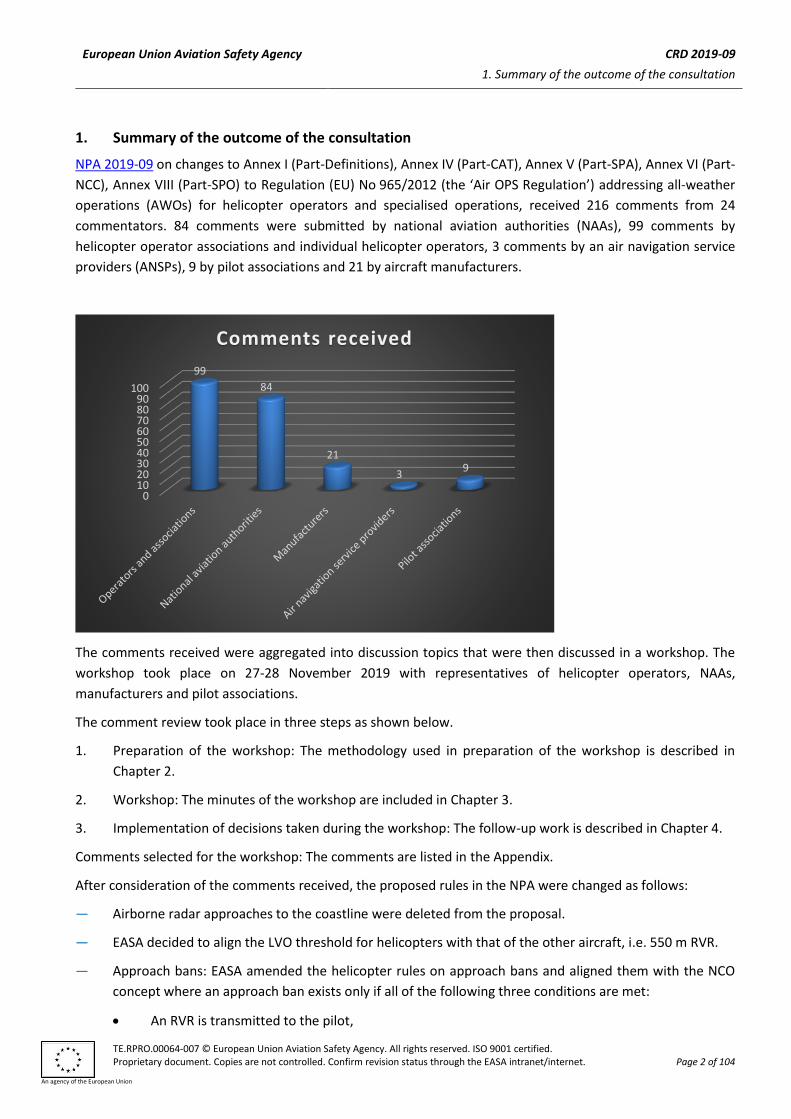
NPA 2019-09 on changes to Annex I (Part-Definitions), Annex IV (Part-CAT), Annex V (Part-SPA), Annex VI (Part-
NCC), Annex VIII (Part-SPO) to Regulation (EU) No 965/2012 (the ‘Air OPS Regulation’) addressing all-weather
operations (AWOs) for helicopter operators and specialised operations, received 216 comments from 24
commentators. 84 comments were submitted by national aviation authorities (NAAs), 99 comments by
helicopter operator associations and individual helicopter operators, 3 comments by an air navigation service
providers (ANSPs), 9 by pilot associations and 21 by aircraft manufacturers.
The comments received were aggregated into discussion topics that were then discussed in a workshop. The
workshop took place on 27-28 November 2019 with representatives of helicopter operators, NAAs,
manufacturers and pilot associations.
The comment review took place in three steps as shown below.
1. Preparation of the workshop: The methodology used in preparation of the workshop is described in
Chapter 2.
2. Workshop: The minutes of the workshop are included in Chapter 3.
3. Implementation of decisions taken during the workshop: The follow-up work is described in Chapter 4.
Comments selected for the workshop: The comments are listed in the Appendix.
After consideration of the comments received, the proposed rules in the NPA were changed as follows:
— Airborne radar approaches to the coastline were deleted from the proposal.
— EASA decided to align the LVO threshold for helicopters with that of the other aircraft, i.e. 550 m RVR.
— Approach bans: EASA amended the helicopter rules on approach bans and aligned them with the NCO
concept where an approach ban exists only if all of the following three conditions are met:
• An RVR is transmitted to the pilot,
0102030405060708090
100
99
84
21
39
Comments received
European Union Aviation Safety Agency CRD 2019-09
1. Summary of the outcome of the consultation
TE.RPRO.00064-007 © European Union Aviation Safety Agency. All rights reserved. ISO 9001 certified. Proprietary document. Copies are not controlled. Confirm revision status through the EASA intranet/internet. Page 3 of 104
An agency of the European Union
• The transmitted RVR is less than 550 m, and
• The transmitted RVR is less than the operating minima.
If there is no approach ban, the pilot can fly to the decision height (DH)/minimum descent height (MDH)
with a higher risk of a go-around. Converted meteorological visibility (CMV) is no longer relevant to
helicopter operating rules and was deleted.
— Operational credit for helicopters under the specific approval SA CAT I is extended to:
• helicopters equipped with 3 axis autopilots,
• aerodromes with centreline markings instead of centreline lighting,
• aerodromes with no touchdown zone lights.
A 3-axis autopilot is not sufficient to reduce the DH below 200 ft, but gives access to the reduced RVR with
a 200-250 ft DH as well as to the reduced planning minima.
— Reduced VFR minima on point-in-space (PinS) approaches with instructions to proceed VFR:
• VFR minima on short VFR segments prior to the instrument departures and after the instrument
approach are extended to the cases where the MAPt/IDF is located within 3 to 5 km of the landing
site/departure site, but only the cloud base is reduced in this case.
• The concept of reduced VFR minima is extended to conventional IFR approaches where it is possible
to cancel IFR in the immediate vicinity of the destination.
— IFR with stand-alone GNSS at destination and at the alternate: The expected resilience to jamming is
better defined.
— Returning from offshore without an alternate:
• The two existing options are merged at AMC level.
• The coastal aerodrome option is amended and clarified to avoid VFR in marginal weather
conditions.
• ‘cloud based’ was changed for ‘cloud ceiling’ in the option that does not rely on VFR for backup.
— Use of NVIS under IFR: This operation is clarified as a multi-crew operation. The principle of no operational
credit for NVIS remains unchanged.
• The training of the technical crew member is better defined.
• The pilot training is defined in greater detail.
• The features of an FSTD suitable for NVIS training are defined.
— EFVS: The operational credit defined for aeroplanes was extended to helicopters flying to runways.
Operational credit for helicopter EFVS operations into a non-runway environment may be defined in AMC
and GM in the future, when the technology permits.
European Union Aviation Safety Agency CRD 2019-09
2. Preparation of the workshop
TE.RPRO.00064-007 © European Union Aviation Safety Agency. All rights reserved. ISO 9001 certified. Proprietary document. Copies are not controlled. Confirm revision status through the EASA intranet/internet. Page 4 of 104
An agency of the European Union
2. Preparation of the workshop
The comments addressing the following topics were not discussed in the workshop :
— General comments including many supportive comments
— Editorial comments
— Duplicate comments
— Comments on the explanatory note
The above comments were addressed by EASA ahead of the workshop.
23 comments discussing issues that are outside the scope of the NPA were re-directed as necessary but were
also not addressed in the workshop. The NPA generated input on CS-ACNS, CS-AWO, on AWO elements
addressed in NPA 2018-06(B), on the HEMS NPA 2018-04 (RMT.0326), on the Opinion No 02/2020 (RMT.0573),
and on helicopter low-level route and approach procedure design.
The following discussion topics were prepared for the workshop, based on the 74 most relevant comments.
Introductory presentations were prepared for each topic. The selected comments, as well as a short
presentation on each topic, were sent in advance to the participants.
— Threshold of 500 or 550 m RVR for low-visibility operation (LVO) approvals: 9 answers to questions.
Summary: The threshold could be 500 m RVR to reflect helicopter capabilities, or 550 m RVR to harmonise
across the different domains and be consistent with the aerodromes regulations. Workshop participants
who did not answer the question in the NPA were requested to position themselves.
— Airborne radar approaches to the coastline: 20 comments
Summary: This approach definition is based on the offshore airborne radar approach, combining radar
with GNSS, and introducing additional restrictions. It received strong opposition from NAAs with expertise
in offshore operations. The workshop was requested to decide between deleting, amending and
restricting, or maintaining the concept.
— IFR with stand-alone GNSS for both destination and alternate: 7 comments
Summary: The NPA proposes that stand-alone GNSS is acceptable as the only approach aid at both
destination and the alternate if the aircraft system is robust to any failure. The workshop was requested
to answer comments received on jamming and minimum equipment lists (MELs).
— Point-in-space approaches with instructions to ‘proceed VFR’: 11 comments
Summary: The NPA proposed reduced VFR minima for a VFR segment of flight no greater than 3 km
distance, following a PinS approach or prior to a PinS departure. Some NAAs commented that the proposal
is not safe enough. Some operators and pilot unions commented that the operational benefits of the NPA
proposal are too low and VFR in marginal weather during the whole flight will remain the preferred option,
resulting in unsafe operations.The workshop was requested to answer if VFR minima could be reduced as
proposed in the NPA, or in a different way, or not at all.
— NVIS under IFR: 10 comments
Summary: The NPA proposed to extend the use of NVIS to visual segments of IFR flights, with restrictions
(eg. multi-crew and specific training) and no operational credit. One NAA with expertise in NVIS
European Union Aviation Safety Agency CRD 2019-09
2. Preparation of the workshop
TE.RPRO.00064-007 © European Union Aviation Safety Agency. All rights reserved. ISO 9001 certified. Proprietary document. Copies are not controlled. Confirm revision status through the EASA intranet/internet. Page 5 of 104
An agency of the European Union
commented that the proposal was unsafe. The workshop was requested to assess the benefits of NVIS for
IFR, to assess the risks including any workload issues, visual illusions and NVIS failures, to discuss NVIS
training, and to decide whether the proposal should be abandoned, amended or maintained.
— Ceiling or cloud base for helicopter offshore operations (HOFO): 1 comment
Summary: The operating minima used when returning from offshore shoud consider the ‘cloud base’. This
had remained unchanged in the NPA proposal, although all other IFR operating minima use ‘cloud ceiling’.
One operator commented that the correct word should be ‘ceiling’, and ‘cloud base’ had appeared
following translation mistake. This was confirmed by the NAA of the country of origin of this paragraph of
the rule. The workshop was requested to address the comment and assess any unintended consequences
of changing the rules.
— Take-off minima : 5 comments
Summary: By procedure design, the helicopter should be able to return to the take-off point during the
early stage of a PinS departure. The workshop was requested to address these comments with specific
focus on the need for a ceilometer or weather station for a PinS departure, and the relevance of ceiling in
take-off minima for a PinS approach.
— Approach bans: 1 comment
Summary: NPA 2018-06 had proposed that there would be no more approach bans in the case when
neither the visibility nor the RVR was transmitted to the pilot. One commentator suggested the deletion
of the approach ban concept for helicopters, because it would introduce a safety feature only at
aerodromes where it was the least needed. The workshop was requested to decide whether to maintain
this feature at aerodromes where it could be introduced and enforced, or to limit it to LVO operations as
proposed for NCO.
— Helicopter Specific approvals HELI SA CAT I and CAT II: 2 comments
Summary: The NPA proposed to grant operational credit proportionate to the capabilities of the
helicopters and crews, reducing the helicopter operating minima on CAT I ILS/MLS and CAT II landing
systems to runways, with helicopters not certified for CAT II. The proposal was well received, and 2
comments suggested the concept could be extended to helicopters with 3-axis autopilots and to
aerodromes without touchdown zone lights / centreline lights. The workshop was requested to provide
the way forward.
— Additional topics had also been prepared (if time permits):
• Offshore approaches with OEM certified approach systems: 2 comments
• Altimeter checks for SPO: 2 comments
• EFVS: 2 comments
• Vertical speeds on approach: 2 comments
European Union Aviation Safety Agency CRD 2019-09
2. Preparation of the workshop
TE.RPRO.00064-007 © European Union Aviation Safety Agency. All rights reserved. ISO 9001 certified. Proprietary document. Copies are not controlled. Confirm revision status through the EASA intranet/internet. Page 6 of 104
An agency of the European Union
EASA had invited all members of the Rotorcraft committee1 or their alternates to the workshop, as well as
members of the Air Ops TeB2 or their representatives for the SPO and/or helicopter domain.
1 The Rotorcraft committee is an EASA advisory body, whose members represent helicopter operator associations, helicopter
manufacturers, and helicopter pilot associations. 2 The Air OPS TeB is an EASA advisory body, whose members are experts of the national aviation authorities in the Air Operations
domain.
European Union Aviation Safety Agency CRD 2019-09
3. Minutes of the workshop
TE.RPRO.00064-007 © European Union Aviation Safety Agency. All rights reserved. ISO 9001 certified. Proprietary document. Copies are not controlled. Confirm revision status through the EASA intranet/internet. Page 7 of 104
An agency of the European Union
3. Minutes of the workshop
Organised by Eric Bennett, FS2.2 RMT.0599
List of participants
Attendees
Mike Deer – Bell Flight Alain Ducollet – Airbus Helicopters John Hill – BHA Igor Jandura – Slovak CAA Ornulf Lien – CAA Norway Peter Möller – EHA Erik Normann – Norwegian Air Ambulance Erlend Segtnan – Norwegian Air Ambulance Bernardino Paggi – Leonardo Helicopters (only day 1) Isabelle Prat – Belgian CAA Eric Bennett – EASA rulemaking Jan Loncke – EASA certification Alexandros Smerlas – EASA certification Robbie Decoster – EASA standardisation (only day 1)
AGENDA
Related Links/ Documents: (Optional)
1. NPA 2019-09 and NPA 2018-06(C) 2. Agenda and appendix to the agenda 3. Extended notes 4. Introductory presentations
MoM distribution and use: (Optional)
Distribution: All participants to the workshop. Use: The minutes of meeting will be used to feed the comment-response document to NPA 2019-09
MoM prepared by Eric Bennett
MoM reviewed by Jan Loncke
MINUTES OF MEETING
Subject SPO and helicopter AWO workshop Date 27 and 28 November 2019 Location Cologne
European Union Aviation Safety Agency CRD 2019-09
3. Minutes of the workshop
TE.RPRO.00064-007 © European Union Aviation Safety Agency. All rights reserved. ISO 9001 certified. Proprietary document. Copies are not controlled. Confirm revision status through the EASA intranet/internet. Page 8 of 104
An agency of the European Union
1. Agenda Item 2: Question on RVR minima for helicopters without LVO approval Introduced by :Eric Bennett
Eric Bennett introduced the topic. Participants clarified their position. Additional feedback from entities who did not answer the question in their comments to the NPA:
GAMA: 500 m RVR Norwegian air ambulance: 500 m RVR Slovak authority: 500 m RVR
500 m RVR reflects helicopter capabilities. 550 m RVR allows alignment with aeroplane and aerodromes regulations. Several participants declared that it was not so important. Action 1: EASA to decide on an RVR threshold for LVOs based on helicopter feedback.
Action owner: EASA
Due date: Publication of CRD and Opinion
2. Agenda Item 3: Airborne radar approach to the coastline (ARA-L) Introduced by: Eric Bennett
EASA presented the topic, the negative comments received and offered three options.
• 1. Delete the AMC
• 2. Make the AMC proposal safer based on the constructive comments received
• 3. Maintain the AMC as it is. EASA also asked the participants whether the AMC had unintended consequences on offshore operations. The discussions within the group led to the following conclusions:
• Option 2 is the way forward. The ARA-L should be made safer.
• There are no visible consequences on HOFO but a double-check is needed.
• The AMC is not directly related to the rule. The approval should be granted by the competent authority. An endorsement by the local authority may be introduced. The implementing rules need to be amended accordingly.
• A working session should take place to finalise the work. Expected duration: ½ day. Action 2: EASA to ensure that the ARA-L has no unintended consequences on HOFO.
EASA to call UK CAA in order to better understand their comments and expectations. EASA to organise a working session to improve the ARA-L AMC and implementing rules.
Action owner: EASA
Due date: 27/2/2020
3. Agenda Item 4: GNSS only at destination and alternate Introduced by: Eric Bennett
European Union Aviation Safety Agency CRD 2019-09
3. Minutes of the workshop
TE.RPRO.00064-007 © European Union Aviation Safety Agency. All rights reserved. ISO 9001 certified. Proprietary document. Copies are not controlled. Confirm revision status through the EASA intranet/internet. Page 9 of 104
An agency of the European Union
Eric Bennett introduced the topic and opened the debate on the two main topics discussed in the comments to the NPA:
• Jamming
• MEL With regard to jamming, the group invited EASA to do the following :
EASA to consider the jamming of more than one GNSS frequency. EASA to check the available data (USA, ICAO, ECCAIRS, etc.) EASA to attempt to better define ‘temporary jamming’ based on the typical ‘local jamming’ including the 2-3 minutes required by the on-board GNSS receiver to recover and show the position again. EASA not to define ‘inertial coasting’ as the means of compliance. EASA may emphasise that, in certain cases, e.g. where obstacles higher than the MSA are on both sides of the flight path, the operator should ensure that there is no excessive drift on either side, which should require additional equipment (not only a procedure).
With regard to MELs, the group agreed that all equipment required by the proposal should be operative for an IFR flight. Action 3: EASA to amend the proposal as defined above.
EASA not to introduce MEL alleviations below the minimum equipment referred to in the AMC.
Action owner: EASA
Due date: Publication of CRD and Opinion
4. Agenda Item 5: Point-in-space approaches with instructions to proceed VFR (PinS-VFR) Introduced by: Eric Bennett
EASA introduced the topic, with an overview of the negative comments received. The group discussed the implications on safety of the reduced VFR minima as they were proposed. PinS approaches with instructions to’proceed visually’ and instructions to ‘proceed VFR’ were compared. Incentives to design the missed approach point (MAPt) close to the destination were discussed. The transition from instrument to visual flight was discussed. The participants were unanimously in favour of:
• extending the reduced minima from 3 km to 5 m distance from MAPt to landing and from take-off to IDF. If the distance is between 3 km and 5 km, the VIS would be as defined by SERA (5 km at night), and only the ceiling would be reduced.
• Extending the concept to conventional approaches, provided that obstacles are charted from the point where it is planned to ‘cancel IFR’ to the destination.
Action 4: EASA to amend the PinS-VFR proposal as defined above.
Action owner: EASA
Due date: Publication of CRD and Opinion
5. Agenda Item 6: Night vision imaging systems (NVIS)
European Union Aviation Safety Agency CRD 2019-09
3. Minutes of the workshop
TE.RPRO.00064-007 © European Union Aviation Safety Agency. All rights reserved. ISO 9001 certified. Proprietary document. Copies are not controlled. Confirm revision status through the EASA intranet/internet. Page 10 of 104
An agency of the European Union
Introduced by: Eric Bennett
EASA introduced the topic. The group discussed the use of NVIS in the context of an IFR flight, and the reservations expressed in the comments to the NPA. The group concluded the following :
The rules should not forbid the use of NVIS in IFR. EASA to add the following in the proposal: The FSTD used for training can be a generic FSTD. Motion systems are not required. The FSTD cockpit is to be NVIS compatible. The FSTD visual system should be sufficiently ‘dimmable’ so that night VFR cues are lost without use of NVGs and are visible with their use. Note: As already required by ORO.FC, the pilot to be familiarised with the FSTD before receiving NVIS on it. If not representative of one of the types flown, this may require flight training on the FSTD prior to the NVIS training on it.
EASA to hold an additional meeting or web meeting on NVIS, with NVIS experts, considering that the NVIS expertise available within the group of participants was limitied to two persons from the same operator. Action 5: EASA to prepare an amended proposal; as per the conclusions of the group.
EASA to hold an additional meeting or web meeting on NVIS, with NVIS experts. Action owner: EASA
Due date: 27/02/2020
6. Agenda Item 7: Use of ceiling instead of cloud base for coastal aerodromes in offshore operations Introduced by: Eric Bennett
EASA introduced the topic. One commentator had described the use of ‘cloud base’ as a translation mistake, when transposing Norwegian regulations into SPA-HOFO. CAA Norway confirmed that it was the case. The group discussed the implications on planning minima; and whether to correct this mistake; or to keep it in order to remain on the safe side. The conclusion was that the mistake should be corrected, based on the follwoing:
• Ceiling is used everywhere for IFR planning minima. Cloud base appears only in HOFO.
• ICAO Annex 3 and Part-MET require forecasts to be amended if a forecast cloud base becomes a forecast ceiling. In other words, a forecast ‘cloud base’ is unlikely to become a ‘ceiling’.
• CAA Norway confirm that they have more than 20 years of experience using ‘ceiling’ without an unsafe occurrence.
Action 6: EASA to correct the translation mistake in SPA-HOFO.
Action owner: EASA
Due date: Publication of EASA Opinion and CRD
7. Agenda Item 8: Take-off minima Introduced by: Eric Bennett
European Union Aviation Safety Agency CRD 2019-09
3. Minutes of the workshop
TE.RPRO.00064-007 © European Union Aviation Safety Agency. All rights reserved. ISO 9001 certified. Proprietary document. Copies are not controlled. Confirm revision status through the EASA intranet/internet. Page 11 of 104
An agency of the European Union
EASA introduced the topic, and focused the discussion on the most commented topic: whether a ceiling of 250 ft was needed for a PinS departure to an initial departure fix; with instructions to ‘proceed visually’; and whether a ceilometer would also be needed. The 250-ft ceiling was initially proposed to reflect the PANS-OPS requirement to be able to return to the take-off point in case of an issue during the visual segment. The group agreed that :
• a ceilometer should not be required for IFR departures;
• the latest (draft) amendments to PANS-OPS should be checked for increased flexibility, including the option to climb into the cloud layer before the initial departure fix.
• the 250-ft could be based on helicopter requirements. In other words, if a helicopter can continue the flight within the obstacle-protected envelopes from TDP, then the 250-ft ceiling should not be required.
Post-meeting notes: Would relevant performance data be available in flight manuals? If the exact data is not available but some more conservative data is, then it can be used of course. Action 7: EASA to propose an amended draft.
Action owner: EASA
Due date: Done (see extended notes)
Action 8: Erik Normann to check the latest draft amendments to PANS-OPS and send documents and conclusions to EASA
Action owner: Erik Normann
Due date 27/02/2020
Action 9 Check if the relevant performance data is available in flight manuals
Action owner: Operators and manufacturers
Due date 27/02/2020
8. Agenda Item 9: Approach bans Introduced by: Eric Bennett
EASA introduced the topic and proposed two options, considering the comments receive.d
• 1. Remain aligned with the fixed wing NPA 2018-06(C) proposal: o No approach ban if no RVR or VIS is transmitted o Approach is not allowed if RVR or converted VIS is lower than minima
• 2. Align with the NCO proposal o No approach ban unless the RVR is below than the SPA-LVO threshold of 550 m
The group concluded that the approach ban was not a real issue with helicopters. Most participants said EASA that could simplify helicopter rules and align them with NCO. Action 10: EASA to amend the proposal in accordance with the above
Action owner: EASA
Due date: Publication of EASA Opinion and CRD
European Union Aviation Safety Agency CRD 2019-09
3. Minutes of the workshop
TE.RPRO.00064-007 © European Union Aviation Safety Agency. All rights reserved. ISO 9001 certified. Proprietary document. Copies are not controlled. Confirm revision status through the EASA intranet/internet. Page 12 of 104
An agency of the European Union
9. Agenda Item 10: Cat II and SA CAT I operations Introduced by: Eric Bennett
EASA introduced the topic. A video was shown by Norwegian Air Ambulance. Cat II was discussed first with no proposed changes. SA CAT I was then discussed, based on the topics addressed in the comments received:
o Use of 3-axis autopilots o Need for touchdown zone (TDZ) lights and centreline lights o Performance issues with tailwinds
The group concluded the following: EASA to amend the proposal as follows:
• Extend to 3-axis autopilots
• Delete the requirement for TDZ lights
• Require centerline markings instead of centerline lighting. No change regarding helicopter performance Action 11: EASA to amend the proposal in accordance with the above
Action owner: EASA
Due date: Publication of EASA Opinion and CRD
10. Agenda Item 10: Other topics Introduced by: Eric Bennett
Offshore approaches with OEM certified approach systems A solution to the comment was found and agreed by the participants. Altimeter checks The group decided there should be no change. EVS The proposal in both NPA 2019-09 and NPA 2018-06(C) was reviewed by the group. A discussion followed that led to the following conclusion: EASA to change the NPA 2018-06 and 2019-09 proposal and extend from ‘RWY’ to ‘RWY and FATO’ in the definition of EFVS and in CAT.OP.MPA.312 and the equivalent SPO/NCC implementing rules. EASA to leave AMC unchanged so that they are applicable only on runways. EASA to ensure that if EFVS technology improves and operational credit can be granted when flying IFR to a FATO (eg on a PinS approach with instructions to ‘proceed visually’), only an AMC or AltMoc will be needed. Vertical speeds on approaches with high glide path angles The group reviewed the proposed GM and the comments received and concluded there should be no change. Action 12: EASA to amend the proposal in accordance with the above
Action owner: EASA
European Union Aviation Safety Agency CRD 2019-09
3. Minutes of the workshop
TE.RPRO.00064-007 © European Union Aviation Safety Agency. All rights reserved. ISO 9001 certified. Proprietary document. Copies are not controlled. Confirm revision status through the EASA intranet/internet. Page 13 of 104
An agency of the European Union
Due date: Publication of EASA Opinion and CRD
11. Closing Presented by: Eric Bennett
As the predefined agenda had been completed 30 minutes earlier than planned, EASA offered the group the option to discuss one additional topic of their choice, if any. All participants declined the offer. EASA thanked everyone for attending. The meeting closed at 16:30 hrs on 28/11/2019.
European Union Aviation Safety Agency CRD 2019-09
4. Follow-up of the actions decided during the workshop
TE.RPRO.00064-007 © European Union Aviation Safety Agency. All rights reserved. ISO 9001 certified. Proprietary document. Copies are not controlled. Confirm revision status through the EASA intranet/internet. Page 14 of 104
An agency of the European Union
4. Follow-up of the actions decided during the workshop
Action 1 on RVR threshold for LVO with helicopters
Following the consultation, EASA decided to align the LVO threshold for helicopters with that of the other
aircraft.
Action 2 on airborne radar approaches to the coastline (ARA-L)
EASA proceeded with additional web meetings and email exchanges and discussions, including consultation of
the UK CAA. Due to the pandemic, a meeting that had been organised on 24 March, became web-based and
attracted an insufficient number of participants. An operator had organised a simulator session on 25 March to
demonstrate the concept, which was also postponed. The simulator session eventually took place on 25 June
and was only attended by the Norwegian CAA.
The simulator session did not demonstrate a flight to a predesigned approach procedure. Instead, it attempted
to demonstrate the following (as reported to EASA by the Norwegian CAA):
‘a time constrained procedure design done by the HEMS TCM, inventing a destination (an unknown
anywhere) on the moving map, assessing wind, setting up a final course trying to consider distance to
obstacles, visual references, crosswind and a failsafe missed approach procedure. And adding any
intermediate approach path required to position from the current route to the FAPt. And all this needs to be
punched, waypoint for waypoint (albeit using vectors), into the FMS in real time. And it happens while having
to maintain an awareness of where you are and monitoring flightpath and instruments, as you are most likely
performing a low level IFR flight in IMC possibly at night at the same time.’
From this simulator session on, EASA worked on 2 work streams in parallel:
One one hand, EASA attempted to define regulations and means of compliance to safely fly a predesigned
airborne radar approach to the coastline (i.e. a simpler procedure than the one demonstrated in the simulator).
This attempt, which might have been biased by the demonstration of a much more demanding concept in the
simulator, led to an accumulation of safety requirements including the following:
— Prior design of the approach procedure
— Approval of the competent authority with the endorsement of the local authority
— Operational demonstration with increased operating minima
— Flight data monitoring
— Destination to be categorised as a category B (no self-briefing) or C aerodrome
— Training and checking and recency requirements comparable to those for HOFO
On the other hand, EASA attempted to get a better understanding of the different operational concepts used at
the time of the NPA and at the time of the simulator session, and the likely usage of the ARA-L. The conclusions
were as follows:
— Search and rescue (SAR) is likely to be the kind of operations that would benefit the most from the ARA-L. It is outside the scope of EU regulations.
— The main usage outside SAR is likely to be emergency cloud-breaking procedures in the context of HEMS under IFR. The Air OPS Regulation does not set criteria for emergency procedures.
European Union Aviation Safety Agency CRD 2019-09
4. Follow-up of the actions decided during the workshop
TE.RPRO.00064-007 © European Union Aviation Safety Agency. All rights reserved. ISO 9001 certified. Proprietary document. Copies are not controlled. Confirm revision status through the EASA intranet/internet. Page 15 of 104
An agency of the European Union
— The second next usage outside SAR has appeared to be a cloud-breaking procedure at sea followed by a VFR segment of flight to a destination inland. This is possible within the current regulatory framework, provided that VFR operating minima are met.
— With regard the initial intent of flying under IFR to destinations on the coastline with no PinS approach procedure, the operator would need to put mitigation measures to reduce the risk, which might far exceed the investment necessary to design PinS approaches to the coastal destinations.
Following these conclusions, EASA decided not to implement the airborne radar approaches to the coastline in
the rules. The latest draft proposal is published in Appendix 1 and can be used as a starting point for NAAs and
operators wishing to further develop the concept under CAT.OP.MPA.125(c) or using flexibility provisions.
Action 3 on stand-alone GNSS
With regard to jamming issues:
— EASA amended the proposal to consider the jamming of all GNSS frequencies.
— EASA requested data on jamming and received data from Airbus Helicopters, which confirmed that jamming issues appear approx. every 100 000 hours, that their frequency is increasing and that the issue needs to be addressed.
— EASA defined ‘temporary jamming’ for helicopters, based on the available data and expected (non-military) risks related to jamming.
— EASA did not define ‘inertial coasting’ as the only means of compliance.
— EASA introduced a sentence so that in certain cases where obstacles that are higher than the MSA and are on both sides of the flight path, the operator should ensure there is no excessive drift on either side, which should require additional equipment (not only a procedure).
With regard to the MEL, EASA amended the explanatory note to clarify that all equipment required by the proposal should be operative for an IFR flight. Action 4 on PinS approaches with instructions to proceed VFR (PinS-VFR)
EASA amended the proposal as per the conclusions of the workshop.
Action 5 on NVIS
EASA proceeded with additional web meetings and email exchanges and discussions with NVIS experts. This
additional consultation resulted in introducing the following:
— An AMC that describes the training of the technical crew member, based on the work developed in the
HEMS NPA 2018-04, AMC2 SPA.HEMS.130(f)(1);
— An AMC that defines the features of an FSTD that can be used for NVIS training; and
— An AMC that better defines pilot training, including:
• the qualification of the trainer in charge of NVIS training for visual segments of IFR flights; and
• the contents and frequency of the operator proficiency check, including when operating more than
one type or variants.
Action 6 on ceiling or cloud base
European Union Aviation Safety Agency CRD 2019-09
4. Follow-up of the actions decided during the workshop
TE.RPRO.00064-007 © European Union Aviation Safety Agency. All rights reserved. ISO 9001 certified. Proprietary document. Copies are not controlled. Confirm revision status through the EASA intranet/internet. Page 16 of 104
An agency of the European Union
EASA corrected the translation mistake in SPA.HOFO. When doing so, EASA realised that the following issues
remained to be solved:
— There were two available options to return from offshore without an alternate: the Norwegian option
with the translation mistake at rule level, and the coastal aerodrome option in AMC material.
— The coastal aerodrome option was not clearly defined. Although it is based on VFR, it could lead to an
airbordne radar approach to the coastline with undefined criteria, followed by a VFR segment of flight to
the coastal aerodrome below VFR minima.
Further consultation took place between EASA and the UK CAA, and between the UK CAA and UK offshore
operators. This consultation resulted in a clarified text that should avoid VFR operations in marginal weather.
Actions 7, 8 and 9 on take-off minima
EASA introduced minor amendments to the proposal, based on little additional input from operators. Ground
infrastructure is not required for an IFR departure, but ‘cloud ceiling’ remains a criterion for an IFR departure
when required to be able to return to the take-off point.
Action 10 on approach bans
EASA amended the helicopter rules on approach bans and aligned them with the NCO concept
Action 11 on Cat II and SA CAT I operations
EASA amended the proposal by:
— extending the concept to 3-axis autopilots;
— deleting the requirement for TDZ lights; and
— requiring centreline markings instead of centreline lighting.
EASA introduced no change regarding helicopter performance requirements.
Action 12 on other topics
EASA implemented minor changes on offshore approaches with manufacturer certified approach systems.
EASA amended the EFVS regulations so that:
— the EFVS rules include helicopters;
— operational credits are the same for helicopters as for aeroplanes when flying to a runway; and
— Operational credits for helicopter EFVS operations into a non-runway environment may be defined in
AMC and GM in the future, when the technology permits.
—
European Union Aviation Safety Agency CRD 2019-09
5. Appendices
TE.RPRO.00064-007 © European Union Aviation Safety Agency. All rights reserved. ISO 9001 certified. Proprietary document. Copies are not controlled. Confirm revision status through the EASA intranet/internet. Page 17 of 104
An agency of the European Union
5. Appendices
Appendix 1 — Draft regulation, AMC and GM on the ARA-L
CAT.OP.MPA.125 Instrument departure and approach procedures
(d) By way of derogation from (a), the operator may use helicopter departure and approach procedures other
than those referred to in (a) provided that the operator meets all of the following conditions:
(1) The procedure design methodology, aircraft equipment, operating procedures and crew training
programmes have been approved by the competent authority, following a risk assessment by the
operator.
(2) The instrument segments of the procedure take place over water and the procedure is not used for
offshore operations.
(3) The operator defines its methodology, based on its risk assessment.
(4) The operator uses such approach procedures only if procedures established by the State do not
meet the operational needs.
(5) Before such operations take place in another Member State, the operator shall obtain an
endorsement from the competent authority of that State.
AMC1 CAT.OP.MPA.125(d) Instrument departure and approach procedures
AIRBORNE RADAR APPROACH TO THE COASTLINE (ARA-L) — HELICOPTERS
(a) An ARA-L should only be flown if the helicopter is equipped with the following:
(1) a weather radar or other piece of equipment that is capable of providing navigation and real-time
obstacle environment information for obstacle clearance;
(2) a moving map system that includes a clear and correct image of the coastal terrain. This system or
navigation display should be able to depict the desired track inbound the ARA-L landing location
and be used for increased situational awareness. The same system should include obstacle
information data of the area close to the coastline;
(3) separate displays for the weather radar image and the moving map, or a single display capable of
showing both superimposed images;
(4) for single-pilot operations, a 4-axis autopilot; and for multi-pilot operations, a 3-axis or 4 axis
autopilot; and
(5) GNSS equipment for tracking guidance and cross-checking of the weather radar display.
(b) ARA-L design
(1) The minimum descent height (MDH) should not be lower than the greater of:
(i) 100 ft above the elevation of the landing location;
(ii) 100 ft above any obstacle between the coastline and the landing location;
(iv) 300 ft by day; or
European Union Aviation Safety Agency CRD 2019-09
5. Appendices
TE.RPRO.00064-007 © European Union Aviation Safety Agency. All rights reserved. ISO 9001 certified. Proprietary document. Copies are not controlled. Confirm revision status through the EASA intranet/internet. Page 18 of 104
An agency of the European Union
(v) 400 ft by night.
(2) If a 3-axis autopilot is used, an increment of 100 ft should be applied to the MDH.
(3) Minimum descent altitude (MDA) may only be used if the radio altimeter is unserviceable. The MDA
should be a minimum of the MDH + 200 ft, and be based on a calibrated barometer at destination
or on the lowest forecast barometric pressure adjusted to sea level (QNH) for the region.
(4) The decision range should be at least 1 NM from the closest land at a ground speed of maximum
80 kt.
(5) The approach track should be chosen to enable the greatest awareness of terrain features and to
reduce the tailwind component. For single-pilot operations without a trained technical crew
member in the front seat, the coastline should appear on the pilot’s side. The approach track should
be 30 to 90 degrees to the coastline. The lateral clearance from any obstacle up to the MAPt should
be at least 1 NM.
(6) The maximum tailwind component in the visual segment should be 10 kt.
(7) The MAPt should be defined as the distance from the selected GNSS waypoint or the distance to
the closest radar target image of the same waypoint, whichever comes first.
(8) The operator should determine an obstacle-free sector using available maps, charts or satellite
data. An inbound track leading to the MAPt within the obstacle free sector should be exclusively
over water and should not include fixed obstacles within the navigation performance. The missed
approach procedure at the MAPt following any inbound track within the obstacle free sector should
meet the criteria defined in (9).
(9) The missed approach procedure should be exclusively over water and should not include fixed
obstacles within the navigation performance. It should include a turn away from land. A bank angle
of no more than 15 degrees and a rate of turn no greater than 3 deg/sec should be used to ensure
an obstacle separation compatible with the navigation performance of the GNSS, taking into
account the maximum acceptable winds.
(c) Operating procedure — flight preparation
(1) The available inbound tracks and missed approach procedures should be prepared within the pre-
identified obstacle-free sector. The forecast wind at destination should ensure a tailwind
component compatible with (c)(6) on the visual segment starting at the MAPt, for at least one
available inbound track.
(2) Rain should be considered, because heavy rain may clutter the radar image and limit the ability to
fly the ARA-L.
(3) If a destination alternate is selected, a non-radar-based approach should be available at the
alternate.
(4) The flight crew should take into account the latest relevant obstacle information including ships
and rig moves.
(d) Operating procedure — approach
(1) A procedure set-up should be done prior to the start of the procedure. This should include the
selection of the destination and MAPt in the FMS/NAV system, using pre-defined points. Track
European Union Aviation Safety Agency CRD 2019-09
5. Appendices
TE.RPRO.00064-007 © European Union Aviation Safety Agency. All rights reserved. ISO 9001 certified. Proprietary document. Copies are not controlled. Confirm revision status through the EASA intranet/internet. Page 19 of 104
An agency of the European Union
guidance towards this position should be selected on the navigation display. The airborne radar
image should be available.
(2) Before the approach, the pilot should assess the wind using available information and should
initiate the approach only if the ground speed can be maintained within the defined limits.
(3) Display of track information could be either magnetic or true; however, the same track should be
displayed on the GNSS display and radar image.
(4) During the instrument segments of the ARA-L, the available higher modes of automation should be
used.
(5) Before commencing the final approach, the commander should ensure that a clear path exists on
the radar screen for the final and missed approach segments. The lateral clearance defined in (c)
should be maintained during the flight.
(6) Prior to continuing visually, the pilot should be in sight of the destination.
(e) The initial training and checking of the flight crew and any involved technical crew member for ARA-L
should be conducted either as part of the operator’s conversion course or as a separate equipment and
procedure training, and should include all of the following:
(1) ground training, including:
(i) knowledge of the structure of the ARA-L;
(ii) knowledge of the airborne radar specifications, limitations, modes, and usage;
(iii) knowledge of the area navigation system;
(2) aircraft/FSTD training to proficiency, including all of the following:
(i) ARA-L to the maximum crosswinds and to the maximum tailwinds envisaged in the operation;
(ii) ARA-L to the lowest minima, followed by a go-around and by a landing;
(iii) ARA-L in the pilot-monitoring, pilot-flying and single-pilot functions, as relevant to the kind
of operations;
(3) line flying under supervision;
(4) a line check.
(f) The recurrent training and checking programme of the flight crew and any involved technical crew
member should include at least one ARA-L per 6 months in the pilot-monitoring, pilot-flying, single-pilot
and technical crew member functions as relevant to the operations. OSAPs should be part of the annual
aircraft/FSTD training, the line check or the operator proficiency check. If OSAPs are trained and not
checked, then the flight crew member should be trained to proficiency to fly the OSAPs.
(g) A pilot should only operate an ARA-L with passengers as commander or co-pilot, when they have carried
out in the preceding 90 days at least 3 ARA-L approaches and landings in a helicopter of the same type or
a full flight simulator (FFS) representing that type.
(h) The commander should undergo aerodrome or operating site familiarisation training under ORO.FC.105,
prior to ARA-L operations. The training should meet one of the following conditions:
European Union Aviation Safety Agency CRD 2019-09
5. Appendices
TE.RPRO.00064-007 © European Union Aviation Safety Agency. All rights reserved. ISO 9001 certified. Proprietary document. Copies are not controlled. Confirm revision status through the EASA intranet/internet. Page 20 of 104
An agency of the European Union
(1) The trainer should have experience of flying the ARA-L procedure to the aerodrome or operating
site;
(2) the trainer should be the procedure designer and the trainee should have completed the training
defined in (f); or
(3) the training takes place in the aircraft /FSTD.
(i) The commander should not commence a flight based on an ARA-L unless the procedure has been designed
in accordance with (b), the flight preparation criteria defined in (c) are met, and the crew meets the
training, checking and recent experience requirements defined in (e) to (h) above.
(j) Operational evaluation phase
The operator should initially start implementing ARA-L approaches with at least 2-NM decision range until
the operator has flown 30 ARA-L approaches.
GM1 CAT.OP.MPA.125(d) Airborne radar approach to location on land (ARA-L)
GENERAL
(a) General
(1) The helicopter ARA-L procedure may have as many as five separate segments: the arrival, initial,
intermediate, final approach, and missed approach segment. The individual approach segments can
begin and end at designated fixes. However, the segments of an ARA-L may often begin at specified
points where no fixes are available.
(2) The fixes, or points, are named to coincide with the beginning of the associated segment. For
example, the intermediate segment begins at the intermediate fix (IF) and ends at the final
approach fix (FAF). Where a fix is not available or not appropriate, the segments begin and end at
specified points; for example, at the intermediate point (IP) and final approach point (FAP). The
order in which the segments are discussed in this GM is the order in which the pilot would fly them
in a complete procedure: that is, from the arrival through the initial and intermediate to the final
approach and, if necessary, to the missed approach.
(3) Only those segments that are required by local conditions prevailing at the time of the approach
need to be included in a procedure. In constructing the procedure, the final approach track, which
should be oriented so as to be substantially into the wind, should be identified first as it is the least
flexible and most critical of all the segments. When the origin and the orientation of the final
approach have been determined, the other necessary segments should be integrated with it to
produce an orderly manoeuvring pattern that does not generate an unacceptably high workload
for the flight crew.
(4) The GNSS/area navigation system should be used to enhance the safety of the ARA-L. This is
achieved by using the GNSS/area navigation system to navigate the helicopter onto, and maintain,
the final approach track, and by using the GNSS range and bearing information to navigate to the
position of the landing location on the weather radar display.
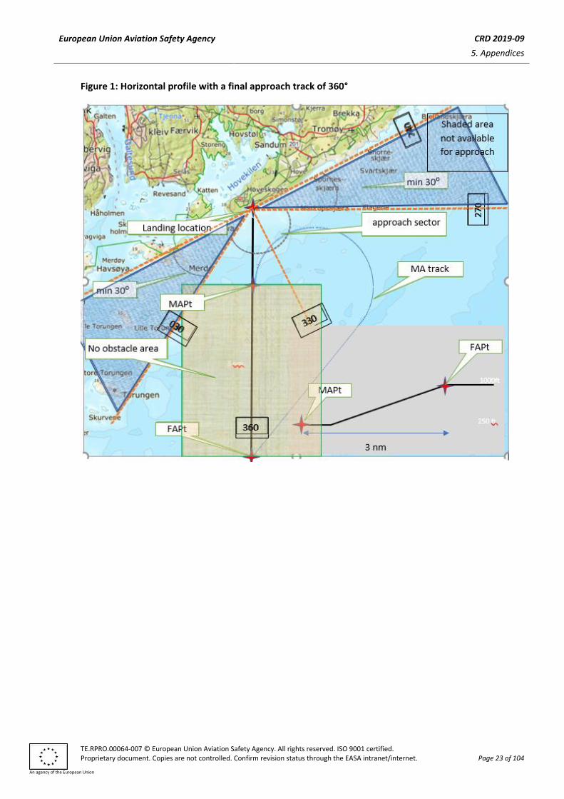
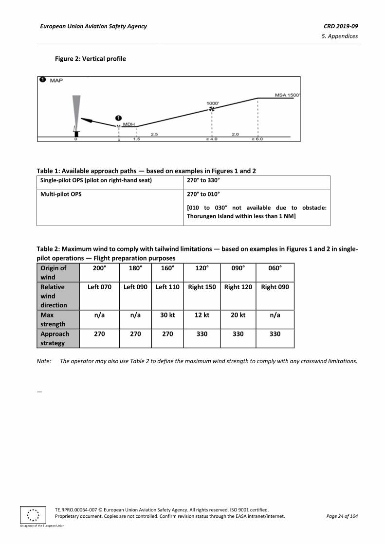
(5) Examples of ARA-L procedures, as well as vertical profile and missed approach procedures, are
contained in Figures 1 and 2 below.
(b) Obstacle environment
European Union Aviation Safety Agency CRD 2019-09
5. Appendices
TE.RPRO.00064-007 © European Union Aviation Safety Agency. All rights reserved. ISO 9001 certified. Proprietary document. Copies are not controlled. Confirm revision status through the EASA intranet/internet. Page 21 of 104
An agency of the European Union
(1) Each segment of the ARA-L is located in an overwater area that has a flat surface at sea level.
However, due to the passage of large vessels which are not required to notify their presence, the
exact obstacle environment cannot be determined. As the largest vessels and structures are known
to reach elevations that exceed 500 ft above mean sea level (AMSL), the uncontrolled offshore
obstacle environment at the arrival, initial and intermediate approach segments can reasonably be
assumed to be capable of reaching to at least 500 ft AMSL. Nevertheless, in the case of the final
approach and missed approach segments, specific areas are involved within which no radar returns
are allowed. In these areas, the height of wave crests, and the possibility that small obstacles may
be present that are not visible on the radar, result in an uncontrolled surface environment that
extends to an elevation of 50 ft AMSL.
(2) Information about movable obstacles should be retrieved from a vessel traffic
service (VTS)/automatic identification system (AIS). VTS is a marine traffic monitoring system
established by harbour or port authorities, similar to air traffic control for aircraft based on satellite.
The AIS is an automatic tracking system that uses transponders on ships and is used by VTS.
Under normal circumstances, the relationship between the approach procedure and the obstacle
environment is governed by the concept that vertical separation is very easy to apply during the
arrival, initial and intermediate segments, while horizontal separation, which is much more difficult
to guarantee in an uncontrolled environment, is applied only in the final and missed approach
segments.
(3) As the ARA-L takes place near the coastline, terrain information is useful for increased situational
awareness. A moving map, including the moving map of a helicopter terrain awareness and warning
system (HTAWS), may be used to provide such increased situational awareness.
(c) Arrival segment
The arrival segment commences at the last en-route navigation fix, where the aircraft leaves the
helicopter route, and it ends either at the initial approach fix (IAF) or, if no course reversal or similar
manoeuvre is required, it ends at the IF. Standard 1 000-ft en-route obstacle clearance criteria should be
applied to the arrival segment.
(d) Initial approach segment
The initial approach segment is only required if the intermediate approach track cannot be joined directly.
Most approaches will be flown direct to a point close to the IF, and then on to the final approach track,
using GNSS/area navigation guidance. The segment commences at the IAF, and on completion of the
manoeuvre, it ends at the IP. The minimum obstacle clearance (MOC) assigned to the initial approach
segment is 1 000 ft.
(e) Intermediate approach segment
The intermediate approach segment commences at the IP, or in the case of straight-in approaches, where
there is no initial approach segment, it commences at the IF. The segment ends at the FAP and should not
be less than 2 NM in length. The purpose of the intermediate segment is to align the helicopter with the
final approach track and prepare it for the final approach. During the intermediate segment, the
helicopter should be lined up with the final approach track, the speed should be stabilised, the destination
should be identified on the radar, and the final approach and missed approach areas should be identified
and verified to be clear of radar returns. The MOC assigned to the intermediate segment is 500 ft.
European Union Aviation Safety Agency CRD 2019-09
5. Appendices
TE.RPRO.00064-007 © European Union Aviation Safety Agency. All rights reserved. ISO 9001 certified. Proprietary document. Copies are not controlled. Confirm revision status through the EASA intranet/internet. Page 22 of 104
An agency of the European Union
(f) Final approach segment
(1) The final approach track should be selected with an angle of less than 90° to reduce the closure rate
to land. For single-pilot operations, the land should be oriented to the same side as the
commander’s seat.
(2) The final approach segment commences at the FAP and ends at the missed approach point (MAPt).
The FAP is located 4 NM from the landing location. The final approach area, which should be
identified on the radar, takes the form of a corridor between the FAP and the radar return of the
destination. This corridor should not be less than 2-NM wide so that the projected track of the
helicopter does not pass closer than 1 NM to the obstacles lying outside the area.
(3) On passing the FAP, the helicopter will descend below the intermediate approach altitude and
follow a descent angle which should not be steeper than 3.7 degrees. At this stage, vertical
separation from the offshore obstacle environment will be lost. Descent from 1 000 to 300 ft AMSL
at a constant 3.7-degree angle will involve a horizontal distance of 2 NM.
(4) During the final approach, tracking should be maintained by coupling to the GNSS final approach
track, and the compensation for drift is then automatically taken care of. The approach ends at the
1-NM distance to the selected landing location and is identified by either the GNSS distance or the
radar image distance, whichever comes first.
(g) Missed approach segment
(1) The missed approach segment commences at the MAPt at least 1 NM from the coast and ends
when the helicopter reaches the minimum en-route altitude. The missed approach manoeuvre is a
‘turning missed approach’.
(2) At MAPt 1NM before waypoint, a turn away out on the reciprocal inbound course will be initiated.
Final approach track will be selected at an offset angle, preferably allowing for missed approach
away from land on the ‘sea side’ and into the wind. This geometry will also mean that very early
into the turn, distance to land will build up. (In addition, the generous climb gradient — even with
engine out — will allow for considerable height gain during turn.)
(i) Radar equipment
During the ARA procedure, colour-mapping radar equipment with a 120° sector scan and a
2.5-NM range scale selected may result in dynamic errors of the following order:
(1) bearing/tracking error of ± 4.5° with 95 % accuracy;
(2) mean ranging error of 250 m; and
(3) random ranging error of ± 250 m with 95 % accuracy.
European Union Aviation Safety Agency CRD 2019-09
5. Appendices
TE.RPRO.00064-007 © European Union Aviation Safety Agency. All rights reserved. ISO 9001 certified. Proprietary document. Copies are not controlled. Confirm revision status through the EASA intranet/internet. Page 23 of 104
An agency of the European Union
Figure 1: Horizontal profile with a final approach track of 360°
European Union Aviation Safety Agency CRD 2019-09
5. Appendices
TE.RPRO.00064-007 © European Union Aviation Safety Agency. All rights reserved. ISO 9001 certified. Proprietary document. Copies are not controlled. Confirm revision status through the EASA intranet/internet. Page 24 of 104
An agency of the European Union
Figure 2: Vertical profile
Table 1: Available approach paths — based on examples in Figures 1 and 2
Single-pilot OPS (pilot on right-hand seat) 270° to 330°
Multi-pilot OPS 270° to 010°
[010 to 030° not available due to obstacle:
Thorungen Island within less than 1 NM]
Table 2: Maximum wind to comply with tailwind limitations — based on examples in Figures 1 and 2 in single-
pilot operations — Flight preparation purposes
Origin of
wind
200° 180° 160° 120° 090° 060°
Relative
wind
direction
Left 070 Left 090 Left 110 Right 150 Right 120 Right 090
Max
strength
n/a n/a 30 kt 12 kt 20 kt n/a
Approach
strategy
270 270 270 330 330 330
Note: The operator may also use Table 2 to define the maximum wind strength to comply with any crosswind limitations.
—
European Union Aviation Safety Agency CRD 2019-09
5. Appendices
TE.RPRO.00064-007 © European Union Aviation Safety Agency. All rights reserved. ISO 9001 certified. Proprietary document. Copies are not controlled. Confirm revision status through the EASA intranet/internet. Page 25 of 104
An agency of the European Union
Appendix 2 — Most relevant comments selected for the workshop
COMMENTS RELATED TO THRESHOLD FOR LVOs
comment 27 comment by: LBA
Comment LBA: There is a difference in the definition of LVO: In fixed wing operations, LVO starts at 550 m, in helicopter operations it starts at 500 m. Despite this should no problem in general, it might be one during mixed operations at one airport. It would be useful to streamline the values.
comment 58 comment by: UK CAA
Page: 27 Paragraph No: 1, Question to Stakeholders Comment: The UK CAA sees merit in the continued use of 500m RVR for helicopter operations but recognises the issues surrounding harmonisation and standardisation, globally as well as within Europe. We are aware of the considerable discussions ongoing within the Comment Response Group for NPA 2018-06 and it is most important that the outcome is harmonised and standardised across all domains. Differences will inevitably bring the possibility of confusion and reduced safety and should be avoided. Justification: The RVR requirements and the determination of LVO should be harmonised across all domains to ensure clarity and understanding. Proposed Text: Remove “for helicopter, the RVR shall be less than 500m” where it appears in the proposed definitions. Apply the standardised and harmonised RVR requirements when established.
comment 80 comment by: Romanian CAA
The minimum RVR without a SPA.LVO approval for helicopter Type B CAT I approaches and low-visibility take-offs should be 500 m.
comment 106 comment by: British Helicopter Association
Answer to question on Page 28. 500m
Comment 142 comment by: FOCA Switzerland
European Union Aviation Safety Agency CRD 2019-09
5. Appendices
TE.RPRO.00064-007 © European Union Aviation Safety Agency. All rights reserved. ISO 9001 certified. Proprietary document. Copies are not controlled. Confirm revision status through the EASA intranet/internet. Page 26 of 104
An agency of the European Union
Ref. to letter a) Category I (CAT I): We support the idea to set the minimum RVT for Helicopter CAT-I at 500m.
Comment 161 comment by: DGAC France
ANNEX I Definition for terms used in Annexes II to VIII (page 27) QUESTION TO STAKEHOLDERS The minimum RVR without a SPA.LVO approval for helicopter Type B approaches and low-visibility take-offs should be: - Neither 500 nor 550m for takes-offs. It should be 400m, to remain coherent with aeroplanes. - 550m for approaches and not 500m. This is necessary to keep a coherent regulation between aeroplane operations, helicopter operations and aerodrome operations. A reduction to 500m would bring several inconsistencies. For instance: helicopters operating on airports without LVP procedures in place; aeroplanes and helicopters operating under different minima that impact airport procedures.
comment 206 comment by: CAA-Norway
CAA-Norway agrees that criteria for minimum RVR for requiring a SPA.LVO should be harmonised.
comment 210 comment by: ANWB MAA
Agree with 500 m without LVO.
comment 10 comment by: Norwegian Air Ambulance
Q to stakeholders: NLAs opinion tha 500 meters minimum RVR should be in force. Maybe a requirement to an operational autopilot with stability requirements should be required for the 550 to 500 m reduction The main reason is that helicopters that fly IFR to these minimums are using modern equippment and are much more capable than the predesessors like th S61 or similar that was used when this rule was written
European Union Aviation Safety Agency CRD 2019-09
5. Appendices
TE.RPRO.00064-007 © European Union Aviation Safety Agency. All rights reserved. ISO 9001 certified. Proprietary document. Copies are not controlled. Confirm revision status through the EASA intranet/internet. Page 27 of 104
An agency of the European Union
AIRBORNE RADAR APPROACHES TO THE COASTLINE
comment 23 comment by: Norwegian Air Ambulance
page 53 (g) The aerodrome or operating site used for ARA-L operations should be considered to be a Category C aerodrome under ORO.FC.105. This sentence does not make sence sine the nature of the ARA-L could be done anywhere where there is a shoreline. A mitigating sentence could be included/added that special training and checking need to be done like it is expressed in the sentence above(f)
comment 24 comment by: Norwegian Air Ambulance
A really useful procedure in countries that has a coastline
Comment 63 comment by: UK CAA
Page No: 52 Paragraph No: 21, AMC1 CAT.OP.MPA.125(c), (a) Comment: The UK CAA believes that the paragraph is confusing and unclear in its intent. CAT.OP.MPA 125 (c) provides for operators to seek approval by the State for alternative approach and departure procedures and does not invite any AMC. The AMC has been introduced to provide a hook for the proposed ARA-L. This procedure is understood to have come from a specific operational requirement in one State and for essential SAR operations. This may or may not be the case, but it is a good example of exactly what the regulation provides and is not considered appropriate for wider Commercial Air Transport use without clear justification. Introducing this AMC takes away the determination that a State can make and is not supported for this reason. More importantly though, the proposal has several flaws and we consider that it may be potentially unsafe (as explained in following UK CAA comments) and should not be accepted. It is strongly recommended that a State should be able to determine on a case by case basis such extreme activities which are more than likely to involve Emergency Services. Normal PinS procedures to “Proceed VFR” as entered elsewhere might be possible if agreed by the State. Justification: Removal of State determination is unacceptable and we believe the proposed procedure for ARA-L is flawed and potentially unsafe and unsuitable for normal CAT operations. Proposed Text: Delete all reference to the AMC/GM.
comment 64 comment by: UK CAA
European Union Aviation Safety Agency CRD 2019-09
5. Appendices
TE.RPRO.00064-007 © European Union Aviation Safety Agency. All rights reserved. ISO 9001 certified. Proprietary document. Copies are not controlled. Confirm revision status through the EASA intranet/internet. Page 28 of 104
An agency of the European Union
Page No: 52 Paragraph No: 21, AMC1 CAT.OP.MPA.125(c),(a) Comment: Significant Concern. The UK CAA considers the whole concept of using weather radar as an approach aid is flawed and unsafe. Justification: Weather radars are neither designed nor certified for use as an approach aid. Proposed Text: Delete AMC1 CAT.OP.MPA.125(c) and GM1 CAT.OP.MPA.125(c).
comment 65 comment by: UK CAA
Page No: 52 Paragraph No: 21, AMC1 CAT.OP.MPA.125(c),(b)(1) Comment: Significant Concern. A weather radar is a simplex unmonitored system and should not be relied upon for obstacle detection unless a suitable independent system is available to provide a cross-check. Justification: Weather radars are neither designed nor certified for obstacle detection. Proposed Text: A requirement to include cross checking should be added. For example, see AMC1 SPA.HOFO.125 (g) & (h).
Comment 66 comment by: UK CAA
Page No: 52 Paragraph No: 21, AMC1 CAT.OP.MPA.125(c), (b)(2) Comment: Significant Concern. Reliance on a HTAWS database is inappropriate and unsafe. Justification: HTAWS databases are low resolution and not subject to updates. Note that in the case of the fatal accident to the SAR helicopter at Black Rock (S92 reg. EI-ICR on 14 March 2017), the terrain that the helicopter collided with was missing from the HTAWS database. Proposed Text: Delete the last sentence of the paragraph, i.e. delete the text “A helicopter terrain awareness system (HTAWS) or similar would fulfil this option.”
Comment 67 comment by: UK CAA
Page No: 52 Paragraph No: 21, AMC1 CAT.OP.MPA.125(c), (b)(4) Comment: Significant Concern. The UK CAA recommends that GNSS should also be used to cross-check the weather radar.
European Union Aviation Safety Agency CRD 2019-09
5. Appendices
TE.RPRO.00064-007 © European Union Aviation Safety Agency. All rights reserved. ISO 9001 certified. Proprietary document. Copies are not controlled. Confirm revision status through the EASA intranet/internet. Page 29 of 104
An agency of the European Union
Justification: A weather radar is a simplex unmonitored system and should not be relied upon for obstacle detection unless a suitable independent system is available to provide a cross-check. Proposed Text: Change the paragraph to read: “(4) GNSS equipment for tracking guidance and cross-checking of the weather radar display.”
comment 68 comment by: UK CAA
Page No: 52 Paragraph No: 21, AMC1 CAT.OP.MPA.125(c), (c)(7) Comment: Significant Concern. Missed approach procedures should ideally not include turns. The UK CAA recommends that an alternative, safer missed approach procedure is proposed or else delete AMC1 CAT.OP.MPA.125(c) and GM1 CAT.OP.MPA.125(c). Justification: Turning in poor visibility and/or at night is a well-known cause of disorientation which, at low height, could easily lead to CFIT.
comment 139 comment by: THALES
There is no correspondance in the airworthiness regulation (CS-AWO, CS-ACNS, ...) for the ARA-L operation introduced in the AIR OPS regulation. It raises the question if the safety requirements (integrity, avaialibility, performance) to consider for this operation. Thales suggest the agency to clarify the connection between the ARA-L operation introduced in the AIR OPS and the associated saftey expectation at airworthiness level.
comment 147 comment by: COPAC
EXPLICACIÓN: Esta propuesta resulta muy interesante. En principio, al estar dentro de CAT.OP.MPA, podrían utilizarse las aproximaciones ARA-L propuestas sobre cualquier “operational site” en la costa, pero estaría restringida a su uso diurno, siendo el uso nocturno únicamente autorizado para operadores con aprobación SPA.HEMS, siempre bajo las condiciones determinadas por SPA.HEMS.125(b)(4). En la práctica, esta limitación podría impedir a operadores SAR, HHO o HOFO sacar provecho de las ventajas operacionales de esta propuesta. Por otro lado, no parece claro si la propuesta detalla que esos procedimientos ARA-L deban estar previamente diseñados por el operador, antes de la realización del vuelo, o si por el contrario pueden ser diseñados por la tripulación de acuerdo al Manual de Operaciones justo antes de comenzar la aproximación en cuestión. Una aclaración en este sentido, dentro de la GM por ejemplo, ayudaría a que la autorización para realizar ARA-L se obtuviera de manera más sencilla. Actualmente en España los helicópteros SAR Offshore ya realizan ese tipo de aproximaciones a lugares en la costa, la ampliación de este procedimiento al resto de operaciones supondría una mejora en la seguridad y eficiencia en las operaciones. COMENTARIO/MODIFICACIÓN:
European Union Aviation Safety Agency CRD 2019-09
5. Appendices
TE.RPRO.00064-007 © European Union Aviation Safety Agency. All rights reserved. ISO 9001 certified. Proprietary document. Copies are not controlled. Confirm revision status through the EASA intranet/internet. Page 30 of 104
An agency of the European Union
Se propone que se aclare el punto AMC1 CAT.OP.MPA.125(c) d) (1), para explicar cuándo es aceptable el diseño de la aproximación ARA-L –por parte de la tripulación justo antes de comenzar la aproximación en base al procedimiento detallado en el Manual de Operaciones, o bien con más antelación- con el fin de que no quede a criterio de la Autoridad aeronáutica local. Esto contribuiría a que las autorizaciones para el uso de ese tipo de aproximaciones sean expedidas con más facilidad. Asimismo se propone que se modifique la AMC1. CAT.OP.MPA.105e) “Use of aerodromes and operating sites”, para que incluya la posibilidad de uso de estas ARA-L por parte de todo tipo de operaciones, no solo las que lo hacen bajo SPA.HEMS, con mención específica a las operaciones SAR para los países en las que éstas no están bajo aprobación SPA.HEMS. English summary : cat C categorisation not supported. Please extend to SAR
comment 208 comment by: CAA-Norway
The proposal to introduce an AMC to describe a novel, in CAT terms, approach procedure ARA-L raises several questions. The concept of an own radar approach to the coastline is well know from military operations and also civilian SAR, for which we have issued approvals in the past. We are also currently processing one application for such an operation from a HEMS operator. We believe, supported by the statements in the Explanatory note, that we can issue an approval for this according to CAT.OP.MPA.125(c) as it is today, if and when we are satisfied that the operator can do this with an acceptable level of risk. There is little doubt that this type of approach introduces additional hazards, and proper controls need to be in place. For SAR a certain increased risk level may be acceptable, but that type of operation is also characterised by exceptionally well equipped aircraft, very experienced crews, well developed procedures and training programmes, and ambitious currency requirements. For SAR the need for such an approach is fairly evident, as they are expected to respond to all types of accidents that may happen anywhere and in any kind of weather. A similar need could be claimed for HEMS, but the decision has been taken to operate HEMS as CAT, precisely to reduce the safety risk to these operations. One control is realising and implementing that not everything is possible in HEMS. This control is even more appropriate for transport of passengers in CAT in general, which should be performed to the highest standards and with the lowest risk level. Although such an approach would require the individual state to issue an approval, per definition the AMC and GM outlines the requirements and guidelines considered sufficient for a CAT level IMC approach to the coastline as seen by EASA. As mentioned, we are in the process of handling an application for a similar type of operation. This process is by no means completed, but as we see it now there appears to be some unanswered questions/shortcomings in the AMC/GM. Some of these are:
• For what type of operation/operational need could such an approval be appropriate? • Could this be approved for sites used regularly, in leu of designing a proper PinS
approach, possibly for cost saving purposes?
European Union Aviation Safety Agency CRD 2019-09
5. Appendices
TE.RPRO.00064-007 © European Union Aviation Safety Agency. All rights reserved. ISO 9001 certified. Proprietary document. Copies are not controlled. Confirm revision status through the EASA intranet/internet. Page 31 of 104
An agency of the European Union
• Could this type of approach be performed to any unprepared/unsurveyed site on an ad hoc basis?
• What weather information is required regarding conditions at and around the site? • It is not clear if the radar or the GNSS moving map is designated as the primary
navigation aid, the radar is probably not useful unless crosschecked with other navaids.
• The assumption that 50' AMSL could be assumed as the highest obstacle in an uncontrolled environment without radar echoes may be flawed as e.g. a kiteboard kite may typically fly up to 100'.
• HTAWS and Moving map obstacle databases cannot be relied upon to provide certainty with respect to obstacles.
• The alternate requirements appear unclear, as the AMC states, "If a destination alternate is required..." and "... a non-radar-based approach should be available ...".
• The training requirements appear to not include mandatory simulator training, and a currency requirement of one (1) ARA-L per year must be far off, as in our view 3 per 90 days for such a high-risk operation may be considered more appropriate. (Training text here also refers to OSAP requirements which perhaps is an editorial error?)
• The consequence of designing ARA-L sites as category C aerodromes under ORO.FC.105 is unclear, is it e.g. to be taken to mean that each site should be visited beforehand by each pilot?
• Crew composition and workload assessment
As we see it, this AMC is not required to approve an approach of this type. It is not required for the possible urgent need for SAR operations as that is otherwise regulated, and any requirement for its use in HEMS could be addressed by the individual state under the current IR. There should therefore be ample time to do a proper assessment of the need for such a procedure for general CAT operations, and if so, to develop proper AMC and GM material. This should additionally contain at least a list of the hazards that need be included in the operators risk assessment when developing the procedure, minimum equipment specifications and possibly require a program of phased implementation and operational demonstration.
comment 54 comment by: Norwegian Helikopter Employee Association
To introduce a new ARA-L type approach for helicopters, are a good step in a safer direction in order to fly in a safer IFR environment and not under marginal VFR conditions. However the minima MAP/DR should be the same as for normal ARA, MAP/DR 0,75 NM, otherwise the ARA-L will not be used before flying VFR (800/1500 meters, clear of clouds 500 ft) Suggestion: If the ARA-L approach are setup 30-45 degrees offset to the shoreline, the minimum distance during missed approach to the destination point, are not more than the equivalent for a ARA approach (0,579 NM).
European Union Aviation Safety Agency CRD 2019-09
5. Appendices
TE.RPRO.00064-007 © European Union Aviation Safety Agency. All rights reserved. ISO 9001 certified. Proprietary document. Copies are not controlled. Confirm revision status through the EASA intranet/internet. Page 32 of 104
An agency of the European Union
comment 69 comment by: UK CAA
Page No: 54 Paragraph No: 22, GM1 CAT.OP.MPA.125(c), (f)(2) Comment: Significant Concern. The maximum descent slope should be expressed using the term ‘degrees’ and not ‘%’. There is no instrument on any aircraft that expresses glidepaths/descent slopes in the term ‘%’. The angle should be 3.7 degrees. Justification: Accuracy of information and purpose. Proposed Text: Change paragraph (f)(2) on page 55: on 2nd line “…which should not be steeper than 6.5% 3.7 degrees.” And on 4th line “…at a constant 6.5% 3.7 degree gradient…”.
Comment 70 comment by: UK CAA
Page No: 54 Paragraph No: 22, GM1 CAT.OP.MPA.125(c), (g)(2) Comment: Significant Concern. Missed approach procedures should ideally not include turns. We suggest that an alternative, safer missed approach procedure is developed or else delete AMC1 CAT.OP.MPA.125(c) and GM1 CAT.OP.MPA.125(c). Justification: Turning in poor visibility and/or at night is a well-known cause of disorientation which, at low height, could easily lead to CFIT.
Comment 71 comment by: UK CAA
Page No: 54 Paragraph No: 22, GM1 CAT.OP.MPA.125(c), (i)(2) Comment: Significant Concern. The weather radar accuracy comprises a mean error (bias) of +250m and a random error of ±250m. This is also incorrect in the current GM1 SPA.HOFO.125 (i). Additionally, the minimum decision range of 1NM and missed approach calculation should be reviewed and reconsidered in the light of the increased weather radar error. Justification: This is a factual error. Proposed Text: Amend (i)(2) “mean ranging error of 250 m; or and “.
Comment 153 comment by: Airbus Helicopters
European Union Aviation Safety Agency CRD 2019-09
5. Appendices
TE.RPRO.00064-007 © European Union Aviation Safety Agency. All rights reserved. ISO 9001 certified. Proprietary document. Copies are not controlled. Confirm revision status through the EASA intranet/internet. Page 33 of 104
An agency of the European Union
The statement: "The land needs to be in front of the helicopter so that it can be identified on the radar, and be on the pilot’s side for sufficient situational awareness."may be discutable : in the example, the coast on the left side when performing the approach toward the 030 is limited to a small island part. In some cases, the coast may still be on the left side but too far to be really visible, not bringing any situation awareness. Off course having the coast line on the commanders side brings some visual clue. But not having it isn’t, to my view, a “no go”… A coast line is not like a ship : a ship is very small and clues may be missed when on the other side from the commander’s side at the very beginning of the take off phase or at the very end of the landing phase…over land, this phase is different as a lot of peripherical clues are available.
Comment 154 comment by: Airbus Helicopters
Comment on paragraph (f)(1) Final approach segment: The 30° minimum angle is already providing safety margin in our view. This requirement of having the coast on the commander’s side may lead to build the approach in the other axis, from where potentially come the average wind. It is more dangerous to follow a downwind single pilot approach than a head wind approach with the coast on the other side of the commander’s seat. On the other side, if for any reason the coast is on the other side and wind comes from behind, the most important item is still the wind, especially if the angle is steep. If this requirement comes from the fact that the obstacles for ship take offs and landings can be required to be on the commander's side, we are not in that case here as we are talking about the entire final approach. The obstacle problem on the ship is dedicated to the final touchdown phase.
Comment 155 comment by: Airbus Helicopters
Comment on paragraph (b)(1):Why the overwater area should necessary beat sea level ? We can imagine such an approach over big lakes which would be precluded by the requirement. It is sugegsted to remove this restriction.
Comment 196 comment by: CHC Helicopter
The landing location may be located a maximum of 1 nm in land. With a FAP 4 nm from the landing location and a MAPt 1 nm from the landing location, you may already be over land when initiating the missed approach. Is that taken into consideration?
Comment 197 comment by: CHC Helicopter
Page 58 explanatory note states: "The pilot may not be able to avoid crosswinds during the final approach and during the first part of the visual segment, for the same reason. Flying an ARA-L in strong crosswinds may result in unusual drift angles, which requires training. The operator may define a maximum crosswind component." Unusual drift angles not only require training, but also require a large wind correction angle. As the weather radar is most effective in painting targets within +-15 degrees from the nose of the aircraft, it may start to miss obstacles at wind correction angles larger than 15 degrees. Should a maximum wind correction angle be specified in the rules?

European Union Aviation Safety Agency CRD 2019-09
5. Appendices
TE.RPRO.00064-007 © European Union Aviation Safety Agency. All rights reserved. ISO 9001 certified. Proprietary document. Copies are not controlled. Confirm revision status through the EASA intranet/internet. Page 34 of 104
An agency of the European Union
European Union Aviation Safety Agency CRD 2019-09
5. Appendices
TE.RPRO.00064-007 © European Union Aviation Safety Agency. All rights reserved. ISO 9001 certified. Proprietary document. Copies are not controlled. Confirm revision status through the EASA intranet/internet. Page 35 of 104
An agency of the European Union
Stand-alone GNSS for both destination and alternate
comment 2 comment by: CMC Electronics
The "sufficient reliability and integrity" is defined in AMC as a list of installation and/or operational criteria. This is a step away from "performance based" paradigm. The reliability and integrity should be defined in terms of performance, for instance, as qualitative or quantitative requirements, so compliance can be demonstrated regardless of if SBAS or GBAS are available, single or dual GNSS installation, single or dual frequency capability, etc. Furthermore, item a) of GM2 (as well as the AMC (b)(2)) impose "no single point of failure" results in loss of GNSS capability; this is more in line with a catastrophic failure condition, which may be neither the case nor the intention here, despite the claim in the Explanatory note. Bottom line, in the way the AMC1 CAT.OP.MPA.192(d) is formulated, it is impossible to propose an equivalent level of safety, thus making the AMC rather prescriptive than "one acceptable means of compliance". The explanatory note talks about some safety target; unfortunately this is not defined in a way to allow for an "equivalent level of safety". I am affraid that the AMC1 is a hidden mandate for Multi-constellation-dual-frequency receivers, without leaving the door open for an "equivalent level of safety".
comment 4 comment by: CMC Electronics
The MEL reflecting GBAS capability of the helicopter is not enough to actually perform a GBAS approach. The site must be equipped with a ground station. This should probably be visible in AMC1.
comment 14 comment by: Norwegian Air Ambulance
This is a very welcomed change. The availability of conventional procedures are reduced and this will increase the ability to fly IFR with helicopters with limited range/fuel.
comment 140 comment by: THALES
The jamming consideration is introduced in AMC1 CAT.OP.MPA.192(d) item b (3) for PBN operations. This is new to considerer jamming in the AIR OPS regulation. This consideration would be applicable only for helicopters. Thales suggest to the agency to clarify why the jamming consideration is introduced specifically for Helicopter only and for PBN operations. The same comment is also applicable to: - - AMC1 NCC.OP.153(d) item (b) (3) page 100 - - AMC1 SPO.OP.152 item (b) (3) page 129
comment 162 comment by: Airbus Helicopters
European Union Aviation Safety Agency CRD 2019-09
5. Appendices
TE.RPRO.00064-007 © European Union Aviation Safety Agency. All rights reserved. ISO 9001 certified. Proprietary document. Copies are not controlled. Confirm revision status through the EASA intranet/internet. Page 36 of 104
An agency of the European Union
Comment on paragraph (b)(2): This paragraph of the AMC duplicates with CAT.IDE.H.345 (c) rule already covering the case of in-flight failure of navigation means. The terminology "navigation capability" is not defined in the NPA and may be subject to interpretation. It is proposed to indicate "should not compromise the navigation capability required for the intended route, approach and landing operation" to be consistent with the CAT.OP.MPA.192(d) Comment on paragaph (b)(3):provided multiconstellation and multifrequency, the case of GNSS loss compromising the navigation capability should be also considered. The second sentence is also proposed to be modified to clarify the case of other sensors are available as follows: "unless other sensors are available to continue on the intended route" omment on paragaph (b)(6): It is not clear what is meant by the operator's MEL should reflect the elements in paragraph (b)(1) and (b)(2). Should the next failure in-flight in a case of dispatch with one sensor failed still leave the aircraft with the navigation capability targeted by condition (b)(2)? This would mean dispatch will not be authorized unless a triple redundancy of the navigation means is installed onboard the aircraft. Please confirm the understanding of the requirement is correct and possibly clarify paragraph (b)(6) to be more explicit.
comment 214 comment by: CAA-Norway
Recent experience has shown that jamming of GNSS signals may not only be of very short duration and only affect a very small area. Installation of light Inertial navigation systems should be promoted and considered to be made mandatory to support GNSS navigation in a continuously more sparse-conventional-navaids-equipped environment.
comment 199 comment by: DGAC France
GM2 to AMC1 CAT.OP.MPA.192(d) Selection of aerodromes and operating sites — helicopters (page 61) GNSS RELIABILITY AND INTEGRITY — HELICOPTERS “Additional sensors or function may be used during jamming events”. It would be worthwhile to precise that this sensors or function may have different performances (a different level of precision, a level of precision that is limited in time (for instance due to drift), …) Explanatory note: Multi-constellation multi-frequency GNSS technology “will render obsolete the need for a conventional navigation backup and should be incentivised, even if conventional navigation should remain in use when available”. The proposal to incentivise multi-constellation multi-frequency GNSS technology is much appreciated. However, it seems premature to pretend that conventional navigation will be useless as backup systems. In particular, the question of independence between Communication, Navigation and Surveillance function will need to be addressed (especially if the surveillance function relies on the same GNSS technology). The protection of GNSS signals will be much more difficult than conventional systems: on conventional system the signal strength increase when the aircraft approach the system (and therefore is at its maximum during the critical phases of taking off and landing) but it is not the case for GNSS signals; GNSS signals are in open frequency bands (meaning open to manufacturers that are producing devices not certified for aviation) and therefore much more vulnerable to jamming since products are much more
European Union Aviation Safety Agency CRD 2019-09
5. Appendices
TE.RPRO.00064-007 © European Union Aviation Safety Agency. All rights reserved. ISO 9001 certified. Proprietary document. Copies are not controlled. Confirm revision status through the EASA intranet/internet. Page 37 of 104
An agency of the European Union
accessible; Member State regulations are not coherent at European level regarding GNSS jamming.
European Union Aviation Safety Agency CRD 2019-09
5. Appendices
TE.RPRO.00064-007 © European Union Aviation Safety Agency. All rights reserved. ISO 9001 certified. Proprietary document. Copies are not controlled. Confirm revision status through the EASA intranet/internet. Page 38 of 104
An agency of the European Union
PinS approaches with instructions to proceed VFR
comment 158 comment by: DGAC France
2.3.1.1.2 NPA 2018-04 ‘Helicopter emergency medical services performance and public interest sites’ — Reduced HEMS VFR minima on a mixed IFR/VFR flight (page 10) AMC1 SPA.HEMS.120(a) HEMPS operating minima (page 12) REDUCED VFR MINIMA TO BE USED WHEN INSTRUCTED TO ‘PROCEED VFR’ This information is welcome to facilitate the reading. However, it shows that there is maybe an issue of coherence between Table 2 (“Reduced HEMS operating minima when instructed to ‘proceed VFR’ following an instrument approach”) and Tables 1 and 2 proposed in AMC1 SPA.PINS-VFR.100 (page 88 of this NPA 2019-09). Table 2 for HEMS seems more stringent regarding the visibility minima by day (Visibility for HEMS operations = distance and up to 3000m ; Visibility for other PinS operations = distance and up to 1500m).
comment 146 comment by: COPAC
EXPLICACIÓN: En la práctica, incluir como una nueva SPA las aproximaciones y salidas PinS con mínimos reducidos VFR, puede disuadir a los operadores de solicitar tal aprobación, especialmente en los países más burocratizados. Como ejemplo, es posible que en España no haya ningún operador de helicópteros que tenga autorización para SPA.LVO. Por esta razón, se considera más conveniente la siguiente propuesta: COMENTARIO/MODIFICACIÓN: Se recomienda que los preceptos incluidos en la SPA.PINS-VFR.100 sean incluidos en el resto de regulaciones donde puedan tener aplicación, sin constituir por sí mismos una nueva Subparte, de tal manera que no sea un requerimiento previo para el operador el obtener una aprobación específica para operar de acuerdo a esa SPA.PINS-VFR.100. El hecho de haber obtenido ya un AOC o una aprobación específica para operar según SPA.HEMS, SPA.HOFO, SPA.NVIS, SPA.HHO o SPA.PBN debería ser suficiente requisito como para realizar las operaciones de acuerdo a lo propuesto por SPA.PINS-VFR.100. Esto se extiende también a los AMC que son propuestos más adelante en la NPA (pag. 88-91). English summary : requests that this is not a SPA
comment 60 comment by: UK CAA
Page No: 31 Paragraph No: 5, SPA.PINS-VFR.100 Comment: Whilst we understand what is intended with the application of procedures to allow lower than standard VFR minima in PinS approaches or departures, this needs very careful consideration to prevent unintended consequences from arising. One of the tenets of this NPA is to facilitate the use of IFR rather than marginal “scud running” VFR flights, which
European Union Aviation Safety Agency CRD 2019-09
5. Appendices
TE.RPRO.00064-007 © European Union Aviation Safety Agency. All rights reserved. ISO 9001 certified. Proprietary document. Copies are not controlled. Confirm revision status through the EASA intranet/internet. Page 39 of 104
An agency of the European Union
is supported, but this proposal could lead to just that scenario. We believe the proposal lacks justification and proper safety analysis. What is being proposed is too loose and effectively makes a ‘Proceed VFR’ requirement a “Proceed visually” one but they are constructed differently. The ‘Proceed visually’ is an IFR flight being conducted in a visual segment. The whole point of weather minima is to set a cut off point for safe operations including in the control of the aircraft by sole visual means through adequate external references and not through instruments, whilst being able to comply with the Rules of the Air in terms of third-party endangerment and collision avoidance. Establishing the flight visibility at the MAPt is not always easy and pilots may be tempted to push on in just the conditions that we are trying to avoid. The proposal cannot be supported as to “Proceed VFR” should be as it is intended within the VFR requirements of that airspace as determined by Part-SERA – day or night. Any operation below such minima should only be applied to essential emergency services as foreseen by Article 4 of CR (EU) 923/2012. Such approvals should not be granted on a blanket basis as each PinS procedure will attract differing circumstances that must be fully justified by the operator to the CA. The question must always be, why cannot the MAPt or IDF be set closer to the landing / take-off point and ‘Proceed visually’ as a visual segment of an IFR procedure with concomitant obstacle clearances contained within the defined procedure. Further consideration should be given as to the need and justification for this proposal and whether better use of the standard PinS procedures be considered and adopted instead. The established criteria within the procedure design for obstacle clearance, minimum crossing heights, manoeuvring areas etc should be observed. Justification: Inadequate analysis of consequential impacts and requires re-consideration and justification but preferably the standard use of the PinS procedures should be considered and adopted.
comment 207 comment by: CAA-Norway
If this concept is to be extended from the HEMS domain, it should be properly assessed. The assessment should include access to limited weather information, less experienced pilots and instructors, possible unintended consequences such as extending scud running to the VFR part of PinS approaches. The statement in the explanatory note that a go-around is always a safe option may not be quite true, as transitioning from VFR to IFR in an unintentional-IMC situation is one of the more challenging manoeuvres that is performed.
comment 212 comment by: ANWB MAA
What will be considered as experienced crew?
comment 53 comment by: Norwegian Helikopter Employee Association
Inorder to achieve the overall goal of getting helicopter operations to be conducted more under safer IFR conditions and not marginal VFR, the required planning and operative minimas for PINs approaches, need to be lowered. Example:
European Union Aviation Safety Agency CRD 2019-09
5. Appendices
TE.RPRO.00064-007 © European Union Aviation Safety Agency. All rights reserved. ISO 9001 certified. Proprietary document. Copies are not controlled. Confirm revision status through the EASA intranet/internet. Page 40 of 104
An agency of the European Union
When the VFR weather requirements are 800/1500 meters visibility clear of clouds at 500ft, and the present PINs planning weather requirements are a lot higher, well then it is only natural for the operators to choose the flight conditions/operations that can make the job done (ie VFR). Conclusion: Not only does the required planning and operative PINs minima need to be lowered, but a PINs approach should also be possible to perform at night. Today some PINs approaches are daytime only.
comment 56 comment by: Norwegian Helikopter Employee Association
As commented earlier with regards to PINs planning and operative minimas, the required minimas need to be lower, in order for the operators to wanting to choose the IFR approach before the VFR operation. Example: If a helicopter is lined up on the final segment of a PINs approach (day or night), regardless of the weather requirements for that approach, the crew cannot continue the approach to land if they don't have sufficient references to proceed the the landing area. At the same time they are in a much better and safer situation when lined up at the end of a IFR approach, than if they are flying in poor VFR conditions en route. Conclusion: Make the required planning and operative for PINs approaches lower, or better than VFR requirements (when possible), because then the crews will start to select the IFR PINs approach before flying VFR.
comment 74 comment by: UK CAA
Page No: 90 Paragraph No: 41, AMC1 SPA.PINS-VFR.100 Comment: The concept of reduced VFR has been commented on and the relevance of this AMC will be determined by any review of the proposed SPA. We believe that this may need deleting or elements raising to rule level. Justification: Review and justification for proposed lower than standard VFR PinS procedures required.
comment 78 comment by: FinnHEMS Oy
Proposed material is sufficient for providing adequate weather minimas for both NIGHT and DAY operations, when destination is located at or closer than 3 km from MAPt. Beyond 3 km the material instructs to utilize SERA regulation. Following SERA.5010 regulation “Special VFR in control zones” can lead to lower minimas when PinS approaches are commenced within Control Zone.
European Union Aviation Safety Agency CRD 2019-09
5. Appendices
TE.RPRO.00064-007 © European Union Aviation Safety Agency. All rights reserved. ISO 9001 certified. Proprietary document. Copies are not controlled. Confirm revision status through the EASA intranet/internet. Page 41 of 104
An agency of the European Union
Maybe it would be more clear to publish minimum weather when operated beyond 3 km distance. On the other hand, “reduced VFR minima” will provide at night cloud ceiling heights, which are lower than allowed minimum flight heights. Exemption from normal minimum altitudes should be added to this material.
comment 92 comment by: DRF Luftrettung
Page 89 SECTION: AMC 1 SPA.PINS-VFR.100 Table 3, Table 4 COMMENT: Night Visibility is always expressed as the visibility of a specified light source against a dark background and can not be compared with the flight visibility during day operation. We think, that a night visibility of 2000m is too much with an x < 1000m and suggest changing the values in table 3 and table 4 to 1500 m and x + 500m
Comment 150 comment by: COPAC
EXPLICACIÓN: Ver lo expuesto para SPA.PINS-VFR.100, en relación con la inclusión de este AMC dentro del resto de la normativa, no como una aprobación específica más. En otro orden, en la nota explicativa se señala que esta aprobación será accesible para operadores que puedan disponer de un FSTD del tipo de helicóptero utilizado, con el fin de realizar el entrenamiento y/o verificación anual, para operaciones CAT (distintas de HEMS) y SPO, entre otras. Se considera que pueden existir problemas con esta aclaración: sucede que FSTD de helicópteros del mismo tipo pero de distintas variantes podrían ser utilizados de manera eficaz y con un coste económico menor para el cumplimiento de este requisito y, dado que no se manifiesta en el AMC de manera explícita, las Autoridades locales podrían no permitir su uso, dejando sin sentido las medidas propuestas por esta NPA. Esto podría suceder, por ejemplo, con tripulaciones que habitualmente vuelen Bell 412 EP y que no puedan realizar sus entrenamientos en un FSTD Bell 412 HP por ser una variante distinta. COMENTARIO/MODIFICACIÓN: Se propone que se introduzca una aclaración en el tipo de FSTD necesario para cumplir con los requisitos de entrenamiento y verificación con el fin de detallar de manera explícita la idoneidad de FSTD del mismo tipo de helicópteros aunque de distinta variante. English Summary : FSTDs of the same type should be used, but different variants should be OK
European Union Aviation Safety Agency CRD 2019-09
5. Appendices
TE.RPRO.00064-007 © European Union Aviation Safety Agency. All rights reserved. ISO 9001 certified. Proprietary document. Copies are not controlled. Confirm revision status through the EASA intranet/internet. Page 42 of 104
An agency of the European Union
NVIS under IFR
comment 114 comment by: Austro Control
NPA 2019-09 Comments by Austro Control GmbH
· Page No: 29 Paragraph: SPA.NVIS.120 NVIS operating minima Comment: It is understood that the newly introduced table of p. 12 will allow NVIS operations below the current VFR weather minima and therefore VFR will be deleted form SPA.NVIS.120 as requirement for the operations. Because most NVIS is performed with HEMS and the HEMS bases do not provide adequate weather information there is no justification to lower the minima. Justification: Safety Proposed text: maintain VFR, alter Table on p.12, raise limits for NVFR without NVIS · Page No: 30 Paragraph: Explanatory note to SPA.NVIS.120 Comment: The use of NVIS on the visual segment of an IFR flight is only possible at night. With minima lower than the standard VFR night minima any failure of the NVIS system in such a situation results in a hazardous situation if not the same minima would apply as for a “plain eye” NVFR flight. The mix of IFR with NVIS is highly questionable and further research into the combination must be performed before implementing such procedures. NVIS is only a 2D projection and does not provide the same angle of view in combination with a 3D procedure. Justification: Safety, High safety concern Proposed text - · Page No: 77 Paragraph No: AMC1 SPA.NVIS.120 Operating minima for night-vision imaging systems (NVISs), NVIS Operations under IFR Comment: The mixing of NVIS (night vision imaging system) with IFR (instrument flight rules) does not match as NVIS is used to enhance night vision capability in VMC (visual meteorological conditions). Even in military operations the both are not mixed. Military flies either IFR or NVG. The flipped down NVG under IMC as stated in (2) will not provide any benefit as NVG’s may not work in clouds or during daylight conditions or under certain very low residual light conditions. NVG’s provide only a 2D projection with a maximum field of view of 40°. The compatibility with the necessary 3D perception is highly questionable. Other limitations and drawbacks of the use of NVG’s are not even assessed as e. g. Pilot fatigue will increase by a factor of 10 or the additional weight which will be at least including the required helmet around 2.3 kg. Many pilots therefore will become unfit to fly due to severe spine
European Union Aviation Safety Agency CRD 2019-09
5. Appendices
TE.RPRO.00064-007 © European Union Aviation Safety Agency. All rights reserved. ISO 9001 certified. Proprietary document. Copies are not controlled. Confirm revision status through the EASA intranet/internet. Page 43 of 104
An agency of the European Union
problems caused by the additional weight and the multiplication of the forces due to vibration in helicopters. The required constant scanning technique is also not considered. Medical factors are not considered. Reassessment of whole AMC according to comments necessary. Justification: Safety, Flight safety, Operational flight safety
comment 168 comment by: DGAC France
SPA.NVIS.120 NVIS operating minima (page 29) Guidance material or safety information should be developed regarding the determination of the minimum transition height from where a change to/from aided flight may be continued. At present, an operator may decide to set it to zero or to a height below the applicable minimum (DA/H or MDA/H). Possible interactions between [ IMC / NVIS / Take-off decision point / Landing decision point ] transitions should be studied (decision point meaning the point from which, in case of engine failure, the operation can be interrupted or continued safely).
comment 211 comment by: ANWB MAA
When flying an instrument approach with the use of NVIS (for the visual segment) it might be helpfull/desirable to switch of (a part of) the ALS. In that case will the minima "ALS-out" apply or the minima "full ALS"?
comment 29 comment by: FAA
Doc Name: AMC1 SPA.NVIS.120 Operating minima for night-vision imaging systems (NVISs) Para 31 Referenced Text "(b)Night-vision goggles may be used in a flipped-down position during a flight under IFR: (2) under IMC:" Question: Evaluation or consideration of visual illusions wearing NVGs in degraded visual environments? How different is this relative to CAT I operations using EFVS per 14 CFR 91.175 or 176?"
comment 30 comment by: FAA
Doc Name: AMC1 SPA.NVIS.120 Operating minima for night-vision imaging systems (NVISs) Para 31 Referenced Text:"(b)Night-vision goggles may be used in a flipped-down position during a flight under IFR: (2) under IMC:" Questions:"Is there a separate requirement for autopilot or does this assume only the minimum stabilization to satisfy CS 27/29 App B?
European Union Aviation Safety Agency CRD 2019-09
5. Appendices
TE.RPRO.00064-007 © European Union Aviation Safety Agency. All rights reserved. ISO 9001 certified. Proprietary document. Copies are not controlled. Confirm revision status through the EASA intranet/internet. Page 44 of 104
An agency of the European Union
Does this assume the aircraft is coupled or just in ATT or SAS mode? "
comment 36 comment by: FAA
Doc Name:GM1 SPA.NVIS.120 Operating minima for night-vision imaging systems (NVISs) Para 32 Referenced Text (d) The use of night-vision goggles in a flipped-down position does not prevent to assess the 'unaided' condition by looking out below the googles. Comment: Not sure how this relates to operating minima. Is this a requirement? (Is a GM the same as the rule or similar to an AMC or AC?). This is adding another workload task in an already high workload environment. Too many factors here. Is this saying that periodic unaided assessment is needed?" Proposed Resolution: Clarify how this relates to NVIS Ops IFR ops minima
comment 77 comment by: FinnHEMS Oy
Excellent update to include IFR operations into the NVIS guidance. Paragraph (c) is little problematic, because it requires all visual cues to be assessed unaided. Finnish terrain has quite often very few artificial lights, when operating outside congested areas. Therefore the assessment of fulfilling the weather minima will be difficult unaided. Especially the cloud ceiling should be possible to assess also with aided view. This is especially the case when utilizing PinS approaches and departures with reduced VFR minima.
comment 215 comment by: ANWB MAA
The AMC states the visuel cues will be assessed unaided. The continue safely IFR the NVG will be "on" which means the pilot needs to assess the visul cues by looking below or above his goggles. In this critical stage of flight this will implicate a lot of movements with the head with the risk of desorientation. Why not assess the cues with the goggles on as the intention is to continue visual by the use of the goggles.
comment 37 comment by: FAA
Doc Name: AMC1 SPA.NVIS.130 Crew requirements for night-vision imaging systems (NVISs) Para 33 Referenced Text: (a) The minimum crew should be two pilots, or one pilot and one NVIS technical crew member. Question: Will EASA accept single crew pilot only operations, particularly if, by future aircraft modification, the existing RFMS limitation requiring second crewmember is removed?
comment 149 comment by: COPAC
EXPLICACIÓN:
European Union Aviation Safety Agency CRD 2019-09
5. Appendices
TE.RPRO.00064-007 © European Union Aviation Safety Agency. All rights reserved. ISO 9001 certified. Proprietary document. Copies are not controlled. Confirm revision status through the EASA intranet/internet. Page 45 of 104
An agency of the European Union
En el apartado a), se propone que la tripulación mínima debería ser de dos pilotos o de un piloto y un tripulante técnico NVIS. El objetivo de esta NPA es favorecer el vuelo bajo reglas IFR cuando existen condiciones VMC marginales y, en el caso específico de esta propuesta, el permitir un adecuado uso de los medios de NVIS en las fases visuales de vuelos IFR. Tal y como se reconoce en la misma propuesta en su nota explicativa, la carga de trabajo y complejidad son muy altas en las fases de transición desde la fase de vuelo instrumental a la visual con NVIS, especialmente en condiciones marginales VFR. Por las propias limitaciones humanas, existe una probabilidad relativamente alta de que el piloto a los mandos pueda tener una pérdida de conciencia situacional o una desorientación espacial en esta fase de la operación. En una situación así, un tripulante técnico NVIS no tendría la capacidad necesaria para poder hacerse con el control del helicóptero de manera segura. Por ello se hace la siguiente recomendación: COMENTARIO/MODIFICACIÓN: Se propone que la tripulación mínima deba ser de dos pilotos para operaciones NVIS bajo IFR, sin posibilidad de sustituir a uno de los pilotos por un tripulante técnico NVIS. English summary : Considers the minimum crew should be 2 pilots for NVIS under IFR.
European Union Aviation Safety Agency CRD 2019-09
5. Appendices
TE.RPRO.00064-007 © European Union Aviation Safety Agency. All rights reserved. ISO 9001 certified. Proprietary document. Copies are not controlled. Confirm revision status through the EASA intranet/internet. Page 46 of 104
An agency of the European Union
Ceiling or cloud base for offshore operations (HOFO)
comment 202 comment by: Bristow Norway
Bristow Norway notices that NCC.OP.148, SPO.OP.143 and CAT.OP.MPA.192 all is consistent in their use of ceiling contrary to SPA.HOFO.120`s use of the term base for determining requirements. SPA.HOFO`use of the term base has a substantial operational impact for us and SPA.HOFO should be changed to use ceiling to reflect the same principals used in NPA 2019-09 NCC, SPO and CAT.
European Union Aviation Safety Agency CRD 2019-09
5. Appendices
TE.RPRO.00064-007 © European Union Aviation Safety Agency. All rights reserved. ISO 9001 certified. Proprietary document. Copies are not controlled. Confirm revision status through the EASA intranet/internet. Page 47 of 104
An agency of the European Union
Take-off minima
comment 114 comment by: Austro Control
NPA 2019-09 Comments by Austro Control GmbH
· Page No: 39 Paragraph No: AMC2 CAT.OP.MPA.110 Aerodrome operating minima, Take off operations – Helicopters (a) (2) Comment: How can a commander determine that the visibility or RVR along the take-off runway/area is equal or better than the required minimum if the reported visibility is below that required for take-off and the RVR is not reported? By good guess or rule of thumb? Justification: Safety concern, Clarification Proposed text: The method for the determination shall be incorporated in the AMC material. Standardized procedure for obtaining required parameters required. · Page No: 40 Paragraph No: Table 1.H, ** Comment: For PinS departures to an initial departure fix (IDF), RVR should not be less than 800 m ant the ceiling should not be less than 250 ft. This requires the use of valid data e. g. ceilograph and transmissometer Justification: Safety, Procedure requirements · Page No: 67 Paragraph No: AMC3 SPA.LVO.100(a)) Low-visibility operations (LVO’s) and operations with operational credits, Low-visibility take-off (LVTO) operations helicopter Comment: Integration of a limitation that under any circumstances the minimum RVR or VIS shall not be less than the required rejected take-off distance for the helicopter according to the approved rotor craft flight manual. Justification: Safety, Flight safety, Clarification Proposed text: Add a point: (c) under any circumstances the minimum RVR or VIS according Table 1.H shall not be lower than the required rejected take-off distance* for the take-off procedure executed. *reference to the rotor craft flight manual
European Union Aviation Safety Agency CRD 2019-09
5. Appendices
TE.RPRO.00064-007 © European Union Aviation Safety Agency. All rights reserved. ISO 9001 certified. Proprietary document. Copies are not controlled. Confirm revision status through the EASA intranet/internet. Page 48 of 104
An agency of the European Union
comment 21 comment by: Norwegian Air Ambulance
Table 1.H pg 40 ** requires a ceiling requirement for PINS departure of at least 250' We don't think this requirement is relevant. The visibility os normally the only restriction to wheter a departure can take place. Even when there is a requirement to be able to return to the FATO visually this can be done without expressing a ceiling. We suggest: Visibility according to table and a vertical visibilty sufficient to avoid obstacles in case of a visual return to FATO
comment 108 comment by: British Helicopter Association
Table 1.H The ** explanatory note. A ceiling limit of 250ft is not required as the aircraft should be able to return to the FATO prior to going IMC and after going IMC the ceiling requirement will be governed by the instrument approach minima.
comment 148 comment by: FOCA Switzerland
Ref. to AMC2 CAT.OP.MPA.110 Aerodrome operating minima in Table 1.H Footnote **: From our perspective, there is usually only RVR/VIS minima for takeoff OPS. Therefore, we suggest to stick to that standard. However, we support the 800m RVR minimum.
comment 170 comment by: DGAC France
AMC2 CAT.OP.MPA.110 Aerodrome operating minima (page 39) TAKE-OFF OPERATIONS — HELICOPTERS - Point (a)(1) : It is proposed to add “and equipment” at the end of the first sentence (“aircraft characteristics and equipment”). Moreover, there is maybe a wording issue with the insertion of “or both”. - Point (a)(3): the addition of “or RVR” brings confusion since the RVR is not reported and the RVR definition should not be associated with an individual appreciation. - Table 1.H: “** On PinS departures to an initial departure fix (IDF), RVR should be not less than 800 m […]”. As a consequence, if no RVR is available, can we use a CMV and therefore a VIS of 400m (according to RVR/CMV to VIS conversion table). It is proposed to refer to RVR/VIS not less than 800m. Moreover, VIS could be more appropriate in case of return to the FATO just after take-off. A similar comment is proposed in AMC3 NCC.OP.110 (page 92) and AMC4 SPO.OP.110 (page 104)
European Union Aviation Safety Agency CRD 2019-09
5. Appendices
TE.RPRO.00064-007 © European Union Aviation Safety Agency. All rights reserved. ISO 9001 certified. Proprietary document. Copies are not controlled. Confirm revision status through the EASA intranet/internet. Page 49 of 104
An agency of the European Union
Approach bans
comment 169 comment by: DGAC France
SPO.OP.215 Commencement and continuation of approach (page 37) Helicopters usually land at places where no RVR or VIS is available. Therefore, they are used to continue approaches below 1000ft. It is understood that SPO.OP.215 is more dedicated to approach and landing at aerodromes (point (a) refers to runway, point (a)(1) refers to aerodrome). In this case, considering that the obstacle protection of a runway is far greater than usual helicopter landing places, considering the manoeuvrability and the low approach speed of helicopters, DGAC propose to allow for helicopters continuing the approach below 1000ft even if the reported VIS or controlled RVR is below the applicable minima, down to the DA/H or MDA/H. However, aerodrome operators or ANSP can specify restrictions of access to their landing sites considering operations constraints and weather conditions. Same comment would apply to the proposed amendments of CAT.OP.MPA.305 and NCC.OP.230 (see NPA 2018-06(C), quoted page 8 and 9 of this NPA 2019-06).
European Union Aviation Safety Agency CRD 2019-09
5. Appendices
TE.RPRO.00064-007 © European Union Aviation Safety Agency. All rights reserved. ISO 9001 certified. Proprietary document. Copies are not controlled. Confirm revision status through the EASA intranet/internet. Page 50 of 104
An agency of the European Union
HELI SA CAT I and CAT II specific approvals
comment 79 comment by: FinnHEMS Oy
Excellent approach trying to benefit from ILS Cat I/II infrastructure more efficiently. However, some parts of the regulation is preventing the use of HELI SA CAT I -procedure from the whole HEMS -helicopter fleet in Finland. 4-axis autopilot and approach with Vy speed In Finnish HEMS environment, the southern bases (located at EFHK, EFTU and EFTP) are operating with EC135P2+ helicopter type. In the proposed text EC135P2+ is not qualifying to HELI SA CAT I because it does not have 4-axis autopilot. However, ILS autolevel function at 65 ft is available. Also, the minimum coupled speed with IAS mode is down to 40 kts IAS. This makes flying with VY speed in IFR possible. It is clear that 4-axis autopilot is providing higher level of safety than 3-axis autopilot. The need for 4-axis autopilot is reasoned with the need to follow Type B approach at VY speed. In our opinion, flying instrument approach at VY speed will not necessary provide stable approach, because small changes in IAS will change position in the Velocity – Power curve. VY is not the most stable airspeed and therefore small change in attitude could lead uncontrollably to change airspeed under the minimum IFR speed. We would recommend at “low visibility situation” to use e.g. Vi=80 kts in order to be more in the safe and stable side during the approach and possible go-around situation. With this speed, automatic level-off is functioning well. We would request to change requirement to 3-axis autopilot with ILS -autolevel function. That will facilitate the whole HEMS fleet in Finland. Requirement of Centerline and Touchdown Zone Lights HELI SA CAT I operations should be possible according to the NPA also at ILS CAT I aerodromes. However, ILS CAT I aerodromes where HEMS bases are located in Finland, don´t have Runway centerlights nor Touchdown zone light. Only aerodromes with ILS CAT II procedures are equipped with those. According to the NPA, without centerlights minimum RVR will come down only to RVR 450 m, which is minimal change to current RVR 500 m (without HELI SA CAT I approach). Please reconsider this requirement again. CAT A / Performance class 1 landing with HELI SA CAT I approach Typically the Finnish aerodromes are equipped only with one ILS CAT I procedure. Currently, no other Type B approach is available. That will quite often lead to situation where ILS approach must be made into downwind. Allthough the requirement is to make Performance Class 1 landing without any downwind component, would the landing into the downwind be more safe option when landing after ILS CAT I approach in low RVR situation. Landing directly to the runway ahead will increase the need of horizontal space and lower the net climb gradient at OEI situation, but on the other hand runway provides normally plenty of additional landing distance compared to the requirement. In HELI SA CAT I approach the minima would be lowest at RVR 300 m. We would not recommend in the downwind condition to try to turn into the wind, but landing the helicopter straight on the runway would be the safest option. Operators can be required the calculate the additional space needed with in the downwind condition.
comment 220 comment by: CAA-Norway
The explanatory note discusses CAT II certified helicopters. We are not aware of any helicopters that are CAT II certified, nor that any such certification criteria exist. CS-AWO is

European Union Aviation Safety Agency CRD 2019-09
5. Appendices
TE.RPRO.00064-007 © European Union Aviation Safety Agency. All rights reserved. ISO 9001 certified. Proprietary document. Copies are not controlled. Confirm revision status through the EASA intranet/internet. Page 51 of 104
An agency of the European Union
applicable only to aeroplanes. If our assumption is correct, we suggest consideration should be given to establishing such criteria to enable the use of the associated operational requirements already published in SPA.LVO.105 for CAT II operations for helicopters.
European Union Aviation Safety Agency CRD 2019-09
5. Appendices
TE.RPRO.00064-007 © European Union Aviation Safety Agency. All rights reserved. ISO 9001 certified. Proprietary document. Copies are not controlled. Confirm revision status through the EASA intranet/internet. Page 52 of 104
An agency of the European Union
Other topics (if time permits)
Offshore approaches with OEM certified approach systems
comment 174 comment by: DGAC France
AMC2 SPA.HOFO.125(f) Offshore standard approach procedures (OSAPs) (page 84) ORIGINAL EQUIPMENT MANUFACTURER (OEM) — CERTIFIED APPROACH SYSTEM The rational to apply point (d) in the AMC may be confusing if the objective is also to cross-check the SBAS altitude with the radio altimeter (and not only the QNH altitude used for Baro-VNAV).
comment 198 comment by: CHC Helicopter
Page 87 GM2 SPA.HOFO.125 item (c): The standard en-route RNP value (full scale deflection on the CDI) is 2 nm, so this requirement mandates the pilot to change the setting. This is undesirable: 1. The ARA is flown in LNAV mode coupled down to OIP, so the sensitivity of the CDI makes no difference: the cross track error will be (close to) zero anyway. 2. Certain navigation systems may not automatically change the RNP setting from a manual setting. If the pilot forgets to reset the RNP value before returning to onshore for an RNP approach to LNAV or LNAV/VNAV minima, the RNP will still be at 1 nm, and a 1 dot deviation will then be 0.5 nm from track, far outside the maximum allowed deviation of 0.15 nm.
Altimeter checks for SPO
comment 213 comment by: ANWB MAA
Is the altimeter check also applicable for fully automated air data systems where there is a continuous cross checking of 2 independent sensors with fault monitoring
comment 114 comment by: Austro Control
NPA 2019-09 Comments by Austro Control GmbH
· Page No: 103 Paragraph No: GM1 SPO.OP.101 Altimeter check and settings, Altimeter-Setting Procedures Comment: The ICAO Doc 8168 (PANS-OPS). Volume I procedures for (a) (b) (c) shall be transferred into the GM instead of reference to the document. Justification: Safety, Flight safety, Clarification, Information, Human principles, better readability Proposed text: (a) 3.2 “Pre-flight operational test” - transfer of the PANS-OPS procedure according ICAO Doc 8168 3.2
European Union Aviation Safety Agency CRD 2019-09
5. Appendices
TE.RPRO.00064-007 © European Union Aviation Safety Agency. All rights reserved. ISO 9001 certified. Proprietary document. Copies are not controlled. Confirm revision status through the EASA intranet/internet. Page 53 of 104
An agency of the European Union
(b) 3.3 “Take-off and climb” - transfer of the PANS-OPS procedure according ICAO Doc 8168 3.3 (c) 3.5 “Approach and landing” - transfer of the PANS-OPS procedure according ICAO Doc 8168 3.4
EFVS
comment 144 comment by: FOCA Switzerland
Ref. to SPO.OP.235 Under this section, the EFVS operational credits are not specified. In our view, however, it might be required to provide further explanation.
comment 20 comment by: Norwegian Air Ambulance
The prosed amendment does not specify what kind of credit can be used. If it is to premature to indicate numbers - for instance reduced visibulity to 50% of required for the procedure - it should say that national CAA may approve such reductions based on a risk assessment.
Vertical speeds on approach
comment 91 comment by: DRF Luftrettung
Page 50 SECTION: GM9 CAT.OP.MPA.110 Vertical speeds at or below 800 ft/min should be considered to be normal, and vertical speeds above 1 000 ft/min should be considered to be high. If the vertical speed is above 1 000 ft/min, a go-around should be considered COMMENT: There are approaches with a descent gradient of 11% (i.e. EDPR RNP 294Z), where you have planned descent rates of more than 1000ft/min. SUGGESTION: We suggest changing the text to: During RNP Approaches you may encounter high vertical speeds. If the vertical speed is more than 200 ft/min greater than the planned sink rate, a go-around should be considered.
comment 194 comment by: CHC Helicopter
European Union Aviation Safety Agency CRD 2019-09
5. Appendices
TE.RPRO.00064-007 © European Union Aviation Safety Agency. All rights reserved. ISO 9001 certified. Proprietary document. Copies are not controlled. Confirm revision status through the EASA intranet/internet. Page 54 of 104
An agency of the European Union
GM9 CAT.OP.MPA.110 on page 50: the text: "If the vertical speed is above 1 000 ft/min, a go-around should be considered" appears very weak. Suggest to change to "If the vertical speed is above 1 000 ft/min, a go-around should be initiated".
—
European Union Aviation Safety Agency CRD 2019-09
5. Appendices
TE.RPRO.00064-007 © European Union Aviation Safety Agency. All rights reserved. ISO 9001 certified. Proprietary document. Copies are not controlled. Confirm revision status through the EASA intranet/internet. Page 55 of 104
An agency of the European Union
Appendix 3 — Other comments received
(General Comments) -
comment 8 comment by: Finnish Transport Safety Agency
Traficom has no comments and supports the proposal.
comment 25 comment by: Norwegian Air Ambulance
I can't find the reference in the document for this comment, but it is with reference to AMC2 ACNS.c.PBN.205 For compliance with the RNP 0,3 navigation specification, the RNP system is supported by an SBAS capable GNSS position source, i.e one that has been authorized against ETSO-C145c (operational class 3) or ETSO-C146c (operational class 3) It should be empasized that there is no requirement for SBAS coverage to fly RNP 0,3 We would also point out that this requirement will block out the elder helicopters from the RNP0,3 procedures because it is so expencive to modify some of the FMSs that it will never happen. To our knowlege a non-SBAS receiver is more than accurate to provide the horizontal requirement. We strongly encorage the panel to skip this requirement so more helicopters can utilize these procedures.
comment 38 comment by: European Helicopter Association (EHA)
We cannot find the reference in the document for this comment, but it is with reference to AMC2 ACNS.c.PBN.205. For compliance with the RNP 0,3 navigation specification, the RNP system is supported by an SBAS capable GNSS position source, i.e. one that has been authorized against ETSO-C145c (operational class 3) or ETSO-C146c (operational class 3). It should be emphasized that there is no requirement for SBAS coverage to fly RNP 0,3. We would also point out that this requirement will block out many older helicopters from the RNP0,3 procedures because it is so expensive to modify some of the FMSs that it will never happen. To our knowledge, a non-SBAS receiver is more than accurate to provide the horizontal requirement. We strongly encourage the panel to skip this requirement so more helicopters can utilize these procedures.
comment 85 comment by: DRF Luftrettung
General
European Union Aviation Safety Agency CRD 2019-09
5. Appendices
TE.RPRO.00064-007 © European Union Aviation Safety Agency. All rights reserved. ISO 9001 certified. Proprietary document. Copies are not controlled. Confirm revision status through the EASA intranet/internet. Page 56 of 104
An agency of the European Union
We welcome the intention of the EASA to further enhance the safety of air operations by means of extensions to Regulation (EU) 965/2012 relating to all-weather operation. We are pleased to use the opportunity to comment on the EASA legislative proposals for the safe implementation of PINS operations. We consider it reasonable to adapt the legal situation throughout all member states in order to strengthen the acceptance of the air rescue service throughout Europe and the aviation safety awareness within the crews. With more than 100 IR-Rated HEMS-Pilots it is still difficult, to perform HEMS Missions in instrumental flight conditions because nowadays the hospital sites do not have appropriate approach procedures. Moreover – especially in Germany - it is the approval authority for PINS approaches, which is not willing to implement procedures in uncontrolled airspace. We therefore suggest, to implement also a time frame for the approval of PINS approaches by the national competent authorities.
comment 114 comment by: Austro Control
NPA 2019-09 Comments by Austro Control GmbH
General: Austro Control supports the principal idea of “All-weather operations Helicopters and specialised operations”. Regarding the presented NPA 2019-09 Austro Control does not agree how the proposals of this NPA shall be introduced. In general, there is a problem in helicopter operations identified which in fact causes a lot of accidents. The so called “root cause” is mistakenly determined as “loss of control and inadvertent IMC”. First happens the flight into “inadvertent IMC conditions followed by the loss of control”. The root cause happened long time before the actual entering such conditions during a VFR flight in VMC conditions. Current regulations define clearly VMC weather conditions which shall be met to conduct flights under VFR (Reference SERA.5001; SERA.5005). Flights into marginal VMC conditions therefore are only allowed within the constraints of SERA.5010. The mentioned reduction to a visibility down to 800 m is only allowed for HEMS operations, SPA.HEMS.120 during the en-route part of the flight for short periods under certain conditions. All other operational 800 m visibility requirements refer to RVR and therefore become part of an IFR procedure. Within the NPA 2019-09 there are further inconsistencies that lead to the final conclusion that the proposed changes are not mature to be implemented, as any lowering of current existing minimum requirements regarding VMC day and night is unacceptable and not justifiable in regard to the proposed goal to enable safe “All-weather operations for Helicopters” in relation to the identified root cause of accidents of helicopters in operations in marginal VMC during VFR flights. In respect to the already existing SPA.LVO some of the proposed changes are partially in contradiction. A profoundly analysis on the subject based on expert knowledge and scientific evidence is strongly recommended. As mentioned, Austro Control supports “All-weather operations Helicopters” but the way to achieve safe operations shall be altered and may be introduced as e. g. SPA.AWO.H in which the requirements and conditions for such kind of operations shall be clearly defined. A change of conditions in the current regulation will render itself obsolete. NCO or NCC helicopter operations regarding AWO may create a need as the goal is to transport persons to a destination in a non-commercial environment. In respect to SPO operations it seems unclear for what purpose AWO helicopter shall be used as currently all SPO helicopter operations are not operations to a destination in the sense of transport of persons, cargo or mail. Furthermore, SPO helicopter operations depend on VMC in order to
European Union Aviation Safety Agency CRD 2019-09
5. Appendices
TE.RPRO.00064-007 © European Union Aviation Safety Agency. All rights reserved. ISO 9001 certified. Proprietary document. Copies are not controlled. Confirm revision status through the EASA intranet/internet. Page 57 of 104
An agency of the European Union
fulfil the mission. Unclear is also the term of NCO or NCC off-shore operations as such operations are currently not existent. The current safety standards shall be not undermined or deregulated by proposed changes. In total the NPA 2019-09 is not mature enough to address AWO helicopter in a safe and controlled manner and should be re-evaluated/redesigned also in respect to the upcoming ICAO AWO helicopter documents which are currently under development. Generally, it must be mentioned that the hard rules should be so clear, that numerous AMC/GM for explanation purposes are be avoided. · Page No: 1 Paragraph No: various Comment: No doubt, that there are benefits in providing helicopter operators with an option to fly some missions under IFR. But it is not understood that an IFR flight is a planned flight under strict adherence to established procedures and an inadvertent flight of a helicopter operating under VFR in VMC conditions into IMC conditions does not convert the flight into an IFR operation in IMC. VFR remains VFR and is conducted only in VMC conditions (SERA.5001; SERA.5005; SERA.5010; exemptions may apply by operational regulations e. g. SPA.HEMS.120). A flight under IFR remains a flight under IFR regardless if VMC or IMC conditions exist. Therefore, a visual part of a PinS (Point in Space) procedure will remain part of the IFR procedure and defined minima for the continuation may be established regardless of VFR. IFR operating minima are currently below the standard of VFR minima. The use of NVIS systems on the visual segment of an IFR flight seems to be not a well thought idea as such systems are only operational during certain ambient light conditions commonly known as night and under conditions. Furthermore, the use of NVIS does not lower current VFR minima at night. Justification: lack of understanding; no consideration of PART.SERA; generalizing special conditions of HEMS for all helicopter operations; lack of evidence; missing risk-based approach; no current data available; misunderstanding of the use of NVIS; no benefit for non IFR certified helicopters; no enhancement of safety in regard to accidents in regard to “inadvertent flight into IMC and subsequently loss of control”. · Page No 6: Paragraph No: 2 “The specific objectives are to…” Comment: The specific objectives to fly more missions under IFR is generally supported. But there is no data available to support the statement that IFR is the safer option. Currently the majority of helicopter operations are conducted according to VFR. IFR operations with helicopters are still in conjunction with certain operations (e. g. Subpart HOFO) almost exclusively and some NCO/NCC operations. The problem that arises here is “low-level IFR routes” in uncontrolled airspace. Is ADS-B mandatory for all participants in that airspace? How to mitigate the collision risk with other participants in the same airspace e. g. ultra-lights, drones, remote controlled/unmanned aircraft, soar planes, paragliding? What data has been analysed to conclude that such operations will not create more risk? On what bases is the risk-based approach performed and what mitigating measures are required to ensure safe operations? Justification: Safety
European Union Aviation Safety Agency CRD 2019-09
5. Appendices
TE.RPRO.00064-007 © European Union Aviation Safety Agency. All rights reserved. ISO 9001 certified. Proprietary document. Copies are not controlled. Confirm revision status through the EASA intranet/internet. Page 58 of 104
An agency of the European Union
· Page No: 7 Paragraph No: 2.3.1 Notes Comment: Standardised weather information that is not Part-MET certified at the destination for planning of an IFR fight might lead to a high accident rate if there is no definition to which standard the MET information shall comply. The challenge is that not the current weather conditions have to be considered. It is a forecast of weather conditions at the expected time of arrival plus minus a timeframe before and after. A Risk evaluation is necessary (legislator) how such a change could influence flight safety as non-Part-MET certified weather may not provide the same reliability. Justification: Safety Proposal: Implementation of strict standards if only non-Part-MET certified weather information is available. The available information must match the necessary parameters in terms of availability and reliability to Part-MET certified information. · Page No: 11 Paragraph No: (c) to SPA.HEMS.120 Comment: The term “suitably qualified” for the technical crew member in the front seat shall be defined. Justification: Clarity, legal certainty Proposed text: (c) For single-pilot operations, the ceiling and visibility minima defined in point SERA.5005 shall apply unless the technical crew member is seated in the front seat and is qualified according to the requirements of Subpart J, SPA.HEMS. (alternate: an appropriate AMC/GM) · Page No: 12 Paragraph No: AMC1 SPA.HEMS.120(a) HEMS operating minima Comment: The amended table is simplified but the requirement of visibility is lowered from 3.000 m / 2.000 m to 1.500 m. This is in contradiction to the summary where it is stated, that the major contributing factor for helicopter accidents is the flight in marginal VMC. In fact, this is a reduction of 50% regarding the visibility requirement at a ceiling of only 300ft from 3.000 m down to 1.500 m. The Night table does not encourage operators to use NVIS at night as the ceiling requirement is only marginal different to determine the minimum visibility. Justification: Safety Proposed text:
European Union Aviation Safety Agency CRD 2019-09
5. Appendices
TE.RPRO.00064-007 © European Union Aviation Safety Agency. All rights reserved. ISO 9001 certified. Proprietary document. Copies are not controlled. Confirm revision status through the EASA intranet/internet. Page 59 of 104
An agency of the European Union
Simplification of the table in terms of 1 Pilot and 2 Pilots may be substantiated but no lowering of VFR minima by the alternation of the table. NVIS shall comply to minima as specified for NVFR. No NVIS flights shall be discriminated with raised minima. · Page No: 12 Paragraph No: AMC1 SPA.HEMS.120(a), Headline two – Reduced VFR Minima to be used when instructed to “proceed VFR” Comment: In an IFR departure or approach the “visual part” is integrated in the IFR procedure and therefore table 1 may not be used to lower defined minima. Table 1 defines HEMS VFR Minima. The “visual part” remains an integrated component of an IFR procedure and therefore the established and approved procedure minima shall apply. Table 2 and Table 3 are obsolete. Note: IFR departure/approach procedures shall be designed that in any case visual reference with the ground is lost while in the “visual part” the initiation of the appropriate procedure is possible at any point to ensure adequate obstacle clearance. For departures the visibility requirement shall be determined by appropriate measures. For approaches the obstacle accountability for a missed approach procedure shall be considered along the visual segment. “ Justification: Safety, Clarification Proposed text: For IFR departure and approach procedures the visibility requirements of the particular departure/approach apply for the “visual part” of the published departure/approach procedure. · Page No: 14 Paragraph No: CAT.OP.MPA.192 181 Selection of aerodromes and operating sites – helicopter, (c) The operator shall apply appropriate safety margins to flight planning in order to…. Comment: “appropriate safety margins” is an undefined expression and does not constitute any standardisation regarding planning requirements. Justification: Safety, Clarification Proposed text: The appropriate safety margins shall be clearly defined (at least in AMC/GM). · Page No: 14, 15 Paragraph No: AMC1 CAT.OP.MPA.192(c);(d) Selection of aerodromes and operating sites – helicopter, Planning minima for destination aerodromes(s) and selection of alternate aerodrome(s) (2) (B) visibility of at least 5000m Comment: Visibility requirement seems to be in contradiction with other visibility requirements. Justification: Clarification
European Union Aviation Safety Agency CRD 2019-09
5. Appendices
TE.RPRO.00064-007 © European Union Aviation Safety Agency. All rights reserved. ISO 9001 certified. Proprietary document. Copies are not controlled. Confirm revision status through the EASA intranet/internet. Page 60 of 104
An agency of the European Union
· Page No: 16, 17 Paragraph No: AMC1 CAT.OP.MPA.192(c);(d) Meteorological information to establish a reasonable probability of landing at destination (i) (2) a meteorological observation from a properly trained observer Comment: What is a “properly trained meteorological observer”? To which standard shall the observer be trained? Here we are talking about “forecast weather” conditions and not “observed conditions” even it is mentioned under supplementary meteorological information. Same applies for (3) non-certified weather observation station. Who will take the responsibility in the case of misleading information if the available weather information does not comply to any MET standard? Same applies to the GM2 CAT.OP.MPA.192(c);(d). Weather cameras do not provide standardized weather information to be used for IFR flights. Justification: Safety, Safety concern, high safety risk involved; without scientific data about required standards; this item should not to be implemented; comparison has to be done that no additional risks are created Proposed text: delete completely, revaluation required, standardisation required · Page No: 21 Paragraph No: first dash – One of the mitigations ensures that the available weather information remains reliable, when non-Part-MET certified. Comment: There is no proof that the mentioned mitigations in the AMC will ensure the same level of safety. To increase weather minima on a destination based on non-standardized weather information is no adequate mitigating measure. Without Part-MET certified weather information how can be assured that weather forecasts are correct and standardized to be used as a reliable planning source? Justification: Safety and operational safety Proposed text: - · Page No:26 Paragraph No: Point 2.5 What are the expected benefits and drawbacks of the proposals, 6th passage: The overall safety outcome is expected to be positive, as at least some operators are expected to implement the proposed options. They will fly more under IFR and less under VFR in marginal conditions. Their exposure to one of the major risks of helicopter accidents will be reduced. Comment: The statement is to be doubted. If compared to the fixed wing operations in controlled airspace at controlled airports that might be the case. Helicopter operations are different and a simple switch from VFR to IFR in marginal VMC does not enhance safety per-se. There is no such data available besides the current IFR operations which mostly take place in an off-shore environment with no other unknown participants in the airspace sectors than the operating helicopters in that particular area. One factor is not mentioned at all and this is
European Union Aviation Safety Agency CRD 2019-09
5. Appendices
TE.RPRO.00064-007 © European Union Aviation Safety Agency. All rights reserved. ISO 9001 certified. Proprietary document. Copies are not controlled. Confirm revision status through the EASA intranet/internet. Page 61 of 104
An agency of the European Union
“icing”. A further fact is that helicopters when flying in IMC conditions are all the time in IMC conditions due to their altitude limitations. Justification: Safety · Page No: 28 Paragraph No: Definitions for terms used in Annexes II to VIII “visibility” and Explanatory not to “Definitions” Comment: The definition of “visibility” is not practicable in terms to the visibility requirements and in reference to determine forecast weather conditions with non-Part-MET certified equipment. Justification: Safety, Clarification Proposed text: - · Page No: 28 Paragraph: Question to stakeholders Comment: No objection to the reduction of RVR from 550 m to 500 m for helicopters. The measurement shall be performed to the required standards. · Page No: 29 Paragraph: SPA.NVIS.120 NVIS operating minima Comment: It is understood that the newly introduced table of p. 12 will allow NVIS operations below the current VFR weather minima and therefore VFR will be deleted form SPA.NVIS.120 as requirement for the operations. Because most NVIS is performed with HEMS and the HEMS bases do not provide adequate weather information there is no justification to lower the minima. Justification: Safety Proposed text: maintain VFR, alter Table on p.12, raise limits for NVFR without NVIS · Page No: 30 Paragraph: Explanatory note to SPA.NVIS.120 Comment: The use of NVIS on the visual segment of an IFR flight is only possible at night. With minima lower than the standard VFR night minima any failure of the NVIS system in such a situation results in a hazardous situation if not the same minima would apply as for a “plain eye” NVFR flight. The mix of IFR with NVIS is highly questionable and further research into the combination must be performed before implementing such procedures. NVIS is only a 2D projection and does not provide the same angle of view in combination with a 3D procedure.
European Union Aviation Safety Agency CRD 2019-09
5. Appendices
TE.RPRO.00064-007 © European Union Aviation Safety Agency. All rights reserved. ISO 9001 certified. Proprietary document. Copies are not controlled. Confirm revision status through the EASA intranet/internet. Page 62 of 104
An agency of the European Union
Justification: Safety, High safety concern Proposed text - · Page No: 30 Paragraph No: SPA.HOFO.125 Offshore standard approach procedures (OSAPs) (a)(2)(i) Comment: The device that provides equivalent performance to determine the MDH instead of the use of the radio altimeter shall be defined Justification: Safety, Clarification Proposed text: - · Page No: 31 Paragraph No: SPA.PINS-VFR.100 Helicopter point-in-space (PinS)approaches and departures with reduced VFR minima (d) Comment: In general, the title is misleading as the PinS is an IFR procedure and not a VFR procedure. (d) the “experienced and trained” for the crew qualification shall be determined and defined as minimum required training, checking and being current in comparison to other crew requirements where special qualifications are required. Justification: Safety, Clarification Proposed text: create AMC/GM for clarification · Page No: 33 Paragraph No: SPO.OP.101 Altimeter check and setting (a) Comment: The possible procedures to be used for the altimeter checking before each departure shall be standardized. Justification: Safety issue, Standardization guidance Proposed text: Create appropriate AMC/GM · Page No: 39 Paragraph No: AMC2 CAT.OP.MPA.110 Aerodrome operating minima, Take off operations – Helicopters (a) (2) Comment: How can a commander determine that the visibility or RVR along the take-off runway/area is equal or better than the required minimum if the reported visibility is below that required for take-off and the RVR is not reported? By good guess or rule of thumb? Justification: Safety concern, Clarification
European Union Aviation Safety Agency CRD 2019-09
5. Appendices
TE.RPRO.00064-007 © European Union Aviation Safety Agency. All rights reserved. ISO 9001 certified. Proprietary document. Copies are not controlled. Confirm revision status through the EASA intranet/internet. Page 63 of 104
An agency of the European Union
Proposed text: The method for the determination shall be incorporated in the AMC material. Standardized procedure for obtaining required parameters required. · Page No: 40 Paragraph No: Table 1.H, ** Comment: For PinS departures to an initial departure fix (IDF), RVR should not be less than 800 m ant the ceiling should not be less than 250 ft. This requires the use of valid data e. g. ceilograph and transmissometer Justification: Safety, Procedure requirements Proposed text: Definition what kind of equipment is required to determine the required ceiling and visibility parameters. · Page No: 43 Paragraph No: Explanatory note to paragraph (a) Comment: CDFA technique is used for approaches in IMC conditions where an aircraft descends continuously to a defined MDA and upon reaching maintaining MDA flying low level in direction of the runway (within defined parameters) until visual contact is established. For helicopters basically such a procedure could be followed but in the use of PinS when reaching the visual segment, the change to a different angle may only occur when visual reference is established. A more detailed clarification in the explanatory note would have been helpful as CDFA and PinS in terms of procedures are mixed in between necessary requirements for fixed wing vs. helicopters where the latter may already be at the visual segment. Justification: Safety, Procedure requirements, Clarification Proposed text: - · Page No: 49 (48 + 49) Paragraph No: Explanatory note to paragraph (a) to (h); “…moreover, if the aircraft is certified for single-pilot operations under IFR and the single pilot is capable and trained, then the minima should be the same in accordance with the performance-based principles.” Comment: The training requirements shall be determined for single pilot IFR operations with helicopters as well as the standards to comply with in reference to “capable”. The applicable performance-based-principles for SP IFR helicopter operations shall be referenced. Minimum requirements as well as training and being current for SP IFR helicopter operations shall be integrated to ensure the same level of safety as on MCC IFR helicopter operations particularly during possible in-flight emergency situations. Justification: Safety, Procedure requirements, Clarification Proposed text: -
European Union Aviation Safety Agency CRD 2019-09
5. Appendices
TE.RPRO.00064-007 © European Union Aviation Safety Agency. All rights reserved. ISO 9001 certified. Proprietary document. Copies are not controlled. Confirm revision status through the EASA intranet/internet. Page 64 of 104
An agency of the European Union
· Page No: 64 Paragraph No: AMC1 CAT.OP.MPA.305 (b) Commencement and continuation of approach, Visual references for instrument approach operations (j) Comment: A single light source in marginal weather conditions is not a sufficient reference to continue an approach as this is misleading and caused already many helicopter accidents. Justification: Safety, Flight safety Proposed text: delete j or replace by “the identification beacon light and visual ground reference” · Page No: 64 Paragraph No: AMC1 CAT.OP.MPA.305 (b) Commencement and continuation of approach, Visual references for instrument approach operations (l) Comment: The sufficient visual cues in (l) need to be clearly defined. The term that VMC are met in this context is misleading as VMC conditions will refer to SERA. Justification: Safety, Flight safety, Clarification Proposed text: Definition what is acceptable as “visual cues” e. g. visual ground reference; delete VMC and replace “.to determine that the minimum conditions for the visual segment for the approach are met.” · Page No: 67 Paragraph No: AMC3 SPA.LVO.100(a)) Low-visibility operations (LVO’s) and operations with operational credits, Low-visibility take-off (LVTO) operations helicopter Comment: Integration of a limitation that under any circumstances the minimum RVR or VIS shall not be less than the required rejected take-off distance for the helicopter according to the approved rotor craft flight manual. Justification: Safety, Flight safety, Clarification Proposed text: Add a point: (c) under any circumstances the minimum RVR or VIS according Table 1.H shall not be lower than the required rejected take-off distance* for the take-off procedure executed. *reference to the rotor craft flight manual · Page No: 75 Paragraph No: (h) to the explanatory note Multi-crew operations with a technical crew member (TCM), “A HEMS TCM that is provided with training towards the monitoring and navigation functions under HEMS should not be required to undergo additional training under the HELI SA CAT I specific approval.”
European Union Aviation Safety Agency CRD 2019-09
5. Appendices
TE.RPRO.00064-007 © European Union Aviation Safety Agency. All rights reserved. ISO 9001 certified. Proprietary document. Copies are not controlled. Confirm revision status through the EASA intranet/internet. Page 65 of 104
An agency of the European Union
Comment: It seems there is a misunderstanding in terms of “Multi-Crew-Operations” vs. “Single-Pilot operations with a TCM” which in fact both may be named “Multi-Crew” but the latter does not constitute two fully qualified pilots at the flight crew stations. Further just by the training provided to HEMS TCM for VFR and VFR/night operations it is not ensured that the HEMS TCM is also qualified and able to act as HEMC TCM under IFR/IMC conditions during HELI SA CAT I specific approval flight operations. It is essential to understand the procedure flown, the limitations, the minima, the monitoring, the risks involved, the possible mitigating measures, emergency procedures under IFR in IMC conditions etc. Therefore, it is suggested within the rulemaking to define the additional training requirements for HEMS TCM under IFR/IMC conditions. Definition of minimum requirements, training/checking/recurrence requirements is essential and necessary for safe operations. Justification: Safety, Operational flight safety, Safety concern Proposed text: - · Page No: 77 Paragraph No: AMC1 SPA.NVIS.120 Operating minima for night-vision imaging systems (NVISs), NVIS Operations under IFR Comment: The mixing of NVIS (night vision imaging system) with IFR (instrument flight rules) does not match as NVIS is used to enhance night vision capability in VMC (visual meteorological conditions). Even in military operations the both are not mixed. Military flies either IFR or NVG. The flipped down NVG under IMC as stated in (2) will not provide any benefit as NVG’s may not work in clouds or during daylight conditions or under certain very low residual light conditions. NVG’s provide only a 2D projection with a maximum field of view of 40°. The compatibility with the necessary 3D perception is highly questionable. Other limitations and drawbacks of the use of NVG’s are not even assessed as e. g. Pilot fatigue will increase by a factor of 10 or the additional weight which will be at least including the required helmet around 2.3 kg. Many pilots therefore will become unfit to fly due to severe spine problems caused by the additional weight and the multiplication of the forces due to vibration in helicopters. The required constant scanning technique is also not considered. Medical factors are not considered. Reassessment of whole AMC according to comments necessary. Justification: Safety, Flight safety, Operational flight safety Proposed text: Delete or replace by “the identification beacon light and visual ground reference” · Page No: 100 Paragraph No: AMC1 NCC.OP.153(d) Destination aerodromes – instrument approach operations, PBN Operations (a) Comment: Paragraph (a) is unclear as the AMC1 describes the destination aerodrome and not the destination alternate aerodrome. Further it is unclear and undefined to what parameters the pilot in-command shall refer to his selection of an aerodrome as destination alternate to verify that the GNSS provides sufficient reliability and integrity. As the selection of the destination alternate is incorporated in the planning the acceptable criteria for the selection
European Union Aviation Safety Agency CRD 2019-09
5. Appendices
TE.RPRO.00064-007 © European Union Aviation Safety Agency. All rights reserved. ISO 9001 certified. Proprietary document. Copies are not controlled. Confirm revision status through the EASA intranet/internet. Page 66 of 104
An agency of the European Union
shall be clearly defined regarding GNSS reliability and integrity. RAIM may not be used for planning purposes. Justification: Safety, Flight safety, Clarification Proposed text: (a) reformulation required, clarification required, standardisation required · Page No: 103 Paragraph No: GM1 SPO.OP.101 Altimeter check and settings, Altimeter-Setting Procedures Comment: The ICAO Doc 8168 (PANS-OPS). Volume I procedures for (a) (b) (c) shall be transferred into the GM instead of reference to the document. Justification: Safety, Flight safety, Clarification, Information, Human principles, better readability Proposed text: (a) 3.2 “Pre-flight operational test” - transfer of the PANS-OPS procedure according ICAO Doc 8168 3.2 (b) 3.3 “Take-off and climb” - transfer of the PANS-OPS procedure according ICAO Doc 8168 3.3 (c) 3.5 “Approach and landing” - transfer of the PANS-OPS procedure according ICAO Doc 8168 3.4 · Page No: 117 (116-117) Paragraph No: AMC7 SPO.OP.110 Aerodrome operating minima – aeroplanes and helicopters, p.117 (f) (2) (partially also (f) (1)) Comment: If in the design of a PinS approach the RVR or VIS as instructed “proceed VFR” is lower than the distance between the PinS and the FATO as mentioned in (2) “proceed VFR” and the visibility is reduced to 800 m the requirement to “proceed VFR” shall also include that ground sight during the visual segment must be maintained. Justification: Safety, Flight safety, Clarification Proposed text: (2) PinS approaches with instructions to “proceed VFR”: the RVR or VIS should be equal to the VMC applicable in the airspace class where the PinS is designed and not be lower than 800 m. Ground sight (reference to ground) shall be maintained all the time while in the visual segment. · Page No: 129 Paragraph No: AMC1 SPO.OP.152 Destination aerodromes – instrument approach operations, PBN Operations Comment: Comment: Paragraph (a) is unclear as the AMC1 describes the destination aerodrome and not the destination alternate aerodrome. Further it is unclear and undefined to what parameters the pilot in-command shall refer to his selection of an aerodrome as destination alternate to verify that the GNSS provides sufficient reliability and integrity. As
European Union Aviation Safety Agency CRD 2019-09
5. Appendices
TE.RPRO.00064-007 © European Union Aviation Safety Agency. All rights reserved. ISO 9001 certified. Proprietary document. Copies are not controlled. Confirm revision status through the EASA intranet/internet. Page 67 of 104
An agency of the European Union
the selection of the destination alternate is incorporated in the planning the acceptable criteria for the selection shall be clearly defined regarding GNSS reliability and integrity. RAIM may not be used for planning purposes. Justification: Safety, Flight safety, Clarification Proposed text: (b) Generally, a reformulation, a clarification and a standardisation are required. · Page No: 133 Paragraph No: SPO.OP.215(a) commencement and continuation of approach, Approaches with no intention to land Comment: It is assumed that all PinS will be located within controlled airspace. In fact, this will not be the case. Therefore, the AMC needs to be reassessed. Justification: Safety, Flight safety, Clarification Proposed text: - · Page No: 133 Paragraph No: AMC1 SPO.OP.215(b) Commencement and continuation of approach; Visual references for instrument approach operations Comment: see comment for Page No: 64 Justification: Safety, Flight safety, Clarification Proposed text: -
response Extracts of this comment were discussed in the workshop.
comment 141 comment by: FOCA Switzerland
FOCA wants to thank EASA for the opportunity to comment on this NPA.
comment 157 comment by: DGAC France
DGAC France thanks EASA for the quality of this NPA and the detailed rationals given throughout the text.
comment 203 comment by: CHC Helikopter service AS
European Union Aviation Safety Agency CRD 2019-09
5. Appendices
TE.RPRO.00064-007 © European Union Aviation Safety Agency. All rights reserved. ISO 9001 certified. Proprietary document. Copies are not controlled. Confirm revision status through the EASA intranet/internet. Page 68 of 104
An agency of the European Union
CHC Helikopter Service AS, Norway notices that NCC.OP.148, SPO.OP.143 and CAT.OP.MPA.192 are consistent in their use of the term ceiling contrary to SPA.HOFO.120`s use of the term base for determining requirements. SPA.HOFO`use of the term base has a substantial operational impact for us and SPA.HOFO should be changed to use ceiling to reflect the same principals used in NPA 2019-09 NCC, SPO and CAT
response This is a duplicate of comment 202, which was discussed in the workshop.
comment 204 comment by: CAA-Norway
This NPA is quite extensive and also contains proposals for changes that are to a certain extent novel and may have significant consequences for safety of operations. A general comment is that it is not clear to us what justification and considerations underpin all of these proposals, and the explanation given in the NPA are at times sketchy. No RIA or risk assessments are included and those referenced does not appear to address the particular issues proposed in this NPA. This makes it difficult to fully assess the impact of this NPA.
Executive Summary p. 1
comment 26 comment by: LBA
comment 57 comment by: UK CAA
Page No: 1 Comment: The UK CAA appreciates the opportunity to comment on this comprehensive NPA and has provided some detailed responses. However, it has not been made clear why, for regulatory changes affecting helicopters, no separate impact assessment has been provided over and above that in NPA 2018-06. Also, it is known that much in NPA 2018-06 is subject to change and detail in this NPA will need to be fully aligned in due course. It would be essential that the revised NPAs be published for further comment before any Opinion is drafted. Justification: There is no provision of any impact assessment, or in some cases, adequate justification for changes to helicopter specific operations. We believe a further opportunity should be made available to comment on for the complete AWO proposals by publication of a second NPA and updated RIA.
comment 136 comment by: THALES
THALES support the objective to increase the safety of helicopter operations by removing obstacles to the development of helicopter flights under instrument flight rules (IFR) with helicopters, paving the way for further design and use of helicopter instrument procedures. THALES strongly support the effort be aligned with ICAO SARPs and ICAO documents.
European Union Aviation Safety Agency CRD 2019-09
5. Appendices
TE.RPRO.00064-007 © European Union Aviation Safety Agency. All rights reserved. ISO 9001 certified. Proprietary document. Copies are not controlled. Confirm revision status through the EASA intranet/internet. Page 69 of 104
An agency of the European Union
THALES highlight the importance to keep coherency for operations (as AWO) introduced/modified of the AIR OPS regulation with the airworthiness capacities recently introduced/modified (CS-ACNS, CS-AWO, ...).
2. In summary—why and what p. 4-26
comment 1 comment by: CMC Electronics
On page 5, the link "FAA Copter II operating minima" is not correct. On FAA website the Order 8700.1 - General Aviation Operations Inspector's Handbook is listed as Cancelled on October 04, 2007.
comment 9 comment by: Norwegian Air Ambulance
I the scentence below the difference by day and night should be indentified: The VFR operating minima are lower for helicopters and can be as low as 800 m by day and 3000 meter at night. With low visibilities under VFR, pilots will naturally reduce the speed to adjust to the environment. Under the ‘see and avoid’ principle, reduced speeds also ensure that pilots will be able to detect obstacles and initiate evasive manoeuvres within ± 30 seconds. With 800-m visibility, the speed should be reduced to 50 kt. This sentence could be: Helicopters seldom fly from runway A to runway B because they are outcompeted by aeroplanes on such flights or their destination are far away from any airport with an instrument approach or departure procedure. In order to fly IFR, helicopters usually need an instrument approach in the vicinity of their destination. This approach is likely to be a helicopter point-in-space (PinS) approach6. They will then need an instrument departure, which is likely to be a helicopter PinS departure7. Most helicopters also need low-level routes (LLRs) because they are unpressurised, and most of the times they are not certified for icing conditions. The minimum altitudes of the LLR needs to be as low as possible to accomodate flying at close to freezing point
comment 19 comment by: Norwegian Air Ambulance
METEOROLOGICAL INFORMATION TO ESTABLISH A REASONABLE PROBABILITY OF LANDING AT DESTINATION In (h)(2)(i) and (i)(1) supplementary information is supported for PINS procedures. There are some description of the equipment used - time stamped, approach direction view, not older than 30 mins and stored for thre months. The requirements of the equipment should be of aviation standard and it should be maintained properly. Is there a reference to what type of standard needs to be met? Not any brand without certification of at leaast the pressure sensor and temp sensor should be mentioned.
comment 39 comment by: European Helicopter Association (EHA)
European Union Aviation Safety Agency CRD 2019-09
5. Appendices
TE.RPRO.00064-007 © European Union Aviation Safety Agency. All rights reserved. ISO 9001 certified. Proprietary document. Copies are not controlled. Confirm revision status through the EASA intranet/internet. Page 70 of 104
An agency of the European Union
In the sentence below, the difference by day and night should be identified: The VFR operating minima are lower for helicopters and can be as low as 800 m by day and 3000 meter at night. With low visibilities under VFR, pilots will naturally reduce the speed to adjust to the environment. Under the ‘see and avoid’ principle, reduced speeds also ensure that pilots will be able to detect obstacles and initiate evasive manoeuvres within ± 30 seconds. With 800-m visibility, the speed should be reduced to 50 kt. This sentence could be: Helicopters seldom fly from runway A to runway B because they are outcompeted by aeroplanes on such flights or their destination are far away from any airport with an instrument approach or departure procedure. In order to fly IFR, helicopters usually need an instrument approach in the vicinity of their destination. This approach is likely to be a helicopter point-in-space (PinS) approach6. They will then need an instrument departure, which is likely to be a helicopter PinS departure7. Most helicopters also need low-level routes (LLRs) because they are unpressurised, and most of the times they are not certified for icing conditions. The minimum altitudes of the LLR needs to be as low as possible to accommodate flying at close to freezing point
comment 40 comment by: European Helicopter Association (EHA)
METEOROLOGICAL INFORMATION TO ESTABLISH A REASONABLE PROBABILITY OF LANDING AT DESTINATION In (h)(2)(i) and (i)(1) supplementary information is supported for PINS procedures. There is some description of the equipment used - time stamped, approach direction view, not older than 30 mins and stored for three months. The requirements of the equipment should be of aviation standard and it should be maintained properly. Is there a reference to what type of standard needs to be met? Not any brand without certification of at least the pressure sensor and temp sensor should be mentioned.
comment 86 comment by: DRF Luftrettung
Page 4 SECTION: Chapter 2.1 „A speed of 50 kt is less than the minimum control speed in IFR (Vmini) of most of the current IFR-certified helicopters. Vmini reflects the flight characteristics and controllability of the helicopter with sole reference to instruments, by an instrument-rated pilot.“ COMMENT: Please keep in mind, that the airbus helicopters mostly used in HEMS (all Helionix-HS) have a minimum approved IFR Speed of 30 Kts. The mentioned airspeed of 50 kts is therefore misleading and should not be further used.
comment 87 comment by: DRF Luftrettung
European Union Aviation Safety Agency CRD 2019-09
5. Appendices
TE.RPRO.00064-007 © European Union Aviation Safety Agency. All rights reserved. ISO 9001 certified. Proprietary document. Copies are not controlled. Confirm revision status through the EASA intranet/internet. Page 71 of 104
An agency of the European Union
Page 9 SECTION: CAT.OP.MPA.305 (a)(1) If the reported visibility or controlling RVR for the runway to be used for landing is less than the applicable minimum, then an instrument approach operation shall not be continued: past a point at which the aircraft is 1 000 ft above the aerodrome elevation; COMMENT: The weather information and ATIS is normally checked before reaching the IAF, so that the FMS can properly be set to the approach procedure of the rwy in use. In case, the reported visibilty is below, it does not make sense to start the approach and than stop the approach at a point, where the aircraft is 1000 ft above aerodrome elevation. Especially in single pilot IFR the workload in the approach should be reduced, so that the pilot can concentrate on the approach and not on an additional weather check on final. Flying with autopilot enganged, we therefore suggest, to continue the approach down to the minimum with a prepared missed approach procedure.
comment 88 comment by: DRF Luftrettung
Page 9 SECTION: CAT.OP.MPA.305(b) If the required visual reference is not established, then a missed approach shall be executed at or before the DA/H or the MDA/H. COMMENT: This text is misleading, because the missed approach sector, especially the obstacle clearance, normally prohibits to fly a missed approach before having reached the missed approach point. If a pilot does not have the proper instrument signals, he is required to fly in that altitude to the missed approach point and start the missed approach from there. Especially when the missed approach procedure is not aligned with the runway heading, FMS may turn to the next fix in the missed approach procedure. According to ICAO DOC 8168 1.7.2.3 shall turns in the missed approach not start before the MAPt, SUGGESTION: Please delete the words”or before”
comment 89 comment by: DRF Luftrettung
Page 11
European Union Aviation Safety Agency CRD 2019-09
5. Appendices
TE.RPRO.00064-007 © European Union Aviation Safety Agency. All rights reserved. ISO 9001 certified. Proprietary document. Copies are not controlled. Confirm revision status through the EASA intranet/internet. Page 72 of 104
An agency of the European Union
SECTION: SPA.HEMS.120 c) „For single-pilot operations, the ceiling and visibility minima defined in point SERA.5005 shall apply unless the technical crew member is seated in the front seat and is suitably qualified.“ COMMENT: There are HEMS-Missions, where the weather criteria are below the SERA.5005 minima. It is not reasonable, that a pilot can fly the emergency physician to the accident site and while the physician needs the help of the HEMS-TC for the subsequent transport of the patient, he is not allowed to continue the flight. SERA.5005 not only states the weather criteria for a day but also for night flights. In controlled airspace that means, that a pilot has to follow the regulations for airspace E with a vertical separation of 1000ft to the cloud base. Let us consider a safe flight path clear of obstacles in 1000 ft AGL. That means, that in that case the pilot can fly to the accident site with a cloud base of 1500 ft and is not allowed to fly the patient to adequate treatment, because he has to have 2000 ft of cloud base when flying night at an obstacle-free altitude of 1000 ft. Page 12 SECTION: AMC 1 SPA.HEMS.120(a) Table 1 “As defined by the applicable airspace VFR minima (*)” COMMENT: When flying en-route in controlled airspace one of the alleviations for a HEMS Flight according to GM1 SPA.HEMS.100(a) (c)(2)(i) is the deviation from visibility rules. The Asterix is therefore misleading because the aircraft can be flown all the time at 800m visibility, not only for short periods. We suggest to insert a new Asterix: ”as defined in GM1 SPA.HEMS.100(a) (c)(2)(i)”
comment 90 comment by: DRF Luftrettung
Page 14 SECTION: AMC 1 CAT.OP.MPA.192(c)(d)
European Union Aviation Safety Agency CRD 2019-09
5. Appendices
TE.RPRO.00064-007 © European Union Aviation Safety Agency. All rights reserved. ISO 9001 certified. Proprietary document. Copies are not controlled. Confirm revision status through the EASA intranet/internet. Page 73 of 104
An agency of the European Union
„(a)(1)…an approach and landing is possible under visual meteorological conditions (VMC) from the minimum safe altitude (MSA) at the initial approach fix (IAF) or before;“ COMMENT: Your approach is, to make it as most possible to determine if you can plan your flight to the destination aerodrome. Nevertheless we find, that the criteria are not approbiate for your intentions „(a)(1)…an approach and landing is possible under visual meteorological conditions (VMC) from the minimum safe altitude (MSA) at the initial approach fix (IAF) or before;“ There are many approaches especially in mountain area, where the approaches follow a route away from hills etc. and the IAF altitude is very low, while the MSA has to take the mountains in account and is much higher that the IAF altitude. Furthermore we are in controlled airspace with a VFR vertical separation of 1000 ft to the cloud base. What does that mean? With an IAF altitude of 3000ft and a MSA of 4000 ft the cloud base must be at 5000ft to fulfill the above criteria. We think this is not an adequate decision for the selection of a destination and should be deleted, because numeral (2) is more IFR based and practical. Page 14/15 SECTION: AMC 1 CAT.OP.MPA.192(c)(d) (2) for a land destination: (i) the available current meteorological information indicates that the following meteorological conditions at the destination aerodrome will exist from 2 hours (B) visibility of at least 5 000 m; COMMENT: AMC 1 CAT.OP.MPA.192(c)(d) Your approach is, to make it as most possible to determine if you can plan your flight to the destination aerodrome. Nevertheless, we find, that the criteria are not appropriate for your intentions “(a)(2)(i)(B)..visibility of at least 5000m;” Performing a 3D approach in a height of 400ft above the minimum the aircraft is about 1.2 NM to the aerodrome. Your proposed visibility is therefore not appropriate and could be reduced to 3000 m. Page 15 SECTION: AMC 1 CAT.OP.MPA.192(c)(d)
European Union Aviation Safety Agency CRD 2019-09
5. Appendices
TE.RPRO.00064-007 © European Union Aviation Safety Agency. All rights reserved. ISO 9001 certified. Proprietary document. Copies are not controlled. Confirm revision status through the EASA intranet/internet. Page 74 of 104
An agency of the European Union
“(a)(2)(ii).. two published instrument approaches with independent navigation aids are available at the aerodrome of intended landing COMMENT: Your approach is, to make it as most possible to determine if you can plan your flight to the destination aerodrome. Nevertheless, we find, that the criteria are not appropriate for your intentions “(a)(2)(ii).. two published instrument approaches with independent navigation aids are available at the aerodrome of intended landing According to the fact, that only one of the 5 criteria has to be met for the selection of the destination it is not comprehensible, while there is no minimum weather required when I have to independent approaches at the destination. I.e. one ILS and one LPV – who have the same minima – are sufficient to plan to the destination, even if the weather is well below the minima for the approach. Page 15 SECTION: AMC 1 CAT.OP.MPA.192(c)(d) (a)(4) ..one destination alternate aerodrome is selected, and the meteorological information obtained in accordance with the procedures established in the operations manual gives a reasonable probability of landing at destination; COMMENT: Your approach is, to make it as most possible to determine if you can plan your flight to the destination aerodrome. Nevertheless, we find, that the criteria are not appropriate for your intentions (a)(4) ..one destination alternate aerodrome is selected, and the meteorological information obtained in accordance with the procedures established in the operations manual gives a reasonable probability of landing at destination; Later on in the AMC you define the reasonable probability with - a time-stamped image - an observation from a properly trained observer - a report from a noncertified observation system- We do not see the point, while in the planning phase of an IFR flight one of the above procedures is sufficient and adequate for the decision to fly later on to the destination. All of the above are only current snapshots and do not give any reasonable probability for the time of landing.
European Union Aviation Safety Agency CRD 2019-09
5. Appendices
TE.RPRO.00064-007 © European Union Aviation Safety Agency. All rights reserved. ISO 9001 certified. Proprietary document. Copies are not controlled. Confirm revision status through the EASA intranet/internet. Page 75 of 104
An agency of the European Union
comment 93 comment by: British Helicopter Association
Page 4 Para 2.1 Sub para 6 Insert 'In IMC' before The controllability of the helicopter is further reduced....
comment 94 comment by: British Helicopter Association
Para 2.1 Sub para 7 Disagree with the statement 'A helicopter becomes more and more difficult to control as the visibility and speed are reduced' In many cases the helicopter is easier to control as the power margin increases when speed decreases (admittedly to a certain point). I cannot see the relevance of the second part of the sentence about a pilot's confidence. If this sentence/Pra is retained it would be better English to replace 'more and more' with 'progressively more'
comment 95 comment by: British Helicopter Association
Page 5 sub para 4. Ease of reading Suggest change sentence 'the additional flight time may not be negligible compared .....' to read 'The additional flight time required might be significant when compared to....'
comment 96 comment by: British Helicopter Association
Page 5 sub para 5. Is this paragraph a true statement or is just not well written? IFR operating minima may be equal to.... A PinS approach which does not end at the HLS may have a 'visual segment' where the flight between the MDH and the HLS is conducted with the required visual references (this does not necessarily equate to VFR and will be to the visual references defined by the NAA). The same applies to the PinS departure where there is a visual segment from the HLS to the IDF.
comment 97 comment by: British Helicopter Association
Page 6. Improve Text, clarity and meaning. Sub Para 1 under 'The specific objectives are to: - amend 'that put IFR with helicopters ....compared to VFR, ' to read 'that make IFR operations with helicopters markedly more difficult or uneconomic when compared to VFR operations, considering...'
comment 98 comment by: British Helicopter Association
Page 7 Para 2.3.1 sub para 2
European Union Aviation Safety Agency CRD 2019-09
5. Appendices
TE.RPRO.00064-007 © European Union Aviation Safety Agency. All rights reserved. ISO 9001 certified. Proprietary document. Copies are not controlled. Confirm revision status through the EASA intranet/internet. Page 76 of 104
An agency of the European Union
Change '....unintended IMC or even intended IMC,...' to read' 'in inadvertent IMC or even when it is obviously IMC, ...'
comment 99 comment by: British Helicopter Association
Page 7 under additional options: NVISs does not need the small s as it is already plural with the S standing for Systems
comment 100 comment by: British Helicopter Association
Page 8 para 3. Awkward English. Amend '...the IFR flight time...good weather conditions.' to read 'the time to complete a flight under IFR becomes more comparable to the time taken if it were conducted under VFR.'
comment 101 comment by: British Helicopter Association
Page 12 Para (a) Clarity Believe there potential for confusion as the Table 1 is already giving alleviation to the VFR limits in SERA. Would it be better to replace 'for the VFR segment..' in Line 4 of of Para (a) with 'for the visual segment...'
comment 102 comment by: British Helicopter Association
Page 22 Section 2.3.3 Do not understand what is meant by last line 'The IFR operating minima are only changed to the margins.' What does margins mean?
comment 103 comment by: British Helicopter Association
Page 25 1st Line. Arguably incorrect statement. Suggest to amend to: In certain conditions IFR operations with helicopters are considered safer than those under VFR, particulary when operating in marginal VMC.
comment 104 comment by: British Helicopter Association
Page 25 Navigation aids at closed aerodromes. The ability to utilise conventional navigation aids at closed aerodromes has no place in this document. Because Aerodrome licencing requirements normally require provsion of Fire and Rescue Services for CAT flights it is extremely unlikely aerodrome operators or ANS providers will permit this. It a practice that could be used in emergency but should not be encouraged as the airfield could be used for other purposes during hours of closure.
European Union Aviation Safety Agency CRD 2019-09
5. Appendices
TE.RPRO.00064-007 © European Union Aviation Safety Agency. All rights reserved. ISO 9001 certified. Proprietary document. Copies are not controlled. Confirm revision status through the EASA intranet/internet. Page 77 of 104
An agency of the European Union
comment 115 comment by: European Helicopter Association (EHA)
Page 4 Para 2.1 Sub para 6 Insert 'In IMC' before The controllability of the helicopter is further reduced....
comment 116 comment by: European Helicopter Association (EHA)
Para 2.1 Sub para 7 Disagree with the statement 'A helicopter becomes more and more difficult to control as the visibility and speed are reduced' In many cases the helicopter is easier to control as the power margin increases when speed decreases (admittedly to a certain point). I cannot see the relevance of the second part of the sentence about a pilot's confidence. If this sentence/Pra is retained it would be better English to replace 'more and more' with 'progressively more'
comment 117 comment by: European Helicopter Association (EHA)
Page 5 sub para 4. Ease of reading Suggest change sentence 'the additional flight time may not be negligible compared .....' to read 'The additional flight time required might be significant when compared to....'
comment 118 comment by: European Helicopter Association (EHA)
Page 5 sub para 5. Is this paragraph a true statement or is just not well written? IFR operating minima may be equal to.... A PinS approach which does not end at the HLS may have a 'visual segment' where the flight between the MDH and the HLS is conducted with the required visual references (this does not necessarily equate to VFR and will be to the visual references defined by the NAA). The same applies to the PinS departure where there is a visual segment from the HLS to the IDF.
comment 119 comment by: European Helicopter Association (EHA)
Page 6. Improve Text, clarity and meaning. Sub Para 1 under 'The specific objectives are to: - amend 'that put IFR with helicopters ....compared to VFR, ' to read 'that make IFR operations with helicopters markedly more difficult or uneconomic when compared to VFR operations, considering...'
comment 120 comment by: European Helicopter Association (EHA)
European Union Aviation Safety Agency CRD 2019-09
5. Appendices
TE.RPRO.00064-007 © European Union Aviation Safety Agency. All rights reserved. ISO 9001 certified. Proprietary document. Copies are not controlled. Confirm revision status through the EASA intranet/internet. Page 78 of 104
An agency of the European Union
Page 7 Para 2.3.1 sub para 2 Change '....unintended IMC or even intended IMC,...' to read' 'in inadvertent IMC or even when it is obviously IMC, ...'
comment 121 comment by: European Helicopter Association (EHA)
Page 7 under additional options: NVISs does not need the small s as it is already plural with the S standing for Systems
comment 122 comment by: European Helicopter Association (EHA)
Page 8 para 3. Awkward English. Amend '...the IFR flight time...good weather conditions.' to read 'the time to complete a flight under IFR becomes more comparable to the time taken if it were conducted under VFR.'
comment 123 comment by: European Helicopter Association (EHA)
Page 12 Para (a) Clarity Believe there potential for confusion as the Table 1 is already giving alleviation to the VFR limits in SERA. Would it be better to replace 'for the VFR segment..' in Line 4 of of Para (a) with 'for the visual segment...'
comment 124 comment by: European Helicopter Association (EHA)
Page 22 Section 2.3.3 Do not understand what is meant by last line 'The IFR operating minima are only changed to the margins.' What does margins mean?
comment 125 comment by: European Helicopter Association (EHA)
Page 25 1st Line. Arguably incorrect statement. Suggest to amend to:
European Union Aviation Safety Agency CRD 2019-09
5. Appendices
TE.RPRO.00064-007 © European Union Aviation Safety Agency. All rights reserved. ISO 9001 certified. Proprietary document. Copies are not controlled. Confirm revision status through the EASA intranet/internet. Page 79 of 104
An agency of the European Union
In certain conditions IFR operations with helicopters are considered safer than those under VFR, particulary when operating in marginal VMC.
comment 126 comment by: European Helicopter Association (EHA)
Page 25 Navigation aids at closed aerodromes. The ability to utilise conventional navigation aids at closed aerodromes has no place in this document. Because Aerodrome licencing requirements normally require provsion of Fire and Rescue Services for CAT flights it is extremely unlikely aerodrome operators or ANS providers will permit this. It a practice that could be used in emergency but should not be encouraged as the airfield could be used for other purposes during hours of closure.
comment 143 comment by: FOCA Switzerland
Ref to Page 17; AMC1 CAT.OP.MPA.192(c);(d) The reference under letter k) seems not to be correct. It is referred to "(1)", however, it should be referred to "(h)" in our opinion.
comment 159 comment by: DGAC France
2.3.1.1.2 NPA 2018-04 ‘Helicopter emergency medical services performance and public interest sites’ — Reduced HEMS VFR minima on a mixed IFR/VFR flight (page 10) AMC1 SPA.HEMS.120(a) HEMPS operating minima (page 12) REDUCED VFR MINIMA TO BE USED WHEN INSTRUCTED TO ‘PROCEED VFR’ “A specific approval will be needed to reduce the VFR minima for non-HEMS operators, using Article 4.3 of Commission Implementing Regulation (EU) No 923/2012 on standardised European rules of the air (SERA).” (page 13) Article 4 of SERA applies to a restricted list of activities (Article 4.1). Therefore, a question of coherence may be raised if this NPA 2019-09 introduces the possibility to give specific approvals to any CAT, NCC or SPO operator to reduce its VFR minima while SERA do not allow it. Two options can be envisaged: - To modify article 4 of SERA to extend the possibility of derogation to other operators. This is not supported by DGAC. - To modify the proposed amendment of AirOPS : AirOPS should precise that applicants for a reduction of VFR minima should be listed in article 4 of SERA. This option is proposed and supported by DGAC.
comment 160 comment by: DGAC France
2.3.1.1.3 Draft upcoming opinion on ‘Fuel planning and management’ (RMT.0573), CRD to NPA 2016-06(A)(B)(C), and associated AMC and GM (for information only) (page 14) Unless DGAC missed it, this last version of the draft upcoming opinion has not been consulted with the MAB (on contrary to the information given in page 21). Member state may have additional comments when the full draft opinion will be available.
European Union Aviation Safety Agency CRD 2019-09
5. Appendices
TE.RPRO.00064-007 © European Union Aviation Safety Agency. All rights reserved. ISO 9001 certified. Proprietary document. Copies are not controlled. Confirm revision status through the EASA intranet/internet. Page 80 of 104
An agency of the European Union
AMC1 CAT.OP.MPA.192(c);(d) Selection of aerodromes and operating sites — helicopters (page 14) - PLANNING MINIMA FOR DESTINATION ALTERNATE AERODROMES Point (d)(1) refers to point (a)(2) but no destination alternate aerodrome is required in point (a)(2). - METEOROLOGICAL INFORMATION TO ESTABLISH A REASONABLE PROBABILITY OF LANDING AT DESTINATION In point (k), the reference to point “(1) above” should be replace by “(h)(1) above”
2.5. What are the expected benefits and drawbacks of the proposals p. 26
comment 145 comment by: COPAC
EXPLICACIÓN: Los beneficios propuestos por esta NPA serán de una aplicación limitada en España debido a que operaciones como SAR no se encuentran incluidas dentro de SPA.HEMS. Según el documento “Data Collection and Comparative Assessment of Existing National FTL Provisions for EMS”, adjunto a la NPA 2017-07, en todos los países de Europa estudiados, a excepción de UK y España, las operaciones SAR están consideradas como una operación HEMS. Podría suceder que operadores que realizan en España funciones de Protección Civil, con helicópteros que engloban operaciones HEMS, SAR y/o de lucha contraincendios, estuvieran capacitados para adoptar las disposiciones de esta NPA en las operaciones HEMS y, sin embargo, no las pudieran adoptar cuando realizan operaciones SAR, con el mismo helicóptero y misma tripulación, convenientemente entrenados y verificados. COMENTARIO/MODIFICACIÓN: Se recomienda que se incluya en esta NPA 2019-09 una disposición por la que, de manera explícita, se amplíen sus opciones también a operaciones SAR, u otras de similares características, con el fin de que se pueda aplicar en aquellos países cuyas Autoridades no hayan incluido estas operaciones dentro de la regulación EASA. De esta manera, todas las disposiciones que esta NPA propone podrán ser adoptadas de una manera más amplia y sin restricciones.
comment 209 comment by: CAA-Norway
The use of the term "regulatory obstacles" in several places in this NPA is thought-provoking. It is generally assumed that the type of regulation addressed in this NPA is mainly containing safety requirements. They may be detailed, and they may be in need of revision, but it is not likely that many of them are intended as, or indeed are, obstacles to operations. When revising, replacing or adding to these requirements, it is common practice to assess if this maintains or reduces the associated risk, while of course modernising, simplifying, enabling etc. operations. Such an assessment is not evident for every proposal in this NPA. An informal assessment could even indicate that parts of the propsal could potentially increase the risk to some operations. This could be contrary to strategic objective no 1 in the Rotorcraft safety roadmap, to improve the overall Rotorcraft safety by 50 % over the next 10 years.
European Union Aviation Safety Agency CRD 2019-09
5. Appendices
TE.RPRO.00064-007 © European Union Aviation Safety Agency. All rights reserved. ISO 9001 certified. Proprietary document. Copies are not controlled. Confirm revision status through the EASA intranet/internet. Page 81 of 104
An agency of the European Union
3.1 Draft Regulation - ANNEX I Definitions for terms used in Annexes II to VIII p. 27-28
comment 105 comment by: British Helicopter Association
Page 1 Annex 1 Definition of LVOs the small s is not required as the full meaning states the O stands for operations Is there a 'not' missing from the definition? Should it read '...; for helicopters, the RVR shall not be less than 500m;'
comment 127 comment by: European Helicopter Association (EHA)
Page 1 Annex 1 Definition of LVOs the small s is not required as the full meaning states the O stands for operations Is there a 'not' missing from the definition? Should it read '...; for helicopters, the RVR shall not be less than 500m;'
comment 128 comment by: European Helicopter Association (EHA)
Answer to question on Page 28. 500m
response This is a duplicate of comment 202, which was discussed in the workshop.
comment 163 comment by: DGAC France
ANNEX I Definition for terms used in Annexes II to VIII (page 27) ‘LOW-VISIBILITY OPERATIONS (LVOs)’ The definition ‘low-visibility operations (LVOs) should be replaced by: ‘low-visibility operations (LVOs)’ means approach on a runway with any RVR less than 550 m or DH less than 200ft, or means take-off operations on a runway with any RVR less than 550 m or means taxiing at an aerodrome at which any RVR is less than 550 m’ Rational: LVO operation should include all operations with DH lower than 200ft. If not, CAT II operations with RVR above 550m, but with a DH below 200ft would not be considered as LVO operations and SPA.GEN.100 would not apply for this example (see also comment of DGAC on NPA 2018-06(C)). Moreover, the RVR should be the same for aeroplanes and helicopters in this definition (see also the answer of DGAC to the question to stakeholder).
European Union Aviation Safety Agency CRD 2019-09
5. Appendices
TE.RPRO.00064-007 © European Union Aviation Safety Agency. All rights reserved. ISO 9001 certified. Proprietary document. Copies are not controlled. Confirm revision status through the EASA intranet/internet. Page 82 of 104
An agency of the European Union
comment 165 comment by: DGAC France
ANNEX I Definition for terms used in Annexes II to VIII (page 27) ‘TYPE B INSTRUMENT APPROACH OPERATION’ (a) The RVR for helicopters should be the same as aeroplanes (550m). Please refer to the answer of DGAC to the question to stakeholder for the rational. (c) Category III definition should be amended. For example, a type B approach with DH of 150ft and RVR of 250m would have not class (it can’t be a CAT II approach according the CAT II definition in point (b), nor a CAT III approach since the RVR and DH criteria are not simultaneously verified, as required by the definition in point (c)). It is therefore proposed to replace CAT III definition by : "a DH lower than 100 ft or no DH, and or an RVR less than 300 m or no RVR limitation".
3.1 Draft Regulation - ANNEX V [Part-SPA] - SPA.LVO.100 p. 29
comment 41 comment by: European Helicopter Association (EHA)
NLAs opinion that 500 meters minimum RVR should be in force. Maybe a requirement to an operational autopilot with stability requirements should be required for the 550 to 500 m reduction. The main reason is that helicopters that fly IFR to these minimums are using modern equipment and are much more capable than the predecessors like the S61 or similar vintage airframes that was in use when this rule was written.
response This is a duplicate of comment 10, which was discussed in the workshop.
comment 59 comment by: UK CAA
Page No: 29 Paragraph No: 2, SPA.LVO.100 (b) Comment: As in previous UK CAA comment, it is recommended that the proposed reduction of RVR to 500m for helicopters is not introduced but the distance harmonised across all domains. Justification: Harmonisation.
response This is a duplicate of comment 58, which was discussed in the workshop.
comment 167 comment by: DGAC France
SPA.LVO.100 Low-visibility operations and operations with operational credits (page 29) It is proposed to modify (b): instrument approach operations in LVO conditions to cover operations with DH less than 200ft and RVR higher than 550m which fulfil the definition of CAT II operations. Moreover, minima should be the same for helicopter and aeroplane (please refer to the answer of DGAC to the question to stakeholder asked in annex I of the NPA)
European Union Aviation Safety Agency CRD 2019-09
5. Appendices
TE.RPRO.00064-007 © European Union Aviation Safety Agency. All rights reserved. ISO 9001 certified. Proprietary document. Copies are not controlled. Confirm revision status through the EASA intranet/internet. Page 83 of 104
An agency of the European Union
Proposal : "(b) standard approach operations with visibility conditions less than 550m RVR or DH lower than 200ft"
3.1 Draft Regulation - ANNEX V [Part-SPA] - SPA.HOFO.125 p. 30-31
comment 205 comment by: CAA-Norway
The choice of the term "Offshore standard approach procedures" is not explained. A lot could be said about offshore approaches, but "standard" is not the first thing that comes to mind even in the current ARA regime. Adding the option of including other types of approaches for which no particular criteria have been established to our knowledge, does perhaps not add to a "standard" concept. Would "Offshore IMC approach procedures" or something of that nature suffice?
3.1 Draft Regulation - ANNEX V [Part-SPA] - SPA.PINS-VFR.100 p. 31-32
comment 107 comment by: British Helicopter Association
SPA.PINS-VFR.100 Para (b) would it be better to replace all mentions of 'VFR segment' with 'visual segment'. The explanatory note will also cause potential confusion where it says 'the approach design may require the pilot to 'proceed VFR' from the MAPt'. Suggest it would be clearer to say ' the approach design may require the pilot to 'proceed visually at reduced VFR minima' from the MAPt. In the explanatory boxes in some cases VFR would be better replaced by 'visually'. The words at page 64 in paras l and m would support this
comment 129 comment by: European Helicopter Association (EHA)
SPA.PINS-VFR.100 Para (b) would it be better to replace all mentions of 'VFR segment' with 'visual segment'. The explanatory note will also cause potential confusion where it says 'the approach design may require the pilot to 'proceed VFR' from the MAPt'. Suggest it would be clearer to say ' the approach design may require the pilot to 'proceed visually at reduced VFR minima' from the MAPt. In the explanatory boxes in some cases VFR would be better replaced by 'visually'. The words at page 64 in paras l and m would support this
comment 156 comment by: Airbus Helicopters
Comment on paragraph (b)(1): Why only intention to land is authorized? We could also envisage winching (wind farms operations). This case is proposed to be included in the NPA text.
European Union Aviation Safety Agency CRD 2019-09
5. Appendices
TE.RPRO.00064-007 © European Union Aviation Safety Agency. All rights reserved. ISO 9001 certified. Proprietary document. Copies are not controlled. Confirm revision status through the EASA intranet/internet. Page 84 of 104
An agency of the European Union
3.1 Draft Regulation - ANNEX VIII [Part-SPO] - SPO.OP.235 p. 39
comment 42 comment by: European Helicopter Association (EHA)
The prosed amendment does not specify what kind of credit can be used. If it is too premature to indicate numbers - for instance reduced visibility to 50% of required for the procedure - it should say that national CAA may approve such reductions based on a risk assessment.
response This is a duplicate of comment 20, which was discussed in the workshop.
3.2. Draft AMC and GM - ANNEX IV [Part-CAT] - AMC2 CAT.OP.MPA.110 p. 40-41
comment 43 comment by: European Helicopter Association (EHA)
Table 1.H page 40 ** requires a ceiling requirement for PINS departure of at least 250' We don't think this requirement is relevant. The visibility is normally the only restriction to whether a departure can take place. Even when there is a requirement to be able to return to the FATO visually this can be done without expressing a ceiling. We suggest: Visibility according to table and a vertical visibility sufficient to avoid obstacles in case of a visual return to FATO.
response This is a duplicate of comment 21, which was discussed in the workshop.
comment 61 comment by: UK CAA
Page No: 40 Paragraph No: 16, AMC2 CAT.OP.MPA.110 (a)(1) Comment: The text has been revised but as presented is not now entirely clear on its intent. There is a need to avoid obstacles during departure and for any forced landing. A revision is offered below. Justification: Clarity of intent Proposed Text: (1) Take-off minima should be expressed as visibility VIS or runway visual range RVR limits, taking into account all relevant factors for each aerodrome or operating site planned to be used and aircraft characteristics. Where there is a specific need to see and avoid obstacles on departure, and/or or for a forced landing, additional conditions, or both, e.g. ceiling, should be specified.
comment 130 comment by: European Helicopter Association (EHA)
European Union Aviation Safety Agency CRD 2019-09
5. Appendices
TE.RPRO.00064-007 © European Union Aviation Safety Agency. All rights reserved. ISO 9001 certified. Proprietary document. Copies are not controlled. Confirm revision status through the EASA intranet/internet. Page 85 of 104
An agency of the European Union
Table 1.H The ** explanatory note. A ceiling limit of 250ft is not required as the aircraft should be able to return to the FATO prior to going IMC and after going IMC the ceiling requirement will be governed by the instrument approach minima.
response This is a duplicate of comment 108, which was discussed in the workshop.
3.2. Draft AMC and GM - ANNEX IV [Part-CAT] - AMC3 CAT.OP.MPA.110 p. 42-45
comment 11 comment by: Norwegian Air Ambulance
The note for table 4H should say what is the case for PINS approaches with proceed VFR. A brief explanation for what is valid for PINS approach with a proceed VFR is required for clarification For proceed VFR the DH/MDH is related to the OCA(H). The DH/MDH is the OCH(A) from procedure design around the Mapt and not the height of the FATO since the destination does not need to be a FATO. Explanatary note: PinS approaches with instructions to ‘proceed VFR’ are cloud-breaking procedures that may be used to continue flight under VFR to an unspecified destination. As opposed to other IFR procedures, it may not be possible to determine the DH/MDH with reference to a given heliport or runway threshold. An alternative solution is proposed in a footnote. According to PANS OPS 8168 vol the OCH shall not be lower than 250 feet above tha landing threshold or FATO. For a PINS with 'proceed VFR' this could be very restrictive and contraproductive to the purpose of the NPA - to improve the use of IFR. The safety is covered in the wather requirement for a PINS app with 'proceed VFR' The safety of how to stay away from trouble is defined in AMC1 CAT.OP.MPA.305(b)(l) Commencement and continuation of approach
comment 22 comment by: Norwegian Air Ambulance
* VAL of 35 ft This is an unnecesarry comment since pr PANS OPS criteria LPV200 procedure are by nature 35 ft vertical alarm limit
comment 44 comment by: European Helicopter Association (EHA)
The note for table 4H should say what is the case for PINS approaches with proceed VFR. A brief explanation for what is valid for PINS approach with a proceed VFR is required for clarification. For proceed VFR the DH/MDH is related to the OCA(H). The DH/MDH is the OCH(A) from procedure design around the Mapt and not the height of the FATO since the destination does not need to be a FATO.
European Union Aviation Safety Agency CRD 2019-09
5. Appendices
TE.RPRO.00064-007 © European Union Aviation Safety Agency. All rights reserved. ISO 9001 certified. Proprietary document. Copies are not controlled. Confirm revision status through the EASA intranet/internet. Page 86 of 104
An agency of the European Union
Explanatory note: PinS approaches with instructions to ‘proceed VFR’ are cloud-breaking procedures that may be used to continue flight under VFR to an unspecified destination. As opposed to other IFR procedures, it may not be possible to determine the DH/MDH with reference to a given heliport or runway threshold. An alternative solution is proposed in a footnote. According to PANS OPS 8168 vol the OCH shall not be lower than 250 feet above that landing threshold or FATO. For a PINS with 'proceed VFR' this could be very restrictive and contra productive to the purpose of the NPA - to improve the use of IFR. The safety is covered in the weather requirement for a PINS app with 'proceed VFR'. The safety of how to stay away from trouble is defined in AMC1 CAT.OP.MPA.305(b)(l) Commencement and continuation of approach.
comment 45 comment by: European Helicopter Association (EHA)
* VAL of 35 ft This is an unnecessary comment since per PANS OPS criteria LPV200 procedure are by nature 35 ft vertical alarm limit.
comment 82 comment by: EASA Focal Point for AustroControl ANSP-issues
2. AMC3 CAT.OP.MPA.110 Aerodrome operating minima / Table 3.H : Remark ** on Page 42 : For point-in-space (PINs) approaches with instructions to ‘proceed VFR’, the DH or MDH should be with reference to the ground below the missed approach point (MAPt).
· Comment Austro Control: the DH or MDH is always in reference to the actual heliport elevation!
comment 83 comment by: EASA Focal Point for AustroControl ANSP-issues
3. AMC3 CAT.OP.MPA.110 Aerodrome operating minima / Table 4.H: Note: A on Page 42: Helicopter point-in-space (PinS) approach with instructions to ‘proceed VFR’ is not directly related to the nearest FATO or runway, because the flight can continue VFR to any destination after the PinS.
· Comment Austro Control: This is not always the case, even with a proceed VFR construction there is always a link between the procedure Minima and the actual/fictious landing site/heliport! In addition there is a requirement to publish the height above the surface 0.8NM around the heliport.
comment 109 comment by: British Helicopter Association
Notes after Table 4.H
European Union Aviation Safety Agency CRD 2019-09
5. Appendices
TE.RPRO.00064-007 © European Union Aviation Safety Agency. All rights reserved. ISO 9001 certified. Proprietary document. Copies are not controlled. Confirm revision status through the EASA intranet/internet. Page 87 of 104
An agency of the European Union
We have the potential for confusion here as previously 'proceed VFR' has been used for the segment between the MAPt and the HLS when the aircraft may be using using reduced VFR minima. Here in the notes we are discussing a cloud break procedure where PinS procedures are being used to achieve a transition (descent) from IMC to VMC where the aircraft can proceed visually enroute in accordance with VFR. The explanatory Note to Table 3.H on Page 43 goes someway to clarify my point but not totally. The explanatory note on Page 66 para 3 is clear.
comment 131 comment by: European Helicopter Association (EHA)
Notes after Table 4.H We have the potential for confusion here as previously 'proceed VFR' has been used for the segment between the MAPt and the HLS when the aircraft may be using using reduced VFR minima. Here in the notes we are discussing a cloud break procedure where PinS procedures are being used to achieve a transition (descent) from IMC to VMC where the aircraft can proceed visually enroute in accordance with VFR. The explanatory Note to Table 3.H on Page 43 goes someway to clarify my point but not totally. The explanatory note on Page 66 para 3 is clear.
comment 137 comment by: THALES
THALES would like to highlight that there are on-going studies to consider that PINS based on GNSS/SBAS could reach the same level of minima as LPV : 200ft which represents an opertaional benefit. The proposed NPA is understood as limiting to 250ft minima as for GNSS (LNAV) or GNSS/Baro-VNAV (LNAV/VNAV).
comment 171 comment by: DGAC France
AMC3 CAT.OP.MPA.110 Aerodrome operating minima (page 41) NPA, APV, CAT I OPERATIONS — HELICOPTERS - Table 3.H: “* For LPV, a DH of 200 ft may be used only if the published FAS datablock sets a vertical alert limit not exceeding 35 m. Otherwise, the DH should not be lower than 250 ft.” Comment : If the vertical alert limit (VAL) published in the FAS exceeds 35m, the OCH of the procedure will hardly reach a value less than 250ft. Anyway if the VAL allows the OCH to be a little bit less than 250ft there would be no safety reason to limit the DH to 250ft. Most of the time the certification of the runway (precision against non precision) will be the limited factor on the DH. As a consequence there is maybe no need to specify this note which may introduce useless complexity. Same comment for Part-NCC, page 97 (see specific comment given during NPA 2018-06(C) consultation). Same comment for Part-SPO, page 107 (AMC5 SPO.OP.110 Aerodrome operating minima — aeroplanes and helicopters, Table 3) - The creation of Table 4.H. is supported. As a consequence, Table 4.A proposed in NPA 2018-06(C) should be modified (deletion of helicopter reference in table 4.A)
comment 193 comment by: CHC Helicopter
European Union Aviation Safety Agency CRD 2019-09
5. Appendices
TE.RPRO.00064-007 © European Union Aviation Safety Agency. All rights reserved. ISO 9001 certified. Proprietary document. Copies are not controlled. Confirm revision status through the EASA intranet/internet. Page 88 of 104
An agency of the European Union
The note on page 42: "For LPV, a DH of 200 ft may be used only if the published FAS datablock sets a vertical alert limit not exceeding 35 m. Otherwise, the DH should not be lower than 250 ft" appears more relevant to NAAs and approach designers than operators and pilots, as they normally don't look at the details of the FAS DB, but instead fly to the minima as published on a plate.
3.2. Draft AMC and GM - ANNEX IV [Part-CAT] - AMC5 CAT.OP.MPA.110 p. 45-50
comment 62 comment by: UK CAA
Page No: 45 Paragraph No: 18, AMC5 CAT.OP.MPA.110 Comment: Removal of the Type A and Type B designators has been recommended to the ICAO FLTOPSP; (FLTOPSP/6-WP/15). If ICAO removes the Type A and Type B classifications, future alignment will become necessary. Justification: Alignment with ICAO
comment 172 comment by: DGAC France
AMC5 CAT.OP.MPA.110 Aerodrome operating minima DETERMINATION OF RVR/CMV/VIS MINIMA (page 44) FOR INSTRUMENT APPROACH OPERATIONS — HELICOPTERS Point (g)(1) – PinS operations : the RVR and VIS minima given in this AMC brings confusion since, as far as we understand the proposed amendments, the minima for PinS approaches with instruction “proceed visually” should be either VMC minima or reduced minima if approved according to SPA.PINS-VFR. The same comment applies to AMC6 NCC.OP.110 and AMC7 SPO.OP.110.
comment 182 comment by: DGAC France
AMC5 CAT.OP.MPA.110 Aerodrome operating minima (page 44) DETERMINATION OF RVR/CMV/VIS MINIMA FOR INSTRUMENT APPROACH OPERATIONS — HELICOPTERS Point (a)(2) refers to minimum RVR and VIS according to Table 9.2.H while Table 9.2.H refers to RVR only (similar comment in AMC6 NCC.OP.110 et AMC7 SPO.OP.110)
3.2. Draft AMC and GM - ANNEX IV [Part-CAT] - AMC7 CAT.OP.MPA.110 p. 51
comment 195 comment by: CHC Helicopter
The explanatory note states "This concern was inherited from aeroplanes using the CDFA technique that do have this problem when converting an MDH into a DH for the purpose of implementing the CDFA technique, because of high inertia. Helicopters,however, have much higher vertical acceleration capabilities and are likely not to implement the CDFA technique".
European Union Aviation Safety Agency CRD 2019-09
5. Appendices
TE.RPRO.00064-007 © European Union Aviation Safety Agency. All rights reserved. ISO 9001 certified. Proprietary document. Copies are not controlled. Confirm revision status through the EASA intranet/internet. Page 89 of 104
An agency of the European Union
Not implementing the CDFA technique for helicopter operators is hard, as it requires an approval per approach, as per GM1 ORO.GEN.130(b) point (p)(2). Helicopter operators should hence already use the CDFA technique.
3.2. Draft AMC and GM - ANNEX IV [Part-CAT] - AMC1 CAT.OP.MPA.125(c) p. 52-54
comment 12 comment by: Norwegian Air Ambulance
Operating procedure Suggest to add a (9) which indicates when to leave the MDH The MDH shall be maintained til a noraml desent angle(8,3*) to land is reached
comment 46 comment by: European Helicopter Association (EHA)
Operating procedure Suggest adding a (9) which indicates when to leave the MDH. The MDH shall be maintained till a normal descent angle (8,3°) to land is reached. Page 53 (g) The aerodrome or operating site used for ARA-L operations should be considered to be a Category C aerodrome under ORO.FC.105. This sentence does not make sense sine the nature of the ARA-L could be done anywhere where there is a shoreline. A mitigating sentence could be included/added that special training and checking need to be done like it is expressed in the sentence above (f).
response This is a duplicate of comment 23, which was discussed in the workshop.
comment 47 comment by: European Helicopter Association (EHA)
This is a very useful procedure in countries that has a coastline.
response This is a duplicate of comment 24, which was discussed in the workshop.
3.2. Draft AMC and GM - ANNEX IV [Part-CAT] - GM1 CAT.OP.MPA.125(c) p. 54-61
comment 13 comment by: Norwegian Air Ambulance
Typo - the 250 should read 300 according to AMC
European Union Aviation Safety Agency CRD 2019-09
5. Appendices
TE.RPRO.00064-007 © European Union Aviation Safety Agency. All rights reserved. ISO 9001 certified. Proprietary document. Copies are not controlled. Confirm revision status through the EASA intranet/internet. Page 90 of 104
An agency of the European Union
(2) On passing the FAP, the helicopter will descend below the intermediate approach altitude and follow a descent gradient which should not be steeper than 6.5 %. At this stage, vertical separation from the offshore obstacle environment will be lost. Descent from 1 000 to 300250 ft AMSL at a constant 6.5-% gradient will involve a horizontal distance of 2 NM. Figure 2: Vertical profile must be edited to match the procedure description. Mapt is at 1 NM There is no OIP
comment 48 comment by: European Helicopter Association (EHA)
Typo - the 250 should read 300 according to AMC. (2) On passing the FAP, the helicopter will descend below the intermediate approach altitude and follow a descent gradient which should not be steeper than 6.5 %. At this stage, vertical separation from the offshore obstacle environment will be lost. Descent from 1 000 to 300250 ft AMSL at a constant 6.5-% gradient will involve a horizontal distance of 2 NM. Figure 2: Vertical profile must be edited to match the procedure description. Mapt is at 1 NM. There is no OIP.
3.2. Draft AMC and GM - ANNEX IV [Part-CAT] - AMC1 CAT.OP.MPA.192(d) p. 62
comment 49 comment by: European Helicopter Association (EHA)
This is a very welcomed change. The availability of conventional procedures is reduced, and this will increase the ability to fly IFR with helicopters with limited range/fuel.
response This is a duplicate of comment 14, which was discussed in the workshop.
comment 110 comment by: British Helicopter Association
Page 62 Explanatory note para 5. Suggest using either the word criteria (used in AMC1 CAT.OP.MPA.192(d) Para (b) or requirements instead of 'standards'
comment 132 comment by: European Helicopter Association (EHA)
Page 62 Explanatory note para 5. Suggest using either the word criteria (used in AMC1 CAT.OP.MPA.192(d) Para (b) or requirements instead of 'standards'
comment 151 comment by: THALES
European Union Aviation Safety Agency CRD 2019-09
5. Appendices
TE.RPRO.00064-007 © European Union Aviation Safety Agency. All rights reserved. ISO 9001 certified. Proprietary document. Copies are not controlled. Confirm revision status through the EASA intranet/internet. Page 91 of 104
An agency of the European Union
AMC1 CAT.OP.MPA.192(d) item (b) (F) and GM2 to AMC1 CAT.OP.MPA.192(d) item (b) : Thales understand that the consideration about jamming is if only one frequency is affected. If it is not the intent, the wording should be clarified. The same comment is applicable to: - AMC1 NCC.OP.153(d) item (b) (3) and GM1 NCC.OP.153(d) item (c) page 100 - AMC1 SPO.OP.152 item (b) (3) and GM2 SPO.OP.152 item (c) page 129
comment 173 comment by: DGAC France
AMC1 CAT.OP.MPA.192(d) Selection of aerodromes and operating sites — helicopters (page 61) PBN OPERATIONS This proposal should not be transposed to aeroplanes in the corresponding AMC1 CAT.OP.MPA.182(f) (cf. RMT.0573 ‘Fuel planning and management’) since the rational given would not apply.
3.2. Draft AMC and GM - ANNEX IV [Part-CAT] - GM2 to AMC1 CAT.OP.MPA.192(d) p. 62-64
comment 3 comment by: CMC Electronics
Refer to the comment to AMC1 CAT.OP.MPA.192(d).
3.2. Draft AMC and GM - ANNEX V [Part-SPA] - AMC1 SPA.LVO.100(b) p. 69
comment 152 comment by: THALES
The wording 'aeroplane' has been replaced by 'aircraft' in AMC1 SPA.LVO.100(b) to extent the CAT II OPERATIONS to Helicopter but in parallel in the CS-AWO Section 3 od subpart B (NPA2018-06), it is still the wording 'aeroplane' which is used for CAT II. Thus the modifications proposed in the AIR OPS regulation for Helicopter is not harmonized which the airworthiness regulation and will create an uncertainty in term of airworthiness requirement for CAT II operations with Helicopter. Thales suggest to Agency to coordinate NPA 2019-09 and NPA 2018-06 (CS-AWO part) for CAT II operations for Helicopter. .
3.2. Draft AMC and GM - ANNEX V [Part-SPA] - AMC4 SPA.LVO.100(c) p. 70-77
comment 5 comment by: CMC Electronics
The Explanatory notes have alink to FAA website the Order 8700.1 - General Aviation Operations Inspector's Handbook, which is listed as Cancelled on October 04, 2007.
European Union Aviation Safety Agency CRD 2019-09
5. Appendices
TE.RPRO.00064-007 © European Union Aviation Safety Agency. All rights reserved. ISO 9001 certified. Proprietary document. Copies are not controlled. Confirm revision status through the EASA intranet/internet. Page 92 of 104
An agency of the European Union
comment 55 comment by: Norwegian Helikopter Employee Association
New provisions for Helicopter operators to get approval, to operate to lower HELI SA CAT I minimas, are a very good initiative. Suggestion: The new HELI SA CAT I minimas of 130/150/200 ft, should be for all precision instrument approach's (ILS , LPV, LNAV/VNAV).
comment 72 comment by: UK CAA
Page No: 70 Paragraph No: 28, AMC4 SPA.LVO.100(c) Comment: It is understood from NPA 2018-06 that the “SA Cat 1” stands for ‘Special Authorisation’ and not Specific Approval as in SPA. We recommend changing the heading as shown. Justification: Clarity and harmonisation Proposed Text: HELICOPTER SPECIFIC APPROVAL SPECIAL AUTHORISATION CATEGORY 1 (HELSA CAT 1)
comment 111 comment by: British Helicopter Association
page 77 once and 78 twice: the small s in the abbreviation NVISs is not required as it is already plural 'night-vision imaging systems'
comment 133 comment by: European Helicopter Association (EHA)
page 77 once and 78 twice: the small s in the abbreviation NVISs is not required as it is already plural 'night-vision imaging systems'
3.2. Draft AMC and GM - ANNEX V [Part-SPA] - GM6 SPA.LVO.100(c) p. 77-78
comment 73 comment by: UK CAA
Page No: 77 Paragraph No: 29, GM6 SPA.LVO.100(c) Comment: It is understood from NPA 2018-06 that the “SA Cat 1” stands for ‘Special Authorisation’ and not Specific Approval as in SPA. We recommend changing the heading as shown. Justification: Clarity and harmonisation
European Union Aviation Safety Agency CRD 2019-09
5. Appendices
TE.RPRO.00064-007 © European Union Aviation Safety Agency. All rights reserved. ISO 9001 certified. Proprietary document. Copies are not controlled. Confirm revision status through the EASA intranet/internet. Page 93 of 104
An agency of the European Union
Proposed Text: HELICOPTER SPECIFIC APPROVAL SPECIAL AUTHORISATION CATEGORY 1 (HELSA CAT 1)
3.2. Draft AMC and GM - ANNEX V [Part-SPA] - AMC2 SPA.LVO.105 p. 78
comment 217 comment by: CAA-Norway
The term "safety assessment" should be defined and requirements explained for the benefit of operators and authorities alike, if it is intended to mean something different from a "safety risk assessment". If not, it should be changed to Reg 965/2012 terminology.
3.2. Draft AMC and GM - ANNEX V [Part-SPA] - AMC1 SPA.NVIS.120 p. 79
comment 16 comment by: Norwegian Air Ambulance
Very welcome improvement to increase the use of IFR outside airports
comment 28 comment by: FAA
Doc Name: AMC1 SPA.NVIS.120 Operating minima for night-vision imaging systems (NVISs) Para 31 Referenced Text: NVIS operations under IFR Comment: Possible confusion here with (2)(iv) below. Reading the section leads me to think I can use NVGs while filed on an IFR flight plan regardless of ceiling and vis. Therefore, IFR in this context means the rules under which the pilot flies. (2)(iv) however seems to indicate the pilots will "transition to VFR" meaning they cancel their IFR flight plan and continue visually or does it mean transition to VMC (for example, transitioning from the instrument segment to the visual segment of an approach where the pilot must have visual contact with the runway environment. Proposed Resolution: Throughout document: Clarify use of IFR/VFR: Does IFR mean "filing and flying under instrument flight rules"? Or operating IMC. With regards to NVG makes a difference. Operating IFR in VMC is foreseeable with NVGs. Operating IFR in IMC is another."
comment 31 comment by: FAA
Doc Name:AMC1 SPA.NVIS.120 Operating minima for night-vision imaging systems (NVISs) Para 31 Referenced Text (c) The pilot-in-command/commander should not proceed on a visual segment of an IFR flight unless the visual cues are assessed unaided Comment: "Suggest ". . . should not proceed on a visual segment of an IFR flight unless the visual cues required for the visual segment are visible without the NVGs" OR " . . .segment are visible unaided." Not sure what "assessed" means. Be specific
European Union Aviation Safety Agency CRD 2019-09
5. Appendices
TE.RPRO.00064-007 © European Union Aviation Safety Agency. All rights reserved. ISO 9001 certified. Proprietary document. Copies are not controlled. Confirm revision status through the EASA intranet/internet. Page 94 of 104
An agency of the European Union
comment 32 comment by: FAA
Doc Name: AMC1 SPA.NVIS.120 Operating minima for night-vision imaging systems (NVISs) Para 31 Referenced Text: (d) The pilot-in-command/commander should not proceed VFR unless the VFR weather minima are assessed unaided. Comment: VFR weather minima are objective and quantitative. I think this is saying don't go VFR unless you are at or above VFR weather minima. No need to assess unaided unless you expect the pilot to make the call regarding VFR mins. Additionally, does this mean 3000m vis from HEMS NVIS VFR table or 5000m vis?
comment 50 comment by: European Helicopter Association (EHA)
This is a very welcomed improvement in order to increase the use of IFR outside airports.
3.2. Draft AMC and GM - ANNEX V [Part-SPA] - GM1 SPA.NVIS.120 p. 80
comment 17 comment by: Norwegian Air Ambulance
The last part of this sentence may be deleted: A flight may be completed partly under IFR and partly under VFR. The use of NVIS might be beneficial to improve the safety during the transition to VFR, for example when flying a point-in-space (PinS) approach with instructions to ‘proceed VFR’ and proceed visually.
comment 33 comment by: FAA
Doc Name: GM1 SPA.NVIS.120 Operating minima for night-vision imaging systems (NVISs) Para 32 Referenced Text: Title (General comment) Comment: "Title = Operating minima for . . . In the text from (a)-(d) no minima are presented. Appears to be generalized information. Is there an existing section not affected by change that has the minima?" Proposed Resolution: Add the minima you want to use or state it does not change. OR change the title.
comment 34 comment by: FAA
Doc Name: GM1 SPA.NVIS.120 Operating minima for night-vision imaging systems (NVISs) Para 32
European Union Aviation Safety Agency CRD 2019-09
5. Appendices
TE.RPRO.00064-007 © European Union Aviation Safety Agency. All rights reserved. ISO 9001 certified. Proprietary document. Copies are not controlled. Confirm revision status through the EASA intranet/internet. Page 95 of 104
An agency of the European Union
Referenced Text: (b)Approaches under IFR have a visual segment, which may be a visual segment of an instrument approach or a visual approach. The use of NVIS might be beneficial to improve the safety of the visual segment of an IFR flight, as well as to improve situational awareness Proposed Resolution: Suggest change to ". . . as well as to assist with the transition from the instrument to visual segment." if that is what you mean. Clarify how this relates to NVIS Ops IFR ops minima. A caution regarding the use ""situational awareness"". Be specific. SA is too general and ill-defined a term for regulatory or guidance material. SA regarding what? and what other aspects of SA are decreased or not affected? Pilots' SA may well be decreased in situations where the vis coupled with approach lights or other lights interferes with NVG performance
comment 35 comment by: FAA
Doc Name: GM1 SPA.NVIS.120 Operating minima for night-vision imaging systems (NVISs) Para 32 Referenced Text: A flight may be completed partly under IFR and partly under VFR. The use of NVIS might be beneficial to improve the safety during the transition to VFR, for example when flying a point-in-space (PinS) approach with instructions to ‘proceed VFR’ and proceed visually. Question: Who determines ""might be beneficial""? Has a determination been made by the authorities that using NVGs in IMC and transitioning to VMC with them is beneficial? Sounds like leaving the determination as to the safety of using the NVG for these operations up to the operator." Proposed Resolution: Clarify how this relates to NVIS Ops IFR ops minima. Use more definitive wording than "might"" or delete"
comment 51 comment by: European Helicopter Association (EHA)
The last part of this sentence may be deleted: A flight may be completed partly under IFR and partly under VFR. The use of NVIS might be beneficial to improve the safety during the transition to VFR, for example when flying a point-in-space (PinS) approach with instructions to ‘proceed VFR’ and proceed visually.
comment 112 comment by: British Helicopter Association
The abbreviation NVGs is introduced. The small s is not required as the abbreviation stands for night-vision goggles which is already plural. Correct this from here onwards in numerous places in the document as the abbriviations NVG, which is correct, is often used in the same paragraph where NVGs is used. Such as page 81 para 4.2.2.2
European Union Aviation Safety Agency CRD 2019-09
5. Appendices
TE.RPRO.00064-007 © European Union Aviation Safety Agency. All rights reserved. ISO 9001 certified. Proprietary document. Copies are not controlled. Confirm revision status through the EASA intranet/internet. Page 96 of 104
An agency of the European Union
comment 134 comment by: European Helicopter Association (EHA)
The abbreviation NVGs is introduced. The small s is not required as the abbreviation stands for night-vision goggles which is already plural. Correct this from here onwards in numerous places in the document as the abbriviations NVG, which is correct, is often used in the same paragraph where NVGs is used. Such as page 81 para 4.2.2.2
comment 216 comment by: ANWB MAA
Agree but if you offer the option to continue on goggles visual it's preferred to have them in the flipped down position to prevent this movement in the transition form IFR to VFR
3.2. Draft AMC and GM - ANNEX V [Part-SPA] - GM1 SPA.NVIS.140 p. 81-84
comment 18 comment by: Norwegian Air Ambulance
This is important to adopt since the visibility requirement for departure outside airports is allowed down to 800 meters visibility. The use of NVG will in many situations add a great safety factor to the operation.
comment 52 comment by: European Helicopter Association (EHA)
This is important to adopt since the visibility requirement for departure outside airports is allowed down to 800 meters visibility. The use of NVG will in many situations add a great safety factor to the operation.
comment 84 comment by: EASA Focal Point for AustroControl ANSP-issues
1. GM1 SPA.NVIS.140 Information and documentation / 2nd paragraph (on top of Page 80 !): During departure, the NVIS provides extra safety if used correctly. This is especially true for a departure where the instruction is to proceed visually from the FATO to the initial departure fix (IDF), where there is no obstacle surface protection.
· Comment Austro Control: according to PANS-OPS there is obstacle protection for a PinS procedure with a instruction proceed visually!
3.2. Draft AMC and GM - ANNEX V [Part-SPA] - AMC2 SPA.HOFO.125(f) p. 86-88
comment 219 comment by: CAA-Norway
It is unclear to us what criteria the OEM certified approach systems are certified to. Neither the RFM we have access to nor the NPA seem to touch on this.

European Union Aviation Safety Agency CRD 2019-09
5. Appendices
TE.RPRO.00064-007 © European Union Aviation Safety Agency. All rights reserved. ISO 9001 certified. Proprietary document. Copies are not controlled. Confirm revision status through the EASA intranet/internet. Page 97 of 104
An agency of the European Union
The S-92 RFM supplement requires a special authorisation from the local aviation authority. That would in our case be included in the SPA.HOFO approval, but it would be helpful to know what criteria are relevant.
3.2. Draft AMC and GM - ANNEX V [Part-SPA] - AMC1 SPA.PINS-VFR.100 p. 90-93
comment 92 comment by: DRF Luftrettung
Page 88 SECTION: AMC 1 SPA.PINS-VFR.100 (a)(1) and (a)(2) COMMENT: Part SERA operational minima should apply under VFR. Chapter (a)(1) and (a)(2) now give alleviations, if below VFR minima. Therefore, the expression “the VFR segment of the Flight” is not correct, because we are below VFR minima SUGGESTION: Delete: the VFR segment of the flight Insert: the visual segment of the flight Page 89 SECTION: AMC 1 SPA.PINS-VFR.100 Table 3, Table 4 COMMENT: Night Visibility is always expressed as the visibility of a specified light source against a dark background and can not be compared with the flight visibility during day operation. We think, that a night visibility of 2000m is too much with an x < 1000m and suggest changing the values in table 3 and table 4 to 1500 m and x + 500m
response Partially accepted During the review of comments EASA held a workshop with key helicopter experts. This comment was discussed and some elements were included in the Opinion.
comment 175 comment by: DGAC France
AMC1 SPA.PINS-VFR.100 Helicopter point-in-space (PinS) approaches and departures with reduced VFR minima (page 88) GENERAL
European Union Aviation Safety Agency CRD 2019-09
5. Appendices
TE.RPRO.00064-007 © European Union Aviation Safety Agency. All rights reserved. ISO 9001 certified. Proprietary document. Copies are not controlled. Confirm revision status through the EASA intranet/internet. Page 98 of 104
An agency of the European Union
In AMC1 SPA.PINS-VFR.100, the reference to the Part-SERA minima in the new Subpart SPA-PINS is introduced. However, it is not clear whether derogation under article 4.3 of SERA would be necessary on top of the specific approval SPA.PINS. If it is necessary to get derogation to SERA, the scope of SPA.PINS should precise that applicants for a reduction of VFR minima should be listed in article 4 of SERA (see also comment [159] of DGAC on this NPA 2019-09).
comment 218 comment by: ANWB MAA
Are point a - k also applicable for HEMS operations. This is not clear due to the explanatory notes statting: “The proposal is similar to the draft amendment to the HEMS operating minima, as proposed in NPA 2018-04 (see relevant extracts in Section 2.3.2.2 of this NPA). The operating minima are proposed to be higher than to the equivalent HEMS operating minima, and the training requirements are proposed to be lower” So it seems the HEMS VFR reduced minima are lower because of the higher training requirement. However we didn't see any of this trainingsitems (so far?) in NPA 2018-04.
3.2. Draft AMC and GM - ANNEX VI [Part-NCC] - AMC3 NCC.OP.100 p. 94-95
comment 179 comment by: DGAC France
AMC3 NCC.OP.110 Aerodrome operating minima — general (page 92) TAKE-OFF OPERATIONS “** On PinS departures to IDF, RVR should be not less than 800 m […]”. As a consequence, if no RVR is available, can we use a CMV and therefore a VIS of 400m (according to RVR/CMV to VIS conversion table). It is proposed to refer to RVR/VIS not less than 800m. Moreover, VIS could be more appropriate in case of return to the FATO just after take-off. A similar comment is proposed in AMC2 CAT.OP.MPA.110 (page 39), and AMC4 SPO.OP.110 (page 104).
3.2. Draft AMC and GM - ANNEX VI [Part-NCC] - AMC4 NCC.OP.110 p. 96-98
comment 138 comment by: THALES
THALES would like to highlight that there are on-going studies to consider that PINS based on GNSS/SBAS could reach the same level of minima as LPV : 200ft which represents an opertaional benefit. The proposed NPA is understood as limiting to 250ft minima as for GNSS (LNAV) or GNSS/Baro-VNAV (LNAV/VNAV).
comment 176 comment by: DGAC France
AMC4 NCC.OP.110 Aerodrome operating minima – general (page 94) DETERMINATION OF DH/MDH FOR INSTRUMENT APPROACH OPERATIONS Under table 3, it is stated that “For localiser performance with vertical guidance (LPV), a DH of 200 ft may be used only if the published FAS datablock sets a vertical alert limit not
European Union Aviation Safety Agency CRD 2019-09
5. Appendices
TE.RPRO.00064-007 © European Union Aviation Safety Agency. All rights reserved. ISO 9001 certified. Proprietary document. Copies are not controlled. Confirm revision status through the EASA intranet/internet. Page 99 of 104
An agency of the European Union
exceeding 35 m. Otherwise, the DH should not be lower than 250 ft.” If the vertical alert limit (VAL) published in the FAS exceeds 35m, the OCH of the procedure will hardly reach a value less than 250ft. Anyway if the VAL allows the OCH to be a little bit less than 250ft there would be no safety reason to limit the DH to 250ft. Most of the time the certification of the runway (precision against non precision) will be the limited factor on the DH. As a consequence there is maybe no need to specify this note which may introduce useless complexity (cf. comment provided by DGAC on NPA 2018-06(C)).
3.2. Draft AMC and GM - ANNEX VI [Part-NCC] - AMC6 NCC.OP.110 p. 98-102
comment 183 comment by: DGAC France
AMC6 NCC.OP.110 Aerodrome operating minima — general (page 96) DETERMINATION OF THE RVR/CMV/VIS MINIMA FOR TYPE A INSTRUMENT APPROACH AND TYPE B CAT I INSTRUMENT APPROACH — HELICOPTERS Point (a)(2) refers to minimum RVR and VIS according to Table 8.2.H while Table 8.2.H refers to RVR/CMV. Editorial comment: Point (i) or (1) “an RVR of less than 800m …, in which case normal minima apply” should be renumbered point (c). Same comments apply to AMC7 SPO.OP.110.
comment 185 comment by: DGAC France
AMC6 NCC.OP.110 Aerodrome operating minima — general (page 96) DETERMINATION OF THE RVR/CMV/VIS MINIMA FOR NPA TYPE A INSTRUMENT APPROACH AND TYPE B CAT I INSTRUMENT APPROACH — HELICOPTERS Point (f)(1) – PinS operations : the RVR and VIS minima given in this AMC brings confusion since, as far as we understand the proposed amendments, the minima for PinS approaches with instruction “proceed visually” should be either VMC minima or reduced minima if approved according to SPA.PINS-VFR. The same comment applies to AMC5 CAT.OP.MPA.110 and AMC7 SPO.OP.110.
3.2. Draft AMC and GM - ANNEX VI [Part-NCC] - AMC1 NCC.OP.153(d) p. 102
comment 164 comment by: Airbus Helicopters
Comment on paragraph (b)(2): This paragraph of the AMC duplicates with NCC.IDE.H.250(b) rule already covering the case of in-flight failure of navigation means. The terminology "navigation capability" is not defined in the NPA and may be subject to interpretation. It is proposed to indicate "should not compromise the navigation capability required for the intended route, approach and landing operation" to be consistent with the CAT.OP.MPA.192(d) Comment on paragaph (b)(3):provided multiconstellation and multifrequency, the case of GNSS loss compromising the navigation capability should be also considered. The second
European Union Aviation Safety Agency CRD 2019-09
5. Appendices
TE.RPRO.00064-007 © European Union Aviation Safety Agency. All rights reserved. ISO 9001 certified. Proprietary document. Copies are not controlled. Confirm revision status through the EASA intranet/internet. Page 100 of 104
An agency of the European Union
sentence is also proposed to be modified to clarify the case of other sensors are available as follows: "unless other sensors are available to continue on the intended route" omment on paragaph (b)(6): It is not clear what is meant by the operator's MEL should reflect the elements in paragraph (b)(1) and (b)(2). Should the next failure in-flight in a case of dispatch with one sensor failed still leave the aircraft with the navigation capability targeted by condition (b)(2)? This would mean dispatch will not be authorized unless a triple redundancy of the navigation means is installed onboard the aircraft. Please confirm the understanding of the requirement is correct and possibly clarify paragraph (b)(6) to be more explicit.
comment 191 comment by: DGAC France
AMC1 NCC.OP.153(d) Destination aerodromes — instrument approach operations (page 100) PBN OPERATIONS It is preferred for clarity and coherence with the requirement of demonstration in point (b) to split point (a) in two parts, one applicable to aeroplanes, and the second to helicopters. For helicopters, the formulation proposed in point AMC1 CAT.OP.MPA.192(d) is proposed. AMC1 NCC.OP.153(d) Destination aerodromes — instrument approach operations PBN OPERATIONS - AEROPLANES (a) The pilot-in-command should only select an aerodrome as a destination alternate aerodrome if an instrument approach procedure that does not rely on GNSS is available either at that aerodrome or at the destination aerodrome. PBN OPERATIONS - HELICOPTERS (b) In case it was not demonstrated that the GNSS provides sufficient reliability and integrity, Tthe pilot-in-command should only select an aerodrome as a destination alternate aerodrome if an instrument approach procedure that does not rely on GNSS is available either at that aerodrome or at the destination aerodrome. GNSS RELIABILITY AND INTEGRITY — HELICOPTERS (b) The operator may demonstrate sufficient ...
3.2. Draft AMC and GM - ANNEX VI [Part-NCC] - GM1 NCC.OP.153(d) p. 102-103
comment 6 comment by: CMC Electronics
Refer to the comment to AMC1 CAT.OP.MPA.192(d)
comment 200 comment by: DGAC France
GM1 NCC.OP.153(d) Selection of aerodromes and operating sites (page 100) GNSS RELIABILITY AND INTEGRITY — HELICOPTERS “Additional sensors or function may be used during jamming events”. It would be worthwhile to precise that this sensors or function may have different performances (a different level of precision, a level of precision that is limited in time (for instance due to drift), ….
3.2. Draft AMC and GM - ANNEX VIII [Part-SPO] - AMC3 SPO.OP.110 p. 105
European Union Aviation Safety Agency CRD 2019-09
5. Appendices
TE.RPRO.00064-007 © European Union Aviation Safety Agency. All rights reserved. ISO 9001 certified. Proprietary document. Copies are not controlled. Confirm revision status through the EASA intranet/internet. Page 101 of 104
An agency of the European Union
comment 177 comment by: DGAC France
AMC3 SPO.OP.110 Aerodrome operating minima — aeroplanes and helicopters (page 103) GENERAL DGAC couldn’t find in NPA 2018-06(C) a similar modification of Part-NCC. Part-NCC should be modified similarly to this amendment of Part-SPO.
3.2. Draft AMC and GM - ANNEX VIII [Part-SPO] - AMC4 SPO.OP.110 p. 106-108
comment 178 comment by: DGAC France
AMC4 SPO.OP.110 Aerodrome operating minima — aeroplanes and helicopters (page 104) TAKE-OFF OPERATIONS In (b)(2), for consistency with part NCC and for clarity, it should be precised that the requirement applies only to the “prescribed” lights.
comment 180 comment by: DGAC France
AMC4 SPO.OP.110 Aerodrome operating minima — aeroplanes and helicopters (page 104) TAKE-OFF OPERATIONS WITH HELICOPTERS AND COMPLEX MOTOR-POWERED AEROPLANES “** On PinS departures to IDF, RVR should be not less than 800 m […]”. As a consequence, if no RVR is available, can we use a CMV and therefore a VIS of 400m (according to RVR/CMV to VIS conversion table). It is proposed to refer to RVR/VIS not less than 800m. Moreover, VIS could be more appropriate in case of return to the FATO just after take-off. A similar comment is proposed in AMC2 CAT.OP.MPA.110 (page 39), and in AMC3 NCC.OP.110 (page 92)
3.2. Draft AMC and GM - ANNEX VIII [Part-SPO] - AMC7 SPO.OP.110 p. 119-122
comment 181 comment by: DGAC France
AMC7 SPO.OP.110 Aerodrome operating minima — aeroplanes and helicopters (page 109) DETERMINATION OF RVR/CMV FOR INSTRUMENT APPROACH OPERATIONS — AEROPLANES Editorial comments: - the title should keep RVR/CMV/VIS MINIMA; - in table 4.A replace reference to NCC by SPO - in the title of table 6.A, we should read “[…] vs minimum RVR” Technical comment: Under table 3, it is stated that “For localiser performance with vertical guidance (LPV), a DH of 200 ft may be used only if the published FAS datablock sets a vertical alert limit not exceeding 35 m. Otherwise, the DH should not be lower than 250 ft.” If the vertical alert limit (VAL) published in the FAS exceeds 35m, the OCH of the procedure will hardly reach a value less than 250ft. Anyway if the VAL allows the OCH to be a little bit less than 250ft there would be no safety reason to limit the DH to 250ft. Most of the time the certification of the runway (precision against non precision) will be the limited factor on the DH. As a consequence there is maybe no need to specify this note which may introduce useless complexity (cf. comment provided by DGAC on NPA 2018-06(C), Part-NCC).
European Union Aviation Safety Agency CRD 2019-09
5. Appendices
TE.RPRO.00064-007 © European Union Aviation Safety Agency. All rights reserved. ISO 9001 certified. Proprietary document. Copies are not controlled. Confirm revision status through the EASA intranet/internet. Page 102 of 104
An agency of the European Union
comment 184 comment by: DGAC France
AMC7 SPO.OP.110 Aerodrome operating minima — aeroplanes and helicopters (page 116) DETERMINATION OF THE RVR/CMV/VIS MINIMA FOR TYPE A INSTRUMENT APPROACH AND TYPE B CAT I INSTRUMENT APPROACH — HELICOPTERS Point (a)(2) refers to minimum RVR and VIS according to Table 8.2.H while Table 8.2.H refers to RVR/CMV. Editorial comment: Point (i) or (1) “an RVR of less than 800m …, in which case normal minima apply” should be renumbered point (c). Same comments apply to AMC6 NCC.OP.110.
comment 186 comment by: DGAC France
DETERMINATION OF THE RVR/CMV/VIS MINIMA FOR NPA TYPE A INSTRUMENT APPROACH AND TYPE B CAT I INSTRUMENT APPROACH — HELICOPTERS Point (f)(1) – PinS operations : the RVR and VIS minima given in this AMC brings confusion since, as far as we understand the proposed amendments, the minima for PinS approaches with instruction “proceed visually” should be either VMC minima or reduced minima if approved according to SPA.PINS-VFR. The same comment applies to AMC5 CAT.OP.MPA.110 and AMC6 NCC.OP.110.
3.2. Draft AMC and GM - ANNEX VIII [Part-SPO] - AMC8 SPO.OP.110 p. 122-123
comment 75 comment by: UK CAA
Page No: 122 Paragraph No: 8, AMC8 SPO.OP.110, Table 9: Conversion of reported meteorological visibility to RVR/CMV. Comment: The accuracy of the conversion factors in the CMV table has been called into question by the Aerodrome Meteorological Observation and Forecast Study Group; (refer Aerodrome Meteorological Observation and Forecast Study Group paper AMOFSG/10-SN No. 11). If, in future, it is determined that the CMV conversion factors do not accurately convert reported visibility to an equivalent RVR value, it may be worth considering complete removal of the CMV table. This would simplify the regulations significantly; and remove any risk of unrealistic expectations (in terms of visibility) during the approach. Justification: Accuracy and simplicity
comment 187 comment by: DGAC France
AMC8 SPO.OP.110 Aerodrome operating minima — aeroplanes and helicopters (page 119) CONVERSION OF REPORTED METEOROLOGICAL VISIBILITY (VIS) TO RVR/CMV In Table 5, keep “x” in the title of column “RVR/CMV = reported VIS x”
European Union Aviation Safety Agency CRD 2019-09
5. Appendices
TE.RPRO.00064-007 © European Union Aviation Safety Agency. All rights reserved. ISO 9001 certified. Proprietary document. Copies are not controlled. Confirm revision status through the EASA intranet/internet. Page 103 of 104
An agency of the European Union
3.2. Draft AMC and GM - ANNEX VIII [Part-SPO] - AMC9 SPO.OP.110 p. 123-125
comment 188 comment by: DGAC France
AMC9 SPO.OP.110 Aerodrome operating minima — aeroplanes and helicopters (page 120) EFFECT ON LANDING MINIMA OF TEMPORARILY FAILED OR DOWNGRADED GROUND EQUIPMENT — COMPLEX MOTOR-POWERED AIRCRAFT If there is a GBAS standby system, GLS should be mentioned in (b)(3) and table 10 (cf. comments provided by DGAC on NPA 2018-06(C) in Part-CAT and Part-NCC).
3.2. Draft AMC and GM - ANNEX VIII [Part-SPO] - AMC10 SPO.OP.110 p. 125
comment 189 comment by: DGAC France
AMC10 SPO.OP.110 Aerodrome operating minima — aeroplanes and helicopters (page 122) EFFECT ON LANDING MINIMA OF TEMPORARILY FAILED OR DOWNGRADED GROUND EQUIPMENT — OTHER-THAN COMPLEX MOTOR-POWERED AIRCRAFT This AMC should be modified to be consistent with NPA 2018-06(C) (see Part-NCC)
3.2. Draft AMC and GM - ANNEX VIII [Part-SPO] - GM9 SPO.OP.110 p. 129
comment 190 comment by: DGAC France
GM9 SPO.OP.110 Aerodrome operating minima — aeroplanes and helicopters (page 126) INCREMENTS SPECIFIED BY THE COMPETENT AUTHORITY Shouldn’t we specify that the scope of the increment is the RVR/CMV? and not the DH/MDH (cf. comment provided by DGAC on NPA 2018-06(C) in Part-NCC).
3.2. Draft AMC and GM - ANNEX VIII [Part-SPO] - AMC1 SPO.OP.152 p. 132
comment 166 comment by: Airbus Helicopters
Comment on paragraph (b)(2): This paragraph of the AMC duplicates with SPO.IDE.H.220(b) rule already covering the case of in-flight failure of navigation means. The terminology "navigation capability" is not defined in the NPA and may be subject to interpretation. It is proposed to indicate "should not compromise the navigation capability required for the intended route, approach and landing operation" to be consistent with the CAT.OP.MPA.192(d) Comment on paragaph (b)(3):provided multiconstellation and multifrequency, the case of GNSS loss compromising the navigation capability should be also considered. The second sentence is also proposed to be modified to clarify the case of other sensors are available as follows: "unless other sensors are available to continue on the intended route" omment on paragaph (b)(6): It is not clear what is meant by the operator's MEL should reflect the elements in paragraph (b)(1) and (b)(2). Should the next failure in-flight in a case of
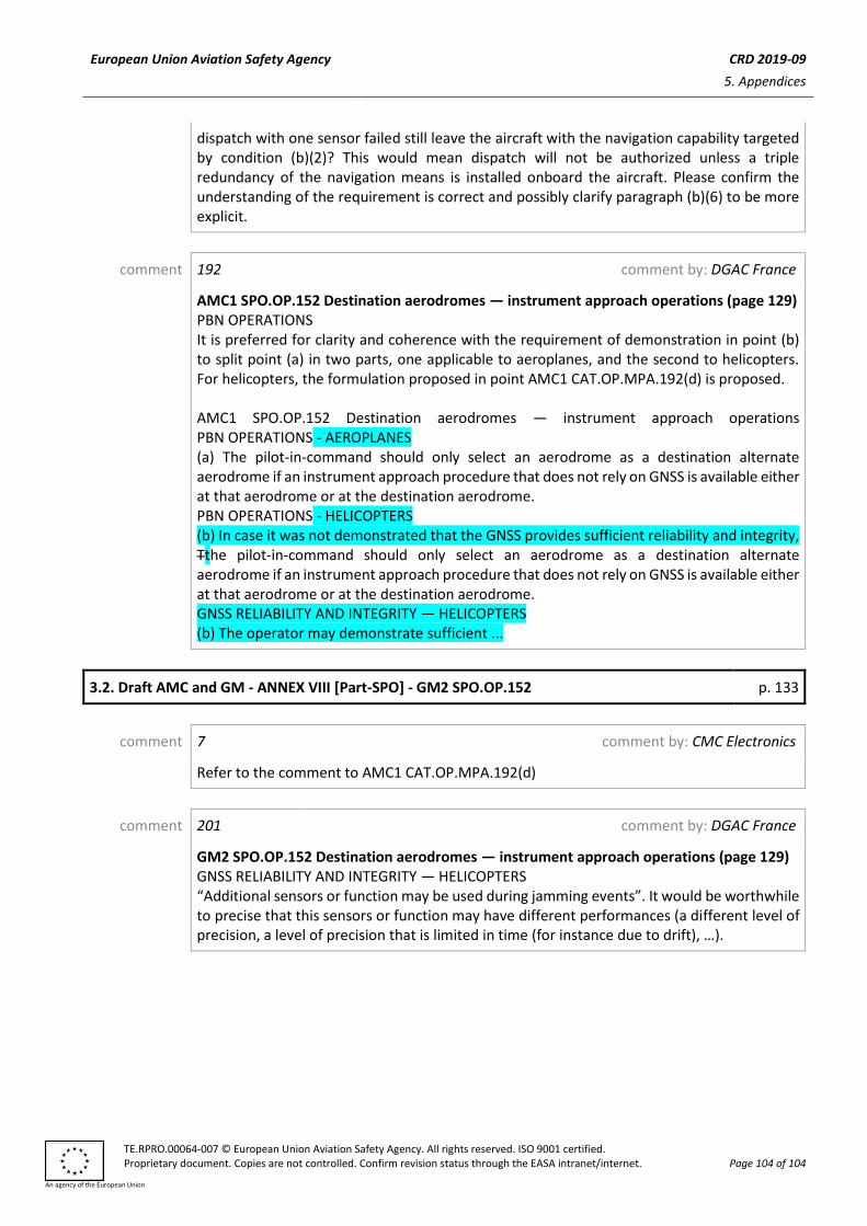
European Union Aviation Safety Agency CRD 2019-09
5. Appendices
TE.RPRO.00064-007 © European Union Aviation Safety Agency. All rights reserved. ISO 9001 certified. Proprietary document. Copies are not controlled. Confirm revision status through the EASA intranet/internet. Page 104 of 104
An agency of the European Union
dispatch with one sensor failed still leave the aircraft with the navigation capability targeted by condition (b)(2)? This would mean dispatch will not be authorized unless a triple redundancy of the navigation means is installed onboard the aircraft. Please confirm the understanding of the requirement is correct and possibly clarify paragraph (b)(6) to be more explicit.
comment 192 comment by: DGAC France
AMC1 SPO.OP.152 Destination aerodromes — instrument approach operations (page 129) PBN OPERATIONS It is preferred for clarity and coherence with the requirement of demonstration in point (b) to split point (a) in two parts, one applicable to aeroplanes, and the second to helicopters. For helicopters, the formulation proposed in point AMC1 CAT.OP.MPA.192(d) is proposed. AMC1 SPO.OP.152 Destination aerodromes — instrument approach operations PBN OPERATIONS - AEROPLANES (a) The pilot-in-command should only select an aerodrome as a destination alternate aerodrome if an instrument approach procedure that does not rely on GNSS is available either at that aerodrome or at the destination aerodrome. PBN OPERATIONS - HELICOPTERS (b) In case it was not demonstrated that the GNSS provides sufficient reliability and integrity, Tthe pilot-in-command should only select an aerodrome as a destination alternate aerodrome if an instrument approach procedure that does not rely on GNSS is available either at that aerodrome or at the destination aerodrome. GNSS RELIABILITY AND INTEGRITY — HELICOPTERS (b) The operator may demonstrate sufficient ...
3.2. Draft AMC and GM - ANNEX VIII [Part-SPO] - GM2 SPO.OP.152 p. 133
comment 7 comment by: CMC Electronics
Refer to the comment to AMC1 CAT.OP.MPA.192(d)
comment 201 comment by: DGAC France
GM2 SPO.OP.152 Destination aerodromes — instrument approach operations (page 129) GNSS RELIABILITY AND INTEGRITY — HELICOPTERS “Additional sensors or function may be used during jamming events”. It would be worthwhile to precise that this sensors or function may have different performances (a different level of precision, a level of precision that is limited in time (for instance due to drift), …).