Embed Size (px)
Citation preview

Crossroads WestS P E C I F I C P L A N
Riverbank’s Newest Master Planned Community
Prepared by:
February 2019


Crossroads West Specific Plan | 3
Table of ContentsCHAPTER 1 - EXECUTIVE SUMMARY
1.1 Specific Plan Purpose and Process ......................................................................................................................... 111.2 Specific Plan Organization ...................................................................................................................................... 121.3 Plan Area Vicinity and Project Description ......................................................................................................... 141.4 Existing Conditions Summary ............................................................................................................................... 16 1.4.1 Property Ownership ................................................................................................................................... 16 1.4.2 Existing and Surrounding Land Use ........................................................................................................ 16 1.4.3 Topography and Drainage ......................................................................................................................... 18 1.4.4 Biological Resource .................................................................................................................................... 181.5 Summary of Land Use Plan .................................................................................................................................... 18
CHAPTER 2 - CONTEXT & SETTING
2.1 Project History ...................................................................................................................................................... 212.2 Compliance and Regulatory Authority ................................................................................................................. 21 2.2.1 Specific Plan Authority .............................................................................................................................. 21 2.2.2 Entitlement Phasing and Sequence .......................................................................................................... 22 2.2.3 CEQA Compliance ..................................................................................................................................... 22 2.2.4 Severability .................................................................................................................................................. 22 2.3 Policy Setting – City of Riverbank General Plan ................................................................................................. 22 2.3.1 General Plan Land Use .............................................................................................................................. 23 2.3.2 General Plan Analysis ................................................................................................................................ 232.4 Site Analysis and Existing Conditions .................................................................................................................. 23
CHAPTER 3 - VISION FOR CROSSROADS WEST
3.1 Overview ...................................................................................................................................................... 273.2 Crossroads West within the Regional Context .................................................................................................... 273.3 The Crossroads West Plan ....................................................................................................................................... 273.4 Development Principles .......................................................................................................................................... 28 3.4.1 Sustainability Elements .............................................................................................................................. 283.5 Planning and Design Principles ............................................................................................................................. 29 3.5.1 Sustainability Elements .............................................................................................................................. 29 3.5.2 Community Elements ................................................................................................................................ 31

4 | Crossroads West Specific Plan
CHAPTER 4 - LAND USE
4.1 Overview ...................................................................................................................................................... 334.2 Main Elements of the Land Use Plan .................................................................................................................... 354.3 Land Use in Crossroads West ................................................................................................................................ .36 4.3.1 Mixed Use 1 ................................................................................................................................................. 36 4.3.2 Mixed Use 2 ................................................................................................................................................. 36 4.3.3 Residential ................................................................................................................................................... 37 4.3.4 Parks and Open Space................................................................................................................................ 37 4.3.5 Interim Agricultural Uses .......................................................................................................................... 374.4 Land Use Regulations and Development Standards ........................................................................................... 37 4.4.1 Mixed Use 1 ................................................................................................................................................. 38 4.4.1.1 Purpose and Scope ..................................................................................................................... 38 4.4.1.2 Density/FAR................................................................................................................................ 38 4.4.1.3 Allowed Land Uses .................................................................................................................... .39 4.4.1.4 Development Standards ............................................................................................................ 41 4.4.2 Mixed Use 2 ................................................................................................................................................. 43 4.4.2.1 Purpose ........................................................................................................................................ 43 4.4.2.2 Density/FAR................................................................................................................................ 43 4.4.2.3 Allowed Uses ............................................................................................................................... 43 4.4.2.4 Conditional Uses ........................................................................................................................ 43 4.4.2.5 Development Standards ............................................................................................................ 43 4.4.3 Low Density Residential ............................................................................................................................ 44 4.4.3.1 Purpose ........................................................................................................................................ 44 4.4.3.2 Density ......................................................................................................................................... 44 4.4.3.3 Allowed Uses ............................................................................................................................... 46 4.4.3.4 Development Standards ............................................................................................................ 47 4.4.4 Medium Density Residential..................................................................................................................... 47 4.4.4.1 Purpose ........................................................................................................................................ 47 4.4.4.2 Density ......................................................................................................................................... 47 4.4.4.3 Allowed Uses ............................................................................................................................... 47 4.4.5 High Density Residential ........................................................................................................................... 47 4.4.5.1 Purpose ........................................................................................................................................ 47 4.4.5.2 Density/FAR................................................................................................................................ 47 4.4.5.3 Allowed Uses ............................................................................................................................... 48 4.4.5.4 Compatible Transition from Higher Density Development to Less Intensive Uses ......... 48 4.4.5.5 Development Standards ............................................................................................................ 49 4.4.6 Parks and Open Space................................................................................................................................ 50 4.4.6.1 Purpose ........................................................................................................................................ 50 4.4.6.2 Allowable/Required Area .......................................................................................................... 50 4.4.6.3 Allowed Land Uses ..................................................................................................................... 52 4.4.6.4 Conditional Uses ........................................................................................................................ 52 4.4.6.5 Development Standards ............................................................................................................ 52
Crossroads West Specific Plan | 5
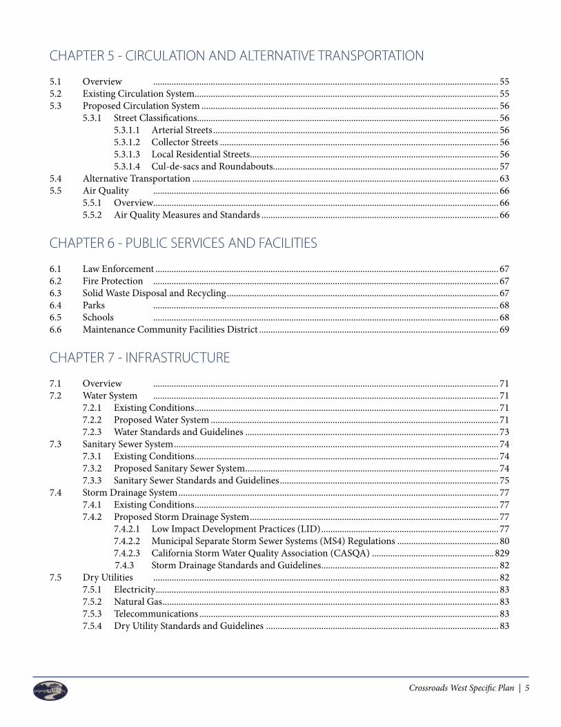
CHAPTER 5 - CIRCULATION AND ALTERNATIVE TRANSPORTATION
5.1 Overview ...................................................................................................................................................... 555.2 Existing Circulation System .................................................................................................................................... 555.3 Proposed Circulation System ................................................................................................................................. 56 5.3.1 Street Classifications................................................................................................................................... 56 5.3.1.1 Arterial Streets ............................................................................................................................ 56 5.3.1.2 Collector Streets ......................................................................................................................... 56 5.3.1.3 Local Residential Streets ............................................................................................................ 56 5.3.1.4 Cul-de-sacs and Roundabouts.................................................................................................. 575.4 Alternative Transportation ..................................................................................................................................... 635.5 Air Quality ...................................................................................................................................................... 66 5.5.1 Overview ...................................................................................................................................................... 66 5.5.2 Air Quality Measures and Standards ....................................................................................................... 66
CHAPTER 6 - PUBLIC SERVICES AND FACILITIES
6.1 Law Enforcement ..................................................................................................................................................... 676.2 Fire Protection ...................................................................................................................................................... 676.3 Solid Waste Disposal and Recycling ...................................................................................................................... 676.4 Parks ...................................................................................................................................................... 686.5 Schools ...................................................................................................................................................... 686.6 Maintenance Community Facilities District ........................................................................................................ 69
CHAPTER 7 - INFRASTRUCTURE
7.1 Overview ...................................................................................................................................................... 717.2 Water System ...................................................................................................................................................... 71 7.2.1 Existing Conditions .................................................................................................................................... 71 7.2.2 Proposed Water System ............................................................................................................................. 71 7.2.3 Water Standards and Guidelines .............................................................................................................. 737.3 Sanitary Sewer System ............................................................................................................................................. 74 7.3.1 Existing Conditions .................................................................................................................................... 74 7.3.2 Proposed Sanitary Sewer System .............................................................................................................. 74 7.3.3 Sanitary Sewer Standards and Guidelines ............................................................................................... 757.4 Storm Drainage System ........................................................................................................................................... 77 7.4.1 Existing Conditions .................................................................................................................................... 77 7.4.2 Proposed Storm Drainage System ............................................................................................................ 77 7.4.2.1 Low Impact Development Practices (LID) ............................................................................. 77 7.4.2.2 Municipal Separate Storm Sewer Systems (MS4) Regulations ............................................ 80 7.4.2.3 California Storm Water Quality Association (CASQA) .....................................................829 7.4.3 Storm Drainage Standards and Guidelines ............................................................................. 82 7.5 Dry Utilities ...................................................................................................................................................... 82 7.5.1 Electricity ..................................................................................................................................................... 83 7.5.2 Natural Gas .................................................................................................................................................. 83 7.5.3 Telecommunications .................................................................................................................................. 83 7.5.4 Dry Utility Standards and Guidelines ..................................................................................................... 83

6 | Crossroads West Specific Plan
CHAPTER 8 - DESIGN GUIDELINES
8.1 MU 1 Overview ...................................................................................................................................................... 85 8.1.1 MU 1 Site Design ........................................................................................................................................ 85 8.1.1.1 Placement and Orientation ....................................................................................................... 86 8.1.1.2 Parking and Circulation ............................................................................................................ 86 8.1.1.3 Landscape, Lighting, Signs and Site Amenities ...................................................................... 87 8.1.2 Architecture ................................................................................................................................................. 88 8.1.2.1 Style and Design ......................................................................................................................... 89 8.1.2.2 Massing, Scale and Form ........................................................................................................... 89 8.1.2.3 Site Design ................................................................................................................................... 90 8.1.2.4 Materials ..................................................................................................................................... 90 8.1.2.5 Signage ........................................................................................................................................ 918.2 Mixed Use 2 Overview ............................................................................................................................................ 91 8.2.1 Mixed Use 2 Site Design ............................................................................................................................ 92 8.2.1.1 Placement and Orientation ....................................................................................................... 92 8.2.1.2 Parking and Circulation ............................................................................................................ 92 8.2.2 Architecture ................................................................................................................................................. 92 8.2.2.1 Style and Design ......................................................................................................................... 92 8.2.2.2 Massing, Scale and Form ........................................................................................................... 93 8.2.2.3 Architectural Style ...................................................................................................................... 93 8.3 Residential Overview ............................................................................................................................................... 93 8.3.1 Low Density Residential ............................................................................................................................ 93 8.3.2 Medium Density Residential..................................................................................................................... 94 8.3.3 High Density Residential ........................................................................................................................... 94 8.3.4 Residential Site Design .............................................................................................................................. 94 8.3.4.1 Placement and Orientation ....................................................................................................... 94 8.3.4.2 Parking ......................................................................................................................................... 94 8.3.5 Architecture ................................................................................................................................................. 95 8.3.5.1 Style and Design ......................................................................................................................... 95 8.3.5.2 Massing, Scale and Form ........................................................................................................... 95 8.3.5.3 Architectural Style ...................................................................................................................... 96 8.3.5.3.1 Craftsman ................................................................................................................. 97 8.3.5.3.2 Traditional (American) ........................................................................................... 98 8.3.5.3.3 Italianate .................................................................................................................... 99 8.3.5.3.4 Spanish Colonial ....................................................................................................100 8.3.5.3.5 French......................................................................................................................1018.4 Streetscape Guidelines and Character .................................................................................................................102 8.4.1 Paving and Sidewalks ...............................................................................................................................102 8.4.2 Lighting ....................................................................................................................................................102 8.4.3 Street Furniture .........................................................................................................................................103 8.4.4 Public Art ..................................................................................................................................................103 8.4.5 Walls and Fences .......................................................................................................................................1048.5 Landscape Guidelines ............................................................................................................................................104 8.5.1 Street Landscape .......................................................................................................................................104 8.5.2 Public Open Space Landscape ................................................................................................................106 8.5.3 Parks and Trails Landscape .....................................................................................................................107 8.5.4 Entry Monuments and Roundabouts Landscape .................................................................................107 8.5.5 Master Street Tree Plan ............................................................................................................................109

Crossroads West Specific Plan | 7
CHAPTER 9 - PROJECT FINANCING PLAN
9.1 Overview ....................................................................................................................................................1119.2 Phasing ....................................................................................................................................................111 9.2.1 Phase A ....................................................................................................................................................112 9.2.2 Phase B ....................................................................................................................................................112 9.2.3 Phase C ....................................................................................................................................................112 9.2.4 Major Back Bone Infrastructure .............................................................................................................114 9.2.4.1 Water Well and Peaking Reservoir.........................................................................................114 9.2.4.2 Off-Site Sewer Improvements .................................................................................................114 9.2.4.3 Morrill Road .............................................................................................................................115 9.2.4.4 Bridge Crossings at MID Lateral No. 6 .................................................................................115 9.2.4.5 Crawford Road Connection ...................................................................................................115 9.2.5 Major Backbone Infrastructure for MU 1 Property ............................................................................116 9.2.5.1 Oakdale Road (if necessary to make modifications to the existing completed improvements)..........................................................................................................................116 9.2.5.2 Claribel Road ............................................................................................................................116 9.2.5.3 New North/South Collector Road / On-site Public Improvements ..................................1169.3 Financing Strategies ...............................................................................................................................................117 9.3.1 Area Specific Impact Fees ........................................................................................................................117 9.3.2 Assessment Districts and Special Tax Districts ....................................................................................117 9.3.2.1 Community Facilities District (CFDs) ..................................................................................118 9.3.3 Private Funding.........................................................................................................................................118 9.3.4 Other Funding Sources ............................................................................................................................118 9.4 Establishing Financing Plan .................................................................................................................................119 9.4.1 Financing Principles and Policies ...........................................................................................................119 9.4.2 Implementation of Financing Plan ........................................................................................................1209.5 City Services Provision ..........................................................................................................................................1219.6 Draft Capital Improvement Program ..................................................................................................................121 9.6.1 Phase A - Capital Improvement Program .............................................................................................122 9.6.2 Phase B - Capital Improvement Program .............................................................................................124 9.6.3 Phase C - Capital Improvement Program .............................................................................................126
CHAPTER 10 - IMPLEMENTATION AND ADMINISTRATION
10.1 Overview ....................................................................................................................................................129 10.1.1 City Documents ....................................................................................................................................................129 10.1.2 Specific Plan Documents .........................................................................................................................13010.2 Effectuation of Entitlements .................................................................................................................................13210.3 Amendment Process ..............................................................................................................................................13210.4 Architectural and Site Plan Review Process .......................................................................................................13210.5 Preliminary Development Plan Process ..............................................................................................................13310.6 Administration ....................................................................................................................................................13310.7 Interpretations ....................................................................................................................................................13410.8 Alternative Development & Design Standards ..................................................................................................13410.9 Amendment Process ...............................................................................................................................................135 10.9.1 Minor Specific Plan Modifications .........................................................................................................135 10.9.2 Major Specific Plan Amendments ..........................................................................................................13610.10 Specific Plan Enforcement .....................................................................................................................................13610.11 Severability ....................................................................................................................................................136

8 | Crossroads West Specific Plan
APPENDIX
Appendix A GP Consistency Matrix ............................................................................................................................137Appendix B Mitigation Monitoring and Reporting Program (MMRP) .................................................................151Appendix C MU-1 Master Sign Program ....................................................................................................................179Appendix D Chapter 157: Water Efficient Landscape and Irrigation ......................................................................191Appendix E Chapter 153: Zoning ................................................................................................................................199Appendix F Chapter 153.36: Retail Sale of Alcoholic Beverages .............................................................................207Appendix G City of Riverbank Master Street Tree List .............................................................................................213
LIST OF FIGURES:
Figure 1 – Project Vicinity Map ........................................................................................................................................... 15Figure 2 – Property Owner Map .......................................................................................................................................... 17Figure 3 – Existing and Surrounding Land Use ................................................................................................................. 20Figure 4 – City of Riverbank General Plan Land Use Map ............................................................................................... 24Figure 5 – Proposed Crossroads West Land Use Map ....................................................................................................... 34Figure 6 – Linear Park Basin ................................................................................................................................................. 51Figure 7 – Regional Sports Park Master Plan ..................................................................................................................... 53Figure 8 – Proposed Crossroads West Circulation Plan ................................................................................................... 58Figure 9 – Typical Street Cross Sections .............................................................................................................................. 59Figure 10 – Typical Street Cross Sections ........................................................................................................................... 60Figure 11 – Typical Street Cross Sections ........................................................................................................................... 61Figure 12 – Typical Street Cross Sections ........................................................................................................................... 62Figure 13 – Pedestrian and Bicycle Circulation Plan ........................................................................................................ 64Figure 14 – Proposed Public Transit Locations .................................................................................................................. 65Figure 15 – Proposed Crossroads West Water System ...................................................................................................... 72Figure 16 – Proposed Crossroads West Sanitary Sewer System ....................................................................................... 76Figure 17 – Proposed Crossroads West Storm Drainage System ..................................................................................... 81Figure 18 – Proposed Circulation for Crossroads Commercial ....................................................................................... 85Figure 19 – Walls and Fences ..............................................................................................................................................105
LIST OF TABLES:
Table 1 – Land Use Summary - Residential Land Use & Non Residential/MU Land Uses .......................................... 19Table 2 – Land Use Summary - Residential Land Use & Non Residential/MU Land Uses .......................................... 35 Table 3 – Summary Table for All Mixed Use Development Standards ........................................................................... 41Table 4 – Low Density Residential Standards (LDR) ......................................................................................................... 46Table 5 – Medium Density Residential Standards (MDR)................................................................................................ 47Table 6 – High Density Residential Standards (HDR) - Multi-Family/Apartments ..................................................... 48

Crossroads West Specific Plan | 9
DOCUMENT PREPARERS:
Sean TobinSr. Vice PresidentMVE, Inc.1117 L StreetModesto, CA 95354
LEAD AGENCY CONTACTS:
John B. Anderson Donna M. KenneyPresident Planning & Building ManagerJ.B. Anderson Land Use Planning City of Riverbank139 South Stockton Ave. Ripon, CA 209-836-7124
Sean Scully Bill KullCity Manager Giuliani & Kull, Inc.City of Riverbank City Engineer
Michael Riddell Sue FitzpatrickPublic Works Director Parks and Recreation DirectorCity of Riverbank City of Riverbank
City Council Members: Planning Commission:
Richard D. O’Brien John DinanMayor Chair
Darlene Barber-Martinez Robert BallVice Mayor (District 4) Vice Chair
Cal Campbell Melissa HughesCouncilmember (District 3) Commissioner
Luis Uribe Joan StewartCouncilmember (District 1) Chairman
Cindy Fosi Mallorie FenrichCity Councilmember (District 2) Commissioner

10 | Crossroads West Specific Plan
Left Blank Intentionally
Crossroads West Specific Plan | 11
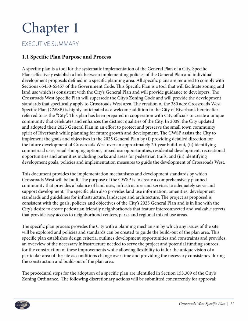
Chapter 1EXECUTIVE SUMMARY
1.1 Specific Plan Purpose and Process
A specific plan is a tool for the systematic implementation of the General Plan of a City. Specific Plans effectively establish a link between implementing policies of the General Plan and individual development proposals defined in a specific planning area. All specific plans are required to comply with Sections 65450-65457 of the Government Code. This Specific Plan is a tool that will facilitate zoning and land use which is consistent with the City’s General Plan and will provide guidance to developers. The Crossroads West Specific Plan will supersede the City’s Zoning Code and will provide the development standards that specifically apply to Crossroads West area. The creation of the 380 acre Crossroads West Specific Plan (CWSP) is highly anticipated as a welcome addition to the City of Riverbank hereinafter referred to as the “City”. This plan has been prepared in cooperation with City officials to create a unique community that celebrates and enhances the distinct qualities of the City. In 2009, the City updated and adopted their 2025 General Plan in an effort to protect and preserve the small town community spirit of Riverbank while planning for future growth and development. The CWSP assists the City to implement the goals and objectives in the 2025 General Plan by (i) providing detailed direction for the future development of Crossroads West over an approximately 20-year build-out, (ii) identifying commercial uses, retail shopping options, mixed use opportunities, residential development, recreational opportunities and amenities including parks and areas for pedestrian trails, and (iii) identifying development goals, policies and implementation measures to guide the development of Crossroads West.
This document provides the implementation mechanisms and development standards by which Crossroads West will be built. The purpose of the CWSP is to create a comprehensively planned community that provides a balance of land uses, infrastructure and services to adequately serve and support development. The specific plan also provides land use information, amenities, development standards and guidelines for infrastructure, landscape and architecture. The project as proposed is consistent with the goals, policies and objectives of the City’s 2025 General Plan and is in line with the City’s desire to create pedestrian friendly neighborhoods that feature interconnected and walkable streets that provide easy access to neighborhood centers, parks and regional mixed use areas.
The specific plan process provides the City with a planning mechanism by which any issues of the site will be explored and policies and standards can be created to guide the build-out of the plan area. This specific plan establishes design criteria, outlines development opportunities and constraints and provides an overview of the necessary infrastructure needed to serve the project and potential funding sources for the construction of these improvements while allowing flexibility to tailor the unique vision of a particular area of the site as conditions change over time and providing the necessary consistency during the construction and build-out of the plan area.
The procedural steps for the adoption of a specific plan are identified in Section 153.309 of the City’s Zoning Ordinance. The following discretionary actions will be submitted concurrently for approval:

12 | Crossroads West Specific Plan
Specific Plan – A specific plan requires adoption by resolution or ordinance, following public hearings before both the Planning Commission and the City Council. Additional entitlement applications that are necessary for the implementation of the specific plan may be made concurrently with the specific plan application.
General Plan Amendments – With the adoption of the 2025 General Plan, the City has indicated a preferred land use distribution for lands covered by the Crossroads West project site. In order to develop the site according to the Riverbank General Plan, several General Plan Amendments are necessary. First, because the Specific Plan is being developed to survive 20 years or so, the City has agreed to create a Specific Plan General Plan designation to govern the land use mix and density. This new General Plan Land Use designation will follow the land use mix envisioned with the Riverbank 2025 General Plan, but will eliminate the geographic representation of each designation area within the defined Specific Plan boundary. In this case, the Specific Plan will demonstrate the specific location of each use and document the method in which the plan area will be implemented following the density and intensity goals set by the defined Specific Plan General Plan designation. In this manner, the Crossroads West Specific Plan area will receive a General Plan designation of Specific Plan (SP). Third, the proposed Specific Plan suggests the relocation of certain planned roads identified on the General Plan Circulation Element. The adopted General Plan Circulation Element will need to be modified to conform to the certain street patterns proposed with this Specific Plan.
Prezone Application – Concurrent with the adoption of a specific plan, the planning area must be prezoned SP and assigned a number from the City. As referenced above, it may be necessary to connect the adoption of the specific plan with the adoption of other entitlements or programs such as subdivision or parcel maps, area facilities plans, design guidelines, monitoring programs, planned development permits, financing mechanisms, etc. to implement the plan. The specific plan shall define the relationship between other planning documents and the defined planning area.
Annexation Application – In addition to this specific plan and prezone request, the applicant has prepared an annexation application to the City of Riverbank who in turn will be requested annexation of the subject area through an application with Stanislaus LAFCO. Annexation of the 380+/- acres is necessary in order to receive the service benefits provided by the City of Riverbank. These include utilities, public safety protection and other City provided services such as public works and park maintenance.
Development Agreement – The applicants have suggested that a future action of the City of Riverbank would be to include the consideration of a Development Agreement to define certain terms of development timing, phased implementation obligations and reimbursement terms.
1.2 Specific Plan Organization
The Crossroads West Specific Plan has been organized into 10 chapters and they are described as follows:
Chapter 1 – Executive Summary provides an overview of the specific plan purpose and process; identifies Plan Area location and summarizes the vision for the Crossroads West development including the land use plan.

Crossroads West Specific Plan | 13
Chapter 2 – Context and Setting discusses the legal authority of the specific plan document, the policy setting methods and compatibility with the City of Riverbank General Plan and Zoning Code as well provides a brief overview of the site and the existing conditions.
Chapter 3 – Vision for Crossroads West provides a vision for the project with design and planning principles and how these principles relate to Crossroads West.
Chapter 4 – Land Use provides detail regarding the land use plan and land use designations. The land use chapter also provides development standards for each land use, which will help guide development of the plan area.
Chapter 5 – Circulation and Alternative Transportation provides a summary of the existing roadway system in the plan area and an overview of the proposed circulation system of Crossroads West. Details include street classifications and sections, bike paths and walkways, bus transit facilities and alternatives to vehicle use.
Chapter 6 – Public Services and Facilities provides information relating to the public services and facilities that will serve the plan area including law enforcement, fire protection, solid waste disposal and recycling, parks and schools.
Chapter 7 – Infrastructure provides a summary of the backbone infrastructure systems for water, sanitary sewer and storm drainage that will service the plan area. Preliminary Master Plan studies have been prepared for the site and will need periodic review and amendment as subdivision and/or parcel maps are submitted.
Chapter 8 – Design Guidelines details the architectural styles and site planning for each land use district. These Design Guidelines are intended to provide guidance and direction for all development within the plan area, creating a unique and inviting Crossroads West community.
Chapter 9 – Project Financing Plan provides funding and financing mechanisms that may be used to fund the development and construction of public facilities and improvements including roadways, parks and backbone infrastructure.
Chapter 10 – Implementation and Administration describes the process for which subsequent and future submittals are made and if necessary, how amendments will be reviewed and approved for the specific plan.

14 | Crossroads West Specific Plan
1.3 Plan Area Vicinity and Project Description
The CWSP is approximately 380 acres, which is centrally located in Stanislaus County in the heart of the San Joaquin Valley. The plan area is bound to the west by farm land and existing residential homes on large lots. Oakdale Road bounds the plan area to the east; Claribel Road bounds the plan area to the south and the Riverbank Regional Sports Park and MID Main Canal bound the plan area to the north. MID Lateral No. 6 bifurcates the plan area in the southern third of the parcel. The project area encompasses approximately 380 acres of land that has primarily been used for farming and agricultural purposes. The boundaries of the site are within the City’s proposed sphere of influence and are a natural choice for annexation because of its location to existing development and existing infrastructure. Please see Figure 1 – Project Vicinity Map for a visual of the project location.
The 380 acre Crossroads West development is envisioned as a vibrant mixed use community consisting of residential, retail, commercial, office, hospitality, entertainment, recreation, mixed use and/or public and civic facilities, interconnected walking and biking paths, parks and open space. The land use plan for the Crossroad West development is located in Chapter 4 of this specific plan as Figure 5. The retail, commercial, office, hospitality, entertainment, recreation and mixed uses within the plan area will assist in job creation, further complying with the City’s goals and policies of their 2025 General Plan. The site is compact in design and therefore has been planned efficiently. By increasing pedestrian connectivity to existing uses to the north and east, the small town community atmosphere desired by the City has been preserved.
There are approximately 59+/- acres of land intended for mixed use commercial, office, hospitality, entertainment, recreation, mixed uses, and/or retail/residential development. These are identified in Figure 5 as Mixed Use 1 and Mixed Use 2. The largest concentration of retail development will be located at the southern end of the plan area at the intersection of Oakdale Road and Claribel Road and is identified as Mixed Use 1. A smaller mixed use site is located near Morrill Road and Oakdale Road and is identified as Mixed Use 2.Proposed lot densities in the residential component of the CWSP are consistent with the 2025 General Plan. The residential lots will vary between low density (0-8 du/ac), medium density (8-16 du/ac) and high density residential
Existing shopping center Oakdale/Claribel.
Existing irrigating ditch
Existing Riverbanks Sports Complex
Existing Oakdale Road

Crossroads West Specific Plan | 15
Figure 1 - Project Vicinity MapFigure 1 - Vicinity Map
N
PROJECTAREA
CRAWFORD ROAD
MORRILL ROAD
COFF
EE R
OA
D
OA
KD
ALE
RO
AD
PATTERSON ROAD
MID MAIN CANAL
MID LATERAL 6
CLARIBEL ROAD
16 | Crossroads West Specific Plan
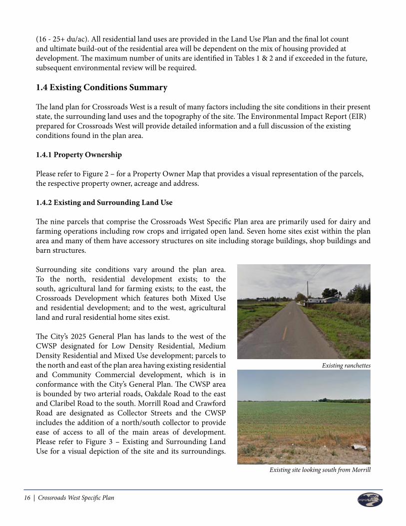
(16 - 25+ du/ac). All residential land uses are provided in the Land Use Plan and the final lot count and ultimate build-out of the residential area will be dependent on the mix of housing provided at development. The maximum number of units are identified in Tables 1 & 2 and if exceeded in the future, subsequent environmental review will be required.
1.4 Existing Conditions Summary
The land plan for Crossroads West is a result of many factors including the site conditions in their present state, the surrounding land uses and the topography of the site. The Environmental Impact Report (EIR) prepared for Crossroads West will provide detailed information and a full discussion of the existing conditions found in the plan area.
1.4.1 Property Ownership
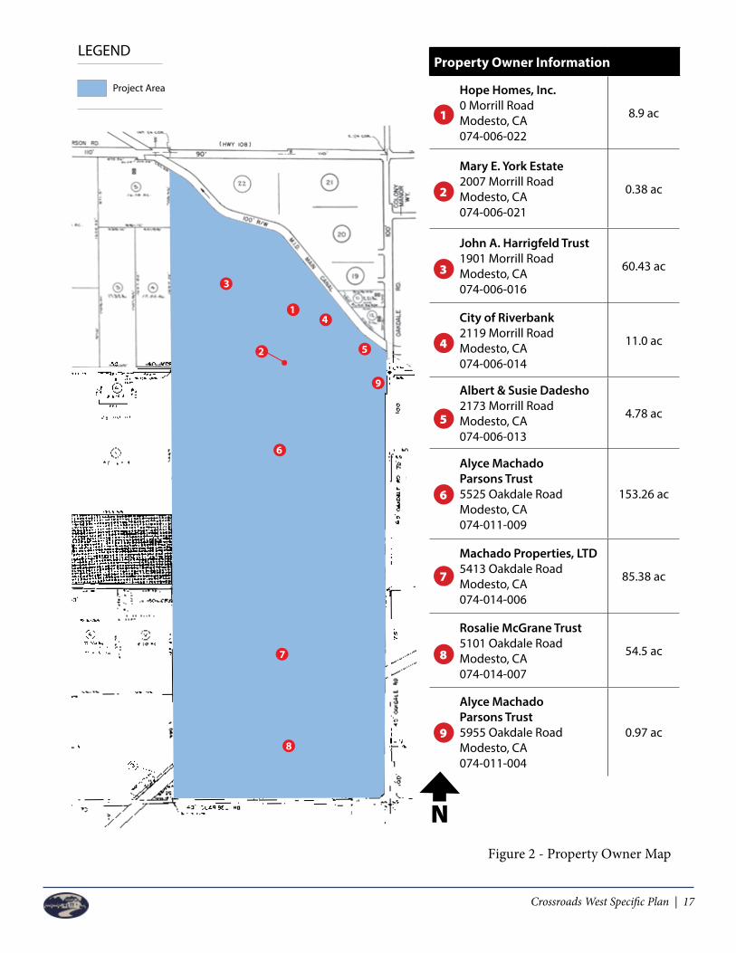
Please refer to Figure 2 – for a Property Owner Map that provides a visual representation of the parcels, the respective property owner, acreage and address.
1.4.2 Existing and Surrounding Land Use
The nine parcels that comprise the Crossroads West Specific Plan area are primarily used for dairy and farming operations including row crops and irrigated open land. Seven home sites exist within the plan area and many of them have accessory structures on site including storage buildings, shop buildings and barn structures.
Surrounding site conditions vary around the plan area. To the north, residential development exists; to the south, agricultural land for farming exists; to the east, the Crossroads Development which features both Mixed Use and residential development; and to the west, agricultural land and rural residential home sites exist.
The City’s 2025 General Plan has lands to the west of the CWSP designated for Low Density Residential, Medium Density Residential and Mixed Use development; parcels to the north and east of the plan area having existing residential and Community Commercial development, which is in conformance with the City’s General Plan. The CWSP area is bounded by two arterial roads, Oakdale Road to the east and Claribel Road to the south. Morrill Road and Crawford Road are designated as Collector Streets and the CWSP includes the addition of a north/south collector to provide ease of access to all of the main areas of development. Please refer to Figure 3 – Existing and Surrounding Land Use for a visual depiction of the site and its surroundings.
Existing ranchettes
Existing site looking south from Morrill
Crossroads West Specific Plan | 17
Figure 2 - Property Owner Map
N
PROPER T Y OWNERSHIP MAP • R IVERBANK , CATERCEIRA
06
26
2_
Pro
pe
rty_
Ow
ne
rsh
ip_
map
_V
1
06
08
07
_T
T
0 400 800 1200
Project Management • Urban Design • Land Planning • Entitlements Engineering • Surveying • Construction Staking • Marketing & Graphics
Corporate: 200 W. Roseburg Avenue, Suite B2, Modesto, CA 95350 • 866.526.4214www.mve.net • Modesto, CA • Stockton, CA • Fresno, CA • Reno, NV • Scottsdale, AZ
LEGEND
Project Area
3
41
2 5
6
7
8
9
1. York Robert E. 2007 Morrill Road8.90 ACAPN # 074-006-022
2. York Robert E.2007 Morrill Road0.37 ACAPN # 074-006-021
3. Christian & Sonya Harrigfeld1901 Morrill Road60.43 ACAPN # 074-006-016
4. City of Riverbank2119 Morrill Road11.14 ACAPN # 074-006-014
5. Dadesho Albert Wilson/Dadesho Susie2173 Morrill Road4.92 ACAPN # 074-006-013
6. Alyce Machado Parsons5525 Oakdale Road153.26 ACAPN # 074-011-009
7. Machado Properties LTD5413 Oakdale Road85.38 ACAPN # 074-014-006
8. Bosio 2003 Family LP5101 Oakdale Road57.65 ACAPN # 074-014-007
9. City of Riverbank2119 Morrill Road1.24 ACAPN # 074-014-004
PROPERTY OWNER INFO
PROPER T Y OWNERSHIP MAP • R IVERBANK , CATERCEIRA
06
26
2_
Pro
pe
rty_
Ow
ne
rsh
ip_
map
_V
1
06
08
07
_T
T
0 400 800 1200
Project Management • Urban Design • Land Planning • Entitlements Engineering • Surveying • Construction Staking • Marketing & Graphics
Corporate: 200 W. Roseburg Avenue, Suite B2, Modesto, CA 95350 • 866.526.4214www.mve.net • Modesto, CA • Stockton, CA • Fresno, CA • Reno, NV • Scottsdale, AZ
LEGEND
Project Area
3
4
1
2 5
67
8
9
1. York Robert E. 2007 Morrill Road8.90 ACAPN # 074-006-022
2. York Robert E.2007 Morrill Road0.37 ACAPN # 074-006-021
3. Christian & Sonya Harrigfeld1901 Morrill Road60.43 ACAPN # 074-006-016
4. City of Riverbank2119 Morrill Road11.14 ACAPN # 074-006-014
5. Dadesho Albert Wilson/Dadesho Susie2173 Morrill Road4.92 ACAPN # 074-006-013
6. Alyce Machado Parsons5525 Oakdale Road153.26 ACAPN # 074-011-009
7. Machado Properties LTD5413 Oakdale Road85.38 ACAPN # 074-014-006
8. Bosio 2003 Family LP5101 Oakdale Road57.65 ACAPN # 074-014-007
9. City of Riverbank2119 Morrill Road1.24 ACAPN # 074-014-004
PROPERTY OWNER INFO
Property Owner Information
Hope Homes, Inc. 0 Morrill RoadModesto, CA074-006-022
8.9 ac
Mary E. York Estate2007 Morrill RoadModesto, CA074-006-021
0.38 ac
John A. Harrigfeld Trust 1901 Morrill RoadModesto, CA074-006-016
60.43 ac
City of Riverbank2119 Morrill RoadModesto, CA074-006-014
11.0 ac
Albert & Susie Dadesho2173 Morrill RoadModesto, CA074-006-013
4.78 ac
Alyce Machado Parsons Trust 5525 Oakdale RoadModesto, CA 074-011-009
153.26 ac
Machado Properties, LTD 5413 Oakdale RoadModesto, CA074-014-006
85.38 ac
Rosalie McGrane Trust 5101 Oakdale RoadModesto, CA 074-014-007
54.5 ac
Alyce Machado Parsons Trust 5955 Oakdale RoadModesto, CA074-011-004
0.97 ac
1
2
3
4
5
6
7
8
9
Figure 2 - Property Owner Map

18 | Crossroads West Specific Plan
1.4.3 Topography and Drainage
The lands that comprise the CWSP area are relatively flat and are utilized primarily for farming of row crops and dairy operations. Based on observation and preliminary runoff data, the plan area generally slopes and drains from the northeast towards the southwest.
1.4.4 Biological Resource
The primary use of the plan area today is agricultural in nature with uses including dairy operations, row crops and fallow land. Due to the intensive agriculture use that is present on the site and the lack of a suitable habitat, it is unlikely that any special status plants or species exist on the site. Due to the historic and current use of the property, no potentially jurisdictional wetlands or Waters of the US have been observed in or surrounding the plan area.
1.5 Summary of Land Use Plan
The land use plan as proposed for Crossroads West has approximately 59 acres dedicated to mixed use development. These areas will feature a mix of commercial, retail, office, hospitality, entertainment, recreation, residential, restaurants, neighborhood and regional commercial uses, as further described in Section 4.4.1 and 4.4.2, that will help with job creation for the City and provide convenient shopping destinations for the residents of Riverbank. Residential development is permitted within the mixed use areas, identified on the Land Use Plan as Mixed Use 1 (MU 1) and Mixed Use 2 (MU 2), and discussed in more detail in Chapter 4 of this Specific Plan. The remainder of the site is dedicated to residential land uses, parks and open space and the potential for development of a school site(s). The ultimate build-out of these areas will be determined with the submittal of final development plans.
The land use plan as proposed would permit residential development within a range of between 1,524 to 2,452 residential units. For Low Density Residential (LDR) the plan assumes between 1,170 and 1,872 units, assuming a build-out at between 5 and 8 dwelling units per gross acre, after removing parks, schools, and collector and arterial road rights-of-way. Medium Density Residential (MDR) development is assumed at around 96 to 192 units, based upon a build-out at between 8 and 16 dwelling units per acre. Some MDR density development would be allowed in the LDR areas, although they would need to fall within the total LDR number unit range. High Density Residential (HDR) is assume to build-out at around 248 to 388 units on 15.5 acres, and assuming a build-out density of 16 to 25 dwelling units per acre. The maximum number of units are identified in Tables 1 & 2 and if exceeded in the future, subsequent environmental review will be required.
The Mixed Use 1 property could provide up to 550,000 square feet of MU 1 Commercial Uses (defined in Section 4.4.1.3 below), but could similarly provide less MU 1 Commercial Uses and more MU 1 Residential Uses (defined in Section 4.4.1.3 below) depending upon market demands at the timing of development (i.e. it could provide 360,000 square feet of MU 1 Commercial Uses and 350 MU 1 Residential dwelling units). Mixed Use 2 is estimated to develop with up to 27,000 square feet of retail, and about 25 to 50 residential units.

Crossroads West Specific Plan | 19
Table 1 provides a summary of the land uses proposed for Crossroads West. If any of the analyzed maximum land use intensities are exceeded, additional environmental review will be required.
Table 1 – Land Use Summary - Residential Land Use
Map Symbol Land Use Acreage Range
Density/S.F..Range
Units or S.F.Average
Density/S.F.Average
Units or S.F.
LDR Low Density Residential 234 5 du/ac - 8 du/ac 1,170 - 1,872 6.5 du/ac 1,521
MDR Medium DensityResidential 12 8 du/ac - 16 du/ac 96 - 192 12 du/ac 144
HDR High DensityResidential 15.5 16 du/ac - 25+ du/ac 248 - 388 20.5+ du/ac 318
PParks/Open Space/
RegionalSports Park
42 N/A N/A N/A N/A
Schools 12/20 N/A N/A N/A N/A
Map Symbol Land Use Acreage Maximum
Density/S.F.Maximum
Units or S.F.Maximum
S.F.
MU 1Mixed Use 1 (R)
Mixed Use 1 (C)54
25 du/ac
0.35 FAR1
350
360,000 sf
0
550,000 sf
MU 2Mixed Use 2 (R)
Mixed Use 2 (C)5
25 du/ac
0.35 FAR1
50
27,000 sf
N/A
N/A
Table 1 – Land Use Summary - Non Residential/MU Land Uses
1Residential and Hospitality uses are exempt from the FAR maximum.

20 | Crossroads West Specific Plan
Figure 3 – Existing and Surrounding Land UseFigure 3 – Existing and Surrounding Land Use
MACHADO RANCHPROPOSED GENERAL PLAN & SPHERE OF INFLUENCE BOUNDARY • R IVERBANK , CA
Project Management • Urban Design • Land Planning • Entitlements • Engineering • Surveying • Construction Staking • Marketing & Graphics
are
a_v2
_T
T
CLARIBEL ROAD
OA
KDA
LE
RO
AD
MORRILL ROAD
COFF
EE
RO
AD
LEGEND
Proposed General Plan Amendment Boundary Adjustment
Project Area
PROJECT AREA
1312
11
109
8
7
14
15
16
12
3 4
56
MORRILL ROAD
CLARIBEL ROAD
TERCEIRASITE PHOTOS • R IVERBANK , CA
Project Management • Urban Design • Land Planning • Entitlements • Engineering • Surveying • Construction Staking • Marketing & Graphicstos_
v2
dp
1 2 3 4
5 6 7 8
9 10 11 12
13 14 15 16
TERCEIRASITE PHOTOS • R IVERBANK , CA
Project Management • Urban Design • Land Planning • Entitlements • Engineering • Surveying • Construction Staking • Marketing & Graphicstos_
v2
dp
1 2 3 4
5 6 7 8
9 10 11 12
13 14 15 16
TERCEIRASITE PHOTOS • R IVERBANK , CA
Project Management • Urban Design • Land Planning • Entitlements • Engineering • Surveying • Construction Staking • Marketing & Graphicstos_
v2
dp
1 2 3 4
5 6 7 8
9 10 11 12
13 14 15 16
TERCEIRASITE PHOTOS • R IVERBANK , CA
Project Management • Urban Design • Land Planning • Entitlements • Engineering • Surveying • Construction Staking • Marketing & Graphicstos_
v2
dp
1 2 3 4
5 6 7 8
9 10 11 12
13 14 15 16
TERCEIRASITE PHOTOS • R IVERBANK , CA
Project Management • Urban Design • Land Planning • Entitlements • Engineering • Surveying • Construction Staking • Marketing & Graphicstos_
v2
dp
1 2 3 4
5 6 7 8
9 10 11 12
13 14 15 16
TERCEIRASITE PHOTOS • R IVERBANK , CA
Project Management • Urban Design • Land Planning • Entitlements • Engineering • Surveying • Construction Staking • Marketing & Graphicstos_
v2
dp
1 2 3 4
5 6 7 8
9 10 11 12
13 14 15 16
TERCEIRASITE PHOTOS • R IVERBANK , CA
Project Management • Urban Design • Land Planning • Entitlements • Engineering • Surveying • Construction Staking • Marketing & Graphicstos_
v2
dp
1 2 3 4
5 6 7 8
9 10 11 12
13 14 15 16
TERCEIRASITE PHOTOS • R IVERBANK , CA
Project Management • Urban Design • Land Planning • Entitlements • Engineering • Surveying • Construction Staking • Marketing & Graphicstos_
v2
dp
1 2 3 4
5 6 7 8
9 10 11 12
13 14 15 16
TERCEIRASITE PHOTOS • R IVERBANK , CA
Project Management • Urban Design • Land Planning • Entitlements • Engineering • Surveying • Construction Staking • Marketing & Graphicstos_
v2
dp
1 2 3 4
5 6 7 8
9 10 11 12
13 14 15 16
TERCEIRASITE PHOTOS • R IVERBANK , CA
Project Management • Urban Design • Land Planning • Entitlements • Engineering • Surveying • Construction Staking • Marketing & Graphicstos_
v2
dp
1 2 3 4
5 6 7 8
9 10 11 12
13 14 15 16
TERCEIRASITE PHOTOS • R IVERBANK , CA
Project Management • Urban Design • Land Planning • Entitlements • Engineering • Surveying • Construction Staking • Marketing & Graphicstos_
v2
dp
1 2 3 4
5 6 7 8
9 10 11 12
13 14 15 16
TERCEIRASITE PHOTOS • R IVERBANK , CA
Project Management • Urban Design • Land Planning • Entitlements • Engineering • Surveying • Construction Staking • Marketing & Graphicstos_
v2
dp
1 2 3 4
5 6 7 8
9 10 11 12
13 14 15 16
TERCEIRASITE PHOTOS • R IVERBANK , CA
Project Management • Urban Design • Land Planning • Entitlements • Engineering • Surveying • Construction Staking • Marketing & Graphicstos_
v2
dp
1 2 3 4
5 6 7 8
9 10 11 12
13 14 15 16
TERCEIRASITE PHOTOS • R IVERBANK , CA
Project Management • Urban Design • Land Planning • Entitlements • Engineering • Surveying • Construction Staking • Marketing & Graphicstos_
v2
dp
1 2 3 4
5 6 7 8
9 10 11 12
13 14 15 16
TERCEIRASITE PHOTOS • R IVERBANK , CA
Project Management • Urban Design • Land Planning • Entitlements • Engineering • Surveying • Construction Staking • Marketing & Graphicstos_
v2
dp
1 2 3 4
5 6 7 8
9 10 11 12
13 14 15 16
TERCEIRASITE PHOTOS • R IVERBANK , CA
Project Management • Urban Design • Land Planning • Entitlements • Engineering • Surveying • Construction Staking • Marketing & Graphicstos_
v2
dp
1 2 3 4
5 6 7 8
9 10 11 12
13 14 15 16
MID MAIN CANAL
MID LATERAL 6
N

Crossroads West Specific Plan | 21
Chapter 2CONTEXT & SETTING
2.1 Project History
Riverbank is a mid-size City in the Central Valley with a population of approximately 24,610 residents. The City has experienced well-planned growth over the last decade with new Community Commercial and residential developments adding to the character and community-oriented town the residents desire. Crossroads West will be the perfect addition to Riverbank as it will seamlessly blend with the existing Crossroads development while providing enhanced amenities in shopping, dining and recreation. The existing Crossroads development adjacent to the CWSP and across Oakdale Road to the east has been a highly successful Commercial project. Placed in the City Sphere of Influence in 1989, planned in the 1990’s and annexed in 1997, the City has focused its development efforts on the Crossroads area for over 25 years. As the Crossroads project is now basically complete, the Crossroads West development promotes orderly development because of its continuity with the existing Crossroads, the ease of access to the plan area via Oakdale Road and Claribel Road.
The CWSP provides a variety of residential and Mixed Use development opportunities that will complement the existing Crossroads project, provide room for public facilities and school sites if they are needed in the area, and provide vast areas of green space and open space as functional active and passive recreation areas. A mix of residential densities is planned which will accommodate an array of home buyers and family sizes.
2.2 Compliance and Regulatory Authority
2.2.1 Specific Plan Authority
Specific Plans are authorized and described in California Government Code Section 65450 et. seq. As set forth in the Government Code Section 65451, Specific Plans are required to contain the following information: (a) A specific plan shall include a text and a diagram or diagrams which specify all of the following in detail: (1) The distribution, location and extent of the uses of land, including open space, within the area covered by the plan. (2) The proposed distribution, location and extent and intensity of major components of public and private transportation, sewage, water, drainage, solid waste disposal, energy and other essential facilities proposed to be within the area covered by the plan and needed to support the land use described by the plan. (3) Standards and criteria by which development will proceed, and standards for the conservation, development and utilization of natural resources, where applicable. (4) A program of implementation including regulations, programs, public works projects and financing measures necessary to carry out paragraphs (1), (2) and (3).

22 | Crossroads West Specific Plan
The CWSP has been prepared along with supporting studies to provide text and diagrams for the items listed above. A land use plan diagram; major infrastructure and services including water, sanitary sewer and drainage; guidelines and standards; implementation and financing measures have been included.
(b) Section 65454 states: “No specific plan may be adopted or amended unless the proposed plan or amendment is consistent with the General Plan.
Working closely with City staff, the CWSP has been found to be in substantial compliance with the 2025 General Plan. Appendix A of this Specific Plan consists of the General Plan consistency matrix utilized to determine the Specific Plan is in substantial conformance with the 2025 General Plan.
2.2.2 Entitlement Phasing and Sequence
The CWSP provides general information regarding design, phasing, financing and implementation of the plan area. The CWSP suggests land use classifications which will establish the framework for the implementation of the development guidelines and constraints identified in the Specific Plan. The Plan Area will receive an SP zoning number which will be identified on the final, adopted Specific Plan. The Specific Plan summarizes some basic phasing and financing of backbone infrastructure to serve the plan area in Chapter 9. A more in depth project Infrastructure Financing and Phasing Plan will be provided prior to the approval of any parcel map, tentative map or subdivision map, development plan review or planned development process.
2.2.3 CEQA Compliance
Projects that do not meet certain categorical exemptions are subject to a review by the California Environmental Quality Act (CEQA). The Crossroads West plan area is subject to this environmental review under CEQA. In conjunction with the specific plan, an EIR will be prepared and submitted for review. The EIR will examine and evaluate environmental impacts and provide necessary mitigation measures for the plan area. The CWSP is intended to function together with the Mitigation Monitoring and Reporting Plan contained in the EIR. Mitigation measures which are developed as part of theEIR will be incorporated as policies or standards in the CWSP if applicable or they will be placed as conditions of approval on subsequent development applications for the plan area.
2.2.4 Severability
If any portion, regulation, condition or program of the Crossroads West Specific Plan are held invalid by a California or Federal Court of competent jurisdiction, such portions shall be deemed separate, distinct and independent provisions, and the invalidity of such provisions shall not affect the validity of the remaining provisions thereof.
2.3 Policy Setting – City of Riverbank General Plan
The goals, policies and implementation measures of the City of Riverbank 2025 General Plan, adopted on April 22, 2009 and amended on February 24, 2014, govern the CWSP area. A General Plan’s function is to provide guidance to the development and management of land within the City. The 2025 General Plan contains goals, policies and objectives to which all projects submitted for review and approval to the City

Crossroads West Specific Plan | 23
must adhere. The General Plan document summarizes its policies and implementation strategies as they relate to the City’s goals and objectives. The 2025 General Plan includes the following elements: Land Use, Circulation, Community Character and Design, Economic Development, Conservation and Open Space, Safety, Noise, Public Services and Facilities, Air Quality, Housing and Legal Authority.
2.3.1 General Plan Land Use
The CWSP area is currently under the jurisdiction of Stanislaus County, but within the City of Riverbank Sphere of Influence. See Figure 4 – City of Riverbank General Plan Land Use Map of the land use densities and intensities envisioned with the City’s 2025 General Plan.
While it is clear the CWSP is in substantial compliance with the City’s General Plan Land Use Element, it does differ enough to trigger an amendment to the 2025 General Plan document that will be processed concurrently with adoption of this document. The General Plan Amendment will be considered for approval by the City Council concurrently with the annexation and rezone applications, and consist of the creation of a General Plan land use designation of Specific Plan and some Circulation Element revisions.
2.3.2 General Plan Analysis
The City of Riverbank adopted their General Plan with lands envisioned for build-out through the year 2025. The estimated build-out of these lands will be phased to ensure orderly growth and development and will be dependent on population trends and demand for new housing and amenities for residents.It is important to phase development according to the demonstrated need for residential, Mixed Use and public uses and keep the supply manageable in accordance with available City services and infrastructure.
During public outreach for preparation of the 2025 General Plan, the City encountered key land issues brought forth from the public as well as known issues amongst City staff. Major concerns from the public were traffic congestion, housing affordability, loss of open space and rural character as well as a shift away from the redevelopment of downtown to other less prominent areas.
The overriding theme of the public outreach was balance. Residents of Riverbank and City staff wanted to find a balance between the revitalization of the existing downtown and the development of new retail, commercial and residential areas. Based on the goals, policies and procedures adopted in the 2025 General Plan, Crossroads West will blend seamlessly into the existing Community Commercial, mixed-use and residential areas presently found in Crossroads. Appendix A consists of a General Plan consistency matrix, and the CWSP is in conformance with the 2025 General Plan based on this analysis.
2.4 Site Analysis and Existing Conditions
Because of the existing use of the site, primarily dairy and farming operations, some constraints do exist in the plan area that will be fully addressed in the project EIR, although the constraints on the development of the site are few. The potential limitations and constraints are summarized below:
1. The Modesto Irrigation District (MID) Main Canal forms the northern boundary of the project site. While some may see this as a limiting factor to development in the area, the project applicant

24 | Crossroads West Specific Plan
Figure 4 – City of Riverbank General Plan Land Use Map
N
City of RiverbankGENERAL PLAN
AG Resource Conservation (AG)
Buffer/Greenway/Open Space(B/G/OS)
Civic (C)
Community Commercial (C/C)
Higher Density Residential - 16+ Units(HDR)
Industrial/Buisness Park (I/BP)
Lower Density Residential - 0-8 Units(LDR)
Medium Density Residential -8-16 Units (MDR)
Mixed Use (MU)
City Limits
Multi-Use Recreational/Resource(MUR/R)
Parks
Reserve (R)
January 2015
Reserve (R)
Clustered Rural Residential - 0.2 orless units per acre (RR)
LEGEND
City of RiverbankGENERAL PLAN
AG Resource Conservation (AG)
Buffer/Greenway/Open Space(B/G/OS)
Civic (C)
Community Commercial (C/C)
Higher Density Residential - 16+ Units(HDR)
Industrial/Buisness Park (I/BP)
Lower Density Residential - 0-8 Units(LDR)
Medium Density Residential -8-16 Units (MDR)
Mixed Use (MU)
City Limits
Multi-Use Recreational/Resource(MUR/R)
Parks
Reserve (R)
January 2015
Reserve (R)
Clustered Rural Residential - 0.2 orless units per acre (RR)
Figure 4 – City of Riverbank General Plan Land Use Map

Crossroads West Specific Plan | 25
sees it as a positive attribute to the project. A Class I Bike Trail will be created along the south side of the MID Main Canal which will provide continued recreational opportunities between the existing Riverbank community and the Crossroads West Specific Plan area.
2. Oakdale Road is classified as a major arterial roadway in the City’s 2025 General Plan. This type of roadway is designed as a multiple lane road which is intended to move a high volume of traffic to and from various destinations around the City. Because of the Mixed Use 1 development being proposed at Claribel and Oakdale Roads, this is actually seen as a positive factor for the CWSP. There will be ingress and egress locations along Oakdale and Claribel Roads to provide ease of access to Mixed Use 1. Smaller, collector roadways will be constructed heading north through the site as well as east and west to handle lower volume traffic to the residential areas and Regional Sports Park.
3. MID Lateral No. 6 runs east and west in the southern 1/3 of the project site. A vehicular and pedestrian crossing is proposed across this facility to provide access to the Mixed Use 1. The Specific Plan also suggests the construction of a trail along the north side of MID Lateral No. 6 again to connect the existing Riverbank community and Crossroads West Specific Plan area.
4. The western boundary of the plan area abuts agricultural land and residential estate lots which front on Crawford Road. Future urban development of the properties which front Crawford Road is unknown at this time. In the interim, the project applicant has proposed less intensive Low-Density Residential as well as a park basin along the western boundary of the plan to provide a buffer to the residents on Crawford Road.
5. Existing Crawford Road west of the project site contains numerous small ranchette style parcels. With the development of the project, traffic levels would be expected to increase on Crawford Road. While these levels would be within acceptable traffic levels of service, the residents on Crawford Road have expressed a concern about this increased traffic.
MID Main Canal at Oakdale Road

26 | Crossroads West Specific Plan
6. Concurrent with the first development in Phase B, a gate will be constructed across Crawford Road, near the project’s west property line, and an appropriate temporary vehicular turn around will be constructed on each side of the temporary gate. In addition, the temporary gate will be constructed in a way to allow quick access for the fire district to pass through and continue down Crawford Road, but otherwise will stay closed. As Crawford Road is constructed with the development of Phase B, and realigned consistent with this Specific Plan, and the north/south collector road and dual use/park basin are designed, the temporary gate and turnarounds will be revised to maintain emergency access, but not daily vehicular traffic. In the future, when the area between the project site and Coffee Road develops (it is located within the City of Riverbank sphere of influence), Crawford Road will be continued to Coffee Road, and an alternative route through the neighborhood may be proposed, or Crawford Road may become Crawford Court permanently. Such a determination will be made in the future when development plans are prepared for the area west of Crossroads West.
1. Aggregated Base (AB) Turn-Around2. AB Emergency Vehicle Access (EVA)3. Concrete EVA Driveway4. EVA Automated Gate and Fire Department Knox Box5. “Road Ends 500 ft” Signage - W31A (CA)6. “Emergency Access Keep Clear” Signage - SR46 (CA)
7. Proposed Collector Road8. Abandon Existing Crawford Road Right of Way9. Metal Split Rail Fencing or Similar10. Wrought Iron Fencing or Similar11. Property Line
Preliminary Crawford Road Emergency Vehicular Access (EVA) Layout
LEGEND
9
11
54
10
1 1 2
3
7
6
Existing Crawford Road
Park/Basin
Park/Basin
10 8
N

Crossroads West Specific Plan | 27
Chapter 3VISION FOR CROSSROADS WEST
3.1 Overview
The Crossroads West Specific Plan will be the implementing document for development within the plan area and will direct the development of the project site as a comprehensively planned new community in the City of Riverbank. With the approval and construction of the adjacent Crossroads project, the City of Riverbank set a precedent for high-quality development and met a demand for first class amenities for its residents. With approval of the CWSP, the City of Riverbank will create new standards for high-quality development and amenities and establish a benchmark for future development not only in Riverbank but for surrounding areas as well. The vision of Crossroads West will be realized and expressed in the design guidelines and character elements of the project. The specific details of how this vision will be carried forward are contained in the chapters that follow.
3.2 Crossroads West within the Regional Context
The Specific Plan process was initiated for this planning area with an initial vision to improve and expand housing opportunities for all types of home buyers, integrating land uses while updating planning philosophies, improving quality of life for residents, creating a livable community where motorized and non-motorized transportation modes work in harmony and a community that balances the economics and job creation with a visually pleasing neighborhood.
The City of Riverbank has created a unique community identity for itself with the existing Crossroads development. Crossroads West intends to expand and build upon the successes of Crossroads Specific Plan by further enhancing the area and providing additional amenities for all residents of Riverbank. The proximity of the planning area to Riverbank City Limit and the major access points from Oakdale Road and Claribel Road are the main reasons for developing this portion of Riverbank. Other virtues of the CWSP area are the availability of infrastructure, proximity to the Regional Sports Park and the opportunity to improve the jobs/housing balance in the City. Development of the planning area crafts a continuous growth pattern for the City and eliminates unincorporated islands.
3.3 The Crossroads West Plan
The vision for Crossroads West is to create a unique, mixed-use community inspired by small town America. Crossroads West will be a desirable community with a diverse mix of housing types, abundant open spaces and easy access to regional shopping, dining and entertainment. Illustration of proposed Park/Basin

28 | Crossroads West Specific Plan
The community will be centered on pedestrian friendly walkways, bike paths and landscaped corridors and will feature gateways that call attention to major intersections and neighborhoods within the planning area. The Crossroads West development is expected to be a positive addition to the City of Riverbank because it embraces and implements the City’s goals and policies as expressed in its General Plan.
The Commercial core of the community is the regional center (Mixed Use 1) located along Claribel Road. This area is envisioned as a pedestrian friendly mix of regional and neighborhood serving retail, commercial, office, residential, hospitality, entertainment, recreation, restaurants and services presented in a visually appealing manner to residents. Pedestrian access from the MID Lateral will be provided from the houses north of the center, truly creating a walkable community.
The residential components of the CWSP area are envisioned to be inviting and open. Homes will be placed near parks, retail and other amenities reinforcing the strong sense of place in each neighborhood. A mix of architectural themes is desirable for the area to promote the use of different materials, color palettes and styles.
3.4 Development Principles
The planning and design principles in the following sections provide the physical framework and further establish the vision for Crossroads West. These principles are intended to implement the development principles focusing on sustainability.
3.4.1 Sustainability Elements The creation of development principles is essential to create a strong sense of place, to improve the quality of life and create better places to live and work in the Crossroads West development. These development principles will help to achieve the vision for Crossroads West. The CWSP development principles are as follows:
• Promote a balance of uses in the land plan including retail, commercial, office, hospitality, entertainment, recreation and residential opportunities, schools, public facilities, parks and open space and varying density residential.
• Promote a mixed-use compact development pattern that is linked to regional amenities and transportation systems.
• Provide a variety of sidewalks and walkways throughout the project to promote connectivity, foster
Pedestrian friendly commercial courtyard
Class I bike trail

Crossroads West Specific Plan | 29
a sense of community and connect the residents of Riverbank to amenities and public facilities.• Protect adjacent farmland by providing transitional buffers.
• Encourage energy efficiency and thoughtful use of resources through sustainable design practices and Low-Impact Design (LID) strategies.
• Promote friendly and inviting streetscapes through the use of landscape materials, street fixtures, furniture and design elements that reflect a high-quality development.
• Encourage the use of mixed architectural styles and materials.
• Reinforce existing retail corridors to the east and designate sufficient commercial land for job generating uses to improve the jobs to housing balance.
• Create a safe and accessible link between neighborhoods, community facilities and Commercial uses and residential uses within the plan area and to the surrounding neighborhoods.
3.5 Planning and Design Principles
The planning and design principles in the following sections provide the physical framework and further establish the vision for Crossroads West. These principles are intended to implement the development principles focusing on the relationship of the neighborhood and community elements. Sustainability elements, community elements and neighborhood elements provide the overarching theme of the CWSP. This CWSP is in substantial conformance with the City of Riverbank Sustainable Agricultural Strategy and the Regional Transportation Plan/Sustainable Community Plan adopted by Stanislaus Council of Governments (STANCOG) in 2014.
3.5.1 Sustainability Elements
Smart growth is a better way to build and maintain our towns and cities. Smart growth means building urban, suburban and rural communities with housing and transportation choices near jobs, shops and schools. This approach supports local economies and protects the environment. The sustainability elements contained in the CWSP provide the guidance and framework for promoting energy efficiency, creating live/work/play communities, reducing vehicle trips and employing eco-friendly building and landscape materials throughout the development.
A. Sustainable Community Design
1. Compact Development The proper use of land for development encourages livability, walk-ability and transportation
efficiency. Compact development involves increased density and taller buildings to improve the sustainability of land and natural resources. The CWSP meets or exceeds the development intensity identified in the City’s General Plan and approved Municipal Services Review (MSR).
2. Reduce Dependency on Automobiles Provide a Bicycle Network and alternative methods of transportation such as clean air transit,

30 | Crossroads West Specific Plan
bicycling and walking should be encouraged through design. By providing amenities such as shopping, employment areas and attractive walking and bicycling paths within close proximity to neighborhoods, vehicle trips can be reduced.
3. Open Street Network and Walkable Streets Community connectivity is paramount when creating a walk-able neighborhood and fostering a sense of community beyond the development. All streets, sidewalks and walking/biking paths encourage use by the community at large.
Continuous sidewalks and/or bicycle trails and paths should be provided throughout the CWSP area to promote physical activity and provide an appealing and comfortable pedestrian environment.
4. School/Community Facility Proximity The existing City of Riverbank General Plan identified two possible schools sites within the Crossroads West Specific Plan area, one just north of Morrill Road, and one just south of Crawford Road. These two possible school sites are identified on the Crossroads West Land Use Plan. The underlying land use designation is low density residential (LDR) for any school site, until acquired.
The Crossroads West Specific Plan projects the development of about 1,665 detached single-family units and about 310 high-density (multi-family) units. Sylvan Union School District provides housing for elementary students in K-5 elementary and 6-8 middle schools. Secondary students in grades 9 through 12 will attend schools in the Modesto High School District. The following student generation rates were provided: (i) for single-family units, 0.280 for K-5 students, 0.150 for 6-8 students and 0.176 for 9-12 students, and (ii) for multi-family units, 0.083 for K-5 students, 0.111 for 6-8 students and 0.096 for 9-12 students.
Based on the foregoing, the CWSP is projected to generate about 492 K-5 students, about 310
6-8 students, and about 323 9-12 students. Assuming school sizes of about 800 students for an elementary school, 1,200 students for a middle school, and about 2,400 students for a high school, the project would generate the need for about 62% of an elementary school, about 26% of a middle school and about 13% of a high school.
In addition, the Mixed Use 1 area is permitted to construct up to 350 additional residential units.
Assuming all these 350 units are developed, and split as 175 single-family and 175 multi-family, the Mixed Use 1 area could generate up to an additional 64 K-5 students, 46 6-8 students and about 48 9-12 students.
Bus stop
Pedestrian area along park basin
Class I bike trail along Oakdale Road
Crossroads West Specific Plan | 31
5. Access to Community and Regional Amenities Interconnected streets, bike paths and walking paths shall be integrated into the land plan and ultimate build out of the CWSP linking residents to the regional amenities found in the northern and southern portions of the project.
6. Sustainable Design and Green Building Strategies Buildings for Mixed Use 1 and retail use and residential dwelling units within the plan area shall meet or exceed Cal Green mandatory measures at the time of approval.
B. Sustainable Landscape Design
1. Drought Tolerant Landscape and High Efficiency Irrigation Systems The master developer of the CWSP is required to install drought tolerant landscapes throughout the CWSP area which will reduce water usage and comply with State and City of Riverbank Municipal Code Chapter 157: Water Efficient Landscape and Irrigation water conservation standards. (Appendix D) The CWSP will also utilize irrigation systems that are high efficiency and water conserving. The use of bubblers, drip irrigation and low flow emitters will be required.
2. Pavement and Hardscape Areas A reduction in the amount of paving and hardscape will be encouraged in the CWSP area. The use of permeable surfaces such as landscaping, pavers, decomposed granite, gravel, grass and/or landscaping strips that allow water to percolate into the soil will be encouraged.
3.5.2 Community Elements
Community elements are important as unifying elements of the CWSP area. These elements will provide common features throughout the project that help to merge the different neighborhoods together and provide continuity. The community wide elements include parks and open space, streetscapes, gateways and monuments that will help define the community identity of Crossroads West.
A. Parks and Open Space Network 1. The parks and open space network throughout Crossroads West is comprised of park
land, stormwater retention areas/dual-use basins and linear parks. This network of open space provides active and passive recreation areas, neighborhood parks and dual-use facilities. To further promote non-vehicular travel, the CWSP area provides bicycle lanes and walkways linked to all of the major destinations in the plan area. This community wide system of tree- lined streets, linear parks, bicycle lanes and walkways links all of the neighborhoods, mixed use areas and public facilities which promote walking and cycling as an alternative means of transportation.
B. Gateways, Monuments and Streetscape Landscaping 1. Gateways and Monuments
The CWSP provides the City of Riverbank an opportunity to distinguish itself through the use of Gateways and Monuments that clearly define Crossroads West and the neighboring developments along Claribel Road and Oakdale Road.

32 | Crossroads West Specific Plan
2. Streetscape Landscaping Landscape treatments will be applied to street corridors, entry features, intersections and public spaces that will further define the character of Crossroads West and provide a clear continuity throughout the development.
C. Public Transit Linkage 1. The City of Riverbank has an established public transit system that is detailed in the existing circulation system of the 2025 General Plan. The CWSP shall incorporate areas for future bus stops or other public transit facilities as needed. Shelters, bus turnouts, benches and ticketing facilities should be planned in conjunction with the City’s
Development Services Department and any recommendations or requirements made through the Traffic Study.
Entry monumentation

Crossroads West Specific Plan | 33
Chapter 4LAND USE
4.1 Overview
The land use chapter of a specific plan summarizes the various land uses within the project boundary and provides details about permitted uses, conditional uses and development standards. This chapter essentially provides the framework for the finished product for Crossroads West. The Crossroads West Land Use Plan and the land use categories discussed within this chapter establish the land use classifications for all of the areas within the CWSP area. The City of Riverbank’s General Plan Map is being proposed to be modified according to the new land use designation to establish an overall General Plan designation for the CWSP area of Specific Plan. This plan and Figure 5 set forth the framework for the CWSP development consistent with the proposed Specific Plan land use designations. A comparison of the adopted General Plan Land Uses with the proposed General Plan Land uses for the project area is shown in Appendix A.
Development standards provided in this specific plan supersede any development standards contained in the existing Zoning Ordinance (and/or existing General Plan Map) for the City of Riverbank. For any instance where a development standard is not addressed in the CWSP, the City’s Zoning Ordinance will apply.
The development standards of the CWSP will facilitate the construction of neighborhoods that are desirable, attractive and provide compatible land uses throughout the entire development. This process will allow Crossroads West to seamlessly blend in with its surroundings which include nearby residential developments and Community Commercial centers.
Formulation of the Crossroads West Land Use Plan was influenced by many factors including physical site constraints, environmental character of the property and the adjacent land uses which are discussed in greater detail in Chapter 2 Context and Setting. The Land Use Plan responds to the property owner’s desires, input from the community, necessary development flexibility over time, analysis done on the project site for environmental impacts and infrastructure availability. The result is a comprehensive Land Use Plan that includes a balance of mixed land uses that have been organized and distributed throughout the site in a logical and efficient manner.
MDR example
Mixed Use Example

34 | Crossroads West Specific Plan
Figure 5 – Proposed Crossroads West Land Use Map
Project Managem
ent • Civil/Structural Engineering • Urban D
esign • Land Planning • Entitlements • Right-of-W
ay/Permitting • Surveying • Construction Staking • G
raphicsProviding services in California & N
evada
11.21.2017
1117 L StreetM
odesto, CA 95354
866.526.4214w
ww
.mve.net
CRO
SSROA
DS W
EST D
EVELO
PER GRO
UP
CROSSRO
AD
S WEST CO
NCEPTU
AL LA
ND
USE PLA
NRiverbank, California
Morr ill Road
Crawford Road
OaKd
ale R
oad
M ID Ma in Canal
M ID LATE RAL 6
SPORTS PARK22 ac
LDR- !58 .5 ac
LDR-47 ! ac
LDR-249 .5 ac
LDR-355 ac
MU- !54 ac
Park Bas
in 7a
c
Park
Basin I3 A
C
c lar ibel road
E x i s t i n g C r a w f o r d R o a d
co
lle
ct
or road
HDR6 ac
HDR3 .5 ac
B ike Tra il
pedestr ian cross ing
Local Street
well locat ion
New Fire Station site along Oakdale Rd
N E W C R AW F O R D R O A D
B ike Tra il
B i ke Tra il
Ex ist ingM ID cross ing
HDR6 ac
MDR!2 ac
MU-25 ac
N
B ike Tra il4-5 ac
ne ighborhood park
4-5 acne ighborhood
park
N
LOW
-DEN
SITY RESIDEN
TIAL (LD
R) - 5-8 DU
/Acre 3, 4
MED
IUM
DEN
SITY RESIDEN
TIAL (M
DR) - 8-16 D
U/Acre
HIG
H D
ENSITY RESID
ENTIA
L (HD
R) - 20+ DU
/Acre
REGIO
NA
L SPORTS PA
RK (P)
MIXED
USE 1
(MU
-1) 5
MIXED
USE 2
(MU
-2)
School (S)
PARK/BA
SIN (P)
Neighborhood Park
ARTERIA
LS, COLLEC
TORS A
ND
LOCA
L STREETS
ACCESS POIN
TS FOR CO
MM
ERCIAL
EXISTING
TRAFFIC SIG
NA
LS
NO
TES:1 Total acreage does not include the existing Right-of-W
ays for the MID
Main Canal, O
akdale Road, MID
Lateral 6, or Claribel Road.2 Active Adult is allow
ed anywhere w
ithin the LDR designation.
3 The School locations are a placeholder within the LD
R. 4 LD
R unit count includes Neighborhood Park land w
hich has an underlying land use designation of LDR.
5 In Mixed U
se 1, development could consist of all retail (550,000 sf) and no residential; or up to 350 units of residential and about 360,000 sf of retail.
6 Park area and school areas are included in the LDR acreage.
7 The Land Use areas and shapes as show
n on this Land Use M
ap are conceptual. Shapes of the Land Use areas m
ay be reconfigured based on
final design.
LEGEN
D/N
OTES
POSSIBLE SCH
OO
L SITE 3 (S)
ACTIVE A
DU
LT 2
AcresD
.U.’s
AverageD
.U./Acre
S.F.
2341,521
6.5-
12144
12-
15.5310
20-
22-
--
540/350
-550,000/360,000
538
1227,000
20-
--
25-
--
387.5 12,013/2,363
577,000/387,000
BIKE TRAIL
STORM
DISCH
ARG
E
LEGEN
D/N
OTES
POSSIBLE N
EIGH
BORH
OO
D PA
RK
POSSIBLE TRA
FFIC SIGN
AL
Project Management • Civil/Structural Engineering • Urban Design • Land Planning • Entitlements • Right-of-Way/Permitting • Surveying • Construction Staking • GraphicsProviding services in California & Nevada
11.2
1.20
17 1117 L StreetModesto, CA 95354866.526.4214www.mve.net
CROSSROADS WEST DEVELOPER GROUP
CROSSROADS WEST CONCEPTUAL LAND USE PLANRiverbank, California
Morrill
Road
Crawford
Road
OaKdale Road
MID M
a in
Cana
l
MID
LATE R
AL
6
SPORTS P
ARK
22 a
c
LDR-!
58.5
ac
LDR-4
7! ac
LDR-2
49.5 a
c
LDR-3
55 a
c
MU-!
54 a
c
Park Bas
in 7a
c
Park Basin I3 AC
cla
ribel
road
Exi
stin
g C
raw
ford
Ro
ad
collector road
HDR
6 a
c
HDR
3.5
ac
Bike
Trail
ped
estrian
crossing
Local
Stree
t
wel
l lo
cation
New
Fire
Sta
tion
site
alo
ng
Oak
dale
Rd
N
EW
CR
AW
FO
RD
RO
AD
Bike
Trail
Bike
Trail
Exis
ting
MID c
rossing
HDR
6 a
cMDR
!2 a
cMU-2
5 a
c
N
Bike
Trail
4-5
ac
neighborhood
park 4
-5 a
cneighborhood
park
N
LOW-DENSITY RESIDENTIAL (LDR) - 5-8 DU/Acre 3, 4
MEDIUM DENSITY RESIDENTIAL (MDR) - 8-16 DU/Acre
HIGH DENSITY RESIDENTIAL (HDR) - 20+ DU/Acre
REGIONAL SPORTS PARK (P)
MIXED USE 1 (MU-1) 5
MIXED USE 2 (MU-2)
School (S)
PARK/BASIN (P)
Neighborhood Park
ARTERIALS, COLLECTORS AND LOCAL STREETS
ACCESS POINTS FOR COMMERCIAL
EXISTING TRAFFIC SIGNALS
NOTES:1 Total acreage does not include the existing Right-of-Ways for the MID Main Canal, Oakdale Road, MID Lateral 6, or Claribel Road.2 Active Adult is allowed anywhere within the LDR designation.3 The School locations are a placeholder within the LDR. 4 LDR unit count includes Neighborhood Park land which has an underlying land use designation of LDR.5 In Mixed Use 1, development could consist of all retail (550,000 sf ) and no residential; or up to 350 units of residential and about 360,000 sf of retail.6 Park area and school areas are included in the LDR acreage.7 The Land Use areas and shapes as shown on this Land Use Map are conceptual. Shapes of the Land Use areas may be reconfigured based on final design.
LEGEND/NOTES
POSSIBLE SCHOOL SITE 3 (S)
ACTIVE ADULT 2
Acres D.U.’s AverageD.U./Acre S.F.
234 1,521 6.5 -
12 144 12 -
15.5 310 20 -
22 - - -
54 0/350 - 550,000/360,000
5 38 12 27,000
20 - - -
25 - - -
387.5 1 2,013/2,363 577,000/387,000
BIKE TRAIL
STORM DISCHARGE
LEGEND/NOTES
POSSIBLE NEIGHBORHOOD PARK
POSSIBLE TRAFFIC SIGNAL
N
Project Management • Civil/Structural Engineering • Urban Design • Land Planning • Entitlements • Right-of-Way/Permitting • Surveying • Construction Staking • GraphicsProviding services in California & Nevada
11.2
1.20
17 1117 L StreetModesto, CA 95354866.526.4214www.mve.net
CROSSROADS WEST DEVELOPER GROUP
CROSSROADS WEST CONCEPTUAL LAND USE PLANRiverbank, California
Morrill
Road
Crawford
Road
OaKdale Road
MID M
a in
Cana
l
MID
LATE R
AL
6
SPORTS P
ARK
22 a
c
LDR-!
58.5
ac
LDR-4
7! ac
LDR-2
49.5 a
c
LDR-3
55 a
c
MU-!
54 a
c
Park Bas
in 7a
c
Park Basin I3 AC
cla
ribel
road
Exi
stin
g C
raw
ford
Ro
ad
collector road
HDR
6 a
c
HDR
3.5
ac
Bike
Trail
ped
estrian
crossing
Local
Stree
t
wel
l lo
cation
New
Fire
Sta
tion
site
alo
ng
Oak
dale
Rd
N
EW
CR
AW
FO
RD
RO
AD
Bike
Trail
Bike
Trail
Exis
ting
MID c
rossing
HDR
6 a
cMDR
!2 a
cMU-2
5 a
c
N
Bike
Trail
4-5
ac
neighborhood
park 4
-5 a
cneighborhood
park
N
LOW-DENSITY RESIDENTIAL (LDR) - 5-8 DU/Acre 3, 4
MEDIUM DENSITY RESIDENTIAL (MDR) - 8-16 DU/Acre
HIGH DENSITY RESIDENTIAL (HDR) - 20+ DU/Acre
REGIONAL SPORTS PARK (P)
MIXED USE 1 (MU-1) 5
MIXED USE 2 (MU-2)
School (S)
PARK/BASIN (P)
Neighborhood Park
ARTERIALS, COLLECTORS AND LOCAL STREETS
ACCESS POINTS FOR COMMERCIAL
EXISTING TRAFFIC SIGNALS
NOTES:1 Total acreage does not include the existing Right-of-Ways for the MID Main Canal, Oakdale Road, MID Lateral 6, or Claribel Road.2 Active Adult is allowed anywhere within the LDR designation.3 The School locations are a placeholder within the LDR. 4 LDR unit count includes Neighborhood Park land which has an underlying land use designation of LDR.5 In Mixed Use 1, development could consist of all retail (550,000 sf ) and no residential; or up to 350 units of residential and about 360,000 sf of retail.6 Park area and school areas are included in the LDR acreage.7 The Land Use areas and shapes as shown on this Land Use Map are conceptual. Shapes of the Land Use areas may be reconfigured based on final design.
LEGEND/NOTES
POSSIBLE SCHOOL SITE 3 (S)
ACTIVE ADULT 2
Acres D.U.’s AverageD.U./Acre S.F.
234 1,521 6.5 -
12 144 12 -
15.5 310 20 -
22 - - -
54 0/350 - 550,000/360,000
5 38 12 27,000
20 - - -
25 - - -
387.5 1 2,013/2,363 577,000/387,000
BIKE TRAIL
STORM DISCHARGE
LEGEND/NOTES
POSSIBLE NEIGHBORHOOD PARK
POSSIBLE TRAFFIC SIGNAL
NOTES:1 Total acreage does not include the existing Right-of-Ways for the MID Main Canal, Oakdale
Road, MID Lateral No. 6, or Claribel Road.2 Active Adult is allowed anywhere within the LDR designation.3 The School locations are a placeholder within the LDR. 4 LDR unit count includes Neighborhood Park land which has an underlying land use
designation of LDR.5 In Mixed Use 1, development could consist of all retail (550,000 sf ) and no residential; or up
to 350 units of residential and about 360,000 sf of retail.6 Park area and school areas are included in the LDR acreage.7 The Land Use areas and shapes as shown on this Land Use Map are conceptual.
Shapes of the Land Use areas may be reconfigured based on final design.

Crossroads West Specific Plan | 35
This chapter is to be used in conjunction with other chapters that discuss the circulation system, public facilities, infrastructure, phasing and financing for Crossroads West. Given the time-frame (approximately 20 years) for the project development and the potential for changing market conditions and community desires throughout that period, this Specific Plan incorporates development flexibility over time. Such flexibility allows final decisions on uses and development siting to be made as conditions change over time within a framework that ensures the other project objectives are achieved. This process is further discussed in the Implementation and Administration chapter 10. A Design Review Process consistent with Section 10.4 of the CWSP will be performed to evaluate the consistency of development proposals with the Design Guidelines set in Chapter 8 which identifies color palette and design materials, landscape, and architectural style of buildings proposed within the CWSP.
As property owners and builders elect to develop property within the CWSP area, they will be required to submit Preliminary Development Plans (PDP’s), Tentative Subdivision Maps and any other detailed plans as required by the City of Riverbank for review and approval. These maps and plans will be designed based on the policies and development standards contained in this chapter.
4.2 Main Elements of the Land Use Plan The Crossroads West Land Use Plan (Figure 5) provides a visual representation of the land use distribution within the plan area. The Land Use Data Table (Table 2) provides a breakdown of the land uses with acreage and estimated dwelling units as well as maximum floor area ratio (FAR). This information is subject to change slightly as the land plan begins to develop according to current market conditions, consumer demands and builder direction. In no case will the total number of dwelling units nor the total square footage of anticipated development exceed the maximums set forth in this Specific Plan and the assumptions made in the Land Use Table.Table 2 – Land Use Summary - Residential Land Use
Map Symbol Land Use Acreage Maximum
Density/S.F.Maximum
Units or S.F.Maximum
S.F.
MU 1Mixed Use 1 (R)
Mixed Use 1 (C)54
25 du/ac
0.35 FAR1
350
360,000 sf
0
550,000 sf
MU 2Mixed Use 2 (R)
Mixed Use 2 (C)5
25 du/ac
0.35 FAR1
50
27,000 sf
N/A
N/A
Table 2 – Land Use Summary - Non Residential/MU Land Uses
Map Symbol Land Use Acreage Range
Density/S.F.Range
Units or S.F.Average
Density/S.F.Average
Units or S.F.
LDR Low Density Residential 234 5 du/ac - 8 du/ac 1,170 - 1,872 6.5 du/ac 1,521
MDR Medium DensityResidential 12 8 du/ac - 16 du/ac 96 - 192 12 du/ac 144
HDR High DensityResidential 15.5 16 du/ac - 25+ du/ac 248 - 388 20.5+ du/ac 318
PParks/Open Space/
RegionalSports Park
42 N/A N/A N/A N/A
Schools 12/20 N/A N/A N/A N/A
1Residential and Hospitality uses are exempt in Section 4.4.1.3 from the FAR maximum.

36 | Crossroads West Specific Plan
Connectivity amongst the varied land uses throughout the plan is an important component of the CWSP as it provides vehicular and pedestrian access to the Mixed Use centers of the plan as well as the residents who will reside in the dwelling units provided. Streets are designed as complete streets and allow for the efficient flow of vehicular traffic including walking, biking, and the use of public transit. These connections are shown in Figure 12 Pedestrian and Bicycle Circulation Plan in Chapter 5 of this Specific Plan.
The Circulation Element of the City of Riverbank General Plan was consulted while planning the circulation plan for Crossroads West. Claribel Road and Oakdale Road provide the existing backbone circulation system and the main access into the development. The CWSP provides for east/west collector roads as well as a north/south collector roads which provide connectivity for all of the neighborhoods to amenities and public facilities.
4.3 Land Use in Crossroads West
This section provides an in-depth look at the land use categories that make up the Crossroads West Specific Plan. Development Standards and Allowable Land Uses, Conditional Uses and Design Guidelines have been prepared for each category and are provided herein.
4.3.1 Mixed Use 1
The Mixed Use 1 (MU 1) land use designation provides the MU 1 developer flexibility for long-term implementation of the Specific Plan, consistent with the MU General Plan land use designation. Maximum development intensity (excluding residential or hospitality developments) would be at a Floor Area Ratio (FAR) no greater than 0.35, but overall development density is expected to be at a FAR of 0.25. In addition, up to 350 residential dwelling units could be constructed within the MU 1. While development of the MU 1 with all retail/commercial could result in around 550,000 square feet of development, the MU 1 plan provides the necessary flexibility for an alternative MU 1 Commercial and MU 1 Residential scenario containing up to 350 residential dwelling units and up to 360,000 square feet of retail/commercial development. The environmental impact report prepared on the CWSP analyzes impacts under both scenarios. The MU 1 development will be retail, commercial, office, hospitality, entertainment, recreational or similar uses, and residential is permitted as the market dictates. All future development within the MU 1 category will be subject to the Approval Process in Chapter 10 to ensure consistency with the Design Guidelines in Chapter 8, and Development Standards set forth in this Specific Plan.
4.3.2 Mixed Use 2
The Mixed Use 2 (MU 2) land designation similarly provides flexibility to the developer. Ultimately, the MU 2 designated land will be developed as neighborhood serving retail uses on a smaller, more intimate scale than the MU 1 area of the project. Residential uses are also permitted at medium or high density rates, with an assumed development at 20 du/acre for up to half of the MU 2 site. Office use is permitted and will further promote job creation throughout the CWSP. All future development within the MU 2 category will be subject to the Approval Process in Chapter 10 to ensure consistency with the Design Guidelines in Chapter 8, and Development Standards set forth in this Specific Plan.

Crossroads West Specific Plan | 37
4.3.3 Residential
The CWSP land use plan proposes three categories of residential land uses: LDR, Low Density Residential; MDR, Medium Density Residential; and HDR, High Density Residential. These residential designations provide varying densities that will ensure a mix of housing types and styles across the plan area. All future development within the residential land use categories will be subject to Design Review Approval to ensure consistency with the Design Guidelines and Development Standards set forth in this specific plan. The Land Use Plan in Figure 5 identifies possible locations for such land uses, and it is expected that within the LDR areas, a school site might be developed as well as a one (1) acre fire station. The final location of these public use areas will be determined by mutual consent of the land owner, City of Riverbank as well as the benefiting agency.
4.3.4 Parks and Open Space
The City of Riverbank’s Westside Regional Sports Park is within the boundaries of the CWSP. As a part of the build out of Crossroads West Specific Plan, this regional sports park will be increased in size by a minimum of 11 acres. This expanded regional sports park combined with a dual-use linear park system, neighborhood parks, and linear trails make up the park and open space network for Crossroads West Specific Plan. While the acreage calculations of park land and open space are conceptual at this stage, the CWSP will meet or exceed the City’s park land requirements for both Regional Parks as well as Neighborhood Parks. An initial park land dedication calculation based on the average units suggests the project obligation might be 19.6 acres. This is calculated as 2,013 units with 3.24 individuals per household, or a population estimate of approximately 6,425 people, and a regional park land requirement of 2 acre per 1,000 in population. The Neighborhood Park requirement is 3 acres per 1,000 in population, for an estimated total obligation of about 19.6 acres. Any dual use Park Basins within Phase A, B or C may receive partial park credit. The City of Riverbank has historically credited dual use park/basins at 50% towards the required City of Riverbank parkland dedication obligation. At the time of final design, a park credit may be requested and if the design provides adequate usable space, the City may grant park credit of 50% or more.
4.3.5 Interim Agricultural Uses
Interim agricultural uses limited to row crops, trees and vines will be allowed in any land use zone within the CWSP area. Existing agricultural uses (i.e. existing dairy) will be allowed to maintain existing operating functions after annexation is complete.
4.4 Land Use Regulations and Development Standards
The following sections describe planned land use designations and provide land use regulations and development standards for each zone classification within the specific plan and are illustrated on the Land Use Plan.

38 | Crossroads West Specific Plan
4.4.1 Mixed Use 1
4.4.1.1 Purpose and Scope
The MU 1 component of the CWSP area is intended to be developed as retail, commercial, office, hospitality, entertainment, recreation and/or residential uses (as further described in Section 4.4.1.3 below). The MU 1 will provide a mix of commercial services, shopping opportunities to serve the community and residential uses to provide a positive contribution to the City’s economic base. In addition, the plan is intended to provide land use and implementation flexibility while providing land use and development criteria as set forth in this Specific Plan related to the MU 1 area, maintaining density caps for the MU 1 development.
4.4.1.2 Density/FAR
The City of Riverbank General Plan has analyzed development of the property with commercial uses up to an overall FAR of 0.30. Due to the shape of the property, and realistic development expectations, if the property were to develop entirely with commercial uses, a more realistic development intensity for commercial property is about 10,000 square feet per acre, or just a little under an overall site development FAR of 0.25. To recognize this, for the purposes of the Specific Plan and the accompanying EIR, a maximum commercial development intensity of 550,000 square feet for the gross 54 acre Mixed Use 1 parcel will be analyzed. At the same time, subareas of development within the Mixed Use 1 area may be developed at a higher FAR, up to 0.35, so long as the overall development stays within the upper limit of 550,000 square feet of commercial development. Residential and Hospitality developments may exceed the 0.35 FAR maximum. If this upper limit is to be exceeded in the future, subsequent environmental review will be required.
Since the Mixed Use 1 area also allows residential development at low-, medium-, and high-densities, consistent with the development standards for each residential category, the Specific Plan allows, and the EIR evaluates, an alternative that would allow up to 350 residential dwelling units to be constructed within MU 1. These residential units could be provided through horizontal integration in small development areas at low-, medium- or high- density intensities. While development of MU 1 with all retail/commercial could result in around 550,000 square feet of development, an alternative mixed use residential/retail/commercial scenario could contain up to 350 residential dwelling units and 360,000 square feet of MU 1 Commercial Use (defined below) development. The environmental impact report prepared on the CWSP analyzes impacts under both scenarios.
For the purposes of the Specific Plan, the maximum residential development option assumes about half of the property will develop commercially, up to an overall FAR of 0.30 (although sub areas development will still be allowed to develop up to an FAR of 0.35, so long as the overall limits are not exceeded. Residential and Hospitality developments may exceed the 0.35 FAR maximum. The commercial FAR has been increased for this option to the General Plan maximum standard. While the remainder of the site may be developed residentially, at a low-, medium-, or high-density intensity, vertical integration of residential development in commercial areas is preferred. If vertical integration of residential development occurs in the Mixed Use 1 area, the ground floor commercial land use will still be considered as developing commercially. As set forth above, the development of the MU

Crossroads West Specific Plan | 39
1 Property development will be retail, commercial, office, residential, hospitality, entertainment, recreation or similar uses (as further described in Section 4.4.1.3 below).
4.4.1.3 Allowed Land Uses
The allowable land uses within the community Mixed Use 1 areas (hereinafter “MU 1 Uses”) of the plan are:
(A) All attached single-family and multi-family residential uses, including duplexes, apartments, boarding houses, multiple dwellings, dwelling groups, rooming houses, condominiums, townhouses, live-work units, accessory dwelling units, assisted living and independent living
development.(B) Detached residential uses with a minimum net density of six units per acre, including single
family homes, caretaker units, and manufactured homes.(C) Attached Higher Density Residential in a vertical and/or horizontal mixed use setting of 10
or more dwelling units per net acre. (D) Hotels and motels.(E) Churches (excluding open-air or tent), day care centers, vocational schools, and public
swimming pool.(F) Clubhouse, lodge, social hall.(G) Office uses including administrative, professional, creative, medical, hospitals, urgent care,
telecommunications, flex, research, and similar office uses that are primarily worker-occupied.(H) Parking lots.(I) Public or quasi-public utilities and buildings except those listed in Riverbank Municipal Code §
153.093(M), as amended.(J) Retail and/or wholesale sales and/or services including but not limited to food and specialty
foods, groceries, open air markets, small household goods, pharmaceuticals and sundries, apparel, drug stores, general merchandise, art and supplies, antiques, furniture, appliances (sales and service), electronics, books, florists, flowers, hardware, toys, bicycles and sporting goods, music, bakery, camera, candy, china, clothing, confections, drapery, dry goods, ice dealer (less than five tons, sales only), jewelry, liquor store, news dealer, radio (sales and service), shoes, stationary, or other merchandise or any combination of the above unless otherwise specifically prohibited by this chapter.
(K) Retail and/or wholesale sales of cannabis and/or services including but not limited to food and specialty foods (all cannabis uses are subject to the current requirements of Riverbank Municipal Code §120 and as amended).
(L) Retail and/or wholesale sales of boats, building materials, or lumber yards (must be enclosed by a six foot fence), mobile homes, trucks and similar uses.
(M) Secondhand stores or used merchandise (the operation or sale of wrecked automobiles, and junk are prohibited).
(N) Service uses and establishments including personal and business services with walk-in customer service, such as automobile steam cleaning, bank, bar, barber shop, bath, beauty shop, spas, massage, cleaners, cafe, car wash, clinic, dance studio, delicatessen, delivery service, drapery cleaning, dressmaking, travel or real estate agents, medical clinics, child or adult care, photocopiers, mailing services, drive-in restaurant, gas station and service, equipment rental, ice cream parlor, laboratory experimental, motion picture, testing, launderette, laundry, meat locker,

40 | Crossroads West Specific Plan
mini warehouses when enclosed by a solid masonry wall at least six feet in height, museum, parking garage, photography, electronics, printing establishment, radio station, repair shops (appliance, radio, television), recreation center, restaurant, sign painting, tailor, taxi stand, television studio, theater, upholstery and veterinary. Rental uses of items such as party supplies, wedding apparel or tuxedos are allowed as service uses.
(O) General commercial uses including entertainment and recreational uses including bars, full service restaurants, breweries and brew pubs, quick service restaurants and drive through fast food, dance and exercise studios, gyms, sports facilities, health clubs, children entertainment and recreational facilities, game arcades, and similar uses. Sales of alcoholic beverages do not require
a conditional use permit unless the use is a bar, night club, or sit down restaurant that generates more than 50% of their total sales from the sale of alcoholic beverages. (Appendix F does not apply within the “Mixed Use 1” land use designation. For alcohol permitting refer to the MU-1 Conditions of Approval and Development Agreement). (P) Civic uses including government offices and services, libraries, community centers, conference facilities, and similar uses.(Q) Public infrastructure including support uses include water, storm water, sewer, and utility infrastructure, streets, sidewalks, bicycle paths, parking garages, transit stops, parks, plazas, streetscape improvements and other public facilities.(R) Utility facilities including communication equipment and buildings and electrical substations, together with the necessary buildings, apparatus or appurtenances thereto.(S) Institutional and educational uses including colleges, trade schools, day care centers, places of worship, museums, and similar uses.(T) Stamps, rubber or metal (manufacture or assembly).(U) Temporary construction building to house tools and equipment or containing supervisory offices
in connection with construction projects during active construction on the same property.(V) Signs as allowed by this CWSP.(W) Garage sales as defined in Riverbank Municipal Code § 153.003 (for residential uses only),
as amended.(X) Home occupations as defined in the Riverbank Municipal Code (for residential uses only),
as amended.(Y) Accessory buildings normally incidental to permitted uses provided that such buildings are
constructed concurrent with, or subsequent to the construction of the permitted use.(Z) Self storage facilities.(AA) New and used car lots in which all of the cars are in operable condition without major body
damage. Such lots shall be paved and landscaped with an automatic irrigation system and shall include an office and rest room facilities. Used car lots need not be within an enclosed building or fence.
(BB) Tattoo establishments or body art establishments, subject to the requirements of the Riverbank Municipal Code.
The term “hospitality” used within this Specific Plan is defined as hotel, motel, lodging, extended stay, other hospitality lodging with guest services, or similar type facilities.
The allowable land uses described in (A), (B), and (C) above are sometimes collectively referred to herein as “MU 1 Residential Uses”. The allowable land use described in (D) – (AA) above are sometimes collectively referred to herein as “MU 1 Commercial Uses”. In addition, MU 1 Residential Uses and MU 1 Commercial Uses are sometimes collectively referred to herein as “MU 1 Uses”.

Crossroads West Specific Plan | 41
4.4.1.4 Development Standards
In addition to the design guidelines discussed in Chapter 8 of the CWSP, development standards within the MU 1 land use shall be those identified in Table 3.
In addition to the Design Guidelines discussed in Chapter 8 of the CWSP, development standards within the MU 1, Mixed Use 1 Land Use shall include the following:
• Nuisances. Operation by owner(s) and/or occupant(s) on any premises of the commercial development shall be conducted in a manner to reasonably minimize the amount of unreasonable noise, odor, dust, smoke, vibration or electrical interference off the site atypical with normal operations of a regional MU 1 Commercial Use complex. This requirement may be satisfied by recording it within a declaration or other instrument such as Covenants Conditions and Restrictions (CC&Rs) or an Operation, Easement and Access Agreement (OEA) against the applicable premises and binding future owners and/or occupants.
Mixed Use (MU)Land Use Designations
Commercial (C)Development RequirementsDevelopment Intensity• Business or professional components• Commercial components
N/A.25 - .35 FAR (Residential and Hospitality Uses are exempt from the FAR max)
Minimum front, side and rear setbacks• Front• Side4
• Rear4
• From Residential
10 ft0 ft0 ft20 ft
Maximum Building Height:• Within 30 ft of residential property• Within 50 ft of residential property• Within 100 ft of residential property
40 ft55 ft70 ft
Development RequirementsMinimum Landscape Coverage2 10%Parking (minimum)3
• Retail• Restaurants/Bars• All Others
1 per 300 sf1 per 250 sf1 per 300 sf
Decorative Masonry, Concrete or Metal Fencing adjacent to residential and along Mid Lateral No. 6
6 ft maximum height with 5 ft landscape strip
Footnotes:1. Residential development in a mixed use area will be subject to the Development Standards for LDR, MDR or HDR development in this
Specific Plan, based on the density proposed.2. 50% shade cover in ten years for parking lot trees.3. Minimum parking requirements are set forth above. The development can provide more parking than above as necessary in Developer’s
discretion.4. There shall be a zero side yard, and rear yard setbacks where two commercial properties are adjacent to each other.
Table 3 - Summary Table for All Mixed Use Development Standards1

42 | Crossroads West Specific Plan
• Landscaping. A landscaping plan for the applicable portion of the development site requesting development plan approval including plant species, initial size, location, growth characteristics and method of irrigation shall be approved by the Community Development Director prior to issuance of any permit for such area. The required landscaping for the applicable portion of the development site shall be installed prior to final inspection of the building or buildings and shall be maintained by the property owner or tenant. MU 1 Commercial Use development approvals shall be based on the degree of compliance with landscape standards set forth in this Specific Plan as of project approval.
• Trash storage area. Trash bins for MU 1 Commercial Use development (excluding single-family dwellings, duplexes, or dwelling groups) shall be provided in a fully enclosed trash storage area. This area or areas shall be provided at locations that are readily accessible to tenants and sanitation collectors.
• Off-street parking. Off-street parking shall be at a minimum as provided in Table 3. For commercial uses not identified in Table 3, parking shall be a minimum of 3 parking spaces per 1,000 square feet, provided, however, development can provide more parking at the discretion of Developer. Parking shall be able to be shared among the various parcels in the project and via Shared Parking and Maintenance Agreement between the different MU 1 Uses in the MU 1 project area. This requirement may be satisfied by recording a declaration or other instrument (such as Covenants, Conditions & Restrictions (CC&Rs) or an Operation, Easement and Access Agreement (OEA) against the applicable premises and binding future owners and/or occupants.
• Site plan review. Proposals to construct on a parcel shall be subject to staff level site plan review by the Community Development Director prior to issuance of a building permit. This review shall be limited to compliance with Design Guidelines including, but not be limited to, comparison of the project with the Design Guidelines in Chapter 8 of the CWSP.
• In any instance where there is a conflict between the Development Standards, Design Guidelines and City Zoning Ordinance, the Development Standards and Design Guidelines from the CWSP supersede and govern development within the plan area.
Vertical Mixed Use
Horizontal Mixed Use

Crossroads West Specific Plan | 43
4.4.2 Mixed Use 2
4.4.2.1 Purpose
The Mixed Use 2 component (MU 2) of the CWSP area is intended as a pedestrian friendly environment with a mix of neighborhood serving retail/restaurant uses, entertainment uses, educational uses, and office uses. The Mixed Use 2 areas will be highly visible from the surrounding neighborhoods within the plan area and are meant to provide basic services and gathering places to the residents of Crossroads West. 4.4.2.2 Density/FAR
The maximum Floor Area Ratio (FAR) is the allowable, buildable area of the Mixed Use 2 land use. Within the CWSP, a FAR of 0.35 is permitted for retail and neighborhood serving uses. There is potential for multi-story buildings with residential units above retail and neighborhood serving uses. These residential units would conform to the Medium or High Density Residential standards with a density range of 8 to 25 dwelling units per acre with an average estimate of 16 dwelling units per acre.
4.4.2.3 Allowed Uses
The allowable land uses within the MU 2, Mixed Use 2 areas of the plan are the same as identified in 4.4.1.3.
4.4.2.4 Conditional Uses
Certain land uses may be permitted upon securing a Conditional Use Permit through the City of Riverbank Planning Department. (A) Residential care homes for more than seven persons, provided it is determined that the care home
will not adversely affect commercial uses in the area and that commercial uses will not adversely affect the proposed care home.
(B) Emergency shelters as defined in the Riverbank Municipal Code, as amended. (C) Transitional housing as defined in the Riverbank Municipal Code, as amended. (D) Supportive housing as defined in the Riverbank Municipal Code, as amended.
4.4.2.5 Development Standards
In addition to the Design Guidelines discussed in Chapter 8 of the CWSP, development standards within the MU 2 area shall be the same as those for MU 1 and shown in Section 4.4.1.5 – Table 3.
• Nuisances. No operation shall be conducted on any premises in such a manner as to cause an unreasonable amount of noise, odor, dust, smoke, vibration or electrical interference detectable off the site.
• Landscaping. A landscaping plan for all uses (except single-family dwellings, duplexes and triplexes) including plant species, initial size, location, growth characteristics and method of irrigation shall be approved by the Community Development Director prior to issuance of any permit. The required landscaping shall be installed prior to final inspection and shall be

44 | Crossroads West Specific Plan
maintained by the property owner. Approval shall be based on the degree of compliance with landscape standards as adopted from time to time by the City Council.
• Trash storage area. Trash bins (except single-family dwellings, duplexes, or dwelling groups) shall be provided in a fully enclosed trash storage area per City Standards. This area or areas shall be provided at locations that are readily accessible to residents and sanitation collectors.
• Off-street parking. Off-street parking shall conform as provided in Table 3. For land uses not identified in Table 3, the parking standards described in the City of Riverbank Municipal Code will govern, as amended.
• Site plan review. Proposals to construct on a parcel shall be subject to site plan review by the Community Development Director prior to issuance of a building permit. This review shall include, but not be limited to, comparison of the project with the approved Design Guidelines in Chapter 8 of the CWSP.
4.4.3 Low Density Residential
4.4.3.1 Purpose The LDR designation is intended to provide detached, single-family dwellings on a variety of lot sizes and neighborhood configurations. Lot sizes will vary, and are expected to range in size from 4,500 square feet and larger. Please reference Table 4 – LDR for lot specifications and development standards.
4.4.3.2 Density
The maximum number of units allowed on parcels designated LDR, Low Density Residential is 8 dwelling units per acre. The density range provides some flexibility and will accommodate 5 to 8 dwelling units per gross acre in the LDR designation, after deducting arterial and collector road right-of- way and any public facilities, like schools or parks. Average development density is calculated at 6.5 du/ac. The density range is provided to allow for a mix of lot sizes on different parcels throughout the plan area.
As shown on the Land Use Plan – Figure 5 – each of the LDR development areas, areas LDR-1, LDR-2, LDR-
LDR Street View
2003
340
ROSE WALK
Interior and Typical Lot Plot Plan
2003
340
ROSE WALK
Gated Entry Example
Townhome Product

Crossroads West Specific Plan | 45
3 and LDR-4 will be required to provide a minimum development density of 5 dwelling units per acre, and can provide up to 25% of the area at MDR densities of eight (8) to sixteen (16) dwelling units per acre, as long as the entire area does not exceed 8 units per acre over the entire LDR planning area. An example of this in LDR 3 is as follows:
Minimum Dwelling Unit (D.U.) Count: 55 acres LDR x 5/D.U.’s/acres = 275 lots
Possible Development Scenario: 13 acres MDR x 10/D.U.’s/acre = 130 D.U.’s 42 acres LDR x 5.4/D.U.’s/acre = 227 D.U.’s Total D.U.’s = 357 D.U.’s
Average Density: 357 D.U.’s/55 acres = 6.49/D.U./acresThe development scenario would be allowed as it falls within the maximum LDR threshold of 8 D.U.’s/acre and does not exceed the average density of 6.5 D.U.’s/acres.
Table 4 - Low Density Residential Standards (LDR)Lot Sizes: 7,000 s.f.+ 6,000 - 6,999 s.f. 5,000 - 5,999 s.f. 4,500 - 4,999 s.f.
Setbacks (Minimum)Front Yard @ street
Living Space 15’ 15’ 15’ 12’Porch 12’ 12’ 12’ 10’Garage Front Facing (Door) 20’ 20’ 20’ 18’Side-Entry Garage Wall 10’ 10’ 10’ 10’
Side YardLiving Space (Interior Property Line) 5’/10’ 5’ 5’ 4’Living Space (Corner Property Line) 10’/15’ 10’ 10’ 10’Wrap Around Porch (Corner) 10’/15’ 7’ 7’ 7’Detached Garages/Accessory Unit 5’ 5’ 5’ 5’
Rear YardLiving Space 15’ 15’ 10’ 8’Front Entry Attached/Detached Garage 5’ 5’ 5’ 5’Patio Covers (1 Story Height) 10’ min. 10’ min. 10’ min. 8’ min.
Height (Maximum to Ridge Line)Primary Dwelling 35’ (2 Stories) 35’ (2 Stories) 35’ (2 Stories) 35’ (2 Stories)Detached Garage 15’ (1 Story) 15’ (1 Story) 15’ (1 Story) N/ADetached Garage/Accessory Unit 25’ (2 Stories) 25’ (2 Stories) 25’ (2 Stories) 25’ (2 Stories)
Building Coverage (Single Story/Two Story) 60% / 50% 60% / 55% 60% / 55% 65% / 55%
Alley Loaded Product

46 | Crossroads West Specific Plan
4.4.3.3 Allowed Uses
The allowable land uses within the LDR, Low Density Residential areas of the plan conform to the City of Riverbank Land Usage Code, Title XV, Chapter 153 – Zoning, Section 153.031, R-1 Single-Family Residential District Permitted Uses located in Appendix E. In addition, up to 25% of the area may be developed to MDR, Medium Density Residential, and if this is proposed, any MDR area will need to comply with the MDR standards contained in paragraph 4.4.4 of this plan. For more information on various allowable land uses, please refer to Appendix E.
Table 5 - Medium Density Residential Standards (MDR) Lot Size (minimum)Area, Interior Lot 2,500 sfArea, Corner Lot 2,850 sf
Width, Interior 35’Width, Corner 40’Density Range and AverageOverall Residential Density/Allowable Residential Units per lot
8-16 DU/ACRE1 primary dwelling no secondary units allowed
Setbacks (minimum)Front Yard
Living Space PorchGarage (Front/Side Entry/Alley)
10’5’8’ / N/A / N/A
Side YardLiving Space (Interior)Living Space (Corner)Wrap Around Porch (Corner)Detached Garage/Accessory Unit
3’ one side or 6’ (zero lot line)10’5’N/A
Rear YardLiving SpaceGarages with Rear AccessPatio Covers
8’4’N/A
Coverage (maximum)Site Coverage 65% - 2/3 storyHeight (maximum to ridge)Height Limit 45’ (3 stories)Private Open Space (per unit)Minimum Area 300 sf*Parking StandardsOff-Street Parking: minimum 2 spaces/dwellingGuest Parking: .25/unit*Open Space is made up of Private and Common Open Space. Private Open Space would include patios and open yard areas. Common Open Space would include amenities such as a Tot Lot, Picnic Area, Shade Structures, etc.
Courtyard Product

Crossroads West Specific Plan | 47
4.4.3.4 Development Standards
In addition to the Design Guidelines discussed in Chapter 8 of the CWSP, development standards within the LDR, Low Density Residential Land Use shall be as shown in Table 4. A Developer shall also prepare a PDP concurrent with, or prior to, tentative map and Site Plan Review approvals as described in Section 10.5 of this document.
4.4.4 Medium Density Residential 4.4.4.1 Purpose
The MDR designation is intended to provide areas within Crossroads West with smaller lot sizes for both attached and detached housing including but not limited to cluster homes, courtyard homes motor courts and townhomes. To promote a mix of lot sizes and product types, the lot sizes are expected to range from about 2,500 square feet to 4,499 square feet. Please reference Table 5 – MDR for lot specifications and development standards. Modifications will be allowed based on architecture presented through the PDP process.
4.4.4.2 Density
The maximum number of units allowed on parcels designated MDR, Medium-Density Residential is 16 dwelling units per acre. Flexibility is provided in this designation by allowing a range of densities from 8 to 16 dwelling units per gross acre in the MDR designation, after deducting arterial and collector road right-of-way and any public facilities like schools or parks. Average development density is calculated at 12 du/ac. The density range is provided to allow for a mix of lot sizes and housing product types on different parcels throughout the plan area.
4.4.4.3 Allowed Uses
The allowable land uses within the MDR, Medium Density Residential areas of the plan conform to the City of Riverbank Land Usage Code, Title XV, Chapter 153 – Zoning, Section 153.047, R-2 Duplex Residential District Permitted Uses located in Appendix E.
4.4.5 High Density Residential
4.4.5.1 Purpose
The purpose of the HDR land use designation is to provide attached, higher density residential options to residents of Crossroads West. Please reference Table 6 – HDR for lot specifications and development standards.
4.4.5.2 Density/FAR
The maximum density allowed within the HDR designation is 25 dwelling units per acre. This will be achieved through the approval and construction of multi-story buildings containing condominiums and

48 | Crossroads West Specific Plan
apartment homes. Flexibility is allowed in terms of density in the HDR designation with a range of 16 to 25 dwelling units per gross acre.
4.4.5.3 Allowed Uses
The allowable land uses within the HDR, High Density Residential areas of the plan conform to the City of Riverbank Land Usage Code, Title XV, Chapter 153 – Zoning, Section 153.060, R-3 Multi-Family Residential District Permitted Uses located in Appendix E.
4.4.5.4 Compatible Transition from Higher Density Development to Less Intensive Uses
Appropriate transitional methods should be considered at all locations where high density development abuts less intensive land uses. In general, transitions between different types of intensities of land use should be made gradually, particularly where natural or man-made buffers are not available. The CWSP strives to meet the following objectives when compatible transition is necessary:
Table 6 - High Density Residential Standards (HDR) – Multi-Family/Apartments
FAR StandardsSingle-story building FAR 0.60Two-story building FAR 0.80
Three-story building FAR 1.20Permitted Density (per HDR land use are and individual lot)HDR Density Range:16 to 25 dwelling units per Gross Acre HDR Average Density: 20.5 DU/ Gross Acre
Setbacks (minimum)Front Yard
Living Space (First/Second story)PorchGarage (Front/Side Entry/Alley)
10’10’N/A
Side YardLiving Space (Interior)Living Space (Corner)
5’10’
Distance Between Buildings 10’Open Space (minimum)300 Sq. feet/unit Private and Common Open Space*CoverageSite Coverage/Landscape Coverage N/AHeight (maximum)Height Limit 75’ProjectionsBuilding elements such as chimneys, bay windows, roof overhangs, and other projections may extend no greater than 24” into a front or side yard setback. Roof overhangs on porches may extend no greater than 24” beyond face of porch columns.Parking Standards1 space per studio/1 bedroom, 1.5 spaces per 2-3 bedrooms and 2.5 spaces per 4+ bedrooms. Visitor parking 1 space/4 units.
*Open Space is made up of Private and Common Open Space. Private Open Space would include patios and open yard areas. Common Open Space would include amenities such as a Tot Lot, Picnic Area, Shade Structures, etc.

Crossroads West Specific Plan | 49
a. Site Orientation:(1) Site design should be oriented so that less compatible
uses such as recreational facilities are located in the interior of the development and not adjacent or in close proximity to low-density residential neighborhoods.
(2) Site access should be off of collector or thoroughfare streets.
(3) Where appropriate, streets may be used as boundaries between different intensities of land uses.
b. Land Features:(1) Promote the retention of stands of trees, or natural
vegetation whenever possible to separate higher-density residential development from a less intensive land use.
(2) Where possible, use existing differences in topography to naturally separate higher-density developments and less intensive land uses.
c. Buffering and Landscaping:(1) Encourage the creative and extensive use of
landscaping and berming techniques for effective buffering between differing intensities of land uses and to increase neighborhood privacy and security.
(2) When using fencing around the perimeter of a multi-family development it should be used in combination with landscaping and possible berming.
(3) Encourage the use of high quality materials in the construction of fencing and landscaping to decrease long-term maintenance costs and to make it less likely that neglected, unsightly areas will occur.
d. Lighting:(1) Any lighting used to illuminate parking areas, signs
or other structures shall be arranged so as to deflect light away from any adjoining property or from public streets through fixture type, height, and location.
(2) Exterior lighting of buildings shall be limited to low level incandescent spotlights and similar illuminating devices hooded in such a manner that the direct beam of any such light source will not glare upon adjacent property or public streets.
4.4.5.5 Development Standards
In addition to the Design Guidelines discussed in Chapter 8 of the CWSP, development standards within the HDR, High Density Residential Land Use shall be as shown in Table 6.
HDR elevation example
HDR Aerial View
Transition from HDR to LDR

50 | Crossroads West Specific Plan
4.4.6 Parks and Open Space
4.4.6.1 Purpose
Parks and Open Space are an integral part of any neighborhood and with the diverse vision for Crossroads West, the parks and open space element will be the constant theme carried through from each land use designation creating a cohesive community. The purpose of parks and open space is to provide visual interest to the residents and visitors; provide connectivity amongst neighborhoods and land uses; create gathering places for active and passive recreation; and promote walk-able, pedestrian- friendly neighborhoods.
The main Park and Open Space areas consist of the Central linear Park Basin identified on Figure 6, and a Conceptual design for an expanded Riverbank Regional Sports Park identified on Figure 7.
4.4.6.2 Allowable/Required Area
The Crossroads West development will be required to dedicate and improve park land and open space. The amount of this parkland dedication will be determined during the PDP review process, as defined
Picnic Tables and BBQ Park equipmentLinear Park Basin example
Half court basketballShaded picnic areaBicycle rack
4-5 acre illustrative neighborhood vignette4-5 acre neighborhood park example

Crossroads West Specific Plan | 51
M O R R I L L R O A D
N E W C R A W
F OR D
R OA
D
MI D
L A T E R A L 6
SUBDIVISIO
N LAYOUT
PUBLIC ART/REST AREA (TYP.)
TOT LOT
VOLLEY BALL OR BASKETBALL
PRACTICE FIELDS
SHADED PICNIC AREAS
LOW RIPARIAN AREA
GRASS AMPHITHEATER
POSSIBLE 9 HOLE
DISC GOLF COURSE
1
2
3
4
5
8
6
7
9
PUBLIC ART/REST AREA
(TYP.)
LOW RIPARIAN AREA
PEAKINGRESERVOIR
STORM PUMPSTATION
R-1
MDR
R-1
R-1
NOTE: The plans shown on this page are conceptual and are intended to be for illustrative purposes.
AREA OF DETAIL
N
Figure 6 – Linear Park Basin
LID SwaleWater storage tank
Storm pump station

52 | Crossroads West Specific Plan
in Section 10.5. and will be based on the number of residential lots proposed. An initial park land dedication calculation based on the average units suggests the project obligation might be 19.6 acres. This is calculated as 2,013 units with 3.24 individuals per household, or a population of approximately 6,522, and a regional park land requirement of 2 acres per 1,000 in population. The Neighborhood Park requirement is 3 acres per 1,000 in population, for an estimated total obligation of about 19.6 acres. Any dual use Park Basins within Phase A, B or C may receive partial park credit. The City of Riverbank has historically credited dual use park/basins at 50% towards the required City of Riverbank parkland dedication obligation. At the time of final design, a higher level of park credit may be requested and if the design provides adequate usable space, the City may grant park credit over 50%. To achieve parkland credit the dual use park/basin will need to be designed with City standard park elements which could include usable space not subject to inundation, play areas, restrooms or parking areas, a par course, and uses in inundation areas such as soccer fields, disc golf or similar uses. At the time of design, such park features will be taken into consideration, as will the amount of land subject to inundation, and the time of such inundation. A final park credit amount, which may be over or under the historic credit of 50% will be determined by the City in consultation with the developer. Since the 20 acre Linear Park Basin is a preliminary design, and its effective park credit is yet to be calculated, two additional neighborhood park (4-5 acre) locations have been shown in LDR-1 and LDR-4, if needed to meet the minimum park requirement. Depending on the credits granted for the linear dual use park/basin, these neighborhood parks can flex up or down in size. Any required parkland not provided within CWSP Area will be offset by paying an “In Lieu” park fee. Crossroads West Specific Plan area is home to the City’s west side Regional Sports Park, which will be expanded and improved with development of the CWSP. Please see Figure 7 - Conceptual Regional Sports Park.
4.4.6.3 Allowed Land Uses
Permitted uses in the Parks and Open Space designation will be limited to neighborhood parks, linear parks and dual use park basin facilities, water wells, tanks and other public facilities, as appropriate. Accessory buildings or structures built in conjunction with a park are also permitted in the Parks and Open Space designation. (See Figure 6)
4.4.6.4 Conditional Uses
Because of its specific function within the plan area, park land, landscape areas and open space are the only permitted uses for this designation. There are no conditional uses permitted.
4.4.6.5 Development Standards
In addition to the Design Guidelines and Landscape Guidelines discussed in Chapter 8 of the CWSP, development standards within the Parks and Open Space Land Use shall be subject to the Site Plan Review approval in conjunction with new neighborhood.
In any instance where there is a conflict between the Development Standards, Design Guidelines, Landscape Guidelines and City Zoning Ordinance, the Development Standards, Design Guidelines and Landscape Guidelines from the CWSP supersede and govern development within the plan area.

Crossroads West Specific Plan | 53
Figure 7 – Regional Sports Park Master Plan
M.I.D M
AIN C
ANAL
MORRILL ROAD
WALKINGTRAIL
SOFTBALL FIELD
SOCCERFIELD
DUAL USEBASIN
PR
OPO
SED
LO
CA
L R
OA
D
ENTRY TOLDR-1
LOC
AL
ST
REET
LOC
AL
ST
REET
PARKING LOT
STORMWATER PUMP STATION
PRACTICEFIELD
6’ SOUNDWALL TYPICAL
PICNIC AREA
WATER WELLSITE
NOTE: FIELDS MAY BE LIGHTED AND FACILITY SHALL BE DESIGNED PER ADA REQUIREMENTS.
LDR
- 1
PRACTICEFIELD
SOCCERFIELD
SOCCERFIELD
EXISTINGPROPERTY LINE
12’ WIDE CLASS 1 BIKE TRAIL
Figure 8 – Regional Sports Park Master PlanEXISTINGPARCEL LINE
NEW PARCEL LINE
LDR
- 1
12’ WIDE CLASS 1 BIKE TRAIL
20’ LANDSCAPE BUFFER WITH CLASS I
BIKE TRAIL
CONCESSIONS/RESTROOMS
N
N

54 | Crossroads West Specific Plan
Left Blank Intentionally

Crossroads West Specific Plan | 55
Chapter 5CIRCULATION AND ALTERNATIVE TRANSPORTATION
5.1 Overview
This chapter describes the existing road network and proposed circulation system that will provide vehicular access in and around the plan area of Crossroads West. In addition to the circulation, transportation alternatives will be discussed to encourage the use of bicycles, public transit and other methods for moving through the plan area.
The implementation of the CWSP will provide additional roadways, bus transit, bicycle lanes and pedestrian connectivity between the plan area and other nearby developments, which improves the overall connectivity of the City. The Circulation Plan shows the relationship between existing roads and the future roads as identified in the CWSP and the City of Riverbank Circulation Element of the General Plan. These connections provide regional and local accessibility between land uses within and adjacent to the plan area.
The phasing of roadway improvements and new construction will be set by the master developer and the City to assure the improvements are completed in a timely manner. Further discussion on the phasing and financing of the circulation and alternative transportation improvements can be found in Chapter 9 – Project Financing Plan.
5.2 Existing Circulation System
The CWSP area is bound by Oakdale Road running north and south to the east, Claribel Road running east and west to the south. The closest main roadway to the west of the plan area is Coffee Road, which runs north and south. The plan area is bifurcated east to west by Morrill Road in the northern area of the site and Crawford Road running east to west midway of the site. Regional access to the project site is via State Highway 99, which is approximately 7 miles west via Claribel Road.
Oakdale Road and Claribel Road are classified as arterial streets in the City of Riverbank’s General Plan. Arterial streets are designed to handle a higher volume of traffic and are typically placed on external boundaries of a project such as this to keep traffic moving and to prevent motorists from using the local streets.
Morrill Road and Crawford Road are classified as collector streets in the City of Riverbank’s General Plan. Collector streets are designed to funnel traffic onto arterials and other major roadways. Improvements are planned on Morrill Road and Crawford Road so that they are able to handle the proposed traffic generated by the Crossroads West project.

56 | Crossroads West Specific Plan
5.3 Proposed Circulation System
The Crossroads West plan area is well suited for development because of the existing circulation system and roadways that exist in the vicinity. The CWSP proposes the construction of one additional collector street, running north and south through the plan area. This internal collector street will provide additional funneling of traffic through the project site without a reliance on local streets. This new internal north and south collector will intersect Claribel Road although its exact location has not been established, and it may be adjusted east or west during the tentative map approval process. Several new local streets will also be constructed for the neighborhoods within Crossroads West. The exact location of these streets is unknown at this time as they will be determined during the tentative map approval process.
In addition to new roadways, the CWSP proposes to install bicycle paths and lanes within the development. These lanes will be connected where possible to existing City of Riverbank Bicycle Lanes to provide optimal connectivity to non-motorized modes of transportation.
Working together, this network of roadways, bicycle lanes and walkways will provide convenient and safe access to all neighborhoods within the plan area as illustrated in Figure 8 – Proposed Crossroads West Circulation Plan. Construction of the roadway network will adhere to the adopted City Standards and Street Cross Sections, unless modified by this Specific Plan.
5.3.1 Street Classifications
5.3.1.1 Arterial Streets
Arterial streets feature 4 travel lanes, sidewalks on both sides of the street, bike lanes and landscape strips with the exception of the south side of Claribel, which is not the responsibility of the project. Arterial streets are intended to function like boulevards or thoroughfares and therefore do not allow on-street parking. Please refer to Figure 9 – Typical Street Cross Sections.
5.3.1.2 Collector Streets
Collector streets are smaller than arterials and typically only have 2 travel lanes, sidewalks on both sides of the street, bike lanes where applicable and landscape strips. On-street parking is allowed on collector streets as it is not uncommon for businesses to front onto collectors. Please refer to Figure 10, 11and 12 – Typical Street Cross Sections for an illustrative view.
5.3.1.3 Local Residential Streets
These smaller streets are designed to handle small volume, neighborhood traffic with low speeds. The local residential streets being proposed for Crossroads West will feature 2 travel lanes, curb, gutter and sidewalk on both sides. On-street parking is permitted on local residential streets to provide additional parking for the residents of the neighborhoods within the plan area. Optional street sections are provided with variable width parkstrips and travel lane widths. The choice of which LDR/MDR street cross-section to be used in any development is at the discretion of the developer. Please refer to Figure 11– Typical Street Cross Sections for an illustrative view.

Crossroads West Specific Plan | 57
5.3.1.4 Cul-de-sacs and Roundabouts
Cul-de-sacs are a popular street treatment in residential neighborhoods and are appealing to families with children because they provide a closed end street that does not allow through traffic. Cul-de-sacs proposed within the CWSP area will be designed and built according to City of Riverbank Street Standards and will provide adequate turning radius for emergency vehicles.
Roundabouts are often used as a method of traffic calming in neighborhoods and on collector streets and as focal points at the entrance of communities. The Crossroads West Proposed Circulation Plan shows the possible location of roundabouts within the residential neighborhoods of the plan area and will not be included in the MU 1 property area. Roundabouts provide for the slowing of traffic on otherwise straight through street where speeds can escalate. Roundabouts also provide a place for public art displays, landscape treatments and traffic signage. All round abouts shall be designed to the U.S. Department of Transportation Federal Highway Administration Roundabouts: An Informational Guide (Latest Edition Pub#FHWA-RD-00-067) and Caltrans Roundabouts.
Crawford Road roundabout
Roundabout design plan
Roundabout aerial view

58 | Crossroads West Specific Plan
Figure 8 – Proposed Crossroads West Circulation Plan
N
Figure 8 – Proposed Crossroads West Circulation Plan
MORRILL ROAD
MID MAIN CANAL
CRAWFORD ROAD
MID LATERAL NO. 6
OA
KDA
LE
R
OA
D
CLARIBEL ROAD
LEGEND
Proposed Arterial with Median
Arterial with Median
Minor Collector (No Median)
Full Access Intersection
Right In Right out Intersection
Roundabout
ProposedTrafficSignal
ExistingTrafficSignal
PotentialTrafficSignal subject to additional analysis
Proposed gated emergency access and turnaround for exiting Crawford Road

Crossroads West Specific Plan | 59
Figure 9 – Typical Street Cross Sections
Claribel Road (R.O.W. varies)
R.O.W.
10’ 5’ 17’ 12’sidewalk/bike trail
land-scape
travel lane travel lane striped median*
existing roadway
55’
NORTH
12’11’
SOUTH
*Width of striped median will vary to accommodate left turn lanes
varies
Oakdale Road Section (North of Morrill Road to Crawford Road)
R.O.W.
planting strip
travel lane travel lane median travel lane travel lane
126’
sidewalksidewalk planting strip
6’ min. 14’ 15’ 22’ 13’ 16’ 12’12’ 5’6’ min. 5’
WEST EAST
Proposed 6’ Wall except
adjacent to MU-2
Existing 6’ Wall
Existing
planting strip
planting strip
*Left turn pockets reduce planting strip
R.O.W.
planting strip
travel lane travel lane median travel lane travel lane
125’
sidewalksidewalk planting strip
6’min. 14’ 15’ 22’ 13’ 16’ 12’12’ 5’6’ min. 5’
WEST EASTExisting
Oakdale Road Section (South of Crawford Road to MID Lateral No. 6)
Proposed 6’ Wall except adjacent to
HDR and MU1
Existing 6’ Wall
**
*Left turn pockets reduce planting strip**All improvements are existing in this area except 12’ sidewalk and landscaping on west side
planting strip
planting strip
******10’ landscape easement behind 12’ sidewalk to be
provided along MU1 section
*

60 | Crossroads West Specific Plan
Figure 10 – Typical Street Cross Sections
Collector Street Section without walls (Morrill Road from Oakdale Road to west edge of project)
R.O.W.
5’ 8’ 5’ 12’ 5’ 8’ 9’
side-walk
parking bike lane
travel lane bike lane
parking planting strip
84’
12’
travel lane9’
planting strip
3’ 3’ 5’side-walk
Collector Street Section with wall condition(Morrill Road from Oakdale Road to west edge of project)
R.O.W.
5’ 8’ 5’ 12’ 5’ 8’ 7’
parking bike lane
travel lane bike lane
parking
90’
12’
travel lane7’ 1’ 1’ 7’
s/w5’7’
6’ wall 6’ wall
s/wplantingstrip
plantingstrip
plantingstrip
plantingstrip
Collector Street Section without walls(Crawford Road from Oakdale Road to west edge of project)
R.O.W.
5’ 5’ 5’ 9’
side-walk
bike lane
bike lane
planting strip
84’
14’
median9’
planting strip
3’ 3’ 5’side-walk
13’
travel lane13’
travel lane
Collector Street Section with wall condition (Crawford Road from Oakdale Road to west edge of project)
R.O.W.
5’ 5’ 5’ 7’
bike lane
bike lane
90’
14’
median7’ 1’ 1’ 5’13’
travel lane13’
travel lane7’ 7’
planting strip
6’ wall 6’ wall
s/wp/splanting strip
s/w p/s
Collector Street Section without walls (Morrill Road from Oakdale Road to west edge of project)
R.O.W.
5’ 8’ 5’ 12’ 5’ 8’ 9’
side-walk
parking bike lane
travel lane bike lane
parking planting strip
84’
12’
travel lane9’
planting strip
3’ 3’ 5’side-walk
Collector Street Section with wall condition(Morrill Road from Oakdale Road to west edge of project)
R.O.W.
5’ 8’ 5’ 12’ 5’ 8’ 7’
parking bike lane
travel lane bike lane
parking
90’
12’
travel lane7’ 1’ 1’ 7’
s/w5’7’
6’ wall 6’ wall
s/wplantingstrip
plantingstrip
plantingstrip
plantingstrip

Crossroads West Specific Plan | 61
Figure 11 – Typical Street Cross Sections
*LDR/MDR Street Cross Section
*The choice of which LDR/MDR street cross-section to be used in any development is at the discretion of the developer.
R.O.W.
5’ 10’ 5’
travel lane side walk
48’
10’
travel lane
1’ 1’
side walk
8’ 8’
parkingparking
curb curb
*Optional LDR/MDR Street Cross Section
*The choice of which LDR/MDR street cross-section to be used in any development is at the discretion of the developer.
R.O.W.
5’ 12’ 5’
travel lane side walk
52’
12’
travel lane
1’ 1’
side walk
8’ 8’
parkingparking
curb curbMinor Collector adjacent to LDR-1 and Regional Sports Complex
p/s6’
s/w parking5’ 8’
travel lane travel lane12’ 12’ 8’
parking
75’R.O.W.
p/s6’ 6’
p/s
6’ Wall
12’
sidewalk/bike trail
RegionalPark
R.O.W.
North/South Collector Street Section South of MID Lateral 6 (Commercial Condition (both sides))
5’ 6.5’ 12’ 6.5’ 5’sidewalk bike lane travel lane bike lane planting
strip57’
12’travel lane
5’side-walk
5’planting
strip
Com. Com.
North/South Collector Street Section South of MID Lateral 6(Residential/Commercial Condition)
R.O.W.
5’ 6.5’ 12’ 6.5’ 5’sidewalk bike lane travel lane bike lane planting
strip66’
12’travel lane
5’side-walk
7’planting
strip
7’planting
strip
Res. Com.
*LDR/MDR Street Cross Section
*The choice of which LDR/MDR street cross-section to be used in any development is at the discretion of the developer.
R.O.W.
5’ 10’ 5’
travel lane side walk
48’
10’
travel lane
1’ 1’
side walk
8’ 8’
parkingparking
curb curb
*Optional LDR/MDR Street Cross Section
*The choice of which LDR/MDR street cross-section to be used in any development is at the discretion of the developer.
R.O.W.
5’ 12’ 5’
travel lane side walk
52’
12’
travel lane
1’ 1’
side walk
8’ 8’
parkingparking
curb curb
*Optional LDR/MDR Street Cross Section
*The choice of which LDR/MDR street cross-section to be used in any development is at the discretion of the developer.
R.O.W.
9’ 10’ 9’
travel lane p/s
64’
10’
travel lanep/s
5’
s/w s/w
8’ 8’parkingparking
5’
*Optional LDR/MDR Street Cross Section
*The choice of which LDR/MDR street cross-section to be used in any development is at the discretion of the developer.
R.O.W.
7’ 10’ 7’
travel lane p/s
60’
10’
travel lanep/s
5’
s/w
5’
s/w
8’ 8’parkingparking
*Optional LDR/MDR Street Cross Section
*The choice of which LDR/MDR street cross-section to be used in any development is at the discretion of the developer.
R.O.W.
7’ 10’ 7’
travel lane p/s
60’
10’
travel lanep/s
5’
s/w
5’
s/w
8’ 8’parkingparking
*Optional LDR/MDR Street Cross Section
*The choice of which LDR/MDR street cross-section to be used in any development is at the discretion of the developer.
R.O.W.
9’ 10’ 9’
travel lane p/s
64’
10’
travel lanep/s
5’
s/w s/w
8’ 8’parkingparking
5’

62 | Crossroads West Specific Plan
Figure 12 – Typical Street Cross Sections
Collector at Dual-Use Basin without wall (North/South Collector from Morrill to north side of MID Lateral No. 6)
Varies 30’ 75’
land-scape
basin slope bottom of dual - use basin30’
basin slope6’
planting strip
sidewalk/bike trail
12’
planting strip
parking9’ 8’
travel lane travel lane12’ 12’ 8’
parking planting strip
9’* 5’
side-walk
75’148’
1’6’
1’6’
Metal split rail-fencing or similar
North/South Collector north of Dual-Use Park Basin to Morrill
Varies 30’ 75’
land-scape
basin slope bottom of dual - use basin
30’
basin slope
6’
planting strip
sidewalk/bike trail
12’
planting strip
parking9’ 8’
travel lane travel lane12’ 12’ 8’
parking p/s6’* 5’
side-walk
84’R.O.W.148’
1’6’
1’6’
with wall**condition
Metal split rail-fencing or similar
p/s6’*
with wallcondition
*
*Planting strip reduced to 6’ with wall condition and 6’ of landscape required on the back side of the sidewalk for a 78’ R.O.W.
*Planting strip increases to 9’ and 6’ planting strip behind sidewalk is removed without wall condition.**Walls are optional along MDR section.
R.O.W.
10’ 5’bike trail land-
scape
18’
5’land-scape
6’ wall
Class I Bike Trail along Canal adjacent to MID Lateral 6 and the Main Canal
Residential Canal
3ft high chain link fence
3’ min.setback
3’ min.setback
20’ R.O.W.
Alley (two way)
3’ min.setback
3’ min.setback
15’ R.O.W.
Alley (one way)

Crossroads West Specific Plan | 63
5.4 Alternative Transportation
Alternative Transportation includes bicycle lanes, pedestrian walkways, bus routes and other means of public transportation. With growing concerns over the environment, motor vehicle use is on the decline as more and more residents are using other transportation methods to get to school, work and other amenities in their neighborhoods.
Class I and Class II Bike Lanes will be integrated into the Circulation Plan of Crossroads West.The likelihood that bike lanes will be utilized is dependent on their ability to provide direct routes to certain areas and amenities in the neighborhoods such as parks, employment centers and school sites. Safe, well-lit bicycle facilities that have been planned for efficiency and ease of access further lessen the use of motorized vehicles in the community.
Pedestrian walkways and sidewalks will be provided throughout Crossroads West to encourage walking and jogging. Separated sidewalks provide a safe and pleasant walking experience in neighborhoods and provide connectivity to all major areas of the development including public facilities and shopping. When residents are provided with walk-able streets and pedestrian paths that provide ease of access to the main areas of Crossroads West, the development is encouraging an alternative to vehicular traffic.See Figure 13 – Pedestrian and Bicycle Circulation Plan
Bus routes and other public transit options will be planned for within the confines of Crossroads West. Riverbank Dial-a-Ride operates routes throughout the City and will likely add additional routes as new development occurs. Stanislaus Regional Transit operates loop Route 60 through Riverbank and into Oakdale. These public transit providers will be integral partners in developing suitable bus turnout locations and bus shelter facilities within the plan area. To support the use of public transit, it is likely these facilities will be placed near the highest intensity uses in the plan area including high- density residential units and the regional MixedUse 1 areas. Figure 14 – Proposed Public Transit Locations shows where these bus turnouts and shelters could be placed in Crossroads West.
Pedestrian bridge
Class I bike trail Oakdale Road

64 | Crossroads West Specific Plan
Figure 13 – Pedestrian and Bicycle Circulation Plan
LEGEND
Class I Bike Trails
Class 2 Bike Lane
Preliminary Pedestrian Bridge Crossing (FinallocationtobebasedonFinalSitePlanDesign)
MORRILL ROAD
MID MAIN CANAL
CRAWFORD ROAD
M
ID LATERAL #6
OA
KDA
LE
R
OA
D
CLARIBEL ROAD
Figure 13 – Pedestrian and Bicycle Circulation Plan
N
Class 1 Bike Trails
Class 2 Bike Lane
Existing Class 2 Bike Lane
Existing Class 1 Bike Trails

Crossroads West Specific Plan | 65
N
MORRILL ROAD
MID MAIN CANAL
CRAWFORD ROAD
MID LATERAL NO. 6
OA
KDA
LE
R
OA
D
CLARIBEL ROAD
LEGEND
Public Transit Locations
Figure 14 – Proposed Public Transit Locations Figure 14 – Proposed Public Transit Locations
66 | Crossroads West Specific Plan
5.5 Air Quality
5.5.1 Overview
The City of Riverbank and the CWSP area are located within the boundaries of the San Joaquin Valley Air Basin and are under the jurisdiction of the San Joaquin Valley Air Pollution Control District (SJVAPCD). The Air District has developed and implemented rules and policies to mitigate air pollution in the valley and lessen the accumulation of air pollution over time. The CWSP area will be subject to the rules and policies established by SJVAPCD. Air Quality standards are provided herein as they relate to air pollution caused by vehicle traffic and a more detailed discussion of possible pollutants and mitigation measures will be available in the Project EIR.
5.5.2 Air Quality Measures and Standards
Because ozone and particulate matter pollution levels in the San Joaquin Valley are some of the highest in the nation, the CWSP encourages people to walk, bicycle or use public transit for a significant number of their daily trips.
During phases of construction, materials and practices should be used that reduce direct and indirect air pollutant emissions. This includes dust control measures and proper disposal of construction debris.
To minimize health risks to residents of Crossroads West, incompatible land uses shall be avoided. This includes proper placement of industrial and manufacturing uses in areas buffered from residential neighborhoods to eliminate industrial waste and hazardous air emissions.
For buildings utilized by the public, the CWSP shall provide outdoor electrical outlets and encourage the use of electric powered maintenance equipment to reduce gas emissions. The use of electric vehicles shall be encouraged per Cal-Green Standards.

Crossroads West Specific Plan | 67
PUBLIC SERVICES AND FACILITIES
Public Services and Facilities will be required to serve the future population generated by the development of Crossroads West. This chapter will review the necessary public services including law enforcement (police services), fire protection, solid waste disposal and recycling and parks that will be required as well as some possible facilities that may be developed within the plan area including school sites. The construction of any new public facilities will be at the discretion of the agency such as the school district or City of Riverbank and will be included on an as needed basis.
6.1 Law Enforcement
Law enforcement will be provided to Crossroads West area by the Stanislaus County Sheriff ’s office who provides contract police services to the City of Riverbank Police Department. The Chief of Police for the City is responsible to protect and serve the residents, businesses and visitors to the plan area as well as provide emergency response services as a second responder to the Fire Department. The Crossroads West project will be required to create a Community Facilities District to generate revenue to pay for the extra police services required for the new annexation area.
6.2 Fire Protection
Fire protection services are provided to the City of Riverbank through a contract with StanislausConsolidated Fire Protection District. This department is the first responder to all medical emergency calls and 911 calls where fire services are requested.
Currently, the fire department operates out of Station #36, which is located in downtown Riverbank on Topeka Street. This station is manned 24 hours per day. The need for an additional fire station will be evident with the development of the CWSP area. A new station is proposed to be on a site of 1-2 acres located along Oakdale Road near the intersection of Crawford Road and Oakdale Road at a location mutually agreed on by the City, developer, and the Stanislaus Consolidated Fire Protection District.
6.3 Solid Waste Disposal and Recycling
Garbage or solid waste disposal and recycling services are currently provided to residents and businesses in Riverbank through a franchise agreement with Gilton Solid Waste. Gilton provides each resident and
Chapter 6
City of Riverbank Police Department
Fire Station

68 | Crossroads West Specific Plan
business with two collection bins upon signing up for services with the City. Solid waste, yard waste and recycling are all collected and sorted at the Gilton facility. The CWSP area is entirely within Gilton’s service area and the specific routes and schedule will be established upon completion of the project.
6.4 Parks
The City of Riverbank prides itself on having abundant park land and open space for its residents to enjoy. Currently, the City has 15 parks ranging in size from small pocket parks to large, regional sports parks. Parks, open space and recreation areas are essential to creating a neighborhood environment within the Crossroads West community. The Land Use Plan is envisioned to be an inter-connected network of bike trails, walking trails and linear parks that provide easy access to all main areas within the plan including the Mixed Use 1 and Mixed Use 2 areas. CWSP proposes a dual-use park basins which are designed to handle peak storm water flow as well as be designed for recreation and gathering.
It is important to note that the park areas and open space areas shown on the Land Use Plan are approximate and final determination on size, location and amenities will occur with the submittal of a PDP. A Community Facilities District will be created to generate revenue for parks maintenance.
6.5 Schools
The existing City of Riverbank General Plan identified two possible schools sites within the Crossroads West Specific Plan area, one just north of Morrill Road, and one just south of Crawford Road. The school sites are identified on the Crossroads West Land Use Plan. The underlying land use designation is low density residential (LDR) for any school site, until acquired by the Sylvan Union School District.
The Crossroads West Specific Plan projects the development of about 1,665 detached single-family units and about 310 high-density (multi-family) units. Sylvan Union School District provides housing for elementary students in K-5 elementary and 6-8 middle schools. Secondary students in grades 9 through 12 will attend schools in the Modesto High School District. The following student generation rates were provided: (i) for single-family units, 0.280 for K-5 students, 0.150 for 6-8 students and 0.176 for 9-12 students, and (ii) for multi-family units, 0.083 for K-5 students, 0.111 for 6-8 students and 0.096 for 9-12 students. Based on the foregoing, the CWSP is projected to generate about 492 K-5 students, about 310 6-8 students, and about 323 9-12 students. Assuming school sizes of about 800 students for an elementary school, 1,200 students for a middle school, and about 2,400 students for a highs school, the project would generate the need for about 62% of an elementary school, about 26% of a middle school and about 13% of a high school.
Existing school

Crossroads West Specific Plan | 69
In addition, the Mixed Use 1 area is permitted to construct up to 350 additional residential units Assuming all these 350 units are developed, and split as 175 single-family and 175 multi-family, the Mixed Use 1 area could generate up to an additional 64 (K-5) students, 46 (6-8) students and about 48 (9-12) students.
6.6 Maintenance Community Facilities District
A Maintenance Community Facilities District (CFD) will be created for the project to operate and maintain facilities including street lights, parkway landscaping, parks and other landscape areas, storm drainage systems, street maintenance as well as provide funding for police protection. At the time of development the developers within each phase of development (A, B, or C) will either be required to annex to an existing CFD, or create a new CFD specific to the service demands of the CWSP area by defined benefit.

70 | Crossroads West Specific Plan
Left Blank Intentionally
Crossroads West Specific Plan | 71
INFRASTRUCTURE
7.1 Overview
The following chapter summarizes the existing utilities and infrastructure that exists within the plan area as well as provides the basic infrastructure requirements needed to adequately serve Crossroads West.The City of Riverbank’s backbone infrastructure including domestic water, sewer and drainage systems will be discussed as well as build-out solutions and possible interim solutions that will allow efficient phasing of development.
It is important to note that the information provided for the infrastructure plan in this chapter is presented at a conceptual level, and, to the extent feasible, intended to follow the adopted City of Riverbank Master Plans. This Chapter 7 is meant to provide a general overview of the size, type and location of infrastructure. As the land is entitled through tentative subdivision maps or site plan review permits, the engineer of record will be required to certify the exact locations and sizing of all new infrastructure improvements.
In the event of a change in land use, the infrastructure master plans will be allowed revisions at the administrative level as long as they are found in substantial compliance with the Crossroads West Specific Plan and it is determined that the service levels are met. Revisions made to the land use plan or master infrastructure plans will require the review and approval of the City of Riverbank Planning Department, the City Engineer and the Public Works Department.
7.2 Water System
7.2.1 Existing Conditions
The City of Riverbank Domestic Water System provides four connection points for the Crossroads West project. There is an 8” line existing in Morrill Road just west of Oakdale Road that was constructed to serve the Riverbank Sports Complex in the northern end of the plan area. The 8” line connects to the City’s existing water system at the intersection of Oakdale Road and Morrill Road and ultimately contributes to the residential water supply system east of Oakdale Road and two 12” stubs from the existing shopping center that will connect across Oakdale Road to the MU 1 property. Those two connections are available to provide water service to the MU 1 area if the MU 1 area is first to develop. This line was placed during construction of the existing Crossroads development in anticipation for future growth to the west.
7.2.2 Proposed Water System
Domestic water service will be provided to Crossroads West through the installation of water mains in the proposed arterial and collector roadways. Each land use will be connected to these main lines through an interconnected master water system. The installation of a 12” water main line from the existing stub at Crawford Road will service a portion of the plan area. Flows and demands for that portion of the plan
Chapter 7

72 | Crossroads West Specific Plan
Figure 15 – Proposed Crossroads West Water System
N
MORRILL ROAD
MID MAIN CANAL
CRAWFORD ROAD
MID LATERAL NO. 6
OA
KDA
LE
R
OA
D
CLARIBEL ROAD
12”
EX 1
2”
12”
12”
12”12”
12”
12”
12”
EX 1
2”
EX 8”12”
12”
WELLSITE
CONNECT TO EXISTING
CONNECT TO EXISTING
PEAKINGRESERVOIR
CONNECT TO EXISTING
12”
EX 8” WATER TO BEUPSIZED TO 12” WATER
NOTE: THIS MAIN MAY BE LOCATED WITHIN THE MU 1 PROPERTY & DEDICATED IN A PUE TO THE CITY.
LEGEND
Proposed Water Trunk Line
ExistingWaterLine(SizeNoted)
12”
EX 12”
Figure 15 – Proposed Crossroads West Water System
Crossroads West Specific Plan | 73
area will be determined at the design stage of development. This 12” line will serve as the initial supply for the first phase of development north of MID Lateral No. 6, which is likely to occur on the east side of the project. The existing water stubs are available for the MU 1 area and will come from the two 12” stubs in Oakdale Road.
With the development of the MU 1 at the corner of Claribel Road and Oakdale Road, connections will be made through connecting to existing water lines in Oakdale Road and to a new water line constructed along the Claribel frontage of/or within MU 1. These lines will be looped through the project to serve development. As part of the development of the property north of MID Lateral No. 6, when the new north south collector road is constructed and as part of that development, the water lines north of MID Lateral No. 6 will be stubbed to the south side of MID Lateral No. 6 and connected to the water line within MU 1 at the time the property north of the MID Lateral No. 6 is developed. A water balance and consumption report will be prepared with the development of MU1 to determine if additional water line improvement are required to provide domestic and fire flow service.
In addition to the installation of water main lines, the City of Riverbank Water Master Plan provides, and the CWSP proposes construction of a 1.69 million gallon Peaking Reservoir water tank to be located in the linear park near MID Lateral No. 6. A booster pump station will be constructed in conjunction with the water tank to distribute water to areas that will not be adequately served by the 12” main line. The ultimate water system build out will feature a tie-in to the existing 12” line which will provide uniform water distribution for the balance of the plan area. A new water well is proposed to be located in the Regional Park expansion area near the MID Main Lateral in the northern portion of the Specific Plan area. This well will be used to supplement the overall water system for Crossroads West. Please see Figure 15 – Proposed Crossroads West Water System for a conceptual domestic water system plan.
The timing of the construction of the new Peaking Reservoir water tank and well will be determined by a water balance and consumption report prepared at the time of the residential property development north of MID Lateral No. 6. All water improvements shown are part of the City’s Master Water Plan and are funded through the payment of City capital fees known as System Development Fees. If an adequate amount of fee revenue has not been collected when the well and/or tank are required, the CWSP developer’s will be required to front the cost of the master water improvements, subject to reimbursement through fee offsets, and/or repayments as fees are collected from other areas in the City.
The City of Riverbank Public Works Department will be responsible for the operation and maintenance of the proposed water supply, transmission main lines, water storage tank and well site upon approval and certification of the Improvement Plans submitted by the master developer.
7.2.3 Water Standards and Guidelines
The City of Riverbank requires all new residential, commercial mixed use or industrial development to be served by a public water system. The proposed water system for Crossroads West will be designed and constructed to operate at levels established by the City’s Public Works Department. Standards and Guidelines for the Domestic Water System shall include:
• Ensure the construction of a water system with adequate supply, transmission and storage to meet the needs of the CWSP.
• Minimum water pressure shall be provided based on standards established by the City; this pressure

74 | Crossroads West Specific Plan
shall be adequate throughout the day and during peak hour demands. Minimum fire flows must• be provided based on standards established by the City’s Fire Department and Public Works
Department.• Individual water meter will be provided to all new parcels within the MU 1 Development. The MU
1 Development may elect in its sole discretion to have one or more water meters per parcel and/or development, or one or more water meters and/or private individual or multiple sub-meters per parcel and/or development as long as each parcel has its own City domestic water meter.
7.3 Sanitary Sewer System
7.3.1 Existing Conditions
The CWSP intends to tie-in to the City of Riverbank’s existing sanitary sewer system at two different locations. An 8” line in Morrill Road, west of Oakdale Road, was installed to service the Regional Sports Park in the northern portion of the plan area. This line ties into the sewer manhole at the intersection of Oakdale Road and Morrill Road and is ultimately a part of the residential sewer collection system. An 18” line runs across Oakdale Road to Crawford Road, which was planned for the future development of Crossroads West. This stub is an extension of the main trunk line that services the existing Crossroads development to the east and extends to Roselle Avenue.
7.3.2 Proposed Sanitary Sewer System
To adequately service the CWSP area, new sewer main lines and an extension of the 18” trunk line will be constructed in the new arterial and collector roads in the project. These improvements will service the majority of the plan area however a portion of development south of Crawford Road will be required to utilize a sewer pump station that will be placed in the southwest portion of the site, near the Mixed Use 1 land use.
The Proposed Crossroads West Sanitary Sewer System, is shown in Figure 16. An 18” line in Crawford Road; a 10” line in Morrill Road; and an 8” line where Crawford Road intersects the westerly boundary of the plan area. All new sewer lines will be installed at varying slopes to provide the best service for the project. Should LDR 1 develop prior to the necessary sewer improvements or trunk line extension, this flow may utilize a temporary lift station that connects to the existing 8” line in Morrill Road.
The development of the MU 1 property may require the construction of an interim sewer connection to the existing sewer line at the intersection of Oakdale Road and Crawford Road. If the MU 1 site proposes to develop in advance of the property north of MID Lateral No. 6, the MU 1 site will connect to the existing City of Riverbank sewer system utilizing either the following scenarios at the MU 1 Developer’s discretion:
• Scenario 1 – Interim Sewer Lift Station Only: The MU 1 site will construct a private interim sewer lift station which will be constructed on the east side of the collector street, directly south of MID Lateral No. 6. The entire project site will discharge to this lift station. Effluent from the interim sewer lift station will discharge utilizing force main to Oakdale Road, and connect to the existing 12” sewer line located on the north side of the existing Crossroads Shopping Center.
• Scenario 2 – Permanent Gravity System and Private Interim Sewer Lift Station: The MU 1 site will
Crossroads West Specific Plan | 75
construct a 12” sewer line extending from the existing 18” sewer stub at Crawford Road and Oakdale Road to the MU 1 site along Oakdale Road. A majority of the MU 1 site will gravity discharge to this 12” sewer line. An interim sewer lift station will be constructed on the east side of the collector street, directly south of MID Lateral No. 6 to serve areas of the MU 1 site that cannot gravity discharge to Oakdale Road. Effluent from the interim sewer lift station will discharge to the proposed gravity system constructed with the MU 1 site.
The final sewer scenario will be dependent on market conditions, project needs, and cost at the time of development of the MU 1 site as determined by the MU 1 developer in consultation with the City of Riverbank.
At the time the residential development occurs north of MID Lateral No. 6, and concurrent with the construction of the north south collector roadway through the project site and the construction of the bridge over MID Lateral No. 6, the sewer line will be extended to the south side of MID Lateral No. 6 to allow for a gravity connection from within the Mixed Use 1 development area. If this occurs in advance of development of the Mixed Use 1 property, then this connection will be available to serve the Mixed Use 1 site. If the Mixed Use 1 site has constructed a temporarily lift station and/or connection along Oakdale Road outlined in Scenario 1 or Scenario 2, at the time the new sewer connection becomes available, the temporary pump station and force main will be abandoned and connected to the new gravity sewer line.
A preliminary analysis was performed on the downstream system in Roselle, north of the Crawford Road Lift Station (CRLS). The existing flows from the CRLS are greater than the capacity in the stretch of 18” from CRLS to Talbot Lift Station (TLS) and from TLS to First Street. Therefore, a force main or a new and larger gravity main would need to be extended to a point downstream where the existing gravity sewer has adequate capacity. The reduction of the CRLS flows from the TLS flows would be 3,272 -2,100 = 1,172 gpm. This flow is less than the 80% full capacity of the 18” line it currently ties into. Therefore, the existing line could remain and be utilized by the TLS. As mentioned above, the CRLS would need to have a force main extended past the TLS to a point where the gravity line could accept the flow plus any additional flow due to future upgrades to the CRLS. A proposed solution to the lack of capacity would be to extend a 16” force main from CRLS to the existing 30” sewer main near First Street. This improvement will provide additional capacity for areas outside of the CWSP, and will be subject to reimbursement or fee offsets. 7.3.3 Sanitary Sewer Standards and Guidelines
The City of Riverbank Sewer Collection System Master Plan provides the design criteria required for all new gravity flow sewer systems constructed within the City. These criteria will apply to the sanitary sewer system installed for Crossroads West.
• Ensure the construction of a sanitary sewer system with adequate transmission and storage to meet the needs of the CWSP.
• Sewers are required to be sized to meet minimum flows of 40 to 70 percent full.• Maximum depth for sewer trunk lines is 30 feet; minimum depth for trunk lines is 3 feet.• All future sewer lines, which will be incorporated into the sewer collection network will be

76 | Crossroads West Specific Plan
LEGEND
ProposedSanitary SewerSystem
Future Gravity Connection
ExistingSanitarySewerLineSize and Direction of Flow
8”
FM
EX 8”
MORRILL ROAD
MID MAIN CANAL
CRAWFORD ROAD
MID LATERAL #6
OA
KDA
LE
R
OA
D
CLARIBEL ROAD
8” 10” 8”
10”
10”
8”
18”
EX 8”
EX 18”
CONNECTTO EXISTING
CONNECTTO EXISTING
(PRIVATE)
POTENTIALINTERIM
LIFT STATION(PRIVATE)
LIFT STATION
TEMPORARYLIFT STATION (PRIVATE)
GRAVITY CONNECTION FOR COMMERCIAL PROPERTY
8”
FM
TEMPORARYFORCE MAIN
EX 12”
CONNECT TOEXISTING
Figure 16 – Proposed Crossroads WestSanitary Sewer System
Figure 16 – Proposed Crossroads WestSanitary Sewer System
Crossroads West Specific Plan | 77
required to be comprised of mainly 8” lines and where applicable, 6” lines, in some cases, on-site private sewer service lines shall be as small as 4”.
7.4 Storm Drainage System
Storm water discharge regulations continue to become more and more stringent as urban development continues. Water quality is of the utmost importance for local municipalities therefore storm water must be properly retained, treated and discharged to promote optimal water quality. Storm water runoff from storm events collects and transports soil, pet waste, pesticides, fertilizer, oil and grease, leaves, litter, and other potential pollutants that ultimately wind up in the local water supply system. Thus, it is of critical importance to design and build efficient, low-maintenance storm drainage systems to help treat, retain and release storm water to the municipal water supply. The following subsections provide details and guidelines which show the adherence to the City of Riverbank’s Low Impact Development (LID) Practices, MS4 Permit Regulations and CASQA compliance.
7.4.1 Existing Conditions
Currently, the Regional Sports Park located at the northern end of the plan area and the MU 1 area are the only areas within the CWSP boundary that have drainage facilities to accommodate storm water runoff. The facilities there were developed as part of the overall plan for the Regional Sports Park tie into the existing City of Riverbank facilities located in Morrill Road and Oakdale Road. MU 1 has the ability to tie into the existing storm basin on the east side of Oakdale Road. The remaining project areas do not have a formal storm drainage system. Natural runoff generally flows to the south and west conforming to the site’s natural topography.
A full Geotechnical Report has been prepared for the site. Soil conditions vary slightly from north to south and east to west. The majority of the land is comprised of two main soil types, Greenfield Sandy Loam and Madera Sandy Loam. Greenfield sandy loam features slopes of 0 to 3 percent and has a depth of 38” to 54”.
7.4.2 Proposed Storm Drainage System
7.4.2.1 Low Impact Development Practices (LID)
In January 2013, the City of Riverbank and AECOM partnered to develop and adopt a Low Impact Development Design and Specifications Manual to assist developers in meeting State and Local mandates for storm water drainage. Negative impacts to the Stanislaus River, the San Joaquin Delta and regional wildlife have prompted many municipalities to design and adopt LID Practices and Guidelines. The CWSP is identified as a Greenfield/rural residential property in the LID manual and does not have any other land data available due to it being outside the current City Limit line.
The CWSP area (other than MU 1) is proposing a standalone drainage system that will filter, percolate and in some cases detain all storm water runoff for ultimate discharge into one of two adjacent irrigation laterals. The MU 1 shall use the remaining capacity in the drainage system basin at Crossroads Shopping Center and/or, if needed, some additional new on-site drainage facilities to be determined at the time of development of MU 1. Because of our Greenfield/rural residential designation within the LID manual, maintaining existing hydrological conditions by conserving natural areas and existing drainage features

78 | Crossroads West Specific Plan
is an important consideration where possible. Impervious hardscape surfaces (conventional roofs and paving) should be designed to discharge to pervious areas to help filter and infiltrate the stormwater runoff. To further aid infiltration, native soil compaction in landscaped areas should be minimized. Land planning for Crossroads West and the preliminary drainage studies and design are integrated which emphasize water conservation, protect water quality, help reduce flooding and improve the overall watershed health. The LID Practices devised are appropriate for the local and existing conditions found on the project site.
The property north of MID Lateral No. 6 in Crossroads West proposes to construct and use three major storm water detention basins. The first proposed basin may be located in a portion of the 11 acre expansion of the Riverbank Regional Sports Park, and drain the areas north of Morrill Road. The two remaining detention basins will be located north and south of Crawford Road on the west side of the proposed North/South collector. Kleinfelder was hired to perform boring and percolation testing in the locations of the proposed detention ponds. Each pond had two percolation tests performed for a total of six along with one deep boring at each pond to classify the deeper underlying soil. The percolation tests were performed at a depth that would be consistent with the proposed bottom of the proposed detention ponds. These percolation rates will be used as recommended in the report for design and sizing of the basins. The deeper tests may be utilized for the design of an absorption trench to percolate any nuisance water that may occur. LID practices can greatly improve storm water quality by encouraging processes (such as sedimentation, filtration, or evapotranspiration) which reduce the pollutants present in urban and suburban runoff.
Boring and percolation testing locations

Crossroads West Specific Plan | 79
The CWSP will utilize the City of Riverbank model standards and specifications for low impact development practices to ensure better water quality management, and recharging of ground water supplies, where feasible and reduce community infrastructure costs. While the City of Riverbank collects fees for regional water collection and disposal, the CWSP area will be exempted from these fees because the system proposed with this Specific Plan is considered a stand alone system. This exemption is appropriate as the CWSP will construct all necessary storm water collection and disposal facilities to serve the entire project area, as well as set up a Community Facilities District (CFD) financing district to maintain the system.
Best Management Practices (BMP’S) go hand in hand with LID guidelines to help address significant water quality issues and hydrologic concerns that developments create. Several design goals are required by the City and they include:
• conserve natural areas and drainages;• minimize impervious surfaces, drain to previous
area;• minimize soil compaction;• mitigate peak runoff and associated erosion; and• treat runoff in storm water BMPs
Construction of Crossroads West is anticipated to be phased and will be directed by demand and need. Because of this, temporary basins will be needed to handle storm water runoff until the permanent facilities are constructed.
The MU 1 area of the CWSP has the right to utilize on-site storage and/or transmission to the existing off-site basin in the existing Crossroads development or a combination of both. Preliminary calculations for the site and existing grades helped to determine that the existing basin just east of Oakdale Road and south of MID Lateral No. 6 has approximately 8 acre-feet of additional storage capacity available to serve the MU 1 area.
The MU 1 area shall have the right to use an on-site basin in conjunction with underground storage of storm water, surface water storage in parking areas and landscaped swale areas or use a combination of both and the existing basin in Crossroads Shopping Center. The design and construction of these improvements will adhere to capacity constraints described above and the adopted City of Riverbank LID Practices. No impact and/or storm drainage fees for the Crossroads West project shall be required as it is providing its own drainage facilities and/or using existing drainage facilities.
The MID Discharge Agreement currently on file for Crossroads will need to be modified to accommodate Crossroads West development. The agreement currently permits the discharge of storm water out of
Bioretention areas are shallow, landscaped areas that receive and treat stormwater.
Vegetated Basin

80 | Crossroads West Specific Plan
existing basins easterly of Oakdale Road into the MID Lateral No. 6. These pre-existing contracts will need to be modified to add the additional discharge from Crossroads West. On-site percolation of storm water is anticipated to reduce the peak and long-term discharge volumes to the MID facilities. All new construction projects in the City of Riverbank are classified in the LID Practices Manual based on their intended use, i.e. residential, MU 1 and 2, parking areas, etc. The following Design Standards must be implemented for all project classifications:
Mitigate peak run-off flow rates• Conserve and create natural areas• Minimize storm water pollutants of concern• Protect slopes and channels• Provide storm drain stenciling and signage• Properly design outdoor material and trash
storage areas• Provide proof of ongoing BMP practices and
maintenance• Incorporate treatment control BMP’s for water
quality
LID Practices are most effective when they are dispersed throughout a development project. The CWSP area has been designed with this in mind and features linear park drainage basins running north and south throughout the project area. Treatment and attenuation of flows throughout the project site can be achieved by draining sidewalks to vegetated swales, constructing parking lots with bio-retention basins and/or permeable pavement and piping of roof leaders to the surface of a bio-retention area.
7.4.2.2 Municipal Separate Storm Sewer Systems (MS4) Regulations
The Clean Water Act was amended in 1987 and established the NPDES storm water program in an effort to improve water quality. The Act, implemented in two phases addressed the most significant sources of pollution in storm water runoff in Phase 1 and additional sources to protect water quality in Phase 2. The permit process is also set in 2 phases. Phase 1 MS4 Permits are required for all medium and large municipalities and Phase 2 MS4 permits are required for small municipalities in urbanized areas.The City of Riverbank is in Phase 2 of the MS4 Permit. Upon successful completion of the annexation of CWSP into the City of Riverbank, the project site will be included in the cities MS4 Permit obligations. All new development will be required to comply MS4 permit obligation at the development.
Vegetated swales are shallow stormwater conveyance channels with vegetation covering the side slopes and
bottom.
Basins that are thoughtfully designed and planted can manage stormwater from a larger area, while still
offering aesthetic appeal.
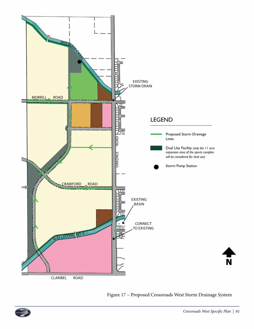
Crossroads West Specific Plan | 81
Figure 17 – Proposed Crossroads West Storm Drainage System
MORRILL ROAD
MID MAIN CANAL
CRAWFORD ROAD
MID LATERAL NO. 6
OA
KDA
LE
R
OA
D
CLARIBEL ROAD
LEGEND
ProposedStormDrainage Lines
Dual Use Facility (only the 11 acre expansion area of the sports complex will be considered for dual use)
StormPumpStation
EXISTING STORM DRAIN
CONNECTTO EXISTING
EXISTINGBASIN
N
Figure 17 – Proposed Crossroads West Storm Drainage System

82 | Crossroads West Specific Plan
7.4.2.3 California Storm Water Quality Association (CASQA)
CASQA is comprised of professional members dedicated to the advancement of storm water quality. Since 1989, CASQA has provided education, implementation guidance, regulatory review, collaboration with local, state and federal agencies and assessment to ensure water quality is at the forefront of all new development. The City of Riverbank requires adherence to CASQA’s mission which is largely to help California storm water permittees in developing, implementing and maintaining effective storm water quality management programs.
CASQA assists developers and projects like Crossroads West to be in compliance with the National Pollutant Discharge Elimination System (NPDES) mandates which are governed in conjunction with the Clean Water Act.
7.4.3 Storm Drainage Standards and Guidelines
Figure 17 provides an illustrative of the Proposed Crossroads West Storm Drainage System. This system will be designed to adhere to the City of Riverbank Storm Drain System Master Plan, the LID Standards and Specifications, the MS4 Permit Regulations governed by the California Department of Transportation – Storm Water Management Division and the CASQA recommendations and guidelines. The developer for CWSP is charged with designing and maintaining a system that will provide an adequate storm drain system that will function according to City established levels of service.
Guidelines for construction of the storm water drainage system shall include but are not be limited to:
• The overall storm drain system and storm drainage facilities shall be designed to handle and properly carry a 10-year storm event.
• Dual-use basins north of the MID Lateral No. 6 shall be constructed for the majority of the CWSP to function both during a storm event and a non-storm event. The maximum depth for these dual-use basins shall be 6 feet with a maximum water depth of 4 feet with 2 feet of freeboard.
• The majority of the CWSP storm drainage system will be designed as a linear park system beginning at the Regional Sports Park and continuing throughout the development until it’s connection point at the Mixed Use 1/Mixed Use 2 components.
• The Mixed Use 1 development will utilize available capacity in the existing basin on the east side of Oakdale Road, just north of the existing shopping center combined with on-site detention.
• Appropriate accommodations for ADA access will be required for all dual-use storm basin concepts.
• All standards and guidelines, where appropriate, from the LID Standards and Specifications adopted by the City of Riverbank in January 2013, shall be implemented into the design and construction of the Storm Drainage System.
• All regulatory requirements of the MS4 Permit for the City of Riverbank shall be adhered to during the design and construction of the Storm Drainage System.

Crossroads West Specific Plan | 83
7.5 Dry Utilities
Dry utilities for the plan area include electricity, natural gas and telecommunication services. These services are not typically provided by the City and therefore rely on outside service providers. This section provides details on the dry utility providers who will service the CWSP area. 7.5.1 Electricity
Electricity service is available from Modesto Irrigation District (MID) and they have confirmed adequate supply for the area. New power lines will be installed underground, which conforms to the City development standards. Each user, tenant or residential unit will be individually metered for their electricity use.
7.5.2 Natural Gas
The entire CWSP area falls within the service boundary for PG&E and therefore they will be the natural gas provider. Similar to electricity service, new transmission lines will be installed underground for Crossroads West, which meets City requirements. Individual connections for retail tenants and residential units will be established for usage and billing purposes. 7.5.3 Telecommunications
Telecommunications services include phone service, fiber optics and cable television. AT&T Residential Division will be the primary phone and fiber optic provider for residents of Crossroads West. Charter Communications will be the primary cable television provider. AT&T Business Division will be the primary provider for the retail, Mixed Use 1 and civic uses within the plan area. As with the other utilities, all new transmission lines will be constructed underground to meet the requirements of the City.
7.5.4 Dry Utility Standards and Guidelines
• Tentative subdivision maps and/or development plans shall be submitted to the City and appropriate utility companies to confirm the location, sizing and availability of service to the Crossroads West development.
• Builders within the CWSP area shall coordinate with all dry utility providers to ensure proper design guidelines and criteria are met when preparing improvement plans.
• Telecommunication services including fiber optics if available shall be provided to every residential unit within the plan area to enhance the opportunity for telecommuting and home based businesses thereby reducing the impacts on the transportation system and air quality.
• All new transmission lines for electricity, natural gas and telecommunications shall be constructed underground per City of Riverbank requirements unless otherwise noted and approved by the City and the utility provider or otherwise economically infeasible to install underground. This excludes all transformers and secondary boxes in commercial areas only. Switch gear boxes shall be planned for and properly screened from public view. Special attention shall be made to prevent any utility box from being a target for Graffiti.
• Existing overhead transmission lines shall be placed underground where practical.• Service standards for dry utilities providers are established and enforced by the California Public
Utilities Commission.

84 | Crossroads West Specific Plan
Left Blank Intentionally

Crossroads West Specific Plan | 85
DESIGN GUIDELINES
8.1 MU 1 Overview
The purpose of these Design Guidelines is to set out the permitted architectural theme and future development plans for the retail commercial development within Mixed Use 1 and Mixed Use 2. If low, medium or high density residential is proposed, it will be designed consistent with the design guidelines starting in Section 8.3. These guidelines are intended to direct the future development of this site ensuring architectural compatibility, site design, landscape features, intensity of development and signage program. These development guidelines are intended to provide the necessary flexibility (i) to allow creative freedom and diversity, (ii) for the project to be developed as a phased development, (iii) for tenants and future tenants to be and remain attracted to the regional MU 1 Commercial Use facility developed, such as a regional and/or neighborhood Shopping Center and/or commercial uses, (iv) for potential future changes and/or additional changes in retail and/or other permitted MU 1 Commercial Uses going forward, and the development of the best possible project. This document outlines the guidelines under which the MU 1 Commercial Uses, MU 1 Residential Uses, and other permitted mixed-uses can successfully coexist.
8.1.1 MU 1 Site Design
The commercial development plan consists of one or more retail areas, separated by private vehicular roadways which bisect the site from Claribel Road to Oakdale Road, and may include one or more “commercial use” areas and/or mixed-use residential areas.
One main and four secondary entries are planned in Claribel Road. The main entry provides a North/South Collector road connecting Claribel Road to MID Lateral No. 6. The North/South Collector provides the access to the retail and the future residential to the North MID Lateral No. 6 and is intended to be signalized.
Chapter 8
For illustrative purposes only. Building areas, parking, driveways, and landscape areas on the site plan may be relocated throughout the development site and square footage can be reconfigured. The North/South Collector intersection with Claribel Road is preliminary and may shift during final design.

86 | Crossroads West Specific Plan
8.1.1.1 Placement and Orientation
The location of the main parking field for the retail/commercial use shall be substantially consistent with the manner shown in the PDP to be presented for the project in the future, but parking and landscape areas can be moved to the front, side or rear as necessary to accommodate development and/or tenant requirements.
All building structures along Claribel and Oakdale Roads shall respect a 20’ minimum setback, however drive through lanes and necessary structures ancillary to the building’s like patios, walking paths, trash enclosures, exit walkways and other pedestrian type enclosures may be located in the 20’ set back area. For all interior parcel lines (internal to the shopping center) building structures shall not have a setback requirement.
To allow the project to attract a variety of uses, no minimum or maximum lot size shall be required.
8.1.1.2 Parking and Circulation
Special paving or pavement markings shall be provided at key on-site intersections and/or key entries.
Pedestrian walks shall be provided connecting retail structures to the parking areas. Walkways which cross traffic lanes shall have special markings.
90 degree or angled parking shall be permitted. In addition, diagonal parking shall also be permitted.Cross access parking easements shall be provided throughout the retail development and to the extent required by developer in the mixed-use development or in the form of CC&Rs/OEA or shared parking declaration. With these cross access agreements, shared parking, and peak/off-peak shared parking arrangements shall be allowed to meet parking requirements through MU-1 (for example, if one area is under-parked and another area has excess parking, such excess parking areas shall be allowed to supplement the under-parked areas), consideration shall also be given to shared parking and in the case where the need for parking does not meet City of Riverbank code. Additionally, when MU 1 Residential Uses are adjacent or in close proximity to MU 1 Commercial Uses, the various uses within the MU 1 property may share parking based on peak and off-peak parking demand.Emergency vehicle access shall be provided.
Proposed improvements within this development may, at developer’s discretion, be phased over time. Improvements constructed within each phase shall provide the services necessary to support the uses constructed and open to the public including utilities, roadways, parking, landscaping, compatible retail, and signage.
The parking areas shall be designed to include provisions for pedestrian connection from the parking lots in the front of the anchor building line located in the rear portion of the site for access to building entrances. Walkways that cross traffic lanes shall have special striping or other delineations. Walkway
Special pavers example
Crossroads West Specific Plan | 87
strips shall be intermittently provided through landscaped areas to protect landscaping from foot traffic damage.
Reciprocal access and shared parking between retail properties and owners of MU-1 shall be used if approved by the MU 1 developer, whenever possible. Cross access easements may be provided in the mixed-use property at developer’s discretion.
All commercial site designs may include loading areas and raised docks which are screened from view from the public right of way by landscaping or a screening structure. If a screen wall is used, it shall be architecturally treated. Screen structures may be made of wood, post and wire, masonry, landscaping, or various other compatible materials.
Drive aisles shall allow for circulation within the development, with sufficient width for emergency vehicles.
Provisions for connecting driveways and walkways between adjacent properties on the Retail/Mixed-Use Site are to be provided.
8.1.1.3 Landscape, Lighting, Signs and Site Amenities
The general characteristics of the landscape plan palette for the development shall be a combination of year-round color and textural interest. Developer shall select plants on the basis of color combinations, growth patterns, low maintenance, water conservation characteristics, and compatibility with the area. At time of installation, all trees within the landscape setback on Claribel and Oakdale shall have a container size of 15 gallons, otherwise trees shall have a minimum container size of 15 gallons.
Canopy-providing trees shall be planted in the parking lot planter islands to produce shade and shall result in a fifty (50) percent surface shading within ten (10) years. Minimum planting will consist of one fifteen (15) gallon tree for every ten (10) parking spaces.
A landscaped median may be provided at the main signalized entry from Claribel at the North/South collector. Shrubs or vine planting shall be provided to screen utilities and trash enclosures. All landscape areas provided (with the exception of areas adjacent to public streets, patios, walkways and the rear MID Canal) shall have a minimum average width of five (5’) feet. This includes but is not limited to landscaping adjacent to buildings, alongside rear property lines, and finger planters within parking lots.
Where possible, landscaping shall be used to soften the appearance of fences and blank walls.
The design of the exterior building lighting poles and sconces shall be compatible with the overall architectural style of the development.
Parking lot lighting shall be consistent throughout the development. The maximum pole height of the lighting shall be thirty eight (38’) feet measured from top of pole base.
All lighting shall be LED and shall be directed and shielded in such a manner so as not to directly cast light on neighboring properties.

88 | Crossroads West Specific Plan
This development shall allow one 50’ high sign at the Claribel / Oakdale intersection and three (3) 35’ high monument sign(s) along Claribel Road. Two 35’ high monument signs shall be allowed on Oakdale Road. Developer may be allowed to have additional monument signs (not to exceed one (1) per parcel as long as they do not exceed 10’ in height), gas station pricing signs and other signs required by state law or governmental requirements shall be allowed notwithstanding anything contained herein.
Tenant identification signs will be allowed on all faces of buildings including those that are visible on Claribel, Oakdale, and MID Lateral No. 6 and north/south connection road.
A uniform sign program identifying locations of signs is attached to and part of the design guidelines, Appendix C. Individually mounted, channel letters shall be utilized for building attached signs. Illumination shall be individually illuminated, internal, halo, or direct (gooseneck lighting from above or up-lit from below, mounted on hard metal canopies). Building attached signs for uses less than 2,000 square feet shall be limited to the name and logo of the business except for signs related to drive through uses, directional signs, etc. The guidelines provide flexibility so that signs can be consistent with the proposed Tenant’s prototypical design, quantity, and colors and will be architecturally compatible. Trash enclosures shall be constructed of solid material including without limitation wood, metal, concrete and masonry material, and shall be a minimum of six feet in height, with solid view obstructing gates.
Fences and walls shall be designed to be compatible with the surrounding landscape and architectural style of the development.
8.1.2 Architecture
The architectural theme shall be complementary to the Crossroads Shopping Center on the east side of Oakdale Road but also establishing its own identity while creating a campus of retail structures which vary in character, massing, materials, and colors. Each structure shall be complementary but shall maintain its own uniqueness as though designed and constructed at different times. If entertainment uses are included, building design may include some or all of the following: neon tower, marquee, special lights and statement lobby glazing. Facades shall contain primary and secondary features to vary the scale and offer flexible leasing opportunities. The concepts for architectural theme are to use rural architectural forms and treatments balancing off
Architectural example
Architectural example
Trash enclosure example

Crossroads West Specific Plan | 89
Architectural example
the agricultural heritage of the Central Valley of California with some vineyard influence. The theme may contain, at applicant’s discretion, architectural treatments found within the Crossroads Shopping Center on the east side of Oakdale Road.
8.1.2.1 Style and Design
The development shall include tower features, variable heights, undulating facades, and a variety of materials, colors and storefronts. Awnings, banners, outdoor patios, light sconces, site lighting, and/or street furniture shall be included.
The general character of all building exteriors shall be consistent with the style of theme established for the development.
Any outdoor storage of goods, materials or equipment shall be limited to twenty feet in height with setbacks equal to height and located in an enclosed fenced area. The fencing shall be designed as an integral part of the building design and site layout and consistent with the architecture of the shopping center. Chain link fencing with wood inserts is not an acceptable manner of screening outdoor storage of goods. Sidewalk sales and temporary sales (no greater than 60 days at a time) shall be permitted for the common areas without the requirement for fencing or special City approvals.
8.1.2.2 Massing, Scale and Form
No retail building within the development shall exceed 75 feet in height except for tower elements or elevation enhancement covering no more than 50% of the frontage. Height exceeding these allowances must be as otherwise authorized by the Community Development Director.
Rooflines shall vary in height between different buildings and may include a blend of sloping and flat rooflines as shown in the Illustration A.
Large, continuous structures shall incorporate breaks in horizontal planes by varying architectural features and designs and recessing windows and entrances or other building features, to provide articulation and scale. Windows shall be enhanced by use of various sizes and shapes. The design shall be complementary to the architectural style of the development.
Fences and walls shall be designed to be compatible with the surrounding landscape and architectural style of the development.
8.1.2 Architecture
The architectural theme shall be complementary to the Crossroads Shopping Center on the east side of Oakdale Road but also establishing its own identity while creating a campus of retail structures which vary in character, massing, materials, and colors. Each structure shall be complementary but shall maintain its own uniqueness as though designed and constructed at different times. If entertainment uses are included, they shall be designed as featured elements which may include some or all of the following: neon tower, marquee, special lights and statement lobby glazing. Facades shall contain primary and secondary features to vary the scale and offer flexible leasing opportunities. The concepts for architectural theme are to use rural architectural forms and treatments balancing off the agricultural heritage of the Central Valley of California with some vineyard influence.
8.1.2.1 Style and Design
The development shall include tower features, variable heights, undulating facades, and a variety of materials, colors and storefronts. Awnings, banners, outdoor patios, light sconces, site lighting, and/or street furniture shall be included. The general character of all building exteriors shall be consistent with the style of theme established for the development. Any outdoor storage of goods, materials or equipment shall be limited to twenty feet in height and located in an enclosed fenced area. The fencing shall be designed as an integral part of the building design and site layout and consistent with the architecture of the shopping center. Chain link fencing with wood inserts is not an acceptable manner of screening outdoor storage of goods. Sidewalk sales and temporary sales (no greater than 60 days at a time) shall be permitted for the common areas without the requirement for fencing.
8.1.2.2 Massing, Scale and Form
No retail building within the development shall exceed 50 feet in height except for tower element or features or elevation enhancement covering no more than 50% of the frontage and any entertainment use or hospitality use which shall not exceed 65 feet in height. Height exceeding these allowances must be as otherwise authorized by the Community Development Director. Rooflines shall vary in height between different buildings and may include a blend of sloping and flat rooflines.
Architectural example
Varied roof lines example
Scale & Massing example

90 | Crossroads West Specific Plan
On facades which front on Claribel and Oakdale Roads, architectural treatment shall be applied to the building elevations.
No mechanical equipment shall be exposed on the wall surface of any building.
Mechanical and utility equipment shall be located below the roof line or parapet wall and out of public view from the immediately adjacent parking lot. All roof-mounted mechanical equipment or ductwork which project vertically above the roof or parapet shall be screened by an enclosure which is consistent or compatible with the building’s architectural design.
Gutters and downspouts located on the exterior wall shall be treated or painted to blend into the facade to which it is attached, unless used as a design element or architectural feature, in which case the color shall be consistent with the color schemes of the building or the intended architectural feature.
8.1.2.3 Site Design
The rural architectural theme for the MU 1 property will include similarly themed building architecture and materials as set forth in the below photos.
8.1.2.4 Materials 8.1.2.4 Materials
Stucco Finish Board and Batten Siding
Lap Siding Stone Veneer
Brick Veneer Metal Siding
Standing Seam Metal Roof Roofing Tile
8.1.2.4 Materials
Stucco Finish Board and Batten Siding
Lap Siding Stone Veneer
Brick Veneer Metal Siding
Standing Seam Metal Roof Roofing Tile
8.1.2.4 Materials
Stucco Finish Board and Batten Siding
Lap Siding Stone Veneer
Brick Veneer Metal Siding
Standing Seam Metal Roof Roofing Tile
8.1.2.4 Materials
Stucco Finish Board and Batten Siding
Lap Siding Stone Veneer
Brick Veneer Metal Siding
Standing Seam Metal Roof Roofing Tile
8.1.2.4 Materials
Stucco Finish Board and Batten Siding
Lap Siding Stone Veneer
Brick Veneer Metal Siding
Standing Seam Metal Roof Roofing Tile
8.1.2.4 Materials
Stucco Finish Board and Batten Siding
Lap Siding Stone Veneer
Brick Veneer Metal Siding
Standing Seam Metal Roof Roofing Tile
8.1.2.4 Materials
Stucco Finish Board and Batten Siding
Lap Siding Stone Veneer
Brick Veneer Metal Siding
Standing Seam Metal Roof Roofing Tile
8.1.2.4 Materials
Stucco Finish Board and Batten Siding
Lap Siding Stone Veneer
Brick Veneer Metal Siding
Standing Seam Metal Roof Roofing Tile

Crossroads West Specific Plan | 91
Large, continuous structures shall incorporate breaks in horizontal planes by varying architectural features and designs and recessing windows and entrances or other building features, to provide articulation and scale.
Windows shall be enhanced by use of various sizes and shapes. The design shall be complementary to the architectural style of the development. On facades which front on Claribel and Oakdale Roads, architectural treatment shall be applied to the building elevations. No mechanical equipment shall be exposed on the wall surface of any building. Mechanical and utility equipment shall be located below the roof line or parapet wall and out of public view. All roof-mounted mechanical equipment or ductwork which project vertically above the roof or parapet shall be screened by an enclosure which is consistent or compatible with the building’s architectural design. Gutters and downspouts located on the exterior wall shall be treated or painted to blend into the facade to which it is attached, unless used as a design element or architectural feature, in which case the color shall be consistent with the color schemes of the building or the intended architectural feature.
8.1.2.3 Planning Director Review / Modifications
Future modifications to the items contained herein may be approved administratively by the Planning Director as long as they are substantially consistent with the architectural theme of the Project.
8.1.2.4 Architectural Style
The rural architectural theme for the Retail/Mixed-Use Site will include similarly themed building architecture and materials as set forth in the below photos.
Use of Standing Seam Metal Roof, Stucco and Wood Board, Baton Siding and Block
Use of Standing Seam Metal Roof, Stucco, Wood Board & Baton Siding and Block
Awning projections and Façade Projections
Varying use of materials
Awning projections and Façade Projections
Varying use of materials
Awning projections and Facade Projections
Varying use of materialsVarying use of materials
8.1.2.5 Signage
This development shall allow one 50’ high and three 35’ high monument sign along Claribel Road. Two 35’ high monument sign shall be allowed on Oakdale Road. Gas station pricing signs or other monument signs required by State laws and/or other governmental requirements shall be allowed and not restricted by this CWSP.
Tenant identification signs will be allowed on the faces of buildings that are visible on Claribel, Oakdale, and MID Lateral No. 6.
A uniform sign program identifying locations of signs shall be prepared for review and approval of the Community Development Department as part of the Architectural and Site Review process. Individually mounted, channel letters shall be utilized for building attached signs. Illumination shall be internal, halo, or direct (gooseneck lighting from above or uplift from below, mounted on hard metal canopies). Building attached signs for uses less than 2,000 square feet shall be limited to the name and logo of the business only except for signs related to drive through uses.
Signs shall have design elements and colors consistent with the architecture proposed.(see Appendix C: Master Sign Program)
Address numbers shall contrast with their background and shall be a minimum of six inches in height.
8.2 Mixed Use 2 Overview
Building on the characteristics and style of the regional Mixed Use 1 portion of the CWSP area, the Mixed Use 2 parcels are intended to provide smaller scale, localized amenities and conveniences to the residents of Crossroads West all while keeping a succinct theme within the development.
The design standards and guidelines contained in this section were developed to ensure Mixed Use 2 development is thoughtfully planned, well designed and compatible with adjacent land uses. The desire of the mixed-use land is to create pedestrian oriented places that are easily maneuvered, vibrant and contribute to the overall character of the neighborhoods.
Pylon Sign & Monument Sign Rendering
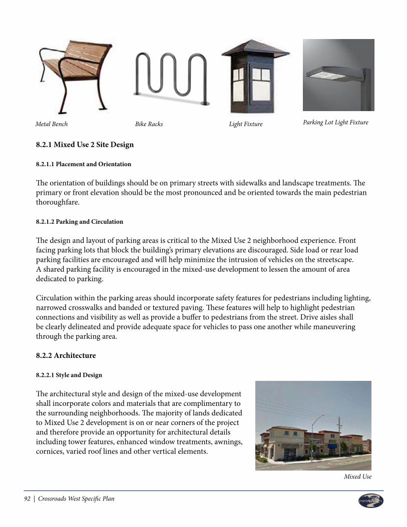
92 | Crossroads West Specific Plan
8.2.1 Mixed Use 2 Site Design
8.2.1.1 Placement and Orientation
The orientation of buildings should be on primary streets with sidewalks and landscape treatments. The primary or front elevation should be the most pronounced and be oriented towards the main pedestrian thoroughfare. 8.2.1.2 Parking and Circulation
The design and layout of parking areas is critical to the Mixed Use 2 neighborhood experience. Front facing parking lots that block the building’s primary elevations are discouraged. Side load or rear load parking facilities are encouraged and will help minimize the intrusion of vehicles on the streetscape. A shared parking facility is encouraged in the mixed-use development to lessen the amount of area dedicated to parking.
Circulation within the parking areas should incorporate safety features for pedestrians including lighting, narrowed crosswalks and banded or textured paving. These features will help to highlight pedestrian connections and visibility as well as provide a buffer to pedestrians from the street. Drive aisles shall be clearly delineated and provide adequate space for vehicles to pass one another while maneuvering through the parking area.
8.2.2 Architecture
8.2.2.1 Style and Design
The architectural style and design of the mixed-use development shall incorporate colors and materials that are complimentary to the surrounding neighborhoods. The majority of lands dedicated to Mixed Use 2 development is on or near corners of the project and therefore provide an opportunity for architectural details including tower features, enhanced window treatments, awnings, cornices, varied roof lines and other vertical elements.
Mixed Use
Metal Bench Bike Racks Light Fixture Parking Lot Light Fixture

Crossroads West Specific Plan | 93
Guidelines and standards have been established for the Mixed Use 2 development areas and include:
• Primary elevations shall be oriented onto major street frontages that provide pedestrian accessibility.
• Secondary elevations shall compliment the primary elevation and can be oriented towards the parking area or street frontages that cater to vehicle traffic.
• Horizontal massing should be broken up to provide visual interest and character to buildings.• A cohesive color palette shall be used on all buildings within the Mixed Use 2 development and
should be complimentary to the regional Mixed Use 1 center.• Storefronts should be eye catching and appealing to pedestrians and visitors to the site. The use
of awnings, shutters, stone work and other decorative elements should be incorporated into the design.
• Glass frontages are encouraged to provide attractive views into stores but should not be the only element incorporated into the storefront. Decorative entry ways, landscape treatments and site furniture are all encouraged.
8.2.2.2 Massing, Scale and Form
The scale and mass of buildings within the Mixed Use 2 development should be pedestrian scale and not overpower the site. Large, continuous expanses of blank wall should be avoided. Multiple story buildings should provide relief in roof lines and varying heights should be integrated to break up the mass and form of buildings.
8.2.2.3 Architectural Style Architecture, color and design of the buildings in the mixed-use areas are important because it sets the tone for the neighborhoods and provides a basis for the architectural style of the remainder of the CWSP area. The buildings can incorporate many design elements from different architectural styles and utilize colors from a vast color palette to create unique and memorable neighborhoods.
The architecture of the mixed-use areas shall be consistent to the residential homes in the area to create a cohesive and complimentary neighborhood. Details and guidelines of the architectural styles are provided in future sections of this chapter.
8.3 Residential Overview
Residential Site design and architecture are the focus of this section. The design guidelines establish the framework for which the residentially designated areas of the CWSP will be constructed and provides a distinctive and diverse character to the community. The new neighborhoods within the Crossroads West project will draw from elements of classic Riverbank neighborhoods communicated to the design team.
8.3.1 Low Density Residential
The low density residential (LDR) land use designation is characterized by single-family, detached homes on varied lot sizes. The CWSP showcases ±234 acres of land for this type of housing density. The amount of land designated for LDR will be reduced by the site selection of public use areas such as schools, fire station and neighborhood parks.

94 | Crossroads West Specific Plan
8.3.2 Medium Density Residential Medium density residential areas are characterized by smaller, compact lot sizes that can accommodate detached or attached single-family homes. The CWSP shows one areas containing ±12 acres south of Morrill Road that will be dedicated to medium density construction.
8.3.3 High Density Residential High density residential areas are characterized by compact, multi-family development, most notably apartment complexes, townhomes, or condominiums. The CWSP shows three (3) areas containing 15.5+ acres west of Oakdale Road. The corner of Morrill Road and Oakdale Road will be a vibrant, neighborhood spot with the combination of the high density and medium density residential and the Mixed Use 2 development. The third location is illustrated as south of Crawford Road adjacent to the MID Lateral No. 6.
8.3.4 Residential Site Design
The proper siting of homes in Crossroads West is critical to the overall flow and continuity of the development. The residential parcels have been thoughtfully planned to provide transitional buffers between land uses and ease of access to shopping, dining and community amenities. The following standards and guidelines intend to carry-out the vision for the CWSP and promote quality design and cohesive neighborhoods.
8.3.4.1 Placement and Orientation
• The placement and orientation of buildings is important in creating a vibrant streetscape and in facilitating the interaction of residents. The following standards and guidelines shall apply to the residential areas of Crossroads West:
• Variations to front setbacks shall be incorporated into master development plans for all densities of residential homes. No more than two consecutive homes shall have the same front setback.
• A cohesive mix of lot sizes and product types shall be incorporated into residential areas of the CWSP. Homes should be oriented towards the street to create a safe, pleasant and active neighborhood.
• Courtyard, cluster or alley-loaded homes may be considered to lessen the appearance of garage fronts on residential streets.
8.3.4.2 Parking
Parking is a necessary component of any residential development and good design principles are necessary to keep the parking areas from dominating the view along public streets. Off-street parking will be provided for the CWSP area per the standards set forth in Chapter 4, Tables 4, 5 and 6.
• All visitor parking, resident parking, handicap accessible parking and clean-air vehicle parking shall be clearly marked and identified.
Massing, Scale and Form

Crossroads West Specific Plan | 95
• In multi-family complexes, the majority of the parking lots shall be placed to the rear or side of buildings or evenly distributed throughout and out of public view. Parking lots shall not dominate the streetscape of multi-family residential areas.
• If feasible, a combination of on-street and off-street parking shall be utilized in residential areas to provide a buffer from street to sidewalk.
• Parking lots shall be located in a way that provides short, direct access to the main building
8.3.5 Architecture
Architecture is the most important element of a development project. In the case of the residential areas of Crossroads West, the architecture sets the tone for the type of development and promotes quality design that will help to enhance the City of Riverbank. 8.3.5.1 Style and Design
Various architectural styles will be encouraged in Crossroads West. Different architectural styles will help to create unique neighborhoods amongst the mixed-use and residential areas. The following design parameters are meant to establish minimum standards for the residential areas, regardless of what architectural style is selected. Homebuilders/Architects are encouraged to build upon the architectural styles presented here to develop new and differing architectural styles like California Modern, Western Regional Farmhouse, Savannah and other styles.
• Architectural design themes shall be varied throughout the CWSP to establish unique neighborhood project identities.
• Discourage the placement of consecutive elevations, floor plans and color palette on homes within a subdivision.
• 4-sided architecture is encouraged when adjacent to public view sheds to avoid flat, unfinished walls.
• Each production builder shall offer a variety of alternate floor plans and building elevations to provide sufficient variations of homes within each subdivision, or portion thereof. The minimum range of different exterior house designs, derived from a combination of different floor plans and different elevations for each floor plan according to the following table:
8.3.5.2 Massing, Scale and Form
Massing, scale and form are used in development to encourage residential areas that are visually appealing, provide streetscape variety, are at an appropriate pedestrian scale and are compatible with surrounding neighborhoods and land uses.
Alley loaded product lessen garage front
Number of Lots Number of house types (models with different elevations)Under 50 lots 9 (3 models/3 elevations)51+ lots 12 (4 models/3 elevations)

96 | Crossroads West Specific Plan
• Building articulation shall be incorporated including the use of overhangs, balconies, porches and patios and dormers to help reduce building mass.
• Varied roof lines shall be integrated into the residential home design such as hipped roofs, gabled roofs, pitched roofs and roof dormers.
• Residential dwellings shall be constructed at a pedestrian scale.
8.3.5.3 Architecture Style
The residential communities within the CWSP area are envisioned as traditional, single-family neighborhoods with some of the qualities of the older, established neighborhoods of Riverbank. Diversity of architecture is encouraged throughout the residential areas and each dwelling unit should have a distinct identity and relation with one style of architecture. If a particular architectural style is not depicted here, additional styles may be proposed to the City which adhere to the visions of this Specific Plan.

Crossroads West Specific Plan | 97
7.6.3.C Craftsman
The Craftsman architectural style is typically characterized by low pitched gabled roofs, occasionally hipped and with wide, enclosed eave overhangs. The roof rafters are usually exposed and decorative (false) beam or braces commonly are added under the gables. The front porches are full or partial width and the roof is supported by square columns, tapered, that frequently extend down to the ground level with no breaks. Most common wall cladding is with siding, shingle and stucco with brick or stone accents. Dormers are found gabled with exposed rafter ends and braces. Wood trellises also accent this style as either an extended porch or porte cochere. For Eastview, more contemporary interpretations of this style are encouraged including other elements that create social spaces adjacent to the residences. Note: The image shown is a representation of the architectural style and not intended to convey actual architectural requirements.
Design Requirements:• Roof Pitch, Material and Color
The standard roof pitch is 4:12 - 6:12. Roof materialcommonly is flat or shake tile. The color range complimentsthe main house colors ranging from the dark greys, brownsand greens. Overhangs are 16”-24” eaves, and boxed or openare common. Exposed rafter tails may occur along the rake,decorative braces, brackets or beams.
• Siding:Siding and shingles can be used. Wood, Hardy Board orother manufactured siding may be used. Brick/stone veneermay be used as an accent.
• Porches:Are encouraged with columns supporting the roofs aretypically short, with square upper columns resting uponmore massive piers or solid porch balustrades. These begindirectly at ground level and extend well above the porchfloor.
• Window Treatment:Two accent windows featured at the front elevation areencouraged, and if in public view, trimmed with stucco orwood at the top and bottom. Windows may have dividedlights with a minimum four quadrants per window.
• Doors:Entry Doors have stucco or wood trim surrounds. Style willreflect the chosen theme.
• Color Palette:Stucco finishes will be sand finish or smooth and range froma light to a darker color depending on the style. Stucco/woodtrim and fascia should have a contrasting color and shuttershave an accent color. The siding will be complementary to thestucco color and the brick/stone veneer should complementthe theme chosen for the elevation.
EASTVIEW SPECIFIC PLAN CHAPTER 7 - COMMUNITY DESIGN
�������� Page 7-71
ELEMENTS MINIMUM EMBELLISHMENTS ENHANCED EMBELLISHMENTSOutward Appearance Asymmetrical one- and two- story boxy forms;
low lines with simple, wide projecting roofsHorizontal character through the use of boxed massing with vertical and horizontal offsets
Roof Elements Low-pitched gable roofs, occasionally hipped roofs; low roof slopes; wide projecting eaves with exposed rafters and beams; shingles or flat tiles
Varied porch roof styles; overhangs range from 18” to 26”; concrete shake materials
Exterior WallElements
A blend of stucco and siding with accents of rock, stone or brick
Authentic clapboard sidings; wood shingles
Window Elements Casement windows that are double hung; large front windows with grid patterns
Bands of continuous windows often under onesill
Additional Embellishments
Exposed structural elements; prominent front porches with gabled roofs or columns; decorative shutters; decorative beams; exposed eaves
Heavy square columns with stone or brick trim; Arts and Crafts style light fixtures; dor-mers
Exterior WallElements
Earth tone color palette with contrasting, comple- mentary trim colors
Same
Outdoor Living Spaces Grand front porches a minimum of 4 feet deep Same
8.3.5.3.1 Craftsman
Southern California is the birth place of Craftsman architecture which was inspired by the English arts and crafts movement of the late 19th century. The Craftsman style is distinct and easily recognizable featuring shallow pitched roofs with deep overhangs and broad porches that display rafters, brackets, beams and columns.
Craftsman homes combine a mixture of materials to add visual interest including stone near the foundation, shingled roofs and wood siding. A statement front door and abundant casement windows with grid patterns are also classic Craftsman elements. The color palette is varied and includes earth tone base colors with complimentary trim colors.
The front entry porch is probably the most notable design element in the Craftsman style of architecture. Porches typically extend the entire front expanse of a Craftsman home and are anchored by large, sturdy columns on stone or brick piers.
Craftsman Style

98 | Crossroads West Specific Plan
8.3.5.3.2 Traditional (American)
The American Traditional style of architecture is found throughout the Country rather than a particular region or State. The style is simple and classic featuring open, columned porches, symmetrical one and two story stacked homes and dominant, gabled roofs.
American Traditional architecture draws inspiration from the colonial period as well as Greek-inspired architecture with the introduction of moldings and decorative borders. Primarily, this home style features a stucco exterior with the addition of brick facades but clapboard siding is also a classic choice for this style of home.
The color palette of Traditional architecture is neutral and light. Off-whites, light beige, creams and tans dominate the exterior colors and trim colors are complimentary. Window shutters and brick often complete the front elevation of a classic American Traditional.
Traditional (American) Style
7.6.3.E Traditional
The Traditional style is a mix of several themes including Cape Cod, Colonial, and East Coast Eclectic. The use of brick veneer and wood siding with heavier trim above doors and windows is typical. Wood shutters and a white picket fence round out the details. There are one and two story elements with simple gable forms. Simple porches or balconies are attired with wood details. Entries are simple with featured elements. Dormers may occur with gabled or hip roofs.
Note: Image shown is a representation of the architectural style and not intended to convey actual architectural requirements.
Design Requirements: • Roof Pitch:
Roof pitch is 5:12 - 8:12 standard.
• Roof Material and Color:Roof material may include flat concrete tile that typicallyranges in color from light to dark brown and grey.
• Overhangs:Are 16” to 24” standard.
• Porches:Are encouraged and may vary in size either at entry or fullwidth.
• Balconies:Balconies are minimized in this style, and may have simplewrought iron detailing as an attachment to the buildingplane.
• Window Treatment:A variety of shutters are used and may have stucco trim onwindows in view. Windows may have divided lights withminimum four quadrant window.
• Doors:Entry doors may be decorative with enhanced patterns andsurrounded by wood and in contemporary versions bystucco surrounds.
• Color Palette:Part stucco may be allowed with a sand finish and matchingsiding. Wood or manufactured siding is encouraged. Acombination of stucco elements may be allowed. Thecolor range is from white, light beige, and brown or greywith contrasting color on trim, fascia, posts at porch andsupporting exposed beams.
EASTVIEW SPECIFIC PLAN CHAPTER 7 - COMMUNITY DESIGN
�������� Page 7-73
ELEMENTS MINIMUM EMBELLISHMENTS ENHANCED EMBELLISHMENTSOutward Appearance Symmetrical one- and two- story stacked homes SameRoof Elements Dominant gable roof with one intersecting gable;
moderate pitch and slopes; predominantly flat tileGambrel roof form
Exterior Wall Elements
Stucco and/or siding with stone or brick trimsand details
Authentic clapboard siding with brick veneers and wainscot trim; decorative shingles
Window Elements Symmetrical window placement on front ele- vation; vertical multi-paned windows; standard single-hung windows
Decorative bay windows on front elevation
Additional Embellishments
Colonial details; porticos; decorative shutters; decorative attic vents; decorative door trims and Greek-inspired moldings
Decorative cornice gable-end trims; decora- tive doors with side lights
Exterior Wall Elements
Primarily light color palette with off-whites, creams and tans with contrasting and comple- mentary trims
Same
Outdoor Living Spaces Enclosed front yards with decorative fencing and gates porches
Same

Crossroads West Specific Plan | 99
8.3.5.3.3 Italianate
The Italianate style of architecture emerged in the mid-1800’s in the United States and was predominantly found in port cities like San Francisco and along the northeastern seaboard. It is another architectural style that is easily recognized for incorporating columns, marble, stone and cornice treatments. These dwelling units typically feature low pitched or flat roofs, tall arched windows, smooth stucco exteriors and dramatic entryways flanked by columns.
Curved tile roofs are the predominant choice for an Italianate style home. Shingle roofs are also permissible and should feature a variegated color scheme. The exterior walls of Italianate style homes are typically finished in smooth or textured stucco and sometimes incorporate marble or stone embellishments. The color palette is classic and soft featuring tan, soft yellows and off-white shades with contrasting and complimentary trim colors.
Italianate StyleELEMENTS MINIMUM EMBELLISHMENTS ENHANCED EMBELLISHMENTSOutward Appearance Symmetrical one- and two- story stacked homes SameRoof Elements Low Pitched roofs with curved tiles; shingles; flat
roofs with shingles or compositeDormers with additional windows
Exterior Wall Elements
Smooth stucco Textured stucco with marble and/or stone embellishments
Window Elements Tall, narrow windows with decorative trim for separation
Slightly arched windows; multi-pane windows
Additional Embellishments
Greek-inspired moldings; projecting eves, cornices and columns
Cupolas, glazed doors
Exterior Wall Elements
Primarily light color palette with off-whites, creams and tans with contrasting and complementary trims
Sunny hues of yellow, orange
Outdoor Living Spaces Porticos, courtyards and fountains Same

100 | Crossroads West Specific Plan
8.3.5.3.4 Spanish Colonial
The Spanish Colonial style of architecture gained popularity around 1915 and is still a widely used design in home construction today. Historic missions all throughout California played a part in creating the famous style we know today. Homes constructed in the Spanish Colonial style feature low-pitched roofs of Spanish tile or red clay, the use of arched doorways and window treatments, stucco exterior walls, textured and decorative wooden doors and ironwork details.
Homes of the Spanish Colonial style are typically a square or rectangular shape with design features on the exterior elevations to provide visual interest. These design features are distinct and easily recognizable. The use of wrought iron details, balconies, recessed windows with arched frames and the signature mission style parapet or dormer over the front door are the most widely used symbols of Spanish architecture.
Spanish Colonial Style
7.6.3.D Santa Barbara
Evoking the historical perspective of the California Missions, this architectural style is an adoption of Mediterranean forms indigenous to arid climates. It is characterized by simple stucco forms and flatter wall planes but with unique detailing such as the use of ornamental grillwork, brightly colored ceramic tile inserts or banding, courtyard entries and small but well detailed balconies. Unique details attributed to this style include small towers, quatrefoil windows and arcaded porches.
Note: Image shown is a representation of the architectural style and not intended to convey actual architectural requirements.
Design Requirements:
• Roof Pitch, Material and Color:3:12 - 5:12 is typical. Tiles may be s-tile or individual curvedtiles that range in color from reddish orange to deep terra-cotta. Some variation in roof color is allowed but should bea subtle blend of colors. Concrete mudding layers of tiles atroof edges is encouraged.
• Overhangs:Overhangs typically are 12” to flush under core molding. Noeaves and simple tile rakes are typical.
• Porches:Porches are simple stucco form and arcaded with simpledetailing. The use of ceramic tile inserts is suggested forenhancement of detailing. Courtyards are encouraged.
• Balconies:Balconies are small in scale and encouraged to include detailornamental grillwork and recessed access doors.
• Window Treatment:Windows have flat header details in contrast to archedcourtyard entries. Deep recesses along flat wall planes isencouraged. Use of accent shutters is encouraged.
• Doors:Entry Doors are recessed. Glass inserts and wood trim maybe used.
• Color Palette:Stucco finish is smooth or light sand finish and range fromwhite, brown earth tones, and beige, with dark or colorfulaccents on window mullions. Shutters may utilize a rangewith colors in blue, ochre or red.
EASTVIEW SPECIFIC PLANCHAPTER 7 - COMMUNITY DESIGN
�������� CITY OF GALTPage 7-72
7.6.3.I Spanish/Mediterranean
The Mediterranean Style is commonly considered a popular style in California, due to its prominence along coastal areas and worldwide appeal. It is typically characterized by its Terra-cotta roofs, prominent balconies and arcades, curved arches and arcades and white stucco or warm colored finish. Detailing is accentuated with mosaic or painted tile ornamentation, tower like chimneys, ornamental iron work for stairs, railings and windows, and articulated door surrounds. Landscape typically accentuates the Mediterranean character, with flower pots, bronze urns, filigree light fixtures and enhanced outdoor patios, courtyards and fireplaces, framed by stucco walls and ornamental wrought iron gates. For Eastview, more contemporary interpretations of this style are encouraged including other elements that create social spaces adjacent to the residences.
Note: Image shown is a representation of the architectural style and not intended to convey actual architectural requirements.
Design Requirements: • Roof Pitch:
Roof pitches are low to moderate 3:12 to 7:12.
• Roof Material and Color:Roof tiles may be s-tiles or individual curved tiles and aretypically terra-cotta in color. Concrete mudding layers oftiles at roof edges is encouraged.
• Overhangs:Have tight rakes and eaves (min. 6”). Larger 12” eaves, havestucco wrapped fascia.
• Porches:Front Porches face the street and may be accented by simplestucco detailing or decorative tile glazing. Front entry courts
can be incorporated, and may have low stucco garden walls and wrought iron gates and grilles.
• Balconies:Balconies are strongly expressed, and may include wroughtiron detailing, flower pots, grilles and mosaic tile accents.
• Window Treatment:Arched windows are prominent. They are encouraged tobe recessed within the stucco elevation. Stucco and tilesurrounds may be used. Wood sash and casement windowsare common.
• Doors:Arched doors are prominent. They may be wood carved ordetailed with stucco and tile surrounds.
• Color Palette:Stucco finish should be smooth or may be steel troweled.The color ranges from a white to a light beige or darkershades such as brown and tan. Color is accentuated by theterra-cotta roofs, doors, windows and lavish landscape.
EASTVIEW SPECIFIC PLAN CHAPTER 7 - COMMUNITY DESIGN
�������� Page 7-77
ELEMENTS MINIMUM EMBELLISHMENTS ENHANCED EMBELLISHMENTSOutward Appearance Asymmetrical two-story homes with square and
rectangular plan designsSquare or rectangular plan designs with internal courtyard
Roof Elements Side gabled with some hipped or flat roofs; low pitch with wide overhangs; clay or concrete tiles
Mission-shaped dormers for parapet
Exterior Wall Elements
Stucco exterior finishes Stucco, smooth or custom-troweled finishes
Window Elements Decorative arched windows; grid patterns; accent bay windows
Recessed windows; window groupings with decorative trim and column separation
Additional Embellishments
Arched doorways and entry-ways; use of decorative wrought iron, clay ceramic tiles; decorative shutters; stucco embellishments on exterior finishes
Sculptured chimneys
Exterior Wall Elements
Primarily light color palette with deeper contrasting trim colors
Same
Outdoor Living Spaces Internal courtyards Same

Crossroads West Specific Plan | 101
8.3.5.3.5 French
In the 19th Century, French influences on residential architecture began to surface in the United States. This style is recognizable for its heavy use of steep, hip roofs that are high pitched and often constructed of wood shingles to add to the classic, rustic look of French architecture. The details of this home style are delicate and feature many Tudor elements such as large, grand entry ways that are arched or pronounced and the use of stone, brick and stucco that add visual interest to the homes’ exterior elevations.
The color palette of French architecture is natural and earth toned, which helps to play up the details and use of stone and brick finishes. Often times, pale blues or gray trim is added for a slight color variation and additional visual appeal.
French Style
7.6.3.F French Country
French Country style was developed in 18th and 19th century France and was symbolic of the charm and character of rural France. The random elements and accents of this style express this distinct and appealing architectural character. A mixture of color, textures and materials draws upon the earth tone shades of the materials. Detail embellishment is a strong feature of French Country themes such as doors and windows with impressive trim or shutters, varying pitched roof lines, textured chimneys, and balconies.
Note: Image shown is a representation of the architectural style and not intended to convey actual architectural requirements.
Design Requirements: • Roof Pitch:
High pitched roofs, 6:12 - 12:12, are standard.
• Roof Material and Color:Roof material is typically flat tile and shall range from lightto dark.
• Overhangs:Shall have 12” rakes and eaves, wrapped in stucco.
• Porches:Porches are simple stucco form and maybe arcaded orangled to match roof pitches. Columns should be heavy andmatch similar material texture.
• Balconies:Balconies are small in scale and encouraged to includedecorative wrought iron features, pot shelves or both.
• Window Treatment:Shutters should be used and may have stucco trims onwindows in public view. Windows should have dividedlights with four quadrants per window. Diamond mullionsmay be used for a feature windows.
• Doors:Entry Doors should have stucco surrounds and may bedecorated with enhanced glass patterns.
• Color Palette:Should project stronger and more vivid color concept. Stuccoshall be smooth finish. Stone texture with contrasting stuccofield and accent shutters may be incorporated.
EASTVIEW SPECIFIC PLANCHAPTER 7 - COMMUNITY DESIGN
�������� CITY OF GALTPage 7-74
ELEMENTS MINIMUM EMBELLISHMENTS ENHANCED EMBELLISHMENTSOutward Appearance Asymmetrical two-story homes with a strong
Tudor and Norman influenceLarger, single-story home
Roof Elements Mansard roofs; steep, high pitched roofs with wood shingles or composite shingles
Overhangs – minimum 18”; concrete shake roof
Exterior Wall Elements
Smooth stucco or masonry; wood siding, shingles or clapboard embellishments; heavy stone and brick accents
Authentic clapboard or wood siding as the primary exterior treatment; heavy brick and stone use on trims
Window Elements Multi-pane windows; slightly arched with pop-outs
Decorative bay window on front elevation
Additional Embellishments
Covered entry; full porches and/or balconies; French doors; alcoves
Extra-wide porch with trims
Exterior Wall Elements
Earth-tone color palette with contrasting trims; blue/gray color palette
Same
Outdoor Living Spaces Courtyard of stone; gardens with water element Same

102 | Crossroads West Specific Plan
8.4 Streetscape Guidelines and Character 8.4.1 Paving and Sidewalks The pedestrian network throughout the CWSP area is an important element for purposes of providing safe and attractive methods of maneuvering the community. Paving will be found throughout the development in the form of sidewalks, bicycle paths and multi-use trails all with the same goal of urging residents to use alternate forms of transportation.
Sidewalks throughout Crossroads West will be a minimum of 5’ wide. All Class I and Class II bicycle lanes will be clearly marked and designed according to the CWSP and the City’s Bike Plan. Pedestrian trails and bicycle lanes are a required amenity that provides connectivity to the Mixed Use 2 and regional shopping areas suggested in Mixed Use 1 as well as a connection to public use sites and the Regional Sports Park north of Morrill Road.
In the regional Mixed Use 1 and Mixed Use 2 areas of the community, it is envisioned that decorative paving of a distinctive color and pattern will be used at entrances to clearly provide a sense of arrival to these destinations.
Street paving and sidewalks are not only a safety element but also provide a wayfinding and place making element to the Crossroads West project. 8.4.2 Lighting
The lighting used throughout the CWSP provides two benefits, that of illumination and safety. Well-lit streets, pedestrian trails, neighborhood centers and regional shopping areas are inviting and attractive.
All poles and fixtures for street lighting will be selected from the approved master lists of MID, who will ultimately provide service to the plan area. Light poles and fixtures shall be sized appropriately to provide illumination without being intrusive. In residential areas, lighting is subject to the approval of the design review committee and the City and shall utilize the following guidelines:
• Light poles and fixtures should complement the surrounding buildings, pedestrian walkways, trails and the amenities they illuminate.
• If proposed decorative lighting may be placed predominantly at entry ways, gateways, near bicycle lanes and pedestrian trails to provide clear visibility.
• All residential units shall have illuminated house numbers to provide visibility to emergency personnel.• All Mixed Use 1 buildings are required to have building and/ City of Riverbank Lighting Standard
Decorative paving
Expanded concrete side-walk with tree wells
Concrete sidewalk with tree wells and seating
Concrete Class I bike trail
Paved Class I bike trail

Crossroads West Specific Plan | 103
or pole mounted lighting for use at night to assist in illuminating the pedestrian walkways.
• Bollard lights are an acceptable form of lighting that can be used at intersections and at pedestrian trails to provide illumination.
• Any lighting issue not clearly defined in these guidelines will be subject to the City of Riverbank’s Lighting Standards.
8.4.3 Street Furniture
Street furniture describes all of the finishing touches to a neighborhood and overall community. In Crossroads West, an eclectic mix of furnishings should be used to create a cohesive and distinctive flair in all pedestrian friendly areas.
The street furniture elements that should be incorporated include but are not limited to:
• Trash receptacles• Decorative planters, tree grates• Bicycle racks• Kiosks / Directories• Newspaper/magazine racks
8.4.4 Public Art
Public art is a wonderful way to provide character and a personal touch to a new community. This amenity is encouraged and welcomed in Crossroads West, but not required. Public art can be any number of things from murals, sculptures, fountains or gallery walks, public patios/gathering places. When displaying and exhibiting public art, the significance of the piece should have one or more of the following aspects:
• The art pieces should be commissioned from a local craftsman.• The art pieces should depict a historical element or time period of the area, or compliment the
architectural or aesthetic theme of the project.• When possible, the art pieces should utilize local, natural materials.• Public art should be sought from unlikely sources including schools, community centers and
senior centers.
Planters
Newspaper stand
Benches
Public art Public art Public art

104 | Crossroads West Specific Plan
8.4.5 Walls and Fences
Walls and fences are an integral part of the streetscape and the community. Walls and fences are elements that provide safety, security, privacy, property definition, and noise attenuation. When poorly designed or maintained, walls and fences become targets for vandalism, degrading the overall quality and character of a neighborhood. Walls and fences shall be regulated to ensure that they contribute to the quality of the community (See Figure 19). The following guidelines shall be applied in the design of walls and fences within public viewsheds:
a. When a wall is needed, its scale and design shall be compatible with the surrounding landscape and architectural materials found in the neighborhood.
b. Walls and fencing shall be constructed of high quality, long lasting, low maintenance and vandal resistant materials.
c. Perimeter walls shall be constructed of solid material (i.e. decorative masonry, split face concrete block, plaster, stucco, or brick).
d. Residential yard fencing shall not exceed seven (7) feet in height and shall be constructed from redwood, cedar or comparable material.
e. Edge fencing along the west edge of the parkway basin shall be split rail or similar fencing (2-3 rails) and shall be four (4) feet in height, typically.
f. Where a LDR/MDR land use is adjacent to a HDR or MU commercial land use acoustic walls shall be installed and enhanced with plantings and wall articulation to avoid monotony. The walls shall be constructed of masonry or similar type materials.
g. Walls shall be built on private property such that the face of wall is the edge of row.
8.5 Landscape Guidelines
8.5.1 Street Landscape
The street hierarchy within the CWSP area will be defined by landscape treatments. Landscape corridors shall remain consistent throughout the development with regard to plant and shrub selection, hardscape materials, lighting and other site furnishings. Improvement plans prepared by a licensed Landscape Architect will be required with each submittal for development and are subject to the Design Review Process identified in Section 10.4 of the CWSP.
Masonry wall example
Decorative Wall
Separated sidewalk
Landscape median
Streetscape

Crossroads West Specific Plan | 105
Figure 19 – Walls and Fences
LEGEND
6’ masonry wall except where lots front on
Morrill Road, walls on private property and North/SouthCollector*
6’ masonry wall along lots unless lots front onto bike trail;
6’ Decorative Masonry, Concrete or Metal Fencing adjacent to residential and along Mid Lateral No. 6;
3’ Wall with 3’ wrought iron unless lots front onto park/basin
Metal split rail fence or similar
*Nowallwillberequiredifaschoolisdevelopedadjacent toCrawfordRoad,theNorth/SouthCollectororMorrillRoad.
MORRILL ROAD
MID MAIN CANAL
OA
KDA
LE
R
OA
D
CLARIBEL ROAD
Figure 19 – Walls and Fences
MID #6 LATERAL
C
OLL
ECTO
R
ROAD
CRAWFORD ROAD

106 | Crossroads West Specific Plan
Center median landscape will be featured on Oakdale Road and Crawford Road could can incorporate grass or artificial grass, ground cover, trees and shrubs. The median landscape should provide adequate planting area for trees. In the area adjacent to the MU 1 Property, tree spacing may be relaxed and pruning allowed to promote building architecture and signage visibility in the project. Tree spacing is important as it ensures visibility, proper root development and shade canopy. In addition to center median landscape treatments, arterial streets will also be landscaped on either side of the street near the sidewalk to provide a buffer between pedestrians and vehicular traffic.
Collector and neighborhood streets will be constructed as two lane roads with on-street parking permitted on both sides of the street. Landscape strips on the collector streets will be on both sides and feature ground cover, grass, and trees. The landscape strip may also serve as a storm water collection and treatment device. Separated curb and sidewalk again provides a buffer between pedestrians and vehicular traffic.
All street landscape trees shall be planted with proper spacing and with root deflectors and deep watering device to prevent sidewalk and road damage. The materials chosen for street landscape should be drought tolerant and weather resistant meeting current local and state codes. In addition, the irrigation systems installed to maintain the street landscape should be water conserving. Public street landscaping throughout Crossroads West will be maintained through the creation of a Community Facilities District established to collect funds necessary for proper care and maintenance of the landscaping installed throughout the Specific Plan area. This district will be responsible for the long-term maintenance and upkeep of street landscape and for the repair or replacement of damaged or expired items. 8.5.2 Public Open Space Landscape
The Mixed Use 1 and Mixed Use 2 areas within the CWSP area shall contribute to the public open space atmosphere by providing deliberately designed spaces for residents and visitors such as outdoor plazas and gathering areas. Pedestrian plazas are an excellent opportunity to provide decorative benches and lighting, landscape spaces and decorative planters and pots. The landscape in these areas shall be well planned to provide buffers between buildings and parking as well as focal features to enhance the overall pedestrian experience.Public Open Space within the residential areas consists of center street medians, street trees, bike paths along the MID Laterals and unique urban landscape features to be built with each neighborhood. The
LID swale design
Center median landscape
Root barrier
Public open space
Park walkway
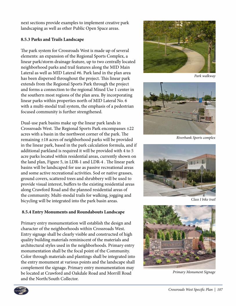
Crossroads West Specific Plan | 107
next sections provide examples to implement creative park landscaping as well as other Public Open Space areas. 8.5.3 Parks and Trails Landscape
The park system for Crossroads West is made up of several elements: an expansion of the Regional Sports Complex, a linear park/storm drainage feature, up to two centrally located neighborhood parks and trail features along the MID Main Lateral as well as MID Lateral #6. Park land in the plan area has been dispersed throughout the project. This linear park extends from the Regional Sports Park through the project and forms a connection to the regional Mixed Use 1 center in the southern most regions of the plan area. By incorporating linear parks within properties north of MID Lateral No. 6 with a multi-modal trail system, the emphasis of a pedestrian focused community is further strengthened.
Dual-use park basins make up the linear park lands in Crossroads West. The Regional Sports Park encompasses ±22 acres with a basin in the northwest corner of the park. The remaining ±18 acres of neighborhood parks will be provided in the linear park, based in the park calculation formula, and if additional parkland is required it will be provided with 4 to 5 acre parks located within residential areas, currently shown on the land plan, Figure 5, in LDR-1 and LDR-4 . The linear park basins will be landscaped for use as passive recreational areas and some active recreational activities. Sod or native grasses, ground covers, scattered trees and shrubbery will be used to provide visual interest, buffers to the existing residential areas along Crawford Road and the planned residential areas of the community. Multi-modal trails for walking, jogging and bicycling will be integrated into the park basin areas.
8.5.4 Entry Monuments and Roundabouts Landscape
Primary entry monumentation will establish the design and character of the neighborhoods within Crossroads West. Entry signage shall be clearly visible and constructed of high quality building materials reminiscent of the materials and architectural styles used in the neighborhoods. Primary entry monumentation shall be the focal point of the Community. Color through materials and plantings shall be integrated into the entry monument at various points and the landscape shall complement the signage. Primary entry monumentation may be located at Crawford and Oakdale Road and Morrill Road and the North/South Collector.
Primary Monument Signage
Park walkway
Riverbank Sports complex
Class I bike trail

108 | Crossroads West Specific Plan
Secondary Monument Signage
Secondary entries and monumentation offer individual communities within CWSP an opportunity to make visitors and residents aware of the arrival into their own individual community. The monumentation and landscaping shall be less prominent in size and scale than the primary entry monumentation, however the general improvements should be consistent.
Roundabouts are used throughout Crossroads West north of MID Lateral No. 6 that echo the roundabouts used in the existing Crossroads Development. These roundabouts are blank canvases for public art and landscaping that will help to unify Crossroads West and create a distinct neighborhood feel. Like those in the existing Crossroads north of MID Lateral No. 6, the roundabouts in the CWSP area shall be sized appropriately and provide landscaping trees if applicable and color through shrubs and flowers.
The landscaped areas at entry monuments and roundabouts at the residential property north of the MID Lateral No. 6 will be maintained via two mechanisms: the formation of a Maintenance CFD or the creation of an HOA. Landscaped areas at entry monuments on the MU 1 Property will be maintained by the affected property, via CC&Rs or Maintenance CFD at the discretion of the MU 1 developer.
Landscaped roundabout
Landscaped roundabout

Crossroads West Specific Plan | 109
Street Tree Themes
Botanical Name Common Name Name of Road
Quercus virginiana Cork Oak Oakdale Road
Acer rubrum Red Maple Collector Road
Quercus ruba Northern Red Oak Morrill Road
Pistacia chinensis Chinese Pistache Crawford Road
Koelreuteria paniculata Golden Rain Tree Claribel Road
8.5.5 Master Street Tree Plan
The City of Riverbank’s Master Street Tree List (Appendix G) is a list of street tree species appropriate for use within the City of Riverbank. The list is a guide for choosing street tree species for development projects. The below exhibit is a proposed street tree theme for the various major and collector roads.

110 | Crossroads West Specific Plan
Left Blank Intentionally

Crossroads West Specific Plan | 111
Chapter 9PROJECT FINANCING PLAN
9.1 Overview
The construction of public improvements and/or facilities may be financed using a number of funding sources and programs. This chapter identifies the obligations of the CWSP and the funding sources that may be used by the developer of each Phase of development, identified in paragraph 9.2, to assure timely construction and maintenance of these improvements. As discussed below these three (3) phases, Phase A, B and C, have been crafted to allow development, in any order, partially or completely, in response to market conditions.
While there are several ways in which to finance improvements and facilities, this section is intended to only provide an overview. A detailed Financing Plan will be reviewed and approved by the City and Developer prior to recordation of any final map within the Specific Plan area. The detailed Financing Plan shall outline the preferred methods of financing. Developer of Phase A may complete its Financing Plan independently for the commercial portion of the development only. It is anticipated that any residential development associated with Phase A would have associated improvement items which might rely on Phase B and Phase C infrastructure like the regional sewer lift station to be built north of MID Lateral No. 6. In this later case, residential development associated with Phase A would be expected to participate in a focused financing plan with Phase B and C.
9.2 Phasing
The phasing plan for Crossroads West will be developed to ensure timely completion of public facilities and improvements that coincide with development. The plan will also ensure that each phase of development has the infrastructure necessary to meet the demands of the new construction. At this time, it is anticipated that the regional Mixed Use 1 Property will develop first followed by various areas of residential and Mixed Use 2, which are located north of MID Lateral No. 6. The plan can be distinguished by three (3) development phases representing each major landholding. See Figure 20. This phased development plan represents only today’s best estimate as to how the Specific Plan area could be phased and should not be construed as the final phasing plan, as project development will be influenced by several factors, including general economic conditions, demographics; occupancy rates, construction schedule, construction costs, the emergence of other competitive projects, and possible changes in the regional infrastructure and public facilities, including the possibility of the North County Corridor (NCC) Project. These three phases have been designed, to the extent feasible, for independent utility and development. Each phase could be able to develop and connect to sewer, water, and storm drainage facilities without relying on adjacent phases to develop. Each phase can provide adequate circulation within the phase.
The following subsections of Section 9.2 are only a summary of the general infrastructure and/or service requirements for each phase, while a more detailed description of the funding sources, financial strategy,

112 | Crossroads West Specific Plan
financial obligations, allocation of responsibilities, and specific infrastructure required for each phase are more specifically stated in the Section 9.6 tables.
9.2.1 Phase A
Phase A may connect to existing sewer, water, and storm drainage facilities to the east in, or across, Oakdale Road. Phase A will get transportation access from the adjacent roadways (Oakdale Road and Claribel Road). Because it is expected that Phase A will develop before sewer lines are extended from Phase B across MID Lateral No. 6 to serve Phase A, Phase A may need an on-site, privately owned sewer lift station to connect sewer lines into Oakdale Road, however Phase A may either (i) connect into existing sewer lines on Oakdale Road and use a temporary sewer lift station, or (ii) extend the sewer line south of MID Lateral No. 6 and connect. With the future construction of the roadway across the MID canal, water and sewer lines will be extended to Phase A by the Phase B and Phase C properties. Developers have submitted preliminary engineering studies for review by the City, the final infrastructure studies shall be approved by the City to demonstrate which infrastructure items are necessary to serve Phase A.
Phase A storm drainage will consist of some on-site storage and conveyance of the remainder of the storm water to the existing storm drain basin in the Crossroad neighborhood just east of Oakdale Road. This proposed storm water discharge into the MID facilities must be approved by MID as well as the City of Riverbank.
9.2.2 Phase B
Phase B will connect to sewer, water, and get transportation access from the adjacent roadways (Oakdale Road, Crawford Road and Morrill Road). Phase B will have a storm drain system consisting of on-site storage in the Central Park Basin that conveys runoff through a pump into the MID Lateral No. 6 located at the south end of Phase B. Sewer will be provided by the extension of the existing sewer line at the intersection of Oakdale and Crawford Roads. Water will be provided by a looped system connecting water lines in Oakdale Road to water lines in Morrill Road.
Phase B will be connected to Phase A by the roadway across the MID Lateral #6, which shall be constructed by and as a part of Phases B and C.
9.2.3 Phase C
Phase C can connect to sewer, water, and transportation access from the adjacent Morrill Road. Phase C will ultimately be served by sewer lines coming up from the south through Phase B. If the Phase B sewer lines are not available, Phase C can install a temporary sewer lift station, to be owned, operated and maintained by the developer of Phase C, and connecting to existing sewer lines in Morrill Road, until such time as the sewer line in Phase B at Morrill Road becomes available. Phase C will have a storm drain system consisting of a storage basin at the northwest corner of the Regional Sports Park with a pump connecting the basin to the adjacent MID Main Lateral.

Crossroads West Specific Plan | 113
Figure 20 – Preliminary Phasing Plan
Project Managem
ent • Civil/Structural Engineering • Urban D
esign • Land Planning • Entitlements • Right-of-W
ay/Permitting • Surveying • Construction Staking • G
raphicsProviding services in California & N
evada
11.21.2017
1117 L StreetM
odesto, CA 95354
866.526.4214w
ww
.mve.net
CRO
SSROA
DS W
EST D
EVELO
PER GRO
UP
CROSSRO
AD
S WEST CO
NCEPTU
AL LA
ND
USE PLA
NRiverbank, California
Morr ill Road
Crawford Road
OaKd
ale R
oad
M ID Ma in Canal
M ID LATE RAL 6
SPORTS PARK22 ac
LDR- !58 .5 ac
LDR-47 ! ac
LDR-249 .5 ac
LDR-355 ac
MU- !54 ac
Park Bas
in 7a
c
Park
Basin I3 A
C
c lar ibel road
E x i s t i n g C r a w f o r d R o a d
co
lle
ct
or road
HDR6 ac
HDR3 .5 ac
B ike Tra il
pedestr ian cross ing
Local Street
well locat ion
New Fire Station site along Oakdale Rd
N E W C R AW F O R D R O A D
B ike Tra il
B i ke Tra il
Ex ist ingM ID cross ing
HDR6 ac
MDR!2 ac
MU-25 ac
N
B ike Tra il4-5 ac
ne ighborhood park
4-5 acne ighborhood
park
N
LOW
-DEN
SITY RESIDEN
TIAL (LD
R) - 5-8 DU
/Acre 3, 4
MED
IUM
DEN
SITY RESIDEN
TIAL (M
DR) - 8-16 D
U/Acre
HIG
H D
ENSITY RESID
ENTIA
L (HD
R) - 20+ DU
/Acre
REGIO
NA
L SPORTS PA
RK (P)
MIXED
USE 1
(MU
-1) 5
MIXED
USE 2
(MU
-2)
School (S)
PARK/BA
SIN (P)
Neighborhood Park
ARTERIA
LS, COLLEC
TORS A
ND
LOCA
L STREETS
ACCESS POIN
TS FOR CO
MM
ERCIAL
EXISTING
TRAFFIC SIG
NA
LS
NO
TES:1 Total acreage does not include the existing Right-of-W
ays for the MID
Main Canal, O
akdale Road, MID
Lateral 6, or Claribel Road.2 Active Adult is allow
ed anywhere w
ithin the LDR designation.
3 The School locations are a placeholder within the LD
R. 4 LD
R unit count includes Neighborhood Park land w
hich has an underlying land use designation of LDR.
5 In Mixed U
se 1, development could consist of all retail (550,000 sf) and no residential; or up to 350 units of residential and about 360,000 sf of retail.
6 Park area and school areas are included in the LDR acreage.
7 The Land Use areas and shapes as show
n on this Land Use M
ap are conceptual. Shapes of the Land Use areas m
ay be reconfigured based on
final design.
LEGEN
D/N
OTES
POSSIBLE SCH
OO
L SITE 3 (S)
ACTIVE A
DU
LT 2
AcresD
.U.’s
AverageD
.U./Acre
S.F.
2341,521
6.5-
12144
12-
15.5310
20-
22-
--
540/350
-550,000/360,000
538
1227,000
20-
--
25-
--
387.5 12,013/2,363
577,000/387,000
BIKE TRAIL
STORM
DISCH
ARG
E
LEGEN
D/N
OTES
POSSIBLE N
EIGH
BORH
OO
D PA
RK
POSSIBLE TRA
FFIC SIGN
AL
N
Figure 19 – Preliminary Phasing Plan
PHASE A
PHASE B
NOTE: Phasing may be adjusted to accommodate market demand.
PHASE C

114 | Crossroads West Specific Plan
9.2.4 Major Back Bone Infrastructure
Major Back Bone Infrastructure within the CWSP is that infrastructure which serves the entire project area, or which is required by the currently adopted City of Riverbank Infrastructure Master Plans. Examples of Major Back Bone Infrastructure would be Morrill Road improvements, a new City Master Plan water well and peaking reservoir, off-site sewer upgrades to sewer lines downstream of the Crawford Road Lift Station, Traffic Signal at Claribel and the new North/South Collector and the bridge crossing of the MID Lateral #6. Items which are Specific Plan exclusive master improvements, such as Crawford Road, dual use parks/drainage basins, and similar improvements that serve the CWSP development exclusively, are not Back Bone Infrastructure Improvements.
Paragraph 9.6 Capital Improvement Program identifies the Major Back Bone infrastructure needed to serve each Phase of Development. To the extent an improvement is contained within the City of Riverbank Systems Development Fee program, full reimbursement through fee offset or by reimbursement from fees collected, will be available. The developer of each Phase may also negotiate a Development Agreement for the Phase that may include City participation or offsets for other improvements not in the City fee program.
9.2.4.1 Water Well and Peaking Reservoir
The City of Riverbank Water Master Plan requires construction of a new water well and peaking reservoir in the project area to serve not only the project, but a larger area. These facilities will be located within the regional park or the dual use park/basin. Concurrent with development, a more detailed engineering analysis will be performed to determine the timing of construction of the well and the peaking reservoir. As these are City of Riverbank Master Planned facilities, the project fair share responsibility for these facilities is included in the currently adopted City of Riverbank System Development Fee program. If the stated facilities are needed in advance of adequate water funds being collected, advanced developer contribution may be required. The timing of these improvements will be determined by the City Engineer. If the developers are required to make advanced contributions, the City of Riverbank will negotiate reimbursement through collected fees or by way of System Development Fee offsets.
9.2.4.2 Off-Site Sewer Improvements
The City of Riverbank Wastewater Master Plan requires upgrading of the sewer force main and lift station pumps in Roselle Avenue at the Crawford Road Lift Station to serve not only the project area, but areas to the west of the project. Prior to development, a more detailed engineering analysis will be performed to determine the timing of construction of the upgraded force main and pumps. As these are City of Riverbank Master Planned facilities, the project fair share responsibility for these facilities is included in the currently adopted City of Riverbank System Development Fee program. If the stated facilities, as clarified by Chapter 7 of this Specific Plan, are needed in advance of adequate sewer funds being collected, advanced developer contribution may be required. The timing of these improvements will be determined by the City Engineer. If the developers are required to make advanced contributions, the City of Riverbank will negotiate reimbursement through collected fees or by way of System Development Fee offsets.

Crossroads West Specific Plan | 115
9.2.4.3 Morrill Road
Morrill Road is a major road serving the project area. Morrill Road will serve the development on north end of the plan area as well as the current and expanded Regional City Park. As such, the timing of Morrill Road construction and its completion is important to the City. Property owners adjacent to Morrill will be expected to dedicate the needed right-of-way for the road construction, consistent with the Specific Plan roadway cross-section, without reimbursement. At the time of development, each adjacent landowner will be required to perform frontage improvements. The City may require improvements in front of adjacent landowner’s property to complete roadway segments. Offsite improvements designed and constructed by new development may be subject to reimbursement as a Specific Plan Improvement item through the collection of a Specific Plan Fee affecting Phase B and Phase C only. As examples, if the southwest corner of Morrill Road and Oakdale Road develops, the City may request pavement and curb and gutter improvements on the north side of Morrill Road as well. These offsite improvements could be subject to a reimbursement agreement for improvements constructed north of the centerline of Morrill Road.
9.2.4.4 Bridge Crossings at MID Lateral No. 6
The North/South Collector Road Bridge crossing at MID Lateral No.6 is expected to be required with development of LDR-4, Phase B. The costs associated with this bridge crossing complete with wet and dry utilities will be shared by all development in Phases B and C as a Specific Plan Fee affecting development north of the MID Lateral No. 6. A Specific Plan fee will be adopted to be paid by the developments north of MID Lateral No. 6 for the North/South Collector Road Bridge crossing, and any pedestrian crossings over the MID Lateral.
9.2.4.5 Crawford Road Connection
Existing Crawford Road west of the project site contains numerous small ranchette style parcels. With the development of the project, traffic levels would be expected to increase on Crawford Road. While these levels would be within acceptable traffic levels of service, the residents on Crawford Road have expressed a concern about this increased traffic.
Concurrent with the first development in Phase B, a gate will be constructed across Crawford Road, near the project’s west property line, and an appropriate temporary vehicular turn around will be constructed on each side of the temporary gate. In addition, the temporary gate will be constructed in a way to allow quick access for the fire district to pass through and continue down Crawford Road, but otherwise will stay closed. The cost of these improvements will be borne by developments in Phase B and Phase C. As Crawford Road is constructed with the development of Phase B, and realigned consistent with this Specific Plan, and the north/south collector road and dual use/park basin are designed; the temporary gate and turnarounds will be revised to maintain emergency access, but not allow daily vehicular traffic westerly of the Specific Plan area via Crawford Road. In the future, when the area between the project site and Coffee Road develops (it is located within the City of Riverbank sphere of influence), Crawford Road will be continued to Coffee Road, and an alternative route through the neighborhood may be proposed, or Crawford Road may become Crawford Court permanently. Such a determination will be made in the future when annexation plans are promoted for the area west of the Crossroads West Specific Plan area.

116 | Crossroads West Specific Plan
9.2.5 Infrastructure Specific to the MU - 1 Property
MU - 1 property is expected to be an extension of the existing Crossroads Shopping Center east of Oakdale Road. Similar to the existing Crossroads Shopping Center, it is anticipated that the MU 1 developers will negotiate a Development Agreement. The infrastructure listed below could be eligible for reimbursement in the MU 1 Development Agreement, but the final determination as to which improvements are included, and the level of their inclusion in the Development Agreement will be based on future negotiations between the City of Riverbank and the developer of the MU 1 Property.
9.2.5.1 Oakdale Road (if necessary to make modifications to the existing completed improvements)
- Land dedication- Traffic Signal modification/improvement at Freddi Lane- Paving, curb, gutter and sidewalk, and lane modifications (including bike paths and/or lanes)- Landscaping and irrigation between sidewalk and curb and in right of way- Street lighting or modifications to street lighting- New and/or existing under-grounding power and communication lines- Main gas and electrical lines- Water, storm, and Sewer Infrastructure (including any public water loop and fire hydrants)- Street markings and signage- Any bus shelter improvements as outlined in the Specific Plan
9.2.5.2 Claribel Road
- Land dedication- Traffic Signal at Claribel Road and Oakdale Road- Sidewalk / Bikeway along Claribel Road- Street lighting or modifications to street lighting- New and/or existing under-grounding power and communication lines- Main gas and electrical lines- Water, storm, and Sewer Infrastructure (including any public water loop and fire hydrants)- Paving, curb, gutter, and sidewalk and lane modifications- Street markings and signage- Landscape and irrigation in right of way and between sidewalk and street curb
9.2.5.3 New North/South Collector Road / On-site Public Improvements
- Land dedication- Traffic Signal at North/South Collector Road and Claribel Road.- Sidewalk / Bikeway along new connector road- Street lighting- Under-grounding power and communication extensions / backbone power extensions- Main gas and electrical lines- Water, storm, and Sewer Infrastructure (including any public water loop and fire hydrants)- Concrete curbing, gutter, and sidewalk and paving- Street markings and signage- Landscaping and irrigation in right of way between street curb and sidewalk

Crossroads West Specific Plan | 117
All hard and soft costs (i.e., Architecture and Engineering expenses, testing and inspections, Geo-Tech, Environmental testing and third party consulting charges) associated with the above improvements listed in Sections 9.2.5.1, 9.2.5.2, and 9.2.5.3.
9.3 Financing Strategies
In order to properly design, build and maintain the public facilities and infrastructure for Crossroads West, several funding sources and financing strategies will be utilized. The following subsections detail possible sources for financing, but it should be noted that the final mix of financing strategies will be determined in the implementation process.
Since each Phase, Phase A, B, and C, can develop independently, it is expected that each Phase will establish their own financing strategy. There are common infrastructure items which benefit a combination of Phase areas. In this case, shared financing strategies amongst Phases may be necessary to capture all costs based on benefits received. This would be the case for fee reimbursements, oversizing, fee offsets, maintenance districts, community facilities districts, and similar items. At the same time, if a Phase developer chooses to join another Phase in any of these districts, mechanisms, or agreements, they may at the developer’s discretion.
9.3.1 Area Specific Impact Fees
Specific Plan fees may be developed as part of the Financing Strategy discussed above. In this case, fees will be calculated for the CWSP and levied against all new development within the Specific Plan area based on benefit to facilitate construction of public facilities and infrastructure to serve the Plan area. Specific Plan fees maybe imposed as a result of the CWSP Financing Plan and may result in fee credits and/or fee waivers. Possible Specific Plan Fees which would benefit all Phases A, B and C might include: Neighborhood Parks as it relates to planned residential development and CFD formation costs. Possible Specific Plan Fees which would benefit Phases A and B might include: a permanent sewer lift station north of MID Lateral No. 6 and force main to gravity sewer.
Possible Specific Plan Fees which benefit Phases B and C might include: Morrill Road; Crawford Road; North/South Collector Road north of MID Lateral No.6, Bridge over MID Lateral No. 6 complete with wet and dry utilities; Crawford EVA closure at western edge of the project; storm drainage improvements, Oakdale Road; sewer over-sizing on-site; and, the Pedestrian crossing over MID Lateral No. 6.
The Subdivision Map Act allows Cities to require developers to dedicate land or make cash payments for backbone infrastructure and public facilities required for their project. Land dedications are most often done for road rights-of-way and utility easements, park sites and other public facilities.
9.3.2 Assessment Districts and Special Tax Districts
The State of California has laws and procedures in place to levy assessments against properties benefiting from improvements and to issue tax-exempt bonds to finance said improvements. The districts must be initiated by the governing body (City Council) and are subject to a majority protest of the property
118 | Crossroads West Specific Plan
owners. Assessments are distributed based on the benefits received by each property and act as a lien against the property. The assessments are typically a fixed dollar amount and may be prepaid however; most property owners or developers pay them back over time with accrued interest.
9.3.2.1 Community Facilities District (CFD’s)
California’s Mello-Roos Community Facilities Act of 1982 allows the creation of special districts authorized to levy a special tax and issuance of tax exempt bonds to finance public facilities and services. Because CFD’s use non-resource bonds that eliminate risk to the municipality, they are an attractive funding source for large projects like Crossroads West. The creation of a CFD can be initiated by the governing body (City Council) or by the property owner. The property owner must submit a petition and garner a 2/3 vote of all registered voters living in the area.
Bonds issued to a CFD provide greater flexibility to developers because a broader range of improvements can be funded through a CFD. These bonds also provide flexibility with the timing of improvements because the monies are available as-needed and not on a pay as you go system. At this time, the City of Riverbank has stated their preference that a bonded CFD not be established for Crossroads West, although one is not prohibited by this Specific Plan.
Developers in the Crossroads West Specific Plan area will be required to create a Maintenance CFD for road, storm water systems, street lighting, parks, and landscaping as well as extended police protection services. The CFD will likely have a number of zones of benefit to reflect actual services provided to each Phase by land use type which will result in a tiered assessment approach.
9.3.3 Private Funding
Private funding also referred to as developer funding simply means the improvements associated with the CWSP area will be the responsibility of the developer and/or property owners. A developer is free to seek out private funding sources, equity or debt financing of his choosing to complete the necessary improvements to service Crossroads West. Should private funding be the mechanism chosen, the developer assumes the most risk initially due to the high up-front costs associated with construction of the improvements. Reimbursement Agreements will be necessary between the developer and the City to assure the developer is reimbursed for the cost of constructing the backbone infrastructure and any other public facilities or improvements. For this funding source, the City acts as the bookkeeper and is responsible for collecting monies and issuing payments to the master developer.
9.3.4 Other Funding Sources
Other funding sources include public and private financing through grants, bonds and overrides. Some of the most popular are Federal and State Grants, General Obligation Bonds, Revenue Bonds, School Bonds and Sales Tax Overrides.
Cities are sometimes eligible for grants from other public agencies like the Federal or State Government. While limited, these grants should be considered as a valid funding source for certain improvements.Grants from the Federal or State government will be project specific and only valid for the improvement for which the grant is issued. Further research will be required to determine the availability of these grants.

Crossroads West Specific Plan | 119
Proposition 46 was passed in 1986 which permitted Cities, Counties and School Districts to issue general obligation bonds. These bonds may be used to finance the acquisition of land for capital improvements and are repaid with the revenues generated from increased property taxes. A general obligation bond can only be established and issued upon securing a 2/3 voter approval. Sales tax overrides are an additional sales tax that is above the local level currently being collected. Jurisdictions may elect to submit a sales tax override measure to be approved by the voters. If approved, the additional sales tax would be collected and used to fund infrastructure improvements and capital projects.
The Land Use Plan for Crossroads West shows two possible school sites that can be developed subject to approval by the Sylvan Union School District. Senate Bill 50 authorizes school districts to collect development impact fees to fund a portion of new school construction. While these fees are solely for use by the school district to fund limited school construction and improvements, the impact fees are valid source of funding and should be considered.
9.4 Establishing Financing Plan
9.4.1 Financing Principles and Policies
The following principles and policies will govern the funding and financing strategies for the CWSP area. These principles and policies will help guide the decisions on the formation of financing entities, adopting financing mechanisms and approving the project.
1. A complete financing analysis should be prepared to identify the infrastructure needed to properly serve each phase of the Crossroads West Specific Plan area.• Policy 1 – Financial analysis shall be conducted that encompasses the entire CWSP area,
identifying all infrastructure costs and financing mechanisms proposed. The analysis shall account for project-specific circumstances, allow for a changing market and provide refined facility and cost data as it becomes available. The Mixed Use 1 area and its financing plan will be limited to only the infrastructure needed to serve the site, but includes infrastructure that benefits Phase B, Phase C, and the City, and therefore all such parties will participate in a financial resolution.
2. New development within Crossroads West should pay the full costs for backbone infrastructure and other public facilities needed to serve the project.• Policy 2 – The existing residents surrounding the CWSP area shall not be burdened with new
taxes or assessments to pay for public infrastructure or facilities that they do not benefit from.• Policy 2.1 – As a part of the Financing Plan to be submitted for approval, evaluate the City’s
existing development impact fee program to determine the relation with backbone infrastructure and other public facilities required for the CWSP area.
• Policy 2.2 – Should any property outside of the CWSP area receive benefit from new infrastructure or facilities, an area of benefit shall be established and said property owners will be assessed a fair share of cost.
3. The total cost for infrastructure improvements and public facilities should be kept to industry standards and minimums and not exceed projected costs.• Policy 3 – New construction of infrastructure and public facilities shall utilize local resources

120 | Crossroads West Specific Plan
when possible to keep costs low.• Policy 3.1 – Encourage measures that minimize costs for new construction in the CWSP area.
Such measures can include construction and reimbursement agreements with the developer, which can lower costs generally associated with these improvements.
4. If a property owner within the boundaries of Crossroads West is required to dedicate land or make improvements to serve the project that are in excess of the benefit the landowner would receive, the excess value should be reimbursed from other properties who receive a benefit.• Policy 4 – Require dedication of land for road improvements and construction of public
improvements consistent with City policies.• Policy 4.1 – The City shall provide credits against City fees to landowners or developers who
build infrastructure of broader City-wide benefit.• Policy 4.2 – The Financing Plan shall include options to incentivize properties to develop at the
designated land use and density provided for in the CWSP.
5. Financing mechanisms should be identified or established to ensure the on-going maintenance of public facilities and improvements.• Policy 5 – The City shall assume responsibility for coordination of landowners and developers in
establishing the appropriate financing mechanisms. The mechanisms shall be incorporated into the Financing Plan and should be interpreted broadly to include all possible funding sources. The City shall support the developers of Crossroads West to create their own separate maintenance of infrastructure, or in combination with one or more of the phases of Crossroads West.
9.4.2 Implementation of Financing Plan
The implementation of the Financing Plan shall be a joint effort between the City of Riverbank and the developers of each specific phase of the Crossroads West Specific Plan area. The schedule of implementation has been designed to accommodate different circumstances including changes to the infrastructure and the overall intensity of the development.
Action 1 – Identify the Final Public Facilities Prior to the adoption of the Financing Plan, the City must provide direction concerning what public
facilities are needed to adequately serve the plan area. This decision shall require input from the Police Department, Stanislaus Consolidated Fire Protection District, Modesto City Schools and Sylvan Union School District on the proposed facilities outlined in the Land Use Plan.
Action 2 – Complete Final Cost Estimates The interested parties shall compile a list of final infrastructure costs associated with the CWSP area.
The cost estimates will be incorporated into the Financing Plan and will be considered preliminary and for planning purposes only.
Action 3 – Establish Infrastructure Phasing Based on Development Priorities It is the assumption of the CWSP that the regional Mixed Use 1 area will begin construction first and
therefore the necessary infrastructure and tie-ins for this area will be phased first. The remaining land plan will need to establish a sequence of phasing for improvements to assure demands are met with new construction.

Crossroads West Specific Plan | 121
Action 4 – Formalize any City and Other Agency Funding Commitments Based on the outcomes of the previous action steps, the City shall select the preferred financing
strategy or strategies desired for the construction of the Crossroads West project.
9.5 City Services Provision
In addition to the construction costs associated with new infrastructure and public facilities, the City shall ensure that new development within Crossroads West Specific Plan will fully fund the ongoing operations and maintenance costs associated with the new project. The City of Riverbank will require the formation of and annexation to a Maintenance CFD, which shall be dependent on the developers’ election, to maintain the infrastructure independently, or in combination with the other developers.
An analysis of the cost of maintenance of items identified shall be prepared prior to the recordation of the First Final Map. The analysis shall focus on the potential benefits each phase shall receive based on land use type and respective public service benefit. This analysis shall provide a framework for subsequent detailed financial planning and implementation for the costs of ongoing maintenance, operation and public services. The analysis will identify the types and estimated costs of ongoing operations and maintenance costs that new development has on City support services.
9.6 Draft Capital Improvement Program
The following Capital Improvement Program (CIP) identifies the Major Back Bone Infrastructure that is expected for each Phase of development as well as the responsible party and maintenance obligations. This is a “draft” plan as until development is actually proposed, and engineering analysis is prepared, it is not clear that all of the proposed items will be needed up front. Some items may be able to be deferred and as required in Paragraph 9.1, prior to development of any Phase a more detailed Financing Plan will be prepared. The funding sources which have been denoted as “To be Determined” (TBD) is meant to imply that the City and Developer are in the midst of negotiating possible funding sources, which will be determined in the future by City Council action. It is likely these items denoted would be part of a package of negotiated conditions which would be formalized in a City Council approved Agreement.

122 | Crossroads West Specific Plan
9.6.1 Phase A - Capital Improvement Program
Phase A
Improvement ResponsibleParty
Funding Sources
WhenProvided
MaintenanceResponsibility
Water Lines12 inch water line in Claribel Road and Oakdale Road, adjacent to Phase A will be constructed incrementally as Phase A develops. Water line and all appurtenances may be constructed in a PUE adjacent to Claribel Road or interior of the project site provided the responsibilities for this improvement have been approved by the City of Riverbank.
Developer Systems Development Fee
Concurrent with Development
City
Off-Site Sewer UpgradeThe Crawford at Roselle Road Lift Station and downstream improvements to Force Main and Trunk Sewer will need to be upgraded. If it is determined, based on engineering calculations, some capacity is available; the City will allow commercial development on Phase A only prior to requiring the sewer upgrades. The upgrade may be phased if engineering calculations show discrete components can be constructed to increase capacity, or Phase A developments may increase onsite storage capacity and meter flows. Any initial available capacity shall be reserved for use in Phase A for commercial development only. This excludes any residential development planned for Phase A.
Developer SystemsDevelopment Fee <1>
Based on Engineering Analysis
City
Sewer Line (Under MID, Lateral No. 6)Phases B and C will share the cost for extending the sewer line under MID Lateral No. 6 to serve Phase A at the time of construction of the north/south Collector Road over MID Lateral No. 6.
Developer of Phase B & C
Developerof Phase B & C
When required by City
City
Sewer Lines (South of MID Lateral No. 6, external, adjacent and internal to the Project)Internal sewer lines serving Phase A will be constructed by one of the methods identified in this CWSP.
Developer TBD Concurrent with Development
City/Developer<3>
Water LinesOnsite public water main lines of 12” serving multiple parcels.
Developer TBD Concurrent with Development
City
Storm Drain LinesMain storm drain lines serving multiple parcels which will drain towards the existing system in the Crossroads Development East of Oakdale Road.
Developer Developer Concurrent with Development
City
Temporary Sewer Lift StationsPhase A has the option to construct a temporary lift station to serve the western portion of the development in the event development occurs in advance of gravity sewer lines being available north of MID Lateral No. 6. Construction of a temporary lift station is allowed at developers’ cost and discretion.
Developer Developer Concurrent with Development if gravity lines are not available
Developer
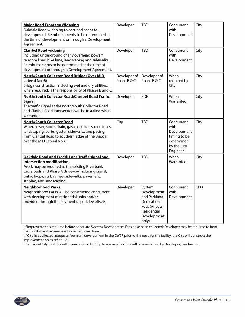
Crossroads West Specific Plan | 123
Major Road Frontage WideningOakdale Road widening to occur adjacent to development. Reimbursements to be determined at the time of development or through a Development Agreement.
Developer TBD Concurrent with Development
City
Claribel Road widening Including underground of any overhead power/telecom lines, bike lane, landscaping and sidewalks. Reimbursements to be determined at the time of development or through a Development Agreement.
Developer TBD Concurrent with Development
City
North/South Collector Road Bridge (Over MID Lateral No. 6)Bridge construction including wet and dry utilities, when required, is the responsibility of Phases B and C.
Developer of Phase B & C
Developer of Phase B & C
When required by City
City
North/South Collector Road/Claribel Road Traffic SignalThe traffic signal at the north/south Collector Road and Claribel Road intersection will be installed when warranted.
Developer SDF When Warranted
City
North/South Collector RoadWater, sewer, storm drain, gas, electrical, street lights, landscaping, curbs, gutter, sidewalks, and paving from Claribel Road to southern edge of the Bridge over the MID Lateral No. 6.
City TBD Concurrent with Development timing to be determined by the City Engineer
City
Oakdale Road and Freddi Lane Traffic signal and intersection modification, Work may be required at the existing Riverbank Crossroads and Phase A driveway including signal, traffic loops, curb ramps, sidewalks, pavement, striping, and landscaping.
Developer TBD When Warranted
City
Neighborhood ParksNeighborhood Parks will be constructed concurrent with development of residential units and/or provided through the payment of park fee offsets.
Developer System Development and Parkland Dedication Fees (Affects Residential Development only)
Concurrent with Development
CFD
1If Improvement is required before adequate Systems Development Fees have been collected; Developer may be required to front the shortfall and receive reimbursement over time.2If City has collected adequate fees from development in the CWSP prior to the need for the facility; the City will construct the improvement on its schedule. 3Permanent City facilities will be maintained by City. Temporary facilities will be maintained by Developer/Landowner.

124 | Crossroads West Specific Plan
9.6.2 Phase B - Capital Improvement Program
Phase B
Improvement ResponsibleParty
Funding Sources
When Provided
MaintenanceResponsibility
Water Lines12 inch water lines in Oakdale Road, Morrill Road, Crawford Road, and north/south Collector will be constructed incrementally based on a Water Analysis prepared at the time of development.
Developer Systems Development Fee 1
Concurrent with Development
City
Water Well (And Site)Prior to development in Phases B or C, a Water Analysis will be prepared to determine the timing of construction of the new water well.
Developer orCity2
Systems Development Fee1
Based on Engineering Analysis
City
Peaking Reservoir (And Site)One approximately 2.0 MG Peaking Reservoir and booster pump is proposed north of MID Lateral No.6. Timing of construction will be based on a Water Analysis prepared in advance of development in Phases B and C.
Developer orCity2
Systems Development Fee1
Based on Engineering Analysis
City
Off-Site Sewer UpgradeThe Crawford Road at Roselle Lift Station and downstream improvements to Force Main and Trunk Sewer will need to be upgraded. The upgrade may be phased if engineering calculations show discrete components can be constructed to increase capacity.
Developer Systems Development Fee1
Based on Engineering Analysis
City
Sewer Lines (North of MID Lateral No. 6)Prior to development, a reimbursement program will be prepared to share costs between Phases B and C for sewer lines over ten (10) inches in size.
Developer Developer Concurrent with Development
City
Sewer Line (Under MID, Lateral No. 6)Phases B and C will share the cost for extending the sewer line under MID Lateral No. 6 to serve Phase A at the time of construction of the north/south Collector Road over MID Lateral No. 6.
Developer Developer When required by City
City
New Sewer Lift StationA new sewer lift station is required to serve the southerly area of Phase B. Prior to construction of this lift station, an analysis will be prepared to determine if the lift station can serve areas west of the CWSP, and if so, a reimbursement mechanism will be established.
Developer Developer When Development Warrants
City
Major Road Frontage WideningOakdale Road widening to occur adjacent to development. Reimbursements to be determined at the time of development or through a Development Agreement.
Developer TBD Concurrent with Development
City

Crossroads West Specific Plan | 125
Collector RoadsCrawford Road, Morrill Road and the north/south Collector Road to be constructed at the time of adjacent development. City may require discrete sections which extend beyond development frontage, but such improvement would be subject to reimbursement by agreement or Development Agreement when in front of a benefiting landowner.
Developer Developer Concurrent with Development
City
North/South Collector Road Bridge (Over MID Lateral No. 6)Bridge construction including all wet and dry utilities, when required, is the responsibility of Phases B and C.
Developer Developer When required by City
City
Pedestrian Bridge over MID Lateral No. 6Pedestrian Bridge, if constructed, are the responsibilities of Phases B and C
Developer Developer When required by City
City
Regional Park ExpansionCity will construct the Regional Park expansion.
City SystemsDevelopment Fee1and 4
When Determinedby City
City
Neighborhood ParksNeighborhood Parks will be constructed concurrent with development of residential units or provided through the payment of park fee offsets.
Developer SystemsDevelopment and Parkland Dedication Fees1and 4
Concurrent with Development
City
Storm DrainageEach Phase of development will provide its own storm drainage system, supported by engineering calculations. Payment of City storm drainage fees will not be required.
Developer Developer Concurrent with Development
CFD
1If Improvement is required before adequate Systems Development Fees have been collected, Developer may be required to front the shortfall and receive reimbursement over time.2If City has collected adequate fees from development in the CWSP prior to the need for the facility, the City will construct the improvement on its schedule. 3Permanent City facilities will be maintained by City. Temporary facilities will be maintained by Developer/Landowner.4Applies to residential development only

126 | Crossroads West Specific Plan
9.6.3 Phase C - Capital Improvement Program
Phase C
Improvement ResponsibleParty
Funding Sources
When Provided
MaintenanceResponsibility
Water Lines12 inch water lines in Oakdale Road, Morrill Road, Crawford Road, and north/south Collector will be constructed incrementally based on a Water Analysis prepared at the time of development.
Developer Systems Development Fee1
Concurrent with Development
City
Water Well (And Site)Prior to development in Phases B or C, a Water Analysis will be prepared to determine the timing of construction of the new water well.
Developer orCity2
Systems Development Fee1
Based on Engineering Analysis
City
Peaking Reservoir (And Site)One approximately 2.0 MG Peaking Reservoir and booster pump is proposed north of MID Lateral No.6. Timing of construction will be based on a Water Analysis prepared in advance of development in Phases B and C.
Developer orCity2
Systems Development Fee1
Based on Engineering Analysis
City
Off-Site Sewer UpgradeThe Crawford Road at Roselle Lift Station and downstream improvements to Force Main and Trunk Sewer will need to be upgraded. If it is determined, based on engineering calculations, some capacity is available; the City may allow some development prior to requiring the upgrade. The upgrade may be phased if engineering calculations show discrete components can be constructed to increase sewer capacity.
Developer Systems Development Fee1
Based on Engineering Analysis
City
Sewer Lines (North of MID Lateral No. 6)Prior to development, a reimbursement program will be prepared to share costs between Phases B and C for sewer lines over ten (10) inches in size.
Developer Developer Concurrent with Development
City
Sewer Line (Under MID, Lateral No. 6)Phases B and C will share the cost for extending the sewer line under MID Lateral No. 6 to serve Phase A at the time of construction of the north/south Collector Road over MID Lateral No. 6.
Developer Developer When required by City
City
Temporary Lift StationsPhase C has the option to construct a temporary lift station to serve the development in the event development occurs in advance of gravity sewer lines being available. Construction of such temporary lift station is allowed at developer’s cost and discretion.
Developer Developer Concurrent with Development if gravity lines are not available
Developer
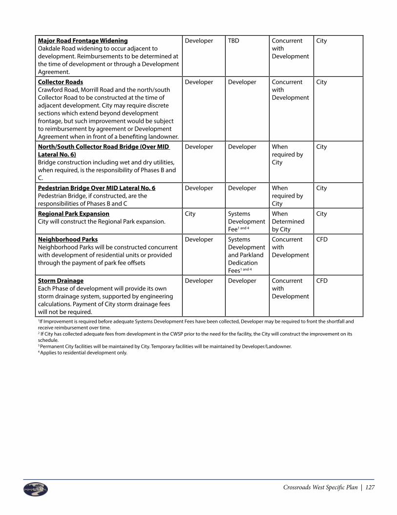
Crossroads West Specific Plan | 127
Major Road Frontage WideningOakdale Road widening to occur adjacent to development. Reimbursements to be determined at the time of development or through a Development Agreement.
Developer TBD Concurrent with Development
City
Collector RoadsCrawford Road, Morrill Road and the north/south Collector Road to be constructed at the time of adjacent development. City may require discrete sections which extend beyond development frontage, but such improvement would be subject to reimbursement by agreement or Development Agreement when in front of a benefiting landowner.
Developer Developer Concurrent with Development
City
North/South Collector Road Bridge (Over MID Lateral No. 6)Bridge construction including wet and dry utilities, when required, is the responsibility of Phases B and C.
Developer Developer When required by City
City
Pedestrian Bridge Over MID Lateral No. 6Pedestrian Bridge, if constructed, are the responsibilities of Phases B and C
Developer Developer When required by City
City
Regional Park ExpansionCity will construct the Regional Park expansion.
City SystemsDevelopment Fee1 and 4
When Determinedby City
City
Neighborhood ParksNeighborhood Parks will be constructed concurrent with development of residential units or provided through the payment of park fee offsets
Developer SystemsDevelopment and Parkland Dedication Fees1 and 4
Concurrent with Development
CFD
Storm DrainageEach Phase of development will provide its own storm drainage system, supported by engineering calculations. Payment of City storm drainage fees will not be required.
Developer Developer Concurrent with Development
CFD
1If Improvement is required before adequate Systems Development Fees have been collected, Developer may be required to front the shortfall and receive reimbursement over time.2 If City has collected adequate fees from development in the CWSP prior to the need for the facility, the City will construct the improvement on its schedule. 3 Permanent City facilities will be maintained by City. Temporary facilities will be maintained by Developer/Landowner.4 Applies to residential development only.

128 | Crossroads West Specific Plan
Left Blank Intentionally

Crossroads West Specific Plan | 129
IMPLEMENTATION AND ADMINISTRATION
10.1 Overview
California Government Code Sections 65450 through 65457 guide the formation, approval and administration of specific plans for municipalities. This chapter describes the Development Plan Review process, Specific Plan Interpretation and amendment process, Design Review Process, Plan enforcement and other mechanisms to implement the Crossroads West Specific Plan (CWSP).
Riverbank Municipal Code (RMC) states that a specific plan must be adopted by the City Council either by resolution or ordinance and that the specific plan shall be prepared, adopted and amended in the same manner as a general plan. The only difference, a specific plan document may be amended as many times as deemed necessary by the legislative body.
10.1.1 City Documents
General Plan
The City of Riverbank 2025 General Plan serves as the long-term policy guide for the physical and economic development of the City. The City’s core values are the foundation of the General Plan and the underlying basis for its vision and direction.
The Specific Plan implements the goals and policies of the General Plan and supplements these goals and policies by providing specific direction to reflect conditions unique to the Specific Plan area. Prior to the initial approval of this Specific Plan, a comprehensive citywide update to the General Plan was approved, which incorporated the appropriate land use and policy framework to reflect the Specific Plan development program. The Specific Plan is consistent with the City’s 2025 General Plan as adopted.
Zoning & Other Codes
The City of Riverbank Municipal Code is one of the primary tools for implementing the General Plan. Included in the Municipal Code is the City’s Zoning Code, which will be used in conjunction with the Specific Plan to implement the development program. Other related components of the Municipal Code include the Subdivision Ordinance, Sign Ordinance, and Tree Ordinance, all of which will be used to implement the Specific Plan where applicable.
The Specific Plan modifies the permitted uses, development standards, and other regulations of the City’s Municipal Code. In these cases, the standards and regulations provided in the Specific Plan supersede those in the Municipal. Where the Specific Plan is silent, regulations in the Municipal Code remain applicable. If a conflict occurs between the requirements of the Specific Plan and the City’s Municipal Code, the requirements of the Specific Plan shall prevail.
Chapter 10
130 | Crossroads West Specific Plan
Standard Specifications
The City of Riverbank Standard Specifications provide detailed drawings and design standards to guide public improvement projects within the City. Topics addressed include safety, streets, lighting, water, sewer, storm drains, parking, walls, fire standards, utilities, landscaping, irrigation, standard measures, backflow and cross connections, and bike and pedestrian trails.
The Specific Plan includes plans, standards and guidelines that supplement the City’s adopted Standard Specifications. If a conflict occurs between the requirements of the Specific Plan and the City’s Standard Specifications, the requirements of the Specific Plan shall prevail.
10.1.2 Specific Plan Documents
Environmental Impact Report
An Environmental Impact Report (EIR) was certified for the Specific Plan by the City Council through the adoption of Resolution No._________on_________. The EIR, prepared in accordance with CEQA, examines the potential direct and indirect environmental effects of the project and identifies appropriate mitigation measures, where feasible, to reduce impacts determined to be potentially significant.
This EIR serves as the base environmental document for purposes of evaluating subsequent development entitlements, discretionary permits, and ministerial approvals. Included is the Mitigation Monitoring and Reporting Program to be used by the City and project developers in ensuring compliance with adopted mitigation measures as the Specific Plan area builds out. The Specific Plan Mitigation Monitoring and Reporting Program is included as Appendix A.
10.2 Effectuation of Entitlements
Concurrent with adoption of this Specific Plan, the City will prezone all properties within the Specific Plan Area to SP-4 pursuant to Section 153.309 of the Riverbank Municipal Code. In order to fully effectuate land use and zoning entitlements, and allow development on any property with the Specific Plan Area to proceed, the following subsequent approvals may be required:
Development Agreement
Development Agreements are anticipated for one of more of the development areas for Crossroads West Specific Plan.Key topics which might be addressed in development agreement for properties include, as applicable:
• Vested rights (subject to subsequent project entitlements), and applicable laws and regulations• Affordable housing requirements, participation, and subsidies (if any).• Outside agency approvals, permits and responsibilities.• Public improvements (on-site and off-site) to be dedicated constructed or financed by Specific
Plan area and individual properties. • Park and ride lots.• Parks, open space and trail dedication, thresholds, construction, and financing.

Crossroads West Specific Plan | 131
• Police, fire, and general fund contributions.• Community wide financing mechanisms formation and obligations (infrastructure, services and
maintenance).• Credits and reimbursements.• Project phasing/sub-phasing, including “large lot” parcelization and/or subdivisions.• Defaults, remedies and termination.• Hold harmless agreement.• Other relevant provisions.
A Development Agreement must be approved and executed prior to or concurrent with final City approval of any subsequent development entitlements for an applicable property. Development Agreements are to be processed in accordance with the Riverbank Municipal Code, and run with the land.
Project Entitlements in Riverbank
Individual development projects within the Specific Plan are subject to review and approval of subsequent permits and entitlements by the City. Typical entitlements may include architectural and site plan review, PDP’s, use permits, parcel maps, subdivision maps, and/or other permits. Application and processing requirements, with the exception of the Site Plan Review and PDP’s, shall be in accordance with the City’s Zoning Code and other regulations, unless otherwise modified by this Specific Plan.
All subsequent development projects, public improvements, and other activities shall be consistent with the provisions of the Specific Plan, applicable development agreements, and pertinent City of Riverbank policies, requirements and standards. In acting to approve a subsequent project or permit, the City may impose conditions as are reasonably necessary to ensure that the project is in compliance with the Specific Plan and all then applicable plans and regulations.
Outside Agency Approvals
Other permits and approvals may be required by federal, state and/or regional agencies. These agencies may include the U.S. Army Corps of Engineers, U.S. Fish and Wildlife Services, California Department of Fish and Game, California Department of Transportation, Regional Water Quality Control Board, San Joaquin Valley Air Pollution Control District, Stanislaus County, Modesto Irrigation District and others as applicable.
Subsequent Environmental Review
Each subsequent development project shall be reviewed to ensure compliance with the California Environmental Quality Act (CEQA). The project specific EIR, certified for the Crossroads West Specific Plan serves as the base environmental document for subsequent entitlements within the Specific Plan area. Development applications are to be reviewed on a project-by-project basis to determine consistency with the EIR.
The EIR prepared for the Specific Plan identifies specific mitigation measures to be applied to projects within the Specific Plan as applicable. Some of the mitigation measures necessitate additional study or

132 | Crossroads West Specific Plan
review to be undertaken prior to a project moving forward.
See the Specific Plan Mitigation Monitoring and Reporting Program (Appendix B) for a full listing of applicable mitigation measures.
Existing Uses
At the time of Specific Plan approval, there are a number of existing homes and related agricultural structures within the Specific Plan Area. While some of these uses may remain either indefinitely or for an extended period, it is expected that many will ultimately be replaced to accommodate new development consistent with Specific Plan land uses.
Certain existing land uses that were legal under prior land use regulations may not conform to the standards specified in this Specific Plan. Since the Specific Plan is oriented towards the future, it is intended that these nonconforming uses will eventually be phased out consistent with the City’s Zoning Code. Permits should not be granted for expansion of structures to accommodate nonconforming uses, but routine interior and exterior maintenance is permitted under certain circumstances. Routine interior and exterior maintenance shall be determined by the Community Development Director. This Specific Plan does not establish a specific time frame for non-conforming uses to comply. 10.3 Amendment Process
The CWSP represents the master plan for the Crossroads West development area. Individual project applications will be reviewed by the Community Development Director or its designee, without requiring public notice and/or public hearing, to determine consistency with the Specific Plan and other regulatory documents. Such applications could include Large Acreage Tract Maps, Parcel Maps, Tentative Subdivision Maps, Development Plans for Commercial or Mixed Use projects, Design Review Applications and Conditional Use Permits.
Applications for any entitlement within the CWSP shall be submitted to the City of Riverbank Development Services Department for review and action, which shall be conducted by the Community Development Director or its designee. Upon submittal of a complete application package, the applicant will be notified of any deficiencies and/or requests for additional information needed to process the requested action. To the extent an owner and staff cannot agree, owner may appeal staff ’s decision to the Planning Commission for approval, and if the owner disagrees with such Planning Commission decision, owner may appeal to the City Council.
10.4 Architectural and Site Plan Review Process
All applications for residential, commercial and mixed use developments in the Specific Plan will be under obligation to present architectural drawings to the Community Development Director to demonstrate how the proposed projects complies with and implement the Crossroads West Specific Plan. The City shall develop processing forms and charge appropriate fees for the administrative review of Design Review Permits. It will be expected that sufficient evidence is presented along with the applications being presented to allow the Community Development Director the opportunity to fully understand the project being proposed in order to determine, without requiring public notice and/

Crossroads West Specific Plan | 133
or public hearing, that the design is in substantial conformance with the Specific Plan. The review and approval of the Design Review Permit shall be by the Community Development Director, unless appealed to the Planning Commission for approval in accordance with the Riverbank Municipal Code, and if the owner disagrees with such Planning Commission decision, owner may appeal to the City Council.
10.5 Preliminary Development Plan Process
A Developer shall also prepare a Preliminary Development Plan (PDP) concurrent with, or prior to, tentative parcel map, tentative subdivision map and Site Plan Review approvals as described in Section 10.5 of this document.
Scope: The minimum area to be addressed in the PDP is the development area as indicated in Figure 5 as distinct development areas (e.g., LDR-1, LDR-2, LDR-3, LDR-4, MU-1 and MU-2) and shall be a schematic plan covering the entire development area. The PDP shall illustrate how the proposed project implements the CWSP and show tentative locations for future circulation and infrastructure connection points.
Purpose: The purpose of the PDP will be to assist City Staff in reviewing and conditioning the development applications consistent with the CWSP.
PDP’s shall be subject to the following provision of this Specific Plan:a) The density of development shall be consistent with the Specific Plan land use designations.b) The number of residential units or commercial square footage proposed shall be within the
minimum and maximum range of the Specific Plan for that land use category.c) The PDP must be approved by the Planning Commission prior to consideration of a Site Plan
Approval by Staff or concurrently with the Tentative Map approval.d) Residential units allocated by the Specific Plan may be reallocated within a distinct development
area through a Preliminary Development Plan if: (i) the minimum numbers of medium and high density units are achieved, (ii) the average number of units allowed in the district is not exceeded and (iii) PDP complies with the CWSP design guidelines. Compliance must be demonstrated with a numerical comparison of low, medium, and high density units required in the Specific Plan and the proposed low, medium, and high density units.
e) Residential units allocated by the Specific Plan may be transferred to another planning area when two or more distinct development areas are the subject of one PDP. The reallocation of units between distinct development areas shall be deemed consistent with the Specific Plan if: (i) the minimum numbers of medium and high density units are achieved in each district, (ii) the average numbers of units allowed in each district is not exceeded and (iii) the design guidelines are followed. Compliance must be demonstrated with a numerical comparison of low, medium, and high density units required in the Specific Plan and the proposed low, medium, and high density units by district.
10.6 Administration
The City of Riverbank is responsible for and shall cause its staff to perform the administration, implementation, and enforcement of the Specific Plan, without requiring public notice and/or public hearing, provided the design is in conformance with the Specific Plan. Implementation of the Specific

134 | Crossroads West Specific Plan
Plan is anticipated to occur over several years, and over time conditions may change that necessitate interpretation, minor modification, and possible amendment to the Specific Plan. It is intended that the Specific Plan be administered with flexibility and creativity to allow the City and property owners to react quickly to changes in the market place within the intent of the Specific Plan. To the extent an owner and staff cannot agree, owner may appeal staff ’s decision to the Planning Commission for approval, and if the owner disagrees with such Planning Commission decision, owner may appeal to the City Council.
10.7 Interpretations
Interpretations of any standards, guidelines, and requirements included within this Specific Plan are to be made at the discretion of the Community Development Director (Director). In making an interpretation, the Director shall determine that the interpretation is consistent with, and will not otherwise obstruct the attainment of, the Specific Plan. The Director may forward any interpretation directly to the Planning Commission for determination. All interpretations of the Director may be appealed to the Planning Commission for approval in accordance with the Riverbank Municipal Code, and if the owner disagrees with such Planning Commission decision, owner may appeal to the City Council.
For purpose of interpretation the terms “shall”, “will”, “must”, “are to”, and “is to” are mandatory. “Should” and “encouraged” are highly recommended, and “may” is permissive.
10.8 Alternative Development & Design Standards
The Specific Plan allows for the approval of alternative development and design standards that differ from those specified in the Specific Plan. The intent is to provide flexibility to respond to evolving market conditions, promote innovation design, and consider the merits of individual projects. Alternative standards may be approved by the Director, without requiring public notice and/or public hearing, provided the alternative development and/or design standards are in substantial conformance with the Specific Plan, and such alternatives shall not require amendment to the Specific Plan when they:
• Provide for efficient, diverse, and innovative development.• Encourage the mixing of uses.• Enhance pedestrian orientation, connectivity, and social interaction.• Promote attractive and active streetscapes.• Support high quality and district design that strengthens community character and identity.• Respect the character and quality of adjacent uses.• Respond to unique natural, cultural, and/or scenic resources.• Are consistent with the intent and character of the Specific Plan and the 2025 General Plan.• Achieve the original design intent to a same or better level.• Respond to changes and evaluation ongoing in marketplace in MU 1 Uses.
A request for alternative standards is to be submitted and approved concurrent with the subdivision map or site plan review application required for the applicable project. The request shall include explanation and illustration of the proposed alternative standards, how they achieve the above criteria and any other information deemed necessary for evaluation by the Director. In reviewing a request for alternative standards, the Director and/or its designee, without requiring public notice and/or public hearing, shall consider whether the application complies substantially with the above criteria. To the extent an owner

Crossroads West Specific Plan | 135
and staff cannot agree, owner may appeal staff ’s decision to the Planning Commission for approval, and if the owner disagrees with such Planning Commission decision, owner may appeal to the City Council. 10.9 Amendment Process
Large projects like Crossroads West adopt specific plans often with phased, lengthy development time-frames and multiple developers/builders. Situations may arise where an amendment to the specific plan is warranted including changing market conditions, unforeseen circumstances or development standards changes through the City.
Amendments to the specific plan shall be classified as minor or major and the Community Development Director will be the primary decision maker. To the extent an owner and staff cannot agree, owner may appeal staff ’s decision to the Planning Commission for approval, and if the owner disagrees with such Planning Commission decision, owner may appeal to the City Council.
10.9.1 Minor Specific Plan Modifications
The Specific Plan allows for approval of minor modifications to the Specific Plan. The Community Development Director shall determine whether a proposed revision is minor, and may act upon a minor modification administratively without amendment to the Specific Plan. A minor modification may be approved if determined by the Director to be in substantial conformance with:
• The vision and overall intent of the Specific Plan;• Applicable development agreement(s);• The City of Riverbank General Plan;• The Specific Plan Environmental Impact Report.
Examples of minor modifications include, but are not limited to:
• Minor adjustments to land use boundaries and street alignments where the general land use pattern is maintained.
• Changes to the provision of public infrastructure and facilities that do not impact the level of service provided or affect the development capacity in the Specific Plan area.
• Other modifications determined by the Director to be in substantial conformity with the Specific Plan.
A request for a minor modification is to be submitted to the Community Development Director. The request shall include explanation of how the request is in substantial conformance with the above, and any other information deemed necessary for evaluation by the Director. The Director, without requiring public notice and/or public hearing, may make a determination on the project or may forward any minor modifications to the Planning Commission for determination. All minor modifications to the Specific Plan may be appealed to the Planning Commission in accordance with Riverbank Municipal Code. To the extent an owner and staff cannot agree, owner may appeal staff ’s decision to the Planning Commission for approval, and if the owner disagrees with such Planning Commission decision, owner may appeal to the City Council.

136 | Crossroads West Specific Plan
10.9.2 Major Specific Plan Amendments
When it is determined that a specific development project or requested interpretation, alternative standard, or minor modification is not in substantial conformity with the Specific Plan, an amendment to the Specific Plan will be required. A Specific Plan amendment may be initiated by a developer, property owner, or the City. Specific Plan amendments are to be processed in the same manner as the initial Specific Plan adoption, requiring review by the Planning Commission and action by the City Council as specified in Section 153.309 of the Riverbank Municipal Code. Depending upon the nature of a Specific Plan amendment, a concurrent amendment to the General Plan, Municipal Code, Development Agreement, or other related City and Specific Plan documents may be required.
All requests for a Specific Plan amendment and related documents shall include text (red-line/strike-out), graphics and other materials suitable to replace or augment the sections being amended. The graphic format and style of the original documents is to be followed for ease of incorporation and consistency. All amendments to the Specific Plan and related documents are subject to compliance with CEQA.
10.10 Specific Plan Enforcement
Any violation of the requirements of this Specific Plan is to be enforced in the same manner as a violation of the Municipal Code.
10.11 Severability
If any section, subsection, phrase, regulation, condition, program or portion of this Specific Plan, or any future amendment, is for any reason held to be invalid or unconstitutional by any court or competent jurisdiction, such decision shall not affect the validity of the remaining portion of this Specific Plan, or any future amendment.

Crossroads West Specific Plan | 137
APPENDIX AGP Consistency Matrix

138 | Crossroads West Specific Plan
Left Blank Intentionally

Crossroads West Specific Plan | 139
Appendix A: General Plan Consistency Table
The following table summarizes the General Plan consistency with the Crossroads West Specific Plan (CWSP).
For the Purposes of efficiency and brevity, only those goals within the Riverbank General Plan that are relevant to the CWSP are itemized and described in the Table. The column shown as “General Plan Goals and Policies” contains in many cases only partial quotes from relevant sections of the General Plan. The Table is organized sequentially with the City’s General Plan document and formatted by section and subject heading. Since the Riverbank General Plan is organized in a more “narrative” format, the Table is similarly structured showing General Plan page numbers to facilitate location of the various items being addressed.
Riverbank General Plan Goals General Plan Page
General Plan
Compatible
Compatibility Analysis
Goal LAND-1: Managed Urban Growth that Benefits the Entire Community
LAND-15 Yes The CWSP includes Mixed Use Commercial Retail Land Uses, Neighborhood and Community Parks. Most notably, the CWSP includes the expansion of the City’s existing Regional Sports Park. In addition, the CWSP includes potential future school sites and a future fire station. These land uses will benefit the entire community.
Goal LAND-2: Balanced and Diverse Uses of Land…Approved specific plans shall include a variety of land uses…Approved specific plans that include proposed parks, schools, and other civic uses.
LAND-15 Yes The CWSP includes a mixture of land uses consistent with those identified in the City of Riverbank General Plan, and will provide residential and commercial development at intensities projected by the General Plan. The CWSP includes 261 acres of residential land uses, including low, medium and high density residential. In addition, 59 acres of commercial mixed use is included in the Plan, which allows for up to .35 Floor Area Ratio and 25 dwelling units per acre. Parks and schools are planned for at levels necessary to serve the projected residential development. Parks contemplated in the CWSP includes open space, trails, neighborhood parks and expansion of the regional sports complex – 42 acres. Future school sites in the plan area might include a ten (10) acre Elementary School as well as a twenty (20) acre Middle School.
Appendix A: GP Consistency Matrix

140 | Crossroads West Specific Plan
Goal LAND-3: Development Patterns that encourage Alternatives to Vehicular Travel.
LAND-16 Yes The CWSP includes a bike trails along the Modesto Irrigation District (MID) Main lateral as well as Lateral 6, Pedestrian Crossing of MID Lateral 6 is proposed to access the Mixed Use 1 Land Use area to the south of the plan area. Bike trails are proposed along the planned north-south Collector Road which will connect various neighborhoods and land uses to the new development areas as well as the balance of the City of Riverbank to the north and east.
Goal CIRC-1: Riverbank’s Circulation Network Provides Convenience and Choice among All Modes of Transportation…New growth areas shall provide a fully connected network of smaller roadways that provide many alternative routes.
CIRC-13 Yes The CWSP provides a hierarchy of roadways from major roadways like Claribel Road and Oakdale Road, to collector roads like Morrill and Crawford. These roadways serve to link each neighborhood through a series minor streets that provide a roadway network which promotes alternative transportation methods such as buses, biking and walking. In addition, the Plan includes a new north-south collector in the heart of the project that will connect the various land uses within the Plan Area to Claribel Road to the South.
Goal CIRC-2: The City’s Urban Development Pattern Supports All Locally Available Modes of Transportation…New growth areas will provide an appropriate balance of higher-activity land uses, such as schools, parks, retail and commercial services, small offices, civic uses, apartments, in accessible neighborhood centers.
CIRC-15 Yes The CWSP includes a mixture of land uses including residential (low, medium and high density), commercial mixed use, and parks/open space. These land uses are balanced throughout the project area, with commercial and higher density land uses located adjacent to arterial and collector streets.
Goal CIRC-3: Increase the Availability and Use of Transit…accommodate transit facilities consistent with transit agency planning.
CIRC-16 Yes The CWSP provides bus turnout locations along Oakdale Road as well as along the new north-south collector.
Appendix A: GP Consistency Matrix

Crossroads West Specific Plan | 141
Appendix A: GP Consistency Matrix
Goal DESIGN-1: Street and circulation patterns that encourage walking, bicycling, transit use, and reduce traffic congestion...new growth areas shall arrange streets in an interconnected block pattern…ensure frequent street and trail connections between new residential developments and established neighborhoods.
DES-3 Yes The proposed circulation system includes arterial streets, collector streets, local residential streets and cul-de-sacs and roundabouts. Arterial and collector streets include Complete Streets principles, allowing for all modes of transportation. The proposed roadways interconnect with the proposed land uses, such as residential to commercial, commercial and residential to parks/open space.
Goal DESIGN-2: Amenities and Features along Neighborhood Residential and Commercial Streets that Accommodate All Travel Modes...visually attractive streetscapes with street trees and sidewalks on both sides of street.
DES-5 Yes Arterial and Collector roadways will be constructed with separated sidewalk and landscape strips to allow for street trees. Internal residential streets will provide for trees behind sidewalks in front yards. Street trees will be consistent with the street tree palette and theme presented in the CWSP. The CWSP also includes neighborhood entry signs and an opportunity for street furniture and public art, further enhancing the design of the Plan area.
Goal DESIGN-3: Neighborhoods are Oriented to the Pedestrian and Foster a Sense of Community…discourage residential development that backs up to parks or other open space.
DES-7 Yes The Linear Park Basin (20 acres) will be located on the western edge of the CWSP area and will feature passive recreational open space, volley ball court, shaded picnic areas, and possible 9-hole disc golf course. In addition to the linear park basin, two (2) 4.5 acre neighborhood parks could be planned within the low density residential land use areas to accommodate the planned population. These recreation areas will be open to the surrounding development. The CWSP includes the opportunity for an eleven (11) acre expansion of the City’s Regional Sports Complex which further provides recreational opportunities to the entire City of Riverbank.

142 | Crossroads West Specific Plan
Goal DESIGN-4: High Quality Residential Site Design and Architecture…provide diversity among dwelling units in the use of color, building materials, floor plan layouts, square footages, and roof-lines.
DES-11 Yes The CWSP provides residential architectural design guidelines intended to provide the diversity among units, but these guidelines are also flexible enough for the City to consider other architectural styles. The CWSP includes five (5) main architecture styles: Craftsman, Traditional (American), Italianate, Spanish Colonial, and French. In addition, home builders/architects are encouraged to build upon the architectural styles suggested by the Specific Plan or offer differing architectural styles such as California Modern, Western Regional Farmhouse, Savannah and other styles.
Goal DESIGN-5: Surveillance and Visibility of Public and Semi-Public Places to Improve Safety and Encourage a Sense of Community Ownership...encourage the use of porches, stoops, and other elements that provide a place to comfortably linger and thereby provide “eyes on the street.”
DES-12 Yes As shown in Chapter 8: Design Guidelines, the CWSP includes a variety of architecture styles which include the use of porches and stoops that provide surveillance on the street and improve safety by providing “eyes on the street.”
Goal DESIGN-6: Multi-Family Architecture and Site Design Reflects Positive Features Consistent with Single-Family Homes…encourage multi-family housing to incorporate building forms and architectural features common to adjoining adjacent single-family houses.
DES-12 Yes High density residential is characterized by compact, multi-family development and includes architecture forms such as traditional apartments, townhomes and condominiums. Three (3) areas containing 15.5 acres are planned for multi-family residential development. These areas are adjacent to planned Mixed Use Development along Oakdale Road; the City’s Regional Sports Complex and has access to other areas of the specific plan via transit and bicycle/PED. Various architecture styles and features are encouraged in the medium and high density residential areas that will incorporate architectural elements of single-family homes
Appendix A: GP Consistency Matrix

Crossroads West Specific Plan | 143
Appendix A: GP Consistency Matrix
Goal DESIGN-10: New and Existing Commercial Areas, Mixed-Use Areas, and Neighborhood Centers Accommodate Pedestrians, Bicyclists, Transit Users, and Motor Vehicles
DES-17 Yes The CWSP include two (2) areas designated for Mixed Use and Commercial development that include design elements that promote elevations oriented onto major street frontages that provide pedestrian accessibility and exposure while also providing efficient and safe access for vehicular and bicycle traffic.
Goal DESIGN-11: Urban Design of Commercial Projects and Neighborhood Centers Enhance the Character of the City
DES-20 Yes The CWSP includes commercial design guidelines to make sure commercial developments are of the highest quality, and in keeping with the existing high quality Crossroads Shopping Center lying immediately east of the CWSP site. The CWSP includes design guidelines for Mixed Use Commercial that promotes pedestrian and vehicular visibility and architectural themes consistent with the existing Crossroad Shopping Center to the east.
Goal Design-15: Adequate, Safe, Well-Located Public Open Spaces, Parks, Facilities, and Access to Features of the Natural Environment
DES-24 Yes The CWSP provides park and dual use park basins adjacent to collector streets. This form of design promotes a high level of visibility for these open space areas. As shown in Figure 5 of the CWSP, a dual Park/Basin is proposed along the north-south collector road in the heart of the project. The City of Riverbank is also encouraged about the opportunity to expand the Regional Sports Complex Morrill Road and possibly add future neighborhood parks (4.5 acres each) within the residential neighborhoods.
Goal DESIGN-17: Environmental Sensitivity and Low-Impact Development Principles in the Design and Construction of All Projects
DES-25 Yes Low Impact Development (LID) Principles are mandatory and will be incorporated into project drainage facilities. The CWSP will utilize LID guidelines and specifications throughout the plan to ensure water quality management and recharge of groundwater resources. The CWSP area is proposing a standalone drainage system that will filter, percolate and in some cases detain all

144 | Crossroads West Specific Plan
storm water runoff for ultimate discharge into one of two adjacent irrigation laterals. For instance, the expansion of the City’s Regional Sports Complex includes a dual-use facility that will detain storm water runoff from the project area as well as the expanded regional park. In addition, the CWSP includes dual-use linear park basin along the new north-south Collector Road that will detain storm water runoff.
Goal DESIGN-18: Renewable Resource Use and Energy Efficiency In Site and Architectural Design
DES-26 Yes Development in the CWSP will be required to comply with the current version of the California Building Code (CBC) that identifies requirements for Energy Efficiency, use of recyclable materials and the like. In addition, development is required to adhere to the California Green Building Standards Code (CALGreen), also known as Title 24.
Goal DESIGN-19: Water Quality is Protected Throughout the Development Process and Occupation of the Site…Promote the use of rain gardens, open ditches or swales, and pervious driveways and parking areas in site design to maximize infiltration of storm water.
DES-27 Yes The CWSP includes Low Impact Development (LID) Standards that promote storm water solutions to capture and filter all storm water runoff as a result of the development of the CWSP area. Dual-use facilities, such as the linear park along the north-south collector street will capture and filter storm water runoff prior to discharge into the MID irrigation laterals.
Goal ED-1: Continue to make economic development a priority in Riverbank
ED-5 Yes The CWSP includes two (2) Mixed Use Commercial areas that will promote regional and neighborhood commercial opportunities. The Mixed Use 1 area is located on the corner of Claribel Road and Oakdale Road and will expand on regional and community commercial oriented uses similar to the existing Crossroad Shopping Center. The Mixed Use 2 will provide for neighborhood oriented commercial activities in combination with high density residential (multi-family) opportunities.
Appendix A: GP Consistency Matrix

Crossroads West Specific Plan | 145
Appendix A: GP Consistency Matrix
Goal ED-2 Strengthen Riverbank’s economic base
ED-5 Yes The CWSP provides opportunities for retail and small scale office development. The Mixed Use 1 area provides for regional and community commercial oriented uses including office, retail, and restaurant uses. The Mixed Use area provides for neighborhood commercial oriented uses, such as small-scale retail, boutique stores, etc. The two (2) Mixed Use commercial areas will strengthen Riverbank’s economic base and provide opportunities for additional retail and sales tax generating uses.
Goal ED-5: Proactively create and maintain a positive business climate
ED-8 Yes As discussed above, the CWSP includes two (2) Mixed Use areas that allow for commercial and high density residential land uses. The goal is to continue the retail climate that has been created by the existing Crossroads Shopping Center.
Goal ED-7: Continue to increase Riverbank’s base of regional commercial uses, while addressing market opportunities with locally-oriented commercial uses.
ED-10 Yes The CWSP provides opportunities for regional and community serving retail uses, while the Highway 108 corridor and the Downtown Specific Plan continue to provide opportunities for unique and local-serving commercial development.
Goal ED-9: Ensure that development patterns can be feasibly sustained when accounting for the fiscal benefits and costs associated with different land uses
ED-11 Yes The CWSP, through the provision for future retail development, and participation in maintenance CFD’s to cover ongoing costs associated with landscaping, lighting, roads; police services, storm water maintenance, will assure the project is sustainable.
Goal ED-10: Plan for a diversity of housing that will make the community attractive to a variety of workers
ED-11 Yes The CWSP includes a variety of land uses and densities, including low-, medium- and high density residential as well as two (2) mixed use areas that allow for high density residential. Low, Medium and High Density Residential will provide a wide opportunity for housing at various price points and rents.

146 | Crossroads West Specific Plan
Goal CONS-3: Support the Practice of Agricultural and the Resources Associated with Farming in the Riverbank Planning Area and Beyond
CONS-5 Yes As part of this goal, Policy CONS-3.2 states that “ongoing agricultural practices on fertile lands in the western portion of the Riverbank Planning Area shall be protected from encroachment of urban use through the use of buffers.” The CWSP includes a dual use park basin along a portion of the western boundary of the plan area that serves as an interim agricultural buffer between the CWSP and ongoing agricultural practices to the west. The General Plan suggests a permanent agricultural buffer west of Coffee Road.
Goal CONS-6: Maintain or Increase Surface and Groundwater Quality and Supply
CONS-8 Yes The CWSP includes areas for stormwater retention and groundwater infiltration through use of stormwater basins and collection at two (2) key locations: the Linear Park Basin (20 acres) and the expansion of the City’s Regional Sports Park. These areas will include basin areas that are designed to capture storm water runoff. The CWSP will feature Low Impact Development (LID) standards that include swales and storm water capture and filtration systems at each building site.
Goal CONS-8: Minimize the Use of Energy through Sustainable Development Patterns, Construction Practices, and Construction Materials
CONS-9 Yes Development within the CWSP will be required to adhere to the California Building Code (CBC) and CALGreen regulations related to the use of energy.
Goal SAFE-2: Provide Adequate Access for Emergency Response
SAFE-4 Yes The CWSP roadway system provides looped internal access to all project areas. The CWSP includes a location for a future Fire Station for the Stanislaus Consolidated Fire Protection District (SCFPD) at a key location defined by emergency response mapping provided by SCFPD.
Appendix A: GP Consistency Matrix

Crossroads West Specific Plan | 147
Goal CONS-3: Support the Practice of Agricultural and the Resources Associated with Farming in the Riverbank Planning Area and Beyond
CONS-5 Yes As part of this goal, Policy CONS-3.2 states that “ongoing agricultural practices on fertile lands in the western portion of the Riverbank Planning Area shall be protected from encroachment of urban use through the use of buffers.” The CWSP includes a dual use park basin along a portion of the western boundary of the plan area that serves as an interim agricultural buffer between the CWSP and ongoing agricultural practices to the west. The General Plan suggests a permanent agricultural buffer west of Coffee Road.
Goal CONS-6: Maintain or Increase Surface and Groundwater Quality and Supply
CONS-8 Yes The CWSP includes areas for stormwater retention and groundwater infiltration through use of stormwater basins and collection at two (2) key locations: the Linear Park Basin (20 acres) and the expansion of the City’s Regional Sports Park. These areas will include basin areas that are designed to capture storm water runoff. The CWSP will feature Low Impact Development (LID) standards that include swales and storm water capture and filtration systems at each building site.
Goal CONS-8: Minimize the Use of Energy through Sustainable Development Patterns, Construction Practices, and Construction Materials
CONS-9 Yes Development within the CWSP will be required to adhere to the California Building Code (CBC) and CALGreen regulations related to the use of energy.
Goal SAFE-2: Provide Adequate Access for Emergency Response
SAFE-4 Yes The CWSP roadway system provides looped internal access to all project areas. The CWSP includes a location for a future Fire Station for the Stanislaus Consolidated Fire Protection District (SCFPD) at a key location defined by emergency response mapping provided by SCFPD.
Appendix A: GP Consistency Matrix Appendix A: GP Consistency Matrix
Goal NOISE-1: Create Land Use Patterns and Transportation Networks that Minimize Noise Problems
NOISE-3 Yes The Program EIR prepared for the CWSP has evaluated land uses and noise impacts. Along major noise producing roadways, such as Oakdale and Claribel, residential uses will be buffered from noise by way of sound walls. Internal to the project, noise issues are treated through typical design methods, unless modified by mitigation measures suggested Mitigation Monitoring and Reporting Program (MMRP) of the Program EIR.
Goal NOISE-2: Minimize Noise Impacts Associated with Development Projects and other Land Use Change
NOISE-4 Yes Development within the CWSP will be required to adhere to the City’s Noise Standards (Chapter 93 of the Riverbank Municipal Code) and the Mitigation Monitoring and Reporting Program (MMRP) of the Program EIR.
Goal PUBLIC-1: Public Service and Infrastructure Provision to Meet or Exceed Level of Service Standards Consistent with other Community Goals
PUBLIC-2 Yes The CWSP includes provisions and analysis of the existing and proposed infrastructure for the CWSP area. Domestic water will be provided to Crossroads West through the installation of water mains in the proposed arterial and collector roadways as well as a new water well and water storage tank. Sanitary sewer will be provided via new sewer main lines and an extension of the 18” trunk line in Crawford Road. Stormwater will be provided via LID development standards and include a standalone storm drain system that will filter, percolate and in some cases detain all stormwater runoff for ultimate discharge into one (1) of two (2) adjacent MID irrigation laterals.
Goal PUBLIC-2: Adequate Supply of Quality Water to Serve Existing and Future Projected Development Needs
PUBLIC-3 Yes As discussed in the response to Goal CONS-6, the Water Supply Assessment prepared for the project shows that an adequate supply of water exists to serve the project site. Water infrastructure, including wells, tanks and water lines will be constructed as development occurs and will be consistent with the City’s Water Master Plan and future water modeling projections.

148 | Crossroads West Specific Plan
Goal PUBLIC-3: Adequate Wastewater Service to Meet Existing and Future Projected Development Determined in the General Plan
PUBLIC-4 Yes It has been determined, through the analysis in the Program EIR and by evaluation of the City’s Wastewater Master Plan, that adequate wastewater treatment capacity exists to serve the entire project site.
Goal PUBLIC-4: Storm Drainage Systems that Protect Public Safety, Preserve Natural Resources, and Prevent Erosion and Flood Potential
PUBLIC-4 Yes The CWSP handles all of its on-site storm water runoff through internal collection infiltration and disposal systems. Storm drainage infrastructure, including swales, basins, percolation fields with storm water outlets to adjacent MID facilities.
Goal PUBLIC-7: Fire Protection Services, Staffing, and Deployment Adequate to Serve the Needs of Existing and Planned Development
PUBLIC-7 Yes Development in the CWSP will pay all adopted fire fees and service fees. The CWSP also provides a location for a future Fire Station along Oakdale Road according to emergency fire response mapping conducted by the Stanislaus Consolidated Fire Protection District.
Goal PUBLIC-8: Police Enforcement Services, Staffing and Deployment Adequate to Serve the Needs of Existing and Planned Development
PUBLIC-8 Yes Development will be required to pay Impact Fees and participate in a Community Facilities District for on-going police services.
Goal PUBLIC-9: School Facilities that Serve Existing and Future Needs and Complement Our Neighborhoods
PUBLIC-8 Yes The CWSP includes possible locations for future school sites, centrally located within the project pursuant to the busing criteria established by Sylvan Union School District. It will be up to the school district to negotiate with the landowners for site acquisition. It is anticipated that these areas could be mapped residentially if the District chooses not to proceed with site purchase. The CWSP will mitigate its impact on school facilities by paying adopted school fees. As development occurs, additional school sites may need to be secured to construct future school sites.
Appendix A: GP Consistency Matrix

Crossroads West Specific Plan | 149
Goal PUBLIC-3: Adequate Wastewater Service to Meet Existing and Future Projected Development Determined in the General Plan
PUBLIC-4 Yes It has been determined, through the analysis in the Program EIR and by evaluation of the City’s Wastewater Master Plan, that adequate wastewater treatment capacity exists to serve the entire project site.
Goal PUBLIC-4: Storm Drainage Systems that Protect Public Safety, Preserve Natural Resources, and Prevent Erosion and Flood Potential
PUBLIC-4 Yes The CWSP handles all of its on-site storm water runoff through internal collection infiltration and disposal systems. Storm drainage infrastructure, including swales, basins, percolation fields with storm water outlets to adjacent MID facilities.
Goal PUBLIC-7: Fire Protection Services, Staffing, and Deployment Adequate to Serve the Needs of Existing and Planned Development
PUBLIC-7 Yes Development in the CWSP will pay all adopted fire fees and service fees. The CWSP also provides a location for a future Fire Station along Oakdale Road according to emergency fire response mapping conducted by the Stanislaus Consolidated Fire Protection District.
Goal PUBLIC-8: Police Enforcement Services, Staffing and Deployment Adequate to Serve the Needs of Existing and Planned Development
PUBLIC-8 Yes Development will be required to pay Impact Fees and participate in a Community Facilities District for on-going police services.
Goal PUBLIC-9: School Facilities that Serve Existing and Future Needs and Complement Our Neighborhoods
PUBLIC-8 Yes The CWSP includes possible locations for future school sites, centrally located within the project pursuant to the busing criteria established by Sylvan Union School District. It will be up to the school district to negotiate with the landowners for site acquisition. It is anticipated that these areas could be mapped residentially if the District chooses not to proceed with site purchase. The CWSP will mitigate its impact on school facilities by paying adopted school fees. As development occurs, additional school sites may need to be secured to construct future school sites.
Appendix A: GP Consistency Matrix Appendix A: GP Consistency Matrix
Goal PUBLIC-11: Develop a Diversifies Park System in a Variety of Scales and Environments to Meet Existing and Future Needs
PUBLIC-9 Yes The CWSP is designed to meet its park requirements, consistent with the City General Plan, and includes community and neighborhood park locations as well as a dual use park basin facility. The CWSP includes a dual use linear park/basin adjacent to the new north-south collector street, the expansion of the City’s Regional Sports Part along Morrill Road and neighborhood oriented parks within the Low Density Residential areas. These will provide a variety of parks and open space opportunities for future residents to utilize.
Goal PUBLIC-15: Encourage Participation by Youth in a Variety of Community Service and Public Policy Activities
PUBLIC-12
Yes The development of CWSP includes the expansion of the existing Riverbank Regional Sports Park and will include opportunities for expansion of youth sports and community activities.
Goal PUBLIC-19: Work with the Riverbank Unified and Sylvan School Districts and Private School Operators to Provide for Public Schools and Educational Facilities that Serve as Neighborhood Focal Points and Maintain a Quality Learning and Recreational Environment
PUBLIC-13
Yes The CWSP includes two (2) potential locations for schools. Ongoing discussions and coordination with the appropriate Sylvan Union School District will ensure that adequate educational facilities will developed as part of this development.
Goal PUBLIC-20: Plan for the Costs of New School Facilities when Planning for Specific New Residential Development
PUBLIC-13
Yes Financing of new school sites will be provided as development occurs through the payment of School Impact Fees in compliance with State Law (SB50/AB1575). Two (2) possible school sites are identified within the CWSP.
Goal PUBLIC-21: Construct New Public Schools to Meet the Needs of Residential Growth
PUBLIC-15
Yes As discussed above, there are two (2) potential locations for schools within the CWSP. As the CWSP develops, the financing and construction of school sites will occur. Based on generation rates, the CWSP is projected to generate about 492 K-5 students, about 310 6-8 students and about 323 9-12 students.

150 | Crossroads West Specific Plan
Goal AIR-1: Create and Enhance Development Patterns that Encourage People to Walk, Bicycle, or Use Public Transit for a significant Number of Their Daily Trips
AIR-3 Yes The CWSP includes a variety of land uses and densities. The circulation system includes Complete Streets principles to allow for the movement of all modes of transportation in an efficient and safe manner. Commercial development at the two (2) Mixed Use sites will incorporate design elements to enhance pedestrian, bicycle and vehicular visibility and movement.
Goal AIR-2: Construction Practices and Materials Used in Riverbank Minimize Direct and Indirect Air Pollutant Emissions
AIR-6 Yes The CWSP will be consistent with the San Joaquin Valley Air Pollution Control District Rules and Regulations and the MMRP of the Program EIR related to Air Quality and Greenhouse Gas Emissions.
Goal AIR-3: Avoid Land Use Incompatibility that Causes Local Exposure to Harmful and Hazardous Air Pollutants
AIR-6 Yes The CWSP land uses are not those land uses typically considered as causing local exposure to harmful or hazardous materials. Existing laws related to these items, and any mitigation measures identified in the Program EIR will be applied to the project.
Appendix A: GP Consistency Matrix

Crossroads West Specific Plan | 151
Goal AIR-1: Create and Enhance Development Patterns that Encourage People to Walk, Bicycle, or Use Public Transit for a significant Number of Their Daily Trips
AIR-3 Yes The CWSP includes a variety of land uses and densities. The circulation system includes Complete Streets principles to allow for the movement of all modes of transportation in an efficient and safe manner. Commercial development at the two (2) Mixed Use sites will incorporate design elements to enhance pedestrian, bicycle and vehicular visibility and movement.
Goal AIR-2: Construction Practices and Materials Used in Riverbank Minimize Direct and Indirect Air Pollutant Emissions
AIR-6 Yes The CWSP will be consistent with the San Joaquin Valley Air Pollution Control District Rules and Regulations and the MMRP of the Program EIR related to Air Quality and Greenhouse Gas Emissions.
Goal AIR-3: Avoid Land Use Incompatibility that Causes Local Exposure to Harmful and Hazardous Air Pollutants
AIR-6 Yes The CWSP land uses are not those land uses typically considered as causing local exposure to harmful or hazardous materials. Existing laws related to these items, and any mitigation measures identified in the Program EIR will be applied to the project.
Appendix A: GP Consistency Matrix Appendix B: Mitigation Monitoring and Reporting Program (MMRP)
APPENDIX BMitigation Monitoring and Reporting Program (MMRP)
152 | Crossroads West Specific Plan
Left Blank Intentionally

Crossroads West Specific Plan | 153
Appendix B: Mitigation Monitoring and Reporting Program (MMRP)
FINAL MITIGATION MONITORING AND REPORTING PROGRAM 4.0
Final Environmental Impact Report – Crossroads West Specific Plan 4.0-1
This document is the Final Mitigation Monitoring and Reporting Program (FMMRP) for the Crossroads West Specific Plan Project (Project). This FMMRP has been prepared pursuant to Section 21081.6 of the California Public Resources Code, which requires public agencies to “adopt a reporting and monitoring program for the changes made to the project or conditions of project approval, adopted in order to mitigate or avoid significant effects on the environment.” A FMMRP is required for the proposed Project because the EIR has identified significant adverse impacts, and measures have been identified to mitigate those impacts.
The numbering of the individual mitigation measures follows the numbering sequence as found in the Draft EIR, some of which were revised after the Draft EIR were prepared. These revisions are shown in Chapter 3.0 of the Final EIR. All revisions to mitigation measures that were necessary as a result of responding to public comments and incorporating staff-initiated revisions have been incorporated into this FMMRP.
4.1 MITIGATION MONITORING AND REPORTING PROGRAM The FMMRP, as outlined in the following table, describes mitigation timing, monitoring responsibilities, and compliance verification responsibility for all mitigation measures identified in this Final EIR.
The City of Riverbank will be the primary agency responsible for implementing the mitigation measures and will continue to monitor mitigation measures that are required to be implemented during the operation of the Project.
The FMMRP is presented in tabular form on the following pages. The components of the FMMRP are described briefly below:
• Mitigation Measures: The mitigation measures are taken from the Draft EIR in the same order that they appear in that document.
• Mitigation Timing: Identifies at which stage of the Project mitigation must be completed.
• Monitoring Responsibility: Identifies the agency that is responsible for mitigation monitoring.
• Compliance Verification: This is a space that is available for the monitor to date and initial when the monitoring or mitigation implementation took place.

154 | Crossroads West Specific Plan
Appendix B: Mitigation Monitoring and Reporting Program (MMRP)
4.0
FIN
AL M
ITIG
ATIO
N M
ON
ITO
RIN
G AN
D R
EPO
RTIN
G PR
OGR
AM
4.0-
2 Fi
nal E
nvir
onm
enta
l Im
pact
Rep
ort –
Cro
ssro
ads W
est S
peci
fic P
lan
T ABL
E 4.
0-1:
MIT
IGAT
ION
MO
NIT
ORI
NG
AN
D R
EPO
RTIN
G P
ROG
RAM
ENVI
RON
MEN
TAL
IMPA
CT
MIT
IGAT
ION
MEA
SURE
M
ONIT
ORIN
G RE
SPON
SIBI
LITY
TI
MIN
G VE
RIFI
CATI
ON
(DAT
E/IN
ITIA
LS)
AEST
HET
ICS
AND
VISU
AL R
ESOU
RCES
Impa
ct
3.1-
3:
Proj
ect
impl
emen
tatio
n m
ay
resu
lt in
lig
ht a
nd g
lare
impa
cts.
Miti
gatio
n M
easu
re 3
.1-1
: A li
ghtin
g pl
an sh
all b
e pr
epar
ed fo
r ea
ch p
hase
of
dev
elop
men
t. Th
e lig
htin
g pl
an sh
all d
emon
stra
te th
at th
e lig
htin
g sy
stem
s an
d ot
her
exte
rior
ligh
ting
thro
ugho
ut t
he p
hase
of
deve
lopm
ent
has
been
de
signe
d to
min
imiz
e lig
ht s
pilla
ge o
nto
adja
cent
pro
pert
ies
to t
he g
reat
est
exte
nt fe
asib
le. U
se o
f LED
ligh
ting
or o
ther
pro
ven
ener
gy e
ffici
ent l
ight
ing
shal
l be
requ
ired
for
fac
ilitie
s to
be
dedi
cate
d to
the
City
of
Rive
rban
k fo
r m
aint
enan
ce.
City
of
Rive
rban
k De
velo
pmen
t Se
rvic
es
Depa
rtm
ent
Prio
r to
the
appr
oval
of t
he
Site
Pla
n re
view
for e
ach
phas
e
AGRI
CULT
URAL
RES
OURC
ES
Impa
ct
3.2-
1:
The
prop
osed
Pr
ojec
t has
the
pote
ntia
l to
resu
lt in
the
con
vers
ion
of F
arm
land
s, in
clud
ing
Prim
e Fa
rmla
nd,
Uniq
ue F
arm
land
, and
Far
mla
nd
of
Stat
ewid
e Im
port
ance
, as
sh
own
on t
he m
aps
prep
ared
pu
rsua
nt
to
the
Farm
land
M
appi
ng
and
Mon
itori
ng
Prog
ram
of
th
e Ca
lifor
nia
Reso
urce
s Ag
ency
, to
no
n-ag
ricu
ltura
l use
s.
Miti
gatio
n M
easu
re 3
.2-1
: Pr
ior
to t
he i
ssua
nce
of g
radi
ng p
erm
its,
build
ing
perm
its, o
r fin
al m
ap a
ppro
val o
n th
e su
bjec
t re
siden
tial p
rope
rty,
the
Proj
ect
appl
ican
t sh
all s
ecur
e pe
rman
ent
prot
ectio
n of
offs
ite fa
rmla
nd
base
d on
a 1
:1 ra
tio to
the
amou
nt o
f gro
ss F
arm
land
conv
erte
d as
a re
sult
of
Proj
ect
deve
lopm
ent,
cons
isten
t w
ith
the
requ
irem
ents
of
th
e Ci
ty’s
Sust
aina
ble
Agri
cultu
ral
Stra
tegy
. Th
e ac
reag
e re
quir
ing
agri
cultu
ral
miti
gatio
n sh
all
be e
qual
to
the
port
ion
of t
he p
roje
ct s
ite d
edic
ated
to
resid
entia
l us
es w
hich
wou
ld b
e su
bjec
t to
the
disc
retio
nary
dev
elop
men
t en
title
men
t and
land
s des
igna
ted
as P
rim
e Fa
rmla
nd, F
arm
land
of S
tate
wid
e Im
port
ance
, or U
niqu
e Fa
rmla
nd. P
erm
anen
t pre
serv
atio
n sh
all c
onsis
t of t
he
purc
hase
of a
gric
ultu
ral c
onse
rvat
ion
ease
men
ts g
rant
ed in
per
petu
ity fr
om
will
ing
selle
r(s)
, enf
orce
able
dee
d re
stri
ctio
ns, p
urch
ase
of b
anke
d m
itiga
tion
cred
its, o
r ot
her
cons
erva
tion
mec
hani
sms
acce
ptab
le t
o th
e Ci
ty. L
and
set
asid
e fo
r pe
rman
ent p
rese
rvat
ion
shal
l: (1
) be
of e
qual
or
bett
er s
oil q
ualit
y,
have
a d
epen
dabl
e an
d su
stai
nabl
e su
pply
of i
rrig
atio
n w
ater
, and
be
loca
ted
with
in S
tani
slaus
Cou
nty;
and
(2)
not
be
prev
ious
ly e
ncum
bere
d by
a
cons
erva
tion
ease
men
t of a
ny n
atur
e.
The
perm
anen
t pr
otec
tion
of fa
rmla
nd s
hall
be a
ccom
plish
ed b
y ei
ther
: (1)
th
e la
ndow
ner/
deve
lope
r w
orki
ng d
irec
tly w
ith a
n es
tabl
ished
far
mla
nd
trus
t or s
imila
r or
gani
zatio
n, su
ch a
s the
Cen
tral
Val
ley
Farm
land
Tru
st, a
nd
prov
idin
g ce
rtifi
catio
n sa
tisfa
ctor
y to
the
City
tha
t su
ch l
ands
hav
e be
en
perm
anen
tly p
rese
rved
at
the
spec
ified
rat
io; o
r (2
) it
is th
e Ci
ty’s
inte
nt t
o w
ork
with
a q
ualif
ied
land
trus
t or
simila
r or
gani
zatio
n, s
uch
as th
e Ce
ntra
l Va
lley
Farm
land
Tru
st, t
o es
tabl
ish a
fee
for
agri
cultu
ral l
and
cons
erva
tion
ease
men
ts.
City
of
Rive
rban
k De
velo
pmen
t Se
rvic
es
Depa
rtm
ent
Prio
r to
the
issu
ance
of
grad
ing
perm
its,
build
ing
perm
its, o
r fin
al m
ap
appr
oval
on
the
subj
ect
resi
dent
ial
prop
erty

Crossroads West Specific Plan | 155
Appendix B: Mitigation Monitoring and Reporting Program (MMRP)
4.0
FIN
AL M
ITIG
ATIO
N M
ON
ITO
RIN
G AN
D R
EPO
RTIN
G PR
OGR
AM
4.0-
2 Fi
nal E
nvir
onm
enta
l Im
pact
Rep
ort –
Cro
ssro
ads W
est S
peci
fic P
lan
T ABL
E 4.
0-1:
MIT
IGAT
ION
MO
NIT
ORI
NG
AN
D R
EPO
RTIN
G P
ROG
RAM
ENVI
RON
MEN
TAL
IMPA
CT
MIT
IGAT
ION
MEA
SURE
M
ONIT
ORIN
G RE
SPON
SIBI
LITY
TI
MIN
G VE
RIFI
CATI
ON
(DAT
E/IN
ITIA
LS)
AEST
HET
ICS
AND
VISU
AL R
ESOU
RCES
Impa
ct
3.1-
3:
Proj
ect
impl
emen
tatio
n m
ay
resu
lt in
lig
ht a
nd g
lare
impa
cts.
Miti
gatio
n M
easu
re 3
.1-1
: A li
ghtin
g pl
an sh
all b
e pr
epar
ed fo
r ea
ch p
hase
of
dev
elop
men
t. Th
e lig
htin
g pl
an sh
all d
emon
stra
te th
at th
e lig
htin
g sy
stem
s an
d ot
her
exte
rior
ligh
ting
thro
ugho
ut t
he p
hase
of
deve
lopm
ent
has
been
de
signe
d to
min
imiz
e lig
ht s
pilla
ge o
nto
adja
cent
pro
pert
ies
to t
he g
reat
est
exte
nt fe
asib
le. U
se o
f LED
ligh
ting
or o
ther
pro
ven
ener
gy e
ffici
ent l
ight
ing
shal
l be
requ
ired
for
fac
ilitie
s to
be
dedi
cate
d to
the
City
of
Rive
rban
k fo
r m
aint
enan
ce.
City
of
Rive
rban
k De
velo
pmen
t Se
rvic
es
Depa
rtm
ent
Prio
r to
the
appr
oval
of t
he
Site
Pla
n re
view
for e
ach
phas
e
AGRI
CULT
URAL
RES
OURC
ES
Impa
ct
3.2-
1:
The
prop
osed
Pr
ojec
t has
the
pote
ntia
l to
resu
lt in
the
con
vers
ion
of F
arm
land
s, in
clud
ing
Prim
e Fa
rmla
nd,
Uniq
ue F
arm
land
, and
Far
mla
nd
of
Stat
ewid
e Im
port
ance
, as
sh
own
on t
he m
aps
prep
ared
pu
rsua
nt
to
the
Farm
land
M
appi
ng
and
Mon
itori
ng
Prog
ram
of
th
e Ca
lifor
nia
Reso
urce
s Ag
ency
, to
no
n-ag
ricu
ltura
l use
s.
Miti
gatio
n M
easu
re 3
.2-1
: Pr
ior
to t
he i
ssua
nce
of g
radi
ng p
erm
its,
build
ing
perm
its, o
r fin
al m
ap a
ppro
val o
n th
e su
bjec
t re
siden
tial p
rope
rty,
the
Proj
ect
appl
ican
t sh
all s
ecur
e pe
rman
ent
prot
ectio
n of
offs
ite fa
rmla
nd
base
d on
a 1
:1 ra
tio to
the
amou
nt o
f gro
ss F
arm
land
conv
erte
d as
a re
sult
of
Proj
ect
deve
lopm
ent,
cons
isten
t w
ith
the
requ
irem
ents
of
th
e Ci
ty’s
Sust
aina
ble
Agri
cultu
ral
Stra
tegy
. Th
e ac
reag
e re
quir
ing
agri
cultu
ral
miti
gatio
n sh
all
be e
qual
to
the
port
ion
of t
he p
roje
ct s
ite d
edic
ated
to
resid
entia
l us
es w
hich
wou
ld b
e su
bjec
t to
the
disc
retio
nary
dev
elop
men
t en
title
men
t and
land
s des
igna
ted
as P
rim
e Fa
rmla
nd, F
arm
land
of S
tate
wid
e Im
port
ance
, or U
niqu
e Fa
rmla
nd. P
erm
anen
t pre
serv
atio
n sh
all c
onsis
t of t
he
purc
hase
of a
gric
ultu
ral c
onse
rvat
ion
ease
men
ts g
rant
ed in
per
petu
ity fr
om
will
ing
selle
r(s)
, enf
orce
able
dee
d re
stri
ctio
ns, p
urch
ase
of b
anke
d m
itiga
tion
cred
its, o
r ot
her
cons
erva
tion
mec
hani
sms
acce
ptab
le t
o th
e Ci
ty. L
and
set
asid
e fo
r pe
rman
ent p
rese
rvat
ion
shal
l: (1
) be
of e
qual
or
bett
er s
oil q
ualit
y,
have
a d
epen
dabl
e an
d su
stai
nabl
e su
pply
of i
rrig
atio
n w
ater
, and
be
loca
ted
with
in S
tani
slaus
Cou
nty;
and
(2)
not
be
prev
ious
ly e
ncum
bere
d by
a
cons
erva
tion
ease
men
t of a
ny n
atur
e.
The
perm
anen
t pr
otec
tion
of fa
rmla
nd s
hall
be a
ccom
plish
ed b
y ei
ther
: (1)
th
e la
ndow
ner/
deve
lope
r w
orki
ng d
irec
tly w
ith a
n es
tabl
ished
far
mla
nd
trus
t or s
imila
r or
gani
zatio
n, su
ch a
s the
Cen
tral
Val
ley
Farm
land
Tru
st, a
nd
prov
idin
g ce
rtifi
catio
n sa
tisfa
ctor
y to
the
City
tha
t su
ch l
ands
hav
e be
en
perm
anen
tly p
rese
rved
at
the
spec
ified
rat
io; o
r (2
) it
is th
e Ci
ty’s
inte
nt t
o w
ork
with
a q
ualif
ied
land
trus
t or
simila
r or
gani
zatio
n, s
uch
as th
e Ce
ntra
l Va
lley
Farm
land
Tru
st, t
o es
tabl
ish a
fee
for
agri
cultu
ral l
and
cons
erva
tion
ease
men
ts.
City
of
Rive
rban
k De
velo
pmen
t Se
rvic
es
Depa
rtm
ent
Prio
r to
the
issu
ance
of
grad
ing
perm
its,
build
ing
perm
its, o
r fin
al m
ap
appr
oval
on
the
subj
ect
resi
dent
ial
prop
erty
FIN
AL M
ITIG
ATIO
N M
ON
ITO
RIN
G AN
D R
EPO
RTIN
G PR
OGR
AM
4.0
Fina
l Env
iron
men
tal I
mpa
ct R
epor
t – C
ross
road
s Wes
t Spe
cific
Pla
n 4.
0-3
ENVI
RON
MEN
TAL
IMPA
CT
MIT
IGAT
ION
MEA
SURE
M
ONIT
ORIN
G RE
SPON
SIBI
LITY
TI
MIN
G VE
RIFI
CATI
ON
(DAT
E/IN
ITIA
LS)
Miti
gatio
n M
easu
re 3
.2-2
: Pri
or t
o th
e co
nver
sion
of a
gric
ultu
ral l
ands
in
the
Plan
Are
a, t
he P
roje
ct a
pplic
ant
shal
l pa
rtic
ipat
e in
the
Sta
nisla
us
LAFC
o’s
Agri
cultu
ral P
rese
rvat
ion
Polic
y (a
s am
ende
d on
Mar
ch 2
5, 2
015)
, co
nsist
ent
with
the
City
’s Su
stai
nabl
e Ag
ricu
ltura
l St
rate
gy.
The
Proj
ect
appl
ican
t sh
all p
repa
re a
“Pl
an f
or A
gric
ultu
ral P
rese
rvat
ion”
, whi
ch s
hall
incl
ude
info
rmat
ion
such
as
the
Proj
ect’s
dir
ect
and
indi
rect
im
pact
s to
ag
ricu
ltura
l re
sour
ces,
the
avai
labi
lity
of
othe
r la
nds
in
the
City
of
Ri
verb
ank’
s exi
stin
g bo
unda
ries
, and
rele
vant
Gen
eral
Pla
n po
licie
s. T
he P
lan
shal
l also
spe
cify
the
met
hod
or s
trat
egy
prop
osed
to
min
imiz
e th
e lo
ss o
f ag
ricu
ltura
l lan
ds. T
he in
form
atio
n pr
ovid
ed in
the
Pla
n sh
all b
e co
nsist
ent
with
the
envi
ronm
enta
l doc
umen
tatio
n pr
epar
ed b
y th
e Ci
ty.
Stan
isla
us
LAFC
o Pr
ior t
o th
e co
nver
sion
of
agri
cultu
ral
land
s in
the
Plan
Are
a
Impa
ct
3.2-
3:
The
prop
osed
Pr
ojec
t has
the
pote
ntia
l to
resu
lt in
co
nflic
ts w
ith
adja
cent
ag
ricu
ltura
l lan
ds
or
indi
rect
ly
caus
e co
nver
sion
of
agri
cultu
ral
lands
.
Miti
gatio
n M
easu
re 3
.2-3
: Pri
or t
o ap
prov
al o
f any
Fin
al M
aps,
“Rig
ht t
o Fa
rm”
lang
uage
sha
ll be
pre
sent
ed to
the
City
for
appr
oval
and
rec
orda
tion
agai
nst
the
affe
cted
pro
pert
y. T
he p
ropo
sed
lang
uage
sha
ll co
ntai
n th
e fo
llow
ing
stat
emen
t: “A
ll pe
rson
s pu
rcha
sing
lots
with
in t
he b
ound
arie
s of
th
is ap
prov
ed
map
sh
oul d
be
pr
epar
ed
to
acce
pt
the
inco
nven
ienc
es
asso
ciat
ed w
ith a
gric
ultu
ral
oper
atio
ns, s
uch
as n
oise
, odo
rs, f
lies,
dust
or
fum
es. S
tani
slaus
Cou
nty
has
dete
rmin
ed th
at s
uch
inco
nven
ienc
es s
hall
not
be c
onsid
ered
to b
e a
nuisa
nce
if ag
ricu
ltura
l ope
ratio
ns a
re c
onsis
tent
with
ac
cept
ed cu
stom
s and
stan
dard
s.”
City
of
Rive
rban
k De
velo
pmen
t Se
rvic
es
Depa
rtm
ent
Prio
r to
appr
oval
of a
ny
Fina
l Map
s
AIR
QUAL
ITY
Impa
ct 3
.3-1
: Pr
ojec
t op
erat
ion
has
the
pote
ntia
l to
conf
lict w
ith
or o
bstr
uct i
mpl
emen
tatio
n of
an
appl
icab
le a
ir q
ualit
y pl
an, c
ause
a
viol
atio
n of
an
ai
r qu
ality
st
anda
rd,
or
cont
ribu
te
subs
tant
ially
to
an e
xist
ing
or
proj
ecte
d ai
r qua
lity
viol
atio
n.
Miti
gatio
n M
easu
re 3
.3-1
: Th
e Pr
ojec
t pr
opon
ent
shal
l su
bmit
an A
ir
Impa
ct A
sses
smen
t (AI
A) a
pplic
atio
n to
the
San
Joaq
uin
Valle
y Ai
r Po
llutio
n Co
ntro
l Di
stri
ct i
n ac
cord
ance
with
Dist
rict
Rul
e 95
10 I
ndir
ect
Sour
ce
Revi
ew (
ISR)
to
obta
in A
IA a
ppro
val
from
the
Dist
rict
for
the
pha
se o
r Pr
ojec
t co
mpo
nent
tha
t is
to b
e co
nstr
ucte
d. P
rior
to
the
issua
nce
of a
bu
ildin
g pe
rmit
of e
ach
indi
vidu
al p
hase
or
Proj
ect
com
pone
nt, t
he P
roje
ct
prop
onen
t sha
ll in
corp
orat
e m
itiga
tion
mea
sure
s in
to th
e pr
opos
ed P
roje
ct
and
dem
onst
rate
com
plia
nce
with
Dist
rict
Rul
e 95
10 in
clud
ing
paym
ent
of
all f
ees.
Miti
gatio
n M
easu
re 3
.3-2
: Pri
or to
the
appr
oval
of i
mpr
ovem
ent p
lans
, the
Pr
ojec
t pro
pone
nt sh
all i
ncor
pora
te m
easu
res t
hat r
educ
e ve
hicl
e em
issio
ns.
The
mea
sure
s w
ill b
e im
plem
ente
d th
roug
h pr
ojec
t de
sign,
con
ditio
ns o
f ap
prov
al,
notic
ing
and
disc
losu
re s
tate
men
ts,
or t
hrou
gh t
he C
ity’s
plan
ch
eck
and
insp
ectio
n pr
oces
s. Th
is m
itiga
tion
mea
sure
is in
tend
ed to
ens
ure
that
the
bes
t av
aila
ble
and
prac
tical
app
roac
hes
are
used
to
redu
ce
oper
atio
nal e
miss
ions
. App
ropr
iate
mea
sure
s sh
all b
e se
lect
ed b
y th
e Ci
ty in
San
Joaq
uin
Valle
y Ai
r Po
llutio
n Co
ntro
l Dis
tric
t
City
of
Rive
rban
k De
velo
pmen
t Se
rvic
es
Depa
rtm
ent
Prio
r to
final
ap
prov
al o
f im
prov
emen
t pl
ans f
or e
ach
phas
e
Prio
r to
the
appr
oval
of
impr
ovem
ent
plan
s for
eac
h ph
ase
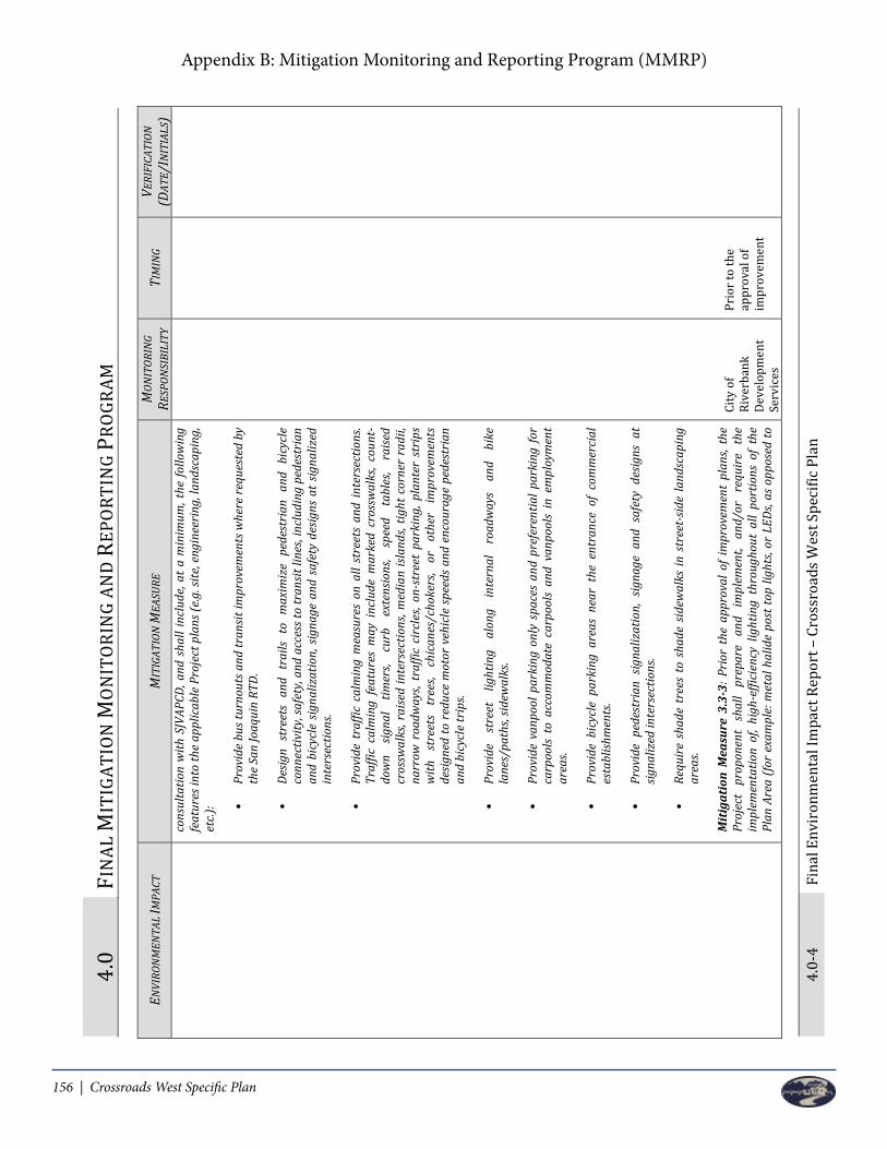
156 | Crossroads West Specific Plan
Appendix B: Mitigation Monitoring and Reporting Program (MMRP)
4.0
FIN
AL M
ITIG
ATIO
N M
ON
ITO
RIN
G AN
D R
EPO
RTIN
G PR
OGR
AM
4.0-
4 Fi
nal E
nvir
onm
enta
l Im
pact
Rep
ort –
Cro
ssro
ads W
est S
peci
fic P
lan
ENVI
RON
MEN
TAL
IMPA
CT
MIT
IGAT
ION
MEA
SURE
M
ONIT
ORIN
G RE
SPON
SIBI
LITY
TI
MIN
G VE
RIFI
CATI
ON
(DAT
E/IN
ITIA
LS)
cons
ulta
tion
with
SJV
APCD
, and
sha
ll in
clud
e, at
a m
inim
um, t
he fo
llow
ing
feat
ures
into
the
appl
icab
le P
roje
ct p
lans
(e.g
. site
, eng
inee
ring
, lan
dsca
ping
, et
c.): •
Prov
ide
bus t
urno
uts a
nd tr
ansit
impr
ovem
ents
whe
re re
ques
ted
by
the
San
Joaq
uin
RTD.
• De
sign
stre
ets
and
trai
ls to
max
imiz
e pe
dest
rian
and
bic
ycle
co
nnec
tivity
, saf
ety,
and
acce
ss to
tran
sit li
nes,
incl
udin
g pe
dest
rian
an
d bi
cycl
e sig
naliz
atio
n, s
igna
ge a
nd s
afet
y de
signs
at
signa
lized
in
ters
ectio
ns.
• Pr
ovid
e tr
affic
cal
min
g m
easu
res
on a
ll st
reet
s an
d in
ters
ectio
ns.
Traf
fic c
alm
ing
feat
ures
may
inc
lude
mar
ked
cros
swal
ks, c
ount
-do
wn
signa
l tim
ers,
curb
ex
tens
ions
, sp
eed
tabl
es,
raise
d cr
ossw
alks
, rai
sed
inte
rsec
tions
, med
ian
islan
ds, t
ight
cor
ner
radi
i, na
rrow
roa
dway
s, tr
affic
cir
cles
, on-
stre
et p
arki
ng, p
lant
er s
trip
s w
it h
stre
ets
tree
s, ch
ican
es/c
hoke
rs,
or
othe
r im
prov
emen
ts
desig
ned
to r
educ
e m
otor
veh
icle
spe
eds
and
enco
urag
e pe
dest
rian
an
d bi
cycl
e tr
ips.
• Pr
ovid
e st
reet
lig
htin
g al
ong
inte
rnal
ro
adw
ays
and
bike
la
nes/
path
s, sid
ewal
ks.
• Pr
ovid
e va
npoo
l par
king
onl
y sp
aces
and
pre
fere
ntia
l par
king
for
carp
ools
to a
ccom
mod
ate
carp
ools
and
vanp
ools
in e
mpl
oym
ent
area
s.
• Pr
ovid
e bi
cycl
e pa
rkin
g ar
eas
near
the
ent
ranc
e of
com
mer
cial
es
tabl
ishm
ents
.
• Pr
ovid
e pe
dest
rian
sig
naliz
atio
n, s
igna
ge a
nd s
afet
y de
signs
at
signa
lized
inte
rsec
tions
.
• Re
quir
e sh
ade
tree
s to
sha
de s
idew
alks
in s
tree
t-sid
e la
ndsc
apin
g ar
eas.
Miti
gatio
n M
easu
re 3
.3-3
: Pri
or t
he a
ppro
val o
f im
prov
emen
t pl
ans,
the
Proj
ect
prop
onen
t sh
all
prep
are
and
impl
emen
t, an
d/or
re
quir
e th
e im
plem
enta
tion
of, h
igh-
effic
ienc
y lig
htin
g th
roug
hout
all
port
ions
of
the
Plan
Are
a (f
or e
xam
ple:
met
al h
alid
e po
st to
p lig
hts,
or L
EDs,
as o
ppos
ed to
City
of
Rive
rban
k De
velo
pmen
t Se
rvic
es
Prio
r to
the
appr
oval
of
impr
ovem
ent

Crossroads West Specific Plan | 157
Appendix B: Mitigation Monitoring and Reporting Program (MMRP)
4.0
FIN
AL M
ITIG
ATIO
N M
ON
ITO
RIN
G AN
D R
EPO
RTIN
G PR
OGR
AM
4.0-
4 Fi
nal E
nvir
onm
enta
l Im
pact
Rep
ort –
Cro
ssro
ads W
est S
peci
fic P
lan
ENVI
RON
MEN
TAL
IMPA
CT
MIT
IGAT
ION
MEA
SURE
M
ONIT
ORIN
G RE
SPON
SIBI
LITY
TI
MIN
G VE
RIFI
CATI
ON
(DAT
E/IN
ITIA
LS)
cons
ulta
tion
with
SJV
APCD
, and
sha
ll in
clud
e, at
a m
inim
um, t
he fo
llow
ing
feat
ures
into
the
appl
icab
le P
roje
ct p
lans
(e.g
. site
, eng
inee
ring
, lan
dsca
ping
, et
c.): •
Prov
ide
bus t
urno
uts a
nd tr
ansit
impr
ovem
ents
whe
re re
ques
ted
by
the
San
Joaq
uin
RTD.
• De
sign
stre
ets
and
trai
ls to
max
imiz
e pe
dest
rian
and
bic
ycle
co
nnec
tivity
, saf
ety,
and
acce
ss to
tran
sit li
nes,
incl
udin
g pe
dest
rian
an
d bi
cycl
e sig
naliz
atio
n, s
igna
ge a
nd s
afet
y de
signs
at
signa
lized
in
ters
ectio
ns.
• Pr
ovid
e tr
affic
cal
min
g m
easu
res
on a
ll st
reet
s an
d in
ters
ectio
ns.
Traf
fic c
alm
ing
feat
ures
may
inc
lude
mar
ked
cros
swal
ks, c
ount
-do
wn
signa
l tim
ers,
curb
ex
tens
ions
, sp
eed
tabl
es,
raise
d cr
ossw
alks
, rai
sed
inte
rsec
tions
, med
ian
islan
ds, t
ight
cor
ner
radi
i, na
rrow
roa
dway
s, tr
affic
cir
cles
, on-
stre
et p
arki
ng, p
lant
er s
trip
s w
it h
stre
ets
tree
s, ch
ican
es/c
hoke
rs,
or
othe
r im
prov
emen
ts
desig
ned
to r
educ
e m
otor
veh
icle
spe
eds
and
enco
urag
e pe
dest
rian
an
d bi
cycl
e tr
ips.
• Pr
ovid
e st
reet
lig
htin
g al
ong
inte
rnal
ro
adw
ays
and
bike
la
nes/
path
s, sid
ewal
ks.
• Pr
ovid
e va
npoo
l par
king
onl
y sp
aces
and
pre
fere
ntia
l par
king
for
carp
ools
to a
ccom
mod
ate
carp
ools
and
vanp
ools
in e
mpl
oym
ent
area
s.
• Pr
ovid
e bi
cycl
e pa
rkin
g ar
eas
near
the
ent
ranc
e of
com
mer
cial
es
tabl
ishm
ents
.
• Pr
ovid
e pe
dest
rian
sig
naliz
atio
n, s
igna
ge a
nd s
afet
y de
signs
at
signa
lized
inte
rsec
tions
.
• Re
quir
e sh
ade
tree
s to
sha
de s
idew
alks
in s
tree
t-sid
e la
ndsc
apin
g ar
eas.
Miti
gatio
n M
easu
re 3
.3-3
: Pri
or t
he a
ppro
val o
f im
prov
emen
t pl
ans,
the
Proj
ect
prop
onen
t sh
all
prep
are
and
impl
emen
t, an
d/or
re
quir
e th
e im
plem
enta
tion
of, h
igh-
effic
ienc
y lig
htin
g th
roug
hout
all
port
ions
of
the
Plan
Are
a (f
or e
xam
ple:
met
al h
alid
e po
st to
p lig
hts,
or L
EDs,
as o
ppos
ed to
City
of
Rive
rban
k De
velo
pmen
t Se
rvic
es
Prio
r to
the
appr
oval
of
impr
ovem
ent
FIN
AL M
ITIG
ATIO
N M
ON
ITO
RIN
G AN
D R
EPO
RTIN
G PR
OGR
AM
4.0
Fina
l Env
iron
men
tal I
mpa
ct R
epor
t – C
ross
road
s Wes
t Spe
cific
Pla
n 4.
0-5
ENVI
RON
MEN
TAL
IMPA
CT
MIT
IGAT
ION
MEA
SURE
M
ONIT
ORIN
G RE
SPON
SIBI
LITY
TI
MIN
G VE
RIFI
CATI
ON
(DAT
E/IN
ITIA
LS)
typi
cal m
ercu
ry co
brah
ead
light
s).
Miti
gatio
n M
easu
re 3
.3-4
: Pri
or to
the
appr
oval
of i
mpr
ovem
ent p
lans
, the
Pr
ojec
t pr
opon
ent
shal
l pre
pare
and
impl
emen
t, an
d th
e Ci
ty s
hall
requ
ire
the
impl
emen
tatio
n of
, the
follo
win
g ad
ditio
nal m
itiga
tion
mea
sure
s:
• Us
e lo
w-V
OC p
aint
(in
door
and
out
door
, for
bot
h re
siden
tial
and
non-
resid
entia
l use
s).
• Us
e on
ly n
atur
al g
as h
eart
hs (o
r no
hear
ths)
.
• Ap
ply
a W
ater
Con
serv
atio
n St
rate
gy t
o ac
hiev
e re
duct
ions
in
outd
oor
wat
er
usag
e th
roug
h in
stal
latio
n of
w
ater
-effi
cien
t ir
riga
tion
syst
ems,
and
land
scap
ing
with
nat
ive
and
drou
ght-
tole
rant
pla
nts t
hat a
lso re
duce
the
need
for g
as-p
ower
ed la
ndsc
ape
mai
nten
ance
equ
ipm
ent.
• Re
quir
e al
l fla
t ro
ofs
on n
on-r
esid
entia
l str
uctu
res
to h
ave
a w
hite
or
silv
er ca
p sh
eet t
o re
duce
ene
rgy
dem
and.
• In
stal
l low
flow
bat
hroo
m fa
ucet
s.
• In
stal
l low
-flow
kitc
hen
fauc
ets.
• In
stal
l low
-flow
toile
ts.
• In
stal
l low
-flow
show
ers.
• Us
e w
ater
-effi
cien
t irr
igat
ion
syst
ems.
Depa
rtm
ent
City
of
Rive
rban
k De
velo
pmen
t Se
rvic
es
Depa
rtm
ent
plan
s
Prio
r to
the
appr
oval
of
impr
ovem
ent
plan
s
Impa
ct
3.3-
2:
Proj
ect
cons
truc
tion
has
the
pote
ntia
l to
caus
e a
viol
atio
n of
an
air q
ualit
y st
anda
rd
or
cont
ribu
te
subs
tant
ially
to
an e
xist
ing
or
proj
ecte
d ai
r qua
lity
viol
atio
n.
Miti
gatio
n M
easu
re 3
.3-5
: To
red
uce
cons
truc
tion-
rela
ted
emiss
ions
, the
fo
llow
ing
mea
sure
s sha
ll be
impl
emen
ted:
• Pr
ior
to y
ear
2025
, con
stru
ctio
n co
ntra
cts
for
deve
lopm
ent
in t
he
Plan
Are
a sh
all s
peci
fy u
se o
f off-
road
con
stru
ctio
n eq
uipm
ent t
hat
achi
eves
fle
et a
vera
ge e
miss
ions
equ
al t
o or
less
tha
n th
e Ti
er I
II em
issio
ns s
tand
ard
of 4
.8 N
Ox g
ram
s pe
r ho
rsep
ower
-hou
r (g
/hp-
hr).
The
fleet
ave
rage
can
be
achi
eved
thro
ugh
any
com
bina
tion
of
unco
ntro
lled
engi
nes
com
plyi
ng w
ith T
ier
III a
nd a
bove
eng
ine
stan
dard
s. Be
ginn
ing
in
2025
, co
nstr
uctio
n co
ntra
cts
for
deve
lopm
ent
in
the
Plan
Ar
ea
shal
l sp
ecify
us
e of
of
f-roa
d co
nstr
uctio
n eq
uipm
ent t
hat a
chie
ves
fleet
ave
rage
em
issio
ns e
qual
City
of
Rive
rban
k De
velo
pmen
t Se
rvic
es
Depa
rtm
ent
San
Joaq
uin
Valle
y Ai
r Po
llutio
n Co
ntro
l Dis
tric
t
Prio
r to
issu
ance
of a
gr
adin
g or
bu
ildin
g pe
rmit

158 | Crossroads West Specific Plan
Appendix B: Mitigation Monitoring and Reporting Program (MMRP)
4.0
FIN
AL M
ITIG
ATIO
N M
ON
ITO
RIN
G AN
D R
EPO
RTIN
G PR
OGR
AM
4.0-
6 Fi
nal E
nvir
onm
enta
l Im
pact
Rep
ort –
Cro
ssro
ads W
est S
peci
fic P
lan
ENVI
RON
MEN
TAL
IMPA
CT
MIT
IGAT
ION
MEA
SURE
M
ONIT
ORIN
G RE
SPON
SIBI
LITY
TI
MIN
G VE
RIFI
CATI
ON
(DAT
E/IN
ITIA
LS)
to o
r le
ss th
an th
e Ti
er IV
em
issio
ns s
tand
ards
of N
Ox g
/hp-
hr. T
he
fleet
av
erag
e ca
n be
ac
hiev
ed
thro
ugh
any
com
bina
tion
of
cont
rolle
d en
gine
s co
mpl
ying
w
ith
Tier
IV
an
d ab
ove
engi
ne
stan
dard
s.
• Pr
ior
to i
ssua
nce
of a
gra
ding
or
build
ing
perm
it, t
he p
roje
ct
appl
ican
t sha
ll su
bmit
a Fu
gitiv
e Du
st C
ontr
ol P
lan
to S
JVAP
CD fo
r re
view
and
app
rova
l. Th
e Fu
gitiv
e Du
st C
ontr
ol P
lan
shal
l red
uce
emiss
ions
, dur
ing
cons
truc
tion
of P
M10
and
PM
2.5
and
shal
l inc
lude
th
e fo
llow
ing:
o
Nam
es, a
ddre
sses
and
pho
ne n
umbe
rs o
f per
sons
res
pons
ible
fo
r th
e pr
epar
atio
n, s
ubm
issio
n an
d im
plem
enta
tion
of t
he
plan
.
o
Desc
ript
ion
and
loca
tion
of o
pera
tions
.
o
List
ing
of a
ll fu
gitiv
e du
st e
miss
ions
sou
rces
incl
uded
in t
he
oper
atio
n.
o
The
follo
win
g du
st co
ntro
l mea
sure
s sha
ll be
impl
emen
ted:
Al
l on
-site
un
pave
d ro
ads
shal
l be
ef
fect
ivel
y st
abili
zed
usin
g w
ater
or
chem
ical
sta
biliz
ers
that
ca
n be
det
erm
ined
to
be a
s ef
ficie
nt a
s or
mor
e ef
ficie
nt fo
r fu
gitiv
e du
st c
ontr
ol th
an C
alifo
rnia
Air
Re
sour
ces
Boar
d ap
prov
ed s
oil s
tabi
lizer
s, an
d th
at
shal
l not
incr
ease
any
oth
er e
nvir
onm
enta
l im
pact
s in
clud
ing
loss
of v
eget
atio
n.
Al
l mat
eria
l exc
avat
ed o
r gr
aded
will
be
suffi
cien
tly
wat
ered
to
prev
ent
exce
ssiv
e du
st.
Wat
erin
g w
ill
occu
r as
ne
eded
w
ith
com
plet
e co
vera
ge
of
dist
urbe
d ar
eas.
The
exca
vate
d so
il pi
les
will
be
wat
ered
as
need
ed t
o lim
it du
st e
miss
ions
to
less
th
an 2
0 pe
rcen
t op
acity
or
cove
red
with
tem
pora
ry
cove
ring
s.
Co
nstr
uctio
n ac
tiviti
es
that
oc
cur
on
unpa
ved
surf
aces
w
ill
be
disc
ontin
ued
duri
ng
win
dy
cond
ition
s whe
n w
inds
exc
eed
25 m
iles p
er h
our a
nd
thos
e ac
tiviti
es
caus
e vi
sible
du
st
plum
es.

Crossroads West Specific Plan | 159
Appendix B: Mitigation Monitoring and Reporting Program (MMRP)
4.0
FIN
AL M
ITIG
ATIO
N M
ON
ITO
RIN
G AN
D R
EPO
RTIN
G PR
OGR
AM
4.0-
6 Fi
nal E
nvir
onm
enta
l Im
pact
Rep
ort –
Cro
ssro
ads W
est S
peci
fic P
lan
ENVI
RON
MEN
TAL
IMPA
CT
MIT
IGAT
ION
MEA
SURE
M
ONIT
ORIN
G RE
SPON
SIBI
LITY
TI
MIN
G VE
RIFI
CATI
ON
(DAT
E/IN
ITIA
LS)
to o
r le
ss th
an th
e Ti
er IV
em
issio
ns s
tand
ards
of N
Ox g
/hp-
hr. T
he
fleet
av
erag
e ca
n be
ac
hiev
ed
thro
ugh
any
com
bina
tion
of
cont
rolle
d en
gine
s co
mpl
ying
w
ith
Tier
IV
an
d ab
ove
engi
ne
stan
dard
s.
• Pr
ior
to i
ssua
nce
of a
gra
ding
or
build
ing
perm
it, t
he p
roje
ct
appl
ican
t sha
ll su
bmit
a Fu
gitiv
e Du
st C
ontr
ol P
lan
to S
JVAP
CD fo
r re
view
and
app
rova
l. Th
e Fu
gitiv
e Du
st C
ontr
ol P
lan
shal
l red
uce
emiss
ions
, dur
ing
cons
truc
tion
of P
M10
and
PM
2.5
and
shal
l inc
lude
th
e fo
llow
ing:
o
Nam
es, a
ddre
sses
and
pho
ne n
umbe
rs o
f per
sons
res
pons
ible
fo
r th
e pr
epar
atio
n, s
ubm
issio
n an
d im
plem
enta
tion
of t
he
plan
.
o
Desc
ript
ion
and
loca
tion
of o
pera
tions
.
o
List
ing
of a
ll fu
gitiv
e du
st e
miss
ions
sou
rces
incl
uded
in t
he
oper
atio
n.
o
The
follo
win
g du
st co
ntro
l mea
sure
s sha
ll be
impl
emen
ted:
Al
l on
- site
un
pave
d ro
ads
shal
l be
ef
fect
ivel
y st
abili
zed
usin
g w
ater
or
chem
ical
sta
biliz
ers
that
ca
n be
det
erm
ined
to
be a
s ef
ficie
nt a
s or
mor
e ef
ficie
nt fo
r fu
gitiv
e du
st c
ontr
ol th
an C
alifo
rnia
Air
Re
sour
ces
Boar
d ap
prov
ed s
oil s
tabi
lizer
s, an
d th
at
shal
l not
incr
ease
any
oth
er e
nvir
onm
enta
l im
pact
s in
clud
ing
loss
of v
eget
atio
n.
Al
l mat
eria
l exc
avat
ed o
r gr
aded
will
be
suffi
cien
tly
wat
ered
to
prev
ent
exce
ssiv
e du
st.
Wat
erin
g w
ill
occu
r as
ne
eded
w
ith
com
plet
e co
vera
ge
of
dist
urbe
d ar
eas.
The
exca
vate
d so
il pi
les
will
be
wat
ered
as
need
ed t
o lim
it du
st e
miss
ions
to
less
th
an 2
0 pe
rcen
t op
acity
or
cove
red
with
tem
pora
ry
cove
ring
s.
Co
nstr
uctio
n ac
tiviti
es
that
oc
cur
on
unpa
ved
surf
aces
w
ill
be
disc
ontin
ued
duri
ng
win
dy
cond
ition
s whe
n w
inds
exc
eed
25 m
iles p
er h
our a
nd
thos
e ac
tiviti
es
caus
e vi
sible
du
st
plum
es.
FIN
AL M
ITIG
ATIO
N M
ON
ITO
RIN
G AN
D R
EPO
RTIN
G PR
OGR
AM
4.0
Fina
l Env
iron
men
tal I
mpa
ct R
epor
t – C
ross
road
s Wes
t Spe
cific
Pla
n 4.
0-7
ENVI
RON
MEN
TAL
IMPA
CT
MIT
IGAT
ION
MEA
SURE
M
ONIT
ORIN
G RE
SPON
SIBI
LITY
TI
MIN
G VE
RIFI
CATI
ON
(DAT
E/IN
ITIA
LS)
Cons
truc
tion
activ
ities
m
ay
cont
inue
if
dust
su
ppre
ssio
n m
easu
res
are
used
to
min
imiz
e vi
sible
du
st p
lum
es.
Tr
ack-
out
debr
is on
to p
ublic
pav
ed r
oads
sha
ll no
t ex
tend
50
feet
or m
ore
from
an
activ
e op
erat
ion
and
trac
k-ou
t sh
all
be r
emov
ed o
r iso
late
d su
ch a
s be
hind
a l
ocke
d ga
te a
t th
e co
nclu
sion
of e
ach
wor
kday
.
Al
l ha
ulin
g m
ater
ials
shou
ld b
e m
oist
whi
le b
eing
lo
aded
into
dum
p tr
ucks
.
Al
l ha
ul t
ruck
s ha
ulin
g so
il, s
and
and
othe
r lo
ose
mat
eria
l on
publ
ic r
oads
sha
ll be
cov
ered
(e.g
., w
ith
tarp
s or
othe
r en
clos
ures
that
wou
ld r
educ
e fu
gitiv
e du
st e
miss
ions
).
So
il lo
ads
shal
l be
kep
t be
low
6 i
nche
s of
the
fr
eebo
ard
of th
e tr
uck.
Dr
op h
eigh
ts s
houl
d be
min
imiz
ed w
hen
load
ers
dum
p so
il in
to tr
ucks
.
Ga
te se
als s
houl
d be
tigh
t on
dum
p tr
ucks
.
Tr
affic
spee
ds o
n un
pave
d ro
ads s
hall
be li
mite
d to
a
max
imum
of 1
5 m
iles p
er h
our.
Al
l gra
ding
act
iviti
es sh
all b
e su
spen
ded
whe
n vi
sible
du
st e
miss
ions
exc
eed
20 p
erce
nt.
Ot
her
fugi
tive
dust
con
trol
mea
sure
s as n
eces
sary
to
com
ply
with
SJV
APCD
Rul
es a
nd R
egul
atio
ns.
Di
stur
bed
area
s sho
uld
be m
inim
ized
.
BIOL
OGIC
AL R
ESOU
RCES
Impa
ct 3
.4-2
: Th
e po
tent
ial
to
have
dir
ect o
r in
dire
ct e
ffect
s on
sp
ecia
l-sta
tus
rept
ile
and
Miti
gatio
n M
easu
re 3
.4-1
: Th
e pr
ojec
t pr
opon
ent
shal
l im
plem
ent
the
follo
win
g m
easu
res t
o av
oid
or m
inim
ize
impa
cts o
n w
este
rn p
ond
turt
le:
City
of
Rive
rban
k De
velo
pmen
t
Prio
r to
com
men
ce-
men
t of a
ny

160 | Crossroads West Specific Plan
Appendix B: Mitigation Monitoring and Reporting Program (MMRP)
4.0
FIN
AL M
ITIG
ATIO
N M
ON
ITO
RIN
G AN
D R
EPO
RTIN
G PR
OGR
AM
4.0-
8 Fi
nal E
nvir
onm
enta
l Im
pact
Rep
ort –
Cro
ssro
ads W
est S
peci
fic P
lan
ENVI
RON
MEN
TAL
IMPA
CT
MIT
IGAT
ION
MEA
SURE
M
ONIT
ORIN
G RE
SPON
SIBI
LITY
TI
MIN
G VE
RIFI
CATI
ON
(DAT
E/IN
ITIA
LS)
amph
ibia
n sp
ecie
s. •
Grou
nd-d
istur
bing
act
iviti
es i
n ar
eas
of p
oten
tial
pond
tur
tle
nest
ing
habi
tat
shal
l be
avoi
ded
duri
ng t
he n
estin
g se
ason
(Ap
ril–
Augu
st),
to th
e ex
tent
feas
ible
.
• A
prec
onst
ruct
ion
surv
ey f
or w
este
rn p
ond
turt
les
with
in a
quat
ic
habi
tats
and
adj
acen
t su
itabl
e up
land
s to
be
dist
urbe
d by
pro
ject
ac
tiviti
es s
hall
be c
ondu
cted
by
a qu
alifi
ed b
iolo
gist
. In
aqua
tic
habi
tats
whi
ch m
ay b
e de
wat
ered
dur
ing
proj
ect
cons
truc
tion,
su
rvey
s sh
all
be c
ondu
cted
im
med
iate
ly a
fter
dew
ater
ing
and
befo
re a
ny s
ubse
quen
t di
stur
banc
e. E
lsew
here
, su
rvey
s sh
all
be
cond
ucte
d w
ithin
24
hour
s bef
ore
proj
ect d
istur
banc
e.
• If
pond
turt
les a
re fo
und
duri
ng p
reco
nstr
uctio
n su
rvey
s, a
qual
ified
bi
olog
ist, w
ith a
ppro
val f
rom
CDF
W, s
hall
mov
e th
e tu
rtle
s to
the
ne
ares
t su
itabl
e ha
bita
t ou
tsid
e th
e ar
ea
subj
ect
to
proj
ect
dist
urba
nce.
The
con
stru
ctio
n ar
ea sh
all b
e re
insp
ecte
d w
hene
ver a
la
pse
in co
nstr
uctio
n ac
tivity
of 2
wee
ks o
r mor
e ha
s occ
urre
d.
• Co
nstr
uctio
n pe
rson
nel
perf
orm
ing
activ
ities
w
ithin
aq
uatic
ha
bita
ts a
nd a
djac
ent
suita
ble
upla
nds
to b
e di
stur
bed
by p
roje
ct
activ
ities
sha
ll re
ceiv
e w
orke
r en
viro
nmen
tal
awar
enes
s tr
aini
ng
from
a q
ualif
ied
biol
ogist
to in
stru
ct w
orke
rs to
rec
ogni
ze w
este
rn
pond
turt
le, t
heir
hab
itats
, and
mea
sure
s bei
ng im
plem
ente
d fo
r its
pr
otec
tion.
• Co
nstr
uctio
n pe
rson
nel
shal
l ob
serv
e a
15-m
iles-
per-
hour
spe
ed
limit
on u
npav
ed ro
ads.
Miti
gatio
n M
easu
re 3
.4-2
: Th
e pr
ojec
t pr
opon
ent
shal
l im
plem
ent
the
follo
win
g m
easu
res t
o av
oid
or m
inim
ize
impa
cts o
n gi
ant g
arte
r sna
ke:
• In
are
as w
ithin
200
fee
t of
any
irr
igat
ion
ditc
h (p
oten
tial
GGS
aqua
tic h
abita
t) c
onst
ruct
ion
will
occ
ur d
urin
g th
e GG
S ac
tive
seas
on o
f May
1 th
roug
h Oc
tobe
r 1.
• Co
nstr
uctio
n pe
rson
nel
shal
l re
ceiv
e w
orke
r en
viro
nmen
tal
awar
enes
s tr
aini
ng t
o in
stru
ct w
orke
rs t
o re
cogn
ize
gian
t ga
rter
sn
ake
and
thei
r hab
itats
.
• W
ithin
24
hour
s be
fore
con
stru
ctio
n ac
tiviti
es, a
reas
with
in 2
00
feet
of a
ny ir
riga
tion
ditc
h (p
oten
tial G
GS a
quat
ic h
abita
t) sh
all b
e
Serv
ices
De
part
men
t
Calif
orni
a De
part
men
t of
Fish
and
W
ildlif
e
Qual
ified
Bi
olog
ist
City
of
Rive
rban
k De
velo
pmen
t Se
rvic
es
Depa
rtm
ent
Calif
orni
a De
part
men
t of
Fish
and
W
ildlif
e
grad
ing
activ
ities
Prio
r to
com
men
ce-
men
t of a
ny
grad
ing
activ
ities

Crossroads West Specific Plan | 161
Appendix B: Mitigation Monitoring and Reporting Program (MMRP)
4.0
FIN
AL M
ITIG
ATIO
N M
ON
ITO
RIN
G AN
D R
EPO
RTIN
G PR
OGR
AM
4.0-
8 Fi
nal E
nvir
onm
enta
l Im
pact
Rep
ort –
Cro
ssro
ads W
est S
peci
fic P
lan
ENVI
RON
MEN
TAL
IMPA
CT
MIT
IGAT
ION
MEA
SURE
M
ONIT
ORIN
G RE
SPON
SIBI
LITY
TI
MIN
G VE
RIFI
CATI
ON
(DAT
E/IN
ITIA
LS)
amph
ibia
n sp
ecie
s. •
Grou
nd-d
istur
bing
act
iviti
es i
n ar
eas
of p
oten
tial
pond
tur
tle
nest
ing
habi
tat
shal
l be
avoi
ded
duri
ng t
he n
estin
g se
ason
(Ap
ril–
Augu
st),
to th
e ex
tent
feas
ible
.
• A
prec
onst
ruct
ion
surv
ey f
or w
este
rn p
ond
turt
les
with
in a
quat
ic
habi
tats
and
adj
acen
t su
itabl
e up
land
s to
be
dist
urbe
d by
pro
ject
ac
tiviti
es s
hall
be c
ondu
cted
by
a qu
alifi
ed b
iolo
gist
. In
aqua
tic
habi
tats
whi
ch m
ay b
e de
wat
ered
dur
ing
proj
ect
cons
truc
tion,
su
rvey
s sh
all
be c
ondu
cted
im
med
iate
ly a
fter
dew
ater
ing
and
befo
re a
ny s
ubse
quen
t di
stur
banc
e. E
lsew
here
, su
rvey
s sh
all
be
cond
ucte
d w
ithin
24
hour
s bef
ore
proj
ect d
istur
banc
e.
• If
pond
turt
les a
re fo
und
duri
ng p
reco
nstr
uctio
n su
rvey
s, a
qual
ified
bi
olog
ist, w
ith a
ppro
val f
rom
CDF
W, s
hall
mov
e th
e tu
rtle
s to
the
ne
ares
t su
itabl
e ha
bita
t ou
tsid
e th
e ar
ea
subj
ect
to
proj
ect
dist
urba
nce.
The
con
stru
ctio
n ar
ea sh
all b
e re
insp
ecte
d w
hene
ver a
la
pse
in co
nstr
uctio
n ac
tivity
of 2
wee
ks o
r mor
e ha
s occ
urre
d.
• Co
nstr
uctio
n pe
rson
nel
perf
orm
ing
activ
ities
w
ithin
aq
uatic
ha
bita
ts a
nd a
djac
ent
suita
ble
upla
nds
to b
e di
stur
bed
by p
roje
ct
activ
ities
sha
ll re
ceiv
e w
orke
r en
viro
nmen
tal
awar
enes
s tr
aini
ng
from
a q
ualif
ied
biol
ogist
to in
stru
ct w
orke
rs to
rec
ogni
ze w
este
rn
pond
turt
le, t
heir
hab
itats
, and
mea
sure
s bei
ng im
plem
ente
d fo
r its
pr
otec
tion.
• Co
nstr
uctio
n pe
rson
nel
shal
l ob
serv
e a
15-m
iles-
per-
hour
spe
ed
limit
on u
npav
ed ro
ads.
Miti
gatio
n M
easu
re 3
.4-2
: Th
e pr
ojec
t pr
opon
ent
shal
l im
plem
ent
the
follo
win
g m
easu
res t
o av
oid
or m
inim
ize
impa
cts o
n gi
ant g
arte
r sna
ke:
• In
are
as w
ithin
200
fee
t of
any
irr
igat
ion
ditc
h (p
oten
tial
GGS
aqua
tic h
abita
t) c
onst
ruct
ion
will
occ
ur d
urin
g th
e GG
S ac
tive
seas
on o
f May
1 th
roug
h Oc
tobe
r 1.
• Co
nstr
uctio
n pe
rson
nel
shal
l re
ceiv
e w
orke
r en
viro
nmen
tal
awar
enes
s tr
aini
ng t
o in
stru
ct w
orke
rs t
o re
cogn
ize
gian
t ga
rter
sn
ake
and
thei
r hab
itats
.
• W
ithin
24
hour
s be
fore
con
stru
ctio
n ac
tiviti
es, a
reas
with
in 2
00
feet
of a
ny ir
riga
tion
ditc
h (p
oten
tial G
GS a
quat
ic h
abita
t) sh
all b
e
Serv
ices
De
part
men
t
Calif
orni
a De
part
men
t of
Fish
and
W
ildlif
e
Qual
ified
Bi
olog
ist
City
of
Rive
rban
k De
velo
pmen
t Se
rvic
es
Depa
rtm
ent
Calif
orni
a De
part
men
t of
Fish
and
W
ildlif
e
grad
ing
activ
ities
Prio
r to
com
men
ce-
men
t of a
ny
grad
ing
activ
ities
FIN
AL M
ITIG
ATIO
N M
ON
ITO
RIN
G AN
D R
EPO
RTIN
G PR
OGR
AM
4.0
Fina
l Env
iron
men
tal I
mpa
ct R
epor
t – C
ross
road
s Wes
t Spe
cific
Pla
n 4.
0-9
ENVI
RON
MEN
TAL
IMPA
CT
MIT
IGAT
ION
MEA
SURE
M
ONIT
ORIN
G RE
SPON
SIBI
LITY
TI
MIN
G VE
RIFI
CATI
ON
(DAT
E/IN
ITIA
LS)
surv
eyed
for
gian
t ga
rter
sna
ke. T
he s
urve
y sh
all b
e re
peat
ed if
a
laps
e in
con
stru
ctio
n ac
tivity
of 2
wee
ks o
r gr
eate
r ha
s occ
urre
d. If
a
gian
t gar
ter
snak
e is
enco
unte
red
duri
ng c
onst
ruct
ion,
act
iviti
es
with
in
200
feet
of
th
e ir
riga
tion
ditc
hes
shal
l ce
ase
until
ap
prop
riat
e co
rrec
tive
mea
sure
s ha
ve b
een
com
plet
ed o
r it
is
dete
rmin
ed b
y th
e qu
alifi
ed b
iolo
gist
and
City
staf
f, in
coo
rdin
atio
n w
ith U
SFW
S an
d CD
FW, t
hat
the
gian
t ga
rter
sna
ke s
hall
not
be
harm
ed.
Any
sight
ings
sha
ll be
rep
orte
d to
USF
WS
and
CDFW
im
med
iate
ly.
• A
biol
ogic
al o
nsite
mon
itor
will
be
pres
ent
duri
ng in
itial
gro
und-
dist
urbi
ng a
ctiv
ities
with
in 2
00 f
eet
of a
ny i
rrig
atio
n di
tch
or
pote
ntia
l GGS
hab
itat w
ithin
the
CWSP
Pla
n Ar
ea
• Co
nstr
uctio
n ve
hicl
es w
ould
req
uire
low
-spe
ed l
imits
with
in s
uch
sites
to le
ssen
the
prob
abili
ty th
at th
e sp
ecie
s co
uld
be r
un o
ver
by
vehi
cles
and
equ
ipm
ent.
• An
y aq
uatic
hab
itat
for
the
snak
e th
at is
dew
ater
ed s
hall
rem
ain
dry
for
at l
east
15
cons
ecut
ive
days
afte
r Ap
ril
15 a
nd b
efor
e ex
cava
ting
or
fillin
g of
th
e de
wat
ered
ha
bita
t. If
com
plet
e de
wat
erin
g is
not
poss
ible
, po
tent
ial
snak
e pr
ey (
e.g.,
fish
and
tadp
oles
) will
be
rem
oved
so th
at sn
akes
and
oth
er w
ildlif
e ar
e no
t at
trac
ted
to th
e co
nstr
uctio
n ar
ea.
• Gi
ant
gart
er s
nake
aqu
atic
hab
itat
to b
e av
oide
d (i.
e. ir
riga
tion
ditc
hes)
with
in o
r adj
acen
t to
cons
truc
tion
area
s will
be
fenc
ed a
nd
desig
nate
d as
env
iron
men
tally
sen
sitiv
e ar
eas.
Thes
e ar
eas s
hall
be
avoi
ded
by a
ll co
nstr
uctio
n pe
rson
nel.
Qual
ified
Bi
olog
ist
U.S.
Fis
h an
d W
ildlif
e Se
rvic
e
Impa
ct 3
.4-3
: Th
e po
tent
ial
to
have
dir
ect o
r in
dire
ct e
ffect
s on
sp
ecia
l-sta
tus b
ird
spec
ies.
Miti
gatio
n M
easu
re 3
.4-3
: Th
e pr
ojec
t pr
opon
ent
shal
l im
plem
ent
the
follo
win
g m
easu
re to
avo
id o
r min
imiz
e im
pact
s on
wes
tern
bur
row
ing
owl:
• N
o le
ss th
an 1
4 da
ys b
efor
e in
itiat
ing
grou
nd d
istur
banc
e ac
tiviti
es,
a qu
alifi
ed b
iolo
gist
shal
l com
plet
e an
initi
al ta
ke a
void
ance
surv
ey
usin
g th
e re
com
men
ded
met
hods
des
crib
ed in
the
Dete
ctio
n Su
rvey
s se
ctio
n of
the
Mar
ch 7
, 201
2, C
DFW
Sta
ff Re
port
on
Burr
owin
g Ow
l M
itiga
tion
(CDF
W
2012
). Im
plem
enta
tion
of
avoi
danc
e an
d m
inim
izat
ion
mea
sure
s (a
s pr
esen
ted
in th
e M
arch
7, 2
012,
CDF
W
Staf
f Re
port
on
Burr
owin
g Ow
l Miti
gatio
n) w
ould
be
trig
gere
d if
the
initi
al ta
ke a
void
ance
sur
vey
resu
lts in
pos
itive
ow
l pre
senc
e in
City
of
Rive
rban
k De
velo
pmen
t Se
rvic
es
Depa
rtm
ent
Qua
lifie
d Bi
olog
ist
Calif
orni
a De
part
men
t of
No
less
than
14
days
bef
ore
initi
atin
g gr
ound
di
stur
banc
e ac
tiviti
es

162 | Crossroads West Specific Plan
Appendix B: Mitigation Monitoring and Reporting Program (MMRP)
4.0
FIN
AL M
ITIG
ATIO
N M
ON
ITO
RIN
G AN
D R
EPO
RTIN
G PR
OGR
AM
4.0-
10
Fina
l Env
iron
men
tal I
mpa
ct R
epor
t – C
ross
road
s Wes
t Spe
cific
Pla
n
ENVI
RON
MEN
TAL
IMPA
CT
MIT
IGAT
ION
MEA
SURE
M
ONIT
ORIN
G RE
SPON
SIBI
LITY
TI
MIN
G VE
RIFI
CATI
ON
(DAT
E/IN
ITIA
LS)
the
Plan
Are
a w
here
pro
ject
act
iviti
es s
hall
occu
r. If
need
ed, t
he
deve
lopm
ent
of a
void
ance
and
min
imiz
atio
n ap
proa
ches
sha
ll be
de
velo
ped
in co
ordi
natio
n w
ith C
DFW
.
Miti
gatio
n M
easu
re 3
.4-4
: Th
e pr
ojec
t pr
opon
ent
shal
l im
plem
ent
the
follo
win
g m
easu
res t
o av
oid
or m
inim
ize
impa
cts o
n Sw
ains
on’s
haw
k:
• N
o m
ore
than
30
days
bef
ore
the
com
men
cem
ent o
f con
stru
ctio
n, a
qu
alifi
ed
biol
ogist
sh
all
perf
orm
pr
econ
stru
ctio
n su
rvey
s fo
r ne
stin
g Sw
ains
on’s
haw
k an
d ot
her
rapt
ors
duri
ng t
he n
estin
g se
ason
(Feb
ruar
y 1
thro
ugh
Augu
st 3
1).
• Ap
prop
riat
e bu
ffers
sha
ll be
est
ablis
hed
and
mai
ntai
ned
arou
nd
activ
e ne
st s
ites
duri
ng c
onst
ruct
ion
activ
ities
to a
void
nes
t fai
lure
as
a r
esul
t of
pro
ject
act
iviti
es. T
he a
ppro
pria
te s
ize
and
shap
e of
th
e bu
ffers
sh
all
be
dete
rmin
ed
by
a qu
alifi
ed
biol
ogist
, in
co
ordi
natio
n w
ith C
DFW
, an
d m
ay v
ary
depe
ndin
g on
the
nes
t lo
catio
n, n
est
stag
e, an
d co
nstr
uctio
n ac
tivity
. The
buf
fers
may
be
adju
sted
if a
qua
lifie
d bi
olog
ist d
eter
min
es it
wou
ld n
ot b
e lik
ely
to
adve
rsel
y af
fect
the
nest
. Mon
itori
ng s
hall
be c
ondu
cted
to c
onfir
m
that
pro
ject
act
ivity
is n
ot r
esul
ting
in d
etec
tabl
e ad
vers
e ef
fect
s on
nest
ing
bird
s or
the
ir y
oung
. No
proj
ect
activ
ity s
hall
com
men
ce
with
in t
he b
uffe
r ar
eas
until
a q
ualif
ied
biol
ogist
has
det
erm
ined
th
at th
e yo
ung
have
fled
ged
or th
e ne
st s
ite is
oth
erw
ise n
o lo
nger
in
use
.
• Be
fore
the
com
men
cem
ent
of c
onst
ruct
ion,
the
pro
ject
pro
pone
nt
shal
l pr
ovid
e co
mpe
nsat
ory
miti
gatio
n fo
r th
e pe
rman
ent
loss
of
Swai
nson
's ha
wk
fora
ging
hab
itat.
Miti
gatio
n sh
all b
e at
the
CDFW
sp
ecifi
ed r
atio
s, w
hich
are
bas
ed o
n di
stan
ce t
o ne
sts.
The
Plan
Ar
ea’s
dist
ance
to th
e cl
oses
t nes
t cur
rent
ly fa
lls w
ithin
the
rang
e of
“w
ithin
5 m
iles
of a
n ac
tive
nest
tree
but
gre
ater
than
1 m
ile fr
om
the
nest
tree
.” As
such
, the
Pro
ject
shal
l cur
rent
ly b
e re
spon
sible
for
0.75
acr
es o
f eac
h ac
re o
f urb
an d
evel
opm
ent
auth
oriz
ed (
0-75
:1
ratio
). T
he p
roje
ct p
ropo
nent
sha
ll ei
ther
pro
vide
land
s pr
otec
ted
thro
ugh
fee
title
acq
uisit
ion
or c
onse
rvat
ion
ease
men
t (ac
cept
able
to
the
CDFW
) on
agri
cultu
ral l
ands
or o
ther
suita
ble
habi
tats
whi
ch
prov
ide
fora
ging
hab
itat f
or S
wai
nson
's ha
wk.
Miti
gatio
n M
easu
re 3
.4-5
: Th
e pr
ojec
t pr
opon
ent
shal
l im
plem
ent
the
follo
win
g m
easu
re t
o av
oid
or m
inim
ize
impa
cts
on o
ther
pro
tect
ed b
ird
Fish
and
W
ildlif
e
City
of
Rive
rban
k De
velo
pmen
t Se
rvic
es
Depa
rtm
ent
Qual
ified
Bi
olog
ist
Calif
orni
a De
part
men
t of
Fish
and
W
ildlif
e
City
of
Rive
rban
k De
velo
pmen
t
No
mor
e th
an
30 d
ays b
efor
e co
mm
ence
-m
ent o
f co
nstr
uctio
n
Prio
r to
grou
nd
dist
urbi
ng

Crossroads West Specific Plan | 163
Appendix B: Mitigation Monitoring and Reporting Program (MMRP)
4.0
FIN
AL M
ITIG
ATIO
N M
ON
ITO
RIN
G AN
D R
EPO
RTIN
G PR
OGR
AM
4.0-
10
Fina
l Env
iron
men
tal I
mpa
ct R
epor
t – C
ross
road
s Wes
t Spe
cific
Pla
n
ENVI
RON
MEN
TAL
IMPA
CT
MIT
IGAT
ION
MEA
SURE
M
ONIT
ORIN
G RE
SPON
SIBI
LITY
TI
MIN
G VE
RIFI
CATI
ON
(DAT
E/IN
ITIA
LS)
the
Plan
Are
a w
here
pro
ject
act
iviti
es s
hall
occu
r. If
need
ed, t
he
deve
lopm
ent
of a
void
ance
and
min
imiz
atio
n ap
proa
ches
sha
ll be
de
velo
ped
in co
ordi
natio
n w
ith C
DFW
.
Miti
gatio
n M
easu
re 3
.4-4
: Th
e pr
ojec
t pr
opon
ent
shal
l im
plem
e nt
the
follo
win
g m
easu
res t
o av
oid
or m
inim
ize
impa
cts o
n Sw
ains
on’s
haw
k:
• N
o m
ore
than
30
days
bef
ore
the
com
men
cem
ent o
f con
stru
ctio
n, a
qu
alifi
ed
biol
ogist
sh
all
perf
orm
pr
econ
stru
ctio
n su
rvey
s fo
r ne
stin
g Sw
ains
on’s
haw
k an
d ot
her
rapt
ors
duri
ng t
he n
estin
g se
ason
(Feb
ruar
y 1
thro
ugh
Augu
st 3
1).
• Ap
prop
riat
e bu
ffers
sha
ll be
est
ablis
hed
and
mai
ntai
ned
arou
nd
activ
e ne
st s
ites
duri
ng c
onst
ruct
ion
activ
ities
to a
void
nes
t fai
lure
as
a r
esul
t of
pro
ject
act
iviti
es. T
he a
ppro
pria
te s
ize
and
shap
e of
th
e bu
ffers
sh
all
be
dete
rmin
ed
by
a qu
alifi
ed
biol
ogist
, in
co
ordi
natio
n w
ith C
DFW
, an
d m
ay v
ary
depe
ndin
g on
the
nes
t lo
catio
n, n
est
stag
e, an
d co
nstr
uctio
n ac
tivity
. The
buf
fers
may
be
adju
sted
if a
qua
lifie
d bi
olog
ist d
eter
min
es it
wou
ld n
ot b
e lik
ely
to
adve
rsel
y af
fect
the
nest
. Mon
itori
ng s
hall
be c
ondu
cted
to c
onfir
m
that
pro
ject
act
ivity
is n
ot r
esul
ting
in d
etec
tabl
e ad
vers
e ef
fect
s on
nest
ing
bird
s or
the
ir y
oung
. No
proj
ect
activ
ity s
hall
com
men
ce
with
in t
he b
uffe
r ar
eas
until
a q
ualif
ied
biol
ogist
has
det
erm
ined
th
at th
e yo
ung
have
fled
ged
or th
e ne
st s
ite is
oth
erw
ise n
o lo
nger
in
use
.
• Be
fore
the
com
men
cem
ent
of c
onst
ruct
ion,
the
pro
ject
pro
pone
nt
shal
l pr
ovid
e co
mpe
nsat
ory
miti
gatio
n fo
r th
e pe
rman
ent
loss
of
Swai
nson
's ha
wk
fora
ging
hab
itat.
Miti
gatio
n sh
all b
e at
the
CDFW
sp
ecifi
ed r
atio
s, w
hich
are
bas
ed o
n di
stan
ce t
o ne
sts.
The
Plan
Ar
ea’s
dist
ance
to th
e cl
oses
t nes
t cur
rent
ly fa
lls w
ithin
the
rang
e of
“w
ithin
5 m
iles
of a
n ac
tive
nest
tree
but
gre
ater
than
1 m
ile fr
om
the
nest
tree
.” As
such
, the
Pro
ject
shal
l cur
rent
ly b
e re
spon
sible
for
0.75
acr
es o
f eac
h ac
re o
f urb
an d
evel
opm
ent
auth
oriz
ed (
0-75
:1
ratio
). T
he p
roje
ct p
ropo
nent
sha
ll ei
ther
pro
vide
land
s pr
otec
ted
thro
ugh
fee
title
acq
uisit
ion
or c
onse
rvat
ion
ease
men
t (ac
cept
able
to
the
CDFW
) on
agri
cultu
ral l
ands
or o
ther
suita
ble
habi
tats
whi
ch
prov
ide
fora
ging
hab
itat f
or S
wai
nson
's ha
wk.
Miti
gatio
n M
easu
re 3
.4-5
: Th
e pr
ojec
t pr
opon
ent
shal
l im
plem
ent
the
follo
win
g m
easu
re t
o av
oid
or m
inim
ize
impa
cts
on o
ther
pro
tect
ed b
ird
Fish
and
W
ildlif
e
City
of
Rive
rban
k De
velo
pmen
t Se
rvic
es
Depa
rtm
ent
Qual
ified
Bi
olog
ist
Calif
orni
a De
part
men
t of
Fish
and
W
ildlif
e
City
of
Rive
rban
k De
velo
pmen
t
No
mor
e th
an
30 d
ays b
efor
e co
mm
ence
-m
ent o
f co
nstr
uctio
n
Prio
r to
grou
nd
dist
urbi
ng
FIN
AL M
ITIG
ATIO
N M
ON
ITO
RIN
G AN
D R
EPO
RTIN
G PR
OGR
AM
4.0
Fina
l Env
iron
men
tal I
mpa
ct R
epor
t – C
ross
road
s Wes
t Spe
cific
Pla
n 4.
0-11
ENVI
RON
MEN
TAL
IMPA
CT
MIT
IGAT
ION
MEA
SURE
M
ONIT
ORIN
G RE
SPON
SIBI
LITY
TI
MIN
G VE
RIFI
CATI
ON
(DAT
E/IN
ITIA
LS)
spec
ies t
hat m
ay o
ccur
on
the
site:
• Pr
econ
stru
ctio
n su
rvey
s for
act
ive
nest
s of s
peci
al-s
tatu
s bir
ds sh
all
be c
ondu
cted
by
a qu
alifi
ed b
iolo
gist
in a
ll ar
eas o
f sui
tabl
e ha
bita
t w
ithin
500
feet
of p
roje
ct d
istur
banc
e. Su
rvey
s sh
all b
e co
nduc
ted
with
in 1
4 da
ys b
efor
e co
mm
ence
men
t of a
ny c
onst
ruct
ion
activ
ities
th
at o
ccur
dur
ing
the
nest
ing
seas
on (F
ebru
ary
15 to
Aug
ust 3
1) in
a
give
n ar
ea.
• If
any
activ
e ne
sts,
or b
ehav
iors
ind
icat
ing
that
act
ive
nest
s ar
e pr
esen
t, ar
e ob
serv
ed,
appr
opri
ate
buffe
rs a
roun
d th
e ne
st s
ites
shal
l be
det
erm
ined
by
a qu
alifi
ed b
iolo
gist
to
avoi
d ne
st f
ailu
re
resu
lting
from
pro
ject
act
iviti
es. T
he s
ize
of th
e bu
ffer
shal
l dep
end
on t
he s
peci
es, n
est
loca
tion,
nes
t st
age,
and
spec
ific
cons
truc
tion
activ
ities
to b
e pe
rfor
med
whi
le th
e ne
st is
act
ive.
The
buffe
rs m
ay
be a
djus
ted
if a
qual
ified
bio
logi
st d
eter
min
es it
wou
ld n
ot b
e lik
ely
to a
dver
sely
affe
ct th
e ne
st. I
f buf
fers
are
adj
uste
d, m
onito
ring
will
be
con
duct
ed t
o co
nfir
m t
hat
proj
ect
activ
ity i
s no
t re
sulti
ng i
n de
tect
able
adv
erse
effe
cts
on n
estin
g bi
rds
or t
heir
you
ng.
No
proj
ect
activ
ity s
hall
com
men
ce w
ithin
the
buf
fer
area
s un
til a
qu
alifi
ed b
iolo
gist
has
det
erm
ined
tha
t th
e yo
ung
have
fled
ged
or
the
nest
site
is o
ther
wise
no
long
er in
use
.
Serv
ices
De
part
men
t
Qual
ified
Bi
olog
ist
activ
ities
Impa
ct 3
.4-4
: Th
e po
tent
ial
to
resu
lt in
dir
ect o
r in
dire
ct e
ffect
s on
sp
ecia
l-sta
tus
mam
mal
sp
ecie
s.
Miti
gatio
n M
easu
re 3
.4-6
: Th
e pr
ojec
t pr
opon
ent
shal
l im
plem
ent
the
follo
win
g m
easu
res t
o av
oid
or m
inim
ize
impa
cts o
n sp
ecia
l-sta
tus b
ats:
• If
rem
oval
of
suita
ble
roos
ting
area
s (i.
e. bu
ildin
gs, t
rees
, shr
ubs,
brid
ges,
etc.)
mus
t oc
cur
duri
ng t
he b
at p
uppi
ng s
easo
n (A
pril
1 th
roug
h Ju
ly 3
1),
surv
eys
for
activ
e m
ater
nity
roo
sts
shal
l be
co
nduc
ted
by a
qua
lifie
d bi
olog
ist. T
he s
urve
ys s
hall
be c
ondu
cted
fr
om d
usk
until
dar
k.
• If
a sp
ecia
l-sta
tus
bat
mat
erni
ty r
oost
is
loca
ted,
app
ropr
iate
bu
ffers
aro
und
the
roos
t sit
es s
hall
be d
eter
min
ed b
y a
qual
ified
bi
olog
ist a
nd im
plem
ente
d to
avo
id d
estr
uctio
n or
aba
ndon
men
t of
the
roos
t res
ultin
g fr
om h
abita
t rem
oval
or
othe
r pr
ojec
t act
iviti
es.
The
size
of t
he b
uffe
r sh
all d
epen
d on
the
spe
cies
, roo
st lo
catio
n,
and
spec
ific
cons
truc
tion
activ
ities
to
be p
erfo
rmed
in t
he v
icin
ity.
No
proj
ect a
ctiv
ity sh
all c
omm
ence
with
in th
e bu
ffer a
reas
unt
il th
e en
d of
the
pupp
ing
seas
on (
Augu
st 1
) or
unt
il a
qual
ified
bio
logi
st
City
of
Rive
rban
k De
velo
pmen
t Se
rvic
es
Depa
rtm
ent
Qual
ified
Bi
olog
ist
If re
mov
al o
f su
itabl
e ro
ostin
g ar
eas
(i.e.
bui
ldin
gs,
tree
s, sh
rubs
, br
idge
s, et
c.)
mus
t occ
ur
duri
ng th
e ba
t pu
ppin
g se
ason
(A
pril
1 th
roug
h Ju
ly
31)

164 | Crossroads West Specific Plan
Appendix B: Mitigation Monitoring and Reporting Program (MMRP)
4.0
FIN
AL M
ITIG
ATIO
N M
ON
ITO
RIN
G AN
D R
EPO
RTIN
G PR
OGR
AM
4.0-
12
Fina
l Env
iron
men
tal I
mpa
ct R
epor
t – C
ross
road
s Wes
t Spe
cific
Pla
n
ENVI
RON
MEN
TAL
IMPA
CT
MIT
IGAT
ION
MEA
SURE
M
ONIT
ORIN
G RE
SPON
SIBI
LITY
TI
MIN
G VE
RIFI
CATI
ON
(DAT
E/IN
ITIA
LS)
conf
orm
s the
mat
erni
ty ro
ost i
s no
long
er a
ctiv
e.
Impa
ct 3
.4-6
: Th
e po
tent
ial
to
effe
ct
prot
ecte
d w
etla
nds
and
juri
sdic
tiona
l wat
ers.
Miti
gatio
n M
easu
re 3
.4-7
: If
cons
truc
tion
activ
ities
w
ould
di
stur
b a
ditc
h/ca
nal/
basin
with
in t
he P
lan
Area
, th
e pr
oper
ty o
wne
r/ap
plic
ant
prop
osin
g th
e ac
tivity
sha
ll ve
rify
tha
t th
e fa
cilit
y qu
alifi
es u
nder
the
ag
ricu
ltura
l ditc
h ex
empt
ion.
If th
e fa
cilit
ies d
o no
t qua
lify
for
the
exem
ptio
n an
d ar
e de
term
ined
to
be ju
risd
ictio
nal b
y th
e re
gula
tory
age
ncie
s, an
y fil
l ac
tivity
wou
ld r
equi
re a
utho
riza
tion
for
fill
from
the
reg
ulat
ory
agen
cies
(U
SACE
-404
per
mit,
RW
QCB-
401
cert
ifica
tion,
160
0 St
ream
bed
Alte
ratio
n Ag
reem
ent)
. All
requ
irem
ents
of a
per
mit
shal
l be
adhe
red
to th
roug
hout
the
cons
truc
tion
phas
e.
City
of
Rive
rban
k De
velo
pmen
t Se
rvic
es
Depa
rtm
ent
Qual
ified
Bi
olog
ist
If co
nstr
uctio
n ac
tiviti
es w
ould
di
stur
b a
ditc
h /
cana
l / b
asin
w
ithin
the
Plan
Ar
ea
CULT
URAL
AN
D TR
IBAL
RES
OURC
ES
Impa
ct
3.5-
1:
Proj
ect
impl
emen
tatio
n ha
s the
pot
entia
l to
cau
se a
sub
stan
tial
adve
rse
chan
ge t
o a
sign
ifica
nt h
isto
rica
l re
sour
ce,
as
defin
ed
in
CEQA
Gu
idel
ines
§1
5064
.5,
or
a si
gnifi
cant
tr
i bal
cu
ltura
l re
sour
ce,
as d
efin
ed i
n Pu
blic
Re
sour
ces C
ode
§210
74.
Miti
gatio
n M
easu
re 3
.5-1
: Pri
or t
o gr
ound
dist
urbi
ng a
ctiv
ities
for
eac
h ph
ase
of t
he P
roje
ct t
hat
wou
ld p
oten
tially
affe
ct o
ne o
r m
ore
of t
he li
sted
re
sour
ces
belo
w,
the
reso
urce
s sh
all
be e
valu
ated
for
the
ir p
oten
tial
arch
itect
ural
an
d/or
hi
stor
ic
i mpo
rtan
ce
by
a Qu
alifi
ed
Arch
itect
ural
H
istor
ian,
at
the
cost
of
the
Proj
ect
appl
ican
t. Th
e po
tent
ially
hist
oric
re
sour
ces w
ithin
the
Proj
ect s
ite in
clud
e th
e fo
llow
ing:
• Bu
ildin
gs o
r bu
ildin
g co
mpl
exes
loca
ted
nort
hwes
t of
the
Oak
dale
Ro
ad /
Mor
rill
Road
int
erse
ctio
n, e
ast
of t
he e
xist
ing
Rive
rban
k Sp
orts
Com
plex
(on
APN
074
-006
-013
);
• Bu
ildin
gs o
r bu
ildin
g co
mpl
exes
loca
ted
sout
hwes
t of
the
Oak
dale
Ro
ad /
Mor
rill
Road
inte
rsec
tion,
app
roxi
mat
ely
0.18
mile
s sou
th o
f th
e Ri
verb
ank
Spor
ts C
ompl
ex (o
n AP
N 0
74-0
11-0
09);
• Bu
ildin
gs o
r bu
ildin
g co
mpl
exes
loca
ted
nort
hwes
t of
the
Oak
dale
Ro
ad /
Cra
wfo
rd R
oad
inte
rsec
tion,
loc
ated
alo
ng O
akda
le R
oad
(on
APN
074
-011
-009
);
• Bu
ildin
gs o
r bu
ildin
g co
mpl
exes
loca
ted
sout
hwes
t of
the
Oak
dale
Ro
ad /
Cra
wfo
rd R
oad
inte
rsec
tion,
loca
ted
0.14
to 0
.27
mile
s wes
t of
Oak
dale
Roa
d (o
n AP
N 0
74-0
14-0
06);
and
• Th
e M
ID L
ater
al N
o. 6
tha
t cr
osse
s th
e so
uthe
rn p
ortio
n of
the
Pr
ojec
t site
.
Wor
k sh
all
not
cont
inue
at
the
abov
e-lis
ted
site(
s) u
ntil
the
Qual
ified
City
of
Rive
rban
k De
velo
pmen
t Se
rvic
es
Depa
rtm
ent
Qual
ified
Ar
chite
ctur
al
His
tori
an
Prio
r to
grou
nd
dist
urbi
ng
activ
ities
for
each
pha
se o
f th
e Pr
ojec
t tha
t w
ould
po
tent
ially
af
fect
one
or
mor
e of
the
liste
d re
sour
ces

Crossroads West Specific Plan | 165
Appendix B: Mitigation Monitoring and Reporting Program (MMRP)
4.0
FIN
AL M
ITIG
ATIO
N M
ON
ITO
RIN
G AN
D R
EPO
RTIN
G PR
OGR
AM
4.0-
12
Fina
l Env
iron
men
tal I
mpa
ct R
epor
t – C
ross
road
s Wes
t Spe
cific
Pla
n
ENVI
RON
MEN
TAL
IMPA
CT
MIT
IGAT
ION
MEA
SURE
M
ONIT
ORIN
G RE
SPON
SIBI
LITY
TI
MIN
G VE
RIFI
CATI
ON
(DAT
E/IN
ITIA
LS)
conf
orm
s the
mat
erni
ty ro
ost i
s no
long
er a
ctiv
e.
Impa
ct 3
.4-6
: Th
e po
tent
ial
to
effe
ct
prot
ecte
d w
etla
nds
and
juri
sdic
tiona
l wat
ers.
Miti
gatio
n M
easu
re 3
.4-7
: If
cons
truc
tion
activ
ities
w
ould
di
stur
b a
ditc
h/ca
nal/
basin
with
in t
he P
lan
Area
, th
e pr
oper
ty o
wne
r/ap
plic
ant
prop
osin
g th
e ac
tivity
sha
ll ve
rify
tha
t th
e fa
cilit
y qu
alifi
es u
nder
the
ag
ricu
ltura
l ditc
h ex
empt
ion.
If th
e fa
cilit
ies d
o no
t qua
lify
for
the
exem
ptio
n an
d ar
e de
term
ined
to
be ju
risd
ictio
nal b
y th
e re
gula
tory
age
ncie
s, an
y fil
l ac
tivity
wou
ld r
equi
re a
utho
riza
tion
for
fill
from
the
reg
ulat
ory
agen
cies
(U
SACE
-404
per
mit,
RW
QCB-
401
cert
ifica
tion,
160
0 St
ream
bed
Alte
ratio
n Ag
reem
ent)
. All
requ
irem
ents
of a
per
mit
shal
l be
adhe
red
to th
roug
hout
the
cons
truc
tion
phas
e.
City
of
Rive
rban
k De
velo
pmen
t Se
rvic
es
Depa
rtm
ent
Qual
ified
Bi
olog
ist
If co
nstr
uctio
n ac
tiviti
es w
ould
di
stur
b a
ditc
h /
cana
l / b
asin
w
ithin
the
Plan
Ar
ea
CULT
URAL
AN
D TR
IBAL
RES
OURC
ES
Impa
ct
3.5-
1:
Proj
ect
impl
emen
tatio
n ha
s the
pot
entia
l to
cau
se a
sub
stan
tial
adve
rse
chan
ge t
o a
sign
ifica
nt h
isto
rica
l re
sour
ce,
as
defin
ed
in
CEQA
Gu
idel
ines
§1
5064
.5,
or
a si
gnifi
cant
tr
i bal
cu
ltura
l re
sour
ce,
as d
efin
ed i
n Pu
blic
Re
sour
ces C
ode
§210
74.
Miti
gatio
n M
easu
re 3
.5-1
: Pri
or t
o gr
ound
dist
urbi
ng a
ctiv
ities
for
eac
h ph
ase
of t
he P
roje
ct t
hat
wou
ld p
oten
tially
affe
ct o
ne o
r m
ore
of t
he li
sted
re
sour
ces
belo
w,
the
reso
urce
s sh
all
be e
valu
ated
for
the
ir p
oten
tial
arch
itect
ural
an
d/or
hi
stor
ic
impo
rtan
ce
by
a Qu
alifi
ed
Arch
itect
ural
H
istor
ian,
at
the
cost
of
the
Proj
ect
appl
ican
t. Th
e po
tent
ially
hist
oric
re
sour
ces w
ithin
the
Proj
ect s
ite in
clud
e th
e fo
llow
ing:
• Bu
ildin
gs o
r bu
ildin
g co
mpl
exes
loca
ted
nort
hwes
t of
the
Oak
dale
Ro
ad /
Mor
rill
Road
int
erse
ctio
n, e
ast
of t
he e
xist
ing
Rive
rban
k Sp
orts
Com
plex
(on
APN
074
-006
-013
);
• Bu
ildin
gs o
r bu
ildin
g co
mpl
exes
loca
ted
sout
hwes
t of
the
Oak
dale
Ro
ad /
Mor
rill
Road
inte
rsec
tion,
app
roxi
mat
ely
0.18
mile
s sou
th o
f th
e Ri
verb
ank
Spor
ts C
ompl
ex (o
n AP
N 0
74-0
11-0
09);
• Bu
ildin
gs o
r bu
ildin
g co
mpl
exes
loca
ted
nort
hwes
t of
the
Oak
dale
Ro
ad /
Cra
wfo
rd R
oad
inte
rsec
tion,
loc
ated
alo
ng O
akda
le R
oad
(on
APN
074
-011
-009
);
• Bu
ildin
gs o
r bu
ildin
g co
mpl
exes
loca
ted
sout
hwes
t of
the
Oak
dale
Ro
ad /
Cra
wfo
rd R
oad
inte
rsec
tion,
loca
ted
0.14
to 0
.27
mile
s wes
t of
Oak
dale
Roa
d (o
n AP
N 0
74-0
14-0
06);
and
• Th
e M
ID L
ater
al N
o. 6
tha
t cr
osse
s th
e so
uthe
rn p
ortio
n of
the
Pr
ojec
t site
.
Wor
k sh
all
not
cont
inue
at
the
abov
e-lis
ted
site(
s) u
ntil
the
Qual
ified
City
of
Rive
rban
k De
velo
pmen
t Se
rvic
es
Depa
rtm
ent
Qual
ified
Ar
chite
ctur
al
His
tori
an
Prio
r to
grou
nd
dist
urbi
ng
activ
ities
for
each
pha
se o
f th
e Pr
ojec
t tha
t w
ould
po
tent
ially
af
fect
one
or
mor
e of
the
liste
d re
sour
ces
FIN
AL M
ITIG
ATIO
N M
ON
ITO
RIN
G AN
D R
EPO
RTIN
G PR
OGR
AM
4.0
Fina
l Env
iron
men
tal I
mpa
ct R
epor
t – C
ross
road
s Wes
t Spe
cific
Pla
n 4.
0-13
ENVI
RON
MEN
TAL
IMPA
CT
MIT
IGAT
ION
MEA
SURE
M
ONIT
ORIN
G RE
SPON
SIBI
LITY
TI
MIN
G VE
RIFI
CATI
ON
(DAT
E/IN
ITIA
LS)
Arch
itect
ural
Hist
oria
n co
nduc
ts s
uffic
ient
res
earc
h an
d da
ta c
olle
ctio
n to
de
term
ine
if th
e ab
ove-
liste
d si
te(s
) is
elig
ible
for
list
ing
on t
he N
RHP
or
CRH
R; o
r no
t a
signi
fican
t Pu
blic
Tru
st R
esou
rce.
Sho
uld
the
site(
s) b
e de
term
ined
to
not
be s
igni
fican
t or
elig
ible
, no
furt
her
actio
n is
requ
ired
. Sh
ould
the
site
(s)
be d
eter
min
ed t
o be
sig
nific
ant
or e
ligib
le, t
he P
roje
ct
appl
ican
t sha
ll w
ork
with
the
Regi
ster
ed P
rofe
ssio
nal H
istor
ian
to d
evel
op a
cu
ltura
l res
ourc
e pl
an fo
r the
site
(s).
If a
build
ing
or b
uild
ing
com
plex
is d
eter
min
ed t
o be
impo
rtan
t un
der
the
crite
ria
of th
e Ca
lifor
nia
Regi
ster
of H
istor
ical
Res
ourc
es, a
nd th
e bu
ildin
gs
cann
ot
be
pres
erve
d,
then
it
is re
com
men
ded
that
th
e bu
ildin
gs
be
docu
men
ted
thro
ugh
the
prep
arat
ion
of th
e DP
R 52
3 fo
rms w
ith la
rge
scal
e “H
ABS-
like”
pho
togr
aphs
tak
en.
Sets
of t
hese
pho
togr
aphs
sha
ll be
pla
ced
with
the
Cou
nty
mus
eum
or
a su
itabl
e ar
chiv
al f
acili
ty a
nd t
he C
entr
al
Calif
orni
a In
form
atio
n Ce
nter
, th
ereb
y pr
eser
ving
inf
orm
atio
n on
ear
ly
arch
itect
ure
for f
utur
e re
sear
cher
s.
Miti
gatio
n M
easu
re 3
.5-2
: Al
l con
stru
ctio
n w
orke
rs sh
all r
ecei
ve a
cul
tura
l re
sour
ces
sens
itivi
ty tr
aini
ng s
essio
n be
fore
they
beg
in s
ite w
ork
in o
rder
to
iden
tify
any
pote
ntia
lly s
igni
fican
t cu
ltura
l or
sim
ilar
reso
urce
s th
at m
ay
resu
lt du
ring
cons
truc
tion.
The
sens
itivi
ty tr
aini
ng se
ssio
n sh
all b
e in
stru
cted
by
a p
rofe
ssio
nal
arch
aeol
ogist
. Th
e se
nsiti
vity
tra
inin
g sh
all
info
rm t
he
wor
kers
of t
heir
resp
onsib
ility
to id
entif
y an
d pr
otec
t any
cul
tura
l res
ourc
es,
incl
udin
g pr
ehist
oric
or
hi
stor
ic
artif
acts
, or
ot
her
indi
catio
ns
of
arch
aeol
ogic
al r
esou
rces
, with
in th
e Pl
an A
rea.
The
sens
itivi
ty tr
aini
ng sh
all
cove
r la
ws
pert
aini
ng t
o cu
ltura
l res
ourc
es, e
xam
ples
of c
ultu
ral r
esou
rces
th
at m
ay b
e di
scov
ered
in
the
Plan
Are
a, a
nd w
hat
to d
o if
a cu
ltura
l re
sour
ce, o
r any
thin
g th
at m
ay b
e a
cultu
ral r
esou
rce,
is di
scov
ered
.
If an
y cu
ltura
l res
ourc
es, i
nclu
ding
pre
hist
oric
or
hist
oric
art
ifact
s, or
oth
er
indi
catio
ns o
f ar
chae
olog
ical
res
ourc
es,
are
foun
d du
ring
gra
ding
and
co
nstr
uctio
n ac
tiviti
es d
urin
g an
y ph
ase
of t
he P
roje
ct, a
ll w
ork
shal
l be
ha
lted
imm
edia
tely
with
in a
200
-foot
rad
ius
of t
he d
iscov
ery
until
an
arch
aeol
ogist
m
eetin
g th
e Se
cret
ary
of
the
Inte
rior
's Pr
ofes
siona
l Qu
alifi
catio
ns
Stan
dard
s in
pr
ehist
oric
or
hi
stor
ical
ar
chae
olog
y, as
ap
prop
riat
e, ha
s eva
luat
ed th
e fin
d(s)
.
Wor
k sh
all
not
cont
inue
at
the
disc
over
y sit
e un
til t
he a
rcha
eolo
gist
co
nduc
ts s
uffic
ient
res
earc
h an
d da
ta c
olle
ctio
n to
mak
e a
dete
rmin
atio
n th
at th
e re
sour
ce is
eith
er 1
) a si
gnifi
cant
find
; 2) n
ot cu
ltura
l in
orig
in; o
r 3)
not p
oten
tially
sig
nific
ant o
r el
igib
le fo
r lis
ting
on th
e N
RHP
or C
RHR;
or
4)
City
of
Rive
rban
k De
velo
pmen
t Se
rvic
es
Depa
rtm
ent
Qual
ified
Ar
chae
olog
ist
Prio
r to
grou
nd
dist
urba
nce

166 | Crossroads West Specific Plan
Appendix B: Mitigation Monitoring and Reporting Program (MMRP)
4.0
FIN
AL M
ITIG
ATIO
N M
ON
ITO
RIN
G AN
D R
EPO
RTIN
G PR
OGR
AM
4.0-
14
Fina
l Env
iron
men
tal I
mpa
ct R
epor
t – C
ross
road
s Wes
t Spe
cific
Pla
n
ENVI
RON
MEN
TAL
IMPA
CT
MIT
IGAT
ION
MEA
SURE
M
ONIT
ORIN
G RE
SPON
SIBI
LITY
TI
MIN
G VE
RIFI
CATI
ON
(DAT
E/IN
ITIA
LS)
not a
sign
ifica
nt P
ublic
Tru
st R
esou
rce.
If a
signi
fican
t fin
ding
is m
ade,
a pl
an m
ust b
e de
velo
ped
for t
his i
nadv
erte
nt
findi
ng.
Mea
sure
s to
pot
entia
lly a
ddre
ss a
sub
surf
ace
findi
ng c
ould
incl
ude
one
or m
ore
of t
he f
ollo
win
g de
pend
ing
upon
the
nat
ure
of t
he f
ind:
re
cord
atio
n of
the
findi
ng; f
urth
er e
ffort
s to
def
ine
the
exte
nt a
nd n
atur
e of
th
e re
sour
ce;
pres
erva
tion
in p
lace
, an
d re
-des
ign
to e
nsur
e lo
ng-t
erm
pr
eser
vatio
n of
the
reso
urce
; and
/or d
ata
reco
very
exc
avat
ions
.
If N
ativ
e Am
eric
an r
esou
rces
are
ide
ntifi
ed,
a N
ativ
e Am
eric
an m
onito
r, fo
llow
ing
the
Guid
elin
es f
or M
onito
rs/C
onsu
ltant
s of
Nat
ive
Amer
ican
Cu
ltura
l, Re
ligio
us,
and
Buri
al S
ites
esta
blish
ed b
y th
e N
ativ
e Am
eric
an
Her
itage
Com
miss
ion,
may
als
o be
req
uire
d an
d, i
f re
quir
ed,
shal
l be
re
tain
ed a
t the
Pro
ject
app
lican
t’s e
xpen
se.
Impa
ct
3.5-
2:
Proj
ect
impl
emen
tatio
n ha
s the
pot
entia
l to
cau
se a
sub
stan
tial
adve
rse
chan
ge
to
a si
gnifi
cant
ar
chae
olog
ical
re
sour
ce,
as
defin
ed
in
CEQA
Gu
idel
ines
§1
5064
.5.
Impl
emen
t Miti
gatio
n M
easu
re 3
.5-2
.
See
Miti
gatio
n M
easu
re 3
.5-2
Se
e M
itiga
tion
Mea
sure
3.5
-2
Impa
ct
3.5-
3:
Proj
ect
impl
emen
tatio
n ha
s the
pot
entia
l to
dir
ectly
or i
ndir
ectly
des
troy
a
uniq
ue p
aleo
ntol
ogic
al re
sour
ce.
Miti
gatio
n M
easu
re 3
.5-3
: If
pale
onto
logi
cal
reso
urce
s ar
e di
scov
ered
du
ring
the
cour
se o
f con
stru
ctio
n du
ring
any
pha
se o
f the
Pro
ject
, wor
k sh
all
be h
alte
d im
med
iate
ly w
ithin
50
met
ers (
165
feet
) of t
he d
iscov
ery,
the
City
of
Rive
rban
k sh
all b
e no
tifie
d, a
nd a
qua
lifie
d pa
leon
tolo
gist
shal
l be
reta
ined
to
dete
rmin
e th
e sig
nific
ance
of t
he d
iscov
ery.
If th
e pa
leon
tolo
gica
l res
ourc
e is
cons
ider
ed s
igni
fican
t, it
shou
ld b
e ex
cava
ted
by a
qua
lifie
d pa
leon
tolo
gist
an
d gi
ven
to a
loca
l age
ncy,
Stat
e Un
iver
sity,
or o
ther
app
licab
le in
stitu
tion,
w
here
the
res
ourc
e co
uld
be c
urat
ed a
nd d
ispla
yed
for
publ
ic e
duca
tion
purp
oses
.
City
of
Rive
rban
k De
velo
pmen
t Se
rvic
es
Depa
rtm
ent
Qual
ified
Pa
leon
tolo
gist
If pale
onto
logi
cal
reso
urce
s are
di
scov
ered
du
ring
the
cour
se o
f co
nstr
uctio
n
Impa
ct
3.5-
4:
Proj
ect
impl
emen
tatio
n ha
s the
pot
entia
l to
di
stur
b hu
man
re
mai
ns,
incl
udin
g th
ose
inte
rred
out
side
of
form
al ce
met
erie
s.
Miti
gatio
n M
easu
re 3
.5-4
: If
hum
an r
emai
ns a
re d
iscov
ered
dur
ing
the
cour
se o
f con
stru
ctio
n du
ring
any
pha
se o
f the
Pro
ject
, wor
k sh
all b
e ha
lted
at th
e sit
e an
d at
any
nea
rby
area
rea
sona
bly
susp
ecte
d to
ove
rlie
adj
acen
t hu
man
rem
ains
unt
il th
e St
anis
laus
Cou
nty
Coro
ner
has
been
info
rmed
and
ha
s de
term
ined
that
no
inve
stig
atio
n of
the
caus
e of
dea
th is
req
uire
d. If
the
rem
ains
are
of N
ativ
e Am
eric
an o
rigi
n, e
ither
of t
he fo
llow
ing
step
s w
ill b
e ta
ken:
City
of
Rive
rban
k De
velo
pmen
t Se
rvic
es
Depa
rtm
ent
If hu
man
re
mai
ns a
re
disc
over
ed
duri
ng th
e co
urse
of
cons
truc
tion
duri
ng a
ny
phas
e of
the

Crossroads West Specific Plan | 167
Appendix B: Mitigation Monitoring and Reporting Program (MMRP)
4.0
FIN
AL M
ITIG
ATIO
N M
ON
ITO
RIN
G AN
D R
EPO
RTIN
G PR
OGR
AM
4.0-
14
Fina
l Env
iron
men
tal I
mpa
ct R
epor
t – C
ross
road
s Wes
t Spe
cific
Pla
n
ENVI
RON
MEN
TAL
IMPA
CT
MIT
IGAT
ION
MEA
SURE
M
ONIT
ORIN
G RE
SPON
SIBI
LITY
TI
MIN
G VE
RIFI
CATI
ON
(DAT
E/IN
ITIA
LS)
not a
sign
ifica
nt P
ublic
Tru
st R
esou
rce.
If a
signi
fican
t fin
ding
is m
ade,
a pl
an m
ust b
e de
velo
ped
for t
his i
nadv
erte
nt
findi
ng.
Mea
sure
s to
pot
entia
lly a
ddre
ss a
sub
surf
ace
findi
ng c
ould
incl
ude
one
or m
ore
of t
he f
ollo
win
g de
pend
ing
upon
the
nat
ure
of t
he f
ind:
re
cord
atio
n of
the
findi
ng; f
urth
er e
ffort
s to
def
ine
the
exte
nt a
nd n
atur
e of
th
e re
sour
ce;
pres
erva
tion
in p
lace
, an
d re
-des
ign
to e
nsur
e lo
ng-t
erm
pr
eser
vatio
n of
the
reso
urce
; and
/or d
ata
reco
very
exc
avat
ions
.
If N
ativ
e Am
eric
an r
esou
rces
are
ide
ntifi
ed,
a N
ativ
e Am
eric
an m
onito
r, fo
llow
ing
the
Guid
elin
es f
or M
onito
rs/C
onsu
ltant
s of
Nat
ive
Amer
ican
Cu
ltura
l, Re
ligio
us,
and
Buri
al S
ites
esta
blish
ed b
y th
e N
ativ
e Am
eric
an
Her
itage
Com
miss
ion,
may
als
o be
req
uire
d an
d, i
f re
quir
ed,
shal
l be
re
tain
ed a
t the
Pro
ject
app
lican
t’s e
xpen
se.
Impa
ct
3.5-
2:
Proj
ect
impl
emen
tatio
n ha
s the
pot
entia
l to
cau
se a
sub
stan
tial
adve
rse
chan
ge
to
a si
gnifi
cant
ar
chae
olog
ical
re
sour
ce,
as
defin
ed
in
CEQA
Gu
idel
ines
§1
5064
.5.
Impl
emen
t Miti
gatio
n M
easu
re 3
.5-2
.
See
Miti
gatio
n M
easu
re 3
.5-2
Se
e M
itiga
tion
Mea
sure
3.5
-2
Impa
ct
3.5-
3:
Proj
ect
impl
emen
tatio
n ha
s the
pot
entia
l to
dir
ectly
or i
ndir
ectly
des
troy
a
uniq
ue p
aleo
ntol
ogic
al re
sour
ce.
Miti
gatio
n M
easu
re 3
.5-3
: If
pale
onto
logi
cal
reso
urce
s ar
e di
scov
ered
du
ring
the
cour
se o
f con
stru
ctio
n du
ring
any
pha
se o
f the
Pro
ject
, wor
k sh
all
be h
alte
d im
med
iate
ly w
ithin
50
met
ers (
165
feet
) of t
he d
iscov
ery,
the
City
of
Rive
rban
k sh
all b
e no
tifie
d, a
nd a
qua
lifie
d pa
leon
tolo
gist
shal
l be
reta
ined
to
dete
rmin
e th
e sig
nific
ance
of t
he d
iscov
ery.
If th
e pa
leon
tolo
gica
l res
ourc
e is
cons
ider
ed s
igni
fican
t, it
shou
ld b
e ex
cava
ted
by a
qua
lifie
d pa
leon
tolo
gist
an
d gi
ven
to a
loca
l age
ncy,
Stat
e Un
iver
sity,
or o
ther
app
licab
le in
stitu
tion,
w
here
the
res
ourc
e co
uld
be c
urat
ed a
nd d
ispla
yed
for
publ
ic e
duca
tion
purp
oses
.
City
of
Rive
rban
k De
velo
pmen
t Se
rvic
es
Depa
rtm
ent
Qual
ified
Pa
leon
tolo
gist
If pale
onto
logi
cal
reso
urce
s are
di
scov
ered
du
ring
the
cour
se o
f co
nstr
uctio
n
Impa
ct
3.5-
4:
Proj
ect
impl
emen
tatio
n ha
s the
pot
entia
l to
di
stur
b hu
man
re
mai
ns,
incl
udin
g th
ose
inte
rred
out
side
of
form
al ce
met
erie
s.
Miti
gatio
n M
easu
re 3
.5-4
: If
hum
an r
emai
ns a
re d
iscov
ered
dur
ing
the
cour
se o
f con
stru
ctio
n du
ring
any
pha
se o
f the
Pro
ject
, wor
k sh
all b
e ha
lted
at th
e sit
e an
d at
any
nea
rby
area
rea
sona
bly
susp
ecte
d to
ove
rlie
adj
acen
t hu
man
rem
ains
unt
il th
e St
anis
laus
Cou
nty
Coro
ner
has
been
info
rmed
and
ha
s de
term
ined
that
no
inve
stig
atio
n of
the
caus
e of
dea
th is
req
uire
d. If
the
rem
ains
are
of N
ativ
e Am
eric
an o
rigi
n, e
ither
of t
he fo
llow
ing
step
s w
ill b
e ta
ken:
City
of
Rive
rban
k De
velo
pmen
t Se
rvic
es
Depa
rtm
ent
If hu
man
re
mai
ns a
re
disc
over
ed
duri
ng th
e co
urse
of
cons
truc
tion
duri
ng a
ny
phas
e of
the
FIN
AL M
ITIG
ATIO
N M
ON
ITO
RIN
G AN
D R
EPO
RTIN
G PR
OGR
AM
4.0
Fina
l Env
iron
men
tal I
mpa
ct R
epor
t – C
ross
road
s Wes
t Spe
cific
Pla
n 4.
0-15
ENVI
RON
MEN
TAL
IMPA
CT
MIT
IGAT
ION
MEA
SURE
M
ONIT
ORIN
G RE
SPON
SIBI
LITY
TI
MIN
G VE
RIFI
CATI
ON
(DAT
E/IN
ITIA
LS)
•
The
Coro
ner
shal
l co
ntac
t th
e N
ativ
e Am
eric
an
Her
itage
Co
mm
issio
n in
ord
er to
asc
erta
in th
e pr
oper
des
cend
ants
from
the
dece
ased
indi
vidu
al. T
he c
oron
er s
hall
mak
e a
reco
mm
enda
tion
to
the
land
owne
r or
the
per
son
resp
onsib
le fo
r th
e ex
cava
tion
wor
k,
for
mea
ns o
f tre
atin
g or
disp
osin
g of
, with
app
ropr
iate
dig
nity
, the
hu
man
rem
ains
and
any
ass
ocia
ted
grav
e go
ods,
whi
ch m
ay in
clud
e ob
tain
ing
a qu
alifi
ed a
rcha
eolo
gist
or
team
of
arch
aeol
ogist
s to
pr
oper
ly e
xcav
ate
the
hum
an re
mai
ns.
•
The
land
owne
r sh
all
reta
in a
Nat
ive
Amer
ican
mon
itor,
and
an
arch
aeol
ogist
, if
reco
mm
ende
d by
the
Nat
ive
Amer
ican
mon
itor,
and
rebu
ry
the
Nat
ive
Amer
ican
hu
man
re
mai
ns
and
any
asso
ciat
ed g
rave
goo
ds, w
ith a
ppro
pria
te d
igni
ty, i
n a
loca
tion
that
is
not
subj
ect
to f
urth
er s
ubsu
rfac
e di
stur
banc
e w
hen
any
of t
he
follo
win
g co
nditi
ons o
ccur
s:
o
The
Nat
ive
Amer
ican
Her
itage
Com
miss
ion
is un
able
to
iden
tify
a de
scen
dent
.
o
The
desc
enda
nt
iden
tifie
d fa
ils
to
mak
e a
reco
mm
enda
tion.
o
The
City
of
Rive
rban
k or
its
aut
hori
zed
repr
esen
tativ
e re
ject
s th
e re
com
men
datio
n of
the
des
cend
ant,
and
the
med
iatio
n by
the
Nat
ive
Amer
ican
Her
itage
Com
miss
ion
fails
to p
rovi
de m
easu
res a
ccep
tabl
e to
the
land
owne
r.
San
Joaq
uin
Coun
ty C
oron
er
proj
ect
GEOL
OGY
AN
D SO
ILS
Impa
ct
3.6-
2:
Impl
emen
tatio
n an
d co
nstr
uctio
n of
the
prop
osed
Pr
ojec
t m
ay r
esul
t in
sub
stan
tial
soil
eros
ion
or th
e lo
ss o
f top
soil.
Miti
gatio
n M
easu
re 3
.6-1
: Pri
or t
o cl
eari
ng, g
radi
ng, a
nd d
istu
rban
ces
to
the
grou
nd s
uch
as s
tock
pilin
g, o
r ex
cava
tion
for
each
pha
se o
f the
Pro
ject
, th
e Pr
ojec
t pro
pone
nt sh
all s
ubm
it a
Not
ice
of In
tent
(NOI
) and
Sto
rm W
ater
Po
llutio
n Pr
even
tion
Plan
(SW
PPP)
to th
e RW
QCB
to o
btai
n co
vera
ge u
nder
th
e Ge
nera
l Pe
rmit
for
Disc
harg
es
of
Stor
m
Wat
er
Asso
ciat
ed
with
Co
nstr
uctio
n Ac
tivity
(Co
nstr
uctio
n Ge
nera
l Pe
rmit
Orde
r 20
09-0
009-
DWQ
amen
ded
by 2
010-
0014
-DW
Q &
2012
-000
6-DW
Q).
The
SWPP
P sh
all
be
desig
ned
with
Bes
t M
anag
emen
t Pr
actic
es (
BMPs
) th
at t
he R
WQC
B ha
s de
emed
as e
ffect
ive
at r
educ
ing
eros
ion,
con
trol
ling
sedi
men
t, an
d m
anag
ing
runo
ff. T
hese
inc
lude
: co
veri
ng d
istur
bed
area
s w
ith m
ulch
, te
mpo
rary
se
edin
g, so
il st
abili
zers
, bin
ders
, fib
er ro
lls o
r bla
nket
s, te
mpo
rary
veg
etat
ion,
an
d pe
rman
ent
seed
ing.
Sed
imen
t co
ntro
l BM
Ps,
inst
allin
g sil
t fe
nces
or
City
of
Rive
rban
k De
velo
pmen
t Se
rvic
es
Depa
rtm
ent
Prio
r to
clea
ring
, gr
adin
g, a
nd
dist
urba
nces
to
the
grou
nd
such
as
stoc
kpili
ng, o
r ex
cava
tion
for
each
pha
se o
f th
e Pr
ojec
t

168 | Crossroads West Specific Plan
Appendix B: Mitigation Monitoring and Reporting Program (MMRP)
4.0
FIN
AL M
ITIG
ATIO
N M
ON
ITO
RIN
G AN
D R
EPO
RTIN
G PR
OGR
AM
4.0-
16
Fina
l Env
iron
men
tal I
mpa
ct R
epor
t – C
ross
road
s Wes
t Spe
cific
Pla
n
ENVI
RON
MEN
TAL
IMPA
CT
MIT
IGAT
ION
MEA
SURE
M
ONIT
ORIN
G RE
SPON
SIBI
LITY
TI
MIN
G VE
RIFI
CATI
ON
(DAT
E/IN
ITIA
LS)
plac
ing
stra
w w
attle
s be
low
slo
pes,
inst
allin
g be
rms
and
othe
r te
mpo
rary
ru
n-on
and
run
off d
iver
sions
. The
se B
MPs
are
onl
y ex
ampl
es o
f wha
t sho
uld
be c
onsid
ered
and
sho
uld
not
prec
lude
new
or
inno
vativ
e ap
proa
ches
cu
rren
tly a
vaila
ble
or b
eing
dev
elop
ed. F
inal
sele
ctio
n of
BM
Ps w
ill b
e su
bjec
t to
app
rova
l by
City
of R
iver
bank
and
the
RWQC
B. T
he S
WPP
P w
ill b
e ke
pt o
n sit
e du
ring
con
stru
ctio
n ac
tivity
and
will
be
mad
e av
aila
ble
upon
req
uest
to
repr
esen
tativ
es o
f the
RW
QCB.
Impa
ct
3.6-
3:
The
prop
osed
Pr
ojec
t ha
s th
e po
tent
ial
to b
e loc
ated
on
a ge
olog
ic u
nit
or s
oil
that
is
unsta
ble,
or
that
wou
ld
beco
me
unsta
ble
as a
res
ult
of
Proj
ect
impl
emen
tatio
n,
and
pote
ntia
lly
resu
lt in
lan
dslid
e,
later
al
spre
adin
g,
subs
iden
ce,
lique
fact
ion
or c
ollap
se.
Miti
gatio
n M
easu
re 3
.6-2
: Pri
or to
ear
thm
ovin
g ac
tiviti
es fo
r ea
ch p
hase
of
the
Proj
ect,
a ce
rtifi
ed g
eote
chni
cal e
ngin
eer,
or e
quiv
alen
t, sh
all b
e re
tain
ed
to p
erfo
rm a
fin
al g
eote
chni
cal
eval
uatio
n of
the
soi
ls at
a d
esig
n-le
vel a
s re
quir
ed b
y th
e re
quir
emen
ts o
f the
Cal
iforn
ia B
uild
ing
Code
Titl
e 24
, Par
t 2,
Chap
ter
18,
Sect
ion
1803
.1.1
.2 r
elat
ed t
o ex
p ans
ive
soils
and
oth
er s
oil
cond
ition
s. Th
e ev
alua
tion
shal
l be
pr
epar
ed
in
acco
rdan
ce
with
th
e st
anda
rds
and
requ
irem
ents
out
lined
in
Calif
orni
a Bu
ildin
g Co
de, T
itle
24,
Part
2, C
hapt
er 1
6, C
hapt
er 1
7, a
nd C
hapt
er 1
8, w
hich
add
ress
es s
truc
tura
l de
sign,
tes
ts a
nd in
spec
tions
, and
soi
ls an
d fo
unda
tion
stan
dard
s. Th
e fin
al
geot
echn
ical
eva
luat
ion
shal
l inc
lude
des
ign
reco
mm
enda
tions
to e
nsur
e th
at
soil
cond
ition
s do
not
pos
e a
thre
at t
o th
e he
alth
and
saf
ety
of p
eopl
e or
st
ruct
ures
, in
clud
ing
thre
ats
from
liq
uefa
ctio
n or
lat
eral
spr
eadi
ng.
The
grad
ing
and
impr
ovem
ent p
lans
, as
wel
l as
the
stor
m d
rain
age
and
build
ing
plan
s fo
r ea
ch p
hase
of t
he P
roje
ct s
hall
be d
esig
ned
in a
ccor
danc
e w
ith th
e re
com
men
datio
ns p
rovi
ded
in th
e fin
al g
eote
chni
cal e
valu
atio
n.
City
of
Rive
rban
k De
velo
pmen
t Se
rvic
es
Depa
rtm
ent
Cert
ified
Ge
otec
hnic
al
Engi
neer
Prio
r to
eart
hmov
ing
activ
ities
for
each
pha
se o
f th
e Pr
ojec
t
Impa
ct
3.6-
4:
Pote
ntia
l fo
r ex
pans
ive
soils
to
cr
eate
su
bsta
ntia
l ri
sks
to
life
or
prop
erty
.
Impl
emen
t Miti
gatio
n M
easu
re 3
.6-2
. Se
e M
itiga
tion
Mea
sure
3.6
-2
See
Miti
gatio
n M
easu
re 3
.6-2
GREE
NH
OUSE
GAS
ES A
ND
CLIM
ATE
CHAN
GE
Impa
ct
3.7-
1:
Pote
ntia
l to
ge
nera
te
gree
nhou
se
gas
emis
sion
s, ei
ther
di
rect
ly
or
indi
rect
ly,
that
m
ay
have
a
sign
ifica
nt
impa
ct
on
the
envi
ronm
ent
or
pote
ntia
l to
co
nflic
t w
ith a
n ap
plic
able
pla
n,
polic
y, o
r re
gula
tion
adop
ted
for
the
purp
ose
of
redu
cing
th
e
Miti
gatio
n M
easu
re 3
.7-1
: The
City
sha
ll re
quir
e GH
G re
duct
ion
mea
sure
s in
con
nect
ion
with
ten
tativ
e su
bdiv
ision
map
s su
bmitt
ed f
or a
ppro
val,
incl
udin
g bu
t not
lim
ited
to th
e fo
llow
ing:
• Ac
tions
incl
uded
in
Miti
gatio
n M
easu
res
3.3-
1 th
roug
h 3.
3-5
(see
Se
ctio
n 3.
3: A
ir Q
ualit
y) th
at a
lso re
duce
GH
G em
issio
ns;
• Ac
tions
tha
t fu
rthe
r im
prov
e en
ergy
effi
cien
cy, s
uch
as r
equi
ring
th
at a
ll bu
ildin
gs e
xcee
d Ti
tle 2
4 en
ergy
-effi
cien
cy r
equi
rem
ents
by
a ce
rtai
n pe
rcen
tage
, re
quir
ing
on-s
ite
rene
wab
le
ener
gy
City
of
Rive
rban
k De
velo
pmen
t Se
rvic
es
Depa
rtm
ent
Prio
r app
rova
l of
tent
ativ
e su
bdiv
isio
n m
aps

Crossroads West Specific Plan | 169
Appendix B: Mitigation Monitoring and Reporting Program (MMRP)
4.0
FIN
AL M
ITIG
ATIO
N M
ON
ITO
RIN
G AN
D R
EPO
RTIN
G PR
OGR
AM
4.0-
16
Fina
l Env
iron
men
tal I
mpa
ct R
epor
t – C
ross
road
s Wes
t Spe
cific
Pla
n
ENVI
RON
MEN
TAL
IMPA
CT
MIT
IGAT
ION
MEA
SURE
M
ONIT
ORIN
G RE
SPON
SIBI
LITY
TI
MIN
G VE
RIFI
CATI
ON
(DAT
E/IN
ITIA
LS)
plac
ing
stra
w w
attle
s be
low
slo
pes,
inst
allin
g be
rms
and
othe
r te
mpo
rary
ru
n-on
and
run
off d
iver
sions
. The
se B
MPs
are
onl
y ex
ampl
es o
f wha
t sho
uld
be c
onsid
ered
and
sho
uld
not
prec
lude
new
or
inno
vati v
e ap
proa
ches
cu
rren
tly a
vaila
ble
or b
eing
dev
elop
ed. F
inal
sele
ctio
n of
BM
Ps w
ill b
e su
bjec
t to
app
rova
l by
City
of R
iver
bank
and
the
RWQC
B. T
he S
WPP
P w
ill b
e ke
pt o
n sit
e du
ring
con
stru
ctio
n ac
tivity
and
will
be
mad
e av
aila
ble
upon
req
uest
to
repr
esen
tativ
es o
f the
RW
QCB.
Impa
ct
3.6-
3:
The
prop
osed
Pr
ojec
t ha
s th
e po
tent
ial
to b
e loc
ated
on
a ge
olog
ic u
nit
or s
oil
that
is
unsta
ble,
or
that
wou
ld
beco
me
unsta
ble
as a
res
ult
of
Proj
ect
impl
emen
tatio
n,
and
pote
ntia
lly
resu
lt in
lan
dslid
e,
later
al
spre
adin
g,
subs
iden
ce,
lique
fact
ion
or c
ollap
se.
Miti
gatio
n M
easu
re 3
.6-2
: Pri
or to
ear
thm
ovin
g ac
tiviti
es fo
r ea
ch p
hase
of
the
Proj
ect,
a ce
rtifi
ed g
eote
chni
cal e
ngin
eer,
or e
quiv
alen
t, sh
all b
e re
tain
ed
to p
erfo
rm a
fin
al g
eote
chni
cal
eval
uatio
n of
the
soi
ls at
a d
esig
n-le
vel a
s re
quir
ed b
y th
e re
quir
emen
ts o
f the
Cal
iforn
ia B
uild
ing
Code
Titl
e 24
, Par
t 2,
Chap
ter
18,
Sect
ion
1803
.1.1
.2 r
elat
ed t
o ex
p ans
ive
soils
and
oth
er s
oil
cond
ition
s. Th
e ev
alua
tion
shal
l be
pr
epar
ed
in
acco
rdan
ce
with
th
e st
anda
rds
and
requ
irem
ents
out
lined
in
Calif
orni
a Bu
ildin
g Co
de, T
itle
24,
Part
2, C
hapt
er 1
6, C
hapt
er 1
7, a
nd C
hapt
er 1
8, w
hich
add
ress
es s
truc
tura
l de
sign,
tes
ts a
nd in
spec
tions
, and
soi
ls an
d fo
unda
tion
stan
dard
s. Th
e fin
al
geot
echn
ical
eva
luat
ion
shal
l inc
lude
des
ign
reco
mm
enda
tions
to e
nsur
e th
at
soil
cond
ition
s do
not
pos
e a
thre
at t
o th
e he
alth
and
saf
ety
of p
eopl
e or
st
ruct
ures
, in
clud
ing
thre
ats
from
liq
uefa
ctio
n or
lat
eral
spr
eadi
ng.
The
grad
ing
and
impr
ovem
ent p
lans
, as
wel
l as
the
stor
m d
rain
age
and
build
ing
plan
s fo
r ea
ch p
hase
of t
he P
roje
ct s
hall
be d
esig
ned
in a
ccor
danc
e w
ith th
e re
com
men
datio
ns p
rovi
ded
in th
e fin
al g
eote
chni
cal e
valu
atio
n.
City
of
Rive
rban
k De
velo
pmen
t Se
rvic
es
Depa
rtm
ent
Cert
ified
Ge
otec
hnic
al
Engi
neer
Prio
r to
eart
hmov
ing
activ
ities
for
each
pha
se o
f th
e Pr
ojec
t
Impa
ct
3.6-
4:
Pote
ntia
l fo
r ex
pans
ive
soils
to
cr
eate
su
bsta
ntia
l ri
sks
to
life
or
prop
erty
.
Impl
emen
t Miti
gatio
n M
easu
re 3
.6-2
. Se
e M
itiga
tion
Mea
sure
3.6
-2
See
Miti
gatio
n M
easu
re 3
.6-2
GREE
NH
OUSE
GAS
ES A
ND
CLIM
ATE
CHAN
GE
Impa
ct
3.7-
1:
Pote
ntia
l to
ge
nera
te
gree
nhou
se
gas
emis
sion
s, ei
ther
di
rect
ly
or
indi
rect
ly,
that
m
ay
have
a
sign
ifica
nt
impa
ct
on
the
envi
ronm
ent
or
pote
ntia
l to
co
nflic
t w
ith a
n ap
plic
able
pla
n,
polic
y, o
r re
gula
tion
adop
ted
for
the
purp
ose
of
redu
cing
th
e
Miti
gatio
n M
easu
re 3
.7-1
: The
City
sha
ll re
quir
e GH
G re
duct
ion
mea
sure
s in
con
nect
ion
with
ten
tativ
e su
bdiv
ision
map
s su
bmitt
ed f
or a
ppro
val,
incl
udin
g bu
t not
lim
ited
to th
e fo
llow
ing:
• Ac
tions
incl
uded
in
Miti
gatio
n M
easu
res
3.3-
1 th
roug
h 3.
3-5
(see
Se
ctio
n 3.
3: A
ir Q
ualit
y) th
at a
lso re
duce
GH
G em
issio
ns;
• Ac
tions
tha
t fu
rthe
r im
prov
e en
ergy
effi
cien
cy, s
uch
as r
equi
ring
th
at a
ll bu
ildin
gs e
xcee
d Ti
tle 2
4 en
ergy
-effi
cien
cy r
equi
rem
ents
by
a ce
rtai
n pe
rcen
tage
, re
quir
ing
on-s
ite
rene
wab
le
ener
gy
City
of
Rive
rban
k De
velo
pmen
t Se
rvic
es
Depa
rtm
ent
Prio
r app
rova
l of
tent
ativ
e su
bdiv
isio
n m
aps
FIN
AL M
ITIG
ATIO
N M
ON
ITO
RIN
G AN
D R
EPO
RTIN
G PR
OGR
AM
4.0
Fina
l Env
iron
men
tal I
mpa
ct R
epor
t – C
ross
road
s Wes
t Spe
cific
Pla
n 4.
0-17
ENVI
RON
MEN
TAL
IMPA
CT
MIT
IGAT
ION
MEA
SURE
M
ONIT
ORIN
G RE
SPON
SIBI
LITY
TI
MIN
G VE
RIFI
CATI
ON
(DAT
E/IN
ITIA
LS)
emis
sion
s of g
reen
hous
e ga
ses.
prod
uctio
n to
m
eet
a sp
ecifi
ed
perc
ent
of
the
subd
ivisi
on’s
elec
tric
ity n
eeds
, etc
.
• Ac
tions
that
furt
her r
educ
e ve
hicl
e m
iles t
rave
led,
such
as p
rovi
ding
tr
ansit
hub
s th
at w
ould
be
acce
ssib
le b
y lo
cal a
nd r
egio
nal t
rans
it ro
utes
and
com
mun
ity m
ultim
odal
pat
hs a
nd t
rails
; pr
ovid
ing
gene
ral p
edes
tria
n co
nnec
tivity
thro
ugho
ut th
e pr
ojec
t, et
c.
• Pa
ymen
t for
GH
G of
fset
s, as
det
erm
ined
to b
e fe
asib
le b
y th
e Ci
ty.
HAZ
ARDS
AN
D H
AZAR
DOUS
MAT
ERIA
LS
Impa
ct
3.8-
1:
Proj
ect
impl
emen
tatio
n ha
s the
pot
entia
l to
cr
eate
a
sign
ifica
nt
haza
rd
thro
ugh
the
rout
ine
tran
spor
t, us
e,
or
disp
osal
of
ha
zard
ous
mat
eria
ls
or
thro
ugh
the
reas
onab
ly
fore
seea
ble
upse
t an
d ac
cide
nt
cond
ition
s in
volv
ing
the
rele
ase
of
haza
rdou
s m
ater
ials
in
to
the
envi
ronm
ent.
Impl
emen
t Miti
gatio
n M
easu
re 3
.6-1
.
Miti
gatio
n M
easu
re 3
.8-1
: Pri
or t
o th
e ap
prov
al o
f any
map
, Pre
limin
ary
Deve
lopm
ent
Plan
, or
site
plan
, the
City
sha
ll re
view
the
201
7 Ph
ase
I ES
A (G
eoco
n Co
nsul
tant
s, In
c., Ju
ly 2
017)
cite
d in
the
Dra
ft EI
R fo
r th
e CW
SP t
o de
term
ine
if it
is st
ill a
pplic
able
. Afte
r Ju
ly 1
, 202
0, th
e Ci
ty s
hall
requ
ire
an
upda
ted
Phas
e I E
SA fo
r th
e sp
ecifi
c pr
oper
ty. T
he P
hase
I ES
A sh
all e
valu
ate
the
spec
ific
prop
erty
pro
pose
d to
be
deve
lope
d, t
o en
sure
tha
t no
mat
eria
l ch
ange
s ha
ve o
ccur
red
since
pre
para
tion
of t
he 2
017
Phas
e I
ESA
(Geo
con
Cons
ulta
nts,
Inc.,
July
201
7).
Miti
gatio
n M
easu
re 3
.8-2
: The
app
lican
t sha
ll hi
re a
qua
lifie
d co
nsul
tant
to
perf
orm
add
ition
al s
oil a
nd s
ite te
stin
g fo
r th
e ar
eas
iden
tifie
d in
this
EIR
to
have
pot
entia
l haz
ardo
us co
nditi
ons p
rese
nt p
rior
to a
ny m
appi
ng a
ppro
vals.
Th
e fo
llow
ing
area
s ha
ve
been
de
emed
to
ha
ve
pote
ntia
l ha
zard
ous
cond
ition
s pre
sent
:
• Th
e re
siden
tial u
nits
and
adj
oini
ng st
ruct
ures
.
• Th
e re
mna
nt c
onst
ruct
ion
and/
or fa
rmin
g m
ater
ials
(i.e.
rem
nant
pi
pes,
etc.)
.
• Th
e so
ils in
the
are
a w
here
farm
ing
equi
pmen
t an
d ab
ove
grou
nd
tank
s hav
e be
en st
ored
, inc
ludi
ng, b
ut n
ot li
mite
d to
, the
follo
win
g:
o
The
parc
els
asso
ciat
ed w
ith t
he A
lexa
nder
Dai
ry (
APN
s
See
Miti
gatio
n M
easu
re 3
.6-1
City
of
Rive
rban
k De
velo
pmen
t Se
rvic
es
Depa
rtm
ent
City
of
Rive
rban
k De
velo
pmen
t Se
rvic
es
Depa
rtm
ent
See
Miti
gatio
n M
easu
re 3
.6-1
Prio
r to
the
appr
oval
of a
ny
map
, Pr
elim
inar
y De
velo
pmen
t Pl
an, o
r site
pl
an
Prio
r to
any
map
ping
ap
prov
als

170 | Crossroads West Specific Plan
Appendix B: Mitigation Monitoring and Reporting Program (MMRP)
4.0
FIN
AL M
ITIG
ATIO
N M
ON
ITO
RIN
G AN
D R
EPO
RTIN
G PR
OGR
AM
4.0-
18
Fina
l Env
iron
men
tal I
mpa
ct R
epor
t – C
ross
road
s Wes
t Spe
cific
Pla
n
ENVI
RON
MEN
TAL
IMPA
CT
MIT
IGAT
ION
MEA
SURE
M
ONIT
ORIN
G RE
SPON
SIBI
LITY
TI
MIN
G VE
RIFI
CATI
ON
(DAT
E/IN
ITIA
LS)
074-
011-
009
and
074-
014-
006)
.
o
The
parc
els
asso
ciat
ed w
ith t
he p
rope
rtie
s lo
cate
d at
58
17
Oakd
ale
Road
, 55
25
Oakd
ale
Road
, an
d 20
54
Craw
ford
Roa
d.
o
The
Har
rigf
eld
prop
erty
loca
ted
at 1
901
Mor
rill
Road
.
o
All p
arce
ls lo
cate
d so
uth
of M
orri
ll Ro
ad.
The
inte
nt o
f th
e ad
ditio
nal
test
ing
is to
inv
estig
ate
whe
ther
any
of
the
build
ings
, fac
ilitie
s, or
soi
ls in
any
of
the
abov
e pa
rcel
s co
ntai
n ha
zard
ous
mat
eria
ls. I
f as
best
os-c
onta
inin
g m
ater
ials
and/
or l
ead
are
foun
d in
the
bu
ildin
gs,
a Ca
lifor
nia
Occu
patio
nal
Safe
ty
and
Hea
lth
Adm
inist
ratio
n (C
al/O
SHA)
cer
tifie
d as
best
os c
onta
inin
g bu
ildin
g m
ater
ials
(ACB
M)
and
lead
bas
ed p
aint
con
trac
tor
shal
l be
ret
aine
d to
rem
ove
the
asbe
stos
-co
ntai
ning
mat
eria
ls an
d le
ad i
n ac
cord
ance
with
EPA
and
Cal
/OSH
A st
anda
rds.
In a
dditi
on,
all
activ
ities
(co
nstr
uctio
n or
dem
oliti
on)
in t
he
vici
nity
of
thes
e m
ater
ials
shal
l co
mpl
y w
ith C
al/O
SHA
asbe
stos
and
lea
d w
orke
r co
nstr
uctio
n st
anda
rds.
The
ACBM
and
lea
d sh
all
be d
ispos
ed o
f pr
oper
ly a
t an
appr
opri
ate
offs
ite d
ispos
al fa
cilit
y.
Miti
gatio
n M
easu
re 3
.8-3
: If t
he s
ite in
vest
igat
ion
requ
ired
by
Miti
gatio
n M
easu
re 3
.8-2
indi
cate
s a p
roba
bilit
y th
at h
azar
dous
mat
eria
ls m
ay b
e fo
und
on a
ny p
arce
l, th
e ap
plic
ant f
or th
at p
arce
l sha
ll su
bmit
a Ph
ase
II ES
A, w
hich
sh
all f
urth
er e
valu
ate
on-s
ite c
ondi
tions
. The
Pha
se II
ESA
sha
ll ad
dres
s th
e lik
ely
pres
ence
of
ha
zard
ous
subs
tanc
es
and/
or
petr
oleu
m
prod
ucts
id
entif
ied
in t
he p
revi
ous
Phas
e I
ESA
(Geo
con
Cons
ulta
nts,
Inc.,
201
7)
prep
ared
for t
he P
lan
Area
.
In a
dditi
on, d
ue t
o th
e pa
st a
gric
ultu
ral o
pera
tions
in t
he P
lan
Area
, a s
oil
sam
plin
g pr
ogra
m s
hall
be i
mpl
emen
ted
to a
sses
s po
tent
ial
agri
chem
ical
(in
clud
ing
pest
icid
es,
herb
icid
es,
dies
el,
petr
oche
mic
als,
etc.)
im
pact
s to
su
rfac
e so
il w
ithin
the
Plan
Are
a, a
s fol
low
s:
A so
il sa
mpl
ing
and
anal
ysis
wor
kpla
n sh
all b
e su
bmitt
ed fo
r ap
prov
al t
he
Stan
islau
s Co
unty
Dep
artm
ent
of E
nvir
onm
enta
l Re
sour
ces.
The
sam
plin
g an
d an
alys
is pl
an s
hall
mee
t th
e re
quir
emen
ts o
f th
e De
part
men
t of
Tox
ic
Subs
tanc
es C
ontr
ol I
nter
im G
uida
nce
for
Sam
plin
g Ag
ricu
ltura
l Pr
oper
ties
(200
8),
and
the
Coun
ty
Depa
rtm
ent
of
Envi
ronm
enta
l Re
sour
ces
Reco
mm
ende
d So
il an
d Gr
ound
wat
er S
ampl
ing
for
Unde
rgro
und
Tank
In
vest
igat
ions
(20
13).
The
soils
in t
he a
rea
whe
re f
arm
ing
equi
pmen
t an
d
City
of
Rive
rban
k De
velo
pmen
t Se
rvic
es
Depa
rtm
ent
If th
e si
te
inve
stig
atio
n re
quir
ed b
y M
itiga
tion
Mea
sure
3.8
-2
indi
cate
s a
prob
abili
ty th
at
haza
rdou
s m
ater
ials
may
be
foun
d on
an
y pa
rcel

Crossroads West Specific Plan | 171
Appendix B: Mitigation Monitoring and Reporting Program (MMRP)
4.0
FIN
AL M
ITIG
ATIO
N M
ON
ITO
RIN
G AN
D R
EPO
RTIN
G PR
OGR
AM
4.0-
18
Fina
l Env
iron
men
tal I
mpa
ct R
epor
t – C
ross
road
s Wes
t Spe
cific
Pla
n
ENVI
RON
MEN
TAL
IMPA
CT
MIT
IGAT
ION
MEA
SURE
M
ONIT
ORIN
G RE
SPON
SIBI
LITY
TI
MIN
G VE
RIFI
CATI
ON
(DAT
E/IN
ITIA
LS)
074-
011-
009
and
074-
014-
006)
.
o
The
parc
els
asso
ciat
ed w
ith t
he p
rope
rtie
s lo
cate
d at
58
17
Oakd
ale
Road
, 55
25
Oakd
ale
Road
, an
d 20
54
Craw
ford
Roa
d.
o
The
Har
rigf
eld
prop
erty
loca
ted
at 1
901
Mor
rill
Road
.
o
All p
arce
ls lo
cate
d so
uth
of M
orri
ll Ro
ad.
The
inte
nt o
f th
e ad
ditio
nal
test
ing
is to
inv
estig
ate
whe
ther
any
of
the
build
ings
, fac
ilitie
s, or
soi
ls in
any
of
the
abov
e pa
rcel
s co
ntai
n ha
zard
ous
mat
eria
ls. I
f as
best
os- c
onta
inin
g m
ater
ials
and/
or l
ead
are
foun
d in
the
bu
ildin
gs,
a Ca
lifor
nia
Occu
patio
nal
Safe
ty
and
Hea
lth
Adm
inist
ratio
n (C
al/O
SHA)
cer
tifie
d as
best
os c
onta
inin
g bu
ildin
g m
ater
ials
(ACB
M)
and
lead
bas
ed p
aint
con
trac
tor
shal
l be
ret
aine
d to
rem
ove
the
asbe
stos
-co
ntai
ning
mat
eria
ls an
d le
ad i
n ac
cord
ance
with
EPA
and
Cal
/OSH
A st
anda
rds.
In a
dditi
on,
all
activ
ities
(co
nstr
uctio
n or
de m
oliti
on)
in t
he
vici
nity
of
thes
e m
ater
ials
shal
l co
mpl
y w
ith C
al/O
SHA
asbe
stos
and
lea
d w
orke
r co
nstr
uctio
n st
anda
rds.
The
ACBM
and
lea
d sh
all
be d
ispos
ed o
f pr
oper
ly a
t an
appr
opri
ate
offs
ite d
ispos
al fa
cilit
y.
Miti
gatio
n M
easu
re 3
.8-3
: If t
he s
ite in
vest
igat
ion
requ
ired
by
Miti
gatio
n M
easu
re 3
.8-2
indi
cate
s a p
roba
bilit
y th
at h
azar
dous
mat
eria
ls m
ay b
e fo
und
on a
ny p
arce
l, th
e ap
plic
ant f
or th
at p
arce
l sha
ll su
bmit
a Ph
ase
II ES
A, w
hich
sh
all f
urth
er e
valu
ate
on-s
ite c
ondi
tions
. The
Pha
se II
ESA
sha
ll ad
dres
s th
e lik
ely
pres
ence
of
ha
zard
ous
subs
tanc
es
and/
or
pet r
oleu
m
prod
ucts
id
entif
ied
in t
he p
revi
ous
Phas
e I
ESA
(Geo
con
Cons
ulta
nts,
Inc.,
201
7)
prep
ared
for t
he P
lan
Area
.
In a
dditi
on, d
ue t
o th
e pa
st a
gric
ultu
ral o
pera
tions
in t
he P
lan
Area
, a s
oil
sam
plin
g pr
ogra
m s
hall
be i
mpl
emen
ted
to a
sses
s po
tent
ial
agri
chem
ical
(in
clud
ing
pest
icid
es,
herb
icid
es,
dies
el,
petr
oche
mic
als,
etc.)
im
pact
s to
su
rfac
e so
il w
ithin
the
Plan
Are
a, a
s fol
low
s:
A so
il sa
mpl
ing
and
anal
ysis
wor
kpla
n sh
all b
e su
bmitt
ed fo
r ap
prov
al t
he
Stan
islau
s Co
unty
Dep
artm
ent
of E
nvir
onm
enta
l Re
sour
ces.
The
sam
plin
g an
d an
alys
is pl
an s
hall
mee
t th
e re
quir
emen
ts o
f th
e De
part
men
t of
Tox
ic
Subs
tanc
es C
ontr
ol I
nter
im G
uida
nce
for
Sam
plin
g Ag
ricu
ltura
l Pr
oper
ties
(200
8),
and
the
Coun
ty
Depa
r tm
ent
of
Envi
ronm
enta
l Re
sour
ces
Reco
mm
ende
d So
il an
d Gr
ound
wat
er S
ampl
ing
for
Unde
rgro
und
Tank
In
vest
igat
ions
(20
13).
The
soils
in t
he a
rea
whe
re f
arm
ing
equi
pmen
t an
d
City
of
Rive
rban
k De
velo
pmen
t Se
rvic
es
Depa
rtm
ent
If th
e si
te
inve
stig
atio
n re
quir
ed b
y M
itiga
tion
Mea
sure
3.8
-2
indi
cate
s a
prob
abili
ty th
at
haza
rdou
s m
ater
ials
may
be
foun
d on
an
y pa
rcel
FIN
AL M
ITIG
ATIO
N M
ON
ITO
RIN
G AN
D R
EPO
RTIN
G PR
OGR
AM
4.0
Fina
l Env
iron
men
tal I
mpa
ct R
epor
t – C
ross
road
s Wes
t Spe
cific
Pla
n 4.
0-19
ENVI
RON
MEN
TAL
IMPA
CT
MIT
IGAT
ION
MEA
SURE
M
ONIT
ORIN
G RE
SPON
SIBI
LITY
TI
MIN
G VE
RIFI
CATI
ON
(DAT
E/IN
ITIA
LS)
tank
s hav
e be
en st
ored
, inc
ludi
ng, b
ut n
ot li
mite
d to
, the
follo
win
g, sh
ould
be
incl
uded
in th
e so
il sa
mpl
ing
and
anal
ysis
wor
kpla
n:
• Th
e pa
rcel
s ass
ocia
ted
with
the
Alex
ande
r Dai
ry (A
PNs 0
74-0
11-0
09
and
074-
014-
006)
.
• Th
e pa
rcel
s as
soci
ated
with
the
prop
ertie
s lo
cate
d at
581
7 Oa
kdal
e Ro
ad, 5
525
Oakd
ale
Road
, and
205
4 Cr
awfo
rd R
oad.
• Th
e H
arri
gfel
d pr
oper
ty lo
cate
d at
190
1 M
orri
ll Ro
ad.
• Al
l par
cels
loca
ted
sout
h of
Mor
rill
Road
.
If th
e sa
mpl
ing
resu
lts i
ndic
ate
the
pres
ence
of
agri
chem
ical
s th
at e
xcee
d co
mm
erci
al sc
reen
ing
leve
ls, a
rem
oval
act
ion
wor
kpla
n sh
all b
e pr
epar
ed in
co
ordi
natio
n w
ith
Stan
islau
s Co
unty
De
part
men
t of
En
viro
nmen
tal
Reso
urce
s. Th
e re
mov
al a
ctio
n w
orkp
lan
shal
l inc
lude
a d
etai
led
engi
neer
ing
plan
fo
r co
nduc
ting
the
rem
oval
ac
tion,
a
desc
ript
ion
of
the
onsit
e co
ntam
inat
ion,
the
goa
ls to
be
achi
eved
by
the
rem
oval
act
ion,
and
any
al
tern
ativ
e re
mov
al o
ptio
ns th
at w
ere
cons
ider
ed a
nd r
ejec
ted
and
the
basis
fo
r th
at r
ejec
tion.
A n
o fu
rthe
r ac
tion
lett
er s
hall
be i
ssue
d by
Sta
nisla
us
Coun
ty D
epar
tmen
t of
Env
iron
men
tal
Reso
urce
s up
on c
ompl
etio
n of
the
re
mov
al a
ctio
n. T
he r
emov
al a
ctio
n sh
all
be d
eem
ed c
ompl
ete
whe
n th
e co
nfir
mat
ion
sam
ples
exh
ibit
conc
entr
atio
ns b
elow
the
com
mer
cial
scre
enin
g le
vels,
whi
ch w
ill b
e es
tabl
ished
by
the
agen
cies
.
If an
y st
aine
d so
il or
odo
r-im
pact
ed a
reas
are
enc
ount
ered
dur
ing
the
Phas
e II
ESA,
the
n so
il sa
mpl
ing
of t
hese
are
as s
hall
be in
clud
ed in
the
abo
ve s
oil
sam
plin
g w
orkp
lan,
and
dep
endi
ng u
pon
the
sam
plin
g re
sults
, inc
lude
d in
the
rem
oval
act
ion
wor
kpla
n as
wel
l.
Miti
gatio
n M
easu
re 3
.8-4
: Pri
or to
bri
ngin
g ha
zard
ous m
ater
ials
onsit
e, th
e ap
plic
ant
shal
l sub
mit
a H
azar
dous
Mat
eria
ls Bu
sines
s Pl
an (
HM
BP)
to t
he
Stan
islau
s Co
unty
Div
ision
of
Envi
ronm
enta
l Re
sour
ces
(CUP
A) f
or r
evie
w
and
appr
oval
. If
duri
ng t
he c
onst
ruct
ion
proc
ess
the
appl
ican
t or
any
su
bcon
trac
tors
gen
erat
es h
azar
dous
was
te, t
he a
pplic
ant m
ust r
egist
er w
ith
the
CUPA
as
a ge
nera
tor
of h
azar
dous
was
te,
obta
in a
n EP
A ID
# an
d ac
cum
ulat
e, s
hip
and
disp
ose
of th
e ha
zard
ous
was
te p
er H
ealth
and
Saf
ety
Code
Ch.
6.5
. (Ca
lifor
nia
Haz
ardo
us W
aste
Con
trol
Law
).
Miti
gatio
n M
easu
re 3
.8-5
: Pr
ior
to i
nitia
tion
of a
ny g
roun
d di
stur
banc
e
Stan
isla
us
Coun
ty D
ivis
ion
of
Envi
ronm
enta
l Re
sour
ces
City
of
Rive
rban
k
Prio
r to
brin
ging
ha
zard
ous
mat
eria
ls
onsi
te
Prio
r to
initi
atio
n of
any

172 | Crossroads West Specific Plan
Appendix B: Mitigation Monitoring and Reporting Program (MMRP)
4.0
FIN
AL M
ITIG
ATIO
N M
ON
ITO
RIN
G AN
D R
EPO
RTIN
G PR
OGR
AM
4.0-
20
Fina
l Env
iron
men
tal I
mpa
ct R
epor
t – C
ross
road
s Wes
t Spe
cific
Pla
n
ENVI
RON
MEN
TAL
IMPA
CT
MIT
IGAT
ION
MEA
SURE
M
ONIT
ORIN
G RE
SPON
SIBI
LITY
TI
MIN
G VE
RIFI
CATI
ON
(DAT
E/IN
ITIA
LS)
activ
ities
with
in 5
0 fe
et o
f a
wel
l, th
e ap
plic
ant
shal
l hi
re a
lic
ense
d w
ell
cont
ract
or t
o ob
tain
a w
ell
aban
donm
ent
perm
it fr
om S
tani
slau
s Co
unty
De
part
men
t of
Env
iron
men
tal R
esou
rces
, and
pro
perl
y ab
ando
n th
e on
-site
w
ells,
pur
suan
t to
rev
iew
and
app
rova
l of
the
City
Eng
inee
r an
d th
e St
anisl
aus C
ount
y De
part
men
t of E
nvir
onm
enta
l Res
ourc
es.
Impl
emen
t Miti
gatio
n M
easu
res 3
.8-1
, 3.8
-2, 3
.8-3
, 3.8
-4, a
nd 3
.8-5
.
Deve
lopm
ent
Serv
ices
De
part
men
t
See
Miti
gatio
n M
easu
res 3
.8-1
, 3.
8-2,
3.8
-3,
3.8-
4, a
nd 3
.8-5
grou
nd
dist
urba
nce
activ
ities
w
ithin
50
feet
of
a w
ell
See
Miti
gatio
n M
easu
res 3
.8-1
, 3.
8-2,
3.8
-3,
3.8-
4, a
nd 3
.8-5
NOI
SE
Impa
ct 3
.11-
1: C
onst
ruct
ion
of
the
prop
osed
Pr
ojec
t m
ay
gene
rate
sign
ifica
nt n
oise
.
Miti
gatio
n M
easu
re 3
.11-
1: C
onst
ruct
ion
activ
ities
shal
l not
occ
ur b
etw
een
6:30
p.m
. and
6:0
0 a.
m. o
n w
eekd
ays o
r 5:
00 p
.m. a
nd 8
:00
a.m
. on
wee
kend
s an
d le
gal h
olid
ays,
as r
equi
red
by th
e Ci
ty o
f Riv
erba
nk M
unic
ipal
Cod
e. Th
is re
quir
emen
t sh
all b
e no
ted
in t
he im
prov
emen
ts p
lans
pri
or t
o ap
prov
al b
y th
e Ci
ty’s
Publ
ic W
orks
Dep
artm
ent.
Miti
gatio
n M
easu
re 3
.11-
2: I
n an
effo
rt t
o co
mpl
y w
ith t
he C
ity G
ener
al
Plan
stan
dard
s con
tain
ed in
Tab
le 3
.11-
6 (T
able
N-3
of t
he G
ener
al P
lan)
, all
equi
pmen
t sh
all
be f
itted
with
fac
tory
equ
ippe
d m
uffle
rs,
and
in g
ood
wor
king
ord
er. I
n ad
ditio
n, a
ll st
agin
g ar
eas s
hall
be lo
cate
d as
far a
s fea
sibly
po
ssib
le f
rom
res
iden
tial
area
s. T
his
requ
irem
ent
shal
l be
not
ed i
n th
e im
prov
emen
ts
plan
s pr
ior
to
appr
oval
by
th
e Ci
ty’s
Publ
ic
Wor
ks
Depa
rtm
ent.
City
of
Rive
rban
k Pu
blic
Wor
ks
Depa
rtm
ent
City
of
Rive
rban
k Pu
blic
Wor
ks
Depa
rtm
ent
Duri
ng
cons
truc
tion
activ
ities
Duri
ng
cons
truc
tion
activ
ities
Impa
ct
3.11
-4:
The
prop
osed
Pr
ojec
t may
resu
lt in
traf
fic n
oise
at
new
sens
itive
rece
ptor
s.
Miti
gatio
n M
easu
re 3
.11-
3: T
he P
roje
ct a
pplic
ant(
s) s
hall
dete
rmin
e th
e ap
prop
riat
e m
etho
ds f
or r
educ
ing
traf
fic n
oise
leve
ls at
the
Pro
ject
site
to
with
in t
he C
ity o
f Ri
verb
ank
noise
leve
l cri
teri
a.
It is
exp
ecte
d th
at t
raffi
c no
ise le
vels
coul
d ex
ceed
the
City
sta
ndar
ds a
t re
siden
tial a
reas
adj
acen
t to
Oa
kdal
e Ro
ad, M
orri
ll Ro
ad a
nd C
lari
bel R
oad.
Miti
gatio
n ca
n ta
ke th
e fo
rm
of s
ound
wal
ls, b
erm
s, a
com
bina
tion
of w
alls
and
berm
s, se
tbac
ks a
nd
shie
ldin
g fr
om b
uild
ing
faca
des.
The
effe
ctiv
enes
s of t
he p
ropo
sed
miti
gatio
n sh
all b
e do
cum
ente
d by
aco
ustic
al a
naly
ses.
The
appr
opri
ate
miti
gatio
n w
ill
be d
eter
min
ed p
rior
to
the
appr
oval
of
tent
ativ
e m
aps
or s
ite p
lans
, and
su
bjec
t to
revi
ew a
nd a
ppro
val b
y th
e Ci
ty o
f Riv
erba
nk.
City
of
Rive
rban
k Pu
blic
Wor
ks
Depa
rtm
ent
Prio
r to
appr
oval
of
tent
ativ
e m
aps
or si
te p
lans

Crossroads West Specific Plan | 173
Appendix B: Mitigation Monitoring and Reporting Program (MMRP)
4.0
FIN
AL M
ITIG
ATIO
N M
ON
ITO
RIN
G AN
D R
EPO
RTIN
G PR
OGR
AM
4.0-
20
Fina
l Env
iron
men
tal I
mpa
ct R
epor
t – C
ross
road
s Wes
t Spe
cific
Pla
n
ENVI
RON
MEN
TAL
IMPA
CT
MIT
IGAT
ION
MEA
SURE
M
ONIT
ORIN
G RE
SPON
SIBI
LITY
TI
MIN
G VE
RIFI
CATI
ON
(DAT
E/IN
ITIA
LS)
activ
ities
with
in 5
0 fe
et o
f a
wel
l, th
e ap
plic
ant
shal
l hi
re a
lic
ense
d w
ell
cont
ract
or t
o ob
tain
a w
ell
aban
donm
ent
perm
it fr
om S
tani
slau
s Co
unty
De
part
men
t of
Env
iron
men
tal R
esou
rces
, and
pro
perl
y ab
ando
n th
e on
-site
w
ells,
pur
suan
t to
rev
iew
and
app
rova
l of
the
City
Eng
inee
r an
d th
e St
anisl
aus C
ount
y De
part
men
t of E
nvir
onm
enta
l Res
ourc
es.
Impl
emen
t Miti
gatio
n M
easu
res 3
.8-1
, 3.8
-2, 3
.8-3
, 3.8
-4, a
nd 3
.8-5
.
Deve
lopm
ent
Serv
ices
De
part
men
t
See
Miti
gatio
n M
easu
res 3
.8-1
, 3.
8-2,
3.8
-3,
3.8-
4, a
nd 3
.8-5
grou
nd
dist
urba
nce
activ
ities
w
ithin
50
feet
of
a w
ell
See
Miti
gatio
n M
easu
res 3
.8-1
, 3.
8-2,
3.8
-3,
3.8-
4, a
nd 3
.8-5
NOI
SE
Impa
ct 3
.11-
1: C
onst
ruct
ion
of
the
prop
osed
Pr
ojec
t m
ay
gene
rate
sign
ifica
nt n
oise
.
Miti
gatio
n M
easu
re 3
.11-
1: C
onst
ruct
ion
activ
ities
shal
l not
occ
ur b
etw
een
6:30
p.m
. and
6:0
0 a.
m. o
n w
eekd
ays o
r 5:
00 p
.m. a
nd 8
:00
a.m
. on
wee
kend
s an
d le
gal h
olid
ays,
as r
equi
red
by th
e Ci
ty o
f Riv
erba
nk M
unic
ipal
Cod
e. Th
is re
quir
emen
t sh
all b
e no
ted
in t
he im
prov
emen
ts p
lans
pri
or t
o ap
prov
al b
y th
e Ci
ty’s
Publ
ic W
orks
Dep
artm
ent.
Miti
gatio
n M
easu
re 3
.11-
2: I
n an
effo
rt t
o co
mpl
y w
ith t
he C
ity G
ener
al
Plan
stan
dard
s con
tain
ed in
Tab
le 3
.11-
6 (T
able
N-3
of t
he G
ener
al P
lan)
, all
equi
pmen
t sh
all
be f
itted
with
fac
tory
equ
ippe
d m
uffle
rs,
and
in g
ood
wor
king
ord
er. I
n ad
ditio
n, a
ll st
agin
g ar
eas s
hall
be lo
cate
d as
far a
s fea
sibly
po
ssib
le f
rom
res
iden
tial
area
s. T
his
requ
irem
ent
shal
l be
not
ed i
n th
e im
prov
emen
ts
plan
s pr
ior
to
appr
oval
by
th
e Ci
ty’s
Publ
ic
Wor
ks
Depa
rtm
ent.
City
of
Rive
rban
k Pu
blic
Wor
ks
Depa
rtm
ent
City
of
Rive
rban
k Pu
blic
Wor
ks
Depa
rtm
ent
Duri
ng
cons
truc
tion
activ
ities
Duri
ng
cons
truc
tion
activ
ities
Impa
ct
3.11
-4:
The
prop
osed
Pr
ojec
t may
resu
lt in
traf
fic n
oise
at
new
sens
itive
rece
ptor
s.
Miti
gatio
n M
easu
re 3
.11-
3: T
he P
roje
ct a
pplic
ant(
s) s
hall
dete
rmin
e th
e ap
prop
riat
e m
etho
ds f
or r
educ
ing
traf
fic n
oise
leve
ls at
the
Pro
ject
site
to
with
in t
he C
ity o
f Ri
verb
ank
noise
leve
l cri
teri
a.
It is
exp
ecte
d th
at t
raffi
c no
ise le
vels
coul
d ex
ceed
the
City
sta
ndar
ds a
t re
siden
tial a
reas
adj
acen
t to
Oa
kdal
e Ro
ad, M
orri
ll Ro
ad a
nd C
lari
bel R
oad.
Miti
gatio
n ca
n ta
ke th
e fo
rm
of s
ound
wal
ls, b
erm
s, a
com
bina
tion
of w
alls
and
berm
s, se
tbac
ks a
nd
shie
ldin
g fr
om b
uild
ing
faca
des.
The
effe
ctiv
enes
s of t
he p
ropo
sed
miti
gatio
n sh
all b
e do
cum
ente
d by
aco
ustic
al a
naly
ses.
The
appr
opri
ate
miti
gatio
n w
ill
be d
eter
min
ed p
rior
to
the
appr
oval
of
tent
ativ
e m
aps
or s
ite p
lans
, and
su
bjec
t to
revi
ew a
nd a
ppro
val b
y th
e Ci
ty o
f Riv
erba
nk.
City
of
Rive
rban
k Pu
blic
Wor
ks
Depa
rtm
ent
Prio
r to
appr
oval
of
tent
ativ
e m
aps
or si
te p
lans
FIN
AL M
ITIG
ATIO
N M
ON
ITO
RIN
G AN
D R
EPO
RTIN
G PR
OGR
AM
4.0
Fina
l Env
iron
men
tal I
mpa
ct R
epor
t – C
ross
road
s Wes
t Spe
cific
Pla
n 4.
0-21
ENVI
RON
MEN
TAL
IMPA
CT
MIT
IGAT
ION
MEA
SURE
M
ONIT
ORIN
G RE
SPON
SIBI
LITY
TI
MIN
G VE
RIFI
CATI
ON
(DAT
E/IN
ITIA
LS)
Impa
ct
3.11
-5:
The
prop
osed
Pr
ojec
t may
res
ult i
n no
ise
from
on
-site
ac
tiviti
es
at
sens
itive
re
cept
ors.
Miti
gatio
n M
easu
re 3
.11-
4: T
he c
ente
r of
the
play
fiel
ds sh
all b
e lo
cate
d at
a
min
imum
di
stan
ce
of
275-
feet
fr
om
the
near
est
resid
ence
s. Th
is re
quir
emen
t sh
all b
e no
ted
in t
he im
prov
emen
ts p
lans
pri
or t
o ap
prov
al b
y th
e Ci
ty’s
Publ
ic W
orks
Dep
artm
ent.
Miti
gatio
n M
easu
re 3
.11-
5: U
se o
f the
pla
y fie
lds
shal
l be
rest
rict
ed to
the
dayt
ime
hour
s of
7:0
0 a.
m. t
o 10
:00
p.m
. Thi
s re
quir
emen
t sha
ll be
not
ed in
th
e im
prov
emen
ts p
lans
pri
or t
o ap
prov
al b
y th
e Ci
ty’s
Publ
ic W
orks
De
part
men
t.
Miti
gatio
n M
easu
re 3
.11-
6: W
hen
scho
ol s
ite p
lans
hav
e be
en d
evel
oped
, a
deta
iled
anal
ysis
of
scho
ol
site
noise
im
pact
s sh
all
be
iden
tifie
d an
d ap
prop
riat
e m
itiga
tion
mea
sure
s sha
ll be
incl
uded
in th
e pr
ojec
t des
igns
. The
Ci
ty sh
all r
evie
w a
nd a
ppro
ve th
e an
alys
is of
scho
ol si
te n
oise
impa
cts,
as w
ell
as a
ny m
itiga
tion
mea
sure
s res
ultin
g fr
om th
e an
alys
is.
City
of
Rive
rban
k Pu
blic
Wor
ks
Depa
rtm
ent
City
of
Rive
rban
k Pu
blic
Wor
ks
Depa
rtm
ent
City
of
Rive
rban
k Pu
blic
Wor
ks
Depa
rtm
ent
Prio
r to
appr
oval
of
impr
ovem
ent
plan
s
Prio
r to
appr
oval
of
impr
ovem
ent
plan
s
Prio
r to
appr
oval
of
impr
ovem
ent
plan
s
PUBL
IC S
ERVI
CES
AND
RECR
EATI
ON
Impa
ct
3.12
-1:
The
prop
osed
Pr
ojec
t ha
s th
e po
tent
ial
to
requ
ire
the
cons
truc
tion
of p
olic
e de
part
men
t fa
cilit
ies
whi
ch m
ay
caus
e su
bsta
ntia
l ad
vers
e ph
ysic
al e
nvir
onm
enta
l im
pact
s.
Miti
gatio
n M
easu
re 3
.12-
1: P
rior
to
the
City
rec
ordi
ng a
“Fi
nal M
ap”
for
each
Pro
ject
with
in th
e Pl
an A
rea,
the
owne
r of
the
proj
ect/
map
sha
ll ei
ther
an
nex
the
map
ped
prop
erty
into
a C
omm
unity
Fac
ilitie
s Di
stri
ct (
“CFD
”), o
r cr
eate
a n
ew C
FD fo
r th
e m
appe
d pr
oper
ty, w
hich
will
incl
ude
fund
ing
for
oper
atio
nal
serv
ices
with
the
Riv
erba
nk P
olic
e De
part
men
t (S
tani
slaus
Co
unty
She
riff)
.
City
of
Rive
rban
k De
velo
pmen
t Se
rvic
es
Depa
rtm
ent
Prio
r to
the
City
re
cord
ing
a “F
inal
Map
” for
ea
ch P
roje
ct
with
in th
e Pl
an
Area
Impa
ct
3.12
-5:
The
prop
osed
Pr
ojec
t ha
s th
e po
tent
ial
to
requ
ire
the
cons
truc
tion
of p
ark
and
recr
eatio
nal
faci
litie
s w
hich
m
ay c
ause
sub
stan
tial
adve
rse
phys
ical
env
iron
men
tal i
mpa
cts.
Miti
gatio
n M
easu
re 3
.12-
2: P
rior
to th
e re
cord
ing
of a
ny F
inal
Map
s, or
in
conn
ectio
n w
ith a
ny o
ther
fina
l app
rova
ls fo
r th
e M
U-1
“Mix
ed U
se R
etai
l” ar
ea d
edic
ated
to
resid
entia
l de
velo
pmen
t, th
e pr
ojec
t de
velo
per
shal
l de
dica
te a
nd fi
nanc
e th
e im
prov
emen
t of s
uffic
ient
par
k la
nd in
acc
orda
nce
with
a p
ark
impr
ovem
ent
plan
, su
bjec
t to
app
rova
l by
the
City
, or
pay
su
ffici
ent
in l
ieu
fees
in
acco
rdan
ce w
ith t
he Q
uim
by A
ct a
nd t
he C
ity’s
Gene
ral
Plan
pol
icy,
to d
evel
op a
t le
ast
five
acre
s of
par
klan
d pe
r 1,
000
resid
ents
. If s
uffic
ient
par
k ar
ea is
not
pro
vide
d fo
r in
the
subd
ivid
able
land
s in
acc
orda
nce
with
the
Qui
mby
Act
and
City
Ord
inan
ces,
the
Proj
ect
appl
ican
t sh
all d
emon
stra
te w
here
the
par
klan
d de
dica
tion
may
occ
ur a
nd
prov
ide
sure
ty o
f its
ded
icat
ion
and
impr
ovem
ent a
ccor
ding
to a
def
ined
tim
e lin
e fo
r de
dica
tion
and
impr
ovem
ent.
This
dedi
catio
n re
quir
emen
t sh
all
incl
ude
deve
lopm
ent
of fu
ll pa
rk im
prov
emen
t pl
ans
to b
e ap
prov
ed b
y th
e Di
rect
or o
f Par
ks a
nd R
ecre
atio
n. T
he ti
min
g of
the
park
impr
ovem
ents
shal
l be
neg
otia
ted
with
the
dev
elop
er u
nles
s st
ipul
ated
in
a De
velo
pmen
t
City
of
Rive
rban
k De
velo
pmen
t Se
rvic
es
Depa
rtm
ent
Prio
r to
the
reco
rdin
g of
an
y Fi
nal M
aps,
or in
co
nnec
tion
with
any
oth
er
final
app
rova
ls
for t
he M
U-1
“Mix
ed U
se
Reta
il” a
rea
dedi
cate
d to
re
side
ntia
l de
velo
pmen
t

174 | Crossroads West Specific Plan
Appendix B: Mitigation Monitoring and Reporting Program (MMRP)
4.0
FIN
AL M
ITIG
ATIO
N M
ON
ITO
RIN
G AN
D R
EPO
RTIN
G PR
OGR
AM
4.0-
22
Fina
l Env
iron
men
tal I
mpa
ct R
epor
t – C
ross
road
s Wes
t Spe
cific
Pla
n
ENVI
RON
MEN
TAL
IMPA
CT
MIT
IGAT
ION
MEA
SURE
M
ONIT
ORIN
G RE
SPON
SIBI
LITY
TI
MIN
G VE
RIFI
CATI
ON
(DAT
E/IN
ITIA
LS)
Agre
emen
t or S
ubdi
visio
n Im
prov
emen
t Agr
eem
ent.
TRAN
SPOR
TATI
ON A
ND
CIRC
ULAT
ION
Impa
ct
3.13
-1:
Unde
r Ex
istin
g co
nditi
ons,
the
prop
osed
Pro
ject
w
ould
re
sult
in
a si
gnifi
cant
im
pact
at
the
Patte
rson
Roa
d /
Coffe
e Ro
ad in
ters
ectio
n.
Miti
gatio
n M
easu
re 3
.13-
1: P
rior
to
issua
nce
of a
ny B
uild
ing
Perm
its fo
r th
e CW
SP P
roje
ct, e
ach
proj
ect
appl
ican
t in
the
Pla
n Ar
ea s
hall
pay
the
appl
icab
le C
ity o
f Ri
verb
ank
Impa
ct F
ee t
owar
ds t
he i
mpr
ovem
ent
of t
he
Patt
erso
n Ro
ad /
Cof
fee
Road
inte
rsec
tion
in o
rder
to s
atisf
y th
eir
fair
sha
re
oblig
atio
n.
City
of
Rive
rban
k Pu
blic
Wor
ks
Depa
rtm
ent
Prio
r to
issu
ance
of a
ny
Build
ing
Perm
its fo
r the
CW
SP P
roje
ct
Impa
ct
3.13
-2:
Unde
r Ex
istin
g co
nditi
ons,
the
prop
osed
Pro
ject
w
ould
re
sult
in
a si
gnifi
cant
im
pact
at
the
Clar
ibel
Roa
d /
Oakd
ale
Road
inte
rsec
tion.
Miti
gatio
n M
easu
re 3
.13-
2: P
rior
to
the
appr
oval
of
a Fi
nal
Map
or
impr
ovem
ent
plan
s, ea
ch a
pplic
ant
with
in t
he C
WSP
Pro
ject
sha
ll be
re
spon
sible
for
the
proj
ect’s
fair
sha
re im
pact
s to
war
ds th
e co
st o
f wid
enin
g Oa
kdal
e Ro
ad t
o pr
ovid
e a
seco
nd s
outh
boun
d tr
avel
lan
e th
at c
ontin
ues
beyo
nd
Clar
ibel
Ro
ad
a di
stan
ce
suffi
cien
t to
ac
com
mod
ate
effic
ient
in
ters
ectio
n tr
affic
ope
ratio
ns a
nd a
tran
sitio
n ba
ck to
a s
ingl
e la
ne, a
s w
ell
as a
nor
thbo
und
righ
t tu
rn la
ne. T
he d
istan
ce n
eede
d to
acc
omm
odat
e th
e au
xilia
ry th
roug
h la
ne a
nd tr
ansit
ion
back
to a
sing
le la
ne is
rou
ghly
¼ m
ile.
This
road
way
impr
ovem
ent s
hall
be n
oted
on
the
proj
ect i
mpr
ovem
ent p
lans
.
The
sum
of e
ach
proj
ect a
pplic
ant’s
fair
shar
e co
st sh
all b
e eq
ual t
o th
e to
tal
cost
to c
onst
ruct
the
entir
e im
prov
emen
t, an
d th
e su
m o
f the
fair
shar
e co
sts
shal
l be
used
by
the
deve
lope
r(s)
to
cons
truc
t th
e en
tire
impr
ovem
ent.
The
spec
ific
segm
ents
of r
oadw
ay w
hich
wou
ld b
e w
iden
ed sh
all b
e co
mpl
eted
as
dete
rmin
ed b
y th
e Ci
ty E
ngin
eer
base
d on
the
lev
el o
f de
velo
pmen
t be
ing
prop
osed
at t
he ti
me.
City
of
Rive
rban
k Ci
ty
Engi
neer
Prio
r to
the
appr
oval
of a
Fi
nal M
ap o
r im
prov
emen
t pl
ans
Impa
ct
3.13
-3:
Unde
r Ex
istin
g co
nditi
ons,
the
prop
osed
Pro
ject
w
ould
re
sult
in
a si
gnifi
cant
im
pact
at t
he C
lari
bel R
oad
/ N-
S Co
llect
or in
ters
ectio
n.
Miti
gatio
n M
easu
re
3.13
-3:
Prio
r to
ap
prov
al
of
a Fi
nal
Map
or
im
prov
emen
t pl
ans,
each
app
lican
t w
ithin
the
CW
SP P
roje
ct s
hall
be
resp
onsib
le
for
the
proj
ect’s
fa
ir
shar
e im
pact
s to
war
ds
the
cost
of
co
nstr
uctin
g a
traf
fic s
igna
l and
anc
illar
y la
nes
at t
he C
lari
bel R
oad
/ N
-S
Colle
ctor
int
erse
ctio
n.
Whe
n w
arra
nted
, con
stru
ctio
n of
the
tra
ffic
signa
l sh
all b
e re
quir
ed, t
o th
e sa
tisfa
ctio
n of
the
City
of R
iver
bank
City
Eng
inee
r. Th
e ad
ditio
nal a
ncill
ary
lane
s sh
all b
e co
mpl
eted
as
dete
rmin
ed b
y th
e Ci
ty
Engi
neer
bas
ed o
n th
e le
vel
of d
evel
opm
ent
bein
g pr
opos
ed a
t th
e tim
e.
Whe
n w
arra
nted
, th
is ro
adw
ay
impr
ovem
ent
shal
l be
no
ted
on
the
impr
ovem
ent p
lans
for s
uch
proj
ect.
The
sum
of e
ach
proj
ect a
pplic
ant’s
fair
shar
e co
st sh
all b
e eq
ual t
o th
e to
tal
cost
to c
onst
ruct
the
entir
e im
prov
emen
t, an
d th
e su
m o
f the
fair
shar
e co
sts
City
of
Rive
rban
k Ci
ty
Engi
neer
Prio
r to
appr
oval
of a
Fi
nal M
ap o
r im
prov
emen
t pl
ans

Crossroads West Specific Plan | 175
Appendix B: Mitigation Monitoring and Reporting Program (MMRP)
4.0
FIN
AL M
ITIG
ATIO
N M
ON
ITO
RIN
G AN
D R
EPO
RTIN
G PR
OGR
AM
4.0-
22
Fina
l Env
iron
men
tal I
mpa
ct R
epor
t – C
ross
road
s Wes
t Spe
cific
Pla
n
ENVI
RON
MEN
TAL
IMPA
CT
MIT
IGAT
ION
MEA
SURE
M
ONIT
ORIN
G RE
SPON
SIBI
LITY
TI
MIN
G VE
RIFI
CATI
ON
(DAT
E/IN
ITIA
LS)
Agre
emen
t or S
ubdi
visio
n Im
prov
emen
t Agr
eem
ent.
TRAN
SPOR
TATI
ON A
ND
CIRC
ULAT
ION
Impa
ct
3.13
-1:
Unde
r Ex
istin
g co
nditi
ons,
the
prop
osed
Pro
ject
w
ould
re
sult
in
a si
gnifi
cant
im
pact
at
the
Patte
rson
Roa
d /
Coffe
e Ro
ad in
ters
ectio
n.
Miti
gatio
n M
easu
re 3
.13-
1: P
rior
to
issua
nce
of a
ny B
uild
ing
Perm
its fo
r th
e CW
SP P
roje
ct, e
ach
proj
ect
appl
ican
t in
the
Pla
n Ar
ea s
hall
pay
the
appl
icab
le C
ity o
f Ri
verb
ank
Impa
ct F
ee t
owar
ds t
he i
mpr
ovem
ent
of t
he
Patt
erso
n Ro
ad /
Cof
fee
Road
inte
rsec
tion
in o
rder
to s
atisf
y th
eir
fair
sha
re
oblig
atio
n.
City
of
Rive
rban
k Pu
blic
Wor
ks
Depa
rtm
ent
Prio
r to
issu
ance
of a
ny
Build
ing
Perm
its fo
r the
CW
SP P
roje
ct
Impa
ct
3.13
-2:
Unde
r Ex
istin
g co
nditi
ons,
the
prop
osed
Pro
ject
w
ould
re
sult
in
a si
gnifi
cant
im
pact
at
the
Clar
ibel
Roa
d /
Oakd
ale
Road
inte
rsec
tion.
Miti
gatio
n M
easu
re 3
.13-
2: P
rior
to
the
appr
oval
of
a Fi
nal
Map
or
impr
ovem
ent
plan
s, ea
ch a
pplic
ant
with
in t
he C
WSP
Pro
ject
sha
ll be
re
spon
sible
for
the
proj
ect’s
fair
sha
re im
pact
s to
war
ds th
e co
st o
f wid
enin
g Oa
kdal
e Ro
ad t
o pr
ovid
e a
seco
nd s
outh
boun
d tr
avel
lan
e th
at c
ontin
ues
beyo
nd
Clar
ibel
Ro
ad
a di
stan
ce
suffi
cien
t to
ac
com
mod
a te
effic
ient
in
ters
ectio
n tr
affic
ope
ratio
ns a
nd a
tran
sitio
n ba
ck to
a s
ingl
e la
ne, a
s w
ell
as a
nor
thbo
und
righ
t tu
rn la
ne. T
he d
istan
ce n
eede
d to
acc
omm
odat
e th
e au
xilia
ry th
roug
h la
ne a
nd tr
ansit
ion
back
to a
sing
le la
ne is
rou
ghly
¼ m
ile.
This
road
way
impr
ovem
ent s
hall
be n
oted
on
the
proj
ect i
mpr
ovem
ent p
lans
.
The
sum
of e
ach
proj
ect a
pplic
ant’s
fair
shar
e co
st sh
all b
e eq
ual t
o th
e to
tal
cost
to c
onst
ruct
the
entir
e im
prov
emen
t, an
d th
e su
m o
f the
fair
shar
e co
sts
shal
l be
used
by
the
deve
lope
r(s)
to
cons
truc
t th
e en
tire
impr
ovem
ent.
The
spec
ific
segm
ents
of r
oadw
ay w
hich
wou
ld b
e w
iden
ed sh
all b
e co
mpl
eted
as
dete
rmin
ed b
y th
e Ci
ty E
ngin
eer
base
d on
the
lev
el o
f de
velo
pmen
t be
ing
prop
osed
at t
he ti
me.
City
of
Rive
rban
k Ci
ty
Engi
neer
Prio
r to
the
appr
oval
of a
Fi
nal M
ap o
r im
prov
emen
t pl
ans
Impa
ct
3.13
-3:
Unde
r Ex
istin
g co
nditi
ons,
the
prop
osed
Pro
ject
w
ould
re
sult
in
a si
gnifi
cant
im
pact
at t
he C
lari
bel R
oad
/ N-
S Co
llect
or in
ters
ectio
n.
Miti
gatio
n M
easu
re
3.13
-3:
Prio
r to
ap
prov
al
of
a Fi
nal
Map
or
im
prov
emen
t pl
ans,
each
app
lican
t w
ithin
the
CW
SP P
roje
ct s
hall
be
resp
onsib
le
for
the
proj
ect’s
fa
ir
shar
e im
pact
s to
war
ds
the
cost
of
co
nstr
uctin
g a
traf
fic s
igna
l and
anc
illar
y la
nes
at t
he C
lari
bel R
oad
/ N
-S
Colle
ctor
int
erse
ctio
n.
Whe
n w
arra
nted
, con
stru
ctio
n of
the
tra
ffic
signa
l sh
all b
e re
quir
ed, t
o th
e sa
tisfa
ctio
n of
the
City
of R
iver
bank
City
Eng
inee
r. Th
e ad
ditio
nal a
ncill
ary
lane
s sh
all b
e co
mpl
eted
as
dete
rmin
ed b
y th
e Ci
ty
Engi
neer
bas
ed o
n th
e le
vel
of d
evel
opm
ent
bein
g pr
opos
ed a
t th
e tim
e.
Whe
n w
arra
nted
, th
is ro
adw
ay
impr
ovem
ent
shal
l be
no
ted
on
the
impr
ovem
ent p
lans
for s
uch
proj
ect.
The
sum
of e
ach
proj
ect a
pplic
ant’s
fair
shar
e co
st sh
all b
e eq
ual t
o th
e to
tal
cost
to c
onst
ruct
the
entir
e im
prov
emen
t, an
d th
e su
m o
f the
fair
shar
e co
sts
City
of
Rive
rban
k Ci
ty
Engi
neer
Prio
r to
appr
oval
of a
Fi
nal M
ap o
r im
prov
emen
t pl
ans
FIN
AL M
ITIG
ATIO
N M
ON
ITO
RIN
G AN
D R
EPO
RTIN
G PR
OGR
AM
4.0
Fina
l Env
iron
men
tal I
mpa
ct R
epor
t – C
ross
road
s Wes
t Spe
cific
Pla
n 4.
0-23
ENVI
RON
MEN
TAL
IMPA
CT
MIT
IGAT
ION
MEA
SURE
M
ONIT
ORIN
G RE
SPON
SIBI
LITY
TI
MIN
G VE
RIFI
CATI
ON
(DAT
E/IN
ITIA
LS)
shal
l be
used
by
the
deve
lope
r(s)
to co
nstr
uct t
he e
ntir
e im
prov
emen
t.
Impa
ct
3.13
-5:
Unde
r Ex
istin
g co
nditi
ons,
the
prop
osed
Pro
ject
w
ould
re
sult
in
a si
gnifi
cant
im
pact
at
th
e se
gmen
t of
Pa
tters
on R
oad
from
McH
enry
Av
enue
to C
offe
e Ro
ad.
Miti
gatio
n M
easu
re 3
.13-
4: P
rior
to
issua
nce
of a
ny B
uild
ing
Perm
its fo
r ea
ch p
roje
ct in
the
Plan
Are
a, e
ach
proj
ect a
pplic
ant s
hall
pay
the
appl
icab
le
City
of
Rive
rban
k Im
pact
Fee
tow
ards
wid
enin
g of
SR
108
to fo
ur-la
nes
in
orde
r to
satis
fy th
eir f
air s
hare
obl
igat
ion.
City
of
Rive
rban
k Pu
blic
Wor
ks
Depa
rtm
ent
Prio
r to
issu
ance
of a
ny
Build
ing
Perm
its fo
r ea
ch p
roje
ct in
th
e Pl
an A
rea
Impa
ct
3.13
-6:
Unde
r Ex
istin
g co
nditi
ons,
the
prop
osed
Pro
ject
w
ould
re
sult
in
a si
gnifi
cant
im
pact
at t
he s
egm
ent o
f Cla
ribe
l Ro
ad f
rom
McH
enry
Ave
nue
to
Coffe
e Ro
ad.
Miti
gatio
n M
easu
re 3
.13-
5: P
rior
to
issua
nce
of a
ny B
uild
ing
Perm
its fo
r ea
ch p
roje
ct in
the
Plan
Are
a, e
ach
proj
ect a
pplic
ant s
hall
pay
the
appl
icab
le
Coun
ty R
TIF
fee
tow
ards
con
stru
ctio
n of
the
Nor
th C
ount
y Co
rrid
or in
ord
er
to sa
tisfy
thei
r fai
r sha
re o
blig
atio
n.
Stan
isla
us
Coun
cil o
f Go
vern
men
ts
Prio
r to
issu
ance
of a
ny
Build
ing
Perm
its fo
r ea
ch p
roje
ct in
th
e Pl
an A
rea
Impa
ct
3.13
-7:
Unde
r Ex
istin
g co
nditi
ons,
the
prop
osed
Pro
ject
w
ould
re
sult
in
a si
gnifi
cant
im
pact
at t
he s
egm
ent o
f Cla
ribe
l Ro
ad fr
om O
akda
le R
oad
to C
laus
Ro
ad.
Miti
gatio
n M
easu
re 3
.13-
6. P
rior
to
issua
nce
of B
uild
ing
Perm
its f
or t
he
Proj
ect,
each
pro
ject
app
lican
t in
the
Plan
Are
a sh
all p
ay th
e ap
plic
able
City
of
Riv
erba
nk I
mpa
ct F
ee a
nd C
ount
y RT
IF fe
e to
war
ds t
he im
prov
emen
t of
Cl
arib
el R
oad
from
Oak
dale
Roa
d to
Cla
us R
oad
in o
rder
to s
atis
fy th
eir
fair
sh
are
oblig
atio
n.
Stan
isla
us
Coun
cil o
f Go
vern
men
ts
Prio
r to
issu
ance
of
Build
ing
Perm
its fo
r the
Pr
ojec
t
Impa
ct
3.13
-9:
Unde
r Ex
istin
g co
nditi
ons,
the
prop
osed
Pro
ject
w
ould
re
sult
in
a si
gnifi
cant
im
pact
at
th
e Oa
kdal
e Ro
ad
betw
een
Mor
rill
Road
an
d Cr
awfo
rd R
oad
segm
ent.
Miti
gatio
n M
easu
re 3
.13-
7: P
rior
to is
suan
ce o
f any
Bui
ldin
g Pe
rmits
eac
h pr
ojec
t with
in th
e Pl
an A
rea,
eac
h pr
ojec
t app
lican
t sha
ll be
res
pons
ible
for
cont
ribu
ting
the
fair
sha
re c
ontr
ibut
ion
tow
ards
the
cos
ts o
f w
iden
ing
Oakd
ale
Road
to fo
ur la
nes b
y pr
ovid
ing
a se
cond
sout
hbou
nd th
roug
h tr
avel
la
ne b
etw
een
Mor
rill
Road
and
Cra
wfo
rd R
oad.
The
app
lican
t sh
all
be
resp
onsib
le f
or w
iden
ing
Oakd
ale
Road
whe
n de
term
ined
by
the
City
En
gine
er.
City
of
Rive
rban
k Ci
ty
Engi
neer
Prio
r to
issu
ance
of a
ny
Build
ing
Perm
its e
ach
proj
ect w
ithin
th
e Pl
an A
rea
Impa
ct 3
.13-
11:
The
prop
osed
Pr
ojec
t w
ould
adv
erse
ly a
ffect
pe
dest
rian
and
bic
ycle
faci
litie
s.
Miti
gatio
n M
easu
re 3
.13-
8: E
ach
proj
ect
appl
ican
t in
the
Pla
n Ar
ea s
hall
wor
k w
ith C
ity o
f Riv
erba
nk s
taff
to id
entif
y ap
plic
able
ped
estr
ian
cros
sing
feat
ures
and
shal
l ins
tall
the
feat
ures
, whe
n w
arra
nted
, to
the
satis
fact
ion
of
the
City
of R
iver
bank
City
Eng
inee
r.
Miti
gatio
n M
easu
re 3
.13-
9: E
ach
proj
ect
appl
ican
t in
the
Pla
n Ar
ea s
hall
mon
itor
pede
stri
an,
bicy
cle,
and
mot
or
vehi
cle
safe
ty
cond
ition
s as
de
velo
pmen
t pr
ocee
ds. A
ny i
dent
ified
saf
ety
cond
ition
s as
a r
esul
t of
thi
s
City
of
Rive
rban
k Ci
ty
Engi
neer
City
of
Rive
rban
k Ci
ty
Whe
n w
arra
nted
, as
dete
rmin
ed b
y th
e Ci
ty
Engi
neer
Whe
n w
arra
nted
, as

176 | Crossroads West Specific Plan
Appendix B: Mitigation Monitoring and Reporting Program (MMRP)
4.0
FIN
AL M
ITIG
ATIO
N M
ON
ITO
RIN
G AN
D R
EPO
RTIN
G PR
OGR
AM
4.0-
24
Fina
l Env
iron
men
tal I
mpa
ct R
epor
t – C
ross
road
s Wes
t Spe
cific
Pla
n
ENVI
RON
MEN
TAL
IMPA
CT
MIT
IGAT
ION
MEA
SURE
M
ONIT
ORIN
G RE
SPON
SIBI
LITY
TI
MIN
G VE
RIFI
CATI
ON
(DAT
E/IN
ITIA
LS)
mon
itori
ng sh
all b
e in
stal
led
to a
llevi
ate
thes
e co
ncer
ns, a
s app
licab
le, t
o th
e sa
tisfa
ctio
n of
the
City
of R
iver
bank
City
Eng
inee
r.
Engi
neer
de
term
ined
by
the
City
En
gine
er
Impa
ct 3
.13-
12:
The
prop
osed
Pr
ojec
t w
ould
adv
erse
ly a
ffect
tr
ansi
t ser
vice
s or f
acili
ties.
Miti
gatio
n M
easu
re 3
.13-
10: T
he p
roje
ct a
pplic
ants
in th
e CW
SP A
rea
shal
l in
stal
l the
tran
sit e
lem
ents
incl
uded
in th
e CW
SP. T
he p
roje
ct a
pplic
ants
shal
l w
ork
with
Sta
nisla
us R
egio
nal
Tran
sit s
taff
to i
dent
ify a
pplic
able
on-
site
tran
sit f
acili
ties
and
feat
ures
in
orde
r to
ens
ure
that
tra
nsit
faci
litie
s ar
e in
corp
orat
ed in
to th
e pr
ojec
t. Th
e tr
ansit
faci
litie
s and
feat
ures
may
incl
ude,
bu
t wou
ld n
ot b
e lim
ited
to, b
us tu
rnou
ts, b
us st
ops,
and
signa
ge. T
he p
roje
ct
appl
ican
ts s
hall
inst
all t
he fe
atur
es, w
hen
war
rant
ed, t
o th
e sa
tisfa
ctio
n of
th
e Ci
ty E
ngin
eer.
City
of
Rive
rban
k Ci
ty
Engi
neer
Stan
isla
us
Regi
onal
Tr
ansi
t
Whe
n w
arra
nted
, as
dete
rmin
ed b
y th
e Ci
ty
Engi
neer
Impa
ct
3.13
-13:
Un
der
EPAP
co
nditi
ons,
the
prop
osed
Pro
ject
w
ould
re
sult
in
a si
gnifi
cant
im
pact
to q
ueue
leng
ths.
Miti
gatio
n M
easu
re
3.13
-11:
Pr
ior
to
appr
oval
of
a
Fina
l M
ap
or
impr
ovem
ent
plan
s, ea
ch p
roje
ct a
pplic
ant
with
in t
he C
WSP
Are
a sh
all b
e re
spon
sible
for
len
gthe
ning
the
ava
ilabl
e st
orag
e in
lef
t tu
rn l
anes
at
the
Oakd
ale
Road
/ C
raw
ford
Roa
d, O
akda
le R
oad
/ Fr
eddi
Lan
e, an
d Oa
kdal
e Ro
ad /
Cla
ribe
l Roa
d in
ters
ectio
ns. T
he a
pplic
ants
sha
ll be
res
pons
ible
for
le
ngth
enin
g sp
ecifi
c tu
rn la
nes w
hen
dete
rmin
ed b
y th
e Ci
ty E
ngin
eer.
The
se
road
way
impr
ovem
ents
shal
l be
note
d on
the
proj
ect i
mpr
ovem
ent p
lans
.
City
of
Rive
rban
k Ci
ty
Engi
neer
Prio
r to
appr
oval
of a
Fi
nal M
ap o
r im
prov
emen
t pl
ans
Impa
ct
3.13
-14:
Un
der
EPAP
co
nditi
ons,
the
prop
osed
Pro
ject
w
ould
re
sult
in
a si
gnifi
cant
im
pact
at
the
prop
osed
mix
ed
use
reta
il ar
ea a
cces
s.
Miti
gatio
n 3.
13-1
2: P
rior
to a
ppro
val o
f a F
inal
Map
or
impr
ovem
ent p
lans
fo
r th
e “M
U-1
Mix
ed U
se R
etai
l” ar
ea,
the
proj
ect
appl
ican
t sh
all
be
resp
onsib
le fo
r pr
ovid
ing
a de
sign
for
vehi
cula
r ac
cess
to
the
satis
fact
ion
of
the
City
of R
iver
bank
City
Eng
inee
r w
hen
deve
lopm
ent
of t
he “
MU-
1 M
ixed
Us
e Re
tail”
are
a pr
ocee
ds. T
his r
oadw
ay d
esig
n sh
all b
e no
ted
on th
e pr
ojec
t im
prov
emen
t pla
ns.
City
of
Rive
rban
k Ci
ty
Engi
neer
Prio
r to
appr
oval
of a
Fi
nal M
ap o
r im
prov
emen
t pl
ans f
or th
e “M
U-1
Mix
ed
Use
Reta
il” a
rea
Impa
ct
3.13
-15:
Un
der
EPAP
co
nditi
ons,
the
prop
osed
Pro
ject
w
ould
re
sult
in
a si
gnifi
cant
im
pact
at t
he M
cHen
ry A
venu
e /
Kier
nan
Aven
ue
/ Cl
arib
el
Aven
ue in
ters
ectio
n.
Miti
gatio
n M
easu
re 3
.13-
13: P
rior
to is
suan
ce o
f Bui
ldin
g Pe
rmits
for
each
pr
ojec
t in
the
Pla
n Ar
ea, e
ach
proj
ect
appl
ican
t sh
all
pay
the
appl
icab
le
Coun
ty R
TIF
fee
tow
ards
con
stru
ctio
n of
the
Nor
th C
ount
y Co
rrid
or in
ord
er
to sa
tisfy
thei
r fai
r sha
re o
blig
atio
n.
Stan
isla
us
Coun
cil o
f Go
vern
men
ts
Prio
r to
issu
ance
of
Build
ing
Perm
its fo
r ea
ch p
roje
ct in
th
e Pl
an A
rea
Impa
ct
3.13
-16:
Un
der
Cum
ulat
ive
(Yea
r 20
42)
cond
ition
s, th
e pr
opos
ed P
roje
ct
wou
ld
resu
lt in
a
sign
ifica
nt
impa
ct a
t th
e Pa
tters
on R
oad
/
Impl
emen
t Miti
gatio
n M
easu
re 3
.13-
1.
See
Miti
gatio
n M
easu
re 3
.13-
1 Se
e M
itiga
tion
Mea
sure
3.1
3-1

Crossroads West Specific Plan | 177
Appendix B: Mitigation Monitoring and Reporting Program (MMRP)
4.0
FIN
AL M
ITIG
ATIO
N M
ON
ITO
RIN
G AN
D R
EPO
RTIN
G PR
OGR
AM
4.0-
24
Fina
l Env
iron
men
tal I
mpa
ct R
epor
t – C
ross
road
s Wes
t Spe
cific
Pla
n
ENVI
RON
MEN
TAL
IMPA
CT
MIT
IGAT
ION
MEA
SURE
M
ONIT
ORIN
G RE
SPON
SIBI
LITY
TI
MIN
G VE
RIFI
CATI
ON
(DAT
E/IN
ITIA
LS)
mon
itori
ng sh
all b
e in
stal
led
to a
llevi
ate
thes
e co
ncer
ns, a
s app
licab
le, t
o th
e sa
tisfa
ctio
n of
the
City
of R
iver
bank
City
Eng
inee
r.
Engi
neer
de
term
ined
by
the
City
En
gine
er
Impa
ct 3
.13-
12:
The
prop
osed
Pr
ojec
t w
ould
adv
erse
ly a
ffect
tr
ansi
t ser
vice
s or f
acili
ties.
Miti
gatio
n M
easu
re 3
.13-
10: T
he p
roje
ct a
pplic
ants
in th
e CW
SP A
rea
shal
l in
stal
l the
tran
sit e
lem
ents
incl
uded
in th
e CW
SP. T
he p
roje
ct a
pplic
ants
shal
l w
ork
with
Sta
nisla
us R
egio
nal
Tran
sit s
taff
to i
dent
ify a
pplic
able
on-
site
tran
sit f
acili
ties
and
feat
ures
in
orde
r to
ens
ure
that
tra
nsit
faci
litie
s ar
e in
corp
orat
ed in
to th
e pr
ojec
t. Th
e tr
ansit
faci
litie
s and
feat
ures
may
incl
ude,
bu
t wou
ld n
ot b
e lim
ited
to, b
us tu
rnou
ts, b
us st
ops,
and
signa
ge. T
he p
roje
ct
appl
ican
ts s
hall
inst
all t
he fe
atur
es, w
hen
war
rant
ed, t
o th
e sa
tisfa
ctio
n of
th
e Ci
ty E
ngin
eer.
City
of
Rive
rban
k Ci
ty
Engi
neer
Stan
isla
us
Regi
onal
Tr
ansi
t
Whe
n w
arra
nted
, as
dete
rmin
ed b
y th
e Ci
ty
Engi
neer
Impa
ct
3.13
-13:
Un
der
EPAP
co
nditi
ons,
the
prop
osed
Pro
ject
w
ould
re
sult
in
a si
gnifi
cant
im
pact
to q
ueue
leng
ths.
Miti
gatio
n M
easu
re
3.13
-11:
Pr
ior
to
appr
oval
of
a
Fina
l M
ap
or
impr
ovem
ent
plan
s, ea
ch p
roje
ct a
pplic
ant
with
in t
he C
WSP
Are
a sh
all b
e re
spon
sible
for
len
gthe
ning
the
ava
ilabl
e st
orag
e in
lef
t tu
rn l
anes
at
the
Oakd
ale
Road
/ C
raw
ford
Roa
d, O
akda
le R
oad
/ Fr
eddi
Lan
e, an
d Oa
kdal
e Ro
ad /
Cla
ribe
l Roa
d in
ters
ectio
ns. T
he a
pplic
ants
sha
ll be
res
pons
ible
for
le
ngth
enin
g sp
ecifi
c tu
rn la
nes w
hen
dete
rmin
ed b
y th
e Ci
ty E
ngin
eer.
The
se
road
way
impr
ovem
ents
shal
l be
note
d on
the
proj
ect i
mpr
ovem
ent p
lans
.
City
of
Rive
rban
k Ci
ty
Engi
neer
Prio
r to
appr
oval
of a
Fi
nal M
ap o
r im
prov
emen
t pl
ans
Impa
ct
3.13
-14:
Un
der
EPAP
co
nditi
ons,
the
prop
osed
Pro
ject
w
ould
re
sult
in
a si
gnifi
cant
im
pact
at
the
prop
osed
mix
ed
use
reta
il ar
ea a
cces
s.
Miti
gatio
n 3.
13-1
2: P
rior
to a
ppro
val o
f a F
inal
Map
or
impr
ovem
ent p
lans
fo
r th
e “M
U-1
Mix
ed U
se R
etai
l” ar
ea,
the
proj
ect
appl
ican
t sh
all
be
resp
onsib
le fo
r pr
ovid
ing
a de
sign
for
vehi
cula
r ac
cess
to
the
satis
fact
ion
of
the
City
of R
iver
bank
City
Eng
inee
r w
hen
deve
lopm
ent
of t
he “
MU-
1 M
ixed
Us
e Re
tail”
are
a pr
ocee
ds. T
his r
oadw
ay d
esig
n sh
all b
e no
ted
on th
e pr
ojec
t im
prov
emen
t pla
ns.
City
of
Rive
rban
k Ci
ty
Engi
neer
Prio
r to
appr
oval
of a
Fi
nal M
ap o
r im
prov
emen
t pl
ans f
or th
e “M
U-1
Mix
ed
Use
Reta
il” a
rea
Impa
ct
3.13
-15:
Un
der
EPAP
co
nditi
ons,
the
prop
osed
Pro
ject
w
ould
r e
sult
in
a si
gnifi
cant
im
pact
at t
he M
cHen
ry A
venu
e /
Kier
nan
Aven
ue
/ Cl
arib
el
Aven
ue in
ters
ectio
n.
Miti
gatio
n M
easu
re 3
.13-
13: P
rior
to is
suan
ce o
f Bui
ldin
g Pe
rmits
for
each
pr
ojec
t in
the
Pla
n Ar
ea, e
ach
proj
ect
appl
ican
t sh
all
pay
the
appl
icab
le
Coun
ty R
TIF
fee
tow
ards
con
stru
ctio
n of
the
Nor
th C
ount
y Co
rrid
or in
ord
er
to sa
tisfy
thei
r fai
r sha
re o
blig
atio
n.
Stan
isla
us
Coun
cil o
f Go
vern
men
ts
Prio
r to
issu
ance
of
Build
ing
Perm
its fo
r ea
ch p
roje
ct in
th
e Pl
an A
rea
Impa
ct
3.13
-16:
Un
der
Cum
ulat
ive
(Yea
r 20
42)
cond
ition
s, th
e pr
opos
ed P
roje
ct
wou
ld
resu
lt in
a
sign
ifica
nt
impa
ct a
t th
e Pa
tters
on R
oad
/
Impl
emen
t Miti
gatio
n M
easu
re 3
.13-
1.
See
Miti
gatio
n M
easu
re 3
.13-
1 Se
e M
itiga
tion
Mea
sure
3.1
3-1
FIN
AL M
ITIG
ATIO
N M
ON
ITO
RIN
G AN
D R
EPO
RTIN
G PR
OGR
AM
4.0
Fina
l Env
iron
men
tal I
mpa
ct R
epor
t – C
ross
road
s Wes
t Spe
cific
Pla
n 4.
0-25
ENVI
RON
MEN
TAL
IMPA
CT
MIT
IGAT
ION
MEA
SURE
M
ONIT
ORIN
G RE
SPON
SIBI
LITY
TI
MIN
G VE
RIFI
CATI
ON
(DAT
E/IN
ITIA
LS)
Coffe
e Ro
ad in
ters
ectio
n.
Impa
ct
3.13
-17:
Un
der
Cum
ulat
ive
(Yea
r 20
42)
cond
ition
s, th
e pr
opos
ed P
roje
ct
wou
ld
resu
lt in
a
sign
ifica
nt
impa
ct
at
the
Coffe
e Ro
ad
/ M
orri
ll Ro
ad in
ters
ectio
n.
Miti
gatio
n M
easu
re
3.13
-14:
Pr
ior
to
appr
oval
of
a
Fina
l M
ap
or
impr
ovem
ent
plan
s, ea
ch a
pplic
ant
with
in t
he C
WSP
Pro
ject
sha
ll be
re
spon
sible
for
the
proj
ect’s
fair
sha
re im
pact
s to
war
ds th
e co
st o
f ins
talli
ng
a tr
affic
sig
nal
at t
he C
offe
e Ro
ad /
Mor
rill
Road
int
erse
ctio
n. W
hen
war
rant
ed,
cons
truc
tion
of t
he t
raffi
c sig
nal
shal
l be
req
uire
d, t
o th
e sa
tisfa
ctio
n of
the
City
of
Rive
rban
k Ci
ty E
ngin
eer.
Whe
n w
arra
nted
, thi
s ro
adw
ay i
mpr
ovem
ent
shal
l be
not
ed o
n th
e im
prov
emen
t pl
ans
for
such
pr
ojec
t.
City
of
Rive
rban
k Ci
ty
Engi
neer
Prio
r to
appr
oval
of a
Fi
nal M
ap o
r im
prov
emen
t pl
ans
Impa
ct
3.13
-18:
Un
der
Cum
ulat
ive
(Yea
r 20
42)
cond
ition
s, th
e pr
opos
ed P
roje
ct
wou
ld
resu
lt in
a
sign
ifica
nt
impa
ct
at
the
Coffe
e Ro
ad
/ Re
loca
ted
Craw
ford
Ro
ad
inte
rsec
tion.
Miti
gatio
n M
easu
re 3
.13-
15:
Pri
or t
o ap
prov
al o
f a
Fina
l M
ap o
r im
prov
emen
t pl
ans,
each
pro
ject
app
lican
t sh
all b
e re
spon
sible
for
its
fair
sh
are
of t
he c
ost
of in
stal
ling
traf
fic s
igna
l at
the
Coffe
e Ro
ad /
Rel
ocat
ed
Craw
ford
Roa
d in
ters
ectio
n.
The
signa
l sha
ll be
inst
alle
d w
hen
cond
ition
s w
arra
nt, a
s det
erm
ined
by
the
City
of R
iver
bank
City
Eng
inee
r.
City
of
Rive
rban
k Ci
ty
Engi
neer
Prio
r to
appr
oval
of a
Fi
nal M
ap o
r im
prov
emen
t pl
ans
Impa
ct
3.13
-19:
Un
der
Cum
ulat
ive
(Yea
r 20
42)
cond
ition
s, th
e pr
opos
ed P
roje
ct
wou
ld
resu
lt in
a
sign
ifica
nt
impa
ct a
t the
Cla
ribe
l Roa
d /
N-S
Colle
ctor
inte
rsec
tion.
Impl
emen
t Miti
gatio
n M
easu
re 3
.13-
3.
See
Miti
gatio
n M
easu
re 3
.13-
3 Se
e M
itiga
tion
Mea
sure
3.1
3-3
Impa
ct
3.13
-20:
Un
der
Cum
ulat
ive
(Yea
r 20
42)
cond
ition
s, th
e pr
opos
ed P
roje
ct
wou
ld
resu
lt in
a
sign
ifica
nt
impa
ct a
t th
e Cl
arib
el R
oad
/ Oa
kdal
e Ro
ad in
ters
ectio
n.
Miti
gatio
n M
easu
re
3.13
-16:
Pr
ior
to
appr
oval
of
a
Fina
l M
ap
or
impr
ovem
ent p
lans
, eac
h ap
plic
ant i
n th
e Pl
an A
rea
shal
l be
resp
onsib
le fo
r th
e pr
ojec
t’s f
air
shar
e im
pact
s to
war
ds t
he c
ost
of a
ddin
g a
seco
nd
nort
hbou
nd le
ft tu
rn la
ne a
t th
e Cl
arib
el R
oad
/ Oa
kdal
e Ro
ad in
ters
ectio
n,
as d
eter
min
ed b
y th
e Ci
ty o
f Riv
erba
nk C
ity E
ngin
eer.
Whe
n w
arra
nted
, the
ad
ditio
n of
a s
econ
d no
rthb
ound
lef
t tu
rn l
ane
shal
l be
req
uire
d, t
o th
e sa
tisfa
ctio
n of
the
Sta
nisla
us C
ount
y Ro
ad C
omm
issio
ner.
Whe
n w
arra
nted
, th
is ro
adw
ay im
prov
emen
t sha
ll be
not
ed o
n th
e im
prov
emen
t pla
ns fo
r su
ch
proj
ect.
City
of
Rive
rban
k Ci
ty
Engi
neer
Prio
r to
appr
oval
of a
Fi
nal M
ap o
r im
prov
emen
t pl
ans
Impa
ct
3.13
-24:
Un
der
Cum
ulat
ive
(Yea
r 20
42)
cond
ition
s, th
e pr
opos
ed P
roje
ct
wou
ld
resu
lt in
a
sign
ifica
nt
impa
ct a
t th
e se
gmen
t of
Cof
fee
Miti
gatio
n M
easu
re
3.13
-17:
Pr
ior
to
appr
oval
of
a
Fina
l M
ap
or
impr
ovem
ent
plan
s, ea
ch p
roje
ct a
pplic
ant
in t
he P
lan
Area
sha
ll be
re
spon
sible
for
the
fai
r sh
are
of t
he c
ost
of i
mpr
ovin
g Co
ffee
Road
fro
m
Mor
rill
Road
to
the
relo
cate
d Cr
awfo
rd R
oad
inte
rsec
tion
to p
rovi
de t
he
func
tiona
l equ
ival
ent o
f a tw
o-la
ne a
rter
ial s
tree
t sta
ndar
d, a
s det
erm
ined
by
City
of
Rive
rban
k Ci
ty
Engi
neer
Prio
r to
appr
oval
of a
Fi
nal M
ap o
r im
prov
emen
t

178 | Crossroads West Specific Plan
Appendix B: Mitigation Monitoring and Reporting Program (MMRP)
4.0
FIN
AL M
ITIG
ATIO
N M
ON
ITO
RIN
G AN
D R
EPO
RTIN
G PR
OGR
AM
4.0-
26
Fina
l Env
iron
men
tal I
mpa
ct R
epor
t – C
ross
road
s Wes
t Spe
cific
Pla
n
ENVI
RON
MEN
TAL
IMPA
CT
MIT
IGAT
ION
MEA
SURE
M
ONIT
ORIN
G RE
SPON
SIBI
LITY
TI
MIN
G VE
RIFI
CATI
ON
(DAT
E/IN
ITIA
LS)
Road
bet
wee
n M
orri
ll Ro
ad a
nd
the
relo
cate
d Cr
awfo
rd R
oad.
th
e Ci
ty o
f Riv
erba
nk C
ity E
ngin
eer.
plan
s
Impa
ct
3.13
-25:
Un
der
Cum
ulat
ive
(Yea
r 20
42)
cond
ition
s, th
e pr
opos
ed P
roje
ct
wou
ld
resu
lt in
a
sign
ifica
nt
impa
ct a
t th
e se
gmen
t of
Cof
fee
Road
be
twee
n th
e re
loca
ted
Craw
ford
Roa
d an
d th
e re
alig
ned
Clar
ibel
Roa
d in
ters
ectio
n.
Miti
gatio
n M
easu
re
3.13
-18:
Pr
ior
to
appr
oval
of
a
Fina
l M
ap
or
impr
ovem
ent
plan
s, ea
ch p
roje
ct a
pplic
ant
in t
he P
lan
Area
sha
ll be
re
spon
sible
for
con
trib
utin
g its
fai
r sh
are
to t
he c
ost
of i
mpr
ovin
g Co
ffee
Road
from
the
relo
cate
d Cr
awfo
rd R
oad
inte
rsec
tion
to th
e re
alig
ned
Clar
ibel
Ro
ad in
ters
ectio
n to
the
equi
vale
nt o
f a fo
ur-la
ne a
rter
ial s
tree
t sta
ndar
d, a
s de
term
ined
by
the
City
of R
iver
bank
City
Eng
inee
r.
City
of
Rive
rban
k Ci
ty
Engi
neer
Prio
r to
appr
oval
of a
Fi
nal M
ap o
r im
prov
emen
t pl
ans
Impa
ct
3.13
-26:
Un
der
Cum
ulat
ive
(Yea
r 20
42)
cond
ition
s, th
e pr
opos
ed P
roje
ct
wou
ld
resu
lt in
a
sign
ifica
nt
impa
ct a
t th
e se
gmen
t of
Cof
fee
Road
be
twee
n th
e re
alig
ned
Clar
ibel
Roa
d in
ters
ectio
n an
d N
CC.
Miti
gatio
n M
easu
re 3
.13-
19:
Pri
or t
o ap
prov
al o
f a
Fina
l M
ap o
r im
prov
emen
t pl
ans,
each
pro
ject
app
lican
t in
the
Pla
n Ar
ea s
hall
be
resp
onsib
le fo
r co
ntri
butin
g its
fair
sha
re fe
e to
the
cost
of i
mpr
ovin
g Co
ffee
Road
fro
m t
he r
ealig
ned
Clar
ibel
Roa
d in
ters
ectio
n to
NCC
to
a fo
ur-la
ne
arte
rial
stre
et st
anda
rd.
City
of
Rive
rban
k Ci
ty
Engi
neer
Prio
r to
appr
oval
of a
Fi
nal M
ap o
r im
prov
emen
t pl
ans
UTIL
ITIE
S
Impa
ct
3.14
-6:
The
prop
osed
Pr
ojec
t ha
s th
e po
tent
ial
to
requ
ire
or
resu
lt in
th
e co
nstr
uctio
n of
new
sto
rm w
ater
dr
aina
ge f
acili
ties
or e
xpan
sion
of
ex
istin
g fa
cilit
ies,
the
cons
truc
tion
of
whi
ch
coul
d ca
use
sign
ifica
nt e
nvir
onm
enta
l ef
fect
s.
Miti
gatio
n M
easu
re 3
.14-
1: P
rior
to
the
issua
nce
of a
bui
ldin
g or
gra
ding
pe
rmit,
the
Pro
ject
app
lican
t sh
all
subm
it a
drai
nage
pla
n to
the
City
of
Rive
rban
k fo
r re
view
and
app
rova
l. Th
e pl
an s
hall
incl
ude
an e
ngin
eere
d st
orm
dra
inag
e pl
an t
hat
dem
onst
rate
s at
tain
men
t of
pre
-Pro
ject
run
off
requ
irem
ents
pri
or t
o re
leas
e an
d de
scri
bes
the
volu
me
redu
ctio
n m
easu
res
and
trea
tmen
t co
ntro
ls us
ed t
o re
ach
atta
inm
ent
cons
isten
t w
ith t
he
Rive
rban
k Lo
w I
mpa
ct D
evel
opm
ent
Desig
n an
d Sp
ecifi
catio
ns M
anua
l, th
e Ri
verb
ank
Stor
m D
rain
Sys
tem
Mas
ter P
lan,
and
the
Cros
sroa
ds W
est S
peci
fic
Plan
.
City
of
Rive
rban
k Ci
ty
Engi
neer
Prio
r to
the
issu
ance
of a
bu
ildin
g or
gr
adin
g pe
rmit

Crossroads West Specific Plan | 179
APPENDIX CMU-1 Master Sign Program
4.0
FIN
AL M
ITIG
ATIO
N M
ON
ITO
RIN
G AN
D R
EPO
RTIN
G PR
OGR
AM
4.0-
26
Fina
l Env
iron
men
tal I
mpa
ct R
epor
t – C
ross
road
s Wes
t Spe
cific
Pla
n
ENVI
RON
MEN
TAL
IMPA
CT
MIT
IGAT
ION
MEA
SURE
M
ONIT
ORIN
G RE
SPON
SIBI
LITY
TI
MIN
G VE
RIFI
CATI
ON
(DAT
E/IN
ITIA
LS)
Road
bet
wee
n M
orri
ll Ro
ad a
nd
the
relo
cate
d Cr
awfo
rd R
oad.
th
e Ci
ty o
f Riv
erba
nk C
ity E
ngin
eer.
plan
s
Impa
ct
3.13
-25:
Un
der
Cum
ulat
ive
(Yea
r 20
42)
cond
ition
s, th
e pr
opos
ed P
roje
ct
wou
ld
resu
lt in
a
sign
ifica
nt
impa
ct a
t th
e se
gmen
t of
Cof
fee
Road
be
twee
n th
e re
loca
ted
Craw
ford
Roa
d an
d th
e re
alig
ned
Clar
ibel
Roa
d in
ters
ectio
n.
Miti
gatio
n M
easu
re
3.13
-18:
Pr
ior
to
appr
oval
of
a
Fina
l M
ap
or
impr
ovem
ent
plan
s, ea
ch p
roje
ct a
pplic
ant
in t
he P
lan
Area
sha
ll be
re
spon
sible
for
con
trib
utin
g its
fai
r sh
are
to t
he c
ost
of i
mpr
ovin
g Co
ffee
Road
from
the
relo
cate
d Cr
awfo
rd R
oad
inte
rsec
tion
to th
e re
alig
ned
Clar
ibel
Ro
ad in
ters
ectio
n to
the
equi
vale
nt o
f a fo
ur-la
ne a
rter
ial s
tree
t sta
ndar
d, a
s de
term
ined
by
the
City
of R
iver
bank
City
Eng
inee
r.
City
of
Rive
rban
k Ci
ty
Engi
neer
Prio
r to
appr
oval
of a
Fi
nal M
ap o
r im
prov
emen
t pl
ans
Impa
ct
3.13
-26:
Un
der
Cum
ulat
ive
(Yea
r 20
42)
cond
ition
s, th
e pr
opos
ed P
roje
ct
wou
ld
resu
lt in
a
sign
ifica
nt
impa
ct a
t th
e se
gmen
t of
Cof
fee
Road
be
twee
n th
e re
alig
ned
Clar
ibel
Roa
d in
ters
ectio
n an
d N
CC.
Miti
gatio
n M
easu
re 3
.13-
19:
Pri
or t
o ap
prov
al o
f a
Fina
l M
ap o
r im
prov
emen
t pl
ans,
each
pro
ject
app
lican
t in
the
Pla
n Ar
ea s
hall
be
resp
onsib
le fo
r co
ntri
butin
g its
fair
sha
re fe
e to
the
cost
of i
mpr
ovin
g Co
ffee
Road
fro
m t
he r
ealig
ned
Clar
ibel
Roa
d in
ters
ectio
n to
NCC
to
a fo
ur-la
ne
arte
rial
stre
et st
anda
rd.
City
of
Rive
rban
k Ci
ty
Engi
neer
Prio
r to
appr
oval
of a
Fi
nal M
ap o
r im
prov
emen
t pl
ans
UTIL
ITIE
S
Impa
ct
3.14
-6:
The
prop
osed
Pr
ojec
t ha
s th
e po
tent
ial
to
requ
ire
or
resu
lt in
th
e co
nstr
uctio
n of
new
sto
rm w
ater
dr
aina
ge f
acili
ties
or e
xpan
sion
of
ex
istin
g fa
cilit
ies ,
the
cons
truc
tion
of
whi
ch
coul
d ca
use
sign
ifica
nt e
nvir
onm
enta
l ef
fect
s.
Miti
gatio
n M
easu
re 3
.14-
1: P
rior
to
the
issua
nce
of a
bui
ldin
g or
gra
ding
pe
rmit,
the
Pro
ject
app
lican
t sh
all
subm
it a
drai
nage
pla
n to
the
City
of
Rive
rban
k fo
r re
view
and
app
rova
l. Th
e pl
an s
hall
incl
ude
an e
ngin
eere
d st
orm
dra
inag
e pl
an t
hat
dem
onst
rate
s at
tain
men
t of
pre
- Pro
ject
run
off
requ
irem
ents
pri
or t
o re
leas
e an
d de
scri
bes
the
volu
me
redu
ctio
n m
easu
res
and
trea
tmen
t co
ntro
ls us
ed t
o re
ach
atta
inm
e nt
cons
isten
t w
ith t
he
Rive
rban
k Lo
w I
mpa
ct D
evel
opm
ent
Desig
n an
d Sp
ecifi
catio
ns M
anua
l, th
e Ri
verb
ank
Stor
m D
rain
Sys
tem
Mas
ter P
lan,
and
the
Cros
sroa
ds W
est S
peci
fic
Plan
.
City
of
Rive
rban
k Ci
ty
Engi
neer
Prio
r to
the
issu
ance
of a
bu
ildin
g or
gr
adin
g pe
rmit

180 | Crossroads West Specific Plan
Left Blank Intentionally
MU-1 MASTER SIGN PROGRAM

Crossroads West Specific Plan | 181
MASTER SIGN PROGRAM FOR
CROSSROADS WEST SPECIFIC PLAN
Appendix C: MU-1 Master Sign Program
MU-1 MASTER SIGN PROGRAM

182 | Crossroads West Specific Plan
MASTER SIGN PROGRAM CROSSROADS WEST
Page 2 of 6
MASTER SIGN PROGRAM Crossroads West Shopping Center
PURPOSE AND INTENT
This criteria has been established for the purpose of maintaining a continuity of quality and aesthetics throughout the shopping center for the mutual benefit of all tenants, and to comply with the regulations of the City of Riverbank.
The intent of the sign criteria is to offer each tenant design flexibility and to incorporate common design elements. The signs specified will offer optimum tenant identity when designed in conformance with the design standards.
Conformance will be strictly enforced, and any installed non-conforming or unapproved signs will be removed at tenant's expense.
GENERAL REQUIREMENTS
‐ Prior to fabrication or applying for city approvals, each tenant shall submit to the landlord, for written approval, sign drawings indicating the location, size and style of lettering, materials, type of illumination, installation, details, color selection and logo design, and method of attachment.
‐ All signs shall be reviewed by the landlord for conformance with the established sign criteria. Approval or disapproval of sign submittals shall remain the sole and absolute right of the landlord.
‐ All permits and fees for signs and their installation shall be obtained by the tenant or its representative.
‐ All signs shall be constructed at the tenant's sole cost and expense.
‐ Tenant shall be responsible for the installation and maintenance of its sign. Should tenant's sign require maintenance or repair, landlord shall give tenant thirty (30) days written notice to affect the maintenance or repair. Should tenant fail to do so, landlord shall undertake repairs and tenant shall reimburse landlord within ten (10) days from the receipt of invoice.
DESIGN CRITERIA
1. STYLE
‐ Tenant signs must be self-illuminated individual pan channel metal letters, minimum 5" deep, with plexi-glas face.
‐ If the tenant does not have an established exterior sign identity, the style of lettering shall be similar to Helvetica Medium.
Appendix C: MU-1 Master Sign Program

Crossroads West Specific Plan | 183
Appendix C: MU-1 Master Sign Program MASTER SIGN PROGRAM CROSSROADS WEST
Page 3 of 6
2. NUMBER
‐ Each in-line non end-cap shop tenant will be permitted one (1) sign unless the premises has a building frontage on more than one side, in which case landlord must approve the number of signs, not to exceed two (2) total.
‐ Each end-cap shop tenant will be permitted one (1) sign for each building frontage. For example, if an end-cap tenant’s suite contains three (3) frontages, such tenant will be allowed signs on its three (3) frontages.
‐ Freestanding and stand alone building tenants (i.e., individual stand alone restaurants, financial institutions, retail establishments) with four frontages will be allowed one (1) sign on each building frontage.
3. SIZE OF LETTERS
‐ Maximum letter height for in-line and end-cap tenants less than 3,000 square feet shall be 30" (using either solely upper case letters or solely lower case letters) with the maximum length not to exceed 80% of lineal frontage. Tenants utilizing a combination of upper and lower case letters will be allowed a total letter height not to exceed 36”. Total square footage allowed is 1 ½ square feet per each lineal foot of store frontage.
‐ Maximum letter size for in-line, end-cap or freestanding tenants with a building size in excess of 3,000 square feet shall be 36" with maximum length not to exceed 80% of lineal frontage. Total square footage allowed is 1 ½ square feet per each lineal foot of store frontage.
‐ Freestanding and stand alone building tenants must conform to calculations of frontage x 1 ½ square feet and an individual letter height not to exceed 48”.
‐ Major in-line or freestanding tenants in excess of 5,000 square feet (“Major Tenants”), please refer to the “Major Tenants” Section below for wall signage requirements.
4. SIGN COPY
‐ Excepting Major Tenants, wording of signs for tenants shall not include the product sold except as part of the tenant name, insignia, or logo.
5. COLOR
‐ A variation of color from one tenant to another is encouraged. All letters of the sign shall be one color. Logo colors may differ from sign color. The trim caps and returns are to be dark bronze or such other compatible color. Major Tenants are an exception to the provisions contained within this paragraph and are allowed to utilize their nationally identified colors.
Appendix C: MU-1 Master Sign Program

184 | Crossroads West Specific Plan
MASTER SIGN PROGRAM CROSSROADS WEST
Page 4 of 6
6. LOGOS
‐ Tenant will be permitted to display one (1) logo at each sign location subject to landlord's approval. The logo area shall be included within the sign area limitation. The logo shall be defined as a graphic symbol commonly used by the Tenant for identification.
CONSTRUCTION REQUIREMENTS
‐ Excepting Major Tenants, sign construction shall be individual aluminum pan channel letters, 5" deep aluminum returns and 3/4" trimcap. Letter faces shall be 3/16" thick plexiglas as manufactured by Acrylite or Rohm & Haas for outdoor use. Interior neon tubing will be 3" on center or less. Neon the same color as plexiglas face. No labels visible on signs, except UL label and County sticker; no sign company name to be visible from ground. All signs shall be fabricated using full welded construction.
‐ All sign bolts, fastenings and lips shall be hot-dipped galvanized iron, stainless steel, aluminum, brass, bronze, nickel or cadmium plated. No black iron materials of any type will be permitted.
‐ All cabinets, conductors, crossovers, transformers, wiring and other equipment must be concealed behind the sign fascia.
‐ Excepting Major Tenants, the face of the channel letters and logos shall be acrylic plastic (3/16" thick minimum) fastened to the metal frame by a trim cap matching the color of the letter returns.
‐ All signs and their installation must comply with all local building and electrical codes and bear a U.L. label if required by the local governing agency.
‐ The stroke of the letter will dictate the number of rows of neon tubing and the milliamp requirements for internal illumination. The tubing is to be installed and labeled in accordance with the "National Board of Fire Underwriters Specifications".
INSTALLATION
‐ Excepting Major Tenants, all signs are to be installed under the direction of the project superintendent and/or landlord. Sign work is not to commence on tenant's premises unless the project superintendent has reviewed a signed copy of the approved shop drawings. Each sign will be inspected for conformance with the detailed shop drawings.
‐ Tenant's sign contractor shall completely install and connect the sign display.
‐ The sign contractor shall repair any damage to the building caused by its work. All penetrations of the building shall be neatly sealed in a watertight condition and shall be patched to match the adjacent finish to landlord's satisfaction. Damage to the building that is not repaired by the sign contractor shall be corrected at tenant's expense.
‐ Landlord will inspect tenant's sign installation and require tenant to have any discrepancies and/or code violations corrected at tenant's expense.
Appendix C: MU-1 Master Sign Program

Crossroads West Specific Plan | 185
Appendix C: MU-1 Master Sign Program MASTER SIGN PROGRAM CROSSROADS WEST
Page 5 of 6
GUARANTEE
The entire sign display will be guaranteed for one (1) year against defects in material and workmanship. Defective parts shall be replaced without charge.
INSURANCE
The sign company shall carry workmen's compensation and public liability insurance against all damage suffered or done to any and all personal and/or property while engaged in the construction or installation of signs in an amount not less than $1,000,000.00 per occurrence.
UNDER CANOPY SIGNS
The tenant is responsible, at tenant’s discretion, for providing an under canopy sign, to hang no lower than 8 feet from ground. The maximum size is to be 6 square feet and the copy is to be business name only. Design and copy to be approved by landlord and City before installation.
STORE FRONT AND RECEIVING DOOR SIGNAGE
‐ Tenant shall be permitted to place a sign of not more than 144 square inches at the bottom of the window panel adjacent to the store from entry door. The sign shall be decaled or adhered lettering indicating hours of business, emergency phone numbers, approved credit cards, etc. No other window signage will be permitted at any time.
‐ Each tenant who has a non-customer door for receiving merchandise may have uniformly applied on said door in location, as directed by the Landlord, in block letters not to exceed 8”, the tenant's name and address. Where more than one tenant uses the same door, each name and address shall be applied.
PROHIBITED SIGNAGE
‐ Except as provided herein, no advertising placards, external display, decorative lighting, flags, balloons, banners (excepting grand opening banners which shall be removed by tenant at tenant’s cost no later than 30-45 days from tenant’s opening date), pennants, names, insignia, trademarks or other descriptive material, shall be affixed or maintained upon either the interior or exterior glass panes and supports of the show windows and doors or upon the exterior walls of the building.
‐ Signs on or affixed to trucks, automobiles, trailers or other vehicles which advertise, identify, or provide direction to a use or activity not related to its lawful making of deliveries of sales or merchandise or rendering of services from such vehicles is prohibited.
EXPIRATION OF LEASE TERM
At the expiration or a sooner termination of tenant's lease term, tenant shall remove its sign and patch and repair the sign fascia including repairing any damage to the sign fascia and the replacement of any building materials damaged by tenant’s installation or removal of tenant’s sign. Additionally, tenant will be required to re-paint tenant’s sign fascia to match the adjacent finish to the landlord's satisfaction.
Appendix C: MU-1 Master Sign Program

186 | Crossroads West Specific Plan
MASTER SIGN PROGRAM CROSSROADS WEST
Page 6 of 6
MAJOR TENANTS
The provisions of this Master Sign Program shall not be applicable to identification signs of occupancies designated by the landlord as Major Tenants (any tenant in excess of 5,000 square feet or any national or chain tenant having 10 or more retail stores in the United States). These tenants may install their standard signage, which appears on buildings operated by them in a majority of locations in California or the western United States, provided the signs are architecturally compatible, are fabricated and installed in first class condition and have been approved by the landlord.
FREE STANDING SIGNS
The intent of Crossroads West is to incorporate Major Tenants and regional tenants onto four (4) free standing center pylon signs as further depicted on the attached Exhibit “E-1”. Additionally, freestanding single pad tenants or shops tenants within a multi-tenant pad building may have the right to install (at their sole cost and expense) a small monument sign for their individual parcel as shown on the attached Exhibit “E-2”, not to exceed six feet (6’) in height and a total of ten feet (10’) in width with a sign area not to exceed 30 square feet per side. The individual tenant panel to be installed by tenant must be approved and permitted by landlord and the City prior to installation. The tenant may have their standard copy style and colors as long as such copy style and colors are architecturally compatible with the pylon sign as determined by landlord and the City in their sole discretion. Tenant will not be allowed representation on the pylon sign or monument sign unless allowed by landlord in its sole discretion. To the extent tenant is allowed representation on the pylon sign or monument sign, tenant will reimburse landlord its pro-rata share of the costs associated with the initial design, permitting, construction, fabrication, installation and electrical connections of the sign in common with the other tenants located on the sign based on tenant’s sign panel area as the numerator and the total tenant signage contained on the sign as the denominator.
EXHIBITS
Exhibit “A-1” Pylon Sign & Monument Sign Rendering Exhibit “A-2” Site Plan
Appendix C: MU-1 Master Sign Program

Crossroads West Specific Plan | 187
Appendix C: MU-1 Master Sign Program Appendix C: MU-1 Master Sign Program

188 | Crossroads West Specific Plan
Appendix C: MU-1 Master Sign Program

Crossroads West Specific Plan | 189
Appendix C: MU-1 Master Sign Program Appendix C: MU-1 Master Sign Program
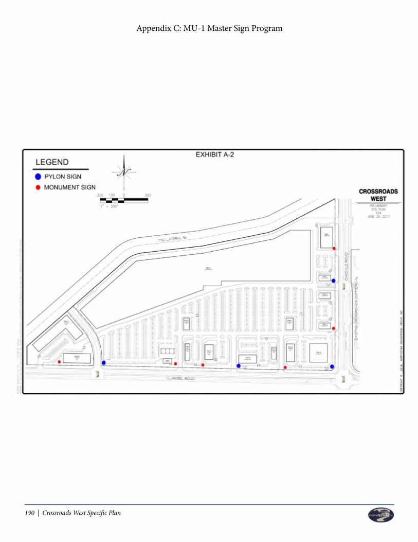
190 | Crossroads West Specific Plan
Appendix C: MU-1 Master Sign Program

Crossroads West Specific Plan | 191
Appendix C: MU-1 Master Sign Program
APPENDIX DChapter 157: Water Efficient Landscape and Irrigation

192 | Crossroads West Specific Plan
Left Blank Intentionally
Crossroads West Specific Plan | 193
Riverbank, California Code of Ordinances
CHAPTER 157: WATER EFFICIENT LANDSCAPE AND IRRIGATION
Section
157.01 Purpose and intent
157.02 Applicability
157.03 Water conservation definition
157.04 Process
157.05 Development standards
§ 157.01 PURPOSE AND INTENT.
The purpose and intent of this chapter is to establish landscaping regulations that are intended to:
(A) Enhance the aesthetic appearance of development in all areas of the city by providing development standards relating toquality, quantity and functional aspects of landscaping and landscape screening.
(B) Increase compatibility between residential and abutting commercial and industrial uses.
(C) Reduce the heat and glare generated by development.
(D) Establish a water conservation plan to reduce water consumption in the landscape environment using conservation principlesimportant to the State of California and the City of Riverbank.
(E) Protect public health, safety, and welfare by minimizing the impact of all forms of physical and visual pollution, controlling soilerosion, screening incompatible land uses, preserving the integrity of neighborhoods, and enhancing pedestrian and vehicular traffic andsafety.
(F) Comply with the California Department of Water Resources Title 23, Division 2, Chapter 2.7 entitled Model Water EfficientLandscape Ordinance and the California Green Building Standards of 2013 and/or these standards as amended from time to time.
(Ord. 2014-005, passed 6-10-14)
§ 157.02 APPLICABILITY.
All new development in the city shall comply with the provisions of this chapter and the requirements of the State Model WaterEfficient Landscape Ordinance referenced above, which is incorporated herein by this reference. All required landscaping shall beinstalled by the developer and approved by the Development Services Department prior to the issuance of a certificate of occupancyfor any building, unless other arrangements are agreed to by the Community Development Director.
(A) Exceptions. The following shall be exempt from the provisions of this section:
(1) Yards and landscape areas for single family homes when not installed by the builder or developer prior to or as a condition ofhome sales.
(2) Interior remodels, tenant improvements and demolitions.
(3) Changes of use to any existing building.
(4) Replacement or repair of existing plant material or irrigation systems in conjunction with routine maintenance of existingprojects.
(5) Modifications or additions to existing structures which do not result in an increase of more than 10% of the floor area, or
Appendix D: Chapter 157 Water Efficient Landscape and Irrigation

194 | Crossroads West Specific Plan
1,000 square feet, whichever is greater.
(B) Statutory authority in case of conflicting provisions. Nothing in this section shall be deemed to affect, annul or abrogateany other laws or ordinances pertaining or applicable to the properties and areas affected by this chapter.
(Ord. 2014-005, passed 6-10-14)
§ 157.03 WATER CONSERVATION DEFINITION.
For the purpose of this chapter, the following definition shall apply unless the context clearly indicates or requires a differentmeaning.
WATER CONSERVATION. This definition shall mean a combination of landscape features and techniques that in the aggregatereduce the demand for and consumption of water, including but not limited to appropriate low water using plants, nonlivinggroundcover, a low percentage of turf coverage, permeable paving and water conserving irrigation techniques and systems, and otherwater saving techniques and measures approved by the Community Development Services Department.
(Ord. 2014-005, passed 6-10-14)
§ 157.04 PROCESS.
The Community Development Director shall establish a format for landscape plans and any other procedural guidelines for submittalas deemed necessary.
(A) Plans required. Plans for the development of required landscaping shall be submitted to the Development ServicesDepartment for review and approval prior to the issuance of any building permit or as may be required for a site plan permit. Saidplans shall be prepared by a licensed landscape architect, landscape contractor, architect or certified irrigation designer.
(B) Plan review and approval. The Community Development Services Department shall review each project and proposedlandscape plan for compliance with the landscape and water conservation requirements.
(C) Alternative means of compliance. The Community Development Director may allow alternative means of complying with therequirements in this section provided the alternative achieves results comparable to those achieved through strict application of theprovisions of this section.
(Ord. 2014-005, passed 6-10-14)
§ 157.05 DEVELOPMENT STANDARDS.
(A) Required. In the following designated districts, not less than the stipulated percent of gross site area shall be landscaped inaccordance with this section:
Landscape Area Requirements
Zone District Required Landscaping (Gross% of site)
R-1/PD 30R-2 30 (a)R-3 30 (a)C-1/PD 10 (c)C-2 10 (c)
Appendix D: Chapter 157 Water Efficient Landscape and Irrigation

Crossroads West Specific Plan | 195
C-M 7.5 (c)M-1/PD 7.5 (b)(o)M-2 7.5 (b) 5 (c)CX-1 10 (c)
(1) In multiple-family developments of 12 or more dwelling units, 10% of the total building site shall be set aside and landscapedfor the purposes of common recreational open space. Such 10% may be included in the general landscaping requirements.
(2) This requirement may be waived by the Community Development Director for remodeling, alterations, or renovations toexisting buildings and developments on parcels or building sites where an existing building occupies a substantial portion of the site andthere exists limited space to landscape because of the front yard or corner street side yard setback areas.
(3) In commercial and industrial districts, where a lot larger than 10,000 square feet is to be developed in phases, the CommunityDevelopment Director may determine that only the developed portion of the site need be landscaped. Provision shall be made,however, to insure that the landscape requirement can still be met upon full development of the site. This exception shall not apply toany setback along a public street which shall be landscaped upon the initial development of the site. Open areas (areas not landscaped)shall be continuously maintained free of weeds, litter and debris, and shall not become a source of nuisance to adjoining property.
(B) Determination of landscaped areas. In determining landscaped areas, setbacks, when landscaped, private patios and all otherareas not occupied by buildings, parking lots, vehicle storage areas, and driveways shall be included. Areas occupied by clubhouses,recreation buildings, pools, saunas, inter walkways, and similar amenities may be included as landscaped areas. In industrial zoningdistricts, areas planted along a public right-of-way shall qualify as one and one-half (1.5) times the area toward the overall requiredlandscaping area.
(C) Landscape materials and placement. All landscape areas shall demonstrate a recognizable pattern or theme for the overalldevelopment. To accomplish this, new landscaping and landscape areas shall conform to the following:
(1) Plant materials shall be selected for maintenance efficiency, drought tolerance and adaptability and relationship to Riverbank'senvironment and climate. Trees and shrubs in reasonable numbers shall be used in the landscape design; ground cover alone shall notbe acceptable. No one species of plant shall exceed 20% of the plant material. Landscaped areas shall incorporate a minimum of twoof the following plantings: (1) grasses and ground covers, (2) shrubs, and (3) trees.
(2) In all commercial (C) and industrial (M) districts, plant materials shall be sized and spaced to achieve immediate effect andshall normally not be less than 24-inch box for parking lot shade trees, 15 gallon container for trees, five gallon container for shrubs,and a one gallon container for mass planting. Non-turf areas, such as shrub beds, shall be top dressed with a bark chip mulch orapproved alternative.
(3) Turf shall be limited to 25% of the total landscaped area in all commercial (C) and industrial (M) districts. In residentialdistricts turf shall not exceed 50% of the total landscaped area.
(D) Landscape irrigation. Provisions shall be made for a permanent "in place" irrigation system to all landscaped areas requiredherein, including street tree wells. All new irrigation systems shall use Xeriscaping principles including such techniques and materials aslow precipitation sprinkler heads, bubblers, drip irrigation systems, timing devices and moisture sensors. All irrigation systems must bedesigned to comply with the "State Model Water Efficient Landscape Ordinance" and shall minimize overspray onto impervioussurfaces, such as building, sidewalks, parking areas, and the like, through the use of such techniques as low-trajectory spray nozzles orunderground low volume applicators. All irrigation system controllers shall be set in compliance with the day and hour wateringrequirements of the city and shall be designed to minimize water use by installing automatic systems such as multi-start controllers andsoil moisture sensors.
(E) Site preparation and installation.
(1) Prior to the planting of any materials, the compacted soils surrounding a building site will be returned to a friable condition.Friable condition shall mean returning the soil to an easily crumbled or loosely compacted condition down to a minimum depth perplanting material requirements, whereby the root structure of newly planted material will be allowed to spread unimpeded. The soilmust be returned to a friable condition to a minimum depth as required for the planting material.
(2) Trees should be adequate in trunk diameter to support the top area of the tree. Trees, shrubs, and vines should have body andfullness that is typical of the species.
Appendix D: Chapter 157 Water Efficient Landscape and Irrigation

196 | Crossroads West Specific Plan
(3) All ground cover should be healthy, densely foliated, and well rooted cuttings, or one-gallon container plants.
(4) The spacing of trees and shrubs should be appropriate to the species used. The plant materials should be spaced so that theydo not interfere with the adequate lighting of the premises or restrict access to emergency apparatus such as fire hydrants or firealarm boxes. Proper spacing should also insure unobstructed access for vehicles and pedestrians in addition to providing clear vision ofthe intersections from approaching vehicles. Plant material should conform to the following spacing standards:
(a) A minimum of 25 feet from the property corner at a street intersection to the center of the first tree or large shrub.
(b) A minimum of 15 feet between center of trees and large shrubs to light standards.
(c) A minimum of 15 feet between center of trees or large shrubs and fire hydrants.
(d) A minimum of 15 feet from the intersection of a driveway with a street right-of-way to the center of any tree having adiameter larger than 18 inches at maturity or large shrub.
(F) Maintenance. Required planting areas shall be permanently maintained. As used in this section, "maintained" includes:watering, weeding, pruning, insect control, and replacement of plant materials and irrigation equipment as needed to preserve the healthand appearance of plant materials.
(G) Parking lot landscaping. Parking lots and parking structures shall have interior and perimeter landscaping areas as prescribedby the following:
(1) Parking lots or parking structures adjoining street property lines or public streets shall have a perimeter landscape buffer witha minimum width as follows:
(a) If abutting an expressway: 20 feet.
(b) If abutting an arterial: 15 feet.
(c) If abutting a collector: 15 feet.
(d) If abutting a local collector: 10 feet.
(e) If abutting a local street: five feet.
(2) Vehicle overhang may encroach a maximum of two feet into landscape areas which are a minimum of ten feet wide.
(3) An average three foot high (minimum two and one-half foot and maximum three and one-half foot) continuous screen shall beinstalled between all parking areas and public streets. A screen shall consist of one or any combination of the following:
(a) Walls. A wall shall consist of concrete, concrete block, stone, brick, tile or similar type of solid masonry material.
(b) Berms. A berm shall be constructed of earthen materials and it shall be landscaped.
(c) Solid fences. A solid fence shall be constructed of wood, or other materials.
(d) Plant materials. Vegetation, consisting of trees or shrubs.
(4) Interior landscaped areas shall be a minimum of five feet in width, exclusive of curbs.
(5) The end of each row of parking stalls shall be separated from aisle ways by a landscaped planter or sidewalk.
(6) In all parking lots with a capacity of five parking spaces or more, a minimum of one shade tree for every five spaces shall beprovided in landscape islands within the parking lot. Tree spacing shall be such that every designated parking space is within 30 feet ofthe trunk of a tree.
(7) All planting areas within or abutting a parking lot shall be protected with raised concrete curbs.
(H) Landscaping in rights-of-way. All land area within the public right-of-way adjoining all sides of any parcel or building site thatis not otherwise covered with a building, structure, paving, or similar impervious surface shall be landscaped and maintained inconjunction with the landscaping installed on the adjoining property as regulated in this chapter. Landscaping within the right-of-wayshall not be used when determining the required percentage of landscaping area as required in this chapter.
(1) Design. The design of the landscaping of the public right-of-way shall be included in the landscape plan and shall meet therequirements set forth in this chapter. Adequate space shall be provided in the landscape area to allow free, unrestricted growth and
Appendix D: Chapter 157 Water Efficient Landscape and Irrigation
Crossroads West Specific Plan | 197
development of the landscaping and street trees.
(2) Street trees. Street trees shall be planted in accordance with the Theme Street List, as it may be amended from time to time,or as otherwise set forth in the Chapter 96: Trees, §§ 96.03 through 96.06 relating to street trees and in accordance with the streettree planting standards as established by the City Engineer.
(I) Driveway and corner visibility. All landscaping material shall be maintained in accordance with the provisions of § 96.11.
(J) Landscaping along walls. All solid walls over three feet in height that are adjacent to public streets or right-of-ways shallcomply with one of the following:
(1) Be fully landscaped with vines and/or other plant materials to prevent the placement of graffiti. All landscaping shall includethe installation of a permanent irrigation system.
(2) If not landscaped, shall be constructed of split-face concrete, brick or some other type of material that will discourage theplacement of graffiti.
(K) Landscape screening of Residential (R) properties. Where a commercial or industrial site adjoins a Residential (R) District,screening which is at least 75% opaque shall be provided. Where fences are required, such fencing shall be landscaped as appropriate.
(L) Model homes. To promote landscape water conservation through education, all single family residential developments withmore than two model homes to be constructed by a developer, shall provide for landscaping the models entirely with water savinglandscaping and irrigation in accordance with the following requirements:
(1) Plant materials. Each "water saving" model home to be landscaped shall contain exclusively low water use plant materials asidentified on a suggested planting list available from the Community Development Department or approved by the CommunityDevelopment Director.
(2) Irrigation system. Each "water saving" model home shall contain exclusively an irrigation system that provides a highefficiency in water application according to site conditions. (Drip or trickle may not be used in turf areas).
(3) Signs. Each development with "water saving" model homes shall provide the following information to potential buyers:
(a) Front yard sign. A four square foot sign shall be located in the front yard of each "water saving" model such that it isclearly visible to buyers. The sign shall indicate that the model features a water saving landscape and irrigation design.
(b) Interior display. A drawing, or combination of drawings, shall be displayed inside each "water saving" model or the salesoffice which provides a schematic of the landscape. These drawings shall include a key identifying the common name of the plantsused in the "water saving" model yards. A brochure with the same information may be distributed with the sales information topotential buyers to satisfy this requirement.
(4) Literature. Additional literature describing water conserving landscaping and irrigation shall also be made available to thepotential buyer and displayed.
(Ord. 2014-005, passed 6-10-14)
Appendix D: Chapter 157 Water Efficient Landscape and Irrigation

198 | Crossroads West Specific Plan
Left Blank Intentionally

Crossroads West Specific Plan | 199
APPENDIX EChapter 153: Single Family Residential District R-1 Zone
Duplex Residential District R-2 Zone
Multi-Family Residential District R-3 Zone

200 | Crossroads West Specific Plan
Left Blank Intentionally

Crossroads West Specific Plan | 201
(`67 Code, § 10-2-6)
§ 153.016 LAND USE RESTRICTION.
No building shall hereafter be erected, nor shall any use of land be conducted except the use of land for agricultural purposes so thatthe same will be closer to the right-of-way line of any street than any official plan line or any building line which has been establishedfor such street.
(`67 Code, § 10-2-7) (Ord. 82-7, passed 9-27-82)
SINGLE-FAMILY RESIDENTIAL DISTRICT R-1 ZONE
§ 153.030 REGULATIONS.
The following regulations shall apply in all R-1 Districts and shall be subject to the provisions of §§ 153.180 through 153.185 of thischapter.
(`67 Code, § 10-3-1)
§ 153.031 USES PERMITTED.
(A) One single-family dwelling or one manufactured home provided that the manufactured home meets the following restrictions:
(1) Manufactured homes may be installed only if no more than ten years has elapsed between the date of manufacture and thedate of application for a permit to install the manufactured home.
(2) Manufactured homes must be on a foundation system approved by resolution of the City Council.
(3) All manufactured homes shall be subject to review and approval by the Community Development Director with respect tosiding material, roofing materials and roof overhang to ensure, to the greatest extent feasible, compatibility with surrounding structures. A pictorial representation of the proposed manufactured home shall be submitted with the application.
(4) No other dwelling units (i.e. single family, duplex, multiple family, apartments or dwelling groups) shall be allowed on the samelot.
(Ord. 87-11, passed 7-27-87; Am. Ord. 2002-001, passed 1-28-02)
(B) Accessory buildings are normally incidental to a single-family dwelling provided that such buildings are constructed concurrentwith, or subsequent to the construction of the single-family dwelling. NORMALLY INCIDENTAL shall be deemed to mean that, inaddition to a two car garage (either attached or detached), the size of the accessory building does not exceed 20% of the living area ofthe dwelling.
(1) A detached accessory building, other than a covered patio as defined herein, may occupy not more than 50% of a requiredrear yard, subject to the following requirements within an "R" district:
(a) No detached accessory building shall be closer that six feet to the main building, inclusive of roof covering;
(b) No detached accessory building shall be allowed within the required yard areas, inclusive of roof covering;
(c) Seven and one-half feet shall be the maximum height for a "shed" located at the setback line. A shed height may beincreased one and one-half feet for every one foot back from the setback line to a maximum height of 15 feet;
(d) A detached gazebo shall not be located closer than six feet to the main building inclusive of roof covering; shall not exceeda maximum height of 15 feet.
(Ord. 88-14, passed 11-28-88; Am. Ord. 2004-001, passed 6-14-04)
(C) Family day care centers limited to six paying guests.
Appendix E: Chapter 153 Single Family Residential District R-1 Zone
(`67 Code, § 10-2-6)
§ 153.016 LAND USE RESTRICTION.
No building shall hereafter be erected, nor shall any use of land be conducted except the use of land for agricultural purposes so thatthe same will be closer to the right-of-way line of any street than any official plan line or any building line which has been establishedfor such street.
(`67 Code, § 10-2-7) (Ord. 82-7, passed 9-27-82)
SINGLE-FAMILY RESIDENTIAL DISTRICT R-1 ZONE
§ 153.030 REGULATIONS.
The following regulations shall apply in all R-1 Districts and shall be subject to the provisions of §§ 153.180 through 153.185 of thischapter.
(`67 Code, § 10-3-1)
§ 153.031 USES PERMITTED.
(A) One single-family dwelling or one manufactured home provided that the manufactured home meets the following restrictions:
(1) Manufactured homes may be installed only if no more than ten years has elapsed between the date of manufacture and thedate of application for a permit to install the manufactured home.
(2) Manufactured homes must be on a foundation system approved by resolution of the City Council.
(3) All manufactured homes shall be subject to review and approval by the Community Development Director with respect tosiding material, roofing materials and roof overhang to ensure, to the greatest extent feasible, compatibility with surrounding structures. A pictorial representation of the proposed manufactured home shall be submitted with the application.
(4) No other dwelling units (i.e. single family, duplex, multiple family, apartments or dwelling groups) shall be allowed on the samelot.
(Ord. 87-11, passed 7-27-87; Am. Ord. 2002-001, passed 1-28-02)
(B) Accessory buildings are normally incidental to a single-family dwelling provided that such buildings are constructed concurrentwith, or subsequent to the construction of the single-family dwelling. NORMALLY INCIDENTAL shall be deemed to mean that, inaddition to a two car garage (either attached or detached), the size of the accessory building does not exceed 20% of the living area ofthe dwelling.
(1) A detached accessory building, other than a covered patio as defined herein, may occupy not more than 50% of a requiredrear yard, subject to the following requirements within an "R" district:
(a) No detached accessory building shall be closer that six feet to the main building, inclusive of roof covering;
(b) No detached accessory building shall be allowed within the required yard areas, inclusive of roof covering;
(c) Seven and one-half feet shall be the maximum height for a "shed" located at the setback line. A shed height may beincreased one and one-half feet for every one foot back from the setback line to a maximum height of 15 feet;
(d) A detached gazebo shall not be located closer than six feet to the main building inclusive of roof covering; shall not exceeda maximum height of 15 feet.
(Ord. 88-14, passed 11-28-88; Am. Ord. 2004-001, passed 6-14-04)
(C) Family day care centers limited to six paying guests.
(D) Family day care centers for seven to 12 paying guests when the following criteria are met:
(1) At least one off-street parking space shall be provided for each employee.
(2) There are no other day care centers for more than six paying guests within 300 feet of the exterior boundaries of the subjectsite.
(3) In addition to the required employee parking, there shall be provided at least two off-street parking spaces for loading andunloading of guests. These spaces shall be so located that vehicles head in and head out without using the public street formaneuvering, loading or unloading.
(E) Home occupations as defined in § 153.003 and regulated in §§ 153.265 through 153.267 of this chapter.
(F) Public parks and public buildings.
(G) Temporary real estate office and sign (not to exceed 100 square feet in area) may be located on any new subdivision for aperiod of not more than two years from the date of recording of the map of the subdivision upon which the office and sign are located. This time limit shall automatically be extended under the conditions in § 153.285(A)(1)(g) of this chapter.
(H) Temporary construction buildings to house tools and equipment or containing supervisory office in connection with constructionprojects during active construction on the same property.
(I) Residential care homes in which less than seven persons not of the immediate family are provided with food, shelter and carefor compensation, but not including hospitals, clinics or similar institutions devoted primarily to diagnosis and treatment of disease orinjury.
(J) Signs as allowed in §§ 153.280 through 153.285.
(K) Garage sales, as defined in § 153.003.
(L) Temporary uses such as a circus, carnival, fair or festival provided that they meet the following requirements:
(1) The use shall be temporary in nature and shall not last more than four days.
(2) The organizers of the event shall notify the Riverbank Police Services Division of their intentions at least 30 days prior to thescheduled beginning of the event.
(3) A business license shall be obtained as required by § 110.18 of the city code.
(4) Licenses will only be issued to local businesses or shopping centers when conducted on the same property as thebusiness/shopping center or to local nonprofit organizations.
(M) Temporary mobile home for ill or aged family members as regulated by § 153.219 of the city code.
(N) Second unit meeting § 153.325.
(O) One duplex on a corner lot, provided that the front door and garage of each unit faces a different street and that garages arerecessed five feet from living quarters subject to an architectural and site plan review application approved by the CommunityDevelopment Director.
(`67 Code, § 10-3-2) (Ord. 87-11, passed 7-27-87; Am. Ord. 2003-014, passed 11-10-03; Am. Ord. 2008-008, passed 9-8-08)
§ 153.032 USES PERMITTED WITH A USE PERMIT.
(A) Churches and other religious institutions (excluding open-air or tent).
(B) Schools, public utility, quasi-public buildings.
(C) Public or private automobile parking lots when adjacent to a C or M district or to a PD district when used for commercial orindustrial purposes.
(D) Mobile home park which meets the "Mobile Home Park Standards" as adopted by resolution of the City Council.
(E) Family day care centers for seven to 12 paying guests when the requirements of § 153.031(D) of this chapter are not met.
202 | Crossroads West Specific Plan
(D) Family day care centers for seven to 12 paying guests when the following criteria are met:
(1) At least one off-street parking space shall be provided for each employee.
(2) There are no other day care centers for more than six paying guests within 300 feet of the exterior boundaries of the subjectsite.
(3) In addition to the required employee parking, there shall be provided at least two off-street parking spaces for loading andunloading of guests. These spaces shall be so located that vehicles head in and head out without using the public street formaneuvering, loading or unloading.
(E) Home occupations as defined in § 153.003 and regulated in §§ 153.265 through 153.267 of this chapter.
(F) Public parks and public buildings.
(G) Temporary real estate office and sign (not to exceed 100 square feet in area) may be located on any new subdivision for aperiod of not more than two years from the date of recording of the map of the subdivision upon which the office and sign are located. This time limit shall automatically be extended under the conditions in § 153.285(A)(1)(g) of this chapter.
(H) Temporary construction buildings to house tools and equipment or containing supervisory office in connection with constructionprojects during active construction on the same property.
(I) Residential care homes in which less than seven persons not of the immediate family are provided with food, shelter and carefor compensation, but not including hospitals, clinics or similar institutions devoted primarily to diagnosis and treatment of disease orinjury.
(J) Signs as allowed in §§ 153.280 through 153.285.
(K) Garage sales, as defined in § 153.003.
(L) Temporary uses such as a circus, carnival, fair or festival provided that they meet the following requirements:
(1) The use shall be temporary in nature and shall not last more than four days.
(2) The organizers of the event shall notify the Riverbank Police Services Division of their intentions at least 30 days prior to thescheduled beginning of the event.
(3) A business license shall be obtained as required by § 110.18 of the city code.
(4) Licenses will only be issued to local businesses or shopping centers when conducted on the same property as thebusiness/shopping center or to local nonprofit organizations.
(M) Temporary mobile home for ill or aged family members as regulated by § 153.219 of the city code.
(N) Second unit meeting § 153.325.
(O) One duplex on a corner lot, provided that the front door and garage of each unit faces a different street and that garages arerecessed five feet from living quarters subject to an architectural and site plan review application approved by the CommunityDevelopment Director.
(`67 Code, § 10-3-2) (Ord. 87-11, passed 7-27-87; Am. Ord. 2003-014, passed 11-10-03; Am. Ord. 2008-008, passed 9-8-08)
§ 153.032 USES PERMITTED WITH A USE PERMIT.
(A) Churches and other religious institutions (excluding open-air or tent).
(B) Schools, public utility, quasi-public buildings.
(C) Public or private automobile parking lots when adjacent to a C or M district or to a PD district when used for commercial orindustrial purposes.
(D) Mobile home park which meets the "Mobile Home Park Standards" as adopted by resolution of the City Council.
(E) Family day care centers for seven to 12 paying guests when the requirements of § 153.031(D) of this chapter are not met.
Appendix E: Chapter 153 Single Family Residential District R-1 Zone

Crossroads West Specific Plan | 203
lot driveways shall not be located on the half of the lot frontage nearest the radius return, or be closer than 20 feet to said radiusreturn.
(2) Side or rear yard when lot abuts an arterial - ten feet.
(3) Side or rear yard, interior lots all other cases - five feet.
(4) Detached accessory buildings - six feet from any other buildings.
(5) A detached accessory building other than a covered patio as defined herein, may not occupy more than 50% of a requiredrear yard, subject to the following requirements:
(a) Within an "R" District, no detached accessory building shall be closer than six feet to the main building, inclusive of roofcovering.
(Ord. 90-01, passed 1-22-90; Am. Ord. 2004-001, passed 6-14-04)
(D) Lot coverage. No more than 50% of the lot may be covered by buildings.
(E) Off-street parking. As required in § 153.184 of this chapter.
(F) Minimum building size.
(1) Single-family dwellings and mobile homes - 900 square feet.
(2) All other uses - no minimum size.
(G) Density. Maximum permissible density is eight dwelling units per net acre.
(Ord. 87-11, passed 7-27-87)
(H) Open space requirements. All multiple residential uses of two or more dwelling units on one lot shall provide a fencedplayground (or other open space in the case of an adult-only facility) of at least 50 square feet per unit with a minimum area of 300square feet provided regardless of the number of units. This area shall not be a lineal open space but should have a width to depthratio not exceeding one to two (1:2). Except in very large complexes (more than 50 units) this required open space shall be in onelocation.
(Ord. 2004-001, passed 6-14-04)
(`67 Code, § 10-3-4)
DUPLEX RESIDENTIAL DISTRICT R-2 ZONE
§ 153.045 REGULATIONS.
The following regulations shall apply in the R-2 districts and shall be subject to the provisions of §§ 153.180 through 153.185 of thischapter.
(`67 Code, § 10-4-1)
§ 153.046 USES PERMITTED.
(A) A single-family dwelling or one duplex, or two dwelling units, except that on parcels with no direct frontage on a citymaintained street, only one single-family dwelling is permitted.
(B) In lieu of all the residential uses listed in division (A) above, one manufactured home per lot provided that the manufacturedhome meets the following restrictions:
(1) Manufactured homes may be installed only if no more than ten years has elapsed between the date of manufacture and thedate of application for a permit to install the manufactured home.
Appendix E: Chapter 153 Duplex Residential District R-2 Zone
(2) Manufactured homes must be on a foundation system approved by resolution of the City Council.
(3) All manufactured homes shall be subject to review and approval by the Community Development Director with respect tosiding material, roofing materials and roof overhang to ensure, to the greatest extent feasible, compatibility with surrounding structures. A pictorial representation of the proposed manufactured home shall be submitted with the application.
(4) No other dwelling units (such as, single-family or duplex) shall be allowed on the same lot.
(Ord. 87-11, passed 7-27-87; Am. Ord. 2002-001, passed 1-28-02)
(C) Accessory buildings normally incidental to dwellings provided that such buildings are constructed concurrent with, orsubsequent to the construction of the dwellings. NORMALLY INCIDENTAL shall be deemed to mean that, in addition to a garage(s)(either attached or detached) as required by this title, the size of the accessory building does not exceed 20% of the living area of thedwellings.
(Ord. 88-14, passed 11-28-88)
(D) Family day care centers limited to six paying guests.
(E) Family day care centers for seven to 12 paying guests when the following criteria are met:
(1) At least one off-street parking space shall be provided for each employee.
(2) There are no other day care centers for more than six paying guests within 300 feet of the exterior boundaries of the subjectsite.
(3) In addition to the required employee parking, there shall be provided at least two off-street parking spaces for loading andunloading of guests. These spaces shall be located so that vehicles head in and head out without using the public street formaneuvering, loading, or unloading.
(F) Home occupations as defined in § 153.003 and regulated in §§ 153.265 through 153.267.
(G) Public parks and public buildings.
(H) Temporary real estate office and sign (not to exceed 100 square feet in area) may be located on any new subdivision for aperiod of not more than two years from the date of recording of the map of the subdivision upon which the office and sign are located. This time limit shall automatically be extended under the conditions described in § 153.285(A)(1)(g).
(I) Temporary construction building to house tools and equipment or containing supervisory offices in connection with constructionprojects during active construction on the same property.
(J) Residential care homes in which less than seven persons not of the immediate family are provided with food, shelter and carefor compensation, but not including hospitals, clinics, or similar institutions devoted primarily to diagnosis and treatment of disease orinjury.
(K) Signs as allowed in §§ 153.280 through 153.285.
(L) Temporary uses such as a circus, carnival, fair or festival, provided that they meet the following requirements:
(1) The use shall be temporary in nature and shall not last more than four days.
(2) The organizers of the event shall notify the Riverbank Police Services Division of their intentions at least 30 days prior to thescheduled beginning of the event.
(3) A business license shall be obtained as required by § 110.18 of the city code.
(4) Licenses will only be issued to local businesses or shopping centers when conducted on the same property as thebusiness/shopping center or to local nonprofit organizations.
(M) Temporary mobile home for ill or aged family members as required by § 153.219.
(N) Garage sales as defined in § 153.003.
(Ord. 87-11, passed 7-27-87)
(`67 Code, § 10-4-2)
lot driveways shall not be located on the half of the lot frontage nearest the radius return, or be closer than 20 feet to said radiusreturn.
(2) Side or rear yard when lot abuts an arterial - ten feet.
(3) Side or rear yard, interior lots all other cases - five feet.
(4) Detached accessory buildings - six feet from any other buildings.
(5) A detached accessory building other than a covered patio as defined herein, may not occupy more than 50% of a requiredrear yard, subject to the following requirements:
(a) Within an "R" District, no detached accessory building shall be closer than six feet to the main building, inclusive of roofcovering.
(Ord. 90-01, passed 1-22-90; Am. Ord. 2004-001, passed 6-14-04)
(D) Lot coverage. No more than 50% of the lot may be covered by buildings.
(E) Off-street parking. As required in § 153.184 of this chapter.
(F) Minimum building size.
(1) Single-family dwellings and mobile homes - 900 square feet.
(2) All other uses - no minimum size.
(G) Density. Maximum permissible density is eight dwelling units per net acre.
(Ord. 87-11, passed 7-27-87)
(H) Open space requirements. All multiple residential uses of two or more dwelling units on one lot shall provide a fencedplayground (or other open space in the case of an adult-only facility) of at least 50 square feet per unit with a minimum area of 300square feet provided regardless of the number of units. This area shall not be a lineal open space but should have a width to depthratio not exceeding one to two (1:2). Except in very large complexes (more than 50 units) this required open space shall be in onelocation.
(Ord. 2004-001, passed 6-14-04)
(`67 Code, § 10-3-4)
DUPLEX RESIDENTIAL DISTRICT R-2 ZONE
§ 153.045 REGULATIONS.
The following regulations shall apply in the R-2 districts and shall be subject to the provisions of §§ 153.180 through 153.185 of thischapter.
(`67 Code, § 10-4-1)
§ 153.046 USES PERMITTED.
(A) A single-family dwelling or one duplex, or two dwelling units, except that on parcels with no direct frontage on a citymaintained street, only one single-family dwelling is permitted.
(B) In lieu of all the residential uses listed in division (A) above, one manufactured home per lot provided that the manufacturedhome meets the following restrictions:
(1) Manufactured homes may be installed only if no more than ten years has elapsed between the date of manufacture and thedate of application for a permit to install the manufactured home.

204 | Crossroads West Specific Plan
(2) Manufactured homes must be on a foundation system approved by resolution of the City Council.
(3) All manufactured homes shall be subject to review and approval by the Community Development Director with respect tosiding material, roofing materials and roof overhang to ensure, to the greatest extent feasible, compatibility with surrounding structures. A pictorial representation of the proposed manufactured home shall be submitted with the application.
(4) No other dwelling units (such as, single-family or duplex) shall be allowed on the same lot.
(Ord. 87-11, passed 7-27-87; Am. Ord. 2002-001, passed 1-28-02)
(C) Accessory buildings normally incidental to dwellings provided that such buildings are constructed concurrent with, orsubsequent to the construction of the dwellings. NORMALLY INCIDENTAL shall be deemed to mean that, in addition to a garage(s)(either attached or detached) as required by this title, the size of the accessory building does not exceed 20% of the living area of thedwellings.
(Ord. 88-14, passed 11-28-88)
(D) Family day care centers limited to six paying guests.
(E) Family day care centers for seven to 12 paying guests when the following criteria are met:
(1) At least one off-street parking space shall be provided for each employee.
(2) There are no other day care centers for more than six paying guests within 300 feet of the exterior boundaries of the subjectsite.
(3) In addition to the required employee parking, there shall be provided at least two off-street parking spaces for loading andunloading of guests. These spaces shall be located so that vehicles head in and head out without using the public street formaneuvering, loading, or unloading.
(F) Home occupations as defined in § 153.003 and regulated in §§ 153.265 through 153.267.
(G) Public parks and public buildings.
(H) Temporary real estate office and sign (not to exceed 100 square feet in area) may be located on any new subdivision for aperiod of not more than two years from the date of recording of the map of the subdivision upon which the office and sign are located. This time limit shall automatically be extended under the conditions described in § 153.285(A)(1)(g).
(I) Temporary construction building to house tools and equipment or containing supervisory offices in connection with constructionprojects during active construction on the same property.
(J) Residential care homes in which less than seven persons not of the immediate family are provided with food, shelter and carefor compensation, but not including hospitals, clinics, or similar institutions devoted primarily to diagnosis and treatment of disease orinjury.
(K) Signs as allowed in §§ 153.280 through 153.285.
(L) Temporary uses such as a circus, carnival, fair or festival, provided that they meet the following requirements:
(1) The use shall be temporary in nature and shall not last more than four days.
(2) The organizers of the event shall notify the Riverbank Police Services Division of their intentions at least 30 days prior to thescheduled beginning of the event.
(3) A business license shall be obtained as required by § 110.18 of the city code.
(4) Licenses will only be issued to local businesses or shopping centers when conducted on the same property as thebusiness/shopping center or to local nonprofit organizations.
(M) Temporary mobile home for ill or aged family members as required by § 153.219.
(N) Garage sales as defined in § 153.003.
(Ord. 87-11, passed 7-27-87)
(`67 Code, § 10-4-2)
Appendix E: Chapter 153 Duplex Residential District R-2 Zone
§ 153.047 USES PERMITTED WITH A USE PERMIT.
(A) Churches and other religious institutions (excluding open-air or tent).
(B) Schools, public utilities, and quasi-public buildings.
(C) Public or private automobile parking lots when adjacent to any C or M district or to any PD district which is used forcommercial or industrial purposes.
(D) Mobile home parks which meet the "Mobile Home Park Standards" as adopted by resolution of the City Council.
(E) Family day care centers for seven to 12 paying guests when the requirements of § 153.046(E) are not met.
(F) Duplexes parcels with no direct frontage on a city maintained street.
(G) Accessory buildings that do not meet the requirements of § 153.046(C).
(`67 Code, § 10-4-3) (Ord. 92-06, passed 7-13-92; Am. Ord. 97-03, passed 1-27-97; Am. Ord. 2003-014, passed 11-10-03)
§ 153.048 BUILDING REQUIREMENTS.
(A) Height limit.
(1) For dwellings and other main buildings - 35 feet.
(2) For accessory buildings - 15 feet.
(3) No fence (excluding wire fences and nonsolid fences which do not limit visibility as determined by the CommunityDevelopment Director) shall be constructed in excess of eight feet in height within any side or rear yard, except fences within the sideor rear yard which encloses electrical substations, which may be constructed to the height required by law.
(4) No fence, hedge or screen planting (excluding wire fences and nonsolid fences which do not limit visibility as determined bythe Community Development Director) shall be constructed or permitted to grow in excess of three feet in height within any front yardor side yard of a corner lot.
(B) Building site area required.
(1) Minimum area - 6,000 square feet.
(2) Minimum width, interior lot - 55 feet.
(3) Minimum width, corner lot - 65 feet.
(Ord. 87-11, passed 7-27-87)
(4) Minimum depth - 100 feet unless otherwise approved by the Planning Commission or City Council, whichever is the finaldecision making body. Plot plans of lots for which less than the minimum depth is requested may be required to ensure that the lot isusable for residential purposes.
(Ord. 88-14, passed 11-28-88)
(C) Yards and open spaces required.
(1) Front yard and side yard of a corner lot - not less than 15 feet from the planned right-of-way line, provided that no vehicleopening of any building is closer than 20 feet to the property line or planned right-of-way line toward which the opening faces.
(2) Side or rear yard when lot abuts an arterial - ten feet.
(3) Side or rear yard, interior lots, all other cases - five feet.
(4) Detached accessory buildings - ten feet from any other buildings.
(Ord. 90-01, passed 1-22-90)
(D) Lot coverage. No more than 50% of the lot may be covered by buildings.

Crossroads West Specific Plan | 205
(E) Off-street parking. As required in § 153.184.
(F) Minimum building size.
(1) Single-family dwellings and mobile homes - 900 square feet.
(2) All other uses - No minimum size.
(G) Density. Maximum permissible density of 12 dwelling units per net acre.
(Ord. 87-11, passed 7-27-87)
(H) Open space requirements. All multiple residential uses of two or more dwelling units on one lot shall provide a fencedplayground (or other open space in the case of an adult-only facility) of at least 50 square feet per unit with a minimum area of 300square feet provided regardless of the number of units. This area shall not be a lineal open space but should have a width to depthratio not exceeding one to two (1:2). Except in very large complexes (more than 50 units) this required open space shall be in onelocation.
(Ord. 89-22, passed 1-8-90)
(`67 Code, § 10-4-4)
MULTIPLE FAMILY RESIDENTIAL DISTRICT R-3 ZONE
§ 153.060 REGULATIONS.
The following regulations shall apply in all R-3 districts and shall be subject to the provisions of §§ 153.180 through 153.185 of thischapter.
(`67 Code, § 10-5-1)
§ 153.061 USES PERMITTED.
(A) Single-family, duplex and multiple family dwellings, apartment houses, dwelling groups, except that on parcels with no directfrontage on a city maintained street, only one single-family dwelling is permitted.
(B) In lieu of all the residential uses listed in division (A) above, one manufactured home per lot provided that the manufacturedhome meets the following restrictions:
(1) Manufactured homes may be installed only if no more than ten years has elapsed between the date of manufacture and thedate of application for a permit to install the manufactured home.
(2) Manufactured homes must be on a foundation system approved by resolution of the City Council.
(3) All manufactured homes shall be subject to review and approval by the Community Development Director with respect tosiding material, roofing materials and roof overhang to ensure, to the greatest extent feasible, compatibility with surrounding structures. A pictorial representation of the proposed manufactured home shall be submitted with the application.
(4) No other dwelling units (such as, single-family, duplex, multiple family, apartments or dwelling groups) shall be allowed on thesame lot.
(Ord. 87-11, passed 7-27-87; Am. Ord. 2002-001, passed 1-28-02)
(C) Accessory buildings normally incidental to permitted uses provided that such buildings are constructed concurrent with, orsubsequent to the construction of the permitted use. NORMALLY INCIDENTAL shall be deemed to mean that, in addition to agarage(s) (either attached or detached) as required by this chapter, the size of the accessory building does not exceed 20% of the areaof the main building.
(Ord. 88-14, passed 11-28-88)
Appendix E: Chapter 153 Multiple Family Residential District R-3 Zone
(D) Family day care centers limited to six paying guests.
(E) Family day care centers for seven to 12 paying guests when the following criteria are met:
(1) At least one off-street parking space shall be provided for each employee.
(2) There are no other day care centers for more than six paying guests within 300 feet of the exterior boundaries of the subjectsite.
(3) In addition to the required employee parking, there shall be provided at least two off-street parking spaces for loading andunloading of guests. These spaces shall be located so that vehicles head in and head out without using the public street formaneuvering, loading, or unloading.
(F) Home occupations as defined in § 153.003 and regulated in §§ 153.265 through 153.267.
(G) Public parks and public buildings.
(H) Temporary real estate office and sign (not to exceed 100 square feet in area) may be located on any new subdivision for aperiod of not more than two years from the date of recording of the map of the subdivision upon which the office and sign are located. This time limit shall automatically be extended under the conditions described in § 153.285(A)(1)(g).
(I) Temporary construction building to house tools and equipment or containing supervisory offices in connection with constructionprojects during active construction on the same property.
(J) Residential care homes in which less than seven persons not of the immediate family are provided with food, shelter and carefor compensation, but not including hospitals, clinics, or similar institutions devoted primarily to diagnosis and treatment of disease orinjury.
(K) Signs as allowed in §§ 153.280 through 153.285.
(L) Temporary uses such as a circus, carnival, fair or festival, provided that they meet the following requirements:
(1) The use shall be temporary in nature and shall not last more than four days.
(2) The organizers of the event shall notify the Riverbank Police Services Division of their intentions at least 30 days prior to thescheduled beginning of the event.
(3) A business license shall be obtained as required by § 110.18 of the city code.
(4) Licenses will only be issued to local businesses or shopping centers when conducted on the same property as thebusiness/shopping center or to local nonprofit organizations.
(M) Temporary mobile home for ill or aged family members as required by § 153.219 of the city code.
(N) Garage sales as defined in § 153.003.
(Ord. 87-11, passed 7-27-87)
(O) Second unit meeting § 153.325.
(P) Emergency shelters as defined in § 153.003.
(Q) Transitional housing as defined in § 153.003.
(R) Supportive housing as defined in § 153.003.
(`67 Code, § 10-5-2) (Am. Ord. 2003-014, passed 11-10-03; Am. Ord. 2015-002, passed 2-24-15)
§ 153.062 USES PERMITTED WITH A USE PERMIT.
(A) Churches and other religious institutions (excluding open-air or tent).
(B) Schools, public utilities and quasi-public buildings.
(C) Public or private automobile parking lots when adjacent to any C or M district or to any PD district which is used for
(E) Off-street parking. As required in § 153.184.
(F) Minimum building size.
(1) Single-family dwellings and mobile homes - 900 square feet.
(2) All other uses - No minimum size.
(G) Density. Maximum permissible density of 12 dwelling units per net acre.
(Ord. 87-11, passed 7-27-87)
(H) Open space requirements. All multiple residential uses of two or more dwelling units on one lot shall provide a fencedplayground (or other open space in the case of an adult-only facility) of at least 50 square feet per unit with a minimum area of 300square feet provided regardless of the number of units. This area shall not be a lineal open space but should have a width to depthratio not exceeding one to two (1:2). Except in very large complexes (more than 50 units) this required open space shall be in onelocation.
(Ord. 89-22, passed 1-8-90)
(`67 Code, § 10-4-4)
MULTIPLE FAMILY RESIDENTIAL DISTRICT R-3 ZONE
§ 153.060 REGULATIONS.
The following regulations shall apply in all R-3 districts and shall be subject to the provisions of §§ 153.180 through 153.185 of thischapter.
(`67 Code, § 10-5-1)
§ 153.061 USES PERMITTED.
(A) Single-family, duplex and multiple family dwellings, apartment houses, dwelling groups, except that on parcels with no directfrontage on a city maintained street, only one single-family dwelling is permitted.
(B) In lieu of all the residential uses listed in division (A) above, one manufactured home per lot provided that the manufacturedhome meets the following restrictions:
(1) Manufactured homes may be installed only if no more than ten years has elapsed between the date of manufacture and thedate of application for a permit to install the manufactured home.
(2) Manufactured homes must be on a foundation system approved by resolution of the City Council.
(3) All manufactured homes shall be subject to review and approval by the Community Development Director with respect tosiding material, roofing materials and roof overhang to ensure, to the greatest extent feasible, compatibility with surrounding structures. A pictorial representation of the proposed manufactured home shall be submitted with the application.
(4) No other dwelling units (such as, single-family, duplex, multiple family, apartments or dwelling groups) shall be allowed on thesame lot.
(Ord. 87-11, passed 7-27-87; Am. Ord. 2002-001, passed 1-28-02)
(C) Accessory buildings normally incidental to permitted uses provided that such buildings are constructed concurrent with, orsubsequent to the construction of the permitted use. NORMALLY INCIDENTAL shall be deemed to mean that, in addition to agarage(s) (either attached or detached) as required by this chapter, the size of the accessory building does not exceed 20% of the areaof the main building.
(Ord. 88-14, passed 11-28-88)

206 | Crossroads West Specific Plan
Appendix E: Chapter 153 Multiple Family Residential District R-3 Zone
(D) Family day care centers limited to six paying guests.
(E) Family day care centers for seven to 12 paying guests when the following criteria are met:
(1) At least one off-street parking space shall be provided for each employee.
(2) There are no other day care centers for more than six paying guests within 300 feet of the exterior boundaries of the subjectsite.
(3) In addition to the required employee parking, there shall be provided at least two off-street parking spaces for loading andunloading of guests. These spaces shall be located so that vehicles head in and head out without using the public street formaneuvering, loading, or unloading.
(F) Home occupations as defined in § 153.003 and regulated in §§ 153.265 through 153.267.
(G) Public parks and public buildings.
(H) Temporary real estate office and sign (not to exceed 100 square feet in area) may be located on any new subdivision for aperiod of not more than two years from the date of recording of the map of the subdivision upon which the office and sign are located. This time limit shall automatically be extended under the conditions described in § 153.285(A)(1)(g).
(I) Temporary construction building to house tools and equipment or containing supervisory offices in connection with constructionprojects during active construction on the same property.
(J) Residential care homes in which less than seven persons not of the immediate family are provided with food, shelter and carefor compensation, but not including hospitals, clinics, or similar institutions devoted primarily to diagnosis and treatment of disease orinjury.
(K) Signs as allowed in §§ 153.280 through 153.285.
(L) Temporary uses such as a circus, carnival, fair or festival, provided that they meet the following requirements:
(1) The use shall be temporary in nature and shall not last more than four days.
(2) The organizers of the event shall notify the Riverbank Police Services Division of their intentions at least 30 days prior to thescheduled beginning of the event.
(3) A business license shall be obtained as required by § 110.18 of the city code.
(4) Licenses will only be issued to local businesses or shopping centers when conducted on the same property as thebusiness/shopping center or to local nonprofit organizations.
(M) Temporary mobile home for ill or aged family members as required by § 153.219 of the city code.
(N) Garage sales as defined in § 153.003.
(Ord. 87-11, passed 7-27-87)
(O) Second unit meeting § 153.325.
(P) Emergency shelters as defined in § 153.003.
(Q) Transitional housing as defined in § 153.003.
(R) Supportive housing as defined in § 153.003.
(`67 Code, § 10-5-2) (Am. Ord. 2003-014, passed 11-10-03; Am. Ord. 2015-002, passed 2-24-15)
§ 153.062 USES PERMITTED WITH A USE PERMIT.
(A) Churches and other religious institutions (excluding open-air or tent).
(B) Schools, public utilities and quasi-public buildings.
(C) Public or private automobile parking lots when adjacent to any C or M district or to any PD district which is used forcommercial or industrial purposes.
(D) Hotels, rooming or boarding houses.
(E) Professional offices.
(F) Labor camp.
(G) Institutions for treatment of alcoholics.
(H) Mobile home parks which meet the "Mobile Home Park Standards" as adopted by resolution of the City Council.
(I) Family day care centers for seven to 12 paying guests when the requirements of § 153.061(E) are not met.
(J) Duplex and multiple family dwellings, apartment houses and dwelling groups on parcels with no direct frontage on a citymaintained street.
(K) Accessory buildings that do not meet the requirements of § 153.061(C).
(L) Residential care homes for more than seven persons.
(`67 Code, § 10-5-3) (Ord. 92-06, passed 7-13-92; Am. Ord. 97-03, passed 1-27-97; Am. Ord. 2003-014, passed 11-10-03)
§ 153.063 BUILDING REQUIREMENTS.
(A) Height limit.
(1) For dwellings and other main buildings - three stories but in no case to exceed 45 feet.
(2) For accessory buildings - 15 feet.
(3) No fence (excluding wire fences and nonsolid fences which do not limit visibility as determined by the CommunityDevelopment Director) shall be constructed in excess of eight feet in height within any side or rear yard, except fences within the sideor rear yard which encloses electrical substations, which may be constructed to the height required by law.
(4) No fence, hedge or screen planting (excluding wire fences and nonsolid fences which do not limit visibility as determined bythe Community Development Director) shall be constructed or permitted to grow in excess of three feet in height within any front yardor side yard of a corner lot.
(B) Building site area required.
(1) Minimum area:
(a) For one and two family dwellings or nondwelling main buildings - 6,000 square feet.
(b) For each unit in excess of two dwelling units - 2,000 square feet, not to exceed 20 units per net acre.
(2) Minimum width, interior lot - 55 feet.
(3) Minimum width, corner lot - 65 feet.
(Ord. 87-11, passed 7-27-87)
(4) Minimum depth - 100 feet unless otherwise approved by the Planning Commission or City Council, whichever is the finaldecision making body. Plot plans of lots for which less than the minimum depth is requested may be required to ensure that the lot isusable for residential purposes.
(Ord. 88-14, passed 11-28-88)
(C) Yards and open spaces required - single-family dwellings, duplexes and triplexes:
(1) Front yard and side yard of a corner lot - not less than 15 feet from the planned right-of-way line, provided that no vehicleopening of any building is closer than 20 feet to the property line or planned right-of-way line toward which the opening faces.
(2) Rear yard when lot backs up to an arterial - ten feet.

Crossroads West Specific Plan | 207
APPENDIX FChapter 153.36 Retail Sale of Alcoholic Beverages

208 | Crossroads West Specific Plan
Appendix F: Chapter 153.36 Retail Sale of Alcoholic Beverages
(E) To provide for properly maintained alcoholic beverage sale establishments so that negative impacts generated by theseactivities are not harmful to the surrounding environment in any way;
(F) To monitor that deemed approved activities do not substantially change in mode or character of operation.
(Ord. 2005-009, passed 6-13-05)
§ 153.361 USE PERMIT REQUIRED.
Use permits shall be required for the sale of alcoholic beverages, including beer and wine, for on or off-site consumption. Indetermining whether to issue a use permit, the city shall apply appropriate conditions to the use permit that insure compliance with theintent of this chapter. Upon issuance of a use permit, an alcoholic beverage sale activity shall be considered deemed approved andsubject to the conditions herein.
(Ord. 2005-009, passed 6-13-05)
§ 153.362 APPLICABILITY OF DEEMED APPROVED ALCOHOLIC BEVERAGE SALE REGULATIONS.
(A) To which property applicable. The deemed approved alcoholic beverage sale regulations shall apply, to the extentpermissible under other laws, to all legal nonconforming alcoholic beverage sale commercial activities within the city.
(B) Duplicated regulation. Whenever any provision of the deemed approved alcoholic beverage sale regulations and any otherprovision of law, whether set forth in this code, or in any other law, ordinance, or resolution of any kind, imposes overlapping orcontradictory regulations, or contain restrictions covering any of the same subject matter, that provision which is more restrictive orimposes higher standards shall control, except as otherwise expressly provided in the deemed approved alcoholic beverage saleregulations.
(C) Relationship to the zoning regulations. The nonconforming use provisions of the zoning regulations including, but not limitedto, §§ 153.195, 153.196, 153.197, 153.198, 153.199, 153.200, 153.201, 153.202 and 153.203, shall apply to the deemed approvedalcoholic beverage sale regulations.
(Ord. 2005-009, passed 6-13-05)
§ 153.363 DEFINITIONS.
As used in this chapter, the following terms shall have the meanings set forth.
ALCOHOLIC BEVERAGE. Alcohol, spirits, liquor, wine, beer, and every liquid or solid containing alcohol, spirits, wine, or beer,which contains one-half of one percent or more of alcohol by volume and which is fit for beverage purposes either alone or whendiluted, mixed, or combined with other substances, and sales of which requires a State Department of Alcoholic Beverage Controllicense.
ALCOHOLIC BEVERAGE SALES COMMERCIAL ACTIVITY. The retail sale, for on- or off- premises consumption, of liquor,beer, wine, or other alcoholic beverages, excluding full-service restaurants that comply with the below-listed definition of full servicerestaurant.
CONDITION OF APPROVAL. A requirement, which must be carried out by the activity in order to retain its deemed approvedstatus.
DEEMED APPROVED ACTIVITY. Any legal nonconforming alcoholic beverage sales commercial activity, as defined in thissection, in existence immediately prior to the effective date of the deemed approved alcoholic beverage sale regulations shall beconsidered a DEEMED APPROVED ACTIVITY as long as it complies with the deemed approved performance standards as setforth in § 153.364, and shall no longer be considered a legal nonconforming activity.
DEEMED APPROVED STATUS. The status conferred upon a deemed approved activity. DEEMED APPROVED STATUSreplaces legal nonconforming status.
FULL-SERVICE RESTAURANT. A place which is regularly and in a bona fide manner used and kept open for the serving of at
ten square feet of gross floor area or be more than those dimensions, and shall be located in accordance with the minimum yardrequirements of the zoning district in which located.
(D) Modification of building size requirements. The requirements of divisions (A) through (C) of this section may be modifiedby the Community Development Director in the case of administratively approved uses or by the Planning Commission in the case ofuses permitted by conditional use permit to encourage colocation.
(Ord. 99-07, passed 6-28-99) Penalty, see § 10.99
§ 153.343 REMOVAL OF ABANDONED ANTENNAS AND TOWERS.
Any antenna or tower that is not operated for a continuous period of 12 months shall be considered abandoned, and the owner of theantenna or tower shall remove the tower or antenna within 90 days of receipt of notice from the city and/or its sphere of influencenotifying the owner of such abandonment. Failure to remove an abandoned antenna or tower within the 90-day period shall be groundsto remove the tower or antenna at the owner's expense. If there are two or more users of a single tower, then this provision shall notbecome effective until all users cease using the tower.
(Ord. 99-07, passed 6-28-99)
§ 153.344 NONCONFORMING USES.
(A) Not expansion of nonconforming use. Towers that are constructed and antennas that are installed in accordance with theprovisions of this subchapter shall not be deemed to constitute the expansion of a nonconforming use or structure.
(B) Preexisting towers. Preexisting towers shall be allowed to continue their usage as they presently exist. Routine maintenance(including replacement with a new tower of like construction and height) shall be permitted on such preexisting towers. Newconstruction other than routine maintenance on a preexisting tower shall comply with the requirements of this subchapter.
(C) Rebuilding damaged or destroyed nonconforming towers or antennas. Notwithstanding the provisions of § 153.343, bonafide nonconforming towers or antennas that are damaged or destroyed by natural causes may be rebuilt without having to first obtainadministrative approval or a conditional use permit and without having to meet the separation requirements specified in § 153.341(B)(4) and (B)(5). The type, height, and location of the tower on-site shall be of the same type and intensity as the original facilityapproval. Building permits to rebuild the facility shall comply with the then-applicable building codes, and shall be obtained within 180days from the date the facility is damaged or destroyed. If no permit is obtained or if the permit expires, the tower or antenna shall bedeemed abandoned as specified in § 153.343.
(Ord. 99-07, passed 6-28-99)
RETAIL SALE OF ALCOHOLIC BEVERAGES
§ 153.360 PURPOSE.
The general purposes of the alcoholic beverage sales regulations are to protect and promote the public health, safety, comfort,convenience, prosperity, and general welfare by requiring that alcoholic beverage sales commercial activities achieve the followingobjectives:
(A) To protect residential, commercial, industrial, and civic areas and minimize the adverse impacts of nonconforming andincompatible uses;
(B) To provide opportunities for alcoholic beverage sale activities to operate in a mutually beneficial relationship to each other andto other commercial and civic services;
(C) To provide mechanisms to address problems often associated with the public consumption of alcoholic beverages, such as litter,loitering, graffiti, unruly behavior and escalated noise levels;
(D) To provide that alcoholic beverage sale commercial activities are not the source of undue public nuisances in the community; (E) To provide for properly maintained alcoholic beverage sale establishments so that negative impacts generated by theseactivities are not harmful to the surrounding environment in any way;
(F) To monitor that deemed approved activities do not substantially change in mode or character of operation.
(Ord. 2005-009, passed 6-13-05)
§ 153.361 USE PERMIT REQUIRED.
Use permits shall be required for the sale of alcoholic beverages, including beer and wine, for on or off-site consumption. Indetermining whether to issue a use permit, the city shall apply appropriate conditions to the use permit that insure compliance with theintent of this chapter. Upon issuance of a use permit, an alcoholic beverage sale activity shall be considered deemed approved andsubject to the conditions herein.
(Ord. 2005-009, passed 6-13-05)
§ 153.362 APPLICABILITY OF DEEMED APPROVED ALCOHOLIC BEVERAGE SALE REGULATIONS.
(A) To which property applicable. The deemed approved alcoholic beverage sale regulations shall apply, to the extentpermissible under other laws, to all legal nonconforming alcoholic beverage sale commercial activities within the city.
(B) Duplicated regulation. Whenever any provision of the deemed approved alcoholic beverage sale regulations and any otherprovision of law, whether set forth in this code, or in any other law, ordinance, or resolution of any kind, imposes overlapping orcontradictory regulations, or contain restrictions covering any of the same subject matter, that provision which is more restrictive orimposes higher standards shall control, except as otherwise expressly provided in the deemed approved alcoholic beverage saleregulations.
(C) Relationship to the zoning regulations. The nonconforming use provisions of the zoning regulations including, but not limitedto, §§ 153.195, 153.196, 153.197, 153.198, 153.199, 153.200, 153.201, 153.202 and 153.203, shall apply to the deemed approvedalcoholic beverage sale regulations.
(Ord. 2005-009, passed 6-13-05)
§ 153.363 DEFINITIONS.
As used in this chapter, the following terms shall have the meanings set forth.
ALCOHOLIC BEVERAGE. Alcohol, spirits, liquor, wine, beer, and every liquid or solid containing alcohol, spirits, wine, or beer,which contains one-half of one percent or more of alcohol by volume and which is fit for beverage purposes either alone or whendiluted, mixed, or combined with other substances, and sales of which requires a State Department of Alcoholic Beverage Controllicense.
ALCOHOLIC BEVERAGE SALES COMMERCIAL ACTIVITY. The retail sale, for on- or off- premises consumption, of liquor,beer, wine, or other alcoholic beverages, excluding full-service restaurants that comply with the below-listed definition of full servicerestaurant.
CONDITION OF APPROVAL. A requirement, which must be carried out by the activity in order to retain its deemed approvedstatus.
DEEMED APPROVED ACTIVITY. Any legal nonconforming alcoholic beverage sales commercial activity, as defined in thissection, in existence immediately prior to the effective date of the deemed approved alcoholic beverage sale regulations shall beconsidered a DEEMED APPROVED ACTIVITY as long as it complies with the deemed approved performance standards as setforth in § 153.364, and shall no longer be considered a legal nonconforming activity.
DEEMED APPROVED STATUS. The status conferred upon a deemed approved activity. DEEMED APPROVED STATUSreplaces legal nonconforming status.
FULL-SERVICE RESTAURANT. A place which is regularly and in a bona fide manner used and kept open for the serving of at

Crossroads West Specific Plan | 209
Appendix F: Chapter 153.36 Retail Sale of Alcoholic Beverages
(E) To provide for properly maintained alcoholic beverage sale establishments so that negative impacts generated by theseactivities are not harmful to the surrounding environment in any way;
(F) To monitor that deemed approved activities do not substantially change in mode or character of operation.
(Ord. 2005-009, passed 6-13-05)
§ 153.361 USE PERMIT REQUIRED.
Use permits shall be required for the sale of alcoholic beverages, including beer and wine, for on or off-site consumption. Indetermining whether to issue a use permit, the city shall apply appropriate conditions to the use permit that insure compliance with theintent of this chapter. Upon issuance of a use permit, an alcoholic beverage sale activity shall be considered deemed approved andsubject to the conditions herein.
(Ord. 2005-009, passed 6-13-05)
§ 153.362 APPLICABILITY OF DEEMED APPROVED ALCOHOLIC BEVERAGE SALE REGULATIONS.
(A) To which property applicable. The deemed approved alcoholic beverage sale regulations shall apply, to the extentpermissible under other laws, to all legal nonconforming alcoholic beverage sale commercial activities within the city.
(B) Duplicated regulation. Whenever any provision of the deemed approved alcoholic beverage sale regulations and any otherprovision of law, whether set forth in this code, or in any other law, ordinance, or resolution of any kind, imposes overlapping orcontradictory regulations, or contain restrictions covering any of the same subject matter, that provision which is more restrictive orimposes higher standards shall control, except as otherwise expressly provided in the deemed approved alcoholic beverage saleregulations.
(C) Relationship to the zoning regulations. The nonconforming use provisions of the zoning regulations including, but not limitedto, §§ 153.195, 153.196, 153.197, 153.198, 153.199, 153.200, 153.201, 153.202 and 153.203, shall apply to the deemed approvedalcoholic beverage sale regulations.
(Ord. 2005-009, passed 6-13-05)
§ 153.363 DEFINITIONS.
As used in this chapter, the following terms shall have the meanings set forth.
ALCOHOLIC BEVERAGE. Alcohol, spirits, liquor, wine, beer, and every liquid or solid containing alcohol, spirits, wine, or beer,which contains one-half of one percent or more of alcohol by volume and which is fit for beverage purposes either alone or whendiluted, mixed, or combined with other substances, and sales of which requires a State Department of Alcoholic Beverage Controllicense.
ALCOHOLIC BEVERAGE SALES COMMERCIAL ACTIVITY. The retail sale, for on- or off- premises consumption, of liquor,beer, wine, or other alcoholic beverages, excluding full-service restaurants that comply with the below-listed definition of full servicerestaurant.
CONDITION OF APPROVAL. A requirement, which must be carried out by the activity in order to retain its deemed approvedstatus.
DEEMED APPROVED ACTIVITY. Any legal nonconforming alcoholic beverage sales commercial activity, as defined in thissection, in existence immediately prior to the effective date of the deemed approved alcoholic beverage sale regulations shall beconsidered a DEEMED APPROVED ACTIVITY as long as it complies with the deemed approved performance standards as setforth in § 153.364, and shall no longer be considered a legal nonconforming activity.
DEEMED APPROVED STATUS. The status conferred upon a deemed approved activity. DEEMED APPROVED STATUSreplaces legal nonconforming status.
FULL-SERVICE RESTAURANT. A place which is regularly and in a bona fide manner used and kept open for the serving of atleast lunch and dinner to guests for compensation and which has suitable kitchen facilities connected therewith, containingconveniences for cooking an assortment of foods which may be required for such meals. The sale or service of sandwiches (whetherprepared in a kitchen or made elsewhere and heated up on the premises) or snack foods shall not constitute a FULL-SERVICERESTAURANT. To be considered a FULL SERVICE RESTAURANT under the deemed approved program, the establishmentmust meet the following criteria:
(1) A FULL SERVICE RESTAURANT shall serve meals to guests at all times the establishment is open for business. Anestablishment shall not be considered a FULL-SERVICE RESTAURANT if it served alcohol without meal service being providedwith the exception that alcohol sales to restaurant patrons may continue for up to two hours after meal service has ceased to allowguests to comfortably complete their meals.
(2) There shall be a real offer or holding out to sell meals. Premises shall make an offer or holding out of sales of meals to thepublic by maintaining and displaying a printed menu and/or a menu board. A two-thirds majority of the items offered on the menu shallbe available at any given time the establishment is open. The mere offering of meals without actual sales shall not be deemedsufficient.
(3) The offer of meals is not adequate to meet the above criteria. A FULL SERVICE RESTAURANT shall make actual andsubstantial sales of meals to guests for compensation. Substantial sales shall mean that no less than 60% of total revenue shall begenerated from food service and no more than 40% of revenue from the sales of alcohol.
(4) "Meals" means the usual assortment of foods commonly ordered at various times of the day for the cuisine served. Theservice of snack foods and/or appetizers alone shall not be deemed compliance with this requirement. Meals shall be prepared on thepremises. Heating of food prepared elsewhere shall not constitute a meal for the purposes of this policy.
(5) Premises shall be equipped for meal service and maintained in good faith. Premises must possess and maintain appliances forthe cooking of a variety of foods such as stoves, ovens, broilers, or other devices, as well as pots, pans, or containers that can be usedfor cooking. Premises shall possess the necessary utensils, table service, and condiment dispensers with which to serve meals to thepublic.
(6) A FULL SERVICE RESTAURANT shall comply with all local health department standards.
(7) A FULL SERVICE RESTAURANT may have a separate lounge or bar area provided that the restaurant and bar/loungearea operate as a single entity. The physical layout, entry location(s), spatial connection between the areas, and operationalcharacteristics, among other factors, shall be used to determine compliance. Any bar/lounge area cannot remain open when the diningarea is closed. However, the dining area may be open while the bar/lounge area is closed.
(8) To the extent that ABC regulations do not conflict with the above criteria, a FULL SERVICE RESTAURANT shall complywith all State Department of Alcoholic Beverage Control regulations related to "Bona fide public eating place, meals."
ILLEGAL ACTIVITY. An activity which has been finally determined to be in noncompliance with the deemed approvedperformance standards of this chapter. Such an activity shall lose its deemed approved status and shall no longer be considered adeemed approved activity.
LEGAL NONCONFORMING ALCOHOLIC BEVERAGE SALES COMMERCIAL ACTIVITY or LEGALNONCONFORMING ACTIVITY. An alcoholic beverage sales commercial activity which was a nonconforming use pursuant to thenonconforming use regulations, and for which a valid state of California Alcoholic Beverage Control license had been issued and usedin the exercise of the rights and privileges conferred by the license, at a time immediately prior to the effective date of the deemedapproved alcoholic beverage sale regulations. Such an activity shall be considered a deemed approved activity, and shall no longer beconsidered a LEGAL NONCONFORMING ACTIVITY, except such activity shall be subject to those zoning regulations relating tononconforming uses, as of the effective date of the alcoholic beverage sale regulations.
PERFORMANCE STANDARDS. Regulations prescribed in the performance standards of this chapter.
PREMISES. The actual space within a building devoted to alcoholic beverage sales.
(Ord. 2005-009, passed 6-13-05)
§ 153.364 PERFORMANCE STANDARDS AND DEEMED APPROVED ACTIVITIES.
An activity shall retain its deemed approved status only if it conforms with all of the following deemed approved performance

210 | Crossroads West Specific Plan
standards:
(A) That it does not result in adverse effects to the health, peace, or safety of persons residing or working in the surrounding area;
(B) That it does not result in jeopardizing or endangering the public health or safety of persons residing or working in thesurrounding area;
(C) That it does not result in repeated nuisance activities within the premises or in close proximity of the premises, including but notlimited to disturbance of the peace, illegal drug activity, public drunkenness, drinking in public, harassment of passersby, gambling,prostitution, sale of stolen goods, public urination, theft, assaults, batteries, acts of vandalism, excessive littering, loitering, graffiti, illegalparking, excessive loud noises, especially in the late night or early morning hours, traffic violations, curfew violations, lewd conduct, orpolice detentions and arrests;
(D) That it does not result in violations to any applicable provision of any other city, state, or federal regulation, ordinance or statute;
(E) That its upkeep and operating characteristics are compatible with and will not adversely affect the livability or appropriatedevelopment of abutting properties and the surrounding neighborhood.
(Ord. 2005-009, passed 6-13-05)
§ 153.365 AUTOMATIC DEEMED APPROVED STATUS.
All alcoholic beverage sales commercial activities that were legal activities immediately prior to the effective date of the alcoholicbeverage sale regulations shall automatically become deemed approved activities as of the effective date of the regulations and shallno longer be considered legal nonconforming activities. Each such deemed approved activity shall retain its deemed approved statusas long as it complies with the deemed approved performance standards.
(Ord. 2005-009, passed 6-13-05)
§ 153.366 NOTIFICATION TO OWNERS OF DEEMED APPROVED ACTIVITIES.
The Community Development Director shall notify the owner of each deemed approved activity, and also the property owner if notthe same, of the activity's deemed approved status. Such notice shall be sent via certified return receipt mail and shall include a copyof the performance standards of this chapter with the requirement that these be posted in a conspicuous and unobstructed place visiblefrom the entrance of the establishment for public review, notification that the activity is required to comply with all these sameperformance standards and that a review fee is required, and the amount of such fee provided in the master fee schedule, and that theactivity is required to comply with all other aspects of the deemed approved alcoholic beverage sale regulations. Should the notice bereturned, the notice shall be sent via regular U.S. Mail.
(Ord. 2005-009, passed 6-13-05)
§ 153.367 PROCEDURE FOR CONSIDERATION OF VIOLATIONS TO PERFORMANCE STANDARDS.
(A) Upon receiving a complaint from the public, Police Department, or any other interested party that a deemed approved activityis in violation of the performance, and once it is determined by the city that violations appear to be occurring, then the deemedapproved status of the deemed approved activity in question shall be reviewed by the Planning Commission at a public hearing. Notification of the public hearing shall be in accordance with adopted city standards.
(B) The purpose of the public hearing is to receive testimony on whether the operating methods of the deemed approved activityare causing undue negative impacts in the surrounding area. At the public hearing, the Planning Commission shall determine whetherthe deemed approved activity conforms to the deemed approved performance standards and to any other applicable criteria, and maycontinue the deemed approved status for the activity in question or require such changes or impose such reasonable conditions ofapproval as are in the judgment of the Planning Commission necessary to ensure conformity to said criteria and such conditions shallbe based on the evidence before the Planning Commission. The decision of the Planning Commission shall be based upon informationcompiled by staff and testimony from the business owner and all other interested parties. New conditions of approval shall be made apart of the deemed approved status and the deemed approved activity shall be required to comply with these conditions. Thedetermination of the Planning Commission shall become final ten calendar days after the date of decision unless appealed to the City
least lunch and dinner to guests for compensation and which has suitable kitchen facilities connected therewith, containingconveniences for cooking an assortment of foods which may be required for such meals. The sale or service of sandwiches (whetherprepared in a kitchen or made elsewhere and heated up on the premises) or snack foods shall not constitute a FULL-SERVICERESTAURANT. To be considered a FULL SERVICE RESTAURANT under the deemed approved program, the establishmentmust meet the following criteria:
(1) A FULL SERVICE RESTAURANT shall serve meals to guests at all times the establishment is open for business. Anestablishment shall not be considered a FULL-SERVICE RESTAURANT if it served alcohol without meal service being providedwith the exception that alcohol sales to restaurant patrons may continue for up to two hours after meal service has ceased to allowguests to comfortably complete their meals.
(2) There shall be a real offer or holding out to sell meals. Premises shall make an offer or holding out of sales of meals to thepublic by maintaining and displaying a printed menu and/or a menu board. A two-thirds majority of the items offered on the menu shallbe available at any given time the establishment is open. The mere offering of meals without actual sales shall not be deemedsufficient.
(3) The offer of meals is not adequate to meet the above criteria. A FULL SERVICE RESTAURANT shall make actual andsubstantial sales of meals to guests for compensation. Substantial sales shall mean that no less than 60% of total revenue shall begenerated from food service and no more than 40% of revenue from the sales of alcohol.
(4) "Meals" means the usual assortment of foods commonly ordered at various times of the day for the cuisine served. Theservice of snack foods and/or appetizers alone shall not be deemed compliance with this requirement. Meals shall be prepared on thepremises. Heating of food prepared elsewhere shall not constitute a meal for the purposes of this policy.
(5) Premises shall be equipped for meal service and maintained in good faith. Premises must possess and maintain appliances forthe cooking of a variety of foods such as stoves, ovens, broilers, or other devices, as well as pots, pans, or containers that can be usedfor cooking. Premises shall possess the necessary utensils, table service, and condiment dispensers with which to serve meals to thepublic.
(6) A FULL SERVICE RESTAURANT shall comply with all local health department standards.
(7) A FULL SERVICE RESTAURANT may have a separate lounge or bar area provided that the restaurant and bar/loungearea operate as a single entity. The physical layout, entry location(s), spatial connection between the areas, and operationalcharacteristics, among other factors, shall be used to determine compliance. Any bar/lounge area cannot remain open when the diningarea is closed. However, the dining area may be open while the bar/lounge area is closed.
(8) To the extent that ABC regulations do not conflict with the above criteria, a FULL SERVICE RESTAURANT shall complywith all State Department of Alcoholic Beverage Control regulations related to "Bona fide public eating place, meals."
ILLEGAL ACTIVITY. An activity which has been finally determined to be in noncompliance with the deemed approvedperformance standards of this chapter. Such an activity shall lose its deemed approved status and shall no longer be considered adeemed approved activity.
LEGAL NONCONFORMING ALCOHOLIC BEVERAGE SALES COMMERCIAL ACTIVITY or LEGALNONCONFORMING ACTIVITY. An alcoholic beverage sales commercial activity which was a nonconforming use pursuant to thenonconforming use regulations, and for which a valid state of California Alcoholic Beverage Control license had been issued and usedin the exercise of the rights and privileges conferred by the license, at a time immediately prior to the effective date of the deemedapproved alcoholic beverage sale regulations. Such an activity shall be considered a deemed approved activity, and shall no longer beconsidered a LEGAL NONCONFORMING ACTIVITY, except such activity shall be subject to those zoning regulations relating tononconforming uses, as of the effective date of the alcoholic beverage sale regulations.
PERFORMANCE STANDARDS. Regulations prescribed in the performance standards of this chapter.
PREMISES. The actual space within a building devoted to alcoholic beverage sales.
(Ord. 2005-009, passed 6-13-05)
§ 153.364 PERFORMANCE STANDARDS AND DEEMED APPROVED ACTIVITIES.
An activity shall retain its deemed approved status only if it conforms with all of the following deemed approved performance
Appendix F: Chapter 153.36 Retail Sale of Alcoholic Beverages

Crossroads West Specific Plan | 211
standards:
(A) That it does not result in adverse effects to the health, peace, or safety of persons residing or working in the surrounding area;
(B) That it does not result in jeopardizing or endangering the public health or safety of persons residing or working in thesurrounding area;
(C) That it does not result in repeated nuisance activities within the premises or in close proximity of the premises, including but notlimited to disturbance of the peace, illegal drug activity, public drunkenness, drinking in public, harassment of passersby, gambling,prostitution, sale of stolen goods, public urination, theft, assaults, batteries, acts of vandalism, excessive littering, loitering, graffiti, illegalparking, excessive loud noises, especially in the late night or early morning hours, traffic violations, curfew violations, lewd conduct, orpolice detentions and arrests;
(D) That it does not result in violations to any applicable provision of any other city, state, or federal regulation, ordinance or statute;
(E) That its upkeep and operating characteristics are compatible with and will not adversely affect the livability or appropriatedevelopment of abutting properties and the surrounding neighborhood.
(Ord. 2005-009, passed 6-13-05)
§ 153.365 AUTOMATIC DEEMED APPROVED STATUS.
All alcoholic beverage sales commercial activities that were legal activities immediately prior to the effective date of the alcoholicbeverage sale regulations shall automatically become deemed approved activities as of the effective date of the regulations and shallno longer be considered legal nonconforming activities. Each such deemed approved activity shall retain its deemed approved statusas long as it complies with the deemed approved performance standards.
(Ord. 2005-009, passed 6-13-05)
§ 153.366 NOTIFICATION TO OWNERS OF DEEMED APPROVED ACTIVITIES.
The Community Development Director shall notify the owner of each deemed approved activity, and also the property owner if notthe same, of the activity's deemed approved status. Such notice shall be sent via certified return receipt mail and shall include a copyof the performance standards of this chapter with the requirement that these be posted in a conspicuous and unobstructed place visiblefrom the entrance of the establishment for public review, notification that the activity is required to comply with all these sameperformance standards and that a review fee is required, and the amount of such fee provided in the master fee schedule, and that theactivity is required to comply with all other aspects of the deemed approved alcoholic beverage sale regulations. Should the notice bereturned, the notice shall be sent via regular U.S. Mail.
(Ord. 2005-009, passed 6-13-05)
§ 153.367 PROCEDURE FOR CONSIDERATION OF VIOLATIONS TO PERFORMANCE STANDARDS.
(A) Upon receiving a complaint from the public, Police Department, or any other interested party that a deemed approved activityis in violation of the performance, and once it is determined by the city that violations appear to be occurring, then the deemedapproved status of the deemed approved activity in question shall be reviewed by the Planning Commission at a public hearing. Notification of the public hearing shall be in accordance with adopted city standards.
(B) The purpose of the public hearing is to receive testimony on whether the operating methods of the deemed approved activityare causing undue negative impacts in the surrounding area. At the public hearing, the Planning Commission shall determine whetherthe deemed approved activity conforms to the deemed approved performance standards and to any other applicable criteria, and maycontinue the deemed approved status for the activity in question or require such changes or impose such reasonable conditions ofapproval as are in the judgment of the Planning Commission necessary to ensure conformity to said criteria and such conditions shallbe based on the evidence before the Planning Commission. The decision of the Planning Commission shall be based upon informationcompiled by staff and testimony from the business owner and all other interested parties. New conditions of approval shall be made apart of the deemed approved status and the deemed approved activity shall be required to comply with these conditions. Thedetermination of the Planning Commission shall become final ten calendar days after the date of decision unless appealed to the CityCouncil.
(Ord. 2005-009, passed 6-13-05)
§ 153.368 APPEAL ON THE REVOCATION OF A DEEMED APPROVED STATUS TO THE CITY COUNCIL.
(A) Within ten calendar days after the date of a decision by the Planning Commission to revoke a deemed approved status, anappeal from said decision may be taken to the City Council by any interested party. In the event the last date of appeal falls on aweekend or holiday when city offices are closed, the next date such offices are open for business shall be the last date of appeal. Such appeal shall be made on a form prescribed by the Planning Commission and shall be filed with the City Clerk. The appeal shallstate specifically wherein it is claimed there was an error or abuse of discretion by the Commission or wherein its decision is notsupported by the evidence in the record. Upon receipt of the appeal and an appeal fee in accordance with this section, the Councilshall set the date for consideration thereof. The City Clerk shall notify the Secretary of the City Planning Commission of the receipt ofsaid appeal and of the date set for consideration thereof; and said Secretary shall, not less than ten days prior thereto, give writtennotice to: the owner of the deemed approved activity; the property owner; adverse party or parties, or to the attorney, spokesperson, orrepresentative of such party or parties; other interested groups and neighborhood associations who have requested notification; and tosimilar groups and individuals as the Secretary deems appropriate, of the time, date, and place of the hearing on the appeal. Inconsidering the appeal, the Council shall determine whether the deemed approved activity conforms to the applicable deemed approvedperformance standards, and may approve or disapprove the revocation or require such changes therein or impose such reasonableconditions of approval as are in its judgment necessary to ensure conformity to said standards.
(B) The decision of the City Council shall be made by resolution and shall be final. The City Council shall vote on the appeal within30 days after its first hearing of the appeal. If the Council is unable to decide the appeal at that meeting, it shall appear for a vote oneach regular meeting of the Council thereafter until decided.
(Ord. 2005-009, passed 6-13-05)
§ 153.369 NOTIFICATION OF PUBLIC HEARING.
The Community Development Director shall notify the owner of each deemed approved activity, and also the property owner if notthe same, of the time and place of the public hearing. Such notice shall be sent via certified return receipt mail and shall includenotification that the deemed approved status of the deemed approved activity will be considered before the Officer. The publichearing shall be noticed by posting notices within 300 feet of the subject property; notice shall also be given by mail or delivery to allpersons shown on the last available equalized assessment roll as owning real property in the city within 300 feet of the subjectproperty. All such notices shall be given not less than ten days prior to the date set for the hearing, if such is to be held. Fees fornotification shall be in accordance with city regulations and paid for by the deemed approved activity in question.
(A) Notice on site. A city-provided notice of 8 1/2 x 11 inches in dimension shall also be posted on the premises of the subjectactivity, placed in the window of the activity. (If a window facing the street is not present, then the placard will be required to beposted onto the exterior of the building.) All notices shall advertise the time, date, purpose, and location of the public hearing for eachparticular site. All notices shall be given not less than ten days prior to the date set for the hearing.
(B) Notice by mail. Notice by mail is deemed given on the date the notice is placed into the U.S. Mail system.
(Ord. 2005-009, passed 6-13-05)
§ 153.370 FEE SCHEDULE.
Fees, and regulations pertaining to fees, including the review, notification, appeal, and reinspection of deemed approved activities,shall be in accordance with the city master fee schedule.
(Ord. 2005-009, passed 6-13-05)
§ 153.371 OFFICIAL ACTION.
Appendix F: Chapter 153.36 Retail Sale of Alcoholic Beverages

212 | Crossroads West Specific Plan
Left Blank Intentionally

Crossroads West Specific Plan | 213
APPENDIX GCity of Riverbank Street Tree List

214 | Crossroads West Specific Plan
Botanical Name Common NameWater Use Type
Height (Ft.)
Width (Ft.)
Power Lines
USDA Zone Use
Acer platanoides Norway Maple Moderate D 40-50 30-50 N 3-7 SAcer rubrum Red Maple Moderate D 40-70 30-50 N 3-9 SAfrocarpus gracilior (Podocarpus gracilior) African Fern Pine Moderate E 40-60 20-43 N 9-11 SArbutus ''Marina'' Marina Arbutus Low E 40-50 25-40 N 8-9 ACarpinus betulus 'Fastigiata' European Hornbeam Moderate D 30-40 20-30 N 4-8 SCeltis occidentalis Common Hackberry Low D 40-60 40-60 N 2-9 SCercis canadensis Eastern Redbud Moderate D 20-30 25-35 Y 4-8 SChilopsis linearis Desert Willow Very Low D 12-20 10-15 Y 6-9 AChionanthus retusus Chinese Fringe Tree Moderate D 10-20 10-20 Y 5-9 ACrataegus spp. (Native and non-native species)Hawthorn Moderate D 20-35 20-35 Y 3-8 SFraxinus americana White Ash Moderate D 60-80 60-80 N 3-9 SFraxinus uhdei Evergreen Ash Moderate E 60-80 40-60 N 9-11 SGinkgo biloba (MALE only) Maiden Hair Tree Moderate D 35-50 35-50 N 4-9 SKoelreuteria paniculata Golden Rain Tree Moderate D 30-40 30-40 N 5-9 SLagerstroemia spp., hybrids and cvs. Crape Myrtle Low D 10-30 10-30 Y 6-9 ALaurus ''Saratoga'' Saratoga Laurel Low E 20-30 15-25 Y 5-9 SLaurus nobilis Sweet Bay Low E 10-25 10-20 Y 8-11 ALiriodendron tulipifera Tulip Tree Moderate D 60-90 30-50 N 4-9 SMagnolia grandiflora Southern Magnolia Moderate E 60-80 30-50 N 7-9 SMagnolia x soulangeana Saucer Magnolia Moderate D 20-25 20-25 Y 4-9 AMelaleuca linariifolia Flax Leaf Paper Bark Low E 20-30 10-20 Y 9-11 AParkinsonia 'Desert Museum' Desert Museum Palo Verde Very Low D 15-25 15-25 Y 6-9 AParkinsonia florida (Cercidium florida) Blue Palo Verde Very Low D 25-35 20-30 N 9-11 APistacia chinensis Chinese Pistache Low D 30-35 20-30 N 6-9 SPodocarpus macrophyllus Yew Pine Moderate E 15-20 6-10 Y 7-11 APrunus caroliniana Carolina Laurel Cherry Low E 15-20 15-20 Y 7-10 APrunus cerasifera 'Krauter Vesuvius' Cherry Plum Low D 15-20 15-20 Y 5-8 AQuercus agrifolia Coast Live Oak Very Low E 20-60 20-60 N 7-10 SQuercus coccinea Scarlet Oak Moderate D 50-70 40-50 N 4-9 SQuercus douglasii Blue Oak Very Low D 20-30 15-25 N 6-9 SQuercus ilex Holly Oak Low E 30-60 30-60 N 7-9 SQuercus lobata Valley Oak Low D 30-75 30-50 N 5-10 SQuercus palustris Pin Oak Moderate D 50-70 40-60 N 4-8 SQuercus robur English Oak Moderate D 40-70 40-70 N 5-8 SQuercus rubra Red Oak Moderate D 50-75 50-75 N 4-8 SQuercus suber Cork Oak Low E 40-70 40-70 N 8-10 SQuercus virginiana Southern Live Oak Moderate E 40-80 60-100 N 8-10 SRhaphiolepis ''Majestic Beauty'' Majestic Beauty Low E 15-25 8-10 Y 7-11 AStyphnolobium japonicum (Sophora japonica) Japanese Pagoda Tree Low D 50-75 50-75 N 4-8 AThuja plicata Western Red Cedar Moderate E 50-70 15-25 N 5-7 AUlmus parvifolia Chinese Evergreen Elm Moderate D 40-50 25-40 N 4-9 SZelkova serrata Saw Leaf Zelkova Moderate D 50-80 50-80 N 5-8 S
Small Trees 15' - 25' Height - Minimum Recommended Planter Width 4'Medium Trees 25' - 35' Height - Minimum Recommended Planter Width 6'Medium to Large Trees 36' - 50' Height - Minimum Recommended Planter Width 8'Very Large Trees > 50' - Minimum Recommended Planter Width 10'
Type: D = Deciduous E = Evergreen
Use: A = Accent Tree S - Street Tree
Riverbank Street Tree List


