Embed Size (px)
Citation preview
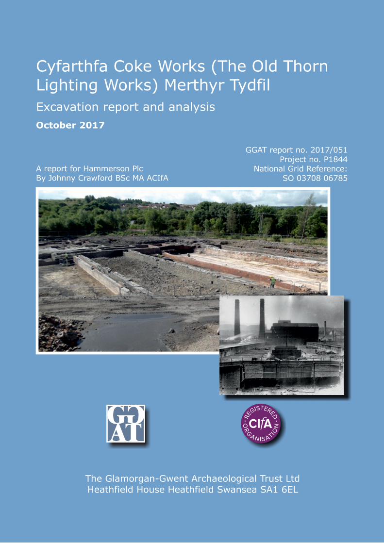
October 2017
A report for Hammerson PlcBy Johnny Crawford BSc MA ACIfA
GGAT report no. 2017/051Project no. P1844
National Grid Reference:SO 03708 06785
The Glamorgan-Gwent Archaeological Trust LtdHeathfield House Heathfield Swansea SA1 6EL
Excavation report and analysis
Cyfarthfa Coke Works (The Old ThornLighting Works) Merthyr Tydfil
Cyfarthfa Coke Works, Merthyr Tydfil: excavation report and analysis
1
Contents Page
Contents ......................................................................................................................... 1
1 Introduction ............................................................................................................. 15 Project background and commission ............................................................................. 15 Location, topography and geology ................................................................................ 15
2 Historical and archaeological background ........................................................... 17 3 Methodology ............................................................................................................ 22 On-site methodology ...................................................................................................... 22
Post-excavation methodology ........................................................................................ 23
4 Site Summary .......................................................................................................... 24 5 Phase 1. 1766 to circa 1840 ..................................................................................... 27 Anthony Bacon’s canal .................................................................................................. 28
6 Phase 2. Circa 1840 to 1882 ..................................................................................... 47 Thomas ovens ................................................................................................................ 47 Coke yard remains ......................................................................................................... 56
The Smithy ..................................................................................................................... 59
6 Phase 3. 1882 to 1926 .............................................................................................. 68 Coppée coke ovens ........................................................................................................ 69 Coal washery and crusher .............................................................................................. 70
7 Phase 4. 1926 to present........................................................................................ 171 8 Specialist artefactual and environmental assessments ...................................... 179 Pottery and glass - Joyce Compton (Freelance) ........................................................... 180 Metalwork – Dr Tim Young (Geo Arch) ..................................................................... 182 Steelmaking ceramics – Dr Tim Young (Geo Arch) ................................................... 184
Ceramic building material (bricks) Johnny Crawford (GGAT) .................................. 185
Animal Bone Report – Hannah Bowden BA, MSc ..................................................... 200
Mortar analysis by Rob Dunning BSc MCIfA ............................................................ 202 Clay pipes - Charlotte James (GGAT) ......................................................................... 209
9 Discussion............................................................................................................... 211 10 Conclusion ............................................................................................................. 223
References .................................................................................................................. 224 Appendix I Inventory of contexts ............................................................................ 229
Appendix II Catalogue of illustrated metalwork ................................................... 308 Appendix III Historical research documentation .................................................. 323 Appendix IV Open Day ............................................................................................ 330
Figures Figure 1. Location map of excavated remains (red) ........................................................... 16
Figure 2. Extent of surveyed remains of the Cyfarthfa Coke works and location of detailed
figures ...................................................................................................................................... 25
Figure 3. List of conventions used in the detailed plans and elevations/sections ............. 26 Figure 4. Plan of tramway 2296 and drain features 2301, 2303. ....................................... 43 Figure 5. Gable end of the Thomas oven ............................................................................. 48 Figure 6. Floor of the Thomas ovens and coke bench ........................................................ 49 Figure 7. Elevation drawing of the main chute for the Carr's disintegrator. .................. 76 Figure 8. Southern end of the settling chamber ................................................................. 86
Cyfarthfa Coke Works, Merthyr Tydfil: excavation report and analysis
2
Figure 9. Northern section of settling chamber................................................................... 87
Figure 10. South section of foundation for distributing screw mechanism ...................... 94 Figure 11. Central section of foundation for distributing screw mechanism ................... 95 Figure 12. North west section of foundation for distributing screw mechanism ............. 96
Figure 13. North central section of foundation for distributing screw mechanism ......... 97 Figure 14. North eastern section of foundation for distributing screw mechanism ........ 98 Figure 15. Vitrified mouth of main gas flue down-take, northern coke oven battery. .. 111 Figure 16. Baffle arrangement partially blocking the western chimney base. ............... 131 Figure 17. Plan of an area of brick bay group 2468 ......................................................... 140
Figure 18. West facing elevation of the excavated southern coke oven battery. ............ 161 Figure 19. Phasing plan for the Cyfarthfa Coke works features dating from
approximately 1765 to present. ........................................................................................... 213 Figure 20. The northern area of the site showing extent of surveyed remains (black),
structure numbers (red-box), context numbers (red-ellipse), group numbers (red-box
bold) and cut numbers (red-bold underlined). .................................................................. 226
Figure 21. The southern area of the site showing extent of surveyed remains (black),
structure numbers (red-box), context numbers (red-ellipse), group numbers (red-box
bold) and cut numbers (red-bold underlined). .................................................................. 227 Figure 22. The eastern area of the site showing extent of surveyed remains (black),
structure numbers (red-box), context numbers (red-ellipse), group numbers (red-box
bold) and cut numbers (red-bold). ..................................................................................... 228
Plates Plate 1. Possibly the earliest known plan of the layout of the Cyfarthfa Ironworks.
Purporting to date to January 1795, the plan depicts several inconsistencies with the
accepted development of the works. This includes the presence of a tramway from the
Ynysfach site (annotated ‘a’, adjacent to the canal in the top left quarter) and an
additional blast furnace. (Glamorgan Archives DG/F/9/10) .............................................. 19
Plate 2. Extract from the map of the Cyfarthfa Iron works taken from a Dynevor Estate
map of January 1785. The uppermost curving section of canal adjacent to the buildings
labelled 'b' is the section exposed during the archaeological work in 2013. Area ‘d’ is the
mine yard and ‘c’ is the coal yard (Glamorgan Archives DG/F/9/10). ............................. 28
Plate 3. Extract of a drawing by Pamplin of the Cyfarthfa Ironworks dated between 1791
and 1800. Although this image depicts the Glamorganshire canal near the lower works,
note the widening of the canal wall. A very similar feature was noted during excavation
of Anthony Bacon’s canal (Cyfarthfa Castle Museum)...................................................... 29 Plate 4. Anthony Bacon's canal. The orange/brown ramp on the right of the photo is
believed to be a lading and unlading ramp, to aid transfer of materials to and from the
tub boats. Note also the curved walling to allow the widening of the canal for the passage
of boats. Note the later brick culvert built into the canal. View to east. ........................... 30
Plate 5. One of the few photographs to show the canal and culvert prior to filling with
water. The construction of the culvert can clearly be seen, as can the stone packing (2006)
around it. The light brown deposit towards the base may be the natural clay or a build
up of silt in the channel prior to construction of the culvert. ............................................ 31
Plate 6. The same features within the canal presenting their more usual view. The
planning frame width is 0.6m. .............................................................................................. 32
Cyfarthfa Coke Works, Merthyr Tydfil: excavation report and analysis
3
Plate 7. Stone capping 2002 which had been laid over the culvert contained by the canal.
It is likely this had been placed both to level the area and protect the underlying culvert,
the arch of which is just visible in the bottom right quadrant of the photograph. .......... 32 Plate 8. Culvert 2003 on removal of the capping. Note its position within the channel of
the canal. View to south. ........................................................................................................ 33 Plate 9. Crossing point 2021 sited over culvert 2003. View to north east. ........................ 34 Plate 10. Stone drain 2203. The function and date of this drain remains unknown
although its form suggests that it may relate to either Phase 1 or 2. ................................ 35 Plate 11. Probable Phase 1 and 2 features located beneath the footprint of the 1882 north
Coppée oven coke bench. The earliest feature is the set of tramway sleepers (2296) which
has been cut by the later insertion of a stone drain (2301) and brick built chamber 2297).
The construction cut (2300) for the Coppée ovens is clearly visible in the upper left
quadrant. View to north. ...................................................................................................... 36 Plate 12. Ghost of the rail that once ran over the south of stone sleeper group 2296. View
to south west. .......................................................................................................................... 37
Plate 13. Box drain 2301 showing the iron lintel covering the drainage channel into
rectangular chamber 2297. Secondary drain 2302, which probably Fed the box drain, can
be seen curving at the bottom of the image. View to north east. ....................................... 38 Plate 14. Brick chamber 2297. Note the raised edges and distinctive curving in the bricks
forming the right hand (south western) side of the chamber. This suggests that this side
was open when in use. The dislodging of the lower wall in the image was historical wear
and tear caused during its lifetime. View to south east. ..................................................... 39 Plate 15. Interior of brick chamber 2297 showing the drain in the south west face and the
floor. ........................................................................................................................................ 40 Plate 16. Extract from a map of the Cyfarthfa works of 1856 showing small, rectangular
structures within the coke yard. These share the alignment of brick chamber 2297 and at
least one is shown with an open end. The linear alignment suggests that a buried drain
(such as 2301) may have linked them (Glamorgan Archives DG/F/9/10) One of these is
likely to be brick chamber 2297. ........................................................................................... 41
Plate 17. Smithy area, 'L' shaped structure showing the steps and the inner return of the
‘L’ shape. View to north. ....................................................................................................... 44 Plate 18. Smithy area, L shaped structure, showing the batter on the steps and the better
quality stone quoins to the right of the image. View to east. .............................................. 45
Plate 19. Battered gable end of the surviving element of the Thomas ovens. Note excellent
quality of the dressed stonework. ......................................................................................... 50 Plate 20. Close up of the 'D' shaped stay associated with the door fittings on the Thomas
ovens. ....................................................................................................................................... 51 Plate 21. View of the surviving corner of the Thomas oven ............................................... 51
Plate 22.View to the south west of the internal floor surfaces of the Thomas ovens. The
internal divisions are marked by the absence of bricks whilst the coking bench is the
damaged brick surface to the left of the ranging rods. Slot 2366, a recess for the coke oven
doors can be seen immediately right of the ranging rods. The upstanding walls are the
remains of the later Coppée oven which was constructed in the 1880s. ........................... 52 Plate 23. Receiver pit 2361 for part of the Thomas oven door mechanism. Note the iron
stay, identical to those on the north side of the ovens. ........................................................ 53
Plate 24. Receiver pit for door mechanism showing slot 2366 for the door. View to west
.................................................................................................................................................. 54 Plate 25. View to the north west of the interior of the Thomas ovens. .............................. 54 Plate 26. Interior floors of the Thomas ovens and coke bench showing the relationship
with later brick chamber 2341. View to east. ...................................................................... 55
Cyfarthfa Coke Works, Merthyr Tydfil: excavation report and analysis
4
Plate 27. North side of the Thomas ovens beneath the later Coppée coke ovens. View to
south. ....................................................................................................................................... 55 Plate 28. Cut 2310 and inspection chamber 2309. These features were cut into a coal dust
surface which appears to have built up over the phase one levels and may be an indicator
of the original level of the phase two marshalling yard. View to south east. .................... 56 Plate 29. Coke yard area, culvert group 2295 showing the highly distinctive orange clay
(deposit 2347) used to seal the culvert. Considerable quantities of coal dust (deposit 2306)
must have been present at the time the feature was constructed. View to south. ............ 57 Plate 30. Coke yard area, stone floor of culvert 2295. Note the traces of clay on the upper
stone courses. .......................................................................................................................... 58 Plate 31. View towards the Cyfarthfa Coke works taken around 1891. The low building
to the right of the prominent spoil heap is the smithy building (courtesy of Cyfarthfa
Castle Museum). ..................................................................................................................... 59 Plate 32. Remains of the smithy/forge building as exposed, view to south west. ............. 60
Plate 33. Brick floor surface forming the only internal division within the smithy/forge at
the north east end of the building. View to north east. ....................................................... 61 Plate 34. Iron plate forming a possible threshold into the smithy/forge. This was the only
obvious entrance into the building although more undoubtedly existed. View to east. .. 62 Plate 35. Remains of the best preserved hearth base. Along with two others, this is all that
remains of the smithying stations that would have been in operation every day at the
Cyfarthfa works. View to east............................................................................................... 63 Plate 36. Walls 2249 and 2250 which had been cut by the construction of storage bunker
wall 2213 for the coke works. Note also box drain 2248 which terminated at the corner of
the structure. .......................................................................................................................... 64 Plate 37. Stone capped drain 2248 may have been cut by the construction of walls 2249
and 2250; the exact nature of the relationship was unclear. This view towards the north
east shows the fair faced interior of the structure. ............................................................. 65 Plate 38. Phase 2 wall 2130, truncated by the construction of the 1882 washing and
crushing plant. View to north west. ...................................................................................... 66
Plate 39. North Coke rammer wall area, the remains of a Phase 2 tramway (sleeper group
2384) which had survived beneath the fill of the rammer wall. View to north west. ...... 67 Plate 40. The only known specific photograph of the operational Cyfarthfa coal washery
and Coppée coke ovens, believed to have been taken in the early 1890s. View to west. The
photograph is full of detail but highlights that fact that the excavated remains comprise
only a fraction of the original site. The building and chimneys visible in the top right of
the image is the brickworks (Alan George). ........................................................................ 70 Plate 41. Annotated map of the Cyfarthfa coke works dated 23rd February 1892. This
shows the Coppée coke oven complex in its original form (Phase 3a), prior to the addition
of the Sheppard Washer in 1894/5. The red features are the locations of individual steam
engines (Glamorgan Archives DG/F/9/10). .......................................................................... 72 Plate 42. The western elevator chute 2063 for the Carr's disintegrator. Note the parallel
lines on the far wall marking the position of the iron sheets that formed the actual wearing
surface of the elevator. This sheeting was intact at a lower level, as seen at the bottom
right of the photograph. View to north. ............................................................................... 73 Plate 43. The western chute 2063 for the Carr's disintegrator elevator. View to west. .. 75
Plate 44. The north chute (2064) of the Carr's disintegrator elevator pit. View to north.
.................................................................................................................................................. 77 Plate 45. The southern (2054) chute for the disintegrator elevator pit. Note the reversed
'L' shape which contrasts with the full width of the other two chutes. View to south. ... 78
Cyfarthfa Coke Works, Merthyr Tydfil: excavation report and analysis
5
Plate 46. Foundation and mounting pins for the disintegrator and elevator engine. View
to north east. ........................................................................................................................... 79 Plate 47. Phase 3a storage bunkers showing the internal division into four. Note the Phase
3b extension to the bunkers as the red brick walls in the distance. View to north. ......... 80
Plate 48. Phase 3a coal storage bunker group 2172. Abutment of walls 2176 (left) and
2181 (right). View to east. The slot (recess 2192) in wall 2176 is believed to be a beam slot
to support a floor level, working in conjunction with the step in the walls visible in the
photograph.............................................................................................................................. 81 Plate 49. General view of the remains of the hopper (Group 2055) for the Sheppard coal
washer, view to north ............................................................................................................. 82 Plate 50. Recess in hopper 2055 showing the iron and brick wall supports on either side.
View to west. ........................................................................................................................... 83 Plate 51. Hopper 2055 following clearance of the water and debris that it had contained.
This feature is exactly as depicted in a drawing contained in The Engineer of 12th
December 1895. The rectangular chamber housed part of the chain bucket system. ..... 83
Plate 52. Base of the remains of the settling chamber. View to south ............................... 84 Plate 53. Closer view of the iron strips on the base of the settling chamber. They had been
secured to the timber sleepers by round flathead nails. Scale is 1m. ................................ 85 Plate 54. Sheppard washer chamber 2038, view of the interior, looking south. The
chamber contained three pipes, the one from elevator pit 2049, and two others, set lower
which are likely to have emptied the chamber. The fill of the chamber (2039) was not
excavated due to the presence of asbestos. ........................................................................... 88 Plate 55. High pressure steam or water pipe 2044. This pipe probably helped to supply
power or water for the Sheppard Feldspar washer located west of the settling tank and
was one of the few remaining elements of it to have survived. .......................................... 89
Plate 56. The north passage of Group 2059 (brick floor 2072) showing chute 2060 to the
right. Note the sleeper locations and the slots built into the flanking walls that would have
permitted easier replacement of the sleepers. Note how the pins are off-set to the right
(south) side of the passage, possibly to allow limited access to the screw conveyor for
clearing blockages and repairing the machinery (see also Plate 59). View to east. ......... 90 Plate 57. View of chute 2060 in the north passageway. Note the recess in the wall to the
right of the chute to allow for insertion of a timber sleeper. Scale is 1m. ......................... 91 Plate 58. The damaged east end of the north passage showing the blocking in wall 2129
that dates to Phase 3b (1894/5) and which was done during installation of the Sheppard
plant. View to east. ................................................................................................................. 92 Plate 59. Remains of timber sleeper 2107 set within floor 2072. Scale is 1m. Note the
shallow recess beneath the wall on the left of the photograph which permitted insertion
of one side of the sleeper; the opposite end could then be dropped into place using the
larger recess in the opposite wall. ......................................................................................... 93 Plate 60. Western elevation of the Phase 3b of the coal storage bunker (wall 2213). Also
visible are the brick wall partitions inside the structure to create the bunkers. View to
east. .......................................................................................................................................... 99
Plate 61. Phase 3b coal storage bunker. View of the eastern (internal) elevation of wall
2213. Brick partition walls 2217 (left) and 2218 (right) are also visible. Scale divisions are
0.5m. ...................................................................................................................................... 100
Plate 62. North Coppée oven battery. Insulation deposit 2313 sandwiched between the
western end of the north coke oven battery (wall 2315 on the left) and the coal storage
bunker (wall 2215 on right). Note the deposit has been heat affected. View to south. .. 101 Plate 63. Close-up section of a photograph of the coke works from the 1890s showing
three dandies on a trackway along the top of the north coke oven battery. Floor surfaces
Cyfarthfa Coke Works, Merthyr Tydfil: excavation report and analysis
6
2219 to 2221 are believed to relate to the very base of this transportation system, in the
location of the recess in the building, which was used to transport processed coal from
storage to the tops of the coke ovens. View to north west (Alan George) ....................... 102 Plate 64. North Coppée coke oven battery. Floor surface 2219 looking east to the remains
of the coke ovens. This floor is believed to be associated with the transportation system
for moving processed coal to the top of the Coppée coke ovens. Note the extensive wear
to the surface of the bricks. ................................................................................................. 103 Plate 65. North Coppée coke oven battery, floor surface 2221 showing the cut for the
modern pipe run (2228). Floor 2221 was almost certainly related to the transportation
system for moving coal to the top of the coke ovens but the insertion of the masonry
partition (wall 2229 on the right of the photograph) would have significantly affected the
space available. ..................................................................................................................... 104 Plate 66. Detail from a photograph of the north coke oven battery in the 1890s (Alan
George) .................................................................................................................................. 105
Plate 67. Remains of the strip foundations of the north battery of Coppée coke ovens.
View to east. Wall 2314 is visible to the right of the photograph whilst wall 2324 is visible
on the left. The space between is filled with a series of linear brick foundations, and the
base of a single, large flue (2340 and 2343) is located adjacent to the left hand wall. View
to north east. ......................................................................................................................... 106 Plate 68. North coke oven battery, strip foundations 2328 (left) to 2331 (right). Retaining
wall 2341 is on the far left of the image whilst the remains of the main heat flue are on the
far right. ................................................................................................................................ 107 Plate 69. North Coppée coke oven battery, retaining wall 2314 looking along its length.
View to west. The vertical left hand face of the wall is likely to mark the location of the
front of the Coppée ovens. ................................................................................................... 108
Plate 70. Northern Coppée coke oven battery, surviving floor (2340) of the main gas flue.
Note the highly vitrified original floor of the flue just above the ranging rod. View to east.
................................................................................................................................................ 109
Plate 71. North Coppée coke oven battery, one of the two surviving pillar bases in the
vitrified surface of the main gas flue. Scale divisions are 0.5m ....................................... 110 Plate 72. North Coppée oven battery, South wall of secondary gas flue 2338, view to south.
................................................................................................................................................ 112 Plate 73. North Coppée oven battery, secondary gas flue chamber 2338. The floor of this
chamber sloped in two dimensions, demonstrating the highly skilled nature of the
workmanship involved. Note the extensive vitrification. View to east. ........................... 113 Plate 74. North Coppée oven battery, mouth of the secondary gas flue running from the
main gas flue. Note the collapsing arch and the attempt at support being provided by
brick pillar 2339. View to north.......................................................................................... 114
Plate 75. North Coppée oven battery, flow lines in the residue within secondary gas flue
2338. Scale is 0.5m ................................................................................................................ 115 Plate 76. North Coppée coke oven battery, characteristic flow lines in the residue left on
the side walls of the secondary gas flue. Scale is 0.5m. ..................................................... 115
Plate 77. North Coppée coke oven battery, the north wall of the main gas flue (wall 2435).
View to north with masonry wall 2437 to the rear. .......................................................... 116 Plate 78. North Coppée coke oven battery, the south wall of the main gas flue (wall 2436)
to the rear, and feature 2508, with a ranging rod resting on it. feature 2508 may, in fact
have been the only surviving portion of the walls of the transverse flues for the ovens.
View to north. ....................................................................................................................... 117 Plate 79. North Coppée coke oven flue complex, south elevation of wall 2442 showing
stepped foundation. View to north. .................................................................................... 119
Cyfarthfa Coke Works, Merthyr Tydfil: excavation report and analysis
7
Plate 80. North Coppée oven flue complex, north elevation of wall 2437. Note the absence
of a stepped foundation. Brick floor 2481 is visible, as is part of a chamber forming part
of chimney 2464. View to south. ......................................................................................... 120 Plate 81. North Coppée coke oven flue complex, view of floor surface 2446 that formed
the north side of the channel for the main gas flue in this area. Note the gas flue to the
right and wall 2443 to the right. View to west. .................................................................. 121 Plate 82. North Coppée coke oven flue complex, showing the arrangement of walls and
floors to create a substantial 'cradle' in which to construct main gas flue 2448. Junction
base 2464 is closest to the camera. View to west. .............................................................. 122
Plate 83. North Coppée oven gas flues, roof of the main gas flue 2448 showing the outer
skin of standard refractory brick and the outer surface of the specialist wedge shaped
brick that formed the flue itself. Scale is 2m. View to south. ........................................... 123 Plate 84. North Coppée Coke oven flue complex, oblique sectional view through damaged
main gas flue 2441. Note the method of construction using high quality specialist bricks.
Scale is 1m, View to west. .................................................................................................... 124
Plate 85. North Coppée coke oven flue complex, view of the interior of the western end of
main gas flue 2448 showing the lower half of the flue abutting wall 2433. View to west.
................................................................................................................................................ 125 Plate 86. North Coppée coke oven gas flue complex, view of the unfinished western
terminal of flue 2448. View to north west. ......................................................................... 125
Plate 87. North Coppée coke oven flue complex, iron plates 2444 placed over the
uncompleted western terminal of main gas flue 2448 as a removable inspection cover.
Note the specialist bricks propping the sheets in place, which were found in their original
positions. View to south. ...................................................................................................... 126 Plate 88. North Coppée coke oven flue complex, oblique view of the western terminal of
main gas flue 2448. Several interesting features are visible including the mouth of
secondary flue 2442 inside the main flue, and iron plates 2444. View to south west. .... 126 Plate 89. North Coppée coke oven flue complex, repair or insert to the roof of the main
gas flue 2448. The repair may have been intended to remedy a collapse of secondary flue
2447, which is visible at the bottom of the image. View to north. ................................... 127 Plate 90. North Coppée coke oven complex, north wall of chimney base 2132. The
structures just visible to left and right are the mouths of main gas flue 2448. View to
north. ..................................................................................................................................... 128
Plate 91. North Coppée coke oven flue complex, mouth of main gas flue 2448 at its
junction with chimney base 2132. Floor surface 2439 also served as the south wall of the
chamber. View to east. ......................................................................................................... 129 Plate 92. North Coppée coke oven flue complex, partially blocked mouth of the main gas
flue within chimney base 2132. This feature was possibly a baffle to reduce the ingress of
residue into the chamber base. Note the distortion of the roof, probably caused by heat.
View to east. .......................................................................................................................... 130 Plate 93. North Coppée coke oven flue complex, brick chamber 2464, which was the
junction of flues 2456, 2448 and 2459. Scale is 2m, View to north. ................................. 132
Plate 94. North Coppée coke oven flue complex, mouth of the western flue (flue 2458)
opening into flue junction 2464. View to west. .................................................................. 133 Plate 95. North Coppée coke oven flue complex, eastern flued mouth 2456 opening into
flue junction 2464. View to east. ......................................................................................... 134 Plate 96. North Coppée coke oven flue complex, rear view of flue 2459 showing the
reinforced collar of the flue and elements of the relieving arch on either side. View to
south. ..................................................................................................................................... 135
Cyfarthfa Coke Works, Merthyr Tydfil: excavation report and analysis
8
Plate 97. North Coppée coke oven flue complex, mouth of flue 2442 entering main gas flue
2441. View to south west. ..................................................................................................... 136 Plate 98. North Coppée coke oven flue complex, rear of blocked archway 2449. This may
be a vestigial flue that once connected the main gas flue with brick base group 2468. View
to north. ................................................................................................................................. 137 Plate 99. North Coppée coke oven flue complex, Blocked archway 2449. Note brick base
group 2468 to the rear of the arch. View to south. ............................................................ 137 Plate 100. North Coppée oven battery, a capping brick in place over one of the brick bays
forming part of group 2468. Note the chamfered nature of the brick to ensure a good seal.
Scale is 0.5m .......................................................................................................................... 138 Plate 101. North Coppée coke oven battery, brick built bays group 2468 looking south
east ......................................................................................................................................... 141 Plate 102. North Coppée coke oven battery, brick bay group 2468, view to east .......... 142 Plate 103. Close up view of the construction of one of the bays forming part of group 2468,
part of the north coke oven battery. Note the reddened appearance caused by intense
heat. ....................................................................................................................................... 143 Plate 104. North Coppée oven battery, wider view of brick channel group 2468, with the
mouth of flue 2447 visible at the bottom right of the photograph. View to south. ........ 143 Plate 105. North Coppée oven battery, the mouths of three secondary flues which were
open to channel 2480. Note the centre flue (flue 2449) had been blocked during its lifetime.
Flue 2448 is on the left and flue 2453 is on the right. View to north. .............................. 144 Plate 106. North Coppée coke oven rammer wall, north elevation of wall 2324 showing
constructional differences. View to south. ......................................................................... 145
Plate 107. North Coppée coke rammer wall, alcove 2321 showing the remains of timber
planking and two recesses in the south elevation of wall 2324. View to north. .............. 146
Plate 108. North Coppée oven gas flue system, brick reinforcing collar above the mouth
of flue 2338/2432. The grey brickwork in the foreground is part of collapsed relieving
arch 2391. View to south. .................................................................................................... 147
Plate 109. North Coppée coke oven rammer wall, brick surface 2029 and iron access plate
2469. View to west. ............................................................................................................... 148 Plate 110. North Coppée coke oven rammer wall, poor photograph of chamber 2485 and
blocked flue 2486. Full access to the chamber was not possible for health and safety
reasons. View to north. ........................................................................................................ 149
Plate 111. Brick built trough 2202 that once housed the high pressure water system for
the north coke bench. View to north east. Masonry wall 2199, which formed the north
part of the coke storage bunker is visible to the right of the trough. .............................. 150 Plate 112. View of the north wall of trough feature 2201. This photograph also shows the
insubstantial nature of the material that likely formed the fill for the coking benches, and
may explain why both the troughs had subsided. ............................................................. 151 Plate 113. The sloped floor of trough 2202. Note the collection of rust coloured debris to
the right hand side of the channel. This suggests that the floor had subsided during the
operational lifetime of the coke ovens, but not as severely as 2201 (see below). View to
south ...................................................................................................................................... 152 Plate 114. South Coppée coke battery coke bench, trough 2201 looking west. Note that
the gap that opened between the trough and wall had been partially filled with brickwork,
suggesting that subsidence had been an issue during the operational lifetime of the coke
bench. .................................................................................................................................... 153 Plate 115. South Coppée coke oven coke bench, view of the south wall of trough 2201.
View to north. ....................................................................................................................... 154
Cyfarthfa Coke Works, Merthyr Tydfil: excavation report and analysis
9
Plate 116. South Coppée coke oven, south elevation of the southern coke rammer wall
(wall 2133)). View to east ..................................................................................................... 155 Plate 117. South Coppée coke oven battery, useful photograph showing the south
elevation of the south main gas flue (flue 2012 at the rear left, and coke rammer masonry
walls 2009 (centre) and 2133 (right). The very straight construction cut for the wall (cut
2135) is clearly visible at the bottom of the photograph. View to north. ........................ 156 Plate 118. South Coppée coke oven coke rammer walls, oblique view of the rammer walls
and the main gas flue to the rear. This image provides an indicator of the combined width
of the wall in this location, which was in excess of 2m. View to north west. .................. 157
Plate 119. South Coppée Coke oven battery, western terminal end of the main gas flue
(flue 2012). The scale is resting on the course of a more modern Phase 4 pipe trench, view
to west .................................................................................................................................... 158 Plate 120. South Coppée coke oven main gas flue, spur to flue 2012 showing the
supporting partition walls 2280 (nearest camera) and 2281. View to south................... 159
Plate 121. South coke oven flue complex, eastern terminal end of main gas flue 2012
showing one of the square pillar bases that supported the roof and the brick bay grouping
beyond. The level of vitrification was greater here than for the northern flue. View to
east. ........................................................................................................................................ 160 Plate 122. Southern Coppée coke oven flue complex, remains of recesses 2560 (closest)
and 2559 visible as heavily vitrified areas of brick. View to east. ................................... 162
Plate 123. South Coppée coke oven flue complex, crude blocking visible at the junction of
flues 2555 and 2526. This blocking may be contemporary with the modifications evident
in the chimney base chamber (see below). View to north east. ........................................ 163
Plate 124. South Coppée coke oven flue complex, view of secondary gas flue 2526 and
chimney base 2509. Note the ridge of accreted material in the centre of the channel and
the deliberate attempt to narrow the chimney base chamber. View to east. .................. 164 Plate 125. South Coppée coke oven flue complex, another view of the eastern terminus of
main gas flue 2012 showing the possible mounting for a grille or similar. View to east.
................................................................................................................................................ 165
Plate 126. South Coppée coke oven flue complex, exposed remains of the north coke
rammer wall (wall elements 2537, 2570, 2533 and 2534). The double skinned nature of
the masonry is evident, as is the later wedge shaped cut (cut2530) through the wall,
associated with either construction or demolition of the Thorn Lighting works. View to
east. ........................................................................................................................................ 166 Plate 127. General view to the west of the central coke bin formed by masonry walls 2181,
2198 and 2199. ...................................................................................................................... 168 Plate 128. The vertically mounted iron pipe set within the recess in the north coke bin
wall. View to north. Note also the smaller recesses fitted with iron box inserts, which
probably supported a false floor within the coke bin area............................................... 168 Plate 129. Closer view of the horizontally arranged floor supports in the south wall of the
coke bin (2198). View to south ............................................................................................ 169 Plate 130. View of the west wall of the coke bin (2181) showing the damaged recess that
was probably part of the transport system for moving the coke from the bin to the furnace
tops. View to north west ...................................................................................................... 170 Plate 131. View to the north west across the development area taken in 1947 prior to
construction of the Thorn Lighting Works. Note the extensive deposits of brick and stone
and the absence of vegetation, suggesting recent demolition of the final remains of the
coke and brickworks. The photograph was taken from the historic spoil heap that
dominated the southern part of the Cyfarthfa site, with the smithy area being located
close to the centre right of the image. (Alan George) ....................................................... 171
Cyfarthfa Coke Works, Merthyr Tydfil: excavation report and analysis
10
Plate 132. View to the south east across the development area taken in 1947 showing
recent demolition. Note the historic spoil heap in the middle distance and the possible
remains of the associated engine house at the right edge of the heap. The same spoil heap
can be seen from different angles in photographs of the 1890s, shown elsewhere in this
report (Alan George) ........................................................................................................... 172 Plate 133. Photographs of the Thorn Lighting works under construction. The engineered
break in the massive masonry walls is, in fact, the outlet for the storage bunkers between
the two coke oven batteries. The image strongly suggests that construction of the Thorn
works accounts for the extensive truncation of the southern coke battery when compared
to the north. View to south (Alan George). ........................................................................ 173 Plate 134. North Coppée coke oven coke bench, cut for modern brick chamber 2309. 174 Plate 135. North Coppée coke oven coke bench, construction cut 2310 showing the rubble
packing and the cut through a coal dust layer and possible re-deposited clay. Note the
drain like feature at the base of the cut. View to south. ................................................... 174
Plate 136. North Coppée coke oven battery, chamber 2309 and the capping over the canal.
Note that these features have cut the construction cut for the south retaining wall of the
coke ovens (construction cut 2300). .................................................................................... 175
Plate 137. North coke rammer wall area, brick chamber 2341 showing the poorly defined
constriction cut through the Thomas oven coke bench. View to east. ............................ 176 Plate 138. Manhole 2034, which had truncated the south east corner of the Carr's
disintegrator building. View to north................................................................................. 177 Plate 139. Inspection chamber 2139 cutting the north wall of the main flue for the
southern coke ovens. This was almost certainly part of the Thorn Lighting works. View
to east..................................................................................................................................... 178 Plate 140. Close-up photograph of the coke yard drawn around 1798 by William Pamplin.
Although some artistic licence may be expected, this depicts the coke yard as it would
have looked in Phase 1. Curiously, no canal is depicted, although it was certainly in
existence at the time. (Author’s collection). ....................................................................... 212
Plate 141. Extract from the 1851 Merthyr Board of Health map showing the coke yard
area (development area is outlined). No coke ovens are depicted and coking in heaps is
almost certainly the technology employed. This is likely to be similar to the coke yard
layout depicted by Pamplin in 1798. .................................................................................. 216 Plate 142. The coke yard depicted in 1856 by Mr Cope Pearce. The Thomas ovens have
been constructed, indicating a construction date of between 1851 and 1856. (Glamorgan
Archives DG/F/9/10) ............................................................................................................ 217 Plate 143. Plan of the Cyfarthfa Coppée coke oven dated 23rd February 1892. This is the
form of complex prior to construction of the Sheppard washery in 1894/5. The red
squares indicate the location of steam engines (Glamorgan Archives DG/F/9/10). ....... 219
Plate 144. Second edition OS map of 1904 showing the Coppée coke oven complex. This
is the form of the ovens following the construction of the Sheppard Washery in 1894/5.
................................................................................................................................................ 219 Plate 145. Some of the 1500 visitors to the Cyfarthfa Coke works Open Day being briefed
by Martin Tuck, the Excavation Director. ........................................................................ 330
Cyfarthfa Coke Works, Merthyr Tydfil: excavation report and analysis
11
Tables Table 1. Schedule of engines for the Cyfarthfa coke plant Phase 3a (see Plate 41) ......... 72 Table 2. Finds and environmental assemblage summary ................................................ 179 Table 3 Scale of Fragmentation and Condition of bone ................................................... 200
Table 4. Catalogue of animal bone recovered from Cyfarthfa Cokeworks .................... 201 Table 5. Catalogue of clay pipe fragments......................................................................... 209 Table 6. Objects recommended for illustration from Dr Tim Young’s metalwork report
and the steelmaking ceramic report ................................................................................... 308
Cyfarthfa Coke Works, Merthyr Tydfil: excavation report and analysis
12
Summary
The Glamorgan-Gwent Archaeological Trust Ltd (GGAT Projects) were commissioned by
Hammerson plc. to undertake an archaeological excavation and watching brief in advance of
a development on the site of the former Thorn Lighting Works and Cyfarthfa Coke Works,
Merthyr Tydfil, in order to fulfil the conditions of their planning permission to redevelop the
site. The majority of the archaeological work was undertaken over the summer of 2013, with a
watching brief continuing into late 2013.
Archaeological remains relating to the whole of the period of operation of the Cyfarthfa
Ironworks were discovered, providing a fascinating insight into the history of the works.
The earliest, and most unexpected, recorded remains were a section of the canal built by
Anthony Bacon for the works in the late 18th century, which included a lading ramp, and a
passing place for tub boats. This canal was in existence from at least 1777 and was finally
phased out of use by 1840. The canal was then re-used to contain a brick culvert supplying
water to the coke yards, before being buried and lost by later development. This later
development included ephemeral remains relating to the operation of the coke yard between
the late 18th to mid-19th centuries. These features included stone tramway sleepers, culverts
and other related structures. The remains of a set of Thomas coke ovens were also recorded,
which date to between 1851 and 1856. Although damaged, these remains are some of the only
archaeologically examined Thomas ovens of this period and have provided new information
on the construction of this important transitional technology.
The most extensive remains uncovered were those of the Coppée coke ovens and associated
coal washery. The layout of the Cyfarthfa Coppée ovens, which date to 1882, was unique,
consisting of a double row of ovens separated by a central storage area. The Coppée ovens
were part of an attempt to modernise the works by conversion to the production of steel and
huge investment was made. The facility was provided with a Carr’s disintegrator for reducing
the washed coal to a size suitable for use in the Coppée ovens but the system was modified in
1894/5 by the addition of a Sheppard Feldspar Washer, and both phases the system were visible
in the recorded remains. The remains of the Sheppard equipment are the only archaeologically
examined remains of this type of plant.
The Coppée coke ovens themselves were heavily truncated, although the north battery and
associated heat flues were comparatively intact, providing valuable information on the
construction and operation of these features. It is evident that part of the ovens was subject to
remodelling, either through repair of heat damage or modification of the design; the work
carried out at Cyfarthfa is the first time the remains of a Coppée coke oven has been
archaeologically recorded and is likely to become a site type reference for future work in
industrial archaeology.
The Cyfarthfa Ironworks finally closed in 1919 and had been demolished by 1926. Minor
features relating to the later use of the site by the Thorn Lighting works, built in 1947, were
recorded; these included a number of manhole covers and service pipes.
Cyfarthfa Coke Works, Merthyr Tydfil: excavation report and analysis
13
A laser scanning survey was conducted to record all upstanding remains prior to construction
of the development. The data obtained is of sufficient quality to allow the construction of a 3-
D model should it be required and will be a highly valuable resource for future researchers.
Analysis of a wide range of artefacts recovered confirmed the broad date range for the
operation of the Cyfarthfa site, spanning the 18th, 19th and 20th centuries, although material
from the early 20th century predominated. This analysis of the material has yielded information
ranging from the type of hand tools being used to the type of bricks and mortars being used at
the site and is an invaluable addition to the general body of knowledge concerning the
operation of the Cyfarthfa works.
The extent of survival of structural remains strongly suggests that archaeological features
relating to the operation of the works will survive outside the development area. This should
be borne in mind when considering any future potential development in these locations.
A highly successful open day, facilitated by Hammerson plc., was held for local residents, at
which approximately 1500 people took the opportunity to view the remains. The large
attendance clearly demonstrated the high level of interest in archaeological remains of the iron
industry in Merthyr Tydfil.
All work was carried out to the standards set out by the Chartered Institute for Archaeologists.
Acknowledgements
This project was managed by Martin Tuck MCIfA (Head of Projects). The report was written
and compiled by Johnny Crawford BSc MA ACIfA (Project Officer). Specialist assessments
were provided by Dr Tim Young, Joyce Compton, Hannah Bowden, Charlie James-Martin and
Johnny Crawford. Illustrations were prepared by Paul Jones (GGAT Senior Illustrator). The
field team consisted of Martin Tuck (Excavation Director), Charlotte James-Martin, Johnny
Crawford, Jon Burton, Sophie Lewis-Jones, Andy Shobrook, Simon Ratty, Charlotte Bellamy,
Dafydd Davies, Cassandra Davis, Emma Kington, Ewan Kennaway, Gareth Rees, Kim
Dowding, Marie Wall, Robert Barratt and Sarah Baker
The author would like to thank Mr Chris Parry of Cyfarthfa Castle Museum for his generous
donation of time and knowledge, for his continued assistance during the project, as well as Mr
Dietrich Martini and Mr Chris Coates. Especial thanks are due to Paul Jackson of the Coke
Oven Managers Association and Jennifer Hillyard, Librarian at the North of England Institute
of Mining and Mechanical Engineers.
Copyright notice
The copyright of this report is held by the Glamorgan-Gwent Archaeological Trust Ltd, which
has granted an exclusive licence to Hammerson plc., and their agents, to use and reproduce the
material it contains. Ordnance Survey maps are reproduced under licence (AL10005976)
unless otherwise stated; annotations are GGAT copyright.
Cyfarthfa Coke Works, Merthyr Tydfil: excavation report and analysis
14
Abbreviations
GGAT: Glamorgan Gwent Archaeological Trust
LB: Listed Buildings Grade I, II and II* (Cadw)
NGR: National Grid Reference
NPRN: National Primary Record Number (in NMR)
PRN: Primary Record Number (in SMR)
RCAHMW: Royal Commission on the Ancient and Historical Monuments of Wales
SAM: Scheduled Ancient Monument (Cadw)
HER: Historic Environment Record (curated by the Glamorgan-Gwent
Archaeological Trust)
Cyfarthfa Coke Works, Merthyr Tydfil: excavation report and analysis
15
1 Introduction
Project background and commission
The Glamorgan-Gwent Archaeological Trust Ltd. (GGAT Projects Division) were
commissioned by Hammerson plc., to undertake a scheme of archaeological excavation and
monitoring (watching brief) prior to and during the redevelopment of land forming an extension
to the Merthyr Retail park, Merthyr Tydfil on land centred on NGR SO 03708 06785 (Figure
1). This land was formerly occupied by the coking works for the Cyfarthfa ironworks and
latterly by the Thorn Lighting Works and the archaeological work was undertaken in order to
safeguard against the loss of the archaeological resource associated with these sites. The
archaeological programme of works was a condition of planning permission (condition 13 of
Planning Application No. P/12/0219) to mitigate the impact of the development on the
archaeological resource, and was undertaken according to an archaeological Written Scheme
of Investigation (Dunning 2013) as a result of evaluation work which confirmed the presence
of several buried structures (Sherman 2012). The Written Scheme provided the framework for
the archaeological programme and this specification was approved by Merthyr Tydfil Borough
Council, on recommendation by their archaeological advisors, GGAT Curatorial.
Location, topography and geology
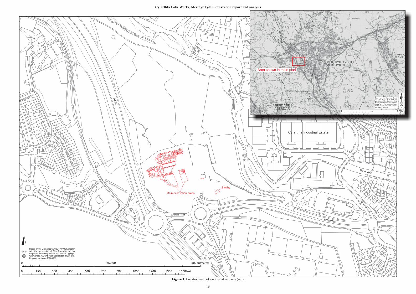
The development area was situated approximately 1.25km northwest of the centre of Merthyr
Tydfil, and bordered to the south by Swansea Road and to the west by the A470 (Figure 1). To
the east of the site are the extant remains of the Cyfarthfa Ironworks (SAM Gm425),
approximately 22m below the excavated area.
The solid geology of the immediate area is formed by deposits of the South Wales Lower Coal
Measures which are overlain by till of the Devensian period (British Geological Survey, 2017).
N
GRID
250.00 500.00metres0
0 1500feet150 300 450 600 750 900 1050 1200 1350
Based on the Ordnance Survey 1:10000 Landplan with the permission of The Controller of Her Majesty’s Stationery Office, © Crown Copyright, Glamorgan-Gwent Archaeological Trust Ltd, Licence number AL10005976
Swansea Road
A470
River Taff
Cyfarthfa R
oad
Swansea Road
Cyfarthfa Industrial Estate
River Taff
Based on the Ordnance Survey 1 :50000 map 2016 w i th t he permission of The Controller of Her Majesty’s Stationery Office, © Crown Copyr ight , Glamorgan-Gwent Archaeological Trust Ltd, Licence number AL10005976
N
GRID
0 2.50 5.00km
Area shown in main plan
Smithy
Main excavation areas
Figure 1. Location map of excavated remains (red).
16
Cyfarthfa Coke Works, Merthyr Tydfil: excavation report and analysis
Cyfarthfa Coke Works, Merthyr Tydfil: excavation report and analysis
17
2 Historical and archaeological background
The development area was situated in what was once the Coke Yard of the Cyfarthfa Ironworks
and included multiphase forges, smithies, coke ovens, calcining kilns, coal stores, a marshalling
yard and office buildings. Later, the site of the coke ovens was replaced by the Thorn Electrical
Industries factory (variously known in available sources as the Thorn Lighting Works, and the
Thorn Electrical Works), which overlooked the Hoover Transport factory on the main site of
the Cyfarthfa Ironworks to the north. The name Thorn Lighting Works has been used
throughought this report in connection with the former factory as this was the original name
given to the factory in 1947.
The Cyfarthfa Ironworks (NPRNs: 34,078–34,080; PRN: 01169m) is a nationally and
internationally important ironworks site, a large section of which is protected by legislation.
These include the recently restored furnace bank, water management features and associated
transport network. The main ironworks area, located east of the development, contains the
remains of the furnace bank (PRN: 04960m; NPRN: 275,868), a run of six stone blast furnaces,
first blown in 1765 and in use until 1872, notable for their size and extent, brick kilns (PRN:
02370m; NPRN: 34,081), and engine house (PRN: 02372m; NPRN: 34,082), together with the
remains of the smelting house (PRN: 02373m; NPRN: 34,083) and boiler (all within SAM
Gm425). Also included in the area is the Tai-mawr leat (SAM Gm479; PRN: 02435.0m;
NPRN: 275,881) to the northwest of the furnaces and Pont-y-Cafnau Iron Bridge (SAM
Gm424; PRN: 01090m; NPRN: 34,860; Grade II* Listed Building: Cadw ref: 11,408), a cast
iron tramroad bridge, thought to be of c.1794, and possibly the world's first iron railway bridge.
Cyfarthfa, the fourth coke-fired ironworks to be founded in south Wales, is recognized as being
nationally and internationally important for its historic associations and having played a key
role in the development innovations in iron production technology, such as Cort’s Puddling
Process. The site is generally well presented and understood with good survival of both
standing structures and buried remains, which may extend beyond the area currently protected
through legislation (i.e. beyond the SAM area). This suspicion was, in fact confirmed by the
work undertaken within the development area as presented in this current report.
Cyfarthfa Iron Works was founded on 29th August 1765, when Anthony Bacon and William
Brownrigg leased 405 hectares of land, 13km long and 8km wide, for 99 years at a rent of £100
per year from William Talbot, 1st Earl Talbot and a Captain Michael Richards, two prominent
local landowners. The extensive area leased enabled the works to be supplied with coal, iron
ore, limestone, clay and water from the River Taff.
Bacon and Brownrigg engaged Charles Wood to build a leat, a forge and a 15m high blast
furnace for smelting iron ore. Wood, who had pioneered the potting and stamping method of
refining pig iron into wrought iron, and patented it in 1763, supervised the construction
between April 1766 and May 1767, keeping a detailed diary of this work which has partially
survived (Gross 2001). Initially, ore was smelted with charcoal but as supplies dwindled the
works began to use coal instead, which necessitated an expansion of mining activity and the
means to transport the resulting ore and coal.
Cyfarthfa Coke Works, Merthyr Tydfil: excavation report and analysis
18
The works initially operated a single furnace and concentrated on the production of pig iron.
On 22nd July 1777, Bacon bought out Brownrigg and went into partnership with Richard
Crawshay and they began to manufacture cannon for the Board of Ordnance, initially for use
in the American War of Independence, and later for the long series of wars with Revolutionary
and Napoleonic France. Following Bacon’s retirement in 1783, Crawshay gained control of the
Cyfarthfa Works, although he did not become the outright owner until 1794. Thereafter, the
works remained in the Crawshay family, passing from Richard Crawshay, who died in 1810 to
William Crawshay I, who directed operations from his London office, while the day to day
management, including the great expansion of the works, fell to William Crawshay II, who was
responsible for the building of the nearby Cyfarthfa Castle in 1824.
The works at Cyfarthfa was the first in the area to change to the production of bar iron, which
ultimately lead to Cyfarthfa becoming the largest ironworks in the world by 1806. Instrumental
in adopting Cort’s Puddling Process soon after it was patented in 1784, were William Crawshay
in partnership with Watkin George, Cyfarthfa’s foundry manager, perhaps most notable for his
involvement in the design of several of the area’s early cast-iron bridges, including the
surviving Pont-y-Cafnau and for the development of the Ynysfach ironworks as a sister site to
Cyfarthfa. Even from its earliest days however, Cyfarthfa was forced to buy in supplies of pig
iron from both the nearby Dowlais and Plymouth ironworks for refining to maintain its
production of bar iron. Anthony Bacon had used Cyfarthfa for the manufacture of armaments
in the 1770s and in 1782 granted permission to Samuel Homfray to construct a cannon boring
mill within the works. Thereafter, manufacture of ordnance, particularly for the Royal Navy
became a significant business for Cyfarthfa, so much so that a pile of cannon balls was included
in the Crawshay family crest.
The layout of the works at the time is detailed in a view drawn around 1800 by William
Pamplin, one of Richard Crawshay’s employees; this shows four furnaces and associated
charging houses and casting sheds used in the production of pig iron, as well as the 48ft
(approximately 15m) diameter waterwheel which powered the bellows. Immediately to the
north is a large building with numerous chimneys that housed the puddling furnaces and rolling
mills. The early 19th century layout of the works and its associated features appears on
Ordnance Survey maps and surveyors’ drawings of the period. Also detailed are tramroads
leading to the Glamorganshire Canal.
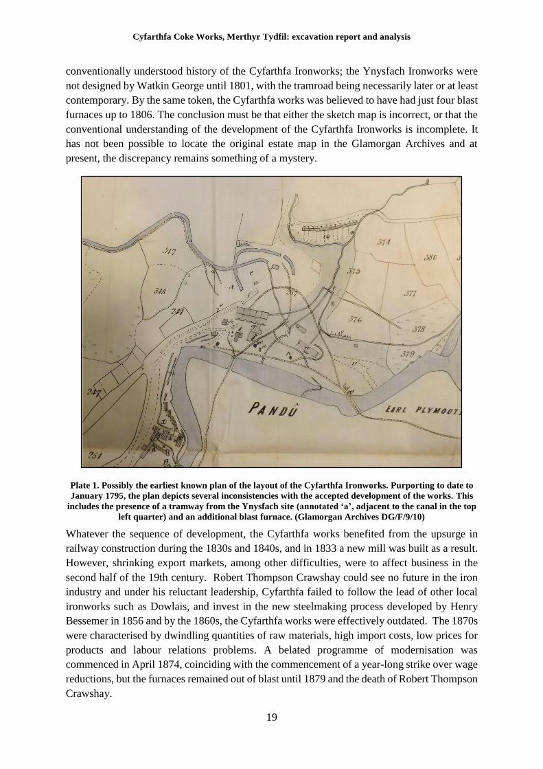
Research carried out for the current report has, however, revealed the presence of an earlier
map of the Cyfarthfa works. The Glamorgan Archives contains a file relating to a legal dispute
involving the Cyfarthfa Iron and Steel works (Glamorgan Archives DG/F/9/10). The file
contains a copy of a sketch map of the Cyfarthfa ironworks, purported to date to January 1795,
from estate maps belonging to the Dynevor (Lord Talbot) estate which would make it the
earliest known representation of the layout of the Cyfarthfa works (Plate 1). The land formed
part of the Llancaiach estate, jointly owned by Lord Talbot and Captain Richards. Despite
being a sketch map, it contains a wealth of important detail, including the location of Homfray’s
previously lost cannon boring mill (annotated ‘l’ on the map), the coke yard (‘c’) and mine
yard (‘d’), a tramway connecting the Cyfarthfa mine yard to the Ynysfach site (‘a’) and the
presence of five blast furnaces. These last two features present something of an enigma in the
Cyfarthfa Coke Works, Merthyr Tydfil: excavation report and analysis
19
conventionally understood history of the Cyfarthfa Ironworks; the Ynysfach Ironworks were
not designed by Watkin George until 1801, with the tramroad being necessarily later or at least
contemporary. By the same token, the Cyfarthfa works was believed to have had just four blast
furnaces up to 1806. The conclusion must be that either the sketch map is incorrect, or that the
conventional understanding of the development of the Cyfarthfa Ironworks is incomplete. It
has not been possible to locate the original estate map in the Glamorgan Archives and at
present, the discrepancy remains something of a mystery.
Plate 1. Possibly the earliest known plan of the layout of the Cyfarthfa Ironworks. Purporting to date to
January 1795, the plan depicts several inconsistencies with the accepted development of the works. This
includes the presence of a tramway from the Ynysfach site (annotated ‘a’, adjacent to the canal in the top
left quarter) and an additional blast furnace. (Glamorgan Archives DG/F/9/10)
Whatever the sequence of development, the Cyfarthfa works benefited from the upsurge in
railway construction during the 1830s and 1840s, and in 1833 a new mill was built as a result.
However, shrinking export markets, among other difficulties, were to affect business in the
second half of the 19th century. Robert Thompson Crawshay could see no future in the iron
industry and under his reluctant leadership, Cyfarthfa failed to follow the lead of other local
ironworks such as Dowlais, and invest in the new steelmaking process developed by Henry
Bessemer in 1856 and by the 1860s, the Cyfarthfa works were effectively outdated. The 1870s
were characterised by dwindling quantities of raw materials, high import costs, low prices for
products and labour relations problems. A belated programme of modernisation was
commenced in April 1874, coinciding with the commencement of a year-long strike over wage
reductions, but the furnaces remained out of blast until 1879 and the death of Robert Thompson
Crawshay.
Cyfarthfa Coke Works, Merthyr Tydfil: excavation report and analysis
20
The ironworks of this middle and later period was shown in detail on the Board of Health map
of 1851 (Plate 141). The works were located either side of the River Taff and connected by two
tramroad bridges, in addition to Pont-y-Cafnau. Notable features extant at the time, apart from
the blast furnaces, were casting sheds, a smithy, and a coke yard (similar to that illustrated by
Pamplin in 1800, Plate 140) with extensive coke ovens to the rear of the charging bank and the
Tai-mawr leat to the northwest of the works.
Following the death of Robert Thompson Crawshay, his three sons, trading under the name of
Crawshay Brothers (Cyfarthfa) Ltd. embarked on the change to the manufacture of steel using
the Bessemer Process for blowing air through molten iron. Steel production commenced at
Cyfarthfa in 1883-84, over 25 years later than the Dowlais works, using five new blast furnaces
and four Bessemer converters. A new rolling mill was built in 1885 and, by 1887, the works
employed 4,000 people and had an output of up to 76,200 tonnes a week. Of relevance to the
current report, construction of the Coppée coke ovens was commenced in 1882 in order to
coincide with the change in technology from iron to steel production.
These measures were insufficient, however, to prevent the business going into terminal decline
and in 1902, the ailing Cyfarthfa works was acquired by GKN (Guest, Keen and Nettlefolds),
successors of the rival Dowlais works. In spite of additional investment, the works proved
unprofitable and production ceased in 1910, with a brief reprieve during the First World War
(Roberts 2005) when it was used in connection with the production of steel for artillery shells.
The Cyfarthfa works finally closed in 1919, never to re-open, ending 154 years of iron and
steel production on the site, and providing a body blow to the local social and economic fabric
of Merthyr.
On the 26th of January 1926 the Merthyr Express carried a short news article on the demolition
of the Cyfarthfa works, in which the journalist states:
The work of demolition, as carried out by the Provincial Coal and Shipping Company
Ltd, proceeds apace …. The last stack fell just short of a month ago. About 100 men
are engaged on the work of destruction, and it is computed that within a year the work
will be completed. The material from the works is being used for a multiplicity of
purposes. Millions of bricks have been taken away. A great deal of masonry has been
acquired by the Cardiff Corporation for their new waterworks.
In the mid-20th century the development area was selected as the site for the Thorn Lighting
Works, making incandescent lamps. The factory was constructed in 1947 and remained
broadly successful until the early 1990s, when competition forced Thorn to decide between
continuing operations in Merthyr or Eastern Europe, and the works closed. The factory was
demolished in 1993, with the site remaining derelict until commencement of the redevelopment
of the site by Hammerson plc. in 2012/2013.
Cyfarthfa Coke Works, Merthyr Tydfil: excavation report and analysis
21
The role of coke in iron and steel production
The production of coke was, and remains, a fundamental part of the process of iron and steel
production. Without coke, a high quality product is simply not achievable and the development
of technology for the more efficient production of coke was vital in the development of the
iron industry as a whole.
In the earliest days of the industrial revolution, charcoal was the fuel of choice for iron
production; charcoal had been used in this capacity since the Roman period as it burned at high
temperatures and produced few impurities. However, by the 17th century, sources of timber in
Britain were rapidly disappearing and experimentation with other fuel forms was undertaken.
In 1710, Abraham Derby pioneered the use of coke in a blast furnace for the production of pig
iron. By the mid-18th century, the use of coke in blast furnaces was routine although not yet
on the huge scales characteristic of the Industrial Revolution.
Coke is essentially coal which had been heated in the absence of oxygen to drive off impurities,
particularly sulphur, which would make the resulting iron brittle. Coking was initially
undertaken by applying the same techniques as those employed in the production of charcoal;
coal would be heaped up and set alight before being covered in a layer of earth to exclude the
oxygen. Any gaps in the covering would admit air and result in full combustion occurring, and
yield rates of only 30% coke from a firing were common. In 1768, John Wilkinson refined the
process of coking in heaps by building each pile around a central brick chimney, which by the
mid-19th century had boosted the efficiency of coking in heaps to the extent that yield had
increased to approximately 65%. Beehive ovens were a further refinement, and were the first
dedicated structural features for the mass production of coke. Their use was pioneered in
Sheffield in 1802 and by the mid-19th century, tens of thousands were in operation nationally.
There is no physical evidence for the presence of beehive ovens at Cyfarthfa, with their
characteristic form, although it is possible they may have been used.
Different varieties of coke oven were developed and utilised from the mid-19th century onward
but the most common in use within South Wales was the Thomas oven, also known as the
Welsh oven due to its ubiquity in that region. This is the type discovered at Cyfarthfa, beneath
the remains of the later Coppée ovens and is discussed in more detail below. The Coppée oven
design itself was simply a much more massive and efficient refinement of earlier designs used
on the European continent. Its structure and impact are also discussed below but it is important
to stress that all of the above methods of coking were developed in tandem with improvements
in general iron and steel production technology and are just as reflective of the development of
the Industrial Revolution as blast furnaces or other facilities that are often perceived to be more
‘glamourous’.
Thus, the story of the Cyfarthfa coke works and its surrounding area is an integral part of the
story of the Cyfarthfa Ironworks as a whole and the archaeological remains examined and
recorded in this report should be contextualised as part of that national and internationally
significant site.
Cyfarthfa Coke Works, Merthyr Tydfil: excavation report and analysis
22
3 Methodology
On-site methodology
The archaeological programme of works was carried out in accordance with the methodology
detailed in Old Thorn Site, Merthyr Tydfil, archaeological written scheme of investigation,
(Dunning 2013), the main points of which are summarised below.
Modern overburden was excavated by a mechanical excavator with both toothed and toothless
grading buckets, under archaeological supervision, to the top of the first archaeological horizon
and also to assist revealing significant archaeological structures buried beneath mining waste.
Following removal of any overburden, sufficient cleaning and excavation of features and
deposits was undertaken by a combination of mechanical and hand means to establish the
extent, character, function, and date of any archaeological remains. No excavation of the area
beyond that required for the development’s formation level was undertaken, resulting in the
survival in situ of significant archaeological remains.
A written record was made of all archaeological contexts using pro-forma context sheets, in
accordance with the GGAT Manual of Excavation Recording Techniques. Digitised versions
of these records (contexts 2000 to 2572) are contained at Appendix I to this report. The
excavation was carried out to the Standards and Guidance for archaeological excavation
(revised 2014) issued by the Chartered Institute for Archaeologists.
The excavated areas were surveyed using Leica GS08 GPS related to the OS National Grid.
This data was used to produce a detailed plan of the features to aid in interpretation and
presentation (Figures 2 and 19). All levels were related to Ordnance Survey datum. Levels for
the majority of features are contained in the digital copy of the laser scan survey appended to
this report.
A drawn record of archaeological contexts was made comprising scale plans and sections
(usually 1:20 scale for plans and 1:10 scale for sections), and a standard set of conventions
were used to depict various materials and features (Figure 3).
A full photographic record was made using 12 megapixel (minimum) digital cameras. All scale
divisions shown within photographs are 0.5m divisions.
Due to the length of time required to draw conventional elevation drawings, and to make best
use of an available technology, a laser scanning system was used to record all upstanding
features. The laser survey was carried out using a Leica P16 capable of a resolution of 1.6mm
to 50mm at 10m. The resolutions achieved during the survey were variable, based on the
distance of the station from the features.
Whilst the nature and extent of the archaeology was indeed recorded exceptionally accurately,
the results have proved difficult to translate into a format that can be readily accommodated
within the current report. It was therefore decided to include the results of the laser scan as a
digital appendix to the report, to be used as reference material for future research.
Cyfarthfa Coke Works, Merthyr Tydfil: excavation report and analysis
23
In terms of preservation by record, the laser scan represents the most complete and accurate
record of the remains encountered at Cyfarthfa. The data gathered is tied into the National Grid
system and the nature of the data is such that it would be suitable for the construction of a 3D
model of the recorded remains should that be desired at a future point in time.
All classes of finds were retained, cleaned, processed and catalogued in accordance with the
requirements of the Chartered Institute of Archaeologists’ Standard and Guidance for the
collection, documentation, conservation and research of archaeological materials (2001
revised 2014).
Provision was made for site visits to be made by relevant specialists when necessary and for
monitoring visits made by the archaeological advisor to the Local Planning Authority (Mr Neil
Maylan).
Post-excavation methodology
Recovered artefacts were processed, catalogued and sent for specialist analysis with synthesis
of the resulting reports into this assessment stage report (Section 9). The individual specialist
reports included an assessment of the artefactual assemblages and their potential for further
study. Samples were also sent for specialist analysis and the assessment results form part of
this report. All primary site records were digitised and collated to form a comprehensive digital
archive.
An initial structural report was written which divided the site into four phases. Fundamental
area plans have been produced to show only the most significant features of that area and are
included as Figures 1-17. In some instances, it has been determined unnecessary to show
context numbers for features that are made up of numerous numbers and group numbers have
been allocated. Significant context numbers can be found within the Site Summary below
(Section 4).
An archive of archaeological records relating to the fieldwork (including artefacts and ecofacts
subject to the agreement of the site owners; excepting those that may be subject to the Treasure
Act (1996) and/or Treasure Order (2002)) and an archive of records relating to the preparation
of the reports has been prepared to the specifications in ICON’s guidelines and The National
Standard and Guidance to Best Practice for Collecting and Depositing Archaeological
Archives in Wales (National Panel for Archaeological Archives in Wales 2017).
After an appropriate period has elapsed a digital copy of the report and full archive will be
deposited with the National Monuments Record, RCAHMW, Aberystwyth, and a digital copy
of the report and archive index will be deposited with the Regional Historic Environment
Record, curated by the Glamorgan-Gwent Archaeological Trust, Swansea
Cyfarthfa Coke Works, Merthyr Tydfil: excavation report and analysis
24
4 Site Summary
The archaeological excavation and monitoring works took place across the extent of
development site, which consisted of an area of approximately 2.3 hectares. The site had been
left vacant since the demolition of the former Thorn Lighting Works in 1993 and had been
covered by low scrub and undergrowth, with a large mound of material left in the centre. This
material was removed by topsoil stripping, the majority of which had been undertaken by the
time of commencement of the excavation work in July 2013. The archaeological work
continued until November 2013, changing from an excavation to a watching brief as the
groundworks phase drew to a close and actual construction began.
The uppermost deposit across the site (2000) consisted of black/grey loamy material containing
isolated industrial deposits, clays and demolition material including brick, stone, metal and
occasional modern pottery pieces. The depth of this overburden was highly variable, ranging
from being at the surface, to a depth in excess of 2m below the ground surface. This built up
deposit was almost certainly present as a result of the demolition of the Thorn Lighting works
and probably represents an attempt to level the ground following that event. It is known
however, that the contract for the demolition of the Cyfarthfa works, drawn up in 1924,
specified that demolition material was to be used to backfill and level any uneven ground, so
some of this material may have dated to that period (see below).
This deposit overlay a general deposit (2306) of coal, shale and coal dust that is likely to have
been the predominant surface during the operation of the coking plant and probably during the
life of the earlier coke yard. Different phases of coal deposit were believed to be present but
differentiation between them was virtually impossible. The natural ground appeared to consist
of yellow/grey coloured clay containing shale stone and decayed sandstone. It must be noted
however that Charles Wood in his diary relating to the preparation of the site for construction
of the works in the 1760s, noted that the undulating ground had to be extensively levelled and
it is possible that some of the ground believed to be natural may in fact, have been imported
material; levelling of the site appears to have been a recurring requirement at Cyfarthfa.
Four major phases of activity were noted within the remains recorded on the site. These ranged
in date from the late 18th century to the mid-20th century. Individual summaries of the results
from each of these phases are given below.
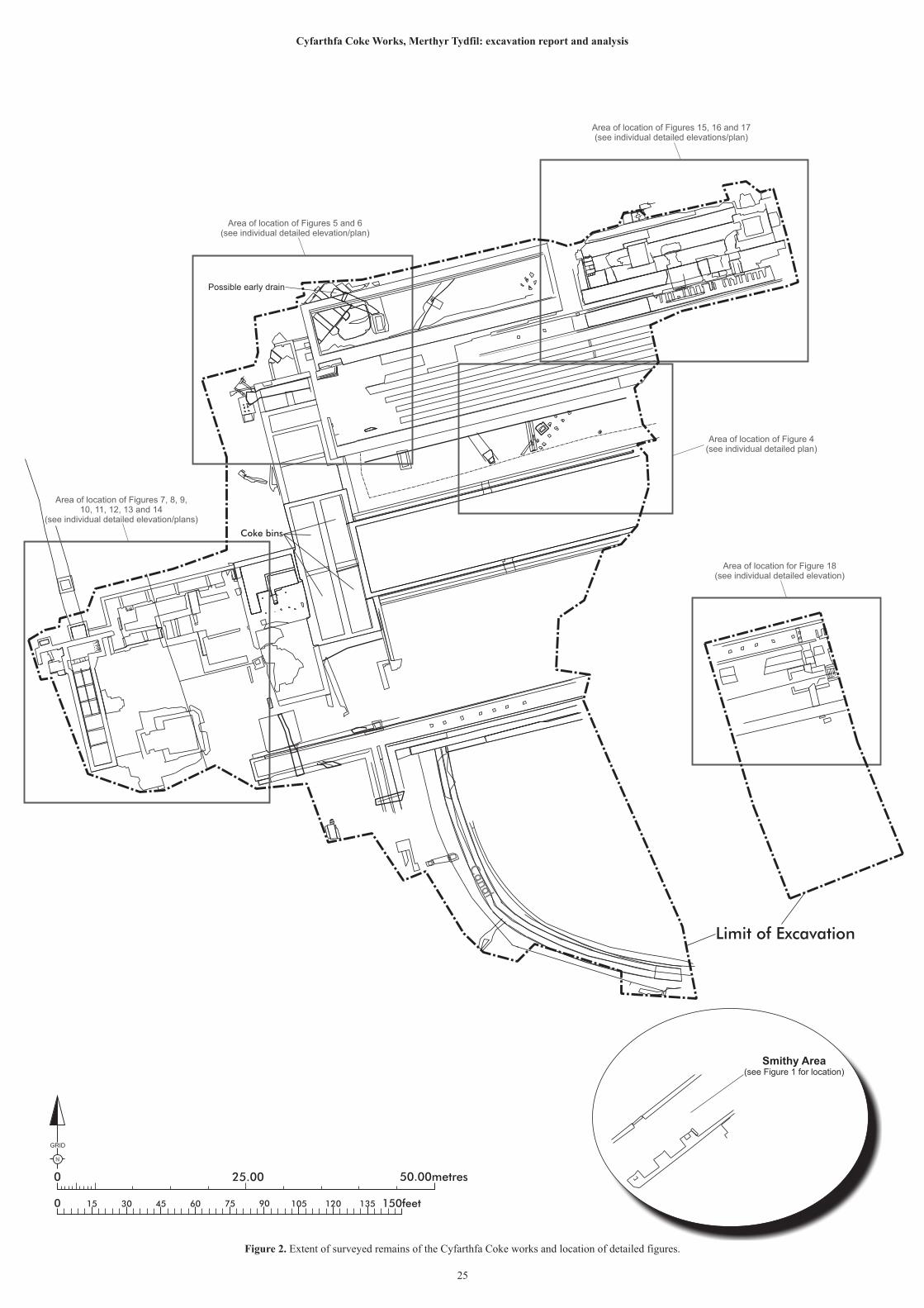
N
GRID
25.00 50.00metres0
0 150feet15 30 45 60 75 90 105 120 135
Area of location of Figures 7, 8, 9,10, 11, 12, 13 and 14
(see individual detailed elevation/plans)
Area of location of Figures 5 and 6(see individual detailed elevation/plan)
Area of location of Figure 4(see individual detailed plan)
Area of location of Figures 15, 16 and 17(see individual detailed elevations/plan)
Area of location for Figure 18(see individual detailed elevation)
Figure 2. Extent of surveyed remains of the Cyfarthfa Coke works and location of detailed figures.
25
Cyfarthfa Coke Works, Merthyr Tydfil: excavation report and analysis
Limit of Excavation
Canal
Coke bins
Smithy Area(see Figure 1 for location)
Possible early drain
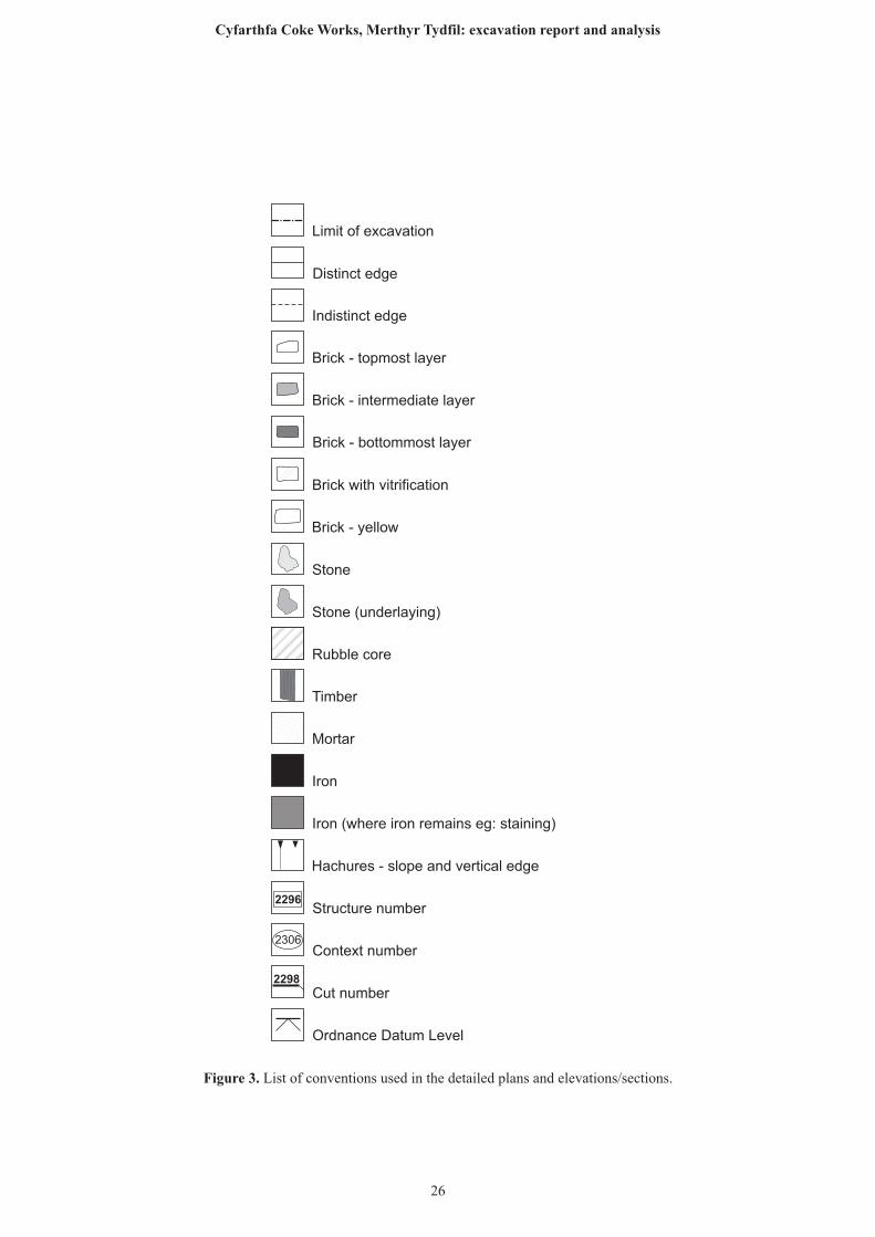
Brick - topmost layer
Brick - intermediate layer
Brick - bottommost layer
Stone
Limit of excavation
Distinct edge
Indistinct edge
Timber
Mortar
Iron
Brick with vitrification
Iron (where iron remains eg: staining)
Hachures - slope and vertical edge
Rubble core
Stone (underlaying)
Brick - yellow
Structure number
Context number
Cut number
Ordnance Datum Level
2298
2306
2296
Figure 3. List of conventions used in the detailed plans and elevations/sections.
26
Cyfarthfa Coke Works, Merthyr Tydfil: excavation report and analysis
Cyfarthfa Coke Works, Merthyr Tydfil: excavation report and analysis
27
5 Phase 1. 1766 to circa 1840
The earliest archaeological activity noted on site was associated with the operation of the
Cyfarthfa Ironworks by Anthony Bacon in the latter part of the 18th century. The evidence
consisted of a curving section of canal exposed in the south of the site. Despite a lack of
artefactual evidence, phasing was established through its relationship with later features,
supported by very limited documentary evidence.
Prior to the construction of the canal, ironstone and coal was brought to the site by road, carried
in panniers on the backs of donkeys and ponies (Pedler 1930 p.26). The pack horse method
was replaced rapidly by the construction of a canal, and given that canals were already in use
in Anthony Bacon’s home region of Salop, it was probably always the intention to construct
one for Cyfarthfa. The canal provided the main means of transporting raw materials for the
ironworks, remaining in use apparently until the 1830s (Hadfield quoted in Gross 2001, p.xxii)
although see Pedler, below. The canal seems to have been constructed after the time of Charles
Wood, the diary keeping engineer who supervised the initial construction of the works, as no
mention is made in the diary, the surviving portions of which date from 1766 to 1767, of a
canal. This dates the canal construction to after 1767 and before 1795, when it is shown on the
estate map of Lord Dynevor (Plate 2). However, it is likely that the canal in fact belongs to the
period before Anthony Bacon’s death in 1786, when the works passed to the control of the
Crawshays. Pedler believed the date of construction to be between 1780 and 1790, when
mining operations in the Canaid Valley, located south of the development area, began in
earnest. However, a brief legal reference, concerning a lease of land by Anthony Bacon from
one Ann Richard dated 14th October 1777 mentions “a Piece of Land used as a Coaking [sic]
Bank, with a Piece of Wood Gro’d [sic] adjoining, at Cyfarthfa Furnace, also the Land under
the Canal, and the Land taken for a road on the Lower side therof…” (Lloyd 1906 p.49). From
this reference it seems that the canal supplying coal and other raw materials to the area used
for coking was certainly in existence in or before 1777.
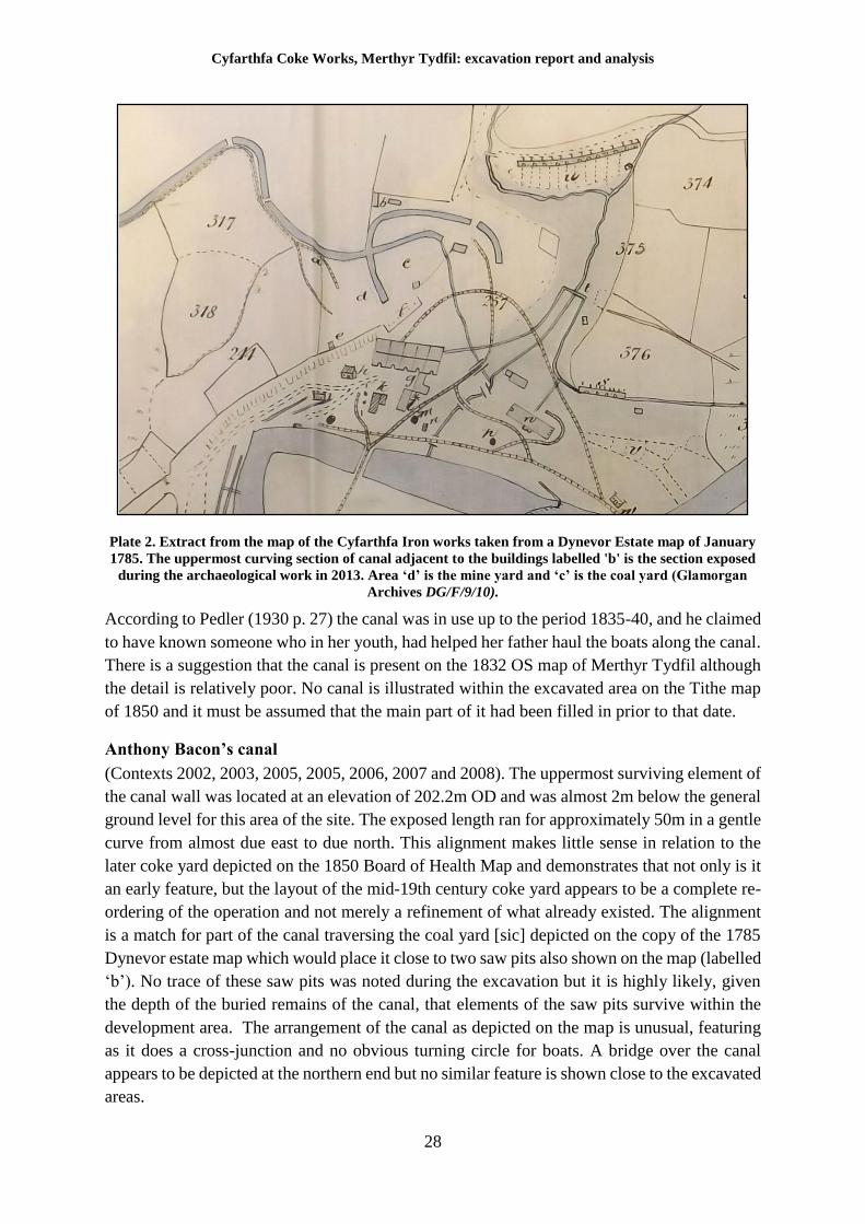
Cyfarthfa Coke Works, Merthyr Tydfil: excavation report and analysis
28
Plate 2. Extract from the map of the Cyfarthfa Iron works taken from a Dynevor Estate map of January
1785. The uppermost curving section of canal adjacent to the buildings labelled 'b' is the section exposed
during the archaeological work in 2013. Area ‘d’ is the mine yard and ‘c’ is the coal yard (Glamorgan
Archives DG/F/9/10).
According to Pedler (1930 p. 27) the canal was in use up to the period 1835-40, and he claimed
to have known someone who in her youth, had helped her father haul the boats along the canal.
There is a suggestion that the canal is present on the 1832 OS map of Merthyr Tydfil although
the detail is relatively poor. No canal is illustrated within the excavated area on the Tithe map
of 1850 and it must be assumed that the main part of it had been filled in prior to that date.
Anthony Bacon’s canal
(Contexts 2002, 2003, 2005, 2005, 2006, 2007 and 2008). The uppermost surviving element of
the canal wall was located at an elevation of 202.2m OD and was almost 2m below the general
ground level for this area of the site. The exposed length ran for approximately 50m in a gentle
curve from almost due east to due north. This alignment makes little sense in relation to the
later coke yard depicted on the 1850 Board of Health Map and demonstrates that not only is it
an early feature, but the layout of the mid-19th century coke yard appears to be a complete re-
ordering of the operation and not merely a refinement of what already existed. The alignment
is a match for part of the canal traversing the coal yard [sic] depicted on the copy of the 1785
Dynevor estate map which would place it close to two saw pits also shown on the map (labelled
‘b’). No trace of these saw pits was noted during the excavation but it is highly likely, given
the depth of the buried remains of the canal, that elements of the saw pits survive within the
development area. The arrangement of the canal as depicted on the map is unusual, featuring
as it does a cross-junction and no obvious turning circle for boats. A bridge over the canal
appears to be depicted at the northern end but no similar feature is shown close to the excavated
areas.
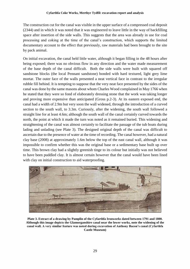
Cyfarthfa Coke Works, Merthyr Tydfil: excavation report and analysis
29
The construction cut for the canal was visible in the upper surface of a compressed coal deposit
(2344) and in which it was noted that it was engineered to leave little in the way of backfilling
space after insertion of the side walls. This suggests that the area was already in use for coal
processing and coking at the time of the canal’s construction, which supports the limited
documentary account to the effect that previously, raw materials had been brought to the site
by pack animal.
On initial excavation, the canal held little water, although it began filling in the 48 hours after
being exposed; there was no obvious flow in any direction and the water made measurement
of the base depth of the canal difficult. Both the side walls were built with squared off
sandstone blocks (the local Pennant sandstone) bonded with hard textured, light grey lime
mortar. The outer face of the walls presented a neat vertical face in contrast to the irregular
rubble fill behind. It is tempting to suppose that the very neat face presented by the sides of the
canal was done by the same masons about whom Charles Wood complained in May 1766 when
he stated that they were so fond of elaborately dressing stone that the work was taking longer
and proving more expensive than anticipated (Gross p.2-3). At its eastern exposed end, the
canal had a width of 2.9m but very soon the wall widened, through the introduction of a curved
section to the south wall, to 3.3m. Curiously, after the widening, the south wall followed a
straight line for at least 4.6m; although the south wall of the canal certainly curved towards the
north, the point at which it made the turn was noted as it remained buried. This widening and
straightening of the canal was almost certainly to facilitate the passage of the tub boats during
lading and unlading (see Plate 3). The designed original depth of the canal was difficult to
ascertain due to the presence of water at the time of recording. The canal however, had a natural
clay base (2008) at approximately 1.6m below the top of the east canal wall, although it was
impossible to confirm whether this was the original base or a sedimentary base built up over
time. This brown clay had a slightly greenish tinge to its colour but initially was not believed
to have been puddled clay. It is almost certain however that the canal would have been lined
with clay on initial construction to aid waterproofing.
Plate 3. Extract of a drawing by Pamplin of the Cyfarthfa Ironworks dated between 1791 and 1800.
Although this image depicts the Glamorganshire canal near the lower works, note the widening of the
canal wall. A very similar feature was noted during excavation of Anthony Bacon’s canal (Cyfarthfa
Castle Museum)
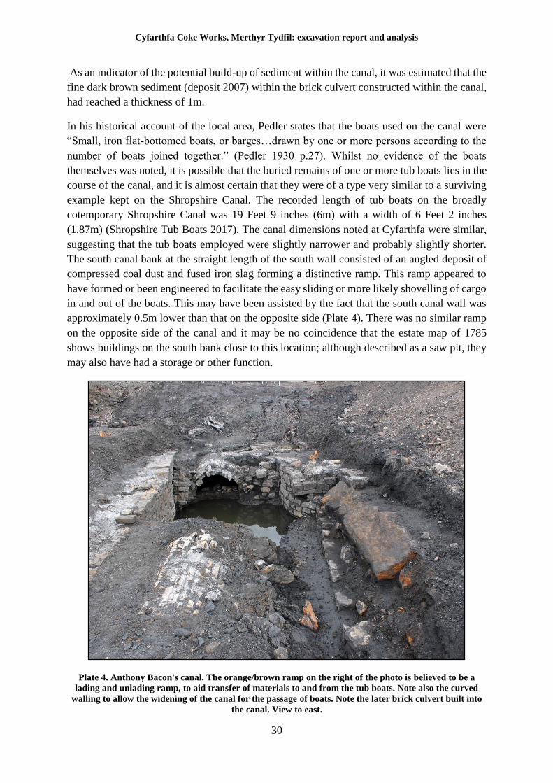
Cyfarthfa Coke Works, Merthyr Tydfil: excavation report and analysis
30
As an indicator of the potential build-up of sediment within the canal, it was estimated that the
fine dark brown sediment (deposit 2007) within the brick culvert constructed within the canal,
had reached a thickness of 1m.
In his historical account of the local area, Pedler states that the boats used on the canal were
“Small, iron flat-bottomed boats, or barges…drawn by one or more persons according to the
number of boats joined together.” (Pedler 1930 p.27). Whilst no evidence of the boats
themselves was noted, it is possible that the buried remains of one or more tub boats lies in the
course of the canal, and it is almost certain that they were of a type very similar to a surviving
example kept on the Shropshire Canal. The recorded length of tub boats on the broadly
cotemporary Shropshire Canal was 19 Feet 9 inches (6m) with a width of 6 Feet 2 inches
(1.87m) (Shropshire Tub Boats 2017). The canal dimensions noted at Cyfarthfa were similar,
suggesting that the tub boats employed were slightly narrower and probably slightly shorter.
The south canal bank at the straight length of the south wall consisted of an angled deposit of
compressed coal dust and fused iron slag forming a distinctive ramp. This ramp appeared to
have formed or been engineered to facilitate the easy sliding or more likely shovelling of cargo
in and out of the boats. This may have been assisted by the fact that the south canal wall was
approximately 0.5m lower than that on the opposite side (Plate 4). There was no similar ramp
on the opposite side of the canal and it may be no coincidence that the estate map of 1785
shows buildings on the south bank close to this location; although described as a saw pit, they
may also have had a storage or other function.
Plate 4. Anthony Bacon's canal. The orange/brown ramp on the right of the photo is believed to be a
lading and unlading ramp, to aid transfer of materials to and from the tub boats. Note also the curved
walling to allow the widening of the canal for the passage of boats. Note the later brick culvert built into
the canal. View to east.
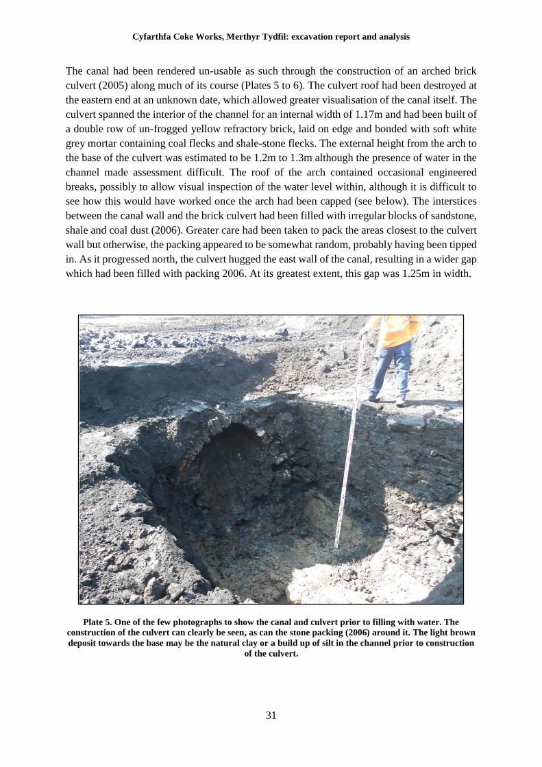
Cyfarthfa Coke Works, Merthyr Tydfil: excavation report and analysis
31
The canal had been rendered un-usable as such through the construction of an arched brick
culvert (2005) along much of its course (Plates 5 to 6). The culvert roof had been destroyed at
the eastern end at an unknown date, which allowed greater visualisation of the canal itself. The
culvert spanned the interior of the channel for an internal width of 1.17m and had been built of
a double row of un-frogged yellow refractory brick, laid on edge and bonded with soft white
grey mortar containing coal flecks and shale-stone flecks. The external height from the arch to
the base of the culvert was estimated to be 1.2m to 1.3m although the presence of water in the
channel made assessment difficult. The roof of the arch contained occasional engineered
breaks, possibly to allow visual inspection of the water level within, although it is difficult to
see how this would have worked once the arch had been capped (see below). The interstices
between the canal wall and the brick culvert had been filled with irregular blocks of sandstone,
shale and coal dust (2006). Greater care had been taken to pack the areas closest to the culvert
wall but otherwise, the packing appeared to be somewhat random, probably having been tipped
in. As it progressed north, the culvert hugged the east wall of the canal, resulting in a wider gap
which had been filled with packing 2006. At its greatest extent, this gap was 1.25m in width.
Plate 5. One of the few photographs to show the canal and culvert prior to filling with water. The
construction of the culvert can clearly be seen, as can the stone packing (2006) around it. The light brown
deposit towards the base may be the natural clay or a build up of silt in the channel prior to construction
of the culvert.
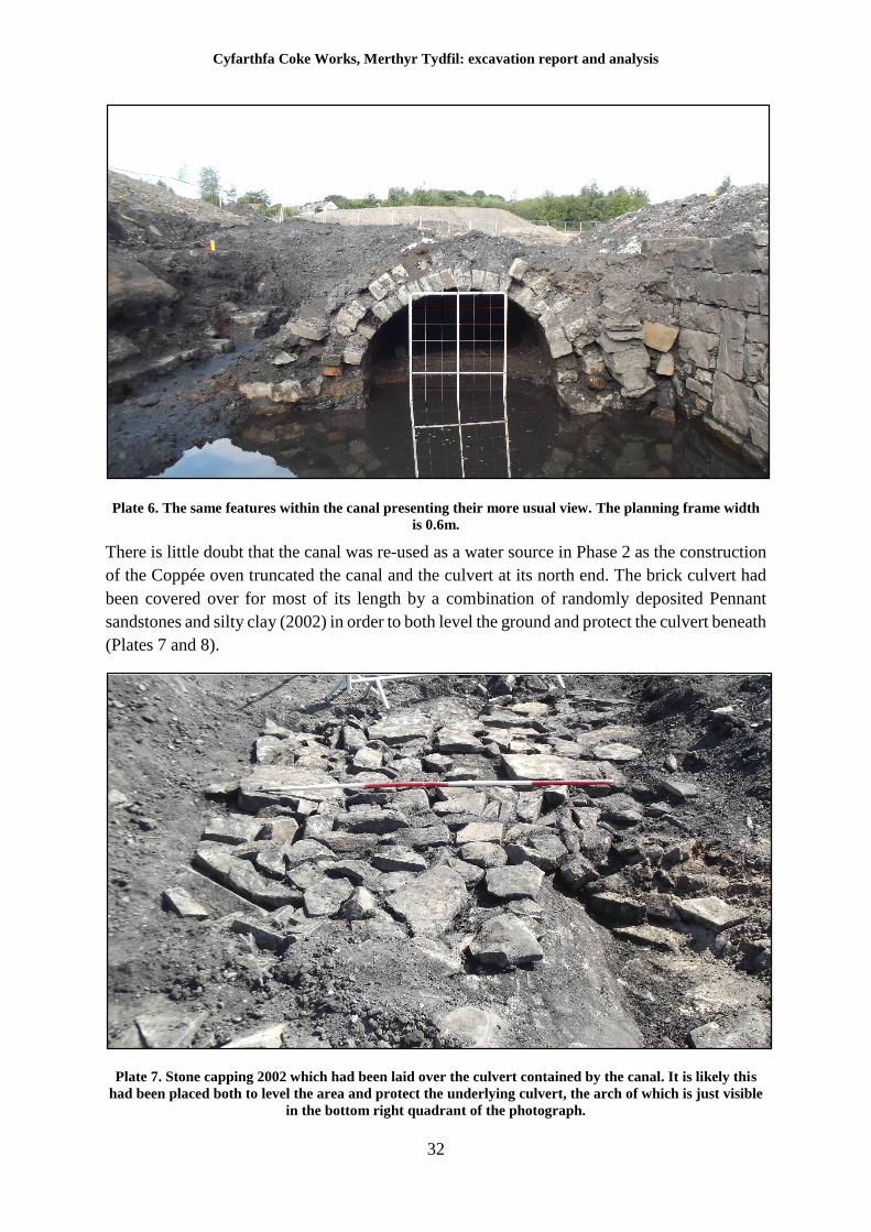
Cyfarthfa Coke Works, Merthyr Tydfil: excavation report and analysis
32
Plate 6. The same features within the canal presenting their more usual view. The planning frame width
is 0.6m.
There is little doubt that the canal was re-used as a water source in Phase 2 as the construction
of the Coppée oven truncated the canal and the culvert at its north end. The brick culvert had
been covered over for most of its length by a combination of randomly deposited Pennant
sandstones and silty clay (2002) in order to both level the ground and protect the culvert beneath
(Plates 7 and 8).
Plate 7. Stone capping 2002 which had been laid over the culvert contained by the canal. It is likely this
had been placed both to level the area and protect the underlying culvert, the arch of which is just visible
in the bottom right quadrant of the photograph.
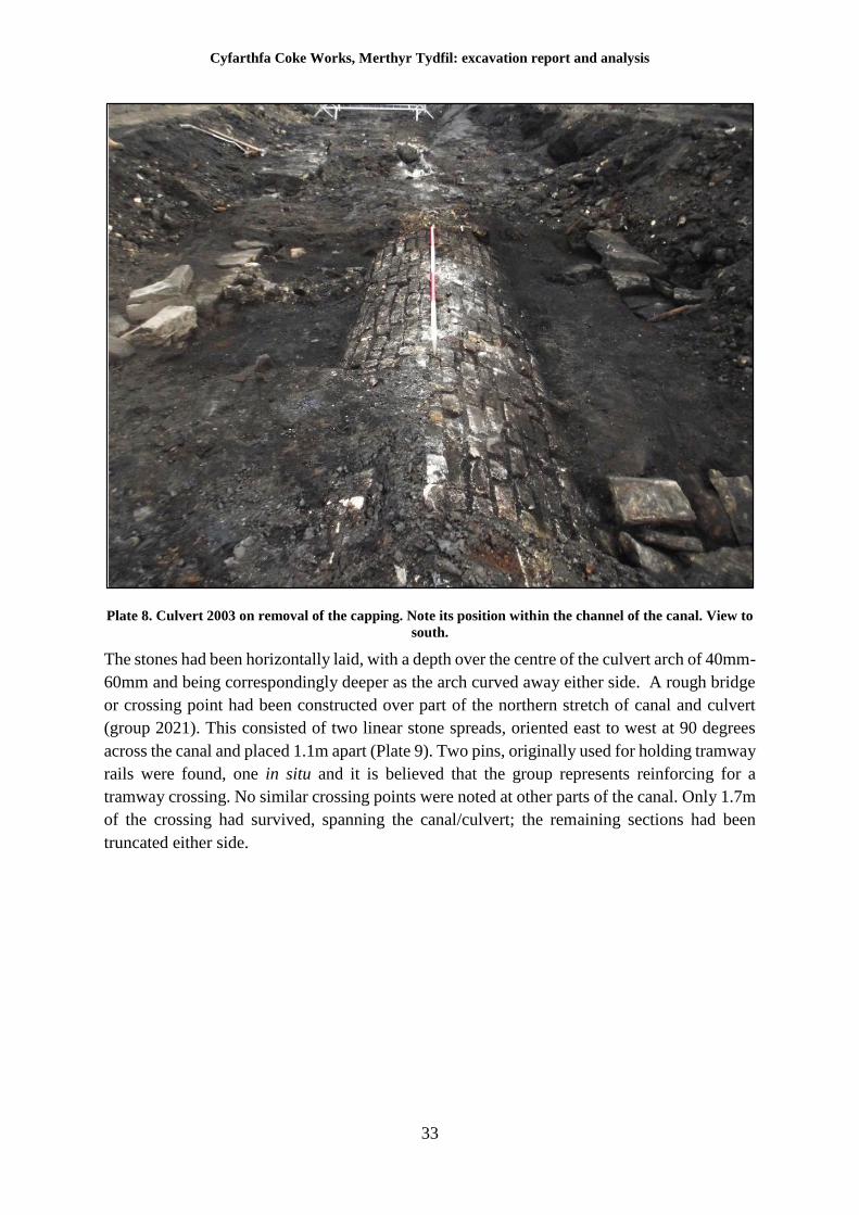
Cyfarthfa Coke Works, Merthyr Tydfil: excavation report and analysis
33
Plate 8. Culvert 2003 on removal of the capping. Note its position within the channel of the canal. View to
south.
The stones had been horizontally laid, with a depth over the centre of the culvert arch of 40mm-
60mm and being correspondingly deeper as the arch curved away either side. A rough bridge
or crossing point had been constructed over part of the northern stretch of canal and culvert
(group 2021). This consisted of two linear stone spreads, oriented east to west at 90 degrees
across the canal and placed 1.1m apart (Plate 9). Two pins, originally used for holding tramway
rails were found, one in situ and it is believed that the group represents reinforcing for a
tramway crossing. No similar crossing points were noted at other parts of the canal. Only 1.7m
of the crossing had survived, spanning the canal/culvert; the remaining sections had been
truncated either side.
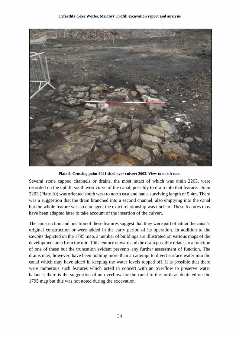
Cyfarthfa Coke Works, Merthyr Tydfil: excavation report and analysis
34
Plate 9. Crossing point 2021 sited over culvert 2003. View to north east.
Several stone capped channels or drains, the most intact of which was drain 2203, were
recorded on the uphill, south west curve of the canal, possibly to drain into that feature. Drain
2203 (Plate 10) was oriented south west to north east and had a surviving length of 5.4m. There
was a suggestion that the drain branched into a second channel, also emptying into the canal
but the whole feature was so damaged, the exact relationship was unclear. These features may
have been adapted later to take account of the insertion of the culvert.
The construction and position of these features suggest that they were part of either the canal’s
original construction or were added in the early period of its operation. In addition to the
sawpits depicted on the 1795 map, a number of buildings are illustrated on various maps of the
development area from the mid-19th century onward and the drain possibly relates to a function
of one of these but the truncation evident prevents any further assessment of function. The
drains may, however, have been nothing more than an attempt to divert surface water into the
canal which may have aided in keeping the water levels topped off. It is possible that there
were numerous such features which acted in concert with an overflow to preserve water
balance; there is the suggestion of an overflow for the canal to the north as depicted on the
1795 map but this was not noted during the excavation.
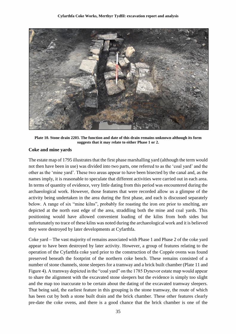
Cyfarthfa Coke Works, Merthyr Tydfil: excavation report and analysis
35
Plate 10. Stone drain 2203. The function and date of this drain remains unknown although its form
suggests that it may relate to either Phase 1 or 2.
Coke and mine yards
The estate map of 1795 illustrates that the first phase marshalling yard (although the term would
not then have been in use) was divided into two parts, one referred to as the ‘coal yard’ and the
other as the ‘mine yard’. These two areas appear to have been bisected by the canal and, as the
names imply, it is reasonable to speculate that different activities were carried out in each area.
In terms of quantity of evidence, very little dating from this period was encountered during the
archaeological work. However, those features that were recorded allow us a glimpse of the
activity being undertaken in the area during the first phase, and each is discussed separately
below. A range of six “mine kilns”, probably for roasting the iron ore prior to smelting, are
depicted at the north east edge of the area, straddling both the mine and coal yards. This
positioning would have allowed convenient loading of the kilns from both sides but
unfortunately no trace of these kilns was noted during the archaeological work and it is believed
they were destroyed by later developments at Cyfarthfa.
Coke yard – The vast majority of remains associated with Phase 1 and Phase 2 of the coke yard
appear to have been destroyed by later activity. However, a group of features relating to the
operation of the Cyfarthfa coke yard prior to the construction of the Coppée ovens was found
preserved beneath the footprint of the northern coke bench. These remains consisted of a
number of stone channels, stone sleepers for a tramway and a brick built chamber (Plate 11 and
Figure 4). A tramway depicted in the “coal yard” on the 1785 Dynevor estate map would appear
to share the alignment with the excavated stone sleepers but the evidence is simply too slight
and the map too inaccurate to be certain about the dating of the excavated tramway sleepers.
That being said, the earliest feature in this grouping is the stone tramway, the route of which
has been cut by both a stone built drain and the brick chamber. These other features clearly
pre-date the coke ovens, and there is a good chance that the brick chamber is one of the
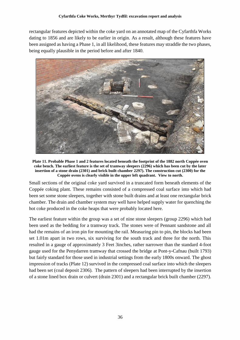
Cyfarthfa Coke Works, Merthyr Tydfil: excavation report and analysis
36
rectangular features depicted within the coke yard on an annotated map of the Cyfarthfa Works
dating to 1856 and are likely to be earlier in origin. As a result, although these features have
been assigned as having a Phase 1, in all likelihood, these features may straddle the two phases,
being equally plausible in the period before and after 1840.
Plate 11. Probable Phase 1 and 2 features located beneath the footprint of the 1882 north Coppée oven
coke bench. The earliest feature is the set of tramway sleepers (2296) which has been cut by the later
insertion of a stone drain (2301) and brick built chamber 2297). The construction cut (2300) for the
Coppée ovens is clearly visible in the upper left quadrant. View to north.
Small sections of the original coke yard survived in a truncated form beneath elements of the
Coppée coking plant. These remains consisted of a compressed coal surface into which had
been set some stone sleepers, together with stone built drains and at least one rectangular brick
chamber. The drain and chamber system may well have helped supply water for quenching the
hot coke produced in the coke heaps that were probably located here.
The earliest feature within the group was a set of nine stone sleepers (group 2296) which had
been used as the bedding for a tramway track. The stones were of Pennant sandstone and all
had the remains of an iron pin for mounting the rail. Measuring pin to pin, the blocks had been
set 1.01m apart in two rows, six surviving for the south track and three for the north. This
resulted in a gauge of approximately 3 Feet 3inches, rather narrower than the standard 4-foot
gauge used for the Penydarren tramway that crossed the bridge at Pont-y-Cafnau (built 1793)
but fairly standard for those used in industrial settings from the early 1800s onward. The ghost
impression of tracks (Plate 12) survived in the compressed coal surface into which the sleepers
had been set (coal deposit 2306). The pattern of sleepers had been interrupted by the insertion
of a stone lined box drain or culvert (drain 2301) and a rectangular brick built chamber (2297).
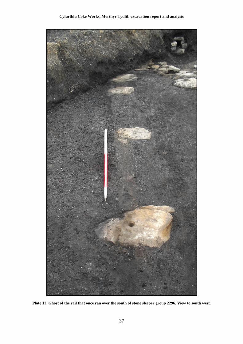
Cyfarthfa Coke Works, Merthyr Tydfil: excavation report and analysis
37
Plate 12. Ghost of the rail that once ran over the south of stone sleeper group 2296. View to south west.
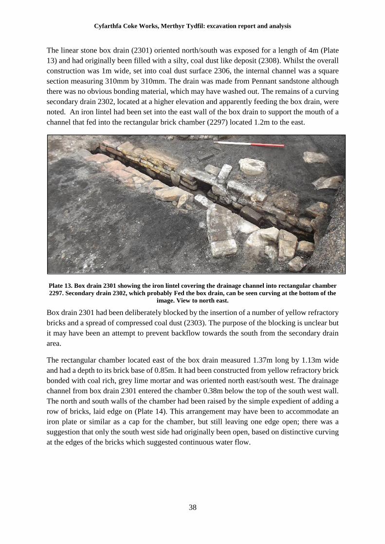
Cyfarthfa Coke Works, Merthyr Tydfil: excavation report and analysis
38
The linear stone box drain (2301) oriented north/south was exposed for a length of 4m (Plate
13) and had originally been filled with a silty, coal dust like deposit (2308). Whilst the overall
construction was 1m wide, set into coal dust surface 2306, the internal channel was a square
section measuring 310mm by 310mm. The drain was made from Pennant sandstone although
there was no obvious bonding material, which may have washed out. The remains of a curving
secondary drain 2302, located at a higher elevation and apparently feeding the box drain, were
noted. An iron lintel had been set into the east wall of the box drain to support the mouth of a
channel that fed into the rectangular brick chamber (2297) located 1.2m to the east.
Plate 13. Box drain 2301 showing the iron lintel covering the drainage channel into rectangular chamber
2297. Secondary drain 2302, which probably Fed the box drain, can be seen curving at the bottom of the
image. View to north east.
Box drain 2301 had been deliberately blocked by the insertion of a number of yellow refractory
bricks and a spread of compressed coal dust (2303). The purpose of the blocking is unclear but
it may have been an attempt to prevent backflow towards the south from the secondary drain
area.
The rectangular chamber located east of the box drain measured 1.37m long by 1.13m wide
and had a depth to its brick base of 0.85m. It had been constructed from yellow refractory brick
bonded with coal rich, grey lime mortar and was oriented north east/south west. The drainage
channel from box drain 2301 entered the chamber 0.38m below the top of the south west wall.
The north and south walls of the chamber had been raised by the simple expedient of adding a
row of bricks, laid edge on (Plate 14). This arrangement may have been to accommodate an
iron plate or similar as a cap for the chamber, but still leaving one edge open; there was a
suggestion that only the south west side had originally been open, based on distinctive curving
at the edges of the bricks which suggested continuous water flow.
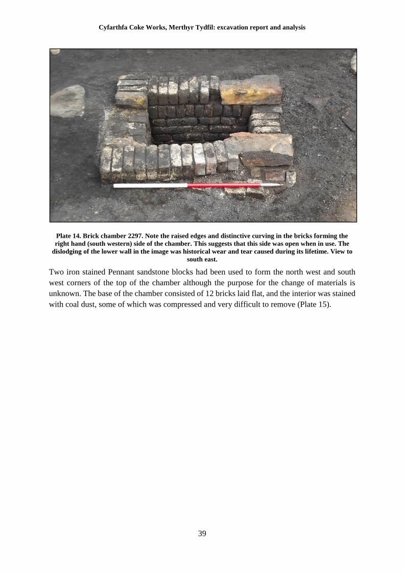
Cyfarthfa Coke Works, Merthyr Tydfil: excavation report and analysis
39
Plate 14. Brick chamber 2297. Note the raised edges and distinctive curving in the bricks forming the
right hand (south western) side of the chamber. This suggests that this side was open when in use. The
dislodging of the lower wall in the image was historical wear and tear caused during its lifetime. View to
south east.
Two iron stained Pennant sandstone blocks had been used to form the north west and south
west corners of the top of the chamber although the purpose for the change of materials is
unknown. The base of the chamber consisted of 12 bricks laid flat, and the interior was stained
with coal dust, some of which was compressed and very difficult to remove (Plate 15).
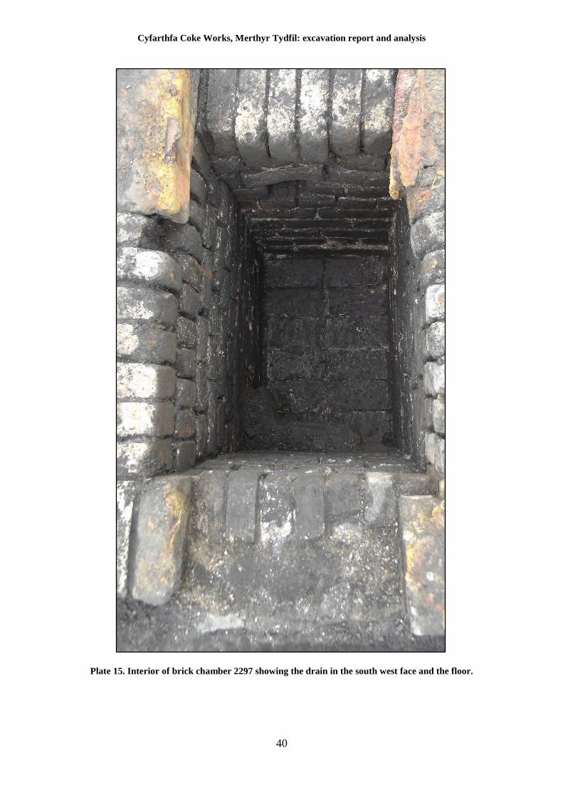
Cyfarthfa Coke Works, Merthyr Tydfil: excavation report and analysis
40
Plate 15. Interior of brick chamber 2297 showing the drain in the south west face and the floor.
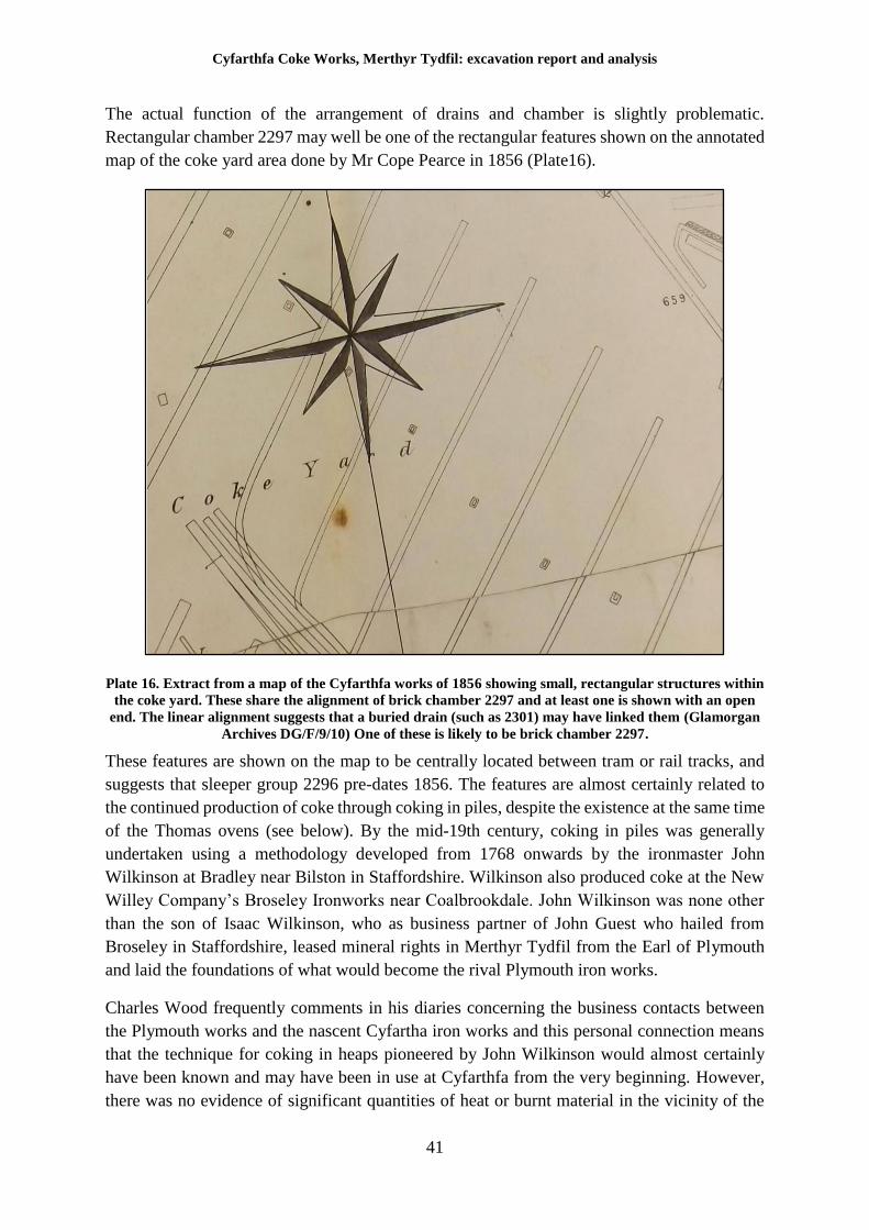
Cyfarthfa Coke Works, Merthyr Tydfil: excavation report and analysis
41
The actual function of the arrangement of drains and chamber is slightly problematic.
Rectangular chamber 2297 may well be one of the rectangular features shown on the annotated
map of the coke yard area done by Mr Cope Pearce in 1856 (Plate16).
Plate 16. Extract from a map of the Cyfarthfa works of 1856 showing small, rectangular structures within
the coke yard. These share the alignment of brick chamber 2297 and at least one is shown with an open
end. The linear alignment suggests that a buried drain (such as 2301) may have linked them (Glamorgan
Archives DG/F/9/10) One of these is likely to be brick chamber 2297.
These features are shown on the map to be centrally located between tram or rail tracks, and
suggests that sleeper group 2296 pre-dates 1856. The features are almost certainly related to
the continued production of coke through coking in piles, despite the existence at the same time
of the Thomas ovens (see below). By the mid-19th century, coking in piles was generally
undertaken using a methodology developed from 1768 onwards by the ironmaster John
Wilkinson at Bradley near Bilston in Staffordshire. Wilkinson also produced coke at the New
Willey Company’s Broseley Ironworks near Coalbrookdale. John Wilkinson was none other
than the son of Isaac Wilkinson, who as business partner of John Guest who hailed from
Broseley in Staffordshire, leased mineral rights in Merthyr Tydfil from the Earl of Plymouth
and laid the foundations of what would become the rival Plymouth iron works.
Charles Wood frequently comments in his diaries concerning the business contacts between
the Plymouth works and the nascent Cyfartha iron works and this personal connection means
that the technique for coking in heaps pioneered by John Wilkinson would almost certainly
have been known and may have been in use at Cyfarthfa from the very beginning. However,
there was no evidence of significant quantities of heat or burnt material in the vicinity of the
Cyfarthfa Coke Works, Merthyr Tydfil: excavation report and analysis
42
surviving chamber. Neither did chamber 2297 resemble in any way, previously documented
examples of the structures associated with coking in heaps (Jackson 2008). However, all coking
required prodigious quantities of water in order to arrest combustion of the coke and the clear
associations of the chamber with drain 2301 suggest that the features actually related to the
supply and use of water for this purpose. It is possible that each of the brick chambers acted as
a reservoir supplied by drain 2301. As the channels gradually clogged with coal dust, additional
channels, such as 2302, may have been constructed to augment the flow, with remedial work
such as blocking being carried out to compensate for the changes. Contrary to previous belief,
there is no evidence from the map of 1856 for the existence of beehive ovens, and it is likely
that Cyfarthfa transitioned somewhat slowly from coking in heaps. Indeed, according to Paul
Jackson, the technique of coking in heaps was retained, probably out of necessity, at some
locations in Britain until after the Second World War, and there is every likelihood that both
methods were employed contemporaneously at Cyfarthfa until the construction of the Coppée
ovens in 1882. A similar transition appears to have occurred after the construction of the
Coppée ovens in 1882, when a battery of the earlier Thomas coke ovens appears to have been
retained in use (see below).
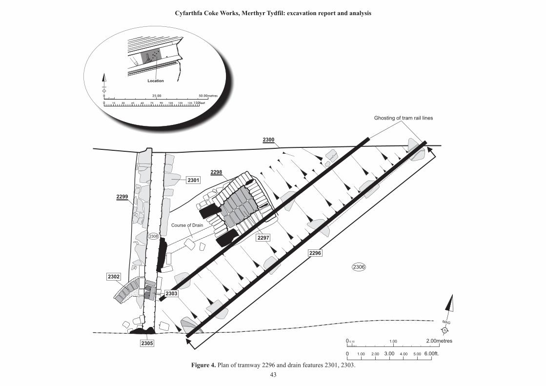
N
MAG
0 0.10 1.00 2.00metres
0 1.00 2.00 6.00ft.3.00 4.00 5.00
Course of Drain
Ghosting of tram rail lines
2308
2306
2297
2302
2301
2303
2305
2296
2300
2299
2298
25.00 50.00metres0
0 150feet15 30 45 60 75 90 105 120 135
N
GRID
Location
Figure 4. Plan of tramway 2296 and drain features 2301, 2303.
43
Cyfarthfa Coke Works, Merthyr Tydfil: excavation report and analysis
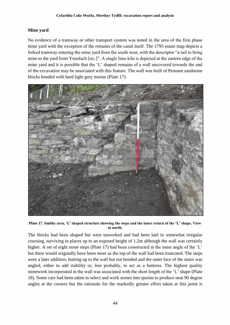
Cyfarthfa Coke Works, Merthyr Tydfil: excavation report and analysis
44
Mine yard
No evidence of a tramway or other transport system was noted in the area of the first phase
mine yard with the exception of the remains of the canal itself. The 1795 estate map depicts a
forked tramway entering the mine yard from the south west, with the descriptor “a rail to bring
mine to the yard from Ynusfach [sic.]”. A single lime kiln is depicted at the eastern edge of the
mine yard and it is possible that the ‘L’ shaped remains of a wall uncovered towards the end
of the excavation may be associated with this feature. The wall was built of Pennant sandstone
blocks bonded with hard light grey mortar (Plate 17).
Plate 17. Smithy area, 'L' shaped structure showing the steps and the inner return of the ‘L’ shape. View
to north.
The blocks had been shaped but were unworked and had been laid in somewhat irregular
coursing, surviving in places up to an exposed height of 1.2m although the wall was certainly
higher. A set of eight stone steps (Plate 17) had been constructed at the inner angle of the ‘L’
but there would originally have been more as the top of the wall had been truncated. The steps
were a later addition, butting up to the wall but not bonded and the outer face of the stairs was
angled, either to add stability or, less probably, to act as a buttress. The highest quality
stonework incorporated in the wall was associated with the short length of the ‘L’ shape (Plate
18). Some care had been taken to select and work stones into quoins to produce neat 90 degree
angles at the corners but the rationale for the markedly greater effort taken at this point is
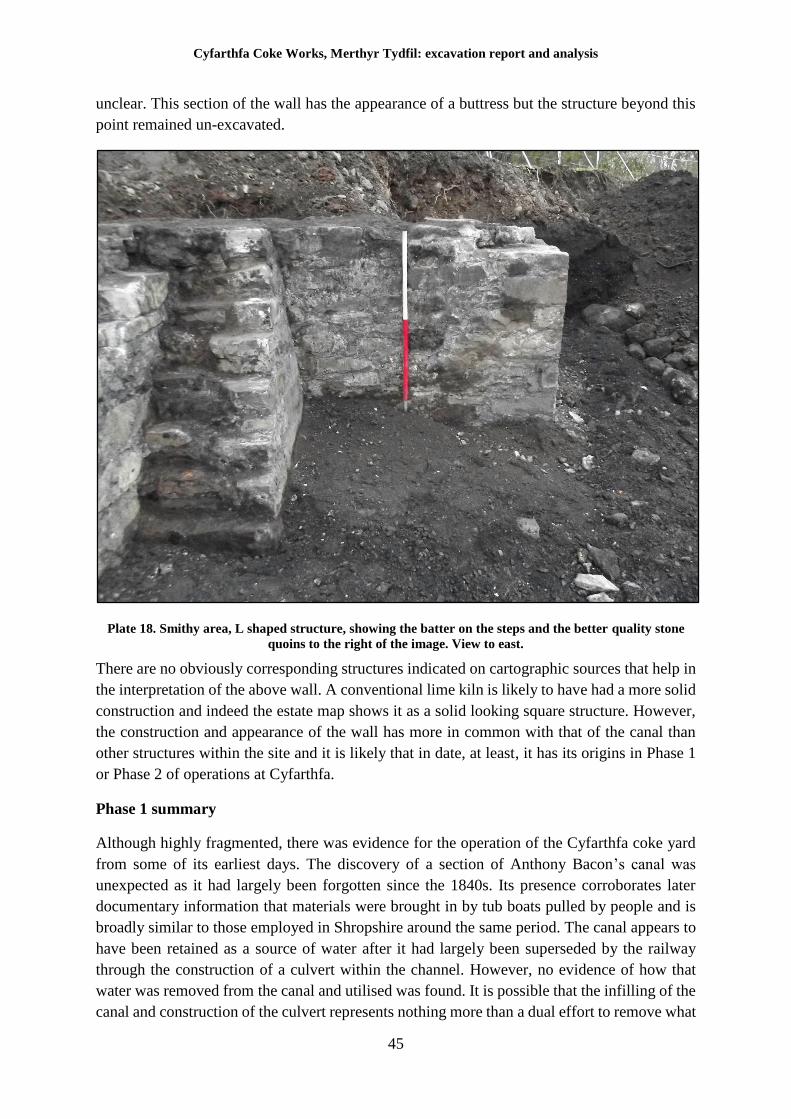
Cyfarthfa Coke Works, Merthyr Tydfil: excavation report and analysis
45
unclear. This section of the wall has the appearance of a buttress but the structure beyond this
point remained un-excavated.
Plate 18. Smithy area, L shaped structure, showing the batter on the steps and the better quality stone
quoins to the right of the image. View to east.
There are no obviously corresponding structures indicated on cartographic sources that help in
the interpretation of the above wall. A conventional lime kiln is likely to have had a more solid
construction and indeed the estate map shows it as a solid looking square structure. However,
the construction and appearance of the wall has more in common with that of the canal than
other structures within the site and it is likely that in date, at least, it has its origins in Phase 1
or Phase 2 of operations at Cyfarthfa.
Phase 1 summary
Although highly fragmented, there was evidence for the operation of the Cyfarthfa coke yard
from some of its earliest days. The discovery of a section of Anthony Bacon’s canal was
unexpected as it had largely been forgotten since the 1840s. Its presence corroborates later
documentary information that materials were brought in by tub boats pulled by people and is
broadly similar to those employed in Shropshire around the same period. The canal appears to
have been retained as a source of water after it had largely been superseded by the railway
through the construction of a culvert within the channel. However, no evidence of how that
water was removed from the canal and utilised was found. It is possible that the infilling of the
canal and construction of the culvert represents nothing more than a dual effort to remove what
Cyfarthfa Coke Works, Merthyr Tydfil: excavation report and analysis
46
was in effect an obstacle dividing the coke yard, and to contain the flow of water within the
canal, which would otherwise be difficult to divert. As the canal was reputed to have been in
use until the 1840s, the culvert work must date to the mid-19th century and more properly
belongs to Phase 2. The main surviving section of stone tram road sleepers possibly also date
to this period; they are certainly one of the earlier features noted on the site and circumstantially
may be related to a tramway noted on the 1795 estate map of the Cyfarthfa works.
The ‘L’ shaped wall noted towards the end of the archaeological work may relate to the
presence of an early lime kiln but not enough was exposed to be certain. No artefacts datable
to Phase 1 were recovered from the site.
All phase 1 features were reburied following recording with the exception of the possible
limekiln wall, which was subject to preservation by record.
Cyfarthfa Coke Works, Merthyr Tydfil: excavation report and analysis
47
6 Phase 2. Circa 1840 to 1882
Based on cartographic differences between the Board of Health Map of 1851 and an annotated
map of 1856, it is quite likely that a group of coking ovens, based on a specific design principle
and known as Welsh or Thomas ovens, were constructed between these dates, representing a
technological shift in the operation of the iron works. The storage areas depicted on mapping
at the west perimeter of the site appear to have become redundant or at least significantly less
utilised around this time. Other features appear to have been retained, however; the fact though
that the rectangular chambers associated with the former coking yard are depicted, as well as
the retention of extensive area of tramway suggests that coking in long piles may have
continued in use either as an interim or a supplementary means of producing coke. Certainly,
John Percy (1875) stated in his treatise on Metallurgy that he had seen coking in long piles
“practiced largely at Cyfarthfa, Lowmoor and elsewhere.” As Percy had visited these sites in
the 1850s and 60s this clearly suggests that use of both the ovens and piles were
contemporaneous (see Phase 1 above).
Thomas ovens
The remains of a row of early coking ovens were found beneath the north wall of the north
battery of Coppée coke ovens. These remains shared an alignment with coke ovens depicted
on mid-19th century cartographic sources and which had been demolished to make way for the
Coppée ovens constructed in 1882. The 1851 Board of Health map of Merthyr Tydfil depicts
the coke yard area but does not depict these features; a map of the Cyfarthfa works dated to
1856 does show them. This strongly suggests that the ovens were built in the five years between
1851 and 1856. The recorded remains consisted of a series of brick floors showing extensive
heat damage, with limestone elements located at the peripheries and at the southern elevation
of the row. Several ‘D’ shaped iron fittings are likely to have been stays that indicated the
position of a door mechanism. The internal divisions between each chamber were visible as
damaged areas of brickwork but none of the divisions survived above floor level. There was
evidence that the coking bench, i.e. the working surface where hot coke was pushed/pulled out
of the ovens and doused with water to arrest combustion was located on the south side of the
ovens. No evidence was noted for the presence of a steam rammer on the north side of the
ovens although contemporary sources (Percy 1875) state that the coke at Cyfarthfa was indeed
pushed out of the coke ovens by a “suitable apparatus, capable of being moved on a railway
along the back of a single row of ovens”. It must be assumed that the pusher mechanism and
rails were removed on demolition of the Thomas ovens.
Thomas ovens were described by John Percy in his treatise on metallurgy as one of a number
of non-recovery oven designs in use at the time but all ovens of this type were essentially an
intermediate technology bridging the gap between coking in piles, beehive ovens and the later
more massive coke ovens introduced in the 1860s and 1870s. Thomas ovens are sometimes
referred to as Welsh ovens as their development appears to have been conducted primarily in
South Wales, where for a time they appear to have been the dominant form of coke oven.
Relatively little is known about the operation of Thomas ovens, for the simple reason that they
were a transitional technology and as far as is known, the Cyfarthfa examples remain the only
Thomas ovens to have been examined archaeologically.
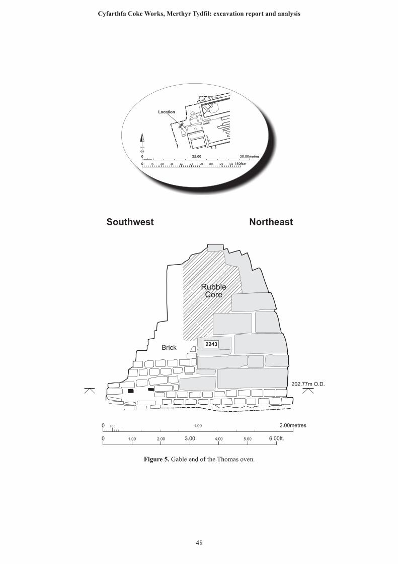
0 0.10 1.00 2.00metres
0 1.00 2.00 6.00ft.3.00 4.00 5.00
RubbleCore
202.77m O.D.
Southwest Northeast
Brick2243
25.00 50.00metres0
0 150feet15 30 45 60 75 90 105 120 135
N
GRID
Location
Figure 5. Gable end of the Thomas oven.
48
Cyfarthfa Coke Works, Merthyr Tydfil: excavation report and analysis
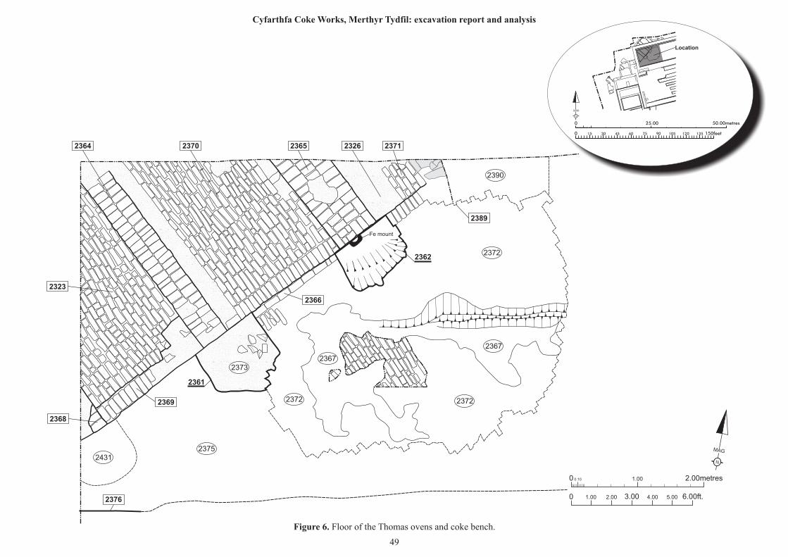
N
MAG
0 0.10 1.00 2.00metres
0 1.00 2.00 6.00ft.3.00 4.00 5.00
Fe mount
23722372
2372
2367
2367
2390
23752431
2373
2362
2361
2368
2376
2369
2366
2389
2323
2364 2370 2365 2326 2371
25.00 50.00metres0
0 150feet15 30 45 60 75 90 105 120 135
N
GRID
Location
Figure 6. Floor of the Thomas ovens and coke bench.
49
Cyfarthfa Coke Works, Merthyr Tydfil: excavation report and analysis
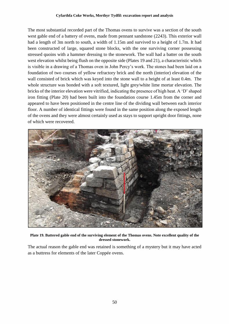
Cyfarthfa Coke Works, Merthyr Tydfil: excavation report and analysis
50
The most substantial recorded part of the Thomas ovens to survive was a section of the south
west gable end of a battery of ovens, made from pennant sandstone (2243). This exterior wall
had a length of 3m north to south, a width of 1.15m and survived to a height of 1.7m. It had
been constructed of large, squared stone blocks, with the one surviving corner possessing
stressed quoins with a hammer dressing to the stonework. The wall had a batter on the south
west elevation whilst being flush on the opposite side (Plates 19 and 21), a characteristic which
is visible in a drawing of a Thomas oven in John Percy’s work. The stones had been laid on a
foundation of two courses of yellow refractory brick and the north (interior) elevation of the
wall consisted of brick which was keyed into the stone wall to a height of at least 0.4m. The
whole structure was bonded with a soft textured, light grey/white lime mortar elevation. The
bricks of the interior elevation were vitrified, indicating the presence of high heat. A ‘D’ shaped
iron fitting (Plate 20) had been built into the foundation course 1.45m from the corner and
appeared to have been positioned in the centre line of the dividing wall between each interior
floor. A number of identical fittings were found in the same position along the exposed length
of the ovens and they were almost certainly used as stays to support upright door fittings, none
of which were recovered.
Plate 19. Battered gable end of the surviving element of the Thomas ovens. Note excellent quality of the
dressed stonework.
The actual reason the gable end was retained is something of a mystery but it may have acted
as a buttress for elements of the later Coppée ovens.
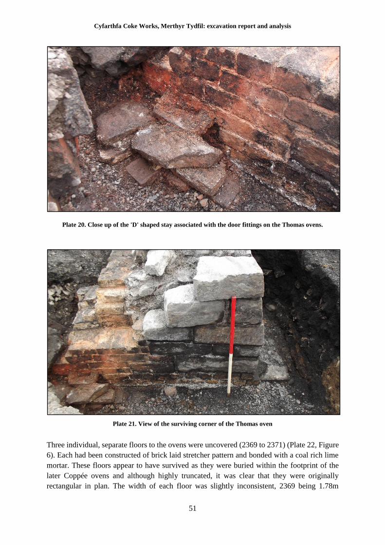
Cyfarthfa Coke Works, Merthyr Tydfil: excavation report and analysis
51
Plate 20. Close up of the 'D' shaped stay associated with the door fittings on the Thomas ovens.
Plate 21. View of the surviving corner of the Thomas oven
Three individual, separate floors to the ovens were uncovered (2369 to 2371) (Plate 22, Figure
6). Each had been constructed of brick laid stretcher pattern and bonded with a coal rich lime
mortar. These floors appear to have survived as they were buried within the footprint of the
later Coppée ovens and although highly truncated, it was clear that they were originally
rectangular in plan. The width of each floor was slightly inconsistent, 2369 being 1.78m
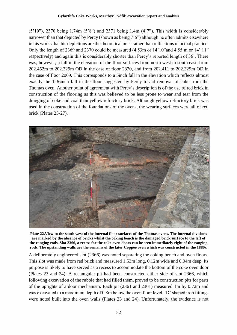
Cyfarthfa Coke Works, Merthyr Tydfil: excavation report and analysis
52
(5’10”), 2370 being 1.74m (5’8”) and 2371 being 1.4m (4’7”). This width is considerably
narrower than that depicted by Percy (shown as being 7’6”) although he often admits elsewhere
in his works that his depictions are the theoretical ones rather than reflections of actual practice.
Only the length of 2369 and 2370 could be measured (4.53m or 14’10”and 4.55 m or 14’ 11”
respectively) and again this is considerably shorter than Percy’s reported length of 36’. There
was, however, a fall in the elevation of the floor surfaces from north west to south east, from
202.452m to 202.329m OD in the case of floor 2370, and from 202.411 to 202.329m OD in
the case of floor 2069. This corresponds to a 5inch fall in the elevation which reflects almost
exactly the 1:36inch fall in the floor suggested by Percy to aid removal of coke from the
Thomas oven. Another point of agreement with Percy’s description is of the use of red brick in
construction of the flooring as this was believed to be less prone to wear and tear from the
dragging of coke and coal than yellow refractory brick. Although yellow refractory brick was
used in the construction of the foundations of the ovens, the wearing surfaces were all of red
brick (Plates 25-27).
Plate 22.View to the south west of the internal floor surfaces of the Thomas ovens. The internal divisions
are marked by the absence of bricks whilst the coking bench is the damaged brick surface to the left of
the ranging rods. Slot 2366, a recess for the coke oven doors can be seen immediately right of the ranging
rods. The upstanding walls are the remains of the later Coppée oven which was constructed in the 1880s.
A deliberately engineered slot (2366) was noted separating the coking bench and oven floors.
This slot was made from red brick and measured 1.53m long, 0.12m wide and 0.04m deep. Its
purpose is likely to have served as a recess to accommodate the bottom of the coke oven door
(Plates 23 and 24). A rectangular pit had been constructed either side of slot 2366, which
following excavation of the rubble that had filled them, proved to be construction pits for parts
of the uprights of a door mechanism. Each pit (2361 and 2361) measured 1m by 0.72m and
was excavated to a maximum depth of 0.8m below the oven floor level. ‘D’ shaped iron fittings
were noted built into the oven walls (Plates 23 and 24). Unfortunately, the evidence is not
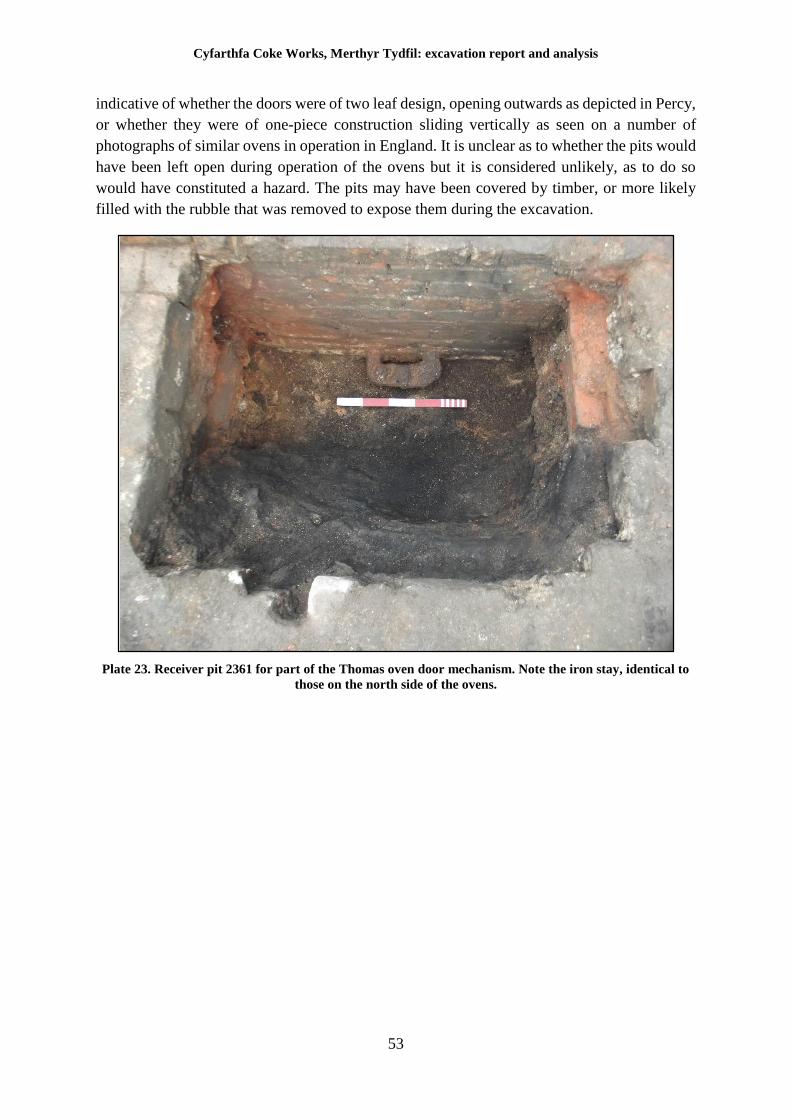
Cyfarthfa Coke Works, Merthyr Tydfil: excavation report and analysis
53
indicative of whether the doors were of two leaf design, opening outwards as depicted in Percy,
or whether they were of one-piece construction sliding vertically as seen on a number of
photographs of similar ovens in operation in England. It is unclear as to whether the pits would
have been left open during operation of the ovens but it is considered unlikely, as to do so
would have constituted a hazard. The pits may have been covered by timber, or more likely
filled with the rubble that was removed to expose them during the excavation.
Plate 23. Receiver pit 2361 for part of the Thomas oven door mechanism. Note the iron stay, identical to
those on the north side of the ovens.
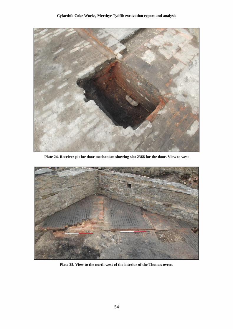
Cyfarthfa Coke Works, Merthyr Tydfil: excavation report and analysis
54
Plate 24. Receiver pit for door mechanism showing slot 2366 for the door. View to west
Plate 25. View to the north west of the interior of the Thomas ovens.
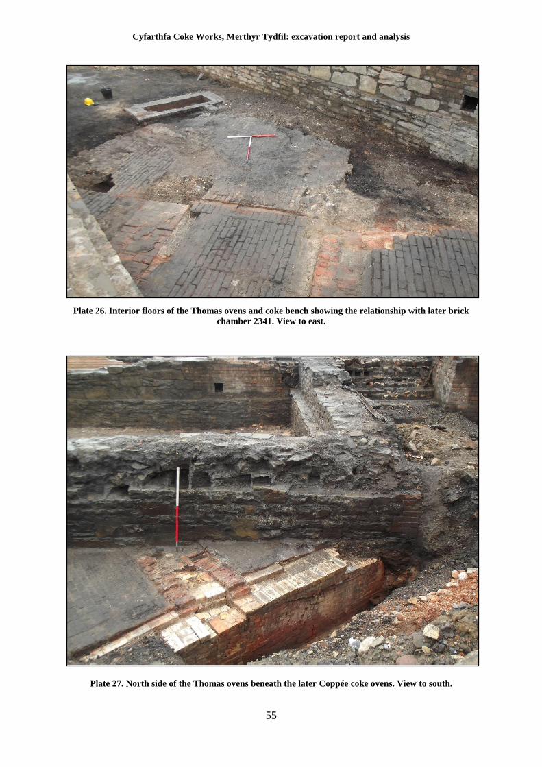
Cyfarthfa Coke Works, Merthyr Tydfil: excavation report and analysis
55
Plate 26. Interior floors of the Thomas ovens and coke bench showing the relationship with later brick
chamber 2341. View to east.
Plate 27. North side of the Thomas ovens beneath the later Coppée coke ovens. View to south.
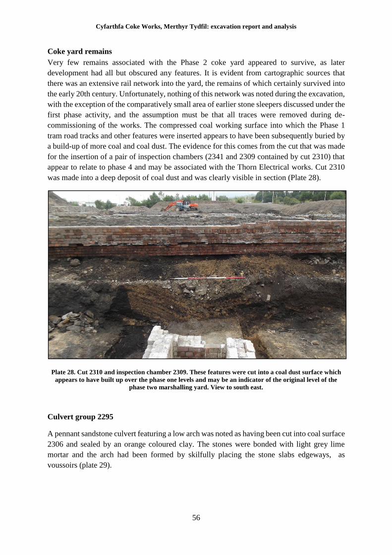
Cyfarthfa Coke Works, Merthyr Tydfil: excavation report and analysis
56
Coke yard remains
Very few remains associated with the Phase 2 coke yard appeared to survive, as later
development had all but obscured any features. It is evident from cartographic sources that
there was an extensive rail network into the yard, the remains of which certainly survived into
the early 20th century. Unfortunately, nothing of this network was noted during the excavation,
with the exception of the comparatively small area of earlier stone sleepers discussed under the
first phase activity, and the assumption must be that all traces were removed during de-
commissioning of the works. The compressed coal working surface into which the Phase 1
tram road tracks and other features were inserted appears to have been subsequently buried by
a build-up of more coal and coal dust. The evidence for this comes from the cut that was made
for the insertion of a pair of inspection chambers (2341 and 2309 contained by cut 2310) that
appear to relate to phase 4 and may be associated with the Thorn Electrical works. Cut 2310
was made into a deep deposit of coal dust and was clearly visible in section (Plate 28).
Plate 28. Cut 2310 and inspection chamber 2309. These features were cut into a coal dust surface which
appears to have built up over the phase one levels and may be an indicator of the original level of the
phase two marshalling yard. View to south east.
Culvert group 2295
A pennant sandstone culvert featuring a low arch was noted as having been cut into coal surface
2306 and sealed by an orange coloured clay. The stones were bonded with light grey lime
mortar and the arch had been formed by skilfully placing the stone slabs edgeways, as
voussoirs (plate 29).
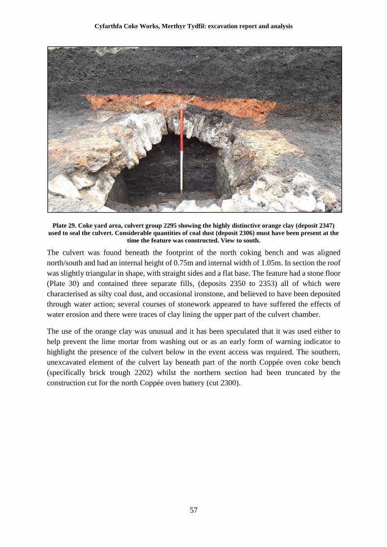
Cyfarthfa Coke Works, Merthyr Tydfil: excavation report and analysis
57
Plate 29. Coke yard area, culvert group 2295 showing the highly distinctive orange clay (deposit 2347)
used to seal the culvert. Considerable quantities of coal dust (deposit 2306) must have been present at the
time the feature was constructed. View to south.
The culvert was found beneath the footprint of the north coking bench and was aligned
north/south and had an internal height of 0.75m and internal width of 1.05m. In section the roof
was slightly triangular in shape, with straight sides and a flat base. The feature had a stone floor
(Plate 30) and contained three separate fills, (deposits 2350 to 2353) all of which were
characterised as silty coal dust, and occasional ironstone, and believed to have been deposited
through water action; several courses of stonework appeared to have suffered the effects of
water erosion and there were traces of clay lining the upper part of the culvert chamber.
The use of the orange clay was unusual and it has been speculated that it was used either to
help prevent the lime mortar from washing out or as an early form of warning indicator to
highlight the presence of the culvert below in the event access was required. The southern,
unexcavated element of the culvert lay beneath part of the north Coppée oven coke bench
(specifically brick trough 2202) whilst the northern section had been truncated by the
construction cut for the north Coppée oven battery (cut 2300).
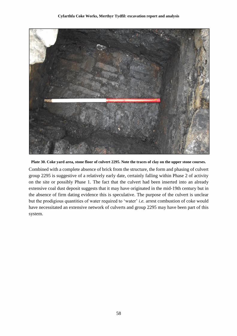
Cyfarthfa Coke Works, Merthyr Tydfil: excavation report and analysis
58
Plate 30. Coke yard area, stone floor of culvert 2295. Note the traces of clay on the upper stone courses.
Combined with a complete absence of brick from the structure, the form and phasing of culvert
group 2295 is suggestive of a relatively early date, certainly falling within Phase 2 of activity
on the site or possibly Phase 1. The fact that the culvert had been inserted into an already
extensive coal dust deposit suggests that it may have originated in the mid-19th century but in
the absence of firm dating evidence this is speculative. The purpose of the culvert is unclear
but the prodigious quantities of water required to ‘water’ i.e. arrest combustion of coke would
have necessitated an extensive network of culverts and group 2295 may have been part of this
system.
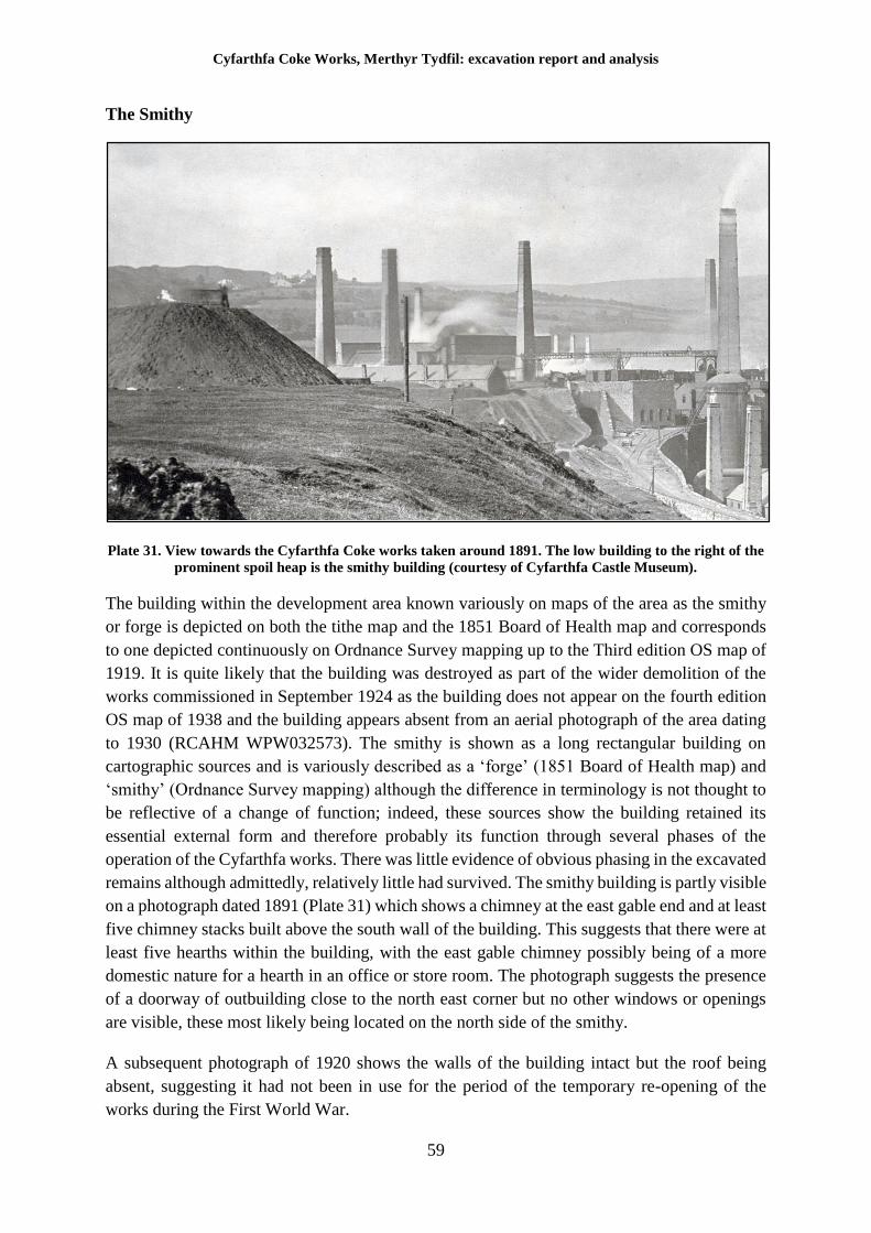
Cyfarthfa Coke Works, Merthyr Tydfil: excavation report and analysis
59
The Smithy
Plate 31. View towards the Cyfarthfa Coke works taken around 1891. The low building to the right of the
prominent spoil heap is the smithy building (courtesy of Cyfarthfa Castle Museum).
The building within the development area known variously on maps of the area as the smithy
or forge is depicted on both the tithe map and the 1851 Board of Health map and corresponds
to one depicted continuously on Ordnance Survey mapping up to the Third edition OS map of
1919. It is quite likely that the building was destroyed as part of the wider demolition of the
works commissioned in September 1924 as the building does not appear on the fourth edition
OS map of 1938 and the building appears absent from an aerial photograph of the area dating
to 1930 (RCAHM WPW032573). The smithy is shown as a long rectangular building on
cartographic sources and is variously described as a ‘forge’ (1851 Board of Health map) and
‘smithy’ (Ordnance Survey mapping) although the difference in terminology is not thought to
be reflective of a change of function; indeed, these sources show the building retained its
essential external form and therefore probably its function through several phases of the
operation of the Cyfarthfa works. There was little evidence of obvious phasing in the excavated
remains although admittedly, relatively little had survived. The smithy building is partly visible
on a photograph dated 1891 (Plate 31) which shows a chimney at the east gable end and at least
five chimney stacks built above the south wall of the building. This suggests that there were at
least five hearths within the building, with the east gable chimney possibly being of a more
domestic nature for a hearth in an office or store room. The photograph suggests the presence
of a doorway of outbuilding close to the north east corner but no other windows or openings
are visible, these most likely being located on the north side of the smithy.
A subsequent photograph of 1920 shows the walls of the building intact but the roof being
absent, suggesting it had not been in use for the period of the temporary re-opening of the
works during the First World War.
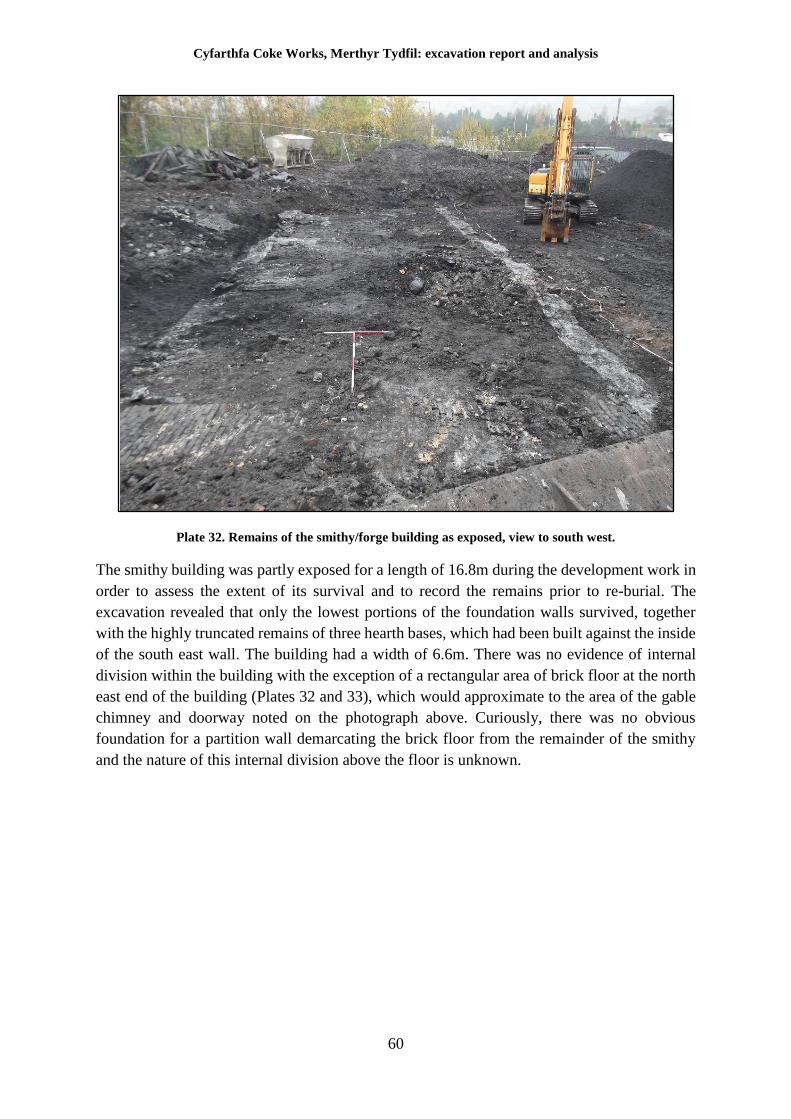
Cyfarthfa Coke Works, Merthyr Tydfil: excavation report and analysis
60
Plate 32. Remains of the smithy/forge building as exposed, view to south west.
The smithy building was partly exposed for a length of 16.8m during the development work in
order to assess the extent of its survival and to record the remains prior to re-burial. The
excavation revealed that only the lowest portions of the foundation walls survived, together
with the highly truncated remains of three hearth bases, which had been built against the inside
of the south east wall. The building had a width of 6.6m. There was no evidence of internal
division within the building with the exception of a rectangular area of brick floor at the north
east end of the building (Plates 32 and 33), which would approximate to the area of the gable
chimney and doorway noted on the photograph above. Curiously, there was no obvious
foundation for a partition wall demarcating the brick floor from the remainder of the smithy
and the nature of this internal division above the floor is unknown.
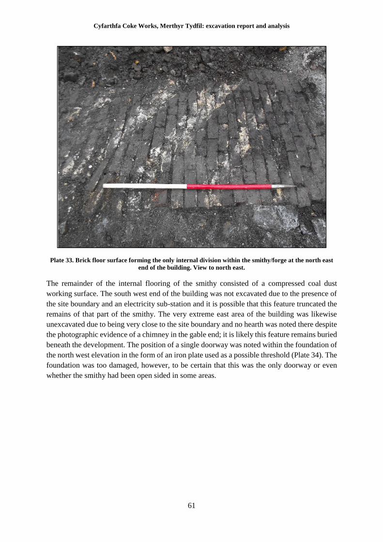
Cyfarthfa Coke Works, Merthyr Tydfil: excavation report and analysis
61
Plate 33. Brick floor surface forming the only internal division within the smithy/forge at the north east
end of the building. View to north east.
The remainder of the internal flooring of the smithy consisted of a compressed coal dust
working surface. The south west end of the building was not excavated due to the presence of
the site boundary and an electricity sub-station and it is possible that this feature truncated the
remains of that part of the smithy. The very extreme east area of the building was likewise
unexcavated due to being very close to the site boundary and no hearth was noted there despite
the photographic evidence of a chimney in the gable end; it is likely this feature remains buried
beneath the development. The position of a single doorway was noted within the foundation of
the north west elevation in the form of an iron plate used as a possible threshold (Plate 34). The
foundation was too damaged, however, to be certain that this was the only doorway or even
whether the smithy had been open sided in some areas.
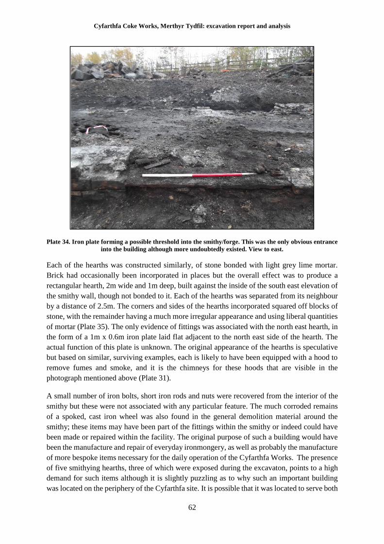
Cyfarthfa Coke Works, Merthyr Tydfil: excavation report and analysis
62
Plate 34. Iron plate forming a possible threshold into the smithy/forge. This was the only obvious entrance
into the building although more undoubtedly existed. View to east.
Each of the hearths was constructed similarly, of stone bonded with light grey lime mortar.
Brick had occasionally been incorporated in places but the overall effect was to produce a
rectangular hearth, 2m wide and 1m deep, built against the inside of the south east elevation of
the smithy wall, though not bonded to it. Each of the hearths was separated from its neighbour
by a distance of 2.5m. The corners and sides of the hearths incorporated squared off blocks of
stone, with the remainder having a much more irregular appearance and using liberal quantities
of mortar (Plate 35). The only evidence of fittings was associated with the north east hearth, in
the form of a 1m x 0.6m iron plate laid flat adjacent to the north east side of the hearth. The
actual function of this plate is unknown. The original appearance of the hearths is speculative
but based on similar, surviving examples, each is likely to have been equipped with a hood to
remove fumes and smoke, and it is the chimneys for these hoods that are visible in the
photograph mentioned above (Plate 31).
A small number of iron bolts, short iron rods and nuts were recovered from the interior of the
smithy but these were not associated with any particular feature. The much corroded remains
of a spoked, cast iron wheel was also found in the general demolition material around the
smithy; these items may have been part of the fittings within the smithy or indeed could have
been made or repaired within the facility. The original purpose of such a building would have
been the manufacture and repair of everyday ironmongery, as well as probably the manufacture
of more bespoke items necessary for the daily operation of the Cyfarthfa Works. The presence
of five smithying hearths, three of which were exposed during the excavaton, points to a high
demand for such items although it is slightly puzzling as to why such an important building
was located on the periphery of the Cyfarthfa site. It is possible that it was located to serve both
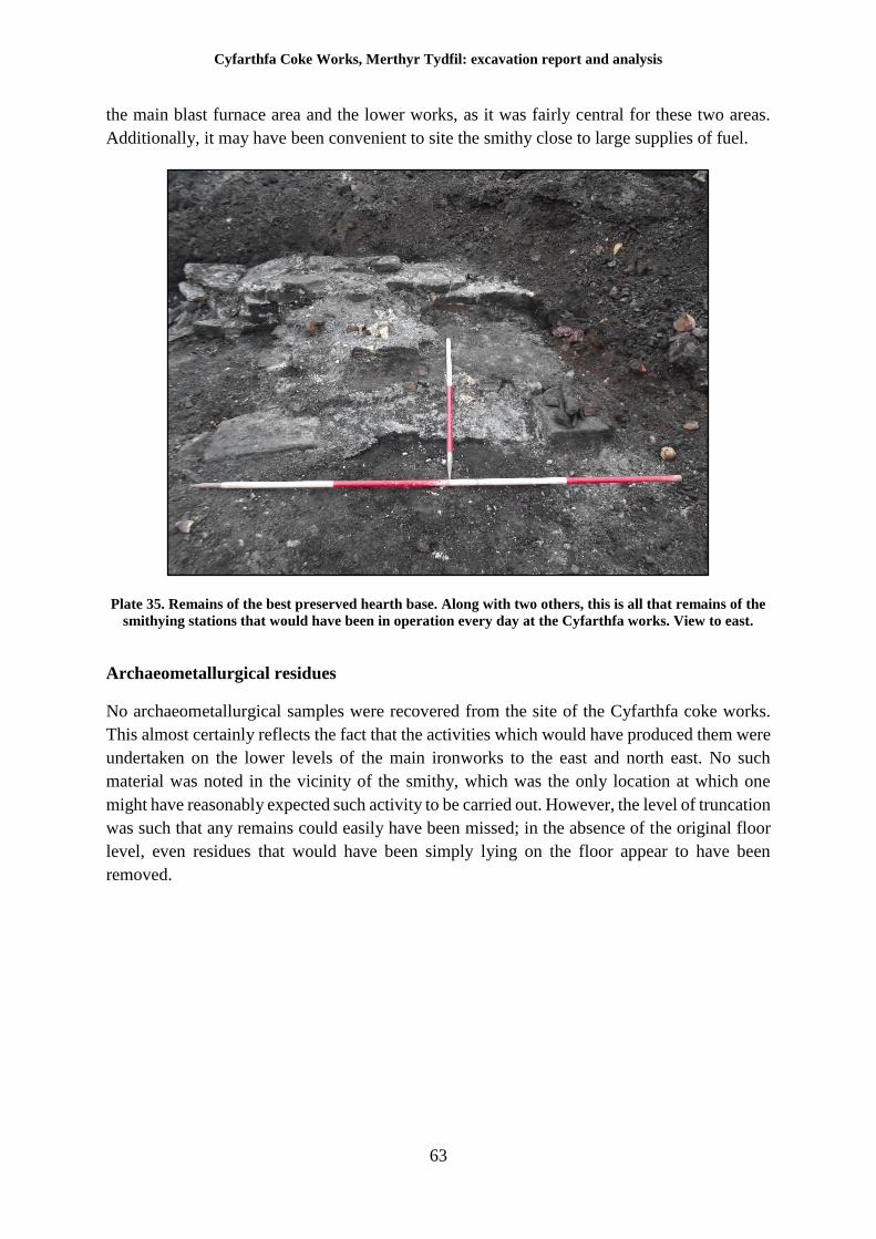
Cyfarthfa Coke Works, Merthyr Tydfil: excavation report and analysis
63
the main blast furnace area and the lower works, as it was fairly central for these two areas.
Additionally, it may have been convenient to site the smithy close to large supplies of fuel.
Plate 35. Remains of the best preserved hearth base. Along with two others, this is all that remains of the
smithying stations that would have been in operation every day at the Cyfarthfa works. View to east.
Archaeometallurgical residues
No archaeometallurgical samples were recovered from the site of the Cyfarthfa coke works.
This almost certainly reflects the fact that the activities which would have produced them were
undertaken on the lower levels of the main ironworks to the east and north east. No such
material was noted in the vicinity of the smithy, which was the only location at which one
might have reasonably expected such activity to be carried out. However, the level of truncation
was such that any remains could easily have been missed; in the absence of the original floor
level, even residues that would have been simply lying on the floor appear to have been
removed.
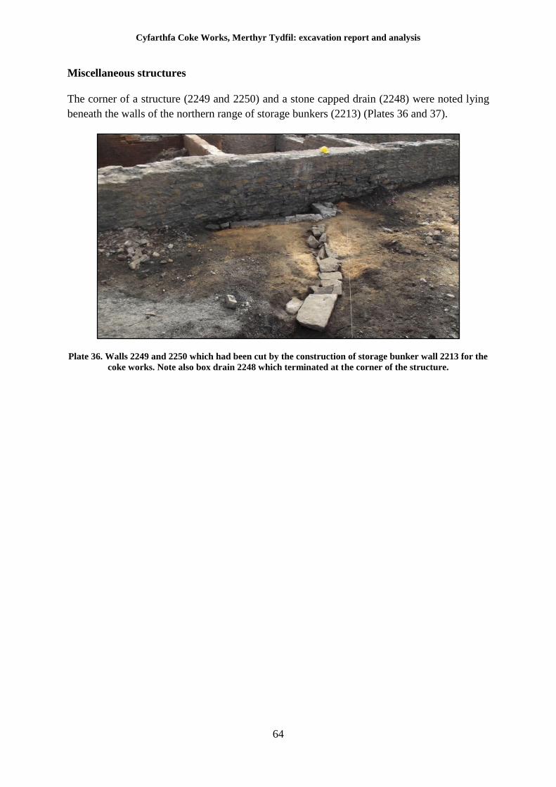
Cyfarthfa Coke Works, Merthyr Tydfil: excavation report and analysis
64
Miscellaneous structures
The corner of a structure (2249 and 2250) and a stone capped drain (2248) were noted lying
beneath the walls of the northern range of storage bunkers (2213) (Plates 36 and 37).
Plate 36. Walls 2249 and 2250 which had been cut by the construction of storage bunker wall 2213 for the
coke works. Note also box drain 2248 which terminated at the corner of the structure.
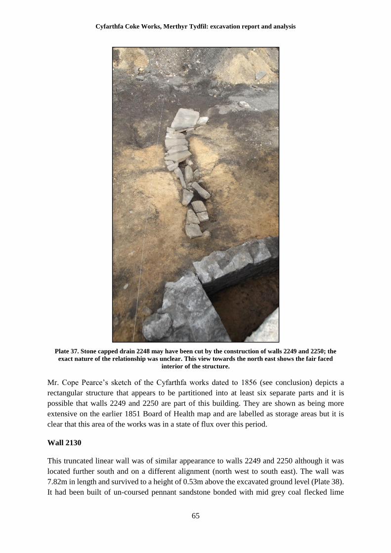
Cyfarthfa Coke Works, Merthyr Tydfil: excavation report and analysis
65
Plate 37. Stone capped drain 2248 may have been cut by the construction of walls 2249 and 2250; the
exact nature of the relationship was unclear. This view towards the north east shows the fair faced
interior of the structure.
Mr. Cope Pearce’s sketch of the Cyfarthfa works dated to 1856 (see conclusion) depicts a
rectangular structure that appears to be partitioned into at least six separate parts and it is
possible that walls 2249 and 2250 are part of this building. They are shown as being more
extensive on the earlier 1851 Board of Health map and are labelled as storage areas but it is
clear that this area of the works was in a state of flux over this period.
Wall 2130
This truncated linear wall was of similar appearance to walls 2249 and 2250 although it was
located further south and on a different alignment (north west to south east). The wall was
7.82m in length and survived to a height of 0.53m above the excavated ground level (Plate 38).
It had been built of un-coursed pennant sandstone bonded with mid grey coal flecked lime
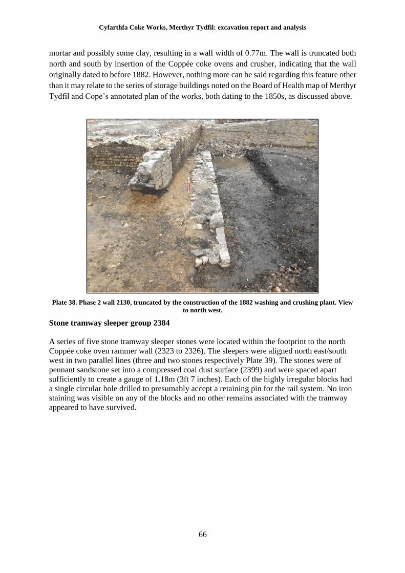
Cyfarthfa Coke Works, Merthyr Tydfil: excavation report and analysis
66
mortar and possibly some clay, resulting in a wall width of 0.77m. The wall is truncated both
north and south by insertion of the Coppée coke ovens and crusher, indicating that the wall
originally dated to before 1882. However, nothing more can be said regarding this feature other
than it may relate to the series of storage buildings noted on the Board of Health map of Merthyr
Tydfil and Cope’s annotated plan of the works, both dating to the 1850s, as discussed above.
Plate 38. Phase 2 wall 2130, truncated by the construction of the 1882 washing and crushing plant. View
to north west.
Stone tramway sleeper group 2384
A series of five stone tramway sleeper stones were located within the footprint to the north
Coppée coke oven rammer wall (2323 to 2326). The sleepers were aligned north east/south
west in two parallel lines (three and two stones respectively Plate 39). The stones were of
pennant sandstone set into a compressed coal dust surface (2399) and were spaced apart
sufficiently to create a gauge of 1.18m (3ft 7 inches). Each of the highly irregular blocks had
a single circular hole drilled to presumably accept a retaining pin for the rail system. No iron
staining was visible on any of the blocks and no other remains associated with the tramway
appeared to have survived.
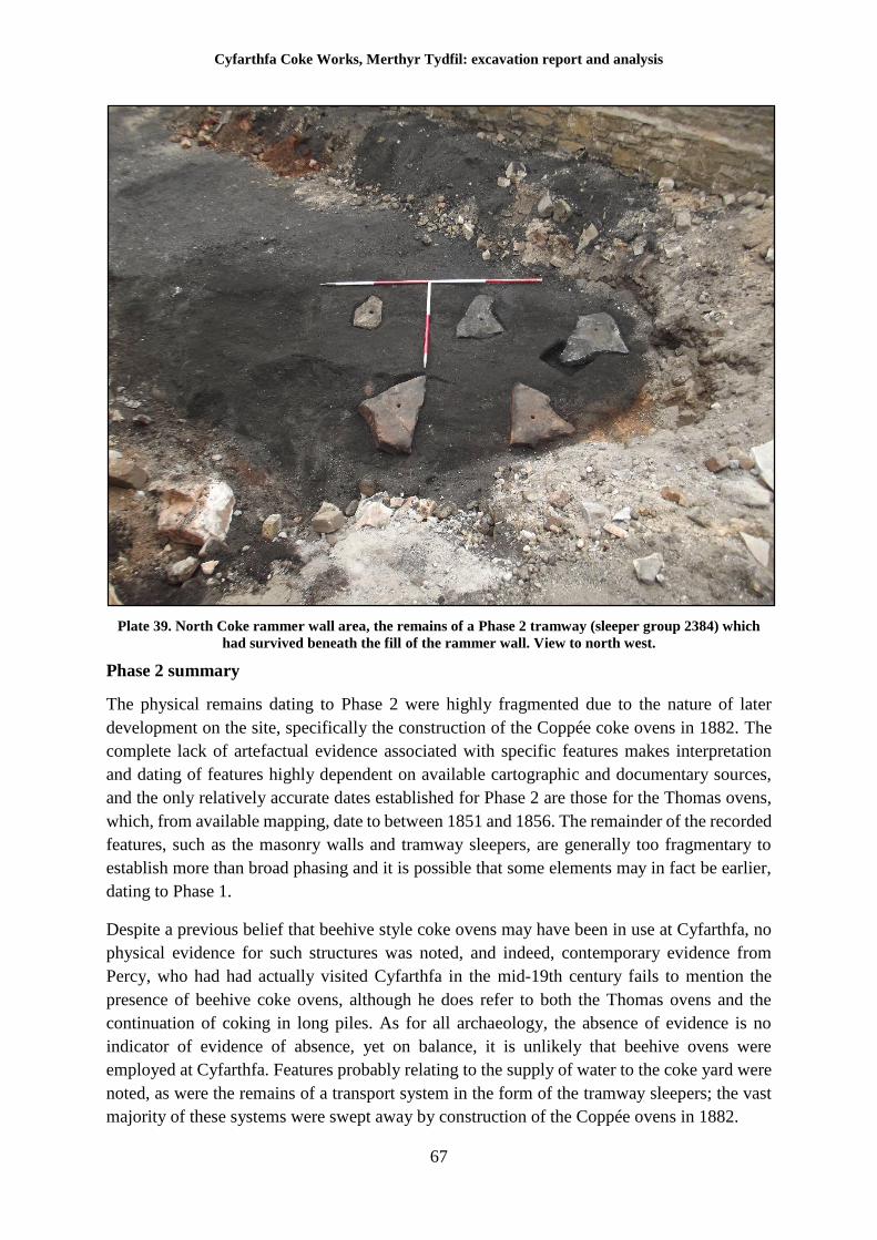
Cyfarthfa Coke Works, Merthyr Tydfil: excavation report and analysis
67
Plate 39. North Coke rammer wall area, the remains of a Phase 2 tramway (sleeper group 2384) which
had survived beneath the fill of the rammer wall. View to north west.
Phase 2 summary
The physical remains dating to Phase 2 were highly fragmented due to the nature of later
development on the site, specifically the construction of the Coppée coke ovens in 1882. The
complete lack of artefactual evidence associated with specific features makes interpretation
and dating of features highly dependent on available cartographic and documentary sources,
and the only relatively accurate dates established for Phase 2 are those for the Thomas ovens,
which, from available mapping, date to between 1851 and 1856. The remainder of the recorded
features, such as the masonry walls and tramway sleepers, are generally too fragmentary to
establish more than broad phasing and it is possible that some elements may in fact be earlier,
dating to Phase 1.
Despite a previous belief that beehive style coke ovens may have been in use at Cyfarthfa, no
physical evidence for such structures was noted, and indeed, contemporary evidence from
Percy, who had had actually visited Cyfarthfa in the mid-19th century fails to mention the
presence of beehive coke ovens, although he does refer to both the Thomas ovens and the
continuation of coking in long piles. As for all archaeology, the absence of evidence is no
indicator of evidence of absence, yet on balance, it is unlikely that beehive ovens were
employed at Cyfarthfa. Features probably relating to the supply of water to the coke yard were
noted, as were the remains of a transport system in the form of the tramway sleepers; the vast
majority of these systems were swept away by construction of the Coppée ovens in 1882.
Cyfarthfa Coke Works, Merthyr Tydfil: excavation report and analysis
68
6 Phase 3. 1882 to 1926
The majority of the area excavated as part of the archaeological works was dominated by the
remains of the coal washing and coking plant. A number of historical documentary sources
have been located that aid interpretation of the remains, and the salient points of each are
repeated below.
The Cyfarthfa works was extensively remodelled, beginning in 1882, to facilitate its conversion
from an iron works to a steel works. As part of this modernisation programme, a new coking
plant was installed, to replace the Welsh or Thomas ovens that had been used since the first
half of the 19th century, a move which also presumably marks the end of the use of coking in
long piles at the Cyfarthfa works. The operation of this new plant, built over the original coking
yards, is extensively described in an 1897 booklet (Crawshay Brothers (Cyfarthfa) 1897) which
is essentially an advertising prospectus released as part of the re-branding of the Cyfarthfa
works after its conversion to steel production. The section concerning the coking plant is
informative and is worth quoting in full.
“Coal Washing and Coking Plant – The Coal Washery is an exceedingly efficient plant, and gives very great
satisfaction. It deals easily with over 500 tons per shift, and the mixing, sizing and washing of the coal are all that
can be desired. The loss of coal due to washing is under 5 cwt. per 100 tons, while the refuse is very completely
eliminated, reducing the ash in the coke to a minimum.
A noteworthy feature of the plant, which otherwise possesses much in common with modern coal washing plant,
is the settling chamber, which dispenses with the usual settling ponds with their attendant trouble and expense in
cleaning out; enables the water to be used over and over again, and to which is due the very small amount of
waste. The nut and pea coals on leaving the washing machines, pass through a screen perforated to allow the water
to escape through to the settling chamber, and are elevated to a Carr’s disintegrator, where they are reduced to a
powder, and fall to the foot of a second elevator where they meet the duff coal from the settling chamber, and the
whole of the coals thus reduced to the required fineness, are raised to extensive storage bunkers capable of holding
about 600 tons of clean coal, fitted with distributing screws, by means of which the coal is taken to whichever
part required filling.
The arrangements at the coke plant are very complete. The ovens are of the Coppée type in two banks of 90 each,
and are fed with washed coal from the storage bunkers by means of conical dandies which pass underneath the
bunker, and are filled by means of slides in the bottom of it.
The dandies have sliding bottoms, through which, when open, the coal drops into the ovens. Each oven is capable
of making 10 to 11 tons of coke per week. The charge of coal per oven is 2 ½ tons generally, in the proportion 1/3
bituminous coal and 2/3 steam coal, and the time of coking 24 hours. The average weekly make of the total 180
ovens is about 2000 tons.
The coke is pushed out of the ovens by means of powerful steam ram engines, carried on travelling carriages
which can be brought opposite to any particular oven. The coke is conveyed to the blast furnaces from the coke
bunkers by means of dandies, several of which are placed on a low truck worked by wire ropes and a small engine,
and drawn under the bunkers to be filled under sliding doors arranged for this purpose. After they are filled the
truck is withdrawn and the dandies are brought back to a point level with the top of the furnaces, to which they
are brought direct.
The waste heat and gasses from the ovens are utilized under 10 boilers for generating steam for driving the
washing, crushing and distributing machinery at the washery and ovens, and brickworks, blast engines at the blast
furnaces, and other contiguous machinery.”
Cyfarthfa Coke Works, Merthyr Tydfil: excavation report and analysis
69
The original technical drawings for the construction of the ovens have not been located and it
is not known at the time of writing whether the work was undertaken internally or whether, as
is more likely, an external company was responsible for the construction of the Coppée ovens.
Despite a large number of bricks recovered during the excavation being marked with the names
of external contractors (see brick analysis report below), the same prospectus that described
the coke plant also makes it clear that the works was equipped with a highly advanced
brickworks, constructed at the same period as the Coppée ovens, capable of an output of 20,000
bricks per day of both red and firebrick type. Besides the manufacture of these bricks, “tuyéres,
seats, stoppers, and pipes are made for the use in the Bessemer department, and bricks for lining
the blast furnaces, for the Cowper stove regenerators, and for the coke ovens, all of special size
or form, are also made by machinery, effecting a great saving of labour as compared with hand
making.” This makes it clear that whilst an external contractor may have been brought in for
the initial build, which is likely to explain the variety of ‘imported’ specialist bricks, the
Cyfarthfa works was eventually more than capable of supplying itself with the specialist bricks
necessary for the continual operation of the coke ovens.
The form of the Coppée ovens, laid out in two parallel batteries, is also worthy of note.
According to Paul Jackson of the Coke Oven Managers Association,
“In the period 1882-6 there was constructed at these works [Cyfarthfa] a unique structure comprising of two
batteries of 90 Coppée coke ovens. Unlike Ebbw Vale where a similar number of ovens were placed in-line, the
batteries here were built so that the coke-side of each faced inward to form a rectangle. They were located west
of the ironworks and formed an immense structure. Coke from the benches was stored in a central row of bunkers,
below the benches, from where it was loaded into ‘dandies’ and onto an incline plane, to be conveyed to the
furnace tops. The stonework was again massively constructed with ornate trimmings (to chimneys etc.) and this
coking complex was unique in the United Kingdom. Unfortunately, up to this point in time, no useful pictures
which could throw more light on the various details of this temple-like structure have surfaced.”
Subsequent research has demonstrated that several photographs do actually exist of the plant
(Plates 31 and 40) but the layout of the Cyfarthfa Coppée ovens was indeed unique within the
United Kingdom.
Coppée coke ovens
The coke ovens were constructed to operate on the Coppée principle and were constructed as
part of the modernisation of the works and its conversion to steel making. To quote Paul
Jackson,
“Originating from continental Europe, as many of the nineteenth century coke oven developments did, the Coppée
oven was the invention of Evence Dieudonné Coppée, a Belgian coking works manager. He took several of the
continental types of ovens and modified them to produce a horizontal chambered oven with vertical heating flues
and a door at each end of the chamber. Most importantly he organized the ovens in pairs so that each would be at
a different phase of the coking cycle at any one time. This enabled coal, in a freshly charged oven, to be quickly
brought to coking temperature by intense heat from the walls, which were heated with gas created from the second
oven, which would be in the middle of its coking process and producing a plentiful supply of fuel.”
The exact date of construction for the oven and washery/crusher complex remains unknown as
no documentary references specifically recording this fact have been located at the time of
writing. Although Coppée introduced his method in 1861, Jackson believed that the ovens
dated to between 1882 and 1886 and most sources state construction of the new plant, with its
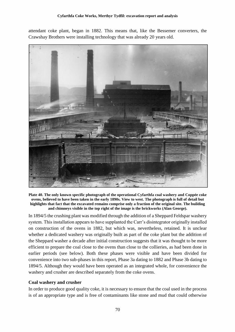
Cyfarthfa Coke Works, Merthyr Tydfil: excavation report and analysis
70
attendant coke plant, began in 1882. This means that, like the Bessemer converters, the
Crawshay Brothers were installing technology that was already 20 years old.
Plate 40. The only known specific photograph of the operational Cyfarthfa coal washery and Coppée coke
ovens, believed to have been taken in the early 1890s. View to west. The photograph is full of detail but
highlights that fact that the excavated remains comprise only a fraction of the original site. The building
and chimneys visible in the top right of the image is the brickworks (Alan George).
In 1894/5 the crushing plant was modified through the addition of a Sheppard Feldspar washery
system. This installation appears to have supplanted the Carr’s disintegrator originally installed
on construction of the ovens in 1882, but which was, nevertheless, retained. It is unclear
whether a dedicated washery was originally built as part of the coke plant but the addition of
the Sheppard washer a decade after initial construction suggests that it was thought to be more
efficient to prepare the coal close to the ovens than close to the collieries, as had been done in
earlier periods (see below). Both these phases were visible and have been divided for
convenience into two sub-phases in this report, Phase 3a dating to 1882 and Phase 3b dating to
1894/5. Although they would have been operated as an integrated whole, for convenience the
washery and crusher are described separately from the coke ovens.
Coal washery and crusher
In order to produce good quality coke, it is necessary to ensure that the coal used in the process
is of an appropriate type and is free of contaminants like stone and mud that could otherwise
Cyfarthfa Coke Works, Merthyr Tydfil: excavation report and analysis
71
interfere with the coking process. In order to obtain the required level of purity, it is necessary
for the coal to be cleaned (known as washing), and graded, to separate out stone from the coal
and to ensure that the coal is of a relatively uniform size, using mechanical means. In the case
of Cyfarthfa, the nature of this operation during the earlier period is unknown. Pedler mentions
a screen (another term for a washery) located near Colliers Row Pit, located approximately
600m south of the Cyfarthfa site, when discussing the old Cyfarthfa Canal (1930 p.26) but the
context of the reference is somewhat unclear. It seems likely, however, that much of the
processing undertaken later at the excavated washery was done off site during the first two
phases of the works. Neither the Board of Health map of 1850, nor the 1856 map of the works,
contain any indication of a washery or similar and the conclusion must be that the coal was
indeed washed and sorted away from the site prior to the erection of the Coppée ovens and
attendant washery.
This sequence of processing does not seem to have been retained for the Phase 3. The
prospectus for the Cyfarthfa Works published in 1897 makes it clear that the only raw material
for which the works was not self-sufficient was iron ore, which whilst formerly obtained from
the Cyfarthfa estate, was derived at that time chiefly from Spain. Coal was therefore still being
obtained locally and it was probably more efficient to have a centralised, modern washery,
although this may not have been realised for some time.
The first crusher with a Carr’s disintegrator at the heart, was constructed in 1882, at the same
time as the Coppée ovens. Young (Appendix II) states that this was largely supplanted in
1894/5 by a Sheppard Coal Washer, his source being a contemporary industrial magazine
known as The Engineer of 1895. One stipulation of the contract to construct the new washery
was the retention of the Carr’s disintegrator in order that it could be used rapidly in the event
of the new machinery malfunctioning. The Bridgend firm of Sheppard and Sons Ltd. was
employed to construct the washery to a design of their development. The excavated remains
exhibit features from both sets of plant, and although only the remains of the Sheppard plant
are generally recognisable, the two phases are discussed below.
The excavated remains of the washery and crusher represent only the very lowest levels of the
original structures. The photograph of the coke and washery complex taken in the 1890s (Plate
40) clearly demonstrate that much of the plant was housed in a substantial raised, brick, stone
and iron clad superstructure. However, enough of the foundations of the washing and crushing
plant survived to assign functions to each of the areas.
The first phase crusher, centred on the Carr’s Disintegrator, is depicted on an annotated map
of the works prepared by the Chief Engineer in February 1892 (Plate 41). This shows the layout
of the washery and crusher buildings as well as the coke oven complex. The purpose of the
map was primarily to indicate the location of various steam engines and their water supplies
rather than to detail the layout of the plant itself. The building housing the crusher is labelled
43 and described in the accompanying schedule as a ‘coal crushing rolls engine’ As the contract
for the later addition of the Sheppard Washer specified the retention of the disintegrator,
elements of the first phase should be visible and indeed it appears they are distinguishable by
the use of different coloured brick, evident in the excavated remains.
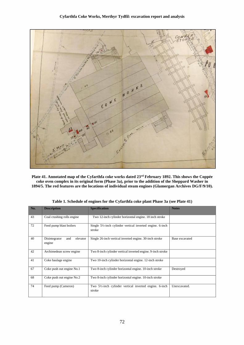
Cyfarthfa Coke Works, Merthyr Tydfil: excavation report and analysis
72
Plate 41. Annotated map of the Cyfarthfa coke works dated 23rd February 1892. This shows the Coppée
coke oven complex in its original form (Phase 3a), prior to the addition of the Sheppard Washer in
1894/5. The red features are the locations of individual steam engines (Glamorgan Archives DG/F/9/10).
Table 1. Schedule of engines for the Cyfarthfa coke plant Phase 3a (see Plate 41)
No. Description Specification Notes
43 Coal crushing rolls engine Two 12-inch cylinder horizontal engine. 18 inch stroke
72 Feed pump blast boilers Single 5½-inch cylinder vertical inverted engine. 6-inch
stroke
40 Disintegrator and elevator
engine
Single 26-inch vertical inverted engine. 30-inch stroke Base excavated
42 Archimedean screw engine Two 8-inch cylinder vertical inverted engine. 9-inch stroke
41 Coke haulage engine Two 10-inch cylinder horizontal engine. 12-inch stroke
67 Coke push out engine No.1 Two 8-inch cylinder horizontal engine. 10-inch stroke Destroyed
68 Coke push out engine No.2 Two 8-inch cylinder horizontal engine. 10-inch stroke
74 Feed pump (Cameron) Two 5½-inch cylinder vertical inverted engine. 6-inch
stroke
Unexcavated.
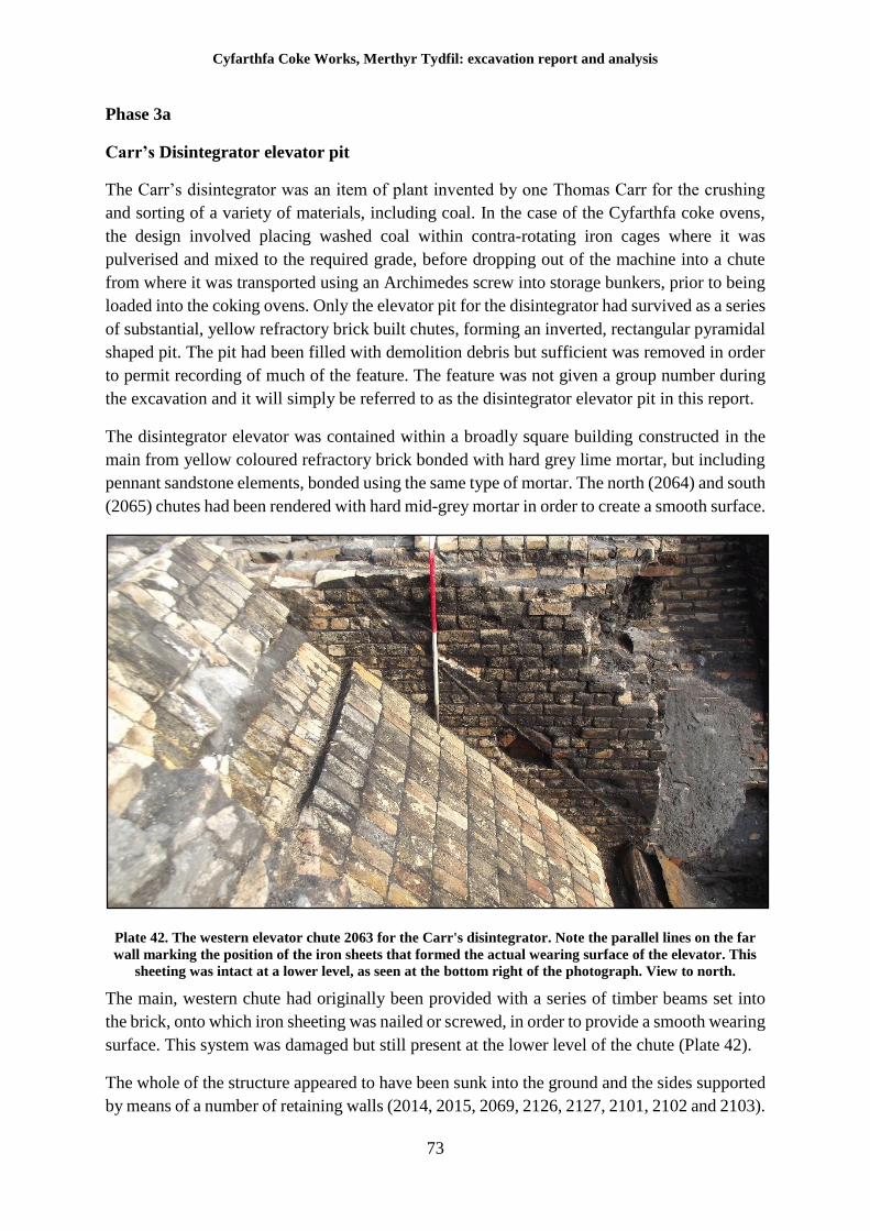
Cyfarthfa Coke Works, Merthyr Tydfil: excavation report and analysis
73
Phase 3a
Carr’s Disintegrator elevator pit
The Carr’s disintegrator was an item of plant invented by one Thomas Carr for the crushing
and sorting of a variety of materials, including coal. In the case of the Cyfarthfa coke ovens,
the design involved placing washed coal within contra-rotating iron cages where it was
pulverised and mixed to the required grade, before dropping out of the machine into a chute
from where it was transported using an Archimedes screw into storage bunkers, prior to being
loaded into the coking ovens. Only the elevator pit for the disintegrator had survived as a series
of substantial, yellow refractory brick built chutes, forming an inverted, rectangular pyramidal
shaped pit. The pit had been filled with demolition debris but sufficient was removed in order
to permit recording of much of the feature. The feature was not given a group number during
the excavation and it will simply be referred to as the disintegrator elevator pit in this report.
The disintegrator elevator was contained within a broadly square building constructed in the
main from yellow coloured refractory brick bonded with hard grey lime mortar, but including
pennant sandstone elements, bonded using the same type of mortar. The north (2064) and south
(2065) chutes had been rendered with hard mid-grey mortar in order to create a smooth surface.
Plate 42. The western elevator chute 2063 for the Carr's disintegrator. Note the parallel lines on the far
wall marking the position of the iron sheets that formed the actual wearing surface of the elevator. This
sheeting was intact at a lower level, as seen at the bottom right of the photograph. View to north.
The main, western chute had originally been provided with a series of timber beams set into
the brick, onto which iron sheeting was nailed or screwed, in order to provide a smooth wearing
surface. This system was damaged but still present at the lower level of the chute (Plate 42).
The whole of the structure appeared to have been sunk into the ground and the sides supported
by means of a number of retaining walls (2014, 2015, 2069, 2126, 2127, 2101, 2102 and 2103).
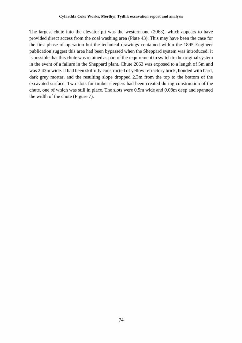
Cyfarthfa Coke Works, Merthyr Tydfil: excavation report and analysis
74
The largest chute into the elevator pit was the western one (2063), which appears to have
provided direct access from the coal washing area (Plate 43). This may have been the case for
the first phase of operation but the technical drawings contained within the 1895 Engineer
publication suggest this area had been bypassed when the Sheppard system was introduced; it
is possible that this chute was retained as part of the requirement to switch to the original system
in the event of a failure in the Sheppard plant. Chute 2063 was exposed to a length of 5m and
was 2.43m wide. It had been skilfully constructed of yellow refractory brick, bonded with hard,
dark grey mortar, and the resulting slope dropped 2.3m from the top to the bottom of the
excavated surface. Two slots for timber sleepers had been created during construction of the
chute, one of which was still in place. The slots were 0.5m wide and 0.08m deep and spanned
the width of the chute (Figure 7).
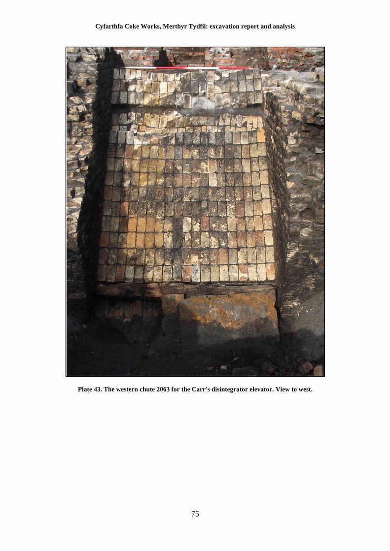
Cyfarthfa Coke Works, Merthyr Tydfil: excavation report and analysis
75
Plate 43. The western chute 2063 for the Carr's disintegrator elevator. View to west.
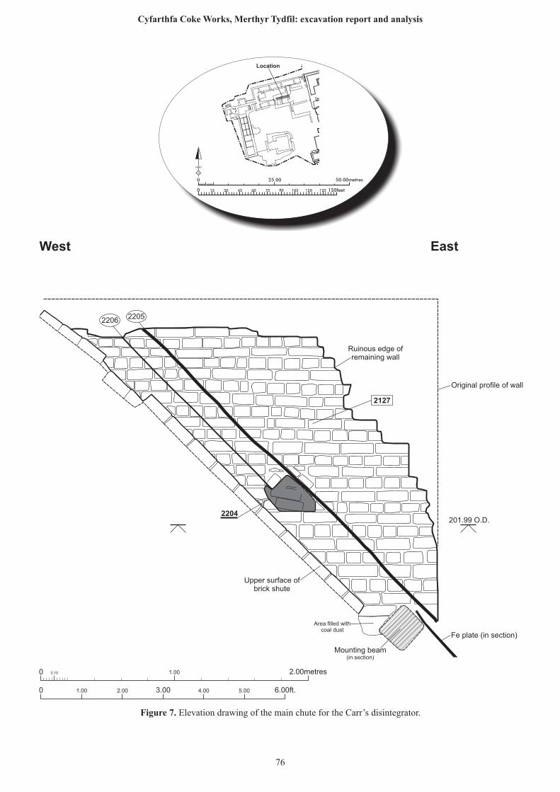
0 0.10 1.00 2.00metres
0 1.00 2.00 6.00ft.3.00 4.00 5.00
Fe plate (in section)
22062205
2127
2204
West East
Original profile of wall
Upper surface ofbrick shute
Mounting beam(in section)
Ruinous edge ofremaining wall
Area filled withcoal dust
201.99 O.D.
25.00 50.00metres0
0 150feet15 30 45 60 75 90 105 120 135
N
GRID
Location
Figure 7. Elevation drawing of the main chute for the Carr’s disintegrator.
76
Cyfarthfa Coke Works, Merthyr Tydfil: excavation report and analysis
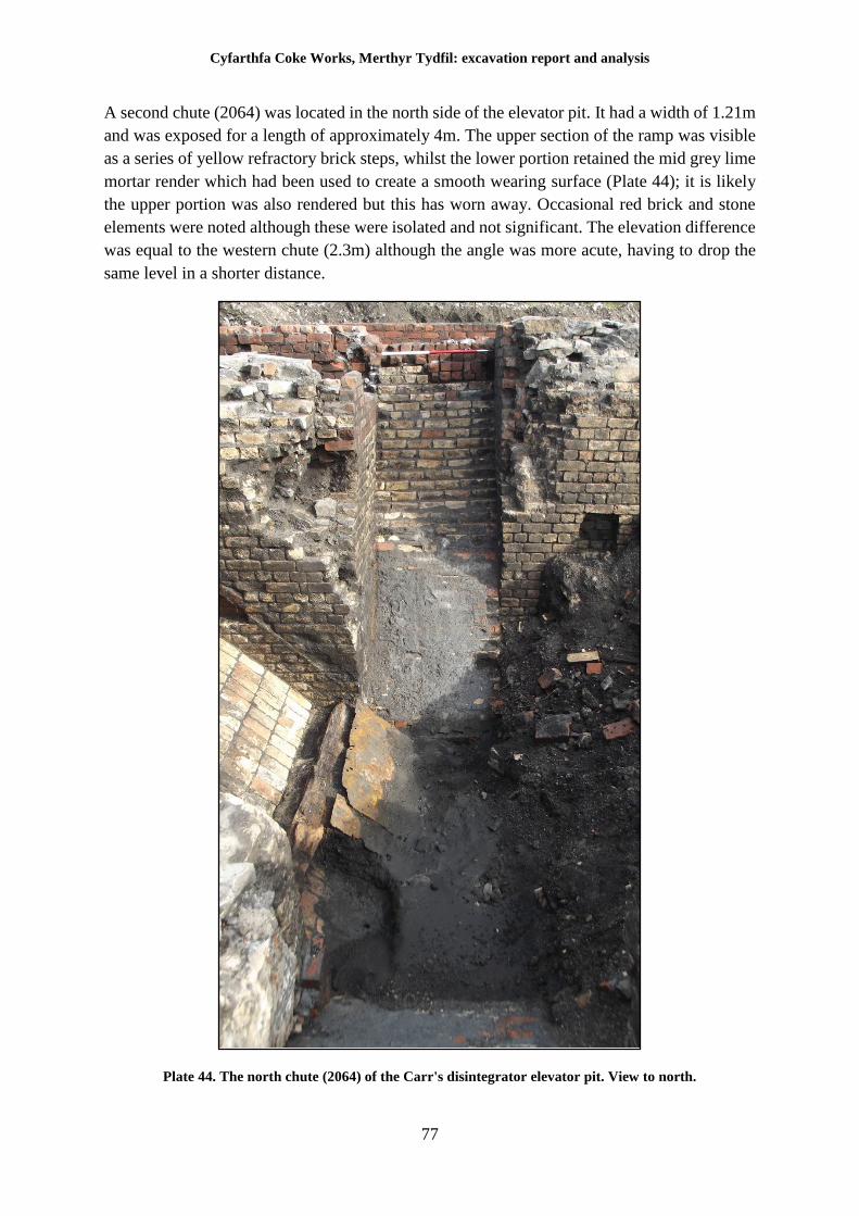
Cyfarthfa Coke Works, Merthyr Tydfil: excavation report and analysis
77
A second chute (2064) was located in the north side of the elevator pit. It had a width of 1.21m
and was exposed for a length of approximately 4m. The upper section of the ramp was visible
as a series of yellow refractory brick steps, whilst the lower portion retained the mid grey lime
mortar render which had been used to create a smooth wearing surface (Plate 44); it is likely
the upper portion was also rendered but this has worn away. Occasional red brick and stone
elements were noted although these were isolated and not significant. The elevation difference
was equal to the western chute (2.3m) although the angle was more acute, having to drop the
same level in a shorter distance.
Plate 44. The north chute (2064) of the Carr's disintegrator elevator pit. View to north.
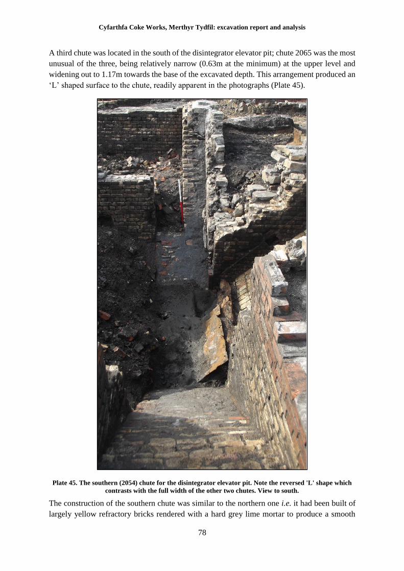
Cyfarthfa Coke Works, Merthyr Tydfil: excavation report and analysis
78
A third chute was located in the south of the disintegrator elevator pit; chute 2065 was the most
unusual of the three, being relatively narrow (0.63m at the minimum) at the upper level and
widening out to 1.17m towards the base of the excavated depth. This arrangement produced an
‘L’ shaped surface to the chute, readily apparent in the photographs (Plate 45).
Plate 45. The southern (2054) chute for the disintegrator elevator pit. Note the reversed 'L' shape which
contrasts with the full width of the other two chutes. View to south.
The construction of the southern chute was similar to the northern one i.e. it had been built of
largely yellow refractory bricks rendered with a hard grey lime mortar to produce a smooth
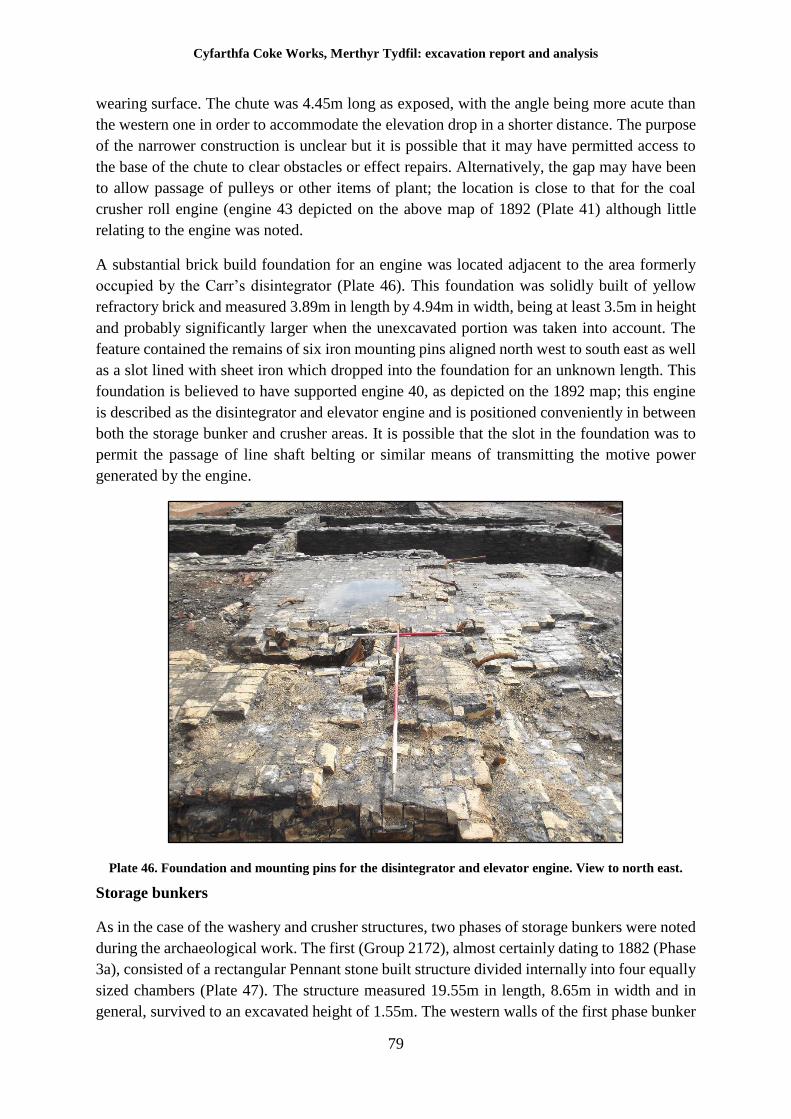
Cyfarthfa Coke Works, Merthyr Tydfil: excavation report and analysis
79
wearing surface. The chute was 4.45m long as exposed, with the angle being more acute than
the western one in order to accommodate the elevation drop in a shorter distance. The purpose
of the narrower construction is unclear but it is possible that it may have permitted access to
the base of the chute to clear obstacles or effect repairs. Alternatively, the gap may have been
to allow passage of pulleys or other items of plant; the location is close to that for the coal
crusher roll engine (engine 43 depicted on the above map of 1892 (Plate 41) although little
relating to the engine was noted.
A substantial brick build foundation for an engine was located adjacent to the area formerly
occupied by the Carr’s disintegrator (Plate 46). This foundation was solidly built of yellow
refractory brick and measured 3.89m in length by 4.94m in width, being at least 3.5m in height
and probably significantly larger when the unexcavated portion was taken into account. The
feature contained the remains of six iron mounting pins aligned north west to south east as well
as a slot lined with sheet iron which dropped into the foundation for an unknown length. This
foundation is believed to have supported engine 40, as depicted on the 1892 map; this engine
is described as the disintegrator and elevator engine and is positioned conveniently in between
both the storage bunker and crusher areas. It is possible that the slot in the foundation was to
permit the passage of line shaft belting or similar means of transmitting the motive power
generated by the engine.
Plate 46. Foundation and mounting pins for the disintegrator and elevator engine. View to north east.
Storage bunkers
As in the case of the washery and crusher structures, two phases of storage bunkers were noted
during the archaeological work. The first (Group 2172), almost certainly dating to 1882 (Phase
3a), consisted of a rectangular Pennant stone built structure divided internally into four equally
sized chambers (Plate 47). The structure measured 19.55m in length, 8.65m in width and in
general, survived to an excavated height of 1.55m. The western walls of the first phase bunker
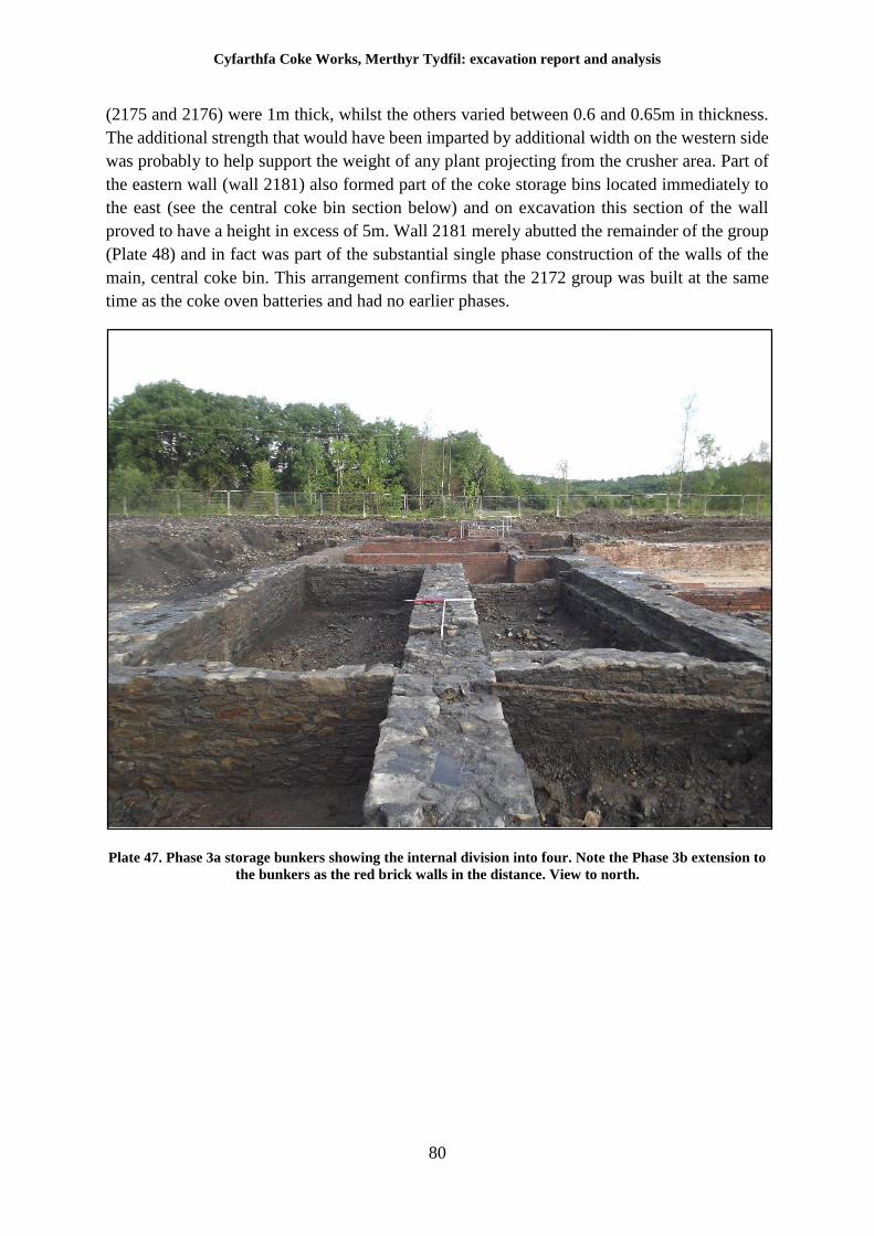
Cyfarthfa Coke Works, Merthyr Tydfil: excavation report and analysis
80
(2175 and 2176) were 1m thick, whilst the others varied between 0.6 and 0.65m in thickness.
The additional strength that would have been imparted by additional width on the western side
was probably to help support the weight of any plant projecting from the crusher area. Part of
the eastern wall (wall 2181) also formed part of the coke storage bins located immediately to
the east (see the central coke bin section below) and on excavation this section of the wall
proved to have a height in excess of 5m. Wall 2181 merely abutted the remainder of the group
(Plate 48) and in fact was part of the substantial single phase construction of the walls of the
main, central coke bin. This arrangement confirms that the 2172 group was built at the same
time as the coke oven batteries and had no earlier phases.
Plate 47. Phase 3a storage bunkers showing the internal division into four. Note the Phase 3b extension to
the bunkers as the red brick walls in the distance. View to north.
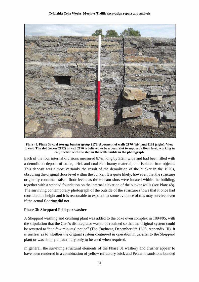
Cyfarthfa Coke Works, Merthyr Tydfil: excavation report and analysis
81
Plate 48. Phase 3a coal storage bunker group 2172. Abutment of walls 2176 (left) and 2181 (right). View
to east. The slot (recess 2192) in wall 2176 is believed to be a beam slot to support a floor level, working in
conjunction with the step in the walls visible in the photograph.
Each of the four internal divisions measured 8.7m long by 3.2m wide and had been filled with
a demolition deposit of stone, brick and coal rich loamy material, and isolated iron objects.
This deposit was almost certainly the result of the demolition of the bunker in the 1920s,
obscuring the original floor level within the bunker. It is quite likely, however, that the structure
originally contained raised floor levels as three beam slots were located within the building,
together with a stepped foundation on the internal elevation of the bunker walls (see Plate 48).
The surviving contemporary photograph of the outside of the structure shows that it once had
considerable height and it is reasonable to expect that some evidence of this may survive, even
if the actual flooring did not.
Phase 3b Sheppard Feldspar washer
A Sheppard washing and crushing plant was added to the coke oven complex in 1894/95, with
the stipulation that the Carr’s disintegrator was to be retained so that the original system could
be reverted to “at a few minutes’ notice” (The Engineer, December 6th 1895, Appendix III). It
is unclear as to whether the original system continued in operation in parallel to the Sheppard
plant or was simply an auxiliary only to be used when required.
In general, the surviving structural elements of the Phase 3a washery and crusher appear to
have been rendered in a combination of yellow refractory brick and Pennant sandstone bonded
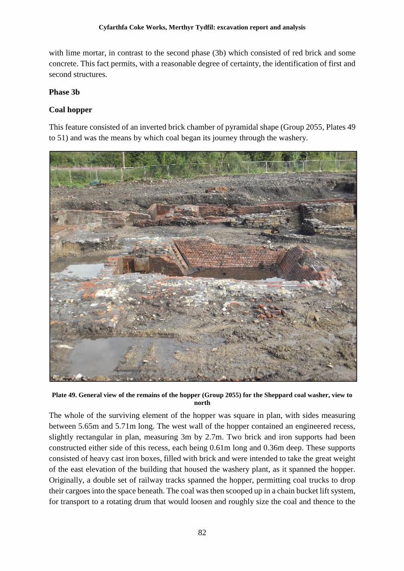
Cyfarthfa Coke Works, Merthyr Tydfil: excavation report and analysis
82
with lime mortar, in contrast to the second phase (3b) which consisted of red brick and some
concrete. This fact permits, with a reasonable degree of certainty, the identification of first and
second structures.
Phase 3b
Coal hopper
This feature consisted of an inverted brick chamber of pyramidal shape (Group 2055, Plates 49
to 51) and was the means by which coal began its journey through the washery.
Plate 49. General view of the remains of the hopper (Group 2055) for the Sheppard coal washer, view to
north
The whole of the surviving element of the hopper was square in plan, with sides measuring
between 5.65m and 5.71m long. The west wall of the hopper contained an engineered recess,
slightly rectangular in plan, measuring 3m by 2.7m. Two brick and iron supports had been
constructed either side of this recess, each being 0.61m long and 0.36m deep. These supports
consisted of heavy cast iron boxes, filled with brick and were intended to take the great weight
of the east elevation of the building that housed the washery plant, as it spanned the hopper.
Originally, a double set of railway tracks spanned the hopper, permitting coal trucks to drop
their cargoes into the space beneath. The coal was then scooped up in a chain bucket lift system,
for transport to a rotating drum that would loosen and roughly size the coal and thence to the
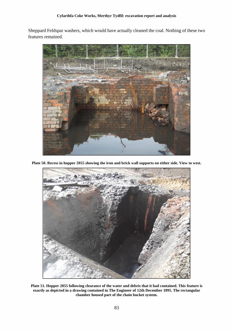
Cyfarthfa Coke Works, Merthyr Tydfil: excavation report and analysis
83
Sheppard Feldspar washers, which would have actually cleaned the coal. Nothing of these two
features remained.
Plate 50. Recess in hopper 2055 showing the iron and brick wall supports on either side. View to west.
Plate 51. Hopper 2055 following clearance of the water and debris that it had contained. This feature is
exactly as depicted in a drawing contained in The Engineer of 12th December 1895. The rectangular
chamber housed part of the chain bucket system.
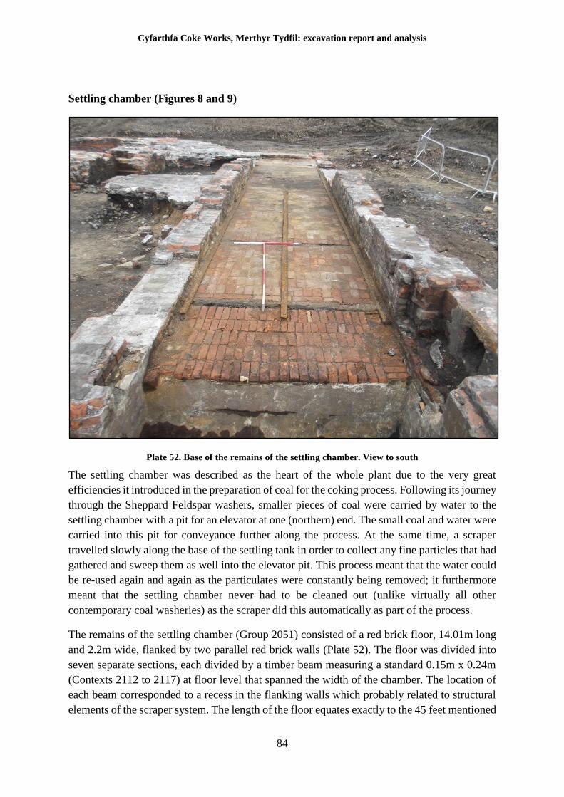
Cyfarthfa Coke Works, Merthyr Tydfil: excavation report and analysis
84
Settling chamber (Figures 8 and 9)
Plate 52. Base of the remains of the settling chamber. View to south
The settling chamber was described as the heart of the whole plant due to the very great
efficiencies it introduced in the preparation of coal for the coking process. Following its journey
through the Sheppard Feldspar washers, smaller pieces of coal were carried by water to the
settling chamber with a pit for an elevator at one (northern) end. The small coal and water were
carried into this pit for conveyance further along the process. At the same time, a scraper
travelled slowly along the base of the settling tank in order to collect any fine particles that had
gathered and sweep them as well into the elevator pit. This process meant that the water could
be re-used again and again as the particulates were constantly being removed; it furthermore
meant that the settling chamber never had to be cleaned out (unlike virtually all other
contemporary coal washeries) as the scraper did this automatically as part of the process.
The remains of the settling chamber (Group 2051) consisted of a red brick floor, 14.01m long
and 2.2m wide, flanked by two parallel red brick walls (Plate 52). The floor was divided into
seven separate sections, each divided by a timber beam measuring a standard 0.15m x 0.24m
(Contexts 2112 to 2117) at floor level that spanned the width of the chamber. The location of
each beam corresponded to a recess in the flanking walls which probably related to structural
elements of the scraper system. The length of the floor equates exactly to the 45 feet mentioned
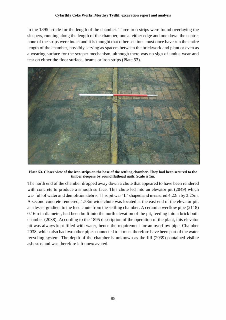
Cyfarthfa Coke Works, Merthyr Tydfil: excavation report and analysis
85
in the 1895 article for the length of the chamber. Three iron strips were found overlaying the
sleepers, running along the length of the chamber, one at either edge and one down the centre;
none of the strips were intact and it is thought that other sections must once have run the entire
length of the chamber, possibly serving as spacers between the brickwork and plant or even as
a wearing surface for the scraper mechanism, although there was no sign of undue wear and
tear on either the floor surface, beams or iron strips (Plate 53).
Plate 53. Closer view of the iron strips on the base of the settling chamber. They had been secured to the
timber sleepers by round flathead nails. Scale is 1m.
The north end of the chamber dropped away down a chute that appeared to have been rendered
with concrete to produce a smooth surface. This chute led into an elevator pit (2049) which
was full of water and demolition debris. This pit was ‘L’ shaped and measured 4.22m by 2.25m.
A second concrete rendered, 1.53m wide chute was located at the east end of the elevator pit,
at a lesser gradient to the feed chute from the settling chamber. A ceramic overflow pipe (2118)
0.16m in diameter, had been built into the north elevation of the pit, feeding into a brick built
chamber (2038). According to the 1895 description of the operation of the plant, this elevator
pit was always kept filled with water, hence the requirement for an overflow pipe. Chamber
2038, which also had two other pipes connected to it must therefore have been part of the water
recycling system. The depth of the chamber is unknown as the fill (2039) contained visible
asbestos and was therefore left unexcavated.
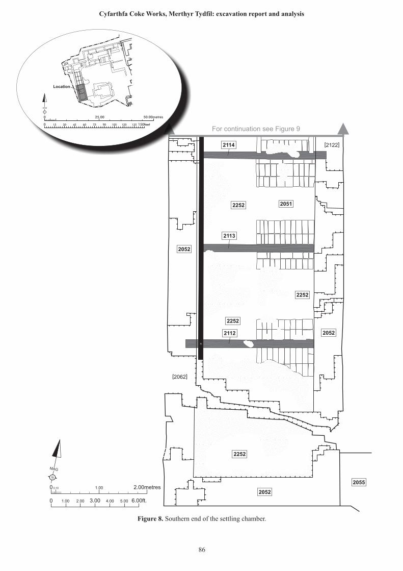
N
MAG
0 0.10 1.00 2.00metres
0 1.00 2.00 6.00ft.3.00 4.00 5.00
2055
2052
2252
2052
2252
2052
2252
20512252
2114
2113
2112
[2062]
[2122]
For continuation see Figure 9
25.00 50.00metres0
0 150feet15 30 45 60 75 90 105 120 135
N
GRID
Location
Figure 8. Southern end of the settling chamber.
86
Cyfarthfa Coke Works, Merthyr Tydfil: excavation report and analysis
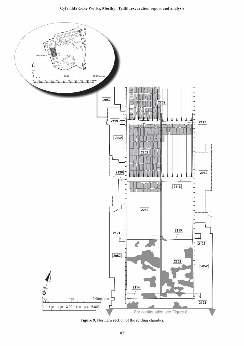
N
MAG
0 0.10 1.00 2.00metres
0 1.00 2.00 6.00ft.3.00 4.00 5.00
20522252
2252
2252
2119
2052
2120
2121
2052
2252
2117
2116
2062
2115
2123
2052
2122
2114
For continuation see Figure 8
25.00 50.00metres0
0 150feet15 30 45 60 75 90 105 120 135
N
GRID
Location
Figure 9. Northern section of the settling chamber.
87
Cyfarthfa Coke Works, Merthyr Tydfil: excavation report and analysis
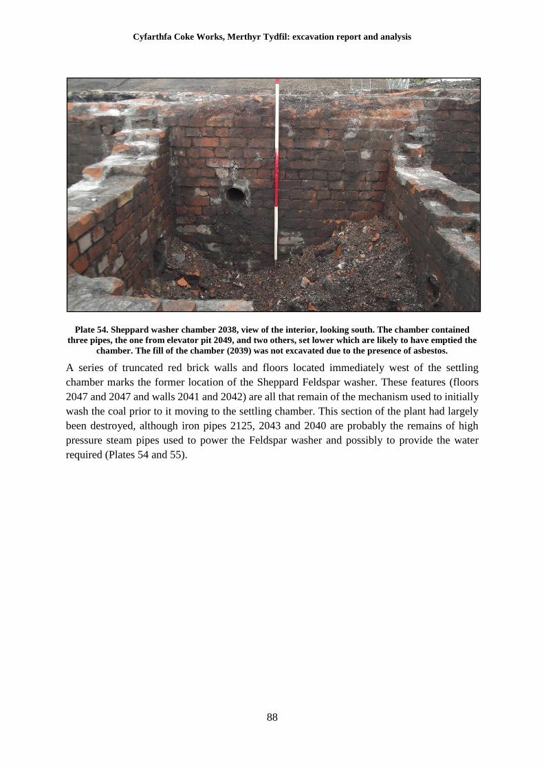
Cyfarthfa Coke Works, Merthyr Tydfil: excavation report and analysis
88
Plate 54. Sheppard washer chamber 2038, view of the interior, looking south. The chamber contained
three pipes, the one from elevator pit 2049, and two others, set lower which are likely to have emptied the
chamber. The fill of the chamber (2039) was not excavated due to the presence of asbestos.
A series of truncated red brick walls and floors located immediately west of the settling
chamber marks the former location of the Sheppard Feldspar washer. These features (floors
2047 and 2047 and walls 2041 and 2042) are all that remain of the mechanism used to initially
wash the coal prior to it moving to the settling chamber. This section of the plant had largely
been destroyed, although iron pipes 2125, 2043 and 2040 are probably the remains of high
pressure steam pipes used to power the Feldspar washer and possibly to provide the water
required (Plates 54 and 55).
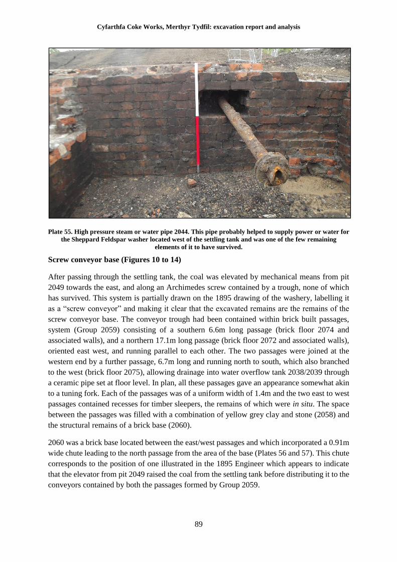
Cyfarthfa Coke Works, Merthyr Tydfil: excavation report and analysis
89
Plate 55. High pressure steam or water pipe 2044. This pipe probably helped to supply power or water for
the Sheppard Feldspar washer located west of the settling tank and was one of the few remaining
elements of it to have survived.
Screw conveyor base (Figures 10 to 14)
After passing through the settling tank, the coal was elevated by mechanical means from pit
2049 towards the east, and along an Archimedes screw contained by a trough, none of which
has survived. This system is partially drawn on the 1895 drawing of the washery, labelling it
as a “screw conveyor” and making it clear that the excavated remains are the remains of the
screw conveyor base. The conveyor trough had been contained within brick built passages,
system (Group 2059) consisting of a southern 6.6m long passage (brick floor 2074 and
associated walls), and a northern 17.1m long passage (brick floor 2072 and associated walls),
oriented east west, and running parallel to each other. The two passages were joined at the
western end by a further passage, 6.7m long and running north to south, which also branched
to the west (brick floor 2075), allowing drainage into water overflow tank 2038/2039 through
a ceramic pipe set at floor level. In plan, all these passages gave an appearance somewhat akin
to a tuning fork. Each of the passages was of a uniform width of 1.4m and the two east to west
passages contained recesses for timber sleepers, the remains of which were in situ. The space
between the passages was filled with a combination of yellow grey clay and stone (2058) and
the structural remains of a brick base (2060).
2060 was a brick base located between the east/west passages and which incorporated a 0.91m
wide chute leading to the north passage from the area of the base (Plates 56 and 57). This chute
corresponds to the position of one illustrated in the 1895 Engineer which appears to indicate
that the elevator from pit 2049 raised the coal from the settling tank before distributing it to the
conveyors contained by both the passages formed by Group 2059.
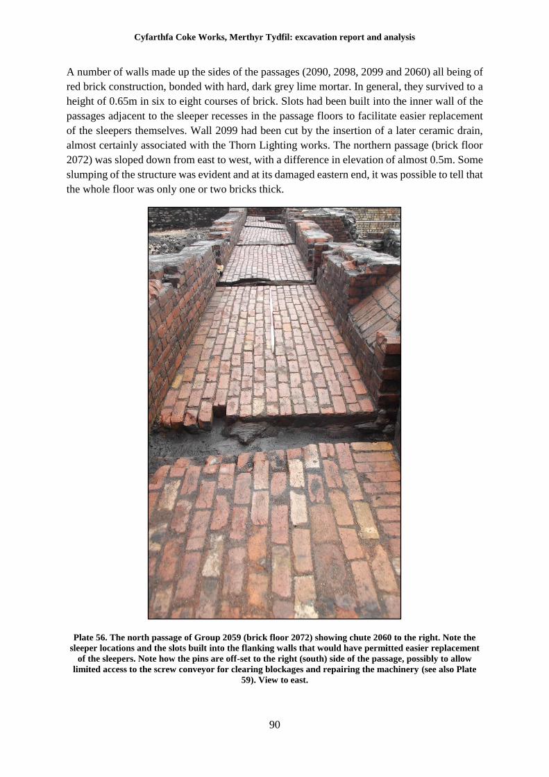
Cyfarthfa Coke Works, Merthyr Tydfil: excavation report and analysis
90
A number of walls made up the sides of the passages (2090, 2098, 2099 and 2060) all being of
red brick construction, bonded with hard, dark grey lime mortar. In general, they survived to a
height of 0.65m in six to eight courses of brick. Slots had been built into the inner wall of the
passages adjacent to the sleeper recesses in the passage floors to facilitate easier replacement
of the sleepers themselves. Wall 2099 had been cut by the insertion of a later ceramic drain,
almost certainly associated with the Thorn Lighting works. The northern passage (brick floor
2072) was sloped down from east to west, with a difference in elevation of almost 0.5m. Some
slumping of the structure was evident and at its damaged eastern end, it was possible to tell that
the whole floor was only one or two bricks thick.
Plate 56. The north passage of Group 2059 (brick floor 2072) showing chute 2060 to the right. Note the
sleeper locations and the slots built into the flanking walls that would have permitted easier replacement
of the sleepers. Note how the pins are off-set to the right (south) side of the passage, possibly to allow
limited access to the screw conveyor for clearing blockages and repairing the machinery (see also Plate
59). View to east.
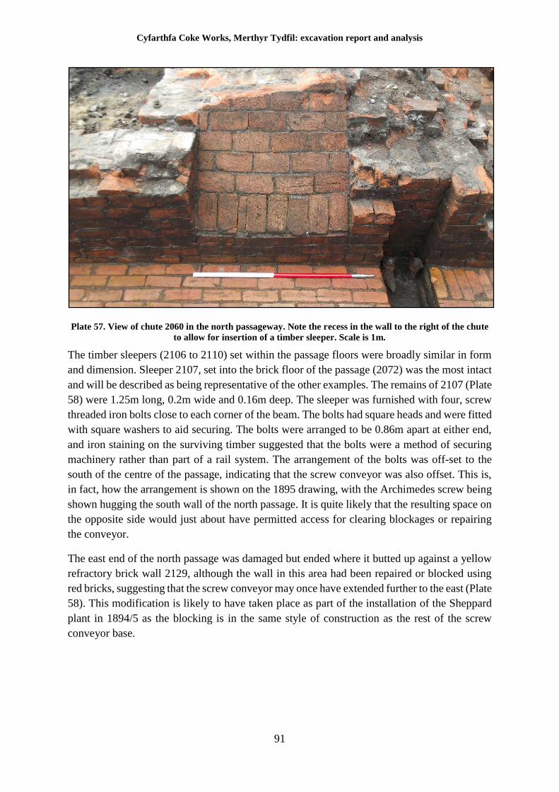
Cyfarthfa Coke Works, Merthyr Tydfil: excavation report and analysis
91
Plate 57. View of chute 2060 in the north passageway. Note the recess in the wall to the right of the chute
to allow for insertion of a timber sleeper. Scale is 1m.
The timber sleepers (2106 to 2110) set within the passage floors were broadly similar in form
and dimension. Sleeper 2107, set into the brick floor of the passage (2072) was the most intact
and will be described as being representative of the other examples. The remains of 2107 (Plate
58) were 1.25m long, 0.2m wide and 0.16m deep. The sleeper was furnished with four, screw
threaded iron bolts close to each corner of the beam. The bolts had square heads and were fitted
with square washers to aid securing. The bolts were arranged to be 0.86m apart at either end,
and iron staining on the surviving timber suggested that the bolts were a method of securing
machinery rather than part of a rail system. The arrangement of the bolts was off-set to the
south of the centre of the passage, indicating that the screw conveyor was also offset. This is,
in fact, how the arrangement is shown on the 1895 drawing, with the Archimedes screw being
shown hugging the south wall of the north passage. It is quite likely that the resulting space on
the opposite side would just about have permitted access for clearing blockages or repairing
the conveyor.
The east end of the north passage was damaged but ended where it butted up against a yellow
refractory brick wall 2129, although the wall in this area had been repaired or blocked using
red bricks, suggesting that the screw conveyor may once have extended further to the east (Plate
58). This modification is likely to have taken place as part of the installation of the Sheppard
plant in 1894/5 as the blocking is in the same style of construction as the rest of the screw
conveyor base.
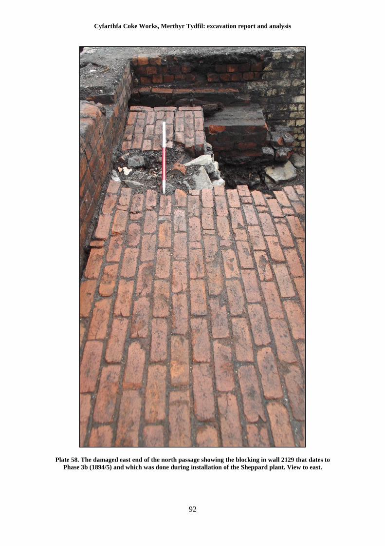
Cyfarthfa Coke Works, Merthyr Tydfil: excavation report and analysis
92
Plate 58. The damaged east end of the north passage showing the blocking in wall 2129 that dates to
Phase 3b (1894/5) and which was done during installation of the Sheppard plant. View to east.
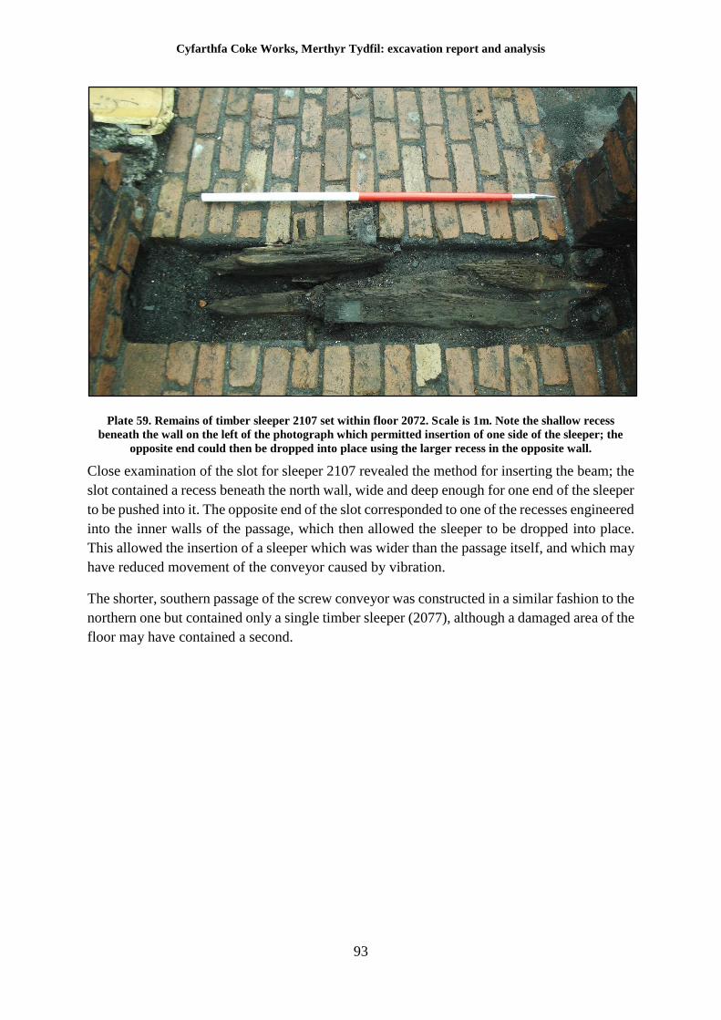
Cyfarthfa Coke Works, Merthyr Tydfil: excavation report and analysis
93
Plate 59. Remains of timber sleeper 2107 set within floor 2072. Scale is 1m. Note the shallow recess
beneath the wall on the left of the photograph which permitted insertion of one side of the sleeper; the
opposite end could then be dropped into place using the larger recess in the opposite wall.
Close examination of the slot for sleeper 2107 revealed the method for inserting the beam; the
slot contained a recess beneath the north wall, wide and deep enough for one end of the sleeper
to be pushed into it. The opposite end of the slot corresponded to one of the recesses engineered
into the inner walls of the passage, which then allowed the sleeper to be dropped into place.
This allowed the insertion of a sleeper which was wider than the passage itself, and which may
have reduced movement of the conveyor caused by vibration.
The shorter, southern passage of the screw conveyor was constructed in a similar fashion to the
northern one but contained only a single timber sleeper (2077), although a damaged area of the
floor may have contained a second.
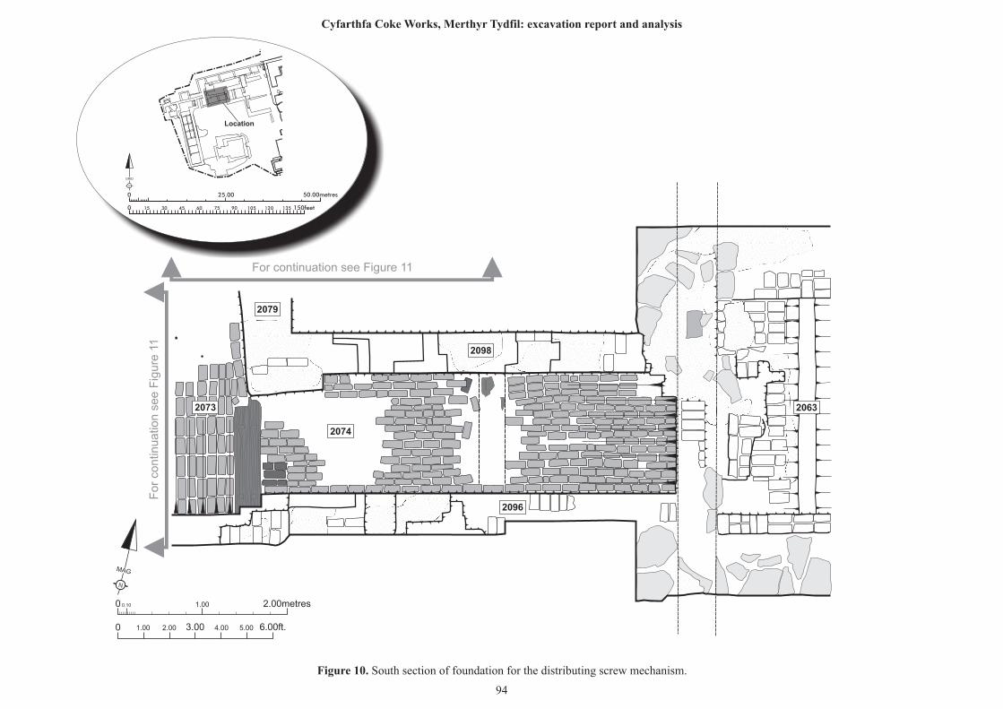
N
MAG
0 0.10 1.00 2.00metres
0 1.00 2.00 6.00ft.3.00 4.00 5.00
2074
2073
2098
2096
2079
2063
For continuation see Figure 11
25.00 50.00metres0
0 150feet15 30 45 60 75 90 105 120 135
N
GRID
Location
Figure 10. South section of foundation for the distributing screw mechanism.
94
For
contin
uatio
n s
ee F
igure
11
Cyfarthfa Coke Works, Merthyr Tydfil: excavation report and analysis
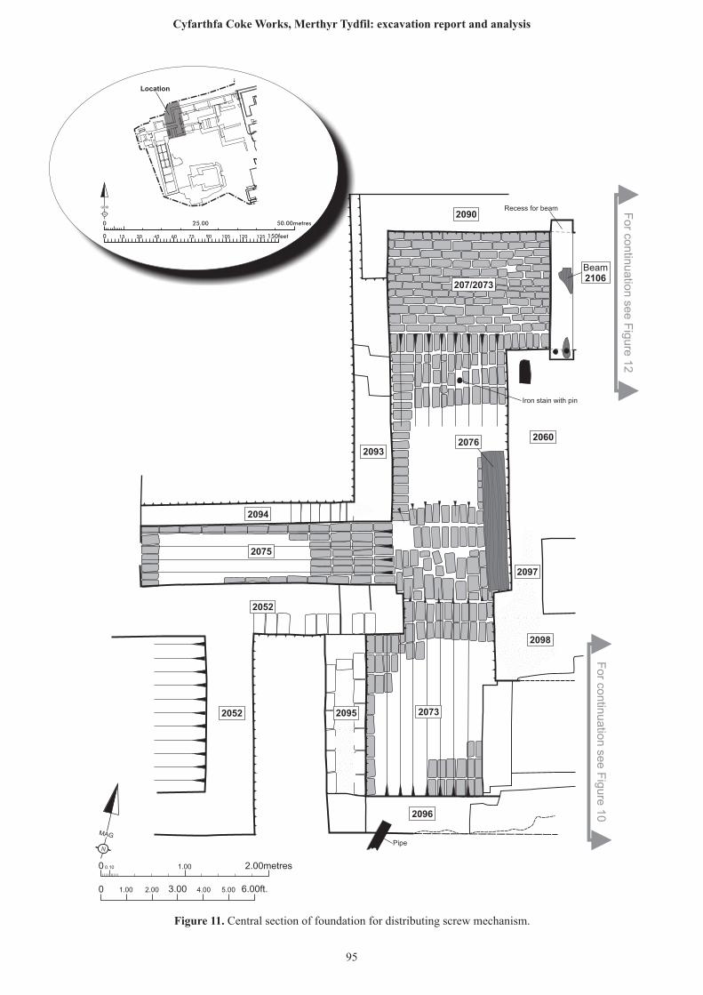
N
MAG
0 0.10 1.00 2.00metres
0 1.00 2.00 6.00ft.3.00 4.00 5.00
Pipe
2075
2094
2052
2052 2095
2096
2073
2098
2090
207/2073
2060
2097
20762093
Beam2106
Iron stain with pin
Recess for beam
25.00 50.00metres0
0 150feet15 30 45 60 75 90 105 120 135
N
GRID
Location
Figure 11. Central section of foundation for distributing screw mechanism.
95
Cyfarthfa Coke Works, Merthyr Tydfil: excavation report and analysis
For co
ntin
uatio
n se
e F
igure
12
For co
ntin
ua
tion
see F
igure
10
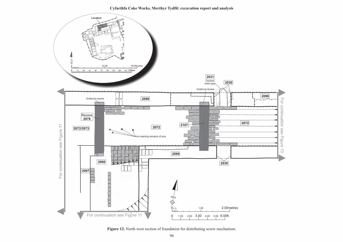
N
MAG
0 0.10 1.00 2.00metres
0 1.00 2.00 6.00ft.3.00 4.00 5.00
Ceramicdrain-pipe
Undercut recess
Undercut recess
2097
2060
2099
20722072/2073
2090
2072
2090
2031
Recess2078
2107
2030
2030
Iron staining remains of pins
For continuation see Figure 11
For
contin
uatio
n s
ee F
igure
11
For co
ntin
uatio
n se
e F
igure
13
25.00 50.00metres0
0 150feet15 30 45 60 75 90 105 120 135
N
GRID
Location
Figure 12. North west section of foundation for distributing screw mechanism.
96
Cyfarthfa Coke Works, Merthyr Tydfil: excavation report and analysis
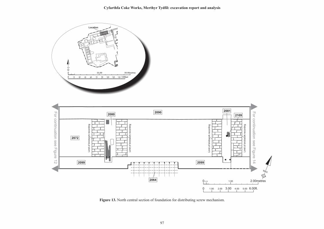
N
MAG
0 0.10 1.00 2.00metres
0 1.00 2.00 6.00ft.3.00 4.00 5.00
2090
2099
2064
2099
2072
20802081
2109
Lim
it of brick
work
reco
rdin
g
Lim
it of brick
work
reco
rdin
g
Lim
it of brick
work
reco
rdin
g
Lim
it of brick
work
reco
rdin
g
For co
ntin
uatio
n se
e F
igure
12
For co
ntin
uatio
n se
e F
igure
14
25.00 50.00metres0
0 150feet15 30 45 60 75 90 105 120 135
N
GRID
Location
Figure 13. North central section of foundation for distributing screw mechanism.
97
Cyfarthfa Coke Works, Merthyr Tydfil: excavation report and analysis
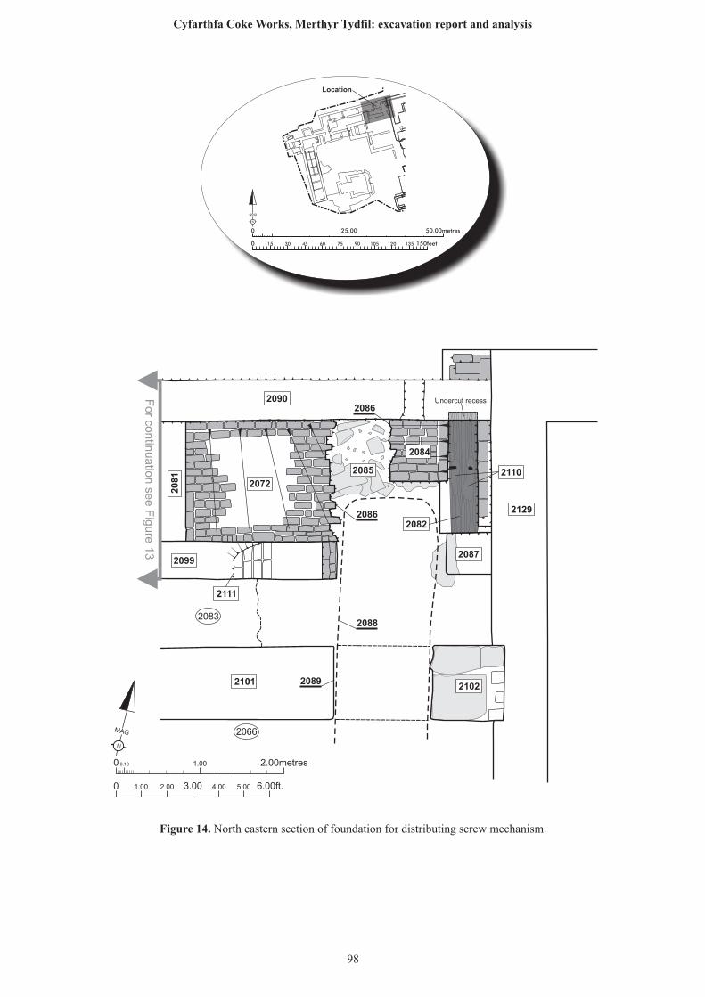
N
MAG
0 0.10 1.00 2.00metres
0 1.00 2.00 6.00ft.3.00 4.00 5.00
2129
2087
2102
2099
2111
2090
2081
2072
2085
2084
2101
2110
2082
2083
2066
2089
2088
2086
2086
Undercut recess
For co
ntin
uatio
n se
e F
igure
13
25.00 50.00metres0
0 150feet15 30 45 60 75 90 105 120 135
N
GRID
Location
Figure 14. North eastern section of foundation for distributing screw mechanism.
98
Cyfarthfa Coke Works, Merthyr Tydfil: excavation report and analysis
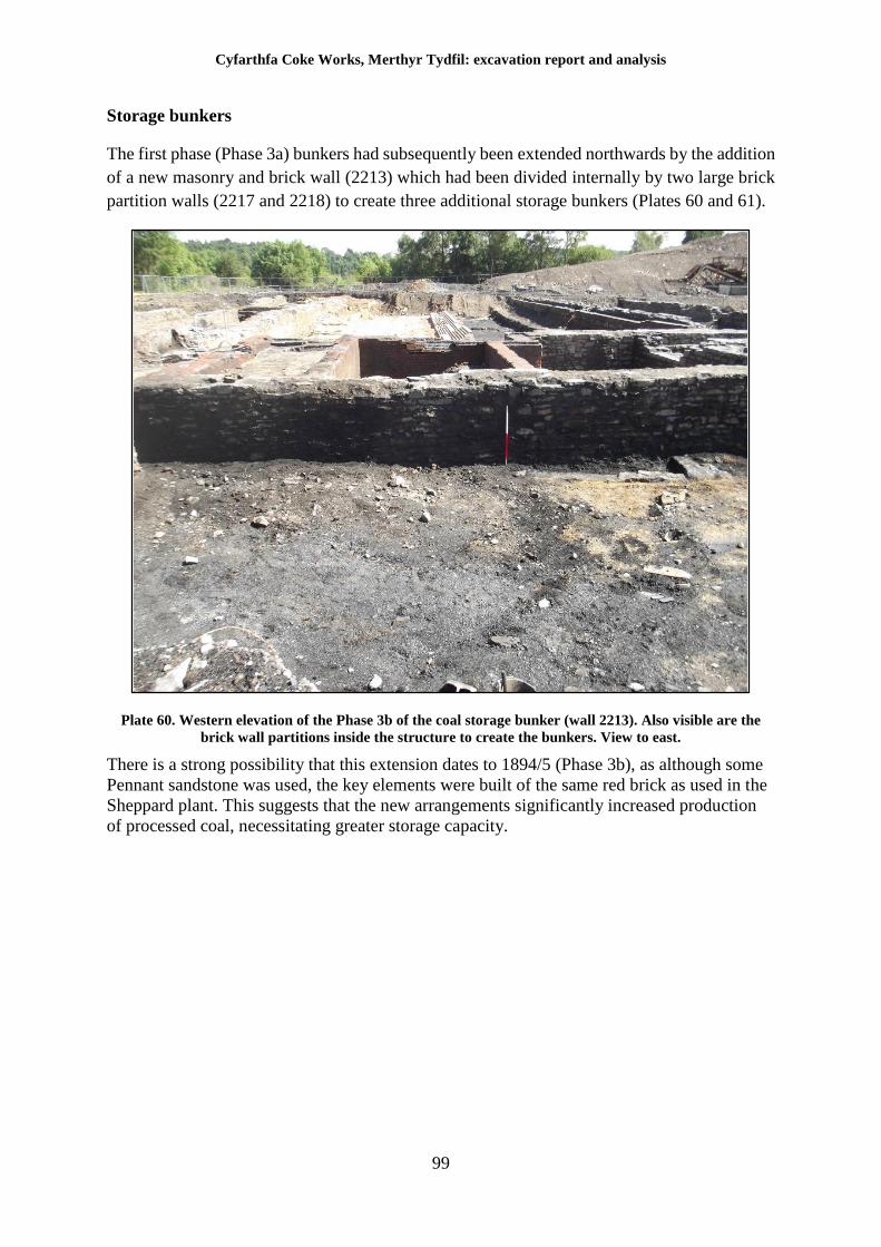
Cyfarthfa Coke Works, Merthyr Tydfil: excavation report and analysis
99
Storage bunkers
The first phase (Phase 3a) bunkers had subsequently been extended northwards by the addition
of a new masonry and brick wall (2213) which had been divided internally by two large brick
partition walls (2217 and 2218) to create three additional storage bunkers (Plates 60 and 61).
Plate 60. Western elevation of the Phase 3b of the coal storage bunker (wall 2213). Also visible are the
brick wall partitions inside the structure to create the bunkers. View to east.
There is a strong possibility that this extension dates to 1894/5 (Phase 3b), as although some
Pennant sandstone was used, the key elements were built of the same red brick as used in the
Sheppard plant. This suggests that the new arrangements significantly increased production
of processed coal, necessitating greater storage capacity.
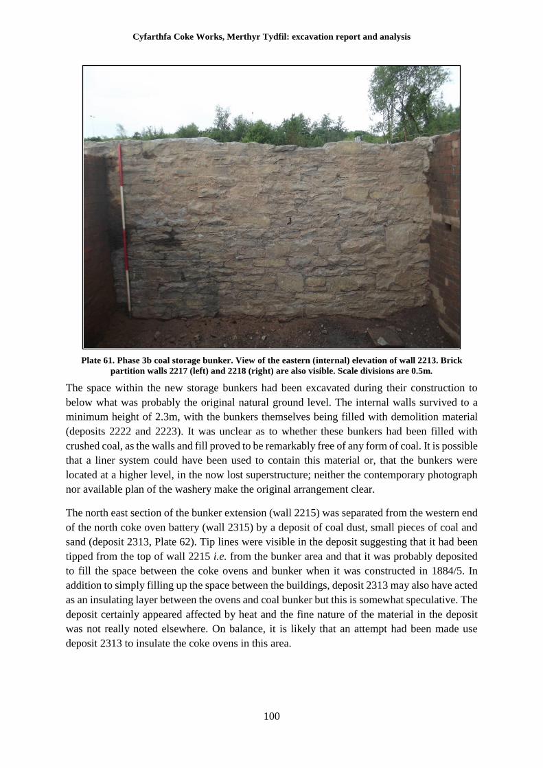
Cyfarthfa Coke Works, Merthyr Tydfil: excavation report and analysis
100
Plate 61. Phase 3b coal storage bunker. View of the eastern (internal) elevation of wall 2213. Brick
partition walls 2217 (left) and 2218 (right) are also visible. Scale divisions are 0.5m.
The space within the new storage bunkers had been excavated during their construction to
below what was probably the original natural ground level. The internal walls survived to a
minimum height of 2.3m, with the bunkers themselves being filled with demolition material
(deposits 2222 and 2223). It was unclear as to whether these bunkers had been filled with
crushed coal, as the walls and fill proved to be remarkably free of any form of coal. It is possible
that a liner system could have been used to contain this material or, that the bunkers were
located at a higher level, in the now lost superstructure; neither the contemporary photograph
nor available plan of the washery make the original arrangement clear.
The north east section of the bunker extension (wall 2215) was separated from the western end
of the north coke oven battery (wall 2315) by a deposit of coal dust, small pieces of coal and
sand (deposit 2313, Plate 62). Tip lines were visible in the deposit suggesting that it had been
tipped from the top of wall 2215 i.e. from the bunker area and that it was probably deposited
to fill the space between the coke ovens and bunker when it was constructed in 1884/5. In
addition to simply filling up the space between the buildings, deposit 2313 may also have acted
as an insulating layer between the ovens and coal bunker but this is somewhat speculative. The
deposit certainly appeared affected by heat and the fine nature of the material in the deposit
was not really noted elsewhere. On balance, it is likely that an attempt had been made use
deposit 2313 to insulate the coke ovens in this area.
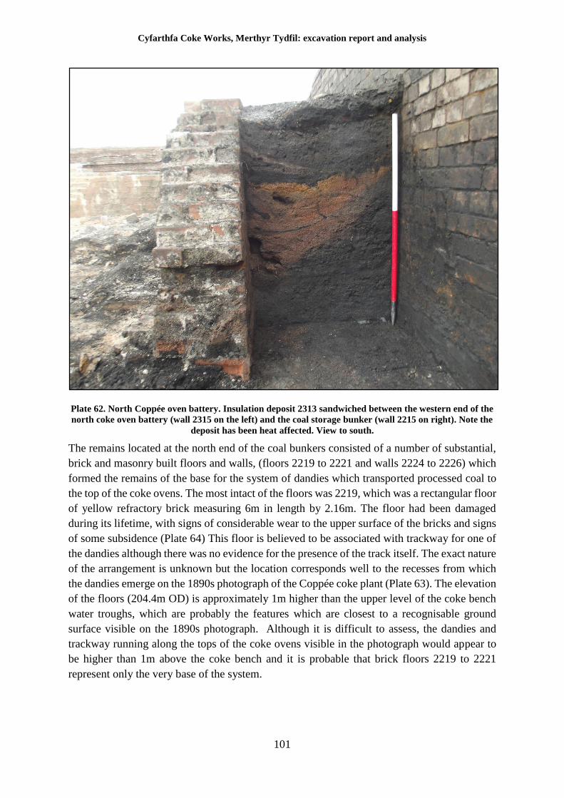
Cyfarthfa Coke Works, Merthyr Tydfil: excavation report and analysis
101
Plate 62. North Coppée oven battery. Insulation deposit 2313 sandwiched between the western end of the
north coke oven battery (wall 2315 on the left) and the coal storage bunker (wall 2215 on right). Note the
deposit has been heat affected. View to south.
The remains located at the north end of the coal bunkers consisted of a number of substantial,
brick and masonry built floors and walls, (floors 2219 to 2221 and walls 2224 to 2226) which
formed the remains of the base for the system of dandies which transported processed coal to
the top of the coke ovens. The most intact of the floors was 2219, which was a rectangular floor
of yellow refractory brick measuring 6m in length by 2.16m. The floor had been damaged
during its lifetime, with signs of considerable wear to the upper surface of the bricks and signs
of some subsidence (Plate 64) This floor is believed to be associated with trackway for one of
the dandies although there was no evidence for the presence of the track itself. The exact nature
of the arrangement is unknown but the location corresponds well to the recesses from which
the dandies emerge on the 1890s photograph of the Coppée coke plant (Plate 63). The elevation
of the floors (204.4m OD) is approximately 1m higher than the upper level of the coke bench
water troughs, which are probably the features which are closest to a recognisable ground
surface visible on the 1890s photograph. Although it is difficult to assess, the dandies and
trackway running along the tops of the coke ovens visible in the photograph would appear to
be higher than 1m above the coke bench and it is probable that brick floors 2219 to 2221
represent only the very base of the system.
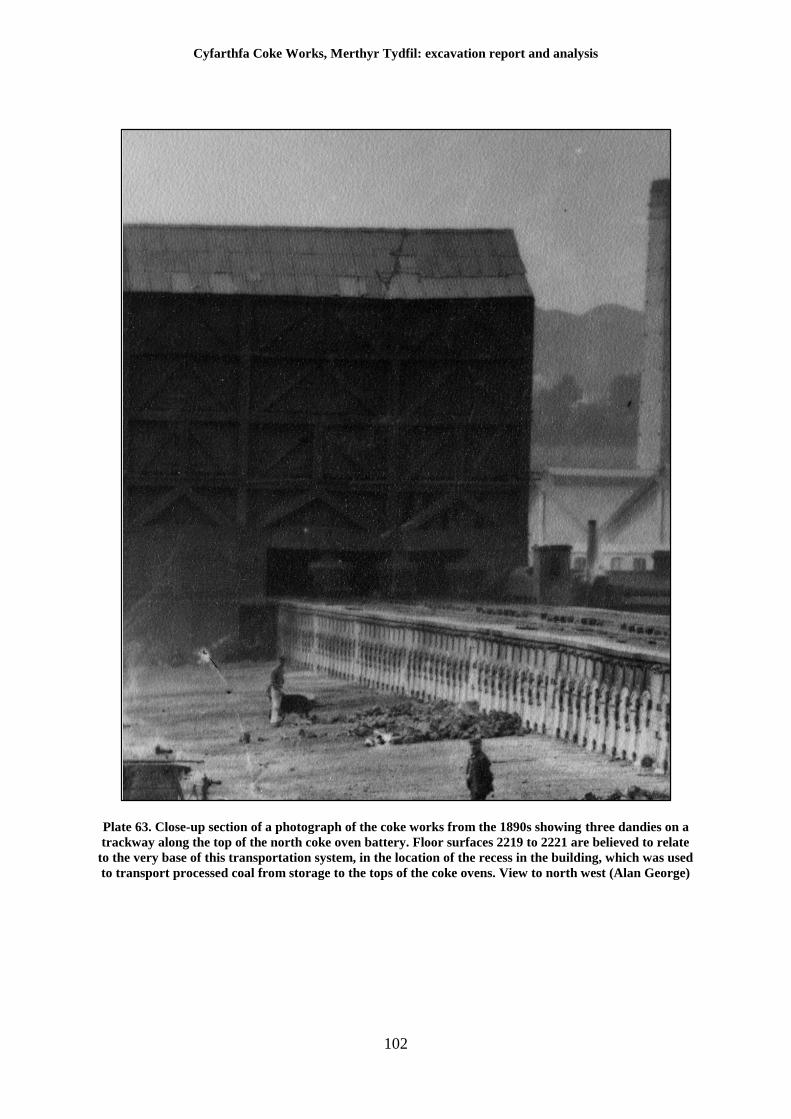
Cyfarthfa Coke Works, Merthyr Tydfil: excavation report and analysis
102
Plate 63. Close-up section of a photograph of the coke works from the 1890s showing three dandies on a
trackway along the top of the north coke oven battery. Floor surfaces 2219 to 2221 are believed to relate
to the very base of this transportation system, in the location of the recess in the building, which was used
to transport processed coal from storage to the tops of the coke ovens. View to north west (Alan George)
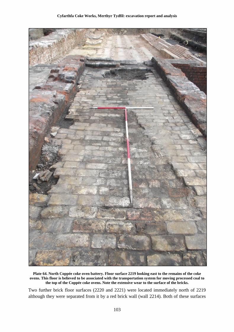
Cyfarthfa Coke Works, Merthyr Tydfil: excavation report and analysis
103
Plate 64. North Coppée coke oven battery. Floor surface 2219 looking east to the remains of the coke
ovens. This floor is believed to be associated with the transportation system for moving processed coal to
the top of the Coppée coke ovens. Note the extensive wear to the surface of the bricks.
Two further brick floor surfaces (2220 and 2221) were located immediately north of 2219
although they were separated from it by a red brick wall (wall 2214). Both of these surfaces
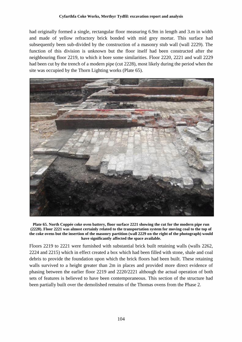
Cyfarthfa Coke Works, Merthyr Tydfil: excavation report and analysis
104
had originally formed a single, rectangular floor measuring 6.9m in length and 3.m in width
and made of yellow refractory brick bonded with mid grey mortar. This surface had
subsequently been sub-divided by the construction of a masonry stub wall (wall 2229). The
function of this division is unknown but the floor itself had been constructed after the
neighbouring floor 2219, to which it bore some similarities. Floor 2220, 2221 and wall 2229
had been cut by the trench of a modern pipe (cut 2228), most likely during the period when the
site was occupied by the Thorn Lighting works (Plate 65).
Plate 65. North Coppée coke oven battery, floor surface 2221 showing the cut for the modern pipe run
(2228). Floor 2221 was almost certainly related to the transportation system for moving coal to the top of
the coke ovens but the insertion of the masonry partition (wall 2229 on the right of the photograph) would
have significantly affected the space available.
Floors 2219 to 2221 were furnished with substantial brick built retaining walls (walls 2262,
2224 and 2215) which in effect created a box which had been filled with stone, shale and coal
debris to provide the foundation upon which the brick floors had been built. These retaining
walls survived to a height greater than 2m in places and provided more direct evidence of
phasing between the earlier floor 2219 and 2220/2221 although the actual operation of both
sets of features is believed to have been contemporaneous. This section of the structure had
been partially built over the demolished remains of the Thomas ovens from the Phase 2.
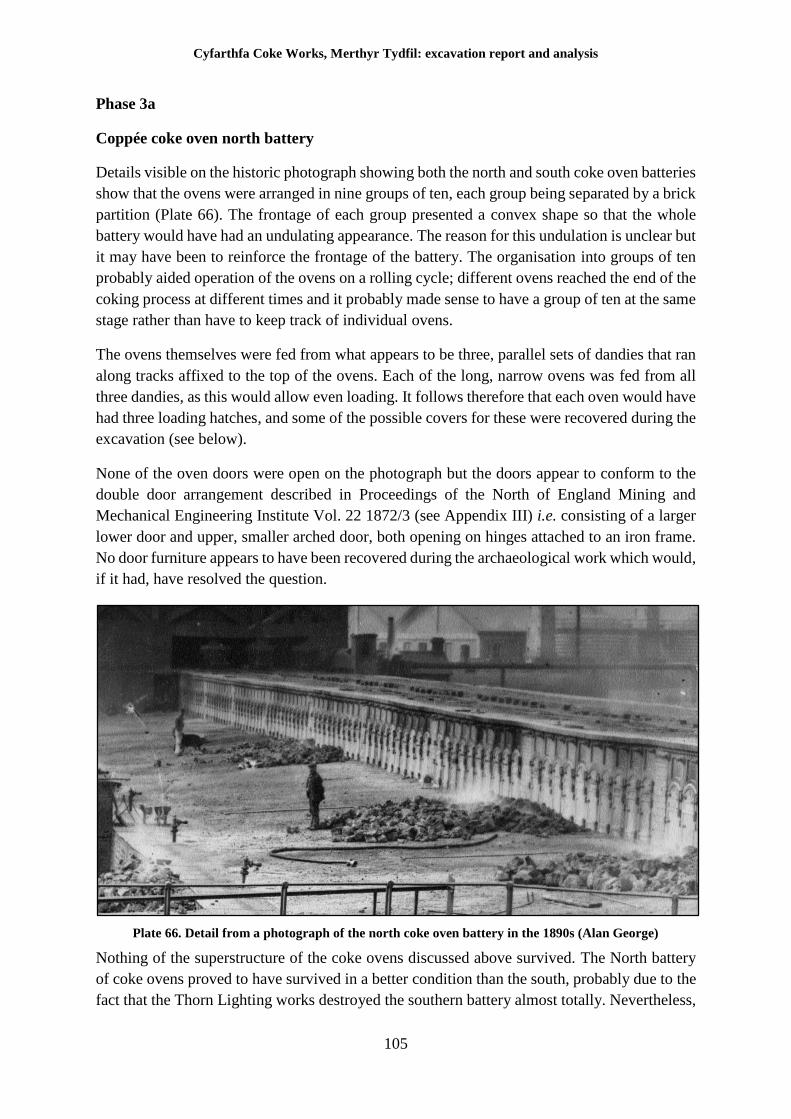
Cyfarthfa Coke Works, Merthyr Tydfil: excavation report and analysis
105
Phase 3a
Coppée coke oven north battery
Details visible on the historic photograph showing both the north and south coke oven batteries
show that the ovens were arranged in nine groups of ten, each group being separated by a brick
partition (Plate 66). The frontage of each group presented a convex shape so that the whole
battery would have had an undulating appearance. The reason for this undulation is unclear but
it may have been to reinforce the frontage of the battery. The organisation into groups of ten
probably aided operation of the ovens on a rolling cycle; different ovens reached the end of the
coking process at different times and it probably made sense to have a group of ten at the same
stage rather than have to keep track of individual ovens.
The ovens themselves were fed from what appears to be three, parallel sets of dandies that ran
along tracks affixed to the top of the ovens. Each of the long, narrow ovens was fed from all
three dandies, as this would allow even loading. It follows therefore that each oven would have
had three loading hatches, and some of the possible covers for these were recovered during the
excavation (see below).
None of the oven doors were open on the photograph but the doors appear to conform to the
double door arrangement described in Proceedings of the North of England Mining and
Mechanical Engineering Institute Vol. 22 1872/3 (see Appendix III) i.e. consisting of a larger
lower door and upper, smaller arched door, both opening on hinges attached to an iron frame.
No door furniture appears to have been recovered during the archaeological work which would,
if it had, have resolved the question.
Plate 66. Detail from a photograph of the north coke oven battery in the 1890s (Alan George)
Nothing of the superstructure of the coke ovens discussed above survived. The North battery
of coke ovens proved to have survived in a better condition than the south, probably due to the
fact that the Thorn Lighting works destroyed the southern battery almost totally. Nevertheless,
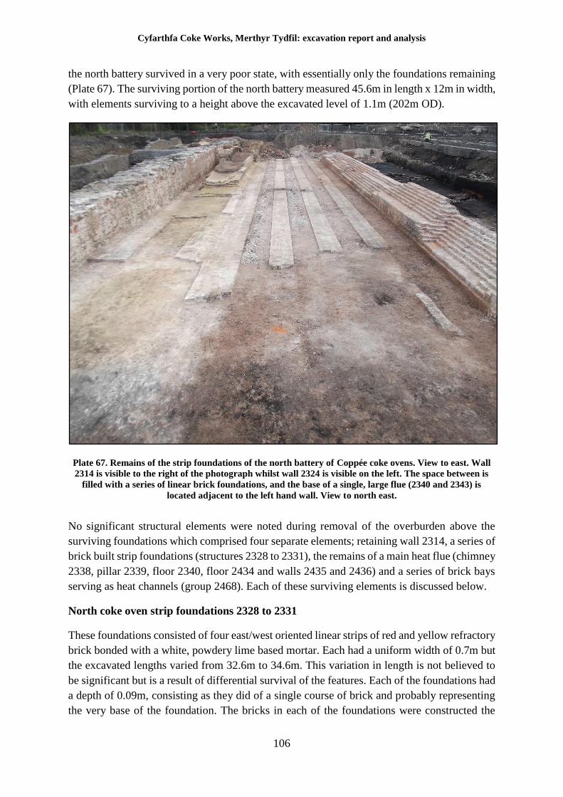
Cyfarthfa Coke Works, Merthyr Tydfil: excavation report and analysis
106
the north battery survived in a very poor state, with essentially only the foundations remaining
(Plate 67). The surviving portion of the north battery measured 45.6m in length x 12m in width,
with elements surviving to a height above the excavated level of 1.1m (202m OD).
Plate 67. Remains of the strip foundations of the north battery of Coppée coke ovens. View to east. Wall
2314 is visible to the right of the photograph whilst wall 2324 is visible on the left. The space between is
filled with a series of linear brick foundations, and the base of a single, large flue (2340 and 2343) is
located adjacent to the left hand wall. View to north east.
No significant structural elements were noted during removal of the overburden above the
surviving foundations which comprised four separate elements; retaining wall 2314, a series of
brick built strip foundations (structures 2328 to 2331), the remains of a main heat flue (chimney
2338, pillar 2339, floor 2340, floor 2434 and walls 2435 and 2436) and a series of brick bays
serving as heat channels (group 2468). Each of these surviving elements is discussed below.
North coke oven strip foundations 2328 to 2331
These foundations consisted of four east/west oriented linear strips of red and yellow refractory
brick bonded with a white, powdery lime based mortar. Each had a uniform width of 0.7m but
the excavated lengths varied from 32.6m to 34.6m. This variation in length is not believed to
be significant but is a result of differential survival of the features. Each of the foundations had
a depth of 0.09m, consisting as they did of a single course of brick and probably representing
the very base of the foundation. The bricks in each of the foundations were constructed the
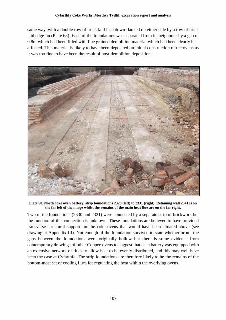
Cyfarthfa Coke Works, Merthyr Tydfil: excavation report and analysis
107
same way, with a double row of brick laid face down flanked on either side by a row of brick
laid edge-on (Plate 68). Each of the foundations was separated from its neighbour by a gap of
0.8m which had been filled with fine grained demolition material which had been clearly heat
affected. This material is likely to have been deposited on initial construction of the ovens as
it was too fine to have been the result of post-demolition deposition.
Plate 68. North coke oven battery, strip foundations 2328 (left) to 2331 (right). Retaining wall 2341 is on
the far left of the image whilst the remains of the main heat flue are on the far right.
Two of the foundations (2330 and 2331) were connected by a separate strip of brickwork but
the function of this connection is unknown. These foundations are believed to have provided
transverse structural support for the coke ovens that would have been situated above (see
drawing at Appendix III). Not enough of the foundation survived to state whether or not the
gaps between the foundations were originally hollow but there is some evidence from
contemporary drawings of other Coppée ovens to suggest that each battery was equipped with
an extensive network of flues to allow heat to be evenly distributed, and this may well have
been the case at Cyfarthfa. The strip foundations are therefore likely to be the remains of the
bottom-most set of cooling flues for regulating the heat within the overlying ovens.
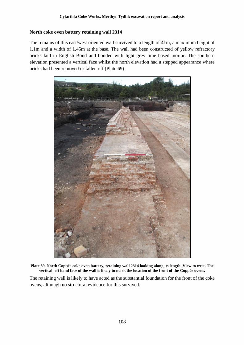
Cyfarthfa Coke Works, Merthyr Tydfil: excavation report and analysis
108
North coke oven battery retaining wall 2314
The remains of this east/west oriented wall survived to a length of 41m, a maximum height of
1.1m and a width of 1.45m at the base. The wall had been constructed of yellow refractory
bricks laid in English Bond and bonded with light grey lime based mortar. The southern
elevation presented a vertical face whilst the north elevation had a stepped appearance where
bricks had been removed or fallen off (Plate 69).
Plate 69. North Coppée coke oven battery, retaining wall 2314 looking along its length. View to west. The
vertical left hand face of the wall is likely to mark the location of the front of the Coppée ovens.
The retaining wall is likely to have acted as the substantial foundation for the front of the coke
ovens, although no structural evidence for this survived.
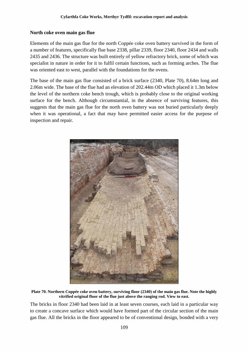
Cyfarthfa Coke Works, Merthyr Tydfil: excavation report and analysis
109
North coke oven main gas flue
Elements of the main gas flue for the north Coppée coke oven battery survived in the form of
a number of features, specifically flue base 2338, pillar 2339, floor 2340, floor 2434 and walls
2435 and 2436. The structure was built entirely of yellow refractory brick, some of which was
specialist in nature in order for it to fulfil certain functions, such as forming arches. The flue
was oriented east to west, parallel with the foundations for the ovens.
The base of the main gas flue consisted of a brick surface (2340, Plate 70), 8.64m long and
2.06m wide. The base of the flue had an elevation of 202.44m OD which placed it 1.3m below
the level of the northern coke bench trough, which is probably close to the original working
surface for the bench. Although circumstantial, in the absence of surviving features, this
suggests that the main gas flue for the north oven battery was not buried particularly deeply
when it was operational, a fact that may have permitted easier access for the purpose of
inspection and repair.
Plate 70. Northern Coppée coke oven battery, surviving floor (2340) of the main gas flue. Note the highly
vitrified original floor of the flue just above the ranging rod. View to east.
The bricks in floor 2340 had been laid in at least seven courses, each laid in a particular way
to create a concave surface which would have formed part of the circular section of the main
gas flue. All the bricks in the floor appeared to be of conventional design, bonded with a very
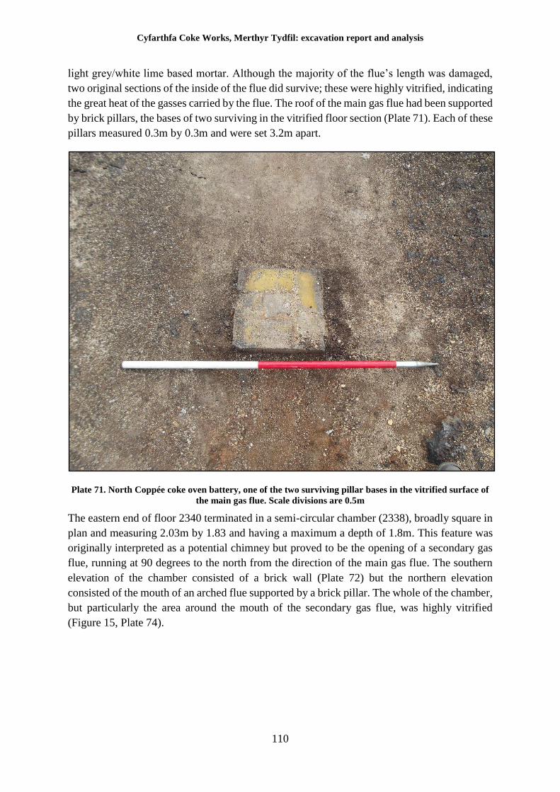
Cyfarthfa Coke Works, Merthyr Tydfil: excavation report and analysis
110
light grey/white lime based mortar. Although the majority of the flue’s length was damaged,
two original sections of the inside of the flue did survive; these were highly vitrified, indicating
the great heat of the gasses carried by the flue. The roof of the main gas flue had been supported
by brick pillars, the bases of two surviving in the vitrified floor section (Plate 71). Each of these
pillars measured 0.3m by 0.3m and were set 3.2m apart.
Plate 71. North Coppée coke oven battery, one of the two surviving pillar bases in the vitrified surface of
the main gas flue. Scale divisions are 0.5m
The eastern end of floor 2340 terminated in a semi-circular chamber (2338), broadly square in
plan and measuring 2.03m by 1.83 and having a maximum a depth of 1.8m. This feature was
originally interpreted as a potential chimney but proved to be the opening of a secondary gas
flue, running at 90 degrees to the north from the direction of the main gas flue. The southern
elevation of the chamber consisted of a brick wall (Plate 72) but the northern elevation
consisted of the mouth of an arched flue supported by a brick pillar. The whole of the chamber,
but particularly the area around the mouth of the secondary gas flue, was highly vitrified
(Figure 15, Plate 74).
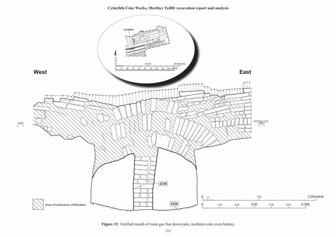
0 0.10 1.00 2.00metres
0 1.00 2.00 6.00ft.3.00 4.00 5.00
2339
2338
West East
Area of extensive vitrification
25.00 50.00metres0
0 150feet15 30 45 60 75 90 105 120 135
N
GRID
Location
Figure 15. Vitrified mouth of main gas flue down-take, northern coke oven battery.
111
Cyfarthfa Coke Works, Merthyr Tydfil: excavation report and analysis
202.55m O.D.
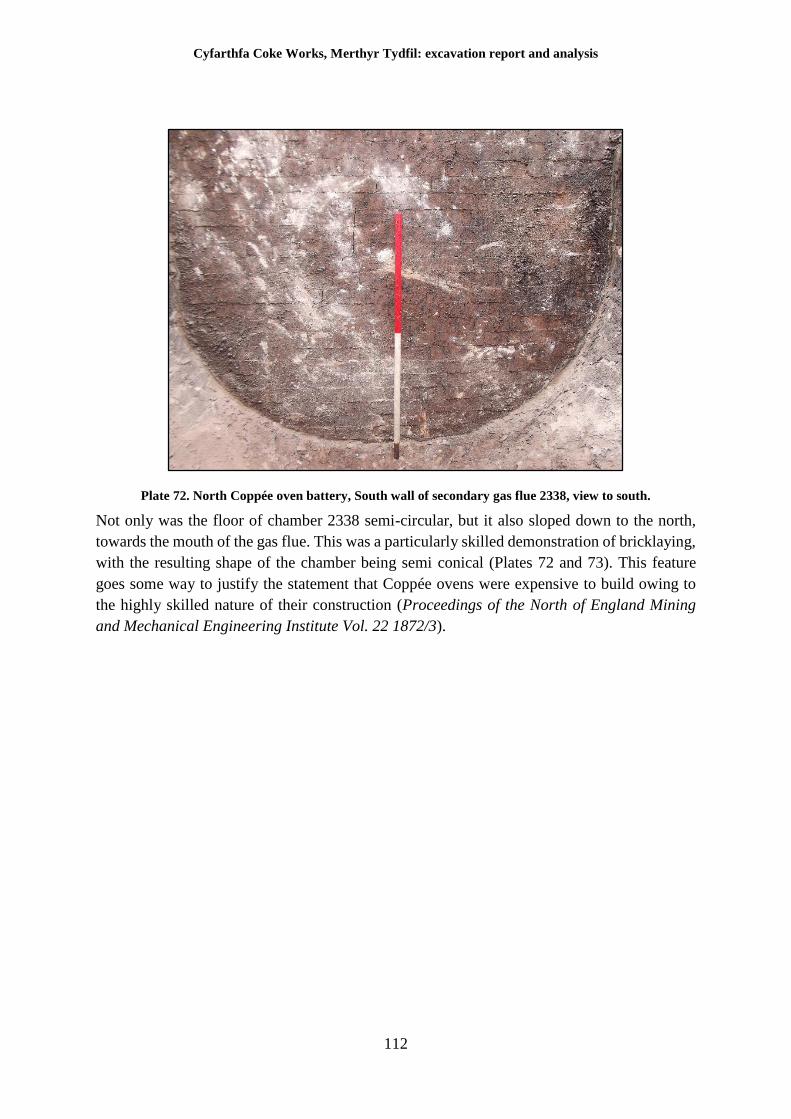
Cyfarthfa Coke Works, Merthyr Tydfil: excavation report and analysis
112
Plate 72. North Coppée oven battery, South wall of secondary gas flue 2338, view to south.
Not only was the floor of chamber 2338 semi-circular, but it also sloped down to the north,
towards the mouth of the gas flue. This was a particularly skilled demonstration of bricklaying,
with the resulting shape of the chamber being semi conical (Plates 72 and 73). This feature
goes some way to justify the statement that Coppée ovens were expensive to build owing to
the highly skilled nature of their construction (Proceedings of the North of England Mining
and Mechanical Engineering Institute Vol. 22 1872/3).
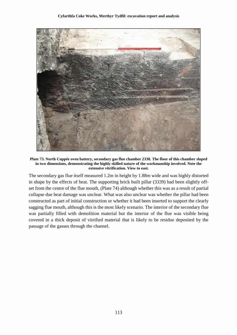
Cyfarthfa Coke Works, Merthyr Tydfil: excavation report and analysis
113
Plate 73. North Coppée oven battery, secondary gas flue chamber 2338. The floor of this chamber sloped
in two dimensions, demonstrating the highly skilled nature of the workmanship involved. Note the
extensive vitrification. View to east.
The secondary gas flue itself measured 1.2m in height by 1.88m wide and was highly distorted
in shape by the effects of heat. The supporting brick built pillar (3339) had been slightly off-
set from the centre of the flue mouth, (Plate 74) although whether this was as a result of partial
collapse due heat damage was unclear. What was also unclear was whether the pillar had been
constructed as part of initial construction or whether it had been inserted to support the clearly
sagging flue mouth, although this is the most likely scenario. The interior of the secondary flue
was partially filled with demolition material but the interior of the flue was visible being
covered in a thick deposit of vitrified material that is likely to be residue deposited by the
passage of the gasses through the channel.
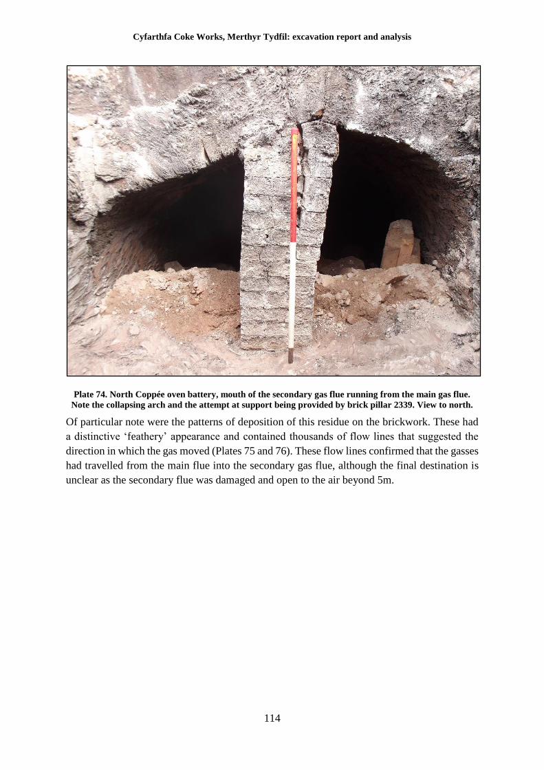
Cyfarthfa Coke Works, Merthyr Tydfil: excavation report and analysis
114
Plate 74. North Coppée oven battery, mouth of the secondary gas flue running from the main gas flue.
Note the collapsing arch and the attempt at support being provided by brick pillar 2339. View to north.
Of particular note were the patterns of deposition of this residue on the brickwork. These had
a distinctive ‘feathery’ appearance and contained thousands of flow lines that suggested the
direction in which the gas moved (Plates 75 and 76). These flow lines confirmed that the gasses
had travelled from the main flue into the secondary gas flue, although the final destination is
unclear as the secondary flue was damaged and open to the air beyond 5m.
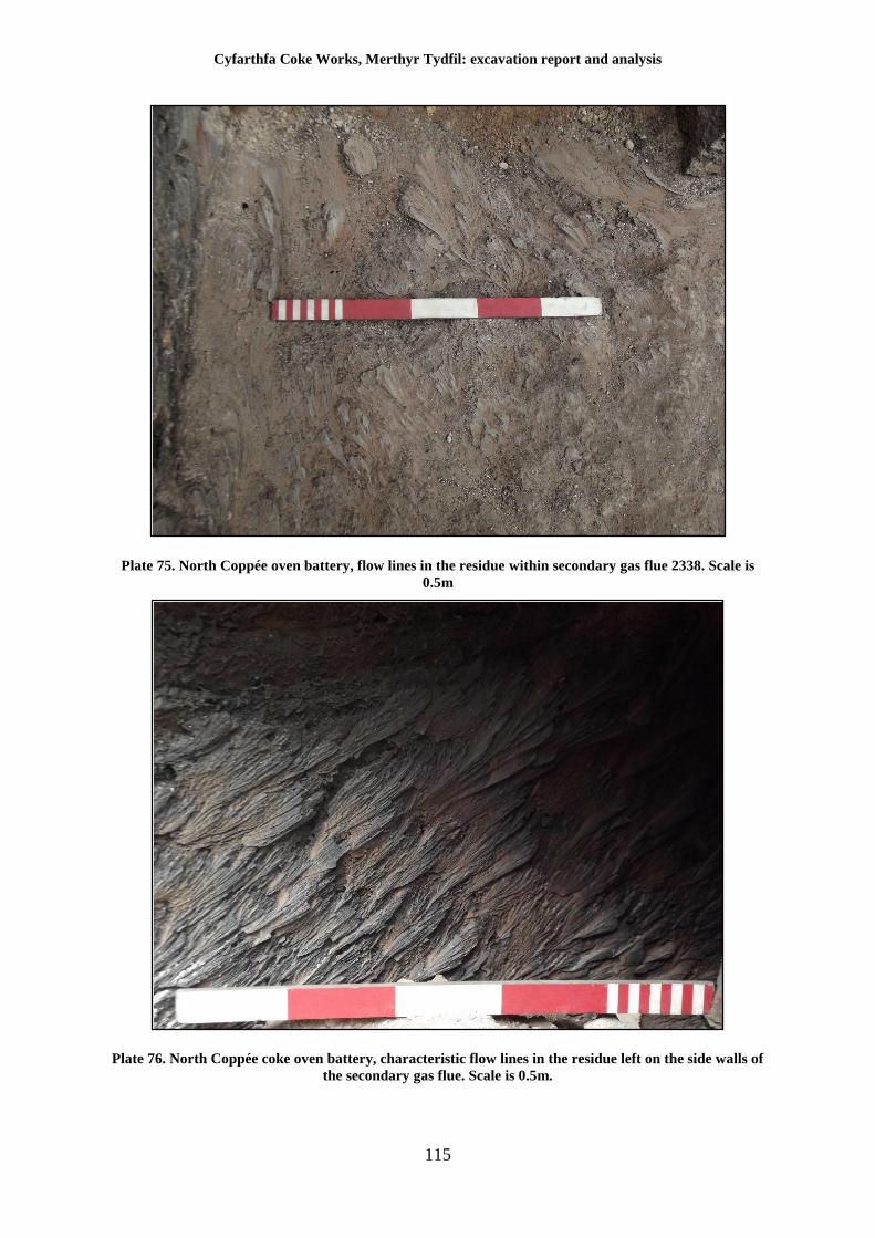
Cyfarthfa Coke Works, Merthyr Tydfil: excavation report and analysis
115
Plate 75. North Coppée oven battery, flow lines in the residue within secondary gas flue 2338. Scale is
0.5m
Plate 76. North Coppée coke oven battery, characteristic flow lines in the residue left on the side walls of
the secondary gas flue. Scale is 0.5m.
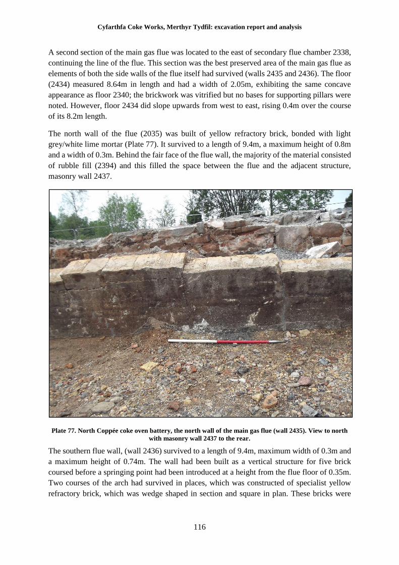
Cyfarthfa Coke Works, Merthyr Tydfil: excavation report and analysis
116
A second section of the main gas flue was located to the east of secondary flue chamber 2338,
continuing the line of the flue. This section was the best preserved area of the main gas flue as
elements of both the side walls of the flue itself had survived (walls 2435 and 2436). The floor
(2434) measured 8.64m in length and had a width of 2.05m, exhibiting the same concave
appearance as floor 2340; the brickwork was vitrified but no bases for supporting pillars were
noted. However, floor 2434 did slope upwards from west to east, rising 0.4m over the course
of its 8.2m length.
The north wall of the flue (2035) was built of yellow refractory brick, bonded with light
grey/white lime mortar (Plate 77). It survived to a length of 9.4m, a maximum height of 0.8m
and a width of 0.3m. Behind the fair face of the flue wall, the majority of the material consisted
of rubble fill (2394) and this filled the space between the flue and the adjacent structure,
masonry wall 2437.
Plate 77. North Coppée coke oven battery, the north wall of the main gas flue (wall 2435). View to north
with masonry wall 2437 to the rear.
The southern flue wall, (wall 2436) survived to a length of 9.4m, maximum width of 0.3m and
a maximum height of 0.74m. The wall had been built as a vertical structure for five brick
coursed before a springing point had been introduced at a height from the flue floor of 0.35m.
Two courses of the arch had survived in places, which was constructed of specialist yellow
refractory brick, which was wedge shaped in section and square in plan. These bricks were
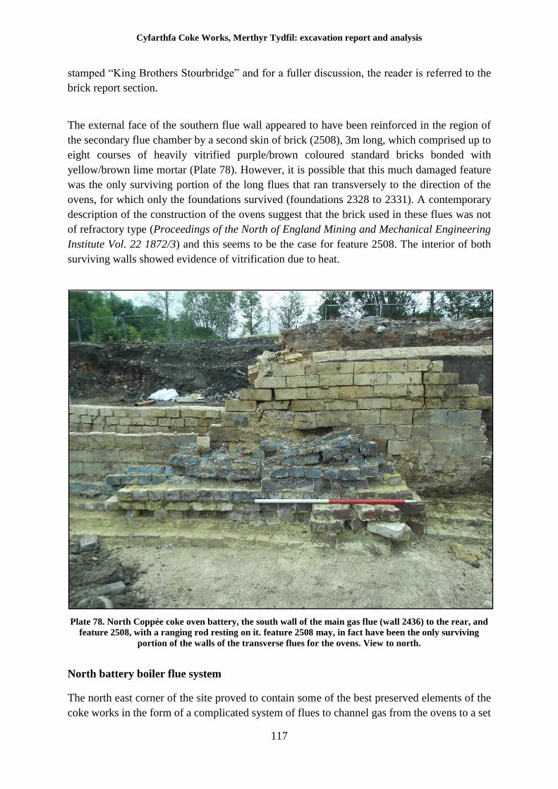
Cyfarthfa Coke Works, Merthyr Tydfil: excavation report and analysis
117
stamped “King Brothers Stourbridge” and for a fuller discussion, the reader is referred to the
brick report section.
The external face of the southern flue wall appeared to have been reinforced in the region of
the secondary flue chamber by a second skin of brick (2508), 3m long, which comprised up to
eight courses of heavily vitrified purple/brown coloured standard bricks bonded with
yellow/brown lime mortar (Plate 78). However, it is possible that this much damaged feature
was the only surviving portion of the long flues that ran transversely to the direction of the
ovens, for which only the foundations survived (foundations 2328 to 2331). A contemporary
description of the construction of the ovens suggest that the brick used in these flues was not
of refractory type (Proceedings of the North of England Mining and Mechanical Engineering
Institute Vol. 22 1872/3) and this seems to be the case for feature 2508. The interior of both
surviving walls showed evidence of vitrification due to heat.
Plate 78. North Coppée coke oven battery, the south wall of the main gas flue (wall 2436) to the rear, and
feature 2508, with a ranging rod resting on it. feature 2508 may, in fact have been the only surviving
portion of the walls of the transverse flues for the ovens. View to north.
North battery boiler flue system
The north east corner of the site proved to contain some of the best preserved elements of the
coke works in the form of a complicated system of flues to channel gas from the ovens to a set
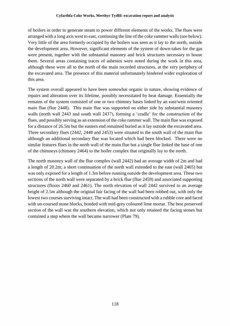
Cyfarthfa Coke Works, Merthyr Tydfil: excavation report and analysis
118
of boilers in order to generate steam to power different elements of the works. The flues were
arranged with a long axis west to east, continuing the line of the coke rammer walls (see below).
Very little of the area formerly occupied by the boilers was seen as it lay to the north, outside
the development area. However, significant elements of the system of down-takes for the gas
were present, together with the substantial masonry and brick structures necessary to house
them. Several areas containing traces of asbestos were noted during the work in this area,
although these were all to the north of the main recorded structures, at the very periphery of
the excavated area. The presence of this material unfortunately hindered wider exploration of
this area.
The system overall appeared to have been somewhat organic in nature, showing evidence of
repairs and alteration over its lifetime, possibly necessitated by heat damage. Essentially the
remains of the system consisted of one or two chimney bases linked by an east/west oriented
main flue (flue 2448). This main flue was supported on either side by substantial masonry
walls (north wall 2443 and south wall 2437), forming a ‘cradle’ for the construction of the
flues, and possibly serving as an extension of the coke rammer wall. The main flue was exposed
for a distance of 26.5m but the eastern end remained buried as it lay outside the excavated area.
Three secondary flues (2442, 2448 and 2453) were situated in the south wall of the main flue
although an additional secondary flue was located which had been blocked. There were no
similar features flues in the north wall of the main flue but a single flue linked the base of one
of the chimneys (chimney 2464) to the boiler complex that originally lay to the north.
The north masonry wall of the flue complex (wall 2442) had an average width of 2m and had
a length of 20.2m; a short continuation of the north wall extended to the east (wall 2465) but
was only exposed for a length of 1.3m before running outside the development area. These two
sections of the north wall were separated by a brick flue (flue 2459) and associated supporting
structures (floors 2460 and 2461). The north elevation of wall 2442 survived to an average
height of 2.5m although the original fair facing of the wall had been robbed out, with only the
lowest two courses surviving intact. The wall had been constructed with a rubble core and faced
with un-coursed stone blocks, bonded with mid-grey coloured lime mortar. The best preserved
section of the wall was the southern elevation, which not only retained the facing stones but
contained a step where the wall became narrower (Plate 79).
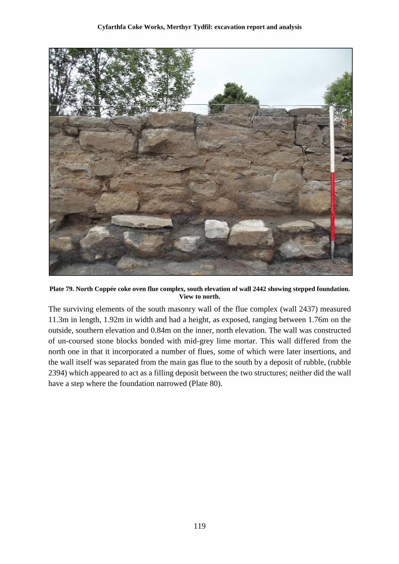
Cyfarthfa Coke Works, Merthyr Tydfil: excavation report and analysis
119
Plate 79. North Coppée coke oven flue complex, south elevation of wall 2442 showing stepped foundation.
View to north.
The surviving elements of the south masonry wall of the flue complex (wall 2437) measured
11.3m in length, 1.92m in width and had a height, as exposed, ranging between 1.76m on the
outside, southern elevation and 0.84m on the inner, north elevation. The wall was constructed
of un-coursed stone blocks bonded with mid-grey lime mortar. This wall differed from the
north one in that it incorporated a number of flues, some of which were later insertions, and
the wall itself was separated from the main gas flue to the south by a deposit of rubble, (rubble
2394) which appeared to act as a filling deposit between the two structures; neither did the wall
have a step where the foundation narrowed (Plate 80).
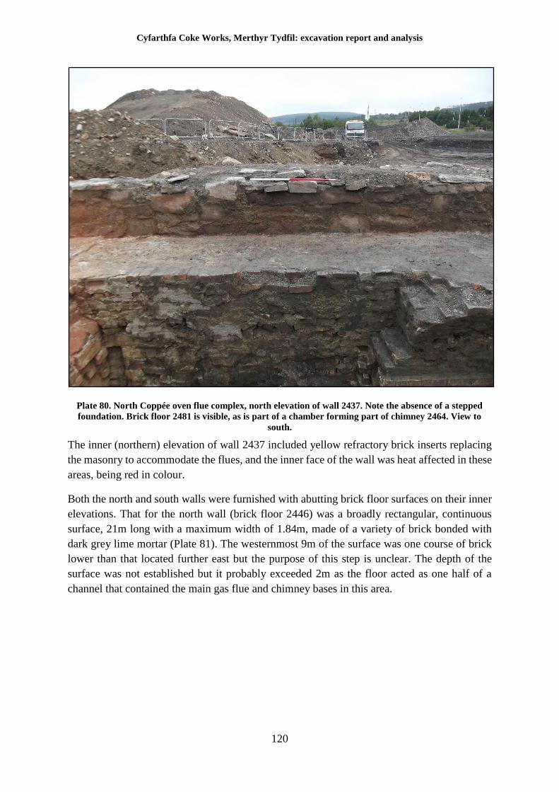
Cyfarthfa Coke Works, Merthyr Tydfil: excavation report and analysis
120
Plate 80. North Coppée oven flue complex, north elevation of wall 2437. Note the absence of a stepped
foundation. Brick floor 2481 is visible, as is part of a chamber forming part of chimney 2464. View to
south.
The inner (northern) elevation of wall 2437 included yellow refractory brick inserts replacing
the masonry to accommodate the flues, and the inner face of the wall was heat affected in these
areas, being red in colour.
Both the north and south walls were furnished with abutting brick floor surfaces on their inner
elevations. That for the north wall (brick floor 2446) was a broadly rectangular, continuous
surface, 21m long with a maximum width of 1.84m, made of a variety of brick bonded with
dark grey lime mortar (Plate 81). The westernmost 9m of the surface was one course of brick
lower than that located further east but the purpose of this step is unclear. The depth of the
surface was not established but it probably exceeded 2m as the floor acted as one half of a
channel that contained the main gas flue and chimney bases in this area.
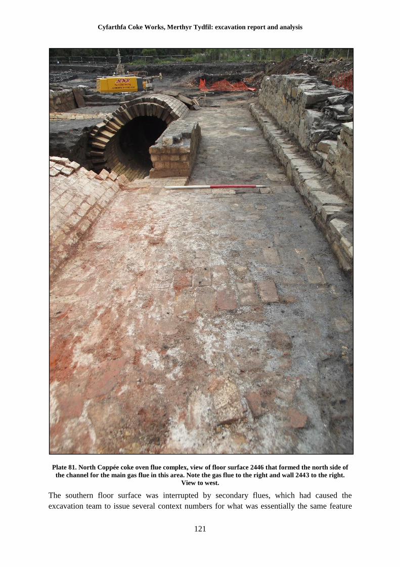
Cyfarthfa Coke Works, Merthyr Tydfil: excavation report and analysis
121
Plate 81. North Coppée coke oven flue complex, view of floor surface 2446 that formed the north side of
the channel for the main gas flue in this area. Note the gas flue to the right and wall 2443 to the right.
View to west.
The southern floor surface was interrupted by secondary flues, which had caused the
excavation team to issue several context numbers for what was essentially the same feature
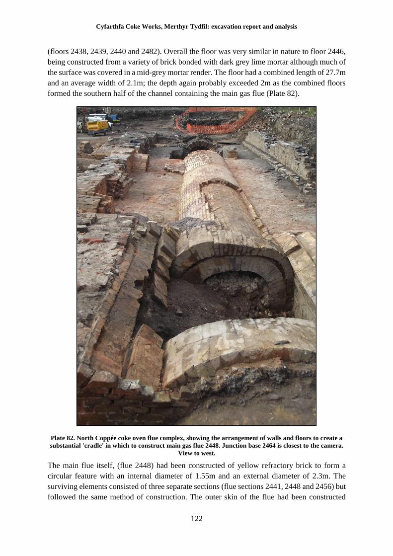
Cyfarthfa Coke Works, Merthyr Tydfil: excavation report and analysis
122
(floors 2438, 2439, 2440 and 2482). Overall the floor was very similar in nature to floor 2446,
being constructed from a variety of brick bonded with dark grey lime mortar although much of
the surface was covered in a mid-grey mortar render. The floor had a combined length of 27.7m
and an average width of 2.1m; the depth again probably exceeded 2m as the combined floors
formed the southern half of the channel containing the main gas flue (Plate 82).
Plate 82. North Coppée coke oven flue complex, showing the arrangement of walls and floors to create a
substantial 'cradle' in which to construct main gas flue 2448. Junction base 2464 is closest to the camera.
View to west.
The main flue itself, (flue 2448) had been constructed of yellow refractory brick to form a
circular feature with an internal diameter of 1.55m and an external diameter of 2.3m. The
surviving elements consisted of three separate sections (flue sections 2441, 2448 and 2456) but
followed the same method of construction. The outer skin of the flue had been constructed
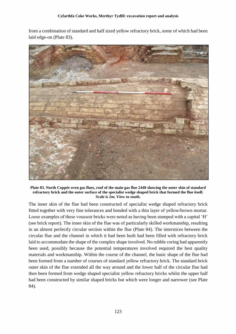
Cyfarthfa Coke Works, Merthyr Tydfil: excavation report and analysis
123
from a combination of standard and half sized yellow refractory brick, some of which had been
laid edge-on (Plate 83).
Plate 83. North Coppée oven gas flues, roof of the main gas flue 2448 showing the outer skin of standard
refractory brick and the outer surface of the specialist wedge shaped brick that formed the flue itself.
Scale is 2m. View to south.
The inner skin of the flue had been constructed of specialist wedge shaped refractory brick
fitted together with very fine tolerances and bonded with a thin layer of yellow/brown mortar.
Loose examples of these voussoir bricks were noted as having been stamped with a capital ‘H’
(see brick report). The inner skin of the flue was of particularly skilled workmanship, resulting
in an almost perfectly circular section within the flue (Plate 84). The interstices between the
circular flue and the channel in which it had been built had been filled with refractory brick
laid to accommodate the shape of the complex shape involved. No rubble coring had apparently
been used, possibly because the potential temperatures involved required the best quality
materials and workmanship. Within the course of the channel, the basic shape of the flue had
been formed from a number of courses of standard yellow refractory brick. The standard brick
outer skin of the flue extended all the way around and the lower half of the circular flue had
then been formed from wedge shaped specialist yellow refractory bricks whilst the upper half
had been constructed by similar shaped bricks but which were longer and narrower (see Plate
84).
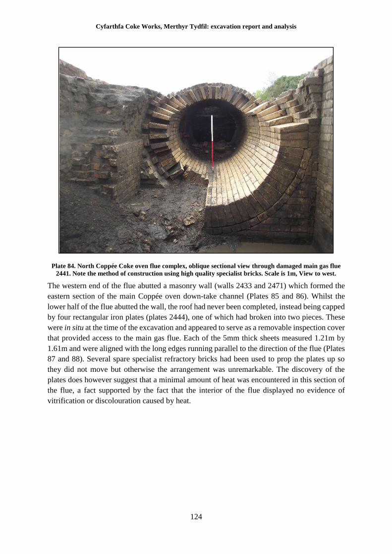
Cyfarthfa Coke Works, Merthyr Tydfil: excavation report and analysis
124
Plate 84. North Coppée Coke oven flue complex, oblique sectional view through damaged main gas flue
2441. Note the method of construction using high quality specialist bricks. Scale is 1m, View to west.
The western end of the flue abutted a masonry wall (walls 2433 and 2471) which formed the
eastern section of the main Coppée oven down-take channel (Plates 85 and 86). Whilst the
lower half of the flue abutted the wall, the roof had never been completed, instead being capped
by four rectangular iron plates (plates 2444), one of which had broken into two pieces. These
were in situ at the time of the excavation and appeared to serve as a removable inspection cover
that provided access to the main gas flue. Each of the 5mm thick sheets measured 1.21m by
1.61m and were aligned with the long edges running parallel to the direction of the flue (Plates
87 and 88). Several spare specialist refractory bricks had been used to prop the plates up so
they did not move but otherwise the arrangement was unremarkable. The discovery of the
plates does however suggest that a minimal amount of heat was encountered in this section of
the flue, a fact supported by the fact that the interior of the flue displayed no evidence of
vitrification or discolouration caused by heat.
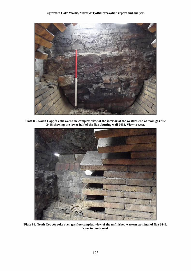
Cyfarthfa Coke Works, Merthyr Tydfil: excavation report and analysis
125
Plate 85. North Coppée coke oven flue complex, view of the interior of the western end of main gas flue
2448 showing the lower half of the flue abutting wall 2433. View to west.
Plate 86. North Coppée coke oven gas flue complex, view of the unfinished western terminal of flue 2448.
View to north west.
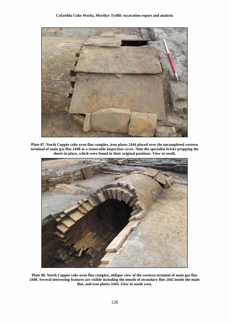
Cyfarthfa Coke Works, Merthyr Tydfil: excavation report and analysis
126
Plate 87. North Coppée coke oven flue complex, iron plates 2444 placed over the uncompleted western
terminal of main gas flue 2448 as a removable inspection cover. Note the specialist bricks propping the
sheets in place, which were found in their original positions. View to south.
Plate 88. North Coppée coke oven flue complex, oblique view of the western terminal of main gas flue
2448. Several interesting features are visible including the mouth of secondary flue 2442 inside the main
flue, and iron plates 2444. View to south west.
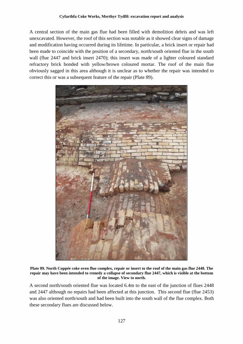
Cyfarthfa Coke Works, Merthyr Tydfil: excavation report and analysis
127
A central section of the main gas flue had been filled with demolition debris and was left
unexcavated. However, the roof of this section was notable as it showed clear signs of damage
and modification having occurred during its lifetime. In particular, a brick insert or repair had
been made to coincide with the position of a secondary, north/south oriented flue in the south
wall (flue 2447 and brick insert 2470); this insert was made of a lighter coloured standard
refractory brick bonded with yellow/brown coloured mortar. The roof of the main flue
obviously sagged in this area although it is unclear as to whether the repair was intended to
correct this or was a subsequent feature of the repair (Plate 89).
Plate 89. North Coppée coke oven flue complex, repair or insert to the roof of the main gas flue 2448. The
repair may have been intended to remedy a collapse of secondary flue 2447, which is visible at the bottom
of the image. View to north.
A second north/south oriented flue was located 6.4m to the east of the junction of flues 2448
and 2447 although no repairs had been affected at this junction. This second flue (flue 2453)
was also oriented north/south and had been built into the south wall of the flue complex. Both
these secondary flues are discussed below.
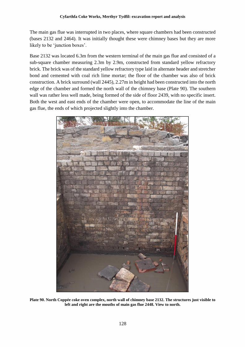
Cyfarthfa Coke Works, Merthyr Tydfil: excavation report and analysis
128
The main gas flue was interrupted in two places, where square chambers had been constructed
(bases 2132 and 2464). It was initially thought these were chimney bases but they are more
likely to be ‘junction boxes’.
Base 2132 was located 6.3m from the western terminal of the main gas flue and consisted of a
sub-square chamber measuring 2.3m by 2.9m, constructed from standard yellow refractory
brick. The brick was of the standard yellow refractory type laid in alternate header and stretcher
bond and cemented with coal rich lime mortar; the floor of the chamber was also of brick
construction. A brick surround (wall 2445), 2.27m in height had been constructed into the north
edge of the chamber and formed the north wall of the chimney base (Plate 90). The southern
wall was rather less well made, being formed of the side of floor 2439, with no specific insert.
Both the west and east ends of the chamber were open, to accommodate the line of the main
gas flue, the ends of which projected slightly into the chamber.
Plate 90. North Coppée coke oven complex, north wall of chimney base 2132. The structures just visible to
left and right are the mouths of main gas flue 2448. View to north.
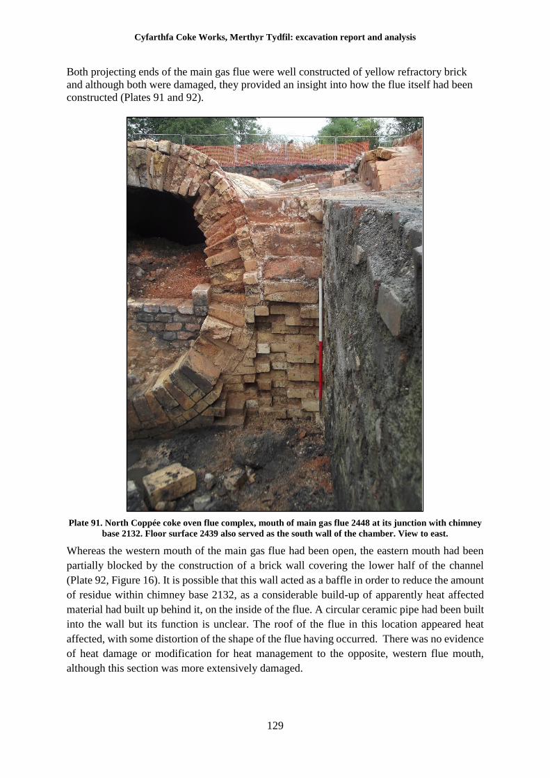
Cyfarthfa Coke Works, Merthyr Tydfil: excavation report and analysis
129
Both projecting ends of the main gas flue were well constructed of yellow refractory brick
and although both were damaged, they provided an insight into how the flue itself had been
constructed (Plates 91 and 92).
Plate 91. North Coppée coke oven flue complex, mouth of main gas flue 2448 at its junction with chimney
base 2132. Floor surface 2439 also served as the south wall of the chamber. View to east.
Whereas the western mouth of the main gas flue had been open, the eastern mouth had been
partially blocked by the construction of a brick wall covering the lower half of the channel
(Plate 92, Figure 16). It is possible that this wall acted as a baffle in order to reduce the amount
of residue within chimney base 2132, as a considerable build-up of apparently heat affected
material had built up behind it, on the inside of the flue. A circular ceramic pipe had been built
into the wall but its function is unclear. The roof of the flue in this location appeared heat
affected, with some distortion of the shape of the flue having occurred. There was no evidence
of heat damage or modification for heat management to the opposite, western flue mouth,
although this section was more extensively damaged.
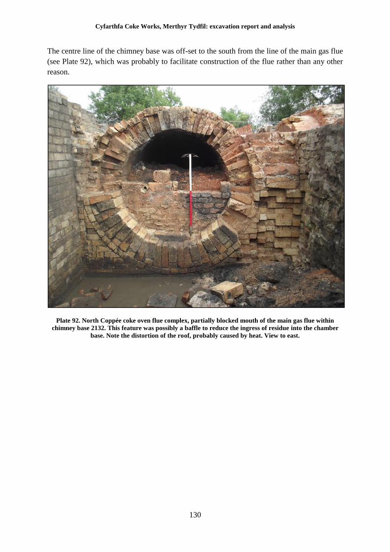
Cyfarthfa Coke Works, Merthyr Tydfil: excavation report and analysis
130
The centre line of the chimney base was off-set to the south from the line of the main gas flue
(see Plate 92), which was probably to facilitate construction of the flue rather than any other
reason.
Plate 92. North Coppée coke oven flue complex, partially blocked mouth of the main gas flue within
chimney base 2132. This feature was possibly a baffle to reduce the ingress of residue into the chamber
base. Note the distortion of the roof, probably caused by heat. View to east.
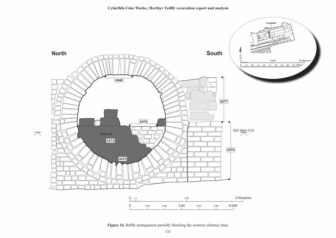
0 0.10 1.00 2.00metres
0 1.00 2.00 6.00ft.3.00 4.00 5.00
Stone fill202.165m O.D.
North South
2473
2475
2474
2448
2477
2474
25.00 50.00metres0
0 150feet15 30 45 60 75 90 105 120 135
N
GRID
Location
Figure 16. Baffle arrangement partially blocking the western chimney base.
131
Cyfarthfa Coke Works, Merthyr Tydfil: excavation report and analysis
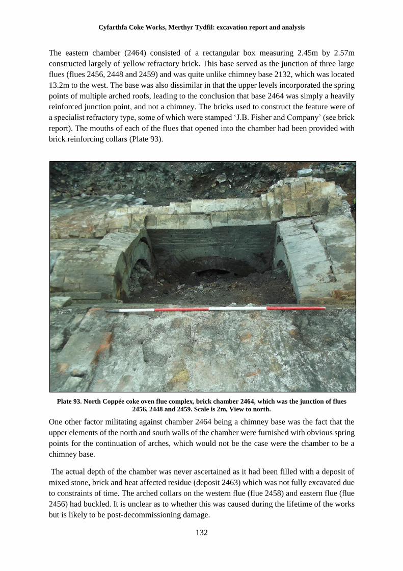
Cyfarthfa Coke Works, Merthyr Tydfil: excavation report and analysis
132
The eastern chamber (2464) consisted of a rectangular box measuring 2.45m by 2.57m
constructed largely of yellow refractory brick. This base served as the junction of three large
flues (flues 2456, 2448 and 2459) and was quite unlike chimney base 2132, which was located
13.2m to the west. The base was also dissimilar in that the upper levels incorporated the spring
points of multiple arched roofs, leading to the conclusion that base 2464 was simply a heavily
reinforced junction point, and not a chimney. The bricks used to construct the feature were of
a specialist refractory type, some of which were stamped ‘J.B. Fisher and Company’ (see brick
report). The mouths of each of the flues that opened into the chamber had been provided with
brick reinforcing collars (Plate 93).
Plate 93. North Coppée coke oven flue complex, brick chamber 2464, which was the junction of flues
2456, 2448 and 2459. Scale is 2m, View to north.
One other factor militating against chamber 2464 being a chimney base was the fact that the
upper elements of the north and south walls of the chamber were furnished with obvious spring
points for the continuation of arches, which would not be the case were the chamber to be a
chimney base.
The actual depth of the chamber was never ascertained as it had been filled with a deposit of
mixed stone, brick and heat affected residue (deposit 2463) which was not fully excavated due
to constraints of time. The arched collars on the western flue (flue 2458) and eastern flue (flue
2456) had buckled. It is unclear as to whether this was caused during the lifetime of the works
but is likely to be post-decommissioning damage.
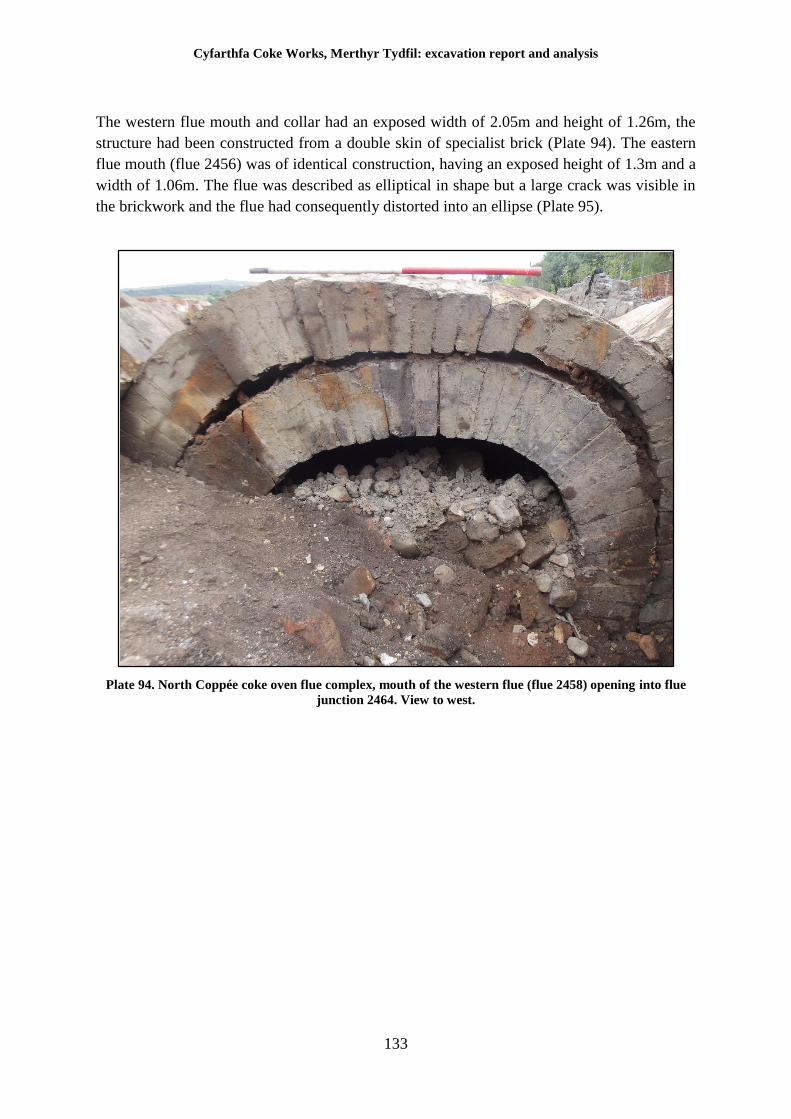
Cyfarthfa Coke Works, Merthyr Tydfil: excavation report and analysis
133
The western flue mouth and collar had an exposed width of 2.05m and height of 1.26m, the
structure had been constructed from a double skin of specialist brick (Plate 94). The eastern
flue mouth (flue 2456) was of identical construction, having an exposed height of 1.3m and a
width of 1.06m. The flue was described as elliptical in shape but a large crack was visible in
the brickwork and the flue had consequently distorted into an ellipse (Plate 95).
Plate 94. North Coppée coke oven flue complex, mouth of the western flue (flue 2458) opening into flue
junction 2464. View to west.
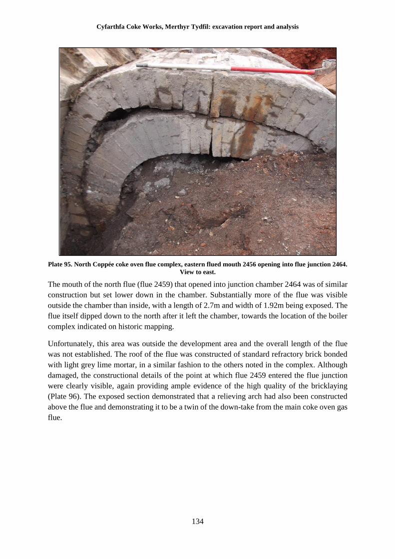
Cyfarthfa Coke Works, Merthyr Tydfil: excavation report and analysis
134
Plate 95. North Coppée coke oven flue complex, eastern flued mouth 2456 opening into flue junction 2464.
View to east.
The mouth of the north flue (flue 2459) that opened into junction chamber 2464 was of similar
construction but set lower down in the chamber. Substantially more of the flue was visible
outside the chamber than inside, with a length of 2.7m and width of 1.92m being exposed. The
flue itself dipped down to the north after it left the chamber, towards the location of the boiler
complex indicated on historic mapping.
Unfortunately, this area was outside the development area and the overall length of the flue
was not established. The roof of the flue was constructed of standard refractory brick bonded
with light grey lime mortar, in a similar fashion to the others noted in the complex. Although
damaged, the constructional details of the point at which flue 2459 entered the flue junction
were clearly visible, again providing ample evidence of the high quality of the bricklaying
(Plate 96). The exposed section demonstrated that a relieving arch had also been constructed
above the flue and demonstrating it to be a twin of the down-take from the main coke oven gas
flue.
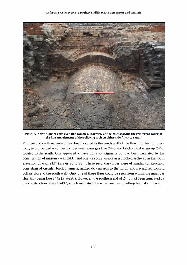
Cyfarthfa Coke Works, Merthyr Tydfil: excavation report and analysis
135
Plate 96. North Coppée coke oven flue complex, rear view of flue 2459 showing the reinforced collar of
the flue and elements of the relieving arch on either side. View to south.
Four secondary flues were or had been located in the south wall of the flue complex. Of these
four, two provided a connection between main gas flue 2448 and brick chamber group 2468,
located to the south. One appeared to have done so originally but had been truncated by the
construction of masonry wall 2437, and one was only visible as a blocked archway in the south
elevation of wall 2437 (Plates 98 to 99). These secondary flues were of similar construction,
consisting of circular brick channels, angled downwards to the north, and having reinforcing
collars close to the south wall. Only one of these flues could be seen from within the main gas
flue, this being flue 2442 (Plate 97). However, the southern end of 2442 had been truncated by
the construction of wall 2437, which indicated that extensive re-modelling had taken place.
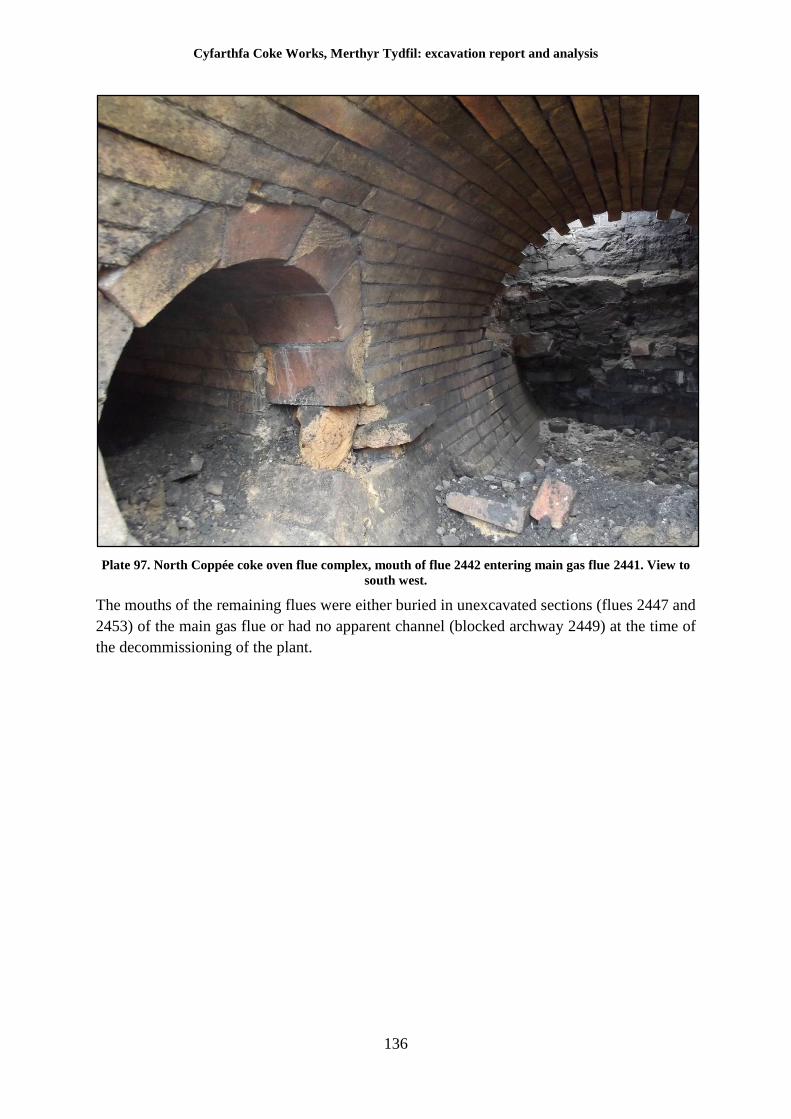
Cyfarthfa Coke Works, Merthyr Tydfil: excavation report and analysis
136
Plate 97. North Coppée coke oven flue complex, mouth of flue 2442 entering main gas flue 2441. View to
south west.
The mouths of the remaining flues were either buried in unexcavated sections (flues 2447 and
2453) of the main gas flue or had no apparent channel (blocked archway 2449) at the time of
the decommissioning of the plant.
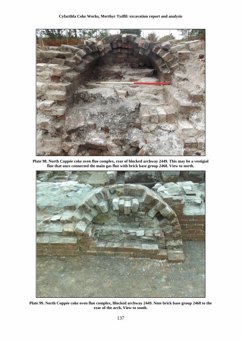
Cyfarthfa Coke Works, Merthyr Tydfil: excavation report and analysis
137
Plate 98. North Coppée coke oven flue complex, rear of blocked archway 2449. This may be a vestigial
flue that once connected the main gas flue with brick base group 2468. View to north.
Plate 99. North Coppée coke oven flue complex, Blocked archway 2449. Note brick base group 2468 to the
rear of the arch. View to south.
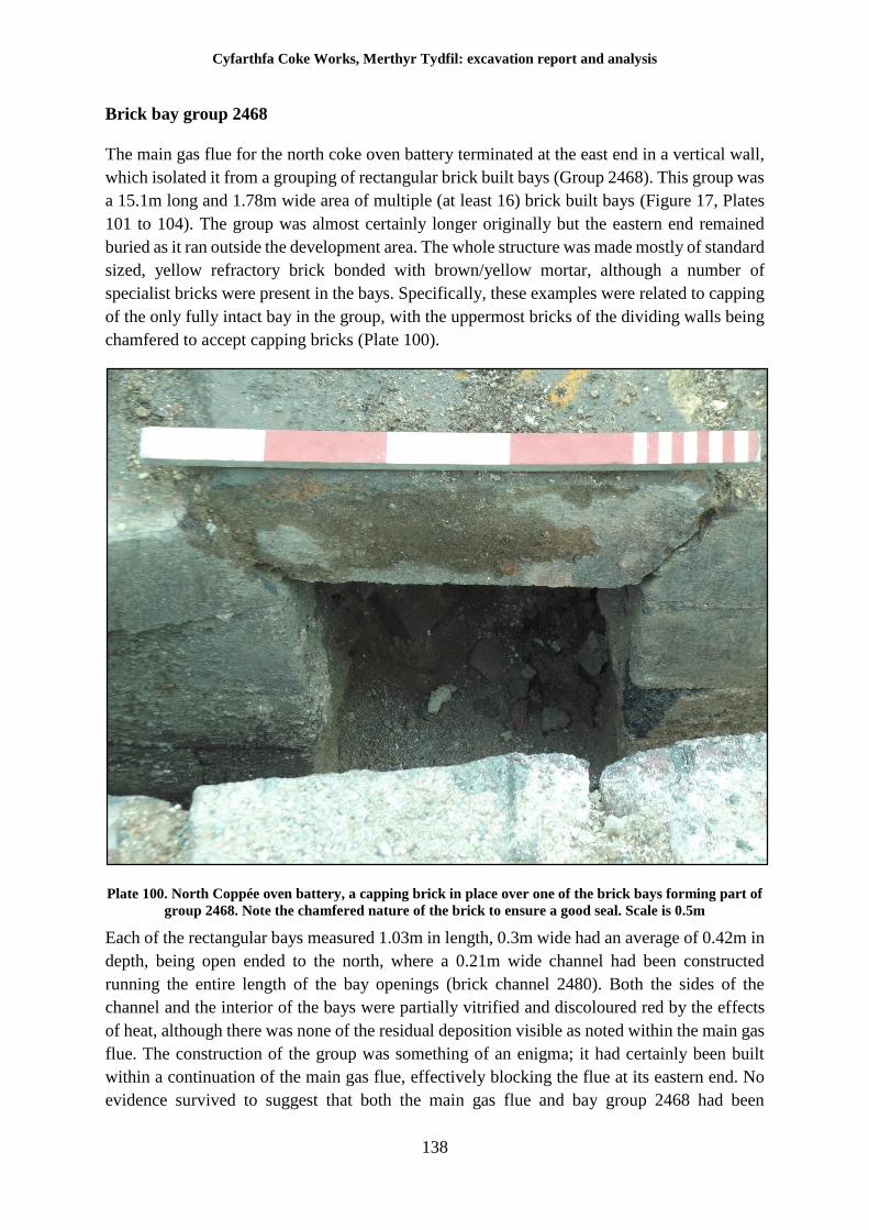
Cyfarthfa Coke Works, Merthyr Tydfil: excavation report and analysis
138
Brick bay group 2468
The main gas flue for the north coke oven battery terminated at the east end in a vertical wall,
which isolated it from a grouping of rectangular brick built bays (Group 2468). This group was
a 15.1m long and 1.78m wide area of multiple (at least 16) brick built bays (Figure 17, Plates
101 to 104). The group was almost certainly longer originally but the eastern end remained
buried as it ran outside the development area. The whole structure was made mostly of standard
sized, yellow refractory brick bonded with brown/yellow mortar, although a number of
specialist bricks were present in the bays. Specifically, these examples were related to capping
of the only fully intact bay in the group, with the uppermost bricks of the dividing walls being
chamfered to accept capping bricks (Plate 100).
Plate 100. North Coppée oven battery, a capping brick in place over one of the brick bays forming part of
group 2468. Note the chamfered nature of the brick to ensure a good seal. Scale is 0.5m
Each of the rectangular bays measured 1.03m in length, 0.3m wide had an average of 0.42m in
depth, being open ended to the north, where a 0.21m wide channel had been constructed
running the entire length of the bay openings (brick channel 2480). Both the sides of the
channel and the interior of the bays were partially vitrified and discoloured red by the effects
of heat, although there was none of the residual deposition visible as noted within the main gas
flue. The construction of the group was something of an enigma; it had certainly been built
within a continuation of the main gas flue, effectively blocking the flue at its eastern end. No
evidence survived to suggest that both the main gas flue and bay group 2468 had been
Cyfarthfa Coke Works, Merthyr Tydfil: excavation report and analysis
139
connected although the possibility cannot be discounted; the absence of residue does however
suggest that there was no connection. There was some evidence, in the form of vitrification on
the side walls of the main gas flue, that the group of bays had been inserted after the main gas
flue had been in use.
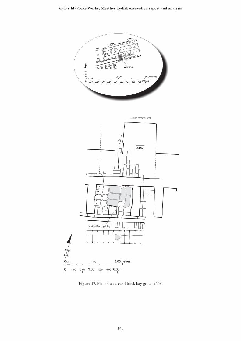
N
MAG
0 0.10 1.00 2.00metres
0 1.00 2.00 6.00ft.3.00 4.00 5.00
2447
Vertical flue opening
Stone rammer wall
25.00 50.00metres0
0 150feet15 30 45 60 75 90 105 120 135
N
GRID
Location
Figure 17. Plan of an area of brick bay group 2468.
140
Cyfarthfa Coke Works, Merthyr Tydfil: excavation report and analysis
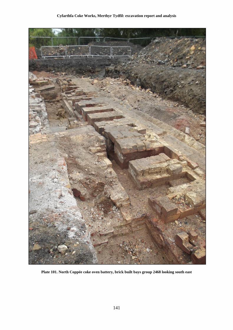
Cyfarthfa Coke Works, Merthyr Tydfil: excavation report and analysis
141
Plate 101. North Coppée coke oven battery, brick built bays group 2468 looking south east
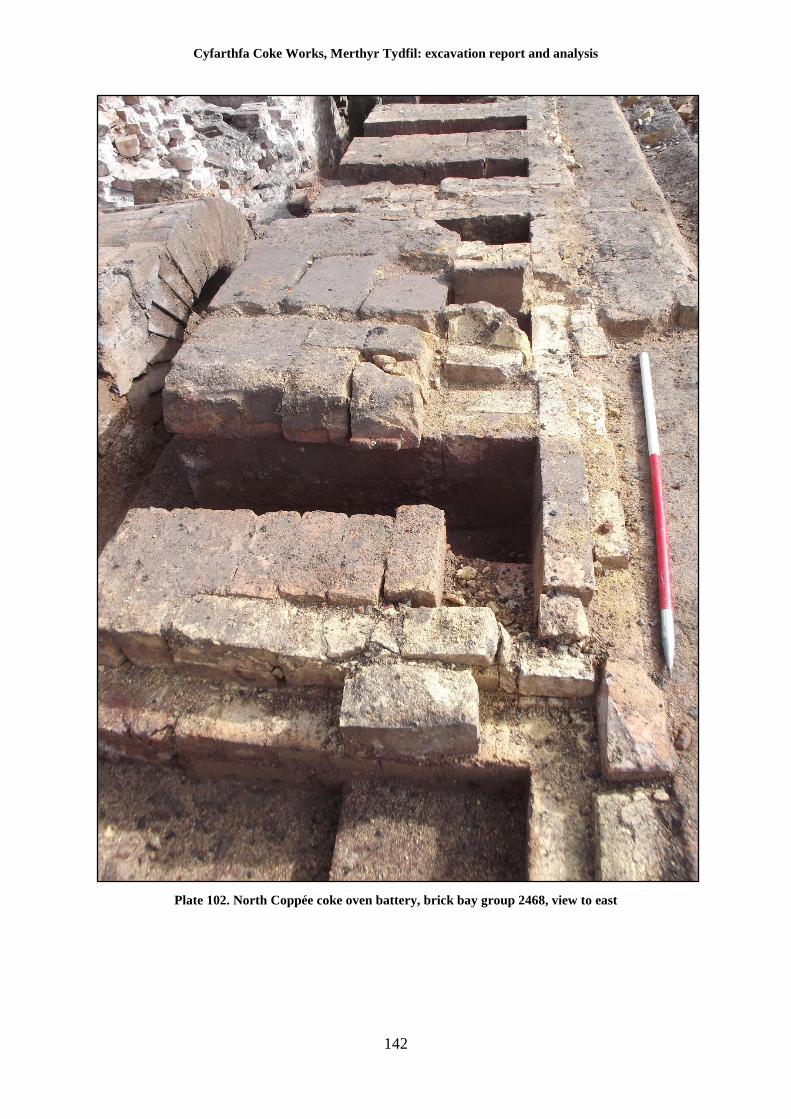
Cyfarthfa Coke Works, Merthyr Tydfil: excavation report and analysis
142
Plate 102. North Coppée coke oven battery, brick bay group 2468, view to east
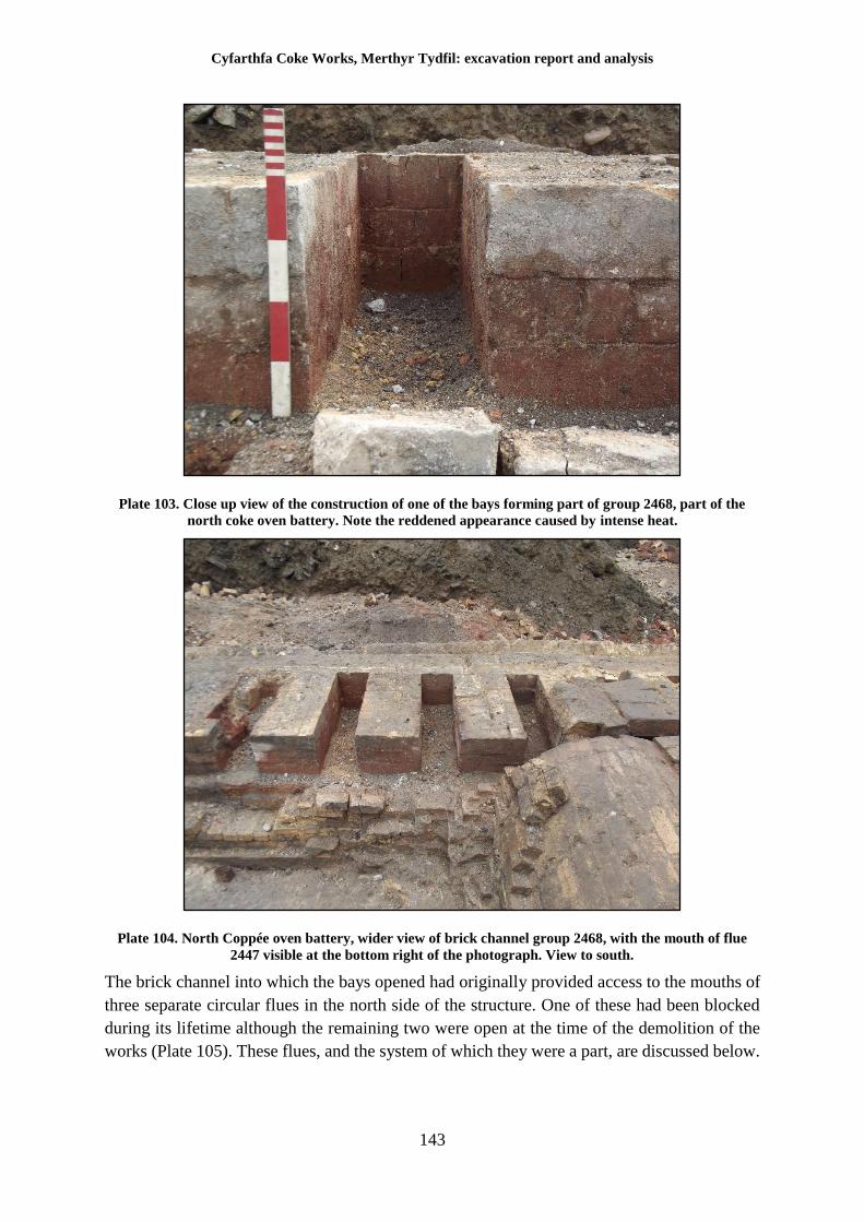
Cyfarthfa Coke Works, Merthyr Tydfil: excavation report and analysis
143
Plate 103. Close up view of the construction of one of the bays forming part of group 2468, part of the
north coke oven battery. Note the reddened appearance caused by intense heat.
Plate 104. North Coppée oven battery, wider view of brick channel group 2468, with the mouth of flue
2447 visible at the bottom right of the photograph. View to south.
The brick channel into which the bays opened had originally provided access to the mouths of
three separate circular flues in the north side of the structure. One of these had been blocked
during its lifetime although the remaining two were open at the time of the demolition of the
works (Plate 105). These flues, and the system of which they were a part, are discussed below.
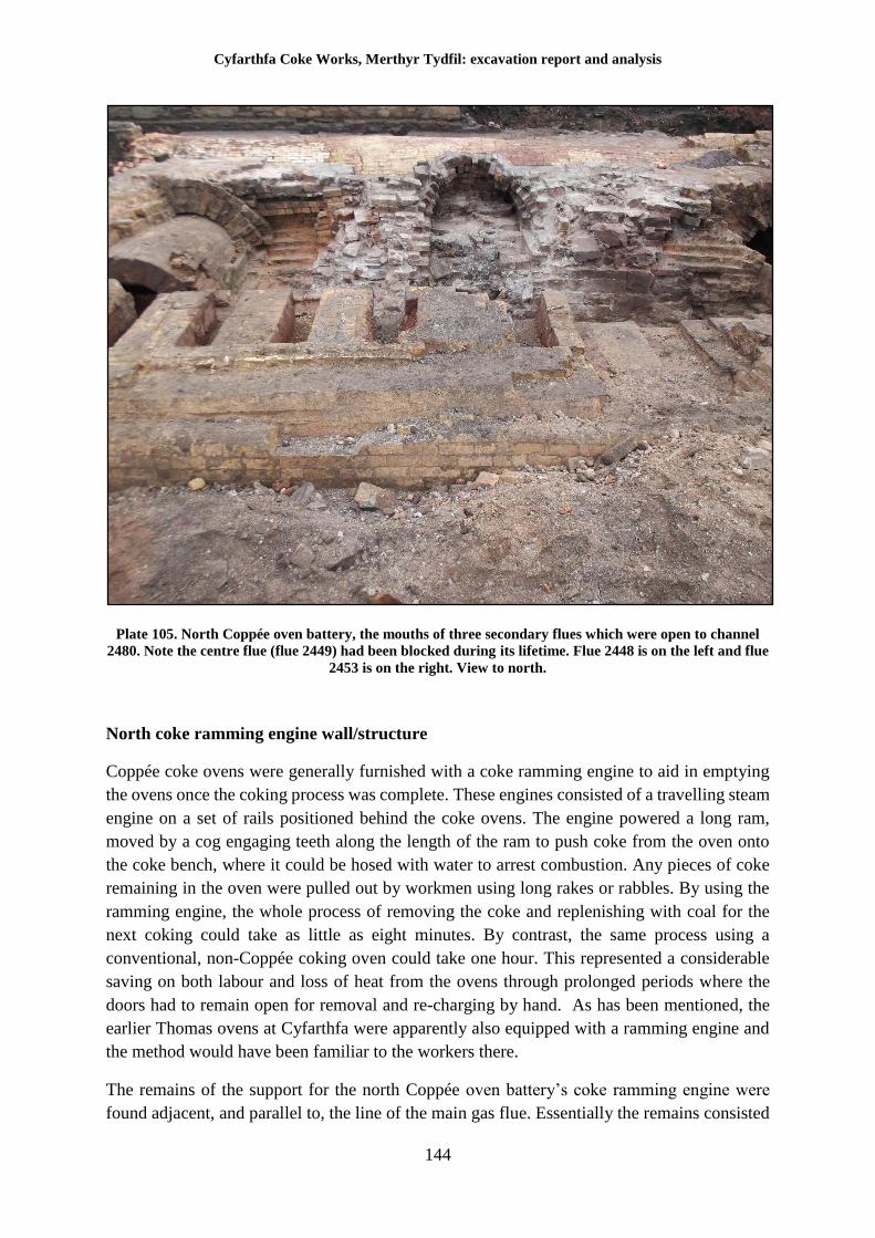
Cyfarthfa Coke Works, Merthyr Tydfil: excavation report and analysis
144
Plate 105. North Coppée oven battery, the mouths of three secondary flues which were open to channel
2480. Note the centre flue (flue 2449) had been blocked during its lifetime. Flue 2448 is on the left and flue
2453 is on the right. View to north.
North coke ramming engine wall/structure
Coppée coke ovens were generally furnished with a coke ramming engine to aid in emptying
the ovens once the coking process was complete. These engines consisted of a travelling steam
engine on a set of rails positioned behind the coke ovens. The engine powered a long ram,
moved by a cog engaging teeth along the length of the ram to push coke from the oven onto
the coke bench, where it could be hosed with water to arrest combustion. Any pieces of coke
remaining in the oven were pulled out by workmen using long rakes or rabbles. By using the
ramming engine, the whole process of removing the coke and replenishing with coal for the
next coking could take as little as eight minutes. By contrast, the same process using a
conventional, non-Coppée coking oven could take one hour. This represented a considerable
saving on both labour and loss of heat from the ovens through prolonged periods where the
doors had to remain open for removal and re-charging by hand. As has been mentioned, the
earlier Thomas ovens at Cyfarthfa were apparently also equipped with a ramming engine and
the method would have been familiar to the workers there.
The remains of the support for the north Coppée oven battery’s coke ramming engine were
found adjacent, and parallel to, the line of the main gas flue. Essentially the remains consisted
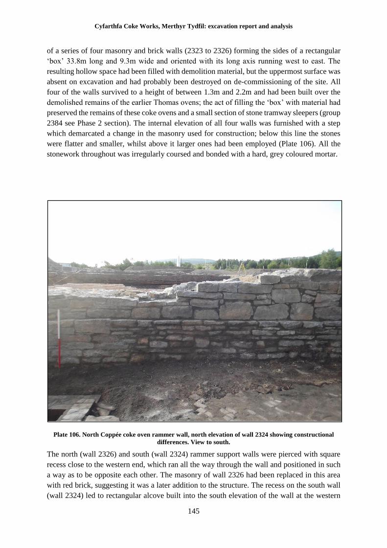
Cyfarthfa Coke Works, Merthyr Tydfil: excavation report and analysis
145
of a series of four masonry and brick walls (2323 to 2326) forming the sides of a rectangular
‘box’ 33.8m long and 9.3m wide and oriented with its long axis running west to east. The
resulting hollow space had been filled with demolition material, but the uppermost surface was
absent on excavation and had probably been destroyed on de-commissioning of the site. All
four of the walls survived to a height of between 1.3m and 2.2m and had been built over the
demolished remains of the earlier Thomas ovens; the act of filling the ‘box’ with material had
preserved the remains of these coke ovens and a small section of stone tramway sleepers (group
2384 see Phase 2 section). The internal elevation of all four walls was furnished with a step
which demarcated a change in the masonry used for construction; below this line the stones
were flatter and smaller, whilst above it larger ones had been employed (Plate 106). All the
stonework throughout was irregularly coursed and bonded with a hard, grey coloured mortar.
Plate 106. North Coppée coke oven rammer wall, north elevation of wall 2324 showing constructional
differences. View to south.
The north (wall 2326) and south (wall 2324) rammer support walls were pierced with square
recess close to the western end, which ran all the way through the wall and positioned in such
a way as to be opposite each other. The masonry of wall 2326 had been replaced in this area
with red brick, suggesting it was a later addition to the structure. The recess on the south wall
(wall 2324) led to rectangular alcove built into the south elevation of the wall at the western
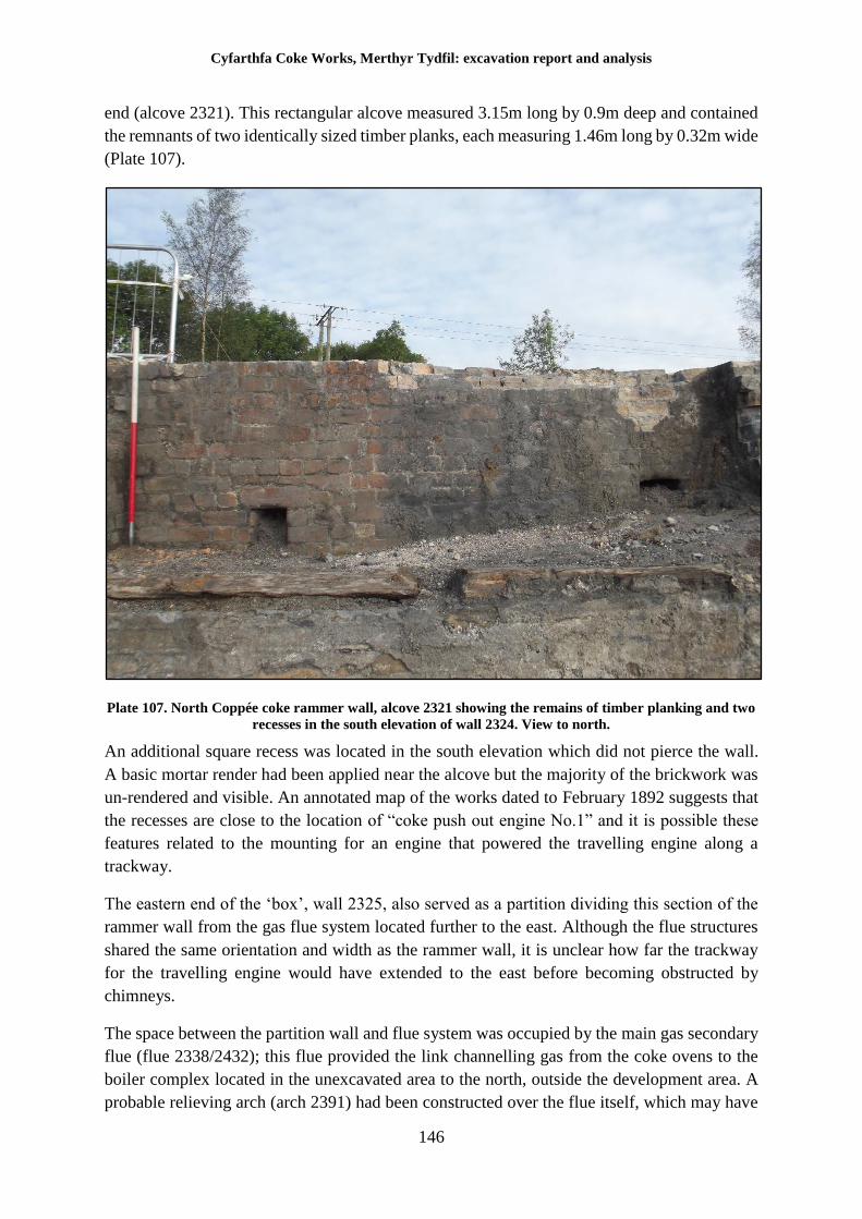
Cyfarthfa Coke Works, Merthyr Tydfil: excavation report and analysis
146
end (alcove 2321). This rectangular alcove measured 3.15m long by 0.9m deep and contained
the remnants of two identically sized timber planks, each measuring 1.46m long by 0.32m wide
(Plate 107).
Plate 107. North Coppée coke rammer wall, alcove 2321 showing the remains of timber planking and two
recesses in the south elevation of wall 2324. View to north.
An additional square recess was located in the south elevation which did not pierce the wall.
A basic mortar render had been applied near the alcove but the majority of the brickwork was
un-rendered and visible. An annotated map of the works dated to February 1892 suggests that
the recesses are close to the location of “coke push out engine No.1” and it is possible these
features related to the mounting for an engine that powered the travelling engine along a
trackway.
The eastern end of the ‘box’, wall 2325, also served as a partition dividing this section of the
rammer wall from the gas flue system located further to the east. Although the flue structures
shared the same orientation and width as the rammer wall, it is unclear how far the trackway
for the travelling engine would have extended to the east before becoming obstructed by
chimneys.
The space between the partition wall and flue system was occupied by the main gas secondary
flue (flue 2338/2432); this flue provided the link channelling gas from the coke ovens to the
boiler complex located in the unexcavated area to the north, outside the development area. A
probable relieving arch (arch 2391) had been constructed over the flue itself, which may have
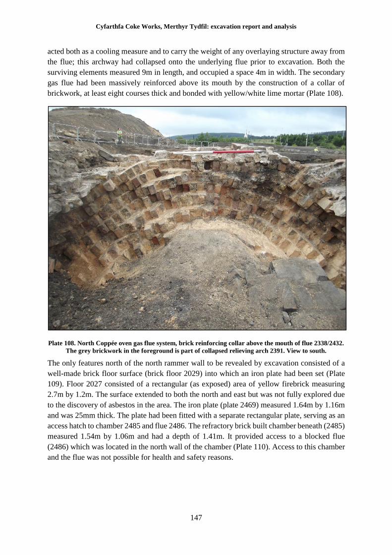
Cyfarthfa Coke Works, Merthyr Tydfil: excavation report and analysis
147
acted both as a cooling measure and to carry the weight of any overlaying structure away from
the flue; this archway had collapsed onto the underlying flue prior to excavation. Both the
surviving elements measured 9m in length, and occupied a space 4m in width. The secondary
gas flue had been massively reinforced above its mouth by the construction of a collar of
brickwork, at least eight courses thick and bonded with yellow/white lime mortar (Plate 108).
Plate 108. North Coppée oven gas flue system, brick reinforcing collar above the mouth of flue 2338/2432.
The grey brickwork in the foreground is part of collapsed relieving arch 2391. View to south.
The only features north of the north rammer wall to be revealed by excavation consisted of a
well-made brick floor surface (brick floor 2029) into which an iron plate had been set (Plate
109). Floor 2027 consisted of a rectangular (as exposed) area of yellow firebrick measuring
2.7m by 1.2m. The surface extended to both the north and east but was not fully explored due
to the discovery of asbestos in the area. The iron plate (plate 2469) measured 1.64m by 1.16m
and was 25mm thick. The plate had been fitted with a separate rectangular plate, serving as an
access hatch to chamber 2485 and flue 2486. The refractory brick built chamber beneath (2485)
measured 1.54m by 1.06m and had a depth of 1.41m. It provided access to a blocked flue
(2486) which was located in the north wall of the chamber (Plate 110). Access to this chamber
and the flue was not possible for health and safety reasons.
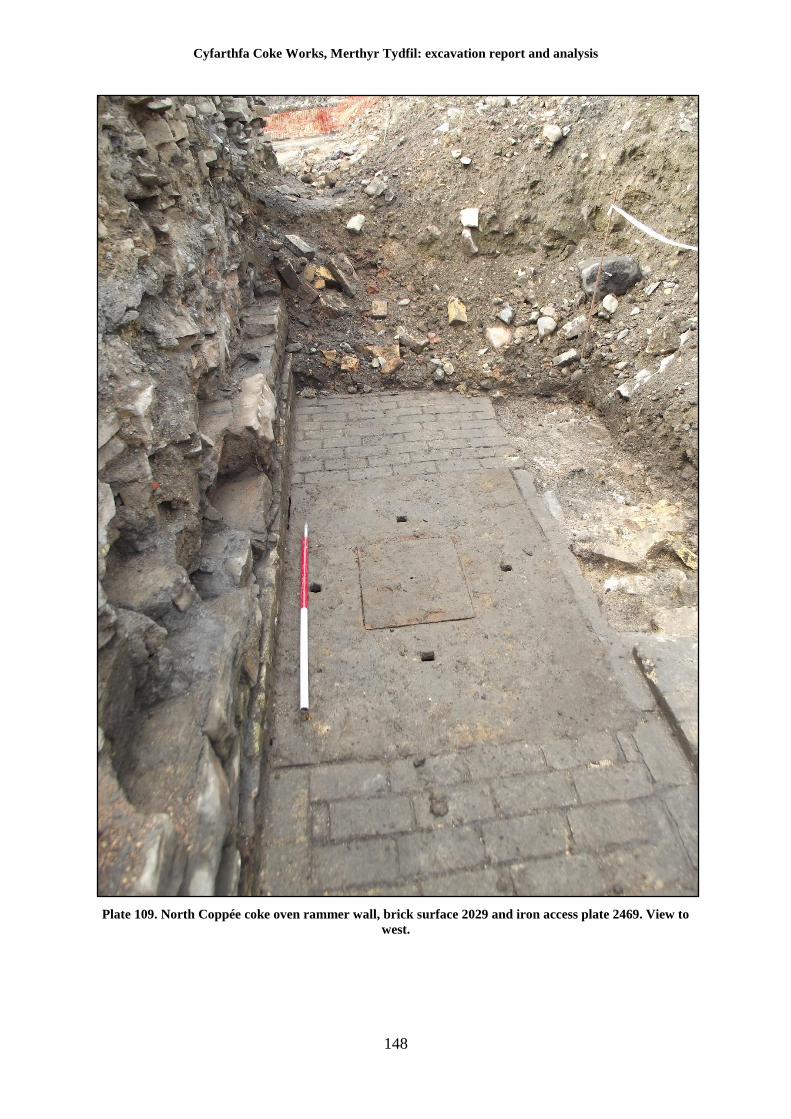
Cyfarthfa Coke Works, Merthyr Tydfil: excavation report and analysis
148
Plate 109. North Coppée coke oven rammer wall, brick surface 2029 and iron access plate 2469. View to
west.
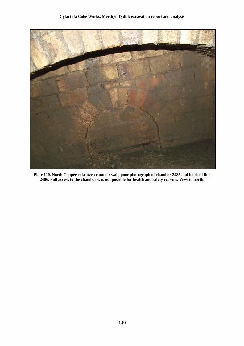
Cyfarthfa Coke Works, Merthyr Tydfil: excavation report and analysis
149
Plate 110. North Coppée coke oven rammer wall, poor photograph of chamber 2485 and blocked flue
2486. Full access to the chamber was not possible for health and safety reasons. View to north.
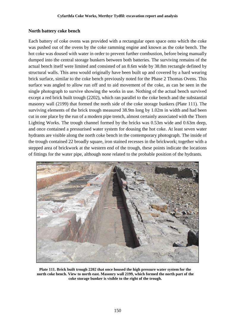
Cyfarthfa Coke Works, Merthyr Tydfil: excavation report and analysis
150
North battery coke bench
Each battery of coke ovens was provided with a rectangular open space onto which the coke
was pushed out of the ovens by the coke ramming engine and known as the coke bench. The
hot coke was doused with water in order to prevent further combustion, before being manually
dumped into the central storage bunkers between both batteries. The surviving remains of the
actual bench itself were limited and consisted of an 8.6m wide by 38.8m rectangle defined by
structural walls. This area would originally have been built up and covered by a hard wearing
brick surface, similar to the coke bench previously noted for the Phase 2 Thomas Ovens. This
surface was angled to allow run off and to aid movement of the coke, as can be seen in the
single photograph to survive showing the works in use. Nothing of the actual bench survived
except a red brick built trough (2202), which ran parallel to the coke bench and the substantial
masonry wall (2199) that formed the north side of the coke storage bunkers (Plate 111). The
surviving elements of the brick trough measured 38.9m long by 1.02m in width and had been
cut in one place by the run of a modern pipe trench, almost certainly associated with the Thorn
Lighting Works. The trough channel formed by the bricks was 0.53m wide and 0.63m deep,
and once contained a pressurised water system for dousing the hot coke. At least seven water
hydrants are visible along the north coke bench in the contemporary photograph. The inside of
the trough contained 22 broadly square, iron stained recesses in the brickwork; together with a
stepped area of brickwork at the western end of the trough, these points indicate the locations
of fittings for the water pipe, although none related to the probable position of the hydrants.
Plate 111. Brick built trough 2202 that once housed the high pressure water system for the
north coke bench. View to north east. Masonry wall 2199, which formed the north part of the
coke storage bunker is visible to the right of the trough.
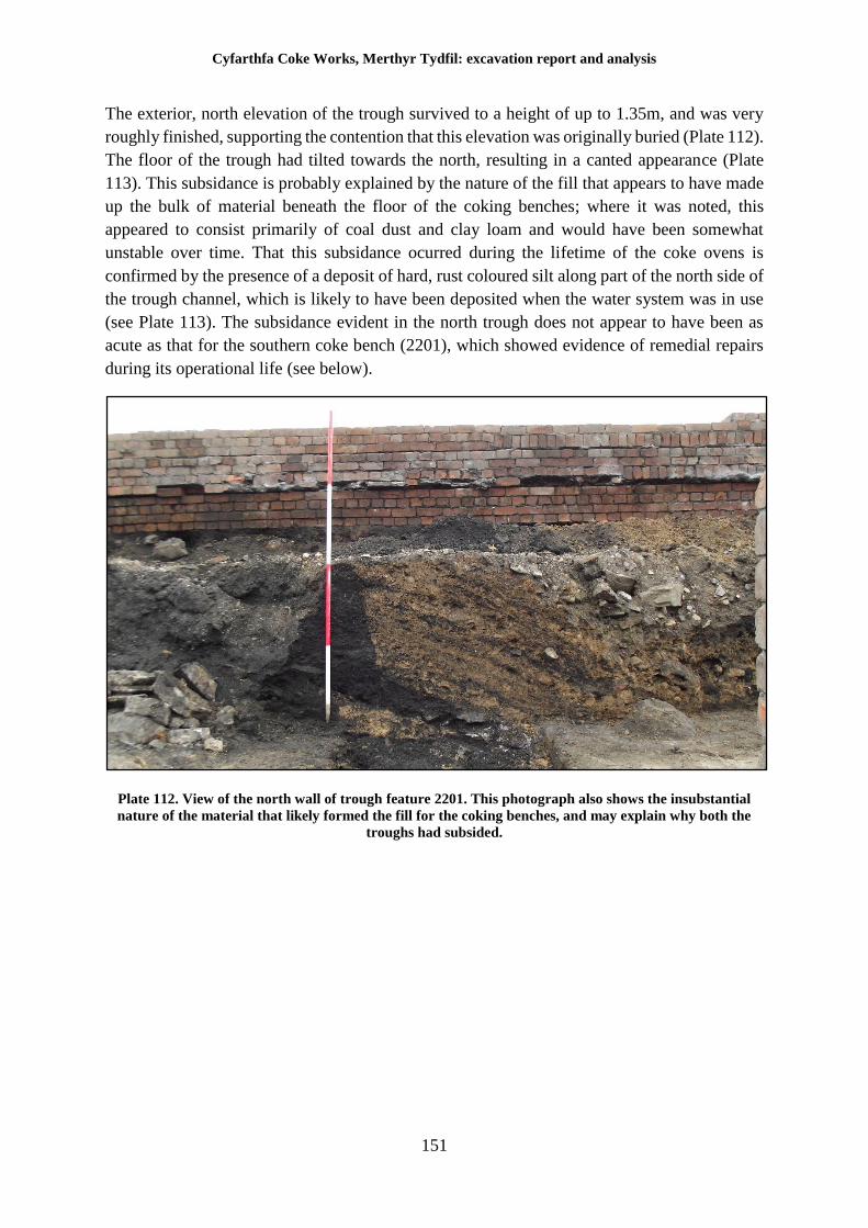
Cyfarthfa Coke Works, Merthyr Tydfil: excavation report and analysis
151
The exterior, north elevation of the trough survived to a height of up to 1.35m, and was very
roughly finished, supporting the contention that this elevation was originally buried (Plate 112).
The floor of the trough had tilted towards the north, resulting in a canted appearance (Plate
113). This subsidance is probably explained by the nature of the fill that appears to have made
up the bulk of material beneath the floor of the coking benches; where it was noted, this
appeared to consist primarily of coal dust and clay loam and would have been somewhat
unstable over time. That this subsidance ocurred during the lifetime of the coke ovens is
confirmed by the presence of a deposit of hard, rust coloured silt along part of the north side of
the trough channel, which is likely to have been deposited when the water system was in use
(see Plate 113). The subsidance evident in the north trough does not appear to have been as
acute as that for the southern coke bench (2201), which showed evidence of remedial repairs
during its operational life (see below).
Plate 112. View of the north wall of trough feature 2201. This photograph also shows the insubstantial
nature of the material that likely formed the fill for the coking benches, and may explain why both the
troughs had subsided.
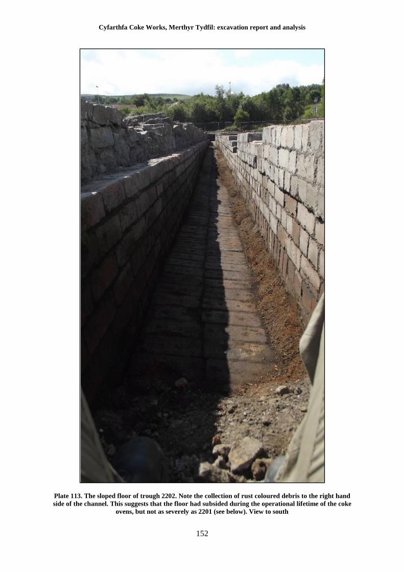
Cyfarthfa Coke Works, Merthyr Tydfil: excavation report and analysis
152
Plate 113. The sloped floor of trough 2202. Note the collection of rust coloured debris to the right hand
side of the channel. This suggests that the floor had subsided during the operational lifetime of the coke
ovens, but not as severely as 2201 (see below). View to south
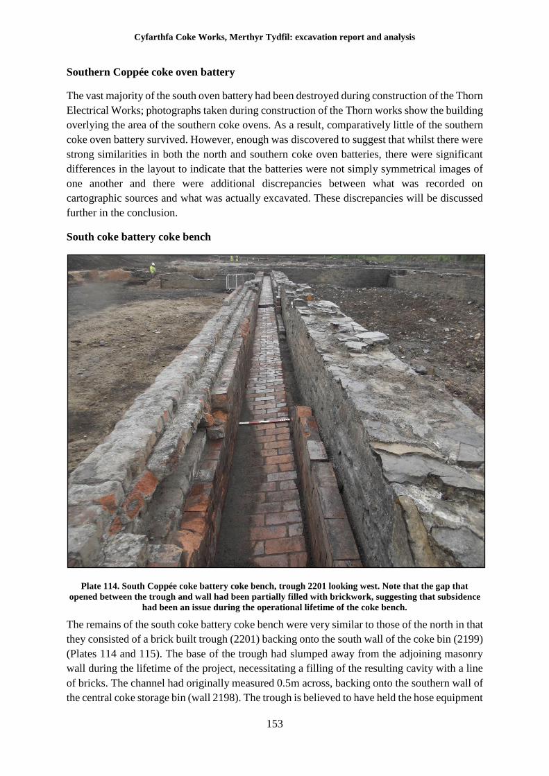
Cyfarthfa Coke Works, Merthyr Tydfil: excavation report and analysis
153
Southern Coppée coke oven battery
The vast majority of the south oven battery had been destroyed during construction of the Thorn
Electrical Works; photographs taken during construction of the Thorn works show the building
overlying the area of the southern coke ovens. As a result, comparatively little of the southern
coke oven battery survived. However, enough was discovered to suggest that whilst there were
strong similarities in both the north and southern coke oven batteries, there were significant
differences in the layout to indicate that the batteries were not simply symmetrical images of
one another and there were additional discrepancies between what was recorded on
cartographic sources and what was actually excavated. These discrepancies will be discussed
further in the conclusion.
South coke battery coke bench
Plate 114. South Coppée coke battery coke bench, trough 2201 looking west. Note that the gap that
opened between the trough and wall had been partially filled with brickwork, suggesting that subsidence
had been an issue during the operational lifetime of the coke bench.
The remains of the south coke battery coke bench were very similar to those of the north in that
they consisted of a brick built trough (2201) backing onto the south wall of the coke bin (2199)
(Plates 114 and 115). The base of the trough had slumped away from the adjoining masonry
wall during the lifetime of the project, necessitating a filling of the resulting cavity with a line
of bricks. The channel had originally measured 0.5m across, backing onto the southern wall of
the central coke storage bin (wall 2198). The trough is believed to have held the hose equipment
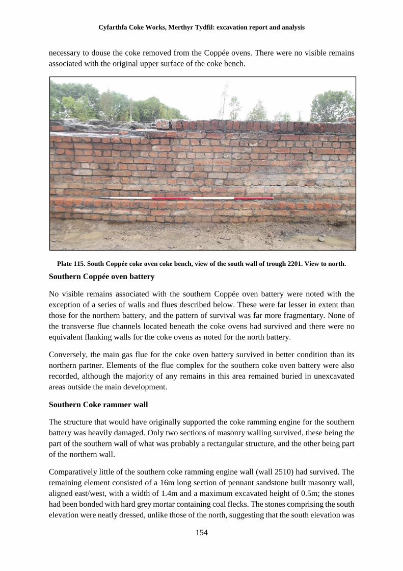
Cyfarthfa Coke Works, Merthyr Tydfil: excavation report and analysis
154
necessary to douse the coke removed from the Coppée ovens. There were no visible remains
associated with the original upper surface of the coke bench.
Plate 115. South Coppée coke oven coke bench, view of the south wall of trough 2201. View to north.
Southern Coppée oven battery
No visible remains associated with the southern Coppée oven battery were noted with the
exception of a series of walls and flues described below. These were far lesser in extent than
those for the northern battery, and the pattern of survival was far more fragmentary. None of
the transverse flue channels located beneath the coke ovens had survived and there were no
equivalent flanking walls for the coke ovens as noted for the north battery.
Conversely, the main gas flue for the coke oven battery survived in better condition than its
northern partner. Elements of the flue complex for the southern coke oven battery were also
recorded, although the majority of any remains in this area remained buried in unexcavated
areas outside the main development.
Southern Coke rammer wall
The structure that would have originally supported the coke ramming engine for the southern
battery was heavily damaged. Only two sections of masonry walling survived, these being the
part of the southern wall of what was probably a rectangular structure, and the other being part
of the northern wall.
Comparatively little of the southern coke ramming engine wall (wall 2510) had survived. The
remaining element consisted of a 16m long section of pennant sandstone built masonry wall,
aligned east/west, with a width of 1.4m and a maximum excavated height of 0.5m; the stones
had been bonded with hard grey mortar containing coal flecks. The stones comprising the south
elevation were neatly dressed, unlike those of the north, suggesting that the south elevation was
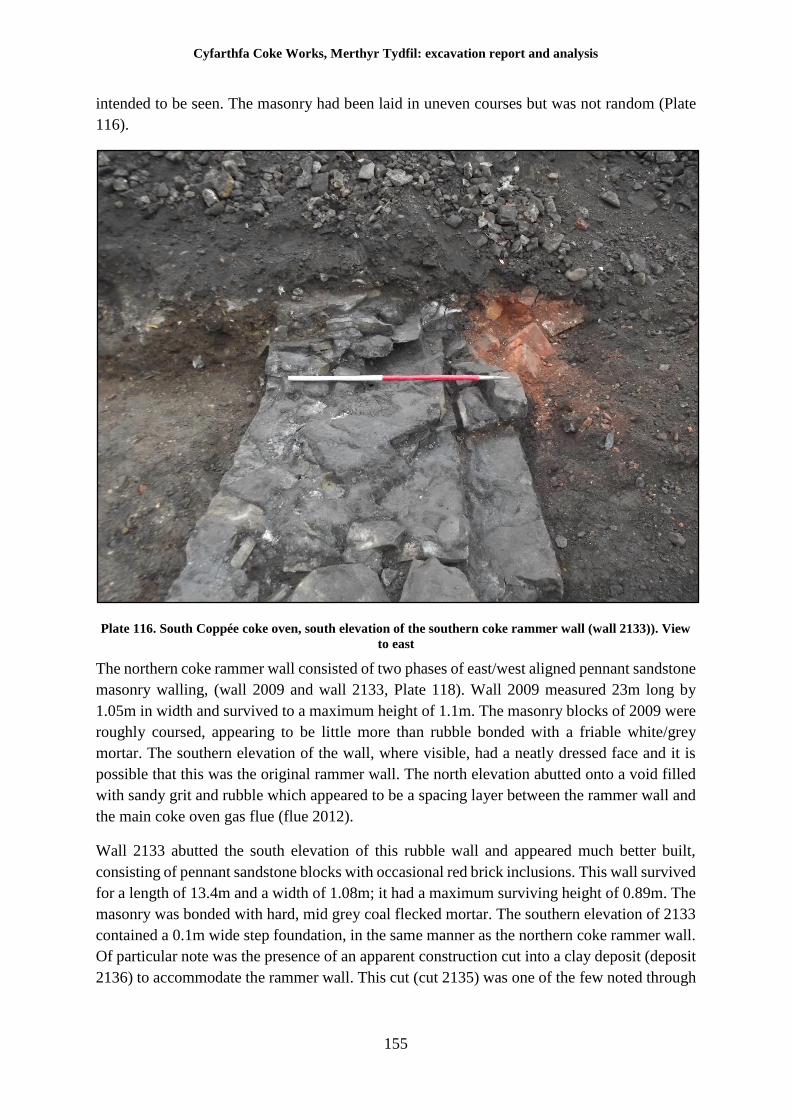
Cyfarthfa Coke Works, Merthyr Tydfil: excavation report and analysis
155
intended to be seen. The masonry had been laid in uneven courses but was not random (Plate
116).
Plate 116. South Coppée coke oven, south elevation of the southern coke rammer wall (wall 2133)). View
to east
The northern coke rammer wall consisted of two phases of east/west aligned pennant sandstone
masonry walling, (wall 2009 and wall 2133, Plate 118). Wall 2009 measured 23m long by
1.05m in width and survived to a maximum height of 1.1m. The masonry blocks of 2009 were
roughly coursed, appearing to be little more than rubble bonded with a friable white/grey
mortar. The southern elevation of the wall, where visible, had a neatly dressed face and it is
possible that this was the original rammer wall. The north elevation abutted onto a void filled
with sandy grit and rubble which appeared to be a spacing layer between the rammer wall and
the main coke oven gas flue (flue 2012).
Wall 2133 abutted the south elevation of this rubble wall and appeared much better built,
consisting of pennant sandstone blocks with occasional red brick inclusions. This wall survived
for a length of 13.4m and a width of 1.08m; it had a maximum surviving height of 0.89m. The
masonry was bonded with hard, mid grey coal flecked mortar. The southern elevation of 2133
contained a 0.1m wide step foundation, in the same manner as the northern coke rammer wall.
Of particular note was the presence of an apparent construction cut into a clay deposit (deposit
2136) to accommodate the rammer wall. This cut (cut 2135) was one of the few noted through
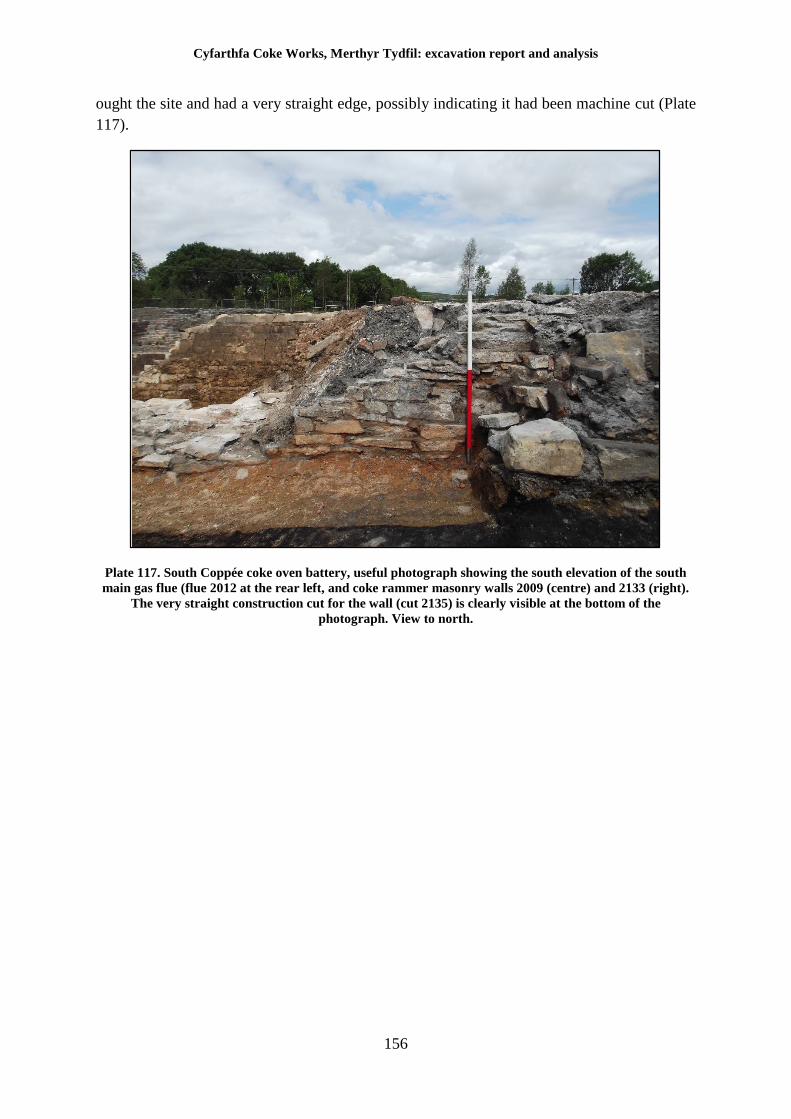
Cyfarthfa Coke Works, Merthyr Tydfil: excavation report and analysis
156
ought the site and had a very straight edge, possibly indicating it had been machine cut (Plate
117).
Plate 117. South Coppée coke oven battery, useful photograph showing the south elevation of the south
main gas flue (flue 2012 at the rear left, and coke rammer masonry walls 2009 (centre) and 2133 (right).
The very straight construction cut for the wall (cut 2135) is clearly visible at the bottom of the
photograph. View to north.
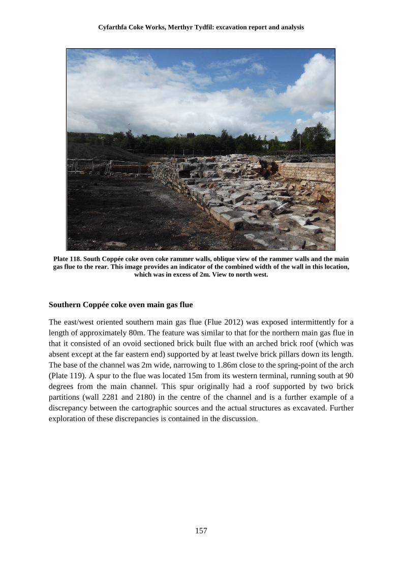
Cyfarthfa Coke Works, Merthyr Tydfil: excavation report and analysis
157
Plate 118. South Coppée coke oven coke rammer walls, oblique view of the rammer walls and the main
gas flue to the rear. This image provides an indicator of the combined width of the wall in this location,
which was in excess of 2m. View to north west.
Southern Coppée coke oven main gas flue
The east/west oriented southern main gas flue (Flue 2012) was exposed intermittently for a
length of approximately 80m. The feature was similar to that for the northern main gas flue in
that it consisted of an ovoid sectioned brick built flue with an arched brick roof (which was
absent except at the far eastern end) supported by at least twelve brick pillars down its length.
The base of the channel was 2m wide, narrowing to 1.86m close to the spring-point of the arch
(Plate 119). A spur to the flue was located 15m from its western terminal, running south at 90
degrees from the main channel. This spur originally had a roof supported by two brick
partitions (wall 2281 and 2180) in the centre of the channel and is a further example of a
discrepancy between the cartographic sources and the actual structures as excavated. Further
exploration of these discrepancies is contained in the discussion.
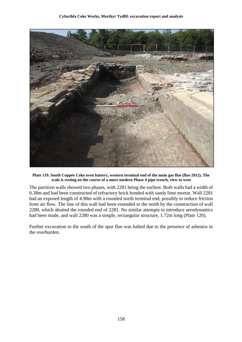
Cyfarthfa Coke Works, Merthyr Tydfil: excavation report and analysis
158
Plate 119. South Coppée Coke oven battery, western terminal end of the main gas flue (flue 2012). The
scale is resting on the course of a more modern Phase 4 pipe trench, view to west
The partition walls showed two phases, with 2281 being the earliest. Both walls had a width of
0.38m and had been constructed of refractory brick bonded with sandy lime mortar. Wall 2281
had an exposed length of 4.98m with a rounded north terminal end, possibly to reduce friction
from air flow. The line of this wall had been extended to the north by the construction of wall
2280, which abutted the rounded end of 2281. No similar attempts to introduce aerodynamics
had been made, and wall 2280 was a simple, rectangular structure, 1.72m long (Plate 120).
Further excavation to the south of the spur flue was halted due to the presence of asbestos in
the overburden.
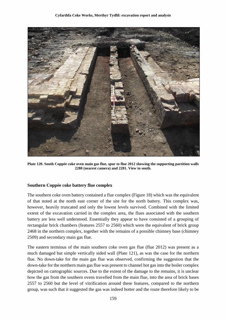
Cyfarthfa Coke Works, Merthyr Tydfil: excavation report and analysis
159
Plate 120. South Coppée coke oven main gas flue, spur to flue 2012 showing the supporting partition walls
2280 (nearest camera) and 2281. View to south.
Southern Coppée coke battery flue complex
The southern coke oven battery contained a flue complex (Figure 18) which was the equivalent
of that noted at the north east corner of the site for the north battery. This complex was,
however, heavily truncated and only the lowest levels survived. Combined with the limited
extent of the excavation carried in the complex area, the flues associated with the southern
battery are less well understood. Essentially they appear to have consisted of a grouping of
rectangular brick chambers (features 2557 to 2560) which were the equivalent of brick group
2468 in the northern complex, together with the remains of a possible chimney base (chimney
2509) and secondary main gas flue.
The eastern terminus of the main southern coke oven gas flue (flue 2012) was present as a
much damaged but simple vertically sided wall (Plate 121), as was the case for the northern
flue. No down-take for the main gas flue was observed, confirming the suggestion that the
down-take for the northern main gas flue was present to channel hot gas into the boiler complex
depicted on cartographic sources. Due to the extent of the damage to the remains, it is unclear
how the gas from the southern ovens travelled from the main flue, into the area of brick bases
2557 to 2560 but the level of vitrification around these features, compared to the northern
group, was such that it suggested the gas was indeed hotter and the route therefore likely to be
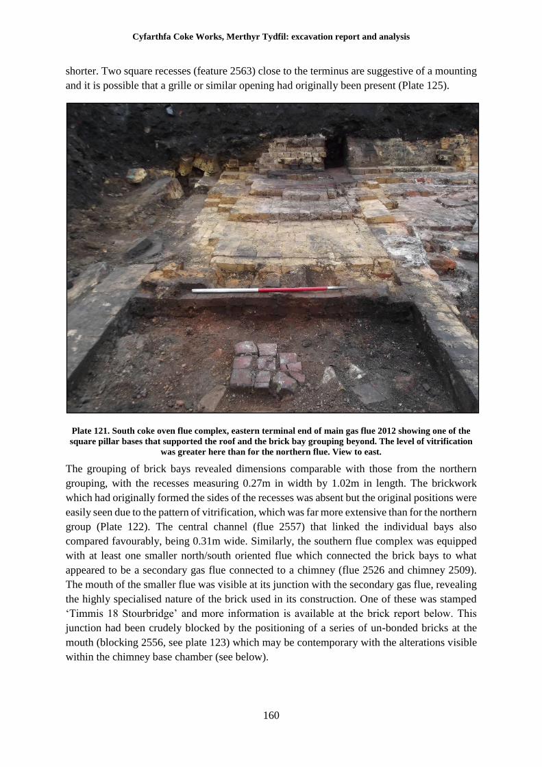
Cyfarthfa Coke Works, Merthyr Tydfil: excavation report and analysis
160
shorter. Two square recesses (feature 2563) close to the terminus are suggestive of a mounting
and it is possible that a grille or similar opening had originally been present (Plate 125).
Plate 121. South coke oven flue complex, eastern terminal end of main gas flue 2012 showing one of the
square pillar bases that supported the roof and the brick bay grouping beyond. The level of vitrification
was greater here than for the northern flue. View to east.
The grouping of brick bays revealed dimensions comparable with those from the northern
grouping, with the recesses measuring 0.27m in width by 1.02m in length. The brickwork
which had originally formed the sides of the recesses was absent but the original positions were
easily seen due to the pattern of vitrification, which was far more extensive than for the northern
group (Plate 122). The central channel (flue 2557) that linked the individual bays also
compared favourably, being 0.31m wide. Similarly, the southern flue complex was equipped
with at least one smaller north/south oriented flue which connected the brick bays to what
appeared to be a secondary gas flue connected to a chimney (flue 2526 and chimney 2509).
The mouth of the smaller flue was visible at its junction with the secondary gas flue, revealing
the highly specialised nature of the brick used in its construction. One of these was stamped
‘Timmis 18 Stourbridge’ and more information is available at the brick report below. This
junction had been crudely blocked by the positioning of a series of un-bonded bricks at the
mouth (blocking 2556, see plate 123) which may be contemporary with the alterations visible
within the chimney base chamber (see below).
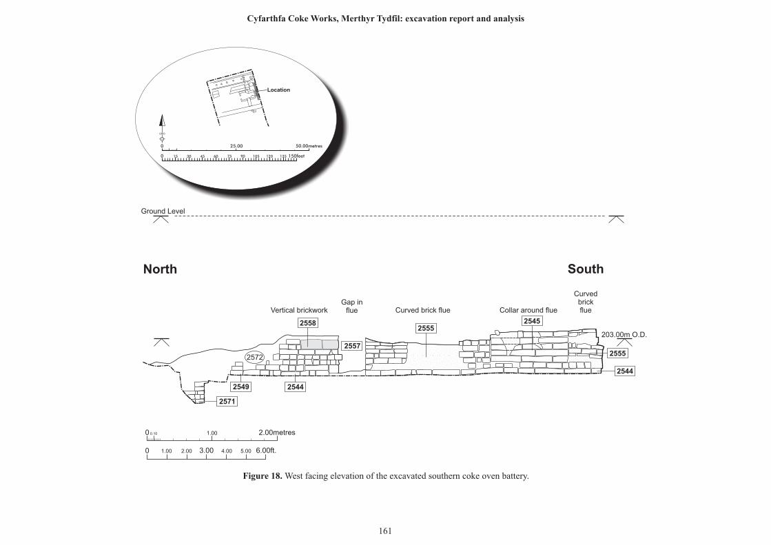
0 0.10 1.00 2.00metres
0 1.00 2.00 6.00ft.3.00 4.00 5.00
25552545
2544
2555
2558
2571
25442549
2557
2572
Curved brick flueGap in
flueVertical brickwork Collar around flue
Curvedbrickflue
North South
Ground Level
25.00 50.00metres0
0 150feet15 30 45 60 75 90 105 120 135
N
GRID
Location
Figure 18. West facing elevation of the excavated southern coke oven battery.
161
Cyfarthfa Coke Works, Merthyr Tydfil: excavation report and analysis
203.00m O.D.
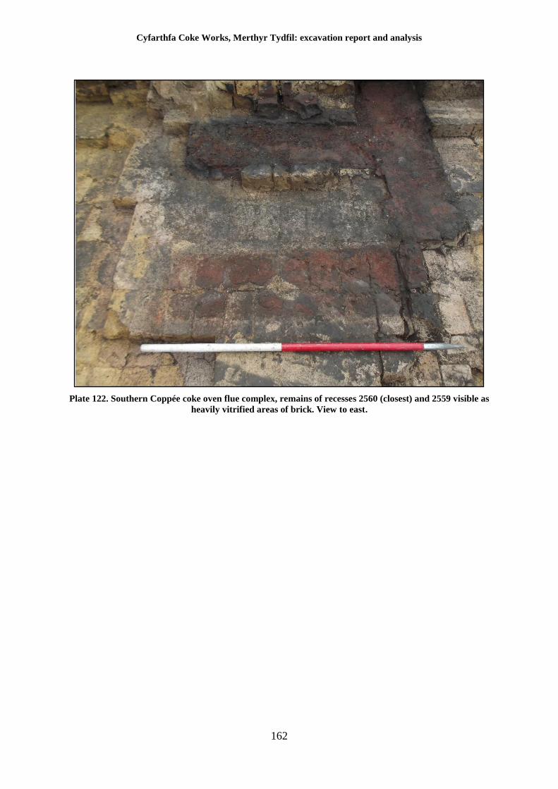
Cyfarthfa Coke Works, Merthyr Tydfil: excavation report and analysis
162
Plate 122. Southern Coppée coke oven flue complex, remains of recesses 2560 (closest) and 2559 visible as
heavily vitrified areas of brick. View to east.
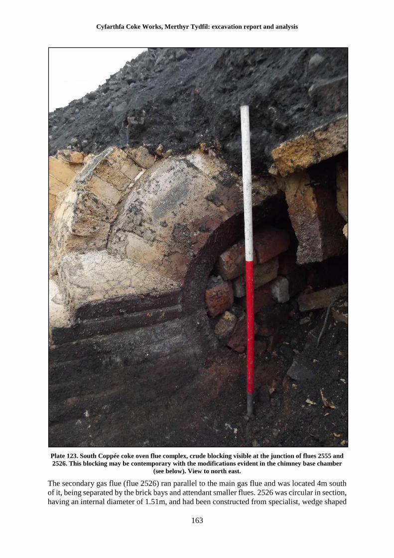
Cyfarthfa Coke Works, Merthyr Tydfil: excavation report and analysis
163
Plate 123. South Coppée coke oven flue complex, crude blocking visible at the junction of flues 2555 and
2526. This blocking may be contemporary with the modifications evident in the chimney base chamber
(see below). View to north east.
The secondary gas flue (flue 2526) ran parallel to the main gas flue and was located 4m south
of it, being separated by the brick bays and attendant smaller flues. 2526 was circular in section,
having an internal diameter of 1.51m, and had been constructed from specialist, wedge shaped
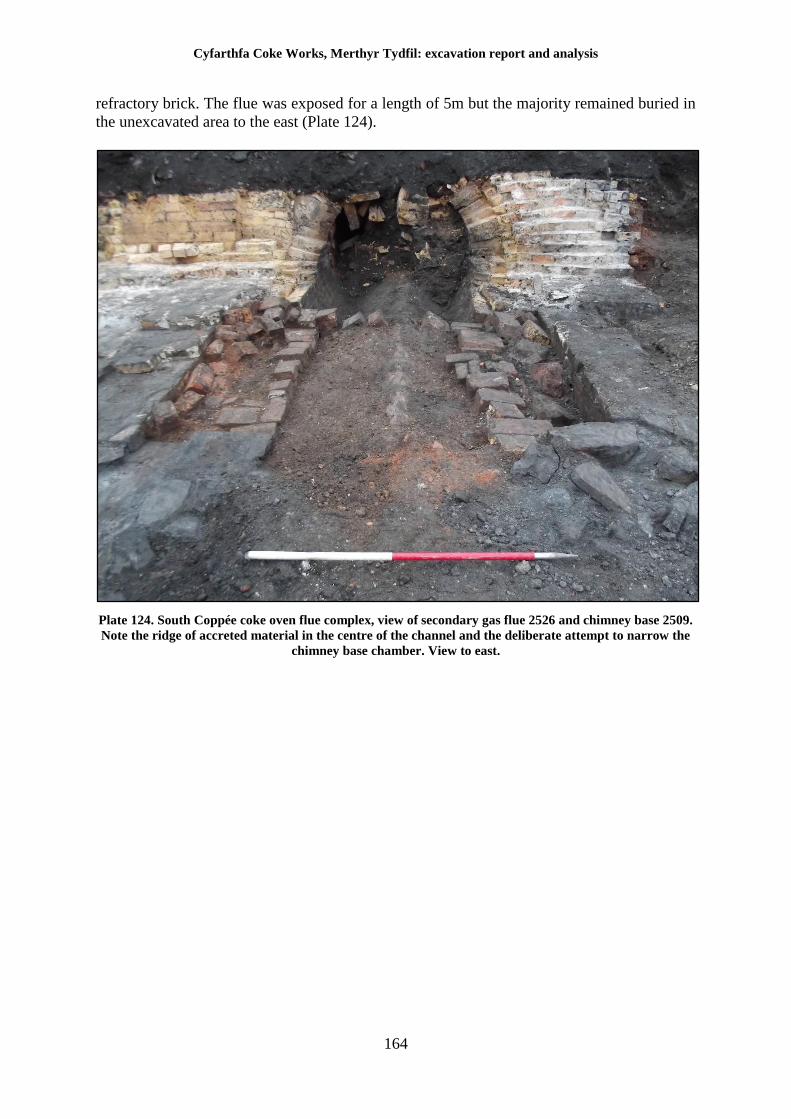
Cyfarthfa Coke Works, Merthyr Tydfil: excavation report and analysis
164
refractory brick. The flue was exposed for a length of 5m but the majority remained buried in
the unexcavated area to the east (Plate 124).
Plate 124. South Coppée coke oven flue complex, view of secondary gas flue 2526 and chimney base 2509.
Note the ridge of accreted material in the centre of the channel and the deliberate attempt to narrow the
chimney base chamber. View to east.
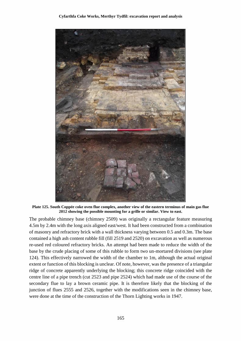
Cyfarthfa Coke Works, Merthyr Tydfil: excavation report and analysis
165
Plate 125. South Coppée coke oven flue complex, another view of the eastern terminus of main gas flue
2012 showing the possible mounting for a grille or similar. View to east.
The probable chimney base (chimney 2509) was originally a rectangular feature measuring
4.5m by 2.4m with the long axis aligned east/west. It had been constructed from a combination
of masonry and refractory brick with a wall thickness varying between 0.5 and 0.3m. The base
contained a high ash content rubble fill (fill 2519 and 2520) on excavation as well as numerous
re-used red coloured refractory bricks. An attempt had been made to reduce the width of the
base by the crude placing of some of this rubble to form two un-mortared divisions (see plate
124). This effectively narrowed the width of the chamber to 1m, although the actual original
extent or function of this blocking is unclear. Of note, however, was the presence of a triangular
ridge of concrete apparently underlying the blocking; this concrete ridge coincided with the
centre line of a pipe trench (cut 2523 and pipe 2524) which had made use of the course of the
secondary flue to lay a brown ceramic pipe. It is therefore likely that the blocking of the
junction of flues 2555 and 2526, together with the modifications seen in the chimney base,
were done at the time of the construction of the Thorn Lighting works in 1947.
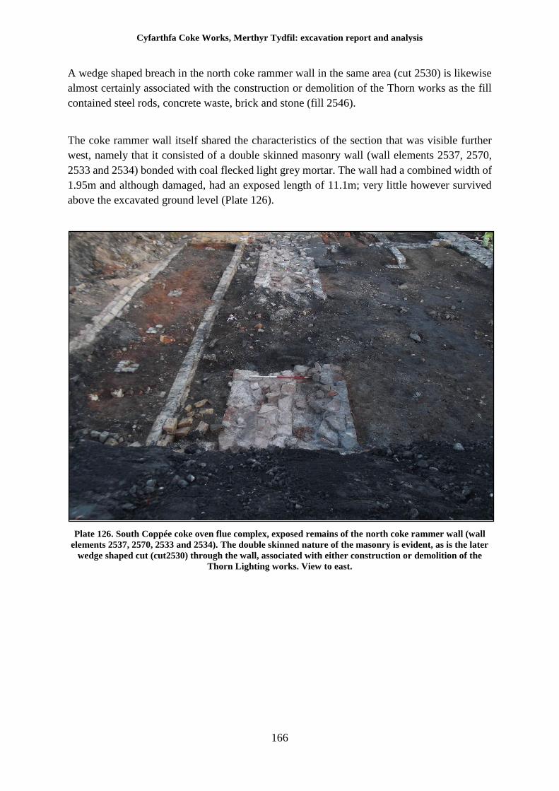
Cyfarthfa Coke Works, Merthyr Tydfil: excavation report and analysis
166
A wedge shaped breach in the north coke rammer wall in the same area (cut 2530) is likewise
almost certainly associated with the construction or demolition of the Thorn works as the fill
contained steel rods, concrete waste, brick and stone (fill 2546).
The coke rammer wall itself shared the characteristics of the section that was visible further
west, namely that it consisted of a double skinned masonry wall (wall elements 2537, 2570,
2533 and 2534) bonded with coal flecked light grey mortar. The wall had a combined width of
1.95m and although damaged, had an exposed length of 11.1m; very little however survived
above the excavated ground level (Plate 126).
Plate 126. South Coppée coke oven flue complex, exposed remains of the north coke rammer wall (wall
elements 2537, 2570, 2533 and 2534). The double skinned nature of the masonry is evident, as is the later
wedge shaped cut (cut2530) through the wall, associated with either construction or demolition of the
Thorn Lighting works. View to east.
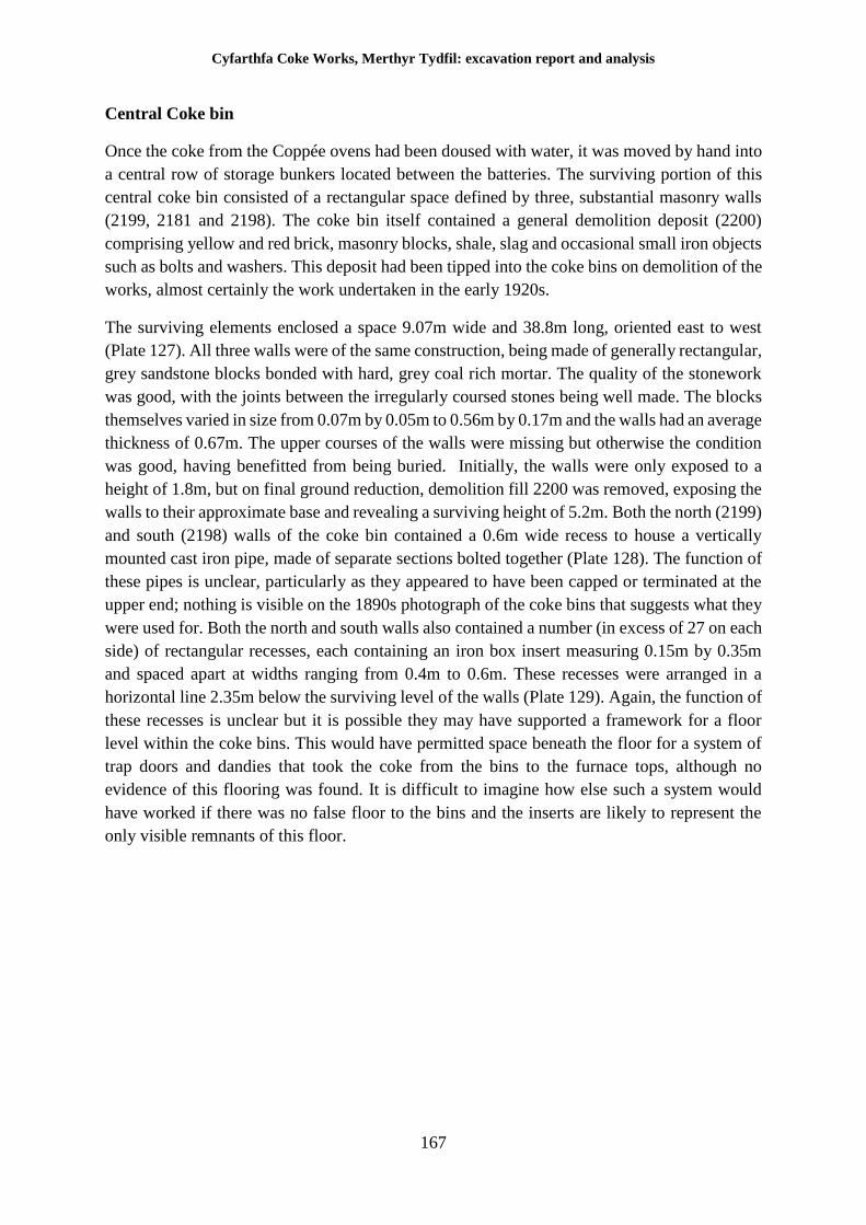
Cyfarthfa Coke Works, Merthyr Tydfil: excavation report and analysis
167
Central Coke bin
Once the coke from the Coppée ovens had been doused with water, it was moved by hand into
a central row of storage bunkers located between the batteries. The surviving portion of this
central coke bin consisted of a rectangular space defined by three, substantial masonry walls
(2199, 2181 and 2198). The coke bin itself contained a general demolition deposit (2200)
comprising yellow and red brick, masonry blocks, shale, slag and occasional small iron objects
such as bolts and washers. This deposit had been tipped into the coke bins on demolition of the
works, almost certainly the work undertaken in the early 1920s.
The surviving elements enclosed a space 9.07m wide and 38.8m long, oriented east to west
(Plate 127). All three walls were of the same construction, being made of generally rectangular,
grey sandstone blocks bonded with hard, grey coal rich mortar. The quality of the stonework
was good, with the joints between the irregularly coursed stones being well made. The blocks
themselves varied in size from 0.07m by 0.05m to 0.56m by 0.17m and the walls had an average
thickness of 0.67m. The upper courses of the walls were missing but otherwise the condition
was good, having benefitted from being buried. Initially, the walls were only exposed to a
height of 1.8m, but on final ground reduction, demolition fill 2200 was removed, exposing the
walls to their approximate base and revealing a surviving height of 5.2m. Both the north (2199)
and south (2198) walls of the coke bin contained a 0.6m wide recess to house a vertically
mounted cast iron pipe, made of separate sections bolted together (Plate 128). The function of
these pipes is unclear, particularly as they appeared to have been capped or terminated at the
upper end; nothing is visible on the 1890s photograph of the coke bins that suggests what they
were used for. Both the north and south walls also contained a number (in excess of 27 on each
side) of rectangular recesses, each containing an iron box insert measuring 0.15m by 0.35m
and spaced apart at widths ranging from 0.4m to 0.6m. These recesses were arranged in a
horizontal line 2.35m below the surviving level of the walls (Plate 129). Again, the function of
these recesses is unclear but it is possible they may have supported a framework for a floor
level within the coke bins. This would have permitted space beneath the floor for a system of
trap doors and dandies that took the coke from the bins to the furnace tops, although no
evidence of this flooring was found. It is difficult to imagine how else such a system would
have worked if there was no false floor to the bins and the inserts are likely to represent the
only visible remnants of this floor.
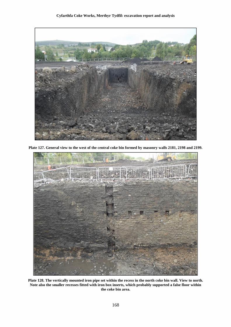
Cyfarthfa Coke Works, Merthyr Tydfil: excavation report and analysis
168
Plate 127. General view to the west of the central coke bin formed by masonry walls 2181, 2198 and 2199.
Plate 128. The vertically mounted iron pipe set within the recess in the north coke bin wall. View to north.
Note also the smaller recesses fitted with iron box inserts, which probably supported a false floor within
the coke bin area.
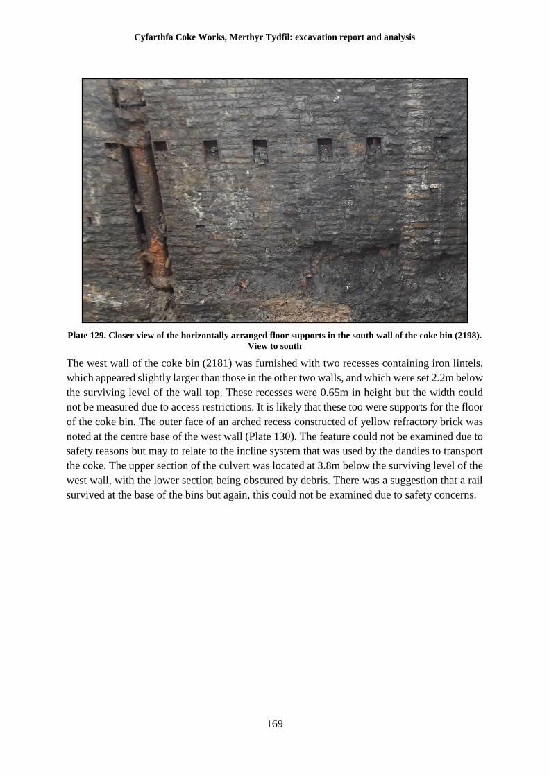
Cyfarthfa Coke Works, Merthyr Tydfil: excavation report and analysis
169
Plate 129. Closer view of the horizontally arranged floor supports in the south wall of the coke bin (2198).
View to south
The west wall of the coke bin (2181) was furnished with two recesses containing iron lintels,
which appeared slightly larger than those in the other two walls, and which were set 2.2m below
the surviving level of the wall top. These recesses were 0.65m in height but the width could
not be measured due to access restrictions. It is likely that these too were supports for the floor
of the coke bin. The outer face of an arched recess constructed of yellow refractory brick was
noted at the centre base of the west wall (Plate 130). The feature could not be examined due to
safety reasons but may to relate to the incline system that was used by the dandies to transport
the coke. The upper section of the culvert was located at 3.8m below the surviving level of the
west wall, with the lower section being obscured by debris. There was a suggestion that a rail
survived at the base of the bins but again, this could not be examined due to safety concerns.
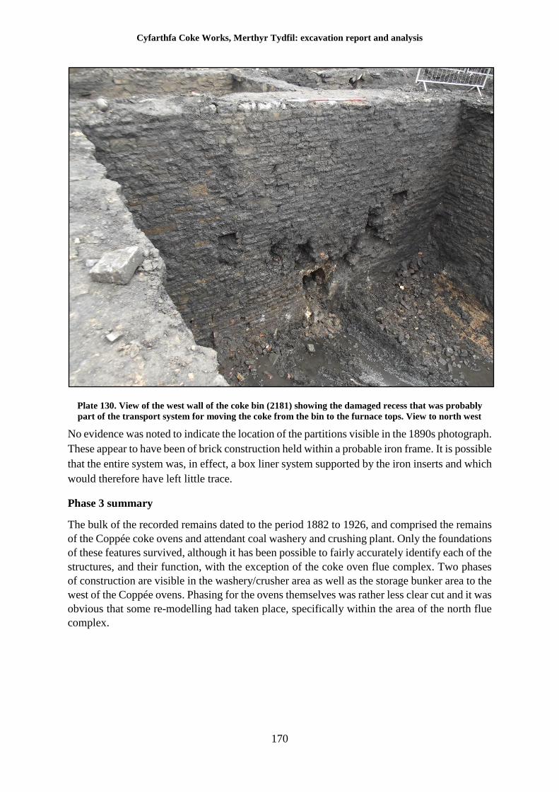
Cyfarthfa Coke Works, Merthyr Tydfil: excavation report and analysis
170
Plate 130. View of the west wall of the coke bin (2181) showing the damaged recess that was probably
part of the transport system for moving the coke from the bin to the furnace tops. View to north west
No evidence was noted to indicate the location of the partitions visible in the 1890s photograph.
These appear to have been of brick construction held within a probable iron frame. It is possible
that the entire system was, in effect, a box liner system supported by the iron inserts and which
would therefore have left little trace.
Phase 3 summary
The bulk of the recorded remains dated to the period 1882 to 1926, and comprised the remains
of the Coppée coke ovens and attendant coal washery and crushing plant. Only the foundations
of these features survived, although it has been possible to fairly accurately identify each of the
structures, and their function, with the exception of the coke oven flue complex. Two phases
of construction are visible in the washery/crusher area as well as the storage bunker area to the
west of the Coppée ovens. Phasing for the ovens themselves was rather less clear cut and it was
obvious that some re-modelling had taken place, specifically within the area of the north flue
complex.
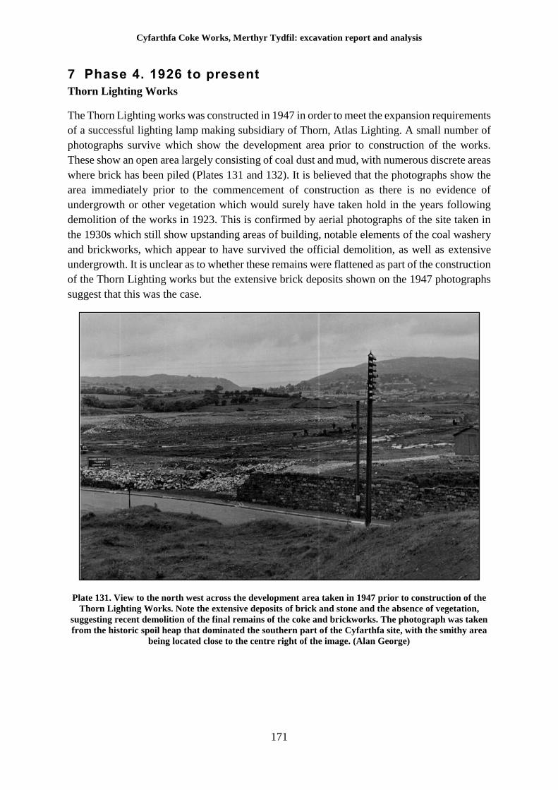
Cyfarthfa Coke Works, Merthyr Tydfil: excavation report and analysis
171
7 Phase 4. 1926 to present
Thorn Lighting Works
The Thorn Lighting works was constructed in 1947 in order to meet the expansion requirements
of a successful lighting lamp making subsidiary of Thorn, Atlas Lighting. A small number of
photographs survive which show the development area prior to construction of the works.
These show an open area largely consisting of coal dust and mud, with numerous discrete areas
where brick has been piled (Plates 131 and 132). It is believed that the photographs show the
area immediately prior to the commencement of construction as there is no evidence of
undergrowth or other vegetation which would surely have taken hold in the years following
demolition of the works in 1923. This is confirmed by aerial photographs of the site taken in
the 1930s which still show upstanding areas of building, notable elements of the coal washery
and brickworks, which appear to have survived the official demolition, as well as extensive
undergrowth. It is unclear as to whether these remains were flattened as part of the construction
of the Thorn Lighting works but the extensive brick deposits shown on the 1947 photographs
suggest that this was the case.
Plate 131. View to the north west across the development area taken in 1947 prior to construction of the
Thorn Lighting Works. Note the extensive deposits of brick and stone and the absence of vegetation,
suggesting recent demolition of the final remains of the coke and brickworks. The photograph was taken
from the historic spoil heap that dominated the southern part of the Cyfarthfa site, with the smithy area
being located close to the centre right of the image. (Alan George)
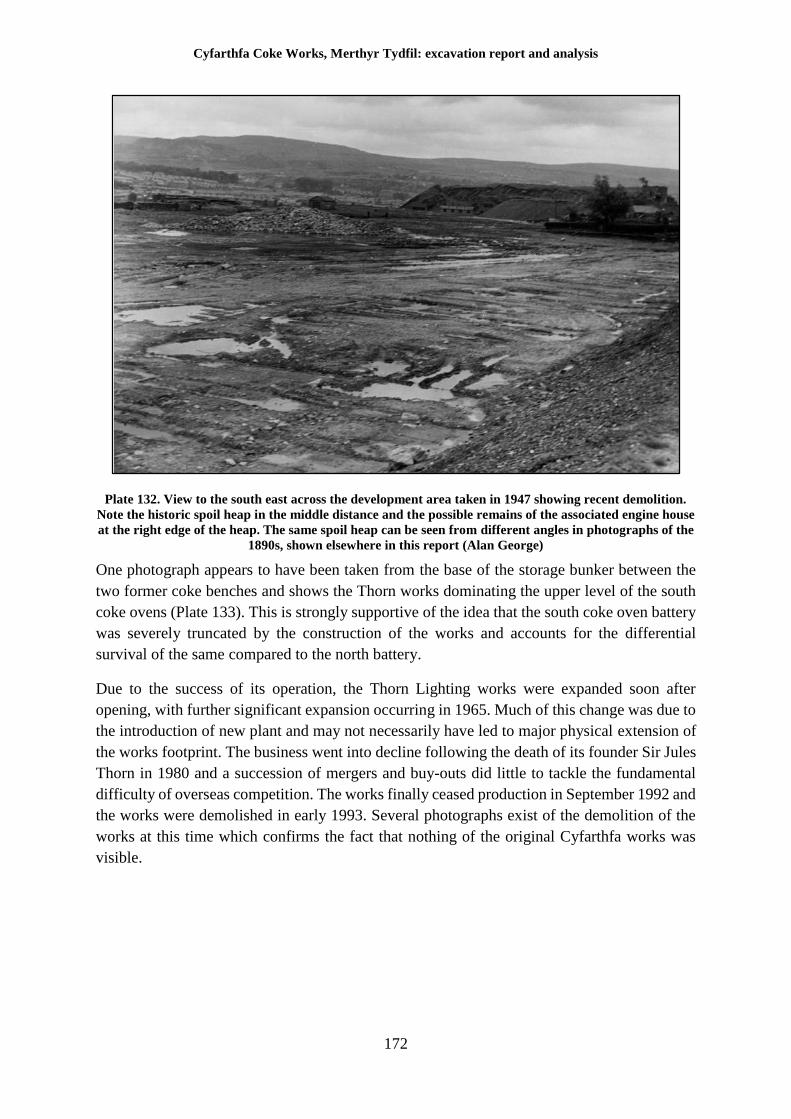
Cyfarthfa Coke Works, Merthyr Tydfil: excavation report and analysis
172
Plate 132. View to the south east across the development area taken in 1947 showing recent demolition.
Note the historic spoil heap in the middle distance and the possible remains of the associated engine house
at the right edge of the heap. The same spoil heap can be seen from different angles in photographs of the
1890s, shown elsewhere in this report (Alan George)
One photograph appears to have been taken from the base of the storage bunker between the
two former coke benches and shows the Thorn works dominating the upper level of the south
coke ovens (Plate 133). This is strongly supportive of the idea that the south coke oven battery
was severely truncated by the construction of the works and accounts for the differential
survival of the same compared to the north battery.
Due to the success of its operation, the Thorn Lighting works were expanded soon after
opening, with further significant expansion occurring in 1965. Much of this change was due to
the introduction of new plant and may not necessarily have led to major physical extension of
the works footprint. The business went into decline following the death of its founder Sir Jules
Thorn in 1980 and a succession of mergers and buy-outs did little to tackle the fundamental
difficulty of overseas competition. The works finally ceased production in September 1992 and
the works were demolished in early 1993. Several photographs exist of the demolition of the
works at this time which confirms the fact that nothing of the original Cyfarthfa works was
visible.
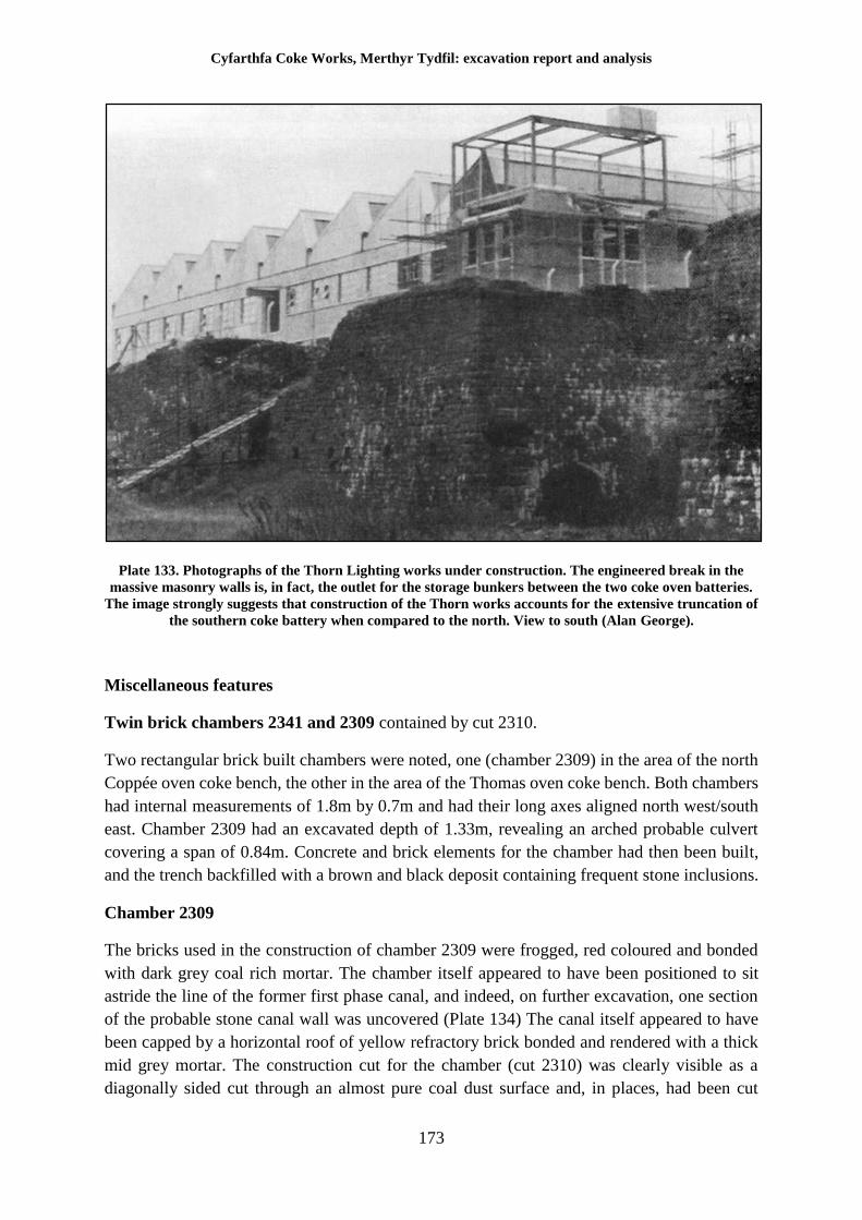
Cyfarthfa Coke Works, Merthyr Tydfil: excavation report and analysis
173
Plate 133. Photographs of the Thorn Lighting works under construction. The engineered break in the
massive masonry walls is, in fact, the outlet for the storage bunkers between the two coke oven batteries.
The image strongly suggests that construction of the Thorn works accounts for the extensive truncation of
the southern coke battery when compared to the north. View to south (Alan George).
Miscellaneous features
Twin brick chambers 2341 and 2309 contained by cut 2310.
Two rectangular brick built chambers were noted, one (chamber 2309) in the area of the north
Coppée oven coke bench, the other in the area of the Thomas oven coke bench. Both chambers
had internal measurements of 1.8m by 0.7m and had their long axes aligned north west/south
east. Chamber 2309 had an excavated depth of 1.33m, revealing an arched probable culvert
covering a span of 0.84m. Concrete and brick elements for the chamber had then been built,
and the trench backfilled with a brown and black deposit containing frequent stone inclusions.
Chamber 2309
The bricks used in the construction of chamber 2309 were frogged, red coloured and bonded
with dark grey coal rich mortar. The chamber itself appeared to have been positioned to sit
astride the line of the former first phase canal, and indeed, on further excavation, one section
of the probable stone canal wall was uncovered (Plate 134) The canal itself appeared to have
been capped by a horizontal roof of yellow refractory brick bonded and rendered with a thick
mid grey mortar. The construction cut for the chamber (cut 2310) was clearly visible as a
diagonally sided cut through an almost pure coal dust surface and, in places, had been cut
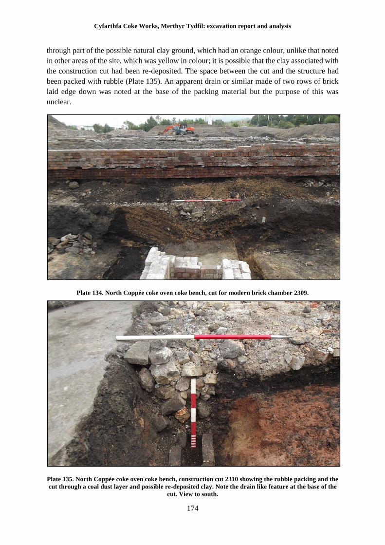
Cyfarthfa Coke Works, Merthyr Tydfil: excavation report and analysis
174
through part of the possible natural clay ground, which had an orange colour, unlike that noted
in other areas of the site, which was yellow in colour; it is possible that the clay associated with
the construction cut had been re-deposited. The space between the cut and the structure had
been packed with rubble (Plate 135). An apparent drain or similar made of two rows of brick
laid edge down was noted at the base of the packing material but the purpose of this was
unclear.
Plate 134. North Coppée coke oven coke bench, cut for modern brick chamber 2309.
Plate 135. North Coppée coke oven coke bench, construction cut 2310 showing the rubble packing and the
cut through a coal dust layer and possible re-deposited clay. Note the drain like feature at the base of the
cut. View to south.
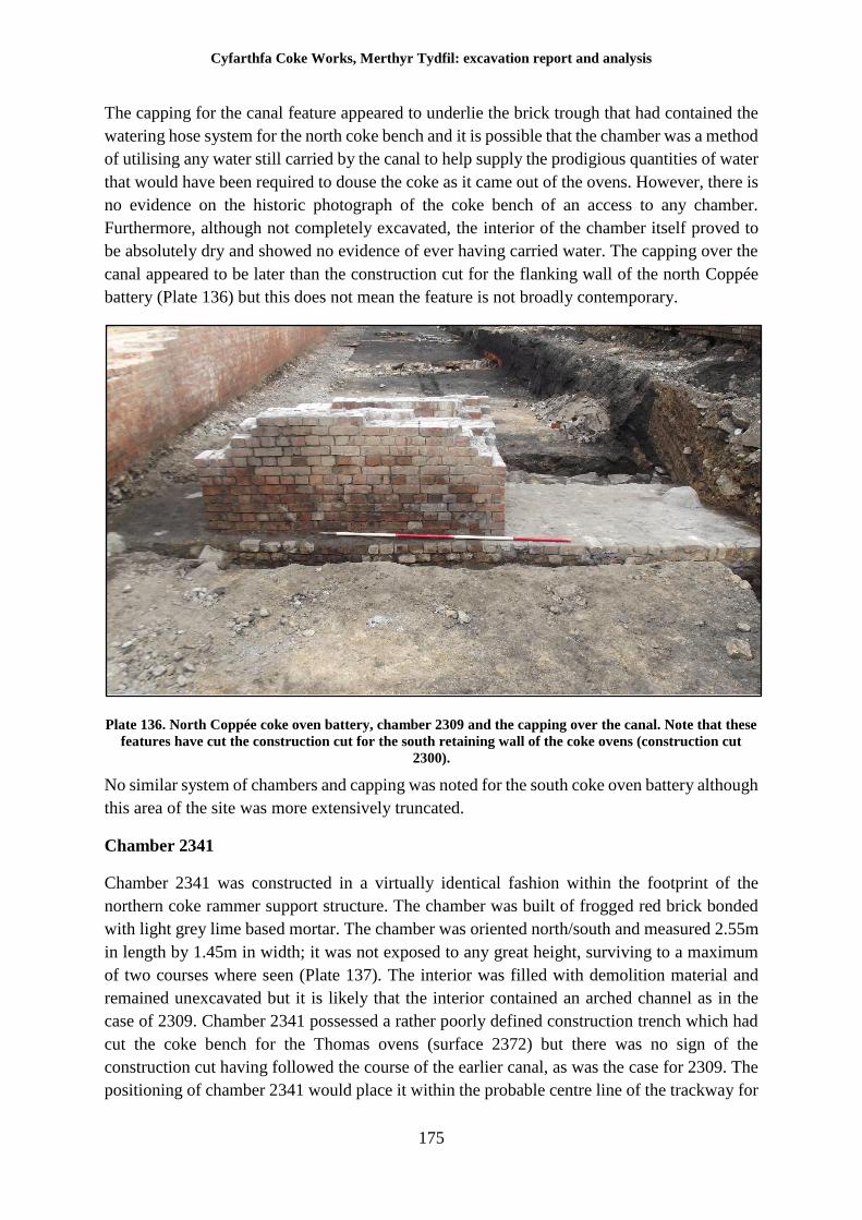
Cyfarthfa Coke Works, Merthyr Tydfil: excavation report and analysis
175
The capping for the canal feature appeared to underlie the brick trough that had contained the
watering hose system for the north coke bench and it is possible that the chamber was a method
of utilising any water still carried by the canal to help supply the prodigious quantities of water
that would have been required to douse the coke as it came out of the ovens. However, there is
no evidence on the historic photograph of the coke bench of an access to any chamber.
Furthermore, although not completely excavated, the interior of the chamber itself proved to
be absolutely dry and showed no evidence of ever having carried water. The capping over the
canal appeared to be later than the construction cut for the flanking wall of the north Coppée
battery (Plate 136) but this does not mean the feature is not broadly contemporary.
Plate 136. North Coppée coke oven battery, chamber 2309 and the capping over the canal. Note that these
features have cut the construction cut for the south retaining wall of the coke ovens (construction cut
2300).
No similar system of chambers and capping was noted for the south coke oven battery although
this area of the site was more extensively truncated.
Chamber 2341
Chamber 2341 was constructed in a virtually identical fashion within the footprint of the
northern coke rammer support structure. The chamber was built of frogged red brick bonded
with light grey lime based mortar. The chamber was oriented north/south and measured 2.55m
in length by 1.45m in width; it was not exposed to any great height, surviving to a maximum
of two courses where seen (Plate 137). The interior was filled with demolition material and
remained unexcavated but it is likely that the interior contained an arched channel as in the
case of 2309. Chamber 2341 possessed a rather poorly defined construction trench which had
cut the coke bench for the Thomas ovens (surface 2372) but there was no sign of the
construction cut having followed the course of the earlier canal, as was the case for 2309. The
positioning of chamber 2341 would place it within the probable centre line of the trackway for
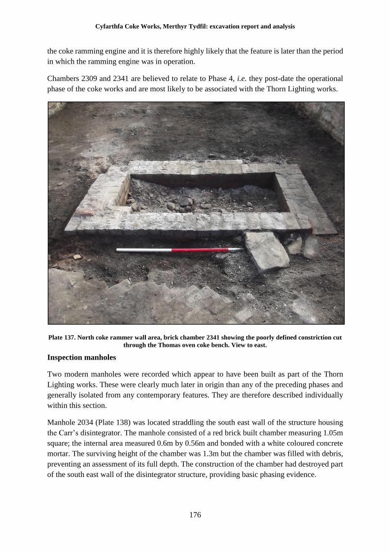
Cyfarthfa Coke Works, Merthyr Tydfil: excavation report and analysis
176
the coke ramming engine and it is therefore highly likely that the feature is later than the period
in which the ramming engine was in operation.
Chambers 2309 and 2341 are believed to relate to Phase 4, i.e. they post-date the operational
phase of the coke works and are most likely to be associated with the Thorn Lighting works.
Plate 137. North coke rammer wall area, brick chamber 2341 showing the poorly defined constriction cut
through the Thomas oven coke bench. View to east.
Inspection manholes
Two modern manholes were recorded which appear to have been built as part of the Thorn
Lighting works. These were clearly much later in origin than any of the preceding phases and
generally isolated from any contemporary features. They are therefore described individually
within this section.
Manhole 2034 (Plate 138) was located straddling the south east wall of the structure housing
the Carr’s disintegrator. The manhole consisted of a red brick built chamber measuring 1.05m
square; the internal area measured 0.6m by 0.56m and bonded with a white coloured concrete
mortar. The surviving height of the chamber was 1.3m but the chamber was filled with debris,
preventing an assessment of its full depth. The construction of the chamber had destroyed part
of the south east wall of the disintegrator structure, providing basic phasing evidence.
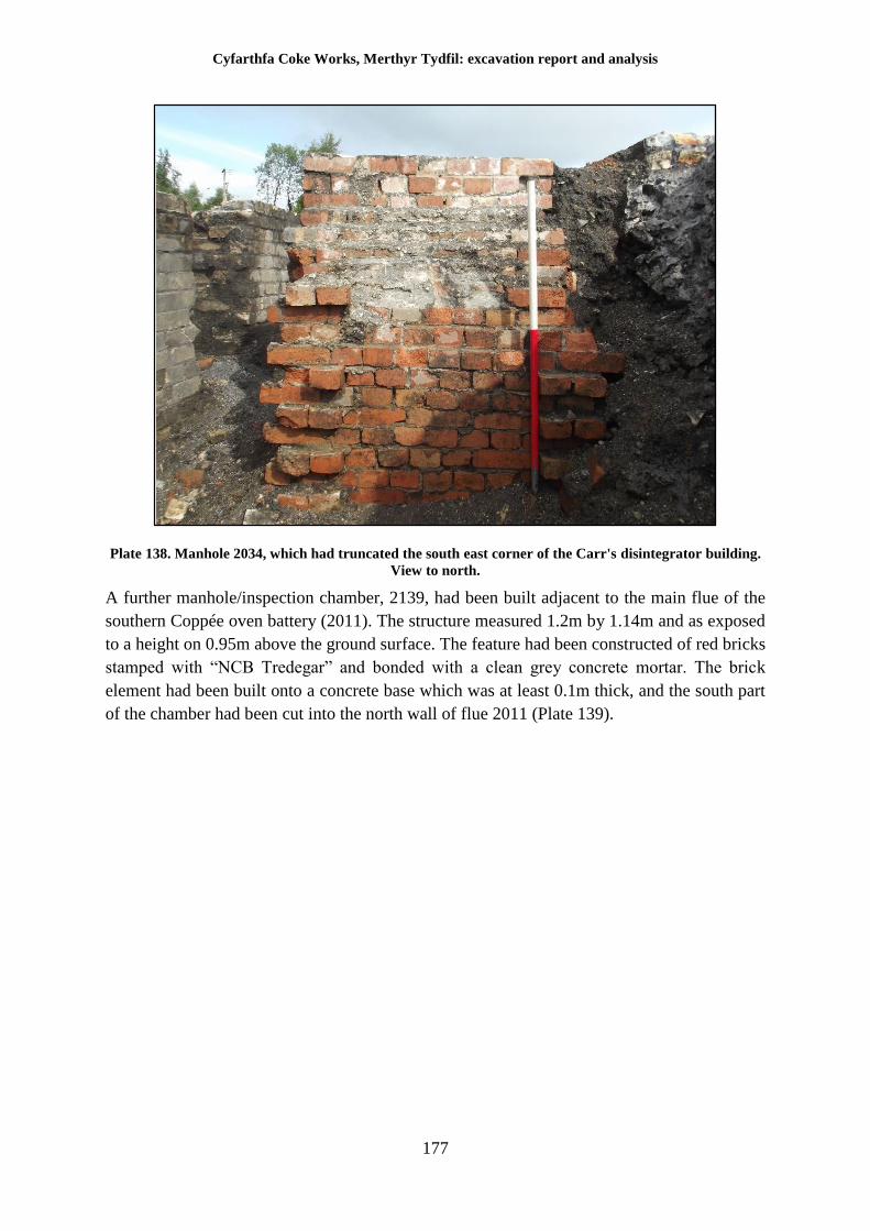
Cyfarthfa Coke Works, Merthyr Tydfil: excavation report and analysis
177
Plate 138. Manhole 2034, which had truncated the south east corner of the Carr's disintegrator building.
View to north.
A further manhole/inspection chamber, 2139, had been built adjacent to the main flue of the
southern Coppée oven battery (2011). The structure measured 1.2m by 1.14m and as exposed
to a height on 0.95m above the ground surface. The feature had been constructed of red bricks
stamped with “NCB Tredegar” and bonded with a clean grey concrete mortar. The brick
element had been built onto a concrete base which was at least 0.1m thick, and the south part
of the chamber had been cut into the north wall of flue 2011 (Plate 139).
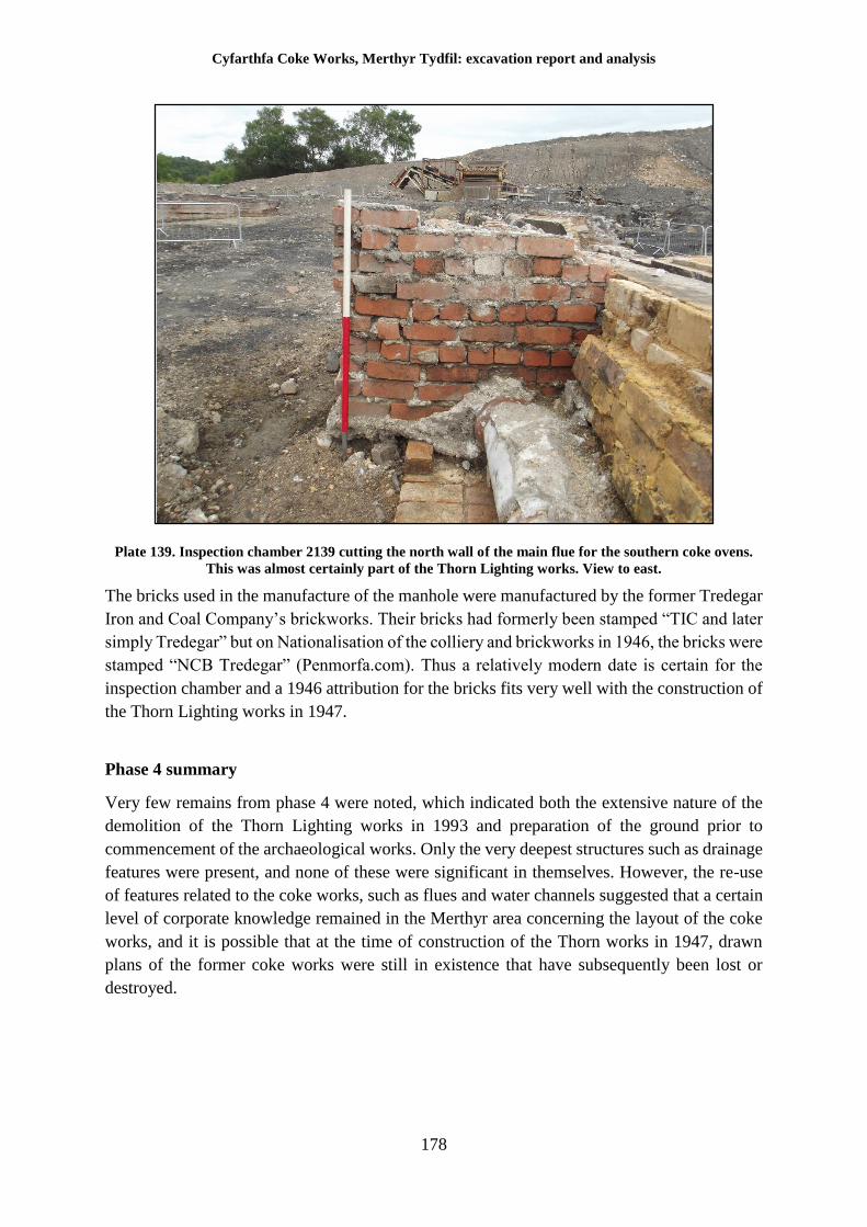
Cyfarthfa Coke Works, Merthyr Tydfil: excavation report and analysis
178
Plate 139. Inspection chamber 2139 cutting the north wall of the main flue for the southern coke ovens.
This was almost certainly part of the Thorn Lighting works. View to east.
The bricks used in the manufacture of the manhole were manufactured by the former Tredegar
Iron and Coal Company’s brickworks. Their bricks had formerly been stamped “TIC and later
simply Tredegar” but on Nationalisation of the colliery and brickworks in 1946, the bricks were
stamped “NCB Tredegar” (Penmorfa.com). Thus a relatively modern date is certain for the
inspection chamber and a 1946 attribution for the bricks fits very well with the construction of
the Thorn Lighting works in 1947.
Phase 4 summary
Very few remains from phase 4 were noted, which indicated both the extensive nature of the
demolition of the Thorn Lighting works in 1993 and preparation of the ground prior to
commencement of the archaeological works. Only the very deepest structures such as drainage
features were present, and none of these were significant in themselves. However, the re-use
of features related to the coke works, such as flues and water channels suggested that a certain
level of corporate knowledge remained in the Merthyr area concerning the layout of the coke
works, and it is possible that at the time of construction of the Thorn works in 1947, drawn
plans of the former coke works were still in existence that have subsequently been lost or
destroyed.
Cyfarthfa Coke Works, Merthyr Tydfil: excavation report and analysis
179
8 Specialist artefactual and environmental assessments
Following completion of the fieldwork all bulk finds were sorted and cleaned, re-packaged in
labelled bags and stored in labelled museum storage boxes. All finds, including small finds,
were quantified by type and context, and this data, along with the sample data, entered onto a
computerised database (Microsoft Access). The assemblage was then submitted for specialist
assessment. Pages 180 to 210 present the resulting specialist reports.
No small finds were recorded and no samples for environmental analysis were taken. The
artefactual and environmental assemblage is summarised in Table 1.
Table 2. Finds and environmental assemblage summary
Category Bulk finds Small finds Samples
Animal bone 22
Brick/tile 68
Ceramic object 75
Clay-pipe 29
Coal
Coins
Coke/Clinker
Copper alloy 2
Environmental samples
Flint/Chert
Glass 42
Iron 366
Leather
Modern Synthetics 5
Mortar samples 25
Other
Other metals (Pb, Cu etc.)
Pottery 115
Shell
Slag/other industrial
Stone Artefact
Stone tile/slate
Structural Stone
Unworked Stone
Wood
Cyfarthfa Coke Works, Merthyr Tydfil: excavation report and analysis
180
Pottery and glass - Joyce Compton (Freelance)
Post-medieval and modern pottery
Introduction and Methodology
The pottery recovered from work at Cyfarthfa coke works forms a small assemblage amounting
to 122 sherds, weighing 1207g, most of which is un-stratified. All of the pottery has been
recorded by sherd count and weight, in grams, by context, and the data entered onto an Excel
spreadsheet for ease of manipulation. The spreadsheet forms part of the archive. The
assemblage is fragmentary (average sherd weight 9.9g) but, although fragmented, is in
relatively good condition, apart from several sherds which are coated with a black deposit
(possibly tar) and others with heat damage.
Descriptions and Dating
More than three-quarters of the assemblage comprises modern ceramics dating to the 19th and
20th centuries. White earthenware is the largest component, mostly with blue transfer-printing
but there are occasional sherds with brown or orange. Several sherds have pink lustre wavy-
line decoration; others have blue stripes. Also present are mocha wares, common in public
houses before the advent of glass beer mugs, and yellow-glazed kitchen wares. No makers’
marks were noted. Two fragments of modern white-glazed bathroom tile were also recorded
and a small sherd of grey stoneware, probably from an inkwell.
There are remains of two ornaments, the first is un-stratified and from a moulded figurine in
grey stoneware, depicting the lower portion of a skirted female figure. The second is a finer
example, retrieved from 2132, and comprises joining sherds from a Staffordshire-type ceramic
figurine, depicting a male figure in blue breeches and waistcoat seated on a wooden tub. The
figurine is missing its head and most of both arms, but is likely to represent the nursery
character Little Boy Blue.
Earlier pottery types are present in small amounts, primarily local coarse ware and North Devon
gravel-tempered ware. The latter are probably derived from finer vessels, such as jugs, rather
than large pans. Both pottery types have a date range of 16th to 19th centuries. A West Country
or North Devon slipware jug or pitcher handle (17th/18th century) is also present.
Post-medieval and modern glass
Introduction and Methodology
The post-medieval and modern glass amounts to a total of 44 sherds, weighing 2033g. All of
the glass has been counted and weighed (in grams) by context and type, and the data entered
onto an Excel spreadsheet which forms part of the archive. The assemblage is dominated by
bottle glass of all types, representing 98% by weight of the total.
Cyfarthfa Coke Works, Merthyr Tydfil: excavation report and analysis
181
Descriptions and Dating
Bottles
More than half of the bottle glass assemblage derives from blue-green bottles, representing
19th or early 20th century mineral water or medicine containers. Some sherds are embossed
with Hansards Aerated Waters, Merthyr, another has J A Bailey just above the base. Hansard’s
factory was in Castle Street, Merthyr; J A Bailey was a merchant with premises in Alexandra
Road, Swansea. There are also sherds embossed with Hancocks, Cardiff (and see below). A
complete cylindrical bottle, used perhaps for ink or quack medicine, was found un-stratified.
This has a sheared lip which helped to secure a cork closure; the dried-up cork is still within
the bottle.
Two complete crown-top beer bottles in brown glass came from 2132. Both are embossed
Hancocks, Cardiff & Swansea; Hancocks’ brewery firm was set up in Cardiff in 1884 and soon
had branches in Newport and Swansea. Crown top closures were patented in 1892. Ten body
sherds of dark green glass, deriving from beer or wine bottles, were recorded. Colourless
sherds are few and include the lower half of a fish or meat paste jar. An un-stratified, green
wine bottle rim sherd is dated to the second half of the 18th century, using the typology in
Morgan (n.d.). This sherd is in poor surface condition and appears to have suffered from heat
damage.
Window glass
There are three sherds of un-stratified modern window glass; two small colourless sherds and
a blue-green sherd with a moulded design on one surface, probably an aid to obscuring vision.
Object
This is a corner rim sherd from a shallow vessel in yellow-green glass. The external surface
has an all-over moulded ‘checkerboard’ design of raised small squares. The function is not
readily apparent, but is reminiscent of the sort of tray once seen on ladies’ dressing tables for
holding hairpins and the like.
Conclusion
Much of both assemblages is un-stratified and dates to the 19th and early 20th centuries. The
stratified components are of similar composition and date. All of the earlier post-medieval
pieces are also un-stratified. Neither assemblage appears to be contemporary with the
operational coke works and is equally unlikely to derive from the later Thorn electrical works.
It may be notable that the glass is almost entirely composed of bottle sherds, but the whole
collection has the appearance of an accumulation of rubbish originating from elsewhere.
Reference
Morgan, R, n.d., Sealed bottles: their History and Evolution (1630-1930), Midlands Antique
Bottle Publishing, Burton upon Trent
Cyfarthfa Coke Works, Merthyr Tydfil: excavation report and analysis
182
Metalwork – Dr Tim Young (Geo Arch)
The site has produced 366 metal objects during both the excavation and subsequent watching
brief. A high proportion of the objects were not recorded from stratified contexts and many
were recovered from the scrap metal from the groundworks crushing plant following
mechanical overburden removal. Structural metalwork from the re-use of the site during the
mid-late twentieth century was excluded from the investigation as far as possible.
The assemblage described here is mostly material that was associated with the coking plant of
the steelworks period (1882-1919); a few pieces are derived from earlier use of the site.
The majority of the pieces are not identifiable to particular uses, being relatively ‘stock’ items
or forms. The more specific items include a series of cogged wheels, probably from roller
crushers or breakers. Such roll crushers may have been a component of the 1882 crushing plant,
rather than the 1894/5 washery that largely replaced it. The washery was represented by several
large castings that were probably basal supports for the internal conveyors. Structural ironwork
was also present, as were items from the water supply.
Items relating to transport formed a significant group, with items derived from both standard
gauge and light railways, as well as wheel from a hand cart and a wheel barrow. A few items
from the plateways of the pre-steelworks period were also recovered.
Tools included pieces that would have been employed in the coke works, including large
spanners, long handled tools, a shovel and a possible rake, as well items usually associated
with mining, such as a mandrel, a wedge and prise bars.
A full copy of the report and recommended illustrations is contained at Appendix II to this
report.
Discussion
The metalwork assemblage from the site was largely disturbed from its original location –
either within demolition deposits or removed from the site by mechanical excavation.
The majority of the items were derived from the structure of the coal washery and crushing
plant, the transport infrastructure and the water supply. There were very few items derived from
the machinery of the plant and possibly none at all from the Coppée ovens. This suggests that
the demolition and salvage of useful metal was thorough.
It may be significant that the drive wheels from a coal breaker or crusher (Cat. #349-352) are
some of the very few pieces of the heavy plant recovered. Wear on cogged drive wheels in such
a dirty environment may have necessitated their replacement, so these wheels were not
necessarily an active part of the plant at the time of disuse.
Other heavy castings from the machinery (e.g. Cat. #300301) appear to be associated with the
lower ends of conveyors from the washery, and so may have been abandoned in their below
ground level settings.
Cyfarthfa Coke Works, Merthyr Tydfil: excavation report and analysis
183
The large structural box-work and girder castings of the assemblage are likely to have remained
in situ in the building remains until disturbed by the constructional groundworks.
The water supply system for the plant comprised, at least in part, distribution via cast iron pipes
with control valves produced by Blakeborough & Sons of Brighouse (Cat. #321323). None of
the valves was retrieved under archaeological conditions, so it is not known whether this water
system was part of the 1880s works or the 1890s washery.
The assemblage is interesting, for it largely dates to within the period when bulk steel was
gradually supplanting wrought iron as the construction material of choice (indeed, the
introduction of bulk steelmaking was, of course, the purpose behind the construction of the
Coppée coking works). Very few pieces of the assemblage are, however, actually made of steel;
most of the metalwork is still of either cast or wrought iron. Most of the fastenings (nuts, bolts
etc.) are still apparently hand-made.
There are, however, glimmers of modernisation when compared with the mainly slightly older
assemblages from the sister Ynysfach Ironworks and the Ffos-y-fran project (GGAT
forthcoming). There are slightly more objects of steel, there is a greater use beginning to be
made of hex-headed bolts and nuts and the internal plateway system of the Cyfarthfa Ironworks
has finally (by 1882) been replaced by edge rail systems.
As seen on those other sites, the edge rail systems (both standard and narrow gauge) have
produced large quantities of screws, bolts, spikes and fishplates during track laying,
replacement and final removal, which dominate the transport component of the assemblage;
there are very few of the larger items of rails or chairs.
As well as the railed transport systems, the site produced wheels probably cart from a hand cart
and a wheel barrow (Drawings 7 and 8).
Although most of the assemblage is likely to relate to the steelworks period, there is a small
proportion of earlier material. Two substantial pieces of iron (Cat. #287-288, Drawings 16 and
17)) may be associated with the earlier coke ovens, one probably a structural support binding,
the other a hinged plate of uncertain purpose. The pre-1882 phase also produced evidence for
the plateway system adjacent to the ovens, which employed lightweight stone sleepers with an
Outram-style plate. A single un-stratified example of an Outram-style channel plate (Cat. #242,
Drawing 4) may be indicative of the associated plates. There were also other fragmentary
pieces of plateway track, including a complete plate with very narrow integral chairs (Cat.
#241, Drawing 3), a pointer fragment (Cat. #243, Drawing 3), and a horned sill (Cat. #244,
Drawing 5). The plate and sill cannot be paralleled precisely in examples from other sites, but
the late use of horned sills at Cyfarthfa compared with other ironworks has been discussed
previously (Young 2014a, 14).
The tool assemblage from the site includes several examples of spanners (Drawings 9 and 10),
long handled tools (Drawing 11), a shovel and a possible rake fragment (Cat #265-272, 280,
282, Drawing 12) that may have been employed in the coke works. Other tools, including prise
bars, a chisel, a wedge and a mandrel (Cat. #273-278, Drawings 13 to 15) are either mining
Cyfarthfa Coke Works, Merthyr Tydfil: excavation report and analysis
184
tools or for manually processing coal (or perhaps coke) in the stockyard. The slightly larger
size of the implements compared with the underground tools from Ffos-y-fran may hint that
these tools were or over-ground use.
Recommendations
The assemblage contains a small number of pieces for which both illustration and retention is
recommended. Some twenty-two items have been identified in the catalogue (see report in
Appendix II) as being worthy of illustration in the site report; these same items should be
retained if possible. The illustrations have been attached for reference at the Appendix.
Steelmaking ceramics – Dr Tim Young (Geo Arch)
The material comprises a collection of ten Bessemer converter tuyéres. Nine of the tuyéres are
used discards of a type associated with the Cyfarthfa Steelworks (approximately 1882 – 1919)
and of which examples have also been recovered recently from the Ynysfach Ironworks and
from the Cyfarthfa Ironworks stables.
A single example of an unused short tuyére is of a different design. It is only 227mm in length
and bears the usual pattern of nine bores employed at the Cyfarthfa works, but they are only
9mm (three eighths of an inch) in diameter, as opposed to the usual 12mm bores (half inch
diameter) employed on other Cyfarthfa Bessemer tuyéres. The purpose of this piece is
unknown; it is very much shorter than documented types of tuyére for Bessemer converters
and may be either for an unusual converter or perhaps it might be a test piece from the
brickworks (Drawings 19 and 20).
Recommendations
The steelworks ceramics are an important addition to understanding and should therefore be
retained and deposited as part of the archive in its eventual repository.
Cyfarthfa Coke Works, Merthyr Tydfil: excavation report and analysis
185
Ceramic building material (bricks) Johnny Crawford (GGAT)
Introduction
During the Cyfarthfa Coke works excavation and watching brief, a total of 68 examples of
ceramic building material (brick and tile) were retained for analysis. Given the large quantity
of this type of material noted on the site, only single samples from significant locations were
retained. Un-stratified material was retained only when it was either readily distinguishable
though form or identifying features such as stamps. Retained samples were examined visually
in order to characterise size and shape, any markings, and colour and texture of fabric. Of the
total assemblage, 34 were considered to possess sufficient characteristics for analysis and
cataloguing.
The generally accepted evolution of brick types over time in the UK was established over 40
years ago (Harley 1974), but the Cyfarthfa examples fall outside this sequence as they contain
significant numbers of specialist industrial brick, manufactured to perform specific tasks. In
reality, very little serious academic work has been undertaken on bricks dating to the later
industrial revolution and therefore the corpus of knowledge concerning these generally under
examined items is, with a few exceptions, rather thin (Campbell 2003). Within a Welsh context,
it is fair to say that most classification of brick has been undertaken by enthusiastic amateurs
who have made their information available through the internet; the websites Penmorfa.com
and Industrial Gwent are particularly useful in this regard. However, the general guidance
provided for specialist finds reporting (CIfA 2014) has been consulted with regard to the
following report
Observations on the assemblage from Cyfarthfa
Some minor variation in ‘standard’ sized brick dimensions were noted, caused probably by
variations in batch manufacture and post-manufacture exposure to heat. These variations are in
the region of several millimetres and are not considered significant.
Whilst examination of the mortar is beyond the scope of this brick report, it should be noted
that many of the refractory bricks examined retained traces of mortar which had a similar
appearance to the fabric of the bricks to which it adhered. This suggests that the bricks were
bonded with as chemically similar a mortar as possible to reduce the differential heating of
materials within the structures, and thus improve longevity of the structures themselves.
The great number of specialist refractory bricks noted on the site appear to have been left at
Cyfarthfa as they were of much less utility than standard sized bricks, in terms of their
reclamation and re-use. Millions of standard bricks were reported to have been sent to Cardiff
on final demolition of the Cyfarthfa works, but those from the coke ovens were simply unusable
for any other application and therefore simply left on site.
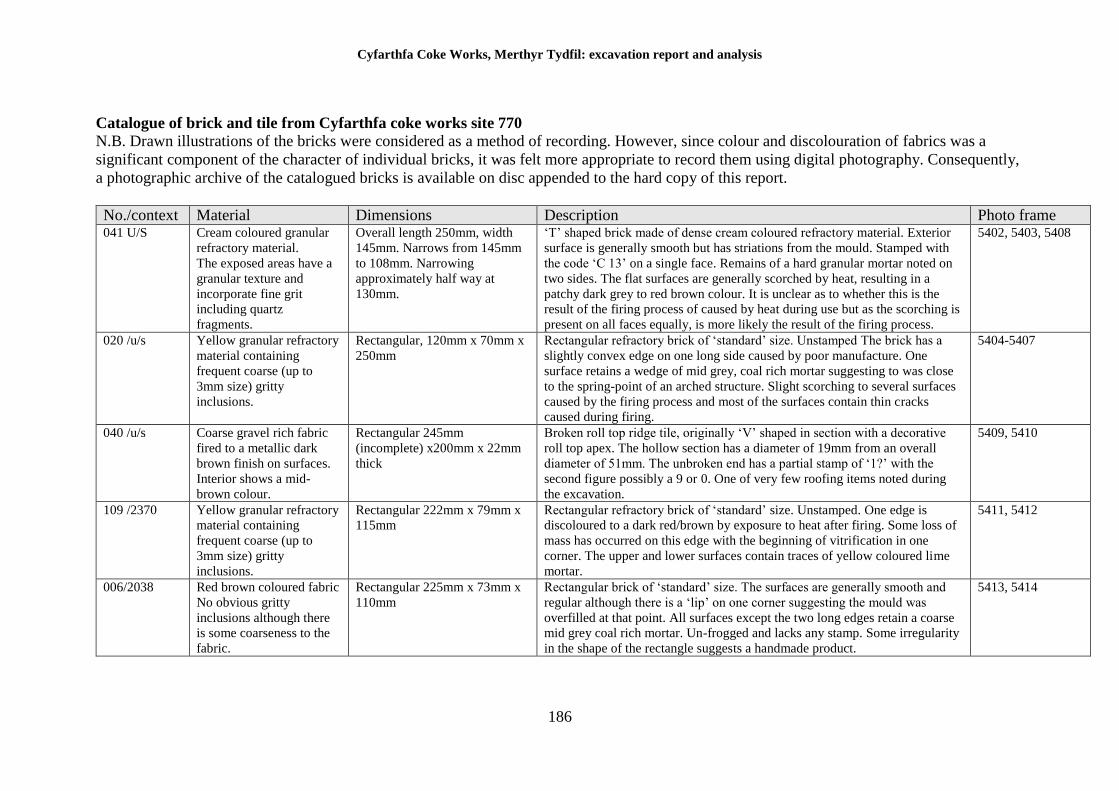
Cyfarthfa Coke Works, Merthyr Tydfil: excavation report and analysis
186
Catalogue of brick and tile from Cyfarthfa coke works site 770
N.B. Drawn illustrations of the bricks were considered as a method of recording. However, since colour and discolouration of fabrics was a
significant component of the character of individual bricks, it was felt more appropriate to record them using digital photography. Consequently,
a photographic archive of the catalogued bricks is available on disc appended to the hard copy of this report.
No./context Material Dimensions Description Photo frame 041 U/S Cream coloured granular
refractory material.
The exposed areas have a
granular texture and
incorporate fine grit
including quartz
fragments.
Overall length 250mm, width
145mm. Narrows from 145mm
to 108mm. Narrowing
approximately half way at
130mm.
‘T’ shaped brick made of dense cream coloured refractory material. Exterior
surface is generally smooth but has striations from the mould. Stamped with
the code ‘C 13’ on a single face. Remains of a hard granular mortar noted on
two sides. The flat surfaces are generally scorched by heat, resulting in a
patchy dark grey to red brown colour. It is unclear as to whether this is the
result of the firing process of caused by heat during use but as the scorching is
present on all faces equally, is more likely the result of the firing process.
5402, 5403, 5408
020 /u/s Yellow granular refractory
material containing
frequent coarse (up to
3mm size) gritty
inclusions.
Rectangular, 120mm x 70mm x
250mm
Rectangular refractory brick of ‘standard’ size. Unstamped The brick has a
slightly convex edge on one long side caused by poor manufacture. One
surface retains a wedge of mid grey, coal rich mortar suggesting to was close
to the spring-point of an arched structure. Slight scorching to several surfaces
caused by the firing process and most of the surfaces contain thin cracks
caused during firing.
5404-5407
040 /u/s Coarse gravel rich fabric
fired to a metallic dark
brown finish on surfaces.
Interior shows a mid-
brown colour.
Rectangular 245mm
(incomplete) x200mm x 22mm
thick
Broken roll top ridge tile, originally ‘V’ shaped in section with a decorative
roll top apex. The hollow section has a diameter of 19mm from an overall
diameter of 51mm. The unbroken end has a partial stamp of ‘1?’ with the
second figure possibly a 9 or 0. One of very few roofing items noted during
the excavation.
5409, 5410
109 /2370 Yellow granular refractory
material containing
frequent coarse (up to
3mm size) gritty
inclusions.
Rectangular 222mm x 79mm x
115mm
Rectangular refractory brick of ‘standard’ size. Unstamped. One edge is
discoloured to a dark red/brown by exposure to heat after firing. Some loss of
mass has occurred on this edge with the beginning of vitrification in one
corner. The upper and lower surfaces contain traces of yellow coloured lime
mortar.
5411, 5412
006/2038 Red brown coloured fabric
No obvious gritty
inclusions although there
is some coarseness to the
fabric.
Rectangular 225mm x 73mm x
110mm
Rectangular brick of ‘standard’ size. The surfaces are generally smooth and
regular although there is a ‘lip’ on one corner suggesting the mould was
overfilled at that point. All surfaces except the two long edges retain a coarse
mid grey coal rich mortar. Un-frogged and lacks any stamp. Some irregularity
in the shape of the rectangle suggests a handmade product.
5413, 5414
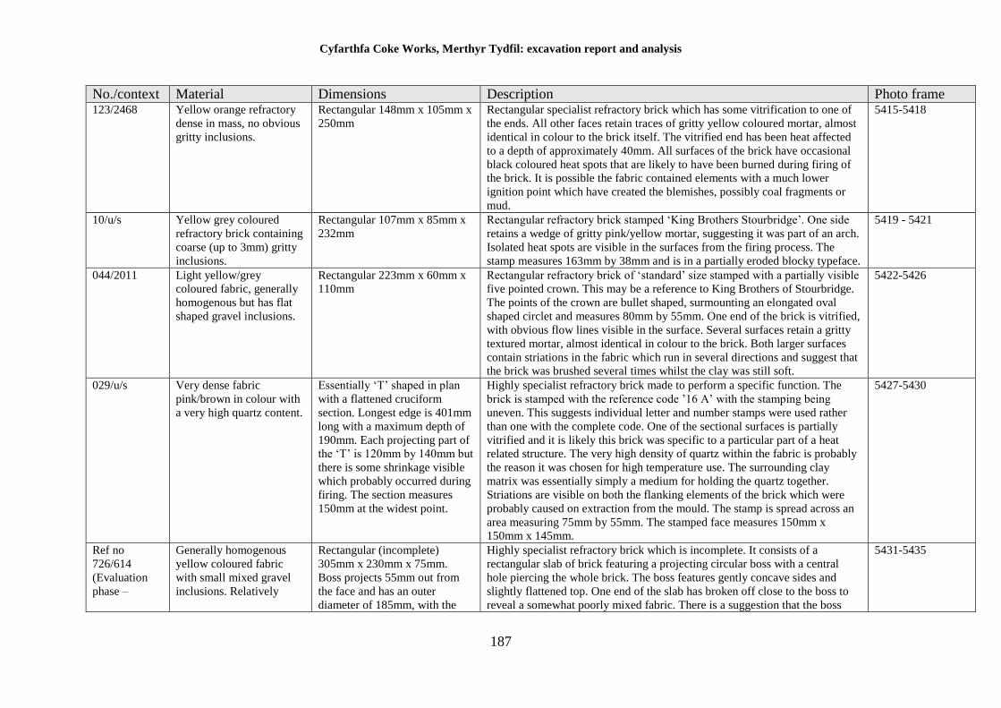
Cyfarthfa Coke Works, Merthyr Tydfil: excavation report and analysis
187
No./context Material Dimensions Description Photo frame 123/2468 Yellow orange refractory
dense in mass, no obvious
gritty inclusions.
Rectangular 148mm x 105mm x
250mm
Rectangular specialist refractory brick which has some vitrification to one of
the ends. All other faces retain traces of gritty yellow coloured mortar, almost
identical in colour to the brick itself. The vitrified end has been heat affected
to a depth of approximately 40mm. All surfaces of the brick have occasional
black coloured heat spots that are likely to have been burned during firing of
the brick. It is possible the fabric contained elements with a much lower
ignition point which have created the blemishes, possibly coal fragments or
mud.
5415-5418
10/u/s Yellow grey coloured
refractory brick containing
coarse (up to 3mm) gritty
inclusions.
Rectangular 107mm x 85mm x
232mm
Rectangular refractory brick stamped ‘King Brothers Stourbridge’. One side
retains a wedge of gritty pink/yellow mortar, suggesting it was part of an arch.
Isolated heat spots are visible in the surfaces from the firing process. The
stamp measures 163mm by 38mm and is in a partially eroded blocky typeface.
5419 - 5421
044/2011 Light yellow/grey
coloured fabric, generally
homogenous but has flat
shaped gravel inclusions.
Rectangular 223mm x 60mm x
110mm
Rectangular refractory brick of ‘standard’ size stamped with a partially visible
five pointed crown. This may be a reference to King Brothers of Stourbridge.
The points of the crown are bullet shaped, surmounting an elongated oval
shaped circlet and measures 80mm by 55mm. One end of the brick is vitrified,
with obvious flow lines visible in the surface. Several surfaces retain a gritty
textured mortar, almost identical in colour to the brick. Both larger surfaces
contain striations in the fabric which run in several directions and suggest that
the brick was brushed several times whilst the clay was still soft.
5422-5426
029/u/s Very dense fabric
pink/brown in colour with
a very high quartz content.
Essentially ‘T’ shaped in plan
with a flattened cruciform
section. Longest edge is 401mm
long with a maximum depth of
190mm. Each projecting part of
the ‘T’ is 120mm by 140mm but
there is some shrinkage visible
which probably occurred during
firing. The section measures
150mm at the widest point.
Highly specialist refractory brick made to perform a specific function. The
brick is stamped with the reference code ’16 A’ with the stamping being
uneven. This suggests individual letter and number stamps were used rather
than one with the complete code. One of the sectional surfaces is partially
vitrified and it is likely this brick was specific to a particular part of a heat
related structure. The very high density of quartz within the fabric is probably
the reason it was chosen for high temperature use. The surrounding clay
matrix was essentially simply a medium for holding the quartz together.
Striations are visible on both the flanking elements of the brick which were
probably caused on extraction from the mould. The stamp is spread across an
area measuring 75mm by 55mm. The stamped face measures 150mm x
150mm x 145mm.
5427-5430
Ref no
726/614
(Evaluation
phase –
Generally homogenous
yellow coloured fabric
with small mixed gravel
inclusions. Relatively
Rectangular (incomplete)
305mm x 230mm x 75mm.
Boss projects 55mm out from
the face and has an outer
diameter of 185mm, with the
Highly specialist refractory brick which is incomplete. It consists of a
rectangular slab of brick featuring a projecting circular boss with a central
hole piercing the whole brick. The boss features gently concave sides and
slightly flattened top. One end of the slab has broken off close to the boss to
reveal a somewhat poorly mixed fabric. There is a suggestion that the boss
5431-5435
Cyfarthfa Coke Works, Merthyr Tydfil: excavation report and analysis
188
No./context Material Dimensions Description Photo frame included for
comparison)
smooth finish to external
surfaces.
central hole having a diameter
of 42mm. The central hole,
including the boss measures
131mm in length
itself was applied as a lump of clay before being stamped to create the final
shape. The last stage of manufacture was to pierce the central hole down the
centre of the boss; the exit hole on the reverse of the brick is somewhat
ragged. Although incomplete, it is likely that the broken end of the slab would
have had the same dimensions, with the boss being centrally located. The fact
that the break has occurred near the boss suggests an inherent structural
weakness in the method of manufacturing this particular type of brick, as
evidenced by an almost identical break in another example (No.31).
031/u/s Generally homogenous
yellow brown fabric
containing frequent quarts
and micaceous inclusions.
Fine, gritty texture to the
external surfaces.
Rectangular (incomplete)
360mm x 225mm x 73mm.
Boss projects 63mm form the
face of the brick and is 195mm
in diameter. The central piercing
is 50mm in diameter and
112mm deep.
Highly specialised refractory brick which is incomplete. It consists of a slab of
brick featuring a projecting circular boss with a central hole pierced into the
boss; this piercing does not go the whole way through the brick and is
believed to be a manufacturing defect. The boss has a rounded profile and
features a prominent circular moulding around it which may be related to how
the piece was made; there is some evidence that the boss was a later addition.
The slab itself has broken near the boss revealing the interior of the central
piercing and the section of the boss. It is likely that this particular break
pattern was common to this pattern of refractory brick and is likely to
represent an inherent design flaw. The pattern of the brick is very similar to
726/614 and its function is likely to have been identical. There are enough
differences, however, to suggest that whilst unstamped, both examples are
likely to have come from different manufacturers.
0935-0938
015/u/s Generally homogenous
yellow /brown colour,
isolated small quartz
inclusions
Rectangular 223mm x 105mm x
60mm. Two projecting cones on
one side, 50mm diameter,
38mm high.
An ostensibly standard sized brick which is furnished with two projecting, flat
topped cones on one side. These cones almost certainly fitted into matching
recesses in another brick but no examples of it were recovered. The reverse of
the brick is stamped ‘HARRIS & PEARSON STOURBRIDGE’, the stamp
measuring 142mm x 33mm and contained within a rectangular cartouche.
Although the projections are clearly designed to allow the brick to lock into
place securely, the actual purpose of the shape is as yet unknown.
0931-0934
022/u/s Dense yellow brown fabric
containing frequent quartz
inclusions. Relatively
smooth finish to exterior
surfaces.
Irregular wedge shape. 290mm
long x maximum thickness
185mm
Specialist refractory brick which bears marked effects from exposure to high
temperature after initial firing, obscuring the nature of the original fabric. The
brick is multi-faceted, possessing seven separate faces. All but one of the
faces are flat but the remaining one has a slightly concave shape that is likely
to have formed part of a curve when combined with other specialist bricks.
The concave face is also the one most affected by heat, having a deep red
colour and is also the only face not to retain traces of a hard, gritty lime based
mortar. It is likely therefore that this face was actively exposed to heat, for
example within a coke oven or furnace. The brick is stamped ‘HARRIS &
0938-0943
Cyfarthfa Coke Works, Merthyr Tydfil: excavation report and analysis
189
No./context Material Dimensions Description Photo frame PEARSON STOURBRIDGE’ and the pattern code number ‘7’ The stamp
measures 155mm by 34mm and is contained within a rectangular cartouche.
The number 7 is set at a slight angle. It should be noted that another brick of
the same pattern could not be used to continue the arc described by the
concave face and that this brick was made to occupy a very specific place
within the final structure.
028/u/s Dense, gritty fabric, highly
discoloured by
vitrification.
Irregular wedge shape, 260mm
x 250mm at widest parts,
170mm thick.
Specialist refractory brick which has been exposed to significant heat after
initial firing, resulting in vitrification and adherence of residues to the faces.
The brick is multi-faceted, possessing seven faces. Although difficult to
visualise due to the extent of vitrification, all except one face is flat, with the
remaining one slightly concave in shape. This is also the most heavily heat
affected face, and has a blistered appearance with a deep maroon colour. It is
likely this blistered face was part of the interior arch of a coke oven.
Interestingly, however, only three sides exhibit significant vitrification
presenting something of a puzzle as to how this variation was achieved. The
remaining sided retain traces of a hard gritty mortar. No manufacturers stamp
is visible. However, an almost identical, un-vitrified brick (45) has the stamp.
0944-0946
045/u/s Homogenous pink
coloured fabric containing
frequent fine gravel
inclusions. Smooth finish
to exterior surfaces.
Irregular wedge shape, 246mm
x 246mm at widest parts,
144mm thick.
Specialist refractory brick which is in relatively good condition compared to
other, similar examples. It is multi-faceted, possessing seven faces. All except
one face is straight, with the remaining one being slightly concave. This
concave face measures 100mm x 143mm and is probably the ‘working’ face
of the brick, helping to form an arch inside a coke oven. Although the sides
retain traces of a light cream coloured gritty mortar, the brick does not show
any signs of being affected by heat after initial firing. This suggests that the
brick was never used as intended within an actual operational oven or furnace.
The brick does indeed exhibit some manufacturing irregularities in shape,
being slightly bent along its edge and it is possible that the tolerances required
in the construction of ovens meant that is was rejected and discarded. The
brick is stamped ‘C.K. HARRISON STOURBRIDGE’ contained within a
rectangular cartouche measuring 153mm x 40mm.
0946-0948
u/s Homogenous
yellow/brown fabric
containing occasional
brown grit inclusions.
Smooth finish to faces but
frequent small fissures to
surface, indicating the clay
Rectangular 225mm x 110mm x
67mm.
Two examples of a standard non-refractory brick were recovered which were
frogged and stamped ‘WBI 1946 LTD’. The stamp was contained within a
bevel edged, recessed rectangular frog, measuring 56mm x 700mm, recessed
10mm below the face of the brick. The bricks were machine made, with the
remains of ‘plugs’ visible on the reverse side. The frog on the reverse side was
shallower but of the same dimension. Both examples were of similar fabric
but differences in colour suggested a different batch. The presence of two
0949-0950
Cyfarthfa Coke Works, Merthyr Tydfil: excavation report and analysis
190
No./context Material Dimensions Description Photo frame was not compressed
particularly hard.
raised studs next to the manufacturer’s stamp on one of the bricks may
indicate differences in date or place of manufacture. These bricks were almost
certainly used in the construction of the Thorn Lighting Works, which began
in 1947.
117/2139 Dense orange red fabric
containing frequent mixed
angular gravel inclusions.
Generally smooth finish to
faces but frequent small
fissures to surface,
indicating the clay was not
compressed particularly
hard.
Rectangular 222mm x 113mm x
79mm
An example of a machine made non-refractory frogged brick was retained for
examination. The brick features a recessed rectangular frog with rounded
corners measuring 164mm x 65mm and recessed 6mm from the face of the
brick. The frog contained the stamp ‘NCB TREDEGAR’. Extensive traces of
concrete based mortar still adhered to much of the brick.
0951
u/s Dense red/brown fabric
with slightly gritty finish
to exterior surfaces.
Frequent dark red/brown
fine gravel inclusions.
Rectangular 125mm x 105mm x
66mm
An example of a machine made non-refractory frogged brick. The brick is
stamped ‘STAR NEWPORT’ and has two star symbols either side of the text.
The stamp is contained within a rectangular frog, measuring 172mm x 61mm
and recessed 6mm from the face of the brick. The frog on the reverse is
shallower and retains two ‘plug’ marks. The brick retains traces of a fine gritty
concrete based mortar. This is typical of the products of the firm and are
found throughout South Wales.
0952
u/s Homogenous yellow
brown fabric with frequent
very fine, angular gravel
inclusions.
Rectangular but broken
minimum of 190mm long x
112mm wide x 77mm deep.
Incomplete refractory brick stamped ‘THISTLE 3’. A small dog-toothed
arrow symbol is located above the S of the word thistle. No mortar is evident
on any of the surfaces and this was one of the only bricks of this type
recovered. It is a product of the Scottish Thistle works and as such is rather
out of place in the assemblage, particularly when considering that South
Wales and South West England contained numerous high quality brickworks
up until relatively recently.
0953
728/811
(Evaluation
find)
Dense orange pink
coloured fabric containing
frequent mixed gravel and
quartz inclusions. Slightly
gritty finish to faces.
‘T’ shaped 226mm x 139mm
narrowing to 102mm (20mm
either side). 150mm thick. Leg
of the ‘T’ is 120mm long.
Specialist refractory brick stamped with ‘KING BROTHERS
STOURBRIDGE’ and the code ‘D 13’. The manufacturers stamp measures
167mm x 40mm and has text with a serrifed font. The code has been hastily
applied as evidenced by the fact that the ‘D’ and ‘13’ are oriented in opposite
ways. The brick retains traces of a hard lime based mortar and shows evidence
of having been heat affected after initial firing, with area of colour varying
from grey to deep maroon. The base of the ‘T’ shape shows signs of the
beginning of vitrification, suggesting this was the area of the brick closest to
the heat source. The form of the brick is suggestive of a keystone of some
kind although its exact position within a structure such as a coke oven is
0954
Cyfarthfa Coke Works, Merthyr Tydfil: excavation report and analysis
191
No./context Material Dimensions Description Photo frame unknown. This example was one of a number of such bricks recovered (see
020).
020/u/s Dense homogenous
creamy yellow coloured
fabric small mixed gravel
inclusions.
‘T’ shaped 235 x 145mm
narrowing to 102mm (20mm
either side). 145m thick. Leg of
the ‘T’ is 123mm long.
Specialist refractory brick stamped with the code ‘D 13’. There is no
manufacturer’s mark and the stamps are different to those employed in the
very similar brick 728/811. Some traces of hard lime based mortar are visible
but otherwise the brick is ‘cleaner’ than the other example. However, the foot
of the ‘T’ exhibits the same almost vitrified fabric, suggesting it occupied a
similar position within the structure. There are minor variations in the
dimensions of some of the planes but the width of the leg of the ‘T’ is exactly
the same, suggesting this was the crucial measurement. The brick is likely to
have functioned similarly as a keystone (see 728/811). It is possible that this
example was also made by King Brothers but the absence of a stamp and
difference in fabric suggest that another manufacturer may be responsible,
perhaps even the Cyfarthfa Brickworks itself.
0955
030/u/s Dense grey brown fabric
containing very frequent
quartz inclusions. Fine,
gritty texture to the outside
faces but the clay element
appears to be only a matrix
to hold the quartz.
Cruciform, identical in shape to
sample 029 i.e. ‘T’ shaped plan
and flattened cruciform section.
Longest edge is 380mm long
with a maximum depth of
187mm. Each projecting part of
the ‘T’ is 119mm by 135mm.
The central section measures
145mm at the widest point.
Highly specialist refractory brick made to perform a specific function. The
brick is stamped with the reference code ’16 B’ with the stamping being
uneven. This suggests individual letter and number stamps were used rather
than one with the complete code. Both ends of the brick show signs of
vitrification, a pattern that only really makes sense if the brick was used as a
spacer or part of the dividing wall between individual ovens or furnaces. The
very high density of quartz within the fabric is probably the reason it was
chosen for high temperature use. The stamp is spread across an area
measuring 70mm by 40mm but the figures and letter are smaller in size than
those on other examples. The stamped face, which is broadly square measures
150mm x 134mm.
0956-0959
025/u/s Dense creamy yellow
fabric containing frequent
mixed gravel inclusions.
There is much less
obvious quartz included as
part of the fabric than in
the other examples of this
brick pattern (029 and
030).
Cruciform, identical in shape to
sample 029 and 030 i.e. ‘T’
shaped plan and flattened
cruciform section although 025
is incomplete. Longest edge is
325mm long (incomplete) with
a maximum depth of 202mm.
The surviving projecting part of
the ‘T’ measures 126mm by
154mm. The central section
measures 625mm at the widest
point.
Highly specialist refractory brick made to perform a specific function. The
brick is stamped with the reference code ’16’. Whilst very similar, the
stamping is not identical to that seen on 029. One of the projecting arms of the
‘T’ shape has broken off. The very high density of quartz within the fabric is
probably the reason it was chosen for high temperature use. The stamp is
spread across an area measuring 64mm by 63mm, being almost identical in
size and nature to 029. The stamped face, which is broadly square measures
160mm x 160mm. No part of the brick shows any sign of vitrification or of
having been exposed to significant heat following initial firing and it is
possible that this example was never used, although there are minimal traces
of soft white lime based mortar.
0960-0962
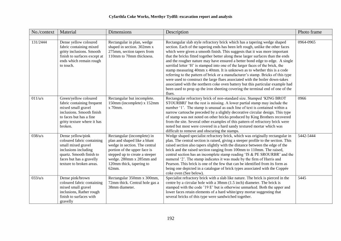
Cyfarthfa Coke Works, Merthyr Tydfil: excavation report and analysis
192
No./context Material Dimensions Description Photo frame
131/2444 Dense yellow coloured
fabric containing mixed
gritty inclusions. Smooth
finish to surfaces except at
ends which remain rough
to touch.
Rectangular in plan, wedge
shaped in section. 302mm x
275mm, section tapers from
110mm to 70mm thickness.
Rectangular slab style refractory brick which has a tapering wedge shaped
section. Each of the tapering ends has been left rough, unlike the other faces
which were given a smooth finish. This suggests that it was more important
that the bricks fitted together better along these larger surfaces than the ends
and the rougher nature may have ensured a better bond edge to edge. A single
serrifed letter ‘H’ is stamped into one of the larger faces of the brick, the
stamp measuring 40mm x 40mm. It is unknown as to whether this is a code
referring to the pattern of brick or a manufacturer’s stamp. Bricks of this type
were used to construct the large flues associated with the boiler down-takes
associated with the northern coke oven battery but this particular example had
been used to prop up the iron sheeting covering the terminal end of one of the
flues.
0964-0965
011/u/s Green/yellow coloured
fabric containing frequent
mixed small gravel
inclusions. Smooth finish
to faces but has a fine
gritty texture where it has
broken.
Rectangular but incomplete.
150mm (incomplete) x 152mm
x 70mm.
Rectangular refractory brick of non-standard size. Stamped ‘KING BROT
STOURBRI’ but the rest is missing. A lower partial stamp may include the
number ‘1’. The stamp is unusual as each line of text is contained within a
narrow cartouche preceded by a slightly decorative circular design. This type
of stamp was not noted on other bricks produced by King Brothers recovered
from the site. Several other examples of this pattern of refractory brick were
noted but most were covered in a hard sandy textured mortar which was
difficult to remove and obscuring the stamps.
0966
038/u/s Dense yellow/pink
coloured fabric containing
small mixed gravel
inclusions including
quartz. Smooth finish to
faces but has a gravelly
texture to broken areas.
Rectangular (incomplete) in
plan and shaped like a blunt
wedge in section. The central
portion of the upper face is
stepped up to create a steeper
wedge. 280mm x 285mm and
120mm thick, tapering to
62mm.
Wedge shaped specialist refractory brick, which was originally rectangular in
plan. The central section is raised, giving a steeper profile to the section. This
raised section also tapers slightly with the distance between the edge of the
brick and the raised section ranging from 100mm to 110mm. The raised,
central section has an incomplete stamp reading ‘IS & PE SROURBR’ and the
numeral ‘2’. The stamp indicates it was made by the firm of Harris and
Pearson. This brick is one of the few that can be identified from its form as
being one depicted in a catalogue of brick types associated with the Coppée
coke oven (See below).
5442-5444
033/u/s Dense pink/brown
coloured fabric containing
mixed small gravel
inclusions, Rather rough
finish to surfaces with
gravelly
Rectangular 350mm x 300mm,
72mm thick. Central hole gas a
38mm diameter.
Specialist refractory brick with a slab like nature. The brick is pierced in the
centre by a circular hole with a 38mm (1.5 inch) diameter. The brick is
stamped with the code ’19 E’ but is otherwise unmarked. Both the upper and
lower faces retain elements of a hard white/grey mortar suggesting that
several bricks of this type were sandwiched together.
5445
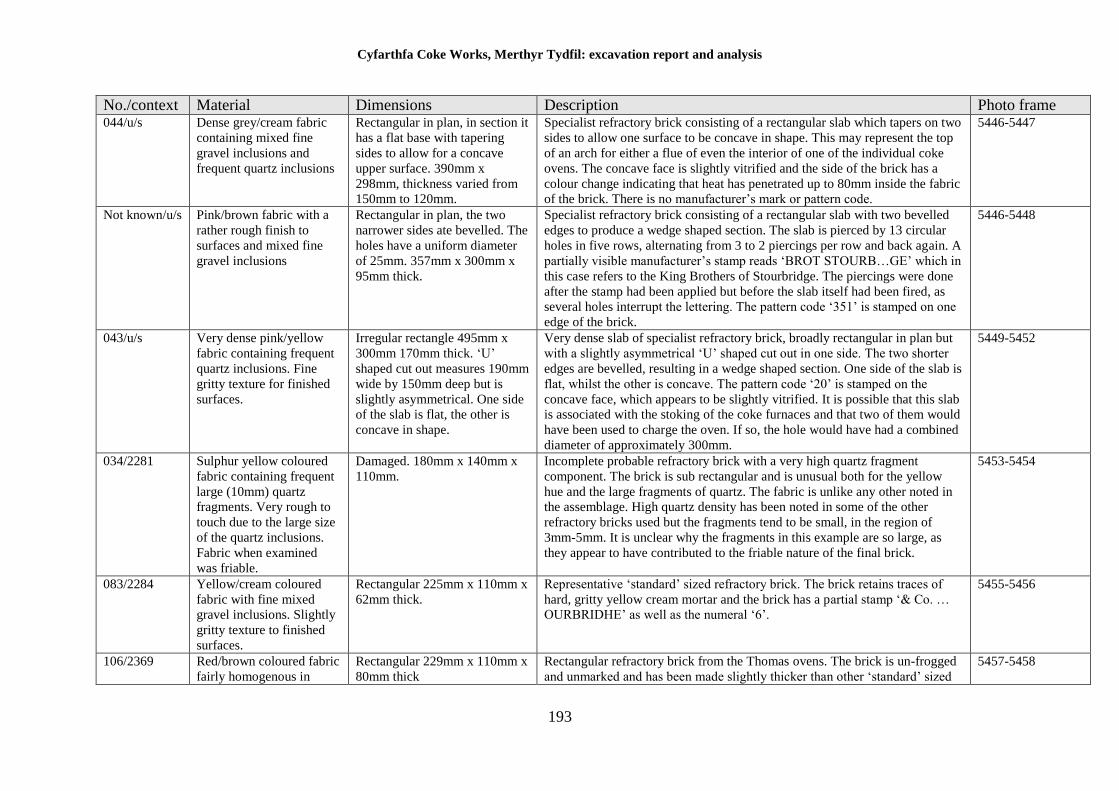
Cyfarthfa Coke Works, Merthyr Tydfil: excavation report and analysis
193
No./context Material Dimensions Description Photo frame 044/u/s Dense grey/cream fabric
containing mixed fine
gravel inclusions and
frequent quartz inclusions
Rectangular in plan, in section it
has a flat base with tapering
sides to allow for a concave
upper surface. 390mm x
298mm, thickness varied from
150mm to 120mm.
Specialist refractory brick consisting of a rectangular slab which tapers on two
sides to allow one surface to be concave in shape. This may represent the top
of an arch for either a flue of even the interior of one of the individual coke
ovens. The concave face is slightly vitrified and the side of the brick has a
colour change indicating that heat has penetrated up to 80mm inside the fabric
of the brick. There is no manufacturer’s mark or pattern code.
5446-5447
Not known/u/s Pink/brown fabric with a
rather rough finish to
surfaces and mixed fine
gravel inclusions
Rectangular in plan, the two
narrower sides ate bevelled. The
holes have a uniform diameter
of 25mm. 357mm x 300mm x
95mm thick.
Specialist refractory brick consisting of a rectangular slab with two bevelled
edges to produce a wedge shaped section. The slab is pierced by 13 circular
holes in five rows, alternating from 3 to 2 piercings per row and back again. A
partially visible manufacturer’s stamp reads ‘BROT STOURB…GE’ which in
this case refers to the King Brothers of Stourbridge. The piercings were done
after the stamp had been applied but before the slab itself had been fired, as
several holes interrupt the lettering. The pattern code ‘351’ is stamped on one
edge of the brick.
5446-5448
043/u/s Very dense pink/yellow
fabric containing frequent
quartz inclusions. Fine
gritty texture for finished
surfaces.
Irregular rectangle 495mm x
300mm 170mm thick. ‘U’
shaped cut out measures 190mm
wide by 150mm deep but is
slightly asymmetrical. One side
of the slab is flat, the other is
concave in shape.
Very dense slab of specialist refractory brick, broadly rectangular in plan but
with a slightly asymmetrical ‘U’ shaped cut out in one side. The two shorter
edges are bevelled, resulting in a wedge shaped section. One side of the slab is
flat, whilst the other is concave. The pattern code ‘20’ is stamped on the
concave face, which appears to be slightly vitrified. It is possible that this slab
is associated with the stoking of the coke furnaces and that two of them would
have been used to charge the oven. If so, the hole would have had a combined
diameter of approximately 300mm.
5449-5452
034/2281 Sulphur yellow coloured
fabric containing frequent
large (10mm) quartz
fragments. Very rough to
touch due to the large size
of the quartz inclusions.
Fabric when examined
was friable.
Damaged. 180mm x 140mm x
110mm.
Incomplete probable refractory brick with a very high quartz fragment
component. The brick is sub rectangular and is unusual both for the yellow
hue and the large fragments of quartz. The fabric is unlike any other noted in
the assemblage. High quartz density has been noted in some of the other
refractory bricks used but the fragments tend to be small, in the region of
3mm-5mm. It is unclear why the fragments in this example are so large, as
they appear to have contributed to the friable nature of the final brick.
5453-5454
083/2284 Yellow/cream coloured
fabric with fine mixed
gravel inclusions. Slightly
gritty texture to finished
surfaces.
Rectangular 225mm x 110mm x
62mm thick.
Representative ‘standard’ sized refractory brick. The brick retains traces of
hard, gritty yellow cream mortar and the brick has a partial stamp ‘& Co. …
OURBRIDHE’ as well as the numeral ‘6’.
5455-5456
106/2369 Red/brown coloured fabric
fairly homogenous in
Rectangular 229mm x 110mm x
80mm thick
Rectangular refractory brick from the Thomas ovens. The brick is un-frogged
and unmarked and has been made slightly thicker than other ‘standard’ sized
5457-5458
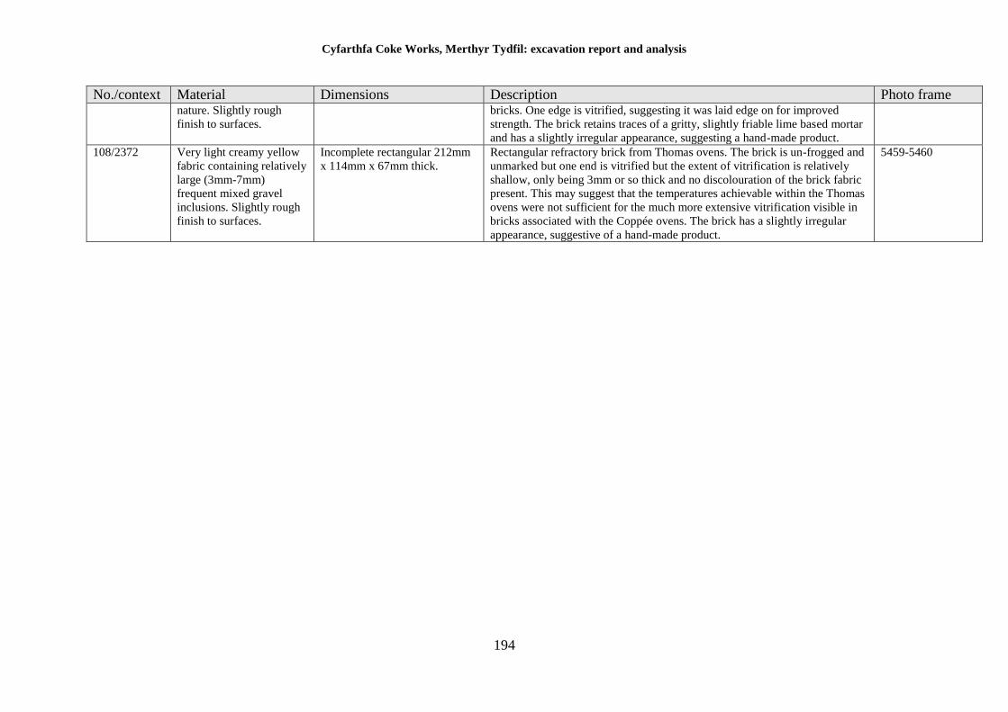
Cyfarthfa Coke Works, Merthyr Tydfil: excavation report and analysis
194
No./context Material Dimensions Description Photo frame nature. Slightly rough
finish to surfaces.
bricks. One edge is vitrified, suggesting it was laid edge on for improved
strength. The brick retains traces of a gritty, slightly friable lime based mortar
and has a slightly irregular appearance, suggesting a hand-made product.
108/2372 Very light creamy yellow
fabric containing relatively
large (3mm-7mm)
frequent mixed gravel
inclusions. Slightly rough
finish to surfaces.
Incomplete rectangular 212mm
x 114mm x 67mm thick.
Rectangular refractory brick from Thomas ovens. The brick is un-frogged and
unmarked but one end is vitrified but the extent of vitrification is relatively
shallow, only being 3mm or so thick and no discolouration of the brick fabric
present. This may suggest that the temperatures achievable within the Thomas
ovens were not sufficient for the much more extensive vitrification visible in
bricks associated with the Coppée ovens. The brick has a slightly irregular
appearance, suggestive of a hand-made product.
5459-5460
Cyfarthfa Coke Works, Merthyr Tydfil: excavation report and analysis
195
Discussion
Most industrial activity in South Wales was associated with both the use and
manufacture of bricks. The occurrence within the Coal Levels of suitable clay deposits
interleaved with coal seams meant that clay was a by-product of mining, and indeed it
was not unusual to find mines being operated after the coal had been exhausted, for the
extraction of clay for bricks. The majority of ironworks, including Cyfarthfa, operated
its own mining network in tandem with iron production and as a result, often operated
their own brickworks. However, these brickworks were usually managed within the
host coal mine company and as a result are poorly documented, and the survival of
recognisable stamps on the bricks themselves are often the only firm indication of their
provenance; this is the case with brick assemblage from Cyfarthfa.
Only a single example of roofing material was contained within the assemblage.
Contemporary photographs of the coal washery indicate a roof made of corrugated iron
and it is likely the majority of the buildings in the area would have had roofs of similar
construction, meaning that the requirement for ceramic roofing materials was
potentially low.
In the main, the bricks can be divided into two general categories, refractory bricks and
constructional bricks.
Refractory bricks
Specialist refractory bricks, which tend to have a creamy, yellow coloured fabric, were
manufactured as special bricks in order to create sacrificial linings for structures subject
to intense heat, including brick kilns, coke ovens, furnaces and chimneys. One of the
properties of refractory brick fabric is that it can withstand repeated heating and cooling
without becoming fractured, and therefore brick linings will survive intact for some
time. They only lose their structural integrity when heated to melting point, and even
then will survive intact. Ten of the specialist refractory bricks in the assemblage were
manufactured in the Stourbridge area, with two manufacturers being particularly
prominent, King Brothers and Harris and Pearson. The remainder of the specialist
bricks were unstamped. Whilst all these bricks were un-stratified, there is little doubt
that they were used within the Cyfarthfa Coppée coke ovens and its associated
structures. It is likely, therefore, that the bricks bearing stamps were bought from the
Stourbridge companies for the initial construction of the coke ovens.
It is clear from contemporary documentation that the brickworks constructed at the
same time as the Coppée ovens at Cyfarthfa were eventually able to supply the need for
specialist products, but the initial build was almost certainly carried out with the
Stourbridge products. It is possible that the unstamped examples of specialist brick were
manufactured at the Cyfarthfa site and that there was no perceived need to stamp
Cyfarthfa Coke Works, Merthyr Tydfil: excavation report and analysis
196
products that were to be used within the works, but there is no direct evidence to support
this. Whilst CYFARTHFA stamped standard sized firebricks are known from South
Wales (Penmorfa 2017), not a single example of a Cyfarthfa stamped brick was noted
in the assemblage. There were, however, unstamped bricks aplenty. It would be
remarkable if the coke ovens were not utilizing bricks manufactured literally next door
and this supports the idea that products intended for internal consumption, including
the more specialised types, remained unstamped.
Standard sized refractory bricks were evident in the assemblage, the majority of which
were un-frogged and unstamped. These bricks almost certainly date to the operation of
the Cyfarthfa works but no later and are therefore likely to pre-date 1919.
Constructional bricks
Constructional bricks i.e. those intended for general building, tended to be a variation
of orange/red in colour, indicating a higher iron oxide content. The fabric was
unsuitable for applications requiring high temperatures but were used for everything
from building walls and foundations to propping up boiler vessels. Constructional
bricks would have been made in their millions and as the vast majority of constructional
bricks noted on site were un-frogged and unstamped, the information that can be
obtained from them is somewhat limited; dating of the bricks is likely to be based on
context alone.
Notes on the manufacturers identified at Cyfarthfa.
Thistle brick.
Thistle was the trade name of a high alumina (38%) content brick manufactured by
Scottish company JG Stein in the Castlecary/Bonnybridge and Linlithgow area, near
Falkirk. The company manufactured high quality refractory products although under a
different name, and Thistle bricks have been found as far away as Tasmania and South
America. A single, un-stratified example of a Thistle brick was noted and its presence
is somewhat unusual. However, bricks manufactured by the same company with the
trade name Nettle have been found in Ebbw Vale and Cwmbran, in association with
works owned by GKN, who appear to have sold the Stein products alongside their own
brand of refractories. It is possible, therefore, that the example from Cyfarthfa was
associated with the acquisition of the works by GKN after 1909.
King Brothers, Stourbridge
King Brothers was a firm in existence between 1860 and 1955 based in Netherend in
the West Midlands. According to contemporary advertising, the firm specialised in the
manufacture of firebricks, glasshouse pots, crucibles, retorts and all fire-clay goods.
Cyfarthfa Coke Works, Merthyr Tydfil: excavation report and analysis
197
Their products have been found at the site of the Towcester Company Iron Works,
which was in operation between 1875 and 1878, in association with iron smelting which
suggests there was a precedent for the firm supplying specialist bricks to iron producers.
As the Cyfarthfa coke works is the first archaeologically examined works of this nature,
there are no references for comparison of the recovered bricks. However, two historical
illustrations of various forms of refractory brick associated with the Coppée coke oven
design are available, and some of the King Brothers bricks are similar to some of those
illustrated. The majority of the bricks are likely to relate to the period 1882 to 1909.
J B Fisher and Company
JB Fisher & Co. owned the Hayes (Fireclay) Colliery in Stourbridge from the 1860s,
and are listed as the Hays Fireclay Works in the 1872 to 1892 editions of the Kelly’s
directory for the area. The works had been taken over by Mobberly and Perry by 1896
and the stamps were changed on the bricks to reflect the new owners (Penmorfa). This
would date the Fisher bricks from Cyfarthfa to the period between the late 1860s and
early 1890s, which coincides with the period of modernisation and conversion to steel
initiated by the Crawshay brothers. Though not many references of this manufacturer’s
bricks have been located, one example has been noted in Brazil.
Timmis Stourbridge
Timmis and Co. were started around 1871 near Lye, Stourbridge by GH and JA Timmis
to mine fireclay from beneath the Stourbridge area. By 1881 they were sending out clay
from their own siding connected to the Great Western Railway and presumably were
making their own refractory products as well. The company existed until 1958 (Grace’s
Guide 2017). Timmis bricks have been found as far afield as Argentina although no
significant references to their products have been located. No example of a Timmis
stamped brick was noted in the assemblage, but one was noted within the construction
of the south Coppée coke oven (flue 2526) and the manufacturer has been mentioned
here as a result.
Welsh Brick Industries 1946
Welsh Brick Industries 1946 was formed in that year on the site of the former West End
Brickworks Company (formerly Highland Park Brickworks) in Ely, Cardiff, and is
listed in trade directories until 1968. Although the evidence is circumstantial, the close
association of the 1946 date with the construction date of the Thorn lighting works
suggests that the samples retained for examination may have been associated with the
construction or maintenance of the lighting works.
NCB Tredegar
Although the Tredegar Iron Company had been established in 1800, operating a number
of collieries in order to supply its works, the firm did not establish a dedicated
Cyfarthfa Coke Works, Merthyr Tydfil: excavation report and analysis
198
brickworks until 1933. Its products were stamped TIC (Tredegar Iron Company) and
later simply Tredegar. On nationalisation of the company’s collieries in 1946, the bricks
were stamped NCB Tredegar (National Coal Board). The brickworks is believed to
have closed in the 1960s. This suggests that the structures from which the NBC
Tredegar bricks derive date between 1946 and the late 1960s. This coincides with the
construction and operation of the Thorn Lighting works.
General conclusions
The majority of the specialist bricks employed in the initial construction of the Coppée
coke ovens were most likely obtained from specialist manufacturers based around the
Stourbridge area. It is probable that the expertise and materials for the construction of
both the coke ovens and brickworks was bought in by the Crawshay Brothers with the
intention to become self-sufficient at a later stage. These specialist materials were
drawn from a relatively narrow group of suppliers who were used to meeting the needs
of the iron and steel industries. It is perhaps stretching the evidence too far to suggest
that they effectively supplied coke ovens in ‘kit’ form but the coding of brick patterns
attests to a highly standardised production capability.
The absence of stamps on some specialist bricks in the assemblage suggests that
Cyfarthfa may well have been manufacturing its own replacement products, as
suggested by the contemporary works prospectus, although the evidence is
circumstantial. Refractory bricks do, however, depend very much on the nature of the
clay used in construction for the final properties of the bricks. It is unknown whether
any of the local clays would have been suitable or whether suitable material would have
been bought in from other concerns. Given that the prospectus states that the Cyfarthfa
works were self-sufficient, however, it seems likely that material was locally sourced.
Relatively few constructional bricks were noted from the fabric of the coke ovens
themselves; the standard sized bricks used were made from the same material used for
refractory examples. The reason is obvious in that the oven area was likely to
experience great heat and even construction work on the peripheries was carried out
with heat resistant materials. The exception to this was the brick troughs for the hose
system in the coke bench, and coal washery, for which red constructional material was
used.
The bricks date in range from the 1870s to the mid-1940s. Bricks recovered from the
fabric of the Thomas ovens are un-datable as they have no distinguishing features. The
bulk of the assemblage derives from the period of the 1880s to 1919, conforming to the
established date for the construction and operation of the coke works.
The later (mid-20th century) bricks are likely to be associated with the Thorn Lighting
works.
Cyfarthfa Coke Works, Merthyr Tydfil: excavation report and analysis
199
Constructional bricks were generally unremarkable and are likely to have been locally
sourced.
Given that there are very few sources of information concerning bricks of this period,
it is impossible to state how the Cyfarthfa assemblage compared to those found on other
sites. However, it is hoped that by taking a more detailed look at the brickwork, other
sites excavated in the future may have reference to this material for comparison.
References
British Brick Society, 1984, Information sheet No.32
Campbell, J, 2003, The study of Bricks and Brickwork in England since Nathaniel
Lloyd, Proceedings of the First International Congress of Construction History,
Madrid January 2003.
Chartered Institute for Archaeologists (revised 2014), Standard and Guidance for the
collection, documentation, conservation and research of archaeological
Materials CIfA, Reading
Harley, L S 1974 “A typology of brick”, Journal of the British Archaeological
Association, 3rd series, 37, 63-87
Online resources
Anon, n.d. www.industrialgwent.co.uk [accessed 2 January 2013]
Graces Guide – Online database for industrial history [Online] available at
http://www.gracesguide.co.uk/Main_Page
Jones, N n.d. www.cwmbran.info [accessed 2 January 2013]
Penmorfa – Online database for most historic Welsh and English brick types. [Online]
Scottish Brick History – [Online] available at http://www.scottishbrickhistory.co.uk
available at http://www.penmorfa.com/bricks/
Cyfarthfa Coke Works, Merthyr Tydfil: excavation report and analysis
200
Animal Bone Report – Hannah Bowden BA, MSc
During September to December 2013 excavations were conducted at Old Thorn Site,
Cyfarthfa Ironworks, in which a total of twenty-two animal bone fragments (0.065kg)
were hand collected from un-stratified deposits.
Methodology
The faunal remains were identified to species or species group with reference to known
specimens and publications (Cohen and Serjeantson, 1996; Hillson, 1992; Schmid,
1972). The distinction between sheep and goat has not been made due to the relatively
small size and condition of the assemblage. When species could not be identified, bone
was categorized to species size, consisting of large mammal (domestic cattle or horse),
medium mammal (domestic and wild ruminants and non-ruminates) and small mammal
(domestic and wild carnivores, insectivores, lagomorphs and rodents). Ribs and
vertebrae have been classed to species size only. Bone fragments were counted using
the NISP methodology (Lyman, 2008).
The preservation and condition of bone has been observed using a scale of poor to good,
detailed in Table 1.
Table 3 Scale of Fragmentation and Condition of bone
Scale Fragmentation and Condition of bone
Poor Fragments are small/unidentifiable.
Only enamel/burnt fragments have survived.
Surface of the bone is extremely pitted/cracked/various layers are notable.
Moderate Fragmented/signs of modification (burnt/gnawed/butchered) with identifiable
features.
Surface of the bone is slightly pitted, with faint cracks/fairly intact.
Good Complete element surviving/near complete element but slightly fragmented.
The surface of the bone is in very good condition/smooth surface.
Results
The assemblage consisted of five sheep/goat bone fragments, one fragmented domestic
fowl bone, two medium mammal sized vertebrae and long bone fragments with the
remaining bone consisting of fourteen indeterminable fragments. The condition of the
bone ranged from poor to moderate.
Due to the assemblage being derived from un-stratified deposits, no further work is
needed and Table 2 contains a catalogue of the recovered bone. However, there is
nothing unusual in the assemblage and the bone probably derived from later infilling of
the site.
Cyfarthfa Coke Works, Merthyr Tydfil: excavation report and analysis
201
Table 4. Catalogue of animal bone recovered from Cyfarthfa Cokeworks
Context Description Quantity Weight (Kg)
U/S 18 0.035
2 x sheep/goat phalanges
1 x medium mammal vertebrae fragment
1 x medium mammal limb bone fragment
14 x Indeterminable fragments
2000/U/S 4 0.030
1 x sheep/goat scapula fragment
1 x sheep/goat radius
1 x sheep/goat tarsal
1 x domestic fowl radius fragment
References
Cohen, A, and Serjeantson, D, 1996, A manual for the identification of bird bones
from archaeological sites (revised edition). London.
Hillson, S, 1986, Teeth. Cambridge.
Lyman, R. L, 2008, Quantitative Paleozoology. Cambridge.
Schmid, E, 1972, Atlas of animal bones. Amsterdam.
Cyfarthfa Coke Works, Merthyr Tydfil: excavation report and analysis
202
Mortar analysis by Rob Dunning BSc MCIfA
Introduction
An initial assessment of the recovered mortar samples identified two main research
questions. The first was to determine whether the mortar types change over time. This
could be achieved comparing the samples from Phase 1 (1765-1840), specifically
Bacon's Canal, with samples taken from Phase 2 (1840-1882), as well as from Phase 3
(1882-1926).
The second question was to determine if the mortar had been adapted to allow for
thermodynamic expansion. With much of the ironworks dealing with both creating and
managing high temperatures then these structures would need to withstand significant
temperature change. It is possible that a higher quality refractory mortar would be used
in structures close to high and fluctuating temperatures.
A total of 25 mortar samples were examined from and provided the dataset used for
comparative analysis in order to address the two research questions noted above.
Comparison of samples from Phase 1 (1765-1840) with Phase 2 (1840-1882) and
Phase 3 (1882-1926)
The two samples recovered from Phase 1, specifically Bacon's Canal (Samples 115 and
116), were compared to nine samples from Phase 2 (Samples 061, 078, 097, 103, 105,
107, 110, 112 and 114) and fourteen samples from Phase 3 (Samples 011, 015, 026,
028, 041, 046, 053, 055, 063, 069, 073, 080, 084 and 100). The samples were examined
visually and described by colour and presence of inclusions. Hardness was tested by
resistance to manual pressure:
Hardness Description
Very hard Impossible to break with manual pressure
Hard Breaks with manual pressure
Soft Breaks under light manual pressure
Very soft Crumbles without additional pressure
Assessment
Sample Context Description
011 2052 Very hard grey mortar with frequent coarse components less than
2mm diameter (lime and coal)
015 2096 Very hard dark grey mortar with frequent coarse components less
than 2mm diameter (lime)
026 2074 Hard dark grey mortar with moderate coarse components less than
4mm diameter (lime, coal and stone)
028 2098 Very hard grey mortar with isolated coarse components less than
2mm (lime and coal)
041 2281 Very hard orange-brown mortar with isolated coarse components
less than 2mm diameter (lime). Clearly hardened and heat-
affected.
046 2209 Hard light grey lime mortar with moderate coarse components
less than 5mm (lime and coal)
051 2243 Hard light orange-brown clay mortar with isolated coarse
components less than 2mm (stone)
Cyfarthfa Coke Works, Merthyr Tydfil: excavation report and analysis
203
053 2238 Very hard dark grey mortar with isolated coarse components less
than 2mm diameter (lime)
055 2225 Soft light grey lime mortar with moderate coarse components less
than 2mm (lime and coal)
061 2245 Very hard red-brown lime mortar with moderate coarse
components less than 2mm (lime). Clearly hardened and heat-
affected. Sample also contained fragment of iron slag (22mm in
diameter)
063 2227 Very hard grey lime mortar with frequent coarse components less
than 2mm (lime and coal)
069 2219 Very hard grey mortar with isolated coarse components less than
2mm in diameter (lime and coal)
072 2213 Very hard light grey lime mortar with isolated coarse components
less than 2mm in diameter (lime and stone)
073 2224 Hard grey-black mortar lime mortar with isolated coarse
components less than 12mm in diameter (lime and stone)
078 2278 Soft grey lime mortar with isolated coarse components less than
2mm in diameter (lime and coal)
080 2285 Soft yellow-white mortar with isolated coarse components less
than 4mm (stone)
084 2284 Very hard orange mortar with isolated coarse components less
than 2mm (coal). Clearly hardened and heat-affected.
097 2130 Soft white grey lime mortar with frequent coarse components less
than 4mm in diameter (lime and coal)
098 2208 Very hard dark grey lime mortar with frequent coarse components
less than 2mm in diameter (lime, stone and coal)
100 2212 Soft dark grey mortar with isolated coarse components
103 2365 Very hard red-brown mortar with moderate coarse components
less than 2mm (stone). Clearly hardened and heat-affected.
105 2369 Hard yellow-white lime mortar with isolated coarse components
less than 2mm in diameter (lime and stone). Clearly hardened and
heat-affected.
107 2372 Soft dark grey lime mortar with frequent coarse components less
than 4mm (lime, stone and coal). Clearly hardened and heat-
affected.
110 2370 Soft grey-white lime mortar with isolated coarse components less
than 2mm in diameter (lime and stone). Some fragments of the
sample appear heat affected, others do not.
112 2364 Very hard red-brown lime mortar with moderate coarse
components less than 2mm (stone). Clearly hardened and heat-
affected.
114 2005 Soft grey lime mortar with frequent coarse components less than
6mm in diameter (lime, coal and stone)
115 2004 Soft light grey lime mortar with frequent coarse components less
than 7mm (lime and coal)
116 2003 Soft dark grey lime mortar with moderate coarse components less
than 5mm (lime, coal and stone)
125 2441 Hard dark grey clay mortar with isolated coarse components less
than 2mm (coal)
The samples were crushed, dried and coarse aggregates larger than 2mm were removed.
A 100g sub-sample was then dissolved in dilute hydrochloric acid (10%), following
Cadw methodology (Cadw 2004, 2), dried and weighed to establish lime content.
Overall composition of the mortar was calculated based on the coarse and fine
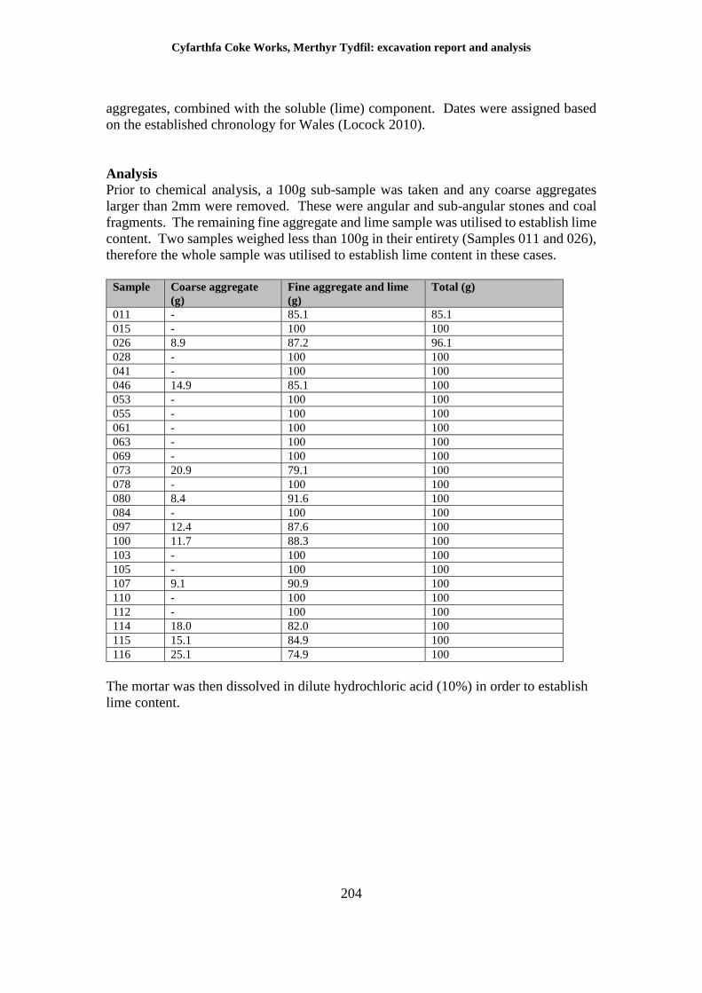
Cyfarthfa Coke Works, Merthyr Tydfil: excavation report and analysis
204
aggregates, combined with the soluble (lime) component. Dates were assigned based
on the established chronology for Wales (Locock 2010).
Analysis
Prior to chemical analysis, a 100g sub-sample was taken and any coarse aggregates
larger than 2mm were removed. These were angular and sub-angular stones and coal
fragments. The remaining fine aggregate and lime sample was utilised to establish lime
content. Two samples weighed less than 100g in their entirety (Samples 011 and 026),
therefore the whole sample was utilised to establish lime content in these cases.
Sample Coarse aggregate
(g)
Fine aggregate and lime
(g)
Total (g)
011 - 85.1 85.1
015 - 100 100
026 8.9 87.2 96.1
028 - 100 100
041 - 100 100
046 14.9 85.1 100
053 - 100 100
055 - 100 100
061 - 100 100
063 - 100 100
069 - 100 100
073 20.9 79.1 100
078 - 100 100
080 8.4 91.6 100
084 - 100 100
097 12.4 87.6 100
100 11.7 88.3 100
103 - 100 100
105 - 100 100
107 9.1 90.9 100
110 - 100 100
112 - 100 100
114 18.0 82.0 100
115 15.1 84.9 100
116 25.1 74.9 100
The mortar was then dissolved in dilute hydrochloric acid (10%) in order to establish
lime content.
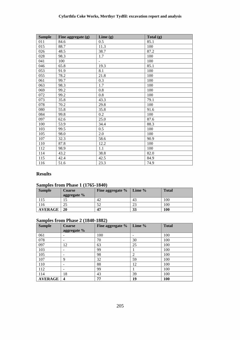
Cyfarthfa Coke Works, Merthyr Tydfil: excavation report and analysis
205
Sample Fine aggregate (g) Lime (g) Total (g)
011 84.6 0.5 85.1
015 88.7 11.3 100
026 48.5 38.7 87.2
028 98.3 1.7 100
041 100 - 100
046 65.8 19.3 85.1
053 91.9 8.1 100
055 78.2 21.8 100
061 99.7 0.3 100
063 98.3 1.7 100
069 99.2 0.8 100
072 99.2 0.8 100
073 35.8 43.3 79.1
078 70.2 29.8 100
080 55.8 35.8 91.6
084 99.8 0.2 100
097 62.6 25.0 87.6
100 53.9 34.4 88.3
103 99.5 0.5 100
105 98.0 2.0 100
107 32.3 58.6 90.9
110 87.8 12.2 100
112 98.9 1.1 100
114 43.2 38.8 82.0
115 42.4 42.5 84.9
116 51.6 23.3 74.9
Results
Samples from Phase 1 (1765-1840) Sample Coarse
aggregate %
Fine aggregate % Lime % Total
115 15 42 43 100
116 25 52 23 100
AVERAGE 20 47 33 100
Samples from Phase 2 (1840-1882) Sample Coarse
aggregate %
Fine aggregate % Lime % Total
061 - 100 - 100
078 - 70 30 100
097 12 63 25 100
103 - 99 1 100
105 - 98 2 100
107 9 32 59 100
110 - 88 12 100
112 - 99 1 100
114 18 43 39 100
AVERAGE 4 77 19 100
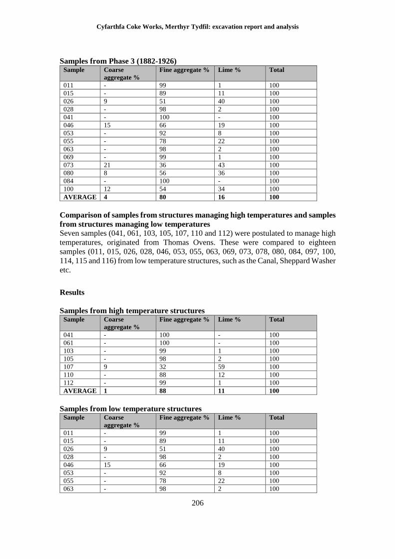
Cyfarthfa Coke Works, Merthyr Tydfil: excavation report and analysis
206
Samples from Phase 3 (1882-1926) Sample Coarse
aggregate %
Fine aggregate % Lime % Total
011 - 99 1 100
015 - 89 11 100
026 9 51 40 100
028 - 98 2 100
041 - 100 - 100
046 15 66 19 100
053 - 92 8 100
055 - 78 22 100
063 - 98 2 100
069 - 99 1 100
073 21 36 43 100
080 8 56 36 100
084 - 100 - 100
100 12 54 34 100
AVERAGE 4 80 16 100
Comparison of samples from structures managing high temperatures and samples
from structures managing low temperatures
Seven samples (041, 061, 103, 105, 107, 110 and 112) were postulated to manage high
temperatures, originated from Thomas Ovens. These were compared to eighteen
samples (011, 015, 026, 028, 046, 053, 055, 063, 069, 073, 078, 080, 084, 097, 100,
114, 115 and 116) from low temperature structures, such as the Canal, Sheppard Washer
etc.
Results
Samples from high temperature structures Sample Coarse
aggregate %
Fine aggregate % Lime % Total
041 - 100 - 100
061 - 100 - 100
103 - 99 1 100
105 - 98 2 100
107 9 32 59 100
110 - 88 12 100
112 - 99 1 100
AVERAGE 1 88 11 100
Samples from low temperature structures Sample Coarse
aggregate %
Fine aggregate % Lime % Total
011 - 99 1 100
015 - 89 11 100
026 9 51 40 100
028 - 98 2 100
046 15 66 19 100
053 - 92 8 100
055 - 78 22 100
063 - 98 2 100
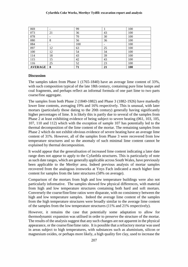
Cyfarthfa Coke Works, Merthyr Tydfil: excavation report and analysis
207
069 - 99 1 100
073 21 36 43 100
078 - 70 30 100
080 8 56 36 100
084 - 100 - 100
097 12 63 25 100
100 12 54 34 100
114 18 43 39 100
115 15 42 43 100
116 25 52 23 100
AVERAGE 8 71 21 100
Discussion
The samples taken from Phase 1 (1765-1840) have an average lime content of 33%,
with such composition typical of the late 18th century, containing pure lime lumps and
coal fragments, and perhaps reflect an informal formula of one part lime to two parts
coarse/fine aggregate.
The samples from both Phase 2 (1840-1882) and Phase 3 (1882-1926) have markedly
lower lime contents, averaging 19% and 16% respectively. This is unusual, with later
mortars (particularly those dating to the 20th century) generally having significantly
higher percentages of lime. It is likely this is partly due to several of the samples from
Phase 2 at least exhibiting evidence of being subject to severe heating (061, 103, 105,
107, 110 and 112) which with the exception of sample 107 has potentially led to the
thermal decomposition of the lime content of the mortar. The remaining samples from
Phase 2 which do not exhibit obvious evidence of severe heating have an average lime
content of 31%. However, all of the samples from Phase 3 were recovered from low
temperature structures and so the anomaly of such minimal lime content cannot be
explained by thermal decomposition.
It would appear that the generalisation of increased lime content indicating a later date
range does not appear to apply to the Cyfarthfa structures. This is particularly of note
as such date ranges, which are generally applicable across South Wales, have previously
been applicable to the Merthyr area. Indeed previous analysis of mortar samples
recovered from the analogous ironworks at Ynys Fach indicated a much higher lime
content for samples from the later structures (58% on average).
Comparison of the mortars from high and low temperature buildings were also not
particularly informative. The samples showed few physical differences, with material
from high and low temperature structures containing both hard and soft mortars.
Conversely the coarse/fine/lime ratios were disparate, with no consistency between the
high and low temperature samples. Indeed the average lime content of the samples
from the high temperature structures were broadly similar to the average lime content
of the samples from the low temperature structures (11% and 21% respectively).
However, it remains the case that potentially some adaptation to allow for
thermodynamic expansion was utilised in order to preserve the structure of the mortar.
The results of the analysis suggest that any such changes are not apparent in the physical
appearance, or the coarse/fine/lime ratio. It is possible that a refractory mortar was used
in areas subject to high temperatures, with substances such as aluminium, silicon or
magnesium oxides, or perhaps more likely, a high quality fire clay, used to increase the
Cyfarthfa Coke Works, Merthyr Tydfil: excavation report and analysis
208
refractory properties of the mortar, with any such additions not being apparent utilising
the current methodology.
Refractory mortar was used to present a continuous, single-face to the high
temperatures found in the furnaces for example, sealing gaps between firebricks on the
interior elevation of the structure. A refractory mortar's purpose was not to bind the
component stones or bricks together. It is possible that the refractory mortar 'skin' did
not survive and that the samples were taken from the binding mortar located in the body
of the structure itself, mortar that would not have required as significant adaptation to
thermodynamic expansion, hence the similarity in the results.
Bibliography
Cadw, 2004, The Use of Lime Mortar in Historic Buildings: Technical Conservation
Note 2, Cadw
Locock M, 2010, Bricks and mortar: Post-medieval buildings archaeology in Wales in
The Archaeologist 75, Institute for Archaeologists
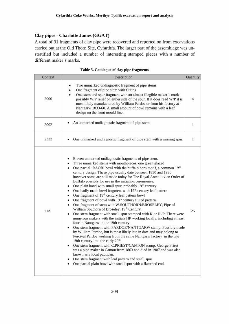
Cyfarthfa Coke Works, Merthyr Tydfil: excavation report and analysis
209
Clay pipes - Charlotte James (GGAT)
A total of 31 fragments of clay pipe were recovered and reported on from excavations
carried out at the Old Thorn Site, Cyfarthfa. The larger part of the assemblage was un-
stratified but included a number of interesting stamped pieces with a number of
different maker’s marks.
Table 5. Catalogue of clay pipe fragments
Context Description Quantity
2000
Two unmarked undiagnostic fragment of pipe stems.
One fragment of pipe stem with fluting
One stem and spur fragment with an almost illegible maker’s mark
possibly W/P relief on either side of the spur. If it does read W/P it is
most likely manufactured by William Pardoe or from his factory at
Nantgarw 1833-60. A small amount of bowl remains with a leaf
design on the front mould line.
4
2002 An unmarked undiagnostic fragment of pipe stem.
1
2332 One unmarked undiagnostic fragment of pipe stem with a missing spur. 1
U/S
Eleven unmarked undiagnostic fragments of pipe stem.
Three unmarked stems with mouthpieces, one green glazed
One partial ‘RAOB’ bowl with the buffalo horn motif, a common 19th
century design. These pipe usually date between 1850 and 1930
however some are still made today for The Royal Antediluvian Order of
Buffalo possibly for use in the initiation ceremonies.
One plain bowl with small spur, probably 19th century.
One badly made bowl fragment with 19th century leaf pattern
One fragment of 19th century leaf pattern bowl
One fragment of bowl with 19th century fluted pattern.
One fragment of stem with W.SOUTHORN/BROSELEY, Pipe of
William Southorn of Broseley, 19th Century.
One stem fragment with small spur stamped with K or H /P. There were
numerous makers with the initials HP working locally, including at least
four in Nantgarw in the 19th century.
One stem fragment with PARDOE/NANTGARW stamp. Possibly made
by William Pardoe, but is most likely late in date and may belong to
Percival Pardoe working from the same Nantgarw factory in the late
19th century into the early 20th.
One stem fragment with C.PRIEST/CANTON stamp. George Priest
was a pipe maker in Canton from 1863 and died in 1907 and was also
known as a local publican.
One stem fragment with leaf pattern and small spur
One partial plain bowl with small spur with a flattened end.
25
Cyfarthfa Coke Works, Merthyr Tydfil: excavation report and analysis
210
Discussion
There were a number of maker’s marks and diagnostic fragments in the assemblage
mostly dating the collection from the middle to the late nineteenth century, however
few were recovered from stratified contexts. The pieces identified in the stratified
contexts (2002 and 2332) were undiagnostic and unmarked.
There is nothing unusual in the assemblage, which dates to the operational period of
the works. If anything, the relative dearth of fragments suggests that the activity of
smoking may have been controlled within the areas of the works that were excavated.
Bibliography
Atkinson, D.R. 1975. Tobacco pipes of Broseley Shropshire. Hart-Talbot, Saffron
Waldon. Essex.
Ayto, E.G. 2002. Clay tobacco pipes. Shire Publications. Buckinghamshire
Brennan, D, Evans, G, James, H & Dale-Jones, E 1996, Excavations in Camarthen,
Dyfed, 1976-1990. Finds from the Seventeenth to the Nineteenth Centuries, Medieval
and Later pottery in Wales, 14, 15-108
Evans, D.H. 1981. Documentary Evidence for clay pipe makers in Wales. Medieval
and Later Pottery in Wales 4.
Evans, G, 1993, Excavations in Carmarthen, Dyfed, 1976-990. Finds from the
Seventeenth to the Nineteenth Centuries. Pottery, Glass, Clay Pipes and Bone. Medieval
and Later Pottery in Wales
Harley, L, 1963, The Clay Tobacco-Pipe in Britain with special reference to Essex
and East Anglia, Essex Field Club Special Memoirs 8
Higgins, D.A. 1995. ‘Clay tobacco pipes’ in The dismantling of Kiln II: Nantgarw
China and Pottery Works. Dyfed Archaeological Trust.
Knight, J.K. 1980. Monmouthshire clay pipe makers. Medieval and Later Pottery in
Wales 3.
Cyfarthfa Coke Works, Merthyr Tydfil: excavation report and analysis
211
9 Discussion
Cyfarthfa Ironworks is one of the most important industrial heritage sites in the world.
The extensive remains of the blast furnaces, along with remains of engine houses,
melting houses and the infrastructure related to the works, have rightly been recognised
as being of international significance and therefore accorded statutory designation as
Scheduled Ancient Monuments. The provision of coke to the works was integral to the
operation of the ironworks from its earliest days, and the extensive remains uncovered
during archaeological work described above revealed evidence for coke production
from every phase of its 150-year lifespan but most substantially in the remains of the
Coppée coke works was constructed in 1882. The merits, or otherwise, of divorcing
individual elements of the formerly coherent Cyfarthfa estate are beyond the scope of
this current report.
Phase 1 - 1765-1840, (Figure 19)
Perhaps the most surprising discovery resulting from the archaeological work
undertaken as part of the redevelopment of the site, was part of Anthony Bacon’s canal
which had supplied the coke yard; no specific dating evidence was found but there can
be little doubt that the feature is Bacon’s canal and dates to at least 1777, if not slightly
earlier. Although the canal was known from historical sources, these are somewhat
vague and add little of substance to the understanding of how the Cyfarthfa site operated
in the late 18th century. The canal was certainly out of use by the late 1840s, although
the construction of the refractory brick culvert within the actual channel of the canal
suggests that it still had an active part to play in the later operation of the works through
the provision or management of water to the coke yard site. The very course of the canal
had been lost until its re-discovery as part of the archaeological work and comparison
of the remains with the estate map of 1795 suggests that more of the canal and
associated early buildings may lie buried beneath the ground. Recording of the canal’s
form and dimensions has allowed a basic comparison with other, contemporary
industrial canals in Shropshire, a process which suggests that they were similar in
nature.
The remains of Anthony Bacon’s canal are important in terms of their heritage value.
Part of the canal has been recorded south of the development area (NPRN 232778) but
this information dates to 1978 and is based primarily upon documentary and
cartographic evidence. The section exposed during the archaeological work provided
the only substantial information as to how it was actually used, together with its
appearance, dimensions and structural data. As the remains were re-buried, they have
been preserved for future generations.
Other ephemeral remains from this early period were located in the form of isolated
walls, tram-road tracks and drains. Accurate dating of these features has proved
impossible due to the absence of datable material but the phasing evidence suggests that
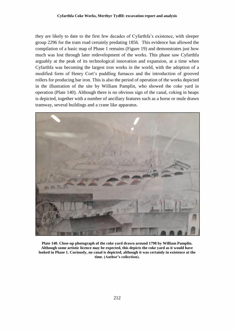
Cyfarthfa Coke Works, Merthyr Tydfil: excavation report and analysis
212
they are likely to date to the first few decades of Cyfarthfa’s existence, with sleeper
group 2296 for the tram road certainly predating 1856. This evidence has allowed the
compilation of a basic map of Phase 1 remains (Figure 19) and demonstrates just how
much was lost through later redevelopment of the works. This phase saw Cyfarthfa
arguably at the peak of its technological innovation and expansion, at a time when
Cyfarthfa was becoming the largest iron works in the world, with the adoption of a
modified form of Henry Cort’s puddling furnaces and the introduction of grooved
rollers for producing bar iron. This is also the period of operation of the works depicted
in the illustration of the site by William Pamplin, who showed the coke yard in
operation (Plate 140). Although there is no obvious sign of the canal, coking in heaps
is depicted, together with a number of ancillary features such as a horse or mule drawn
tramway, several buildings and a crane like apparatus.
Plate 140. Close-up photograph of the coke yard drawn around 1798 by William Pamplin.
Although some artistic licence may be expected, this depicts the coke yard as it would have
looked in Phase 1. Curiously, no canal is depicted, although it was certainly in existence at the
time. (Author’s collection).
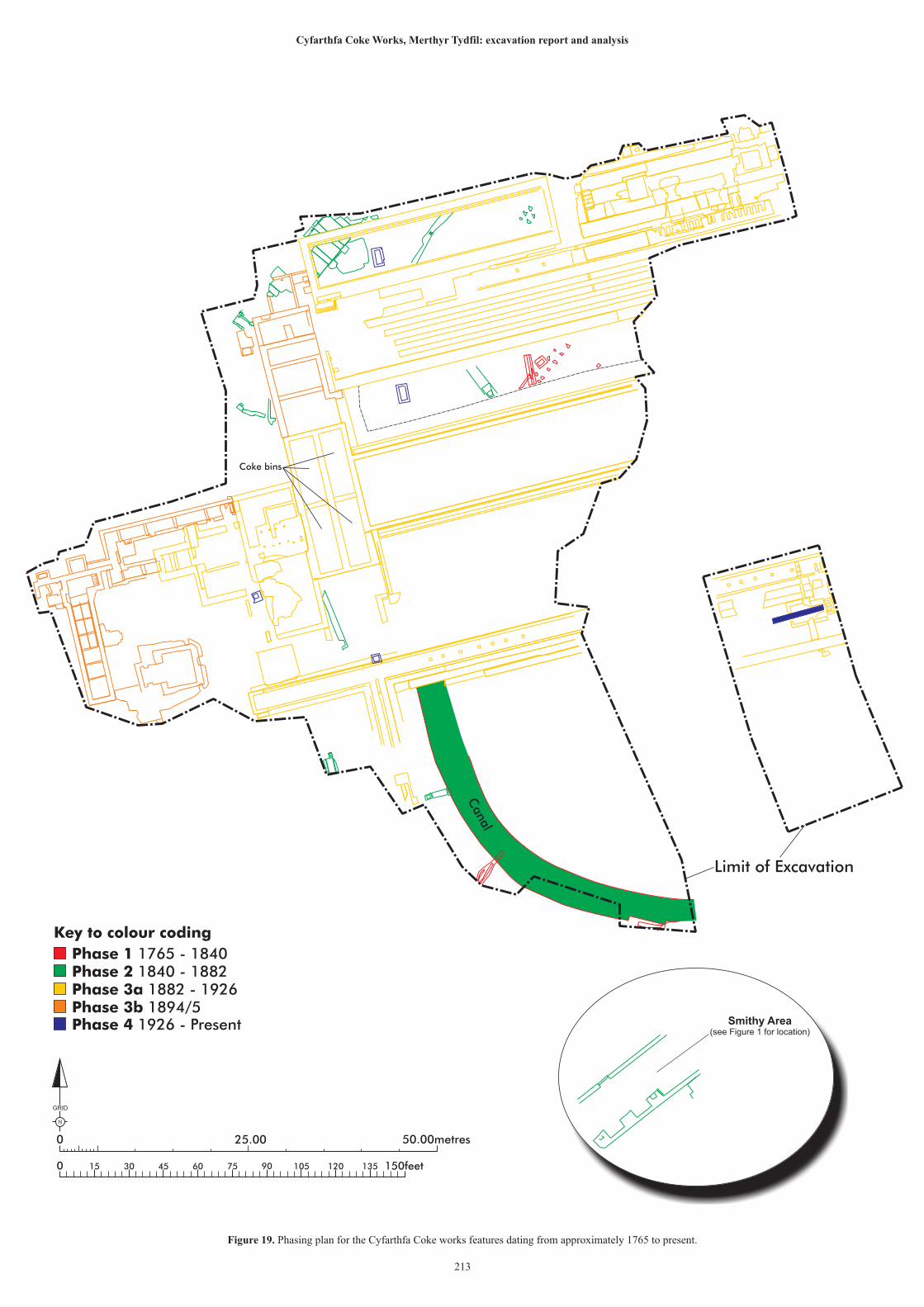
0 150feet15 30 45 60 75 90 105 120 135
25.00 50.00metres0
N
GRID
Smithy Area(see Figure 1 for location)
Phase 1 1765 - 1840Phase 2 1840 - 1882Phase 3a 1882 - 1926Phase 3b 1894/5Phase 4 1926 - Present
Key to colour coding
Canal
Coke bins
Figure 19. Phasing plan for the Cyfarthfa Coke works features dating from approximately 1765 to present.
213
Cyfarthfa Coke Works, Merthyr Tydfil: excavation report and analysis
Limit of Excavation
Cyfarthfa Coke Works, Merthyr Tydfil: excavation report and analysis
214
Phase 2 – 1840-1882 (Figure 19)
Phase 2 encompassed a period of continued prosperity and stagnation in the fortunes of
the Cyfarthfa works. This can be seen in the archaeological remains as investment in
new coking technology in the form of the Thomas ovens although the earlier method of
coking in heaps appears to have been retained. These developments would almost
certainly have been known about, particularly given the initial close relationship
between the Cyfarthfa and Plymouth iron works, one of whose owners was a key driver
in the refinement of the technology of coking in heaps. Curiously, no structural
evidence for these developments was found, although much of coke yard of this period
had been destroyed by construction of the later Coppée ovens. Neither was there
evidence for the presence of beehive ovens, although the same caveat applies. The canal
may have been adapted as a water source, possibly to aid in the supply of the huge
quantities of water required for dousing the coke, although there is no evidence for how
this water was extracted, and it is more plausible that the canal was covered and
channelled simply to remove it as an obstacle which divided the coke yard; certainly, it
is clear that tramways or narrow gauge industrial railway became the main means of
transportation within the site, once the canal had been buried. A prominent water outlet
depicted on OS mapping and known as the Trant bach, may have been the main drain
for the canal although there is no easy way of proving this as the direction taken by the
underground passages is unknown. The outflow channel is still extant, outside the
development area boundary, and a cursory examination suggests that the culvert
containing the water branches, indicating several sources of water had been channelled.
Water continues to flow out to this day and the development appears to have had little
discernible effect on this flow.
The Thomas ovens can be dated fairly accurately through cartographic evidence to
between 1851 and 1856 (Plates 141 and 142). It is possible that the decision not to
completely abandon the method of coking in heaps and to retain that method in tandem
with the Thomas ovens may have been the first sign of the technological conservatism
that appears to have bedevilled the Cyfarthfa works from the 1850s onwards. Even after
construction of the Coppée ovens in 1882, one a set of Thomas ovens appears to have
been retained, possibly as a redundancy measure but also indicating a failure to fully
trust the new technology.
One factor which may have played a part in the gradual conservatism evident in the
Cyfarthfa operation is the financial cost of building and maintaining not one (Cyfarthfa
Castle in 1824) but two grand houses. The Crawshays had acquired Caversham Park in
Oxfordshire in 1838 but when the original building was destroyed by fire in 1850,
William Crawshay II had an impressive new building erected, the current Caversham
Park. The financial strain of these two properties may have made the Crawshays more
reluctant to invest in new technology and to become reliant on the steady returns
guaranteed by their existing operation. Certainly, family politics played a significant
Cyfarthfa Coke Works, Merthyr Tydfil: excavation report and analysis
215
part in the various levels of involvement in the actual day to day running of the
Crawshay concerns (Parry pers. Comm. 2017) and is quite possible that this perceived
conservatism was a symptom of such politics. It is possible that more research might
shed light on this aspect of the Cyfarthfa story.
Despite the partial survival, the remains of the Thomas ovens themselves are of
significance, as they are, as far as the author can ascertain, the only archaeologically
examined examples of this transitional technology. The recorded dimensions do not
quite match with those referenced by John Percy but they are almost certainly the ones
he saw when he visited the works in the 1850s and 1860s. Whether the shorter oven
length represents an earlier iteration of the technology or whether it is simply a
convenient local standard is unknown as there are no other known examples for
comparison. The constructional techniques employed e.g. the use of red brick for the
flooring, generally match Percy’s description. However, as Percy stated that the
Cyfarthfa ovens had been in use for many years, it is probable that they were an early
example of their type. The remains of the Thomas ovens recorded at Cyfarthfa are likely
to constitute the only record of this type of feature for many years; they were re-buried
and have been preserved in situ although it should be noted that similar, associated
remains almost certainly survive beneath the ground, outside the boundary of the
development area.
Although thoroughly demolished in the 1920s, the smithy building represented an
element of continuity between phases and is testament to the vital work of blacksmiths
in the day to day operation of iron works. The layout of the building is likely to have
remained unchanged throughout its lifetime but little else can be said about the
structure. The little that remained of the smithy was re-buried for preservation in situ.
And the features relating to Phase 2 have been included on a plan for ease of reference.
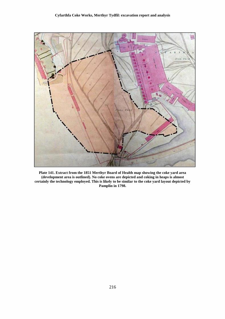
Cyfarthfa Coke Works, Merthyr Tydfil: excavation report and analysis
216
Plate 141. Extract from the 1851 Merthyr Board of Health map showing the coke yard area
(development area is outlined). No coke ovens are depicted and coking in heaps is almost
certainly the technology employed. This is likely to be similar to the coke yard layout depicted by
Pamplin in 1798.
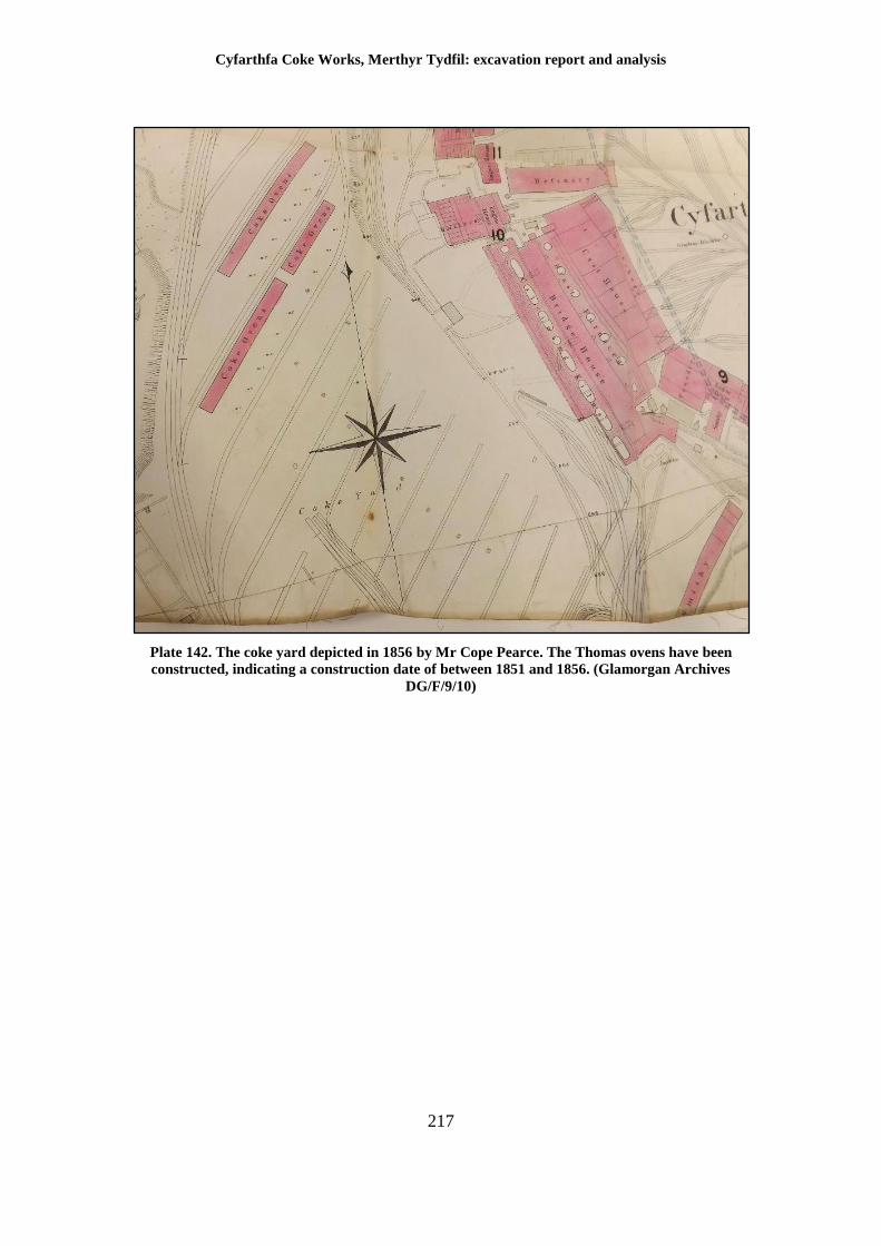
Cyfarthfa Coke Works, Merthyr Tydfil: excavation report and analysis
217
Plate 142. The coke yard depicted in 1856 by Mr Cope Pearce. The Thomas ovens have been
constructed, indicating a construction date of between 1851 and 1856. (Glamorgan Archives
DG/F/9/10)
Cyfarthfa Coke Works, Merthyr Tydfil: excavation report and analysis
218
Phase 3 – 1882-1926 (Figure 19)
The majority of the recorded remains derive from Phase 3 and constitute the belated
attempts at modernisation of Cyfarthfa undertaken by the Crawshay Brothers after the
death of Robert Thompson Crawshay in 1879. The conversion from iron to steel making
by the construction of Bessemer converters came almost a quarter of a century after
their great rivals at the Dowlais ironworks. The reasons for this delay in adopting steel
production are rather obscure and possibly owe much to internal family politics but it
is clear that the Crawshay family had become conservative in their outlook with regard
to the Cyfarthfa works. It is highly likely that the decision to convert the works was the
spur for the construction of the Coppée ovens at Cyfarthfa in 1882. They were built
over the demolished remains of the previous coke yard and together with the Bessemer
converters and brickworks, represented a considerable investment into the business.
The design of the Cyfarthfa Coppée ovens, as noted by Jackson, is unique. The reasons
for this are unclear but it is possible that the topography of the site lent itself to two
parallel batteries of ovens rather than the more conventional single row. Also apparently
unique is the arrangement of the central storage bunker, which again, may have been
the result of the nature of the ground. A basic coal washery with attendant Carr’s
disintegrator was always intended to be part of the design (Phase 3a) but was supplanted
a decade or so after initial construction by the installation of the Sheppard Feldspar
washery (Phase 3b, and note the differences between Plates 143 and 144). It is probable
that the Sheppard washery was simply more efficient but the stipulation that the Carr’s
disintegrator was to be retained for emergency use is interesting. The recorded remains
indicate that some modification of the original structure was required to accommodate
the Sheppard equipment and could be seen as simply an attempt to build redundancy
into the operation. However, it is also perhaps yet another sign of the failure of the
Crawshays to whole heartedly trust in new technology, despite the apparent advantages.
The construction of the Coppée ovens is likely to have been carried out by an outside
contractor, using materials sourced from the West Midlands. With the completion of
the Cyfarthfa brickworks, the business would have been self-sufficient in the provision
of refractory and constructional brick. It is curious, however, that whilst Cyfarthfa
stamped brick is attested from other parts of Wales, not a single example of a brick
bearing the Cyfarthfa stamp was noted.
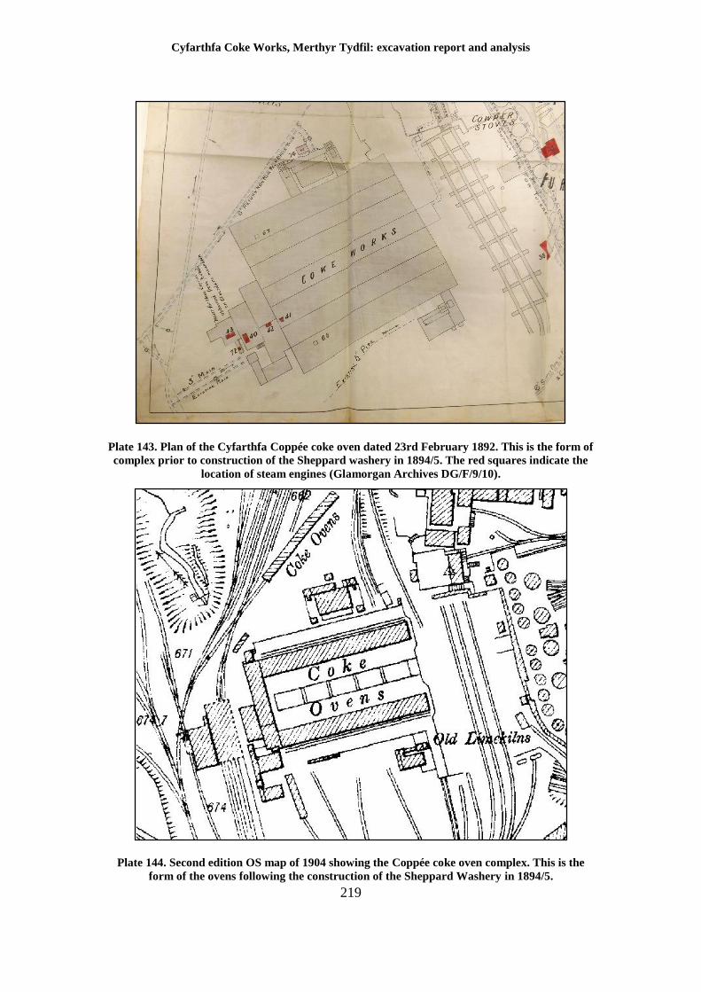
Cyfarthfa Coke Works, Merthyr Tydfil: excavation report and analysis
219
Plate 143. Plan of the Cyfarthfa Coppée coke oven dated 23rd February 1892. This is the form of
complex prior to construction of the Sheppard washery in 1894/5. The red squares indicate the
location of steam engines (Glamorgan Archives DG/F/9/10).
Plate 144. Second edition OS map of 1904 showing the Coppée coke oven complex. This is the
form of the ovens following the construction of the Sheppard Washery in 1894/5.
Cyfarthfa Coke Works, Merthyr Tydfil: excavation report and analysis
220
As in the example of the Thomas ovens, there are no other previously investigated
Coppée ovens with which to compare with the Cyfarthfa remains and the results must
stand on their own merits. The different features broadly conform to the theoretical
plans of Coppée ovens contained within a copy of the Proceedings of the North of
England Mining and Mechanical Engineers Institute of 1872/73 (Appendix III)
although only the very base of the oven structures on the north side had survived.
Sufficient had survived to allow the identification of the main gas flue and the front
retaining wall for the coke ovens. The specialist refractory bricks from which the ovens
and associated flues had been made had been left behind as being of little value to the
demolition firm in the 1920s. Whereas standard sized bricks could easily be re-used
(see the contemporary newspaper quote stating that millions had been taken for use in
Cardiff) the highly irregular shapes and sizes of the coke oven bricks prevented their
use for anything else.
The remains of the down-takes for diverting the main gas flue contents around the
unexcavated north boiler complex was something not depicted on the plans with any
great detail. The excavated remains presented something of a puzzle in terms of the
phasing but it is clear that this area underwent significant re-modelling in terms of the
blocking of secondary flues. It is unclear why this was carried out; it is possible that a
new boiler system was introduced or that damage from heat may have necessitated a
change in layout. Another possibility considered was the re-use of the Cyfarthfa works
during the First World War. Following its closure in 1910, no activity was carried out
on site, although some sources suggests that the coke ovens were kept operating by
GKN. An inspection of the works by representatives of the Ministry of Munitions in
1916 discovered rabbits living in an engine house (Glamorgan Archives DG/C/1/24).
However, Number 3 furnace was put back into blast on 23rd October 1917 for the
processing of pig iron into shell steel and this would have required quantities of coke.
The most obvious source of this fuel would have been from Cyfarthfa’s own ovens and
it is possible that the re-modelling may have taken place in order to accommodate this
late activity after a prolonged period of dormancy.
The Coppée ovens and attendant washery owe nothing to the previous layout of the
coke yard. Despite being an older form of technology (the Coppée principle was almost
30 years old at the time of construction at Cyfarthfa) there was a clear attempt at
breaking with the past with a completely different set of alignments, to create a state of
the art-facility. This can be easily appreciated from the Phase 3 (Figure 19) plan of the
site. The irony is that coke ovens based on the Coppée principle were on the verge of
becoming obsolete in 1882. By the latter part of the 19th century, non-recovery coke
ovens i.e. those in which waste gasses were burnt off, were being replaced by those that
were able to refine chemical elements within the waste gasses to produce a range of
useful products. This resulted in a more economically sustainable and probably
unintentionally, cleaner system. The Cyfarthfa Coppée ovens represent, yet again, the
Cyfarthfa Coke Works, Merthyr Tydfil: excavation report and analysis
221
failure of the Crawshays in the latter part of their ownership to truly adapt to
technological innovation.
The final discussion point must be the discrepancies apparent in the surveyed extent of
the Coppée ovens as depicted on contemporary mapping, and the actual physical
remains that were excavated.
Even allowing for the fact that the majority of the physical remains of the Coppée ovens
had been destroyed by the construction of the Thorn Lighting Works, there is a marked
asymmetry in the archaeological remains of the south coke battery which is not apparent
on the mapping. The main gas flue for the south battery extends well to the west, beyond
that of the north battery, as well as possessing a spur to the south, a feature that does
not appear to exist for the north battery. The presence of this flue may well be explained
by the presence of two chimneys south of the coal crusher, washery on the photograph
of the works dating to the early 1890s. The north coke oven battery was equipped with
down takes to re-use heat for heating a boiler plant; no such requirement existed for the
south battery, and it is likely that the extension and spur represent the efforts to channel
waste gas straight into conventional chimneys.
Whilst this is the likely explanation, the OS mapping is not sufficiently distinct to be
definitive. It should also be remembered that the ground levels had been reduced to
such an extent that everything that was exposed had originally been buried. This means
that surface features may have had a different layout and appearance when surveyed
underground; the asymmetry of layout is only apparent in the excavated archaeological
remains.
Cyfarthfa Coke Works, Merthyr Tydfil: excavation report and analysis
222
Phase 4 - 1926-present (Figure 19)
The demolition of the Cyfarthfa works as a whole was particularly thorough and this is
certainly true for the coke works site. The actual contract for the demolition work
survives in the Glamorgan Archives indicating that the demolition was to have taken
place between 13th September 1924 and 13th March 1926. The major structural
elements had been removed by this date and all the loose material i.e. salvageable
material such as masonry, brick and metal, had been removed from the site, although
some of the material was used to level the ground where holes existed. The majority of
the relatively small artefactual assemblage of pottery and glass recovered from the site
dates to this period. Photographs of the site taken prior to the construction of the Thorn
Lighting works in 1947 show a flat area, containing no recognisable structures.
Construction of the lighting works truncated large parts of the former coke works, in
particular the south coke oven battery and ancillary buildings. However, as has been
seen, significant areas remained beneath the ground, and it is highly likely that other
areas of the works remain buried outside the development area. This includes the
remains of the north boiler complex and probably the remains of the Cyfarthfa
brickworks to the north west.
The Thorn Lighting works was, in its turn, thoroughly demolished in 1993. Combined
with ground preparation in advance of the current development, only the lowest
elements of the Thorn lighting works, such as drainage features, and datable through
the brickwork, had survived. However, the re-use of elements of the coke works in the
designs for the Thorn Lighting works, specifically the re-use of the south coke oven
battery main gas flue as a pipe run suggests that there was a good awareness of the
original layout of the coke works when the lighting works was built. The very little that
survived from this period is indicated on the Phase 4 plan (Figure 19) but the demolition
was so complete, that little more can be said on the use of the site during this period.
Cyfarthfa Coke Works, Merthyr Tydfil: excavation report and analysis
223
10 Conclusion
The redevelopment of the site of the former Cyfarthfa coke works afforded a hitherto
unique insight into the production of coke at an ironworks of major importance, across
the span of its existence. The recorded remains will serve as useful reference for future
research and helps to form another component of the story of the Cyfarthfa Ironworks.
The work has recorded the remains of a Coppée coke oven in unprecedented detail and
in archaeological terms, forms the most thorough dataset for this site type that currently
exists. The research carried out for the current report has also highlighted some potential
discrepancies with the accepted version of the development of Cyfarthfa which will
require more investigation.
The physical remains encountered at Cyfarthfa are largely devoid of the human
element; very little in the form of personal effects was discovered possibly due to a
combination of the level of truncation but also to the impersonal nature of working
environments at that time. The closest connection to individuals, and in particular to
Anthony Bacon and the Crawshays, has been in the form of the structures themselves.
It was these individuals, by turns dynamic and innovative, at others rather conservative
in outlook, who were responsible for the development of the site, and it is their legacy
that was excavated and examined within the development area.
The work has demonstrated that extensive remains relating to the Cyfarthfa ironworks
as a whole are likely to survive outside the current development area and this may have
an impact on the planning of future developments in the area. The Phase 1 and 2 period
remains were recorded and re-buried, being preserved in situ. Following recording,
much of the exposed Phase 3 remains were demolished but significant elements of the
north coke oven battery flue system and the central storage area remain in situ.
Cyfarthfa Coke Works, Merthyr Tydfil: excavation report and analysis
224
References
Cadw, 2004, The use of lime mortar in historic structures, (Technical Conservation
Note 2), Cadw
Crawshay Brothers (Cyfarthfa), 1897, Cyfarthfa Steelworks, Cyfarthfa Castle Museum
Dunning R, 2011, Cyfarthfa Retail Park extension, Merthyr Tydfil: archaeological field
evaluation project design, GGAT Report no. 2011/094
Dunning, R, 2013, Old Thorn Site, Merthyr Tydfil, archaeological written scheme of
investigation, GGAT Report No. 2013/043
Gross, J (Ed.), 2001, The Diary of Charles Wood of Cyfarthfa Ironworks, Merthyr Tydfil
1766 – 1767, Merton Priory Press, Cardiff
Jackson, P, 2008, Non-recovery Coke making in the UK, Proceedings of the Coke Oven
Managers Association,
Locock M, 2010, ‘Bricks and mortar: post-medieval buildings archaeology in Wales’,
The Archaeologist, 75, 37
Lloyd, J, 1906, The Early History of the Old South Wales Iron Works, 1760 to 1840,
Bedford Press, London
North of England Mining and Mechanical Engineering Institute 1872/3, Proceedings
Volume 22 1872/1873, NEMMEI, Newcastle
Percy, J 1875, Metallurgy: the art of extracting metal from their ores, Murray, London
Pedler, F, J, 1930, History of the Hamlet of Gellideg, Cardiff Academic Press, Cardiff
Roberts R, 2005, Southeast Wales Industrial Ironworks Landscapes, GGAT Report no.
2005/056
Sherman A, Cyfarthfa retail park extension, Merthyr Tydfil: Summary of
archaeological field evaluation results, GGAT Report no. 2012/017
Statham I, 1996, Swansea Road, Merthyr Tydfil: Geotechnical Report, Ove Arup Job
no. 52467/01/IS/ML
Strange, K, 2005, Merthyr Tydfil, Iron Metropolis, Life in a Welsh Industrial Town,
Tempus, Stroud.
Internet sources
Alan George Old Merthyr Tydfil [Online]. Accessed at various times, available at
http://www.alangeorge.co.uk/cyfarthfa_ironworks.htm
Engineering timelines [Online]. Accessed at various times, available at
http://www.engineering-timelines.com/scripts/engineeringItem.asp?id=1391
Shropshire Tub boats [Online]. Accessed at various times, available at
http://www.pittdixon.go-plus.net/stbc/stbc.htm
Cyfarthfa Coke Works, Merthyr Tydfil: excavation report and analysis
225
Documents
Book of maps of the Cyfarthfa works 1795 to 1893, Glamorgan archives DG/F/9/10
Letter from the Ministry of Munitions to GKN concerning re-opening of Cyfarthfa for
the war effort Glamorgan Archives DG/C/1/24
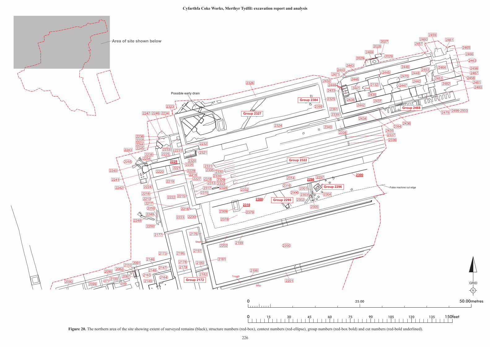
N
GRID
25.00 50.00metres0
0 150feet15 30 45 60 75 90 105 120 135
2300
2298
2228
2300
2310
2463
2394
2399
2255
2259
21632164
20832071
2200
2316
2306
2436
2456
2465
2466
2467
2461
2459
2460
2464
2457
2458
24812482
2027
2446
2446
2028
20292029
2469
2443
2448
2132
2443
2471
2437
2441 Void
2470
24402447
2480
2445
2439
2453
2442
2438
2444
2433
2434
2435
2090
2339
2338
2340
2391
2432
2325
2326
2324
2499-25032479
2453
2337
2336
2247 2246 2234
2323
2236223722442245
2238
2243
2242
2241
2240
2254
2231
2320
23212225
2226
22202221
2219
2222
2223
22292214
2227
2218
22132215
2217
23182313
2317
2315
2216
2230
2250
2249
2248
2177 2176
21952197
2178
2179
2173
2146
21472148
2149
2091
2090
21102082
2087
2099
2180
2182
Step
Step
2201
2198
2181
21992202
2309
False machine cut edge
2314 2297
2305
2302
2303
2301
2304
2378
2379
2232
2233
23312335
23302334
23292333
23282332
2224
2100Trough
Group 2322
Group 2327
Group 2296
Group 2172
Group 2468
Group 2384
Group 2295
Area of site shown below
Figure 20. The northern area of the site showing extent of surveyed remains (black), structure numbers (red-box), context numbers (red-ellipse), group numbers (red-box bold) and cut numbers (red-bold underlined).
226
Cyfarthfa Coke Works, Merthyr Tydfil: excavation report and analysis
Possible early drain
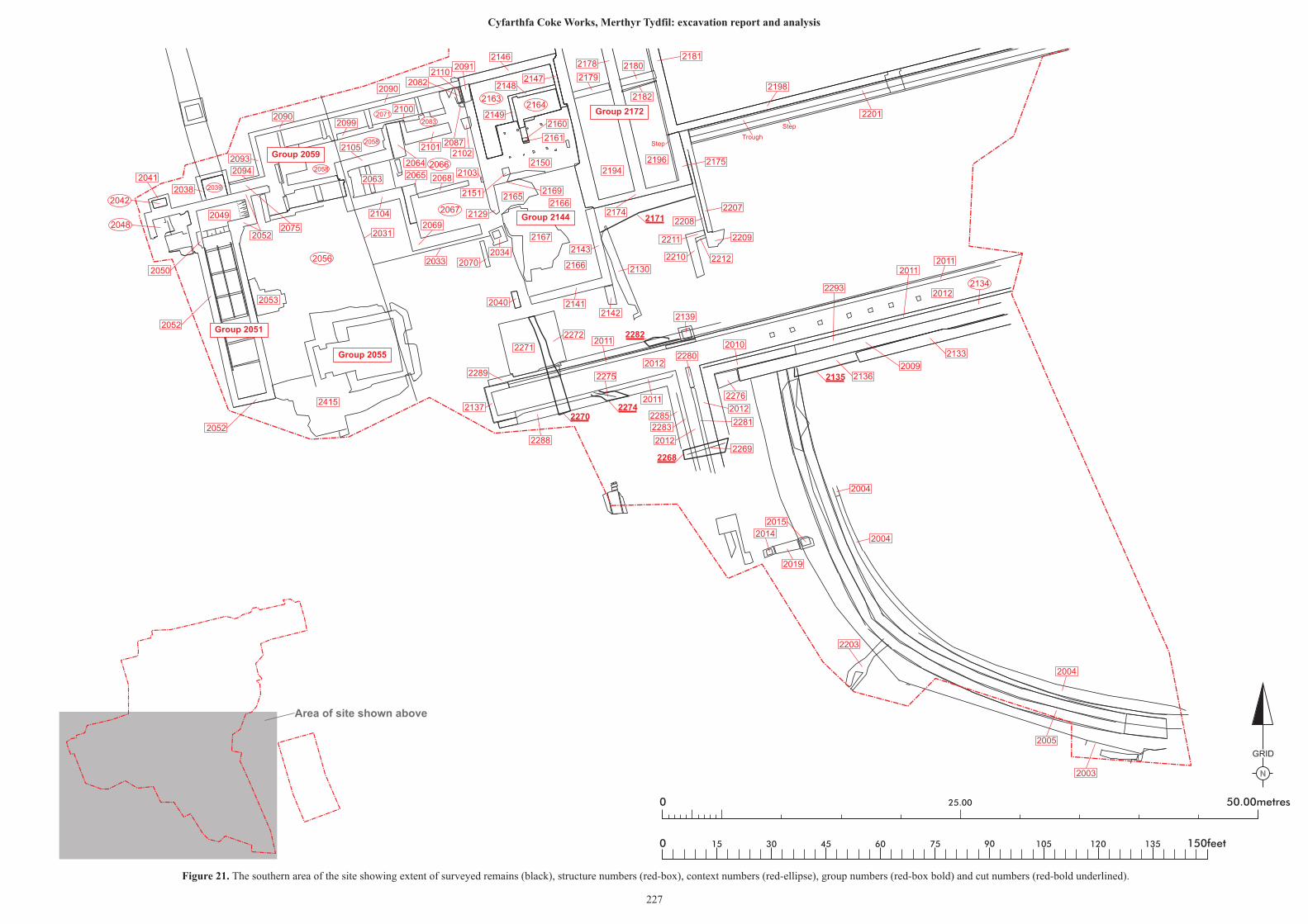
N
GRID
25.00 50.00metres0
0 150feet15 30 45 60 75 90 105 120 135
2270
2282
2171
2274
2268
2135
21632164
2083
2066
2067
2071
2058
2058
2039
2042
2048
2056
2134
2009
2090
2178
2179
2146
21472148
2149
2091
2090
21102082
20872102
2101
20682065 2103
2129
2069
20702034
2099
2064
2105
2104
2063
2093
2094
2038
2041
2049
2052
2050
2052
2052
2053
2415
2033
20312075
2040 2141
2151
2167
2166
21662165
2169
21942196
2180
2182
2174
2143
2142
2130
2271
2272
2289
2137
2288
2139
2011
2011
2275
2012
2269
2285
2283
2012
2280
2010
2276
2012
2281
2136
2133
2012
20112011
2293
2004
2004
2004
2014
2015
2019
2203
2005
2003
2210
2211
2212
2209
2207
2208
2175
Step
Step
2201
2198
2181
2150
2160
2161
2100
Trough
Group 2172
Group 2144
Group 2055
Group 2051
Group 2059
Area of site shown above
Figure 21. The southern area of the site showing extent of surveyed remains (black), structure numbers (red-box), context numbers (red-ellipse), group numbers (red-box bold) and cut numbers (red-bold underlined).
227
Cyfarthfa Coke Works, Merthyr Tydfil: excavation report and analysis
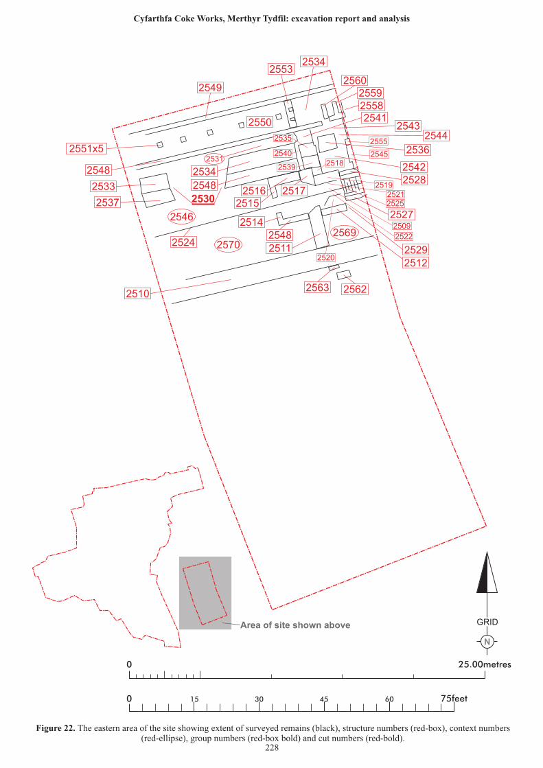
N
GRID
25.00metres0
0 75feet15 30 45 60
2530
2570
2546
2531
2569
2533
2537
2549
2548
2510
2553
2550
2551x5
2534
256025592558
2534
2548
2515
251425482511
25122529
2527
2524
25412543
2544
2536
2516 2517
25422528
2563 2562
2535
2539
25402518
2555
2545
251925212525
2509
2522
2520
Area of site shown above
Figure 22. The eastern area of the site showing extent of surveyed remains (black), structure numbers (red-box), context numbers(red-ellipse), group numbers (red-box bold) and cut numbers (red-bold).
228
Cyfarthfa Coke Works, Merthyr Tydfil: excavation report and analysis
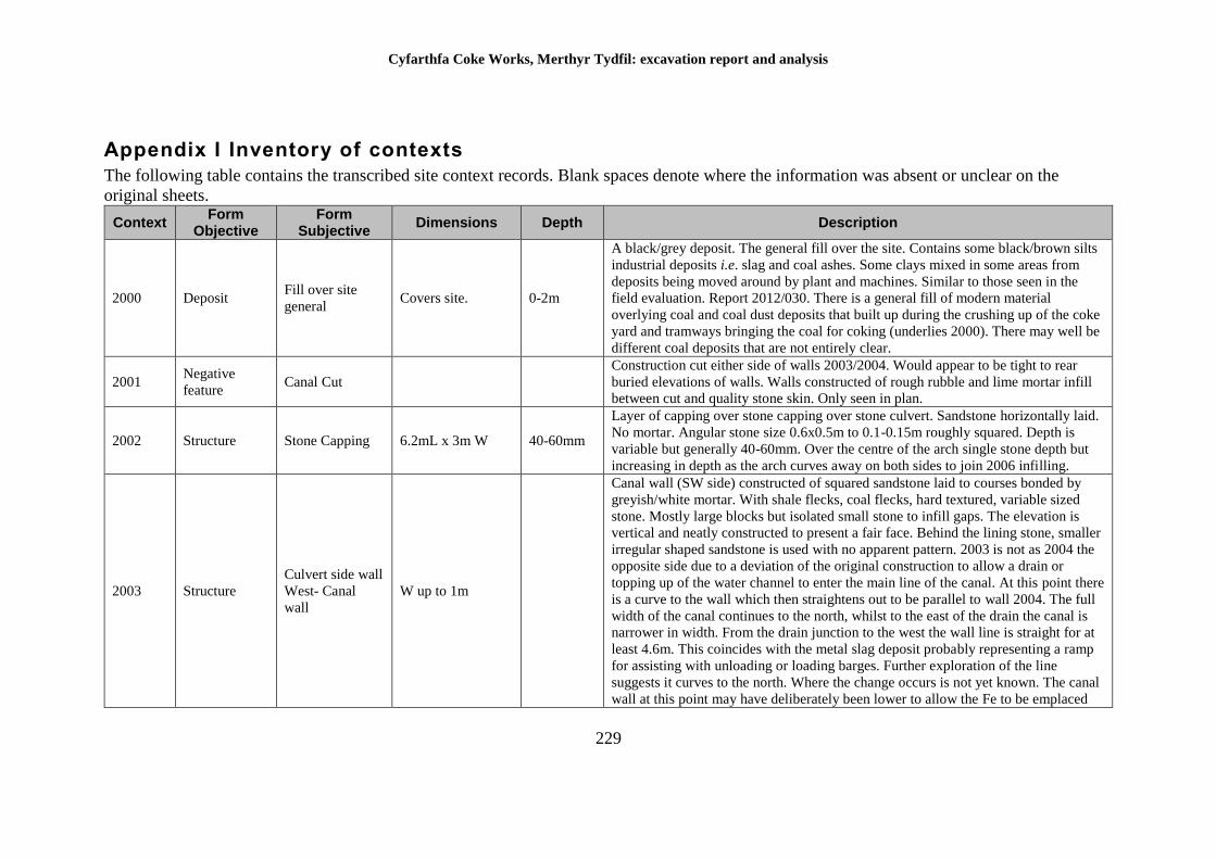
Cyfarthfa Coke Works, Merthyr Tydfil: excavation report and analysis
229
Appendix I Inventory of contexts
The following table contains the transcribed site context records. Blank spaces denote where the information was absent or unclear on the
original sheets.
Context Form
Objective Form
Subjective Dimensions Depth Description
2000 Deposit Fill over site
general Covers site. 0-2m
A black/grey deposit. The general fill over the site. Contains some black/brown silts
industrial deposits i.e. slag and coal ashes. Some clays mixed in some areas from
deposits being moved around by plant and machines. Similar to those seen in the
field evaluation. Report 2012/030. There is a general fill of modern material
overlying coal and coal dust deposits that built up during the crushing up of the coke
yard and tramways bringing the coal for coking (underlies 2000). There may well be
different coal deposits that are not entirely clear.
2001 Negative
feature Canal Cut
Construction cut either side of walls 2003/2004. Would appear to be tight to rear
buried elevations of walls. Walls constructed of rough rubble and lime mortar infill
between cut and quality stone skin. Only seen in plan.
2002 Structure Stone Capping 6.2mL x 3m W 40-60mm
Layer of capping over stone capping over stone culvert. Sandstone horizontally laid.
No mortar. Angular stone size 0.6x0.5m to 0.1-0.15m roughly squared. Depth is
variable but generally 40-60mm. Over the centre of the arch single stone depth but
increasing in depth as the arch curves away on both sides to join 2006 infilling.
2003 Structure
Culvert side wall
West- Canal
wall
W up to 1m
Canal wall (SW side) constructed of squared sandstone laid to courses bonded by
greyish/white mortar. With shale flecks, coal flecks, hard textured, variable sized
stone. Mostly large blocks but isolated small stone to infill gaps. The elevation is
vertical and neatly constructed to present a fair face. Behind the lining stone, smaller
irregular shaped sandstone is used with no apparent pattern. 2003 is not as 2004 the
opposite side due to a deviation of the original construction to allow a drain or
topping up of the water channel to enter the main line of the canal. At this point there
is a curve to the wall which then straightens out to be parallel to wall 2004. The full
width of the canal continues to the north, whilst to the east of the drain the canal is
narrower in width. From the drain junction to the west the wall line is straight for at
least 4.6m. This coincides with the metal slag deposit probably representing a ramp
for assisting with unloading or loading barges. Further exploration of the line
suggests it curves to the north. Where the change occurs is not yet known. The canal
wall at this point may have deliberately been lower to allow the Fe to be emplaced
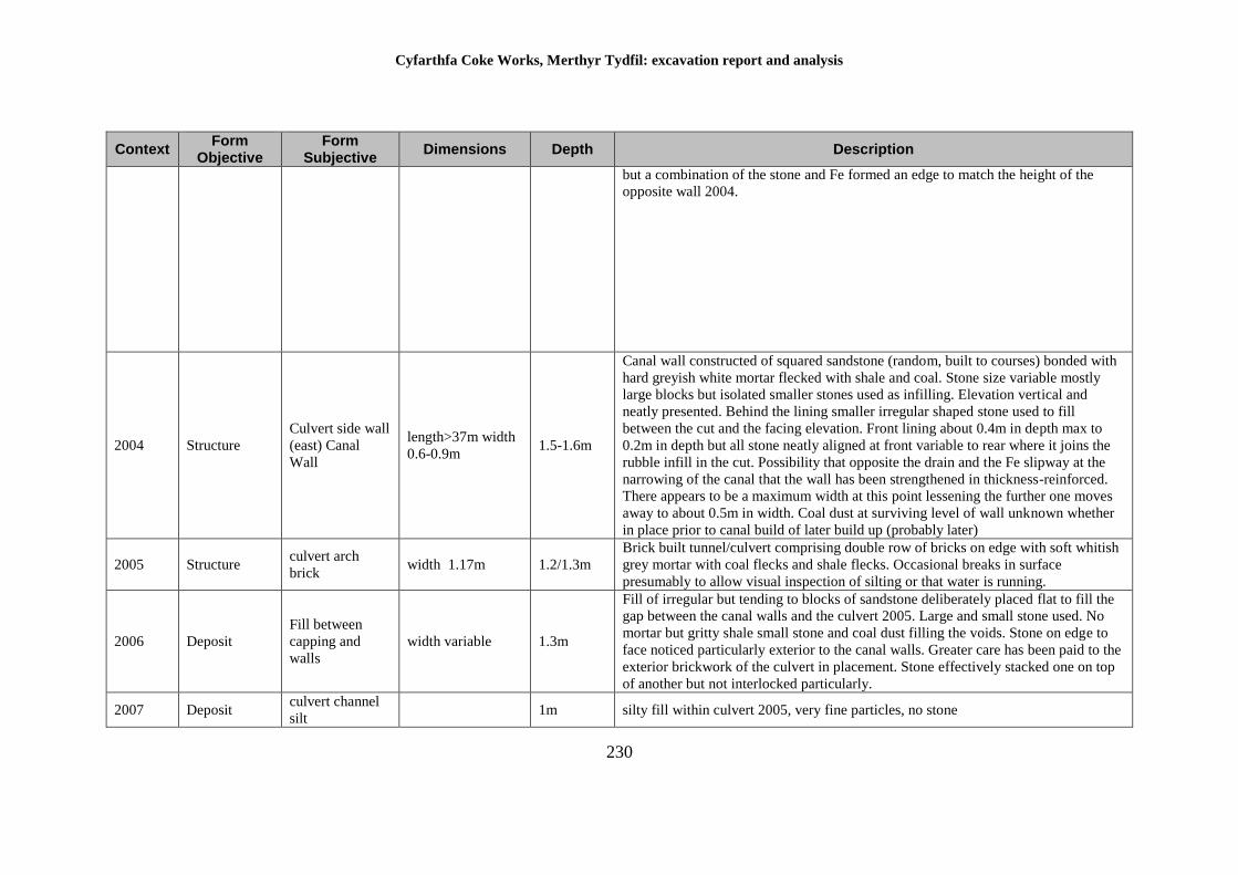
Cyfarthfa Coke Works, Merthyr Tydfil: excavation report and analysis
230
Context Form
Objective Form
Subjective Dimensions Depth Description
but a combination of the stone and Fe formed an edge to match the height of the
opposite wall 2004.
2004 Structure
Culvert side wall
(east) Canal
Wall
length>37m width
0.6-0.9m 1.5-1.6m
Canal wall constructed of squared sandstone (random, built to courses) bonded with
hard greyish white mortar flecked with shale and coal. Stone size variable mostly
large blocks but isolated smaller stones used as infilling. Elevation vertical and
neatly presented. Behind the lining smaller irregular shaped stone used to fill
between the cut and the facing elevation. Front lining about 0.4m in depth max to
0.2m in depth but all stone neatly aligned at front variable to rear where it joins the
rubble infill in the cut. Possibility that opposite the drain and the Fe slipway at the
narrowing of the canal that the wall has been strengthened in thickness-reinforced.
There appears to be a maximum width at this point lessening the further one moves
away to about 0.5m in width. Coal dust at surviving level of wall unknown whether
in place prior to canal build of later build up (probably later)
2005 Structure culvert arch
brick width 1.17m 1.2/1.3m
Brick built tunnel/culvert comprising double row of bricks on edge with soft whitish
grey mortar with coal flecks and shale flecks. Occasional breaks in surface
presumably to allow visual inspection of silting or that water is running.
2006 Deposit
Fill between
capping and
walls
width variable 1.3m
Fill of irregular but tending to blocks of sandstone deliberately placed flat to fill the
gap between the canal walls and the culvert 2005. Large and small stone used. No
mortar but gritty shale small stone and coal dust filling the voids. Stone on edge to
face noticed particularly exterior to the canal walls. Greater care has been paid to the
exterior brickwork of the culvert in placement. Stone effectively stacked one on top
of another but not interlocked particularly.
2007 Deposit culvert channel
silt 1m silty fill within culvert 2005, very fine particles, no stone
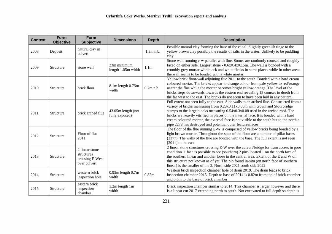
Cyfarthfa Coke Works, Merthyr Tydfil: excavation report and analysis
231
Context Form
Objective Form
Subjective Dimensions Depth Description
2008 Deposit natural clay in
culvert 1.3m n.b.
Possible natural clay forming the base of the canal. Slightly greenish tinge to the
yellow brown clay possibly the results of salts in the water. Unlikely to be puddling
clay
2009 Structure stone wall 23m minimum
length 1.05m width 1.1m
Stone wall running e-w parallel with flue. Stones are randomly coursed and roughly
faced on either side. Largest stone - 0.6x0.4x0.15m. The wall is bonded with a
crumbly grey mortar with black and white flecks in some places while in other areas
the wall seems to be bonded with a white mortar.
2010 Structure brick floor 8.1m length 0.75m
width 0.7m n.b
Yellow brick floor/wall adjoining flue 2011 to the south. Bonded with a hard cream
coloured mortar. The bricks appear to change colour from pale yellow to red/orange
nearer the flue while the mortar becomes bright yellow orange. The level of the
bricks steps downwards towards the eastern end revealing 15 courses in doeth from
the far west to the east. The bricks do not seem to have been laid in any pattern.
2011 Structure brick arched flue 43.05m length (not
fully exposed)
Full extent not seen fully to the east. Side walls to an arched flue. Constructed from a
variety of bricks measuring from 0.23x0.11x0.06m with crown and Stourbridge
stamps to the large blocks measuring 0.54x0.3x0.08 used in the arched roof. The
bricks are heavily vitrified in places on the internal face. It is bonded with a hard
cream coloured mortar, the external face is not visible to the south but to the north a
pipe 2273 has destroyed and potential outer features/faces
2012 Structure Floor of flue
2011
The floor of the flue running E-W is comprised of yellow bricks being bonded by a
light brown mortar. Throughout the span of the floor are a number of pillar bases
(2377). The walls of the flue are bonded with the base. The full extent is not seen
[2011] to the east
2013 Structure
2 linear stone
structures
crossing E-West
over culvert
2 linear stone structures crossing E-W over the culvert/bridge for tram access in poor
condition. 1 face is possible to see (southern) 2 pins located 1 on the north face of
the southern linear and another loose in the central area. Extent of the E and W of
this structure not known as of yet. The pin found in-situ (on north face of southern
linear) is the smaller of the 2. North side 2021 south side 2022
2014 Structure western brick
inspection hole
0.95m length 0.7m
width 0.82m
Western brick inspection chamber hole of drain 2019. The drain leads to brick
inspection chamber 2015. Depth to base of 2014 is 0.82m from top of brick chamber
and 0.6m to the base of brick chamber
2015 Structure
eastern brick
inspection
chamber
1.2m length 1m
width
Brick inspection chamber similar to 2014. This chamber is larger however and there
is a linear cut 2017 extending north to south. Not excavated to full depth so depth is
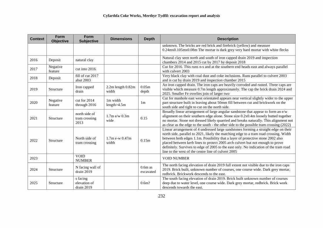
Cyfarthfa Coke Works, Merthyr Tydfil: excavation report and analysis
232
Context Form
Objective Form
Subjective Dimensions Depth Description
unknown. The bricks are red brick and firebrick (yellow) and measure
0.24mx0.105mx0.08m The mortar is dark grey very hard mortar with white flecks
2016 Deposit natural clay Natural clay seen north and south of iron capped drain 2019 and inspection
chambers 2014 and 2015 cut by 2017 by deposit 2018
2017 Negative
feature cut into 2016
Cut for 2016. This runs n-s and at the southern end heads east and always parallel
with culvert 2003
2018 Deposit fill of cut 2017
abut 2003
Very black clay with coal dust and coke inclusions. Runs parallel to culvert 2003
and is cut by drain 2019 and inspection chamber 2015
2019 Structure Iron capped
drain
2.2m length 0.82m
width
0.05m
depth
An iron capped drain. The iron caps are heavily corroded and rusted. Three caps are
visible which measure 0.7m length approximately. The cap the brick drain 2024 and
2025. Smaller Fe overlies join of larger two
2020 Negative
feature
cut for 2014
through 2016
1m width
length>4.5m 1m
Cut for manhole east west orientated appears near vertical slightly wider to the upper
part structure built in leaving about 50mm fill between cut and brickwork on the
south side and tight to cut on the north side.
2021 Structure
north side of
tram crossing
2013
1.7m e/w 0.3m
wide 0.15
Broadly linear arrangement of large angular sandstone that appear to form an e/w
alignment on their southern edge alone. Stone size 0.2x0.4m loosely butted together
no mortar. Stone not dressed likely quarried and breaks naturally. This alignment not
as clear as the edge to the south - the other side to the possible tram crossing (2022)
2022 Structure North side of
tram crossing
1.7m e-w 0.47m
width 0.15m
Linear arrangement of 4 undressed large sandstones forming a straight edge on their
north side, parallel to 2021, likely the matching edge to a tram road crossing. Width
between both edges 1.1m. Possibility that a layer of protective stone 2002 also
placed between kerb lines to protect 2005 arch culvert but not enough to prove
definitely. Survives to edge of 2005 to the east only. No indication of the tram road
line to the west of the centre line of culvert 2005
2023 VOID
NUMBER VOID NUMBER
2024 Structure N facing wall of
drain 2019
0.6m as
excavated
The north facing elevation of drain 2019 full extent not visible due to the iron caps
2019. Brick built, unknown number of courses, one course wide. Dark grey mortar,
redbrick. Brickwork descends to the east.
2025 Structure
s facing
elevation of
drain 2019
0.6m?
The south facing elevation of drain 2019. Brick built unknown number of courses
deep due to water level, one course wide. Dark grey mortar, redbrick. Brick work
descends towards the east.
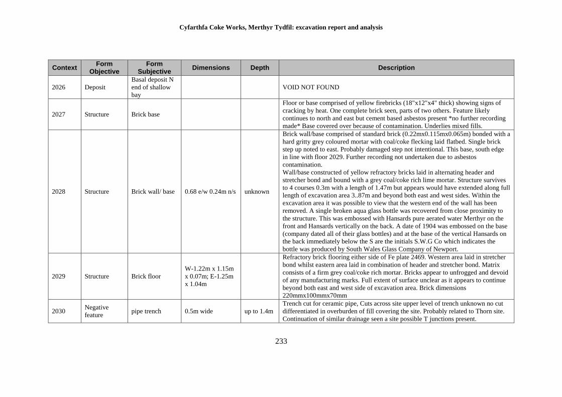
Cyfarthfa Coke Works, Merthyr Tydfil: excavation report and analysis
233
Context Form
Objective Form
Subjective Dimensions Depth Description
2026 Deposit
Basal deposit N
end of shallow
bay
VOID NOT FOUND
2027 Structure Brick base
Floor or base comprised of yellow firebricks (18"x12"x4" thick) showing signs of
cracking by heat. One complete brick seen, parts of two others. Feature likely
continues to north and east but cement based asbestos present *no further recording
made* Base covered over because of contamination. Underlies mixed fills.
2028 Structure Brick wall/ base 0.68 e/w 0.24m n/s unknown
Brick wall/base comprised of standard brick (0.22mx0.115mx0.065m) bonded with a
hard gritty grey coloured mortar with coal/coke flecking laid flatbed. Single brick
step up noted to east. Probably damaged step not intentional. This base, south edge
in line with floor 2029. Further recording not undertaken due to asbestos
contamination.
Wall/base constructed of yellow refractory bricks laid in alternating header and
stretcher bond and bound with a grey coal/coke rich lime mortar. Structure survives
to 4 courses 0.3m with a length of 1.47m but appears would have extended along full
length of excavation area 3..87m and beyond both east and west sides. Within the
excavation area it was possible to view that the western end of the wall has been
removed. A single broken aqua glass bottle was recovered from close proximity to
the structure. This was embossed with Hansards pure aerated water Merthyr on the
front and Hansards vertically on the back. A date of 1904 was embossed on the base
(company dated all of their glass bottles) and at the base of the vertical Hansards on
the back immediately below the S are the initials S.W.G Co which indicates the
bottle was produced by South Wales Glass Company of Newport.
2029 Structure Brick floor
W-1.22m x 1.15m
x 0.07m; E-1.25m
x 1.04m
Refractory brick flooring either side of Fe plate 2469. Western area laid in stretcher
bond whilst eastern area laid in combination of header and stretcher bond. Matrix
consists of a firm grey coal/coke rich mortar. Bricks appear to unfrogged and devoid
of any manufacturing marks. Full extent of surface unclear as it appears to continue
beyond both east and west side of excavation area. Brick dimensions
220mmx100mmx70mm
2030 Negative
feature pipe trench 0.5m wide up to 1.4m
Trench cut for ceramic pipe, Cuts across site upper level of trench unknown no cut
differentiated in overburden of fill covering the site. Probably related to Thorn site.
Continuation of similar drainage seen a site possible T junctions present.
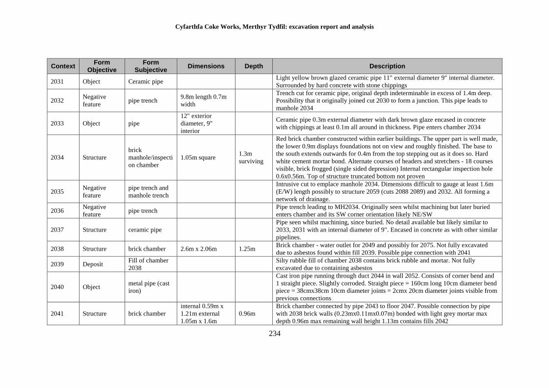
Cyfarthfa Coke Works, Merthyr Tydfil: excavation report and analysis
234
Context Form
Objective Form
Subjective Dimensions Depth Description
2031 Object Ceramic pipe Light yellow brown glazed ceramic pipe 11" external diameter 9" internal diameter.
Surrounded by hard concrete with stone chippings
2032 Negative
feature pipe trench
9.8m length 0.7m
width
Trench cut for ceramic pipe, original depth indeterminable in excess of 1.4m deep.
Possibility that it originally joined cut 2030 to form a junction. This pipe leads to
manhole 2034
2033 Object pipe
12" exterior
diameter, 9"
interior
Ceramic pipe 0.3m external diameter with dark brown glaze encased in concrete
with chippings at least 0.1m all around in thickness. Pipe enters chamber 2034
2034 Structure
brick
manhole/inspecti
on chamber
1.05m square 1.3m
surviving
Red brick chamber constructed within earlier buildings. The upper part is well made,
the lower 0.9m displays foundations not on view and roughly finished. The base to
the south extends outwards for 0.4m from the top stepping out as it does so. Hard
white cement mortar bond. Alternate courses of headers and stretchers - 18 courses
visible, brick frogged (single sided depression) Internal rectangular inspection hole
0.6x0.56m. Top of structure truncated bottom not proven
2035 Negative
feature
pipe trench and
manhole trench
Intrusive cut to emplace manhole 2034. Dimensions difficult to gauge at least 1.6m
(E/W) length possibly to structure 2059 (cuts 2088 2089) and 2032. All forming a
network of drainage.
2036 Negative
feature pipe trench
Pipe trench leading to MH2034. Originally seen whilst machining but later buried
enters chamber and its SW corner orientation likely NE/SW
2037 Structure ceramic pipe
Pipe seen whilst machining, since buried. No detail available but likely similar to
2033, 2031 with an internal diameter of 9". Encased in concrete as with other similar
pipelines.
2038 Structure brick chamber 2.6m x 2.06m 1.25m Brick chamber - water outlet for 2049 and possibly for 2075. Not fully excavated
due to asbestos found within fill 2039. Possible pipe connection with 2041
2039 Deposit Fill of chamber
2038
Silty rubble fill of chamber 2038 contains brick rubble and mortar. Not fully
excavated due to containing asbestos
2040 Object metal pipe (cast
iron)
Cast iron pipe running through duct 2044 in wall 2052. Consists of corner bend and
1 straight piece. Slightly corroded. Straight piece = 160cm long 10cm diameter bend
piece = 38cmx38cm 10cm diameter joints = 2cmx 20cm diameter joints visible from
previous connections
2041 Structure brick chamber
internal 0.59m x
1.21m external
1.05m x 1.6m
0.96m
Brick chamber connected by pipe 2043 to floor 2047. Possible connection by pipe
with 2038 brick walls (0.23mx0.11mx0.07m) bonded with light grey mortar max
depth 0.96m max remaining wall height 1.13m contains fills 2042
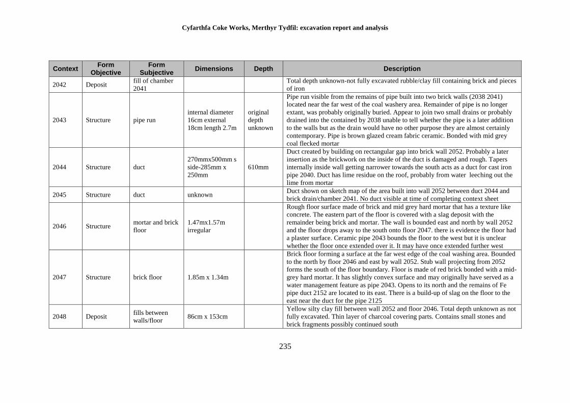
Cyfarthfa Coke Works, Merthyr Tydfil: excavation report and analysis
235
Context Form
Objective Form
Subjective Dimensions Depth Description
2042 Deposit fill of chamber
2041
Total depth unknown-not fully excavated rubble/clay fill containing brick and pieces
of iron
2043 Structure pipe run
internal diameter
16cm external
18cm length 2.7m
original
depth
unknown
Pipe run visible from the remains of pipe built into two brick walls (2038 2041)
located near the far west of the coal washery area. Remainder of pipe is no longer
extant, was probably originally buried. Appear to join two small drains or probably
drained into the contained by 2038 unable to tell whether the pipe is a later addition
to the walls but as the drain would have no other purpose they are almost certainly
contemporary. Pipe is brown glazed cream fabric ceramic. Bonded with mid grey
coal flecked mortar
2044 Structure duct
270mmx500mm s
side-285mm x
250mm
610mm
Duct created by building on rectangular gap into brick wall 2052. Probably a later
insertion as the brickwork on the inside of the duct is damaged and rough. Tapers
internally inside wall getting narrower towards the south acts as a duct for cast iron
pipe 2040. Duct has lime residue on the roof, probably from water leeching out the
lime from mortar
2045 Structure duct unknown Duct shown on sketch map of the area built into wall 2052 between duct 2044 and
brick drain/chamber 2041. No duct visible at time of completing context sheet
2046 Structure mortar and brick
floor
1.47mx1.57m
irregular
Rough floor surface made of brick and mid grey hard mortar that has a texture like
concrete. The eastern part of the floor is covered with a slag deposit with the
remainder being brick and mortar. The wall is bounded east and north by wall 2052
and the floor drops away to the south onto floor 2047. there is evidence the floor had
a plaster surface. Ceramic pipe 2043 bounds the floor to the west but it is unclear
whether the floor once extended over it. It may have once extended further west
2047 Structure brick floor 1.85m x 1.34m
Brick floor forming a surface at the far west edge of the coal washing area. Bounded
to the north by floor 2046 and east by wall 2052. Stub wall projecting from 2052
forms the south of the floor boundary. Floor is made of red brick bonded with a mid-
grey hard mortar. It has slightly convex surface and may originally have served as a
water management feature as pipe 2043. Opens to its north and the remains of Fe
pipe duct 2152 are located to its east. There is a build-up of slag on the floor to the
east near the duct for the pipe 2125
2048 Deposit fills between
walls/floor 86cm x 153cm
Yellow silty clay fill between wall 2052 and floor 2046. Total depth unknown as not
fully excavated. Thin layer of charcoal covering parts. Contains small stones and
brick fragments possibly continued south
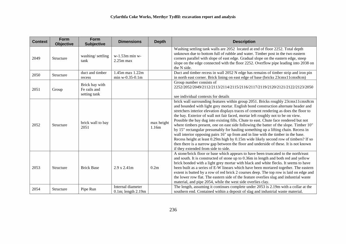
Cyfarthfa Coke Works, Merthyr Tydfil: excavation report and analysis
236
Context Form
Objective Form
Subjective Dimensions Depth Description
2049 Structure washing/ settling
tank
w-1.53m min w-
2.25m max
Washing settling tank walls are 2052 located at end of floor 2252. Total depth
unknown due to bottom full of rubble and water. Timber post in the two eastern
corners parallel with slope of east edge. Gradual slope on the eastern edge, steep
slope on the edge connected with the floor 2252. Overflow pipe leading into 2038 on
the N side.
2050 Structure duct and timber
recess
1.45m max 1.22m
min w-0.35-0.1m
Duct and timber recess in wall 2052 N edge has remains of timber strip and iron pin
in north east corner. Brick lining on east edge of base (bricks 23cmx11cmx8cm)
2051 Group
Brick bay with
Fe rails and
setting tank
Group number consists of
2252/2052/2049/2112/2113/2114/2115/2116/2117/2119/2120/2121/2122/2123/2050
see individual contexts for details
2052 Structure brick wall to bay
2051
max height
1.16m
brick wall surrounding features within group 2051. Bricks roughly 23cmx11cmx8cm
and bounded with light grey mortar. English bond construction alternate header and
stretchers interior elevation displays traces of cement rendering as does the floor to
the bay. Exterior of wall not fair faced, mortar left roughly not to be on view.
Possible the bay dug into existing fills. Chute to east. Chute face rendered but not
where timbers present, one on east side following the batter of the slope. Timber 10"
by 15" rectangular presumably for hauling something up a lifting chain. Recess in
wall interior opposing pairs 16" up from and in line with the timber in the base.
Recess height at least 0.29m high by 0.15m wide likely second row of timbers? If so
then there is a narrow gap between the floor and underside of these. It is not known
if they extended from side to side.
2053 Structure Brick Base 2.9 x 2.41m 0.2m
A stone/brick floor or base which appears to have been truncated to the north/east
and south. It is constructed of stone up to 0.36m in length and both red and yellow
brick bonded with a light grey mortar with black and white flecks. It seems to have
been built as a series of E-W linears which have been mortared together. The eastern
extent is butted by a row of red brick 2 courses deep. The top row is laid on edge and
the lower row flat. The eastern side of the feature overlies slag and industrial waste
material, and pipe 2054, while the west side overlies clay.
2054 Structure Pipe Run Internal diameter
0.1m; length 2.19m
The length, assuming it continues complete under 2053 is 2.19m with a collar at the
southern end. Contained within a deposit of slag and industrial waste material.
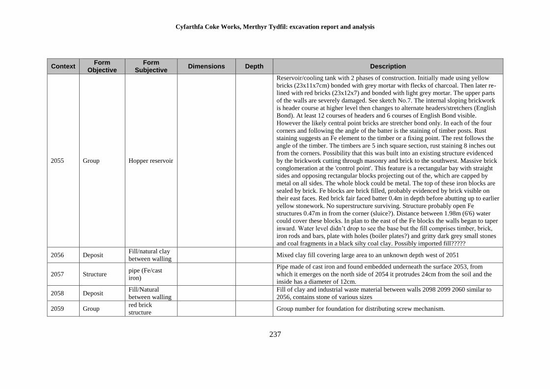
Cyfarthfa Coke Works, Merthyr Tydfil: excavation report and analysis
237
Context Form
Objective Form
Subjective Dimensions Depth Description
2055 Group Hopper reservoir
Reservoir/cooling tank with 2 phases of construction. Initially made using yellow
bricks (23x11x7cm) bonded with grey mortar with flecks of charcoal. Then later re-
lined with red bricks (23x12x7) and bonded with light grey mortar. The upper parts
of the walls are severely damaged. See sketch No.7. The internal sloping brickwork
is header course at higher level then changes to alternate headers/stretchers (English
Bond). At least 12 courses of headers and 6 courses of English Bond visible.
However the likely central point bricks are stretcher bond only. In each of the four
corners and following the angle of the batter is the staining of timber posts. Rust
staining suggests an Fe element to the timber or a fixing point. The rest follows the
angle of the timber. The timbers are 5 inch square section, rust staining 8 inches out
from the corners. Possibility that this was built into an existing structure evidenced
by the brickwork cutting through masonry and brick to the southwest. Massive brick
conglomeration at the 'control point'. This feature is a rectangular bay with straight
sides and opposing rectangular blocks projecting out of the, which are capped by
metal on all sides. The whole block could be metal. The top of these iron blocks are
sealed by brick. Fe blocks are brick filled, probably evidenced by brick visible on
their east faces. Red brick fair faced batter 0.4m in depth before abutting up to earlier
yellow stonework. No superstructure surviving. Structure probably open Fe
structures 0.47m in from the corner (sluice?). Distance between 1.98m (6'6) water
could cover these blocks. In plan to the east of the Fe blocks the walls began to taper
inward. Water level didn’t drop to see the base but the fill comprises timber, brick,
iron rods and bars, plate with holes (boiler plates?) and gritty dark grey small stones
and coal fragments in a black silty coal clay. Possibly imported fill?????
2056 Deposit Fill/natural clay
between walling Mixed clay fill covering large area to an unknown depth west of 2051
2057 Structure pipe (Fe/cast
iron)
Pipe made of cast iron and found embedded underneath the surface 2053, from
which it emerges on the north side of 2054 it protrudes 24cm from the soil and the
inside has a diameter of 12cm.
2058 Deposit Fill/Natural
between walling
Fill of clay and industrial waste material between walls 2098 2099 2060 similar to
2056, contains stone of various sizes
2059 Group red brick
structure Group number for foundation for distributing screw mechanism.
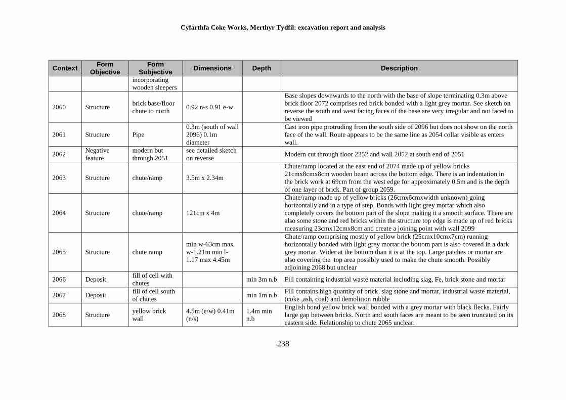
Cyfarthfa Coke Works, Merthyr Tydfil: excavation report and analysis
238
Context Form
Objective Form
Subjective Dimensions Depth Description
incorporating
wooden sleepers
2060 Structure brick base/floor
chute to north 0.92 n-s 0.91 e-w
Base slopes downwards to the north with the base of slope terminating 0.3m above
brick floor 2072 comprises red brick bonded with a light grey mortar. See sketch on
reverse the south and west facing faces of the base are very irregular and not faced to
be viewed
2061 Structure Pipe
0.3m (south of wall
2096) 0.1m
diameter
Cast iron pipe protruding from the south side of 2096 but does not show on the north
face of the wall. Route appears to be the same line as 2054 collar visible as enters
wall.
2062 Negative
feature
modern but
through 2051
see detailed sketch
on reverse Modern cut through floor 2252 and wall 2052 at south end of 2051
2063 Structure chute/ramp 3.5m x 2.34m
Chute/ramp located at the east end of 2074 made up of yellow bricks
21cmx8cmx8cm wooden beam across the bottom edge. There is an indentation in
the brick work at 69cm from the west edge for approximately 0.5m and is the depth
of one layer of brick. Part of group 2059.
2064 Structure chute/ramp 121cm x 4m
Chute/ramp made up of yellow bricks (26cmx6cmxwidth unknown) going
horizontally and in a type of step. Bonds with light grey mortar which also
completely covers the bottom part of the slope making it a smooth surface. There are
also some stone and red bricks within the structure top edge is made up of red bricks
measuring 23cmx12cmx8cm and create a joining point with wall 2099
2065 Structure chute ramp
min w-63cm max
w-1.21m min l-
1.17 max 4.45m
Chute/ramp comprising mostly of yellow brick (25cmx10cmx7cm) running
horizontally bonded with light grey mortar the bottom part is also covered in a dark
grey mortar. Wider at the bottom than it is at the top. Large patches or mortar are
also covering the top area possibly used to make the chute smooth. Possibly
adjoining 2068 but unclear
2066 Deposit fill of cell with
chutes min 3m n.b Fill containing industrial waste material including slag, Fe, brick stone and mortar
2067 Deposit fill of cell south
of chutes min 1m n.b
Fill contains high quantity of brick, slag stone and mortar, industrial waste material,
(coke ,ash, coal) and demolition rubble
2068 Structure yellow brick
wall
4.5m (e/w) 0.41m
(n/s)
1.4m min
n.b
English bond yellow brick wall bonded with a grey mortar with black flecks. Fairly
large gap between bricks. North and south faces are meant to be seen truncated on its
eastern side. Relationship to chute 2065 unclear.
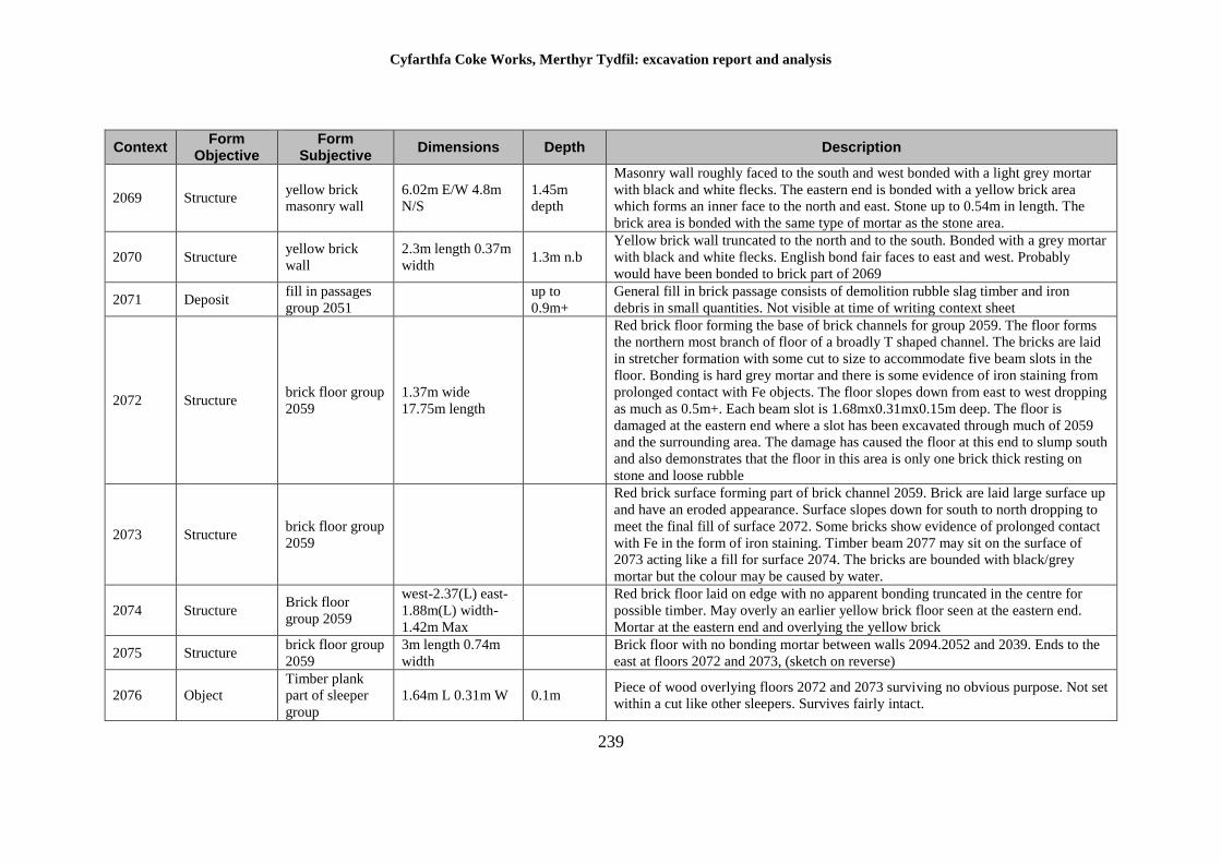
Cyfarthfa Coke Works, Merthyr Tydfil: excavation report and analysis
239
Context Form
Objective Form
Subjective Dimensions Depth Description
2069 Structure yellow brick
masonry wall
6.02m E/W 4.8m
N/S
1.45m
depth
Masonry wall roughly faced to the south and west bonded with a light grey mortar
with black and white flecks. The eastern end is bonded with a yellow brick area
which forms an inner face to the north and east. Stone up to 0.54m in length. The
brick area is bonded with the same type of mortar as the stone area.
2070 Structure yellow brick
wall
2.3m length 0.37m
width 1.3m n.b
Yellow brick wall truncated to the north and to the south. Bonded with a grey mortar
with black and white flecks. English bond fair faces to east and west. Probably
would have been bonded to brick part of 2069
2071 Deposit fill in passages
group 2051
up to
0.9m+
General fill in brick passage consists of demolition rubble slag timber and iron
debris in small quantities. Not visible at time of writing context sheet
2072 Structure brick floor group
2059
1.37m wide
17.75m length
Red brick floor forming the base of brick channels for group 2059. The floor forms
the northern most branch of floor of a broadly T shaped channel. The bricks are laid
in stretcher formation with some cut to size to accommodate five beam slots in the
floor. Bonding is hard grey mortar and there is some evidence of iron staining from
prolonged contact with Fe objects. The floor slopes down from east to west dropping
as much as 0.5m+. Each beam slot is 1.68mx0.31mx0.15m deep. The floor is
damaged at the eastern end where a slot has been excavated through much of 2059
and the surrounding area. The damage has caused the floor at this end to slump south
and also demonstrates that the floor in this area is only one brick thick resting on
stone and loose rubble
2073 Structure brick floor group
2059
Red brick surface forming part of brick channel 2059. Brick are laid large surface up
and have an eroded appearance. Surface slopes down for south to north dropping to
meet the final fill of surface 2072. Some bricks show evidence of prolonged contact
with Fe in the form of iron staining. Timber beam 2077 may sit on the surface of
2073 acting like a fill for surface 2074. The bricks are bounded with black/grey
mortar but the colour may be caused by water.
2074 Structure Brick floor
group 2059
west-2.37(L) east-
1.88m(L) width-
1.42m Max
Red brick floor laid on edge with no apparent bonding truncated in the centre for
possible timber. May overly an earlier yellow brick floor seen at the eastern end.
Mortar at the eastern end and overlying the yellow brick
2075 Structure brick floor group
2059
3m length 0.74m
width
Brick floor with no bonding mortar between walls 2094.2052 and 2039. Ends to the
east at floors 2072 and 2073, (sketch on reverse)
2076 Object
Timber plank
part of sleeper
group
1.64m L 0.31m W 0.1m Piece of wood overlying floors 2072 and 2073 surviving no obvious purpose. Not set
within a cut like other sleepers. Survives fairly intact.
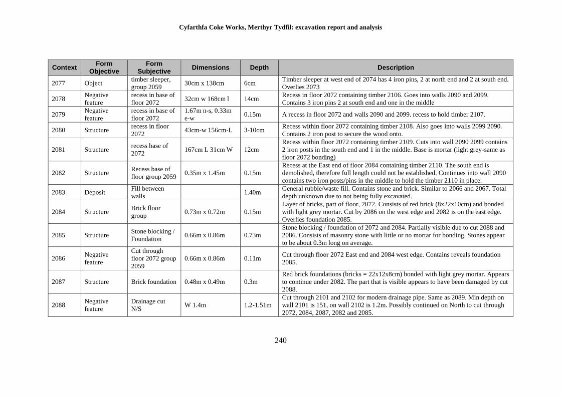
Cyfarthfa Coke Works, Merthyr Tydfil: excavation report and analysis
240
Context Form
Objective Form
Subjective Dimensions Depth Description
2077 Object timber sleeper,
group 2059 30cm x 138cm 6cm
Timber sleeper at west end of 2074 has 4 iron pins, 2 at north end and 2 at south end.
Overlies 2073
2078 Negative
feature
recess in base of
floor 2072 32cm w 168cm l 14cm
Recess in floor 2072 containing timber 2106. Goes into walls 2090 and 2099.
Contains 3 iron pins 2 at south end and one in the middle
2079 Negative
feature
recess in base of
floor 2072
1.67m n-s, 0.33m
e-w 0.15m A recess in floor 2072 and walls 2090 and 2099. recess to hold timber 2107.
2080 Structure recess in floor
2072 43cm-w 156cm-L 3-10cm
Recess within floor 2072 containing timber 2108. Also goes into walls 2099 2090.
Contains 2 iron post to secure the wood onto.
2081 Structure recess base of
2072 167cm L 31cm W 12cm
Recess within floor 2072 containing timber 2109. Cuts into wall 2090 2099 contains
2 iron posts in the south end and 1 in the middle. Base is mortar (light grey-same as
floor 2072 bonding)
2082 Structure Recess base of
floor group 2059 0.35m x 1.45m 0.15m
Recess at the East end of floor 2084 containing timber 2110. The south end is
demolished, therefore full length could not be established. Continues into wall 2090
contains two iron posts/pins in the middle to hold the timber 2110 in place.
2083 Deposit Fill between
walls 1.40m
General rubble/waste fill. Contains stone and brick. Similar to 2066 and 2067. Total
depth unknown due to not being fully excavated.
2084 Structure Brick floor
group 0.73m x 0.72m 0.15m
Layer of bricks, part of floor, 2072. Consists of red brick (8x22x10cm) and bonded
with light grey mortar. Cut by 2086 on the west edge and 2082 is on the east edge.
Overlies foundation 2085.
2085 Structure Stone blocking /
Foundation 0.66m x 0.86m 0.73m
Stone blocking / foundation of 2072 and 2084. Partially visible due to cut 2088 and
2086. Consists of masonry stone with little or no mortar for bonding. Stones appear
to be about 0.3m long on average.
2086 Negative
feature
Cut through
floor 2072 group
2059
0.66m x 0.86m 0.11m Cut through floor 2072 East end and 2084 west edge. Contains reveals foundation
2085.
2087 Structure Brick foundation 0.48m x 0.49m 0.3m
Red brick foundations (bricks = 22x12x8cm) bonded with light grey mortar. Appears
to continue under 2082. The part that is visible appears to have been damaged by cut
2088.
2088 Negative
feature
Drainage cut
N/S W 1.4m 1.2-1.51m
Cut through 2101 and 2102 for modern drainage pipe. Same as 2089. Min depth on
wall 2101 is 151, on wall 2102 is 1.2m. Possibly continued on North to cut through
2072, 2084, 2087, 2082 and 2085.
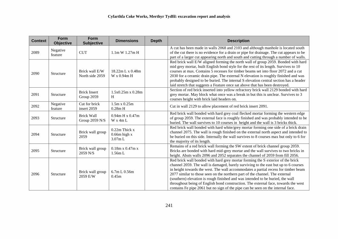
Cyfarthfa Coke Works, Merthyr Tydfil: excavation report and analysis
241
Context Form
Objective Form
Subjective Dimensions Depth Description
2089 Negative
feature CUT 1.1m W 1.27m H
A cut has been made in walls 2068 and 2103 and although manhole is located south
of the cut there is no evidence for a drain or pipe for drainage. The cut appears to be
part of a larger cut appearing north and south and cutting through a number of walls.
2090 Structure Brick wall E/W
North side 2059
18.22m L x 0.48m
W x 0.94m H
Red brick wall E/W aligned forming the north wall of group 2059. Bonded with hard
mid grey mortar, built English bond style for the rest of its length. Survives to 10
courses at max. Contains 5 recesses for timber beams set into floor 2072 and a cut
2030 for a ceramic drain pipe. The external N elevation is roughly finished and was
probably designed to be buried. The internal S elevation central section has a header
laid stretch that suggests a Feature once sat above that has been destroyed.
2091 Structure Brick Insert
Group 2059
1.5x0.25m x 0.28m
H
Section of red brick inserted into yellow refractory brick wall 2129 bonded with hard
grey mortar. May block what once was a break in but this is unclear. Survives to 3
courses height with brick laid headers on.
2092 Negative
feature
Cut for brick
insert 2059
1.5m x 0.25m
0.28m H Cut in wall 2129 to allow placement of red brick insert 2091.
2093 Structure Brick Wall
Group 2059 N/S
0.94m H x 0.47m
W x 4m L
Red brick wall bonded with hard grey coal flecked mortar forming the western edge
of group 2059. The external face is roughly finished and was probably intended to be
buried. The wall survives to 10 courses in height and the wall is 3 bricks thick.
2094 Structure Brick wall group
2059
0.22m Thick x
0.66m high x
3.07m L
Red brick wall bonded with hard white/grey mortar forming one side of a brick drain
channel 2075. The wall is rough finished on the external north aspect and intended to
be buried on this side. Internally the wall survives to 8 courses max but only to 6 for
the majority of its length.
2095 Structure Brick wall group
2059 N/S
0.18m x 0.47m x
1.56m L
Remains of a red brick wall forming the SW extent of brick channel group 2059.
Bricks are bonded with hard mid-grey mortar and the wall survives to two bricks in
height. Abuts walls 2096 and 2052 separates the channel of 2059 from fill 2056.
2096 Structure Brick wall group
2059 E/W
6.7m L 0.56m
0.45m
Red brick wall bonded with hard grey mortar forming the S exterior of the brick
channel 2059. The wall is damaged, barely surviving to the east but up to 6 courses
in height towards the west. The wall accommodates a partial recess for timber beam
2077 similar to those seen on the northern part of the channel. The external
(southern) elevation is rough finished and was intended to be buried, the wall
throughout being of English bond construction. The external face, towards the west
contains Fe pipe 2061 but no sign of the pipe can be seen on the internal face.
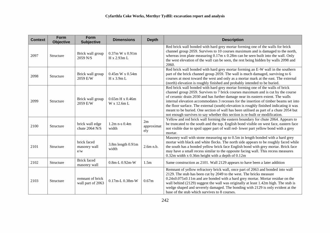
Cyfarthfa Coke Works, Merthyr Tydfil: excavation report and analysis
242
Context Form
Objective Form
Subjective Dimensions Depth Description
2097 Structure Brick wall group
2059 N/S
0.37m W x 0.91m
H x 2.93m L
Red brick wall bonded with hard grey mortar forming one of the walls for brick
channel group 2059. Survives to 10 courses maximum and is damaged to the north,
whereas iron plate measuring 0.17m x 0.28m can be seen built into the wall. Only
the west elevation of the wall can be seen, the rest being hidden by walls 2098 and
2060.
2098 Structure Brick wall group
2059 E/W
0.45m W x 0.54m
H x 3.9m L
Red brick wall bonded with hard grey mortar forming an E-W wall in the southern
part of the brick channel group 2059. The wall is much damaged, surviving to 6
courses at most toward the west and only as a mortar mark at the east. The external
(north) elevation is roughly finished and probably intended to be buried.
2099 Structure Brick wall group
2059 E/W
0.65m H x 0.46m
W x 12.6m L
Red brick wall bonded with hard grey mortar forming one of the walls of brick
channel group 2059. Survives to 7 brick courses maximum and is cut by the course
of ceramic drain 2030 and has further damage near its eastern extent. The walls
internal elevation accommodates 3 recesses for the insertion of timber beams set into
the floor surface. The external (south) elevation is roughly finished indicating it was
meant to be buried. One section of wall has been utilised as part of a chute 2054 but
not enough survives to say whether this section is re-built or modification.
2100 Structure brick wall edge
chute 2064 N/S
1.2m n-s 0.4m
width
2m
approximat
ely
Yellow and red brick wall forming the eastern boundary for chute 2064. Appears to
be truncated to the south and the top. English bond visible on west face, eastern face
not visible due to spoil upper part of wall red- lower part yellow bond with a grey
mortar.
2101 Structure
brick faced
masonry wall
e/w
3.8m length 0.91m
width 2.6m n.b.
Masonry wall with stone measuring up to 0.5m in length bonded with a hard grey
mortar with black and white flecks. The north side appears to be roughly faced while
the south has a bonded yellow brick face English bond with grey mortar. Brick face
may have a small recess similar to the opposite facing wall. This recess measures
0.32m width x 0.36m height with a depth of 0.12m
2102 Structure Brick faced
masonry wall 0.8m-L 0.92m-W 1.5m Same construction as 2101. Wall 2129 appears to have been a later addition
2103 Structure remnant of brick
wall part of 2063 0.17m-L 0.38m-W 0.67m
Remnant of yellow refractory brick wall, once part of 2063 and bonded into wall
2129. The stub has been cut by 2049 to the west. The bricks measure
0.24x0.075x0.11m and are bonded with a hard grey mortar. Mortar residue on the
wall behind (2129) suggest the wall was originally at least 1.42m high. The stub is
wedge shaped and severely damaged. The bonding with 2129 is only evident at the
base of the stub which survives to 8 courses.
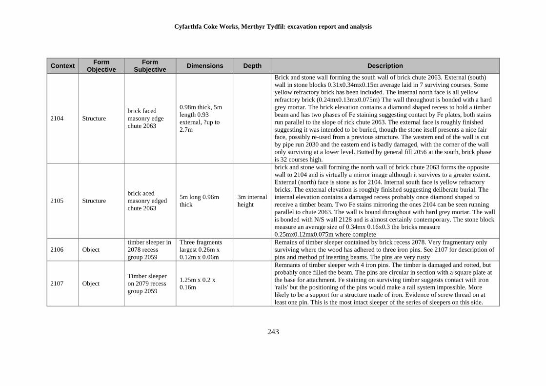
Cyfarthfa Coke Works, Merthyr Tydfil: excavation report and analysis
243
Context Form
Objective Form
Subjective Dimensions Depth Description
2104 Structure
brick faced
masonry edge
chute 2063
0.98m thick, 5m
length 0.93
external, ?up to
2.7m
Brick and stone wall forming the south wall of brick chute 2063. External (south)
wall in stone blocks 0.31x0.34mx0.15m average laid in 7 surviving courses. Some
yellow refractory brick has been included. The internal north face is all yellow
refractory brick (0.24mx0.13mx0.075m) The wall throughout is bonded with a hard
grey mortar. The brick elevation contains a diamond shaped recess to hold a timber
beam and has two phases of Fe staining suggesting contact by Fe plates, both stains
run parallel to the slope of rick chute 2063. The external face is roughly finished
suggesting it was intended to be buried, though the stone itself presents a nice fair
face, possibly re-used from a previous structure. The western end of the wall is cut
by pipe run 2030 and the eastern end is badly damaged, with the corner of the wall
only surviving at a lower level. Butted by general fill 2056 at the south, brick phase
is 32 courses high.
2105 Structure
brick aced
masonry edged
chute 2063
5m long 0.96m
thick
3m internal
height
brick and stone wall forming the north wall of brick chute 2063 forms the opposite
wall to 2104 and is virtually a mirror image although it survives to a greater extent.
External (north) face is stone as for 2104. Internal south face is yellow refractory
bricks. The external elevation is roughly finished suggesting deliberate burial. The
internal elevation contains a damaged recess probably once diamond shaped to
receive a timber beam. Two Fe stains mirroring the ones 2104 can be seen running
parallel to chute 2063. The wall is bound throughout with hard grey mortar. The wall
is bonded with N/S wall 2128 and is almost certainly contemporary. The stone block
measure an average size of 0.34mx 0.16x0.3 the bricks measure
0.25mx0.12mx0.075m where complete
2106 Object
timber sleeper in
2078 recess
group 2059
Three fragments
largest 0.26m x
0.12m x 0.06m
Remains of timber sleeper contained by brick recess 2078. Very fragmentary only
surviving where the wood has adhered to three iron pins. See 2107 for description of
pins and method pf inserting beams. The pins are very rusty
2107 Object
Timber sleeper
on 2079 recess
group 2059
1.25m x 0.2 x
0.16m
Remnants of timber sleeper with 4 iron pins. The timber is damaged and rotted, but
probably once filled the beam. The pins are circular in section with a square plate at
the base for attachment. Fe staining on surviving timber suggests contact with iron
'rails' but the positioning of the pins would make a rail system impossible. More
likely to be a support for a structure made of iron. Evidence of screw thread on at
least one pin. This is the most intact sleeper of the series of sleepers on this side.
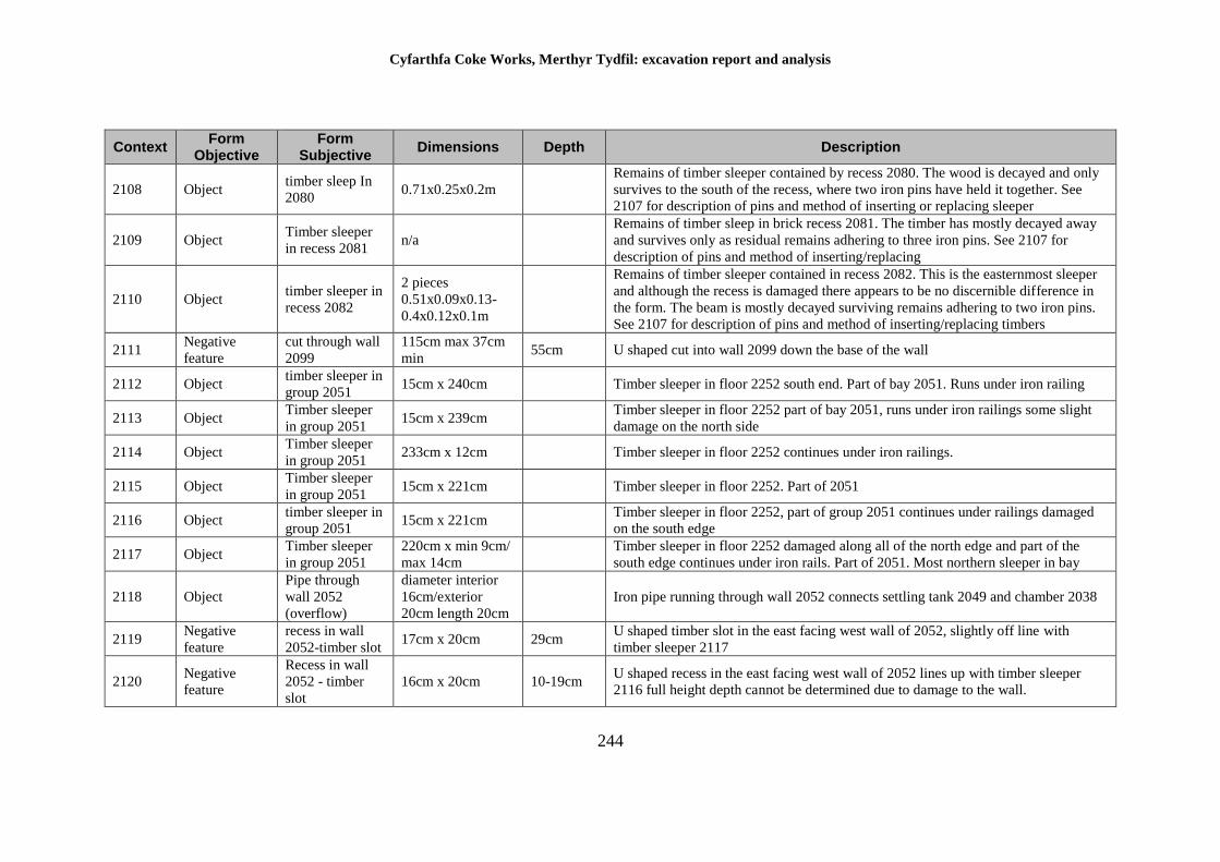
Cyfarthfa Coke Works, Merthyr Tydfil: excavation report and analysis
244
Context Form
Objective Form
Subjective Dimensions Depth Description
2108 Object timber sleep In
2080 0.71x0.25x0.2m
Remains of timber sleeper contained by recess 2080. The wood is decayed and only
survives to the south of the recess, where two iron pins have held it together. See
2107 for description of pins and method of inserting or replacing sleeper
2109 Object Timber sleeper
in recess 2081 n/a
Remains of timber sleep in brick recess 2081. The timber has mostly decayed away
and survives only as residual remains adhering to three iron pins. See 2107 for
description of pins and method of inserting/replacing
2110 Object timber sleeper in
recess 2082
2 pieces
0.51x0.09x0.13-
0.4x0.12x0.1m
Remains of timber sleeper contained in recess 2082. This is the easternmost sleeper
and although the recess is damaged there appears to be no discernible difference in
the form. The beam is mostly decayed surviving remains adhering to two iron pins.
See 2107 for description of pins and method of inserting/replacing timbers
2111 Negative
feature
cut through wall
2099
115cm max 37cm
min 55cm U shaped cut into wall 2099 down the base of the wall
2112 Object timber sleeper in
group 2051 15cm x 240cm Timber sleeper in floor 2252 south end. Part of bay 2051. Runs under iron railing
2113 Object Timber sleeper
in group 2051 15cm x 239cm
Timber sleeper in floor 2252 part of bay 2051, runs under iron railings some slight
damage on the north side
2114 Object Timber sleeper
in group 2051 233cm x 12cm Timber sleeper in floor 2252 continues under iron railings.
2115 Object Timber sleeper
in group 2051 15cm x 221cm Timber sleeper in floor 2252. Part of 2051
2116 Object timber sleeper in
group 2051 15cm x 221cm
Timber sleeper in floor 2252, part of group 2051 continues under railings damaged
on the south edge
2117 Object Timber sleeper
in group 2051
220cm x min 9cm/
max 14cm
Timber sleeper in floor 2252 damaged along all of the north edge and part of the
south edge continues under iron rails. Part of 2051. Most northern sleeper in bay
2118 Object
Pipe through
wall 2052
(overflow)
diameter interior
16cm/exterior
20cm length 20cm
Iron pipe running through wall 2052 connects settling tank 2049 and chamber 2038
2119 Negative
feature
recess in wall
2052-timber slot 17cm x 20cm 29cm
U shaped timber slot in the east facing west wall of 2052, slightly off line with
timber sleeper 2117
2120 Negative
feature
Recess in wall
2052 - timber
slot
16cm x 20cm 10-19cm U shaped recess in the east facing west wall of 2052 lines up with timber sleeper
2116 full height depth cannot be determined due to damage to the wall.
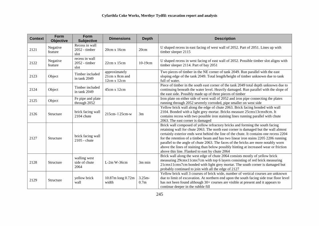
Cyfarthfa Coke Works, Merthyr Tydfil: excavation report and analysis
245
Context Form
Objective Form
Subjective Dimensions Depth Description
2121 Negative
feature
Recess in wall
2052 - timber
slot
20cm x 16cm 20cm U shaped recess in east facing of west wall of 2052. Part of 2051. Lines up with
timber sleeper 2115
2122 Negative
feature
recess in wall
2052 - timber
slot
22cm x 15cm 10-19cm U shaped recess in west facing of east wall of 2052. Possible timber slot aligns with
timber sleeper 2114. Part of bay 2051
2123 Object Timber included
in tank 2049
approximately
21cm x 8cm and
12cm x 12cm
Two pieces of timber in the NE corner of tank 2049. Run parallel with the east
sloping edge of the tank 2049. Total length/height of timber unknown due to tank
full of water.
2124 Object Timber included
in tank 2049 45cm x 12cm
Piece of timber in the south east corner of the tank 2049 total depth unknown due to
continuing beneath the water level. Heavily damaged. Run parallel with the slope of
the east side. Possibly made up of three pieces of timber
2125 Object Fe pipe and plate
through 2052
Iron plate on either side of west wall of 2052 and iron pipe connecting the plates
running through 2052 severely corroded, pipe smaller on west side
2126 Structure brick facing wall
2104 chute 215cm- l 25cm-w 3m
Yellow brick wall along the edge of chute 2063. Brick facing bonded with wall
2104. Bonded with a light grey mortar. Bricks measure 25cmx13cmx8cm. It
contains recess with two possible iron staining lines running parallel with chute
2063. The east corner is damaged
2127 Structure brick facing wall
2105 - chute
Brick wall composed of yellow refractory bricks and forming the south facing
retaining wall for chute 2063. The north east corner is damaged but the wall almost
certainly exterior ends west behind the line of the chute. It contains one recess 2204
for the retention of a timber beam and has two linear iron stains 2205 2206 running
parallel to the angle of chute 2063. The faces of the bricks are more notably worn
above the lines of staining than below possibly hinting at increased wear or friction
above this line. Flanked to east by chute 2064
2128 Structure
walling west
side of chute
2064
L-2m W-36cm 3m min
Brick wall along the west edge of chute 2064 consists mostly of yellow brick
measuring 29cmx11cmx7cm with top 6 layers consisting of red brick measuring
21cmx11cmx7cm bonded with light grey mortar. The south corner is damaged but
probably continued to join with all the edge of 2127
2129 Structure yellow brick
wall
10.87m long 0.72m
width
3.25m-
0.7m
Yellow brick wall 3 courses of brick wide, number of vertical courses are unknown
due to limit of excavation. At northern end upon the south facing side true floor level
has not been found although 30+ courses are visible at present and it appears to
continue deeper in the rubble fill
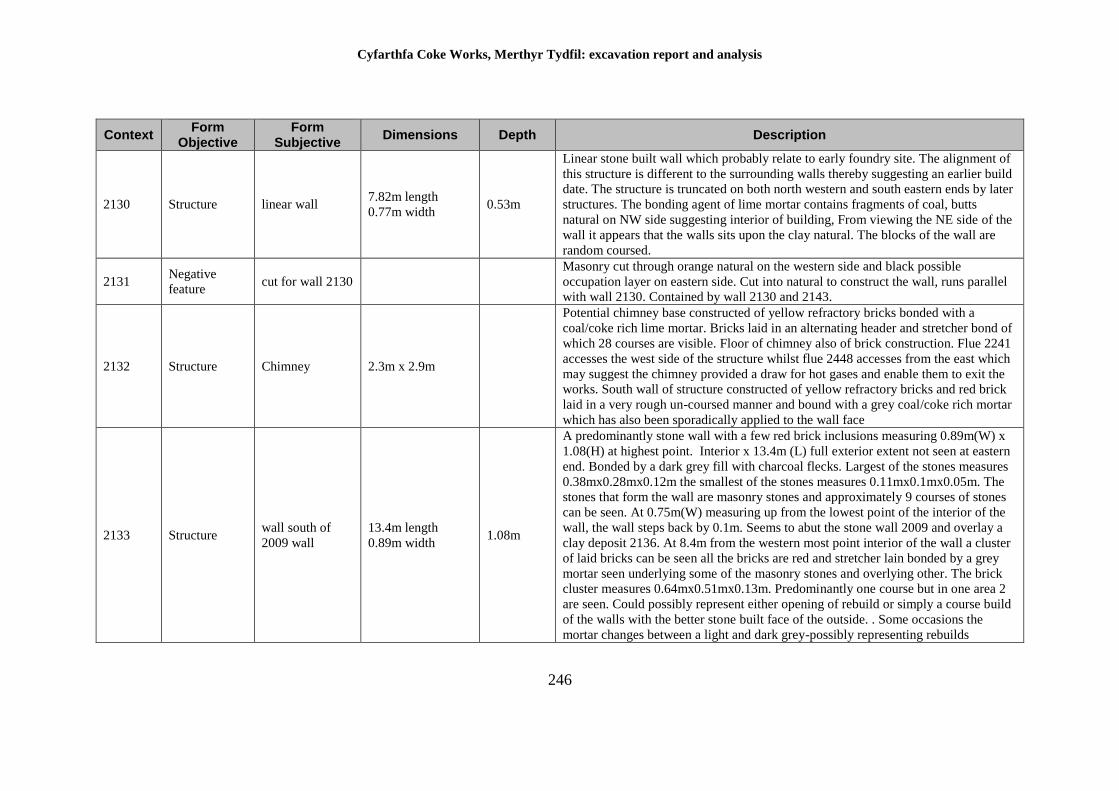
Cyfarthfa Coke Works, Merthyr Tydfil: excavation report and analysis
246
Context Form
Objective Form
Subjective Dimensions Depth Description
2130 Structure linear wall 7.82m length
0.77m width 0.53m
Linear stone built wall which probably relate to early foundry site. The alignment of
this structure is different to the surrounding walls thereby suggesting an earlier build
date. The structure is truncated on both north western and south eastern ends by later
structures. The bonding agent of lime mortar contains fragments of coal, butts
natural on NW side suggesting interior of building, From viewing the NE side of the
wall it appears that the walls sits upon the clay natural. The blocks of the wall are
random coursed.
2131 Negative
feature cut for wall 2130
Masonry cut through orange natural on the western side and black possible
occupation layer on eastern side. Cut into natural to construct the wall, runs parallel
with wall 2130. Contained by wall 2130 and 2143.
2132 Structure Chimney 2.3m x 2.9m
Potential chimney base constructed of yellow refractory bricks bonded with a
coal/coke rich lime mortar. Bricks laid in an alternating header and stretcher bond of
which 28 courses are visible. Floor of chimney also of brick construction. Flue 2241
accesses the west side of the structure whilst flue 2448 accesses from the east which
may suggest the chimney provided a draw for hot gases and enable them to exit the
works. South wall of structure constructed of yellow refractory bricks and red brick
laid in a very rough un-coursed manner and bound with a grey coal/coke rich mortar
which has also been sporadically applied to the wall face
2133 Structure wall south of
2009 wall
13.4m length
0.89m width 1.08m
A predominantly stone wall with a few red brick inclusions measuring 0.89m(W) x
1.08(H) at highest point. Interior x 13.4m (L) full exterior extent not seen at eastern
end. Bonded by a dark grey fill with charcoal flecks. Largest of the stones measures
0.38mx0.28mx0.12m the smallest of the stones measures 0.11mx0.1mx0.05m. The
stones that form the wall are masonry stones and approximately 9 courses of stones
can be seen. At 0.75m(W) measuring up from the lowest point of the interior of the
wall, the wall steps back by 0.1m. Seems to abut the stone wall 2009 and overlay a
clay deposit 2136. At 8.4m from the western most point interior of the wall a cluster
of laid bricks can be seen all the bricks are red and stretcher lain bonded by a grey
mortar seen underlying some of the masonry stones and overlying other. The brick
cluster measures 0.64mx0.51mx0.13m. Predominantly one course but in one area 2
are seen. Could possibly represent either opening of rebuild or simply a course build
of the walls with the better stone built face of the outside. . Some occasions the
mortar changes between a light and dark grey-possibly representing rebuilds

Cyfarthfa Coke Works, Merthyr Tydfil: excavation report and analysis
247
Context Form
Objective Form
Subjective Dimensions Depth Description
2134 Deposit
rubble fill
between
2011/2009
4.6m-L 0.77m-W 0.6m
A grey colour silty industrial deposit containing rubble from the flue walls 2011 and
brick dust along with some mortar. Also seen possibly containing stones from the
wall 2009 seen as rubble fill between the walls 2009 2011 measures 0.77m (W)
between the two walls x 4.6m (full extent not seen) neither east nor west. Seems to
then underlie the black/dark grey deposit 2293 to the west
2135 Negative
feature
Wall trench
foundation cut
>10m length,
0.75m width unknown
Likely machine cut edge for a trench to enable building of wall to coke ovens flue
2138 and wall 2009 in particular.
Cut subsequently cut by 2284 the foundation trench for 2133
2136 Deposit Fill of trench 7.2m x 0.75m 0.27m
An orange/red deposit (clay) containing a frequent amount of small and large
pebbles. It is seen contained by the cut 2135 abutting the wall 2009 and underlying
the wall 21353 partial by 1.65m from the walls western-most part to the east it is
partially overlying the brick culverts 2005 by 0.33m and underlying the stones
overlying the culvert 2002.
2137 Structure Brick walling
west end of flue 3.03m x 0.51m 0.99m
A brick formed wall, forming as the end wall (w end) of the flue structure, formed
from yellow bricks, bonded by a dark grey mortar with charcoal flecks. It features
approximately 10 courses and contains both stretcher and header lain bricks. Seen
bonded with the e-w running walls 2011.Seen as a U shape the walls 2011 then
continue east from this.
2138 Group Southern coke
oven flue group Group number for flue. 2009-12, 2377, 2283-6, 2280-1, 2288, 2133-6, 2293, 2276-8
2139 Structure Modern manhole
chamber 1.2m x 1.14m 0.95m
Modern manhole chamber, only bottom part remains. Constructed with red bricks
stamped with NCB TREDEGAR measuring 0.22m x 0.105m x 0.07m and bonded
with grey mortar with no inclusions. Built onto a base of concrete at least 0.1m thick.
It appears to connect with pipes. The south end of the chamber appears to abut the N
facing side of the N 2011.
2140 Structure Brick Wall 1.4m x 0.63m 0.5m Small wall made of yellow bricks. Northern side is truncated but appears to be close
to ending. Poorly preserved.
2141 Structure Yellow brick
walling 7.1m x 0.75m 0.95m
Yellow brick wall. On corner with 2143, original south extension is cut and replaced
by wall 2142 made of stone. Evidence of this is the fact bricks are coming out of the
corner and protruding onto the stone. Original height of the wall lost. On west side
unclear if it is truncated or just a degraded face. On top circular hole is present,
0.15m across.
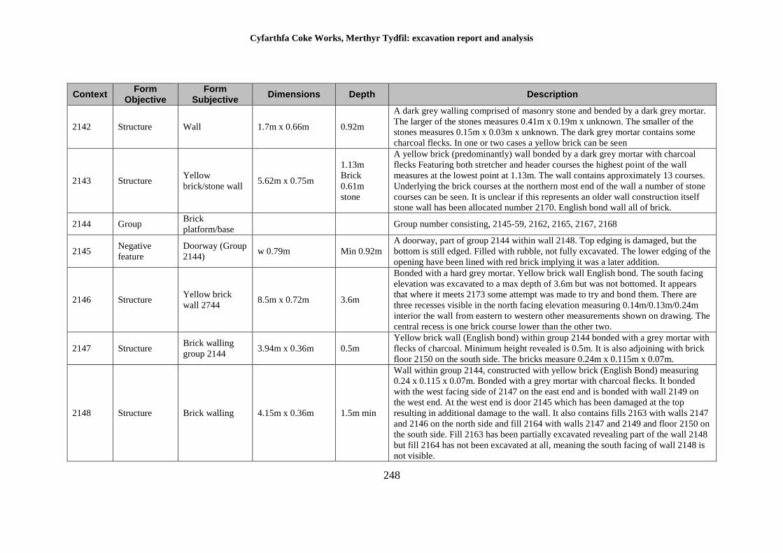
Cyfarthfa Coke Works, Merthyr Tydfil: excavation report and analysis
248
Context Form
Objective Form
Subjective Dimensions Depth Description
2142 Structure Wall 1.7m x 0.66m 0.92m
A dark grey walling comprised of masonry stone and bended by a dark grey mortar.
The larger of the stones measures 0.41m x 0.19m x unknown. The smaller of the
stones measures 0.15m x 0.03m x unknown. The dark grey mortar contains some
charcoal flecks. In one or two cases a yellow brick can be seen
2143 Structure Yellow
brick/stone wall 5.62m x 0.75m
1.13m
Brick
0.61m
stone
A yellow brick (predominantly) wall bonded by a dark grey mortar with charcoal
flecks Featuring both stretcher and header courses the highest point of the wall
measures at the lowest point at 1.13m. The wall contains approximately 13 courses.
Underlying the brick courses at the northern most end of the wall a number of stone
courses can be seen. It is unclear if this represents an older wall construction itself
stone wall has been allocated number 2170. English bond wall all of brick.
2144 Group Brick
platform/base Group number consisting, 2145-59, 2162, 2165, 2167, 2168
2145 Negative
feature
Doorway (Group
2144) w 0.79m Min 0.92m
A doorway, part of group 2144 within wall 2148. Top edging is damaged, but the
bottom is still edged. Filled with rubble, not fully excavated. The lower edging of the
opening have been lined with red brick implying it was a later addition.
2146 Structure Yellow brick
wall 2744 8.5m x 0.72m 3.6m
Bonded with a hard grey mortar. Yellow brick wall English bond. The south facing
elevation was excavated to a max depth of 3.6m but was not bottomed. It appears
that where it meets 2173 some attempt was made to try and bond them. There are
three recesses visible in the north facing elevation measuring 0.14m/0.13m/0.24m
interior the wall from eastern to western other measurements shown on drawing. The
central recess is one brick course lower than the other two.
2147 Structure Brick walling
group 2144 3.94m x 0.36m 0.5m
Yellow brick wall (English bond) within group 2144 bonded with a grey mortar with
flecks of charcoal. Minimum height revealed is 0.5m. It is also adjoining with brick
floor 2150 on the south side. The bricks measure 0.24m x 0.115m x 0.07m.
2148 Structure Brick walling 4.15m x 0.36m 1.5m min
Wall within group 2144, constructed with yellow brick (English Bond) measuring
0.24 x 0.115 x 0.07m. Bonded with a grey mortar with charcoal flecks. It bonded
with the west facing side of 2147 on the east end and is bonded with wall 2149 on
the west end. At the west end is door 2145 which has been damaged at the top
resulting in additional damage to the wall. It also contains fills 2163 with walls 2147
and 2146 on the north side and fill 2164 with walls 2147 and 2149 and floor 2150 on
the south side. Fill 2163 has been partially excavated revealing part of the wall 2148
but fill 2164 has not been excavated at all, meaning the south facing of wall 2148 is
not visible.
Cyfarthfa Coke Works, Merthyr Tydfil: excavation report and analysis
249
Context Form
Objective Form
Subjective Dimensions Depth Description
2149 Structure brick walling
group 2144
2.24m length
0.37m width 2m n.b
Yellow brick wall, English bond with a hard grey mortar with black and white
flecks. Full depth was not excavated maximum depth seen on the west face, not
excavated on its eastern face.
2150 Structure
Brick
platform/base
group 2144
3.89m length
4.94m width
Yellow brick platform, base of possible machinery. Square in shape although
damaged bricks in areas. Grey mortar does not appear to be heat affected. Multiple
brick layers used to construct platform/multiple courses. Possibly the same
floor/platform as 2167 although damaged in the middle, only 2166 concrete remains
could show construction, possible basal layer for brick for brick course platform.
Although they do appear to be separate platforms. The straight end of bricks facing
south do not have mortar remains upon, supporting the idea that they are separate
features/platforms
2151 Structure chimney group
2144 0.58m 0.59m
Chimney within 2150 part of group 2151 external limits are unclear interior apparent
constructed from yellow brick, grey mortar in a header stretcher pattern on visible
courses within brick floor/platform 2150 although area is separate from machinery
anchor area can be seen in western corner of 2150/group 2144 south facing interior
of chimney suggests that higher courses had a different brick pattern. Change from
stretcher-header
2152 Object anchor bolt of
group 2144
0.83m length
0.04m width
Fe anchor bolt used to hold down machinery upon 2150 used in conjunction with
2153 2154 2156 2157 2158 2159 to brace/hold machinery in place upon brick base
2150. Majority of anchor bolts on the same east western alignment including this
example 2159 2158 more northerly but one upon the same alignment. Majority of
surviving anchor bolts at southern edge of 2150. Two others at northern edge. The
iron anchor itself is angled towards south east. Length of surviving anchor 0.83m
0.04m thick. Other than being cut into 2150 Fe anchor is approximately 0.18m from
brick floor layer below.
2153 Object anchor bolt
group 2144 0.55m x 0.05m
Fe anchor bolt used in conjunction with the other examples to held down machinery
upon brick base 2150. 6 in a line at the southern edge of brick base. Possibly
suggesting more restraint was needed from the southern side.
2154 Object anchor part of
group 2144 0.14m 0.05m
Fe anchor bolt used to hold down machinery in conjunction with 2152 2153 2156
2157 2158 2159 cuts into brick base 2150, which is a brick machinery platform
majority of anchors needed on the southern edge of 2150, suggesting more restraint
was needed from this side. Very little remaining from this example although the
original cut through 2150 is visible, slightly offline with other southern examples.
Cyfarthfa Coke Works, Merthyr Tydfil: excavation report and analysis
250
Context Form
Objective Form
Subjective Dimensions Depth Description
2155 Object anchoor bolt of
group 2144
0.25m-L 40mm
diameter
Fe anchor bolt used to hold up/down machinery upon/within 2150 brick platform
part of group 2144.
2156 Object anchor bolt of
2144
0.6m 40mm
diameter
Fe anchor bolt used to hold up/down machinery upon/within 2150 brick platform
part of group 2144
2157 Object Anchor bolt of
groupp 2144
length-0.25m
40mm diameter
Fe anchor bolt used to hold up/down machinery upon/within 2150 brick platform
part of group 2144
2158 Object anchor bolt of
group 2144
0.45m length
40mm diameter
Fe anchor bolt used to hold up/down machinery upon/within 2150 brick platform
part of group 2144
2159 Object anchor bolt of
group 2144
0.25m length
40mm diameter
Fe anchor bolt used to hold down/up machinery upon/within 2150 brick platform
part of group 2144.
2160 Object Fe plate from
chute 2162
w=0.47m min
L=1.09m <10mm
thick
Iron plate within chute 2162 on the south wall of chute, heavily corroded, not fully
excavated/revealed, therefore total length unknown
2161 Object
Timber
(vibration
suppressor)
L=0.5m, w=0.09m
x 10cm Timber vibration suppressor within chute 2162, greatly damaged on the top
2162 Structure chute in base
2150 group 2144
L=1.38m
w==0.53m 0.52-0.62m
Rectangular chute heading downwards towards the north. Contains an iron plate
2160 and timber resting behind the iron 2161. Built in amongst large yellow bricks
of 2150 part of group 2144 seems to have contained same fill as 2164.
2163 Deposit fill between
2150 2129 2146
Maybe same fill as 2164 fill of bay in between walls 2129 2146 2142 2148 2149 and
large brick area 2150. Fill contains large amounts of brick and stone and rubble,
surrounding walls are made of yellow brick unsure how deep area is.
2164 Deposit fill between
2148 2150
L=3.82m
w=1.84m-2.1m
Rubble fill between 2148 and 2150, contains stone/brick and smaller pieces. Unsure
of how deep area would have been. Same rubble may have filled 2162. Maybe same
fill as 2163.
2165 Negative
feature
cut in group
2144 (void) L=3.1m w=2.3m 1.56m
Rubble is filled with stone bricks and large amounts of cement/mortar that has been
destroyed and fallen in from 2167 2166 2169 2129 2150. Cement mortar is white
with small pieces of rubble/brick/stone in. Rubble also contains lime slag
2166 Structure
concrete/brick/li
me slag
foundation
9.7m=L
Dark grey cement covering lime slag. Iron staining on south corner. Mortar cement
floor. Seems to be part of, and underlying 2167. Uneven floor level possibly made so
by machine, contains lime mortar, brick, lime slag. May have originally been
covered by the yellow bricks in 2167. May have been resting on lime slag pile.
Cyfarthfa Coke Works, Merthyr Tydfil: excavation report and analysis
251
Context Form
Objective Form
Subjective Dimensions Depth Description
2167 Structure brick floor 2144 L=6.4m w==5.2m
Brick surface is bonded with dark grey mortar possibly contemporary with 2150. It
has been constructed on a pile of lime slag topped with lime mortar to strengthen as
can be seen by a section cut made by machine next to 2165. In bad condition with
most of the bricks having been destroyed. Because of the destruction of the bricks
the dark grey mortar is visible and seems to slope and disappear into 2166. At the
highest level 2 courses of brick are visible in patches above the level of 2166. It
seems likely that the yellow bricks in 2167 may have extended to cover 2166
2168 Negative
feature
pipe line cut
through group
2144
0.74m width 13+m
length 1.14m
Cut through group 2144 on the west side probably for a modern sewer pipe. Leads
from manhole 2034, no evidence of the pipe itself but the cut is substantial. Several
other features have been cut by the course of this pipe
2169 Structure wall part of 2150
0.62m thick
opposite 2161 up
to 0.95m 2.36m+
long
Yellow firebrick wall English bond construction with hard grey mortar, roughly
pointed probably intended to be buried. Forms the southern wall of a probable
chimney stack (2161). The top of the wall is covered with modern looking off-white
concrete with gravel inclusions bedding for a pipe. On close inspection, the wall is
part of 2150 as a single build, no separate phasing for 2169 is visible.
2170 Structure Masonry at base
of wall 2143
2.56m L x
unknown width 0.56m
Section of stone making up part of the base of yellow fire brick wall 2143. The stone
has been used at the point of intersection of wall 2130 and 2143, although neither
wall actually touches. The stones present a rectangular appearance, being fair faced
and bonded with un-pointed hard grey mortar, suggesting the length of wall was
intended to be buried. The wall is 7 courses high as excavated and appears to be
lower than the brick base of the rest of the wall. There is no obvious reason for this
section of the wall to be stone.
2171 Negative
feature Trench for wall 0.9m W x 8.65mL
Cut for foundation of wall 2174 filled with large angular stones and a grey sandy
grit. Truncated by wall 2207 which is probably later date and 2143 which is earlier
and unexcavated.
2172 Group
Four Bay
Masonry
Structure
19.35m L x 8.65m
W 1.5m
Four bays separated by internal walls and with no apparent entrances. Partially
excavated not to base. Bay fills are 2194, 2195, 2196 and 2197. Walls are 2176,
2181, 2175, 2177, 2178, 2173, 2174, 2180 and 2179. Also present are square box
negative features 2193, 2192, 2191, 2190, 2189, 2188, 2187, 2186, 2185, 2184, 2183
and Fe object 2182.
2173 Structure
Masonry
Walling of group
2172
18.25m L x 0.75m
W 1.45m
Wall of group 2172. Built butting brick floor____ , of which it is a later addition.
Unlike other walls in the group it contains no recess. It was constructed with wall
Cyfarthfa Coke Works, Merthyr Tydfil: excavation report and analysis
252
Context Form
Objective Form
Subjective Dimensions Depth Description
2174 and 2177 with which it is bonded but earlier than 2179 which is butted against
2173.
2174 Structure Masonry wall of
group 2172 8.65m L x 0.6m W 1.5m
Stone wall part of group 2172. Foundation cut is 2171. Only potentially still standing
with height changing throughout the structure. Bonded with 2175 and 2173, butted
by 2178. Contains recesses 2183 as an iron base.
2175 Structure Masonry walling
of group 2172 1m W x 3.9m L 1.45m
Stone wall part of 2172. Bonded by wall 2174 and butted by 2198. Also butted by
later wall 2208. Contains a plinth 1m from base and 17cm protruding. Also contains
recess 2185 0.6m from base.
2176 Structure Masonry walling
group 2172 3.9m L x 1m W 1.4m
Stone wall part of 2172. Built together with and bonded with wall 2177. On southern
side butted by 2113, which appears to be a later addition. Contains a plinth 1m from
the base and 0.2m protrusion. Contains recess 2192 and 2193 0.5m from base.
2177 Structure Masonry walling
of group 2172
8.65m L x 0.65m
W 1.4m
Stone wall part of 2172. Built together with and bonded with 2173 and 2176 as well
as potentially 2178 although less clear. Contains no recess unlike other walls in this
group. N-facing side has height of 2.1m suggesting the base may be deeper than
excavated.
2178 Structure Masonry walling
of group 2172
18.25m L x 0.95m
W 1.2m
Central wall of 4 bays made of masonry stone. Grey mortar. Two masonry walls
2179 and 2180 bonded at the centre. North most walls bonded to 2177. South most
bonded to 2174. Comprised of various sized masonry stones, very large to medium
stones northern edge west facing wall face comprises two recesses 2189 and 2190.
Southern end. East facing wall of masonry also has recesses 2187, 2186 and 2184.
Fe object resting approximately 7cm onto current top course of wall 2182. Mortar is
grey in colour with charcoal flecks. Average brick dimensions 19 x 8 x 11cm.
2179 Structure Masonry walling
of group 2172 3.1m L x 0.65m W 1.08m
Masonry divider wall of 2 bays abutting 2178 and 2173. Large to medium masonry
stones used for construction not as wide as surrounding walls, 3 courses in width.
Faced on either side, both north and south facing walls no recesses in either face.
Small damage to some places.
2180 Structure Masonry walling
of group 2172
3.05m L x 0.64m
W 1.37m
Dividing masonry wall of two bays. Large to medium stones used in construction
width the same as 2179, suggesting inside walls 2-3 courses of stone used in
construction recess in wall in north facing face approximately. 1.1m from top of wall
2191.
Cyfarthfa Coke Works, Merthyr Tydfil: excavation report and analysis
253
Context Form
Objective Form
Subjective Dimensions Depth Description
2181 Structure Masonry walling
of group 2171 9.9m L x 0.79m W 1.31m
Masonry walling between 2175 and 2176 later addition to construction however
2180 overlies suggesting central bay divisions are later addition to a once open area
comprised of the 4 main walls 2174, 2173, 2177 and the eastern walls 2175 and
2176 meaning a gap where a entrance/exit due to facing stones being visible upon
2175 2181 abuts 2175. The southern edge west facing side of 2181has staggered
masonry sticking out of it which may suggest remnants of a contemporary wall.
There is also a plinth that runs the length of the whole 3 construction phases. 2175,
2181, 2176. Approximately 1m in height and 20cm in width. More staggered stones
are visible at the northern edge of the wall on the west facing wall face. Possibly
once again suggesting a contemporary wall which is no longer detectable. East
facing face faced with masonry. Masonry stones are southern edge are contemporary
with 2198 appears to fill a gap between 2175 and 2181. 2181 is a later addition as is
northern edge with staggered stones appear. (although less obvious) to be
contemporary with 2199. Height on eastern face to floor/ current floor level = 1.31m.
Western face to current floor level 1.3m.
2182 Object Iron Rail 3.07m L x 0.05-8m
W 0.1m
Iron rail balanced upon current remains of wall 2178 and plinth of wall 2181.
Unknown if this is original position although appears to be stable. Appears to have
collapsed into situ. Possible iron girder used as support for roofing. Apparent shape
visible - see photos.
2183 Negative
feature
recess in walling
group 2172 0.19m x 0.21m 0.15m
Recess in wall 2174 upon north facing wall. 0.18m from top of wall 0.6m from
current floor level.
2184 Negative
feature
recess in walling
group 2172 w=0.14m 0.11m
Recess in wall 2178 on eastern side located 0.63m from the current top of wall and
0.36m from corner between 2178 and 2174 offset by 0.16m
2185 Negative
feature
recess in walling
2172
l=0.41m-0.29m
w=0.2m 0.17m
Recess in wall 2175 upon west facing wall in alignment with another recess on wall
2178 although larger and an odd shape (see sketch) 0.5m down from plinth of 2175
0.18m up from current floor level.
2186 Negative
feature
recess in wall
2172
0.17m height
0.26m length
0.19m width
Recess in wall 2178 upon east facing wall. 0.17m down to current floor level 0.73m
to top remaining course of 2178 it is unclear if this is reflected in wall 2181 due to
unexcavated area
2187 Negative
feature
recess in wall
2172 w=0.28m 0.17m
Recess in wall 2178 18cm thin wall. located 61cm from remaining top wall 20cm
from corner with wall 2180 recess in E face of 2178
2188 Negative
feature
recess in wall
2172 w=30cm 14cm
Recess in wall 2173/9??? on N facing side located 52cm from current top wall 18cm
from corner between 2179 and 2173 offset by 19cm
Cyfarthfa Coke Works, Merthyr Tydfil: excavation report and analysis
254
Context Form
Objective Form
Subjective Dimensions Depth Description
2189 Negative
feature
recess in wall
2172 25cm 23cm
Recess in wall 2178 on the west facing side located 53cm from the current top of
wall and 43cm from corner between 2178 and 2179 offset 23cm
2190 Negative
feature
recess in wall
group 2172
170mm deep,
280mm wide,
155mm inset into
wall 2178
Rectangular “beam socket" in west facing elevation of wall 2178 In NW chamber,
part of 4 walled chamber group 2172. Substantial stones on all four sides of recesses,
2189 is similar in construction. Suggests designed to hold beam firmly in position,
perhaps to ??? out vibration
2191 Negative
feature
recess in wall
group 2172
190mmx105mm
inserted 180mm
into 2180
Recess beam socket in wall 2180 in N facing elevation
2192 Negative
feature
recess in wall
group 2172
Beam socket in wall 2173 (s end of). One of three set at some 'level' within NE
chamber within group 2172
2193 Negative
feature
recess in wall
group 2172
Beam slot in wall 2173 part of 2172 group. As with 2192 a beam slot created within
west elevation of wall 2173. Construction making use of large sandstone/iron stone
blocks
2194 Deposit fill between bays
of 2172
Fill of bay of group 2172 with frequent brick and angular stone, within a sandy
grout. Dump layer created in one phase when the bay was abandoned, Not fully
excavated
2195 Deposit fill between bays
of 2172
Fill of bay of group 2172 with frequent brick and angular stones within a sandy grit.
Dump layer created in one phase when the bay was abandoned not fully excavated
2196 Deposit fill between bays
of 2172
Fill of bay of group 2172 with frequent brick and angular stones within a sandy grit.
Dump layer created in one phase when the bay was abandoned not fully excavated
2197 Deposit fill between bays
2172
Fill of bays of group 2172 with frequent brick and angular stone, within a sandy grit,
dump layer created in one phase when the bay was abandoned not fully excavated
2198 Structure South coal coke
bay
37.3m L x 0.67m
W
Stone block wall with part of a coke bay. Butted against red brick through 2202.
Western end truncated and bonded with 2181, butts 2175. Parallel to 2199, section
missing at 19.7m from the west and 23.7m from the W for 2.3m and 1.1m
respectively. At 34.1m from the south there is a 0.3m by 0.36m recess. Eastern end
not fully excavated.
Cyfarthfa Coke Works, Merthyr Tydfil: excavation report and analysis
255
Context Form
Objective Form
Subjective Dimensions Depth Description
2199 North Wall Coke
Bay
38.9m L x 0.69m
TH 1.8m
Extensive masonry wall forming the south elevation of the North Coppée oven
battery. Built of largely rectangular, grey sandstone blocks bonded with hard grey
coal rich mortar. The wall is a quality build, nicely worked stone, jointing is highly
rectangular. Although the coursing is irregular. Red brick trough 2202 adjoins the
rear (N) face of the wall. The masonry contains two square recesses in its length.
Sandstone blocks vary in size from 0.07m x 0.05m to 0.56m x 0.17m. The upper part
of the wall is missing and the lower parts are below the excavation level but it
survives to some 15 courses in places. There is no discolouration from coke or coal
visible on the stonework, probably as it was exposed to the elements. No evidence of
any of the stone being re-used from earlier structure i.e. the mortar stains. On
examination of a photograph provided by Alan George , the square recess are likely
to be to retain the upper part of the bulkhead assemblies for the different components
in the coke bins.
2200 Deposit Fill in coke bay
General demolition layer forming the fill between the two batteries of coke ovens in
the area shown as coke bins on OS mapping. The deposit consists of a variety of
refractory brick, red brick, stone blocks, shale, slag and small iron fragments/objects
like pins and washers. This is almost certainly the general demolition left as a result
of destruction of the coke ovens. Depth is unknown.
Cyfarthfa Coke Works, Merthyr Tydfil: excavation report and analysis
256
Context Form
Objective Form
Subjective Dimensions Depth Description
2201 Structure Red brick trough
- south
0.51m base width,
1.1m overall width,
32.5m L as e
1.09m
external
height,
0.5m
internal
height max
Red brick built trough, adjoining masonry wall 2198 and running parallel to it. The
wall is bonded with hard grey gritty mortar with the brick being machine made and
displaying circular mould marks which are different to those seen in the brick for
trough 2202. The south wall of the trough is 0.48m wide surviving to 9 courses
maximum. The internal face contains 8 square recesses, measuring 60mm x 55mm
most of which are damaged and iron stained. These recesses are found at 0.31m from
the base at the west to 0.42m from the base towards the east reflecting the fall in the
trough line in this direction. The base is constructed from bricks laid flat but is not
bonded into either wall. The north wall of the trough is a single skin of brick, much
damaged towards the eastern extent. The floor of the trough cants to the south at its
easternmost extent, creating a build-up and possibly indicating slumping during its
operational life. The external flue (southern) of the trough is much better finished
than trough 2202 with neater pointer evident. English bond construction for much of
its height but the pattern changes at the upper and lower portions. The wall steps out
to the south for 3 courses before stepping in again - this is different to that employed
in 2202. The trough has been cut by the course of a modern pipe trench.
IMPRESSION: This trench is almost certainly a housing for a high pressure hose
pipe for quenching the coke as it comes out of the ovens. There is no evidence for it
being a drain i.e. No silting etc. It is virtually a minor copy of the trough to the north
(2202) although the built quality and bricks are superior. The trough is more
damaged than 2002 but its form and function can still be discussed. A section of
rusted iron pipe is still attached to masonry wall 2199 which is probably the remains
of a water pipe Feeding into the trough from the south. The recess for holding the
water pipe are mirrored by iron stains on the opposite wall though there is no
evidence of recesses. Rather it suggests something iron against the bricks.
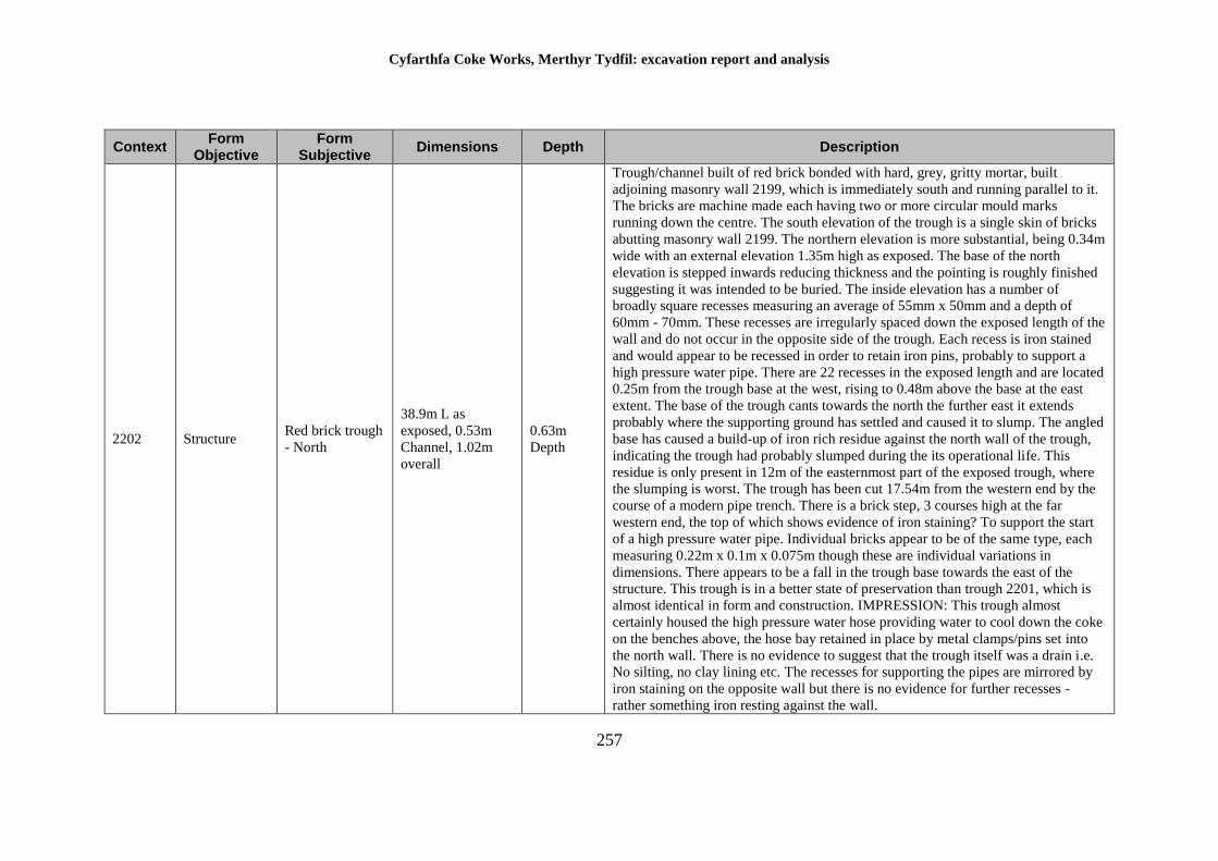
Cyfarthfa Coke Works, Merthyr Tydfil: excavation report and analysis
257
Context Form
Objective Form
Subjective Dimensions Depth Description
2202 Structure Red brick trough
- North
38.9m L as
exposed, 0.53m
Channel, 1.02m
overall
0.63m
Depth
Trough/channel built of red brick bonded with hard, grey, gritty mortar, built
adjoining masonry wall 2199, which is immediately south and running parallel to it.
The bricks are machine made each having two or more circular mould marks
running down the centre. The south elevation of the trough is a single skin of bricks
abutting masonry wall 2199. The northern elevation is more substantial, being 0.34m
wide with an external elevation 1.35m high as exposed. The base of the north
elevation is stepped inwards reducing thickness and the pointing is roughly finished
suggesting it was intended to be buried. The inside elevation has a number of
broadly square recesses measuring an average of 55mm x 50mm and a depth of
60mm - 70mm. These recesses are irregularly spaced down the exposed length of the
wall and do not occur in the opposite side of the trough. Each recess is iron stained
and would appear to be recessed in order to retain iron pins, probably to support a
high pressure water pipe. There are 22 recesses in the exposed length and are located
0.25m from the trough base at the west, rising to 0.48m above the base at the east
extent. The base of the trough cants towards the north the further east it extends
probably where the supporting ground has settled and caused it to slump. The angled
base has caused a build-up of iron rich residue against the north wall of the trough,
indicating the trough had probably slumped during the its operational life. This
residue is only present in 12m of the easternmost part of the exposed trough, where
the slumping is worst. The trough has been cut 17.54m from the western end by the
course of a modern pipe trench. There is a brick step, 3 courses high at the far
western end, the top of which shows evidence of iron staining? To support the start
of a high pressure water pipe. Individual bricks appear to be of the same type, each
measuring 0.22m x 0.1m x 0.075m though these are individual variations in
dimensions. There appears to be a fall in the trough base towards the east of the
structure. This trough is in a better state of preservation than trough 2201, which is
almost identical in form and construction. IMPRESSION: This trough almost
certainly housed the high pressure water hose providing water to cool down the coke
on the benches above, the hose bay retained in place by metal clamps/pins set into
the north wall. There is no evidence to suggest that the trough itself was a drain i.e.
No silting, no clay lining etc. The recesses for supporting the pipes are mirrored by
iron staining on the opposite wall but there is no evidence for further recesses -
rather something iron resting against the wall.
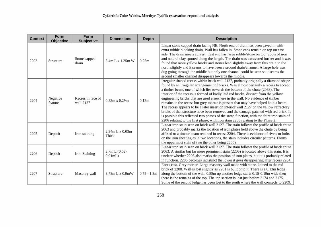
Cyfarthfa Coke Works, Merthyr Tydfil: excavation report and analysis
258
Context Form
Objective Form
Subjective Dimensions Depth Description
2203 Structure Stone capped
drain 5.4m L x 1.25m W 0.25m
Linear stone capped drain facing NE. North end of drain has been caved in with
extra rubble blocking drain. Wall has fallen in. Stone caps remain on top on east
side. The drain meets culvert. East end has large rubble/stone on top. Spots of iron
and natural clay spotted along the length. The drain was excavated further and it was
found that more yellow bricks and stones lead slightly away from this drain to the
north slightly and it seems to have been a second drain/channel. A large hole was
dug going through the middle but only one channel could be seen so it seems the
second smaller channel disappears towards the middle.
2204 Negative
feature
Recess in face of
wall 2127 0.33m x 0.29m 0.13m
Irregular shaped recess within brick wall 2127, probably originally a diamond shape
found by an irregular arrangement of bricks. Was almost certainly a recess to accept
a timber beam, one of which lies towards the bottom of the chute (2063). The
interior of the recess is formed of badly laid red bricks, distinct from the yellow
engineering bricks that are used elsewhere in the wall. No evidence of timber
remains in the recess but grey mortar is present that may have helped hold a beam.
The recess appears to be a later insertion interior wall 2127 on the yellow refractory
bricks of that structure have been removed and the damage patched with red brick. It
is possible this reflected two phases of the same function, with the faint iron stain of
2206 relating to the first phase, with iron stain 2205 relating to the Phase 2.
2205 Deposit Iron staining 2.94m L x 0.03m
Thick
Linear iron stain seen on brick wall 2127. The stain follows the profile of brick chute
2063 and probably marks the location of iron plates held above the chute by being
affixed to a timber beam retained in recess 2204. There is evidence of rivets or bolts
on the iron sheeting as in two locations, the stain includes circular patterns. Forms
the uppermost stain of two the other being 2206).
2206 Deposit Iron Staining 2.7m L (0.02-
0.01mL)
Linear iron stain seen on brick wall 2127. The stain follows the profile of brick chute
2063. A similar but far more prominent stain (2205) is located above this stain. It is
unclear whether 2206 also marks the position of iron plates, but it is probably related
in function. 2206 becomes indistinct the lower it goes disappearing after recess 2204.
2207 Structure Masonry wall 8.78m L x 0.9mW 0.75 - 1.3m
Faces east. Grey mortar. Large masonry wall made with stone. Joined to the red
brick of 2208. Wall is lost slightly as 2201 is built onto it. There is a 0.13m ledge
along the bottom of the wall. 0.58m up another ledge starts 0.15-0.19m wide then
there is the remains of the top. The top section is lost just before 2174 and 2175.
Some of the second ledge has been lost to the south where the wall connects to 2209.
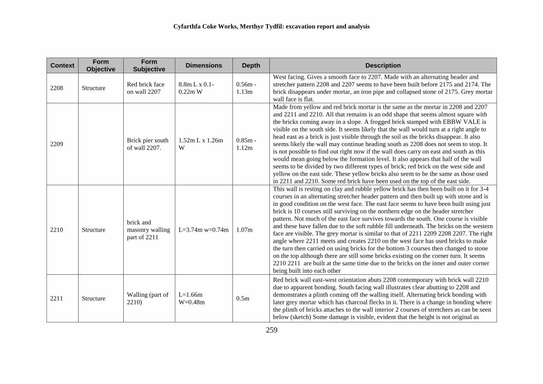
Cyfarthfa Coke Works, Merthyr Tydfil: excavation report and analysis
259
Context Form
Objective Form
Subjective Dimensions Depth Description
2208 Structure Red brick face
on wall 2207
8.8m L x 0.1-
0.22m W
0.56m -
1.13m
West facing. Gives a smooth face to 2207. Made with an alternating header and
stretcher pattern 2208 and 2207 seems to have been built before 2175 and 2174. The
brick disappears under mortar, an iron pipe and collapsed stone of 2175. Grey mortar
wall face is flat.
2209 Brick pier south
of wall 2207.
1.52m L x 1.26m
W
0.85m -
1.12m
Made from yellow and red brick mortar is the same as the mortar in 2208 and 2207
and 2211 and 2210. All that remains is an odd shape that seems almost square with
the bricks coming away in a slope. A frogged brick stamped with EBBW VALE is
visible on the south side. It seems likely that the wall would turn at a right angle to
head east as a brick is just visible through the soil as the bricks disappear. It also
seems likely the wall may continue heading south as 2208 does not seem to stop. It
is not possible to find out right now if the wall does carry on east and south as this
would mean going below the formation level. It also appears that half of the wall
seems to be divided by two different types of brick; red brick on the west side and
yellow on the east side. These yellow bricks also seem to be the same as those used
in 2211 and 2210. Some red brick have been used on the top of the east side.
2210 Structure
brick and
masonry walling
part of 2211
L=3.74m w=0.74m 1.07m
This wall is resting on clay and rubble yellow brick has then been built on it for 3-4
courses in an alternating stretcher header pattern and then built up with stone and is
in good condition on the west face. The east face seems to have been built using just
brick is 10 courses still surviving on the northern edge on the header stretcher
pattern. Not much of the east face survives towards the south. One course is visible
and these have fallen due to the soft rubble fill underneath. The bricks on the western
face are visible. The grey mortar is similar to that of 2211 2209 2208 2207. The right
angle where 2211 meets and creates 2210 on the west face has used bricks to make
the turn then carried on using bricks for the bottom 3 courses then changed to stone
on the top although there are still some bricks existing on the corner turn. It seems
2210 2211 are built at the same time due to the bricks on the inner and outer corner
being built into each other
2211 Structure Walling (part of
2210)
L=1.66m
W=0.48m 0.5m
Red brick wall east-west orientation abuts 2208 contemporary with brick wall 2210
due to apparent bonding. South facing wall illustrates clear abutting to 2208 and
demonstrates a plinth coming off the walling itself. Alternating brick bonding with
later grey mortar which has charcoal flecks in it. There is a change in bonding where
the plinth of bricks attaches to the wall interior 2 courses of stretchers as can be seen
below (sketch) Some damage is visible, evident that the height is not original as
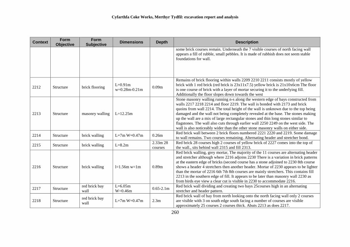
Cyfarthfa Coke Works, Merthyr Tydfil: excavation report and analysis
260
Context Form
Objective Form
Subjective Dimensions Depth Description
some brick courses remain. Underneath the 7 visible courses of north facing wall
appears a fill of rubble, small pebbles. It is made of rubbish does not seem stable
foundations for wall.
2212 Structure brick flooring L=0.91m
w=0.28m-0.21m 0.09m
Remains of brick flooring within walls 2209 2210 2211 consists mostly of yellow
brick with 1 red brick (red brick is 23x11x7.5) yellow brick is 21x10x6cm The floor
is one course of brick with a layer of mortar securing it to the underlying fill.
Additionally the floor slopes down towards the west
2213 Structure masonry walling L=12.25m
Stone masonry walling running n-s along the western edge of bays constructed from
walls 2217 2218 2214 and floor 2219. The wall is bonded with 2173 and brick
quoins from wall 2214. The total height of the wall is unknown due to the top being
damaged and the wall not being completely revealed at the base. The stones making
up the wall are a mix of large rectangular stones and thin long stones similar to
flagstones. The wall also cuts through earlier wall 2250 2249 on the west side. The
wall is also noticeably wider than the other stone masonry walls on either side.
2214 Structure brick walling L=7m W=0.47m 0.26m Red brick wall between 2 brick floors numbered 2221 2220 and 2219. Some damage
to wall remains. Two courses remaining. Alternating header and stretcher bond.
2215 Structure brick walling L=8.2m 2.33m 28
courses
Red brick 28 courses high 2 courses of yellow brick of 2227 comes into the top of
the wall., sits behind wall 2315 and fill 2313.
2216 Structure brick walling l=1.56m w=1m 0.89m
Red brick walling, grey mortar, The majority of the 11 courses are alternating header
and stretcher although where 2216 adjoins 2230 There is a variation in brick patterns
at the eastern edge of bricks (second course has a stone adjoined to 2230 8th course
shows a header 4 stretchers then another header. Mortar of 2230 appears to be lighter
than the mortar of 2216 6th 7th 8th courses are mainly stretchers. This contains fill
2213 in the southern edge of fill. It appears to be later than masonry wall 2230 as
from birds eye view a clear cut is visible in 2230 to accommodate 2216.
2217 Structure red brick bay
wall
L=6.05m
W=0.46m 0.65-2.1m
Red brick wall dividing and creating two bays 25courses high in an alternating
stretcher and header pattern.
2218 Structure red brick bay
wall L=7m W=0.47m 2.3m
Red brick wall of bay from north looking onto the north facing wall only 2 courses
are visible with 3 on south edge south facing a number of courses are visible
approximately 25 courses 2 courses thick. Abuts 2213 as does 2217.
Cyfarthfa Coke Works, Merthyr Tydfil: excavation report and analysis
261
Context Form
Objective Form
Subjective Dimensions Depth Description
2219 Structure Brick floor L=6m W=2.16m
Yellow brick floor with bricks worn away towards the west side (by machine?)
Discolouration on bricks possibly due to iron rusting. Bricks have been raised to a
higher level around the edges of the walls 2213 2218 2214 in comparison to the rest
of the floor which has uneven levels throughout possibly due to the fill underneath
sinking. The mortar is a dark grey which suggests this is a later stage of the works
compared to other area. The main pattern of the bricks seem to be a stretcher pattern
with stretcher bricks lining the edges although the western edge lining wall 2213
seems to be header pattern. Along the north edge of the floor along 2214 there are
cuts in the floor where bricks have come away revealing the fill. On the west the cut
2311 is 83cm away from wall 2213 and is 90cm long and 36cm at its widest along
2214. The fill inside 2312 is visible and still has iron remains in it. Another cut
further down is 1.9m long where one course of stretcher bricks have been removed
(11cm wide). An extra 3(?) bricks may have been moved at the top of this cut
making the widest width 30cm. Towards the east end nearest 2227 lies a large
intrusive cut 2406 1.44mx 1.17m also revealing a fill 2407. This fill may be similar
to the fill of 2312 but is difficult to know for certain occasional red brick placed
among the yellow brick.
2220 Structure Brick floor 3.12m L x 1.92m
W
Brick floor butted against wall 2214. Continues under wall 2229 and re-emerges as
floor 2221. On South side course of bricks parallel to wall and on W side a course of
larger brick, 0.35m x 0.35m butted against wall 2224 floor would have originally
continued up to wall 2225 but it is cut by 2228 floor made of a simple course brick
on a black mortar fill.
2221 Structure Brick Floor 2.3m L x 1.13m -
1.83m W
Same layout as 2219. Yellow brick in stretcher pattern. Slightly uneven level on
south edge. Grey mortar. Bricks on north side have been lost showing fill. One stone
has been placed down instead of bricks. Flooring is broken so fill of 2228 is visible
on the north side.
2222 Deposit Fill between bay
2218 and 2217 6m L x 3.8m W 2.3m
Dump layer within bay of 2218, 2217. Deposited in a single phase when bay was
abandoned probably intentionally.
2223 Deposit Fill between bay
2217/2177
Orangey/brown rubble rich fill sandy loam texture. Rubble include large stones and
medium stones, frequent small stones and bricks which are damaged same fill as
2222 not 100% excavated to the true floor level. Only partially excavated.
Cyfarthfa Coke Works, Merthyr Tydfil: excavation report and analysis
262
Context Form
Objective Form
Subjective Dimensions Depth Description
2224 Structure Part brick - part
stone wall 3.3m L x 0.7m W 1.22m
Brick wall with stone facing on W side. Clear cut on W side between stone faced
stone wall 2213. Butted by later brick 2220. Cut by void 228, where only 0.7m
remain. Bonded with wall 2225. Facing appears to be contemporary to brick part due
to lack of brick face that side.
2225 Structure Brick Wall 7.7m L x 0.75m W 1.25m
Brick wall, bonded with 2224, contains 1.25 box cut which extends entire width. An
additional row of bricks added on south side of box to top of wall. Floor 2220, 2221
and wall 2229 probably butted walls originally but has been cut by void 2228.
Butted by 2238, 2226 and 2231. Box cut begins 0.7m from base.
2226 Walling 3.08m L 2.1m
Yellow brick walling infill of an opening between redbrick wall 2225 and 2227. 25
courses. Alternating header and stretcher bonding. Later than 2225 and 2227 infilled
the void between them. Clear division no bonding the small recess in southern most
end.
2227 Structure Walling 2.14m L x 0.71m
W
0.12 -
0.23m
Grey crumbling mortar. Yellow brick same as brick door 2219. Cuts interior and
butts up against 2214 and 2218. 3 courses of brick sit on 2215 so it seems to be built
later. Could be contemporary with 2217. The face is laid out in a header - stretcher
pattern. Looking down over the top there are four rows making the wall.
2228 Negative
feature
Pipe line cut
walls 2224 and
2226
7.7m L x 1.1m W 1.3m
Cut for pipe line cutting through walls 2224 and 2226, although some of the walling
remains. It also cuts through floors 2220, 2221 and wall 2229. Filled with rubble fill
much of bricks with grit. Butted against wall 2225.
2229 Structure Masonry walling 1.7m L x 0.95m W 0.28m Stone walling overlying brick floors 2220 and 2221. Butted against 2214 cut by
ditch 2228.
2230 Masonry
Walling 7.73m L x 1.4m W
1.35 -
2.15m
Masonry wall large stones used for construction. Evidence of adaption to the wall at
the southern end appeared to be a step/stairs which have been filled in at a later date.
Later grey mortar from above it is apparent that 2230 has been cut by 2216 the
northern end showing steps/filled in steps of wall. 2230 abuts 2176 due to possibly
facing on the east facing wall of 2176. Variation in height measurements from east
wall face 1.15m to west facing wall of 2130 due to variation in the floor level/limit
of excavation. It is not the true floor level on either side so is not a true
representation of walls actual height.
2231 Structure Brick base 2.6m L x 2m W
Brick base containing chimney 2232. Unexcavated due to asbestos. Later than
containing walls 2235 probably used to level area. On north side slopes down in a
series of steps although its possible this is only due to the collapse of part of the
base.
Cyfarthfa Coke Works, Merthyr Tydfil: excavation report and analysis
263
Context Form
Objective Form
Subjective Dimensions Depth Description
2232 Negative
feature Chimney 1.2m L x 1m W
Chimney within floor 2231 filled with sandy grit, small angular stones and bricks.
Not excavated due to presence of asbestos. Insulation nearby suggests high
temperatures would have been present when active. Also butted against wall 2328.
2233 Structure Honeycomb
brick 1.7m L x 1.2m W 1.2m
Structure composed of a number of steps on the west side with honeycomb
mechanism on the east side. Honeycomb structure associated with chimney 2232,
used to facilitate movements of air. It is built together and bonded with floor 2231.
Design of honeycomb structure on back.
2234 Object Iron lintel
supporting 2233 1.7m L x 0.15m W
Iron lintel at base of brick stepped 'honeycomb' structure. 2233 between walls 2323,
2235, 2326
2235 Structure Brick Wall 4.5m L x 0.38m W 1.64m
Brick wall alternating heading, stretcher bonding overlies early coke oven flooring
2235. 18 courses surviving cannot tell a clear relationship with 2225 although
appears to butt against.
2236 Structure Brick Wall 2.46m L x 0.33m
W 1.41m
Red brick wall bonded with wall 2235 and 2237. Overlying floors 2244 and 2246.
The wall has been damaged along the west end and the top. The bricks measure
220mm x 110mm x 75mm and bonded with light grey mortar. The wall was not
completely revealed due to the presence of asbestos in the area.
2237 Structure brick pier 0.23m=w 0.36m=l 1.23m
Red brick pier coming off 2236. Small division with 2 courses surviving. Overlying
earlier coke oven floor 2244 and a hard dark grey layer which may be a later
floor/levelling for walls.
2238 Structure brick wall L=2.4m w=0.35m 0.52m
surviving
Length of red brick walling, damaged true height unknown, depth unknown. At least
8 courses of brick (230mmx110mm75mm) alternate headers and stretchers courses
(English bond) with hard grey coloured mortar with lime flecks, shale-stone flecks
and coal flecks. Possibly linked to 2236 to create a rectangular bay.
2239 Structure brick wall w-0.87m l-0.48m 0.78m
Remains of brick wall running alongside wall 2225. Bonded with the S end of the
west wall 2235. The wall was not fully excavated due to the presence of asbestos.
The wall was constructed with yellow bricks (22x11x8) and bonded with light grey
mortar with charcoal flecks
Cyfarthfa Coke Works, Merthyr Tydfil: excavation report and analysis
264
Context Form
Objective Form
Subjective Dimensions Depth Description
2240 Structure brick wall l=3.3m w=0.6-
0.25m 0.48-0.78m
A NE/SW running linear wall overlying the stone built wall 2245. The wall is brick
formed bonded by a dark grey mortar with some charcoal flecks. The bricks were
yellow in colour and one brick had a stamp King brothers Stourbridge. The brick
built wall can be seen overlying the e-w running wall towards the central of the all
2240 whilst either side of 2245 it has been built upon the fill 2000. It features
between 4 and 5 courses and abuts 2225 (wall). The bricks also vary in size the
smaller being 0.1x0.15, the larger being refractory bricks. South side of wall
damaged possible original width 0.6m. Height variable top lost due to truncation
surviving at 0.78m to the east against 2225 to the west 0.48m. The top is truncated
fairly level, base of wall made to fit surviving earlier structure 2243- not a level
plane. Structure late built over fill-coal rich with ? Shale and occasional large stone.
Lower courses (5-6 in total) using ??? Brick of all sizes to form the foundation then
a mix of header and stretchers used to carry the wall upwards. Irregular coursing
possible because of bricks to hand and not new bricks. All bricks show signs of
wear. Wall cracked where it overlies earlier structure 2243. Recess built into wall on
east side (0.4 deep 0.25 wide 0.7 height) built up using large refractory bricks,
unknown whether recess originally blind or open topped. Probably blind.
2241 Structure engine base 3.3m x 1.7m 1.2m
Structure comprised of reused yellow brick and fragments of brick and stone to form
a rectangular base. Bricks of all sizes similar to 2242. The surface of the base has
squared sockets to hold anchor bars presumably for machinery. Three bars surviving
in 6 recesses. Small recess may be false. Recess crudely formed with brick and stone
roughly square to rectangular orientated N/s three each side in pairs. Whole base
probably built in trench cut through coal and shale debris a general accumulation of
that built up on site. The exterior elevations are poorly finished with mortar lumps
prominent on the exterior. No attempt to create a flush face with the brick/stone.
Presumably the anchor bolt originally central to the structure whose edges are
damaged. This structure extends south for 0.9m to incorporate 2242.
2242 Structure brick base 1.15m E/W 0.93m
N/S 1.1m
Rectangular brick platform/base built onto the plinth of base 2241. Constructed of
irregular sized bricks to a stretcher bond. The exterior elevation not well finished
with mortar oozing out Probably built in a trench, the elevations not to be on view 15
courses surviving, the lower 3 regular red brick to form the foundation red brick
(230x110x75mm) irregular brick 110x50mm reused brick for upper 0.75m
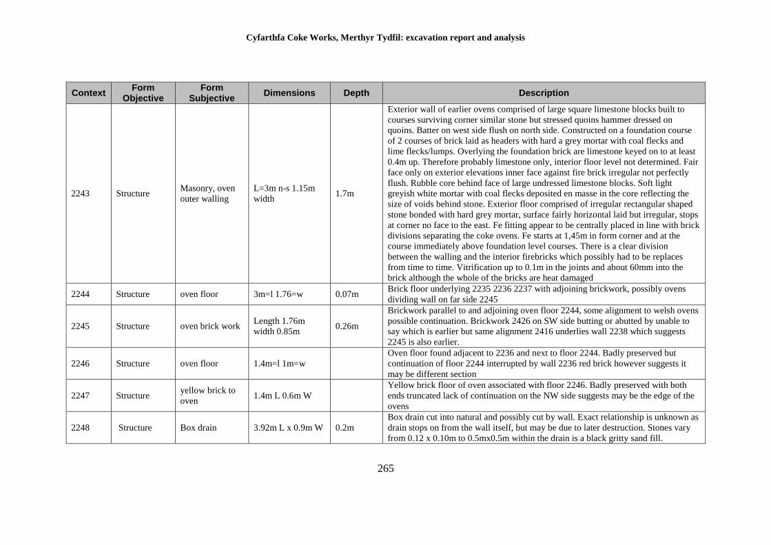
Cyfarthfa Coke Works, Merthyr Tydfil: excavation report and analysis
265
Context Form
Objective Form
Subjective Dimensions Depth Description
2243 Structure Masonry, oven
outer walling
L=3m n-s 1.15m
width 1.7m
Exterior wall of earlier ovens comprised of large square limestone blocks built to
courses surviving corner similar stone but stressed quoins hammer dressed on
quoins. Batter on west side flush on north side. Constructed on a foundation course
of 2 courses of brick laid as headers with hard a grey mortar with coal flecks and
lime flecks/lumps. Overlying the foundation brick are limestone keyed on to at least
0.4m up. Therefore probably limestone only, interior floor level not determined. Fair
face only on exterior elevations inner face against fire brick irregular not perfectly
flush. Rubble core behind face of large undressed limestone blocks. Soft light
greyish white mortar with coal flecks deposited en masse in the core reflecting the
size of voids behind stone. Exterior floor comprised of irregular rectangular shaped
stone bonded with hard grey mortar, surface fairly horizontal laid but irregular, stops
at corner no face to the east. Fe fitting appear to be centrally placed in line with brick
divisions separating the coke ovens. Fe starts at 1,45m in form corner and at the
course immediately above foundation level courses. There is a clear division
between the walling and the interior firebricks which possibly had to be replaces
from time to time. Vitrification up to 0.1m in the joints and about 60mm into the
brick although the whole of the bricks are heat damaged
2244 Structure oven floor 3m=l 1.76=w 0.07m Brick floor underlying 2235 2236 2237 with adjoining brickwork, possibly ovens
dividing wall on far side 2245
2245 Structure oven brick work Length 1.76m
width 0.85m 0.26m
Brickwork parallel to and adjoining oven floor 2244, some alignment to welsh ovens
possible continuation. Brickwork 2426 on SW side butting or abutted by unable to
say which is earlier but same alignment 2416 underlies wall 2238 which suggests
2245 is also earlier.
2246 Structure oven floor 1.4m=l 1m=w
Oven floor found adjacent to 2236 and next to floor 2244. Badly preserved but
continuation of floor 2244 interrupted by wall 2236 red brick however suggests it
may be different section
2247 Structure yellow brick to
oven 1.4m L 0.6m W
Yellow brick floor of oven associated with floor 2246. Badly preserved with both
ends truncated lack of continuation on the NW side suggests may be the edge of the
ovens
2248 Structure Box drain 3.92m L x 0.9m W 0.2m
Box drain cut into natural and possibly cut by wall. Exact relationship is unknown as
drain stops on from the wall itself, but may be due to later destruction. Stones vary
from 0.12 x 0.10m to 0.5mx0.5m within the drain is a black gritty sand fill.
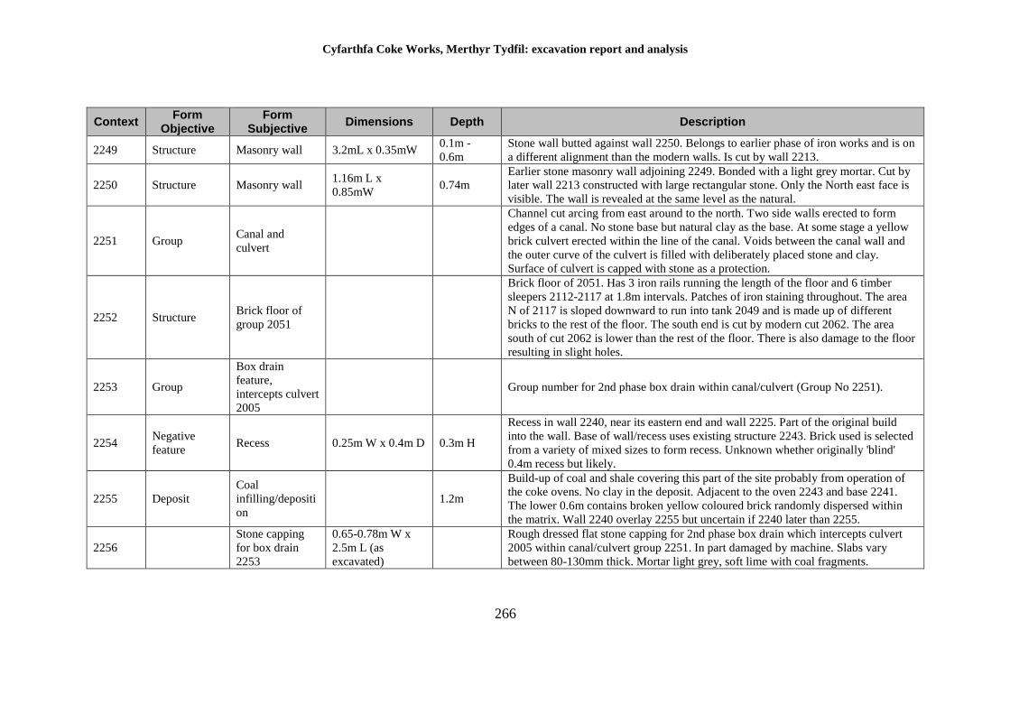
Cyfarthfa Coke Works, Merthyr Tydfil: excavation report and analysis
266
Context Form
Objective Form
Subjective Dimensions Depth Description
2249 Structure Masonry wall 3.2mL x 0.35mW 0.1m -
0.6m
Stone wall butted against wall 2250. Belongs to earlier phase of iron works and is on
a different alignment than the modern walls. Is cut by wall 2213.
2250 Structure Masonry wall 1.16m L x
0.85mW 0.74m
Earlier stone masonry wall adjoining 2249. Bonded with a light grey mortar. Cut by
later wall 2213 constructed with large rectangular stone. Only the North east face is
visible. The wall is revealed at the same level as the natural.
2251 Group Canal and
culvert
Channel cut arcing from east around to the north. Two side walls erected to form
edges of a canal. No stone base but natural clay as the base. At some stage a yellow
brick culvert erected within the line of the canal. Voids between the canal wall and
the outer curve of the culvert is filled with deliberately placed stone and clay.
Surface of culvert is capped with stone as a protection.
2252 Structure Brick floor of
group 2051
Brick floor of 2051. Has 3 iron rails running the length of the floor and 6 timber
sleepers 2112-2117 at 1.8m intervals. Patches of iron staining throughout. The area
N of 2117 is sloped downward to run into tank 2049 and is made up of different
bricks to the rest of the floor. The south end is cut by modern cut 2062. The area
south of cut 2062 is lower than the rest of the floor. There is also damage to the floor
resulting in slight holes.
2253 Group
Box drain
feature,
intercepts culvert
2005
Group number for 2nd phase box drain within canal/culvert (Group No 2251).
2254 Negative
feature Recess 0.25m W x 0.4m D 0.3m H
Recess in wall 2240, near its eastern end and wall 2225. Part of the original build
into the wall. Base of wall/recess uses existing structure 2243. Brick used is selected
from a variety of mixed sizes to form recess. Unknown whether originally 'blind'
0.4m recess but likely.
2255 Deposit
Coal
infilling/depositi
on
1.2m
Build-up of coal and shale covering this part of the site probably from operation of
the coke ovens. No clay in the deposit. Adjacent to the oven 2243 and base 2241.
The lower 0.6m contains broken yellow coloured brick randomly dispersed within
the matrix. Wall 2240 overlay 2255 but uncertain if 2240 later than 2255.
2256
Stone capping
for box drain
2253
0.65-0.78m W x
2.5m L (as
excavated)
Rough dressed flat stone capping for 2nd phase box drain which intercepts culvert
2005 within canal/culvert group 2251. In part damaged by machine. Slabs vary
between 80-130mm thick. Mortar light grey, soft lime with coal fragments.
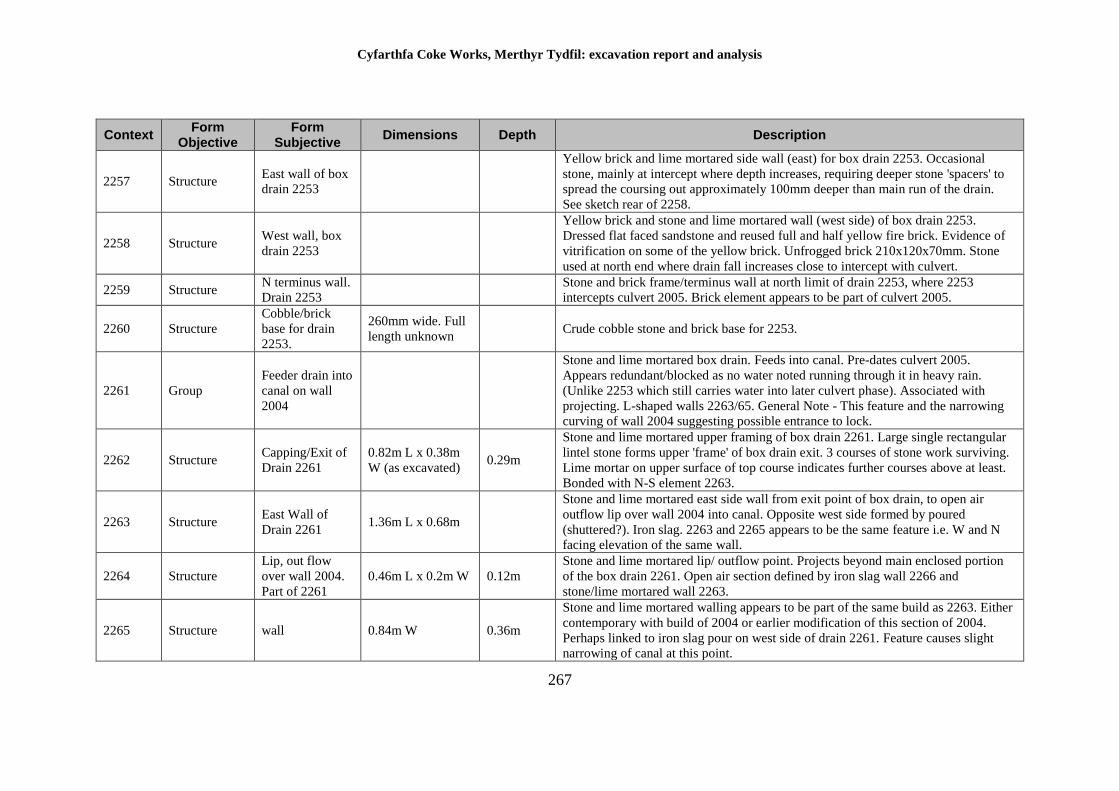
Cyfarthfa Coke Works, Merthyr Tydfil: excavation report and analysis
267
Context Form
Objective Form
Subjective Dimensions Depth Description
2257 Structure East wall of box
drain 2253
Yellow brick and lime mortared side wall (east) for box drain 2253. Occasional
stone, mainly at intercept where depth increases, requiring deeper stone 'spacers' to
spread the coursing out approximately 100mm deeper than main run of the drain.
See sketch rear of 2258.
2258 Structure West wall, box
drain 2253
Yellow brick and stone and lime mortared wall (west side) of box drain 2253.
Dressed flat faced sandstone and reused full and half yellow fire brick. Evidence of
vitrification on some of the yellow brick. Unfrogged brick 210x120x70mm. Stone
used at north end where drain fall increases close to intercept with culvert.
2259 Structure N terminus wall.
Drain 2253
Stone and brick frame/terminus wall at north limit of drain 2253, where 2253
intercepts culvert 2005. Brick element appears to be part of culvert 2005.
2260 Structure
Cobble/brick
base for drain
2253.
260mm wide. Full
length unknown Crude cobble stone and brick base for 2253.
2261 Group
Feeder drain into
canal on wall
2004
Stone and lime mortared box drain. Feeds into canal. Pre-dates culvert 2005.
Appears redundant/blocked as no water noted running through it in heavy rain.
(Unlike 2253 which still carries water into later culvert phase). Associated with
projecting. L-shaped walls 2263/65. General Note - This feature and the narrowing
curving of wall 2004 suggesting possible entrance to lock.
2262 Structure Capping/Exit of
Drain 2261
0.82m L x 0.38m
W (as excavated) 0.29m
Stone and lime mortared upper framing of box drain 2261. Large single rectangular
lintel stone forms upper 'frame' of box drain exit. 3 courses of stone work surviving.
Lime mortar on upper surface of top course indicates further courses above at least.
Bonded with N-S element 2263.
2263 Structure East Wall of
Drain 2261 1.36m L x 0.68m
Stone and lime mortared east side wall from exit point of box drain, to open air
outflow lip over wall 2004 into canal. Opposite west side formed by poured
(shuttered?). Iron slag. 2263 and 2265 appears to be the same feature i.e. W and N
facing elevation of the same wall.
2264 Structure
Lip, out flow
over wall 2004.
Part of 2261
0.46m L x 0.2m W 0.12m
Stone and lime mortared lip/ outflow point. Projects beyond main enclosed portion
of the box drain 2261. Open air section defined by iron slag wall 2266 and
stone/lime mortared wall 2263.
2265 Structure wall 0.84m W 0.36m
Stone and lime mortared walling appears to be part of the same build as 2263. Either
contemporary with build of 2004 or earlier modification of this section of 2004.
Perhaps linked to iron slag pour on west side of drain 2261. Feature causes slight
narrowing of canal at this point.
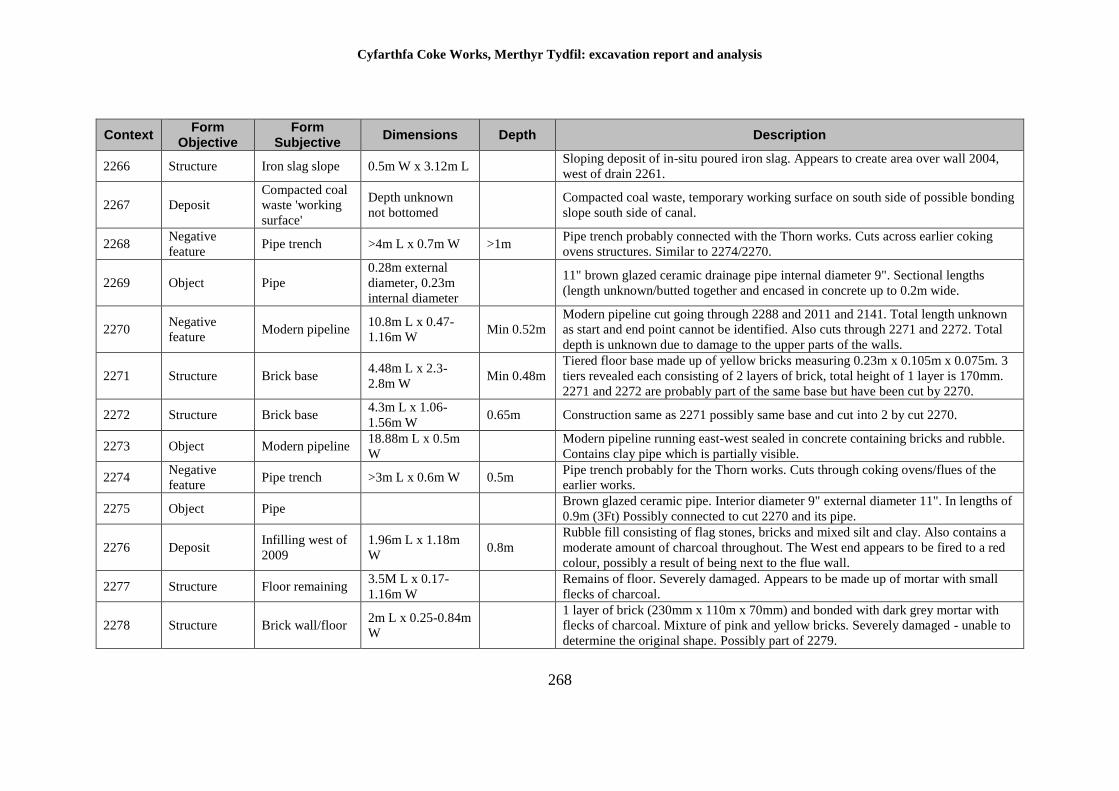
Cyfarthfa Coke Works, Merthyr Tydfil: excavation report and analysis
268
Context Form
Objective Form
Subjective Dimensions Depth Description
2266 Structure Iron slag slope 0.5m W x 3.12m L Sloping deposit of in-situ poured iron slag. Appears to create area over wall 2004,
west of drain 2261.
2267 Deposit
Compacted coal
waste 'working
surface'
Depth unknown
not bottomed
Compacted coal waste, temporary working surface on south side of possible bonding
slope south side of canal.
2268 Negative
feature Pipe trench >4m L x 0.7m W >1m
Pipe trench probably connected with the Thorn works. Cuts across earlier coking
ovens structures. Similar to 2274/2270.
2269 Object Pipe
0.28m external
diameter, 0.23m
internal diameter
11" brown glazed ceramic drainage pipe internal diameter 9". Sectional lengths
(length unknown/butted together and encased in concrete up to 0.2m wide.
2270 Negative
feature Modern pipeline
10.8m L x 0.47-
1.16m W Min 0.52m
Modern pipeline cut going through 2288 and 2011 and 2141. Total length unknown
as start and end point cannot be identified. Also cuts through 2271 and 2272. Total
depth is unknown due to damage to the upper parts of the walls.
2271 Structure Brick base 4.48m L x 2.3-
2.8m W Min 0.48m
Tiered floor base made up of yellow bricks measuring 0.23m x 0.105m x 0.075m. 3
tiers revealed each consisting of 2 layers of brick, total height of 1 layer is 170mm.
2271 and 2272 are probably part of the same base but have been cut by 2270.
2272 Structure Brick base 4.3m L x 1.06-
1.56m W 0.65m Construction same as 2271 possibly same base and cut into 2 by cut 2270.
2273 Object Modern pipeline 18.88m L x 0.5m
W
Modern pipeline running east-west sealed in concrete containing bricks and rubble.
Contains clay pipe which is partially visible.
2274 Negative
feature Pipe trench >3m L x 0.6m W 0.5m
Pipe trench probably for the Thorn works. Cuts through coking ovens/flues of the
earlier works.
2275 Object Pipe Brown glazed ceramic pipe. Interior diameter 9" external diameter 11". In lengths of
0.9m (3Ft) Possibly connected to cut 2270 and its pipe.
2276 Deposit Infilling west of
2009
1.96m L x 1.18m
W 0.8m
Rubble fill consisting of flag stones, bricks and mixed silt and clay. Also contains a
moderate amount of charcoal throughout. The West end appears to be fired to a red
colour, possibly a result of being next to the flue wall.
2277 Structure Floor remaining 3.5M L x 0.17-
1.16m W
Remains of floor. Severely damaged. Appears to be made up of mortar with small
flecks of charcoal.
2278 Structure Brick wall/floor 2m L x 0.25-0.84m
W
1 layer of brick (230mm x 110m x 70mm) and bonded with dark grey mortar with
flecks of charcoal. Mixture of pink and yellow bricks. Severely damaged - unable to
determine the original shape. Possibly part of 2279.
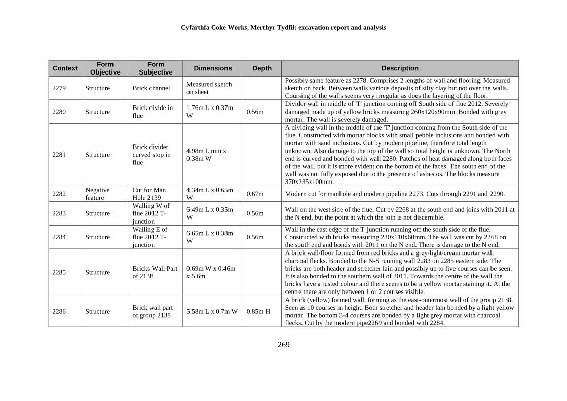
Cyfarthfa Coke Works, Merthyr Tydfil: excavation report and analysis
269
Context Form
Objective Form
Subjective Dimensions Depth Description
2279 Structure Brick channel Measured sketch
on sheet
Possibly same feature as 2278. Comprises 2 lengths of wall and flooring. Measured
sketch on back. Between walls various deposits of silty clay but not over the walls.
Coursing of the walls seems very irregular as does the layering of the floor.
2280 Structure Brick divide in
flue
1.76m L x 0.37m
W 0.56m
Divider wall in middle of 'T' junction coming off South side of flue 2012. Severely
damaged made up of yellow bricks measuring 260x120x90mm. Bonded with grey
mortar. The wall is severely damaged.
2281 Structure
Brick divider
curved stop in
flue
4.98m L min x
0.38m W
A dividing wall in the middle of the 'T' junction coming from the South side of the
flue. Constructed with mortar blocks with small pebble inclusions and bonded with
mortar with sand inclusions. Cut by modern pipeline, therefore total length
unknown. Also damage to the top of the wall so total height is unknown. The North
end is curved and bonded with wall 2280. Patches of heat damaged along both faces
of the wall, but it is more evident on the bottom of the faces. The south end of the
wall was not fully exposed due to the presence of asbestos. The blocks measure
370x235x100mm.
2282 Negative
feature
Cut for Man
Hole 2139
4.34m L x 0.65m
W 0.67m Modern cut for manhole and modern pipeline 2273. Cuts through 2291 and 2290.
2283 Structure
Walling W of
flue 2012 T-
junction
6.49m L x 0.35m
W 0.56m
Wall on the west side of the flue. Cut by 2268 at the south end and joins with 2011 at
the N end, but the point at which the join is not discernible.
2284 Structure
Walling E of
flue 2012 T-
junction
6.65m L x 0.38m
W 0.56m
Wall in the east edge of the T-junction running off the south side of the flue.
Constructed with bricks measuring 230x110x60mm. The wall was cut by 2268 on
the south end and bonds with 2011 on the N end. There is damage to the N end.
2285 Structure Bricks Wall Part
of 2138
0.69m W x 0.46m
x 5.6m
A brick wall/floor formed from red bricks and a grey/light/cream mortar with
charcoal flecks. Bonded to the N-S running wall 2283 on 2285 eastern side. The
bricks are both header and stretcher lain and possibly up to five courses can be seen.
It is also bonded to the southern wall of 2011. Towards the centre of the wall the
bricks have a rusted colour and there seems to be a yellow mortar staining it. At the
centre there are only between 1 or 2 courses visible.
2286 Structure Brick wall part
of group 2138 5.58m L x 0.7m W 0.85m H
A brick (yellow) formed wall, forming as the east-outermost wall of the group 2138.
Seen as 10 courses in height. Both stretcher and header lain bonded by a light yellow
mortar. The bottom 3-4 courses are bonded by a light grey mortar with charcoal
flecks. Cut by the modern pipe2269 and bonded with 2284.
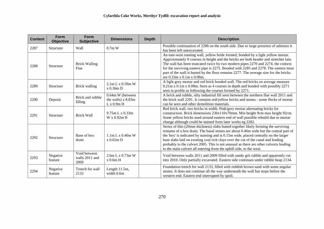
Cyfarthfa Coke Works, Merthyr Tydfil: excavation report and analysis
270
Context Form
Objective Form
Subjective Dimensions Depth Description
2287 Structure Wall 0.7m W Possible continuation of 2286 on the south side. Due to large presence of asbestos it
has been left unexcavated.
2288 Structure Brick Walling
Flue
An east-west running wall, yellow bride formed, bonded by a light yellow mortar.
Approximately 9 courses in height and the bricks are both header and stretcher lain.
The wall has been truncated twice by two modern pipes 2270 and 2274, the context
for the surviving eastern pipe is 2275. Bonded with 2285 and 2278. The eastern most
part of the wall is butted by the floor remains 2277. The average size for the bricks
are 0.23m x 0.1m x 0.08m.
2289 Structure Brick walling 2.1m L x 0.59m W
x 0.36m D
A light grey mortar and red brick bonded wall. The red bricks on average measure
0.21m x 0.1m x 0.08m. Seen as 4 courses in depth and bonded with possibly 2271
seen in profile as following the courses formed by 2271.
2290 Deposit Brick and rubble
filling
0.64m W (between
the walls) x 8.83m
L x 0.9m H
A brick and rubble, silty industrial fill seen between the northern flue wall 2011 and
the brick wall 2291. It contains red/yellow bricks and stones - some flecks of mortar
can be seen and other demolition materials.
2291 Structure Brick Wall 9.75m L x 0.33m
W x 0.92m H
Red brick wall, two bricks in width. Pink/grey mortar alternating bricks for
construction. Brick dimensions 230x110x70mm. Min height 9cm max height 92cm.
Some yellow bricks used around eastern end of wall possible rebuild due to mortar
change although could be stained from later works eg 2282.
2292 Structure Base of box
drain
1.1m L x 0.46m W
x 0.02m D
Series of thin (20mm thickness) slabs butted together likely forming the surviving
remains of a box drain. The basal stones are about 0.46m wide but the central part of
the 'box' is indicated by staining and is 0.15m wide, placed centrally on the larger
base slabs laid on existing coal rich clays over the cut of the canal and leading
probably to the culvert 2005. This is not unusual as there are other culverts leading
to the main culvert all entering from the uphill side, to the west.
2293 Negative
feature
Void between
walls 2011 and
2009
2.6m L x 0.73m W
x 0.6m H
Void between walls 2011 and 2009 filled with sandy grit rubble and apparently cut
into 2010. Only partially excavated. Eastern side continues under rubble heap 2134.
2294 Negative
feature
Trench for wall
2133
Length 11.5m,
width 0.6m
Foundation trench for wall 2133, filled with reddish brown sand with some angular
stones. It does not continue all the way underneath the wall but stops before the
western end. Eastern end interrupted by spoil.
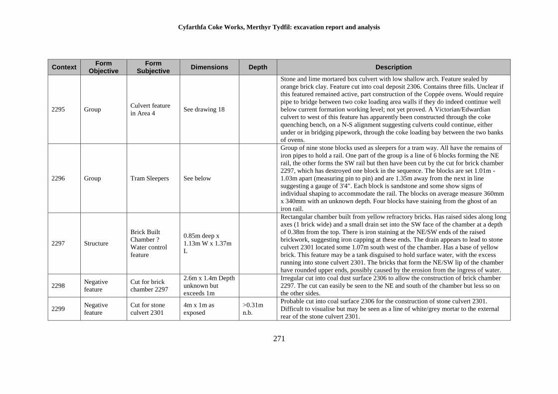
Cyfarthfa Coke Works, Merthyr Tydfil: excavation report and analysis
271
Context Form
Objective Form
Subjective Dimensions Depth Description
2295 Group Culvert feature
in Area 4 See drawing 18
Stone and lime mortared box culvert with low shallow arch. Feature sealed by
orange brick clay. Feature cut into coal deposit 2306. Contains three fills. Unclear if
this featured remained active, part construction of the Coppée ovens. Would require
pipe to bridge between two coke loading area walls if they do indeed continue well
below current formation working level; not yet proved. A Victorian/Edwardian
culvert to west of this feature has apparently been constructed through the coke
quenching bench, on a N-S alignment suggesting culverts could continue, either
under or in bridging pipework, through the coke loading bay between the two banks
of ovens.
2296 Group Tram Sleepers See below
Group of nine stone blocks used as sleepers for a tram way. All have the remains of
iron pipes to hold a rail. One part of the group is a line of 6 blocks forming the NE
rail, the other forms the SW rail but then have been cut by the cut for brick chamber
2297, which has destroyed one block in the sequence. The blocks are set 1.01m -
1.03m apart (measuring pin to pin) and are 1.35m away from the next in line
suggesting a gauge of 3'4". Each block is sandstone and some show signs of
individual shaping to accommodate the rail. The blocks on average measure 360mm
x 340mm with an unknown depth. Four blocks have staining from the ghost of an
iron rail.
2297 Structure
Brick Built
Chamber ?
Water control
feature
0.85m deep x
1.13m W x 1.37m
L
Rectangular chamber built from yellow refractory bricks. Has raised sides along long
axes (1 brick wide) and a small drain set into the SW face of the chamber at a depth
of 0.38m from the top. There is iron staining at the NE/SW ends of the raised
brickwork, suggesting iron capping at these ends. The drain appears to lead to stone
culvert 2301 located some 1.07m south west of the chamber. Has a base of yellow
brick. This feature may be a tank disguised to hold surface water, with the excess
running into stone culvert 2301. The bricks that form the NE/SW lip of the chamber
have rounded upper ends, possibly caused by the erosion from the ingress of water.
2298 Negative
feature
Cut for brick
chamber 2297
2.6m x 1.4m Depth
unknown but
exceeds 1m
Irregular cut into coal dust surface 2306 to allow the construction of brick chamber
2297. The cut can easily be seen to the NE and south of the chamber but less so on
the other sides.
2299 Negative
feature
Cut for stone
culvert 2301
4m x 1m as
exposed
>0.31m
n.b.
Probable cut into coal surface 2306 for the construction of stone culvert 2301.
Difficult to visualise but may be seen as a line of white/grey mortar to the external
rear of the stone culvert 2301.
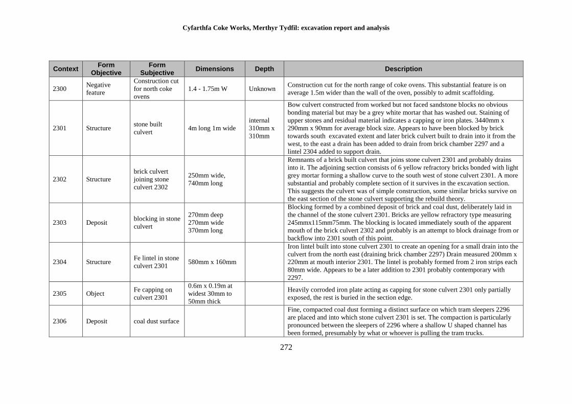
Cyfarthfa Coke Works, Merthyr Tydfil: excavation report and analysis
272
Context Form
Objective Form
Subjective Dimensions Depth Description
2300 Negative
feature
Construction cut
for north coke
ovens
1.4 - 1.75m W Unknown Construction cut for the north range of coke ovens. This substantial feature is on
average 1.5m wider than the wall of the oven, possibly to admit scaffolding.
2301 Structure stone built
culvert 4m long 1m wide
internal
310mm x
310mm
Bow culvert constructed from worked but not faced sandstone blocks no obvious
bonding material but may be a grey white mortar that has washed out. Staining of
upper stones and residual material indicates a capping or iron plates. 3440mm x
290mm x 90mm for average block size. Appears to have been blocked by brick
towards south excavated extent and later brick culvert built to drain into it from the
west, to the east a drain has been added to drain from brick chamber 2297 and a
lintel 2304 added to support drain.
2302 Structure
brick culvert
joining stone
culvert 2302
250mm wide,
740mm long
Remnants of a brick built culvert that joins stone culvert 2301 and probably drains
into it. The adjoining section consists of 6 yellow refractory bricks bonded with light
grey mortar forming a shallow curve to the south west of stone culvert 2301. A more
substantial and probably complete section of it survives in the excavation section.
This suggests the culvert was of simple construction, some similar bricks survive on
the east section of the stone culvert supporting the rebuild theory.
2303 Deposit blocking in stone
culvert
270mm deep
270mm wide
370mm long
Blocking formed by a combined deposit of brick and coal dust, deliberately laid in
the channel of the stone culvert 2301. Bricks are yellow refractory type measuring
245mmx115mm75mm. The blocking is located immediately south of the apparent
mouth of the brick culvert 2302 and probably is an attempt to block drainage from or
backflow into 2301 south of this point.
2304 Structure Fe lintel in stone
culvert 2301 580mm x 160mm
Iron lintel built into stone culvert 2301 to create an opening for a small drain into the
culvert from the north east (draining brick chamber 2297) Drain measured 200mm x
220mm at mouth interior 2301. The lintel is probably formed from 2 iron strips each
80mm wide. Appears to be a later addition to 2301 probably contemporary with
2297.
2305 Object Fe capping on
culvert 2301
0.6m x 0.19m at
widest 30mm to
50mm thick
Heavily corroded iron plate acting as capping for stone culvert 2301 only partially
exposed, the rest is buried in the section edge.
2306 Deposit coal dust surface
Fine, compacted coal dust forming a distinct surface on which tram sleepers 2296
are placed and into which stone culvert 2301 is set. The compaction is particularly
pronounced between the sleepers of 2296 where a shallow U shaped channel has
been formed, presumably by what or whoever is pulling the tram trucks.
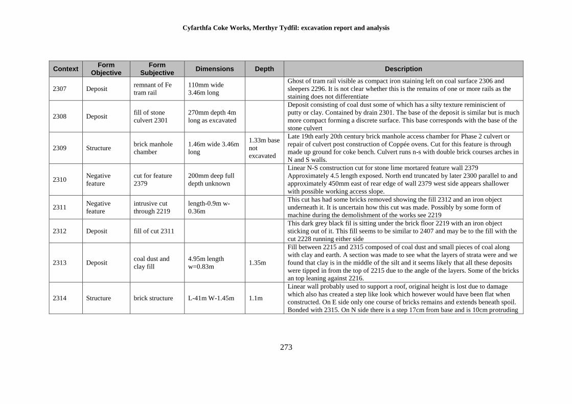
Cyfarthfa Coke Works, Merthyr Tydfil: excavation report and analysis
273
Context Form
Objective Form
Subjective Dimensions Depth Description
2307 Deposit remnant of Fe
tram rail
110mm wide
3.46m long
Ghost of tram rail visible as compact iron staining left on coal surface 2306 and
sleepers 2296. It is not clear whether this is the remains of one or more rails as the
staining does not differentiate
2308 Deposit fill of stone
culvert 2301
270mm depth 4m
long as excavated
Deposit consisting of coal dust some of which has a silty texture reminiscient of
putty or clay. Contained by drain 2301. The base of the deposit is similar but is much
more compact forming a discrete surface. This base corresponds with the base of the
stone culvert
2309 Structure brick manhole
chamber
1.46m wide 3.46m
long
1.33m base
not
excavated
Late 19th early 20th century brick manhole access chamber for Phase 2 culvert or
repair of culvert post construction of Coppée ovens. Cut for this feature is through
made up ground for coke bench. Culvert runs n-s with double brick courses arches in
N and S walls.
2310 Negative
feature
cut for feature
2379
200mm deep full
depth unknown
Linear N-S construction cut for stone lime mortared feature wall 2379
Approximately 4.5 length exposed. North end truncated by later 2300 parallel to and
approximately 450mm east of rear edge of wall 2379 west side appears shallower
with possible working access slope.
2311 Negative
feature
intrusive cut
through 2219
length-0.9m w-
0.36m
This cut has had some bricks removed showing the fill 2312 and an iron object
underneath it. It is uncertain how this cut was made. Possibly by some form of
machine during the demolishment of the works see 2219
2312 Deposit fill of cut 2311
This dark grey black fil is sitting under the brick floor 2219 with an iron object
sticking out of it. This fill seems to be similar to 2407 and may be to the fill with the
cut 2228 running either side
2313 Deposit coal dust and
clay fill
4.95m length
w=0.83m 1.35m
Fill between 2215 and 2315 composed of coal dust and small pieces of coal along
with clay and earth. A section was made to see what the layers of strata were and we
found that clay is in the middle of the silt and it seems likely that all these deposits
were tipped in from the top of 2215 due to the angle of the layers. Some of the bricks
an top leaning against 2216.
2314 Structure brick structure L-41m W-1.45m 1.1m
Linear wall probably used to support a roof, original height is lost due to damage
which also has created a step like look which however would have been flat when
constructed. On E side only one course of bricks remains and extends beneath spoil.
Bonded with 2315. On N side there is a step 17cm from base and is 10cm protruding
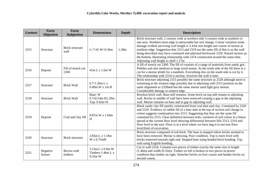
Cyfarthfa Coke Works, Merthyr Tydfil: excavation report and analysis
274
Context Form
Objective Form
Subjective Dimensions Depth Description
2315 Structure Brick structure
wall L=7.65 W=0.36m 1.28m
Brick structure wall, 2 courses wide at northern side 3 courses wide at southern in
one area. Northern most edge is untraceable bar soil change. Colour variation some
damage evident surviving wall length is 3.43m min height one course of mortar at
northern edge. Suggestion that 2313 and 2319 are the same fill of this is so the wall
being described may have continued and adjoined brickwork 2320. Raised section ay
the bottom, illustrating relationship with 2314 constructed around the same time.
Adjoining wall height to shelf 1.17m
2316 Deposit Fill of trench cut
2300 41m L x 1.6m W
A fill of trench cut 2300. The fill of consists of a range of materials from sandy grit.
Pebbles and also medium to large sized stones. At the south side of the fill there is a
cut for a mortar plinth for a manhole. Everything else on the south side is cut by it.
The relationship with 2314 is unclear, however the wall is later.
2317 Structure Brick Wall 0.7-1.26m L x
0.49m W x 1m H
Brick structure adjoining 2315 possibly the same structure as 2328 although more is
remaining at the western edge possibly due to adjoining wall 2315 position on the
same alignment as 2328and has the same mortar used light grey mortar.
Considerable damage to eastern edge.
2318 Structure Brick Wall
Base: W
0.7x0.54m H1.29m
Top: 0.45m W
Brocken brick wall. Base still remains. Some brick on top still remain to adjoining
wall. Bricks in middle of wall have been removed creating a gap in the adjoining
wall. Mortar remains on base and in gap in adjoining wall.
2319 Deposit Coal and clay fill 0.87m W x 1.04m
H
Black sandy clay fill mainly constructed from coal dust and clay. Contained by 2320
and 2220. Evidence of rubble fill of a later date at the top of section soil change in
colour suggests continuation into 2313. Suggesting that they are the same fill
contained by 2315. Clear definition between soils, variation of soil colour in a linear
spread at the current floor level showing differential between fills 2313, 2319 and
floor level to the east. Floor is at a level where we have dug it to not true floor
level/limit of excavation.
2320 Structure Brick structure 2.85m L x 1.18m
W x 0.75mH
Brick structure composed of red brick. The base is stepped where bricks seemed to
have been removed. Mortar is showing. Poor condition. Top is more level with
bricks removed towards right end. Stepped base using headed brick bonding. Top
wall using English bonding.
2321 Negative
feature
Recess with
timbers
3.15m L x 0.9m W
Timbers 1.46m L x
0.32m W
Cut in wall 2324. Contains two pieces of timber exactly the same size in length
(1.46m) and width (0.32m). Timber on left is broken in two pieces in poorer
condition than timber on right. Stretcher bricks on first course and header bricks on
second course.
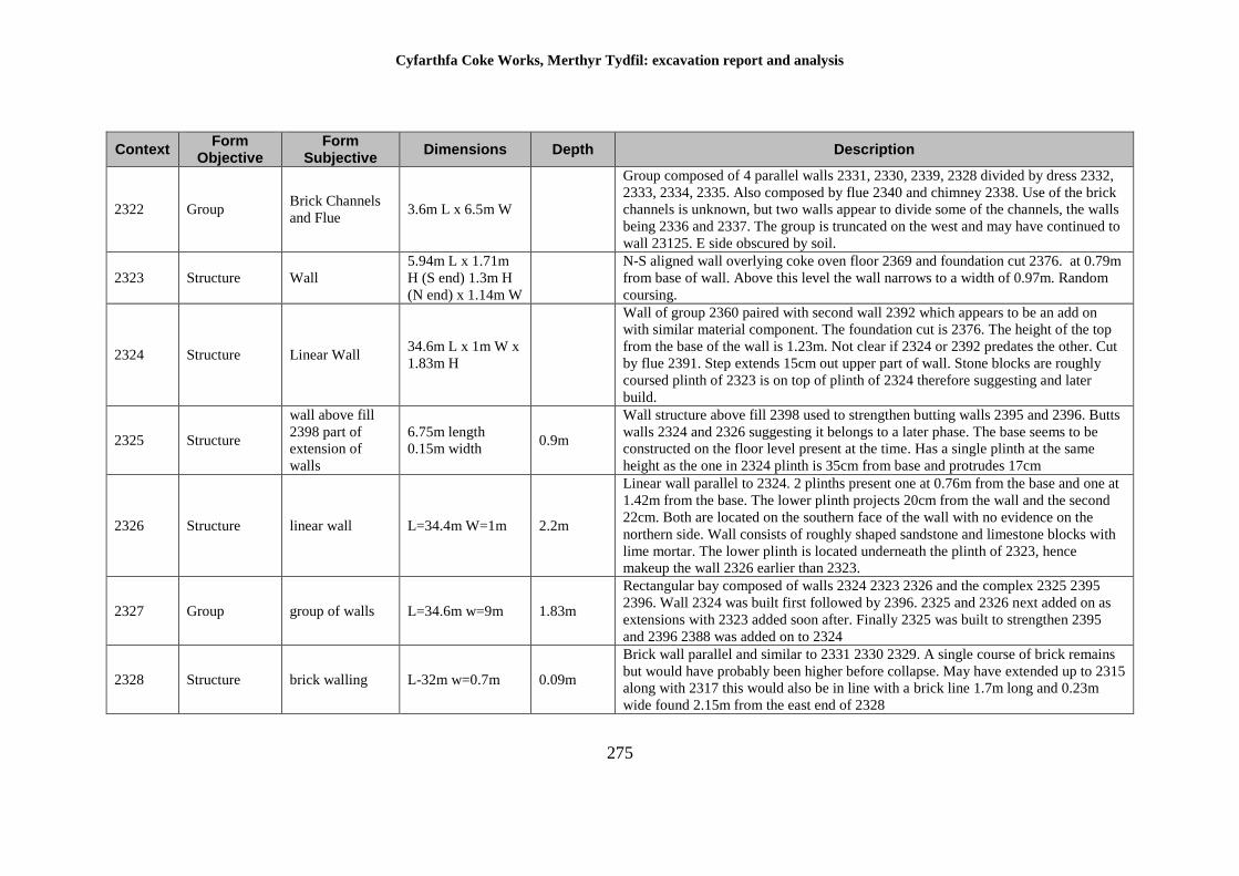
Cyfarthfa Coke Works, Merthyr Tydfil: excavation report and analysis
275
Context Form
Objective Form
Subjective Dimensions Depth Description
2322 Group Brick Channels
and Flue 3.6m L x 6.5m W
Group composed of 4 parallel walls 2331, 2330, 2339, 2328 divided by dress 2332,
2333, 2334, 2335. Also composed by flue 2340 and chimney 2338. Use of the brick
channels is unknown, but two walls appear to divide some of the channels, the walls
being 2336 and 2337. The group is truncated on the west and may have continued to
wall 23125. E side obscured by soil.
2323 Structure Wall
5.94m L x 1.71m
H (S end) 1.3m H
(N end) x 1.14m W
N-S aligned wall overlying coke oven floor 2369 and foundation cut 2376. at 0.79m
from base of wall. Above this level the wall narrows to a width of 0.97m. Random
coursing.
2324 Structure Linear Wall 34.6m L x 1m W x
1.83m H
Wall of group 2360 paired with second wall 2392 which appears to be an add on
with similar material component. The foundation cut is 2376. The height of the top
from the base of the wall is 1.23m. Not clear if 2324 or 2392 predates the other. Cut
by flue 2391. Step extends 15cm out upper part of wall. Stone blocks are roughly
coursed plinth of 2323 is on top of plinth of 2324 therefore suggesting and later
build.
2325 Structure
wall above fill
2398 part of
extension of
walls
6.75m length
0.15m width 0.9m
Wall structure above fill 2398 used to strengthen butting walls 2395 and 2396. Butts
walls 2324 and 2326 suggesting it belongs to a later phase. The base seems to be
constructed on the floor level present at the time. Has a single plinth at the same
height as the one in 2324 plinth is 35cm from base and protrudes 17cm
2326 Structure linear wall L=34.4m W=1m 2.2m
Linear wall parallel to 2324. 2 plinths present one at 0.76m from the base and one at
1.42m from the base. The lower plinth projects 20cm from the wall and the second
22cm. Both are located on the southern face of the wall with no evidence on the
northern side. Wall consists of roughly shaped sandstone and limestone blocks with
lime mortar. The lower plinth is located underneath the plinth of 2323, hence
makeup the wall 2326 earlier than 2323.
2327 Group group of walls L=34.6m w=9m 1.83m
Rectangular bay composed of walls 2324 2323 2326 and the complex 2325 2395
2396. Wall 2324 was built first followed by 2396. 2325 and 2326 next added on as
extensions with 2323 added soon after. Finally 2325 was built to strengthen 2395
and 2396 2388 was added on to 2324
2328 Structure brick walling L-32m w=0.7m 0.09m
Brick wall parallel and similar to 2331 2330 2329. A single course of brick remains
but would have probably been higher before collapse. May have extended up to 2315
along with 2317 this would also be in line with a brick line 1.7m long and 0.23m
wide found 2.15m from the east end of 2328
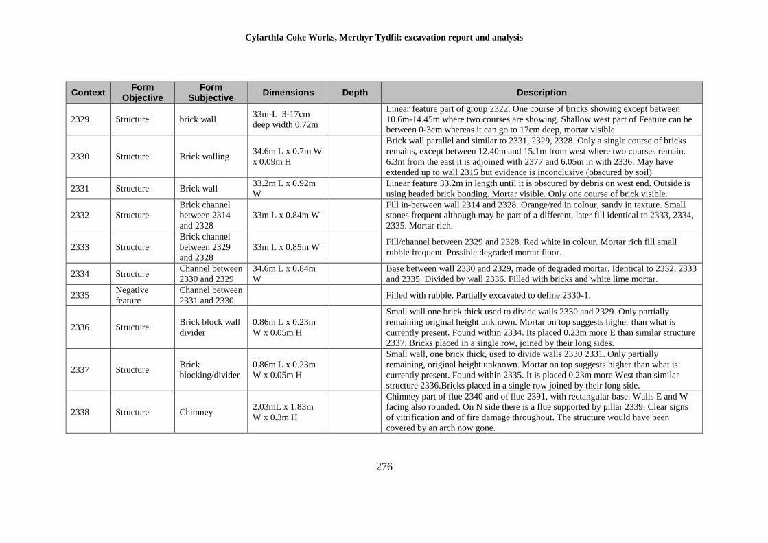
Cyfarthfa Coke Works, Merthyr Tydfil: excavation report and analysis
276
Context Form
Objective Form
Subjective Dimensions Depth Description
2329 Structure brick wall 33m-L 3-17cm
deep width 0.72m
Linear feature part of group 2322. One course of bricks showing except between
10.6m-14.45m where two courses are showing. Shallow west part of Feature can be
between 0-3cm whereas it can go to 17cm deep, mortar visible
2330 Structure Brick walling 34.6m L x 0.7m W
x 0.09m H
Brick wall parallel and similar to 2331, 2329, 2328. Only a single course of bricks
remains, except between 12.40m and 15.1m from west where two courses remain.
6.3m from the east it is adjoined with 2377 and 6.05m in with 2336. May have
extended up to wall 2315 but evidence is inconclusive (obscured by soil)
2331 Structure Brick wall 33.2m L x 0.92m
W
Linear feature 33.2m in length until it is obscured by debris on west end. Outside is
using headed brick bonding. Mortar visible. Only one course of brick visible.
2332 Structure
Brick channel
between 2314
and 2328
33m L x 0.84m W
Fill in-between wall 2314 and 2328. Orange/red in colour, sandy in texture. Small
stones frequent although may be part of a different, later fill identical to 2333, 2334,
2335. Mortar rich.
2333 Structure
Brick channel
between 2329
and 2328
33m L x 0.85m W Fill/channel between 2329 and 2328. Red white in colour. Mortar rich fill small
rubble frequent. Possible degraded mortar floor.
2334 Structure Channel between
2330 and 2329
34.6m L x 0.84m
W
Base between wall 2330 and 2329, made of degraded mortar. Identical to 2332, 2333
and 2335. Divided by wall 2336. Filled with bricks and white lime mortar.
2335 Negative
feature
Channel between
2331 and 2330 Filled with rubble. Partially excavated to define 2330-1.
2336 Structure Brick block wall
divider
0.86m L x 0.23m
W x 0.05m H
Small wall one brick thick used to divide walls 2330 and 2329. Only partially
remaining original height unknown. Mortar on top suggests higher than what is
currently present. Found within 2334. Its placed 0.23m more E than similar structure
2337. Bricks placed in a single row, joined by their long sides.
2337 Structure Brick
blocking/divider
0.86m L x 0.23m
W x 0.05m H
Small wall, one brick thick, used to divide walls 2330 2331. Only partially
remaining, original height unknown. Mortar on top suggests higher than what is
currently present. Found within 2335. It is placed 0.23m more West than similar
structure 2336.Bricks placed in a single row joined by their long side.
2338 Structure Chimney 2.03mL x 1.83m
W x 0.3m H
Chimney part of flue 2340 and of flue 2391, with rectangular base. Walls E and W
facing also rounded. On N side there is a flue supported by pillar 2339. Clear signs
of vitrification and of fire damage throughout. The structure would have been
covered by an arch now gone.
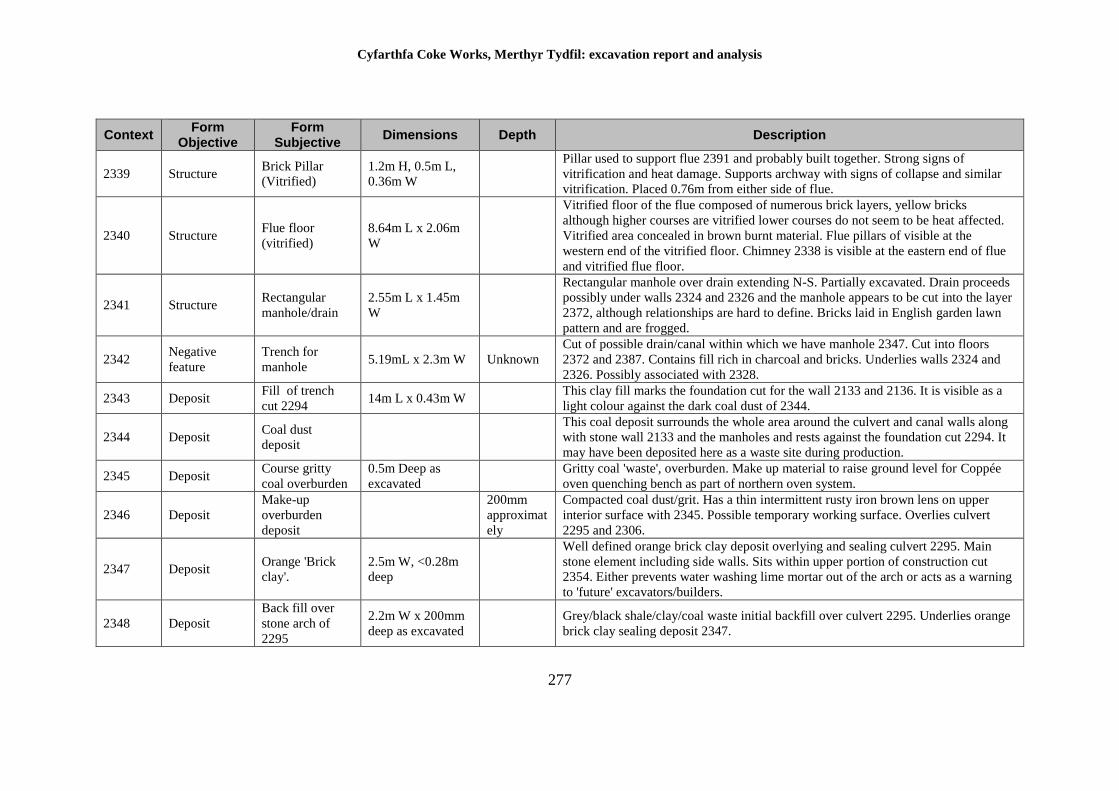
Cyfarthfa Coke Works, Merthyr Tydfil: excavation report and analysis
277
Context Form
Objective Form
Subjective Dimensions Depth Description
2339 Structure Brick Pillar
(Vitrified)
1.2m H, 0.5m L,
0.36m W
Pillar used to support flue 2391 and probably built together. Strong signs of
vitrification and heat damage. Supports archway with signs of collapse and similar
vitrification. Placed 0.76m from either side of flue.
2340 Structure Flue floor
(vitrified)
8.64m L x 2.06m
W
Vitrified floor of the flue composed of numerous brick layers, yellow bricks
although higher courses are vitrified lower courses do not seem to be heat affected.
Vitrified area concealed in brown burnt material. Flue pillars of visible at the
western end of the vitrified floor. Chimney 2338 is visible at the eastern end of flue
and vitrified flue floor.
2341 Structure Rectangular
manhole/drain
2.55m L x 1.45m
W
Rectangular manhole over drain extending N-S. Partially excavated. Drain proceeds
possibly under walls 2324 and 2326 and the manhole appears to be cut into the layer
2372, although relationships are hard to define. Bricks laid in English garden lawn
pattern and are frogged.
2342 Negative
feature
Trench for
manhole 5.19mL x 2.3m W Unknown
Cut of possible drain/canal within which we have manhole 2347. Cut into floors
2372 and 2387. Contains fill rich in charcoal and bricks. Underlies walls 2324 and
2326. Possibly associated with 2328.
2343 Deposit Fill of trench
cut 2294 14m L x 0.43m W
This clay fill marks the foundation cut for the wall 2133 and 2136. It is visible as a
light colour against the dark coal dust of 2344.
2344 Deposit Coal dust
deposit
This coal deposit surrounds the whole area around the culvert and canal walls along
with stone wall 2133 and the manholes and rests against the foundation cut 2294. It
may have been deposited here as a waste site during production.
2345 Deposit Course gritty
coal overburden
0.5m Deep as
excavated
Gritty coal 'waste', overburden. Make up material to raise ground level for Coppée
oven quenching bench as part of northern oven system.
2346 Deposit
Make-up
overburden
deposit
200mm
approximat
ely
Compacted coal dust/grit. Has a thin intermittent rusty iron brown lens on upper
interior surface with 2345. Possible temporary working surface. Overlies culvert
2295 and 2306.
2347 Deposit Orange 'Brick
clay'.
2.5m W, <0.28m
deep
Well defined orange brick clay deposit overlying and sealing culvert 2295. Main
stone element including side walls. Sits within upper portion of construction cut
2354. Either prevents water washing lime mortar out of the arch or acts as a warning
to 'future' excavators/builders.
2348 Deposit
Back fill over
stone arch of
2295
2.2m W x 200mm
deep as excavated
Grey/black shale/clay/coal waste initial backfill over culvert 2295. Underlies orange
brick clay sealing deposit 2347.
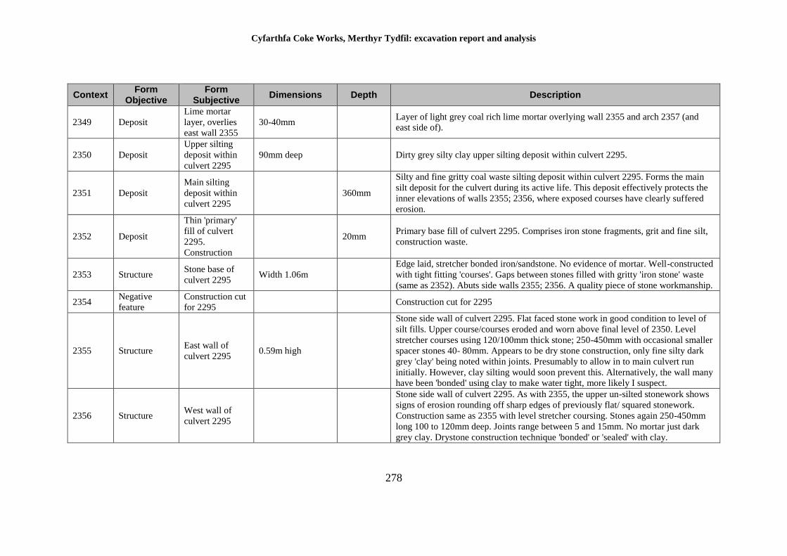
Cyfarthfa Coke Works, Merthyr Tydfil: excavation report and analysis
278
Context Form
Objective Form
Subjective Dimensions Depth Description
2349 Deposit
Lime mortar
layer, overlies
east wall 2355
30-40mm Layer of light grey coal rich lime mortar overlying wall 2355 and arch 2357 (and
east side of).
2350 Deposit
Upper silting
deposit within
culvert 2295
90mm deep Dirty grey silty clay upper silting deposit within culvert 2295.
2351 Deposit
Main silting
deposit within
culvert 2295
360mm
Silty and fine gritty coal waste silting deposit within culvert 2295. Forms the main
silt deposit for the culvert during its active life. This deposit effectively protects the
inner elevations of walls 2355; 2356, where exposed courses have clearly suffered
erosion.
2352 Deposit
Thin 'primary'
fill of culvert
2295.
Construction
20mm Primary base fill of culvert 2295. Comprises iron stone fragments, grit and fine silt,
construction waste.
2353 Structure Stone base of
culvert 2295 Width 1.06m
Edge laid, stretcher bonded iron/sandstone. No evidence of mortar. Well-constructed
with tight fitting 'courses'. Gaps between stones filled with gritty 'iron stone' waste
(same as 2352). Abuts side walls 2355; 2356. A quality piece of stone workmanship.
2354 Negative
feature
Construction cut
for 2295 Construction cut for 2295
2355 Structure East wall of
culvert 2295 0.59m high
Stone side wall of culvert 2295. Flat faced stone work in good condition to level of
silt fills. Upper course/courses eroded and worn above final level of 2350. Level
stretcher courses using 120/100mm thick stone; 250-450mm with occasional smaller
spacer stones 40- 80mm. Appears to be dry stone construction, only fine silty dark
grey 'clay' being noted within joints. Presumably to allow in to main culvert run
initially. However, clay silting would soon prevent this. Alternatively, the wall many
have been 'bonded' using clay to make water tight, more likely I suspect.
2356 Structure West wall of
culvert 2295
Stone side wall of culvert 2295. As with 2355, the upper un-silted stonework shows
signs of erosion rounding off sharp edges of previously flat/ squared stonework.
Construction same as 2355 with level stretcher coursing. Stones again 250-450mm
long 100 to 120mm deep. Joints range between 5 and 15mm. No mortar just dark
grey clay. Drystone construction technique 'bonded' or 'sealed' with clay.
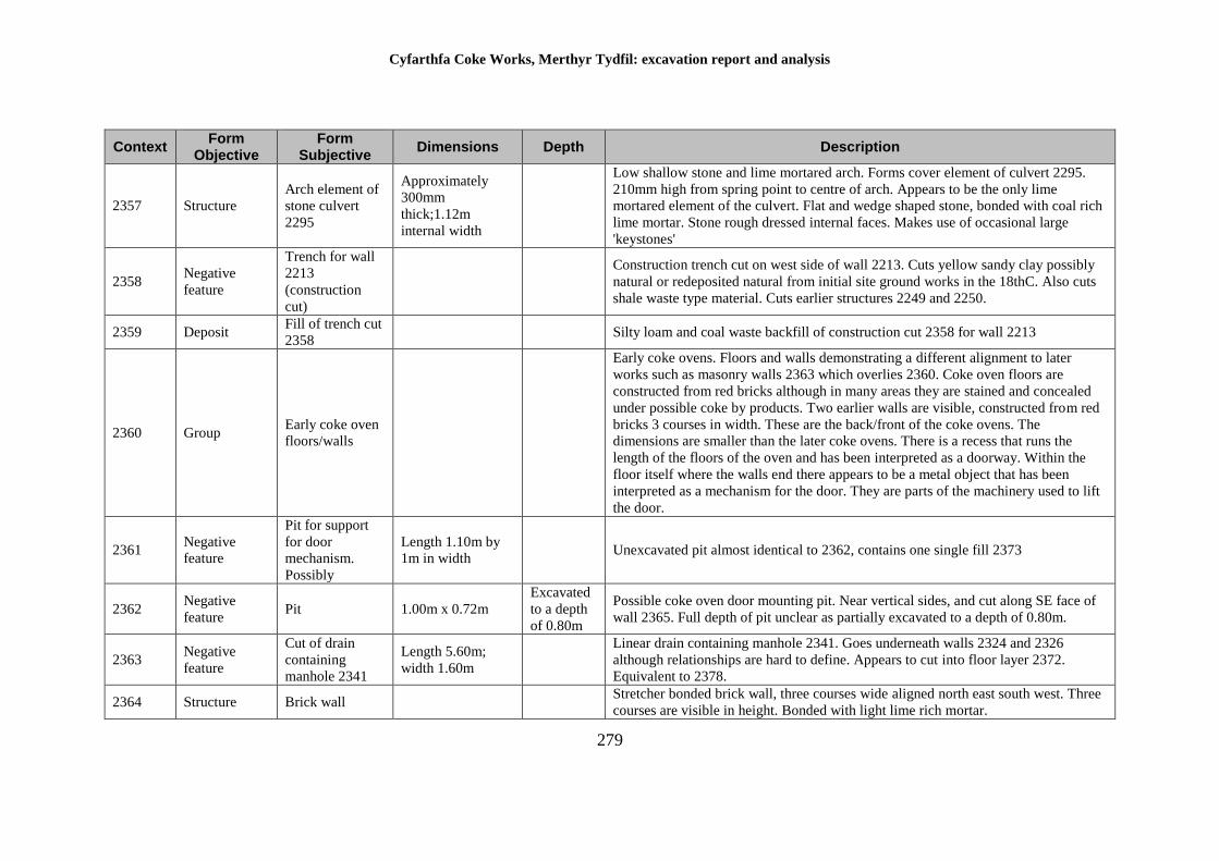
Cyfarthfa Coke Works, Merthyr Tydfil: excavation report and analysis
279
Context Form
Objective Form
Subjective Dimensions Depth Description
2357 Structure
Arch element of
stone culvert
2295
Approximately
300mm
thick;1.12m
internal width
Low shallow stone and lime mortared arch. Forms cover element of culvert 2295.
210mm high from spring point to centre of arch. Appears to be the only lime
mortared element of the culvert. Flat and wedge shaped stone, bonded with coal rich
lime mortar. Stone rough dressed internal faces. Makes use of occasional large
'keystones'
2358 Negative
feature
Trench for wall
2213
(construction
cut)
Construction trench cut on west side of wall 2213. Cuts yellow sandy clay possibly
natural or redeposited natural from initial site ground works in the 18thC. Also cuts
shale waste type material. Cuts earlier structures 2249 and 2250.
2359 Deposit Fill of trench cut
2358 Silty loam and coal waste backfill of construction cut 2358 for wall 2213
2360 Group Early coke oven
floors/walls
Early coke ovens. Floors and walls demonstrating a different alignment to later
works such as masonry walls 2363 which overlies 2360. Coke oven floors are
constructed from red bricks although in many areas they are stained and concealed
under possible coke by products. Two earlier walls are visible, constructed from red
bricks 3 courses in width. These are the back/front of the coke ovens. The
dimensions are smaller than the later coke ovens. There is a recess that runs the
length of the floors of the oven and has been interpreted as a doorway. Within the
floor itself where the walls end there appears to be a metal object that has been
interpreted as a mechanism for the door. They are parts of the machinery used to lift
the door.
2361 Negative
feature
Pit for support
for door
mechanism.
Possibly
Length 1.10m by
1m in width Unexcavated pit almost identical to 2362, contains one single fill 2373
2362 Negative
feature Pit 1.00m x 0.72m
Excavated
to a depth
of 0.80m
Possible coke oven door mounting pit. Near vertical sides, and cut along SE face of
wall 2365. Full depth of pit unclear as partially excavated to a depth of 0.80m.
2363 Negative
feature
Cut of drain
containing
manhole 2341
Length 5.60m;
width 1.60m
Linear drain containing manhole 2341. Goes underneath walls 2324 and 2326
although relationships are hard to define. Appears to cut into floor layer 2372.
Equivalent to 2378.
2364 Structure Brick wall Stretcher bonded brick wall, three courses wide aligned north east south west. Three
courses are visible in height. Bonded with light lime rich mortar.
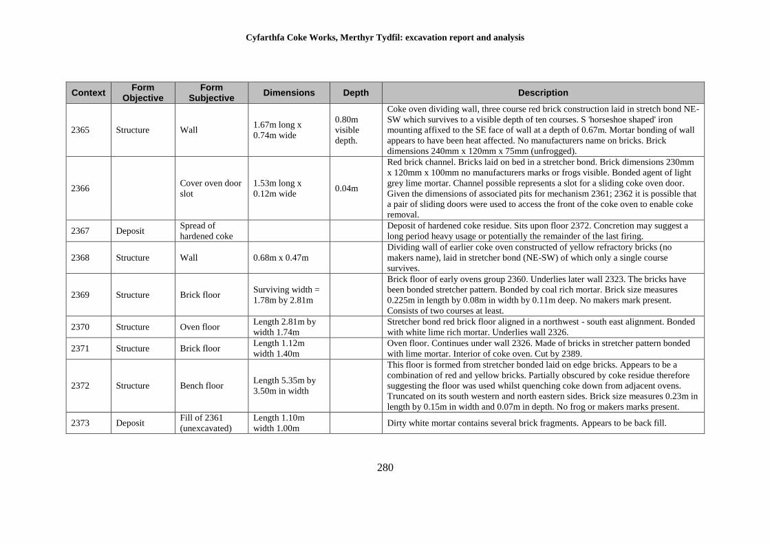
Cyfarthfa Coke Works, Merthyr Tydfil: excavation report and analysis
280
Context Form
Objective Form
Subjective Dimensions Depth Description
2365 Structure Wall 1.67m long x
0.74m wide
0.80m
visible
depth.
Coke oven dividing wall, three course red brick construction laid in stretch bond NE-
SW which survives to a visible depth of ten courses. S 'horseshoe shaped' iron
mounting affixed to the SE face of wall at a depth of 0.67m. Mortar bonding of wall
appears to have been heat affected. No manufacturers name on bricks. Brick
dimensions 240mm x 120mm x 75mm (unfrogged).
2366 Cover oven door
slot
1.53m long x
0.12m wide 0.04m
Red brick channel. Bricks laid on bed in a stretcher bond. Brick dimensions 230mm
x 120mm x 100mm no manufacturers marks or frogs visible. Bonded agent of light
grey lime mortar. Channel possible represents a slot for a sliding coke oven door.
Given the dimensions of associated pits for mechanism 2361; 2362 it is possible that
a pair of sliding doors were used to access the front of the coke oven to enable coke
removal.
2367 Deposit Spread of
hardened coke
Deposit of hardened coke residue. Sits upon floor 2372. Concretion may suggest a
long period heavy usage or potentially the remainder of the last firing.
2368 Structure Wall 0.68m x 0.47m
Dividing wall of earlier coke oven constructed of yellow refractory bricks (no
makers name), laid in stretcher bond (NE-SW) of which only a single course
survives.
2369 Structure Brick floor Surviving width =
1.78m by 2.81m
Brick floor of early ovens group 2360. Underlies later wall 2323. The bricks have
been bonded stretcher pattern. Bonded by coal rich mortar. Brick size measures
0.225m in length by 0.08m in width by 0.11m deep. No makers mark present.
Consists of two courses at least.
2370 Structure Oven floor Length 2.81m by
width 1.74m
Stretcher bond red brick floor aligned in a northwest - south east alignment. Bonded
with white lime rich mortar. Underlies wall 2326.
2371 Structure Brick floor Length 1.12m
width 1.40m
Oven floor. Continues under wall 2326. Made of bricks in stretcher pattern bonded
with lime mortar. Interior of coke oven. Cut by 2389.
2372 Structure Bench floor Length 5.35m by
3.50m in width
This floor is formed from stretcher bonded laid on edge bricks. Appears to be a
combination of red and yellow bricks. Partially obscured by coke residue therefore
suggesting the floor was used whilst quenching coke down from adjacent ovens.
Truncated on its south western and north eastern sides. Brick size measures 0.23m in
length by 0.15m in width and 0.07m in depth. No frog or makers marks present.
2373 Deposit Fill of 2361
(unexcavated)
Length 1.10m
width 1.00m Dirty white mortar contains several brick fragments. Appears to be back fill.
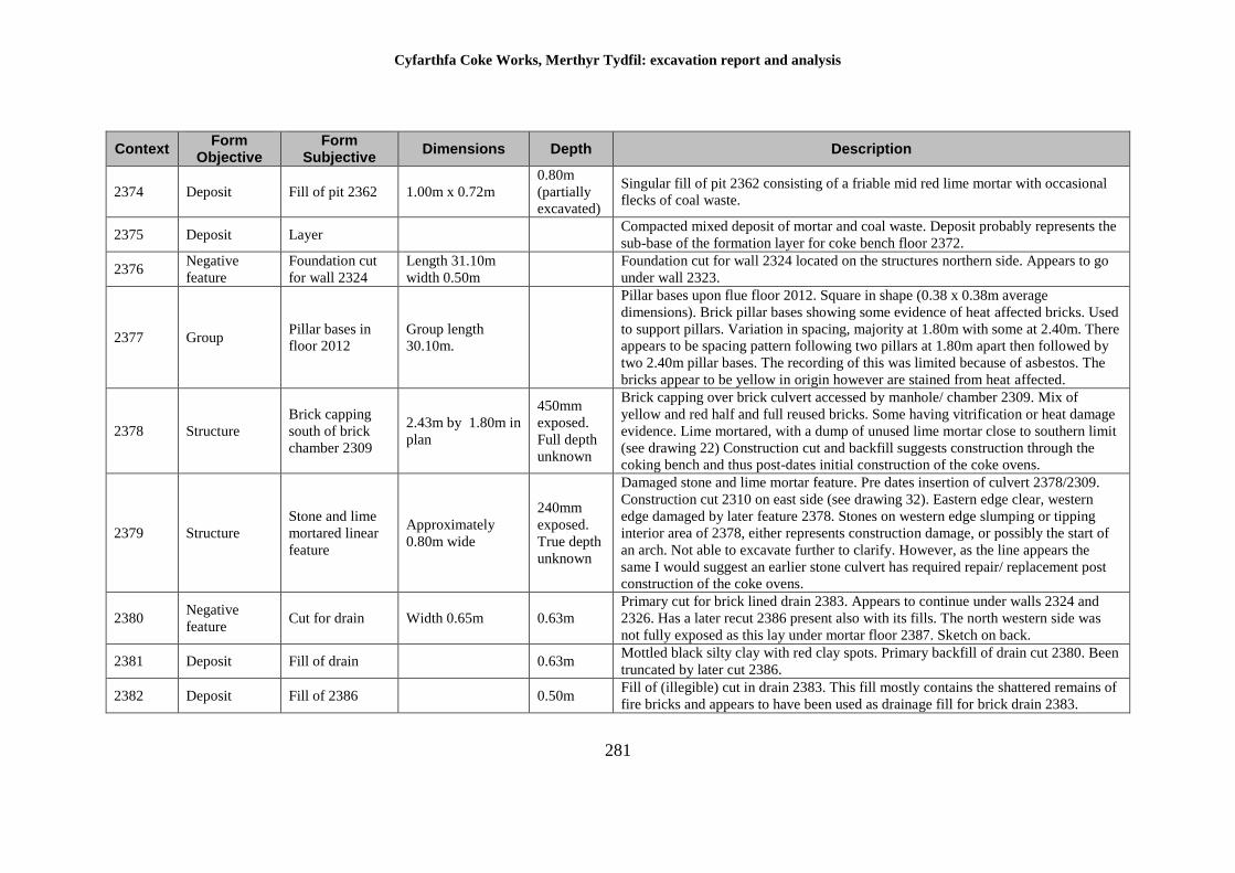
Cyfarthfa Coke Works, Merthyr Tydfil: excavation report and analysis
281
Context Form
Objective Form
Subjective Dimensions Depth Description
2374 Deposit Fill of pit 2362 1.00m x 0.72m
0.80m
(partially
excavated)
Singular fill of pit 2362 consisting of a friable mid red lime mortar with occasional
flecks of coal waste.
2375 Deposit Layer Compacted mixed deposit of mortar and coal waste. Deposit probably represents the
sub-base of the formation layer for coke bench floor 2372.
2376 Negative
feature
Foundation cut
for wall 2324
Length 31.10m
width 0.50m
Foundation cut for wall 2324 located on the structures northern side. Appears to go
under wall 2323.
2377 Group Pillar bases in
floor 2012
Group length
30.10m.
Pillar bases upon flue floor 2012. Square in shape (0.38 x 0.38m average
dimensions). Brick pillar bases showing some evidence of heat affected bricks. Used
to support pillars. Variation in spacing, majority at 1.80m with some at 2.40m. There
appears to be spacing pattern following two pillars at 1.80m apart then followed by
two 2.40m pillar bases. The recording of this was limited because of asbestos. The
bricks appear to be yellow in origin however are stained from heat affected.
2378 Structure
Brick capping
south of brick
chamber 2309
2.43m by 1.80m in
plan
450mm
exposed.
Full depth
unknown
Brick capping over brick culvert accessed by manhole/ chamber 2309. Mix of
yellow and red half and full reused bricks. Some having vitrification or heat damage
evidence. Lime mortared, with a dump of unused lime mortar close to southern limit
(see drawing 22) Construction cut and backfill suggests construction through the
coking bench and thus post-dates initial construction of the coke ovens.
2379 Structure
Stone and lime
mortared linear
feature
Approximately
0.80m wide
240mm
exposed.
True depth
unknown
Damaged stone and lime mortar feature. Pre dates insertion of culvert 2378/2309.
Construction cut 2310 on east side (see drawing 32). Eastern edge clear, western
edge damaged by later feature 2378. Stones on western edge slumping or tipping
interior area of 2378, either represents construction damage, or possibly the start of
an arch. Not able to excavate further to clarify. However, as the line appears the
same I would suggest an earlier stone culvert has required repair/ replacement post
construction of the coke ovens.
2380 Negative
feature Cut for drain Width 0.65m 0.63m
Primary cut for brick lined drain 2383. Appears to continue under walls 2324 and
2326. Has a later recut 2386 present also with its fills. The north western side was
not fully exposed as this lay under mortar floor 2387. Sketch on back.
2381 Deposit Fill of drain 0.63m Mottled black silty clay with red clay spots. Primary backfill of drain cut 2380. Been
truncated by later cut 2386.
2382 Deposit Fill of 2386 0.50m Fill of (illegible) cut in drain 2383. This fill mostly contains the shattered remains of
fire bricks and appears to have been used as drainage fill for brick drain 2383.
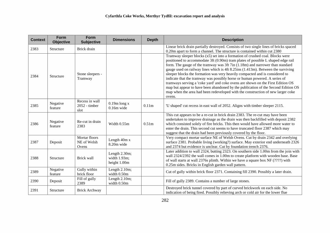
Cyfarthfa Coke Works, Merthyr Tydfil: excavation report and analysis
282
Context Form
Objective Form
Subjective Dimensions Depth Description
2383 Structure Brick drain Linear brick drain partially destroyed. Consists of two single lines of bricks spaced
0.20m apart to form a channel. The structure is contained within cut 2380
2384 Structure Stone sleepers -
Tramway
Tramway sleeper blocks (x5) set into a formation of crushed coal. Blocks were
positioned to accommodate 3ft (0.90m) tram plates of possible L shaped edge rail
form. The gauge of the tramway was 3ft 7in (1.18m) and narrower than standard
gauge used on railway lines which is 4ft 8.25ins (1.413m). Between the surviving
sleeper blocks the formation was very heavily compacted and is considered to
indicate that the tramway was possibly horse or human powered. A series of
tramways serving a 'coke yard' and coke ovens are shown on the First Edition OS
map but appear to have been abandoned by the publication of the Second Edition OS
map when the area had been redeveloped with the construction of new larger coke
ovens.
2385 Negative
feature
Recess in wall
2052 - timber
slot
0.19m long x
0.16m wide 0.11m 'U shaped' cut recess in east wall of 2052. Aligns with timber sleeper 2115.
2386 Negative
feature
Re-cut in drain
2383 Width 0.55m 0.51m
This cut appears to be a re-cut in brick drain 2383. The re-cut may have been
undertaken to improve drainage as the drain was then backfilled with deposit 2382
which consisted solely of fire bricks. This then would have allowed more water to
enter the drain. This second cut seems to have truncated floor 2387 which may
suggest that the drain had been previously covered by the floor.
2387 Deposit
Mortar floors
NE of Welsh
Ovens
Length 40m x
8.20m wide
Very compact mortar surface NE of Welsh Ovens. Cut by drain 2342 and overlying
surface 2381. Probable living (working?) surface. May exterior end underneath 2326
and 2374 but evidence is unclear. Cut by foundation trench 2376.
2388 Structure Brick wall
Length 2.30m;
width 1.93m;
height 1.00m
Later addition to wall 2324, butting 2323. On southern side 1.00m from the join with
wall 2324/2392 the wall comes in 1.00m to create platform with wooden base. Base
of wall starts at wall 2376s plinth. Within we have a square box NF (????) with
0.25m sides. Bricks in English garden wall pattern.
2389 Negative
feature
Gully within
brick floor
Length 2.10m;
width 0.50m Cut of gully within brick floor 2371. Containing fill 2390. Possibly a later drain.
2390 Deposit Fill of gully
2389
Length 2.10m;
width 0.50m Fill of gully 2389. Contains a number of large stones.
2391 Structure Brick Archway Destroyed brick tunnel covered by part of curved brickwork on each side. No
indication of being fired. Possibly relieving arch or cold air for the lower flue
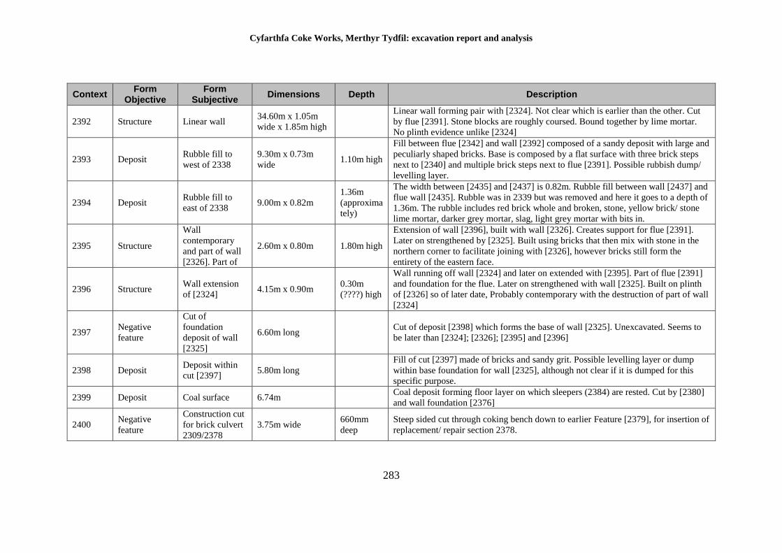
Cyfarthfa Coke Works, Merthyr Tydfil: excavation report and analysis
283
Context Form
Objective Form
Subjective Dimensions Depth Description
2392 Structure Linear wall 34.60m x 1.05m
wide x 1.85m high
Linear wall forming pair with [2324]. Not clear which is earlier than the other. Cut
by flue [2391]. Stone blocks are roughly coursed. Bound together by lime mortar.
No plinth evidence unlike [2324]
2393 Deposit Rubble fill to
west of 2338
9.30m x 0.73m
wide 1.10m high
Fill between flue [2342] and wall [2392] composed of a sandy deposit with large and
peculiarly shaped bricks. Base is composed by a flat surface with three brick steps
next to [2340] and multiple brick steps next to flue [2391]. Possible rubbish dump/
levelling layer.
2394 Deposit Rubble fill to
east of 2338 9.00m x 0.82m
1.36m
(approxima
tely)
The width between [2435] and [2437] is 0.82m. Rubble fill between wall [2437] and
flue wall [2435]. Rubble was in 2339 but was removed and here it goes to a depth of
1.36m. The rubble includes red brick whole and broken, stone, yellow brick/ stone
lime mortar, darker grey mortar, slag, light grey mortar with bits in.
2395 Structure
Wall
contemporary
and part of wall
[2326]. Part of
2.60m x 0.80m 1.80m high
Extension of wall [2396], built with wall [2326]. Creates support for flue [2391].
Later on strengthened by [2325]. Built using bricks that then mix with stone in the
northern corner to facilitate joining with [2326], however bricks still form the
entirety of the eastern face.
2396 Structure Wall extension
of [2324] 4.15m x 0.90m
0.30m
(????) high
Wall running off wall [2324] and later on extended with [2395]. Part of flue [2391]
and foundation for the flue. Later on strengthened with wall [2325]. Built on plinth
of [2326] so of later date, Probably contemporary with the destruction of part of wall
[2324]
2397 Negative
feature
Cut of
foundation
deposit of wall
[2325]
6.60m long Cut of deposit [2398] which forms the base of wall [2325]. Unexcavated. Seems to
be later than [2324]; [2326]; [2395] and [2396]
2398 Deposit Deposit within
cut [2397] 5.80m long
Fill of cut [2397] made of bricks and sandy grit. Possible levelling layer or dump
within base foundation for wall [2325], although not clear if it is dumped for this
specific purpose.
2399 Deposit Coal surface 6.74m Coal deposit forming floor layer on which sleepers (2384) are rested. Cut by [2380]
and wall foundation [2376]
2400 Negative
feature
Construction cut
for brick culvert
2309/2378
3.75m wide 660mm
deep
Steep sided cut through coking bench down to earlier Feature [2379], for insertion of
replacement/ repair section 2378.
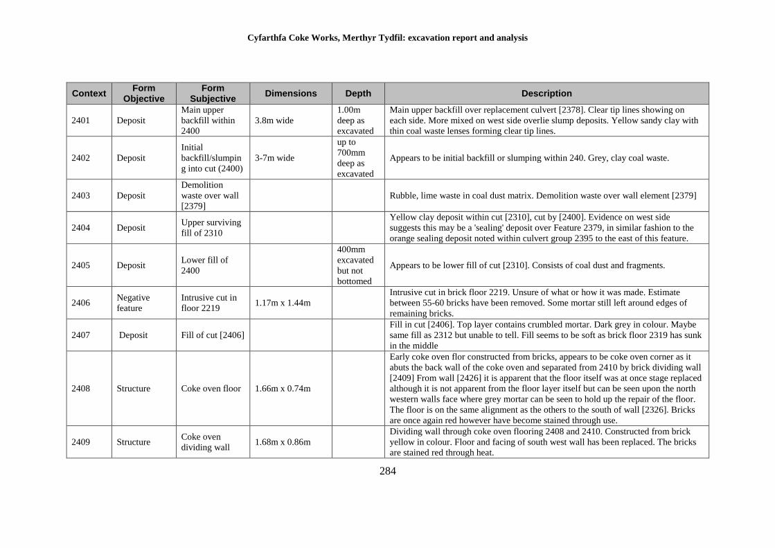
Cyfarthfa Coke Works, Merthyr Tydfil: excavation report and analysis
284
Context Form
Objective Form
Subjective Dimensions Depth Description
2401 Deposit
Main upper
backfill within
2400
3.8m wide
1.00m
deep as
excavated
Main upper backfill over replacement culvert [2378]. Clear tip lines showing on
each side. More mixed on west side overlie slump deposits. Yellow sandy clay with
thin coal waste lenses forming clear tip lines.
2402 Deposit
Initial
backfill/slumpin
g into cut (2400)
3-7m wide
up to
700mm
deep as
excavated
Appears to be initial backfill or slumping within 240. Grey, clay coal waste.
2403 Deposit
Demolition
waste over wall
[2379]
Rubble, lime waste in coal dust matrix. Demolition waste over wall element [2379]
2404 Deposit Upper surviving
fill of 2310
Yellow clay deposit within cut [2310], cut by [2400]. Evidence on west side
suggests this may be a 'sealing' deposit over Feature 2379, in similar fashion to the
orange sealing deposit noted within culvert group 2395 to the east of this feature.
2405 Deposit Lower fill of
2400
400mm
excavated
but not
bottomed
Appears to be lower fill of cut [2310]. Consists of coal dust and fragments.
2406 Negative
feature
Intrusive cut in
floor 2219 1.17m x 1.44m
Intrusive cut in brick floor 2219. Unsure of what or how it was made. Estimate
between 55-60 bricks have been removed. Some mortar still left around edges of
remaining bricks.
2407 Deposit Fill of cut [2406]
Fill in cut [2406]. Top layer contains crumbled mortar. Dark grey in colour. Maybe
same fill as 2312 but unable to tell. Fill seems to be soft as brick floor 2319 has sunk
in the middle
2408 Structure Coke oven floor 1.66m x 0.74m
Early coke oven flor constructed from bricks, appears to be coke oven corner as it
abuts the back wall of the coke oven and separated from 2410 by brick dividing wall
[2409] From wall [2426] it is apparent that the floor itself was at once stage replaced
although it is not apparent from the floor layer itself but can be seen upon the north
western walls face where grey mortar can be seen to hold up the repair of the floor.
The floor is on the same alignment as the others to the south of wall [2326]. Bricks
are once again red however have become stained through use.
2409 Structure Coke oven
dividing wall 1.68m x 0.86m
Dividing wall through coke oven flooring 2408 and 2410. Constructed from brick
yellow in colour. Floor and facing of south west wall has been replaced. The bricks
are stained red through heat.
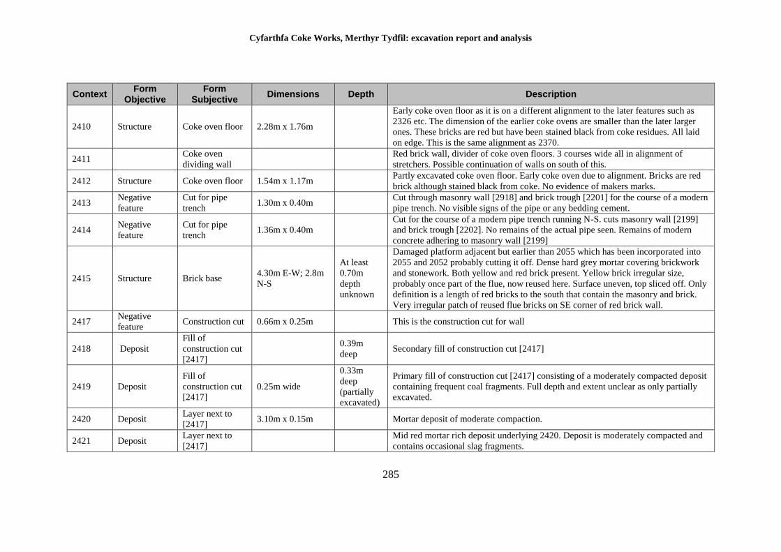
Cyfarthfa Coke Works, Merthyr Tydfil: excavation report and analysis
285
Context Form
Objective Form
Subjective Dimensions Depth Description
2410 Structure Coke oven floor 2.28m x 1.76m
Early coke oven floor as it is on a different alignment to the later features such as
2326 etc. The dimension of the earlier coke ovens are smaller than the later larger
ones. These bricks are red but have been stained black from coke residues. All laid
on edge. This is the same alignment as 2370.
2411 Coke oven
dividing wall
Red brick wall, divider of coke oven floors. 3 courses wide all in alignment of
stretchers. Possible continuation of walls on south of this.
2412 Structure Coke oven floor 1.54m x 1.17m Partly excavated coke oven floor. Early coke oven due to alignment. Bricks are red
brick although stained black from coke. No evidence of makers marks.
2413 Negative
feature
Cut for pipe
trench 1.30m x 0.40m
Cut through masonry wall [2918] and brick trough [2201] for the course of a modern
pipe trench. No visible signs of the pipe or any bedding cement.
2414 Negative
feature
Cut for pipe
trench 1.36m x 0.40m
Cut for the course of a modern pipe trench running N-S. cuts masonry wall [2199]
and brick trough [2202]. No remains of the actual pipe seen. Remains of modern
concrete adhering to masonry wall [2199]
2415 Structure Brick base 4.30m E-W; 2.8m
N-S
At least
0.70m
depth
unknown
Damaged platform adjacent but earlier than 2055 which has been incorporated into
2055 and 2052 probably cutting it off. Dense hard grey mortar covering brickwork
and stonework. Both yellow and red brick present. Yellow brick irregular size,
probably once part of the flue, now reused here. Surface uneven, top sliced off. Only
definition is a length of red bricks to the south that contain the masonry and brick.
Very irregular patch of reused flue bricks on SE corner of red brick wall.
2417 Negative
feature Construction cut 0.66m x 0.25m This is the construction cut for wall
2418 Deposit
Fill of
construction cut
[2417]
0.39m
deep Secondary fill of construction cut [2417]
2419 Deposit
Fill of
construction cut
[2417]
0.25m wide
0.33m
deep
(partially
excavated)
Primary fill of construction cut [2417] consisting of a moderately compacted deposit
containing frequent coal fragments. Full depth and extent unclear as only partially
excavated.
2420 Deposit Layer next to
[2417] 3.10m x 0.15m Mortar deposit of moderate compaction.
2421 Deposit Layer next to
[2417]
Mid red mortar rich deposit underlying 2420. Deposit is moderately compacted and
contains occasional slag fragments.
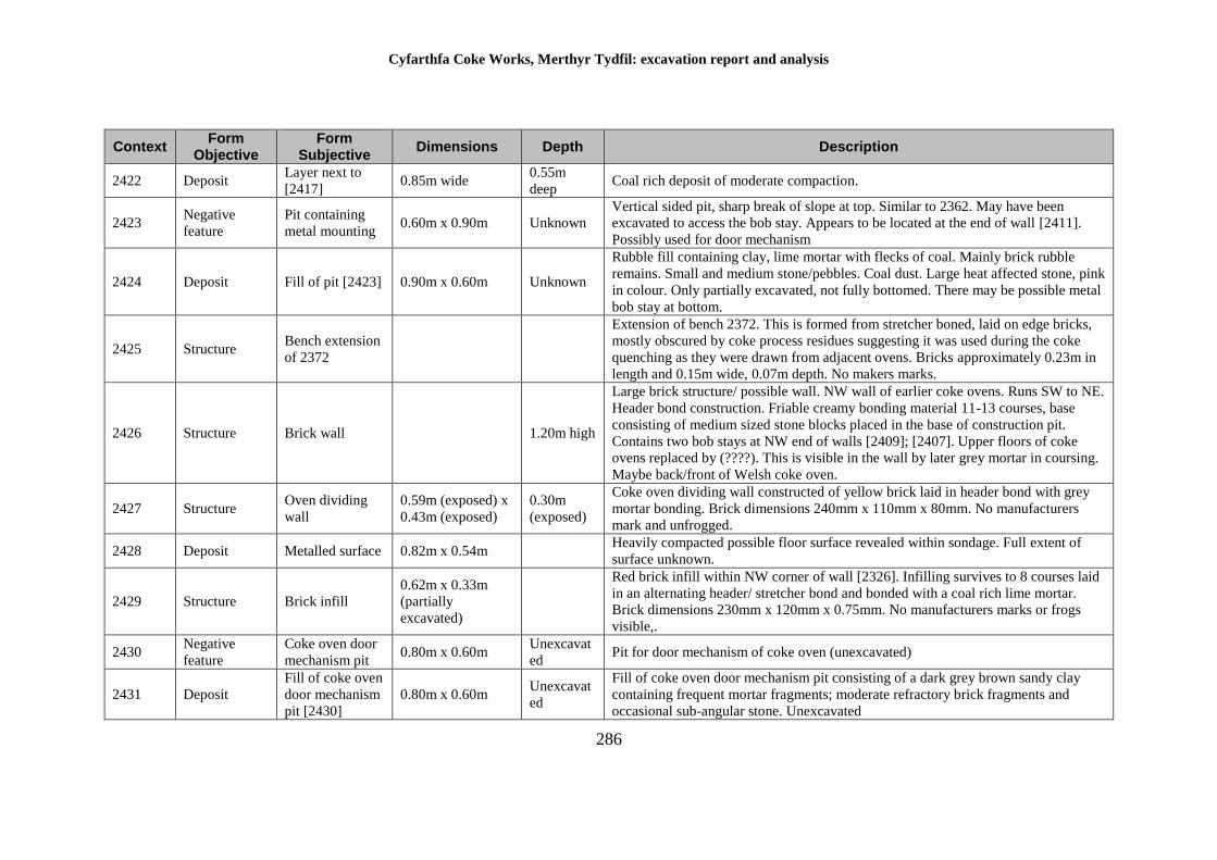
Cyfarthfa Coke Works, Merthyr Tydfil: excavation report and analysis
286
Context Form
Objective Form
Subjective Dimensions Depth Description
2422 Deposit Layer next to
[2417] 0.85m wide
0.55m
deep Coal rich deposit of moderate compaction.
2423 Negative
feature
Pit containing
metal mounting 0.60m x 0.90m Unknown
Vertical sided pit, sharp break of slope at top. Similar to 2362. May have been
excavated to access the bob stay. Appears to be located at the end of wall [2411].
Possibly used for door mechanism
2424 Deposit Fill of pit [2423] 0.90m x 0.60m Unknown
Rubble fill containing clay, lime mortar with flecks of coal. Mainly brick rubble
remains. Small and medium stone/pebbles. Coal dust. Large heat affected stone, pink
in colour. Only partially excavated, not fully bottomed. There may be possible metal
bob stay at bottom.
2425 Structure Bench extension
of 2372
Extension of bench 2372. This is formed from stretcher boned, laid on edge bricks,
mostly obscured by coke process residues suggesting it was used during the coke
quenching as they were drawn from adjacent ovens. Bricks approximately 0.23m in
length and 0.15m wide, 0.07m depth. No makers marks.
2426 Structure Brick wall 1.20m high
Large brick structure/ possible wall. NW wall of earlier coke ovens. Runs SW to NE.
Header bond construction. Friable creamy bonding material 11-13 courses, base
consisting of medium sized stone blocks placed in the base of construction pit.
Contains two bob stays at NW end of walls [2409]; [2407]. Upper floors of coke
ovens replaced by (????). This is visible in the wall by later grey mortar in coursing.
Maybe back/front of Welsh coke oven.
2427 Structure Oven dividing
wall
0.59m (exposed) x
0.43m (exposed)
0.30m
(exposed)
Coke oven dividing wall constructed of yellow brick laid in header bond with grey
mortar bonding. Brick dimensions 240mm x 110mm x 80mm. No manufacturers
mark and unfrogged.
2428 Deposit Metalled surface 0.82m x 0.54m Heavily compacted possible floor surface revealed within sondage. Full extent of
surface unknown.
2429 Structure Brick infill
0.62m x 0.33m
(partially
excavated)
Red brick infill within NW corner of wall [2326]. Infilling survives to 8 courses laid
in an alternating header/ stretcher bond and bonded with a coal rich lime mortar.
Brick dimensions 230mm x 120mm x 0.75mm. No manufacturers marks or frogs
visible,.
2430 Negative
feature
Coke oven door
mechanism pit 0.80m x 0.60m
Unexcavat
ed Pit for door mechanism of coke oven (unexcavated)
2431 Deposit
Fill of coke oven
door mechanism
pit [2430]
0.80m x 0.60m Unexcavat
ed
Fill of coke oven door mechanism pit consisting of a dark grey brown sandy clay
containing frequent mortar fragments; moderate refractory brick fragments and
occasional sub-angular stone. Unexcavated
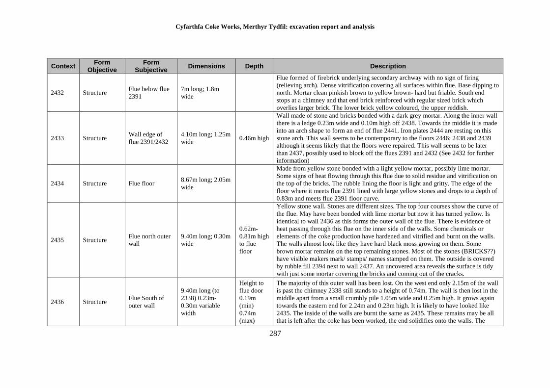
Cyfarthfa Coke Works, Merthyr Tydfil: excavation report and analysis
287
Context Form
Objective Form
Subjective Dimensions Depth Description
2432 Structure Flue below flue
2391
7m long; 1.8m
wide
Flue formed of firebrick underlying secondary archway with no sign of firing
(relieving arch). Dense vitrification covering all surfaces within flue. Base dipping to
north. Mortar clean pinkish brown to yellow brown- hard but friable. South end
stops at a chimney and that end brick reinforced with regular sized brick which
overlies larger brick. The lower brick yellow coloured, the upper reddish.
2433 Structure Wall edge of
flue 2391/2432
4.10m long; 1.25m
wide 0.46m high
Wall made of stone and bricks bonded with a dark grey mortar. Along the inner wall
there is a ledge 0.23m wide and 0.10m high off 2438. Towards the middle it is made
into an arch shape to form an end of flue 2441. Iron plates 2444 are resting on this
stone arch. This wall seems to be contemporary to the floors 2446; 2438 and 2439
although it seems likely that the floors were repaired. This wall seems to be later
than 2437, possibly used to block off the flues 2391 and 2432 (See 2432 for further
information)
2434 Structure Flue floor 8.67m long; 2.05m
wide
Made from yellow stone bonded with a light yellow mortar, possibly lime mortar.
Some signs of heat flowing through this flue due to solid residue and vitrification on
the top of the bricks. The rubble lining the floor is light and gritty. The edge of the
floor where it meets flue 2391 lined with large yellow stones and drops to a depth of
0.83m and meets flue 2391 floor curve.
2435 Structure Flue north outer
wall
9.40m long; 0.30m
wide
0.62m-
0.81m high
to flue
floor
Yellow stone wall. Stones are different sizes. The top four courses show the curve of
the flue. May have been bonded with lime mortar but now it has turned yellow. Is
identical to wall 2436 as this forms the outer wall of the flue. There is evidence of
heat passing through this flue on the inner side of the walls. Some chemicals or
elements of the coke production have hardened and vitrified and burnt on the walls.
The walls almost look like they have hard black moss growing on them. Some
brown mortar remains on the top remaining stones. Most of the stones (BRICKS??)
have visible makers mark/ stamps/ names stamped on them. The outside is covered
by rubble fill 2394 next to wall 2437. An uncovered area reveals the surface is tidy
with just some mortar covering the bricks and coming out of the cracks.
2436 Structure Flue South of
outer wall
9.40m long (to
2338) 0.23m-
0.30m variable
width
Height to
flue door
0.19m
(min)
0.74m
(max)
The majority of this outer wall has been lost. On the west end only 2.15m of the wall
is past the chimney 2338 still stands to a height of 0.74m. The wall is then lost in the
middle apart from a small crumbly pile 1.05m wide and 0.25m high. It grows again
towards the eastern end for 2.24m and 0.23m high. It is likely to have looked like
2435. The inside of the walls are burnt the same as 2435. These remains may be all
that is left after the coke has been worked, the end solidifies onto the walls. The
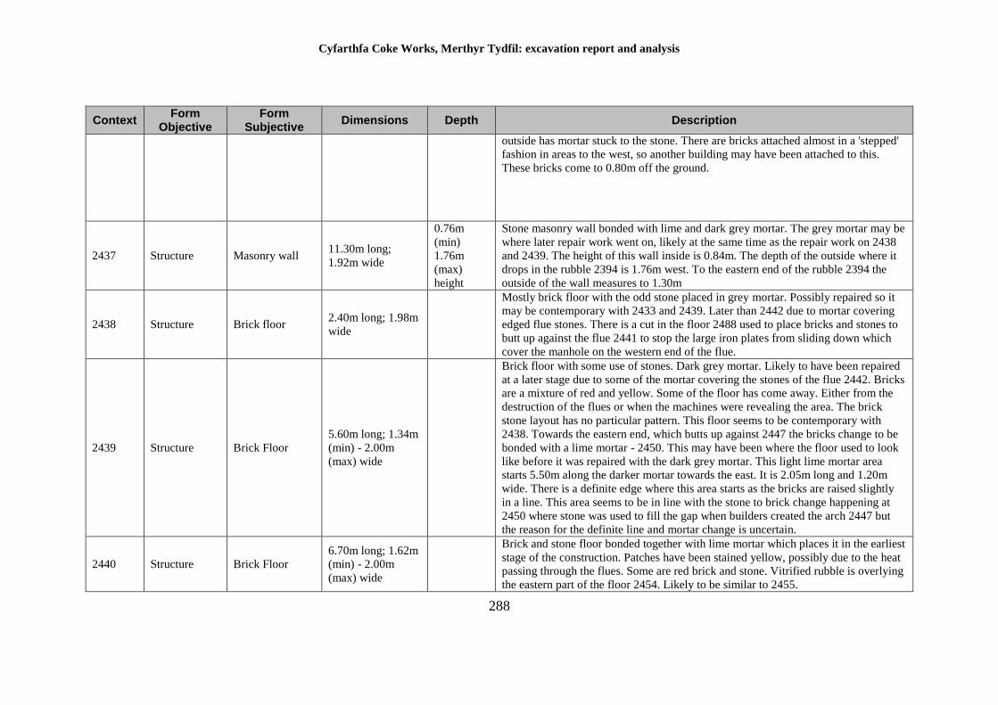
Cyfarthfa Coke Works, Merthyr Tydfil: excavation report and analysis
288
Context Form
Objective Form
Subjective Dimensions Depth Description
outside has mortar stuck to the stone. There are bricks attached almost in a 'stepped'
fashion in areas to the west, so another building may have been attached to this.
These bricks come to 0.80m off the ground.
2437 Structure Masonry wall 11.30m long;
1.92m wide
0.76m
(min)
1.76m
(max)
height
Stone masonry wall bonded with lime and dark grey mortar. The grey mortar may be
where later repair work went on, likely at the same time as the repair work on 2438
and 2439. The height of this wall inside is 0.84m. The depth of the outside where it
drops in the rubble 2394 is 1.76m west. To the eastern end of the rubble 2394 the
outside of the wall measures to 1.30m
2438 Structure Brick floor 2.40m long; 1.98m
wide
Mostly brick floor with the odd stone placed in grey mortar. Possibly repaired so it
may be contemporary with 2433 and 2439. Later than 2442 due to mortar covering
edged flue stones. There is a cut in the floor 2488 used to place bricks and stones to
butt up against the flue 2441 to stop the large iron plates from sliding down which
cover the manhole on the western end of the flue.
2439 Structure Brick Floor
5.60m long; 1.34m
(min) - 2.00m
(max) wide
Brick floor with some use of stones. Dark grey mortar. Likely to have been repaired
at a later stage due to some of the mortar covering the stones of the flue 2442. Bricks
are a mixture of red and yellow. Some of the floor has come away. Either from the
destruction of the flues or when the machines were revealing the area. The brick
stone layout has no particular pattern. This floor seems to be contemporary with
2438. Towards the eastern end, which butts up against 2447 the bricks change to be
bonded with a lime mortar - 2450. This may have been where the floor used to look
like before it was repaired with the dark grey mortar. This light lime mortar area
starts 5.50m along the darker mortar towards the east. It is 2.05m long and 1.20m
wide. There is a definite edge where this area starts as the bricks are raised slightly
in a line. This area seems to be in line with the stone to brick change happening at
2450 where stone was used to fill the gap when builders created the arch 2447 but
the reason for the definite line and mortar change is uncertain.
2440 Structure Brick Floor
6.70m long; 1.62m
(min) - 2.00m
(max) wide
Brick and stone floor bonded together with lime mortar which places it in the earliest
stage of the construction. Patches have been stained yellow, possibly due to the heat
passing through the flues. Some are red brick and stone. Vitrified rubble is overlying
the eastern part of the floor 2454. Likely to be similar to 2455.
Cyfarthfa Coke Works, Merthyr Tydfil: excavation report and analysis
289
Context Form
Objective Form
Subjective Dimensions Depth Description
2441 Structure Brick arched
flue (cool air)
4.90m long; 2.36m
wide
2.50m
(approxima
tely)
West end of cool air flue within Area 5. Constructed from yellow bricks measuring
22.5cm x 10cm x 7.5cm, on the outer edge and yellow slabs measuring 46cm x
30.5cm x 9cm within the inner edge and bonded with soft grey mortar. The east end,
connected with chimney 2132, has been destroyed approximately half way. The west
end is covered by iron plates 2444. Brick floors 2446; 2438 and 2439 are
approximately located two thirds up the north and south sides of the flue.
Additionally brick side flue 2442 runs off the south side of 2441. The north east
corner is bonded with chimney retaining wall 2445 and the west end is cut and
blocked off by wall 2433
2442 Structure Brick Side Flue 2.04m long;
1.13m/ 0.80m wide
Side flue running off the south side of cool air flue 2441. Constructed from yellow
bricks measuring 23cm x 7.5cm x 10.5cm on the outer edge and larger yellow slabs
measuring 30cm x 11cm x 27cmfor the inner part of the circle. Only the top with a
maximum width of 1.13m has been revealed. The west side is overlain by 2438 and
the east side underlies 2439. the south end has been cut by wall 2437 and is blocked
by it. There is damage to the majority of the top of the outer layer, resulting in most
of the bricks being removed.
2443 Structure
Northern
exterior masonry
wall
Random coursed core of exterior wall bonded with a grey coal/coke rich mortar.
Wall was originally faced with rectangular dressed stone blocks but apart from two
courses at the base of the wall this facing has been removed. The possibly occurred
during decommissioning of the site in the early part of the 20th century.
2444 Object
FE plates and
brickwork over
2441
2.54m long; 1.21m
wide
Collection of four iron plates measuring 1.21m x 0.61m x 0.02m each, over the west
end of cool air flue 2441. One of the plates has been broken in half. There are three
slabs on the south edge and two on the north edge of the collection. The iron plates
are partially corroded and also overlie 2433
2446 Structure Brick Floor 20.58m (max0
long; 1.84m wide
Brick floor placed between flue 2441 and 2448, wall 2445 and wall 2443.
Constructed with a variety of bricks bonded mostly with dark grey mortar, with the
area running along the north edge of 2448 containing lime mortar. Depth is unknown
as floor was not fully excavated to base.
2447 Structure Brick Arched
Flue
1.85m long; 0.58m
wide (see also
comments box)
0.62m high
Brick arched flue constructed with yellow bricks measuring 23cm x 10.5cm x 8cm
and bonded with yellow mortar. The inner lining is constructed using large brick
slabs that are wider at one end allowing for the arch shape. The flue is partially
revealed and continues into wall 2450. It is bonded with 2470. Has same
construction as 2453.
Cyfarthfa Coke Works, Merthyr Tydfil: excavation report and analysis
290
Context Form
Objective Form
Subjective Dimensions Depth Description
2448 Structure Brick Flue 1.55m of interior;
2.30m interior.
A hot air flue constructed in refractory bricks. A number of different shaped bricks
used including wedge section bricks to attain a circular section. Brick built
stabilising wedges support the flue and are considered here as part of the same flue
structure. Onto these supports are built the outer circle constructed using half bricks.
Inside this are laid the large wedge shaped bricks to form a tight circle. The interior
void has a diameter of 1.55m. On the west end the flue has been blocked up by 2473
which reaches approximately halfway up the flue circle. The bricks at the west end
are not vitrified (although the back end of the blocking was vitrified) but the bricks
were discoloured through heating to a depth of 2cm. At the east end of the flue the
bricks were slightly vitrified and heated to 3-4cm into the brick. A number of side
flues leave the main flue to the south. These are 2447/2470 and 2453. These are later
additions of have been repaired as the brickwork joining the main flue are quite
different. The mortar bonding of the bricks of 2448 is a clay based pale yellow
brown.
2449 Structure Brick arched
flue/ doorway
1.75m outside;
1.24m inside 1.80m high
Possible doorway (?) Part of wall 2451/2489 red brick, two bricks wide bonded into
2451/2489. Arch all headers V walls headers/stretchers. Doorway onto floor 2479
and blocked by 2504 covered by 2492/ 2493. Blocked by 2504. Red brick
construction bounded with a soft white mortar containing occasional brick
fragments. May be entrance onto floor 2479 for back of flue 2490. Some bricks on
east side continue beyond line of wall 2451/2489. May have continued out onto floor
2479, though as it is bonded with wall 2451/2487 and floor 2479 abuts 2451/2489
was probably all part of the same construction. May have provided access to the flue
bay during construction and then access to north side of main flue for maintenance.
2450 Structure Brick Wall/
Floor
1.26m long; 0.87m
wide 0.68m high
Potential similar structure to 2451 and 2452 (?). The brick wall/ floor is located to
the west of flue 2447. This potential wall/ floor structure would have cut wall 2437
and nibble (?) 2394. The bricks/ rocks which make up the wall/ floor are scarred red
with a layer of light grey mortar on top of each brick. The area 2450 is damaged.
This is perhaps due to machinery or due to collapse previously. Only the bottom two
courses of bricks can be properly identified. The wall continues southward, where
the top layer of brick/stone is not visible as it lies under a light layer of grey mortar
and brick dust. The south end of the north facing face looks similar to backfill 2498
and contained within 2494.
Cyfarthfa Coke Works, Merthyr Tydfil: excavation report and analysis
291
Context Form
Objective Form
Subjective Dimensions Depth Description
2451 Structure Masonry Wall 1.23m long; 0.90m
wide 0.49m high
A potential cut in wall 2478 to allow for a brick wall next to flue 2449. the wall has
different sized bricks with the west side of 2451 (north facing) having a large
foundation stone. The dimensions of this foundation stone are 0.42m (long) by
0.13m (height). There are three courses of varying sizes of stone before the top two
courses are of brick, forming a regular course of bricks. The bricks are originally
yellow colour but are stained red, with a layer of light grey mortar bonding each of
the courses of bricks. The southern end of 2451 is similar to the backfill 2503 and
contained within 2499. The average brick size is 0.23m (long) by 0.08m (height).
2452 Structure Brick remnant
wall
1.26m long; 1.10m
wide 0.68m high
A potential remnant of a brick wall which may have been an addition to wall 2439.
The potential wall consists of seven courses of bricks. The colour of the bricks are
stained red, with a light grey layer of mortar. The level of the bricks are not all at the
seven course height. At the fourth course of bricks there is a layer beginning to arch
towards flue 2448. This pattern of arching bricks is repeated on the sixth course of
bricks.
2453 Structure Brick Arched
Flue
A (interior. 0.75m;
exterior 1.35m) B
(interior 0.88m;
exterior 1.48m)
(D.Davies) Yellow brick flue with light grey mortar, although in some areas the
mortar has been stained yellow/orange. Outer layers of construction made with small
yellow bricks laid stretcher in bond in the arch shape. Inner courses constructed
from larger/ longer stretcher bricks some which are red others are stained red.
Dimensions of longer/larger bricks approximately 0.45m length, 0.10m wide and
0.15m in height whereas the smaller bricks used on the outer phases and northern
arch face are approximately 0.20m in length, 0.12m wide and 0.80m height.
Northern face is constructed from stretcher yellow bricks and demonstrates a
vitrified mortar spread coming from within the flue itself. 2454. Although this spread
technically underlies the flue it is apparent that the vitrified material accommodated
in the shape of the flue itself and therefore demonstrates the stratigraphic
relationship. (S. Baker 13/09/2013) Brick arched flue constructed with yellow bricks
0.30m long. These bricks are wider at the top and narrow at the bottom creating the
arch. The bricks are different width, some are smaller to close the gap in the arch.
The tunnel has been unblocked and carries on through wall 2478. The bricks on the
corner of the flue have curved outer corners. The bricks are bonded with 0.05m of
hard yellow mortar with occasional grains of sand. The inner side of the tube tunnel
is covered with hard reddish purple vitrified concretion due to the heat passing
through. The outside of the tube is covered with vitrified concrete from the heat and
Cyfarthfa Coke Works, Merthyr Tydfil: excavation report and analysis
292
Context Form
Objective Form
Subjective Dimensions Depth Description
chemicals- 2454. The construction consisted of a U shaped cut through wall 2489
which was then partially backfilled by structural brick preparation 2500 creating a
square shaped linear channel into which the lower end of tube 2453 was constructed.
The upper course of 2453 was constructed and then a reinforcing arch or collar 2451
was constructed over the tube to support the upstanding wall. The southern end of
the tube was then covered by brick structure 2502 intended to seal in the heat. Gaps
on the southern side of the wall were then filled with structural backfill 2503.
2454 Deposit Mortar Repair
2.08m long; 1.48m
(max) 0.80m (min)
width
A large patch of vitrified mortar, with yellow and orange patches of brick dust on top
of the mortar. The mortar looks as if could be a repair on the top of a flue which
would join flue 2448. Rocks can be seen within the mortar which range from pebble
size to medium sized stones.
2455 Structure Brick Floor 1.30m long;
0.42m wide
Continuation of floor 2440. Yellow and orange patches of brick work floor. On the
north side of 2455 is a patch of vitrified mortar repair (context number 2454)
2456 Structure Flue 1.60m wide 1.30m high
East - west aligned flue part of 2448. Constructed entirely of firebricks bonded by
mortar and laid in a stretcher bond. Appears to have several cracks in its structure
suggesting severe heat affection. Butted by later floors 2466; 2467. One stress
fracture is located at the top of the arch and has caused the structure to slump. From
viewing the flue within the opening to the west it appears that the structure is
elliptical. Although this is difficult to tell as the opening has not been fully excavated
and only one third of the flues profile can be seen. However, due to the curvature of
the flues profile which can be seen it could be estimated that the flue is elliptical in
shape. From viewing the flue two openings to the west a clear profile of the section
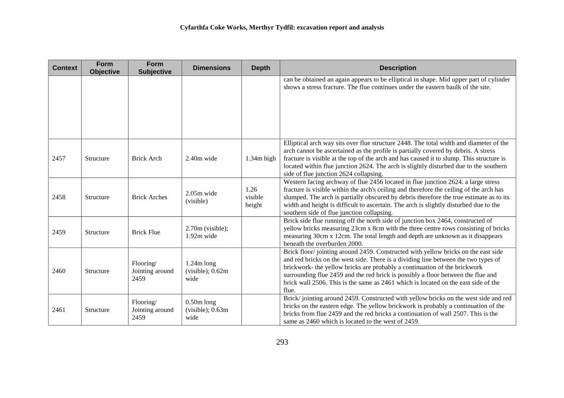
Cyfarthfa Coke Works, Merthyr Tydfil: excavation report and analysis
293
Context Form
Objective Form
Subjective Dimensions Depth Description
can be obtained an again appears to be elliptical in shape. Mid upper part of cylinder
shows a stress fracture. The flue continues under the eastern baulk of the site.
2457 Structure Brick Arch 2.40m wide 1.34m high
Elliptical arch way sits over flue structure 2448. The total width and diameter of the
arch cannot be ascertained as the profile is partially covered by debris. A stress
fracture is visible at the top of the arch and has caused it to slump. This structure is
located within flue junction 2624. The arch is slightly disturbed due to the southern
side of flue junction 2624 collapsing.
2458 Structure Brick Arches 2.05m wide
(visible)
1.26
visible
height
Western facing archway of flue 2456 located in flue junction 2624. a large stress
fracture is visible within the arch's ceiling and therefore the ceiling of the arch has
slumped. The arch is partially obscured by debris therefore the true estimate as to its
width and height is difficult to ascertain. The arch is slightly disturbed due to the
southern side of flue junction collapsing.
2459 Structure Brick Flue 2.70m (visible);
1.92m wide
Brick side flue running off the north side of junction box 2464, constructed of
yellow bricks measuring 23cm x 8cm with the three centre rows consisting of bricks
measuring 30cm x 12cm. The total length and depth are unknown as it disappears
beneath the overburden 2000.
2460 Structure
Flooring/
Jointing around
2459
1.24m long
(visible); 0.62m
wide
Brick floor/ jointing around 2459. Constructed with yellow bricks on the east side
and red bricks on the west side. There is a dividing line between the two types of
brickwork- the yellow bricks are probably a continuation of the brickwork
surrounding flue 2459 and the red brick is possibly a floor between the flue and
brick wall 2506. This is the same as 2461 which is located on the east side of the
flue.
2461 Structure
Flooring/
Jointing around
2459
0.50m long
(visible); 0.63m
wide
Brick/ jointing around 2459. Constructed with yellow bricks on the west side and red
bricks on the eastern edge. The yellow brickwork is probably a continuation of the
bricks from flue 2459 and the red bricks a continuation of wall 2507. This is the
same as 2460 which is located to the west of 2459.
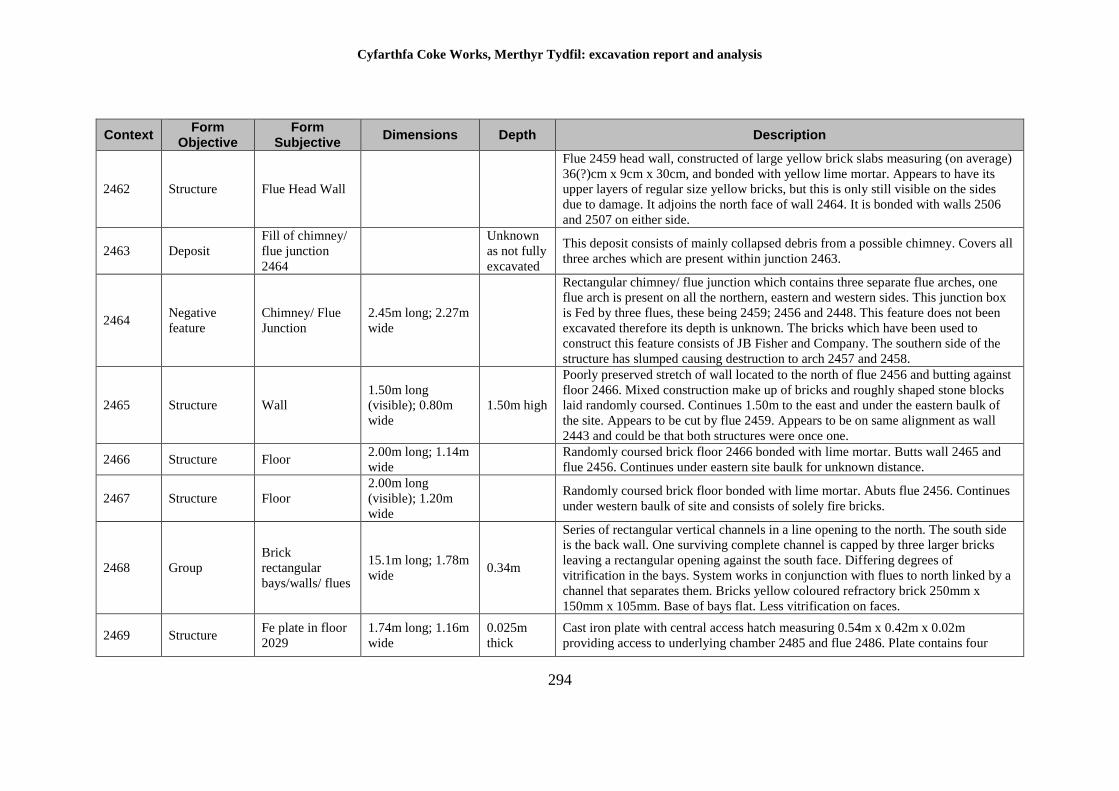
Cyfarthfa Coke Works, Merthyr Tydfil: excavation report and analysis
294
Context Form
Objective Form
Subjective Dimensions Depth Description
2462 Structure Flue Head Wall
Flue 2459 head wall, constructed of large yellow brick slabs measuring (on average)
36(?)cm x 9cm x 30cm, and bonded with yellow lime mortar. Appears to have its
upper layers of regular size yellow bricks, but this is only still visible on the sides
due to damage. It adjoins the north face of wall 2464. It is bonded with walls 2506
and 2507 on either side.
2463 Deposit
Fill of chimney/
flue junction
2464
Unknown
as not fully
excavated
This deposit consists of mainly collapsed debris from a possible chimney. Covers all
three arches which are present within junction 2463.
2464 Negative
feature
Chimney/ Flue
Junction
2.45m long; 2.27m
wide
Rectangular chimney/ flue junction which contains three separate flue arches, one
flue arch is present on all the northern, eastern and western sides. This junction box
is Fed by three flues, these being 2459; 2456 and 2448. This feature does not been
excavated therefore its depth is unknown. The bricks which have been used to
construct this feature consists of JB Fisher and Company. The southern side of the
structure has slumped causing destruction to arch 2457 and 2458.
2465 Structure Wall
1.50m long
(visible); 0.80m
wide
1.50m high
Poorly preserved stretch of wall located to the north of flue 2456 and butting against
floor 2466. Mixed construction make up of bricks and roughly shaped stone blocks
laid randomly coursed. Continues 1.50m to the east and under the eastern baulk of
the site. Appears to be cut by flue 2459. Appears to be on same alignment as wall
2443 and could be that both structures were once one.
2466 Structure Floor 2.00m long; 1.14m
wide
Randomly coursed brick floor 2466 bonded with lime mortar. Butts wall 2465 and
flue 2456. Continues under eastern site baulk for unknown distance.
2467 Structure Floor
2.00m long
(visible); 1.20m
wide
Randomly coursed brick floor bonded with lime mortar. Abuts flue 2456. Continues
under western baulk of site and consists of solely fire bricks.
2468 Group
Brick
rectangular
bays/walls/ flues
15.1m long; 1.78m
wide 0.34m
Series of rectangular vertical channels in a line opening to the north. The south side
is the back wall. One surviving complete channel is capped by three larger bricks
leaving a rectangular opening against the south face. Differing degrees of
vitrification in the bays. System works in conjunction with flues to north linked by a
channel that separates them. Bricks yellow coloured refractory brick 250mm x
150mm x 105mm. Base of bays flat. Less vitrification on faces.
2469 Structure Fe plate in floor
2029
1.74m long; 1.16m
wide
0.025m
thick
Cast iron plate with central access hatch measuring 0.54m x 0.42m x 0.02m
providing access to underlying chamber 2485 and flue 2486. Plate contains four
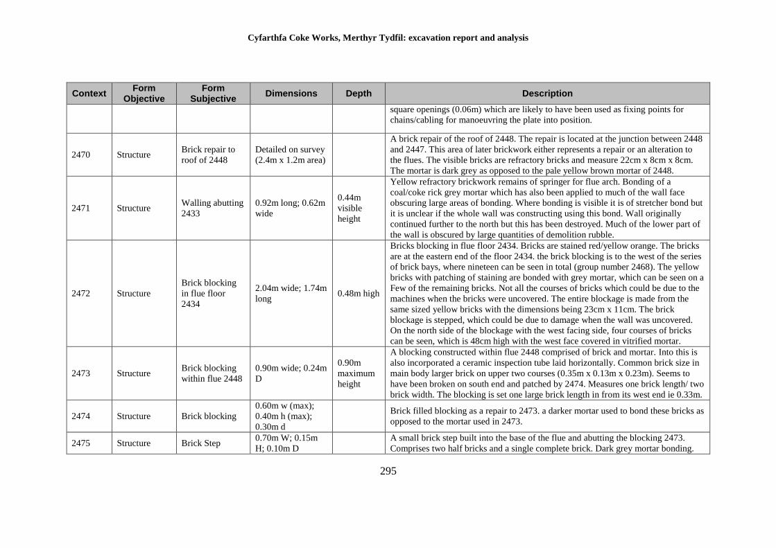
Cyfarthfa Coke Works, Merthyr Tydfil: excavation report and analysis
295
Context Form
Objective Form
Subjective Dimensions Depth Description
square openings (0.06m) which are likely to have been used as fixing points for
chains/cabling for manoeuvring the plate into position.
2470 Structure Brick repair to
roof of 2448
Detailed on survey
(2.4m x 1.2m area)
A brick repair of the roof of 2448. The repair is located at the junction between 2448
and 2447. This area of later brickwork either represents a repair or an alteration to
the flues. The visible bricks are refractory bricks and measure 22cm x 8cm x 8cm.
The mortar is dark grey as opposed to the pale yellow brown mortar of 2448.
2471 Structure Walling abutting
2433
0.92m long; 0.62m
wide
0.44m
visible
height
Yellow refractory brickwork remains of springer for flue arch. Bonding of a
coal/coke rick grey mortar which has also been applied to much of the wall face
obscuring large areas of bonding. Where bonding is visible it is of stretcher bond but
it is unclear if the whole wall was constructing using this bond. Wall originally
continued further to the north but this has been destroyed. Much of the lower part of
the wall is obscured by large quantities of demolition rubble.
2472 Structure
Brick blocking
in flue floor
2434
2.04m wide; 1.74m
long 0.48m high
Bricks blocking in flue floor 2434. Bricks are stained red/yellow orange. The bricks
are at the eastern end of the floor 2434. the brick blocking is to the west of the series
of brick bays, where nineteen can be seen in total (group number 2468). The yellow
bricks with patching of staining are bonded with grey mortar, which can be seen on a
Few of the remaining bricks. Not all the courses of bricks which could be due to the
machines when the bricks were uncovered. The entire blockage is made from the
same sized yellow bricks with the dimensions being 23cm x 11cm. The brick
blockage is stepped, which could be due to damage when the wall was uncovered.
On the north side of the blockage with the west facing side, four courses of bricks
can be seen, which is 48cm high with the west face covered in vitrified mortar.
2473 Structure Brick blocking
within flue 2448
0.90m wide; 0.24m
D
0.90m
maximum
height
A blocking constructed within flue 2448 comprised of brick and mortar. Into this is
also incorporated a ceramic inspection tube laid horizontally. Common brick size in
main body larger brick on upper two courses (0.35m x 0.13m x 0.23m). Seems to
have been broken on south end and patched by 2474. Measures one brick length/ two
brick width. The blocking is set one large brick length in from its west end ie 0.33m.
2474 Structure Brick blocking
0.60m w (max);
0.40m h (max);
0.30m d
Brick filled blocking as a repair to 2473. a darker mortar used to bond these bricks as
opposed to the mortar used in 2473.
2475 Structure Brick Step 0.70m W; 0.15m
H; 0.10m D
A small brick step built into the base of the flue and abutting the blocking 2473.
Comprises two half bricks and a single complete brick. Dark grey mortar bonding.
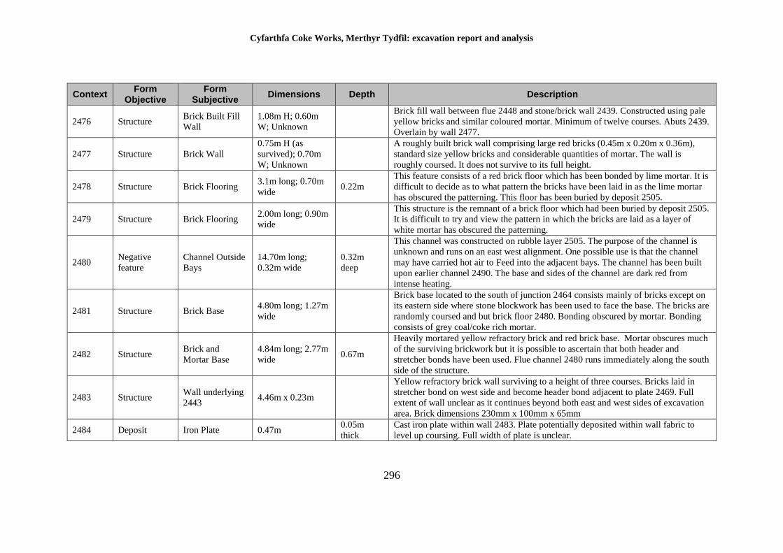
Cyfarthfa Coke Works, Merthyr Tydfil: excavation report and analysis
296
Context Form
Objective Form
Subjective Dimensions Depth Description
2476 Structure Brick Built Fill
Wall
1.08m H; 0.60m
W; Unknown
Brick fill wall between flue 2448 and stone/brick wall 2439. Constructed using pale
yellow bricks and similar coloured mortar. Minimum of twelve courses. Abuts 2439.
Overlain by wall 2477.
2477 Structure Brick Wall
0.75m H (as
survived); 0.70m
W; Unknown
A roughly built brick wall comprising large red bricks (0.45m x 0.20m x 0.36m),
standard size yellow bricks and considerable quantities of mortar. The wall is
roughly coursed. It does not survive to its full height.
2478 Structure Brick Flooring 3.1m long; 0.70m
wide 0.22m
This feature consists of a red brick floor which has been bonded by lime mortar. It is
difficult to decide as to what pattern the bricks have been laid in as the lime mortar
has obscured the patterning. This floor has been buried by deposit 2505.
2479 Structure Brick Flooring 2.00m long; 0.90m
wide
This structure is the remnant of a brick floor which had been buried by deposit 2505.
It is difficult to try and view the pattern in which the bricks are laid as a layer of
white mortar has obscured the patterning.
2480 Negative
feature
Channel Outside
Bays
14.70m long;
0.32m wide
0.32m
deep
This channel was constructed on rubble layer 2505. The purpose of the channel is
unknown and runs on an east west alignment. One possible use is that the channel
may have carried hot air to Feed into the adjacent bays. The channel has been built
upon earlier channel 2490. The base and sides of the channel are dark red from
intense heating.
2481 Structure Brick Base 4.80m long; 1.27m
wide
Brick base located to the south of junction 2464 consists mainly of bricks except on
its eastern side where stone blockwork has been used to face the base. The bricks are
randomly coursed and but brick floor 2480. Bonding obscured by mortar. Bonding
consists of grey coal/coke rich mortar.
2482 Structure Brick and
Mortar Base
4.84m long; 2.77m
wide 0.67m
Heavily mortared yellow refractory brick and red brick base. Mortar obscures much
of the surviving brickwork but it is possible to ascertain that both header and
stretcher bonds have been used. Flue channel 2480 runs immediately along the south
side of the structure.
2483 Structure Wall underlying
2443 4.46m x 0.23m
Yellow refractory brick wall surviving to a height of three courses. Bricks laid in
stretcher bond on west side and become header bond adjacent to plate 2469. Full
extent of wall unclear as it continues beyond both east and west sides of excavation
area. Brick dimensions 230mm x 100mm x 65mm
2484 Deposit Iron Plate 0.47m 0.05m
thick
Cast iron plate within wall 2483. Plate potentially deposited within wall fabric to
level up coursing. Full width of plate is unclear.
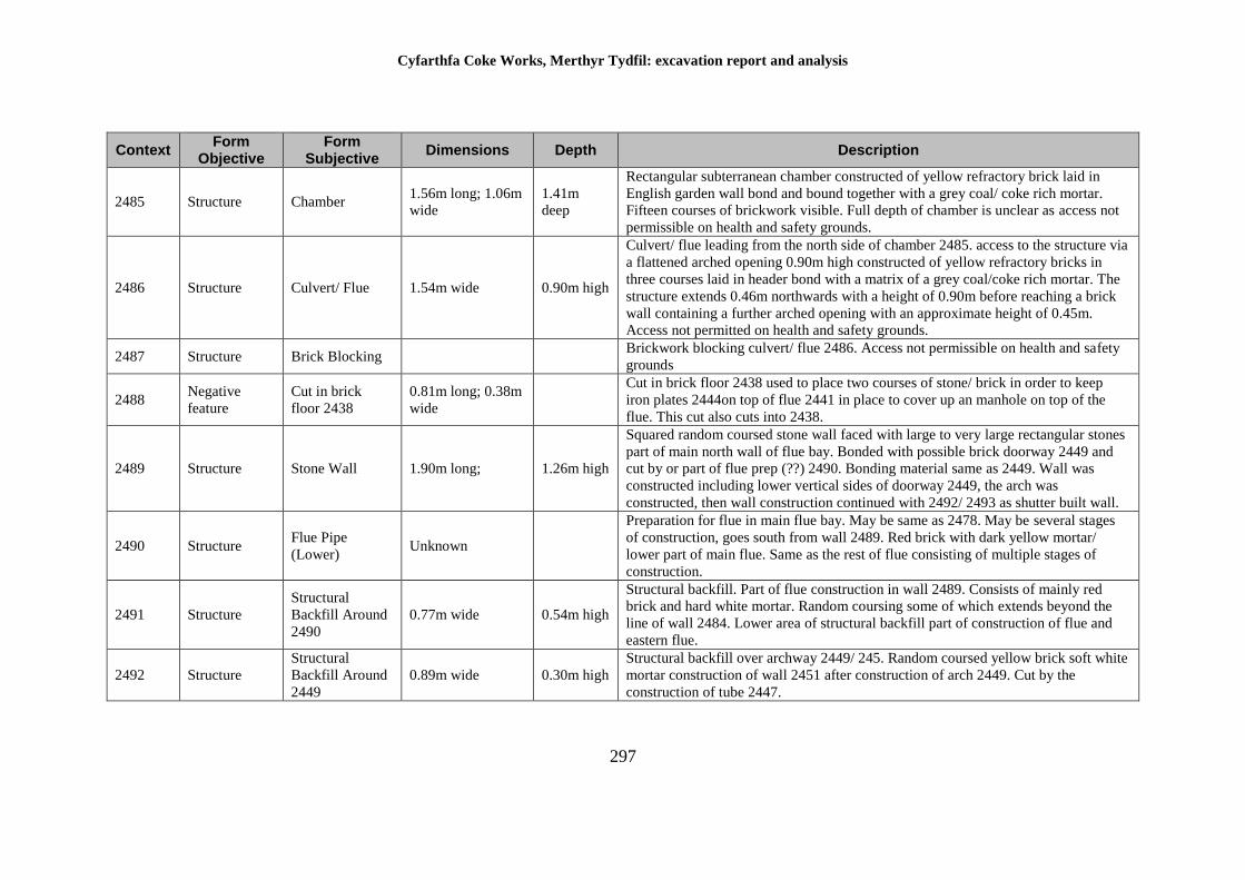
Cyfarthfa Coke Works, Merthyr Tydfil: excavation report and analysis
297
Context Form
Objective Form
Subjective Dimensions Depth Description
2485 Structure Chamber 1.56m long; 1.06m
wide
1.41m
deep
Rectangular subterranean chamber constructed of yellow refractory brick laid in
English garden wall bond and bound together with a grey coal/ coke rich mortar.
Fifteen courses of brickwork visible. Full depth of chamber is unclear as access not
permissible on health and safety grounds.
2486 Structure Culvert/ Flue 1.54m wide 0.90m high
Culvert/ flue leading from the north side of chamber 2485. access to the structure via
a flattened arched opening 0.90m high constructed of yellow refractory bricks in
three courses laid in header bond with a matrix of a grey coal/coke rich mortar. The
structure extends 0.46m northwards with a height of 0.90m before reaching a brick
wall containing a further arched opening with an approximate height of 0.45m.
Access not permitted on health and safety grounds.
2487 Structure Brick Blocking Brickwork blocking culvert/ flue 2486. Access not permissible on health and safety
grounds
2488 Negative
feature
Cut in brick
floor 2438
0.81m long; 0.38m
wide
Cut in brick floor 2438 used to place two courses of stone/ brick in order to keep
iron plates 2444on top of flue 2441 in place to cover up an manhole on top of the
flue. This cut also cuts into 2438.
2489 Structure Stone Wall 1.90m long; 1.26m high
Squared random coursed stone wall faced with large to very large rectangular stones
part of main north wall of flue bay. Bonded with possible brick doorway 2449 and
cut by or part of flue prep (??) 2490. Bonding material same as 2449. Wall was
constructed including lower vertical sides of doorway 2449, the arch was
constructed, then wall construction continued with 2492/ 2493 as shutter built wall.
2490 Structure Flue Pipe
(Lower) Unknown
Preparation for flue in main flue bay. May be same as 2478. May be several stages
of construction, goes south from wall 2489. Red brick with dark yellow mortar/
lower part of main flue. Same as the rest of flue consisting of multiple stages of
construction.
2491 Structure
Structural
Backfill Around
2490
0.77m wide 0.54m high
Structural backfill. Part of flue construction in wall 2489. Consists of mainly red
brick and hard white mortar. Random coursing some of which extends beyond the
line of wall 2484. Lower area of structural backfill part of construction of flue and
eastern flue.
2492 Structure
Structural
Backfill Around
2449
0.89m wide 0.30m high
Structural backfill over archway 2449/ 245. Random coursed yellow brick soft white
mortar construction of wall 2451 after construction of arch 2449. Cut by the
construction of tube 2447.
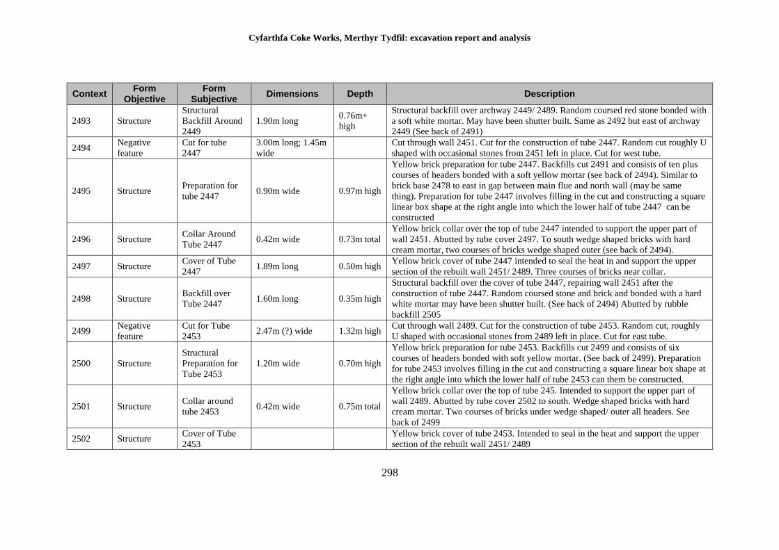
Cyfarthfa Coke Works, Merthyr Tydfil: excavation report and analysis
298
Context Form
Objective Form
Subjective Dimensions Depth Description
2493 Structure
Structural
Backfill Around
2449
1.90m long 0.76m+
high
Structural backfill over archway 2449/ 2489. Random coursed red stone bonded with
a soft white mortar. May have been shutter built. Same as 2492 but east of archway
2449 (See back of 2491)
2494 Negative
feature
Cut for tube
2447
3.00m long; 1.45m
wide
Cut through wall 2451. Cut for the construction of tube 2447. Random cut roughly U
shaped with occasional stones from 2451 left in place. Cut for west tube.
2495 Structure Preparation for
tube 2447 0.90m wide 0.97m high
Yellow brick preparation for tube 2447. Backfills cut 2491 and consists of ten plus
courses of headers bonded with a soft yellow mortar (see back of 2494). Similar to
brick base 2478 to east in gap between main flue and north wall (may be same
thing). Preparation for tube 2447 involves filling in the cut and constructing a square
linear box shape at the right angle into which the lower half of tube 2447 can be
constructed
2496 Structure Collar Around
Tube 2447 0.42m wide 0.73m total
Yellow brick collar over the top of tube 2447 intended to support the upper part of
wall 2451. Abutted by tube cover 2497. To south wedge shaped bricks with hard
cream mortar, two courses of bricks wedge shaped outer (see back of 2494).
2497 Structure Cover of Tube
2447 1.89m long 0.50m high
Yellow brick cover of tube 2447 intended to seal the heat in and support the upper
section of the rebuilt wall 2451/ 2489. Three courses of bricks near collar.
2498 Structure Backfill over
Tube 2447 1.60m long 0.35m high
Structural backfill over the cover of tube 2447, repairing wall 2451 after the
construction of tube 2447. Random coursed stone and brick and bonded with a hard
white mortar may have been shutter built. (See back of 2494) Abutted by rubble
backfill 2505
2499 Negative
feature
Cut for Tube
2453 2.47m (?) wide 1.32m high
Cut through wall 2489. Cut for the construction of tube 2453. Random cut, roughly
U shaped with occasional stones from 2489 left in place. Cut for east tube.
2500 Structure
Structural
Preparation for
Tube 2453
1.20m wide 0.70m high
Yellow brick preparation for tube 2453. Backfills cut 2499 and consists of six
courses of headers bonded with soft yellow mortar. (See back of 2499). Preparation
for tube 2453 involves filling in the cut and constructing a square linear box shape at
the right angle into which the lower half of tube 2453 can them be constructed.
2501 Structure Collar around
tube 2453 0.42m wide 0.75m total
Yellow brick collar over the top of tube 245. Intended to support the upper part of
wall 2489. Abutted by tube cover 2502 to south. Wedge shaped bricks with hard
cream mortar. Two courses of bricks under wedge shaped/ outer all headers. See
back of 2499
2502 Structure Cover of Tube
2453
Yellow brick cover of tube 2453. Intended to seal in the heat and support the upper
section of the rebuilt wall 2451/ 2489
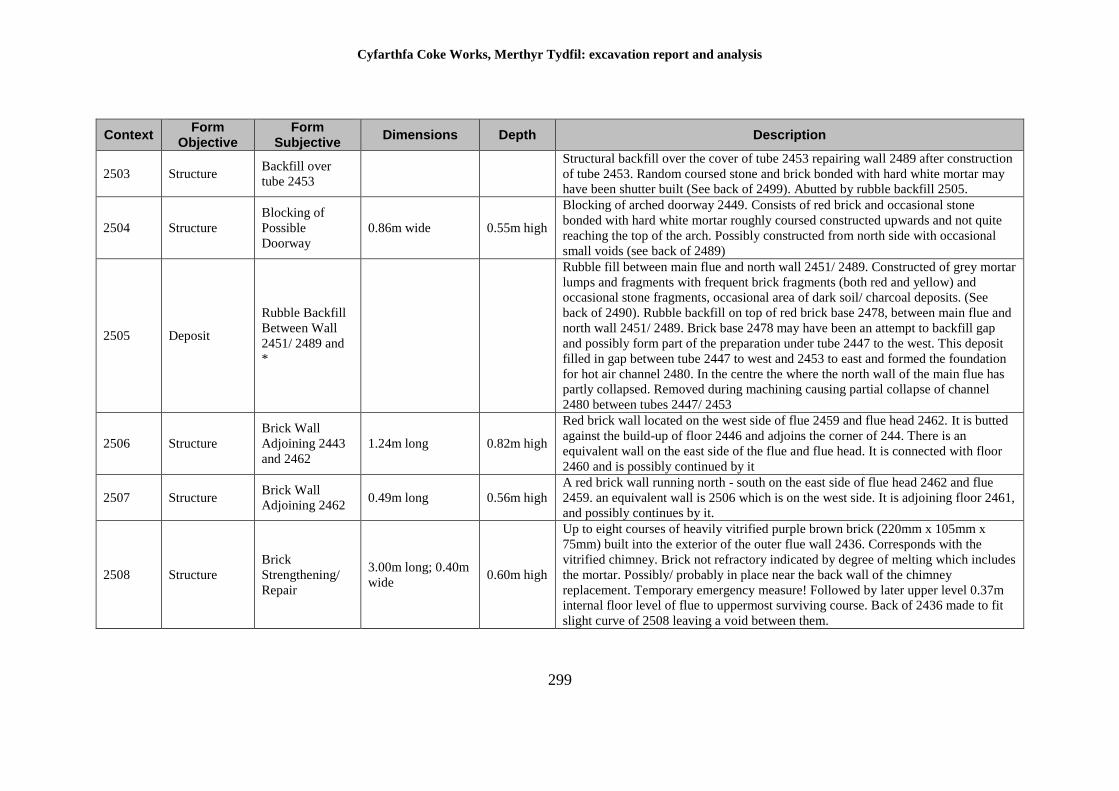
Cyfarthfa Coke Works, Merthyr Tydfil: excavation report and analysis
299
Context Form
Objective Form
Subjective Dimensions Depth Description
2503 Structure Backfill over
tube 2453
Structural backfill over the cover of tube 2453 repairing wall 2489 after construction
of tube 2453. Random coursed stone and brick bonded with hard white mortar may
have been shutter built (See back of 2499). Abutted by rubble backfill 2505.
2504 Structure
Blocking of
Possible
Doorway
0.86m wide 0.55m high
Blocking of arched doorway 2449. Consists of red brick and occasional stone
bonded with hard white mortar roughly coursed constructed upwards and not quite
reaching the top of the arch. Possibly constructed from north side with occasional
small voids (see back of 2489)
2505 Deposit
Rubble Backfill
Between Wall
2451/ 2489 and
*
Rubble fill between main flue and north wall 2451/ 2489. Constructed of grey mortar
lumps and fragments with frequent brick fragments (both red and yellow) and
occasional stone fragments, occasional area of dark soil/ charcoal deposits. (See
back of 2490). Rubble backfill on top of red brick base 2478, between main flue and
north wall 2451/ 2489. Brick base 2478 may have been an attempt to backfill gap
and possibly form part of the preparation under tube 2447 to the west. This deposit
filled in gap between tube 2447 to west and 2453 to east and formed the foundation
for hot air channel 2480. In the centre the where the north wall of the main flue has
partly collapsed. Removed during machining causing partial collapse of channel
2480 between tubes 2447/ 2453
2506 Structure
Brick Wall
Adjoining 2443
and 2462
1.24m long 0.82m high
Red brick wall located on the west side of flue 2459 and flue head 2462. It is butted
against the build-up of floor 2446 and adjoins the corner of 244. There is an
equivalent wall on the east side of the flue and flue head. It is connected with floor
2460 and is possibly continued by it
2507 Structure Brick Wall
Adjoining 2462 0.49m long 0.56m high
A red brick wall running north - south on the east side of flue head 2462 and flue
2459. an equivalent wall is 2506 which is on the west side. It is adjoining floor 2461,
and possibly continues by it.
2508 Structure
Brick
Strengthening/
Repair
3.00m long; 0.40m
wide 0.60m high
Up to eight courses of heavily vitrified purple brown brick (220mm x 105mm x
75mm) built into the exterior of the outer flue wall 2436. Corresponds with the
vitrified chimney. Brick not refractory indicated by degree of melting which includes
the mortar. Possibly/ probably in place near the back wall of the chimney
replacement. Temporary emergency measure! Followed by later upper level 0.37m
internal floor level of flue to uppermost surviving course. Back of 2436 made to fit
slight curve of 2508 leaving a void between them.
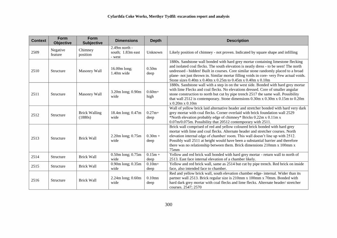
Cyfarthfa Coke Works, Merthyr Tydfil: excavation report and analysis
300
Context Form
Objective Form
Subjective Dimensions Depth Description
2509 Negative
feature
Chimney
position
2.49m north -
south; 1.83m east
- west
Unknown Likely position of chimney - not proven. Indicated by square shape and infilling
2510 Structure Masonry Wall 16.00m long;
1.40m wide
0.50m
deep
1880s. Sandstone wall bonded with hard grey mortar containing limestone flecking
and isolated coal flecks. The south elevation is neatly dress - to be seen! The north
undressed - hidden! Built in courses. Core similar stone randomly placed to a broad
plane- not just thrown in. Similar mortar filling voids in core- very Few actual voids.
Stone sizes 0.40m x 0.40m x 0.25m to 0.45m x 0.40m x 0.10m
2511 Structure Masonry Wall 3.20m long; 0.90m
wide
0.60m+
high
1880s. Sandstone wall with a step in on the west side. Bonded with hard grey mortar
with lime Flecks and coal flecks. No elevations dressed. Core of smaller angular
stone construction to north but cut by pipe trench 2517 the same wall. Possibility
that wall 2512 is contemporary. Stone dimensions 0.30m x 0.30m x 0.15m to 0.20m
x 0.20m x 0.10m
2512 Structure Brick Walling
(1880s)
18.4m long; 0.47m
wide
0.27m+
deep
Wall of yellow brick laid alternative header and stretcher bonded with hard very dark
grey mortar with coal flecks. Corner overlaid with brick foundation wall 2529
*North elevation probably edge of chimney* Bricks 0.22m x 0.11m x
0.07m/0.075m. Possibility that 20512 contemporary with 2511.
2513 Structure Brick Wall 2.20m long; 0.75m
wide
0.30m +
deep
Brick wall comprised of red and yellow coloured brick bonded with hard grey
mortar with lime and coal flecks. Alternate header and stretcher courses. North
elevation internal edge of chamber/ room. This wall doesn’t line up with 2512.
Possibly wall 2511 at height would have been a substantial barrier and therefore
there was no relationship between them. Brick dimensions 210mm x 100mm x
75mm
2514 Structure Brick Wall 0.50m long; 0.75m
wide
0.15m +
deep
Yellow and red brick wall bonded with hard grey mortar - return wall to north of
2513. East face internal elevation of a chamber likely.
2515 Structure Brick Wall 0.90m long; 0.35m
wide
0.10m+
deep
Yellow and red brick wall, same as 2514 but cut by pipe trench. Red brick on inside
face, also intended face to chamber.
2516 Structure Brick Wall 2.24m long; 0.60m
wide
0.10mn
deep
Red and yellow brick wall, south elevation chamber edge- internal. Wider than its
partner wall 2513. Brick regular size is 210mm x 100mm x 70mm. Bonded with
hard dark grey mortar with coal flecks and lime flecks. Alternate header/ stretcher
courses. 2547; 2570
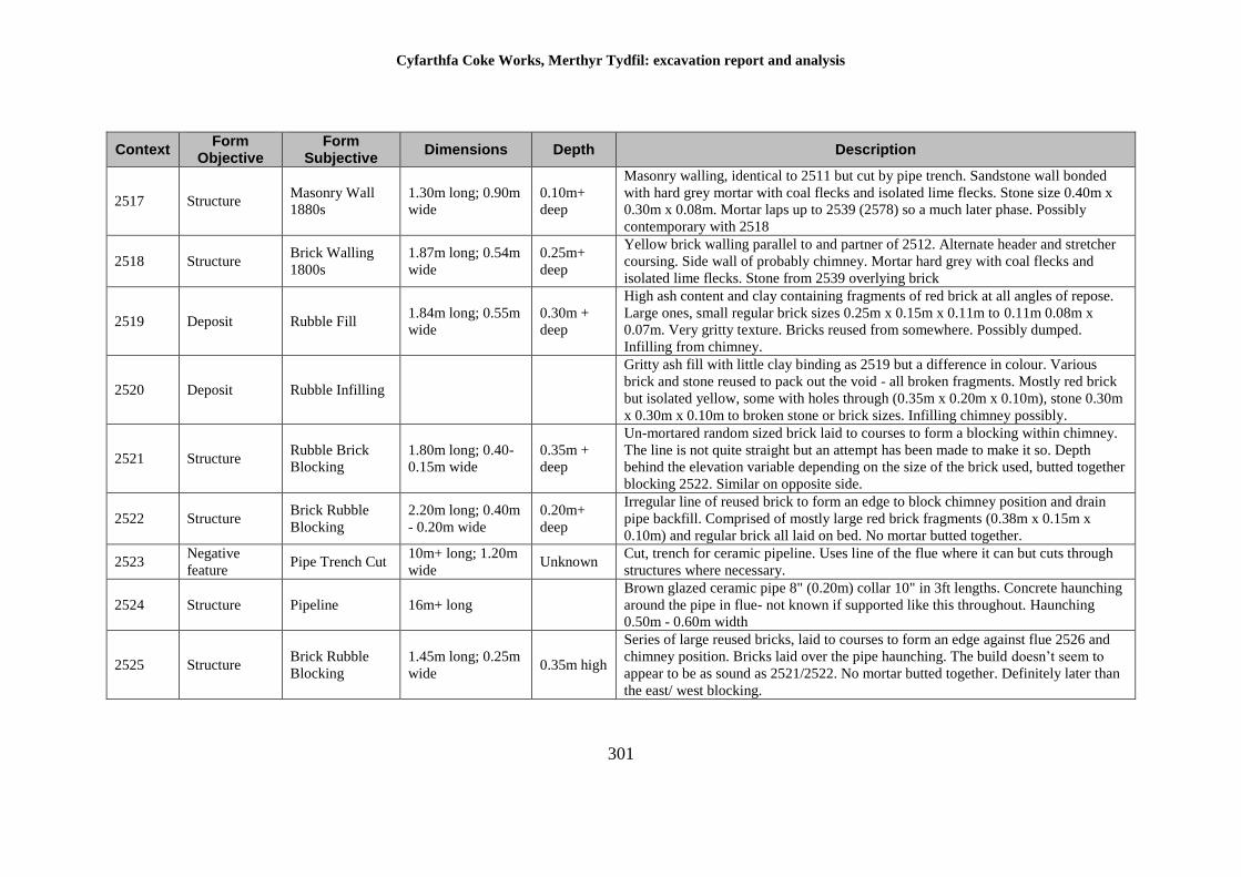
Cyfarthfa Coke Works, Merthyr Tydfil: excavation report and analysis
301
Context Form
Objective Form
Subjective Dimensions Depth Description
2517 Structure Masonry Wall
1880s
1.30m long; 0.90m
wide
0.10m+
deep
Masonry walling, identical to 2511 but cut by pipe trench. Sandstone wall bonded
with hard grey mortar with coal flecks and isolated lime flecks. Stone size 0.40m x
0.30m x 0.08m. Mortar laps up to 2539 (2578) so a much later phase. Possibly
contemporary with 2518
2518 Structure Brick Walling
1800s
1.87m long; 0.54m
wide
0.25m+
deep
Yellow brick walling parallel to and partner of 2512. Alternate header and stretcher
coursing. Side wall of probably chimney. Mortar hard grey with coal flecks and
isolated lime flecks. Stone from 2539 overlying brick
2519 Deposit Rubble Fill 1.84m long; 0.55m
wide
0.30m +
deep
High ash content and clay containing fragments of red brick at all angles of repose.
Large ones, small regular brick sizes 0.25m x 0.15m x 0.11m to 0.11m 0.08m x
0.07m. Very gritty texture. Bricks reused from somewhere. Possibly dumped.
Infilling from chimney.
2520 Deposit Rubble Infilling
Gritty ash fill with little clay binding as 2519 but a difference in colour. Various
brick and stone reused to pack out the void - all broken fragments. Mostly red brick
but isolated yellow, some with holes through (0.35m x 0.20m x 0.10m), stone 0.30m
x 0.30m x 0.10m to broken stone or brick sizes. Infilling chimney possibly.
2521 Structure Rubble Brick
Blocking
1.80m long; 0.40-
0.15m wide
0.35m +
deep
Un-mortared random sized brick laid to courses to form a blocking within chimney.
The line is not quite straight but an attempt has been made to make it so. Depth
behind the elevation variable depending on the size of the brick used, butted together
blocking 2522. Similar on opposite side.
2522 Structure Brick Rubble
Blocking
2.20m long; 0.40m
- 0.20m wide
0.20m+
deep
Irregular line of reused brick to form an edge to block chimney position and drain
pipe backfill. Comprised of mostly large red brick fragments (0.38m x 0.15m x
0.10m) and regular brick all laid on bed. No mortar butted together.
2523 Negative
feature Pipe Trench Cut
10m+ long; 1.20m
wide Unknown
Cut, trench for ceramic pipeline. Uses line of the flue where it can but cuts through
structures where necessary.
2524 Structure Pipeline 16m+ long
Brown glazed ceramic pipe 8" (0.20m) collar 10" in 3ft lengths. Concrete haunching
around the pipe in flue- not known if supported like this throughout. Haunching
0.50m - 0.60m width
2525 Structure Brick Rubble
Blocking
1.45m long; 0.25m
wide 0.35m high
Series of large reused bricks, laid to courses to form an edge against flue 2526 and
chimney position. Bricks laid over the pipe haunching. The build doesn’t seem to
appear to be as sound as 2521/2522. No mortar butted together. Definitely later than
the east/ west blocking.
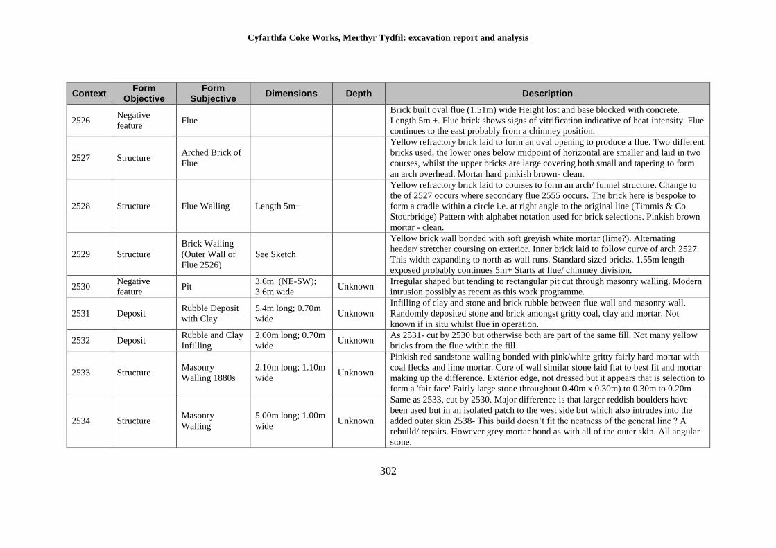
Cyfarthfa Coke Works, Merthyr Tydfil: excavation report and analysis
302
Context Form
Objective Form
Subjective Dimensions Depth Description
2526 Negative
feature Flue
Brick built oval flue (1.51m) wide Height lost and base blocked with concrete.
Length 5m +. Flue brick shows signs of vitrification indicative of heat intensity. Flue
continues to the east probably from a chimney position.
2527 Structure Arched Brick of
Flue
Yellow refractory brick laid to form an oval opening to produce a flue. Two different
bricks used, the lower ones below midpoint of horizontal are smaller and laid in two
courses, whilst the upper bricks are large covering both small and tapering to form
an arch overhead. Mortar hard pinkish brown- clean.
2528 Structure Flue Walling Length 5m+
Yellow refractory brick laid to courses to form an arch/ funnel structure. Change to
the of 2527 occurs where secondary flue 2555 occurs. The brick here is bespoke to
form a cradle within a circle i.e. at right angle to the original line (Timmis & Co
Stourbridge) Pattern with alphabet notation used for brick selections. Pinkish brown
mortar - clean.
2529 Structure
Brick Walling
(Outer Wall of
Flue 2526)
See Sketch
Yellow brick wall bonded with soft greyish white mortar (lime?). Alternating
header/ stretcher coursing on exterior. Inner brick laid to follow curve of arch 2527.
This width expanding to north as wall runs. Standard sized bricks. 1.55m length
exposed probably continues 5m+ Starts at flue/ chimney division.
2530 Negative
feature Pit
3.6m (NE-SW);
3.6m wide Unknown
Irregular shaped but tending to rectangular pit cut through masonry walling. Modern
intrusion possibly as recent as this work programme.
2531 Deposit Rubble Deposit
with Clay
5.4m long; 0.70m
wide Unknown
Infilling of clay and stone and brick rubble between flue wall and masonry wall.
Randomly deposited stone and brick amongst gritty coal, clay and mortar. Not
known if in situ whilst flue in operation.
2532 Deposit Rubble and Clay
Infilling
2.00m long; 0.70m
wide Unknown
As 2531- cut by 2530 but otherwise both are part of the same fill. Not many yellow
bricks from the flue within the fill.
2533 Structure Masonry
Walling 1880s
2.10m long; 1.10m
wide Unknown
Pinkish red sandstone walling bonded with pink/white gritty fairly hard mortar with
coal flecks and lime mortar. Core of wall similar stone laid flat to best fit and mortar
making up the difference. Exterior edge, not dressed but it appears that is selection to
form a 'fair face' Fairly large stone throughout 0.40m x 0.30m) to 0.30m to 0.20m
2534 Structure Masonry
Walling
5.00m long; 1.00m
wide Unknown
Same as 2533, cut by 2530. Major difference is that larger reddish boulders have
been used but in an isolated patch to the west side but which also intrudes into the
added outer skin 2538- This build doesn’t fit the neatness of the general line ? A
rebuild/ repairs. However grey mortar bond as with all of the outer skin. All angular
stone.
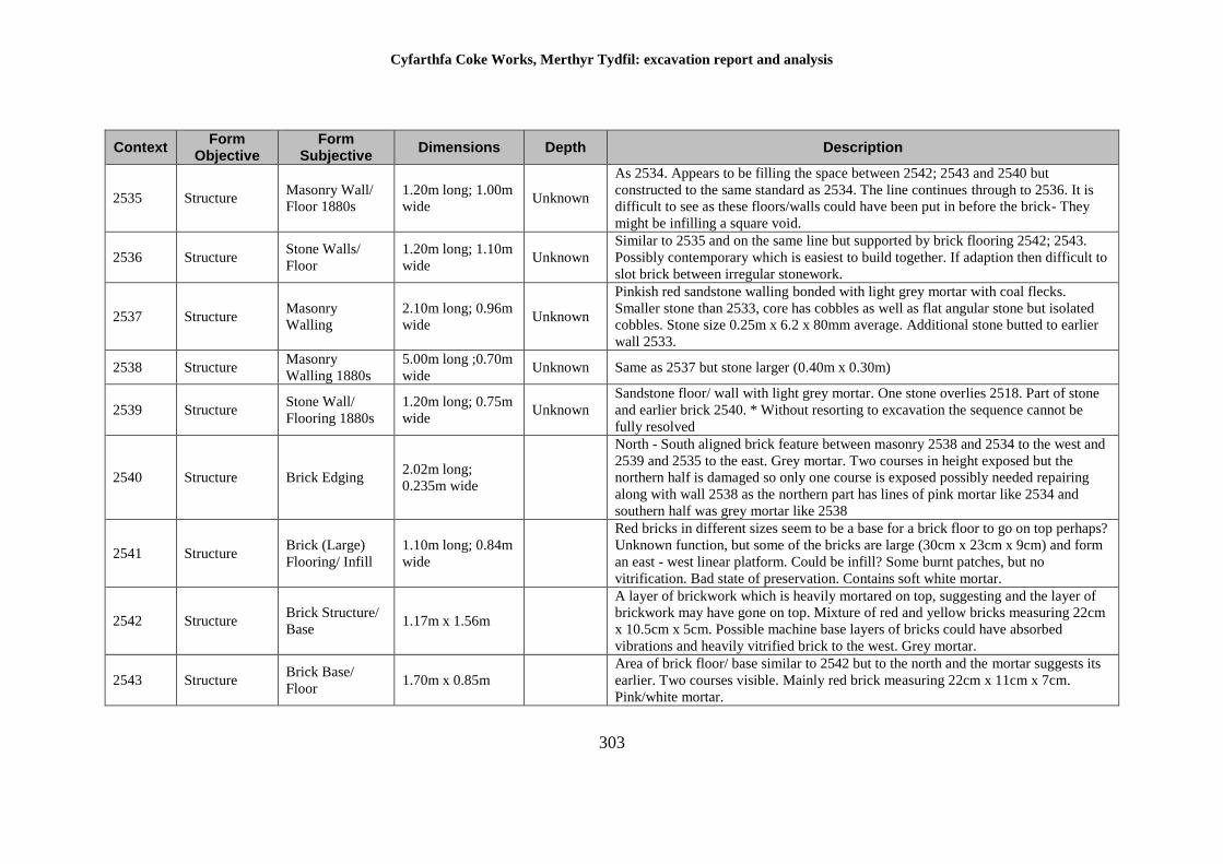
Cyfarthfa Coke Works, Merthyr Tydfil: excavation report and analysis
303
Context Form
Objective Form
Subjective Dimensions Depth Description
2535 Structure Masonry Wall/
Floor 1880s
1.20m long; 1.00m
wide Unknown
As 2534. Appears to be filling the space between 2542; 2543 and 2540 but
constructed to the same standard as 2534. The line continues through to 2536. It is
difficult to see as these floors/walls could have been put in before the brick- They
might be infilling a square void.
2536 Structure Stone Walls/
Floor
1.20m long; 1.10m
wide Unknown
Similar to 2535 and on the same line but supported by brick flooring 2542; 2543.
Possibly contemporary which is easiest to build together. If adaption then difficult to
slot brick between irregular stonework.
2537 Structure Masonry
Walling
2.10m long; 0.96m
wide Unknown
Pinkish red sandstone walling bonded with light grey mortar with coal flecks.
Smaller stone than 2533, core has cobbles as well as flat angular stone but isolated
cobbles. Stone size 0.25m x 6.2 x 80mm average. Additional stone butted to earlier
wall 2533.
2538 Structure Masonry
Walling 1880s
5.00m long ;0.70m
wide Unknown Same as 2537 but stone larger (0.40m x 0.30m)
2539 Structure Stone Wall/
Flooring 1880s
1.20m long; 0.75m
wide Unknown
Sandstone floor/ wall with light grey mortar. One stone overlies 2518. Part of stone
and earlier brick 2540. * Without resorting to excavation the sequence cannot be
fully resolved
2540 Structure Brick Edging 2.02m long;
0.235m wide
North - South aligned brick feature between masonry 2538 and 2534 to the west and
2539 and 2535 to the east. Grey mortar. Two courses in height exposed but the
northern half is damaged so only one course is exposed possibly needed repairing
along with wall 2538 as the northern part has lines of pink mortar like 2534 and
southern half was grey mortar like 2538
2541 Structure Brick (Large)
Flooring/ Infill
1.10m long; 0.84m
wide
Red bricks in different sizes seem to be a base for a brick floor to go on top perhaps?
Unknown function, but some of the bricks are large (30cm x 23cm x 9cm) and form
an east - west linear platform. Could be infill? Some burnt patches, but no
vitrification. Bad state of preservation. Contains soft white mortar.
2542 Structure Brick Structure/
Base 1.17m x 1.56m
A layer of brickwork which is heavily mortared on top, suggesting and the layer of
brickwork may have gone on top. Mixture of red and yellow bricks measuring 22cm
x 10.5cm x 5cm. Possible machine base layers of bricks could have absorbed
vibrations and heavily vitrified brick to the west. Grey mortar.
2543 Structure Brick Base/
Floor 1.70m x 0.85m
Area of brick floor/ base similar to 2542 but to the north and the mortar suggests its
earlier. Two courses visible. Mainly red brick measuring 22cm x 11cm x 7cm.
Pink/white mortar.
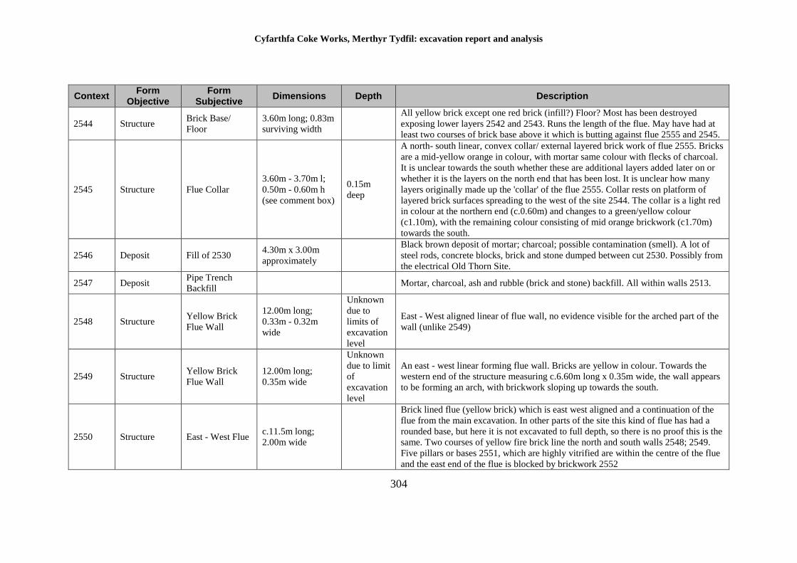
Cyfarthfa Coke Works, Merthyr Tydfil: excavation report and analysis
304
Context Form
Objective Form
Subjective Dimensions Depth Description
2544 Structure Brick Base/
Floor
3.60m long; 0.83m
surviving width
All yellow brick except one red brick (infill?) Floor? Most has been destroyed
exposing lower layers 2542 and 2543. Runs the length of the flue. May have had at
least two courses of brick base above it which is butting against flue 2555 and 2545.
2545 Structure Flue Collar
3.60m - 3.70m l;
0.50m - 0.60m h
(see comment box)
0.15m
deep
A north- south linear, convex collar/ external layered brick work of flue 2555. Bricks
are a mid-yellow orange in colour, with mortar same colour with flecks of charcoal.
It is unclear towards the south whether these are additional layers added later on or
whether it is the layers on the north end that has been lost. It is unclear how many
layers originally made up the 'collar' of the flue 2555. Collar rests on platform of
layered brick surfaces spreading to the west of the site 2544. The collar is a light red
in colour at the northern end (c.0.60m) and changes to a green/yellow colour
(c1.10m), with the remaining colour consisting of mid orange brickwork (c1.70m)
towards the south.
2546 Deposit Fill of 2530 4.30m x 3.00m
approximately
Black brown deposit of mortar; charcoal; possible contamination (smell). A lot of
steel rods, concrete blocks, brick and stone dumped between cut 2530. Possibly from
the electrical Old Thorn Site.
2547 Deposit Pipe Trench
Backfill Mortar, charcoal, ash and rubble (brick and stone) backfill. All within walls 2513.
2548 Structure Yellow Brick
Flue Wall
12.00m long;
0.33m - 0.32m
wide
Unknown
due to
limits of
excavation
level
East - West aligned linear of flue wall, no evidence visible for the arched part of the
wall (unlike 2549)
2549 Structure Yellow Brick
Flue Wall
12.00m long;
0.35m wide
Unknown
due to limit
of
excavation
level
An east - west linear forming flue wall. Bricks are yellow in colour. Towards the
western end of the structure measuring c.6.60m long x 0.35m wide, the wall appears
to be forming an arch, with brickwork sloping up towards the south.
2550 Structure East - West Flue c.11.5m long;
2.00m wide
Brick lined flue (yellow brick) which is east west aligned and a continuation of the
flue from the main excavation. In other parts of the site this kind of flue has had a
rounded base, but here it is not excavated to full depth, so there is no proof this is the
same. Two courses of yellow fire brick line the north and south walls 2548; 2549.
Five pillars or bases 2551, which are highly vitrified are within the centre of the flue
and the east end of the flue is blocked by brickwork 2552
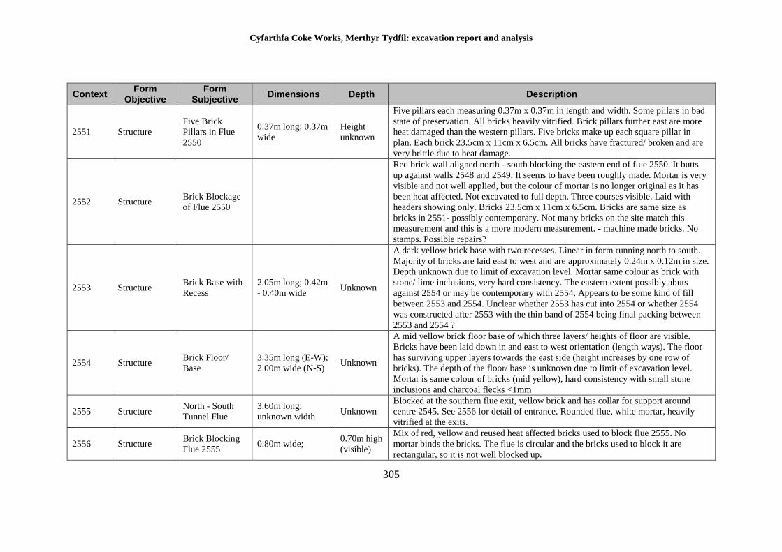
Cyfarthfa Coke Works, Merthyr Tydfil: excavation report and analysis
305
Context Form
Objective Form
Subjective Dimensions Depth Description
2551 Structure
Five Brick
Pillars in Flue
2550
0.37m long; 0.37m
wide
Height
unknown
Five pillars each measuring 0.37m x 0.37m in length and width. Some pillars in bad
state of preservation. All bricks heavily vitrified. Brick pillars further east are more
heat damaged than the western pillars. Five bricks make up each square pillar in
plan. Each brick 23.5cm x 11cm x 6.5cm. All bricks have fractured/ broken and are
very brittle due to heat damage.
2552 Structure Brick Blockage
of Flue 2550
Red brick wall aligned north - south blocking the eastern end of flue 2550. It butts
up against walls 2548 and 2549. It seems to have been roughly made. Mortar is very
visible and not well applied, but the colour of mortar is no longer original as it has
been heat affected. Not excavated to full depth. Three courses visible. Laid with
headers showing only. Bricks 23.5cm x 11cm x 6.5cm. Bricks are same size as
bricks in 2551- possibly contemporary. Not many bricks on the site match this
measurement and this is a more modern measurement. - machine made bricks. No
stamps. Possible repairs?
2553 Structure Brick Base with
Recess
2.05m long; 0.42m
- 0.40m wide Unknown
A dark yellow brick base with two recesses. Linear in form running north to south.
Majority of bricks are laid east to west and are approximately 0.24m x 0.12m in size.
Depth unknown due to limit of excavation level. Mortar same colour as brick with
stone/ lime inclusions, very hard consistency. The eastern extent possibly abuts
against 2554 or may be contemporary with 2554. Appears to be some kind of fill
between 2553 and 2554. Unclear whether 2553 has cut into 2554 or whether 2554
was constructed after 2553 with the thin band of 2554 being final packing between
2553 and 2554 ?
2554 Structure Brick Floor/
Base
3.35m long (E-W);
2.00m wide (N-S) Unknown
A mid yellow brick floor base of which three layers/ heights of floor are visible.
Bricks have been laid down in and east to west orientation (length ways). The floor
has surviving upper layers towards the east side (height increases by one row of
bricks). The depth of the floor/ base is unknown due to limit of excavation level.
Mortar is same colour of bricks (mid yellow), hard consistency with small stone
inclusions and charcoal flecks <1mm
2555 Structure North - South
Tunnel Flue
3.60m long;
unknown width Unknown
Blocked at the southern flue exit, yellow brick and has collar for support around
centre 2545. See 2556 for detail of entrance. Rounded flue, white mortar, heavily
vitrified at the exits.
2556 Structure Brick Blocking
Flue 2555 0.80m wide;
0.70m high
(visible)
Mix of red, yellow and reused heat affected bricks used to block flue 2555. No
mortar binds the bricks. The flue is circular and the bricks used to block it are
rectangular, so it is not well blocked up.
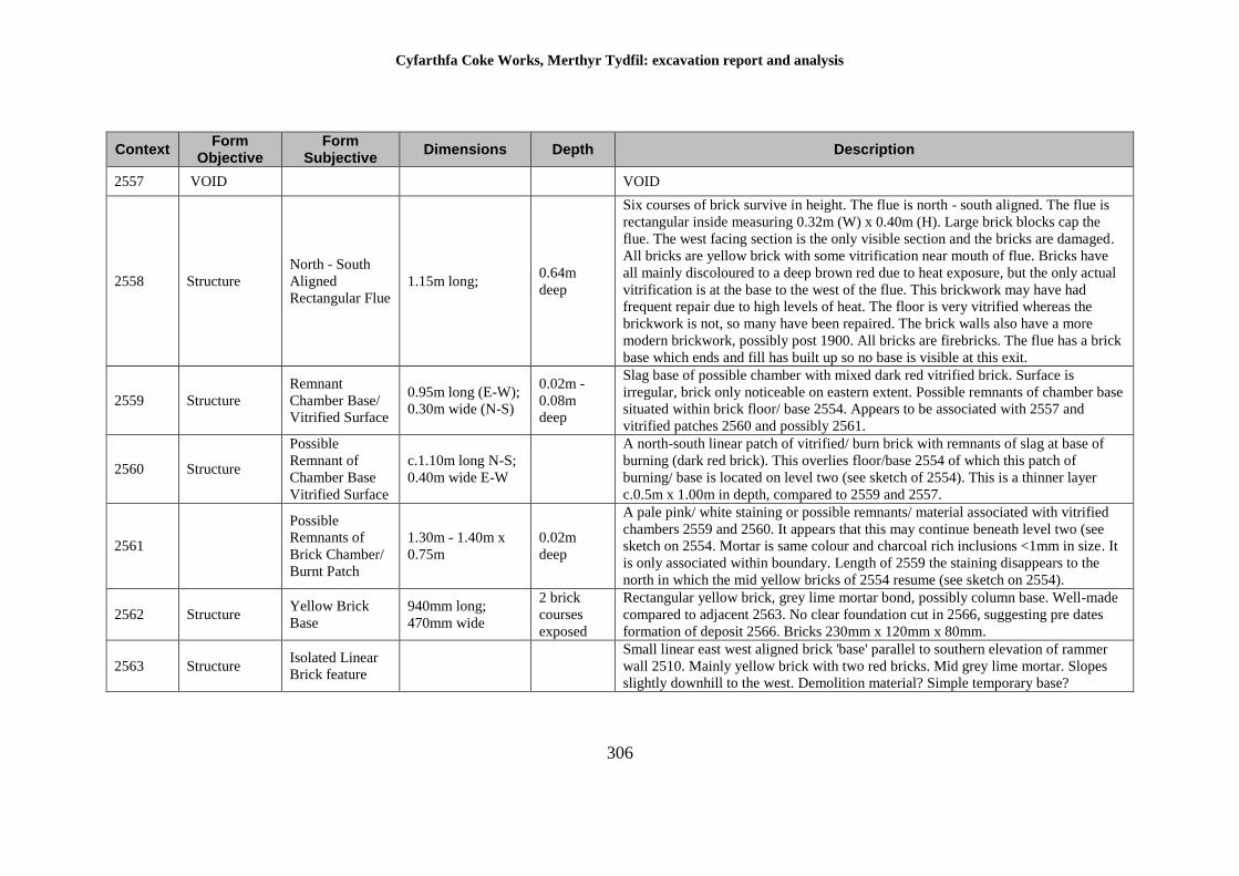
Cyfarthfa Coke Works, Merthyr Tydfil: excavation report and analysis
306
Context Form
Objective Form
Subjective Dimensions Depth Description
2557 VOID VOID
2558 Structure
North - South
Aligned
Rectangular Flue
1.15m long; 0.64m
deep
Six courses of brick survive in height. The flue is north - south aligned. The flue is
rectangular inside measuring 0.32m (W) x 0.40m (H). Large brick blocks cap the
flue. The west facing section is the only visible section and the bricks are damaged.
All bricks are yellow brick with some vitrification near mouth of flue. Bricks have
all mainly discoloured to a deep brown red due to heat exposure, but the only actual
vitrification is at the base to the west of the flue. This brickwork may have had
frequent repair due to high levels of heat. The floor is very vitrified whereas the
brickwork is not, so many have been repaired. The brick walls also have a more
modern brickwork, possibly post 1900. All bricks are firebricks. The flue has a brick
base which ends and fill has built up so no base is visible at this exit.
2559 Structure
Remnant
Chamber Base/
Vitrified Surface
0.95m long (E-W);
0.30m wide (N-S)
0.02m -
0.08m
deep
Slag base of possible chamber with mixed dark red vitrified brick. Surface is
irregular, brick only noticeable on eastern extent. Possible remnants of chamber base
situated within brick floor/ base 2554. Appears to be associated with 2557 and
vitrified patches 2560 and possibly 2561.
2560 Structure
Possible
Remnant of
Chamber Base
Vitrified Surface
c.1.10m long N-S;
0.40m wide E-W
A north-south linear patch of vitrified/ burn brick with remnants of slag at base of
burning (dark red brick). This overlies floor/base 2554 of which this patch of
burning/ base is located on level two (see sketch of 2554). This is a thinner layer
c.0.5m x 1.00m in depth, compared to 2559 and 2557.
2561
Possible
Remnants of
Brick Chamber/
Burnt Patch
1.30m - 1.40m x
0.75m
0.02m
deep
A pale pink/ white staining or possible remnants/ material associated with vitrified
chambers 2559 and 2560. It appears that this may continue beneath level two (see
sketch on 2554. Mortar is same colour and charcoal rich inclusions <1mm in size. It
is only associated within boundary. Length of 2559 the staining disappears to the
north in which the mid yellow bricks of 2554 resume (see sketch on 2554).
2562 Structure Yellow Brick
Base
940mm long;
470mm wide
2 brick
courses
exposed
Rectangular yellow brick, grey lime mortar bond, possibly column base. Well-made
compared to adjacent 2563. No clear foundation cut in 2566, suggesting pre dates
formation of deposit 2566. Bricks 230mm x 120mm x 80mm.
2563 Structure Isolated Linear
Brick feature
Small linear east west aligned brick 'base' parallel to southern elevation of rammer
wall 2510. Mainly yellow brick with two red bricks. Mid grey lime mortar. Slopes
slightly downhill to the west. Demolition material? Simple temporary base?
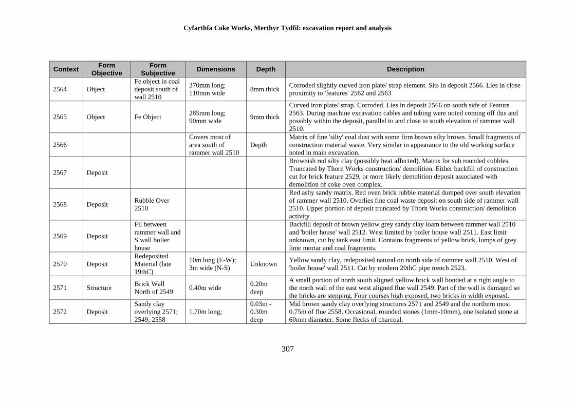
Cyfarthfa Coke Works, Merthyr Tydfil: excavation report and analysis
307
Context Form
Objective Form
Subjective Dimensions Depth Description
2564 Object
Fe object in coal
deposit south of
wall 2510
270mm long;
110mm wide 8mm thick
Corroded slightly curved iron plate/ strap element. Sits in deposit 2566. Lies in close
proximity to 'features' 2562 and 2563
2565 Object Fe Object 285mm long;
90mm wide 9mm thick
Curved iron plate/ strap. Corroded. Lies in deposit 2566 on south side of Feature
2563. During machine excavation cables and tubing were noted coming off this and
possibly within the deposit, parallel to and close to south elevation of rammer wall
2510.
2566
Covers most of
area south of
rammer wall 2510
Depth
Matrix of fine 'silty' coal dust with some firm brown silty brown. Small fragments of
construction material waste. Very similar in appearance to the old working surface
noted in main excavation.
2567 Deposit
Brownish red silty clay (possibly heat affected). Matrix for sub rounded cobbles.
Truncated by Thorn Works construction/ demolition. Either backfill of construction
cut for brick feature 2529, or more likely demolition deposit associated with
demolition of coke oven complex.
2568 Deposit Rubble Over
2510
Red ashy sandy matrix. Red oven brick rubble material dumped over south elevation
of rammer wall 2510. Overlies fine coal waste deposit on south side of rammer wall
2510. Upper portion of deposit truncated by Thorn Works construction/ demolition
activity.
2569 Deposit
Fil between
rammer wall and
S wall boiler
house
Backfill deposit of brown yellow grey sandy clay loam between rammer wall 2510
and 'boiler house' wall 2512. West limited by boiler house wall 2511. East limit
unknown, cut by tank east limit. Contains fragments of yellow brick, lumps of grey
lime mortar and coal fragments.
2570 Deposit
Redeposited
Material (late
19thC)
10m long (E-W);
3m wide (N-S) Unknown
Yellow sandy clay, redeposited natural on north side of rammer wall 2510. West of
'boiler house' wall 2511. Cut by modern 20thC pipe trench 2523.
2571 Structure Brick Wall
North of 2549 0.40m wide
0.20m
deep
A small portion of north south aligned yellow brick wall bonded at a right angle to
the north wall of the east west aligned flue wall 2549. Part of the wall is damaged so
the bricks are stepping. Four courses high exposed, two bricks in width exposed.
2572 Deposit
Sandy clay
overlying 2571;
2549; 2558
1.70m long;
0.03m -
0.30m
deep
Mid brown sandy clay overlying structures 2571 and 2549 and the northern most
0.75m of flue 2558. Occasional, rounded stones (1mm-10mm), one isolated stone at
60mm diameter. Some flecks of charcoal.
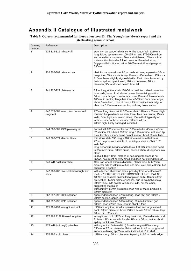
Cyfarthfa Coke Works, Merthyr Tydfil: excavation report and analysis
308
Appendix II Catalogue of illustrated metalwork
Table 6. Objects recommended for illustration from Dr Tim Young’s metalwork report and the
steelmaking ceramic report
Drawing number
Reference Description
1 225 315-316 railway sill
steel narrow gauge railway tie for flat bottom rail, 1210mm long, folded up from slots 100-125mm and 175-190mm from end would take maximum 80mm width base; 105mm x 4mm main section but sides folded down to 18mm below top. Suggests flat bottomed rail of 60-65mm width and gauge of 890mm
2 226 305-307 railway chair
chair for narrow rail, slot 90mm wide at base, expansion 35mm deep, then 65mm wide for top 40mm or 85mm deep. 355mm x 110mm base, slightly sigmoidal with offset holes, fastened by bolts or spikes, tip not seen, 170mm preserved 18mm diameter, 35mm domed head 11mm tall
3 241 227-229 plateway rail 3 foot long, entire, chair 130x50mm with two raised bosses on inner side, base of rail shows recess below rising section, 30mm thick flange on outer face, riser 72mm off base at ends, 100mm in centre, flange has inset 45-85mm from outer edge, about 5mm deep, crest of riser is 25mm inside inner edge of chair, rail 115mm wide in centre, no fixing holes visible
4 242 379-382 scrap pile channel rail fragment
725mm long piece, width 120mm, chair 140mm x 85mm, slight rounded lump extends on wide, lower face has central, 25mm wide, 5mm high, crenulated sides, 15mm thick typically on vertical, wider at base, channel 80mm, sides c. 40mm high, badly damaged, accreted.
5 244 308-309 2306 plateway sill
horned sill, 830 mm centre bar, 160mm to tip, 45mm x 45mm 'D' section; lotus head 230mm long, 110mm wide, upturned tip as outer cheek, inner horns do not survive, head 20mm thick
6 245 366-371 sleeper block
thin stone slab, 550 long y 390 wide maximum thickness 72mm. Impressions visible of the integral chairs. Chair 1 75 wide 140 long, second is 74 wide and fades out at 125. iron spike head is 35mm x 18mm, 30mm proud, section where disappears into stone is about 16 x 11mm. method of securing into stone is not known, hole must be very small and does not extend through
7 246 WB Cast iron wheel
Cast iron wheel, 750mm diameter, 50mm wide, hub 75mm diameter extends 35mm out on one side, axle hole c.35mm but obscured, 8 spokes
8 247 283-285 five spoked wrought iron wheel
with attached short stub axles, possibly from wheelbarrow? marked 'PERKS WROUGHT IRON WHEEL LYE.. PAT No. 18595', on possible enamelled or plated 'hub'. 40mm x 8mm rim section, 14mm diameter spokes, hub in two halves total 30mm thick, axle swells to hub one side, not the other, suggesting means of 10assembly; 65mm protrudes each side of the hub which is 82mm diameter
9 267 297-298 2066 spanner
open-ended spanner: 425mm long, shaft 350 and 30mm x 20mm section, gap is 33mm
10 268 297-298 2241 spanner
open-ended spanner: 560mm long, 20mm diameter, gap 50mm, head 22mm thick, bent in slight S form
11 271 291-292 wrought iron tool
: 950mm long tool, small suspension loop and large curved hook, 13mm diameter, hook 130mm across 55mm return, loop 60mm o/d, 32mm i/d
12 272 293 2132 Hooked long tool
wrought iron tool: 1120mm long hook tool, 15mm diameter rod, 112mm x 85mm outside handle, 83mm x 50mm inside, short spikey hook turns 55mm
13 273 WB (in trough) prise bar
with sigmoidal flattened tip (cf smiths tongs),625mm long, 530mm of 22mm diameter, flattens down to 45mm long basal surface widening tip 25mm wide inclined at 10 to shaft
14 276 296 cold chisel : 320mm long, 60mm diameter, tapering to 60mm wide edge
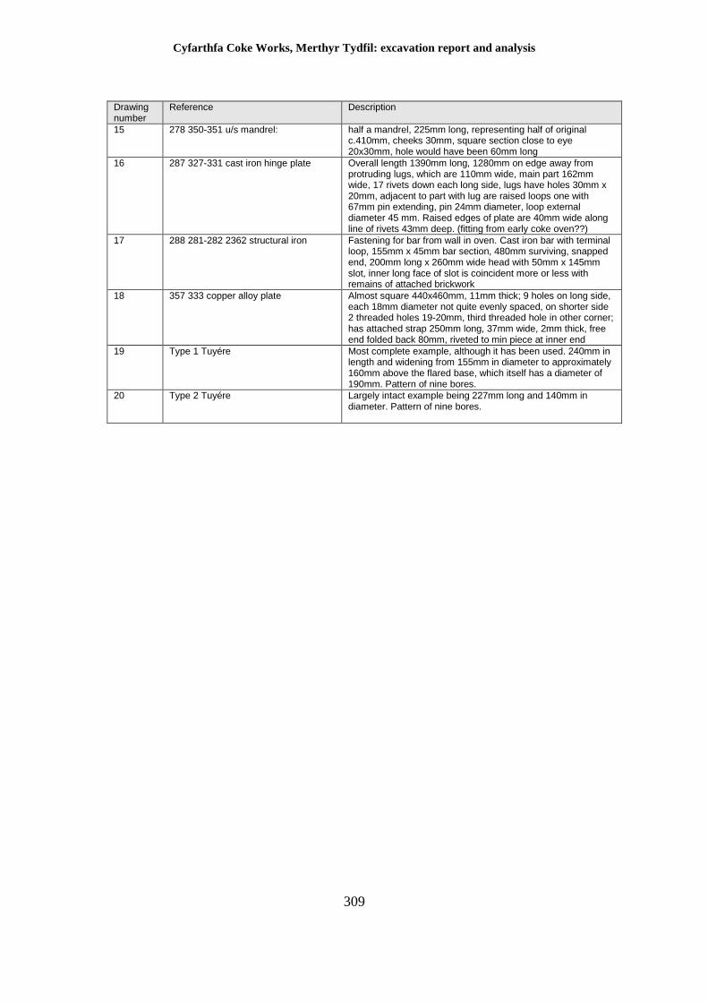
Cyfarthfa Coke Works, Merthyr Tydfil: excavation report and analysis
309
Drawing number
Reference Description
15 278 350-351 u/s mandrel: half a mandrel, 225mm long, representing half of original c.410mm, cheeks 30mm, square section close to eye 20x30mm, hole would have been 60mm long
16 287 327-331 cast iron hinge plate Overall length 1390mm long, 1280mm on edge away from protruding lugs, which are 110mm wide, main part 162mm wide, 17 rivets down each long side, lugs have holes 30mm x 20mm, adjacent to part with lug are raised loops one with 67mm pin extending, pin 24mm diameter, loop external diameter 45 mm. Raised edges of plate are 40mm wide along line of rivets 43mm deep. (fitting from early coke oven??)
17 288 281-282 2362 structural iron Fastening for bar from wall in oven. Cast iron bar with terminal loop, 155mm x 45mm bar section, 480mm surviving, snapped end, 200mm long x 260mm wide head with 50mm x 145mm slot, inner long face of slot is coincident more or less with remains of attached brickwork
18 357 333 copper alloy plate Almost square 440x460mm, 11mm thick; 9 holes on long side, each 18mm diameter not quite evenly spaced, on shorter side 2 threaded holes 19-20mm, third threaded hole in other corner; has attached strap 250mm long, 37mm wide, 2mm thick, free end folded back 80mm, riveted to min piece at inner end
19 Type 1 Tuyére Most complete example, although it has been used. 240mm in length and widening from 155mm in diameter to approximately 160mm above the flared base, which itself has a diameter of 190mm. Pattern of nine bores.
20 Type 2 Tuyére Largely intact example being 227mm long and 140mm in diameter. Pattern of nine bores.
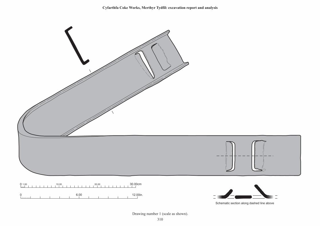
0 12.00in.6.00
0 1.00 10.00 20.00 30.00cm
Schematic section along dashed line above
Drawing number 1 (scale as shown).
310
Cyfarthfa Coke Works, Merthyr Tydfil: excavation report and analysis
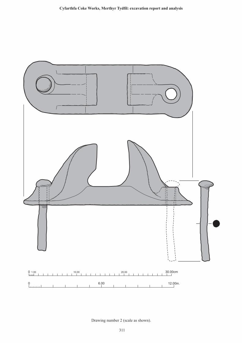
0 12.00in.6.00
0 1.00 10.00 20.00 30.00cm
311
Drawing number 2 (scale as shown).
Cyfarthfa Coke Works, Merthyr Tydfil: excavation report and analysis
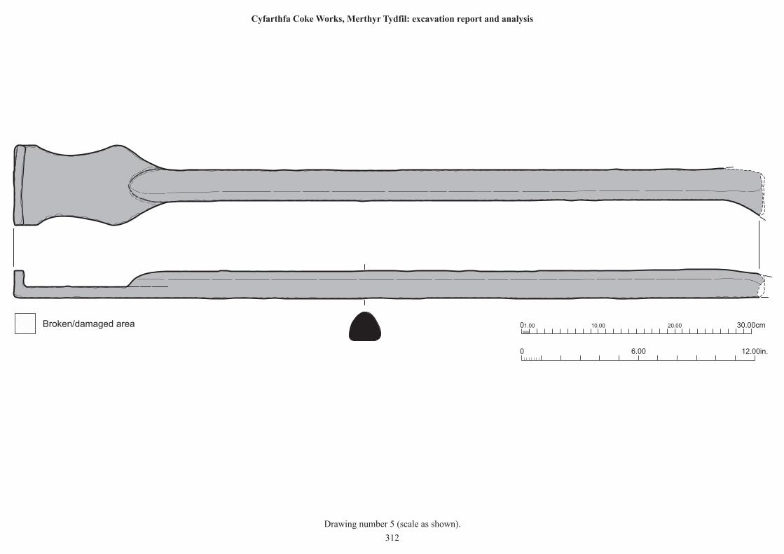
0 12.00in.6.00
01.00 10.00 20.00 30.00cmBroken/damaged area
Drawing number 5 (scale as shown).
312
Cyfarthfa Coke Works, Merthyr Tydfil: excavation report and analysis
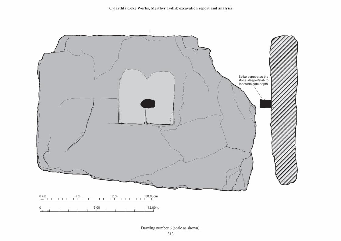
0 1.00 10.00 20.00 30.00cm
0 12.00in.6.00
Spike penetrates thestone sleeper/slab toindeterminate depth
Drawing number 6 (scale as shown).
313
Cyfarthfa Coke Works, Merthyr Tydfil: excavation report and analysis
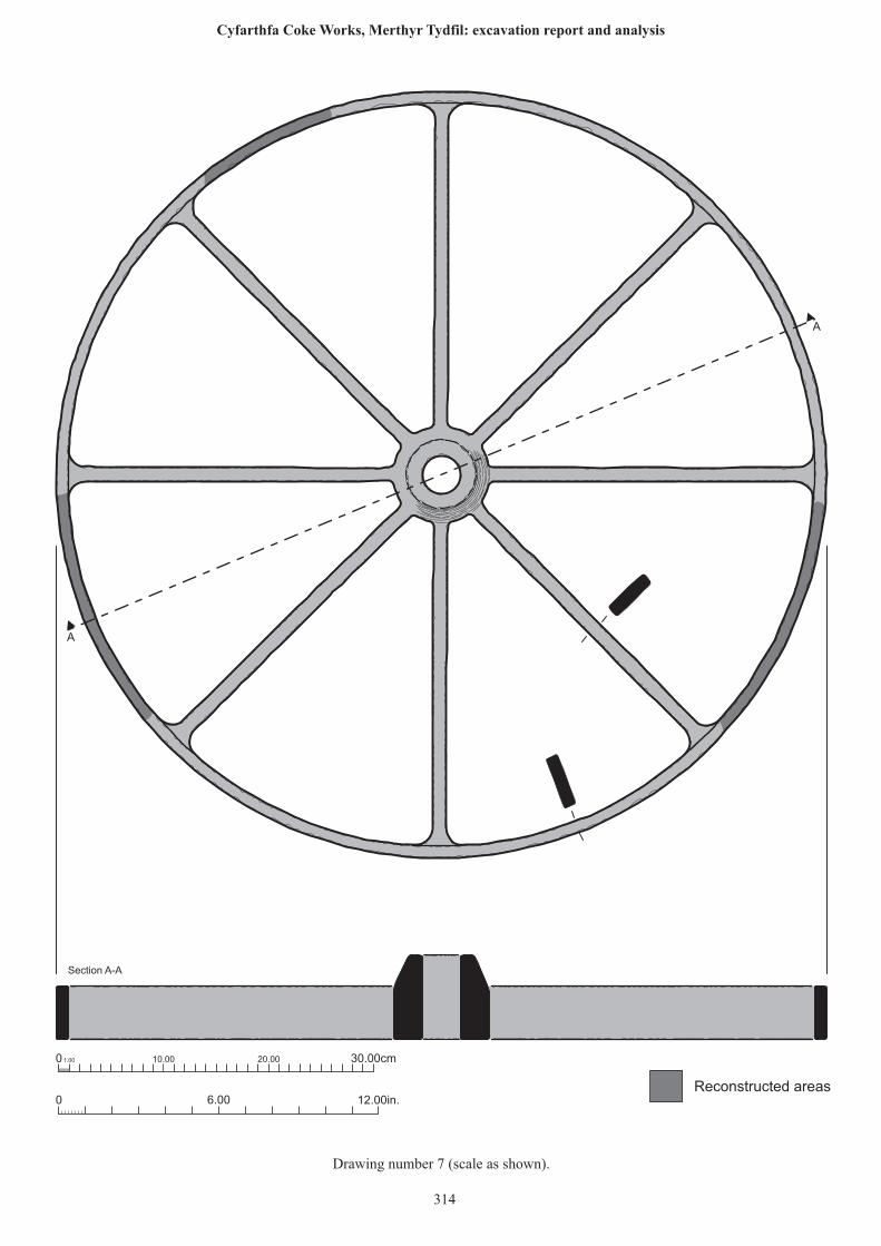
0 1.00 10.00 20.00 30.00cm
0 12.00in.6.00
A
A
Section A-A
Reconstructed areas
314
Drawing number 7 (scale as shown).
Cyfarthfa Coke Works, Merthyr Tydfil: excavation report and analysis
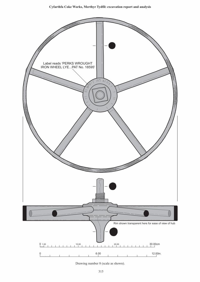
0 1.00 10.00 20.00 30.00cm
0 12.00in.6.00
Label reads ‘PERKS WROUGHTIRON WHEEL LYE...PAT No. 18595'
Rim shown transparent here for ease of view of hub
315
Drawing number 8 (scale as shown).
Cyfarthfa Coke Works, Merthyr Tydfil: excavation report and analysis
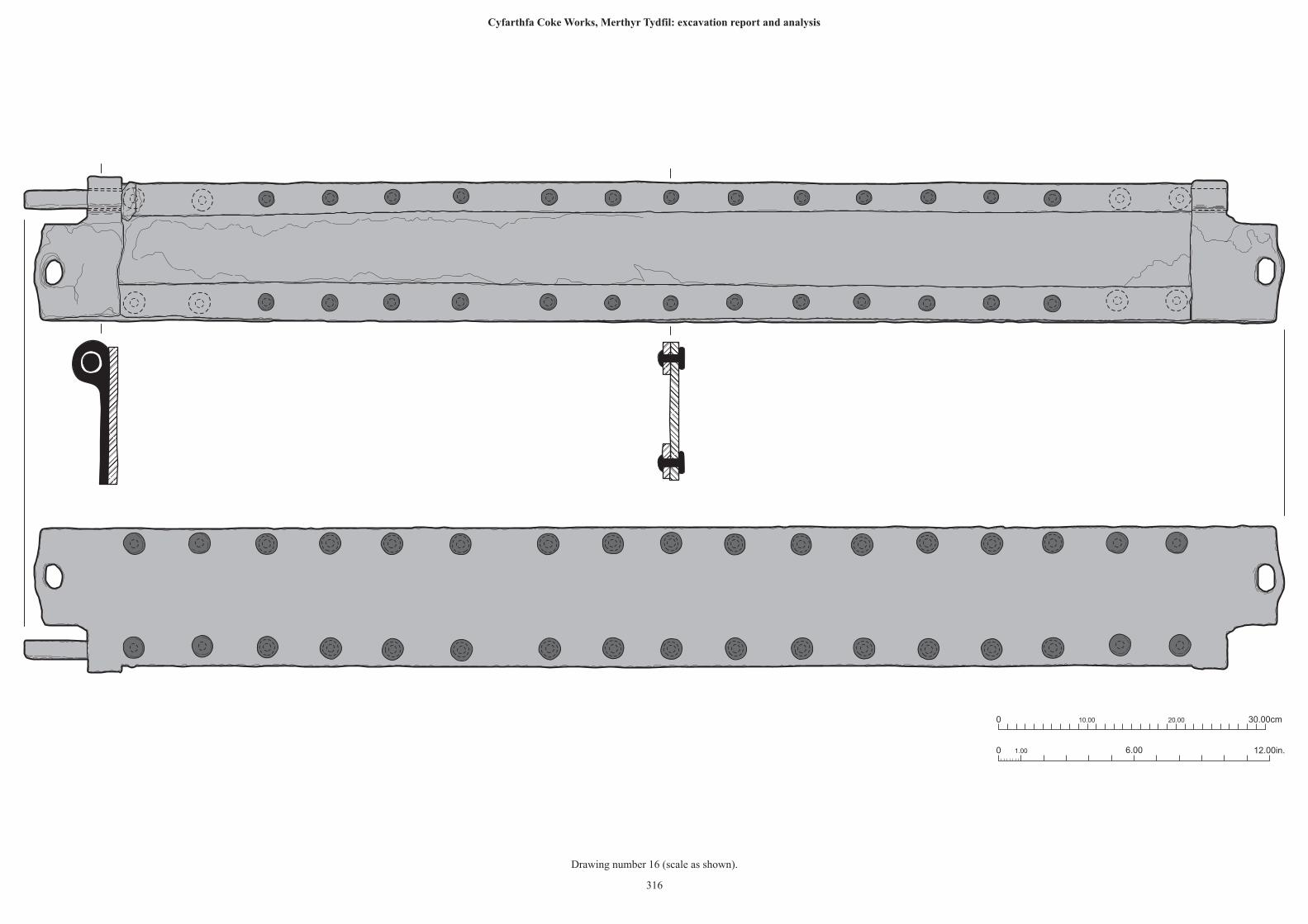
0 6.00 12.00in.1.00
10.000 20.00 30.00cm
316
Drawing number 16 (scale as shown).
Cyfarthfa Coke Works, Merthyr Tydfil: excavation report and analysis
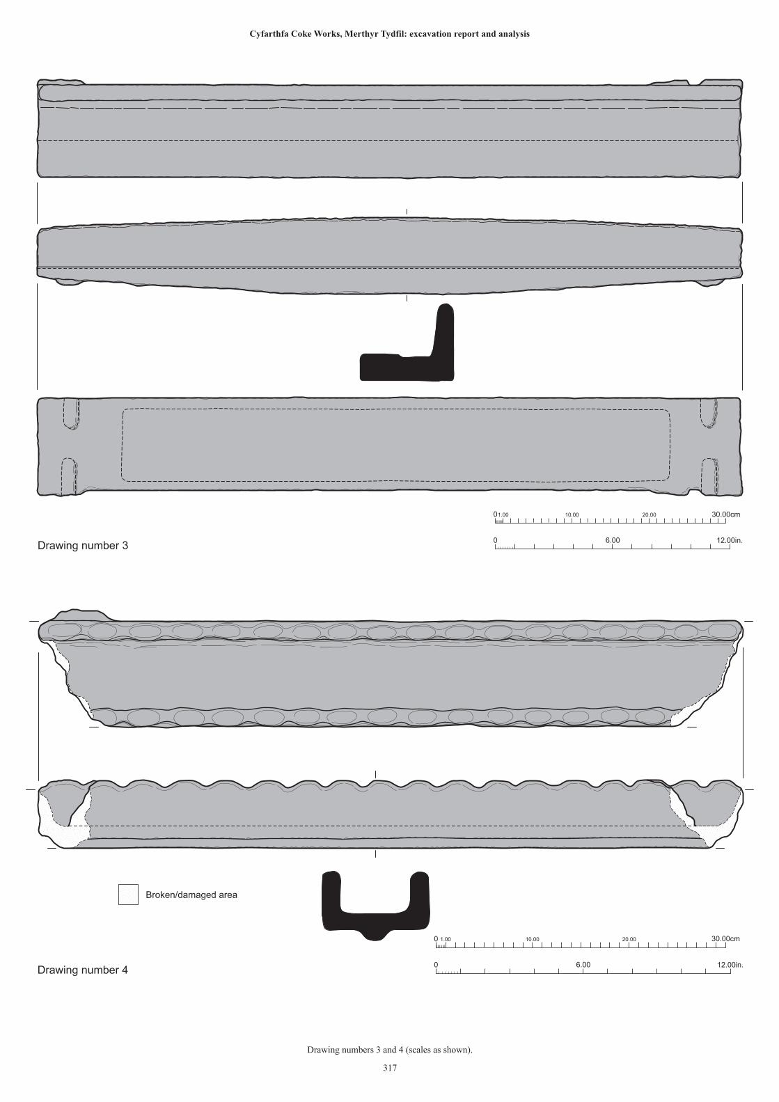
0 12.00in.6.00
01.00 10.00 20.00 30.00cm
Drawing number 3
Broken/damaged area
0 12.00in.6.00
0 1.00 10.00 20.00 30.00cm
Drawing number 4
317
Drawing numbers 3 and 4 (scales as shown).
Cyfarthfa Coke Works, Merthyr Tydfil: excavation report and analysis
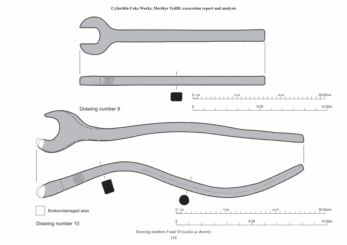
0 1.00 10.00 20.00 30.00cm
0 12.00in.6.00
0 1.00 10.00 20.00 30.00cm
0 12.00in.6.00
Drawing number 9
Drawing number 10
Broken/damaged area
Drawing numbers 9 and 10 (scales as shown).
318
Cyfarthfa Coke Works, Merthyr Tydfil: excavation report and analysis
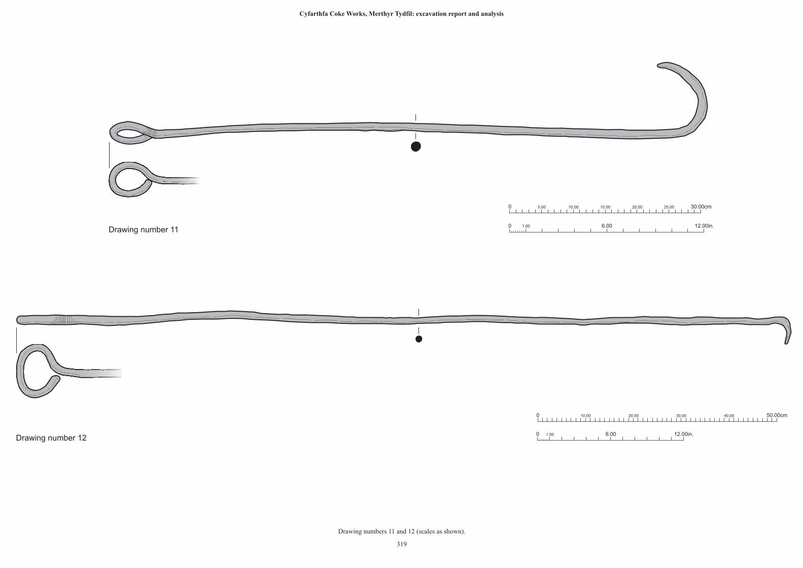
10.000 5.00 20.00 30.00cm15.00 25.00
0 6.00 12.00in.1.00Drawing number 11
0 10.00 50.00cm20.00 30.00 40.00
0 6.00 12.00in.1.00Drawing number 12
319
Drawing numbers 11 and 12 (scales as shown).
Cyfarthfa Coke Works, Merthyr Tydfil: excavation report and analysis
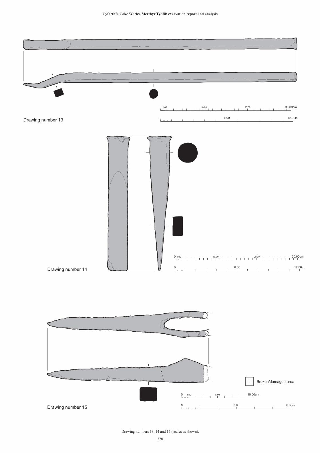
6.000 12.00in.
0 1.00 10.00 20.00 30.00cm
Drawing number 13
0 12.00in.6.00
0 1.00 10.00 20.00 30.00cm
Drawing number 14
0 6.00in.3.00
0 1.00 5.00 10.00cm
Drawing number 15
Broken/damaged area
320
Drawing numbers 13, 14 and 15 (scales as shown).
Cyfarthfa Coke Works, Merthyr Tydfil: excavation report and analysis
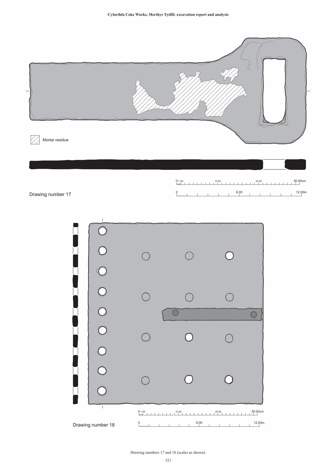
0 1.00 10.00 20.00 30.00cm
0 12.00in.6.00Drawing number 17
Mortar residue
0 1.00 10.00 20.00 30.00cm
0 12.00in.6.00Drawing number 18
321
Drawing numbers 17 and 18 (scales as shown).
Cyfarthfa Coke Works, Merthyr Tydfil: excavation report and analysis
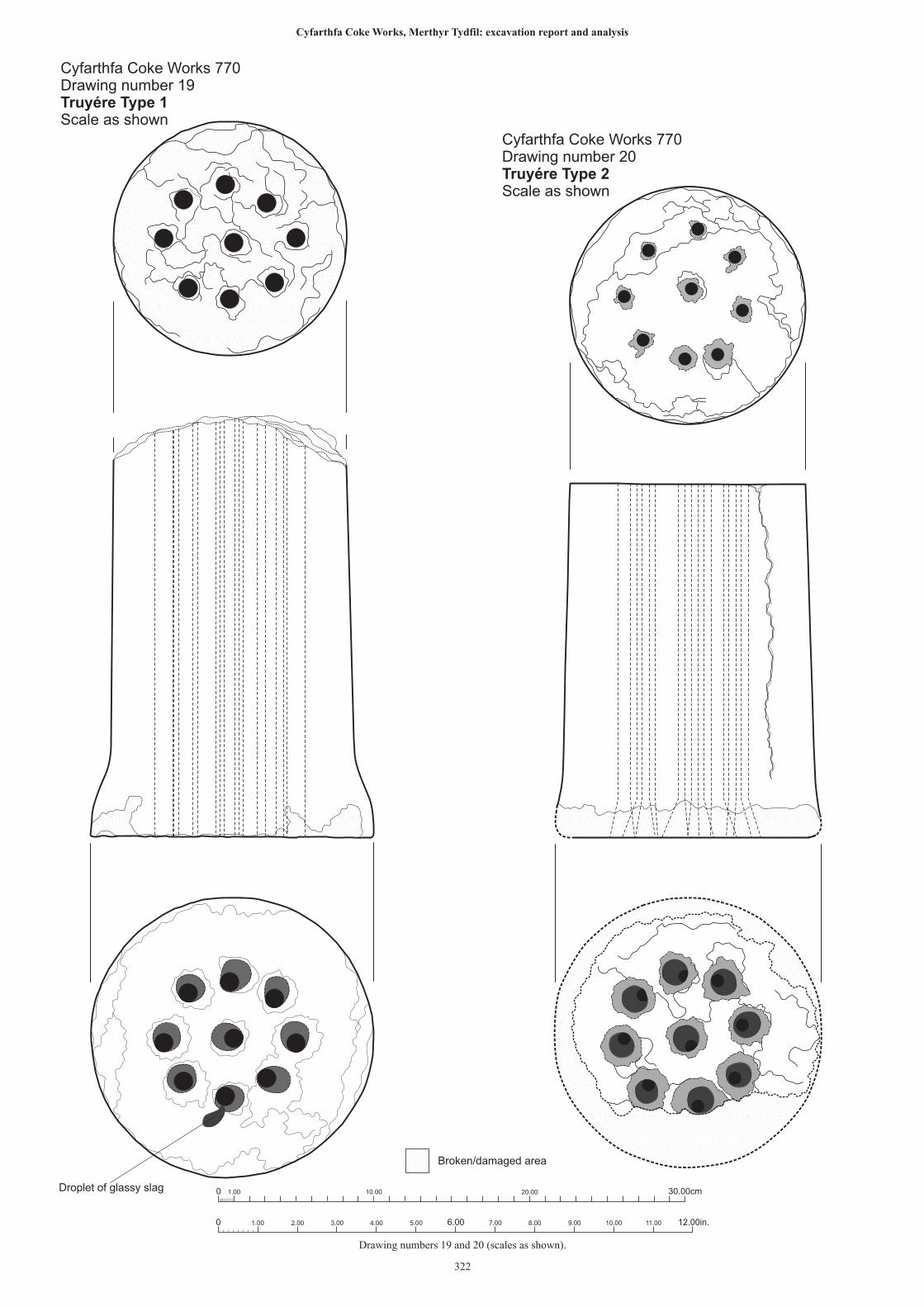
Droplet of glassy slag
Cyfarthfa Coke Works 770Drawing number 19Truyére Type 1Scale as shown
Cyfarthfa Coke Works 770Drawing number 20Truyére Type 2Scale as shown
Broken/damaged area
0 1.00 10.00 20.00 30.00cm
0 2.00 4.00 12.00in.6.00 8.00 10.001.00 3.00 5.00 7.00 9.00 11.00
322
Drawing numbers 19 and 20 (scales as shown).
Cyfarthfa Coke Works, Merthyr Tydfil: excavation report and analysis
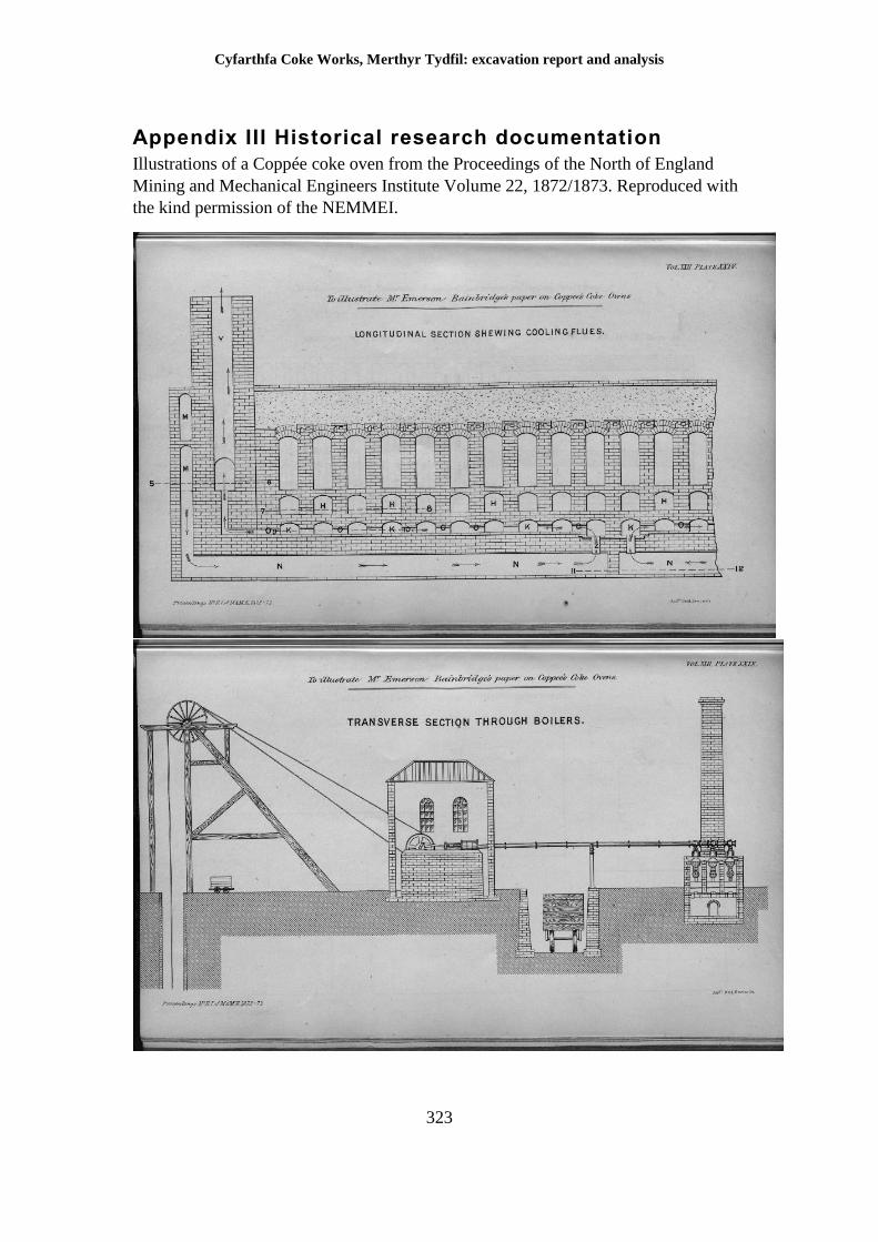
Cyfarthfa Coke Works, Merthyr Tydfil: excavation report and analysis
323
Appendix III Historical research documentation
Illustrations of a Coppée coke oven from the Proceedings of the North of England
Mining and Mechanical Engineers Institute Volume 22, 1872/1873. Reproduced with
the kind permission of the NEMMEI.
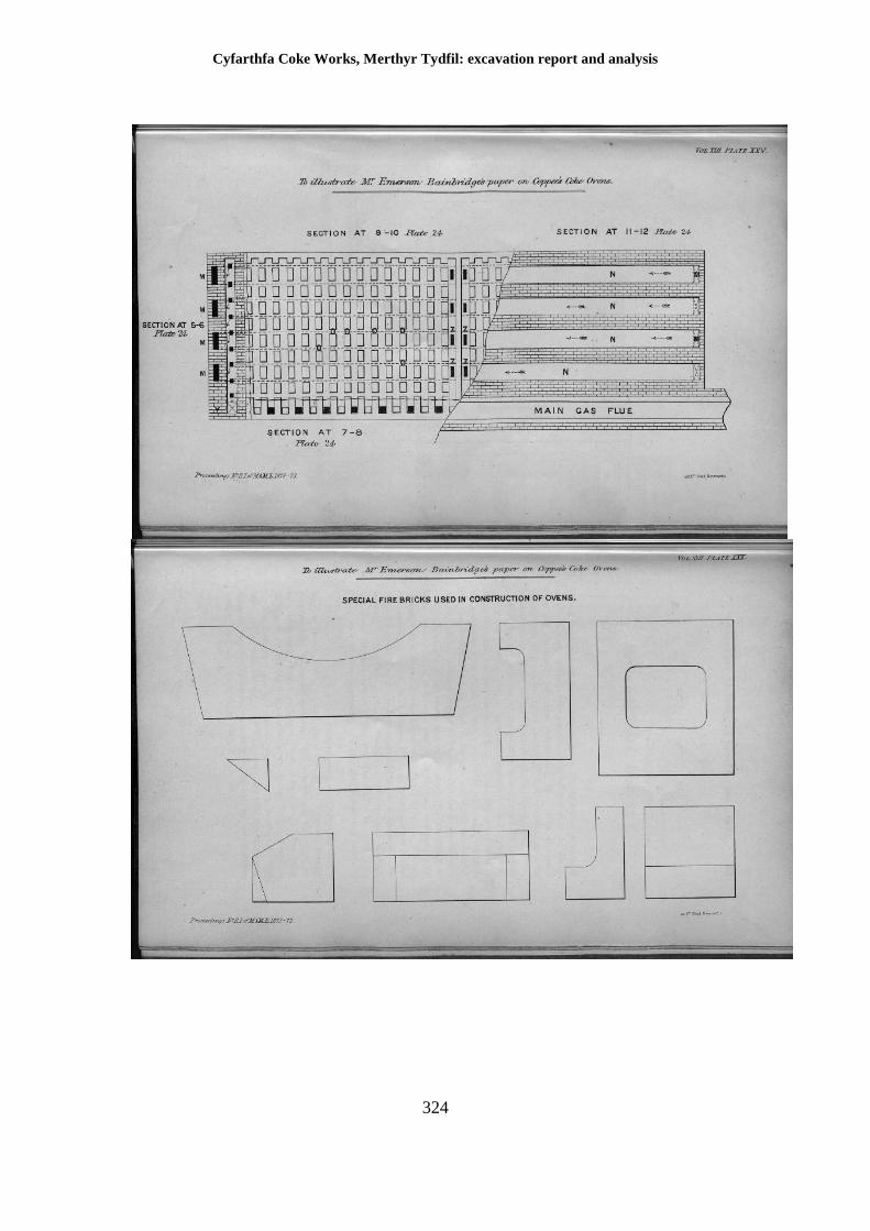
Cyfarthfa Coke Works, Merthyr Tydfil: excavation report and analysis
324
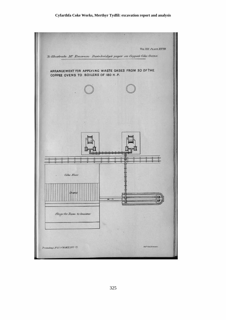
Cyfarthfa Coke Works, Merthyr Tydfil: excavation report and analysis
325
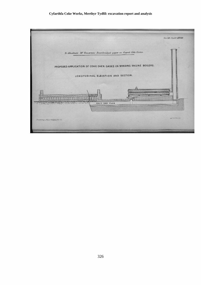
Cyfarthfa Coke Works, Merthyr Tydfil: excavation report and analysis
326
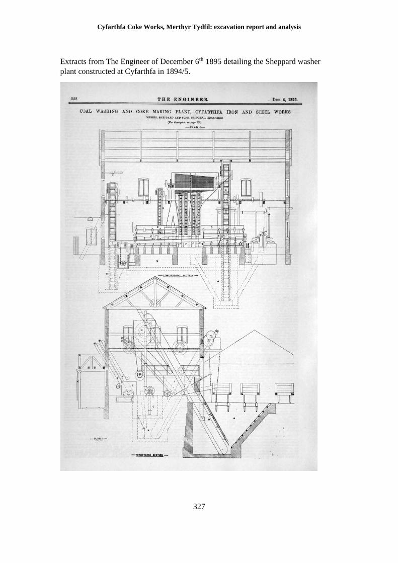
Cyfarthfa Coke Works, Merthyr Tydfil: excavation report and analysis
327
Extracts from The Engineer of December 6th 1895 detailing the Sheppard washer
plant constructed at Cyfarthfa in 1894/5.
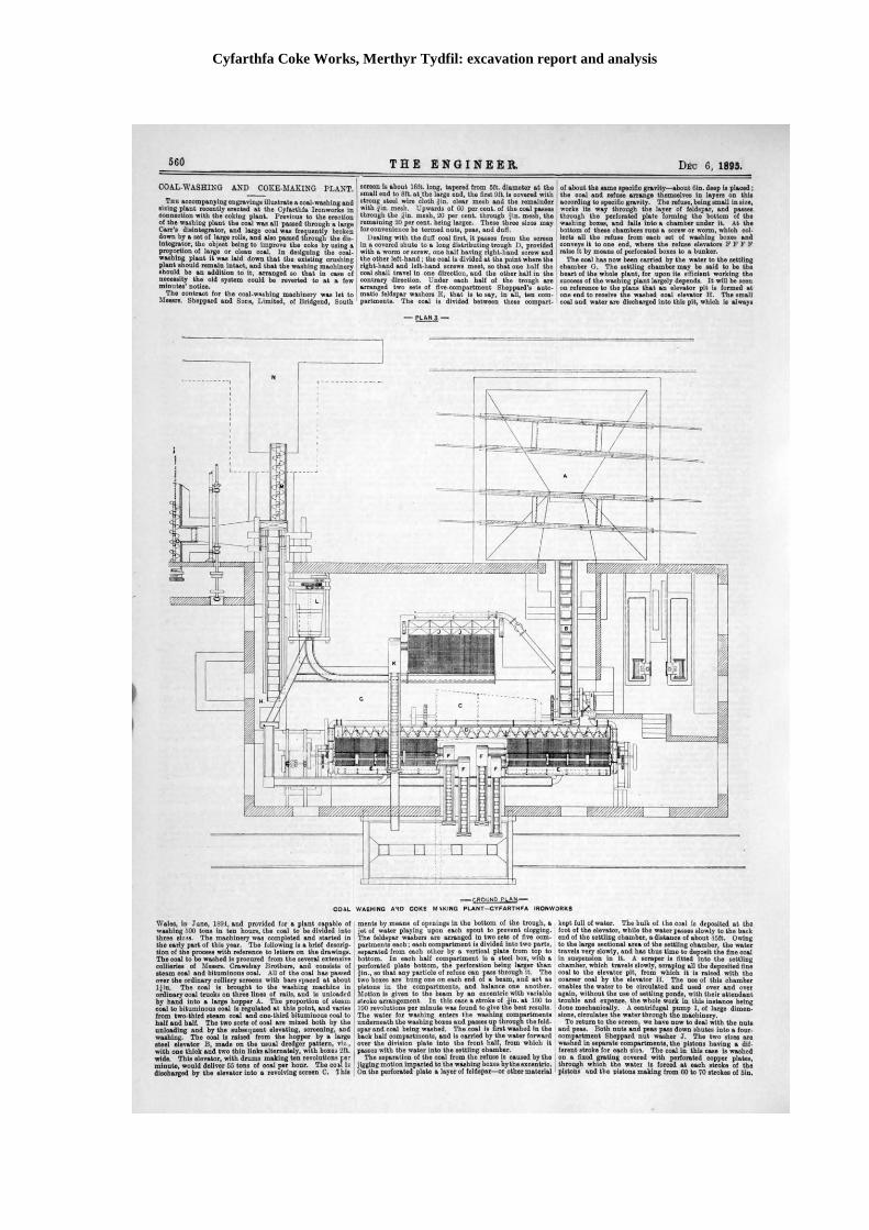
Cyfarthfa Coke Works, Merthyr Tydfil: excavation report and analysis
328
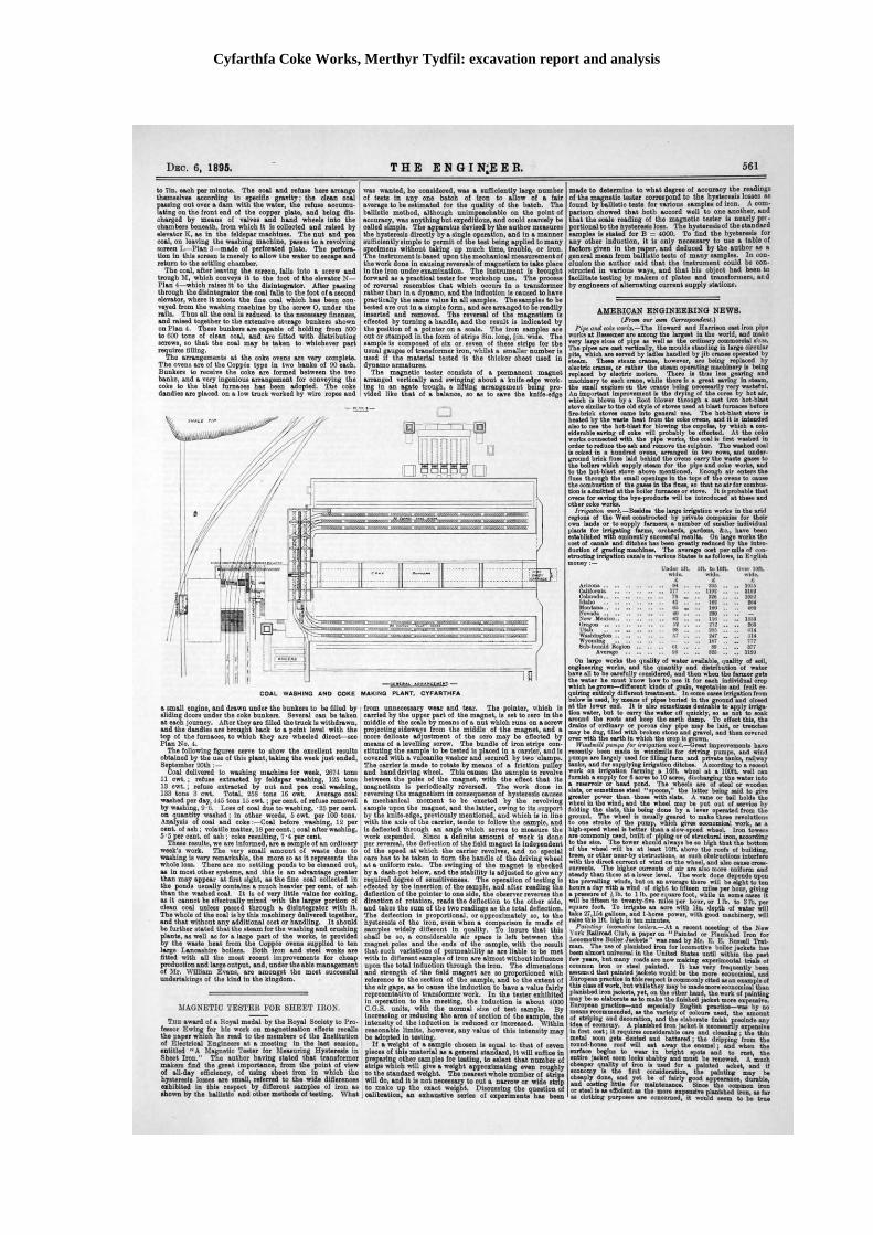
Cyfarthfa Coke Works, Merthyr Tydfil: excavation report and analysis
329
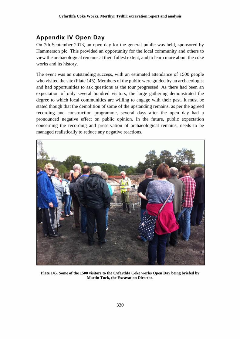
Cyfarthfa Coke Works, Merthyr Tydfil: excavation report and analysis
330
Appendix IV Open Day
On 7th September 2013, an open day for the general public was held, sponsored by
Hammerson plc. This provided an opportunity for the local community and others to
view the archaeological remains at their fullest extent, and to learn more about the coke
works and its history.
The event was an outstanding success, with an estimated attendance of 1500 people
who visited the site (Plate 145). Members of the public were guided by an archaeologist
and had opportunities to ask questions as the tour progressed. As there had been an
expectation of only several hundred visitors, the large gathering demonstrated the
degree to which local communities are willing to engage with their past. It must be
stated though that the demolition of some of the upstanding remains, as per the agreed
recording and construction programme, several days after the open day had a
pronounced negative effect on public opinion. In the future, public expectation
concerning the recording and preservation of archaeological remains, needs to be
managed realistically to reduce any negative reactions.
Plate 145. Some of the 1500 visitors to the Cyfarthfa Coke works Open Day being briefed by
Martin Tuck, the Excavation Director.
Glamorgan-Gwent Archaeological
Trust Ltd
QUALITY CONTROL Report Title:: Cyfarthfa Coke Works, Merthyr Tydfil: excavation report and analysis Report Date: November 2017 Report Number: 2017/051
Report prepared by: Johnny Crawford Position: Assistant Project Manager Date: 27/11/2017
Illustrations prepared by: Paul Jones Position: Senior Illustrator Date: 23/10/2017
Illustrations checked and authorised by: Paul Jones Position: Senior Illustrator Date: 27/11/2017
Report checked and authorised by: Martin Tuck Position: Senior Projects Manager Date: 27/11/2017
As part of our desire to provide a quality service we would welcome any comments you may wish to make on the content or presentation of this report. Glamorgan-Gwent Archaeological Trust Ltd. Heathfield House, Heathfield, Swansea, SA1 6LE Tel. 01792 655208; Fax. 01792 474469 Registered Charity no. 505609 Web: www.ggat.org.uk e-mail: [email protected]


