Embed Size (px)
Citation preview
1
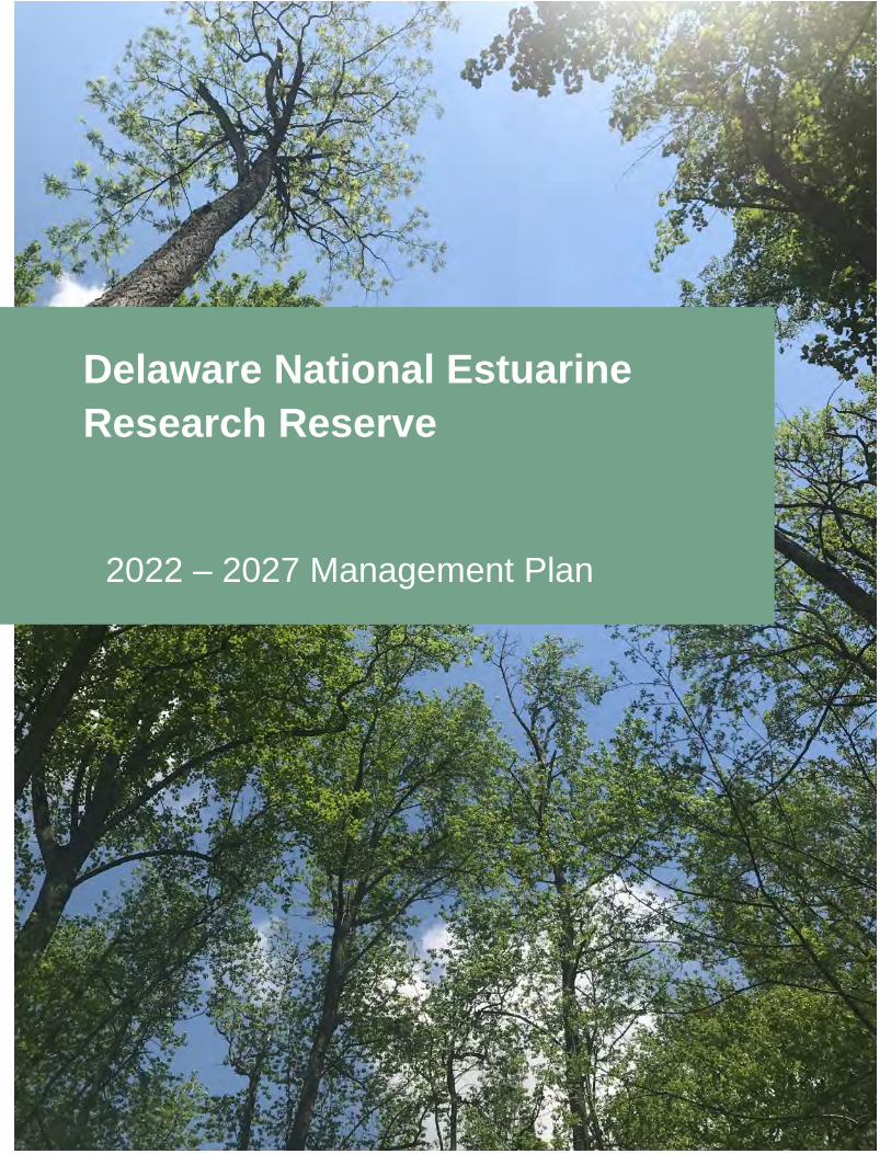
Delaware National Estuarine Research Reserve
2022 – 2027 Management Plan
Table of Contents
2
DELAWARE NATIONAL ESTUARINE RESEARCH RESERVE MANAGEMENT PLAN
3rd Revision, November 2021 2nd Revision, August 2013
Revision, June 2005 June 1993
Prepared for
U.S. Department of Commerce National Oceanic and Atmospheric
Administration Office for Coastal Management 1305 East West Highway Silver Spring, MD 20910
State of Delaware Department of Natural Resources and
Environmental Control Division of Climate, Coastal and Energy
Delaware Coastal Programs 100 West Water Street, Suite 10B
Dover, DE 19901
2
TABLE OF CONTENTS
Executive Summary .............................................................................................................................................. 7 Plan Purpose, Scope and Reserve Context ...................................................................................................... 7
Delaware National Estuarine Research Reserve Strategic Plan 2021 - 2026 ................................................ 10 Introduction to the Reserve................................................................................................................................ 23
Introduction to the National Estuarine Research Reserve System .................................................................. 23 History and Local Management of DNERR...................................................................................................... 24 Delaware’s Ecological Setting .......................................................................................................................... 25 Boundary Description ....................................................................................................................................... 28 Boundary Changes........................................................................................................................................... 31 Socioeconomic Attributes ................................................................................................................................. 35 Archaeological and Cultural Resources ........................................................................................................... 36 Threats and Stressors ...................................................................................................................................... 36
Administrative Plan ............................................................................................................................................. 38 Overview .......................................................................................................................................................... 38 Organizational Framework and Chart .............................................................................................................. 38 Staffing Plan ..................................................................................................................................................... 38 Staffing Needs .................................................................................................................................................. 42 Strategic Partnerships ...................................................................................................................................... 42 Advisory Committees ....................................................................................................................................... 43
Volunteer Plan ..................................................................................................................................................... 44 Implementation of the Volunteer Program ....................................................................................................... 44
Special Area Designations ................................................................................................................................. 45 Coastal Training Program Plan .......................................................................................................................... 48
Coastal Training Program Context ................................................................................................................... 48 Priority Issues, Audiences, Delivery and Partnerships .................................................................................... 49 Coastal Training Program Capacity ................................................................................................................. 52 Coastal Training Future Needs and Opportunities ........................................................................................... 53 Monitoring and Evaluation Strategies .............................................................................................................. 53 Role of the CTP Advisory Committee .............................................................................................................. 53
Education and Interpretive Plan ........................................................................................................................ 54 Education Program Setting and Context .......................................................................................................... 54 Priority Issues, Audiences, Delivery and Partnerships .................................................................................... 55 Education Program Alignment and Delivery .................................................................................................... 57 Current and Anticipated Partnerships .............................................................................................................. 58 Education Program Capacity ........................................................................................................................... 58 Education Program Future Needs and Opportunities ...................................................................................... 59
Research and Monitoring Plan........................................................................................................................... 60 Research and Monitoring Program Context ..................................................................................................... 60 Priority Issues, Audiences, Delivery and Partnerships .................................................................................... 61 Priority Audiences and Partners ....................................................................................................................... 62 Research and Monitoring Program Delivery .................................................................................................... 63 Research and Monitoring Program Capacity ................................................................................................... 64 Research and Monitoring Future Needs and Opportunities............................................................................. 64
Stewardship Plan ................................................................................................................................................ 66 Stewardship Program Context ......................................................................................................................... 66 Priority Issues, Audiences, Delivery and Partnerships .................................................................................... 67 Stewardship Program Delivery ......................................................................................................................... 68 Stewardship Program Capacity ........................................................................................................................ 68 Stewardship Future Needs and Opportunities ................................................................................................. 68
Public Access and Visitor Use Plan .................................................................................................................. 70
3
General Access Policies .................................................................................................................................. 70 Site Specific Policies ........................................................................................................................................ 73 Maintenance of Facilities and Public Use Areas .............................................................................................. 74
Facility Development and Improvement Plan, Including Construction Plan ................................................ 75 St. Jones Reserve Existing Facilities ............................................................................................................... 75 St. Jones Reserve Identified Future Facility Needs ......................................................................................... 76 Blackbird Creek Reserve Existing Facilities ..................................................................................................... 78 Blackbird Creek Reserve Identified Future Facility Needs ............................................................................... 79 Construction Plan ............................................................................................................................................. 79
Resource Protection Plan ................................................................................................................................... 80 Resource Protection and Management............................................................................................................ 80 Laws and Regulations – Legal Authorities ....................................................................................................... 81 Land Protection ................................................................................................................................................ 82 Resource Manipulation Plan ............................................................................................................................ 83
Restoration Plan .................................................................................................................................................. 85 Priority Restoration Area .................................................................................................................................. 85 Prioritization Processes and Criteria ................................................................................................................ 85 Description of Restoration Areas and Management ........................................................................................ 86
Land Acquisition Plan ......................................................................................................................................... 88 State Control .................................................................................................................................................... 88 Land Acquisition Priorities with Core and Buffer .............................................................................................. 88 Partnerships in Land Protection and Acquisition ............................................................................................. 91
Appendices .......................................................................................................................................................... 94
4
TABLE OF FIGURES Figures
Figure 1 National Estuarine Research Reserve System Map ............................................................. 23 Figure 2 State of Delaware with Drainage Basins and Surrounding States ........................................ 25 Figure 3 Major Drainage Basins of Delaware ..................................................................................... 26 Figure 4 DNERR sites within the Delaware Bay Drainage Basin ....................................................... 27 Figure 5 St. Jones River Watershed and DNERR Boundary .............................................................. 29 Figure 6 Blackbird Creek Watershed and DNERR Boundary ............................................................. 31 Figure 7 531 Union Church Road ...................................................................................................... 32 Figure 8 0 Taylors Bridge Road ......................................................................................................... 33 Figure 9 Union Church Road (Road No. 456) .................................................................................... 34 Figure 10 789 Blackbird Landing Road .............................................................................................. 35 Figure 11 DNREC/CCE/DCP Organizational Chart ........................................................................... 41 Figure 12 St. Jones Reserve Component FW Hunting Map ............................................................... 71 Figure 13 Blackbird Creek Reserve Component FW Hunting Map..................................................... 72 Figure 14 Trail map of the St. Jones Reserve Component ................................................................. 73 Figure 15 Trail map of the Blackbird Creek Reserve Component ...................................................... 74 Figure 16 Conservation Easement at the St. Jones Reserve Component .......................................... 82 Figure 17 Resource Manipulation at St. Jones Reserve .................................................................... 83 Figure 18 Resource Manipulation at Blackbird Creek Reserve .......................................................... 84 Figure 19 Blackbird Creek Reserve Habitat Restoration Goals from Appendix C ............................... 86 Figure 20 Land Protection within and adjacent to the St. Jones Reserve Component........................ 89 Figure 21 Land Protection within and adjacent to the Blackbird Creek Reserve Component ............. 90 Figure 22 Core, Buffer and Acquisition areas for St. Jones Reserve Component .............................. 92 Figure 23 Core, Buffer and Acquisition areas for Blackbird Creek Reserve Component .................... 93
5
LIST OF ACRONYMS
AGO America’s Great Outdoors CDMO Centralized Data Management Office CIB Delaware Center for the Inland Bays CTP Coastal Training Program CZMA Coastal Zone Management Act CCE Division of Climate, Coastal and Energy, DNREC DCMP Delaware Coastal Management Program, DNREC DCP Delaware Coastal Programs, DNREC DDA Delaware Department of Agriculture DelDOT Delaware Department of Transportation DHCA Division of Historic and Cultural Affairs, Department of State DFS Delaware Forest Service DGS Delaware Geological Survey DISC Delaware Invasive Species Council DNERR Delaware National Estuarine Research Reserve, DNREC DNREC Department of Natural Resources and Environmental Control DNS Delaware Nature Society DSG Delaware Sea Grant DSU Delaware State University FW Division of Fish and Wildlife, DNREC GIS Geographic Information System JDP John Dickinson Plantation and Mansion, DHCA MACAN Mid-Atlantic Coastal Acidification Network MOU Memorandum of Understanding NERR National Estuarine Research Reserve NERRS National Estuarine Research Reserve System NOAA National Oceanic and Atmospheric Administration PARKS Division of Parks and Recreation, DNREC PDE Partnership for the Delaware Estuary QA/QC Quality Assurance and Quality Control RASCL Resilient and Sustainable Communities League RCP Resilient Community Partnership SSAM-1 Sentinel Site Application Module-1 SWMP System-Wide Monitoring Program TNC The Nature Conservancy TOTE Teachers on the Estuary UD University of Delaware USDA U.S. Department of Agriculture USFWS U.S. Fish and Wildlife Service
6
LIST OF APPENDICES
Appendix A – 2014 DNERR Climate Adaptation Plan
Appendix B – NOAA/DNREC MOU
Appendix C –DNERR Stewardship Plan (2019)
Appendix D – DNERR/FW MOU
Appendix E – CTP Advisory Committee
Appendix F – Education Market Analysis Summary
Appendix G – Education Needs Assessment Summary
Appendix H – Delaware Sentinel Site Plan
Appendix I – State and County Legal Authorities Affecting Resource Protection in DNERR
Appendix J –Blackbird Creek Reserve Ecological Restoration Master Plan (2007)
Appendix K - Federal Consistency Determination
Appendix L - NEPA Determination
Appendix M - Public Engagement Process
7
Executive Summary Plan Purpose, Scope and Reserve Context The Delaware Department of Natural Resources and Environmental Control (DNREC) is the state agency responsible for the operation and management of the Delaware National Estuarine Research Reserve (DNERR or Reserve), in cooperation with the Office for Coastal Management of the National Oceanic and Atmospheric Administration (NOAA). Designated in 1993, DNERR is one of 29 protected areas that comprise the National Estuarine Research Reserve System (NERRS). NERRS promotes stewardship of our nation’s coasts and estuaries through innovative research, education and training using a place-based system of protected areas. DNERR consists of two Reserve components, the Blackbird Creek Reserve in New Castle County and the St. Jones Reserve in Kent County, which are about 20 miles apart. These components include both brackish and freshwater tidal wetlands, and represent the diverse estuarine ecosystems found throughout the Mid-Atlantic states. NERRS was created by the Coastal Zone Management Act (CZMA) of 1972, as amended, 16 U.S.C. § 1461, to augment the Federal Coastal Zone Management Program. Reserves are required by federal regulation, 15 C.F.R. § 921.13, to have a NOAA approved management plan that is updated every five years and serves as the framework for directing and tracking the progress of Reserve programs. Since the last approved management plan (3rd revision), DNERR has had an important impact on the local area and its communities. From 2013 to 2020, the Coastal Training Program (CTP) held 53 trainings, workshops or conferences with 27,851 contact hours with local constituents. The Education Program had 32,466 contact hours with 11,722 K-12 students and 23,599 public participants. Additionally, volunteers have been engaged in the work at the DNERR donating 20,739 hours of their time – producing the full-time employee (FTE) equivalent of ten and half years’ worth of work. Some of those volunteer hours were spent recording 1,784,923 spawning horseshoe crabs on three beaches DNERR monitors. The Research and Monitoring Program has produced 15 peer-reviewed publications occurring at, and/or utilizing DNERR infrastructure and data. The DNERR mini-grant opportunity, available through the Research and Monitoring Program, has distributed $183,766 of funding to local, Delaware-based researchers, many of which were early career faculty. The Stewardship Program has worked to enhance 76 acres of DNERR land through reforestation and other restoration efforts. These are just a few snapshots of some of the accomplishments of DNERR’s programs in the last few years; more details can be found in publications and reports. This revision of DNERR’s management plan is the fourth revision to be approved by NOAA. It describes the background history, programs and administration of DNERR and outlines the strategy for meeting the DNERR’s mission during 2021-2026. In addition to continuing the tradition of robust local community education, training, research and stewardship programs, With the approval of this management plan, the DNERR boundary will be amended to incorporate an additional 6 parcels - all found within the priority acquisition area identified in the 2013 revision of the plan - increasing the total acreage of the Reserve to 6,364 acres. These parcels include lands that enhance and contribute to the ecological protection within the Blackbird Creek watershed. The “McKinley” property at 531 Union Church Road is 67.4 acres in size and includes a mix of native hardwoods and coastal plain ponds (Delmarva Bays). At 0 Taylors Bridge Road, the 32-acre “Unruh” property includes a wooded tributary buffer and agricultural lands. Three parcels known as the “Norris” property, totaling 42.6 acres at Union Church Road were acquired to improve wildlife corridor habitat and include forest and agriculture lands. Additionally, an inholding property known as “Manwaring” at 789 Blackbird Landing Road that is 16.3 acres in size was acquired. Details on the habitat makeup,
8
existing uses, and future uses can be found in the Boundary Changes section of the Introduction to the Reserve. Details on resource manipulation at the Unruh and Norris properties can be found in the Resource Manipulation Plan. DNERR Niche DNERR draws upon research conducted within the Reserve and surrounding areas to promote informed coastal management and advance climate adaptation and resilience. This place-based approach is DNERR’s niche in estuarine research and achieving stewardship and education goals in Delaware. Education and training programs promote the sustainable use of coastal and estuarine resources that support resilient coastal communities. These programs include community public education and outreach, K-16 environmental education programs, educator professional development, technical assistance and training for coastal decision makers. DNERR is a regional leader in management-driven and applied estuarine science. Research is conducted by staff scientists and in collaboration with local, regional and national scientists who build on the long-term monitoring data and infrastructure that DNERR provides to address coastal management issues. DNERR’s stewardship program utilizes adaptive management techniques to conserve, restore and protect the natural resources within the Reserve, providing place-based research and education opportunities that promote a better understanding of Delaware’s important estuarine and coastal areas. Since the last revision of the management plan DNERR has led the way meeting climate change and resiliency needs, producing a Climate Adaptation Plan in 2014 (Appendix A), as well as continuing longstanding research, monitoring, education and professional trainings that have laid the groundwork informing Delaware climate change and resiliency planning. Reserve Programs Overview Administration: DNERR will effectively manage its existing resources, explore funding and additional resources to enhance its programs, strengthen relationships with existing partners and develop new partnerships and provide support and professional development opportunities for staff. Coastal Training Program: DNERR will continue to offer technical assistance, resources, tools and training to assist decision-makers in utilization of best available research. Education and Outreach: DNERR will increase coastal resource knowledge and environmental stewardship through formal and informal education targeting Reserve users, visitors and students. Research and Monitoring: DNERR will continue to conduct and coordinate applied research and long-term monitoring efforts. DNERR will initiate new projects and provide technical and advisory services that address significant coastal management issues. Stewardship: DNERR will model resilient site management through preservation, restoration and adaptive management. Sustainable site management will provide research and education opportunities to promote a better understanding of Delaware’s estuarine and coastal areas. Facilities and Public Access: DNERR will plan for additional construction of facilities that meet accessibility standards for reserve visitors with disabilities in addition to staying abreast of changing standards and visitor needs. Through managed access, DNERR will help visitors increase their connection to and foster a sense of stewardship for estuarine and coastal resources.
9
By actively using this management plan to guide the Reserve, DNERR aims to be a recognized resource for NOAA, the Mid-Atlantic Region, and the state of Delaware. DNERR Focus Areas DNERR management focuses on the most pressing environmental concerns facing our region. These focus topics align directly with the NERRS Strategic Plan 2017-2022 and include environmental change, water quality and quantity, habitat protection and coastal communities. Environmental change due to climate change is occurring rapidly, affecting DNERR and communities throughout Delaware. Future impacts will be exacerbated by sea level rise, inundation and flooding from coastal storms, and changes to groundwater and surface water flows. Coastal flood impacts are expected to increase significantly in the next few decades. Flooding coupled with sea level rise pose increased risks to the growing number of people and rising value of property in the coastal floodplain. DNERR is able to study the impacts of these threats to support adaptation and mitigation strategies to help protect vulnerable communities. Healthy water quality and quantity is vital for coastal ecosystems and communities to thrive. Coastal waters continue to be threatened by eutrophication and nuisance algal blooms that are strongly influenced by population growth and land use practices. The System-Wide Monitoring Program (SWMP) is foundational for understanding baselines, trends, patterns, and changes in estuarine water quality. SWMP provides critical information to local municipalities used in assessing flood risks, evaluating conditions contributing to poor water quality, informing decisions on local public health risks and advisories, determining regulatory policies for nutrient criteria and managing invasive species. Habitat protection is essential to maintaining and improving water quality and quantity. According to a 2011 report from the US Fish and Wildlife Service, DNREC, Virginia Polytechnic Institute and State University, 238 acres of estuarine emergent wetlands were lost in Delaware between 1992 to 2007 with changes of estuarine vegetated wetlands being the greatest in Kent County (where the St. Jones Reserve component is located) amounting to net losses of 165 acres representing 69 percent of the statewide loss of this type. Approximately 54% of wetlands have been functionally lost since the 1780’s. Development, human activities, sea level rise, and inundation are primary causes for these losses, highlighting the need for increased wetland protection and restoration activities. DNERR maps, monitors and studies estuarine habitat changes while developing, testing and implementing protection and restoration approaches. These research, monitoring and stewardship activities are transferable to other state, regional and national partners, extending the benefits beyond Delaware. A robust estuarine ecosystem is vital to support coastal communities and keep them healthy. DNERR has reserve components in two out of three of Delaware’s counties, and is uniquely poised to provide research, education and training programs that foster a stewardship ethic in our coastal communities and advances social science. Engaging coastal communities including underserved and underrepresented communities will in turn benefit the estuarine system and the coastal communities for the long-term. The 2021-2026 DNERR Strategic Plan details goals, objectives and strategies that are cross-sectoral and aim to address issues within these coastal management areas. More details are in each sector chapter, and within the other chapters of this plan.
10
Delaware National Estuarine Research Reserve Strategic Plan 2021 - 2026 Vision: Healthy, resilient and sustainable coastal watersheds for current and future generations. Mission: DNERR promotes effective stewardship of estuarine and coastal ecosystems through education, outreach, partnerships and research. Goal 1: Protect and improve ecosystem health, resiliency, biological diversity, and cultural integrity within the region. Objective 1: Develop, maintain and operate facilities that minimize environmental impacts and resource consumption by using innovative design, construction methods and technologies. Strategies:
● Collaborate among sectors to work towards implementing the 2014 DNERR Climate Adaptation Plan (Appendix A) using DNERR as a demonstration site for on-the-ground resiliency projects to help to inform decision makers. o Administration Identify priority demonstration site locations, materials and staff time needs. Establish timeline of demonstration project implementation and process. Review the Climate Adaptation Plan regularly to ensure implementation and most up to
date practices. o Coastal Training Program Incorporate on-the-ground resiliency projects into trainings relating to resiliency and
infrastructure o Education Develop educational programs for various user groups pertaining to climate adaptation
and demonstration sites. Implement interpretive signage to explain climate adaptation and demonstration sites
o Research and Monitoring Provide expertise and technical guidance to develop demonstration site maintenance
and monitoring plans. Collaborate with state partners to lead and/or support climate change research needs
and to test resiliency strategies. o Stewardship Evaluate and implement relevant strategic actions from the DNERR Climate Adaptation
Plan to each demonstration project. o Collaborate with sectors to include demonstration sites in program development by
providing expertise where applicable.
● Incorporate sea level rise and climate change in facility planning and interpretive signage. o Administration Utilize sea level rise and climate change mapping tools for consideration of future land
acquisition and facility or infrastructure siting. o Education Develop, design and install interpretive signage about sea level rise and climate change.
Protecting Places
11
Incorporate an educational visual change in infrastructure to show impacts due to sea level rise.
Utilize new interpretive technology to show effects of sea level rise and climate change at DNERR.
● Increase outdoor facilities using green materials and approaches to encourage visitation and facilitate learning. o Education
Work towards planning, developing and building outdoor learning and recreational spaces at DNERR.
Develop school and public programs that utilize outdoor learning spaces. o Public Access
Expand outdoor visitor facilities for recreation, training and education. Create interactive stops and rest areas along the publicly accessible areas.
Objective 2: Increase research and monitoring in non-tidal habitats within the estuarine system as represented by DNERR. Strategies:
● Establish and enhance long-term monitoring efforts to assess environmental changes within the DNERR boundaries to act as a sentinel site for the state and region. o Research and Monitoring
Increase the capacity for long-term monitoring within DNERR, through the addition of new monitoring sites and/or by adding new parameters to existing sites, while maintaining the current level of high-quality monitoring.
Continue to work with regional and national partners to create and apply standardized operating procedures which lead to consistent data collection.
Periodically analyze collected monitoring data to assess estuarine trends, patterns and changes.
Identify spatial and/or parametrical data gaps needed to better understand local system changes and seek capacity and partnerships to help fill those identified gaps.
o Stewardship Collaborate with local and regional partners to address data gaps in long-term
monitoring and identify restoration opportunities within DNERR and its watershed. Seek funding and other capacity building opportunities to support long-term
restoration and utilization of DNERR data for monitoring restoration outcomes.
● Promote new research in non-tidal habitats by engaging with new partners. o Research and Monitoring
Seek new partnerships by actively participating in local and regional workgroups and conferences.
Identify funding mechanisms and opportunities to collaboratively support partner research with a strong emphasis on supporting student-led research.
o Stewardship Identify ways to advance the understanding of baseline biodiversity or changes within
DNERR habitats. Continue to support the Research Coordinator with partner engagement and new
research opportunities.
12
Objective 3: Protect, enhance, and restore coastal ecosystems to improve biodiversity, to reduce habitat fragmentation and invasive species. Strategies:
● Work with partners to protect and restore key habitats and act as a facilitator to share best management practices and lessons learned. o Administration Identify the partners able to protect and restore identified key habitats. Identify potential funding sources for protection and restoration work.
o Coastal Training Program Provide trainings to collaborate and share best management practices and lessons
learned. o Stewardship Adapt techniques and learn from local and regional partners to enhance restoration
practices at DNERR. Support the CTP’s efforts to share best management practices and lessons learned with
partners and local decision makers. Engage with partners by participating in committees that meet DNERR priorities at a
local or regional scale. Work internally and with partners to emphasize early detection, identify, track, monitor
and manage invasive species
● Develop monitoring plans, using current and emerging technologies, to understand baseline biodiversity and success of restoration projects at DNERR. o Stewardship
Catalog current restoration projects to develop or assess current monitoring plans and develop restoration goals for future projects.
Identify methods to collect baseline data before, during and after implementing restoration projects.
Develop metrics to define success of a restoration project, while understanding the individual uniqueness of each project through adaptive management.
● Collaborate with land management organizations to work toward a holistic approach to stewardship and land management. o Administration Work with neighboring land managers to identify and implement restoration projects in
locations within DNERR boundaries and on adjacent lands that will be the most impactful.
o Coastal Training Program Collaborate with Stewardship Coordinator to facilitate meetings and discussions with
land stewardship partners to develop a holistic approach to restoration and land management.
o Stewardship Coordinate with partners to understand what land management or restoration strategies
are being implemented within the watersheds of DNERR. Build relationships with additional land management partners and enhance current
relationships through facilitated conversations. Ensure current and future land management practices enhance habitats or ecosystem
functions of DNERR.
● Conduct a market analysis and needs assessment about land management as it relates to climate change, sustainability, and resiliency. o Coastal Training Program
13
Goal 2: Foster effective decision-making and best management practices related to the stewardship of estuarine ecosystems through the application of research and long-term environmental monitoring. Objective 1: Develop and maintain integrity of DNERR for research, long-term resource protection and education while permitting traditional uses that do not conflict with DNERR goals. Strategies:
● Balance research, education, and public use while maintaining stewardship objectives. o Administration Identify and mitigate current and potential conflicting use requirements between user
groups. o Stewardship Support the education program’s efforts by providing information to visitors about
invasive species, reducing negative impacts of trail use, knowledge of habitat protection and awareness or public stewardship at DNERR.
Create trail plans for DNERR that support contingencies for trail loss over time and adaptive removal of vulnerable trail segments.
Assist with the understanding of anthropogenic impacts to species and habitat quality and provide processes for the public to contribute.
Objective 2: Increase awareness and capacity of DNERR in the scientific community. Strategies:
● Publish peer reviewed papers on scientific findings. o Research and Monitoring
Lead or support comprehensive analyses of historical and ongoing DNERR and Mid-Atlantic regional environmental monitoring data.
Publish scientific analyses, findings and methods in peer-reviewed journals to make them available to a wider scientific audience.
Participate in, or lead, NERR-wide estuarine studies.
● Partner with organizations to apply for external funding opportunities to increase research, monitoring and conservation activities. o Research and Monitoring
Apply to competitive, external funding opportunities to address DNERR coastal management and research priorities.
Increase awareness of DNERR’s pre-existing data and ‘living laboratory’ facilities to encourage new and additional partner research.
o Stewardship Identify areas and develop a timeline for restoration at DNERR in order to support
applications for competitive external funding opportunities.
● Engage stakeholders to help identify research priorities. o Coastal Training Program
Collaborate with the Research Coordinator to conduct a needs assessment to better understand research needs of stakeholders.
Facilitate discussions between stakeholders and research staff. o Research and Monitoring
Give presentations regarding available DNERR data and research to different stakeholder groups throughout Delaware and the Mid-Atlantic.
Applying Science
14
Participate on, or lead, workgroups and committees addressing DNERR’s research and management priority areas.
Coordinate with DNERR staff to better understand the research needs of stakeholders.
Objective 3: Continue the collection of environmental monitoring data to inform research and the understanding of how DNERR systems are changing. Strategies:
● Synthesize SWMP data to understand how systems have already changed. o Research and Monitoring
Seek funding and/or build capacity to periodically analyze SWMP and SSAM-1 data to assess estuarine trends, patterns and changes.
Work with partners to develop new tools to make data analyses more accessible and consistent.
● Expand environmental monitoring to include emerging technologies and pressures. o Research and Monitoring
Seek funding and/or partnerships to acquire, install and maintain new technology and sensors to increase water quality monitoring activities.
Promote DNERR as a place to trial new environmental sensing technologies. Participate in standard operating procedure, data management and QA/QC
development. Objective 4: Engage stakeholders in scientific data collection and application. Strategies:
● Train and engage volunteers in community science projects. o Volunteer Plan Provide trainings to volunteers who will be participating in community science projects. Communicate regularly with the current volunteer base about potential volunteer
opportunities. Promote volunteer opportunities to recruit new volunteers and develop a reliable
volunteer base. o Stewardship Identify partnership opportunities to provide volunteers with training at DNERR.
● Encourage DNERR visitors to utilize available community science tools to increase the
DNERR's impact and advance biological observations and science. o Education Develop programs that utilize and educate participants on how to use data collection
technology tools. Increase awareness of biomonitoring efforts through social media and interpretive
materials and kiosk signage. o Research and Monitoring Provide technical guidance, resources and expertise on the use and/or development of
community-based science programs and tools. Assist DNERR staff on the implementation of community-based science projects.
o Stewardship Use science data collected by volunteers to understand biological observations at
DNERR. o Public Access Identify currently utilized citizen science tools and research new opportunities. Seek funding sources to acquire new opportunities.
15
● Encourage the use of community science data collection tools to engage community members and help inform management decisions. o Coastal Training Program
Highlight and train community leaders on available data collection applications for community science programs and how that information can inform decisions.
o Education Work with other sectors to identify research projects that can utilize data collection
tools to answer scientific questions. Develop surveys and tools that could be utilized in programming/community science
opportunities.
● Engage stakeholders to help identify research priorities. o Coastal Training Program
Collaborate with the Research Coordinator to involve stakeholders in identifying informational needs for decision-making that could be supported by DNERR research activities.
o Research and Monitoring Participate on, or lead, workgroups and committees addressing stakeholder research
and management priority areas. Coordinate with DNERR staff to better identify decision-making and informational
needs that could be supported by research activities. o Stewardship
Support the CTP’s efforts to identify stakeholders to assist with DNERR conservation and research priorities.
Objective 5: Utilize information acquired from research and monitoring to develop educational and training programs. Strategies:
● Increase the application of science-based information, tools, and technical information in coastal decision-making regarding priority coastal issues. o Coastal Training Program
Provide trainings and technical assistance on DNERR research, new tools and technical information to coastal decision makers.
● Utilize scientific data provided by DNERR in Teachers on the Estuary (TOTE) workshops. o Education
Develop pre- and post- workshop materials that utilize DNERR data. Incorporate SWMP data and resources into TOTE workshops. Utilize demonstration sites during TOTE workshops. Work with other DNERR sectors to promote up-to-date research projects during
workshops.
● Develop education programs and trainings to be inclusive and reach diverse audiences. o Coastal Training Program
Attend professional development opportunities to identify ways to engage diverse audiences in coastal resource decisions.
Partner with trusted organizations in communities to reach underrepresented audiences with resiliency information and trainings.
Research effective communication tools, languages, wording and culture to effectively engage coastal decision makers.
o Education Increase trainings and understanding of best practices for diversity and inclusivity for
DNERR education staff.
16
Review, assess and redevelop current programs for inclusivity. Partner with trusted organizations in underrepresented communities to reach new
audiences. Objective 6: Promote the use of DNERR components by state and federal agencies, academic institutions, and local or private environmental organizations as long-term field laboratories. Strategies:
● Establish and/or maintain partnerships and increase prominence through presentations at conferences and mentoring opportunities. o Administration Encourage professional development and networking opportunities. Create branding of presentations and abstracts to present a common DNERR theme
and image. Establish a network of DNREC agencies that are willing to partner in mentorship
opportunities. Create and improve collaborations and partnerships within DNREC to establish a
consistent presence at events. Create a staff uniform allotment and catalogue of items to be used during professional
events. o Coastal Training Program Present and network at relevant conferences. Provide a platform for interns, students and fellows to present their research or projects.
o Research and Monitoring Attend and present at local, regional and national conferences. Increase the capacity and opportunities to mentor and support students, interns and
fellows. o Stewardship Support all DNERR programs to maintain partnerships and increase awareness of the
stewardship program. Identify stewardship projects that could increase mentorship opportunities through
internships and fellowships.
● Improve facilities to support DNERR and visiting researcher activities. o Research and Monitoring
Create a DNERR Field Research Use Plan to guide and coordinate field-based research activities.
Track on-going research activities at DNERR to ensure no competing interests and to facilitate collaborations.
o Facilities Identify facility improvement needs for visiting/emerging professionals, and funding
sources available to accomplish needs. Develop a replacement and maintenance schedule for dormitory facilities.
17
Goal 3: Inspire an awareness and connection to coastal habitats through education, outreach and experiences. Objective 1: Establish DNERR as a trusted resource in estuarine research and management. Strategies:
● Increase the number of publications and contributions for a diversity of audiences. o Administration Identify the current reach of DNERR publications and opportunities for expansion.
o Coastal Training Program Collaborate with the Research Coordinator to create companion documents to technical
papers suitable for decision makers. o Research and Monitoring Publish research findings in different formats, in addition to peer-reviewed scientific
journals. Work with DNERR staff to create companion documents to technical papers suitable for
a general audience. Work with partners to contribute to create and/or translate scientific literature based on
stakeholder content needs.
● Provide focused trainings about land management for habitat protection and community resiliency. o Coastal Training Program
Identify needs of land managers for information on habitat protection and community resiliency.
Work with the Stewardship Coordinator to identify habitat protection priorities and inventory habitat protection strategies for DNERR to inform trainings.
Coordinate with the Reserve Manager and Stewardship Coordinator to identify resiliency strategies for DNERR to inform trainings and informational documents.
● Enhance awareness of DNERR as an expert in estuarine conservation through brand development. o Administration Identify gaps in estuary knowledge and guide DNERR’s efforts towards those. Develop content that establishes DNERR’s brand within the DNREC branding
guidelines. Identify agencies to develop partnerships and cross-promote efforts. Identify current levels and areas of DNERR staff expertise, and areas for expansion or
growth. Work with DNREC to create a holistic communication plan that meets DNERRs
objectives. o Coastal Training Program Highlight DNERR during presentations and trainings.
o Education Develop outreach materials such as brochures, flyers and handouts that will be made
publicly accessible. Align all public DNERR content (social media, outreach materials, presentations, etc.) to
a similar look and feel. Coordinate with other DNERR sectors to identify and utilize volunteers in science
projects.
Engaging People
18
Coordinate with other DNERR sectors and DNREC public affairs to make the DNERR website more user friendly and reflective of the Reserve’s mission and work.
o Research and Monitoring Work with DNERR staff to highlight recent scientific findings and accomplishments,
including those of DNERR students, interns and fellows. Create a standardized presentation and poster template which could be used by DNERR
staff at conferences. o Stewardship Communicate projects that highlight habitat protection and stewardship practices,
through the use of interactive mapping technologies. Develop and present stewardship activities to appropriate audiences based on projects
at DNERR. Serve on technical advisory boards or committees that meet DNERR priorities for local
and regional restoration planning and implementation efforts.
● Establish and maintain demonstration projects for decision makers to better understand how to implement best management practices. o Administration Identify project need, location, funding and implementation strategy.
o Coastal Training Program Identify and highlight best management practices utilized at DNERR. Support the Stewardship Coordinator by developing trainings, informational documents
and tools as it relates to DNERR demonstration sites for decision makers. o Research and Monitoring Assist in the creation of monitoring plans, analyses, metrics of success and maintenance
plans for all demonstration projects. Assist DNERR staff in creating interpretive signage, messaging and displays to highlight
DNERR monitoring and findings within demonstration areas. o Stewardship Use DNERR resources as guidance to identify areas to target for restoration. Seek opportunities to use demonstration projects as a resource for the public and
partners. Use emerging technologies, as a tool for demonstration projects at DNERR for local and
regional partners.
● Conduct needs assessments and market analyses to address stakeholder needs. o Coastal Training Program
Work with the Stewardship Coordinator to identify stakeholders. Coordinate with the Stewardship Coordinator to develop a needs assessment and
market analysis for decision makers regarding conservation/land management projects.
o Education Conduct needs assessments and market analyses for school programs and
educators to better serve our local school districts. Conduct needs assessments and market analyses for public user groups to better
serve their needs. Objective 2: Improve public access and visitor experiences. Strategies:
● Improve the access to, and connection between properties within the DNERR boundary. o Public Access
Work with neighboring landowners to create improved and new trail connections. Increase and improve visitor amenities within DNERR boundaries.
19
● Implement the use of signage to increase public awareness of resources and on-going projects.
o Education Review and update content in kiosks to ensure that they accurately reflect the work
being done by DNERR. Design, develop and install new waysides to replace damaged and outdated
waysides. Utilize virtual technology and resources to improve visitor experiences. Maintain up to date virtual and physical interpretive materials.
o Public Access Identify signage needs and funding sources for procurement and implementation. Improve access and signage at DNERR to ensure all sites are properly marked
including boundary markers and visitor use information.
● Evaluate the effectiveness and increase resiliency of DNERR infrastructure. o Stewardship
Identify low-lying areas available to be repurposed for uses that can be temporarily flooded or allow them to be set aside for natural habitat change.
Advance the understanding of threats to DNERR infrastructure and increase resilience by implementing strategic actions from the DNERR Climate Action Plan.
o Facilities Work with partners to conduct energy and resiliency audits of DNERR infrastructure
and facilities. Develop a disaster preparedness plan.
Objective 3: Increase use of technology and distance learning to provide science-based information and training to priority audiences. Strategies:
● Provide virtually accessible information for teachers and K-12 students (kits, professional development opportunities, and classroom resources). o Education
Identify where and how virtual information will be stored and disseminated. Work with the Delaware Department of Education to identify which resources
teachers need access to. Design, develop, promote and provide kits and resources that will be provided to
local K-12 teachers and TOTE participants. Identify new and unique methods to engage with unreached audiences through
technology.
● Increase online and social media presence and following. o Education
Develop cross sector content that can be routinely utilized on online platforms and social media pages.
Increase the promotion of DNERR events and programs online. Create a series of virtual tours that can be used for educational purposes and as
introductions to the DNERR components. Conduct an analysis of DNERR’s current virtual presence.
● Develop and implement on-line training modules and training opportunities to reach decision
makers. o Coastal Training Program
Research new innovations and means of on-line training dissemination.
20
Collaborate with DNERR staff and partners to develop on-line training modules and training content.
Objective 4: Develop a reliable volunteer base. Strategies:
● Identify DNERR areas/projects that could utilize volunteers. o Administration o Volunteer Plan Review and update any existing guidelines or training for DNERR volunteers. Identify areas of growth or need for volunteers and volunteer projects. Develop volunteer training relevant to projects on an as needed basis.
o Stewardship Assess current projects for opportunities to engage volunteers that will help facilitate the
mission DNERR.
● Develop training and guidelines for volunteers. o Volunteer Plan Coordinate with research and stewardship sectors to identify projects that could utilize
volunteers. Develop training and volunteer opportunities to meet the needs of the DNERR.
● Increase opportunities for volunteers to participate in education, stewardship and community
science projects. o Administration Establish partnerships to develop, manage, and advertise new opportunities.
o Volunteer Plan Coordinate with research and stewardship sectors to identify, during the development
stage, new projects that could utilize volunteers. Provide various volunteer opportunities throughout the year. Promote volunteer opportunities to recruit new volunteers and develop a reliable
volunteer base. Recognize volunteer accomplishments and value to maintain a positive volunteer
environment. o Stewardship Work with the Education Coordinator to identify volunteer projects. Participate in and adapt outcomes from workgroups and committees that are applicable
to DNERR’s community science program.
● Work with local community organizations and build relationships to provide equitable and inclusive volunteer experiences. o Volunteer Plan Work with trusted partners to identify collaborative volunteer opportunities. Develop and increase understanding of equity and inclusivity in volunteer experiences. Work towards adapting current and developing new volunteer programs to be equitable
and inclusive. Objective 5: Increase diversity, equity, inclusion and environmental justice (DEIJ) knowledge and skill sets within DNERR and improve community connections and partnerships. Strategies:
● Participate in and host trainings to better understand DEIJ implementation and DNERR’s role. o Administration Coordinate with state and regional partners to identify available DEIJ training.

21
Work with DNREC and NERRs workgroups to establish DEIJ definitions to be incorporated into DNERR work.
o Coastal Training Program Research opportunities to host and attend existing trainings.
o Education o Research and Monitoring Seek funding to make DEIJ trainings available for staff and stakeholders.
o Stewardship Create a collection of DEIJ resources for DNERR from credible organizations.
● Seek to increase the distribution, capacity and impact of career development opportunities to
create and/or improve the diversity of future coastal professionals. o Administration Develop a list of potential career opportunities that exist in CCE and establish a pool of
willing and trained mentors. Coordinate with relevant state and federal partners to develop volunteer guidelines and
thresholds for compensation. o Coastal Training Program Coordinate with local universities and NOAA fellowship programs to provide and
implement mentor and internship opportunities in the CTP. Participate in career development programs through the local school districts and
community organizations. Develop and implement DNERR specific on-boarding materials and training for new
interns and staff to provide them with a sense of place. Be available for knowledge transfer and provide experiences and opportunities for other
staff and interns. o Education Coordinate a network of coastal professionals working towards equitable career
development and recruitment. Engage with local colleges, schools and school districts to facilitate career exploration. Facilitate interactions and mentorships between aspiring coastal professionals and
current coastal professionals. Actively recruit for internship opportunities through DNERR’s website and social media
pages and promote intern projects. o Research and Monitoring Create a mentoring program for high school and undergraduate students, including
underrepresented students, interested in coastal and environmental science careers. Create and/or support a series of student professional development trainings, including
underrepresented communities. Increase cohort development and alumni relations with DNERR interns and fellows.
o Stewardship Ensure career development opportunities includes engagement within the NERRS.
● Utilize professional development, establish new partnerships and enhance existing partnerships with trusted community organizations to address gaps identified during a needs assessment analysis. o Administration Coordinate with DNREC to identify key communities as it relates to DNERR and DNREC
priority areas and community needs. o Coastal Training Program Foster current and establish new relationships with community organizations and
leaders. Conduct a gap analysis to identify areas where DNERR can improve and enhance
community engagement.
22
o Education o Research and Monitoring Seek to increase research partnerships with local and regional academic institutes, non-
profits, and state and federal programs. o Stewardship Continue fostering existing relationships with indigenous communities to incorporate
traditional and historical ecological knowledge into restoration planning, research and monitoring.
● Seek funding and opportunities to equitably and inclusively engage diverse and underserved communities in education, research, stewardship and training opportunities. o Administration Identify funding sources that can be used exclusively for incorporating DEIJ principles
into community engagement. o Coastal Training Program Partner with organizations to secure funding to provide equitable training opportunities.
o Education Develop mobile education programs to bring estuary education directly to underserved
communities. Work with underserved schools and groups to enhance and expand student’s
engagement with estuary content. o Research and Monitoring Investigate potential funding mechanisms to create and/or support student mini-
fellowship opportunities. o Stewardship Identify new partnerships and local internship programs whose targets include
underrepresented communities.
● Develop new and revise existing criteria for engaging stakeholders to be inclusive of DEIJ principles and objectives. o Administration Develop workgroups and committees that embody DEIJ principles and objectives. Identify currently engaged stakeholders and identify stakeholder community gaps.
o Coastal Training Program Develop and implement standards for CTP trainings, workshops, events and materials
to improve diversity and inclusion. o Education Identify guidelines to ensure DNERR is making impactful and inclusive first impressions.
o Stewardship Develop standards for choosing how data and maps are displayed to include people with
disabilities. Consciously include language and actions that make individuals feel a sense of
belonging at DNERR.
23
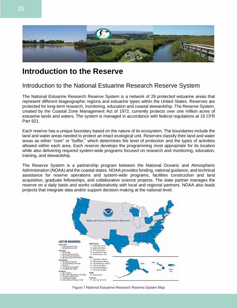
Introduction to the Reserve Introduction to the National Estuarine Research Reserve System The National Estuarine Research Reserve System is a network of 29 protected estuarine areas that represent different biogeographic regions and estuarine types within the United States. Reserves are protected for long-term research, monitoring, education and coastal stewardship. The Reserve System, created by the Coastal Zone Management Act of 1972, currently protects over one million acres of estuarine lands and waters. The system is managed in accordance with federal regulations at 15 CFR Part 921. Each reserve has a unique boundary based on the nature of its ecosystem. The boundaries include the land and water areas needed to protect an intact ecological unit. Reserves classify their land and water areas as either “core” or “buffer,” which determines the level of protection and the types of activities allowed within each area. Each reserve develops the programming most appropriate for its location while also delivering required system-wide programs focused on research and monitoring, education, training, and stewardship. The Reserve System is a partnership program between the National Oceanic and Atmospheric Administration (NOAA) and the coastal states. NOAA provides funding, national guidance, and technical assistance for reserve operations and system-wide programs, facilities construction and land acquisition, graduate fellowships, and collaborative science projects. The state partner manages the reserve on a daily basis and works collaboratively with local and regional partners. NOAA also leads projects that integrate data and/or support decision-making at the national level.
Figure 1 National Estuarine Research Reserve System Map
24
Each reserve is required to develop a management plan that contains the goals, objectives, and strategies for that reserve. Management plans are updated every five years and must be approved by NOAA. These plans enable the reserves and NOAA to track progress and realize opportunities for growth. Each plan describes how the reserve will carry out its foundational research, education, and training programs. Each plan also outlines administration, resource protection, public access, land acquisition, and facility plans, as well as restoration and resource manipulation plans if applicable. The plans also incorporate strategies designed to help the reserve contribute to the system’s national goals. NOAA periodically evaluates reserves for compliance with federal requirements and their approved management plan. The most recent strategic plan for the National Estuarine Research Reserve System can be found online. It describes the following goals for the system.
1. Protecting Places: Enhance and inspire stewardship, protection, and management of estuaries and their watersheds in coastal communities through place-based approaches.
2. Applying Science: Improve the scientific understanding of estuaries and their watersheds through the development and application of reserve research, data and tools.
3. Educating Communities: Advance environmental appreciation and scientific literacy, allowing for science-based decisions that positively affect estuaries, watersheds and coastal communities.
History and Local Management of DNERR During the early 1980s, DNREC examined the precursor to the NERRS, the National Estuarine Sanctuary Program, which had been established by Section 315 of the CZMA in 1972. Although that program had several desirable attributes, it did not have enough flexibility or utility within the context of Delaware’s resource needs to warrant the state’s support. When the CZMA was reauthorized in 1986, the National Estuarine Sanctuary Program became the NERRS, with greater emphasis on applied research and environmental education and allowing more flexibility in administration to accommodate multiple uses and responsive management. Given this new direction for estuarine reserves, the state of Delaware began to identify potential sites in 1988. The intensive site selection criteria assessed ecological representation, research and educational value, as well as acquisition and management considerations. The diverse range of habitats in Delaware makes it an ideal location for a National Estuarine Research Reserve (NERR). In order to capture the full breadth of this diversity, a multi-component NERR was planned for the state. This approach allowed for a diversity of representative estuarine ecosystems to be protected. Two sites were selected and nominated by Governor Michael Castle. The multiple site reserve included parcels of land held by both private landowners and parcels owned in fee simple by the state of Delaware. In 1993, following NOAA’s approval of the submitted management plan, the Delaware NERR (DNERR) became the 22nd reserve in the system encompassing 3,800 acres. DNERR is a federal-state partnership between NOAA and DNREC (Appendix B). Both NOAA and Delaware’s goals and objectives guide the work of DNERR. Refer to the administration plan within this document for more information regarding the administrative framework of DNERR. With approval of this 2021 management plan revision, DNERR will be approximately 6,364 acres in size. DNERR directly manages approximately 1,021 of these acres. When using mapping with Geographic Information System (GIS) tools, the total acreage of the two components include:
● The 5,119-acre St. Jones Reserve component located in Kent County, southeast of the City of Dover; and,
25
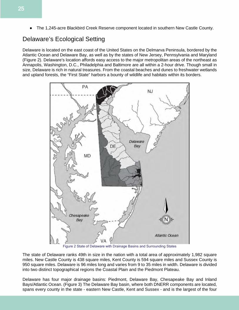
● The 1,245-acre Blackbird Creek Reserve component located in southern New Castle County. Delaware’s Ecological Setting Delaware is located on the east coast of the United States on the Delmarva Peninsula, bordered by the Atlantic Ocean and Delaware Bay, as well as by the states of New Jersey, Pennsylvania and Maryland (Figure 2). Delaware's location affords easy access to the major metropolitan areas of the northeast as Annapolis, Washington, D.C., Philadelphia and Baltimore are all within a 2-hour drive. Though small in size, Delaware is rich in natural treasures. From the coastal beaches and dunes to freshwater wetlands and upland forests, the “First State” harbors a bounty of wildlife and habitats within its borders.
Figure 2 State of Delaware with Drainage Basins and Surrounding States
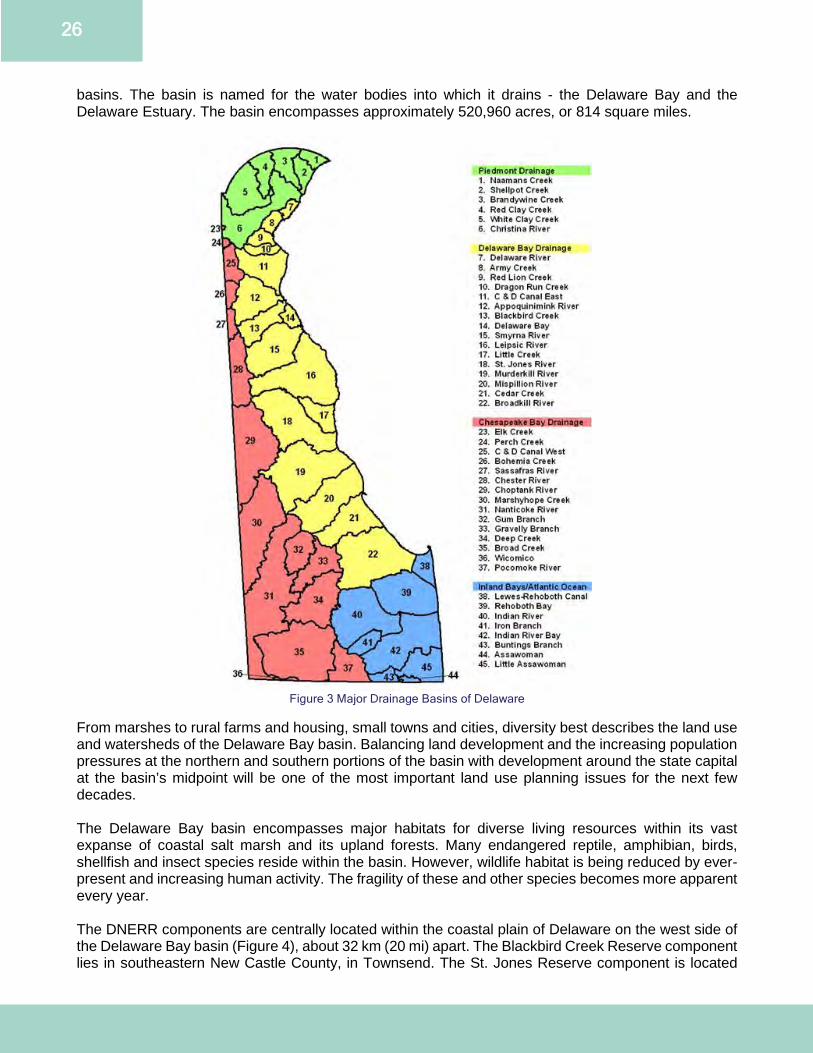
The state of Delaware ranks 49th in size in the nation with a total area of approximately 1,982 square miles. New Castle County is 438 square miles, Kent County is 594 square miles and Sussex County is 950 square miles. Delaware is 96 miles long and varies from 9 to 35 miles in width. Delaware is divided into two distinct topographical regions the Coastal Plain and the Piedmont Plateau. Delaware has four major drainage basins: Piedmont, Delaware Bay, Chesapeake Bay and Inland Bays/Atlantic Ocean. (Figure 3) The Delaware Bay basin, where both DNERR components are located, spans every county in the state - eastern New Castle, Kent and Sussex - and is the largest of the four
26
basins. The basin is named for the water bodies into which it drains - the Delaware Bay and the Delaware Estuary. The basin encompasses approximately 520,960 acres, or 814 square miles.
Figure 3 Major Drainage Basins of Delaware
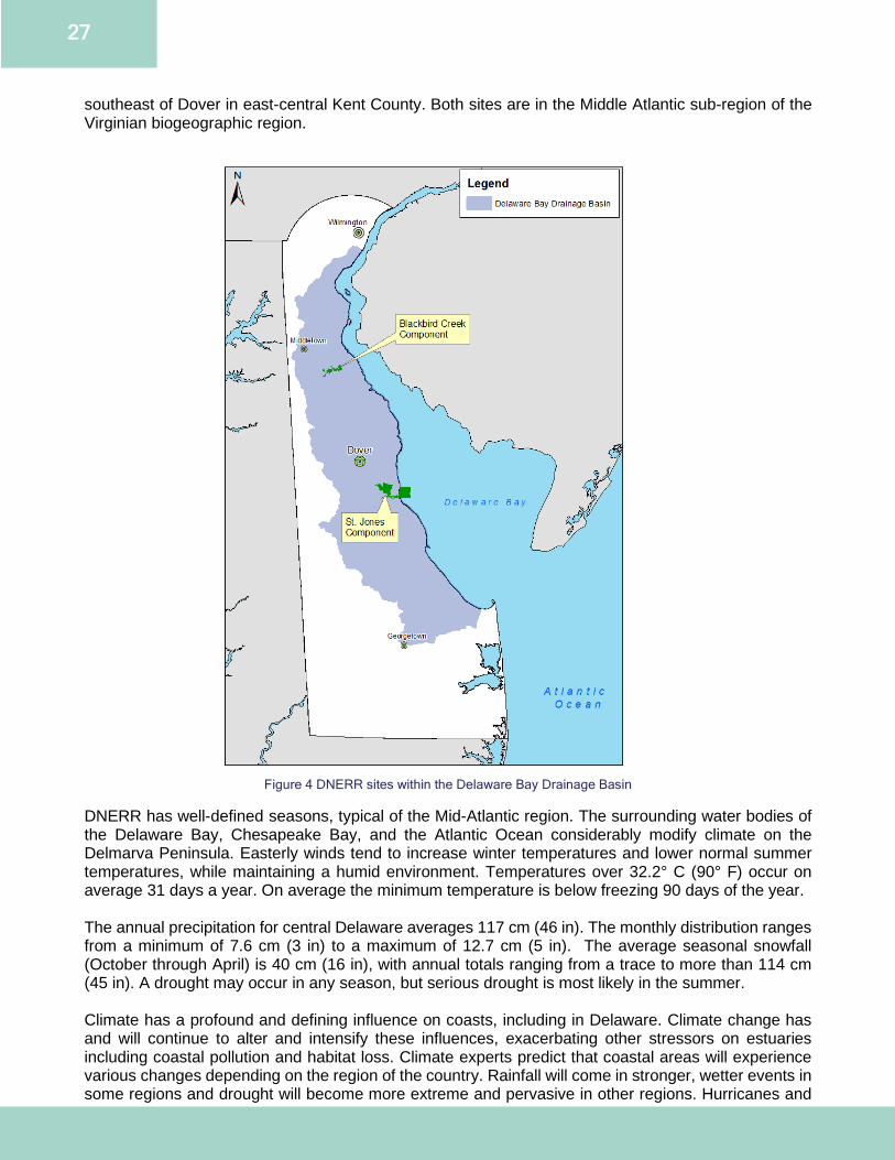
From marshes to rural farms and housing, small towns and cities, diversity best describes the land use and watersheds of the Delaware Bay basin. Balancing land development and the increasing population pressures at the northern and southern portions of the basin with development around the state capital at the basin’s midpoint will be one of the most important land use planning issues for the next few decades. The Delaware Bay basin encompasses major habitats for diverse living resources within its vast expanse of coastal salt marsh and its upland forests. Many endangered reptile, amphibian, birds, shellfish and insect species reside within the basin. However, wildlife habitat is being reduced by ever-present and increasing human activity. The fragility of these and other species becomes more apparent every year. The DNERR components are centrally located within the coastal plain of Delaware on the west side of the Delaware Bay basin (Figure 4), about 32 km (20 mi) apart. The Blackbird Creek Reserve component lies in southeastern New Castle County, in Townsend. The St. Jones Reserve component is located
27
southeast of Dover in east-central Kent County. Both sites are in the Middle Atlantic sub-region of the Virginian biogeographic region.
Figure 4 DNERR sites within the Delaware Bay Drainage Basin
DNERR has well-defined seasons, typical of the Mid-Atlantic region. The surrounding water bodies of the Delaware Bay, Chesapeake Bay, and the Atlantic Ocean considerably modify climate on the Delmarva Peninsula. Easterly winds tend to increase winter temperatures and lower normal summer temperatures, while maintaining a humid environment. Temperatures over 32.2° C (90° F) occur on average 31 days a year. On average the minimum temperature is below freezing 90 days of the year. The annual precipitation for central Delaware averages 117 cm (46 in). The monthly distribution ranges from a minimum of 7.6 cm (3 in) to a maximum of 12.7 cm (5 in). The average seasonal snowfall (October through April) is 40 cm (16 in), with annual totals ranging from a trace to more than 114 cm (45 in). A drought may occur in any season, but serious drought is most likely in the summer. Climate has a profound and defining influence on coasts, including in Delaware. Climate change has and will continue to alter and intensify these influences, exacerbating other stressors on estuaries including coastal pollution and habitat loss. Climate experts predict that coastal areas will experience various changes depending on the region of the country. Rainfall will come in stronger, wetter events in some regions and drought will become more extreme and pervasive in other regions. Hurricanes and
28
nor’easters may become stronger and more frequent, something that Delaware is already seeing anecdotally. Boundary Description DNERR was established as a multi-component reserve. The two components, the St. Jones Reserve and Blackbird Creek Reserve, are characterized by tidal rivers or creeks traversing extensive tidal wetlands classified as wash over barrier marsh systems, typical of the lower and middle western Delaware Bay. Designated core areas of DNERR are vital to maintaining estuarine ecosystem function. These ecological units preserve for research a range of physical, chemical and biological factors contributing to the diversity of natural processes occurring within the estuary. The designation and rationale of specific areas identified as core are determined by scientific knowledge of the area and the degree of scientific research occurring within the area. DNERR core areas are the estuarine waters and associated tidal marshes within the designated boundary associated with the St. Jones River, Blackbird Creek and their tributaries. These core components ensure adequate and direct applications of state and federal control and management, providing sufficient protection to ensure the integrity of a stable platform for the continuation of ongoing scientific investigation. Buffer zones protect core areas and provide additional protection for estuarine dependent species. Buffer areas of DNERR are identified as those areas that are adjacent to, surround and are essential to maintaining the integrity of the core land and water areas. Refer to the land acquisition plan for details and maps. St. Jones Reserve 818 Kitts Hummock Road, Dover DE 19901 The St. Jones Reserve component is about 5,119 acres in designated size, situated along 5.5 miles of mesohaline tidal river at the lower end of the St. Jones River watershed. It includes about 2,375 acres of Delaware Bay subtidal bottom and nearshore waters, running for 2 miles along the DNREC Division of Fish and Wildlife’s (FW) Ted Harvey Conservation Area’s bay shoreline and extending outward 2 miles into the open bay of the Delaware Bay. The St. Jones Reserve component contains parcels of land held by private landowners, DNERR and two other state agencies [FW and Division of Historical and Cultural Affairs (DHCA)]. When designated, the St. Jones’s boundaries were based on habitat type, specifically core habitats of wetlands and buffer habitats of upland areas. This resulted in habitat specific boundaries and not parcel specific. This has resulted in portions of parcels falling within the DNERR boundaries with a variety of protections in place on the core habitats, as detailed in the Resource Protection Plan. In addition to the core habitat protections, at St. Jones, there is an additional 266 acres in the buffer area protected through conservation easement held by the Division of Parks and Recreation (PARKS).
29
Figure 5 St. Jones River Watershed and DNERR Boundary
Adjacent to the St. Jones Reserve component on its eastern side is the FW Ted Harvey Conservation Area, consisting of 3,432 acres of woodlands, upland fields, croplands, freshwater ponds and wetlands, coastal wetland impoundments and Delaware Bay shoreline. Although the Ted Harvey Conservation Area is not within the designated DNERR boundaries, it is available for use in DNERR research and educational activities through cooperative arrangements with FW. FW’s Roberts Tract, a 233-acre parcel, borders the St. Jones Reserve component at its western end and provides conservation-oriented land ownership on both upstream and downstream ends of the St. Jones River. A small boat ramp and fishing pier at Scotton Landing, owned and managed by FW, provides good boat and water access to the main channel of the St. Jones River towards DNERR’s western end. The John Dickinson Plantation and Mansion (JDP) which is owned and managed by the DHCA provides another 450 acres of protected area within the designated boundaries, adjacent to the DNERR’s western border. Dover Air Force Base is a considerable presence to the north/northwest of the DNERR. The Delaware Bay sub-component to the St. Jones Reserve component provides extensive intertidal and subtidal research opportunities. This area is representative of much of the western Delaware Bay waterfront and nearshore. It is one of the preferred spawning areas for horseshoe crabs and a major foraging area of migratory shorebirds.
30
The St. Jones River watershed covers 57,643 acres of the Delaware Bay Basin. The St. Jones River is dammed at Silver Lake in Dover and then winds approximately 10.5 miles through residential and commercially developed areas, until it reaches DNERR before emptying into the Delaware Bay. The St. Jones River watershed has significant development in upstream non-tidal areas, where urbanized Dover (Delaware’s capital) dominates the middle and upper watershed. Downstream portions of the St. Jones River watershed, where the lower St. Jones Reserve component is located, are primarily agricultural. The largest tributaries of the lower St. Jones Reserve component are Trunk Ditch, Beaver Gut Ditch, and Cypress Branch, all entering on the south side of the St. Jones River. Blackbird Creek Reserve Blackbird Landing Road, Townsend DE 19734 The Blackbird Creek Reserve component is 1,245 acres in designated size, situated along 5.7 miles of low salinity brackish and freshwater tidal creek, starting 5.8 miles upstream from where Blackbird Creek empties into the Delaware Bay. The total length of tidal Blackbird Creek is about 11.5 miles. The Blackbird Creek Reserve component contains parcels of land held by private landholders, plus DNERR and FW. As with the St. Jones Reserve component – the original DNERR boundaries were based on habitat type and include state protection through a variety of means detailed in the resource protection plan. Two properties, a large area of mixed native hardwoods, Delmarva Bays and wooded tributary buffers totaling 99.4 acres, were added to the Blackbird Creek Reserve in 2015. In 2016 and 2017, an additional 58.9 acres from 2 properties were added to 803 Blackbird Landing Road to improve wildlife corridor habitats. These new properties will be incorporated into the DNERR boundaries upon approval of a boundary change and this management plan. For more information, see the discussion below in the section Boundary Changes. The Blackbird Creek watershed drains roughly 31 square miles of southern New Castle County into the Delaware Bay. It is dominated by forest, wetlands and agriculture. It is primarily used for fishing, boating, research and hiking. The largest tributary of the upper creek segment is Beaver Branch, entering on the northside of Blackbird Creek about midway within DNERR. Downstream of the seaward end of DNERR, from Taylors Bridge to Delaware Bay, the lower Blackbird Creek passes by Red Bank and Stave Landing before reaching the bay. Much of the expansive tidal marshes and uplands that border lower Blackbird Creek downstream of DNERR are owned and managed by FW. Upstream of DNERR, in non-tidal areas west of Route 13, are extensive areas of forested wetlands containing unique Delmarva Bays, much within Blackbird State Forest, which is managed by the Department of Agriculture’s Delaware Forest Service (DFS).
31
Figure 6 Blackbird Creek Watershed and DNERR Boundary
Boundary Changes In December 2015, January 2016 and December 2017, DNERR acquired new property totaling 158.3 acres. The parcels include forested uplands, Delmarva Bays and farmland. DNERR acquired the properties for their high ecological value and their connection to or in-holding within existing Reserve properties. All ponds or forested uplands acquired are managed to preserve habitat quality, minimize detrimental impacts and control invasive species. Each parcel provides increased opportunities for research, education and restoration. Upon approval of this boundary change and updated management plan, DNERR will expand its boundaries to include 531 Union Church Road, 0 Taylors Bridge Road, Union Church Road parcels (Road No. 456) and 789 Blackbird Landing Road (Figures 7, 8, 9 and 10). There will be a public notice and comment period as part of the boundary change and plan approval process.
Property Name Property Address Property Size Date Acquired “McKinley” 531 Union Church Road 67.4 acres December 2015 “Unruh” 0 Taylors Bridge Road 32 acres December 2015 “Norris” Union Church Road (Road No. 456) 42.6 acres January 2016 “Manwaring” 789 Blackbird Landing Road 16.3 acres December 2017
32
Figure 7 531 Union Church Road
This 67.4-acre “McKinley” property was purchased in December 2015 with State of Delaware Open Space funding and has been used as match to NERRs Procurement Acquisition and Construction grants awarded to DNERR. It hosts a mix of native hardwoods and Delmarva Bays. This property falls within the previously identified priority acquisition area in the 2013 management plan revision and is adjacent to the 515 Union Church Road Tract, which was purchased in December 2011 and was approved to be added to DNERR in the 2013 management plan revision. This property will be managed as a buffer zone. See the Restoration Plan for a description of how this area will be managed for invasive species.
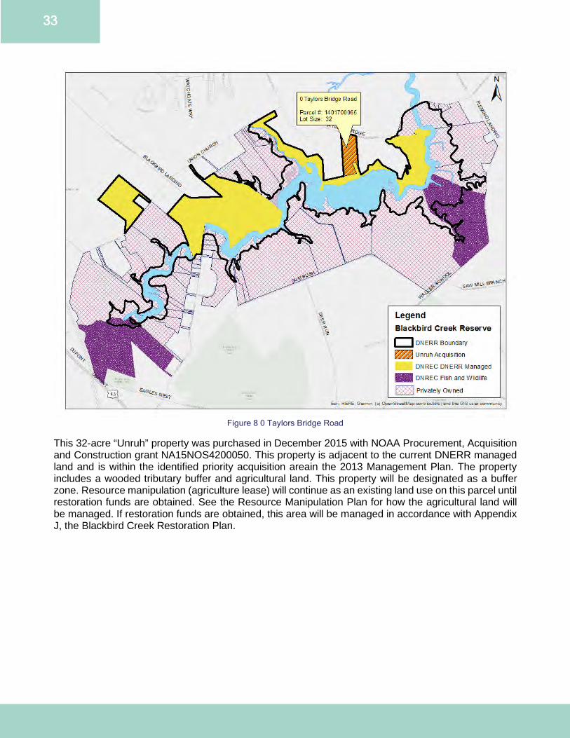
33
Figure 8 0 Taylors Bridge Road
This 32-acre “Unruh” property was purchased in December 2015 with NOAA Procurement, Acquisition and Construction grant NA15NOS4200050. This property is adjacent to the current DNERR managed land and is within the identified priority acquisition areain the 2013 Management Plan. The property includes a wooded tributary buffer and agricultural land. This property will be designated as a buffer zone. Resource manipulation (agriculture lease) will continue as an existing land use on this parcel until restoration funds are obtained. See the Resource Manipulation Plan for how the agricultural land will be managed. If restoration funds are obtained, this area will be managed in accordance with Appendix J, the Blackbird Creek Restoration Plan.
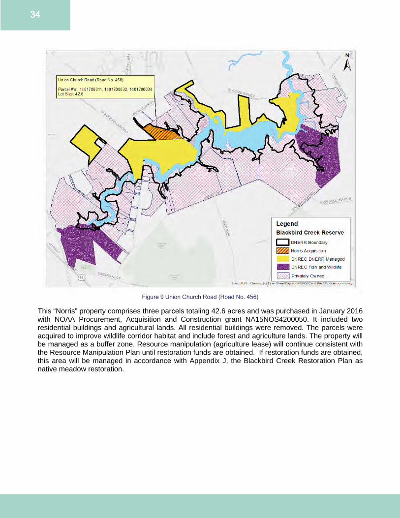
34
Figure 9 Union Church Road (Road No. 456)
This “Norris” property comprises three parcels totaling 42.6 acres and was purchased in January 2016 with NOAA Procurement, Acquisition and Construction grant NA15NOS4200050. It included two residential buildings and agricultural lands. All residential buildings were removed. The parcels were acquired to improve wildlife corridor habitat and include forest and agriculture lands. The property will be managed as a buffer zone. Resource manipulation (agriculture lease) will continue consistent with the Resource Manipulation Plan until restoration funds are obtained. If restoration funds are obtained, this area will be managed in accordance with Appendix J, the Blackbird Creek Restoration Plan as native meadow restoration.
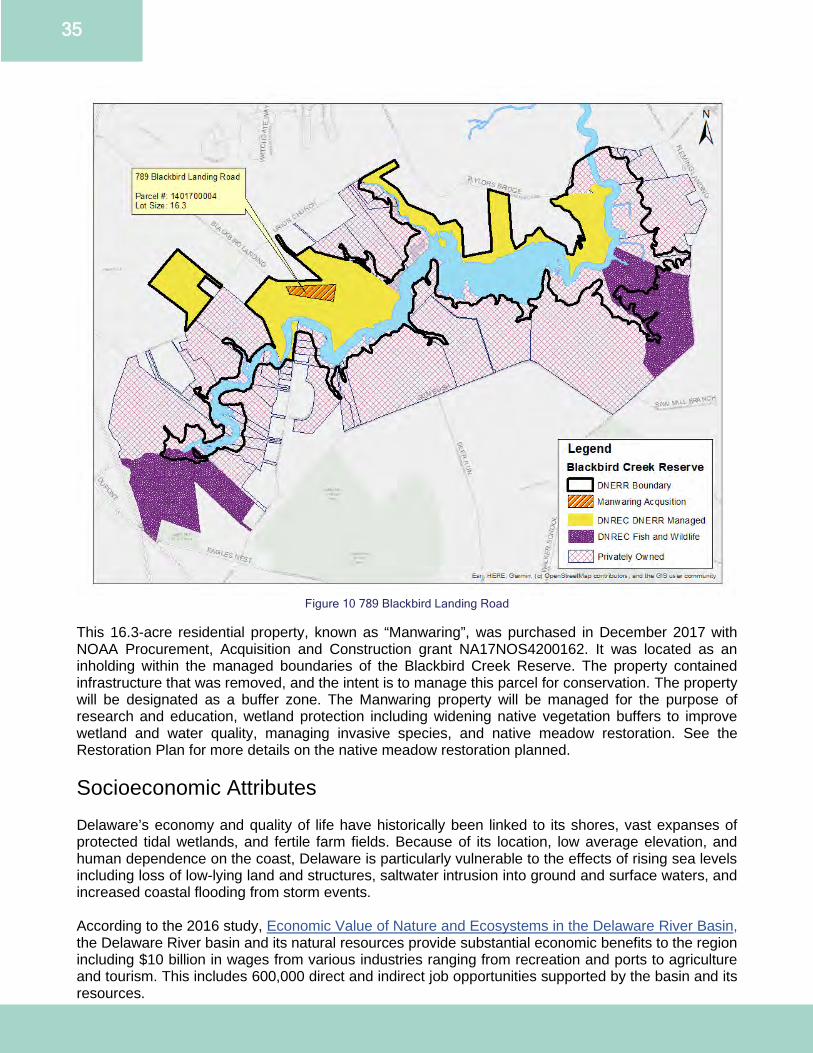
35
Figure 10 789 Blackbird Landing Road
This 16.3-acre residential property, known as “Manwaring”, was purchased in December 2017 with NOAA Procurement, Acquisition and Construction grant NA17NOS4200162. It was located as an inholding within the managed boundaries of the Blackbird Creek Reserve. The property contained infrastructure that was removed, and the intent is to manage this parcel for conservation. The property will be designated as a buffer zone. The Manwaring property will be managed for the purpose of research and education, wetland protection including widening native vegetation buffers to improve wetland and water quality, managing invasive species, and native meadow restoration. See the Restoration Plan for more details on the native meadow restoration planned. Socioeconomic Attributes Delaware’s economy and quality of life have historically been linked to its shores, vast expanses of protected tidal wetlands, and fertile farm fields. Because of its location, low average elevation, and human dependence on the coast, Delaware is particularly vulnerable to the effects of rising sea levels including loss of low-lying land and structures, saltwater intrusion into ground and surface waters, and increased coastal flooding from storm events. According to the 2016 study, Economic Value of Nature and Ecosystems in the Delaware River Basin, the Delaware River basin and its natural resources provide substantial economic benefits to the region including $10 billion in wages from various industries ranging from recreation and ports to agriculture and tourism. This includes 600,000 direct and indirect job opportunities supported by the basin and its resources.
36
According to the U.S. Census Bureau (2010 Census), the estimated population for Delaware as of 2019 is 973,764 people with population representation as follows: 69.2% white, 23.2% black or African American, 9.6% Hispanic or Latino, 4.1% Asian, 2.7% two or more races, 0.7% American Indian or Alaska Native, and 0.1% Native Hawaiian or other Pacific Islander. The median household income in Delaware is $68,287 and approximately 11.3 % people live in poverty. The population density varies greatly between the two DNERR components. The Blackbird Creek watershed encompasses 80 km2 (31 mi2) and is inhabited by 5,465 people (2010 census), for a population density of 68.3/km2 (26.4/mi2). The St. Jones River watershed encompasses 233 km2 (90 mi2) and is inhabited by 68,323 people (2010 census), for a population density of 293.2/km2 (113.2/mi2). Archaeological and Cultural Resources A total of 32 archaeological sites have been found in upland areas fringing the lower St. Jones River marshes. These sites span a period of more than 8000 years, covering Archaic and Woodland I and II periods. Lenape, Nanticoke Lenni-Lenape, Nanticoke and other indigenous people lived in what is now Delaware for thousands of years prior to the arrival of the first Europeans. As Europeans flooded into Lenapehoking (the Mid-Atlantic area), the Lenape suffered from the devastation of European diseases and the claiming of the indigenous lands as colonies. As a result of this suffering and persecution, many Lenape families moved away hoping to protect and practice the traditions and language of their ancestors. The Lenape who remained on the ancestral lands adapted to living among the Europeans, but also continued to hunt, fish and collect plants for food and medicines. These Lenape were called the “Keepers of the Land” because they stayed to maintain the connection of the Lenape to their homeland. Today, two state recognized tribal communities remain in Delaware including the Nanticoke community in southern Sussex County and the Lenape community in central Kent County. Historic sites found within the DNERR boundaries include the colonial settlements of Kingston-Upon-Hull, Town Point in Kent County, and the JDP. The JDP encompasses 450 acres of protected area within the DNERR’s designated boundaries, adjacent to the St. Jones Reserve’s western border. This historic site provides opportunities to understand 18th century plantation life. DHCA and DNERR work closely together on land management and education programming. A total of 73 archaeological sites in upland areas fringing Blackbird Creek marshes were reported in the Cultural Resource Survey maintained by the Delaware Bureau of Archaeology and Historic Preservation (part of DHCA). Blackbird Creek uplands and stream courses were intensively used from 3000 B.C. to A.D. 1000. Changes in settlement patterns from A.D. 1000 to A.D. 1650 focused primarily on estuarine resources in the floodplain, rather than in upland areas. The earliest historic European settlement in the Blackbird Creek Reserve is the Huguenot House (built in the first quarter of the 18th century), which is listed on the National Register of Historic Places. Threats and Stressors Delaware’s coastal zone provides critical habitat for plants, waterfowl, wildlife, fish and marine mammals. It also provides homes, jobs, recreational opportunities, port access and water resources critical to the state’s economy. Managing potentially conflicting human uses and impacts to habitat is complex and challenging. Threats and stressors impacting Delaware are encapsulated within DNERR. Coastal population increase, changing land use patterns, stormwater runoff, eutrophication, invasive species, increasing intensity of coastal storms, climate change, flooding and sea level rise are primary threats addressed in DNERR’s work.
37
DNERR is especially vulnerable to impacts of land use changes associated with increased coastal populations, notably eutrophication from water quality degradation. The counties that contain the DNERR components have witnessed dramatic population increases over the 2000 to 2010 time period. New Castle County (includes Blackbird Creek Reserve) has seen a 7.6% increase and Kent County (includes St. Jones Reserve) has seen a 28.1% increase (U.S. Census Bureau, 2010 Census Redistricting Data Public Law 94-171 Summary File). The increased population leads to increases in the number of people using the DNERR properties, however most visitor use of the DNERR is benign. The ability of the land to sequester carbon, nutrients and reduce polluted runoff declines with many land use changes. Forests and marshes have large buffering capacities, trapping nutrients and sediment prior to entering surface waters. Impervious surfaces including roofs, roads and parking lots have very little capacity to absorb nutrients or slow the flow of water without engineered solutions or green infrastructure retrofits. Stormwater runoff can severely impact receiving waters by increasing eutrophication, leading to hypoxia, decreased light penetration, altered habitat composition and decreased fish and shellfish populations. Recovery from eutrophication can take long periods of time even if the causes of the eutrophication are immediately halted. Development in Delaware’s coastal zone puts homes, businesses and infrastructure at risk resulting in human hardship and higher costs to the government for response and recovery. Stressors associated with climate change, sea level rise and increased storm intensity compound the stressors of increased development in coastal communities. Delaware experiences intense storms, storm surge, winds and saltwater inundation on a regular basis, causing flooding of built infrastructure. Future inundation impacts will increase due to sea level rise. Nor’easter storms frequently generate the most coastal damage (property damage, infrastructure and beach loss), especially during the winter months. Shoreline erosion is exacerbated by high winds and pounding wave action. Sea level rise and local land subsidence threatens marshes and other low-lying habitats due to barriers preventing migration landward. If sea levels rise faster than the ability of the marsh to accrete sediment and build up, the marshes will drown. This would cause a decrease in the size of all DNERR properties and a loss of vital nursery habitat and other ecosystem services as well as impact infrastructure like drinking water wells, trails, roads and buildings. In Delaware, relative sea level rise is currently occurring at 14inches per 100 years, double the global mean sea level rise rate of 6-7inches per 100 years. As climate changes and population increases, DNERR is concerned about the potential for new invasive species while trying to manage and eradicate existing invasive species. Lack of predators and competitive advantages allow invasive species to grow uncontrollably, potentially impacting the economy and human health. Invasive plant and animal species known to occur on the DNERR properties include kudzu (Pueraria lobata), multiflora rose (Rosa multiflora), autumn olive (Elaeegnus umbellate), parrot feather (Myriophyllum aquaticum), common reed (Phragmites australis), garlic mustard (Alliaria petiolata), Canada thistle (Cirsium arvense) and northern snakehead (Channa argus). Invasive species known to occur in Delaware, but not yet found on the DNERR properties include nutria (Myocaster coypus), Asian shore crab (Hemigrapsus sanguineus) and spotted lanternfly (Lycorma delicatula). While there are numerous challenges facing it, Delaware’s small size as a state comes in handy when it comes to developing solutions and opportunities. Numerous federal, state, local, academia, and non-profit organizations are looking to address similar threats and stressors as DNERR. When working together, organizations can see where goals and skill sets overlap, and where there are gaps that are needed to be addressed to best serve Delaware communities and the conservation goals of the area. DNERR is uniquely situated to help make these connections between organizations by facilitating conversations, engaging stakeholders, and by identifying and bridging gaps.

38
Administrative Plan
Overview DNERR administration improves the operations, infrastructure and stature of the Reserve to better support and enable the education, research, stewardship and training programs. Administration is defined for the purposes of this management plan as working with NOAA, DNREC Division of Climate, Coastal and Energy (CCE), Delaware Coastal Programs (DCP), the Delaware Coastal Management Program (DCMP) and partner agencies to fulfill the DNERR mission. DNERR meets agency mandates, assesses and addresses infrastructure needs, appropriately staffs DNERR and provides staff with the skills and resources necessary to perform their jobs. DNERR administration also provides long-term direction and vision for the program including implementation of all programs and policies. These duties form the administration plan and include staffing, volunteer and special areas plans. Organizational Framework and Chart DNERR is administered through a collaborative process. As part of NERRS, DNERR operates as a federal-state partnership. State partners manage the individual reserves and NOAA’s Office for Coastal Management provides direction, funding and review for the NERRS and individual reserves. The Office for Coastal Management conducts performance evaluations on the operation and management of individual reserves pursuant to sections 312 and 315 of the CZMA. The purpose of the NOAA review is to ensure DNREC is complying with NERRS goals, approved funding awards and work plans, as well as DNERR’s management plan. Deficiency findings must be addressed in operation awards and management plan updates in an appropriate and timely manner to avoid withdrawal of NERRS designation. The state partner is DNREC/CCE/DCP. The organizational chart for DNREC/CCE/DCP is presented in Figure 11. All partner agencies collaborate closely to meet shared goals. The DCP section of DNREC serves as:
● the research, education and policy lead for coastal, estuarine and ocean issues for DNREC and works in an integrated manner to leverage resources;
● DNREC’s point of contact for multiple regional, coastal, estuarine and ocean partnerships; ● implementing authority for CZMA programs including the Coastal Management Program and
NERRS. Staffing Plan DNERR staff offices are located at the St. Jones Reserve component with limited offices located at the Blackbird Creek Reserve component. The Reserve Manager, Research Coordinator and Education Coordinator are core staff positions designated by NERRS and assume major responsibilities in the function of the Reserve. Additionally, there are numerous other positions including the Coastal Training Program Coordinator and the Stewardship Coordinator.
39
Administrative and Facilities Staff Reserve Manager (100% state funded)
● Provides overall coordination of DNERR operations and programming ● Ensures policies in the management plan are followed and programs successfully meet NERRS
and DCP mandates ● Pursues and administers federal and other grants, contracts and state budget appropriations ● Provides oversight and coordination of coastal training, education, research and stewardship
programs ● Develops and maintains partnerships with local, state and federal agencies, groups and
individuals to elevate DNERR exposure and capacity ● Supervises DNERR staff ● Oversees all activities, land management, acquisition and facilities within DNERR boundaries
Conservation Technician (100% federal funded through DNERR)
● Manages Reserve facilities and DNERR lands in accordance with the DNERR management plan, DNERR Stewardship Plan (Appendix C), and other state and federal mandates
● Coordinates with the Reserve Manager on site management policies and issues ● Assists with community outreach and education programs ● Assists with research and monitoring programs
Administrative Specialist (100% federal funded through DNERR - Seasonal)
● Provides support to daily DNERR operations ● Prepares grant reports ● Communicates positively and productively with visitors, vendors and state partners ● Handles fiscal workflow and tracking ● Maintains DNERR's filing system ● Oversees facility use reservations, confirmations and logistics ● Answers telephones, takes messages and responds to inquiries
Education and Training Staff Education Coordinator (100% federal funded through DNERR)
● Manages K-16, educator professional development and community outreach programs ● Conveys estuarine and watershed science to all audiences in accordance with the DNERR
management plan and NERRS and DCP mandates ● Develops and maintains partnerships to enhance education programs ● Represents DNERR at local, state and national levels ● Collaborates with the Coastal Training Program (CTP) Coordinator to ensure education
programs are complementary ● Incorporates research and monitoring results into education programs ● Oversees development of all educational materials ● Assists management, research and stewardship programs as needed
Assistant Education Coordinator (100% federal funded through DNERR - Seasonal)
● Conducts K-16 student field based estuarine science education and outreach programs ● Develops materials for K-16 and teacher programs ● Assists with community programs ● Represents DNERR at festivals and meetings ● Assists management, research and stewardship programs
Coastal Training Program Coordinator (100% federal funded – split 50/50 between DNERR and DCMP)

40
● Develops and produces workshops for coastal decision-makers based on formal and informal needs assessments in accordance with the DNERR management plan and NERRS and DCP mandates
● Develops and maintains partnerships to enhance the CTP ● Represents DNERR at local, state and national levels ● Collaborates with the Education Coordinator to ensure education programs are complementary ● Incorporates research and monitoring results into the CTP ● Develops CTP related materials ● Assists management, education, research and stewardship programs
Research Staff Research Coordinator (100% federal funded – split 50/50 between DNERR and DCMP)
● Manages research and monitoring programs with a focus on high priority coastal management needs in accordance with the DNERR management plan
● Develops and maintains partnerships to expand research programs ● Represents DNERR on local, state and national levels ● Incorporates research and monitoring results into education programs ● Leads and supports search for funding opportunities to enhance research capacity ● Drafts scientific manuscripts and presents work at local, regional and national meetings ● Assists with stewardship, education and training programs
Environmental Scientist (100% federal funded through DNERR)
● Implements the SWMP in accordance with NERRS and the Centralized Data Management Office (CDMO) requirements
● Procures and maintains SWMP equipment and supplies ● Deploys monitoring equipment ● Performs quality assurance and quality control (QA/QC) on data and prepares annual reports
for submittal to CDMO ● Performs data analyses with Research Coordinator ● Assists with developing and maintaining partnerships to expand research programs ● Assists with grant proposals, preparation of manuscripts for publication, presentations and other
outreach activities ● Leads and assists with DNERR research projects ● Assists with stewardship, education and training programs
Stewardship Coordinator (100% federal funded – split 50/50 between DNERR and DCMP)
● Leads conservation planning, restoration, and invasive species monitoring and control ● Assists with training and education programs ● Develops and maintains partnerships with state and private neighboring landowners to ensure
land management strategies are effectively coordinated and communicated ● Leads restoration activities which include grant writing, monitoring plan development, data
collection and maintenance plan creation ● Assists with implementation of biological monitoring efforts associated with the DNERR’s
Sentinel Site Plan Seasonal and Contractual Positions (funding varies) Seasonal and Contractual positions including the Kent Conservation District Conservation Technician I position, are utilized in the research, education and stewardship programs at DNERR based upon programming needs.
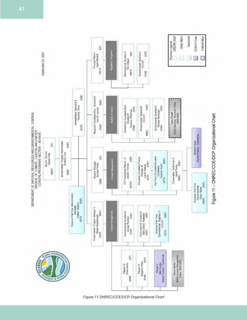
41
Figure 11 DNREC/CCE/DCP Organizational Chart
42
Staffing Needs Volunteer Coordinator A part-time Volunteer Coordinator is needed to manage DNERR’s volunteer program Currently, volunteer coordination is jointly managed by all staff. This would free up core staff time and enhance DNERR operations with motivated and well-trained volunteers. The Volunteer Coordinator will:
● Produce a volunteer needs assessment ● Write duty statements for each volunteer position or function ● Streamline recruiting, screening and placement policies and procedures ● Determine volunteer recognition procedures and award scales ● Develop volunteer orientation and training programs, including a comprehensive docent training
program ● Track and report volunteer hours ● Recruit new volunteers through outreach to schools, non-profits, civic organizations, and
businesses ● Help develop a Friends Group
Administrative Specialist DNERR currently has a part-time (0.75) Administrative Specialist position that maintains the day-to-day operations of the St. Jones Reserve Visitor Center. Expanding Coastal Training Center rental reservations, program requests, and general expansion of workload would make having a full-time position beneficial to the organization. GIS Specialist Although DNERR staff have access to ESRI ArcMap and other GIS products, DNERR does not have a dedicated GIS specialist. A dedicated GIS specialist would be beneficial for future habitat mapping and change analysis and other potential projects using emerging geospatial technologies. Strategic Partnerships Partnerships are essential to organization relevancy and growth. DNERR maintains multiple partnerships to accomplish its mission and will continue to do so through current Memoranda of Understanding, such as with FW (Appendix D) and collaborative projects. DNREC recognizes the need for cooperation and coordination to achieve the objectives of DNERR’s management plan and takes an integrated approach. The Reserve Manager ensures that implementation of the management plan is coordinated with agencies, organizations and landowners presently active within DNERR’s components. The Reserve Manager acts as liaison between outside entities and DNERR, in partnership with the coastal training, education, research and stewardship programs. In coordinating with other regional institutions, authorities and groups, DNERR looks to those that will enhance the Reserve’s mission while meeting and expanding their own environmental goals and objectives. Given Delaware’s relatively small size, it is necessary for DNERR to identify programs that can work cooperatively to address environmental issues within the Reserve and the state, making the most of limited time and resources. Partnerships support and expand coastal training, education, research and stewardship through collaboration and increasing capacity of research at DNERR and providing additional technical expertise in the development and implementation of conservation best management practices. These partnerships include Delaware State University (DSU), University of Delaware (UD) and UDs associated programs such as Delaware Sea Grant (DSG) and the Cooperative Extension, DNREC, Delaware Department of Agriculture (DDA), Delaware Department of Transportation (DelDOT), Delaware Department of State’s Office of State Planning, DHCA, U.S. Fish and Wildlife’s (USFWS) Bombay Hook National Wildlife Refuge and Prime Hook National Wildlife Refuge, and non-profit organizations such as Partnership for the Delaware Estuary (PDE), The Nature Conservancy
43
(TNC), Delaware Wild Lands, Delaware Nature Society (DNS) and Delaware Center for the Inland Bays (CIB). DNERR collaborates closely on research, outreach, stewardship activities, technical assistance and training with DCMP, which is part of DCP. These collaborations include the Resilient Community Partnership (RCP) grants which provide technical assistance to coastal communities, research projects on estuarine processes, and participation at local community events such as Coast Day. Advisory Committees Advisory committees of local citizens and partners provide feedback and recommendations on site management, research, education activities and review policies and implementation strategies. These committees function as both ad hoc and standing committees. Management Advisory Committee The DNERR management advisory committee functions on an ad hoc basis and typically represents many of the federal, state, county and local agencies, commissions, societies and organizations that may have an interest in, impact on, or are impacted by DNERR activities. The committee assists DNERR staff with implementing the management plan. The committee ensures DNERR goals are realistic and are aligned with relevant issues. Education Advisory Committee The ad hoc DNERR education advisory committee reviews regional educational and volunteer needs and is coordinated by the Education Coordinator. Committee members are from educational and environmental interests in the state. The education committee provides guidance for the implementation of a comprehensive estuarine education program, meeting a critical need in Delaware. Coastal Training Program Advisory Committee The DNERR coastal training advisory committee is a standing committee. Led by the CTP Coordinator, the group meets annually or more frequently as needed. Committee members are from state agencies, academic organizations and non-governmental organizations that work on coastal management issues in the state. (Appendix E) The CTP advisory committee provides guidance on implementation of a comprehensive CTP. Refer to the Strategic Plan on pages 10-22 for Administrative Goals, Objectives, Strategies and Actions.
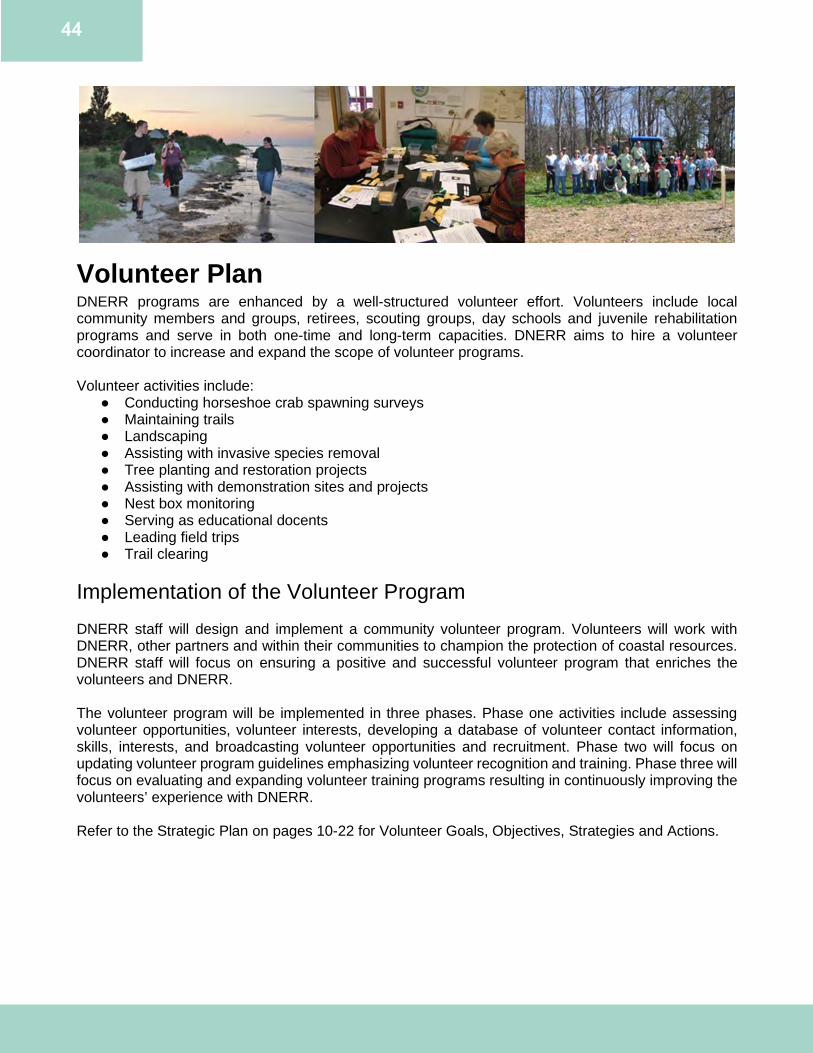
44
Volunteer Plan DNERR programs are enhanced by a well-structured volunteer effort. Volunteers include local community members and groups, retirees, scouting groups, day schools and juvenile rehabilitation programs and serve in both one-time and long-term capacities. DNERR aims to hire a volunteer coordinator to increase and expand the scope of volunteer programs. Volunteer activities include:
● Conducting horseshoe crab spawning surveys ● Maintaining trails ● Landscaping ● Assisting with invasive species removal ● Tree planting and restoration projects ● Assisting with demonstration sites and projects ● Nest box monitoring ● Serving as educational docents ● Leading field trips ● Trail clearing
Implementation of the Volunteer Program DNERR staff will design and implement a community volunteer program. Volunteers will work with DNERR, other partners and within their communities to champion the protection of coastal resources. DNERR staff will focus on ensuring a positive and successful volunteer program that enriches the volunteers and DNERR. The volunteer program will be implemented in three phases. Phase one activities include assessing volunteer opportunities, volunteer interests, developing a database of volunteer contact information, skills, interests, and broadcasting volunteer opportunities and recruitment. Phase two will focus on updating volunteer program guidelines emphasizing volunteer recognition and training. Phase three will focus on evaluating and expanding volunteer training programs resulting in continuously improving the volunteers’ experience with DNERR. Refer to the Strategic Plan on pages 10-22 for Volunteer Goals, Objectives, Strategies and Actions.
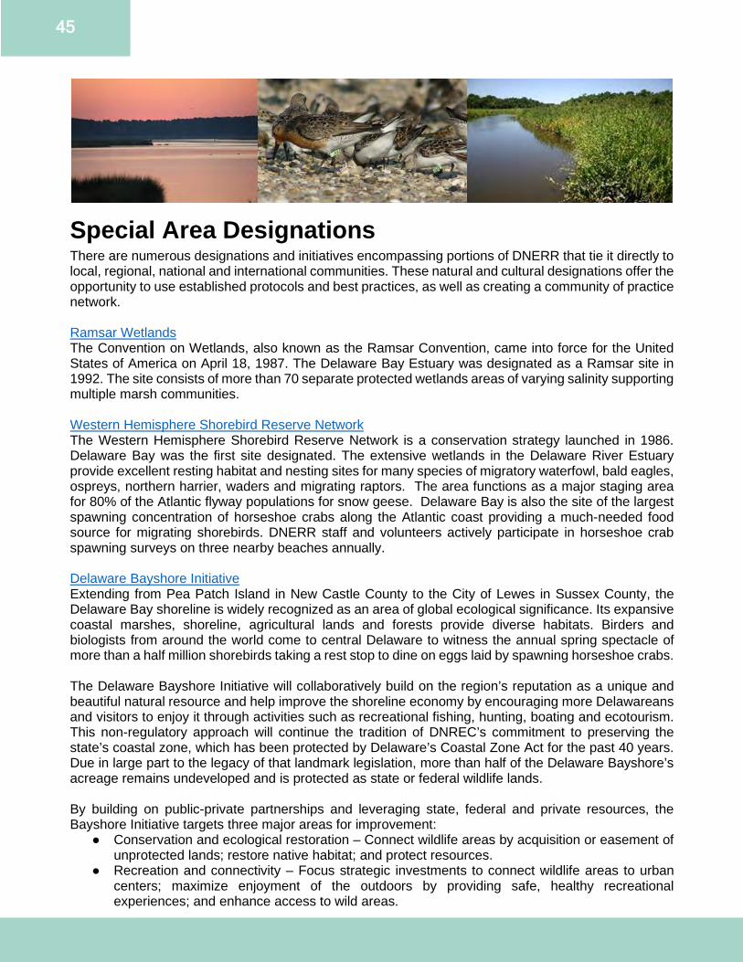
45
Special Area Designations There are numerous designations and initiatives encompassing portions of DNERR that tie it directly to local, regional, national and international communities. These natural and cultural designations offer the opportunity to use established protocols and best practices, as well as creating a community of practice network. Ramsar Wetlands The Convention on Wetlands, also known as the Ramsar Convention, came into force for the United States of America on April 18, 1987. The Delaware Bay Estuary was designated as a Ramsar site in 1992. The site consists of more than 70 separate protected wetlands areas of varying salinity supporting multiple marsh communities. Western Hemisphere Shorebird Reserve Network The Western Hemisphere Shorebird Reserve Network is a conservation strategy launched in 1986. Delaware Bay was the first site designated. The extensive wetlands in the Delaware River Estuary provide excellent resting habitat and nesting sites for many species of migratory waterfowl, bald eagles, ospreys, northern harrier, waders and migrating raptors. The area functions as a major staging area for 80% of the Atlantic flyway populations for snow geese. Delaware Bay is also the site of the largest spawning concentration of horseshoe crabs along the Atlantic coast providing a much-needed food source for migrating shorebirds. DNERR staff and volunteers actively participate in horseshoe crab spawning surveys on three nearby beaches annually. Delaware Bayshore Initiative Extending from Pea Patch Island in New Castle County to the City of Lewes in Sussex County, the Delaware Bay shoreline is widely recognized as an area of global ecological significance. Its expansive coastal marshes, shoreline, agricultural lands and forests provide diverse habitats. Birders and biologists from around the world come to central Delaware to witness the annual spring spectacle of more than a half million shorebirds taking a rest stop to dine on eggs laid by spawning horseshoe crabs. The Delaware Bayshore Initiative will collaboratively build on the region’s reputation as a unique and beautiful natural resource and help improve the shoreline economy by encouraging more Delawareans and visitors to enjoy it through activities such as recreational fishing, hunting, boating and ecotourism. This non-regulatory approach will continue the tradition of DNREC’s commitment to preserving the state’s coastal zone, which has been protected by Delaware’s Coastal Zone Act for the past 40 years. Due in large part to the legacy of that landmark legislation, more than half of the Delaware Bayshore’s acreage remains undeveloped and is protected as state or federal wildlife lands. By building on public-private partnerships and leveraging state, federal and private resources, the Bayshore Initiative targets three major areas for improvement:
● Conservation and ecological restoration – Connect wildlife areas by acquisition or easement of unprotected lands; restore native habitat; and protect resources.
● Recreation and connectivity – Focus strategic investments to connect wildlife areas to urban centers; maximize enjoyment of the outdoors by providing safe, healthy recreational experiences; and enhance access to wild areas.
46
● Engagement and marketing – Engage, educate and inspire the next generation of environmental stewards; partner with local communities and organizations to promote the area regionally, nationally and internationally; and promote local volunteerism.
In addition to economic benefits, the Delaware Bayshore Initiative stands to improve quality of life through enhanced outdoor recreational opportunities; to provide students with outdoor living classroom educational options; and to help prepare Delaware for future climate changes and impacts. It was recently recognized by the U.S. Department of the Interior as one of the country’s most promising ways to reconnect Americans to the natural world. America’s Great Outdoors, Delaware National Bayshore President Barack Obama launched the America’s Great Outdoors (AGO) Initiative on April 16, 2010 to foster a 21st-century approach to conservation that is designed by and accomplished in partnership with the American people. In 2011, the AGO Fifty-State Report summarized project ideas in each state for the Department of the Interior and other federal agencies to partner with state and local governments and other stakeholders on a shared conservation and recreation agenda. The Delaware Bayshore was included in this report as being a widely recognized area of global ecological significance. Extensive coastal marshes, beaches and agricultural lands annually support more than a half-million shorebirds during both spring and fall migration. More than half of the Bayshore region is protected as refuges, wildlife areas, agriculture preserves, parks and cultural heritage sites. Potential action identified in the report includes collaborating to conserve and restore the Delaware Bayshore, enhance recreation and evaluate the possibility of designating the area as the first National Bayshore. National Estuary Program In 1988, Governor Mike Castle of Delaware, Governor Robert Casey of Pennsylvania and Governor Tomas Kean of New Jersey nominated the Delaware Estuary for inclusion in the National Estuary Program established by Section 320 of the Water Quality Act of 1987 based on its regional and national importance as an environmental and economic resource. In response, hundreds of organizations and dedicated citizens worked together with local, state, regional and federal agencies to create the Comprehensive Conservation Management Plan for the Delaware Estuary identifying the most significant environmental issues/needs and strategies to address them. In 1996, the Delaware Estuary’s inclusion in the National Estuary Program was made official with acceptance of this plan and a pledge to work collective to implement it by the Governors of Delaware, New Jersey and Pennsylvania and the Regional Administrators of Regions 2 and 3 of the U.S. Environmental Protection Agency. The Delaware Estuary Program was originally administered by the Delaware River Basin Commission, but the Delaware Estuary Program’s responsibilities were transferred to the tri-state non-profit organization PDE in 2004 to provide greater flexibility, identity and fundraising capacity. St. Jones River Greenway The St. Jones River Greenway is a planned 14-mile-long riverside pathway linking the greater Dover and central Kent County area to the Delaware Bay. The Greenway will connect isolated residential communities, the city of Dover and recreation areas along the St. Jones River. Kent County residents will have access to a pathway designed for pedestrians and bicyclists, providing a choice of a non-vehicular means of commuting to work, accessing services and visiting family and friends. The greenway will also offer recreational, natural resource, cultural and educational experiences. The St. Jones Reserve falls under the Bay segment of the Greenway. Coastal Heritage Scenic Byway The Route 9 Coastal Heritage Scenic Byway (designated by DNREC as a Coastal Heritage Greenway in 1992) winds along the north and central Delaware coast, passing through several wildlife refuges and areas. The byway begins in the historic city of New Castle and ends just south of the Dover Air Force Base near the entrance to JDP and the St. Jones Reserve. The two-lane, north-south road runs 52 miles, paralleling the western shore of the Delaware River and Bay and offers an intimate interaction with one of the largest areas of preserved coastal wetlands on the east coast.
47
National Historic Landmarks and National Historic Park within the Boundary of the Reserve John Dickinson House, Dover, DE. Listed Jan. 20, 1961. Built in 1740, this house, known as Poplar Hall, was the childhood home, and later the country estate of John Dickinson, “Penman of the Revolution,” president of Delaware, chairman of the Annapolis Convention and one of Delaware’s five signers of the U.S. Constitution. The JDP was added to the First State National Historic Park in 2015. While the Huguenot House itself is not located within the boundaries of DNERR, a portion of the land parcel the house resides on is within the boundaries. As previously noted, the house is on the National Historic Register. Blackbird-Millington Corridor A band of open space stretches across the Delmarva Peninsula, from the Cypress Branch and Millington area in Maryland to the Delaware Bay at the mouth of the Blackbird Creek. This area, the Blackbird-Millington Corridor, is recognized by TNC and other conservation organizations as a regional conservation priority based on 3 factors:
1. There is a concentration of important ecological features and natural communities 2. Private landowners have a history of balanced stewardship in the Corridor 3. There is a solid foundation for conservation
In 2004 over 30 organizations and 150 local residents worked to develop the Blackbird-Millington Corridor Conservation Area Plan for conserving the region’s natural and rural heritage. Delaware Natural Areas Preservation System The Delaware Natural Areas Preservation System was created by the Delaware General Assembly in 1978 (7 Del. Code, Chapter 73) to ensure that Delawareans of today and the future understand and appreciate natural communities and benefit from the natural, scientific, educational, aesthetic, recreational and cultural values they possess. Both components of DNERR have natural area within their boundaries including the Blackbird Natural Area within the Blackbird Creek component and the St. Jones River Natural Area within the St. Jones Reserve component. There are currently no nature preserves within DNERR boundaries.
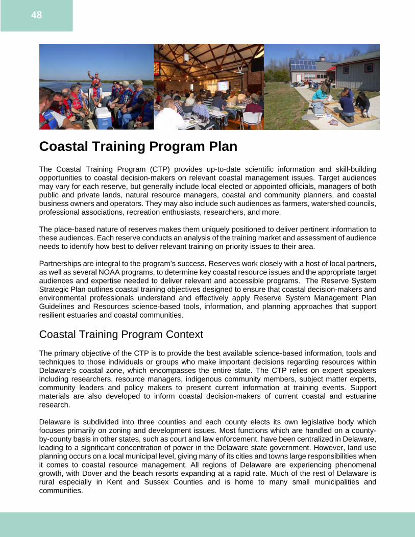
48
Coastal Training Program Plan The Coastal Training Program (CTP) provides up-to-date scientific information and skill-building opportunities to coastal decision-makers on relevant coastal management issues. Target audiences may vary for each reserve, but generally include local elected or appointed officials, managers of both public and private lands, natural resource managers, coastal and community planners, and coastal business owners and operators. They may also include such audiences as farmers, watershed councils, professional associations, recreation enthusiasts, researchers, and more. The place-based nature of reserves makes them uniquely positioned to deliver pertinent information to these audiences. Each reserve conducts an analysis of the training market and assessment of audience needs to identify how best to deliver relevant training on priority issues to their area. Partnerships are integral to the program’s success. Reserves work closely with a host of local partners, as well as several NOAA programs, to determine key coastal resource issues and the appropriate target audiences and expertise needed to deliver relevant and accessible programs. The Reserve System Strategic Plan outlines coastal training objectives designed to ensure that coastal decision-makers and environmental professionals understand and effectively apply Reserve System Management Plan Guidelines and Resources science-based tools, information, and planning approaches that support resilient estuaries and coastal communities. Coastal Training Program Context The primary objective of the CTP is to provide the best available science-based information, tools and techniques to those individuals or groups who make important decisions regarding resources within Delaware’s coastal zone, which encompasses the entire state. The CTP relies on expert speakers including researchers, resource managers, indigenous community members, subject matter experts, community leaders and policy makers to present current information at training events. Support materials are also developed to inform coastal decision-makers of current coastal and estuarine research. Delaware is subdivided into three counties and each county elects its own legislative body which focuses primarily on zoning and development issues. Most functions which are handled on a county-by-county basis in other states, such as court and law enforcement, have been centralized in Delaware, leading to a significant concentration of power in the Delaware state government. However, land use planning occurs on a local municipal level, giving many of its cities and towns large responsibilities when it comes to coastal resource management. All regions of Delaware are experiencing phenomenal growth, with Dover and the beach resorts expanding at a rapid rate. Much of the rest of Delaware is rural especially in Kent and Sussex Counties and is home to many small municipalities and communities.
49
Delaware has been facing tremendous developmental pressures over the past decade due to an influx of businesses attracted to the state by friendly tax laws and great economic growth - making it the sixth most densely populated state in the nation. According to the Delaware Population Consortium in 2017, by 2050, the population of Delaware is expected to be 1,095,000, which is an increase of 15% over the 2015 population level of 949,000. This population growth and the resulting demand for new homes, jobs and services highlights the importance of improving the management of Delaware’s land and natural resources. Balancing development and the increasing population pressures continues to be one of the most important issues to be addressed. Despite the pressures, Delaware’s coastal resources have always served as vital economic, social, aesthetic and intrinsic benefits to Delaware. Nearly 50 percent of Delaware’s visitors utilize coastal waters and beaches for recreational activities such as boating, fishing, sailing, surfing, sunbathing and water skiing. Maintaining a balance of these competing pressures and needs in the Delaware Bay estuary while protecting the environment is one of the most difficult challenges for Delaware’s natural resource decision makers. The CTP is designed to assist with this complexity by providing up-to-date scientific information and skill building opportunities to coastal decision-makers who are responsible for making decisions that affect coastal resources. An increased understanding of the health of Delaware’s natural resources will inform best management practices to restore, protect and preserve these resources. Through the CTP, DNERR can ensure that coastal decision-makers have the knowledge and tools needed to address critical resource management issues of concern to Delaware’s communities. Priority Issues, Audiences, Delivery and Partnerships Based on the results of previous surveys, research, and in consultation with the CTP advisory committee, partners and staff, CTP identified three priority coastal issues. These broad topics encompass needs reflected by most of Delaware’s coastal resource decision makers and are issues that fall historically within the expertise of DNERR and CTP partners. Coastal Training Program Priority Issue #1: Resilient Communities Many Delaware communities lack resources and capacity to prepare for the impacts of climate change or coastal hazards. Resiliency represents the ability to recover after hazardous events in the short and long-term. Coastal hazards can pose threats to Delaware’s communities including people, property, infrastructure, society and economies. The same hazards can have significant impacts on natural ecosystems and the environment such as forests, beaches, dunes and marshes. The impacts of climate change in Delaware from sea level rise will affect more than beaches and waterfront property owners. Storm and flood hazards often extend beyond the coast to inland areas. Communities in Delaware are vulnerable to natural hazards including extreme winds, storm surge and/or flooding. Although most natural hazards cannot be avoided or prevented, measures can be taken to reduce community risks and vulnerabilities. Adapting to climate change and sea level rise requires the incorporation of these issues into the current decision-making and planning processes. Most state and local policies and regulations for flood management, emergency management, infrastructure siting, building codes and natural resource management do not yet fully consider the future effects of sea level rise, increasingly warm temperatures throughout the year, and changes to precipitation patterns. Without considering these impacts, residences, infrastructure and resources may be vulnerable in the future. Additional challenges can include high staff turn-over rate, limited funding for implementing projects, non-resident landowners and political climate. The CTP will assist communities and state agencies with addressing and planning for changing environmental conditions such as flooding and sea level rise. The CTP will also promote the use of natural solutions and green infrastructure in adaptation or implementation projects such as living shorelines, tidal wetland restoration, open space preservation, and energy efficiency programs.
50
The CTP will focus on providing information as identified by the CTP advisory committee of particular importance to decision makers working on this issue, which includes providing:
● ways to incorporate resiliency provisions into planning by providing examples of model ordinances, regulatory standards and technical assistance with the development of management plans, comprehensive plans, hazard plans, etc.;
● access to maps and data to assess risks such as the Delaware Flood Planning Tool, Delaware Coastal Inundation Mapping Tool and habitat maps;
● access to technical assistance or funding assistance for grant writing help, funding databases, trainings on green infrastructure or new techniques for resilience; and,
● information on ways to communicate climate change risks to constituents as well as communicate co-benefits of climate adaptation and win-win strategies.
Priority Audience As identified by the CTP advisory committee, the top three priority audiences for the “resilient communities priority” are: county government, municipalities and local communities. The CTP technical assistance and trainings will target local government officials, county government officials, state legislators and agency representatives who are liaisons with them (DNREC, DelDOT, Division of Small Businesses, Department Health and Social Services, DDA, Office of State Planning), local and regional planning representatives, state planning representatives, as well as secondary influencers including utility provider representatives, economic development and tourism representatives, agricultural representatives [farmers, Farm Bureau representatives, U.S. Department of Agriculture (USDA)], university researchers, consultants and property owners. Current and Anticipated Partners Several entities within Delaware are investigating sea level rise and climate change. These current or anticipated partners include, but are not limited to the DCMP, UD, DSG, PDE, CCE, DNREC’s Division of Watershed Stewardship, CIB, Nanticoke Watershed Alliance, Delaware Environmental Observing System, and the Delaware Geological Survey (DGS). Delivery System The CTP will provide several methods of in-person and virtual technical assistance and training delivery to reach the priority audience. This can include informal networking sessions such as the Resilient and Sustainable Communities League (RASCL) Coffee Hours that host about 30 people in a discussion, to large formal events with multiple concurrent presentation sessions such as the Delaware Wetlands Conference. Trainings may include topics such as: living shorelines, flooding, emergency planning, green infrastructure and ecosystem services. Technical assistance projects will include opportunities such as assisting with the DCP RCP and RASCL’s Steering Committee and Outreach Committee. Coastal Training Program Priority Issue #2: Habitat Protection and Restoration Delaware’s coastal wetland and forests provide buffers from coastal storms; natural flood control; filtration of pollutants to maintain water quality and provide waterfront access for recreation. Delaware’s coasts also harbor an abundance of fish and shellfish that support both commercial and recreational fisheries and provide nesting and foraging areas for migratory birds. Habitat protection and restoration are key topics for DNERR and coastal decision makers. The Delaware CTP will provide the best available science to priority audiences to support the protection and restoration of healthy, productive and resilient coastal ecosystems. The CTP will focus on providing information as identified by the CTP advisory committee of importance to decision makers working on this issue, which includes:
● the benefits of natural resources and the services they provide;
51
● information on the economic value of natural resources, and the ability to conduct a cost/benefit analysis or economic analysis;
● the ability to access and analyze data on the current state of coastal resources; ● the ability to access examples of best management practices for land management and
restoration such as demonstration sites and case studies; ● the ability to access guidance on innovative techniques to restore and conserve natural
resources like green infrastructure, stormwater/pond management, buffers and the use of tools such as inundation maps.
Priority Audience The top three priority audiences for the “habitat protection and restoration priority” include non-governmental organizations, the private sector and local communities. The DNERR CTP trainings will target Delaware’s nonprofit organizations that also support healthy ecosystems such as TNC, PDE, CIB, Delaware Wildlands, Delaware Center for Horticulture, Delaware Invasive Species Council (DISC), private business organizations such as local chambers of commerce and private consulting firms, as well as local community leaders. Current and Anticipated Partners Current and anticipated partner organizations include indigenous communities, UD, DSU, Delaware League of Local Governments, DISC, TNC, PDE, CIB, DelDOT, USDA, Natural Resources Conservation Service (Delaware), DDA and DNREC. Training Delivery System There are several formats in which the CTP will facilitate collaboration and opportunities of information exchange with coastal decision makers about healthy ecosystems. The CTP will provide training opportunities, private sector (business leaders/decision makers) immersion experiences in the Delaware Bay watershed, participatory restoration learning experiences, virtual webinars, support for conferences and will coordinate with natural resource decision makers and managers through committee assistance such the Delaware Living Shoreline Committee’s Outreach Subcommittee. Coastal Training Program Priority Issue #3: Coastal Resource Management and Planning Coastal resource management is complex and requires the balancing of often competing and occasionally conflicting demands of coastal resource use, economic development and conservation. Efficient and effective coastal resource planning decisions depend on understanding the impacts of human activities on ecosystem integrity, vulnerable species and valued ecosystem services. Through research and planning, Delaware can better identify resources most suitable for various types of activities in order to reduce conflicts among uses, reduce environmental impacts, facilitate compatible uses, and preserve critical ecosystem services to meet economic, environmental, security and social objectives. Fluctuating funding levels, changing political climate, and turnover of officials in a decision-making role makes this issue a continually difficult task to address. The CTP supports training planners, regulatory staff and municipal officials in their capacity to implement or improve coastal resource planning and regulation. CTP workshops, online courses and technical assistance will help priority audiences to effectively manage the direct, indirect and cumulative impacts of development on coastal resources and uses. The CTP will focus on providing information as identified by the CTP advisory committee of importance to decision makers working on this issue, which includes:
● the benefits of natural resources and the services they provide to communities; ● information on how to incorporate the conservation of natural resources into governmental
planning (at state, county and local levels);
52
● examples of best practices for community planning and ordinances such as case studies and on-site demonstrations/examples;
● techniques to communicate coastal risks and hazards, as well as the benefits of preserving natural resources, and;
● techniques to work collaboratively with diverse stakeholder groups to conserve coastal resources.
Priority Audience As identified by the CTP advisory committee, the top three priority audiences for the “coastal resource management and planning priority” are: state, county and local governments. As a result, the DNERR CTP trainings/meetings will target local and regional planning commissions, local and county government representatives, state agency representatives and municipalities. Current and Anticipated Partners Current and anticipated partners include the UD Institute for Public Administration, community organizations, State Planning Office, TNC, PDE, Conservation Districts, DSG, numerous programs in DNREC, Delaware Chapter of the American Planning Association, MARCO, DelDOT, DDA, DSU and RASCL. Training Delivery System The coastal resource management and planning priority includes diverse subject matter regarding community planning and societal planning, as well as leadership and communication skills that facilitate these goals. Technical assistance will be tailored to specific planning issues such as waterway and wetland protection, marine spatial planning for the Delaware Bay and ocean area, and state and municipal comprehensive land use planning. CTP will also host trainings in cooperation with partner organizations such as the NOAA Digital Coast office to inform decision makers of best practices for leadership including facilitation skills, project management skills and communication techniques. When applicable, CTP will use its national partnership with the American Planning Association to certify programs for certification maintenance credit to attract professional planners. Coastal Training Program Capacity CTP is an important program to connect decision makers to applied scientific research being conducted by and in coordination with DNERR. The CTP Coordinator is responsible for the program and collaboration and coordination with internal staff and external partners is imperative. A cross-sectoral DNERR team provides the program with expertise in scientific analysis and presentations at CTP events and technical assistance with planning tools, models, best management practices and marketing. It is important for the CTP to foster partnerships and learn from community leaders and organizations to provide equitable and inclusive trainings, workshops, webinars, internships and areas of community engagement. CTP will work collaboratively with external partners to widen the audience base to ensure a more diverse, equitable and inclusive program. This will include maintaining existing partnerships and establishing new partnerships. CTP continues to have numerous training partners including but not limited to the UD’s Institute for Public Administration, DSG, various sections within DNREC, DFS, PDE, Delaware Wildlands, DelDOT, CIB, Office of State Planning and more. The CTP advisory committee is representative of many of these organizations (Appendix E). Efforts will be made to expand training partnerships to include organizations in the agricultural and frontline communities. DNERR infrastructure, resources and cross-sectoral collaboration in conjunction with external resources such as additional technical expertise, publications, funding resources and larger meeting spaces from partner organizations will continue to support quality trainings and dissemination of research and stewardship information to Delaware’s coastal decision makers.
53
Coastal Training Future Needs and Opportunities Dynamic systems such as our coastal areas are always in flux and require flexibility when planning for changes. This is also true for the CTP as the issues that Delaware faces change. Social inequities have been brought to the forefront that must be addressed, especially as it relates to community resilience. DNERR CTP will work with new and existing partners to help address these inequities within the purview of the program. The CTP Coordinator will work with partners to address gaps in the CTP program, provide equitable and inclusive mentor and internship opportunities, develop and implement standards for CTP trainings, workshops, events and materials to improve diversity and inclusion, and to be open to other learning opportunities and partnership to further stakeholder engagement in the program. The CTP anticipates a combination approach to the program including virtual and in-person opportunities. Monitoring and Evaluation Strategies Monitoring and evaluation will be ongoing to ensure that the DNERR CTP is effective in its selection of topics, audiences and delivery methods. Post-workshop evaluations are administered at every training event to determine the effectiveness of the workshop and if the participants intend to apply the knowledge they learned. These evaluations will assist in ensuring that trainings are quality events which effectively meet participant needs. Workshop evaluations will also be used to report on performance measures established in the Performance Monitoring Manual 2.0: The NERRS Coastal Training Program (2014). Methods of evaluation also include:
● written evaluations for participants upon completion of a CTP session; ● maintenance of databases of CTP participants, providers and partners; ● marketing evaluation tools; ● Assessing needs of coastal decision maker workshops through detailed needs assessments
targeted to individual types of decision makers, and; ● consultation with the CTP advisory committee, partners and priority audience members.
Role of the CTP Advisory Committee Delaware’s CTP advisory committee (Appendix E) is a technical committee that provides advice and input to the program regarding the program’s goals, objectives and strategies. The members meet annually and also respond to requests for advice and input from the CTP Coordinator in order to advance DNERR’s goal of increasing the ability of community leaders and other decision makers to address critical coastal management issues in Delaware. The committee is comprised of individuals and organizations with expertise relative to coastal issues and training needs, especially as it relates to Delaware coastal resource management issues. Involvement in the committee is voluntary and, as a result, it is anticipated that committee membership will evolve over time. DNERR has final authority to make decisions or set policy regarding any aspect of the CTP. Refer to the Strategic Plan on pages 10-22 for Coastal Training Program Goals, Objectives, Strategies and Actions.
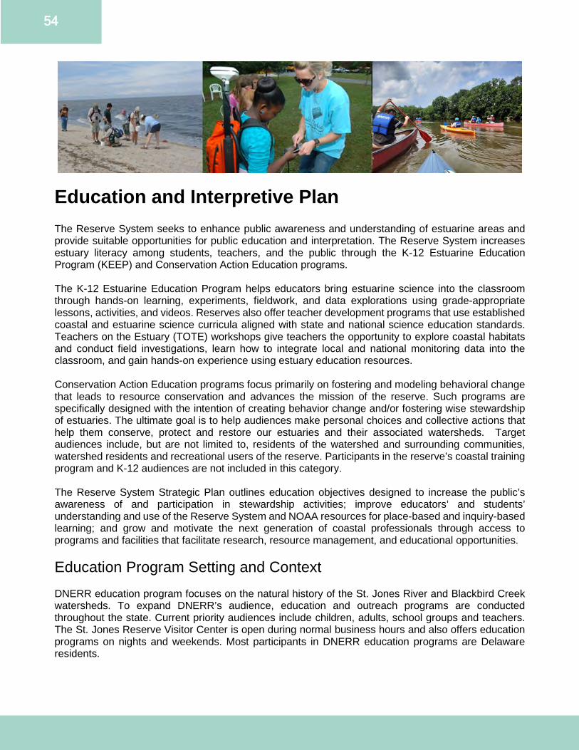
54
Education and Interpretive Plan The Reserve System seeks to enhance public awareness and understanding of estuarine areas and provide suitable opportunities for public education and interpretation. The Reserve System increases estuary literacy among students, teachers, and the public through the K-12 Estuarine Education Program (KEEP) and Conservation Action Education programs. The K-12 Estuarine Education Program helps educators bring estuarine science into the classroom through hands-on learning, experiments, fieldwork, and data explorations using grade-appropriate lessons, activities, and videos. Reserves also offer teacher development programs that use established coastal and estuarine science curricula aligned with state and national science education standards. Teachers on the Estuary (TOTE) workshops give teachers the opportunity to explore coastal habitats and conduct field investigations, learn how to integrate local and national monitoring data into the classroom, and gain hands-on experience using estuary education resources. Conservation Action Education programs focus primarily on fostering and modeling behavioral change that leads to resource conservation and advances the mission of the reserve. Such programs are specifically designed with the intention of creating behavior change and/or fostering wise stewardship of estuaries. The ultimate goal is to help audiences make personal choices and collective actions that help them conserve, protect and restore our estuaries and their associated watersheds. Target audiences include, but are not limited to, residents of the watershed and surrounding communities, watershed residents and recreational users of the reserve. Participants in the reserve’s coastal training program and K-12 audiences are not included in this category. The Reserve System Strategic Plan outlines education objectives designed to increase the public’s awareness of and participation in stewardship activities; improve educators’ and students’ understanding and use of the Reserve System and NOAA resources for place-based and inquiry-based learning; and grow and motivate the next generation of coastal professionals through access to programs and facilities that facilitate research, resource management, and educational opportunities. Education Program Setting and Context DNERR education program focuses on the natural history of the St. Jones River and Blackbird Creek watersheds. To expand DNERR’s audience, education and outreach programs are conducted throughout the state. Current priority audiences include children, adults, school groups and teachers. The St. Jones Reserve Visitor Center is open during normal business hours and also offers education programs on nights and weekends. Most participants in DNERR education programs are Delaware residents.
55
St. Jones Reserve Component Most school and public programs take place at the St. Jones Reserve. School programs are often conducted in coordination with the JDP, located on the property next to the St. Jones Reserve. Marsh walks, pollinator garden tours and horseshoe crab spawning survey trainings are onsite programming examples. Blackbird Creek Reserve Component The Blackbird Creek Reserve component is utilized for some public and group programs, but not as frequently as the St. Jones Reserve. Current program offerings include canoe trips, tree plantings and guided hikes. The Blackbird Creek Reserve is also where DNERR hosts the annual Blackbird Creek Fall Festival, featuring DNERR programs and multiple partners. This event engages surrounding communities in estuarine education and stewardship activities. This festival has the largest attendance of DNERR’s public programming. Priority Issues, Audiences, Delivery and Partnerships Priority issues were identified through a market analysis of local environmental education centers, needs assessment of K-12 science teachers, discussions among DNERR staff and stakeholder workshops. These issues align with the priorities of the NERRS system strategic plan, the NOAA Education Strategic Plan, and the DNERR Strategic Plan. Market Analysis Summary (Appendix F) DNERR conducted a market analysis in the spring of 2020. The survey collected information about local nature centers, programs offered, teacher professional development and the use of volunteers in education programs. The majority of respondents were employed by local nature and visitor centers in Delaware that serve multiple or all of the counties in the state. Most of the respondents provided public and school programs. The topics most highly addressed by environmental educators in the state were conservation, animals, cultural and historical resources, invasive species and biodiversity. All age groups were served, with an emphasis on grades 3-8. Respondents indicated a need for more focus on conservation, climate change and sea level rise, lab or field data collection, estuaries, and cultural and historical resources. Roughly one-third of respondents offered teacher professional development, with an emphasis on curriculum workshops. These workshops mainly focus on middle school educators with plans to continue the current levels of teacher professional development offerings. Needs Assessment Summary (Appendix G) DNERR conducted a needs assessment survey of Delaware science teachers in the spring of 2020. The survey was conducted to guide future school program offerings, teacher professional development opportunities and to highlight potential barriers to attending DNERR programming. Most responses were from public middle and high school teachers. Most respondents offered 0-2 classes per year with focused content about estuaries, watersheds or coastal issues. Respondents indicated wanting increased coverage on climate change and sea level rise, lab or field data collection, biodiversity, pollution and invasive species. These topics align with DNERR’s goals and the findings of the market analysis. Teachers indicated interest in virtual programming, speakers in the classroom and field trips. Across the board, teachers were looking for both pre-trip and post-trip materials. Barriers to attending DNERR programs included cost, travel, lack of time within the school year and large class sizes. Teacher professional development workshop attendance at DNERR TOTEs has decreased since the Delaware Teacher Center closed in 2017. Teacher professional development is currently provided by the schools during teacher in-service days. Teachers indicated they would likely attend a workshop and would be more inclined to attend should guidance and support continue after the workshop. Teachers also indicated interest in workshops focused on distance learning, field-based learning, data collection and curriculum workshops.
56
Both the market analysis and needs assessment were conducted during the beginning of the COVID-19 pandemic (May and June 2020). Answers could have been influenced due to virtual learning and limited contact with teachers. These evaluations may need to be reassessed post-pandemic. Education Program Priority Issue #1: Sea Level Rise and Climate Change Climate change and sea level rise were identified in stakeholder workshops, the market analysis and the needs assessment as high priority issues. The issues are being prioritized in multiple ways:
● The DNERR education team serves on the planning committee for the Mid-Atlantic Climate Change Education Conference. This conference is responsible for bringing climate change-specific content, curriculum and speakers to K-16 teachers in the Mid-Atlantic region. The conference is held in conjunction with DSG, the NOAA Environmental Science Training Center, Goucher College and other Mid-Atlantic NERRS.
● The themes of sea level rise and climate change will be incorporated at new interpretive waysides in development for the DNERR trail system. They will also be incorporated into DNERR school, public and TOTE programs and will utilize DNERR data and research whenever possible.
Education Program Priority Issue #2: Underserved and Underrepresented Communities The DNERR education team aims to increase service to underserved and underrepresented communities. These communities make up a large portion of the surrounding community. To increase equitable access to K-16 watershed education, DNERR will collaborate with partners to offer translated materials, equitable access to internships, assist with career development and participate in targeted community outreach. Education Program Priority Issue #3: Community Engagement DNERR will continue to assess and hone the most appropriate niche through a market analysis and needs assessment conducted for public user groups. Anecdotally, the DNERR is one of the “best kept secrets” among education programs in Delaware, simply because many members of the surrounding community do not know the Reserve exists. Over the past several years, levels of community engagement with DNERR remain unchanged. The DNERR education team is prioritizing engagement opportunities with the local community, teachers, school districts, prospective volunteers and public user groups. The education team will evaluate and realign current programs to ensure they meet current state standards including Next Generation Science Standards. It is critical that outreach programs are aligned to the curriculum for teachers to justify fitting them into the busy school year. DNERR’s TOTE program needs reevaluation and redesign to attract attendees. Over the past several years, attendance in TOTE programs has substantially decreased for a variety of reasons. In 2017, with the closure of the Delaware Teacher Center, teacher professional development moved directly into schools and is now completed during teacher in-service days, no longer necessitating site visits. DNERR will work with partners that also offer professional development to build new relationships with teachers and school districts to increase TOTE workshop attendance. Priority Audiences Current Audiences DNERR education programs service all three of Delaware’s counties. However, the St. Jones Reserve Visitor Center’s location leads towards a higher level of programming within Kent County. Additionally, the Visitor Center’s proximity to Route 1 (a major highway transecting the entire state of Delaware) and

57
Route 9 (a Coastal Heritage Scenic Byway) allows visitation from both local populations and tourists traveling to and from the Delaware beaches. The education program reaches the greatest portion of people through its public and outreach programs. While the Blackbird Creek Fall Festival has the largest one day turnout, boat and canoe trips are the most popular recurring public program offerings. DNERR is focusing efforts on increasing the number, availability, marketing and relevancy of additional public programs to bring in new and returning program participants. Establishing and maintaining positive relationships with K-12 educators is integral to creating a meaningful TOTE experience for educators and identifying innovative ways to introduce estuarine content and stewardship practices into the classroom. These relationships will be important for redeveloping the TOTE program and identifying new ways to bring estuary content directly into the classroom. New Audiences The DNERR education team will continue to develop relationships with surrounding communities, partners, audiences, and user groups. An untapped user group is the Dover Air Force Base. The St. Jones Reserve is located one exit down from the Dover Air Force Base and can provide free access for recreation and education through the on-base schools and existing outdoor recreation programs. School Audiences As of July 1, 2019, there were 180,786 people living in Kent County. According to the US Census Data, 12.7% live in poverty. The Capital, Caesar Rodney and Smyrna school districts (all of which have Title 1 schools) are the primary school districts that fall within the watersheds of the St. Jones River and Blackbird Creek. Even though DNERR programming is offered at no charge, transportation costs often limit access to DNERR services to in-classroom activities rather than on-site field trips. Caesar Rodney School District The population in the Caesar Rodney School District is 48,587. The median household income is $67,226. The race and ethnicity makeup of the community is 66% White, 19% Black, 8% Hispanic or Latino, 4% Asian, and 4% of two or more races. Within the district, 7.7% of the students have disabilities and 14.9% of students are in families with income below the national poverty level. Capital School District The total population in the Capital School District is 58,826. The median household income in the district is $53,112. The race and ethnicity makeup of the community is 50% White, 36% Black, 7% Hispanic or Latino, 2% Asian, 1% American Indian/Alaskan Native, 4% two or more races. Within the district, 6.6% of students have disabilities and 24.9% of students are in families with income below poverty level. Smyrna School District The total population in the Smyrna School District is 36,262. The median household income in the district is $67,271. The race and ethnicity makeup in the community is 68% White, 22% Black, 5% Hispanic and Latino, 1% Asian, 3% two or more races. Within the district, 4.8% of students have disabilities and 10.4% of students are in families with income below poverty level. Education Program Alignment and Delivery In addition to the education priorities noted above, DNERR will focus on expanding public programming opportunities. This will require marketing and will be part of the outreach effort undertaken by DNERR. These programs will integrate research conducted at DNERR as well as opportunities for community science projects. DNERR will also focus on updating and replacing interpretive materials along the trail systems. The current waysides are weather worn and need to be replaced with durable materials with updated information.
58
The education staff is working with other DNERR programs to incorporate DNERR data into their new curriculum and programs. DNERR staff is also developing new public programming that highlights DNERR research while tying the programs into global issues such as climate change. To reach wider audiences, the education team promotes DNERR work on social media pages. Outcomes of the education program will be shared with other environmental educators, education advisory work groups and through presentations at local, regional and or national conferences. The DNERR education team aims to instill a stewardship ethic into all education program participants and create estuarine literate citizens. DNERR should be open to all and be a safe and inclusive space for all to participate in environmental education. Current and Anticipated Partnerships Partnerships with other organizations are integral to DNERR’s ability to provide education across the state. Partners include Delaware Association for Environmental Education, CIB, DHCA, TNC, PDE, DSG, Tidewater Utilities, Inc., other sections within CCE, and several divisions within DNREC. In the future it will be important to foster working relationships with other DNREC education programs. Further connections also need to be made with local school districts, colleges, and community groups to achieve the goals of the education program. John Dickinson Plantation and Mansion (JDP) The JDP is a close partner of DNERR. As the neighbor to the St. Jones Reserve component, JDP and DNERR frequently partner on school and public education programs. School groups are often split between the sites due to capacity and to create smaller sized groups with personalized education. The annual Make a Splash Festival is held each spring and it is the largest school group event held jointly by DNERR and JDP. During this festival DNERR, JDP, volunteers and other partners bring both water education and Delaware estuary history to 600-800 4th graders annually. Delaware Natural Resources and Environmental Control (DNREC) DNERR works with staff from other DNREC divisions to highlight their education programs, assist with large programs and obtain artifacts utilized in exhibits. DNERR also works closely with these divisions on several education programs hosted at the Reserve including Make a Splash, Blackbird Creek Fall Festival and Delaware Envirothon. Other Mid-Atlantic NERRS DNERR works with other Mid-Atlantic NERRS on projects, workgroups and programs. Collaborations include the Mid-Atlantic Climate Change Education Conference, TOTE workshops and the Mid-Atlantic Coastal Acidification Network (MACAN) education workgroup. Junior Achievement DNERR will continue to grow the partnership with Junior Achievement of Delaware. DNERR and Junior Achievement work together to provide Delaware students with career-readiness opportunities. Education Program Capacity The education program is staffed by one full-time Education Coordinator and one part-time Assistant Education Coordinator. The Education Coordinator is the lead contact for all programs, special activities and volunteer activities. The Assistant Education Coordinator leads and supports informal education programming and coordinates DNERR’s social media pages. The education team hosts TOTE workshops with assistance from other DNERR staff serving as boat drivers, presenters and providing technical assistance. Staff constraints limit the ability to host large

59
school groups. The education team is evaluating current school programs and working to identify ways to reach schools with large numbers of students unable to bring all of their students onsite. The education team utilizes several spaces throughout the DNERR to host programs. These areas include a functional wet lab space, exhibit room space, and use of the Coastal Training Center at the St. Jones Reserve. DNERR education staff split use of vehicles and boats with the research and stewardship teams. Education Program Future Needs and Opportunities DNERR has several needs to address as noted in the priorities above. DNERR will prioritize increasing K-12 program capacity to address the barriers of transportation costs, limited education staff and space constraints. DNERR will focus on branding and marketing initiatives to broadcast programming opportunities and increase the number of program participants. As referenced in the staffing plan, DNERR education programs would benefit from a part time Volunteer Coordinator. Refer to the Strategic Plan on pages 10-22 for Education Goals, Objectives, Strategies and Actions.
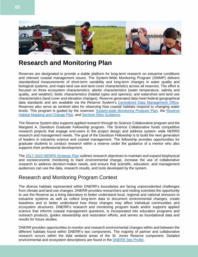
60
Research and Monitoring Plan Reserves are designated to provide a stable platform for long-term research on estuarine conditions and relevant coastal management issues. The System-Wide Monitoring Program (SWMP) delivers standardized measurements of short-term variability and long-term changes in water quality and biological systems, and maps land use and land cover characteristics across all reserves. The effort is focused on three ecosystem characteristics: abiotic characteristics (water temperature, salinity and quality, and weather); biotic characteristics (habitat types and species); and watershed and land use characteristics (land cover and elevation changes). Reserve-generated data meet federal geographical data standards and are available via the Reserve System’s Centralized Data Management Office. Reserves also serve as sentinel sites for observing how coastal habitats respond to changing water levels. This program is guided by the reserves’ System-wide Monitoring Program Plan, the Reserve Habitat Mapping and Change Plan, and Sentinel Sites Guidance. The Reserve System also supports applied research through its Science Collaborative program and the Margaret A. Davidson Graduate Fellowship program. The Science Collaborative funds competitive research projects that engage end-users in the project design and address system- wide NERRS research and management needs. The goal of the Davidson Fellowship is to build the next generation of leaders in estuarine science and coastal management. The fellowship provides opportunities for graduate students to conduct research within a reserve under the guidance of a mentor who also supports their professional development. The 2017-2022 NERRS Strategic Plan outlines research objectives to maintain and expand biophysical and socioeconomic monitoring to track environmental change, increase the use of collaborative research to address decision-maker needs, and ensure that scientific, education, and management audiences can use the data, research results, and tools developed by the system. Research and Monitoring Program Context The diverse habitats represented within DNERR’s boundaries are facing unprecedented challenges from climate and land use changes. DNERR provides researchers and visiting scientists the opportunity to use the Reserve as a living laboratory to better understand local, regional and national stressors to estuarine systems as well as collect long-term data to document environmental changes, create baselines and to better understand how these changes may affect individual communities and ecosystem structures. DNERR’s research and monitoring program leads and/or supports applied science that informs coastal management questions, is incorporated into education programs and outreach products, guides stewardship and restoration efforts, and serves as foundational data and results for future studies. DNERR provides opportunities to monitor and research environmental changes within and between the different habitats found within DNERR’s two components. The majority of partner and collaborative research occurs within the tidal wetland areas of the St. Jones Reserve component. Detailed environmental and ecosystem descriptions are found in the DNERR Site Profile.

61
St. Jones Reserve Component The St. Jones River watershed covers an urbanized and developed upper section with superfund sites, and an agrarian and relatively undisturbed downstream section. The salinity has high tidal and seasonal variability as well as a gradient upstream. Most of the tidal marsh areas are denoted as mesohaline salt marsh dominated by saltmarsh cordgrass (Sporobolus alterniflorus). DNERR’s main office at the St. Jones Reserve is where DNERR research staff are primarily located. The St. Jones Reserve tidal marsh area is well studied by partners for greenhouse gas fluxes, hydrology, biogeochemical processes and as a comparison site throughout the United States. These research activities are primarily led by DNERR staff, UD, DSU and DGS. Blackbird Creek Reserve Component The Blackbird Creek watershed is one of the least developed in Delaware, with less watershed development than the St. Jones River. It is a tidal oligohaline-mesohaline system with portions being considered tidal freshwater habitat. The Blackbird Creek Reserve component has a diverse and unique suite of habitats within its boundaries including Delmarva Bays, oligohaline tidal marshes, tidal freshwater wetlands, managed meadows and active upland forest restoration sites. It is not as well studied as the St. Jones Reserve component, resulting in fewer ongoing partner research studies. Previous and current research interests include investigating coastal forest retreat, nesting bird activity and blue crab trophic dynamics. This work is in close collaboration with partners from DSU and the University of Maryland. DNERR will seek to increase research opportunities at Blackbird Creek by increasing the awareness of existing data sets including SWMP, vegetation and surface elevation table data. Priority Issues, Audiences, Delivery and Partnerships The four priority research issues are based on the NERRS 2017 Strategic Plan priority areas, stakeholder feedback on this management plan update and the DNERR Strategic Plan. Research Program Priority Issue #1: Coastal Habitat and Ecosystem Processes Coastal habitats, particularly tidal marshes, are under-studied systems despite their ecological importance. To protect these systems, DNERR needs to better understand the complex physical and biogeochemical processes in tidal wetlands and how these processes change. DNERR’s priority questions include understanding spatiotemporal changes in greenhouse gas fluxes, determining which covariates best predict if a salt marsh is a source or sink of carbon and nitrogen, and where marsh migration and subsequent coastal forest retreat are most probable. These research questions address the understanding of how marsh loss and climate change will affect tidal wetland ecosystem services including carbon sequestration, carbon storage, and nitrogen retention and transformation. Research and data collection will lead to the development, or improvement, of biogeochemical models, GIS-based tools to predict vulnerable habitat areas, and supporting information used in ecosystem valuation efforts. Research Program Priority Issue #2: Anthropogenic Influences on Estuaries Estuaries face continuously increasing pressures from climate change, urbanization, industrialization and land use changes. These changes can lead to eutrophication, coastal acidification, saltwater intrusion and exposure to contaminants. Eutrophication, resulting from excess nutrients, can cause downstream water quality issues. DNERR and its stakeholders are interested in better understanding eutrophication-driven acidification and hypoxia events and their ecosystem effects. This includes testing emerging sensor technologies and innovative techniques which may help mitigate these effects, such as biochar applications into marsh soils. As saltwater intrusion continues to be a growing issue in Delaware, DNERR needs a better understanding of how changing salinity regimes may affect biogeochemical processes, groundwater and surface water movement and habitat changes in order to establish better management strategies. Studies on presence and effects of legacy and emerging
62
contaminants including organics, metals and microplastics are needed to quantify the synergistic effects of pollution on individual species and food webs. Research Program Priority Issue #3: Population Dynamics of Coastal Species Many iconic and economically important species including the horseshoe crab (Limulus polyphemus), clapper rail (Rallus crepitans) and blue crab (Callinectes sapidus) utilize DNERR. Climate change, invasive species, habitat loss and predation changes could negatively affect population dynamics of these important organisms. DNERR will continue to lead and/or support the collection of species-specific data to best understand how populations change over time. Observed changes can be used to develop additional studies investigating why changes are occurring and create restoration-based strategies to help mitigate losses and promote recovery. Research Program Priority Issue #4: Social Science and Economics DNERR stakeholders identified social science, including behavioral science, and economic studies as priority needs to support the research and monitoring program elements outlined above. Social and economic analyses will support decision-making processes and promote community level behavioral changes. Research questions include understanding the best information delivery mechanism of new scientific data to Delaware’s diverse communities, understanding what research is most needed by underserved communities and valuing the economic benefit of certain land/species management decisions. Priority Audiences and Partners While DNERR’s primary research and monitoring efforts occur within the Reserve’s boundaries, the geographic scope and key audiences are found throughout the state of Delaware and the Mid-Atlantic region. DNERR conducts place-based research and collects site specific data which can be used to broadly assess coastal impacts, patterns, and comparisons at the local, state or national level. In research, the audience and partners are often the same entities. Academic Communities DNERR works closely with academic partners including UD, DSU, University of Maryland, and Drexel University by providing field site access, permitting guidance, local expertise and data to graduate students and visiting researchers. State and Federal Partners DNERR works closely with state partners including the other programs within DNREC, DDA and DelDOT. DNERR also works with local federal partners from USFWS and the U.S. Geological Survey. Regional Partners DCP is the Delaware lead on regional ocean planning and science groups including the Mid-Atlantic Regional Council for the Ocean (MARCO), MACO, MACAN, CIB and PDE. DNERR research staff serve and/or participate on various workgroups, steering committees and science and technical advisory committees as subject matter experts and/or program representatives. DNERR Staff DNERR’s research and monitoring program leads and supports applied science which informs and is integrated into DNERR training, education and stewardship programs. NERR System and NOAA DNERR actively engages in the NERR System by participating on national workgroups and by joining nationwide studies, such as the marsh crab study and decomposition rate study.
63
Research and Monitoring Program Delivery SWMP Implementation DNERR’s SWMP and sentinel site monitoring efforts are guided by the DNERR Sentinel Site Plan (Appendix H) and the NERR’s System-Wide Monitoring Plan. DNERR currently maintains seven water quality sondes (four in the St. Jones Reserve and three in the Blackbird Creek Reserve), two meteorological stations (one at each component), and collects monthly nutrient grab samples at six of the seven water quality sites (with one site additionally equipped with an automated Isco sampler to collect monthly nutrient samples over a tidal cycle). The DNERR Environmental Scientist will continue to lead all aspects of the DNERR’s SWMP program (abiotic water quality, meteorology and nutrients) including sensor deployment, calibration and maintenance, data downloading, QA/QC and timely submissions to the CDMO. The DNERR Research Coordinator oversees implementation of SWMP, grant management to ensure SWMP is properly funded and will seek opportunities to create analytical tools and analyses using SWMP data. DNERR has historically leveraged funds from partner programs, such as DCMP, to provide funding support to replace outdated water quality sondes. Having a dedicated and consistent funding source to replace aging water quality sondes is needed to ensure high quality data collection. Finally, having funds to maintain access to RTK-GPS is needed for water level to be continuously collected as a SWMP parameter. Additional Monitoring and Research Activities The DNERR’s Sentinel Site Plan (Appendix H) was completed in 2017 and outlines how DNERR will implement the Sentinel Site Application Module-1 (SSAM-1) to understand coastal habitat changes due to changing water levels. This includes the collection of vegetation transect data, surface elevation table measurements, elevation transects and periodic habitat maps. The DNERR Stewardship Coordinator will continue to lead biennial emergent vegetation biomonitoring and habitat mapping at both components. Surface elevation table and feldspar clay readings are led by the DCMP Environmental Scientist. Funding support for SSAM-1 activities is provided by both DNERR and DCMP programs. DNERR’s research and monitoring program currently includes two additional biological monitoring efforts to assess long-term ecosystem changes: marsh bird monitoring at the St. Jones Reserve led by the Stewardship Coordinator and nekton monitoring at the Blackbird Creek Reserve led by the DNERR Environmental Scientist. Funding for the marsh bird surveys is split between DNERR and DCMP, and periodic analyses and data entry into the Saltmarsh Habitat and Avian Research Program national database are supported by interns and UD staff. Supplies for the nekton surveys have been partially supported by external grant sources such as state funds through the Strategic Opportunity for Adaptation grant program. National Programs and Opportunities DNERR seeks external funding opportunities to enhance partnerships and research capacity. External funding sources include the NERRS Science Collaborative, the Mid-Atlantic Coastal Ocean Observing System and the National Fish and Wildlife Foundation. The NERRS Science Collaborative is an important funding opportunity for DNERR to enhance research activities with tangible coastal management outcomes and products. One example includes a NERRS Science Collaborative Catalyst Grant, led by Grand Bay NERR, to create a tool to better analyze and visual surface elevation table data (SETr). Support for other DNERR Functions DNERR research staff collaborate with all DNERR programs to ensure research and monitoring activities have a broader reach and application. This may include participating in outreach events, providing data and support for educational programs, or designing research projects to support DNERR management priorities.
64
Research and Monitoring Program Capacity Staffing DNERR’s research and monitoring program is staffed by the Research Coordinator, Environmental Scientist, and Stewardship Coordinator. Additional staffing is leveraged through DCMP, state, federal and academic partners, research interns and fellows. The Margaret A. Davidson Fellowship provides the opportunity to increase research scope, capacity and subject matter expertise. Facilities and Infrastructure The St. Jones Reserve facility has a small laboratory dedicated for SWMP activities and a multi-use ‘wet’ laboratory shared with the DNERR education program capable of limited sample preparation and storage. The St. Jones Reserve has an outdoor boat corral, shared between DNERR and DCMP, where small boats used to access field sites are housed year-round. Shared laboratory space is currently limited but applying for external facility improvement grants could expand available table space for research and education activities. There is also an opportunity with facility improvements to make the wet lab space more readily available for visiting researcher use. These potential improvements and expansions would increase the reach and scope of DNERR’s research and monitoring program. The St. Jones Reserve walking trail includes approximately a quarter mile of boardwalk crossing the tidal wetland field site, providing easy access to saltmarsh habitat for research opportunities. Presently this area is heavily studied by visiting researchers and provides opportunities for collaborations as foundational monitoring data increases. Two emerging challenges are the observed impacts occurring in this area due to heavy use and a limitation of space for new research. DNERR could further increase research at the St. Jones Reserve by expanding access into the tidal marsh areas and by creating a Research Use Plan including guidelines for allowing marsh recovery after studies are completed. DNERR will also explore opportunities to expand research activities at the Blackbird Creek Reserve. Research and Monitoring Future Needs and Opportunities Multiple stakeholder needs and opportunities have been discussed throughout the development of this management plan update with partner organizations. Below is a brief list of research needs in which the DNERR could plan a strong lead and/or supporting role. All needs and subsequent opportunities will be dependent on external grant funding support and by creating new partnerships or enhancing existing collaborations. Estuarine Restoration Research and Monitoring The need for science-based restoration will increase as wetland loss continues due to pressures such as sea level rise. New restoration approaches, such as the beneficial reuse of dredged materials, has gained interest from coastal managers as a tool to mitigate tidal wetland loss. There is a need to better understand how marshes and surrounding areas respond to thin layer sediment placement. Opportunities exist to create and/or support demonstration sites with long-term monitoring to improve the understanding of where thin layer placement projects are most appropriate and whether they are restoring the ecological integrity of the estuarine ecosystem. Other innovative restoration techniques which could be explored include the use of biochar and runnels. As a living laboratory with two components, DNERR is well positioned to be controls or test sites for small scale restoration studies which can leverage SSAM-1 and SWMP data as pre-existing baselines. Long-term Estuarine Monitoring SWMP is regarded as a highly valuable dataset by local partners due to the continuous, long-term collection of important water quality parameters such as dissolved oxygen. SWMP provides local, baseline data suitable for state and regional water quality modeling. There is a growing need to expand water quality monitoring in Delaware, both spatially and to include new parameters of interest. DNERR can provide technical trainings to state partners to better enable them to deploy water quality sensors
65
in their areas of interest. Current SWMP water quality stations could be leveraged to include emerging sensor technologies and parameters. For example, expanding SWMP to include carbonate chemistry parameters (such as the partial pressure of carbon dioxide) could allow DNERR to fill a data gap on estuarine acidification in the Mid-Atlantic. Innovative Technologies and Novel Approaches New and emerging technologies and scientific approaches offer the opportunity to enhance estuarine monitoring and restoration if they can be appropriately tested and studied. This includes inexpensive sensors using open-source platforms like Arduino which could spatially expand water quality monitoring by continuously measuring parameters like nitrate. These emerging technologies could be tested alongside pre-existing SWMP sites. The two DNERR components reflect distinctly different estuarine systems making data collection and sensor trials particularly robust. Emerging Contaminants Estuarine waters and sediments contain a mixture of anthropogenic compounds and materials, some of which have known and/or potential ecological, environmental and/or human health effects. This contaminant mixture will continue to grow as new chemicals are developed, categorized and exposed into the environment. Most emerging contaminants are not actively monitored, and in some cases, do not have standardized methodologies developed to quantify their environmental presence. Such contaminants include Per- and polyfluoroalkyl substances (also known as PFAS), microplastics and endocrine disruptors. DNERR’s living laboratory offers the opportunity for partners to study the environmental presence, fate and transport of these contaminants in order to increase our understanding of where they are most abundant and how they may impact the estuarine food web. Refer to the Strategic Plan on pages 10-22 for Research and Monitoring Goals, Objectives, Strategies and Actions.
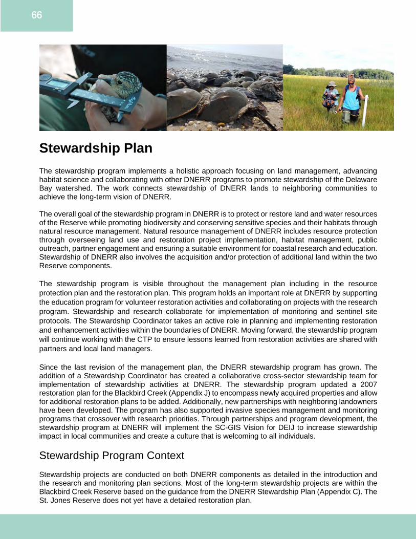
66
Stewardship Plan The stewardship program implements a holistic approach focusing on land management, advancing habitat science and collaborating with other DNERR programs to promote stewardship of the Delaware Bay watershed. The work connects stewardship of DNERR lands to neighboring communities to achieve the long-term vision of DNERR. The overall goal of the stewardship program in DNERR is to protect or restore land and water resources of the Reserve while promoting biodiversity and conserving sensitive species and their habitats through natural resource management. Natural resource management of DNERR includes resource protection through overseeing land use and restoration project implementation, habitat management, public outreach, partner engagement and ensuring a suitable environment for coastal research and education. Stewardship of DNERR also involves the acquisition and/or protection of additional land within the two Reserve components. The stewardship program is visible throughout the management plan including in the resource protection plan and the restoration plan. This program holds an important role at DNERR by supporting the education program for volunteer restoration activities and collaborating on projects with the research program. Stewardship and research collaborate for implementation of monitoring and sentinel site protocols. The Stewardship Coordinator takes an active role in planning and implementing restoration and enhancement activities within the boundaries of DNERR. Moving forward, the stewardship program will continue working with the CTP to ensure lessons learned from restoration activities are shared with partners and local land managers. Since the last revision of the management plan, the DNERR stewardship program has grown. The addition of a Stewardship Coordinator has created a collaborative cross-sector stewardship team for implementation of stewardship activities at DNERR. The stewardship program updated a 2007 restoration plan for the Blackbird Creek (Appendix J) to encompass newly acquired properties and allow for additional restoration plans to be added. Additionally, new partnerships with neighboring landowners have been developed. The program has also supported invasive species management and monitoring programs that crossover with research priorities. Through partnerships and program development, the stewardship program at DNERR will implement the SC-GIS Vision for DEIJ to increase stewardship impact in local communities and create a culture that is welcoming to all individuals. Stewardship Program Context Stewardship projects are conducted on both DNERR components as detailed in the introduction and the research and monitoring plan sections. Most of the long-term stewardship projects are within the Blackbird Creek Reserve based on the guidance from the DNERR Stewardship Plan (Appendix C). The St. Jones Reserve does not yet have a detailed restoration plan.
67
Current Blackbird Creek Reserve projects include riparian buffer and upland reforestation and native meadow restoration. Science-based restoration monitoring is planned to be added to all restoration efforts as part of the implementation process of the DNERR Stewardship Plan (Appendix C). Projects conducted at both components of DNERR include native and invasive species monitoring, habitat mapping and working closely with the research program to implement activities related to vegetation monitoring and the sentinel site program. Priority Issues, Audiences, Delivery and Partnerships The three priority DNERR stewardship issues are based on the SWMP, Reserve System Strategic Plan priority areas, stakeholder needs and restoration goals of the DNERR Stewardship Plan (Appendix C). Stewardship Program Priority Issue #1: Habitat Conservation and Restoration Delaware’s habitat has been greatly impacted by anthropogenic changes. DNERR promotes the use of Reserve managed lands as reference sites for established and experimental restoration techniques. With partners, DNERR develops and implements pre- and post-monitoring activities for restoration projects. Advancing restoration science and enhancing adaptive capacity of habitats is critical to managing sites in the context of climate change and other stressors. Baseline data, lessons learned and best management practices inform restoration and conservation approaches on DNERR lands and are utilized by other local and regional land managers. Stewardship Program Priority Issue #2: Invasive and Non-native Species Management Invasive species are organisms that are introduced into an area in which it did not endemically evolve. Lack of natural predators and competitive advantage allow invasive species to rapidly grow within the new environment causing harm to the environment, the economy and human health. Invasive species are usually very opportunistic and hard to eradicate once established. The stewardship program works with DNERR staff and volunteers to monitor and track invasive species. Staff communicates with state agencies DDA and FW to identify new and emerging species of concern. Stewardship staff advises on identifying and controlling potential invasive species of concern on properties considered for acquisition and those already being managed by DNERR. Stewardship Program Priority Issue #3: Anthropogenic Influences on Habitats Habitats and land use surrounding DNERR are diverse and varied between DNERR components. The population density and usage of the targeted watersheds varies dramatically from Blackbird Creek Reserve (highly rural with protected headwaters and buffer areas) to the St. Jones Reserve (highly urban upstream and rural downstream). The stewardship and research and monitoring programs aim to collaborate to assess the impact of stressors on ecological processes, habitats and species. Priority Audiences Adjacent landowners, land managers, academics and experts from non-governmental organizations in the Mid-Atlantic region are the primary audiences. A goal of the stewardship program is ensuring regional and national partners are aware of DNERR stewardship activities. The program actively participates in NERRS workgroups and provides technical expertise to national studies. Partnerships DNERR builds and maintains partnerships with numerous local, regional and national partners and plans to expand into new partnerships to achieve programmatic goals to address priority issues. Current primary partners are UD, DSU, Delaware Wildlands, DNREC and DDA.
68
Stewardship Program Delivery National Programs and Opportunities DNERR plans to seek external funding opportunities to enhance partnerships and stewardship capacity. Potential external funding sources include, but are not limited to, the NERRS Science Collaborative and the National Fish and Wildlife Federation. External funding would enhance the research and stewardship activities to provide demonstration sites and include restoration science-based monitoring plans. The stewardship program also plans to collaborate with other NERRS sectors across the nation to advance priority activities. Support for other DNERR Programs The stewardship program collaborates with all DNERR programs by participating in outreach events, providing data and support for educational programs, supporting the CTP by sharing best management practices and lessons learned and designing projects that support DNERR management priorities and stakeholders. This collaboration allows flexibility in meeting shared objectives, notably in the implementation of SWMP and Sentinel Site Plan. Additional Stewardship Activities In addition to collaborating with the research and monitoring program on SWMP and SSAM-1, the Stewardship Coordinator leads three biological monitoring efforts to assess long-term ecosystem changes: marsh bird monitoring, documenting estuarine recovery from anthropogenic impacts at the St. Jones Reserve and nest box monitoring at both DNERR components. Marsh bird monitoring is conducted in collaboration with UD. Nest box monitoring is conducted in collaboration with DSU to understand over-wintering and site fidelity of eastern bluebirds. Stewardship Program Capacity A full-time Stewardship Coordinator, also noted in the research plan, leads the program and actively collaborates with other DNERR staff to meet stewardship goals and objectives. The DNERR Conservation Technician assists the Stewardship Coordinator in managing public, research, education and compatible traditional uses in accordance with the DNERR management plan, stewardship plan and other state and federal mandates. The stewardship program is supported by DCMP staff, interns and volunteers. An important component of the stewardship program is the support from the Reserve Manager and Conservation Technician. The Stewardship Coordinator leads quarterly meetings to ensure strong cross-program communication and coordination of on the ground activities, planning and implementation. These quarterly stewardship meetings are open to all DNERR staff, and are especially important for the Stewardship Coordinator, Reserve Manager, Research Coordinator and Conservation Technician. Stewardship Future Needs and Opportunities With stakeholder inputs into the development of this management plan update, the stewardship program identified the following future needs and opportunities. Invasive Species Monitoring DNERR focuses on early detection and prevention of invasive species. Potential strategies include collaborating with partners to establish a demonstration site for invasive species management techniques. DNERR also identified a need to create a database of existing terrestrial and aquatic invasive species and site specific monitoring plans.
69
Science-Based Restoration Monitoring DNERR will continue evaluating current site conditions to identify habitats in need of restoration. based on the 2007 Blackbird Creek Reserve Ecological Restoration Master Plan (Appendix J) and the DNERR Stewardship Plan (Appendix C). DNERR will develop adaptive, science-based restoration plans in collaboration with partners and other programs for these habitats. Developing restoration projects is contingent upon available staffing and funding resources. DNERR will continue to pursue external funding opportunities to complete restoration projects. Habitat Fragmentation A critical element of the stewardship program is promoting land preservation throughout DNERR’s watersheds. DNERR accomplishes this by assisting other land preservation groups and agencies working in those areas. With partners, DNERR proactively seeks opportunities to reduce habitat forest fragmentation, especially as connected to the Blackbird Creek Reserve component. There is also potential to use DNERR and partner expertise to inventory habitats within actively managed DNERR sites to help assess management options. Innovative Technologies and Novel Approaches DNERR is exploring innovative passive data collection technologies to supplement limited staff time for monitoring. These technologies could expand understanding of levels of success of restoration projects. Expansion of monitoring could include collecting data on habitat migration, edges and ecotones and collecting baseline data for habitats within DNERR. St. Jones Reserve Restoration Plan DNERR does not currently have a restoration plan for the St. Jones Reserve component. The DNERR Stewardship Plan (Appendix C) currently provides guidance on restoration and phased approaches for land management based on restoration at the Blackbird Creek Reserve. An update that includes restoration planning for the St. Jones Reserve will be important for future land management planning and ensuring partners value DNERR as a multi-component site with opportunities to collaborate.
Refer to the Strategic Plan on pages 10-22 for Stewardship Goals, Objectives, Strategies and Actions.
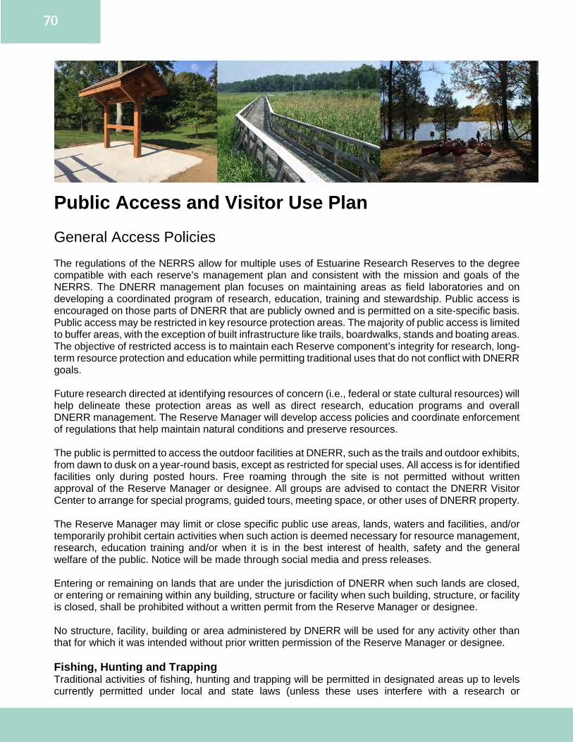
70
Public Access and Visitor Use Plan General Access Policies The regulations of the NERRS allow for multiple uses of Estuarine Research Reserves to the degree compatible with each reserve’s management plan and consistent with the mission and goals of the NERRS. The DNERR management plan focuses on maintaining areas as field laboratories and on developing a coordinated program of research, education, training and stewardship. Public access is encouraged on those parts of DNERR that are publicly owned and is permitted on a site-specific basis. Public access may be restricted in key resource protection areas. The majority of public access is limited to buffer areas, with the exception of built infrastructure like trails, boardwalks, stands and boating areas. The objective of restricted access is to maintain each Reserve component’s integrity for research, long-term resource protection and education while permitting traditional uses that do not conflict with DNERR goals. Future research directed at identifying resources of concern (i.e., federal or state cultural resources) will help delineate these protection areas as well as direct research, education programs and overall DNERR management. The Reserve Manager will develop access policies and coordinate enforcement of regulations that help maintain natural conditions and preserve resources. The public is permitted to access the outdoor facilities at DNERR, such as the trails and outdoor exhibits, from dawn to dusk on a year-round basis, except as restricted for special uses. All access is for identified facilities only during posted hours. Free roaming through the site is not permitted without written approval of the Reserve Manager or designee. All groups are advised to contact the DNERR Visitor Center to arrange for special programs, guided tours, meeting space, or other uses of DNERR property. The Reserve Manager may limit or close specific public use areas, lands, waters and facilities, and/or temporarily prohibit certain activities when such action is deemed necessary for resource management, research, education training and/or when it is in the best interest of health, safety and the general welfare of the public. Notice will be made through social media and press releases. Entering or remaining on lands that are under the jurisdiction of DNERR when such lands are closed, or entering or remaining within any building, structure or facility when such building, structure, or facility is closed, shall be prohibited without a written permit from the Reserve Manager or designee. No structure, facility, building or area administered by DNERR will be used for any activity other than that for which it was intended without prior written permission of the Reserve Manager or designee. Fishing, Hunting and Trapping Traditional activities of fishing, hunting and trapping will be permitted in designated areas up to levels currently permitted under local and state laws (unless these uses interfere with a research or
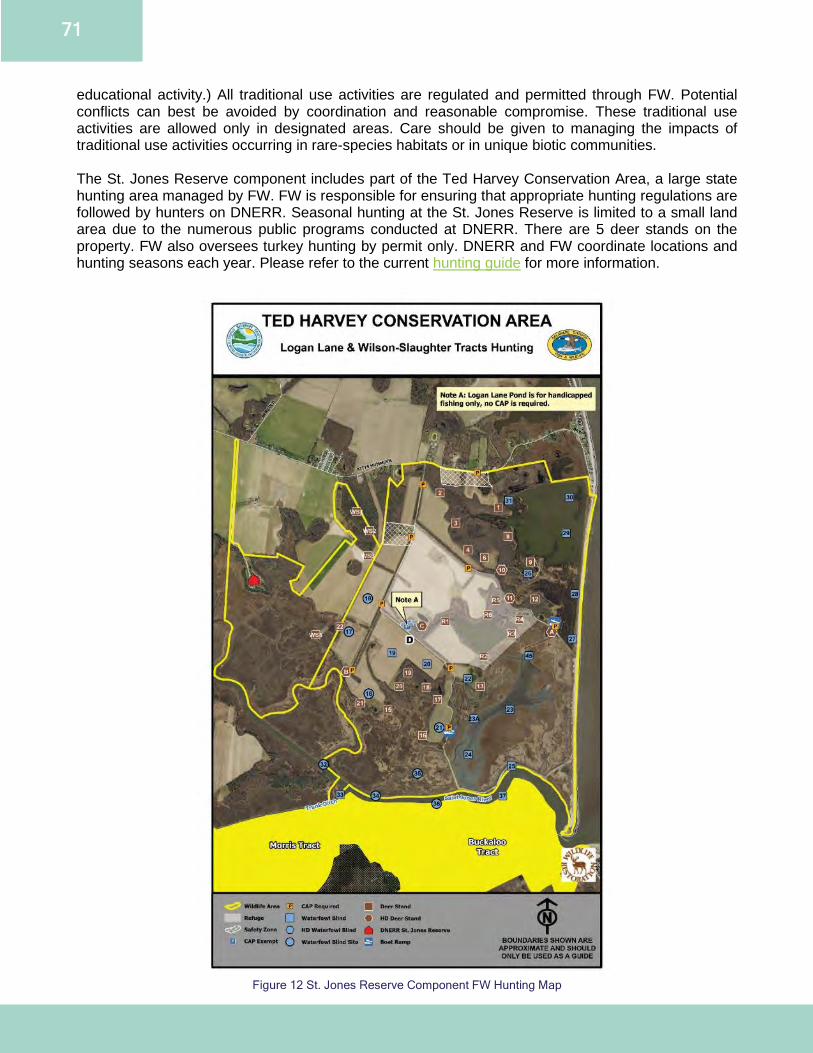
71
educational activity.) All traditional use activities are regulated and permitted through FW. Potential conflicts can best be avoided by coordination and reasonable compromise. These traditional use activities are allowed only in designated areas. Care should be given to managing the impacts of traditional use activities occurring in rare-species habitats or in unique biotic communities. The St. Jones Reserve component includes part of the Ted Harvey Conservation Area, a large state hunting area managed by FW. FW is responsible for ensuring that appropriate hunting regulations are followed by hunters on DNERR. Seasonal hunting at the St. Jones Reserve is limited to a small land area due to the numerous public programs conducted at DNERR. There are 5 deer stands on the property. FW also oversees turkey hunting by permit only. DNERR and FW coordinate locations and hunting seasons each year. Please refer to the current hunting guide for more information.
Figure 12 St. Jones Reserve Component FW Hunting Map
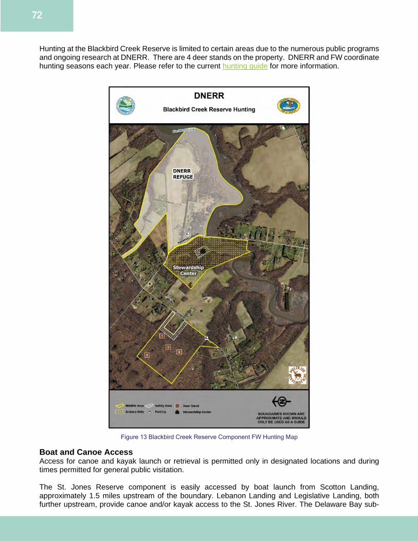
72
Hunting at the Blackbird Creek Reserve is limited to certain areas due to the numerous public programs and ongoing research at DNERR. There are 4 deer stands on the property. DNERR and FW coordinate hunting seasons each year. Please refer to the current hunting guide for more information.
Figure 13 Blackbird Creek Reserve Component FW Hunting Map
Boat and Canoe Access Access for canoe and kayak launch or retrieval is permitted only in designated locations and during times permitted for general public visitation. The St. Jones Reserve component is easily accessed by boat launch from Scotton Landing, approximately 1.5 miles upstream of the boundary. Lebanon Landing and Legislative Landing, both further upstream, provide canoe and/or kayak access to the St. Jones River. The Delaware Bay sub-
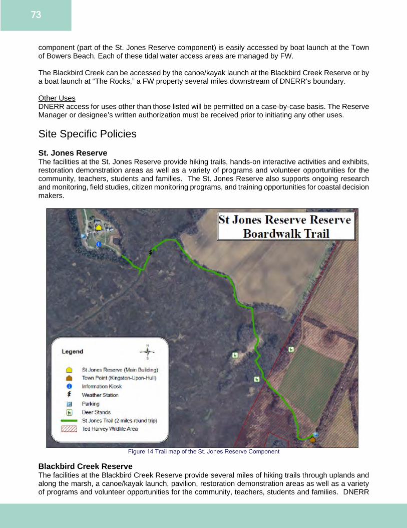
73
component (part of the St. Jones Reserve component) is easily accessed by boat launch at the Town of Bowers Beach. Each of these tidal water access areas are managed by FW. The Blackbird Creek can be accessed by the canoe/kayak launch at the Blackbird Creek Reserve or by a boat launch at “The Rocks,” a FW property several miles downstream of DNERR’s boundary. Other Uses DNERR access for uses other than those listed will be permitted on a case-by-case basis. The Reserve Manager or designee’s written authorization must be received prior to initiating any other uses. Site Specific Policies St. Jones Reserve The facilities at the St. Jones Reserve provide hiking trails, hands-on interactive activities and exhibits, restoration demonstration areas as well as a variety of programs and volunteer opportunities for the community, teachers, students and families. The St. Jones Reserve also supports ongoing research and monitoring, field studies, citizen monitoring programs, and training opportunities for coastal decision makers.
Figure 14 Trail map of the St. Jones Reserve Component
Blackbird Creek Reserve The facilities at the Blackbird Creek Reserve provide several miles of hiking trails through uplands and along the marsh, a canoe/kayak launch, pavilion, restoration demonstration areas as well as a variety of programs and volunteer opportunities for the community, teachers, students and families. DNERR
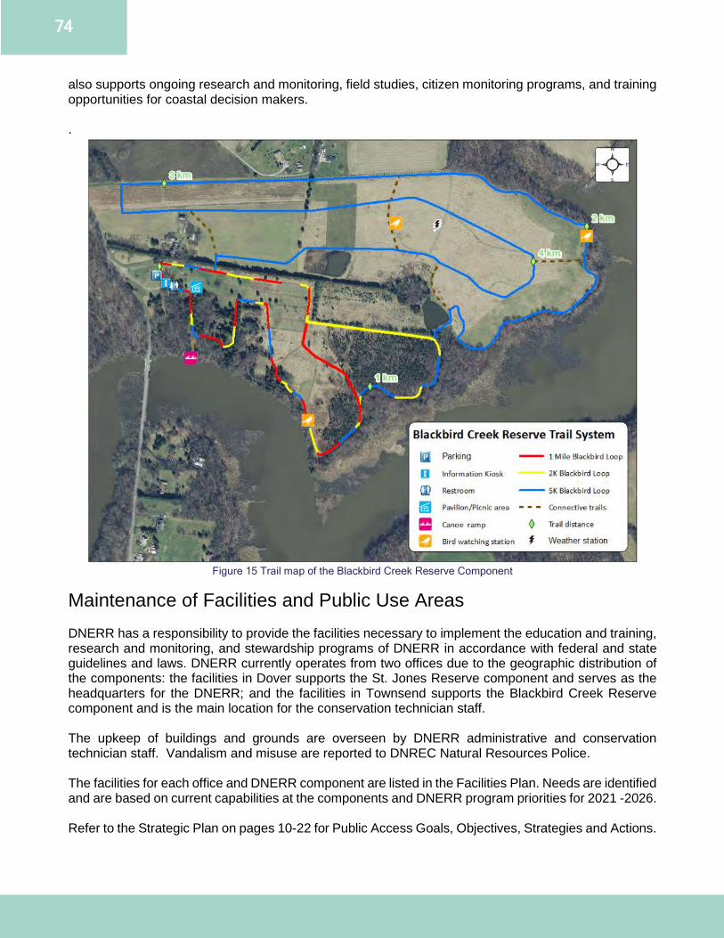
74
also supports ongoing research and monitoring, field studies, citizen monitoring programs, and training opportunities for coastal decision makers. .
Figure 15 Trail map of the Blackbird Creek Reserve Component
Maintenance of Facilities and Public Use Areas DNERR has a responsibility to provide the facilities necessary to implement the education and training, research and monitoring, and stewardship programs of DNERR in accordance with federal and state guidelines and laws. DNERR currently operates from two offices due to the geographic distribution of the components: the facilities in Dover supports the St. Jones Reserve component and serves as the headquarters for the DNERR; and the facilities in Townsend supports the Blackbird Creek Reserve component and is the main location for the conservation technician staff. The upkeep of buildings and grounds are overseen by DNERR administrative and conservation technician staff. Vandalism and misuse are reported to DNREC Natural Resources Police. The facilities for each office and DNERR component are listed in the Facilities Plan. Needs are identified and are based on current capabilities at the components and DNERR program priorities for 2021 -2026. Refer to the Strategic Plan on pages 10-22 for Public Access Goals, Objectives, Strategies and Actions.
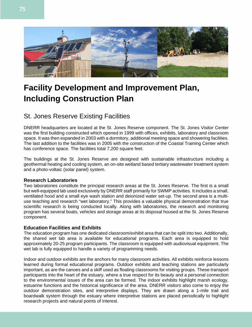
75
Facility Development and Improvement Plan, Including Construction Plan St. Jones Reserve Existing Facilities DNERR headquarters are located at the St. Jones Reserve component. The St. Jones Visitor Center was the first building constructed which opened in 1999 with offices, exhibits, laboratory and classroom space. It was then expanded in 2003 with a dormitory, additional meeting space and showering facilities. The last addition to the facilities was in 2005 with the construction of the Coastal Training Center which has conference space. The facilities total 7,200 square feet. The buildings at the St. Jones Reserve are designed with sustainable infrastructure including a geothermal heating and cooling system, an on-site wetland based tertiary wastewater treatment system and a photo-voltaic (solar panel) system. Research Laboratories Two laboratories constitute the principal research areas at the St. Jones Reserve. The first is a small but well-equipped lab used exclusively by DNERR staff primarily for SWMP activities. It includes a small, ventilated hood and a small eye wash station and deionized water set-up. The second area is a multi-use teaching and research “wet laboratory.” This provides a valuable physical demonstration that true scientific research is being conducted locally. Along with laboratories, the research and monitoring program has several boats, vehicles and storage areas at its disposal housed at the St. Jones Reserve component. Education Facilities and Exhibits The education program has one dedicated classroom/exhibit area that can be split into two. Additionally, the shared wet lab area is available for educational programs. Each area is equipped to hold approximately 20-25 program participants. The classroom is equipped with audiovisual equipment. The wet lab is fully equipped to handle a variety of programming needs. Indoor and outdoor exhibits are the anchors for many classroom activities. All exhibits reinforce lessons learned during formal educational programs. Outdoor exhibits and teaching stations are particularly important, as are the canoes and a skiff used as floating classrooms for visiting groups. These transport participants into the heart of the estuary, where a true respect for its beauty and a personal connection to the environmental issues of the area can be formed. The indoor exhibits highlight marsh ecology, estuarine functions and the historical significance of the area. DNERR visitors also come to enjoy the outdoor demonstration sites, and interpretive displays. They are drawn along a 1-mile trail and boardwalk system through the estuary where interpretive stations are placed periodically to highlight research projects and natural points of interest.
76
Dormitory Four dormitory rooms were built onto the main building at the St. Jones Reserve in 2003. The rooms are in great demand for visiting researchers, educators, and volunteers such as interns and AmeriCorps National Civilian Community Corps teams especially during peak field season. The rooms are designed to accommodate up to 16 people. Currently there are sufficient beds for 10 people. There are full bathrooms with showers available as well as a washer and dryer for those staying in the dormitory rooms. A kitchen is shared with DNERR staff. DNERR will continue to monitor demand for the rooms and space. Currently, a living or break room style area is needed to accommodate multi-month residents - such as summer interns or visiting researchers. Conference Facilities The Coastal Training Center was constructed in 2005 and has a conference room with a capacity for 75 people seated at tables. Audiovisual equipment is provided to support meetings and offers an expanded exhibit area in the foyer. The conference room has proven to be an invaluable tool in drawing groups to visit DNERR, thus accomplishing the goal of making DNERR a place where discussions and exchanges of ideas happen regularly among members of the environmental community. Improved and updated audiovisual equipment and a catering kitchen would enhance the use of the facility. Trail/Boardwalk Within the St. Jones Reserve component, there is a 1-mile trail through the estuary. This trail links up with other state property managed by FW and provides access to the Delaware Bay for a total one-way distance of approximately 5 miles. The trail begins with a quarter mile raised boardwalk over the marsh with several interpretive stations. There are also several areas where the boardwalk is lowered to allow up-close access to the marsh. The trail then follows a narrow corridor bordering farm fields and marsh, allowing visitors to see prime examples of runoff potential and habitat encroachment. Expanded trail systems with JDP and FW are anticipated to enhance DNERR visitor experience and provide additional research opportunities. Native Plant Nursery The native plant nursery is along the trailhead and includes interpretive signage that promotes the use of native plants to DNERR visitors and program participants. DNERR purchases native tree seedlings and with the help of volunteers holds an annual tree-potting event. The seedlings are then housed in the native plant nursery for 1-2 years before being planted in reforestation areas, again with volunteer assistance. This gives the young trees an increased success rate when transplanted. Maintenance Shop A maintenance shop and bull pen are located on the St. Jones Reserve component and is where equipment, vehicles and boats are stored for facility and land management. St. Jones Reserve Identified Future Facility Needs An identified need for all facilities is to conduct an energy efficiency audit of the systems and implement upgrades wherever feasible. The 2014 DNERR Climate Adaptation Plan (Appendix A) will be implemented in upgrades to incorporate climate change and sea level rise scenarios. Creating a plan to relocate infrastructures such as trails, boardwalks, parking areas and vehicle storage may need to be considered based on predictive models. Additionally, all facilities and infrastructure need a resiliency and disaster preparedness audit and plan. Exhibit and Education Needs and Renovations New and revised outdoor wayside interpretive signage (Estimated Cost: $20,000) On the St. Jones Reserve trail and around the facility, interpretive signs need updates, revisions and new locations. The new trail signage will provide for both resource protection and recreational use of the reserve in addition to highlighting the cultural heritage of the estuary. The new signage to be installed
77
around the facility will also highlight green building construction techniques at DNERR including photovoltaic panels; tertiary wetland wastewater treatment system; geothermal; rain gardens; etc. Outdoor educational locations (Estimated Cost: $75,000) The state requirement for entire school grades to attend field trips has led to the need to host more students at a time. Outdoor educational spaces such as screened in pavilion, nature play areas and amphitheater would greatly increase the number of DNERR visitors and students served. Additionally, it would reduce the amount of competing use in the wet lab with research, and in the main educational exhibits with everyday visitors. Trail improvements Expansion/Connection with the DHCA: JDP and FW: Ted Harvey Conservation Area (Estimated Cost: $250,000) The expansion of the St. Jones Reserve trail and signage to connect the adjacent properties would address goals identified by the St. Jones Greenway, Route 9 Coastal Heritage Byway and the Delaware Bayshore Initiative as well as provide an enhanced visitor experience. Facility Improvements Expansion of Photovoltaic System (Estimated Cost: $110,000) In 2007, photovoltaic system was installed on the roof of the Coastal Training Center at the St. Jones Reserve. The expansion of the system will utilize all appropriate space available on the roof of the Visitor Center to further increase DNERR’s use of renewable energy. Pervious Pavers Demonstration Project (Estimated Cost: $50,000) This project proposes to utilize the St. Jones Reserve as a demonstration site for pervious pavers on the walkways leading to the Visitor Center and the sidewalk leading to the Coastal Training Center. Pervious paving systems are used for the purpose of reducing surface runoff and increasing infiltration when compared to traditional sidewalks, patios, walkways and parking areas. Access Improvements (Estimated Cost: $150,000) Improvements are necessary to DNERR facilities for the safety and security of public users and staff. Options include, but are not limited to, keyless entry system, real-time streaming video conferencing, security cameras and improved exterior lighting. Conference Facility AV Improvements (Estimated Cost: $75,000) The conference facility needs built-in audio-visual equipment. Currently the use of laptops, projector and plug in speakers has limited function and use. An overhead projector/smart board, surround sound, and sound damping panels are needed to enhance the use of the facility for meetings. Conference Facility Kitchen Renovation (Estimated Cost: $35,000) The current kitchen is sufficient for drop off meals, with disposable flatware and dishes. Ideally the kitchen would be renovated into a catering kitchen and include a stovetop, and a dishwasher that would allow for the use of reusable dishware per public health guidelines. Dormitories and Laboratory Facilities (Estimated Cost: $250,000) Improvements to the dormitories and research laboratories will be implemented as funding allows to accommodate increasing needs for researcher and educator dormitory and support facilities. The laboratories could be further improved to increase research activities for DNERR staff and capacity to support visiting researchers. This includes installing additional hood space and a deionized water set-up in the wet lab, updated eye wash stations, industrial ice maker, an additional freezer and storage space. Additional features which would increase visiting researcher capacity could include a visiting research desk or office space, gas cylinder storage and benchtop space for equipment such as spectrophotometers. The wet lab is a shared space, so additions and new features should be coordinated with education and research staff to ensure there are no competing uses.
78
Equipment, Vehicle and Boat Storage (Estimated Cost: $50,000) There is a need to expand the shop and bull pen that can serve as a secure place for vehicles and equipment to be stored out of the elements, reducing the need for maintenance and increasing the useful years of service of these vehicles. Existing Equipment The St. Jones Reserve site is well equipped for programs offered. Laptop computers, iPads and projectors are available for presentations. A copier/color printer is available to create handouts for programs. A variety of field test kits and microscopes are available for programming. DNERR has the use of several boats including: 24ft Carolina skiff, small skiff, Jon Boat, SeaArk and has use of a larger bay boat. DNERR owns a 2005 Dodge Durango and also has a Fleet leased 2016 Chevrolet Tahoe. Lawnmowers, tractors, trailers and accessories are used for land management. Identified Future Equipment Needs Furniture (Estimated Cost $15,000) Coastal Training Center tables and chairs Office desks and chairs for visiting researchers and interns Blackbird Creek Reserve Existing Facilities Blackbird Creek Reserve boasts 4.5 miles of trails through uplands and along the marsh, a canoe/kayak launch, restoration demonstration areas as well as a Stewardship Center that includes meeting rooms, laboratory, offices and a shop. Meeting rooms There are 2 meeting rooms at the Blackbird Creek Stewardship Center. One meeting room can hold up to 30 people sitting at tables and the other can seat 12 people around a conference table. Research Laboratory A small suitable lab is used exclusively by DNERR staff. Along with the laboratory, the research and monitoring program has shared use of canoes, kayaks, vehicles and storage areas. Interpretive Trail There are 4.5miles of connected trails at Blackbird Creek Reserve, with the options of a one mile, 2K or 5K loop. Interpretive signage exists in many locations highlighting native species, restoration projects and field stations. The trailhead offers a parking area with a portable toilet facility. Canoe/Kayak Launch DNERR established a canoe and kayak launching area onsite to provide direct access to the Blackbird Creek. It’s located a short walk from the trailhead parking area and offers an up-close view of a living-shoreline demonstration site. Maintenance Shop A maintenance shop pole barn is located on the Blackbird Creek Reserve and stores equipment for facility and land management. Equipment and tools are shared between the St. Jones and Blackbird Creek Reserve components.
79
Blackbird Creek Reserve Identified Future Facility Needs Exhibits Stewardship Center (Estimated Cost $20,000) This will include interpretive panels within the lobby and meeting area of the Stewardship Center. Outdoor wayside interpretive signage (Estimated Cost $40,000) On the Blackbird Creek Reserve trails and around the facility new interpretive signage needs to be erected. The new trail signage will provide for both resource protection and recreational use of the reserve. Trail improvements Expansion/connection between DNERR managed parcels (Estimated Cost $120,000) The connection of trails would enhance public access. Composting toilets (Estimated Cost $50,000) There is a need to build a composting toilet structure to allow for enhanced visitor and educational experiences. Existing Equipment The Blackbird Creek Reserve is equipped for programs offered. Laptop computers and projectors are available for presentations. A copier/color printer is available to create handouts for programs. DNERR has the use of canoes and kayaks for education, training, and research programs. DNERR also has a FLEET leased 2019 F250 pickup truck. Lawnmowers, tractors, trailers and tools are available for land management. Identified Future Equipment Needs Enclosed utility vehicle (Estimated Cost $20,000) The management of DNERR land is a year-round task. This includes snow removal from trails and sidewalks, and maintenance during hot buggy marsh conditions. The addition of an enclosed utility vehicle would enable conservation technician staff to complete work tasks to enable visitor comfort and safety year-round and minimize environmental hazards. Construction Plan All construction activities will be completed under the guidance of the following principles to ensure DNERR meets its guiding principle of promoting good environmental stewardship and to meet the NERRS Sustainable Design Guidelines. Additionally, guidelines from the 2014 DNERR Climate Adaptation Plan (Appendix A) will be utilized during construction.
● Facilities and access routes will create minimum visual or environmental impacts both within and beyond the component boundaries.
● Facilities will be designed and located to support multiple DNERR goals to the greatest extent possible.
● Planning for significant new facilities will solicit input from representatives of user groups or those to be affected by the facilities.
● Facilities construction and equipment shall strive for energy efficiency, incorporate green building materials and techniques and anticipate technological advances.
Refer to the Strategic Plan on pages 10-22 for Facility Goals, Objectives, Strategies and Actions.
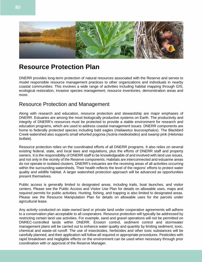
80
Resource Protection Plan DNERR provides long-term protection of natural resources associated with the Reserve and serves to model responsible resource management practices to other organizations and individuals in nearby coastal communities. This involves a wide range of activities including habitat mapping through GIS, ecological restoration, invasive species management, resource inventories, demonstration areas and more. Resource Protection and Management Along with research and education, resource protection and stewardship are major emphases of DNERR. Estuaries are among the most biologically productive systems on Earth. The productivity and integrity of DNERR’s resources must be protected to provide a stable environment for research and education programs, which are used to address coastal management issues. DNERR components are home to federally protected species including bald eagles (Haliaeetus leucocephalus). The Blackbird Creek watershed also supports small whorled pogonia (Isotria medeoloides) and swamp pink (Helonias bullata). Resource protection relies on the coordinated efforts of all DNERR programs. It also relies on several existing federal, state, and local laws and regulations, plus the efforts of DNERR staff and property owners. It is the responsibility of DNERR staff to be knowledgeable of and involved with land use issues, and not only in the vicinity of the Reserve components. Habitats are interconnected and estuarine areas do not operate in isolated clusters. DNERR’s estuaries are the receiving areas of all activities occurring within the surrounding watersheds. Their health reflects the level of the regions’ efforts to protect water quality and wildlife habitat. A larger watershed protection approach will be advanced as opportunities present themselves. Public access is generally limited to designated areas, including trails, boat launches, and visitor centers. Please see the Public Access and Visitor Use Plan for details on allowable uses, maps and required permits for public activities. Hunting, fishing, and trapping is also limited to designated areas. Please see the Resource Manipulation Plan for details on allowable uses for the parcels under agricultural lease. Any activity conducted on state-owned land or private land under cooperative agreements will adhere to a conservation plan acceptable to all cooperators. Resource protection will typically be addressed by restricting certain land use activities. For example, sand and gravel operations will not be permitted on DNREC-controlled lands within DNERR. Erosion control, sediment control and stormwater management plans will be carried out to enhance water quality and quantity by limiting sediment, toxic, chemical and waste-oil runoff. The use of insecticides, herbicides and other toxic substances will be carefully planned, and their application will follow all required or appropriate procedures. Pesticides with rapid breakdown and negligible effects on the environment can be used when necessary through prior coordination with or approval of the Reserve Manager.
81
DNERR staff will encourage any activities outside of and adjacent to DNERR managed lands to be compatible with resource protection and conservation. Activities such as development, infrastructure concerns and any land-disturbing action that occurs upstream from the DNERR or any of its tributaries may be monitored. Research proposals and education programs will undergo a review for impacts on resource protection by the appropriate agency, advisory committee or DNERR staff. The type and scope of any project will be weighed against the need to maintain critical natural and cultural resources. Research is a key use of DNERR and is given a high priority in the management plan. Interference from research activities can disrupt DNERR’s efforts to achieve effective long-term management goals of the estuarine systems. DNERR staff will monitor research sites and will post signs identifying these sites. Except for samples taken for approved research and education programs, and fish and game taken from designated fishing, hunting, or trapping areas, nothing may be removed without prior approval of the Reserve Manager. Plants, animals, minerals, cultural resources or any parts of these must remain to protect the integrity of DNERR. While some resource protection challenges have been detailed in the Threats and Stressors section as well as the Stewardship Plan, resource protection on DNERR managed lands can provide unique challenges since land that falls within the Reserve boundaries is often privately owned. While the privately owned core areas that are within the boundaries of DNERR have protections through the State Wetlands Act, what happens “upstream” or “upland” on private land does not always stay there. This is true for a watershed in general. As noted previously - the estuary at St. Jones has a large city and a military base upstream, which impacts the entire component. On the other hand, Blackbird Creek Reserve has much more protected and undeveloped land upstream - leading to a more ecologically sound estuary. Additionally, DNERR boundaries fall under several different and sometimes overlapping jurisdictions of local and state agencies, coordination and cooperation among all authorities is essential. Some of the state and local regulations directly affecting DNERR are listed in the Laws and Regulations section. DNERR staff coordinate resource protection activities with the appropriate regulatory authorities and other agencies to ensure all state and local permits are completed and approved as necessary. Existing surveillance and enforcement are primarily handled directly by DNERR during business hours, and through DNREC Natural Resources Police after hours or if issues are beyond the scope of DNERR capacity. Local police units patrol the St. Jones Reserve access lane and respond to security alarms at the St. Jones and Blackbird Creek Reserves. Laws and Regulations – Legal Authorities The state exercises direct management control of the designated lands through ownership, conservation easement or legislative authority including the State Wetlands Act (7 Del. C. Chapter 66), Delaware Coastal Zone Act of 1971 (7 Del. C. Chapter 70), Subaqueous Lands Act, (7 Del. C. Chapter 72), Delaware Antiquities Act (7 Del. C. Chapter 53), The 1978 Natural Areas Preservation System Act (7 Del. C. Chapter 73), Conservation easement (7 Del. C. Chapter 69), Erosion and Sedimentation Control and Stormwater Management (7 Del. C. Chapter 40), Sediment and Stormwater Regulations, Endangered Species Act, (7 Del. C. Chapter 6), Wildlife and Fish Management (7 Del. C. Chapters 1-27), Hunting and Fishing Regulations, Environmental Protection Act (7 Del. C. Chapter 60), Land Use and Zoning Restrictions – New Castle County, Kent County, Public Lands, and State Parks (9 Del. C. Chapter 26, Chapter 30, Chapter 48, Chapter 49) (7 Del. C. Chapter 45, Chapter 47) and Surface Water Quality Standards (7 Del. C. Chapter 60). (Appendix I) At the time of Reserve designation all private landowners were informed that a portion of their property was to be included in the DNERR buffer boundaries. The State Wetlands Act is the primary protection
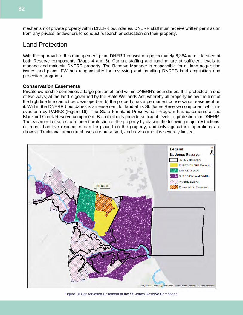
82
mechanism of private property within DNERR boundaries. DNERR staff must receive written permission from any private landowners to conduct research or education on their property. Land Protection With the approval of this management plan, DNERR consist of approximately 6,364 acres, located at both Reserve components (Maps 4 and 5). Current staffing and funding are at sufficient levels to manage and maintain DNERR property. The Reserve Manager is responsible for all land acquisition issues and plans. FW has responsibility for reviewing and handling DNREC land acquisition and protection programs. Conservation Easements Private ownership comprises a large portion of land within DNERR’s boundaries. It is protected in one of two ways; a) the land is governed by the State Wetlands Act, whereby all property below the limit of the high tide line cannot be developed or, b) the property has a permanent conservation easement on it. Within the DNERR boundaries is an easement for land at its St. Jones Reserve component which is overseen by PARKS (Figure 16). The State Farmland Preservation Program has easements at the Blackbird Creek Reserve component. Both methods provide sufficient levels of protection for DNERR. The easement ensures permanent protection of the property by placing the following major restrictions: no more than five residences can be placed on the property, and only agricultural operations are allowed. Traditional agricultural uses are preserved, and development is severely limited.
Figure 16 Conservation Easement at the St. Jones Reserve Component
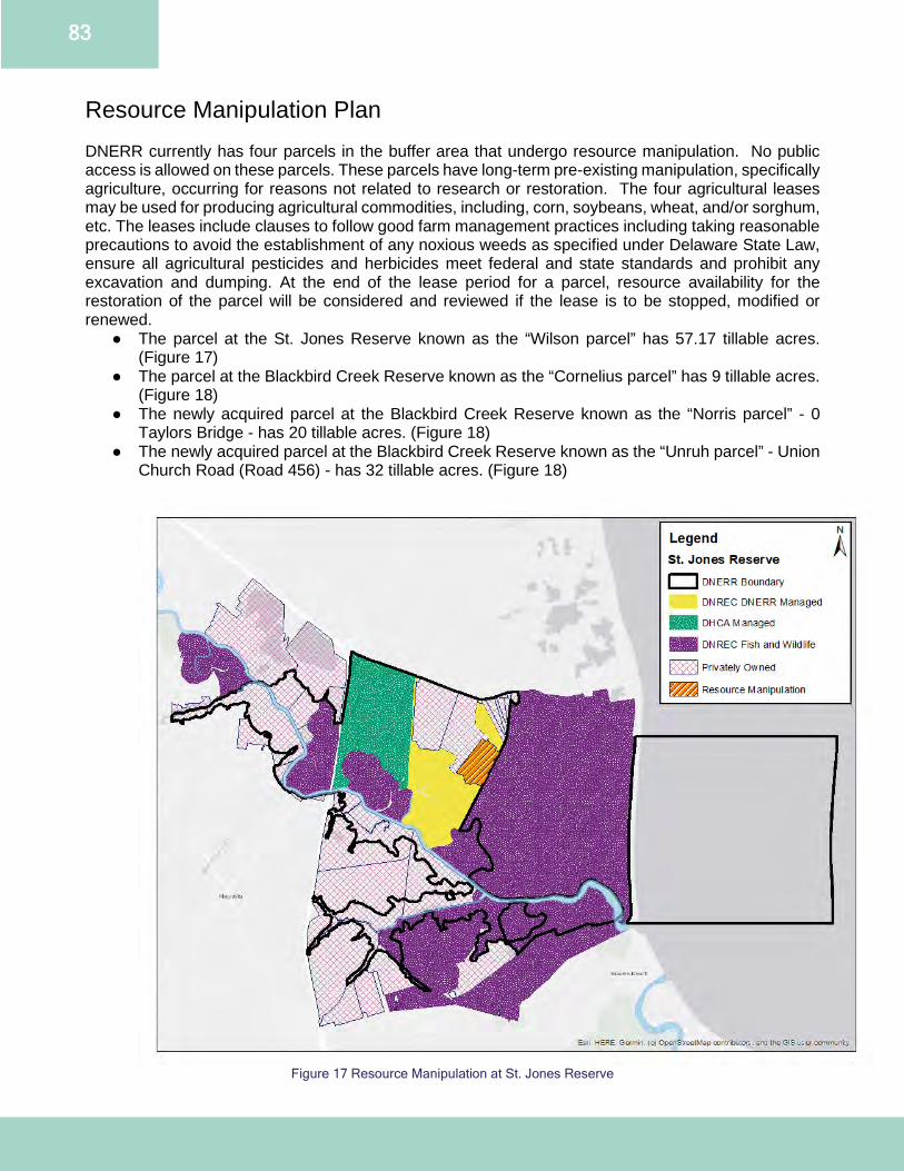
83
Resource Manipulation Plan DNERR currently has four parcels in the buffer area that undergo resource manipulation. No public access is allowed on these parcels. These parcels have long-term pre-existing manipulation, specifically agriculture, occurring for reasons not related to research or restoration. The four agricultural leases may be used for producing agricultural commodities, including, corn, soybeans, wheat, and/or sorghum, etc. The leases include clauses to follow good farm management practices including taking reasonable precautions to avoid the establishment of any noxious weeds as specified under Delaware State Law, ensure all agricultural pesticides and herbicides meet federal and state standards and prohibit any excavation and dumping. At the end of the lease period for a parcel, resource availability for the restoration of the parcel will be considered and reviewed if the lease is to be stopped, modified or renewed.
● The parcel at the St. Jones Reserve known as the “Wilson parcel” has 57.17 tillable acres. (Figure 17)
● The parcel at the Blackbird Creek Reserve known as the “Cornelius parcel” has 9 tillable acres. (Figure 18)
● The newly acquired parcel at the Blackbird Creek Reserve known as the “Norris parcel” - 0 Taylors Bridge - has 20 tillable acres. (Figure 18)
● The newly acquired parcel at the Blackbird Creek Reserve known as the “Unruh parcel” - Union Church Road (Road 456) - has 32 tillable acres. (Figure 18)
Figure 17 Resource Manipulation at St. Jones Reserve
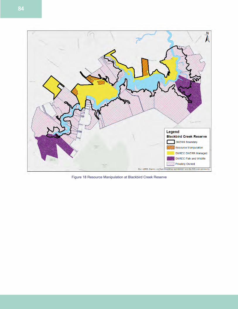
84
Figure 18 Resource Manipulation at Blackbird Creek Reserve
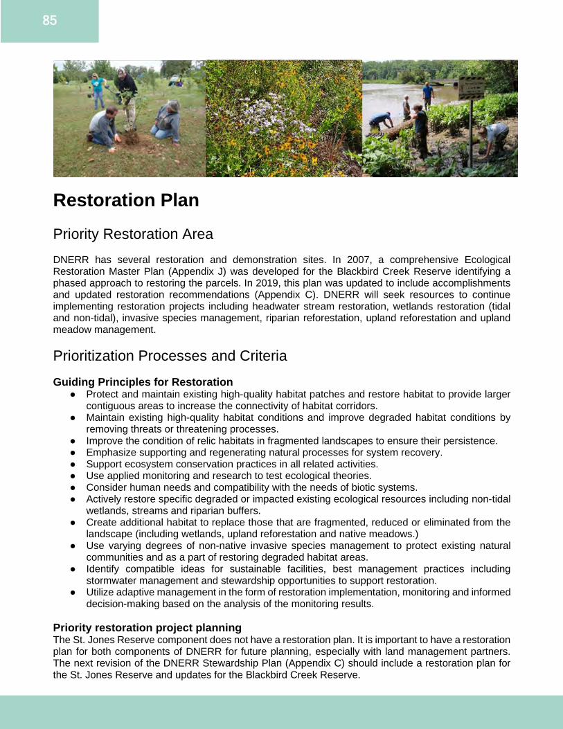
85
Restoration Plan Priority Restoration Area DNERR has several restoration and demonstration sites. In 2007, a comprehensive Ecological Restoration Master Plan (Appendix J) was developed for the Blackbird Creek Reserve identifying a phased approach to restoring the parcels. In 2019, this plan was updated to include accomplishments and updated restoration recommendations (Appendix C). DNERR will seek resources to continue implementing restoration projects including headwater stream restoration, wetlands restoration (tidal and non-tidal), invasive species management, riparian reforestation, upland reforestation and upland meadow management. Prioritization Processes and Criteria Guiding Principles for Restoration
● Protect and maintain existing high-quality habitat patches and restore habitat to provide larger contiguous areas to increase the connectivity of habitat corridors.
● Maintain existing high-quality habitat conditions and improve degraded habitat conditions by removing threats or threatening processes.
● Improve the condition of relic habitats in fragmented landscapes to ensure their persistence. ● Emphasize supporting and regenerating natural processes for system recovery. ● Support ecosystem conservation practices in all related activities. ● Use applied monitoring and research to test ecological theories. ● Consider human needs and compatibility with the needs of biotic systems. ● Actively restore specific degraded or impacted existing ecological resources including non-tidal
wetlands, streams and riparian buffers. ● Create additional habitat to replace those that are fragmented, reduced or eliminated from the
landscape (including wetlands, upland reforestation and native meadows.) ● Use varying degrees of non-native invasive species management to protect existing natural
communities and as a part of restoring degraded habitat areas. ● Identify compatible ideas for sustainable facilities, best management practices including
stormwater management and stewardship opportunities to support restoration. ● Utilize adaptive management in the form of restoration implementation, monitoring and informed
decision-making based on the analysis of the monitoring results. Priority restoration project planning The St. Jones Reserve component does not have a restoration plan. It is important to have a restoration plan for both components of DNERR for future planning, especially with land management partners. The next revision of the DNERR Stewardship Plan (Appendix C) should include a restoration plan for the St. Jones Reserve and updates for the Blackbird Creek Reserve.
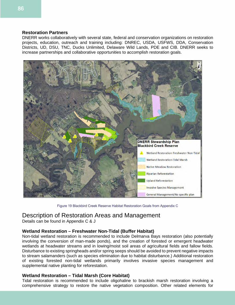
86
Restoration Partners DNERR works collaboratively with several state, federal and conservation organizations on restoration projects, education, outreach and training including: DNREC, USDA, USFWS, DDA, Conservation Districts, UD, DSU, TNC, Ducks Unlimited, Delaware Wild Lands, PDE and CIB. DNERR seeks to increase partnerships and collaborative opportunities to accomplish restoration goals.
Figure 19 Blackbird Creek Reserve Habitat Restoration Goals from Appendix C
Description of Restoration Areas and Management Details can be found in Appendix C & J Wetland Restoration – Freshwater Non-Tidal (Buffer Habitat) Non-tidal wetland restoration is recommended to include Delmarva Bays restoration (also potentially involving the conversion of man-made ponds), and the creation of forested or emergent headwater wetlands at headwater streams and in lowing/moist soil areas of agricultural fields and fallow fields. Disturbance to existing springheads and/or spring seeps should be avoided to prevent negative impacts to stream salamanders (such as species elimination due to habitat disturbance.) Additional restoration of existing forested non-tidal wetlands primarily involves invasive species management and supplemental native planting for reforestation. Wetland Restoration – Tidal Marsh (Core Habitat) Tidal restoration is recommended to include oligohaline to brackish marsh restoration involving a comprehensive strategy to restore the native vegetation composition. Other related elements for
87
wetland system restoration include addressing sea level rise and marsh subsidence in a localized, long-term research and monitoring plan. Short-term efforts should focus on the control of non-native invasive common reed (Phragmites australis), where it is encroaching into other native species dominated marshes. Other possible tidal wetland restoration measures can include sediment dredging and raising marsh surfaces or passive material structures (logs and rock sills) and waterfowl exclusion. Native Meadow Restoration (Buffer Habitat) Upland native meadow restoration is recommended for a large portion of the fallow fields of the Blackbird Creek Reserve. This habitat type will add to the diversity and mosaic of habitats without compromising the intended riparian buffers, wetland restoration or upland reforestation efforts. Native meadow will provide habitat for some niche species including insects, small mammals, non-area-sensitive grassland birds, reptiles and amphibians. Native meadow restoration approaches will include non-persistent, targeted herbicide treatment of cool season grasses and weeds followed by drilling seeding native warm season grasses and wildflowers. Other options include allowing natural succession and monitoring weeds or plant invasion potential and treating with herbicides, strategic time of year mowing, or controlled cool season burns. In the late summer, strategic mowing will be restricted to the hottest and driest times of the day and avoided in the morning when any fields may be shaded or when soil moisture is high after heavy rains and will use a mower height of no lower than 6 inches. Riparian Restoration (Buffer and Core Habitats) Riparian buffer restoration is recommended for the Blackbird Creek mainstem and all the stream tributaries on DNERR managed buffer (from upland to wetlands) and core (wetlands to water’s edge). Buffer restoration is recommended using native reforestation plantings and natural succession management where the existing buffer is non-existent, inadequate in width or poorly structured. For mesic to dry hardwood forest types, an expanded forested buffer is generally recommended with the potential for minor inclusions of scrub-shrub or limited patches of native coastal plain meadow. Riparian restoration efforts will be integrated with invasive management measures. DNERR will continue the process of mowing areas around recently planted trees to increase the survival rate. As needed, staff will reevaluate and plant trees to fill areas where wildlife or seasonal weather have destroyed plantings. After the trees have become established, natural succession for woodland recruitment will be maintained. Upland Reforestation (Buffer Habitat) Upland reforestation is recommended in addition to the recommendations for riparian buffer restoration. This reforestation is recommended specifically to extend existing blocks of upland forest and to add further buffer area to anticipated wetland restoration and coastal pond creation areas. Reforestation approaches will include various techniques including natural succession management, planting various propagules (seeds, tubelings, bare root plants, container-grown nursery stock) and soil amendments. Reforestation efforts will be integrated with invasive management measures. The goal of the strategic upland reforestation is to create a wildlife corridor to minimize habitat fragmentation and provide safe passage within the Blackbird Creek Reserve. Invasive Species Management (Buffer and Core Habitat) Invasive species management is needed for all habitat types in core or buffer areas. Not all invasive species management efforts involve active invasive species treatment, removal and control. Invasive species management includes baseline assessment, monitoring, active control, passive control and combining invasive species management with other types of projects, such as stream restoration, wetland restoration, and reforestation. Priority non-native invasive species for control are Kudzu (Pueraria montana), Canada thistle (Cirsium arvense), multiflora rose (Rosa multiflora) and Parrot’s-feather-water-milfoil (Myriophyllum aquaticum). Common reed (Phragmites australis) needs to be addressed in a comprehensive long-term fashion, rather than attempts at short term total eradication, due to its homogenous occurrence. Further species control techniques include stem/stump cut herbicide (non-persistent) treatments, physical manual removal, soil amendments, hydrology manipulation, controlled burning and native plantings.
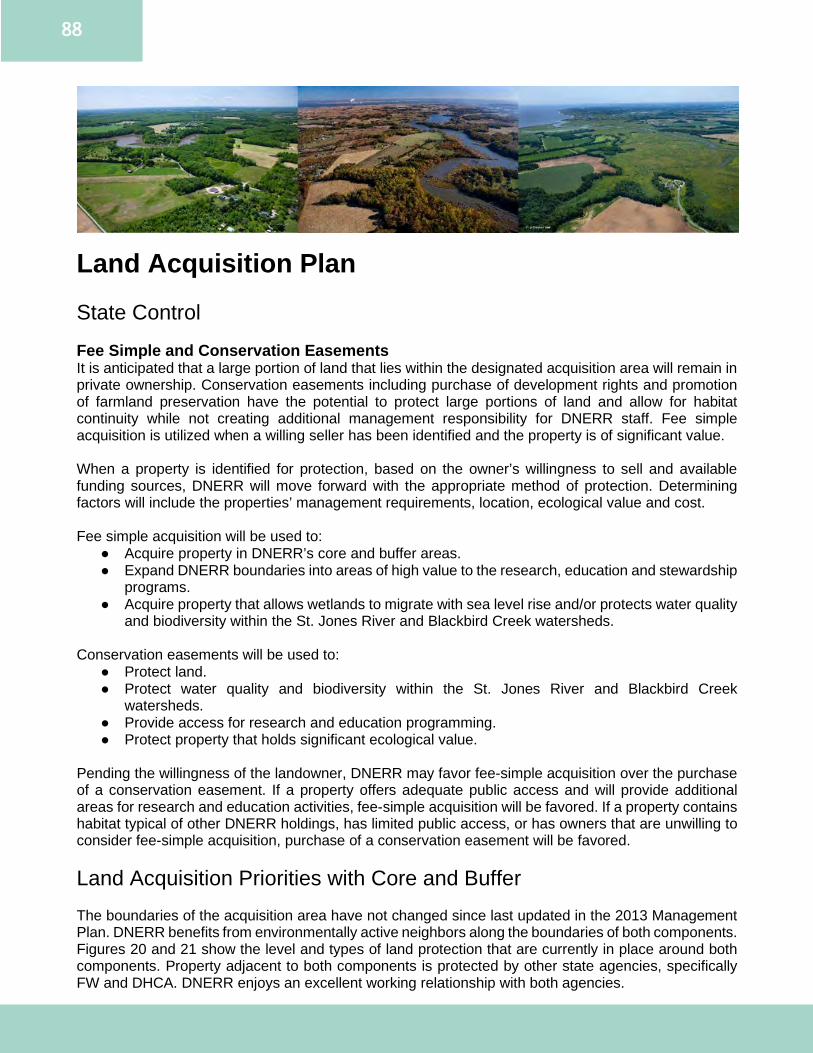
88
Land Acquisition Plan State Control Fee Simple and Conservation Easements It is anticipated that a large portion of land that lies within the designated acquisition area will remain in private ownership. Conservation easements including purchase of development rights and promotion of farmland preservation have the potential to protect large portions of land and allow for habitat continuity while not creating additional management responsibility for DNERR staff. Fee simple acquisition is utilized when a willing seller has been identified and the property is of significant value. When a property is identified for protection, based on the owner’s willingness to sell and available funding sources, DNERR will move forward with the appropriate method of protection. Determining factors will include the properties’ management requirements, location, ecological value and cost. Fee simple acquisition will be used to:
● Acquire property in DNERR’s core and buffer areas. ● Expand DNERR boundaries into areas of high value to the research, education and stewardship
programs. ● Acquire property that allows wetlands to migrate with sea level rise and/or protects water quality
and biodiversity within the St. Jones River and Blackbird Creek watersheds. Conservation easements will be used to:
● Protect land. ● Protect water quality and biodiversity within the St. Jones River and Blackbird Creek
watersheds. ● Provide access for research and education programming. ● Protect property that holds significant ecological value.
Pending the willingness of the landowner, DNERR may favor fee-simple acquisition over the purchase of a conservation easement. If a property offers adequate public access and will provide additional areas for research and education activities, fee-simple acquisition will be favored. If a property contains habitat typical of other DNERR holdings, has limited public access, or has owners that are unwilling to consider fee-simple acquisition, purchase of a conservation easement will be favored. Land Acquisition Priorities with Core and Buffer The boundaries of the acquisition area have not changed since last updated in the 2013 Management Plan. DNERR benefits from environmentally active neighbors along the boundaries of both components. Figures 20 and 21 show the level and types of land protection that are currently in place around both components. Property adjacent to both components is protected by other state agencies, specifically FW and DHCA. DNERR enjoys an excellent working relationship with both agencies.
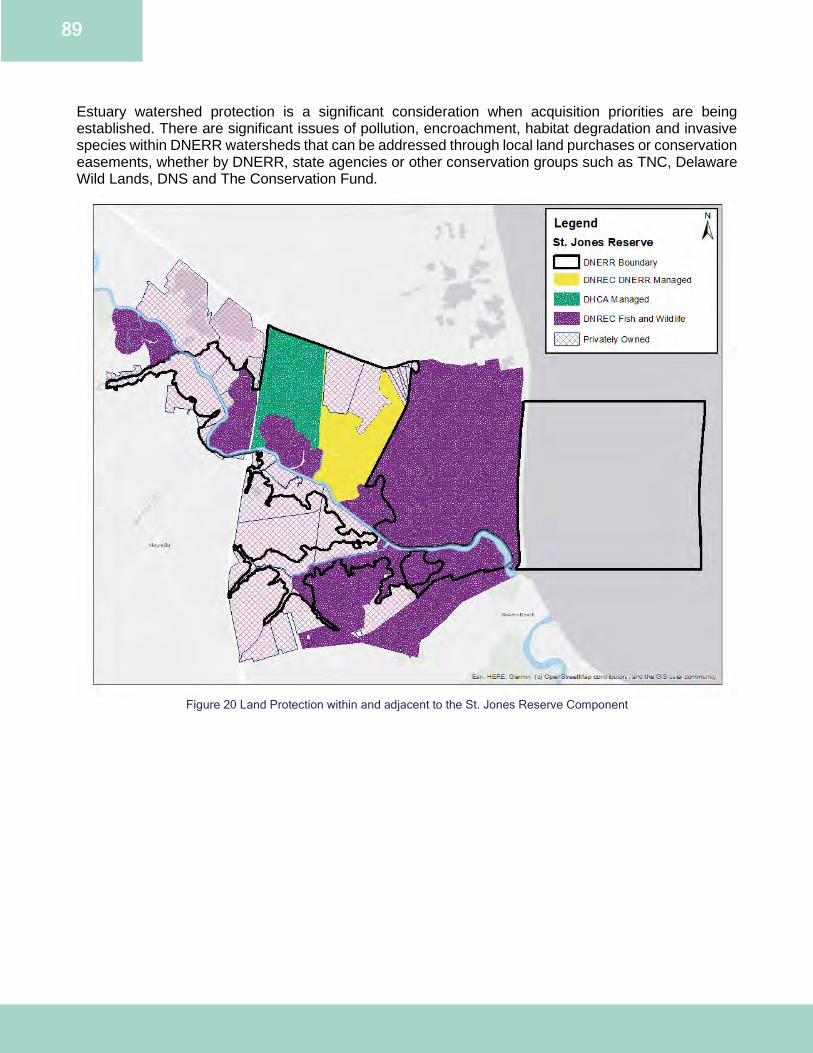
89
Estuary watershed protection is a significant consideration when acquisition priorities are being established. There are significant issues of pollution, encroachment, habitat degradation and invasive species within DNERR watersheds that can be addressed through local land purchases or conservation easements, whether by DNERR, state agencies or other conservation groups such as TNC, Delaware Wild Lands, DNS and The Conservation Fund.
Figure 20 Land Protection within and adjacent to the St. Jones Reserve Component
90
Figure 21 Land Protection within and adjacent to the Blackbird Creek Reserve Component
Each DNERR Reserve component has a defined acquisition area. Figures 22 and 23 reflect the priority areas for land acquisition within the core and buffer areas. The acquisition maps reflect currently protected areas and the areas that DNERR is interested in acquiring properties, easements or facilitating protection by other public and private groups. Any designated areas that are not held in state ownership or are otherwise protected are also included as priority acquisition areas. The identified areas allow DNERR to focus on properties that border the current boundaries, but also on properties that will ensure the continued environmental quality of the surrounding watersheds. The priority for land acquisition is the fee simple purchase or conservation easement purchase of any remaining properties held in private ownership that are in the designated boundaries. Secondary priority will be given to any properties that are contiguous to the DNERR boundaries. St. Jones Reserve Land acquisition/protection in the designated areas of the St. Jones Reserve has been very successful with the efforts of FW and DHCA. The property acquisitions by these agencies have established a large corridor of protected land of which DNERR is a significant component. Core area acquisition is the primary focus in the St. Jones Reserve. Within the core area, special emphasis is placed on land that adjoins the current DNERR boundaries or borders the St. Jones River. Expanding into these areas will allow for greater research, educational and stewardship opportunities as well as provide space for future building expansions if they become necessary.
91
DNERR will be focusing on land located on the southern side as well as upstream portions of the St. Jones River. Acquisition priorities for the St. Jones Reserve are properties:
● located within DNERR core and buffer areas; ● that lie along the St. Jones River, and; ● that will enhance resiliency, preserve or restore ecological function to the St. Jones River.
Blackbird Creek Reserve The Blackbird Creek Reserve consists mostly of privately owned properties protected through easement or state regulation. In particular, large portions of the privately held sections of core and buffer areas of the Blackbird Creek Reserve are protected under Delaware Department of Agriculture’s Farmland Preservation Program. Landowners who place their lands into farmland preservation agree to not develop their lands for at least 10 years, devoting the land only to agriculture and related uses. In return, the owners receive tax benefits, right-to-farm protection, and an opportunity to sell a preservation easement to the state that keeps the land free from development. The farming community in the Blackbird Creek watershed was a driving force in establishing this state administered program and strong support for it still exists. The location of the Blackbird Creek Reserve in relation to the growing development pressure in the area demands that land protection activities by DNERR focus largely on the Blackbird Creek Reserve component. Acquisition priorities for the Blackbird Creek Reserve are properties:
● located within DNERR core and buffer areas; ● that will grant expanded access to the Blackbird Creek, and; ● that will enhance resiliency, preserve or restore ecological function to the Blackbird Creek.
Partnerships in Land Protection and Acquisition Partnerships with other land conservation organizations, both public and private, are important. These partnerships generate mutual benefits within and outside DNERR for land protection and restoration. In addition to the partnerships listed elsewhere in this management plan, DNERR is a member of the Interagency Acquisition Working Group, chaired by PARKS and whose members include staff from DNREC, DDA, Delaware Economic Development Office, New Castle County, Kent County and Sussex County. Land acquisition relies on available funding, and both federal and state programs have been instrumental in helping DNERR obtain land for conservation. The NOAA Procurement, Acquisition and Construction grants, along with the Delaware Open Space program have been two main recent funding sources. Delaware’s Open Space Program, guided by the Delaware Open Space Council, coordinates acquisition by expanding state parks and preserves, fish and wildlife areas, state forests and cultural resource sites.
92
Figure 22 Core, Buffer and Acquisition areas for St. Jones Reserve Component
93
Figure 23 Core, Buffer and Acquisition areas for Blackbird Creek Reserve Component

94
Appendices
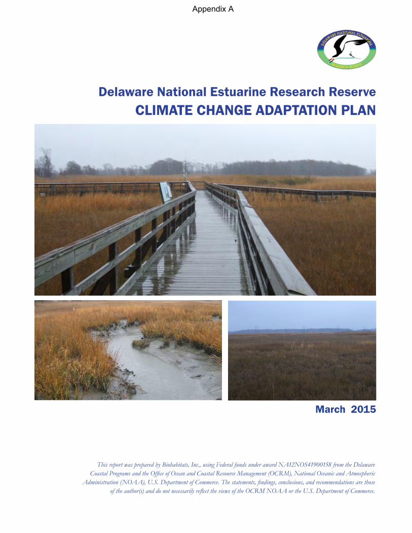
Delaware National Estuarine Research Reserve CLIMATE CHANGE ADAPTATION PLAN
March 2015
This report was prepared by Biohabitats, Inc., using Federal funds under award NA12NOS41900158 from the Delaware Coastal Programs and the Office of Ocean and Coastal Resource Management (OCRM), National Oceanic and Atmospheric
Administration (NOAA), U.S. Department of Commerce. The statements, findings, conclusions, and recommendations are those of the author(s) and do not necessarily reflect the views of the OCRM NOAA or the U.S. Department of Commerce.
Appendix A

This page left intentionally blank
Delaware National Estuarine Research Reserve DNERR CLIMATE CHANGE ADAPTATION PLAN
EXECUTIVE SUMMARY
Purpose and Need
Biohabitats, Inc. was retained by the Delaware National Estuarine Research Reserve (DNERR) through the Delaware Department of Natural Resources and Environmental Control to develop a Climate Change Adaptation Plan for the DNERR. This plan includes the two DNERR Reserves components, the Upper Blackbird Creek Reserve (Blackbird Reserve) and the Lower St. Jones Reserve (St. Jones Reserve). Both reserve components are located approximately 30 miles apart in New Castle and Kent County, respectively.
The Climate Change Adaptation Plan is intended to provide planning and guidance for impending changes to the Reserve’s infrastructure, land, and ecosystems. This includes anticipated future system changes and changing conditions that are already being observed. Further, the intent is to protect and manage the Reserve, so it can continue to fulfill its mission of estuarine resource conservation and applied research on issues of importance to the Reserve, the region and beyond.
This Climate Adaptation Plan is needed to address very real threats that climate change is currently posing and will increasingly present in the future at these two critical DNERR locations. This plan is an initial guidance and mapping document to start to address climate change resiliency and adaptive management for the Reserve, in the context of its ecosystem setting and associated land uses. DNERR’s response to climate change will help shape the future of the Reserve lands and habitat areas, address infrastructure and facility concerns, and influence how the DNERR continues to fulfill its mission.
The key aspects of the plan include the following:
• Assistance in decision-making for land, natural resource, and infrastructure protection through strategies based on vulnerability,
• Development of a broad level resource protection, restoration and retreat/migration strategy in response to sea level rise,
• Direction for incorporating sea level rise considerations into potential future land acquisition for the Reserves,
• Provision of information and resources for management of land, infrastructure/facilities, and habitats affected by climate change and sea level rise,
• Preparation of a description of potential best management practices for resiliency and adaptive management of the critical resources on DNERR lands, both infrastructure and habitat.
© Biohabitats, Inc. 2015 2
Delaware National Estuarine Research Reserve DNERR CLIMATE CHANGE ADAPTATION PLAN
Project Coordination & Goals
The effort to create a DNERR Climate Change Adaptation Plan began on December 2, 2014 with State of Delaware and Biohabitats staff at the DNERR St. Jones Reserve. Representatives from the state’s National Estuarine Research Reserves including St. Jones and Blackbird tracts, as well as staff from the State’s Fish and Wildlife Office and Delaware Coastal Programs were present, providing input on specific goals and objectives for the Plan. These goals and objectives included:
• Incorporating climate change into land and facilities management, • Influencing acquisition planning for new reserve lands, • Informing habitat management – what should be maintained and restored (for what
conditions), • Planning for protection and changes to facilities, infrastructure and amenities, • Helping inform recommendations for future research and interpretive education, • Investigating thresholds – investigating to see if threshold levels exist for actions/point
of no return, • Addressing related issues – triggers (e.g., temp./heat), leave alone, monitoring, and self-
organization, and • Research needs – identifying a list of research needs or augmentation of existing
programs.
Climate Adaptation Plan Contents
This plan includes 3 sections. Section 1 is an introduction, framing the purpose and need; and climate change issues to be addressed. Section 2 is a vulnerability assessment that identifies habitats and infrastructure at risk, and discusses the Reserves’ climate change vulnerability. Section 3 addresses climate change adaptation, including adaptation and resiliency strategies, best management practices for resiliency, and an adaptive management trajectory scenario for informing future adaptation and management efforts.
Vulnerability Assessment
The vulnerability assessment in this plan identifies the Reserve’s biological communities at risk with climate change. For this assessment 15 types of habitat/vegetation communities and other land use types were mapped and evaluated; with 14 of the types occurring at the St. Jones Reserve and 11 occurring at the Blackbird Reserve. A qualitative matrix of climate change vulnerability was prepared for both Reserve areas yielding total vulnerability scores for each habitat and land use type (Appendix B). The results indicated that 9 out of the 14 types at the St. Jones Reserve scored Moderate to High vulnerability to climate change, and 6 out of 11
© Biohabitats, Inc. 2015 3
Delaware National Estuarine Research Reserve DNERR CLIMATE CHANGE ADAPTATION PLAN
types at the Blackbird Reserve scored Moderate to High vulnerability. Facilities and Infrastructure at the Reserves were also assessed for vulnerability to climate change impacts from such factors as sea level rise, storm surge & erosion, precipitation changes, temperature changes, and salinity shifts.
Climate Change Adaptation
Adaptation and resiliency strategies were developed for the Reserve consistent with its stated mission and goals of the DNERR. Proactive strategies for climate change adaptation were provided for the following categories:
• Facilities and Infrastructure Management • Land Acquisition Planning • Habitat Conservation and Management • Research and Programming Activities
Best management practices for resiliency were also developed for Reserve infrastructure and habitat, using 10 specified goals, stating the goal, strategic actions and priority phasing for the following resources:
• Building infrastructure • Utilities • Site amenities • Research equipment • Roadways & drainage • Tidal marsh • Other wetlands • Riparian edge/shorelines • Upland forests • Herbaceous communities (meadows) • Stream channels/open water • Wildlife habitat
An adaptive management approach and an adaptive management process for climate change were also identified. Additionally, a Climate Adaptation Plan Development Checklist is provided, listing the sequential steps necessary for preparing a plan for a particular facility or property (below).
© Biohabitats, Inc. 2015 4
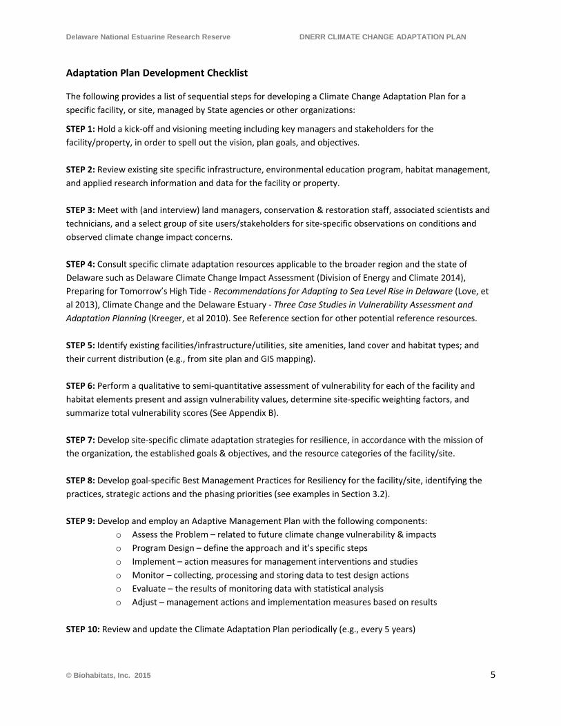
Delaware National Estuarine Research Reserve DNERR CLIMATE CHANGE ADAPTATION PLAN
Adaptation Plan Development Checklist
The following provides a list of sequential steps for developing a Climate Change Adaptation Plan for a specific facility, or site, managed by State agencies or other organizations:
STEP 1: Hold a kick-off and visioning meeting including key managers and stakeholders for the facility/property, in order to spell out the vision, plan goals, and objectives. STEP 2: Review existing site specific infrastructure, environmental education program, habitat management, and applied research information and data for the facility or property. STEP 3: Meet with (and interview) land managers, conservation & restoration staff, associated scientists and technicians, and a select group of site users/stakeholders for site-specific observations on conditions and observed climate change impact concerns. STEP 4: Consult specific climate adaptation resources applicable to the broader region and the state of Delaware such as Delaware Climate Change Impact Assessment (Division of Energy and Climate 2014), Preparing for Tomorrow’s High Tide - Recommendations for Adapting to Sea Level Rise in Delaware (Love, et al 2013), Climate Change and the Delaware Estuary - Three Case Studies in Vulnerability Assessment and Adaptation Planning (Kreeger, et al 2010). See Reference section for other potential reference resources. STEP 5: Identify existing facilities/infrastructure/utilities, site amenities, land cover and habitat types; and their current distribution (e.g., from site plan and GIS mapping). STEP 6: Perform a qualitative to semi-quantitative assessment of vulnerability for each of the facility and habitat elements present and assign vulnerability values, determine site-specific weighting factors, and summarize total vulnerability scores (See Appendix B). STEP 7: Develop site-specific climate adaptation strategies for resilience, in accordance with the mission of the organization, the established goals & objectives, and the resource categories of the facility/site. STEP 8: Develop goal-specific Best Management Practices for Resiliency for the facility/site, identifying the practices, strategic actions and the phasing priorities (see examples in Section 3.2). STEP 9: Develop and employ an Adaptive Management Plan with the following components:
o Assess the Problem – related to future climate change vulnerability & impacts o Program Design – define the approach and it’s specific steps o Implement – action measures for management interventions and studies o Monitor – collecting, processing and storing data to test design actions o Evaluate – the results of monitoring data with statistical analysis o Adjust – management actions and implementation measures based on results
STEP 10: Review and update the Climate Adaptation Plan periodically (e.g., every 5 years)
© Biohabitats, Inc. 2015 5
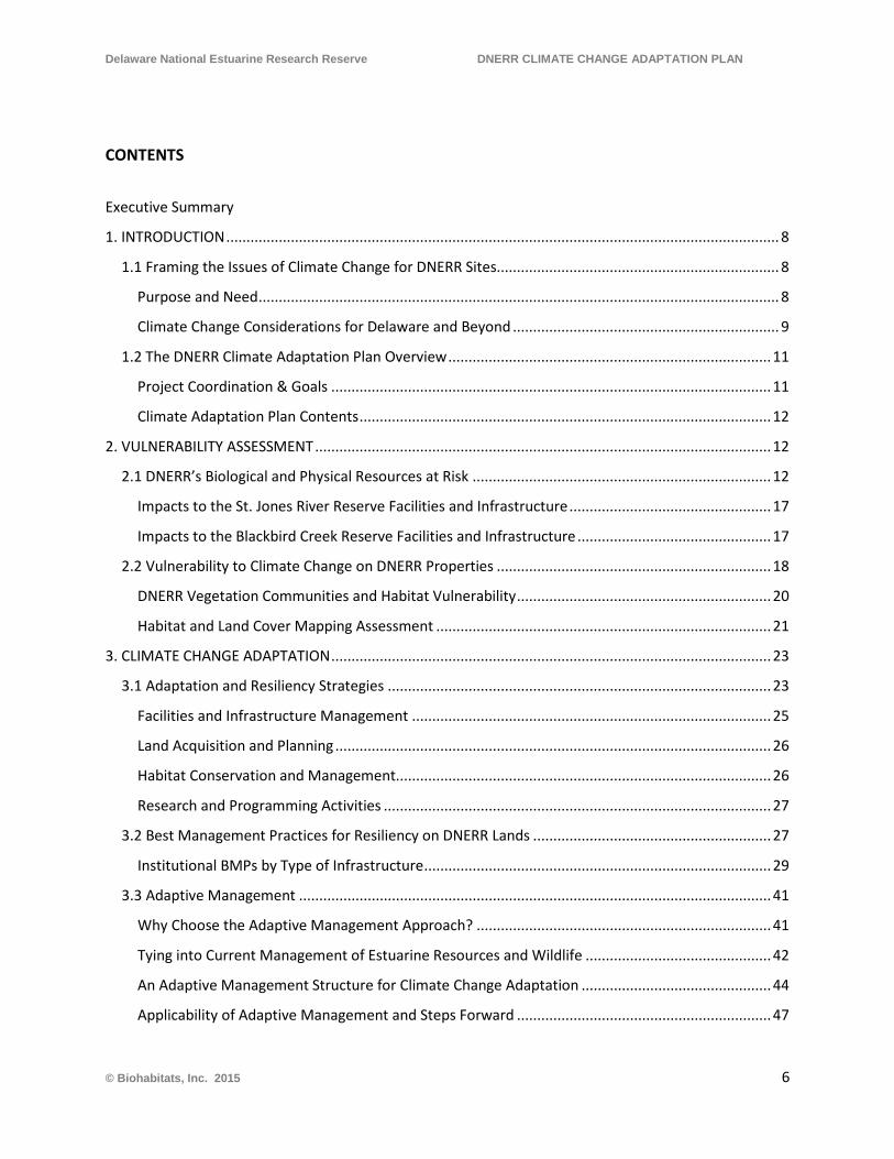
Delaware National Estuarine Research Reserve DNERR CLIMATE CHANGE ADAPTATION PLAN
CONTENTS
Executive Summary
1. INTRODUCTION ......................................................................................................................................... 8
1.1 Framing the Issues of Climate Change for DNERR Sites...................................................................... 8
Purpose and Need ................................................................................................................................. 8
Climate Change Considerations for Delaware and Beyond .................................................................. 9
1.2 The DNERR Climate Adaptation Plan Overview ................................................................................ 11
Project Coordination & Goals ............................................................................................................. 11
Climate Adaptation Plan Contents ...................................................................................................... 12
2. VULNERABILITY ASSESSMENT ................................................................................................................. 12
2.1 DNERR’s Biological and Physical Resources at Risk .......................................................................... 12
Impacts to the St. Jones River Reserve Facilities and Infrastructure .................................................. 17
Impacts to the Blackbird Creek Reserve Facilities and Infrastructure ................................................ 17
2.2 Vulnerability to Climate Change on DNERR Properties .................................................................... 18
DNERR Vegetation Communities and Habitat Vulnerability ............................................................... 20
Habitat and Land Cover Mapping Assessment ................................................................................... 21
3. CLIMATE CHANGE ADAPTATION ............................................................................................................. 23
3.1 Adaptation and Resiliency Strategies ............................................................................................... 23
Facilities and Infrastructure Management ......................................................................................... 25
Land Acquisition and Planning ............................................................................................................ 26
Habitat Conservation and Management............................................................................................. 26
Research and Programming Activities ................................................................................................ 27
3.2 Best Management Practices for Resiliency on DNERR Lands ........................................................... 27
Institutional BMPs by Type of Infrastructure ...................................................................................... 29
3.3 Adaptive Management ..................................................................................................................... 41
Why Choose the Adaptive Management Approach? ......................................................................... 41
Tying into Current Management of Estuarine Resources and Wildlife .............................................. 42
An Adaptive Management Structure for Climate Change Adaptation ............................................... 44
Applicability of Adaptive Management and Steps Forward ............................................................... 47
© Biohabitats, Inc. 2015 6
Delaware National Estuarine Research Reserve DNERR CLIMATE CHANGE ADAPTATION PLAN
REFERENCES ................................................................................................................................................ 48
APPENDIX A - FIGURES ................................................................................................................................ 52
APPENDIX B – TABLES ................................................................................................................................. 53
APPENDIX C – LITERATURE REVIEW ............................................................................................................ 54
Review of Climate Change Documents ................................................................................................... 55
Primary Sources with brief synopses .................................................................................................. 55
Secondary Sources .............................................................................................................................. 59
APPENDIX D – CLIMATE ADAPTATION PLAN DEVELOPMENT CHECKLIST ................................................... 61
Adaptation Plan Development Checklist ................................................................................................ 62
APPENDIX E – ADAPTIVE MANAGEMENT CONTEXT ................................................................................... 63
What is Adaptive Management? ............................................................................................................ 64
What Does It Require? Further Insights .................................................................................................. 64
Existing and On-going Work in Support of the Adaptive Management Approach ................................. 65
& NERRS Climate Objectives ................................................................................................................... 65
DNERR Research and Monitoring Program............................................................................................. 66
Applicability of Adaptive Management .................................................................................................. 67
© Biohabitats, Inc. 2015 7
Delaware National Estuarine Research Reserve DNERR CLIMATE ADAPTATION PLAN
1. INTRODUCTION
1.1 Framing the Issues of Climate Change for DNERR Sites
Purpose and Need
Biohabitats, Inc. was retained by the Delaware National Estuarine Research Reserve (DNERR) through the Delaware Department of Natural Resources and Environmental Control (DNREC) to develop a Climate Change Adaptation Plan for the DNERR. This plan includes the two DNERR Reserves components (the Reserve), the Upper Blackbird Creek Reserve (Blackbird Reserve) and the Lower St. Jones Reserve (St. Jones Reserve). Both reserve components are located approximately 30 miles apart in New Castle and Kent County, respectively.
The Climate Change Adaptation Plan is intended to help plan for and provide guidance related to impending changes to the Reserve lands and ecosystems in which the Reserves are located. This includes the anticipated future system changes and changing conditions that are already being observed at the Reserve and on adjacent lands. This plan will help the Reserve to continue to fulfill its mission of estuarine resource conservation and applied research on issues of importance to the Reserve and the region.
The key aspects of the plan include the following:
• Assistance in decision-making for land, natural resource, infrastructure protection through strategies based on vulnerability,
• Development of a broad level resource protection, restoration and retreat/migration strategy in response to sea level rise,
• Direction for incorporating sea level rise considerations into potential future land acquisition for the Reserves,
• Provision of information and resources for management of land, infrastructure/facilities, and habitats affected by climate change and sea level rise,
• Preparation of a description of potential best management practices for resiliency and adaptive management of the critical resources on DNERR lands, both infrastructure and habitat.
This Climate Adaptation Plan is needed to address very real threats that climate change is currently posing and will increasingly present in the future at these two critical DNERR locations. This plan is an initial guidance and mapping document to begin to address climate change resiliency and adaptive management for the reserve, in the context of its ecosystem setting and associated land uses. DNERR’s response to climate change will help shape the future of the reserve lands and habitat areas, address infrastructure and facility concerns, and influence how the DNERR continue to fulfill its mission.
© Biohabitats, Inc. 2015 8

Delaware National Estuarine Research Reserve DNERR CLIMATE ADAPTATION PLAN
Climate Change Considerations for Delaware and Beyond
There is widespread agreement, based on empirical monitoring data that the earth’s climate is getting warmer and that sea level is rising. The expectation from climatologists and other scientists is that the observed warming trends will continue for decades into the future (IPCC 2014, Delaware Division of Energy and Climate 2014). From the Intergovernmental Panel on Climate Change report (2014) “Continued emission of greenhouse gases will cause further warming and long-lasting changes in all components of the climate system, increasing the likelihood of severe, pervasive and irreversible impacts for people and ecosystems. Limiting climate change would require substantial and sustained reductions in greenhouse gas emissions which, together with adaptation, can limit climate change risks.”
Accelerated rates of sea level rise are being observed in the Mid- Atlantic region, which already has higher-than-global average rates. A recent study identified a “hotspot” of accelerated sea level rise along a 620-mile stretch of the eastern U.S. coast north of Cape Hatteras, North Carolina. Over the past 60 years, sea level rates in this region were estimated to be three to four times higher than the global average. The Mid-Atlantic coast has experienced a higher-than-global-average rate of sea level rise over the past century, ranging from 0.09 to 0.17 inches per year, or 9 to 17 inches since 1900. This higher rate of sea level rise is due largely to land subsidence. In Delaware, sea level has risen approximately 13 inches during the past century, based on NOAA tide gauge measurements (Delaware Division of Energy and Climate, 2014).
Much effort has been expended in predicting the future rate of increase in global temperatures and the coincident rate of sea level rise, however there is variability in the findings. The variability is often the result of the assumptions that are made as to the level to which greenhouse gas emissions will be reduced (or not reduced) over a given period of time. Given that the rates of change carry a degree of uncertainty, predictions based on conservative estimates of change vs. higher rates of change, result in a range of increase for temperatures and the other physical and biological parameters.
For instance, in the Delaware Climate Change Impact Assessment report (Delaware Division of Energy and Climate 2014), temperature change was predicted under two scenarios- “The lower scenario represents a future in which people shift to clean energy sources in the coming decades, reducing emissions of carbon dioxide (CO2) and other greenhouse (heat-trapping) gases that are causing climate to change so quickly. The higher scenario represents a future in which people continue to depend heavily on fossil fuels, and emissions of greenhouse gases continues to grow.” Based on these two scenarios, the following potential temperature changes were reported:
© Biohabitats, Inc. 2015 9
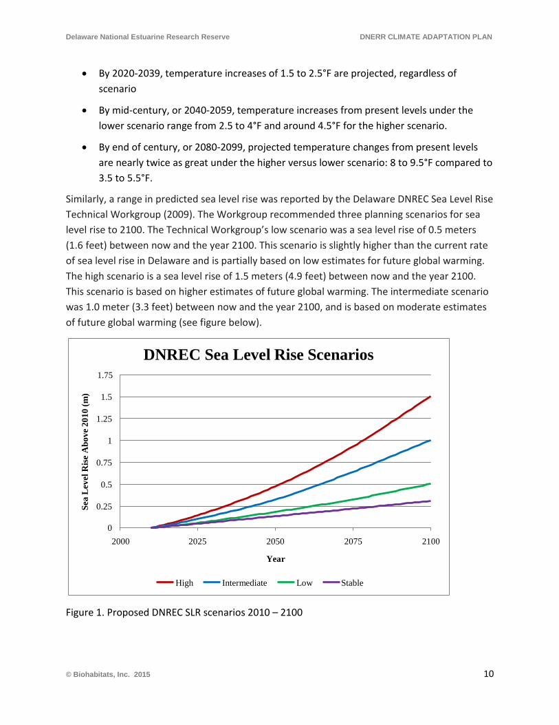
Delaware National Estuarine Research Reserve DNERR CLIMATE ADAPTATION PLAN
• By 2020-2039, temperature increases of 1.5 to 2.5°F are projected, regardless of scenario
• By mid-century, or 2040-2059, temperature increases from present levels under the lower scenario range from 2.5 to 4°F and around 4.5°F for the higher scenario.
• By end of century, or 2080-2099, projected temperature changes from present levels are nearly twice as great under the higher versus lower scenario: 8 to 9.5°F compared to 3.5 to 5.5°F.
Similarly, a range in predicted sea level rise was reported by the Delaware DNREC Sea Level Rise Technical Workgroup (2009). The Workgroup recommended three planning scenarios for sea level rise to 2100. The Technical Workgroup’s low scenario was a sea level rise of 0.5 meters (1.6 feet) between now and the year 2100. This scenario is slightly higher than the current rate of sea level rise in Delaware and is partially based on low estimates for future global warming. The high scenario is a sea level rise of 1.5 meters (4.9 feet) between now and the year 2100. This scenario is based on higher estimates of future global warming. The intermediate scenario was 1.0 meter (3.3 feet) between now and the year 2100, and is based on moderate estimates of future global warming (see figure below).
Figure 1. Proposed DNREC SLR scenarios 2010 – 2100
Sea
Lev
el R
ise
Abo
ve 2
010
(m)
1.75
DNREC Sea Level Rise Scenarios
1.5
1.25
1
0.75
0.5
0.25
0 2000 2025 2050 2075 2100
Year
High Intermediate Low Stable
© Biohabitats, Inc. 2015 10
Delaware National Estuarine Research Reserve DNERR CLIMATE ADAPTATION PLAN
These trends are expected to continue into the future. “Future climate changes are expected to affect Delaware and the surrounding region by increasing average, seasonal, and extreme temperatures; average precipitation; the frequency of heavy precipitation events; and the total amount of rainfall that falls in the wettest periods of the year. For all temperature-related indices, there is a significant difference between the changes expected under higher versus lower scenarios by end of century. For many of the changes, this difference begins to emerge by mid-century. In addition, analyses of sea level rise highlight the potential impacts to a wide range of resources, particularly in a low-lying state with extensive ocean and bay shoreline, tidal rivers, and valuable ecosystems”(Delaware Division of Energy and Climate 2014).
In addition, it is predicted that by 2100, winter precipitation will increase by approximately 15-35%, and total annual days of heavy precipitation will increase. Also, the growing season will increase by 30-50 days annually. Since these predicted rates of change for sea level rise, temperature and precipitation patterns are made by local scientists for the State of Delaware, and they are recent estimates, they are used as a basis for this climate adaptation plan (Delaware Division of Energy and Climate 2014).
1.2 The DNERR Climate Adaptation Plan Overview
Project Coordination & Goals
The effort to create a DNERR Climate Change Adaptation Plan was begun on December 2, 2014 with State of Delaware and Biohabitats staff at the DNERR St. Jones Reserve. Representatives from the state’s National Estuarine Research Reserves (NERRs) including St. Jones and Blackbird tracts attended, as well as staff from the State’s Fish and Wildlife Office and Delaware Coastal Programs (DCP), providing input on specific goals and objectives to be included in the Plan. These goals and objectives included:
• Incorporating climate change into land and facilities management, • Influencing acquisition planning for new reserve lands, • Informing habitat management – what should they be maintaining and restoring (for
what conditions), • Planning for protection and changes to facilities, infrastructure and amenities, • Helping inform recommendations for future research and interpretive education, • Investigating thresholds – look to see if threshold levels exist for actions/point of no
return, • Addressing related issues – triggers (e.g., temp./heat), leave alone, monitoring, and self-
organization, • Research needs – identify list of augmentation research needs.
© Biohabitats, Inc. 2015 11
Delaware National Estuarine Research Reserve DNERR CLIMATE ADAPTATION PLAN
Climate Adaptation Plan Contents
This plan provides a Vulnerability Assessment in Section 2, including an identification of habitats and infrastructure at risk, and discussion of the Reserves’ climate change vulnerability. In Section 3 climate change adaptation is addressed, including adaptation and resiliency strategies, best management practices for resiliency, and an adaptive management trajectory scenario for informing future adaptation and management efforts.
2. VULNERABILITY ASSESSMENT
2.1 DNERR’s Biological and Physical Resources at Risk
Climate change will have impacts of varying degrees on the Reserve’s natural resources and infrastructure. Changes in temperature will affect seasonal duration and seasonal intensity of precipitation and extreme storm events, as well as transpiration and available moisture. Precipitation patterns are difficult to predict, although the Intergovernmental Panel on Climate Change estimates include ranges from periods of intense drought to events and periods of higher than normal precipitation (IPCC, 2014). If increasing temperature trends continue, including the 2014 record of being the hottest year recorded globally (NASA/NOAA, 2015), they will likely affect the Reserve through Sea Level Rise (SLR) and an increasing incidence and
© Biohabitats, Inc. 2015 12
Delaware National Estuarine Research Reserve DNERR CLIMATE ADAPTATION PLAN
intensity of damaging storm events. These negative effects caused by global climate change will have an influence on the Reserve, Delaware Fish and Wildlife lands and locally contiguous land uses, ecosystems, wildlife, and infrastructure in ways, and to a degree, that are difficult to predict. The vegetation and land cover categories for the St. Jones and Blackbird Creek NERRs have been assessed extensively over four periods in the last 75 years - in 1937, 2002, 2007 and 2012. The most recent assessment was performed by the Delaware Wildlife Species Conservation and Research Program (Coxe 2013 and 2014). The vegetation categories were broadly identified as: Forest; Woodland; Shrubland; Herbaceous Communities; Marsh; Anthropogenic Communities/ Land Covers; Non-vegetated Land Covers; and Water. Each of these broad categories has generally exhibited small incremental changes, evidenced by an increase in forest and herbaceous communities, slight decreases over the last three assessment periods for marsh, and increases in open water coverage. Anthropogenic communities and their associated land cover generally decreased over the four periods, likely coinciding with the mission of the NERRs to support natural systems in balance with anthropogenic systems. These generalized vegetation and land use categories are composed of numerous habitat or land use types (Table 1) which support numerous common, and sometimes rare, plant and animal species. These generalized categories are mapped in Figures A-1 and A-2 (found in Appendix A) described in further detail below.
© Biohabitats, Inc. 2015 13
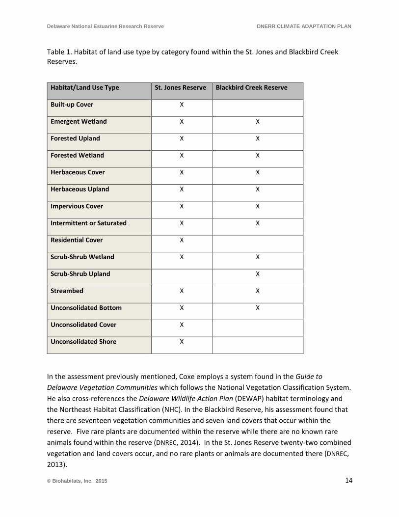
Delaware National Estuarine Research Reserve DNERR CLIMATE ADAPTATION PLAN
Table 1. Habitat of land use type by category found within the St. Jones and Blackbird Creek Reserves.
Habitat/Land Use Type St. Jones Reserve Blackbird Creek Reserve
Built-up Cover X
Emergent Wetland X X
Forested Upland X X
Forested Wetland X X
Herbaceous Cover X X
Herbaceous Upland X X
Impervious Cover X X
Intermittent or Saturated X X
Residential Cover X
Scrub-Shrub Wetland X X
Scrub-Shrub Upland X
Streambed X X
Unconsolidated Bottom X X
Unconsolidated Cover X
Unconsolidated Shore X
In the assessment previously mentioned, Coxe employs a system found in the Guide to Delaware Vegetation Communities which follows the National Vegetation Classification System. He also cross-references the Delaware Wildlife Action Plan (DEWAP) habitat terminology and the Northeast Habitat Classification (NHC). In the Blackbird Reserve, his assessment found that there are seventeen vegetation communities and seven land covers that occur within the reserve. Five rare plants are documented within the reserve while there are no known rare animals found within the reserve (DNREC, 2014). In the St. Jones Reserve twenty-two combined vegetation and land covers occur, and no rare plants or animals are documented there (DNREC, 2013).
© Biohabitats, Inc. 2015 14
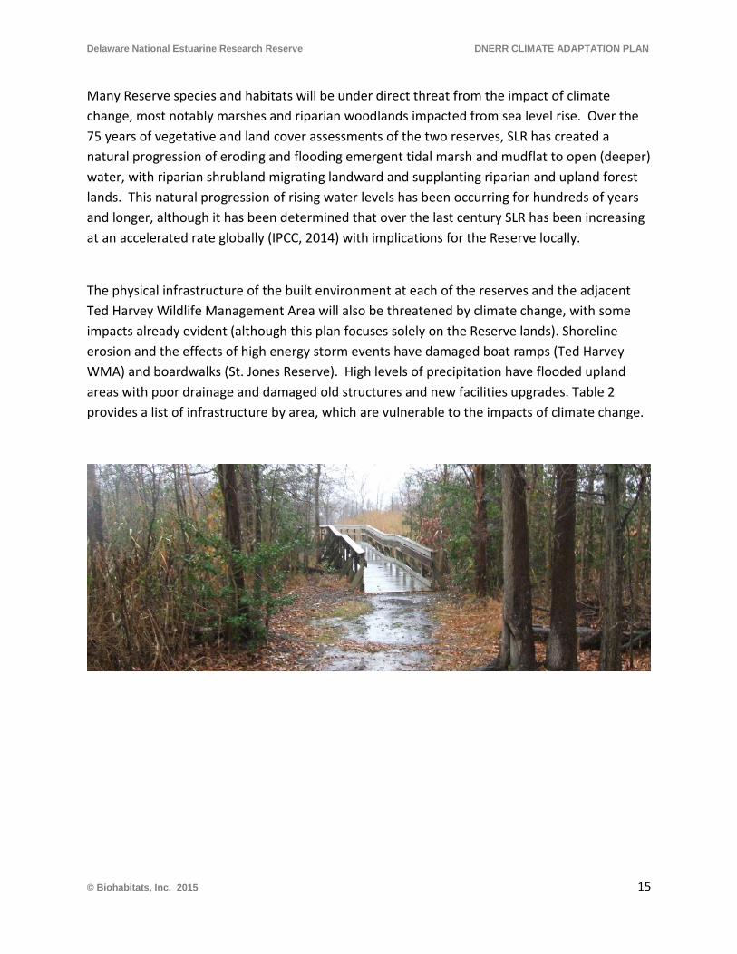
Delaware National Estuarine Research Reserve DNERR CLIMATE ADAPTATION PLAN
Many Reserve species and habitats will be under direct threat from the impact of climate change, most notably marshes and riparian woodlands impacted from sea level rise. Over the 75 years of vegetative and land cover assessments of the two reserves, SLR has created a natural progression of eroding and flooding emergent tidal marsh and mudflat to open (deeper) water, with riparian shrubland migrating landward and supplanting riparian and upland forest lands. This natural progression of rising water levels has been occurring for hundreds of years and longer, although it has been determined that over the last century SLR has been increasing at an accelerated rate globally (IPCC, 2014) with implications for the Reserve locally.
The physical infrastructure of the built environment at each of the reserves and the adjacent Ted Harvey Wildlife Management Area will also be threatened by climate change, with some impacts already evident (although this plan focuses solely on the Reserve lands). Shoreline erosion and the effects of high energy storm events have damaged boat ramps (Ted Harvey WMA) and boardwalks (St. Jones Reserve). High levels of precipitation have flooded upland areas with poor drainage and damaged old structures and new facilities upgrades. Table 2 provides a list of infrastructure by area, which are vulnerable to the impacts of climate change.
© Biohabitats, Inc. 2015 15
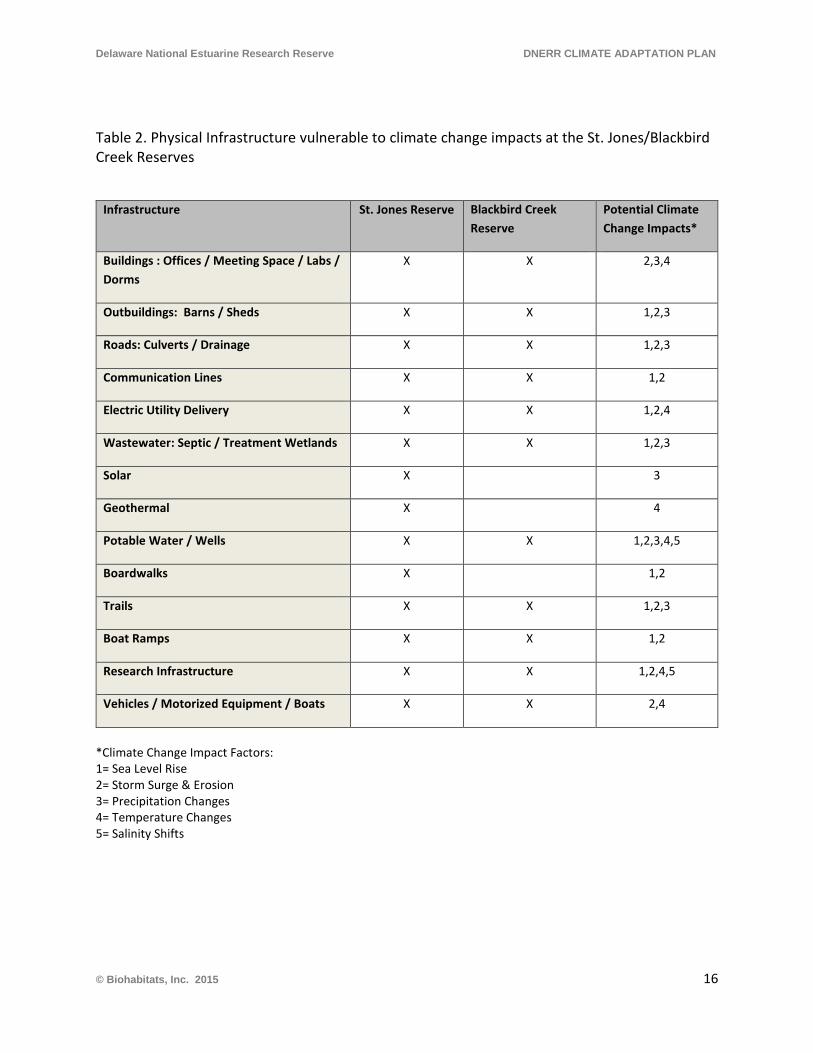
Delaware National Estuarine Research Reserve DNERR CLIMATE ADAPTATION PLAN
Table 2. Physical Infrastructure vulnerable to climate change impacts at the St. Jones/Blackbird Creek Reserves
Infrastructure St. Jones Reserve Blackbird Creek Reserve
Potential Climate Change Impacts*
Buildings : Offices / Meeting Space / Labs / Dorms
X X 2,3,4
Outbuildings: Barns / Sheds X X 1,2,3
Roads: Culverts / Drainage X X 1,2,3
Communication Lines X X 1,2
Electric Utility Delivery X X 1,2,4
Wastewater: Septic / Treatment Wetlands X X 1,2,3
Solar X 3
Geothermal X 4
Potable Water / Wells X X 1,2,3,4,5
Boardwalks X 1,2
Trails X X 1,2,3
Boat Ramps X X 1,2
Research Infrastructure X X 1,2,4,5
Vehicles / Motorized Equipment / Boats X X 2,4
*Climate Change Impact Factors: 1= Sea Level Rise 2= Storm Surge & Erosion 3= Precipitation Changes 4= Temperature Changes 5= Salinity Shifts
© Biohabitats, Inc. 2015 16
Delaware National Estuarine Research Reserve DNERR CLIMATE ADAPTATION PLAN
Impacts to the St. Jones River Reserve Facilities and Infrastructure
• The main office, barn and building complex are new and built at grade, approximately 10-15 feet above high tide. These were not likely built to withstand hurricane force winds.
• The new geothermal system at the St. Jones River Reserve offices and visitor center shuts down with high groundwater temperatures, influenced by and coupled with the demands of higher air temperatures. Continued higher temperatures and higher warmer groundwater levels will make the system ineffective.
• The wells for potable water are potentially threatened by saltwater intrusion, either due to SLR or episodically from hurricane driven storm surge.
• Solar panels on the barn could be damaged from high winds from higher intensity storm events.
• A lack of positive drainage at low points along roadside swales threatens to impact buried utilities along the access lane to the Reserve.
• Existing trails and boardwalk sections are threatened, with one boardwalk section currently flooding.
• Deployed water quality data sondes can be retrieved prior to predicted extreme storm events to avoid loss, if the expectation of the costs of the loss outweigh the value of the data collected. Weather station instrumentation can similarly be retrieved prior to potentially extreme and catastrophically damaging weather events. Surface Elevation Tables are permanent and can be covered by area-wide deposits of storm driven sediment, although providing data of value once uncovered.
• Barns and sheds are available for housing motorized equipment and boats to protect them from the elements to extend their useful life.
Impacts to the Blackbird Creek Reserve Facilities and Infrastructure
• The newly acquired and reconditioned office and meeting space is situated 20-30 feet above the tide. It is surrounded by a maturing oak forest that may pose a threat of damage from wind-throws during extreme storm events.
• The old KOA campground well, at 10-15 feet deep, is threatened by saltwater intrusion either due to SLR or episodically from hurricane-driven storm surge.
• Blackbird Landing Road floods regularly at the bridge and approach to the reserve.
© Biohabitats, Inc. 2015 17
Delaware National Estuarine Research Reserve DNERR CLIMATE ADAPTATION PLAN
• Buried utilities and the office septic system are susceptible to flooding impacts.
• Trails are experiencing some erosion and drainage issues.
• The canoe and kayak launch at the former campground is being affected by sediment deposition covering stones in the launch area. Shoreline erosion in the launch area has the potential for downed trees to block the launch.
• Deployed water quality data sondes can be retrieved prior to predicted extreme storm events to avoid loss if the expectation of the costs of the loss outweigh the value of the data collected. Weather station instrumentation can similarly be retrieved prior to potentially extreme and catastrophically damaging weather events. Surface Elevation Tables are permanent and can be covered by area wide deposits of storm driven sediment and debris, although providing data of value once uncovered.
• Barns and sheds are available for housing motorized equipment and boats to protect them from the elements to extend their useful life.
2.2 Vulnerability to Climate Change on DNERR Properties
The predicted rise in ambient temperature of the atmosphere will affect climate patterns of precipitation, wind, storms, droughts, and seasons. As these climate patterns change and sea level rises, their combined effects on shoreline areas, such as those in the Delaware Bay, will create changes that may seem at first straightforward (e.g. rising sea surface elevations will flood areas higher on the landscape) but when considered comprehensively become complex and difficult to predict, as all the changes occur simultaneously. The identification of the vulnerability of valuable resources, then, is also both straightforward and complex, when all the potential interactions are considered.
There is substantial uncertainty inherent in predicting how greenhouse gases, global warming, climate change and sea level rise will interact and affect future conditions. In the current literature there are predictions for the amount of increase in temperature that will reach a “critical threshold” or “tipping point”, after which the earth’s climate and sea levels will be altered to the extent that a return to current climatic conditions and trajectories are not possible. However, predictions of the temperature increase that will create a tipping point, and if such a tipping point scenario is actually realistic, are the source of vigorous scientific and social debate.
During the literature review for this project, no predictions of ecological thresholds were encountered, other than the sort that were made with a high degree of certainty, e.g., if sea
© Biohabitats, Inc. 2015 18
Delaware National Estuarine Research Reserve DNERR CLIMATE ADAPTATION PLAN
level rises, then shoreline areas and their respective ecological and plant communities will become inundated and transformed into a different ecological and plant community. The Literature Review associated with this Plan is found in Appendix C. Other common themes in the literature included predictions of vegetation community migrations northward as temperatures rise, increased salinity of brackish and coastal freshwater systems with sea level rise, and non-specific warnings of changes in invasive species occurrence and robustness.
Some potential environmental shifts associated with climate change are listed below, as adapted from Tiner (1985):
1. Increased temperatures-ambient air and surface water 2. Sea level rise 3. Increased flooding of roads and infrastructure 4. Salt water intrusion into groundwater 5. Increased frequency of droughts 6. Increased extreme rain events 7. Wildlife habitat changes 8. Alteration of species diversity (locally) 9. Alteration of species diversity (landscape) 10. Alteration of species composition 11. Alteration of habitat structure 12. Conversion of one habitat type to another 13. Conversion to tidal wetlands 14. Conversion to open water 15. Salinization of aquifers 16. Alteration of flood water retention 17. Alteration of nutrient dynamics 18. Alteration of sediment transport 19. Alteration of land subsidence rate 20. Alteration of wetland accretion rate 21. Increased stress on forested communities-e.g. climate, disease 22. Alteration of woodlands to emergent shrub, forb, or grass species 23. Shift to more salt tolerant species 24. Alteration of invasive community dynamics 25. Altered susceptibility to wildfire 26. Local extirpation of rare flora and fauna 27. Increased human pressure on remaining land base
© Biohabitats, Inc. 2015 19
Delaware National Estuarine Research Reserve DNERR CLIMATE ADAPTATION PLAN
DNERR Vegetation Communities and Habitat Vulnerability
It is important to understand how vulnerable to climate change the vegetation communities and habitats are at the Reserves, due to future climate-related conditions and climate change impacts of sea level rise, change precipitation patterns, temperature rise and extremes. Their vulnerability is explored in general in this section, which also includes some of the considerations for how the DNERR research, monitoring and management mission components can be directed to address the future impacts. The opportunities for climate change resiliency management are introduced here and further detailed in terms of guidance recommendations in Section 3. Climate Change Adaptation.
Descriptions of how the vegetation communities have already changed at the Reserve, by Robert Coxe with the Delaware Division of Fish and Wildlife, are documented in Historical Analysis and Maps of Vegetation Communities, Land Covers, and Habitats of DNERR St. Jones Reserve (DNREC 2013); and Historical Analysis and Map of Vegetation Communities, Land Covers, and Habitats of DNERR Blackbird Creek Reserve (DNREC 2014). In these documents Coxe states that since European settlement, physical factors such as fire regime and moisture availability have changed (as have nearly all of the biological factors) resulting in a markedly different landscape today. He also points out that today, instead of natural communities, we have expressions of vegetation communities that only approximate the historic natural communities. Coxe also describes how sea level rise may affect the vegetation communities at the Reserves in terms of projected acres of inundation by sea level rise scenarios (0.5m, 1.0 m, and 1.5 m) and how it will impact the natural capital value of these communities (expressed in 2012 dollars).
Coxe describes significant changes in the past 75 years, particularly in the tidal marsh communities, but also in the estuarine waters (mesohaline to polyhaline), non-tidal wetlands and forest communities, and anthropogenic communities (primarily agricultural land). The most significant scale of changes at the St. Jones Reserve include a loss of 87 acres of North Atlantic High Salt Marsh, a loss of 61 acres of Mesohaline Seepage Marsh, a gain of 151 acres North Atlantic Low Salt Marsh, and a gain of about 41.5 acres of Reed Tidal Marsh. For terrestrial communities and cover types, significant changes include a loss of 15 acres of Northeastern Oldfield, and a loss of 39 acres of Agricultural Fields. A subset of communities that have been completely or nearly lost in that timeframe at St. Jones Reserve include Mesohaline Seepage Marsh, Atlantic Giant Cordgrass Marsh, Wax Myrtle Shrub Swamp, Early to Mid-successional Loblolly Pine, and Estuarine Mesohaline Water.
The most significant changes at the Blackbird Reserve include the loss of 54 acres of Pickerelweed Tidal Marsh, 14 acres of Cattail Brackish Tidal Marsh, about 10 acres of Freshwater Tidal High Marsh, and 11 acres of North Atlantic Coastal Plain Tidal Swamp. In
© Biohabitats, Inc. 2015 20
Delaware National Estuarine Research Reserve DNERR CLIMATE ADAPTATION PLAN
addition, there was a gain of 34 acres of Mesohaline Seepage Marsh, 24 acres of Estuarine Coastal Oligohaline Water, and 55 acres of Reed Tidal Marsh. For terrestrial communities and cover types, significant changes include a loss of 29 acres of North Atlantic Coastal Plain Hardwood Forest, 10 acres of Successional Maritime Forest, 125 acres of Agricultural Fields, the gain of 75 acres of Northeastern Oldfield and 58 acres of Northeastern Modified Successional Forest. A subset of communities that have been completely or nearly lost in that timeframe at Blackbird include Cattail Brackish Marsh, Freshwater Tidal High Marsh, North Atlantic Coastal Plain Tidal Swamp, Swamp Loosestrife Shrub Swamp, Wax Myrtle Shrub Swamp, and Estuarine Tidal Riverfront Water.
Overall, the results show a change in land use and land management from agricultural farming uses to the Reserve use. They also importantly depict the already-occurring effects of climate change through the 20th Century including rising sea level, inundation and changes in the salinity regime of the tidal waters at the Reserve. These changes show fairly dramatic shifts and losses, and should be viewed as useful tools for anticipating future continued changes in community types, extents and distribution. Understanding and anticipating future changes over the next few decades and beyond are critical in terms of leveraging the Reserve’s research, monitoring, education and management mission directives to track and respond to changes as they happen in an adaptive and resilient way.
Habitat and Land Cover Mapping Assessment
This plan utilizes the existing habitat, cover type and community classification system that has been generated for the Reserve tracts. The vegetation community classification mapping obtained from DNERR for the Reserves is from the National Wetland Classification Standard (NWCS), an application of the widely applied Classification of Wetlands and Deepwater Habitats of the United States (Cowardin et al. 1979). The Reserve site’s vegetation communities and habitat mapping classifications for Figures A-1 and A-2 (Appendix A) are depicted using the CLASSES (Level 3) classification. It has been adopted directly from the NWCS, which contains information added within the existing content to supply further detail, or appended to the NWCS to include upland, permanently frozen, and cultural cover types, as referenced from (NOAA 2008).
There are 11 habitat cover and community types present at Blackbird and 14 habitat cover and community types present at St. Jones (Figures A-1 and A-2) Presented in Appendix A are the three projected sea level rise scenarios of 0.5m, 1.0m, and 1.5 m rise overlaid on the existing habitat/community mapping (Figures A-3—A-6 for Blackbird Creek and Figures A-7—A-10 for St. Jones). This overlay of SLR scenarios and habitats specifically shows the aerial extent of each habitat inundated by the corresponding elevation change of mean high water. The associated
© Biohabitats, Inc. 2015 21
Delaware National Estuarine Research Reserve DNERR CLIMATE ADAPTATION PLAN
analysis table found in Appendix B provides the corresponding percentages of areas affected by sea level rise. It does not account for the potential for habitats to shift based on landward migration up the topographic gradient, wetland accretion or erosion rates, or species range shifts. Nor does it account for other conversions (land use changes or new plant community invasions). In order to test how the existing vegetation communities and habitats may shift and change under the three sea level rise scenarios, a detailed GIS analysis will need to be undertaken by the DNERR using a Sea Level Affecting Marshes Model (SLAMM) or a more simplified modified ‘bathtub’ model that would look at the changes in future sea level in relation existing habitats with enhanced parameters such a localized accretion rates and existed habitat elevation ranges. The undertaking of this modeling effort is an important part of informing future adaptive management efforts, described further in Section 3 of this report (and Appendix E).
As an additional assessment and planning overlay a qualitative matrix of simplified climate change impact categories was prepared for adjacent steep slopes and/or barriers, precipitation changes, temperature changes, salinity shifts, storm surge and erosion, and the three SLR projection scenarios. A straightforward scoring value system was assigned, with 0 for no anticipated impact and a -1 value for any anticipated significant impact. For the two key categories of steep slope and/or barriers and storm surge and erosion, a possible value of -2 is possible, given a higher degree of potential direct impact. The corresponding values assigned were from a combination of understanding the context of the communities at the Reserves, reviewing the precedent work of Robert Coxe, the nature of the community biology and ecology, and associated best professional judgment (in Appendix B). The simplified scoring system was tallied across each impact to generate a Total Vulnerability score for each habitat/community/cover type. The vulnerability scores were assigned to three categories of general vulnerability to climate change- 0 to -3 for Low, -4 to -6 for Moderate and -7 to -10 for High vulnerability. The associated Total Vulnerability for habitats that fall within each category is presented in Figures A-11 for Blackbird, and Figure A-12 & C for St. Jones. In summary the habitats at Blackbird under this assessment score 6 out of 11 habitats have Moderate or High vulnerability, and for St. Jones 9 out of 14, habitats have Moderate or High vulnerability.
© Biohabitats, Inc. 2015 22
Delaware National Estuarine Research Reserve DNERR CLIMATE ADAPTATION PLAN
3. CLIMATE CHANGE ADAPTATION
3.1 Adaptation and Resiliency Strategies
Adaptation to climate change and sea level rise is a relatively new and evolving practice. The potential changes climate change and sea level rise could initiate are many, important, and complex. This makes adaptation planning a challenge. The predicted rates of change have inherent uncertainty, which leads to questions of how soon, and to what extent, change needs to be implemented. However it is widely accepted that changes need to be enacted sooner rather than later, to avoid conflicts and problems in coming decades, and reduce potential costs.
Adaptation should be viewed as addressing specific needs with specific solutions. In the context of climate change and sea level rise, it should also encompass the ability to respond, in a timely and successful way, to potentially be prepared for unexpected future scenarios. One of the primary goals of adaptation to climate change and sea level rise is resiliency. Resiliency, in this context, can be thought of as the ability of a system to withstand a disturbance without permanent loss of important attributes, or to retain or regain important functions after a disturbance.
Adaptations need to accommodate vulnerabilities that may result from climate change and the predicted changes in temperature, precipitation, storm intensity, season lengths, etc. They also need to accommodate sea level rise changes and increased probability of sediment transport change, shoreline and stormwater erosion, flooding associated with storms and permanent inundation. Adaptations need to address avoidance of damage, or the mitigation of unavoidable impacts. Therefore they should address how to deal with existing conditions and accommodate future change. They should also address how future actions accommodate the changes in environmental conditions the future may hold.
The Mission of the Reserves states that they shall
“provide opportunities for long-term research, education, and interpretation.”
And the Goals of the Reserves (DNERR 2013) are to:
• Ensure stable and long-term locations and environment for research, • Identify, through coordinated research within the system, significant issues and address
them, • Enhance public awareness, understanding and education of estuarine areas, • Promote Federal, state, public and private research at the Reserves,
© Biohabitats, Inc. 2015 23
Delaware National Estuarine Research Reserve DNERR CLIMATE ADAPTATION PLAN
• Conduct and coordinate research for improved understanding and management of estuarine areas.
The Mission and Goals of the Reserve are structured to support activities such as the development of adaptation plans, which should facilitate the adaptation process. In fact, the Mission and Goals, combined with the location of the Reserves, provides a unique framework for addressing climate change and sea level rise. Results of the research specific to the Reserves will provide very valuable context for helping Delaware Bay and the Mid-Atlantic States develop effective adaptation plans, which can be applied on a regional scale. Resiliency in adaptation plans must incorporate local conditions, and the resources available at the Reserves will provide research opportunities to explore and identify regionally specific resilient adaptations. The Goals are well-suited to enable the Reserves to play a key role in climate change adaptation, on a regional scale and beyond.
There are strategies that can be employed by the DNERR to adapt to expected climate change impacts and preemptively create resiliency with respect to these impacts. Adaptation strategies include, where appropriate:
• Removal of hardened shoreline structures that are not protecting infrastructure, to allow for the natural landward progression of marsh due to SLR. Note: This strategy will first require the collection of more elevation data to show the potential for natural landward migration;
• An increased capacity of natural precipitation infiltration and drainage through green infrastructure best management practices;
• Identification and adaptation of natural and anthropogenic blockages to stormwater/flood water drainage from the upland landscape;
• Survey identification and modification of existing built structures and infrastructure that are susceptible to flooding from high levels of precipitation and storm surge from extreme weather events, in order to be able to withstand those events;
• Develop planning and standards protocols for future facilities infrastructure to be able to handle precipitation inundation (poor drainage), flooding and high wind events associated with the effects of climate change, i.e. elevated buildings, plumbing and electrical placement, backup power, etc.;
• Research and identify species and habitats within the reserves that are “on the edge” of temperature, flooding, precipitation thresholds, and plan for the potential loss or
© Biohabitats, Inc. 2015 24
Delaware National Estuarine Research Reserve DNERR CLIMATE ADAPTATION PLAN
replacement of these species and habitats with adaptable native species and habitats (climate change-driven species shifts).
• Survey and plan for the acquisition of contiguous or nearby properties that have the potential to aid in the reserve’s current mission and future adaptability to handle climate change, including wetland and open water migration and associated needed buffer distribution shifts.
Specifically for the St. Jones and Blackbird Reserves, there is a need for proactive adaptation planning and strategies that incorporate resiliency for the following resource categories:
• Facilities and Infrastructure Management • Land Acquisition Planning • Habitat Conservation and Management • Research and Programming Activities
During the literature search for this plan, no telltale climatic or environmental thresholds or indicators identified in the scientific literature were found that would trigger or prompt specific adaptation strategies or actions for resource management. There is no research-derived information that could be located that describes thresholds, “tipping points,” or environmental conditions that induce accelerated or unknown changes in resource character, or irreversible resource change. Therefore, adaptation plans need to include actions and best management practices that have the highest probability of success, given the current understanding of the problem. General characteristics of adaptation and resiliency actions for the resource categories are presented below.
Facilities and Infrastructure Management
Adaptation needs to address the vulnerability of current infrastructure (structures, utilities, roads, trails, docks, fences, etc.) and provide solutions where need is indicated or necessary. Plans need to accommodate higher water levels, on a daily tidal basis, associated with sea level rise. This includes structures and utilities. They also need to address increased storm intensity, with accompanying potential higher tides, flood surges, precipitation amounts, stormwater runoff, and high winds. Changes in climate such as drought and longer growing seasons need to be included in the planning process. Any future facility additions should be planned so as to accommodate potential future climatic conditions, appropriate to the intended use and planned life span of the specific infrastructure.
© Biohabitats, Inc. 2015 25
Delaware National Estuarine Research Reserve DNERR CLIMATE ADAPTATION PLAN
Land Acquisition and Planning
Adaptation should address the overall goals of the respective facilities which are based on NOAA’s mission of science, service and stewardship. When climate change and sea level rise compromise the facility’s ability to accomplish their goals, for whatever reason, then acquisition of additional property may be an appropriate adaptation.
Adjacent lands that have the potential for compatible use (habitat conservation and restoration), such as agricultural lands that become less productive, should be evaluated for acquisition and conversion. This should occur where these lands are of suitable connection, configuration, slope etc. to accommodate tidal wetland and other riparian habitat migration and/or restoration. Additional inland properties may need to be assessed for upland habitat migration potential, by enhancement and/or restoration landward where marshes are allowed or encouraged to migrate upslope. Land acquisition should strive to protect and enhance the biodiversity of habitats, maintain or improve the ecological integrity of the system, and provide buffer zones for resilience.
Also, thresholds for acquisition should be developed, so that when the identified constraints/thresholds on the delivery of ecological services from the facilities are reached, the acquisition process can be activated, with a strategy or priority in place for property that may best suit the need. A complimentary process to determine thresholds should be developed. The goal of the process would be to forecast, identify and clearly describe the potential situations where the acquisition of property would be warranted or needed. Situations may include the need to move facilities to higher ground, to acquire a more advantageous location for scientific monitoring or research, to restore lost habitat types, etc.
Habitat Conservation and Management
An existing conditions inventory of aquatic, tidal marsh and upland herbaceous and woody plant species should be undertaken, which documents species, density, percent cover, and areal extent of plant community/habitat types. This data will provide an important baseline that will enable investigators to detect, quantify rates, and predict change in the future. With a focus on existing programs, research and the mission of the Reserves, habitat conservation goals should be elucidated that quantify the target amount (or ranges) of habitat that the DNERR determines to be necessary or desirable to maintain its mission. Based on an existing conditions habitat inventory and on projected conditions at strategic points in the future, thresholds should be identified where action should be taken to protect, restore or acquire more of a particular habitat type. For instance, if a certain acreage of marsh habitat is desired, and the threshold minimum is being approached, then alternative actions should be exercised to resolve the situation.
© Biohabitats, Inc. 2015 26
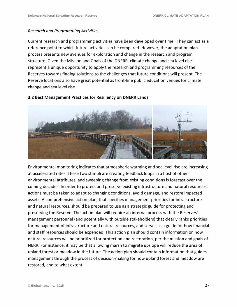
Delaware National Estuarine Research Reserve DNERR CLIMATE ADAPTATION PLAN
Research and Programming Activities
Current research and programming activities have been developed over time. They can act as a reference point to which future activities can be compared. However, the adaptation plan process presents new avenues for exploration and change in the research and program structure. Given the Mission and Goals of the DNERR, climate change and sea level rise represent a unique opportunity to apply the research and programming resources of the Reserves towards finding solutions to the challenges that future conditions will present. The Reserve locations also have great potential as front-line public education venues for climate change and sea level rise.
3.2 Best Management Practices for Resiliency on DNERR Lands
Environmental monitoring indicates that atmospheric warming and sea level rise are increasing at accelerated rates. These two stimuli are creating feedback loops in a host of other environmental attributes, and sweeping change from existing conditions is forecast over the coming decades. In order to protect and preserve existing infrastructure and natural resources, actions must be taken to adapt to changing conditions, avoid damage, and restore impacted assets. A comprehensive action plan, that specifies management priorities for infrastructure and natural resources, should be prepared to use as a strategic guide for protecting and preserving the Reserve. The action plan will require an internal process with the Reserves’ management personnel (and potentially with outside stakeholders) that clearly ranks priorities for management of infrastructure and natural resources, and serves as a guide for how financial and staff resources should be expended. This action plan should contain information on how natural resources will be prioritized for protection and restoration, per the mission and goals of NERR. For instance, it may be that allowing marsh to migrate upslope will reduce the area of upland forest or meadow in the future. The action plan should contain information that guides management through the process of decision-making for how upland forest and meadow are restored, and to what extent.
© Biohabitats, Inc. 2015 27
Delaware National Estuarine Research Reserve DNERR CLIMATE ADAPTATION PLAN
The following Best Management Practices (BMP’s) are examples of management tools that can be applied to help accomplish the comprehensive action plan’s specified goals. The BMP’s are organized by Infrastructure and Natural Resources categories.
© Biohabitats, Inc. 2015 28
Delaware National Estuarine Research Reserve DNERR CLIMATE ADAPTATION PLAN
Institutional BMPs by Type of Infrastructure
Practice and Goals Strategic Action Phase Priority*
Building Infrastructure – This includes the building spaces of the Reserve tracts including the headquarters, garages, barn, offices and outbuildings. These features represent the critical infrastructure for administration, staff offices, meeting space, programming, and storage essential to the NERR’s mission and delivery of services GOAL 1 – Protect the built infrastructure from climate change impacts mainly localized flooding, poor drainage, intensive storm winds, and major storm event storm surges.
1.a Improve drainage around building perimeter, waterproof foundations, install wick drains, and seal cracks, repair flashing and complete associate deferred exterior maintenance.
Phase 1, 2 and 3
1.b Provide strategic native plantings for wind breaks and shade around buildings, and also prune or remove damaged, dead or wind-fall susceptible trees/major limbs and other tall vegetation that presents a wind damage hazard.
Phase , 2 and 3
1.c Elevate buildings that can be modified or moved to bring finished floor and storage elevations above increased flooding and storm surge levels, as future predicted SLR levels elevate and flood elevations increase. Also consider retrofit of buildings to raise entrances, windows and foundations above future flood elevations.
Phase 2 and 3
1.d For new construction develop new standards requiring that waterproof materials be used in the construction of new infrastructure and in the repair or protection of existing infrastructure. Retrofit structures using waterproof shutters, shields or doors, and use salt and corrosion-resistant materials.
Phase 1
1.e Increase inspection and maintenance of infrastructure that that is sensitive to water or salt in areas at risk from sea level rise, storm events, or elevated groundwater levels.
Phase 2
1.f Relocate primary buildings if subject to recurring flooding frequency, damaged by major storms; or pro-actively site any future replacement facilities (as buildings reach expected life) to elevations above occurring floods and revised projected SLR.
Phase 2, and 3
1.g Prepare for recovery from flooding by stockpiling materials, establishing turn – key agreements for equipment rental, and pre – positioning emergency power generation capacity, portable pumps, and debris removal equipment.
Phase 1, 2 and 3
1.h Conduct a watershed analysis to identify opportunity sites for green infrastructure or low impact development (LID) techniques to improve stormwater and flood control system capacity to accommodate sea level and groundwater rise.
Phase 1
1.i Require that any hazardous materials stored on site are stored above projected flood levels or are protected from flood damage.
Phase 1, 2 and 3
*Phase 1 = Short term (1-3 years); Phase 2= Midterm (4-10 years); Phase 3 = Long Term (11- 15 + years)
© Biohabitats, Inc. 2015 29
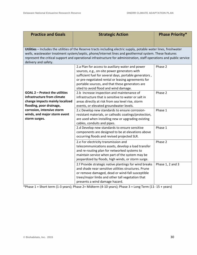
Delaware National Estuarine Research Reserve DNERR CLIMATE ADAPTATION PLAN
Practice and Goals Strategic Action Phase Priority*
Utilities – Includes the utilities of the Reserve tracts including electric supply, potable water lines, freshwater wells, wastewater treatment system/septic, phone/internet lines and geothermal system. These features represent the critical support and operational infrastructure for administration, staff operations and public service delivery and safety. GOAL 2 – Protect the utilities infrastructure from climate change impacts mainly localized flooding, poor drainage, corrosion, intensive storm winds, and major storm event storm surges.
2.a Plan for access to auxiliary water and power sources, e.g., on-site power generators with sufficient fuel for several days, portable generators , or pre-negotiated rental or leasing agreements for portable sources, and that these generators are sited to avoid flood and wind damage.
Phase 2
2.b Increase inspection and maintenance of infrastructure that is sensitive to water or salt in areas directly at risk from sea level rise, storm events, or elevated groundwater levels.
Phase 2
2.c Develop new standards to ensure corrosion-resistant materials, or cathodic coatings/protection, are used when installing new or upgrading existing cables, conduits and pipes.
Phase 1
2.d Develop new standards to ensure sensitive components are designed to be at elevations above occurring floods and revised projected SLR.
Phase 1
2.e For electricity transmission and telecommunications assets, develop a load transfer and re-routing plan for networked systems to maintain service when part of the system may be jeopardized by floods, high winds, or storm surge.
Phase 2
2.f Provide strategic native plantings for wind breaks and shade near sensitive utilities structures. Prune or remove damaged, dead or wind-fall susceptible trees/major limbs and other tall vegetation that presents a wind damage hazard.
Phase 1, 2 and 3
*Phase 1 = Short term (1-3 years); Phase 2= Midterm (4-10 years); Phase 3 = Long Term (11- 15 + years)
© Biohabitats, Inc. 2015 30
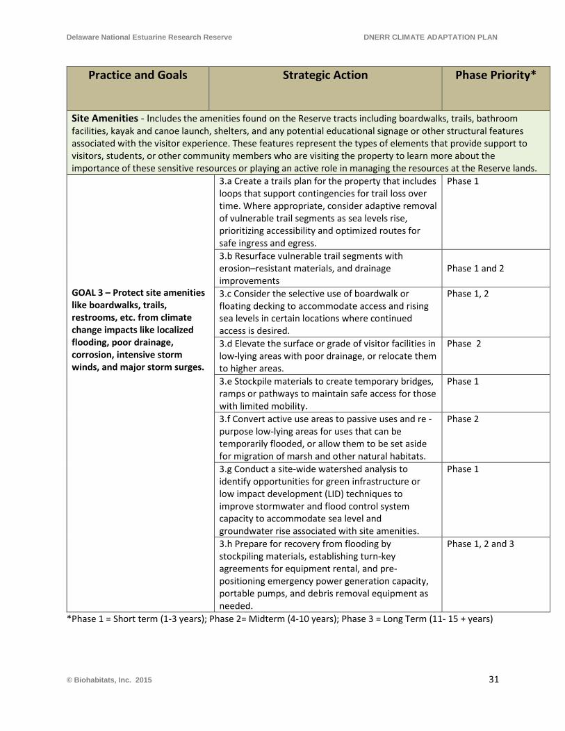
Delaware National Estuarine Research Reserve DNERR CLIMATE ADAPTATION PLAN
Practice and Goals Strategic Action Phase Priority*
Site Amenities - Includes the amenities found on the Reserve tracts including boardwalks, trails, bathroom facilities, kayak and canoe launch, shelters, and any potential educational signage or other structural features associated with the visitor experience. These features represent the types of elements that provide support to visitors, students, or other community members who are visiting the property to learn more about the importance of these sensitive resources or playing an active role in managing the resources at the Reserve lands. GOAL 3 – Protect site amenities like boardwalks, trails, restrooms, etc. from climate change impacts like localized flooding, poor drainage, corrosion, intensive storm winds, and major storm surges.
3.a Create a trails plan for the property that includes loops that support contingencies for trail loss over time. Where appropriate, consider adaptive removal of vulnerable trail segments as sea levels rise, prioritizing accessibility and optimized routes for safe ingress and egress.
Phase 1
3.b Resurface vulnerable trail segments with erosion–resistant materials, and drainage improvements
Phase 1 and 2
3.c Consider the selective use of boardwalk or floating decking to accommodate access and rising sea levels in certain locations where continued access is desired.
Phase 1, 2
3.d Elevate the surface or grade of visitor facilities in low-lying areas with poor drainage, or relocate them to higher areas.
Phase 2
3.e Stockpile materials to create temporary bridges, ramps or pathways to maintain safe access for those with limited mobility.
Phase 1
3.f Convert active use areas to passive uses and re - purpose low-lying areas for uses that can be temporarily flooded, or allow them to be set aside for migration of marsh and other natural habitats.
Phase 2
3.g Conduct a site-wide watershed analysis to identify opportunities for green infrastructure or low impact development (LID) techniques to improve stormwater and flood control system capacity to accommodate sea level and groundwater rise associated with site amenities.
Phase 1
3.h Prepare for recovery from flooding by stockpiling materials, establishing turn-key agreements for equipment rental, and pre-positioning emergency power generation capacity, portable pumps, and debris removal equipment as needed.
Phase 1, 2 and 3
*Phase 1 = Short term (1-3 years); Phase 2= Midterm (4-10 years); Phase 3 = Long Term (11- 15 + years)
© Biohabitats, Inc. 2015 31
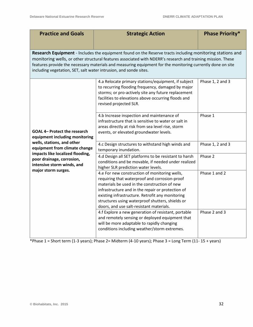
Delaware National Estuarine Research Reserve DNERR CLIMATE ADAPTATION PLAN
Practice and Goals Strategic Action Phase Priority*
Research Equipment - Includes the equipment found on the Reserve tracts including monitoring stations and monitoring wells, or other structural features associated with NDERR’s research and training mission. These features provide the necessary materials and measuring equipment for the monitoring currently done on site including vegetation, SET, salt water intrusion, and sonde sites. GOAL 4– Protect the research equipment including monitoring wells, stations, and other equipment from climate change impacts like localized flooding, poor drainage, corrosion, intensive storm winds, and major storm surges.
4.a Relocate primary stations/equipment, if subject to recurring flooding frequency, damaged by major storms; or pro-actively site any future replacement facilities to elevations above occurring floods and revised projected SLR.
Phase 1, 2 and 3
4.b Increase inspection and maintenance of infrastructure that is sensitive to water or salt in areas directly at risk from sea level rise, storm events, or elevated groundwater levels.
Phase 1
4.c Design structures to withstand high winds and temporary inundation.
Phase 1, 2 and 3
4.d Design all SET platforms to be resistant to harsh conditions and be movable, if needed under realized higher SLR prediction water levels.
Phase 2
4.e For new construction of monitoring wells, requiring that waterproof and corrosion-proof materials be used in the construction of new infrastructure and in the repair or protection of existing infrastructure. Retrofit any monitoring structures using waterproof shutters, shields or doors, and use salt-resistant materials.
Phase 1 and 2
4.f Explore a new generation of resistant, portable and remotely sensing or deployed equipment that will be more adaptable to rapidly changing conditions including weather/storm extremes.
Phase 2 and 3
*Phase 1 = Short term (1-3 years); Phase 2= Midterm (4-10 years); Phase 3 = Long Term (11- 15 + years)
© Biohabitats, Inc. 2015 32
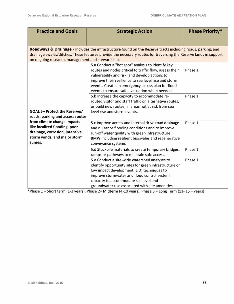
Delaware National Estuarine Research Reserve DNERR CLIMATE ADAPTATION PLAN
Practice and Goals Strategic Action Phase Priority*
Roadways & Drainage - Includes the infrastructure found on the Reserve tracts including roads, parking, and drainage swales/ditches. These features provide the necessary routes for traversing the Reserve lands in support on ongoing research, management and stewardship.
GOAL 5– Protect the Reserves’ roads, parking and access routes from climate change impacts like localized flooding, poor drainage, corrosion, intensive storm winds, and major storm surges.
5.a Conduct a "hot spot" analysis to identify key routes and nodes critical to traffic flow, assess their vulnerability and risk, and develop actions to improve their resilience to sea level rise and storm events. Create an emergency access plan for flood events to ensure safe evacuation when needed.
Phase 1
5.b Increase the capacity to accommodate re- routed visitor and staff traffic on alternative routes, or build new routes, in areas not at risk from sea level rise and storm events.
Phase 1
5.c Improve access and internal drive road drainage and nuisance flooding conditions and to improve run-off water quality with green infrastructure BMPs including resilient bioswales and regenerative conveyance systems
Phase 1
5.d Stockpile materials to create temporary bridges, ramps or pathways to maintain safe access.
Phase 1
5.e Conduct a site-wide watershed analyses to identify opportunity sites for green infrastructure or low impact development (LID) techniques to improve stormwater and flood control system capacity to accommodate sea level and groundwater rise associated with site amenities.
Phase 1
*Phase 1 = Short term (1-3 years); Phase 2= Midterm (4-10 years); Phase 3 = Long Term (11- 15 + years)
© Biohabitats, Inc. 2015 33
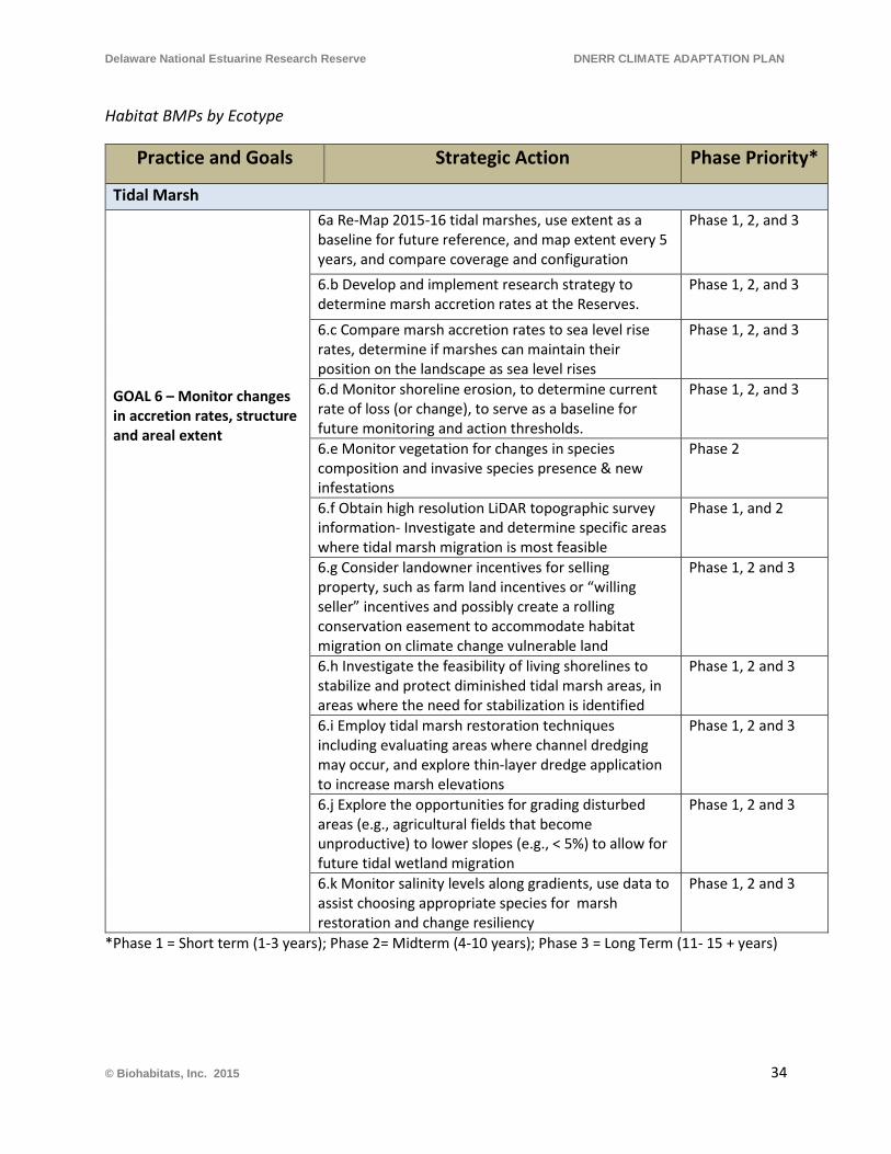
Delaware National Estuarine Research Reserve DNERR CLIMATE ADAPTATION PLAN
Habitat BMPs by Ecotype
Practice and Goals Strategic Action Phase Priority*
Tidal Marsh GOAL 6 – Monitor changes in accretion rates, structure and areal extent
6a Re-Map 2015-16 tidal marshes, use extent as a baseline for future reference, and map extent every 5 years, and compare coverage and configuration
Phase 1, 2, and 3
6.b Develop and implement research strategy to determine marsh accretion rates at the Reserves.
Phase 1, 2, and 3
6.c Compare marsh accretion rates to sea level rise rates, determine if marshes can maintain their position on the landscape as sea level rises
Phase 1, 2, and 3
6.d Monitor shoreline erosion, to determine current rate of loss (or change), to serve as a baseline for future monitoring and action thresholds.
Phase 1, 2, and 3
6.e Monitor vegetation for changes in species composition and invasive species presence & new infestations
Phase 2
6.f Obtain high resolution LiDAR topographic survey information- Investigate and determine specific areas where tidal marsh migration is most feasible
Phase 1, and 2
6.g Consider landowner incentives for selling property, such as farm land incentives or “willing seller” incentives and possibly create a rolling conservation easement to accommodate habitat migration on climate change vulnerable land
Phase 1, 2 and 3
6.h Investigate the feasibility of living shorelines to stabilize and protect diminished tidal marsh areas, in areas where the need for stabilization is identified
Phase 1, 2 and 3
6.i Employ tidal marsh restoration techniques including evaluating areas where channel dredging may occur, and explore thin-layer dredge application to increase marsh elevations
Phase 1, 2 and 3
6.j Explore the opportunities for grading disturbed areas (e.g., agricultural fields that become unproductive) to lower slopes (e.g., < 5%) to allow for future tidal wetland migration
Phase 1, 2 and 3
6.k Monitor salinity levels along gradients, use data to assist choosing appropriate species for marsh restoration and change resiliency
Phase 1, 2 and 3
*Phase 1 = Short term (1-3 years); Phase 2= Midterm (4-10 years); Phase 3 = Long Term (11- 15 + years)
© Biohabitats, Inc. 2015 34
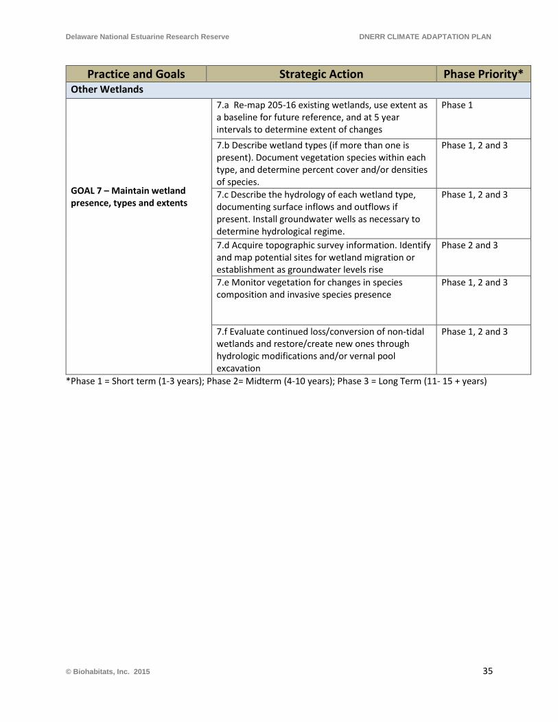
Delaware National Estuarine Research Reserve DNERR CLIMATE ADAPTATION PLAN
Practice and Goals Strategic Action Phase Priority* Other Wetlands GOAL 7 – Maintain wetland presence, types and extents
7.a Re-map 205-16 existing wetlands, use extent as a baseline for future reference, and at 5 year intervals to determine extent of changes
Phase 1
7.b Describe wetland types (if more than one is present). Document vegetation species within each type, and determine percent cover and/or densities of species.
Phase 1, 2 and 3
7.c Describe the hydrology of each wetland type, documenting surface inflows and outflows if present. Install groundwater wells as necessary to determine hydrological regime.
Phase 1, 2 and 3
7.d Acquire topographic survey information. Identify and map potential sites for wetland migration or establishment as groundwater levels rise
Phase 2 and 3
7.e Monitor vegetation for changes in species composition and invasive species presence
Phase 1, 2 and 3
7.f Evaluate continued loss/conversion of non-tidal wetlands and restore/create new ones through hydrologic modifications and/or vernal pool excavation
Phase 1, 2 and 3
*Phase 1 = Short term (1-3 years); Phase 2= Midterm (4-10 years); Phase 3 = Long Term (11- 15 + years)
© Biohabitats, Inc. 2015 35
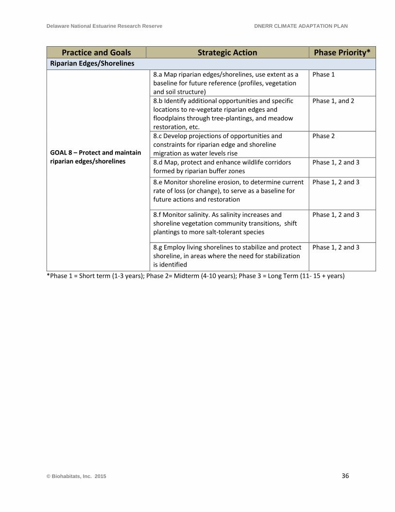
Delaware National Estuarine Research Reserve DNERR CLIMATE ADAPTATION PLAN
Practice and Goals Strategic Action Phase Priority* Riparian Edges/Shorelines GOAL 8 – Protect and maintain riparian edges/shorelines
8.a Map riparian edges/shorelines, use extent as a baseline for future reference (profiles, vegetation and soil structure)
Phase 1
8.b Identify additional opportunities and specific locations to re-vegetate riparian edges and floodplains through tree-plantings, and meadow restoration, etc.
Phase 1, and 2
8.c Develop projections of opportunities and constraints for riparian edge and shoreline migration as water levels rise
Phase 2
8.d Map, protect and enhance wildlife corridors formed by riparian buffer zones
Phase 1, 2 and 3
8.e Monitor shoreline erosion, to determine current rate of loss (or change), to serve as a baseline for future actions and restoration
Phase 1, 2 and 3
8.f Monitor salinity. As salinity increases and shoreline vegetation community transitions, shift plantings to more salt-tolerant species
Phase 1, 2 and 3
8.g Employ living shorelines to stabilize and protect shoreline, in areas where the need for stabilization is identified
Phase 1, 2 and 3
*Phase 1 = Short term (1-3 years); Phase 2= Midterm (4-10 years); Phase 3 = Long Term (11- 15 + years)
© Biohabitats, Inc. 2015 36
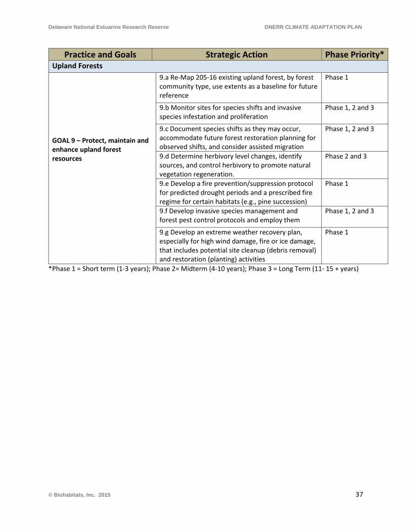
Delaware National Estuarine Research Reserve DNERR CLIMATE ADAPTATION PLAN
Practice and Goals Strategic Action Phase Priority* Upland Forests GOAL 9 – Protect, maintain and enhance upland forest resources
9.a Re-Map 205-16 existing upland forest, by forest community type, use extents as a baseline for future reference
Phase 1
9.b Monitor sites for species shifts and invasive species infestation and proliferation
Phase 1, 2 and 3
9.c Document species shifts as they may occur, accommodate future forest restoration planning for observed shifts, and consider assisted migration
Phase 1, 2 and 3
9.d Determine herbivory level changes, identify sources, and control herbivory to promote natural vegetation regeneration.
Phase 2 and 3
9.e Develop a fire prevention/suppression protocol for predicted drought periods and a prescribed fire regime for certain habitats (e.g., pine succession)
Phase 1
9.f Develop invasive species management and forest pest control protocols and employ them
Phase 1, 2 and 3
9.g Develop an extreme weather recovery plan, especially for high wind damage, fire or ice damage, that includes potential site cleanup (debris removal) and restoration (planting) activities
Phase 1
*Phase 1 = Short term (1-3 years); Phase 2= Midterm (4-10 years); Phase 3 = Long Term (11- 15 + years)
© Biohabitats, Inc. 2015 37
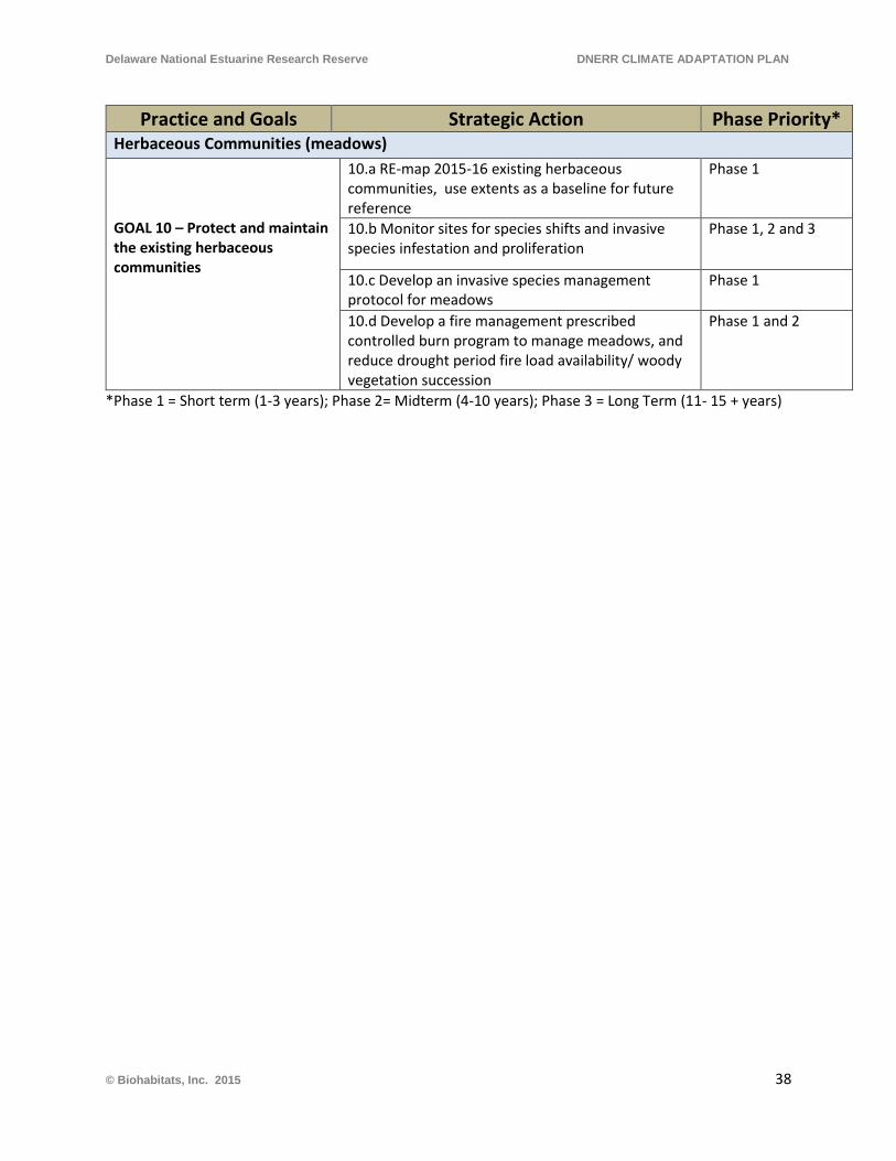
Delaware National Estuarine Research Reserve DNERR CLIMATE ADAPTATION PLAN
Practice and Goals Strategic Action Phase Priority* Herbaceous Communities (meadows) GOAL 10 – Protect and maintain the existing herbaceous communities
10.a RE-map 2015-16 existing herbaceous communities, use extents as a baseline for future reference
Phase 1
10.b Monitor sites for species shifts and invasive species infestation and proliferation
Phase 1, 2 and 3
10.c Develop an invasive species management protocol for meadows
Phase 1
10.d Develop a fire management prescribed controlled burn program to manage meadows, and reduce drought period fire load availability/ woody vegetation succession
Phase 1 and 2
*Phase 1 = Short term (1-3 years); Phase 2= Midterm (4-10 years); Phase 3 = Long Term (11- 15 + years)
© Biohabitats, Inc. 2015 38
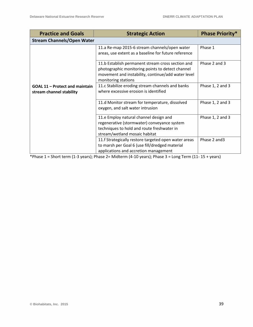
Delaware National Estuarine Research Reserve DNERR CLIMATE ADAPTATION PLAN
Practice and Goals Strategic Action Phase Priority* Stream Channels/Open Water GOAL 11 – Protect and maintain stream channel stability
11.a Re-map 2015-6 stream channels/open water areas, use extent as a baseline for future reference
Phase 1
11.b Establish permanent stream cross section and photographic monitoring points to detect channel movement and instability, continue/add water level monitoring stations
Phase 2 and 3
11.c Stabilize eroding stream channels and banks where excessive erosion is identified
Phase 1, 2 and 3
11.d Monitor stream for temperature, dissolved oxygen, and salt water intrusion
Phase 1, 2 and 3
11.e Employ natural channel design and regenerative (stormwater) conveyance system techniques to hold and route freshwater in stream/wetland mosaic habitat
Phase 1, 2 and 3
11.f Strategically restore targeted open water areas to marsh per Goal 6 (use fill/dredged material applications and accretion management
Phase 2 and3
*Phase 1 = Short term (1-3 years); Phase 2= Midterm (4-10 years); Phase 3 = Long Term (11- 15 + years)
© Biohabitats, Inc. 2015 39
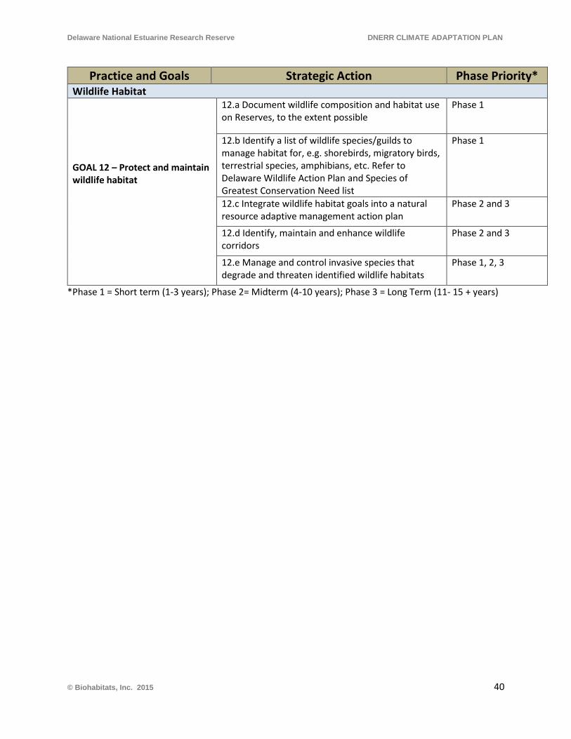
Delaware National Estuarine Research Reserve DNERR CLIMATE ADAPTATION PLAN
Practice and Goals Strategic Action Phase Priority* Wildlife Habitat GOAL 12 – Protect and maintain wildlife habitat
12.a Document wildlife composition and habitat use on Reserves, to the extent possible
Phase 1
12.b Identify a list of wildlife species/guilds to manage habitat for, e.g. shorebirds, migratory birds, terrestrial species, amphibians, etc. Refer to Delaware Wildlife Action Plan and Species of Greatest Conservation Need list
Phase 1
12.c Integrate wildlife habitat goals into a natural resource adaptive management action plan
Phase 2 and 3
12.d Identify, maintain and enhance wildlife corridors
Phase 2 and 3
12.e Manage and control invasive species that degrade and threaten identified wildlife habitats
Phase 1, 2, 3
*Phase 1 = Short term (1-3 years); Phase 2= Midterm (4-10 years); Phase 3 = Long Term (11- 15 + years)
© Biohabitats, Inc. 2015 40
Delaware National Estuarine Research Reserve DNERR CLIMATE ADAPTATION PLAN
3.3 Adaptive Management and Climate Change
“Adaptive management focuses on learning and adapting, through partnerships of managers, scientists, and other stakeholders who learn together how to create and maintain sustainable resource systems” (U.S. Fish and Wildlife Service (USFWS) Adaptive Management Technical Guide (2009). Adaptive management was originally developed as a problem-solving tool for the management of resources in the face of uncertainty. Determining a detailed structure for the adaptive management process, and how it should be applied to the Reserve’s resources, is a task that is beyond the scope of this plan, and will require time, planning and input from many institutional sources.
Why Choose the Adaptive Management Approach?
The DNERR is uniquely and strategically positioned to be a leader in the development of climate change adaptation techniques, not only locally, but for the Delaware Bay region and beyond. Given the Reserves’ mission and resources (on-site habitats and communities, staff expertise and research programs) there is abundant opportunity to apply its scientific research to predict future habitat shifts, changes and losses for the range of SLR projections (0.5 m, 1.0 m, and 1.5 m scenarios). Additionally, there is an opportunity to monitor the real-time impacts on these habitats as they change and to apply a science-based strategy to manage for continuing climate change resiliency. The organizational structure, mission and goals of the DNERR lend themselves to the application of adaptive management to the climate change and sea level rise challenges they are facing.
Protecting and maintaining the diverse infrastructure and natural resources of the Reserves as the climate changes and sea level rises is a complex undertaking. Protecting built infrastructure is a more straightforward process than protecting and maintaining the finite and evolving natural resources at the Reserves. Natural resource/habitat management will require additional baseline mapping and monitoring, analysis of monitoring data, and developing an adaptive management ‘action plan’ for managing change. The action plan, in a detailed way, will reflect a strategy for reacting to and managing changes within the existing natural resource and habitat types. The action plan’s components, such as the BMP’s provided in this climate adaptation plan, will reflect the value that the DNERR places on the various natural resources and habitat types that occur there, and consider how institutional and capital resources are expended to protect and conserve them.
With the Coastal Training Program and its Education Program the Reserve is uniquely able to translate the research that is conducted at the Reserve into information that can be applied by Delaware’s decision makers. Through the Reserve’s educational programming, it can also share
© Biohabitats, Inc. 2015 41
Delaware National Estuarine Research Reserve DNERR CLIMATE ADAPTATION PLAN
its research and findings with the general public, teachers and informal educators, and students.
Tying into Current Management of Estuarine Resources and Wildlife
Delaware NERR System-Wide Monitoring Program-Current Activities and Potential Needs The St. Jones River and Blackbird Creek watersheds support four water quality data logger sites and one meteorological station each. The water samples collected monthly at each site are analyzed for nutrients and chlorophyll with one site sampled monthly every 2.5 hours through a tidal cycle.
Biological monitoring instruments and infrastructure in place at the St. Jones Marsh is expected to track marsh health and species change over the long term. The Blackbird Creek Reserve should have a similar monitoring developed for it as well, as it occupies a broader range of the tidal and nontidal freshwater marsh system further upstream from Delaware Bay. There are numerous methods for monitoring multiple biological components of the estuarine marsh system. Monitoring regimens for fish, macroinvertebrate, bird, macrophyte, benthic algal and plankton communities should be accounted for as well. Additionally, upland meadow, scrub shrub, and forest communities will need to be continually evaluated. Permanent transects and randomized spot plots, observation points and humane cage/mist netting or photo capture sites should be included in upland long term monitoring efforts. Macrophytes, mammals, birds, macroinvertebrates, amphibians and reptiles should all be accounted for if resources are available to support a full biological baseline assessment for potentially determining the long term effects of climate change on the Reserve’s biological communities.
Surface Elevation Tables (SETs) located in the St. Jones River and Blackbird Creek watersheds are a critical monitoring component to evaluate the relative marsh accretion, sedimentation, or erosion from climate change induced sea level rise or local subsidence impacts. Additional SETS and monitoring should be located along the salinity gradients for each reserve to provide data indicating the biogenic effects of each vegetative community’s ability to keep pace with SLR. Additionally, the marsh carbon and mineral sediment, and upland soils coring baseline assessment should be expanded to develop a comprehensive baseline for each of the Reserves for future evaluation. Sediment and soil microbial communities should also be evaluated as part of the biological baseline when core samples are taken.
The numbers of stations for each of these monitoring components, their location and frequency of sampling should be reviewed internally as well as by an advisory group that can include external experts familiar with research monitoring plans as well as NERRs goals and objectives. Monitoring and research efforts of other NERRs can be reviewed and discussed in the context of identifying and evaluating climate change impacts. A planned effort to bring together local,
© Biohabitats, Inc. 2015 42
Delaware National Estuarine Research Reserve DNERR CLIMATE ADAPTATION PLAN
regional and national authorities for this work could be undertaken to serve as a model for other NERRs, while advancing climate change impact research and planning at the Reserve.
More than baseline monitoring, hypothesis-driven research, which is currently supported, can be augmented with direct program funding or competitive grants and facility resources that specifically address climate change impacts to the Reserves. Increasing the levels of funding for a greater degree of climate change research and monitoring may not be available at the state or federal level. Philanthropic entities with environmental goals may be persuaded to support some level of annual funding to expand current and support newly identified research efforts.
DNERR Education and Training As the effects of climate change at the Reserves are determined through research, it is recommended that these effects be communicated in the education and training programs. The DNERR 2013-2018 Management Plan’s Education and Training Goal is to improve public awareness and environmental literacy in our communities to enable environmentally sustainable decision-making. There are two primary objectives for research directed education and training to address the goals:
Objective 1: Enhance public awareness and understanding of the value and functions of estuarine ecosystems in the Mid-Atlantic Region.
Objective 2: Promote the wise use of estuarine resources and encourage a positive environmental stewardship ethic among Reserve users and visitors as well as coastal decision-makers.
The DNERR’s Coastal Training Program (CTP), which is in the Reserve’s education department, addresses these objectives by providing current scientific information, access to technologies and skill-building opportunities to Delawareans responsible for making decisions about the state’s coastal resources. The DNERR CTP’s Strategic Plan (2012-2017) identifies Climate Change and Sea Level Rise as one of the Program’s Priority Coastal Issues, and as stated in the CTP Strategic Plan, the CTP will develop trainings and workshops that communicate climate change science. This can include information about the climate adaptation planning and practices undertaken by the DNERR so coastal decision makers are able to apply best adaptation practices and techniques as well. When conducting programming, the CTP can also implement recommended practices for adaptation identified in this plan.
Climate change adaptation practices are also being investigated by several entities within Delaware, and the CTP can strategically partner with other organizations to deliver the latest research and information on the DNERR’s adaptation work as well as work by others on this topic. Coastal decision makers that the CTP can target for communicating this information can include local government officials, county government officials, state legislators, state agency
© Biohabitats, Inc. 2015 43
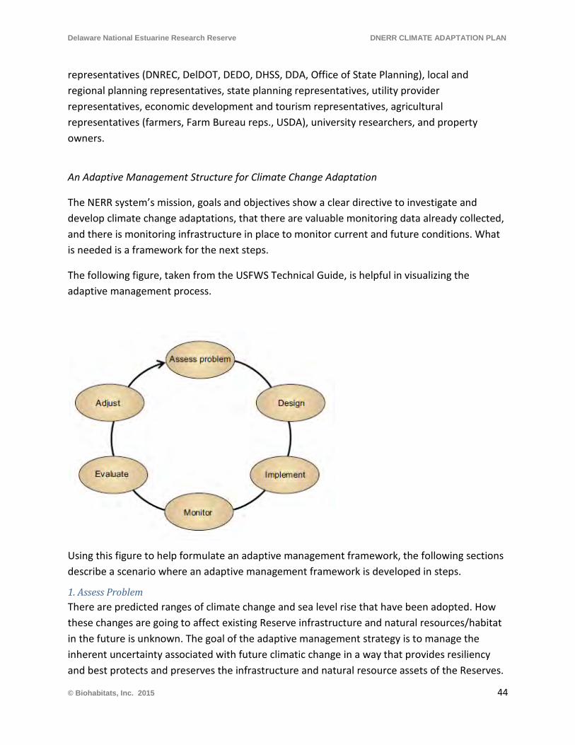
Delaware National Estuarine Research Reserve DNERR CLIMATE ADAPTATION PLAN
representatives (DNREC, DelDOT, DEDO, DHSS, DDA, Office of State Planning), local and regional planning representatives, state planning representatives, utility provider representatives, economic development and tourism representatives, agricultural representatives (farmers, Farm Bureau reps., USDA), university researchers, and property owners.
An Adaptive Management Structure for Climate Change Adaptation
The NERR system’s mission, goals and objectives show a clear directive to investigate and develop climate change adaptations, that there are valuable monitoring data already collected, and there is monitoring infrastructure in place to monitor current and future conditions. What is needed is a framework for the next steps.
The following figure, taken from the USFWS Technical Guide, is helpful in visualizing the adaptive management process.
Using this figure to help formulate an adaptive management framework, the following sections describe a scenario where an adaptive management framework is developed in steps.
1. Assess Problem There are predicted ranges of climate change and sea level rise that have been adopted. How these changes are going to affect existing Reserve infrastructure and natural resources/habitat in the future is unknown. The goal of the adaptive management strategy is to manage the inherent uncertainty associated with future climatic change in a way that provides resiliency and best protects and preserves the infrastructure and natural resource assets of the Reserves.
© Biohabitats, Inc. 2015 44
Delaware National Estuarine Research Reserve DNERR CLIMATE ADAPTATION PLAN
The management objectives of DNERR for infrastructure and natural resource/habitat protection and preservation should be described in as much detail as possible, so that the ultimate success or failure of an action or a group of actions can be determined with as high a resolution as possible.
2. Design an Adaptive Management Program Designing the approach to adaptation is a major step in the process. It requires:
• Estimating the amount of effort necessary to execute an climate change adaptation plan, determining the budget available for climate change adaptation efforts and creating an adaptive management design that is implementable based on the budget
• Assessment of existing historic data - a unique tool the Reserves can apply to the adaptive management design process for natural resources/habitat is the analysis of prior trends in communities and habitat losses and gains that occurred on the two Reserve tracts between 1937 and 2012 (Coxe 2013, and Coxe 2014). This work describes trends in habitat change that are valuable in projecting into the future and designing monitoring/research activities focused on adaptation questions
• Quantification, categorization and organization of information for all existing resources, infrastructure and natural resources that are at risk and management adaptation is needed for
• Gap analysis for any additional information that is determined to be lacking or absent • Determination of the most feasible method for modeling sea level rise; and reach
consensus on the degree of detail needed and which model to use • Modeling of the three accepted sea level rise scenarios (0.5m, 1.0m, and 1.5 m) to
estimate future impacts • Modeling of habitat shifts due to climate change, or prediction of habitat shifts based
on predicted future conditions • Formulation of specific hypotheses, or questions that management answers are needed
for (based on the results of the modeling) • Generation of predictions of outcomes, for comparison with hypothesis testing
outcomes • Development of data analysis and evaluation protocols for the hypotheses to be tested,
before an actual study begins, in order to inform the experimental design process • Prioritization of management objectives for infrastructure which includes
o a detailed analysis of how climate change and sea level rise may negatively affect infrastructure
o ranking of priorities for protection of infrastructure o development of detailed research/monitoring strategies that will address the
predicted problems
© Biohabitats, Inc. 2015 45
Delaware National Estuarine Research Reserve DNERR CLIMATE ADAPTATION PLAN
o review and refinement of research/monitoring strategies to facilitate efficient implementation and any ongoing needs if determined necessary in the future
• Prioritization of management objectives for natural resources includes o a detailed analysis of how climate change and sea level rise may affect natural
resources and habitat types o ranking resource protection/restoration goals, or development of a systematic
approach that describes which resources/habitats will receive priority in the event of limited resources or swiftly changing conditions
o development of detailed research/monitoring strategies that will address the predicted problems, monitor real-time effects and trend,
o review and refinement of research/monitoring strategies to facilitate efficient implementation and on-going need if it is determined necessary in the future
3. Implement The process for implementation of the adaptive management program should be considered and described in enough detail to satisfy budgeting feasibility in the Design step. Whatever detail is needed beyond what is generated in the Design step should be completed to facilitate and expedite the installation of the studies. Implementation of the Design should be carried out in a way that reflects the priorities established in the design step, following a sequence or hierarchy of importance and value to the overall Reserve mission. A log for each hypothesis-testing action or investigation should be maintained, beginning with the implementation step, so that if a disruption occurs during the implementation/ monitoring/ evaluation sequence of events, work completed through the disruption can be recreated, and time and information are not lost in recreating or redoing previously performed work.
4. Monitor Monitoring for each individual design takes place for as long as needed, in order to finish the respective investigations. A data collection, storage and management system should be clearly described for each experiment or investigative action. Planning is needed to ensure that there is continuity and clarity in how data is collected and stored, over time, so that data is not lost, recorded in obsolete formats, or unnecessarily complicated. Monitoring data should be carefully reviewed for quality assurance and quality control, to help ensure a reliable evaluation process.
5. Evaluate The evaluation of the monitoring data should follow protocols developed in the Design step. Describing how monitoring data is to be evaluated in the design step is important for continuity of the research over time, and helps to define the scope of the adjustment process. This process obviously can be revised if the data collected indicate that a different analysis will be
© Biohabitats, Inc. 2015 46
Delaware National Estuarine Research Reserve DNERR CLIMATE ADAPTATION PLAN
more effective. Care should be taken in the evaluation step that the results are interpreted on a realistic scale, and that appropriate protocol is followed in the derivation of results.
6. Adjust Based on the evaluation of hypothesis testing, adjustments to management can be derived. Development of resilient management adaptation actions, based on the evaluation results of monitoring, defines the endpoint of one iteration of the adaptive management cycle. Then the newly developed, and hopefully more effective management adaptations should be subjected to the same process, whereby their effectiveness is tested by implementation, monitoring and evaluation.
Applicability of Adaptive Management and Steps Forward
There is good historic monitoring data available to begin the adaptive management process, and there is a good analysis of the past vegetative communities at both Reserves that can be used to develop hypotheses for investigation. An important component that is needed in the design process is a categorization of resources and prioritization or ranking of infrastructure and natural resource/habitat values, based on the mission and goals of the Reserves. This prioritization process is may be challenging to accomplish, but it is necessary to rank priorities, so that meaningful action plans can be formulated to solve the potential problems facing the Reserves. The other utility in the prioritization is its value in deciding which questions to answer first, based on a limited resources scenario.
The NERR is, by nature, a learning organization, and it is well suited for formulating and following the steps in the adaptive management process. As is often stated in the literature, adaptive management is not monitoring management and then changing techniques to accommodate change. Adaptive management requires an intentional process of describing the challenge, formulating alternative approaches to problem solving, monitoring the results, and then analyzing data to determine which alternative provides the best solution. When the best alternative solution is determined, it is implemented and the iterative process of adaptive management begins again.
Another important benefit of adaptive management is the educational and information sharing aspect. An adaptive management process will not only involve all internal DNERR staff and stakeholders, but it will provide a seminal opportunity to collaborate with other regional and national entities who are also dealing with climate change adaptation.
© Biohabitats, Inc. 2015 47
Delaware National Estuarine Research Reserve DNERR CLIMATE ADAPTATION PLAN
REFERENCES
Allen, O., Barkus, Brianna, and Bennett, Karen. 2006. Delaware Wildlife Action Plan 2007 – 2017. Delaware Natural Heritage and Endangered Species Program Delaware Division of Fish and Wildlife. Delaware Department of Natural Resources and Environmental Control, 89 Kings Highway, Dover, DE 19901.
City of Keene, New Hampshire Planning. 2007. Keene, New Hampshire- Adapting to Climate Change: Planning a Climate Resilient Community. City of Keene, N.H., in association with ICLEI, Local Governments for Sustainability.
Cowardin, L.M., V. Carter, F.C. Golet, and E.T. LaRoe. 1979. Classification of wetlands and deepwater habitats of the United States. U.S. Department of Interior, Fish and Wildlife Service, Office of Biological Services.
Coxe, Robert. 2014. Historical Analysis and Map of Vegetation Communities, Land Covers, and Habitats of DNERRS Blackbird Creek Reserve, New Castle County Delaware 1937-2012. Delaware Wildlife Species Conservation and Research Program Wildlife Section, Dept. of Natural Resources and Environmental Control.
Coxe, Robert. 2013. Historical Analysis and Map of Vegetation Communities, Land Covers, and Habitats of DNERRS St. Jones Reserve, Kent County Delaware. Delaware Wildlife Species Conservation and Research Program Wildlife Section, Dept. of Natural Resources and Environmental Control.
Delaware Division of Energy and Climate. 2014. Delaware Climate Change Impact Assessment. Delaware Department of Natural Resources and Environmental Control, Dover, Delaware.
Delaware National Estuarine Research Reserve (DNERR). 2013. Delaware National Estuarine Research Reserve Management Plan. 2013-2018. 2nd Revision August 2013.
Delaware Natural Resources and Environmental Control Sea Level Rise Technical Workgroup. 2009. Recommended Sea Level Rise Scenarios for Delaware. Delaware Coastal Programs Section of DNREC.
Delaware Valley Regional Planning Commission. 2004. Sea level rise impacts in the Delaware estuary of Pennsylvania. Pennsylvania Coastal Zone Management Program, PA Department of Environmental Protection, Water Planning Office, CZM Project Number: 2002-PD.20.
Fisher, A. 2000. Preliminary findings from the Mid-Atlantic Regional Assessment. Climate Research 14, 261–269.
Frumhoff, P.C., J.J. McCarthy, J.M. Melillo, S.C. Moser, and D.J. Wuebbles. 2007. Confronting Climate Change in the U.S. Northeast: Science, Impacts, and Solutions. Synthesis report of the Northeast Climate Impacts Assessment (NECIA). Cambridge, MA: Union of Concerned Scientists (UCS).
© Biohabitats, Inc. 2015 48
Delaware National Estuarine Research Reserve DNERR CLIMATE ADAPTATION PLAN
Galbraith, H., Jones, R., Park, R., Clough, J., Herrod-Julius, S., Harrington, B., Page, G. 2002. Global Climate Change and Sea Level Rise: Potential Losses of Intertidal Habitat for Shorebirds. Waterbirds 25(2): 173-183.
Hare, William. 2003. Assessment of Knowledge on Impacts of Climate Change – Contribution to the Specification of Article 2 of the UNFCCC: Impacts on Ecosystems, Food Production, Water and Socio-economic Systems. Report prepared for the German Advisory Council on Global Change. http://www.wbgu.de/fileadmin/templates/dateien/veroeffentlichungen/sondergutachten/sn2003/wbgu_sn2003_ex01.pdf
Hellmann, J. J., Byers, J.E., Bierwagen, B.G., Dukes, J. 2008. "Five potential consequences of climate change for invasive species." Conservation Biology 22(3): 534-543
Intergovernmental Panel on Climate Change (IPCC). 2014. Climate Change 2014: Impacts, Adaptation and Vulnerability. IPCC Workgroup II. 5th Assessment Report. WGII AR5. 1820 pp.
Kreeger, D., J. Adkins, P. Cole, R. Najjar, D. Velinsky, P. Conolly, and J. Kraeuter. June 2010. Climate Change and the Delaware Estuary: Three Case Studies in Vulnerability Assessment and Adaptation Planning. Partnership for the Delaware Estuary, PDE Report No. 10-01. 1 –117 pp. http://archive.delawareonline.com/assets/pdf/BL161173722.PDF)
Love, S., Ellwood, M., Siok, D., Smith, K., Valencik, K., and Whiteman, C. 2014. Preparing for Tomorrow’s High Tide: 2014 Sea Level Rise Workshop Proceedings and Interim Implementation Plan. Delaware Department of Natural Resources and Environmental Control Delaware Coastal Programs.
Love, S., Arndt, T., and Ellwood, M. 2013. Preparing for Tomorrow’s High Tide: Recommendations for Adapting to Sea Level Rise in Delaware. Final Report of the Delaware Sea Level Rise Advisory Committee. Delaware Department of Natural Resources and Environmental Control Delaware Coastal Programs.
Love, S., Arndt, T., and Ellwood, M. 2013. Preparing for Tomorrow’s High Tide: Sea Level Rise Vulnerability Assessment for the State of Delaware. Final Report of the Delaware Sea Level Rise Advisory Committee. Delaware Department of Natural Resources and Environmental Control Delaware Coastal Programs.
Lowe, Lindy and Rebecca Lunde. Adapting to Rising Tides – adaptation responses. A project of the NOAA Coastal Services Center and the San Francisco Bay Conservation and Development Commission. Accessed online February 2015. (http://www.adaptingtorisingtides.org/project-reports/#responsecards)
Maryland Commission on Climate Change Adaptation and Response Working Group. 2008. Comprehensive Strategy for Reducing Maryland’s Vulnerability to Climate Change, Phase I: Sea-level Rise and Coastal Storms. Chapter 5 in Report of the Maryland Commission on Climate Change Adaptation and Response Working Group
© Biohabitats, Inc. 2015 49
Delaware National Estuarine Research Reserve DNERR CLIMATE ADAPTATION PLAN
McKenney-Easterling, M., DeWalle, D.R., Iverson, L.R., Prasad, A.M., Buda, A.R. 2000. The potential impacts of climate change and variability on forests and forestry in the Mid-Atlantic Region. Climate Research 14, 195–206.
Morris, J.T., Sundareshwar, P.V., Nietch, C.T., Kjerfve, B., Cahoon, D.R. 2002. Responses of Coastal Wetlands to Rising Sea Level. Ecology 83:2869–2877
Najjar, R. G., H. A. Walker, P. J. Anderson, E. J. Barron, R. J. Bord, J. R. Gibson, V. S. Kennedy, C. G. Knight, J. P. Megonigal, R. E. O’Conner, C. D. Polsky, N. P. Psuty, B. A. Richards, L. G. Sorenson, E. M. Steele, and R. S. Swanson. 2000. The potential impacts of climate change on the mid-Atlantic coastal region. Climate Research 14: 219–233
NASA, NOAA Release 15-010. NASA, NOAA Find 2014 Warmest Year in Modern Record. Goddard Institute for Space Studies GISS. Surface Temperature Analysis Press Release, January 2015.
National Estuarine Research Reserve System. 2008. Climate Change: Science, education and stewardship for tomorrow’s estuaries. NOAA National Ocean Service, Office of Ocean and Coastal Resource Management, Estuarine Reserves Division, 1305 East West Highway N/ORM5, Silver Spring, Maryland 20910
National Estuarine Research Reserve System (NEERS). 2011. System-Wide Monitoring Program Plan. Estuarine Reserves Division, N/ORM5. NOAA National Ocean Service. Silver Spring, MD.
Neff, R., Chang, H.J., Knight, C.G., Najjar, R.G., Yarnal, B., Walker, H.A., 2000. Impact of climate variation and change on Mid-Atlantic Region hydrology and water resources. Climate Research 14, 207–218
Pachauri, Rajendra K. and Leo Meyer, Editors. 2014. CLIMATE CHANGE 2014 Synthesis Report, Intergovernmental Panel on Climate Change. World Meteorological Organization, Geneva, Switzerland.
Partnership for the Delaware Estuary. 2007. Chapter 3: Northeast National Estuary Program Coastal Condition. http://www.epa.gov/owow/oceans/nepccr/index.html.
Polsky, Colin, Allard, J., Currit, N., Crane, R., Yarnal, B. 2000. The Mid-Atlantic Region and its climate: past, present, and future. Climate Research 14, 161–173.
Reeve, K. and R. Kingston. 2014 Green Works for Climate Resilience: A Guide to Community Planning for Climate Change. National Wildlife Federation, Washington, DC. http://www.nwf.org/~/media/PDFs/Global-Warming/Climate-Smart-Conservation/2014/green-works-final-for-web.pdf
Rice, Tracey Monegan. 2009. Best Management Practices For Shoreline Stabilization to Avoid and Minimize Adverse Environmental Impacts. Prepared for the USFWS, Panama City Ecological Services Field Office.
© Biohabitats, Inc. 2015 50
Delaware National Estuarine Research Reserve DNERR CLIMATE ADAPTATION PLAN
http://www.fws.gov/charleston/pdf/PIPL/BMPs%20For%20Shoreline%20Stabilization%20To%20Avoid%20And%20Minimize%20Adverse%20Environmental%20Impacts.pdf
Rogers, C.E., McCarty, J.P., 2000. Climate change and ecosystems of the Mid-Atlantic Region. Climate Research 14, 235–244
Schneider, S.H., S. Semenov, A. Patwardhan, I. Burton, C.H.D. Magadza, M. Oppenheimer, A.B. Pittock, A. Rahman, J.B. Smith, A. Suarez and F. Yamin, 2007: Assessing key vulnerabilities and the risk from climate change. Climate Change 2007: Impacts, Adaptation and Vulnerability. Contribution of Working Group II to the Fourth Assessment Report of the Intergovernmental Panel on Climate Change, M.L. Parry, O.F. Canziani, J.P. Palutikof, P.J. van der Linden and C.E. Hanson, Eds., Cambridge University Press, Cambridge, UK, 779-810.
Sorensen, Robert M. "Control of Erosion, Inundation, and Salinity Intrusion Caused By Sea Level Rise” chapter in Greenhouse Effect and Sea Level Rise: A Challenge for This Generation, Van Nostrand Reinhold, ISBN 0442209916 1984.
Tiner, R. W. (1985). Wetlands of Delaware. Newton Corner, MA and Dover, DE: USFWS and Delaware Department of Natural Resources and Environmental Control.
U.S. EPA (2009). Synthesis of Adaptation Options for Coastal Areas. Washington, DC, U.S. Environmental Protection Agency, Climate Ready Estuaries Program. EPA 430-F-08-024, January 2009.
Williams, B. K., R. C. Szaro, and C. D. Shapiro. 2009. Adaptive Management: The U.S. Department of the Interior Technical Guide. Adaptive Management Working Group, U.S. Department of the Interior, Washington, DC.
© Biohabitats, Inc. 2015 51
Delaware National Estuarine Research Reserve DNERR CLIMATE ADAPTATION PLAN
APPENDIX A - FIGURES
© Biohabitats, Inc. 2015 52
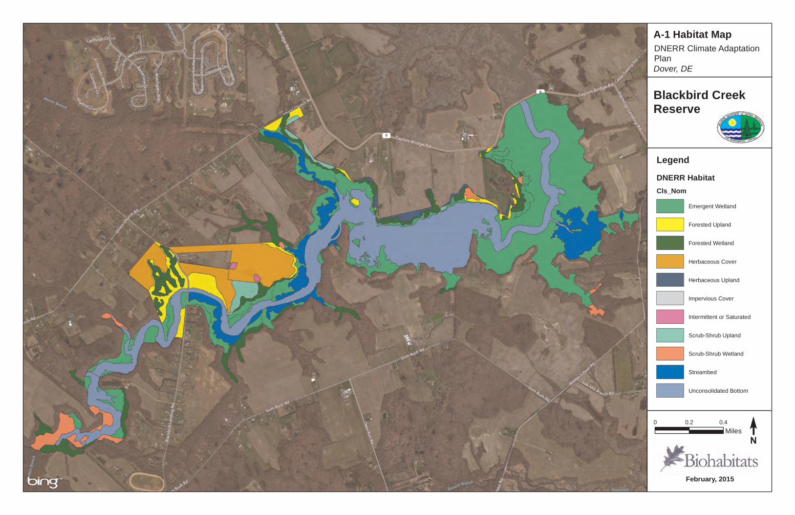
February, 2015
Blackbird CreekReserve
LegendDNERR HabitatCls_Nom
Emergent Wetland
Forested Upland
Forested Wetland
Herbaceous Cover
Herbaceous Upland
Impervious Cover
Intermittent or Saturated
Scrub-Shrub Upland
Scrub-Shrub Wetland
Streambed
Unconsolidated Bottom
0 0.2 0.4Miles
A-1 Habitat Map
Dover, DEDNERR Climate Adaptation Plan
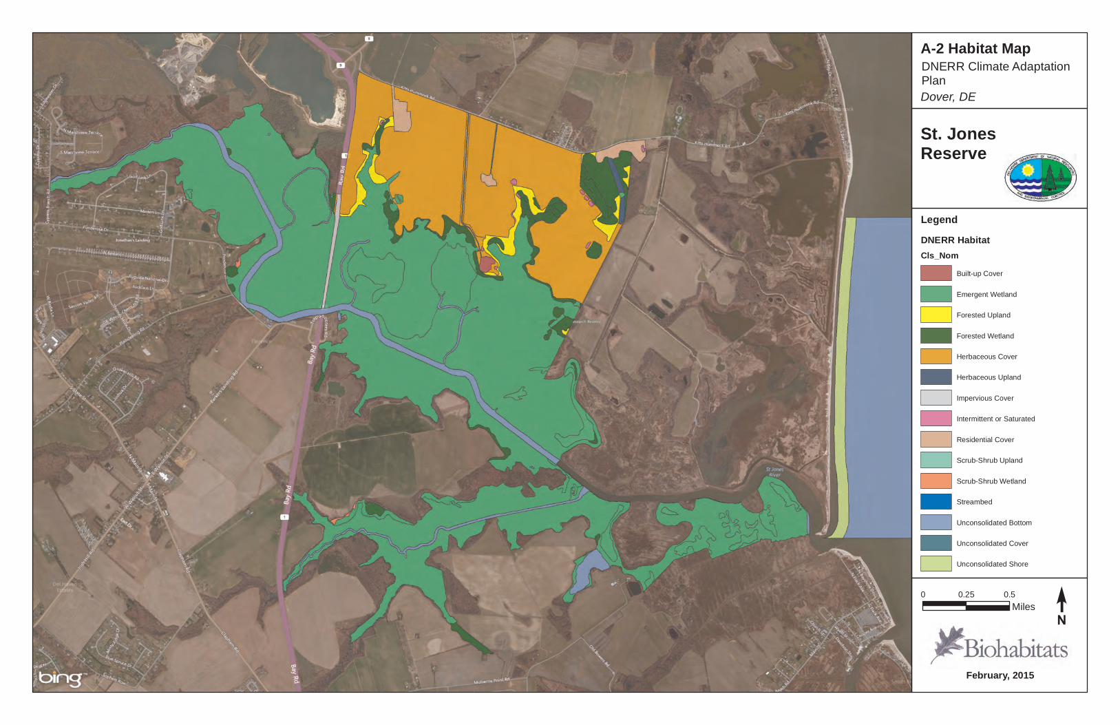
February, 2015
St. JonesReserve
0 0.25 0.5Miles
A-2 Habitat Map
Dover, DE
DNERR Climate Adaptation Plan
LegendDNERR HabitatCls_Nom
Built-up Cover
Emergent Wetland
Forested Upland
Forested Wetland
Herbaceous Cover
Herbaceous Upland
Impervious Cover
Intermittent or Saturated
Residential Cover
Scrub-Shrub Upland
Scrub-Shrub Wetland
Streambed
Unconsolidated Bottom
Unconsolidated Cover
Unconsolidated Shore
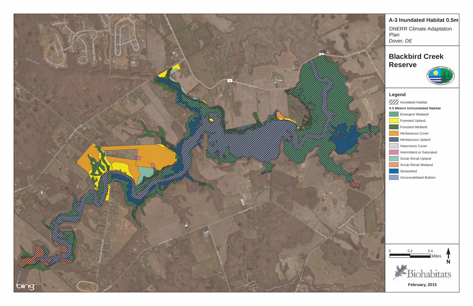
February, 2015
Blackbird CreekReserve
0 0.2 0.4Miles
A-3 Inundated Habitat 0.5m
Dover, DEDNERR Climate Adaptation Plan
LegendInundated Habitat
0.5 Meters Uninundated HabitatEmergent Wetland
Forested Upland
Forested Wetland
Herbaceous Cover
Herbaceous Upland
Impervious Cover
Intermittent or Saturated
Scrub-Shrub Upland
Scrub-Shrub Wetland
Streambed
Unconsolidated Bottom
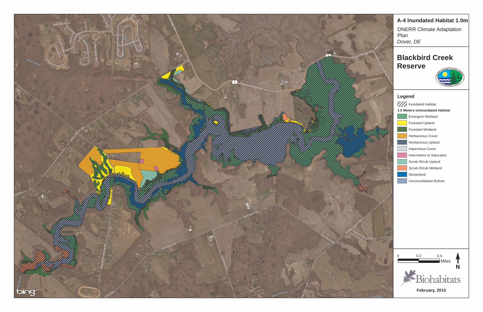
February, 2015
Blackbird CreekReserve
0 0.2 0.4Miles
A-4 Inundated Habitat 1.0m
Dover, DEDNERR Climate Adaptation Plan
LegendInundated Habitat
1.0 Meters Uninundated HabitatEmergent Wetland
Forested Upland
Forested Wetland
Herbaceous Cover
Herbaceous Upland
Impervious Cover
Intermittent or Saturated
Scrub-Shrub Upland
Scrub-Shrub Wetland
Streambed
Unconsolidated Bottom

February, 2015
Blackbird CreekReserve
0 0.2 0.4Miles
A-5 Inundated Habitat 1.5m
Dover, DEDNERR Climate Adaptation Plan
LegendInundated Habitat
1.5 Meters Uninundated HabitatEmergent Wetland
Forested Upland
Forested Wetland
Herbaceous Cover
Herbaceous Upland
Impervious Cover
Intermittent or Saturated
Scrub-Shrub Upland
Scrub-Shrub Wetland
Streambed
Unconsolidated Bottom
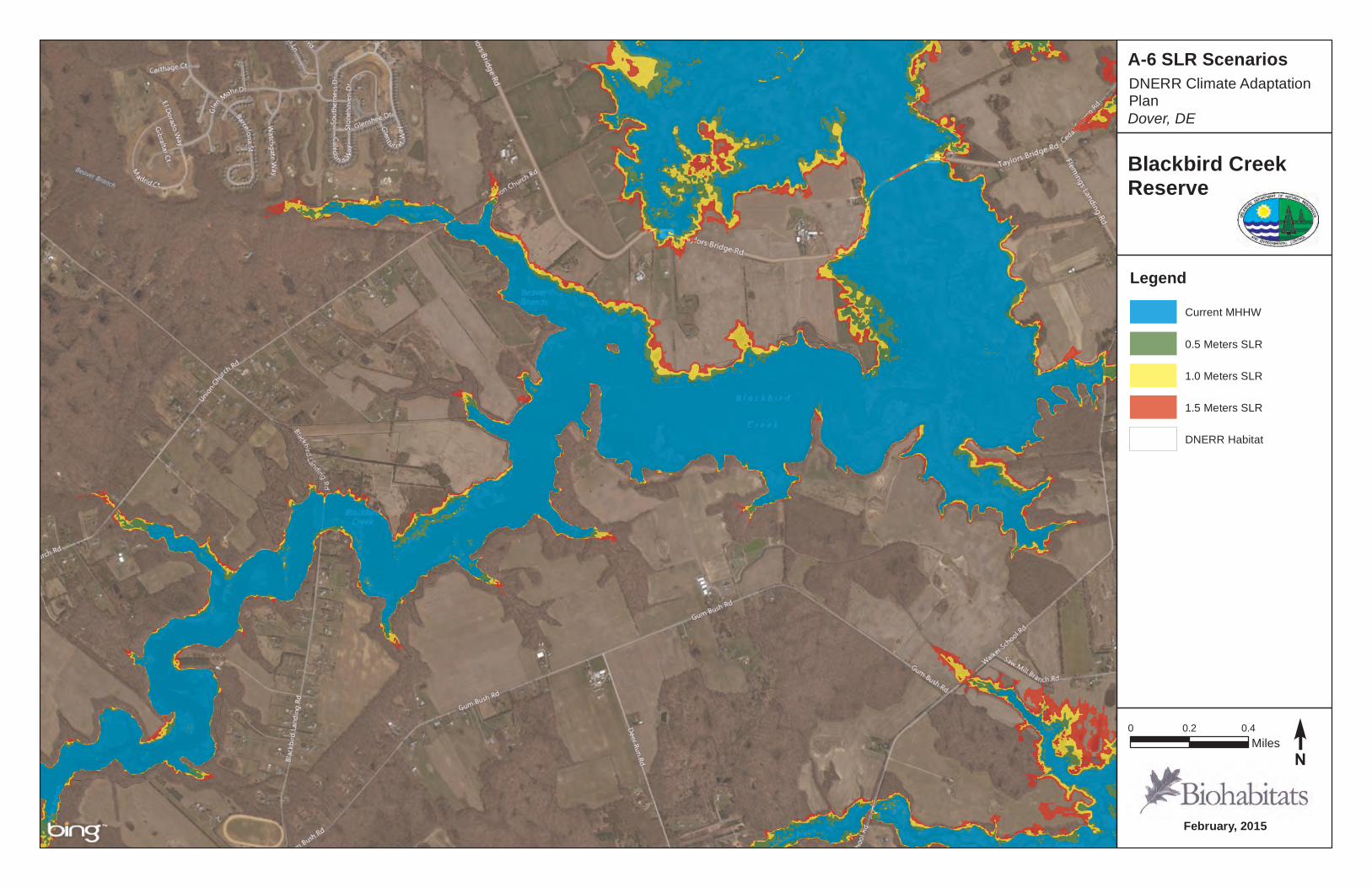
February, 2015
Blackbird CreekReserve
0 0.2 0.4Miles
A-6 SLR Scenarios
Dover, DEDNERR Climate Adaptation Plan
LegendCurrent MHHW
0.5 Meters SLR
1.0 Meters SLR
1.5 Meters SLR
DNERR Habitat

February, 2015
St. JonesReserve
0 0.25 0.5Miles
A-7 Inundated Habitat 0.5m
Dover, DE
DNERR Climate Adaptation Plan
LegendInundated Habitat
0.5 Meters Uninundated HabitatBuilt-up Cover
Emergent Wetland
Forested Upland
Forested Wetland
Herbaceous Cover
Herbaceous Upland
Impervious Cover
Intermittent or Saturated
Residential Cover
Scrub-Shrub Wetland
Streambed
Unconsolidated Bottom
Unconsolidated Cover
Unconsolidated Shore
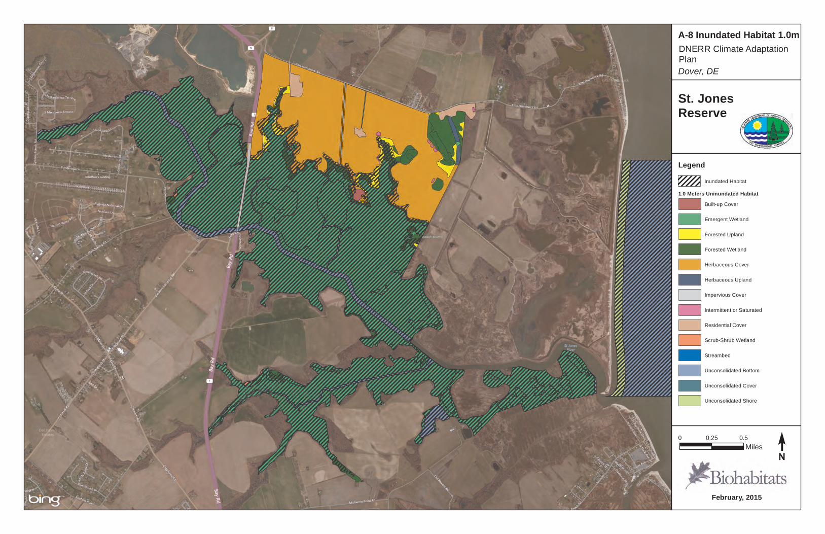
February, 2015
St. JonesReserve
0 0.25 0.5Miles
A-8 Inundated Habitat 1.0m
Dover, DE
DNERR Climate Adaptation Plan
LegendInundated Habitat
1.0 Meters Uninundated HabitatBuilt-up Cover
Emergent Wetland
Forested Upland
Forested Wetland
Herbaceous Cover
Herbaceous Upland
Impervious Cover
Intermittent or Saturated
Residential Cover
Scrub-Shrub Wetland
Streambed
Unconsolidated Bottom
Unconsolidated Cover
Unconsolidated Shore

February, 2015
St. JonesReserve
0 0.25 0.5Miles
A-9 Inundated Habitat 1.5m
Dover, DE
DNERR Climate Adaptation Plan
LegendInundated Habitat
1.5 Meters Uninundated HabitatBuilt-up Cover
Emergent Wetland
Forested Upland
Forested Wetland
Herbaceous Cover
Herbaceous Upland
Impervious Cover
Intermittent or Saturated
Residential Cover
Scrub-Shrub Wetland
Streambed
Unconsolidated Bottom
Unconsolidated Cover
Unconsolidated Shore
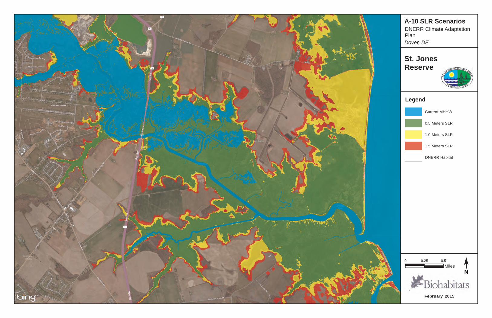
February, 2015
St. JonesReserve
0 0.25 0.5Miles
A-10 SLR Scenarios
Dover, DE
DNERR Climate Adaptation Plan
LegendCurrent MHHW
0.5 Meters SLR
1.0 Meters SLR
1.5 Meters SLR
DNERR Habitat
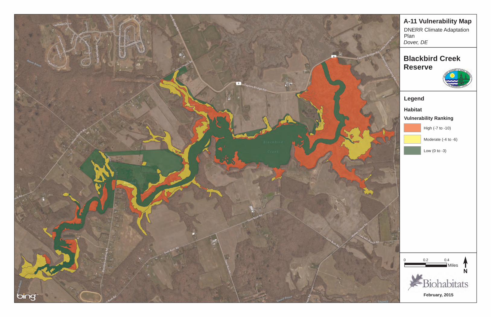
February, 2015
Blackbird CreekReserve
LegendHabitatVulnerability Ranking
High (-7 to -10)
Moderate (-4 to -6)
Low (0 to -3)
0 0.2 0.4Miles
A-11 Vulnerability Map
Dover, DEDNERR Climate Adaptation Plan
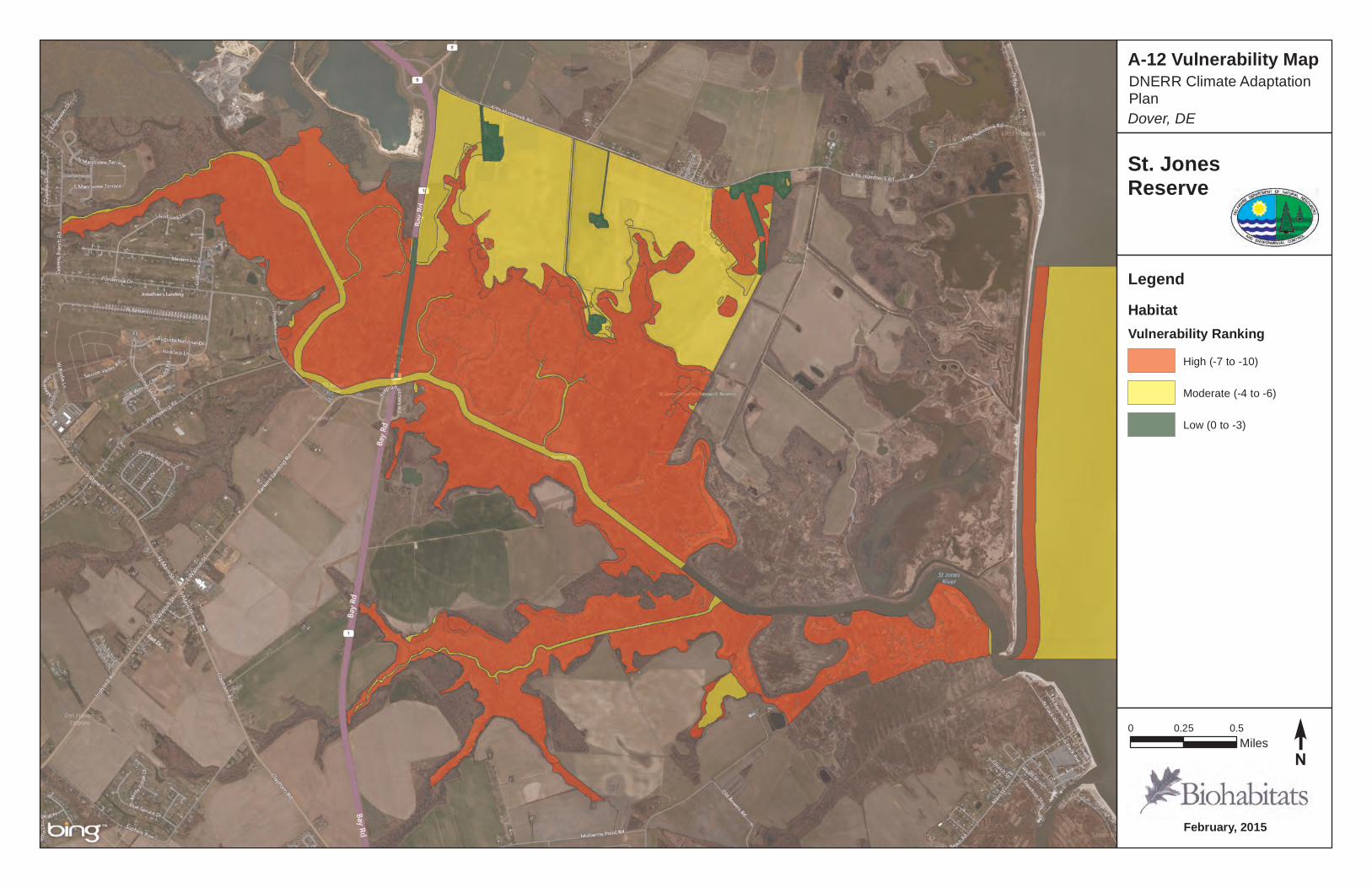
February, 2015
St. JonesReserve
0 0.25 0.5Miles
A-12 Vulnerability Map
Dover, DE
DNERR Climate Adaptation Plan
LegendHabitatVulnerability Ranking
High (-7 to -10)
Moderate (-4 to -6)
Low (0 to -3)
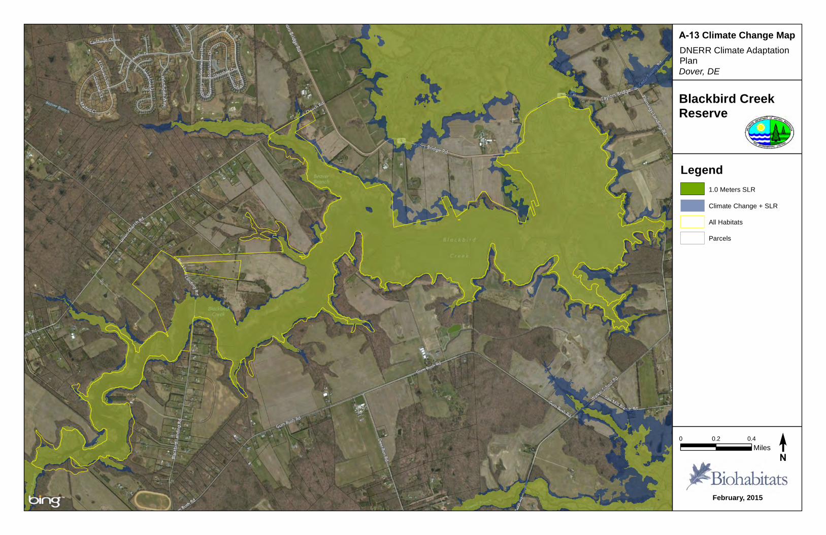
February, 2015
Blackbird CreekReserve
0 0.2 0.4Miles
A-13 Climate Change Map
Dover, DEDNERR Climate Adaptation Plan
Legend1.0 Meters SLR
Climate Change + SLR
All Habitats
Parcels
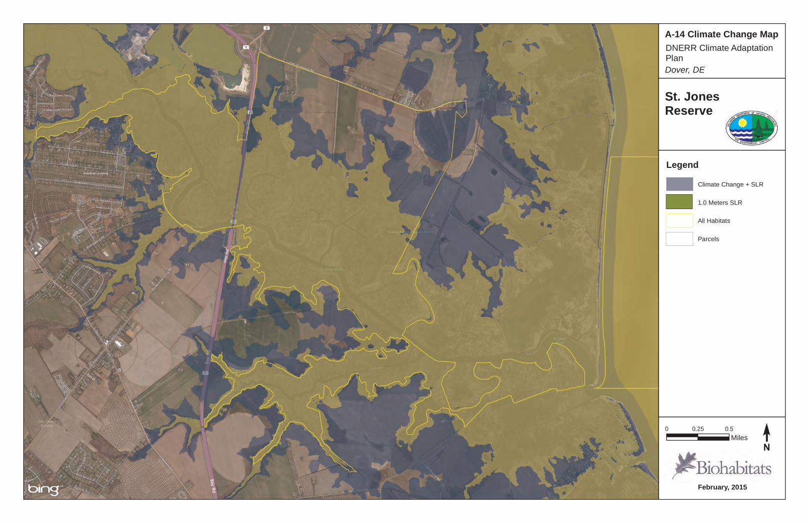
February, 2015
St. JonesReserve
0 0.25 0.5Miles
A-14 Climate Change Map
Dover, DE
DNERR Climate Adaptation Plan
LegendClimate Change + SLR
1.0 Meters SLR
All Habitats
Parcels
Delaware National Estuarine Research Reserve DNERR CLIMATE ADAPTATION PLAN
APPENDIX B – TABLES
© Biohabitats, Inc. 2015 53
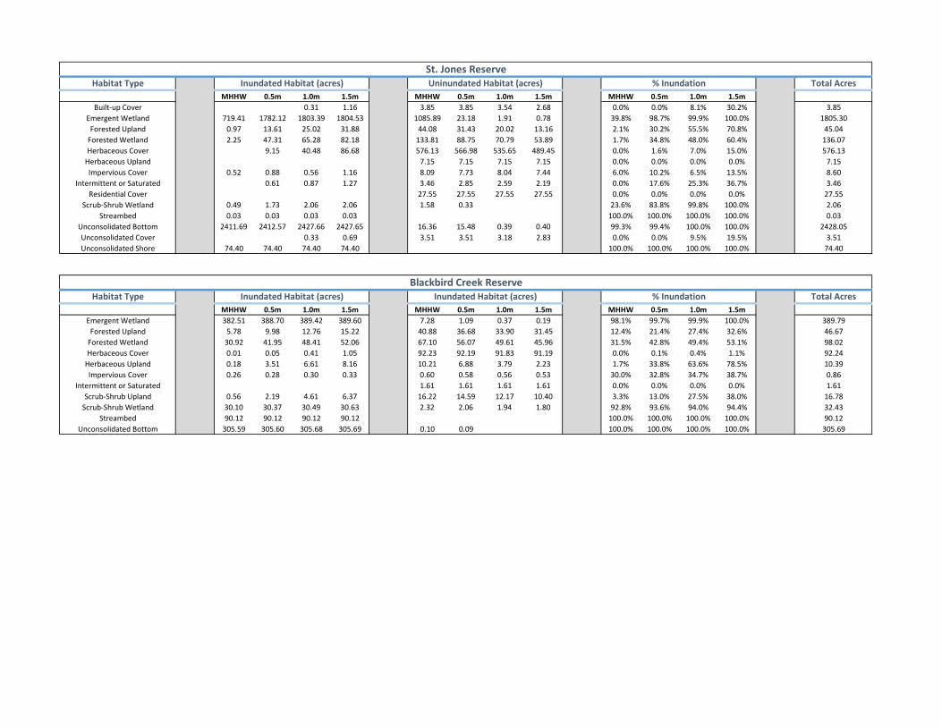
MHHW 0.5m 1.0m 1.5m MHHW 0.5m 1.0m 1.5m MHHW 0.5m 1.0m 1.5m0.31 1.16 3.85 3.85 3.54 2.68 0.0% 0.0% 8.1% 30.2%
719.41 1782.12 1803.39 1804.53 1085.89 23.18 1.91 0.78 39.8% 98.7% 99.9% 100.0%0.97 13.61 25.02 31.88 44.08 31.43 20.02 13.16 2.1% 30.2% 55.5% 70.8%2.25 47.31 65.28 82.18 133.81 88.75 70.79 53.89 1.7% 34.8% 48.0% 60.4%
9.15 40.48 86.68 576.13 566.98 535.65 489.45 0.0% 1.6% 7.0% 15.0%7.15 7.15 7.15 7.15 0.0% 0.0% 0.0% 0.0%
0.52 0.88 0.56 1.16 8.09 7.73 8.04 7.44 6.0% 10.2% 6.5% 13.5%0.61 0.87 1.27 3.46 2.85 2.59 2.19 0.0% 17.6% 25.3% 36.7%
27.55 27.55 27.55 27.55 0.0% 0.0% 0.0% 0.0%0.49 1.73 2.06 2.06 1.58 0.33 23.6% 83.8% 99.8% 100.0%0.03 0.03 0.03 0.03 100.0% 100.0% 100.0% 100.0%
2411.69 2412.57 2427.66 2427.65 16.36 15.48 0.39 0.40 99.3% 99.4% 100.0% 100.0%0.33 0.69 3.51 3.51 3.18 2.83 0.0% 0.0% 9.5% 19.5%
74.40 74.40 74.40 74.40 100.0% 100.0% 100.0% 100.0%
MHHW 0.5m 1.0m 1.5m MHHW 0.5m 1.0m 1.5m MHHW 0.5m 1.0m 1.5m382.51 388.70 389.42 389.60 7.28 1.09 0.37 0.19 98.1% 99.7% 99.9% 100.0%
5.78 9.98 12.76 15.22 40.88 36.68 33.90 31.45 12.4% 21.4% 27.4% 32.6%30.92 41.95 48.41 52.06 67.10 56.07 49.61 45.96 31.5% 42.8% 49.4% 53.1%0.01 0.05 0.41 1.05 92.23 92.19 91.83 91.19 0.0% 0.1% 0.4% 1.1%0.18 3.51 6.61 8.16 10.21 6.88 3.79 2.23 1.7% 33.8% 63.6% 78.5%0.26 0.28 0.30 0.33 0.60 0.58 0.56 0.53 30.0% 32.8% 34.7% 38.7%
1.61 1.61 1.61 1.61 0.0% 0.0% 0.0% 0.0%0.56 2.19 4.61 6.37 16.22 14.59 12.17 10.40 3.3% 13.0% 27.5% 38.0%
30.10 30.37 30.49 30.63 2.32 2.06 1.94 1.80 92.8% 93.6% 94.0% 94.4%90.12 90.12 90.12 90.12 100.0% 100.0% 100.0% 100.0%
305.59 305.60 305.68 305.69 0.10 0.09 100.0% 100.0% 100.0% 100.0%
Inundated Habitat (acres)
Emergent Wetland
Unconsolidated Shore
Residential CoverScrub-Shrub Wetland
StreambedUnconsolidated BottomUnconsolidated Cover
Inundated Habitat (acres) Uninundated Habitat (acres)
Emergent WetlandForested Upland
Scrub-Shrub UplandScrub-Shrub Wetland
StreambedUnconsolidated Bottom
Forested UplandForested WetlandHerbaceous Cover
Herbaceous UplandImpervious Cover
Intermittent or Saturated
Habitat Type Inundated Habitat (acres)
St. Jones Reserve
1805.3045.04
% Inundation
Forested WetlandHerbaceous Cover
Herbaceous UplandImpervious Cover
Intermittent or Saturated
Built-up Cover
Habitat Type
136.07576.13
7.158.603.46
27.55
Total Acres
3.85
2.060.03
2428.053.51
74.40
16.7832.4390.12
305.69
Blackbird Creek ReserveTotal Acres
389.7946.6798.0292.2410.390.861.61
% Inundation
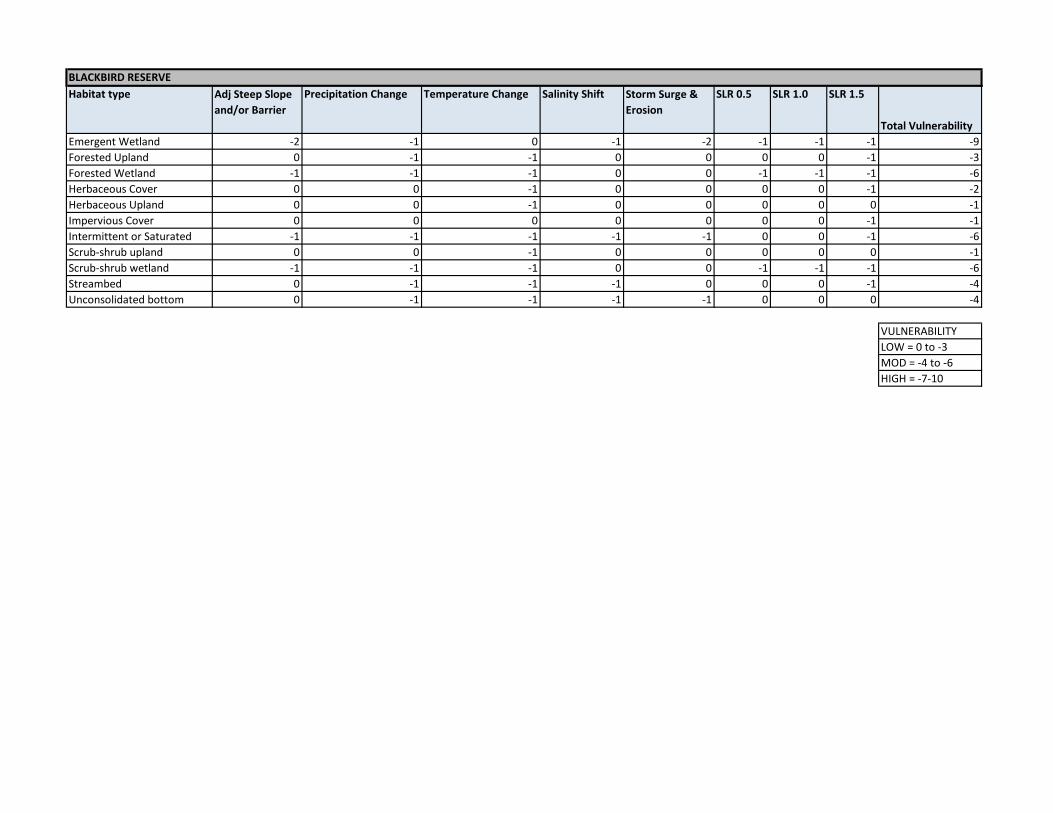
BLACKBIRD RESERVEHabitat type Adj Steep Slope
and/or BarrierPrecipitation Change Temperature Change Salinity Shift Storm Surge &
ErosionSLR 0.5 SLR 1.0 SLR 1.5
Total Vulnerability Emergent Wetland -2 -1 0 -1 -2 -1 -1 -1 -9Forested Upland 0 -1 -1 0 0 0 0 -1 -3Forested Wetland -1 -1 -1 0 0 -1 -1 -1 -6Herbaceous Cover 0 0 -1 0 0 0 0 -1 -2Herbaceous Upland 0 0 -1 0 0 0 0 0 -1Impervious Cover 0 0 0 0 0 0 0 -1 -1Intermittent or Saturated -1 -1 -1 -1 -1 0 0 -1 -6Scrub-shrub upland 0 0 -1 0 0 0 0 0 -1Scrub-shrub wetland -1 -1 -1 0 0 -1 -1 -1 -6Streambed 0 -1 -1 -1 0 0 0 -1 -4Unconsolidated bottom 0 -1 -1 -1 -1 0 0 0 -4
VULNERABILITYLOW = 0 to -3MOD = -4 to -6HIGH = -7-10
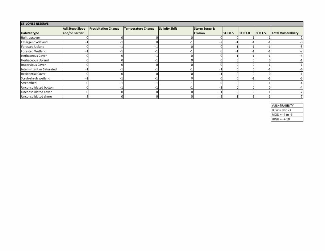
ST. JONES RESERVE
Habitat typeAdj Steep Slope and/or Barrier
Precipitation Change Temperature Change Salinity Shift Storm Surge & Erosion SLR 0.5 SLR 1.0 SLR 1.5 Total Vulnerability
Built-upcover 0 0 0 0 0 0 -1 -1 -2Emergent Wetland -1 -1 0 -1 -2 -1 -1 -1 -8Forested Upland 0 -1 -1 0 0 -1 -1 -1 -5Forested Wetland -1 -1 -1 -1 0 -1 -1 -1 -7Herbaceous Cover 0 0 -1 0 0 -1 -1 -1 -4Herbaceous Upland 0 0 -1 0 0 0 0 0 -1Impervious Cover 0 0 0 0 0 0 0 -1 -1Intermittent or Saturated -1 -1 -1 -1 -1 0 0 -1 -6Residential Cover 0 0 0 0 -1 0 0 0 -1Scrub-shrub wetland -1 -1 -1 0 0 0 -1 -1 -5Streambed 0 -1 -1 -1 0 0 0 -1 -4Unconsolidated bottom 0 -1 -1 -1 -1 0 0 0 -4Unconsolidated cover 0 0 0 0 -1 0 0 -1 -2Unconsolidated shore -2 0 0 0 -2 -1 -1 -1 -7
VULNERABILITYLOW = 0 to -3MOD = -4 to -6HIGH = -7-10
Delaware National Estuarine Research Reserve DNERR CLIMATE ADAPTATION PLAN
APPENDIX C – LITERATURE REVIEW
© Biohabitats, Inc. 2015 54

Delaware National Estuarine Research Reserve DNERR CLIMATE ADAPTATION PLAN
Review of Climate Change Documents
Volumes of information and analysis have been published on climate change, global warming and sea level rise in peer-reviewed scientific journals, government reports and a variety of science and non-profit publications. The literature search conducted for this report was done with two main objectives:
• Review climate change, global warming and sea level rise prediction literature produced by a broad range of entities,
• Identify documents that contain information that is useful for this climate adaptation plan, both more general, broad-based information on the topic, and more detailed information that is specific to the region and the locations of the Blackbird and St. Jones Reserves.
Primary Sources with brief synopses
Keene, New Hampshire- Adapting to Climate Change: Planning a Climate Resilient Community (2007)
Summary-Northeast, local government perspective. In 2006 Keene, New Hampshire was invited by the Local Governments for Sustainability (ICLEI) to become the first municipality to participate in a climate adaptation initiative, the Climate Resilient Communities (CRC) Program, using ICLEI’s CRC Five Milestones Relevance- The paper details how the process was carried out in a community setting. The final pages contain tables listing response items and action items for each response, which may be useful in developing a stakeholder process. Delaware Climate Change Impact Assessment (2014)
Summary- Delaware Perspective. Prepared by the Delaware Division of Energy and Climate, this extensive publication documents past climate characteristics and presents projections of future conditions. A listing of Delaware’s resources (Public Health, Water Resources, Agriculture, Ecosystems and Wildlife, and Infrastructure) and how climate change may impact them is presented. Relevance- Information specific to Delaware is presented, and potential impacts of climate change are explored. Confronting Climate Change in the U.S. Northeast: Science, Impacts, and Solutions (2007)
Summary - Northeast Perspective. Extensive publication from the Union of Concerned Scientists, a projection of future climate and a projection of impacts to coastal, marine, forest, water, agricultural, winter recreation and human health resources. Relevance- Information specific to the Northeast is presented, and potential impacts of climate change are explored.
© Biohabitats, Inc. 2015 55
Delaware National Estuarine Research Reserve DNERR CLIMATE ADAPTATION PLAN
Assessment of Knowledge on Impacts of Climate Change – Contribution to the Specification of Article 2 of the UNFCCC: Impacts on Ecosystems, Food Production, Water and Socio-economic Systems (2003).
Summary- Global Perspective. A compilation of contemporary data to be used as a basis for a consideration of what may constitute dangerous anthropogenic interference with the climate system under Article 2 of the United Nations Framework Convention on Climate Change (UNFCCC). Global summary of climate change, with emphasis on ecosystem effects, food production, water resources, and sustainable development Relevance- Assessment of impacts of climate change on ecology, agriculture, water and socio-economic factors. Climate Change and the Delaware Estuary: Three Case Studies in Vulnerability Assessment and Adaptation Planning (2010)
Summary- Delaware Perspective. Future climate projection and case studies concerning impacts to tidal wetland, drinking water and bivalve shellfish. Relevance- Assessment of impacts of climate change on specific, local resources. Preparing for Tomorrow’s High Tide: Recommendations for Adapting to Sea Level Rise in Delaware. Final Report of the Delaware Sea Level Rise Advisory Committee (2013)
Summary- Delaware Perspective. Future sea level rise predictions. Developed by Delaware’s Sea Level Rise Advisory Committee and by staff of the Delaware Coastal Programs section of the Delaware Department of Natural Resources and Environmental Control (DNREC). Intended to assist government agencies, businesses and individuals make well-informed choices about preparing for and responding to sea level rise. Relevance- Assessment and adaptation strategies are presented for Delaware. Climate Change: Science, Education and Stewardship for Tomorrow’s Estuaries (2008)
Summary- National Estuarine Research Reserves Perspective. Outlines the capabilities and strengths of the reserve system, as well as potential short and long-term activities, to address climate change in critical coastal area. Relevance- limited to generalized approaches to the problem of climate change, but specific to the Research Reserves. CLIMATE CHANGE 2014 Synthesis Report, Intergovernmental Panel on Climate Change
Summary- Global Perspective. Predictions of future climate conditions, impacts to ecology, water, food, urban systems, human health, and adaptations and mitigation strategies. Relevance- Comprehensive and current thinking on climate change.
© Biohabitats, Inc. 2015 56
Delaware National Estuarine Research Reserve DNERR CLIMATE ADAPTATION PLAN
Synthesis of Adaptation Options for Coastal Areas (2009)
Summary- National Perspective. Overview of vulnerability of coastal areas to climate change and sea level rise, and options for adaptation to change related to wetlands, erosion, infrastructure, invasive species, etc. Relevance- Useful list of adaptations that are relevant to Delaware. Global Climate Change and Sea Level Rise: Potential Losses of Intertidal Habitat for Shorebirds 2002
Summary- Delaware Bay/ Local Perspective. Prediction of sea level rise and the adverse effects on shorebird habitat. Relevance- Good summary of an important ecological prediction. Five Potential Consequences of Climate Change for Invasive Species (2008)
Summary- National Perspective. Presents conceptual model for how invasive species extent and movement may be affected by climate change. Relevance- Available information on a topic that is not well-researched or documented. Responses of Coastal Wetlands to Rising Sea Level (2002)
Summary- Model is presented that predicts salt marsh adaptability to rising sea level and other environmental factors. Relevance- Available information on a topic that is not well-researched or documented. Predicts that salt marshes will maintain themselves if the relative sea level rate of increase does not exceed 1.2cm/yr (0.47 inches per year). Table C-1 on the following pages lists the Primary Sources and the key topics mentioned in those papers.
© Biohabitats, Inc. 2015 57
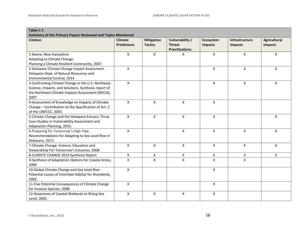
Delaware National Estuarine Research Reserve DNERR CLIMATE ADAPTATION PLAN
Table C-1 Summary of the Primary Papers Reviewed and Topics Mentioned Citation Climate
Predictions Mitigation Tactics
Vulnerability / Threat Prioritizations
Ecosystem Impacts
Infrastructure Impacts
Agricultural Impacts
1-Keene, New Hampshire Adapting to Climate Change: Planning a Climate Resilient Community, 2007.
X X X X X X
2-Delaware Climate Change Impact Assessment. Delaware Dept. of Natural Resources and Environmental Control, 2014
X X X X
3-Confronting Climate Change in the U.S. Northeast: Science, Impacts, and Solutions. Synthesis report of the Northeast Climate Impacts Assessment (NECIA), 2007.
X X X X
4-Assessment of Knowledge on Impacts of Climate Change – Contribution to the Specification of Art. 2 of the UNFCCC, 2003.
X X X X
5-Climate Change and the Delaware Estuary: Three Case Studies in Vulnerability Assessment and Adaptation Planning, 2010.
X X X X X
6-Preparing for Tomorrow’s High Tide: Recommendations for Adapting to Sea Level Rise in Delaware, 2013.
X X X X X
7-Climate Change: Science, Education and Stewardship For Tomorrow’s Estuaries, 2008.
X X X X X X
8-CLIMATE CHANGE 2014 Synthesis Report X X X X X X 9-Synthesis of Adaptation Options for Coastal Areas, 2009
X X X X X
10-Global Climate Change and Sea Level Rise: Potential Losses of Intertidal Habitat for Shorebirds, 2002.
X X
11-Five Potential Consequences of Climate Change for Invasive Species, 2008.
X X
12-Responses of Coastal Wetlands to Rising Sea Level, 2002.
X X X X
© Biohabitats, Inc. 2015 58
Delaware National Estuarine Research Reserve DNERR CLIMATE ADAPTATION PLAN
Secondary Sources
Allen, O., Barkus, Brianna, and Bennett, Karen. 2006. Delaware Wildlife Action Plan 2007 – 2017. Delaware Natural Heritage and Endangered Species Program Delaware Division of Fish and Wildlife. Delaware Department of Natural Resources and Environmental Control, 89 Kings Highway, Dover, DE 19901.
Summary- Comprehensive strategy for protecting and preserving Delaware’s wildlife.
Delaware Valley Regional Planning Commission. 2004. Sea level rise impacts in the Delaware Estuary of Pennsylvania. Pennsylvania Coastal Zone Management Program, PA Department of Environmental Protection, Water Planning Office, CZM Project Number: 2002-PD.20.
Summary- Predictions of change in wetlands, salinity, water quality, public access and hazardous waste sites. Fisher, A. 2000. Preliminary findings from the Mid-Atlantic Regional Assessment. Climate Research 14,
261–269. Summary- Summarizes findings published in this issue of Climate Research, which was dedicated to climate change. Love, S., Ellwood, M., Siok, D., Smith, K., Valencik, K., and Whiteman, C. 2014. Preparing for Tomorrow’s
High Tide: 2014 Sea Level Rise Workshop Proceedings and Interim Implementation Plan. Delaware Department of Natural Resources and Environmental Control Delaware Coastal Programs.
Summary- Report out on recommendations and adaptations developed to address sea level rise. Topics included land and socio-economics, transportation and infrastructure, water resources, wetlands, shoreline and habitat. Maryland Commission on Climate Change Adaptation and Response Working Group. 2008.
Comprehensive Strategy for Reducing Maryland’s Vulnerability to Climate Change, Phase I: Sea-level Rise and Coastal Storms. Chapter 5 in Report of the Maryland Commission on Climate Change Adaptation and Response Working Group
Summary- Example of vulnerability response document from the region. McKenney-Easterling, M., DeWalle, D.R., Iverson, L.R., Prasad, A.M., Buda, A.R. 2000. The potential
impacts of climate change and variability on forests and forestry in the Mid-Atlantic Region. Climate Research 14, 195–206.
Summary- Overview of current forest status, modeling of future climate change impacts. Najjar, R. G., H. A. Walker, P. J. Anderson, E. J. Barron, R. J. Bord, J. R. Gibson, V. S. Kennedy, C. G. Knight,
J. P. Megonigal, R. E. O’Conner, C. D. Polsky, N. P. Psuty, B. A. Richards, L. G. Sorenson, E. M. Steele, and R. S. Swanson. 2000. The potential impacts of climate change on the mid-Atlantic coastal region. Climate Research 14: 219–233
© Biohabitats, Inc
Delaware National Estuarine Research Reserve DNERR CLIMATE ADAPTATION PLAN
Summary- Prediction of temperature, sea level and stream flow increase from climate change. Delaware case study. Neff, R., Chang, H.J., Knight, C.G., Najjar, R.G., Yarnal, B., Walker, H.A., 2000. Impact of climate variation
and change on Mid-Atlantic Region hydrology and water resources. Climate Research 14, 207–218
Summary- Predicted climate change impacts on hydrology and freshwater resources in the Mid-Atlantic Region. Polsky, Colin, Allard, J., Currit, N., Crane, R., Yarnal, B. 2000. The Mid-Atlantic Region and Its Climate:
Past, Present, and Future. Climate Research 14, 161–173. Summary- see title. Rogers, C.E., McCarty, J.P., 2000. Climate change and ecosystems of the Mid-Atlantic Region. Climate
Research 14, 235–244 Summary- current status and potential stressors for freshwater, marine and forest ecosystems. Schneider, S.H., S. Semenov, A. Patwardhan, I. Burton, C.H.D. Magadza, M. Oppenheimer, A.B. Pittock,
A. Rahman, J.B. Smith, A. Suarez and F. Yamin, 2007: Assessing key vulnerabilities and the risk from climate change. Climate Change 2007: Impacts, Adaptation and Vulnerability. Contribution of Working Group II to the Fourth Assessment Report of the Intergovernmental Panel on Climate Change, M.L. Parry, O.F. Canziani, J.P. Palutikof, P.J. van der Linden and C.E. Hanson, Eds., Cambridge University Press, Cambridge, UK, 779-810.
Summary- Global in scope, assessment of climate change vulnerabilities and response strategies. Sorensen, Robert M. "Control of Erosion, Inundation, and Salinity Intrusion Caused By Sea Level Rise.
Greenhouse Effect and Sea Level Rise: A Challenge for This Generation 1984. Summary- Technical information on techniques to control shoreline erosion and salt water intrusion, with cost estimation information. Tiner, R. W. (1985). Wetlands of Delaware. Newton Corner, MA and Dover, DE: USFWS and Delaware
Department of Natural Resources and Environmental Control. Summary- Technical information on wetlands, useful for information on how disturbance affects wetland ecology. Williams, B. K., R. C. Szaro, and C. D. Shapiro. 2009. Adaptive Management: The U.S. Department of the
Interior Technical Guide. Adaptive Management Working Group, U.S. Department of the Interior, Washington, DC.
Summary- Descriptive and technical information on adaptive management.
© Biohabitats, Inc
Delaware National Estuarine Research Reserve DNERR CLIMATE ADAPTATION PLAN
APPENDIX D – CLIMATE ADAPTATION PLAN DEVELOPMENT CHECKLIST
© Biohabitats, Inc
Delaware National Estuarine Research Reserve DNERR CLIMATE ADAPTATION PLAN
Adaptation Plan Development Checklist
The following provides a list of sequential steps for developing a Climate Change Adaptation Plan for a specific facility, or site, managed by State agencies or other organizations:
STEP 1: Hold a kick-off and visioning meeting including key managers and stakeholders for the facility/property, in order to spell out the vision, plan goals, and objectives. STEP 2: Review existing site specific infrastructure, environmental education program, habitat management, and applied research information and data for the facility or property. STEP 3: Meet with (and interview) land managers, conservation & restoration staff, associated scientists and technicians, and a select group of site users/stakeholders for site-specific observations on conditions and observed climate change impact concerns. STEP 4: Consult specific climate adaptation resources applicable to the broader region and the state of Delaware such as Delaware Climate Change Impact Assessment (Division of Energy and Climate 2014), Preparing for Tomorrow’s High Tide - Recommendations for Adapting to Sea Level Rise in Delaware (Love, et al 2013), Climate Change and the Delaware Estuary - Three Case Studies in Vulnerability Assessment and Adaptation Planning (Kreeger, et al 2010). See Reference section for other potential reference resources. STEP 5: Identify existing facilities/infrastructure/utilities, site amenities, land cover and habitat types; and their current distribution (e.g., from site plan and GIS mapping). STEP 6: Perform a qualitative to semi-quantitative assessment of vulnerability for each of the facility and habitat elements present and assign vulnerability values, determine site-specific weighting factors, and summarize total vulnerability scores (See Appendix B). STEP 7: Develop site-specific climate adaptation strategies for resilience, in accordance with the mission of the organization, the established goals & objectives, and the resource categories of the facility/site. STEP 8: Develop goal-specific Best Management Practices for Resiliency for the facility/site, identifying the practices, strategic actions and the phasing priorities (see examples in Section 3.2). STEP 9: Develop and employ an Adaptive Management Plan with the following components:
o Assess the Problem – related to future climate change vulnerability & impacts o Program Design – define the approach and it’s specific steps o Implement – action measures for management interventions and studies o Monitor – collecting, processing and storing data to test design actions o Evaluate – the results of monitoring data with statistical analysis o Adjust – management actions and implementation measures based on results
STEP 10: Review and update the Climate Adaptation Plan periodically (e.g., every 5 years)
© Biohabitats, Inc
Delaware National Estuarine Research Reserve DNERR CLIMATE ADAPTATION PLAN
APPENDIX E – ADAPTIVE MANAGEMENT CONTEXT
© Biohabitats, Inc
Delaware National Estuarine Research Reserve DNERR CLIMATE ADAPTATION PLAN
What is Adaptive Management?
There are a multitude of sources available on adaptive management theory and process. The U.S. Fish and Wildlife Service (USFWS) Adaptive Management Technical Guide (2009) provides the following definition of adaptive management, which is applicable, as a general guide, for the adaptive management structure for managing the Reserve’s resources going forward in the face of climate change:
“An adaptive approach involves exploring alternative ways to meet management objectives, predicting the outcomes of alternatives based on the current state of knowledge, implementing one or more of these alternatives, monitoring to learn about the impacts of management actions, and then using the results to update knowledge and adjust management actions. Adaptive management focuses on learning and adapting, through partnerships of managers, scientists, and other stakeholders who learn together how to create and maintain sustainable resource systems.”
Also from that Guide, as adapted from the National Research Council:
“Adaptive management [is a decision process that] promotes flexible decision making that can be adjusted in the face of uncertainties as outcomes from management actions and other events become better understood. Careful monitoring of these outcomes both advances scientific understanding and helps adjust policies or operations as part of an iterative learning process. Adaptive management also recognizes the importance of natural variability in contributing to ecological resilience and productivity.”
Another applicable statement from the USFWS document is:
“Adaptive management requires stated management objectives to guide decisions about what to try, and explicit assumptions about expected outcomes to compare against actual outcomes. It is important to know what the available management options and alternative assumptions are, in case the action that is tried does not work as expected. The linkages among management objectives, learning about the system, and adjusting direction based on what is learned distinguish adaptive management from a simple trial and error process.”
What Does It Require? Further Insights
The valuation and ranking of existing natural resources and habitat types is a multi-step process that includes a comprehensive inventory of resources and a forecast of potential future change that estimates impacts to the existing resources (see discussion of sea-level rise monitoring in Section 2.3). Additionally, an evaluation of predicted future natural resource and habitat shifts and extents is needed, to determine if losses to any one type of habitat or resource may occur,
© Biohabitats, Inc
Delaware National Estuarine Research Reserve DNERR CLIMATE ADAPTATION PLAN
and if the loss is avoidable or even acceptable, given the Reserve’s overall mission and goals. There are no guidelines in the literature for ranking the value of different types of habitat such as tidal marsh, freshwater wetlands or upland forest in relation to each other, particularly in the context of climate change resilience. Natural capital values in 2012 dollars are provided for the vegetation communities at the Reserves (DNREC 2013, and DNREC 2014), but their monetary value is only one way to value their services (others include ecosystem services delivery and cultural/heritage values). There are also no specific universal thresholds for communities or habitat types for prescribing action triggers; e.g., if X percent of a habitat is lost the manager needs to take action to conserve or restore it, or at Y percent the resource will be below a critical threshold and is likely not unrecoverable. That process must be undertaken by the Reserve staff based on an internal analysis of the existing natural resources and habitats at the Reserves, potential changes to those resources due to climate change, and an assessment of how much of each type of resource the Reserve desires to and should maintain to fulfill their mission and goals.
Existing and On-going Work in Support of the Adaptive Management Approach
& NERRS Climate Objectives
The following section is a summary of current guidance for the Reserves and work being conducted that is relevant to this plan, and provides a recommended adaptive management approach.
Two primary missions of the NERR system are conducting estuarine research and the dissemination of the results of that research through the integration of scientific understanding and public education in support of environmental literacy and sound policy and management decisions. The potential for negative outcomes from the predicted estimates of the effects of climate change, especially on coastal resources, require that the NERRs plan for the study and adaptive management of climate change impacts.
Climate change research and education elements for the St. Jones and Blackbird Creek Reserves are identified in the three primary goals and several objectives of the NERRS 2008 Climate Change document (NERRS, 2008).
Goal I: National Estuarine Research Reserves will contribute to scientific understanding of climate change and monitor ecosystem changes.
Objective I. Enhance Scientific Understanding of Climate Change
Objective II. Monitor Ecosystem Changes
© Biohabitats, Inc

Delaware National Estuarine Research Reserve DNERR CLIMATE ADAPTATION PLAN
Goal II: National Estuarine Research Reserves will assess climate change impacts on human and estuarine ecosystem communities, vulnerability of these communities, and their capacity for adaptation and mitigation.
Objective I. Identify vulnerabilities of estuarine ecosystems to climate change Objective II. Identify vulnerabilities of coastal communities to climate change
Objective III. Support, influence, and disseminate policies or actions to mitigate the impacts of climate change
Goal III: The National Estuarine Research Reserve System will provide educational opportunities and training related to effects of climate change on human and estuarine systems to increase public awareness and foster behavior change.
Objective I. Affect behavior change among decision-makers and the public in response to climate change
Objective II. Lead by example through effective land conservation and infrastructure practices and planning, as well as exhibits and outreach
DNERR Research and Monitoring Program
The National Estuarine Research Reserve System supports a framework for addressing coastal management issues such as the effects of climate change through scientific and technical research that is comprehensive, interdisciplinary and coordinated. Research and monitoring programs that include the development of baseline information form the basis of this approach. Goals for research within the Reserves include:
• Expand capacity to monitor changes in water quality and quantity, habitat, and biological indicators in response to land use and climate change drivers.
• Improve understanding of the effects of climate change and coastal pollution on estuarine and coastal ecology, ecosystem processes, and habitat function.
• Characterize coastal watersheds and estuary ecosystems and quantify ecosystem services to support ecosystem-based management of natural and built communities.
• Increase social science research and use of social information to foster coastal stewards that value and protect estuaries.
It is the policy of the DNERR to implement the NERR System-Wide Monitoring Program (2011) which provides standardized data on national estuarine environmental trends, while allowing the flexibility to assess coastal management issues of regional or local concern. The principal
© Biohabitats, Inc
Delaware National Estuarine Research Reserve DNERR CLIMATE ADAPTATION PLAN
mission of the monitoring program is to develop quantitative measurements of short-term variability and long-term changes in the integrity and biodiversity of representative estuarine ecosystems and coastal watersheds for the purposes of contributing to effective coastal zone management. The program is designed to enhance the value and vision of the reserves as a system of national references sites. Current critical research and monitoring efforts of the DNERR are: • Effects of Climate Change and Sea Level Rise • Biodiversity, Health and Sustainability of Estuarine Habitats • Mapping of Estuarine Habitats • Restoration of Estuarine and Riparian Habitats
Applicability of Adaptive Management
Ecosystem and environmental factor interactions are complex and future environmental conditions are uncertain. Adaptive management is intended to address uncertainty in management decisions, uncertainty about how systems/environmental conditions interact and affect each other, and uncertainty about how systems/environmental conditions may change over time and respond to management actions. It is used to develop hypotheses/alternative management regimes that are intended to solve management problems related to lack of understanding of current system dynamics (e.g. climate variability) or potential problems that may occur in the future. Adaptive management has great benefit potential for addressing management challenges presented by climate change and sea level rise.
© Biohabitats, Inc

This page left intentionally blank

Restore the Earth & Inspire Ecological StewardshipBi ohab itat s Inc . • 2 0 8 1 Cl ipp e r Pa rk R o a d • B al t i more , M D • w w w.b i ohab itat s .com • Ma rch 2 0 1 5
This report was prepared by the Delaware Coastal Programs using federal funds under awards NA17NOS4190151 and NA18NOS4200118 from the National Oceanic and Atmospheric Administration (NOAA), U.S. Department of Commerce (DOC). The statements, findings, conclusions, and recommendations are those of the authors and do not necessarily reflect the views of NOAA or DOC.
DELAWARE NATIONAL ESTUARINE RESEARCH RESERVE
Suggested Citation: Delaware Department of Natural Resources and Environmental Control (DNREC), 2019,”Delaware National Estuarine Research Reserve Stewardship Plan”, Division of Climate, Coastal & Energy, Delaware Coastal
Programs. Internal Technical Report.
Delaware Department of Natural Resources & Environmental Control Delaware Coastal Programs 818 Kitts Hummock Road
Dover, DE (302) 739-6377
Appendix C
1
Table of Contents
1.0 INTRODUCTION ................................................................................................................................. 3
1.1 Project Background .......................................................................................................................... 3
1.2 Blackbird Creek ................................................................................................................................ 7
1.3 About This Plan ................................................................................................................................. 7
2.0 ECOLOGICAL RESTORATION AT THE BLACKBIRD CREEK RESERVE .......................... 8
2.1 Obstacles and Accomplishments...................................................................................................... 8
2.2 Accomplishments: Beyond 2007 Restoration Phases .................................................................... 9
3.0 SUSTAINABILITY AND STEWARDSHIP .................................................................................... 12
3.1 Sustainable Facilities and Infrastructure ..................................................................................... 12
3.2 Stewardship Opportunities at the Blackbird Creek Reserve ...................................................... 13
4.0 ECOLOGICAL RESTORATION ..................................................................................................... 14
4.1 Over-arching Mission and Goals ................................................................................................... 14
4.2 Restoration Approach .................................................................................................................... 16
4.3 Guiding Principles for Restoration ............................................................................................... 16
5.0 RESTORATION RECCOMENDATIONS ...................................................................................... 17
5.1 Restoration and Priorities .............................................................................................................. 17
6.0 REFERENCES .................................................................................................................................... 27
APPENDIX A – 2007 Habitat Map for the Blackbird Creek Reserve
APPENDIX B – NOAA Restoration Monitoring Guidance
2
List of Figures
Figure 1 Blackbird Creek Reserve Location Map ................................................................................... 4
Figure 2 Restoration Management Areas (1 of 2) .................................................................................... 5
Figure 3 Restoration Management Areas (2 of 2) .................................................................................... 6
Figure 4 Blackbird Creek Ecological Restoration Plan......................................................................... 17
List of Tables
Table 1 Ecological Restoration Implementation (2007-2018) ................................................................. 8
Figure 2 Other Accomplishments ............................................................................................................ 10
Figure 3 Completed Facilities and Infrastructures ................................................................................ 11
3
1.0 INTRODUCTION
1.1 Project Background
The Delaware National Estuarine Research Reserve (DNERR) is one of 29 National Estuarine Research Reserve System (NERRS) sites in the United States. The NERRS was established by the Coastal Zone Management Act of 1972, as amended, as each reserve involves a partnership between the National Oceanic and Atmospheric Administration (NOAA) and the Delaware Department of Natural Resources and Environmental Control (DNREC), Division of Energy, Coastal, and Climate – Coastal Programs Section. The DNERR consists of two Reserve components, the Blackbird Creek Reserve (Townsend, DE) and the St. Jones Reserve (Dover, DE), which are located about 30 miles apart (Figure 1). These two reserve components include both brackish and freshwater estuaries and are representative of the diverse array of estuarine ecosystems found throughout the Mid-Atlantic States (DNERR, 2013).
This plan is a revision to the original Blackbird Creek Reserve Ecological Restoration Master Plan created in 2007 and will now be referred to as the DNERR Stewardship Plan. The DNERR Stewardship Plan is for the DNERR-owned parcels of the Blackbird Creek Reserve encompassing approximately 483 acres in southern New Castle County, Delaware. This plan is intended to guide ecological restoration initiatives for the DNERR-owned parcels of the Blackbird Creek Reserve.
For this document, DNERR-owned properties of the Blackbird Creek include all land acquired from 1990 - 2018. All DNERR-owned wetlands and forested uplands on acquired parcels will be managed to preserve environmental quality, minimize detrimental impacts and control invasive species (DNERR, 2013). This stewardship plan relates to the components of the NERRS mission to provide long-term research, education and interpretation, and the part of the DNERR’s mission which includes preserving and managing natural resources within the Reserve.
In the Blackbird Creek Reserve Ecological Restoration Master Plan, acquired lands were referenced by the names of four tract areas: Lowes Tract, Manwaring Tract, Cornelius Tract and the Union Church-Taylors Bridge Tract. Due to the undefined, large area of the named tracts and recent land acquisitions, restoration activities will be referenced by a Management Area number (Figure 2 & 3). The Management Areas of the Blackbird Creek Reserve were created within the original tracts of land using natural barriers as guidelines to ensure easy navigation for current and future conservation staff and researchers. Due to the use of natural barriers, there is not a consistent acreage for the 20 Management Area within the Blackbird Creek Reserve. The size of the management areas ranges from 2-96 acres, with some of the larger sections still being used for agricultural farming.
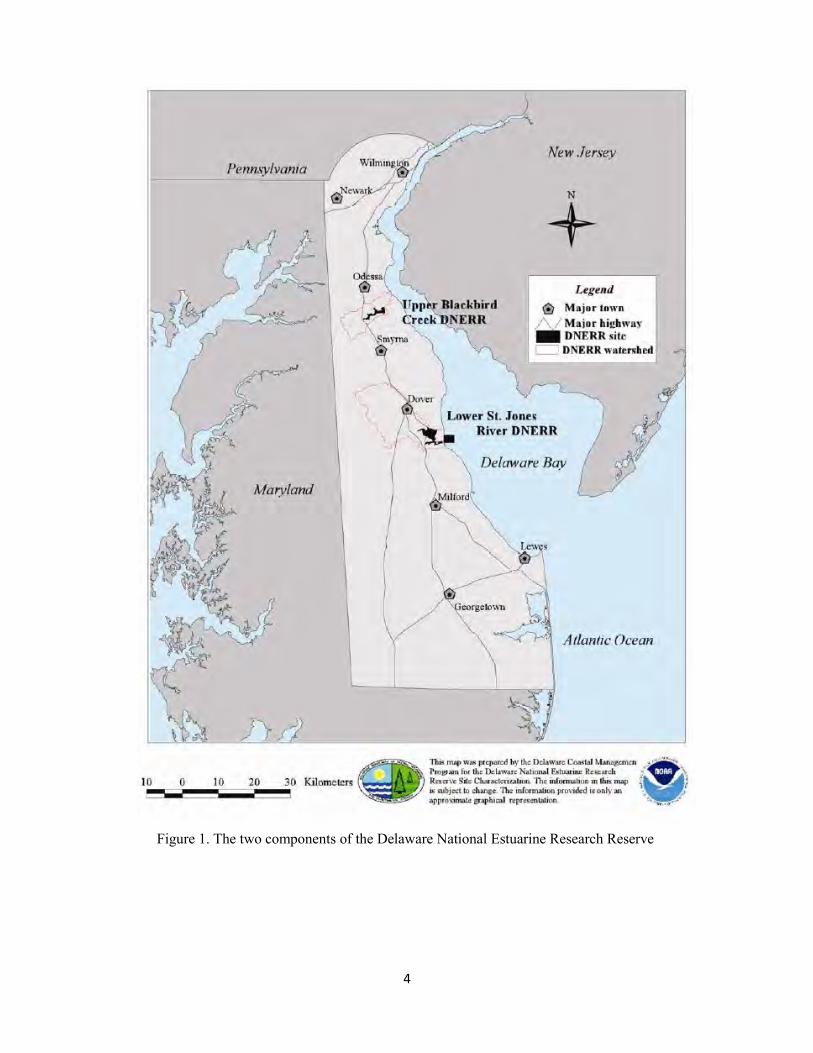
4
Figure 1. The two components of the Delaware National Estuarine Research Reserve
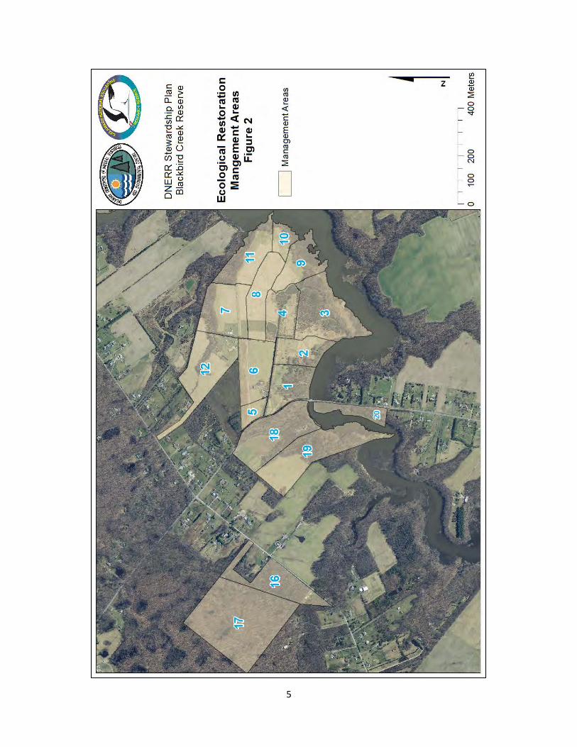
5
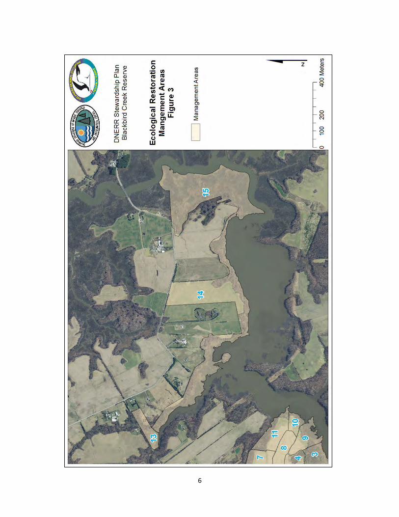
6
7
1.2 Blackbird Creek
The Blackbird Creek Reserve component is 1,087 acres in designated size, situated along 5.7 miles of low-salinity brackish and freshwater tidal creek, starting about 5.8 miles upstream from where Blackbird Creek empties into the Delaware Bay. The Blackbird Creek Reserve component contains 62 parcels of land held by 55 private landholders, plus the DNERR, the Division of Fish and Wildlife. Within the Blackbird Creek designated boundaries, about 212 acres of tidal marshes, upland field, woodlots, and croplands were purchased by the DNERR in 1990. An additional 183 acres of tidal marsh, woodlands, and croplands were purchased in 1996 by DNREC’s Division of Fish and Wildlife (as part of the Division’s Cedar Swamp Wildlife Area), and is available for use in DNERR activities. In 2003, an 8 acre parcel was added to the Reserve to improve public access to the Blackbird Creek. In 2004, 62 acres was added at 801 Blackbird Landing Road, and in February 2005, 85 acres were added at 803 Blackbird Landing Road. Two additional properties, totaling 64 acres, were acquired in late 2005 and 2011 (DNERR, 2013). Two properties, a large area of mix native hardwoods and Delmarva Bays/Coastal Plain Ponds and wooded tributary buffers totaling 99 acres, was added to the Blackbird Creek Reserve in 2015. In 2016 & 2017, an additional 58 acres from 2 properties were added to 803 Blackbird Landing Road to improve wildlife corridor habitats. These new properties will be incorporated into the Reserves boundaries.
1.3 About This Plan
The need for an updated stewardship plan for the DNERR-owned properties is clear. It has been 11 years since the original ecological master restoration plan was implemented and there has not been an evaluation of the successes or limitations encountered. Additional properties have also been added to the Blackbird Creek Reserve and there is a need to include these properties in future restoration efforts. The goal is to complete the Phases that were outlined in the Blackbird Creek Reserve Ecological Restoration Master Plan created in 2007 before pursuing additional restoration. This stewardship plan will guide the Blackbird Creek Reserve’s restoration short term and long term efforts for the next 5-10 years. Site assessments conditions were not updated for the DNERR Stewardship Plan or newly acquired properties, but site assessments for properties purchased from 1990-2005 can be found in the 2007 Blackbird Creek Reserve Ecological Restoration Master Plan.
Currently, there is not a separate stewardship plan for the St. Jones Reserve component on the DNERR. Instead, Stewardship Objectives and Actions for the St. Jones Reserve can be found in the most recent edition of the DNERR Management Plan. The 2023 revision of the DNERR Stewardship Plan will include a stewardship plan for the St. Jones Reserve and Blackbird Creek Reserve.
8
2.0 ECOLOGICAL RESTORATION AT THE BLACKBIRD CREEK RESERVE
2.1 Obstacles and Accomplishments
Currently, the DNERR is implementing Riparian Corridor Buffer Restoration, Upland Native Meadow Restoration, Upland Reforestation and Invasive Species Management. In the original Blackbird Creek Reserve Ecological Restoration Master Plan, restoration was recommended to be completed within 3 Phases over 15 years (Table 1). This timeline seemed reasonable within a written document, but obstacles (land acquisition, funding, program priorities, staff turnover, NEPA reviews, etc.) were not taken into account within the 15 year time frame. Unfortunately, restoration at the Blackbird Creek has been not been fully implemented within the recommended phases described in the Blackbird Creek Reserve Ecological Restoration Master Plan, but it is important to acknowledge restoration that has been completed over the past 11 years.
Table 1. Ecological Restoration Implementation phasing and actions 2007-2018**
9
Reforestation within recommended Upland and Riparian Buffer restoration areas was a learning experience for the DNERR. Bare root seedlings did not have a high success rate (wildlife & weather) and tree tubes remained on smaller trees longer than intended. After several years of care, such as invasive removal, mowing and replanting, some reforestation areas have been considered successful. The process of growing bare root seedlings in the DNERR Native Plant Greenhouse at the St. Jones Reserve has helped to increase the success of trees planted at the Blackbird Creek Reserve. Without the additional care, an area would have to be continually replanted and reforestation would not be complete.
In 2012, steps were taken with partners in DNREC and the University of Delaware to complete a section of the Phase 1 headwater stream restoration. Due to limited resources and technical concerns only 150 ft. of the headwater stream restoration was completed and still remains as an incomplete objective of the 3 Phases. A total of 3 coastal plain ponds have been restored, instead of the 8 targeted coastal plain ponds, but these ponds have been a favorite among local birders.
Invasive species removal and control is a priority and ongoing activity for the DNERR. All priority invasive species have been controlled to recommended requirements of the Blackbird Creek Reserve Ecological Restoration Master Plan. As additional properties were acquired at the Blackbird Creek Reserve, invasive species control and removal became the overall priority for the DNERR. Aquatic invasive species management within coastal plain ponds began in 2012. Unfortunately, Phragmites australis control within wetlands has not been implemented. For these reasons, Table 1 indicates that invasive species management has been partially completed since 2007.
2.2 Accomplishments: Beyond 2007 Restoration Phases
There are multiple restoration efforts that have been completed outside of the three phases detailed in the Blackbird Creek Reserve Ecological Restoration Master Plan (2007). These efforts include a project with Delaware State University, DNREC’s Wetlands Assessment Program installing a living shoreline, property acquisitions and vegetation monitoring. Table 2 outlines all restoration projects that have been completed at the Blackbird Creek Reserve, but were not included in the Blackbird Creek Reserve Ecological Restoration Master Plan. The table also indicates if the area restored during the project differed from the designated restoration type in the Blackbird Creek Reserve Ecological Restoration Master Plan.
Two restoration efforts at the DNERR were completed outside of the recommendations from the Blackbird Creek Reserve Ecological Restoration Master Plan, but were successful at enhancing habitats within the Blackbird Creek Reserve. Delaware State University (DSU) implemented a project titled “Studies of Reforestation and Soil Conservation on Devastated Delaware Farmland,” within Management Area 18 (Figure 2). The objective to develop effective, natural-accommodated reforestation and soil conservation techniques and used the Blackbird Creek Reserve as the experimental site for reforestation techniques. The second reforestation effort was
10
creating an Education Tree Plot in Management Area 2 of the Blackbird Creek Reserve. The goal of the Education Tree Plot was to provide an area with trees native to Delaware that were labeled for educational tree identification. Tree species planted included: sweet gum (Liquidambar styraciflua), dogwood (Cornus florida), Eastern red cedar (Juniperus viginiana), sycamore (Platanus occidentalis), Red maple (Acer ribrum) river birch (Betula nigra), loblolly pine (Pinus taeda), tulip poplar (Liriodendron tulipifera), white oak (Quercus alba), Northern red oak (Quercus rubra), black cherry (Prunus serotine), swamp white oak (Quercus bicolor), American hornbean (Ostrya virginiana), and American holly (Ilex opaca).
Recently, monitoring projects implemented by the DNERR have established at the Blackbird Creek Reserve. These monitoring projects include NERRS Emergent Vegetation Biological Monitoring, aquatic invasive species monitoring and nest box monitoring. Additional habitat enhancements added to the Blackbird Creek Reserve include a kestrel box, which will be monitored by the Brandywine Zoo’s Delaware Kestrel Partnership. In 2016, Bio-Monitoring was expanded to the Blackbird Creek Reserve and is comprised of a Surface Elevation Table (SET), emergent vegetation monitoring and elevation surveys. This research is being used to establish the DNERR as a sentinel site for climate change in Delaware through monitoring of long term changes of emergent vegetation and sediment studies. In 2018, aquatic invasive species monitoring was implemented to eradicate Parrot’s Feather (Myriophyllum aquaticum) from coastal plain ponds.
Habitat maps have been completed for the Blackbird Creek reserve, but the habitat maps were created using 2007 aerial imagery. The 2007 DNERR Habitat Maps will act as a baseline information to understand how current and future restoration efforts have changed the landscape of the Blackbird Creek Reserve (Appendix A). As future habitat maps are created, they will include additional property acquisitions and highlight the progression of areas that are actively being restored.
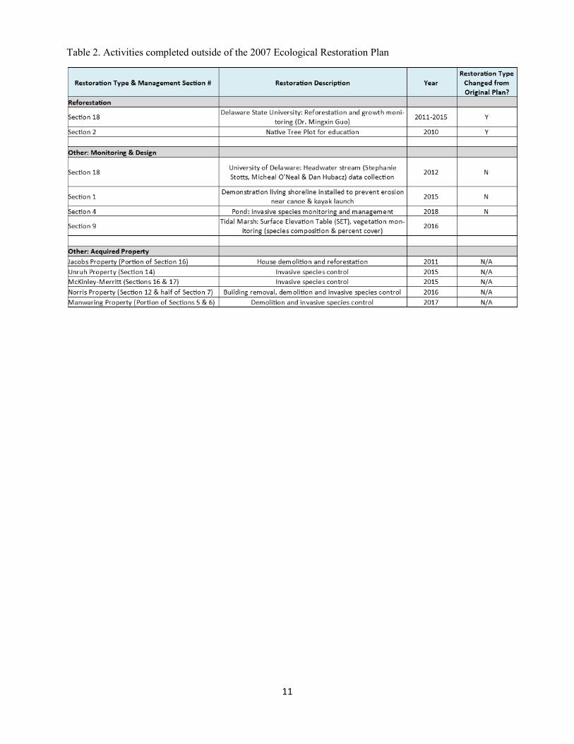
11
Table 2. Activities completed outside of the 2007 Ecological Restoration Plan
12
3.0 SUSTAINABILITY AND STEWARDSHIP 3.1 Sustainable Facilities and Infrastructure
The DNERR recognizes that new facilities need to be compatible with and support conservation and ecological efforts at the Blackbird Creek Reserve. The DNERR has followed the recommendations the Blackbird Creek Reserve Ecological Restoration Master Plan to avoid the placement of new facilities in sensitive areas including wetlands, streams, riparian buffers, rare species habitat areas, steep slopes or forest interior areas.
The basic principles that the DNERR has followed includes:
Minimize the overall size/footprint and disturbance of construction Avoid impacts to sensitive natural resources (identified above) Place facilities in existing disturbed/altered areas Emphasize the minimization of run-off and design for infiltration
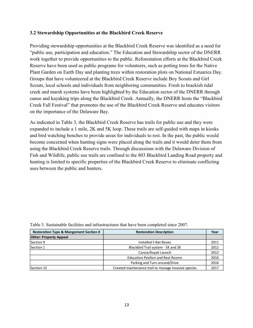
13
3.2 Stewardship Opportunities at the Blackbird Creek Reserve
Providing stewardship opportunities at the Blackbird Creek Reserve was identified as a need for “public use, participation and education.” The Education and Stewardship sector of the DNERR work together to provide opportunities to the public. Reforestation efforts at the Blackbird Creek Reserve have been used as public programs for volunteers, such as potting trees for the Native Plant Garden on Earth Day and planting trees within restoration plots on National Estuaries Day. Groups that have volunteered at the Blackbird Creek Reserve include Boy Scouts and Girl Scouts, local schools and individuals from neighboring communities. Fresh to brackish tidal creek and marsh systems have been highlighted by the Education sector of the DNERR through canoe and kayaking trips along the Blackbird Creek. Annually, the DNERR hosts the “Blackbird Creek Fall Festival” that promotes the use of the Blackbird Creek Reserve and educates visitors on the importance of the Delaware Bay.
As indicated in Table 3, the Blackbird Creek Reserve has trails for public use and they were expanded to include a 1 mile, 2K and 5K loop. These trails are self-guided with maps in kiosks and bird watching benches to provide areas for individuals to rest. In the past, the public would become concerned when hunting signs were placed along the trails and it would deter them from using the Blackbird Creek Reserve trails. Through discussions with the Delaware Division of Fish and Wildlife, public use trails are confined to the 803 Blackbird Landing Road property and hunting is limited to specific properties of the Blackbird Creek Reserve to eliminate conflicting uses between the public and hunters.
Restoration Type & Mangement Section # Restoration Description Year
Other: Property Appeal
Section 9 Installed 5 Bat Boxes 2011
Section 1 Blackbird Trail system - 5K and 2K 2012
Canoe/Kayak Launch 2012
Education Pavilion and Rest Rooms 2016
Parking and Turn-around/Drive 2016
Section 15 Created maintenance trail to manage invasive species 2017
Table 3. Sustainable facilities and infrastructures that have been completed since 2007.
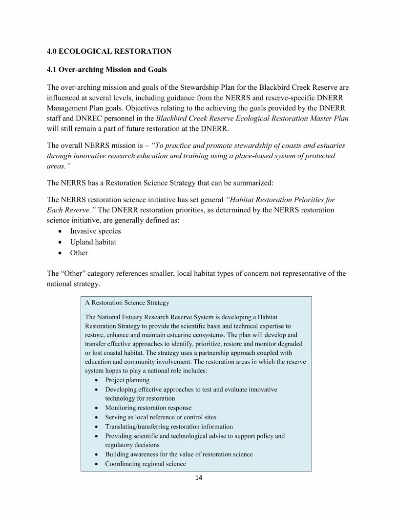
14
4.0 ECOLOGICAL RESTORATION
4.1 Over-arching Mission and Goals
The over-arching mission and goals of the Stewardship Plan for the Blackbird Creek Reserve are influenced at several levels, including guidance from the NERRS and reserve-specific DNERR Management Plan goals. Objectives relating to the achieving the goals provided by the DNERR staff and DNREC personnel in the Blackbird Creek Reserve Ecological Restoration Master Plan will still remain a part of future restoration at the DNERR.
The overall NERRS mission is – “To practice and promote stewardship of coasts and estuaries through innovative research education and training using a place-based system of protected areas.”
The NERRS has a Restoration Science Strategy that can be summarized:
The NERRS restoration science initiative has set general “Habitat Restoration Priorities for Each Reserve.” The DNERR restoration priorities, as determined by the NERRS restoration science initiative, are generally defined as:
Invasive species Upland habitat Other
The “Other” category references smaller, local habitat types of concern not representative of the national strategy.
A Restoration Science Strategy
The National Estuary Research Reserve System is developing a Habitat Restoration Strategy to provide the scientific basis and technical expertise to restore, enhance and maintain estuarine ecosystems. The plan will develop and transfer effective approaches to identify, prioritize, restore and monitor degraded or lost coastal habitat. The strategy uses a partnership approach coupled with education and community involvement. The restoration areas in which the reserve system hopes to play a national role includes:
Project planning Developing effective approaches to test and evaluate innovative
technology for restoration Monitoring restoration response Serving as local reference or control sites Translating/transferring restoration information Providing scientific and technological advise to support policy and
regulatory decisions Building awareness for the value of restoration science Coordinating regional science
15
As a companion, the NERRS also identifies ‘Lost, Disturbed or Damaged Habitat Within Each Reserve,’ and for the DNERR they are as follows:
Salt/Brackish marsh Tidal freshwater wetlands Upland forest/meadow Riverine/riparian wetlands Coastal prairie/scrub
The above priorities are for both the St. Jones Reserve and Blackbird Creek Reserve of the DNERR. Specific priorities for each site are not distinguished.
The Reserve and DNREC identified objectives and implementation plan for the Blackbird Creek Reserve Ecological Restoration Master Plan that included:
Define restoration targets for the plan Improve land use activities from a water quality perspective Provide holistic restoration plan for now, and set the stage for long-term monitoring Identify associated innovation stormwater techniques Produce results on the ground in the near-term Lead to demonstration plots for wildlife habitat types (e.g., for mammals) Act as a model for others in the watershed
Since the DNERR is still in the process of implementing phases from the Blackbird Creek Reserve Ecological Restoration Master Plan, the objectives and implementation plan have not changed.
16
4.2 Restoration Approach
The restoration of the Blackbird Creek Reserve parcels will continue to involve multiple techniques and restoration approaches. These techniques and approaches are dependent upon the condition of the ecological resources that are targeted for restoration and resources available to achieve the restoration goals.
The scale and focus of restoration effort is an important issue to address for any ecological restoration project or program. Ecological restoration can occur at a variety of levels including a system, community, population or species focus. At broad scales, it becomes even more difficult to decide what should be restored, where and how (Hobb, 2002). Other major considerations revolve around a landscape level ecological context and/or restoring natural functions and processes. Whatever is carried out in the way of restoration should involve working with, and not in opposition to, or simply improved management of the resource. Parker & Pickett (1997) indicate that restoration should be considered a process, with the degree of active intervention being determined by contextual circumstances.
4.3 Guiding Principles for Restoration
The following Guiding Principles are used to guide the conceptual ecological restoration initiatives identified in the Blackbird Creek Reserve Ecological Restoration Master Plan and will be used for associated restoration design and implementation/construction processes.
Protect and maintain existing habitat patches, and restore habitat to provide larger patches and increase the connectivity of habitat corridors
Maintain existing high quality habitat conditions and improve degraded habitat conditions by removing threats or threatening processes
Improve the condition of relic habitats in fragmented landscapes to ensure their persistence
Emphasizing supporting and regenerating natural processes for system recovery Conserve non-renewable energy in restoration approaches Support ecosystem conservation practices in all related activities Use applied monitoring and research to test ecological theories Consider human needs and compatibility with the needs of biotic systems
Given the degree to which specific ecological resources have been identified to be degraded or damaged, and other resources are threatened, the Restoration Approach for the Blackbird Component is recommended to include:
Active restoration of specific degraded or impacted existing ecological resources including ; non-tidal wetlands, streams, and riparian buffers
17
Creation of additional habitats that are fragmented, reduced or eliminated from the landscape (including: wetlands, upland reforestation, and native meadows)
Use varying degrees of non-native invasive species management to protect existing natural communities, and as a part of restoring degraded habitat areas
Identify compatible ideas for sustainable facilities, best management practices (e.g. stormwater), and stewardship opportunities to support restoration
Adaptive management in the form of restoration implementation, monitoring, and informed decisions making based on the analysis of the monitoring results
5.0 RESTORATION RECCOMENDATIONS
5.1 Restoration and Priorities
The identification of restoration priorities is important for the restoration properties within the Blackbird Creek Reserve. In the truest sense of adaptive management (learning through implementation, testing, and modifying practices) the actual restoration timing, techniques and priorities will and should change over time. This is necessary to account for research and monitoring results for initial efforts, changes in the watershed, related ecosystem function modeling. Analysis and available resources (financial and material). Building in the flexibility for changes in acreages, locations and types of restoration projects and approaches is inherent in this plan.
The Blackbird Creek Reserve Ecological Restoration Master Plan recommended the following restoration types:
Headwater stream restoration Riparian corridor buffer restoration Invasive species management Wetland restoration – freshwater nontidal Wetland restoration – tidal marsh Upland reforestation Upland native meadow restoration
These restoration types will remain priority for this plan as the DNERR continues to complete recommendations from the Blackbird Creek Reserve Ecological Restoration Master Plan. Unlike the previous plan, the DNERR Stewardship Plan will not contain Phases with specific timelines. Instead, management areas have been created for all properties actively managed at the Blackbird Creek Reserve. These management areas have been numbered to easily track all restoration activities within the Blackbird Creek Reserve (Figure 2 & 3). As previously mentioned, the intention of this Stewardship Plan is to guide restoration at the Blackbird Creek Reserve and reevaluate the success of the restoration activities in 5 years.
18
Over the past several years, the Blackbird Creek Reserve has acquired additional properties to enhance current restoration activities and protect important habitats. It has been a priority to stabilize (control invasive species) and initiate restoration (demolition of buildings) on new properties. It is recommended to continue prioritizing invasive species treatment on all new properties after any new properties have been acquired. This will prevent the spread of invasive to nearby parcels that the DNERR actively controls for invasive species. It is also recommended that any new properties acquired after the DNERR Stewardship Plan would prioritize maintenance for invasive species over restoration. A plan for restoration would be created for new properties during the next 5 year update for the DNERR Stewardship Plan, unless funding for a new property has specific restoration requirements.
A DNERR Stewardship Plan map has been updated to reflect the current restoration plan for the Blackbird Creek Reserve. This map is not intended to reflect outcomes for the next 5 years, instead it is to be used as guidance for long-term restoration planning (Figure 7). The following sub-sections of this plan describe the approach to complete the recommended ecological restoration types from the Blackbird Creek Reserve Ecological Restoration Master Plan and include recently acquired properties that were not in the previous restoration plan. Recommendations for monitoring and research needs, data gaps and focal animals species for each habitat type will remain the same and can be found in the Blackbird Creek Reserve Ecological Restoration Master Plan.
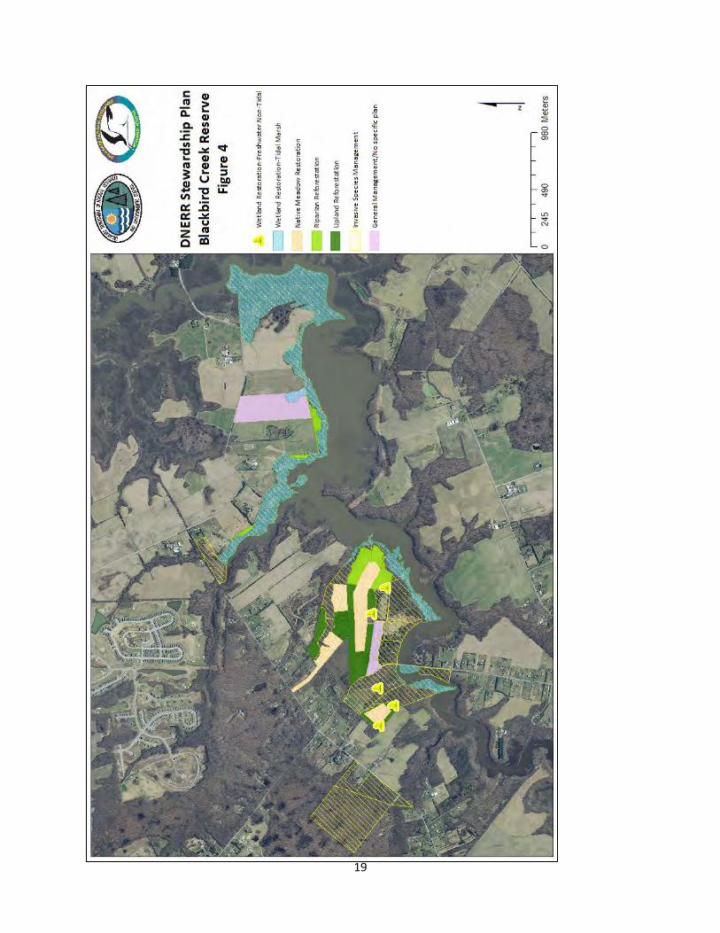
19
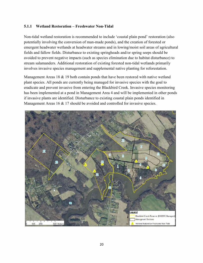
20
5.1.1 Wetland Restoration – Freshwater Non-Tidal Non-tidal wetland restoration is recommended to include ‘coastal plain pond’ restoration (also potentially involving the conversion of man-made ponds), and the creation of forested or emergent headwater wetlands at headwater streams and in lowing/moist soil areas of agricultural fields and fallow fields. Disturbance to existing springheads and/or spring seeps should be avoided to prevent negative impacts (such as species elimination due to habitat disturbance) to stream salamanders. Additional restoration of existing forested non-tidal wetlands primarily involves invasive species management and supplemental native planting for reforestation.
Management Areas 18 & 19 both contain ponds that have been restored with native wetland plant species. All ponds are currently being managed for invasive species with the goal to eradicate and prevent invasive from entering the Blackbird Creek. Invasive species monitoring has been implemented at a pond in Management Area 4 and will be implemented in other ponds if invasive plants are identified. Disturbance to existing coastal plain ponds identified in Management Areas 16 & 17 should be avoided and controlled for invasive species.
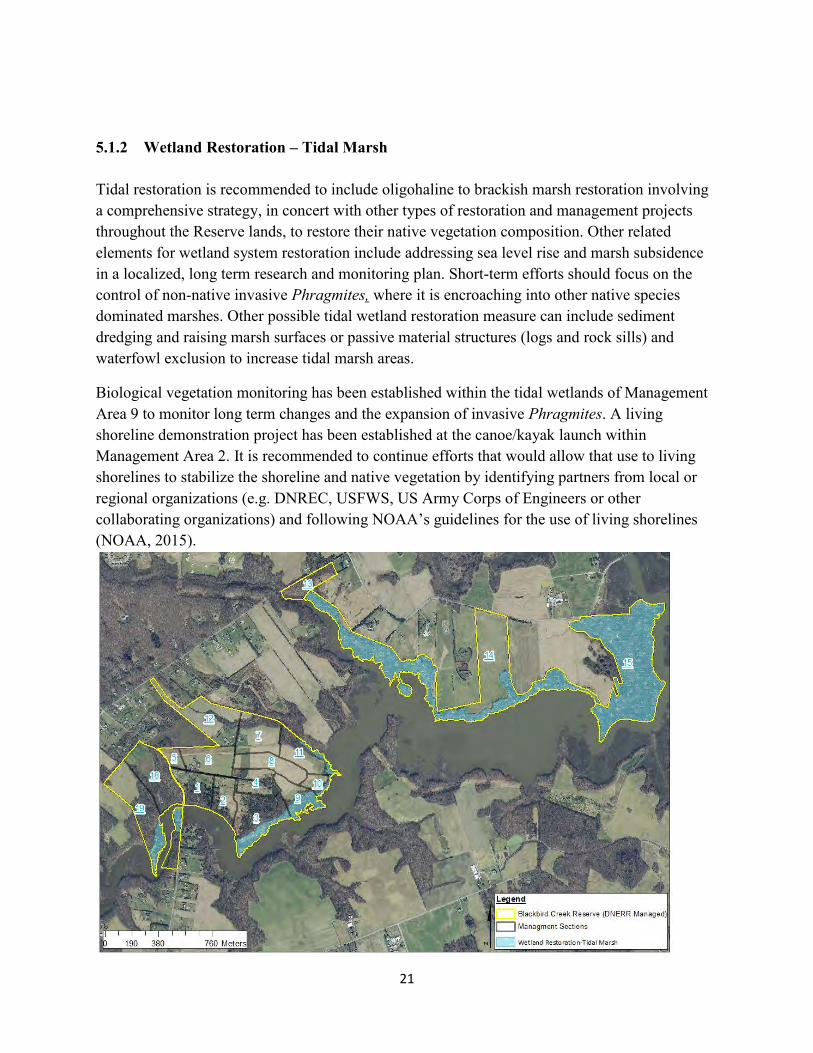
21
5.1.2 Wetland Restoration – Tidal Marsh Tidal restoration is recommended to include oligohaline to brackish marsh restoration involving a comprehensive strategy, in concert with other types of restoration and management projects throughout the Reserve lands, to restore their native vegetation composition. Other related elements for wetland system restoration include addressing sea level rise and marsh subsidence in a localized, long term research and monitoring plan. Short-term efforts should focus on the control of non-native invasive Phragmites, where it is encroaching into other native species dominated marshes. Other possible tidal wetland restoration measure can include sediment dredging and raising marsh surfaces or passive material structures (logs and rock sills) and waterfowl exclusion to increase tidal marsh areas.
Biological vegetation monitoring has been established within the tidal wetlands of Management Area 9 to monitor long term changes and the expansion of invasive Phragmites. A living shoreline demonstration project has been established at the canoe/kayak launch within Management Area 2. It is recommended to continue efforts that would allow that use to living shorelines to stabilize the shoreline and native vegetation by identifying partners from local or regional organizations (e.g. DNREC, USFWS, US Army Corps of Engineers or other collaborating organizations) and following NOAA’s guidelines for the use of living shorelines (NOAA, 2015).
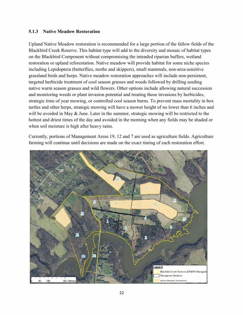
22
5.1.3 Native Meadow Restoration Upland Native Meadow restoration is recommended for a large portion of the fallow fields of the Blackbird Creek Reserve. This habitat type will add to the diversity and mosaic of habitat types on the Blackbird Component without compromising the intended riparian buffers, wetland restoration or upland reforestation. Native meadow will provide habitat for some niche species including Lepidoptera (butterflies, moths and skippers), small mammals, non-area-sensitive grassland birds and herps. Native meadow restoration approaches will include non-persistent, targeted herbicide treatment of cool season grasses and weeds followed by drilling seeding native warm season grasses and wild flowers. Other options include allowing natural succession and monitoring weeds or plant invasion potential and treating those invasions by herbicides, strategic time of year mowing, or controlled cool season burns. To prevent mass mortality in box turtles and other herps, strategic mowing will have a mower height of no lower than 6 inches and will be avoided in May & June. Later in the summer, strategic mowing will be restricted to the hottest and driest times of the day and avoided in the morning when any fields may be shaded or when soil moisture is high after heavy rains.
Currently, portions of Management Areas 19, 12 and 7 are used as agriculture fields. Agriculture farming will continue until decisions are made on the exact timing of each restoration effort.
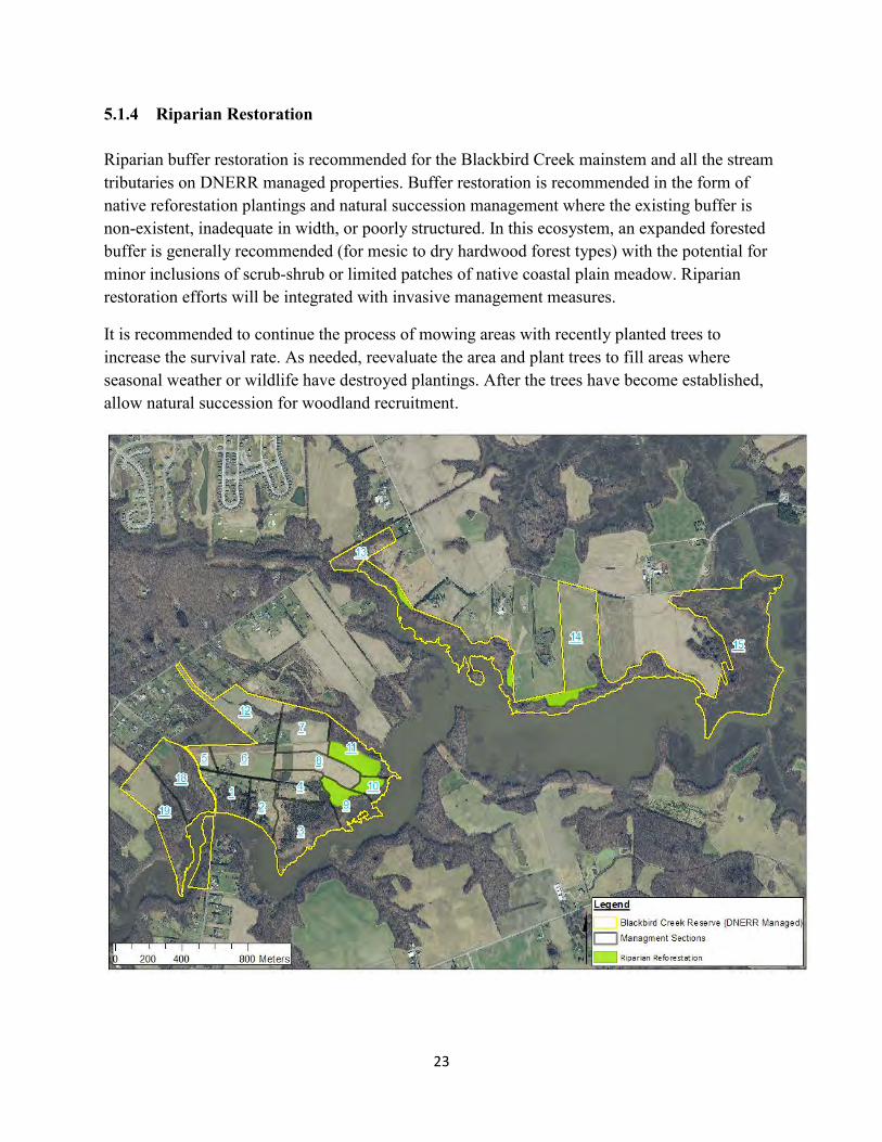
23
5.1.4 Riparian Restoration
Riparian buffer restoration is recommended for the Blackbird Creek mainstem and all the stream tributaries on DNERR managed properties. Buffer restoration is recommended in the form of native reforestation plantings and natural succession management where the existing buffer is non-existent, inadequate in width, or poorly structured. In this ecosystem, an expanded forested buffer is generally recommended (for mesic to dry hardwood forest types) with the potential for minor inclusions of scrub-shrub or limited patches of native coastal plain meadow. Riparian restoration efforts will be integrated with invasive management measures.
It is recommended to continue the process of mowing areas with recently planted trees to increase the survival rate. As needed, reevaluate the area and plant trees to fill areas where seasonal weather or wildlife have destroyed plantings. After the trees have become established, allow natural succession for woodland recruitment.
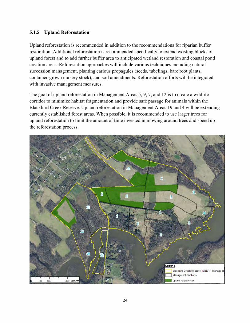
24
5.1.5 Upland Reforestation Upland reforestation is recommended in addition to the recommendations for riparian buffer restoration. Additional reforestation is recommended specifically to extend existing blocks of upland forest and to add further buffer area to anticipated wetland restoration and coastal pond creation areas. Reforestation approaches will include various techniques including natural succession management, planting carious propagules (seeds, tubelings, bare root plants, container-grown nursery stock), and soil amendments. Reforestation efforts will be integrated with invasive management measures.
The goal of upland reforestation in Management Areas 5, 9, 7, and 12 is to create a wildlife corridor to minimize habitat fragmentation and provide safe passage for animals within the Blackbird Creek Reserve. Upland reforestation in Management Areas 19 and 4 will be extending currently established forest areas. When possible, it is recommended to use larger trees for upland reforestation to limit the amount of time invested in mowing around trees and speed up the reforestation process.
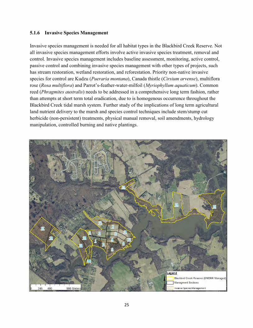
25
5.1.6 Invasive Species Management Invasive species management is needed for all habitat types in the Blackbird Creek Reserve. Not all invasive species management efforts involve active invasive species treatment, removal and control. Invasive species management includes baseline assessment, monitoring, active control, passive control and combining invasive species management with other types of projects, such has stream restoration, wetland restoration, and reforestation. Priority non-native invasive species for control are Kudzu (Pueraria montana), Canada thistle (Cirsium arvense), multiflora rose (Rosa multiflora) and Parrot’s-feather-water-milfoil (Myriophyllum aquaticum). Common reed (Phragmites australis) needs to be addressed in a comprehensive long term fashion, rather than attempts at short term total eradication, due to is homogenous occurrence throughout the Blackbird Creek tidal marsh system. Further study of the implications of long term agricultural land nutrient delivery to the marsh and species control techniques include stem/stump cut herbicide (non-persistent) treatments, physical manual removal, soil amendments, hydrology manipulation, controlled burning and native plantings.

26
For specific ecological restoration projects and managed areas, control of all “priority” species referenced above to <5% coverage to keep these aggressive species in check. Due to requirements of Delaware’s Noxious Weed Law, Canada thistle must be completely controlled (a 0% cover target). For all other existing non-native invasive species, manage for less than 15% total coverage, reflecting a greater tolerance for their occurrence in the system. The targets for invasive species management are based on the biology and character of the species to be controlled and the practicality of achieving control.
27
6.0 REFERENCES DNERR, 2013. Delaware National Estuarine Research Reserve Management Plan 2013-2018.
Delaware National Estuarine Research Reserve. Dover, DE.
National Oceanic and Atmospheric Administration (NOAA). 2015 online. Guidance for Considering the Use of Living Shorelines. NOAA Restoration Center, Office of Habitat Conservation, NOAA Fisheries, Silver Spring, MD. URL: https://www.habitatblueprint.noaa.gov/wp-content/uploads/2018/01/NOAA-Guidance-for-
Considering-the-Use-of-Living-Shorelines_2015.pdf
National Oceanic and Atmospheric Administration (NOAA). The National Estuarine Research Reserve System Strategic Plan 2017-2022. NOAA Office for Coastal Management.
Pinit, P.T., R.J. Bellmer, and G.W. Thayer, 2000. NOAA Fisheries Technical Guidance Manual for Success Criteria in Restoration Projects. Draft. NOAA Restoration Center, Office of Habitat Conservation, NOAA Fisheries, Silver Spring, MD.
Thayer, Gordon W., T.A. McTigue, R.J. Bellmer, F.M. Burrows, S.H. Merkey, A.D. Nickens, S.J. Lozano, P.R. Gayaldo, P.J. Polmateer, and P.T. Pinit, 2003. Science-Based Restoration Monitoring of Coastal Habitats, Volume One: A Framework for Monitoring Plans Under the Estuaries and Clean Waters Act of 2000 (Public Law 160-457). NOAA Coastal Ocean Program Decision Analysis Series No. 23, Volume1. NOAA National Centers for Coastal Ocean Sciences, Silver Spring, MD. 35pp. plus appendices.

28
APPENDIX A
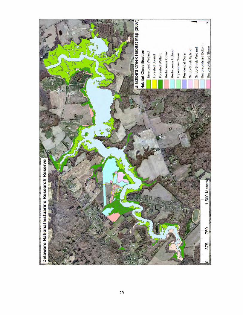
29

30
APPENDIX B
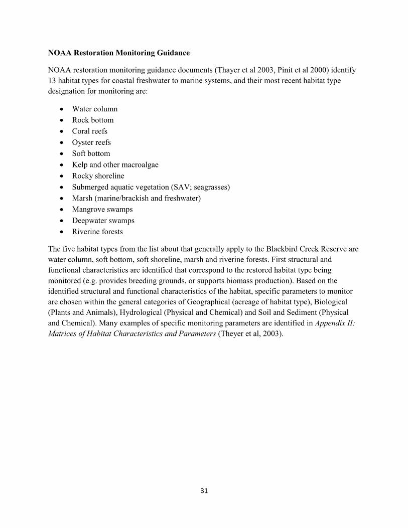
31
NOAA Restoration Monitoring Guidance
NOAA restoration monitoring guidance documents (Thayer et al 2003, Pinit et al 2000) identify 13 habitat types for coastal freshwater to marine systems, and their most recent habitat type designation for monitoring are:
Water column Rock bottom Coral reefs Oyster reefs Soft bottom Kelp and other macroalgae Rocky shoreline Submerged aquatic vegetation (SAV; seagrasses) Marsh (marine/brackish and freshwater) Mangrove swamps Deepwater swamps Riverine forests
The five habitat types from the list about that generally apply to the Blackbird Creek Reserve are water column, soft bottom, soft shoreline, marsh and riverine forests. First structural and functional characteristics are identified that correspond to the restored habitat type being monitored (e.g. provides breeding grounds, or supports biomass production). Based on the identified structural and functional characteristics of the habitat, specific parameters to monitor are chosen within the general categories of Geographical (acreage of habitat type), Biological (Plants and Animals), Hydrological (Physical and Chemical) and Soil and Sediment (Physical and Chemical). Many examples of specific monitoring parameters are identified in Appendix II: Matrices of Habitat Characteristics and Parameters (Theyer et al, 2003).
Appendix D
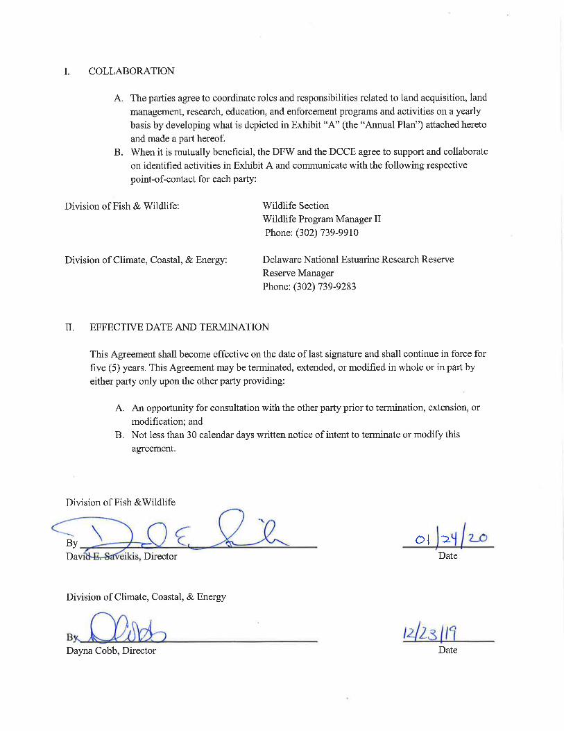
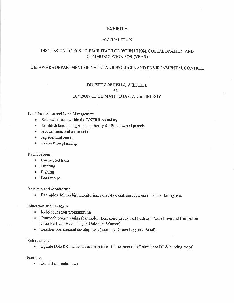

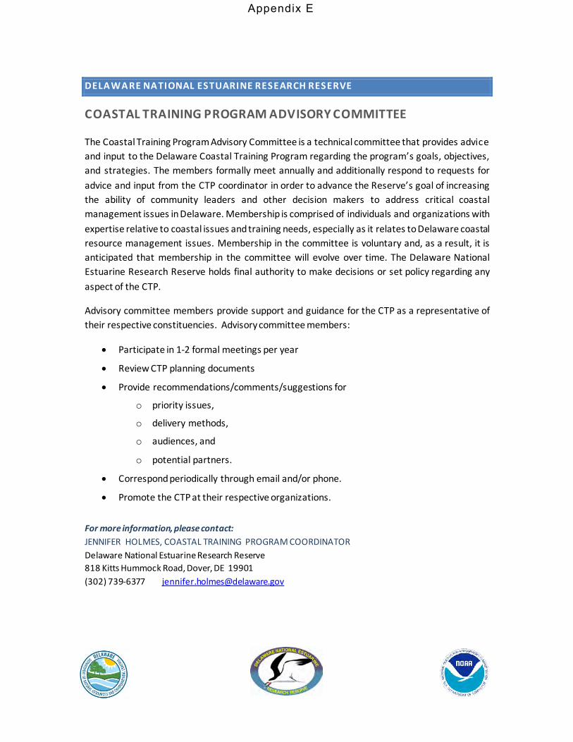
DELAWARE NATIONAL ESTUARINE RESEARCH RESERVE
COASTAL TRAINING PROGRAM ADVISORY COMMITTEE
The Coastal Training Program Advisory Committee is a technical committee that provides advice and input to the Delaware Coastal Training Program regarding the program’s goals, objectives, and strategies. The members formally meet annually and additionally respond to requests for advice and input from the CTP coordinator in order to advance the Reserve’s goal of increasing the ability of community leaders and other decision makers to address critical coastal management issues in Delaware. Membership is comprised of individuals and organizations with expertise relative to coastal issues and training needs, especially as it relates to Delaware coastal resource management issues. Membership in the committee is voluntary and, as a result, it is anticipated that membership in the committee will evolve over time. The Delaware National Estuarine Research Reserve holds final authority to make decisions or set policy regarding any aspect of the CTP.
Advisory committee members provide support and guidance for the CTP as a representative of their respective constituencies. Advisory committee members:
• Participate in 1-2 formal meetings per year
• Review CTP planning documents
• Provide recommendations/comments/suggestions for
o priority issues,
o delivery methods,
o audiences, and
o potential partners.
• Correspond periodically through email and/or phone.
• Promote the CTP at their respective organizations.
For more information, please contact: JENNIFER HOLMES, COASTAL TRAINING PROGRAM COORDINATOR Delaware National Estuarine Research Reserve 818 Kitts Hummock Road, Dover, DE 19901 (302) 739-6377 [email protected]
Appendix E
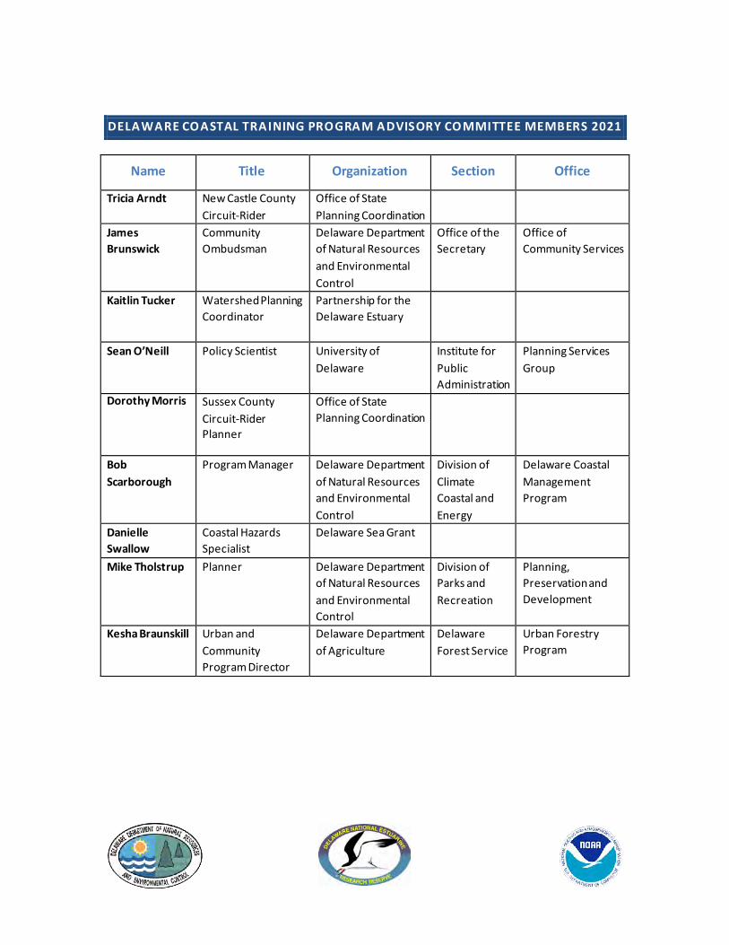
DELAWARE COASTAL TRAINING PROGRAM ADVISORY COMMITTEE MEMBERS 2021
Name Title Organization Section Office
Tricia Arndt New Castle County Circuit-Rider
Office of State Planning Coordination
James Brunswick
Community Ombudsman
Delaware Department of Natural Resources and Environmental Control
Office of the Secretary
Office of Community Services
Kaitlin Tucker Watershed Planning Coordinator
Partnership for the Delaware Estuary
Sean O’Neill Policy Scientist University of Delaware
Institute for Public Administration
Planning Services Group
Dorothy Morris Sussex County Circuit-Rider Planner
Office of State Planning Coordination
Bob Scarborough
Program Manager Delaware Department of Natural Resources and Environmental Control
Division of Climate Coastal and Energy
Delaware Coastal Management Program
Danielle Swallow
Coastal Hazards Specialist
Delaware Sea Grant
Mike Tholstrup Planner Delaware Department of Natural Resources and Environmental Control
Division of Parks and Recreation
Planning, Preservation and Development
Kesha Braunskill Urban and Community Program Director
Delaware Department of Agriculture
Delaware Forest Service
Urban Forestry Program
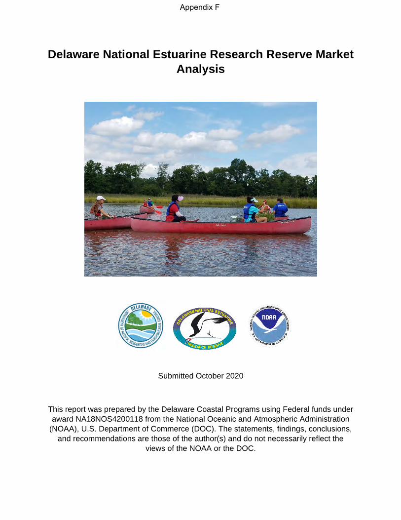
Delaware National Estuarine Research Reserve Market Analysis
Submitted October 2020
This report was prepared by the Delaware Coastal Programs using Federal funds under award NA18NOS4200118 from the National Oceanic and Atmospheric Administration
(NOAA), U.S. Department of Commerce (DOC). The statements, findings, conclusions, and recommendations are those of the author(s) and do not necessarily reflect the
views of the NOAA or the DOC.
Appendix F
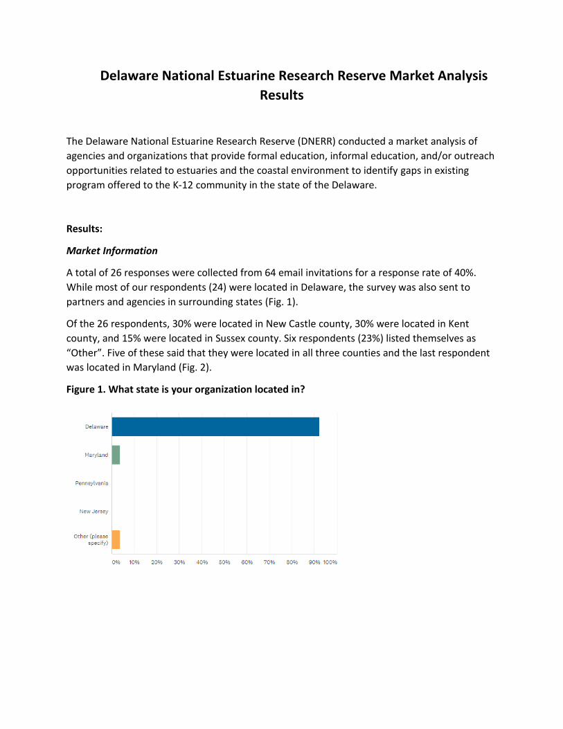
Delaware National Estuarine Research Reserve Market Analysis
Results
The Delaware National Estuarine Research Reserve (DNERR) conducted a market analysis of
agencies and organizations that provide formal education, informal education, and/or outreach
opportunities related to estuaries and the coastal environment to identify gaps in existing
program offered to the K-12 community in the state of the Delaware.
Results:
Market Information
A total of 26 responses were collected from 64 email invitations for a response rate of 40%.
While most of our respondents (24) were located in Delaware, the survey was also sent to
partners and agencies in surrounding states (Fig. 1).
Of the 26 respondents, 30% were located in New Castle county, 30% were located in Kent
county, and 15% were located in Sussex county. Six respondents (23%) listed themselves as
“Other”. Five of these said that they were located in all three counties and the last respondent
was located in Maryland (Fig. 2).
Figure 1. What state is your organization located in?
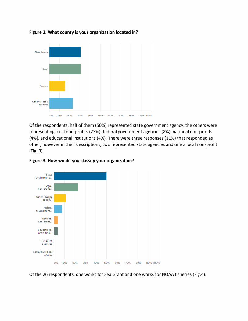
Figure 2. What county is your organization located in?
Of the respondents, half of them (50%) represented state government agency, the others were
representing local non-profits (23%), federal government agencies (8%), national non-profits
(4%), and educational institutions (4%). There were three responses (11%) that responded as
other, however in their descriptions, two represented state agencies and one a local non-profit
(Fig. 3).
Figure 3. How would you classify your organization?
Of the 26 respondents, one works for Sea Grant and one works for NOAA fisheries (Fig.4).
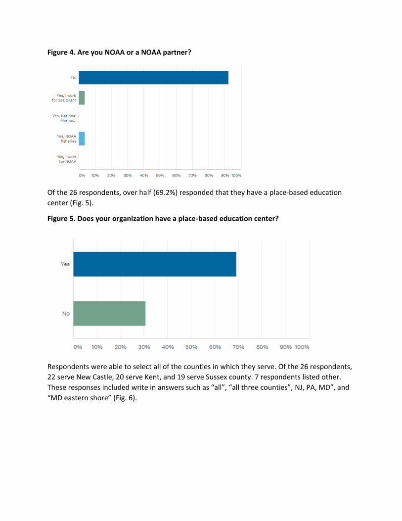
Figure 4. Are you NOAA or a NOAA partner?
Of the 26 respondents, over half (69.2%) responded that they have a place-based education
center (Fig. 5).
Figure 5. Does your organization have a place-based education center?
Respondents were able to select all of the counties in which they serve. Of the 26 respondents,
22 serve New Castle, 20 serve Kent, and 19 serve Sussex county. 7 respondents listed other.
These responses included write in answers such as “all”, “all three counties”, NJ, PA, MD”, and
“MD eastern shore” (Fig. 6).
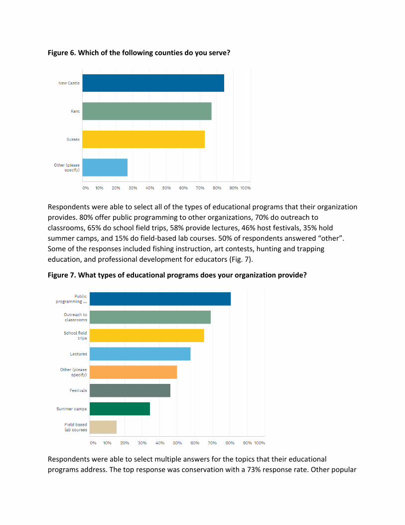
Figure 6. Which of the following counties do you serve?
Respondents were able to select all of the types of educational programs that their organization
provides. 80% offer public programming to other organizations, 70% do outreach to
classrooms, 65% do school field trips, 58% provide lectures, 46% host festivals, 35% hold
summer camps, and 15% do field-based lab courses. 50% of respondents answered “other”.
Some of the responses included fishing instruction, art contests, hunting and trapping
education, and professional development for educators (Fig. 7).
Figure 7. What types of educational programs does your organization provide?
Respondents were able to select multiple answers for the topics that their educational
programs address. The top response was conservation with a 73% response rate. Other popular
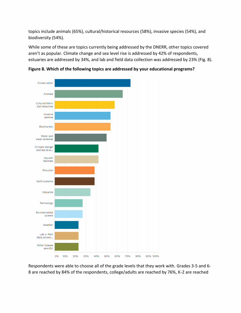
topics include animals (65%), cultural/historical resources (58%), invasive species (54%), and
biodiversity (54%).
While some of these are topics currently being addressed by the DNERR, other topics covered
aren’t as popular. Climate change and sea level rise is addressed by 42% of respondents,
estuaries are addressed by 34%, and lab and field data collection was addressed by 23% (Fig. 8).
Figure 8. Which of the following topics are addressed by your educational programs?
Respondents were able to choose all of the grade levels that they work with. Grades 3-5 and 6-
8 are reached by 84% of the respondents, college/adults are reached by 76%, K-2 are reached
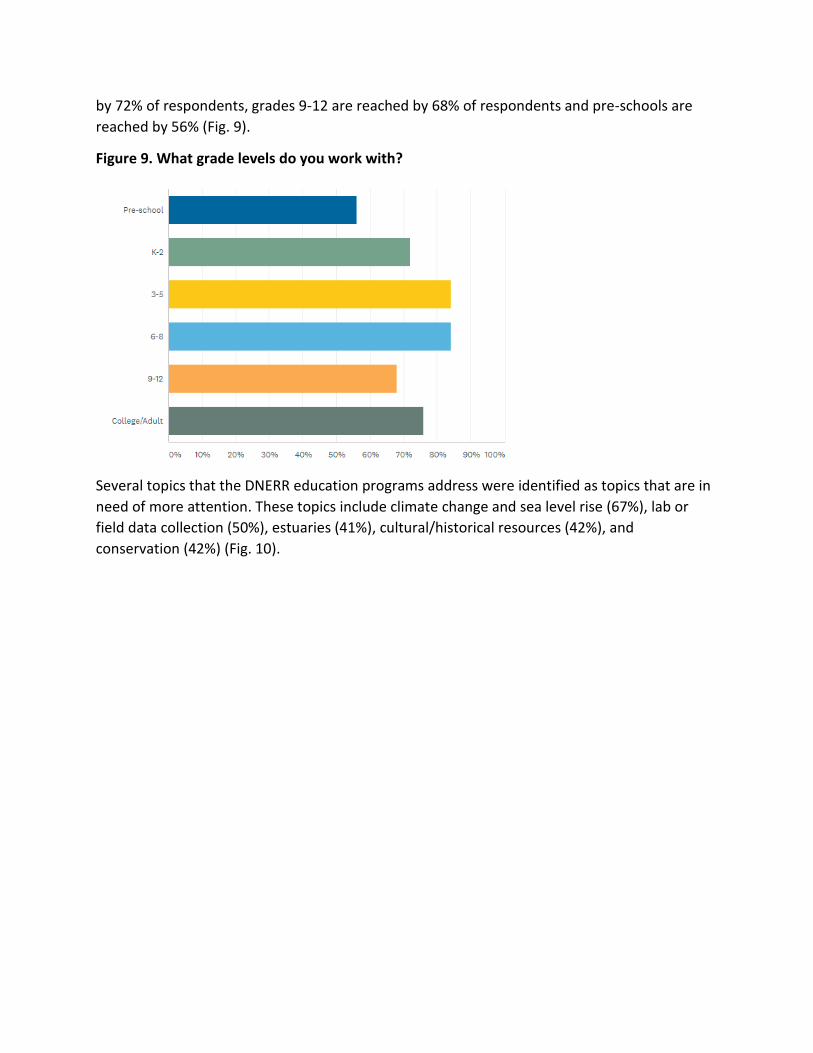
by 72% of respondents, grades 9-12 are reached by 68% of respondents and pre-schools are
reached by 56% (Fig. 9).
Figure 9. What grade levels do you work with?
Several topics that the DNERR education programs address were identified as topics that are in
need of more attention. These topics include climate change and sea level rise (67%), lab or
field data collection (50%), estuaries (41%), cultural/historical resources (42%), and
conservation (42%) (Fig. 10).
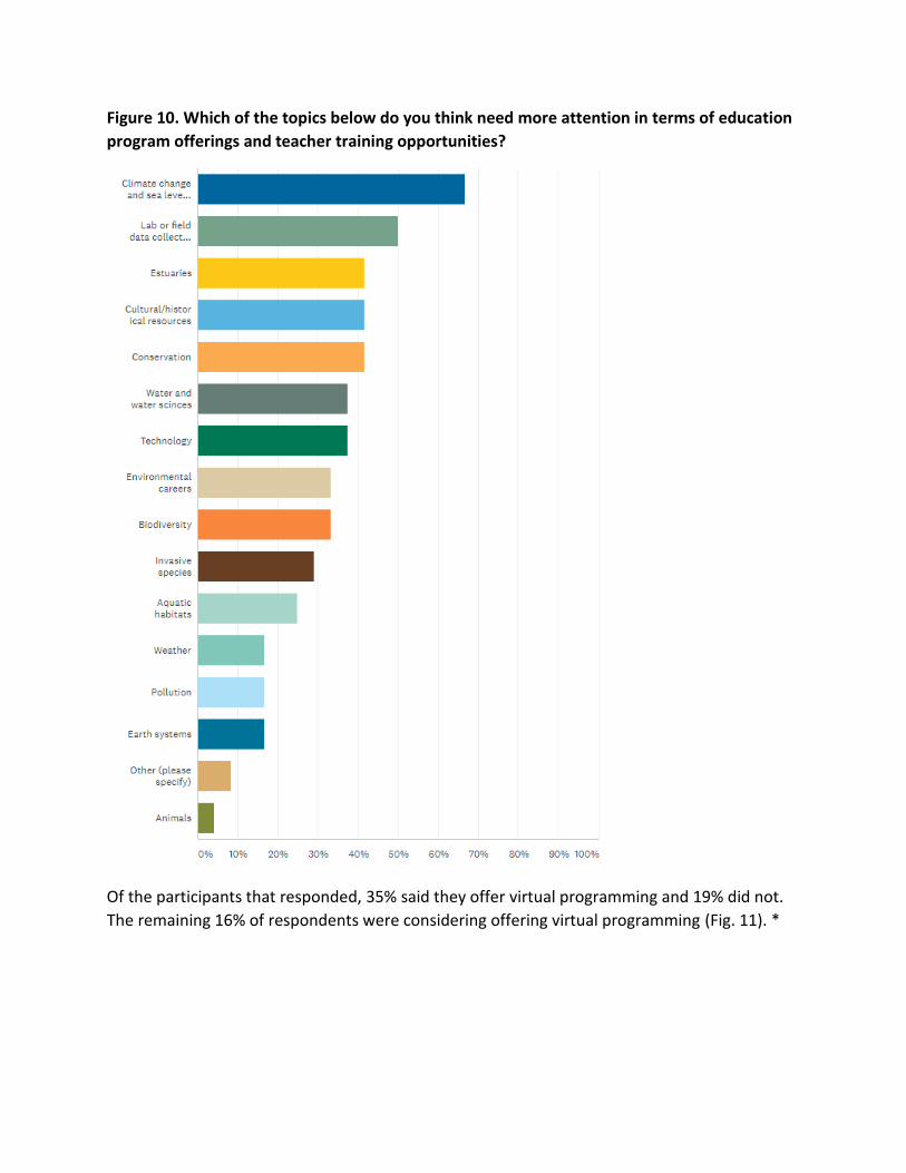
Figure 10. Which of the topics below do you think need more attention in terms of education
program offerings and teacher training opportunities?
Of the participants that responded, 35% said they offer virtual programming and 19% did not.
The remaining 16% of respondents were considering offering virtual programming (Fig. 11). *
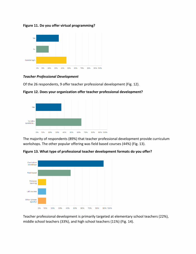
Figure 11. Do you offer virtual programming?
Teacher Professional Development
Of the 26 respondents, 9 offer teacher professional development (Fig. 12).
Figure 12. Does your organization offer teacher professional development?
The majority of respondents (89%) that teacher professional development provide curriculum
workshops. The other popular offering was field based courses (44%) (Fig. 13).
Figure 13. What type of professional teacher development formats do you offer?
Teacher professional development is primarily targeted at elementary school teachers (22%),
middle school teachers (33%), and high school teachers (11%) (Fig. 14).
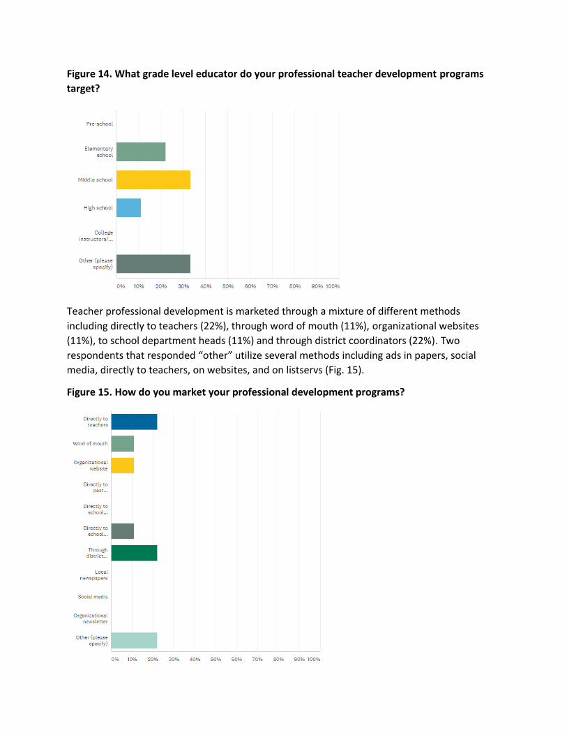
Figure 14. What grade level educator do your professional teacher development programs
target?
Teacher professional development is marketed through a mixture of different methods
including directly to teachers (22%), through word of mouth (11%), organizational websites
(11%), to school department heads (11%) and through district coordinators (22%). Two
respondents that responded “other” utilize several methods including ads in papers, social
media, directly to teachers, on websites, and on listservs (Fig. 15).
Figure 15. How do you market your professional development programs?
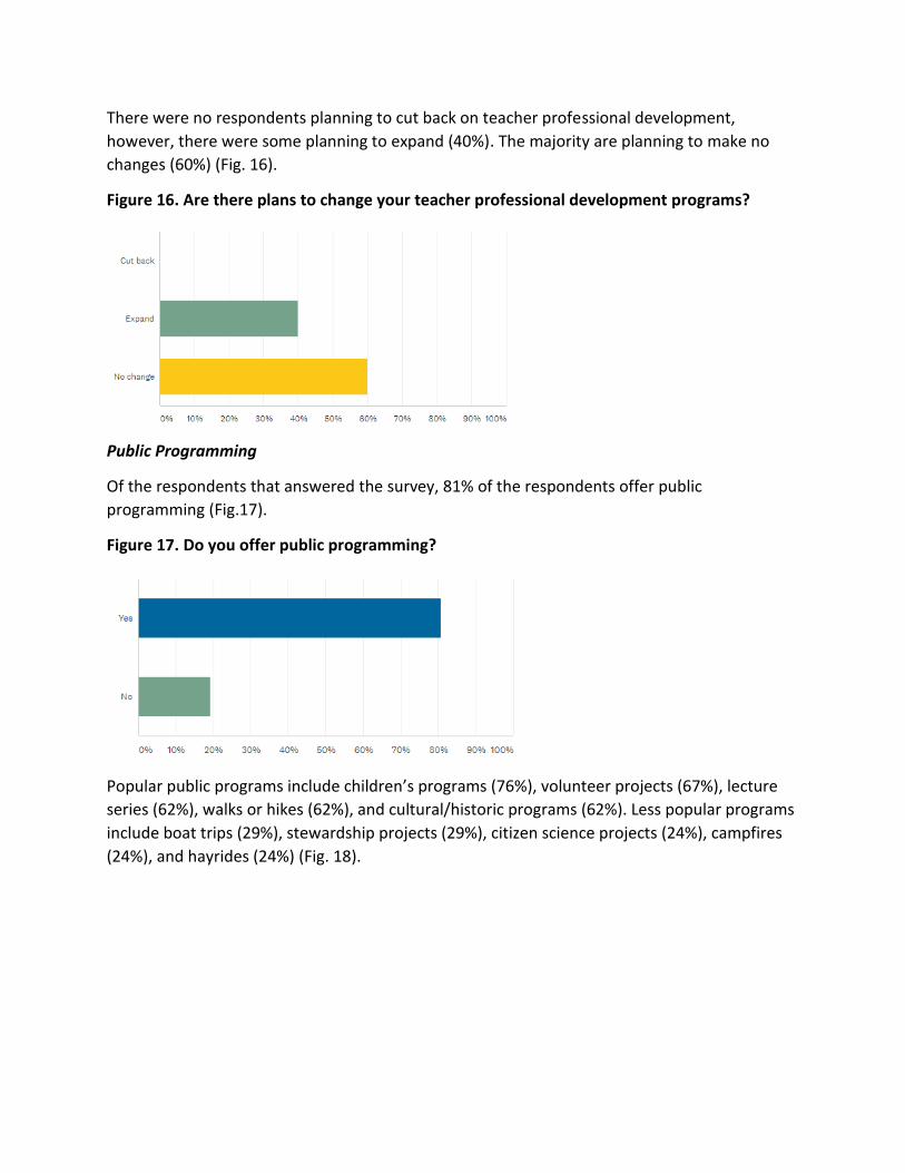
There were no respondents planning to cut back on teacher professional development,
however, there were some planning to expand (40%). The majority are planning to make no
changes (60%) (Fig. 16).
Figure 16. Are there plans to change your teacher professional development programs?
Public Programming
Of the respondents that answered the survey, 81% of the respondents offer public
programming (Fig.17).
Figure 17. Do you offer public programming?
Popular public programs include children’s programs (76%), volunteer projects (67%), lecture
series (62%), walks or hikes (62%), and cultural/historic programs (62%). Less popular programs
include boat trips (29%), stewardship projects (29%), citizen science projects (24%), campfires
(24%), and hayrides (24%) (Fig. 18).
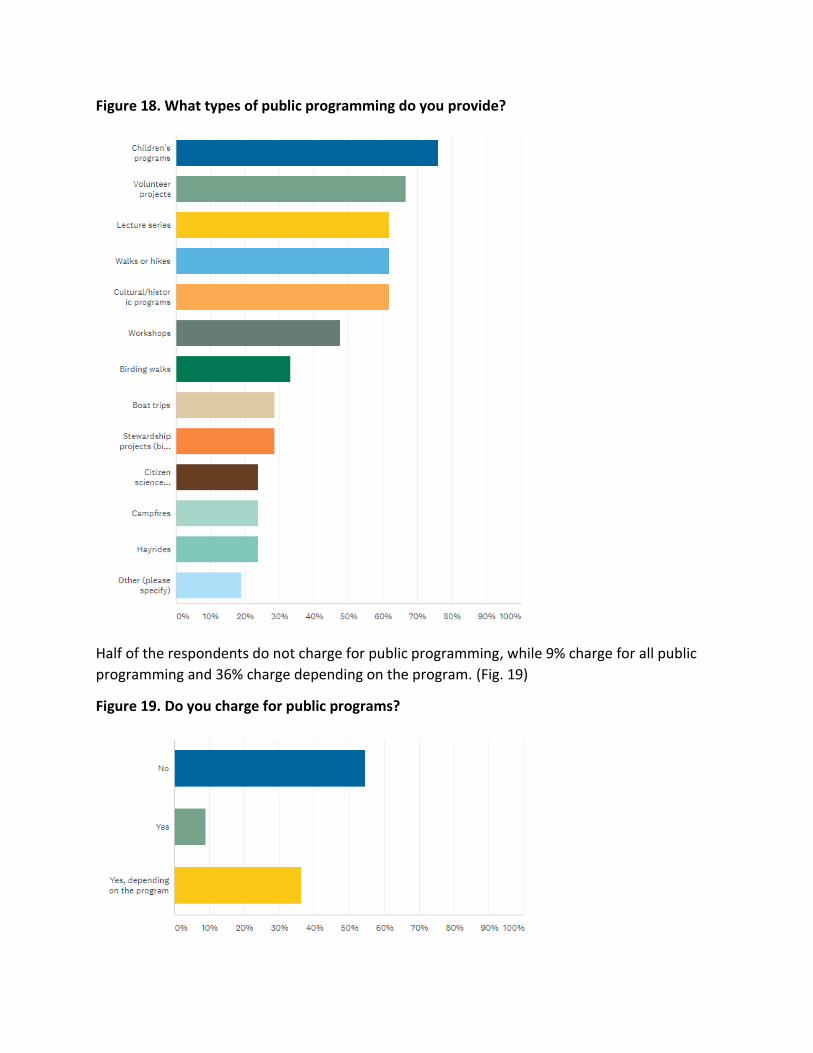
Figure 18. What types of public programming do you provide?
Half of the respondents do not charge for public programming, while 9% charge for all public
programming and 36% charge depending on the program. (Fig. 19)
Figure 19. Do you charge for public programs?
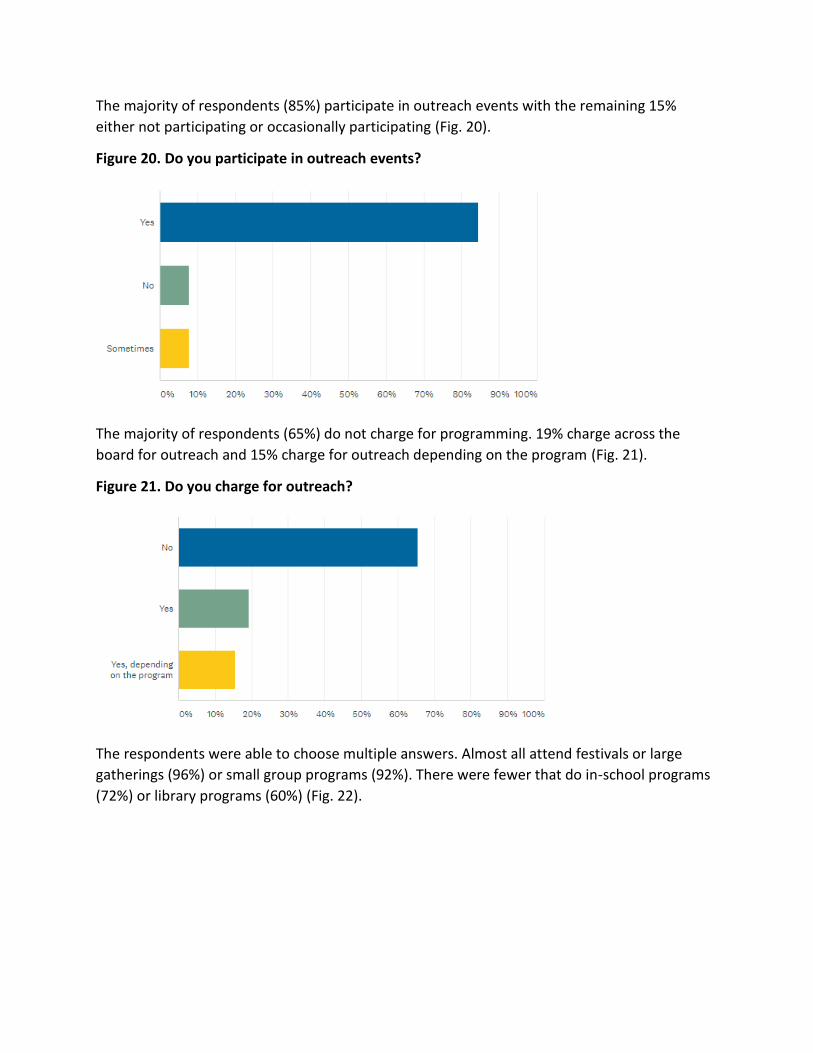
The majority of respondents (85%) participate in outreach events with the remaining 15%
either not participating or occasionally participating (Fig. 20).
Figure 20. Do you participate in outreach events?
The majority of respondents (65%) do not charge for programming. 19% charge across the
board for outreach and 15% charge for outreach depending on the program (Fig. 21).
Figure 21. Do you charge for outreach?
The respondents were able to choose multiple answers. Almost all attend festivals or large
gatherings (96%) or small group programs (92%). There were fewer that do in-school programs
(72%) or library programs (60%) (Fig. 22).
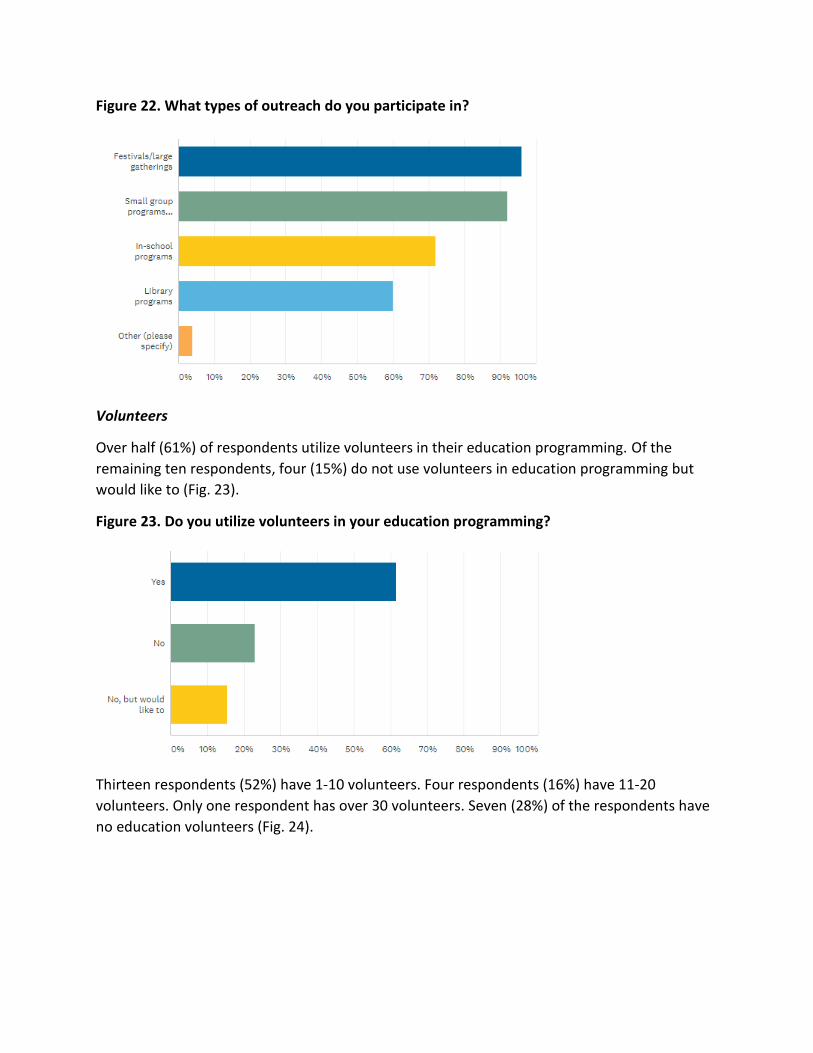
Figure 22. What types of outreach do you participate in?
Volunteers
Over half (61%) of respondents utilize volunteers in their education programming. Of the
remaining ten respondents, four (15%) do not use volunteers in education programming but
would like to (Fig. 23).
Figure 23. Do you utilize volunteers in your education programming?
Thirteen respondents (52%) have 1-10 volunteers. Four respondents (16%) have 11-20
volunteers. Only one respondent has over 30 volunteers. Seven (28%) of the respondents have
no education volunteers (Fig. 24).
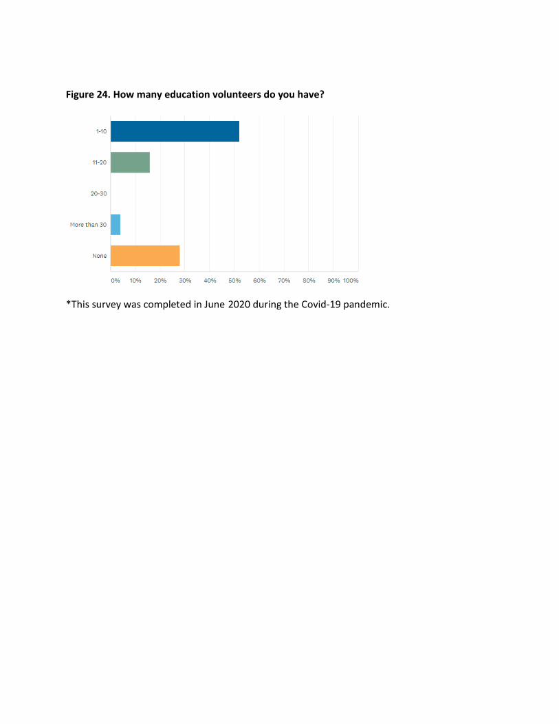
Figure 24. How many education volunteers do you have?
*This survey was completed in June 2020 during the Covid-19 pandemic.
Delaware National Estuarine Research Reserve Needs
Assessment
Submitted October 2020
This report was prepared by the Delaware Coastal Programs using Federal funds under award
NA18NOS4200118 from the National Oceanic and Atmospheric Administration (NOAA), U.S.
Department of Commerce (DOC). The statements, findings, conclusions, and recommendations
are those of the author(s) and do not necessarily reflect the views of the NOAA or the DOC.
Appendix G
Delaware National Estuarine Research Reserve Needs Assessment Results
The Delaware National Estuarine Research Reserve (DNERR) conducted a needs assessment
survey to help identify gaps in existing educational programs and to determine what types of
changes need to be made to current K-12 and teacher professional development programs to
better meet the needs of teachers and students within the state of Delaware. The survey
targeted formal elementary, middle, and high school science teachers.
RESULTS:
Respondent Profiles
A total of 77 responses were collected from 514 email invitations for a response rate of 15%. Of
the teachers who responded, 91% teach in the public-school system, 5% teach in charter
schools, 2% teach in parochial schools, 2% teach in non-parochial private schools, and 1%
responded “other” (Fig. 1) The majority of respondents teach middle school or high school with 49%
teaching grades 6-8 and 41% teaching grades 9-12. Only 8 respondents teach grades K-5 (Fig. 2)
Figure 1. In what education setting do you teach?
Figure 2. What grade level do you teach?
Approximately 64% of respondents are located in New Castle or Kent counties, where Blackbird Creek
and St. Jones components of the Delaware National Estuarine Research Reserve are located. The
remaining 36% are located in Delaware’s third county, Sussex county (Fig. 3.)
Figure 3. Which county is your school located in?
Of the 77 respondents to the question regarding the science subject matter taught, 44.2% teach physical
science, 40.2% teach general science, 38.9% teach life science, 38.9% teach earth science, 37.6% teach
environmental science, 31.1% teach biology, 20.7% teach chemistry, 14.2% teach physics, 3.9% teach
marine science, 1.3% teach computer science, and 11.6% marked their subject matter as “other” (Fig. 4)
Teachers were able to select all of the subjects they teach in order to capture information from teachers
that teach multiple subjects.
Figure 4. Which of the following science subject matters do you teach?
The majority of the respondents teach at least one class per year about estuaries, watersheds, or coastal
areas; however, 36.3% of the respondents do not teach any class periods on these subjects (Fig. 5).
Figure 5. How many classes per year are taught on estuaries, watersheds, or coastal areas?
Field Trips
Teachers expressed interest in a variety of topics on which they would like to be developed into
educational materials and programming. The most popular topic was climate change and sea level rise
with a response rate of 58.4% followed by lab or field data collection and data analysis with a response
rate of 53.25% (Fig. 6). The majority of these respondents indicated that they would also be interested
in virtual programming (Fig. 7).
Figure 6. Which environmental education programming would you like to see at DNERR?
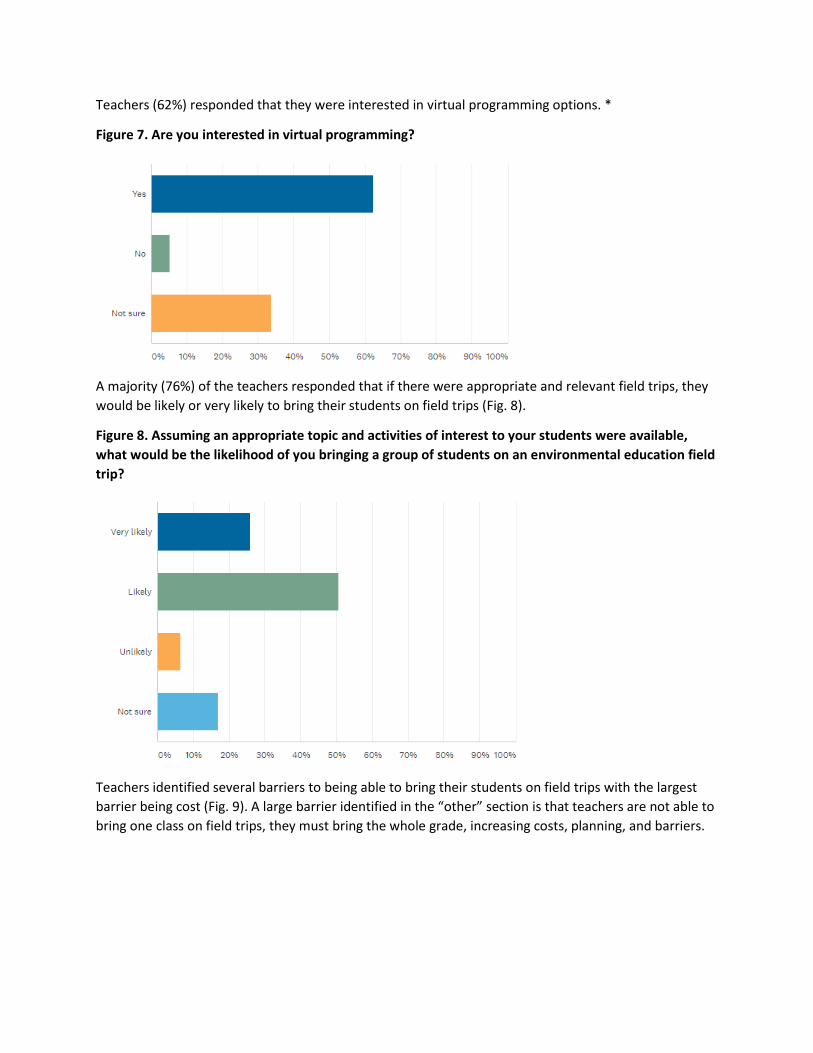
Teachers (62%) responded that they were interested in virtual programming options. *
Figure 7. Are you interested in virtual programming?
A majority (76%) of the teachers responded that if there were appropriate and relevant field trips, they
would be likely or very likely to bring their students on field trips (Fig. 8).
Figure 8. Assuming an appropriate topic and activities of interest to your students were available,
what would be the likelihood of you bringing a group of students on an environmental education field
trip?
Teachers identified several barriers to being able to bring their students on field trips with the largest
barrier being cost (Fig. 9). A large barrier identified in the “other” section is that teachers are not able to
bring one class on field trips, they must bring the whole grade, increasing costs, planning, and barriers.
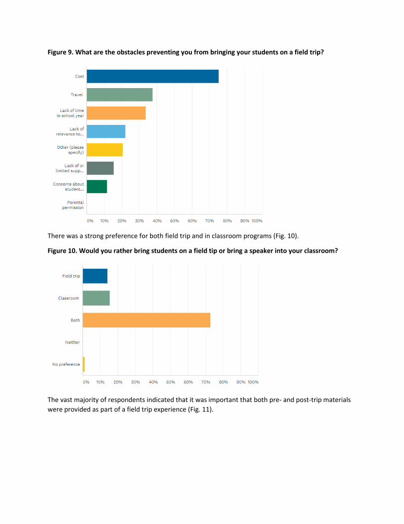
Figure 9. What are the obstacles preventing you from bringing your students on a field trip?
There was a strong preference for both field trip and in classroom programs (Fig. 10).
Figure 10. Would you rather bring students on a field tip or bring a speaker into your classroom?
The vast majority of respondents indicated that it was important that both pre- and post-trip materials
were provided as part of a field trip experience (Fig. 11).
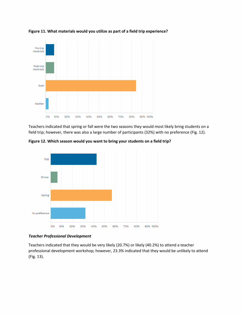
Figure 11. What materials would you utilize as part of a field trip experience?
Teachers indicated that spring or fall were the two seasons they would most likely bring students on a
field trip; however, there was also a large number of participants (32%) with no preference (Fig. 12).
Figure 12. Which season would you want to bring your students on a field trip?
Teacher Professional Development
Teachers indicated that they would be very likely (20.7%) or likely (40.2%) to attend a teacher
professional development workshop; however, 23.3% indicated that they would be unlikely to attend
(Fig. 13).
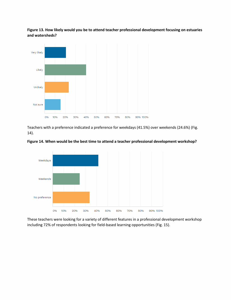
Figure 13. How likely would you be to attend teacher professional development focusing on estuaries
and watersheds?
Teachers with a preference indicated a preference for weekdays (41.5%) over weekends (24.6%) (Fig.
14).
Figure 14. When would be the best time to attend a teacher professional development workshop?
These teachers were looking for a variety of different features in a professional development workshop
including 72% of respondents looking for field-based learning opportunities (Fig. 15).
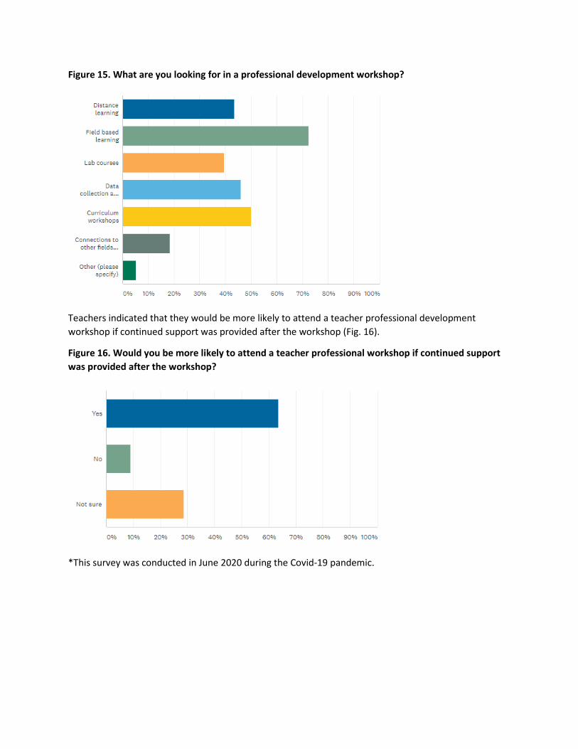
Figure 15. What are you looking for in a professional development workshop?
Teachers indicated that they would be more likely to attend a teacher professional development
workshop if continued support was provided after the workshop (Fig. 16).
Figure 16. Would you be more likely to attend a teacher professional workshop if continued support
was provided after the workshop?
*This survey was conducted in June 2020 during the Covid-19 pandemic.
1
Delaware National Estuarine Research Reserve
NERRS Sentinel Sites Program Plan
Prepared by Kari St.Laurent, Ph.D.
March 2017 First Revision, April 2017
Second Revision, September 2017
Financial support for this publication was provided, fully or in part, by a grant (NA15NOS4200140) under the Federal Coastal Zone Management Act, administered by the Office of Ocean and Coastal Resource Management, National Oceanic and Atmospheric Administration, Silver Spring, MD. The
statements, findings, conclusions, and recommendations are those of the author(s) and do not necessarily reflect the views of the NOAA or the DOC.
Appendix H
2
The following document outlines and details the Delaware National Estuarine Research Reserve (DNERR) plan to be established as a National Estuarine Research Reserve System (NERRS) Sentinel Site for understanding climate change impacts on estuaries. This plan is guided by the NERRS System-wide Monitoring Program (SWMP) Sentinel Site Application Module 1 (SSAM1) Program Plan Development and Review (SSAM-1 Workgroup, 2016), the NERRS Sentinel Sites Program Guidance for Understanding Climate Change Impacts (NERRS 2012), and the Coastal Habitat Response to Changing Water Levels NERR Sentinel Site Application Module 1 (OCM, 2016). Additionally, this NERRS Sentinel Sites Program Plan was guided by established Sentinel Plans from the ACE Basin NERR (Leffler, 2014) and Hudson River NERR (Fernald & Mitchell, 2013). This Plan outlines how the DNERR will implement, manage, and disseminate data collected following the SWMP Program Plan (NERRS, 2011), the NERRS SWMP Vegetation Monitoring Protocol (Moore, 2013), the DNERR Vertical Control Plan (Siok, 2017), surface elevation tables (SET) protocols (Lynch, Hensel, & Cahoon, 2015), and additional monitoring efforts, including secretive marsh bird surveys (Hodgman et al., 2014). Version 1 was reviewed and edited by Nina Garfield (NOAA), Atziri Ibanez (NOAA), Galen Scott (NOAA), Artara Johnson (NOAA), Pete Wiley (NOAA), Scott Lerberg (Chesapeake Bay NERR-Virginia), and Sarah Fernald (Hudson Bay NERR). Version 2 incorporated additional edits and suggestions from Nina Garfield (NOAA), Philippe Hensel (NOAA), and Scott Lerberg (Chesapeake Bay NERR-Virginia). Prepared by: Kari St.Laurent, Ph.D. Research Coordinator Delaware Department of Natural Resources and Environmental Control Delaware National Estuarine Research Reserve Email: [email protected] Phone: (302)739-6377 Prepared for: U.S. Department of Commerce National Oceanic and Atmospheric Administration Office of Coastal Management 1305 East West Highway Silver Spring, MD 20910
3
I. Introduction a. Primary Goals, Environmental Stressors, and Users The Delaware National Estuarine Research Reserve (DNERR) consists of two components: The St. Jones Reserve component, which is a tidal salt marsh located in Dover, DE and the Blackbird Creek Reserve component, a tidal freshwater marsh located approximately 30 minutes north of the St. Jones Reserve (20 miles) in Townsend, DE (Fig. 1). Delaware is particularly vulnerable to sea level rise as it is the lowest lying state in the continental United States and is situated in a region of subsidence due to glacial isostatic readjustment (Engelhart et al., 2011). To date, Delaware has observed an average relative sea level rise rate of 3.35 mm per year (Delaware Sea Level Rise Advisory Committee, 2012), which is among the highest in the continental United States (Raposa et al., 2016; Engelhart et al., 2011). Because of these compounding factors, Delaware’s coastal zone, particularly its tidal wetlands, is vulnerable to the long-term stress of sea level rise and the short-term stress of coastal flooding resulting from storm surge and inundation. Additionally, Delaware is situated in the Mid-Atlantic between the Northeast and Southeast apportioned regions in the National Climate Assessment (Melillo, Richmond, & Yohe, 2014), making it a zone where extreme climate changes are difficult to apply locally and environmental boundaries have been shifting northward due to annual warming, as evident by the updates in the USDA plant hardiness zones (Daly et al., 2012). For these reasons, the DNERR is implementing the necessary infrastructure, resource capacity, and monitoring protocols in order to be designated into the NERRS Sentinel Sites Program. The DNERR has the goals of: 1. Understanding whether tidal marshes have the ability to vertically accrete and keep pace
with local sea level rise,
2. Tracking the changes in tidal marsh vegetation communities and identifying the appearance and/or expansion of invasive and non-indigenous species,
3. Monitoring abiotic and biotic parameters to better understand short-term variability and long-term changes due to anthropogenic development, climate change, coastal erosion, and non-indigenous species colonization,
Understanding these goals through rigorous monitoring and applying the best scientific practices will all DNERR to better understand, adapt, and prepare for future changes to Delaware’s tidal wetlands and the surrounding coastal communities.
The data collected by the DNERR has a wide range of user groups including educators, researchers, and coastal managers, including DNERR staff. The primary users of the Sentinel Sites Program information includes all NERR sectors, local Delaware communities, informal and formal educators, decision-makers, and researchers from academic institutes, local, state, and federal government, and non-profit groups.
4
b. Local Research and Management Issues The DNERR is housed within Delaware Coastal Programs (DCP) of the Delaware Department of Natural Resources and Environmental Control (DNREC). Delaware Coastal Programs has the mission to “balance the use and protection of its resources” and the DNERR specifically has the goal to “promote better understanding of Delaware’s estuarine and coastal areas, and promote informed coastal decision-making” through monitoring and research. This Sentinel Sites Program Plan will allow for the intersection of science and management by providing critically important data which can be directly applied to coastal management issues. The 2013-2018 DNERR Management Plan (“Delaware National Estuarine Research Reserve Management Plan,” 2013) lists five priority research areas which will help address statewide, regional, and reserve-wide management issues: Habitat and ecosystem processes Anthropogenic influences on estuaries Habitat conservation and restoration Species management Social science and economics
Ultimately, the DNERR aims to better understand the vulnerabilities that coastal ecosystems and communities have to climate and land-use changes in order to best identify areas for restoration and adaptation. Additionally, the DNERR seeks to establish the Sentinel Sites as reference sites for restoration and green infrastructure-based projects in Delaware, such as living shorelines. c. Marsh Monitoring The DNERR consists of two components which were designated together in 1993: the St. Jones Reserve and Blackbird Creek Reserve. The St. Jones Reserve, located in Dover, is a tidal salt marsh while the Blackbird Creek Reserve, located in Townsend, is a tidal freshwater marsh. Both components have established emergent tidal marsh vegetation monitoring sites (Fig. 2, 3). The DNERR benefits from having a two-component system with Sentinel Sites infrastructure since it allows for a direct, in-state comparison between different wetland types situated in close proximity (~20 miles). Specific habitat features are highlighted in more detail below (Fig. 2-5) by each component.
St. Jones Reserve Emergent marsh vegetation monitoring at the St. Jones Reserve was established in 2012 and consists of three ~1km transects. The St. Jones River is a fairly urbanized (21%) and agricultural (50%) watershed that is situated in close proximity to the Dover Air Force Base (“St. Jones River” accessed September 2017).
5
The St. Jones vegetation monitoring area (Fig. 2) is classified as a tidal salt marsh with short and long form Spartina alternifora as the dominant vegetation species. Additional emergent estuarine vegetation species include Phragmites australis (invasive), Spartina patens, Spartina cynosuriodes, Distichlis spicata, Schoenoplectus pungens, and Iva frutescens. The St. Jones Reserve vegetation monitoring area has a semi-diurnal tidal cycle with an average tidal range of 1.2 m relative to NAVD88 (derived for the Scotton Landing SWMP station). Salinity nearby the vegetation monitoring area ranges from 0.3 ppt to 26 ppt depending largely on tidal cycle. The majority of this system’s freshwater inputs result from rainfall (annual cumulative average in Dover is 117 cm) and subsequent run-off from land. Additionally, the question of how often and for how long the marsh’s surface is inundated is currently being investigated at each SET location with a series of HOBO water level loggers that are vertically referenced to the closest benchmark (NAVD88) using an RTK (Fig. 2). Results from this study, (anticipated spring 2018) should help address this question; however multiple configurations of HOBO water level loggers will likely be needed in the St. Jones biomonitoring area in order to spatially address this question. Potential pollutants and stressors include the expansion of the invasive species Phragmites australis (along with other invasive species including Rose multiflora and Lonicera japonica), nutrient loading from high agricultural activities in the watershed, persistent organic pollutants (such as DDT, hydrocarbons, and PCBs), and heavy metals (“Delaware National Estuarine Research Reserve Estuarine Profile,” 1999). The St. Jones River watershed contains the Dover Gas Light Company Superfund site. From 1859 to 1948, coal tar residue was buried on site at the 23-acre Dover Gas Light Company in Dover, which has resulted in elevated sediment polycyclic aromatic hydrocarbon concentrations near the Downtown Dover areas of the St. Jones River (Velinsky et al., 2007). Blackbird Creek Reserve Emergent marsh monitoring at the Blackbird Creek Reserve was established in the summer of 2016 after a wooden walkway was installed (Fig. 3). This walkway had to be installed due to the soft and unstable nature of the transect sediment, for example, some locations required a 2.4 meter H-frame to be installed to support the walkway. Blackbird Creek, located in New Castle County, is situated in a more forested/wetland (50%) and agricultural (44%) watershed with only 3% of the watershed categorized as urban (“Delaware National Estuarine Research Reserve Estuarine Profile,” 1999; “Blackbird Creek” accessed September 2017). This system is predominantly oligohaline with a mix of tidal freshwater and salt marsh vegetation species, making it particularly interesting to monitor as sea level rise progresses. The dominant vegetative species include Spartina alterniflora, Pontederia cordata, Arrow arum, Hibiscus moscheutos, Zizania aquatica, Typha sp., and Phragmites australis. It is within a transition zone as evident by the mix of brackish (Spartina alterniflora) and tidal freshwater vegetative species. The salinity nearby the vegetation monitoring area ranges between <0.5 and 7 ppt and has an average tidal range of 1.3 m referenced to NAVD88. Freshwater input to the Blackbird Creek River is primarily from precipitation within the watershed, which has the same annual accumulative rainfall as Dover. The DNERR’s Blackbird Creek component is approximately 10 kilometers from the mouth of
6
the Blackbird Creek tributary (i.e. Delaware River), thus is dominated by the freshwater flow with periodic, and often seasonally-driven, tidal mixing. The DNERR’s Blackbird Creek component is considered to be largely undisturbed and potential environmental stressors are related to salt water intrusions, invasive species, and nutrient run-off from the high amount of agriculture in the watershed. II. Communication and Outreach a. Audiences Perhaps the most important goal for DNERR is to connect the SSAM1 data to as wide and diverse an audience as possible, including (but not limited to) research scientists, coastal managers, formal and informal educators, and the general public. The DNERR research sector works closely with all the DNERR sectors (Coastal Training Program, Stewardship, and Education), state partners including the Delaware Coastal Management Program (DCMP), Delaware Division of Fish and Wildlife, and Delaware’s Division of Watershed Stewardship, the U.S. Fish and Wildlife Service, the University of Delaware, Delaware State University, Delaware Technical Community College, and National Estuary Programs. The ultimate goal is to allow monitoring data to be integrally woven into many different stakeholder needs on the local, regional, and national scale; this includes data that is already available (i.e. previous years of SSAM-1 data) and by including these groups to provide input on future research projects. The DNERR believes that data should not just be collected for ‘science’ but to help address, inform, and better understand important coastal management issues. Research Science The DNERR provides support and expertise to numerous academic institutes including, but not limited to, the University of Delaware, Wesley College, Delaware State University, George Washington University, and Delaware Technical Community College. Many researchers, graduate students, and undergraduate students utilize the DNERR’s abiotic SWMP monitoring data in tandem to their own environmental measurements. For example, subtidal zooplankton dynamics are being assessed by researchers at the University of Delaware and SWMP water quality data is being used to describe the abiotic conditions during sampling. This mutually beneficial data sharing was established through the DNERR’s annual mini-grant competition, in which the DNERR research staff and management write a request for proposal to encourage local academic and non-profit researchers within Delaware to conduct applied science research at the DNERR to address the research priorities outlined in the 2013-2018 Management Plan (“Delaware National Estuarine Research Reserve Management Plan,” 2013). This competition also allows the DNERR to broaden the awareness of the SSAM-1 data sets available for use. The DNERR’s long-term monitoring naturally lends itself to a research-based audience since the SSAM-1 monitoring data provides abiotic and biotic resources which are often required, or at least supplemental, to hypothesis-driven questions. For example, the DNERR’s data is currently utilized by local Delaware researchers on topics including vertical carbon gas fluxes in wetlands, nesting residency of marsh and nesting birds, hydrological changes of a marsh under different sea level rise scenarios, and whether the use of pressure-treated wood is a source of arsenic to marsh vegetation, among many other locally-relevant research questions.
7
Each of these example studies will produce scientific manuscripts and/or graduate theses that will provide useful information as well as expand the awareness of the DNERR as a place-based research hub on an international scale. Lastly, the DNERR has also been making an effort to extent the knowledge of our assets on a more regional and national scale. For example, DNERR and DCMP staff actively provides scientific expertise to regional groups including the Mid-Atlantic Regional Ocean Council (MARCO), the Mid-Atlantic Regional Association Coastal Ocean Observing System (MARACOOS), the Mid-Atlantic Coastal Acidification Network (MACAN), the Center for the Inlands Bays, and the Partnership for the Delaware Estuary. For example, the DNERR is participating in a pilot study aiming to integrate NERRS SWMP data with the Integrated Ocean Observing System (IOOS) buoy data on a beyond-regional scale and provides content to the MACAN website on coastal and ocean acidification. Finally, DNERR research staff also mentor summer interns from around the county, including hosting NOAA Hollings Scholars; these internships often foster positive relationships with new academic institutes as well as prepare young scientists for the workforce and/or graduate school. Coastal Managers The DNERR Research Coordinator and Coastal Training Program (CTP) Coordinator have worked together and established steps to integrate and leverage SSAM-1 data, along with other DNERR research, to CTP efforts including technical assistance to coastal communities, providing trainings to decision-makers and state government agencies, and enhancing public engagement on local environmental issues. In that sense, the CTP program effectively works as an additional communication vector for Sentinel Sites data all the while providing DNERR partners, decision-makers, and individuals with local, high quality, and continuous data. The SSAM-1 data can provide the following to the DNERR’s CTP program; 1) Provide actual and/or sample data sets on water level, salinity changes, and storm events,
among others, to demonstrate environmental variability and change within coastal communities
2) Demonstrate methodology and provide technical guidance on the collection and analysis of environmental data
3) Establish the vegetation monitoring areas as reference sites for a long-term comparison to
restoration projects More specifically, there are a few CTP led programs which the Research Coordinator and CTP Coordinator will work together to integrate SSAM-1 to help inform their respective audiences. Delaware Coastal Programs, which composes DNERR and DCMP, work collaboratively to enhance community preparedness by providing technical assistance, outreach, and community engagement to assist coastal Delaware communities in enhancing their resiliency. Previously, DNERR and DCMP have worked successfully with the small coastal town of Slaughter Beach. In this community resiliency effort, wetland hydrology and coastal flooding data were used to
8
create inundation maps, a vulnerability assessment, and identify adaptation strategies specifically for Slaughter Beach residents. This engagement utilized vertical control (to NAVD88) and water level monitoring to create the inundation maps and provide options for adaptation strategies. In the upcoming years, these Community Preparedness efforts seek to leverage funding by applying vulnerability assessments and water levels on a baywide scale, providing insights and adaptation options to a broad range of coastal Delaware communities. Thus, the approach for monitoring and collecting SSAM-1 data will be directly applicable to this effort. One strategy for working with new communities is to use the SSAM-1 data as a “proof of concept” to demonstrate patterns and trends in water level at the DNERR. This approach will only become more robust with time as the DNERR’s SSAM-1 monitoring data set grows. Additionally, DNERR’s CTP coordinator provides a leadership role in the ad hoc working group The Resilient and Sustainable Communities League (RASCL). RASCL puts together Delaware state agencies, academic groups, and non-governmental groups to collaboratively enhance and build capacity for local communities to adapt and/or mitigate problems resulting from a changing environment. One topic that is gaining interest in RASCL, as well as the Mid-Atlantic, is the implementation of green infrastructure, such as a living shoreline. The DNERR Research Coordinator and CTP Coordinator will work together to demonstrate and provide technical support on monitoring approaches to assess the health of living shorelines. It is also possible for the DNERR’s St. Jones and Blackbird Creek vegetation monitoring areas to be utilized as a “left alone” site, allowing for a reference location between a restored and protected wetland. The DNERR research staff will continue to work with the CTP sector to provide real, locally-collected data to help inform coastal communities of environmental changes. Future research projects will seek direct input from the CTP Coordinator and other coastal-management based groups in Delaware. For example, CTP staff will be included on the development of NERRS Science Collaborative pre-proposals will be included in outreach and communication efforts for recent studies, such as the recently published tidal marsh resiliency to sea level rise (MARS) indices (Raposa et al., 2016). Finally, future research projects should solicit direct input from the CTP sector to allow for the development of the best possible products. Education The DNERR has a robust education program, including informal educational programing, support for formal educators, and citizen science campaigns which incorporate DNERR Sentinel Site Monitoring methodology, data, and other research DNERR research projects. The DNERR Education Coordinator and Research Coordinator meet quarterly (along with the Stewardship Coordinator, Coastal Training Program Coordinator, and Reserve Manger) to have active discussions on how to better integrate the DNERR sector goals as well as to discuss possible projects with a multi-sector utility. The DNERR’s Research and Education Sectors will work collaboratively to integrate and utilize SSAM-1 data into the various educational programs offered annually at the DNERR.
9
Those include informal education programing, formal educational programing, and general outreach and education; details on how data will and could be integrated are highlighted below. Informal Education The DNERR hosts multiple informal education events for the general public, organizational groups (such as Girl Scouts), and visiting classrooms. SSAM-1 data has been successfully integrated into these efforts and a pathway is in place to further increase the DNERR research into informal educational programing. While the learning concepts vary by event, common themes include demonstrating how actual environmental data are collected and demonstrating the importance of habitat. For example, the DNERR started an annual National Estuaries Day open house in the fall of 2016 in which visitors can collect SET data and learn about the importance of surface elevation changes. Another “exhibit” at National Estuaries Day included a poster-size graph displaying when large precipitation events occurred, using DNERR SWMP data and other NOAA precipitation data. Visitors could put sticky notes on dates which were important to them (birthday, anniversary, etc) to see if any big storms had occurred. This exercise directly brings weather and coastal storm data taken at DNERR into the hands and memories of visitors. Another successful informal education event includes the Blackbird Fall Festival, which includes a variety of activities to demonstrate the importance of wetland habitat, including native trees and wetland plants. Integrated throughout the Blackbird Fall Festival is the concept of how environmental parameters, such as salinity, affect the species composition of plants and animals. One specific example includes a hayride in which passengers are driven close to the vegetation monitoring area at Blackbird Creek and are taught about the vegetation species differences at the Blackbird Creek and the St. Jones Reserve components. The protocol for vegetation monitoring, i.e. quadrats, is also demonstrated and integrated into a hands-on activity. The DNERR research sector is making an effort to better integrate SSAM-1 data into informal learning experiences. Although there is no established plan in place, a phenology-based program has been discussed as a possible program. This type of program could pull in DNERR temperature data and relate it to tree budburst and pollinator-friendly plants. The DNERR Research Coordinator is hoping to establish phenology stations which could be used for educational exhibits and as citizen science primers (i.e. Project Budburst). Formal Education The DNERR also hosts and supports a multiple formal education-based programs including the annual Make a Splash Festival for Delaware 4th grade students, visiting formal classrooms as guest speakers, and assisting with research projects for high school classes. The annual Make a Splash includes a rotation of water cycle-based activities including water quality monitoring. The DNERR Research Coordinator will support and work with the Education Coordinator to discuss if and how SSAM-1 data and methods could be incorporated into formal classroom visits, such as showing the SWMPrats widget tool to easily visualize data. Additionally, the DNERR Education Coordinator is currently in the process of redesigning a portion of the
10
DNERR’s educational module, thus there are possibilities for the research and education staff to work closely in the near future. For example, the need to have a learning concept centered on engineering has been identified, and DNERR’s water level and wind data could be leveraged as data to support for the design and creation of alternative energy models. One example of how SSAM-1 data is directly incorporated into formal education includes a partnership with Calgary Christian High School (CCHS). In the 2016, CCHS initiated an advanced environmental science course which offers students one semester of college credit. A mandatory component was a hypothesis-driven, field-based research project. CCHS worked with DNERR to design and implement a zooplankton investigation to look at copepod abundances after rain events. The students were given an overview of sample collection and microscope identification techniques at the DNERR and then took their own samples at the Lebanon Landing SWMP water quality site. The students were able to use water quality and weather data to look at the environmental factors which could help explain copepod abundance changes. It is anticipated that this class will be offered annually at CCHS and this zooplankton-based project will be a possible field study for future classes. General Outreach and Education The DNERR’s education sector also has multiple passive public educational exhibits and media-based content. For example, DNERR has worked with the Delaware Department of Natural Resources and Environmental Control Public Affairs to create a series of YouTube videos titled “Science Time With Maggie.” These videos incorporate and explain the importance of SSAM-1 data. For example, the 2016 video was titled “SWMP! Part 1: Water and Weather” and demonstrated how abiotic SWMP data was collected and the importance of collecting environmental data. Future videos could include topics such as SETs and vegetation monitoring. The DNERR additionally has a blog in which DNERR volunteers and staff have made entries on everything from precipitation data to monitoring a living shoreline with quadrats. It should be noted that not all educational programs will be able to incorporate SSAM-1 data, however the DNERR research staff will work closely with the education staff to utilize and better integrate this data were appropriate. Additionally, DNERR education staff will be included in the discussions for future research-based proposals, such as the NERRS Science Collaborative. General Public/Citizen Science The DNERR is well recognized in the community due to the numerous volunteer events and citizen science programs offered. The DNERR runs multiple successful citizen science campaigns which attract volunteers as far as New England as well as interns from all over the United States. These volunteer and citizen science events include: 1) a horseshoe crab monitoring program in partnership with DNREC, Delaware’s Division of Fish and Wildlife, 2) a secretive marsh bird survey run by the DNERR’s Stewardship Coordinator, 3) semi-annual potting and planting of native trees to enhance wildlife corridors, and 4) NestWatch surveys which monitors native and migratory nesting birds of interest, such as the Eastern Bluebird
11
(Sialia sialis). These citizen science programs have become cornerstones for increasing the capacity to collect and conduct valuable annual monitoring efforts in addition to providing student interns, volunteers, and the general public with outreach and education on important species and monitoring methodologies. b. Data Usage and Availability The DNERR makes all of its data readily available through the CDMO website or upon request to the research staff. Additional Delaware state initiatives have begun to increase public accessibility to state agency data, such as FirstMap, which is an open geodatabase for Delaware geospatial data. Awareness of what data are available and how it is collected is a current challenge, but being bridged by creating relationships with local academic institutes and non- governmental organizations (ex, The Nature Conservancy, MACAN). The DNERR will continue to create relationships with our target audiences to increase the usage and knowledge of the SSAM-1 data availability. The DNERR will also continue to incorporate SSAM-1 monitoring into DNERR-based research questions and partner needs. These include using the abiotic SWMP parameters in tandem to a nekton monitoring program to better understand if and how environmental conditions and land-use changes alter the relative species composition of ecologically important fish, decapods, and larval communities. Additionally, the DNERR aims to increase its biological monitoring, as recommended in our 2016 Adaption Plan (“Delaware National Estuarine Research Reserve Climate Change Adaptation Plan,” 2015), by beginning to develop a phenology monitoring plan, including variables such as budburst and pollinator timings. Biological monitoring, planning, and implementation will include researchers and educators from various Departments and Divisions within Delaware’s state government, ensuring that the information gained by these research and monitoring activities will be immediately useful to our target user groups.
III. Site-Based Monitoring Plan - SSAM1 Monitoring Infrastructure
A. Location of Infrastructure: St. Jones Reserve The St. Jones Reserve is situated in the capital of Delaware (Dover, Kent County) and is a nearly geographic center point along Delaware Bay (Figures 1, 2, 4). The wetlands within the St. Jones Reserve boundaries are mostly classified as a brackish marsh and are largely dominated by Spartina sp. vegetative communities. The vegetation biomonitoring location was selected in part due to accessibility as well as it offering a sloping gradient from upland to a tidal bank to serve as long-term stationary plots for assessing discrete vegetation changes. These hypothesized vegetation changes include change between tall and short forms of Spartina alterniflora and conversions to open mudflats where above surface flooding becomes more frequent.
12
Surface elevation tables are located throughout the DNERR boundaries, including two situated within the vegetation biomonitoring area. This can allow for marsh elevation changes to be assessed on a broad spatial scale and to compare surface elevation changes, via SET measurements, are locally specific or are observed Reserve-wide (which would indicate whether changes in the vegetation monitoring area are local or are broadly representative of the St. Jones). The DNERR has recently established a partnership with the USGS to begin designing a project to establish and apply Structure from Motion (SfM) methodology to a tidal marsh. Structure from Motion utilizes drones to create digital elevation models by stitching aerial photographs taken at different angles. This new technology could allow for broader, ecosystem-scale vegetation monitoring to be collected more frequently without destruction to the tidal marsh. In the winter 2018, DNERR and USGS will begin exploring a two-fold project to 1) optimize the parameters needed to create a marsh digital elevation model by SfM and 2) to map the St. Jones biomonitoring area as a comparison to the Emergent Vegetation Biomonitoring survey. The main prohibiting factor will be whether DNERR can receive permission to fly a drone at the St. Jones area since the close proximity to the Dover Air Force Base makes the St. Jones Reserve component in restricted airspace. The Blackbird Creek Reserve component is another tidal marsh which could benefit from SfM elevation mapping. Additionally, the SWMP meteorological station and both a primary (Scotton Landing) and secondary (Aspen Landing) water quality station are positioned in close proximity to the vegetation monitoring (although it should be noted water quality estimates are often derived using a primary SWMP station further away, but is located in a more representative tidal area). The SWMP water quality stations at the St. Jones Reserve are positioned in a salinity gradient going up the St. Jones River. While DNERR has never explicitly established site-specific research questions, much of the present research occurring at the St. Jones Reserve is focused on wetland hydrology, invasive species impacts and management strategies (specifically for Phragmites australis), and estuarine ecology, among others. Locations and environmental conditions are highlight in more detail below. Blackbird Creek Reserve The Blackbird Creek Reserve is situated in Townsend, Delaware, approximately 20 minutes north of the St. Jones in New Castle County (Figures 1, 3, 5). Blackbird Creek is classified as a tidal freshwater marsh which is potentially vulnerable to sea level rise, especially ecologically if the salt line progresses further inland. Thus, the vegetation monitoring area offers a particularly interesting monitoring question since changes in salinity could drastically alter the vegetative community composition over time. The Blackbird Creek vegetation biomonitoring area includes a mix of freshwater and brackish species, thus a salinity change in either direction could alter those communities. Surface Elevation Tables are located throughout the Blackbird Creek Reserve boundaries, including one situated within the vegetation biomonitoring area. Selection for SET locations were largely controlled by accessibility and land ownership; SETs are situated in a broad geographical scale for site-specific comparisons to be made to assess if surface elevation
13
changes are heterogeneous or homogenous with the Blackbird Creek Reserve boundaries. The SWMP meteorological station is positioned in close proximity to the vegetation monitoring while the SWMP water quality stations are positioned in a salinity gradient, similar to the St. Jones Reserve. Similar to above, the DNERR has never explicitly established site-specific research questions however current research at Blackbird Creek includes relative species changes in nekton at different salinity strata and, similar to the St. Jones, changes to hydrology. The Blackbird Creek Component is not located in restricted airspace, and thus could be a prime location for a Structure from Motion project utilizing drone aerial imagery to create tidal marsh digital elevation models. Locations and environmental conditions are highlight in more detail below. Please refer to Figures 4 and 5 in the Appendix for a comprehensive map with the positions of all DNERR Sentinel Sites infrastructure. B. Vegetation Monitoring Location: Vegetation monitoring occurs biennially at both components of the DNERR: the St. Jones Reserve and Blackbird Creek (Fig. 2, 3). Monitoring on an every other year basis was initiated to minimize marsh disturbance and this biennial monitoring will be revisited periodically to adjust the monitoring frequency as needed (whether more or less). The St. Jones Reserve vegetation monitoring transects occurs in a tidal salt marsh that border the St. Jones River, a tributary of the Delaware River which is dominated by Spartina alterniflora. The St. Jones vegetation monitoring area has 3 vegetation transects, established in 2012, approximately 1 kilometer each in length, with 10 equidistant vegetation plots (Fig 2). Thus, three transect measurements have been made to date. Notably, the vegetation monitoring transects occur in an area where power line poles had to be replaced in 2014. The DNERR worked with Delmarva Power to design a minimal impact replacement effort and to avoid the established vegetation plots. Additional biomass plots where established in 2015 as a separate research question to monitor the impact and recovery of this disturbance. The Blackbird Creek component is a tidal freshwater system which consists of a mix of brackish and freshwater vegetation species including Spartina alternaflora, arrow arum, and marsh hibiscus. The Blackbird Creek vegetation monitoring transects were established and first assessed in the summer of 2016. It consists of 6 lines approximately 175 meters perpendicular to the shoreline and an additional 80 meter perpendicular line (Fig. 3). Each perpendicular transect has five vegetation plots and the parallel transect has four vegetation plots. The parallel transect was added due to the peninsula-like landform that will likely be subject to erosionary and/or accretionary processes in the future. Because of the “soft” nature of the hydric soils, a boardwalk had to be installed in the summer of 2016. The installed boardwalk composes approximately 65% of the total transect distance and will ensure minimal disturbance during future monitoring efforts. Monitoring Method: Emergent vegetation monitoring at the DNERR follows the SWMP bio- monitoring protocols (Moore, 2013). Methodology and sampling methods are identical between
14
the St. Jones and Blackbird Creek components; however the experimental design is catered to each unique habitat (i.e. spatial extent). The St. Jones transects consists of 3 ~1km long transects with 10 fixed vegetation plots, totaling a monitoring area approximately 1050 km2. This large spatial area will allow changes in vegetation species and density to be assessed, in terms of species composition change per quadrat, in additional to the non-quantitative observations of invasive species area expansion (primarily Phragmites austrailis). The Blackbird Creek component, conversely, consists of 6 transects ~175 meters with 5 vegetation plots and an additional transect parallel to the shore, comprising approximately 50 km2. This area is spatially more condensed and composed of “soft” sediments which will allow for erosionary and accretionary processes to be incorporated in the biennial monitoring. The parallel transect was added with the research question of what will happen to the peninsula landform over time. Qualitative observations suggest that sections of this landform could expand into a mudflat while other areas could be subjected to erosion, potentially creating an island. Additionally, a vegetation plot was placed at the edge of the emergent marsh vegetation line and adjacent tidal creek at each perpendicular transect line (Fig.3) to allow changes in shoreline (erosion or accretion) to be assessed. Vegetation is monitored biennially during peak biomass (Mid-August to Mid-September). At each plot (as defined by a 1 m2 quadrant centered on a PVC and/or GPS point), each species is non-destructively identified and a percent cover is estimated to a visual species resolution of 5%, including an estimate of bare ground when necessary. Additionally, a 0.1 m2 quadrant is used to get a stem density count of the most dominate vegetative species and a triplicate measurement of the most frequent/average vegetation height is subjectively estimated to the nearest millimeter. The soil bearing capacity is also measured using a slide hammer, which is a strong metric to assess marsh change and is consistent with the wetlands monitoring protocol of Delaware’s Division of Watershed Stewardship (Wetlands Assessment and Management Section). The DNERR carries marsh vegetation field guides (and smart phones) to accurately ID plants to the lowest possible taxonomic unit and has also consulted with marsh plant experts for identification of less common plan species. Additionally, each vegetation plot is surveyed biennially with an RTK (relative to an established geodetic benchmark to the NAVD88) to determine the elevation with the exception of 2014 monitoring at the St. Jones Reserve due to instrument problems (Figures 2-5). Marsh health is assessed through the development of the Marsh Vulnerability Index in which above ground biomass from 176 cm2 area and all below ground biomass to a depth of 30 cm is cut and bagged then processed in the DNERR laboratory to separate living and dead biomass for drying and weighing (Delaware Coastal Program, 2014). Frequency: Vegetation monitoring is conducted every other year (biennially) and occurs within a 2-3 week period during monitoring years to prevent discrepancies due to seasonal changes. This frequency allows for minimal disturbance due to sampling while still allowing for changes to be assessed (such as from invasive species and sea level rise). Sampling at the St. Jones Reserve began in 2012, and the third iteration was completed the summer of 2016. Sampling was established at the Blackbird Creek Reserve in the summer of 2016. The DNERR is in the process of submitting vegetation monitoring data to the biomonitoring view committee for publication on the Centralized Data Management Office.
15
Data Archiving: Data is collected, digitalized, archived, QA/QCed and maintained by the DNERR’s Stewardship Coordinator, with help from the DNERR research staff, in compliance with the DNERR data management plan generated for the annual operating award (“Delaware National Estuarine Research Reserve Operations, Education and Monitoring,” 2016). All vegetation monitoring data can be accessed upon email request with the plan to have data available via the CDMO after review. Habitat Maps: Habitat maps are currently being processed by the DNERR Stewardship Coordinator and NOAA for the years 2007, 2012, and 2017 using aerial imagery collected specifically for Delaware. The DNERR will be submitting the Habitat Maps for review and for publication to the CDMO as post-processing and change analysis methodology becomes available. DNERR plans to generate Habitat Maps on a 5 year cycle assuming the State of Delaware continues to collect 5-year aerial imagery. This 5 year cycle of Habitat Maps for both the St. Jones and Blackbird Creek Reserves will allow for habitat changes to be assessed as well as exciting new research questions to be realized. C. Wetland Surface Elevation Change Measurements Location (St. Jones Reserve): There are currently 6 SETs installed at the St. Jones component, which were installed from 2004-2012 (Fig. 4). Two SETs are within the vegetation monitoring transects, one SET is adjacent to the St. Jones meteorological station and secondary SWMP water quality station (which provides an excellent educational opportunity), one SET is located closer to the mouth of the St. Jones near the Ted Harvey Wildlife Refuge (DE Fish and Wildlife), and the remaining two SETs are located further upstream (one near our Lebanon Landing SWMP water quality station and the other near a more urbanized section of Dover). This broad SET placement allows for site-specific surface elevation changes to be assessed, for example, whether the St. Jones Reserve relative elevation change is equivalent throughout the Reserve boundaries or if surface elevation changes are site dependent. Additionally, this placement can allow DNERR research staff to assess whether the established vegetation monitoring area is broadly representative of the St. Jones area or if it is a spatially explicit example of coastal change. Five of the St. Jones SETs were installed prior to the establishment of the biomonitoring area and location was largely based on accessibility, ownership of the land, and providing a variable spatial coverage for site-specific questions. A current research question, which leverages this variable SET placement includes whether SETs, in additional to feldspar clay markers, can be used to estimate the annual blue carbon input/output rate. Location (Blackbird Creek Reserve): There are currently 5 SETs installed at the Blackbird Creek component located along a salinity gradient across the Reserve boundaries. Site selection, similar to the St. Jones Reserve, was largely based on providing a variable spatial coverage all the while being assessable; Blackbird Creek can be very tidally restrictive. Additionally, these four SETs are located near SWMP water quality stations, allowing for spatial surface elevation changes to be assessed in reference to water quality metrics such as turbidity. A SET was installed within the vegetation biomonitoring area in February 2017. This SET will be monitored for “settling” and the first data point will be collected once DNERR research staff feels confident that the SET area is stable from installation.
16
Methods: Each SET was installed and is measured as outlined by Lynch, Hensel, and Cahoon (2015). Briefly, a SET arm with 18 rods is inserted at the time of measurement and a ruler is used to measure the height of the rod above the arm to the nearest millimeter after the pin is lowered to just the surface of the sediment surface. Height is recorded and any sediment features are also noted (example, fiddler crab burrow). The same pins are placed in the same location each time to limited methodological error. Additionally, each SET location has 3 feldspar clay layers, as also outlined by Lynch, Hensel, and Cahoon (2015); sediment is carefully dug up with a spade and the height between the feldspar layer and the sediment accumulated on top. Feldspar is reapplied when clay layer is too deep or thin. For ease in tracking, all feldspar clay layers are reapplied at the same time, effectively creating an equivalent time zero for each Reserve suite of SETs. Each SET vertical height is assessed with an RTK at least annually using an established benchmark as vertical reference to NAVD88 (Figures 4-5). Delaware (led by Delaware Coastal Programs and Maser Consulting) conducted a Height Modernization of all established benchmarks, and installed additional benchmarks within the boundaries of the St. Jones Reserve component (Figure 6). Thus, all SETs are vertically surveyed and maintained as outlined in the DNERR’s draft Vertical Control Plan (Siok 2016). Frequency: The DNERR aims to measure each SET twice a year. Ideally, 2-4 SET measurements should be taken per year, as recommended by Lynch et al. (2015), to allow for insights into the seasonable variability in surface elevation change. The DNERR has historically conducted biannual SET measurements; that frequency could change if new research questions are derived requiring more frequent readings. In short, nine pin readings are made for each cardinal direction, resulting in 36 readings per SET per measurement date. Each site also has one shallow and one deep SET, effectively allowing for 72 readings per site. SETs are read as close to low tide as possible (typically slightly before low tide to slightly after) and readings are cancelled if a substantial rainfall event occurred within 24 hours of the scheduled measurement. This allows variance caused by precipitation and tidal range to be held as constant as possible; additionally, many SET locations will be inundated at high tide or during periods of elevated precipitation, which makes accurate measurements unfeasible. SETs are often read over the course of two days per Reserve component (total 4 partial days of measurements) due to time constraints of traveling to each SET within the low tide window. In July 2017, DNERR held a conference call with Nina Garfield (NOAA), Philippe Hensel (NOAA), and Scott Lerberg (Chesapeake Bay NERR-Virginia) to discuss whether the number and geospatial distribution of SETs at the St. Jones Reserve and Blackbird Creek Reserve components would be reprehensive of tidal wetland changes. It was decided that having two SETs within the St. Jones Biomonitoring area and that the network of SETs and NAVD88 benchmark along the Blackbird Creek were sufficient as an RTK reference point and is likely reflective of vertical sediment change in that area. DNERR was encouraged to explore additional marsh elevation measurement techniques, such as digital leveling, high density, gridded RTK surveys, or to utilize new methodologies. In response, DNERR has begun
17
discussions with the USGS to apply Structure from Motion, which utilizes aerial imagery from drones to create high resolution digital elevation models. DNERR hopes to work with USGS to create an ecosystem-wide digital elevation model for both the St. Jones and Blackbird Creek components and to establish a protocol for continuous monitoring. This effort would augment the SET measurements by providing a periodic change analysis of the tidal marsh surface elevation throughout the biomonitoring area. Data Archiving: SET data is archived as a running (continuously updated) Microsoft Access database. SET measurements are collected in the field with a designated project notebook (weather resistant) which is kept with all SET field equipment. After a reading, SET data is digitalized and updated into the designated EXCEL workbook and saved/stored on the Delaware Coastal Programs network data server, which is maintained by Delaware’s Department of Technology and Information. A sample data acquisition table is included in the appendix (Table 1). Data Dissemination: Data is primarily disseminated via email request and will be managed as outlined in the DNERR data management plan (“Delaware National Estuarine Research Reserve Operations, Education and Monitoring,” 2016). We plan to ‘advertise’ our SET data in at least three ways: 1) by maintaining excellent standing partnerships with local and regional organizations, 2) by incorporating data into a National Estuary Program (PDE) vulnerability assessment, and 3) by expanding knowledge of this SET data set through presenting at regional and national meetings. The DNERR is partners with multiple organizations including, but not limited to, the Center for the Inland Bays and Partnership for the Delaware Estuary National Estuary Programs, the US Fish and Wildlife Service at Bombay and Prime Hook National Wildlife Refuges, Mid-Atlantic Regional Association Coastal Ocean Observing System, and other state partners within the Delaware Department of Natural Resources and Environmental Control. D. Vertical Reference Plan for SSAM1 Infrastructure Location: In 2010, Delaware Coastal Programs underwent a Height Modernization project throughout the entire state of Delaware (Figure 6). The goal of this project was to recover and evaluate the status of all existing benchmarks and then re-survey benchmarks deemed capable for Height Modernization as well as install new benchmarks in “deadzones” to extent Delaware’s geodetic network (Siok, 2016a). Briefly, after a vertical height discrepancy of tidal gauge data at USGS 01484085 gauge (Murderkill River in Bowers, DE; Fig. 6), DCP with NGS approval and support, decided that Delaware would immensely benefit from updating the vertical accuracy of all existing benchmarks for surveying purposes ranging from permitting to construction to research. Delaware Coastal Programs (DNERR) worked with Maser Consulting to conduct the Height Modernization effort (Siok, 2016a) and subsequent Vertical Control Plan draft (Siok, 2016b). The draft Vertical Control Plan was created in 2016 and is presently waiting for the Height Modernization plan to be published by NGS after which it will be submitted to the NERRS for review (Siok, 2016b). Benchmarks which were found to be suitable for Height Modernization were vertically updated using the standard methodology as outlined by NGS (Zilkowski et al.,
18
1997). Additional benchmark locations were also identified and installed to improve the range of the RTK to important DNERR Sentinel Sites monitoring infrastructure (Figure 6). At the present, the Delaware Height Modernization project is being reviewed and amended by Maser Consulting and NGS and is anticipated to be completed once the survey processing questions are resolved (anticipated completion by the end of 2017). This addition of geodetic benchmarks will allow for a maximum distance of ~3 miles to the nearest benchmark, greatly increasing our research initiative to vertically control all Sentinel Sites infrastructure with an RTK referenced to NAVD88 on an at least biennial basis. The DNERR installed all new benchmarks under the guidance of NGS (“Accurate Elevations for Sea Level Change Sentinel Sites” 2015). Two Continuous Operating Reference System stations are located near the DNERR; one maintained by DNREC and is approximately 10 and 25 km away from the St. Jones and Blackbird Creek Reserves, respectively (Fig. 6). The other is maintained by the Delaware Environmental Observing System, located approximately 13 and 23 km from the St. Jones and Blackbird Creek Reserves. These two stations were the primary geodetic stations used in the Height Modernization project. The DNERR has geodetic benchmarks (NAVD88) located within the boundaries of both Reserve components acceptable for the range on an RTK (Fig. 4, 5). There are 3 within the St. Jones Reserve, including a benchmark in reasonable proximity to the vegetation transects and the SWMP water quality sondes. These benchmarks were installed during the Height Modernization and are planned to be published into the NGS database once the project is approved. Likewise there is one existing benchmark located within the Blackbird Creek Reserve boundary that is in close and reasonable proximity to all SWMP stations and the vegetation transects, reachable with an RTK. All water quality sondes and SETs are surveyed with an RTK on an at least biennial basis. For the SWMP water quality sondes specifically, RTK measurements allow for water level, instead of water depth, to be assessed at each SWMP site. All DNERR water quality sondes are housed in metal tubes, allowing for a highly stable infrastructure. The water level sensor is surveyed with the RTK, referenced to NAVD88, if a sensor position change occurs (such as any vandalism to the metal tubing), as well as regularly (~ two time per year) to confirm that the sensor’s vertical position is stable. Methods: Delaware has submitted a Height Modernization report to NGS for publication. Presently, this project is with Maser Consulting and will be resubmitted to NGS once all questions with the sampling frequency are resolved. Once that plan is approved, all geodetic benchmarks will be vertically updated. While the DNERR does not have a process in place to maintain the local geodetic network, Delaware Coastal Programs has presented this project to various GIS and surveyor’s conferences throughout Delaware. DNERR will work with Delaware’s Department of Transportation to provide them with shapefiles and a pamphlet for the new benchmark locations (Figure 6). Additionally, any benchmarks that are found to be in poor condition will be reported to NGS (NSRS); the DNERR will check benchmarks periodically for their status, especially in areas with new construction projects. All of the DNERR water quality SWMP stations are vertically surveyed and referenced to established geodetic benchmarks (NAVD88), thus all SWMP water quality sites can accurately measure vertical water level. Tidal datums at DNERR SWMP stations are determined using the
19
nearest tidal benchmark, which is Reedy Point, DE for Blackbird Creek (NOAA Station ID: 8551910) and Lewes, DE for the St. Jones (NOAA Station ID: 8557380). SWMP stations are resurveyed at least annually, but will be resurveyed if relocated or other factors, such as vandalism or ice, affect the sensor position. The DNERR recognizes a need to calculate an updated tidal datum for each DNERR SWMP water quality station. The DNERR Research Coordinator will seek to attend tidal datum workshops and plans to create a future intern project to allow the DNERR’s tidal datums to be updated. Frequency: Maintaining accurate vertical reference is critically important for the DNERR, thus surveys with an RTK to the local NAVD88 benchmark are routine. In other words, all Sentinel Sites infrastructure (biomonitoring plots, SETs, SWMP water quality, and weather stations) are surveyed with an RTK at least biennially, but will be updated as needed due to events such as a major hurricane. While the DNERR aspires to survey all infrastructures annually, staff can be limited by capacity and time due to the remote location and spatial distribution of many monitoring activities. Water quality sondes, which are more readily accessible, are surveyed at least once a year while biomonitoring vegetation plots only occur biennially to reduce marsh disturbance. HOBO water level loggers and SETs are surveyed via RTK annually to our best capabilities. All Sentinel Sites infrastructure and monitoring activities are resurveyed if moved or significantly disturbed (such as vandalism, ice damage, storm impacts, etc.). Data Archiving: All data collected during the Height Modernization survey project was submitted by Maser Consulting P.A. to NGS for review after project was completed in September 2015 (P.A., 2015). At the present, Maser Consulting is revising the Height Moderation report to respond to the processing questions which NGS has brought forth. All collected data are archived on the Delaware Coastal Programs project file maintained by Delaware’s Department of Technology and Information; additionally, all GPS data is stored as a project file on the RTK unit (thus having a duplicate copy). This enables GPS data to be capable of post-processing for future height comparisons. Raw vertical data collected in the field is done so with an RTK; collected data is downloaded at the DNERR and archived in the appropriate project folder, including an at least biennial update of the geodetic position of all abiotic SWMP infrastructures. These data are collected and archived in an Excel sheet of which an example for the DNERR SETs is included in Table 2. An example data sheet from the Height Modernization (recovery of benchmark phase) is included in the Appendix (Table 3). Data Dissemination: All benchmark elevations were submitted to NGS and will be incorporated into the NGS database. The goal of updating all benchmarks for Delaware was to allow increased access to established benchmarks for research, construction, and permitting efforts alike. At this time, the DNERR will seek to publish all Delaware Height Modernization benchmarks on the OPUS database. DCMP research staff will create a pamphlet for dissemination showing the positions of these newly established benchmarks once the Height Modernization plan is completed. E. Water Levels Location: The Delaware Bay tidal station used most often by the DNERR is USGS 01484085 located in the Murderkill River at Bowers, Delaware (Fig. 6). This tidal station is owned and
20
maintained by the Delaware Geological Survey and is referenced to NAVD88, thus was part of the Height Modernization project. An additional tidal stations located in Lewes, Delaware (NOAA Station ID: 8557380) and Reedy Point (NOAA Station ID: 8551910) are used to periodically compare simultaneous observations to the DNERR’s SWMP water quality stations. Additionally, all DNERR water quality stations can also serve as tidal stations with a vertical water level parameter since they are routinely surveyed via RTK for vertical position in reference to an established geodetic benchmark (NAVD88). Water level sensors are housed within a metal tube that provides a stable structure for the sensor position. All water quality sondes are maintained and operated per the System-wide monitoring protocol (NERRS, 2011). Per definition established in the 2003 Computational Techniques for Tidal Datums Handbook, a “control tide station” is one that has been established for >19 years while a “secondary water level station” is <19 years but is ideal for local and premise tidal observations (“Computational Techniques for Tidal Datums Handbook,” 2003). With this is mind the tidal stations situated at Bowers, Lewes, and Reedy Point will be used as true control stations when needed by the DNERR. Methods: All DNERR water quality sondes are vertically referenced with an RTK to a NAVD88 benchmark. Sondes are re-surveyed for vertical position if changes in design or location are made or if any disturbances occur (ranging from ice storms to vandalism). Sondes are surveyed on average twice a year for their vertical position accuracy and are housed in a metal tube attached to a permanent fixture (such as a bridge), providing a very stable infrastructure. Water level data products are QAQCed, per SWMP protocols (NERRS, 2011). The DNERR has an excellent record for submitting and QAQCing water quality data and metadata. Primary SWMP stations are submitted to the CDMO while secondary SWMP stations are archived and backed- up within the DNERR project folder. All future analyses for water level variability will be conducted in either EXCEL or R depending on need. The DNERR hopes to conduct a more rigorous water level investigation with the use of a summer research intern, such as updating tidal datums. Additionally, the DNERR contracted Eagle Rock Analytics to conduct a comprehensive SWMP synthesis to better understand trends, patterns, and variability in the SWMP data collected to date. This report is currently being drafted for submission into a peer reviewed journal. Frequency: Elevations of water quality sondes (or specifically depth of the sensor) are measured on an at least annual basis for all SWMP water quality stations in an effort to maintain the most accurate and up-to-date vertical positioning for water level (instead of water depth). This is done using a Trimble RTK in reference to a geodetic benchmark to the NAVD88 (Fig. 4, 5). The near-by USGS tidal station (Murderkill) is maintained by the Delaware Geological Survey and was surveyed during Delaware’s Height Modernization project. Water level, per sensor from the SWMP water quality sondes, are referenced to local tidal datums (Lewes, Reedy Point) to serve as a base (or reference) elevation, which is critical information needed to investigate localized tidal effects. Thus, DNERR has the need to
21
establish and update all SWMP tidal datums in order to carefully track water level changes due to sea level rise, tidal range (amplitude), and the frequency of surge events. . Data Archiving: SWMP tidal datums are kept with the data files collected for SWMP within an internal database. SWMP water level data are submitted to the CDMO (primary) or updated with secondary stations that can be attained upon email request. All files are stored on the DCP folder network maintained by Delaware’s Department of Technology and Information. Data Dissemination: All water level data are available upon email request or through a data query through the CDMO (for primary SWMP stations). Any future data products created (such as analyses in water level variability, extremes, or tidal datums) will be available upon email request. Products, where applicable, will be presented at various conferences and be made into an education component at DNERR outreach events, such as the open house on National Estuaries Day. F. Water Quality and Meteorological Data: Location: The DNERR currently has all water quality and weather monitoring infrastructure in place according to the CDMO standard protocols (NERRS, 2011). Blackbird Creek has three water quality sites (one primary and two secondary) and one weather station (Fig. 5). Water quality sondes are located along a salinity gradient in the tidal freshwater Blackbird Creek, designed to capture long-term changes in salinity due to sea level rise as well as short-term variability due to storm surge or spring tides. The weather station is located in an open meadow just behind the vegetative plots, allowing for connectivity between the weather, water quality, and vegetation monitoring data.
The St. Jones Reserve has 4 water quality sondes (3 primary and 1 secondary), also along a salinity gradient (Fig. 3). The water quality sonde located the furthest downstream is linked to the GOES satellite, thus is telemetered to provide real-time data to CDMO and IOOS. The St. Jones weather station also provides data in real-time. A secondary water quality station was put in place in 2012 along the same boardwalk that the weather station is situated, allowing for not only great data acquisition, but also a great educational exhibit. Multiple researchers from the University of Delaware conduct various studies at the St. Jones boardwalk marsh, thus this data has been integral to their work ranging from hydrological modeling to zooplankton dynamics to carbon fluxes. Additional nutrient grabs are conducted at each component, including an ISCO to sample water over a tidal cycle at the real-time water quality station located at the St. Jones Reserve (Scotton Landing). Methods: All water quality, weather, and nutrient data are collected, QAQCed, and processed according to protocols in place by the System-Wide Monitoring Program (NERRS, 2011). The DNERR has been collecting water quality and weather data since 1995 and nutrient data since 2002. All SWMP weather and water quality stations assimilate abiotic data over a 24 hour period, at a 15-minute frequency, over the course of the entire year. On occasion, data acquisition may be disturbed due to weather events, such as ice formation; however, these events are rare and reported in the metadata. Meteorological metrics include air temperature, relative humidity, barometric pressure, wind speed and direction, photosynthetically active
22
radiation, and precipitation. Water quality metrics include water temperature, specific conductivity, salinity, water level, pH, dissolved oxygen, and turbidity. Nutrients are collected on a monthly basis using grab samples and an ISCO water sampler, allowing for nutrients to be assessed over a tidal cycle each month. Nutrients include orthophosphate, nitrate, nitrite, ammonium, dissolved inorganic nitrogen, chlorophyll-a, phaephytin, silicate, total suspended solids, total volatile solids, fixed suspended solids, and total dissolved solids. Frequency: Water quality and meteorological data are collected at a 15 minute frequency. One weather station (St. Jones) and one water quality sonde (Scotton Landing) are connected via telemetry to the GOES satellite to provide real-time data to the CDMO. All other water quality sondes and meteorological stations are downloaded and primary stations are published quarterly. Data Archiving: St. Jones meteorological data and all primary water quality stations are submitted to the CDMO, a centralized repository that can have data queried by anyone at any time located anywhere. All secondary water quality stations and the Blackbird Creek weather station data are archived at the DNERR under a project folder. Data Dissemination: Data available through the CDMO can be downloaded at any time for a multitude of purposes (our target audiences). The DNERR has a good relationship with state educational and academic partners, allowing for the SWMP data to have a wide dissemination potential. For example, multiple researchers utilize DNERR SWMP data in parallel to their own monitoring activities, such as acquiring water quality and weather data to better inform vertical carbon dioxide and methane fluxes. Additionally, the DNERR is working with a local high school to conduct a year-long zooplankton study, of which a local SWMP water quality station will be used to understand how environmental factors (in additional to biophysical factors) control diurnal and seasonal zooplankton dynamics.
23
Works Cited
“Accurate Elevations for Sea Level Change Sentinel Sites.” (2015) National Geodetic Service and the Center for Operational Oceanographic Products and Services. “Blackbird Creek.” Delaware Watersheds. http://delawarewatersheds.org/the-delaware-bay-estuary-basin/blackbird-creek/ accessed September 12, 2017 Computational Techniques for Tidal Datums Handbook. (2003). NOAA Special Publication NOS CO-OPS 2. Daly, C., Widrlechner, M. P., Halbleib, M. D., Smith, J. I., & Gibson, W. P. (2012). “Development of a new USDA plant hardiness zone map for the United States.” Journal of Applied Meteorology and Climatology, 51(2), 242–264. Delaware Coastal Program. (2014). “Development of a Marsh Vulnerability Index (MVI) for
Delaware.” Delaware National Estuarine Research Reserve Climate Change Adaptation Plan. (2015) Delaware National Estuarine Research Reserve Estuarine Profile. (1999). Delaware Department of Natural Resources and Environmental Control. Delaware National Estuarine Research Reserve Management Plan. (2013). Delaware National Estuarine Research Reserve Operations, Education and Monitoring. (2016).
Delaware Department of Natural Resources and Environmental Control, Delaware Coastal Programs, Delaware National Estuarine Research Reserve. (October 2014).
Engelhart, S.E., Peltier, W.R., & Horton, B.P. (2011). “Holocene relative sea-level changes and glacial isostaic adjustment of the U.S. Atlantic Coast.” Geology. V. 39, no.8, p. 751-754 Fernald, S. H., & Mitchell, C. G. (2013). Hudson River National Estuarine Research Reserve. Hodgman, T., Elphick, C., Olsen, B., Shriver, G., Kovach, A., & Cohen, J. (2014). The
Saltmarsh Habitat and Avian Research Program. Leffler, J. W. (2014). ACE Basin National Estuarine Research Reserve Sentinel Site Program
Plan Lynch, J. C., Hensel, P., & Cahoon, D. R. (2015). “The Surface Elevation Table and Marker Horizon Technique A Protocol for Monitoring Wetland Elevation Dynamics.” National Park Service.
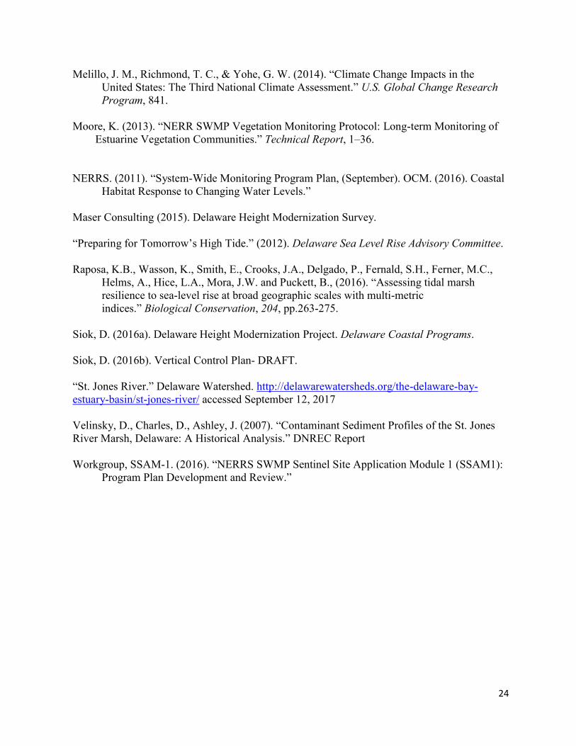
24
Melillo, J. M., Richmond, T. C., & Yohe, G. W. (2014). “Climate Change Impacts in the United States: The Third National Climate Assessment.” U.S. Global Change Research Program, 841. Moore, K. (2013). “NERR SWMP Vegetation Monitoring Protocol: Long-term Monitoring of
Estuarine Vegetation Communities.” Technical Report, 1–36. NERRS. (2011). “System-Wide Monitoring Program Plan, (September). OCM. (2016). Coastal Habitat Response to Changing Water Levels.”
Maser Consulting (2015). Delaware Height Modernization Survey. “Preparing for Tomorrow’s High Tide.” (2012). Delaware Sea Level Rise Advisory Committee. Raposa, K.B., Wasson, K., Smith, E., Crooks, J.A., Delgado, P., Fernald, S.H., Ferner, M.C., Helms, A., Hice, L.A., Mora, J.W. and Puckett, B., (2016). “Assessing tidal marsh resilience to sea-level rise at broad geographic scales with multi-metric indices.” Biological Conservation, 204, pp.263-275. Siok, D. (2016a). Delaware Height Modernization Project. Delaware Coastal Programs. Siok, D. (2016b). Vertical Control Plan- DRAFT. “St. Jones River.” Delaware Watershed. http://delawarewatersheds.org/the-delaware-bay-estuary-basin/st-jones-river/ accessed September 12, 2017 Velinsky, D., Charles, D., Ashley, J. (2007). “Contaminant Sediment Profiles of the St. Jones River Marsh, Delaware: A Historical Analysis.” DNREC Report Workgroup, SSAM-1. (2016). “NERRS SWMP Sentinel Site Application Module 1 (SSAM1): Program Plan Development and Review.”
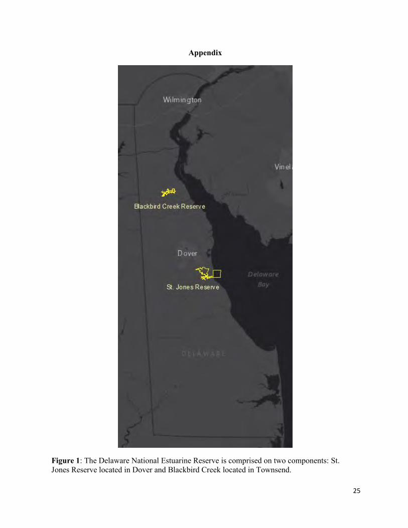
25
Appendix
Figure 1: The Delaware National Estuarine Reserve is comprised on two components: St. Jones Reserve located in Dover and Blackbird Creek located in Townsend.
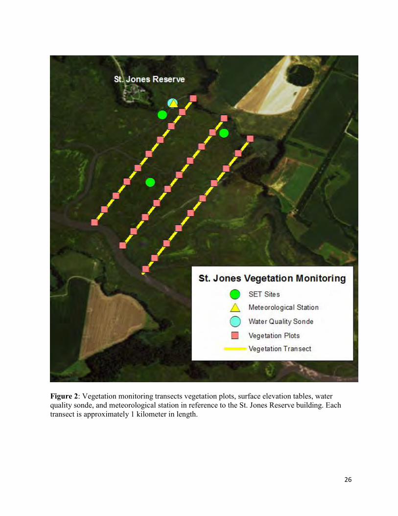
26
Figure 2: Vegetation monitoring transects vegetation plots, surface elevation tables, water quality sonde, and meteorological station in reference to the St. Jones Reserve building. Each transect is approximately 1 kilometer in length.
27
Figure 3: Vegetation monitoring transects and vegetation plots at the Blackbird Creek Reserve. These transects were established in the summer of 2016. The bright yellow lines denote an installed walkway needed to access vegetation plots while the light yellow line are vegetation plots accessed by boat.
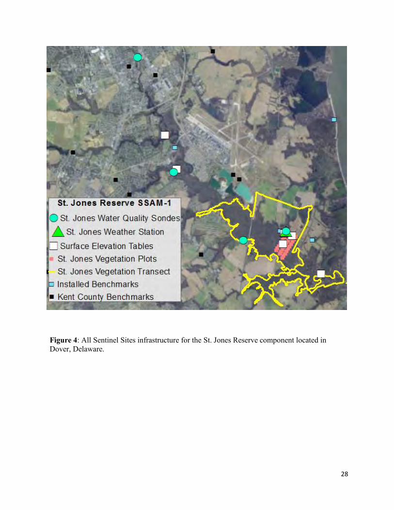
28
Figure 4: All Sentinel Sites infrastructure for the St. Jones Reserve component located in Dover, Delaware.
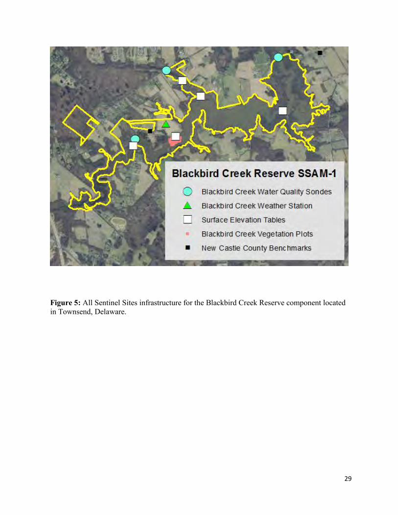
29
Figure 5: All Sentinel Sites infrastructure for the Blackbird Creek Reserve component located in Townsend, Delaware.
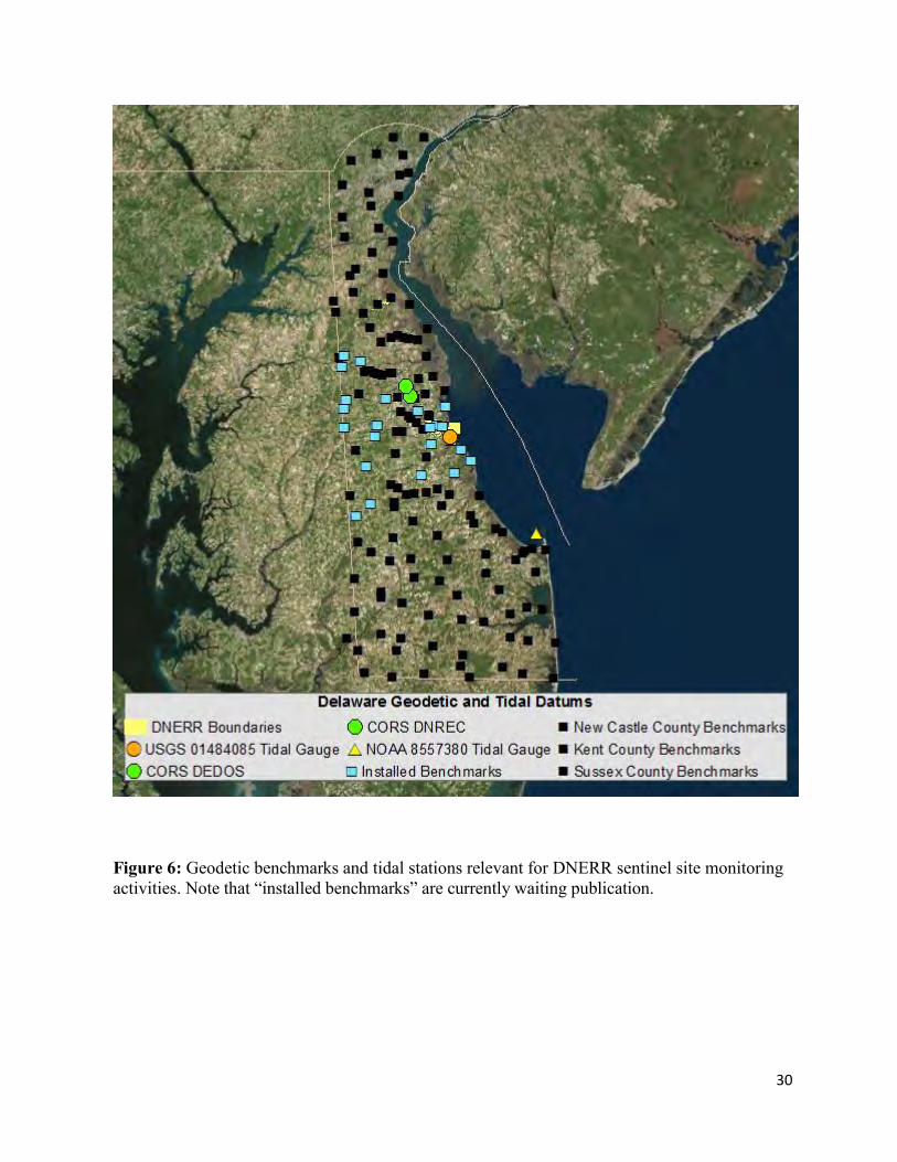
30
Figure 6: Geodetic benchmarks and tidal stations relevant for DNERR sentinel site monitoring activities. Note that “installed benchmarks” are currently waiting publication.
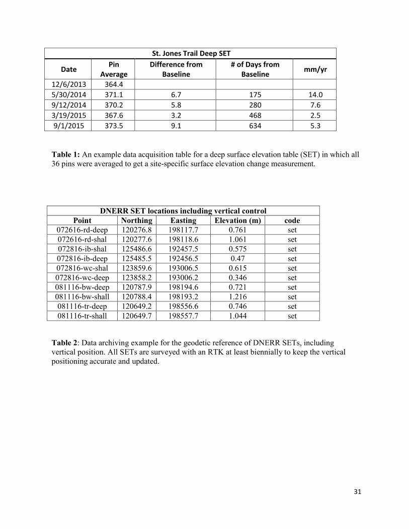
31
St. Jones Trail Deep SET
Date Pin
Average Difference from
Baseline # of Days from
Baseline mm/yr
12/6/2013 364.4
5/30/2014 371.1 6.7 175 14.0
9/12/2014 370.2 5.8 280 7.6
3/19/2015 367.6 3.2 468 2.5
9/1/2015 373.5 9.1 634 5.3
Table 1: An example data acquisition table for a deep surface elevation table (SET) in which all 36 pins were averaged to get a site-specific surface elevation change measurement.
DNERR SET locations including vertical control Point Northing Easting Elevation (m) code
072616-rd-deep 120276.8 198117.7 0.761 set 072616-rd-shal 120277.6 198118.6 1.061 set 072816-ib-shal 125486.6 192457.5 0.575 set 072816-ib-deep 125485.5 192456.5 0.47 set 072816-wc-shal 123859.6 193006.5 0.615 set 072816-wc-deep 123858.2 193006.2 0.346 set 081116-bw-deep 120787.9 198194.6 0.721 set 081116-bw-shall 120788.4 198193.2 1.216 set 081116-tr-deep 120649.2 198556.6 0.746 set 081116-tr-shall 120649.7 198557.7 1.044 set
Table 2: Data archiving example for the geodetic reference of DNERR SETs, including vertical position. All SETs are surveyed with an RTK at least biennially to keep the vertical positioning accurate and updated.
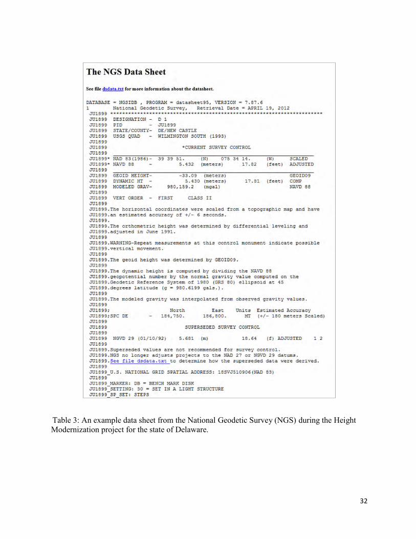
32
Table 3: An example data sheet from the National Geodetic Survey (NGS) during the Height Modernization project for the state of Delaware.
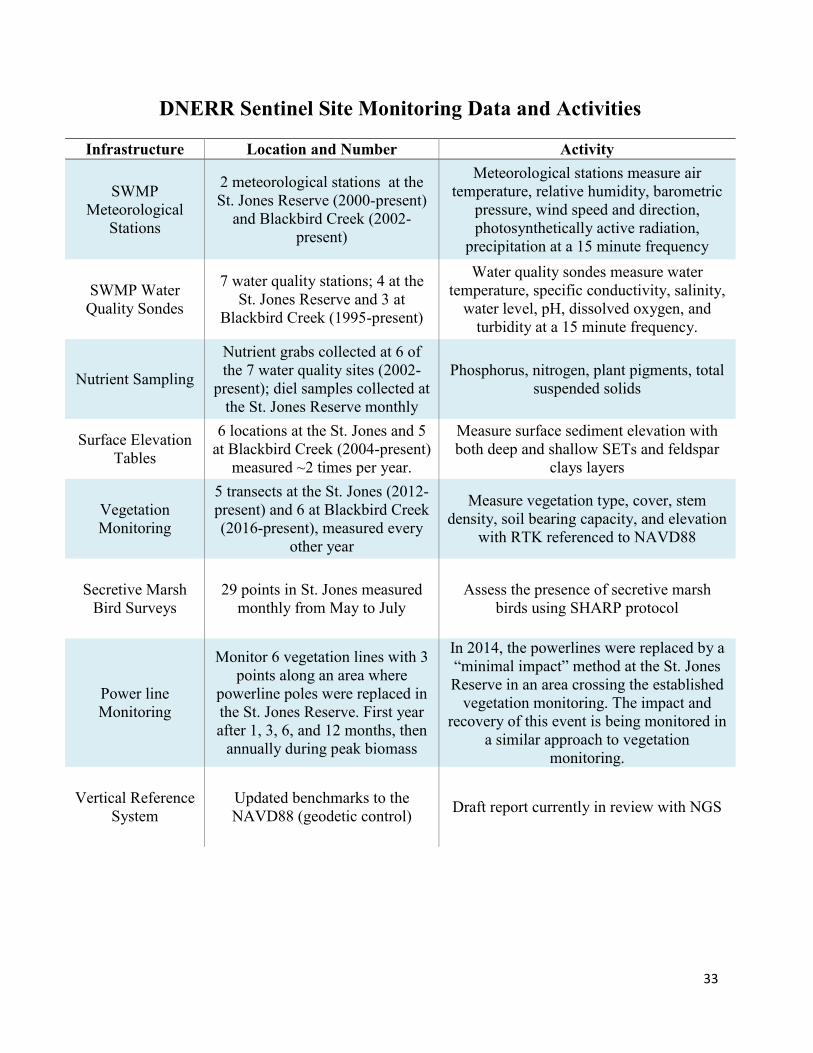
33
DNERR Sentinel Site Monitoring Data and Activities
Infrastructure Location and Number Activity
SWMP Meteorological
Stations
2 meteorological stations at the St. Jones Reserve (2000-present)
and Blackbird Creek (2002-present)
Meteorological stations measure air temperature, relative humidity, barometric
pressure, wind speed and direction, photosynthetically active radiation,
precipitation at a 15 minute frequency
SWMP Water Quality Sondes
7 water quality stations; 4 at the St. Jones Reserve and 3 at
Blackbird Creek (1995-present)
Water quality sondes measure water temperature, specific conductivity, salinity,
water level, pH, dissolved oxygen, and turbidity at a 15 minute frequency.
Nutrient Sampling
Nutrient grabs collected at 6 of the 7 water quality sites (2002-
present); diel samples collected at the St. Jones Reserve monthly
Phosphorus, nitrogen, plant pigments, total suspended solids
Surface Elevation Tables
6 locations at the St. Jones and 5 at Blackbird Creek (2004-present)
measured ~2 times per year.
Measure surface sediment elevation with both deep and shallow SETs and feldspar
clays layers
Vegetation Monitoring
5 transects at the St. Jones (2012-present) and 6 at Blackbird Creek (2016-present), measured every
other year
Measure vegetation type, cover, stem density, soil bearing capacity, and elevation
with RTK referenced to NAVD88
Secretive Marsh Bird Surveys
29 points in St. Jones measured monthly from May to July
Assess the presence of secretive marsh birds using SHARP protocol
Power line Monitoring
Monitor 6 vegetation lines with 3 points along an area where
powerline poles were replaced in the St. Jones Reserve. First year after 1, 3, 6, and 12 months, then
annually during peak biomass
In 2014, the powerlines were replaced by a “minimal impact” method at the St. Jones Reserve in an area crossing the established
vegetation monitoring. The impact and recovery of this event is being monitored in
a similar approach to vegetation monitoring.
Vertical Reference System
Updated benchmarks to the NAVD88 (geodetic control) Draft report currently in review with NGS
I-1
State and County Legal Authorities Affecting Resource Protection in the Delaware National Estuarine Research Reserve
Appendix I
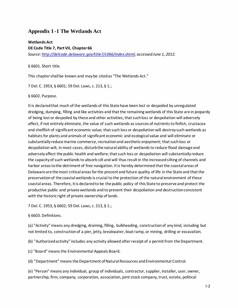
I-2
Appendix I -1 The Wetlands Act
Wetlands Act DE Code Title 7, Part VII, Chapter 66 Source: http://delcode.delaware.gov/title7/c066/index.shtml, accessed June 1, 2012. § 6601. Short title.
This chapter shall be known and may be cited as "The Wetlands Act."
7 Del. C. 1953, § 6601; 59 Del. Laws, c. 213, § 1.;
§ 6602. Purpose.
It is declared that much of the wetlands of this State have been lost or despoiled by unregulated dredging, dumping, filling and like activities and that the remaining wetlands of this State are in jeopardy of being lost or despoiled by these and other activities; that such loss or despoliation will adversely affect, if not entirely eliminate, the value of such wetlands as sources of nutrients to finfish, crustacea and shellfish of significant economic value; that such loss or despoliation will destroy such wetlands as habitats for plants and animals of significant economic and ecological value and will eliminate or substantially reduce marine commerce, recreation and aesthetic enjoyment; that such loss or despoliation will, in most cases, disturb the natural ability of wetlands to reduce flood damage and adversely affect the public health and welfare; that such loss or despoliation will substantially reduce the capacity of such wetlands to absorb silt and will thus result in the increased silting of channels and harbor areas to the detriment of free navigation. It is hereby determined that the coastal areas of Delaware are the most critical areas for the present and future quality of life in the State and that the preservation of the coastal wetlands is crucial to the protection of the natural environment of these coastal areas. Therefore, it is declared to be the public policy of this State to preserve and protect the productive public and private wetlands and to prevent their despoliation and destruction consistent with the historic right of private ownership of lands.
7 Del. C. 1953, § 6602; 59 Del. Laws, c. 213, § 1.;
§ 6603. Definitions.
(a) "Activity" means any dredging, draining, filling, bulkheading, construction of any kind, including but not limited to, construction of a pier, jetty, breakwater, boat ramp, or mining, drilling or excavation.
(b) "Authorized activity" includes any activity allowed after receipt of a permit from the Department.
(c) "Board" means the Environmental Appeals Board.
(d) "Department" means the Department of Natural Resources and Environmental Control.
(e) "Person" means any individual, group of individuals, contractor, supplier, installer, user, owner, partnership, firm, company, corporation, association, joint stock company, trust, estate, political
I-3
subdivision, administrative agency, public or quasi-public corporation or body, or any other legal entity, or its legal representative, agent or assignee.
(f) "Preexisting use" means any use of land, or water, or subaqueous lands, or of a structure or any combination of these which was lawfully in existence prior to and in active use on July 17, 1973, or any temporary or seasonal use in active use for 10 consecutive weeks within the last 12 months previous to July 17, 1973.
(g) "Secretary" means the Secretary of the Department of Natural Resources and Environmental Control.
(h) "Wetlands" shall mean those lands above the mean low water elevation including any bank, marsh, swamp, meadow, flat or other low land subject to tidal action in the State along the Delaware Bay and Delaware River, Indian River Bay, Rehoboth Bay, Little and Big Assawoman Bays, the coastal inland waterways, or along any inlet, estuary or tributary waterway or any portion thereof, including those areas which are now or in this century have been connected to tidal waters, whose surface is at or below an elevation of 2 feet above local mean high water, and upon which may grow or is capable of growing any but not necessarily all of the following plants:
Eelgrass (Zostera marina), Widgeon Grass (Ruppia maritima), Sago Pondweed (Potamogeton pectinatus), Saltmarsh Cordgrass (Spartina alterniflora), Saltmarsh Grass (Spartina cynosuroides), Saltmarsh Hay (Spartina patens), Spike Grass (Distichlis spicata), Black Grass (Juncus gerardii), Switch Grass (Panicum virgatum), Three Square Rush (Scirpus americanus), Sea Lavender (Limonium carolinianum), Seaside Goldenrod (Solidago sempervirens), Seablite (Suaeda maritima), Sea Blite (Suaeda linearis), Perennial Glasswort (Salicornia virginica), Dwarf Glasswort (Salicornia bigelovii), Samphire (Salicornia europaea), Marsh Aster (Aster tenuifolius), Saltmarsh Fleabane (Pluchea purpurascens var. succulenta), Mock Bishop's Weed (Ptilimnium capillaceum), Seaside Plantain (Plantago oliganthus), Orach (Atriplex patula var. hastata), Marsh Elder (Iva frutescens var. oraria), Goundsel Bush (Baccharis halimifolia), Bladderwrack (Fucus vesiculosus), Swamp Rose Mallow, Seaside Hollyhock or March Mallow (Hibiscus palustris), Torrey Rush (Scirpus torreyi), Narrow-leaved Cattail (Typha angustifolia), and Broad-leaved Cattail (T. latifolia) and those lands not currently used for agricultural purposes containing 400 acres or more of contiguous nontidal swamp, bog, muck or marsh exclusive of narrow stream valleys where fresh water stands most, if not all, of the time due to high water table, which contribute significantly to ground water recharge, and which would require intensive artificial drainage using equipment such as pumping stations, drain fields or ditches for the production of agricultural crops.
7 Del. C. 1953, § 6603; 59 Del. Laws, c. 213, § 1; 64 Del. Laws c. 293, § 1.;
§ 6604. Permit required.
(a) Any activity in the wetlands requires a permit from the Department except the activity or activities exempted by this chapter and no permit may be granted unless the county or municipality having jurisdiction has first approved the activity in question by zoning procedures provided by law.
(b) The Secretary shall consider the following factors prior to issuance of any permit:
I-4
(1) Environmental impact, including but not limited to, likely destruction of wetlands and flora and fauna; impact of the site preparation on tidal ebb and flow and the otherwise normal drainage of the area in question, especially as it relates to flood control; impact of the site preparation and proposed activity on land erosion; effect of site preparation and proposed activity on the quality and quantity of tidal waters, surface, ground and subsurface water resources and other resources;
(2) Aesthetic effect, such as the impact on scenic beauty of the surrounding area;
(3) The number and type of public and private supporting facilities required and the impact of such facilities on all factors listed in this subsection;
(4) Effect on neighboring land uses, including but not limited to, public access to tidal waters, recreational areas and effect on adjacent residential and agricultural areas;
(5) State, county and municipal comprehensive plans for the development and/or conservation of their areas of jurisdiction;
(6) Economic effect, including the number of jobs created and the income which will be generated by the wages and salaries of the jobs in relation to the amount of land required, and the amount of tax revenues potentially accruing to the state, county and local governments.
(c) The Secretary may require a bond in an amount and with surety and conditions sufficient to secure compliance with the conditions and limitations, if any, set forth in the permit. The particular amount and the particular conditions of the bond required shall be consistent with and in furtherance of the purposes of this chapter. The Secretary shall state for the record, the basis for the bonding requirements imposed with each permit granted. In the event of a breach of any condition of any such bond, the Attorney General may institute an action in Superior Court upon such bond and prosecute the same to judgment and execution.
7 Del. C. 1953, § 6604; 59 Del. Laws, c. 213, § 1.;
§ 6605. Preexisting use.
Any expansion or extension of a preexisting use requires a permit and no permit may be granted under this chapter unless the county or municipality having jurisdiction has first approved the use in question by zoning procedures provided by law.
7 Del. C. 1953, § 6605; 59 Del. Laws, c. 213, § 1.;
§ 6606. Exemptions.
Any of the following activities are exempt from permit requirements: Mosquito control activities authorized by the Department; construction of directional aids to navigation; duck blinds; foot bridges; the placing of boundary stakes; wildlife nesting structures; grazing of domestic animals; haying; hunting; fishing and trapping.
I-5
7 Del. C. 1953, § 6606; 59 Del. Laws, c. 213, § 1.;
§ 6607. Procedures; regulations; application fees.
(a) The Secretary shall administer this chapter.
(b) The Secretary shall inventory, as promptly as he or she is able, all wetlands within the State and prepare suitable maps. Such maps shall be filed with the Secretary of State and made available for public inspection at the offices of the Department. On completion of a wetlands boundary map for an area, the Secretary shall propose that wetlands within the area be designated as such in accordance with the map. Wetlands designation on the maps shall be conclusive for the purpose of this chapter upon adoption by the Secretary, subject to the outcome of any appeals taken under this section, and subsection (e) of this section. After such designation, the 2-foot elevation above local mean high water specified in § 6603 of this title shall not apply to any land outside the designated area.
(c) The Secretary shall adopt a wetlands designation or any other regulation only after holding a public hearing in accordance with § 6609 of this title.
(d) The Secretary shall, in furtherance of the purpose of this chapter, adopt regulations:
(1) Setting forth procedures, including provision for fees, which shall govern the processing of permit applications and the conduct of hearings;
(2) Elaborating standards consistent with § 6604 of this title by which each permit application will be reviewed and acted upon;
(3) Controlling or prohibiting activities on lands designated or proposed for designation as wetlands, which regulations may vary from area to area according to the ecological value of the subject wetlands and the threat to the health and welfare of the people of this State which their alteration would pose.
(4) Any fees collected under this chapter are hereby appropriated to the Department to carry out the purposes of this chapter. The Secretary shall report through the annual budget process the receipt, proposed use and disbursement of these funds.
(e) If an on-site evaluation by the Department establishes that an error exists in a wetlands map that has been adopted by the Department, the wetlands map containing the error may be corrected by the Department after the Department documents, in writing, the results of the on-site evaluation, and the Department gives the public notice of any proposed correction. For purposes of this subsection, the term "public notice" shall consist of having notice of the proposed correction, the name of the property owner, location of the property in issue and a description of the error, published in a daily newspaper of general circulation throughout the State and a newspaper of general circulation in the county in which the activity is proposed. Such notice shall be published at least 20 days in advance of any correction to a map by the Department. If the Department determines that it has received a meritorious objection to any proposed correction set forth in a public notice, the Department shall hold a public hearing in accordance with the procedures set forth in § 6609 of this title. Any Department correction made to an
I-6
adopted wetlands map shall be filed with the Secretary of State and made available for public inspection at the offices of the Department.
(f) The Secretary may waive any provision of the regulations adopted pursuant to this chapter when warranted under the following circumstances:
(1) Life-threatening emergencies.
(2) Actions required for public safety for which sufficient time is not available to follow the regulations.
(3) When imminent or catastrophic damage or loss of major infrastructure is likely if all provisions of the regulations are adhered to.
(4) Where the authority of the Department under this chapter overlaps with another statute, including but not limited to shellfish grounds (Chapter 19 of this title), beach preservation (Chapter 68 of this title) or subaqueous lands (Chapter 72 of this title) provided that the following criteria are met:
a. If, in the opinion of the Secretary, equal environmental impact review and regulation of the activity would be provided by either statute; and
b. Waiver of these regulations would not be contrary to the purposes of this chapter.
7 Del. C. 1953, § 6607; 59 Del. Laws, c. 213, § 1; 63 Del. Laws, c. 322, § 105(b); 64 Del. Laws, c. 61, §§ 1, 2; 70 Del. Laws, c. 186, § 1; 78 Del. Laws, c. 183, § 2.;
§ 6608. Permit applications.
(a) Any person desiring to obtain a permit required by § 6604 of this title shall submit an application in such form and accompanied by such plans, specifications and other information as required by applicable regulations.
(b) Upon receipt of an application in proper form, the Secretary shall advertise in a daily newspaper of statewide circulation and in a newspaper of general circulation in the county in which the activity is proposed:
(1) The fact that the application has been received; and
(2) A brief description of the nature of the application.
The Secretary may hold a public hearing with respect to any application if it is deemed to be in the best public interest. The Secretary shall hold a public hearing if he or she receives a written meritorious objection within 20 days of advertisement. A public hearing request shall be deemed meritorious if it exhibits a familiarity with the application and a reasoned statement of the permit's probable impact.
7 Del. C. 1953, § 6608; 59 Del. Laws, c. 213, § 1; 70 Del. Laws, c. 186, § 1.;
§ 6609. Public hearings.
I-7
Any public hearing held by the Secretary or the Board concerning a regulation, permit application or alleged violation or appeal shall be conducted as follows:
(1) Notification shall be served upon the applicant, alleged violator, or appellant as summonses are served by registered or certified mail not less than 20 days before the time of said hearing. Not less than 20 days' notice shall also be published in a daily newspaper of general circulation throughout the State and a newspaper of general circulation in the county in which the activity is proposed. Such notice shall also be sent by mail simultaneously to persons who have listed their names and addresses with the Secretary to be notified. Such notice shall also be sent by mail simultaneously to all adjoining property owners. Notice shall outline the area concerned, activity involved, and the location where the application for a permit or other pertinent material is available for inspection.
(2) The permit applicant, alleged violator, or appellant may appear personally or by counsel at the hearing and produce any competent evidence in his or her behalf. The Secretary or the Secretary's duly authorized designee or the Board or its duly authorized designee may administer oaths, examine witnesses and issue, in the name of the Department or the Board, notices of hearings or subpoenae requiring the testimony of witnesses and the production of books, records or other documents relevant to any matter involved in such a hearing; and subpoenae shall also be issued at the request of the applicant or alleged violator. In case of contumacy or refusal to obey a notice of hearing or subpoena under this section, the Superior Court in the county in which the hearing is held shall have jurisdiction, upon application of the Secretary or the Chairperson of the Board, to issue an order requiring such person to appear and testify or produce evidence as the case may require.
(3) A verbatim transcript of testimony at the hearing shall be prepared and shall, along with the exhibits and other documents introduced by the Secretary or other party, constitute the record.
The Secretary or the Secretary's duly authorized designee or the Board or its duly authorized designee shall make findings of fact based on the record. The Secretary or the Board shall then enter such order as will best further the purpose of this chapter, and shall state reasons. The Secretary or the Board shall promptly give written notice to the persons affected by such order.
7 Del. C. 1953, § 6609; 59 Del. Laws, c. 213, § 1; 70 Del. Laws, c. 186, § 1.;
§ 6610. Appeal to Board.
Any person whose interest is substantially affected by any action of the Secretary may appeal to the Environmental Appeals Board within 20 days after the Secretary has announced the decision.
7 Del. C. 1953, § 6611; 59 Del. Laws, c. 213, § 1; 64 Del. Laws, c. 293, § 2.;
§ 6611. [Reserved.]
§ 6612. Appeal from Board's decision.
I-8
(a) Any person or persons, jointly or severally affected by any decision or nondecision of the Board, or any taxpayer, or any officer, department, board or bureau of the State, may appeal to the Superior Court in and for the county in which the use in question is wholly or principally located by filing a petition, duly verified, setting forth that such decision is illegal, in whole or in part, specifying the grounds of the illegality. Any such appeal shall be perfected within 30 days of the decision of the Board.
(b) The Court may affirm, reverse or modify the Board's decision. The Board's findings of fact shall not be set aside unless the Court determines that the record contains no substantial evidence that would reasonably support the findings. If the Court finds that additional evidence should be taken, the Court may remand the cause to the Board for completion of the record.
7 Del. C. 1953, § 6612; 59 Del. Laws, c. 213, § 1.;
§ 6613. Taking without just compensation.
If the Superior Court finds that the action appealed from constitutes a taking without just compensation, it shall invalidate the order and grant appropriate relief, unless the Secretary at this stage, consents to the reversal or modification of his or her decision. However, the Secretary may, through negotiation or condemnation proceedings under Chapter 61 of Title 10, acquire the fee simple or any lesser interest, including but not limited to, a perpetual negative easement or other interest which assures that the affected land shall not thereafter be altered, dredged, dumped upon, filled or otherwise altered subject to any reasonable reservations to the landowner as the Secretary may have stipulated to prior to assessment of damages. A decision of the Superior Court that the action appealed from constitutes a taking without just compensation shall not become effective for 2 years of the date of decision and shall not become effective at all if within that period the Secretary has initiated action to acquire fee simple or any lesser interest in the wetlands in question. A finding of the Superior Court that the denial of a permit or the restrictions imposed by a granted permit constitutes a taking without just compensation shall not affect any land other than that of the petitioning landowner. If the Secretary has not initiated action to acquire fee simple or any lesser interest in the wetlands in question within 2 years from the date of a final court ruling, the permit must be granted as applied.
7 Del. C. 1953, § 6613; 59 Del. Laws, c. 213, § 1; 70 Del. Laws, c. 186, § 1.;
§ 6614. Cease and desist orders.
The Secretary shall have the power to issue an order to any person violating any rule, regulation or order or permit condition or provision of this chapter to cease and desist from such violation. Any cease and desist order issued pursuant to this section shall expire (1) after 30 days of its issuance, or (2) upon withdrawal of said order by the Secretary, or (3) when the order is suspended by an injunction, whichever occurs first.
7 Del. C. 1953, § 6614; 59 Del. Laws, c. 213, § 1.;
§ 6615. Injunction.
I-9
Action for injunctive relief may be brought by the Secretary to prevent a violation of this chapter or a permit condition. The Court of Chancery may, at its discretion, require bond in the appropriate amount.
7 Del. C. 1953, § 6615; 59 Del. Laws, c. 213, § 1.;
§ 6616. Right of entry.
The Secretary or the Secretary's duly authorized designee, in regulating any activity over which he or she has jurisdiction pursuant to this chapter, may enter, at reasonable times, upon any private or public property for the purpose of determining whether a violation exists of a statute or regulation enforceable by him or her, upon giving written notice, and after presenting official identification to the owner, occupant, custodian or agent of said property.
7 Del. C. 1953, § 6616; 59 Del. Laws, c. 213, § 1; 70 Del. Laws, c. 186, § 1.;
§ 6617. Penalties.
(a) Any person who intentionally or knowingly violates any rule, regulation, order, permit condition or provision of this chapter shall be fined not less than $500 or more than $10,000 for each offense. Continuance of any activity prohibited by this chapter during any part of a day shall constitute a separate offense. Any person found guilty of violating any cease and desist order of the Secretary shall be fined for each offense, starting from the date of receipt of the order. The Superior Court shall have jurisdiction of offenses under this subsection.
(b) Any person who violates any rule, regulation, order, permit condition or provision of this chapter shall be fined not less than $50 or more than $500 for each violation. Each day of violation shall be considered as a separate violation. The Justices of the Peace Courts shall have jurisdiction of offenses under this subsection.
(c) Any person who violates a provision of this chapter, any condition or limitation in a permit rule, regulation or order shall be liable for a civil penalty of not less than $1,000 nor more than $10,000 for each completed violation. The Superior Court shall have jurisdiction of offenses under this subsection.
(d) In addition to any penalties imposed under this section or injunctive relief under § 6615 of this title, a person who effects or permits any activity in wetlands in violation of this chapter may be liable to the State for the cost of restoration of the affected wetland to its condition prior to such violation insofar as that is technically feasible. The Attorney General of the State, upon complaint of the Secretary, shall institute a civil action to recover such damages, or may request such cost of restoration to be imposed in the Chancery Court injunctive action or Superior Court civil action.
7 Del. C. 1953, § 6617; 59 Del. Laws, c. 213, § 1; 63 Del. Laws, c. 249, § 1.;
§ 6618. Inconsistent laws superseded; all other laws unimpaired.
All laws or ordinances inconsistent with any provision of this chapter are hereby superseded to the extent of the inconsistency; provided, that present and future zoning powers of all counties and
I-10
municipalities, to the extent that said powers are not inconsistent with this chapter, shall not hereby be impaired; and provided, that a permit granted under this chapter shall not authorize an activity in contravention of county or municipal zoning regulations.
7 Del. C. 1953, § 6618; 59 Del. Laws, c. 213, § 1.;
§ 6619. Liberal construction.
This chapter, being necessary for the welfare of the State and its inhabitants, shall be liberally construed in order to preserve the wetlands of the State.
7 Del. C. 1953, § 6619; 59 Del. Laws, c. 213, § 1.;
§ 6620. Federal aid; other funds.
The Department may cooperate with and receive moneys from the federal government, state or local government or any industry or other source. Such moneys received are appropriated and made available for the study and preservation of the wetlands.
7 Del. C. 1953, § 6620; 59 Del. Laws, c. 213, § 1.;
I-11
Appendix I-2. Coastal Zone Act
The Coastal Zone Act DE Code Title 7, Part VII, Chapter 70 Source: http://delcode.delaware.gov/title7/c070/index.shtml, accessed June 1, 2012. § 7001. Purpose.
It is hereby determined that the coastal areas of Delaware are the most critical areas for the future of the State in terms of the quality of life in the State. It is, therefore, the declared public policy of the State to control the location, extent and type of industrial development in Delaware's coastal areas. In so doing, the State can better protect the natural environment of its bay and coastal areas and safeguard their use primarily for recreation and tourism. Specifically, this chapter seeks to prohibit entirely the construction of new heavy industry in its coastal areas, which industry is determined to be incompatible with the protection of that natural environment in those areas. While it is the declared public policy of the State to encourage the introduction of new industry into Delaware, the protection of the environment, natural beauty and recreation potential of the State is also of great concern. In order to strike the correct balance between these 2 policies, careful planning based on a thorough understanding of Delaware's potential and the State's needs is required. Therefore, control of industrial development other than that of heavy industry in the coastal zone of Delaware through a permit system at the state level is called for. It is further determined that offshore bulk product transfer facilities represent a significant danger of pollution to the coastal zone and generate pressure for the construction of industrial plants in the coastal zone, which construction is declared to be against public policy. For these reasons, prohibition against bulk product transfer facilities in the coastal zone is deemed imperative.
7 Del. C. 1953, § 7001; 58 Del. Laws, c. 175; 70 Del. Laws, c. 186, § 1.;
§ 7002. Definitions.
(a) "Board" shall mean the Coastal Zone Industrial Control Board.
(b) "Bulk product transfer facility" means any port or dock facility, whether an artificial island or attached to shore by any means, for the transfer of bulk quantities of any substance from vessel to onshore facility or vice versa. Not included in this definition is a docking facility or pier for a single industrial or manufacturing facility for which a permit is granted or which is a nonconforming use. Likewise, docking facilities for the Port of Wilmington are not included in this definition.
(c) "Environmental impact statement" means a detailed description as prescribed by the Department of Natural Resources and Environmental Control of the effect of the proposed use on the immediate and surrounding environment and natural resources such as water quality, fisheries, wildlife and the aesthetics of the region.
(d) "Heavy industry use" means a use characteristically involving more than 20 acres, and characteristically employing some but not necessarily all of such equipment such as, but not limited to,
I-12
smokestacks, tanks, distillation or reaction columns, chemical processing equipment, scrubbing towers, pickling equipment and waste-treatment lagoons; which industry, although conceivably operable without polluting the environment, has the potential to pollute when equipment malfunctions or human error occurs. Examples of heavy industry are oil refineries, basic steel manufacturing plants, basic cellulosic pulp-paper mills, and chemical plants such as petrochemical complexes. An incinerator structure or facility which, including the incinerator, contains 5,000 square feet or more, whether public or private, is "heavy industry" for purpose of this chapter. Generic examples of uses not included in the definition of "heavy industry" are such uses as garment factories, automobile assembly plants and jewelry and leather goods manufacturing establishments, and on-shore facilities, less than 20 acres in size, consisting of warehouses, equipment repair and maintenance structures, open storage areas, office and communications buildings, helipads, parking space and other service or supply structures required for the transfer of materials and workers in support of off-shore research, exploration and development operations; provided, however, that on-shore facilities shall not include tank farms or storage tanks.
(e) "Manufacturing" means the mechanical or chemical transformation of organic or inorganic substances into new products, characteristically using power-driven machines and materials handling equipment, and including establishments engaged in assembling component parts of manufactured products, provided the new product is not a structure or other fixed improvement.
(f) "Nonconforming use" means a use, whether of land or of a structure, which does not comply with the applicable use provisions in this chapter where such use was lawfully in existence and in active use prior to June 28, 1971.
(g) "Person" shall include, but not be limited to, any individual, group of individuals, contractor, supplier, installer, user, owner, partnership, firm, company, corporation, association, joint-stock company, trust, estate, political subdivision, administrative agency, public or quasi-public corporation or body, or any other legal entity, or its legal representative, agent or assignee.
(h) "The coastal zone" is defined as all that area of the State, whether land, water or subaqueous land between the territorial limits of Delaware in the Delaware River, Delaware Bay and Atlantic Ocean, and a line formed by certain Delaware highways and roads as follows:
Beginning at the Delaware-Pennsylvania line at a place where said line intersects U.S. Route 13; thence southward along the said U.S. Route 13 until it intersects the right-of-way of U.S. Route I-495; thence along said I-495 right-of-way until the said I-495 right-of-way intersects Delaware Route 9 south of Wilmington; thence along said Delaware Route 9 to the point of its intersection with Delaware Route 273; thence along said Delaware Route 273 to U.S. 13; thence along U.S. 13 to Maintenance Road 409; thence along Maintenance Road 409 to Delaware Road 71; thence along Delaware Road 71 to its intersection with Delaware Road 54; thence along Delaware Road 54 to Delaware Road 896; thence along Delaware Road 896 to Maintenance Road 396; thence along Maintenance Road 396 to Maintenance Road 398; thence along Maintenance Road 398 to the Maryland state line; thence southward along the Maryland state line to Maintenance Road 433; thence along Maintenance Road 433 to Maintenance Road 63; thence along Maintenance Road 63 to Maintenance Road 412; thence
I-13
along Maintenance Road 412 to U.S. 13; thence along U.S. 13 to Delaware 299 at Odessa; thence along Delaware Route 299 to its intersection with Delaware Route 9; thence along Delaware Route 9 to U.S. 113; thence along U.S. Route 113 to Maintenance Road 8A; thence along Maintenance Road 8A to Maintenance Road 7 to the point of its intersection with Delaware Route 14; thence along Delaware Route 14 to Delaware Route 24; thence along Delaware Route 24 to Maintenance Road 331; thence along Maintenance Road 331 to Maintenance Road 334; thence along Maintenance Road 334 to Delaware Route 26; thence along Delaware Route 26 to Maintenance Road 365; thence along Maintenance Road 365 to Maintenance Road 84; thence along Maintenance Road 84 to Maintenance Road 384; thence along Maintenance Road 384 to Maintenance Road 382A; thence along Maintenance Road 382A to Maintenance Road 389; thence along Maintenance Road 389 to Maintenance Road 58; thence along Maintenance Road 58 to Maintenance Road 395; thence along Maintenance Road 395 to the Maryland state line.
7 Del. C. 1953, § 7002; 58 Del. Laws, c. 175; 61 Del. Laws, c. 116, § 88(a); 62 Del. Laws, c. 119, §§ 1, 2; 63 Del. Laws, c. 191, § 1(a); 71 Del. Laws, c. 348, § 1.;
§ 7003. Uses absolutely prohibited in the coastal zone.
Heavy industry uses of any kind not in operation on June 28, 1971, are prohibited in the coastal zone and no permits may be issued therefor. In addition, offshore gas, liquid or solid bulk product transfer facilities which are not in operation on June 28, 1971, are prohibited in the coastal zone, and no permit may be issued therefor. Provided, that this section shall not apply to public sewage treatment or recycling plants. A basic steel manufacturing plant in operation on June 28, 1971, may continue as a heavy industry use in the coastal zone notwithstanding any temporary discontinuance of operations after said date, provided that said discontinuance does not exceed 2 years. An incinerator is neither "public sewage treatment" nor a "recycling plant" for the purpose of this chapter.
7 Del. C. 1953, § 7003; 58 Del. Laws, c. 175; 64 Del. Laws, c. 240, § 6; 66 Del. Laws, c. 256, § 1; 71 Del. Laws, c. 348, § 2.;
§ 7004. Uses allowed by permit only; nonconforming uses.
(a) Except for heavy industry uses, as defined in § 7002 of this title, manufacturing uses not in existence and in active use on June 28, 1971, are allowed in the coastal zone by permit only, as provided for under this section. Any nonconforming use in existence and in active use on June 28, 1971, shall not be prohibited by this chapter and all expansion or extension of nonconforming uses, as defined herein, and all expansion or extension of uses for which a permit is issued pursuant to this chapter, are likewise allowed only by permit. Provided, that no permit may be granted under this chapter unless the county or municipality having jurisdiction has first approved the use in question by zoning procedures provided by law.
(b) In passing on permit requests, the Secretary of the Department of Natural Resources and Environmental Control and the State Coastal Zone Industrial Control Board shall consider the following factors:

I-14
(1) Environmental impact, including but not limited to, probable air and water pollution likely to be generated by the proposed use under normal operating conditions as well as during mechanical malfunction and human error; likely destruction of wetlands and flora and fauna; impact of site preparation on drainage of the area in question, especially as it relates to flood control; impact of site preparation and facility operations on land erosion; effect of site preparation and facility operations on the quality and quantity of surface, ground and subsurface water resources, such as the use of water for processing, cooling, effluent removal, and other purposes; in addition, but not limited to, likelihood of generation of glare, heat, noise, vibration, radiation, electromagnetic interference and obnoxious odors.
(2) Economic effect, including the number of jobs created and the income which will be generated by the wages and salaries of these jobs in relation to the amount of land required, and the amount of tax revenues potentially accruing to state and local government.
(3) Aesthetic effect, such as impact on scenic beauty of the surrounding area.
(4) Number and type of supporting facilities required and the impact of such facilities on all factors listed in this subsection.
(5) Effect on neighboring land uses including, but not limited to, effect on public access to tidal waters, effect on recreational areas and effect on adjacent residential and agricultural areas.
(6) County and municipal comprehensive plans for the development and/or conservation of their areas of jurisdiction.
7 Del. C. 1953, § 7004; 58 Del. Laws, c. 175; 61 Del. Laws, c. 116, § 88(c); 63 Del. Laws, c. 191, § 1(a), (b); 68 Del. Laws, c. 347, § 1.;
§ 7005. Administration of this chapter.
(a) The Department of Natural Resources and Environmental Control shall administer this chapter. All requests for permits for manufacturing land uses and for the expansion or extension of nonconforming uses as herein defined in the coastal zone shall be directed to the Secretary of the Department of Natural Resources and Environmental Control. Such requests must be in writing and must include:
(1)a. Evidence of approval by the appropriate county or municipal zoning authorities;
b. A detailed description of the proposed construction and operation of the use; and
c. An environmental impact statement.
(2) The Secretary of the Department of Natural Resources and Environmental Control shall hold a public hearing and may request further information of the applicant. The Secretary of the Department of Natural Resources and Environmental Control shall first determine whether the proposed use is, according to this chapter and regulations issued pursuant thereto:
a. A heavy industry use under § 7003 of this title;
I-15
b. A use allowable only by permit under § 7004 of this title; or
c. A use requiring no action under this chapter.
The Secretary of the Department of Natural Resources and Environmental Control shall then, if he or she determines that § 7004 of this title applies, reply to the request for a permit within 90 days of receipt of the said request for permit, either granting the request, denying same, or granting the request but requiring modifications; the Secretary shall state the reasons for his or her decision.
(b) The Secretary of the Department of Natural Resources and Environmental Control may issue regulations including, but not limited to, regulations governing disposition of permit requests, and setting forth procedures for hearings before himself or herself and the Board. Provided, that all such regulations shall be subject to approval by the Board.
(c) The Secretary of the Department of Natural Resources and Environmental Control shall develop and propose a comprehensive plan and guidelines for the State Coastal Zone Industrial Control Board concerning types of manufacturing uses deemed acceptable in the coastal zone and regulations for the further elaboration of the definition of "heavy industry" in a manner consistent with the purposes and provisions of this chapter. Such plan and guidelines shall become binding regulations upon adoption by the Board after public hearing. The Board may alter said regulations at any time after a public hearing. Provided, that any such regulations shall be consistent with §§ 7003 and 7004 of this title.
(d) The Department of Natural Resources and Environmental Control and all agencies of state government shall assist the State Coastal Zone Industrial Control Board in developing policies and procedures, and shall provide the Board with such information as it shall require.
(e) The Secretary shall annually prepare a schedule of fees for permits issued pursuant to this section and submit the same as part of the Department's annual operating budget proposal.
7 Del. C. 1953, § 7005; 58 Del. Laws, c. 175; 61 Del. Laws, c. 116, § 88(a), (c); 63 Del. Laws, c. 191, § 1(a), (b); 68 Del. Laws, c. 86, § 8; 70 Del. Laws, c. 186, § 1.;
§ 7006. State Coastal Zone Industrial Control Board created; composition; conflict of interest; quorum.
There is hereby created a State Coastal Zone Industrial Control Board, which shall have 9 voting members. Five of these shall be regular members appointed by the Governor and confirmed by the Senate. No more than 2 of the regular members shall be affiliated with the same political party. At least 1 regular member shall be a resident of New Castle County, 1 a resident of Kent County and 1 a resident of Sussex County, provided that no more than 2 residents of any county shall serve on the Board at the same time. The additional 4 members shall be the Director of the Delaware Economic Development Office, and the chairpersons of the planning commissions of each county, who shall be ex officio voting members. The term of 1 appointed regular member shall be for 1 year; 1 for 2 years; 1 for 3 years; 1 for 4 years; and the chairperson, to be designated as such by the Governor, and serve at the Governor's pleasure. Thereafter, all regular members shall be appointed for 5-year terms. The members shall receive no compensation except for expenses. Any member of the Board with a conflict of interest in a
I-16
matter in question shall disqualify himself or herself from consideration of that matter. A majority of the total membership of the Board less those disqualifying themselves shall constitute a quorum. A majority of the total membership of the Board shall be necessary to make a final decision on a permit request.
7 Del. C. 1953, § 7006; 58 Del. Laws, c. 175; 63 Del. Laws, c. 191, § 1(c), (d); 69 Del. Laws, c. 458, § 1; 70 Del. Laws, c. 186, § 1.;
§ 7007. Appeals to State Coastal Zone Industrial Control Board.
(a) The State Coastal Zone Industrial Control Board shall have the power to hear appeals from decisions of the Secretary of the Department of Natural Resources and Environmental Control made under § 7005 of this title. The Board may affirm or reverse the decision of the Secretary of the Department of Natural Resources and Environmental Control with respect to applicability of any provisions of this chapter to a proposed use; it may modify any permit granted by the Secretary of the Department of Natural Resources and Environmental Control, grant a permit denied by the Secretary, deny a permit or confirm the Secretary's grant of a permit. Provided, however, that the Board may grant no permit for uses prohibited in § 7003 herein.
(b) Any person aggrieved by a final decision of the Secretary of the Department of Natural Resources and Environmental Control under § 7005(a) of this title may appeal same under this section. Appellants must file notice of appeal with the State Coastal Zone Industrial Control Board within 14 days following announcement by the Secretary of the Department of Natural Resources and Environmental Control of his or her decision. The State Coastal Zone Industrial Control Board must hold a hearing and render its decision in the form of a final order within 60 days following receipt of the appeal notification.
(c) Whenever a decision of the Secretary of the Department of Natural Resources and Environmental Control concerning a permit request is appealed, the Board shall hold a public hearing at which the appellant may be represented by counsel. All proceedings in such a hearing shall be made a matter of record and a transcript or recording of all proceedings kept, and the public may attend and be heard.
(d) The Board shall publicly announce by publication in at least 1 newspaper of daily publication in the county in which the site designated in the request is wholly or principally located and in at least 1 newspaper of daily publication and general circulation throughout the State the time, location and subject of all hearings under this section at least 10 days prior thereto.
7 Del. C. 1953, § 7007; 58 Del. Laws, c. 175; 61 Del. Laws, c. 116, § 88(c); 63 Del. Laws, c. 191, § 1(a), (b); 70 Del. Laws, c. 186, § 1.;
§ 7008. Appeals to Superior Court.
Any person aggrieved by a final order of the State Coastal Zone Industrial Control Board under § 7007 of this title may appeal the Board's decision to Superior Court in and for the county of the location of the land in question. Likewise, the Secretary of the Department of Natural Resources and Environmental Control may appeal from any modification by the Board of his or her ruling. The appeal shall be commenced by filing notice thereof with Superior Court not more than 20 days following announcement

I-17
of the Board's decision. The Court may affirm the Board's order in its entirety, modify same or reverse said order. In either case, the appeal shall be based on the record of proceedings before the Board, the only issue being whether the Board abused its discretion in applying standards set forth by this chapter and regulations issued pursuant thereto to the facts of the particular case. The Superior Court may by rule prescribe procedure by which it will receive, hear and make disposition of appeals under this chapter. Provided, that no appeal under this chapter shall stay any cease and desist order or injunction issued pursuant to this chapter.
7 Del. C. 1953, § 7008; 58 Del. Laws, c. 175; 61 Del. Laws, c. 116, § 88(c); 63 Del. Laws, c. 191, § 1(a), (b); 70 Del. Laws, c. 186, § 1.;
§ 7009. Condemnation.
If Superior Court rules that a permit's denial, or restrictions imposed by a granted permit, or the operation of § 7003 or § 7004 of this title, is an unconstitutional taking without just compensation, the Secretary of the State Department of Natural Resources and Environmental Control may, through negotiation or condemnation proceedings under Chapter 61 of Title 10, acquire the fee simple or any lesser interests in the land. If the Secretary does not use this authority to acquire the fee simple or any lesser interests in the land within 5 years from the date of the Court's ruling, the permit must be granted as applied for.
7 Del. C. 1953, § 7009; 58 Del. Laws, c. 175.;
§ 7010. Cease and desist orders.
The Attorney General shall have the power to issue a cease and desist order to any person violating any provision of this chapter ordering such person to cease and desist from such violation. Provided, that any cease and desist order issued pursuant to this section shall expire (1) after 30 days of its issuance, or (2) upon withdrawal of said order by the Attorney General, or (3) when the order is superseded by an injunction, whichever occurs first.
7 Del. C. 1953, § 7010; 58 Del. Laws, c. 175.;
§ 7011. Penalties.
Any person who violates this chapter shall be fined not more than $50,000 for each offense. The continuance of an activity prohibited by this chapter during any part of a day shall constitute a separate offense. Superior Court shall have exclusive original jurisdiction over offenses under this chapter.
7 Del. C. 1953, § 7011; 58 Del. Laws, c. 175.;
§ 7012. Injunctions.
The Court of Chancery shall have jurisdiction to enjoin violations of this chapter.
7 Del. C. 1953, § 7012; 58 Del. Laws, c. 175.;
I-18
§ 7013. Inconsistent laws superseded; all other laws unimpaired; certain uses not authorized.
All laws or ordinances inconsistent with any provision of this chapter are hereby superseded to the extent of the inconsistency. Provided, that present and future zoning powers of all counties and municipalities, to the extent that said powers are not inconsistent with this chapter, shall not hereby be impaired; and provided that a permit granted under this chapter shall not authorize a use in contravention of county or municipal zoning regulations.
7 Del. C. 1953, § 7013; 58 Del. Laws, c. 175.;
I-19
Appendix I-3. Subaqueous Lands Act
The Subaqueous Lands Act DE Code Title 7, Part VII, Chapter 72. Source: http://delcode.delaware.gov/title7/c072/index.shtml, accessed June 1, 2012.
§ 7201. Purposes.
Subaqueous lands within the boundaries of Delaware constitute an important resource of the State and require protection against uses or changes which may impair the public interest in the use of tidal or nontidal waters. The purposes of this chapter are to empower the Secretary to deal with or to dispose of interest in public subaqueous lands and to place reasonable limits on the use and development of private subaqueous lands, in order to protect the public interest by employing orderly procedures for granting interests in public subaqueous land and for issuing permits for uses of or changes in private subaqueous lands. To this end, this chapter empowers the Secretary to adopt rules and regulations to effectuate the purposes of the chapter, to apply to the courts for aid in enforcing this statute and the rules and regulations adopted pursuant hereto, and to convey interests in subaqueous lands belonging to the State.
65 Del. Laws, c. 508, § 2; 68 Del. Laws, c. 76, § 1; 72 Del. Laws, c. 474, § 3.;
§ 7202. Definitions.
(a) "Department" means the Department of Natural Resources and Environmental Control.
(b) "Maintenance" means the actions required to return a channel, bridge, culvert, stormwater basin or water control structure to its full operational condition or to prevent a decline in its utility. These actions shall not change the purpose, scope or capacity of the channel, bridge, culvert, stormwater basin or water control structure.
(c) "Ordinary high water mark" means, for nontidal waters, the line at which the presence and action of water are so continuous in all ordinary years so as to leave a distinct mark on a bank either by erosion or destruction of terrestrial (nonaquatic) vegetation, or that can be determined by other physical or biological means.
(d) "Reconstruction" means the rebuilding of a channel, bridge, culvert, stormwater basin or water control structure that requires significant renovation or repair of their major structural features. This rebuilding shall be characterized by a replacement or major restorative effort similar to the degree required in the original design and construction of the channel, bridge, culvert, stormwater basin or water control structure. This rebuilding shall not change the purpose, scope or capacity of the channel, bridge, culvert, stormwater basin or water control structure.
(e) "Retrofitting" means a change in design, construction or materials to an existing bridge, culvert, stormwater basin or water control structure in order to incorporate later improvements or to reflect new standards, criteria or needs not considered in the original design and construction.

I-20
(f) "Secretary" means the Secretary of the Department of Natural Resources and Environmental Control.
(g) "Subaqueous lands" means submerged lands and tidelands.
(h) "Submerged lands" means:
(1) Lands lying below the line of mean low tide in the beds of all tidal waters within the boundaries of the State;
(2) Lands lying below the plane of the ordinary high water mark of nontidal rivers, streams, lakes, ponds, bays and inlets within the boundaries of the State as established by law; and
(3) Specific manmade lakes or ponds as designated by the Secretary.
(i) "Tidelands" means lands lying between the line of mean high water and the line of mean low water.
65 Del. Laws, c. 508, § 2; 68 Del. Laws, c. 76, § 2; 68 Del. Laws, c. 268, § 1; 72 Del. Laws, c. 474, § 1.;
§ 7203. Jurisdiction.
(a) The Secretary shall have jurisdiction over any project involving ungranted subaqueous lands owned by the State, and shall have jurisdiction and authority to convey a fee simple of lesser interest or to grant an easement with respect to all projects involving these lands. All jurisdiction and authority remaining in the State as to subaqueous lands for which leases have been made or may be made is invested in the Secretary.
(b) Owners of private subaqueous lands must obtain a permit from the Department before making any use of such lands which may contribute to the pollution of public waters, infringe upon the rights of the public, infringe upon the rights of other private owners or make connection with public subaqueous lands.
65 Del. Laws, c. 508, § 2; 68 Del. Laws, c. 76, § 3.;
§ 7204. Ejectment of trespassers.
The Department may eject from any subaqueous lands owned by the State any person, firm or corporation trespassing upon any such lands, including the fixed mooring of floating structures, through appropriate action in the courts of this State.
65 Del. Laws, c. 508, § 2.;
§ 7205. Permits required.
(a) No person shall deposit material upon or remove or extract materials from, or construct, modify, repair or reconstruct, or occupy any structure or facility upon submerged lands or tidelands without first having obtained a permit, lease or letter of approval from the Department. Such permit, lease or letter of approval, if granted, may include reasonable conditions required in the judgment of the Department
I-21
to protect the interests of the public. The Department may adopt regulations setting fees for such permits. If it is determined that granting the permit, lease or approval will result in loss to the public of a substantial resource, the permittee may be required to take measures which will offset or mitigate the loss. This section shall not apply to any repairs or structural replacements which are above the mean low tide and which do not increase any dimensions or change the use of the structure.
(b) The Secretary shall annually prepare a schedule of fees for permits issued pursuant to this section and submit the same as part of the Department's annual operating budget proposal.
(c) The Secretary may waive any provision of the regulations adopted pursuant to this chapter when warranted under the following circumstances:
(1) Life-threatening emergencies.
(2) Actions required for public safety for which sufficient time is not available to follow the regulations.
(3) When imminent or catastrophic damage or loss of major infrastructure is likely if all provisions of the regulations are adhered to.
(4) Where the authority of the Department under this chapter overlaps with another statute, including but not limited to shellfish grounds (Chapter 19 of this title), wetlands (Chapter 66 of this title) or beach preservation (Chapter 68 of this title) provided that the following criteria are met:
a. If, in the opinion of the Secretary, equal environmental impact review and regulation of the activity would be provided by either statute; and
b. Waiver of these regulations would not be contrary to the purposes of this chapter.
65 Del. Laws, c. 508, § 2; 68 Del. Laws, c. 86, § 9; 78 Del. Laws, c. 183, § 3.;
§ 7206. Easements and transfers of title.
(a) Pursuant to this chapter, the Secretary shall have exclusive jurisdiction and authority over all projects to convey a fee simple or lesser interest or to grant easements with respect to subaqueous lands belonging to the State. All jurisdiction and authority to convey a fee simple or lesser interest or to grant easements over subaqueous lands as to which grants have been made or may be made is vested in the Secretary. All leases for shellfish grounds shall be made pursuant to Chapter 19 of this title.
(b) All members of the General Assembly shall be given 2 weeks' notice of intent to convey any interest in subaqueous lands.
65 Del. Laws, c. 508, § 2; 68 Del. Laws, c. 76, § 4.;
§ 7207. Application.
I-22
(a) Each applicant for a lease, permit or grant, pursuant to this chapter, shall file with the Secretary a request stating in detail the type of lease, permit or grant desired, showing the location of the area and containing specifications for any proposed construction.
(b) The Secretary may require such additional information as will enable him or her to consider the application properly. He or she may require an environmental assessment to be provided if he or she determines that the proposed use or activity may have a substantial adverse effect upon the environment.
(c) The Secretary may request of any state agency a report or recommendation concerning any application before the Department.
(d) Upon receipt of an application in proper form, the Secretary shall advertise in a daily newspaper of statewide circulation and in a newspaper of general circulation in the county in which the activity is proposed:
(1) The fact that the application has been received;
(2) A brief description of the nature of the application; and
(3) A statement that a public hearing may be requested by any interested person who offers a meritorious objection to the application.
(e) If the Secretary decides that an objection is not meritorious, he or she shall then provide a written response so stating his or her reasons.
65 Del. Laws, c. 508, § 2; 70 Del. Laws, c. 186, § 1.;
§ 7208. Hearing.
(a) A public hearing shall be held:
(1) If a grant or lease for a period of time in excess of 20 years is sought; or
(2) If the Secretary determines that a public hearing is in the public interest; or
(3) If a written meritorious objection to the application is received within 20 days of the advertisement of the public notice for the application. A public hearing request shall be deemed meritorious if it exhibits a familiarity with the application and provides a reasoned statement of the action's probable impact.
(b) Notice of the public hearing shall be sent to the applicant, to immediately adjacent property owners and to any interested person who requests it, and such notice shall be published in the same manner as the application.
(c) The Secretary shall make a written statement of reasons to be placed with the application if a public hearing is not held.
I-23
65 Del. Laws, c. 508, § 2; 69 Del. Laws, c. 50, § 1; 72 Del. Laws, c. 474, § 2.;
§ 7209. Published notice.
(a) The published notice shall contain a general description of the location of the property and a statement of the nature of the lease, permit or grant sought to be acquired.
(b) If the advertisement is also used to provide notice of a public hearing, it shall also give the time, date and place of the hearing, which shall occur not less than 20 days following the publication of the advertisement.
65 Del. Laws, c. 508, § 2.;
§ 7210. Appeals to Environmental Appeals Board.
Any person whose interest is substantially affected by any action of the Secretary or of the Department taken pursuant to this chapter, may appeal to the Environmental Appeals Board as established by § 6007 of this title within 20 days after the announcement of the decision. Such appeal shall be governed by §§ 6008 and 6009 of this title. There shall be no appeal of a decision by the Secretary to deny a permit on any matter involving state-owned subaqueous lands.
65 Del. Laws, c. 508, § 2; 68 Del. Laws, c. 76, § 5.;
§ 7211. Costs, deposits and fees.
(a) All costs for the proceedings under this chapter shall be assessed against the applicant.
(b) The Secretary may require a deposit at the time of the application or at any other time to insure the payment of the costs.
(c) All costs and deposits and all fees collected under this chapter are hereby appropriated to the Department to carry out the purposes of this chapter.
65 Del. Laws, c. 508, § 2.;
§ 7212. Rules; delegation.
The Secretary may after public hearing, adopt, amend, modify or repeal rules or regulations to effectuate the policy and purposes of this chapter. The Secretary may delegate his or her powers or duties under this chapter, except the power to convey or to lease or grant easements in subaqueous lands.
65 Del. Laws, c. 508, § 2; 70 Del. Laws, c. 186, § 1.;
§ 7213. Existing rights.
This chapter shall not change the law of this State relating to existing property, riparian or other rights of this State or other persons in submerged, tidelands or filled lands.
I-24
65 Del. Laws, c. 508, § 2.;
§ 7214. Violations; enforcement; civil and criminal penalties.
(a) The Secretary shall enforce this chapter.
(b) Whoever violates this chapter, or any rule, regulation or condition of a lease or permit issued pursuant to authority granted in this chapter, or an order of the Secretary, shall be punishable as follows:
(1) If the violation has been completed, by a civil penalty of not less than $1,000 nor more than $10,000 for each completed violation. Each day of continued violation shall be considered as a separate violation. The Superior Court shall have jurisdiction of a violation in which a civil penalty is sought.
(2) If the violation is continuing or threatening to begin, the Secretary may, in addition to seeking a monetary penalty as provided in paragraph (b)(1) of this section, seek a temporary restraining order, a temporary injunction or permanent injunction in the Court of Chancery.
(c) Whoever violates this chapter, or any rule or regulation promulgated thereunder, or any rule or regulation in effect at the time of the enactment of this chapter or any lease or permit condition, or any order of the Secretary, shall be punishable by a criminal penalty of not less than $50 nor more than $500 for each violation. Each day of violation shall be considered as a separate violation. The Courts of the Justice of the Peace shall have jurisdiction of offenses under this subsection.
(d) Any person who knowingly makes any false statement, representation or certification in any application, record, report, plan or other document filed or required to be maintained under this chapter, or under any lease or permit, rule, regulation or order issued under this chapter, who falsifies, tampers with or knowingly renders inaccurate any monitoring device or method required to be maintained under this chapter, shall, upon conviction, be punished by a fine of not less than $500 nor more than $5,000, or by imprisonment for not more than 6 months, or both. The Superior Court shall have jurisdiction of offenses under this subsection.
65 Del. Laws, c. 508, § 2.;
§ 7215. Cease and desist order.
The Secretary shall have the power to issue an order to any person violating any rule or regulation or permit condition or lease condition or provision of this chapter to cease and desist from such violation. Any cease and desist order issued pursuant to this section shall expire:
(1) After 30 days of its issuance;
(2) Upon withdrawal of said order by the Secretary; or
(3) When the order is superseded by an injunction, whichever occurs first.
65 Del. Laws, c. 508, § 2.;
I-25
§ 7216. Interference with Department personnel.
No person shall obstruct, hinder, delay or interfere with, by force or otherwise, the performance by Department personnel of any duty under this chapter, or any rule or regulation or order or permit or decision, promulgated or issued thereunder.
65 Del. Laws, c. 508, § 2.;
§ 7217. Special exemptions.
(a) This chapter shall not apply to any work performed by any state, county, municipal government or conservation district, or their designated contractor, when that work occurs in nontidal submerged lands in the Delaware Atlantic Coastal Plain Province with a contributing drainage area of less than 800 acres.
(b) This chapter shall not apply to maintenance, reconstruction or retrofitting work performed by or with the assistance of any state, county, municipal government or conservation district when that work occurs in any nontidal submerged lands. Such maintenance, reconstruction or retrofitting work shall comply with the standards and specifications associated with best management practices in the Delaware Erosion and Sediment Control Handbook, 1989 or as revised (68 Del. Laws, c. 268, § 2).
(c) This chapter shall not apply to any work in agricultural drainage ditches created from nonsubaqueous lands that are designed according to reasonable drainage standards, when performed by or with the assistance of any state, county, municipal government or conservation district.
(d) This chapter shall not apply to ponds constructed in uplands when those ponds are constructed by or with the assistance of any state, county, municipal government or conservation district.
(e) This chapter shall not apply to stormwater ponds that are permitted in accordance with Chapter 40 of this title or to farm ponds or other ponds whose only source of hydrology is groundwater.
(f) The lease provisions of this chapter shall not apply to any wastewater conveyance or treatment works system owned or operated by the State or any county or municipal government with the State.
(g) This chapter shall not apply to subaqueous archaeological resources and unmarked human burials and human skeletal remains, which are regulated by the Department of State, Division of Historical and Cultural Affairs pursuant to Chapters 53 and 54 of this title.
68 Del. Laws, c. 268, § 2; 72 Del. Laws, c. 474, § 4; 75 Del. Laws, c. 153, § 12.;
I-26
Appendix I-4. Antiquities Act.
The Antiquities Act. DE Code Title 7, Part VI, Chapter 53 (Archaeological Resources in the State) Source: http://delcode.delaware.gov/title7/c053/index.shtml, accessed June 1, 2012.
Subchapter I. General Provisions
§ 5301. Duties of the Department of State.
The duties of the Department of State relative to archaeology within the State are as follows:
(1) To sponsor, engage in and direct archaeological research in this State and to encourage and coordinate archaeological research undertaken by any archaeological society, institution, agency or association of the State;
(2) To encourage cooperation among State agencies in the preservation, protection and excavation of archaeological resources which have or may come into the custody of any other agency of this State;
(3) To protect and encourage the preservation of archaeological resources located on privately owned lands in this State;
(4) To recover and preserve archaeological resources discovered during the course of any public construction in this State, when deemed appropriate by the Director of the Division of Historical and Cultural Affairs of the Department of State, and when the discovery is not subject to federal laws or other state laws that may require an archaeological investigation be conducted;
(5) To cooperate with and assist the University of Delaware and other public institutions of this State in the preservation and protection of archaeological resources;
(6) To furnish materials and objects to the Delaware State Museum, and/or other museums in the State, suitable for demonstrating and interpreting the State's history and heritage;
(7) To furnish exhibits and/or other materials to public and private schools of this State, and to assist in the instruction of students on the State's history and heritage, and the discipline of archaeology;
(8) To cooperate with similar agencies and institutions of other states and the federal government for the general purpose of preserving archaeological resources of this State, and to ensure that all such activity of agencies and institutions is in the best interest of the State;
(9) To publish or otherwise disseminate information resulting from archaeological research conducted in this State;
(10) To enforce the laws regulating archaeological resources situated on state-owned or state-controlled lands, including subaqueous lands.
75 Del. Laws, c. 153, § 2.;
I-27
§ 5302. Rules, regulations and guidelines.
The Division of Historical and Cultural Affairs, with the approval of the Department of State, may formulate and adopt such rules, regulations, standards and guidelines as it deems necessary for the effective execution of its purposes under this chapter.
75 Del. Laws, c. 153, § 2.;
Subchapter II. Archaeological Resources in or on State Lands
§ 5303. Purposes.
(a) The General Assembly finds that:
(1) Archaeological resources in or on state lands are an integral and irreplaceable part of the State's heritage;
(2) Archaeological resources are valued as nonrenewable resources that provide educational, scientific, social and economic benefits for all citizens;
(3) These resources are increasingly endangered because of their commercial attractiveness and the effects of natural forces and human intervention;
(4) Existing state laws do not provide adequate protection to prevent the loss and destruction of these archaeological resources resulting from such causes; and
(5) There is a wealth of archaeological information which has been legally obtained by private individuals for noncommercial purposes and which could voluntarily be made available to professional archaeological institutions to further the educational, scientific, social and economic benefits for all citizens.
(b) The purpose of this subchapter is to secure, for the present and future benefit of the people of Delaware, the protection of archaeological resources which are in or on state lands, including subaqueous lands, to increase awareness and encourage meaningful stewardship of the State's archaeological heritage, and to foster increased cooperation and exchange of information among governmental authorities, the professional archaeological community, and private individuals having collections of archaeological resources and data.
75 Del. Laws, c. 153, § 2.;
§ 5304. Definitions.
(a) "Abandoned shipwreck" means any shipwreck to which title has been voluntarily given up by the owner or by the owner not taking action after a wreck incident to claim title.
(b) "Archaeological investigation" means any surface collection, subsurface tests, excavation, or other activity that results in the disturbance or removal of archaeological resources.
I-28
(c) "Archaeological resource" means any artifact or material remains of past human life or activities which are at least 50 years old and are of archaeological interest, including but not limited to pottery, basketry, whole or fragmentary tools, implements, containers, weapons, weapon projectiles, by-products resulting from manufacture or use of human-made or natural materials, surface or subsurface structures or portions thereof, earthworks, fortifications, ceremonial structures or objects, cooking pits, refuse pits, hearths, kilns, post molds, middens, and shipwrecks; the site, location, or context in which such artifacts or material remains are situated; and any portion or piece of any of the foregoing.
(d) "Department" means the Department of State.
(e) "Director" means the Director of the Division of Historical and Cultural Affairs of the Department of State.
(f) "Division" means the Division of Historical and Cultural Affairs of the Department of State.
(g) "Embedded" means firmly affixed in the subaqueous lands such that the use of tools of excavation is required in order to move bottom sediments to gain access to a shipwreck, its cargo and any part thereof, or to any other archaeological resource.
(h) "Historic shipwreck" means a shipwreck that is listed in or eligible for listing in the National Register of Historic Places.
(i) "National Register of Historic Places" means the nation's official list of districts, sites, buildings, structures, and objects significant in American history, architecture, archaeology, engineering, and culture maintained by the United States National Park Service, Department of the Interior.
(j) "Of archaeological interest" means capable of providing scientific or humanistic understandings of past human behavior, cultural adaptation, and related topics through the application of scientific or scholarly techniques such as controlled observation, contextual measurement, controlled collection, analysis, interpretation and explanation.
(k) "Ordinary high water mark" means, for nontidal waters, the line at which the presence and action of water are so continuous in all ordinary years so as to leave a distinct mark on a bank either by erosion or destruction of terrestrial (nonaquatic) vegetation, or that can be determined by other physical or biological means.
(l) "Person" means an individual, corporation, partnership, trust, institution, association, or any other private entity or any officer or employee, agent, department, or instrumentality of the United States or of any state or political subdivision thereof.
(m) "Qualified person" means a person meeting the United States Secretary of the Interior's Professional Qualification Standards for Archeology (48 FR 44716; 36 CFR Part 61), as determined by the Director.
(n) "Secretary" means the Secretary of State.
(o) "Shipwreck" means a vessel or wreck, its cargo and other contents.
I-29
(p) "State lands" means any lands owned or controlled by the State of Delaware, including subaqueous lands.
(q) "Subaqueous lands" means submerged lands and tidelands.
(r) "Submerged lands" means:
(1) Lands lying below the line of mean low tide in the beds of all tidal waters within the boundaries of the State;
(2) Lands lying below the plane of the ordinary high water mark of nontidal rivers, streams, lakes, ponds, bays and inlets within the boundaries of the State as established by law; and
(3) Specific manmade lakes or ponds as designated by the Secretary of the Department of Natural Resources and Environmental Control.
(s) "Terrestrial lands" means lands owned or controlled by the State lying above the line of mean low tide.
(t) "Tidelands" means lands lying between the line of mean high water and the line of mean low water.
75 Del. Laws, c. 153, § 2.;
§ 5305. Authority to enhance, preserve and protect archaeological resources.
(a) The title to all archaeological resources in or on State lands, including those in or on subaqueous lands, is hereby declared to be under the exclusive domain and control of the State. Further, as provided for under the Abandoned Shipwreck Act (Pub. L. 100-298; 43 U.S.C. §§ 2101-2106), and Guidelines therefore (55 FR 50115, 55 FR 51528), 56 FR 7875:
(1) The State has title to all shipwrecks embedded in subaqueous lands of this State; and
(2) The State has title to every shipwreck located on the State's subaqueous lands, if the shipwreck is listed in or determined eligible for listing in the National Register of Historic Places (16 U.S.C. § 470a; [former] 33 CFR Part 63 [repealed]; 36 CFR Part 60).
(b) The State's authority to enhance, preserve and protect archaeological resources in or on state lands is vested solely in the Department.
(c) Notwithstanding the jurisdictional provisions of § 7203 of this title, the Department is the custodian of archaeological resources in or on the State's subaqueous lands, including but not limited to shipwrecks to which the State has title under § 5305(a) of this title.
75 Del. Laws, c. 153, § 2.;
§ 5306. Jurisdiction and inter-agency cooperation.
I-30
(a) When an archaeological resource is located within the jurisdiction of another state agency, the Division shall coordinate the review and evaluation of permit applications issued pursuant to § 5309 of this title to ensure conformance with all applicable laws and regulations.
(b) Any agency whose activities may affect state-owned shipwrecks shall consult with the Division, provide the Division the opportunity to review and comment on the proposed activity, and take into account the effects of the activity on such resources. This review will not substitute for consultation under Section 106 of the National Historic Preservation Act [16 U.S.C. § 470f] or Section 307 of the Coastal Zone Management Act [16 U.S.C. § 1456], if applicable.
(c) The Division may enter into agreements with state land managing agencies for the purposes of enhancing, preserving, protecting and promoting good stewardship of archaeological resources located in or on State lands managed by those agencies.
(d) All state land managing agencies shall cooperate with the Division in implementing the provisions of this chapter.
(e) All state and local law-enforcement agencies and officers are hereby empowered to, and shall assist the Division in carrying out its duties under this chapter.
75 Del. Laws, c. 153, § 2.;
§ 5307. Restriction or closure of public access.
(a) The Division may temporarily restrict or close public access to any archaeological resource and its surrounding location or context in or on State lands, including subaqueous lands, and including public beaches notwithstanding the jurisdictional provisions of § 6803 of this title, whenever:
(1) In the judgment of the Director a condition constituting an imminent threat to an archaeological resource exists, which may cause harm to the qualities that make the resource of archaeological interest. Such threats may be due to the effects of natural forces or human intervention;
(2) The Director finds that an archaeological investigation is needed to determine if a resource is of archaeological interest; and/or
(3) The Director has issued a permit for archaeological investigation of an archaeological resource under § 5309 of this title, or the Division is conducting an archaeological investigation of an archaeological resource.
(b) The Director shall consult with the state land managing agency with jurisdiction over the lands in or on which the archaeological resource is located to define: the area to be restricted or closed; the anticipated period of the restriction or closure; how the restriction or closure will be posted to provide public notice; how the restriction or closure will be monitored or enforced; and, if the restriction or closure occurs pursuant to paragraph (a)(1) of this section, the steps that the Director and the other state land managing agency must take to alleviate the threat to the archaeological resource.
I-31
(c) The period of a restriction or closure under this section may not exceed 90 days, unless occurring pursuant to paragraph (a)(3) of this section, in which case the period of the restriction or closure is the term of the permit. The Director may, with the approval of the Secretary of State, extend a period of restriction or closure.
(1) The Director shall first consult with the state land managing agency in or on which the archaeological resource is located, as to the need for extending the period; and
(2) When occurring pursuant to paragraph (a)(1) of this section, the Director shall hold a public hearing; the Director shall take into account the comments provided at the public hearing, and within 15 days notify local governments and the public of the Director's decision on whether or not to extend the restriction or closure of access. The Director shall publish that decision in a daily newspaper of statewide circulation and in a newspaper of general circulation in the county in which the restriction or closure will occur.
(d) The Director may, with the approval of the Secretary of State, indefinitely restrict access to and recovery of certain shipwrecks to which the State holds title or terrestrial sites in or on state lands that have particular archaeological and/or environmental values.
(e) The Director may permit public access to certain shipwrecks to which the State holds title with appropriate restrictions to protect their archaeological and/or environmental values.
(f) Any person whose interest is substantially affected may appeal a decision of the Division made pursuant to this subsection regarding access to an archaeological resource. The appeal must be made to the Secretary, and filed with the Secretary within 60 days from the issuance of the Division's decision. The appeal must be conducted in accordance with the Administrative Procedures Act, § 10101 et seq. of Title 29. If an appellant exhausts all administrative remedies, the appellant is entitled to judicial review in accordance with subchapter V of the Administrative Procedures Act [§ 10141 et seq. of Title 29].
75 Del. Laws, c. 153, § 2; 70 Del. Laws, c. 186, § 1.;
§ 5308. Permit required.
No person may excavate, collect, salvage, recover, remove, damage, or otherwise alter or deface any archaeological resource or its surrounding location or context, located in or on state lands, including subaqueous lands, without first having obtained a permit from the Division.
39 Del. Laws, c. 11, § 2; 7 Del. C. 1953, § 5302; 64 Del. Laws, c. 138, §§ 4-6; 69 Del. Laws, c. 430, § 2; 70 Del. Laws, c. 186, § 1; 75 Del. Laws, c. 153, § 2.;
§ 5309. Permit application.
(a) Any qualified person may apply to the Division for a permit to conduct archaeological investigations on state lands. The application must contain information that the Division considers necessary, including
I-32
information concerning the time, scope, location, specific purpose of the proposed work, and proposed disposition of recovered materials and associated records.
(b) The Division shall issue a permit pursuant to an application under subsection (a) of this section if the Division finds that:
(1) The applicant is qualified to carry out the permitted activity;
(2) The proposed activity is undertaken for the purpose of furthering archaeological knowledge in the public interest;
(3) The archaeological resources which are excavated or removed from state lands, including subaqueous lands, will remain the property of the State. Those resources and copies of associated archaeological records and data will be preserved by a qualified university, museum, or other scientific or educational institution, except as may be provided for under a shipwreck management program established pursuant to § 5316 of this title;
(4) The activity pursuant to the permit is not inconsistent with any management plan applicable to the state lands concerned; and
(5) The proposed activity will not interfere with archaeological investigations being conducted or planned by the Division.
(c) A permit may contain any terms, conditions, or limitations which the Division considers necessary to achieve the intent of the chapter in the best interest of the State. A permit must identify the person responsible for carrying out the archaeological investigation. The Division may set reasonable permit fees that approximate and reasonably reflect the costs necessary to defray the expenses of the Division for its services. Any fees collected by the Division under this section are hereby appropriated to the Division to carry out the purposes of this chapter.
(d) The Division may renew a permit upon or prior to expiration, upon such terms as the applicant and the Division may mutually agree. Holders of permits are responsible for obtaining permission of any federal agencies having jurisdiction, including but not limited to the United States Coast Guard, the United States Department of the Navy and the United States Army Corps of Engineers, and of state agencies having jurisdiction, including but not limited to the Department of Natural Resources and Environmental Control, prior to conducting any archaeological investigation on subaqueous or terrestrial state lands.
(e) The Division may suspend a permit issued under this chapter upon the determination that the permit holder has violated any provision of § 5312(a), (b), (c) or (d) of this title. The Division may revoke a permit upon the assessment of a civil penalty under § 5312(e) of this title against the permit holder, or upon the permit holder's conviction under § 5312(f) of this title. The Division may suspend or revoke a permit if the permit holder has not substantially commenced or is not diligently pursuing the archaeological investigation.
I-33
(f) Any permit applicant or permit holder may appeal the denial, suspension, or revocation of a permit by the Division. An appeal must be made to the Secretary and filed with the Secretary within 60 days from the issuance of the Division's decision. The appeal must be conducted in accordance with the Administrative Procedures Act, § 10101 et seq. of Title 29. If an appellant exhausts all administrative remedies, the appellant is entitled to judicial review in accordance with subchapter V of the Administrative Procedures Act [§ 10141 et seq. of Title 29].
75 Del. Laws, c. 153, § 2.;
§ 5310. Qualified repositories.
The University of Delaware and the Division of Historical and Cultural Affairs are designated as properly qualified repositories within the meaning of this chapter.
39 Del. Laws, c. 11, § 2; 48 Del. Laws, c. 219, § 1; 7 Del. C. 1953, § 5303; 64 Del. Laws, c. 138, § 7; 75 Del. Laws, c. 153, § 2.;
§ 5311. Repository of artifacts or material remains.
All artifacts or material remains found in or on state lands, including subaqueous lands, and related records resulting from research, surveys and excavation conducted under a permit must be deposited for permanent preservation in either the University of Delaware Department of Anthropology or the Division of Historical and Cultural Affairs, or in a qualified repository approved by the Director, except as may be provided for under a shipwreck management program established pursuant to § 5316 of this title.
39 Del. Laws, c. 11, § 3; 43 Del. Laws, c. 194, § 1; 48 Del. Laws, c. 219, § 2; 7 Del. C. 1953, § 5304; 64 Del. Laws, c. 138, §§ 8-11; 75 Del. Laws, c. 153, § 2.;
§ 5312. Prohibited acts, criminal and civil penalties.
(a) A person may not excavate, collect, salvage, recover, remove, damage, or otherwise alter or deface any archaeological resource, or its surrounding location or context, located on State lands, including subaqueous lands, unless such activity is pursuant to a permit issued under § 5309 of this title.
(b) A person may not sell, transfer, exchange, transport, purchase, receive or offer to sell, transfer, exchange, transport, purchase or receive any archaeological resource as defined in § 5303 of this title, unless the Division specifically allows for such activity under a permit issued pursuant to § 5309 of this title and/or as may be provided for under a shipwreck management program established pursuant to § 5316 of this title.
(c) A person may not possess, use, or employ on lands owned or controlled by the State, including subaqueous lands, tools or devices designed, modified or commonly used for the excavation, collection, salvage, recovery or removal of archaeological resources or otherwise designed or modified for activities
I-34
prohibited by this chapter, excluding individuals permitted or authorized to possess such tools and devices in accordance with the requirements of this chapter.
(d) A person may not knowingly make a false statement, representation or certification in any application for permits granted under this chapter.
(e) Whoever violates or counsels, procures, solicits, or employs another to violate:
(1) Any prohibition contained in this chapter;
(2) Any condition or limitation in a permit issued pursuant to this chapter; or
(3) Any rule or regulation promulgated under this chapter
shall, upon conviction, be sentenced to pay a fine of not less than $1000 but not exceeding $10,000, or to imprisonment of up to 30 days, or both. Each day of excavation, alteration, destruction, injury or other violation is considered a separate offense and is punishable as such. Unauthorized tools or devices seized from violators of subsection (c) of this section may be ordered forfeited to the State without compensation. Further, restitution may be ordered to compensate the State for the cost of remedying or remediating any violation of this chapter. The Superior Court has jurisdiction of offenses under this chapter.
(f) Whoever violates or counsels, procures, solicits or employs another person to violate:
(1) Any prohibition contained in this chapter;
(2) Any condition or limitation in a permit issued pursuant to this chapter; or
(3) Any rule or regulation promulgated hereunder
shall be assessed a civil penalty of not less than $1000 but not exceeding $10,000. The Superior Court shall have jurisdiction of a violation in which a civil penalty is sought.
(g) Any expenses or civil penalties collected by the Division under this section may be allocated to the Division, subject to the approval of the Department, to carry out the purposes of this chapter.
39 Del. Laws, c. 11, §§ 1, 5; 7 Del. C. 1953, §§ 5301, 5306; 64 Del. Laws, c. 138, §§ 2, 3, 14; 69 Del. Laws, c. 430, §§ 1, 3-5; 75 Del. Laws, c. 153, § 2.;
§ 5313. Exemptions.
(a) The provisions of §§ 5308, 5309, and 5312(c) of this title do not apply to activities of State agencies which are:
(1) Already subject to federal laws or regulations relating to archaeological resources, or
(2) Not intended as archaeological activities, such as, but not limited to, surveying, environmental remediation, soil testing, construction, or property maintenance. State agencies are encouraged to
I-35
advise the Division of any archaeological resources found during the course of such activities, pursuant to the letter or spirit of § 5306 of this title.
(b) This chapter does not apply to public use areas on lands along the Atlantic coast from Cape Henlopen south to the state line, situated between the mean low water line and the base of the primary dune, unless otherwise restricted or closed by the Director under the authority of § 5307 of this title.
69 Del. Laws, c. 430, § 6; 75 Del. Laws, c. 153, § 2.;
§ 5314. Confidentiality.
If the Director has reason to believe that disclosure of the exact location or nature of an archaeological resource would lead to vandalism, pilferage, damage, or otherwise pose a risk of harm to the resource or to the site at which the resource is located, regardless of ownership of the property, the Director may:
(1) Elect not to disclose such information to the public;
(2) Provide the public with only general information about the resource and/or its location, when notifying the public of a restriction or closure of access to a state archaeological resource under § 5307 of this title, or under provisions applicable to shipwrecks to which the State has title.
75 Del. Laws, c. 153, § 2.;
§ 5315. Cooperation with private individuals.
(a) The Division shall take any action necessary and consistent with the purposes of the chapter to foster and improve the communication, cooperation, and exchange of information between the Division and:
(1) Private individuals having collections of archaeological resources and data which were obtained through legal means;
(2) Professional archaeologists and associations of professional archaeologists concerned with the archaeological resources of Delaware and of the United States.
(b) In order to protect and preserve archaeological resources which are found on privately owned lands in this State, it is a declaration and statement of legislative intent that archaeological excavations on privately owned lands are discouraged, except in accordance with and pursuant to the spirit and policy of this chapter; and persons having knowledge of the location of archaeological resources in Delaware are encouraged to communicate such information to the Director or to the Chairperson of the Department of Anthropology of the University of Delaware.
39 Del. Laws, c. 11, § 4; 43 Del. Laws, c. 194, § 2; 48 Del. Laws, c. 219, § 3; 7 Del. C. 1953, § 5305; 64 Del. Laws, c. 138, §§ 12, 13; 70 Del. Laws, c. 186, § 1; 75 Del. Laws, c. 153, § 2.;
§ 5316. Shipwreck Management Program.

I-36
The Division may establish a Shipwreck Management Program, in cooperation with other state and federal agencies experienced in the management of subaqueous lands and resources, to encourage the identification, protection, and, where appropriate, the recovery and disposition of abandoned shipwrecks embedded in or located on state-owned or state-controlled subaqueous lands. The Division is authorized to establish a professional staff for the purpose of implementing the Program.
75 Del. Laws, c. 153, § 2.;
I-37
Appendix I-5. Natural Areas Preservation System Act
The Natural Areas Preservation System Act DE Code Title 7, Part VII, Chapter 73 Source: http://delcode.delaware.gov/title7/c073/index.shtml, accessed June 1, 2012.
§ 7301. Statement of policy.
(a) Because of the continuing growth of the population and the development of the economy of the State, it is necessary and desirable that areas of unusual natural significance be set aside and preserved for the benefit of present and future generations before they have been destroyed, for once destroyed they cannot be wholly restored. Such areas are irreplaceable as laboratories for scientific research, as reservoirs of natural materials -- not all of the uses of which are now known, as habitats for plant and animal species and biotic communities whose diversity enriches the meaning and enjoyment of human life, as living museums where people may observe natural biotic and environmental systems of the earth and the interdependence of all forms of life, and as reminders of the vital dependence of the health of the human community upon the health of the natural communities of which it is an inseparable part.
(b) It is essential to the people of the State that they retain the opportunities to maintain close contact with such living communities and environmental systems of the earth and to benefit from the scientific, educational, esthetic, recreational and cultural values they possess. It is therefore the public policy of the State that a registry of such areas be established and maintained by the Department of Natural Resources and Environmental Control, that such areas be acquired and preserved by the State, and that other agencies, organizations and individuals, both public and private, be encouraged to set aside such areas for the common benefit of the people of present and future generations.
61 Del. Laws, c. 212, § 2.;
§ 7302. Definitions.
The following words, terms and phrases, when used in this chapter, shall have the meanings ascribed to them except where the context clearly indicates a different meaning:
(1) "Articles of dedication" shall mean the writing by which any estate, interest or right in an area is formally dedicated as permitted by § 7306 of this title.
(2) "Council" shall mean the Delaware Natural Areas Advisory Council.
(3) "Dedicate" and "dedication" shall mean the transfer to the Department of Natural Resources and Environmental Control, for and on behalf of the State, of an estate, interest or right in an area in any manner permitted by § 7306 of this title.
(4) "Department" shall mean the Department of Natural Resources and Environmental Control.
(5) "Natural area" shall mean an area of land or water, or of both land and water, whether in public or private ownership, which either retains or has reestablished its natural character (although it need not
I-38
be undisturbed), or has unusual flora or fauna, or has biotic, geological, scenic or archaeological features of scientific or educational value.
(6) "Nature preserve" shall mean a natural area, any estate, interest or right in which has been formally dedicated under this chapter.
(7) "Secretary" shall mean the Secretary of the Department of Natural Resources and Environmental Control.
(8) "System" shall mean the nature preserves held under this chapter.
61 Del. Laws, c. 212, § 2.;
§ 7303. Statement of purpose.
In order to secure for the people of the State of present and future generations the benefits of an enduring resource of areas having 1 or more of the characteristics referred to in § 7302(5) of this title, the State, acting through the Department, shall acquire and hold in trust for the benefit of the people an adequate system of nature preserves for the following uses and purposes:
(1) For scientific research in such fields as ecology, taxonomy, genetics, forestry, pharmacology, agriculture, soil science, geology, conservation, archaeology and other subjects;
(2) For the teaching of biology, natural history, ecology, geology, conservation and other subjects;
(3) As habitats for plant and animal species and communities and other natural objects;
(4) As reservoirs of natural materials;
(5) As places of natural interest and beauty;
(6) As living illustrations of our natural heritage wherein one may observe and experience natural biotic and environmental systems of the earth and their processes;
(7) To promote understanding and appreciation of the scientific, educational, esthetic, recreational and cultural values of such areas by the people of the State;
(8) For the preservation and protection of nature preserves against modification or encroachment resulting from occupation, development or other use which would destroy their natural or esthetic conditions.
In order to give recognition to natural areas, the Department shall establish and maintain a registry of natural areas of unusual significance, but no area so registered shall be a nature preserve unless and until it shall have been dedicated as provided for in § 7306 of this title.
61 Del. Laws, c. 212, § 2.;
§ 7304. Designation of Office of Nature Preserves.
I-39
There is hereby designated within the Department an Office of Nature Preserves, which shall administer for the Department this chapter.
61 Del. Laws, c. 212, § 2.;
§ 7305. Delaware Natural Areas Advisory Council.
(a) There is hereby created a Delaware Natural Areas Advisory Council to advise the Secretary of the Department on the administration of nature preserves and the preservation of natural areas.
(b) The Council shall have 8 members. The Secretary of the Department of Natural Resources and Environmental Control shall be an ex officio member of the Council, with a voice in its deliberations, but without the power to vote. The other members, appointed by the Governor of the State, with the advice and consent of the Senate, shall be persons who have been active or have demonstrated an interest in preserving natural areas, and shall include members of public and private educational organizations, conservation organizations, industry leaders active in environmental matters, sport hunting organizations, and sport fishing organizations and shall not include more than 4 persons who belong to the same political party. Council members shall serve for a period of 4 years, except that members initially appointed to the Council shall serve as follows: Two members shall serve for 1 year; 2 members shall serve for 2 years; 2 members shall serve for 3 years; and, 2 persons shall serve for 4 years.
(c) The Department shall furnish clerical, technical, legal and other services required by the Council in the performance of its official duties.
(d) Members of the Council shall receive no compensation but may be reimbursed for their actual and necessary expenses incurred in the performance of their official duties. The Council shall hold at least 1 regular meeting in each quarter of each calendar year and shall keep a record of its proceedings, which shall be open to the public for inspection.
(e) The Council shall:
(1) Review and make recommendations on the Department's criteria for acquisition and dedication of nature preserves;
(2) Review and make recommendations regarding inventories and registries of natural areas and nature preserves;
(3) Review and make recommendations on departmental plans for the selection of particular natural areas for state acquisition;
(4) Advise the Secretary on policies, rules and regulations governing the management, protection and use of nature preserves;
(5) Recommend the extent and type of visitation and use to be permitted within each nature preserve;
(6) Advise and consult with the Secretary and departmental employees on preservation matters;
I-40
(7) Advise and consult regarding any change from dedicated status of a nature preserve;
(8) Within 10 days of receiving plans from the Department for the selection of particular natural areas for state acquisition, issue written notice to adjacent landowners that such areas are being considered for state acquisition.
61 Del. Laws, c. 212, § 2; 63 Del. Laws, c. 240, § 1.;
§ 7306. Dedication process.
(a) The Department is authorized and empowered, for and on behalf of the State, to acquire nature preserves by gift, devise, purchase, exchange or any other method of acquiring real property or any estate, interest or right therein, provided that such acquisition shall not be made through the exercise of the power of eminent domain, and further provided that any interest owned by the State or by any subdivision thereof may be dedicated only by voluntary act of the agency having jurisdiction thereof. The Department may acquire the fee simple interest in an area or any 1 or more lesser estates, interests and rights therein, including (without limitation upon the generality of the foregoing by reason of specification) a leasehold estate, an easement either appurtenant or in gross and either granting the State specified rights of use or denying to the grantor specified rights of use or both, a license, a covenant, and other contractual rights. A nature preserve may be acquired voluntarily for such consideration as the Department deems advisable or without consideration.
(b) The Secretary of the Department, upon the advice and concurrence of the Council, shall accept natural areas by articles of dedication or gift. A nature preserve is established when articles of dedication have been filed by or at the direction of the owner of land, or a governmental agency having ownership or control thereof, in the office of the county recorder of the county in which the land is located.
(c) Articles of dedication shall be executed by the owner of the land in the same manner and with the same effect as a conveyance of an interest in land and shall be irrevocable except as provided in this section. The county recorder may not accept articles of dedication for recording unless they contain terms restricting the use of the land which adequately provide for its preservation and protection against modification or encroachment resulting from occupation, development or other use which would destroy its natural or esthetic conditions for 1 or more of the uses and purposes set forth in this section.
(d) Articles of dedication may contain provisions for the management, custody and transfer of land, provisions defining the rights of the owner or operating agency and the Department, and such other provisions as may be necessary or advisable to carry out the uses and purposes for which the land is dedicated. They may contain conditions under which the owner and the Department may agree to rescind the articles.
(e) The Department may make or accept amendments of any articles of dedication upon terms and conditions that will not destroy the natural or esthetic condition of a preserve. If the fee simple interest
I-41
in the area is not held by the State, no amendment shall be made without the written consent of the owner. Each amendment shall be recorded in the same manner as the articles of dedication.
61 Del. Laws, c. 212, § 2.;
§ 7307. Additional powers and duties of Department.
In furtherance of the purposes of this chapter and in implementation of the powers and duties elsewhere provided in this chapter, the Department shall have the following additional powers and duties:
(1) To formulate policies for the selection, acquisition, use, management and protection of nature preserves;
(2) To formulate policies for the selection of areas suitable for registration under this chapter;
(3) To formulate policies for the dedication of areas as nature preserves;
(4) To determine, supervise and control the management of nature preserves and to make, publish and amend from time to time rules and regulations necessary or advisable for the use and protection of nature preserves;
(5) To encourage and recommend the dedication of areas as nature preserves;
(6) To make surveys and maintain registries and records of unique natural areas within the State;
(7) To carry on interpretive programs and publish and disseminate information pertaining to nature preserves and other areas within the State; and
(8) To promote and assist in the establishment, restoration and protection of, and advise in the management of, natural areas and other areas of educational or scientific value and otherwise to foster and aid in the establishment, restoration and preservation of natural conditions within the State elsewhere than in the system.
61 Del. Laws, c. 212, § 2.;
§ 7308. Change in status from that of dedicated nature preserve.
Nature preserves dedicated under § 7306 of this title are to be held in trust, for the uses and purposes set forth for the benefit of the people of the State of present and future generations. They shall be managed and protected in the manner approved by, and subject to, the rules and regulations established by the Department. They shall not be taken for any other use except another public use after a finding by the Department of the existence of an imperative and unavoidable public necessity for such other public use and with the approval of the Governor after consultation with the Advisory Council, and by act of the General Assembly not less than 6 months from the date of the Governor's approval. Except as may otherwise be provided by the articles of dedication, the Department may grant, upon such terms and conditions as it may determine, an estate, interest or right in, or dispose of, a
I-42
nature preserve, but only after a finding by the Department of the existence of an imperative and unavoidable public necessity for such grant of disposition, and with the approval of the Governor after consultation with the Advisory Council, and by act of the General Assembly not less than 6 months from the date of the Governor's approval.
61 Del. Laws, c. 212, § 2.;
§ 7309. Public participation.
Before the Department makes any finding of the existence of an imperative and unavoidable public necessity, or grants any estate, interest or right in a nature preserve or disposes of a nature preserve or of any estate, interest or right therein, as provided in § 7308 of this title, it shall give notice of such proposed action and an opportunity for any person to be heard at a public hearing in the county in which the preserve is located. The public hearing shall be published at least once in newspapers with a statewide circulation and general circulation in the county in which the nature preserve is located. The notice shall set forth the substance of the proposed action and describe, with or without legal description, the nature preserve affected, and shall specify a place and time not less than 30 days after such publication for a public hearing before the Department on such proposed action. All persons desiring to be heard shall have a reasonable opportunity to be heard prior to action by the Department on such proposal.
61 Del. Laws, c. 212, § 2.;
§ 7310. Enforcement.
Enforcement of this chapter, including enforcement of the articles of dedication, shall be the responsibility of the Department.
61 Del. Laws, c. 212, § 2.;
§ 7311. Transfer of natural areas.
All units, departments, agencies and instrumentalities of the State, including (without limitation upon the generality of the foregoing by reason of specification) counties, municipalities, schools, colleges and universities, are empowered and urged to dedicate as nature preserves suitable areas or portions of areas within their jurisdiction.
61 Del. Laws, c. 212, § 2.;
§ 7312. Additional protection unimpaired.
Nothing contained in this chapter shall be construed as interfering with the purposes stated in the establishment of or pertaining to any state or local park, preserve, wildlife refuge or other area or the proper management and development thereof, except that any agency administering an area dedicated as a nature preserve under this chapter shall be responsible for preserving the character of the area in accordance with the articles of dedication and the applicable rules and regulations with respect thereto

I-43
established by the Department from time to time. Neither the dedication of an area as a nature preserve nor any action taken by the Department under any of the provisions of this chapter shall void or replace any protective status under law which the area would have were it not a nature preserve, and the protective provisions of this chapter shall be supplemental thereto.
61 Del. Laws, c. 212, § 2.;
I-44
Appendix I-6. Conservation Easements
Conservation Easements DE Code Title 7, Part VII, Chapter 69 Source: http://delcode.delaware.gov/title7/c069/index.shtml, accessed June 1, 2012.
§ 6901. Definitions.
As used in this chapter, unless the context otherwise requires:
(1) "Conservation easement" means a nonpossessory interest of a holder in real property imposing limitations or affirmative obligations, the purposes of which include retaining or protecting natural, scenic or open-space values of real property, assuring its availability for agricultural, forest, recreational or open-space use, protecting natural resources, fish and wildlife habitat, rare species and natural communities maintaining or enhancing air or water quality or preserving the historical, architectural, archaeological or cultural aspects of real property.
(2) "Holder" means:
a. A governmental body empowered to hold an interest in real property under the laws of this State or of the United States; and
b. A charitable corporation, charitable association or charitable trust, the purposes or powers of which include retaining or protecting the natural, scenic or open-space values of real property, assuring the availability of real property for agricultural, forest, recreational or open-space use, protecting natural resources, maintaining or enhancing air or water quality, or preserving the historical, architectural, archaeological or cultural aspects of real property.
(3) "Third-party right of enforcement" shall mean a right provided in a conservation easement to enforce any of its terms and which is granted to a governmental body, charitable corporation, charitable association or charitable trust which, although eligible to be a holder, is not a holder.
70 Del. Laws, c. 552, § 1.;
§ 6902. Creation, conveyance, acceptance and duration.
(a) Except as otherwise provided in this chapter, a conservation easement may be created, conveyed, recorded, assigned, released, modified, terminated or otherwise altered or affected in the same manner as other easements.
(b) No right or duty in favor of or against a holder and no right in favor of a person having a third-party right of enforcement arises under a conservation easement before its acceptance by the holder and a recordation of that acceptance.
(c) Except as provided in § 6903(b) of this title, a conservation easement is unlimited in duration unless the instrument creating it otherwise provides.
I-45
(d) An interest in real property in existence at the time a conservation easement is created is not impaired by it, unless the owner of the interest is a party to the conservation easement or consents to it.
70 Del. Laws, c. 552, § 1.;
§ 6903. Judicial actions.
(a) An action affecting a conservation easement may be brought by:
(1) An owner of an interest in the real property burdened by the easement;
(2) A holder of the easement;
(3) A person having a third-party right of enforcement; or
(4) A person authorized by other law.
(b) This chapter does not affect the power of a court to modify or terminate a conservation easement in accordance with the principles of law and equity.
70 Del. Laws, c. 552, § 1.;
§ 6904. Validity.
A conservation easement is valid even though:
(1) It is not appurtenant to an interest in real property;
(2) It can be or has been assigned to another holder;
(3) It is not of a character that has been recognized traditionally at common law;
(4) It imposes a negative burden;
(5) It imposes affirmative obligations upon the owner of an interest in the burdened property or upon the holder;
(6) The benefit does not touch or concern real property; or
(7) There is no privity of estate or of contract.
70 Del. Laws, c. 552, § 1.;
§ 6905. Applicability.
(a) This chapter applies to any interest created after July 18, 1996, which complies with this chapter, whether or not such interest is designated as a conservation easement, covenant, equitable servitude, restriction, easement or otherwise.
I-46
(b) This chapter applies to any interest created before July 18, 1996, if it would have been enforceable had it been created after July 18, 1996, unless such retroactive application contravenes the constitution or laws of this State or the United States.
(c) This chapter does not invalidate any interest, whether designated as a conservation or preservation easement or as a covenant, equitable servitude, restriction, easement or otherwise that is enforceable under other law of this State.
70 Del. Laws, c. 552, § 1.;
I-47
Appendix I-7. Erosion and Sedimentation Control and Stormwater Management
Erosion and Sedimentation Control DE Code Title 7, Part IV, Chapter 40 Source: http://delcode.delaware.gov/title7/c040/index.shtml, accessed June 1, 2012.
§ 4001. Legislative findings and statement of policy.
(a) Legislative findings. -- The General Assembly finds that erosion and sedimentation continue to present serious problems throughout the State, and that the removal of a stable ground cover in conjunction with the decrease in the infiltration capability of soils resulting from the creation of additional impervious areas such as roads and parking lots has accelerated the process of soil erosion and sediment deposition resulting in pollution of the waters of the State. This damages domestic, agricultural, industrial, recreational, fish and wildlife and other resource uses. The General Assembly further finds that accelerated stormwater runoff increases flood flows and velocities, contributes to erosion, sedimentation, and degradation of water quality, overtaxes the carrying capacity of streams and storm sewers, greatly increases the costs of public facilities in carrying and controlling stormwater, undermines flood plain management and flood control efforts in downstream communities, reduces groundwater recharge, and threatens public health, welfare, and safety.
(b) Statement of policy. -- In consideration of these legislative findings, it is declared to be the policy of this chapter to strengthen and extend the present erosion and sediment control activities and programs of this State for both rural and urban lands and to provide for control and management of stormwater runoff consistent with sound water and land use practices. These activities will reduce to the extent possible any adverse effects of stormwater runoff on the water and lands of the State. This policy, to be carried out by establishing and implementing by the Department of Natural Resources and Environmental Control, hereinafter referred to as the "Department," in cooperation with conservation districts, counties, municipalities and other local governments and subdivisions of this State, and other public and private entities, a statewide comprehensive and coordinated erosion and sediment control and stormwater management program to conserve and protect land, water, air and other resources of the State. This program shall be consistent with, and coordinated with other environmental programs implemented by the Department such as wetlands protection and groundwater protection.
61 Del. Laws, c. 522, § 1; 67 Del. Laws, c. 234, § 1.;
§ 4002. Definitions.
The following words, terms and phrases, when used in this chapter, shall have the meanings ascribed to them in this section, except where the context clearly indicates a different meaning:
(1) "Certified construction reviewer" means an individual who has passed a departmental sponsored or approved training course and who provides on-site construction review for sediment control and stormwater management in accordance with regulations promulgated under this chapter.
I-48
(2) "Designated watershed or subwatershed" means a watershed or subwatershed proposed by a conservation district, county, municipality or state agency and approved by the Department. The Department may establish additional requirements due to existing water quantity or water quality problems. These requirements shall be implemented on an overall watershed or subwatershed master plan developed for water quality and/or water quantity protection.
(3) "Land disturbing activity" means any land change or construction activity for residential, commercial, industrial and institutional land use which may result in soil erosion from water or wind or movement of sediments or pollutants into state waters or onto lands in the State, or which may result in accelerated stormwater runoff, including, but not limited to, clearing, grading, excavating, transporting and filling of land. This paragraph does not apply to commercial forestry practices.
(4) "Person" means any state or federal agency, individual, partnership, firm, association, joint venture, public or private corporation, trust, estate, commission board, public or private institution, utility, cooperative, municipality or other political subdivision of this State, any interstate body, or any other legal entity.
(5) "Responsible personnel" means any foreperson or superintendent who is in charge of on-site clearing and land disturbing activities for sediment and stormwater control associated with a construction project.
(6) "Sediment and stormwater management plan" or "plan" means a plan for the control of soil erosion, sedimentation, stormwater quantity and water quality impacts which may result from any land disturbing activity.
(7) "State waters" means any and all waters, public or private, on the surface of the earth which are contained within, flow through or border upon the State or any portion thereof.
(8) "Stormwater" means the runoff of water from the surface of the land resulting from any form of precipitation and including snow or ice melt.
(9) "Stormwater management" means:
a. For water quantity control, a system of vegetative, structural, and other measures that controls the volume and rate of stormwater runoff which may be caused by land disturbing activities or activities upon the land; and
b. For water quality control, a system of vegetative structural, and other measures that controls adverse effects on water quality that may be caused by land disturbing activities or activities upon the land.
(10) "Stormwater utility" means the establishment of an administrative organization that has been created for the purposes of funding sediment control, stormwater management or flood control planning, design, construction, maintenance, and overall resource needs by authorized and imposed charges.
I-49
61 Del. Laws, c. 522, § 1; 67 Del. Laws, c. 234, § 1; 69 Del. Laws, c. 350, §§ 1, 2; 70 Del. Laws, c. 186, § 1.;
§ 4003. Duties of persons engaged in land disturbing activities.
(a) After July 1, 1991, unless exempted, no person shall engage in land disturbing activities without submitting a sediment and stormwater management plan to the appropriate plan approval authority and obtaining a permit to proceed.
(b) Projects which do not alter stormwater runoff characteristics may be required to provide water quality enhancement even if the predevelopment runoff characteristics are unchanged. Criteria will be detailed in the regulations regarding level of water quality control and variance procedures.
(c) Each land developer shall certify, on the sediment and stormwater management plan submitted for approval, that all land clearing, construction, development, and drainage will be done according to the approved plan.
(d) All approved land disturbing activities shall have associated therein at least 1 individual who functions as responsible personnel.
61 Del. Laws, c. 522, § 1; 67 Del. Laws, c. 234, § 1.;
§ 4003A. Runoff Control near Mill Creek, Little Mill, Red Clay, White Clay Creek, Persimmon Creek and Shellpot Creek.
All land development subject to Chapter 40 of this title in the Mill Creek, Little Mill Creek, Red Clay Creek, White Clay Creek, Persimmon Creek and Shellpot Creek watersheds of New Castle County will, in addition to meeting all other requirements for stormwater management, be required to demonstrate successful management of any increase in stormwater runoff volume from predevelopment land use conditions. Successful management of increased stormwater volume shall include but not be limited to; recharge, infiltration and reuse where soils and site conditions are applicable. For any increase in volume that cannot be recharged, infiltrated or reused, volume management may be achieved by modifying the release rate for the increase in volume so as not to increase the flood elevation for all storms up to and including the 100-year return period.
75 Del. Laws, c. 433, § 1.;
§ 4004. Applicability.
(a) The provisions of this chapter shall not apply to agricultural land management practices unless the conservation district or the Department determines that the land requires a new or updated soil and water conservation plan, and the owner or operator of the land has refused either to apply to a conservation district for the development of such a plan, or to implement a plan developed by a conservation district.
I-50
(b) Unless a waiver is granted the construction of agricultural structures such as broiler houses, machine sheds, repair shops, and other major buildings shall require approval of a sediment and stormwater management plan, by the appropriate plan approval agency, prior to the initiation of construction.
(c) Utility projects disturbing less than 5,000 square feet of land are not subject to the provisions of this chapter.
61 Del. Laws, c. 522, § 1; 67 Del. Laws, c. 234, § 1.;
§ 4005. Program funding and financial assistance.
(a) The Department, conservation districts, counties or municipalities are authorized to receive from federal, state, or other public or private sources financial, technical or other assistance for use in accomplishing the purposes of this chapter. The Department may allocate, as necessary or desirable, any funds received to conservation districts, counties or municipalities for the purpose of effectuating this chapter.
(b) The conservation districts, counties and municipalities shall have authority to adopt a fee system to help fund program implementation. That fee system shall be implemented by the designated plan approval agency to fund overall program management, plan review, construction review, enforcement needs and maintenance responsibilities. In those situations where the Department becomes the designated plan approval agency, the Department may assess a plan review and inspection fee. That fee shall not exceed $80 per disturbed acre per project. There shall be no duplication of fees by the various implementing agencies for an individual land disturbing activity and the fee schedule shall be based upon the costs to the Department, conservation districts, counties or municipalities to implement and administer the program. In addition, the Department of Transportation is authorized to act as the designated plan approval agency in those situations where a public utility engages in land-disturbing activity for which a permit is required because of a project initiated by the Department of Transportation, subject to the following provisions:
(1) If the land-disturbing activity takes place on an existing right-of-way of the Department of Transportation, that Department is permitted to assess and collect a fee for this purpose which shall not exceed $125 per acre, with a $250 minimum.
(2) If the land-disturbing activity takes place adjacent to but not upon an existing right-of-way of the Department of Transportation, the fee contemplated by paragraph (b)(1) of this section is waived.
(c) Authority is also granted to the Department, conservation districts, counties or municipalities to establish a stormwater utility as an alternative to total funding under the fee system. The stormwater utility shall be developed for the designated watersheds and may fund such activities as long range watershed master planning, watershed retrofitting, and facility maintenance. This fee system shall be reasonable and equitable so that each contributor of runoff to the system, including state agencies, shall pay to the extent to which runoff is contributed. Criteria for the implementation of the stormwater utility shall be established in regulations promulgated under this chapter. The implementation of a
I-51
stormwater utility will necessitate the development of a local utility ordinance prior to its implementation.
61 Del. Laws, c. 522, § 1; 67 Del. Laws, c. 234, § 1; 70 Del. Laws, c. 177, § 1.;
§ 4006. State management program.
(a) The Department shall, in cooperation with appropriate state and federal agencies, conservation districts, other governmental subdivisions of the State, and the regulated community develop a state stormwater management program. This program shall take into consideration both quantity and quality of water, and shall be integrated with, and made a part of the amended state erosion and sediment control program to create a sediment and stormwater program.
(b) In carrying out this chapter, the Department shall have the authority to:
(1) Provide technical and other assistance to districts, counties, municipalities and state agencies in implementing this chapter;
(2) Develop and publish, as regulation components, minimum standards, guidelines and criteria for delegation of sediment and stormwater program components, and model sediment and stormwater ordinances for use by districts, counties and municipalities;
(3) Review the implementation of all components of the statewide sediment and stormwater program that have been delegated to either the conservation districts, counties, municipalities or other state agencies in reviews to be accomplished at least once every 3 years;
(4) Require that appropriate sediment and stormwater management provisions be included in all new erosion and sediment control plans developed pursuant to this chapter;
(5) Cooperate with appropriate agencies of the United States or other states or any interstate agency with respect to sediment control and stormwater management;
(6) Conduct studies and research regarding the causes, effects and hazards of stormwater and methods to control stormwater runoff;
(7) Conduct and supervise educational programs with respect to sediment control and stormwater management;
(8) Require the submission to the Department of records and periodic reports by conservation districts, tax ditch organization, county and municipal agencies as may be necessary to carry out this chapter;
(9) Review and approve designated watersheds for the purpose of this chapter;
(10) Establish a maximum life of 3 years for the validation of approved plans. The regulations shall specify variances which expand this time limitation in specific situation; and
I-52
(11) Establish a means of communication, such as a newsletter, so that information regarding program development and implementation can be distributed to interested individuals.
(c) The Department shall develop such regulations in conjunction with and with substantial concurrence of a regulatory advisory committee, appointed by the Secretary, which shall include representatives of the regulated community and others affected by this chapter. The recommendations of this committee shall be presented at all public workshops and hearings related to the adoption of the regulations implementing this chapter. Prior to final promulgation of regulations under this chapter, the Secretary shall explain, in writing, any differences between the advisory committee recommendations and the final regulations. The regulations may include, but are not limited to, the following items:
(1) Criteria for the delegation of program elements;
(2) Types of activities that require a sediment and stormwater management permit;
(3) Waivers, exemptions and variances;
(4) Sediment and stormwater plan approval fees and performance bonds;
(5) Criteria for distribution of funds collected by sediment and stormwater plan approval fees;
(6) Criteria for implementation of a stormwater runoff utility;
(7) Specific design criteria and minimum standards and specifications;
(8) Permit application and approval requirements;
(9) Criteria for approval of designated watersheds;
(10) Criteria regarding attendance and completion of departmental sponsored or approved training courses in sediment and stormwater control that will be required of certified construction reviewers and responsible personnel;
(11) Construction review; and
(12) Maintenance requirements for sediment control during construction and stormwater management structures after construction is completed.
(d) The Department may adopt, amend, modify or repeal rules or regulations after public hearing to effectuate the policy and purposes of this chapter. The conduct of all hearings conducted pursuant to this chapter and the promulgation process shall be in accordance with the relevant provisions of Chapter 60 of this title.
61 Del. Laws, c. 522, § 1; 67 Del. Laws, c. 234, § 1.;
§ 4007. Local sediment and stormwater programs.
I-53
(a) Pursuant to regulations promulgated by the Department, each conservation district, county, municipality or state agency may adopt, and submit to the Department for approval, 1 or more components of a sediment and stormwater program for the area within its jurisdiction.
(b) Requests for delegation of program elements shall be submitted within 6 months of the promulgation of state regulations, and by January 1 of subsequent years if delegation is desired at a future date. The Secretary shall grant or deny such a request on or before April 1 of the year for which delegation is sought.
(c) Delegation, once applied for, shall become effective on July 1 and shall not exceed 3 years, at which time delegation renewal is required.
(d) A district, county, municipality or state agency may develop the program in cooperation with any other governmental subdivisions.
(e) Initial consideration regarding delegation of program elements shall be given to the conservation districts, since the conservation districts, having unique capabilities and areawide responsibilities, are in an ideal position to coordinate and implement local sediment and stormwater programs.
61 Del. Laws, c. 522, § 1; 67 Del. Laws, c. 234, § 1.;
§ 4008. Interim program.
(a) Prior to July 1, 1991, requirements for sediment control shall be as provided in existing erosion and sediment control regulations promulgated September 26, 1980. Also, until July 1, 1991, any state or locally developed regulation or criterion for stormwater management shall remain in effect at the discretion of the implementing authority.
(b) Projects approved prior to July 1, 1991, but which are under construction after July 1, 1991, shall be subject to the penalty provisions contained in § 4015 of this title.
61 Del. Laws, c. 522, § 1; 67 Del. Laws, c. 234, § 1.;
§ 4009. Failure of conservation districts, counties, municipalities or state agencies to implement delegated program elements.
(a) If, at any time, the Department finds that a conservation district, county, municipality or state agency has failed to implement program elements that the Department has delegated, the Department shall provide written notice of violation to the conservation district, county, municipality or state agency.
(b) Within 60 days of receipt of the notice of violation, the conservation district, county, municipality or state agency shall report to the Department the action which it has taken to comply with the requirements set forth in the violation notice.
I-54
(c) If after 120 days of receipt of the notice of violation, the conservation district, county, municipality or state agency has failed to comply satisfactorily with requirements set forth in the notice of violation, the Department may suspend or revoke the delegated authority.
(d) If at any time, a program element delegation is being considered for suspension or revocation, an opportunity for a hearing before the Secretary or the Secretary's designee shall be provided prior to such suspension or revocation.
61 Del. Laws, c. 522, § 1; 67 Del. Laws, c. 234, § 1; 70 Del. Laws, c. 186, § 1.;
§ 4010. State and federal projects.
After July 1, 1991, a state or federal agency may not undertake any land clearing, soil movement, or construction activity unless the agency has submitted a sediment and stormwater management plan to the Department and received its approval. The only variation to this requirement shall be when delegation of the plan approval process has been granted by the Department to a specific state or federal agency.
61 Del. Laws, c. 522, § 1; 67 Del. Laws, c. 234, § 1.;
§ 4011. Designated watersheds or subwatersheds.
(a) Watersheds or subwatersheds approved as designated watersheds or subwatersheds by the Department shall have the regulatory requirements clearly specified through a watershed approach to nonpoint pollution control or flood control. The watershed approach shall result in a specific plan, developed or approved by the Department, for the designated watershed or subwatershed that contains the following information:
(1) Stormwater quantity or quality problem identification;
(2) The overall needs of the watershed, not just the additional impacts of new development activities;
(3) Alternative approaches to address the existing and future problems;
(4) A defined approach which includes the overall costs and benefits;
(5) A schedule for implementation;
(6) Funding sources and amounts; and
(7) A public hearing process prior to departmental approval.
(b) Upon approval of the designated watershed or subwatershed plan, all projects undertaken in that watershed or subwatershed shall have stormwater requirements placed upon them that are consistent with the designated watershed or subwatershed plan.
67 Del. Laws, c. 234, § 1.;
I-55
§ 4012. Construction review and enforcement.
(a) With respect to approved sediment and stormwater plans, the agency responsible for construction review during and after construction completion shall ensure that periodic reviews are undertaken, implementation is accomplished in accordance with the approved plans, and the required measures are functioning in an effective manner. Notice of such right of construction review shall be included in the sediment and stormwater management plan certification. The agency responsible for construction review may, in addition to local enforcement options, refer a site violation to the Department for additional action.
(b) Referral of a site violation to the Department may initiate a departmental construction review of the site to verify site conditions. That construction review may result in the following actions:
(1) Notification through appropriate means to the person engaged in a land disturbing activity and the contractor to comply with the approved plan within a specified time frame.
(2) Notification of plan inadequacy, with a time frame for the person engaged in a land disturbing activity to submit a revised sediment and stormwater plan to the appropriate plan approval agency and to receive its approval with respect thereto.
(c) Failure of the person engaged in the land disturbing activity or the contractor to comply with departmental requirements may result in the following actions in addition to other penalties as provided in this chapter.
(1) The Department shall have the power to issue a cease and desist order to any person violating any provision of this chapter by ordering such person to cease and desist from any site work activity other than those actions necessary to achieve compliance with any administrative order.
(2) The Department may request that the appropriate plan approval agency refrain from issuing any further building or grading permits to the person having outstanding violations until those violations have been remedied.
61 Del. Laws, c. 522, § 1; 66 Del. Laws, c. 202, § 1; 67 Del. Laws, c. 234, § 1.;
§ 4013. Approval of certified construction reviewers.
(a) Based on criteria established by the Department through regulation and any additional criteria established by the agency implementing the plan review and construction elements of the sediment and stormwater program, the person engaged in a land disturbing activity may be required to provide for construction review by a certified construction reviewer.
(b) Individuals functioning as certified construction reviewers must attend and pass a departmental sponsored or approved construction review training course. The Department will establish, through regulation, the length of time for which the certification will last and procedure for renewal. The
I-56
construction reviewers shall also function under the direction of a registered professional engineer licensed to practice engineering in the State.
(c) The responsibility of the certified construction reviewer will be to ensure the adequacy of construction pursuant to the approved sediment and stormwater management plan.
(d) The certified construction reviewer shall be responsible for the following items:
(1) Provision of a construction review of active construction sites on at least a weekly basis, as determined on a case-by-case basis by the plan review and construction review agencies, or as required by regulations promulgated pursuant to this chapter;
(2) Within 5 calendar days, informing the person engaged in the land disturbing activity, and the contractor, by a written construction review report of any violations of the approved plan or inadequacies of the plan. The plan approval agency shall be informed, if the approved plan is inadequate, within 5 working days. In addition, the appropriate construction review agency shall receive copies of all construction review reports; and
(3) Referral of the project to the Department for appropriate enforcement action if the person engaged in the land disturbing activity fails to address the items contained in the written construction review report. Verbal notice shall be made to the Department within 2 working days and written notice shall be provided to the Department within 5 working days.
(e) If the Secretary or the Secretary's designee determines that a certified construction reviewer is not providing adequate site control or is not referring problem situations to the Department, the Secretary or the Secretary's designee may suspend or revoke the certification of the construction reviewer.
(f) In any situation where a certified construction reviewer's approval is being suspended or revoked, an opportunity for hearing before the Secretary or the Secretary's designee shall be provided. During any suspension or revocation, the certified construction reviewer shall not be allowed to provide construction reviews pursuant to this chapter.
(g) The failure to assign a departmental approved certified construction reviewer to a land disturbing activity, when required by the approved plan, will place that project in violation of this chapter and result in appropriate administrative and/or enforcement action.
67 Del. Laws, c. 234, § 1; 70 Del. Laws, c. 186, § 1.;
§ 4014. Training of responsible personnel.
After July 1, 1991, any applicant seeking sediment and stormwater plan approval shall certify to the appropriate approval agency that all responsible personnel involved in the construction project will have a certificate of attendance at a departmentally sponsored or approved training course for the control of sediment and stormwater before initiation of any land disturbing activity. The certificate of attendance
I-57
shall be valid until the Department notifies the individual or announces in local newspapers that recertification is required due to a change in course content.
67 Del. Laws, c. 234, § 1.;
§ 4015. Penalties.
(a) Any person who violates any rule, regulation, order, condition imposed in an approved plan or other provision of this chapter shall be fined not less than $200 or more than $2,000 for each offense. Each day that the violation continues shall constitute a separate offense. The Justice of the Peace Courts shall have jurisdiction of offenses brought under this subsection.
(b) Any person who intentionally, knowingly, and after written notice to comply, violates or refuses to comply with any notice issued pursuant to § 4012 of this title shall be fined not less than $500 or more than $10,000 for each offense. Each day the violation continues shall constitute a separate offense. The Superior Court shall have jurisdiction of offenses brought under this subsection.
61 Del. Laws, c. 522, § 1; 66 Del. Laws, c. 196, §§ 1, 2; 67 Del. Laws, c. 234, § 1; 69 Del. Laws, c. 349, § 1.;
§ 4016. Injunctions.
The Court of Chancery shall have jurisdiction to enjoin violations of this chapter. The appropriate program element authority, the Department or any aggrieved person who suffers damage or is likely to suffer damage because of a violation or threatened violation of this chapter may apply to the Chancery Court for injunctive relief. Among any other appropriate forms of relief, the Chancery Court may direct the violator to restore the affected land or water impacted area to its original condition.
61 Del. Laws, c. 522, § 1; 67 Del. Laws, c. 234, § 1.;
I-58
Sediment and Stormwater Regulations
Sediment and Stormwater Program, Division of Watershed Stewardship, Department of Natural Resources and Environmental Control
Source: http://regulations.delaware.gov/AdminCode/title7/5000/5101.shtml#TopOfPage, accessed June 1, 2012.
1.0 Scope
1.1 Stormwater runoff may reasonably be expected to be a source of pollution to waters of the State, and may add to existing flooding problems. The implementation of a statewide sediment and stormwater program will prevent existing water quantity and water quality problems from becoming worse, and in some cases, reduce existing problems.
1.2 Sediment and stormwater approvals are required for land changes or construction activities for residential, commercial, industrial, or institutional land use which are not exempted or waived by these Regulations. Requirements under these Regulations do not apply to agricultural land management practices unless the Conservation District or the Department determines that the land requires a soil and water conservation plan, and the owner or operator of the land has refused either to apply to a Conservation District for the development of such a plan, or to implement a plan developed by a Conservation District.
1.3 The Department intends that, to the extent possible, the provisions of these Regulations be delegated to either the Conservation Districts, local governments, or other State agencies. Those program provisions which are subject to delegation include sediment and stormwater management plan approval, inspection during construction, post-construction inspection, and education and training. Initial consideration regarding delegation of program components shall be given to the Conservation Districts.
1.4 The implementation of a stormwater utility represents a comprehensive approach to program funding and implementation. The activities which may be undertaken by a stormwater utility include not only assessment, collection, and funding activities, but also carrying out provisions of adopted stormwater management plans. These provisions may include contracting for such services as project construction, project maintenance, project inspection, and enforcement of installation and maintenance requirements imposed with respect to approved land disturbing activities.
8 DE Reg. 1172 (2/01/05)
2.0 Definitions
As used in these regulations, the following terms shall have the meanings indicated below:
“Adverse Impact” means a negative impact to land or waters resulting from a construction or development activity. The negative impact includes increased risk of flooding; degradation of water
I-59
quality; increased sedimentation; reduced groundwater recharge; negative impacts on aquatic organisms; negative impacts on wildlife and other resources, and threatened public health.
“Agricultural Land Management Practices” means those methods and procedures generally accepted by the Conservation Districts and used in the cultivation of land in order to further crop and livestock production and conservation of related soil and water resources.
“Applicant” means a person, firm, or governmental agency who executes the necessary forms to obtain plan approval for a land disturbing activity.
“Appropriate Plan Approval Agency” means the Department, Conservation District, county, municipality, or State agency that is responsible in a jurisdiction for review and approval of sediment and stormwater management plans.
“As-Built Plans or Record Documents” means a set of engineering or site drawings that delineate the specific approved stormwater management facility as actually constructed.
“Certified Construction Reviewer” means those individuals, having passed a Departmental sponsored or approved training course, who provide on-site inspection for sediment control and stormwater management in accordance with these regulations.
“Delegation” means the acceptance of responsibility by a Conservation District, county, municipality, or State agency for the implementation of one or more elements of the statewide sediment and stormwater management program.
“Department” means the Department of Natural Resources and Environmental Control.
“Designated Watershed or Subwatershed” means a watershed or subwatershed proposed by a Conservation District, county, municipality, or State agency and approved by the Department. The Department may establish additional requirements in these watersheds and subwatersheds due to existing water quantity or water quality problems. These requirements shall be implemented on an overall watershed or subwatershed master plan that is developed for water quality and/or water quantity protection.
“Detention Structure” means a permanent stormwater management structure whose primary purpose is to temporarily store stormwater runoff and release the stored runoff at controlled rates.
“Develop Land” means to change the runoff characteristics of a parcel of land in conjunction with residential, commercial, industrial, or institutional construction or alteration.
“Developer” means a person undertaking, or for whose benefit, activities covered by these regulations are commenced and/or carried out.
“Drainage Area” means that area contributing runoff to a single point measured in a horizontal plane, which is enclosed by a ridge line.
I-60
“Easement” means a grant or reservation by the owner of land for the use of such land by others for a specific purpose or purposes, and which must be included in the conveyance of land affected by such easement.
“Erosion and Sediment Control” means the control of solid material, both mineral and organic, during a land disturbing activity, to prevent its transport out of the disturbed area by means of air, water, gravity, or ice.
“Exemption” means those land development activities that are not subject to the sediment and stormwater requirements contained in these regulations.
“Grading” means excavating, filling (including hydraulic fill) or stockpiling of earth materials, or any combination thereof, including the land in its excavated or filled condition.
“Green Technology Best Management Practices (BMP's)” means those practices that achieve stormwater management objectives by applying the principles of filtration, infiltration and storage most often associated with natural vegetation and undisturbed soils while minimizing a reliance on structural components. They may also be constructed using an imported soil medium and planted with vegetation designed to promote the natural hydrologic process. These practices include, but are not limited to, vegetative filtration, riparian buffer plantings, bio-retention areas, vegetative flow conveyance, as well as recharge and surface storage in undisturbed natural areas.
“Infiltration” means the passage or movement of water through the soil profile.
“Land Disturbing Activity” means a land change or construction activity for residential, commercial, industrial, and institutional land use which may result in soil erosion from water or wind or movement of sediments or pollutants into State waters or onto lands in the State, or which may result in accelerated stormwater runoff, including, but not limited to, clearing, grading, excavating, transporting and filling of land.
“Off-site Stormwater Management” means the design and construction of a stormwater management facility that is necessary to control stormwater from more than one land disturbing activity.
“On-site Stormwater Management” means the design and construction of stormwater management practices that are required for a specific land disturbing activity.
“Person” means any State or federal agency, individual, partnership, firm, association, joint venture, public or private corporation, trust, estate, commission, board, public or private institution, utility, cooperative, municipality or other political subdivision of this State, any interstate body or any other legal entity.
“Redevelopment” means a land disturbance activity that alters the use of land but does not necessarily alter the pre-development runoff characteristics.
I-61
“Responsible Personnel” means a foreman or superintendent who is in charge of on-site clearing and land disturbing activities for sediment and stormwater control associated with a construction project.
“Sediment” means soils or other surficial materials transported and/or deposited by the action of wind, water, ice or gravity as a product of erosion.
“Sediment and Stormwater Management Plan” (or Detailed Plan) means a plan for the control of soil erosion, sedimentation, stormwater quantity, and water quality impacts resulting from any land disturbing activity.
“Stabilization” means the prevention of soil erosion by surface runoff or wind through the establishment of a soil cover through the implementation of vegetative or structural measures. Examples include, but are not limited to, straw mulch with temporary or permanent vegetation, wood chips, and stone or gravel ground cover.
“Standard Plan” means a set of pre-defined standards and/or specifications for minor land disturbing activities that may preclude the preparation of a detailed plan under specific conditions.
“State Waters” means any and all waters, public or private, on the surface of the earth which are contained within, flow through or border upon the State or any portion thereof.
“Stormwater” means the runoff of water from the surface of the land resulting from precipitation or snow or ice melt.
“Stormwater Management” means:
• for water quantity control, a system of vegetative, structural, and other measures that may control the volume and rate of stormwater runoff which may be caused by land disturbing activities or activities upon the land; and
• for water quality control, a system of vegetative, structural, and other measures that control adverse effects on water quality that may be caused by land disturbing activities or activities upon the land.
“Stormwater Utility” means an administrative organization that has been established for the purposes of funding sediment control, stormwater management or flood control planning, design, construction, maintenance, and overall resource needs by authorized and imposed charges.
“Tidewater” means water that alternately rises and falls due to the gravitational attraction of the moon and sun and is under the regulatory authority of 7 Del.C. Ch. 72. Examples of tidewaters include the Atlantic Ocean, the Delaware Bay, and the Delaware Inland Bays.
“Variance” means the modification of the minimum sediment and stormwater management requirements for specific circumstances where strict adherence of the requirements would result in unnecessary hardship and not fulfill the intent of these regulations.
I-62
“Waiver” means the relinquishment from sediment and stormwater management requirements by the appropriate plan approval authority for a specific development on a case-by-case review basis.
“Water Quality” means those characteristics of stormwater runoff from a land disturbing activity that relate to the chemical, physical, biological, or radiological integrity of water.
“Water Quantity” means those characteristics of stormwater runoff that relate to the rate and volume of the stormwater runoff to downstream areas resulting from land disturbing activities.
“Watershed” means the total or partial drainage area contributing stormwater runoff to a single point.
8 DE Reg. 1172 (2/01/05)
3.0 Exemptions, Waivers, and Variances
3.1 The following activities are exempt from both sediment control and stormwater management requirements established by these regulations:
3.1.1 Agricultural land management practices, unless the local Conservation District or the Department determines that the land requires a new or updated soil and water conservation plan, and the owner or operator of the land has refused either to apply to a Conservation District for the development of such a plan, or to implement a plan developed by a Conservation District;
3.1.2 Developments or construction that disturb less than 5,000 square feet;
3.1.3 Land development activities which are regulated under specific State or federal laws which provide for managing sediment control and stormwater runoff. An example of this exemption would be specific permits required under the National Pollutant Discharge Elimination System when discharges are a combination of stormwater and industrial or domestic wastewater or which must comply with Parts 122, 123, and 124 of Title 40 of the Code of Federal Regulations. The Department shall ensure that all land developments which are regulated under specific State or federal laws are coordinated with delegated plan approval agencies to ensure compatibility of requirements
3.1.4 Projects which are emergency in nature that are necessary to protect life or property such as bridge, culvert, or pipe repairs and above ground or underground electric and gas utilities or public utility restoration. The emergency nature of a project may preclude prior plan review and approval, but subsequent inspection may necessitate sediment control or site stabilization in accordance with the provisions of this Chapter. The appropriate plan approval agency shall be notified orally or in writing within 48 hours of the initiation of such emergency activity.
The appropriate plan approval agency shall determine and approve of the emergency nature of a project. If the nature of the emergency will require more than 120 days to accomplish construction, formal approval shall be obtained for sediment control and stormwater management. These activities must still comply with other State, federal, and local requirements.
I-63
3.1.5 Commercial forest harvesting operations that meet the requirements of the Department of Agriculture under 3 Del.C. Ch. 29, Subchapter VI.
3.2 Appropriate Plan Approval Agencies may grant waivers from the stormwater management requirements of these regulations for individual developments provided that a written request is submitted by the applicant containing descriptions, drawings, and any other information that is necessary to evaluate the proposed development. A separate written waiver request shall be required if there are subsequent additions, extensions, or modifications which would alter the approved stormwater runoff characteristics to a development receiving a waiver.
3.2.1 A project may be eligible for a waiver of stormwater management for both quantitative and qualitative control if the applicant can demonstrate that:
3.2.1.1 The proposed project will return the disturbed area to a pre-development runoff condition and the pre-development cover is unchanged at the conclusion of the project; or
3.2.1.2 The proposed project consists of a linear disturbance of less than ten (10) feet in width; or
3.2.1.3 The project is for an individual residential detached unit or agricultural structure, and the total disturbed area of the site is less than one acre; or
3.2.1.4 The proposed project is for agricultural structures in locations included in current soil and water conservation plans that have been approved by the appropriate Conservation District.
3.2.2 A project may be eligible for a waiver or variance of stormwater management for water quantity control if the applicant can demonstrate that:
3.2.2.1 The proposed project will not generate an increase in the 2-year post-development peak discharge rate of more than ten (10) percent above the 2-year pre-development peak discharge rate and will have no adverse impact on the receiving wetland, watercourse, or waterway; or
3.2.2.2 Provisions will be made or exist for a nonerosive conveyance system to tidewater by either a closed drainage system or by open channel flow that has adequate capacity to contain the runoff events being considered as a requirement of these regulations; or
3.2.2.3 The location of a project within a watershed would aggravate downstream flooding by the imposition of peak control requirements.
3.3 The plan approval agency may grant a written variance from any requirement of these regulations if there are exceptional circumstances applicable to the site such that strict adherence to the provisions of these regulations will result in unnecessary hardship and not fulfill the intent of these regulations. A written request for variance shall be provided to the plan approval agency and shall state the specific variances sought and the reasons for their granting. The plan approval agency shall not grant a variance unless and until sufficient specific reasons justifying the variance are provided by the applicant.
8 DE Reg. 1172 (2/01/05)
I-64
4.0 Departmental Responsibilities
4.1 The Department is responsible for the implementation and supervision of the sediment and stormwater program which is established by 7 Del.C. Ch. 40. This responsibility shall include, but not be limited to, the authority to:
4.1.1 Provide technical and other assistance to Conservation Districts, counties, municipalities, federal, and State agencies in implementing this Chapter;
4.1.2 Develop and publish, as regulation components, minimum standards, guidelines and criteria for delegation of sediment and stormwater program components, and model sediment and stormwater ordinances for use by Conservation Districts, counties, State agencies, and municipalities;
4.1.3 Review the implementation of all components of the statewide sediment and stormwater management program that have been delegated to either the Conservation Districts, counties, municipalities, or other State agencies in reviews to be accomplished at least once every three years;
4.1.4 Require that appropriate sediment and stormwater management provisions be included in all new erosion and sediment control plans developed pursuant to these regulations;
4.1.5 Cooperate with appropriate agencies of the United States or other states or any interstate agency with respect to sediment control and stormwater management;
4.1.6 Conduct studies and research regarding the causes, effects, and hazards of stormwater and methods to control stormwater runoff;
4.1.7 Conduct and supervise educational programs with respect to sediment control and stormwater management;
4.1.8 Require the submission to the Department of records and periodic reports by Conservation Districts, tax ditch organizations, county, and municipal agencies as may be necessary to carry out these regulations;
4.1.9 Review and approve designated watersheds;
4.1.10 Establish a maximum life of three years for the validation of approved plans. These regulations shall specify variances which expand this time limitation in specific situations; and
4.1.11 Establish a means of communication, such as a newsletter, so that information regarding program development and implementation can be distributed to interested individuals.
4.2 Matters of policy, procedures, standards, criteria, approvals, inspection, or enforcement relating to the Sediment and Stormwater Chapter shall be established by the Department subject to the jurisdiction of the Secretary of the Department. Sediment and stormwater programs or portions of programs which are delegated to the Conservation Districts, counties, municipalities, or State agencies shall include
I-65
sediment and stormwater criteria consistent with the standards, procedures, and regulations of the Department.
A variation of requirements by the delegated agency on a specific watershed will not be valid unless approved by the Department. All State and federal development in the watershed shall be reviewed subject to the same variations and requirements by the delegated State agency or Department as appropriate.
4.3 In situations where public notification and comment are required before an action is taken by the Department, the Regulatory Advisory Committee shall have an opportunity to review the proposed Departmental action and provide input to the Department regarding the action.
5.0 Criteria for Delegation of Program Elements
5.1 Conservation Districts, counties, municipalities, and State agencies may seek delegation of four program elements relating to the implementation of the statewide sediment and stormwater program. Delegation may be granted by the Secretary for review and approval of sediment and stormwater management plans, inspection during construction, subsequent maintenance inspection, and education and training. Program elements that are delegated shall be implemented according to Chapter 40 and these regulations.
5.2 The Secretary, or his designee, shall grant delegation of one or more program elements to any Conservation District, county, municipality, or State agency seeking delegation that is found capable of providing compliance with Chapter 40 and these regulations. The final decision regarding delegation shall be made only after an opportunity has been provided for public review and comment. Initial consideration regarding delegation of program elements shall be given to the Conservation Districts. The Conservation Districts, having unique capabilities and area wide responsibilities are in ideal positions to coordinate and implement local sediment and stormwater programs.
5.3 Requests for delegation of more than one program element may be accomplished by the submission of one request for all the elements requested. A concern by the Department over one element will not jeopardize delegation of other requested program elements.
5.4 To be considered capable of providing compliance with Chapter 40 and these regulations, applications for delegation of program elements shall contain the following requisite items.
5.4.1 Requests for delegation of plan approval responsibility shall include the following information:
5.4.1.1 Ordinance or program information detailing the plan approval process,
5.4.1.2 Plan review check lists and plan submission requirements,
5.4.1.3 Sediment and stormwater criteria, including waiver and variance procedures, that meet minimum standards established by these regulations,
I-66
5.4.1.4 Assurance of adequate personnel allocations and expected time frames for plan review which meet the requirements of Section 8(9), and
5.4.1.5 Assurance that plan reviewers will attend Departmental training programs in related fields such as wetlands identification, subaqueous permits requirements, etc.
5.4.2 Requests for delegation of inspection during construction shall include the following information:
5.4.2.1 Inspection and referral procedures,
5.4.2.2 Time frames for inspection of active land disturbing activities,
5.4.2.3 Inspection forms,
5.4.2.4 Assurance of adequate personnel allocations or a timetable to obtain adequate personnel,
5.4.2.5 Criteria for the Certified Construction Reviewer if utilized, and
5.4.2.6 Procedures and time frames for processing complaints.
5.4.3 Requests for delegation of maintenance inspection responsibility shall include the following information:
5.4.3.1 Inspection and referral procedures,
5.4.3.2 Inspection forms,
5.4.3.3 Time frames, not exceeding one year, for inspection of completed stormwater management structures, and
5.4.3.4 Assurance of adequate personnel allocation or a timetable to obtain adequate personnel.
5.4.4 Requests for delegation of education and training responsibility shall include the following information:
5.4.4.1 Types of educational and training activities to be accomplished,
5.4.4.2 Frequency of activities,
5.4.4.3 Names and backgrounds of those individuals conducting the training, and
5.4.4.4 Procedures and timetables to notify the Department of educational programs.
5.5 A Conservation District, county, municipality, or State agency which has been granted delegation of one or more program elements may establish alternative requirements which are compatible with or are more stringent than Departmental requirements. These alternative requirements may be implemented only when prior Departmental approval has been granted. These alternative requirements shall apply in lieu of the provisions of these regulations in the specific program element that has been
I-67
delegated. Alternative requirements shall be implemented only after public notice has been provided which would allow for public review and comment prior to Departmental approval.
5.6 Delegation of authority for one or more program elements may be granted for a maximum time frame of three years. After three years a new application to the Department must be made. Over the time frame for which delegation has been granted, the Department will evaluate delegation implementation, coordinate review findings with the delegated authority, and determine if the new delegation should be granted.
5.7 A Conservation District, county, municipality, or State agency requesting or renewing delegation shall submit a written request to the Secretary on or before January 1 of the year immediately preceding the fiscal year for which delegation or renewal of delegation is sought.
5.8 The Secretary shall, in writing, grant or deny delegation on or before April 1 of the year during which delegation is sought. The Secretary may not deny a requested delegation unless opportunity has been afforded to the appropriate officials to present arguments. Delegation shall be effective July 1 of that year and extend no more than three years, unless renewed. In the event that the Department does not act on the renewal request by April 1, the delegated authority submitting the request would be entitled to continue operating for a subsequent three year time period unless action is taken by the Department to suspend the program.
5.9 If the Secretary determines that a delegated program falls below acceptable standards established by these regulations, delegation may be suspended after opportunity is afforded for a hearing. During a period of suspension, the program element shall revert to the Department for implementation. Funds set aside by a delegated agency, that were collected through fees established by the plan approval agency, shall be transferred to the Department for use if delegation is suspended.
5.10 A delegated authority may sub-delegate program elements, with Departmental concurrence, to a stormwater utility or other responsible entity or agency.
5.11 The Department shall maintain, and make available upon request, a listing of the current status of delegation for all jurisdictions within the State.
6.0 Plan Approval Fees, Maintenance Fees, and Performance Bonds
6.1 The establishment of plan approval fees, not involving stormwater utilities, shall be in accordance with the following items:
6.1.1 Delegation of program elements will depend, to a large extent, on funding and personnel commitments. If the delegated jurisdiction has a source of funding that is provided through State General or local revenues, then the implementation of the delegated component will not necessitate the imposition of a plan approval fee to cover the cost of the delegated program component.
6.1.2 In the event that one component of an overall sediment and stormwater management program is not funded through the use of general or special funds, a non-refundable plan approval fee will be
I-68
collected at the time that the sediment and stormwater management plan or application for waiver or variance is submitted or approved. The plan approval fee will provide for the unfunded costs of plan review, administration and management of the approval agency, construction review, maintenance inspection, and education and training. The plan review or permit approval agency, whether delegated or the Department, shall be responsible for the collection of the plan approval fee.
Unless all program elements in a county or municipality have been delegated to a single agency, the funds collected not supporting the plan review function shall be distributed to the appropriate agencies.
6.1.3 The number of needed personnel and the direct and indirect expenses associated with those personnel shall be developed by the agencies requesting delegation in a specific jurisdiction in conjunction with and with the concurrence of the Department. Those expenses will then form the basis for determining unit plan approval costs.
6.1.4 Prior to plan approval, a fee may be assessed by the appropriate plan approval agency for those activities approved prior to July 1, 1991 for which construction will initiate after July 1, 1991.
6.1.5 Where the Department becomes the designated plan approval agency, the Department may assess a plan review and construction review fee. That fee shall not exceed $80.00 per disturbed acre per project.
6.1.6 The use of Certified Construction Reviewers for sediment control and the submission of “As Built or Record Document” certification regarding stormwater management construction may reduce the inspection requirements for the delegated agency but may not eliminate that inspection requirement. Periodic overview inspections will still be necessary to ensure construction management.
6.2 The imposition of a financial guarantee, based on existing local authority, may be required by the plan approval agency to ensure that construction of the stormwater management practices was accomplished according to the approved sediment and stormwater management plan. The developer, when required, shall submit to the plan approval agency a surety or cash bond, or irrevocable letter of credit prior to the issuance of any building or grading permit for construction of any land disturbing activity that requires a stormwater management facility.
The amount of the security shall not exceed 150% of the total estimated construction cost of the stormwater management facility. The financial guarantee so required shall include provisions relative to forfeiture for failure to complete work specified in the approved stormwater management plan, compliance with all the provisions of these regulations, and other applicable laws and regulations, and any time limitations. The financial guarantee, fully or partially, shall not be released without a final inspection of the completed work and, when required, after submission of “As Built or Record Document” plans, and after written confirmation by the design engineer that construction was accomplished according to the approved plans. A partial release of the financial guarantee shall be allowed only to the extent that the work already accomplished would warrant such release.
I-69
6.3 A maintenance fee may be required on approvals granted for stormwater management structures that will be maintained by a Conservation District, county, or municipality. A fee mechanism shall be established prior to the final release of any required financial guarantee or final approval of the completed stormwater management structure by the designated construction review agency.
8 DE Reg. 1172 (2/01/05)
7.0 Criteria for Implementation of a Stormwater Utility
The implementation of a stormwater utility will necessitate the development of a local utility ordinance prior to its implementation. There are essential components that an ordinance must contain to function as a funding mechanism for stormwater management and those components shall include, but not be limited to, the following items:
7.1 The financing of a stormwater utility with a user charge system must be reasonable and equitable so that each user of the stormwater system pays to the extent to which the user contributes to the need for the stormwater system, and that the charges bear a substantial relationship to the cost of the service. The use of county and municipal taxpayer rolls and accounting systems are allowed for the assessment and collection of fees.
7.2 The intent of the utility must be clearly defined regarding program components that are to be funded through the utility. Those components may include but not be limited to the following activities:
7.2.1 Preparation of long range watershed master plans for stormwater management,
7.2.2 Annual inspections of all stormwater management facilities, both public and private,
7.2.3 Undertaking regular maintenance, through contracting or other means, of stormwater management structures that have been accepted for maintenance,
7.2.4 Plan review and inspection of sediment control and stormwater management plans and practices, and
7.2.5 Retrofitting designated watersheds, through contracting or other means, to reduce existing flooding problems or to improve water quality.
7.3 The authority for the creation of the stormwater utility and the imposition of charges to finance sediment and stormwater activities is conferred in 7 Del.C. Ch. 40. The application of a stormwater utility by means of a local ordinance shall not be deemed a limitation or repeal of any other powers granted by State statute.
7.4 The creation of a stormwater utility shall include the following components:
7.4.1 The boundaries of the utility, such as watersheds or jurisdictional boundaries as identified by the local governing body,
7.4.2 The creation of a management entity,
I-70
7.4.3 Identification of stormwater problems,
7.4.4 Method for determining utility charges,
7.4.5 Procedures for investment and reinvestment of funds collected, and
7.4.6 An appeals or petition process.
7.5 As established by local ordinance, the local governing agency shall have responsibility for implementing all aspects of the utility including long range planning, plan implementation, capital improvements, maintenance of stormwater facilities, determination of charges, billing, and hearing of appeals and petitions. The local agency also will have responsibility for providing staff support for utility implementation
In the event that an agency or department other than the one in which the utility is located is best equipped to undertake a particular task, the local governing agency shall ensure that appropriate interagency charges are determined such that all costs of stormwater management are reflected in the utility budget and that utility charges finance all aspects of stormwater management.
7.6 With respect to new stormwater management facilities constructed by private developers, the local governing agency shall develop criteria for use in determining whether these will be maintained by the utility or by the facility owner. Such criteria may include whether the facility has been designed primarily to serve residential users and whether it has been designed primarily for purposes of stormwater management. In situations where it is determined that public maintenance is not preferable, standards shall be developed to ensure that inspection of facilities occurs annually and that facilities are maintained as needed.
7.7 The use of charges is limited to those purposes for which the utility has been established, including but not limited to: planning; acquisition of interests in land including easements; design and construction of facilities; maintenance of the stormwater system; billing and administration; and water quantity and water quality management, including monitoring, surveillance, private maintenance inspection, construction inspection, and other activities which are reasonably required.
8.0 Plan Application and Approval Process
8.1 After July 1, 1991, unless a particular activity is exempted by these regulations, a person may not disturb land without an approved sediment and stormwater management plan from the appropriate plan approval agency. A grading or building permit may not be issued for a property unless a sediment and stormwater management plan has been approved that is consistent with the following items:
8.1.1 7 Del.C. Ch. 40, relating to erosion and sediment control and stormwater management, and;
8.1.2 These regulations, or duly adopted county or municipal ordinances that are adopted as a part of the delegation process and relate to the intent of these regulations.
I-71
8.2 A sediment and stormwater management plan or an application for a waiver shall be submitted to the appropriate plan approval agency by the developer for review and approval for a land disturbing activity, unless otherwise exempted. The sediment and stormwater management plan shall contain supporting computations, drawings, and sufficient information describing the manner, location, and type of measures in which stormwater runoff will be managed from the entire development. The appropriate plan approval agency shall review the plan to determine compliance with the requirements of these regulations prior to approval. The approved sediment and stormwater management plan shall serve as the basis for water quantity and water quality control on all subsequent construction.
8.3 The sediment and stormwater management plan shall not be considered approved without the inclusion of an approval stamp with signature and date, on the plans by the appropriate plan approval agency.
8.4 All sediment and stormwater management plans submitted for approval shall contain certification by the owner or developer that clearing, grading, construction, or development will be accomplished pursuant to the plan and that responsible personnel involved in the land disturbance will have a Certification of Training at a Departmental sponsored or approved training program for the control of erosion and sediment control before initiation of the project. The Certification of Training for responsible personnel requirement may be waived by the appropriate plan approval agency on any project involving silviculture or fewer than four residential homes.
8.5 All sediment and stormwater management plans shall contain certification by the owner or developer of the right of the Department or delegated inspection agency to conduct on-site inspections.
8.6 A grading or building permit issued by a local jurisdiction may be suspended or revoked after written notice is given to the permittee by the responsible delegated agency or the Department for any of the following reasons:
8.6.1 Violations of the conditions of the sediment and stormwater management plan approval;
8.6.2 Changes in site runoff characteristics upon which a waiver was granted;
8.6.3 Construction not in accordance with the approved plans;
8.6.4 Noncompliance with correction notice or stop work order issued for the construction of the sediment control practices or the stormwater management facilities;
8.6.5 An immediate danger exists in a downstream area in the opinion of the appropriate plan approval or inspection agency, or the Department; or
8.6.6 Failure to submit stormwater management “As Built or Record Document” plans, when required, at the completion of the project.
I-72
8.7 Approved plans remain valid for 3 years from the date of an approval, unless specifically extended or renewed by the appropriate plan approval agency. The basis for extension or renewal may include, but not limited to, the following items:
8.7.1 Failure to initiate the approved project for reasons acceptable to the appropriate plan approval agency such as funding or other agency permit delays; or
8.7.2 Time duration for a type of activity that typically exceeds three years.
8.8 Projects which have been approved prior to July 1, 1991, and where site clearing has not been initiated on the project within two years, shall be resubmitted to the appropriate plan approval agency for review and approval subject to the requirements of these regulations.
8.9 Upon receipt of a completed application for sediment and stormwater management, the appropriate plan approval agency shall accomplish its review within 30 calendar days, and have either the approval or review comments transmitted to the applicant. If that 30 day time frame cannot be met, the appropriate plan approval agency shall notify the applicant of the reasons for delay, and an expected time frame not to exceed an additional 30 days, when that review will be accomplished.
8 DE Reg. 1172 (2/01/05)
9.0 Criteria for Designated Watersheds
The concept of designated watersheds is intended, not only to prevent existing water quantity and water quality problems from getting worse, but also to reduce existing flooding problems and to improve existing water quality or meet State Water Quality Standards in selected watersheds. Criteria is established for designated watersheds and that criteria will depend on whether the specific problems of the watershed are water quantity or water quality oriented. Water quantity and water quality concerns will be considered in all designated watersheds, but the overall emphasis for each designated watershed will depend on its existing and anticipated problems.
9.1 To initiate consideration of a watershed for Designated Watershed or Subwatershed status, a watershed shall be recommended by a Conservation District, county, municipality, or State agency, to the Department. Upon recommendation to the Department, all involved agencies at the local level will be contacted and their input received prior to any watershed study being initiated.
9.2 Included with the recommendation of a watershed for Designated Watershed or Subwatershed status to the Department shall be an identification of the specific problems that exist in the watershed so that the pursuit of a watershed study is warranted. Inclusion in these regulations as a Designated Watershed or Subwatershed requires approval by the Department that a significant water quantity or water quality problem exists that would necessitate this joint State, District, and local government involvement. Also, inclusion of a watershed as a Designated Watershed or Subwatershed will necessitate a public hearing process. The process of problem identification shall be based on the following information:
I-73
9.2.1 To initiate a watershed study based on water quality considerations the following information must be submitted:
9.2.1.1 Existing water quality data that has been collected as a result of the overall statewide water quality inventory process, or
9.2.1.2 Other water quality data collected through specific sampling that was accomplished in the watershed, or
9.2.1.3 Submission of a water quality assessment that was accomplished using a qualitative collection method of benthic macroinvertebrates.
9.2.2 To initiate a watershed study based on flooding or water quantity considerations the following information must be submitted:
9.2.2.1 Estimated annual flood damage to either private, residential, commercial, industrial, or public properties, or
9.2.2.2 Number of residences or industries in the floodplain, or
9.2.2.3 The history of flooding in the watershed, or
9.2.2.4 Measures already taken to minimize or reduce flooding, or
9.2.2.5 Dangers to public health and welfare.
9.3 Upon modification of these regulations to include a watershed as a Designated Watershed or Subwatershed an advisory group will be established that will guide the overall watershed study. The advisory group will be appointed by the Secretary and will include State, District, and local representatives in addition to representatives of the regulated community and others affected by the results of the study.
9.4 The general components contained in the actual watershed studies shall be the following items:
9.4.1 Stormwater quantity or water quality problem identification,
9.4.2 The overall needs of the watershed including the additional impacts of new development activities,
9.4.3 Alternative approaches to address the existing and future problems,
9.4.4 A selected approach that includes the overall costs and benefits,
9.4.5 Schedule for implementation,
9.4.6 Funding sources that are available for the actual implementation of study recommendations, and
9.4.7 A public hearing process prior to final Departmental approval.
I-74
9.5 The following goals are to be obtained through the implementation of the Designated Watershed or Subwatershed program:
9.5.1 Reduction of existing flooding or water quality impacts,
9.5.2 Prevention of future flooding or water quality impacts, and
9.5.3 Minimization of economic and social losses.
9.6 Specific plan components of a water quality watershed study shall include, but not be limited to, the following items:
9.6.1 The limits of the watershed,
9.6.2 An inventory of existing water quality data,
9.6.3 An inventory of areas having significant natural resource value as defined in existing State or local studies as they may be impacted by the construction or location of stormwater control structures,
9.6.4 An inventory of areas of historical and archaeological value identified in existing State or local studies as they may be impacted by the construction or location of stormwater control structures,
9.6.5 A map or series of maps of the watershed showing the following information:
9.6.5.1 Watershed topography,
9.6.5.2 Significant geologic formations,
9.6.5.3 Soils information,
9.6.5.4 Existing land use based on existing zoning,
9.6.5.5 Proposed land use based on expected zoning or comprehensive plans,
9.6.5.6 Location of tidal and nontidal wetlands, and
9.6.5.7 Locations where water quality data were obtained.
9.6.6 An evaluation of water quantity concerns so that flooding does not become a problem in the watershed.
9.7 Specific components of a water quantity based study shall include, but not be limited to, the following items:
9.7.1 The limits of the watershed,
9.7.2 An inventory of historic flood damage sites, including frequency and damage estimates,
I-75
9.7.3 An inventory of areas of significant natural resource value as noted in existing State and local studies as they may be impacted by the construction or location of stormwater control structures,
9.7.4 An inventory of areas of historical and archaeological value identified in existing State and local studies as they may be impacted by the construction or location of stormwater control structures,
9.7.5 A map or series of maps of the watershed showing the following information:
9.7.5.1 Watershed topography,
9.7.5.2 Soils information,
9.7.5.3 Existing land use based on existing zoning,
9.7.5.4 Proposed land use based on expected zoning or comprehensive plans,
9.7.5.5 Locations of tidal and nontidal wetlands,
9.7.5.6 Locations of existing flooding problems including floor and corner elevations of structures already impacted, and
9.7.5.7 100 year floodplain delineations, water surface profiles, and storm hydrographs at selected watershed location.
9.7.6 An evaluation of water quality concerns so that water quality degradation does not become a problem in the watershed.
9.8 The initiation of studies for Designated Watersheds or Subwatersheds depends on the availability of funding for the study. Once a watershed has been designated, the Department will make every effort to secure funding through federal, State, or local means.
9.9 The Department is designated as the agency responsible for administering designated watershed or subwatershed studies with the advice of the advisory group appointed by the Secretary. Recommendations based on the results of the watershed study will only be made with the overall consent of the advisory group.
9.10 The formal results of the Designated Watershed or Subwatershed study will require formal acceptance by the local Conservation District Board of Supervisors and the local governing body of the appropriate county or municipality.
9.11 Implementation of the results of the Designated Watershed or Subwatershed study will necessitate the development and implementation of a dedicated funding source such as a stormwater utility to ensure design, construction, and maintenance of needed structures is accomplished.
9.12 Those watersheds or subwatersheds designated due to existing water quantity or water quality problems include the following:
I-76
9.12.1 Dover/Silver Lake/St. Jones River and all drainage areas upstream of the Silver Lake dam.
10.0 Specific Design Criteria and Minimum Standards and Specifications
10.1 General submission requirements for all projects requiring sediment and stormwater management approval include the following information:
10.1.1 A standard application form,
10.1.2 A vicinity map indicating north arrow, scale, and other information necessary to locate the property or tax parcel,
10.1.3 A plan at an appropriate scale accompanied by a design report and indicating at least:
10.1.3.1 Name and address of:
10.1.3.1.1 The owner of the property where the project is proposed;
10.1.3.1.2 The land developer; and
10.1.3.1.3 The applicant.
10.1.3.2 The existing and proposed topography, as required on a case by case basis.
10.1.3.3 The proposed grading and earth disturbance including:
10.1.3.3.1 Surface area involved; and
10.1.3.3.2 Limits of grading including limitation of mass clearing and grading whenever possible.
10.1.3.4 Stormwater management and stormwater drainage computations, including:
10.1.3.4.1 Pre- and post-development velocities, peak rates of discharge, and inflow and outflow hydrographs of stormwater runoff at all existing and proposed points of discharge from the site,
10.1.3.4.2 Site conditions around points of all surface water discharge including vegetation and method of flow conveyance from the land disturbing activity, and
10.1.3.4.3 Design details for structural controls.
10.1.3.5 Erosion, sediment control, and stormwater management provisions including:
10.1.3.5.1 Provisions to preserve top soil and limit disturbance;
10.1.3.5.2 Details of site grading, and;
10.1.3.5.3 Design details for structural controls which includes diversions and swales.
I-77
10.1.4 Federal Emergency Management Agency flood maps and federal and State protected wetlands, where appropriate.
10.1.5 The appropriate plan approval agency shall require that plans and design reports be sealed by a qualified design professional that the plans have been designed in accordance with approved sediment and stormwater ordinances, regulations, standards and criteria. The appropriate plan approval agency may waive this requirement on a case by case basis.
10.1.6 Additional information necessary for a complete project review may be required by the appropriate plan approval agency as deemed appropriate. This additional information may include items such as public sewers, water lines, septic fields, wells, etc.
10.2 Specific requirements for the erosion and sediment control portion of the sediment and stormwater management plan approval process include, but are not limited to, the following items. The appropriate plan approval agency may modify the following items for a specific project or type of project. Modification for a specific type of project will require the concurrence of the Department before that modification may be applied and that modification shall be subject to public review and comment prior to adoption.
10.2.1 All plans shall include details of temporary and permanent stabilization measures including placement of the following statement on all plans submitted for approval. Following soil disturbance or redisturbance, permanent or temporary stabilization shall be completed within 14 calendar days as to the surface of all perimeter sediment controls, topsoil stockpiles, and all other disturbed or graded areas on the project site.
These requirements do not apply to those areas which are shown on the plan and are currently being used for material storage, or for those areas on which actual earth moving activities are currently being performed.
10.2.2 All plans shall be consistent with the standards and specifications contained in the Delaware Erosion and Sediment Control Handbook, and approved supplements. The supplements shall be subject to public review and comment prior to their incorporation in the Erosion and Sediment Control Handbook.
10.2.3 A sequence of construction shall be contained on all plans describing the relationship between the implementation and maintenance of sediment controls, including permanent and temporary stabilization and the various stages or phases of earth disturbance and construction. The sequence of construction shall, at a minimum, include the following activities:
10.2.3.1 Clearing and grubbing for those areas necessary for installation of perimeter controls;
10.2.3.2 Construction of perimeter controls;
10.2.3.3 Remaining clearing and grubbing;
I-78
10.2.3.4 Road grading;
10.2.3.5 Grading for the remainder of the site;
10.2.3.6 Utility installation and whether stormdrains will be used or blocked until after completion of construction;
10.2.3.7 Final grading, landscaping, or stabilization; and
10.2.3.8 Removal of sediment controls.
10.2.4 The plans shall contain a description of the predominant soil types on the site, as described by the appropriate soil survey information available through the local Conservation District.
10.2.5 Unless an exception is approved on a case by case basis or an exception is approved for a specific type of activity by the appropriate plan approval agency, not more than 20 acres may be cleared at any one time. Once grading is initiated in one 20 acre section, a second 20 acre section may have stumps, roots, brush, and organic material removed. This will necessitate the phasing of construction on sites in excess of 20 acres to minimize areas exposed of ground cover and reduce erosion rates. Grading of the second 20 acre section may not proceed until temporary or permanent stabilization of the first 20 acre section is accomplished.
10.3 Specific requirements for the permanent stormwater management portion of the sediment and stormwater management plan approval process include, but are not limited to, the following items. The appropriate plan approval agency may modify the following items for a specific project or type of project. Modification for a specific type of project will require the concurrence of the Department before the modification may be applied and the modification for a type of project shall be subject to public review and comment.
10.3.1 It is the overall goal of the Department to utilize stormwater management as a means to minimize water quantity and water quality impacts due to land disturbing activities and to mimic pre-development hydrology, to the maximum extent practicable, in regards to the rate, volume and duration of flow. These regulations will provide general design requirements that must be adhered to in the absence of Designated Watershed or Subwatershed specific criteria.
10.3.2 All hydrologic computations shall be accomplished using the methodologies from the most recent U.S.D.A. Natural Resources Conservation Service Technical Releases 20 or 55, or other methods as approved by the Department. The storm duration for computational purposes shall be the 24 hour rainfall event. For projects south of the Chesapeake and Delaware Canal, the Delmarva Unit Hydrograph shall be incorporated into the design procedure.
10.3.3 Stormwater management requirements for a specific project shall be based on the entire area to be developed, or if phased, the initial submittal shall control that area proposed in the initial phase and establish a procedure and obligation for total site control.
I-79
10.3.4 Water quantity control is an integral component of overall stormwater management. Control of peak discharges will, to some extent, prevent increases in flooding. The following design criteria for peak flow control is established for water quantity control purposes, unless a waiver is granted based on a case-by-case basis:
10.3.4.1 Projects in New Castle County that are located north of the Chesapeake and Delaware Canal shall not exceed the post-development peak discharge for the 2, 10, and 100 year frequency storm events at the pre-development peak discharge rates for the 2, 10, and 100 year frequency storm events.
10.3.4.2 Projects in New Castle County that are located south of the Chesapeake and Delaware Canal, Kent County, and Sussex County shall not exceed the post-development peak discharge for the 2 and 10 year frequency storm events at the pre-development peak discharge rates for the 2 and 10 year frequency storm events.
10.3.4.3 Watersheds, other than Designated Watersheds or Subwatersheds, that have well documented water quantity problems may have more stringent, or modified, design criteria that is responsive to the specific needs of that watershed. Modified criteria for that watershed must receive Departmental approval, and all projects reviewed and approved by the appropriate plan approval agency shall meet or exceed the modified criteria. Proposed modification of criteria for a watershed shall be subject to public review and comment prior to implementation.
10.3.4.4 In addition to the peak flow control design criteria contained in this Section, projects in the Mill Creek, Little Mill Creek, Red Clay Creek, White Clay Creek, Persimmon Creek and Shellpot Creek watersheds shall demonstrate successful management of any increase in stormwater runoff volume from pre-development land use conditions. Successful management of increased stormwater volume shall include but not be limited to; recharge, infiltration and re-use where soils and site conditions are applicable. For any increase in volume that cannot be recharged, infiltrated or re-used, volume management may be achieved by modifying the release rate for the increase in volume so as not to increase the flood elevation for all storms up to and including the 100 year return period.
10.3.5 Water quality control is also an integral component of stormwater management. Control of runoff from small, frequent rainfall events on-site will minimize further degradation of downstream water quality and habitat. The following design criteria are established for water quality protection unless a waiver or variance is granted on a case-by-case basis.
10.3.5.1 In general, the preferred option for water quality protection shall be those practices collectively referred to as "Green Technology BMP's". Other practices shall be considered only after preferred practices have been eliminated for engineering or hardship reasons as approved by the appropriate plan approval agency.
10.3.5.2 Water quality practices shall be designed to manage the rate and volume of flow from the 2.0" NRCS Type II rainfall event, up to a maximum of 1.0" of runoff.
I-80
10.3.5.3 Alternative stormwater quality practices may be acceptable to the Department and/ or the plan approval agency if the removal efficiency for suspended solids meets or exceeds 80% as demonstrated by scientifically independent evaluation and monitoring performance data.
10.3.5.4 The Department and/or the plan approval agency may require other acceptable stormwater quality practices if a receiving waterbody has been identified as impaired, or designated with a specific pollutant reduction target necessary to meet State of Delaware water quality regulations.
10.3.5.5 Water quality practices may also be acceptable to the Department and/or the plan approval agency if they are designed to reduce pollutant loading from a specific post-development source. The Department and/or the plan approval agency will determine if this criterion for water quality Best Management Practices is appropriate.
10.3.5.6 The Department will develop policy and maintain documentation related to the performance of water quality practices. The Department will also provide guidance for the design, appropriate use and required maintenance of water quality practices. These shall include structural and non-structural practices in addition to source reduction management strategies.
10.3.5.7 The Department and/or the plan approval agency will review the specific water quality practices proposed in a Sediment and Stormwater Management Plan, and review, approve or deny approval of the plan based on the criteria specified in Section E. of these regulations.
10.3.6 All ponds that are constructed for stormwater management shall be designed and constructed in accordance with the U.S.D.A. Soil Conservation Service Small Pond Code 378, dated September, 1990, as approved for use in Delaware.
10.3.7 Any pond utilized for water supply purposes, or for irrigation, must obtain approval from the Department for that use pursuant to Chapter 60.
10.3.8 Where ponds are the proposed method of control, the developer shall submit to the approving agency, when required, an analysis of the impacts of stormwater flows downstream in the watershed for the 100 year frequency storm event.
The analysis shall include hydrologic and hydraulic calculations necessary to determine the impact of hydrograph timing modifications of the proposed development, with and without the pond, on downstream dams, highways, structures, or natural points of constricted streamflows past which the timing effects would be considered negligible. The results of the analysis will determine the need to modify the pond design or to eliminate the pond requirement. Lacking a clearly defined downstream point of constriction, the downstream impacts shall be established, with the concurrence of the approving agency, downstream of a tributary of the following size:
10.3.8.1 The first downstream tributary whose drainage area equals or exceeds the contributing area to the pond; or
I-81
10.3.8.2 The first downstream tributary whose peak discharge exceeds the largest designed release rate of the pond.
10.3.9 Where existing wetlands are intended as a component of an overall stormwater management system, the following criteria shall be adhered to:
10.3.9.1 The only disturbance to the wetland, for the purposes of these regulations, shall be that disturbance caused by the stormwater management pond embankment placement and construction; or
10.3.9.2 The applicant can demonstrate that the intended or functional aspects of the stormwater management facility and wetlands are maintained or enhanced, or the construction in the wetland for stormwater management is the only reasonable alternative.
10.3.9.3 All other necessary State and federal permits can be obtained.
10.3.10 Designs shall be in accordance with standards developed or approved by the Department, which are subject to public review and comment.
10.3.11 Ease of maintenance must be considered as a site design component. Access to the stormwater management structure must be provided for in the design, and land area adjacent to the structure must be set aside for disposal of sediments removed from the structure when maintenance is performed. The land set aside for pond maintenance shall be sized as follows:
10.3.11.1 The set aside area shall accommodate at least 2% of the stormwater management basin volume to the elevation of the 2 year storage volume elevation;
10.3.11.2 The maximum depth of the set aside volume shall be one foot;
10.3.11.3 The slope of the set aside area shall not exceed 5%; and
10.3.11.4 The area and slope of the set aside area may be modified if an alternative area or method of disposal is approved by the appropriate plan approval agency.
10.3.12 A clear statement of defined maintenance responsibility shall be established during the plan review and approval process.
10.3.13 All ponds shall have a forebay or other design feature to act as a sediment trap. A reverse slope bench must be provided one foot above the normal pool elevation for safety purposes and all embankment ponds, having a normal pool, shall have a drain installed to facilitate maintenance.
10.3.14 The use of infiltration practices for the disposal of stormwater runoff is classified by the USEPA as an underground injection control practice, class V injection well. The appropriate plan approval agency shall forward a copy of all such approvals and the results of all construction inspections to the Department’s Underground Injection Control program manager.
10.3.15 Infiltration practices have certain limitations on their use on certain sites. These limitations include the following items:
I-82
10.3.15.1 Areas draining to these practices must be stabilized and vegetative filters established prior to runoff entering the system. Infiltration practices shall not be used if a suspended solids filter system does not accompany the practice. If vegetation is the intended filter, there shall be, at least, a 20 foot length of vegetative filter prior to stormwater runoff entering the infiltration practice;
10.3.15.2 The bottom of the infiltration practice shall be at least three feet above the seasonal high water table, whether perched or regional, determined by direct piezometer measurements which can be demonstrated to be representative of the maximum height of the water table on an annual basis during years of normal precipitation, or by the depth in the soil at which mottling first occurs;
10.3.15.3 The infiltration practice shall be designed to completely drain of water within 48 hours.
10.3.15.4 Soils must have adequate permeability to allow water to infiltrate. Infiltration practices are limited to soils having an infiltration rate of at least 1.02 inches per hour.
Initial consideration will be based on a review of the appropriate soil survey, and the survey may serve as a basis for rejection. On-site soil borings and textural classifications must be accomplished to verify the actual site and seasonal high water table conditions when infiltration is to be utilized.
10.3.15.5 Infiltration practices greater than three feet deep shall be located at least 20 feet from basement walls;
10.3.15.6 Infiltration practices designed to handle runoff from impervious parking areas shall be a minimum of 150 feet from any public or private water supply well;
10.3.15.7 The design of an infiltration practice shall provide an overflow system with measures to provide a non-erosive velocity of flow along its length and at the outfall; and
10.3.15.8 The slope of the bottom of the infiltration practice shall not exceed five percent. Also, the practice shall not be installed in fill material as piping along the fill/natural ground interface may cause slope failure.
10.3.15.9 Unless allowed on a specific project, infiltration practices will be used primarily for water quality enhancement only.
10.3.15.10 An infiltration practice shall not be installed on or atop a slope whose natural angle of incline exceeds 20%.
10.3.16 A regional approach to stormwater management is an acceptable alternative to site specific requirements. As a substitute control practice, regional stormwater management structures shall be required to meet the following items:
10.3.16.1 They shall have a contributory drainage area not in excess of 400 acres unless, on a case by case basis, a larger drainage area is approved by the appropriate plan approval agency;
I-83
10.3.16.2 They shall have a permanent pool of water and provide for 24 hour detention of the first inch of stormwater runoff from the entire upstream watershed; and
10.3.16.3 All other necessary approvals have been obtained that could be cause for site rejection.
10.3.17 The pre-development peak discharge rate shall be computed assuming that all land uses in the site to be developed are in good hydrologic condition.
8 DE Reg. 1172 (2/01/05)
10 DE Reg. 735 (10/01/06)
11.0 Standard Plan Criteria
11.1 Approval under this section involves submission of a standard plan by a land owner, developer, or agent to the appropriate plan approval agency. The minimum criteria for the standard plan will be developed by the Department, and may be expanded upon by the appropriate plan approval agency. The standard plan will contain standard conditions for erosion and sediment control that must be implemented on sites where a detailed plan is not required. The appropriate plan approval agency shall approve or deny standard plan requests within 14 calendar days of receipt.
11.2 The inclusion of an activity into the standard plan classification does not relinquish that activity from the requirements of Chapter 40. Rather, the standard plan precludes that activity from the necessity of a detailed plan review for each individual project.
11.3 Approval of a standard plan does not relieve the applicant from the conditions that are a part of the standard plan approval regarding the implementation of control practices as required by the standard plan. Failure to implement control practices pursuant to conditions included in the general permit standard plan may necessitate appropriate enforcement action as provided in Chapter 40 and these regulations.
11.4 Those activities eligible for standard plans include the following, when the stormwater management requirements have been waived in accordance with Section 3 of these Regulations:
11.4.1 Individual detached residential home or agricultural structure construction where the disturbed area for construction will be less than one acre in size. Two or more contiguous lots being developed concurrently by the same land developer will not be eligible for the standard plan.
11.4.2 Highway shoulder and side swale maintenance.
11.4.3 The repair, maintenance, and installation of above and underground utilities.
11.4.4 Minor Commercial, Institutional, and industrial projects where the total disturbed area will be less than one acre.
I-84
11.4.5 Modification or reconstruction of a tax ditch by a tax ditch organization when that tax ditches not intended to serve new development, and which will not increase water quantity or adversely impact water quality, or change points of discharge so as to adversely affect the waters of the State.
11.5 The appropriate plan approval agency may place more restrictive conditions upon the standard plan approval including the requirement for detailed plans for any standard plan category. The imposition of more specific requirements for categories of projects shall be approved by the Department, and shall be subject to public review and comment prior to their imposition.
8 DE Reg. 1172 (2/01/05)
12.0 Certified Construction Reviewer Requirements
12.1 Projects reviewed and approved by the Department for sediment control and stormwater management, in general, shall have a certified construction reviewer when the disturbed area of the project is in excess of 50 acres. In addition any project, regardless of its size, may be required by the Department, or the appropriate plan approval agency, to have a certified construction reviewer on a case by case basis.
12.2 The Department or the appropriate inspection agency may require that any project, already under construction, have on site a certified construction reviewer if, on that project, significant sediment control or stormwater management problems necessitate more frequent inspections.
12.3 The certified construction reviewer shall function under the direction of a registered professional engineer licensed to practice engineering in the State of Delaware.
12.4 Individuals designated as certified construction reviewers shall attend and pass a Departmental sponsored or approved construction review training course. The course content will contain, at a minimum, information regarding the following items:
12.4.1 Basic hydrology and hydraulics;
12.4.2 Soils information including texture, limitations, erodibility, and classifications;
12.4.3 Types of vegetation, growing times, and suitability;
12.4.4 Erosion, sediment control, and stormwater management practices;
12.4.5 Inspection and problem referral procedures;
12.4.6 Aspects of State law, regulations, local ordinances, and approval procedures: and
12.4.7 Sediment and stormwater management plan content.
12.5 The time frame for certification shall not exceed five years unless extended by the Department.
I-85
12.6 The responsibility of the certified construction reviewer will be to ensure the adequacy of construction pursuant to the approved sediment and stormwater management plan.
12.7 The certified construction reviewer shall be responsible for the following items:
12.7.1 Provision of a construction review of active construction sites on at least a weekly basis;
12.7.2 Within five calendar days, informing the person engaged in the land disturbing activity, and the contractor, by a written construction review report of any violations of the approved plan or inadequacies of the plan. The plan approval agency shall be informed, if the approved plan is inadequate, within five working days. In addition, the appropriate construction review agency shall receive copies of all construction review reports; and
12.7.3 Referral of the project through the delegated inspection agency to the Department for appropriate enforcement action if the person engaged in the land disturbing activity fails to address the items contained in the written construction review report. Verbal notice shall be made to the Department within two working days and written notice shall be provided to the Department within five working days.
12.8 If the Secretary or his designee determines that a certified construction reviewer is not providing adequate site control or is not referring problem situations to the Department, the Secretary or his designee may suspend or revoke the certification of the construction reviewer.
12.9 In any situation where a certified construction reviewer’s approval is being suspended or revoked, an opportunity for hearing before the Secretary or his designee shall be provided. During any suspension or revocation, the certified construction reviewer shall not be allowed to provide construction reviews pursuant to these regulations. The minimum time of suspension or revocation shall be 6 months.
13.0 Contractor Certification Program
13.1 The Department shall require certification of responsible personnel for any foreman or superintendent who is in charge of on-site clearing and land disturbing activities for sediment and stormwater control associated with a construction project. Responsible personnel are not required on any project involving silvaculture or fewer than four residential homes. Responsible personnel shall obtain certification by completing a Department sponsored or approved training program. Enrollment of existing and future responsible personnel is the responsibility of employers. Response to a Department notice of training and certification in accordance with the provisions of item 3 of this section shall serve as an application for training. The Department shall notify employers of responsible personnel as to the date and location of training programs for attendance by responsible personnel and other interested persons.
13.2 After July 1, 1991, any applicant seeking sediment and stormwater plan approval shall certify to the appropriate plan approval agency that all responsible personnel involved in the construction project will have a certificate of attendance at a Departmental sponsored or approved training course for the control of sediment and stormwater before initiation of any land disturbing activity. The certificate of
I-86
attendance shall be valid until the Department notifies the individual or announces in local newspapers that recertification is required due to a change in course content.
13.3 After July 1, 1991, employers of responsible personnel may receive interim certification for responsible personnel during the period before attendance at a Departmental sponsored or approved training course by submitting an enrollment form to the Department. Interim certification shall be valid until the scheduled date of attendance for training of responsible personnel. These enrollment forms are available from the Department and the Conservation Districts.
14.0 Construction Review and Enforcement Requirements
14.1 The land developer shall request, at least 24 hours ahead of time, that the appropriate inspection agency approve work completed at the stages of construction outlined in the sequence of construction contained on the approved plans. Any portion of the work which does not comply will be promptly corrected by the developer after written notice by the appropriate inspection agency. The notice shall set forth the nature of corrections required and the time frame within which corrections must be made.
14.2 The land developer shall notify the appropriate inspection agency before initiation of construction and upon project completion when a final inspection will be conducted to ensure compliance with the approved sediment and stormwater management plan.
14.3 The responsible inspection agency shall, for inspection purposes, do all of the following items:
14.3.1 Ensure that the approved sediment and stormwater management plans are on the project site and are complied with;
14.3.2 Ensure that every active site is inspected for compliance with the approved plan on a regular basis;
14.3.3 Prepare and leave on site, or forward to the contractor, a written report after every inspection that describes:
14.3.3.1 The date and location of the site inspection;
14.3.3.2 Whether the approved plan has been properly implemented and maintained;
14.3.3.3 Approved plan or practice deficiencies; and
14.3.3.4 The action taken.
14.3.4 Notification of on-site personnel or the owner/developer in writing when violations are observed, describing the:
14.3.4.1 Nature of the violation;
14.3.4.2 Required corrective action; and
I-87
14.3.4.3 Time period for violation correction.
14.4 The Department may investigate complaints or refer any complaint received to the local inspection agency if the activity is located in a jurisdiction that has received delegation of sediment and stormwater management inspection. In conjunction with a referral, the Department may also initiate an on-site investigation after notification of the local inspection agency in order to properly evaluate the complaint. The Department shall take enforcement action when appropriate, and notify the local inspection agency in a timely manner of any enforcement actions taken.
14.5 The Department, at its discretion and upon notification to either the owner, developer, or contractor, may visit any site to determine the adequacy of sediment and stormwater management practices. In the event that the Department conducts site inspections, the appropriate inspection agency shall be notified prior to the initiation of any enforcement action. The appropriate inspection agency shall establish a time frame to obtain site compliance. This notification shall, in no way limit the right to the Department to take action subsequent to any provision of these regulations or Chapter. Formal procedures for interaction between the Department and the appropriate inspection agency on site inspection and referral will be developed on an individual basis.
14.6 The appropriate plan approval agency may require a revision to the approved plans as necessary due to differing site conditions. The appropriate plan approval agency shall establish guidelines to facilitate the processing of revised plans where field conditions necessitate plan modification. Where changes to the approved plan are necessary those changes shall be in accordance to the following:
14.6.1 Major changes to approved sediment and stormwater management plans, such as the addition or deletion of a sediment basin, shall be submitted by the owner/developer to the appropriate plan approval agency for review and approval.
14.6.2 Minor changes to sediment and stormwater management plans may be made in the field if approved by the construction reviewer and documented in the field review report. The appropriate inspection agency shall develop a list of allowable field modifications for use by the construction reviewer.
14.7 Stormwater management construction shall have inspections accomplished at the following stages:
14.7.1 Infiltration practices shall be inspected at the commencement, during, and upon completion of construction;
14.7.2 All ponds shall be inspected at the following stages:
14.7.2.1 Upon completion of excavation to sub-foundation and where required, installation of structural supports or reinforcement for structures, including, but not limited to;
14.7.2.1.1 Core trenches for structural embankments,
14.7.2.1.2 Inlet-outlet structures and anti-seep structures, watertight connectors on pipes, and
I-88
14.7.2.1.3 Trenches for enclosed storm drainage facilities.
14.7.2.2 During placement of structural fill, concrete, and installation of piping and catch basins;
14.7.2.3 During backfill of foundations and trenches;
14.7.2.4 During embankment construction; and
14.7.2.5 Upon completion of final grading and establishment of permanent vegetation.
14.8 The agency responsible for construction review may, in addition to local enforcement options, refer a site violation to the Department for additional enforcement action.
14.9 Referral of a site violation to the Department may initiate a Departmental construction review of the site to verify site conditions. That construction review may result in the following actions:
14.9.1 Notification through appropriate means to the person engaged in a land disturbing activity and the contractor to comply with the approved plan within a specified time frame; and
14.9.2 Notification of plan inadequacy, with a time frame for the person engaged in a land disturbing activity to submit a revised sediment and stormwater plan to the appropriate plan approval agency and to receive its approval with respect thereto.
The Department shall notify the local inspection agency in a timely manner of what enforcement action is taken on the site.
14.10 Failure of the person engaged in the land disturbing activity or the contractor to comply with Departmental requirements may result in the following actions in addition to other penalties as provided in Chapter 40.
14.10.1 The Department shall have the power to issue a cease and desist order to any person violating any provision of Chapter 40 and these regulations by ordering such person to cease and desist from any site work activity other than those actions necessary to achieve compliance with any administrative order.
14.10.2 The Department may request that the appropriate plan approval agency refrain from issuing any further building or grading permits to the person having outstanding violations until those violations have been remedied.
15.0 Maintenance Requirements
15.1 For erosion and sediment control, all practices shall be maintained in accordance with requirements specified in the Delaware Sediment and Erosion Control Handbook dated 1989 or as directed by the construction reviewer.
15.2 Prior to the issuance of any building or grading permit for which stormwater management is required, the responsible plan approval agency shall require the applicant or owner to execute an
I-89
inspection and maintenance agreement binding on all subsequent owners of land served by the private stormwater management facility. Such agreement shall provide for access to the facility at reasonable times for regular inspection by an inspection agency and for an assessment of property owners to ensure that the stormwater management structure is maintained in proper design working condition.
15.3 The Department encourages, and will provide technical assistance to, any Conservation District or local jurisdiction who chooses to assume the maintenance responsibility for stormwater management structures on, at least, residential lands. Public maintenance provides a reasonable assurance that maintenance will be accomplished on a regular basis.
15.4 The owner or person responsible shall perform or cause to be performed preventive maintenance of all completed stormwater management practices to ensure proper functioning. The responsible inspection agency shall ensure preventive maintenance through inspection of all stormwater management practices. The inspections shall occur at least once each year.
15.5 Inspection reports shall be maintained by the responsible inspection agency on all detention and retention structures and those inspection reports shall include the following items:
15.5.1 The date of inspection;
15.5.2 The name of the inspector;
15.5.3 The condition of:
15.5.3.1 Vegetation,
15.5.3.2 Fences,
15.5.3.3 Spillways,
15.5.3.4 Embankments,
15.5.3.5 Reservoir area,
15.5.3.6 Outlet channels,
15.5.3.7 Underground drainage,
15.5.3.8 Sediment load, or
15.5.3.9 Other items which could effect the proper function of the structure.
15.5.4 Description of needed maintenance.
15.6 Responsible inspection agencies shall provide procedures to ensure that deficiencies indicated by inspections are rectified. The procedures shall include the following:
I-90
15.6.1 Notification to the person responsible for maintenance of deficiencies including a time frame for repairs;
15.6.2 Subsequent inspection to ensure completion of repairs; and
15.6.3 Effective enforcement procedures or procedures to refer projects to the Department if repairs are not undertaken or are not done properly.
16.0 Penalties
16.1 Any person who violates any rule, order, condition imposed in an approved plan or other provision of these regulations shall be fined not less than $200 or more than $2,000 for each offense. Each day that the violation continues shall constitute a separate offense. The Justice of the Peace Courts shall have jurisdiction of offenses brought under this subsection.
16.2 Any person who intentionally, knowingly, and after written notice to comply, violates or refuses to comply with any notice issued pursuant to these regulations shall be fined not less than $500 or more than $10,000 for each offense. Each day the violation continues shall constitute a separate offense. The Superior Court shall have jurisdiction of offenses brought under this subsection.
17.0 Hearings
The conduct of all hearings conducted pursuant to these regulations shall be in accordance with the relevant provisions of 7 Del.C. Ch. 60.
18.0 Severability
If any section, subsection, sentence, clause, phrase, or portion of these regulations are for any reason held invalid or unconstitutional by any court or competent jurisdiction, such provision and such holding shall not affect the validity of the remaining portions of these regulations.
7 DE Reg. 1147 (3/1/04)
I-91
Appendix I-8. Endangered Species
Endangered Species Act DE Code Title 7, Part I, Chapter 6 Source: http://delcode.delaware.gov/title7/c006/index.shtml, accessed June 1, 2012.
§ 601. Importation of endangered species or hides, parts or articles made therefrom.
Notwithstanding any other provision of this title, the importation, transportation, possession or sale of any endangered species of fish or wildlife, or hides or other parts thereof, or the sale or possession with intent to sell any article made in whole or in part from the skin, hide or other parts of any endangered species of fish or wildlife is prohibited, except under license or permit from the Division of Fish and Wildlife. For the purposes of this section, endangered species shall mean those species of fish and wildlife designated by the Division of Fish and Wildlife as seriously threatened with extinction. Such a list shall in any event include, but not be limited to, endangered species as so designated by the Secretary of the Interior.
7 Del. C. 1953, § 601; 58 Del. Laws, c. 65.;
§ 602. Sale of skins, bodies or animals of certain species prohibited.
No part of the skin or body, whether raw or manufactured, of the following species of wild animals or the animal itself may be sold or offered for sale by any individual, firm, corporation, association or partnership within the State: All endangered species as designated by the United States Department of the Interior; leopard (panthera pardus); snow leopard (uncia uncia); clouded leopard (neofelis nebulosa); tiger (panthera tigris); cheetah (acinonyx jubatus); alligators, crocodiles or caiman; vicuna (vicugna vicugna); red wolf (canis niger); polar bear (thalarctos maritimus); and harp seals (phoca groenlandica).
7 Del. C. 1953, § 602; 58 Del. Laws, c. 65; 58 Del. Laws, c. 252, § 1.;
§ 603. Enforcement.
Any officer or agent authorized by the Secretary of the Department of Natural Resources and Environmental Control or any officer or agent authorized by the Director of the Division of Fish and Wildlife, or any police officer of the State, or any police officer of any municipality within the State, has authority to execute any warrant in search for and seizure of any goods, merchandise or wildlife sold or offered for sale in violation of this chapter, or any property or item used in connection with a violation of this chapter; such goods, merchandise, wildlife or property shall be held pending proceedings in any court of proper jurisdiction. Upon conviction, such seized goods, merchandise or wildlife shall be forfeited and, upon forfeiture, either offered to a recognized institution for scientific or educational purposes, or destroyed.
7 Del. C. 1953, § 603; 58 Del. Laws, c. 65.;
I-92
§ 604. Permits for importation of certain fish or wildlife.
The Director of the Division of Fish and Wildlife may permit, under such terms and conditions as he or she may prescribe, the importation of any species or subspecies of fish or wildlife listed in this chapter for zoological, educational, and scientific purposes and for the propagation of such fish or wildlife in captivity for the preservation of a species, unless such importation is prohibited by any federal law or regulation.
7 Del. C. 1953, § 604; 58 Del. Laws, c. 65; 70 Del. Laws, c. 186, § 1.;
§ 605. Penalty.
Whoever violates this chapter shall be guilty of a class A environmental misdemeanor for each offense.
70 Del. Laws, c. 275, § 42.;
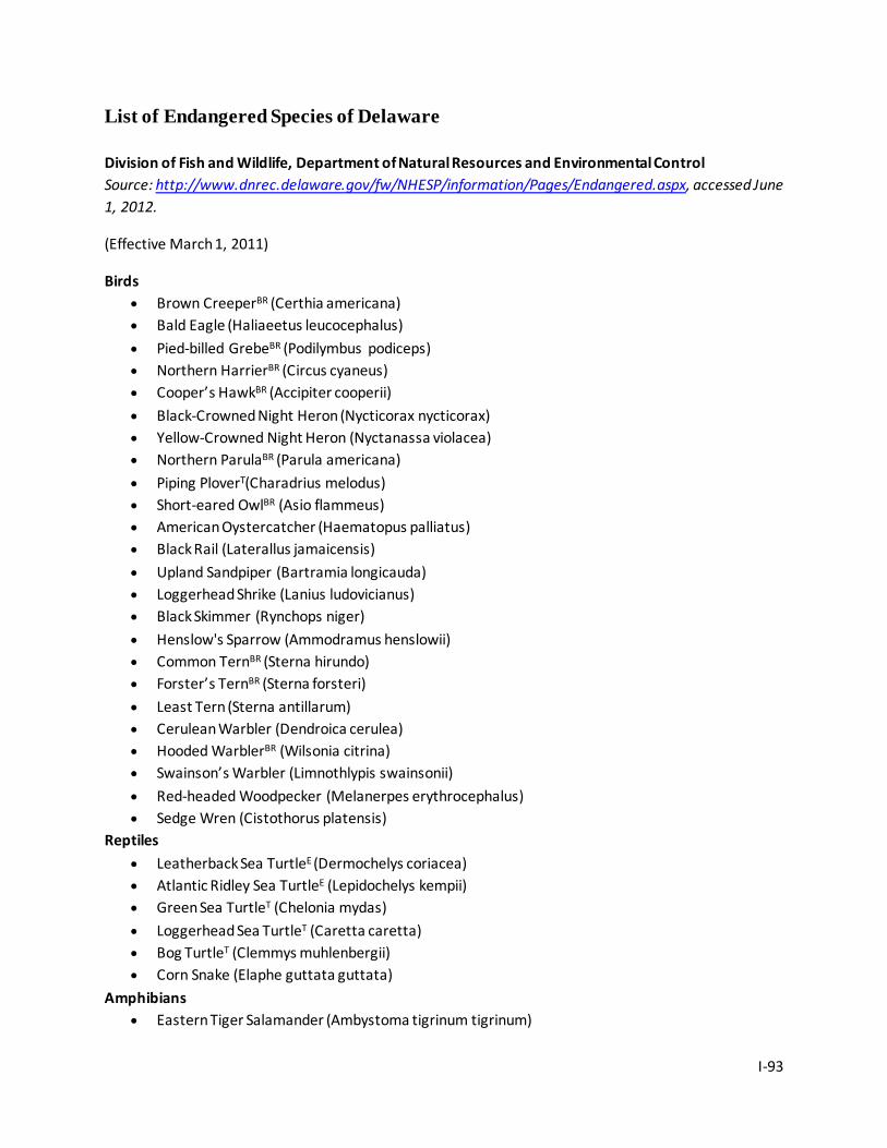
I-93
List of Endangered Species of Delaware Division of Fish and Wildlife, Department of Natural Resources and Environmental Control Source: http://www.dnrec.delaware.gov/fw/NHESP/information/Pages/Endangered.aspx, accessed June 1, 2012.
(Effective March 1, 2011)
Birds • Brown CreeperBR (Certhia americana) • Bald Eagle (Haliaeetus leucocephalus) • Pied-billed GrebeBR (Podilymbus podiceps) • Northern HarrierBR (Circus cyaneus) • Cooper’s HawkBR (Accipiter cooperii) • Black-Crowned Night Heron (Nycticorax nycticorax) • Yellow-Crowned Night Heron (Nyctanassa violacea) • Northern ParulaBR (Parula americana) • Piping PloverT(Charadrius melodus) • Short-eared OwlBR (Asio flammeus) • American Oystercatcher (Haematopus palliatus) • Black Rail (Laterallus jamaicensis) • Upland Sandpiper (Bartramia longicauda) • Loggerhead Shrike (Lanius ludovicianus) • Black Skimmer (Rynchops niger) • Henslow's Sparrow (Ammodramus henslowii) • Common TernBR (Sterna hirundo) • Forster’s TernBR (Sterna forsteri) • Least Tern (Sterna antillarum) • Cerulean Warbler (Dendroica cerulea) • Hooded WarblerBR (Wilsonia citrina) • Swainson’s Warbler (Limnothlypis swainsonii) • Red-headed Woodpecker (Melanerpes erythrocephalus) • Sedge Wren (Cistothorus platensis)
Reptiles • Leatherback Sea TurtleE (Dermochelys coriacea) • Atlantic Ridley Sea TurtleE (Lepidochelys kempii) • Green Sea TurtleT (Chelonia mydas) • Loggerhead Sea TurtleT (Caretta caretta) • Bog TurtleT (Clemmys muhlenbergii) • Corn Snake (Elaphe guttata guttata)
Amphibians • Eastern Tiger Salamander (Ambystoma tigrinum tigrinum)
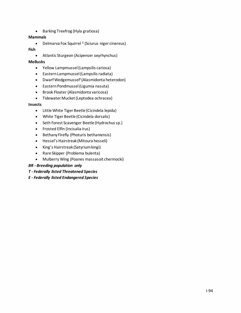
I-94
• Barking Treefrog (Hyla gratiosa) Mammals
• Delmarva Fox Squirrel E (Sciurus niger cinereus) Fish
• Atlantic Sturgeon (Acipenser oxyrhynchus) Mollusks
• Yellow Lampmussel (Lampsilis cariosa) • Eastern Lampmussel (Lampsilis radiata) • Dwarf WedgemusselE (Alasmidonta heterodon) • Eastern Pondmussel (Ligumia nasuta) • Brook Floater (Alasmidonta varicosa) • Tidewater Mucket (Leptodea ochracea)
Insects • Little White Tiger Beetle (Cicindela lepida) • White Tiger Beetle (Cicindela dorsalis) • Seth Forest Scavenger Beetle (Hydrochus sp.) • Frosted Elfin (Incisalia irus) • Bethany Firefly (Photuris bethaniensis) • Hessel’s Hairstreak (Mitoura hesseli) • King’s Hairstreak (Satyrium kingi) • Rare Skipper (Problema bulenta) • Mulberry Wing (Poanes massasoit chermocki)
BR - Breeding population only T - Federally listed Threatened Species E - Federally listed Endangered Species
I-95
Appendix I-9. Division of Fish and Wildlife Regulations
Division of Fish and Wildlife, Department of Natural Resources and Environmental Control Source: http://regulations.delaware.gov/AdminCode/title7/3000/3900%20Wildlife/3900.shtml#TopOfPage, accessed June 1, 2012.
3900 Wildlife
1.0 Definitions
For purposes of Regulations 1.0 through 22.0, the following words and phrases shall have the meaning ascribed to them, unless the context clearly indicates otherwise:
“Administered by the Division” shall mean owned, leased or licensed by the Division.
“Antlered Deer” shall mean any deer with one or more antlers three inches long or longer, measured from the base of the antler where it joins the skull to the tip of the antler following any curve of the antler.
“Antlerless Deer” shall mean any deer that has no antlers or antlers less than three inches in length.
“Bait” shall mean any nontoxic food material, compound or mixture of ingredients which wildlife is able to consume.
“Baited Field” shall include any farm field, woodland, marsh, water body or other tract of land where minerals, grain, fruit, crop or other nontoxic compounds have been placed to attract wildlife to be hunted.
“Black Powder” shall mean a manufacturer’s approved muzzleloading propellant.
“Deer” shall mean white-tailed deer (Odocoileus virginianus) and/or Sika deer (Cervus nippon).
“Director” shall mean the Director or Acting Director of the Division.
“Division” shall mean the Division of Fish and Wildlife of the Department.
“Established Blind” shall mean a structure or pit constructed for the purpose of hunting migratory waterfowl by a landowner on his or her property or by another person with the permission of the landowner or the landowner’s duly authorized agent.
“Established Road” shall mean a road maintained for vehicular use by the Division and designated for such use by the Division on current wildlife area maps.
“Liberated Game” shall mean cottontail rabbits and game birds, including bobwhite quail, mallard duck, chukar and pheasant released pursuant to § 568 of Title 7.
I-96
“Loaded Muzzle-Loading Rifle” shall mean the powder and ball, bullet or shot is loaded in the bore. A muzzle-loading rifle shall not be considered loaded if the cap, primer, or priming powder (in a flintlock) is removed and:
The striking mechanism used to ignite the cap, primer or priming powder is removed or rendered inoperable; or
The rifle is enclosed in a case.
“Lure” shall mean any mixture of ingredients, element or compound that attract wildlife, but the wildlife is unlikely to consume.
“Longbow” shall mean a straight limb, reflex, recurve or compound bow. All crossbows or variations thereof and mechanical holding and releasing devices are expressly excluded from the definition.
“Nongame Wildlife” shall mean any native wildlife, including rare and endangered species, which are not commonly trapped, killed, captured or consumed, either for sport or profit.
“Possession” shall mean either actual or constructive possession of or any control over the object referred to.
“Quality Buck” shall mean an antlered deer with an outside antler spread of at least 15 inches. This measurement is taken across the outside of the main beams at their widest point; this measurement’s path must be perpendicular to the center line of the skull and parallel to the top of the skull plate.
“Refuge” shall mean an area of land, whether in public or private ownership, designated by the Department as a refuge. Land shall only be designated with the permission of the landowner and if such designation is thought to be in the best interest of the conservation of wildlife. Refuges shall normally be closed at all times to all forms of hunting, except as permitted by the Director in writing for wildlife management purposes.
“Roadway” shall mean any road, lane or street, including associated right-of-ways, maintained by this State or any political subdivision of this State.
“Season” shall mean that period of time during which a designated species of wildlife may be lawfully hunted or a designated species of fish may be lawfully fished.
“Vehicle” shall include any means in or by which someone travels or something is carried or conveyed or a means of conveyance or transport, whether or not propelled by its own power.
“Wildlife” shall mean any member of the animal kingdom, including without limitation, any amphibian, arthropod, bird, mammal or reptile.
3 DE Reg. 289 (8/1/99) 3 DE Reg. 1738 (6/1/00) 11 DE Reg. 334 (09/01/07)
I-97
14 DE Reg. 52 (07/01/10) 15 DE Reg. 1505 (04/01/12)
2.0 Method of Take
(Penalty Section 7 Del.C. §103(d))
2.1 General.
Unless otherwise provided by law or regulation of the Department, it shall be unlawful to hunt any protected wildlife with any weapon or firearm other than a longbow or shotgun (10 gauge or smaller), except that:
2.1.1 Crossbows may be used during all deer seasons;
2.1.2 A muzzle-loading rifle with a barrel length of at least twenty inches and loaded with black powder may be used to hunt deer during muzzleloader and shotgun deer seasons;
2.1.3 A .22 caliber rimfire pistol may be used to hunt raccoons and opossums and to take wildlife lawfully confined in a trap;
2.1.4 A hook, spear or gig may be used to take frogs; and
2.1.5 Snapping turtles may be taken by hand or by using a spear, gig, fyke net or turtle trap. Turtle traps can have only one throat or funneling device.
2.1.6 A single shot an antique or authentic reproduction black powder Sharps rifle of 45 to 60 caliber shall be lawful for use during shotgun deer seasons using paper patched bullets.
2.1.7 No person shall place in the field any set or unset equipment associated with the trapping of game animals until the opening day of any state approved trapping season.
2.1.8 Any person who sets or makes use of any trap, snare or other approved wildlife capture device during any lawful trapping season, shall remove all trapping equipment by the last day of the approved trapping season.
2.2 Archery and Crossbow.
2.2.1 General. No person shall use or have in his or her possession, while hunting, any: poison arrow, arrow with and explosive tip, or any longbow with a minimum pull less than 35 pounds.
2.2.2 Crossbows used for deer hunting must have a minimum pull weight of 125 pounds, be manufactured after 1980, and have a mechanical safety. Crossbows may be equipped with a scope.
2.2.2.1 It shall be unlawful to transport a crossbow on or within any vehicle while the crossbow is in the cocked position.
I-98
2.3 Hunting from Boats.
2.3.1 Distance from Blinds. During the season for the hunting of migratory waterfowl, it shall be unlawful for any person to hunt from a boat of any kind that is within 1500 feet of an established blind, except that:
2.3.1.1 Any person may use a boat to tend lawfully set traps for fur-bearing wildlife;
2.3.1.2 Any person may retrieve crippled waterfowl by the use of a boat in accordance with federal regulations;
2.3.1.3 Any person may use a boat for transportation to and from an established blind lawfully used by such person;
2.3.1.4 Any person may hunt from a boat that is firmly secured and enclosed in an established blind.
2.3.2 Notwithstanding the provisions of subsection 2.2.1 of this section, any person may hunt migratory waterfowl within 1500 feet of an established blind, from a boat, with permission of the blind owner.
2.3.3 Gunning Rigs.
2.3.3.1 During the season for hunting migratory waterfowl, it shall be unlawful for any person to hunt within 900 feet of the shoreline (high tide line) of the Delaware River and Bay, between the Appoquinimink River and the Smyrna River, without written permission of the closest adjoining landowner(s).
2.3.3.2 During the season for hunting migratory waterfowl, it shall be unlawful for any person to hunt within 1500 feet of the shoreline (high tide line) of the Delaware River and Bay, between the Smyrna River and the Murderkill River, without written permission of the closest adjoining landowner(s).
2.3.4 Tender Boats. It shall be unlawful for tender boats servicing gunning (layout) rigs to be further than 1500 feet from the rig or to conduct any activity, except to pick up downed birds or service the rig.
2.3.5 During the season for hunting migratory waterfowl, it shall be unlawful for any person to hunt from a boat, or a floating or fixed blind in the Little River in areas bounded on both sides by land administered by the Division, except as permitted in writing by the Director.
2.4 Leghold Traps.
2.4.1 It shall be unlawful for any person to set a leghold trap at any time in this State, except from December 1 through March 10 (March 20 on embanked meadows) in New Castle County and December 15 through March 15 in Kent and Sussex counties.
2.4.2 Notwithstanding subsection 2.4.1 of this section, it shall be lawful to trap raccoons with leghold traps in New Castle County or Kent County from the southerly boundary of New Castle County Route 380 and east and southeast of the center line of U.S. Route No. 13, thence following said center line of U.S. Route No. 13 to the point where U.S. Route No. 13 forms a junction with U.S. Route No. 113 and
I-99
thence along the center line of U.S. Route No. 113 to a line dividing Kent County from Sussex County during any time of the year, except on Sundays. Notwithstanding the foregoing, this subsection shall not apply to lands in Kent County lying east of the center line of Rt. 113, north of the Sussex County line and south of the St. Jones River.
2.4.3 It shall be unlawful for any person to set long-spring traps, “Stop-Loss” traps or jump traps larger than No. 1½ or coil-spring traps larger than No. 1 in any location, except:
2.4.3.1 In any marsh ordinarily subject to the rise and fall of the tide;
2.4.3.2 In a diked marsh that was formerly tidal;
2.4.3.3 Below the mean high tide line in a river ordinarily subject to the rise and fall of the tide;
2.4.3.4 On an island surrounded by tidal marsh or diked marsh that was formerly tidal; or
2.3.4.5 In the areas described in subsection 2.4.2 of this section.
The term “diked marsh” shall not include millponds or any stream running into a millpond.
2.4.4 In addition to the areas listed in subsection 2.4.3 of this section, traps described in said subsection may be set for river otter and/or beavers in tax ditches, millponds and streams leading into such ponds only by underwater sets.
2.4.5 It shall be unlawful for any person to set or make use of long-spring traps, “Stop-Loss” traps or jump traps larger than No. 1½ or coil-spring traps larger than No. 1 without first permanently attaching a metallic tag on each trap, bearing:
2.4.5.1 The words “Trapping License, Delaware”, the number of the trapping license issued to the owner of the traps and the year of issuance; or
2.4.5.2 The owner's name and address.
2.4.6 It shall be unlawful for any person to set a long-spring trap, “Stop-Loss” trap, jump trap No. 1½ or smaller or a coil-spring trap No. 1 or smaller in any location in this State, except in the areas described in subsections 2.4.3 and 2.4.4 of this section and in the following locations:
2.4.6.1 A ditch;
2.4.6.2 A stream; or
2.4.6.3 On land not subject to cultivation of crops due to a normally marshy condition.
2.4.7 For the purposes of subsection 2.4.6 of this section, the term “ditch” shall mean a long, narrow channel dug into the earth as a trough for drainage or irrigation of the soil that normally contains flowing water.
I-100
2.4.8 For the purposes of subsection 2.4.6 of this section, the term “normally marshy condition” shall mean land with one or more of the following associated plant groupings growing upon it: cordgrass, sedges, rushes, cattails, threesquare or phragmites.
2.4.9 When information is furnished to a Fish and Wildlife Agent from the owner, tenant or sharecropper of any land that any species of wildlife is detrimental to crops, property or other interests on land on which he or she resides or controls, upon investigation, that Fish and Wildlife Agent may issue a permit to such person or his or her agent for the use of leghold traps to control said species of wildlife. Said permit may be issued at any time of the year.
2.4.10 The setting of each trap in violation of this section shall be a separate offense.
2.5 Gray Squirrel.
Hunting gray squirrels with a .17 through .22 caliber rimfire or pellet firearm with a rifled barrel, or muzzle-loading rifle not larger than .36 caliber is permitted south of the Chesapeake and Delaware Canal.
2.6 Muskrats.
It shall be unlawful for any person to shoot muskrats at any time, except with written permission of the Director.
2.7 Otters.
Each otter trapped in Delaware must be tagged by an authorized representative of the Division. Each otter sold in Delaware or shipped out of the State must be tagged in accordance with the requirements of the Convention on International Trade in Endangered Species.
2.8 Red Fox.
2.8.1 Red foxes may be killed in accordance with §788 of Title 7 with the following: longbow and crossbow, shotgun, rimfire rifle or centerfire rifle up to .25 caliber, revolvers and single shot pistols or a muzzle-loading rifle.
2.8.2 Notwithstanding subsection 2.8.1 of this section, during any deer firearms season, it shall be unlawful to hunt red fox with any firearm that is not also legal for deer hunting.
2.8.3 Notwithstanding subsection 2.8.1 of this section, it shall be unlawful to kill a red fox that is being pursued by dogs.
2.9 Snapping Turtles
2.9.1 Turtle traps must have either an escape hole below water measuring a minimum of 7.5” in all directions or floats inserted inside the trap or attached to the trap or be set in such a way so that the trap provides sufficient breathing space for all captured turtles at all times.
I-101
2.9.2 Each trap shall be marked with a metallic tag bearing the trapper’s name and address. The tag shall be attached to the trap in a manner that allows it to remain visible, at all times.
2.9.3 All turtle traps must be lifted and emptied of catch at least once every 24 hours.
2.9.4 An annual permit must be obtained from the Division in order to trap snapping turtles. This permit is free.
3 DE Reg. 289 (8/1/99) 6 DE Reg. 536 (10/1/02) 11 DE Reg. 334 (09/01/07) 14 DE Reg. 52 (07/01/10) 15 DE Reg. 1505 (04/01/12)
3.0 Federal Laws and Regulations Adopted
(Penalty Section 7 Del.C. §103(d))
3.1 Federal Laws.
It shall be unlawful for any person to hunt, buy, sell or possess any protected wildlife or part thereof, except in such manner and numbers as may be prescribed by the following federal laws and regulations promulgated thereunder: Airborne Hunting Act (16 USC § 742j-l et seq.), Eagle Act (16 USC § 668 et seq.), Endangered Species Act (16 USC 1531 et seq.), Lacey Act (16 USC § 3371 et seq.), Marine Mammal Protection Act (16 USC § 1361 et seq.), and the Migratory Bird Treaty Act (16 USC § 703 et seq.). Notwithstanding the foregoing, the federal laws and regulations shall be superseded by more stringent restrictions prescribed by State law or regulation of the Department.
3.2 Sea Ducks.
Scoters, eiders and old squaw ducks may be taken during their special season not less than 800 yards seaward from the Delaware Bay shore beginning at an east/west line between Port Mahon and the Elbow Cross Navigation Light south to the Atlantic Ocean or in the Atlantic Ocean.
3.3 Non-toxic Shot.
3.3.1 Required Usage. Non-toxic shot, as defined by federal regulations, shall be required for hunting waterfowl, rails, snipe, and moorhens in Delaware. It shall be unlawful for any person to possess shells loaded with lead shot while hunting waterfowl, rails, snipe, and moorhens.
3.3.2 Maximum Shot Size. It shall be unlawful for any person to hunt, except for deer, in Delaware with any size non-toxic shot (as defined by federal regulations) pellet(s) larger than size T (.20 inches in diameter).
3.4 Special Mallard Release Areas.
I-102
The Division may issue permits to allow the taking of captive-reared mallards during the established waterfowl season under applicable federal regulations. Permits shall only be issued to persons who: control at least 100 acres of land on which there is suitable waterfowl habitat; agree to follow a management plan and federal regulations; and maintain a log of guests and birds harvested. Failure to follow the management plan or a violation of State or federal laws may result in the revocation of a Special Mallard Release Area Permit. Waterfowl may only be hunted on Special Mallard Release Areas from one-half hour after sunrise to one hour before sunset.
3.5 Mute Swans (Cygnus olor)
3.5.1 Mute swans shall be considered an exotic, invasive species that is not subject to state protection. Mute swans may only be taken during legal waterfowl hunting seasons and shooting hours. The method of take for mute swans is restricted to shotguns no larger than 10 gauge and with non-toxic ammunition no larger than size T.
3.5.2 It shall be unlawful to possess, buy, sell, barter, trade, or transfer any live mute swan or their eggs to or from another person unless permitted by the Director of the Division of Fish and Wildlife.
3.5.3 It shall be unlawful to release any mute swan into the wild.
3.6 Special Shotgun Season for Young and Disabled Hunters
3.6.1 Waterfowl may be hunted on a special days established annually by the Division for disabled (non-ambulatory) hunters using a wheelchair for mobility and hunters 10 years of age or older but less than 16 years of age (10-15 years inclusive). Hunters 13-15 years of age must have completed an approved course in hunter training and possess a Delaware Resident or Non-Resident Junior Hunting License. Young hunters must be accompanied by a licensed non-hunting adult who is 21 years of age or older. Young hunters must be of sufficient size, physical strength and emotional maturity to safely handle a shotgun.
3 DE Reg. 289 (8/1/99) 6 DE Reg. 536 (10/1/02) 12 DE Reg. 496 (10/01/08) 14 DE Reg. 52 (07/01/10)
4.0 Seasons
(Penalty Section 7 Del.C. §103(d))
4.1 Season Dates.
Hunting and trapping season dates will be published each year in an annual publication entitled “Delaware Hunting and Trapping Guide.”
4.2 General.
I-103
It shall be unlawful for any person to hunt those species of wildlife for which a season is designated at any time other than during that season.
4.3 Protected Wildlife.
4.3.1 Unless otherwise provided by law or regulation of the Department, it shall be unlawful for any person to hunt any species of protected wildlife.
4.3.2 It shall be unlawful for any person to sell, transport or possess any species of protected wildlife, except when:
4.3.2.1 Otherwise provided by law or regulation of the Department; or
4.3.2.2 The wildlife was lawfully taken outside of this State in accordance with the laws or regulations of the state or nation where the wildlife was taken.
4.4 Beaver.
4.4.1 Unless otherwise provided by law or regulation of the Department, it shall be unlawful for any person to hunt or trap beaver during any period of the year, however, from December 1 through March 20, landowners (or their agents) may take up to eight beavers from their property without a permit, provided the beavers are causing crop or property damage.
4.4.2 Beaver hides and the meat of lawfully taken beaver harvested anywhere within or outside of Delaware may be sold.
4.5 Bullfrogs.
4.5.1 Season. Bullfrogs may be hunted in accordance with the statutes and regulations of the State of Delaware governing the hunting of bullfrogs: from May 1 through September 30.
4.5.2 Limit. It shall be unlawful for any person to take more than twenty-four (24) bullfrogs in any one day.
4.5.3 License. A hunting or fishing license is required to take bullfrogs.
4.6 Crows.
It shall be unlawful for any person to hunt common crows during any period of the year, except Thursdays, Fridays and Saturdays between and including the fourth Thursday of June and the last Saturday of March, unless said person holds a valid depredation permit. The hunting of common crows is restricted only by the provisions of federal regulations pertaining to the taking of common crows. Crows may be taken without a permit when committing damage or about to commit damage.
4.7 Gray Squirrel.
I-104
4.7.1 Season. Gray squirrel may be hunted in accordance with the statutes and regulations of the State of Delaware governing the hunting of gray squirrel: from September 15 (September 14, if September 15 is a Sunday) through the first Saturday in February. Squirrel hunting shall be unlawful during the November deer firearms season. When squirrel season overlaps with a firearms deer season, squirrel may be hunted when hunter orange is displayed in accordance with § 718 of Title 7.
4.7.2 Limit. It shall be unlawful for any person to take more than six gray squirrels in any one day.
4.8 Opossum.
The opossum may only be hunted or trapped during the lawful season to hunt or trap raccoons.
4.9 Pheasant.
4.9.1 Season. Male pheasant may be hunted in accordance with the statutes and regulations of the State of Delaware governing the hunting of pheasant: from the Monday that immediately precedes Thanksgiving through the first Saturday in February, provided that during a deer firearms season hunter orange is displayed in accordance with §718 of Title 7.
4.9.2 Female Pheasant. It shall be unlawful for any person to hunt or possess any female pheasant at any time, except as permitted on game preserves, by licensed game breeders or as otherwise permitted by law.
4.9.3 Male Pheasant Limit. It shall be unlawful for any person to hunt or possess more than two (2) male pheasants in any one day during the pheasant season, except as permitted by law.
4.9.4 Scientific or Propagating Purposes. It shall be unlawful for any person to possess pheasants for scientific and propagating purposes without a valid permit from the Director.
4.9.5 Game Preserves. Nothing in this regulation shall be construed so as to limit the number or sex of pheasants that may be harvested by any one person on licensed game preserves.
4.10 Quail.
4.10.1 Season. Bobwhite quail may be hunted in accordance with the statutes and regulations of the State of Delaware governing the hunting of bobwhite quail: from the Monday that immediately precedes Thanksgiving through the first Saturday of January, provided that during a deer firearms season hunter orange is displayed in accordance with § 718 of Title 7.
4.10.2 Limit. It shall be unlawful for any person to take more than six (6) quail in any one day.
4.11 Rabbit.
4.11.1 Season. Rabbits may be hunted in accordance with the statutes and regulations of the State of Delaware governing the hunting of rabbits: from the Monday that immediately precedes Thanksgiving through the last day of February or the last Saturday of February if February ends on a Sunday provided that during a deer firearms season hunter orange is displayed in accordance with § 718 of Title 7.
I-105
4.11.2 Limit. It shall be unlawful for any person to take more than four (4) rabbits in any one day.
4.12 Raccoon.
4.12.1 Trapping Season. Raccoon may be trapped in accordance with the statutes and regulations of the State of Delaware governing the trapping of raccoon: from December 1 through March 10 (March 20 on embanked meadows) in New Castle County; and from December 15 through March 15 in Kent and Sussex counties. The season is open throughout the year on private land, except on Sundays, in eastern New Castle and Kent counties pursuant to § 786 of Title 7 and Section 4(b) of WR-2.
4.12.2 Hunting Season. Raccoon may be hunted in accordance with the statutes and regulations of the State of Delaware governing the hunting of raccoon: from September 1 (September 2, if September 1 is a Sunday) through October 31 for chase only whereby it shall be unlawful to kill raccoon and opossum; from November 1 through the last day of February; and from March 1 through March 31 for chase only whereby it shall be unlawful to kill raccoon and opossum. The season is open throughout the year on private land in eastern New Castle and Kent counties, except on Sundays, pursuant to § 786 of Title 7.
4.12.3 Notwithstanding subsection 4.3.2 of this section, it shall be unlawful for any person to hunt raccoon or opossum during any period when it is lawful to hunt deer with a firearm, except that it shall be lawful to hunt raccoon from 7:00 p.m. until midnight during the December and January firearm deer seasons.
4.13 Red Fox.
4.13.1 Harvest Season. Red fox may be killed in accordance with the statutes and regulations of the State of Delaware governing the hunting of red fox: from November 1 through the last day of February, excluding Sundays. Notwithstanding the foregoing, red foxes may be killed in accordance with Section 8 of WR-2 and § 788 of Title 7.
4.14 Ruffed Grouse. It shall be unlawful for any person to hunt for ruffed grouse during any period of the year.
4.15 Snapping Turtles.
4.15.1 Season. It shall be unlawful for any person to hunt for snapping turtles during any period of the year, except between and including June 15 and May 15.
4.15.2 Size. It shall be unlawful for any person to sell, offer for sale or kill any snapping turtle with a straight-line carapace (top shell) length of less than eleven inches, measured on the curvature. This straight-line measurement is taken from the nuchal scute directly behind the turtle’s head to the base of the notch where the two most posterior scutes meet over the tail.
4.16 Terrapin.
4.16.1 Season. It shall be unlawful for any person to hunt for diamondback terrapin during any period of the year, except between and including September 1 and November 15.
I-106
4.16.2 Limit. It shall be unlawful for any person to take more than four (4) diamondback terrapin in any one day.
4.17 Muskrats
4.17.1 7 Day Season Extension. The Department may extend the muskrat trapping season 7 days if the Department determines that the statewide muskrat population can sustain additional harvest and the average mean temperature for February was below 320F and the total February snowfall exceeded 12 inches as determined by the National Weather Service station at Wilmington, Delaware.
4.17.2 14 Day Season Extension. The Department may extend the muskrat trapping season 14 days if the Department determines that the statewide muskrat population can sustain additional harvest and the average mean temperature for February was below 280F and the total February snowfall exceeded 24 inches as determined by the National Weather Service station at Wilmington, Delaware.
3 DE Reg. 289 (8/1/99) 3 DE Reg. 1738 (6/1/00) 6 DE Reg. 536 (10/1/02) 8 DE Reg. 352 (8/1/04) 11 DE Reg. 334 (09/01/07) 13 DE Reg. 941 (01/01/10) 14 DE Reg. 52 (07/01/10) 15 DE Reg. 1505 (04/01/12)
5.0 Wild Turkeys
(Penalty Section 7 Del.C. §103(d))
5.1 Possession of Wild Turkey Prohibited; Exceptions.
It shall be unlawful for any person, other than authorized representatives of the Division, to release or possess Meleagris gallopavo (wild turkey) in Delaware without a permit from the Division. The prohibition to possess and/or release Meleagris gallopavo shall include both birds taken from the wild and birds bred in captivity.
5.2 Instruction Requirement.
It shall be unlawful for any person to hunt wild turkeys in Delaware before passing a Division approved course of instruction in turkey hunting. In addition to official Delaware Division of Fish and Wildlife sponsored courses, official NRA Wild Turkey Hunting Clinics, official NWF Turkey Hunting Courses and out-of-state Turkey Hunting Courses (minimum of 4 hours) officially sponsored and sanctioned by other state or provincial Hunter Education Programs shall be recognized as being Division approved courses of instruction in turkey hunting. This includes Division approved internet courses.
5.3 Method of Take.
I-107
5.3.1 It shall be unlawful for any person to use any firearm to hunt wild turkeys, except a 10, 12, 16, or 20 gauge shotgun loaded with size 4, 5, or 6 shot or a longbow, compound bow or crossbow with a broadhead arrow, 7/8 inches in minimum width. Notwithstanding the foregoing, 7 or 7 1/2 shot may be used in shotguns if it is part of a duplex or triplex load that also contains 4, 5 or 6 shot.
5.3.2 It shall be unlawful for any person to use bait or dogs to hunt wild turkeys.
5.3.3 It shall be unlawful for any person to “drive” wild turkeys.
5.3.4 It shall be unlawful for any person to shoot any wild turkey that is in a roost tree.
5.3.5 It shall be unlawful for any person to hunt wild turkeys unless said person is wearing camouflage clothing.
5.3.6 It shall be unlawful for any person to hunt wild turkeys if said person is wearing any garment with the colors white, red, or blue.
5.3.7 It shall be unlawful for any person to hunt wild turkeys and use artificial turkey decoys of either sex that are wholly or partially made from any part of a turkey that was formerly alive.
5.3.8 It shall be unlawful for any person to hunt wild turkeys using an electronic calling device.
5.4 Season and Limit.
5.4.1 The Division may establish a season for hunting bearded wild turkeys. The Division will determine the season length and bag limit. It shall be unlawful for any person to hunt wild turkey, except as permitted by the written authorization of the Division. Proof of course completion referenced in 5.2 of this section shall serve as written authorization for private land hunters. Public land hunters must have an annual permit from the Division.
5.4.2 It shall be unlawful for any person to hunt wild turkeys, except from one-half hour before sunrise to 1:00 p.m.
5.4.3 It shall be unlawful for any person to not check a wild turkey at an authorized checking station by 2:30 p.m. on the day of kill.
5.4.4 It shall be unlawful for any person to take or attempt to take more than one bearded wild turkey per season.
5.5 Special Season for Young and Disabled Hunters
5.5.1 Turkeys may be hunted on private land and selected public land on the Saturday prior to the opening of the regular spring turkey hunting season by disabled (non-ambulatory) hunters using a wheelchair for mobility, and hunters 10 years of age or older but less than 16 years of age (10-15 years inclusive). Hunters 13-15 years of age must have completed an approved course in hunter training as well as a Division approved turkey hunter safety class and possess a Delaware Resident or Non-Resident Junior Hunting License. Young hunters must be accompanied by a licensed non-hunting adult who is 21
I-108
years of age or older who has also completed a Delaware approved turkey hunter safety class. Young hunters must be of sufficient size, physical strength and emotional maturity to safely handle a shotgun.
3 DE Reg. 289 (8/1/99) 11 DE Reg. 334 (09/01/07) 12 DE Reg. 496 (10/01/08) 15 DE Reg. 1505 (04/01/12)
6.0 Game Preserves
(Penalty Section 7 Del.C. §103(d))
It shall be unlawful for any person to hunt liberated game on licensed game preserves from April 1 through October 14.
3 DE Reg. 289 (8/1/99)
3 DE Reg. 1738 (6/1/00)
7.0 Deer
(Penalty Section 7 Del.C. §103(d))
7.1 Limit.
7.1.1 Unless otherwise provided by law or regulation of the Department, it shall be unlawful for any person to:
7.1.1.1 Kill or take or attempt to kill or take more than four antlerless deer in any license year;
7.1.1.2 Kill or take four antlerless deer in any license year without at least two of the four deer being female deer; or
7.1.1.3 Possess or transport an antlered deer that was unlawfully killed.
7.1.1.4 Possess or transport an antlerless deer that was unlawfully killed.
7.1.1.5 Kill any antlered deer without first purchasing a Delaware Resident Combination Hunter’s Choice Deer tag and Quality Buck Deer Tag, a Delaware Non Resident Antlered Deer Tag, or a Non-Resident Quality Buck Deer Tag except that persons exempt from purchasing a hunting license shall be entitled to take one Hunter’s Choice deer at no cost.
7.1.1.6 No hunter may harvest more than two antlered deer during a license year between July 1st. and June 30th of the next calendar year.
7.1.2 For the purposes of this section, a person “driving deer” and not in possession of any weapon or firearm shall not be treated as if they are hunting deer, provided they are assisting lawful hunters.
I-109
7.1.3 It shall be unlawful for any person to purchase, sell, expose for sale, transport or possess with the intent to sell, any deer or any part of such deer at any time, except that hides from deer lawfully killed and checked may be sold. This subsection shall not apply to venison approved for sale by the United States Department of Agriculture and imported into Delaware.
7.1.4 Notwithstanding subsection 7.1.1 of this section, a person may purchase Antlerless Deer Tags for $10 each to kill or take additional antlerless deer during the open season. Hunters may take additional antlerless deer on Antlerless Deer Damage Tags at no cost.
7.1.5 Notwithstanding subsection 7.1.1 of this section, a person may use one Quality Buck tag to take an antlered deer with a minimum outside antler spread of fifteen inches, provided the tag is valid for the season in which it is used. Hunters exempt from the requirement to purchase a hunting license must purchase a Quality Buck tag in order to take a second antlered deer in any one license year.
7.2 Tagging and Designated Checking Stations.
7.2.1 Attaching Tags. Each licensed person who hunts and kills a deer shall, immediately after the killing and before removing the deer from the location of the killing, attach an approved tag to the deer and record in ink the date of harvest on the tag. An approved tag shall mean an Anterless Deer Tag or Doe Tag received with the hunting license, a Delaware Resident Quality Buck Deer Tag, a Delaware Resident Hunter’s Choice Deer Tag, a Delaware Non Resident Quality Buck Deer Tag, a Delaware Non Resident Antlered Deer Tag, an Antlerless Deer Damage Tag, or an Antlerless Tag purchased in addition to the hunting license tags. Any unlicensed person not required to secure a license shall make and attach a tag to the deer that contains the person’s name, address and reason for not having a valid Delaware hunting license.
7.2.2 Retention of Tag. The tag required by subsection 7.2.1 of this section shall remain attached to the deer until the deer is processed for consumption.
7.2.3 Registering Deer. Each person who hunts and kills a deer shall, within 24 hours of killing said deer, register their deer by phone or over the internet through systems authorized by the Division. After registering a deer, hunters will be given a deer registration number. This number must be recorded in ink on the approved tags listed in subsection 7.2.1 of this section. It shall be unlawful to knowingly enter incorrect information when registering a deer.
7.2.4 Dressing. It shall be unlawful for any person to remove from any deer any part thereof, except those internal organs known as the viscera, or cut the meat thereof into parts, until such deer has been registered using the phone or internet system authorized by the Division.
7.2.5 Deer Registration Number. The Deer Registration number provided by the automated phone/internet system must remain with the head and/or carcass until the mount is picked up from the taxidermist or the meat is processed and stored as food.
7.3 Method of Take.
I-110
7.3.1 Shotgun. It shall be unlawful for any person to hunt deer during the shotgun season using a shotgun of a caliber smaller than 20 gauge, or have in his or her possession any shell loaded with shot smaller than what is commonly known as “buckshot.”
7.3.2 Archery and Crossbow Seasons. It shall be unlawful for any person to hunt deer during the archery season or crossbow season and have in his or her possession any weapon or firearm other than a knife, a longbow or crossbow and sharpened broadhead arrows having minimum arrowhead width of 7/8 of an inch.
7.3.3 Muzzle-loading Pistols. A single shot muzzle-loading pistol of .42 caliber or larger using a minimum powder charge of 40 grains may be used to provide the coupe-de-grace on deer during the primitive firearm season.
7.3.4 Refuge in Water. It shall be unlawful for any person to shoot, kill or wound or attempt to shoot, kill or wound any deer that is taking refuge in or swimming through the waters of any stream, pond, lake or tidal waters.
7.3.5 Dogs. It shall be unlawful for any person to make use of a dog for hunting during the shotgun or muzzleloader seasons for deer (in each county), except as permitted in the hunting of migratory waterfowl from an established blind or for hunting dove, quail, raccoon or rabbit on properties closed to deer hunting with firearms during December and January.
7.4 Illegal Hunting Methods; Baiting.
It shall be unlawful for any person to set, lay or use any trap, snare, net, or pitfall or make use of any artificial light, or other contrivance or device, for the purpose of hunting deer. This subsection does not preclude the use of bait for the purpose of attracting deer in order to hunt them on private land.
7.5 Seasons.
7.5.1 Shotgun Seasons. Deer may be hunted with shotgun in accordance with the statutes and regulations of the State of Delaware governing the hunting of deer: from the Friday in November that precedes Thanksgiving by thirteen (13) days through the second Saturday succeeding said Friday; and from the Saturday that precedes the third Monday in January through the following Saturday in January.
7.5.2 Archery Seasons. Deer may be hunted with longbow in accordance with statutes and regulations of the State of Delaware governing the hunting of deer: from September 1 (September 2, if September 1 is a Sunday) through the last day of January, provided hunter orange is displayed in accordance with § 718 of Title 7 when it also lawful to hunt deer with a gun.
7.5.3 Muzzleloader Seasons. Deer may be hunted with muzzle-loading rifles in accordance with the statutes and regulations of the State of Delaware governing the hunting of deer: from the Friday that precedes the second Monday in October through the second Saturday that succeeds the Friday opening day; and from the Monday that follows the close of the January shotgun season through the next Saturday.
I-111
7.5.4 Special Antlerless Season. Antlerless deer may be hunted with a shotgun in accordance with the statutes and regulations of the State of Delaware governing the hunting of deer during all Fridays, Saturdays and Mondays in October except for during the October Muzzleloader season and the last Monday prior to the opening Friday of the October Muzzleloader season. Notwithstanding the foregoing, antlered deer may be taken with archery equipment that is legal during this October shotgun season. Antlerless deer may be hunted with shotgun in accordance with the statutes and regulations of the State of Delaware governing the hunting of deer: from the second Saturday in December through the third Saturday in December.
7.5.5 Crossbow Seasons. Deer may be hunted with crossbows in accordance with statutes and regulations of the State of Delaware governing the hunting of deer: from September 1 (September 2, if September 1 is a Sunday) through the last day of January, provided hunter orange is displayed in accordance with 718 of Title 7 when it also lawful to hunt deer with a gun.
7.5.6 Special Shotgun Season for Young and Disabled Hunters. Deer may be hunted on the first Saturday of November by disabled (non-ambulatory) hunters using a wheelchair for mobility, and hunters 10 years of age or older but less than 16 years of age (10 to 15 inclusive). Hunters 13-15 years of age must have completed an approved course in hunter training and possess a Delaware Resident or Non-Resident Junior Hunting License. Young hunters must be accompanied by a licensed non-hunting adult who is 21 years of age or older. Young hunters must be of sufficient size, physical strength and emotional maturity to safely handle a shotgun.
7.6 Carcass Importation Ban.
7.6.1 Importation. It shall be unlawful to import or possess any carcass or part of a carcass of any member of the family Cervidae (deer) originating from a state or Canadian province, country or any portion of the aforementioned jurisdictions thereof as determined by the Division, in which Chronic Wasting Disease has been found in free-ranging or captive Cervids. Notwithstanding the foregoing, the following parts may be imported into the state:
7.6.1.1 Boned-out meat that is cut and wrapped;
7.6.1.2 Quarters or other portions of meat with no part of the spinal column or skull attached;
7.6.1.3 Hides or capes with no skull attached;
7.6.1.4 Clean (no meat or tissue attached) skull plates with antlers attached;
7.6.1.5 Antlers (with no meat or tissue attached);
7.6.1.6 Upper canine teeth (buglers, whistlers, or ivories); and
7.6.1.7 Finished taxidermy products.
7.6.2 Carcass Notification. Any person who imports into Delaware any deer carcass or parts described in subsection 7.6.1 of this section and is notified that the animal has tested positive for Chronic Wasting
I-112
Disease must report the test results to the department within 72 hours of receiving the notification. In order to facilitate the proper disposal of any infected material, the department may take into possession any imported carcass or carcass part of an animal if the animal has tested positive for Chronic Wasting Disease.
3 DE Reg. 289 (8/1/99) 6 DE Reg. 536 (10/1/02) 8 DE Reg. 352 (8/1/04) 11 DE Reg. 334 (09/01/07) 12 DE Reg. 496 (10/01/08) 14 DE Reg. 52 (07/01/10) 15 DE Reg. 1505 (04/01/12)
8.0 General Rules and Regulations Governing Land and Waters Administered by the Division
8.1 Motorized Vehicles.
8.1.1 General. It shall be unlawful for any person to drive or operate a motorized vehicle upon any lands administered by the Division, except on established roads or as otherwise authorized by the Director.
8.1.2 Noise. It shall be unlawful for any person to drive or operate a motorized vehicle upon any lands administered by the Division, unless such vehicle is equipped with a muffler in good working order and in constant operation to prevent excessive or unusual noise.
8.1.3 Speed Limit. It shall be unlawful for any person to drive or operate a vehicle in excess of twenty (20) miles per hour when on lands administered by the Division, unless otherwise authorized by the Director.
8.1.4 Unlicensed Vehicles. It shall be unlawful for any person to drive or operate any motorized vehicle upon any lands administered by the Division, unless said vehicle is licensed for use upon public highways and roadways or the driver or operator of said vehicle has been issued a permit from the Division.
8.1.5 Parking.
8.1.5.1 It shall be unlawful for any person to park any vehicle on lands administered by the Division in such a manner as to obstruct the use of a boat ramp, roadway or trail. Any vehicle parked in such manner shall be subject to removal, and the owner of said vehicle shall bear all costs involved with such removal.
8.1.5.2 Unless otherwise authorized by the Director, it shall be unlawful for any person to park and leave unattended any vehicle or trailer in any Division parking lot, unless said lot is lawfully being used for direct access to lands or waters administered by the Division.
8.1.5.3 Unless otherwise authorized by the Director, it shall be unlawful for any person to leave any vehicle on lands administered by the Division for a period exceeding 24 hours.
I-113
8.2 Conditions of Use.
8.2.1 Trespass. It shall be unlawful for any person to enter upon lands or waters administered by the Division when those lands or waters have been closed by the Division to: protect public safety; protect Department property; or manage wildlife. Persons shall adhere to special entry restrictions as listed on official area maps signed by the Division Director.
8.2.2 Hours of Entry. It shall be unlawful for any person to be present upon lands or waters administered by the Division between sunset and sunrise, unless such person is lawfully hunting or fishing or has been authorized by written permission of the Director.
8.2.3 Camping. It shall be unlawful for any person to camp on lands administered by the Division, except conservation oriented groups may, with written permission of the Director, camp in areas specified in such permit.
8.2.4 Swimming. It shall be unlawful for any person to swim in waters administered by the Division, except by written permission of the Director.
8.2.5 Dumping.
8.2.5.1 It shall be unlawful for any person to place, dump, deposit, throw or leave any garbage, refuse or similar debris within or upon any lands or waters administered by the Division, except in receptacles provided for such purpose;
8.2.5.2 It shall be unlawful for any person to bring any trash, refuse or similar material onto lands administered by the Division for the purpose of disposing such in Division receptacles.
8.2.5.3 Unless otherwise authorized by the Director, it shall be unlawful for any person to deposit any material, structure, debris or other objects on lands or waters administered by the Division.
8.2.6 Destruction of State Property.
8.2.6.1 It shall be unlawful for any person to deface, damage, remove or alter any structures, buildings, natural-land features, or other property or equipment belonging to the Division.
8.2.6.2 Unless authorized by the Division for management, research or educational purposes, it shall be unlawful for any person to cut, injure or remove trees, shrubs, wildflowers, ferns, mosses or other plants from lands administered by the Division.
8.2.6.3 It shall be unlawful for any person to erect or use any portable or permanent deer stand that involves the use of nails or screws placed in a tree.
8.2.6.4 Unless otherwise authorized by the Director, it shall be unlawful for any person to kindle, build, maintain or use a fire on lands administered by the Division.
8.2.7 Collection of Wildlife.
I-114
8.2.7.1 Collection and removal of any wildlife species from a State Wildlife Area is prohibited unless otherwise provided by statute, regulation or authorized by the Division Director.
8.2.8 Fishing.
8.2.8.1 It shall be unlawful to fish in any Division managed ponds except in accordance with conditions set forth on area maps and/or signs.
8.3 Hunting and Firearms.
8.3.1 Hunting.
8.3.1.1 It shall be unlawful for any person to hunt on lands administered by the Division, except as permitted by the Director in writing and specified on current wildlife area maps distributed by the Division.
8.3.1.2 A daily permit must be obtained before hunting waterfowl at Augustine, Cedar Swamp, Little Creek, Woodland Beach, Ted Harvey, Prime Hook and Assawoman wildlife areas. Permits may be obtained on-site from an authorized agent of the Division and must be returned upon leaving the area. The Director may specify the hours of a permit's effectiveness and determine the conditions of its issuance.
8.3.2 Waterfowl.
8.3.2.1 It shall be unlawful for any person to hunt waterfowl on areas administered by the Division, except from State built blinds, or other blinds authorized by the Division, or by written permission of the Director.
8.3.2.2 It shall be unlawful for any person to enter tidal and/or impounded areas administered by the Division during the waterfowl season, except for access as authorized by paragraph (1) of this subsection.
8.3.3 Trapping. It shall be unlawful for any person to trap or attempt to trap on areas administered by the Division, except for: persons holding a valid contract with the Division to do so; authorized agents of the Division who are conducting authorized wildlife management practices; or scientific purposes as specifically authorized in writing by the Director.
8.3.4 Firearms on Division Areas.
8.3.4.1 It shall be unlawful for any person to possess a firearm on lands or waters administered by the Division from March 1 through August 31, except as authorized by the Director in writing.
8.3.4.2 It shall be unlawful for any person to possess a rifled firearm of any description at any time on those lands bordering the Chesapeake and Delaware Canal and licensed to the Department by the Government of the United States for wildlife management purposes, except that muzzleloaders and shotguns with rifle barrels may be used during deer seasons when it is lawful to use those firearms.
I-115
8.3.4.3 It shall be unlawful for any person to discharge any firearm on lands or waters administered by the Division on Sunday, except in areas designated by the Director or with a permit from the Director.
8.3.4.4 It shall be unlawful for any person to discharge any firearm on lands or waters administered by the Division for any purpose, including target shooting, other than to hunt during an open season, under conditions approved by the Director and specified on the current wildlife area map.
8.3.4.5 It shall be unlawful to possess, consume or be under the influence of alcoholic beverages, liquors or drugs while hunting or in the possession of firearms when on lands administered by the Division.
8.3.5 Dikes. It shall be unlawful for any person to be in possession of any firearm on any dike administered by the Division, unless such person is temporarily crossing a dike at a ninety degree angle or traversing a dike to reach a Division authorized deer stand location during a deer firearms hunting season.
8.3.6 Deer Hunting By Driving. It shall be unlawful for residents to participate in deer drives, except where authorized on current wildlife area maps between the hours of 9:00 a.m. and 3:00 p.m. No more than six (6) resident hunters may participate in driving deer at any one time. Nonresidents may not participate in deer drives at any time. Nonresidents are restricted to hunting deer from stationary locations. Nonresidents may not possess a loaded firearm during the deer season, except to hunt from a stationary location or to retrieve a deer that they wound.
8.4 Horses and Bicycles. It shall be unlawful to ride horses or bicycles on, or allow horses to use, any lands or waters administered by the Division, except on established roads or trails that have been designated by the Division for such purposes on current wildlife area maps.
8.5 Concessions, Posters and Solicitations.
8.5.1 It shall be unlawful for any person to erect, post or distribute any placard, sign, notice, poster, billboard or handbill on lands or waters administered by the Division without written authorization of the Director.
8.5.2 It shall be unlawful for any person to engage in the vending of merchandise, food or services on lands or waters administered by the Division without written authorization of the Director.
8.5.3 It shall be unlawful for any person to do any form of solicitation for money or goods on any lands or waters administered by the Division without written authorization of the Director.
8.6 Firewood. It shall be unlawful for any person to remove firewood from lands administered by the Division without a permit from the Division, except when special firewood areas are designated by the Director in writing.
8.7 Dog Training.
8.7.1 General. It shall be unlawful for any person to train a dog on lands or waters administered by the Division, except:
I-116
8.7.1.1 During open hunting seasons for the game that the dog is being trained to hunt;
8.7.1.2 Within a dog training area established by the Division; and
8.7.1.3 As permitted by the Director in writing on current wildlife area maps.
8.7.2 C&D Canal Summit Area. It shall be unlawful for any person to enter the dog training area west of the Summit Bridge (Rt. 896), designated on the current wildlife area map of the C&D Canal Wildlife Area, for any purpose other than to train dogs or hunt for deer during the shotgun deer seasons. It shall be unlawful for any person to fish, operate a model or full size boat, ride horses or bicycles, or conduct any other activity on the area.
8.8 Geocaching
8.8.1 It shall be unlawful to place caches or letterboxes on Division of Fish and Wildlife property without a permit from the Division. Permits may be obtained by submitting a completed permit application to the appropriate Fish and Wildlife Regional Office. The proposed caching location will be specified in the application. The Regional Fish and Wildlife Manager will review and approve or deny the permit request. A permit will be valid for a maximum of one year from the date of issue at which time the geocache or letterbox must be removed or re-permitted. The permitted time frame will be determined by the area manager and be based on the local wildlife species present and the management activities planned for the area. The area manager will be provided the location of the cache or letterbox and may remove it at his or her discretion, with notice to the permit holder, should circumstances warrant. Online geocache and letterbox descriptions, such as those on geocaching.com or letterboxing.org must include information about access during hunting seasons and provide a link to Delaware Division of Fish and Wildlife Hunting Information.Geocache and letterbox contents must be suitable for all ages. Food, alcohol, tobacco, weapons or other dangerous items, prescription or illegal drugs and adult items are prohibited. From September 1st. through February 15th. of each year and during the spring turkey hunting season, the placement of or searching for geocaches and letterboxes may only occur on Sundays from sunrise to sunset. During the remainder of the year, geocaching and letterbox activities may occur 7 days per week from sunrise to sunset.
3 DE Reg. 289 (8/1/99) 11 DE Reg. 334 (09/01/07) 12 DE Reg. 496 (10/01/08) 15 DE Reg. 1505 (04/01/12)
9.0 Wildlife Theft Prevention Fund.
(Penalty Section 7 Del.C. §103(d))
9.1 Schedule of Rewards.
9.1.1 The Division shall pay up to $1000 for information leading to the arrest and conviction of any person found guilty of:
I-117
9.1.1.1 Commercialization of wildlife; or
9.1.1.2 Killing an endangered species or a species classified as a threatened species in accordance with the Endangered Species Act of 1973, as amended.
9.1.2 The Division shall pay up to $500 for information leading to the arrest and conviction of any person found guilty of:
9.1.2.1 Illegally hunting black ducks, canvasbacks, Canada geese or turkeys;
9.1.2.2 Poisoning wildlife;
9.1.2.3 Gross over-limits of wildlife;
9.1.2.4 Illegally hunting waterfowl or deer on State game refuges;
9.1.2.5 Hunting or trapping out of season;
9.1.2.6 Illegally hunting at night;
9.1.2.7 Hunting during license revocation; or
9.1.2.8 Possessing, tending or setting killer traps with a jaw spread in excess of 5 inches.
9.1.3 The Division shall pay up to $100 for information leading to the arrest and conviction of any person found guilty of illegally taking or wounding wildlife with a rifle.
9.1.4 The confidentiality of informants and their payments shall be maintained by administrative procedures. Peace officers, Department employees or members of their immediate families are not eligible for rewards.
3 DE Reg. 289 (8/1/99)
10.0 Nuisance Game Animals
(Penalty Section 7 Del.C. §103(d))
10.1 Incorporated Cities or Towns. Within the limits of residential or commercial areas of incorporated cities or towns, or within residential or commercial structures, the following game animals may be controlled (killed) without a permit when they are causing damage: gray squirrel, raccoon and opossum. Methods used to control said animals must be consistent with the laws of this State and the regulations of the Department and only live traps may be used (without a depredation permit) outside of established trapping seasons.
10.2 Pest Control Operators. The Division may designate licensed pest control operators as cooperators to control nuisance wild animals. Said cooperators must agree to follow guidelines for control as determined by the Division and notify potential clients of their fees.
I-118
3 DE Reg. 289 (8/1/99)
11.0 Shoreline Refuges of the Delaware River and Bay
(Penalty Section 7 Del.C. §103(d))
11.1 State Wildlife Area Protection for Intertidal Areas.
Any land located between the high tide line and the low tide line, between the Smyrna River and the St. Jones River and adjoining the Delaware River and Bay is hereby designated a State wildlife area and subject to the rules and regulations pertaining thereto, provided the adjoining landowners to said lands agree to their designation and agree to co-sign complaints concerning violations.
11.2 Exemptions.
Woodland Beach, Pickering Beach, and Kitts Hummock shall be exempt from this regulation. This regulation shall not affect surf fishing vehicles in areas where such vehicles are permitted or other uses of intertidal areas authorized by permit from the Division.
3 DE Reg. 289 (8/1/99)
12.0 Waterfowl Refuge
(Penalty Section 7 Del.C. §103(d))
It shall be unlawful for any person to hunt waterfowl in that part of Drawer Creek west of U.S. Route 13 to where the tributaries of the creek meet routes 428 and 429.
3 DE Reg. 289 (8/1/99)
13.0 Wildlife Rehabilitation Permits
(Penalty Section 7 Del.C. §103(d))
13.1 Permit from Division; Exemption.
13.1.1 It shall be unlawful for any person to hold native wildlife in captivity for the purpose of rehabilitation without a permit from the Division and any other permits required by the U.S. Fish and Wildlife Service.
13.1.2 Licensed veterinarians are exempt from the permitting requirements of this regulation when rendering treatment to injured wildlife and provisions are made to return any recovered animals to the wild or transfer them to a permitted rehabilitator for further care. Licensed veterinarians may only hold wildlife for as long as veterinary care is required.
13.2 Training, Housing and Veterinary Care; Inspections.
I-119
13.2.1 Permit holders must conform to the training, housing, release and veterinary care standards as written in the document “Minimum Standards for Wildlife Rehabilitation” published by the National Wildlife Rehabilitators Association and the International Wildlife Rehabilitation Council. Permit holders must also abide by the rules and policies set forth in the “State of Delaware Wildlife Rehabilitation Rules and Policies” document. Failure to abide by both of these documents may result in revocation of the rehabilitation permit. Animals held under rehabilitation permits must be released to the wild according to policies set forth in the document “State of Delaware Wildlife Rehabilitation Rules and Policies” or euthanized, if release is not feasible, unless the Division under §555 of Title 7 authorizes possession for scientific propagation or educational purposes. For federally listed endangered species and migratory birds an extension must be granted by the migratory bird permit office of the United State Fish and Wildlife Service, and the Division for each individual case. Rehabilitators must not release sick animals into the wild.
13.2.2 Rehabilitation facilities must be available for inspection by Division employees during normal business hours. Normal business hours shall mean Monday through Friday, except those days designated as holidays, during the hours in which the staff of the Division is scheduled to work. Violations of compliance with the Minimum Standards or the Rules and Policies noted in 13.2.1 will result in a written warning or immediate revocation of the rehabilitation permit depending on the violation. Persons receiving a warning will have their facility re-inspected. Failure to address the problem(s) in a timely manner will result in permit revocation. Upon permit revocation, all animals will be removed from the facility and either placed with another rehabilitator, released into the wild, placed with an educational facility, or humanly euthanized.
13.3 Rabies Vector Species
13.3.1 It shall be unlawful for any person to attempt rehabilitation of a rabies vector species without having proof of current pre-exposure immunization against the rabies virus. No permitted rehabilitator shall knowingly expose other non-immunized persons to a rabies vector species. For the purpose of the Delaware Wildlife Rehabilitator Permit, rabies vector species are defined as bats, raccoons, skunks, foxes, coyotes and woodchucks.
13.3.2 All rehabilitated rabies vector species must be released in the county of origin and the Division must be notified of the release location in the rehabilitator's annual report to the Division. It shall be unlawful for rehabilitated rabies vector species to be released on State Wildlife Management Areas without the consent of the Division Director.
3 DE Reg. 289 (8/1/99) 11 DE Reg. 334 (09/01/07)
14.0 Falconry
(Penalty Section 7 Del.C. §103(d))
14.1 Federal Regulations Adopted.
I-120
It shall be unlawful for any person to practice the sport of falconry, except in such a manner as prescribed by regulations promulgated under provisions of 50 CFR (Code of Federal Regulations) §§ 21.28, 21.29 and 21.30. Such regulations are hereby made part of the regulations of the Department as prescribed in § 725 of Title 7. Notwithstanding the foregoing, the federal regulations governing falconry shall be superseded by more stringent restrictions prescribed by law or regulation of the Department.
14.2 Permits.
14.2.1 Residents wishing to practice falconry shall apply to the Division for a falconry permit. To be issued a falconry permit, the person shall successfully pass a written test and have their facilities and equipment inspected as prescribed by the federal regulations.
14.2.2 Nonresidents must purchase a nonresident hunting license and be properly permitted to practice falconry in the state in which he or she resides.
14.2.3 Falconry permits shall be effective, unless revoked, for a period of up to three years and coincide with the license period for the hunting license. The Division shall participate in any joint state/federal permit system available.
14.2.4 The issuance of Apprentice Class permits shall be limited to persons 15 years of age or older.
14.3 Taking of Raptors.
14.3.1 It shall be unlawful for any person to take any birds of prey from the wild without a permit from the Division. The Director shall establish a limit on the number of raptors which may be taken each year and appear before the Council on Game and Fish to receive input on such limit before its adoption.
14.3.2 In 2000, and each year thereafter until changed, the Division may issue up to twelve (12) permits for the taking of twelve (12) birds of prey from the wild in Delaware, except that no more than three (3) permits shall be issued for the taking of three (3) nestling red-tailed hawks or three (3) nestling great horned owls, or any combination thereof. Nonresident falconers may apply for available permits to take nestling raptors, provided the state in which the nonresident resides allows Delaware residents the reciprocal opportunity to remove nestling raptors.
14.3.3 The taking of nestling (eyas) birds shall be limited to red-tailed hawks and great horned owls on Thursdays, Fridays and Saturdays from March 18 through June 30.
14.3.4 The season for the taking of passage birds shall be from September 1 through January 12. Nonresident falconers may apply to obtain any available permits to take passage raptors in Delaware, provided the state in which the nonresident resides has a reciprocal arrangement that permits Delaware residents to take passage raptors.
14.3.5 It shall be unlawful to remove raptors from private property without the express consent of the landowner. It shall also be unlawful for any person to remove raptors from State parks, State forests, State wildlife areas, State owned wetland mitigation sites, national wildlife refuges, nature preserves,
I-121
natural areas, and county or local parks without the advance approval of the agency administering the property. The permit to remove a raptor from the wild must be in possession of the falconer when attempting to capture a raptor. Apprentice falconers must be under the direct supervision of their sponsor or a Master or General class falconer when removing raptors from the wild.
14.3.6 Raptors taken from the wild in Delaware may not be sold or bartered.
14.4 Hunting. Falconry shall be a legal method of take for all game birds and game animals in Delaware. The hunting season for resident game shall be from September 1 through February 28. A permit holder whose raptor accidentally kills wildlife during a closed season for such wildlife shall leave the dead wildlife where it lies, except the raptor may feed upon the wildlife before leaving the site of the kill, provided that the wildlife shall not be reduced to possession by the falconer and the falconer shall cease hunting with the raptor that makes the accidental kill for the remainder of the day.
14.5 Marking. Any raptor possessed under a Delaware falconry permit must be banded with a permanent, non-reusable numbered band issued by the U.S. Fish and Wildlife Service or the Division. Captive reared raptors may be marked with either a permanent, non-reusable numbered band or, if sold, a numbered seamless band. Markers shall be removed from birds that die or are intentionally released into the wild and must be forwarded to the Division within ten days along with a report that documents the fate of the bird.
14.6 Release. Raptors, including hybrid raptors, which are not indigenous to Delaware shall not be permanently released into the wild. Raptors released in Delaware must be released within the appropriate season in which that species naturally occurs within the State.
3 DE Reg. 289 (8/1/99) 3 DE Reg. 1738 (6/1/00) 6 DE Reg. 536 (10/1/02)
15.0 Collection or Sale of Native Wildlife
(Penalty Section 7 Del.C. §103(d))
15.1 Commercial Collection.
15.1.1 Unless otherwise provided by law or regulation of the Department, it shall be unlawful for any person to collect, possess, import, cause to be imported, export, cause to be exported, buy, sell or offer for sale any native wildlife species or any part thereof for commercial purposes without a permit from the Director. The permit shall limit the terms and conditions for collecting or possessing said wildlife within the State.
15.1.2 Notwithstanding subsection 15.1.1 of this section, native wildlife species may be possessed, imported, sold or offered for sale for commercial purposes without a permit from the Director if there is written documentation to confirm that said wildlife was legally taken in and transported from another state.
I-122
15.2 Collection and Possession of Reptiles and Amphibians.
15.2.1 Unless otherwise provided by law or regulation of the Department, it shall be unlawful for any person to remove from the wild or possess any native reptile or amphibian species, their eggs or parts without a permit from the Director.
15.2.2 Notwithstanding subsection 15.1.1 of this section, one individual of each of the following species or subspecies of reptiles and amphibians, may be collected and possessed without a permit.
Reptiles Lizard, Northern Fence (Sceloporus undulatus hyacinthinus) Racer, Northern Black (Coluber constrictor constrictor) Skink, Five-lined (Eumeces fasciatus) Snake, Black Rat (Elaphe obsoleta obsoleta) Snake, Eastern Garter (Thamnophis sirtalis sirtalis) Snake, Eastern Hognose (Heterodon platirhinos) Snake, Eastern Worm (Carphophis amoenus amoenus) Snake, Northern Water (Nerodia sipedon sipedon) Snake, Ringneck (Diadophis punctatus) Terrapin, Diamondback (Malaclemys terrapin) Turtle, Common Musk (Sternotherus odoratus) Turtle, Eastern Box (Terrapene carolina carolina) Turtle, Eastern Mud (Kinosternon subrubrum subrubrum) Turtle, Painted (Chrysemys picta) Turtle, Redbelly (Pseudemys rubriventris) Turtle, Snapping (Chelydra serpentina) Amphibians Bullfrog (Rana catesbeiana) Frog, Green (Rana clamitans melanota) Frog, New Jersey Chorus (Pseudacris triseriata kalmi) Frog, Northern Cricket (Acris crepitans crepitans) Frog, Pickerel (Rana palustris) Frog, Southern Leopard (Rana utricularia) Frog, Wood (Rana sylvatica) Newt, Red-spotted (Notophthalmus viridescens viridescens) Peeper, Northern Spring (Pseudacris crucifer crucifer) Salamander, Northern Dusky(Desmognathus fuscus fuscus) Salamander, Northern Two-lined (Eurycea bislineata) Salamander, Redback (Plethodon cinereus) Spadefoot, Eastern (Scaphiopus holbrookii holbrookii) Toad, American (Bufo americanus) Treefrog, Gray (Hyla versicolor and Hyla chrysoscelis)
I-123
15.2.3 It shall be unlawful to remove any reptile or amphibian from the wild and later release said reptile or amphibian back to the wild if it has been held in captivity for more than thirty (30) days.
15.2.4 Notwithstanding subsection 15.1.1 of this section, native reptiles and amphibians taken from the wild and lawfully possessed prior to August 15, 1999, may continue to be held in captivity, provided that written notification of the numbers and species being held is given to the Division prior to December 15, 1999.
15.3 Captive Breeding.
15.3.1 It shall be unlawful for any person to breed in captivity any native wildlife species without a permit from the Director. Said permit shall limit the terms and conditions for captive breeding of said wildlife.
15.3.2 It shall be unlawful for any person to release captive-bred species into the wild. A signed bill of sale shall accompany any captive-bred species that are sold.
15.3.3 This section shall not apply to accredited zoos or to raptors regulated by federal and State falconry or raptor propagation regulations.
15.4 Sale or Possession of CITES Listed Species.
It shall be unlawful for any person to sell or possess bear gall bladder, or other viscera from any species of bear, or any part of other species listed as prohibited by the Convention on International Trade in Endangered Species (CITES). The possession of any part of a bear must be in conformance with CITES.
3 DE Reg. 289 (8/1/99) 3 DE Reg. 1738 (6/1/00) 6 DE Reg. 536 (10/1/02) 15 DE Reg. 1505 (04/01/12)
16.0 Endangered Species.
(Penalty Section 7 Del.C. §103(d))
16.1 Importation, Transportation and Possession.
16.1.1 Pursuant to §601 of Title 7, the importation, transportation, possession or sale of any endangered species of fish or wildlife, or hides or other parts thereof, or the sale or possession with intent to sell any article made in whole or in part from the skin, hide or other parts of endangered species of fish or wildlife is prohibited, except under license or permit from the Division.
16.2 Designation of Species by Division.
16.2.1 Pursuant to §601 of Title 7, the Division may designate species of fish and wildlife that are seriously threatened with extinction as endangered species. The Division will review the state list of
I-124
endangered species and add species suggested by the public that have sufficient documentation for listing.
16.2.2 For the purposes of this section, the phrase “seriously threatened with extinction” shall mean that the species satisfies one or more of the following criteria:
16.2.2.1 Appears on the federal list of endangered species;
16.2.2.2 Ranked as “globally rare” (G1, G2, or G3), which means 100 or fewer populations worldwide; or
16.2.2.3 Is rare within the mid-Atlantic coastal plain.
16.2.3 Based upon the criteria prescribed by subsection 16.2.2 of this section, the following species are declared endangered in this State and are afforded the protection provided by § 601 of Title 7:
Amphibians Salamander, Eastern Tiger (Ambystoma tigrinum tigrinum) Treefrog, Barking (Hyla gratiosa) Birds Creeper, Brown BR (Certhia americana) Eagle, Bald (Haliaeetus leucocephalus) Grebe, Pied-billedBR (Podilymbus podiceps) Harrier, NorthernBR (Circus cyaneus) Hawk, Cooper’sBR (Accipiter cooperii) Heron, Black-Crowned Night- (Nycticorax nycticorax) Heron, Yellow-Crowned Night- (Nyctanassa violacea) Parula, NorthernBR (Parula americana) Plover, Piping (Charadrius melodus) Owl, Short-earedBR (Asio flammeus) Oystercatcher, American (Haematopus palliatus) Rail, Black (Laterallus jamaicensis) Sandpiper, Upland (Bartramia longicauda) Shrike, Loggerhead (Lanius ludovicianus) Skimmer, Black (Rynchops niger) Sparrow, Henslow's (Ammodramus henslowii) Tern, CommonBR (Sterna hirundo) Tern, Forster’sBR (Sterna forsteri) Tern, Least (Sterna antillarum) Warbler, Cerulean (Dendroica cerulea) Warbler, Hooded BR (Wilsonia citrina) Warbler, Swainson’s (Limnothlypis swainsonii) Woodpecker, Red-headed (Melanerpes erythrocephalus) Wren, Sedge (Cistothorus platensis)

I-125
BR Breeding population only Fish Sturgeon, Atlantic (Acipenser oxyrhynchus) Insects Beetle, Little White Tiger (Cicindela lepida) Beetle, White Tiger (Cicindela dorsalis) Beetle, Seth Forest Scavenger (Hydrochus sp.) Elfin, Frosted (Incisalia irus) Firefly, Bethany (Photuris bethaniensis) Hairstreak, Hessel’s (Mitoura hesseli) Hairstreak, King’s (Satyrium kingi) Skipper, Rare (Problema bulenta) Wing, Mulberry (Poanes massasoit chermocki) Mammals Squirrel, Delmarva Fox (Sciurus niger cinereus) Mollusks Lampmussel, Yellow (Lampsilis cariosa) Lampmussel, Eastern (Lampsilis radiata) Wedgemussel, Dwarf (Alasmidonta heterodon) Pondmussel, Eastern (Ligumia nasuta) Floater, Brook (Alasmidonta varicosa) Mucket, Tidewater (Leptodea ochracea) Reptiles Sea Turtle, Leatherback (Dermochelys coriacea) Sea Turtle, Atlantic Ridley (Lepidochelys kempii) Sea Turtle, Green (Chelonia mydas) Sea Turtle, Loggerhead (Caretta caretta) Turtle, Bog (Clemmys muhlenbergii) Snake, Corn (Elaphe guttata guttata)
16.3 Federally Listed Species.
16.3.1 Pursuant to the Endangered Species Act of 1973 (16 USC §§ 1531-1543), as amended, the Secretary of the Interior must publish in the Federal Register a list of all fish and wildlife species determined by him or her or the Secretary of Commerce to be endangered species. The federal list of endangered species is hereby adopted and all species listed thereon are hereby declared to be endangered species in the State as prescribed in §601 of Title 7.
I-126
16.3.2 It shall be unlawful for any person to collect, possess or sell any species of fish or wildlife listed as endangered or threatened pursuant to the Endangered Species Act of 1973, as amended, without the appropriate federal permits.
3 DE Reg. 1738 (6/1/00) 6 DE Reg. 536 (10/01/02)
17.0 Species of Special Concern
(Penalty Section 7 Del.C. §103(d))
17.1 List of Species
The following species or groups of species shall be considered Species of Special Concern for the purpose of qualifying for federal funds for wildlife restoration: Endangered species as designated by state or federal regulations; species designated by WR-16, Section 2, colonial nesting birds; shorebirds; wading birds; neotropical migrant birds; beach nesting birds; bald and golden eagles; peregrine falcons; other raptors, grassland nesting birds; birds of early successional habitat; bobwhite quail; wild turkey; freshwater mussels; bats; nutria; and overly abundant species such as deer, beavers, southern nesting Canada geese, and red fox.
6 DE Reg. 536 (10/1/02)
18.0 Wanton Waste
Penalty Section 7 Del.C. §103(d))
18.1 Retrieval and Possession of Game Animals. A person wounding or killing a game animal shall make a reasonable effort to retrieve the wounded or dead game animal. The retrieved game animal shall be retained in the individual's possession until any of the following occurs:
18.1.1 The game animal is processed for consumption, consumed or utilized for its fur value.
18.1.2 The game animal is transported to the individual's residence, to a taxidermist, or to a place of commercial processing.
18.1.3 The game animal is utilized for scientific, educational or research purposes.
18.2 Any use of a game animal as not described in items 18.1.1 - 18.1.3 above will be deemed wanton waste.
11 DE Reg. 334 (09/01/07)
19.0 (Reserved)
20.0 Game Bird Releases
(Penalty Section 7 Del.C. §103(d))
I-127
20.1 Permit for releasing game birds
20.1.1 All persons possessing or releasing 25 or fewer domestically raised quail, chukar partridge, Hungarian partridge and pheasants into the wild must obtain a permit from the Division. This permit is free.
20.2 Banding Released Game Birds.
20.2.1 All domestically raised quail, chukar partridge, Hungarian partridge and pheasants must be leg banded with a Division approved band before being released into the wild. Person herein must report the number of birds banded, the type of bird released (quail, chukar partridge, Hungarian partridge or pheasant) and the release date and location.
12 DE Reg. 496 (10/01/08)
21.0 Guide License
(Penalty Section 7 Del.C. §103(d))
21.1 Persons required to obtain a Delaware Guide License
21.1.1 All individuals receiving monetary or in-kind compensation for providing personal guide services to hunters are required to have a Delaware Guide License.
21.2 Age Requirement
21.2.1 Persons acquiring a guide license, must be 18 years of age or older
21.3 Fish and Wildlife Violations
21.3.1 Persons acquiring a guide license must not have been convicted for violations of any wildlife or fisheries statutes or regulations within the last three years prior to applying for a Delaware Guide License.
21.4 Reporting
21.4.1 All persons possessing a Delaware Guide License are required to complete and submit an annual report to the Division within seven days after the close of the season to include the following information which must be readily available for inspection by enforcement officers: full name of each hunter, address of each hunter in the party, hunting license number for each hunter, date, number and species of each animal harvested, location of hunts and the name and license number of the guide.
21.5 Record Retention
21.5.1 The guide shall retain all hunting field records for a period of three years.
21.6 General Hunting License
I-128
21.6.1 A resident or non resident hunting license is not required for persons holding a valid Delaware Guide License.
21.6.2 A nonresident shall be exempt from the guide licensing requirement of this section only while guiding hunters for snow geese (light geese), provided:
21.6.2.1 The nonresident is properly licensed to guide in another state or Canadian province which extends the same exemption to Delaware residents;
21.6.2.2 The nonresident guide purchases a Delaware migratory waterfowl stamp and obtains a Delaware H.I.P. permit.
21.6.2.3 The nonresident resides in another state or Canadian province which extends the same exemption to Delaware residents.
12 DE Reg. 496 (10/01/08) 14 DE Reg. 52 (07/01/10)
22.0 Hunter and Trapper License Exempt Number
(Penalty Section 7 Del.C. §103(d))
Hunters and trappers who are exempt from purchasing a license to hunt or trap in Delaware are required to obtain an annual Hunter and Trapper License Exempt Number from the Division. This number must be carried by the hunter or trappers while engaged in hunting and trapping activities.
12 DE Reg. 496 (10/01/08) 14 DE Reg. 52 (07/01/10) 15 DE Reg. 1505 (04/01/12)

I-129
Appendix I-10. Environmental Protection Act
Environmental Protection Act DE Code Title 7, Part VII, Chapter 60 (Environmental Control) Source: http://delcode.delaware.gov/title7/c060/index.shtml, accessed June 1, 2012.
Subchapter I. General Provisions
§ 6001. Findings, policy and purpose.
(a) Findings. -- The General Assembly hereby makes the following findings concerning the development, utilization and control of the land, water, underwater and air resources of the State:
(1) The development, utilization and control of the land, water, underwater and air resources of the State are vital to the people in order to assure adequate supplies for domestic, industrial, power, agricultural, recreational and other beneficial uses;
(2) The development and utilization of the land, water, underwater and air resources must be regulated to ensure that the land, water, underwater and air resources of the State are employed for beneficial uses and not wasted;
(3) The regulation of the development and utilization of the land, water, underwater and air resources of the State is essential to protect beneficial uses and to assure adequate resources for the future;
(4) The land, water, underwater and air resources of the State must be protected and conserved to assure continued availability for public recreational purposes and for the conservation of wildlife and aquatic life;
(5) The land, water, underwater and air resources of the State must be protected from pollution in the interest of the health and safety of the public;
(6) The land, water, underwater and air resources of the State can best be utilized, conserved and protected if utilization thereof is restricted to beneficial uses and controlled by a state agency responsible for proper development and utilization of the land, water, underwater and air resources of the State;
(7) Planning for the development and utilization of the land, water, underwater and air resources is essential in view of population growth and the expanding economic activity within the State.
(b) Policy. -- In view of the rapid growth of population, agriculture, industry and other economic activities, the land, water and air resources of the State must be protected, conserved and controlled to assure their reasonable and beneficial use in the interest of the people of the State. Therefore, it is the policy of this State that:
I-130
(1) The development, utilization and control of all the land, water, underwater and air resources shall be directed to make the maximum contribution to the public benefit; and
(2) The State, in the exercise of its sovereign power, acting through the Department should control the development and use of the land, water, underwater and air resources of the State so as to effectuate full utilization, conservation and protection of the water and air resources of the State.
(c) Purpose. -- It is the purpose of this chapter to effectuate state policy by providing for:
(1) A program for the management of the land, water, underwater and air resources of the State so directed as to make the maximum contribution to the interests of the people of this State;
(2) A program for the control of pollution of the land, water, underwater and air resources of the State to protect the public health, safety and welfare;
(3) A program for the protection and conservation of the land, water, underwater and air resources of the State, for public recreational purposes, and for the conservation of wildlife and aquatic life;
(4) A program for conducting and fostering research and development in order to encourage maximum utilization of the land, water, underwater and air resources of the State;
(5) A program for cooperating with federal, interstate, state, local governmental agencies and utilities in the development and utilization of land, water, underwater and air resources;
(6) A program for improved solid waste storage, collection, transportation, processing and disposal by providing that such activities may henceforth be conducted only in an environmentally acceptable manner pursuant to a permit obtained from the Department.
7 Del. C. 1953, § 6001; 59 Del. Laws, c. 212, § 1.;
Subchapter II. Powers and Duties of Secretary and Department
§ 6002. Definitions.
The following words and phrases shall have the meaning ascribed to them in this chapter unless the context clearly indicates otherwise:
(1) "Activity" means construction, or operation, or use of any facility, property, or device.
(2) "Air contaminant" means particulate matter, dust, fumes, gas, mist, smoke or vapor or any combination thereof, exclusive of uncombined water.
(3) "Air pollution" means the presence in the outdoor atmosphere of 1 or more air contaminants in sufficient quantities and of such characteristics and duration as to be injurious to human, plant or animal life or to property, or which unreasonably interferes with the enjoyment of life and property within the jurisdiction of this State, excluding all aspects of employer-employee relationships as to health and safety hazards.
I-131
(4) "At cost" means the expense to the government to conduct tests and analyses. No added service fee, or other fees and charges, may be included in this cost.
(5) "Board" means the Environmental Appeals Board.
(6) "Boat docking facility" shall mean a place where vessels may be secured to a fixed or floating structure or to the shoreline or shoreline structure.
(7) "Borrow pit" means any excavation into the subsurface for the purpose of extraction of earth products with the exception of excavation for utility or road construction, agricultural or highway drainage, or dredging operations under the jurisdiction of the U.S. Army Corps of Engineers.
(8) "Categorical pretreatment standard" means a pretreatment standard which applies to industrial users in a specific industrial subcategory.
(9) "Commercial landfill" means a waste disposal facility available for use by the general public and which accepts waste for disposal for profit.
(10) "Debris disposal area" means an excavation, pit or depression into which land clearing debris, along with small amounts of construction or demolition waste incidental to construction, has been placed and which is not a permitted or approved waste management facility.
(11) "Dedicated pumpout facility" means a semi-permanent connection made to a vessel for the purpose of removing sewage from the vessel on a continuous basis or automatic intermittent basis to an approved disposal facility.
(12) "Delineation" shall mean the process of defining and/or mapping a boundary that approximates the areas that contribute water to a particular water source used as a public water supply.
(13) "Department" means the Department of Natural Resources and Environmental Control.
(14) "Direct vessel sewage pumpout connection" shall mean a semipermanent connection made to a vessel for the purpose of removing vessel sewage from the vessel holding tank or head on a continuous or automatic intermittent basis to an approved sewage disposal facility.
(15) "Discharge or indirect discharge" means the discharge or the introduction of pollutants from any nondomestic source into a POTW.
(16) "Domestic wastewater" means the liquid and water-borne human and/or household type waste derived from residential, industrial, institutional or commercial sources.
(17) "Dump station" means a type of pumpout facility that receives vessel sewage from portable marine sanitation devices and delivers that sewage to an approved sewage disposal facility.
(18) "Earth products" means any solid material, aggregate or substance of commercial value, whether consolidated or loose, found in natural deposits on or in the earth, including, but not limited to clay, silt, diatomaceous earth, sand, gravel, stone, metallic ores, shale and soil.
I-132
(19) "Environmental release" means any spillage, leakage, emission, discharge or delivery into the air or waters or on or into the lands of this State of any sewage of 10,000 gallons or more oil, industrial waste, liquid waste, hydrocarbon chemical, hazardous substance, hazardous waste, restricted chemical material, vessel discharge, air contaminant, pollutant, regulated biological substance or other wastes reportable pursuant to the Comprehensive Environmental Response, Compensation and Liability Act of 1980 [42 U.S.C. § 9601 et seq.], as amended, or regulations enacted pursuant to § 6028 of this title.
(20) "Excellent ground-water recharge potential area" shall mean any area where soils and sedimentary deposits of the most coarse grained nature have the best ability to transmit water vertically through the unsaturated zone to the water table as mapped by the methods described in the Delaware Geological Survey Open File Report No. 34, "Methodology For Mapping Ground-Water Recharge Areas in Delaware's Coastal Plain" (August 1991), and as depicted on a series of maps prepared by the Delaware Geological Survey. An excellent ground-water recharge potential area shall constitute a critical area as defined under Chapter 92 of Title 29.
(21) "Garbage" shall mean any putrescible solid and semisolid animal and/or vegetable wastes resulting from the production, handling, preparation, cooking, serving or consumption of food or food materials.
(22) "Graywater" means galley, bath and shower water.
(23) "Ground water" means any water naturally found under the surface of the earth.
(24) "Hydrocarbon chemical" means any compound composed of carbon and hydrogen.
(25) "Incinerator," "incinerator structure or facility," and "waste incinerator" include any structure or facility operated for the combustion (oxidation) of solid waste, even if the by-products of the operation include useful products such as steam and electricity. "Incinerator" shall not include:
a. Crematoriums;
b. The disposal of the bodies of animals through incineration;
c. The burning of poultry waste or poultry manure at the same site where the waste or manure was generated, which shall include the burning of poultry waste or poultry manure generated upon an adjacent farm;
d. The disposal of all materials used in the discovery, development, and manufacture of veterinary products, medicines and vaccines; or
e. The disposition of mortalities from poultry operations in facilities approved by the Delaware Department of Natural Resources and Environmental Control which comply with United States Department of Agricultural Natural Resources Conservation Service Interim Conservation Practice Standard Incinerator 769 or any successor standard.
(26) "Industrial user" means a source of indirect discharge. The term "industrial user" shall include, but not be limited to, the original source of the indirect discharge as well as the owners or operators of any
I-133
intervening connections, other than those owned or operated by the receiving POTW, which convey the indirect discharge to the POTW.
(27) "Industrial waste" means any water-borne liquid, gaseous, solid or other waste substance or a combination thereof resulting from any process of industry, manufacturing, trade or business, or from the development of any agricultural or natural resource.
(28) "Liquid waste" means any industrial waste or sewage or other wastes or any combination thereof which may potentially alter the chemical, physical or biological integrity of water from its natural state.
(29) "Liquid waste hauler" means any person who engages in the removal of liquid wastes from septic tanks, cesspools, seepage pits, holding tanks or other such devices and conveys such liquid waste to a location removed from the point of acceptance.
(30) "Liquid waste treatment plant operator" means any person who has direct responsibility for the operation of a liquid waste treatment plant.
(31) "Live-aboard vessel" shall mean:
a. A vessel used principally as a residence;
b. A vessel used as a place of business, professional or other commercial enterprise and, if used as a means of transportation, said transportation use is a secondary or subsidiary use; this definition shall not include commercial fishing boats which do not fall under paragraph (31)a. of this section; or
c. Any other floating structure used for the purposes stated under paragraph (31)a. or b. of this section.
(32) "Marinas" are those facilities adjacent to the water which provide for mooring, berthing, or storage of boats, and which include any or all of the related ancillary structures and functions of marinas, such as docks, piers, boat storage areas, boat ramps, anchorages, breakwaters, channels, moorings, basins, boat repair services, boat sales, sales of supplies which are normally associated with boating such as fuel, bait and tackle, boat rentals and parking areas for users of the marina.
(33) "Marine Sanitation Device (MSD)" includes any equipment on board a vessel which is designed to receive, retain, treat or discharge sewage, and any process to treat such sewage. Marine sanitation devices are classified as:
a. "Type I marine sanitation device" means a device that produces an effluent having a fecal coliform bacteria count not greater than 1,000 per 100 milliliters and no visible floating solids.
b. "Type II marine sanitation device" means a device that produces an effluent having a fecal coliform bacteria count of not greater than 200 per 100 milliliters and suspended solids not greater than 150 milligrams per liter.
c. "Type III marine sanitation device" means a device that is certified to a no-discharge standard. Type III devices include recirculating and incinerating MSDs and holding tanks.
I-134
(34) "Oil" means oil of any kind and in any form, including but not limited to, petroleum products, sludge, oil refuse, oil mixed with other wastes and all other liquid hydrocarbons regardless of specific gravity.
(35) "Open dump" means any facility or site where solid waste is disposed which is not a sanitary landfill and which is not a facility for disposal for hazardous waste.
(36) "Other wastes" means garbage, refuse, decayed wood, sawdust, shavings, bark, sand, lime cinders, ashes, offal, oil, tar, dye-stuffs, acids, chemicals and all discarded substances other than sewage or industrial wastes.
(37) "Persons" means any individual, trust, firm, joint stock company, federal agency, partnership, corporation (including a government corporation), association, state, municipality, commission, political subdivision of a state or any interstate body.
(38) "Pollutant" means dredged spoil, solid waste, incinerator residue, sewage, garbage, sewage sludge, munitions, chemical wastes, biological materials, radioactive materials, heat, wrecked or discarded equipment, rock, sand, cellar dirt, hydrocarbons, oil, and product chemicals, and industrial, municipal and agricultural waste discharged into water.
(39) "POTW pretreatment program" means a program administered by a POTW for the purpose of enforcing pretreatment standards in accordance with the Federal Water Pollution Control Act, as amended, 33 U.S.C. § 1251 et seq. and regulations promulgated thereunder.
(40) "Pretreatment standard" means any pollutant discharge limit promulgated by the Administrator of the United States Environmental Protection Agency in accordance with § 307(b) and (c) of the Federal Water Pollution Control Act, as amended, 33 U.S.C. § 1317(b) and (c), or by the Secretary, which applies to industrial users.
(41) "Public drinking water system" shall mean a community, noncommunity or non-transient non-community water system which provides piped water to the public for human consumption. The system must have at least 15 service connections or regularly serve at least 25 individuals daily for at least 60 days.
(42) "Publicly owned treatment works" or "POTW" means either:
a. A treatment works which is owned by a city, town, county, district or other public body created by or pursuant to the laws of the State; or
b. Any such public body which has jurisdiction over the discharges to such treatment works.
(43) "Pumpout facility" means a mechanical device which is temporarily connected to a vessel for the purpose of removing sewage from a vessel to an approved sewage disposal facility.
(44) "Refuse" means any putrescible or nonputrescible solid waste, except human excreta, but including garbage, rubbish, ashes, street cleanings, dead animals, offal and solid agricultural, commercial,
I-135
industrial, hazardous and institutional wastes and construction wastes resulting from the operation of a contractor.
(45) "Restricted chemical material" means:
a. Any halogenated hydrocarbon chemical (aliphatic or aromatic) including but not limited to trichloroethane, tetrachloroethylene, methylene chloride, halogenated benzenes and carbon tetrachloride; or
b. Any aromatic hydrocarbon chemical including, but not limited to, benzene, toluene and naphthalene; or
c. Any halogenated phenol derivative in which a hydroxide group and 2 or more halogen atoms are substituted onto aromatic carbons of a benzene ring including, but not limited to, trichlorophenol and pentachlorophenol; or
d. Similar materials including but not limited to acrolein, acrylonitrile or benzidene.
(46) "Rubbish" means any nonputrescible solid waste, excluding ashes, such as cardboard, paper, plastic, metal or glass food containers, rags, waste metal, yard clippings, small pieces of wood, excelsior, rubber, leather, crockery and other waste materials.
(47) "Sanitary landfill" means a facility for the disposal of solid waste which meets the criteria promulgated under § 6010(g)(1) of this title.
(48) "Secretary" means the Secretary of the Department of Natural Resources and Environmental Control or the Secretary's duly authorized designee.
(49) "Sewage" means water-carried human or animal wastes from septic tanks, water closets, residences, buildings, industrial establishments, or other places, together with such ground water infiltration, subsurface water, admixtures of industrial wastes or other wastes as may be present.
(50) "Sewage system" means any part of a wastewater disposal system including, but not limited to, all toilets, urinals, piping, drains, sewers, septic tanks, distribution boxes, absorption fields, seepage pits, cesspools and dry wells.
(51) "Sewage system cleanser" means: (i) Any solid or liquid material intended or used primarily for the purpose of cleaning, treating or unclogging any part of a sewage system, or (ii) any solid or liquid material intended or used primarily for the purpose of continuously or automatically deodorizing or disinfecting any part of a sewage system including, but not limited to, solid cakes or devices placed in plumbing fixtures. Excluded from this definition are products intended or used primarily in the manual surface cleaning, scouring, treating, deodorizing or disinfecting, of common plumbing fixtures.
(52) "Slip" means a place where a boat may be secured to a fixed or floating structure, including, but not limited to a dock, pier, mooring or anchorage. Slips may be wet (in the water) or dry (in a rack or other device on land).
I-136
(53) "Solid waste" means any garbage, refuse, refuse-derived fuel, demolition and construction waste wood, sludge from a waste treatment plant, water supply treatment plant or air pollution control facility and other discarded material, including solid, liquid, semisolid or contained gaseous material resulting from industrial, commercial, mining and agricultural operations, and from community activities, but does not include solid or dissolved material in domestic sewage, or solid or dissolved material in irrigation return flows or industrial discharges which are point sources subject to permits under this chapter, as amended, or source, special nuclear or by-product material as defined by the Atomic Energy Act of 1954 [42 U.S.C. § 2011 et seq.], as amended. By-products of a uniform and known composition produced as a result of a production process are not solid wastes when incinerated onsite. All incinerators under state permit as of March 1, 2000, and renewal permit applications for these incinerators shall not come under the provisions of this section and § 6003 of this title.
(54) "Source water" shall mean any aquifer or surface water body from which water is taken either periodically or continuously by a public drinking water system for drinking or food-processing purposes.
(55) "Source water assessment" shall mean the identification and evaluation of the sources of water within the State that are used by public drinking water systems in an effort to determine the susceptibility of those sources to contamination.
(56) "Source water assessment area" shall mean the delineated area which contributes water to a public water supply system. This is called a wellhead protection area for a well and a watershed or basin for a surface water intake. A source water assessment area shall constitute a critical area as defined under Chapter 92 of Title 29.
(57) "Source water assessment plan" shall mean the October 1999 U.S. EPA-approved plan for evaluating the sources of public drinking water in Delaware for their vulnerability and susceptibility to contamination.
(58) "Source Water Protection Citizens Technical Advisory Committee" shall mean a group to advise the Secretary of the Department of Natural Resources and Environmental Control, including, but not limited to, representatives of the following organizations or municipalities: DNREC, Department of Health and Social Services, Department of Agriculture, the Delaware Nature Society, the Delaware Public Health Association, the American Association of Retired Persons, the United States Geological Survey, the Christina River Conservancy, the Water Resources Agency of the University of Delaware, the Council of Farm Organizations, the Delaware Rural Water Association, the League of Women Voters, the Friends of Herring Creek, the Civic League of New Castle County, the Delaware Geological Survey, the Committee of 100, the City of Dover, the City of Lewes, the New Castle County Department of Land Use, Kent County Levy Court, Sussex County Council, the League of Local Governments, the Sussex County Association of Towns, the Homebuilders Association of Delaware, the Commercial Industrial Realty Council, and the Delaware Association of Professional Engineers; and public water suppliers.
(59) "Surface water" means water occurring generally on the surface of the earth.
I-137
(60) "Treatment works" means any device and system used in the storage, treatment, recycling and reclamation of municipal sewage, or industrial wastes of a liquid nature, or necessary to recycle or reuse water at the most economical cost over the estimated life of the works, including intercepting sewers, outfall sewers, sewage collection systems, pumping, power and other equipment, and their appurtenances, extensions, improvements, remodeling, additions and alterations thereof; elements essential to provide a reliable recycled supply such as standby treatment units and clear well facilities and improvements to exclude or minimize inflow and infiltration.
(61) "Variance" means a permitted deviation from an established rule or regulation, or plan, or standard or procedure.
(62) "Vessel" shall mean and include every description of watercraft, boat, houseboat or other form of artificial contrivance used, or capable of being used, whether or not capable of self-propulsion, for navigation on the waters of the State.
(63) "Vessel discharge" includes, but is not limited to, any spilling, leaking, pumping, pouring, emitting, emptying or dumping.
(64) "Vessel sewage" shall mean human body wastes and wastes from toilets and other receptacles intended to receive or retain human body wastes.
(65) "Vessel sewage pumpout station" shall mean a mechanical device which is temporarily connected to a vessel for the purpose of removing vessel sewage from its holding tank or head to an approved sewage disposal facility.
(66) "Water facility" means any well, dam, reservoir, surface water intake or waterway obstruction.
(67) "Water pollution" means the human-made or human-induced alteration of the chemical, physical, biological or radiological integrity of water.
(68) "Water supply system" means all plants, systems, facilities or properties used or useful, or having the present capacity for future use, in connection with the supply or distribution of water, and any integral part thereof, including water distribution systems, mains, laterals, pumping stations, stand pipes, filtration plants, purification plants, hydrants, meters, valves and equipment, appurtenances and all properties, rights, easements and franchises relating thereto and deemed necessary or convenient by the authority for the operation thereof. Except as otherwise provided in this chapter, the term "water supply system" shall not mean a dam, reservoir, surface water intake, water obstruction or well.
(69) "Water utility" shall mean any person or entity operating within this State any water service, system, plant or equipment for public use.
(70) "Water well contractor" means any person engaged in the business of contracting for the construction of water wells and/or installation of pumping equipment in or for wells.
I-138
(71) "Well" means any excavation that is drilled, cored, bored, washed, driven, dug, jetted or otherwise constructed when the intended use of such excavation is for the location, testing, acquisition or artificial recharge of underground water, and where the depth is greater than the diameter or width.
(72) "Wellhead protection area" shall mean the surface and subsurface area surrounding a water well or wellfield supplying a public water system through which contaminants are likely to reach such a well or wellfield. A Wellhead Protection Area shall constitute a critical area as defined under Chapter 92 of Title 29.
(73) "Wellhead protection plan" shall mean the March 1990 U.S. EPA-approved plan for protecting the quality of drinking water derived from public water supply wells in Delaware.
7 Del. C. 1953, § 6002; 59 Del. Laws, c. 212, § 1; 61 Del. Laws, c. 315, § 1; 62 Del. Laws, c. 412, §§ 1, 2; 62 Del. Laws, c. 414, § 3; 63 Del. Laws, c. 248, § 1; 64 Del. Laws, c. 146, § 4; 64 Del. Laws, c. 370, § 1; 64 Del. Laws, c. 479, §§ 4, 5; 65 Del. Laws, c. 144, § 1; 66 Del. Laws, c. 275, § 1; 67 Del. Laws, c. 353, § 2; 68 Del. Laws, c. 124, § 3; 68 Del. Laws, c. 137, §§ 1, 2; 68 Del. Laws, c. 403, §§ 1, 2; 69 Del. Laws, c. 302, § 6; 70 Del. Laws, c. 186, § 1; 71 Del. Laws, c. 418, § 1; 72 Del. Laws, c. 289, §§ 1, 6, 7; 73 Del. Laws, c. 67, § 1; 73 Del. Laws, c. 117, § 1.;
§ 6003. Permit -- Required.
(a) No person shall, without first having obtained a permit from the Secretary, undertake any activity:
(1) In a way which may cause or contribute to the discharge of an air contaminant; or
(2) In a way which may cause or contribute to discharge of a pollutant into any surface or ground water; or
(3) In a way which may cause or contribute to withdrawal of ground water or surface water or both; or
(4) In a way which may cause or contribute to the collection, transportation, storage, processing or disposal of solid wastes, regardless of the geographic origin or source of such solid wastes; or
(5) To construct, maintain or operate a pipeline system including any appurtenances such as a storage tank or pump station; or
(6) To construct any water facility; or
(7) To plan or construct any highway corridor which may cause or contribute to the discharge of an air contaminant or discharge of pollutants into any surface or ground water.
(b) No person shall, without first having obtained a permit from the Secretary, construct, install, replace, modify or use any equipment or device or other article:
(1) Which may cause or contribute to the discharge of an air contaminant; or
(2) Which may cause or contribute to the discharge of a pollutant into any surface or ground water; or
I-139
(3) Which is intended to prevent or control the emission of air contaminants into the atmosphere or pollutants into surface or ground waters; or
(4) Which is intended to withdraw ground water or surface water for treatment and supply; or
(5) For disposal of solid waste.
(c) The Secretary shall grant or deny a permit required by subsection (a) or (b) of this section in accordance with duly promulgated regulations and:
(1) No permit may be granted unless the county or municipality having jurisdiction has first approved the activity by zoning procedures provided by law; and
(2) No permit may be granted to any incinerator unless:
a. The property on which the incinerator is or would be located is within an area which is zoned for heavy industrial activity and shall be subject to such process rules, regulations or ordinances as the county, municipality or other government entity shall require by law, such as a conditional use, so that conditions may be applied regarding the health, safety and welfare of the citizens within the jurisdiction; and
b. Every point on the property boundary line of the property on which the incinerator is or would be located is:
1. At least 3 miles from every point on the property boundary line of any residence;
2. At least 3 miles from every point on the property boundary line of any residential community; and
3. At least 3 miles from every point on the property boundary line of any church, school, park, or hospital.
(d) A county which requests authority to administer a system for granting or denying a septic tank permit, and which satisfies the Secretary that it has the capability, including but not limited to regulations and enforcement authority, may be authorized by the Secretary, for a term stated, to administer such a system for him or her within that county. In the event of such authorization, an applicant for a septic tank permit in that county shall not be bound by subsections (a) and (b) of this section.
(e) The Secretary may, after public hearings, publish a list of activities which do not require a permit.
(f) The Secretary may establish fees for permits issued pursuant to this section with the concurrence and approval of the General Assembly. The Secretary shall annually prepare a schedule of fees for permits issued pursuant to this section and submit the same as part of the Department's annual operating budget proposal.
I-140
(g) No county, municipality or other governmental entity shall issue any building, placement, storage or occupancy permit or license until the property owner has obtained from the Department any necessary permits for underground discharge of wastewater and withdrawal of groundwater.
(h) The Secretary may reduce the amount of any fee charged for any permit or license issued pursuant to the provisions of this title for particular types of permits or classes or categories of permittees.
(i) No county, municipality or other governmental entity shall issue any building, placement, storage or occupancy permit or license to any person intending to operate an incinerator unless:
(1) The property on which the incinerator is or would be located is within an area which is zoned for heavy industrial activity and shall be subject to such process rules, regulations or ordinances as the county, municipality or other government entity shall require by law, such as a conditional use, so that conditions may be applied regarding the health, safety and welfare of the citizens within the jurisdiction; and
(2) Every point on the property boundary line of the property on which the incinerator is or would be located is:
a. At least 3 miles from every point on the property boundary line of any residence;
b. At least 3 miles from every point on the property boundary line of any residential community; and
c. At least 3 miles from every point on the property boundary line of any church, school, park or hospital.
7 Del. C. 1953, § 6003; 59 Del. Laws, c. 212, § 1; 65 Del. Laws, c. 344, § 1; 68 Del. Laws, c. 86, § 3; 68 Del. Laws, c. 89; 68 Del. Laws, c. 348, § 1; 70 Del. Laws, c. 186, § 1; 72 Del. Laws, c. 289, §§ 2-5.;
§ 6004. Permit -- Application; hearing.
(a) Any person desiring to obtain a permit required by § 6003 of this title or a variance or an application to establish a redemption center or a certificate of public convenience and necessity required by subchapter V of this chapter shall submit an application therefor in such form and accompanied by such plans, specifications and other information as required by applicable statute or regulation.
(b) Except as otherwise provided in subsection (c) of this section, upon receipt of an application in proper form, the Secretary shall advertise in a newspaper of general circulation in the county in which the activity is proposed and in a daily newspaper of general circulation throughout the State:
(1) The fact that the application has been received;
(2) A brief description of the nature of the application; and
(3) The place at which a copy of the application may be inspected.
I-141
The Secretary shall hold a public hearing on an application, if he or she receives a meritorious request for a hearing within a reasonable time as stated in the advertisement. A public hearing may be held on any application if the Secretary deems it to be in the best interest of the State to do so. Such notice shall also be sent by mail to any person who has requested such notification from the Department by providing the name and mailing address. The reasonable time stated shall be 15 days, unless federal law requires a longer time, in which case the longer time shall be stated. A public hearing request shall be deemed meritorious if it exhibits a familiarity with the application and a reasoned statement of the permit's probable impact. The applicant shall be responsible for the cost of any such advertisements and notices made by the Department as required by this section, not to exceed $500.
(c) The advertisement and notice requirements set forth in subsection (b) of this section may not apply to a permit application received by the Department whenever the subject matter of said application relates to the following:
(1) Air quality control permit applications for open burning, or for the construction or operation of emission control equipment on an existing gasoline dispensing facility, a delivery vessel or a dry cleaning facility;
(2) Water quality control permit applications for a sewage system for 3 or fewer families, a municipal or publicly owned or operated sewage collection system that does not have a pump or lift station, or, a commercial septic system that is used to treat and dispose of 500 gallons or less per day of domestic wastewater only;
(3) Water well construction permit applications for any well from which the Department determines that the withdrawal under normal operations will not exceed 1,000,000 gallons per day.
The Secretary may act without public notice on any permit application that is specified in this subsection.
(d) Advertisements required under subsection (b) of this section may be placed by persons desiring to obtain a permit under § 6003 of this title, provided the advertisement meets the requirements contained in subsection (b) of this section and any additional requirements as may be specified by the Department.
7 Del. C. 1953, § 6004; 59 Del. Laws, c. 212, § 1; 59 Del. Laws, c. 537, § 1; 61 Del. Laws, c. 503, § 3; 64 Del. Laws, c. 146, §§ 1-3; 64 Del. Laws, c. 472, § 1; 68 Del. Laws, c. 124, § 4; 70 Del. Laws, c. 53, § 1; 70 Del. Laws, c. 186, § 1; 73 Del. Laws, c. 117, § 2; 78 Del. Laws, c. 185, § 1.;
§ 6005. Enforcement; civil and administrative penalties; expenses.
(a) The Secretary shall enforce this chapter.
(b) Whoever violates this chapter or any rule or regulation duly promulgated thereunder, or any condition of a permit issued pursuant to § 6003 of this title, or any order of the Secretary, shall be punishable as follows:
I-142
(1) If the violation has been completed, by a civil penalty imposed by Superior Court of not less than $1,000 nor more than $10,000 for each completed violation. Each day of continued violation shall be considered as a separate violation. The Superior Court shall have jurisdiction of a violation in which a civil penalty is sought. If the violation has been completed and there is a substantial likelihood that it will reoccur, the Secretary may also seek a permanent or preliminary injunction or temporary restraining order in the Court of Chancery.
(2) If the violation is continuing, the Secretary may seek a monetary penalty as provided in paragraph (b)(1) of this section. If the violation is continuing or is threatening to begin, the Secretary may also seek a temporary restraining order or permanent injunction in the Court of Chancery. In his or her discretion, the Secretary may endeavor by conciliation to obtain compliance with all requirements of this chapter. Conciliation shall be giving written notice to the responsible party:
a. Specifying the complaint;
b. Proposing a reasonable time for its correction;
c. Advising that a hearing on the complaint may be had if requested by a date stated in the notice; and
d. Notifying that a proposed correction date will be ordered unless a hearing is requested.
If no hearing is requested on or before the date stated in the notice, the Secretary may order that the correction be fully implemented by the proposed date or may, on his or her own initiative, convene a hearing, in which the Secretary shall publicly hear and consider any relevant submission from the responsible party as provided in § 6006 of this title.
(3) In his or her discretion, the Secretary may impose an administrative penalty of not more than $10,000 for each day of violation. Prior to assessment of an administrative penalty, written notice of the Secretary's proposal to impose such penalty shall be given to the violator, and the violator shall have 30 days from receipt of said notice to request a public hearing. Any public hearing, if requested, right of appeal and judicial appeal shall be conducted pursuant to §§ 6006-6009 of this title. Assessment of an administrative penalty shall be determined by the nature, circumstances, extent and gravity of the violation, or violations, ability of violator to pay, any prior history of such violations, the degree of culpability, economic benefit or savings (if any) resulting from the violation and such other matters as justice may require. Simultaneous violations of more than 1 pollutant or air contaminant parameter or of any other limitation or standard imposed under this chapter shall be treated as a single violation for each day. In the event of nonpayment of the administrative penalty after all legal appeals have been exhausted, a civil action may be brought by the Secretary in Superior Court for collection of the administrative penalty, including interest, attorneys' fees and costs, and the validity, amount and appropriateness of such administrative penalty shall not be subject to review.
(c)(1) Whenever the Secretary determines that any person has violated this chapter, or a rule, or regulation, or condition of a permit issued pursuant to § 6003 of this title, or an order of the Secretary, said person shall be liable for all expenses incurred by the Department:
I-143
a. In abating the violation; or
b. Controlling a pollution incident related to the violation; or
c. Cleanup and restoration of the environment; or
d. The costs incurred by the Department in recovering such expenses.
Such expenses shall include, but not be limited to, the costs of investigation, legal fees and assistance, public hearings, materials, equipment, human resources, contractual assistance and appropriate salary and overtime pay for all state employees involved in the effort notwithstanding merit system laws, regulations or rules to the contrary. The Secretary shall submit a detailed billing of expenses to the liable person.
(2) In the event the liable person desires to challenge the detailed billing submitted by the Secretary, such person shall, within 20 days of receipt of the detailed billing request an administrative hearing before the Secretary. Testimony at the administrative hearing shall be under oath and shall be restricted to issues relating to:
a. The finding of violation; and
b. The billing of expenses submitted by the Secretary.
A verbatim transcript of testimony at the hearing shall be prepared and shall, along with the exhibits and other documents introduced by the Secretary or other party, constitute the record. The Secretary shall make findings of fact based on the record, and enter an order which shall contain reasons supporting the decision. An appeal of the decision of the Secretary may be perfected to Superior Court within 30 days of the decision of the Secretary. In lieu of holding an administrative hearing on the detailed billing, or in the event a liable person fails or refuses to pay any of the expenses listed in the detailed billing, the Secretary may seek to compel payment through the initiation of a civil action in any court of competent jurisdiction within the State of Delaware. This subsection shall not be affected by the appeal provisions of § 6008 of this title.
(d) Any expenses or 75 percent of civil or administrative penalties collected by the Department under this section are hereby appropriated to the Department to carry out the purposes of this chapter; however any expenditure or transfer must be approved by the Director of the Office of Management and Budget and the Controller General. The Department shall submit quarterly reports on the progress of the expenditures and/or projects. All expenditures must be recommended by the Department and approved by the Secretary. All penalty funds will be deposited in the Penalty Fund Account. All of the penalty fund expenditures made by the Department of Natural Resources and Environmental Control shall be reported annually to the Joint Finance Committee in the Department's annual budget presentation. Included in this presentation shall be an explanation of the process used to select the recipients of penalty fund money.
I-144
(e) Penalties or fines created by this section may be tripled with respect to any person or entity that was designated a chronic violator pursuant to § 7904 of this title at the time that the act leading to the penalty or fine occurred.
7 Del. C. 1953, § 6005; 59 Del. Laws, c. 212, § 1; 59 Del. Laws, c. 537, §§ 2, 3; 66 Del. Laws, c. 163, §§ 1, 2; 70 Del. Laws, c. 186, § 1; 73 Del. Laws, c. 318, § 2; 74 Del. Laws, c. 37, § 1; 74 Del. Laws, c. 203, § 1; 75 Del. Laws, c. 88, § 21(4); 75 Del. Laws, c. 357, § 1; 78 Del. Laws, c. 177, § 18.;
§ 6006. Public hearings.
Any public hearing held by the Secretary concerning any regulation or plan, permit application, alleged violation or variance request shall be conducted as follows:
(1) For any hearing on an application for a permit or an alleged violation or variance request, notification shall be served upon the applicant or alleged violator as summonses are served or by registered or certified mail not less than 20 days before the time of said hearing. Not less than 20 days' notice shall also be published in a newspaper of general circulation in the county in which the activity is proposed or the alleged violation has occurred and in a daily newspaper of general circulation throughout the State.
(2) For a hearing on a regulation or plan proposed for adoption, notification shall be published in a newspaper of general circulation in each county and in a newspaper of general circulation in the State. Such notification shall include:
a. A brief description of the regulation or plan;
b. Time and place of hearing; and
c. Time and place where copies of the proposed regulation may be obtained and a copy of the plan is available for public scrutiny.
Such notice shall also be sent to any persons who have requested such notification from the Department by providing the name and mailing address.
(3) The permit applicant or the alleged violator or party requesting a variance may appear personally or by counsel at the hearing and produce any competent evidence in his or her behalf. The Secretary or his or her duly authorized designee may administer oaths, examine witnesses and issue, in the name of the department, notices of hearings or subpoenas requiring the testimony of witnesses and production of books, records or other documents relevant to any matter involved in such hearing; and subpoenas shall also be issued at the request of the applicant or alleged violator or party requesting a variance. In case of contumacy or refusal to obey a notice of hearing or subpoena under this section, the Superior Court in the county in which the hearing is held shall have jurisdiction upon application of the Secretary, to issue an order requiring such person to appear and testify or produce evidence as the case may require.
(4) A record from which a verbatim transcript can be prepared shall be made of all hearings and shall, also with the exhibits and other documents introduced by the Secretary or other party, constitute the
I-145
record. The expense of preparing any transcript shall be borne by the person requesting it. The Secretary shall make findings of fact based on the record. The Secretary shall then enter an order that will best further the purpose of this chapter, and the order shall include reasons. The Secretary shall promptly give written notice to the persons affected by such order.
(5) The Secretary may establish a fee schedule for applications and hearings, and may collect from the applicant or from a violator finally adjudged guilty, the necessary expenses of the Department for conducting the hearing, or a reasonable fee for processing an application, or both. Any fees collected under this chapter are hereby appropriated to the Department to carry out the purposes of this chapter. The Secretary shall report through the annual budget process the receipt, proposed use and disbursement of these funds.
7 Del. C. 1953, § 6006; 59 Del. Laws, c. 212, § 1; 63 Del. Laws, c. 322, § 105(a); 64 Del. Laws, c. 62, § 1; 68 Del. Laws, c. 148, § 1; 70 Del. Laws, c. 186, § 1.;
§ 6007. Establishment of Environmental Appeals Board.
(a) There is hereby created an Environmental Appeals Board which shall consist of 7 Delaware residents, appointed by the Governor with the advice and consent of the Senate. The Chairperson shall be appointed by the Governor and serve at the Governor's pleasure. Each county shall be represented by 2 members. Registered members of either major political party shall not exceed the other major political party by more than 1. The term of each member appointed shall be 3 years. Vacancies in Board membership shall be filled by the Governor for the remainder of the unexpired term.
(b) The Board is a quasi-judicial review board which is constituted in order to hear appeals of decisions of the Secretary. The Board or its designee may issue subpoenas by certified mail for witnesses or evidence, administer oaths to witnesses and conduct prehearing conferences for the simplification of issues by consent, for the disposal of procedural requests or disputes and to regulate and expedite the course of the hearing.
(c) A simple majority of the Board shall constitute a quorum. A simple majority of those members of the Board present shall be required to override the decision of the Secretary. The Board shall schedule, but not necessarily conduct, a hearing within 30 days following the receipt of the appeal. In any event, the Board shall conduct, but not necessarily complete, the hearing within 180 days following the receipt of the appeal unless the parties agree otherwise. The Board may verbally announce the decision at the conclusion of the hearing. A written decision shall be mailed to the parties by certified mail within 90 days after the completion of the hearing. If the Board fails to conduct the hearing or to issue the written opinion as required, the decision of the Secretary shall be a final decision for the purposes of appeal.
(d) Any member of the Board with a personal or private financial interest in the outcome of an appeal before the Board shall disqualify himself or herself from any consideration of that matter and shall inform the Chairperson who shall note such interest on the record of the hearing.
I-146
(e) Each Board member shall be compensated for such reasonable expenses as travel and meals for each meeting and hearing attended.
(f) The Environmental Appeals Board shall adopt such rules and regulations as are necessary to provide procedures to implement the terms of §§ 6007-6009 of this title, which shall apply to appeals to the Environmental Appeals Board. Prior to adopting any such rules and regulations, the Board shall designate a day, time and place for a public hearing on such proposed rules or for any amendments to existing or proposed rules and regulations. The Board shall give 20 days' notice of such hearing by publication in a newspaper of general circulation in the State and shall make copies of such proposed regulations available to the public upon request. The public hearing on such regulations shall be consistent with the provisions of Chapter 101 of Title 29.
(g) In any appeal to the Board there shall be required a reasonable fee, as established by the General Assembly, to cover such costs as are incurred during the appeal. The fees charged by the Environmental Appeals Board shall be deposited in a special account in the name of the Environmental Appeals Board and shall be used solely for the costs and expenses of that Board in holding its hearings and proceedings.
7 Del. C. 1953, § 6007; 59 Del. Laws, c. 212, § 1; 60 Del. Laws, c. 201, § 1; 68 Del. Laws, c. 86, § 4; 68 Del. Laws, c. 148, § 1; 70 Del. Laws, c. 186, § 1.;
§ 6008. Appeals to Board.
(a) Any person whose interest is substantially affected by any action of the Secretary may appeal to the Environmental Appeals Board within 20 days after receipt of the Secretary's decision or publication of the decision. The Board shall conduct a public hearing for all appeals in accordance with Chapter 101 of Title 29. Deliberations of the Board may be conducted in executive session. Each member who votes shall indicate the nature of his or her vote in the written decision.
(b) Whenever a final decision of the Secretary concerning any case decision, including but not limited to any permit or enforcement action is appealed, the Board shall hold a public hearing in accordance with Chapter 101 of Title 29. The record before the Board shall include the entire record before the Secretary. All parties to the appeal may appear personally or by counsel at the hearing and may produce any competent evidence in their behalf. The Board may exclude any evidence which is plainly irrelevant, immaterial, insubstantial, cumulative or unduly repetitive, and may limit unduly repetitive proof, rebuttal and cross-examination. The burden of proof is upon the appellant to show that the Secretary's decision is not supported by the evidence on the record before the Board. The Board may affirm, reverse or remand with instructions any appeal of a case decision of the Secretary.
(c) Appeals of regulations shall be on the record before the Secretary. The Board may hear new evidence if it is relevant to or clarifies those issues in the record before the Secretary. The Board may exclude any new evidence which is plainly irrelevant, immaterial, insubstantial, cumulative or unduly repetitive. Regulations will be presumed valid, and the burden will be upon the appellant to show that the regulations are arbitrary and capricious, or adopted without a reasonable basis in the record. The Board shall take due account of the Secretary's experience and specialized competence and of the purposes of
I-147
this chapter in making its determination. The board may affirm, reverse or remand any appeal of regulations promulgated by the Secretary.
(d) The decision of the Board shall be signed by all members who were present at the hearing.
(e) There shall be no appeal of a decision by the Secretary to deny a permit on any matter involving state-owned land including subaqueous lands, except an appeal shall lie on the sole ground that the decision was discriminatory in that the applicant, whose circumstances are like and similar to those of other applicants, was not afforded like and similar treatment.
(f) No appeal shall operate to stay automatically any action of the Secretary, but upon application, and for good cause, the Secretary or the Court of Chancery may stay the action pending disposition of the appeal.
(g) At any time after the appeal to the Board, the parties may, by stipulation, proceed directly to Superior Court, in which case the Court may affirm, reverse or remand the Secretary's decision based on the record before the Secretary and the Board and whatever other evidence the parties may submit by stipulation. The standard of review for such an appeal shall be governed by subsections (b) and (c) of this section.
(h) In those circumstances in which the Board concludes that an immediate and expedited review of a decision of the Secretary is appropriate or necessary, the Board may hold a public hearing on the appeal at the earliest possible time and issue a decision on such appeal. In such a case, the notice requirements of this section and Chapter 101 of Title 29 do not apply, and the Board shall give advance notice of the hearing only to the extent reasonably possible.
7 Del. C. 1953, § 6008; 59 Del. Laws, c. 212, § 1; 59 Del. Laws, c. 537, § 4; 67 Del. Laws, c. 377, § 1; 68 Del. Laws, c. 148, § 1; 70 Del. Laws, c. 186, § 1.;
§ 6009. Appeal from the Board's decision.
(a) Any person or persons, jointly or severally, or any taxpayer, or any officer, department, board or bureau of the State, aggrieved by any decision of the Board, may appeal to the Superior Court in and for the county in which the activity in question is wholly or principally located by filing a petition, duly verified, setting forth that such decision is illegal, in whole or in part, specifying the grounds of the illegality. Any such appeal shall be perfected within 30 days of the receipt of the written opinion of the Board.
(b) The Court may affirm, reverse or modify the Board's decision. The Board's findings of fact shall not be set aside unless the Court determines that the records contain no substantial evidence that would reasonably support the findings. If the Court finds that additional evidence should be taken, the Court may remand the case to the Board for completion of the record.
I-148
(c) No appeal shall operate to stay automatically any action of the Secretary, but upon application, and for good cause, the Board or the Court of Chancery may stay the action pending disposition of the appeal.
7 Del. C. 1953, § 6009; 59 Del. Laws, c. 212, § 1; 59 Del. Laws, c. 537, §§ 5, 6; 68 Del. Laws, c. 148, § 1.;
§ 6010. Rules and regulations; plans.
(a) The Secretary may adopt, amend, modify or repeal rules or regulations, or plans, after public hearing, to effectuate the policy and purposes of this chapter. No such rule or regulation shall extend, modify or conflict with any law of this State or the reasonable implications thereof.
(b) The Secretary shall formulate, amend, adopt and implement, after a public hearing, a statewide comprehensive water plan for the immediate and long-range development and use of the water resources of the State.
(c) The Secretary may formulate, amend, adopt and implement, after public hearing, a statewide air resources management plan to achieve the purpose of this chapter and comply with applicable federal laws and regulations. Any implementation plan in effect at the time of enactment of this chapter shall continue to be in effect unless amended or repealed by the Secretary.
(d) The Secretary may formulate, amend, adopt and implement, after public hearing, a statewide water pollution management plan to achieve the purposes of this chapter and comply with applicable federal laws and regulations. Any implementation plan in effect at the time of the enactment of this chapter shall continue to be in effect unless amended or repealed by the Secretary.
(e) The Secretary shall formulate, amend, develop and implement, after public hearing, a State solid waste plan in accordance with the requirements of subtitle D of the Resource Conservation and Recovery Act of 1976 (P.L. 94-580) as amended [42 U.S.C. § 6941 et seq.], and any regulations thereunder, hereafter referred to as RCRA: Provided, however, that such plan shall be formulated in coordination with the Delaware Solid Waste Authority and shall include provisions of the statewide solid waste management plan adopted by the Delaware Solid Waste Authority pursuant to § 6403(j) of this title which reflect the applicable functions and activities of the Delaware Solid Waste Authority under Chapter 64 of this title.
(f) The Secretary:
(1) Shall approve the allocation and use of water in the State on the basis of equitable apportionment;
(2) Shall approve all new plans and designs of all impounding water facilities by any state, county, municipal, public or private water user within the State pursuant to subchapter V of this chapter; and
(3) May require reports from all Delaware water users as to a description of their water facilities, and past and present records of water use.
I-149
(g)(1) The Secretary, after notice and public hearing, shall promulgate regulations containing criteria for determining which facilities shall be classified as sanitary landfills and which shall be classified as open dumps within the meaning of this chapter. At a minimum such criteria shall provide that a facility may be classified as a sanitary landfill and not an open dump only if there is no reasonable probability of adverse effects on health or the environment from disposal of solid waste at such facility. Such regulations may provide for the classification of the types of sanitary landfills.
(2) On the date as determined under paragraph (g)(3) of this section below, the open dumping of solid waste or hazardous waste and the establishment of new open dumps is prohibited and all solid waste, including solid waste originating in other states but not including hazardous waste, shall be utilized for resource recovery or disposed of in sanitary landfills, within the meaning of this chapter, or otherwise disposed of in an environmentally sound manner, except in the case of any practice or disposal of solid waste under a timetable or schedule for compliance established under paragraph (g)(5) of this section below.
(3) Except as provided in paragraphs (g)(4) and (5) of this section below, the prohibition contained in paragraph (g)(2) of this section above shall take effect on the date of promulgation of regulations containing criteria under paragraph (g)(1) of this section or on the date of approval of the state solid waste plan under § 4007 of RCRA [42 U.S.C. § 6947], whichever is later.
(4) To assist in the formulation of the state solid waste plan, the Secretary, utilizing the criteria adopted pursuant to paragraph (g)(1) of this section above, shall develop and publish an inventory of all disposal facilities or sites in Delaware which are open dumps within the meaning of this chapter. With respect to any active disposal facilities or sites the Secretary shall coordinate the development of the inventory with the Delaware Solid Waste Authority. Prior to publication of the inventory the Secretary shall provide written notice of the proposed open dump designation to the owner and operator of the disposal facility or site which notice shall contain a detailed statement of deficiencies under the criteria adopted pursuant to paragraph (g)(1) of this section above. Upon receipt of notification the owner or operator shall, within 30 days, be entitled to request a public hearing before the Secretary pursuant to § 6006 of this title to challenge the designation; otherwise, the designation shall become a final decision of the Secretary. With 60 days of publication of the open dump inventory, the owner or operator of a disposal facility or site may apply to the Secretary for a timetable or schedule for compliance or closure under paragraph (g)(5) of this section below. During the pendency of any such application and prior to final action and disposition thereon the prohibition set forth in paragraph (g)(3) of this section above shall not apply with respect to that site. Upon application by the owner or operator, a site or facility may be removed from the open dump inventory after a determination by the Secretary that the basis upon which the site was designated as an open dump no longer exists. Any such application to remove a site or facility from the inventory shall be advertised in accordance with § 6004(b) of this title.
(5) All existing disposal facilities or sites for solid waste which are open dumps listed in the inventory under paragraph (g)(4) of this section shall comply with such measures as may be required by the Secretary, consistent with the requirements of RCRA [42 U.S.C. § 6901 et seq.], for closure or upgrading. The Secretary shall establish a timetable or schedule for compliance for such practice or disposal of solid
I-150
waste which specifies a schedule of remedial measures, including an enforceable sequence of actions or operations, leading to compliance with the prohibition on open dumping of solid waste within a reasonable time (not to exceed 5 years) from the date of publication of criteria under paragraph (g)(1) of this section.
(h)(1) Subject to subsection (f) of this section, the Secretary shall establish procedures for the issuance of water allocation permits which shall be granted concurrently with any license or permit to construct, extend or operate an irrigation well or surface water intake on any farm or farmland in the State. A water allocation permit issued pursuant to this subsection shall reserve the right of the person to whom the permit is issued to utilize up to 20 acre-inches per year, but not more than 10 acre-inches per month.
(2) For the purposes of this subsection:
a. An "acre-inch" of water is the amount of water required to cover 1 acre of land to a depth of 1 inch and is equal in volume to 27,154 gallons of water.
b. An "irrigation well" is an agricultural well which is used exclusively for the watering of lands or crops other than household lawns and gardens.
(i) The Secretary shall waive the requirements of § 6004(b) of this title for irrigation wells if:
(1) The permit application is submitted between and April 1 and October 1, inclusive;
(2) The permit application is to replace an existing irrigation well;
(3) The existing well has a valid allocation permit; and
(4) The replacement well will not exceed allocation permitted amounts.
(j) An emergency circumstance is deemed to exist if a well will replace an existing well and if the Department of Agriculture and/or the Department of Natural Resources and Environmental Control determines that the lack of water or delay in obtaining water poses an immediate and significant danger to the health or welfare of persons or their property, or if 1 or both of the Departments have determined that other exceptional circumstances exist. Verbal approval must be given for the installation of a well if an emergency circumstance exists, provided that:
(1) Within 72 hours after the verbal issuance of a permit number under emergency circumstances, the applicant submits to the Department a well permit application and well completion report, which must include the permit number.
(2) All wells constructed under emergency circumstances must be constructed in conformance with all applicable regulations and officially established policies.
(k) If an emergency circumstance exists when State offices are closed, a well may be constructed, providing that it replaces an existing well and that the Department is notified verbally on the first
I-151
working day following such action. A well permit application, including the well permit number, the appropriate application fee, and a well completion report must be submitted within 72 hours after notification.
(l) The following persons shall serve on an advisory committee that oversees the agriculture irrigation well procedures:
(1) The Secretary of Agriculture, or the Secretary's designee;
(2) The Secretary of the Department of Natural Resources and Environmental Control, or the Secretary's designee;
(3) One person to represent the Delaware Farm Bureau;
(4) One person to represent the Fruit and Vegetable Growers Association of Delaware;
(5) One person who is an irrigation dealer;
(6) One person who is a commercial irrigation well driller;
(7) One person from the University of Delaware Water Resources Agency; and
(8) One person from the Delaware Geological Survey.
The Secretary of Agriculture and the Secretary of the Department of Natural Resources and Environmental Control shall determine that the committee members meet the above descriptions. The Secretary of Agriculture, or the Secretary's designee, shall serve as the chairperson of the advisory oversight committee.
7 Del. C. 1953, § 6010; 59 Del. Laws, c. 212, § 1; 60 Del. Laws, c. 288, § 2; 63 Del. Laws, c. 248, §§ 2-4; 67 Del. Laws, c. 344, § 4; 68 Del. Laws, c. 124, § 5; 73 Del. Laws, c. 191, § 1; 78 Del. Laws, c. 185, § 2.;
§ 6011. Variance.
(a) The Secretary may, upon application of a person (except an application concerning (1) a source of water or a sewerage facility for 3 or fewer families or (2) open burning, on which the Secretary may act without public notification), grant a variance to that person from any rule or regulation promulgated pursuant to this chapter after following the notice and hearing procedure set forth in § 6004 of this title.
(b) The variance may be granted if the Secretary finds that:
(1) Good faith efforts have been made to comply with this chapter;
(2) The person applying is unable to comply with this chapter because the necessary technology or other alternative methods of control are not available or have not been available for a sufficient period of time or the financial cost of compliance by using available technology is disproportionately high with respect to the benefits which continued operation would bestow on the lives, health, safety and welfare
I-152
of the occupants of this State and the effects of the variance would not substantially and adversely affect the policy and purposes of this chapter;
(3) Any available alternative operating procedure or interim control measures are being or will be used to reduce the impact of such source on the lives, health, safety and/or welfare of the occupants of this State; and
(4) The continued operation of such source is necessary to national security or to the lives, health, safety or welfare of the occupants of this State.
(c) The Secretary shall publish his or her decision, except a decision involving (1) a source of water or a sewerage facility for 3 or fewer families or (2) open burning, and the nature of the variance, if granted, and the conditions under which it was granted. The variance may be made effective immediately upon publication.
(d) Any party may appeal a decision of the Secretary on a variance request to the Environmental Appeals Board under § 6008 of this title within 15 days after the Secretary publishes his or her decision.
(e) No variance can be in effect longer than 1 year but may be renewed after another hearing pursuant to this section.
(f) The granting of a variance shall not in any way limit any right to proceed against the holder for any violation of the variance. This chapter, or any rule, or regulation, which is not incorporated in the variance provisions, shall remain in full effect.
(g) Notwithstanding other provisions of this section, the Secretary is not authorized to approve requests for fundamentally different factor variances from categorical pretreatment standards promulgated by the Administrator of the United States Environmental Protection Agency pursuant to § 307(b) or (c) of the Federal Water Pollution Control Act, as amended, 33 U.S.C. § 1317(b) or (c). The Secretary is authorized to accept and review such variance requests, and, upon review, deny such request or recommend that the Administrator of the United States Environmental Protection Agency approve such a variance request.
7 Del. C. 1953, § 6011; 59 Del. Laws, c. 212, § 1; 59 Del. Laws, c. 537, §§ 8, 9; 62 Del. Laws, c. 414, § 1; 70 Del. Laws, c. 186, § 1.;
§ 6012. Temporary emergency variances.
(a) Notwithstanding § 6011 of this title, other than subsection (g) of that section, the Secretary may grant a variance to any rules or regulations promulgated pursuant to this chapter, for a period not to exceed 60 days. The request for a temporary emergency variance shall be submitted in writing, setting forth the reasons for the request.
(b) A temporary emergency variance may be granted only after a finding of fact by the Secretary that:
I-153
(1) Severe hardship would be caused by the time period involved in obtaining variances pursuant to § 6011 of this title;
(2) The emergency was of such an unforeseeable nature so as to preclude, because of time limitations, an application under § 6011 of this title;
(3) The conditions set forth in § 6011(b)(1)-(4) of this title are satisfied.
(c) Temporary emergency variances granted pursuant to this section may not be extended more than once.
(d) The granting of any temporary emergency variance shall be published within 5 days of the granting of said variance.
7 Del. C. 1953, § 6012; 59 Del. Laws, c. 212, § 1; 59 Del. Laws, c. 537, § 10; 62 Del. Laws, c. 414, § 2.;
§ 6013. Criminal penalties.
(a) Any person who wilfully or negligently:
(1) Violates § 6003 of this title, or violates any condition or limitation included in a permit issued pursuant to § 6003 of this title, or any variance condition or limitation, or any rule or regulation, or any order of the Secretary; or
(2) Violates any requirements of a statute or regulation respecting monitoring, recording and reporting of a pollutant or air contaminant discharge; or
(3) Violates a pretreatment standard or toxic effluent standard with respect to introductions of pollutants into publicly owned treatment works
shall be punished by a fine of not less than $2,500 nor more than $25,000 for each day of such violation.
(b) Any person who intentionally, knowingly, or recklessly:
(1) Makes any false statement, representation or certification in any application, record, report, plan or other document filed or required to be maintained under this chapter, or under any permit, rule, regulation or order issued under this chapter; or
(2) Who falsifies, tampers with or renders inaccurate any monitoring device or method required to be maintained under this chapter,
shall upon conviction be punished by a fine of not less than $500 nor more than $10,000 or by imprisonment for not more than 6 months, or both.
(c) Any person who intentionally or knowingly:
I-154
(1) Violates § 6003 of this title, or violates any condition or limitation included in a permit issued pursuant to § 6003 of this title, or any variance condition or limitation, or any rule or regulation, or any order of the Secretary; or
(2) Violates any requirements of a statute or regulation respecting monitoring, recording and reporting of a pollutant or air contaminant discharge; or
(3) Violates a pretreatment standard or toxic effluent standard with respect to introductions of pollutants into publicly owned treatment works,
and who causes serious physical injury to another person or serious harm to the environment as one result of such conduct, shall be guilty of a class D felony and shall, upon conviction, be sentenced in compliance with the sentencing guidelines established for class D felonies in § 4205 of Title 11.
(d) Any person:
(1) Who intentionally or knowingly makes any false statement, representation or certification in any application, record, report, plan or other document filed or required to be maintained under this chapter, or under any permit, rule, regulation or order issued under this chapter; or
(2) Who falsifies, tampers with or intentionally or knowingly causes to be rendered inaccurate any monitoring device or method required to be maintained under this chapter,
and who causes serious physical injury to another person or serious harm to the environment as 1 result of such conduct, shall be guilty of a class D felony and shall, upon conviction, be sentenced in compliance with the sentencing guidelines established for class D felonies in § 4205 of Title 11.
(e) Any officer of any corporation, manager of any limited liability company, or general partner of any limited partnership conducting business in the State who intentionally or knowingly authorizes or directs said business entity or its employees or agents to:
(1) Falsify or conceal any material fact required to be disclosed to the Department;
(2) Destroy, conceal or alter any records that the corporation is required by this title, the Department's regulations, or an order of the Department to maintain; or
(3) Commit any act in violation of this title or rules promulgated by the Department;
shall upon conviction be punished by a fine of not less than $500 nor more than $10,000 or by imprisonment for not more than 6 months, or both. If an act described in this subsection causes serious physical injury to another person or serious harm to the environment as one result of such an act, the officer, manager or general partner committing the act shall be guilty of a class D felony and shall, upon conviction be sentenced in compliance with the sentencing guidelines established for class D felonies in § 4205 of Title 11. Nothing in this subsection shall be read to establish any additional elements for conviction of the criminal offenses described in subsections (a) through (d) of this section.
I-155
(f) Each day of violation with respect to acts or omissions described in this section shall be considered as a separate violation.
(g) The Superior Court shall have exclusive jurisdiction over prosecutions brought pursuant to subsections (a)-(e) of this section. Prosecutions pursuant to subsection (h) of this section may be brought in the jurisdiction of the Courts of the Justices of the Peace.
(h) Whoever violates this chapter, or any rule or regulation promulgated thereunder, or any rule or regulation in effect as of July 26, 1974, or any permit condition, or any order of the Secretary, shall:
(1) For the first conviction, be fined not less than $100 nor more than $500 for each day of violation;
(2) For a subsequent conviction for the same offense within a 10-year period, be fined not less than $500 nor more than $1,500 for each day of violation; and
(3) In addition to the penalties provided in paragraphs (h)(1) and (h)(2) of this section, if the offense involves the failure to acquire a permit as required under this chapter, the offender shall be assessed the cost of the permit, plus a 25 percent surcharge, in addition to the fine.
(i) Any person prosecuted pursuant to subsection (h) of this section shall not be prosecuted for the same offense under subsections (a)-(e) of this section.
(j) The terms "intentionally," "knowingly," "recklessly," "negligently," and "serious physical injury," as used in this section, shall have the meanings assigned to them by Chapter 2 of Title 11.
(k) The term "serious harm to the environment" shall mean damage to the air, water or soil which has or will, beyond a reasonable doubt, cause serious physical injury to any persons working at the facility in question or persons within the State.
(l) It is an affirmative defense to a prosecution that the specific conduct charged was freely and knowingly consented to by the person endangered and that the danger and conduct charged were reasonably foreseeable hazards of:
(1) An occupation, a business or a profession; or
(2) Medical treatment or medical or scientific experimentation conducted by professionally approved methods and such other person had been made aware of the risks involved prior to giving consent.
The defendant may establish an affirmative defense under this subsection by a preponderence of the evidence. The provisions of this subsection are subject to the restrictions enumerated at § 453 of Title 11.
(m) All general defenses affirmative defenses, and bars to prosecution that may apply with respect to other criminal offenses may apply under this section.
I-156
7 Del. C. 1953, § 6013; 59 Del. Laws, c. 212, § 1; 59 Del. Laws, c. 537, §§ 11-13; 69 Del. Laws, c. 366, § 1; 71 Del. Laws, c. 140, § 1; 74 Del. Laws, c. 170, §§ 2, 3; 75 Del. Laws, c. 275, §§ 1-5; 76 Del. Laws, c. 403, §§ 2, 3.;
§ 6014. Regulatory and compliance information, facility performance and public information.
(a) The Department shall develop an Environmental Information System that will include general information about facilities and sites under the Department's regulatory jurisdiction as defined by Chapters 40, 60, 62, 63, 66, 70, 72, 74, 77, 78, and 91 of this title and Chapter 63 of Title 16. The Environmental Information System shall include information on all such facilities and sites related to permitting requirements, emissions and discharge monitoring and reporting data, compliance inspections, violations and enforcement actions. The System shall provide the public with information that indicates when a facility has been inspected, what violations are detected, when the facility comes into compliance, and any enforcement action that results from violations at the facility.
(b) The Secretary shall create or contract with a third party to create a central unified notification system to notify the public in a timely manner of environmental releases. That system shall be designed in a such a manner as to ensure the notification, within 12 hours after the Department is informed of an environmental release, of:
(1) The State Representative and State Senator in whose district the release occurred;
(2) Any community or civic group the majority of whose membership lives within 5 miles of the reporting facility that has identified itself to the Department as an entity wishing to receive notice pursuant to this subsection; and
(3) Any individual who lives within 5 miles of the reporting facility and who has identified himself or herself to the Department as a person wishing to receive notice pursuant to this subsection.
(c) The facility from which an environmental release has occurred shall pay to the Department the cost of the Department's notification under subsection (b) of this section. Such cost shall include a prorated share of the annual fixed costs incurred by the Department for the maintenance of the notification system created pursuant to subsection (b) of this section, and a prorated share of the initial development costs of the notification system to be equally distributed over the first 5 years of the system's existence, both to be determined in the sole discretion of the Department. The facility shall make payment under this subsection within 30 days of receiving written notice of the amount of payment due. Failure to make payment pursuant to this subsection in a timely fashion shall constitute a violation punishable under § 6005 of this title. For purposes of this section facility shall mean any building, structure, installation, equipment, pipe or pipeline (including any pipe into a sewer or publicly owned treatment works), wastewater treatment plant, pit, pond, lagoon, impoundment, landfill, storage container, or any site or area where an environmental release has occurred.
(d) Any records, reports or information obtained pursuant to this chapter and any permits, permit applications and related documentation shall be available to the public for inspection and copying;
I-157
provided, that upon a showing satisfactory to the Secretary by any person that such records, reports, permits, permit applications, documentation or information, or any part thereof (other than effluent data) would, if made public, divulge methods or processes entitled to protection as trade secrets of such person, the Secretary shall consider, treat and protect such record, report or information, or part thereof, as confidential; provided further, however:
(1) That any such record, report or information accorded confidential treatment may be disclosed or transmitted to other officers, employees or authorized representatives of this State or of the United States concerned with carrying out this chapter or when relevant in any proceeding to effectuate the purpose of this chapter; and
(2) That any report environmental release, air contaminant or water pollutant emissions may be made available to the public as reported and as correlated with any applicable emission standards or limitations.
7 Del. C. 1953, § 6014; 59 Del. Laws, c. 212, § 1; 59 Del. Laws, c. 537, § 14; 70 Del. Laws, c. 186, § 1; 73 Del. Laws, c. 117, § 4.;
§ 6015. Interference with Department personnel.
No person shall obstruct, hinder, delay or interfere with, by force or otherwise, the performance by Department personnel of any duty under this chapter, or any rule or regulation or order or permit or decision promulgated or issued thereunder.
7 Del. C. 1953, § 6015; 59 Del. Laws, c. 212, § 1.;
§ 6016. Departmental investigations; witnesses; oaths; attendance.
In furtherance of the policy and purposes of this chapter, the Secretary may make or cause to be made any investigation or study which is, in his or her opinion, necessary for the purpose of enforcing this chapter. For such purposes the investigative officer designated by the Secretary may subpoena witnesses and the production of documents and compel their testimony. Testimony received at a Departmental investigation shall be under oath and open to the public. Findings of these investigations or studies shall be made public.
7 Del. C. 1953, § 6016; 59 Del. Laws, c. 212, § 1; 70 Del. Laws, c. 186, § 1.;
§ 6017. Sealing noncomplying equipment.
(a) The Department may seal, after consultation with the Attorney General, any source required to have a permit which is installed, altered, used or operated without such a permit or which is in violation of a cease and desist order.
(b) If the equipment is sealed, no person shall tamper with or remove the seal from any equipment so sealed. Violation of this provision shall make the violator upon conviction liable to punishment as provided in § 6005 of this title.
I-158
(c) A seal may be removed from equipment only upon receipt of written authorization from the Department. The Department shall order removal of the seal after the reason(s) which caused the sealing has been corrected.
7 Del. C. 1953, § 6017; 59 Del. Laws, c. 212, § 1.;
§ 6018. Cease and desist order.
The Secretary shall have the power to issue an order to any person violating any rule, regulation or order or permit condition or provision of this chapter to cease and desist from such violation; provided, that any cease and desist order issued pursuant to this section shall expire (1) after 30 days of its issuance, or (2) upon withdrawal of said order by the Secretary, or (3) when the order is suspended by an injunction, whichever occurs first.
7 Del. C. 1953, § 6018; 59 Del. Laws, c. 212, § 1.;
§ 6019. Voluntary compliance.
Nothing in this chapter shall prevent the Department from making efforts to obtain voluntary compliance by way of warning, notice or other educational means; this section does not, however, require that such voluntary methods be used before proceeding by way of compulsory enforcement.
7 Del. C. 1953, § 6019; 59 Del. Laws, c. 212, § 1.;
§ 6020. Liberal construction.
This chapter, being necessary for the welfare of the State and its inhabitants, shall be liberally construed in order to preserve the land, air and water resources of the State.
7 Del. C. 1953, § 6020; 59 Del. Laws, c. 212, § 1.;
§ 6021. Federal aid; other funds.
The Department may cooperate with and receive moneys from the federal government, any state or local government or any industry or other source. Such moneys received are appropriated and made available for the study and preservation of land, water and air resources.
7 Del. C. 1953, § 6021; 59 Del. Laws, c. 212, § 1.;
§ 6022. Temporary limits and procedures for hazardous operations.
Where no rule or regulation has been promulgated which sets specific limits for the use, emission or discharge, or operating procedure for hazardous operations, the Secretary may set temporary limits or operating procedure; provided, that the temporary limits or orders shall not be effective for more than 6 months unless adopted into permanent rules and regulations within that period. The affected parties shall be given a hearing before the Department within 30 days, if requested, on any action taken under this section.
I-159
7 Del. C. 1953, § 6022; 59 Del. Laws, c. 212, § 1.;
§ 6023. Licensing of water well contractors, pump installer contractors, drillers, drivers, pump installers, septic tank installers, liquid waste treatment plant operators and liquid waste haulers.
(a) No person shall:
(1) Engage in the drilling, boring, coring, driving, digging, construction, installation, removal or repair of a water well or water test well; or
(2) Install, maintain or repair pumping equipment in or from a well without a license issued by the Department, except (i) as, or under the supervision of, a licensed plumber, or (ii) an agricultural well on land owned or leased by the person installing, maintaining or repairing the pumping equipment. For the purpose of this paragraph "agricultural well" shall mean a well used for irrigation of crops, for the watering of livestock or poultry, for aquaculture uses, or for other on-farm purposes where the water is not to be used for human consumption or to service a residential dwelling.
(b) No person shall engaged in the construction, repair, installation or replacement of a septic tank system or any part thereof except as or under the supervision of a licensed septic tank installer.
(c) No person shall operate any liquid waste treatment system without a duly licensed liquid waste treatment plant operator.
(d) No person shall haul, convey or transport any liquid waste in any container without a license issued by the Department.
(e) Any person requiring a license for any activity specified in subsections (a)-(d) of this section shall file an application with the Secretary in such form and accompanied by such information as the Secretary may require by regulation.
(f) The Secretary shall have the exclusive power to grant or deny any license required under subsections (a), (b), (c) and (d) of this section. The Secretary shall adopt regulations setting forth requirements, including an acceptable performance or an examination for obtaining and retaining any such license.
7 Del. C. 1953, § 6023; 59 Del. Laws, c. 212, § 1; 59 Del. Laws, c. 537, § 15; 60 Del. Laws, c. 288, § 3; 64 Del. Laws, c. 472, § 2; 71 Del. Laws, c. 187, § 1.;
§ 6024. Right of entry.
The Secretary, or the Secretary's duly authorized designee, in regulating water pollution, air pollution, solid waste disposal or any other matter over which he or she has jurisdiction pursuant to this chapter, may enter, at reasonable times, upon any private or public property for the purpose of determining whether a violation exists of a statute or regulation enforceable by him or her, upon given verbal notice, and after presenting official identification to the owner, occupant, custodian or agent of said property.
7 Del. C. 1953, § 6024; 59 Del. Laws, c. 212, § 1; 70 Del. Laws, c. 186, § 1.;
I-160
§ 6025. Solid waste.
(a) The Secretary shall have exclusive authority to effectuate the purposes of this chapter concerning solid waste, set forth in § 6001(c)(6) of this title notwithstanding any authority heretofore conferred upon or exercised by any other state agency, but any regulations heretofore duly adopted by any other state agency shall remain in effect and be enforceable by the Secretary unless repealed, amended or modified by the Secretary. Chapter 64 of this title shall not be interpreted to be in conflict with either the purposes of this chapter concerning solid waste as set forth in § 6001(c)(6) of this title, or any regulation promulgated thereunder.
(b) No person shall cause or contribute to the disposal or discharge of solid waste anywhere in the State including any surface or ground water, except:
(1) Through municipal or private solid waste collection systems which have received a permit from the Department; or
(2) In solid waste disposal facilities which have received a permit from the Department; or
(3) In containers specially provided for solid waste collection by any state or municipal agency or private or public group, organization, agency or company which has received a permit from the Department.
(c) Any person charged with violation of subsection (b) of this section, upon conviction, shall be fined not less than $500 nor more than $1500 for each violation and there shall be no suspension of the fine. Each day of continued violation or part thereof shall be considered as a separate offense. The court shall, in addition to levying the fine, order the person convicted to remove or cause to be removed any improperly disposed solid waste. In addition to the fine, the sentencing judge may order community service directed to the removal of solid waste illegally disposed of in the State, and may order restitution for costs incurred in remediation of the solid waste illegally disposed of in the State. The Courts of the Justices of the Peace shall have jurisdiction of offenses under this section.
(d) In the event a motor vehicle is used during or in aid of the disposal or discharge of solid waste in violation of subsection (b) of this section, and the identity of the offender is not otherwise apparent, there shall be a rebuttable presumption that the registered owner of the motor vehicle caused or contributed to such disposal or discharge. The rebuttable presumption set forth in this section shall not apply to operators of buses carrying 9 or more persons.
(e) Any person, who causes or contributes to the disposal or discharge of solid waste anywhere in the State including any surface or ground water, except:
(1) Through municipal or private solid waste collection systems which have received a permit from the Department; or
(2) In solid waste disposal facilities which have received a permit from the Department; or
I-161
(3) In containers specially provided for solid waste collection by any state or municipal agency or private or public group, organization, agency or company which has received a permit from the Department,
shall be civilly liable to the owner or person in possession of the real property upon which the solid waste is disposed or discharged, for any property damage sustained, for costs incurred by the owner or person in possession for clean up and proper disposal of the solid waste, and for reasonable attorneys' fees. This cause of action is in addition to any other causes of action, rights and/or remedies the owner or person in possession may have.
7 Del. C. 1953, § 6025; 59 Del. Laws, c. 212, § 1; 59 Del. Laws, c. 537, §§ 16, 17; 60 Del. Laws, c. 288, § 4; 76 Del. Laws, c. 403, §§ 4-7.;
§ 6026. License fees.
(a)(1) The Secretary may establish fees, subject to approval by the General Assembly, for granting any license to any percolation tester, system designer, site evaluator, system inspector, well water contractor, pump installer contractor, well driver, well driller, pump installer, septic tank system installer, liquid waste hauler and liquid waste treatment plant operator.
(2) Notwithstanding any other provisions of law to the contrary, the General Assembly hereby authorizes and approves the following schedule of license fees to be imposed by the Department effective July 1, 2003: Percolation Tester, $40 annual fee; System Designer, $40 annual fee; Site Evaluator, $40 annual fee; System Inspector, $40 annual fee; Septic Tank System Installer, $40 annual fee; and Liquid Waste Hauler; $40 annual fee.
(3) Any fees collected under this subsection are hereby appropriated to the Department to carry out the purposes of this chapter.
(b) The Secretary may establish fees for conveyance of oil and hazardous substance through pipeline after holding public hearings on such a fee schedule.
(c) Any fee collected under this subsection is hereby appropriated to the Department to carry out the purposes of this chapter.
7 Del. C. 1953, § 6026; 59 Del. Laws, c. 212, § 1; 60 Del. Laws, c. 288, § 5; 64 Del. Laws, c. 472, § 3; 74 Del. Laws, c. 139, § 1.;
§ 6027. Change of authority.
The word "Secretary" shall be substituted wherever the words "Water and Air Resources Commission" or "Commission" appear in the Delaware Code and any authority vested in the "Water and Air Resources Commission" or "Commission" is hereby delegated to the Secretary without qualification.
7 Del. C. 1953, § 6027; 59 Del. Laws, c. 212, § 1.;
§ 6028. Report of discharge of pollutant or air contaminant.
I-162
(a) Any person who causes or contributes to an environmental release or to the discharge of an air contaminant into the air, or a pollutant, including petroleum substances, into surface water, groundwater or on land, or disposal of solid waste in excess of any reportable quantity specified under either regulations implementing § 102 of the Federal Comprehensive Environmental Response, Compensation and Liability Act of 1980, as amended [42 U.S.C. § 9602], § 311 of the Clean Water Act of 1980, as amended [33 U.S.C. § 1321], or Department regulations, whichever restriction is most stringent, shall report such an incident to the Department as soon as the person has knowledge of said environmental release or discharge and activating their emergency site plan if appropriate unless circumstances exist which make such notification impossible. Such initial notification shall be made in person or by telephone to a number specifically assigned by the Department for this purpose and shall include, to the maximum extent practicable, the following information:
(1) The facility name and location of release;
(2) The chemical name or identity of any substance involved in the release;
(3) An indication of whether the substance is an extremely hazardous substance;
(4) An estimate of the quantity of any such substance that was released into the environment;
(5) The time and duration of the release;
(6) The medium or media into which the release occurred;
(7) Any known or anticipated acute or chronic health risks associated with the emergency and, where appropriate, advice regarding medical attention necessary for exposed individuals;
(8) Proper precautions to take as a result of the release, including evacuation (unless such information is readily available to the community emergency coordination pursuant to the emergency plan);
(9) The names and telephone number of the person or persons to be contacted for further information; and
(10) Such other information as the Department may require.
This information shall be made available to the public by posting on the Department's internet web site no later than 1 business day after the release is reported. Discharges in compliance with a validly issued state permit or in compliance with other state and federal regulations are exempt from the reporting requirement.
(b) The Department shall adopt regulations revising the list, referred to in subsection (a) of this section, of pollutants environmental releases or air contaminants and their reportable quantities which are to be reported to the Department.
I-163
(c) The reporting requirements under this section are in addition to and not in lieu of, any other discharge reporting requirements found in any other state, federal, county or local government permits, regulations or ordinances.
(d) At the Department's discretion, the Department may require said person to file a written report with the Department describing in detail the facts and circumstances of the discharge and measures proposed to prevent such discharge from occurring in the future.
(e) Discharges of an air contaminant or pollutant (including petroleum substances) that are wholly contained within a building are exempt from the reporting requirements.
(f) Any person who violates this section or any rule or regulation duly promulgated hereunder shall be punishable in accordance with the enforcement provisions of this chapter.
7 Del. C. 1953, § 6028; 59 Del. Laws, c. 212, § 1; 59 Del. Laws, c. 537, § 18; 65 Del. Laws, c. 507, § 1; 66 Del. Laws, c. 221, § 1; 67 Del. Laws, c. 288, § 1; 73 Del. Laws, c. 117, § 3.;
§ 6029. Limitations on scope of chapter.
This chapter shall not apply to or change the existing law in respect to:
(1) The landowner's right to place a dam across a gully on his or her property or across a stream that originates on that landowner's property where provision is made for continued established average minimum flow occurring for 7 consecutive days within the lowest flow year of record; or
(2) The right to build and maintain a dam or construct a pond and divert water from any stream on any stream having a minimum flow of not more than 1/2 million gallons of water per day, and utilize up to 360 acre inches of the impounded water per year so long as such action does not affect the established average minimum flow in the stream below the dam at any time; or
(3) Ponds not larger than 60,000 square feet constructed for purposes of conservation, recreation, propagation and protection of fish and wildlife, watering of stock or fire protection.
7 Del. C. 1953, § 6029; 59 Del. Laws, c. 212, § 1; 70 Del. Laws, c. 186, § 1.;
§ 6030. Approval of water use.
No increase in the amount of water used shall be made by a user without prior approval of the Department.
7 Del. C. 1953, § 6030; 59 Del. Laws, c. 212, § 1.;
§ 6031. Obligation of recipients of water allocations.
(a) The Secretary shall, when the use of water pursuant to an allocation granted under § 6010(f) of this title causes the depletion or exhaustion of an existing use of water, require as a condition of such allocation that the recipient of such allocation take 1 or more of the following actions:
I-164
(1) To provide free of charge to the affected person a complete water supply connection to a water supply distribution system and to provide water to the affected person for a term of 3 years in an amount not to exceed 100,000 gallons per year. Water used by the affected person which exceeds 100,000 gallons per year shall be paid for by the affected person on a quarterly basis at the rates established by the Public Service Commission as applicable to the supply of public water in the area in question; and/or
(2) To provide free of charge to the affected person an alternative source of water supply at least equal in quality and quantity to that existing at the time of the granting of the allocation.
(b) The Secretary shall, when an allocation granted pursuant to § 6010(f) of this title causes the depletion or exhaustion of an existing use of water, require as a condition of such allocation that the person receiving such allocation provide free of charge to the affected person an interim water supply which is adequate to meet such person's need. The Secretary shall determine the level of interim water supply sufficient to meet the needs of the affected person and shall further determine the dates on which the interim water supply will commence and terminate.
(c) The Secretary shall, upon receipt of a verified petition setting forth factual allegations that an allocation granted pursuant to § 6010(f) of this title caused the depletion or exhaustion of petitioner's existing use of water, schedule and conduct a hearing to consider the petition. Prior to a hearing under this subsection the Secretary shall give at least 20 days' notification of the date of the hearing to the petitioner and the person granted the allocation. The petitioner or the person granted the allocation may appear personally or by counsel at the hearing and produce any competent evidence. The Secretary or the Secretary's designee may administer oaths, examine witnesses and issue in the name of the Department subpoenae when requested by a petitioner or a person granted an allocation. A verbatim transcript of testimony at the hearing shall be prepared and shall, along with the exhibits and other documents introduced into evidence, constitute the record. The Secretary or the Secretary's designee shall make findings of fact based on the record and issue an order to effectuate such findings and further the purposes of this subsection. Any person whose interest is substantially affected by any order of the Secretary may appeal to the Environmental Appeals Board as provided in § 6008 of this title.
61 Del. Laws, c. 123, § 1; 70 Del. Laws, c. 186, § 1.;
§ 6032. Licensing of site evaluators, percolation testers and on-site system designers and contractors.
(a) No person shall conduct percolation tests or soil evaluations or design, inspect or install on-site wastewater treatment and disposal systems without first having obtained a license from the Secretary. As a prerequisite of licensing, the Secretary may require the person to demonstrate familiarity with test procedures and applicable regulations, and to sign a statement under penalty of perjury that he or she will abide by all statutes and regulations governing the design, inspection and installation of on-site wastewater treatment and disposal systems. In addition, the Secretary may require each licensee or class of licensees to show proof of surety to cover liability for such risks and in such amounts as the Secretary may establish by regulation after public notice in accordance with § 6006 of this title.
I-165
(b) Any license by the Secretary shall be for a fixed term not to exceed 3 years and shall be renewable upon application.
(c) The Secretary shall adopt such other regulations after public notice and hearing in accordance with § 6006 of this title as necessary to accomplish the purposes of this title.
(d) The license requirements shall not apply in a county which has been delegated authority to issue septic tank permits pursuant to § 6003(d) of this title.
61 Del. Laws, c. 264, § 1; 65 Del. Laws, c. 361, § 1; 70 Del. Laws, c. 186, § 1; 74 Del. Laws, c. 139, § 2.;
§ 6033. Pretreatment program.
(a) The Secretary shall develop, implement and enforce, and may amend, modify and repeal, a state pretreatment program in compliance with the Federal Water Pollution Control Act, as amended, 33 U.S.C. § 1251 et seq. and regulations promulgated thereunder. In addition to any other authority which the Secretary may exercise for this purpose under this chapter or other chapters of this Code, the Secretary may:
(1) Require any POTW to develop, submit for approval to the Secretary, administer and enforce a POTW pretreatment program;
(2) Review, approve and deny requests for approval of POTW pretreatment programs submitted by a POTW to the Secretary;
(3) Require any POTW, whether or not such POTW is required to develop and enforce a POTW pretreatment program, to develop, submit for approval to the Secretary and enforce specific limits on or prohibitions against discharges of pollutants by industrial users of such POTW to prevent interference with such POTW;
(4) Incorporate conditions into new or existing permits issued to POTWs, such as, but not limited to, compliance schedules, modification clauses, the elements of an approved pretreatment program and specific limits on or prohibitions against discharges by industrial users into such POTW;
(5) Review, approve and deny requests from POTWs required to develop POTW programs to modify categorical pretreatment standards to reflect removals achieved by such POTW;
(6) Require any POTW or industrial user to submit reports, monitor activities and maintain records to assure compliance with this section and regulations hereunder;
(7) Require compliance by industrial users with pretreatment standards, and discharge limits and prohibitions;
(8) Adopt, amend, modify or repeal rules or regulations to effectuate this section and comply with federal laws and regulations respecting pretreatment. Such rules and regulations shall be adopted, after public hearing, in accordance with § 6010 of this title; provided, however, that the Secretary may
I-166
incorporate into state regulations without a public hearing a categorical pretreatment standard which has previously been promulgated by regulation by the Administrator of the United States Environmental Protection Agency. Prior to incorporating any such categorical pretreatment standard without a public hearing, the Secretary shall comply with §§ 10115, 10116 and 10118 of Title 29.
(b) The Secretary may seek any relief authorized by this chapter against any industrial user even if a POTW has acted or will act to seek such relief.
62 Del. Laws, c. 414, § 4.;
§ 6034. Sewage system cleansers and additives.
(a) No person shall distribute, sell, offer or expose for sale in this State any sewage system cleanser or additive containing any restricted chemical materials in excess of 1 part per hundred by weight. The penalty for an initial violation of this subsection shall be a formal written warning by the Secretary for the first offense; and for any subsequent violation a fine of $500 shall be imposed.
(b) No person shall use, introduce or apply, or cause any other person to use, introduce or apply in any sewage system, surface waters or groundwaters in this State any sewage system cleanser or additive containing any restricted chemical material or any combination thereof, in excess of 1 part per hundred. The penalty for violating this subsection shall be a fine of $100 for the first offense and $1,000 for each subsequent offense.
(c) No person shall serve water, or a product containing water, to the public from a well ordered closed due to the presence of restricted chemical materials. The penalty for each such violation shall be a fine of not less than $1,000 nor more than $10,000. Any subsequent violation of this subsection by a violator shall result in the closing of the facility until a new and safe source of water is found and is operative in the facility.
(d) The Courts of the Justices of the Peace shall have jurisdiction over offenses under this section.
(e) The Secretary, with assistance from the Division of Public Health, shall:
(1) Conduct a public education program by utilizing mass-media instruments within 90 days of July 17, 1984;
(2) Thereafter, conduct random spot checks in appropriate business concerns to insure that no restricted chemical materials are on sale; and
(3) Take appropriate enforcement action for violations of the sale or use of restricted chemical materials as provided in subsections (a) and (b) of this section.
64 Del. Laws, c. 370, § 2.;
§ 6035. Vessel sewage discharge.
I-167
(a) Marina owners/operators for marinas that are located in whole or in part on tidal waters of the State, and that provide dockage for vessels with a portable toilet or toilets or Type III marine sanitation device or devices (MSD), shall provide convenient access, as determined by the Department, to an approved, fully operable and well maintained pumpout facility or facilities and/or dump station or stations for the removal of sewage from said vessels to a Department approved sewage disposal system.
(b)(1) Owners/operators may agree to pool resources for a single pumpout dump station with Departmental approval based on criteria of number and class of vessels, marina locations, cost per pumpout use, and ultimate method of sewage treatment and disposal (i.e. septic system or waste water treatment facility).
(2) The owner/operator of any boat docking facility that is located in whole or in part on tidal waters of the State, and that provides dockage for a live-aboard vessel or vessels with a Type III marine sanitation device or devices, shall install and maintain at all times, in a fully operable condition, an approved dedicated pumpout facility at each live-aboard vessel slip for the purpose of removing sewage from the live-abroad vessel on a continuous or automatic, intermittent basis to a Department approved sewage disposal system.
(3) Any discharge, by any means, of untreated or inadequately treated vessel sewage into or upon the waters of any marina, boat docking facility or tidal water of the State is prohibited.
(4) All vessels while on waters of the State shall comply with 33 U.S.C. § 1322, as amended February 4, 1987.
(5) The Secretary shall have authority to adopt reasonable rules and regulations to implement this section.
66 Del. Laws, c. 275, § 2; 68 Del. Laws, c. 137, § 3; 68 Del. Laws, c. 403, §§ 3-6.;
§ 6036. Projects of state significance.
The Department shall adopt objective standards and criteria to identify "projects of state significance" which standards and criteria shall be used by the Department in evaluating projects in the State requiring the review or approval of the Department. The process to be followed by the Department in the adoption of said objective standards and criteria shall include the following:
(1) In making the determination of whether any proposed project is a project of state significance, the Department shall consider, without limitation, the following factors:
a. Environmental impact, including, without limitation, probable air, land and water pollution likely to be generated by the proposed use under normal operating conditions and as the result of mechanical malfunction and human error; likely destruction of wetlands and flora and fauna; impact and effect of site preparation and facility operations on land erosion, drainage of the area in question, especially as it relates to flood control, and the quality and quantity of surface and ground water resources, such as the
I-168
use of water for processing, cooling, effluent removal and other purposes; and the likelihood of generation of glare, heat, noise, vibration, radiation, electromagnetic interference and obnoxious odors.
b. Economic effect, including, without limitation, the number of jobs created and the income which will be generated by the wages and salaries of these jobs in relation to the amount of land required, and the amount of tax revenues potentially accruing to state and local government.
c. Effect on neighboring land uses including, without limitation, effect on public access to all state surface waters, effect on recreational areas and effect on adjacent residential and agricultural areas.
(2) The Secretary shall further elaborate on the definition of "heavy industry" in accordance with § 7005(c) of this title. The Secretary shall delineate "heavy industry of state significance" as part of this process, which shall be a subcategory of projects of state significance. Heavy industry uses of any kind, including heavy industry of state significance, not in operation on June 28, 1971, shall be prohibited in the coastal zone and no permits may be issued therefor.
(3) All agencies of state government shall assist the Department in developing objective standards and criteria to identify projects of state significance and shall provide such information as the Department requests. The Department shall develop regulations specifying the objective standards and criteria which are to be used to identify projects of state significance and shall make such regulations available for public review no later than 9 months after the effective date of this legislation. The Department shall hold a public hearing on said regulations and shall announce such hearing by publication in a newspaper of general circulation in each county of the State. The Department shall adopt regulations specifying the objective standards and criteria for identifying projects of state significance, with exception of heavy industry of state significance, no later than 13 months after the effective date of this legislation. The Department shall submit to the State Coastal Zone Industrial Control Board standards and criteria for identifying heavy industry of state significance for adoption no later than 11 months after the effective date of this legislation. The State Coastal Zone Industrial Control Board shall adopt said standards and criteria no later than 13 months after the effective date of this legislation.
67 Del. Laws, c. 253, § 2.;
§ 6037. Obligation of persons who contaminate drinking water supplies.
(a)(1) The Secretary shall develop and publish the necessary forms to be used by any person who believes his or her drinking water supply has been contaminated to petition for an alternative water supply, said petition will include, at a minimum, the following:
a. Well information including a valid DNREC well permit number, or other certified documentation as to how and when the well or other water intake was constructed; and
b. The contaminant and its concentration in the form of a signed analytical report from a certified drinking water laboratory which identifies the sample, the contaminant, its concentration and the analytical method detection limit; and
I-169
c. The date the sample was collected, the name of the person collecting the sample, a description of the sample container, and the preservation techniques used, if any.
(2) The form shall be notarized and certified as being true and factual by the petitioner. Failure to provide all relevant information, or providing false information, will be grounds to reject a petition.
(b) Upon the Secretary's receipt of a certified petition that sets forth allegations that a discharge of a substance into a drinking water supply has affected a petitioner's use of an existing drinking supply well or other drinking water intake through any activity, the Secretary shall notify all potentially responsible parties who shall be given 30 days in which to either respond to the petition, propose remedial action or request a hearing on the merits of the petition.
(c) After evaluating all available information in his or her possession, the Secretary will issue an order either verifying or rejecting the contentions contained in the petition. The Secretary's decision to verify the petition and grant relief must be based on findings of fact contained in the certified petition and other scientifically conclusive evidence in his or her possession, which at a minimum establishes that:
(1) A state or federal drinking water standard has been exceeded; and
(2) A source, due to its nature, proximity, and hydrogeologic connection to the affected water supply is the likely cause of the contamination provided that the activity does not contain a valid state or federal permit with which the permittee has fully complied and provided that the permit did not anticipate the contamination of the drinking water supply.
(d) Upon verification of a petition as set forth in subsection (c) of this section, the Secretary shall require that if any activity results in the contamination of an existing drinking water supply by contaminants other than bacteria, viruses, nitrate or pesticides, which have been applied according to the manufacturer's instructions, then the person(s) who is responsible for the contamination shall complete 1 of the following activities which is deemed to be the most cost effective:
(1) Provide at no cost to each person who has had his or her existing drinking water supply contaminated, the installation of an alternative water supply of at least equal quantity and quality to said person's water supply that existed on the date the water supply was contaminated; or
(2) Provide at no cost to each person who has had his or her existing drinking water supply contaminated, a complete water supply connection to a water supply distribution system, and provide water to said person for a term of up to 3 years in an amount not to exceed 100,000 gallons per year. Said 3-year term shall commence on the first day water is supplied to said person by the person who contaminated the drinking water supply. Water used by said person that exceeds 100,000 gallons per year shall be paid by said person at a rate that is established by the appropriate rate setting body taking into consideration the rate charged for the supply of public water in the water supply area before it was contaminated, or the rate charged in a similar area; or
I-170
(3) Provide at no cost the treatment system necessary to maintain the water supply as an adequate drinking water supply and provide the costs of operation and maintenance of the system for a period of 3 years.
(e) In addition to the provisions of subsection (d) of this section, the Secretary may require that the person who has caused the contamination of a person's drinking water supply by contaminates other than bacteria, viruses, nitrate or pesticides, shall provide at no cost to each person who has had his or her drinking water supply contaminated an interim water supply that is of a quality and quantity to meet said person's needs as shall be determined by the Secretary on a case-by-case basis. In addition, the Secretary shall determine the dates on which the interim water supply shall commence and be terminated.
(f) Any affected party may appeal a decision by the Secretary concerning a replacement water supply petition to the Environmental Appeals Board in accordance with § 6008 of this title.
(g) Any hearing that may be conducted pursuant to the provisions of this section shall be done according to procedures as set forth in § 6006 of this title.
(h) For the purposes of this section, "contamination" means the human alteration of the chemical, physical, biological or radiological integrity of water which violates federal or state drinking water standards.
67 Del. Laws, c. 406, § 1; 70 Del. Laws, c. 186, § 1.;
§ 6037B. Recreational water.
(a) The Secretary shall provide for the sanitary control of natural swimming and bathing places.
(b) The Secretary shall consult with the Director of the Division of Public Health prior to making any recommendations on swimming or bathing conditions that pose a significant risk to the public health.
69 Del. Laws, c. 302, § 8.;
§ 6038. Borrow pits.
(a) The Secretary shall develop, implement and enforce, and may amend, modify and repeal, after notice and public hearing, a program to protect the waters of the State from adverse environmental impacts relating to the operation of borrow pits. In addition to any other authority which the Secretary may exercise for the purpose under this chapter or other chapters of the Delaware Code, the Secretary may:
(1) Require borrow pit owners/operators to obtain operating permits from the Department of Natural Resources and Environmental Control;
(2) Require reclamation of abandoned pits by owners/operators;
I-171
(3) Require borrow pit owners/operators to secure the borrow pit premises from illegal dumping, disposal of wastes or vandalism; and
(4) Adopt, amend, modify or repeal rules or regulations to effectuate this section.
(b) Fees may be collected or charged for permits to be issued under this section in an amount determined by the issuing authority, which fee shall not exceed the sum of $80 per disturbed acre, per year, per project.
(c) The Secretary may delegate all or part of the program to any county having rules or regulations governing borrow pits which, upon a finding by the Secretary, are at least equivalent to state requirements.
67 Del. Laws, c. 353, § 1.;
§ 6039. Debris disposal area remediation.
(a) The Secretary may develop, implement and administer a program for the identification, investigation, assessment, mitigation and remediation of debris disposal areas created as part of the construction of residential or subdivision developments. Any person who caused or contributed to the creation or use of a debris disposal area on or after December 8, 1988, shall be subject to enforcement for illegal disposal and may be required by order from the Department to remove and properly dispose of such material. The Department is authorized to develop policies, procedures and guidelines and may establish, amend, modify and repeal, after notice and public hearing, such regulations as may be necessary to effectuate the purposes of this section. The Department may establish an application fee not to exceed $250 for homeowners to participate in the remediation program. The money generated by this application fee shall be placed in the "Debris Disposal Area Remediation Account." This account shall only be used to offset costs of this program. Homeowners who wish to excavate and remove buried debris from their own residential property or homeowners who have already excavated and removed buried debris from their own residential property are eligible for reimbursement of the cost of remediation up to a maximum reimbursement of $10,000, provided that:
(1) The cost was incurred on or after December 8, 1988;
(2) The disposal areas were created as part of the construction of residential or subdivision developments in accordance with this section; and
(3) Satisfactory documentation of the work and expenses incurred are provided.
(b) The Department shall report the findings from the study and the evaluation and make recommendations to the Governor and the General Assembly no later than March 15, 1999.
(c) There shall be established within the Department an account to be known as the "Debris Disposal Area Remediation Account." All funds made available to the Department in accordance with the provisions of subsection (b) of this section shall be placed in the Debris Disposal Area Remediation
I-172
Account to be used by the Department or its agents to carry out the purposes of this section. The Department may establish presumptive remedies to address the remediation of debris disposal areas. These funds shall be used for the purpose of identifying, investigating, assessing, mitigating or remediating debris disposal areas and associated effects as determined by the Department. Notwithstanding any other provision to the contrary, up to $7,500 per site may also be used to cover any secondary damage that may occur to existing structures or property as the result of the remediation, which, if applicable, shall be in addition to the maximum reimbursement amount established in subsection (a) of this section.
(d) The Department may use funds from the Debris Disposal Area Remediation Account to identify, investigate, assess, mitigate or remediate any debris disposal area constructed, used or filled subsequent to December 8, 1988, if the party responsible for the area does not respond as required to any order issued by the Secretary, and if such site presents an imminent threat to human health, safety or the environment as determined by the Department. In addition to the assessment of any penalty as provided in § 6005(a) and (b) of this title, any person who fails to comply with any order issued by the Secretary to identify, investigate, assess, mitigate or remediate any debris disposal area may be liable for all costs incurred by the Department to do so as provided in § 6005 (c) of this title.
(e) Except to the extent provided herein, no provision contained in this section shall relieve any party from compliance with or liability under any other environmental statute, including, but not limited to, Chapters 60, 62, 63, 66, 74 and 77 of Title 7.
71 Del. Laws, c. 418, § 2; 72 Del. Laws, c. 318, §§ 1, 2; 73 Del. Laws, c. 212, § 1.;
§ 6040. Requirement for scrap tire piles; enforcement.
(a) The following definitions shall apply to this section:
(1) "Operator" means any person or entity who has or had a contractual or other responsibility for security, maintenance, sales or operations of a scrap tire pile or of any real property on which a scrap tire pile is located, at any time after July 20, 1999; provided that this definition does not include a person or entity whose only ownership interest is as a mortgagee.
(2) "Owner" means any person or entity who has or had legal or equitable ownership interest in a scrap tire pile, or in any real property on which a scrap tire pile is located, at any time after July 20, 1999.
(3) "Scrap tire" means:
a. A tire that is no longer prudent or practical for vehicular use; or
b. A tire that has not been used on a vehicle for more than 6 months after the last date it was used on a vehicle.
(4) "Scrap tire pile" means an accumulation of 100 or more scrap tires, whether or not they are lying 1 upon another, that:
I-173
a. Has been accumulated or located in the same general vicinity, or accumulated or located on a parcel of real property; and
b. Is not enclosed by a building.
(5) "Tire" means a covering fitting around the rim of a vehicular wheel to absorb shocks, usually of reinforced rubber or a rubberized compound, and pressurized with air or by a pneumatic inner tube, and typically weighing approximately 25 pounds. Included in this meaning is any substantial portion of such covering, and any weight tires including truck tires.
(b) The Secretary shall, after notice and public hearing, promulgate regulations to establish standards for storage of scrap tires. Such standards shall include:
(1) A limit on the number of scrap tires that may be stored at any given location;
(2) A limit on the length of time that scrap tires may be stored at a given location;
(3) Appropriate mosquito control methods to be employed at scrap tire piles; and
(4) Proper methods for managing scrap tire piles.
72 Del. Laws, c. 205, § 1; 75 Del. Laws, c. 346, §§ 1-6.;
§ 6041. Scrap Tire Management Fund.
(a) There shall be established in the State Treasury and in the accounting system of the State a special fund to be known as the Scrap Tire Management Fund ("the Fund").
(b) The following moneys shall be deposited into the Fund:
(1) All fees collected by the State pursuant to § 2910 of Title 30;
(2) The State Treasurer shall credit to the Scrap Tire Management Fund such amount of interest as determined by this paragraph upon such Fund. On the last day of each month, the State Treasurer shall credit the Fund with interest on the average balance in the Fund for the preceding month. The interest to be paid to the Fund shall be that proportionate share, during such preceding month, of interest to the State as the Fund's and the State's average balance is to the total State's average balance; and
(3) Any other money appropriated or transferred to the account by the General Assembly.
(c) Money in the Fund may be used by the Secretary only to carry out the purposes of this section, including but not limited to the following activities.
(1) Conducting a comprehensive inventory of scrap tire piles in the State.
(2) Developing and implementing a scrap tire pile registration program.
(3) Implementing a program to clean up the scrap tire piles in existence in Delaware on June 30, 2006.
I-174
(4) Providing for state matching funds for the cleanup of scrap tire piles that have been registered in accordance with the scrap tire pile registration program referenced in paragraph (c)(2) of this section. For each registered scrap tire pile, the Fund shall cover 90% of the cost of cleaning up the pile. The owner and operator shall pay 10% of the cost of cleaning up the pile, unless they satisfactorily demonstrate the inability to pay that cost.
(5) Paying the total cost of cleaning up scrap tire piles located on abandoned properties and on estate properties where the inheritors do not register the scrap tire piles in accordance with the scrap tire pile registration program referenced in paragraph (c)(2) of this section. For such abandoned and estate properties, the Department shall place liens on the properties in order to recoup the entire cleanup cost upon sale of the properties.
(6) Payment to the Division of Revenue for the costs of administering § 2910 of Title 30.
(d) No greater than 15% of the moneys deposited into the Fund shall be used for administering this section without approval of the Joint Finance Committee.
(e) Prior to January 1, 2009, the Department shall prepare and submit to the Governor and the General Assembly a joint report on the progress made toward cleaning up the scrap tire piles in the State. Such report shall include recommendations for extension, modification, or termination of the Scrap Tire Management Fund and § 2910 of Title 30.
74 Del. Laws, c. 203, § 2; 75 Del. Laws, c. 88, § 21(4); 75 Del. Laws, c. 346, § 7.;
§ 6042. Civil and administrative penalties; Community Environmental Project Fund.
(a) There is hereby established a Community Environmental Project Fund, referred to herein as the "Fund." The Fund shall be held as a separate account within the Department and may be invested by the State Treasurer in securities consistent with investment policies established by the Cash Management Policy Board.
(b) The Fund shall consist of 25 percent of all civil or administrative penalties collected by the Department pursuant to § 4015, § 6005, § 6617, § 7011, § 7214, § 7906, § 9109, or § 9111 of this title. Twenty-five percent of such civil and administrative penalties are hereby appropriated to the Fund, subject to the requirements of this section.
(c) Moneys shall be expended from the Fund only for Community Environmental Projects, referred to herein as "Projects." As used herein the term "Community Environmental Project" means a project that is undertaken for the purpose of effecting pollution elimination, minimization, or abatement, or improving conditions within the environment so as to eliminate or minimize risks to human health, or enhancement of natural resources for the purposes of improving indigenous habitats or the recreational opportunities of the citizens of the Delaware. The Secretary may, by regulation, provide for further definition of such Projects.
I-175
(d) The Secretary, after consultation with the Community Involvement Advisory Council, shall give priority to Community Environmental Projects which benefit communities that are most impacted by specific infraction(s) or violation(s). Specifically, the Secretary, at his or her discretion, shall determine whether a proposed Project is located within the watershed or airshed adversely affected by a violation or infraction as part of the evaluation process. The Secretary shall ensure that records identify the location of each civil or administrative penalty. No provision of this section shall be construed to require the Department to expend funds from the Fund in the absence of a suitable Project within the community where the violation or infraction occurred. The Secretary may also determine that the requirements of this subsection cannot practicably be met with respect to expenditures from the Fund associated with a penalty from a facility or location because such amount is insufficient or too large to be an appropriate expenditure. The expenditure of funds required under this subsection may be waived by the Secretary, with the concurrence of the Director of the Office of Management and Budget and Comptroller General.
(e) In the event that the requirements of this section conflict with applicable federal or State of Delaware requirements pertaining to the establishment and collection of penalties or other assessments by the Department, such requirements shall take precedence over the conflicting requirements of this section.
(f) The Department shall submit quarterly reports on the progress of the expenditures and/or projects conducted with the Community Environmental Project Fund to the Governor and members of the General Assembly. All of the expenditures made by or on behalf of the Fund, together with an explanation the process utilized for selecting and prioritizing Projects, shall be reported annually to the Joint Finance Committee in the Department's budget presentation.
74 Del. Laws, c. 203, § 2; 70 Del. Laws, c. 186, § 1; 75 Del. Laws, c. 88, § 21(4); 75 Del. Laws, c. 346, § 7; 78 Del. Laws, c. 193, § 1.;
Subchapter II-A. Regional Greenhouse Gas Initiative and CO2 Emission Trading Program
§ 6043. Findings, purpose, and definitions.
(a) Findings. -- The General Assembly hereby makes the following findings concerning the development, utilization and control of the air resources of the State related to impacts of carbon dioxide (CO2) emissions:
(1) There is growing scientific consensus that the increased anthropogenic emissions of greenhouse gases are enhancing the natural greenhouse effect and causing changes in the Earth's climate.
(2) Climate change poses serious potential risks to human health and terrestrial and aquatic ecosystems globally, regionally and in the State.
(3) CO2 is an air contaminant as defined in § 6002 of this title.
I-176
(4) It is in the interest of the State to protect human health and terrestrial and aquatic ecosystems by taking actions to stabilize and to limit the CO2 contributions from the State.
(5) A CO2 reduction program focusing on fossil fuel-fired electricity generation, and the development of a CO2 allowance trading program, will create a strong incentive for the creation and deployment of more efficient fuel-burning technologies, renewable resources and end-use efficiency resources, which will lead to lower dependence on imported fossil fuels.
(6) Given the absence of federal action to protect the nation, a number of states, including Delaware, are taking actions regionally to reduce power sector CO2 emissions.
(7) The State of Delaware is a signatory state to the Regional Greenhouse Gas Initiative ("RGGI"), a cooperative effort on the part of mid-Atlantic and northeastern states to curtail CO2 emissions from power plants.
(8) The Memorandum of Understanding ("MOU") signed by the Governors of participating RGGI states requires each participating state to promulgate regulations to establish a cap-and-trade program for CO2 with the goal of stabilizing CO2 emissions at current levels through 2015 and reducing by 10 percent such emissions by 2019.
(9) The MOU sets an initial emissions cap of 7,559,787 short tons of CO2 for Delaware and further requires a minimum of 25 percent of Delaware's allocation of CO2 allowances under the cap-and-trade program to be used for public benefit purposes. The cap and Delaware's allocation may be adjusted in the future.
(10) Implementation of a CO2 reduction program on a large scale, such as regionally, or nationally, is important so as to maximize our efficient use of energy and our contribution to lowering CO2 emissions while minimizing impacts on electric system reliability and unnecessary costs to Delaware power consumers. Further, costs of the CO2 cap and trade program are anticipated to be less burdensome if the program is implemented, to the extent possible and practicable, on a regional level.
(11) Pursuant to Senate Concurrent Resolution 28 of the 144th General Assembly, a stakeholder workgroup was convened to study the RGGI MOU, analyze the actions of other RGGI states, and consider and recommend the best course of action for Delaware, noting particularly the quantity of CO2 allowances to be auctioned and the potential for the use of any revenue to further the goals of the Sustainable Energy Utility or such other goals the workgroup considered consistent with the RGGI MOU.
(b) Definitions. -- For purposes of this chapter, the following terms shall have the meaning set out herein.
(1) "CO2 allowance" shall mean a limited authorization to emit up to 1 ton of CO2.
(2) "Public benefit purpose" shall mean purposes including the promotion of energy efficiency, the mitigation of electricity ratepayer impacts attributable to RGGI, the promotion of distributed renewable or non-carbon-emitting energy technologies, the stimulation and reward of investment in the
I-177
development of innovative carbon emissions abatement technologies with significant carbon reduction potential, and funding of the administration of the Program established by this chapter.
(3) "Regional Greenhouse Gas Initiative" or "RGGI" shall the mean Regional Greenhouse Gas Initiative as established by the MOU signed by Delaware and other states calling for the development of a program to reduce CO2 emissions from energy generating facilities utilizing fossil fuels.
76 Del. Laws, c. 262, § 1.;
§ 6044. Regional Greenhouse Gas Initiative.
(a) The General Assembly explicitly authorizes and sanctions the prior and ongoing participation of the Secretary of the Department of Natural Resources and Environmental Control, and the Chair of the Public Service Commission, and their duly authorized representatives, as part of their official duties, to implement and participate in the Regional Greenhouse Gas Initiative (RGGI).
(b) Representatives of the RGGI states have formed a nonprofit corporation called "RGGI Inc." to assist in the development of the regional program for reducing CO2 emissions. The General Assembly explicitly authorizes and sanctions the prior and ongoing participation in RGGI Inc. by the Secretary of the Department of Natural Resources and Environmental Control, and the Chair of the Public Service Commission, and their duly authorized representatives, as part of their official duties. The State may contract with RGGI Inc, pay dues to RGGI Inc, and transfer funds to RGGI Inc. to facilitate implementation of the RGGI program.
(c) The Secretary of the Department of Natural Resources and Environmental Control is herein authorized to promulgate regulations to implement the RGGI cap and trade program consistent with the RGGI Memorandum of Understanding, as amended.
(d) No person that is required by regulation to hold CO2 allowances shall operate in Delaware unless it holds CO2 allowances as required by the regulations implementing the RGGI Program.
(e) The Secretary shall enforce the provisions of this subchapter.
76 Del. Laws, c. 262, § 1.;
§ 6045. Auction of allowances.
(a) The Secretary of the Department of Natural Resources and Environmental Control is hereby authorized to establish, implement and manage an auction program to sell CO2 allowances into a market based trading program consistent with the RGGI Memorandum of Understanding (MOU) and this statute. The Secretary shall make every effort to participate in a regional allowance auction with other RGGI states but may conduct a Delaware-only auction if such individual auction is found to be in the best interests of Delaware electric ratepayers, as determined by the Secretary, and after consultation with the Delaware Public Service Commission.
I-178
(b) The Secretary need not establish, implement or manage the elements of the allowance auction program by regulation. However, the Secretary shall publish the elements of the auction program in the Delaware Register of Regulations no less than 60 days prior to Delaware's participation in its first auction. The Secretary may modify the auction program as the Secretary deems necessary, but substantive modifications shall also be published in the Delaware Register of Regulations.
(c) Any auction of Delaware CO2 allowances shall be conducted in accordance with accepted auction practices and principles and shall seek to maximize the efficacy of the RGGI program, minimize program costs to consumers and provide a liquid, transparent market for CO2 allowances.
(d) Beginning with 2009 CO2 allowances, the Secretary shall auction 60% of allowances available to Delaware and allocate 40% to generators in proportion to their average annual emissions from 2000-2002. The percentage of allowances auctioned by the Secretary shall increase by 8% per year, such that 100% of Delaware's allowances for 2014 shall be auctioned.
76 Del. Laws, c. 262, § 1.;
§ 6046. Auction revenue.
(a) All proceeds associated with the auction of CO2 allowances shall be directed to public benefit purposes as defined herein.
(b) The Secretary shall hold any and all auction proceeds in an interest bearing account with all interest directed to the account to carry out the purposes set forth herein.
(c) The Secretary shall direct auction proceeds to the following uses:
(1) Sixty-five percent of the CO2 allowance proceeds shall be directed to the Sustainable Energy Utility (SEU), established in § 8059 of Title 29. The SEU shall apply these funds to further the goals and activities of the SEU including, but not limited to, the promotion of energy conservation, energy efficiency, renewable energy, and energy financing pursuant to § 8059(j)(3) of Title 29.
(2) A total of 15% of the CO2 allowance proceeds shall be directed to low-income consumers, of which 10% shall be directed to the federally funded and state administered Weatherization Assistance Program (WAP), and up to 5% shall be directed to the federally funded and state administered fuel assistance (Low Income Home Energy Assistance Program or LIHEAP) programs. Participants in the LIHEAP program funded pursuant to this section shall also participate in the WAP program within 2 years of receiving assistance through LIHEAP, subject to funding availability. These programs are administered by the Office of Community Services, which is located within the Division for State Service Centers, and Delaware Department of Health and Social Services.
(3) Percentage allocations of funds to the SEU and low-income consumers may be reviewed and adjusted annually by a committee comprised of the Secretary of the Department of Natural Resources and Environmental Control (DNREC), who shall serve as committee chair, the Chair of the Board of the SEU, and the program managers of the state WAP and LIHEAP.
I-179
(4) Ten percent of CO2 allowance proceeds shall be directed to Greenhouse Gas Reduction Projects, selected by the Secretary following a periodic competitive proposal process. The Secretary shall utilize an advisory body composed of electric generators, environmental advocates, legislators and such others as the Secretary may find useful in developing guidelines for the proposal process and in soliciting and ranking of projects. Projects must result in quantifiable and verifiable reductions in Greenhouse gas emissions in Delaware not otherwise required by federal or state law and not receiving funding from any other state sources.
(5) The Secretary shall use up to 10% of CO2 allowance proceeds as detailed in subsection (d) of this section. Expenses for running the RGGI program shall be met first, prior to distribution of funds as outlined above.
(d) The Secretary of DNREC shall use annual auction proceeds to implement the cap-and-trade program, monitor emissions, allowances and offsets, and pay any expenses associated with the program including, but not limited to, expenses related to auctioning and tracking of allowances. This may include contracting with RGGI Inc., paying of dues to RGGI Inc., or transferring funds to RGGI Inc. should DNREC determine it appropriate for RGGI Inc. to undertake any action related to implementation of the program. Any auction proceeds directed to the Secretary of DNREC may also be used to fund climate change activities designed to reduce greenhouse gas emissions from all sectors of Delaware's economy and to maintain a public information program to educate Delawareans about the impacts of climate change on Delaware, and for any administrative costs associated with support of the SEU not otherwise provided for under § 8059 of Title 29.
76 Del. Laws, c. 262, § 1.;
§ 6047. Federal preemption.
Should a national cap and trade program essentially equivalent to the requirements of Regional Greenhouse Gas Initiative (RGGI) be promulgated by the federal government, Delaware may transition into the federal program and suspend or amend its regulations accordingly, provided that any unspent funds remaining with the Sustainable Energy Utility or Department of Natural Resources and Environmental Control following cessation or suspension of the RGGI program shall be used in accordance with their initial purpose. Delaware's program shall not be abandoned until the national program is fully implemented and Delaware's regulations are amended to transition to the national program.
76 Del. Laws, c. 262, § 1.;
Subchapter III. Solid Waste Recycling
§ 6051. Findings; intent.
In furtherance of the determination long established in § 6450 of this title that "the reduction of solid waste disposal and recovery of usable materials from solid waste are matters of extreme importance in minimizing the environmental impact of solid waste disposal through landfilling" and that it "is in the
I-180
public interest to develop a comprehensive statewide system of recycling and resource recovery which maximizes the quantity of solid waste materials which can be recovered, reused or converted to beneficial use" the General Assembly hereby makes the following findings and declares the following intent with respect to the establishment of this subchapter. In order to establish a comprehensive statewide system of recycling, wherein recycling is maximized and the necessary economies of scale are realized, every residence and business must have access to recycling programs that are both convenient and cost effective. It is the intent of the General Assembly, in full recognition that the establishment of a comprehensive statewide recycling program has long been sought, that said program shall be accomplished by modification of the existing beverage container law and the establishment of universal recycling inclusive of the prescribed recycling programs, requirements and goals that follow. As such, liberal interpretation in favor of accomplishing the stated goals and objectives shall be exercised.
77 Del. Laws, c. 275, § 1.;
§ 6052. Definitions.
Notwithstanding any definitions in Chapter 60 or 64 of this title to the contrary, the following words and phrases shall have the meaning ascribed to them in this subchapter unless the context clearly indicates otherwise.
(1) "Authority" means the Delaware Solid Waste Authority.
(2) "Beverage" means any mineral waters (but not including naturally sparkling mineral waters), soda waters or any other carbonated beverage not containing alcohol that is commonly known as a "soft drink" and any beer, ale or other malt beverage containing alcohol.
(3) "Beverage container" means any airtight nonaluminous container containing less than 2 quarts of a beverage under pressure of carbonation.
(4) "Dealer" means any person who engages in the sale of beverages in beverage containers to a consumer and shall include groups of retailers or retail chains.
(5) "Multi-family" means 3 or more attached structures, such as condominiums or apartments, generally intended for occupancy by individuals or families and where centralized community trash disposal and collection services are typically provided.
(6) "Municipal solid waste" means wastes such as durable goods, nondurable goods, containers and packaging, food scraps, organic yard waste and miscellaneous inorganic waste from residential (i.e. household), commercial, institutional and industrial sources such as appliances, automobile tires, old newspapers, clothing, disposal tableware, office and classroom paper, wood pallets, and cafeteria wastes. Municipal solid waste does not include solid wastes from other sources such as construction and demolition debris, auto bodies, municipal sludges, combustion ash and industrial process wastes.
(7) "On-premises sales" means sales transactions in which beverages are purchased by a consumer for immediate consumption within the area under the control of the dealer.
I-181
(8) "Organic yard waste" means plant material resulting from lawn maintenance and other horticultural gardening and landscaping activities and includes grass, leaves, prunings, brush, shrubs, garden material, Christmas trees and tree limbs up to 4 inches in diameter.
(9) "Recyclable material" or "recyclables" means any material or group of materials that can be collected and sold or used for recycling.
(10) "Recycling" means the process by which solid wastes are separated for use as raw materials, products or replacement of products, including the reuse of organic yard waste, but does not include the incineration of materials for energy.
(11) "Residential waste" means the solid waste generated in occupied single-family and multi-family structures. Also referred to as "household waste".
(12) "Single stream" means a system in which all fibers (including but not limited to paper, cardboard, etc.) and containers (including but not limited to plastic, glass and metal) are commingled for collection into 1 container instead of being sorted into separate commodities and multiple containers.
(13) "Single-family" means either a detached structure (i.e. a house) surrounded by open space or attached structures, such as town or row homes, generally intended for occupancy by a family and where individual trash collection services are typically provided for each structure.
(14) "Source-separated" means recyclable materials, including single stream recyclables, are segregated at the point of generation and kept apart from the waste stream by the generator thereof for the purpose of collection and recycling.
61 Del. Laws, c. 503, § 1; 63 Del. Laws, c. 385, § 1; 67 Del. Laws, c. 341, § 1; 71 Del. Laws, c. 74, § 2; 77 Del. Laws, c. 275, § 1.;
§ 6053. Universal recycling.
The goal of universal recycling is to create an economy of scale wherein a dramatic increase in Delaware's diversion of recyclables occurs in the most cost effective manner achievable while simultaneously creating job opportunities and significantly reducing Delaware's rate of waste disposal.
Universal recycling shall be implemented in accordance with the following provisions:
(1) Effective no later than September 15, 2011, the Authority shall cease providing curbside recycling services, including yard waste collection, and all persons providing solid waste collection services in the State shall also provide:
a. Single-stream curbside recycling collection services to all of their Delaware single-family residential customers, including delivery of a container for the purpose of storage and collection of recyclables that is adequately sized for the customers use such that recycling is encouraged and disposal of recyclables is discouraged; and the recyclables collection service shall be provided at a frequency of not less than once every other week.
I-182
b. Source-separated recycling collection services to dealers who provide on-premise sales, including delivery of a recyclables container that is adequately sized for the premise being served and a frequency of recyclables collection that shall preclude the recycling containers from overflowing and otherwise causing a nuisance.
c. All single-family residential and on-premise sales customers with a single charge for the collection of waste and recyclables on their "waste services" bill that is inclusive of the combined waste and recycling collection service costs. Local governments that do not presently bill separately for the costs of waste collection are exempt from this requirement.
d. Notification to all customers that the single-stream recycling service will be provided and instructions on participation prior to September 15, 2011.
(2) Effective no later than January 1, 2013, all persons providing solid waste collection services in the State shall provide:
a. Single-stream recycling collection services to all of their Delaware multi-family residential customers, including providing the multi-family complex with an appropriately sized and centrally located recyclables collection container or containers for the complex being served and ideally in the same proximity as the complex's waste disposal containers. Local governments may require multi-family complex owners to provide their own recyclable collection containers consistent with local requirements.
b. Notification to the multi-family complex management that the single-stream recycling service, including instructions on participation, will be provided.
c. A frequency of recyclables collection that shall preclude the recycling containers from overflowing and otherwise causing a nuisance.
d. Written justification to the Department for not providing multi-family recycling collection services where the physical constraints of the site prevent the placement of both trash and recycling containers. Exclusion from multi-family recycling is subject to Department review and approval.
(3) Owners of multi-family complexes must, at least once per calendar year, provide residents with instructions on participating in the complex's recycling program.
(4) The Recycling Public Advisory Council shall issue a report to the Governor and the General Assembly no later than November 1, 2012, with recommendations regarding the implementation of universal recycling in the commercial sector. It is the express requirement of this legislation that universal recycling be adopted by the commercial sector and that all commercial businesses actively participate in a comprehensive recycling program no later than January 1, 2014.
(5) Persons who choose to transport and deliver the solid waste and recyclables they generated on their own property for proper disposal or to a recycling facility of their choice respectively shall not be affected by this subchapter and may continue in this practice.
I-183
(6) Nothing shall impair the ownership of recyclable materials by the generator unless and until such materials are placed at curbside or similar location for collection and recycling, and nothing in this chapter shall be construed to prevent any person from collecting, transporting, processing, and marketing recyclable materials in competition with other persons in the same business, including the Authority, provided that the requirements of this subchapter are satisfied.
(7) Persons engaging in the collection, transportation, processing, or marketing of source separated recyclable materials shall conduct such activities in a manner that the source separated recyclable materials enter the marketplace and are otherwise not disposed via a landfill or by incineration.
77 Del. Laws, c. 275, § 1.;
§ 6054. Delaware Recycling Fund.
(a) There shall be established in the State Treasury and in the accounting system of the State a special fund to be known as the Delaware Recycling Fund ("the Fund").
(b) The following revenue shall be deposited into the Fund:
(1) As specified in § 2912 of Title 30, the recycling fee on the sale of beverage containers;
(2) On the last day of each month, the State Treasurer shall credit the Fund with interest on the average balance in the Fund for the preceding month. The interest to be paid to the Fund shall be that proportionate share, during such preceding month, of interest to the State as the Fund's and the State's average balance is to the total State's average balance;
(3) Any other revenue appropriated or transferred to the account by the General Assembly; and
(4) Repayment of low interest loans.
(c) The Fund shall be used by the Secretary for the exclusive purpose of funding specific activities designed to enhance the State's recycling rate and the diversion of recyclables that would otherwise be land disposed. The Fund may be expended only:
(1) To fund the Recycling Grants and Low Interest Loan Program referenced in § 6055 of this title. Annual funding for the Recycling Grants and Low Interest Loan Program shall be dependent on revenue generated by the Fund;
(2) To pay the limited and reasonable cost of the Department and the Recycling Public Advisory Council to study, evaluate and report on the status and potential for recycling various components of the solid waste stream, with emphasis on those aspects of municipal solid waste and commercial waste necessary to achieve the diversion goals established in § 6056 of this title;
(3) To pay the Department's limited and reasonable costs for administering this subchapter. No greater than 10% of the revenue deposited into the Fund shall be used by the Department for administering this subchapter without approval of the Joint Finance Committee and shall include but not be limited to:
I-184
promoting the Recycling Grants and Low Interest Loan Program, universal recycling, zero waste principles, development of reporting requirements and related recycling initiatives; and
(4) To pay the Division of Revenue for the costs of administering § 2912 of Title 30.
(d) The Department shall commence the Recycling Grants and Low Interest Loan Program in calendar year 2011 and offer the Program at least annually thereafter until 2014.
(e) The revenue from the Fund and its disbursement via the Recycling Grants and Low Interest Loan Program shall be subject to audit and the recipient of any such funding shall agree to the audit and cooperate with the auditor as a condition of receiving funding.
(f) No expenditures shall be made from the Fund for any grants or loans pursuant to § 6055 of this title without the approval by the Controller General and Director of the Office of Management and Budget of a plan for revenues and expenditures for the period between December 1, 2010, and September 15, 2011.
77 Del. Laws, c. 275, § 1.;
§ 6055. Recycling Grants and Low Interest Loan Program.
(a) There is hereby established a competitive Recycling Grants and Low Interest Loan Program (the "Program") to assist persons engaged in the business of collecting, transporting, processing, or marketing recyclable materials with the implementation of:
(1) Source-separated recyclables collection and processing programs with emphasis on start-up costs for residential single-stream recyclables collection; and
(2) Start-up costs for initiatives which result in the recycling of solid waste materials which would otherwise be land disposed, with emphasis on commercial waste.
The Program shall be administered by the Department, and monies from the Program shall be paid based on approved grant and loan requests. The Department shall be entitled to disburse grant and loan monies for the documented costs of implementing the collection or processing of recyclable materials. The Department shall be entitled to adopt guidelines and procedures for administering the Program and determining eligibility for receipt of funding pursuant to § 6054 of this title. Such procedures shall include provisions for repayment of loans to the Department and may include a rebate program for costs based on, including but not limited to, a prorated share of household customers in a recycling program that may have been in existence prior to creation of this law. The Department shall solicit the commentary of the grant eligible stakeholders during development of the grant guidelines and procedures. The Program shall be funded by monies made available under the provisions of § 6054 of this title.
(b) The Recycling Public Advisory Council, after the receipt of comments by grant and loan eligible stakeholders, shall make recommendations annually to the Department regarding the programmatic
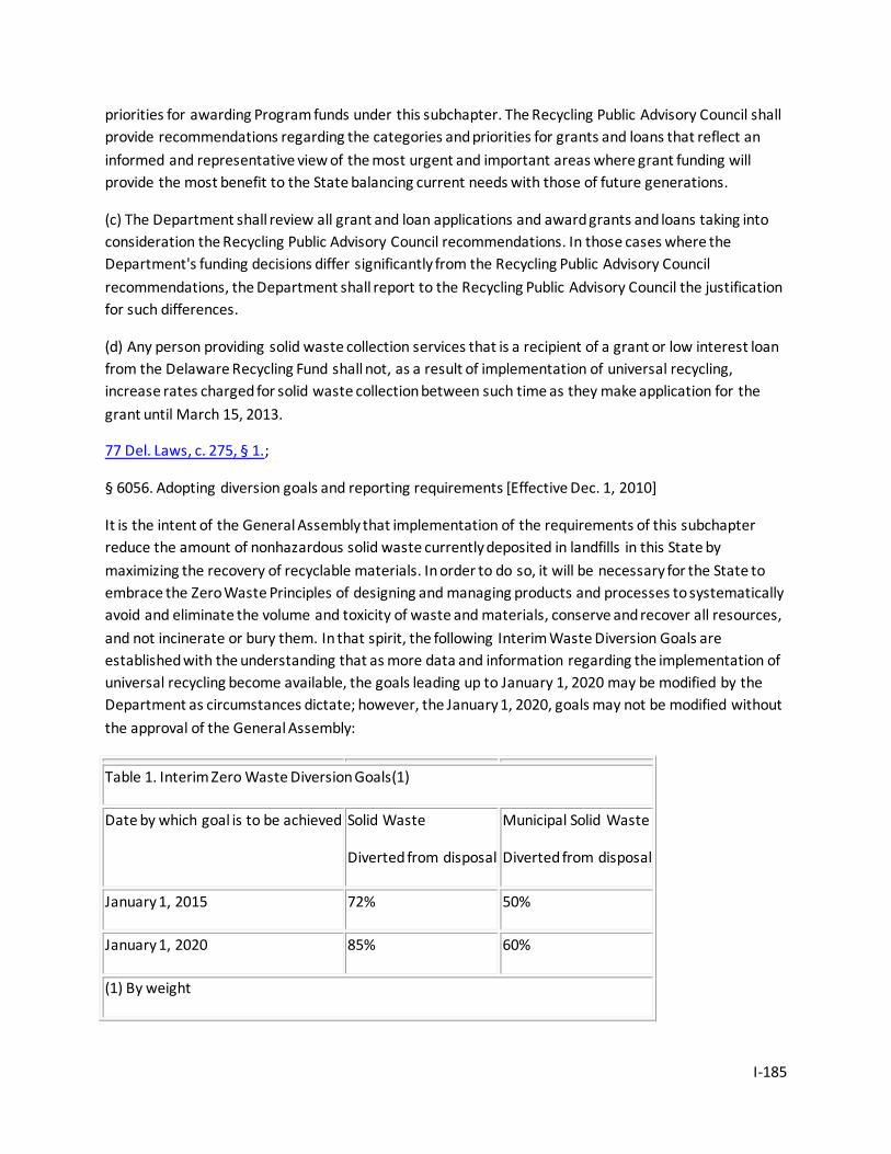
I-185
priorities for awarding Program funds under this subchapter. The Recycling Public Advisory Council shall provide recommendations regarding the categories and priorities for grants and loans that reflect an informed and representative view of the most urgent and important areas where grant funding will provide the most benefit to the State balancing current needs with those of future generations.
(c) The Department shall review all grant and loan applications and award grants and loans taking into consideration the Recycling Public Advisory Council recommendations. In those cases where the Department's funding decisions differ significantly from the Recycling Public Advisory Council recommendations, the Department shall report to the Recycling Public Advisory Council the justification for such differences.
(d) Any person providing solid waste collection services that is a recipient of a grant or low interest loan from the Delaware Recycling Fund shall not, as a result of implementation of universal recycling, increase rates charged for solid waste collection between such time as they make application for the grant until March 15, 2013.
77 Del. Laws, c. 275, § 1.;
§ 6056. Adopting diversion goals and reporting requirements [Effective Dec. 1, 2010]
It is the intent of the General Assembly that implementation of the requirements of this subchapter reduce the amount of nonhazardous solid waste currently deposited in landfills in this State by maximizing the recovery of recyclable materials. In order to do so, it will be necessary for the State to embrace the Zero Waste Principles of designing and managing products and processes to systematically avoid and eliminate the volume and toxicity of waste and materials, conserve and recover all resources, and not incinerate or bury them. In that spirit, the following Interim Waste Diversion Goals are established with the understanding that as more data and information regarding the implementation of universal recycling become available, the goals leading up to January 1, 2020 may be modified by the Department as circumstances dictate; however, the January 1, 2020, goals may not be modified without the approval of the General Assembly:
Table 1. Interim Zero Waste Diversion Goals(1)
Date by which goal is to be achieved Solid Waste
Diverted from disposal
Municipal Solid Waste
Diverted from disposal
January 1, 2015 72% 50%
January 1, 2020 85% 60%
(1) By weight
I-186
(1) In order to effectively measure the diversion rates being achieved, all persons, including persons who collect, process or market recyclables, with the exception of those specified in § 6053(5) of this title, must report to the Department on a calendar year basis, no later than February 15 of the following year, the type and quantity of recyclables managed, the method of recycling collection used (single or multiple streams), and the location of the recycling facilities used pursuant to reporting guidance developed by the Department and the Recycling Public Advisory Council. Said reporting guidance shall be developed pursuant to the solicitation of stakeholders responsible for reporting, shall take into account the need for confidentiality of the information reported and shall be finalized no later than December 1, 2010. The first recycling report shall cover calendar year 2011 and shall be due no later than February 15, 2012.
(2) In order to ensure that the waste diversion goals specified in Table 1 of this section above are achieved by the dates specified, the Department, in cooperation with the Recycling Public Advisory Council [RPAC], shall assess progress and recommend to the Governor and General Assembly any additional mechanisms necessary including but not limited to: which waste streams must be diverted from disposal; the parties responsible for ensuring the identified waste streams are diverted from disposal; the date by which the diverted waste streams must be diverted from disposal; implementation of Pay As You Throw; Extended Producer Responsibility; incentive based recycling; waste bans and related requirements. Such assessment shall be completed, inclusive of any draft legislation determined necessary, and submitted to the General Assembly no later than November 1, 2014, as part of the RPAC annual report.
77 Del. Laws, c. 275, § 1.;
§ 6057. Beverage containers -- Findings, intent, prohibitions.
(a) The General Assembly hereby finds that beverage containers are a valuable recyclable material and a major source of nondegradable litter in this State and that the collection and disposal of this litter and solid waste constitutes a great financial burden for the citizens of this State; and that, in addition to this unnecessary expenditure of tax moneys, such litter unreasonably interferes with the enjoyment of life and property by our citizens; and that the practice of littering and disposal of a recyclable material is not compatible with previously adopted policies of the State in regard to proper use and protection of our natural resources.
(b) It is the intent of the General Assembly to increase recycling significantly, inclusive of beverage containers, thereby conserving valuable natural resources, removing the blight of litter on the landscape of the State caused by the disposal of beverage containers and other packaging, and reduce the increasing costs of litter collection and disposal.
(c) Prohibitions. -- No beverage shall be sold or offered for sale in this State:
(1) In containers connected to each other with plastic rings or similar devices which are not classified by the Department as biodegradable, photodegradable or recyclable.
I-187
(2) In a beverage container which is not recyclable or refillable.
61 Del. Laws, c. 503, § 1; 64 Del. Laws, c. 57, § 1; 67 Del. Laws, c. 341, § 2; 77 Del. Laws, c. 275, § 1.;
§ 6058. Establishment, composition and responsibility of the Recycling Public Advisory Council.
(a) There is hereby established a Recycling Public Advisory Council (the "Council"). The Council shall be composed of 16 members who shall be appointed by the Governor as follows:
(1) One member from the Department;
(2) One member from the Authority;
(3) One member representing county governments, with such member being recommended by the Delaware Association of Counties;
(4) One member representing municipal governments, with such member being recommended by the Delaware League of Local Governments;
(5) One member representing the recycling industry;
(6) One member representing the waste hauling industry;
(7) Two members, 1 representing the soft drink industry and 1 representing the alcohol beverage industry, representing the beverage industry;
(8) One member representing the Delaware State Chamber of Commerce;
(9) One member representing the Delaware restaurant industry; and
(10) Five members representing community-based or public-interest groups.
(11) One member representing the Delaware Food Industry Council.
(b) Members of the Council, except for those appointed pursuant to paragraphs (a)(1) and (2) of this section above, shall serve for terms up to 3 years and may not serve more than 2 consecutive terms but may again serve after 1 year off of the Council. Members shall be appointed for staggered terms so that no more than 5 appointments shall expire in any 1 calendar year. Members may be reimbursed for travel to and from meetings. The Governor shall appoint a Chairman from among the 16 members. Actions of the Council shall be approved by a majority vote of the Council. At least 9 members of the Council shall constitute a quorum. The Council may adopt bylaws as it deems appropriate to serve the purposes of this subchapter.
(c) The Recycling Public Advisory Council shall:
(1) Advise the Department and the Authority on all aspects of recycling;
I-188
(2) Advise the Department in developing criteria for the Recycling Grants and Low Interest Loan Program and selection of applications as well as provide an annual assessment of the revenue needed to satisfy the grant requirements;
(3) Maintain, in conjunction with the Department and the Authority, a methodology for measuring recycling rates;
(4) Provide advice and recommendations regarding the recycling outreach and education programs conducted by the Authority and/or the Department;
(5) Report to the Governor and the General Assembly annually by November 1 of each year on the status of recycling activities in Delaware. Said report shall include, but not be limited to the following:
a. Status of attainment of the recycling goals specified in § 6056 of this title;
b. An accounting of the recycling grants and loan program and any recommendations for future funding of the grants and loan program;
c. An assessment of the activities of both the Department and the Authority in achieving the recycling goals specified in § 6056 of this title;
d. An objective, auditable accounting of recycling rates for total solid waste, municipal solid waste, and residential solid waste;
e. Such other recommendations as the Council shall deem appropriate; and
f. Use the definitions of "recycling" and "municipal solid waste" as stated by the United States Environmental Protection Agency in its document EPA530-R-97-011 dated September 1997. The Council shall be able to adopt changes to these definitions.
(d) The Department, in concert with the Authority and the Council, shall:
(1) Monitor the State's recycling initiatives and measure Delaware's achievements toward attainment of the recycling goals specified in § 6056 of this title;
(2) Design and implement public educational efforts aimed at increasing public awareness of recycling opportunities;
(3) Provide technical assistance to local entities to assist them in increasing their recycling rates; and
(4) Provide administrative support to the Council.
77 Del. Laws, c. 275, § 1.;
§ 6059. Enforcement, civil and administrative penalties.
(a) Whoever violates this subchapter, or any rule or regulation promulgated there under, or any order of the Secretary, shall:
I-189
(1) For the first conviction, be fined not less than $100 nor more than $500 for each day of violation;
(2) For each subsequent conviction for the same offense within a 10-year period, be fined not less than $500 nor more than $1,500 for each day of violation;
(3) In the Secretary's discretion, the Secretary may endeavor by conciliation to obtain compliance with all requirements of this subchapter. Conciliation shall be giving written notice to the responsible party:
a. Specifying the complaint;
b. Proposing a reasonable time for its correction;
c. Advising that a hearing on the complaint may be had if requested by a date stated in the notice; and
d. Notifying that a proposed correction date will be ordered unless a hearing is requested.
If no hearing is requested on or before the date stated in the notice, the Secretary may order that the correction be fully implemented by the proposed date or may, on the Secretary's own initiative, convene a hearing, in which the Secretary shall publicly hear and consider any relevant submission from the responsible party as provided in § 6006 of this title.
(b) Any person whose interest is substantially affected by any action of the Secretary may appeal to the Environmental Appeals Board, in accordance with § 6008 of this title.
61 Del. Laws, c. 503, § 1; 68 Del. Laws, c. 146, § 1; 70 Del. Laws, c. 186, § 1; 77 Del. Laws, c. 275, § 1.;
Subchapter IV. Ocean Dumping
§ 6070. Title.
This subchapter shall be known as the "Solid Waste Dumping Elimination Act."
67 Del. Laws, c. 135, § 1; 68 Del. Laws, c. 121, § 1.;
§ 6071. Purpose.
The General Assembly finds that historically millions of tons of solid wastes have been disposed of in the ocean and waters of the State, that these wastes are not land disposed in recognition of the threat posed by the presence of contaminants, by the lack of knowledge or appreciation of the harm such wastes can cause to the marine environment, or that it is cheaper to dispose of such wastes in the ocean or other waters of the State. Therefore, it is the intent of the General Assembly to prohibit the disposal of solid wastes in the ocean and other waters of the State.
67 Del. Laws, c. 135, § 1; 68 Del. Laws, c. 121, § 1.;
§ 6072. Definitions.
I-190
The following words and phrases shall have the meanings ascribed to them in this subchapter unless the context clearly indicates otherwise:
(1) "Inland bays" shall mean the Rehoboth Bay, Indian River Bay, Indian River and Little Assawoman Bay.
(2) "Waters of exceptional recreational or ecological significance" shall mean waters designated by the State which are important, unique or sensitive from a recreational and/or ecological perspective, but which may or may not have excellent water quality. Such waters shall normally have regional significance with respect to recreational use (fishing, swimming and boating), or have significant or widespread riverine, riparian or wetland natural areas.
68 Del. Laws, c. 121, § 1.;
§ 6073. Prevention.
The provisions of any other law, rule or regulation to the contrary notwithstanding, all disposal of solid wastes into the ocean waters of the State, the Delaware Bay, the inland bays and waters of exceptional recreational or ecological significance is hereby prohibited.
67 Del. Laws, c. 135, § 1; 68 Del. Laws, c. 121, § 1.;
§ 6074. Penalties.
(a) Whoever negligently violates § 6073 of this title shall be fined not less than $2,500 nor more than $25,000 per day of violation, or be imprisoned for not more than 1 year, or both. If a conviction of a person is for a violation committed after a prior conviction of such person under this section, punishment shall be by a fine of not less than $5,000 nor more than $50,000 per day of violation, or by imprisonment of not more than 2 years, or both.
(b) Whoever knowingly violates § 6073 of this title shall be fined not less than $5,000 nor more than $50,000 per day of violation, or be imprisoned for no more than 3 years, or both. If a conviction of a person is for a violation committed after a prior conviction of such person under this section, punishment shall be by a fine of not less than $10,000 nor more than $100,000 per day of violation, or by imprisonment of not more than 6 years, or both.
(c) The Superior Court shall have jurisdiction over violations of § 6073 of this title.
(d) There shall be no suspension of any fines required under the provisions of this section.
67 Del. Laws, c. 135, § 1; 68 Del. Laws, c. 121, § 1.;
Subchapter V. Water Utilities
§ 6075. Nonutility wells and permits for nonutility wells within a service territory served by a water utility under a certificate of public convenience and necessity.
I-191
(a) The Department may not withhold a permit for a potable water well within the service territory served by a water utility under a certificate of public convenience and necessity, or require an applicant for a potable water well permit in an area served by a water utility to utilize the services of the utility, unless:
(1) The Delaware Geological Survey or the Department of Health and Social Services certifies that the ground water supply is inadequate or unsuitable for the intended use for which the permit is being sought;
(2) The water utility demonstrates to the satisfaction of the Department that it can provide service of equal or better quality at lower cost; or
(3) The permit applicant is a resident of a municipality, a county water district authority, or a recorded development where public water is available.
(b) Notwithstanding paragraphs (a)(2) and (3) of this section, following the issuance of a certificate of public convenience and necessity to a water utility, the Department shall not withhold a potable water well permit from any person seeking to construct or extend a well on a farm, farmland or the lands of any existing mobile home community, or an addition, modification or extension of that mobile home community, which as of April 11, 2000, self-supplied potable water under existing permits in an area served by a water utility, nor shall it require that the person utilize the services of the utility. However, this subsection shall not authorize or require the issuance of a potable well permit that would enable a person or entity to act as a water utility without a duly issued certificate of public convenience and necessity.
(c) Notwithstanding any other provision of this section, following the issuance of a certificate of public convenience and necessity to a water utility, the Department shall not withhold a nonpotable water well permit from any person seeking to construct or extend a nonpotable water well in an area serviced by a water utility, subject to the provisions of subsection (d) of this section.
(d) Following the issuance of a nonpotable water well permit in an area for which a certificate of public convenience and necessity has been issued, the Secretary shall send a copy of the permit, with conditions, to the water utility providing water to that area. This notification requirement shall not apply to permits issued for monitor, observation, recovery and dewatering wells. All nonpotable water well permits issued in such an area shall include the following conditions:
(1) Water taken from the well is not to be used for human consumption;
(2) The well shall not, at anytime, be interconnected with any portion of any building's plumbing and/or any water utility's service connection;
(3) Representatives of the Secretary and the water utility that services the certificated area may inspect the well at any reasonable time to insure that there are not interconnections; and
I-192
(4) That the permit is subject to revocation upon any violation of its permit conditions, and upon revocation, the Secretary shall order that the well will be abandoned.
(e) The Secretary may enforce this section under § 6005 of this title. Violations of this section may be sanctioned under the provisions of §§ 6005 and 6013 of this title.
72 Del. Laws, c. 402, § 2.;
§ 6076. Transfer of jurisdiction for certificates of public convenience and necessity for water utilities to the Public Service Commission.
On and after July 1, 2001, the Department and Secretary shall no longer have jurisdiction to issue certificates of public convenience and necessity to water utilities. On such date, the jurisdiction to issue certificates of public convenience and necessity shall be vested in the Public Service Commission. On such date, the Public Service Commission shall also be vested with the jurisdiction, to the extent described in Chapter 1 of Title 26, to issue, suspend and revoke certificates issued to water utilities. The process of reviewing requests for certificates, however, shall include coordination and cooperation by the Commission with the Department of Natural Resources and Environmental Control and the Division of Public Health.
72 Del. Laws, c. 402, § 3.;
§§ 6077-6080. Issuance of certificate; limitations; powers of the Public Service Commission with respect to water utilites; public hearings; rules for conduct; application fee.
Repealed by 72 Del. Laws, c. 402, § 1, effective July 1, 2001.
Subchapter VI. Source Water Protection
§ 6081. Reporting on source water protection.
(a) The Secretary shall prepare, periodically, a report to the Governor and General Assembly, beginning in 2003, of the potential threats, including contaminants currently not regulated, to public drinking water systems. The report shall identify actions that the Secretary proposes to control these threats.
(b) The Secretary shall periodically prepare a report to the respective counties and municipalities, beginning in 2003, that denotes the availability of source water assessments completed by the Department. The Secretary shall also report on the status of the Ground-Water Recharge Potential Mapping Project.
73 Del. Laws, c. 67, § 2; 70 Del. Laws, c. 186, § 1.;
§ 6082. Adoption of source water assessment, wellhead protection, and excellent ground-water recharge potential areas by counties and municipalities.
(a) By December 31, 2004, the Department shall develop a guidance manual, in conjunction with and with the substantial concurrence of the Source Water Protection Citizens Technical Advisory Committee,
I-193
for desirable land uses within source water assessment areas that promote the long-term protection of public drinking water supplies, consistent with "Shaping Delaware's Future: Managing Growth in 21st Century Delaware, Strategies for State Policies and Spending" (December 1999).
(b) The counties and municipalities with populations of 2,000 persons or more, with the assistance of the Department, shall adopt as part of the update and implementation of the 2007 Comprehensive Land Use Plans, the overlay maps delineating, as critical areas, source water assessment, wellhead protection and excellent ground-water recharge potential areas. Furthermore, the counties and municipalities shall adopt, by December 31, 2007, regulations governing the use of land within those critical areas designed to protect those critical areas from activities and substances that may harm water quality and subtract from overall water quantity.
(c) Municipalities with populations of less than 2,000 persons, with the assistance of the Department, may adopt by ordinance the overlay maps delineating, as critical areas, source water assessment, wellhead protection, and excellent ground-water recharge potential areas. Furthermore, the ordinance shall include regulations governing the use of land within those critical areas designed to protect those critical areas from activities and substances that may harm water quality and subtract from overall water quantity. Counties and municipalities of more than 2,000 persons that have previously adopted ordinances that include the Department's overlay maps and regulations that protect public water supplies and are consistent with minimum standards identified in the guidance manual shall be exempt from the provisions of this subsection.
(d) The Department shall make source water assessment areas available to the public as they are completed, with all systems to be completed by 2003.
(e) The Department may, when based on sound science and factual information, revise and update the overlay maps of source water assessment areas.
(f) Counties and municipalities with populations of 2,000 persons or more shall update their overlay maps in accordance with changes made by the Department with respect to source water assessment, wellhead protection and excellent ground-water recharge potential areas.
(g) Municipalities with populations of less than 2,000 persons may update their overlay maps in accordance with changes made by the Department with respect to source water assessment, wellhead protection, and excellent ground-water recharge potential areas.
73 Del. Laws, c. 67, § 2; 70 Del. Laws, c. 186, § 1.;
§ 6083. Adoption of source water assessment, wellhead protection and excellent ground-water recharge potential areas by the Governor's Cabinet Committee on State Planning Issues.
The Department shall make source water assessment, wellhead protection and excellent ground-water recharge potential area delineations available for maps developed as part of "Shaping Delaware's Future: Managing Growth in 21st Century Delaware, Strategies for State Policies and Spending" (December 1999)
I-194
73 Del. Laws, c. 67, § 2; 70 Del. Laws, c. 186, § 1.;
§ 6084. Source Water Protection Citizen and Technical Advisory Committee.
The Secretary shall consult a citizen and technical advisory committee, as established by the Delaware Source Water Assessment Plan, on matters related to the implementation of the Source Water Assessment Plan and the requirements of this statute.
73 Del. Laws, c. 67, § 2; 70 Del. Laws, c. 186, § 1.;
Subchapter VII. Labeling of Plastic Products
§ 6090. Findings; intent.
(a) The General Assembly finds that:
(1) Recycling of waste materials is preferable to incinerating or landfilling those materials because recycling conserves valuable resources, saves energy in the manufacturing process and extends the life of disposal facilities;
(2) Increased recycling is necessary in Delaware to meet the EPA's national goal of a 25% reduction of the solid waste stream;
(3) Plastics have been shown to be recyclable;
(4) One of the barriers to increased recycling of plastics is the necessity of keeping the various types of plastic separate, based on the resin from which they are made; and
(5) The Society of the Plastics Industry, Inc., has devised a coding system that can be used to label plastic containers so as to identify the type of resin from which they are made.
(b) It is the intent of the General Assembly to facilitate the recycling of plastic containers by requiring that these containers be labeled according to resin type.
68 Del. Laws, c. 174, § 1.;
§ 6091. Definitions.
As used in this subchapter, unless otherwise indicated:
(1) "Container" means a "rigid plastic container" or a "plastic bottle" as those terms are defined in this section.
(2) "Department" means the Department of Natural Resources and Environmental Control.
(3) "Label" means a molded, imprinted or raised symbol on or near the bottom of a rigid plastic container or plastic bottle.
I-195
(4) "Person" means any individual, trust, firm, joint stock company, federal agency, partnership, corporation (including a government corporation), association, state, municipality, commission, political subdivision of a state or any interstate body.
(5) "Plastic" means any material made of polymeric organic compounds and additives that can be shaped by flow.
(6) "Plastic bottle" means a plastic container intended for single use that has a neck that is smaller than the body of the container; accepts a screw-type cap, snap cap or other closure; and has a capacity of 16 fluid ounces or more, but less than 5 gallons.
(7) "Rigid plastic container" means any formed or molded container, other than a bottle, intended for single use, composed predominantly of plastic resin and having a relatively inflexible finite shape or form with a capacity of 8 ounces or more but less than 5 gallons.
(8) "Secretary" means the Secretary of the Department of Natural Resources and Environmental Control.
68 Del. Laws, c. 174, § 1.;
§ 6092. Labeling.
(a) On or after July 1, 1992, no person shall distribute, sell or offer for sale in this State any plastic bottle or rigid plastic container unless such container is labeled with a code identifying the appropriate resin type used to produce the structure of the container. The code shall consist of a number placed within 3 triangulated arrows and a letter placed below the triangle of arrows. The triangulated arrows shall be equilateral, formed by 3 arrows with the apex of each point of the triangle at the midpoint of each arrow, rounded with a short radius. The pointer (arrowhead) of each arrow shall be at the midpoint of each side of the triangle with a short gap separating the pointer from the base of the adjacent arrow. The triangle, formed by the 3 arrows curved at their midpoints, shall depict a clockwise path around the code number. The numbers and letters used shall be as follows:
1 = PETE (polyethylene threphthalate)
2 = HDPE (high density polyethylene)
3 = V (vinyl)
4 = LDPE (low density polyethylene)
5 = PP (polypropylene)
6 = PS (polystyrene)
7 = Other
(b) The Department shall maintain a list of the label codes provided in subsection (a) of this section and shall provide a copy of the list to any person upon request.
I-196
(c) The provisions of this section and any rules or regulations adopted hereunder shall be interpreted to conform with nationwide plastics industry standards.
68 Del. Laws, c. 174, § 1.;
§ 6093. Penalty; enforcement.
(a) Any person who violates this subchapter or any rule or regulation duly promulgated thereunder or any order of the Secretary issued pursuant to this subchapter shall be punishable as follows:
(1) If a violation has been completed, by a civil penalty imposed by the Justice of the Peace Court of not less than $250 nor more than $1,000 for each completed violation. The Secretary may also seek a permanent or preliminary injunction or temporary restraining order in the Court of Chancery.
(2) If a violation is continuing, the Secretary may seek a monetary penalty as provided in paragraph (a)(1) of this section. If a violation is continuing or is threatened, the Secretary may also seek a temporary restraining order or permanent injunction in the Court of Chancery.
(b) The Secretary shall have the authority to enforce this subchapter.
68 Del. Laws, c. 174, § 1.;
Subchapter VIII. Clean Air Act Title V Operating Permit Program
§ 6095. Applicability.
This subchapter shall apply to all sources required to obtain a Title V Operating Permit pursuant to the federal Clean Air Act Amendments of 1990. Such sources shall include, but not be limited to, the following:
(1) Sulfuric acid plants; municipal incinerators; fossil-fuel burners; petroleum storage and transfer units with a total storage capacity exceeding 300,000 barrels; petroleum refineries; sulfur recovery plants; chemical process plants;
(2) For pollutants other than radionuclides, any stationary source or group of stationary sources located within a contiguous area and under common control or common ownership consistent with the requirements of 40 C.F.R. Part 70, that emits or has the potential to emit, in the aggregate, 10 tons per year (tpy) or more of any hazardous air pollutant which has been listed pursuant to Title I, § 112(b) of the Clean Air Act Amendments of 1990, Public Law 101-549, 25 tpy or more of any combination of such hazardous air pollutants, or such lesser quantity as the Department may establish by regulation;
(3) A source that directly emits or has the potential to emit, 100 tpy or more of any air pollutant, including any major source of fugitive emissions of any such pollutant, as the Department may establish by regulation;
(4) For ozone nonattainment areas, sources with the potential to emit 100 tpy or more of volatile organic compounds or oxides of nitrogen in areas classified as "marginal" or "moderate," 50 tpy or more
I-197
in areas classified as "serious," 25 tpy or more in areas classified as "severe," and sources subject to the requirements for preconstruction review; except that the references in this paragraph to 100, 50, and 25 tpy of nitrogen oxides shall not apply with respect to any source for which the Department has made a finding, pursuant to regulations, that requirements under this section do not apply;
(5) For areas within the northeast transport region, sources with the potential to emit 50 tpy or more of volatile organic compounds; or
(6) Any other sources designated by the Department or mandated for designation by the United States Environmental Protection Agency.
69 Del. Laws, c. 121, § 1.;
§ 6096. Title V account.
The Secretary shall establish a separate account entitled the "Clean Air Act Title V Operating Permit Program Account," hereinafter the "Account." All fees collected under this subchapter shall be deposited into this account and utilized solely to cover all direct and indirect costs required to support the Title V Operating Permit Program, hereinafter "Program." Any civil or administrative penalties or costs recovered as a result of a violation of a Title V permit shall be used to further the goals and purposes of the Department to promote clean air for the citizens of Delaware.
69 Del. Laws, c. 121, § 1.;
§ 6097. Fees.
(a) The Department shall collect an annual fee from sources that are required to obtain a Title V Operating Permit pursuant to the Title V Program and from sources who voluntarily limit their potential to emit to below Title V applicability thresholds as set forth in § 6095 of this title (i.e., a synthetic minor facility). The annual fees shall be utilized solely to pay for all direct and indirect costs required to develop, administer and implement the Program.
(b) The fee schedule must result in the collection and retention of revenues sufficient to cover the permit program costs. These costs include, but are not limited to, the costs of the following activities, as they relate to the operating permit program for stationary sources: preparing generally applicable regulations or guidance documents regarding the permit program or its implementation or enforcement; reviewing and acting on any application for a permit, permit revision or permit renewal, including the development of an applicable requirement as part of the processing of a permit or permit revision or renewal; general administrative costs of implementing the permit program, including the supporting and tracking of data; implementing and enforcing the terms of any Title V Operating Permit (not including any court costs or other costs associated with an enforcement action), including adequate resources to determine which sources are subject to the program; emissions and ambient monitoring; modeling; preparing inventories and tracking emissions; and supporting the ombudsman established pursuant to the Small Business Stationary Source Technical and Environmental Compliance Program
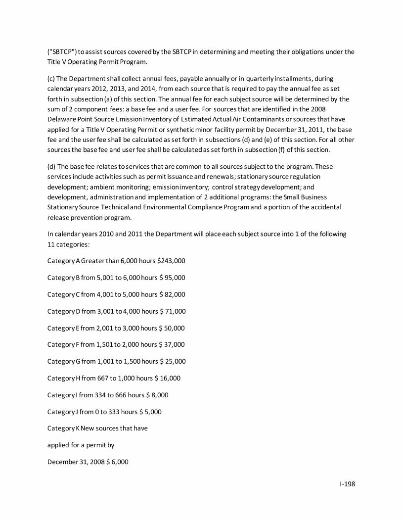
I-198
("SBTCP") to assist sources covered by the SBTCP in determining and meeting their obligations under the Title V Operating Permit Program.
(c) The Department shall collect annual fees, payable annually or in quarterly installments, during calendar years 2012, 2013, and 2014, from each source that is required to pay the annual fee as set forth in subsection (a) of this section. The annual fee for each subject source will be determined by the sum of 2 component fees: a base fee and a user fee. For sources that are identified in the 2008 Delaware Point Source Emission Inventory of Estimated Actual Air Contaminants or sources that have applied for a Title V Operating Permit or synthetic minor facility permit by December 31, 2011, the base fee and the user fee shall be calculated as set forth in subsections (d) and (e) of this section. For all other sources the base fee and user fee shall be calculated as set forth in subsection (f) of this section.
(d) The base fee relates to services that are common to all sources subject to the program. These services include activities such as permit issuance and renewals; stationary source regulation development; ambient monitoring; emission inventory; control strategy development; and development, administration and implementation of 2 additional programs: the Small Business Stationary Source Technical and Environmental Compliance Program and a portion of the accidental release prevention program.
In calendar years 2010 and 2011 the Department will place each subject source into 1 of the following 11 categories:
Category A Greater than 6,000 hours $243,000
Category B from 5,001 to 6,000 hours $ 95,000
Category C from 4,001 to 5,000 hours $ 82,000
Category D from 3,001 to 4,000 hours $ 71,000
Category E from 2,001 to 3,000 hours $ 50,000
Category F from 1,501 to 2,000 hours $ 37,000
Category G from 1,001 to 1,500 hours $ 25,000
Category H from 667 to 1,000 hours $ 16,000
Category I from 334 to 666 hours $ 8,000
Category J from 0 to 333 hours $ 5,000
Category K New sources that have
applied for a permit by
December 31, 2008 $ 6,000
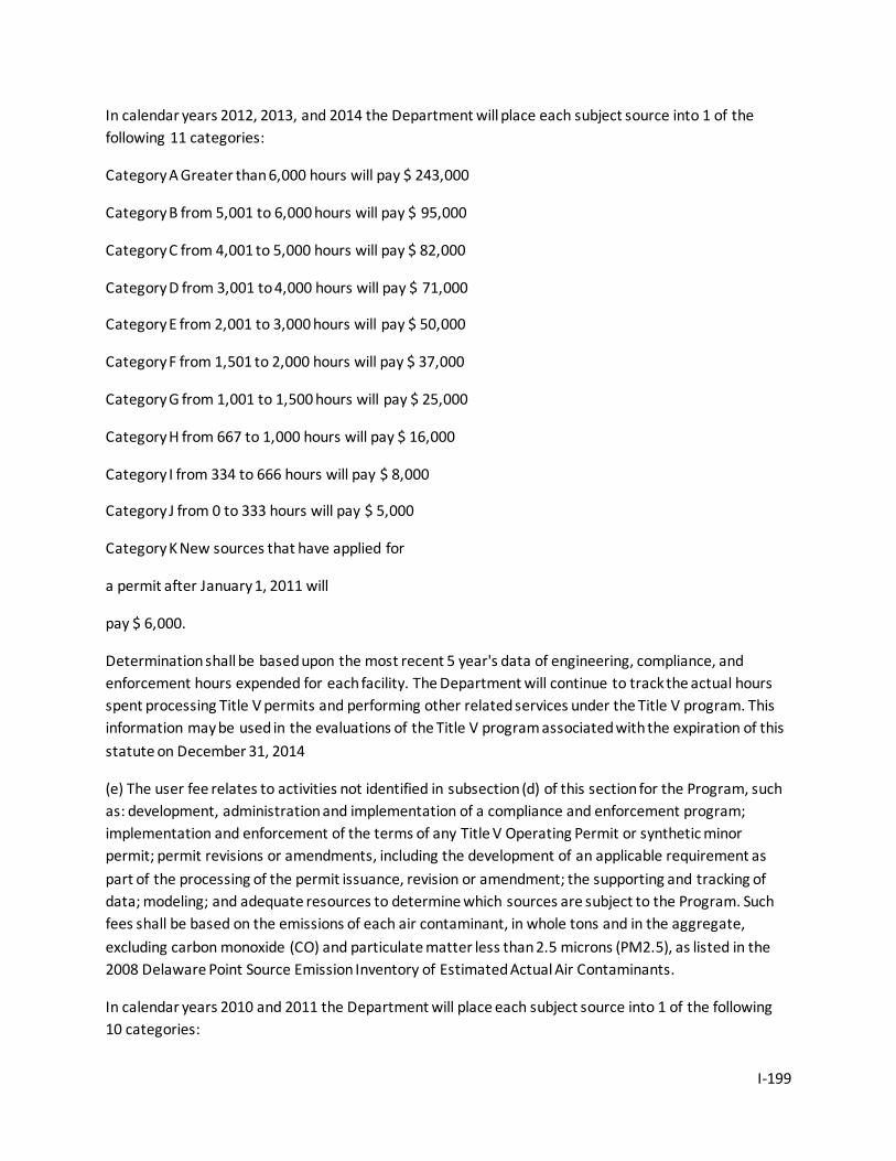
I-199
In calendar years 2012, 2013, and 2014 the Department will place each subject source into 1 of the following 11 categories:
Category A Greater than 6,000 hours will pay $ 243,000
Category B from 5,001 to 6,000 hours will pay $ 95,000
Category C from 4,001 to 5,000 hours will pay $ 82,000
Category D from 3,001 to 4,000 hours will pay $ 71,000
Category E from 2,001 to 3,000 hours will pay $ 50,000
Category F from 1,501 to 2,000 hours will pay $ 37,000
Category G from 1,001 to 1,500 hours will pay $ 25,000
Category H from 667 to 1,000 hours will pay $ 16,000
Category I from 334 to 666 hours will pay $ 8,000
Category J from 0 to 333 hours will pay $ 5,000
Category K New sources that have applied for
a permit after January 1, 2011 will
pay $ 6,000.
Determination shall be based upon the most recent 5 year's data of engineering, compliance, and enforcement hours expended for each facility. The Department will continue to track the actual hours spent processing Title V permits and performing other related services under the Title V program. This information may be used in the evaluations of the Title V program associated with the expiration of this statute on December 31, 2014
(e) The user fee relates to activities not identified in subsection (d) of this section for the Program, such as: development, administration and implementation of a compliance and enforcement program; implementation and enforcement of the terms of any Title V Operating Permit or synthetic minor permit; permit revisions or amendments, including the development of an applicable requirement as part of the processing of the permit issuance, revision or amendment; the supporting and tracking of data; modeling; and adequate resources to determine which sources are subject to the Program. Such fees shall be based on the emissions of each air contaminant, in whole tons and in the aggregate, excluding carbon monoxide (CO) and particulate matter less than 2.5 microns (PM2.5), as listed in the 2008 Delaware Point Source Emission Inventory of Estimated Actual Air Contaminants.
In calendar years 2010 and 2011 the Department will place each subject source into 1 of the following 10 categories:
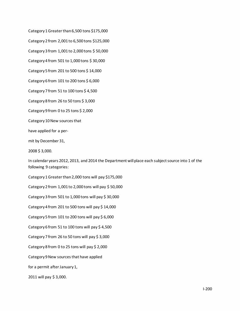
I-200
Category 1 Greater than 6,500 tons $175,000
Category 2 from 2,001 to 6,500 tons $125,000
Category 3 from 1,001 to 2,000 tons $ 50,000
Category 4 from 501 to 1,000 tons $ 30,000
Category 5 from 201 to 500 tons $ 14,000
Category 6 from 101 to 200 tons $ 6,000
Category 7 from 51 to 100 tons $ 4,500
Category 8 from 26 to 50 tons $ 3,000
Category 9 from 0 to 25 tons $ 2,000
Category 10 New sources that
have applied for a per-
mit by December 31,
2008 $ 3,000.
In calendar years 2012, 2013, and 2014 the Department will place each subject source into 1 of the following 9 categories:
Category 1 Greater than 2,000 tons will pay $175,000
Category 2 from 1,001 to 2,000 tons will pay $ 50,000
Category 3 from 501 to 1,000 tons will pay $ 30,000
Category 4 from 201 to 500 tons will pay $ 14,000
Category 5 from 101 to 200 tons will pay $ 6,000
Category 6 from 51 to 100 tons will pay $ 4,500
Category 7 from 26 to 50 tons will pay $ 3,000
Category 8 from 0 to 25 tons will pay $ 2,000
Category 9 New sources that have applied
for a permit after January 1,
2011 will pay $ 3,000.
I-201
(f) Sources not included in the 2008 Delaware Point Source Emission Inventory of Estimated Actual Regulated Air Contaminants or sources that have not applied for a Title V Operating Permit or synthetic minor facility permit by December 31, 2011, shall be assessed a base fee that is consistent with the categories and amounts specified in subsection (d) of this section. The estimated hours on which the base fee assessment is calculated shall include an evaluation of specific regulatory applicability to the source. This shall include, but is not limited to, the following: new source review; new source performance standards; toxic requirements, to include maximum achievable control technology and National Emission Standards for Hazardous Air Pollutants; and continuous emission monitoring requirements. Such sources shall also be assessed a user fee based upon allowable emissions specified in its permit that is consistent with the categories and amounts specified in subsection (e) of this section.
(g) These fees may be increased on an annual basis by no more than the Federal Consumer Price Index for the previous calendar year. Any increases in fees are subject to review and approval by the committee established pursuant to § 6098 of this title. After December 31, 2014, no fees shall be collected pursuant to this section unless authorized by a further act of the General Assembly. The Department shall consult with the Title V Operating Permit Program Advisory Committee prior to any proposed increase to the complement of full-time equivalent employees funded in whole or in part by the Program.
(h) Annual fees must be paid in full by the end of each calendar year 2012, 2013 and 2014. Any delinquent subject source shall be subject to a 2% compounding monthly interest rate for each month overdue. Subject sources delinquent for more than one year may be subject to permit cancellation.
(i) In determining the amount of tons of actual emissions, the Department shall not be required to include any amount of air contaminant emitted by any source in excess of 4,000 tons per year of that air contaminant. The determination of common control or common ownership shall be consistent with the requirements of 40 C.F.R. Part 70.
(j) Any funds collected under this section shall be deposited in the account as described in § 6096 of this title, shall be interest earning, and shall be used solely to develop, administer and implement the Program. The Secretary shall cause an audit of the fiscal affairs to be made annually and shall furnish a copy of such audit report together with such additional information or data with respect to the affairs as the Secretary may deem desirable to the Title V Operating Permit Program Advisory Committee.
(k) The Department will continue to track for each source the actual hours spent processing Title V permits and performing other related services under the Title V program and shall, as part of the annual fee assessment, provide each source with the number of said hours expended during the preceding year. The Division of Air Quality will develop, by May 1 of each year, the overall program costs, the fees collected, current staffing levels, program accomplishments, and each subject source's total hours for the preceding calendar year in report form and present this report at an annual meeting with the Title V Operating Permit Program Advisory Committee. The Division of Air Quality shall publish a notice announcing the availability of the report in a paper of general circulation throughout the State.
I-202
Additionally, the Division shall mail a copy of said notice to the personnel on the Division of Air Quality's mailing lists.
(l) The Program shall be reviewed by an independent third party, to be approved by the committee established pursuant to § 6099 of this title. This review shall not be funded from the fees collected under the Program.
69 Del. Laws, c. 121, § 1; 70 Del. Laws, c. 8, §§ 1, 2; 70 Del. Laws, c. 186, § 1; 72 Del. Laws, c. 214, § 1; 73 Del. Laws, c. 318, § 1; 73 Del. Laws, c. 381, § 1; 75 Del. Laws, c. 172, §§ 1-5; 76 Del. Laws, c. 73, § 1; 76 Del. Laws, c. 312, § 1-7; 77 Del. Laws, c. 430, §§ 54, 55; 78 Del. Laws, c. 110, §§ 1-15.;
§ 6098. Permit shield.
Except for sources required to have a permit before construction or modification under the applicable requirements of this subchapter, if an applicant has submitted a timely and complete application for a permit required by this title (including renewals), but final action has not been taken on such application, the source's failure to have a permit shall not be a violation of this subchapter, unless the delay in final action was due to the failure of the applicant to timely submit information required or requested to process the application.
72 Del. Laws, c. 214, § 3.;
§ 6099. Title V Operating Permit Program Advisory Committee.
There shall be established a "Title V Operating Permit Program Advisory Committee," hereinafter referred to as "Committee." The Committee members shall be appointed by the Governor and shall include, but not be limited to, the Secretary of the Department of Natural Resources and Environmental Control, or the Secretary's duly appointed designee; the Director of the Division of Air Quality, or the Director's duly appointed designee; 2 members who will represent stationary sources; 1 to be a member of the Chemical Industry Council; a member of the Delaware State Chamber of Commerce; a member representing a public utility; 2 members of a nationally affiliated or state environmental advocacy group; and the chairpersons of the House and the Senate Natural Resource Committees. The Secretary of the Department of Natural Resources and Environmental Control shall serve as the Chair of this Committee. The Committee shall provide the Governor and the General Assembly with a report on or before February 1 of each year, for the previous calendar year, identifying the amounts and sources of fees collected pursuant to § 6097 of this title, the expenditures made by the Department to implement the Program, information regarding the performance of the Program, whether the fees collected by § 6097 of this title are adequate to ensure the effective implementation of the Program, and recommendations to remedy or improve any deficiencies or elements of the Program.
69 Del. Laws, c. 121, § 1; 70 Del. Laws, c. 8, § 3; 70 Del. Laws, c. 186, § 1; 72 Del. Laws, c. 214, §§ 2, 4; 73 Del. Laws, c. 381, § 2; 76 Del. Laws, c. 312, § 8; 77 Del. Laws, c. 430, § 56; 78 Del. Laws, c. 110, § 16.;
Subchapter IX. Recycling and Waste Reduction
I-203
§ 6099A. At-store recycling program [Effective Dec. 1, 2009, until Dec. 2, 2014; but see subsection (i) of this section]
(a) For purposes of this subchapter, the following definitions shall apply:
(1) "Manufacturer" means the producer of a plastic carryout bag sold to a store.
(2) "Plastic carryout bag" means a plastic carryout bag provided by a store to a customer at the point of sale.
(3) "Reusable bag" means either of the following:
a. A bag made of cloth or other fabric that has handles and is designed and manufactured to be used repeatedly.
b. A durable plastic bag with handles that is at least 2.25 mils thick and is designed and manufactured to be used repeatedly.
(4) "Store" means a retail establishment, excluding a restaurant, engaged in the business of selling or exchanging goods and/or services for cash, barter or any form of consideration on the assumption that the purchaser of such goods and/or services has acquired the goods and/or services for ultimate consumption or use and not resale that provides plastic carryout bags to its customers in conjunction with the sale of such goods and/or services and that meets either of the following requirements:
a. Has at least 7,000 square feet of retail sales space, or
b. Has 3 or more stores or retail locations, each having at least 3,000 square feet of retail sales space, in the State.
(b) The store shall establish an at-store recycling program pursuant to this section that permits a customer of the store to return clean plastic carryout bags to the store.
(c) A retail establishment that does not meet the definition of a store, as defined herein, and that provides plastic carryout bags to customers at the point of sale may adopt a similar at-store recycling program, as specified in this section.
(d) An at-store recycling program provided by a store shall include all of the following:
(1) By August 1, 2010, all plastic carryout bags provided by the store to a customer shall have printed or displayed on the bag, in a manner conspicuously visible to a consumer, the words "PLEASE RETURN THIS BAG TO A PARTICIPATING STORE FOR RECYCLING", or a similar message encouraging the reuse or recycling of plastic carryout bags.
(2) A plastic carryout bag collection bin shall be placed at each store and shall be visible, easily accessible to the consumer, and clearly marked that the collection bin is available for the purpose of collecting and recycling plastic carryout bags.
I-204
(3) All plastic carryout bags collected by the store shall be collected and recycled in a manner consistent with the intent of this section. In no instance shall a store permit collected plastic carryout bags to be disposed of or to further any act other than the recycling of such bags.
(4) The store shall maintain records describing the collection and recycling of plastic carryout bags collected by such store and shall make the records available to the Department of Natural Resources and Environmental Control (DNREC), upon request, to demonstrate compliance with this section.
(5) The store shall make reusable bags available to customers within the store, which bags may be purchased by such customer and used in lieu of using a plastic carryout bag or paper bag. This subsection is not applicable to a retail establishment specified pursuant to subsection (c) of this section above.
(e) The manufacturer of a plastic carryout bag shall provide educational materials to all stores required to comply with this section to encourage the reduction, reuse, and recycling of plastic carryout bags and the stores shall place such materials in a conspicuous location, visible to the customers of such store.
(f)(1) Unless expressly authorized by this section, a county, city, or other public agency shall not adopt, implement, or enforce an ordinance, resolution, regulation, or rule to do any of the following:
a. Require a store that is in compliance with this section to collect, transport, or recycle plastic carryout bags.
b. Impose a plastic carryout bag fee upon a store that is in compliance with this section.
c. Impose auditing or reporting requirements upon a store that are in addition to those set forth in paragraph (d)(4) of this section.
(2) This section does not prohibit the adoption, implementation, or enforcement of any county, city or other local ordinance, resolution, regulation, or rule governing curbside or drop off recycling programs operated by, or pursuant to a contract with, a county, city, or other public agency, including any action relating to fees for these programs.
(3) This section does not affect any contract, franchise, permit, license, or other arrangement regarding the collection or recycling of solid waste or household hazardous waste.
(g)(1) A violation of this section, with such determination thereof being made by DNREC, shall result in civil liability or administrative penalty in an amount up to $500 for the first violation, up to $1,000 for the second violation, and up to $2,000 for the third, and each subsequent, violation.
(2) Any civil penalties collected in accordance with paragraph (g)(1) of this section shall be paid to DNREC. The penalties collected pursuant to this section by DNREC shall be expended by DNREC, upon appropriation by the General Assembly, to assist in funding enforcement and furtherance of the intent of this section.
(h) This subchapter shall become effective on December 1, 2009.

I-205
(i) This section shall remain in effect through and including December 1, 2014, unless later-enacted legislation extends such date.
77 Del. Laws, c. 198, § 1.;
I-206
Appendix I-11. Land Use and Zoning Restrictions – New Castle County, Kent County, Public Lands, and State Parks
New Castle County DE Code Title 9, Part II, Chapter 26 (Zoning) Source: http://delcode.delaware.gov/title9/c026/index.shtml, accessed June 1, 2012.
Subchapter I. General Provisions
§ 2601. Power of County Council; area subject to regulation.
(a) The County Council may, in accordance with the conditions and procedure specified in this subchapter, regulate the location, height, bulk and size of buildings and other structures, the percentage of lot which may be occupied, the size of yards, courts and other open spaces, the density and distribution of population, the location and uses of buildings and structures for trade, industry, residence, recreation, public activities or other purposes and the uses of land for trade, industry, residence, recreation, public activities, water supply conservation, soil conservation or other similar purposes, in any portion or portions of New Castle County which lie outside of incorporated municipalities; provided however, that no such regulation or regulations promulgated pursuant to Chapter 30 of this title shall apply to any lands, buildings or other structures proposed to be used by or for any nonprofit corporation organized under the laws of this State and engaged at the time of such proposal in the operation in this State of 1 or more acute general hospital facilities for the purpose of such or similar operations, or to any lands, buildings or other structures of such corporation devoted to such operations. The territory lying within incorporated municipalities shall be included upon request made by the governing body or authority thereof.
(b) Notwithstanding subsection (a) of this section, no such regulation or regulations shall apply to any land, building, greenhouse or other structure proposed to be devoted to any agricultural use or which is devoted at the time of such proposal to agricultural use or to any land, building, greenhouse or other structure owned by a cooperative agricultural associations or a corporation which is or is proposed to be devoted to agricultural use. For the purposes of this subsection, any land, building, greenhouse or structure shall be deemed to be devoted to agricultural use if:
(1) The land, building, greenhouse or structure is assessed pursuant to § 8335 of this title;
(2) The land, building, greenhouse or structure is within an Agricultural Preservation District pursuant to Chapter 9 of Title 3;
(3) The person who owns, leases or otherwise controls the land, building, greenhouse or structure is required to implement a nutrient management plan or agricultural waste management plan for the same and the land, building, greenhouse or structure itself is devoted to or used in the production for sale of plants and animals useful to man, including but not limited to:
a. Forages and sod crops;
I-207
b. Grains and feed crops;
c. Dairy animals and dairy products;
d. Poultry and poultry products;
e. Livestock, including beef cattle, sheep, swine, horses, ponies, mules or goats, including the breeding and grazing of any or all of such animals;
f. Bees and apiary products;
g. Fish, hydroponic and aquacultural products;
h. Fur animals; and
i. Trees and forest products;
(4) The land, building, greenhouse or structure is devoted to and meets the requirements and qualifications for payments or other compensation pursuant to a soil conservation program under an agreement with an agency of the federal government;
(5) The land, building or structure is a farm market or roadside stand provided:
a. The products offered for sale are grown or produced on the subject farm or lands in agriculture production associated with such farm operation; or
b. The products are grown or produced on a local regional farm, and such farm market or roadside stand shall comply with the following provisions:
1. All buildings, structures and associated canopies shall comply with the building height setback requirements established by the local jurisdiction within its zoning ordinances. All construction shall conform to applicable building codes and building permit requirements as enacted by the local jurisdiction;
2. Off street customer parking shall be provided in accordance with the provisions of the zoning ordinance of the local jurisdiction provided that at least 1 parking space shall be provided for each 100 square feet of floor area of the establishment. The area of 1 parking space shall be equivalent to a standard parking stall of 9/' x 18/';
3. If a new vehicular entrance is proposed to support a farm market or roadside stand, an entrance permit shall be obtained from the Delaware Department of Transportation prior to the start of construction; and
4. Signage shall comply with signage provisions and permitting requirements established by the local jurisdiction within its zoning ordinances; and
I-208
(6) The land, building or structure is used for an agritourism activity, and such land, building or structure complies with the following provisions:
a. All buildings, structures and associated canopies shall comply with the building height setback requirements established by the local jurisdiction within its zoning ordinances. The construction of buildings or structures to be used by the participants of any agritourism activity shall conform to applicable building codes and building permit requirements enacted by the local jurisdiction;
b. If a new vehicular entrance is necessary to support an agritourism activity, an entrance permit shall be obtained from the Delaware Department of Transportation prior to the start of construction; and
c. Any signage shall comply with signage provisions and permitting requirements established by the local jurisdiction, as well as any applicable signage regulations adopted by the Department of Transportation.
(c) Notwithstanding subsection (a) of this section, no such regulation or regulations shall apply to the agricultural uses of conducting hayrides, horseback riding, guided tours, barn parties and petting zoos.
48 Del. Laws, c. 321, § 1; 9 Del. C. 1953, § 2601; 55 Del. Laws, c. 85, § 18A; 60 Del. Laws, c. 661, § 1; 66 Del. Laws, c. 207, § 1; 71 Del. Laws, c. 401, § 15; 74 Del. Laws, c. 144, § 1; 75 Del. Laws, c. 244, §§ 1, 2; 76 Del. Laws, c. 409, § 2; 78 Del. Laws, c. 143, §§ 1-3.;
§ 2602. Zoning plan and regulations.
(a) For any or all of the purposes specified in § 2601 of this title the County Council may divide the territory of New Castle County into districts or zones of such number, shape, or area as it may determine, and within such districts, or any of them, may regulate the erection, construction, reconstruction, alteration, and uses of buildings and structures and the uses of land.
(b) All such regulations shall be uniform for each class or kind of buildings throughout any district, but the regulations in 1 district may differ from those in other districts.
48 Del. Laws, c. 321, § 2; 9 Del. C. 1953, § 2602; 55 Del. Laws, c. 85, §§ 18A, 18C; 71 Del. Laws, c. 401, § 15.;
§ 2603. Purposes of regulations.
(a) Regulations adopted by the County Council, pursuant to the provisions of this subchapter, shall be in accordance with a comprehensive development plan adopted pursuant to this title, and shall be designated and adopted for the purpose of promoting the health, safety, morals, convenience, order, prosperity or welfare of the present and future inhabitants of this State, including, among other things, the lessening of congestion in the streets or roads or reducing the waste of excessive amounts of roads, securing safety from fire and other dangers, providing adequate light and air, preventing on the 1 hand excessive concentration of population and on the other hand excessive and wasteful scattering of population or settlement, promoting such distribution of population and such classification of land uses and distribution of land development and utilization as will tend to facilitate and provide adequate
I-209
provisions for public requirements, transportation, water flowage, water supply, drainage, sanitation, educational opportunities, recreation, soil fertility, food supply, protection of the tax base, securing economy in governmental expenditures, fostering the State's agricultural and other industries, and the protection of both urban and nonurban development.
(b) The regulations shall be made with reasonable consideration, among other things, of the character of the particular district involved, its peculiar suitability for particular uses, the conservation of property values and natural resources and the general and appropriate trend and character of land, building and population development.
48 Del. Laws, c. 321, § 3; 9 Del. C. 1953, § 2603; 55 Del. Laws, c. 85, § 18A; 66 Del. Laws, Sp. Sess., c. 199, § 1; 66 Del. Laws, c. 207, § 1; 70 Del. Laws, c. 270, § 1; 71 Del. Laws, c. 401, § 15.;
§ 2604. Assistance from and cooperation with other agencies.
The Department of Land Use shall make use of the expert advice and information which may be furnished by appropriate state, federal, or other officials, departments and agencies. All officials, departments, and agencies within the State having information, maps, and data pertinent to county zoning shall make the same available for the use of the Department of Land Use, as well as furnish such other technical assistance and advice as they may have available for such purpose.
48 Del. Laws, c. 321, § 5; 9 Del. C. 1953, § 2605; 55 Del. Laws, c. 85, § 18B; 71 Del. Laws, c. 401, § 85.;
§ 2605. Department's powers in conduct of public hearing.
At any public hearing held pursuant to this subchapter, the Department of Land Use may summon witnesses, administer oaths and compel the giving of testimony.
48 Del. Laws, c. 321, § 6; 9 Del. C. 1953, § 2609; 55 Del. Laws, c. 85, § 18B; 66 Del. Laws, c. 207, § 1; 71 Del. Laws, c. 401, § 85.;
§ 2606. Adoption by county government of zoning plan and regulations; public hearing and notice; consultative hearings; resubmission to Department of Planning.
Repealed by 71 Del. Laws, c. 401, § 86, effective July 13, 1998.
§ 2607. Changes in zoning district, plan or regulations; procedure.
(a) The County Council may, from time to time, make amendments, supplements, changes, modifications (herein called "changes"), in accordance with a comprehensive development plan adopted pursuant to Chapter 13 of this title, with respect to the number, shape, boundary or area of any district or districts, or any regulation of, or within, such district or districts, or any other provision of any zoning regulation or regulations, but no such changes shall be made or become effective until the same shall have been proposed by or be first submitted to the Department of Land Use.
I-210
(b) With respect to any proposed changes, the Department of Land Use shall hold at least 1 public hearing, notice of which hearing shall be published at least 7 days before the date of the hearing in a newspaper of general circulation in the County. The notice shall contain the time and place of hearing, and shall specify the nature of the proposed change in a general way and shall specify the place and times at which the text and map relating to the proposed change may be examined.
(c) Unless such Department of Land Use shall have transmitted its report upon the proposed changes within 45 days after the submission thereof to it, the County Council shall be free to proceed to the adoption of the changes without further awaiting the receipt of the report of the Department of Land Use. In any event, the County Council shall not be bound by the report of the Department of Land Use. Before finally adopting any such changes, the County Council shall hold a public hearing thereon, at least 15 days notice of the time and place of which shall be given by at least 1 publication in a newspaper of general circulation in the County.
48 Del. Laws, c. 321, § 8; 9 Del. C. 1953, § 2611; 50 Del. Laws, c. 118, § 1; 55 Del. Laws, c. 85, §§ 18A, 18B; 66 Del. Laws, Sp. Sess., c. 199, § 2; 66 Del. Laws, c. 201, § 1; 71 Del. Laws, c. 401, §§ 15, 85.;
§ 2608. Zoning coordination and integration; committees and rules of Department of Land Use.
(a) The New Castle County Department of Land Use may cooperate with other planning and zoning commissions within New Castle County and within other counties and states, and with the planning, zoning, legislative and administrative authorities of incorporated or unincorporated municipalities, either within or without such County, with a view to coordinating and integrating the zoning of the County with the planning and zoning of other counties or of municipalities.
(b) The Department of Land Use may appoint committees and adopt such rules for the conduct of its business as it deems proper to effect such cooperation or to more expeditiously and effectively perform its functions.
48 Del. Laws, c. 321, § 9; 9 Del. C. 1953, § 2612; 55 Del. Laws, c. 85, § 18B; 71 Del. Laws, c. 401, § 85.;
§ 2609. Violations of regulations or subchapter; enforcement, remedies and penalties.
(a) No person shall erect, construct, reconstruct, alter, maintain or use any building or structure or use any land in violation of any regulation in or of any provision of, any zoning regulation, or any change thereof, enacted or adopted by the County Council under the authority of this subchapter.
(b) Whoever violates any such regulation, provision or change of this subchapter, shall be fined not more than $100, or imprisoned not more than 10 days, or both.
(c) Each and every day during which such illegal erection, construction, reconstruction, alteration, maintenance or use continues shall be deemed a separate offense.
(d) In case any building or structure is or is proposed to be erected, constructed, reconstructed, altered, maintained or used, or any land is or is proposed to be used, in violation of this subchapter or of any
I-211
regulation or provision of any regulation, or change thereof, enacted or adopted by the County Council under the authority granted by this subchapter, the County Council, the attorney thereof, or any owner or occupier of real estate within the district or within an adjoining district in which such building, structure or land is situated, may, in addition to other remedies provided by law, institute injunction, mandamus, abatement or any other appropriate action or actions, proceeding or proceedings to prevent, enjoin, abate or remove such unlawful erection, construction, reconstruction, alteration, maintenance or use.
48 Del. Laws, c. 321, § 13; 9 Del. C. 1953, § 2619; 54 Del. Laws, c. 222; 55 Del. Laws, c. 85, § 18A; 66 Del. Laws, c. 207, § 1; 71 Del. Laws, c. 401, § 15.;
§ 2610. Nonconforming uses of land or buildings.
(a) The lawful use of a building or structure, or the lawful use of any land, as existing and lawful at the time of the enactment of a zoning regulation, or in the case of a change of regulations, then at the time of such change, may, except as hereinafter provided, be continued although such use does not conform with the provisions of such regulations or change, and such use may be extended throughout the same building, provided no structural alteration of such building is proposed or made for the purpose of such extension. County Council in any zoning regulations may permit the restoration, reconstruction, extension or substitution of nonconforming uses upon such terms and conditions as may be set forth in the zoning regulations.
(b) If the County acquires title to any property by reason of tax delinquency and such properties are not redeemed as provided by law, the future use of such property shall be in conformity with the then existing provisions of the zoning regulations of the County, or with any change of such regulations, equally applicable to other like properties within the district in which the property acquired by the County is located.
48 Del. Laws, c. 321, § 14; 9 Del. C. 1953, § 2620; 55 Del. Laws, c. 85, § 18A; 71 Del. Laws, c. 400, §§ 2.;
§ 2611. Conflict between zoning regulations and other laws.
Whenever any regulation made under authority of this subchapter requires a greater width or size of yards, courts or other open spaces, or requires a lower height of buildings or smaller number of stories, or requires a greater percentage of lot to be left unoccupied, or imposes other higher standards than are required in or under any other statute or local regulation, the regulations made under authority of this subchapter shall govern. Whenever any other statute or local regulation requires a greater width or size of yards, courts or other open spaces, or requires a lower height of buildings or a lesser number of stories, or requires a greater percentage of lot to be left unoccupied, or imposes other higher standards than are required by any regulations made under authority of this subchapter, such statute shall govern.
48 Del. Laws, c. 321, § 17; 9 Del. C. 1953, § 2623; 66 Del. Laws, c. 207, § 1.;
§ 2612. Residential facilities for persons with disabilities.
I-212
(a) For purposes of all county zoning ordinances a residential facility licensed or approved by a state agency serving 10 or fewer persons with disabilities on a 24-hour-per-day basis shall be construed to be a permitted single family residential use of such property.
(b) For the purposes of this section, the term "persons with disabilities" includes any persons with a handicap or disability as those terms are defined in the Delaware Fair Housing Act (Chapter 46 of Title 6).
(c) [Repealed]
62 Del. Laws, c. 390, § 1; 74 Del. Laws, c. 149, §§ 1, 2, 3.;
§ 2613. Notice to local school districts of residential zoning changes.
With respect to any proposed residential zoning change the County Council shall notify the local school district for the area at least 7 days prior to the initial hearing upon such residential zoning change.
66 Del. Laws, Sp. Sess., c. 195, § 1; 71 Del. Laws, c. 401, § 15.;
§ 2614. Changes in zoning.
(a) Unless the Department of Land Use recommends approval of a rezoning, the County Council shall not change the zoning for any parcel of land without the County Council approving such change in zoning by a concurrence of two thirds of all members elected to the County Council.
(b) Any rezoning which is approved subject to restrictions shall require a two-thirds vote of all members elected to the County Council to release, remove or change such restrictions, unless the Department of Land Use recommends approval of the release, removal or change of said restrictions, in which case a simple majority of all members elected to the County Council shall be required.
68 Del. Laws, c. 272, § 1; 69 Del. Laws, c. 27, § 1; 71 Del. Laws, c. 401, §§ 15, 85.;
§ 2615. Notice to property owners of zoning changes.
With respect to any proposed zoning change, unless the owner applies for the change or consents to the change, the county government shall notify the owner of the property and all adjacent property owners to the extent and in the manner the county by ordinance so provides as of June 28, 2000, mailed at least 7 days prior to the initial hearing upon such zoning change.
72 Del. Laws, c. 415 shall become effective for zoning changes initiated after enactment of this act.
72 Del. Laws, c. 415, § 1.;
§ 2616. Emergency Communication Systems.
I-213
(a) "Emergency communications equipment" includes, but is not limited to: repeater systems, 2-way radio communications, signal boosters, bi-directional amplifiers, radiating cable systems or internal antenna or any combination of the foregoing.
(b) "Emergency public safety personnel" includes firefighters, emergency medical services personnel, law-enforcement officers and other personnel routinely called upon to provide emergency assistance to members of the public in a wide variety of emergency situations, including but not limited to, fires, medical emergencies, crimes and terrorist attacks.
(c) "Newly constructed buildings" are defined as any structure of 25,000 square feet or more for which a building permit is issued commencing February 24, 2008. New construction shall not be construed as a renovation or modification of a building, or an expansion or addition to a building which is contiguous to an existing building for which a permanent certificate of occupancy was in effect by February 24, 2008. A structure shall be considered new construction even if it is physically connected to an existing structure exempt from the provisions of this section if it is not contiguous to the structure. "Contiguous structures" shall mean at least 2 structures that share a common wall or floor.
(d) The zoning ordinance and regulations adopted pursuant to this section shall provide that newly constructed buildings of 25,000 square feet of gross floor area or more shall be designed, constructed and/or equipped so that they meet the GAT (Grid Acceptance Test) at 95% compliance for 800 MHz public safety in-building communications coverage. The in-building coverage required under this section may occur naturally or may require in-building emergency communications equipment as defined in subsection (a) of this section.
(e) No issuing agency shall award a permanent certificate of occupancy unless a building affected under this section meets the GAT 95% coverage requirement. An issuing agency may issue a temporary certificate of occupancy for a period of 3 months if a reasonable effort has been made to meet the requirements under this section prior to the issuance of the temporary certificate of occupancy.
(f) The Delaware Department of Safety and Homeland Security (DSHS), or its designee, shall develop and promulgate rules and regulations for the implementation of the provisions in this section. The Secretary of DSHS shall form an advisory committee consisting of representatives of state agencies and private commercial and industrial building interests to develop the rules and regulations specified in this section. The advisory committee shall be comprised of no more than 16 members which shall consist at least of the following members:
(1) The Secretary of the Department of Safety and Homeland Security or the Secretary's designee;
(2) A representative of the Office of Facilities Management to be appointed by the Director of the Office of Management and Budget;
(3) A representative of the Delaware Volunteer Firefighter's Association;
(4) A representative from Emergency Medical Service;
I-214
(5) A representative from the Delaware State Police to be appointed by the Colonel of the State Police;
(6) A representative of the Police Chiefs Council to be appointed by the President of the Police Chiefs Council;
(7) A representative from the Delaware Department of Transportation [DelDOT] to be appointed by the Secretary of the DelDOT;
(8) A representative of the Delaware Department of Technology and Information to be appointed by the Chief Information Officer of the Delaware Department of Technology and Information;
(9) A representative from the Delaware Healthcare Association;
(10) A member of the Commercial Industrial Realty Council;
(11) Two members at-large to be appointed by the Governor of the State of Delaware.
The remaining members shall be appointed by the Governor and shall represent owners and developers of buildings greater than 100,000 square feet. The Advisory Committee shall expire upon completion and adoption of the rules and regulations under this section, but no later than February 28, 2009.
(g) The rules and regulations promulgated by the Department of Safety and Homeland Security shall not require any building to be certified for 95% in-building coverage until all 800 MHz communications towers within a county, under the Next Generation 800 MHz Project in effect at the time this section is enacted, are fully operational. If a building otherwise subject to the provisions of this section is temporarily exempt from certification under this section due to unfinished towers in a county, the design and construction of a building shall incorporate the means to later install any equipment necessary to meet the 95% GAT in-building coverage requirement. A building temporarily exempted under this subsection shall be certified within 6 months after all Next Generation 800 MHz communication towers are fully operational within a county. The Department of Safety and Homeland Security shall publish, and update, on its website, a map of the State showing those counties in which buildings subject to this chapter must comply with the requirements under this section.
(h) If a building, subject to the provisions of this section, has been certified as meeting the GAT 95% in-building coverage requirement, then persons and/or entities involved in the design, construction, ownership and maintenance of the building shall not be liable for any injury, death or damage that solely and directly results from the acts or omissions in its operation of the State of Delaware 800 MHz Emergency Communications system.
(i) Except as otherwise provided in this section, the following shall be an exception to the provisions of this section:
(1) Areas of a building, otherwise subject to the provisions of this Section, where electromagnetic interference (EMI's) will interfere with the efficient operation of equipment sensitive to EMI's; and,
I-215
(2) Any agricultural building not intended and not used for human occupancy, including but not limited to, commercial poultry houses, animal barns, etc.
(j) Buildings that would otherwise be subject to the provisions of this section shall be permanently exempt if a building permit is issued by February 28, 2009.
(k) When all towers associated or related to the Next Generation 800 MHz Project have been erected and are operational, subsection (g) of this section shall no longer be applicable and shall expire unless otherwise provided by a subsequent act of the General Assembly.
(l) The 95% GAT 800 MHz Emergency Communications in-building coverage standard shall be the standard applicable to the 800 MHz Emergency Communications System and any minor upgrades to the 800 MHz Emergency Communications System.
76 Del. Laws, c. 181, § 1; 70 Del. Laws, c. 186, § 1; 77 Del. Laws, c. 378, § 1.;
Subchapter II. The Quality of Life Act
§ 2651. Short title; intent and purpose.
(a) This subchapter shall be known and may be cited as the "Quality of Life Act of 1988." It is the purpose of this subchapter to utilize and strengthen the existing role, processes and powers of County Councils in the establishment and implementation of comprehensive planning programs to guide and control future development. It is the intent of this subchapter to encourage the most appropriate use of land, water and resources consistent with the public interest and to deal effectively with future problems that may result from the use and development of land within their jurisdictions. Through the process of comprehensive planning, it is intended that units of County Council can preserve, promote and improve the public health, safety, comfort, good order, appearance, convenience, law enforcement and fire prevention and general welfare; facilitate the adequate and efficient provision of transportation, water, sewage, schools, parks, recreational facilities, housing and other requirements and services; and conserve, develop, utilize and protect natural resources within their jurisdictions.
(b) It is also the intent of this subchapter to encourage and assure cooperation between and among municipalities, counties and the State and to encourage and assure coordination of planning and development activities of units of County Council, municipalities, regional agencies and state government in accord with applicable provisions of law. A growth management plan or policy plan that meets the standards and requirements of this subchapter shall be an acceptable comprehensive plan. The land use map or map series forming part of the comprehensive plan as required by this subchapter shall have the force of law, and no development, as defined in this subchapter, shall be permitted except in conformity with the land use map or map series and with county land development regulations enacted to implement the other elements of the adopted comprehensive plan. (66 Del. Laws, c. 207, § 1; 71 Del. Laws, c. 401, § 15.)
§ 2652. Definitions.
I-216
For the purposes of this subchapter:
(1) "Area" or "area of jurisdiction" means the total area qualifying under the provisions of this subchapter, being all unincorporated lands within a county.
(2) "Comprehensive plan" or "comprehensive development plan" shall mean, from and after the respective dates by which the counties must be in compliance with this subchapter, a plan that meets the requirements of this subchapter. Wherever in this subchapter land use regulations are required to be in accordance with the comprehensive plan, such requirements shall mean only that such regulations must be in conformity with the applicable maps or map series of the comprehensive plan. Whenever in this subchapter land use orders, permits or zoning district changes are required to be in accordance with the comprehensive plan, such requirements shall mean only that such orders, permits and changes must be in conformity with the map or map series of the comprehensive plan and county land use regulations enacted to implement the other elements of the adopted comprehensive plan.
(3) "Coordination" as used in this chapter means, in general terms, to act jointly, concurrently, and/or harmoniously toward a common end or purpose.
(4) "County" means New Castle.
(5) "Developer" means any person, including a governmental agency, undertaking any development as defined in this subchapter.
(6) "Development" means any construction or reconstruction of any new or existing commercial or residential building(s) or structure(s) upon lands which are not owned by the State or its agencies or its political subdivisions, or are not within the jurisdictional control of the State or its agencies or its political subdivisions.
(7) "Development order" means any order granting, denying or granting with conditions an application for a development permit.
(8) "Development permit" includes any building permit, zoning permit, subdivision approval, rezoning, certificate of occupancy, special exception, variance or any other official action of local government having the effect of permitting the development of land.
(9) "Governing body" means the chief governing body of County Council, however designated, or the combination of such bodies where joint utilization of the provision of this subchapter is accomplished as provided herein.
(10) "Governmental agency" means:
a. The United States or any department, commission, agency or other instrumentality thereof.
b. This State or any department, commission, agency or other instrumentality thereof.
I-217
c. Any local government, as defined in this section, or any department, commission, agency or other instrumentality thereof.
d. Any school board or other special district, authority or governmental entity.
(11) "Land" means the earth, water and air, above, below or on the surface, and includes any improvements or structures customarily regarded as land.
(12) "Land development regulation commission" means a commission designated by a County Council to develop and recommend, to the local governing body, land development regulations which implement the adopted comprehensive plan and to review land development regulations, or amendments thereto, for consistency with the adopted plan and to report to the governing body regarding its findings. The responsibilities of the land development regulation commission may be performed by the local planning agency.
(13) "Land development regulations" means ordinances enacted by governing bodies for the regulation of any aspect of development and includes any County Council zoning, rezoning, subdivision, building construction or sign regulations or any other regulations controlling the development of land.
(14) "Land use" means the development that has occurred on the land, the development that is proposed by a developer on the land or the use that is permitted or permissible on the land under an adopted comprehensive plan.
(15) "Local government" means any municipality.
(16) "Local planning agency" means the agency designated to prepare the comprehensive plan required by this subchapter.
(17) A "newspaper of general circulation" means a newspaper published at least on a weekly basis and printed in the language most commonly spoken in the area within which it circulates, but does not include a newspaper intended primarily for members of a particular professional or occupational group, a newspaper whose primary function is to carry legal notices or a newspaper that is given away primarily to distribute advertising.
(18) "Parcel of land" means any quantity of land capable of being described with such definiteness that its locations and boundaries may be established, which is designated by its owner or developer as land to be used or developed as a unit or which has been used or developed as a unit.
(19) "Person" means an individual, corporation, governmental agency, statutory trust, business trust, estate/trust, partnership, association, 2 or more persons having a joint or common interest or any other legal entity.
(20) "Public facilities" means major capital improvements over which the County has jurisdiction.
I-218
(21) "Public notice" or "due public notice" as used in connection with the phrase "public hearing," "hearing to be held after due public notice" or "public meeting" means publication of notice of the time, place and purpose of such hearing at least twice in a newspaper of general circulation in the area.
66 Del. Laws, c. 207, § 1; 70 Del. Laws, c. 270, §§ 2, 3; 71 Del. Laws, c. 401, § 15; 73 Del. Laws, c. 329, § 48.;
§ 2653. Scope of subchapter.
(a) The County shall have power and responsibility:
(1) To plan for their future development and growth.
(2) To adopt and amend comprehensive plans, or elements or portions thereof, to guide their future development and growth.
(3) To implement adopted or amended comprehensive plans by the adoption of appropriate land development regulations or elements thereof. In furtherance of the authority to adopt, amend and implement comprehensive plans or elements or portions thereof to guide and control future growth, counties are expressly granted the authority to develop and adopt regulations governing the transfer of development rights from identified residential and nonresidential districts, zones or parcels of land to residential and nonresidential districts, zones, parcels or areas designated to receive such development rights; provided that such receiving districts, zones or areas are within the same planning district as defined by the county. Such regulations may provide for the establishment of development right banking. Whenever a county exercises its authority to provide for the transfer of development rights it shall:
a. Comply with all requirements of this subchapter pertaining to the amendment of a comprehensive plan;
b. Provide for the transfer of development rights as an option to the use and development of the subject property according to the otherwise applicable zoning ordinance;
c. Limit designation of receiving areas to locations where the county has determined that growth should be encouraged and where a transfer of development rights would not result in the inability of either the existing or planned public facilities which serve the area to accommodate such growth; and
d. Demonstrate that the creation and regulation of both sending and receiving districts are otherwise consistent with promotion of the policies expressed by the comprehensive plan and statewide planning goals and objectives established pursuant to Chapter 91 of Title 29.
e. Consider appropriate incentives for the transfer of development rights, including bonuses for the use of transferred development rights and intergovernmental agreements with other counties or municipalities which would permit the transfer and use of development rights between counties and municipalities.
I-219
(4) To establish, support and maintain administrative instruments and procedures to carry out the provisions and purposes of this subchapter.
(b) Each County Council shall prepare a comprehensive plan of the type and in the manner set out in this subchapter or amend its existing comprehensive plan to conform to the requirements of this subchapter.
66 Del. Laws, c. 207, § 1; 70 Del. Laws, c. 270, § 4; 71 Del. Laws, c. 401, § 15; 72 Del. Laws, c. 122, §§ 1, 2.;
§ 2654. Areas under this subchapter.
A county shall exercise authority under this subchapter for the total unincorporated area under its jurisdiction.
66 Del. Laws, c. 207, § 1.;
§ 2655. Local planning agency.
(a) The governing body of each County Council shall designate and by ordinance establish a "local planning agency." The governing body may designate itself as the local planning agency pursuant to this subsection. The local planning agency shall prepare the comprehensive plan after meetings to be held after due public notice and shall make recommendations regarding the adoption of such plan or element or portion thereof. The agency may be a local planning commission, the Department of Land Use of the County Council or other instrumentality, including a countywide planning entity established by special act or council of local government officials, provided the composition of the council is fairly representative of all the governing bodies in the County.
(b) The governing body or bodies shall appropriate funds for salaries, fees and expenses necessary in the conduct of the work of the local planning agency and shall also establish a schedule of fees to be charged by the agency. To accomplish the purpose and activities authorized by this subchapter, the local planning agency, with the approval of the governing body or bodies and in accord with the fiscal practices thereof, may expend all sums so appropriated and other sums made available for use from fees, gifts, state or federal grants, state or federal loans and other sources; however, acceptance of loans must be approved by the governing bodies involved.
(c) The local planning agency shall have the general responsibility for the conduct of the comprehensive planning program. Specifically, the local planning agency shall:
(1) Be the agency responsible for the preparation of the comprehensive plan and shall make recommendations regarding the adoption of such plan or element or portion thereof consistent with existing county laws or regulations. During the preparation of the plan, and prior to any recommendation for adoption, the local planning agency shall hold at least 1 public hearing or public meeting on the proposed plan or element or portion thereof. The local planning agency may designate any agency, committee, department or person to prepare, revise, monitor and oversee the effectiveness
I-220
and status of the comprehensive plan or any element thereof. Prior to adoption of the proposed comprehensive plan, the governing body shall hold at least 1 public hearing, with due public notice, on the proposed plan or element thereof. Final recommendation of the adoption of such plan to the governing body shall be in accordance with existing county procedures, or absent such procedures, shall be the responsibility of the local planning agency.
(2) Review proposed land development regulations, land development codes or amendments thereto, and make recommendations to the governing body as to the consistency of the proposal with the adopted comprehensive plan.
(3) Perform any other functions, duties and responsibilities assigned to it by the governing body or special law.
66 Del. Laws, c. 207, § 1; 71 Del. Laws, c. 401, §§ 15, 85.;
§ 2656. Required and optional elements of comprehensive plan; studies and surveys.
(a) The comprehensive plan shall consist of materials in such descriptive form, either written or graphic, as may be appropriate to the prescription of principles, guidelines and standards for the orderly and balanced future economic, social, physical, environmental and fiscal development of the area.
(b) Coordination of the several elements of the local comprehensive plan shall be a major objective of the planning process.
(c) A capital improvements plan covering at least a 5-year period shall be developed in accordance with the adoption of, and be consistent with, the comprehensive plan. The capital improvements plan shall be designed to consider the need for and the location of public facilities in order to encourage the efficient utilization of such facilities and set forth:
(1) Principles for construction, extension or increase in capacity of public facilities, as well as principles for correcting existing public facility deficiencies, which are necessary to implement the comprehensive plan.
(2) Estimated public facility costs, including a delineation of when facilities will be needed, the general location of the facilities and projected revenue sources to fund the facilities.
(3) Standards to ensure the availability of public facilities and the adequacy of those facilities.
(4) To the extent provisions of the capital improvements plan anticipate State financial assistance, involvement or cooperation, such provisions shall be developed in conjunction with the state capital improvement plan and annual capital budget.
(d) The capital improvements plan shall be reviewed on an annual basis and modified as necessary. Corrections, updates and modifications concerning costs, revenue sources, acceptance of facilities pursuant to dedications which are consistent with the plan, or the date of construction of any facility enumerated in the capital improvements plan may be accomplished by ordinance and shall not be
I-221
deemed to be amendments to the local comprehensive plan. All proposed improvements to public facilities shall be consistent with the capital improvements plan.
(e) Coordination of the comprehensive plan with the comprehensive plans of municipalities within the County, adjacent counties and applicable state regulations and policy shall be an objective of the comprehensive planning process. To that end, in the preparation of a comprehensive plan or element thereof, and in the comprehensive plan or element as adopted, the planning agency shall include a specific policy statement or coordinated mapping element indicating the relationship of the proposed development of the area to the comprehensive plans of municipalities within the County, adjacent counties and applicable state regulations and policy as the case may require. Such policy statement or coordinated mapping element shall specifically identify the coordination process undertaken and the official action taken by affected municipalities regarding the county comprehensive plan. Such statement or element shall also set forth the procedures to be followed to ensure continuing coordination with municipalities, regional agencies and the State. In addition, the comprehensive plan shall provide for coordination with state agencies regarding land use and development policies and shall provide for review and consideration by the Cabinet Committee on State Planning Issues at such times as required by this subchapter.
(f) The comprehensive plan and its elements shall contain policy recommendations for the implementation of the plan and its elements.
(g) The comprehensive plan shall include:
(1) A future land use plan element designating proposed future general distribution, location and extent of the uses of land for such activities as residential uses, commercial uses, industry, agriculture, recreation, conservation, education, public buildings and grounds, other public facilities and other categories of the public and private uses of land. The plan shall include standards to be followed in the control and distribution of population densities and building and structure intensities. The proposed distribution, location and extent of the various categories of land use shall be shown on a land use map or map series which shall be supplemented by goals, policies and measurable objectives. Each land use category shall be defined in terms of the types of uses included and standards for the density or intensity of use. The future land use plan shall be based upon surveys, studies and data regarding the area, including the amount of land required to accommodate anticipated growth, the projected population of the area, the character of undeveloped land and the availability of public services. The future land use plan may designate areas for future planned development use involving combinations of types of uses for which special regulations may be necessary to ensure development in accord with the principles and standards of the comprehensive plan and this subchapter. The land use maps or map series shall generally identify and depict historic district boundaries and shall designate historically significant properties meriting protection. Population, demographic, environmental and economic data and projections used to determine present conditions, future land use and public facility requirements shall be developed in conjunction with the State and municipalities, and shall, as a minimum, consistent with projections officially adopted by the Delaware Population Consortium. The sources and assumptions used to develop such projections shall be clearly identified.
I-222
(2) A mobility element which is consistent with the approved Area-wide Transportation Plan and has been developed in conjunction with the Department of Transportation. The mobility element shall provide a balanced transportation system addressing the movement of people and goods while showing existing and proposed rights-of-way, sidewalks, bikeways, rail facilities, terminals and related facilities. The mobility element shall include recommendations for land use regulations that promote a range of sustainable transportation choices for future transportation needs. The mobility element shall be consistent with the State Implementation Plan (SIP) for air quality attainment.
(3) A water and sewer element correlated to principles and guidelines for future land use, indicating ways to provide for future potable water, and wastewater disposal for the area. County Council, in conjunction with the State, shall assess their current, as well as projected, water needs and sources. The element shall describe the problems and needs and the general facilities that will be required for solution of the problems and needs. The water and sewer element shall be developed in consultation with and reviewed by the Department of Natural Resources and Environmental Control. The water and sewer element shall include an assessment of fiscal considerations and shall be consistent with approved area-wide wastewater treatment Plans.
(4) A conservation element for the conservation, use and protection of natural resources in the area and which results in the identification of these resources. At a minimum, the element shall consist of such natural area classifications as wetlands, wood uplands, habitat areas, geological areas, hydrological areas, floodplains, aquifer recharge areas, ocean beaches, soils and slopes. The land use map or map series contained in the future land use element shall generally identify and depict natural areas classifications, such as those enumerated in this section. The land uses identified on said maps shall be consistent with applicable state laws and regulations. Identification and depiction of the above shall be based on the best topographic maps and other information available from state and federal agencies or other sources that the County deems appropriate. The conservation element shall also consider areas most suited for agricultural uses, silvacultural uses and watershed protection. The conservation element shall be developed in consultation with and reviewed by the Department of Agriculture and the Department of Natural Resources and Environmental Control.
(5) A recreation and open space element indicating a comprehensive system of public and private sites for recreation including, but not limited to, nature preserves, parks and playgrounds, parkways, water bodies including beaches and public access to beaches, open spaces and other recreational facilities. A county recreation and open space plan is acceptable in lieu of a recreation and open space element. The recreation and open space element shall be consistent with the comprehensive land use plan. The element shall be developed in consultation with and reviewed by the Department of Natural Resources and Environmental Control and shall reflect the State's open space preservation and outdoor recreation planning activities.
(6) A housing element that is consistent with county housing plans, standards and principles. Such housing plans shall be in accordance with state and federal rules and regulations and the housing plan or housing element of the comprehensive plan shall include the following:
I-223
a. The provision of housing for existing residents and the anticipated growth of the area.
b. The elimination of substandard dwelling conditions.
c. The structural and aesthetic improvement of existing housing.
d. The provision of adequate sites for future housing, including housing for low-income and moderate-income families, group home facilities and foster care facilities, with supporting infrastructure and public facilities.
e. Provision for relocation housing and identification of historically significant and other housing for purposes of conservation, rehabilitation or replacement.
f. The formulation of housing implementation programs.
g. Demonstrated coordination with the State Housing Authority including, but not limited to, guidelines to insure that sites for publicly assisted housing are located where adequate transportation opportunities, health and social services and other community services are available.
(7) An intergovernmental coordination element of the comprehensive plan shall demonstrate consideration of the particular effects of the plan, when adopted, upon the development of municipalities within the County, adjacent counties or on the applicable state regulations.
(8) A recommended community design element to assist in the achievement of the objectives of the comprehensive plan which may consist of design recommendations for land subdivision, neighborhood development, neighborhood redevelopment, design of open space locations and similar matters. To that end, such recommendations may be made available as aids and guides to developers in the future planning and development of land in the area.
(9) An historical preservation element which sets out plans and programs for those structures or lands in the area having historical, archaeological, architectural or similar significance. The historical preservation element shall be developed in consultation with and reviewed by the Division of Historical and Cultural Affairs of the Department of State.
(10) An economic development element setting forth principles and guidelines for the commercial and industrial development, if any, and the employment and personnel utilization within the area. The element may detail the type of commercial and industrial development sought while correlating the present and projected employment needs of the area to other elements of the plan and may set forth methods by which a balanced and stable economic base will be pursued. The economic development element shall include a general area redevelopment component consisting of plans, criteria and programs for community redevelopment, including reuse of housing sites, business sites, industrial sites, central business districts, public building sites, recreational facilities and other locations. The economic development element shall be developed in consultation with and reviewed by the Economic Development Office.
I-224
(h) The comprehensive plan may include such other elements as may be peculiar to and/or necessary for the area concerned and as are added by the governing body upon the recommendation of the local planning agency.
66 Del. Laws, c. 207, § 1; 70 Del. Laws, c. 186, § 1; 70 Del. Laws, c. 270, §§ 5-15; 71 Del. Laws, c. 401, § 15; 74 Del. Laws, c. 186, § 3; 78 Del. Laws, c. 92, § 1.;
§ 2657. State responsibilities to local planning agencies.
(a) All elements of the comprehensive plan shall be based upon data appropriate to the element involved. State agencies shall provide to each county upon request existing data or information necessary to expedite the development and preparation of the comprehensive plan and elements of this section. Surveys and studies utilized in the preparation of the comprehensive plan shall not be deemed a part of the comprehensive plan unless adopted as a part of it. Copies of such studies, surveys and supporting documents shall be made available to public inspection, and shall be made available to the public upon payment of reasonable charges for reproduction. The County shall be relieved of any requirement to comply with the data and information requirements of this subchapter when the State is unable to supply the necessary data and information to implement that requirement, except when such data or information is currently available or readily accessible to the County within budgetary limitations.
(b) The State, through the Office of State Planning Coordination, shall provide to the County, for use in the comprehensive planning process, State land use and development goals and policies, state regulatory requirements, estimates of future state financial capabilities, the State Capital Improvements Budget and Plan, State facility location plans, estimates of existing quantity of natural resources, economic development strategies and any other information which might reasonably influence the county's future land use decisions. The State shall provide the County with long-range plans, performance standards, land development polices, facility siting criteria and infrastructure impact assessment standards (necessary to ensure the availability of public facilities and the adequacy of those facilities), so as to enable the county to prepare the plan elements required by § 2656 of this title and to clearly set forth the criteria the State will use to review such elements. The review by the Cabinet Committee on State Planning Issues shall be pursuant to § 9103 of Title 29. During preparation of the county comprehensive plan, the county and the State shall jointly establish guidelines for the location and arrangement of public facilities, such as public schools, health care facilities, public safety and correctional institutions, libraries and other public buildings. Such guidelines shall be used to coordinate between the various levels of government so as to ensure that public buildings and facilities are located in a manner which are consistent with state and county development goals.
66 Del. Laws, c. 207, § 1; 70 Del. Laws, c. 270, §§ 15, 16; 74 Del. Laws, c. 186, § 4; 78 Del. Laws, c. 92, § 2.;
§ 2658. Evaluation and appraisal of comprehensive plan.
I-225
(a) The comprehensive plan or amendments or revisions thereto shall be submitted to the Governor or designee at such time as the plan is made available for public review. The County shall provide sufficient copies for review by the Cabinet Committee on State Planning Issues. Within 30 days of plan submission, the Cabinet Committee on State Planning Issues shall conduct a public meeting, at which time the County shall make a presentation of the plan and its underlying goals and development policies. Following the public meeting the plan shall be subject to the state review and certification process set forth in § 9103 of Title 29.
(b) The State shall not be obligated to provide state financial assistance or infrastructure improvements to support land use or development actions by the County where the County's adopted comprehensive plan or portions thereof are determined to be substantially inconsistent with state development policies.
(c) The planning programs shall be a continuous and ongoing process. The local planning agency shall prepare a report on the progress of implementing the comprehensive plan, which shall be sent to the Office of State Planning Coordination each year after adoption of the comprehensive plan. The report shall be due annually no later than on each anniversary of the effective date of the most recently adopted comprehensive plan or plan update until January 1, 2012, and annually no later than July 1 each year thereafter starting on July 1, 2012. The Cabinet Committee shall forward the report to the Office of State Planning Coordination, which will evaluate it in the context of state goals, policies and strategies, and the plans of other jurisdictions. The Office of State Planning Coordination will integrate the information, land use trends, and changing conditions found in the county's report into the annual report of the Cabinet Committee, which is to be prepared as specified in § 9101(d) of Title 29. It is the intent of this subchapter that periodic updates on amendments to and the implementation of adopted comprehensive plans be communicated through the evaluation and appraisal reports to ascertain trends, monitor implementation and foster ongoing coordination.
(d) The report shall present an assessment and evaluation of the success or failure of the comprehensive plan or element or portion thereof, and shall contain appropriate statements (using words, maps, illustrations or other forms) related to:
(1) The major problems of development, physical deterioration and the location of land uses and the social and economic effects of such uses in the area.
(2) The condition of each element in the comprehensive plan at the time of adoption and at date of report.
(3) The comprehensive plan objectives as compared with actual results at date of report.
(4) The extent to which unanticipated and unforeseen problems and opportunities occurred between date of adoption and date of report.
(e) The report shall include reformulated objectives, policies and standards in the comprehensive plan or elements or portions thereof.
I-226
(f) The Cabinet Committee may prescribe a format and guidelines for the preparation of the County's report. Should the Cabinet Committee elect to do so, the Office of State Planning Coordination shall assist the Committee in the development and administration of such guidelines.
66 Del. Laws, c. 207, § 1; 70 Del. Laws, c. 270, §§ 15, 17-19; 73 Del. Laws, c. 186, § 1; 74 Del. Laws, c. 186, §§ 3-6; 78 Del. Laws, c. 92, §§ 3-6.;
§ 2659. Legal status of comprehensive plan.
(a) After a comprehensive plan or element or portion thereof has been adopted by County Council in conformity with this subchapter, the land use map or map series forming part of the comprehensive plan as required by this subchapter shall have the force of law, and no development, as defined in this subchapter, shall be permitted except in conformity with the land use map or map series and with land development regulations enacted to implement the other elements of the adopted comprehensive plan.
(b) Nothing in this subchapter shall serve to invalidate any comprehensive plan, land development regulation, land use, development, development order or development permit which presently exists or which hereafter validly comes into existence prior to the date when full compliance with this subchapter is required.
(c) Any application for a development permit filed or submitted prior to adoption or amendment under this subchapter of a comprehensive plan or element thereof shall be processed under the comprehensive plan, ordinances, standards and procedures existing at the time of such application. All subdivision or land development applications heretofore or hereafter filed or submitted to New Castle County that do not receive final approval from New Castle County government within 5 years from the date of application shall be subject to the environmental standards contained in Chapter 40, Articles 5 and 10, of the New Castle County Code, as may be amended, and the traffic impact standards contained in Chapter 40, Articles 5 and 11, of the New Castle County Code, as may be amended. This section shall not be construed to extend any time limitations pertaining to the expiration of subdivision or land development applications contained in the New Castle County Code.
(d) All development permits and development orders heretofore or hereafter validly issued or approved by County Council and not thereafter limited, rescinded or restricted shall automatically be incorporated into and become part of the present and all future comprehensive plans.
(e) In the event that any comprehensive plan or element required to comply with this subchapter shall be determined as failing to comply herewith, such failure shall not invalidate those elements of the plan which do comply with this subchapter, nor invalidate any previously issued development permit or order that was not specifically and timely challenged in the legal action in which such noncompliance was determined.
(f) The County Council may by ordinance provide for the sunsetting of any subdivision or land development plan approvals heretofore or hereafter approved by County Council. However, no such
I-227
plans shall be subject to sunsetting within the first 5 years of approval of such plans by County Council or the first 5 years after adoption of the County sunsetting ordinance, whichever is later.
66 Del. Laws, c. 207, § 1; 70 Del. Laws, c. 270, § 15; 71 Del. Laws, c. 400, §§ 3, 4; 71 Del. Laws, c. 401, §§ 15, 87; 73 Del. Laws, c. 33, § 1.;
§ 2660. County comprehensive plan.
(a) The County shall submit a final comprehensive plan for submission to the Cabinet Committee on State Planning Issues no later than 5 years after the adoption of the current plan; provided, however, that the County may request an extension of such date by forwarding a written request to the Cabinet Committee at least 90 days prior to the deadline. The basis for the request shall be clearly indicated. The decision whether to grant a request an extension, and the duration of such extension, shall be at the discretion of the Cabinet Committee. Upon completion of the comment period set forth in this subchapter, the County shall solicit public comment and adopt a comprehensive plan for zoning, subdivision and other land use decisions. Such plan shall be updated every 10 years thereafter.
(b) Once the County Council shall have in place said comprehensive plan, the County shall not be permitted to amend such plan without a simple majority of the entire membership thereof voting to do so.
(c) Within 1 year of the date of adoption of the county plan, the County shall initiate an implementation program regarding subdivision and development controls. The County shall report the status of the implementation program in the monitoring report as required by this subchapter. This report should include progress to date, problems, issues and opportunities.
(d) Subsequent amendments to the county comprehensive plan required by this chapter shall be submitted to the Cabinet Committee on State Planning Issues for review and certification pursuant to § 9103 of Title 29.
(e) Within 18 months of the date of adoption of the county comprehensive plan or revisions thereof, New Castle County shall amend its official zoning map or maps to rezone all lands in accordance with the uses and intensities of uses provided for in the future land use element for the County. In the event that the comprehensive plan includes provisions governing the rate of growth of particular planning districts or sub-areas of the County, the County's zoning district regulations shall be amended to reflect the timing elements of the comprehensive plan.
66 Del. Laws, c. 216, § 1; 70 Del. Laws, c. 270, §§ 15, 20, 21; 71 Del. Laws, c. 401, § 15; 73 Del. Laws, c. 186, § 2; 74 Del. Laws, c. 186, §§ 3, 7; 78 Del. Laws, c. 92, §§ 7, 8; 78 Del. Laws, c. 129, § 1.;
§ 2661. Information from state and local agencies and school districts.
(a) All subdivision plans approved by the County Council shall be filed with the Office of the Recorder of Deeds, and with such other state and local agencies as the County may by ordinance require.
I-228
(b) As part of its review of a rezoning or subdivision application, the County Council through its designated local planning agency shall request and review information from all state and local agencies and local school districts identified on a list prepared by the County and shall file as part of the record any written information provided by such state and local agencies or local school districts with respect to the rezoning or subdivision application. If the planning agency makes recommendations that are in conflict with the information supplied by state and local agencies or local school districts, it must explain its reasons for doing so in writing.
(c)(1) This section shall apply only to residential development. Prior to recording a major record subdivision plan, as defined by New Castle County, the applicant shall provide certification to the Department of Land Use from the Secretary of the Department of Education after consultation with the superintendent of the appropriate individual school district that the school district has adequate capacity for the proposed development. The Secretary shall respond to any request for certification or Voluntary School Assessments within 60 days' receipt of a completed request for such certification. That certification shall include the following information:
a. Existing classrooms and service levels based upon the Delaware Department of Education Delaware School Construction Manual, September 19, 1996, as may be amended or supplemented from time to time, or based upon other standards accepted as accurate by the Secretary of the Department of Education; and
b. Capacity calculations, which shall include the current student population, increased demand resulting from prior certifications from the Department of Education, and the increased demand that will result from the proposed development. The Department of Land Use shall within 20 days provide the Department of Education with all necessary information regarding the number and type of dwelling units proposed and other information which the Secretary may request.
This subsection shall apply to all new residential major subdivision plans submitted pursuant to the New Castle County Unified Development Code adopted December 31, 1997, as may be amended.
(2) Notwithstanding the foregoing provisions of this subsection, no certificate of adequate school capacity shall be required where either: (i) the residential development is restricted by recorded covenants to provide housing or shelter predominantly for individuals 55 years of age or older pursuant to the Federal Fair Housing Act [42 U.S.C. § 3601 et seq.]; (ii) the residential development is for low income housing, which, for purposes of this section, shall be defined to mean any housing financed by a loan or mortgage that is insured or held by the Secretary of HUD or the Delaware State Housing Authority or which is developed by a nonprofit corporation certified under § 501(c)(3) of the United States Internal Revenue Code [26 U.S.C. § 501(c)(3)]; or (iii) the applicant has pledged, in a writing recorded and running with the subject property, to pay a Voluntary School Assessment in an amount determined pursuant to § 103(c) of Title 14, for each lot for which the applicant would otherwise be required to obtain a certificate.
(3) Voluntary School Assessments will be calculated on a per unit basis as of the time of the issuance of the first building permit, and the assessment shall remain constant throughout the development of the
I-229
subdivision (and shall not be increased for any reason, including but not limited to any resubdivision); provided, however, that after 5 years the Voluntary School Assessment amount may be recalculated. Any Voluntary School Assessments paid under this subsection shall be paid to the Department of Education at the time that a certificate of occupancy is obtained for each unit, and shall be deposited by the Department into an interest-bearing account as set forth below. With the approval of the Secretary, after consultation with the superintendent of the affected school district, an applicant may receive a credit against voluntary assessments to be paid in an amount equal to the fair market value of any lands or properties set aside by the applicant and deeded to the school district for school uses. Any such lands shall not be used for nonschool purposes, other than as parkland or open space. All voluntary assessments paid shall be held in an interest-bearing account by the State for the school district in which the applicant's project is located until such time as the school district engages in construction activities that increase school capacity, at which time such assessments shall be released to the school district by the State in the amount of the Voluntary School Assessments paid into an interest-bearing account for such district. It is the intent of this section that lands or properties required to be conveyed by the applicant to New Castle County as a condition to subdivision approval shall not be eligible to be used for purposes of obtaining a credit against the voluntary school assessment notwithstanding the fact that such lands or properties may subsequently be conveyed by the county to a school district.
(4) To the extent New Castle County has adopted (or in the future attempts to adopt) any regulations or ordinances linking or tying residential development to school capacity, or otherwise restricting residential development in the absence of school capacity, such regulations and ordinances are hereby preempted and of no force and effect.
66 Del. Laws, Sp. Sess., c. 198, § 1; 70 Del. Laws, c. 270, § 15; 71 Del. Laws, c. 401, § 15; 72 Del. Laws, c. 237, § 1; 73 Del. Laws, c. 350, § 108; 74 Del. Laws, c. 308, § 151(a), (b).;
§ 2662. Highway capacity.
The County Council shall not approve any proposed change in the zoning classification for land (i.e., any "rezoning request") without first complying with the following procedures:
(1) As soon as possible, but in any event no later than June 30, 1988, the County Council, through its designated planning agency, shall establish an agreement with the Delaware Department of Transportation (DelDOT) to provide a procedure for analysis by DelDOT of the effects on traffic of each rezoning application.
(2) Each such agreement shall be approved by a resolution or ordinance, consistent with County procedures, and shall establish traffic level of service suitable to the County and DelDOT.
(3) The purpose of the agreement shall be to ensure that traffic analyses are conducted as part of the zoning reclassification process within the County.
(4) The agreement shall provide for the review of traffic impacts according to nationally recognized traffic criteria and shall, at a minimum, consider the effects of existing traffic, projected traffic growth in

I-230
areas surrounding a proposed zoning reclassification and the projected traffic generated by the proposed site development for which the zoning reclassification is sought.
66 Del. Laws, c. 217, § 1; 70 Del. Laws, c. 270, § 15; 71 Del. Laws, c. 401, § 15.;
I-231
New Castle County DE Code Title 9, Part II, Chapter 30 (Subdivision and Land Development) Source: http://delcode.delaware.gov/title9/c030/index.shtml, accessed June 1, 2012.
§ 3001. Definitions.
As used in this chapter, unless otherwise expressly stated:
(1) "Commission" means Regional Planning Commission of New Castle County in § 3003 of this title but shall mean the Department of Land Use in all other sections.
(2) "County" means New Castle County.
(3) "District" means Regional Planning District of New Castle County, which comprises all that portion of the County not included within the corporate limits of any city or town, unless any territory within such corporate limits is included upon request made by the governing body or authority of any such city or town.
(4) "Plan" means the map, plat, or other document verbally or graphically illustrating or describing a plan of subdivision or land development.
(5) "Recorder of Deeds" means Recorder of Deeds in and for New Castle County.
(6) "Regulations" means land subdivision regulations.
(7) "Structure" means any man-made object having an ascertainable stationary location on land or in water, whether or not affixed to the land.
(8) "Subdivide" means the subdivision of land as defined in paragraph (10) of this section, or any act directed toward the present or future subdivision of land.
(9) "Subdivider" means any person, or agent thereof, who undertakes the subdivision of land; or any successor to the rights of said person in said land.
(10) "Subdivision" means:
a. The division or redivision of a lot, tract, or parcel of land, by any means, including by means of a plan or plat or a description by metes and bounds, into 2 or more lots, tracts, parcels or other divisions of land, for the purpose, whether immediate or future, of lease, of the transfer of ownership or of building development, exempting, however, the division of land for agricultural purposes into parcels of more than 10 acres not involving any new streets or easements of access, divisions of property by testamentary or intestate provisions, or divisions of property upon court order;
b. The division or allocation of land for the opening, widening or extension of any street or streets, or the division or allocation of land as open spaces for common use by owners, occupants or leaseholders, or as easements for the extension and maintenance of public sewer, water supply, storm drainage or other public facilities.
I-232
9 Del. C. 1953, § 3001; 55 Del. Laws, c. 49; 60 Del. Laws, c. 468, § 3; 70 Del. Laws, c. 186, § 1; 71 Del. Laws, c. 401, § 89.;
§ 3002. Power to regulate.
In order to provide for the orderly growth and development of the County, to promote the health, safety, prosperity, and the general welfare of the present and future inhabitants of the County, to insure the conservation of property values and natural resources, including the protection of the County's agricultural lands, water resources, and industrial potential, and to afford adequate provisions for public utilities, water supply, drainage, sanitation, vehicular access, educational and recreational facilities, parkland and open space, among other and related activities, the Commission may regulate the subdivision of all land in the County not within the corporate limits of any city or town.
9 Del. C. 1953, § 3002; 55 Del. Laws, c. 49.;
§ 3003. Land subdivision regulations.
In order to carry out the provisions of this chapter, the Commission shall adopt and administer regulations in accordance with the following procedures:
(1) Within 1 year from May 4, 1965, the Commission shall propose regulations pursuant to the purposes specified in this chapter, and shall hold at least 1 public meeting, notice of which shall have been given by publication at least 15 days before said meeting in a newspaper of general circulation in the County. Copies of the proposed regulations shall be available to the public without charge at a place or places stated in said notice. Within 120 days after said meeting, the Commission may adopt the regulations as proposed or may make any amendment, change or addition thereto, except that prior to the adoption thereof the same procedures shall be followed;
(2) Prior to the adoption by the Commission of any subsequent amendment, change or addition to said regulations, the same procedures shall be followed;
(3) No regulation adopted by the Commission shall become effective unless and until approved by the County Council.
9 Del. C. 1953, § 3003; 55 Del. Laws, c. 49; 71 Del. Laws, c. 401, § 15.;
§ 3004. Content of land subdivision regulations.
Any regulations adopted and approved under this chapter shall include, but not be limited to, the following provisions:
(1) Varying procedures for insuring the processing of land subdivision plans, within a reasonable period of time, relative to the number of lots or parcels and the extent of improvements required;
(2) Procedures for insuring that the arrangement of the lots or parcels of land or improvements thereon shall conform to the existing zoning at the time of recordation and that streets, or rights-of-way,
I-233
bordering or within subdivided land shall be of such widths and grades and in such locations as may be deemed necessary to accommodate prospective traffic, that adequate easements or rights-of-way shall be provided for drainage and utilities, that reservations of areas designed for their use as public grounds shall be of suitable size and location for their designated uses, that sufficient and suitable monuments shall be required, that land which might constitute a menace to safety, health or general welfare shall be made safe for the purpose for which it is subdivided, and that adequate provision for water supply is made;
(3) Procedures for encouraging and promoting flexibility and ingenuity in the layout and design of subdivisions and land development, and for encouraging practices which are in accordance with contemporary and evolving principles of site planning and development.
9 Del. C. 1953, § 3004; 55 Del. Laws, c. 49.;
§ 3005. Issuance of building and occupancy permits.
Repealed by 75 Del. Laws, c. 85, § 4, effective June 30, 2005.
§ 3006. Selling before approval; penalty; civil suits.
(a) No street, sanitary sewer, storm sewer, water main, or other improvements shall be constructed, opened, or dedicated for public use or for the common use of occupants of buildings abutting thereon, and no part of any land which has been subdivided after the adoption of regulations under this chapter, shall be sold, transferred or conveyed, except pursuant to an approval received for the land subdivision in accordance with the regulations adopted under this chapter.
(b) Whoever violates subsection (a) of this section shall upon conviction thereof be fined not more than $200 or imprisoned not more than 30 days, or both. Each lot or parcel so transferred or sold and each improvement so constructed, opened or dedicated shall be deemed a separate violation, and each and every day during which such violation continues shall be deemed a separate violation. The Superior Court shall have exclusive jurisdiction of offenses under this section.
(c) The County Council, or any owner of real estate affected by such violation, may, in addition to utilizing other remedies provided by law, institute injunction, mandamus, abatement or other appropriate proceedings to prevent, enjoin, abate or otherwise correct such violation.
9 Del. C. 1953, § 3006; 55 Del. Laws, c. 49; 71 Del. Laws, c. 401, § 15.;
§ 3007. Recording unapproved plans; penalty.
(a) The Recorder of Deeds within the County shall not receive for filing any plan of land showing an arrangement of lots or parcels of lands, streets, easements or rights-of-way unless and until said plan shall have been submitted to, and approved by, the Commission and the County Council pursuant to the regulations adopted under this chapter, and until each such approval shall have been endorsed in
I-234
writing on said plan by the Chairperson or the Executive Director of the Commission and the County Council by the President.
(b) Any plan received by the Recorder of Deeds for filing or recording without the approval of the Commission and the County Council endorsed thereon, shall be null and void and without legal effect and shall upon application of the Commission or the County Council, to the Superior Court, be expunged from the records of the Recorder of Deeds.
(c) Whoever causes any plan to be filed or recorded contrary to the provisions of this chapter shall be fined not less than $100 and not more than $500. The Superior Court shall have exclusive original jurisdiction of offenses under this section.
9 Del. C. 1953, § 3007; 55 Del. Laws, c. 49; 60 Del. Laws, c. 468, § 4; 70 Del. Laws, c. 186, § 1; 71 Del. Laws, c. 401, § 15.;
§ 3008. Improvements private until dedicated.
The approval of a plan by the Commission and by the County Council shall, when recorded, be deemed and taken as acceptance of the intended dedication of the streets, grounds or other improvements appearing thereon to the public use by appropriate governmental body or agency. The approval of a plan shall not impose any duty or obligation upon the County Council or any other public agency to improve, repair, or maintain the streets, grounds or other improvements appearing on the plan. The Commission may adopt and the County Council may approve such regulations as are deemed advisable for the removal of snow from the streets appearing on the plan from the time the plan is recorded until the obligation to maintain such improvements is assumed either by a maintenance corporation or by an appropriate public agency.
9 Del. C. 1953, § 3008; 55 Del. Laws, c. 49; 70 Del. Laws, c. 255, § 1; 71 Del. Laws, c. 401, § 15.;
§ 3009. Approved plan to be recorded.
The subdivider shall, within 120 days after the approval of a plan, record such plan in the office of the Recorder of Deeds. If such plan is not recorded within said time, the approval shall expire.
9 Del. C. 1953, § 3009; 55 Del. Laws, c. 49.;
§ 3010. Schedule of fees.
The Commission shall establish a uniform schedule of fees to be paid by the subdivider and to be proportioned to the cost of processing a subdivision submitted for review and approval of the Commission. No schedule established by the Commission shall become effective unless and until approved by the County Council.
9 Del. C. 1953, § 3010; 55 Del. Laws, c. 49; 71 Del. Laws, c. 401, § 15.;
§ 3011. Effect of approved plan on official map.
I-235
After a plan has been approved and recorded as provided under this chapter, all public streets and public grounds on such plan shall be, and become, a part of the official map of the County without public hearing.
9 Del. C. 1953, § 3011; 55 Del. Laws, c. 49.;
§ 3012. Notice to local school districts of residential subdivision plans or changes in residential subdivision plans that increase density.
With respect to the initial approval of a residential subdivision plan or any change in a residential subdivision plan that increases residential density, the County Council shall notify the local school district for the area at least 7 days prior to any such approval process.
66 Del. Laws, Sp. Sess., c. 195, § 2; 71 Del. Laws, c. 401, § 15.;
§ 3013. Effect of open space acquisition.
Notwithstanding any other provisions of this chapter to the contrary, upon the acquisition by the county government of areas of land, whether by sheriff's sale or otherwise, previously shown as open space on the recorded plats of the county, such lands shall be deemed as dedicated and available for public use. Such acquisition shall not impose any duty or obligation upon the county government or other public agency to improve, repair or maintain the open space.
72 Del. Laws, 1st Sp. Sess., c. 258, § 118.;
I-236
Kent County DE Code Title 9, Part III, Chapter 48 Regional Planning Source: http://delcode.delaware.gov/title9/c048/index.shtml, accessed June 1, 2012.
§ 4801. Definitions.
As used in this chapter, unless the same shall be inconsistent with the context:
(1) "Commission" means "Regional Planning Commission of Kent County" created by this chapter.
(2) "Council" means "the Council of the Mayor and Council of Dover."
(3) "County Engineer" means "County Engineer of Kent County."
(4) "County government" means the county governing body of Kent County.
(5) "District" means "Regional Planning District of Kent County" created by this chapter.
(6) "Highway Department" means "State Department of Transportation of the State of Delaware."
(7) "Land development" means "any tract or parcel of land upon which is proposed the construction or erection of 1 or more commercial, industrial, multi-family, or mobile home park use."
(8) "Minor subdivision" means any subdivision of land that creates 5 or less, or no, parcels of land and if a parcel of land is created, either said created parcel is not on a new road, or said created parcel or parcels is on a private road approved pursuant to regulations adopted by the county government; and shall apply only to the creation of up to a 5 parcel minor subdivision and shall not apply to the creation of parcels in excess of a total of 5 off of the tract of land from which minor subdivision is sought. Original tract shall be deemed to be all tracts separately in existence upon effective date of this definition.
(9) "Recorder's office" means "Recorder of Deeds in and for Kent County."
(10) "Road" includes any "road," "street," "highway," "freeway," "parkway" or other public thoroughfare.
(11) "Subdivision" means division of any part, parcel or area of land by the owner or the owner's agent, into lots or parcels 2 or more in number for the purpose of conveyance, transfer, improvement or sale with or without appurtenant roads, streets, lanes, driveways and ways dedicated or intended to be dedicated to public use, or the use of purchasers or owners of lots fronting thereon. A subdivision includes:
a. Any division of a parcel of land having frontage on an existing improved street into 2 or more lots, 1 or more of which have frontage on the existing street;
b. Any development of a parcel of land which involves installation of streets and driveways whether or not dedicated and whether or not the parcel is divided for the purpose of immediate conveyance, transfer or sale;
I-237
c. Any resubdivision and, as appropriate, shall refer to the process of subdividing land or the land so subdivided.
9 Del. C. 1953, § 4801; 56 Del. Laws, c. 103, § 15; 56 Del. Laws, c. 241, §§ 5, 6; 60 Del. Laws, c. 503, § 22; 67 Del. Laws, c. 167, § 1; 69 Del. Laws, c. 410, § 1; 70 Del. Laws, c. 186, § 1.;
§ 4802. Regional Planning Commission and Regional Planning District; statement of purposes.
For the purpose of promoting health, safety, prosperity and general welfare, as well as for the purpose of securing coordinated plans for roads, airways, railways, public buildings, parks, playgrounds, civic centers, airports, commercial, industrial and residential developments, water supplies, sewers and sewage disposal, drainage and other improvements and utilities (excepting, however, privately owned public utilities engaged in furnishing light, heat, power, transportation or communication by telephone or by telegraph or otherwise, as to which the provisions of this chapter shall not apply) in that portion of Kent County which is not included within the corporate limits of any city or town, unless any territory within such corporate limits is included upon request made by the governing body of authority of any such city or town, and as well as for the purpose of preventing the unnecessary duplication of such improvements or utilities, a department known as the Regional Planning Commission of Kent County is created for the area to be known as the Regional Planning District of Kent County.
9 Del. C. 1953, § 4802; 56 Del. Laws, c. 103, § 15; 56 Del. Laws, c. 241, § 7.;
§ 4803. Regional Planning Commission.
The county government shall, by ordinance, establish a Regional Planning Commission and determine the membership, terms, qualifications and compensation of said Commission.
9 Del. C. 1953, § 4803; 56 Del. Laws, c. 103, § 15; 56 Del. Laws, c. 241, §§ 8, 9; 58 Del. Laws, c. 340, §§ 3, 4; 60 Del. Laws, c. 503, § 22; 66 Del. Laws, c. 323, § 1.;
§ 4804. Office space and equipment.
The Kent County government shall provide suitable and convenient office space for the use and occupancy of the Commission, and the county government shall furnish and supply all necessary equipment for the office.
9 Del. C. 1953, § 4804; 56 Del. Laws, c. 103, § 15; 58 Del. Laws, c. 340, § 5; 66 Del. Laws, c. 323, § 2.;
§ 4805. Secretary of Commission and other personnel.
(a) The Commission shall appoint a secretary who shall serve for such time, and perform such duties and receive such compensation as the Commission may prescribe. The secretary shall give bond if required by the Commission in such amount as the Commission may require.
(b) The Commission may appoint, discharge at pleasure and fix the compensation of such employees and staff or may contract for the services of such persons, firms, or corporations as from time to time, in
I-238
its judgment may be necessary to the exercise of its powers under this chapter; provided, however, that all actions of the Commission are subject to county government approval, and the county government may require any employee to give bond with surety approved by it in a sum to be fixed by the Commission.
9 Del. C. 1953, § 4805; 56 Del. Laws, c. 103, § 15; 70 Del. Laws, c. 186, § 1.;
§ 4806. Assistance to Commission by County and City of Dover.
The county government or council may, from time to time, upon request of the Commission and for the purpose of special surveys, assign or detail to the Commission any members of the administrative staffs or agencies of the county or city, or may direct any such staff or agency to make for the Commission special surveys or studies requested by the Commission.
9 Del. C. 1953, § 4806; 56 Del. Laws, c. 103, § 15.;
§ 4807. Master plan of District.
(a) The Commission shall prepare a master plan of the District showing existing and proposed roads included in or likely to be incorporated in the road system, together with the indication of their existing and proposed widths; existing and proposed county parks, playgrounds, parkways, and other recreation places; existing and proposed county airways, aviation fields and other county open places; existing and proposed sites for county buildings; and such other features as may come wholly or partially within county jurisdiction; and in addition, similar elements of the plan existing and proposed within city or town as have or are likely to bear an important relation to the above county features. Such master plan shall be a public record, but its purpose and effect shall be solely as an aid to the Commission in the performance of its duties.
(b) The Commission may, from time to time, amend, extend or add to the master plan.
(c) The master plan may cover areas within the corporate limits of any city or town in Kent County, to the extent that such areas shall be deemed, in the judgment of the Commission, to be related to the planning of the District. The master plan shall have no legal effect in such areas except as in pursuance of a request for the inclusion of such area within the District as provided in § 4802 of this title.
(d) The Commission shall encourage the cooperation of the cities and towns within Kent County in any matter concerning the master plan and, if requested, shall advise the governing body or authority of any city or town in Kent County with respect thereto.
9 Del. C. 1953, § 4807; 56 Del. Laws, c. 103, § 15.;
§ 4808. Road surveys.
The Commission may, in pursuance of the development and carrying out of its master plan, make from time to time surveys for the exact location of the lines of future roads, road relocations, road extensions, road widenings or narrowings in the District or any portion thereof, and make plats of the
I-239
areas thus surveyed, showing the Commission's recommendations for the exact locations of such future road lines.
9 Del. C. 1953, § 4808; 56 Del. Laws, c. 103, § 15.;
§ 4809. Official map of the District.
(a) There is established an official map of the District. The Commission shall be the maker and custodian of such map. The map shall show the location and lines of the roads within the District existing and established by law as public roads at the time of the preparation and setting up of the map by the Commission; and shall show the location of the lines of the roads on plats which shall have been approved by the Commission at or previous to that time.
(b) Whenever the Commission shall have adopted an official map or any amendment, extension or addition thereto, it shall submit the official map or such amendment, extension or addition thereto, to the county government for its approval and if the official map or amendment, extension or addition thereto shall pertain to the road system of or any road in Kent County, the official map or any amendment, extension or addition thereto shall also be submitted to the Department of Transportation for its approval and upon approval of the official map or such amendment, extension or addition thereto, the Commission shall cause the official map or such amendment, extension or addition thereto to be recorded in the Recorder's office within 15 days after such approval.
(c) The Commission may, from time to time, amend, extend, add to or remove from the official map all roads established or vacated by law.
(d) If the State Department of Transportation changes or amends existing roads or adds new roads which vary from the master plan as established pursuant to § 4807 of this title, the Commission shall have the right, after due notice in writing to the Department, to appeal such change or addition, to the State Highway Commissioners in an official meeting of which the public shall be given notice and which the public may attend. After receiving notice in writing of the appeal of the Regional Planning Commission, the State Highway Commissioners and their employees will refrain from execution of plans changing or adding roads in variance from the aforesaid master plan until the appeal has been heard and a written decision rendered by the said State Highway Commissioners. That decision may be summarily appealed to the Superior Court which shall have the power to enjoin further action by all parties until a determination is reached by that Court as to whether the promotion of the health, safety, prosperity and general welfare of the citizens of this State and of Kent County are better served by compliance with the aforesaid master plan or by granting the change or addition desired by the State Department of Transportation.
9 Del. C. 1953, § 4809; 56 Del. Laws, c. 103, § 15; 60 Del. Laws, c. 503, § 22.;
§ 4810. Subdivision plans; land development plans; road plats; submission to Commission; recording; fees; regulations.
I-240
(a) Plans depicting the location, proposed grades, and drainage of all roads intended to be dedicated by the owner thereof to the public use or for the use of owners of property abutting thereon or adjacent thereto, and plats of all subdivisions and land developments, within the limits of the District, shall be submitted to the Commission for its approval. No person shall record any plan showing any new or proposed road or any plat showing any new or proposed subdivision or land development, in any public office in Kent County, unless such plan or plat shall show thereon by endorsement its approval by the Commission; expressly provided, however, said endorsement of approval for minor subdivision shall be by administrative Commission staff pursuant to minor subdivision regulations which the county government is hereby authorized and directed to adopt. The Commission's approval of any road plan shall, when recorded, be deemed and taken as an acceptance of the intended dedication of the road appearing thereon, but shall not impose any duty upon the county government or upon the Department of Transportation respecting the maintenance or improvement thereof. Such road plan shall, when recorded, become a part of the official map. The county government may adopt such regulations as are deemed advisable for the removal of snow from the streets appearing on the plan from the time the plan is recorded until the obligation to maintain such improvements is assumed either by a maintenance corporation or by an appropriate public agency.
(b) No plat of land showing any new or proposed subdivision or land development within the District shall be received, filed, or recorded by the Recorder of Deeds in and for Kent County until the plat shall have been submitted to and approved by the Commission and such approvals endorsed in writing on the plat by the Director of Planning Services and the County Administrator. The filing or recording of a subdivision or land development plat without the approval of the Commission and/or without the endorsements of the Director of Planning Services and the County Administrator shall, upon application of the Commission or the county government to the Superior Court in and for Kent County, be expunged from the records maintained by the Recorder of Deeds.
(c) On the basis of the estimated cost of the services to be rendered by it in connection with the consideration of such plats and the work incident thereto, the Commission may fix the scale of fees to be paid to it and may from time to time amend such scale. In the case of each plat submitted to the Commission, the fee thus fixed shall be paid before the plat is approved or disapproved, but such fees shall not exceed the actual cost to the Commission of the services and shall be paid by the person requesting the Commission's approval.
(d) Every such plat shall be prepared upon cloth of such size and character, with such notations, information and markings, and accompanied by such data and information as the Commission may, by regulation prescribe, and shall have such permanent markers, boundary stones or stations as the Commission shall prescribe, which shall be shown and designated on the plat thereof. The Commission shall prescribe the procedure for the submission of such plats and action in respect thereto, which shall include certification by a registered engineer or land surveyor as to the proper location on the plat of the aforesaid boundary markers, boundary stones or stations.
9 Del. C. 1953, § 4810; 56 Del. Laws, c. 103, § 15; 56 Del. Laws, c. 241, §§ 10, 11; 60 Del. Laws, c. 503, § 22; 69 Del. Laws, c. 410, § 2; 70 Del. Laws, c. 255, § 2; 77 Del. Laws, c. 175, §§ 1, 2.;
I-241
§ 4811. Approval or disapproval of plat by Commission; hearing.
The Commission shall approve, approve with conditions, disapprove or table a plat within 45 days after acceptance by the Commission of the plat and all necessary supporting documentation; otherwise such plat shall be deemed to have been approved and a certificate to that effect shall be issued by the Commission upon demand. Such period may be extended by mutual agreement between the Commission and the applicant for the Commission's approval. The grounds of disapproval of any plat shall be stated upon the records of the Commission and a copy of such statement shall be furnished to the applicant. No plat shall be acted upon by the Commission without affording a hearing thereon, notice of the time and place of which shall be sent by registered mail to such applicant not less than 5 days before the date fixed therefor. However, in the application the applicant may waive the requirement of such hearing and notice. Any approval or disapproval, after its recordation by the Commission, may be appealed to the county government within 30 days. County government shall affirm or deny, in whole or in part, the decision of the Regional Planning Commission, or remand the matter to the Regional Planning Commission for further proceedings. However, a decision of the Regional Planning Commission may not be remanded to that Commission by the county government more than 1 time.
9 Del. C. 1953, § 4811; 56 Del. Laws, c. 103, § 15; 67 Del. Laws, c. 168, § 1; 70 Del. Laws, c. 186, § 1; 75 Del. Laws, c. 297, § 1.;
§ 4812. Recording unapproved plan; penalty for.
Any Recorder who receives for filing or recording any plan or map contrary to the provisions of this chapter shall be fined not less than $100 nor more than $500.
9 Del. C. 1953, § 4812; 56 Del. Laws, c. 103, § 15.;
§ 4813. Cooperation with other agencies.
(a) Upon the request of the county government or the Council or the Department of Transportation or the Department of Health and Social Services or any other state, county or municipal agency, board, department, commission or authority, the Commission shall, upon such terms as may mutually be agreed upon, prepare plans and supply information relating to any of the matters set forth in this chapter.
(b) In exercising the powers conferred by this chapter the Commission is empowered to act in conjunction and cooperation with representatives, agencies, or officers of the United States government, this State, any other state, or any county, city or town within or without this State.
9 Del. C. 1953, § 4813; 56 Del. Laws, c. 103, § 15; 60 Del. Laws, c. 503, § 22; 70 Del. Laws, c. 149, § 4.;
§ 4814. Entry upon land; access to records.
I-242
(a) In the performance of the functions and duties of the Commission any member thereof or any employee or agent thereof shall have the right to enter and go upon, at reasonable times (Sundays and holidays excluded) between the hours of 8:00 a.m. and 5:00 p.m. any lands in the District, either public or private, and to make surveys and to place and maintain necessary monuments and markers thereon, but such entry shall be made with due care and regard for the protection and preservation of property.
(b) In the performance of the functions and duties of the Commission, any member, employee or agent of the Commission shall have free access, without expense, to all state, county, municipal and other public records.
9 Del. C. 1953, § 4814; 56 Del. Laws, c. 103, § 15.;
§ 4815. Appropriation; authority to make.
The county government may annually appropriate a sum not exceeding $200,000 for the purpose of carrying out this chapter, to be paid as other county expenses out of moneys collected for taxes for county purposes.
9 Del. C. 1953, § 4815; 56 Del. Laws, c. 103, § 15; 60 Del. Laws, c. 233, § 1.;
§ 4816. Issuance of building and occupancy permits.
(a) No building permit shall be issued by the County for the erection of any building or for the construction of any improvement, utility or structure on any part of any land which is required to be submitted to the Commission as provided in § 4810 of this title after the adoption of regulations, and no street, right-of-way, sanitary sewer, storm sewer, water main, or other improvements in connection therewith shall be constructed, opened or dedicated for public use or travel, or for the common use of occupants of buildings abutting thereon, except pursuant to an approval received for the road, subdivision or land development plan in accordance with the provisions contained in this chapter.
(b) No occupancy permit shall be issued for such building, improvement, utility or structure, or land thereunder, except upon a determination of full compliance with the road, subdivision or land development plan approval.
(c) Except in instances in which the Department of Transportation has indicated authorization for temporary use of land set aside for future right-of-way needs, as provided in § 145 of Title 17, no building permit shall be issued by the County for the erection of any building or for the construction of any improvement, or structure on any part of any land which lies, or is located, within the lines of any land designated and set aside for future highway right-of-way needs as appears on the Department's Future Right-of-Way Map -- Final, except as hereinafter provided in subsection (d) of this section.
(d) A building permit, otherwise issuable except for subsection (c) of this section, shall be issued notwithstanding the provisions of subsection (c) of this section unless the Department, after being given written notice thereof by the Commission shall:
I-243
(1) Within 60 days of receipt of such notice, file with the Commission a declaration that:
a. The issuance of the permit will be detrimental to future highway planning and construction; and
b. That the land described in the permit application is needed for future highway purposes; and
(2) Within 180 days of the giving of such notice, institute condemnation proceedings under Chapter 61 of Title 10, to acquire all of the land described in said building permit application as may be located within said future highway right-of-way.
9 Del. C. 1953, § 4816; 56 Del. Laws, c. 103, § 15; 56 Del. Laws, c. 241, § 12; 57 Del. Laws, c. 754, §§ 5, 6; 60 Del. Laws, c. 503, § 22.;
§ 4817. Powers and duties of municipal corporations not affected.
Nothing contained in this chapter shall change, alter, affect, or modify the rights, powers and duties heretofore conferred upon any municipal corporation over, in or upon any lands lying outside of the corporate limits of municipal corporations.
9 Del. C. 1953, § 4817; 56 Del. Laws, c. 103, § 15.;
§ 4818. Appeals from county government decisions.
All decisions of the county government pursuant to applications made under this chapter are appealable to the Superior Court of Kent County; and when such appeal has been filed with the Prothonotary of Kent County, the Prothonotary shall give notice to the Clerk of the Peace of Kent County who shall transmit to the Prothonotary within 10 days the written decision of the county government, which decision shall set forth the legal and factual basis for the refusal of the county government to permit the recording of the plat in the manner requested.
9 Del. C. 1953, § 4818; 57 Del. Laws, c. 710.;
§ 4819. Notice to local school districts of residential subdivision plans or changes in residential subdivision plans that increase density.
With respect to the initial approval of a residential subdivision plan or any change in a residential subdivision plan that increases residential density, the county government shall notify the local school district for the area at least 7 days prior to any such approval process.
66 Del. Laws, Sp. Sess., c. 195, § 2.;
I-244
Kent County DE Code Title 9, Part III, Chapter 49 (Zoning) Source: http://delcode.delaware.gov/title9/c049/index.shtml, accessed June 1, 2012.
Subchapter I. General Provisions
§ 4901. Power of county government; area subject to regulation.
(a) The county government may, in accordance with the conditions and procedure specified in this subchapter, regulate the location, height, bulk and size of buildings and other structures, the percentage of lot which may be occupied, the size of yards, courts, and other open spaces, the density and distribution of population, the location and uses of buildings and structures for trade, industry, residence, recreation, public activities or other purposes, and the uses of land for trade, industry, residence, recreation, public activities, water supply conservation, soil conservation, or other similar purposes, in any portion or portions of Kent County which lie outside of incorporated municipalities, or incorporated municipalities without zoning provisions, notwithstanding any provisions of other titles or chapters of this Code to the contrary. Any real property proposed to be used for an agritourism activity as defined in this title shall be given an expedited review before the Levy Court.
(b) Notwithstanding subsection (a) of this section, no such regulation or regulations shall apply to any land, building, greenhouse or other structure proposed to be devoted to any agricultural use, or which is devoted at the time of such proposal to agricultural use, or to any land, building, greenhouse or other structure owned by a cooperative agricultural associations or a corporation which is or is proposed to be devoted to agricultural use. For the purposes of this subsection, any land, building, greenhouse or structure shall be deemed to be devoted to agricultural use if:
(1) The land, building, greenhouse or structure is assessed pursuant to § 8335 of this title;
(2) The land, building, greenhouse or structure is within an Agricultural Preservation District pursuant to Chapter 9 of Title 3;
(3) The person who owns, leases or otherwise controls the land, building, greenhouse or structure is required to implement a nutrient management plan or agricultural waste management plan for the same and the land, building, greenhouse or structure itself is devoted to or used in the production for sale of plants and animals useful to man, including but not limited to:
a. Forages and sod crops;
b. Grains and feed crops;
c. Dairy animals and dairy products;
d. Poultry and poultry products;
e. Livestock, including beef cattle, sheep, swine, horses, ponies, mules or goats, including the breeding and grazing of any or all of such animals;
I-245
f. Bees and apiary products;
g. Fish, hydroponic and aquacultural products;
h. Fur animals; and
i. Trees and forest products;
(4) The land, building, greenhouse or structure is devoted to and meets the requirements and qualifications for payments or other compensation pursuant to a soil conservation program under an agreement with an agency of the federal government; and
(5) The land, building or structure is a farm market or roadside stand provided:
a. The products offered for sale are grown or produced on the subject farm or lands in agriculture production associated with such farm operation; or
b. The products are grown or produced on a local regional farm, and such farm market or roadside stand shall comply with the following provisions:
1. All buildings, structures and associated canopies shall comply with the building height setback requirements established by the local jurisdiction within its zoning ordinances. All construction shall conform to applicable building codes and building permit requirements as enacted by the local jurisdiction;
2. Off street customer parking shall be provided in accordance with the provisions of the zoning ordinance of the local jurisdiction provided that at least 1 parking space shall be provided for each 100 square feet of floor area of the establishment. The area of 1 parking space shall be equivalent to a standard parking stall of 9/' x 18/';
3. If a new vehicular entrance is proposed to support a farm market or roadside stand, an entrance permit shall be obtained from the Delaware Department of Transportation prior to the start of construction; and
4. Signage shall comply with signage provisions and permitting requirements established by the local jurisdiction within its zoning ordinances.
(c) Notwithstanding subsection (a) of this section, no such regulation or regulations shall apply to the agricultural uses of conducting hayrides, horseback riding, guided tours, barn parties and petting zoos.
9 Del. C. 1953, § 4901; 56 Del. Laws, c. 103, § 16; 66 Del. Laws, c. 207, § 1; 74 Del. Laws, c. 144, § 2; 75 Del. Laws, c. 244, §§ 3, 4; 76 Del. Laws, c. 409, § 3; 78 Del. Laws, c. 143, §§ 1-3.;
§ 4902. Zoning plan and regulations.
(a) For any or all of the purposes specified in § 4901 of this title the county government may divide the territory of Kent County into districts or zones of such number, shape, or area as it may determine, and
I-246
within such districts, or any of them, may regulate the erection, construction, reconstruction, alterations, and uses of buildings and structures and the uses of land.
(b) All such regulations shall be uniform for each class or kind of buildings throughout any district, but the regulations in 1 district may differ from those in other districts.
(c) The county government shall provide for the manner in which regulations shall be enforced and shall designate the administrator of the regulations. The administrator so designated shall have authority to act as such throughout the County.
9 Del. C. 1953, § 4902; 56 Del. Laws, c. 103, § 16.;
§ 4903. Purposes of regulations.
(a) Regulations adopted by the county government, pursuant to the provisions of this subchapter, shall be designated and adopted for the purpose of promoting the health, safety, morale, convenience, order, prosperity or welfare of the present and future inhabitants of this State, including, amongst other things, the lessening of congestion in the streets or roads or reducing the waste of excessive amounts of roads, securing safety from fire and other dangers, providing adequate light and air, preventing on the 1 hand excessive concentration of population and on the other hand excessive and wasteful scattering of population or settlement, promoting such distribution of population and such classification of land uses and distribution of land development and utilization as will tend to facilitate and provide adequate provisions for public requirements, transportation, water flowage, water supply, drainage, sanitation, educational opportunities, recreation, soil fertility, food supply, protection of the tax base, securing economy in governmental expenditures, fostering the State's agricultural and other industries, and the protection of both urban and nonurban development.
(b) The regulations shall be made with reasonable consideration, among other things, of the character of the particular district involved, its peculiar suitability for particular uses, the conservation of property values and natural resources and the general and appropriate trend and character of land, building and population development.
9 Del. C. 1953, § 4903; 56 Del. Laws, c. 103, § 16; 66 Del. Laws, c. 207, § 1.;
§ 4904. Kent County Zoning Commission; consolidation with Regional Planning Commission.
(a) In order to avail itself of the powers conferred by this subchapter, the county government shall appoint a commission of 5 members which shall be known as the Kent County Zoning Commission. Each member shall be appointed for a term of 6 years except that a member appointed to fill a vacancy occurring for any reason other than expiration of term, shall be appointed for the unexpired term.
(b) Each member shall be a freeholder and resident of Kent County, 4 of whom shall live outside any incorporated city or town. No more than 3 of the members of the Commission shall be of the same political party. Originally 3 members shall be appointed for 3 years, and the remaining 2 for 6 years so that at any biennial election, no more than 3 members shall be up for appointment. Members of the
I-247
Regional Planning Commission otherwise qualified, shall be eligible for appointment to the Kent County Zoning Commission.
(c) Upon adoption of permanent zoning regulations by the county government, the Zoning Commission shall cease to exist and the members of the Zoning Commission shall become voting members of and shall serve out their terms on the Kent County Regional Planning Commission. Upon expiration of the said original terms, reappointment or appointment of new members shall be in accordance with the terms established for members of the Regional Planning Commission. Following consolidation with the Zoning Commission, the Kent County Regional Planning Commission shall henceforth exercise all of the powers and duties herein set forth for the Zoning Commission.
9 Del. C. 1953, § 4904; 56 Del. Laws, c. 103, § 16; 56 Del. Laws, c. 241, § 13; 58 Del. Laws, c. 340, § 1; 66 Del. Laws, c. 207, § 1.;
§ 4905. Assistance from and cooperation with other agencies.
The Zoning Commission shall make use of the expert advice and information which may be furnished by appropriate state, federal, or other officials, departments and agencies. All officials, departments, and agencies within the State having information, maps and data pertinent to county zoning shall make the same available for the use of the Zoning Commission, as well as furnish such other technical assistance and advice as they may have available for such purpose.
9 Del. C. 1953, § 4905; 56 Del. Laws, c. 103, § 16.;
§ 4906. Personnel and office facilities of Zoning Commission.
The Zoning Commission may employ such experts, trained personnel, and staff as the funds provided therefor may permit. The county government shall furnish the Zoning Commission with appropriate office space and other facilities. The county government may pay to the Regional Planning Commission of Kent County for salaries and other expenses of the Zoning Commission an amount based upon a proportionate use of personnel and facilities of the Regional Planning Commission by the Zoning Commission.
9 Del. C. 1953, § 4906; 56 Del. Laws, c. 103, § 16.;
§ 4907. Tentative zoning plan; preparation of by Commission.
The Zoning Commission shall make, as promptly as possible, for certification to the county government, a zoning plan or plans, including both the full text of the zoning regulation or regulations and the maps, and representing the recommendations of the Zoning Commission for the regulation by districts or zones of the location, height, bulk, and size of buildings and other structures, percentage of lot which may be occupied, the size of lots, courts, and other open spaces, the density and distribution of population, for the location and use of buildings and structures for trade, industry, residence, recreation, public activities or other purposes, and for the uses of land for trade, industry, recreation, public activities, soil conservation, water supply conservation or other similar purposes.
I-248
9 Del. C. 1953, § 4907; 56 Del. Laws, c. 103, § 16.;
§ 4908. Public hearing and notice.
When the efforts of the Commission shall have reached the stage of a tentative plan, the Commission shall hold at least 1 public hearing on each tentative plan to be separately submitted, notice of which hearing shall be published at least 15 days before the date of the hearing in a newspaper of general circulation in the County. The notice shall contain the time and place of hearing, and shall specify the place and times at which the tentative text and maps of the zoning regulations may be examined.
9 Del. C. 1953, § 4908; 56 Del. Laws, c. 103, § 16.;
§ 4909. Commission's powers in conduct of public hearing.
For the purpose of any public hearing under this subchapter, the Commission shall have the power to summon witnesses, administer oaths, and compel the giving of testimony.
9 Del. C. 1953, § 4909; 56 Del. Laws, c. 103, § 16; 66 Del. Laws, c. 207, § 1.;
§ 4910. Adoption by county government of zoning plan and regulations; public hearing and notice; consultative hearings; resubmission to Commission.
(a) After receiving the certification of a zoning plan from the Zoning Commission and before the adoption of any zoning regulations, the county government shall hold a public hearing thereon, the time and place of which at least 30 days notice shall be given by 1 publication in a newspaper of general circulation in the County. Such notice shall state the place at which the text and maps as certified by the Zoning Commission may be examined.
(b) The county government may conduct consultative hearings to aid it in determining the desirability of contemplated or recommended regulations.
(c) No change in or departure from text or maps, as certified by the Zoning Commission, shall be made unless such change or departure shall first be submitted to the Zoning Commission for its approval or disapproval or suggestions. The Zoning Commission shall have 45 days from and after such submission within which to send its report to the county government, but the county government shall not be bound by the report.
9 Del. C. 1953, § 4910; 56 Del. Laws, c. 103, § 16; 66 Del. Laws, Sp. Sess., c. 201, § 2.;
§ 4911. Changes in zoning district; plan or regulations; procedure.
(a) The county government may, from time to time, make amendments, supplements, changes or modifications (herein called "changes") with respect to the number, shape, boundary or area of any district or districts, or any regulation of, or within, such district or districts, or any other provision of any zoning regulation or regulations, but no such changes shall be made or become effective until the same shall have been proposed by or be first submitted to the Zoning Commission.
I-249
(b) With respect to any proposed changes, the Zoning Commission shall hold at least 1 public hearing, notice of which hearing shall be published at least 15 days before the date of the hearing in a newspaper of general circulation in the County. The notice shall contain the time and place of hearing, and shall specify the nature of the proposed change in a general way and shall specify the place and times at which the text and map relating to the proposed change may be examined.
(c) Unless the Zoning Commission shall have transmitted its report upon the proposed changes within 45 days after acceptance of a completed application including all supporting documentation, by the Commission, the county government shall be free to proceed to the adoption of the changes without further awaiting the receipt of the report of the Zoning Commission. In any event, the county government shall not be bound by the report of the Zoning Commission. Before finally adopting any such changes, the county government shall hold a public hearing thereon, at least 15 days notice of the time and place of which shall be given at least 1 publication in a newspaper of general circulation in the County.
9 Del. C. 1953, § 4911; 56 Del. Laws, c. 103, § 16; 66 Del. Laws, Sp. Sess., c. 201, § 3; 67 Del. Laws, c. 166, § 1.;
§ 4912. Zoning coordination and integration.
The Zoning Commission may cooperate with other planning and zoning commissions within Kent County, and within other counties and states, and with the planning, zoning, legislative and administrative authorities of incorporated or unincorporated municipalities, either within or without such County, with a view to coordinating and integrating the zoning of the County with the planning and zoning of other counties or of municipalities. The Zoning Commission shall also have power to appoint such committee or committees, and adopt such rules for the conduct of its business, as it may deem proper to effect such cooperation or to more expeditiously and effectively perform its functions.
9 Del. C. 1953, § 4912; 56 Del. Laws, c. 103, § 16.;
§ 4913. Board of Adjustment.
The county government shall, by ordinance, establish a Board of Adjustment and determine the membership, terms, qualifications and compensation of said Board.
9 Del. C. 1953, § 4913; 56 Del. Laws, c. 103, § 16; 56 Del. Laws, c. 241, § 14; 66 Del. Laws, c. 321, § 1.;
§ 4914. Board of Adjustment -- Office and personnel.
The county government shall furnish the Board of Adjustment with necessary office space and other facilities. Subject to the approval of the county government, the Board may employ such secretarial and technical assistants as may be required to perform its functions properly.
9 Del. C. 1953, § 4914; 56 Del. Laws, c. 103, § 16.;
§ 4915. Board of Adjustment -- Rules governing organization, procedure and jurisdiction.
I-250
The county government shall provide and specify in its zoning or other regulations, general rules to govern the organization, procedure and jurisdiction of the Board of Adjustment, which rules shall not be inconsistent with this subchapter, and the Board of Adjustment may adopt supplemental rules of procedure not inconsistent with this subchapter or such general rules.
9 Del. C. 1953, § 4915; 56 Del. Laws, c. 103, § 16; 66 Del. Laws, c. 207, § 1.;
§ 4916. Appeals to the Board of Adjustment -- Procedure.
(a) Appeals to the Board of Adjustment may be taken by any person refused a building permit, or from the decision of any administrative officer or agency based upon or made in the course of the administration or enforcement of the provisions of the zoning regulations. Appeals to the Board of Adjustment may be taken by any officer, department, board or bureau of the County affected by the grant or refusal of a building permit or by other decision of an administrative officer or agency based on or made in the course of the administration or enforcement of the provisions of the zoning regulations.
(b) The time within which such appeal must be made, and the effect, form, or other procedure relating thereto, shall be specified in the general rules provided by the county government to govern the procedure of the Board of Adjustment or in the supplemental rules of procedure adopted by the Board.
9 Del. C. 1953, § 4916; 56 Del. Laws, c. 103, § 16.;
§ 4917. Appeals to the Board of Adjustment -- Powers.
Upon appeals the Board of Adjustment shall have the following powers:
(1) To hear and decide appeals where it is alleged by the appellant that there is error in any order, requirement, decision or refusal made by an administrative official or agency based on or made in the enforcement of the zoning regulations;
(2) To hear and decide, in accordance with the provisions of any zoning regulations, requests for special exceptions or for interpretation of the map or for decisions upon other special questions upon which the Board is authorized by any zoning regulation to pass;
(3) Where by reason of exceptional narrowness, shallowness or shape of a specific piece of property at the time of the enactment of the regulations, or by reason of exceptional topographic conditions or other extraordinary and exceptional situation or condition of such piece of property, the strict application of any regulation adopted under this subchapter would result in peculiar and exceptional practical difficulties to, or exceptional and undue hardship upon, the owner of such property, to authorize, upon an appeal relating to such property, a variance from such strict application so as to relieve such difficulties or hardship; provided such relief may be granted without substantial detriment to the public good and without substantially impairing the intent and purpose of the zoning plan and zoning regulations.
9 Del. C. 1953, § 4917; 56 Del. Laws, c. 103, § 16; 66 Del. Laws, c. 207, § 1.;
I-251
§ 4918. Court review of decision of Board of Adjustment; proceedings.
(a) Any persons jointly or severally aggrieved by any decision of the Board of Adjustment or any taxpayer or any officer, department, board or bureau of the County may present to the Superior Court in and for Kent County, a petition duly verified, setting forth that such decision is illegal in whole or in part, specifying the grounds of the illegality. The petition shall be presented to the Court within 30 days after the filing of the decision in the office of the Board.
(b) Upon the presentation of the petition, the Court may allow a writ of certiorari, directed to the Board of Adjustment, to review the decision of the Board of Adjustment, and shall prescribe therein the time within which a return thereto must be made and served upon the petitioner's attorney, which shall not be less than 10 days and may be extended by the Court.
(c) The allowance of the writ shall not stay proceeding upon the decision appealed from, but the Court may, on application, on notice to the Board and on due cause shown, grant a restraining order.
(d) The Board of Adjustment shall not be required to return the original papers acted upon by it, but it shall be sufficient to return certified or sworn copies thereof, or of such portions thereof as may be called for by the writ. The return shall concisely set forth such other facts as may be pertinent and material to show the grounds of the decision appealed from and shall be verified.
(e) If, upon the hearing, it shall appear to the Court that testimony is necessary for the proper disposition of the matter, it may take evidence, or appoint a referee to take such evidence as it may direct and report the same to the Court with the referee's findings of fact and conclusions of law, which shall constitute a part of the proceedings upon which the determination of the Court shall be made.
(f) The Court may reverse or affirm, wholly or partly, or may modify the decision brought up for review.
(g) Costs shall not be allowed against the Board, unless it shall appear to the Court that it acted with gross negligence or in bad faith or with malice in making the decision appealed from.
9 Del. C. 1953, § 4918; 56 Del. Laws, c. 103, § 16; 70 Del. Laws, c. 186, § 1.;
§ 4919. Enforcement; remedies.
(a) The enforcement of any code or regulation adopted by the county government under the authority of this subchapter shall be as prescribed by the county government by ordinance.
(b) In case any building or structure is or is proposed to be erected, constructed, reconstructed, altered, maintained or used, or any land is or is proposed to be used, in violation of this subchapter or of any regulation or provision of any regulation or change thereof, enacted or adopted by the county government, the attorney thereof, or any owner of real estate within the district in which such building, structure or land is situated, may, in addition to other remedies provided by law, institute injunction, mandamus, abatement or any other appropriate action or actions, proceeding or proceedings to
I-252
prevent, enjoin, abate or remove such unlawful erection, construction, reconstruction, alteration, maintenance or use.
9 Del. C. 1953, § 4919; 56 Del. Laws, c. 103, § 16; 65 Del. Laws, c. 304, § 2; 66 Del. Laws, c. 207, § 1.;
§ 4920. Nonconforming uses of land or buildings.
(a) The lawful use of a building or structure, or the lawful use of any land, as existing and lawful at the time of the enactment of a zoning regulation, or in the case of a change of regulations, then at the time of such change, may, except as hereinafter provided, be continued although such use does not conform with the provisions of such regulations or change, and such use may be extended throughout the same building, provided no structural alteration of such building is proposed or made for the purpose of such extension. The county government in any zoning regulations may permit the restoration, reconstruction, extension or substitution of nonconforming uses upon such terms and conditions as may be set forth in the zoning regulations.
(b) If the County acquires title to any property by reason of tax delinquency and such properties are not redeemed as provided by law, the future use of such property shall be in conformity with the then existing provisions of the zoning regulations of the County, or with any change of such regulations, equally applicable to other like properties within the district in which the property acquired by the County is located.
9 Del. C. 1953, § 4920; 56 Del. Laws, c. 103, § 16.;
§ 4921. Appropriations.
The county government may appropriate out of the general county fund such moneys, otherwise unappropriated, as it may deem fit to finance the work of the Zoning Commission and of the Board of Adjustment, and may enforce the zoning regulations and restrictions which are adopted, and may accept grants of money and service for these purposes, and other purposes, in accordance with this chapter, from either private or public sources, state or federal.
9 Del. C. 1953, § 4921; 56 Del. Laws, c. 103, § 16; 58 Del. Laws, c. 340, § 2; 66 Del. Laws, c. 207, § 1.;
§ 4922. Conflict between zoning regulations and other laws.
(a) Whenever any regulations made under authority of this subchapter require a greater width or size of yards, courts or other open spaces, or require a lower height of buildings or smaller number of stories, or require a greater percentage of lot to be left unoccupied, or impose other higher standards than are required in or under any other statute or local regulations, the provisions of the regulations made under authority of this subchapter shall govern. Whenever the provisions of any other statute or local regulation require a greater width or size of yards, courts or other open spaces, or require a lower height of buildings or a lesser number of stories, or require a greater percentage of lot to be left unoccupied, or impose other higher standards than are required by any regulations made under authority of this subchapter, the provisions of such statute shall govern.
I-253
(b) Whenever any other statute shall derogate from this subchapter, unless it be a statute granting powers to the State Planning Office, this subchapter shall govern.
9 Del. C. 1953, § 4922; 56 Del. Laws, c. 103, § 16; 58 Del. Laws, c. 340, § 2; 66 Del. Laws, c. 207, § 1.;
§ 4923. Residential facilities for persons with disabilities.
(a) For purposes of all county zoning ordinances a residential facility licensed or approved by a state agency serving 10 or fewer persons with disabilities on a 24-hour-per-day basis shall be construed to be a permitted single family residential use of such property.
(b) For the purposes of this section, the term "persons with disabilities" includes any persons with a handicap or disability as those terms are defined in the Delaware Fair Housing Act (Chapter 46 of Title 6).
62 Del. Laws, c. 390, § 2; 74 Del. Laws, c. 149, §§ 4-6.;
§ 4924. Notice to local school districts of residential zoning changes.
With respect to any proposed residential zoning change, the county government shall notify the local school district for the area at least 7 days prior to the initial hearing upon such residential zoning change.
66 Del. Laws, Sp. Sess., c. 195, § 1.;
§ 4925. Changes in zoning.
In the case of a rezoning application the county government shall determine its voting requirement necessary to take action thereon, which shall not be less than a majority of all members elected to Levy Court.
68 Del. Laws, c. 272, § 2.;
§ 4926. Notice to property owners of zoning changes.
With respect to any proposed zoning change, unless the owner applies for the change or consents to the change, the county government shall notify the owner of the property and all adjacent property owners to the extent and in the manner the county by ordinance so provides as of June 28, 2000, mailed at least 7 days prior to the initial hearing upon such zoning change.
This act shall become effective for zoning changes initiated after July 13, 2000.
72 Del. Laws, c. 415, § 2.;
§ 4927. Emergency Communication Systems.
I-254
The zoning ordinance and regulations adopted pursuant to this chapter shall provide that newly constructed buildings of 25,000 square feet of gross floor area or more, shall be designed, constructed and/or equipped in accordance with the provisions set forth in § 2616 of this title.
76 Del. Laws, c. 181, § 2.;
Subchapter II. The Quality of Life Act
§ 4951. Short title; intent and purpose.
(a) This subchapter shall be known and may be cited as the "Quality of Life Act of 1988." It is the purpose of this subchapter to utilize and strengthen the existing role, processes and powers of county governments in the establishment and implementation of comprehensive planning programs to guide and control future development. It is the intent of this subchapter to encourage the most appropriate use of land, water and resources consistent with the public interest and to deal effectively with future problems that may result from the use and development of land within their jurisdictions. Through the process of comprehensive planning, it is intended that units of county government can preserve, promote and improve the public health, safety, comfort, good order, appearance, convenience, law enforcement and fire prevention and general welfare; facilitate the adequate and efficient provision of transportation, water, sewage, schools, parks, recreational facilities, housing and other requirements and services; and conserve, develop, utilize and protect natural resources within their jurisdictions.
(b) It is also the intent of this subchapter to encourage and assure cooperation between and among municipalities, counties and the State and to encourage and assure coordination of planning and development activities of units of county government, municipalities, regional agencies and state government in accord with applicable provisions of law. A growth management plan or policy plan that meets the standards and requirements of this subchapter shall be an acceptable comprehensive plan. The land use map or map series forming part of the comprehensive plan as required by this subchapter shall have the force of law, and no development, as defined in this subchapter, shall be permitted except in conformity with the land use map or map series and with county land development regulations enacted to implement the other elements of the adopted comprehensive plan.
66 Del. Laws, c. 207, § 1.;
§ 4952. Definitions.
For the purposes of this subchapter:
(1) "Area" or "area of jurisdiction" means the total area qualifying under the provisions of this subchapter, being all unincorporated lands within a county.
(2) "Comprehensive plan" or "comprehensive development plan" shall mean, from and after the respective dates by which the counties must be in compliance with this subchapter, a plan that meets the requirements of this subchapter. Whenever in this subchapter land use regulations are required to be in accordance with the comprehensive plan, such requirements shall mean only that such regulations
I-255
must be in conformity with the applicable maps or map series of the comprehensive plan. Whenever in this subchapter land use orders, permits or zoning district changes are required to be in accordance with the comprehensive plan, such requirements shall mean only that such orders, permits and changes must be in conformity with the map or map series of the comprehensive plan and county land use regulations enacted to implement the other elements of the adopted comprehensive plan.
(3) "Coordination" as used in this chapter means, in general terms, to act jointly, concurrently, and/or harmoniously toward a common end or purpose.
(4) "County" means Kent County.
(5) "Developer" means any person, including a governmental agency, undertaking any development as defined in this subchapter.
(6) "Development" means any construction or reconstruction of any new or existing commercial or residential building(s) or structure(s) upon lands which are not owned by the State or its agencies or its political subdivisions, or are not within the jurisdictional control of the State or its agencies or its political subdivisions.
(7) "Development order" means any order granting, denying or granting with conditions an application for a development permit.
(8) "Development permit" includes any building permit, zoning permit, subdivision approval, rezoning, certificate of occupancy, special exception, variance or any other official action of local government having the effect of permitting the development of land.
(9) "Governing body" means the chief governing body of county government, however designated, or the combination of such bodies where joint utilization of the provision of this subchapter is accomplished as provided herein.
(10) "Governmental agency" means:
a. The United States or any department, commission, agency or other instrumentality thereof.
b. This State or any department, commission, agency or other instrumentality thereof.
c. Any local government, as defined in this section, or any department, commission, agency or other instrumentality thereof.
d. Any school board or other special district, authority or governmental entity.
(11) "Land" means the earth, water and air, above, below or on the surface, and includes any improvements or structures customarily regarded as land.
(12) "Land development regulation commission" means a commission designated by a county government to develop and recommend, to the local governing body, land development regulations which implement the adopted comprehensive plan and to review land development regulations, or
I-256
amendments thereto, for consistency with the adopted plan and to report to the governing body regarding its findings. The responsibilities of the land development regulation commission may be performed by the local planning agency.
(13) "Land development regulations" means ordinances enacted by governing bodies for the regulation of any aspect of development and includes any county government zoning, rezoning, subdivision, building construction or sign regulations or any other regulations controlling the development of land.
(14) "Land use" means the development that has occurred on the land, the development that is proposed by a developer on the land or the use that is permitted or permissible on the land under an adopted comprehensive plan.
(15) "Local government" means any municipality.
(16) "Local planning agency" means the agency designated to prepare the comprehensive plan required by this subchapter.
(17) A "newspaper of general circulation" means a newspaper published at least on a weekly basis and printed in the language most commonly spoken in the area within which it circulates, but does not include a newspaper intended primarily for members of a particular professional or occupational group, a newspaper whose primary function is to carry legal notices or a newspaper that is given away primarily to distribute advertising.
(18) "Parcel of land" means any quantity of land capable of being described with such definiteness that its locations and boundaries may be established, which is designated by its owner or developer as land to be used or developed as a unit or which has been used or developed as a unit.
(19) "Person" means an individual, corporation, governmental agency, statutory trust, business trust, estate/trust, partnership, association, 2 or more persons having a joint or common interest or any other legal entity.
(20) "Public facilities" means major capital improvements over which the County has jurisdiction.
(21) "Public notice" or "due public notice" as used in connection with the phrase "public hearing," "hearing to be held after due public notice" or "public meeting" means publication of notice of the time, place and purpose of such hearing at least twice in a newspaper of general circulation in the area.
66 Del. Laws, c. 207, § 1; 70 Del. Laws, c. 270, §§ 22, 23; 73 Del. Laws, c. 329, § 49.;
§ 4953. Scope of subchapter.
(a) The County shall have power and responsibility:
(1) To plan for their future development and growth.
(2) To adopt and amend comprehensive plans, or elements or portions thereof, to guide their future development and growth.

I-257
(3) To implement adopted or amended comprehensive plans by the adoption of appropriate land development regulations or elements thereof. In furtherance of the authority to adopt, amend and implement comprehensive plans or elements or portions thereof to guide and control future growth, counties are expressly granted the authority to develop and adopt regulations governing the transfer of development rights from identified districts, zones or parcels of land to districts, zones or areas designated to receive such development rights. Such regulations may provide for the establishment of development right banking. Whenever a county exercises its authority to provide for the transfer of development rights it shall:
a. Comply with all requirements of this subchapter pertaining to the amendment of a comprehensive plan;
b. Provide for the transfer of development rights as an option to the use and development of the subject property according to the otherwise applicable zoning ordinance;
c. Limit designation of receiving areas to locations where the county has determined that growth should be encouraged and where a transfer of development rights would not result in the inability of either the existing or planned public facilities which serve the area to accommodate such growth;
d. Demonstrate that the creation and regulation of both sending and receiving districts are otherwise consistent with promotion of the policies expressed by the comprehensive plan and statewide planning goals and objectives established pursuant to Chapter 91 of Title 29; and
e. Consider appropriate incentives for the transfer of development rights, including bonuses for the use of transferred development rights and intergovernmental agreements with other counties or municipalities which would permit the transfer and use of development rights between counties and municipalities.
(4) To establish, support and maintain administrative instruments and procedures to carry out the provisions and purposes of this subchapter.
(b) Each county government shall prepare a comprehensive plan of the type and in the manner set out in this subchapter or amend its existing comprehensive plan to conform to the requirements of this subchapter.
66 Del. Laws, c. 207, § 1; 70 Del. Laws, c. 270, § 24; 72 Del. Laws, c. 122, § 3.;
§ 4954. Areas under this subchapter.
A county shall exercise authority under this subchapter for the total unincorporated area under its jurisdiction.
66 Del. Laws, c. 207, § 1.;
§ 4955. Local planning agency.
I-258
(a) The governing body of each county government shall designate and by ordinance establish a "local planning agency." The governing body may designate itself as the local planning agency pursuant to this subsection. The local planning agency shall prepare the comprehensive plan after meetings to be held after due public notice and shall make recommendations regarding the adoption of such plan or element or portion thereof. The agency may be a local planning commission, the planning department of the county government or other instrumentality, including a countywide planning entity established by special act or council of local government officials, provided the composition of the council is fairly representative of all the governing bodies in the county.
(b) The governing body or bodies shall appropriate funds for salaries, fees and expenses necessary in the conduct of the work of the local planning agency and shall also establish a schedule of fees to be charged by the agency. To accomplish the purpose and activities authorized by this subchapter, the local planning agency, with the approval of the governing body or bodies and in accord with the fiscal practices thereof, may expend all sums so appropriated and other sums made available for use from fees, gifts, state or federal grants, state or federal loans and other sources; however, acceptance of loans must be approved by the governing bodies involved.
(c) The local planning agency shall have the general responsibility for the conduct of the comprehensive planning program. Specifically, the local planning agency shall:
(1) Be the agency responsible for the preparation of the comprehensive plan and shall make recommendations regarding the adoption of such plan or element or portion thereof consistent with existing county laws or regulations. During the preparation of the plan, and prior to any recommendation for adoption, the local planning agency shall hold at least 1 public hearing or public meeting on the proposed plan or element or portion thereof. The local planning agency may designate any agency, committee, department or person to prepare, revise, monitor and oversee the effectiveness and status of the comprehensive plan or any element thereof. Prior to adoption of the proposed comprehensive plan, the governing body shall hold at least 1 public hearing, with due public notice, on the proposed plan or element thereof. Final recommendation of the adoption of such plan to the governing body shall be in accordance with existing county procedures, or absent such procedures, shall be the responsibility of the local planning agency.
(2) Review proposed land development regulations, land development codes or amendments thereto, and make recommendations to the governing body as to the consistency of the proposal with the adopted comprehensive plan.
(3) Perform any other functions, duties and responsibilities assigned to it by the governing body or special law.
66 Del. Laws, c. 207, § 1.;
§ 4956. Required and optional elements of comprehensive plan; studies and surveys.
I-259
(a) The comprehensive plan shall consist of materials in such descriptive form, either written or graphic, as may be appropriate to the prescription of principles, guidelines and standards for the orderly and balanced future economic, social, physical, environmental and fiscal development of the area.
(b) Coordination of the several elements of the local comprehensive plan shall be a major objective of the planning process.
(c) A capital improvements plan covering at least a 5-year period shall be developed in accordance with the adoption of, and be consistent with, the comprehensive plan. The capital improvements plan shall be designed to consider the need for and the location of public facilities in order to encourage the efficient utilization of such facilities and set forth:
(1) Principles for construction, extension or increase in capacity of public facilities, as well as principles for correcting existing public facility deficiencies, which are necessary to implement the comprehensive plan.
(2) Estimated public facility costs, including a delineation of when facilities will be needed, the general location of the facilities and projected revenue sources to fund the facilities.
(3) Standards to ensure the availability of public facilities and the adequacy of those facilities.
(4) To the extent provisions of the capital improvements plan anticipate State financial assistance, involvement or cooperation, such provisions shall be developed in conjunction with the state capital improvement plan and annual capital budget.
(d) The capital improvements plan shall be reviewed on an annual basis and modified as necessary. Corrections, updates and modifications concerning costs, revenue sources, acceptance of facilities pursuant to dedications which are consistent with the plan, or the date of construction of any facility enumerated in the capital improvements plan may be accomplished by ordinance and shall not be deemed to be amendments to the local comprehensive plan. All proposed improvements to public facilities shall be consistent with the capital improvements plan.
(e) Coordination of the comprehensive plan with the comprehensive plans of municipalities within the County, adjacent counties and applicable state regulations and policy shall be an objective of the comprehensive planning process. To that end, in the preparation of a comprehensive plan or element thereof, and in the comprehensive plan or element as adopted, the planning agency shall include a specific policy statement or coordinated mapping element indicating the relationship of the proposed development of the area to the comprehensive plans of municipalities within the County, adjacent counties and applicable state regulations and policy as the case may require. Such policy statement or coordinated mapping element shall specifically identify the coordination process undertaken and the official action taken by affected municipalities regarding the county comprehensive plan. Such statement or element shall also set forth the procedures to be followed to ensure continuing coordination with municipalities, regional agencies and the State. In addition, the comprehensive plan shall provide for coordination with state agencies regarding land use and development policies and shall
I-260
provide for review and consideration by the Cabinet Committee on State Planning Issues at such times as required by this subchapter.
(f) The comprehensive plan and its elements shall contain policy recommendations for the implementation of the plan and its elements.
(g) The comprehensive plan shall include:
(1) A future land use plan element designating proposed future general distribution, location and extent of the uses of land for such activities as residential uses, commercial uses, industry, agriculture, recreation, conservation, education, public buildings and grounds, other public facilities and other categories of the public and private uses of land. The plan shall include standards to be followed in the control and distribution of population densities and building and structure intensities. The proposed distribution, location and extent of the various categories of land use shall be shown on a land use map or map series which shall be supplemented by goals, policies and measurable objectives. Each land use category shall be defined in terms of the types of uses included and standards for the density or intensity of use. The future land use plan shall be based upon surveys, studies and data regarding the area, including the amount of land required to accommodate anticipated growth, the projected population of the area, the character of undeveloped land, and the availability of public services. The future land use plan may designate areas for future planned development use involving combinations of types of uses for which special regulations may be necessary to ensure development in accord with the principles and standards of the comprehensive plan and this subchapter. The land use maps or map series shall generally identify and depict historic district boundaries and shall designate historically significant properties meriting protection. Population, demographic, environment, oil economic data and projections used to determine present conditions, future land use, and public facility requirements shall be developed in conjunction with the State and municipalities, and shall, as a minimum, be consistent with projections officially adopted by the Delaware Population Consortium. The sources and assumptions used to develop such projections shall be clearly identified.
(2) A mobility element which is consistent with the approved area-wide transportation plan and has been developed in conjunction with the Department of Transportation. The mobility element shall provide a balanced transportation system addressing the movement of people and goods while showing existing and proposed rights-of-way, sidewalks, bikeways, rail facilities, terminals and related facilities. The mobility element shall include recommendations for land use regulations that promote a range of sustainable transportation choices for future transportation needs. The mobility element shall be consistent with the State Implementation Plan (SIP) for air quality attainment.
(3) A water and sewer element correlated to principles and guidelines for future land use, indicating ways to provide for future potable water, and wastewater disposal for the area. County government, in conjunction with the State, shall assess their current, as well as projected, water needs and sources. The element shall describe the problems and needs and the general facilities that will be required for solution of the problems and needs. The water and sewer element shall be developed in consultation with and reviewed by the Department of Natural Resources and Environmental Control. The water and
I-261
sewer element shall include an assessment of fiscal considerations and shall be consistent with approved area-wide wastewater treatment plans.
(4) A conservation element for the conservation, use and protection of natural resources in the area and which results in the identification of these resources. At a minimum, the element shall consist of such natural area classifications as wetlands, wood uplands, habitat areas, geological areas, hydrological areas, floodplains, aquifer recharge areas, ocean beaches, soils and slopes. The land use map or map series contained in the future land use element shall generally identify and depict natural areas classifications, such as those enumerated in this section. The land uses identified on said maps shall be consistent with applicable state laws and regulations. Identification and depiction of the above shall be based on the best topographic maps and other information available from state and federal agencies or other sources that the County deems appropriate. The conservation element shall also consider areas most suited for agricultural uses, silvacultural uses and watershed protection. The conservation element shall be developed in consultation with and reviewed by the Department of Agriculture and the Department of Natural Resources and Environmental Control.
(5) A recreation and open space element indicating a comprehensive system of public and private sites for recreation including, but not limited to, nature preserves, parks and playgrounds, parkways, water bodies including beaches and public access to beaches, open spaces and other recreational facilities. A county recreation and open space plan is acceptable in lieu of a recreation and open space element. The recreation and open space element shall be consistent with the Comprehensive Land Use Plan. The element shall be developed in consultation with and reviewed by the Department of Natural Resources and Environmental Control and shall reflect the State's open space preservation and outdoor recreation planning activities.
(6) A housing element that is consistent with county housing plans, standards and principles. Such housing plans shall be in accordance with state and federal rules and regulations and the housing plan or housing element of the comprehensive plan shall include the following:
a. The provision of housing for existing residents and the anticipated growth of the area.
b. The elimination of substandard dwelling conditions.
c. The structural and aesthetic improvement of existing housing.
d. The provision of adequate sites for future housing, including housing for low-income and moderate-income families, group home facilities and foster care facilities, with supporting infrastructure and public facilities.
e. Provision for relocation housing and identification of historically significant and other housing for purposes of conservation, rehabilitation or replacement.
f. The formulation of housing implementation programs.
I-262
g. Demonstrated coordination with the State Housing Authority including but not limited to guidelines to insure that sites for publicly assisted housing are located where adequate transportation opportunities, health and social services and other community services are available.
(7) An intergovernmental coordination element of the comprehensive plan shall demonstrate consideration of the particular effects of the plan, when adopted, upon the development of municipalities within the County, adjacent counties or on the applicable state regulations.
(8) A recommended community design element to assist in the achievement of the objectives of the comprehensive plan which may consist of design recommendations for land subdivision, neighborhood development, neighborhood redevelopment, design of open space locations and similar matters. To that end, such recommendations may be made available as aids and guides to developers in the future planning and development of land in the area.
(9) An historical preservation element which sets out plans and programs for those structures or lands in the area having historical, archaeological, architectural or similar significance. The historical preservation element shall be developed in consultation with and reviewed by the Division of Historical and Cultural Affairs of the Department of State.
(10) An economic development element setting forth principles and guidelines for the commercial and industrial development, if any, and the employment and personnel utilization within the area. The element may detail the type of commercial and industrial development sought while correlating the present and projected employment needs of the area to other elements of the plan and may set forth methods by which a balanced and stable economic base will be pursued. The economic development element shall include a general area redevelopment component consisting of plans, criteria and programs for community redevelopment, including reuse of housing sites, business sites, industrial sites, central business districts, public building sites, recreational facilities and other locations. The economic development element shall be developed in consultation with and reviewed by the Economic Development Office.
(h) The comprehensive plan may include such other elements as may be peculiar to and/or necessary for the area concerned and as are added by the governing body upon the recommendation of the local planning agency.
(i) Transferred.
66 Del. Laws, c. 207, § 1; 70 Del. Laws, c. 186, § 1; 70 Del. Laws, c. 270, §§ 25-35; 74 Del. Laws, c. 186, § 8; 78 Del. Laws, c. 92, § 9.;
§ 4957. State responsibilities to local planning agencies.
(a) All elements of the comprehensive plan shall be based upon data appropriate to the element involved. State agencies shall provide to each county upon request existing data or information necessary to expedite the development and preparation of the comprehensive plan and elements of this section. Surveys and studies utilized in the preparation of the comprehensive plan shall not be deemed a
I-263
part of the comprehensive plan unless adopted as a part of it. Copies of such studies, surveys and supporting documents shall be made available to public inspection, and shall be made available to the public upon payment of reasonable charges for reproduction. The County shall be relieved of any requirement to comply with the data and information requirements of this subchapter when the State is unable to supply the necessary data and information to implement that requirement, except when such data and information is currently available or readily accessible to the County within budgetary limitations.
(b) The State, through the Office of State Planning Coordination, shall provide to the County, for use in the comprehensive planning process, state land use and development goals and policies, state regulatory requirements, estimates of future state financial capabilities, the State Capital Improvements Budget and Plan, State facility location plans, estimates of existing quantity of natural resources, economic development strategies and any other information which might reasonably influence the County's future land use decisions. The State shall provide the County with long-range plans, performance standards, land development polices, facility siting criteria and infrastructure impact assessment standards (necessary to ensure the availability of public facilities and the adequacy of those facilities), so as to enable the county to prepare the plan elements required by § 4956 of this title and to clearly set forth the criteria the State will use to review such elements. The review by the Cabinet Committee on State Planning Issues shall be pursuant to § 9103 of Title 29. During preparation of the county comprehensive plan, the county and the State shall jointly establish guidelines for the location and arrangement of public facilities, such as public schools, health care facilities, public safety and correctional institutions, libraries and other public buildings. Such guidelines shall be used to coordinate between the various levels of government so as to ensure that public buildings and facilities are located in a manner which are consistent with state and county development goals.
66 Del. Laws, c. 207, § 1; 70 Del. Laws, c. 270, §§ 35, 36; 74 Del. Laws, c. 186, § 9; 78 Del. Laws, c. 92, § 10.;
§ 4958. Evaluation and appraisal of comprehensive plan.
(a) The comprehensive plan or amendments or revisions thereto shall be submitted to the Governor or designee at such time as the plan is made available for public review. The County shall provide sufficient copies for review by the Cabinet Committee on State Planning Issues. Within 30 days of plan submission, the Cabinet Committee on State Planning Issues shall conduct a public meeting, at which time the County shall make a presentation of the plan and its underlying goals and development policies. Following the public meeting the plan shall be subject to the state review and certification process set forth in § 9103 of Title 29.
(b) The State shall not be obligated to provide state financial assistance or infrastructure improvements to support land use or development actions by the county where the County's adopted comprehensive plan or portions thereof are determined to be substantially inconsistent with State development policies.
I-264
(c) The planning programs shall be a continuous and ongoing process. The local planning agency shall prepare a report on the progress of implementing the comprehensive plan, which shall be sent to the Office of State Planning Coordination each year after adoption of the comprehensive plan. The report shall be due annually no later than on each anniversary of the effective date of the most recently adopted comprehensive plan or plan update until January 1, 2012, and annually no later than July 1 each year thereafter starting on July 1, 2012. The Cabinet Committee shall forward the report to the Office of State Planning Coordination, which will evaluate it in the context of state goals, policies and strategies, and the plans of other jurisdictions. The Office of State Planning Coordination will integrate the information, land use trends, and changing conditions found in the County's report into the annual report of the Cabinet Committee, which is to be prepared as specified in § 9101(d), Title 29. It is the intent of this subchapter that periodic updates on amendments to and the implementation of adopted comprehensive plans be communicated through the evaluation and appraisal reports to ascertain trends, monitor implementation and foster ongoing coordination.
(d) The report shall present an assessment and evaluation of the success or failure of the comprehensive plan or element or portion thereof, and shall contain appropriate statements (using words, maps, illustrations or other forms) related to:
(1) The major problems of development, physical deterioration and the location of land uses and the social and economic effects of such uses in the area.
(2) The condition of each element in the comprehensive plan at the time of adoption and at date of report.
(3) The comprehensive plan objectives as compared with actual results at date of report.
(4) The extent to which unanticipated and unforeseen problems and opportunities occurred between date of adoption and date of report.
(e) The report shall include reformulated objectives, policies and standards in the comprehensive plan or elements or portions thereof.
(f) The Cabinet Committee may prescribe a format and guidelines for the preparation of the County's report. Should the Cabinet Committee elect to do so, the Office of State Planning Coordination shall assist the Committee in the development and administration of such guidelines.
66 Del. Laws, c. 207, § 1; 70 Del. Laws, c. 270, §§ 35, 37-39; 73 Del. Laws, c. 186, § 3; 74 Del. Laws, c. 186, §§ 8, 10, 11; 78 Del. Laws, c. 92, §§ 11-14.;
§ 4959. Legal status of comprehensive plan.
(a) After a comprehensive plan or element or portion thereof has been adopted by County Council or Levy Court in conformity with this subchapter, the land use map or map series forming part of the comprehensive plan as required by this subchapter shall have the force of law, and no development, as defined in this subchapter, shall be permitted except in conformity with the land use map or map series
I-265
and with land development regulations enacted to implement the other elements of the adopted comprehensive plan.
(b) Nothing in this subchapter shall serve to invalidate any comprehensive plan, land development regulation, land use, development, development order or development permit which presently exists or which hereafter validly comes into existence prior to the date when full compliance with this subchapter is required.
(c) Any application for a development permit filed or submitted prior to adoption or amendment under this subchapter of a comprehensive plan or element thereof shall be processed under the comprehensive plan, ordinances, standards and procedures existing at the time of such application.
(d) All development permits and development orders heretofore or hereafter validly issued or approved by county government and not thereafter limited, rescinded or restricted shall automatically be incorporated into and become part of the present and all future comprehensive plans, subject to whatever time limitations may otherwise apply to such permits and orders at the time of issuance or approval.
(e) In the event that any comprehensive plan or element required to comply with this subchapter shall be determined as failing to comply herewith, such failure shall not invalidate those elements of the plan which do comply with this subchapter, nor invalidate any previously issued development permit or order that was not specifically and timely challenged in the legal action in which such noncompliance was determined.
66 Del. Laws, c. 207, § 1; 70 Del. Laws, c. 270, § 35.;
§ 4960. County comprehensive plan.
(a) The County shall submit a final comprehensive plan for submission to the Cabinet Committee on State Planning Issues no later than 5 years after the adoption of the current plan; provided, however, that the County may request an extension of such date by forwarding a written request to the Cabinet Committee at least 90 days prior to the deadline. The basis for the request shall be clearly indicated. The decision whether to grant a request an extension, and the duration of such extension, shall be at the discretion of the Cabinet Committee. Upon completion of the comment period set forth in this subchapter, the County shall solicit public comment and adopt a comprehensive plan for zoning, subdivision and other land use decisions. Such plan shall be updated every 10 years thereafter.
(b) Once the county government shall have in place said comprehensive plan, the County shall not be permitted to amend such plan without a simple majority of the entire membership thereof voting to do so.
(c) Within 1 year of the date of adoption of the county plan, the County shall initiate an implementation program regarding subdivision and development controls. The County shall report the status of the implementation program in the monitoring report as required by this subchapter. This report should include progress to date, problems, issues and opportunities.
I-266
(d) Subsequent amendments to the county comprehensive plan required by this chapter shall be submitted to the Cabinet Committee on State Planning Issues for review and certification pursuant to § 9103 of Title 29.
(e) Within 18 months of the date of adoption of the county comprehensive plan or revision thereof, Kent County shall amend its official zoning map(s) to rezone all lands in accordance with the uses and intensities of uses provided for in the future land use element for the County. In the event that the comprehensive plan includes provisions governing the rate of growth of particular planning districts or sub-areas of the County, the County's zoning district regulations shall be amended to reflect the timing elements of the comprehensive plan.
66 Del. Laws, c. 216, § 1; 70 Del. Laws, c. 270, §§ 35, 40, 41; 73 Del. Laws, c. 186, § 4; 74 Del. Laws, c. 186, §§ 8, 12; 78 Del. Laws, c. 92, §§ 15, 16; 78 Del. Laws, c. 129, § 2.;
§ 4961. Information from state and local agencies and school districts.
(a) All subdivision plans approved by the county government shall be filed with the Office of the Recorder of Deeds, and with such other state and local agencies as the County may by ordinance require.
(b) As part of its review of a rezoning or subdivision application, the county government through its designated local planning agency shall request and review information from all state and local agencies and local school districts identified on a list prepared by the County and shall file as part of the record any written information provided by such state and local agencies or local school districts with respect to the rezoning or subdivision application. If the planning agency makes recommendations that are in conflict with the information supplied by state and local agencies or local school districts, it must explain its reasons for doing so in writing.
(c) Any state or local agency or local school district which delivers to the head of county government a written request that it be notified of rezoning and subdivision applications shall be included on the County's list of agencies and school districts from which information shall be requested and reviewed in accordance with subsection (b) of this section.
66 Del. Laws, Sp. Sess., c. 198, § 1; 70 Del. Laws, c. 270, § 35.;
§ 4962. Highway capacity.
The county government shall not approve any proposed change in the zoning classification for land (i.e., any "rezoning request") without first complying with the following procedures:
(1) As soon as possible, but in any event no later than June 30, 1988, the county government, through its designated planning agency, shall establish an agreement with the Delaware Department of Transportation (DelDOT) to provide a procedure for analysis by DelDOT of the effects on traffic of each rezoning application.
I-267
(2) Each such agreement shall be approved by a resolution or ordinance, consistent with county procedures, and shall establish traffic level of service suitable to the County and DelDOT.
(3) The purpose of the agreement shall be to ensure that traffic analyses are conducted as part of the zoning reclassification process within the County.
(4) The agreement shall provide for the review of traffic impacts according to nationally recognized traffic criteria and shall, at a minimum, consider the effects of existing traffic, projected traffic growth in areas surrounding a proposed zoning reclassification and the projected traffic generated by the proposed site development for which the zoning reclassification is sought.
66 Del. Laws, c. 217, § 1; 70 Del. Laws, c. 270, § 35.;
I-268
DE Code Title 7, Part V, Chapter 45 (Public Lands) Source: http://delcode.delaware.gov/title7/c045/index.shtml, accessed June 1, 2012.
§ 4521. Zoning and use.
Notwithstanding any provision of this chapter to the contrary, no state park, or any part thereof, open space as defined in § 7504 of this title, or other area acquired primarily for recreational use, shall be rezoned, neither shall there be a change in the use of any such lands requiring a variance or subdivision approval, except upon 45 days prior notice to all elected members of the General Assembly in whose district such lands, or any part thereof, lie.
72 Del. Laws, c. 156, § 3.;
I-269
DE Code Title 7, Part V, Chapter 47 (State Parks) Source: http://delcode.delaware.gov/title7/c047/sc01/index.shtml, accessed June 1, 2012.
§ 4706. Zoning and use.
Notwithstanding any provision of this chapter to the contrary, no state park, or any part thereof, or other area acquired primarily for recreational use, shall be rezoned, neither shall there be a change in the use of any such lands requiring a variance or subdivision approval, except upon 45 days prior notice to all elected members of the General Assembly in whose district such lands, or any part thereof, lie.
72 Del. Laws, c. 156, § 1.;
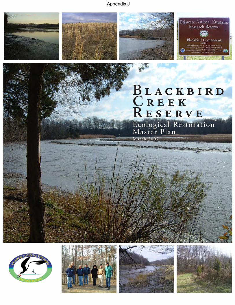
B l a c k b i r d C r e e k R e s e r v e Ecological Restorat ion Master PlanMarch 2007
Appendix J
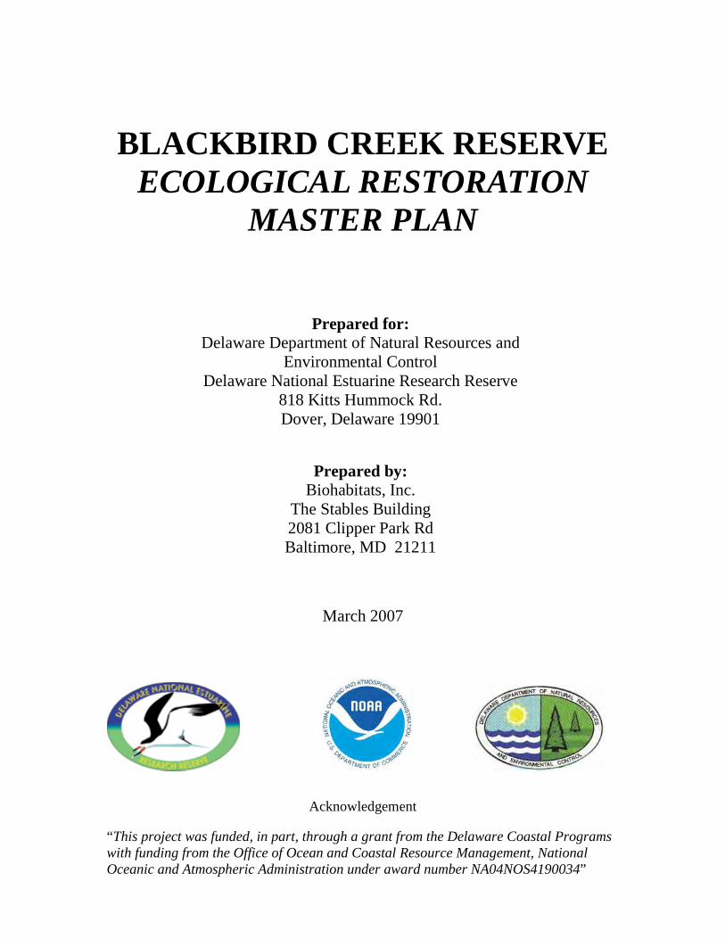
BLACKBIRD CREEK RESERVE
ECOLOGICAL RESTORATION MASTER PLAN
March 2007
Acknowledgement “This project was funded, in part, through a grant from the Delaware Coastal Programs with funding from the Office of Ocean and Coastal Resource Management, National Oceanic and Atmospheric Administration under award number NA04NOS4190034”
Prepared for: Delaware Department of Natural Resources and
Environmental Control Delaware National Estuarine Research Reserve
818 Kitts Hummock Rd. Dover, Delaware 19901
Prepared by: Biohabitats, Inc.
The Stables Building 2081 Clipper Park Rd Baltimore, MD 21211
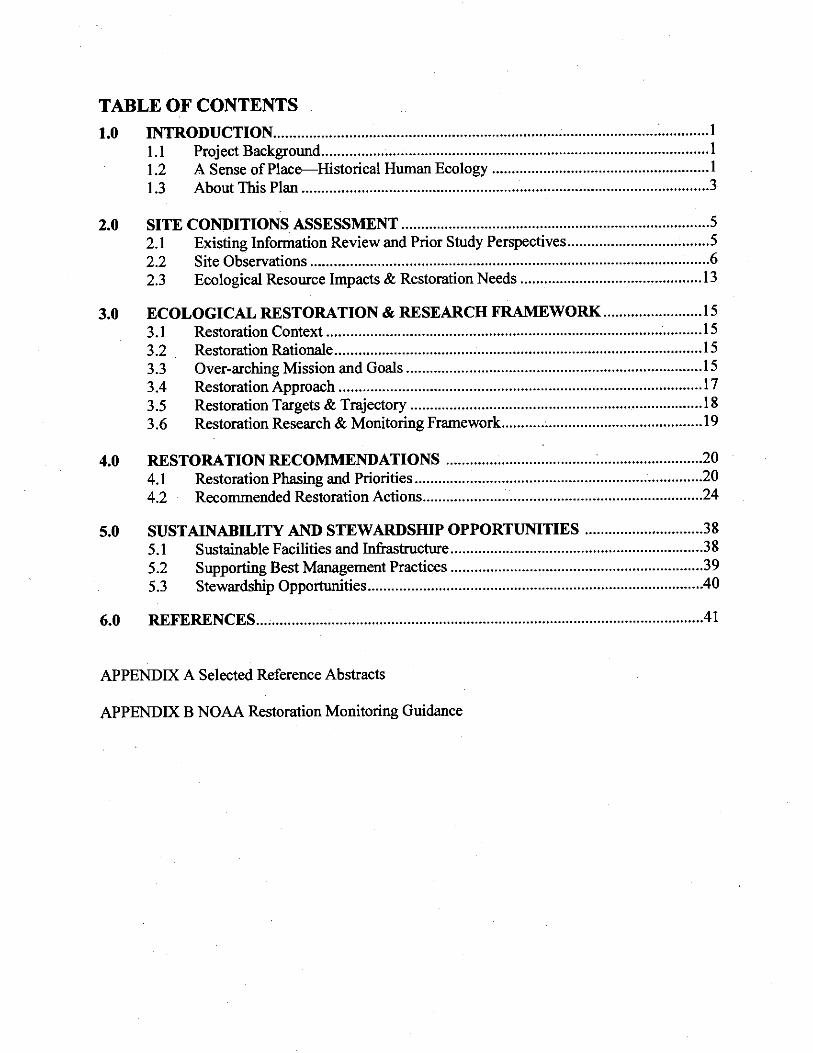
Blackbird Creek Reserve Ecological Restoration Master Plan
New Castle County, Delaware
© Biohabitats, Inc. RESTORING THE EARTH AND INSPIRING ECOLOGICAL STEWARDSHIP 1
1.0 INTRODUCTION
1.1 Project Background The Delaware National Estuarine Research Reserve (DNERR) is one of 27 National Estuarine Research Reserve System (NERRS) sites in the United States. The Reserve System was established by the Coastal Zone Management Act of 1972, as amended, as each reserve involves a partnership between the National Oceanic and Atmospheric Administration (NOAA) and the state the reserve occurs is located. The DNERR is a partnership between NOAA and the Delaware Department of Natural Resources and Environmental Control (DNREC), Division of Soil & Water Conservation—Coastal Programs Section. The DNERR consists of two Reserve components, the Upper Blackbird Creek Reserve Component (hereafter referred to as the Blackbird Creek Reserve) and the Lower St. Jones River Reserve Component, that are located about 30 miles apart (Figure 1.1). These two reserve components include both brackish and freshwater estuaries and are representative of the diverse array of estuarine ecosystems found throughout the Mid-Atlantic States (DNERR 2004). The important ecological values and relatively intact ecosystem components of the Blackbird Creek channel, corridor and watershed are what led to its selection for inclusion as part of the DNERR. This document is an ecological restoration master plan for the DNERR-owned parcels of the Blackbird Creek Reserve encompassing approximately 360 acres on four tracts (Figure 1.2) in southern New Castle County, Delaware. This plan is intended to identify and guide ecological restoration initiatives for the DNERR-owned parcels of the Blackbird Creek Reserve.
DNERR owned-properties of the Blackbird Creek Reserve include those purchased in 2004-05, encompassing the Lowe Tract (formerly Odessa Campground) and the Manwaring Tract. Additional land acquired in 2006 is known as the Cornelius Tract. Previously acquired parcels that are also part of the DNERR-owned lands are in the Union Church-Taylors Bridge Tract. The four tract areas and their prominent features are as follows:
• Lowe Tract (52 acres)—Former campground area, successional upland woods, fallow fields, and tidal marsh fringe
• Manwaring Tract (85 acres)—Fallow fields, farm ponds, narrow riparian woods and tidal marsh • Cornelius Tract (70 acres)—Upland forest stands, stream valleys, active agricultural fields and a
house • Union Church-Taylors Bridge Tract (150 acres)—Narrow riparian woods, small non-tidal wetland
depressions and extensive tidal marsh areas All DNERR-owned wetlands and forested uplands on the acquired parcels are shall be managed to preserve environmental quality, minimize detrimental impacts and control invasive species (DNERR 2004). This restoration master plan relates to the components of the NERRS mission to provide long-term research, education and interpretation, and the part of DNERR’s mission which includes preserving and managing natural resources within the Reserve. 1.2 A Sense of Place--Historical Human Ecology Since the King of England’s original land grant in the late 1600’s and William Penn’s transfer of much of the Blackbird’s lands to the Huguenots, there have been surprisingly few land ownership or land use changes for many of the properties in and around the Blackbird Creek and Reserve parcels.
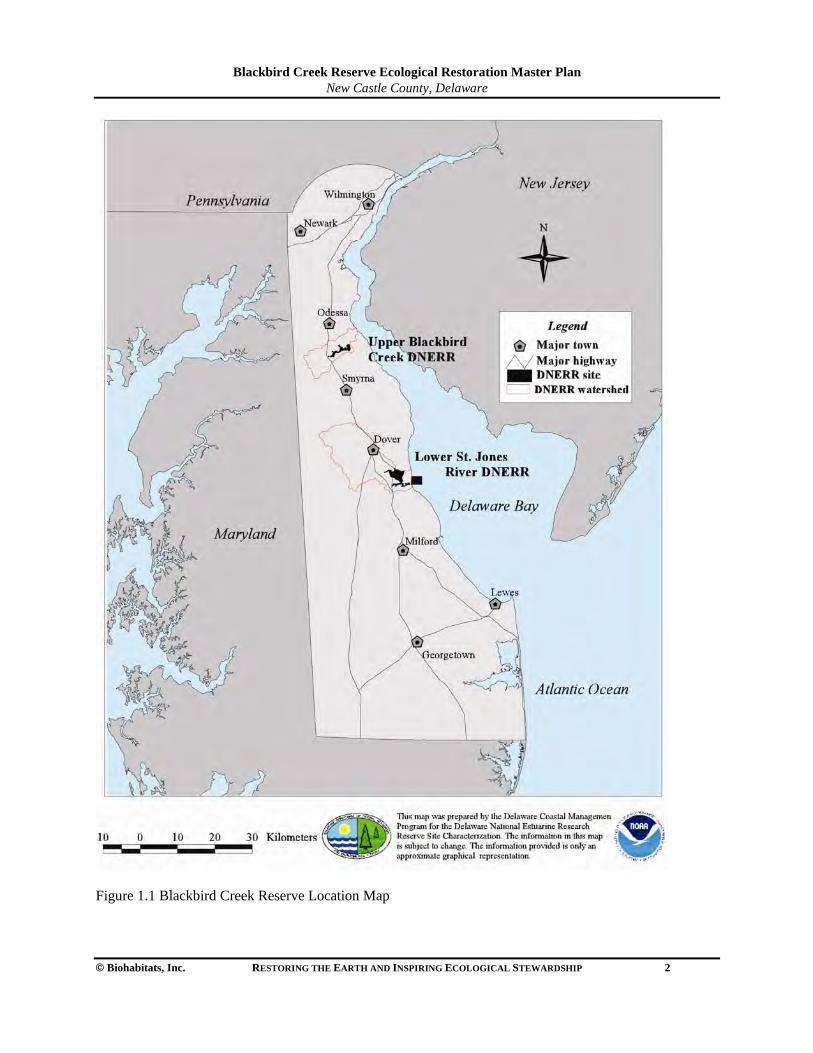
Blackbird Creek Reserve Ecological Restoration Master Plan
New Castle County, Delaware
© Biohabitats, Inc. RESTORING THE EARTH AND INSPIRING ECOLOGICAL STEWARDSHIP 2
Figure 1.1 Blackbird Creek Reserve Location Map
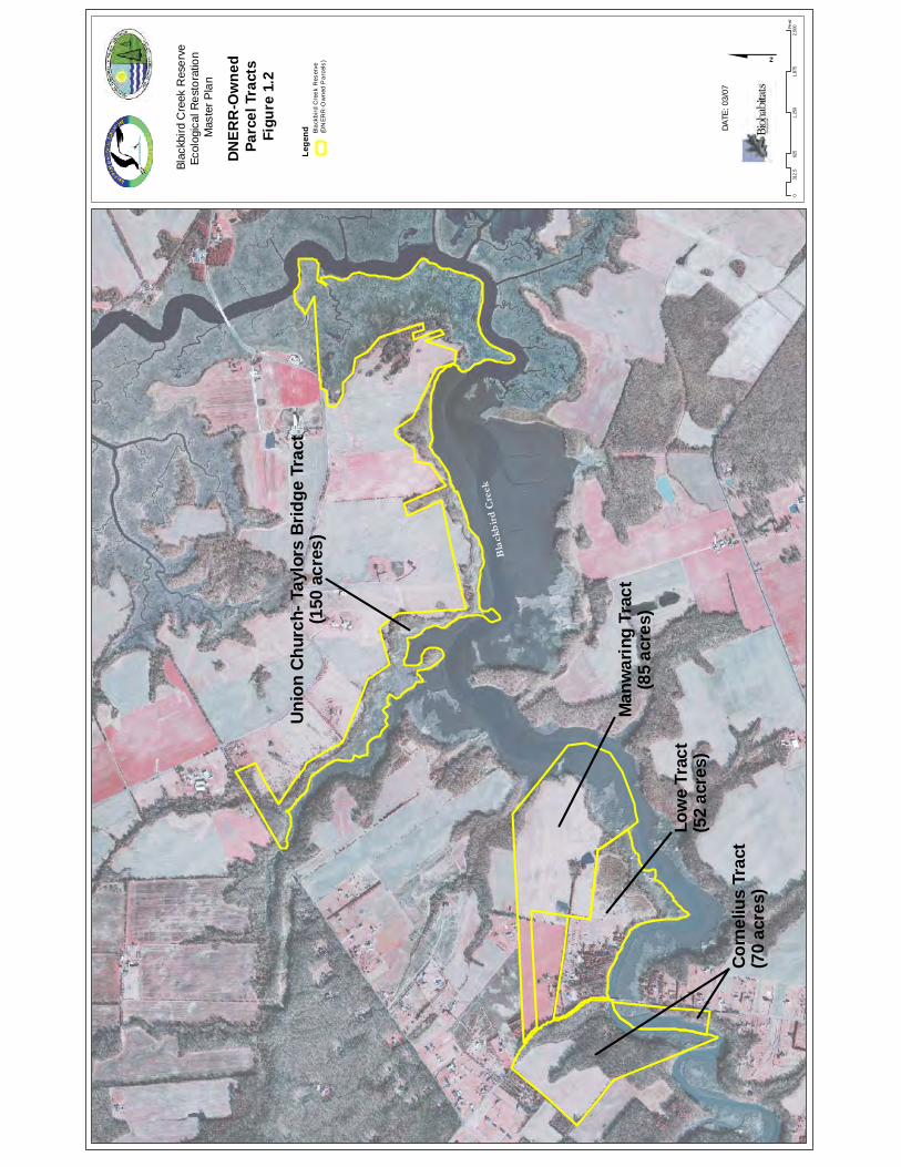
Bla
ckb
ird
Cre
ek
Low
e Tr
act
(52
acre
s)
Cor
neliu
s Tr
act
(70
acre
s)
Uni
on C
hurc
h- T
aylo
rs B
ridge
Tra
ct(1
50 a
cres
)
Man
war
ing
Trac
t(8
5 ac
res)
Conf
iden
tial
Subj
ect t
o At
torn
ey-C
lient
Priv
ilege
an
d/or
Wor
k Pr
oduc
t Doc
trine
s $
DNER
R-O
wne
d Pa
rcel
Tra
cts
Figu
re 1
.2
DATE
: 03/
07
Blac
kbird
Cre
ek R
eser
veEc
olog
ical
Res
tora
tion
Mas
ter P
lan
Lege
nd Blac
kbird
Cre
ek R
eser
ve(D
NER
R-O
wne
d P
arce
ls)
062
51,
250
1,87
52,
500
312
.5Fe
et
Blackbird Creek Reserve Ecological Restoration Master Plan
New Castle County, Delaware
© Biohabitats, Inc. RESTORING THE EARTH AND INSPIRING ECOLOGICAL STEWARDSHIP 3
The Blackbird Creek, often called simply “Blackbird”, is frequently referred to as an example of one of the only ‘pristine’ creek systems in north/central Delaware (See watershed map Figure 1.3. This is especially true in comparison to the more heavily altered (filled, channelized or tide-gated) streams, creeks and rivers in northern Delaware.
The ecological and cultural setting in which the Blackbird Creek Reserve resides is connected by a history of farming, fishing, hunting, trapping and other resource uses that have long been cornerstones of the local communities and their economy. The Cultural Resource Survey, maintained by the Delaware Bureau of Archaeology and Historic Preservation, lists 73 prehistoric archaeological sites in upland areas fringing Blackbird Creek marsh. While somewhat less so today, the influence of resource-based traditions still have a strong effect on the ecological health, and future of the Blackbird Creek Reserve and the creek system itself. This follows the tradition of generations of farmers, hunters, fishermen and trappers that have highly valued the land and waters of Blackbird Creek’s watershed as a provider of resources for their livelihood, residency, recreation and aesthetic enjoyment. The conservation ethic of many of the landowners and stewards of the watershed result from a spirit of place that has developed over time. The Blackbird has a long history of active conservation advocacy by its major property owners, as profiled in the DNREC/NOAA sponsored video, “Blackbird”: Delaware’s Undiscovered Treasure. Several large conservation organizations, including Delaware Wild Lands, have significant land holdings in the area to protect and conserve important natural areas. The entire Blackbird Creek Reserve comprises 50 parcels of land held by 46 private landholders in addition to the DNERR properties and other land under the control of the Division of Fish and Wildlife. The recent acquisition of several parcels adding to the Blackbird Component’s holdings is only part of the regional conservation effort. The ‘buffer’ areas for the Reserve core include private landholdings that are protected under the Delaware State Wetlands Act. These buffer areas are permanently protected, but are held in private ownership (DNERR 2004). Many other large parcels in private ownership have been successfully placed in conservation easements. The State’s Farmland Preservation Program serves a function of land protection in the watershed. Delaware’s Farmland Preservation Program has two major components, Agricultural Preservation Districts and Agricultural Conservation Easements. The occurrence preserved farmland in the Blackbird Creek Reserve area is shown in Figure 1.4.
1.3 About This Plan The need for an ecological restoration master plan for the Blackbird Creek Reserve, DNERR-owned tracts is clear. The newly acquired parcels in 2004-06 include the former campground and related facilities, as well as a modern suburban home, and several agricultural parcels in various states of cultivation, fallowness and natural condition. The parcels have had varying degrees of human influence and disturbance for many centuries, if not millennia, considering earlier Native American inhabitants. A plan to identify potential restoration initiatives and target conditions is an important step in charting a long term course for the Blackbird Creek Reserve. Without a big picture perspective of the site’s ecological restoration needs and priorities, the potential exists for disjointed or uncoordinated efforts without a clear strategy. This ecological restoration master plan will guide the Blackbird Creek Reserve’s restoration for immediate short-term efforts and provide a plan of action for the next 15-20 years.
The remainder of this document provides a site conditions assessment and identification of restoration needs (Section 2), restoration context and research framework (Section 3), and restoration recommendations, prioritization, and phasing (Section 4). Additionally, recommendations related to sustainability and stewardship opportunities are identified (Section 5).

Blackbird Creek Reserve Ecological Restoration Master Plan
New Castle County, Delaware
© Biohabitats, Inc. RESTORING THE EARTH AND INSPIRING ECOLOGICAL STEWARDSHIP 4
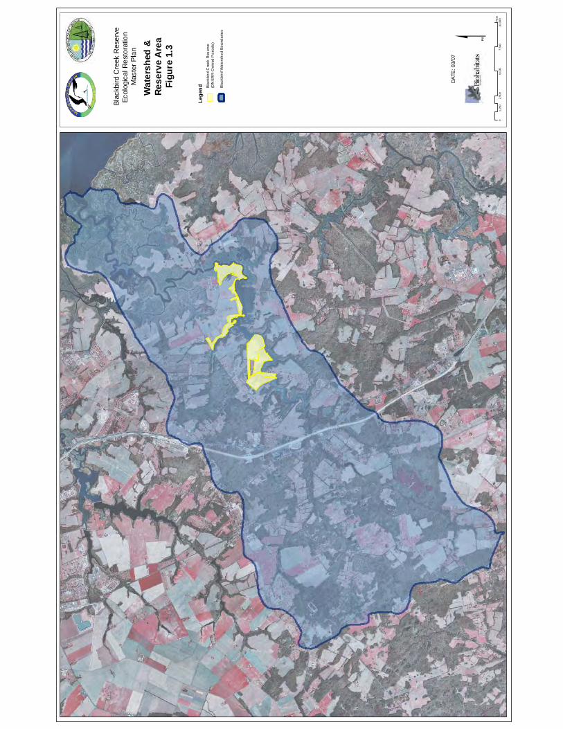
Conf
iden
tial
Subj
ect t
o At
torn
ey-C
lient
Priv
ilege
an
d/or
Wor
k Pr
oduc
t Doc
trine
s $
Wat
ersh
ed &
Re
serv
e A
rea
Figu
re 1
.3
DATE
: 03/
07
Blac
kbird
Cre
ek R
eser
veEc
olog
ical
Res
tora
tion
Mas
ter P
lan
02,
500
5,00
07,
500
10,0
00
1,25
0Fe
et
Lege
nd Blac
kbird
Wat
ersh
ed B
ound
arie
s
Blac
kbird
Cre
ek R
eser
ve(D
NER
R-O
wne
d P
arce
ls)
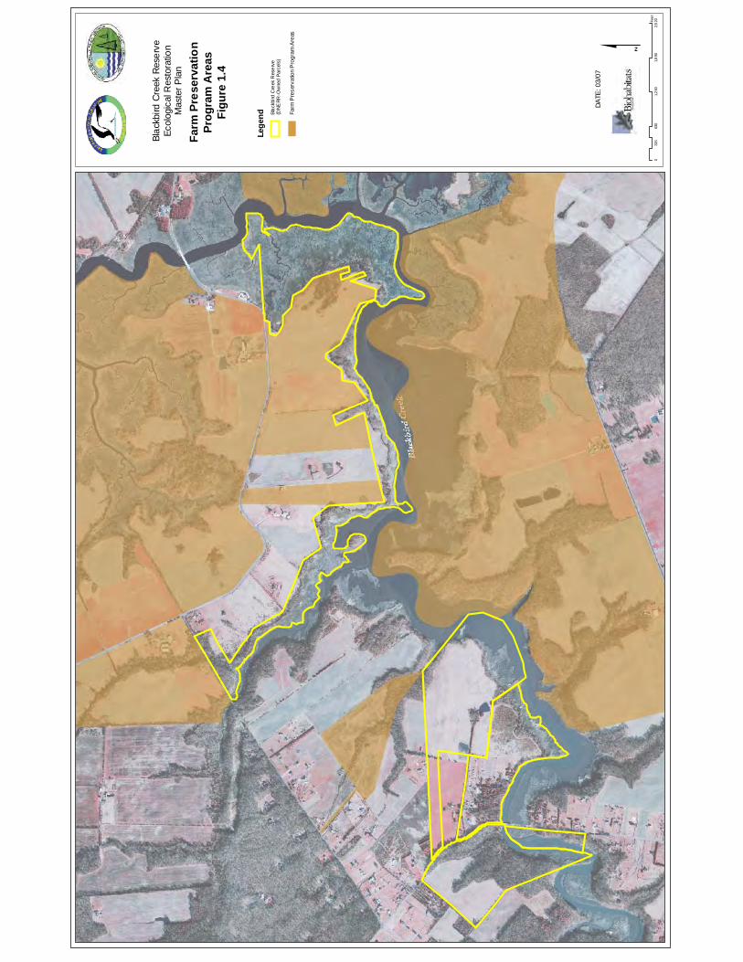
Conf
iden
tial
Subj
ect t
o At
torn
ey-C
lient
Priv
ilege
an
d/or
Wor
k Pr
oduc
t Doc
trine
s
063
01,
260
1,8
902,
520
315
Fee
t
$DA
TE: 0
3/07
Lege
nd Blac
kbird
Cre
ek R
eser
ve(D
NERR
-Ow
ned
Parc
els)
Blac
kbird
Cre
ek R
eser
veEc
olog
ical
Res
tora
tion
Mas
ter P
lan
Farm
Pre
serv
atio
nPr
ogra
m A
reas
Figu
re 1
.4
Farm
Pre
serv
atio
n P
rogr
am A
reas
Blackbird Creek Reserve Ecological Restoration Master Plan
New Castle County, Delaware
© Biohabitats, Inc. RESTORING THE EARTH AND INSPIRING ECOLOGICAL STEWARDSHIP 5
2.0 SITE CONDITIONS ASSESSMENT
2.1 Existing Information Review and Prior Study Perspectives
Biohabitats reviewed several existing documents and mapping information relating specifically to the Blackbird watershed. This information came from several divisions of Delaware DNREC, Delaware Office of State Planning, NOAA, The Nature Conservancy, NatureServe, and the University of Delaware. These documents include:
• Aerial photographs • Geographic Information System (GIS)-geospatial maps • Ecological investigation reports and data • Natural resource management plans • Graduate theses • Peer reviewed journal articles
Previous Reports, Research Investigations and Plans
In the course of developing this restoration management plan, Biohabitats reviewed several management plans, investigation reports and data documents provided by DNREC as well as obtaining other pertinent information independently. These documents include the following (Please see Appendix A for full citations and abstract): These invaluable information sources, and others, formed the basis from which this Ecological Restoration
• A Guide to the Natural Communities of the Delaware Estuary • Detecting and Monitoring Phragmites Invasion of Coastal Wetlands: A Comparison of
Remote Sensing Techniques • “Blackbird” Delaware’s Undiscovered Treasure (Video) • Blackbird-Millington Corridor Conservation Area Plan • Appoquinimink – Blackbird Creek Environmental Profile: GIS map data layers • Delaware National Estuarine Research Reserve: Estuarine Profiles • Delaware National Estuarine Research Reserve Management Plan 1993 • Delaware National Estuarine Research Reserve Management Plan 2004-2009 • DNERR Comprehensive Site Description. Phase I – Description / Analysis of Dominant
Vegetation / Cover Types. • Detecting and Monitoring Phragmites Invasion of Coastal Wetlands: A Comparison of
Remote Sensing Techniques • Remote sensing of habitat change at Delaware NERRS sites • Land use / land cover changes and ecological health indicators in the Blackbird Creek
watershed: With recommendations for restoration • Non-native species in our nation’s estuaries: a framework for an invasion monitoring program • Salem Nuclear Power Plant Ecological Baseline Data • Scrub-Shrub/Emergent Wetland Ecotone Migration Along Delaware Tidal Rivers In
Response To Relative Sea-Level Change, Natural Impacts, And Human Modifications • Shoreline Development Drives Invasion of Phragmites australis and the Loss of Plant
Diversity on New England Salt Marshes
Blackbird Creek Reserve Ecological Restoration Master Plan
New Castle County, Delaware
© Biohabitats, Inc. RESTORING THE EARTH AND INSPIRING ECOLOGICAL STEWARDSHIP 6
Master Plan document evolved. These sources helped to target potential restoration and research opportunities, characterize existing ecological conditions, and articulate past and more recent resource management activities for the Blackbird Creek area. 2.2 Site Observations The Blackbird Creek Reserve project area was investigated by Biohabitats in the winter of 2006-07. The main purpose of the site investigation was to characterize the general site conditions, identify potentially ecologically significant resources, and determine ecological needs and restoration opportunities. Previous studies of the Blackbird Creek Reserve area, GIS mapping and personal communications with DNREC managers were all utilized to inform the site investigations. 2.2.1 Streams and Creeks Numerous tidal creeks and non-tidal streams are found within the study tracts. The non-tidal headwater streams flow through highly erosive soil types (Figure 2.1), and many have incised significantly and/or have undercut banks and head-cuts. These erosion problems appear to stem from overland run-off from fields and in some cases impervious surfaces (i.e. roads). The distribution of stream channels and identified degraded stream reaches are identified in Figure 2.2. Generally, the shoreline banks of the mainstem Blackbird and tidal creeks are very stable with little evidence of active erosion, with the exception of minor erosion at isolated spots. There is a significant and variable width of tidal marsh (fresh to brackish gradient) along the creeks adjoining the study tracts. Tidal creeks and the Blackbird mainstem wetland systems are also facing varying rates of marsh loss, most likely from relative sea level rise, with some suggestion of possible herbivory stressors by foraging geese. The eroding, head-cut and unstable stream reaches identified are a clearly evident restoration need to enhance the streams and protect receiving waters.
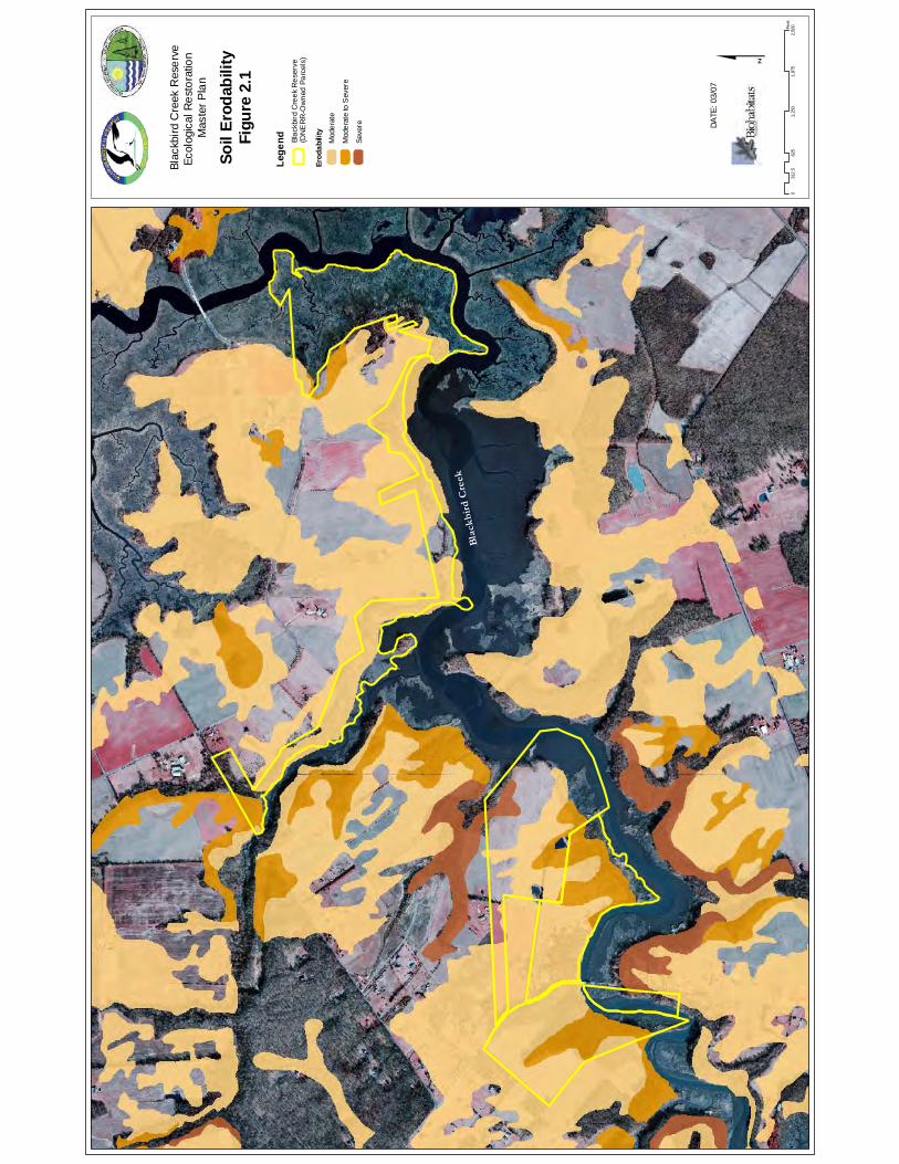
Bla
ckb
ird
Cre
ek
Conf
iden
tial
Subj
ect t
o At
torn
ey-C
lient
Priv
ilege
an
d/or
Wor
k Pr
oduc
t Doc
trine
s $
Soil
Erod
abili
tyFi
gure
2.1
DATE
: 03/
07
Blac
kbird
Cre
ek R
eser
veEc
olog
ical
Res
tora
tion
Mas
ter P
lan
Lege
nd Blac
kbird
Cre
ek R
eser
ve(D
NE
RR
-Ow
ned
Parc
els)
Erod
abili
tyM
oder
ate
Mod
erat
e to
Sev
ere
Seve
re
062
51,
250
1,87
52,
500
312
.5Fe
et
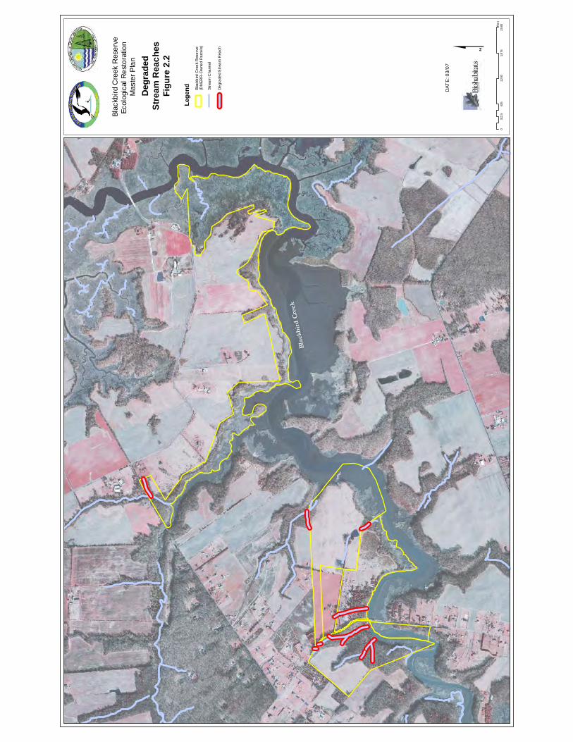
Bla
ckb
ird
Cre
ek
Con
fiden
tial
Subj
ect t
o A
ttorn
ey-C
lient
Priv
ilege
an
d/or
Wor
k P
rodu
ct D
octri
nes $
Deg
rade
dSt
ream
Rea
ches
Figu
re 2
.2
DAT
E: 0
3/07
Blac
kbird
Cre
ek R
eser
veEc
olog
ical
Res
tora
tion
Mas
ter P
lan
Lege
nd Blac
kbird
Cre
ek R
eser
ve(D
NER
R-O
wne
d Pa
rcel
s)
Degr
aded
Stre
am R
each
Stre
am C
hann
el
062
51,
250
1,8
752,
500
312.
5Fe
et
Blackbird Creek Reserve Ecological Restoration Master Plan
New Castle County, Delaware
© Biohabitats, Inc. RESTORING THE EARTH AND INSPIRING ECOLOGICAL STEWARDSHIP 7
2.2.2 Vegetation Communities The following are the natural community association classifications that correspond most appropriately to the vegetation types identified during site investigations as defined by the National Vegetation Classification System (Figure 2.3) and (Table 2.1). The naming conventions have been referenced from the document A Guide to the Natural Communities of the Delaware Estuary (Westervelt et al. 2006): Upland and Riparian Forests Forest community associations dominated by trees and shrubs are shown in Figure 2.4, and include: Atlantic Coastal Plain Mesic Hardwood Forest—This community is an upland system found in a variety of moist but non-wetland sites that include lower slopes and bluffs along streams and rivers in fragmented terrain, mesic flats between drier uplands and floodplains, and localized high areas within bottomland terraces or nonriverine wet flats. The vegetation of these forests is typically dominated by combinations of trees that consist of a significant component of mesophytic deciduous hardwood species. Typical species identified through site investigations of the study area are American beech (Fagus grandifolia), sweetgum (Liquidambar styraciflua), tuliptree (Liriodendron tulipifera), and maple species (Acer sp.). The understories are usually well-developed with shrub and herb layers that may be sparse or moderately dense. Site evidence of highbush blueberry (Vaccinium corymbosum), and field garlic (Allium vineale) were noted among others. Northern Atlantic Coastal Plain Dry Hardwood Forest—This system is comprised of dry hardwood forests mainly dominated by oaks. These forests are found on acidic sandy to gravelly soils, often with an acid loving shrub layer supporting a thick duff. Typical vegetation includes American beech, white oak (Quercus alba), northern red oak (Quercus rubra) and tulip tree. Maritime Red Cedar Woodland—This woodland system is found in small groves of varying age in the study area along the upper edges of the tidal river marshes, but most specifically in one older cedar stand associated with the former campground if the Lowe Tract. The eastern red cedar (Juniperus virginiana) is the dominant vegetation type with site identification of sweetgum, red maple (Acer rubrum), Japanese honeysuckle (Lonicera japonica) and field garlic.
Table 2.1 Vegetation Community Acreages and Percent of Reserve Area Community Type Acreage Percent of Reserve Active Agricultural Fields 32.9 9.2 Atlantic Coastal Plain Mesic Hardwood Forest 59.7 16.7 Atlantic Coastal Plain Northern Basin Swamp and Wet Hardwood Forest
1.5 0.4
Maintained Herbaceous 62.3 17.5 Managed Black Walnut Stand 5.0 1.4 Maritime Red Cedar Woodland 5.8 1.6
Northern Atlantic Coastal Plain Dry Hardwood Forest 44.8 12.6 Northern Atlantic Coastal Plain Fresh and Oligohaline Tidal Marsh
51.7 14.5
Northern Coastal Plain Brackish Tidal Marsh 66.4 18.6 Upland Reforestation Areas 8.6 2.4
Blackbird Creek Reserve Ecological Restoration Master Plan
New Castle County, Delaware
© Biohabitats, Inc. RESTORING THE EARTH AND INSPIRING ECOLOGICAL STEWARDSHIP 8
While the majority of the Blackbird Creek Reserve study area is in agriculture, several stands of maturing forest exist. These include areas on the Lowe and Cornelius tracts. The largest forest stand (31 Ac) within the DNERR-owned lands is on the Cornelius tract, and it is part of a larger forest block encompassing approximately 67 acres. A significant feature of the forested areas in the Reserve is the generally narrow bands of riparian buffer adjacent to the tidal tributaries and Blackbird Creek mainstem that commonly border agricultural fields. The morphology of these sites vary from low lying, near sea level floodplain forests to narrow bands of trees and shrubs along steep, high banks overlooking the Blackbird Creek and Beaver Branch. Although there are some high quality patches of mature forest in this stand, high density non-native invasive species occupy the vast majority of the understory and ground cover of the remainder of the stand. Many of the forested upland and riparian forest areas visited during the site investigation were found to be significantly impacted by non-native invasive plants (Figure 2.5). Based on cursory winter-time qualitative observations, the general density and distribution in all vegetation layers in a given area was generally characterized as either low or moderate to high based on relative abundance. The predominant, invasive species identified during the site investigation include multiflora rose (Rosa multiflora), Japanese honeysuckle (Lonicera japonica), wineberry (Rubus phoencolasius), field garlic (Allium vineale), fescues (Festuca spp.) and Canada thistle (Cirsium arvense). A recent identification and eradication of a stand of kudzu (Pueraria montana) by the Reserve staff at a forest/agriculture field edge on the Cornelius Tract epitomizes the need for timely invasive species identification and control actions. Restoration needs and opportunities identified for forests include riparian buffer restoration to augment poorly buffered corridors in terms of width and composition (Figure 2.6). Their current condition affects both water quality and habitat connectivity. Additional upland forest restoration is also needed to increase patch size and connectivity.
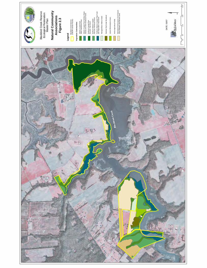
Bla
ckb
ird
Cre
ek
Bla
ckb
ird
Cre
ek
Conf
iden
tial
Subj
ect t
o At
torn
ey-C
lient
Priv
ilege
an
d/or
Wor
k Pr
oduc
t Doc
trine
s
063
01,
260
1,8
902,
520
315
Fee
t
$DA
TE: 0
3/07
Blac
kbird
Cre
ek R
eser
veEc
olog
ical
Res
tora
tion
Mas
ter P
lan
Nat
ural
Com
mun
ityA
ssoc
iatio
nsFi
gure
2.3
Lege
nd
Vege
tatio
n C
omm
uniti
es
Blac
kbird
Cre
ek R
eser
ve(D
NERR
-Ow
ned
Parc
els)
Atla
ntic
Coa
stal
Pla
in
Mes
ic H
ardw
ood
Fore
st
Atla
ntic
Coa
stal
Pla
in N
orth
ern
Basi
n Sw
amp
and
Wet
Har
dwoo
d Fo
rest
North
ern
Coa
stal
Pla
in
Brac
kish
Tida
l Mar
sh
North
ern
Atla
ntic
Coa
stal
Pl
ain
Dry
Har
dwoo
d Fo
rest
North
ern
Atla
ntic
Coa
stal
Pla
in F
resh
and
Olig
ohal
ine
Tida
l Mar
sh
Mai
ntai
ned
Her
bace
aous
(Coo
l Sea
son
Gra
ss M
eado
w an
d M
owed
Law
n)
Activ
e Ag
ricul
tura
l Fie
lds
Man
aged
Bla
ck W
alnu
t Sta
nd
Mar
itim
e R
ed C
edar
Woo
dlan
d
Upla
nd R
efor
esta
tion
Area
s
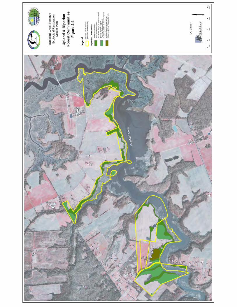
Bla
ckb
ird
Cre
ek
Conf
iden
tial
Subj
ect t
o At
torn
ey-C
lient
Priv
ilege
an
d/or
Wor
k Pr
oduc
t Doc
trine
s
063
01,
260
1,8
902,
520
315
Fee
t
$DA
TE: 0
3/07
Blac
kbird
Cre
ek R
eser
veEc
olog
ical
Res
tora
tion
Mas
ter P
lan
Upl
and
& R
ipar
ian
Fore
st C
omm
uniti
esFi
gure
2.4
Lege
nd
Vege
tatio
n C
omm
uniti
es
Blac
kbird
Cre
ek R
eser
ve(D
NERR
-Ow
ned
Parc
els)
Atla
ntic
Coa
stal
Pla
inM
esic
Har
dwoo
d Fo
rest
:59
.7 a
cres
, 16.
7% o
f Res
erve
Par
cels
North
ern
Atla
ntic
Coa
stal
Pl
ain
Dry
Har
dwoo
d Fo
rest
:44
.8 a
cres
, 12.
6% o
f Res
erve
Par
cels
Mar
itim
e R
ed C
edar
Woo
dlan
d:5.
8 ac
res,
1.6
% o
f Res
erve
Par
cels
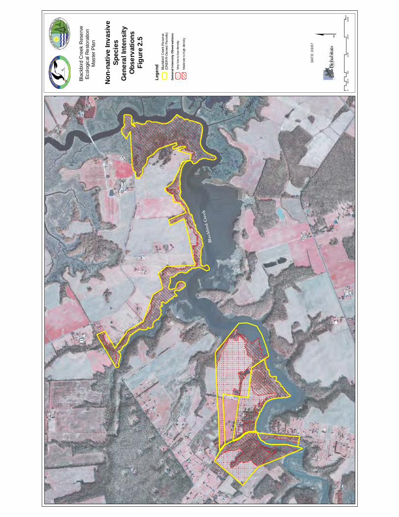
Bla
ckb
ird
Cre
ek
Con
fiden
tial
Subj
ect t
o A
ttorn
ey-C
lient
Priv
ilege
an
d/or
Wor
k P
rodu
ct D
octri
nes $
Non
-nat
ive
Inva
sive
Spec
ies
Gen
eral
Inte
nsity
O
bser
vatio
nsFi
gure
2.5
DAT
E: 0
3/07
Lege
nd
Gen
eral
Inte
nsity
Obs
erva
tions
Very
low
to lo
w d
ensi
ty
Mod
erat
e to
hig
h de
nsity
Blac
kbird
Cre
ek R
eser
ve(D
NER
R-O
wne
d Pa
rcel
s)
Blac
kbird
Cre
ek R
eser
veEc
olog
ical
Res
tora
tion
Mas
ter P
lan
062
51,
250
1,8
752,
500
312.
5Fe
et
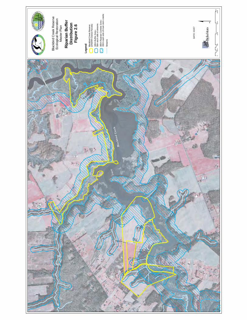
Bla
ckb
ird
Cre
ek
Con
fiden
tial
Subj
ect t
o A
ttorn
ey-C
lient
Priv
ilege
an
d/or
Wor
k P
rodu
ct D
octri
nes $
Ripa
rian
Buffe
r Di
strib
utio
nFi
gure
2.6
DAT
E: 0
3/07
Blac
kbird
Cre
ek R
eser
veEc
olog
ical
Res
tora
tion
Mas
ter P
lan
062
51,
250
1,8
752,
500
312.
5Fe
et
Lege
nd Stre
ams
Blac
kbird
Cre
ek R
eser
ve(D
NER
R-O
wne
d Pa
rcel
s)
300m
Rip
aria
n C
orrid
or Z
one-
-15
0m e
ach
side
of m
ain
stem
cre
eks
100m
Buf
fer Z
one-
-50
m e
ach
side
of s
tream
s
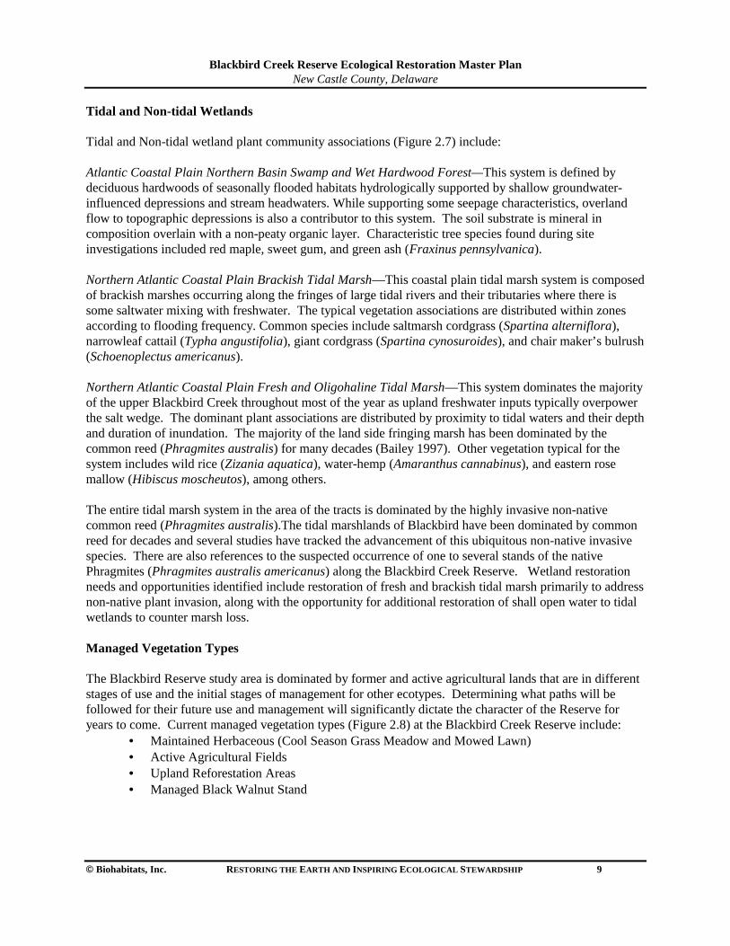
Blackbird Creek Reserve Ecological Restoration Master Plan
New Castle County, Delaware
© Biohabitats, Inc. RESTORING THE EARTH AND INSPIRING ECOLOGICAL STEWARDSHIP 9
Tidal and Non-tidal Wetlands Tidal and Non-tidal wetland plant community associations (Figure 2.7) include:
Atlantic Coastal Plain Northern Basin Swamp and Wet Hardwood Forest—This system is defined by deciduous hardwoods of seasonally flooded habitats hydrologically supported by shallow groundwater-influenced depressions and stream headwaters. While supporting some seepage characteristics, overland flow to topographic depressions is also a contributor to this system. The soil substrate is mineral in composition overlain with a non-peaty organic layer. Characteristic tree species found during site investigations included red maple, sweet gum, and green ash (Fraxinus pennsylvanica).
Northern Atlantic Coastal Plain Brackish Tidal Marsh—This coastal plain tidal marsh system is composed of brackish marshes occurring along the fringes of large tidal rivers and their tributaries where there is some saltwater mixing with freshwater. The typical vegetation associations are distributed within zones according to flooding frequency. Common species include saltmarsh cordgrass (Spartina alterniflora), narrowleaf cattail (Typha angustifolia), giant cordgrass (Spartina cynosuroides), and chair maker’s bulrush (Schoenoplectus americanus). Northern Atlantic Coastal Plain Fresh and Oligohaline Tidal Marsh—This system dominates the majority of the upper Blackbird Creek throughout most of the year as upland freshwater inputs typically overpower the salt wedge. The dominant plant associations are distributed by proximity to tidal waters and their depth and duration of inundation. The majority of the land side fringing marsh has been dominated by the common reed (Phragmites australis) for many decades (Bailey 1997). Other vegetation typical for the system includes wild rice (Zizania aquatica), water-hemp (Amaranthus cannabinus), and eastern rose mallow (Hibiscus moscheutos), among others. The entire tidal marsh system in the area of the tracts is dominated by the highly invasive non-native common reed (Phragmites australis).The tidal marshlands of Blackbird have been dominated by common reed for decades and several studies have tracked the advancement of this ubiquitous non-native invasive species. There are also references to the suspected occurrence of one to several stands of the native Phragmites (Phragmites australis americanus) along the Blackbird Creek Reserve. Wetland restoration needs and opportunities identified include restoration of fresh and brackish tidal marsh primarily to address non-native plant invasion, along with the opportunity for additional restoration of shall open water to tidal wetlands to counter marsh loss. Managed Vegetation Types The Blackbird Reserve study area is dominated by former and active agricultural lands that are in different stages of use and the initial stages of management for other ecotypes. Determining what paths will be followed for their future use and management will significantly dictate the character of the Reserve for years to come. Current managed vegetation types (Figure 2.8) at the Blackbird Creek Reserve include:
• Maintained Herbaceous (Cool Season Grass Meadow and Mowed Lawn) • Active Agricultural Fields • Upland Reforestation Areas • Managed Black Walnut Stand
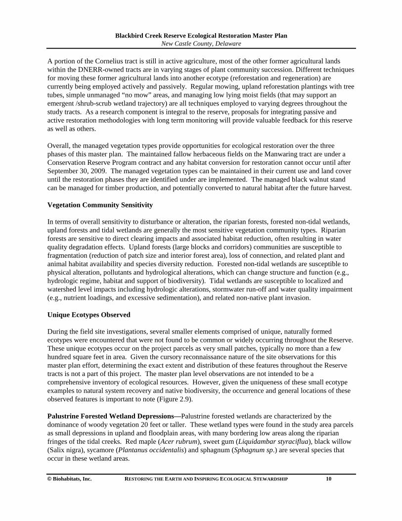
Blackbird Creek Reserve Ecological Restoration Master Plan
New Castle County, Delaware
© Biohabitats, Inc. RESTORING THE EARTH AND INSPIRING ECOLOGICAL STEWARDSHIP 10
A portion of the Cornelius tract is still in active agriculture, most of the other former agricultural lands within the DNERR-owned tracts are in varying stages of plant community succession. Different techniques for moving these former agricultural lands into another ecotype (reforestation and regeneration) are currently being employed actively and passively. Regular mowing, upland reforestation plantings with tree tubes, simple unmanaged “no mow” areas, and managing low lying moist fields (that may support an emergent /shrub-scrub wetland trajectory) are all techniques employed to varying degrees throughout the study tracts. As a research component is integral to the reserve, proposals for integrating passive and active restoration methodologies with long term monitoring will provide valuable feedback for this reserve as well as others. Overall, the managed vegetation types provide opportunities for ecological restoration over the three phases of this master plan. The maintained fallow herbaceous fields on the Manwaring tract are under a Conservation Reserve Program contract and any habitat conversion for restoration cannot occur until after September 30, 2009. The managed vegetation types can be maintained in their current use and land cover until the restoration phases they are identified under are implemented. The managed black walnut stand can be managed for timber production, and potentially converted to natural habitat after the future harvest. Vegetation Community Sensitivity In terms of overall sensitivity to disturbance or alteration, the riparian forests, forested non-tidal wetlands, upland forests and tidal wetlands are generally the most sensitive vegetation community types. Riparian forests are sensitive to direct clearing impacts and associated habitat reduction, often resulting in water quality degradation effects. Upland forests (large blocks and corridors) communities are susceptible to fragmentation (reduction of patch size and interior forest area), loss of connection, and related plant and animal habitat availability and species diversity reduction. Forested non-tidal wetlands are susceptible to physical alteration, pollutants and hydrological alterations, which can change structure and function (e.g., hydrologic regime, habitat and support of biodiversity). Tidal wetlands are susceptible to localized and watershed level impacts including hydrologic alterations, stormwater run-off and water quality impairment (e.g., nutrient loadings, and excessive sedimentation), and related non-native plant invasion. Unique Ecotypes Observed During the field site investigations, several smaller elements comprised of unique, naturally formed ecotypes were encountered that were not found to be common or widely occurring throughout the Reserve. These unique ecotypes occur on the project parcels as very small patches, typically no more than a few hundred square feet in area. Given the cursory reconnaissance nature of the site observations for this master plan effort, determining the exact extent and distribution of these features throughout the Reserve tracts is not a part of this project. The master plan level observations are not intended to be a comprehensive inventory of ecological resources. However, given the uniqueness of these small ecotype examples to natural system recovery and native biodiversity, the occurrence and general locations of these observed features is important to note (Figure 2.9). Palustrine Forested Wetland Depressions—Palustrine forested wetlands are characterized by the dominance of woody vegetation 20 feet or taller. These wetland types were found in the study area parcels as small depressions in upland and floodplain areas, with many bordering low areas along the riparian fringes of the tidal creeks. Red maple (Acer rubrum), sweet gum (Liquidambar styraciflua), black willow (Salix nigra), sycamore (Plantanus occidentalis) and sphagnum (Sphagnum sp.) are several species that occur in these wetland areas.
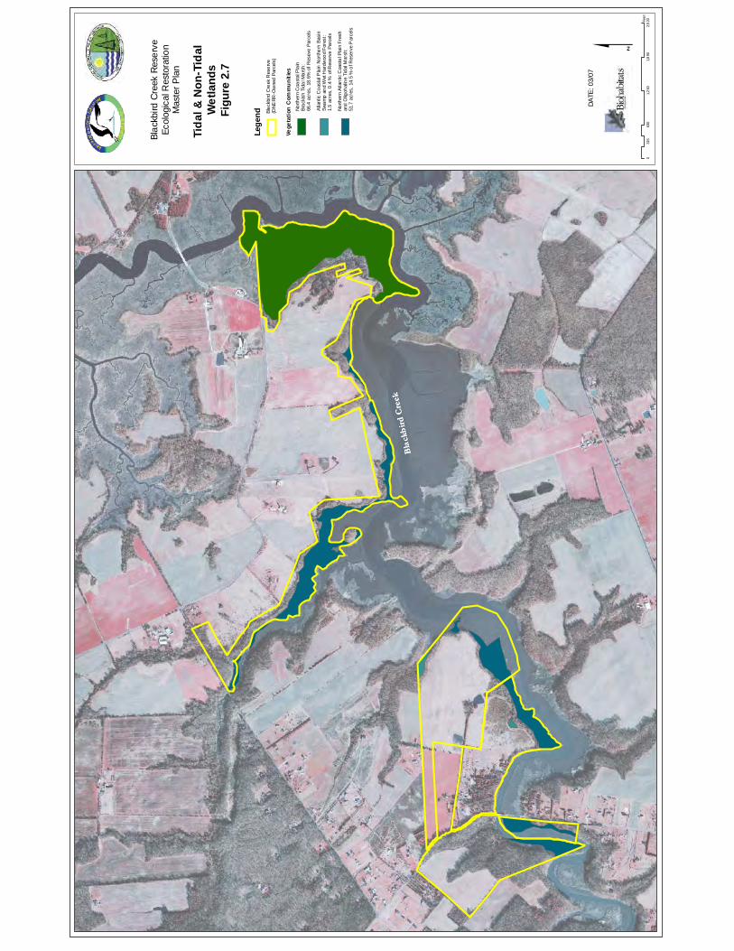
Bla
ckb
ird
Cre
ek
Bla
ckb
ird
Cre
ek
Conf
iden
tial
Subj
ect t
o At
torn
ey-C
lient
Priv
ilege
an
d/or
Wor
k Pr
oduc
t Doc
trine
s
063
01,
260
1,8
902,
520
315
Fee
t
$DA
TE: 0
3/07
Lege
nd
Vege
tatio
n C
omm
uniti
es
Blac
kbird
Cre
ek R
eser
ve(D
NERR
-Ow
ned
Parc
els)
Atla
ntic
Coa
stal
Pla
in N
orth
ern
Basi
n Sw
amp
and
Wet
Har
dwoo
d Fo
rest
:1.
5 ac
res,
0.4
% o
f Res
erve
Par
cels
North
ern
Coa
stal
Pla
in
Brac
kish
Tida
l Mar
sh:
66.4
acr
es, 1
8.6%
of R
esev
e Pa
rcel
s
North
ern
Atla
ntic
Coa
stal
Pla
in F
resh
and
Olig
ohal
ine
Tida
l Mar
sh:
51.7
acr
es, 1
4.5
% o
f Res
erve
Par
cels
Blac
kbird
Cre
ek R
eser
veEc
olog
ical
Res
tora
tion
Mas
ter P
lan
Tida
l & N
on-T
idal
W
etla
nds
Figu
re 2
.7
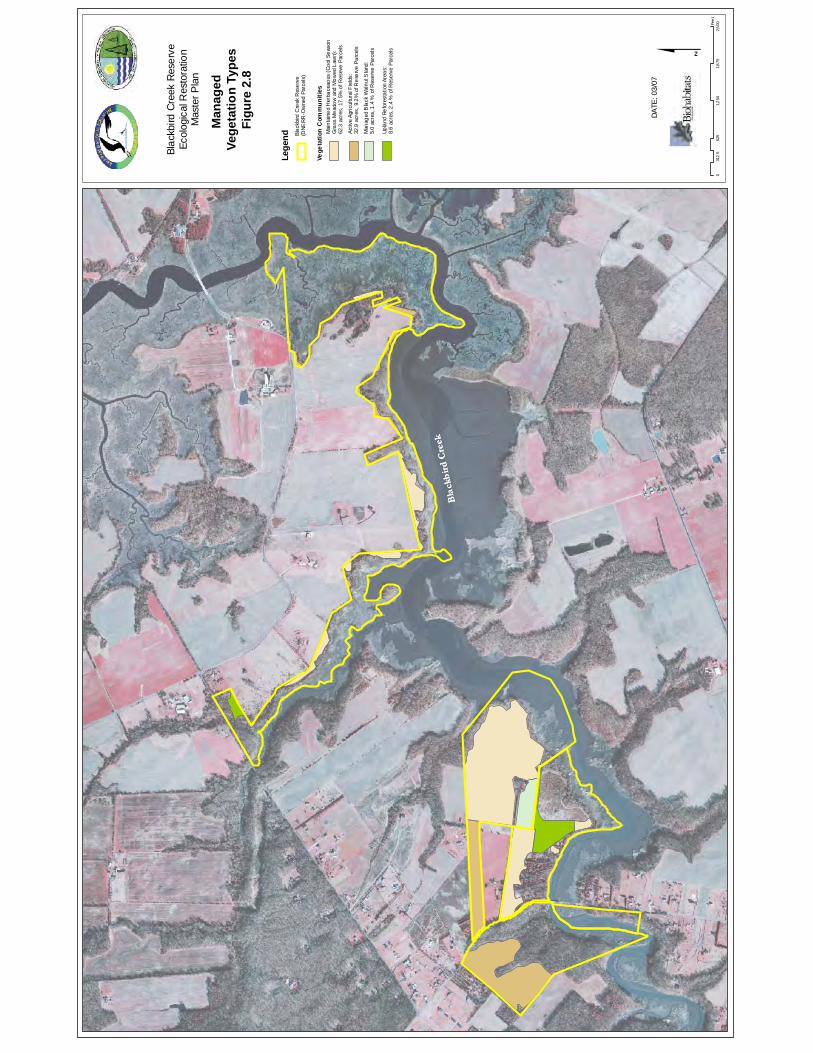
Bla
ckb
ird
Cre
ek
Bla
ckb
ird
Cre
ek
Conf
iden
tial
Subj
ect t
o At
torn
ey-C
lient
Priv
ilege
an
d/or
Wor
k Pr
oduc
t Doc
trine
s $DA
TE: 0
3/07
Blac
kbird
Cre
ek R
eser
veEc
olog
ical
Res
tora
tion
Mas
ter P
lan
Man
aged
Ve
geta
tion
Type
sFi
gure
2.8
Lege
nd
Vege
tatio
n C
omm
uniti
es
Blac
kbird
Cre
ek R
eser
ve(D
NERR
-Ow
ned
Parc
els)
Mai
ntai
ned
Her
bace
aous
(Coo
l Sea
son
Gra
ss M
eado
w an
d M
owed
Law
n):
62.3
acr
es, 1
7.5%
of R
esev
e Pa
rcel
s
Activ
e Ag
ricul
tura
l Fie
lds:
32.9
acr
es, 9
.2%
of R
eser
ve P
arce
ls
Man
aged
Bla
ck W
alnu
t Sta
nd:
5.0
acre
s, 1
.4 %
of R
eser
ve P
arce
ls
Upla
nd R
efor
esta
tion
Area
s:8.
6 ac
res,
2.4
% o
f Res
erve
Par
cels
062
51,
250
1,8
752,
500
312.
5Fe
et
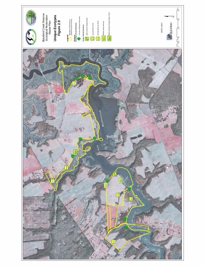
È È ÈÈÈ
¡ÀÈ
!'
!'
!'
È!u
ÈÈ
!4
È
!'
¡«
¡À
!'
Bla
ckb
ird
Cre
ek
Con
fiden
tial
Subj
ect t
o A
ttorn
ey-C
lient
Priv
ilege
an
d/or
Wor
k P
rodu
ct D
octri
nes $
Uniq
ue E
coty
pes
Figu
re 2
.9
DAT
E: 0
3/07
ÈLege
nd
Ecot
ypes
Exis
ting
Fore
sted
Wet
land
s
Uniq
ue H
abita
t Ele
men
ts
Fore
sted
Wet
land
Dep
ress
ion
!4Ba
ld C
ypre
ss R
egen
erat
ion
¡ÀNa
tive
Mea
dow
Reg
ener
atio
n P
atch
¡«Hi
llsid
e Se
ep W
etla
nd
!'Em
erge
nt/S
crub
Shr
ub
!uCo
asta
l Pla
in P
ond
Blac
kbird
Cre
ek R
eser
ve(D
NE
RR
-Ow
ned
Par
cels
)
Blac
kbird
Cre
ek R
eser
veEc
olog
ical
Res
tora
tion
Mas
ter P
lan
062
51,
250
1,8
752,
500
312.
5Fe
et
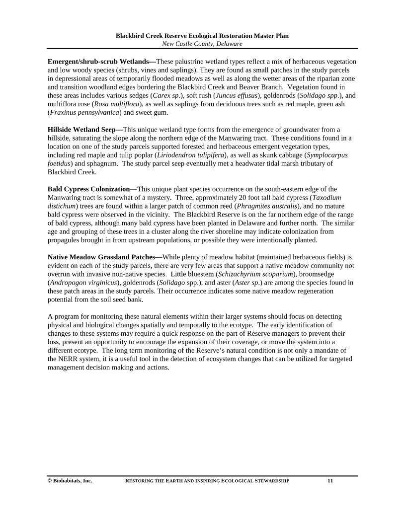
Blackbird Creek Reserve Ecological Restoration Master Plan
New Castle County, Delaware
© Biohabitats, Inc. RESTORING THE EARTH AND INSPIRING ECOLOGICAL STEWARDSHIP 11
Emergent/shrub-scrub Wetlands—These palustrine wetland types reflect a mix of herbaceous vegetation and low woody species (shrubs, vines and saplings). They are found as small patches in the study parcels in depressional areas of temporarily flooded meadows as well as along the wetter areas of the riparian zone and transition woodland edges bordering the Blackbird Creek and Beaver Branch. Vegetation found in these areas includes various sedges (Carex sp.), soft rush (Juncus effusus), goldenrods (Solidago spp.), and multiflora rose (Rosa multiflora), as well as saplings from deciduous trees such as red maple, green ash (Fraxinus pennsylvanica) and sweet gum. Hillside Wetland Seep—This unique wetland type forms from the emergence of groundwater from a hillside, saturating the slope along the northern edge of the Manwaring tract. These conditions found in a location on one of the study parcels supported forested and herbaceous emergent vegetation types, including red maple and tulip poplar (Liriodendron tulipifera), as well as skunk cabbage (Symplocarpus foetidus) and sphagnum. The study parcel seep eventually met a headwater tidal marsh tributary of Blackbird Creek. Bald Cypress Colonization—This unique plant species occurrence on the south-eastern edge of the Manwaring tract is somewhat of a mystery. Three, approximately 20 foot tall bald cypress (Taxodium distichum) trees are found within a larger patch of common reed (Phragmites australis), and no mature bald cypress were observed in the vicinity. The Blackbird Reserve is on the far northern edge of the range of bald cypress, although many bald cypress have been planted in Delaware and further north. The similar age and grouping of these trees in a cluster along the river shoreline may indicate colonization from propagules brought in from upstream populations, or possible they were intentionally planted. Native Meadow Grassland Patches—While plenty of meadow habitat (maintained herbaceous fields) is evident on each of the study parcels, there are very few areas that support a native meadow community not overrun with invasive non-native species. Little bluestem (Schizachyrium scoparium), broomsedge (Andropogon virginicus), goldenrods (Solidago spp.), and aster (Aster sp.) are among the species found in these patch areas in the study parcels. Their occurrence indicates some native meadow regeneration potential from the soil seed bank. A program for monitoring these natural elements within their larger systems should focus on detecting physical and biological changes spatially and temporally to the ecotype. The early identification of changes to these systems may require a quick response on the part of Reserve managers to prevent their loss, present an opportunity to encourage the expansion of their coverage, or move the system into a different ecotype. The long term monitoring of the Reserve’s natural condition is not only a mandate of the NERR system, it is a useful tool in the detection of ecosystem changes that can be utilized for targeted management decision making and actions.
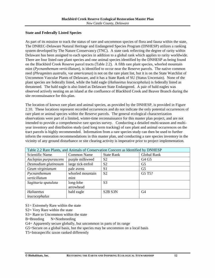
Blackbird Creek Reserve Ecological Restoration Master Plan
New Castle County, Delaware
© Biohabitats, Inc. RESTORING THE EARTH AND INSPIRING ECOLOGICAL STEWARDSHIP 12
State and Federally Listed Species As part of its mission to track the status of rare and uncommon species of flora and fauna within the state, The DNREC-Delaware Natural Heritage and Endangered Species Program (DNHESP) utilizes a ranking system developed by The Nature Conservancy (TNC). A state rank reflecting the degree of rarity within Delaware has been assigned to each species in addition to a global rank which applies to rarity worldwide. There are four listed rare plant species and one animal species identified by the DNHESP as being found on the Blackbird Creek Reserve parcel tracts (Table 2.2). A fifth rare plant species, whorled mountain mint (Pycnanthemum verticillatum), is identified to occur near the Reserve parcels. The native common reed (Phragmites australis, var americanus) is not on the rare plant list, but it is on the State Watchlist of Uncommon Vascular Plants of Delaware, and it has a State Rank of SU (Status Uncertain). None of the plant species are federally listed, while the bald eagle (Haliaeetus leucocephalus) is federally listed as threatened. The bald eagle is also listed as Delaware State Endangered. A pair of bald eagles was observed actively nesting on an island at the confluence of Blackbird Creek and Beaver Branch during the site reconnaissance for this plan. The location of known rare plant and animal species, as provided by the DNHESP, is provided in Figure 2.10. These locations represent recorded occurrences and do not indicate the only potential occurrences of rare plant or animal species within the Reserve parcels. The general ecological characterization observations were part of a limited, winter-time reconnaissance for this master plan project, and are not intended to provide a comprehensive rare species survey. Conducting a detailed multi-season and multi-year inventory and distribution study (and long term tracking) of rare plant and animal occurrences on the tract parcels is highly recommended. Information from a rare species study can then be used to further inform the restoration recommendations in this master plan, and conducting a rare species inventory in the vicinity of any ground disturbance or site clearing activity is imperative prior to project implementation. Table 2.2 Rare Plants, and Animals of Conservation Concern as Identified by DNHESP Scientific Name Common Name State Rank Global Rank Asclepias purpurascens purple milkweed S2 G4 G5 Desmodium glutinosum large tick-trefoil S2 G5 Geum virginianum pale avens S1 G5 Pycnanthemum verticillatum
whorled mountain mint
S2 G5 T5?
Sagittaria spatulata
long-lobe arrowhead
S3
Haliaeetus leucocephalus
bald eagle S2B S3N G4
S1= Extremely Rare within the state S2= Very Rare within the state S3= Rare to Uncommon within the state B=Breeding N=Nonbreeding G4= Apparently secure globally, but uncommon in parts of its range G5=Secure on a global basis, but the species may be uncommon on a local basis T5=Intraspecific taxon ranked differently
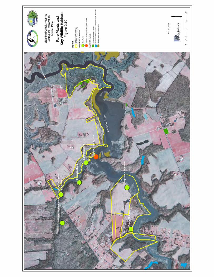
Bla
ckb
ird
Cre
ek
Com
mon
Ree
d
Pale
Ave
ns
Purp
le M
ilkw
eed
Larg
e Ti
ck-tr
efoi
l
Long
-lobe
Arr
owhe
ad
Who
rled
Mou
ntai
n-m
int
Com
mon
Ree
d
Eagl
e N
estin
g S
ite
Con
fiden
tial
Subj
ect t
o A
ttorn
ey-C
lient
Priv
ilege
an
d/or
Wor
k P
rodu
ct D
octri
nes
052
01,
040
1,5
602,
080
260
Fee
t$
Rare
Pla
nts
and
Key
Wild
life
Hab
itats
Figu
re 2
.10
DAT
E: 0
3/07
Lege
nd
Rare
Spe
cies
Occ
urre
nce
Key
Wild
life
Hab
itats
Early
Suc
cess
iona
l Hab
itat
Rare
Pla
nts
Blac
kbird
Cre
ek R
eser
ve
(DN
ERR
-Ow
ned
Parc
els)
Spec
ies
of G
reat
est C
onse
rvat
ion
Nee
d
Unve
geta
ted
Inte
rtida
l Mud
flat
Fres
hwat
er T
idal
For
este
d an
d Sc
rub-
Shru
b W
etla
nds
Blac
kbird
Cre
ek R
eser
veEc
olog
ical
Res
tora
tion
Mas
ter P
lan
Blackbird Creek Reserve Ecological Restoration Master Plan
New Castle County, Delaware
© Biohabitats, Inc. RESTORING THE EARTH AND INSPIRING ECOLOGICAL STEWARDSHIP 13
2.2.3 Human Structures—the Built Environment The Lowe Tract was purchased from an owner that had utilized the property as a campground for recreational vehicles and trailers. The structures have been razed and removed, although old and broken paved interior roads and parking surfaces, a small man-made pond, and other remnants of the campground still persist. Additionally, a property acquisition that included a large suburban type modern home is intended for use as flexible space for offices, small meetings and equipment storage. Identified site features that are specifically anthropogenic in nature are shown on Figure 2.11. 2.3 Ecological Resource Impacts & Restoration Needs Headwater Streams—Degraded headwater streams are the most apparent physically altered ecological feature on the Reserve parcels based on site reconnaissance observations. They have on-going and continual degradation processes including stormwater run-off conveyance, eroding and under-cut banks, incised channels, and riparian tree undermining and loss. The degraded streams are also directly impacting infrastructure including roads and culverts. Riparian Buffers—Riparian corridor buffers along streams and creeks are a significant landscape context feature that is insufficient in terms of typical widths, structure and distribution. These deficiencies are evident from prior studies (McCorkle 2000), aerial photograph analysis and on-site existing conditions observations. Buffer enhancement through reforestation is a significant part of the Streamside Conservation Priority as one of the primary ‘Conservation Priority Areas’ in the Blackbird Millington Conservation Corridor Plan (TNC/DNREC 2005). Non-native Invasive Species—A wide variety of non-native invasive plant species occur throughout the Blackbird corridor in all natural community habitat types. Within the Blackbird Creek Reserve they are a threat to native plant communities and their biodiversity as indicated by Bailey 1997 and TNC/DNREC 2005. Furthermore, invasive species are a primary management concern identified in the DNERR Management Plan (DNERR 2004), and are a part of the active management on the Reserve parcels. Attention to existing and future invasive species threats is necessary. Freshwater Nontidal Forested Wetlands—Delaware has lost more than 50% of its historic wetlands resources since colonial times. This includes palustrine forested wetlands experiencing the greatest loss of all wetland types in Delaware from 1981-1992, encompassing 1500 acres (Tiner 2001). Wetland impacts include the loss of ‘coastal plain ponds’ or Delmarva Bays’, and ecologically unique and regionally important type of forested wetland habitat. The Blackbird Reserve is within the distribution area of coastal plain pond occurrence, but this wetland type is only represented by potentially altered remnants remaining of the Reserve parcels. Areas that would have typically been headwater wetlands at the top of streams have been converted to agricultural fields and their function to protect stream channels has been lost. Tidal Wetlands—Tidal wetlands, particularly emergent marsh, is a prominent habitat feature of the tidal creeks and rivers in the coastal plain of Delaware including Blackbird Creek. Tidal marsh loss and conversion to open water and mudflats, other ecotone shifts, and extensive common reed invasion have been extensively documented in the Blackbird Creek watershed including the Reserve area (McCorkle 2000, Klemas and Field 2004, and Valentine 2002).
Blackbird Creek Reserve Ecological Restoration Master Plan
New Castle County, Delaware
© Biohabitats, Inc. RESTORING THE EARTH AND INSPIRING ECOLOGICAL STEWARDSHIP 14
Upland Forest—Coastal plain upland forests once covered much of the landscape in the coastal Delaware. Currently the forest cover is reduced to percent of the watershed. Corresponding habitat areas and habitat corridor connections have been lost due to forest conversion and fragmentation. The Forest Priority Conservation Areas identified by TNC/DNREC 2005, focuses on protecting and linking mature forests and also requires filling in gaps with new plantings and/or improvements to existing stands. Upland Native Meadow—Early successional vegetation stages of native grassland communities occur as variable patches throughout the coastal plain. They help provide a diversity of habitat types for different species assemblages as a part of mosaic of community types in the region. This vegetation type supports native grassland plants and animals and can also serve to function as a valuable habitat ‘placeholder’ until future targeted efforts under adaptive management perhaps determine a shift to some other habitat type is warranted.
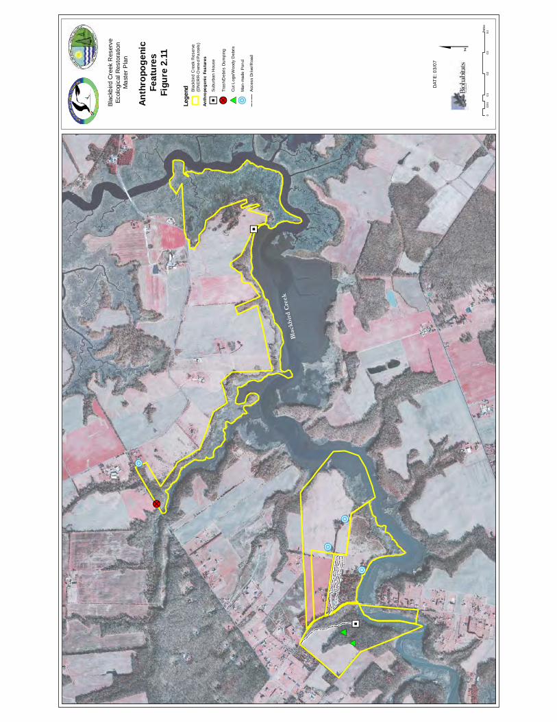
"J
!?
!R
!R
!R
!R# *# *
"J
Bla
ckb
ird
Cre
ek
Con
fiden
tial
Subj
ect t
o A
ttorn
ey-C
lient
Priv
ilege
an
d/or
Wor
k P
rodu
ct D
octri
nes
00.
10.
20.
30.
40.
05
Mile
s
$
Blac
kbird
Cre
ek R
eser
veEc
olog
ical
Res
tora
tion
Mas
ter P
lan
Anth
ropo
geni
c Fe
atur
esFi
gure
2.1
1
DAT
E: 0
3/07
Lege
nd
Anth
ropo
geni
c Fe
atur
es
"JS
ubur
ban
Hou
se
!?Tr
ash/
Deb
ris D
umpi
ng
# *C
ut L
ogs/
Woo
dy D
ebris
!RM
an-m
ade
Pon
d
Acc
ess
Dri
ve/R
oad
Bla
ckbi
rd C
reek
Res
erve
(DN
ER
R-O
wne
d P
arc
els)
Blackbird Creek Reserve Ecological Restoration Master Plan
New Castle County, Delaware
© Biohabitats, Inc. RESTORING THE EARTH AND INSPIRING ECOLOGICAL STEWARDSHIP 15
3.0 ECOLOGICAL RESTORATION & RESEARCH FRAMEWORK
3.1 Restoration Context
Setting the context for ecological restoration is important, as is defining over-arching goals, objectives, rationale and approach for restoration initiatives. The general emphasis of restoration efforts is often to restore damaged or degraded habitats, abate environmental impacts, or re-introduce historically present native species. There are many variations of the definition of ecological restoration by various groups that undertake or advocate restoration (See Mitsch and Jorgensen 2004; Perrow and Davy 2002; and SER 2004). To set the context for ecological restoration for this project we first look to NOAA, the lead organization for the National Estuarine Research Reserve System (NERRS), for their definition of ecological restoration: The process of reestablishing a self-sustaining habitat that closely resembles a natural condition in terms of structure and function. (NOAA 2002) 3.2 Restoration Rationale The State of Delaware and the Nature Conservancy recognizes the Blackbird Creek corridor as one of the most ecologically valuable areas of the state’s “Green Infrastructure” (TNC and DNREC 2005). The ecological significance of the Blackbird Creek system is recognized as one of the most important remaining natural landscapes in Delaware as documented in the Blackbird-Millington Corridor Conservation Area Plan (TNC and DNREC 2005). Evidence from prior studies of this ecosystem and current observations indicate that the Blackbird Creek system is being degraded by invasive species, past agricultural practices and accelerated development in the watershed (Bailey 1997; McCorkle 2000; Valentine 2002; Klemas and Field 2004). In addition to DNERR’s land conversation protection efforts, ecological restoration is needed to counter these trends to protect the Blackbird system from further degradation. Simply relying on unassisted self-recovery of the system may take decades or longer to happen, or may never occur. These factors are the basis for the rationale that ecological restoration efforts are needed for the degraded resources on the DNERR-owned parcels of the Blackbird Creek Reserve. Effective tools for achieving ecological restoration, including an adaptive management approach, are needed for the Blackbird Creek Reserve to benefit the DNERR-owned parcels, as well as to educate and inform management decisions and influence future restoration efforts for the whole system. 3.3 Over-arching Mission and Goals The over-arching mission and goals of ecological restoration for the Blackbird Creek Reserve are influenced at several levels, including guidance from the National Estuarine Research Reserve System (NERRS) and reserve-specific DNERR Management Plan goals. Additionally, objectives related to achieving these goals were provided by the DNERR Staff and DNREC personnel, specifically related to this ecological restoration master plan. The Reserve management staff also takes into account local community and stakeholder objectives for the Reserve area and its contributing watershed. The overall NERRS mission is – ‘To practice and promote coastal and estuarine stewardship through innovative research and education, using a system of protected areas.’
Blackbird Creek Reserve Ecological Restoration Master Plan
New Castle County, Delaware
© Biohabitats, Inc. RESTORING THE EARTH AND INSPIRING ECOLOGICAL STEWARDSHIP 16
A significant component of fulfilling the NERRS mission includes the basic GOAL of:
Protecting, restoring and monitoring of local estuarine and coastal resources for each of the Reserve system sites.
The NERRS also has an evolving restoration strategy (see inset).
The NERRS restoration science initiative has set general ‘Habitat Restoration Priorities for Each Reserve’. The DNERR restoration priorities, as determined by the NERRS restoration science initiative, are generally defined as:
• Invasive species • Upland habitat • And, Other
The ‘Other’ category references smaller, local habitat types of concern not representative of the national strategy.
A Restoration Science Strategy The National Estuarine Research Reserve System is developing a Habitat Restoration Strategy to provide the scientific basis and technical expertise to restore, enhance and maintain estuarine ecosystems. The plan will develop and transfer effective approaches to identify, prioritize, restore and monitor degraded or lost coastal habitat. The strategy uses a partnership approach coupled with education and community involvement. The restoration areas in which the reserve system hopes to play a national role includes:
• Project planning • Developing effective approaches to test and evaluate innovative
technology for restoration • Monitoring restoration response • Serving as local reference or control sites • Translating/transferring restoration information • Providing scientific and technological advise to support policy
and regulatory decisions • Building awareness for the value of restoration science • Coordinating regional science
Blackbird Creek Reserve Ecological Restoration Master Plan
New Castle County, Delaware
© Biohabitats, Inc. RESTORING THE EARTH AND INSPIRING ECOLOGICAL STEWARDSHIP 17
As a companion, the NERRS also identifies ‘Lost, Disturbed or Damaged Habitat Within Each Reserve’, and for the DNERR they are as follows:
• Salt/Brackish marsh • Tidal freshwater wetlands • Upland forest/meadow • Riverine/riparian wetlands • Coastal prairie/scrub
The above priorities are for both the St. Jones River and Blackbird Creek Reserves of the DNERR. Specific priorities for each site are not distinguished. The Reserve and DNREC staff identified objectives for the outcome of this ecological restoration master plan and implementation process that include:
• Define restoration targets for the plan • Improve land use activities from a water quality perspective • Provide a holistic restoration plan for now, and set the stage for long-term monitoring • Identify associated innovative stormwater techniques • Produce results on the ground in the near-term • Lead to demonstration plots for wildlife habitat types (e.g., for mammals) • Act as a model for others in the watershed
3.4 Restoration Approach The restoration of the Blackbird Creek Reserve study parcels will involve multiple techniques and restoration approaches. These techniques and approaches are dependant upon the condition of the ecological resources that are targeted for restoration and resources available to achieve the restoration goals. The scale and focus of restoration effort is an important issue to address for any ecological restoration project or program. Ecological restoration can occur at a variety of levels including a system, community, population or species focus. At broad scales, it becomes even more difficult to decide what should be restored, where and how (Hobbs 2002). Other major considerations revolve around a landscape level ecological context and/or restoring natural functions and processes. Whatever is carried out in the way of restoration should involve working with, and not in opposition to, the natural processes that will form the system in the achievement of a functioning ecosystem (Bradshaw 2002). The amount and type of intervention is dependent on the degree of degradation or ecological impacts. This can range from reconstruction, to less extensive enhancement, or simply improved management of the resource. Parker & Pickett (1997) indicate that restoration should be considered a process, with the degree of active intervention being determined by contextual circumstances. Guiding Principles for Restoration The following Guiding Principles are used to guide the conceptual ecological restoration initiatives identified in this plan, and are recommended for associated restoration design and implementation/construction processes.
Blackbird Creek Reserve Ecological Restoration Master Plan
New Castle County, Delaware
© Biohabitats, Inc. RESTORING THE EARTH AND INSPIRING ECOLOGICAL STEWARDSHIP 18
• Protect and maintain existing habitat patches, and restore habitat to provide larger patches and increase the connectivity of habitat corridors
• Maintain existing high quality habitat conditions and improve degraded habitat conditions by removing threats or threatening processes
• Improve the condition of relic habitats in fragmented landscapes to ensure their persistence • Emphasize supporting and regenerating natural processes for system recovery • Conserve non-renewable energy in restoration approaches • Support ecosystem conservation practices in all related activities • Use applied monitoring and research to test ecological theories • Consider human needs and compatibility with the needs of biotic systems
Given the degree to which specific ecological resources have been identified to be degraded or damaged, and other resources are threatened, the Restoration Approach for the Blackbird Component parcels is recommended to include:
• Active restoration of specific degraded or impacted existing ecological resources including; non-tidal wetlands, streams and riparian buffers
• Creation of additional habitats that are fragmented, reduced or eliminated from the landscape (including; wetlands, upland reforestation and native meadows)
• Use varying degrees of non-native invasive species management to protect existing natural communities, and as a part of restoring degraded habitat areas
• Identify compatible ideas for sustainable facilities, best management practices (e.g. stormwater), and stewardship opportunities to support restoration
• Adaptive management in the form of restoration implementation, monitoring and informed decision making based on the analysis of the monitoring results.
3.5 Restoration Targets & Trajectory Inherently, achieving ecosystem restoration of the entire ‘Blackbird’ system cannot be accomplished in the context of only the Reserve parcels. However, leading by example, the restoration efforts on the Blackbird Creek Reserve can certainly be a significant part of ecosystem restoration. The benefit of the long-term mission and work of the DNERR is that the restoration efforts on the Blackbird Creek Reserve can be accomplished in the broader context of monitoring the changes in the system components. More importantly, the Reserve system research focus affords the opportunity for ecological modeling and entire ecosystem analysis. The key to achieving the Blackbird Creek ecosystem restoration is collaboration with other organizations to monitor and analyze broad-scale efforts. An important aspect of the proposed restoration approach is utilizing adaptive management in the form of restoration monitoring and informed decision making based on the analysis of the monitoring results and natural system responses. Questions related to defining the specific targets for restoration may be thought of in terms of ecosystems, communities, plant assemblages or individual species. Primarily, what is the trajectory, or pathway to the desired restoration endpoint? To establish targets for ecological restoration it is important to consider the restoration priorities identified by NERRS, and the associated list of lost, degraded or disturbed habitats previously identified in this plan. These Reserve-specific priorities, along with the ecological resources identified to be degraded or lost in this part of the system, form the basis for specific restoration targets recommended. The prioritization, phasing, recommended methods and targets for each identified type of restoration are identified in Section 4 of this master plan.
Blackbird Creek Reserve Ecological Restoration Master Plan
New Castle County, Delaware
© Biohabitats, Inc. RESTORING THE EARTH AND INSPIRING ECOLOGICAL STEWARDSHIP 19
The information assessed for the Blackbird Creek and watershed indicates that this highly valued system is showing signs of multiple stressors and degrading influences, and its ecological trajectory is showing a downward trend. This master plan recommends that active intervention must be taken to repair or regenerate specific degraded resources on the Blackbird Creek Reserve. Implementation of the restoration initiatives identified in this plan, along with adaptive management by monitoring, analyzing natural system responses, and revising restoration approaches in the future, is intended to assist the system along a recovery trajectory. 3.6 Restoration Research & Monitoring Framework A critical component of long-term restoration success is the application of applied research and monitoring. These efforts will not only document the restoration site conditions upon implementation, but also serve to track natural system responses and trends. Restoration is not only a problem-solving matter; it is a tool for ecological research (Jordan et al. 1987). Created and restored ecosystems provide unique research opportunities to scientists that natural systems do not, particularly in subjects such as self-organization and ecosystem development (Mitsch and Jorgensen 2004). Monitoring restored coastal areas can provide tools for planning management strategies and help improve future restoration practices and projects (Washington et al. 2000). The research-based mission of the NERRS and the DNERR directly support applying monitoring and scientific research to restoration projects. Restoration project monitoring must be based in scientific testing and experimental design. There is a fundamental need to document baseline conditions of monitoring sites, establish research test plots, identify control areas, and monitor resource conditions over a specified timeframe. The U.S. Department of Commerce, National Oceanic and Atmospheric Administration has produced several documents that provide guidance and specific protocols for coastal restoration project monitoring criteria. Given the NOAA relationship to the DNERR, following the guidance and framework of these documents is essential for Blackbird Creek Reserve ecological restoration project monitoring. Two key documents that should be used to guide the restoration framework are the Science-Based Restoration Monitoring of Coastal Habitats Volume 1 (Thayer et al. 2003), and Draft NOAA Fisheries Technical Guidance Manual for Success Criteria in Restoration Projects (Pinit et al. 2000). Both documents emphasize the need to develop scientifically defensible monitoring plans, and every restoration project for the Blackbird Creek Reserve will need to develop one. There are twelve steps, and thirteen specific habitat types (coastal freshwater to marine systems) identified for developing a scientifically based and statistically valid restoration monitoring plan (Thayer et al. 2003). The corresponding habitat types are provided in Appendix B. Suggestions for possible monitoring parameters corresponding to each recommended restoration type is provided in Section 4 of this master plan.
Blackbird Creek Reserve Ecological Restoration Master Plan
New Castle County, Delaware
© Biohabitats, Inc. RESTORING THE EARTH AND INSPIRING ECOLOGICAL STEWARDSHIP 20
4.0 RESTORATION RECOMMENDATIONS 4.1 Restoration Phasing and Priorities The identification of ecological restoration priorities and phases is important for the short-term immediate needs for Phase 1 (Year 1) and for the longer term Phase 2 (Years 2-5) and Phase 3 (Years 6-15). The prioritization and phasing recommended here is meant for general guidance as a starting point. In the truest sense of adaptive management (learning through implementation, testing and modifying practices) the actual restoration timing, techniques and priorities will and should change over time. This is necessary to account for research and monitoring results for initial efforts, changes in the watershed, related ecosystem function modeling/analysis and available resources (financial and material). Building in the flexibility for changes in acreages, locations and types of restoration projects and approaches is inherent in this ecological restoration master plan. Restoration needs were evaluated for this project based on site observations and existing information review. The specific restoration recommendations are structured to effectively implement the restoration approach identified in Section 3. A list of priority ecological restoration needs by restoration type is provided below in order of need and importance as recommended by Biohabitats. It is based on GIS information, prior studies, our field reconnaissance and analysis. Priorities were assessed based on a number of considerations applied to each restoration activity type to rank their importance. The results of this screening are provided in Table 4.1. This does not suggest for example that all headwater stream restoration projects and actions need to happen first. Rather, we identified the order of highest priority, with the expectation that elements of each of the restoration type will occur in the near-term and longer term phases. The distribution of recommended ecological restoration types is provided in Figure 4.1. Phase 1 recommendations are shown in Figure 4.2, and Phase 2 & 3 recommendations are in Figure 4.3. The recommended priority restoration project types are as follows:
• Headwater stream restoration • Riparian corridor buffer restoration • Invasive species management • Wetland restoration—freshwater nontidal • Wetland restoration—tidal marsh • Upland reforestation • Upland native meadow restoration
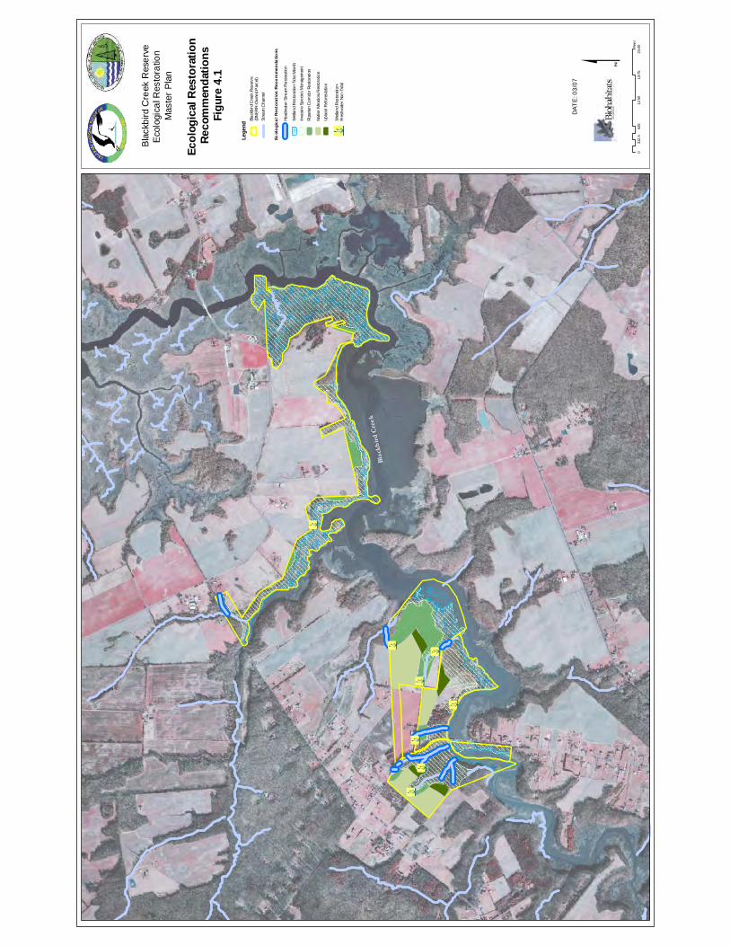
!\
!\
!\!\
!\!\
!\
!\
Bla
ckb
ird
Cre
ek
Con
fiden
tial
Subj
ect t
o A
ttorn
ey-C
lient
Priv
ilege
an
d/or
Wor
k P
rodu
ct D
octri
nes $
Bla
ckbi
rd C
reek
Res
erve
Eco
logi
cal R
esto
ratio
n M
aste
r P
lan
Ecol
ogic
al R
esto
ratio
n Re
com
men
datio
nsFi
gure
4.1
DAT
E: 0
3/07
Lege
nd
Ecol
ogi
cal R
esto
rati
on R
eco
mm
enda
tions
Head
wat
er S
tream
Res
tora
tion
Blac
kbird
Cre
ek R
eser
ve(D
NER
R-O
wne
d P
arce
l)St
ream
Cha
nnel
Wet
land
Res
tora
tion-
Tida
l Mar
sh
Inva
sive
Spec
ies
Man
agem
ent
Ripa
rian
Cor
ridor
Res
tora
tion
Nativ
e M
eado
w R
esto
ratio
n
Upla
nd R
efor
esta
tion
!\W
etla
nd R
esto
ratio
n-Fr
eshw
ater
Non
-Tid
al
062
51,
250
1,8
752,
500
312.
5Fe
et
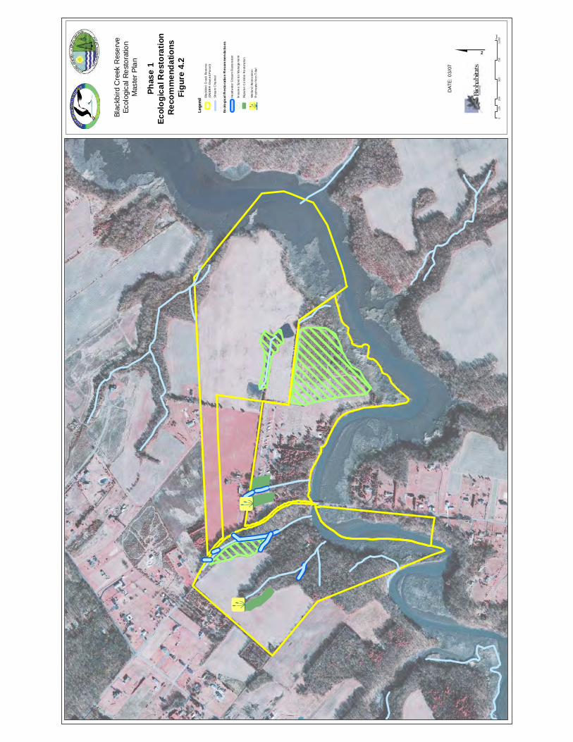
!\!\
Con
fiden
tial
Subj
ect t
o A
ttorn
ey-C
lient
Priv
ilege
an
d/or
Wor
k P
rodu
ct D
octri
nes $
Blac
kbird
Cre
ek R
eser
veEc
olog
ical
Res
tora
tion
Mas
ter P
lan
Phas
e 1
Ecol
ogic
al R
esto
ratio
n R
ecom
men
datio
nsFi
gure
4.2
DAT
E: 0
3/07
Lege
nd
Ecol
ogi
cal R
esto
ratio
n R
ecom
men
datio
ns
He
adw
ater
Str
eam
Res
tora
tion
Bla
ckb
ird C
ree
k R
ese
rve
(DN
ER
R-O
wn
ed
Pa
rce
l)
Str
eam
Cha
nne
l
!\W
etla
nd R
est
ora
tion
-Fr
esh
wat
er N
on-
Tid
al
Inva
siv
e S
pec
ies
Ma
nage
me
nt
Rip
aria
n C
orr
idor
Re
stor
atio
n
025
050
075
01,
000
125
Feet
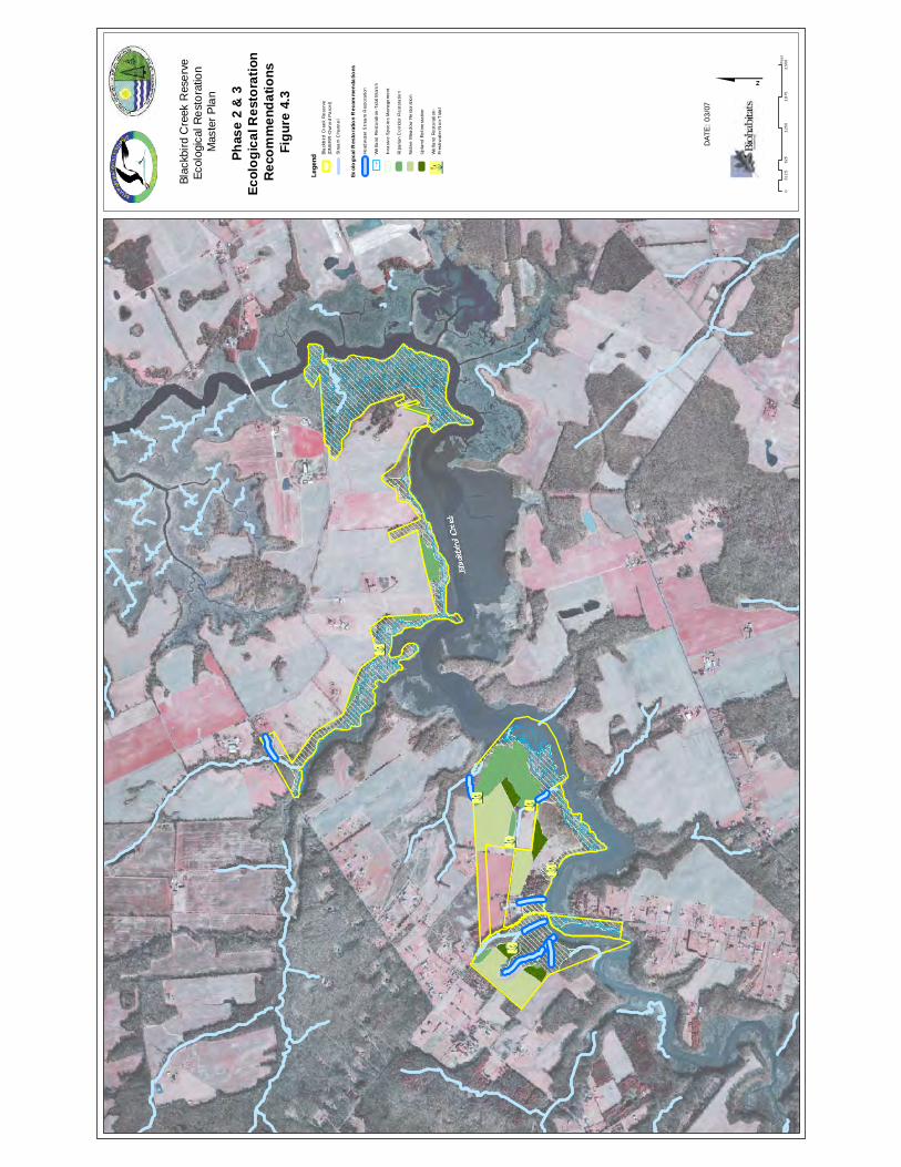
!\
!\
!\!\
!\
!\
Con
fiden
tial
Subj
ect t
o A
ttorn
ey-C
lient
Priv
ilege
an
d/or
Wor
k P
rodu
ct D
octri
nes $
Blac
kbird
Cre
ek R
eser
veEc
olog
ical
Res
tora
tion
Mas
ter P
lan
Phas
e 2
& 3
Ec
olog
ical
Res
tora
tion
Rec
omm
enda
tions
Figu
re 4
.3
DAT
E: 0
3/07
Lege
nd
Ecol
ogi
cal R
esto
ratio
n R
ecom
men
datio
ns
Bla
ckb
ird C
ree
k R
ese
rve
(DN
ER
R-O
wn
ed
Pa
rce
l)
Str
eam
Cha
nne
l
!\W
etla
nd R
est
ora
tion
-Fr
esh
wat
er N
on-
Tid
al
Up
land
Re
fore
sta
tion
Na
tive
Mea
dow
Re
stor
atio
n
Rip
aria
n C
orr
idor
Re
stor
atio
n
Inva
siv
e S
pec
ies
Ma
nage
me
nt
We
tland
Re
sto
rati
on-T
idal
Mar
sh
062
51,
250
1,87
52,
500
312.
5Fe
et
He
adw
ater
Str
eam
Res
tora
tion
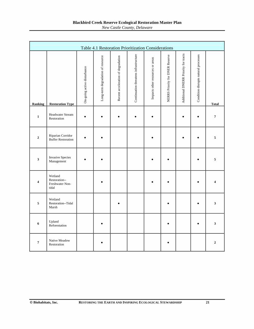
Blackbird Creek Reserve Ecological Restoration Master Plan
New Castle County, Delaware
© Biohabitats, Inc. RESTORING THE EARTH AND INSPIRING ECOLOGICAL STEWARDSHIP 21
Table 4.1 Restoration Prioritization Considerations
Ranking Restoration Type On-
goin
g ac
tive
dist
urba
nce
Long
-ter
m d
egra
datio
n of
res
ourc
e
Rec
ent a
ccel
erat
ion
of d
egra
datio
n
Con
tinua
tion
thre
aten
s in
fras
truc
ture
Impa
cts
othe
r re
sour
ces
or a
reas
NE
RR
S P
riorit
y fo
r D
NE
R R
eser
ve
Add
ition
al D
NE
RR
Prio
rity
for
trac
ts
Con
ditio
n di
srup
ts n
atur
al p
roce
sses
Total
1 Headwater Stream Restoration
● ● ● ● ●
● ● 7
2 Riparian Corridor Buffer Restoration
● ● ●
● ● 5
3 Invasive Species Management
● ● ● ●
● 5
4
Wetland Restoration--Freshwater Non-tidal
● ● ●
● 4
5 Wetland Restoration--Tidal Marsh
● ●
● 3
6 Upland Reforestation
● ●
● 3
7 Native Meadow Restoration
● ●
2
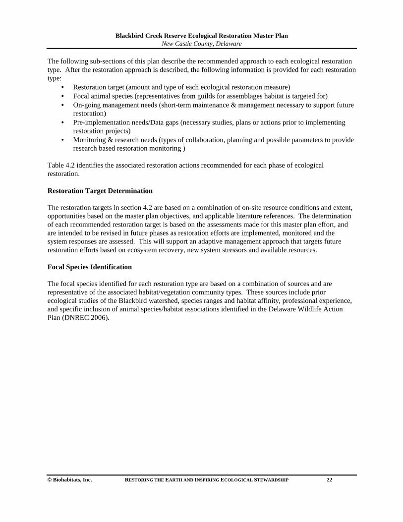
Blackbird Creek Reserve Ecological Restoration Master Plan
New Castle County, Delaware
© Biohabitats, Inc. RESTORING THE EARTH AND INSPIRING ECOLOGICAL STEWARDSHIP 22
The following sub-sections of this plan describe the recommended approach to each ecological restoration type. After the restoration approach is described, the following information is provided for each restoration type:
• Restoration target (amount and type of each ecological restoration measure) • Focal animal species (representatives from guilds for assemblages habitat is targeted for) • On-going management needs (short-term maintenance & management necessary to support future
restoration) • Pre-implementation needs/Data gaps (necessary studies, plans or actions prior to implementing
restoration projects) • Monitoring & research needs (types of collaboration, planning and possible parameters to provide
research based restoration monitoring ) Table 4.2 identifies the associated restoration actions recommended for each phase of ecological restoration. Restoration Target Determination The restoration targets in section 4.2 are based on a combination of on-site resource conditions and extent, opportunities based on the master plan objectives, and applicable literature references. The determination of each recommended restoration target is based on the assessments made for this master plan effort, and are intended to be revised in future phases as restoration efforts are implemented, monitored and the system responses are assessed. This will support an adaptive management approach that targets future restoration efforts based on ecosystem recovery, new system stressors and available resources. Focal Species Identification The focal species identified for each restoration type are based on a combination of sources and are representative of the associated habitat/vegetation community types. These sources include prior ecological studies of the Blackbird watershed, species ranges and habitat affinity, professional experience, and specific inclusion of animal species/habitat associations identified in the Delaware Wildlife Action Plan (DNREC 2006).
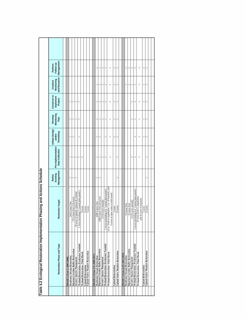
Tabl
e 4.
2 Ec
olog
ical
Res
tora
tion
Impl
emen
tatio
n Ph
asin
g an
d A
ctio
ns S
ched
ule
Res
tora
tion
Phas
e an
d Ty
peR
esto
rtio
n Ta
rget
Ref
ine
Exis
ting
Man
agem
ent
Pre-
impl
emen
tatio
nD
ata
Col
lect
ion
Initi
ate
Des
ign
and/
orPe
rmitt
ing
Dev
elop
Mon
itorin
gPl
an
Con
stru
ct o
r Im
plem
ent
Proj
ect
Con
duct
Mon
itorin
gan
d R
esea
rch
Perf
orm
Follo
w-u
pM
anag
emen
t
PHA
SE 1
(Yea
r 1-
-200
7-20
08)
Hea
dwat
er S
trea
m R
esto
ratio
n16
35 L
inea
r Fee
t�
��
��
Rip
aria
n C
orri
dor
Buf
fer
Res
tora
tion
725
Line
ar F
eet (
2.8
acre
s)�
��
��
Inva
sive
Spe
cies
Man
agem
ent
18 a
cres
of u
plan
d, ri
paria
n &
wet
land
��
��
Wet
land
Res
tora
tion-
-Fre
shw
ater
Non
tidal
1 A
cre
(incl
udin
g 2
'coas
tal p
lain
pon
ds')
��
��
Wet
land
Res
tora
tion-
-Tid
al M
arsh
0 ac
res
�U
plan
d R
efor
esta
tion
0 ac
res
Upl
and
Nat
ive
Mea
dow
Res
tora
tion
0 ac
res
PHA
SE 2
(Yea
rs 2
-5--
2008
-201
3)H
eadw
ater
Str
eam
Res
tora
tion
4280
Lin
ear F
eet
��
��
��
�R
ipar
ian
Cor
rido
r B
uffe
r R
esto
ratio
n19
00 L
inea
r Fee
t (34
acr
es)
��
��
��
�In
vasi
ve S
peci
es M
anag
emen
t15
-20
acre
s ann
ually
��
��
�W
etla
nd R
esto
ratio
n--F
resh
wat
er N
ontid
al2
Acr
es (i
nclu
ding
6-8
'co
asta
l pla
in p
onds
')�
��
��
�W
etla
nd R
esto
ratio
n--T
idal
Mar
sh13
ac.
fres
h to
olig
ohal
ine,
5 a
c. o
f bra
ckis
h, a
nd
6 ac
res o
f ope
n w
ater
to ti
dal m
arsh
��
��
��
Upl
and
Ref
ores
tatio
n3
acre
s�
��
��
Upl
and
Nat
ive
Mea
dow
Res
tora
tion
23 a
cres
��
��
��
�
PHA
SE 3
(Yea
rs 6
-15-
-201
3-20
23)
Hea
dwat
er S
trea
m R
esto
ratio
n0
Line
ar F
eet
��
Rip
aria
n C
orri
dor
Buf
fer
Res
tora
tion
0 Li
near
Fee
t�
�In
vasi
ve S
peci
es M
anag
emen
t15
-20
acre
s ann
ually
��
��
�W
etla
nd R
esto
ratio
n--F
resh
wat
er N
ontid
al2
Acr
es (i
nclu
ding
6-8
'co
asta
l pla
in p
onds
')�
��
��
�W
etla
nd R
esto
ratio
n--T
idal
Mar
sh27
acr
es fr
esh
to o
ligoh
alin
ean
d 45
acr
es o
f bra
ckis
h�
��
��
�
Upl
and
Ref
ores
tatio
n5
acre
s�
��
��
Upl
and
Nat
ive
Mea
dow
Res
tora
tion
13 a
cres
��
��
��
�
Blackbird Creek Reserve Ecological Restoration Master Plan
New Castle County, Delaware
© Biohabitats, Inc. RESTORING THE EARTH AND INSPIRING ECOLOGICAL STEWARDSHIP 23
4.1.2 Additional Rare Species Needs & Considerations Due to the fact that there are identified rare, threatened or endangered species (RTE) identified for the Reserve tracts, and other RTE species may occur, a detailed RTE inventory study is needed. This is necessary in order to specifically understand their extent and to effectively manage this important ecological resource. Specific needs for an RTE species study include the following:
• Conduct seasonal field investigations based on identified and potentially occurring species, their biology, life stages, seasonality and habitat needs
• Document the RTE species population sizes, distribution and condition to provide a baseline for protection, management and monitoring
• Identify direct threats and stresses to the RTE species populations A comprehensive RTE study will help to inform the specific planning, design, implementation and management of the ecological restoration initiatives and facility/site amenity projects. Most importantly, integrating RTE species considerations into project implementation is intended to help ensure their protection and conservation. The potential relationship of the currently known RTE species associated with the recommended ecological restoration habitat types identified in this section are:
• Purple milkweed—Upland and riparian forests (low, dry areas of shady woods) • Large tick-trefoil—Upland forests (high, dry woods, clearings) • Pale avens—Upland forests (forest openings, and thickets) • Whorled mountain mint—Native meadow (dry fields/grassland, thickets) • Long-lobe arrowhead—Tidal wetlands (muddy intertidal flats, water) • Bald eagle—Riparian corridor buffers and tidal marsh wetlands (forests, bodies of water)
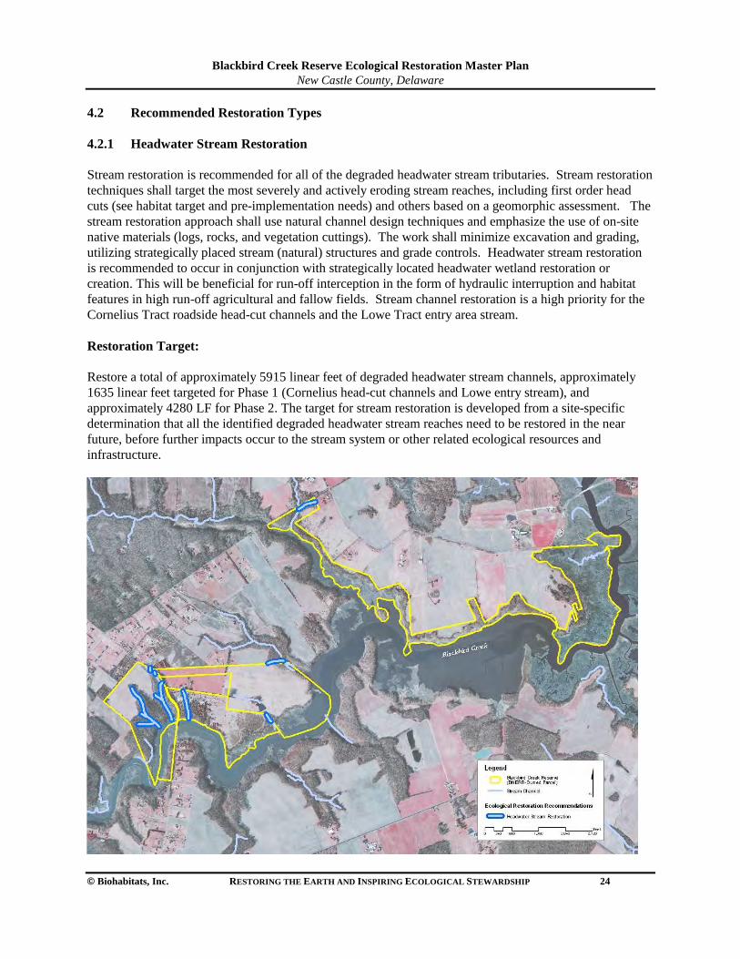
Blackbird Creek Reserve Ecological Restoration Master Plan
New Castle County, Delaware
© Biohabitats, Inc. RESTORING THE EARTH AND INSPIRING ECOLOGICAL STEWARDSHIP 24
4.2 Recommended Restoration Types 4.2.1 Headwater Stream Restoration Stream restoration is recommended for all of the degraded headwater stream tributaries. Stream restoration techniques shall target the most severely and actively eroding stream reaches, including first order head cuts (see habitat target and pre-implementation needs) and others based on a geomorphic assessment. The stream restoration approach shall use natural channel design techniques and emphasize the use of on-site native materials (logs, rocks, and vegetation cuttings). The work shall minimize excavation and grading, utilizing strategically placed stream (natural) structures and grade controls. Headwater stream restoration is recommended to occur in conjunction with strategically located headwater wetland restoration or creation. This will be beneficial for run-off interception in the form of hydraulic interruption and habitat features in high run-off agricultural and fallow fields. Stream channel restoration is a high priority for the Cornelius Tract roadside head-cut channels and the Lowe Tract entry area stream. Restoration Target: Restore a total of approximately 5915 linear feet of degraded headwater stream channels, approximately 1635 linear feet targeted for Phase 1 (Cornelius head-cut channels and Lowe entry stream), and approximately 4280 LF for Phase 2. The target for stream restoration is developed from a site-specific determination that all the identified degraded headwater stream reaches need to be restored in the near future, before further impacts occur to the stream system or other related ecological resources and infrastructure.
Blackbird Creek Reserve Ecological Restoration Master Plan
New Castle County, Delaware
© Biohabitats, Inc. RESTORING THE EARTH AND INSPIRING ECOLOGICAL STEWARDSHIP 25
Focal Animal Species for Habitat Type Bridle shiner (Notropis bifrenatus), spotted sandpiper (Actitis macularia), and midland clubtail (Gamphus fraternus). On-going Management Needs Reduce or eliminate the mowing of field edges and agricultural cropping within 100 feet of headwater channels. Consider closing off the trail from fields to house on Cornelius Tract. Pre-implementation Needs/Data Gaps
• Identify and retain a geomorphologist/stream restoration specialist • Conduct a geomorphic assessment of all on-site stream channels and further prioritize reach
segments for restoration • Monument stream restoration reach cross sections and record GPS/photo point locations to
document current stream conditions. • Identify a restoration design approach and concept for each reach to be restored. • Initiate a stream plan design development, acquire regulatory approvals and make construction
contracting arrangements. Monitoring & Research Needs Identify research partners from local or regional Colleges / Universities, DNREC or other collaborating consultants. Develop a monitoring plan for each stream restoration project. Establish testable hypotheses. Select and monitor appropriate reference sites, and on-site control reaches. Implement a restoration site monitoring plan. Consider the impact of monitoring activities on the habitat and minimize these impacts. Possible monitoring parameters include:
• bankfull width • sinuosity • bank full elevation • bank erosion/scour • bed characterization/pebble counts • cross-sectional areas • wetted width • channel slope • floodplain profile • riparian vegetation • aquatic organisms (fish and macro-invertebrates).
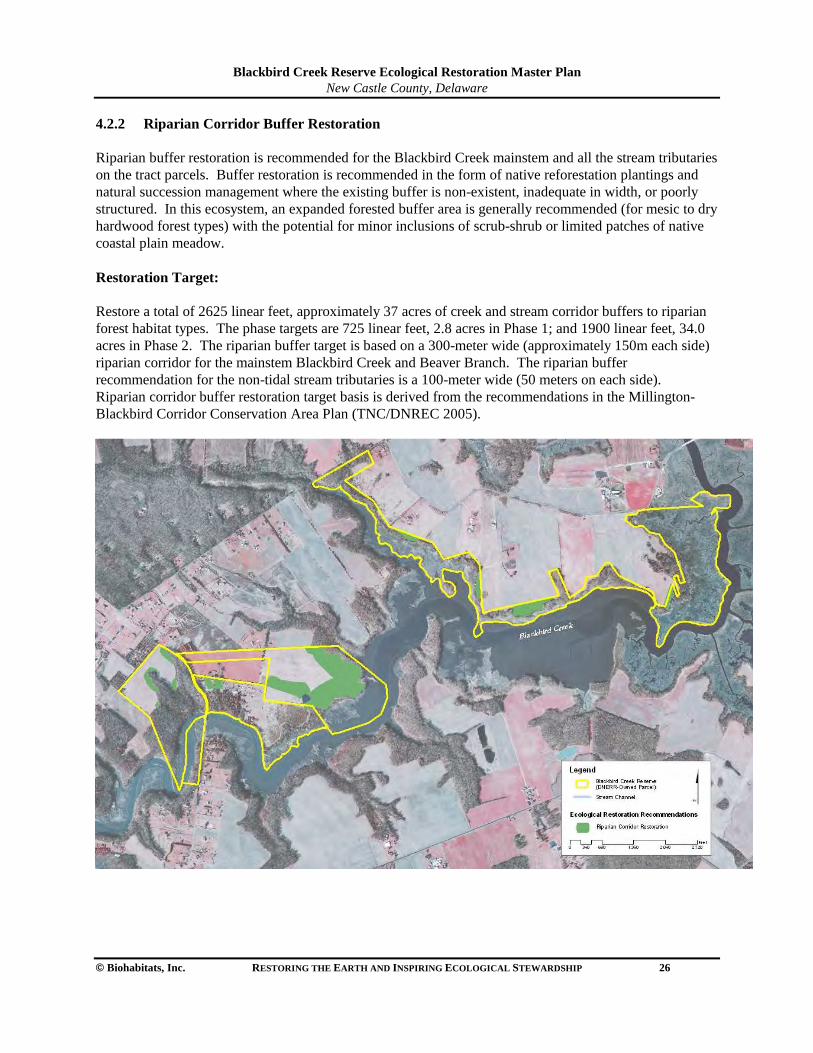
Blackbird Creek Reserve Ecological Restoration Master Plan
New Castle County, Delaware
© Biohabitats, Inc. RESTORING THE EARTH AND INSPIRING ECOLOGICAL STEWARDSHIP 26
4.2.2 Riparian Corridor Buffer Restoration Riparian buffer restoration is recommended for the Blackbird Creek mainstem and all the stream tributaries on the tract parcels. Buffer restoration is recommended in the form of native reforestation plantings and natural succession management where the existing buffer is non-existent, inadequate in width, or poorly structured. In this ecosystem, an expanded forested buffer area is generally recommended (for mesic to dry hardwood forest types) with the potential for minor inclusions of scrub-shrub or limited patches of native coastal plain meadow. Restoration Target: Restore a total of 2625 linear feet, approximately 37 acres of creek and stream corridor buffers to riparian forest habitat types. The phase targets are 725 linear feet, 2.8 acres in Phase 1; and 1900 linear feet, 34.0 acres in Phase 2. The riparian buffer target is based on a 300-meter wide (approximately 150m each side) riparian corridor for the mainstem Blackbird Creek and Beaver Branch. The riparian buffer recommendation for the non-tidal stream tributaries is a 100-meter wide (50 meters on each side). Riparian corridor buffer restoration target basis is derived from the recommendations in the Millington-Blackbird Corridor Conservation Area Plan (TNC/DNREC 2005).
Blackbird Creek Reserve Ecological Restoration Master Plan
New Castle County, Delaware
© Biohabitats, Inc. RESTORING THE EARTH AND INSPIRING ECOLOGICAL STEWARDSHIP 27
Focal Animal Species for Habitat Type Kentucky warbler (Oporornis formosus), evening bat (Nycticeius humeralis) and carpenter frog (Rana virgatipes). On-going Management Needs Maintain limited seasonal mowing of fallow field areas until decisions are made for each buffer segment to: 1) allow natural selection for woodland recruitment; 2) maintain in fallow field condition until future phases; 3) plant with reforestation propagules (tree stock or woody seeds). Pre-implementation Needs/Data Gaps
• Establish buffer baseline documentation study sites with vegetation plots and GPS/photo point monuments to document current riparian composition, structure, and condition
• Conduct further growing season studies of native species composition, invasive species distribution, propagule sources, and soil analysis samples (to help determine appropriate species locations and potential soil amendment needs)
• Initiate planting plan development and plant source identification Monitoring & Research Needs Identify research partners from local or regional College / University partners, DNREC or other collaborating research organizations. Develop a monitoring plan for each riparian buffer project. Establish testable hypotheses. Select and monitor appropriate reference sites, and on-site control sites. Implement a restoration site monitoring plan. Consider the impact of monitoring activities on the habitat and minimize these impacts. Possible monitoring parameters include:
• species composition • percent cover • canopy extent • interspersion • litter fall • mast/seed production, • plant health (herbivory damage, disease) • woody debris • animal species (composition and relative abundance).
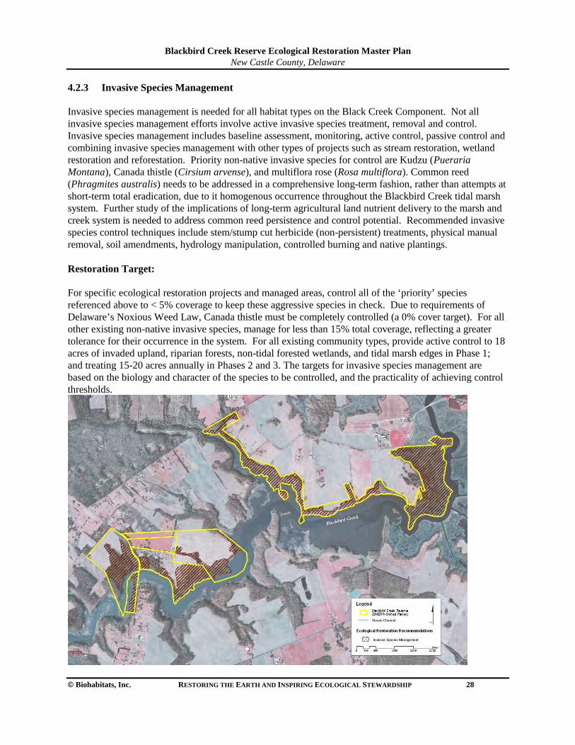
Blackbird Creek Reserve Ecological Restoration Master Plan
New Castle County, Delaware
© Biohabitats, Inc. RESTORING THE EARTH AND INSPIRING ECOLOGICAL STEWARDSHIP 28
4.2.3 Invasive Species Management Invasive species management is needed for all habitat types on the Black Creek Component. Not all invasive species management efforts involve active invasive species treatment, removal and control. Invasive species management includes baseline assessment, monitoring, active control, passive control and combining invasive species management with other types of projects such as stream restoration, wetland restoration and reforestation. Priority non-native invasive species for control are Kudzu (Pueraria Montana), Canada thistle (Cirsium arvense), and multiflora rose (Rosa multiflora). Common reed (Phragmites australis) needs to be addressed in a comprehensive long-term fashion, rather than attempts at short-term total eradication, due to it homogenous occurrence throughout the Blackbird Creek tidal marsh system. Further study of the implications of long-term agricultural land nutrient delivery to the marsh and creek system is needed to address common reed persistence and control potential. Recommended invasive species control techniques include stem/stump cut herbicide (non-persistent) treatments, physical manual removal, soil amendments, hydrology manipulation, controlled burning and native plantings. Restoration Target: For specific ecological restoration projects and managed areas, control all of the ‘priority’ species referenced above to < 5% coverage to keep these aggressive species in check. Due to requirements of Delaware’s Noxious Weed Law, Canada thistle must be completely controlled (a 0% cover target). For all other existing non-native invasive species, manage for less than 15% total coverage, reflecting a greater tolerance for their occurrence in the system. For all existing community types, provide active control to 18 acres of invaded upland, riparian forests, non-tidal forested wetlands, and tidal marsh edges in Phase 1; and treating 15-20 acres annually in Phases 2 and 3. The targets for invasive species management are based on the biology and character of the species to be controlled, and the practicality of achieving control thresholds.
Blackbird Creek Reserve Ecological Restoration Master Plan
New Castle County, Delaware
© Biohabitats, Inc. RESTORING THE EARTH AND INSPIRING ECOLOGICAL STEWARDSHIP 29
Focal Animal Species for Habitat Type Various by habitat, representative species include red-headed woodpecker (Melanerpes erythrocephlus), marsh wren (Cistothorus palustris), and Cope’s gray tree frog (Hyla chrysoscelis). On-going Management Needs Actively treat any identified occurrences of Kudzu, and control Canada thistle to <5% coverage in fallow fields. Treat all targeted non-native invasive species in existing reforestation areas to < 15% coverage, and monitor for invasion by additional highly invasive species. Pre-implementation Needs/Data Gaps
• Establish invasive species management research sites (for treatment testing) with vegetation plots and GPS/photo point monuments to document current composition, structure and distribution
• Prepare a Blackbird Component-wide baseline inventory of non-native invasive species occurrence including species composition, dominance, percent cover, and distribution
Monitoring & Research Needs Identify research partners from local or regional Colleges / Universities, ecological consultants, DNREC or other collaborating research and conservation organizations (e.g., The Nature Conservancy). Develop a monitoring plan for each invasive species management project. Establish testable hypotheses. Select and monitor appropriate on-site controls (in this context- untreated) areas, and treatment sites. Implement a restoration site monitoring plan. Other considerations for common reed control include understanding and addressing long-term and large-scale issues related to agricultural land nutrient transport, hydrologic and sediment dynamics (sea level rise, marsh subsidence, etc.) and changes in the watershed land uses. Possible monitoring parameters include:
• species composition • percent cover • canopy extent • interspersion • litter fall • mast/seed production • seedling regeneration • plant health (herbivory damage, disease) • soil chemistry • animal species (composition and relative abundance).
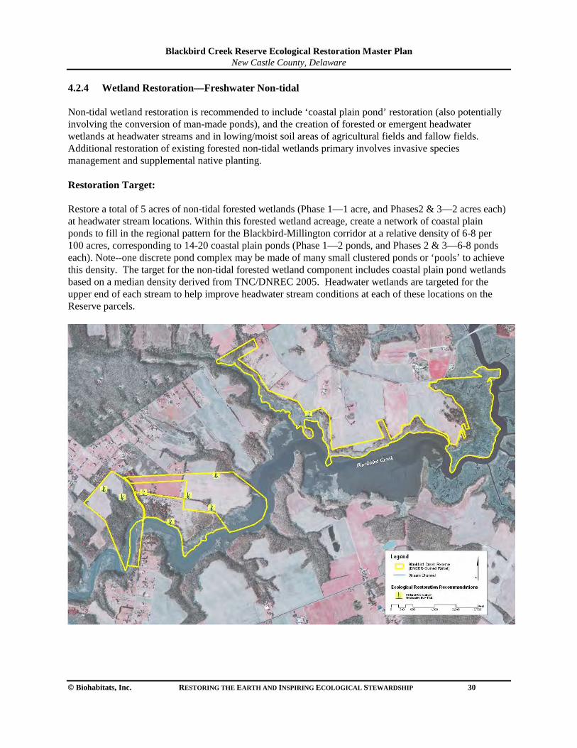
Blackbird Creek Reserve Ecological Restoration Master Plan
New Castle County, Delaware
© Biohabitats, Inc. RESTORING THE EARTH AND INSPIRING ECOLOGICAL STEWARDSHIP 30
4.2.4 Wetland Restoration—Freshwater Non-tidal Non-tidal wetland restoration is recommended to include ‘coastal plain pond’ restoration (also potentially involving the conversion of man-made ponds), and the creation of forested or emergent headwater wetlands at headwater streams and in lowing/moist soil areas of agricultural fields and fallow fields. Additional restoration of existing forested non-tidal wetlands primary involves invasive species management and supplemental native planting. Restoration Target: Restore a total of 5 acres of non-tidal forested wetlands (Phase 1—1 acre, and Phases2 & 3—2 acres each) at headwater stream locations. Within this forested wetland acreage, create a network of coastal plain ponds to fill in the regional pattern for the Blackbird-Millington corridor at a relative density of 6-8 per 100 acres, corresponding to 14-20 coastal plain ponds (Phase 1—2 ponds, and Phases 2 & 3—6-8 ponds each). Note--one discrete pond complex may be made of many small clustered ponds or ‘pools’ to achieve this density. The target for the non-tidal forested wetland component includes coastal plain pond wetlands based on a median density derived from TNC/DNREC 2005. Headwater wetlands are targeted for the upper end of each stream to help improve headwater stream conditions at each of these locations on the Reserve parcels.
Blackbird Creek Reserve Ecological Restoration Master Plan
New Castle County, Delaware
© Biohabitats, Inc. RESTORING THE EARTH AND INSPIRING ECOLOGICAL STEWARDSHIP 31
Focal Animal Species for Habitat Type Spotted salamander (Ambystoma maculatium), Eastern ribbon snake (Thamnophis sauritus), and barking treefrog (Hyla gratiosa) On-going Management Needs Maintain existing pond levels and continue limited seasonal mowing of fallow areas and agricultural field cropping until further study directs most suitable locations for coastal plain pond creation and other forested wetland restoration. Pre-implementation Needs/Data Gaps
• For the existing man-made ponds and potential headwater wetland areas in agricultural or fallow fields, study and model the hydrology, install and monitor ground-water and surface water monitoring wells
• Perform geotechnical and topographic surveys of each of the restoration sites • Establish wetland baseline research sites (proposed restoration sites and control sites) with
hydrology stations, vegetation plots and GPS/photo point monuments to document conditions • Initiate wetland plan design development, regulatory approvals and contracting arrangements
Monitoring & Research Needs Identify research partners from local or regional College / University partners, DNERR, DNREC USFWS or other collaborating research and conservation organizations. Develop a monitoring plan for each wetland restoration project. Establish testable hypotheses. Select and monitor appropriate reference sites, and on-site control areas. Implement a restoration site monitoring plan. Consider the impact of monitoring activities on the habitat and minimize these impacts. Possible monitoring parameters include:
• groundwater and surface elevations • soil texture, chemistry and nutrients • sedimentation rates • vegetation species composition • percent cover • canopy extent • litter fall • mast/seed production • plant health (herbivory damage, disease) • woody debris • animal species (composition and relative abundance).
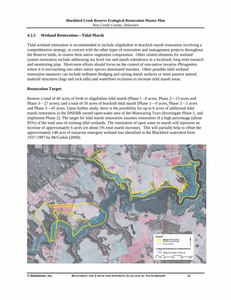
Blackbird Creek Reserve Ecological Restoration Master Plan
New Castle County, Delaware
© Biohabitats, Inc. RESTORING THE EARTH AND INSPIRING ECOLOGICAL STEWARDSHIP 32
4.2.5 Wetland Restoration—Tidal Marsh Tidal wetland restoration is recommended to include oligohaline to brackish marsh restoration involving a comprehensive strategy, in concert with the other types of restoration and management projects throughout the Reserve lands, to restore their native vegetation composition. Other related elements for wetland system restoration include addressing sea level rise and marsh subsidence in a localized, long term research and monitoring plan. Short-term efforts should focus on the control of non-native invasive Phragmites where it is encroaching into other native species dominated marshes. Other possible tidal wetland restoration measures can include sediment dredging and raising marsh surfaces or more passive natural material structures (logs and rock sills) and waterfowl exclusion to increase tidal marsh areas. Restoration Target: Restore a total of 40 acres of fresh to oligohaline tidal marsh (Phase 1 –0 acres, Phase 2—13 acres and Phase 3—27 acres); and a total of 50 acres of brackish tidal marsh (Phase 1—0 acres, Phase 2—5 acres and Phase 3—45 acres. Upon further study, there is the possibility for up to 6 acres of additional tidal marsh restoration in the DNERR owned open-water area of the Manwaring Tract (Investigate Phase 1, and implement Phase 2). The target for tidal marsh restoration assumes restoration of a high percentage (about 85%) of the total area of existing tidal wetlands. The restoration of open water to marsh will represent an increase of approximately 6 acres (or about 5% total marsh increase). This will partially help to offset the approximately 148 acre of estuarine emergent wetland loss identified in the Blackbird watershed from 1937-1997 by McCorkle (2000).
Blackbird Creek Reserve Ecological Restoration Master Plan
New Castle County, Delaware
© Biohabitats, Inc. RESTORING THE EARTH AND INSPIRING ECOLOGICAL STEWARDSHIP 33
Focal Animal Species for Habitat Type Coastal plain swamp sparrow (Melospiza Georgiana nigrescens), black duck (Anas rubripes), and northern diamondback terrapin (Malaclemys terrapin terrapin) On-going Management Needs Continue to keep equipment based maintenance activities out of all tidal wetlands, monitor roadside debris dumping potential Union Church Road crossing at Beaver Dam Creek marsh. Pre-implementation Needs/Data Gaps
• Record tidal elevation data and pattern at additional Creek and marsh stations (e.g., Beaver Dam Creek, Manwaring shoreline and Lowe shoreline) and analyze tidal hydrology.
• Perform geotechnical/sediment coring study of marsh plain and selected channel bottom substrate to document historic patterns of sedimentation.
• Conduct an inventory and assessment study of native common reed (Phragmites australis americanus) stands along the Blackbird Component.
• Establish tidal wetland baseline research sites (proposed restoration sites and control sites) with hydrology stations, vegetation plots and GPS/photo point monuments to document conditions.
Monitoring & Research Needs Identify research partners from local or regional College / Universities, DNREC, USFWS, US Army Corps of Engineers or other collaborating research organizations. Develop a monitoring plan for each wetland restoration project. Establish testable hypotheses. Select and monitoring appropriate reference sites, and on-site control areas. Implement a restoration site monitoring plan. Consider the impact of monitoring activities on the habitat and minimize them. Possible monitoring parameters include:
• Tidal elevation ranges and cycle • marsh substrate texture, chemistry, composition and nutrients • sedimentation rates (SET, sedimentation elevation tables) • vegetation species composition • percent cover • biomass production • detritus export • plant health (herbivory damage, disease) • animal species (fish, wildlife and invertebrate composition and relative abundance).
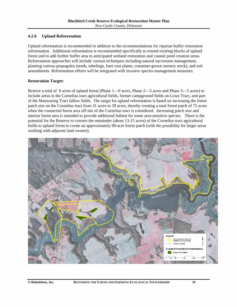
Blackbird Creek Reserve Ecological Restoration Master Plan
New Castle County, Delaware
© Biohabitats, Inc. RESTORING THE EARTH AND INSPIRING ECOLOGICAL STEWARDSHIP 34
4.2.6 Upland Reforestation Upland reforestation is recommended in addition to the recommendations for riparian buffer restoration reforestation. Additional reforestation is recommended specifically to extend existing blocks of upland forest and to add further buffer area to anticipated wetland restoration and coastal pond creation areas. Reforestation approaches will include various techniques including natural succession management, planting various propagules (seeds, tubelings, bare root plants, container-grown nursery stock), and soil amendments. Reforestation efforts will be integrated with invasive species management measures. Restoration Target: Restore a total of 8 acres of upland forest (Phase 1—0 acres, Phase 2—3 acres and Phase 3—5 acres) to include areas in the Cornelius tract agricultural fields, former campground fields on Lowe Tract, and part of the Manwaring Tract fallow fields. The target for upland reforestation is based on increasing the forest patch size on the Cornelius tract from 31 acres to 39 acres, thereby creating a total forest patch of 75 acres when the connected forest area off-site of the Cornelius tract is considered. Increasing patch size and interior forest area is intended to provide additional habitat for some area-sensitive species. There is the potential for the Reserve to convert the remainder (about 13-15 acres) of the Cornelius tract agricultural fields to upland forest to create an approximately 90-acre forest patch (with the possibility for larger areas working with adjacent land owners).
Blackbird Creek Reserve Ecological Restoration Master Plan
New Castle County, Delaware
© Biohabitats, Inc. RESTORING THE EARTH AND INSPIRING ECOLOGICAL STEWARDSHIP 35
Focal Animal Species for Habitat Type Wood thrush (Hylocichla mustelina), Scarlet tanager (Piranga olivacea), and broadhead skink (Eumeces laticeps) On-going Management Needs Maintain limited seasonal mowing of fallow areas and continue agricultural field use until decisions are made on the exact timing of each upland reforestation planting effort. Pre-implementation Needs/Data Gaps
• Establish upland reforestation baseline research sites with vegetation plots and GPS/photo point monuments to document current upland forest composition, structure and condition.
• Conduct further growing season study of native species composition, invasive species distribution and propagule sources, and soil analysis samples.
• Initiate planting plan development and plant source identification. Monitoring & Research Needs Identify research partners from local or regional College / Universities, US Forest Service, DNREC or other collaborating research organizations. Develop a monitoring plan for each upland reforestation project. Establish testable hypotheses. Select and monitor appropriate reference sites and on-site control sites. Implement a restoration site monitoring plan. Consider the impact of monitoring activities on the habitat and minimize these impacts. Possible monitoring parameters include:
• species composition • percent cover • canopy extent • interspersion • litter fall • mast/seed production and seedling regeneration • plant health (herbivory damage, disease), and woody debris • animal species (composition and relative abundance).
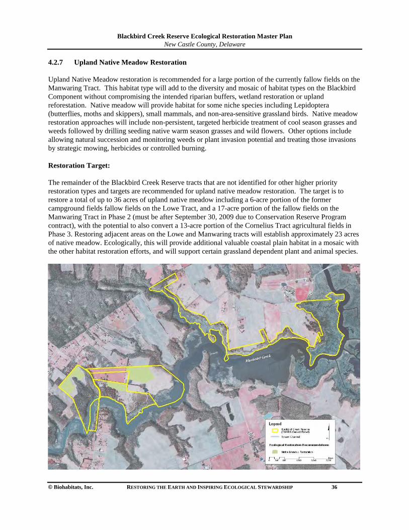
Blackbird Creek Reserve Ecological Restoration Master Plan
New Castle County, Delaware
© Biohabitats, Inc. RESTORING THE EARTH AND INSPIRING ECOLOGICAL STEWARDSHIP 36
4.2.7 Upland Native Meadow Restoration Upland Native Meadow restoration is recommended for a large portion of the currently fallow fields on the Manwaring Tract. This habitat type will add to the diversity and mosaic of habitat types on the Blackbird Component without compromising the intended riparian buffers, wetland restoration or upland reforestation. Native meadow will provide habitat for some niche species including Lepidoptera (butterflies, moths and skippers), small mammals, and non-area-sensitive grassland birds. Native meadow restoration approaches will include non-persistent, targeted herbicide treatment of cool season grasses and weeds followed by drilling seeding native warm season grasses and wild flowers. Other options include allowing natural succession and monitoring weeds or plant invasion potential and treating those invasions by strategic mowing, herbicides or controlled burning. Restoration Target: The remainder of the Blackbird Creek Reserve tracts that are not identified for other higher priority restoration types and targets are recommended for upland native meadow restoration. The target is to restore a total of up to 36 acres of upland native meadow including a 6-acre portion of the former campground fields fallow fields on the Lowe Tract, and a 17-acre portion of the fallow fields on the Manwaring Tract in Phase 2 (must be after September 30, 2009 due to Conservation Reserve Program contract), with the potential to also convert a 13-acre portion of the Cornelius Tract agricultural fields in Phase 3. Restoring adjacent areas on the Lowe and Manwaring tracts will establish approximately 23 acres of native meadow. Ecologically, this will provide additional valuable coastal plain habitat in a mosaic with the other habitat restoration efforts, and will support certain grassland dependent plant and animal species.
Blackbird Creek Reserve Ecological Restoration Master Plan
New Castle County, Delaware
© Biohabitats, Inc. RESTORING THE EARTH AND INSPIRING ECOLOGICAL STEWARDSHIP 37
Focal Animal Species for Habitat Type Bobwhite quail (Colinus virginianus), Eastern box turtle (Terrapene carolina) and Meadow fritillary (Boloria bellona). On-going Management Needs Maintain limited seasonal mowing of fallow areas and continue agricultural field use until decisions are made on the exact timing of each upland reforestation planting effort. Pre-implementation Needs/Data Gaps
• Establish upland meadow restoration baseline research sites with vegetation plots and GPS/photo point monuments to document current upland forest composition, structure and condition
• Conduct further growing season studies of native species composition, invasive species distribution and propagule sources, and soil analysis samples
• Initiate planting plan development and plant source identification Monitoring & Research Needs Identify research partners from local and regional Colleges / Universities, Natural Resources Conservation Service, DNREC or other collaborating research organizations. Develop a monitoring plan for each upland native meadow restoration project. Establish testable hypotheses. Select and monitor appropriate reference sites, and on-site control sites. Implement a restoration site monitoring plan. Consider the impact of monitoring activities on the habitat and minimize these impacts. Possible monitoring parameters include:
• species composition • percent cover • canopy extent • interspersion • litter fall • mast/seed production • seedling regeneration • plant health (herbivory damage, disease), and woody debris • animal species (composition and relative abundance).
Blackbird Creek Reserve Ecological Restoration Master Plan
New Castle County, Delaware
© Biohabitats, Inc. RESTORING THE EARTH AND INSPIRING ECOLOGICAL STEWARDSHIP 38
5.0 SUSTAINABILITY AND STEWARDSHIP OPPORTUNITIES 5.1 Sustainable Facilities and Infrastructure The DNERR proposes several new or redeveloped infrastructure projects on the Blackbird Component tracts to support the research, education and public access components of their mission. There are related site suitability and sustainability issues and opportunities associated with these new facilities. A key point DNERR recognizes is that these facilities need to be compatible with and support conservation and ecological restoration efforts on the Blackbird Reserve. General recommendations for addressing sustainability include avoiding the placement of new facilities in sensitive areas including wetlands, streams, riparian buffers, rare species habitat areas, steep slopes or forest interior areas. Additionally, the amount and location of new impervious surfaces need to be carefully considered and minimized to the extent possible. The associated stormwater run-off needs to be managed and reduced by best management practices (BMPs) and sustainable/low impact development (LID) techniques. Basic principles related to infrastructure facilities sighting include:
• Minimize the overall size/footprint and disturbance of construction • Avoid impacts to sensitive natural resources (identified above) • Place facilities in existing disturbed/altered areas (e.g., maintained fields) • Emphasize the minimization of run-off and design for infiltration
Specific suggestions for sustainability measures for currently proposed facility projects are as follows: Canoe/Kayak Launch—Lowe Tract
• Locate in area of existing disturbed creek bank edge • Create launch as carry-in facility with no vehicle access road/ramp • Avoid nearby rare plant habitat for Purple milkweed • Stabilize minor eroded bank areas at launch edges (using living shoreline techniques)
Education Pavilion and Rest Rooms—Lowe Tract
• Place in existing maintained grass field at entry area • Evaluate building a recycled/re-used material structure (e.g., salvaged logs) • Use composting toilets for rest rooms facilities • Serve energy needs with all solar power
Parking and Turn-around/Drive—Lowe Tract
• Reduce driveway widths to minimal necessary for buses • Formalize parking areas on porous paving materials (e.g., modular pavers) • Add stormwater BMPs—wet or grassed swales, rain gardens, etc. • Landscape remainder of entry area with native landscaping (demonstration habitat gardens)
Existing House-Future Offices—Cornelius Tract • Modify existing landscaping/lawn to native plantings for demonstration and interpretation uses • Create transition zones to woodland to minimize forest gap and diversify edge • Formalize a small parking area using porous paving materials (e.g., modular pavers or wood
mulch)
Blackbird Creek Reserve Ecological Restoration Master Plan
New Castle County, Delaware
© Biohabitats, Inc. RESTORING THE EARTH AND INSPIRING ECOLOGICAL STEWARDSHIP 39
Entry Drive Access Road—Cornelius Tract • Stabilize active head-cut channel with natural channel design stabilization as a part of headwater
stream restoration • Reduce (to narrow 4-5 ft. wide stabilized foot path) or eliminate existing drive path to agricultural
fields, add supplemental forest plantings • Create a roadside vegetated swale BMP along the agricultural field side of the road
Research and Interpretive Trails—Lowe and Manwaring Tracts
• Create a trail plan for placement and management • Employ infrequent periodic mowing of grassed trails • Future temporary trail placement can be strategic with invasive species control activities and other
habitat restoration and research projects • Place more permanent pedestrian trails in a limited fashion to highlight specific restoration types
and interpretive opportunities Woodland Stream Crossing Path—Cornelius Tract
• Construct stream crossing bridge in conjunction with adjacent headwater stream restoration to minimize disturbance activities
• Minimize width for pedestrian access only (4-5 feet wide), use leaf litter or hardwood mulch path material
• Meander trail route to avoid existing trees and their critical root zones • Span a wooden (salvaged/recycled) footbridge over stream with no structural support in stream
channel
5.2 Supporting Best Management Practices BMP Opportunities There are a number of related BMP opportunities for Stormwater and Agricultural BMPs that can work well with the research, restoration, and stewardship objectives of the Reserve. A few suggestions for applicable BMPs are as follows:
• Expanded agricultural field buffer strips (native grasses and legumes) • Stormwater run-off or treatment wetlands • Perimeter native grass or wetland swales • Experimental winter cover crop varieties native/naturalized species for regenerating/improving
soils • Native hayfield testing trials with indigenous species for silage/feed • Organic fertilizer/organic farming demonstration and monitoring of adjacent natural systems
Blackbird Creek Reserve Ecological Restoration Master Plan
New Castle County, Delaware
© Biohabitats, Inc. RESTORING THE EARTH AND INSPIRING ECOLOGICAL STEWARDSHIP 40
BMP Monitoring Potential Along with the research and monitoring based ecological restoration efforts, the establishment of agricultural and stormwater BMPs provides an opportunity for additional monitoring of BMP performance and effects on natural systems. A brief list of possible monitoring parameters is as follows:
5.3 Stewardship Opportunities There are stewardship opportunities on the Blackbird tracts related to public use and participation, interpretation and education opportunities. A list of suggested potential stewardship opportunities includes:
• School-aged educational opportunities to highlight a different part of the Delaware Estuary (fresh to brackish tidal creek and marsh system) compared to the St. Jones Reserve
• Applied ecological monitoring and research for college/university students to work with DNERR research staff on baseline and restoration studies
• Restoration practitioner training grounds to showcase and demonstrate a variety of applied ecological restoration practices and research results
• Self-guided, or periodically organized (education staff guided)interpretive trail and demonstration potential for natural communities and ecotypes
• Community-based resource for engaging farmers and other land owners to see restoration and BMP practices in action, to apply to their lands
• Precipitation and run-off volumes • Stream flow • Water quality
--Pollutant concentration --Biological oxygen demand (BOD) --Dissolved oxygen (DO) --Organics/carcinogens/pesticides --metals --total suspended solids --temperature --pH --nitrogen and phosphorus
• Influence of BMPs on downstream receiving waters --Biotic communities (fish & invertebrates) --bank erosion --Sediment transport --stream flow --in-stream water quality
Blackbird Creek Reserve Ecological Restoration Master Plan
New Castle County, Delaware
© Biohabitats, Inc. RESTORING THE EARTH AND INSPIRING ECOLOGICAL STEWARDSHIP 41
6.0 REFERENCES Bailey, A.R. 1997. Detecting and Monitoring Phragmites Invasion of Coastal Wetlands: A Comparison of
Remote Sensing Techniques. Masters Thesis, College of Marine Studies, University of Delaware. Bradshaw, A.D. 1997. What do we mean by restoration? In Restoration Ecology and Sustainable
Development, eds. K.M. Urbanska, N.R. Webb & P.J. Edwards, pp.8-16. Cambridge: Cambridge University Press.
DNERR. 1993. Delaware National Estuarine Research Reserve Management Plan 1993. Delaware
National Estuarine Research Reserve. Dover, DE. DNERR. 2004. Delaware National Estuarine Research Reserve Management Plan 2004-2009. Delaware
National Estuarine Research Reserve. Dover, DE. DNERR / DNREC. 1995. DNERR Comprehensive Site Description. Phase I – Description / Analysis of
Dominant Vegetation / Cover Types. Delaware National Estuarine Research Reserve, Delaware Dept. of Natural Resources and Environmental Control. Dover, DE.
DNERR / DNREC. 1995. Final Report - DNERR Comprehensive Site Description. Phase II –
Characterization of Finfish and Aquatic Macroinvertebrate Communities and Waterbird Populations. Delaware National Estuarine Research Reserve, Delaware Dept. of Natural Resources and Environmental Control. Dover, DE.
DNREC. 2006. Delaware Wildlife Action Plan. Delaware Dept. of Natural Resources and Environmental
Control. Dover, DE. DNREC / DNERR. 1999. Estuarine Profiles. Delaware Dept. of Natural Resources and Environmental
Control, Delaware National Estuarine Research Reserve. Dover, DE. DNREC / DNHP. 2003. Rare Vascular Plants of Delaware. Delaware Natural Heritage Program,
Delaware Dept. of Natural Resources and Environmental Control, Division of Fish and Wildlife. Hobbs, R.J. 2002. The ecological context: a landscape perspective. In Handbook of Ecological
Restoration, Volume 1: Principles of Restoration, eds. M.R. Perrow and A.J. Davy. Pp. 24-45. Cambridge: Cambridge University Press.
Jordan, W.R., M.E. Gilpin, and J.D. Aber. 1987. Restoration Ecology: ecological restoration as a
technique for basic research. In Restoration Ecology, eds. W.R. Jordan, M.E. Gilpin and J.D. Aber, pp. 3-21. Cambridge: Cambridge University Press.
Klemas, V. V. and R. T. Field. 2004. Remote Sensing of Habitat Change at Delaware NERRS Sites. Final Report to DNREC/DSWC, Delaware Coastal Programs/DNEER.
McCorkle, Richard C. 2000. Land Use / Land Cover Changes and Ecological Health Indicators in the
Blackbird Creek Watershed: With Recommendations For Restoration. Master of Science Thesis in the Marine Studies Program of the University of Delaware.
Mitsch, W.J. and S.E. Jorgensen. 2004. Ecological Engineering and Ecosystem Restoration. John Wiley &
Blackbird Creek Reserve Ecological Restoration Master Plan
New Castle County, Delaware
© Biohabitats, Inc. RESTORING THE EARTH AND INSPIRING ECOLOGICAL STEWARDSHIP 42
Sons, New Jersey. 411 pp. National Oceanic and Atmospheric Administration (NOAA). 2002 online. What is Restoration? National
Oceanic and Atmospheric Administration, Restoration Center, 1315 East-West Highway, Silver Spring, Maryland 20910. URL: http://www.nmfs.noaa.gov/habitat/restoration/whatisrestoration.html
Parker, V.T., and S.T.A. Pickett. 1997. Restoration as an ecosystem process: implications of the modern
ecological paradigm. In Restoration Ecology and Sustainable Development, eds. K.M. Urbanska , N.R. Webb and P.J. Edwards, pp. 17-32. Cambridge: Cambridge University Press.
Perrow, M.R. and A.J. Davy, eds. 2002. Handbook of Ecological Restoration, Volume 1: Principles of
Restoration. Cambridge University Press. 444pp. Pinit, P.T., R.J. Bellmer, and G.W. Thayer. 2000. NOAA Fisheries Technical Guidance Manual for
Success Criteria in Restoration Projects. Draft. NOAA Restoartion Center, Office of Habitat Conservation, NOAA Fisheries, Silver Spring, MD.
SER, 2004. The SER International Primer on Ecological Restoration. Society for Ecological Restoration
International Science & Policy Working Group. Version 2, October, 2004. Silliman, B.R. and M.D. Bertness. 2004. Shoreline Development Drives Invasion of Phragmites australis
and the Loss of Plant Diversity on New England Salt Marshes. Conservation Biology 18 (5), 1424–1434.
Tiner, R.W. 2001. Delaware’s Wetlands: Status and Recent Trends. U.S. Fish and Wildlife Service,
Northeast Region, Hadley, MA. Prepared for the Delaware Department of Natural Resources and Environmental Control, Watershed Assessment Section, Division of Water Resources, Dover, DE. Cooperative National Wetlands Inventory Publication. 19pp.
Thayer, Gordon W., T.A. McTigue, R.J. Bellmer, F.M. Burrows, S.H. Merkey, A.D. Nickens, S.J. Lozano,
P.R. Gayaldo, P.J. Polmateer, and P.T. Pinit. 2003. Science-Based Restoration Monitoring of Coastal Habitats, Volume One: A Framework for Monitoring Plans Under the Estuaries and Clean Waters Act of 2000 (Public Law 160-457). NOAA Coastal Ocean Program Decision Analysis Series No.23, Volume1. NOAA National Centers for Coastal Ocean Science, Silver Spring, MD. 35pp. plus appendices.
TNC/DE-DNREC. 2005. Blackbird-Millington Corridor Conservation Area Plan. The Nature Conservancy
/ Delaware Department of Natural Resources and Environmental Control. Valentine, V. J. 2002. Scrub-Shrub/Emergent Wetland Ecotone Migration Along Delaware Tidal Rivers
In Response to Relative Sea-Level Change, Natural Impacts, and Human Modifications. Ph.D. Dissertation in the Marine Studies Program from the University of Delaware.
Washington, H., J. Malloy, R. Lonie, D. Love, J. Dumbrell, P. Bennett, and S. Baldwin. 2000. Aspects of
Catchment Health: A Community Environmental Assessment and Monitoring Manual. Hawkesbury-Nepean Catchment Management Trust, Windsor, Australia.
Blackbird Creek Reserve Ecological Restoration Master Plan
New Castle County, Delaware
© Biohabitats, Inc. RESTORING THE EARTH AND INSPIRING ECOLOGICAL STEWARDSHIP 43
Wasson, K., Lohrer, D., Crawford, M., and Rumrill, S. 2002. Non-native species in our nation’s estuaries: a framework for an invasion monitoring program. National Estuarine Research Reserve Technical Report Series 2002:1.
Westervelt, K., E. Largay, R. Coxe, W. McAvoy, S. Perles, G. Podniesinski, L. Sneddon, And K. Walz.
2006. A Guide to the Natural Communities of the Delaware Estuary: Version I. NatureServe, Arlington, Virginia.


APPENDIX A

DNERR Management Plan 1993 This Reserve system management planning document established the inclusion of the DNERR in the National Estuarine Research Reserve System (NERRS). This original plan outlined a detailed acquisition agenda and site information for the two Reserve components, the Upper Blackbird Creek Reserve and the Lower St. Jones River Reserve. Plans were made to guide programs for education/interpretation, research, and resource protection through the first five years of operation at the Reserve components. DNERR Estuarine Profiles, 1999 This technical document was developed as a comprehensive characterization and inventory of existing natural resources and environmental features of the DNERR’s two component sites, the Upper Blackbird Creek Reserve and the Lower St. Jones River Reserve. Site specific inventories were carried out between 1993 and 1997 with backround information general to DE estuaries. DNERR Management Plan 2004-2009 This management plan is the second edition of the management plan and is an addendum to the original plan approved by NOAA and adopted by the DNERR in 1993. The updated plan describes the mission, goals, and objectives of the NERRS and the DNERR, also describing the accomplishments of the DNERR since the 1993 plan. Action plans are articulated for the Reserve’s administration; facilities and construction; public access; education, interpretation, and outreach; environmental research and monitoring; and stewardship. The plan designates the Upper Blackbird Creek component as being primarily protected for research use with public access closely coordinated with the Reserve Manager to reduce the potential for human impact. DNERR / DNREC. 1995. DNERR Comprehensive Site Description. Phase I – Description / Analysis of Dominant Vegetation / Cover Types. The Phase I objective was to begin watershed / estuarine characterizations of the Reserve components by mapping and describing the dominant vegetation and cover types within the boundaries and adjacent lands of the two Reserves, upper Blackbird Creek and lower St. Jones River. This study was intended to serve as a baseline for long-term DNERR monitoring work. DNERR / DNREC. 1995. Final Report - DNERR Comprehensive Site Description. Phase II – Characterization of Finfish and Aquatic Macroinvertebrate Communities and Waterbird Populations. The Phase II objective was to complete the major natural resource element characterization of each of the Reserve components with finfish, aquatic macroinvertebrate and waterbird community sampling and analysis. This study was also intended to serve as a complimentary baseline to Phase I for long-term DNERR living resource monitoring work. McCorkle, Richard C. 2000. Land Use / Land Cover Changes and Ecological Health Indicators in the Blackbird Creek Watershed: With Recommendations For Restoration. Master of Science Thesis in the Marine Studies Program of the University of Delaware. Richard McCorkle’s thesis assessed changes in land use and land cover of the Blackbird Creek watershed between 1937 and 1997. This study developed landscape metrics for land cover data to assess landscape
ecological integrity, identified areas with degraded ecological conditions, developed recommendations for ecological restoration, and provided data with the goal of aiding in the setting of priorities by decision makers concerning non-point source pollution control and wildlife habitat restoration efforts. Among McCorkle’s findings over the 60 year span of time was a 12.5% increase in development to 22% of the upland watershed. Cultivated land accounted for 47% of the upland watershed in 1997 but decreased by 16% over the study time period. There was an increase of deciduous forest by 5% accounting for less than 30% of the upland watershed with almost 70% devoted to human uses. Over this time period large areas of tidal marsh converted to open water and mudflats, a 120 ha increase. Remote sensing techniques were also used to evaluate forest interior habitat availability, riparian forest width and the degree of forest patch isolation with regard to the sensitivity of some bird species to these conditions. Klemas, V. V. and R. T. Field. 2004. Remote Sensing of Habitat Change at Delaware NERRS Sites. Final Report to DNREC/DSWC, Delaware Coastal Programs/DNEER. This remote sensing research report utilized Thematic Mapper Images from 1993, 1999, and 2002 to detect and analyze changes in wetland and upland areas around the Blackbird Creek and St. Jones DNERR sites and the Milford Neck Wildlife Area. In the Blackbird Creek study area, large patches of vegetation loss occurred between 1993 and 2002 along the southern bank of the creek east and west of Blackbird Landing. Conversely, there were areas of considerable vegetation gain north and south of Taylors Bridge and along the north bank of the creek east and west of Blackbird Landing. It is stated that the losses are likely related to Phragmites control efforts. Most of the loss and gain occurred between 1993 and 1997. Non-tidal wetland vegetation losses were also documented along the Delaware 1 construction corridor as well as wetland losses possibly associated with suburban development east of Route 13. Small areas of wetland loss and gain were seen in several farm fields, possibly reflecting a change in crop vegetation cover in farmed wetland areas. Upland land uses also showed considerable change although it was more difficult to interpret because of less significant land-cover definition than wetland signatures. Valentine, V. J. 2002. Scrub-Shrub/Emergent Wetland Ecotone Migration Along Delaware Tidal Rivers In Response to Relative Sea-Level Change, Natural Impacts, and Human Modifications. Ph.D. Dissertation in the Marine Studies Program from the University of Delaware. Research by Valentine articulated several factors affecting the migration of the emergent/scrub-shrub ecotone. The interpretation of historic photos showing wetland boundary migration that corresponded with long-term sea-level rise (SLR) over the same time period suggested the strength of SLR in driving ecotone migration. At the Blackbird tributary site it was found that over time ponding and tidal flat creation occurred. The multiple processes of channel straightening and pond/flat creation appeared to work together to flood the ecotone area, killing woody vegetation and displacing the ecotone. It was unexpectedly determined that ecotones along less altered waterways migrated more than those along highly altered waterways. Differences between migration rates at multiple sites suggested that other site specific factors were also influencing migration. Muskrat and beaver activity, bridge modifications at Blackbird Landing and Taylors Bridges, Phragmites australis expansion, and punctuated storm effects are all forwarded by Valentine as possible mechanisms that are influencing the landward movement of the emergent / scrub shrub ecotone.
Non-Native Species at the NERRs Wasson, K., Lohrer, D., Crawford, M., and Rumrill, S. 2002. Non-native species in our nation’s estuaries: a framework for an invasion monitoring program. National Estuarine Research Reserve Technical Report Series 2002:1. This NERRs technical report helps to define and guide the monitoring of non-native species in U.S. estuaries. Biological invasions by non-native species are considered a medium to high priority concern at most of the NERRs. Over 85 non-native species were identified by the reserve system with 8 species identified as priorities at 3 or more reserves. Monitoring is considered to be essential in the identification, understanding and management of invasions at the reserves. The document highlights the NERR Graduate Research Fellowship Program which recognizes invasions as a priority concern and sees graduate research a useful tool for focusing and funding research into the impact of invasions at NERRs sites. Silliman, B.R. and M.D. Bertness. 2004. Shoreline Development Drives Invasion of Phragmites australis and the Loss of Plant Diversity on New England Salt Marshes. Conservation Biology 18 (5), 1424–1434. Silliman and Bertness (2004) found a correlation between Phragmites australis invasion of coastal New England salt marshes and shoreline development. It was found that shoreline development, defined as the removal of woody vegetation bordering marshes, was correlated with reduced soil salinities and increased nitrogen availability. Freeing the plant community from several limiting factors allows for those species with a competitive advantage, such as Phragmites, to emerge and dominate. This suggests that removing woody vegetation bordering marshes facilitates Phragmites invasion by increasing nitrogen availability and reducing soil salinities. With the Upper Blackbird Creek Reserve area maintaining a tidal fresh to middle oligohaline salinity gradient, a likely contributor to Phragmites establishment and expansion along the marsh fringe is the increased availability of nitrogen from the dominant adjacent agricultural land use. Bailey, A.R. 1997. Detecting and Monitoring Phragmites Invasion of Coastal Wetlands: A Comparison of Remote Sensing Techniques. Masters Thesis, College of Marine Studies, University of Delaware. Bailey’s thesis targeted the remote detection of Phragmites cover changes in the Blackbird Creek and St. Jones Rivers between 1979 and 1993. The study found that Phragmites aerial coverage and median patch size in the Blackbird Creek increased over that time period, although the number of patches decreased over the same period indicating that vegetative clonal growth was the primary mode of expansion. TNC/DE-DNREC. 2004. Blackbird-Millington Corridor Conservation Area Plan. The Nature Conservancy / Delaware Department of Natural Resources and Environmental Control. The Nature Conservancy (TNC) and the Delaware Department of Natural Resources and Environmental Control, Division of Fish and Wildlife partnered to develop an existing conditions assessment and conservation plan for the future of the Blackbird-Millington Corridor. The State of Delaware recognizes this corridor as one of the most important areas of the state’s “Green Infrastructure.” The scientific community, local residents, planning agencies and conservation organizations were all coordinated by the TNC to develop this planning and resource conditions document.


APPENDIX B

NOAA Restoration Monitoring Guidance NOAA restoration monitoring guidance documents (Thayer et al 2003, Pinit et al 2000) identify 13 habitat types for coastal freshwater to marine systems, and their most recent habitat type designations for monitoring are:
• Water column • Rock bottom • Coral reefs • Oyster reefs • Soft bottom • Kelp and other macroalgae • Rocky shoreline • Soft shoreline • Submerged aquatic vegetation (SAV; seagrasses) • Marsh (marine/brackish and freshwater) • Mangrove swamps • Deepwater swamps • Riverine forests
The five habitat types from the list above that generally apply to the Blackbird Creek component tracts are water column, soft bottom, soft shoreline, marsh and riverine forests. First structural and functional characteristics are identified that correspond to the restored habitat type being monitored (e.g., provides breeding grounds, or supports biomass production). Based on the identified structural and functional characteristics of the habitat, specific parameters to monitor are chosen within the general categories of Geographical (acreage of habitat type), Biological (Plants and Animals), Hydrological (Physical and Chemical), and Soil and Sediment (Physical and Chemical). Many examples of specific monitoring parameters are identified in Appendix II: Matrices of Habitat Characteristics and Parameters (Thayer et al 2003).