Embed Size (px)
Citation preview
Mountain Bike Facility Development
Web: CollectiveTrax.com Email: [email protected]
Mob UK: +44 7823338691 Mob IT: +39 3791335706
Design and Specification
of
Mountain Bike Facilities
At:
Levenmouth Academy, Methilhaven Rd, Buckhaven, Leven, KY8 1EA
Study commissioned by:
Bat’s Wood SCIO
Final Version Produced By: Tom Durham
On Date: 22/10/19
Mountain Bike Facility Development
Web: CollectiveTrax.com Email: [email protected]
Mob UK: +44 7823338691 Mob IT: +39 3791335706
Contents
1. Background
2. Identified Area for Mountain Bike Facility Development
3. Facility Concept and Description
4. Facility Construction and Specification
5. Other Construction Considerations & Preconstruction Information
6. Costs
Collective Trax – Background
Tom Durham formed Collective Trax in 2012, and has been busy working on mountain bike facility
projects of various scales across Scotland and further afield ever since. These have ranged from small
back garden pump tracks for young children, to feasibility studies and concept design plans for national
scale trail centres and bike parks. Clients have included many community groups, private landowners,
national agencies, and large multinational companies in the renewables sector.
Tom blends his insight from being a mountain bike guide and coach with several years as a ground worker, to identify what type
of facility is best for any given situation. Tom has a keen eye for the bigger picture, and takes a holistic approach to facility
development – an excellent facility is about far more than the trails alone. He also regularly helps with trail design and
management for use in mountain bike races, provides maintenance contracts for several existing facilities, and prides himself on
producing designs that will be inclusive, progressive, and above all safe and fun to ride.
As well as producing design and specification documents, and facility planning, he also acts as Site Trail Designer during the
construction phase of a project; ensuring that his designs are brought to life and give the best possible experience for the end
users and the client.
Tom is a founder member and former chairperson of the Scottish Mountain Bike Consortium (SMBC). He also regularly
participates in industry lead committees and conferences both nationally and internationally, sharing best practice with Trail
Designers from around the world. Tom was involved in the creation of the sportscotland guide to developing mountain bike
facilities in 2016, as well as an innovative study into mountain bike trail erosion alongside the Geotechnical Department at Napier
University.
More recent projects include a large trail development project at Lochore Meadows Country Park in Fife, a small community
bike track in Aberdeenshire, and a path and MTB trail at a primary school in Dunkeld. As well as feasibility studies for both the
Angus Cycle Hub’s local bike park, and a national scale MTB and Adventure Park for Gravitate North East (Gravitate) in
Aberdeenshire, which was described by the client as “nothing short of a masterpiece”!
He is currently working on an exciting new bike park plan in Yorkshire, providing further support to the Gravitate North East
project, developing a management strategy for the use of wild trails in the Italian Alps, as well as several other smaller projects.
For contracts where it is required, other consultants with particular specialisms, such as environmental or forestry expertise,
tourism business management or health and safety, are brought in to support the work that Tom carries out. These existing
collaborations can greatly add to the value delivered at each stage of a project’s life cycle.
Mountain Bike Facility Development
Web: CollectiveTrax.com Email: [email protected]
Mob UK: +44 7823338691 Mob IT: +39 3791335706
1. Background
This project was initially started in early 2018, at which time Duncan Zuill from Levenmouth Academy
requested an initial consultation be carried out by Collective Trax. An initial consultation document
was subsequently produced, including various recommendations on how best to proceed with the
project. (ref: Initial_Consultation-LevenmouthAcademy).
In late December 2018, Duncan requested an updated Consultation report be produced (ref:
Initial_Consultation-LevenmouthAcademyV2). This reflected the desire at that time to investigate
moving forward with the project as a ‘Community Build’ project and giving recommendations as to
how to progress in that direction.
Both approaches to developing this project have subsequently been reviewed and further discussed
with Duncan, during which time a constituted group has been formalised to take responsibility for the
site and its development. Named ‘Bat’s Wood SCIO’, this group have commissioned this Design and
Specification document. This final Design and Specification document therefore intends to provide a
final design concept, and describe a methodology for creating the design once sufficient funding has
been raised.
1.1. The Location
The new Levenmouth Academy is the second largest school in Scotland and was built in 2016. A
range of mainstream sports facilities exist within the grounds including team sports and athletics
pitches, all weather pitches, and many indoor facilities. As a community use school, members of the
public are encouraged into the grounds to use the facilities, which are easily accessible by road, public
transport, and a network of cycle paths that link the nearby communities of Methil, Methilhill, and
Buckhaven.
The Levenmouth area (population c.37500) is classed as having high levels of deprivation, (In the
Buckhaven area alone, all 7 data zones fall within the highest ranked 30% in terms of the Scottish
Index of Multiple Deprivation), and experiences a relatively large number of disengaged pupils. The
desire to build a mountain biking facility is partly aimed at reaching more disengaged members of the
school community through diversionary activity. Cycling and specifically mountain biking is well
documented as having a high level of success in this regard.
There is already much work being done by CLEAR Buckhaven, (Community-Led Environmental Action
for Regeneration) who organise Dr Bike sessions, and bike recycling projects within the community
and at the Academy. In 2017, CLEAR commissioned a PAS Charretteplus programme which lead to
the publication of the Buckhaven Community Action Plan 2018 – 2023. This action plan mentions in
several places the desire from within the community to improve leisure facilities in the area, improve
access to the natural environment with cycling and mountain biking mentioned several times:
• Page 9: Developing mountain bike trails is specifically mentioned as one means of improving
recreational activities,
• Page 16: Developing mountain bike trails is one of 6 actions identified that would ‘Support
physical and recreational activity’.
Mountain Bike Facility Development
Web: CollectiveTrax.com Email: [email protected]
Mob UK: +44 7823338691 Mob IT: +39 3791335706
• More generally, bikes and cycling are mentioned many times, with regards to improving
facilities for recreation and active & sustainable travel.
• The desire for a bike repair and maintenance workshop is also mentioned in terms of ‘Promoting
community recreation and leisure groups’.
The Levenmouth area currently has no active MTB club, or purpose-built facilities, with residents
having to travel to access any formal off-road cycling activity. The nearest of these are a small facility
in Kirkcaldy (15-20 minutes by car), and at Lochore Meadows Country Park’s MTB trail network (c. 40
minutes by car).
While west Fife is becoming increasingly well catered for, with MTB trails as mentioned above, the new
closed road circuit at Lochgelly, and a cycle speedway track in Dunfermline. There is a nationally
identified shortage of cycling facilities in the eastern half of Fife, as detailed in Scottish Cycling’s
Facilities Strategy, although this is slowly changing. A nascent cycle speedway team has started at
Levenmouth Academy and has strong links with Sandwell St Bike Workshop, a community recreational
cycling club. The Levenmouth area is thought to have a higher incidence of bike ownership within the
local population due to its rural location and reportedly very low levels of car ownership. This all
supports the idea that the development of a local MTB club is entirely feasible in the near future. Given
the size of the various towns in east and north Fife, adding specific facilities that are well located and
designed for local people to use, would bring benefits to a large population that is otherwise un-
catered for, and may act as a catalyst for creating a thriving MTB club.
The facility at Levenmouth Academy, once built, will encourage participation of new and inexperienced
mountain bikers as well as providing a fun challenge and opportunity for off-road exercise for those
with more experience. Accessible off road from both local communities and by much of the
Levenmouth area via the network of cycle routes, it will be a safe space for cyclists to ride for leisure,
fun, exercise, and skill development.
The development will offer potential for skills coaching using any nationally approved MTB Coaching
scheme, and therefore it will include various ‘Technical Trail Features’ with progressive difficulty, as
well as creating a fun facility that users want to return to repeatedly. It will be of a sustainable and
low maintenance design and construction. There is potential for a fairly high volume of users on any
facility such as this, and so it will be built to be able to stand up to the demands of this in all weathers.
Mountain Bike Facility Development
Web: CollectiveTrax.com Email: [email protected]
Mob UK: +44 7823338691 Mob IT: +39 3791335706
2. Identified Area for Mountain Bike Facility Development
The area identified by Duncan in which to locate a mountain bike facility is a triangular area of land
called Bat’s Wood. It lies at the back of the Levenmouth Academy playing fields, to the west of the
main buildings. Bat’s Wood covers an area of approximately 1.9Ha, created of made-up ground that
has recently been planted with several thousand tree saplings. It is gently sloping away from the
centre of the site in each direction, although it is generally low lying and was wet underfoot in places
at each of our site visits, with standing water in evidence on some occasions. These site visits have
helped to identify the areas that are most prone to holding water, and allowed the proposed routing
of the trail to avoid these.
The Bat’s Wood team have been gradually developing a biodiversity area on the site, which includes
a garden area, and several small orchards. As time has progressed, the site has evolved as the team
add new features, and the natural growth of self-setting species such as thistles increases.
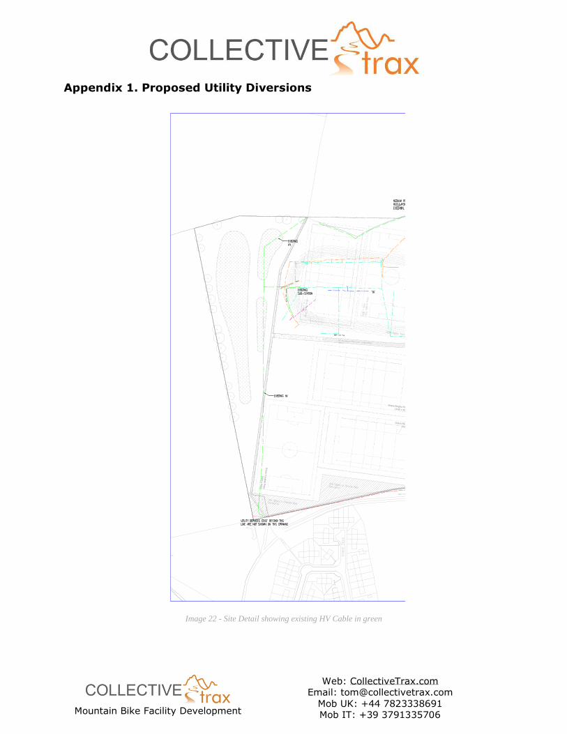
There is an existing HV Electrical Cable buried beneath the site which runs directly north from the S
corner boundary, before turning towards the NE corner boundary. This is best shown on the document
supplied by the facility managers:
(Ref: Appendix 1 - Proposed Utility Diversions.pdf)
The local area sits atop former mine workings and there is a ventilation shaft present on the western
boundary of the Levenmouth Academy site. It would be reasonable to expect to find other evidence
of mining activity during the construction phase if soil is excavated to any depth.
There is a sealed single-track road directly to the Academy boundary from the main entrance, which
then provides access to the site via a vehicle gate. There is also a sealed whindust path running
externally along the Academy boundary fence, providing direct traffic free access to Methilhill and
Buckhaven as mentioned above. This will need to be fenced off during construction in order to maintain
access to the path, whilst keeping users safe.
Since visiting the Bat’s Wood site for the first time, a large amount of demolition rubble mixed with
large pea gravel has been donated to the project team for use on site. This is bunded at the north
end of the site, with various other piles deposited around the site in different locations.
It is the intention of the team at Bat’s Wood SCIO to enter into a lease agreement when the land is
separated from the school estate in the near future. This will enable a planning application to be
submitted for the development, in close partnership with Levenmouth Academy.
Mountain Bike Facility Development
Web: CollectiveTrax.com Email: [email protected]
Mob UK: +44 7823338691 Mob IT: +39 3791335706
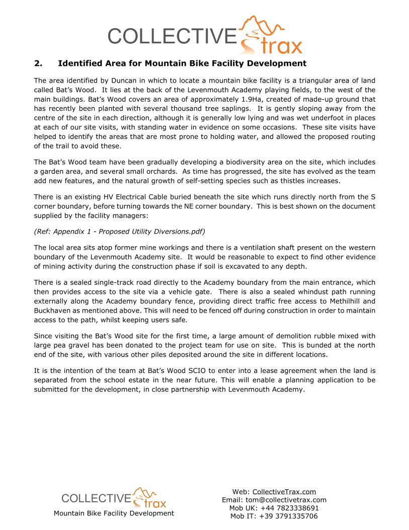
2.1. Visualisation of site location within the Levenmouth area
Image 1 - Levenmouth Area Satellite. Site indicated by orange polygon
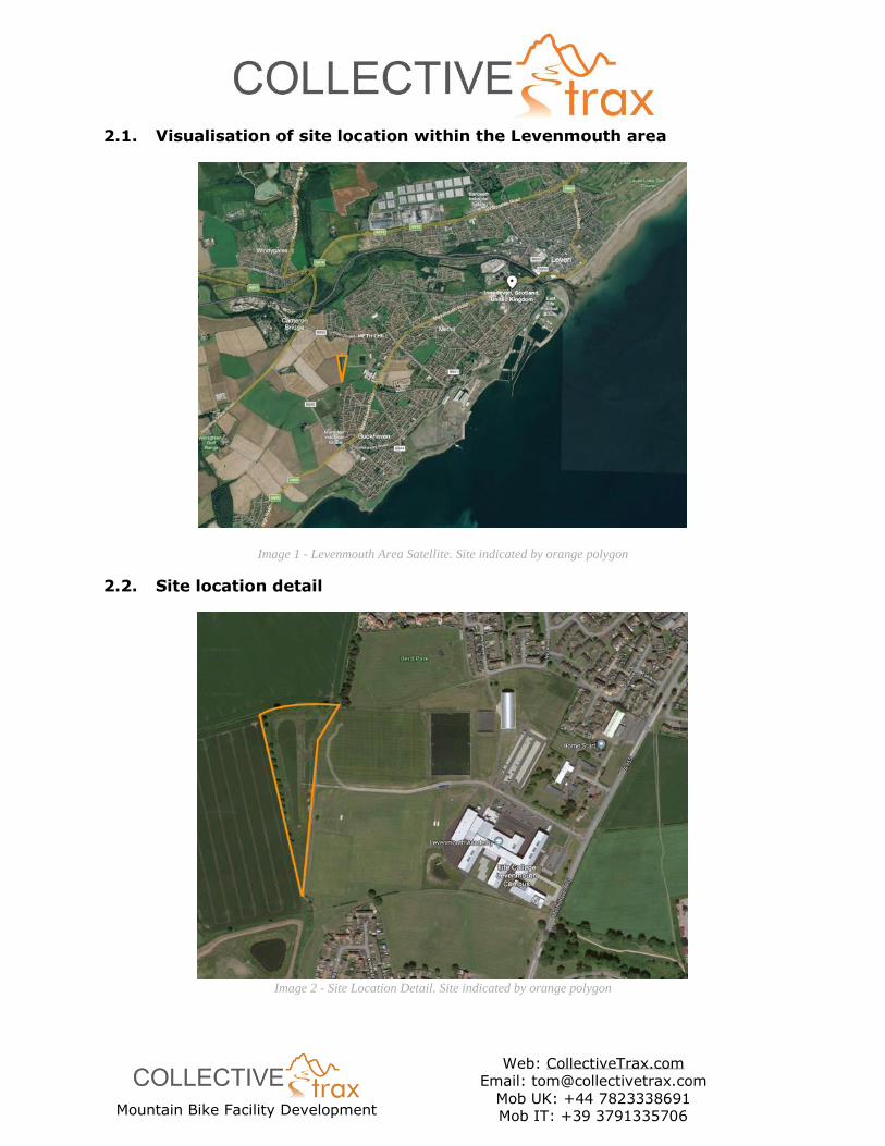
2.2. Site location detail
Image 2 - Site Location Detail. Site indicated by orange polygon
Mountain Bike Facility Development
Web: CollectiveTrax.com Email: [email protected]
Mob UK: +44 7823338691 Mob IT: +39 3791335706
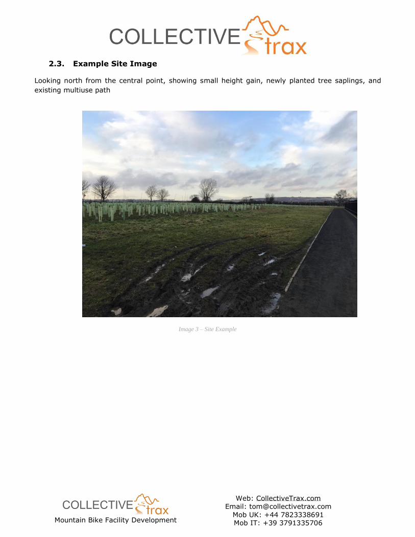
2.3. Example Site Image
Looking north from the central point, showing small height gain, newly planted tree saplings, and
existing multiuse path
Image 3 – Site Example
Mountain Bike Facility Development
Web: CollectiveTrax.com Email: [email protected]
Mob UK: +44 7823338691 Mob IT: +39 3791335706
3. Facility Concept and Description
Given the requirement for a progressive facility to attract beginners and provide a satisfying
experience for the more competent rider, a trail network of interlinking loops will make the most of
the available space will deliver the best value for the required investment.
These individual trail loops or sections will each feature a different ride experience. This will allow easy
repetition of a particular section for coaching or personal skill practice, and provide shorter loops for
novice riders. Those with more experience, will be able to link the loops together as desired to create
a longer overall ride. Interlinking loops of trail in this way will create the possibility of varying the
route each time a rider completes a lap, reducing the repetitiveness that can be inherent in a small
facility.
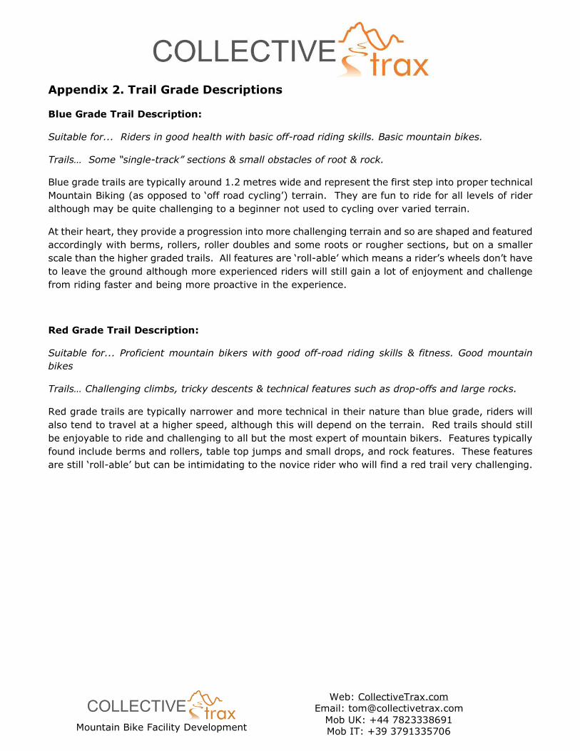
The trail would fall into the cross-country mountain biking trail grading system, using the Green, Blue,
Red, Black progression; indicating the difficulty of features likely to be encountered, much like the
grading system employed on ski pistes. (Ref: Appendix 2 – Trail Grade Description)
3.1. General Trail Description
The main trail will be graded Blue, meaning it will be a fun and involving experience to ride. It will
feature berms, rollers and optional rock features simulating natural terrain as well as providing steps
and drops in each of the different sections. More challenging Red graded features will be built as
options where appropriate, and will be concentrated in the Technical Trail Loop; meaning that riders
can dictate how challenging they want their experience to be by choosing to ride this section if desired,
ensuring that a different experience each time is possible. Additional red grade features may include:
rock rolls, rock steps and causeways, etc.
It is important to stress that a track such as this would not be suitable for severe or ‘Black grade’
features – every feature will be roll-able, so will not include high drops or large jumps.
It is important however that the different sections of trail are of consistent riding experience and join
together coherently as a full loop. This will ensure that the trail is an entertaining and engaging
experience for more competent riders and those looking to ride several laps; to take some exercise
after work for example. Access to the trail will be created at 2 main points, allowing direct access from
each end of the site close to the local housing, accessible from the Academy via the existing multiuse
path. Duncan was keen to avoid creating an access point directly from the Academy gate where an
access path to the garden area currently exists. It is our opinion however that it would be sensible to
allow access from here too. We believe that pupils will naturally want to access the track at the earliest
possible point, rather than diverting to either end of the site.
In total the track length will be approximately 1 Km.
In most facilities of this type and scale, it is advisable to include a large ‘featureless’ area on which
complete beginners can practice basic skills, prior to trying a purpose-built trail. These areas also
serve as a central area for hosting events and can be a useful multipurpose space. However, in the
context of the site at Levenmouth Academy, it was agreed that an area such as this wouldn’t be
necessary as there is such a large area of level grass playing field immediately adjacent.
Mountain Bike Facility Development
Web: CollectiveTrax.com Email: [email protected]
Mob UK: +44 7823338691 Mob IT: +39 3791335706
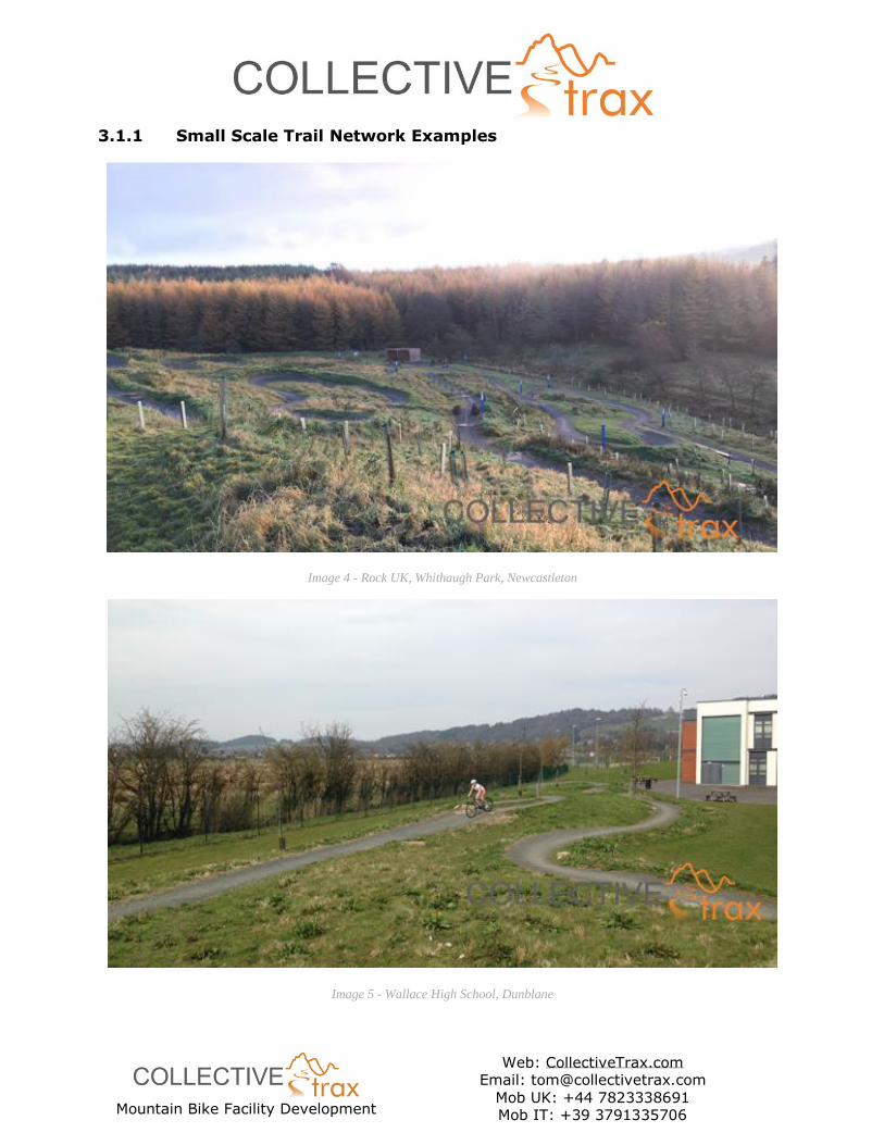
3.1.1 Small Scale Trail Network Examples
Image 4 - Rock UK, Whithaugh Park, Newcastleton
Image 5 - Wallace High School, Dunblane
Mountain Bike Facility Development
Web: CollectiveTrax.com Email: [email protected]
Mob UK: +44 7823338691 Mob IT: +39 3791335706
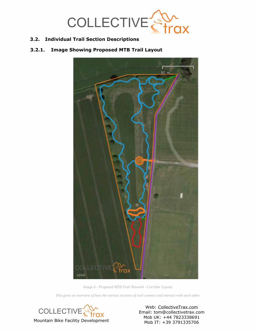
3.2. Individual Trail Section Descriptions
3.2.1. Image Showing Proposed MTB Trail Layout
Image 6 - Proposed MTB Trail Network - Corridor Layout.
This gives an overview of how the various sections of trail connect and interact with each other.
Mountain Bike Facility Development
Web: CollectiveTrax.com Email: [email protected]
Mob UK: +44 7823338691 Mob IT: +39 3791335706
Notes:
• The trail layout is indicated by the Green, Blue and Red lines. The orange lines indicate the
garden area and access path, and the Batswood Meadow. These are shown for reference.
• The purple line shows the route of the existing asphalt path.
• The orange polygon indicates the approximate site boundary.
Image key for all trail layout images:
As described in the trail concept description above, the main trail network will include various individual
loops or sections, joined together to form a coherent experience but with a distinctly different trail
type in each. Each section will enhance the existing site topography, making the most of existing
landscape as much as possible, while extra landscaping will augment the landscape to add to the rider
experience.
A more detailed description of each individual section is included below. It is important to note that
that for a trail project on the scale of this and of this type, the design aspect identifies the best ‘trail
corridor’ within which each trail will be built. Thus, with an identified corridor of around 3m in width,
the trail type descriptions below and design input at the time of construction, the trail building team
will create the trail within the corridor.
Due to the likely time gap between identifying these corridors and starting construction, marking each
with flags, tape or paint was considered to be impractical. Therefore, to help with identifying each
corridor, a GPX file of each will be supplied with this document. Uploading these to any GPS device
will allow for easy demarcation again in the future.
Mountain Bike Facility Development
Web: CollectiveTrax.com Email: [email protected]
Mob UK: +44 7823338691 Mob IT: +39 3791335706
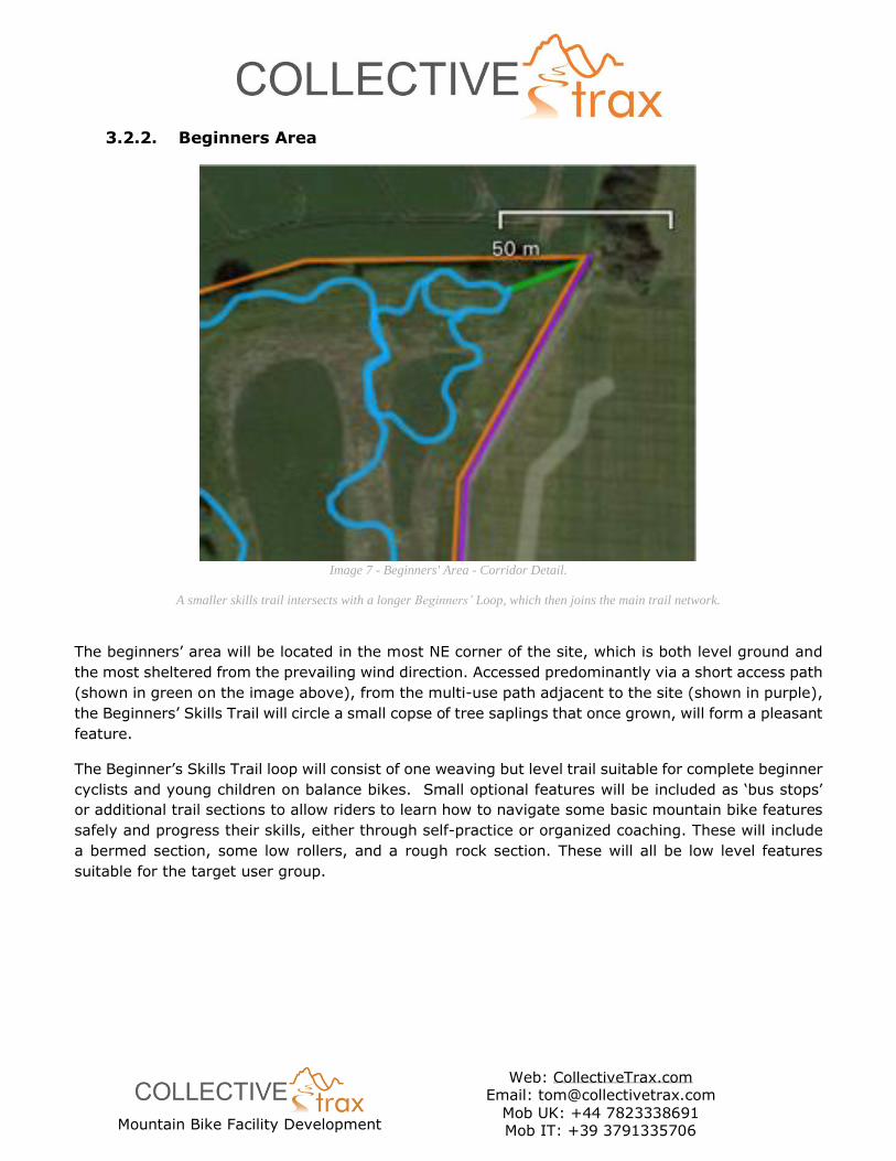
3.2.2. Beginners Area
Image 7 - Beginners' Area - Corridor Detail.
A smaller skills trail intersects with a longer Beginners’ Loop, which then joins the main trail network.
The beginners’ area will be located in the most NE corner of the site, which is both level ground and
the most sheltered from the prevailing wind direction. Accessed predominantly via a short access path
(shown in green on the image above), from the multi-use path adjacent to the site (shown in purple),
the Beginners’ Skills Trail will circle a small copse of tree saplings that once grown, will form a pleasant
feature.
The Beginner’s Skills Trail loop will consist of one weaving but level trail suitable for complete beginner
cyclists and young children on balance bikes. Small optional features will be included as ‘bus stops’
or additional trail sections to allow riders to learn how to navigate some basic mountain bike features
safely and progress their skills, either through self-practice or organized coaching. These will include
a bermed section, some low rollers, and a rough rock section. These will all be low level features
suitable for the target user group.
Mountain Bike Facility Development
Web: CollectiveTrax.com Email: [email protected]
Mob UK: +44 7823338691 Mob IT: +39 3791335706
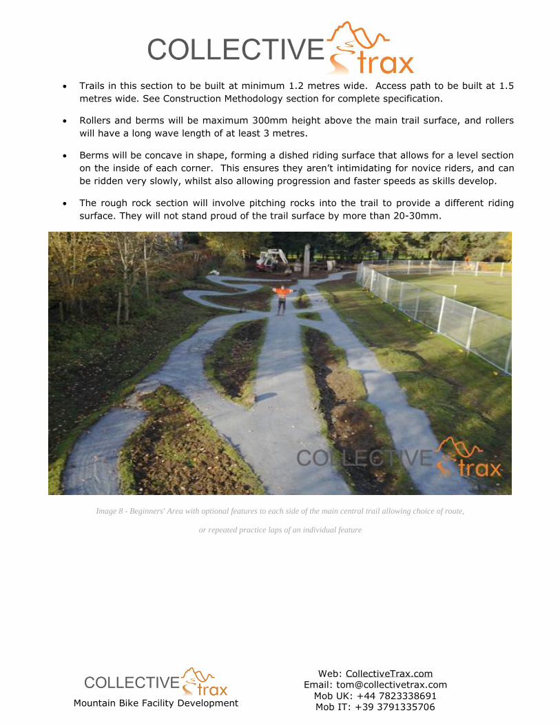
• Trails in this section to be built at minimum 1.2 metres wide. Access path to be built at 1.5
metres wide. See Construction Methodology section for complete specification.
• Rollers and berms will be maximum 300mm height above the main trail surface, and rollers
will have a long wave length of at least 3 metres.
• Berms will be concave in shape, forming a dished riding surface that allows for a level section
on the inside of each corner. This ensures they aren’t intimidating for novice riders, and can
be ridden very slowly, whilst also allowing progression and faster speeds as skills develop.
• The rough rock section will involve pitching rocks into the trail to provide a different riding
surface. They will not stand proud of the trail surface by more than 20-30mm.
Image 8 - Beginners' Area with optional features to each side of the main central trail allowing choice of route,
or repeated practice laps of an individual feature
Mountain Bike Facility Development
Web: CollectiveTrax.com Email: [email protected]
Mob UK: +44 7823338691 Mob IT: +39 3791335706
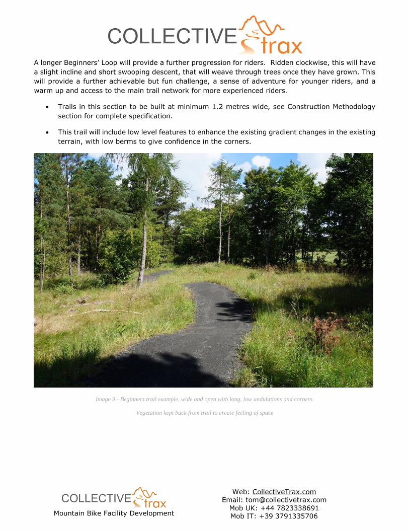
A longer Beginners’ Loop will provide a further progression for riders. Ridden clockwise, this will have
a slight incline and short swooping descent, that will weave through trees once they have grown. This
will provide a further achievable but fun challenge, a sense of adventure for younger riders, and a
warm up and access to the main trail network for more experienced riders.
• Trails in this section to be built at minimum 1.2 metres wide, see Construction Methodology
section for complete specification.
• This trail will include low level features to enhance the existing gradient changes in the existing
terrain, with low berms to give confidence in the corners.
Image 9 - Beginners trail example, wide and open with long, low undulations and corners.
Vegetation kept back from trail to create feeling of space
Mountain Bike Facility Development
Web: CollectiveTrax.com Email: [email protected]
Mob UK: +44 7823338691 Mob IT: +39 3791335706
3.2.3. Singletrack Loop
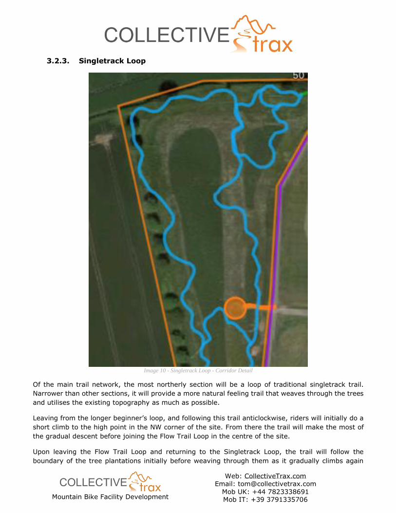
Image 10 - Singletrack Loop - Corridor Detail
Of the main trail network, the most northerly section will be a loop of traditional singletrack trail.
Narrower than other sections, it will provide a more natural feeling trail that weaves through the trees
and utilises the existing topography as much as possible.
Leaving from the longer beginner’s loop, and following this trail anticlockwise, riders will initially do a
short climb to the high point in the NW corner of the site. From there the trail will make the most of
the gradual descent before joining the Flow Trail Loop in the centre of the site.
Upon leaving the Flow Trail Loop and returning to the Singletrack Loop, the trail will follow the
boundary of the tree plantations initially before weaving through them as it gradually climbs again
Mountain Bike Facility Development
Web: CollectiveTrax.com Email: [email protected]
Mob UK: +44 7823338691 Mob IT: +39 3791335706
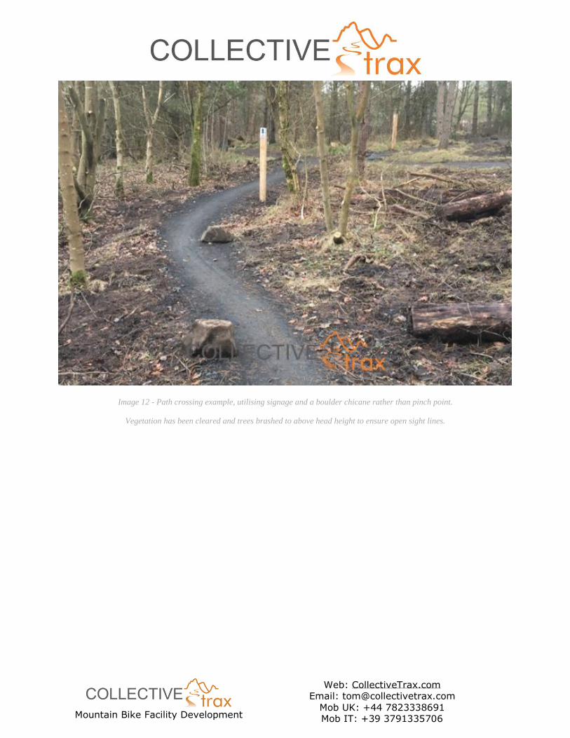
towards the junction with the Beginners Trail. This section will also include a crossing point where the
Singletrack Loop trail crosses the garden area access path. A combination of clear sight lines, signage,
and boulder pinch points on the trail will ensure that this crossing is safe for all users of the facility.
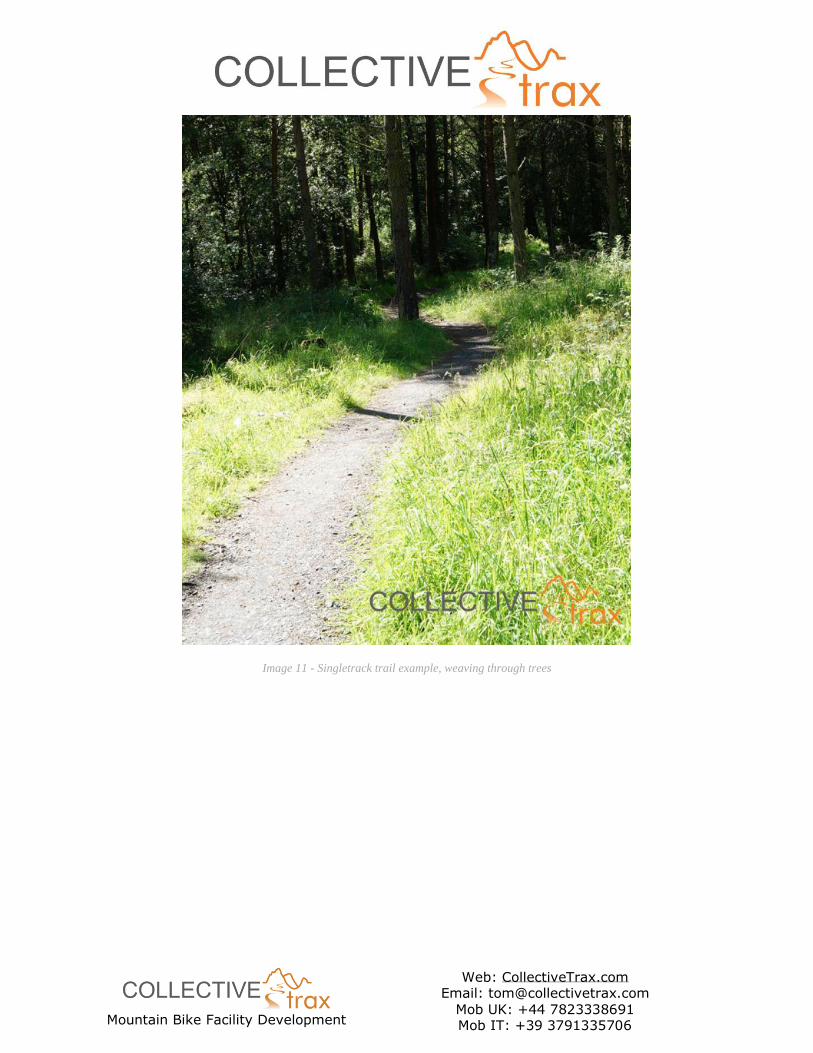
Throughout this Singletrack Loop, natural gradient changes and undulations will be enhanced by
further landscaping, but this will be subtle rather than obviously built. An experienced rider should be
able to ride this trail at a reasonable speed, meaning that corners should be quite open and flowing
with subtle berms to give confidence, again without appearing obviously built.
• Trails in this section to be built at minimum 0.8 metres wide, see Construction Methodology
section for complete specification.
• This trail will include subtle topography enhancements to aid flow with low ‘natural’ berms to
give confidence in the corners.
• As in the image below, the intention will be to allow vegetation to grow up to each side of the
trail to enhance the sensation of being ‘in’ the trail. However, sightlines must be kept open
to allow faster riding.
Mountain Bike Facility Development
Web: CollectiveTrax.com Email: [email protected]
Mob UK: +44 7823338691 Mob IT: +39 3791335706
Image 11 - Singletrack trail example, weaving through trees
Mountain Bike Facility Development
Web: CollectiveTrax.com Email: [email protected]
Mob UK: +44 7823338691 Mob IT: +39 3791335706
Image 12 - Path crossing example, utilising signage and a boulder chicane rather than pinch point.
Vegetation has been cleared and trees brashed to above head height to ensure open sight lines.
Mountain Bike Facility Development
Web: CollectiveTrax.com Email: [email protected]
Mob UK: +44 7823338691 Mob IT: +39 3791335706
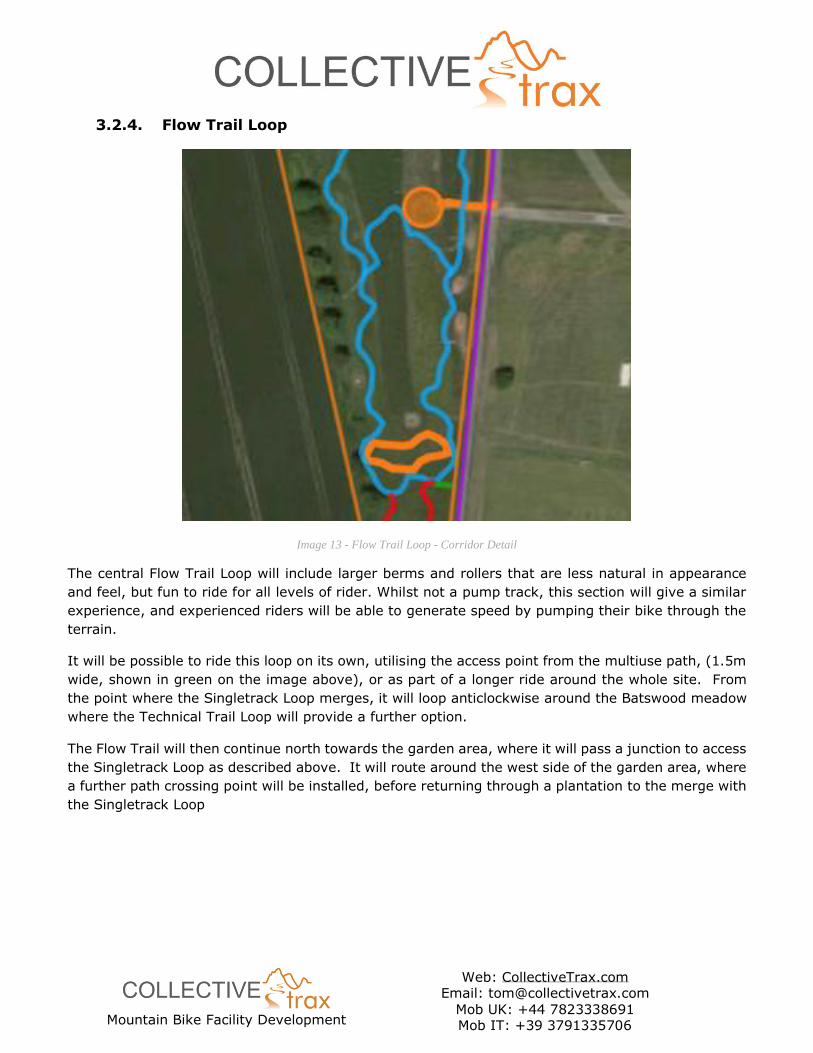
3.2.4. Flow Trail Loop
Image 13 - Flow Trail Loop - Corridor Detail
The central Flow Trail Loop will include larger berms and rollers that are less natural in appearance
and feel, but fun to ride for all levels of rider. Whilst not a pump track, this section will give a similar
experience, and experienced riders will be able to generate speed by pumping their bike through the
terrain.
It will be possible to ride this loop on its own, utilising the access point from the multiuse path, (1.5m
wide, shown in green on the image above), or as part of a longer ride around the whole site. From
the point where the Singletrack Loop merges, it will loop anticlockwise around the Batswood meadow
where the Technical Trail Loop will provide a further option.
The Flow Trail will then continue north towards the garden area, where it will pass a junction to access
the Singletrack Loop as described above. It will route around the west side of the garden area, where
a further path crossing point will be installed, before returning through a plantation to the merge with
the Singletrack Loop
Mountain Bike Facility Development
Web: CollectiveTrax.com Email: [email protected]
Mob UK: +44 7823338691 Mob IT: +39 3791335706
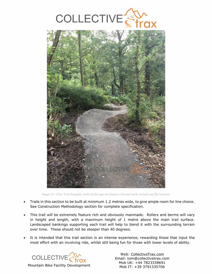
Image 14 - Flow Trail Example, trails of this type are feature rich and rarely include any flat sections.
• Trails in this section to be built at minimum 1.2 metres wide, to give ample room for line choice.
See Construction Methodology section for complete specification.
• This trail will be extremely feature rich and obviously manmade. Rollers and berms will vary
in height and length, with a maximum height of 1 metre above the main trail surface.
Landscaped bankings supporting each trail will help to blend it with the surrounding terrain
over time. These should not be steeper than 40 degrees.
• It is intended that this trail section is an intense experience, rewarding those that input the
most effort with an involving ride, whilst still being fun for those with lower levels of ability.
Mountain Bike Facility Development
Web: CollectiveTrax.com Email: [email protected]
Mob UK: +44 7823338691 Mob IT: +39 3791335706
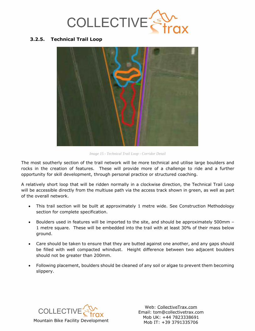
3.2.5. Technical Trail Loop
Image 15 - Technical Trail Loop - Corridor Detail
The most southerly section of the trail network will be more technical and utilise large boulders and
rocks in the creation of features. These will provide more of a challenge to ride and a further
opportunity for skill development, through personal practice or structured coaching.
A relatively short loop that will be ridden normally in a clockwise direction, the Technical Trail Loop
will be accessible directly from the multiuse path via the access track shown in green, as well as part
of the overall network.
• This trail section will be built at approximately 1 metre wide. See Construction Methodology
section for complete specification.
• Boulders used in features will be imported to the site, and should be approximately 500mm –
1 metre square. These will be embedded into the trail with at least 30% of their mass below
ground.
• Care should be taken to ensure that they are butted against one another, and any gaps should
be filled with well compacted whindust. Height difference between two adjacent boulders
should not be greater than 200mm.
• Following placement, boulders should be cleaned of any soil or algae to prevent them becoming
slippery.
Mountain Bike Facility Development
Web: CollectiveTrax.com Email: [email protected]
Mob UK: +44 7823338691 Mob IT: +39 3791335706
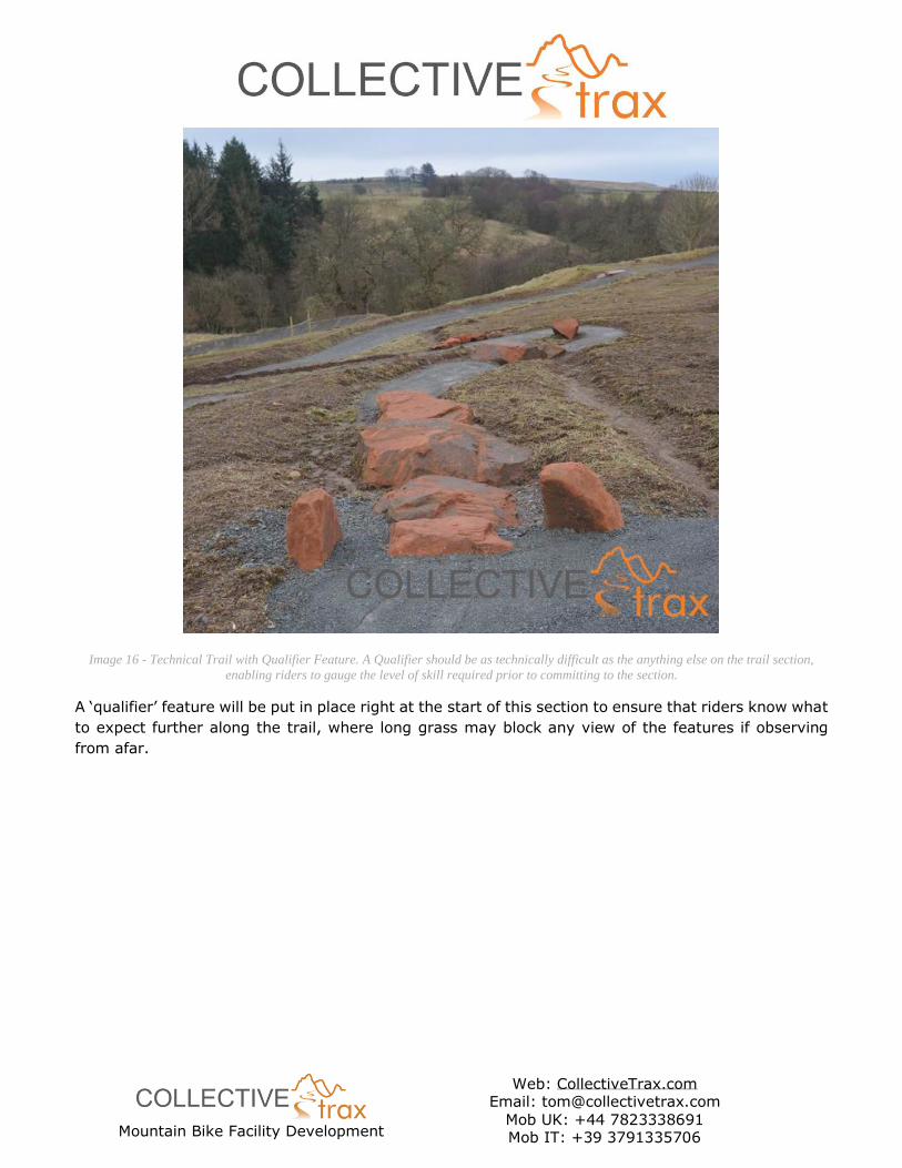
Image 16 - Technical Trail with Qualifier Feature. A Qualifier should be as technically difficult as the anything else on the trail section,
enabling riders to gauge the level of skill required prior to committing to the section.
A ‘qualifier’ feature will be put in place right at the start of this section to ensure that riders know what
to expect further along the trail, where long grass may block any view of the features if observing
from afar.
Mountain Bike Facility Development
Web: CollectiveTrax.com Email: [email protected]
Mob UK: +44 7823338691 Mob IT: +39 3791335706
4. Facility Construction and Specification
4.1 Trail Maturation
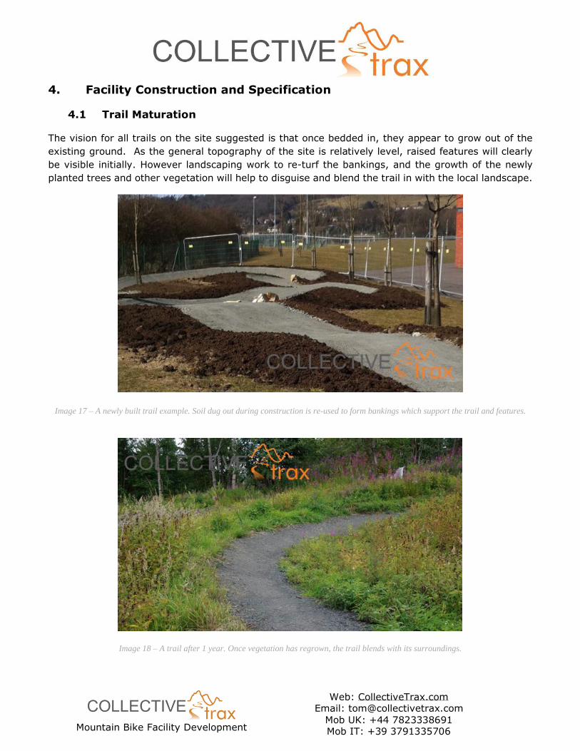
The vision for all trails on the site suggested is that once bedded in, they appear to grow out of the
existing ground. As the general topography of the site is relatively level, raised features will clearly
be visible initially. However landscaping work to re-turf the bankings, and the growth of the newly
planted trees and other vegetation will help to disguise and blend the trail in with the local landscape.
Image 17 – A newly built trail example. Soil dug out during construction is re-used to form bankings which support the trail and features.
Image 18 – A trail after 1 year. Once vegetation has regrown, the trail blends with its surroundings.
Mountain Bike Facility Development
Web: CollectiveTrax.com Email: [email protected]
Mob UK: +44 7823338691 Mob IT: +39 3791335706
In other similar projects we have worked on, clients have opted to plant wild flowers and allow the
grass to grow long immediately surrounding their skills track, providing a biodiversity area. This not
only helps to blend the track with its surroundings, it also removes the need for grass cutting on any
embankments in the future. This approach is in keeping with the current use of the area and we can
be confident that once bedded in the trail will have a very low impact on the surrounding environment.
4.2 Construction Methodology
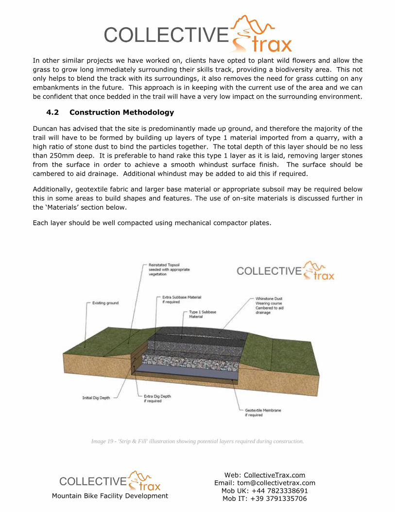
Duncan has advised that the site is predominantly made up ground, and therefore the majority of the
trail will have to be formed by building up layers of type 1 material imported from a quarry, with a
high ratio of stone dust to bind the particles together. The total depth of this layer should be no less
than 250mm deep. It is preferable to hand rake this type 1 layer as it is laid, removing larger stones
from the surface in order to achieve a smooth whindust surface finish. The surface should be
cambered to aid drainage. Additional whindust may be added to aid this if required.
Additionally, geotextile fabric and larger base material or appropriate subsoil may be required below
this in some areas to build shapes and features. The use of on-site materials is discussed further in
the ‘Materials’ section below.
Each layer should be well compacted using mechanical compactor plates.
Image 19 - 'Strip & Fill' illustration showing potential layers required during construction.
Mountain Bike Facility Development
Web: CollectiveTrax.com Email: [email protected]
Mob UK: +44 7823338691 Mob IT: +39 3791335706
Constructing a proper surface for the trails in this way is more expensive initially but allows for proper
drainage and sustainability of the whole facility, especially as made up ground will be unsuitable for
use in construction. It also means that the trail could be used almost year-round, deep snow and ice
being the only exceptions.
Technical Trail Features are mainly constructed utilising the same method as the trail, using additional
bulk material to create a base shape, and with extra landscaping surrounding them to create safe run-
offs. Large boulders may also be used in the construction of some features, as well as for speed
control measures at specific points such as path crossings.
It is strongly advised that trail construction is carried out by mechanical excavators with a tilt-rotate
bucket and suitably skilled operators, with an experienced squad of trail builders in support. This will
go a long way to ensuring that the facility is built efficiently, properly, and in a sustainable manner
from the outset.
4.3 Volunteer Workforce
It is likely that excitement around the construction of a new facility such as this may generate
increased interest within the local community, and that creating a volunteer workforce will be possible.
Indeed, that is one of the aims of the project.
With careful management, a volunteer workforce can be of great assistance with trail construction.
This is usually best utilised prior to construction commencing, in clearing the site access points, and
trail corridors etc of any vegetation or other obstructions. Volunteers can be a great help with setting
up site fencing too, where significant time can be saved.
Volunteers can also have a positive impact working behind the construction team, with tidying up trail
edges, cleaning up boulders used as features, installing ‘trail furniture’, and re-planting vegetation as
required. These are all tasks that can help to reduce the time cost of a project whilst not risking the
health and safety of participants by maintaining a safe distant from plant and machinery etc.
With more careful management, volunteers can potentially also get involved more closely with the
trail construction itself. However, this will have to be discussed on a case by case basis with the
contractor at the point of construction.
Different departments within the Academy can also get involved in the project to help involve as many
pupils as possible if desired. As mentioned below, naming the trail sections is one simple aspect. The
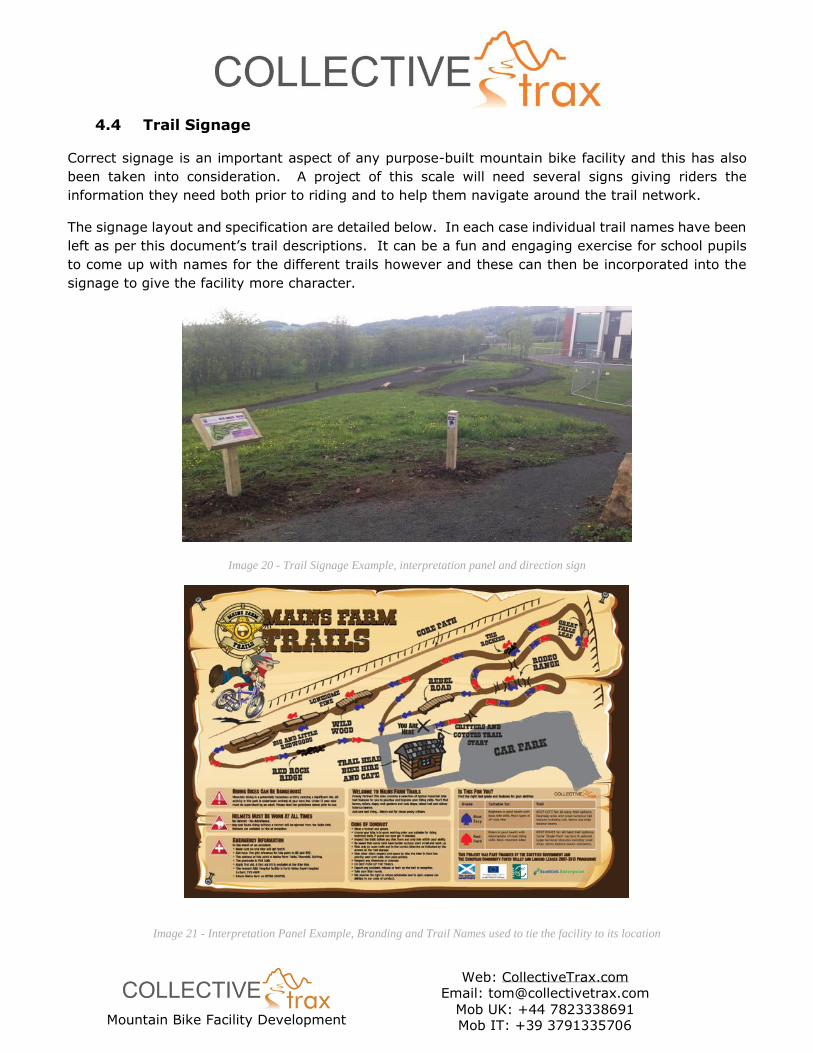
‘branding’ of the signage to be consistent with other parts of the Batswood project is another.
This can go as far as designing the signs if there is desire. The information contained within the signs
is specified by ourselves, but the specific design helps to create an identity for the facility and can be
as imaginative as possible, as long as the information contained is clear to read. An example of a
‘branded’ interpretation sign is given below.
Mountain Bike Facility Development
Web: CollectiveTrax.com Email: [email protected]
Mob UK: +44 7823338691 Mob IT: +39 3791335706
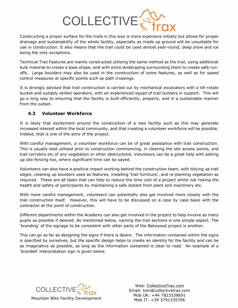
4.4 Trail Signage
Correct signage is an important aspect of any purpose-built mountain bike facility and this has also
been taken into consideration. A project of this scale will need several signs giving riders the
information they need both prior to riding and to help them navigate around the trail network.
The signage layout and specification are detailed below. In each case individual trail names have been
left as per this document’s trail descriptions. It can be a fun and engaging exercise for school pupils
to come up with names for the different trails however and these can then be incorporated into the
signage to give the facility more character.
Image 20 - Trail Signage Example, interpretation panel and direction sign
Image 21 - Interpretation Panel Example, Branding and Trail Names used to tie the facility to its location
Mountain Bike Facility Development
Web: CollectiveTrax.com Email: [email protected]
Mob UK: +44 7823338691 Mob IT: +39 3791335706
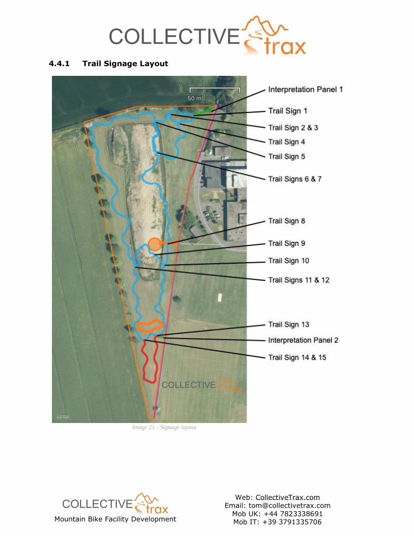
4.4.1 Trail Signage Layout
Image 21 - Signage layout

Mountain Bike Facility Development
Web: CollectiveTrax.com Email: [email protected]
Mob UK: +44 7823338691 Mob IT: +39 3791335706
4.4.2 Trail Signage Specification
Sign Layout Ref. Location Panel Description
Interpretation Panel 1 North Access Path • Emergency Information,
• ‘Do the Ride Thing’ responsible riding advice,
• Trail Network Map with colour grades and names, +
‘You are Here’ arrow
• Is this for you? – Blue / Red Grade Advice
Interpretation Panel 2 South Access Path • Emergency Information,
• ‘Do the Ride Thing’ responsible riding advice,
• Trail Network Map with colour grades and names, +
‘You are Here’ arrow
• Is this for you? – Blue / Red Grade Advice
Trail Sign 1 Access Path – Beginner’s Trail
Junction
• Beginners Skills Trail
• All Trails
• Blue Direction Arrow Left,
Trail Signs 2 & 3 5 Metres prior to trail merge of Beginner’s Skills Trail and
Beginners Loop (on each trail)
• Caution Trails Merge Ahead
Trail Sign 4 Beginner’s Skills Trail – Beginner’s
Loop Junction
• Beginner’s Skills Trail, Blue Direction Arrow Right
• Beginner’s Loop, Blue Direction Arrow Left
Trail Sign 5 Beginner’s Loop – Singletrack Loop
Junction
• Beginner’s Loop, Blue Direction Arrow Right
• Singletrack Trail, Blue Direction Arrow Left
Trail Signs 6 & 7 5 Metres prior to trail merge of
Beginner’s Loop and Singletrack
Loop (on each trail)
• Caution Trails Merge Ahead
Trail Sign 8 Singletrack Loop, Garden Area
Access Path junction • Warning, Path Crossing
• Give Way symbol
Trail Sign 9 Flow Trail, Garden Area Path
junction
• Warning, Path Crossing
• Give Way symbol
Trail Sign 10 Flow Trail – Singletrack Loop
Junction
• Singletrack Trail, Blue Direction Arrow Right
• Flow Trail, Blue Direction Arrow Left
Trail Signs 11 & 12 5 Metres prior to trail merge of
Singletrack Loop & Flow Trail Loop
(on each trail)
• Caution Trails Merge Ahead
Trail Sign 13 Flow Trail Loop – Technical Trail
Loop Junction
(Info panels on both sides of post)
• Flow Trail, Blue Direction Arrow Left
• Technical Trail, Red Direction Arrow Right
• Flow Trail, Blue Direction Arrow Right
• Technical Trail, Red Direction Arrow Left
Trail Signs 14 & 15 5 Metres prior to trail merge of
Technical Trail Loop & Flow Trail
Loop (on each trail)
• Caution Trails Merge Ahead
Mountain Bike Facility Development
Web: CollectiveTrax.com Email: [email protected]
Mob UK: +44 7823338691 Mob IT: +39 3791335706
4.5 Next Steps
Aside from raising the required funding and ensuring all permissions are in place prior to the
construction contract being awarded, there are some practical tasks that can be carried out now to
keep the project moving forward on the ground.
The site is evidently becoming a popular alternative route to the multiuse path for walkers and dog
walkers, and a trod path is forming around the site. The layout of the trail network as described above
crosses this trod path at some points, and there is a risk that this may create conflict in the future,
once users of this trod path form longer standing habits. Therefore, strimming a new ‘walker’s route’
now, that directs these users away from the planned trail corridor, will mean that the effect on them
will be minimised at the time of construction.
The trail route also cuts through various plantation areas, in order to make the most of the topography,
and to add to the experience of riding between trees. In these areas, the trees will need to be removed
to form a clear ‘trail corridor’ of at least 3 metres width, but preferably more. Removing the saplings
now may well be the best time to do this before they become too mature. Once construction is
complete, the trail corridor can be re-planted in some sections, as long as vegetation won’t endanger
riders or block sight lines.
5 Other Construction Considerations & Preconstruction Information
5.1 Mountain Bike Trail Maintenance
A facility like this bike track proposal requires regular maintenance and this should be taken into
account in the initial costing of the project. It is suggested that as a minimum, 5% of the total build
cost is budgeted for maintenance annually over the first 5 years. The key to good maintenance is a
‘little and often’ approach, where regular checks identify potential problems early. This allows for
them to be dealt with before becoming a hazard to riders and inevitably incurring more cost.
A maintenance programme will have to be agreed with the site management before embarking on the
construction of this project. Maintenance is a good project for school pupils or students to get involved
in as it encourages ownership and responsible use of the facility. Collective Trax provides a
maintenance checklist and sample schedule with every trail we build, and can quote for an ongoing
maintenance contract if required.
5.2 Bike Trail Removal – Exit Strategy
If in the future it is decided that the facility is no longer required, the type of design and construction
outlined above allows for re-landscaping and re-planting of vegetation cover to transform the area to
any state required. A budget to cover this should be considered in any financial planning.
Mountain Bike Facility Development
Web: CollectiveTrax.com Email: [email protected]
Mob UK: +44 7823338691 Mob IT: +39 3791335706
5.3 Construction Design Management (CDM) Regulations, Health and Safety
Construction of these trails is not likely to take longer than 30 days or 500 man-hours and the HSE
will therefore not need to be notified prior to construction commencing. In any case, all construction
projects must adhere to the CDM Regulations 2015 regardless of size. The client therefore must
ensure that they are satisfied that they have all aspects of the CDM regulations, risk management
procedures and health and safety plan in place before work commences.
5.4 Planning Permission
Construction of a mountain bike facility in this context is likely to be included within the planning and
ownership or management consent for the site redevelopment project. However as this is already
underway with tree planting etc, it would be prudent to consult the planning department and seek
their advice.
Planning requirements are left entirely up to the client, but we can input details if required to enable
applications to be made.
5.5 Risk Assessment
As part of any facility we design and build, Collective Trax supply a detailed Risk Benefit Assessment
document, specific to the individual facility. This is recognised as the best way of analysing the balance
of a certain level of risk being acceptable, where the user derives benefit from partaking in the activity.
The Risk Benefit Assessment document helps to describe the design methodology, inform maintenance
procedures, and help the facility manager to review the acceptability of identified risks going forwards.
5.6 Welfare Facilities
A small workforce of between 3-8 will be required for this project, therefore one site toilet with hand
washing facilities will be sufficient for contractor welfare should no other provision be available.
5.7 Power / Water for Construction
It is not envisaged that electrical power will be needed during construction. Small quantities of water
may be required at times; the main contractor should liaise with the client to arrange this as required.
5.8 Site Security
Although the site is not immediately adjacent to any urban areas, it is in an area of high deprivation
with a relatively high crime rate. Appropriate security measures should be taken to ensure security of
all plant and tools whilst on site and whilst being left overnight or during weekends. We’d recommend
the use of large containers to store all plant whilst unattended.
5.9 Enclosure Fencing
The eastern boundary of the site will need to be fenced off with Heras type site fencing for the duration
of the build. This will allow continued use of the multiuse path running between the site and the
Academy grounds. A crossing point will need to be created at the main central entrance to the
Mountain Bike Facility Development
Web: CollectiveTrax.com Email: [email protected]
Mob UK: +44 7823338691 Mob IT: +39 3791335706
Academy grounds, with clear lines of site for safe crossing of plant into the site compound and stockpile
area.
The site compound and stockpile area will also need to be fenced off where it is located within the
Academy grounds.
Both the site and the site compound fencing will have appropriate safety signage in place to advise
the public of works in progress.
5.10 Site Access
The site is easily accessible for both machinery and materials from Methilhaven Road, and then
through the Academy grounds to the boundary. A maximum width of 3m is possible via the current
access route. A stockpiling area will have to be formed near the site access point on which materials
could be tipped by lorries arriving from the quarry.
All contractor access and deliveries will require to be granted permission by the Academy. The main
contractor should liaise with the Academy staff to arrange this, prior to work commencing. The main
contractor should also satisfy themselves that the access route to the site is suitable, and make any
necessary arrangements to protect the route if necessary.
5.11 Site Compound
A site compound will be created within the Academy grounds, at the site access point, and include a
material stockpile area. It will be large enough to allow delivery lorries to tip and turn, and will also
include welfare facilities and secure storage. Locating the compound within the Academy grounds will
reduce the potential for members of the public being affected by material deliveries and make
managing public safety in this regard easier too.
It will also avoid heavy tipper lorries having to cross the multiuse path, causing a lot of damage. Both
the path and the turfed area where the compound will be located will need to be protected to avoid
undue damage during construction, and both will have to be reinstated as part of the works following
construction, along with any damage to kerbs etc.
It is worth mentioning here that turf regrowth may take some time depending on the weather and
time of year that construction takes place. Therefore, the area may need to be fenced with stakes
and tape for some time following construction, to allow the grass to re-grow.
5.12 On-Site Materials
As above, delivered materials will be stockpiled in the site compound. Spoil material removed from
the trail route during construction will be reused in landscaping around the track surface and any trail
features. Material will not need to be removed from the site.
Due to the nature of the made-up ground, utilising borrow pits to win material for track construction
will not be possible, and all trail surface material will need to be imported from a local quarry. There
is a large amount of deposited spoil material on-site which could be used as bulk-fill, although this will
Mountain Bike Facility Development
Web: CollectiveTrax.com Email: [email protected]
Mob UK: +44 7823338691 Mob IT: +39 3791335706
need to be graded to separate the round gravel, and the demolition spoil will need to be further
crushed prior to use. The contractor should consider this in their cost calculations.
Once separated, the round gravel could be used by Duncan and his team for paths or other decorative
landscaping. It could also be used as soakaway drain fill material if required.
5.13 Additional Hazards
Other than the HV electrical cable buried beneath the site, as described earlier, there are no other
identified services or hazards, although the contractor should satisfy themselves that this is correct
prior to work commencing.
The most significant hazard during construction will be the safety of the public. Levenmouth Academy
has a very large school and college population, who are commuting and around the Academy grounds
at all times of day. As discussed earlier, an appropriate plan for managing the health and safety of
the public during construction must be created with the guidance of the Academy management.
Where possible, deliveries and movement of plant etc will be avoided at times when a large number
of pupils are in the Academy grounds. Working breaks will be timed to coincide with the Academy
lunch break where possible too.
Mountain Bike Facility Development
Web: CollectiveTrax.com Email: [email protected]
Mob UK: +44 7823338691 Mob IT: +39 3791335706
5.14 Emergency Action Planning
Preparation & Prevention
Specific hazards that could lead to an emergency are listed above. Plans have been put in place to
mitigate against these hazards, but all workers and stakeholders should be aware of the emergency
action plan should it be required.
All vehicles to carry a first aid kit and first aid trained personnel to be on site at all times.
Response & Recovery
The entire site has good mobile phone signal coverage.
Vehicular access is possible to the site compound, and this will bring the emergency services to within
reasonable reach of a casualty on the work site. A casualty may need to be extracted to the compound
manually in serious incidents.
Prior to starting work on site, all workers must make themselves aware of the emergency access
routes, instructions for emergency services, and extraction points, in consultation with the Designer.
The most senior member of any work squad should take responsibility for raising the alarm and
coordinating the response in the event of an emergency on site.
They must then complete all reporting and logging of the incident as soon as is practicable. All records
must be logged in the Project H&S file.
Emergency Vehicle Access Instructions
School Post Code: KY8 1EA. Academy accessed from Methilhaven Road, Buckhaven, Leven, Fife.

Mountain Bike Facility Development
Web: CollectiveTrax.com Email: [email protected]
Mob UK: +44 7823338691 Mob IT: +39 3791335706
6 Costs
Below is a cost estimate breakdown for the construction phase of the project. Materials quantities
have been broken down into sections as requested, with a total cost estimate given for each cost item.
This should allow for funding applications as required. It is worth considering that savings will be
made through bulk purchasing the total quantities as detailed – whether of materials or construction
costs.
It has been mentioned that materials may be imported ‘bit by bit’, as funds become available. We’d
strongly advise against doing this with type 1 subbase as it gives a much superior finish if used when
freshly quarried, and can become wet to the point of being unusable if left sitting for long periods of
time. However, boulders of suitable size and type could certainly be stockpiled for use at a later date.
Item Quantity Cost net VAT Total
Materials
Type 1 and Dust
Access Tracks
Beginners Loops
Singletrack Loop
Flow Trail Loop
Technical Trail
26 Tonnes
166 Tonnes
208 Tonnes
180 Tonnes
63.5 Tonnes
Boulders 0.5 – 1m2
Used on all sections
16 Tonnes
Geotextile Fabric
Used on all sections
1200 metres
Materials Total £10,258.80
Site Design, Plant,
Labour, Compound,
Fencing, Sundries,
Preliminaries
30 Days £56,170.70
Signage Design & Supply £3375.00
Grand Total £69,804.50 net VAT £83,765.4 inc VAT
Mountain Bike Facility Development
Web: CollectiveTrax.com Email: [email protected]
Mob UK: +44 7823338691 Mob IT: +39 3791335706
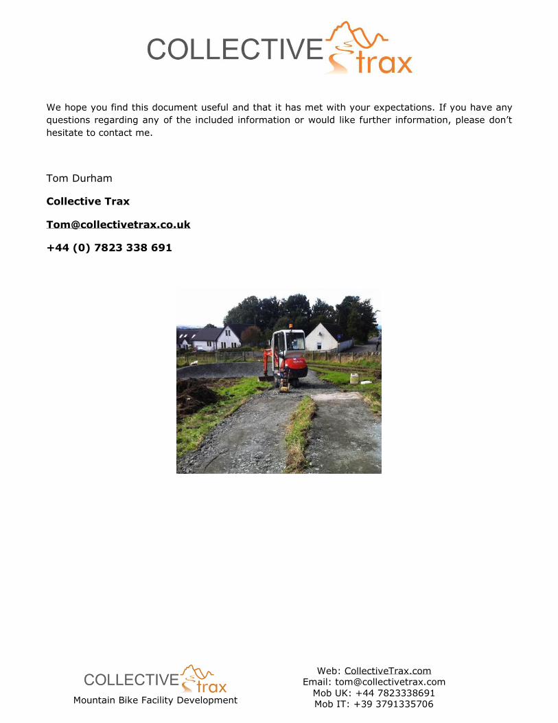
We hope you find this document useful and that it has met with your expectations. If you have any
questions regarding any of the included information or would like further information, please don’t
hesitate to contact me.
Tom Durham
Collective Trax
+44 (0) 7823 338 691
Mountain Bike Facility Development
Web: CollectiveTrax.com Email: [email protected]
Mob UK: +44 7823338691 Mob IT: +39 3791335706
Appendix 1. Proposed Utility Diversions
Image 22 - Site Detail showing existing HV Cable in green
Existing
P.E Faciltiy
2N
o. L
ong J
um
p P
it
Jave
lin T
hro
win
g C
ourt
Shot-p
ut T
hro
win
g C
ourt
Gra
ss F
oo
tball P
itch
100m
x 6
0m
Grass Rugby Pitch113m x 60m
Grass Rugby Pitch113m x 60m
Gra
ss
Ba
nk
i ng
Pr o
vi d
i ng
I nfo
rma
lS
eati ng
EX WATER EX WATER EX WATER
UNK
UN
K
UNK
UNK UNK UNK UNK
UN
KU
NK
UN
K
UNK
UN
KU
NK
UN
KU
NK
UN
KU
NK
UNK
UNK
UNK
UNK
UNK
UNK
UNK
UNK
UNK
UNK
UNK
UN
K
UN
K
UN
K
UN
K
UN
K
UN
K
UN
K
UN
K
UN
K
UN
K
UN
K
UN
K
UN
K
EX BT EX BT
EX
BT
EX
BT
EX
BT
EX BTEX BT EX BT
EX BT
EX BT
EX B
T
EX
BT
EX
BT
EX
BT
EX
BT
EX
BT
EX
BT
EX BT
EX BT
EX BT
EX BT
EX BT
EX BT
EX BT
EX BT
EX BT
EX B
T
EX
BT
EX
BT
EX
BT
EX
BT
EX
BT
EX
BT
EX
BT
EX
BT
EX
BT
EX
BT
EX
BT
EX
BT
EX
BT
EX
BT
EX
BT
EX
BT
EX
BT
EX B
T
EX
BT
EX
WA
TE
R
EX WATER EX WATER
EX GAS EX GAS EX GASEX GAS EX GAS EX GAS EX GAS EX GAS
EX
GA
S
EX
GA
S
EX G
AS
EX G
AS
EX GAS
EX GAS
EX GAS
EX G
AS
EX GAS
EX
GA
SE
X G
AS
EX
GA
SE
X G
AS
EX BT
EX BT
EX BT
EX
ELE
CE
X E
LE
CE
X E
LE
CE
X E
LE
CE
X E
LE
CE
X E
LE
CE
X E
LE
CE
X E
LE
CE
X E
LE
CE
X E
LE
CE
X E
LE
CE
X E
LE
CE
X E
LE
C
EX ELEC
EX ELEC
EX ELEC
EX ELEC
EX ELEC
EX ELEC
EX ELEC
EX ELEC
EX ELEC
EX ELEC
EX ELEC
EX ELEC
EX ELEC
EX ELEC
EX ELEC
EX ELEC
EX ELEC
EX
ELE
CE
X E
LE
CE
X E
LE
CE
X E
LE
C
EX ELEC
EX
ELE
C
EX ELEC
EX ELEC
EX
ELE
CE
X E
LE
C
EX
ELE
C
EX ELEC
EX ELEC
EX ELEC
EX
ELE
C
EX ELEC
EX ELEC
EX ELEC
EX ELEC
EX ELEC
EX ELEC
EX
ELE
C
EX
ELE
C
EX
ELE
C
EX
ELE
C
EX
ELE
C
EX
ELE
C
EX
ELE
C
EX
ELE
C
EX
ELE
C
EX
ELE
C
EX
ELEC
EX
ELEC
EX
ELEC
EX ELECEX ELEC
EX ELEC
EX ELEC
EX ELEC
EX ELEC
EX ELEC
EX
ELE
CE
X E
LE
C
EX ELEC
EX ELEC
EX ELEC
EX ELEC
EX ELEC
EX ELEC
EX ELEC
EX ELEC
EX ELEC
EX
ELEC
EX
ELE
CE
X E
LE
C
EX
ELE
C
EX ELEC EX ELEC
EX ELEC
EX COMMS
EX COMMS
EX COMMS
EX COMMS
EX COMMS EX COMMS
EX
CO
MM
S
EX COMMS
EX COMMS
EX
CO
MM
SE
X C
OM
MS
EX COMMS
EX BT
EX BT
EX BT
EX BT
EX BT
EX
C
EX C
EX C
EX C EX C
EX C
EX
CE
X C
EX
C
EX C EX C EX C EX C
EX
CE
X C
EX C EX C EX C EX C EX C EX C
EX
CE
X C
EX
CE
X C
EX
C
EX
CE
X C
EX
CE
X C
EX C EX C EX C EX C EX C EX C EX C EX C EX C EX C EX C
EX C
EX C
EX C
EX C
EX C
EX C
EX C
EX C
EX C
EX C
EX C
EX C
EX C
EX C
EX C
EX C
EX
CE
X C
EX
CE
X C
EX
C
EX C EX C
EX C
EX C
EX C
EX C
EX C EX C
EX C
EX C EX C EX C EX C EX C
EX C
EX C
EX C
EX C
EX C
EX C
EX
C
EX C
EX
CE
X C
EX
C
EX C
EX
CE
X C
EX
C
EX
C
EX C
EX
CE
X C
EX
C
EX C EX C
EX
CE
X C
EX
C
EX
CE
X C
EX
CE
X C
EX
CE
X C
EX
CE
X C
EX B
T
EX B
T
EX B
T
EX B
T
EX B
T
EX B
T
EX B
T
EX B
T
EX
GA
S
EX
GA
S
EX
GA
S
EX
GA
S
EX
GA
S
EX
GA
S
EX
GA
S
EX
GA
S
EX G
AS
EX G
AS
EX
GA
S
EX
GA
S
EX
WA
TE
R
EX
WA
TE
R
EX
WA
TE
R
EX
WA
TE
R
EX
WA
TE
R
EX
WA
TE
R
EX
WA
TE
R
EX G
AS
EX
GA
S
EX
GA
S
EX
GA
S
EX
GA
S
EX GAS
EX GAS
EX
GA
SE
X G
AS
EX G
AS
EX GAS
EX GAS
EX GAS
EX GAS
EX GAS
EX GAS
EX GAS
EX GAS
EX GAS
GA
S
GAS GAS
EX BT
EX BT
EX BT
EX BT
EX BT
EX BT
EX BT
EX BT
EX BT
EX BT
EX BT
EX BT
EX BT
EX BT
EX BT
EX BT
EX BT
EX BT
EX BT
EX BT
EX BT
NEW HV
NEW HV
NEW HV
NEW HV NEW HV
NEW HV
NEW HV
NEW HV
NEW HV
NE
W L
V
NEW LV
NEW LV
NEW LVNEW LV
NEW LV
NEW LV
NEW LV
NEW LV
EX
ELEC
EX
ELEC
NEW LV
NEW LV
NEW LV
NE
W L
V
NE
W L
V
NE
W L
V
NE
W L
V
NE
W L
V
NE
W L
V
NE
W L
V
NE
W L
V
NE
W L
V
NE
W L
VN
EW
LV
NEW LV NEW LV NEW LV NEW LV NEW LV NEW LV NEW LV NEW LV
NE
W L
V
NE
W L
V
NE
W L
V
NE
W L
V
EX ELEC
EX BT
EX COMMS
EX WATER
EX GAS
EX C
UNK UNK
HV HV
LV LV
WATER
FM FM
GAS GAS
BT BT
Mountain Bike Facility Development
Web: CollectiveTrax.com Email: [email protected]
Mob UK: +44 7823338691 Mob IT: +39 3791335706
Appendix 2. Trail Grade Descriptions
Blue Grade Trail Description:
Suitable for... Riders in good health with basic off-road riding skills. Basic mountain bikes.
Trails… Some “single-track” sections & small obstacles of root & rock.
Blue grade trails are typically around 1.2 metres wide and represent the first step into proper technical
Mountain Biking (as opposed to ‘off road cycling’) terrain. They are fun to ride for all levels of rider
although may be quite challenging to a beginner not used to cycling over varied terrain.
At their heart, they provide a progression into more challenging terrain and so are shaped and featured
accordingly with berms, rollers, roller doubles and some roots or rougher sections, but on a smaller
scale than the higher graded trails. All features are ‘roll-able’ which means a rider’s wheels don’t have
to leave the ground although more experienced riders will still gain a lot of enjoyment and challenge
from riding faster and being more proactive in the experience.
Red Grade Trail Description:
Suitable for... Proficient mountain bikers with good off-road riding skills & fitness. Good mountain
bikes
Trails… Challenging climbs, tricky descents & technical features such as drop-offs and large rocks.
Red grade trails are typically narrower and more technical in their nature than blue grade, riders will
also tend to travel at a higher speed, although this will depend on the terrain. Red trails should still
be enjoyable to ride and challenging to all but the most expert of mountain bikers. Features typically
found include berms and rollers, table top jumps and small drops, and rock features. These features
are still ‘roll-able’ but can be intimidating to the novice rider who will find a red trail very challenging.


