Embed Size (px)
Citation preview

Discovering Mesa Prieta: The Petroglyphs of Northern New Mexico
and the People Who Made Them
Teachers’ Curriculum – 2019 Edition Mesa Prieta Petroglyph Project, Velarde, NM
Judith A. Chaddick, MS; Lucia Ortiz y Garcia; Esta Gutierrez, MS Ed., writers
Alejandro Lopez; Consuelo Luz, Spanish Translators
Katherine Wells, BA, illustrator
Janet MacKenzie, MA, editor
Mesa Prieta Petroglyph Project

©2019 Mesa Prieta Petroglyph Project
Discovering Mesa Prieta

©2019 Mesa Prieta Petroglyph Project
Discovering Mesa Prieta
Discovering Mesa Prieta: The Petroglyphs of Northern New Mexico
and the People Who Made Them
Teachers’ Curriculum appropriate for all levels, from 4th grade to Adult Education Mesa Prieta Petroglyph Project, Velarde, NM
Published by:
Mesa Prieta Petroglyph Project, 2019
Writers: Judith A. Chaddick, MS; Lucia Ortiz y Garcia; Esta Gutierrez, MS Ed.
Spanish translators: Alejandro Lopez; Consuelo Luz
Lead illustrator: Katherine Wells, BA
Editor: Janet MacKenzie, MA
Funders and financial contributors:
Los Alamos National Laboratory Foundation
Historic Preservation Division, New Mexico Department of Cultural Affairs
Santa Fe Community Foundation
New Mexico Children’s Foundation
Family Foundations and Individual Donors
The Northern Rio Grande Heritage Center
For additional information, please contact:
Mesa Prieta Petroglyph Projectwww.mesaprietapetroglyphs.org
Special note:
Curriculum also available online via link on the MPPP website at www.mesaprietapetroglyphs.org
Please credit Mesa Prieta Petroglyph Project and referenced authors.
No fees may be charged for any further distribution of this curriculum.
Mesa Prieta Petroglyph Project is a 501(c)(3) non-profit community
organization located in Velarde, NM.
MPPP documents, protects and sustains endangered archaeological treasures
in the northern Rio Grande Valley.
page i

©2019 Mesa Prieta Petroglyph Project
Discovering Mesa Prieta
page ii
To us these petroglyphs are not the remnants of some long lost civilization that has been dead for many years… They are part of our living culture. What is stored in the petroglyphs is not written in any book or to be found in any library. We need to return to them to remind us of who we are and where we came from, and to teach our own sons and daughters of it.
The petroglyphs are under a severe threat from vandalism and land development activities. For this reason, there is a need to protect the petroglyphs in a way that will allow us to continue to use them for religious purposes, as well as to save them for the benefit of both Indians and non-Indian visitors who come to appreciate our culture.
Herman Agoyo, San Juan Pueblo (the people of San Juan Pueblo now use its Tewa name, Ohkay Owingeh)
All Indian Pueblo Council Chairman (1987-1990).
Statement before the U.S. House of Representatives Committee on Interior and Insular
Affairs. Albuquerque, New Mexico, October 11, 1986.
PROTECTING PETROGLYPHSby Herman Agoyo

©2019 Mesa Prieta Petroglyph Project
Discovering Mesa Prieta
The landscapes, including Mesa Prieta, in which petroglyphs are found are spiritual places to many peoples of northern New Mexico. We do not understand the meaning of these images, but we know that some are sacred to the Pueblos and Hispano people. In development of this curriculum, we sought guidance from Tewa Pueblos regarding cultural concerns and from Hispano heritage experts and historians.
In presenting this curriculum, we wish to celebrate the existence of these images as well as the cultures and histories they embody. It is our intention to be respectful to those who made the petroglyphs and all who hold them sacred.
The terms we use to classify the petroglyphs are descriptive only and are not intended to assign meaning or interpret the images. It is our hope that all of us may approach this curriculum and the petroglyphs with respect and wonder. We believe that Discovering Mesa Prieta will also help students connect with their cultural heritage.
We encourage educators from other geographic areas to adapt the curriculum for their own use. If you need guidance in the pronunciation of Tewa or Hispano words used in this curriculum, please consult with a Tewa-speaking or Spanish-speaking person, or you may contact the Mesa Prieta Petroglyph Project office.
page iii
CONTEXTUAL STATEMENT

©2019 Mesa Prieta Petroglyph Project
Discovering Mesa Prieta
page iv
©2019 Mesa Prieta Petroglyph Project
Discovering Mesa Prieta
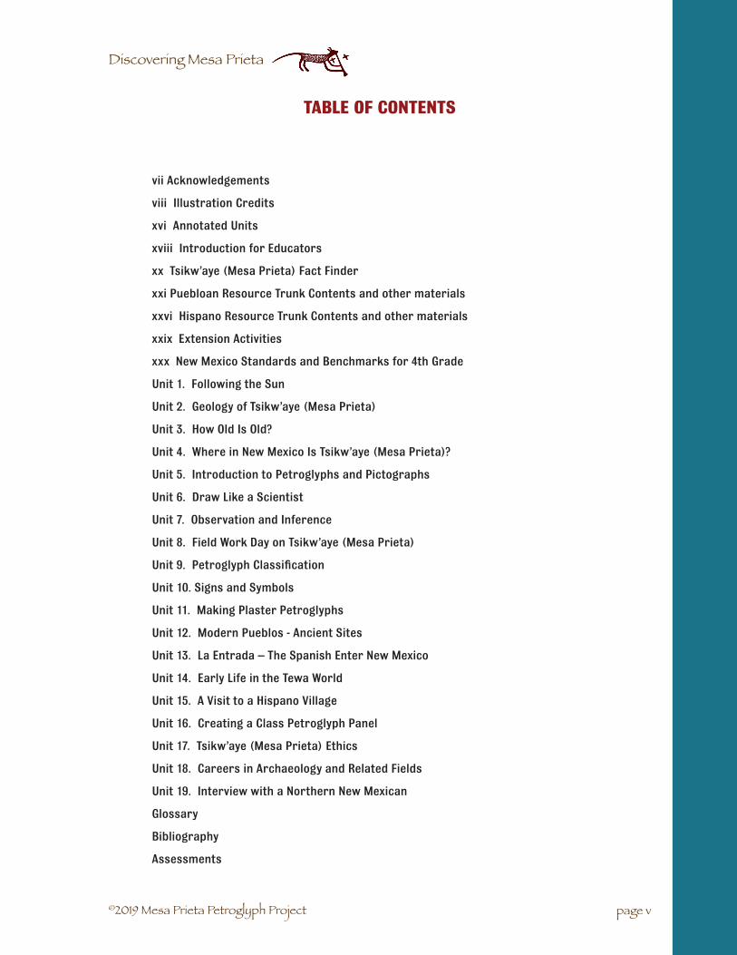
vii Acknowledgements
viii Illustration Credits
xvi Annotated Units
xviii Introduction for Educators
xx Tsikw’aye (Mesa Prieta) Fact Finder
xxi Puebloan Resource Trunk Contents and other materials
xxvi Hispano Resource Trunk Contents and other materials
xxix Extension Activities
xxx New Mexico Standards and Benchmarks for 4th Grade
Unit 1. Following the Sun
Unit 2. Geology of Tsikw’aye (Mesa Prieta)
Unit 3. How Old Is Old?
Unit 4. Where in New Mexico Is Tsikw’aye (Mesa Prieta)?
Unit 5. Introduction to Petroglyphs and Pictographs
Unit 6. Draw Like a Scientist
Unit 7. Observation and Inference
Unit 8. Field Work Day on Tsikw’aye (Mesa Prieta)
Unit 9. Petroglyph Classification
Unit 10. Signs and Symbols
Unit 11. Making Plaster Petroglyphs
Unit 12. Modern Pueblos - Ancient Sites
Unit 13. La Entrada – The Spanish Enter New Mexico
Unit 14. Early Life in the Tewa World
Unit 15. A Visit to a Hispano Village
Unit 16. Creating a Class Petroglyph Panel
Unit 17. Tsikw’aye (Mesa Prieta) Ethics
Unit 18. Careers in Archaeology and Related Fields
Unit 19. Interview with a Northern New Mexican
Glossary
Bibliography
Assessments
TABLE OF CONTENTS
page v

©2019 Mesa Prieta Petroglyph Project
Discovering Mesa Prieta
page vi

©2019 Mesa Prieta Petroglyph Project
Discovering Mesa Prieta
Mesa Prieta Petroglyph Project Board of Directors: The Mesa Prieta Petroglyph Project wishes to thank the past and present memebrs of the Board of Directors for their encouragement and support of the development of this curriculum guide and educational programming for the youth of New Mexico.
Lead writers: Judith A. Chaddick, MS; Lucia Ortiz y Garcia; Esta Gutierrez, MS Ed
Spanish translator: Alejandro Lopez
Lead illustrator: Katherine Wells, BA
Editor: Janet MacKenzie, MA
Curriculum Development: Judith Chaddick, Esta Gutierrez, Janet MacKenzie, Herman Agoyo, Monica Archuleta, Ava Fullerton, Stephanie Richard, Taylor Dale, Tessie Naranjo, Sue-Ellen Jacobs, Jimmy Lara, Marie Abeyta, Bernadette Morrow, Jeannie Cornelius, John (Rocky) Archuleta, Roxanne Swentzell, Frances Harney, Melinda Pekarcik, Suzie Frazier, Russ Shinn, Paul Williams, Richard Ford, Glenna Dean, Candie Borduin, Ron Barber, Diane Souder, Lucia Ortiz y Garcia, Robin Farwell Gavin, Elizabeth Keller.
Curriculum Formatting and Printing: Janet MacKenzie, Barbara Swenson, Mark MacKenzie
Website: Carolyn J. Johnson
Proofreaders: Ava Fullerton, Kerby Goforth, Helen Hall, Martha Yates, Janet MacKenzie, Suzie Frazier, John (Rocky) Archuleta, Richard Ford, Herman Agoyo, Russ Shinn, Judith Chaddick, Esta Gutierrez, Robin Farwell Gavin, Candie Borduin, Jennifer Goyette, MS, Porter Swentzell, PhD, Matthew Martinez, PhD, Sandy Romero, Tessie Naranjo, Paula Lozar.
Materials Development: Carol Ashcraft, Lucy Collier, Marie Markesteyn, Angelina Valdez, Helen Hall, David and Rosella Jardine, Michaela and Makaio Pumphrey, Katherine Wells, Suzie Frazier, Judy Chaddick, Paula Breaux, Esta Gutierrez, Mark MacKenzie, Glenna Dean, Porter Swentzell, Matthew Martinez, J Goyette, S Romero.
Field Testing: Monica Archuleta and her 4th grade class at Velarde Elementary School, Stephanie Richard and her 7/8th grade class at Ohkay Owingeh Community School, Jeannie Cornelius and her 3/4th grade class at Dixon Elementary, Modesto Garcia and his 7th grade history class at Española Middle School East, Taylor Dale and her 4th grade class at ET Salazar Elementary, Jimmy Lara and his 4th grade class at Velarde Elementary School, Bernadette Morrow and her 3/4th grade class at San Ildefonso Day School, Elizabeth Keller and her classes at La Tierra Montessori School for the Arts and Sciences at Alcalde.
4th Grade NM Standards and Benchmarks: Monica Archuleta
Essential Supporters: Ohkay Owingeh Community School, San Ildefonso Day School, Española and Pojoaque Valley Public and Private Schools, Eight Northern Indian Pueblos Council, Bureau of Land Man-agement/Taos Office, Bureau of Land Management/Cultural Heritage Education Program, Northern New Mexico College, Northern Pueblos Institute, The Archaeological Conservancy, National Park Service, Santa Fe National Forest, State Historic Preservation Office, Archaeological Records Management Section, Rio Arriba County, Archaeological Society of New Mexico Rock Art Recording Program, Petroglyph National Monument, Museum of Indian Arts and Culture, New Mexico Laboratory of Anthropology, Museum of Spanish Colonial Art, Historic Los Luceros, The Northern Rio Grande Heritage Area, the LANL Foundation.
Volunteer Consulting Archaeologists/Historians: Richard Ford, Paul Williams, Martha Yates, Kurt Anschuetz, Janet MacKenzie, Diane Souder, Robin Farwell Gavin, Historic Preservation Division. And many other local volunteers who performed thousands of hours of work with the Mesa Prieta Petroglyph Project.
page vii
ACKNOWLEDGEMENTS

©2019 Mesa Prieta Petroglyph Project
Discovering Mesa Prieta
All drawings, unless otherwise attributed, © Katherine Wells. (Images are credited in the order in which they appear on the page)
Unit 1:
2. photos, diagrams, text: Ron Barber
3. diagram: Judith Chaddick; photo: Suzie Frazier
4. photos: Jimmy Lara
Unit 2:
1. photos: http://www.dynamitetoolco.com/Estwing-Tools-s/606.htm, photo: Janet MacKenzie,
3. photo: Janet MacKenzie
4. photo: Janet MacKenzie
5. photo: Janet MacKenzie
8. photo: Janet MacKenzie
9. drawing: Judith Chaddick
10. photo: NASA image, http://www.nmnaturalhistory.org/volcano/taos.html; photo:Janet MacKenzie
11. photo: public domain, http://commons.wikimedia.org/wiki/Glacier; photo: Janet MacKenzie;illustration: public domain, H.B.Horsfall, 1913 http://www.archive.org/details/ahistoryland-mam00scotgoog; illustration: Bureau of Land Management- Dankworth Village
12. illustration: Smithsonian Institute National Museum of the American Indianhttp://nmai.si.edu/exhibitions/horsenation/images/section_02/conquistadors.jpg; illustra-tion: John Dawson, Natural History Museum of Los Angeles. Los Angeles, CA, n.d.; illustration:Bureau of Land Management- Dankworth Village/ Katherine Wells
13. Bureau of Land Management, Dankworth Village. Supplementary drawings by Katherine Wells
14. photo: Janet MacKenzie
15. annotated photo: New Mexico Bureau of Geology and Mineral Resources, 2007-2008.http://geoinfo.nmt.edu/tour/landmarks/ghost_ranch/home.html “Teachers and studentsmay make unlimited copies for educational use.”
16. photos: Janet MacKenzie
17. photos: Janet MacKenzie, photo: available for use under GNU Free Documentation Licensehttp://commons.wikimedia.org/wiki/Image:Tree_in_White_Sands_NM.jpg
18. map: U.S. Geological Survey Map of NM (1965) and New Mexico Geologic Survey HighwayGeologic Map (1982)
page viii
ILLUSTRATION CREDITS
Discovering Mesa Prieta

©2019 Mesa Prieta Petroglyph Project
Discovering Mesa Prieta
21. Ice Age Megafauna: Bureau of Land Management, Dankworth Village. Supplementary drawingsby Katherine Wells
Unit 3:
2. photo: free use/alteration under GNU Free Documentation Licensehttp://upload.wikimedia.org/wikipedia/commons/b/b3/Fossils_in_a_beach_wall.JPG
3. photos: Suzie Frazier
5. photo: Janet MacKenzie
8. photo: Janet MacKenzie
10. illustration: Natural History Museum http://www.nhm.ac.uk/print-version/?p=http://www.nhm.ac.uk//about-us/news/2006/september/news_9620.html, illustration: Nobu Tamura, GnuFree Documentation Licence http://upload.wikimedia.org/wikipedia/commons/7/7f/Ichthyo-stega_BW.jpg
11. illustrations: http://dinosaur.ru.html; http://en.wikipedia.org/wiki/Image:Dimetrodon8DB.jpg
12. photo: Janet MacKenzie
13. illustration: Natural History Museum http://www.nhm.ac.uk/print-version/?p=http://www.nhm.ac.uk//about-us/news/2006/september/news_9620.html, illustration: Nobu Tamura, Gnu FreeDocumentation Licence; illustrations: http://dinosaur.ru.html; http://en.wikipedia.org/wiki/Image:Dimetrodon8DB.jpg
Unit 4:
4. photo: Creative Commons licence http://commons.wikimedia.org/wiki/Compass#mediaviewer/File:Kompas_Sofia.JPG
5. illustration: Joaquin Alves Gaspar, Creative Commons licence, http://commons.wikimedia.org/wiki/Compass_rose#mediaviewer/File:Reinel_compass_rose.svg
6. gazetteer from NM Highway map
7. map: adapted from back cover of Intrigue of the Past: Discovering Archaeology in New Mexico,Bureau of Land Management New Mexico State Office, Cadastral Division,1997.
8. map: adapted from New Mexico Department of Transport map.
9. illustration: Joaquin Alves Gaspar, Creative Commons licence, http://commons.wikimedia.org/wiki/Compass_rose#mediaviewer/File:Reinel_compass_rose.svg
10. map: adapted from back cover of Intrigue of the Past: Discovering Archaeology in New Mexico,Bureau of Land Management New Mexico State Office, Cadastral Division,1997.
11. map: adapted from New Mexico Department of Transport map.
Unit 5:
3. photo: Daniel Mayer, Creative Commons license http://commons.wikimedia.org/wiki/File:Bandelier_National_Monument_in_September_2011_-_Cliff_Dwellings_-_pictograph_painting_closeup.JPG; illustration: student painting
4. photo: Katherine Wells
page ix
Illustration Credits

©2019 Mesa Prieta Petroglyph Project
Discovering Mesa Prieta
5. photo: Mesa Prieta Petroglyph Project
6. illustration: Bureau of Land Management- Dankworth Village; illustration: adapted from In-trigue of the Past: Discovering Archaeology in New Mexico, Bureau of Land Management, EwaKrakowska, illustrator
7. photo: Ekkehart Malotki; illustrations: Katherine Wells; illustration: from Intrigue of the Past:Discovering Archaeology in New Mexico, Bureau of Land Management, Alonzo Cahoe, illustrator
8. photo: Janet MacKenzie; photo: Katherine Wells; photo: Janet MacKenzie; photo: Russ Shinn
Unit 6 :
1. photo: Jimmy Lara
2. student drawings
3. photos: Jimmy Lara
Unit 7:
3. drawing: Katherine Wells
6. drawing: Katherine Wells
8. drawing: Katherine Wells
Unit 8:
1. photo: Janet MacKenzie
2. photo: Janet MacKenzie
3. photo: Janet MacKenzie
4. photo: Jimmy Lara
Unit 9:
2. photo: Janet MacKenzie
24.-28. charts: Mesa Prieta Petroglyph Project
Unit 10:
1. photo: Janet MacKenzie
4. photo: Katherine Wells
7. illustration: adapted from Intrigue of the Past. A Teacher’s Activity Guide for Fourth throughSeventh Grades, Bureau of Land Management, Washington, DC, 1993, p. 97.
Unit 11:
1. photo: Janet MacKenzie
2. photos: Judith Chaddick
4. artwork: Katherine Wells; photo: Suzie Frazier
page x
Illustration Credits

©2019 Mesa Prieta Petroglyph Project
Discovering Mesa Prieta
Unit 12:
2. photo: Janet MacKenzie
7. photo: Museum of Indian Arts and Culture / Laboratory of Anthropology, Santa Fe, NM, 21445/11.
8. photo: Janet MacKenzie
9. map: Judith Chaddick/Janet MacKenzie
10. map: Judith Chaddick/Janet MacKenzie
11. illustration: public domain, Pearson Scott Foresman, 2008, http://commons.wikimedia.org/wiki/File:Flicker_281_F-55_(PSF).png; photo: Janet MacKenzie.
12. photo: Janet MacKenzie; photo: Creative Commons Attribution- Share Alike 2 License http://commons.wikimedia.org/wiki/Image:Wild_Turkey_Walking.jpg.
13. photo: Janet MacKenzie;
14. photo: Museum of Indian Arts and Culture / Laboratory of Anthropology, Santa Fe, NM,21810/11; illustration: Bureau of Land Management- Dankworth Village.
15. plan: after H. P. Mera, Archaeological Survey, A Survey of the Biscuit Ware Area in NorthernNew Mexico, 1934.
Unit 13:
3. illustration: http://www.ducksters.com/history/middle_ages/reconquista.php; photo:http://citywalktalk.blogspot.com/2009/05/eternity-and-ham-part-iii-fini.html.
4. illustration: Gnu Free Documentation licence; photo: Gnu Free Documentation licence; photo:public domain; drawing: courtesy El Camino Real de Tierra Adentro Trails Association,http://www.caminorealcarta.org/calendar.htm#caption, drawing by Ronald Kil.
5. photo: Mesa Prieta Petroglyph Project; photo: public domain, NARA record 3028457; photo:Janet MacKenzie
6. photo: Janet MacKenzie; photo: public domain Library of Congress LC-USF35-323; photo: JanetMacKenzie; photo: Candie Borduin; photo: public domain NARA record 5307166; photo: publicdomain Library of Congress LC-USF34-035857-D; photo: public domain NARA record 521205;photo: Mesa Prieta Petroglyph Project.
7. photo: Mesa Prieta Petroglyph Project; photo: public domain
8. photo: Mesa Prieta Petroglyph Project
Unit 14:
3. photo: Janet MacKenzie; photo: Katherine Wells
4. photo: Janet MacKenzie
6. photo: Janet MacKenzie
7. drawings: Judith Chaddick
8. illustration: Bureau of Land Management, Washington, DC; illustration: Bureau of LandManagement, Washington, DC, Alonzo Cahoe, illustrator.
page xi
Illustration Credits

©2019 Mesa Prieta Petroglyph Project
Discovering Mesa Prieta
9. illustration: Bureau of Land Management, Washington, DC; photo: Piperno and Flannery, 2001,http://www.pubmedcentral.nih.gov/articlerender.fcgi?artid=29388; photo: http://www.flickr.com/photos/ojo_tierra/2506436682/
10. illustration: Ignacio Moquino (Waka), Zia Pueblo. Margretta S. Dietrich Collection, Museum ofIndian Arts and Culture/Laboratory of Anthropology, Museum of New Mexico, Department ofCultural Affairs, Santa Fe, NM.
11. illustrations: Roxanne Swentzell, Permaculture Design Journal, No. 20, Aug. 1994, pp. 8-12.
14.-15. illustration: Life on the Rio Grande: A Diabetes Education Curriculum, Grades 3-5. Ana Con-suelo and Associates, Santa Fe, NM, n.d., p. 16. illustration: Bureau of Land Management, Washington, DC
Unit 15:
7. illustration: public domain National Park Service; photo: http://people.uwec.edu/ivogeler/w188/indians/chamita8.jpg; photo Mesa Prieta Petroglyph Project
8. drawing: public domain; photo: https://images.duckduckgo.com/iu/?u=http%3A%2F%2Fts4.mm.bing.net%2Fth%3Fid%3DHN.608017316103326667%26pid%3D15.1&f=1; Drawing: public do-main http://commons.wikimedia.org/wiki/File:US-NM%281891%29_p573_CHAMITA,_OLD_MILL.jpg; photo Mesa Prieta Petroglyph Project; photo: public domain, Library of Congress LC-DIG-fsa-8b25759
9. photo: Mesa Prieta Petroglyph Project; photo: Mesa Prieta Petroglyph Project; photo: publicdomain Library of Congress LC-DIG-fsa-8a29083;photo: public domain, Library of Congress LC-USW36-914; photo: Creative Commons licence
10. photo: public domain, Library of Congress http://commons.wikimedia.org/wiki/File:RugMakingWomanPassesShuttle.jpg; photo: public domain, Library of Congress http://www.loc.gov/pictures/item/owi2001020577/PP/; photo: public domain, http://www.loc.gov/pictures/item/fsa2000015506/PP/
11. photo: public domain, Library of Congress LC-DIG-fsa-8d25860; photo: public domain, NARA521209; Miguel Gandert https://images.duckduckgo.com/iu/?u=http%3A%2F%2Fwww.iphoto-central.com%2FPhotos%2Fandrewsmith_Images%2FFull%2FMGC-129.jpg&f=1
12. photo: Mesa Prieta Petroglyph Project; photo: Creative Commons licence, author OtávioNogueira from Fortaleza, BR; photo: public Domain, NARA 521200
13. photo: © The University of New Mexico, Albuquerque, NM 87131 http://www.unm.edu/fea-tures/2011/curandero-tradition-returns.html; photo: Creative Commons licence, author JerryFriedman; drawing: public domain; photos: public domain, NARA 5307166, 521866
14. photo: public domain, California Historical Society CHS-3925; photo: public domain, Library ofCongress LC-USZ62-90589; photo: Mesa Prieta Petroglyph Project
15. illustration: public domain National Park Service; photo: http://people.uwec.edu/ivogeler/w188/indians/chamita8.jpg; photo Mesa Prieta Petroglyph Project
16. drawing: public domain;photo: https://images.duckduckgo.com/iu/?u=http%3A%2F%2Fts4.mm.bing.net%2Fth%3Fid%3DHN.608017316103326667%26pid%3D15.1&f=1; Drawing: public do-main http://commons.wikimedia.org/wiki/File:US-NM%281891%29_p573_CHAMITA,_OLD_MILL.jpg; photo Mesa Prieta Petroglyph Project; photo: public domain, Library of Congress LC-DIG-fsa-8b25759
page xii
Illustration Credits

©2019 Mesa Prieta Petroglyph Project
Discovering Mesa Prieta
17. photo: Mesa Prieta Petroglyph Project; photo: Mesa Prieta Petroglyph Project; photo: public domain Library of Congress LC-DIG-fsa-8a29083;photo: public domain, Library of Congress LC-USW36-914; photo: Creative Commons licence
18. photo: public domain, Library of Congress http://commons.wikimedia.org/wiki/File:RugMakingWomanPassesShuttle.jpg; photo: public domain, Library of Congress http://www.loc.gov/pic-tures/item/owi2001020577/PP/
19. photo: public domain, http://www.loc.gov/pictures/item/fsa2000015506/PP/; photo: public domain, Library of Congress LC-DIG-fsa-8d25860; photo: public domain, NARA 521209
20. Miguel Gandert https://images.duckduckgo.com/iu/?u=http%3A%2F%2Fwww.iphotocentral.com%2FPhotos%2Fandrewsmith_Images%2FFull%2FMGC-129.jpg&f=1; photo: Mesa Prieta Petroglyph Project; photo: Creative Commons licence, author Otávio Nogueira from Fortaleza, BR; photo: public Domain, NARA 521200
21. photo: © The University of New Mexico, Albuquerque, NM 87131 http://www.unm.edu/features/2011/curandero-tradition-returns.html; photo: Creative Commons licence, author Jerry Friedman; drawing: public domain
22. photos: public domain, NARA 5307166, 521866; photo: public domain, California Historical Society CHS-3925; photo: public domain, Library of Congress LC-USZ62-90589
23. photo: Mesa Prieta Petroglyph Project
25. photo: public domain, HABS NM,20-DUL.V,7-5
26. photos: Mesa Prieta Petroglyph Project
27. photo: Creative Commons licence http://commons.wikimedia.org/wiki/File:Potaje_-_Garban-zos.JPG
29. photo: Creative Commons licence, author Inc ru http://commons.wikimedia.org/wiki/File:Wheat_beans.jpg
30. photo: Creative Commons licence, author Jerry Friedman http://commons.wikimedia.org/wiki/File:Panocha_New_Mexico1.jpg
33. photos: Mesa Prieta Petroglyph Project
34. drawing: Janet MacKenzie
35. drawing: Janet MacKenzie
37. photo: Mesa Prieta Petroglyph Project
38. photo: Katherine Wells
39. photo: Janet MacKenzie
41. painting: La Tierra student painting
42. photo: public domain, National Register of Historic Places http://en.wikipedia.org/wiki/El_ Rancho_de_las_Golondrinas
page xiii
Illustration Credits

©2019 Mesa Prieta Petroglyph Project
Discovering Mesa Prieta
43. drawing: Judith Chaddick, Katherine Wells
44. drawing: Judith Chaddick, Katherine Wells
45. illustration: Creative Commons licence, http://commons.wikimedia.org/wiki/Dandelion#mediaviewer/File:Illustration_Taraxacum_officinale0.jpg
47. photo: Creative Commons licence, author Th. Voekler http://commons.wikimedia.org/wiki/File:Mojito_mint.jpg
48. photo: Creative Commons licence, http://commons.wikimedia.org/wiki/Garlic#mediaviewer/File:Czosnek.jpg
52. Photo: Creative Commons licence, author Jerry Friedmanhttp://commons.wikimedia.org/wiki/File:Thelesperma_mega-potamicum_flora.jpg; Photo: Creative Commons licence,author Jerry Friedman http://commons.wikimedia.org/wiki/File:Ligusticum_porteri_flowers1.jpg; Photo: Creative Com-mons licence, author Jerry Friedman http://commons.wikime-dia.org/wiki/File:Thelesperma_megapotamicum_flora.jpg
53. photo: public domain, NARA 521836 photo: Creative Commons licence, author David Maiselhttp://commons.wikimedia.org/w/index.php?search=children+play+tires&title=Special%3ASearch&go=Go&uselang=en; photo: public domain, NARA 521231; illustration: Creative Commonslicence, author Melvin Callejas http://nl.wikipedia.org/wiki/Llorona
58. diagram: Janet MacKenzie; photo: Mesa Prieta Petroglyph Project
59. diagram: Janet MacKenzie
60. photo: Creative Commons licence, author Larry Lamsa http://commons.wikimedia.org/wiki/File:Los_Matachines_de_Alcalde.jpg; photo: public domain http://www.legendsofamerica.com/photos-NM-Misc/Cinco%20de%20Mayo,%20Mogollon,%20N.M,%201914-500.jpg; photo:Creative Commons licence, author Tomas Castelazo http://commons.wikimedia.org/wiki/File:Alfe%C3%B1iques_3.jpg
61. photo: public domain, author Senior Airman DeAndre Curtiss http://www.defenseimagery.mil/imagery.html?&guid=12e1a4b5817a8109cfeaf5f94f1425643e006d56
Unit 16:
3. photo: Jimmy Lara; photo: Janet MacKenzie
4. photo: Janet MacKenzie; photo: Candie Borduin
6. photo: Candie Borduin
Unit 17:
2. photo: Candie Borduin
3. photo: Candie Borduin
4. photo: Mesa Prieta Petroglyph Project
5. photo: Janet MacKenzie
page xiv
Illustration Credits

©2019 Mesa Prieta Petroglyph Project
Discovering Mesa Prieta
Unit 18:
1. photo: Mesa Prieta Petroglyph Project
2. photo: public domain http://commons.wikimedia.org/wiki/Image:Tommarp_kloster_02.JPG;aerial photo: public domain http://commons.wikimedia.org/wiki/Image:Crop-mark.jpg
3. photo: Mark MacKenzie; photo: Larry Humetewa
4. photo: Kurt Anscheutz
7. photo: Anne Baldwin
9. photo: Ron Barber
11. photo: Eric Blinman http://www.nmarchaeology.org/eric-blinman.html
14. photo: Anne Baldwin http://sfnfsitestewards.org/news/news_2004_06.pdf
22. photo: Glenna Dean
16. photo: Mesa Prieta Petroglyph Project
17. photo: Candie Borduin
19. photo: Chuck Hannaford http://nmarchaeology.org/charles-a.-hannaford.html
21. photo: Larry Humetewa
23. photo: Steven Lakatos
24. photo: Mark MacKenzie
26. photo: Tessie Naranjo http://www.nnmc.edu/academics/resources/npi/documents/NPIBro-chure3.pdf
28. photo: Diane Souder
29. photo: Mesa Prieta Petroglyph Project
31. photo: Martha Yates
Glossary:
8. drawing: Mesa Prieta Petroglyph Project
page xv
Illustration Credits

©2019 Mesa Prieta Petroglyph Project
Discovering Mesa Prieta
Unit 1. Following the Sun. The ancient Pueblo people studied the sky and were expert astronomers. This activity develops the students’ observational skills that will help them become more connected to their universe. It is best (but not necessary) to begin this activity in September at the fall equinox.
* Unit 2. Geology of Tsikw’aye (Mesa Prieta). Through cooperative learning and hands-on materials, the students will learn about the formation of Mesa Prieta and the animals that lived here at the time of the Ice Age.
Unit 3. How Old Is Old? Geologic timeline: Using a one hundred foot time line to represent the age of the earth, the students will begin to understand how life on earth evolved. Then they will create a personal time line using strips of colored construction paper.
Unit 4. Where in New Mexico Is Tsikw’aye (Mesa Prieta)? Mapping: Each student will receive a New Mexico road map and learn how to use it. They will transfer information from the road map to an outline map of New Mexico and answer review questions.
* Unit 5. Introduction to Petroglyphs and Pictographs. The students will learn the difference between pictographs and petroglyphs through painting and etching into clay. Students will study about the people who created the petroglyphs.
Unit 6. Draw Like a Scientist. Beginning with sunflower seeds, the students will learn how to draw ac-curately. Then they will look at photographs of local petroglyphs and practice drawing them.
Unit 7. Observation and Inference. Using a drawing of two children on the Mesa, the students will learn the difference between observation and inference and how it relates to the petroglyphs and archaeology.
* Unit 8. Field Work Day at Tsikw’aye (Mesa Prieta). Before the trip, students will put together recording books for the Work Day. They will review what to bring and the handout Protecting the Past on the Mesa Prieta Hike. Trained volunteers will guide small groups of students to look for petroglyphs on the Mesa. The students will draw different petroglyphs in their recording books and apply what they have learned in classroom activities.
* Unit 9. Petroglyph Classification. The people who record petroglyphs have grouped them into many dif-ferent categories. We have modified the system into ten different categories for the students. After a cut and paste activity, the students will graph their results.
Unit 10. Signs and Symbols. Students will gain an understanding of symbols by drawing on the board familiar symbols, signs and logos. The concept of symbol will be reinforced with a hand-out on symbols and then students will create a collage using signs and symbols cut out from magazines.
Unit 11. Making Plaster Petroglyphs. As a follow up activity to the field trip or simply an engaging art activity, students will simulate the process of pecking petroglyph designs into Plaster of Paris or draw on smooth river rocks to simulate pictographs.
page xvi
ANNOTATED UNITS
* These are core units.

©2019 Mesa Prieta Petroglyph Project
Discovering Mesa Prieta
Unit 12. Modern Pueblos - Ancient Sites. Mapping activity/reading comprehension/research: Students will learn about the connection between the ancient Tewa Pueblos and the present day Pueblos by locating modern Pueblos and archaeological sites on their New Mexico road map. Then they will read and study the information about the ancient sites and modern Pueblos and possibly do more extensive research.
Unit 13. La Entrada – The Spanish Enter New Mexico. After reading Chapter 1 of “La Entrada”, in Activity 2, students will use New Mexico road maps to explore the many Spanish place names which so clear-ly illustrate the Spanish presence in New Mexico. At the same time they will have the opportunity to review use of coordinates and the compass rose to accurately describe locations. In the art extension, the students will create illustrations for Spanish place names. After reading Chapter 2, a series of time line activities (3 and 4) will help students organize chronologically the events discussed in the reading.
Unit 14. Early Life in the Tewa World. After reading the Tewa story Turkey Girl, the students will observe and draw real turkey feathers. Activity 2 covers the history and sacredness of corn and Ancestral Pueblo Farming Methods. In the third activity students will observe Anasazi beans and learn about the develop-ment of agriculture. The students will learn about the importance of respect for the natural world in the final activity.
Unit 15. A Visit to a Hispano Village. This is a long reading which may be completed over several class pe-riods. Teachers may choose to give students an overview reading of the complete narrative and then fol-low with short rereading. The text will come to life with the many hands-on activities which are suggested as follow up . These include exploration of grains, simple cooking, weaving activities, traditional medicinal herbs, making adobes and creating a Spanish colonial village and many others. We strongly recommend that at least one field trip be included in this unit.
Unit 16. Creating a Class Petroglyph Panel. This activity begins as an art activity. Students will use a dilute bleach solution to create petroglyph designs. Then they will draw these designs onto large butcher paper to create a class petroglyph panel. The final part of this activity helps the students to experience the effects of vandalism.
Unit 17. Tsikw’aye (Mesa Prieta) Ethics. Dilemma Cards: Each group of students must decide what they would do in a difficult situation relating to the petroglyphs. They will share their decision and why they chose it with the rest of the class.
Unit 18. Careers in Archaeology and Related Fields. It is important that students begin to learn about different careers. In groups they will read actual interviews with local archaeologists and others and then present their information to the class.
Unit 19. Interviews with Norteña/os. This is a celebration of the talents and achievements of Hispana/o people of northern New Mexico. A number of local people have answered questions related to their daily lives, interests and childhood. This unit is a work in progress. Updates will be published on the Mesa Prieta Learning Center website.
page xvii
* These are core units.
Annotated Units

©2019 Mesa Prieta Petroglyph Project
Discovering Mesa Prieta
Northern New Mexico has a very rich cultural history. People have lived here for at least 10,000 years and the cultures that have evolved over that time are still flourishing today. In our public schools the study of New Mexico history is emphasized in grade four. Unfortunately the information in text books is often superficial or generalized. Mesa Prieta Petroglyph Project, a not-for-profit organization in northern New Mexico, secured funding to develop a curriculum to supplement the text books.
The curriculum is called Discovering Mesa Prieta: The Petroglyphs of Northern New Mexico and the People Who Made Them. It contains detailed information and activities about the petroglyphs and the early peo-ple who lived north and west of Española. You may not recognize the name “Mesa Prieta” because in the last hundred years it has been known as Black Mesa or Canoe Mesa. Since there are so many Black Mesas in the Southwest, we are returning to the use of the Spanish name, which means Dark Mesa. Before the coming of the Europeans, it was known as Tsikw’aye by the Tewa speaking people of the area.
It is estimated that there are over 100,000 petroglyphs on Mesa Prieta, the largest petroglyph site in New Mexico. The earliest petroglyphs were probably made by the Archaic people between 7500 and 800 years ago. Their images range from simple abstract designs to elaborate multi-element panels. As various groups of people moved into the area, the style of the petroglyphs changed. The majority of the petro-glyphs were created by the Ancestral Puebloans, formerly known as the Anasazi, between 1200 and 1540 AD. Their designs contain a large variety of pictorial elements such as shields, serpents, animals, birds and flute players in a style referred to as the Rio Grande style. Later, with the arrival of the Europeans, many elements associated with their Spanish-related culture became part of the mix of motifs.
By studying the petroglyphs and cultures that made them, we have an opportunity to contemplate our place in time and connect with those who came before us. When we stand on the windy flanks of Mesa Prieta high above the Rio Grande and discover a huge boulder covered with mysterious designs, we can try to imagine what life might have been like in ancient times. When we visit Ohkay Owingeh to watch a sacred dance, we can feel the continuity of their cultural heritage, an unbroken, intimate connection to their past that is reflected in the long history of the nearby petroglyphs.
Many students in the Española Valley have never seen these fascinating petroglyphs and have little con-nection to the early history of this land. It is the hope of Mesa Prieta Petroglyph Project that Discovering Mesa Prieta will open the door of living history for our students and promote and encourage a sense of respect and appreciation for our Pueblo and Hispano peoples, early and recent, and New Mexico’s ancient heritage.
The field of archaeology is integrative and interdisciplinary. Similarly, this curriculum guide is activity based and cross curricular. It is designed to teach students to think holistically; to integrate information from different topics; to problem solve; use inquiry skills and to work cooperatively. Much of it is aligned with the NM Standards and Benchmarks formerly in use by educators.
Using the Curriculum:
a. Grade level: This curriculum was developed to enhance the 4th grade study of New Mexicohistory and is also useful up to 8th grade.
b. Duration: You may wish to use the whole curriculum but it is not essential to use every singleunit and activity. The units marked with an asterisk in the Annotated Units section are consid-ered core units. It is strongly suggested that the field trip to Mesa Prieta or to Historic LosLuceros for their Field Work Day be included. Fall or spring is the best time for this field trip.
INTRODUCTION FOR EDUCATORS
page xviii

©2019 Mesa Prieta Petroglyph Project
Discovering Mesa Prieta
It is suggested that you use the curriculum as a fall semester project, presenting a different unit each week. It may also be started in the winter and completed in the spring.
c. Field work day: The focal point of this curriculum is a field work day at Mesa Prieta to hike onprivate land with trained volunteer guides or a visit to Historic Los Luceros to see a workingranch and 19th century house. It is expected that at least four background activities will becompleted before the trip. Follow-up activities may be utilized afterward. If a field trip is impos-sible, there are many supplemental classroom activities that can be presented.
d. Resource trunks: These may be checked out at the Mesa Prieta Petroglyph Project office andcontain materials and supplies for the activities, as well as books and DVDs. A trained volun-teer may be able to come into the classroom to work with you on one or more of the activi-ties. In order to reserve a trunk, schedule your Field Work Day, and/or classroom visit, pleasecontact MPPP through our website www.mesaprietapetroglyphs.org.
e. Student portfolios: It is suggested that each student keep a Mesa Prieta folder, journal orportfolio. There are student background information sheets and activity sheets for some ofthe lessons. These will provide an assessment tool as well as something that the students mayshare with their families.
f. Extension activities: Many of the ideas in this curriculum have come from Intrigue of the Past:Discovering Archaeology in New Mexico published by the Bureau of Land Management andPetroglyph National Monument Teacher’s Guide which contain extension activities and manyother resources. These guides are included in the resource trunk mentioned above. Somesuggested activities are listed on p. xxii. A third curriculum guide, The Ancestral Pueblo Peopleof Bandelier: A Guide for 4th Grade Teachers, is available online at http://www.nps.gov/band/forteachers/fourth-grade-lesson-plans.htm
The Mesa Prieta Petroglyph Project* hopes that you and your students will become excited about the amazing petroglyphs of Mesa Prieta and all of the cultural resources of our land. Through knowledge comes respect and a desire to preserve the treasures of the past. May our children become the guardians of these treasures.
*Mesa Prieta Petroglyph Project is a 501(c)(3) non-profit community organization located in Velarde,NM. MPPP documents, protects and sustains endangered archaeological treasures in the northern RioGrande Valley.
Suggested Class Introduction to Discovering Mesa Prieta:
Who knows where Black Mesa is? Which Black Mesa? The one between Chamita and Embudo. There are actually many Black Mesas in New Mexico and this one has had many names. The ancient Pueblo people called it Tsikw’aye, which means Hill Top of Dark Rock. The early Spanish people called it Mesa Prieta or Dark Mesa. Later it was called Mesa Canoa or Canoe Mesa because of its shape. When the Anglos came to New Mexico, they called it Black Mesa because of the black rocks that cover it. We have decided that since there are so many Black Mesas, we will use the name Mesa Prieta.
Who has seen the petroglyphs on Mesa Prieta? Petroglyphs are designs and pictures that are chipped into large boulders. As part of our study of New Mexico history, we will be learning all about Mesa Prieta, the petroglyphs and the people who made them. You will each keep a folder or journal of all your work and when we are finished, you may take it home and share what you have learned with your family.
page xix
Introduction for Educators

©2019 Mesa Prieta Petroglyph Project
Discovering Mesa Prieta
1. The Mesa With Many Names
a. Tsikw’aye: Hill Top of Dark Rock (Tewa)
b. Mesa Prieta: Dark Mesa (Spanish)
c. Mesa Canoa: Canoe Mesa (Spanish)
d. Black Mesa: named for the dark basalt rocks (Anglo)
2. Shield volcanoes erupted near Questa and a fissure emited lava near Pilar over 3 million years ago.
3. Lava flowed from above Pilar about 12 miles southwest to present day Chamita.
4. The black basalt cap rock and erosion formed Mesa Prieta.
5. Mesa Prieta is located between the villages of Chamita and Embudo and between the Rio Grande(Pó?káy or Posongeh) and the Rio Ojo Caliente (P’osip’oe).
6. Petroglyphs: Designs and images pecked, chipped or abraded into a rock surface.
a. Basalt rock is usually covered with a dark patina.
b. Brighter petroglyphs are younger, while darker, repatinated petro-glyphs are generally older.
7. Time periods of people who made the petroglyphs
1. Archaic people: 5,500 BCE - 700 CE
2. Early Agricultural people - 700 - 1200 CE
3. Ancestral Pueblo people- lived in large villages: 1200 - 1540 CE(formerly called “Anasazi”, a now outdated term)
4. Historic people (post-European contact) - Pueblos, Hispanos, Genísaros, Anglos: 1540 - 1950
5. Modern - after 1950 (recent marks are sometimes called graffiti, but most are fairly respect-fully placed off to one side, away from ancient images)
8. Ancient and Modern Tewa villages to the east and south of Mesa Prieta
Phiogeh- Flicker Village: Los Luceros.
Sahui Owingeh- Corn Silk Pueblo: Velarde.
Yungue Owingeh- Mockingbird Village, called San Gabriel Pueblo by the early Spanish: West of Ohkay Owingeh and between the Chama River (Tsama) and the Rio Grande (Pó?káy or Posongeh).
Ohkay Owingeh- Village of the Strong People: called San Juan Pueblo by the early Spanish. The Pueblo people have recently returned to the use of their Tewa name.
9. Landscape views from the east side of Mesa Prieta:
E- Sangre de Cristo Mountains: 40 million years old. (We are standing on its sediment)
NE-Taos
W- cap rock of Mesa Prieta: more than 3 million years old
S- Española
Adjacent- Rio Grande, river and valley
page xx
TSIKW’AYE (MESA PRIETA) FACT FINDER

©2019 Mesa Prieta Petroglyph Project
Discovering Mesa Prieta
Ancestral Pueblo Content
1. Trunk Resources (Please return to trunk after use)
30 Earth history timeline cards
1 Timeline roller
32 Petroglyph photos
31 Pictograph photos
1 Painted rock “pictograph”
6 Resource pictures (4 volcano, 2 Mesa Prieta)
1 Poster: Volcano Types of New Mexico
1 Poster: New Mexico: Land of Volcanoes
1 Poster size map of northern New Mexico
1 Laminated Mesa Prieta panorama
1 Laminated pamphlet: Poshuinge... Village Above the Muddy River
Photos of petroglyph vandalism
9 Dilemma cards
7 Numbered Heads Together (sets of 4)
25 Colored northern New Mexico maps
15 Basalt rocks
1 Bag of sediment
1 Bag of corn kernels
1 Cob of Indian corn
30 Pinto beans
30 Anasazi beans
30 Sunflower seeds
25 Balls of modeling clay
12 Slinkies
15 Turkey feathers
page xxi
RESOURCE TRUNK CONTENTS and other materials

©2019 Mesa Prieta Petroglyph Project
Discovering Mesa Prieta
2. Resource Trunk Books (Please return to the trunk)
101 Questions about Ancient Indians of the Southwest
Coyote Tales
In My Mother’s House
Intrigue of the Past: Discovering Archaeology in New Mexico
Keepers of the Earth
Keepers of the Night
Old Father Story Teller
Petroglyph National Monument Teacher’s Guide
Intrigue of the Past. A Teacher’s Activity Guide for Fourth through Seventh Grades.
3. Consumable supplies needed for activities- must be provided by teacher
1 Can of art spray - Unit 14
15 Paper plates
6 Small cups
4. Resources for students to keep- free at Española Chamber of Commerce
25 New Mexico road maps
25 Eight Northern Pueblos visitor guides
5. Additional resources/supplies available for check-out from Mesa Prieta Petroglyph Project
1 Aerial photograph (poster size) of northern New Mexico
1 Poster of Poshu
1 Set of pottery sherds
1 Deer antler
1 Rabbit skin
2 Sets of magnifying loupes
24 Paint sets and brushes
24 Colored pencils sets
4 Water buckets
1 Volcano model
page xxii
Resource Trunk Contents

©2019 Mesa Prieta Petroglyph Project
Discovering Mesa Prieta
page xxiii
6. DVD list
Acoma Pueblo- Sky City. Cavalcade of Enchantment. KOB Television/Video Enterprises, Inc., 1992. (DVD, 10 min.)
Cultural Heritage of the Great Sage Plain. Paradox Productions, 2000. (DVD, 19 min.)
Enchanted Past: Finding New Mexico’s Cultural Resources in Our Own Back Yard, Petroglyph National Monument and Bandelier National Monument, Albuquerque, NM, 2006. (DVD, 13 min.)
Mysteries in Stone- The Petroglyphs. Cavalcade of Enchantment, KOB Television/Video Enterprises, Inc., 1992. (DVD, 23 min.)
*New Mexico, The Volcano State: Explore the Volcanoes of the National Parks and Monuments inthe Land of Enchantment, Petroglyph National Monument and New Mexico Museum of NaturalHistory and Science, Albuquerque, NM, 2003. (DVD, 14 min.)
*Petroglyph National Monument Orientation Movie, Petroglyph National Monument, Albuquerque,NM, March 2008. (DVD, 4 min.)
Petroglyph Recording Project, The. Ohkay Owingeh, 2005. (DVD, 25 min.)
*Santa Fe Community Foundation - Piñon Award. SFCF, 2006. (DVD, 2 min.)
*Shield Volcanoes. Jimmy Lara, Velarde Elementary School, 2008. (PowerPoint program)
*Silent Witness: Protecting American Indian Archeological Heritage. National Park Service, 1994.(DVD, 31 min.)
*Sleeping Monsters - Sacred Fires: Volcanoes of New Mexico. KNME/Colores, 2006. (DVD, 27 min.)
Spring 1996 Eruption Update: A Firsthand Account of the Current Eruption of Kilauea Volcano. Ka ‘Io Productions, Inc., 1996. (DVD, 62 min.)
Sun Dagger, The. The Solstice Project, 1982. (DVD, 58 min.)
Thieves of Time. PBS, KAET-TV/Phoenix, 1992. (DVD, 27 min.)
Understated Sacredness, An. Michael Kanins, dir. KNME/Colores, Albuquerque, NM, 1990. (DVD, 25 min.)
*Visit With Respect. Department of the Interior, Bureau of Land Management, 2007. (DVD, 9 min.)
7. Supplementary books in Mesa Prieta Petroglyph Project Library
Curriculum guides:
Ancestral Pueblo People of Bandelier, A Guide for 4th Grade Teachers.
Jemez Mountain Explorer Guide, 2006 (Draft). Also available online at http://www.nps.gov/band/forteachers/fourth-grade-lesson-plans.htm
*Intrigue of the Past: Discovering Archaeology in New Mexico, Bureau of Land Management, 1997.
Resource Trunk Contents
* Included in resource trunk; for additional materials or books please contact Mesa Prieta Petroglyph Projectthrough our website www.mesaprietapetroglyphs.org.

©2019 Mesa Prieta Petroglyph Project
Discovering Mesa Prieta
*Keepers of the Earth, by Michael Caduto and Joseph Bruchac, Fulcrum Publishing, Golden, CO,1988.
*Keepers of the Night, by Michael Caduto and Joseph Bruchac, Fulcrum Publishing, Golden, CO,1994.
*Petroglyph National Monument – Teachers Guide, Grades K – 8, National Park Service.
* Intrigue of the Past. A Teacher’s Activity Guide for Fourth through Seventh Grades. Bureau ofLand Management, 1993.
Children’s books:
*Ancient Indians of the Southwest, by David Grant Noble, Western National Parks Association, 1998.
Children of Clay, A Family of Pueblo Potters, by Rina Swentzell, Lerner Publications Co., Minneapo-lis, 1992.
*Coyote Tales from the Indian Pueblos, by Evelyn Dahl Reed, Sunstone Press, Santa Fe, 1998.
Dinosaurs, by Rebecca Grambo, KidsBooks, Inc., 2000.
First Clay Gathering, A, by Nora Naranjo-Morse, Modern Curriculum Press, Cleveland, Ohio, 1994.
*In My Mother’s House, by Ann Nolan Clark, Viking Press, NY, 1941.
Life in the Pueblos, by Ruth Underhill, Ancient City Press, Santa Fe, 1991.
Mesa Verde (Visiting the Past), by Jane Shuter, Heinemann, Portsmouth, NH, 2000.
*Old Father Storyteller, by Pablita Velarde, Clear Light Publishers, Santa Fe, NM, 1989.
Stories on Stone, by Jennifer Owings Dewey, Little, Brown and Company, New York, NY, 1996.
Sun Journey: A Story of Zuni Pueblo, by Ann Nolan Clark, Gibbs Smith, Publisher, Layton, UT, 1998.
Village of Blue Stone, by Stephen A. Trimble, Macmillan Publishers, New York, NY, 1990.
When Clay Sings, by Byrd Baylor, Aladdin Books, Macmillan Publishers, New York, NY, 1972.
Adult resource books:
Anasazi, Ancient People of the Rock, by Donald G. Pike, American West Publishing Company, Palo Alto, CA, 1975.
Anazazi, The, by Richard Ambler, Museum of Northern Arizona, Flagstaff, AZ, 1984.
Canyon Country Prehistoric Rock Art, by F.A. Barnes, Wasatch Publishers, Inc, Salt Lake City, UT, 1982.
Ethnogeography of the Tewa Indians, by John P. Harrington, 29th Annual Report of the Bureau of American Ethnology, Washington, DC, 1907- 08.
Field Guide to Rock Art Symbols of the Greater Southwest, A, by Alex Patterson, Johnson Books, Boulder, CO, 1992.
page xxiv
Resource Trunk Contents
* Included in resource trunk; for additional materials or books please contact Mesa Prieta Petroglyph Projectthrough our website www.mesaprietapetroglyphs.org.

©2019 Mesa Prieta Petroglyph Project
Discovering Mesa Prieta
From Out of the Rocks, Discovering Ancient Life in New Mexico, by Stephen A. Trimble, State of New Mexico, Office of Cultural Affairs, Santa Fe, NM, 1980.
From This Earth, The Ancient Art of Pueblo Pottery, by Stewart Peckham, Museum of New Mexico Press, Santa Fe, NM, 1990.
Indian Rock Art of the Southwest, by Polly Schaafsma, University of New Mexico Press, Albuquer-que, NM, 1980.
My Life in San Juan Pueblo, Stories of Esther Martinez, edited by Sue-Ellen Jacobs & Josephine Binford, University of Illinois Press, Chicago, IL 2004.
New Mexico in Maps, edited by Jerry L. Williams, University of New Mexico Press, Albuquerque, NM, 1986.
Pajarito Plateau and its Ancient People, by Edgar L. Hewett, University of New Mexico Press, Albu-querque, NM, 1938.
Petroglyphs and Pueblo Myths of the Rio Grande, by Carol Patterson-Rudolph, Avanyu Publishing Inc., Albuquerque, NM, 1993.
Po’Pay, Leader of the First American Revolution, by Joe S. Sando and Herman Agoyo, Clear Light Publishing, Santa Fe, NM, 2005.
Roadside Geology of New Mexico, by Halka Chronic, Mountain Press Publishing C., Missoula, MT, 1987.
Signs of Life, Rock Art of the Upper Rio Grande, by Dennis Slifer, Ancient City Press, Santa Fe, NM, 1998.
World Rock Art, by Jean Clottes, The Getty Conservation Institute, Los Angeles, CA, 2002.
page xxv
Resource Trunk Contents

©2019 Mesa Prieta Petroglyph Project
Discovering Mesa Prieta
Hispano Content
1. Trunk Resources (Please return to trunk after use)
laminated photos for Units 13 and 15
historical Timeline banner
Timeline event cards
New Mexico road maps
Camino Real brochures – 25
Old Spanish Trail pamphlets – 25
Rio Grande Sun picture map of Española
horseshoe
Historic Period glass shards
sample bags of grains and legume, wheat and panocha flour
wheat head
netting for sprouting jars
laminated interviews - 5
small woven rug
sample bags of wool and yarn
sample simple loom
sample bags of dyeing materials
sample bags of remedios
large bag of Yerbabuena for making tea for class
2. Resource Trunk Books (Please return to the trunk)
*The Camino Real, The King’s Road Activity Book: Spanish Settlers in the Southwest by WalterYoder
*The Big Spanish Heritage Activity Book, Hispanic Settlers in the Southwest by Walter Yoder
*¡Pío Peep! Traditional Spanish Nursery Rhymes by Alma Flor Ada
*Charlie Needs a Cloak by Tomie dePaola
*Abuela’s Weave by Omar S. Castañeda
page xxvi
* Included in resource trunk; for additional materials or books please contact Mesa Prieta Petroglyph Projectthrough our website www.mesaprietapetroglyphs.org.
Resource Trunk Contents

©2019 Mesa Prieta Petroglyph Project
Discovering Mesa Prieta
3. Consumable supplies needed for activities- must be provided by teacher
jars for spouting seeds
arts/drawing materials
adobe mix or dirt and straw
small paper plates
rubber bands
fabrics of various materials
garlic, chile powder
Optional other items:
grain grinder
frying pan or griddle or comal
cooking pot
strainer
small shovels or trowels, hoes
small boards or pieces of wood
measuring cup
knife, cutting board
glass bottles
4. Additional resources/supplies available for check-out from Mesa Prieta Petroglyph Project
miniature adobe brick making forms
simple wooden looms – 30
wool carder
plastic buckets
loupes
5. CD/DVD list
*Songs from ¡Pío Peep! Traditional Spanish Nursery Rhymes, CD by Alma Flor Ada et al.
*Nuestras Acequias, DVD produced by Delighted Eye Video, Rivers & Birds, 20 min.
page xxvii
* Included in resource trunk; for additional materials or books please contact Mesa Prieta Petroglyph Projectthrough our website www.mesaprietapetroglyphs.org.
Resource Trunk Contents

©2019 Mesa Prieta Petroglyph Project
Discovering Mesa Prieta
6. Supplementary books in Mesa Prieta Petroglyph Project Library
Camino Real de Tierra Adentro, El, Vol. Two ed. by June-El Piper. Bureau of Land Management, State Office, Santa Fe, NM, 1999.
Carlos and the Cornfield by Jan Romero Stevens. Northland Publishing, Flagstaff, AZ, 1995.
Conexiones: Connections in Spanish Colonial Art ed. by Carmella Padilla. Museum of Spanish Colonial Art, Santa Fe, NM, 2002.
Coronado’s Land: Daily Life in Colonial New Mexico by Marc Simmons. University of New Mexico Press, Albuquerque, NM, 1991.
José’s Buffalo Hunt: A Story from History by Marc Simmons. University of New Mexico Press, Albuquerque, NM, 2003.
Little Juan Learns a Lesson. El Pequeño Juan Aprende una Lección by Joseph J. Ruiz and A. Samuel Adelo. Sunstone Press, Santa Fe, NM, 1997.
Llorona, The Weeping Woman, La: An Hispanic Legend Told in Spanish & English by Joe Hayes. Cinco Puntos Press, El Paso TX, 2004.
Niñez: Spanish Songs, Games and Stories from Childhood by Virginia Nylander Ebinger. Sunstone Press, Santa Fe, NM, 1993.
Rancho de las Golondrinas, El: Spanish Colonial Life in New Mexico by Louann Jordan. El Rancho de las Golondrinas, Santa Fe, 2005.
Santero’s Miracle, The, A Bilingual Story by Rudolfo Anaya and Enrique Lamadrid University of New Mexico Press, Albuquerque, NM, 2004.
Spanish-American Blanketry: Its Relationship to Aboriginal Weaving in the Southwest by H.P. Mera. School of American Research Press, Santa Fe, NM, 1987
Treasures from the Loom, by Katacha Díaz. Waterford Institute, Sandy, UT, n.d.
page xxviii
Resource Trunk Contents

©2019 Mesa Prieta Petroglyph Project
Discovering Mesa Prieta
Below are some excellent activities that will round out the Discovering Mesa Prieta curriculum. The related Unit in the curriculum is listed before each activity.
1. Intrigue of the Past. Teacher’s Activity Guide (Fundamental concepts)
Units 1, 2, 5: Why is the past important? p. 9
Unit 5: Culture Everywhere, p. 11
Units 16, 17: Context, p. 19
Unit 2, 16, 17: Chronology: Stratigraphic Section, p. 26
Unit 5: Scientific Inquiry, p. 30
Unit 5: It’s in the garbage, p. 34
2. Intrigue of the Past: Archaeology in New Mexico
Units 5, 12: Brief history of the cultures of NM, Chapters 1 – 8
Units 5, 12: Cultural timeline, Appendix 1, pp. 1-12
Units 5, 12: The Spear and the atlatl, Appendix 1, pp. 13-17
Unit 14: Pottery activity (Substitute Rio Grande pottery for Mimbres) App. 1, pp. 28-29
Unit 14: Let’s Eat, Appendix, pp. 1-18
3. Petroglyph National Monument: Teacher’s Guide Grades K - 8
Unit 14: How the Prehistoric People lived, p. 40 – 76
Needs: What do we need to survive? p. 40
What: no Nintendo? p. 46
Ring toss game, p. 48
The importance of corn, p. 50
Ancient Farmers, p. 54
Foods of the prehistoric people, p. 60
Pajaros del desierto, p. 70
Units 5, 10, 14: Petroglyphs
Creating pictographs, p. 82
Hands across the centuries, p. 86
Pictured rock rebus, p. 90
Haiku and petroglyphs, p. 94
Birds in stone, p. 98
Listening to the clay, p. 114
page xxix
EXTENSION ACTIVITIES

©2019 Mesa Prieta Petroglyph Project
Discovering Mesa Prieta
Social Studies
Strand: History
Content Standard I: Students are able to identify important people and events in order to ana-lyze significant patterns, relationships, themes, ideas, beliefs, and turning points in New Mexico, United States, and the World history in order to understand the complexity of the human experi-ence.
Units 1, 2, 5, 8, 10, 12, 14, 16, 17, 18: Benchmark I-A—New Mexico: Describe how contemporary and historical people and events have influenced New Mexico communities and regions.
Performance Standard 1: Identify issues, events, and individuals from New Mexico prehistory and the present.
Units 5, 9, 10: Benchmark I-B—United States: Understand connections among historical events, people, and symbols, significant to US history and culture.
Performance Standard 1: Describe local events and their connections and relationships to na-tional history.
Units 3, 5: Benchmark I-D: Understand time passage and chronology.
Performance Standard 1: Describe and explain how historians and archaeologists provide infor-mation about people in different time periods.
Strand: Geography
Content Standard II: Students understand how physical, natural and cultural processes in-fluence where people live, the ways in which people live, and how societies interact with one another and their environments.
Units 2, 3, 4, 12 Benchmark II-A: Understand the concept of location by using and constructing maps, globes and other geographic tools to identify and derive information about people, places and their environments.
Performance Standard 1: Apply geographic tools of title, grid system, legends, symbols, scale, and compass rose to construct and interpret maps.
Performance Standard 3: Draw conclusions and make generalizations from geographic informa-tion and inquiry.
Units 5, 12, 14: Benchmark II-B: Distinguish between natural and human characteristics of places and use the knowledge to define regions, their relationships with other regions, and patterns of change.
Performance Standard 1: Identify a region as an area with unifying characteristics. Identify in which different individuals and groups of people view and relate to places and regions.
page xxx
NEW MEXICO STANDARDS AND BENCHMARKS- 4TH GRADE*
* Adapted from New Mexico Public Education Department, 2008 Educational Standards Portal website, now outdated) formerly used by New Mexico educators.

©2019 Mesa Prieta Petroglyph Project
Discovering Mesa Prieta
Units, 2, 4, 5, 12, 14: Benchmark II-C: Be familiar with aspects of human behavior and man made and natural environments in order to recognize their impact on the past and the present.
Performance Standard 1: Explain how geographic factors have influenced people, including settlement patterns and population distribution in NM, past and present. 3. Understand how visual data organizes and presents geographic information.
Science
Strand II. Content of Science
Standard I: Earth and Space Science. Understand the structure of the Earth, the Solar System, and the Universe, the interconnectedness among them, and the processes and interactions of Earth’s systems.
Unit 2: Benchmark II: Know the structure and formation of Earth and its atmosphere and the processes that shape them.
Performance Standard 1: Know that the properties of rocks and minerals reflect the processes that shaped them.
Standard II: Life Science. Understand the properties, structures, and processes of living things and the interdependence of living things and their environments.
Unit 3, 14: Benchmark I: Know that living things have diverse forms, structures, functions and habitats.
Performance Standard 1: Explain that different living organisms have distinctive structures and body systems that serve specific functions.
Units 2, 3, 14: Benchmark II: Know that living things have similarities and differences and that living things change over time.
Performance Standard 1: Know that in any particular environment some kinds of plants and animals survive well, some survive less well, and others cannot survive at all.
Performance Standard 2: Know that a change in physical structure or behavior can improve an organism’s chance of survival.
Performance Standard 3: Describe how some living organisms have developed characteristics from generation to generation to improve chances of survival.
Strand III. Content of Science
Standard I: Science and Society. Understand how scientific discoveries, inventions, practices and knowledge influence, and are in influenced by, individuals and societies.
Unit 18: Benchmark I: Describe how science influences decisions made by individuals and societies.
Performance Standard 4: Know that both men and women of all races and social backgrounds choose science as a career.
page xxxi
New Mexico Standards and Benchmarks

©2019 Mesa Prieta Petroglyph Project
Discovering Mesa Prieta
Math
Strand: Data Analysis and Probability
Standard: Student will understand how to formulate questions, analyze data, and determine probabilities.
Units 3, 9, 14: Benchmark: Formulate questions that can be addressed with data and collect, organize, and display relevant data to answer them.
Performance Standard 1: Organize represent and interpret numerical and categorical data and clearly communicates finding.
Performance Standard 2: Design investigations and represent data using tables and graphs.
Standard: Student will understand how to formulate questions, analyze data, and determine probabilities.
Performance Standard: Use data analysis to make reasonable inferences/predictions and to develop convincing arguments from data described in a variety of formats, bar graphs.
Units 3, 9, 14: Benchmark: Develop and evaluate inferences and predictions that are based on data.
Performance Standard 1: Propose and justify conclusions and predictions based on data.
Performance Standard 2: Develop convincing arguments from data displayed in a variety of formats.
Language Arts
Strand: Reading and Listening for Comprehension
Content Standard I: Students will apply strategies and skills to comprehend information that is read, heard, and viewed.
Units 1, 2, 3, 5, 8, 12, 14, 16, 17, 18: Benchmark I-A: Listen to, read, react to, and retell informa-tion.
Performance Standard 1: Use meta-cognitive strategies to comprehend text and to clarify mean-ing of vocabulary.
Performance Standard 2: Visualize and recall story details, including characterization and se-quence.
Performance Standard 3: Read a variety of text.
Units 1, 2, 3, 5, 12, 14: Benchmark I-B: Locate and use a variety of resources to acquire informa-tion across the curriculum.
Performance Standard 1: Use key words, indices, cross-references, and letters on volumes to find information.
Performance Standard 2: Use multiple representations of information to find information.
Units 3, 4, 7, 9, 10, 14, 16, 17: Benchmark I-C: Demonstrate critical thinking skills to comprehend written, spoken and visual information.
page xxxii
New Mexico Standards and Benchmarks

©2019 Mesa Prieta Petroglyph Project
Discovering Mesa Prieta
Performance Standard 5: Demonstrate deductive and inductive reasoning by drawing logical conclusions.
Strand: Writing and Listening for Expression
Content Standard II: Student will communicate effectively through speaking and writing.
Units 2, 3, 5, 7, 9, 10, 12, 14, 16, 17, 18: Benchmark II-A: Demonstrate competence in speaking to convey information.
Performance Standard 1: Actively contribute to a discussion.
Performance Standard 2: Use language to:
• Present information
• Interview
• Solve problems
• Make decisions
Performance Standard 3: Make oral presentations, using technologies when appropriate, with an awareness of audience and purpose.
Performance Standard 4: Use appropriate non-verbal communication while giving presenta-tions.
Performance Standard 5: Read aloud with fluency and comprehension grade level text.
Units 1, 6, 8, 9, 10, 11, 12, 14, 16, 17, 18: Benchmark II-C: Demonstrate competence in the skills and strategies of the writing process.
Performance Standard 1: Produce a variety of written compositions.
Performance Standard 2: Use planning strategies that generate topics and organize ideas.
Performance Standard 3: Focus revisions on:
• Sequence of events
• Transition words
• Sentences patterns
Strand: Literature and Media
Content Standard III: Students will use literature and media to develop an understanding of people, society, and the self.
Units 1, 8, 9, 10, 11, 14, 17: Benchmark III-B: Identify and use the types of literature according to their purpose and function.
Performance Standard 4: Compose fiction, non-fiction, and poetry using selected or assigned topics or forms.
New Mexico Standards and Benchmarks
page xxxiii

©2019 Mesa Prieta Petroglyph Project
Discovering Mesa Prieta
Art
Content Standard 1: Learn and develop the essential skills and technical demands unique to dance, music, theatre/drama, and visual arts.
Units 5, 8, 10, 11, 16: Benchmark: Visual Arts
Performance Standard A: Participate in the process of making art to understand the elements of art: line shape, form, color, texture.
Performance Standard B: Explore and become familiar with art materials and their related techniques.
Performance Standard C: Use art materials and tools in a safe and responsible manner.
New Mexico Standards and Benchmarks
page xxxiv

©2019 Mesa Prieta Petroglyph Project
Discovering Mesa Prieta
SUBJECTS: Science, Math, Language Arts, Social Studies.
SUGGESTED TIME: Ongoing observation and study throughout the year.
MATERIALS:
From the teacher: Large rock or stake, 1 large sidewalk chalk, copy paper, several colors of paint (optional), clock or watch; for each student: white paper plate, pencil, copy paper or notebook, clip boards (optional).
From the trunk: Keepers of the Earth, Keepers of the Night, Old Father Storyteller.
UNIT 1: FOLLOWING THE SUN
VOCABULARY☛ Fall equinox: One of the days (usually September 23rd) when day and night are equal.
☛ Solar marker: Light, shadows and petroglyphs have been used by Native peoples to mark thechange of seasons.
☛ Spring equinox: The other day (usually March 21st) when day and night are equal.
☛ Summer solstice: The longest day and shortest night of the year. On this day (usually June21st) the sun appears to change its direction and begin to rise each day a little bit farthersouth.
☛ Sun Watcher: A person who observes the movement of the sun through the year, noting thechange of season, when it is time to plant and when it is time for certain ceremonies.
☛ Winter solstice: After December 21st, the sun appears to rest and its northward climb in thesky is first noticeable to the naked eye on Christmas Day.
✔ Students will gain an understanding of the cycles of the sun,moon and stars.
✔ �Students will learn the importance of astronomy in NativeAmerican culture.
✔ Students will learn that archaeo-astronomy is an interestingcareer.
OBJECTIVES
Unit 1 page 1

©2019 Mesa Prieta Petroglyph Project
Discovering Mesa Prieta
BACKGROUND
All over the world, ancient peoples watched the sun, moon and stars and the changing of the seasons. For the Pueblo people of the desert southwest the seasons are divided between the winter and the summer. In ancient times they created petroglyph solar markers to indicate these changes. By watching how the sun-light and shadows intersected with particular petroglyphs, the sun watcher could tell when it was time for certain ceremonies or when it was time to plant. At Chaco Canyon the Sun Dagger is a very famous solar marker. You can find background information about the seasons in Keepers of the Night, pp. 76-78.Native peoples also observed the months by watching the phases of the moon. Many tribes have descrip-tive names for each month. The book Thirteen Moons on Turtle’s Back by Joseph Bruchac and Jonathan London describes each month as named by a particular tribe. Groupings of stars that we call constel-lations were described with stories by many ancient peoples. In the past, most Native Americans only told stories during the winter. During the winter months is a good time to share these stories with your students. Many books can be found with Native American star stories. In Old Father Story Teller by Pablita Velarde, there is a story called “The Stars”. Keepers of the Night and Keepers of the Earth, by Michael Caduto and Joseph Bruchac, contain Native American stories and science activities that relate to them.
Unit 1: Following the Sun
Unit 1 page 2
Text, photos and diagrams by Ron Barber Text, photos and diagrams by Ron Barber
©2019 Mesa Prieta Petroglyph Project
Discovering Mesa Prieta
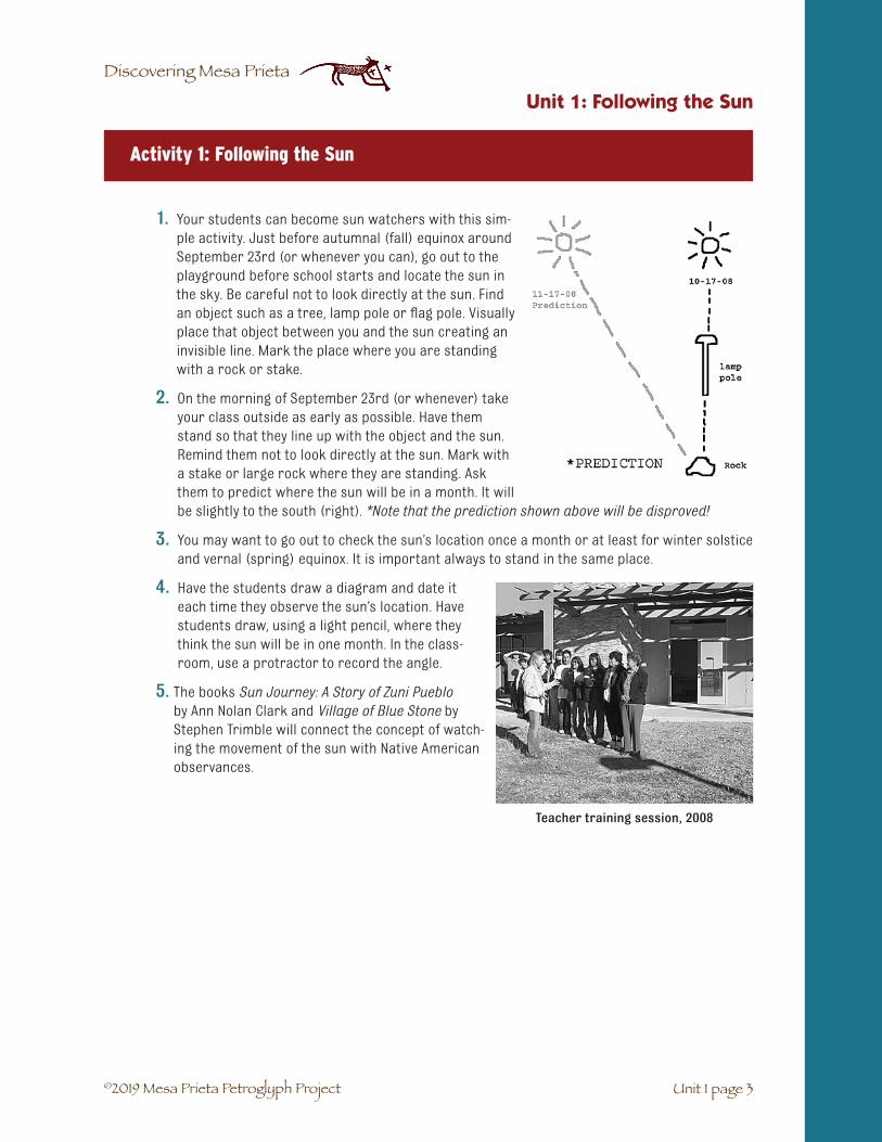
1. Your students can become sun watchers with this sim-ple activity. Just before autumnal (fall) equinox aroundSeptember 23rd (or whenever you can), go out to theplayground before school starts and locate the sun inthe sky. Be careful not to look directly at the sun. Findan object such as a tree, lamp pole or flag pole. Visuallyplace that object between you and the sun creating aninvisible line. Mark the place where you are standingwith a rock or stake.
2. On the morning of September 23rd (or whenever) takeyour class outside as early as possible. Have themstand so that they line up with the object and the sun.Remind them not to look directly at the sun. Mark witha stake or large rock where they are standing. Askthem to predict where the sun will be in a month. It willbe slightly to the south (right). *Note that the prediction shown above will be disproved!
3. You may want to go out to check the sun’s location once a month or at least for winter solsticeand vernal (spring) equinox. It is important always to stand in the same place.
4. Have the students draw a diagram and date iteach time they observe the sun’s location. Havestudents draw, using a light pencil, where theythink the sun will be in one month. In the class-room, use a protractor to record the angle.
5. The books Sun Journey: A Story of Zuni Puebloby Ann Nolan Clark and Village of Blue Stone byStephen Trimble will connect the concept of watch-ing the movement of the sun with Native Americanobservances.
Activity 1: Following the Sun
Unit 1: Following the Sun
Unit 1 page 3
Teacher training session, 2008

©2019 Mesa Prieta Petroglyph Project
Discovering Mesa Prieta
1. Bring your class out to the playground firstthing in the morning on the hour. Choose aflag pole, lamp pole or sign post that re-ceives sun throughout the day.
2. Have the students stand facing the sun(warn them not to stare at the sun) at adistance of about twenty feet.
3. Ask one student to draw, with playgroundchalk, the shadow that the pole is casting.Have another student write the time on theshadow near were the students are stand-ing.
4. Each hour bring the class outside to observewhere the shadow has moved to. Follow the above procedure.
5. Ask the students to draw a diagram of thesundial.
6. The following day bring the class outside atthe same time to observe where the shadowis. Ask one of the students to read the sundialand tell the class what time it is. They shouldnotice that the shadow is not exactly whereit was the day before. Ask students if theycan explain why it is slightly off. (Each day thesun moves a little farther to the south until itreaches winter solstice. Then it proceeds tomove north until summer solstice.)
7. During recess ask some of the students to besun watchers. When recess is over the sunwatchers will inform the teacher and students of the time.
8. If it is allowed, have the students paint the sun dial on the pavement, including the date.As close as possible to winter solstice, mark the new shadows in adifferent color of paint and date it. Repeat at spring equinox.
9. Have the students research why the sun appears to move north andsouth throughout the year.
10. Individual sun dials can be made with a white paper plate and apencil stuck through the middle. Draw a line where the shadowfrom the pencil is cast on the plate and write the time. Repeat eachhour.
Activity 2: Playground Sundial
Unit 1: Following the Sun
Unit 1 page 4
Jimmy Lara’s 4th Grade Class, Velarde Elementary School, 2007
Jimmy Lara’s 4th Grade Class, Velarde Elementary School, 2007

©2019 Mesa Prieta Petroglyph Project
Discovering Mesa Prieta
1. Have your students research the career of an archaeo-astronomer. You may wish to contact Ron Barber, an archaeo-astronomer from Los Alamos and invite him to your class. His Inter-view is in Unit 18. Archaeology as a Career, p. 16 - 13.
2. Students may also wish to research the Sun Dagger at Chaco Canyon. See the Chaco Culture National Historical Park website at http://www.nps.gov/chcu/ and the Ancient Observato-ries: Chaco Canyon website at http://www.exploratorium.edu/chaco/. Films about this topic include The Sun Dagger (58 min.) and The Mystery of Chaco Canyon (56 min.), by Anna Sofaer (http://www.solsticeproject.org/films.html).
EXTENSION: There are many interesting activities that you can do with your students related to astronomy. Observing and learning the names of the phases of the moon is a good family activity. Students can make re-cording books and draw and label each phase as they see it. In the books Keepers of the Night and Keepers of the Earth you will find more activities.
ASSESSMENT: Discuss with your students how they think the ancient people kept track of time without the use of a clock. Then have the stu-dents write an essay on how they would keep track of time if they were alone on an island without clock or calendar.
Activity 3: Careers
Unit 1: Following the Sun
Vocabulario Unidad 1: Siguiendo al sol
☛ Equinocio del invierno: una vez al año (normalmente el 23 de setiembre) cuando el día y la noche son de igual lagura.
☛ Marcador Solar: luz, sombras y petroglyphs fueron usados por los nativos para determinar los cambios de estaciones.
☛ Equinocio del verano: el otro día (normalmente el 21 de Marzo) cuando el día y la noche son iguales.
☛ Solsticio del verano: el día mas largo y la noche mas corta del año. En este día (normal-mente el 21 de Junio) el sol parece cambiar su dirección y comienza a salir cada vez un poquito mas al sur.
☛ Observador del Sol: una persona que observa el movimiento del sol a lo largo del año, anotando el cambio de estaciones, cuando es tiempo de sembrar y cuando es tiempo para determinadas ceremonias.
☛ Solsticio del invierno: después del 21 de Diciembre, el sol parece descansar y su dirección hacia el norte en el cielo es por primera vez perceptible al ojo en el Día de Navidad
Unit 1 page 5

©2019 Mesa Prieta Petroglyph Project
Discovering Mesa Prieta

©2019 Mesa Prieta Petroglyph Project
Discovering Mesa Prieta
SUBJECTS: Science, Language Arts.
SUGGESTED TIME: Two class periods.
MATERIALS:
Copy for students: Formation of Mesa Prieta student activity sheet (2 - 9), Mesa Prieta Geologic History student activity sheet (2 - 10), Ice Age Megafauna student information sheet (2 - 14).
From the trunk: For each group: a “Numbered Heads Together” set of numbers one through four, 2 basalt rocks, 2 baggies of sediment, 2 paper plates. For the class: pictures of San Antonio Peak, Mesa Prieta and an erupting shield volcano, poster map of northern New Mexico, DVD Lava Flows, DVD Sleeping Monsters – Sacred Fires: Volcanoes of New Mexico, 2006 (27 min.), DVD New Mexico, the Volcano State: Explore theVolcanoes of the National Parks and Monuments in the Land of Enchantment, 2003 (14 min.), posters Vol-cano Types of New Mexico and New Mexico: Land of Volcanoes, CD-ROM Shield Volcanoes by Jimmy Lara, ateacher from Velarde Elementary School, 2008.
From the teacher: Scissors, tape, magnifying loupes* (check out from Mesa Prieta Petroglyph office) or hand lenses, DVD player.
For the teacher: Geology of New Mexico teacher resource sheet (2 - 15), Geologic Map of New Mexico teacher resource sheet (2 - 21). Another good resource is the Fossil Horse Cybermuseum at http://www.flmnh.ufl.edu/fhc/firstCM.htm.
BACKGROUND: The CD-ROM and the DVDs listed in Materials may be shown whenever you feel it is appropriate.
PREPARATION: Move student desks into groups of four (you may have some groups of three) and tape numbers 1–4, one on each desk. You may want to make a bulletin board display of the pictures included in the resource trunk or just tape them on the board.
✔ �Students will understand the geologic processes thatformed Mesa Prieta.
✔ Students will learn to work cooperatively.
✔ Students will become good observers.
OBJECTIVES
UNIT 2: GEOLOGY OF TSIKW’AYE (MESA PRIETA)
Unit 2 page 1
*Care of loupes: Cut small swatches of soft cotton cloth for each loupe to use for cleaning the lens. Useantibacterial wipes to clean the large end that touches the face.

©2019 Mesa Prieta Petroglyph Project
Discovering Mesa Prieta
WORD BANK:☛ Adapted: changed or got used to a new situation.
☛ �Ancient: very old.
☛ Basalt: a type of dark volcanic rock formed from runny, non-viscous lava that created the Taos Plateau and Mesa Prieta.
☛ Bison: the proper name for the large mammals that lived on the Great Plains and are sometimes called buffalo.
☛ Cacti: the plural of cactus, a plant that usually has thorns and lives in dry places.
☛ Cap rock: hard rock on top of looser rock and soil that prevents erosion below it.
☛ Cerro: Spanish word for hill. The volcanoes and lava domes near Questa are called cerros.
☛ Climate: the weather patterns over many years; the average weather.
☛ Deposition: the process of moving and depositing earth materials such as sand and rocks in a new location, thus building up that area. This process is part of erosion.
☛ Dire Wolf: a very large wolf that lived during the Ice Age.
☛ Erosion: the process of taking away or removing something such as soil and rocks.
☛ Extinct: when an animal or plant species dies out everywhere on the Earth.
☛ Fissure: a crack in the earth’s crust where lava spews out and flows like a river.
☛ Folsom spear point: a type of spear point made by early people in New Mexico who were hunters and gatherers.
☛ Geologist: a scientist who studies the Earth’s crust and its processes such as rocks, miner-als, soils, erosion, mountain building and volcanoes.
☛ Glaciers: large, thick areas of permanent ice.
☛ Hunter-Gatherers: Early nomadic families who moved constantly to find food and water. Paleo-Indians were hunter-gatherers.
☛ Ice age: a time in the Earth’s history when large sheets of ice called glaciers covered the northern part of North America, Europe and Asia. The last ice age extended from 2.5 million years to 10,000 years ago.
☛ �Interglacial cycle: the time when the climate was warm and dry
☛ Lava Dome: a steep-sided hill that formed when magma pushed up the crust but did not erupt.
☛ Megafauna: large mammals that lived during the last ice age.
☛ Pleistocene Epoch: the geologic time period of the last ice age, between 2.5 million years and 10,000 years ago.
☛ River cobbles: medium size rocks rounded by tumbling in a river or stream.
☛ Santa Fe Group: layers of sediment deposited in the Española valley, mostly by streams and rivers coming off the Sangre de Cristo Mountains.
☛ Sediment: loose sand and gravel washed down through the process of erosion.
☛ Shield volcano: a volcano that is low in shape and spews out runny non-viscous lava. The Hawaiian volcanoes are shield volcanoes as well as the cerros that formed the Taos Plateau.
☛ Spewed: spit out or thrown out.
☛ Viscous lava: lava that is thick and slow moving.
☛ �Vesicle: a small air bubble or cavity found in gas-filled volcanic rocks such as basalt.
☛ Volcanic vent: an opening in the Earth’s crust where magma and volcanic gases escape.
Unit 2 page 2
Unit 2: Geology of Tsikw’aye (Mesa Prieta)

©2019 Mesa Prieta Petroglyph Project
Discovering Mesa Prieta
1. Ask the students for their ideas about how Mesa Prieta was formed. Accept all possibilities.
2. Have students watch the video New Mexico, The Volcano State (14 min.), and look at theposters Volcano Types of New Mexico and New Mexico: Land of Volcanoes.
3. Tell the students that you are going to use diagrams to explain how the geologists think theMesa was formed.
a. Using the Formation of Mesa Prieta student activity sheet (page 2 - 10), draw thefirst picture. Explain that the Rocky Mountains were pushed up due to great pres-sure inside the earth. On the student diagram they are on the east or right side of thedrawing. If your students have studied about Plate Tectonics, then explain that themovement of the tectonic plates created the Rocky Mountain uplift between 75 and 40million years ago.
b. Draw the second picture. The Rio Grande Rift began to form about 30 million yearsago as New Mexico’s crust started to pull apart. The rift would be below sea level if itwere not for sediments and lavas filling it in as the crust separated. The Rift begins inColorado and extends all the way to the Gulf of Mexico. In the Española valley it is about30 miles wide and 2 miles deep, extending from the Sangre de Cristo Mountains to justwest of Abiquiú. For most of the rift’s history it was a valley of deposition, which cre-ated a very flat landscape. Over millions of years, the mountains became lower and therift spread and filled in with sediment building up the land to the west of the moun-tains. However, in the past 3 million years all of the streams and rivers in the rift havebeen eroding the land, creating valleys and canyons.
c. Draw picture three. Explain that between 5 and 3 million years ago many shield volca-noes erupted west and northwest of the present-day town of Taos. Point to them on theposter map of northern New Mexico. Explain that shield volcanoes and fissure erup-tions often spew out runny, non-viscous lava that can travel many miles. The Hawaiianvolcanoes are shield volcanoes. Show the two photos of Hawaiian volcanoes eruptingand flowing. Now the extinct New Mexico volcanoes are low hills called cerros and looklike the shield of a warrior. Show the painting of San Antonio Mountain, which is a lavadome and the largest of the cerros. The lava from numerous fissure eruptions andshield volcanoes created the Taos Plateau. The lava from the fissure eruptions is calledServilleta Basalt. One of the fissure eruptions occurred west of Pilar between 3.6 and
Activity 1
The Rio Grande Rift, with cerros volcanoes in background.
Unit 2 page 3
Unit 2: Geology of Tsikw’aye (Mesa Prieta)

©2019 Mesa Prieta Petroglyph Project
Discovering Mesa Prieta
3.3 million years ago and flowed into a narrow valley to the south. This lava flowed downhill about 20 miles from where it erupted and stopped near the present day town of Chamita. The lava cooled into a very hard, rock called basalt. Because lava, like water, flows to the bottom of a valley, the long lava rock was at the bottom of the valley 3.6 million years ago.
d. The hardened lava, basalt, formed a protective covering (cap rock) over a narrowstrip of land. The land around the lava flow began to erode away. Four hundred fortythousand years ago, the Rio Grande became a flowing river and speeded up theerosion process. Between Embudo and Pilar the cap rock was very narrow and erodedthrough, creating the mesa we see today. Show or pass around the photos of MesaPrieta. Ask the students where the Rio Grande Rift is located in drawings 3 and 4.(It is under the whole valley and the lava flow, including Mesa Prieta.)
4. Give each student the Formation of Mesa Prieta student activity sheet (2 - 10). Have thestudents write an explanation about what is happening in each part. You may want them to cutout the four parts and tape them together in chronological order and color them. An alterna-tive activity suggested by Jimmy Lara is to make little booklets by cutting out the four partsand gluing them on stiff paper in booklet form. (This may be used as an assessment.)
Hardened lava flow on Mesa Prieta. Truchas Peaks in the distance.
Unit 2 page 4
Unit 2: Geology of Tsikw’aye (Mesa Prieta)
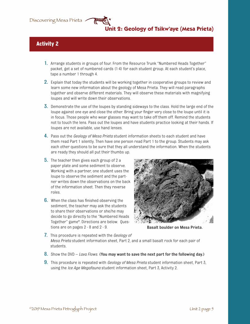
©2019 Mesa Prieta Petroglyph Project
Discovering Mesa Prieta
Activity 2
1. Arrange students in groups of four. From the Resource Trunk “Numbered Heads Together”packet, get a set of numbered cards (1-4) for each student group. At each student’s place,tape a number 1 through 4.
2. Explain that today the students will be working together in cooperative groups to review andlearn some new information about the geology of Mesa Prieta. They will read paragraphstogether and observe different materials. They will observe these materials with magnifyingloupes and will write down their observations.
3. Demonstrate the use of the loupes by standing sideways to the class. Hold the large end of theloupe against one eye and close the other. Bring your finger very close to the loupe until it isin focus. Those people who wear glasses may want to take off them off. Remind the studentsnot to touch the lens. Pass out the loupes and have students practice looking at their hands. Ifloupes are not available, use hand lenses.
4. Pass out the Geology of Mesa Prieta student information sheets to each student and havethem read Part 1 silently. Then have one person read Part 1 to the group. Students may askeach other questions to be sure that they all understand the information. When the studentsare ready they should all put their thumbs up.
5. The teacher then gives each group of 2 apaper plate and some sediment to observe.Working with a partner, one student uses theloupe to observe the sediment and the part-ner writes down the observations on the backof the information sheet. Then they reverseroles.
6. When the class has finished observing thesediment, the teacher may ask the studentsto share their observations or she/he maydecide to go directly to the “Numbered HeadsTogether” game*. Directions are below. Ques-tions are on pages 2 - 8 and 2 - 9.
7. This procedure is repeated with the Geology ofMesa Prieta student information sheet, Part 2, and a small basalt rock for each pair ofstudents.
8. Show the DVD – Lava Flows. (You may want to save the next part for the following day.)
9. This procedure is repeated with Geology of Mesa Prieta student information sheet, Part 3,using the Ice Age Megafauna student information sheet, Part 3, Activity 2.
Basalt boulder on Mesa Prieta.
Unit 2 page 5
Unit 2: Geology of Tsikw’aye (Mesa Prieta)

©2019 Mesa Prieta Petroglyph Project
Discovering Mesa Prieta
* “Numbered Heads Together” is a game used as a review of new information. Each student is assigned a number from one to four for the entire game. After the groups have read and reviewed the information in the first paragraph, the class is ready to play the game.
1. The teacher reads a question. The students put their heads together and quietly (so the other groups can’t hear them) answer the question. The group must be sure that each member knows the answer.
2. The teacher calls on one of the four numbers to raise their hands and all the students who are that number raise their hand. For example, “Number twos, what is the answer?” All of the number twos raise their hands. Then the teacher calls on one of the number twos.
3. If the answer is correct, the teacher moves to the next question. If it is incorrect, another student with that number is called on.
4. For each question a different number will be called on randomly. Keeping score helps to keep up the students’ enthusiasm.
EXTENSION: Have the students color the pictures of the megafauna and cut them out. Discuss what the climate was like and what the habitat might have been like. Create a habitat, either a diorama or two dimensional picture, and glue the animals in it. This activity was suggested by Jimmy Lara.
Some students may wish to do research. Included are some interactive web sites about ancient horses and the ice age:
http://www.flmnh.ufl.edu/fhc/firstCM.htm. (Fossil Horse Cybermuseum)
http://en.wikipedia.org/wiki/Horse_evolution (Evolution of the Horse)
http://www.geologicresources.com/pleistocene_epoch.html (The Great Ice Age)
CONCLUSION: You may want to ask each student to share one thing that they learned today.
ASSESSMENT:
Write these two questions on the board. Ask students to choose one of them and write a paragraph.
a. Which material is more affected by erosion: basalt or sediment? Explain why you think so.
b. What if there had been no fissure near Pilar and the lava had not flowed down to Chamita? How would the land be different today? Explain why.
Unit 2 page 6
Unit 2: Geology of Tsikw’aye (Mesa Prieta)

©2019 Mesa Prieta Petroglyph Project
Discovering Mesa Prieta
Questions for “Numbered Heads Together”
Part 1:
1. Where did the sediment come from? (Sangre de Cristo Mountains; Truchas Peaks)
2. What is the process called that carried the sediment? (erosion)
3. What do geologists call this sediment? (Santa Fe Group)
4. How many years ago did the Sangre de Cristo Mountains form? (75 to 40 million years ago)
5. What carried the sediment away from the Española valley? (streams and rivers; erosion)
6. When did the Rio Grande begin to flow into the Española Valley? (440 thousand years ago)
7. What did the Rio Grande do? (eroded the sediment; deepened the valley; carried rocks andsediment from the Taos area down to the Española valley; helped carve out the Rio GrandeGorge)
Part 2:
1. Where did the basalt rocks come from? (Mesa Prieta; lava from a fissure west of Pilar)
2. Where are the extinct shield volcanoes and lava domes located? (west of Questa; northwestof Taos)
3. Name the largest of the cerros. (San Antonio Peak)
4. What are the cerros? (extinct shield volcanoes and lava domes west and northwest of Taosand Questa. The lava from the shield volcanoes and fissure eruptions formed the TaosPlateau.)
5. When did the volcanoes erupt? (between 5 –3 million years ago)
6. Where did the lava come to a stop? (near the present-day town of Chamita)
7. What did that hardened lava form? (cap rock; Mesa Prieta)
8. How can we tell how high the land was 3.8 million years ago? (The base of the cap rock; Thelava flowed over the ground-level sediment and protected it from eroding.)
Part 3:
1. What does the word “megafauna” mean? (large animal)
2. Were the ice age mammals generally larger or smaller than the present day mammals?(larger)
Unit 2 page 7
Unit 2: Geology of Tsikw’aye (Mesa Prieta)

©2019 Mesa Prieta Petroglyph Project
Discovering Mesa Prieta
3. How did some of the ice age mammals adapt to the cold climate? (long hair; determined by observing the Ice Age Megafauna drawings on page 2-15)
4. How did the predators adapt to their large prey? (large size; long, sharp teeth)
5. What was the climate like during glacial cycles? (cool and moist)
6. Name some of the mammals that went extinct in North America at the end of the last ice age. (horse, camel, mammoth, saber-toothed cat, sloth, tapir)
7. How do we know there were people living in the southwest during the last ice age? (a spear point was found in the bone of a giant bison skeleton in Folsom, NM)
8. Did the hunting of some of these mammals contribute to their going extinct? (possibly)
9. Did the ice age occur before or after the Mesa Prieta lava flow? (after; Mesa Prieta flow ended 3.3 million years ago and the ice age began 2.5 million years ago)
10. When did the most recent ice age end? (10,000 years ago)
11. Name some of the mammals that adapted to the warmer, dryer climate at the end of the ice age. (bison, elk, wolf, bear)
Skull of saber-toothed cat from Los Angeles, CA
Unit 2 page 8
Unit 2: Geology of Tsikw’aye (Mesa Prieta)

©2019 Mesa Prieta Petroglyph Project
Discovering Mesa Prieta
Unit 2 page 9
Unit 2: Geology of Tsikw’aye (Mesa Prieta)

©2019 Mesa Prieta Petroglyph Project
Discovering Mesa Prieta
Name: ______________________ Date: ____________
GEOLOGIC HISTORY OF MESA PRIETA: Student Information Sheet: Activity 2
Looking at Mesa Prieta today, with its tumbled dark basalt boulders, prickly pear cacti, and an occasional juniper bush, it is hard to imagine its fiery beginning.
Part 1
The story of Mesa Prieta actually began long before the volcanoes, be-tween 75-40 million years ago. There was great pressure inside the Earth that caused our present-day Sangre de Cristo Mountains to rise. By 30 million years ago, the great pressure was over, and New Mexico began to split apart, forming the Rio Grande Rift. The land began to drop down as the rift spread apart. As the valley dropped, much of the sediment from the Sangre de Cristo mountains filled in the rift forming the Española valley. These layers of sedimetary sand and gravel are part of the Santa Fe Group.
Part 2
Between 5 and 3 million years ago, west and northwest of the present town of Taos, shield volcanoes, fissure eruptions, and lava domes from numerous eruptions occurred. Most of these eruptions spewed out runny lava similar to the Hawaiian volcanoes. Multiple lava flows over time filled in much of the Taos valley, form-ing the Taos Plateau. One eruption, approximately 3.8 million years ago, erupted from a fissure west of Pilar and flowed south for 20 miles, finally coming to a stop at the present-day town of Chamita. As the lava cooled and hardened, it formed basalt rock in a layer called a cap rock.
You can see many of the extinct shield volcanoes and lava domes if you drive north to Questa. They look like round hills and are called cerros. The largest cerro is named San Antonio Mountain and is a lava dome.
If people had lived 3.3 million years ago when the final lava flowed down from the fissure, they would have been standing on the land that was as high as Mesa Prieta is today.
In the past 3.3 million years, rain and rushing streams have eroded the sand, gravel, and soft sedimentary rock on all sides of the basalt cap rock. The sediment under the cap rock was protected from erosion. This is how Mesa Prieta was formed.
Unit 2 page 10
Unit 2: Geology of Tsikw’aye (Mesa Prieta)
Cap rock above the Rio Grande

©2019 Mesa Prieta Petroglyph Project
Discovering Mesa Prieta
About 440 thousand years ago, the Rio Grande became a river that flowed from Colorado to the Gulf of Mexico. The river speeded up the erosion process. On the Mesa you will find many river cobbles that the Rio Grande carried down from the north. As the land around the cap rock was worn away, the Mesa was left to stand on its own, high and rocky against the blue New Mexico sky.
Part 3
During the first ice age, 2.5 million years ago, the northern parts of the earth were covered by huge ice fields. Geologists call this time the Pleistocene Epoch.
These continental glaciers did not reach New Mexico, but smaller mountain glaciers created the jagged shape of the Truchas Peaks.
During the glacial cycles the climate was cool and moist and supported lush grasslands and mountain forests. When glaciers retreated during the intergla-cial cycles, the climate became warm and dry. The dinosaurs had died out 65 million years ago and the age of mammals folllowed. Scientists call the large ice age mammals “megafauna”. Saber tooth cats and dire wolves hunted woolly mammoths, giant bison, giant elk, horses, and camels. Many other mammals also lived here at that time.
Fossils of some of these mammals have been found in the Española and Pojoaque valleys. Even older fossils of mammals that lived before the ice age have been found in the Santa Fe Group sediments under Mesa Prieta near Chamita. They include ground sloths, horses, camels, dogs, and beaver.
Scientists believe that the earliest people who lived in New Mexico came here about 12,000–13,000 years ago. We call these people Paleo-Indians. They lived on plants they gathered and animals they hunted. The first spear point to
be found together with a giant bison skeleton was excavated at Folsom, NM. Pronghorn antelope, horses, and jackrabbits were probably hunted as well. Folsom spear points have been found on Mesa Prieta.
Unit 2 page 11
Unit 2: Geology of Tsikw’aye (Mesa Prieta)
Ice Age horse, Equus scotti
Truchas Peaks, viewed from Mesa Prieta

©2019 Mesa Prieta Petroglyph Project
Discovering Mesa Prieta
Europeans brought the first modern horses to North America
Ice Age bison
Unit 2 page 12
Unit 2: Geology of Tsikw’aye (Mesa Prieta)
About 10,000 years ago the most recent ice age ended, glaciers melted, and the climate became warmer and drier. Most of the large mammals became extinct, and some scientists think that the hunting of these animals by the early people may have helped cause their extinction.
After their extinction, horses did not live in North America again until the Spanish brought them from Spain about 500 years ago.
Some large mammals like the bison, wolf, bear, and elk were able to adapt to the changing climate by be-coming smaller over thousands of years. Many of the smaller mammals that live today, such as mice and squirrels, were also able to adapt to these climate changes.

©2019 Mesa Prieta Petroglyph Project
Discovering Mesa Prieta
Unit 2 page 13
Unit 2: Geology of Tsikw’aye (Mesa Prieta)
Ice Age Megafauna*: Student Information Sheet: Activity 2
*Bureau of Land Management, Dankworth Village. Supplementary drawings by Katherine Wells.

©2019 Mesa Prieta Petroglyph Project
Discovering Mesa Prieta
Unit 2 page 14
Unit 2: Geology of Tsikw’aye (Mesa Prieta)
Sandia Mountains at Albuquerque, NM
GEOLOGIC HISTORY OF NEW MEXICO: Teacher Resource Sheet
The geologic history of New Mexico is wonderfully diverse. Exposed within the state’s boundaries are Pre-cambrian igneous and metamorphic rocks more than 1.5 billion years (b.y.) old, sedimentary strata repre-senting each geologic period from Cambrian to Quaternary, and a variety of volcanic rocks erupted over the past 60 million years (m.y.) to within a few hundred years of the present. Study of these rocks and their relationships within the structural, tectonic, and geomorphic framework of New Mexico’s present landscapes has yielded much information on the geologic evolution of the state. Because of the complexi-ties of New Mexico’s geology, however, only a brief outline of especially important aspects of the state’s geology can be presented here. Some additional details of New Mexico stratigraphy and structure may be found in the discussion of the state’s paleontology and young faulting elsewhere in this volume.
New Mexico’s Precambrian rocks are exposed predominantly in the cores of mountain ranges along the east side of the Rio Grande and in a few isolated ranges to the west, such as the Brazos, Nacimiento, Zuni, and Barros mountains. A wide variety of metamorphic and igneous rock types is present, with much local variation and many complex structures. In general the pattern seems to have been initial deposition and gradual burial of clastic sediments about 2 b.y. ago (probably at the edge of an ancient continent), ac-companied by several episodes of extrusive volcanic activity, and followed by extensive regional folding, faulting, and metamorphism. Deformation and metamorphism wrought dramatic changes in the volcanic and sedimentary rocks: clastic sediments became contorted phyllites, schists, and quartzites, and the extrusive volcanics were transformed into sheared belts of felsites and amphibolites. Intrusion of gra-nitic magmas overlapped the long-continuing tectonism and metamorphism, producing metamorphosed gneisses, in addition to large volumes of undeformed granite. Pegmatite dikes, representing final crystalli-zation of magmas and containing beryl, lepidolite, tantalite, and other rare minerals, were injected locally into older granites, most notably at the Harding pegmatite mine near Dixon, and in the Petaca District of the Brazos Mountains.
These events appear to have begun earlier in northern New Mexico. Precambrian rocks in the Brazos, Taos, and Nacimiento mountains have been dated at 1.7 to 1.8 b.y., whereas the Precambrian cores of the Zuni, Manzano, Ladron, and Magdalena mountains are 1.3 to 1.6 b.y. old, and the Sandia Granite is about 1.45 b.y. old. Farther south, in the San Andres Mountains, Precambrian ages are 1.3 to 1.4 b.y., and the Precambrian of the Franklin Mountains near El Paso is scarcely 1 b.y. old. As Precambrian metamorphic and igneous activity subsided, the landscapes began to be eroded, and, with the waxing and waning of Paleozoic seas across New Mexico, were in most areas eventu-ally covered by Paleozoic sediments. Uplift during late Tertiary time, associated primarily with tectonic movement along the Rio Grande rift, has once again exposed some of these Precambrian rocks.

©2019 Mesa Prieta Petroglyph Project
Discovering Mesa Prieta
Unit 2 page 15
Unit 2: Geology of Tsikw’aye (Mesa Prieta)
Through the Paleozoic Era most of the state was covered by vast shallow seas in which thick sequences of limestones, sandstones, and shales accumulated. The sedimentary record for the Cambrian through Devo-nian periods is limited to the mountain ranges in the south-central and southwestern part of New Mexico; erosion of early and middle Paleozoic sediments in northern New Mexico occurred later in the Paleozoic. Through the Mississippian and Pennsylvanian periods, marine sediments were deposited in many parts of New Mexico. Renewed uplift in the Pennsylvanian created several large north-south trending islands that divided the northern seas, and by the beginning of the Permian these islands had coalesced into a landmass that shed great volumes of red clastic sediments, pushing the shoreline inexorably southward. These events corresponded temporally to the worldwide assembly of supercontinent Pangaea. In southern New Mexico the tropical seas in which the great Capitan Reef Complex grew persisted until nearly the end of the Permian, but eventually dwindled and vanished, leaving thick sequences of salt and potash over much of southeastern New Mexico.
Rocks of Triassic and Jurassic age are confined mainly to the northern half of the state and were depos-ited as rivers spread eroded sediments across vast conti-nental plains toward oceans to the west. Colorful red, green, gray, brown, and white sandstones and shales of the Chinle and Morrison forma-tions represent these periods in many parts of northern New Mexico.
By the last half of the Cretaceous period the seas had returned; New Mexico was on the western shoreline of a great shallow ocean that covered most of central North America. Numerous advances and retreats of the shoreline produced a great variety of marine and swampy facies. The classic sequence in the San Juan Basin is the best and most easily observed example, for these Cretaceous units are widely exposed today over much of the northwestern quarter of the state. Most of New Mexico’s coal deposits formed from the lush vegetation that existed in northwestern and northeastern New Mexico during this time. The sea retreated quickly out of the state at the close of the Cretaceous, the last time New Mexico would be covered by marine waters. About the same time, the Laramide orogeny, a profound mountain-building episode centered to the west of the state, intensified volcanic activity and uplift in the San Juan Mountains of southwestern Colorado and neighboring areas. Large volumes of clastic sediments were deposited by rivers across much of New Mexico, concentrating in structural depressions such as the San Juan and Raton basins. Local and sporadic volcanic and igneous activity also characterized some parts of New Mexico during the early Tertiary; the internal parts of these volcanic systems are now exposed as stocks and dikes mainly in southwestern New Mexico.

©2019 Mesa Prieta Petroglyph Project
Discovering Mesa Prieta
Unit 2: Geology of Tsikw’aye (Mesa Prieta)
Unit 2 page 16
Exposed volcanic pipe, Dixon, NM
Beginning about 40 m.y. ago, much of southwestern and central New Mexico was subjected to an enor-mous explosion of volcanic activity that lasted about 20 m.y. before subsiding. Great thicknesses of ash-flow tuffs, along with andesite, rhyolite, and basalt flows, originated from gigantic volcanic cauldrons (some more than 50 km in diameter) as a consequence of complex interactions between two colliding lithospheric plates along the western coast of North America. Many of the cauldrons are not obvious in the present landscape, having been obscured by subsequent geologic events, but they form the cores of some of the most conspicuous topographic features of southwestern New Mexico, such as the Mogollon-Datil plateau, Black Range, and Organ, Magdalena, San Mateo, and Peloncillo mountains.
Hydrothermal fluids associated with this volcanism produced some of New Mexico’s most important metallic resources. Other large volcanic masses in central New Mexico (e.g., Sierra Blanca and the Capitan and Ortiz mountains) formed about this time, which also witnessed the final uplift of the Sangre de Cristo Mountains. Locally, the eroded necks of isolated volcanoes which formed in the middle Tertiary, such as Shiprock, still project above the modern landscape.
Continued crustal instability, chiefly extension, was also responsible for initiating, about 30 m.y. ago, the Rio Grande rift, a great north-trending structural depression that bisects the state. Along the eastern edge of the rift, fault blocks have been uplifted gradually to form a line of prominent mountain ranges, and the basins within the rift have accumulated thousands of meters of Miocene to Recent sediments. Continued evolution of the rift has also assured a strong igneous imprint on the geologic history of western and central New Mexico. In the Jemez Mountains, volcanism began about 10 m.y. ago, producing a series of basaltic and rhyolitic flows. As the magma chamber underlying the area became depleted, explosive erup-tions beginning about 1.4 m.y. ago spread ash-flow tuffs and pumice across the Bandelier area, and scattered ash as far east as Kansas. Collapse subsequent to these erup-tions created the Valles Caldera, with a diameter of 22 km, one of the largest in the world. After caldera collapse, magma continued to be extruded until a few tens of thousands of years ago. Extensive volcanism also began in northeastern New Mexico about 8 m.y. ago and left more than 100 cones as well as widespread lava flows covering more than a quarter of Union and Colfax counties. Volcanic activ-ity continued here until about 4,500 years ago, and some of the youngest volcanos, such as Capulin, are virtually intact.
In west-central New Mexico the Mt. Taylor volcanic field flourished from about 3.5 to 2 m.y. ago; Mt. Taylor itself was built up over more than a million years of intermittent activity. The larger Zuni-Bandera field southwest of Grants is an enormous area of malpais and volcanic cones that originated about 1.5 m.y. ago, and lava extrusion has continued nearly to the present. The McCarty’s flow is one of the most voluminous volcanic flows in the world that has occurred in historical times; its eruption about A.D. 1300 has been recorded in Native American stories.
Valles Caldera, Jemez Mountains, NM

©2019 Mesa Prieta Petroglyph Project
Discovering Mesa Prieta
Unit 2 page 17
Unit 2: Geology of Tsikw’aye (Mesa Prieta)
Malpais near Grants, NM
Rio Grande valley from Taos Junction, NM
Plant on dunes at White Sands, NM
The extensive malpais near Carrizozo is not much older (perhaps 1,000-1,500 years old).
Within about the past million years significant volcanic activity has also occurred southwest of Las Cruces and in several places along the west side of the Rio Grande in the Albuquerque area. The Albuquerque volcanoes and related structures are between 150 and 200 thou-sand years old.
During the late Tertiary and Quaternary periods, sedi-ments continued to be deposited in all parts of the state. The surface of the High Plains of eastern New Mexico is of this age, and thick Pleistocene sedimen-tary deposits have built up along the Rio Grande and many other rivers within the state. Erosion and deposi-tion proceed rapidly compared to most other geologic processes, and many of the most conspicuous features of the present landscape—from the familiar desert mesas and buttes to the intricately dissected badlands of northwest and central New Mexico to the windblown gypsum dunes of White Sands—are all the result of very recent geologic processes.
Barry S. Kues and Jonathan F. Callender
(Adapted from New Mexico In Maps, 2nd ed., Jerry L. Williams, ed., University of New Mexico Press, Albuquerque, 1986, pp. 2, 4)

©2019 Mesa Prieta Petroglyph Project
Discovering Mesa Prieta
Unit 2: Geology of Tsikw’aye (Mesa Prieta)
Unit 2 page 18

©2019 Mesa Prieta Petroglyph Project
Discovering Mesa Prieta
Unidad 2: La geología de Tsikw’aye (Mesa Prieta)
Unit 2 page 19
Vocabulario Unidad 2: La geología de Tsikw’aye☛ Adaptado: cambiado o acostumbrado a una nueva situación.
☛ Anciano: muy viejo.
☛ Basalto: un tipo de roca volcánica oscura, lava fría.
☛ Bisonte: el nombre propio para los animales grandes que vivían en las grandes praderas yalgunas veces son llamadas búfalos.
☛ Bolsa: una pequeña burbuja de aire o cavidad que se encuentra en rocas volcánicas llenas degas, como el basalto.
☛ Cacti: el plural de cactus, una planta que normalmente tiene espinas y crece enlugares secos.
☛ Cantos Rodados: rocas de tamaño medio, redondeadas por los ríos y los riachuelos.
☛ Cap Rock: roca dura en lo alto de una roca suelta y tierra que previene la erosión debajo de ella.
☛ Cazadores y agricultores: Las familias nómadas tempranas que se mudaban constantementepara encontrar agua y comida. Los paleo-indios eran cazadores y agricultores.
☛ Cerro: la palabra española para “colina”. Los volcanes que revisten Questa son llamadas Cerros.
☛ Clima: los patrones meteorológicos que han perdurado durante muchos años; el promedio detiempo atmosférico.
☛ Depósito: el proceso mediante el cual los materiales contenidos en el suelo, tales como laarena y las piedras, se trasladan y reacomodan en otro lugar, formando un área nueva. Esteproceso es parte de la erosión.
☛ Dire wolf: un lobo muy grande que existió durante la época glaciar.
☛ Domo de lava o domo tapón: un montículo aproximadamente circular que se origina en unaerupción lenta de lava viscosa de un volcán.
☛ Edad del hielo: un tiempo en la historia de la tierra cuando largas capas de hielo, llamarasglaciares ocupaban la mayor parte de Norte América, Europa y Asia.
☛ Erosión: proceso mediante el cual algo se desgasta o elimina.
☛ Extinción: cuando una especie animal o planta desaparece allá en todos los sitios donde seencuentra en la tierra.
☛ Fisura: una abertura en la capa de la tierra a través de la cual se escapa la lava y flota como río.
☛ Folsom spear point: un tipo de apear punto hecho por los habitantes tempranos de NuevoMéxico que eran cazadores y agricultores.
☛ Geólogo: un científico que estudia la corteza terrestre y sus procesos tales como los minerales,el suelo, la erosión, la formación de montañas y volcanes.
☛ Glaciares: grandes y gruesas capas de permanente hielo.
☛ Lava viscosa: lava espesa y que se mueve lentamente.
☛ Respiradero volcánico o chimenea volcánica: una apertura en la capa de la tierra por dondese escapan los gases volcánicos.
☛ Santa Fe grupo: la formación de sedimento desprendido y depositado al oeste de las montañasde la sangre de Cristo por la acción de la lluvia y los arroyos.
☛ Sedimento: arena desprendida y gravilla lavado debido al proceso de erosión.
☛ Volcán escudo: un volcán que es bajo en forma y sale a borbotones líquido de lava. Los vol-canes Hawaianos son volcanes en escudo al igual que los cerros que forman Mesa Prieta.
☛ Salir a borbotones: escupir o tirar lava.

©2019 Mesa Prieta Petroglyph Project
Discovering Mesa Prieta
Geological Diagram 2
Nombre____________ Fecha___________
UNIDAD 2. Geología de Tsikw’aye (Mesa Prieta)
FORMACIÓN DE MESA PRIETA. Hoja de actividades para el estudiante. Actividad 1
1. Elevación de montaña rocosa 40 millones de años atrás.
2. Grupo de sedimentos en Santa Fe. 24 millones de años atrás. Fisura en RíoGrande. Montañas Sangre de Cristo.
3. Lava emergiendo de un volcán escudo, 3 millones de años atrás. Montañas Sangre de Cristo.
4. Roca para evitar la erosión en Mesa Prieta. Caudal de agua 25 millones de años atrás.
Unit 2 page 20
Unidad 2: La geología de Tsikw’aye (Mesa Prieta)

©2019 Mesa Prieta Petroglyph Project
Discovering Mesa Prieta
*Bureau of Land Management, Dankworth Village. Dibujos suplementarios de Katherine Wells.
Unit 2 page 21
Unidad 2: La geología de Tsikw’aye (Mesa Prieta)
Ice Age Mammals
Unidad 2. Geología de Tsikw’aye (Mesa Prieta)
Hoja de información para el estudiante.
Variedad de fauna en la Edad de Hielo Parte 3 Actividad 2
Animales representados en la ilustración: oso; mamut; caribú; camello; tapir; caballo; tigre sable; bisonte de grandes cuernos; perezoso.
Oso
Marmut
Tapir
Camello
Tigre Sable
Perezoso
Bisonte de Grandes Cuernos
Caribú
Caballo

©2019 Mesa Prieta Petroglyph Project
Discovering Mesa Prieta

©2019 Mesa Prieta Petroglyph Project
Discovering Mesa Prieta
SUBJECTS: Science, Math.
SUGGESTED TIME: Three class periods. For Activity 2, it would be very helpful to have another adult or older student to assist.
MATERIALS:
Copy for students: Earth History Timeline student information sheet (3 - 6), How Old Is Old? student activity sheet (3 - 10).
From the trunk: Geologic timeline rope and cards.
From the teacher: For each student: 10 colored paper strips clipped together, scotch tape or stapler, pencil.
For the teacher: Earth History Timeline teacher resource sheet (3 - 8).
UNIT 3: HOW OLD IS OLD?
✔ Students will understand that the word “old” is a relativeterm.
✔ Students will begin to understand the chronology of themajor events in the earth’s history.
✔ Students will comprehend that their life can be visualized ina chronological timeline.
✔ Students will discover that many native cultures think of timein terms of cycles.
OBJECTIVES
Unit 3 page 1
VOCABULARY☛ Amphibian: (am-FIB-ee-an) vertebrate animal that lives part of its life in the water and
lays its eggs in the water.
☛ Chronology: an arrangement of events in the order in which they occurred.
☛ Coelophysis: (SEEL-o-FYE-sis), was one of the first dinosaurs and its fossilized bones werediscovered at Ghost Ranch, New Mexico.
☛ Cyclical: moving in a spiral or circular path.
☛ Evolve: to change slowly or develop something new: adaptation is often related to achanging climate.
☛ Extinction: the dying out of a species.
☛ Invertebrate: animal without a backbone.
☛ Linear: moving in a straight line.
☛ Timeline: a visual model of the events in chronological order.
☛ Vertebrate: animal with a backbone

©2019 Mesa Prieta Petroglyph Project
Discovering Mesa Prieta
1. Have a brainstorming session on the question “How Old Is Old?” and write student answers on the board. After a few minutes, have the students guide you in the placing of all the answers on a timeline that you create on the board. As each word is placed on the timeline, erase it from the list. Discuss how the word “old” is relative.
2. Lead a class discussion about different beliefs concerning how the Earth was formed and how life came to be. Different cultures and religions have different beliefs, stories and myths about this. Today we will be learning how the scientists explain these concepts by studying fossils and different rock formations. From this evidence they develop hypotheses (educated guesses or predictions) and theories (using available evidence, it is the best explanation of how or why something is the way it is.) When new evidence is discovered, theories usually change.
BACKGROUND
Mesa Prieta is more than three million years old. That sounds very old until you realize that the dinosaurs went extinct 65 million years ago and the earth is believed to be 4.6 billion years old. A geologic timeline will help put this concept of old into perspective.
Many indigenous cultures and various religions have stories and explanations for how the Earth was formed, how humans came to be and when these events happened. If you have students who are bothered by the idea of the geologic timeline, you may want to explain that this is the scientists’ explanation of the chronology of the Earth. The ideas and dates that we are using may change in the future as more fossils are discovered and technology improves.
Creating a personal timeline will further develop the students’ concept of chronology and will introduce the concept of a cyclical timeline.
Activity 1: Setting the Stage
Unit 3 page 2
Unit 3: How Old is Old?
Seashell fossils in an ancient sandstone beach

©2019 Mesa Prieta Petroglyph Project
Discovering Mesa Prieta
1. Define chronology and discuss why it is important toestablish chronological order when studying the past.
2. Explain to the students that they will be using a 100 footrope to represent the 4.6 billion years that most scientistsbelieve is the age of the earth. As the class slowly walksalongside the rope, the students will be reading cards thatexplain what was happening at that time. Students shouldlisten carefully to the student reading the card.
3. Pass out the cards* for the Geologic Timeline and reviewany words that are hard to pronounce or for which themeaning is not clear to the students. Then take them into the hallor outside. Unwind the geologic timeline. Everyone should standat the end (0 inches) that represents the birth of the Earth. Thestudent with card 1 reads what it says. Then everyone moves tothe next number and the student with that card reads it aloud.This process continues until you reach number 4. At this pointthe numbers get very closer together. Have the students lookback to where they began and then continue. Note that at num-ber 16 the scale changes in order to see the individual events.After all students have read their cards, have them look back atthe beginning of the rope and think about the fact that the lastpart of the timeline has most of the cards. Have one studentcollect the cards and an assistant roll up the rope. (This takesabout 10 min.)
4. Back in the classroom, discuss what they have learned from thisactivity. How does the timeline help the students understandthe chronology of life on earth and how the earth haschanged? A simple way to remember the concept of theage of the earth compared to humans on earth is to havethe students extend one arm. This represents the age ofthe earth. Where on your arm is when people began livingin what is now New Mexico? (The answer is the tip of yourfingernail.)
Activity 2: Geologic Timeline
*For some of the numbers on the timeline there is more than one card. This allows for different size classes. Adjustthe cards to the number of students present by eliminating some of the duplicate numbers but be sure that all 23numbers are used. You may want to give students more than one card if your class is small.**To make your own geologic timeline, please see Directions for Making a Geologic Timeline at the end of this unit,at 3-12.
Unit 3 page 3
Unit 3: How Old is Old?

©2019 Mesa Prieta Petroglyph Project
Discovering Mesa Prieta
ASSESSMENT: Pass out the student handouts Earth History Timeline student activity sheet and How Old Is Old student activity sheet. You may want students to work individually, in groups or as a whole class. Us-ing the timeline, math skills and inference, have the students answer the questions. The students may also make up problems for each other.
Answers to assessment sheet:
1. How long did it take for life to begin on Earth? (1 billion years)
2. How long did the age of dinosaurs last? (160 million years)
3. How long ago did amphibians move onto land? (395 million years ago)
4. Did people live during the time of dinosaurs? How do you know? (Use the timeline.) (Dinosaurswent extinct 65 million years ago and people arrived in what is present day New Mexicoabout 13,000 years ago.)
5. Did people live during the time of the ice age? How do you know? (Yes, the ice age ended about10,000 years ago but people arrived in New Mexico earlier.)
6. Did Coelophysis eat flowers? How do you know? (No, flowers didn’t evolve until afterCoelophysis went extinct and it was a predator.)
7. How long ago did the dinosaurs go extinct? (65 million years ago.)
8. Could the first amphians have eaten insects? Why or why not? (Yes, amphibians evolved aftersmall insects.)
9. What large predator hunted Seismosaurus? How do you know? (Probably Allosaurus, becauseit lived at the same time as Seismosaurus and was the largest predator of its time.)
10. Was Dimetrodon a dinosaur? How do you know? (No, it lived before dinosaurs evolved andits legs went out to its sides.)
Teacher preparation: Either you or the students cut enough 1 inch by 4 inch colored strips so that each student has enough strips for his/her years of age. They may be multiple colors or just two different col-ors. It is helpful if each student has his or her own Scotch tape or stapler.
Introduction: Discuss how the concept of timeline could be used to show an individual life. You may wish to ask students to bring in photos of themselves at different ages. Ask the students to think of special events that happened each year of their lives. Make the beginning of your own timeline to show the stu-dents. If they have trouble thinking of events for each year, they could use the names of their teachers.
1. Pass out 10 (or more depending on the age of your students) four inch long strips of differentcolored papers (or two alternating colors) to each student. It would be helpful to have fas-tened the sets of strips together with paper clips.
Activity 3: Personal Timeline
Unit 3 page 4
Unit 3: How Old is Old?

©2019 Mesa Prieta Petroglyph Project
Discovering Mesa Prieta
Teacher may wish to draw an example on the board. On the first strip have the student write his/her name on the back of the strip. Then write “birth” at the left side. Under it, have stu-dents write their birth dates. Tape or staple the second strip to the first strip, end to end, with the tape on the back. On the left side of the second strip, write “1st birthday.” Continue in this way until there is a strip for each year. Now have the students go back and write an event that happened each year such as first tooth, first bike, etc.
2. All of the strips should now be taped or stapled together end to end in chronological order. These can be displayed on a bulletin board or sent home.
3. Discuss the term “linear timeline” that implies that time unfolds in a straight line. Explain that in many cultures, time is visualized as a spiraling cycle. This may be represented as a cyclical timeline. “What does cycle mean? Name some cycles that you know about. (moon phases, day/night, months in a year, life cycles, tires, etc.) How can you turn your personal timeline into a cyclical timeline?” Have students bend their first year strip into a circle and clip it. Then wind the timeline around this circle that represents one year. After it is all rolled up, put the paper clip on the timeline to hold it as a circle. A slinky is another good way to illustrate a cyclical timeline. Each coil can represent a year in someone’s life such as a grandparent, parent, aunt or uncle. Paper clips with small cards can be placed on the coils where special events occurred such as “graduated from school, got married, birth of children, etc.”
INFORMAL ASSESSMENT: The following questions or similar ones can be used as a class review or as a written assignment.
1. How many years old are you? Where is it represented on your timeline?
2. How many years ago where you born?
3. What was special about your 5th year?
4. How many years ago was your 3rd birthday?
Unit 3 page 5
Unit 3: How Old is Old?
A birthday piñata!

©2019 Mesa Prieta Petroglyph Project
Discovering Mesa Prieta
Name _____________________ Date __________
EARTH HISTORY TIMELINE: Student Information Sheet
1. Earth’s crust hardened: There was no life, no water, and no atmosphere. 4.6 billion years ago
2. Blue green algae: This first life on earth was microscopic and lived in the sea.Today we call it Spirulina.
3.5 billion years ago
3. Fish: These animals were the first vertebrates in the sea. There was no life onland.
500 million years ago
4. First plants on land: These were simple plants like mosses and ferns. Smallinsects crawled onto land.
440 million years ago
5. Amphibians: (am-FIB-ee-ans) These were the first vertebrates to live on land, butreturned to the water to lay eggs. They were related to frogs and salamanders.
395 million years ago
6. Insects: Dragonflies were some of the first insects to fly. Their wingspan was30 inches. Insects were everywhere!
345 million years ago
7. Dimetrodon: (dye-MEET-row-don) This large reptile had a huge fin on its backand looked like a dinosaur, but it wasn’t. Its legs were bent out from its sideslike an alligator, while a dinosaur’s legs were attached under its body like anelephant. Its tracks were found in the red rocks at present day Jemez Pueblo.
280 million years ago
8. Coelophysis: (SEEL-o-FYE-sis) This was one of the first dinosaurs and its fossilbones were discovered at Ghost Ranch. It was a predator the size of a turkeyand is the NM State Dinosaur.
225 million years ago
9. Seismosaurus: (SIZE-mo-SORE-us) This was the longest dinosaur in the worldand its bones were found south of Jemez Pueblo. It was related to the long-necks. (sauropods)
200 million years ago
10. Allosaurus: (AL-o-SORE-us) This predator was the ancestor of Tyrannosaurus. 200 million years ago
11. Tyrannosaurus rex: This was the largest carnivore and its bones were found insouthern New Mexico.
135 million years ago
12. First flowers: Colorful flowers and insect pollinators developed together. Thisis called co-evolution.
135 million years ago
13. Dinosaurs went extinct: Scientists think that an asteroid crashed into the Gulfof Mexico causing dust to darken the sky, killing the plants and eventually allthe dinosaurs and many other animals.
65 million years ago
Unit 3 page 6
Unit 3: How Old is Old?

©2019 Mesa Prieta Petroglyph Project
Discovering Mesa Prieta
14: First horse: These early mammals developed in North America and were the size of a fox.
50 million years ago
15. Camels: They lived in the valley west of the Sangre de Cristo Mountains withlarger horses and giant bison.
25 million years ago
16. Lava erupted from a fissure near Pilar: the lava flowed down to Chamita,forming the cap rock of Mesa Prieta.
3.3 million years ago
17. Woolly mammoths: These huge elephants stayed warm during the ice ageswith their long hair and they grazed on grass.
1.6 million years ago
18. Jemez volcano erupted: This created the Valles Caldera. It was 10 times largerthan Mount St. Helens and sent volcanic ash as far as Kansas.
1.4 million years ago
19. Rio Grande began to flow: This new river followed the Rio Grande Rift, creatingthe Española Valley.
440,000 years ago
20. Paleo-Indians: The first people to live in New Mexico were nomads who huntedlarge Ice Age mammals and gathered berries, seeds and roots.
13,000 years ago
21. Last Ice Age ended: Many of the megafauna went extinct in New Mexico, includ-ing the horse, the camel and the woolly mammoth.
10,000 years ago
Unit 3 page 7
Unit 3: How Old is Old?

©2019 Mesa Prieta Petroglyph Project
Discovering Mesa Prieta
Name _____________________ Date __________
EARTH HISTORY TIMELINE: Teacher Information Sheet
1. Earth’s crust hardened: There was no life, no water, and no atmosphere. 4.6 billion years ago
2. Blue green algae: This first life on earth was microscopic and lived in the sea. Today we call it Spirulina.
3.5 billion years ago
3. Trilobites: (TRY-loh-bites) Now the seas were full of invertebrates like shells, crinoids, sponges, jellyfish and giant trilobites.
600 million years ago
4. Fish: These animals were the first vertebrates in the sea. There was no life on land.
500 million years ago
5. First plants on land: These were simple plants like mosses and ferns. Small insects crawled onto land.
440 million years ago
6. Amphibians: (am-FIB-ee-ans) These were the first vertebrates to live on land, but returned to the water to lay eggs. They were related to frogs and salamanders.
410 million years ago
7. Shallow sea covered most of what is now New Mexico. The water was warm. 360 million years ago
8. Reptiles: These animals laid eggs on land and had scales covering their bodies. 330 million years ago
8. Insects: Dragonflies were some of the first inscets to fly. Their wingspan was 30 inches. Insects were everywhere!
330 million years ago
9. Dimetrodon: (dye-MEET-row-don) This large reptile had a huge fin on its back and looked like a dinosaur, but it wasn’t. Its legs were bent out from its sides like an alligator, while a dinosaur’s legs were attached under its body like an elephant. Its tracks were found in the red rocks at present day Jemez Pueblo.
290 million years ago
9. Conifers: These evergreen trees had cones, like pine cones, with seeds. The earlier plants reproduced with spores that did not have male and female parts.
290 million years ago
10. Coelophysis: (SEEL-o-FYE-sis) This was one of the first dinosaurs and its fossil bones were discovered at Ghost Ranch. It was a predator the size of a turkey and is the NM State Dinosaur.
240 million years ago
11. Seismosaurus: (SIZE-mo-SORE-us) This was the longest dinosaur in the world and its bones were found south of Jemez Pueblo. It was related to the long-necks. (sauropods)
200 million years ago
11. Archaeopteryx: (ar-kee-OP-ter-iks) This was the first bird and it was related to dinosaurs. About three feet long, it had feathers and sharp teeth. Scientists are not sure if it flew or glided.
200 million years ago
Unit 3: How Old is Old?
Unit 3 page 8

©2019 Mesa Prieta Petroglyph Project
Discovering Mesa Prieta
11. Allosaurus: (AL-o-SORE-us) This predator was the ancestor of Tyrannosaurus. 200 million years ago
11. Stegosaurus: (STEG-o-SAUR-us) This was an herbivore with bony plates alongits back, spikes on its tail. It had a tiny brain.
200 million years ago
12. Tyrannosaurus rex: This was the largest carnivore and its bones were found insouthern New Mexico.
135 million years ago
12. First flowers: Colorful flowers and insect pollinators developed together. Thisis called co-evolution.
135 million years ago
13. Rocky Mountain uplift: Pressure from inside the Earth began pushing up theRocky Mountains
75 million years ago
14. Dinosaurs went extinct: Scientists think that an asteroid crashed into the Gulfof Mexico causing dust to darken the sky, killing the plants and eventually allthe dinosaurs and many other animals.
65 million years ago
15. First horse: These early mammals developed in North America and were thesize of a fox.
50 million years ago
16. Rio Grande Rift: The Earth’s crust began to pull apart. This caused a hugecanyon two miles deep to form from Colorado to Mexico that is filled today withsediment from the Sangre de Cristo Mountains. It is still spreading two centi-meters per year, which is about the size of the length of your thumbnail.
30 million years ago
17. Camels: They lived in the valley west of the Sangre de Cristo Mountains withlarger horses and giant bison.
25 million years ago
17. Mastodon: (MAST-o-don) A huge, stocky elephant that had long hair andbrowsed on tree leaves in the hills.
25 million years ago
18. Lava erupted from a fissure near Pilar: the lava flowed down to Chamita,forming the cap rock of Mesa Prieta.
3.3 million years ago
19. Smilodon (SMYE-loh-don): This large saber-toothed cat hunted megafauna(large Pleistocene animals)
1.6 million years ago
19. Woolly mammoths: These huge elephants stayed warm during the ice ageswith their long hair and they grazed on grass.
1.6 million years ago
20. Jemez volcano erupted: This created the Valles Caldera. It was 10 times largerthan Mount St. Helens and sent volcanic ash as far as Kansas.
1.4 million years ago
21. Rio Grande began to flow near Alamosa, Colorado. This new river followed theRio Grande Rift, creating the Española Valley.
440,000 years ago
22. Paleo-Indians: The first people to live in New Mexico were nomads who huntedlarge Ice Age mammals and gathered berries, seeds and roots.
13,000 years ago
23. Last Ice Age ended: Many of the megafauna went extinct in New Mexico, includ-ing the horse, the camel and the woolly mammoth.
10,000 years ago
Unit 3 page 9
Unit 3: How Old is Old?
** Please refer to Unit 2 page 15 for description of eras and periods in geologic time.

©2019 Mesa Prieta Petroglyph Project
Discovering Mesa Prieta
Student Activity Sheet
Using the Earth History Timeline student information sheet and your math skills, figure out the answers to these questions:
1. How long did it take for life to begin on Earth?________________________________________
2. How long did the age of dinosaurs last? ___________________________________________
3. How long ago did amphibians move onto land? ______________________________________
4. Did people live during the time of dinosaurs? Using the timeline, how do you know?
________________________________________________________
________________________________________________________
________________________________________________________
5. Did people live during the time of the ice age? How do you know?
________________________________________________________
________________________________________________________
________________________________________________________
6. Did Coelophysis eat flowers? How do you know?
________________________________________________________
________________________________________________________
________________________________________________________
7. How long ago did the dinosaurs go extinct? ____________________________
8. Could the first amphibians have eaten inscects?Why or why not?
________________________________________________________
________________________________________________________
________________________________________________________
Unit 3: How Old is Old?
Unit 3 page 10
Ichthyostega, the first amphibian
Coelophysis

©2019 Mesa Prieta Petroglyph Project
Discovering Mesa Prieta
Ichthyostega, the first amphibian
9. What large predator hunted Seismosaurus? How do you know?
____________________________________________
____________________________________________
____________________________________________
10. Was Dimetrodon a dinosaur? How do you know?
__________________________________________
__________________________________________
__________________________________________
Unit 3 page 11
Unit 3: How Old is Old?
Seismosaurus
Dimetrodon

©2019 Mesa Prieta Petroglyph Project
Discovering Mesa Prieta
Directions for Making a Geologic Timeline
Materials:
1 large wooden rolling pin
100 feet of clothes line or light rope
12 inches of yarn
1 roll of 1 inch clear tape
1 package of sticky long labels
1 black marker
1 tape measure ( at least 25 feet)
2 discs 3 1/2” in diameter, of corrugated plastic or cardboard, perforated to fit over the ends of the rolling pin
Gorilla Glue or other strong adhesive
Procedure:
1. Cut holes in plastic or cardboard discs to fit on rolling pin handles. Using strong glue, adhere adisc to each end of roller. Allow to cure.
2. Tape one end of the rope to the middle of the rolling pin with strong tape. Tape the yarn ontothe other end of the rope.
3. Lay out the rope straight in a gym or hallway.
4. Begin at the rolling pin end. Fold a label onto the rope near the rolling pin. With the markerwrite numeral 1 on the label. Cover both sides of the label with clear tape.
5. With the tape measure and the teacher timeline key, measure the rope to where numeral 2should be placed. NOTE: You will need to make your timeline divisions approximate because ofthe length of time the early periods take up.
To reflect reality on a 100 ft. long rope representing a total of 4.6 billion years, 3.5 billion yearago (event 2- blue green algae) should occur at the 24 ft. mark. Event 3, fish at 500 millionyears ago, should occur at 13 feet. Event 4, first plants at 440 million years ago, should occurat 5 feet. This leaves you with only five feet in which to fit the other 17 events. This is patentlyimpracticable.
We suggest that you put the 3.5 billion year mark (event 2) at 50 feet, event 3 at 40 feet andevent 4 at 30 feet. Fit in events 5-15 proportionally along the rest of the rope. Events 16-21 willbe put onto the section of yarn at the end.
6. Create more numbered labels, up to 21.
7. Attach a label at each event year, proportionally.
8. When you reach the yarn, the scale changes so that those numbers which should be very closetogether, are able to be seen. Be sure to explain to students that the time is “stretched out” forevents 16 - 23. In the 10 foot scale these would otherwise be clustered on top of each other.
9. To store the timeline for future use, carefully roll the rope onto the rolling pin and tape the enddown. It is best stored in its own protective box.
Unit 3 page 12
Unit 3: How Old is Old?

©2019 Mesa Prieta Petroglyph Project
Discovering Mesa Prieta
Unit 3 page 13
Unidad 3: Como de Viejo es Viejo?
Nombre____________ Fecha___________
Unidad 3 ¿Cómo de Viejo es Viejo?
¿CÓMO DE VIEJO ES VIEJO? Hoja de actividades para el estudiante
Usando el Eje Cronológico de la Historia de la Tierra, la hoja de información del estudiante y tus habili-dades matemáticas busca las respuestas a las siguientes preguntas:
1. ¿Cuánto tiempo le tomó a la tierra que hubiera vida en ella? _____________
2. ¿Cuánto duró la vida de los dinosaurios en la Tierra? _____________
3. ¿Hace cuanto tiempo los anfibios llegaron a la Tierra? ____________
4. ¿Vivían personas en la Tierra durante la época de los dinosaurios? Usando el eje cronológico, ¿cómo losabes?
______________________________________________________________________________________________________________________________________________________________________________________________ _______________________
5. ¿Vivían personas en la Tierra durante la Edad del Hielo? ¿Cómo lo sabes?
6. ¿Comía el Coelofisis flores? ¿Cómo lo sabes?
7. ¿Hace cuánto se extinguieron los dinosaurios?
_____________________________ _____________
__________________________________________
8. ¿Comían insectos los primeros anfibios? ¿Por qué o por qué no?
9. ¿Qué gran depredador cazaba al Seismosaurio? ¿Cómo lo sabes?
10. ¿Era el Dimetrodon un dinosaurio? ¿Cómo lo sabes?
Ichthyostega, el primer anfibio
Coelofisis
Seismosaurio
Dimetrodon

©2019 Mesa Prieta Petroglyph Project
Discovering Mesa Prieta
Vocabulario Unidad 3: Como de Viejo es Viejo?
☛ Anfibio: animal vertebrado que vive parte de su vida en el agua y pone sus huevos en el agua.
☛ Cronología: una colocación de los eventos en el orden en el que ocurren.
☛ Coelophysis: el primer dinosaurio; sus huesos fueron descubiertos en el Rancho Fantasma.
☛ Cíclico: lo que se mueve en espiral o en camino circular.
☛ Evolucionar: cambiar lentamente o desarrollar algo nuevo, normalmente relacionado alcambio climático.
☛ Extinción: la desasparación de las especies.
☛ Invertebrado: animales que no tienen espina vertebral.
☛ Lineal: moción en orden cronológico.
☛ Vertebrado: animal con espina vertebral.
Unidad 3: Como de Viejo es Viejo?
Unit 3 page 14

©2019 Mesa Prieta Petroglyph Project
Discovering Mesa Prieta
SUBJECTS: Mapping Skills, Math, Social Studies.
SUGGESTED TIME: Three class periods.
MATERIALS:
Teacher prep: Using a paper cutter, cut a paper strip 1” x 5” for each student, to be used as a mileage gauge (Math Extension activity, 4 - 3).
Copy for students: Where in New Mexico is Mesa Prieta activity sheet (4 - 5), New Mexico outline map student activity sheet (4 - 7).
From the trunk: NM road map and laminated map of northern NM for every student, poster sizelaminated map of northern NM.
SETTING THE STAGE: Ask the students where their school is located in the state of NM. Encourage them to use directional words such as north, south, east and west. Explain that today’s activity will involve using a New Mexico road map to discover where their school is located and where Mesa Prieta is located. They will be using mapping skills that are very important when someone travels to a place where they have never been before.
UNIT 4: WHERE IN NEW MEXICO IS TSIKW’AYE (MESA PRIETA)?
VOCABULARY☛ Compass rose: the symbol indicating the four cardinal directions - north, south, east
and west.
☛ Coordinates: the numbers and letters on the borders of a map that are used to locate aplace on a map.
☛ Distance scale: the miles and kilometers between places and the relationship to inches andcentimeters.
☛ Index of Cities and Towns: alphabetized list of the names of all towns and cities that areincluded on a map.
☛ Legend: the symbols and their meanings that are used on a map.
☛ Mileage Table: list of distances between well-known destinations on a map.
✔ Students will know how to locate places on a road mapusing coordinates.
✔ Students will understand and use symbols, legend, compassrose, and distance scale on a road map.
✔ Students will become oriented to the map of New Mexico.
✔ Students will become oriented to the location of Mesa Prietaand its relationship to the Rio Grande and the Rio Ojo Cali-ente, the cerros volcanoes, Pilar and our modern cities andtowns.
OBJECTIVES
Unit 4 page 1

©2019 Mesa Prieta Petroglyph Project
Discovering Mesa Prieta
1. Pass out a NM road map to every student. Have them put their names on the front. Teach stu-dents how to refold maps. Ask everyone to locate their school on the map. As soon as some-one finds it, stop the activity and ask them how they found it. Continue with this process untileveryone has found the town or village where your school is located. Draw a compass roseon the board and explain how it shows the cardinal directions. North is usually at the top ofthe map. To help the students remember the 4 directions, teach them “Never Eat Sour Worms”.Ask the students to find the compass rose on their map. Discuss where they are in relation toother cities and landmarks using north, south, east and west. Find Colorado on the map. Whatdirection is the compass rose pointing to Colorado. (north) When you go out for recess, drawa compass rose on the sidewalk using chalk or tempera paint. Practice finding the directionsand pointing to landmarks and cities. Example: “Where are the Sangre De Cristo Mountainsfrom Española?” As a class, say and point east. Review the directions often.
2. Explain how the coordinates are used to locate a city. Have them find the coordinates fortheir school and mark the location with a dot using a highlighter or a sticky dot. Have themlocate Taos, (B-8) Española, (C-6) Santa Fe (C-7) and Albuquerque (D-5), Las Vegas (D-8) usingcoordinates and mark them with a dot. (Write these names on the board.) Optional: Pass outcopy paper and have the students record answers.
3. Now show the students the Index of Cities and Towns that is located below the map of NM.Have them pick a town they don’t know and find it using the coordinates. This may be repeateduntil everyone understands how it works. This is a fun game.
ASSESSMENT: Use the Where in New Mexico is Mesa Prieta activity sheet as an assessment or review in class. Have students use their maps for this review.
Answers to activity sheet questions:
1 - 5. What direction is Colorado from your school? (north) Arizona (west), Texas (east and south), Oklahoma (northeast), Mexico (south)?
6. What direction does the Rio Grande flow? (north to south)
7. What direction did the lava flow from Embudo to Chamita? (N to SW)
8. Why do think Mesa Prieta is so narrow? (The lava flowed down a valley and/or the flow ranout of lava.)
9. What direction is Mesa Prieta from Española? (north or northwest)
10. What direction is Mesa Prieta from Taos? (south or southwest)
Challenge Questions: How many miles is it between:
11. Las Cruces and Albuquerque (223 miles)
12. Chama and Las Vegas (170 miles)
13. Los Alamos and Santa Fe (34 miles)
14. Colorado, New Mexico, Utah, Arizona; The Four Corners.
Unit 4: Where in New Mexico is Tsikw’aye (Mesa Prieta)
Activity, Day 1: New Mexico road map
Unit 4 page 2

©2019 Mesa Prieta Petroglyph Project
Discovering Mesa Prieta
Unit 4: Where in New Mexico is Tsikw’aye (Mesa Prieta)
Unit 4 page 3
4. After the assessment, have the students fold up their maps and collect them for futureactivities.
MATH EXTENSION: Pass out a 5 inch paper strip to each student. Have them find the distance scale below the NM map and mark off and label the miles on the paper strip. (Line up your strip with zero) It will work something like a ruler. It is not necessary to draw the white and black lines.
Using their paper mileage strip, measure (this will be a very rough estimate) how far it is from Taos to Española (about 32 miles) Española to Santa Fe (about 20 miles); from Española to Albuquerque (about 70 miles), Pilar to Chamita - lava flow (about 12 miles).
MAP EXTENSION: Ask the students to find the legend. Using the legend find the Albuquerque airport, Ghost Ranch, any state or national park/monument.
1. Pass out a laminated map of northern NM to each student, or use the Northern New MexicoMap student information sheet, p. 4-8.
2. Write Taos, Española, Santa Fe and Albuquerque on the board and ask the students to findthese cities on their map and using erasable markers, they may circle the cities on the lami-nated map.
3. Write on the board and then ask the students to locate Questa, Chamita, Embudo, the cerrosvolcanoes (They look like little clouds on the map.) Review that the lava flowed from a fis-sure near Pilar and ended at the present town of Chamita. From Embudo to Chamita thelava flowed from north to southwest, forming the cap rock of Mesa Prieta.
4. Have the students find and outline highways 68 and 285. Notice how they are on either side ofMesa Prieta and follow the Rio Grande and Rio Ojo Caliente respectively.
5. Have the students draw volcanoes on their map where the cerros are and then draw the riverof lava that flowed from Pilar to present day Chamita.
6. Be sure to have the students erase all lines when they are finished.
Activity, Day 2: Laminated map of northern New Mexico

©2019 Mesa Prieta Petroglyph Project
Discovering Mesa Prieta
1. Pass out the handout NM outline map student activity sheet and the laminated map of north-ern NM to each student. Have the students label on the outline map the title “Map of NewMexico”. Draw a compass rose in the lower part of the state.
2. Using the laminated map as a resource, ask the students to label on their outline map: Taos,Española, Santa Fe, Albuquerque and the Rio Grande. Write these names on the board. (Pointout that the dots for the cities and the line for the river are already on the map).
3. Draw the volcanoes erupting and the lava flowing down near Española.
4. On their outline maps, have students label the states and country adjacent to New Mexico.
OPTIONAL: Using colored pencils or crayons, have the students color their map.
CONCLUSION: Ask each student to share one thing that they learned.
REINFORCING ACTIVITY: Copy the black and white map of northern NM student activity sheet for each student. Glue it on light poster board. Each student cuts his/her map into pieces for a jig saw puzzle. Put his/her name on each piece. Exchange with another student and put together.
Unit 4: Where in New Mexico is Tsikw’aye (Mesa Prieta)
Unit 4 page 4
Activity, Day 3: Assessment

©2019 Mesa Prieta Petroglyph Project
Discovering Mesa Prieta
Name: _____________________________ Date: _________
REVIEW QUESTIONS: Student Activity Sheet
1. What direction is Colorado from your school?_______________________________
2. What direction is Arizona from your school?_______________________________
3. What direction is Texas from your school?_______________________________
4. What direction is Oklahoma from your school?_______________________________
5. What direction is Mexico from your school? ___________________
6. What direction does the Rio Grande flow? _____________________
7. What direction did the lava flow from Embudo to Chamita? ___________________
8. What direction is Mesa Prieta from Española? ___________________
9. What direction is Mesa Prieta from Taos? ___________________
10. Why do you think that Mesa Prieta is so narrow?
________________________________________________________
________________________________________________________
________________________________________________________
Unit 4: Where in New Mexico is Tsikw’aye (Mesa Prieta)
Unit 4 page 5
Compass rose from Pedro Reinel’s nautical chart of 1504

©2019 Mesa Prieta Petroglyph Project
Discovering Mesa Prieta
Challenge Questions: Use the mileage chart below to find your answers.
11. How many miles is it from Las Cruces to Albuquerque? ___________________
12. How many miles is it from Chama to Las Vegas? __________
13. How many miles is it from Los Alamos and Santa Fe? ___________
14. What 4 states touch each other at one point and what is the place called?
________________________________________________________
________________________________________________________
________________________________________________________
15. Below, write the names of 4 cities or towns that you don’t know and find them on the map using thecoordinates. Write down their coordinates.
Name of town Coordinates
____________________________________ __________
____________________________________ __________
____________________________________ __________
____________________________________ __________
Unit 4: Where in New Mexico is Tsikw’aye (Mesa Prieta)
Unit 4 page 6

©2019 Mesa Prieta Petroglyph Project
Discovering Mesa Prieta
Unit 4: Where in New Mexico is Tsikw’aye (Mesa Prieta)
Unit 4 page 7

©2019 Mesa Prieta Petroglyph Project
Discovering Mesa Prieta
Unit 4: Where in New Mexico is Tsikw’aye (Mesa Prieta)
Unit 4 page 8

Discovering Mesa Prieta
Unidad 4. ¿Dónde se encuentra en Nuevo México Tsikw’aye (Mesa Prieta)?
PREGUNTAS DE REVISIÓN: Hoja de actividades para el estudiante.
1. ¿En qué dirección está Colorado desde tu escuela?
2. ¿En qué dirección está Arizona desde tu escuela?
3. ¿En qué dirección está Texas desde tu escuela?
4. ¿En qué dirección está Oklahoma desde tu escuela?
5. ¿En qué dirección está México desde tu escuela?
6. ¿En qué dirección fluye Rio Grande?
7. ¿En qué dirección fluyó la lava desde Embudo a Chamita?
8. ¿En qué dirección está Mesa Prieta de Española?
9. ¿En qué dirección está Mesa Prieta de Taos?
10. ¿Por qué crees que Mesa Prieta es tan estrecha?
Preguntas de Desafío: Utiliza la tabla de kilometraje de mas abajo para encontrar las respuestas a tus preguntas:
11. ¿Cuántas millas de distancia hay desde Las Cruces a Albuquerque?
12. ¿Cuántas millas de distancia hay desde Chama a Las Vegas?
13. ¿Cuántas millas de distancia hay desde Los Álamos a Santa Fe?
14. ¿ Qué 4 estados se tocan en un punto y cómo se llama el lugar?
15. Abajo, escribe los nombres de 4 ciudades o pueblos que no conoces y búscalos en el mapa usando lascoordenadas. Apunta las coordenadas.
Nombre del Pueblo. Coordenadas.
_______________________ ___________________
_______________________ ___________________
_______________________ ___________________
_______________________ ___________________
_______________________ ___________________
Nombre__________________ Fecha_____________
©2019 Mesa Prieta Petroglyph Project
Unidad 4: Dónde está en Nuevo México Tsikw’aye (Mesa Prieta)?
Unit 4 page 9

©2019 Mesa Prieta Petroglyph Project
Discovering Mesa Prieta
Vocabulario Unidad 4: Dónde está en Nuevo México Tsikw’aye (Mesa Prieta)?
☛ Rosa de los vientos: el símbolo que indica los cuatro puntos cardinales- norte, sur, este yoeste.
☛ Coordenadas: los números y letras a los lados de un mapa que se utilizan para localizarun punto en un mapa.
☛ Distancia a escala: las millas y kilómetros entre lugares y la relación en pulgadas ycentímetro.
☛ Índice de ciudades y pueblos: un orden alfabético listando los nombres de todos loslugares incluidos en el mapa.
☛ Leyenda: los símbolos que aparecen en el mapa y sus significados.
☛ Tabla de kilometraje: lista de las distancias entre dos destinos conocidos en un mapa.
Unidad 4: Dónde está en Nuevo México Tsikw’aye (Mesa Prieta)?
Unit 4 page 10

©2019 Mesa Prieta Petroglyph Project
Discovering Mesa Prieta
SUBJECTS: Social Studies, Science, Art.
SUGGESTED TIME: Two class periods.
MATERIALS:
Copy for students: Petroglyphs and Pictographs student information sheet (5 - 6).
From the trunk: Photos of petroglyphs and pictographs.
From the teacher: For each student: Modeling clay, tooth pick, water color paint set, cup for water, paper towels, waxed paper, pencil, drawing paper. For the class: two buckets (may be checked out from the MPPP office)
For the teacher: DVD Flintknapping (45 min.), available at Bandelier National Monument, 505-672-3861. Also Ancestral Pueblo People of Bandelier: A Guide for 4th Grade Teachers, available online at http://www.nps.gov/band/forteachers/fourth-grade-lesson-plans.htm.
BACKGROUND: There is detailed information about the early peoples of New Mexico in Intrigue of the Past: Discovering Archaeology in New Mexico, which is located in the Discovering Mesa Prieta resource trunk.
SETTING THE STAGE: Write on cards or the board the words petroglyph and pictograph. Discuss the definitions and explain that both design methods are classified as rock art. Explain that rock art is a misleading term because it is believed that petroglyphs and pictographs are neither art nor writing, but a form of religious expression. Write on cards or the board the root words and their meanings. Discuss the meanings of the words and how they are formed.
picto = to paint (Latin) graph = to write (Greek)
petro = rock (Latin) glyph = carved work (Greek)
Pass out to each student Petroglyphs and Pictographs student information sheet. Have students read the first paragraph as a class.
✔ �Students will be able to differentiate between a petroglyphand a pictograph.
✔ Students will discover that the study of petroglyphs can bea tool for learning about the past.
✔ Students will understand that different groups of peoplecreated the petroglyphs on Mesa Prieta.
✔ Students will understand the use of a timeline.
OBJECTIVES
UNIT 5: INTRODUCTION TO PETROGLYPHS AND PICTOGRAPHS*
Unit 5 page 1
*Adapted from Intrigue of the Past. A Teacher’s Activity Guide for Fourth through Seventh Grades, Bureau of LandManagement, 1993, pp. 95-96.

©2019 Mesa Prieta Petroglyph Project
Discovering Mesa Prieta
VOCABULARY☛ Agriculture: The raising and caring for plants and/or animals for food and/or other
materials.
☛ Ancestral Pueblo: Ancient Pueblo people who lived from about 1200-1540 AD. Sometimes re-ferred to as “Anasazi”. It is a Navajo word for enemy ancestor. The Pueblo people did not wanttheir ancestors referred to as enemies.
☛ Archaeologist: A scientist who studies ancient peoples and cultures.
☛ Archaic Period: (ar-KAY-ik) Ancient people or culture. The people who first started makingpetroglyphs on Mesa Prieta have been designated Archaic.
☛ Atlatl: (A-tul-A-tul) Also called a spearthrower. A short stick which extends thelength of the arm, for hunting large ani-mals with a spear. First used by Paleo-Indian peoples before the developmentof the bow and arrow.
☛ Genísaros: (hay-NEE-sa-ros) Nativepeople who were taken as slaves by theSpanish and later became free.
☛ Graffiti: Recent markings on walls,rocks or other surfaces, often consid-ered to be vandalism when it affects petroglyphs.
☛ Historic Period: Time period after the first Europeans arrived in what is now New Mexico,beginning about 500 years ago.
☛ Hunters/gatherers: Nomadic people who lived on the plants they gathered and animals theyhunted. The earliest hunter-gatherers lived in the Southwest from about 10,000 to 5,500 BC.and this way of life was lived by some peoples into Historic times.
☛ Modern: The time period after 1950.
☛ Panel: a group of pictographs and/or petroglyphs on a single rock surface.
☛ Patina: the dark coating that forms on rocks over hundreds of years in an arid climate.Sometimes called desert varnish.
☛ Paleo-Indian: New Mexico’s earliest people were nomadic families who lived during the IceAge and hunted large mammals such as giant bison, antelopes and horses.
☛ Pecking: marks made by hitting the basalt rock with another hard rock or antler. Sometimesa hammer stone was used.
☛ Petroglyph: a design pecked, chipped, scratched or abraded into a rock surface.
☛ Pictograph: a design painted or drawn on a rock surface.
☛ Post European Contact: the time after the Spanish arrived in northern NM in 1540 AD.
☛ Rio Grande style: A particular style of petroglyph found along the Northern Rio Grandedrainage that was made by Ancestral Pueblo people.
☛ Rock art: a misleading term for the pecking or painting of designs onto rock surfaces. It isbelieved that this was not an art form but was done for religious purposes.
☛ Repatination: the return of patina over many hundreds of years, darkening the petroglyphs.
☛ Symbol: a design which represents a concept or idea.
Unit 5 page 2
Unit 5: Introduction to Petroglyphs and Pictographs

©2019 Mesa Prieta Petroglyph Project
Discovering Mesa Prieta
Explain that some of the paints were made by grind-ing different colored minerals or clays and mixing them with animal fat. Other paints were made from colored berries or other parts of plants and mixed with egg white as a binder. Charcoal wands were also used. Students can experiment with different materi-als to create their own paints that they can paint onto rocks. Paint brushes were made from yucca leaves. Only one pictograph has been found on Mesa Prieta, perhaps because there are very few caves or overhangs to protect them from the weather.
Pictographs are usually found in caves or under rock overhangs. In Utah, 7000 year old pictographs have been found, while many famous examples 35,000 years old have been found in caves in France and Spain.
1. Have the students look at different photographs of petroglyphs and pictographs and discusswhat they know about them. Discuss the terms panel and symbol.
2. Students choose one pictograph photograph each or passthem out randomly. Ask the students to imagine that theyare living during the time of the Ancestral Pueblo people andpretend that the paper is the surface of a basalt boulder.Have them write their name and also the word “pictograph”on their paper. Ask the students to draw with pencil and thenpaint one or more designs from the photographs or a symbol-ic design of their own on the paper. (Instead of drawing paperyou could use paper bags cut in a roundish shape and crum-pled to represent the rock.) Students may share cups of wa-ter and should clean their brushes every time they change to anew color. The lid of the paint set may be used for mixing newcolors. Have one bucket filled with clean water and an emptybucket for the students’ dirty water. When the students’ watercups get dirty, they may dump them into one bucket and getclean water from the other one. During clean-up be sure thatthey clean each color and then the lid with paper towels.
OPTIONAL: Teacher or class cut narrow yucca leaves to make into brushes. Cut off the point so no one will get poked. Chew or pound with a rock the other end of the leaf until the fibers separate. It is impor-tant to show respect for the yucca plant. Cut only the number of leaves that you need and when you are finished with them, return them to the earth.
Activity 1: Pictographs
Pictograph at Bandelier National Monument
Unit 5 page 3
Unit 5: Introduction to Petroglyphs and Pictographs
Student “Pictograph”

©2019 Mesa Prieta Petroglyph Project
Discovering Mesa Prieta
Explain to students that petroglyphs are found on many rock sur-faces such as basalt, sandstone, limestone, granite and volcanic ash. All of the petroglyphs on Mesa Prieta were made on basalt boulders that are the hardened lava from the three million year old lava flow. These basalt boulders weren’t always black. As the red hot lava cooled, most of the rocks turned gray. Over hundreds of years in an arid climate a black coating called patina formed on the basalt. The early people who lived here discovered that if they pecked through the patina, the gray rock showed and it was pos-sible to make designs on the boulders. Over hundreds of years the patina comes back, darkening the pecked out petroglyphs. This is called repatination. Archaeologists can tell by the repatination if one petroglyph is younger or older than another.
(For advanced students) Several different techniques were used to create petroglyphs.
Pecking: The technique of using a hammer rock with a harder rock or antler to chip out little pieces of rock in order to create petroglyphs. Sometimes a hammer stone was used. Also refers to the marks made with this technique.
Abrading: Marks made by rubbing a stone against a rock face, often until it was smooth.
Scratching: The technique of rubbing a sharp hard rock or metal against the patina on thebasalt. The lines are usually thin, shallow and sometimes very faint.
Incising: The technique of using a sharp rock edge to make lines in a rock surface. After the coming of the Europeans, some petroglyphs were incised using metal.
1. If your students haven’t examined basalt rocks before, this would be a good time to pass themaround.
2. Explain that the students will now pretend that a slab of clay is the basalt boulder and theywill create petroglyphs with a tooth pick. Be sure to tell them that the clay must be returnedat the end of the activity. Pass out a piece of waxed paper, tooth pick and a piece of clay toeach student. They should soften the clay by squeezing it and then form it into a “tortilla” orslab. Using the tooth pick, they may draw a design and then peck it to enlarge or thicken thelines. They may also use the back of the slab.
3. You may want to have the class quietly move around the room to look at each other’s designs.Then ask for positive comments.
4. To clean up, ask students to fold their slabs in half and then in half again. Pound them on thewaxed paper to form columns and then collect them.
5. Review the difference between pictographs and petroglyphs and what else they have learned.
Activity 2: Petroglyphs
Unit 5 page 4
Unit 5: Introduction to Petroglyphs and Pictographs

©2019 Mesa Prieta Petroglyph Project
Discovering Mesa Prieta
Have the students read the second part of the student information sheet Who Made the Petroglyphs? (5 - 6) in groups or as a class and discuss. Create a simple timeline on the board and have students copy it:
10,000-5,500 BC
5,500 BC-700 AD
700-1200 AD 1200-1540 AD 1540-1950 AD 1950 - Present
Paleo-Indian ArchaicEarly
AgriculturalAncestral
Pueblo
Historic (Post Europe-an Contact)
Modern
Unit 5 page 5
Unit 5: Introduction to Petroglyphs and Pictographs
Activity 3: Day 2

©2019 Mesa Prieta Petroglyph Project
Discovering Mesa Prieta
Name _________________________ Date _____________
PETROGLYPHS AND PICTOGRAPHS: Student Information Sheet
From prehistoric times up to the present Native Americans as well as peoples from all over the world have created designs on rock.
Archaeologists analyze these figures and designs, and often find that different groups of people made different styles of designs. The most common petroglyphs on Mesa Prieta are called “Rio Grande Style”. There has been one pictograph found on Mesa Prieta. While all of the petroglyphs found on Mesa Prieta are on basalt boul-ders, in other places petroglyphs are found carved into sandstone, volcanic ash and
granite.
The meanings of the symbols are often mysterious and unknown. Some Native American tribes have ancient stories that tell about the designs and their meanings but sometimes the meanings are a mystery to everyone.
Many native people believe that the spirit of the artist is connected with the work; therefore, petroglyphs and pictographs are sacred and must be treated with respect. We can all enjoy, appreciate and respect the designs that we find on the rocks.
WHO MADE THE PETROGLYPHS?
Paleo-Indian Period: 10,000 BC to 5,500 BC.
The earliest people who are known to have lived in the area of Mesa Prieta were hunters and gatherers. Spear points called Folsom points were found on Mesa Prieta. These people lived during the last ice age and were nomadic. They hunted large mammals such as giant bison and horses with spears and spear-throwers called atlatls.
Unit 5 page 6
Unit 5: Introduction to Petroglyphs and Pictographs

©2019 Mesa Prieta Petroglyph Project
Discovering Mesa Prieta
Archaic Period: 5,500 BC to 700 AD.
It is believed that the Archaic people created the first petroglyphs on Mesa Prieta. They made mostly geometric designs such as circles, lines, diamonds, and other polygons. These patterns are often very difficult to see because of heavy re-patination.
Archaic people were nomadic hunters who used atlatls. They also gathered plants and roots to eat. By the end of this time period, the Archaic people were planting seeds and returning to their fields every so often to care for them.
Early Agricultural Period: 700 AD to 1200 AD.
As people began to grow more crops such as corn (maize), beans and squash, they saved the seeds to plant the next year. The food produced by agriculture allowed extended family groups to make permanent homes and live in small villages.
Ancestral Pueblo Period: 1200 AD to 1540 AD.
The ancestors of the modern Pueblo people lived in large pueblo villages and agricul-ture was very important in order to feed many people.
Most of the petroglyphs that we find on Mesa Prieta were made by these people. The designs were often of animals, people, shields, plants, and sky symbols.
Many flute players were made during this time.
Unit 5 page 7
Unit 5: Introduction to Petroglyphs and Pictographs
Archaic petroglyphs. Photo by Ekkehart Malotk
Archaic patterns on rock. Cracks in rock not shown.
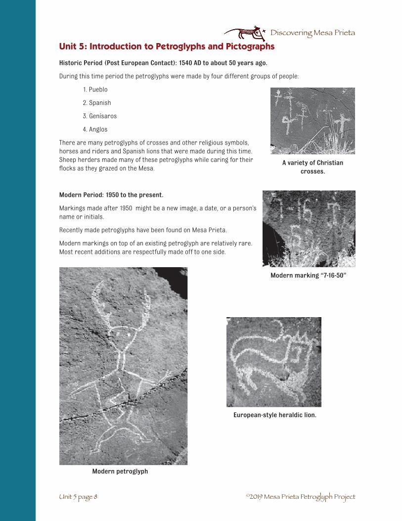
©2019 Mesa Prieta Petroglyph Project
Discovering Mesa Prieta
Historic Period (Post European Contact): 1540 AD to about 50 years ago.
During this time period the petroglyphs were made by four different groups of people:
1. Pueblo
2. Spanish
3. Genísaros
4. Anglos
There are many petroglyphs of crosses and other religious symbols, horses and riders and Spanish lions that were made during this time. Sheep herders made many of these petroglyphs while caring for their flocks as they grazed on the Mesa.
Modern Period: 1950 to the present.
Markings made after 1950 might be a new image, a date, or a person’s name or initials.
Recently made petroglyphs have been found on Mesa Prieta.
Modern markings on top of an existing petroglyph are relatively rare. Most recent additions are respectfully made off to one side.
A variety of Christian crosses.
Unit 5 page 8
Unit 5: Introduction to Petroglyphs and Pictographs
Modern marking “7-16-50”
Modern petroglyph
European-style heraldic lion.

©2019 Mesa Prieta Petroglyph Project
Discovering Mesa Prieta
Unit 5 page 9
Unidad 5: Introducción a los petrográficos y pictográficos
Vocabulario Unidad 5: Introducción a los petrográficos y pictográficos.☛ Agricultura: el cultivo de plantas or matas para conseguir comida para la gente or los animals.
Se dice “granjeria” cuando uno cultiva o cria animales.
☛ Pueblo ancestral: la gente de los pueblos tempranas que vivieron aproximadamente desde el1200 al 1500 antes de Cristo. A veces nos referimos a ellos como “Anasazi”, un término que nose usa actualmente. Es una palabra Navaja para los enemigos ancestrales. La gente Pueblo noquerían que sus ancestros ser refieran a ellos como enemigos.
☛ Arqueólogo: un científico que estudia las gentes y las culturas antiguas.
☛ Arcaico: cultura o gente antigua. Las gentes que primero empezaron a hacer petrográficos enMesa Prieta son llamados arcaicos.
☛ Atlatl (A-tul-A-tul): también llamados tiradores delanzas- un palo corto que se extendía a lo largo delbrazo, para cazar animales grandes con arpones.Primero fueron usados por las gentes Paleo-indi-as, tambien conocidos como tiradores de lanzas.
☛ Genízaros (hay-NEE-sa-ros): los nativos queeran llevados como esclavos por los españoles ydespués consiguieron la libertad.
☛ Graffiti: garabatos, dibujos e inscripciones enlos muros, rocas u otras superficies hechos sinpermiso y violando la propiedad privada. Muchas veces considerado vandalismo.
☛ Época histórica: período que va después de que los Europeos llegasen en lo que ahora seconoce como Nuevo México, empezando hace 500 años.
☛ Cazadores/agricultores: nómadas que vivían de las plantas que cultivaban y de los animalesque cazaban. Los tempranos cazadores y agricultores vivían en el Sur Oeste desde el 10.000hasta el 5.500 antes de Cristo y este modo de vida ha sido vivida por muchas gentes en elperiodo histórico.
☛ Moderno: la época que sigue el año 1950.
☛ Panel: un grupo de pictográficos y/o pictográficos en una misma superficie rocosa.
☛ Patina: la capa oscura que se forma en las rocas durante cientos de años en los climas áridos.A veces llamado desierto barnizado.
☛ Paleo-indios: los primeros habitantes de Nuevo México eran familias nómadas que existierondurante la edad del hielo y cazaban grandes mamíferos, como bisontes enormes, antílopes ycaballos.
☛ Picoteos: macas hechas por golpes en las piedras de basalto con otra roca o una piedra masdura o con un cuero.
☛ Pictográfico: un diseño pintado o dibujado sobre una superficie rocosa. Contacto post-europeo- la época después de que los españoles llegasen a Nuevo México en 1540.
☛ Estilo de Rio Grande: un estilo particular de petrográfico encontrado a lo largo de la canali-zación del norte de Rio Grande que había sido hecho por los primeros pobladores.
☛ Arte en las rocas: un término erróneo para denominar a los picoteos o diseños pintados en lassuperficies rocosas. Se cree que no fue una forma de arte sino que los dibujos fueron hechoscon propósitos religiosos.
☛ Repaginación: la vuelta de la pátina después de cientos de años, oscureciendo lospetrográficos.
☛ Símbolo: un dibujo que representa algo más.

©2019 Mesa Prieta Petroglyph Project
Discovering Mesa Prieta

©2019 Mesa Prieta Petroglyph Project
Discovering Mesa Prieta
SUBJECTS: Science, Math, Art.
SUGGESTED TIME: Two class periods.
MATERIALS:
From the trunk: For each student: a sunflower seed in its shell, photo of petroglyphs. For each group of 4 – 6 students: one small cup.
From the teacher: pencil, drawing or copy paper.
BACKGROUND:
Scientific drawing is about recording accurate infor-mation, whereas artistic drawing is often creative and expressive. Learning to draw an object takes practice just like practicing a musical instrument. You have to look closely to make an accurate copy. This is an important skill for scientists of all kinds. The trick is to look closely at one part of the whole and then draw. Go back and look at the next section, and draw it. This is called, “Look - draw, look - draw”. Counting things like the lines on a sunflower seed or the fingers on a petroglyph figure is another important technique. When drawing a figure on a background like a rock panel, it is helpful to pencil lightly a vertical and horizontal line in the center of the paper so that the figure size and location can be determined. Even young children have success with this method. Use the following activity before you ask the students to draw any petroglyphs or after Unit 5. Introduction to Petroglyphs and Pictographs, (5 - 1).
UNIT 6: DRAW LIKE A SCIENTIST
✔ Students will develop observational skills.
✔ Students will be able to draw accurately.
✔ Students will develop a sense of pride in their abilityto draw.
✔ Students will understand the concept of scale.
OBJECTIVES
Unit 6 page 1

©2019 Mesa Prieta Petroglyph Project
Discovering Mesa Prieta
1. Discuss the fact that it is important for scientists and people recording petroglyphs to drawaccurately. It is also important to understand the concept of scale. When drawing the sunflow-er seed they will enlarge their drawing, but when they draw a petroglyph they will probablyreduce the image.
2. Demonstrate the “look - draw” method of scientific drawing usinga sunflower seed. Tell the students to make many drawings of theseed for practice. This is similar to the practice of showing yourwork in math. The students will be able to see their own progress.
3. Tell the students they will be working with a sunflower seed. Theymust not eat it because it came from bird seed and is not clean. Youwill be collecting them after the activity. Pass out to each studentone sunflower seed and pencil. Remind them to take their time anddraw one small section at a time. At the end of the activity theywill play a game to see how closely they observed. You may wish toreview the shape of the seed, the differences in stripes and differ-ences in the back and front of the seed.
4. Students should draw as many pictures as they wish in order topractice. Have students come up to your desk with their seed anddrawing or walk around to each student. Praise them for the partsof the drawing that they did well and then give suggestions on howto improve the drawing. The student may then draw anotherpicture.
MATH EXTENSION: Ask the students to draw their seed the size of the paper and then figure out how much they enlarged it. Students may choose to lay the seed on the drawing and move it a length at a time, while marking each move with a dot. Counting the dots will give the number of times that they enlarged their drawing. Other students may want to figure it out mathematically by using a centimeter ruler and computation. Collect the seeds and share roasted seeds to eat (optional).
Activity 1: Setting the Stage
Unit 6 page 2
Unit 6: Draw Like a Scientist
Student scientific drawing of sunflower seeds
Student scientific drawing of petroglyph

Discovering Mesa Prieta
1. The petroglyphs on Mesa Prieta were pecked into the black patina of the basalt boulders. Theunderlying rock is gray. When drawing petroglyphs on white paper, it is sometimes difficult totell which part is pecked out. Demonstrate on the board that the lines of the petroglyphs areoften thick and should be drawn using double lines. Demonstrate how to use dots or shadingto show the pecked area. Point out that the lines of the petroglyph on the rock are light, buton the paper they are dark from the pencil. This is called a negative image. Be sure to countthings like the number of fingers, feathers or lines in order to be very accurate.
2. Pass out photos of petroglyphs and new drawing paper. Ask the students to draw petroglyphscarefully using the look - draw method. They will be practicing the drawing of petroglyphs inpreparation for their trip to the Mesa. They should take their time and draw as carefully aspossible.
EXTENSION: With a pencil or permanent marker, draw a petroglyph design on a broken piece of gourd, leather or light wood. Drill holes for yarn, leather thong or string. Wear around the neck.
ASSESSMENT: Have the students use their sunflower seed to do the following assessment. Ask students to write a short paragraph describing their specimen. As-sess student observational skills based on how many descriptive words, both quantitative and qualitative, they used in their paragraph.
©2019 Mesa Prieta Petroglyph Project
Activity 2
Unit 6 page 3
Look-drawing from a photograph
Unit 6: Draw Like a Scientist

©2019 Mesa Prieta Petroglyph Project
Discovering Mesa Prieta

©2019 Mesa Prieta Petroglyph Project
Discovering Mesa Prieta
SUBJECTS: Language Arts, Science.
SUGGESTED TIME: One class period, but review concepts throughout the year, especially before the Field Work Day at Mesa Prieta and before the standardized tests.
MATERIALS:
Copy for students: Children on the Mesa student activity sheet (7 - 4), Children on the Mesa companion picture (7 - 3), Observation and Inference student activity sheet (7 - 7), Observation and Inference Petro-glyph Panel companion picture, (7 - 6).
For the teacher: Children on the Mesa activity teacher’s key (7 - 5), Observation and Inference activity teacher’s key (7 - 8).
BACKGROUND: Archaeology is based on observation and inference. An observation is what is seen or detected. An inference is a suggested reason that tries to explain an observation. A hypothesis is a chosen inference or prediction that the archaeologist will try to prove or disprove through testing. Archaeologists use observation and inference to describe and understand the story of ancient people. By making obser-vations about objects (artifacts and sites) they infer the behavior of the people who used the objects. For example, if a corn cob is found in a fire pit, the archaeologists will infer that the people grew corn. To test their hypothesis, they will look for evidence of corn fields.
SETTING THE STAGE: Write the first four vocabulary words on the board and discuss their meanings with the students. Use examples from within the classroom such as “I am wearing a blue sweater. This is an observation because you can see it and it is a fact. Why did I wear the sweater?” The student answers are all inferences because they don’t know for sure why you wore the sweater. To test their hypothesis they must ask you why you wore the sweater. Play the “What color is my sweater?” game multiple times throughout the course of the year. Have a student come up to the front and other students make observa-tions and inferences about him/her.
UNIT 7: OBSERVATION AND INFERENCE
VOCABULARY☛ Archaeologist: A scientist who studies ancient people and their cultures.
☛ Hypothesis: an educated guess or prediction that may be tested.
☛ Inference: a conclusion made from observations. Opinions may vary.
☛ Observation: recognition or noting of a fact or occurrence.
☛ Petroglyph: a design pecked, chipped or scratched into a rock surface.
✔ Students will be able to differentiate between observation and inference through a problem-solving approach.
OBJECTIVES
Unit 7 page 1
*Adapted from Intrigue of the Past. A Teacher’s Activity Guide for Fourth through Seventh Grades, Bureau of Land Management, 1993, pp. 14-18.

©2019 Mesa Prieta Petroglyph Project
Discovering Mesa Prieta
1. Distribute the picture of the Children on the Mesa student activity sheet and companion picture to the students.
2. Read each statement and ask students to decide if it is a statement of observation or of inference. Is it a fact? If it is, then it is an observation. When you ask “Why” or “Do you know for sure?” or “What might happen?” then it is an inference. Ask them to give reasons for their answers.
3. Assist students to create a definition for observation and inference.
4. Students may wish to color their picture when they are finished.
ASSESSMENT:
1. Distribute the Observation and Inference student activity sheets and explain that these petroglyphs are found on a boulder on Mesa Prieta.
2. Ask students to work on their own to decide which statements are observations and which are inferences. Remind them that these are statements, not questions.
3. When looking at petroglyphs, the students should ask themselves, “Is this a true fact? (observation) Do I know what the maker was thinking? What else could it be?” (inference) Many different inferences are possible from one observation. What other inferences might be made from observing these petroglyphs?
4. Review the answers together or the teacher can evaluate them.
Unit 7: Observation and Inference
Activity: Children on the Mesa
Unit 7 page 2

©2019 Mesa Prieta Petroglyph Project
Discovering Mesa Prieta
Unit 7: Observation and Inference
Unit 7 page 3

©2019 Mesa Prieta Petroglyph Project
Discovering Mesa Prieta
Unit 7: Observation and Inference
Unit 7 page 4
Name: __________________ Date: ________
CHILDREN ON THE MESA: Student Activity Sheet
Place an “I” before the statements that are inferences, and an “O” before the statements that are observations.
___1. The children are in front of some large boulders.
___2. The weather is warm.
___3. The boy is touching his leg.
___4. If the boy tried to stand up, he might fall into a cactus.
___5. The girl is standing next to the boy.
___6. The boy has broken his leg.
___7. There are petroglyphs on one of the boulders.
___8. The girl pushed the boy.
___9. The boy is angry.
___10. The sun is setting.
___11. The girl is thinking about how she will get some help for the boy.
___12. The children are both wearing tie shoes.
___13. The petroglyph arrows and deer mean that the people were going hunting.
___14. The petroglyphs were made by ancient people.
___15. The boy wasn’t careful and tripped over a rock.
___16. There hasn’t been much rain in this area.

©2019 Mesa Prieta Petroglyph Project
Discovering Mesa Prieta
Unit 7: Observation and Inference
Unit 7 page 5
CHILDREN ON THE MESA: Activity Teacher’s Key
Place an “I” before the statements that are inferences, and an “O” before the statements that are observations.
Answers:
O 1. The children are in front of some large boulders.
I 2. The weather is warm.
O 3. The boy is touching his leg.
I 4. If the boy tried to stand up, he might fall into a cactus.
O 5. The girl is standing next to the boy.
I 6. The boy has broken his leg.
O 7. There are petroglyphs on one of the boulders.
I 8. The girl pushed the boy.
I 9. The boy is angry.
I 10. The sun is setting.
I 11. The girl is thinking about how she will get some help for the boy.
O 12. The children are both wearing tie shoes.
I 13. The petroglyph arrows and deer mean that the people were going hunting.
I 14. The petroglyphs were made by ancient people.
I 15. The boy wasn’t careful and tripped over a rock.
I 16. There hasn’t been much rain in this area.

©2019 Mesa Prieta Petroglyph Project
Discovering Mesa Prieta
OBSERVATION AND INFERENCE: Student Activity Sheet, p. 1
Unit 7: Observation and Inference
Unit 7 page 6

©2019 Mesa Prieta Petroglyph Project
Discovering Mesa Prieta
Unit 7 page 7
Name: ______________________ Date: __________
OBSERVATION AND INFERENCE: Student Activity Sheet, p. 2
This is the drawing of a group of petroglyphs on a boulder on Mesa Prieta. Place an “O” before the state-ments that are observations and an “I” before the statements that are inferences. Write the reason for your answer under each statement.
___1. There are many petroglyphs on the boulder.
________________________________________________________
___2. There are zigzag lines on the boulder.
________________________________________________________
___3. There are 3 petroglyphs of snakes on the boulder.
________________________________________________________
___4. The people who made the petroglyphs had a pet dog.
________________________________________________________
___5. There is a figure with 2 legs on the boulder.
________________________________________________________
___6. There are 3 crescent moons on the boulder.
________________________________________________________
___7. There are many dots on the boulder.
________________________________________________________
___8. There is an eyeball with eyelashes on the boulder.
________________________________________________________
___9. The people who made the petroglyphs were Christians.
________________________________________________________
Unit 7: Observation and Inference

©2019 Mesa Prieta Petroglyph Project
Discovering Mesa Prieta
OBSERVATION AND INFERENCE: Activity Teacher’s Key
This is the drawing of a group of petroglyphs on a boulder on Mesa Prieta. Place an “O” before the state-ments that are observations and an “I” before the statements that are inferences. Write the reason for your answer under each statement.
Answers:
O 1. There are many petroglyphs on the boulder.
O 2. There are zigzag lines on the boulder.
I 3. There are 3 petroglyphs of snakes on the boulder.
I 4. The people who made the petroglyphs had a pet dog.
O 5. There is a figure with 2 legs on the boulder.
I 6. There are 3 crescent moons on the boulder.
O 7. There are many dots on the boulder.
I 8. There is an eyeball with eyelashes on the boulder.
I 9. The people who made the petroglyphs were Christians.
Unit 7: Observation and Inference
Unit 7 page 8

©2019 Mesa Prieta Petroglyph Project
Discovering Mesa Prieta
UNIDAD 7. OBSERVACIÓN E INFERENCIA
NIÑOS EN LA MESA. Hoja de actividades para el estudiante
Nombre__________________ Fecha_____________
Pon una “I” antes de cada oración si corresponde a una inferencia o una “O” si corresponde a una observación.
___1. Los niños están delante de unas rocas grandes.
___2. El clima es cálido
___3. El chico se está tocando la pierna.
___4. Si el chico trata de levantarse, puede que se caiga encima de un cactus.
___5. La chica esta parada al lado del chico.
___6. El chico ha roto su pierna.
___7. Hay petrográficos en una de las rocas.
___8. La chica empujó al chico.
___9. El chico está enfadado.
___10. El sol se está poniendo.
___11. La chica está pensando cómo obtener ayuda para el chico.
___12. Los niños llevan zapatos puestos.
___13. Los petrográficos de la flecha y los ciervos significan que los indígenas cazaban.
___14. Los petrográficos se hicieron por las gentes primitivas.
___15. El chico no tuvo cuidado y se cayó en una roca.
___16. No hubo mucha lluvia en esta área.
Unidad 7: Observación e Inferencia
Unit 7 page 9

©2019 Mesa Prieta Petroglyph Project
Discovering Mesa Prieta
Nombre__________________ Fecha_____________
Unidad 7. OBSERVACIÓN E INFERENCIA.
Hoja de actividades para el estudiante, p.2
Este es el dibujo de un grupo de petrográficos en una roca en Mesa Prieta. Pon una “O” antes de cada oración si es una observación y una “I” si es una inferencia. Escribe las razones de tu respuesta debajo de cada oración.
___1. Hay muchos petrográficos en la roca.
_________________________________________________
___2. Hay líneas en zigzag en la roca.
_________________________________________________
___3. Hay tres petrográficos de serpientes en la roca.
_________________________________________________
___4. Las personas que hicieron los petrográficos tenían un perro.
_________________________________________________
___5. Hay una figura con dos piernas en la roca.
_________________________________________________
___6. Hay tres lunas crecientes en la roca.
_________________________________________________
___7. Hay muchos puntos en la roca.
_________________________________________________
___8. Hay un ojo con pestañas en la roca.
___9. Las personas que hicieron los petrográficos eran cristianos.
_________________________________________________
Vocabulario Unidad 7: Observación e Inferencia☛ Arqueólogo: un científico que estudia la cultura y las gntes antiguas.
☛ Hipótesis: una conjetura educada que necesita ser demostrada.
☛ Inferencia: una conclusión hecha a partir de la observación.
☛ Petrográfico: un diseño a base de picotazos, arañazos o astillas en la superficie de una roca.
Unidad 7: Observación e Inferencia
Unit 7 page 10

©2019 Mesa Prieta Petroglyph Project
Discovering Mesa Prieta
SUBJECTS: Science, Social Studies, Language Arts, Art.
SUGGESTED TIME: Two or three class periods.
FIELD TRIP: One school day.
FOLLOW UP: At least two class periods.
MATERIALS:
Copy for students: Protecting the Past on the Petroglyph Hike student information sheet (8 - 6). Copy cover template for handmade Field Work Day Recording Book (optional) (8 - 5).
From the trunk: Before the field work day, show DVDs Visit With Respect, and possibly the beginning of Silent Witness.
SCHEDULING YOUR CLASS FIELD DAY: Mesa Prieta tours are possible because of the generosity of our faithful volun-teers who serve as docents. We provide one docent for every five or six students. Planning your transpor-tation is important before selecting your date to visit. Once you are scheduled and confirmed by our Tour Coordinator, we will not be able to make changes. We encourage you to invite parents to participate. Here is how to register: 1. Go to Mesa Prieta Petroglyph website, mesaprietapetroglyphs.org. 2. Click on “Visit Wells Petroglyph Perserve”. 3. Scroll to “Tours for School Groups”. 4. Fill out information form.
Before the trip be sure that your class has covered at least Unit 2. Geology of Tsikw’aye (Mesa Prieta), Unit 4. Where in New Mexico is Tsikw’aye (Mesa Prieta)?, Unit 5. Introduction To Petroglyphs and Pictographs, Unit 7. Observation and Inference, and the first two pages of Unit 9. Classification, including Activity 1.
Mesa Prieta Petroglyph Project will provide trained volunteer guides. Please make sure that your students are attentive and follow all directions given.
✔ �Students will develop a sense of respect for archaeological sites and ancient cultures.
✔ Students will develop a sense of wonder about the petroglyphs and the people who created them.
✔ Students will become interested in local archaeology and its preservation.
✔ Students will become proficient in drawing the petroglyphs that they see.
✔ Students will be able to write creatively about their observations.
✔ Students will experience a sense of adventure and discovery.
✔ Students will get exercise in a natural environment.
OBJECTIVES
UNIT 8: FIELD WORK DAY ON TSIKW’AYE (MESA PRIETA)
at the Wells Petroglyph Preserve
Unit 8 page 1

©2019 Mesa Prieta Petroglyph Project
Discovering Mesa Prieta
The hike to see the petroglyphs at the Wells Petroglyph Preserve is very steep with loose rocks and cacti. It is mandatory that there be at least one adult for every four to six children. Everyone must wear closed toe shoes or hiking boots and bring a bottle of water. In the warm months there may be snakes sunning themselves on the rocks. It is important to watch where you step and put your hands. In the winter the snakes are hibernating. The hike up the side of the Mesa requires a good deal of physical exertion. Be sure that your students don’t have any medical conditions that could make this hike dangerous for them.
All adults attending the hike must sign MPPP’s waiver when they arrive on site.
Unit 8 page 2
1. Preparation: Make Field Work Day recording books before the trip. If it is not possible to take the trip, photographs of the petroglyphs may be copied into the student books or journals.
2. Materials:
Copy for students: Pre-made cover template (optional).
From the teacher: White copy paper (at least 4 per student), colored construction paper: 8.5” x 11” (1 per student for cover) or pre-made cover, staplers, markers.
3. Procedure:
1. Students fold copy paper and construction paper in half horizontally. Staple along the spine. With markers, students may decorate the cover and write their name and date of the trip.
2. While on the Mesa the students should draw at least 4 petroglyphs or panels (several petroglyphs on one rock face).
3. After the field work day, on the opposite page from the drawing, have the students write a story about the petroglyph or panel.
4. If you are not able to take a trip, you may want the students to draw some of the petroglyphs from the photographs in the resource trunk. On the top half of the paper draw the petroglyph and then write a story about it underneath. These may be bound into books or displayed on a bulletin board.
Activity 1
Unit 8: Field Work Day on Tsikw’aye (Mesa Prieta)

©2019 Mesa Prieta Petroglyph Project
Discovering Mesa Prieta
Unit 8 page 3
Unit 8: Field Work Day on Tsikw’aye (Mesa Prieta)
Activity 2
1. From the trunk: Keepers of the Earth, by Michael Caduto and Joseph Bruchac.
2. Procedure: Tell or read to the class the story of Kokopelli found in Keepers of the Earth, p. 151 or at the end of this unit. There are many different stories about Kokopelli and this is one version. Not all flute players are Kokopelli. There are many flute player petroglyphs on Mesa Prieta. Explain that the students may see human-looking flute players and others in the shapes of animals. Old Father Storyteller and Coyote Tales, which are located in the trunk, also have wonderful stories. Remind students that Pueblo people traditionally told stories only in the winter.
Activity 3
1. Copy for students: Protecting the Past on the Petroglyph Hike student information students.
2. Procedure: To hike up on the shoulder of Mesa Prieta at the Wells Petroglyph Preserve in search of ancient petroglyphs is an experience that students will never forget. Although the hike is rugged and exciting, students will have no trouble, so long as they follow the rules and there are plenty of adults. The caretaker of the Wells Petroglyph Preserve, owned by the Archaeological Conservancy, is Katherine Wells. She welcomes school groups to visit the petroglyphs, but expects the students to respect the land by following the rules on the student handout: Protecting the Past on the Petroglyph Hike. The day before the trip discuss this handout and then develop with the students a set of safety rules such as staying on the trail, no running, pushing, throwing rocks, picking flowers or removing artifacts. Explain that if a rock is dislodged, yell “rock” to warn those below. Watch out for camouflaged cacti and snakes. Stay with your group (groups of no more than 6 students with 1 adult). Review what is necessary to bring on the trip. Collect the permission slips that explain that there will be a high level of physical exertion.

©2019 Mesa Prieta Petroglyph Project
Discovering Mesa Prieta
Field Day Work on Mesa Prieta
Unit 8 page 4
Unit 8: Field Work Day on Tsikw’aye (Mesa Prieta)
MATERIALS FOR TRIP:
For each student: Name tag, pencil, clipboard (MPPP will have some), recording booklet, hat, jacket, closed toe shoes or hiking boots, sunscreen, water and lunch in a backpack (single use camera is optional but expensive cameras are discouraged).
For the class: Teacher should bring a first aid kit that includes necessary student medications, tweezers, band-aids, and trash bags to pick up litter.
PROCEDURE: The day of the trip, upon arriving at the Wells Petroglyph Preserve, review the rules while still on the bus. Tell the students that “Petroglyphs are long ago told stories.” Remind them that they will be hiking in a very special place. “Quietly in our hearts we will ask the ancestors who made these petroglyphs for permission to hike here. When we leave let’s all remember to thank them.” Get down from the bus, assemble into groups and wait for the orientation talk. Follow the guides in a single file. The guide will stop at vari-ous petroglyphs and talk about them. The students will be given the opportunity to draw some of the petroglyphs as the group moves slowly up the mesa. Encourage the students to drink water.
In a level area above the boulders, the group will stop for lunch. The guides will lead group discussions about the landscape, the geology, the petroglyphs, and the people who made them. On the way down, pass out trash bags to each group and ask them to show respect for the land by picking up litter. Remind the students not to pick up any glass. When you get back to the bus, return everyone’s clipboard if borrowed from MPPP and collect recording books so you can use them in class to write stories about the petro-glyphs.
FOLLOW UP:
1. Students are encouraged to write letters to Mesa Prieta Petroglyph Project expressing their gratitude and also something about what they learned and how they feel about the petro-glyphs. Our address is P.O. Box 407, Velarde, NM 87582.
2. Review the story of Kokopelli. Discuss the difference between the myths from a particular culture and fantasy stories that are created today, like Spiderman. Discuss how a figure such as a flute player has become commercialized, popularized and/or secularized.
ASSESSMENT:
1. Ask the students to pick one of the petroglyphs that they drew in their recording booklet to write about. It can be a panel or a single petroglyph. Encourage them to use observed facts, inferences and their imagination to create a story about the petroglyph. In small groups or pairs, have the students read their stories to each other or to students in another class.
2. Ask the students to write about their experience of hiking on Mesa Prieta.
3. Students may wish to write stories about the other drawings in their booklet. This could be used as extra credit. Some of the stories could be made into skits.

©2019 Mesa Prieta Petroglyph Project
Discovering Mesa Prieta
Unit 8 page 5

©2019 Mesa Prieta Petroglyph Project
Discovering Mesa Prieta
Unit 8 page 6
Unit 8: Field Work Day on Tsikw’aye (Mesa Prieta)
PROTECTING THE PAST ON THE PETROGLYPH HIKE*
Student Information Sheet
1. Watch where you are walking so that you don’t step on petroglyphs, vegetation, animal homes or cacti.
2. Stay on the trails so as not to create erosion, cause rocks to fall or get into cacti.
3. We do not disturb animals or plants.
4. Admire petroglyphs with your eyes and record them in your recording book. We do not touch petroglyphs because they may be sacred and also the oil from our hands may damage them.
5. If you find an artifact, you may pick it up, and as you hold it, think about the person who made it. Then put it back where you found it and draw it in your recording book. Do not make piles of artifacts or take any home.
6. If you see litter such as cans, plastic or paper, please pick it up and put it into the class trash bags. Do not pick up glass. Remember to put all of your lunch trash back into your backpack or lunch box.
*Adapted from Intrigue of the Past. A Teacher’s Activity Guide for Fourth through Seventh Grades, Bureau of Land Management, 1993.

©2019 Mesa Prieta Petroglyph Project
Discovering Mesa Prieta
DESCUBRIENDO LA MESA PRIETA*
NOMBRE_______________________________________________________________
FECHA ____________________________ CURSO______________________
1. Mira por dónde caminas. Así evitarás pisar petrográficos, cacti o madrigueras de animales.
2. Favor de pasear solamente en las sendas para no causar erosión, la caida de las piedras o injurias de los cactuses.
3. No disturbana los animales o las plantas.
4. Admira a los petrográficos mediante tus ojos y grábalos en tu libro de recuerdos. No tocamos a los petrográficos porque son sagrados y el aceite de nuestras manos podría dañarlos.
5. Si hallas un artefacto, puedes agarrlo, y mientras lo miras, piensa sobre la persona que lo hizó o lo usó. Luego déjalo donde lo encontró y píntalo en el cuaderno tuyo. No hagas pilas de artefactos y no se los llevas a tu casa.
6. Si ves basura como latas, plástico o papel, por favor, recógela y ponla en la bolsa de basura que corresponda. No recojas cristales de botellas. Recuerda depositar nuevamente todos los restos de tu almuerzo en tu mochila o en tu lonchera.
*Adaptación de “Project Archaeology, Intrigue of the Past”, Bureau of Land Management, 1993
Unit 8 page 7
Unit 8: Field Work Day on Tsikw’aye (Mesa Prieta)

©2019 Mesa Prieta Petroglyph Project
Discovering Mesa Prieta

©2019 Mesa Prieta Petroglyph Project
Discovering Mesa Prieta
SUBJECTS: Math, Social Studies, Critical Thinking Skills.
SUGGESTED TIME: Two class periods.
MATERIALS:
Activity 1:
Copy for students: Common Petroglyph Categories recording activity sheet (9 - 5), Petroglyph Designs activity sheet (9 - 7), Frequency of Petroglyph Categories activity sheet (Bar Graph Template) (9 - 8).
From the teacher: Glue sticks, scissors.
Activity 2:
Copy for each group: one Common Petroglyph Categories on Mesa Prieta- Activity 2 student information sheet (9 - 10) (cutting and drawing options), one drawing of a petroglyph panel (9-11 – 9-22).
From the trunk: DVDs Santa Fe Community Foundation - Piñon Award (2 min.), The Petroglyph Recording Project (25 min.)
From the teacher: For each group: rulers, 11” x 17” white copy paper.
For the teacher: Common Petroglyph Categories - Activity 1 teacher’s resource sheet (9 - 6), Design Element Inventory (Illustrated) teacher resource sheets (9-24 – 9-28), Activity 2 - Demonstrating the Categorization of Elements teacher resource sheet (9 - 23).
UNIT 9: PETROGLYPH CLASSIFICATION
OBJECTIVES
Unit 9 page 1
✔ Students will be able to describe some of the common petroglyph designs from Mesa Prieta.
✔ Students will be able to classify some of the common petroglyph designs.
✔ Students will be able to create and interpret a bar graph from data.
VOCABULARY☛ Element: the individual petroglyph on a panel. (Five turkey tracks equal five elements)
☛ Panel: a group of petroglyphs on one rock face (side).

©2019 Mesa Prieta Petroglyph Project
Discovering Mesa Prieta
1. Explain that every summer, local mid and high school students serve as summer interns in the recording of the petroglyphs on Mesa Prieta. In order to analyze the data, the petro-glyphs are put into different groups that seem to have something in com-mon. Show DVDs Santa Fe Community Foundation - Piñon Award, The Petroglyph Recording Project.
2. Hand out the Common Petroglyph Categories recording student activity sheet (9 - 5) to each student. Discuss the different categories and draw ex-amples on the board from the design sheet. Refer to Common Petroglyph Categories teacher’s resource sheet in the teacher’s guide. (9 - 6)
3. Pass out the Petroglyph Designs student activity sheet (9 - 7). Have the students cut out the petroglyph squares and place them on their Common Petroglyph Categories recording student activity sheet. (9-5) You may wish to discuss why the students placed the petroglyphs where they did. Pass out glue sticks and have the students glue the petroglyph squares in place.
4. Count all the elements in each category and write the amount at the end of the row under the word TOTAL. If there is more than one element in a square, such as five turkey tracks, count them as five elements.
Activity 1
Unit 9 page 2
Unit 9: Petroglyph Classification
BACKGROUND:
The petroglyphs of the Southwest have been classified by archaeolo-gists into different categories in order to better understand the people who made them. The petroglyphs of Mesa Prieta are being re-corded by archaeologists, adult and youth volunteers, students and other interested people through the Mesa Prieta Petroglyph Project. Classification of the petroglyphs is an important part of the record-ing, along with sketching, photographing, writing and using the Global Positioning System (GPS). The person who is doing the recording must decide which category to put the petroglyph in. Sometimes it is not clear which category to place it in, so the recording team must decide how to categorize the petroglyph. The students will also be making judgments that may vary from one another. The teacher may wish to ask questions that will help the student make a decision. For example, if the student placed the animal flute player in the animal category, you may ask what the animal is holding and if it could go in another category. The ten categories we are using here were simplified by combining some of the categories from the Design Element Inventory (Illustrated). For the students, we have included petroglyphs from only the Ancestral Pueblo period so there are no Christian crosses.
Mesa Prieta Youth Intern Training Day 2008 at Katherine
Wells' house.

©2019 Mesa Prieta Petroglyph Project
Discovering Mesa Prieta
5. Pass out the Frequency of Petroglyph Categories bar graph student activity sheet. (9 -8 ) Students each create a bar graph using the data that they have compiled. For example, if there are five tracks and prints elements, extend the bar for “tracks and prints” up to the number five. Student graphs will vary because of differing interpretations.
INTERPRETING THE DATA: Ask questions to help students understand the graph. Note that there are two types of questions. The first eight are objective questions, the last three are inferential. Re-examine the differences between observation and inference with your students. (Refer to Unit 7. Observation and Inference (7 - 1).
1. What was the most common petroglyph category on your graph? (Answers will vary.)
2. Who else had this as the most common petroglyph? (Answers will vary.)
3. What petroglyph category had the smallest number? (Answers will vary.)
4. What is the title of the graph? (Frequency of Petroglyph Categories.)
5. What is the title of the x axis? (Petroglyph Categories.)
6. What is the title of the y axis? (Number of Elements. Remembering tip for students: “Y to the Sky!”)
7. How many elements were there total? (57 elements.)
8. Tell me something about your graph. (Answers will vary.)
9. Why do you think there are so many animal and bird petroglyphs? (Answers will vary.)
10. Why do you think we find petroglyphs of shields, spears, clubs and arrows on the Mesa? (Answers will vary.)
11. How can you tell that the makers observed the sky? (Symbols for sun, stars, moon and lightning.)
Unit 9: Petroglyph Classification
Unit 9 page 3

©2019 Mesa Prieta Petroglyph Project
Discovering Mesa Prieta
Activity 2: Petroglyph Hunt (this may be used as an assessment)
1. To each group of two students pass out a different Petroglyph Panel drawing (9-11 – 9-22) and a Common Petroglyph Categories on Mesa Prieta student information sheet (9 - 9 or 9 - 10). Students will copy the category headings across the top of their 11” x 17” copy paper in large print. You have two options: students may cut out the elements and glue them on under the appropriate headings, or they may draw each element under its category. They will write the number of individual elements (designs) under the category heading. Remember to count every element, such as: 5 turkey tracks equals five elements. Refer to (9 - 21) for an example.
2. Draw a bar graph template with x and y axis and titles on butcher paper or on the chalk board. The groups will combine their data and create a class bar graph. Students from each group will come to the board with the data for each category. (how many elements in each category of petroglyphs) They will extend the bars on the graph according to their data.
INTERPRETING THE DATA: Ask questions to help students understand the class bar graph. A few questions are listed below.
What was the most common petroglyph category on the class bar graph?
Which petroglyph category had the smallest number?
What are the differences between your individual graph and the class graph? (Answers may vary.)
What elements were difficult to classify? (Answers may vary.)
How did your group decide how to classify difficult elements? (Answers may vary.)
CONCLUSION: Have a class discussion about why it is important to record the petroglyphs. Some rea-sons are: They help us understand the people who made them, what animals and plants were important, what they knew about astronomy, what technology they used, etc. Unfortunately some petroglyphs are vandalized or are weathered by nature. Recording the petroglyphs now will enable future people to know what was there. Ask the students if their understanding of petroglyphs has changed since they began studying about them. Through increased understanding, has their respect for the petroglyphs increased?
ASSESSMENT: Have the students answer the question, “Why are petroglyphs important?” using a story, poem, essay or song.
Note: If you know students aged 13-18 years who would be interested in participating as summer interns in the Mesa Prieta Petroglyph Recording Project, please submit their names to Mesa Prieta Petroglyph Project, PO Box 407, Velarde, NM 87582 or call 852-1351.
Unit 9: Petroglyph Classification
Unit 9 page 4

©2019 Mesa Prieta Petroglyph Project
Discovering Mesa Prieta
Unit 9: Petroglyph Classification
Unit 9 page 5

©2019 Mesa Prieta Petroglyph Project
Discovering Mesa Prieta
Unit 9: Petroglyph Classification
Unit 9 page 6

©2019 Mesa Prieta Petroglyph Project
Discovering Mesa Prieta
Unit 9: Petroglyph Classification
Unit 9 page 7

©2019 Mesa Prieta Petroglyph Project
Discovering Mesa Prieta
Unit 9: Petroglyph Classification
Unit 9 page 8
Petr
ogly
ph
Cat
egor
ies

©2019 Mesa Prieta Petroglyph Project
Discovering Mesa Prieta
Unit 9 page 9
Unit 9: Petroglyph Classification
COMMON PETROGLYPH CATEGORIES ON MESA PRIETA
Student Information Sheet: Activity 2: Cutting Option
In your group, cut out all the petroglyph designs from your panel. Write the category headings across the top of the large copy paper. Group similar petroglyphs under their category name and then glue them down. Count the number of elements (individual designs) and write the number under the category name. As you tally each category, one student in your group will go to the bar graph on the board and extend the bar for that category.
TRACKS AND PRINTS
ANIMALS AND BIRDS
HUMANS
CIRCLES, SPIRALS AND LINES
SERPENTS
WEAPONS
SKY IMAGES
SHIELDS AND SHIELD PEOPLE
FLUTE PLAYERS
UNIDENTIFIED PETROGLYPHS

©2019 Mesa Prieta Petroglyph Project
Discovering Mesa Prieta
COMMON PETROGLYPH CATEGORIES ON MESA PRIETA
Student Information Sheet: Activity 2: Drawing Option
Write the category headings across the top of the large copy paper. Draw petroglyphs under their cat-egory name. Count the number of elements (individual designs) and write the number under the category name. As you tally each category, one student in your group will go to the bar graph on the board and extend the bar for that category.
TRACKS AND PRINTS
ANIMALS AND BIRDS
HUMANS
CIRCLES, SPIRALS AND LINES
SERPENTS
WEAPONS
SKY IMAGES
SHIELDS AND SHIELD PEOPLE
FLUTE PLAYERS
UNIDENTIFIED PETROGLYPHS
Unit 9: Petroglyph Classification
Unit 9 page 10

©2019 Mesa Prieta Petroglyph Project
Discovering Mesa Prieta
Unit 9 page 11
Unit 9: Petroglyph Classification

©2019 Mesa Prieta Petroglyph Project
Discovering Mesa Prieta
Unit 9: Petroglyph Classification
Unit 9 page 12

©2019 Mesa Prieta Petroglyph Project
Discovering Mesa Prieta
Unit 9 page 13
Unit 9: Petroglyph Classification

©2019 Mesa Prieta Petroglyph Project
Discovering Mesa Prieta
Unit 9: Petroglyph Classification
Unit 9 page 14

©2019 Mesa Prieta Petroglyph Project
Discovering Mesa Prieta
Unit 9 page 15
Unit 9: Petroglyph Classification

©2019 Mesa Prieta Petroglyph Project
Discovering Mesa Prieta
Unit 9: Petroglyph Classification
Unit 9 page 16

©2019 Mesa Prieta Petroglyph Project
Discovering Mesa Prieta
Unit 9 page 17
Unit 9: Petroglyph Classification

©2019 Mesa Prieta Petroglyph Project
Discovering Mesa Prieta
Unit 9: Petroglyph Classification
Unit 9 page 18

©2019 Mesa Prieta Petroglyph Project
Discovering Mesa Prieta
Unit 9 page 19
Unit 9: Petroglyph Classification

©2019 Mesa Prieta Petroglyph Project
Discovering Mesa Prieta
Unit 9: Petroglyph Classification
Unit 9 page 20

©2019 Mesa Prieta Petroglyph Project
Discovering Mesa Prieta
Unit 9 page 21
Unit 9: Petroglyph Classification

©2019 Mesa Prieta Petroglyph Project
Discovering Mesa Prieta
Unit 9: Petroglyph Classification
Unit 9 page 22

©2019 Mesa Prieta Petroglyph Project
Discovering Mesa Prieta
Unit 9 page 23
Unit 9: Petroglyph Classification

©2019 Mesa Prieta Petroglyph Project
Discovering Mesa Prieta
Unit 9: Petroglyph Classification
Unit 9 page 24
Teacher Resource Sheet 1
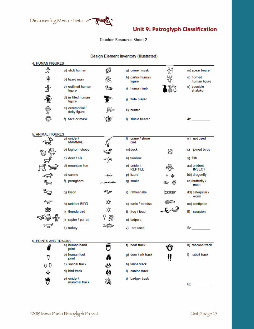
©2019 Mesa Prieta Petroglyph Project
Discovering Mesa Prieta
Unit 9 page 25
Unit 9: Petroglyph Classification
Teacher Resource Sheet 2

©2019 Mesa Prieta Petroglyph Project
Discovering Mesa Prieta
Unit 9: Petroglyph Classification
Unit 9 page 26
Teacher Resource Sheet 3

©2019 Mesa Prieta Petroglyph Project
Discovering Mesa Prieta
Unit 9 page 27
Unit 9: Petroglyph Classification
Teacher Resource Sheet 4
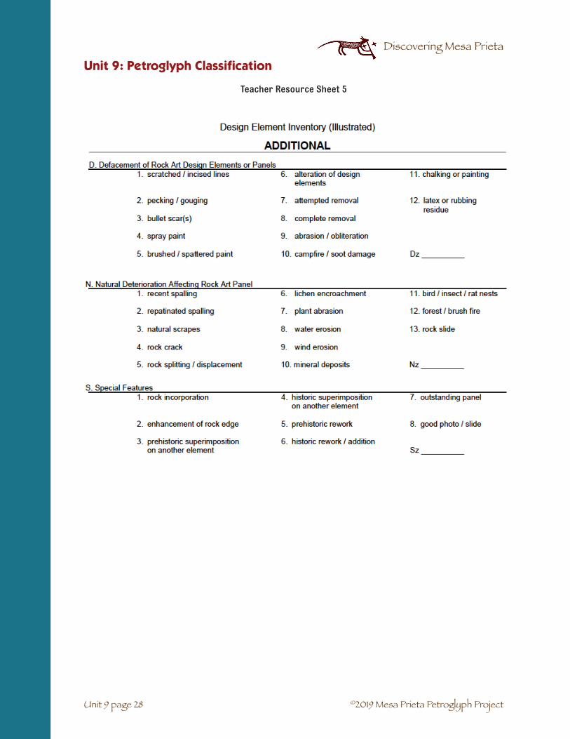
©2019 Mesa Prieta Petroglyph Project
Discovering Mesa Prieta
Unit 9: Petroglyph Classification
Unit 9 page 28
Teacher Resource Sheet 5

©2019 Mesa Prieta Petroglyph Project
Discovering Mesa Prieta
Vocabulario Unidad 9: Clasificación de los Petrográficos
☛ Elemento: un petrográfico individual en un panel (cinco trazas de pavo igualan cinco elementos)
☛ Panel: un grupo de petrográficos en la cara de una roca.
Unit 9 page 29
Unidad 9: Clasificación de los Petrográficos

©2019 Mesa Prieta Petroglyph Project
Discovering Mesa Prieta
UNIDAD 9. CLASIFICACIÓN DE LOS PETROGRÁFICOS
Categorías de los petrográficos comunes. Hoja de registro para el estudiante.
Actividad 1
1. Pistas y huellas TOTAL
__________________________________________________________________
2. Animales y pájaros
__________________________________________________________________
3. Humanos
__________________________________________________________________
4. Círculos, espirales y líneas
__________________________________________________________________
5. Serpientes
__________________________________________________________________
6. Armas
__________________________________________________________________
7. Imágenes del cielo
__________________________________________________________________
8. Escudos y personas con escudos
__________________________________________________________________
9. Flautistas
__________________________________________________________________
10. Petrográficos sin identificar
__________________________________________________________________
Unit 9 page 30
Unidad 9: Clasificación de los Petrográficos

©2019 Mesa Prieta Petroglyph Project
Discovering Mesa Prieta
Unidad 9: Clasificación de los Petrográficos
Unit 9 page 31
Unidad 9. Clasificación de petrográficos
Diseños de petrográficos
Hoja de actividades para el estudiante – Actividad 1
Corta los cuadros con los petrográficos y ordénalos en tu tabla.
Nombre__________________ Fecha_____________
UNIDAD 9. CLASIFICACIÓN DE LOS PETROGRÁFICOS
Frecuencias de las categorías de los petrográficos. Hoja de actividades para el estudiante.
Actividad 1
(Categorías de petrográficos: Pistas; animales; figuras humanas; círculos;
serpientes; armas; imágenes del cielo; escudos; flautistas; sin identificar)
UNIDAD 9. CLASIFICACIÓN DE LOS PETROGRÁFICOS
CATEGORÍAS DE LOS PETROGRÁFICOS MÁS COMUNES EN MESA PRIETA
Hoja de información para el estudiante- Actividad 2- Cortar
En grupo, corta todos los diseños de petrográficos de la tabla. Escriba las categorías arriba de la hoja grande. Agrupa los petrográficos similares debajo del título de su categoría y después pégalos. Cuenta el número de los diseños individuales en cada categoría y escriba el número total bajo su nombre. Mientras se cuenten los elementos de cada categoría, uno del grupo se dirigirá hacia la barra de gráficos en la tabla y hagará más larga la barra para esa categoría.
Pistas y huellas
Animales y pájaros
Humanos
Círculos, espirales y líneas
Serpientes
Armas
Imágenes del cielo
Escudos y personas con escudos
Flautistas
Petrográficos sin identificar

©2019 Mesa Prieta Petroglyph Project
Discovering Mesa Prieta
SUBJECTS: Language Arts, Social Studies.
SUGGESTED TIME: Two class periods.
MATERIALS:
Copy for students: Signs and Symbols student activity sheet -Activity 1 (10 - 5), Clear Creek Canyon Rock Art Panel student informa-tion sheets (text and graphic) (10 – 7-8), student activity sheet Activity 4 (10 - 9)
From the teacher: old magazines and newspapers, glue sticks,scissors, 11” x 14” and 8.5” x 11” construction paper or copy paper, markers.
For the teacher: Signs and Symbols student activity sheet - Activity 1 teacher answer sheet (10 - 6), Activity 4 teacher answer key (10 - 10)
BACKGROUND: Since the beginning of spoken language, people have developed signs and symbols. Petro-glyphs and pictographs help us to infer ideas about the culture and life ways of the people who made them. Many of the petroglyphs on Mesa Prieta may have symbolic meanings that we do not understand. In today’s American culture we use and understand many signs and symbols. Is this an indication of the pervasiveness and effects of our commercialized life style? This might be a good topic for discussion. Someone coming from another culture will have a difficult time understanding the meaning of some of our symbols. They may infer a different meaning to these symbols from what was intended.
UNIT 10: SIGNS AND SYMBOLS
VOCABULARY☛ Hypothesis: an educated guess or idea about a set of facts that can be tested by investigation.
☛ Inference: a conclusion made from observations.
☛ Logo: a symbol that is often used by a business; short for logogram.
☛ Sign: a graphic shape or design that may warn or inform about something that one isapproaching.
☛ Symbol: a graphic shape, design or object that represents an idea.
✔ Students will understand the relationship between a symboland its meaning.
✔ Students will realize why it is so difficult to interpret thepetroglyphs.
✔ Students will gain a deeper understanding of inference.
OBJECTIVES
Unit 10 page 1

©2019 Mesa Prieta Petroglyph Project
Discovering Mesa Prieta
SETTING THE STAGE: Draw a common symbol on the board, such as the Zia Sun symbol. Ask students to describe what they see. (A circle with four lines attached in each direction.) This is an observation. Now ask what it means or stands for. (It represents NM on the state flag.) How do they know? What does it mean to the people of Zia Pueblo? (Answers will be inferences.) Ask about four students at a time to come to the board and draw other symbols or signs. Have the rest of the class guess what they stand for. Remind students that no gang, drugs or war related symbols may be used.
1. Discuss the difference between actual and symbolic. Use examples from the drawings on theboard or draw an octagon. Ask the students what shape it is. Then ask them what it oftensymbolizes (a stop sign) The object or picture represents or stands for an idea or message
2. Pass out the Signs and Symbols student activity sheet, (10-5). Have the students notice thatthere are images they recognize. Under each picture, write what it stands for or a mean-ing that our culture gives it. Do not write the name of the object. Do the first two or threetogether. Three blanks are provided to allow students to enter their own symbols. Give thestudents about 10 minutes to finish it. (answers provided on Signs and Symbols student activ-ity sheet - Activity 1 teacher answer sheet, (10-6).
3. Discuss why we use symbols and how they might have developed. A good example is the swas-tika. It is an ancient design that was used by many cultures. Since the Nazis began using it, theswastika now has taken on a different meaning. Some people object to this new interpretationand have vowed to use it more frequently in order to bring back its traditional meanings.
EXTENSION: Turn the diagram into a bingo game or concentration game.
Unit 10: Signs and Symbols
Activity 1
Unit 10 page 2

©2019 Mesa Prieta Petroglyph Project
Discovering Mesa Prieta
Unit 10: Signs and Symbols
Unit 10 page 3
Activity 2
1. Explain that the class will be making an art collage of Logos, Signs and Symbols. Ask studentsto bring popular magazines from home.
2. Cut out different symbols (with no written words) and glue them on the construction paper.If you don’t find enough symbols in the magazines, the students may draw with marker thesymbols, signs and logos that they know. This may also be used as a homework assignment.
3. Have students take their finished collages to other classes to see how many of the symbols thechildren can recognize.
CONCLUSION: Discuss the results of this experience with the class. Discuss how someone from another culture or an Ancestral Pueblo person might interpret the collages. Now discuss how we infer meaning to the petroglyphs but really do not know what the person was thinking about or wishing to commu-nicate.
(Adapted from a project by Malinda Pekarcik of Santa Clara Pueblo.)
Activity 3*
To each group of students or to each student, pass out a copy of Clear Creek Canyon Rock Art Panelstudent information graphic sheet (10-7). Explain that this panel was created by the ancient people of Utah.
1. Use the following questions to analyze the petroglyph panel:
a. What words would you use to describe the designs on this page? (observations)
b. Why do you think the people created these designs? (inferences)
c. Do you think there is a symbolic message in the design labeled with a, b, c? If so, whatis the message? (inference)
2. Pass out the Interpretation student information sheet (10-8) and have the students take turnsreading the different paragraphs. Discuss the fact that each person had a different interpre-tation of the designs depending on their background and experience.
3. Discuss why these petroglyphs might be important.
*Actvity was adapted from Intrigue of the Past. A Teacher’s Activity Guide for Fourth through Seventh Grades, Bureauof Land Management, 1993, p 98.

©2019 Mesa Prieta Petroglyph Project
Discovering Mesa Prieta
Unit 10: Signs and Symbols
Unit 10 page 4
Activity 4
1. Draw a Zia Sun on the board. Remind the students of your earlier discussion of this symbol.Tell the students that they will be learning more about the meaning of this symbol for NativeAmericans. Ask:
a. What does this symbol remind you of? (the sun, compass rose, etc.)
b. If this represented a compass rose, where would the 4 directions be? (north on top,east on the right, south below and west on the left) Write the name of each direc-tion inside the circle in its correct location.
c. Many Native Americans use the symbol of a circle with a vertical and horizontal linewithin the circle to represent the four directions as well as many different cycles andideas. Draw this symbol on the board.
d. Hand out the page with the Zia Sun with the rays empty. Brainstorm with the studentswhat cycles these rays could represent. If they are having trouble coming up withideas, suggest the parts of the day or the seasons. Where does the sun rise? (east)Within one of the rays on the right write in – Morning. What season could this rep-resent? Within another of the rays on the right, write in – Spring. Discuss where theother parts of the day or the seasons should go. (it is warmer in the south so thiscould represent the summer)
e. Other cycles might be winds of different directions,, life cycle, etc. See teacher answersheet. Draw them in your symbol on the board and have the students fill in their hand-out.
f. An alternative approach would be to hand out the original Zia Sun Symbol with therays filled in. Ask the students how they could improve on this symbol by rearrangingthe words in the rays.
g. Why do you think that the Zia Sun was chosen for the NM state flag? (answers willvary)
ASSESSMENT: Have the students investigate their homes for symbols and bring back a list or sheet of drawings of at least five different sym-bols and their descriptions. (Examples: poison skull and crossbones, Nike symbol, play, stop, rewind buttons on a DVD player recycle symbol, symbols of weather from the newspaper or TV news.) Have students imagine that someone from a different country saw the symbols for the first time. Have students write a sentence about each symbol describing what the person might infer that it means.
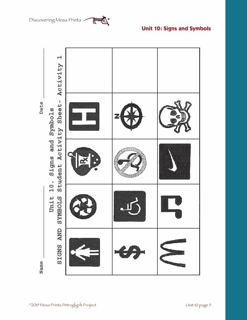
©2019 Mesa Prieta Petroglyph Project
Discovering Mesa Prieta
Unit 10: Signs and Symbols
Unit 10 page 5

©2019 Mesa Prieta Petroglyph Project
Discovering Mesa Prieta
Unit 10: Signs and Symbols
Unit 10 page 6

©2019 Mesa Prieta Petroglyph Project
Discovering Mesa Prieta
Unit 10 page 7
Unit 10: Signs and Symbols

©2019 Mesa Prieta Petroglyph Project
Discovering Mesa Prieta
Unit 10: Signs and Symbols
Unit 10 page 8
CLEAR CREEK CANYON PETROGLYPH PANEL INTEPRETATION:
Student Information Sheet: Activity 3*
Levan Martineau, hired by the Paiute tribe of Utah to interpret Clear Creek Canyon petroglyphs.
Martineau thinks this is part of a larger story of the emergence from the underworld.
a. The clan sign of the Badger clan. Badger was involved in and recorded the emergence story.
b. The river reed which the people of the underworld crawled through to get to this world.
c. A god-like figure who is part of the emergence story.
Indian Joe (Joseph J. Pickyavit), Ute Indian.
Pickyavit thinks that this figure was left by the “Pueblo Indians” whom he said once lived in Clear Creek Canyon. He feels this figure deals with making rain.
a. Rain cloud making rain.
b. Lightning bolt making lightning with the rain storm.
c. Medicine man with good powers in a rain sing (ceremony to bring rain).
Wil Numkena, Hopi Indian and Director, Utah Division of Indian Affairs.
Numkena thinks this figure deals with the emergence into the fourth world.
a. Seed sack that contains the seeds used by the chipmunk to grow a plant for the people, whichthey used to climb out of the underworld.
b. The spruce or pine tree which they climbed to get out of the third or underworld.
c. A two-horned priest of the higher order of the priesthood and keeper of the oral traditions andthe stories of the fourth world.
Kenneth Smith, Navajo Indian and early worker at Fremont Indian State Park.
Smith thinks this figure was part of a fertility ceremony.
a. This was the sack of seeds widely planted.
b. This was a stalk of corn; corn was the most important food source for the people.
c. This was some type of god of fertility or germination who helps the crops and plants to germi-nate and grow.
(Provided through the courtesy of Gordon Topham, Fremont Indian State Park, Clear Creek Canyon, Utah.)
*Adapted from Intrigue of the Past. A Teacher’s Activity Guide for Fourth through Seventh Grades, Bureau of LandManagement, 1993, p 98.

©2019 Mesa Prieta Petroglyph Project
Discovering Mesa Prieta
Unit 10: Signs and Symbols
Unit 10 page 9

©2019 Mesa Prieta Petroglyph Project
Discovering Mesa Prieta
Unit 10: Signs and Symbols
Unit 10 page 10
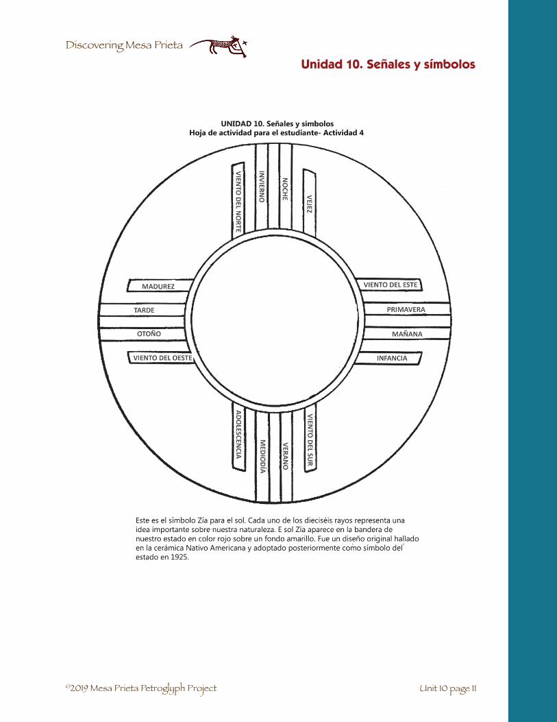
©2019 Mesa Prieta Petroglyph Project
Discovering Mesa Prieta
Unidad 10. Señales y símbolos
Unit 10 page 11
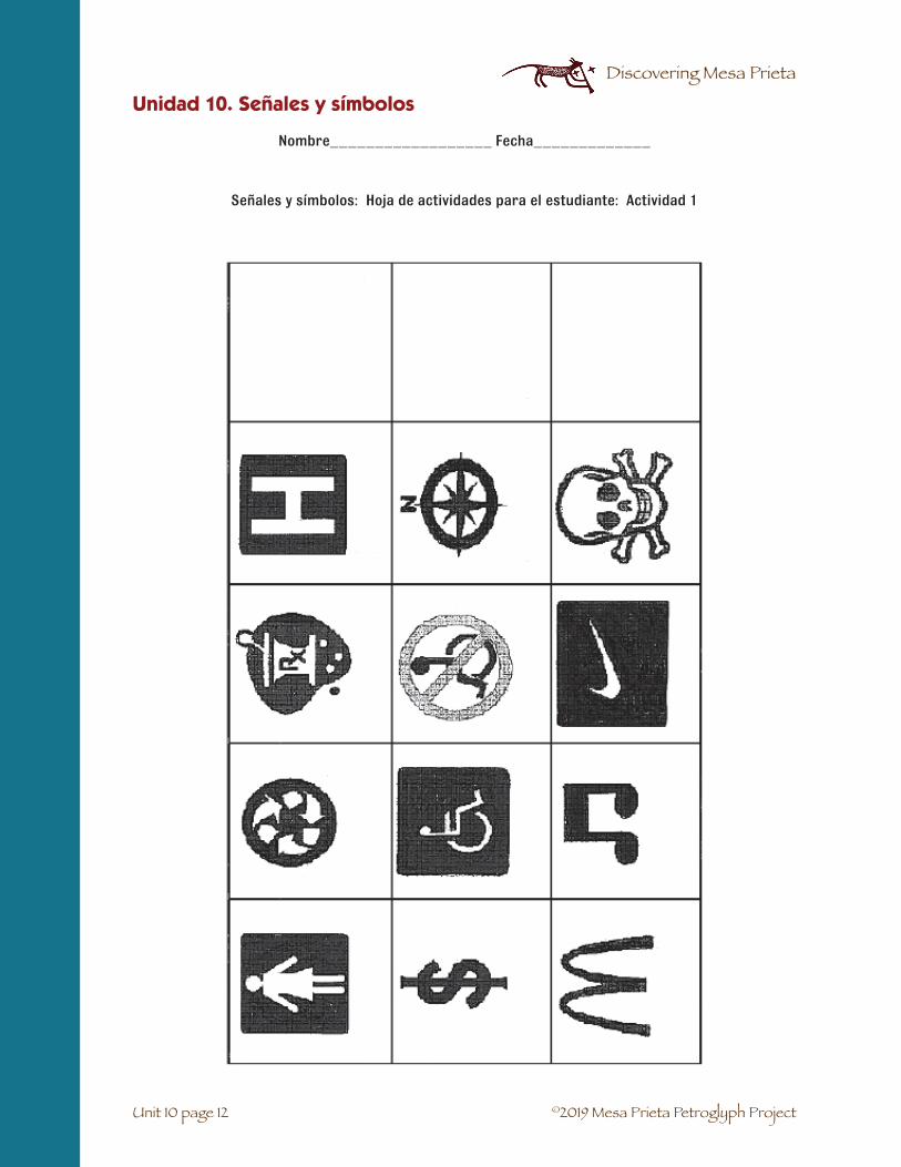
©2019 Mesa Prieta Petroglyph Project
Discovering Mesa Prieta
Nombre__________________ Fecha_____________
Señales y símbolos: Hoja de actividades para el estudiante: Actividad 1
Unidad 10. Señales y símbolos
Unit 10 page 12

©2019 Mesa Prieta Petroglyph Project
Discovering Mesa Prieta
Panel de Arte del Clear Creek Canyon Rock*
Unidad 10. Señales y símbolos
*Adaptación de Intrigue of the Past. A Teacher’s Activity Guide for Fourth through Seventh Grades, Bureau of LandManagement, 1993, p 98.
Unit 10 page 13

©2019 Mesa Prieta Petroglyph Project
Discovering Mesa Prieta
Unidad 10. Señales y símbolos
Unit 10 page 14
Interpretación del panel de los petrográficos de Clear Creek Canyon: Hoja de información para el estudiante: Actividad 3
Levan Martineau, contratado por la tribu Paiute de Utah para interpretar los petrográficos de Clear Creek Canyon. Martineau cree que es parte de una versión más larga del mito de la ascensión de los tribus antiguos desde el mundo subterráneo.
a. El símbolo del clan del tejón (Badger). El tejón formó parte de este mito y además fue el encar-gado de contarlo.
b. Los juncos del río a través de los cuales la gente del mundo subterráneo se arrastró parallegar a este mundo.
c. La figura de una deidad que es parte del mito de ascensión desde el mundo subterráneo.
Indio Joe (Joseph J. Pickyavit) Indio Ute. Pickyavick cree que esta figura fué abandonada por los ‘Indios Pueblo’ los cuales, decía que una vez vivieron en Clear Creek Canyon. El cree que esta figura sirve para invocar a la lluvia.
a. Nube descargando lluvia.
b. Rayo en medio de la tormenta.
c. Curandero con poderes benignos cantando (ceremonia para invocar a la lluvia)
Wil Numkena, Indio Hopi y director de la División de Asuntos Indios en Utah. Numkena cree que la figura tiene que ver con la ascensión al cuarto mundo.
a. Un saco que contiene las semillas usadas por la ardilla para que crezcan plantas y puedan serusadas por la gente que ascenden desde el mundo subterráneo.
b. El abeto o pino que usaban para salir del mundo subterráneo.
c. Un sacerdote, de una orden sacerdotal superior, con dos cuernos y portador de la tradiciónoral y de las historias del cuarto mundo.
Kenneth Smith, Indio Navajo y uno de los primeros trabajadores del parque estatal indio de Fremont. Smith cree que esta figura formaba parte de una ceremonia de la fertilidad.
a. Este era el saco de semillas que fueron plantadas por todo el territorio.
b. Era un tallo de maíz; El maíz era la fuente de comida más importante para la gente.
c. Era una especie de Dios de la fertilidad o de la germinación que ayudaba a crecer y a germinarla cosecha y las plantas.
(Información provista por cortesía de Gordon Thopam, Parque Indio del estado de Fremont, Clear Creek Canyon, Utah).
*Adaptación de Intrigue of the Past. A Teacher’s Activity Guide for Fourth through Seventh Grades, Bureau of LandManagement, 1993, p 98.

©2019 Mesa Prieta Petroglyph Project
Discovering Mesa Prieta
Vocabulario Unidad 10: Signos y símbolos
☛ Hipótesis: una conjetura educada o idea sobre una serie de hechos que deben serdemostrados científicamente.
☛ Inferencia: una conclusión hecha a partir de la observación.
☛ Logo: un símbolo que veces se usa para un negocio; una clase de logograma.
☛ Signo: una forma gráfica o diseño que puede informar sobre algo a lo que uno se estáacercando.
☛ Símbolo: una forma gráfica, diseño u objeto que representa un idea.
Unidad 10. Señales y símbolos
Unit 10 page 15
©2019 Mesa Prieta Petroglyph Project
Discovering Mesa Prieta
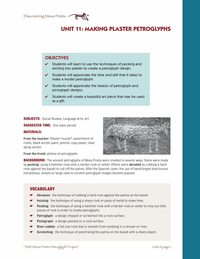
©2019 Mesa Prieta Petroglyph Project
Discovering Mesa Prieta
SUBJECTS: Social Studies, Language Arts, Art.
SUGGESTED TIME: One class period.
MATERIALS:
From the teacher: Plaster rounds*, assortment of rocks, black acrylic paint, pencils, copy paper, clear spray acrylic
From the trunk: photos of petroglyphs.
BACKGROUND: The ancient petroglyphs of Mesa Prieta were created in several ways. Some were made by pecking, using a hammer rock with a harder rock or antler. Others were abraded by rubbing a hard rock against the basalt to rub off the patina. After the Spanish came, the use of hand-forged steel knives, horseshoes, chisels or large nails to scratch petroglyph images became popular.
✔ �Students will learn to use the techniques of pecking andetching into plaster to create a petroglyph design.
✔ �Students will appreciate the time and skill that it takes tomake a model petroglyph.
✔ �Students will appreciate the beauty of petroglyph andpictograph designs.
✔ �Students will create a beautiful art piece that may be usedas a gift.
OBJECTIVES
UNIT 11: MAKING PLASTER PETROGLYPHS
Unit 11 page 1
VOCABULARY☛ Abrasion: the technique of rubbing a hard rock against the patina on the basalt.
☛ Incising: the technique of using a sharp rock or piece of metal to make lines.
☛ Pecking: the technique of using a hammer rock with a harder rock or antler to chip out littlepieces of rock in order to create petroglyphs.
☛ Petroglyph: a design chipped or scratched into a rock surface.
☛ Pictograph: a design painted on a rock surface.
☛ River cobble: a fist size rock that is smooth from tumbling in a stream or river.
☛ Scratching: the technique of penetrating the patina on the basalt with a sharp object.

©2019 Mesa Prieta Petroglyph Project
Discovering Mesa Prieta
Unit 11 page 2
Ask the students to collect round river cobbles and rocks with points at home or on the playgroundduring recess. Every student will need one of each.
1. Have students choose a petroglyph design from photographs in the trunk. Choose one imagethat is not too complex.
2. Put name and date on the bottom of the plaster mold.
3. Trace the circle of the mold onto paper and draw the petroglyph within the circle.
4. Collect petroglyph photos.
5. Copy the petroglyph design onto the black plaster mold with a pencil.
6. Choose a pointed rock to peck and a round rock to use as a hammer. Carefully tap the pointedrock with the round rock to make a small hole. Continue to make holes following the line ofthe petroglyph design. You may also experiment by incising lines and or scratching largeareas.
7. The teacher should spray with clear acrylic outside the building. The finished plaster roundsmake great gifts.
8. Optional: Using markers or water color paints, draw a design on the side of the plasterround.
9. Discuss how hard it must have been to make petroglyphs on hard basalt rocks. The plasterrounds are very soft. “How long do you think it might have taken to make a real petroglyphthe size of your plaster round?”
Activity 1
Unit 11: Making Plaster Petroglyphs

©2019 Mesa Prieta Petroglyph Project
Discovering Mesa Prieta
Unit 11 page 3
Unit 11: Making Plaster Petroglyphs
Activity 3
ASSESSMENT:
1. Have students write about their experience of creating their model petroglyph.
2. Have students write a creative story about their design.
3. Have students take their model and story to a younger class. Partnering with a youngerstudent, tell that student about the petroglyph and how it was made.
*Making Plaster Rounds
Materials: From the teacher: Plaster of Paris, plastic bowls, metal spoons, water, black acrylic paint, brushes, round plastic deli containers (these may be checked out from the Mesa Prieta Petroglyph Project office), sandpaper
Procedure: The plaster rounds can be made by the teacher or a parent ahead of time or in classby the students.
1. In a plastic bowl, mix about a cup of plaster with about half a cup of water for each container.You may want to make four at a time. Add water slowly while mixing. It should be thick likepancake batter.
2. Pour the plaster into the deli containers. They should be at least one inch thick or they maybreak. If students are making their own, have them put their name on the container withmasking tape.
3. Gently tap the container on the table a few times to get out the air bubbles. Let them dryover night.
4. Pop the plaster out of the container. Using sand paper, smooth the top edge.
5. After they are completely dry (no longer cool to the touch) paint the tops with black acrylicpaint. To speed up the drying they may be paced in a gas oven with just the pilot on. Leaveovernight. Two coats of paint works best.
6. If students make mistakes, have some black paint on hand to paint over the mistakes.

©2019 Mesa Prieta Petroglyph Project
Discovering Mesa Prieta
Unit 11 page 4
Unit 11: Making Plaster Petroglyphs
Alternative Art Project: Making a Pictograph on Smooth Rocks
Objectives:
✔ �Students will appreciate the beauty of pictograph designs.
✔ �Students will create a beautiful art piece on a natural rock that may be used as a gift.
Subjects: Social Studies, Art, Language Arts.
Suggested Time: One class period.
Materials:
From the trunk: Painted rock “pictograph”.
From the teacher: A smooth river cobble for each student, pencil, acrylic or tempera paints, brushes, permanent markers or colored pencils, newspapers, clear acrylic spray.
Activity:
1. If possible, take a hike to look for river cobbles or ask students to bring a smooth rock fromhome. Dust off or wash and dry the rocks.
2. Write name and date on the back of the rock.
3. Choose a pictograph design from the photographs. Trace the rock and draw the design ontothe paper. Draw lightly with pencil on the smooth surface of the rock and then outline it withblack permanent marker. Using the art medium provided, students will fill in the design inwhat ever manner they choose.
4. The teacher should spray with clear acrylic outside the building. The finished stones makegreat gifts.
Other Alternative Projects:
1. Using markers or paints, color the entire drawing paper with one or more colors. Then coverthe entire paper with black crayon. Scratch petroglyph designs through the black crayon witha tooth pick and the under colors will show through. (This activity was suggested by MarieAbeyta of Ohkay Owingeh Community School.)
2. Using pottery clay, form a tile. Glaze the green ware with black glaze, carve a petroglyph de-sign into the clay and then fire it. (This activity was suggested by Jeannie Cornelius of DixonElementary School.)
3. Use a solution of bleach water on colored tissue paper. Students dip swabs into the bleachsolution and draw different designs onto the colored tissue. (This activity was suggested byStephanie Richard of Ohkay Owingeh Community School.)

©2019 Mesa Prieta Petroglyph Project
Discovering Mesa Prieta
Unit 11 page 5
Unidad 11: Haciendo Petrográficos Plásticos
Vocabulario Unidad 11: Haciendo Petrográficos Plásticos
☛ Incisivo: la técnica de usar una roca afilada o una pieza de metal para hacer líneas.
☛ Picoteo: la técnica de usar una roca martillada con otra mas dura o un cuerno para descas-carillar pequeños trozos de roca para crear petrográficos.
☛ Petrográfico: un diseño descascarillado o arañado en una superficie rocosa.
☛ Pictográfico: un diseño pintado sobre la superficie de una roca.
☛ Adoquín de un rio: una roca de tamaño pequeño suavizada por estar caída en un riachueloo rio.
☛ Arañazos: la técnica de frotar una roca dura contra una pátina en el basalto.

©2019 Mesa Prieta Petroglyph Project
Discovering Mesa Prieta
©2019 Mesa Prieta Petroglyph Project
Discovering Mesa Prieta
SUBJECTS: Social Studies, Language Arts.
SUGGESTED TIME: Three class periods.
MATERIALS:
Copy for students: Eight Northern Pueblos student activity sheet (12 - 9), Ancestral Tewa Pueblos student information sheet (12 - 10), Life in Phiogeh and Site Plan of Phiogeh student information sheets (12 - 11-14).
From the trunk: New Mexico road map for each student, Life in Poshuowingeh and various pamphlets. (The story and pamphlets must be returned to the trunk).
From the teacher: Markers.
For the teacher: Eight Northern New Mexico Pueblos teacher information sheet (12 - 15), Ancestral Pueblo People of Bandelier, A Guide for 4th Grade Teachers, 2006 (Draft), available from MPPP library. Also available online at http://www.nps.gov/band/forteachers/fourth-grade-lesson-plans.htm. Another good resource is the New Mexico Digital History Project website at http://www.newmexicohistory.org.
UNIT 12: MODERN PUEBLOS - ANCIENT SITES
OBJECTIVES
Unit 12 page 1
✔ Students will become aware of some of the past andpresent native cultures in northern New Mexico.
✔ Students will make the connection between ancient sitesand modern cultures.
✔ Students will gain experience in the use of maps andresearch materials.
✔ Students will gain experience in reading for comprehension.
✔ Students will gain experience in working cooperatively.
VOCABULARY☛ Ancient site: a place lived in or used by ancient people.
☛ Archaeological site: a place where evidence of human activity in the past is preserved.
☛ Tewa: people of six Northern Pueblos and the language they speak (Ohkay Owingeh, Nambé,Pojoaque, San Ildefonso, Santa Clara and Tesuque). Tewa also refers to their spoken language.

©2019 Mesa Prieta Petroglyph Project
Discovering Mesa Prieta
Unit 12 page 2
Unit 12: Modern Pueblos - Ancient SitesBACKGROUND:
There are Eight Northern Pueblos and hundreds of ancient sites in northern New Mexico. Some sites, such as Bandelier National Monument, are developed and maintained while others remain totally undeveloped and unexcavated. This activity will help the students become aware of the rich ancient heritage we have in northern New Mexico and the importance of protecting it. The activity will also increase the students’ awareness of the modern Pueblos in northern New Mexico as well as reinforce the students’ mapping, reading and research skills.
SETTING THE STAGE: Ask the students to brainstorm the names of the Indian Pueblos north of Santa Fe. As students name them, list them on the board.
1.* Taos (Tu-tah: Our Village)
2. Picuris (Pikurea: Those Who Paint)
3. Ohkay Owingeh (San Juan: Village of Strong People)
4. Santa Clara (Kha’p’o: Valley of the Wild Roses)
5. San Ildefonso (Po-who-ge: Where the Water Cuts Through)
6. Nambé (Mound of Earth in the Corner)
7. Pojoaque (P’o Suwae Geh: Water Drinking Place)
8. Tesuque (Te-tsu-geh: Cottonwood Tree Place)
Note that the word “owingeh” refers to village, Pueblo and/or people. Discuss the fact that there were many more Pueblos before the coming of the Spanish in the 1500s. Discuss what might have happened to them. The people of Puye (Santa Clara) and Bandelier (San Ildefonso) probably moved down to the Rio Grande because of drought. Pueblo people moved away from Kuuyemugeh (Cuyamungue) during and after the 1680 Pueblo Revolt. Some Pueblos were destroyed by the Spanish or the diseases that they brought with them (Pecos Pueblo). Many Pueblos were left unoccupied and we don’t know why. This is one of the mysteries that archaeologists are trying to solve. To explore with your class the coming of the Spanish to Tewa territory, and its effects, see Unit 13.
*(The numbers by the Pueblo names refer to numbers on the Eight Northern Pueblos studentactivity sheet (12 - 9)
Intersecting room block walls at Sapawe

©2019 Mesa Prieta Petroglyph Project
Discovering Mesa Prieta
1. Explain that students will be locating the eight northern Pueblos on the NM road maps. Thereare 11 southern Pueblos as well as Apache and Navajo reservations that they may study forextra credit.
2. Pass out a NM state road map to each student. Using the same color of highlighter, mark eachPueblo.
3. After all the Pueblos have been located and marked, the students will label them on theirEight Northern Pueblos student activity sheet. (12-9) (This can be used as a homework as-signment.)
4. Discuss with the students possible questions such as, “Who is from a Pueblo or lives in aPueblo? Who has visited which of the Pueblos? Ask the students to share their experiences.
5. Discuss the fact that some of the modern Pueblos are related to ancient sites such as Puye- Santa Clara Pueblo and Bandelier - San Ildefonso and Cochiti Pueblos. Some of the ancientPueblo people may have come from Mesa Verde in Colorado.
Unit 12: Modern Pueblos - Ancient Sites
Unit 12 page 3
Activity 1
Activity 2
1. Pass out the Ancestral Tewa Pueblos student information sheet (12 - 10), to the students. (Thismap does not include all of the ancient Pueblo sites.) Discuss the term “archaeological site”.Ask if any students have visited an ancient Pueblo site. Ask the students the “mapping ques-tions” about this map. Discuss the word “Tewa” and explain that it is not only a Pueblo lan-guage but may refer to the people who speak Tewa. The Tewa words on the map are from theOhkay Owingeh tradition. The people of Santa Clara Pueblo sometimes pronounce and spellthe words slightly differently.
Mapping Questions:
1. What is the title of the map? (Ancient Tewa Pueblos)
2. What does Tewa refer to? (the language that is spoken by six of the Northern Pueblos and manyancient Pueblos; the people who speak Tewa.)
3. What is the Tewa name for the Rio Grande? (Pó?káy or Posongeh)
4. Between what two rivers is Mesa Prieta located? (Rio Grande- Posongeh or P’o?k’ay and Rio OjoCaliente- P’osip’oe)
5. What is the Tewa name for Mesa Prieta? (Tsikw’aye)
6. What river is Tsiping near? (Rio Chama - Tsama)

©2019 Mesa Prieta Petroglyph Project
Discovering Mesa Prieta
Unit 12: Modern Pueblos - Ancient Sites
Unit 12 page 4
7. What ancient Pueblo is located where the Rio Chama and Rio Grande come together? (Yungeh)
8. Which modern Pueblos use their Tewa names? (Ohkay Owingeh, Nambé)
9. How many ancient and modern sites are named on the map? (36)
10. How many Pueblo sites are located on this map? (46)
11. How many sites have no name on the map? (10) Why do you think they don’t have names? (perhapsarchaeologists haven’t been told the names or maybe the names have been forgotten)
12. How many sites don’t have people living in them now? (40)
13. Why do you think that there aren’t people living in them now? (possible reasons are: drought,flooding, destroyed by the Spanish or the diseases they brought with them, for reasons wedon’t know.)
14. Find Phiogeh on the map. Now we will read about Phiogeh.
As a class or in small groups, read the story of Life in Phiogeh. Before or after each paragraph is read, write the vocabulary words on the board or a sheet of newsprint. Use the game, “Numbered Heads To-gether”, to review the information. The directions are in Unit 2. Geology of Tsikw’aye (Mesa Prieta) (2 - 6). You may wish to ask one or two questions about each of the paragraphs describing life through the seasons or use the questions included. Discuss what it would have been like to live in a Tewa village over 500 years ago.
Activity 3
INTRODUCTION VOCABULARY☛ Ceremonial: having to do with ceremonies which are formal acts performed for religious
reasons.
☛ Phiogeh: the Ancestral Pueblo village located in present day Los Luceros. The site has beendestroyed to build houses.
☛ Flicker: a type of woodpecker that lives in the bosque (cottonwood forest) along the RioGrande.
☛ Flood Irrigate: to water crops with water from a river.
☛ Flood plain: the flat land next to a river where it sometimes floods in the spring.
☛ Grid garden: a farming method used by the Ancestral Pueblo people to grow corn and beans.It was a square that was lined with large stones.
☛ Kiva: ceremonial room in a Pueblo where people pray, do ceremony and practice for dances.
☛ Pó?káy: Tewa word for strong water; also refers to the Rio Grande.
☛ Posongeh: Tewa name for Rio Grande.
☛ Room blocks: rooms that are attached to each other, often in a line.
©2019 Mesa Prieta Petroglyph Project
Discovering Mesa Prieta
Unit 12 page 5
Unit 12: Modern Pueblos - Ancient Sites
FALL VOCABULARY☛ Aspen: a type of tall, slender tree with light bark that grows in the mountains.
☛ Chert: a type flint rock that was often used to make arrow and spear points.
☛ Fall equinox: the day in the fall when day and night are equal in length.
☛ Kernel: the seed of a corn plant or other grain.
☛ Sun Watcher: a person who observes the movement of the sun through the year, noting thechange of season, when it is time to plant and when it is time for certain ceremonies.
WINTER VOCABULARY
☛ Vigas: large beams used to support the flat roof of an adobe house.
☛ Winter solstice: the shortest day of the year, when the sun appears to stand still. This is thefirst day of the new year for the Pueblo people.
SPRING VOCABULARY
☛ Mulch: protective material placed around plants to prevent the evaporation of moisture, theroots from freezing and the growth of weeds.
☛ Spring Equinox: the other day of the year when there is equal day and night.
☛ Tsimaha: a small wild parsley plant that grows on dry, rocky hillsides.
☛ Yucca: a desert plant with long, stiff, sharp leaves.
SPRING VOCABULARY
☛ Mica: a shiny, flaky mineral that is found in some types of rock and clay.
☛ Summer solstice: the longest day of the year.

©2019 Mesa Prieta Petroglyph Project
Discovering Mesa Prieta
Unit 12: Modern Pueblos - Ancient Sites
Unit 12 page 6
Questions for the game Numbered Heads Together
When does the story take place? (about 1450 AD)
What is a flicker? (a type of woodpecker)
What present day town is Phiogeh located near? (Los Luceros)
What did the people do in the kivas? (practiced for dances, held ceremonies and told stories)
How would the people get across Posongeh (Pó?káy)? (wading)
What trail did the people take to hike over the Mesa? (Eagle Gap Trail)
Why didn’t they ride horses when they visited other Pueblos? (modern horses did not live in the Americas until the Spanish brought them)
Fall Questions:
1. Why is Fall Equinox important? (it is the time to get ready for winter; the night and day areequal)
2. Why did they have to trade the chert from the people who lived near Abiquiú? (there was nochert found near their village)
3. What did the women do with the turkey feathers? (they made turkey feather blankets)
4. Why did the women soak the white corn in wood ashes and water? (it loosened the skin onthe kernels so they would pop and be ready for making a posole stew)
Winter Questions:
1. When was the first day of the new year? (winter solstice)
2. Why were the people of Phiogeh expecting a good winter? (there had been enough rain fortheir crops; they had stored enough dried food)
3. How was the corn stored? (strings of corn were hung from the vigas)
4. How did the people prepare for a successful deer hunt? (they did a deer dance)
Spring Questions:
1. Why did the girls and women pick wild onions and tsimaha? (to season their beans)
2. How did the children help get the gardens ready to plant? (they carried gravel to the gridgardens and straightened the rock borders)
3. Why was early spring a good time to make petroglyphs on Tsikw`aye? (the river was still shal-low and they could wade across)
4. What did the women use to make sandals? (wide leaf yucca)
5. Why did the children have to wait until summer solstice to go swimming in the river?(by summer solstice the flooding was over and the river was shallow)
6. How did the people catch fish? (with their bare hands, nets, or woven lines)

©2019 Mesa Prieta Petroglyph Project
Discovering Mesa Prieta
Unit 12 page 7
Unit 12: Modern Pueblos - Ancient Sites
Summer Questions:
1. Why did the children let the turkeys out of their pen? (so they could eat grasshoppersin the gardens)
2. Why did the women like the clay with themica in it? (those pots didn’t crack inthe cooking fire)
3. Why was adobe a good material to buildhouses with? (it kept the houses coolin summer and warm in winter; therewas plenty of clay to make mud thatdried into adobe)
4. Why did the children chase away thecrows and kill rabbits? (because theywould eat the crops and rabbits aregood to eat)
5. Why was it important that everyone didtheir jobs? (all the people depended oneach other to live)
6. What does it mean to you to live in har-mony with Mother Earth? (answers willvary. Only pick or kill what you will eat;thank the plants and animals before youeat them; don’t throw trash in the riveror on the land, recycle, plant trees, etc.)
ASSESSMENT: RESEARCH PROJECT
Divide the class into groups and have each group research and make a report on the different Pueblos and/or ancient sites. Some of the information may be found in the annual Eight Northern Pueblos bro-chure and other pamphlets. More resource information may be found on (12-16 – 20). Below are some topics that could be researched.
1. Location of reservation; size; population; natural resources
2. Traditional language spoken
3. Traditional name of Pueblo
4. Where the children attend school
5. Feast days
6. Traditional dances
7. Traditional arts and crafts
8. Economic development
9. Form of government
10. Other
Bowl: Bandelier B, also known as Bandelier Black-on-gray, A.D. 1400-1550. Courtesy of the
Museum of Indian Arts and Culture/ Laboratory of Anthropology, 21445/11.

©2019 Mesa Prieta Petroglyph Project
Discovering Mesa Prieta
Unit 12: Modern Pueblos - Ancient Sites
Unit 12 page 8
EXTRA MAPPING PRACTICE: On the board write the list of the archaeological sites found on the NM road map.* Discuss what an archaeological site is. With a different color highlighter, mark all of the ar-chaeological sites. Most of the archaeological sites are not indicated on the road map.
*NM Archaeological Sites listed on the New Mexico State Map
Site Coordinates
Abo at Salinas Pueblo Missions National Monument F-6
Aztec Ruins National Monument A-3
Bandelier National Monument C-6
Chaco Canyon National Historic Park C-3
Coronado State Monument D-6
El Morro National Monument E-2
Gila Cliff Dwellings National Monument H-2
Gran Quivira at Salinas Pueblo Missions National Monument F-6
Havikuh Ruins E-1
Jemez State Monument C-5
Pecos National Historic Park D-7
Petroglyph National Monument D-5
Puye Cliff Dwellings C-6
Quarai at Salinas Pueblo Missions National Monument F-6
Salmon Ruins A-3
Three Rivers Petroglyph National Site H-6
Tent Rocks National Monument C-6
EXTENSION ACTIVITIES: There are some wonderful extension activities about agriculture, foods, pottery, etc. in the curriculum guides in the trunk. These will help the students understand what life was like in early Pueblo times. They are listed in Extension Activities at the begin-ning of the Discovering Mesa Prieta curriculum.
Tyuonyi Pueblo structures in Frijoles Canyon at Bandelier National Monument
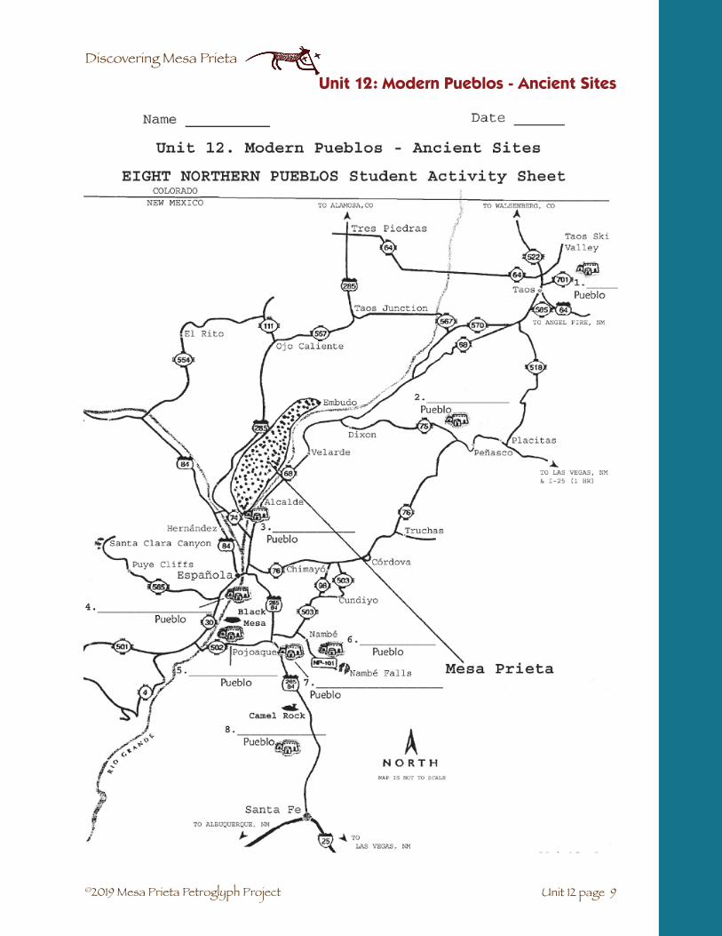
©2019 Mesa Prieta Petroglyph Project
Discovering Mesa Prieta
Unit 12 page 9
Unit 12: Modern Pueblos - Ancient Sites

©2019 Mesa Prieta Petroglyph Project
Discovering Mesa Prieta
Unit 12: Modern Pueblos - Ancient Sites
Unit 12 page 10

©2019 Mesa Prieta Petroglyph Project
Discovering Mesa Prieta
LIFE IN PHIOGEH Student Information Sheet
Introduction:
Our story takes place about 1450 AD before the coming of the Spanish settlers. Phiogeh, which means Flicker Village in Tewa, was a large Pueblo village located on the east side of Pó?káy or Posongeh, the Tewa names for the Rio Grande. The village sat on the ridge above the flood plain in the present day village of Los Lu-ceros. The houses were made of adobe and were attached to each other in room blocks. In the plaza there were probably round kivas, underground ceremonial rooms. Here the people practiced for their dances, held ceremonies and told stories in the winter.
The people grew their crops of corn, beans and squash in grid gardens located near the village, on surrounding hills and on the Mesa. They also planted in flood irrigated fields along the river.
When the river was shallow, people would wade through the water to gather plants, hunt and make petro-glyphs on Tsikw’aye, the Tewa name for Mesa Prieta. They often hiked over the Mesa on the Eagle Gap Trail to the Tewa villages on the other side to trade for pottery and to take part in ceremonies. Trading was also common with the people who lived in the Tewa villages north and south of Phiogeh. There were no horses in those days so everyone traveled on foot.
Fall:
For a week the Sun Watcher had hiked part way up Tsikw’aye early each morning to watch the sun rise. He knew that this morning would mark the fall equinox – the time of equal day and equal night.
As the sun rose over the eastern mountains (Sangre de Cristos), it cast a shadow on an ancient spiral petroglyph. After praying and doing cer-emony, the Sun Watcher waded back across the big river to his village. It was time to prepare for the coming of winter.
The corn, beans and squash were brought in from the fields and dried on the flat roofs of the adobe houses.
The men made new arrowheads from chert, a glassy flint-like rock that was obtained by trading with the people who lived at Tsiping, near present day Abiquiú.
When the harvest was complete, the men collected firewood and went hunt-ing for deer and elk in the mountains.
The women made turkey feather blankets that would keep their families warm in the winter. With the first snow, the children looked forward to the sacred stories that their grandparents would tell.
The children also looked forward to a clay bowl of hot posole to warm their stomachs. Posole was made by soaking dried white corn in a large clay pot filled with wood ashes and water. This loosened the skin on the kernels so that when they were boiled in water, they popped like popcorn and made a delicious stew.
Flicker
Unit 12 page 11
Unit 12: Modern Pueblos - Ancient Sites
Wild turkey
Chert cobble

©2019 Mesa Prieta Petroglyph Project
Discovering Mesa Prieta
Winter:
On the day that winter solstice arrived, the Sun Watcher was again on Tsikw’aye observing the shadow that the sun cast on a sacred petroglyph. Although he knew that months of cold, snowy weather were coming, he also knew that a new year would begin as the days grew longer.
The people of Phiogeh were expecting a good winter because there had been enough rain for their crops and their clay storage pots were filled with dried beans and collected plants. Strings of dried corn and spiral strips of dried squash hung from the vigas. A successful hunt provided each family with plenty of dried meat and the village gave thanks with a deer dance.
Spring:
By the time of spring equinox the snows had melted and the wild plants were sprouting. It was time for the women and girls to go out to the hills to dig wild onions and pick the little green leaves and roots of the tsimaha. They were already thinking of how delicious the beans would taste when flavored with these plants. It was also time to begin preparations for spring planting. The children were happy to help get the grid gardens ready by carrying baskets of gravel for mulch and by straightening the rock borders.
Because Pó?káy had not yet begun to flood, this was a good time to make petroglyphs on Tsikw’aye and collect yucca leaves and roots. The women loved how the shampoo made from the yucca roots made their hair shine. The children and the men looked forward to a new pair of sandals woven from the yucca with wide leaves. And those who were artists made brushes from the narrow leaf yucca to paint their pottery.
As the snow in the mountains melted in late spring, Pó?káy be-came a raging river. This was the important time for fishing which was done with bare hands, nets or woven lines. The fathers were pleased to see the boys making nets to catch the fish. Fish stew would taste very good. No one dared to cross over to Tsikw’aye until the flooding ended and the river was again shallow. The children looked forward to summer solstice because it was then that they were allowed to go swimming in the river again.
Summer:
The green corn dance marked the summer solstice as the people prayed for rain and another good year for their crops. The children who took care of the turkeys were happy to take them out of their pen to catch the grasshoppers that liked to eat the young crops.
The women were busy making clay pots for cooking, eating and storing beans. Sometimes they visited with the people who lived on the west side of Tsikw’aye because those people knew where to dig the clay with the mica in it. The Phiogeh women liked the cooking pots with the flecks of shiny mica because they didn’t crack in the cooking fire.
Wild Yucca
Pot: Bandelier B, also known as Bandelier Black-on-gray, A.D. 1400-1550. Courtesy of the Museum of
Indian Arts and Culture / Laboratory of Anthropology, 21810/11.
Unit 12: Modern Pueblos - Ancient Sites
Unit 12 page 12

©2019 Mesa Prieta Petroglyph Project
Discovering Mesa Prieta
Summer was a good time for the men to build new rooms onto their adobe houses. The women then used their hands to plaster all of the walls with mud. The adobe kept them cool in the summer and warm in the winter. The children worked hard in the grid gardens pulling weeds and worked with the dogs to chase away the crows and kill the rabbits that ate the crops.
Everyone in Phiogeh had their jobs to do and they understood that each person in the village depended on each other to live. Life in the village followed the cycle of the seasons and the ceremonies that went with them. Each person learned to walk their life path with respect for all life. Together they created a strong people who lived in harmony with Mother Earth.
Life in Phiogeh changed with the arrival of the Spanish settlers in 1598 AD. The Phiogeh farmers were required to grow crops for their Spanish neighbors.
In 1680, the Pueblos revolted against the Spanish, who retreated to the south. When the Spanish returned to the area in 1692, they found that most of the people from Phiogeh had moved to Arizona to live with the Hopi people. Their descendants still live there and maintain their Tewa language and culture.
Unit 12 page 13
Unit 12: Modern Pueblos - Ancient Sites

©2019 Mesa Prieta Petroglyph Project
Discovering Mesa Prieta
Unit 12: Modern Pueblos - Ancient Sites
Unit 12 page 14
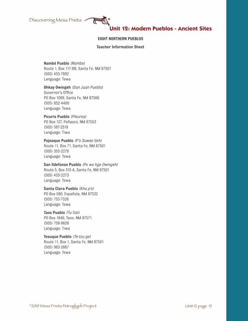
©2019 Mesa Prieta Petroglyph Project
Discovering Mesa Prieta
EIGHT NORTHERN PUEBLOS
Teacher Information Sheet
Nambé Pueblo (Nambe)Route 1, Box 117-BB, Santa Fe, NM 87501 (505) 455-7692Language: Tewa
Ohkay Owingeh (San Juan Pueblo)Governor’s Office PO Box 1099, Santa Fe, NM 87566 (505) 852-4400Language: Tewa
Picuris Pueblo (Pikurea)PO Box 127, Peñasco, NM 87553 (505) 587-2519Language: Tiwa
Pojoaque Pueblo (P’o Suwae Geh)Route 11, Box 71, Santa Fe, NM 87501 (505) 355-2278Language: Tewa
San Ildefonso Pueblo (Po wo hge Owingeh)Route 5, Box 315-A, Santa Fe, NM 87501 (505) 455-2273Language: Tewa
Santa Clara Pueblo (Kha p’o)PO Box 580, Española, NM 87532 (505) 753-7326Language: Tewa
Taos Pueblo (Tu-Tah)PO Box 1846, Taos, NM 87571 (505) 758-8626Language: Tiwa
Tesuque Pueblo (Te-tsu-ge)Route 11, Box 1, Santa Fe, NM 87501 (505) 983-2667Language: Tewa
Unit 12 page 15
Unit 12: Modern Pueblos - Ancient Sites

©2019 Mesa Prieta Petroglyph Project
Discovering Mesa Prieta
Northern Pueblos Calendar of Events
January
January Cloud Dance or Basket Dance (TBA)
Ohkay Owingeh
1st weekend Reyes (King’s) Day
Tesuque Pueblo
January 6 Reyes (King’s) Day Dances
Pojoaque, Nambé, Picuris, Santa Clara, Tesuque, Ohkay Owingeh, San Ildefonso, and Taos Pueblos
January 22 Vespers and Firelight Procession (No Photos)
San Ildefonso Pueblo
January 23 Feast Day, Comanche and Buffalo or Deer Dance (No Photos)
San Ildefonso Pueblo
January 25 St. Paul’s Feast Day
Ohkay Owingeh
February
February Deer Dance (TBA)
Santa Clara Pueblo and Ohkay Owingeh
February 2 Candelaria Feast Day
Picuris Pueblo
February-March Pueblo closed to visitation
Taos Pueblo
March
March No events scheduled.
April
April 20 Easter Sunday Dances
Ohkay Owingeh and San Ildefonso and Nambé Pueblos
Unit 12: Modern Pueblos - Ancient Sites
Unit 12 page 16

©2019 Mesa Prieta Petroglyph Project
Discovering Mesa Prieta
May
May 3 Santa Cruz Feast, Footrace, and Corn Dance
Taos Pueblo
June
June 13 St. Anthony’s Feast Day
Santa Clara, San Ildefonso, and Tesuque Pueblos
Green Corn Dance
Ohkay Owingeh
St. Anthony’s Feast Day and Footraces
Picuris Pueblo
San Antonio Feast Day Corn Dance
Taos Pueblo
June 14 and 15 Tri-Cultural Arts and Crafts Show
Picuris Pueblo
June 22 Annual Butterfly Run Walk
Pojoaque Pueblo
June 23 and 24 St. John the Baptist Feast Day
Ohkay Owingeh
June 24 Corn Dances
Taos Pueblo
July
July 4 Annual 4th of July Celebration
Nambé Falls, Nambé Pueblo
July 11, 12 and 13 Annual Taos Pueblo Pow-Wow
Taos Pueblo
July 17 and 18 ENIPC Annual Artists and Craftsman Show
Ohkay Owingeh
July 25 and 26 Santiago Feast Day, Corn Dances
Taos Pueblo
Unit 12 page 17
Unit 12: Modern Pueblos - Ancient Sites

©2019 Mesa Prieta Petroglyph Project
Discovering Mesa Prieta
August
August 9 Sunset Dance
Picuris Pueblo
August 10 San Lorenzo Feast Day, Footraces and Pole Climbing
Picuris Pueblo
August 10 Pueblo Revolt Day
All Eight Northern Pueblos
August 12 Santa Clara Feast Day
Santa Clara Pueblo
August 20-September Pueblo closed to visitation
Taos Pueblo
Late August- Early September Corn Dances (TBA)
San Ildefonso Pueblo
September
September Harvest Dance (TBA) (No photos)
Ohkay Owingeh
September 8 Feast Day of the Nativity
San Ildefonso Pueblo
September 29 Sunset Dance (No photos)
Taos Pueblo
September 30 San Geronimo Feast Day, Footraces and Pole Climbing (No photos)
Taos Pueblo
October
October 3 Evening Firelight Vespers (No photos)
Nambé Pueblo
October 4 St. Francis de Assisi Pueblo Feast Day
Nambé Pueblo
Unit 12: Modern Pueblos - Ancient Sites
Unit 12 page 18

©2019 Mesa Prieta Petroglyph Project
Discovering Mesa Prieta
November
November 12 San Diego Feast Day
Tesuque Pueblo
December
December 12 Guadalupe Feast Day
Pojoaque Pueblo
December 24 Buffalo Dance, following Christmas Eve Mass
Nambé Pueblo
Sundown Torchlight Procession of the Virgin Vespers Matachine Dance
Ohkay Owingeh, Picuris and Tesuque Pueblos
Vespers, Children’s Dance, and Bonfires
Taos Pueblo
December 25 Christmas Day Dances
Tesuque, Santa Clara, San Ildefonso
Deer or Matachine Dance
Ohkay Owingeh, Picuris, and Taos Pueblos
December 26 Turtle Dance (No Photos)
Ohkay Owingeh
December 28 Holy Innocence Day “Children’s Dance”
Picuris Pueblo and Santa Clara Pueblos
Unit 12 page 19
Unit 12: Modern Pueblos - Ancient Sites

©2019 Mesa Prieta Petroglyph Project
Discovering Mesa Prieta
Vocabulario Unidad 12: Pueblos modernos. Entornos antiguos.
☛ Lugares antiguos: un lugar en el que vivieron o utilizaron para otros fines las gentes antiguas.
☛ Lugar arqueológico: un lugar antiguo estudiado por los arqueólogos.
☛ Tewa: gente de los seis pueblos en Nuevo México del norte y su lengua (Ohkay Owingeh,Nambe, Pojoaque, San Ildefonso, Santa Clara y Tesuque). También refiere a su lengua.
Unit 12: Modern Pueblos - Ancient Sites
Unit 12 page 20

©2019 Mesa Prieta Petroglyph Project
Discovering Mesa Prieta
Unit 13 page 1
SUBJECTS: Social Studies, Language Arts, Reading, Arts, Math.
MODALITIES: Visual, Auditory, Kinesthetic.
SUGGESTED TIME: Four class periods.
MATERIALS:
Copy for students: La Entrada – The Spanish Enter New Mexico: Narrative student activity sheet (13-3), Assessment Activities student activity sheet: (13-22), Historic Period Timeline student activity sheet - Note that there are two versions: upper elementary (13-23) and middle school (13-24), Timeline Math student activity sheet (13-26).
For the students: New Mexico Road Maps, Camino Real pamphlets, Old Spanish Trail pamphlet,art/drawing materials.
For the teacher: Webbing Activity Teacher Key teacher resource sheet (13-19), Assessment Activities: Teacher Key teacher resource sheet (13-22), Timeline Math: Teacher Key teacher resource sheet (13-27).
From the Trunk: Historic Period Timeline banner, Timeline cards.
UNIT 13: LA ENTRADA – THE SPANISH ENTER NEW MEXICO
✔ Students will gain knowledge and understanding of impor-tant events of early Spanish history in Northern New Mexicoand their impact on the lives of the indigenous inhabitants.
✔ Students review mapping skills, as they locate importantcolonial Spanish settlements and routes of travel.
✔ Students will learn about the everyday lives and culture ofthe early Spanish settlers.
✔ Students will learn to use a historical timeline as a tool toenhance their understanding of history.
✔ Students will learn about some of the mutual benefits whichemerged from the interaction between the indigenouspeople and the Spanish.
✔ Students will observe and appreciate the living Spanishculture which reflects the traditions of the past.
OBJECTIVES
Special thanks for the development of this unit go from the Mesa Prieta Petroglyph Project to:
Lucia Ortíz y García, Alejandro López, Esta Gutierrez, Judith Chaddick, Katherine Wells New Mexico Historic Preservation Division

©2019 Mesa Prieta Petroglyph Project
Discovering Mesa Prieta
Unit 13 page 2
Unit 13: La Entrada – The Spanish Enter New Mexico
VOCABULARY: Vocabulary for Narrative Chapter 1☛ Camino Real de Tierra Adentro: a Royal Road of Interior Lands, one of which the Spanish fol-
lowed north to New Mexico from Mexico.
☛ Colonial: Spanish Colonial period, refers to the time period when the Spanish were startingsettlements in the Americas.
☛ Conquistador: a Spanish conqueror
☛ Drought: a long period of very dry conditions
☛ Entrada: the entrance into or arrival at a place
☛ Exile: to force someone to leave their native land
☛ Expedition: a journey by a group of people who have a common purpose (e.g. Oñate’sexpedition to settle in lands north of Mexico)
☛ Expulsion: the expelling or throwing out of someone out of a place
☛ Inquisition: an office established by the Catholic Church in Spain to question people to findout if they were practicing other faiths and to convert them by force if they were. Somepeople such as Jews and Moors escaped to the New World.
☛ Irrigate: provide water for crops
☛ Missionary: a person who attempts to convert others from their religion. Missionaries cameto Mexico and lands north to convert the Indians to Catholicism.
☛ New World: name used by Europeans to describe the Americas
☛ Reign: to rule
☛ Revolt: when people unite and rise up to defeat the ruling powers. (e.g. the Pueblo Revoltagainst the Spanish)
VOCABULARIO: Vocabulario para Relación Capítulo 1☛ Camino Real de Tierra Adentro: El camino nombrado en honor de los Reyes de España,
tomado por los Españoles via al norte de México.
☛ Colonial: la época cuando los Españoles empezaban a poblar los países de las Américas.
☛ Conquistador: un conquistador Español
☛ Entrada: el ingreso de un grupo de personas a un lugar (o sitio)
☛ Espulsión: ser despachado por otros de un lugar (sitio)
☛ Exilio: ser forzado a salir de su patria
☛ Expedición: la jornada de algunos que tienen un fin común, por ejemplo el propósito deOñate y su expedición de poblar la tierra norte de México.
☛ Inquisición: un ministerio establecido por la Iglesia Católica cual objeto era la interrogacióna todos respecto a sus prácticas religiosas
☛ Misionero: uno que propone convertir otros a su religión. Los misioneros Franciscanosentraron a México y después, a Nuevo México, para convertir a los Indios.
☛ Nuevo Mundo – la frase usado por los Europeos para nombrar las continentes de lasAméricas.
☛ Rebelión – cuando varios pueblos se juntan para vencer los que tienen el poder, por ejemplo,en Nuevo México, los Pueblos Indios (arrojaron) despacharon los españoles en el año 1680.
☛ Regar – dar agua por las acequias a los jardines en los campos
☛ Reino – tener poder sobre todo o todos
☛ Sequía – una larga temporada de sequedad dura

©2019 Mesa Prieta Petroglyph Project
Discovering Mesa Prieta
Unit 13 page 3
Unit 13: La Entrada – The Spanish Enter New Mexico
Student Activity Sheet: La Entrada
NARRATIVE
Chapter 1
Pueblo Indian history in the Southwest is many thousands of years old. The Spanish history there is much shorter, just 500 years old. The ar-rival of the Spanish marks the beginning of the Historic Period in New Mexico.
The story of the Spanish conquistadors began in Spain around the 8th century when the Moors from North Africa fought their way into the Iberian Peninsula. The Moors were in power until the 11th century when the Spanish began the campaign to regain control. The Spaniards were finally victorious in the year 1492 after hundreds of years of fighting.
Later, in the 15th century, after the Spanish Catholic Queen, Isabella, came to the throne, the Spanish Inquisition began, and many of the Moorish and Jewish people who had lived in Spain as citizens were forced either to become Catholics or to face execution. Some Jews chose to convert, some practiced their religion in secret, and others decided to find a better life in the New World. Some Moors also made this choice.
The Moors surrender to Queen Isabella and King Ferdinand in 1492. Painting by Francisco Padrilla y Ortiz.
It was in 1493, just a year after Columbus landed on the island of Hispaniola, off the coast of North America, that the Spanish began to colonize the Americas. They started in South America and then traveled northward to Mexico and finally into North America.
Spain in the Americas in the 17th century.

©2019 Mesa Prieta Petroglyph Project
Discovering Mesa Prieta
Unit 13 page 4
Unit 13: La Entrada – The Spanish Enter New Mexico
It is believed that the three G’s are what motivated the Spanish conquistadors to come to the Americas: GOLD, GLORY, and GOD. Columbus reported to Queen Isabella that there might be mines rich with gold in the New World. For those interested in wealth, GOLD was a great attraction. GLORY, also, had become im-portant to the Spanish. They had been fighting wars and had recently re-taken Spain from the Moors. Men who had fought and won many battles were given important titles, land and money.
The New World offered a chance for land and glory. The majority of Spaniards were devout Catholics and came to the New World with an order from the Pope in Rome to convert all the natives to the Christian Catholic religion.
We call the time after the Spanish arrived in what is now north-ern New Mexico the Colonial Period. It began when Queen Isabella sent men to explore the region north of New Spain (Mexico). These expeditions started in Mexico around 1540 when Francisco Vázquez de Coronado set out with 1,100 men in search of a golden city, The Seven Cities of Cibola. Some 50 years later Juan de Oñate led the first Spanish colonists up the Río Grande, settling at Ohkay Owingeh.
Painting “Conversion of Mexican Indians”. Colonial Basilica de Guadalupe, Mexico.
Coronado passes through Colonial New Spain. Painting by Frederic Remington.
Caravan on the Camino Real. Courtesy El Camino Real de Tierra Adentro Trail Association (CARTA) and artist Ronald Kil.
Imagine the caravan – 83 ox carts, filled with food and supplies, 129 soldiers on horseback, their families, 10 Franciscan priests, 800 Aztec Indian allies and thousands of domestic animals like horses, sheep, goats, cows and pigs! The journey lasted six months and by the end only 61 carts remained. The caravan trav-eled as quickly as a pig could trot.

©2019 Mesa Prieta Petroglyph Project
Discovering Mesa Prieta
Unit 13 page 5
Unit 13: La Entrada – The Spanish Enter New Mexico
Chapter 2
Juan de Oñate and his settlers arrived at Ohkay Owingeh on July 11, 1598 and renamed the pueblo “San Juan de los Caballeros”. Caballeros means gentlemen. This new name was given in recognition of the generosity of the Tewa Pueblo people, who helped the Spanish survive their first cold winter with provisions of food, clothing and shelter. The following year, the Spaniards crossed the Río Grande and established a settlement which they named “San Gabriel del Yungue”.
At first they were welcomed by the Tewa people, but soon there were many conflicts because Oñate was a harsh gover-nor who forced the Tewa people to pay taxes and work in the Spanish fields. The first efforts to convert the Tewa people to Christianity by the Franciscan missionaries were not success-ful. Like any native people, the Pueblos had their own religion and they resisted. This caused problems for the missionaries because baptizing people into their religion was their main reason for being in a new land. Also, they needed men to help build their churches, and to work to provide food for the priests.
Mesa Prieta petroglyph, possible ox cart.
Ohkay Owingeh (San Juan Pueblo),about 1871-1907.
This Ohkay Owingeh church replaced the original, which was destroyed.

©2019 Mesa Prieta Petroglyph Project
Discovering Mesa Prieta
Unit 13 page 6
Slowly, the Pueblo peoples and the new settlers learned each others’ language and learned to live togeth-er in ways that were beneficial to both. The Spaniards shared European ways of growing food crops such as wheat and barley, the raising of livestock, which they brought with them: cattle for meat, milk, leather and labor, and sheep for wool and meat. They also brought fruit trees and new, metal farming tools. The Pueblos, on their part, taught the Spaniards their way of living successfully in a harsh land. For example, the Pueblo people taught them how to make soap from yucca roots, how to grow plants with little water and, of course, introduced the newcomers to their sustaining crops of corn, beans, and squash.
Unit 13: La Entrada – The Spanish Enter New Mexico
Chapter 3
During the 1660s and 1670s conditions worsened for the Pueblos. A long lasting drought made food scarce and contagious diseases that the Spaniards had brought with them killed huge numbers of the Pueblo people. They had no immunity to diseases like small pox and measles and these germs (microbes) wiped out some villages.
In the summer of 1675, a new governor, Juan Francisco Treviño, launched an extreme assault on the Pueblo religion. He ordered all of the kivas and all religious articles to be destroyed. He arrested 47 religious leaders from many of the Pueblos and had them publicly beaten. Po’pay (or Popé), from Ohkay Owingeh, began planning a united revolt by getting the support of most of the Pueblo villages. Runners carrying knot-ted cords were sent to all the villages. Each day a knot was untied until the planned date of August 10, 1680. In each of the Pueblo missions many colonists and priests were killed. Eleven days later over 1000 Spaniards fled from Santa Fe. The Pueblo Revolt was a success.
Po’pay. Statue by Cliff Fragua, Jemez Pueblo.

©2019 Mesa Prieta Petroglyph Project
Discovering Mesa Prieta
Unit 13 page 7
Unit 13: La Entrada – The Spanish Enter New Mexico
The Spaniards were driven out of New Mexico and escaped to El Paso del Norte (present-day Ciudad Juárez, Mexico) where they created a new, temporary capital. There, they made plans to re-establish their settlement in the north.
Chapter 4
Twelve years later, Don Diego de Vargas and his soldiers returned to Santa Fe with the exiled Spanish colonists. They won back the capital and the territory through some bloody battles. The Pueblos were again under their control.
The Spanish population in Santa Fe grew so large that there was not enough water in the Santa Fe River to irrigate all of their crops. In 1695 Don Diego de Vargas created La Villa Nueva de Santa Cruz de la Cañada and many Spanish families were moved up north. The land was fertile and water was plentiful. The people of Tano Pueblo, who were living there, were relocated to Santa Clara Pueblo and Ohkay Owingeh and eventually moved to the Hopi Pueblo in Arizona.
Although slavery was forbidden by the Spanish government, it nevertheless became very common by the 1700s. During the Pueblo Revolt, hundreds of Spanish horses were turned loose. The nomadic tribes soon captured some of them and became expert horsemen. Their raiding of both Spanish and Pueblo villages became a seri-ous problem. During battles with these tribes the native men who were captured were often taken to Mexico to work in the silver mines. Many women and young girls were sold as personal slaves to the wealthy. In turn, during these raids, the nomadic Indians also took Spanish men, women and children as slaves.
Now, the Native Americans and the Hispanos have lived together as neighbors for hundreds of years. Many have become united through marriage, have shared family celebrations and have worked together on common projects. Very few of our “Hispano” citizens can claim to be pure Spanish.
This Mesa Prieta petroglyph may depict the knotted cord used to time the Pueblo Revolt.
Don Diego de Vargas

©2019 Mesa Prieta Petroglyph Project
Discovering Mesa Prieta
Unit 13 page 8
Unit 13: La Entrada – The Spanish Enter New Mexico
Not just here in New Mexico, but throughout the country, no matter our heritage, we work hard to over-come the scars left by cruel acts committed in the past. We do this by learning from the mistakes that were made as well as by celebrating the great accomplishments of our ancestors.
Nomadic horsemen petroglyph near Rinconada, NM.

©2019 Mesa Prieta Petroglyph Project
Discovering Mesa Prieta
Unit 13 page 9
Unidad 13. La Entrada – Los Españoles Entran A Nuevo México
Hoja de actividades para el estudiante: La Entrada
RELACIÓN
Special thanks for the development of this unit go from the Mesa Prieta Petroglyph Project to:
Lucia Ortíz y García, Alejandro López, Esta Gutierrez, Judith Chaddick, Katherine Wells New Mexico Historic Preservation Division
Capítulo 1
La historia de los indígenas Pueblo remonta a muchos miles de años en el suroeste de nuestro país. La historia española de solo unos 500 años en ésta región es mucho más breve. La llegada de los españoles marca el comienzo del período histórico en Nuevo México.
La historia de los conquistadores españoles empieza a eso del siglo ocho cuando los moros del norte de Africa luchaban para apoderarse de la Península Ibérica. Los moros mantuvieron su poderío hasta el siglo once cuando los españoles empiezaron tomar el control de sus tierras nuevamente. Los españoles tenieron éxito finalmente, después centenares de años de combate, en el año 1492.
Los moros renunciaron a la Reina Isabela y Rey Ferdinand en 1492. Pintura por Francisco Padrilla y Ortiz.
Más tarde en el siglo quince, despues de que la Reina Isabela asumió el mando de su país, se desenfrenó la inquisición. A consequencia de esto mucha gente mora y judía que había vivido en España y que era ciudadana fue forzada a convertirse al católicismo. Al no hacerlo, eran condenados a muerte. Algunos de los judios decidieron convertirse pero otras personas, entre ellos, algunos moros, decidieron practicar su religión en secreto o jugarse la suerte en el nuevo mundo.
En 1493, un año despué de que Cristobal Colón se desembarcó de la isla de Hispaniola, cerca de las costas de NorteAmerica, España empezó a colonizar el nuevo mundo empezando con Sur America. Después fue avanzando por tierras de México hasta que por último se insertó en el continente norteaméricano.

©2019 Mesa Prieta Petroglyph Project
Discovering Mesa Prieta
Unit 13 page 10
Unidad 13. La Entrada – Los Españoles Entran A Nuevo México
Comunmente se creé que los conquistadores españoles fueron motivados a venir a tierras americanas por las ilusiones de encontrar oro, gloria (fama personal) y por último, para ganarse las almas de los indígenas a la fe de su Dios. Para aquellos quienes les interesaban las riquezas, el oro fue una gran atracción. Colón le envió reportes a la reina diciendole que era probable que habría ricas minas de oro en el nuevo mundo. La gloria personal también se había convertido en una de las grandes preocupaciones de estas personas. Recientemente acababan de luchar contra los moros para recuperar su terri-torio. Quienes habían ganado muchas batallas habían sido coronados con títu-los importantes además de haberseles dado tierras y dinero. El nuevo mundo les ofrecía la posibilidad de obtener aun más tierra y gloria. La mayoría de los españoles eran católicos devotos. Llegaron al nuevo mundo con ordenes del Papa en Roma de convertir a todos los indígenas al cristianismo.
Ya una vez que llegaron los españoles a Nuevo México se le llamo <<colonial>> al período de tiempo que sigue. El período colonial empezó cuando la Reina Isabela envió a hombres a las regiones del extremo norte de la Nueva España (México) para que las exploraran. En 1540 Fran-cisco Vázquez de Coronado emprendió una expedición hacia el norte con 1,100 hombres que buscaban El Dorado o <<Las siete ciudades de Cíbola>>. Cincuenta años más tarde, Juan de Oñate encabezó una caravana de colonizadores que vinieron sigiendo todo el ruta del Río Grande. Cuando llegaron a Ohkay Owingeh decidieron fincar allí.
España en las Americas en el siglo decimoséptimo.
Pintura “Conversión a Indios Méxicanos”. Colonial Basilica de
Guadalupe, México.
Caravana en el Camino Real. Cortesía El Camino Real de Tierra Adentro Trail Association (CARTA) y artista Ronald Kil
Coronado pasó por Nuevo México. Pintura por Frederic Remington.
Imaginense una caravana de 83 carretas jaladas por bueyes que venían llenas de comestibles y otras pertencias. Además, venían 129 soldados montados a caballo más sus familias. También los acompañaban diez fraíles franciscanos y 800 indígenas aliados, en su mayoría aztecas.

©2019 Mesa Prieta Petroglyph Project
Discovering Mesa Prieta
Unit 13 page 11
Unidad 13. La Entrada – Los Españoles Entran A Nuevo México
Como si esto fuera poco, también traían miles de animales domésticos como son caballos, ovejas, cabras, vacas y marranos. La caravana tardó seis meses en llegar a su destino. De las 83 carretas que partieron de México, solamente 62 completaron el viaje. La caravana no podía avanzar más rápido que los pasos lentos de los cerdos.
Capítulo 2
Juan de Oñate y sus colonizadores llegaron a Ohkay Owingeh el 11 de julio de 1598. Al pueblo le bautizaron con el nombre nuevo de <<San Juan de los Caballeros>> en reconocimiento de que la gente indígena Pueblo les había ayudado a sobrel-levar el primer invierno que dificilmente pasaron en Nuevo México. Los indígenas les habían dado comida, ropa y aloja-miento. El siguiente año, los españoles cruzaron el Río Grande y a sus riberas establecieron su propia colonia. Le llamaron <San Gabriel del Yunque>>.
Al principio los indígenas Tewa les dieron la bienvenida a los colonizadores pero después hubo muchos conflictos porque Oñate era un gobernador rudo y obligaba a la gente Tewa a
pagar impuestos y a trabajar las tierras de los españoles. Los primeros esfuer-zos de parte de los misioneros franciscanos en convertir a la gente Tewa al cristianismo no tuvieron éxito alguno. Asî como otros grupos nativos, los Pueblo también tenían su propia re-ligión y resistieron los esfuerzos de los fraíles a cristianizar-los. Esto les causó problemas a los misioneros puesto que una de las razones principales por las cuales ellos se habían trasladado a éstas tierras, era para bautizar a ésta gente y convertirlos a su religión. Además, los fraíles necesitaban a los hombres indígenas para que les ayudaran a construir sus iglesias y a abastecer a los colonizadores con cómida.
Petrográfico de Mesa Prieta- quizá un carreta de buey.
Ohkay Owingeh (San Juan Pueblo),a eso de 1871-1907.
Esta iglesia de Ohkay Owingeh reemplazó la primera que fue destruida.
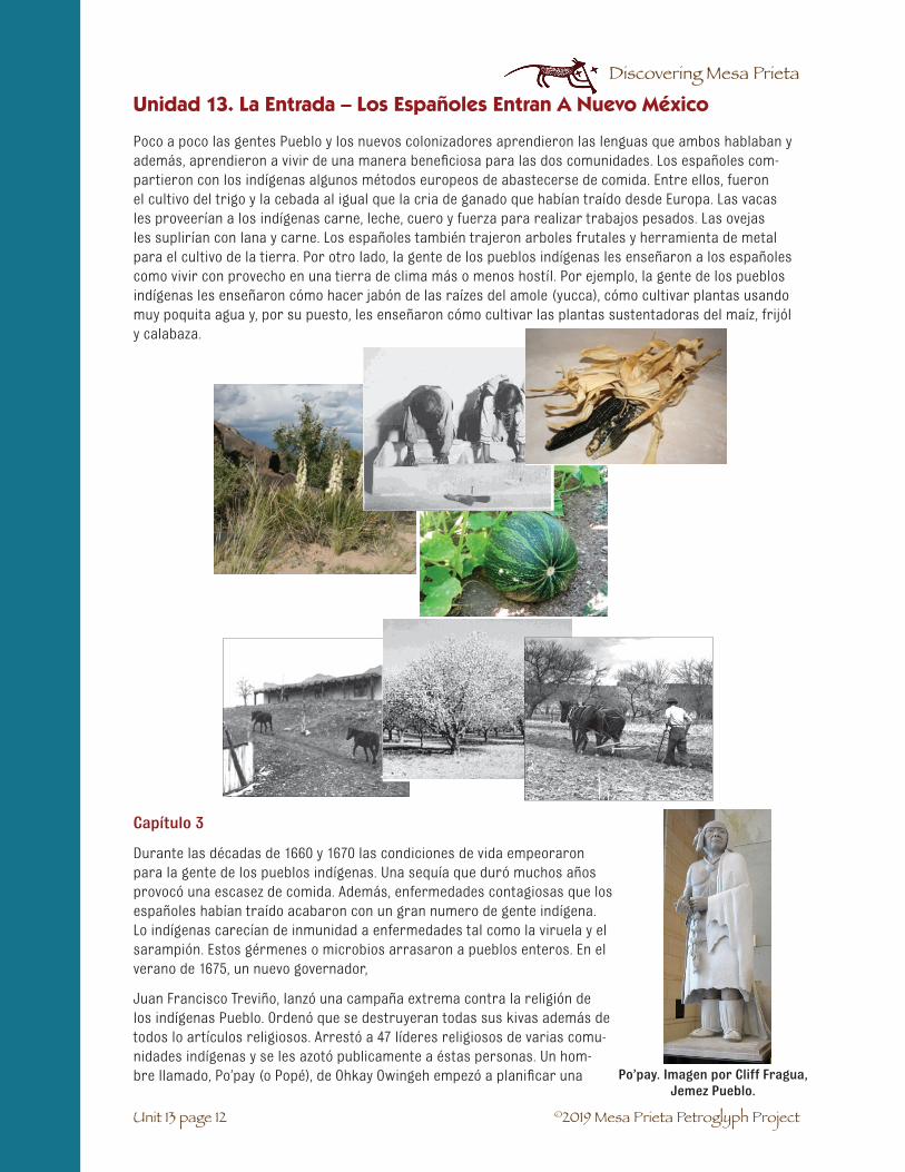
©2019 Mesa Prieta Petroglyph Project
Discovering Mesa Prieta
Unit 13 page 12
Capítulo 3
Durante las décadas de 1660 y 1670 las condiciones de vida empeoraron para la gente de los pueblos indígenas. Una sequía que duró muchos años provocó una escasez de comida. Además, enfermedades contagiosas que los españoles habían traído acabaron con un gran numero de gente indígena. Lo indígenas carecían de inmunidad a enfermedades tal como la viruela y el sarampión. Estos gérmenes o microbios arrasaron a pueblos enteros. En el verano de 1675, un nuevo governador,
Juan Francisco Treviño, lanzó una campaña extrema contra la religión de los indígenas Pueblo. Ordenó que se destruyeran todas sus kivas además de todos lo artículos religiosos. Arrestó a 47 líderes religiosos de varias comu-nidades indígenas y se les azotó publicamente a éstas personas. Un hom-bre llamado, Po’pay (o Popé), de Ohkay Owingeh empezó a planificar una
Unidad 13. La Entrada – Los Españoles Entran A Nuevo México
Poco a poco las gentes Pueblo y los nuevos colonizadores aprendieron las lenguas que ambos hablaban y además, aprendieron a vivir de una manera beneficiosa para las dos comunidades. Los españoles com-partieron con los indígenas algunos métodos europeos de abastecerse de comida. Entre ellos, fueron el cultivo del trigo y la cebada al igual que la cria de ganado que habían traído desde Europa. Las vacas les proveerían a los indígenas carne, leche, cuero y fuerza para realizar trabajos pesados. Las ovejas les suplirían con lana y carne. Los españoles también trajeron arboles frutales y herramienta de metal para el cultivo de la tierra. Por otro lado, la gente de los pueblos indígenas les enseñaron a los españoles como vivir con provecho en una tierra de clima más o menos hostíl. Por ejemplo, la gente de los pueblos indígenas les enseñaron cómo hacer jabón de las raízes del amole (yucca), cómo cultivar plantas usando muy poquita agua y, por su puesto, les enseñaron cómo cultivar las plantas sustentadoras del maíz, frijól y calabaza.
Po’pay. Imagen por Cliff Fragua, Jemez Pueblo.

©2019 Mesa Prieta Petroglyph Project
Discovering Mesa Prieta
Unit 13 page 13
Unidad 13. La Entrada – Los Españoles Entran A Nuevo México
revuelta contra los españoles. Primero, logró conseguir el apoyo de la mayoría de los pueblos índígenas de la zona. Después, se enviaron corredores a cada uno de los pueblos indígenas. Ellos iban cargaban una cuerda con una serie de nudos atados que representaban los días que faltaban hasta el levantamiento contra los espaõles. Cada día que se pasaba, se desataba un nudo hasta que se llegó al último nudo que representaba el día 10 de agosto de1680, fecha en la cual se dio la rebellión. En cada una de las missiones murieron a golpe muchos colonizadores y sacerdotes. A los once días, 1,000 españoles huyeron de Santa Fe. Pues, la revuelta de los indígenas Pueblo había sido exitosa.
A los españoles se les expulsó de Nuevo México y tuvieron que huír a El Paso del Norte (Ciudad Juárez, México) donde fundaron una capital temporaria. Fue allí donde fabricaron planes para la retoma de su antigua colonia del norte de Nuevo México.
Capítulo 4
A los doce años, Don Diego de Vargas y sus soldados regresaron a Santa Fe con los colonizadores españoles que habían sido desterrados. Tras unas batallas sangri-entas los españoles lograron recuperar su captial y el territorio que antes habían dominado. Nuevamente los indígenas Pueblo se encontraban bajo el mando de los españoles.
Al pasarse los años, la población española de Santa Fe aumentó tanto que las aguas del Río de Santa Fe no fueron suficientes como para poder regar todos los cultivos de la gente. En 1695 Don Diego de Vargas fundó la Villa Nueva de Santa Cruz de la Cañada a donde se mudaron muchas familias españolas. Allí, la tierra era fertíl y el agua abundante. La gente de los pueblos indígenas Tano que habían vivído allí fueron trasladados a los pueblos de Santa Clara y Ohkay Owingeh y y finalmente se trasladaron al Pueblo de Hopi en Arizona.
Aunque el gobierno español prohibía la esclavidtud, lo fue bastante común du-rante el siglo diecíocho. Durante la Revuelta de los Pueblo, centenares de caballos habían sido soltados. Las tribus nomádicas capturaron algunos de ellos y los hombres de esas tribus se convirtieron en jinetes expertos. A partir de entonces, el saqeo tanto de las comunidades españolas como las de los indígenas Pueblo se convirtió en un mero problema. En las batallas que surgieron entre los españoles y miembros de éstas tribus, se capturaron a algunos hombres. Ellos fueron llevados a México para trabajar en la minas de plata. Muchas mujeres y niñas fueron vendidas al servicio domestico en casas de los ricos. En turno, durante estas incursiones, los indios nomadas capturaron los hombres, mujeres y niños españoles como esclavas.
Petrográfico de Mesa Prieta, quizá una representación de la cuerda con nudos de Po’pay.
Don Diego de Vargas
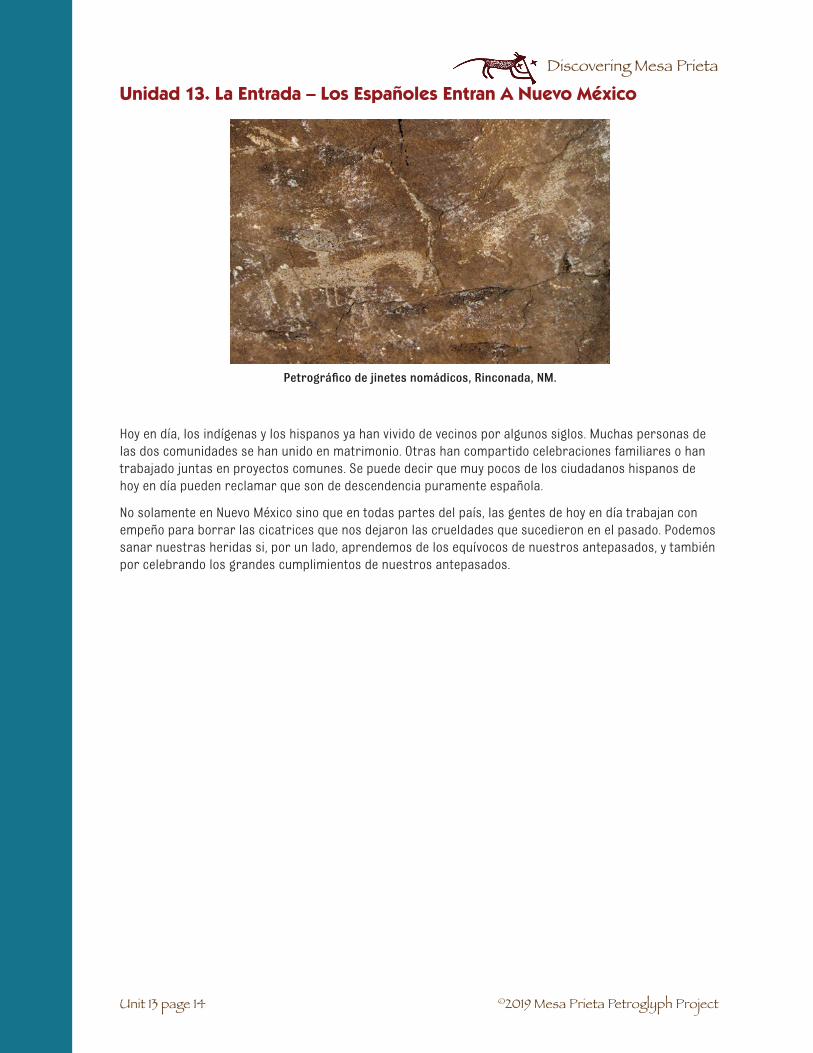
©2019 Mesa Prieta Petroglyph Project
Discovering Mesa Prieta
Unit 13 page 14
Unidad 13. La Entrada – Los Españoles Entran A Nuevo México
Hoy en día, los indígenas y los hispanos ya han vivido de vecinos por algunos siglos. Muchas personas de las dos comunidades se han unido en matrimonio. Otras han compartido celebraciones familiares o han trabajado juntas en proyectos comunes. Se puede decir que muy pocos de los ciudadanos hispanos de hoy en día pueden reclamar que son de descendencia puramente española.
No solamente en Nuevo México sino que en todas partes del país, las gentes de hoy en día trabajan con empeño para borrar las cicatrices que nos dejaron las crueldades que sucedieron en el pasado. Podemos sanar nuestras heridas si, por un lado, aprendemos de los equívocos de nuestros antepasados, y también por celebrando los grandes cumplimientos de nuestros antepasados.
Petrográfico de jinetes nomádicos, Rinconada, NM.

©2019 Mesa Prieta Petroglyph Project
Discovering Mesa Prieta
Unit 13 page 15
Unit 13: La Entrada – The Spanish Enter New Mexico
1. Create a web, eliciting Spanish vocabulary which reflects the influence of the arrival of theSpanish Colonizers starting with the Conquistadors in 1598. Ask the students what evidencewe have today of this influence. Guide the students to brainstorm Spanish vocabulary incommon usage for place names, geographical features, plants, animals, cuisine, religion, etc.Students who say they do not speak Spanish will be surprised at how many words they mayknow.
2. Whole group reading of narrative about La Entrada. Read only Chapter I. Discuss. Point outlocation of various places in the history, such as Spain, Atlantic Ocean, Veracruz, Mexico City,Santa Fe, on a large world map.
Activity 1: Spanish Vocabulary
1. Distribute New Mexico Road Maps. Review 4 directions, location bycoordinates. Discuss briefly how people might choose a name for a newvillage or settlement. Use maps to go on a “Spanish Place Names Hunt.”They can incorporate four directions and coordinates to describe whereplace is located.
2. Record place names on a large sheet of paper and elicit meanings for the Spanish words (Re-fer to “Place Names list” if needed (13-19). With the whole group, create riddles, such as “I amthinking of a place which is northwest of Española. It was named after the color of the earth.”(Tierra Amarilla). Spanish speakers in the class can take the lead in this activity. *good hintfor students – look for the definite article “el” or “la” in front of the noun.
3. Students will then answer review questions, which will include such riddles, as well asquestions about the early history.
ASSESSMENT ACTIVITY: Matching Place Names
Students will need the Assessment Activities student activity sheet (13-20). Students will draw a connect-ing line between matching Spanish names and their English meanings.
ART EXTENSION: Choose a place with a Spanish name and create an illustration that shows the mean-ing of the place. Write the name underneath the picture including English translation. This activity is also included in the assessment for this lesson.
Activity 2: Place Names Mapping

©2019 Mesa Prieta Petroglyph Project
Discovering Mesa Prieta
Unit 13 page 16
Unit 13: La Entrada – The Spanish Enter New Mexico
Activity 3: The Spaniards Meet the Tewa
1. Each student will need a copy of La Entrada- Narrative student activity sheet: (13-3).Read Chapter 2 as a class or in small groups.
2. Review new vocabulary as it comes up and any concepts that may be confusing. After complet-ing this reading you may wish to ask questions that the students must glean from the readingsuch as:
• Why did the Spanish call Ohkay Owingeh – San Juan de los Caballeros? (The first win-ter that Oñate’s colonists spent at Ohkay Owingeh was difficult because they hadn’thad time to grow crops. The people of Ohkay Owingeh helped them with food andsupplies.)
• The next year’s harvest was good and the colonists shared with the Tewa people. Somepeople call this the true “First Thanksgiving”. What year did that take place? (1599)
• Oñate never allowed the Tewa people to own horses. Why? (They didn’t want them tobe able to travel as quickly as the Spaniards.)
• Other than what you read about, what else might the Tewa people have taught the newcolonists? (Pottery making, raising turkeys, hunting, yucca sandals, herbal rem-edies, wild plants to eat)
• How did Po’pay and his leaders spread the word to the other pueblos about the day tobegin the Pueblo Revolt? (They ran from pueblo to pueblo with knotted cords. Eachday a knot was untied. They were to attack the Spaniards after the last knot wasuntied.)
• How did Queen Isabella’s religion affect the Pueblo people? (She sent missionaries toconvert the Indians to Catholicism. They were forced to stop their own religiouspractices, build churches, work in the Spanish fields and give part of their ownharvest to the Spanish.)
• Why do you think Oñate wanted to found colonies in New Mexico? (He hoped to becomerich and famous. (Gold and Glory))
EXTENSION ACTIVITY: Have students view the excellent Vimeo animated video “Frontera!Revolt and Rebellion on the Río Grande” by John Jota Leaños. It can be found on the Internet at http://vimeo.com/75840615 (20 min.)

©2019 Mesa Prieta Petroglyph Project
Discovering Mesa Prieta
Unit 13 page 17
Unit 13: La Entrada – The Spanish Enter New Mexico
Activity 4: The Historic Period Timeline
You will need the Historic Period Timeline Banner and the Timeline Cards from the trunk and small post-its. Review why a timeline is helpful in understanding history. This timeline begins at the left with the oldest events and moves right to the most recent time.
1. Put the Timeline up at the front of the room. Have the students take turns reading each of thetimeline entries. How does the timeline relate to what the students have just read? You maywish to ask questions such as:
• Which colony was established first – the pilgrims’ colony at Plymouth Rock or Oñate’scolony? (Oñate’s colony)
• Where was the first capital of New Mexico? (San Gabriel)
• What year did Spanish explorer Gaspar Castaño de Sosa come to northern New Mexicoand visit the pueblo of Phiogeh? (1591)
• What happened between 1610 and 1680? (Spanish villages and ranches were slowlyestablished along El Camino Real de Tierra Adentro.)
• What happened between the American Revolution and the Treaty of Guadalupe Hildago?(Mexican Revolution of 1821 in which Mexico gained independence from Spain.)
2. Explain to the students that they are going to play a timeline game. There are 16 cards withthe events of the timeline. Each student or pair of students is given a card. Using the timelineon the board, their task is to find the date when the event took place. Write the date on thepost-it on the back of the card. When everyone is ready the students will line up with eachother in date order with the oldest date (Ancestral Pueblos) at the left and the most recent(NM becomes a state) at the right end of the line. This is an active, noisy activity that involvescooperation. The students must compare their date to other students’ dates. You may needto take down the timeline from the board during this part of the activity. When the studentsare ready, have them stand in front of the timeline and check to see if they are standing in thecorrect location on the timeline.
EXTENSION ACTIVITY 1: El Camino Real Pamphlets
Pass out to each student a Camino Real pamphlet. These must be returned to the trunk, so ask thestudents to handle them carefully. As a class, read the first part – The Trail Yesterday.
1. Ask the students to look at the Timeline and find something that they didn’t know before.
2. Have the students pick out one location mentioned below or above the El Camino Real Timelineand read why it is important. Turn over the pamphlet and find it on the map.
3. Share with the whole class, small groups or write their answers down.

©2019 Mesa Prieta Petroglyph Project
Discovering Mesa Prieta
Unit 13 page 18
Unit 13: La Entrada – The Spanish Enter New Mexico
EXTENSION ACTIVITY 2: Mesa Prieta Artifacts
Hold up the resource trunk photos of Historic Period artifacts found on Mesa Prieta. Brainstorm about what the artifacts are, what their functions were, who made have used them and what those people were doing on Mesa Prieta. Why have so many been found near trails and corrals? Ask students to write a story based on Colonial times that includes all the artifacts shown in the photos.
ART ACTIVITY: Ask each student to choose an event on either timeline or use the card they are holding to illustrate and write a caption below their drawing. Display them in the classroom or in the hallway in the timeline order.
TIMELINE MATH: Each student will need a copy of the Historic Period Timeline student activity sheet and Timeline Math student activity sheet (13-26) This may be used as an in-class math activity or sent home as a homework assignment. Before beginning, review with the students the meaning of century (100 years) and decade (10 years). The math is simple subtraction problems. This will give them a better sense of the amount of time between different events.
One of many dated Historic Period petroglyphs on Mesa Prieta

©2019 Mesa Prieta Petroglyph Project
Discovering Mesa Prieta
Unit 13 page 19
Teacher Key for Webbing Activity: Teacher Resource Sheet
Sample Web:
Food/Comidas: Tortillas, enchiladas, tamales, tacos, frijoles, posole, chile rellenos
Geography/Geografía/Nature/Naturalesa: río, mesa, bosque, piedra, llano, arbol
Religion/Religión: iglesia, Cristo, santo, bautismo, padre
Animals/Animales: vaca, oveja or borrega, cerdo or cochino or puerco, caballo, oso, lobo
Family/Familia: mama, papa, abuelos, tía, tío, primo, hermano, etc.
Unit 13: La Entrada – The Spanish Enter New Mexico
Spanish Place Names List☛ Alcalde: mayor
☛ Española: Spanish lady
☛ Peñasco: cliff
☛ Las Trampas: the traps
☛ Ojo Caliente: hot spring
☛ Arroyo Seco: dry arroyo
☛ Arroyo Hondo: deep arroy
☛ Ranchitos: little farms
☛ El Llano: the Plain
☛ El Rito: the stream
☛ Buena Vista: beautiful view
☛ La Madera: the wood
☛ Tres Ritos: three little rivers
☛ Cañones: the canyons
☛ Tierra Amarilla: yellow earth
☛ Peña Blanca: white peak
☛ Agua Fría: cold water
☛ La Ciénega: the marsh
☛ Truchas: trout or fish
☛ San Cristóbal: Saint Christopher
☛ Santa Fe: Holy Faith
☛ Velarde: family name
☛ Hernandez: family name
* Words with El or La in front of them are all Spanish.

©2019 Mesa Prieta Petroglyph Project
Discovering Mesa Prieta
Unit 13 page 20
Assessment Activities:
Student Activity Sheet
Activity 1. Matching Place Names
Draw a line to connect the Spanish Place Name with its English definition.
1. Los Alamos a. mayor
2. Española b. the stream
3. Río Grande c. holy faith
4. Alcalde d. Dry Arroyo
5. Ojo Caliente e. Big River
6. El Rito f. hot spring
7. Ranchitos g. little farms
8. Truchas h. fish
9. Santa Fe i. The cottonwood trees
10. Arroyo Seco trees j. Spanish lady
Activity 2. Place Name Riddles
Use your map to locate and name the village, town or city described below:
• This small city is located northwest of Santa Fe along the Río Grande and was namedafter a Spanish lady. ____________________
• People come from all over to relax in the hot spring of this village which is locatednorth of Española on State Highway 285. _____________________
• Directly south of Española, the name of this historic city means “City of the HolyFaith.”___________________
• Choose three more places with Spanish names and write a riddle for each, using maplocation and meaning of the name._____________________________________________________________________________________________________________________________________ ____________________________________________
Unit 13: La Entrada – The Spanish Enter New Mexico

©2019 Mesa Prieta Petroglyph Project
Discovering Mesa Prieta
Unit 13 page 21
• In the space below, choose a place name and draw an illustration of the name. Labelpicture with its Spanish place name and the English translation.
Unit 13: La Entrada – The Spanish Enter New Mexico

©2019 Mesa Prieta Petroglyph Project
Discovering Mesa Prieta
Unit 13 page 22
Assessment Activities:
Teacher Key
Activity 1. Matching Place Names
Draw a line to connect the Spanish Place Name with its English definition.
1. Los Alamos a. mayor
2. Española b. the stream
3. Río Grande c. holy faith
4. Alcalde d. Dry Arroyo
5. Ojo Caliente e. Big River
6. El Rito f. hot spring
7. Ranchitos g. little farms
8. Truchas h. fish
9. Santa Fe i. The cottonwood trees
10. Arroyo Seco trees j. Spanish lady
Key: 1-i, 2-j, 3-e, 4-a, 5-f, 6-b, 8-h (trout), 9-c, 10-d
Activity 2. Place Name Riddles
Use your map to locate and name the village, town or city described below:
• This small city is located northwest of Santa Fe along the Río Grande and was namedafter a Spanish lady. (Española)
• People come from all over to relax in the hot spring of this village which is locatednorth of Española on State Highway 285. (Ojo Caliente)
• Directly south of Española, the name of this historic city means “City of the Holy Faith.”(Santa Fe)
Unit 13: La Entrada – The Spanish Enter New Mexico

©2019 Mesa Prieta Petroglyph Project
Discovering Mesa Prieta
Unit 13 page 23
Historic Period Timeline:
Upper Elementary Student Activity Sheet
1200 – 1540 Ancestral Pueblo Period: large Pueblo villages throughout what will become New Mexico.
1492 Christopher Columbus lands on the Caribbean island of Hispaniola, claims all new lands for Spain.
1493 Queen Isabella orders all the Jews and Moors (Muslim North Africans) to leave Spain.
1519 Hernán Cortez arrives in Mexico and conquers the Aztec Indians.
1540 Francisco Vázquez de Coronado leads an expedition into Pueblo territory, looking for the Seven Cities of Gold.
1591 Spanish explorer Gaspar Castaño de Sosa visits Pueblo of Phiogeh, located above present day Los Luceros.
1598 Don Juan de Oñate founds the first capital of New Spain near Ohkay Owingeh, calling it San Gabriel.
1610 Spanish capital is moved to Santa Fe under Governor Pedro de Peralta. It is the oldest capital city in the United States.
1610 – 1680 Spanish villages and ranches are slowly established along El Camino Real de TierraAdentro.
1620 The pilgrims land at Plymouth Rock and establish their colony on the northeast coast of North America.
1680 – August 10 Pueblo Revolt: Religious leader, Po’pay, organizes and leads the successful rebellion
against Spanish rule.
1692 Re-conquest: Don Diego de Vargas leads soldiers and settlers back to Santa Fe from El Paso, Texas.
1776 American Revolution: United States gains independence from England.
1821 Mexican Revolution: Mexico gains independence from Spain.
1848 Treaty of Guadalupe Hildago: over half of Mexican lands become American territory.
1912 New Mexico becomes the 47th state of the United States of America and the 5th largest state.
Unit 13: La Entrada – The Spanish Enter New Mexico

©2019 Mesa Prieta Petroglyph Project
Discovering Mesa Prieta
Unit 13 page 24
Historic Period Timeline:
Middle School Student Activity Sheet
1200 – 1540 Ancestral Pueblo Period: large Pueblo villages throughout what will becomeNew Mexico.
1492 Christopher Columbus lands on the Caribbean island of Hispaniola, claims all new lands for Spain.
1493 Spanish expulsion of all the Jews and Moors from Spain.
1519 Hernán Cortez arrives in Mexico and conquers the Aztec Indians.
1540 Francisco Vázquez de Coronado leads an expedition into Pueblo territory, looking for the Seven Cities of Gold.
1569 Spanish Inquisition begins in Latin America.
1591 Spanish explorer Gaspar Castaño de Sosa visits Pueblo of Phiogeh near Alcalde.A few years later the people of Phiogeh move to Hopi Pueblo in Arizona.
1598 Don Juan de Oñate leads a group of settlers to northern NM on the Camino Real. He founds his colony near Ohkay Owingeh, calling it Misión San Gabriel, the first capital of New Spain.
1599 The following fall the colonists share the real first Thanksgiving in the New World with their Pueblo neighbors.
1601 The capital is temporarily moved to the nearby outpost of Los Luceros and the village of Los Luceros begins to develop.
1610 Spanish capital is moved to Santa Fe under Governor Pedro de Peralta. It is theoldest capital city in the United States.
1610 – 1680 Spanish villages and ranches are established along El Camino Real de Tierra Adentro.
1620 The pilgrims land at Plymouth Rock and establish their colony on the northeast coast on North America.
1630 By this time there were 30 Spanish missions along the Camino Real, at most of the Pueb-los and at the new Spanish settlements.
Unit 13: La Entrada – The Spanish Enter New Mexico

©2019 Mesa Prieta Petroglyph Project
Discovering Mesa Prieta
Unit 13 page 25
1680 – August 10 Pueblo Revolt: Religious leader, Po’pay organizes and leads the rebellion against
Spanish rule. Over 1000 Spanish settlers flee to El Paso del Norte, present day Ciudad Juárez, Mexico.
1692 Don Diego de Vargas leads soldiers and settlers back to Santa Fe from El Paso del Norte, in the re-conquest.
1706 Villa de Albuquerque is founded by Francisco Cuervo de Valdés.
1754 Genízaro families begin settling the Pueblo of Abiquiú.
1772 San Miguel (imaginary village) church is built.
1776 American Revolution
1779 Governor Juan Bautista de Anza defeats Comanche band led by Chief Cuerno Verde.
1821 Mexican Revolution – Mexico gains independence from Spain.
1821 Santa Fe Trail connects the mid-west to the south-west.
1829 Old Spanish Trail established to connect New Mexico with California.
1848 Treaty of Guadalupe Hildago: Over half of Mexican lands become American territory.
1862 Civil War enters the southwest with the battle of Valverde.
1878 First railroad established from Raton Pass to El Paso, Texas.
1912 New Mexico become the 47th state, the 5th largest in the United States.
Unit 13: La Entrada – The Spanish Enter New Mexico

©2019 Mesa Prieta Petroglyph Project
Discovering Mesa Prieta
Unit 13 page 26
Timeline Math:
Student Activity Sheet
Using the Historic History Timeline, answer the questions below. Give your answer in centuries plusdecades plus years as well as the total years.
1. How many centuries passed between the beginning of the Ancestral Pueblo period and thearrival of Oñate’s expedition at Ohkay Owingeh?
2. How many decades was the Spanish capital at San Gabriel?
3. How many years passed between the founding of Oñate’s colony of San Gabriel and the found-ing of the Pilgrims’ colony at Plymouth Rock?
4. Which took place first, the American Revolution or the Pueblo Revolt?
5. How many years after the Pueblo Revolt did the American Revolution on the east coast takeplace?
6. How many years after the American Revolution did New Mexico become a state?
7. After the Pueblo Revolt, how many years did the Pueblo people rule themselves?
8. What marked the beginning of the Historic Period in New Mexico?
9. Was it more than or was it less than 2 centuries after Cortez conquered the Aztec Indians inMexico that Don Diego de Vargas re-conquered the Pueblo Indians in New Mexico?
10. How many years after Queen Isabella expelled the Jews and Moors from Spain did the PuebloIndians expel the Spanish from New Mexico?
Unit 13: La Entrada – The Spanish Enter New Mexico

©2019 Mesa Prieta Petroglyph Project
Discovering Mesa Prieta
Unit 13 page 27
Unit 13: La Entrada – The Spanish Enter New Mexico
Timeline Math:
Teacher Key
Using the Historic History Timeline, answer the questions below. Give your answer in centuries plus decades plus years as well as the total years.
1. How many centuries passed between the beginning of the Ancestral Pueblo period and thearrival of Oñate’s expedition at Ohkay Owingeh? (3 centuries plus 18 years (318 years))
2. How many decades was the Spanish capital at San Gabriel? (1 decade and 2 years (12 years))
3. How many years passed between the founding of Oñate’s colony of San Gabriel and the found-ing of the Pilgrims’ colony at Plymouth Rock? (2 decades plus 2 years (22 years))
4. Which took place first, the American Revolution or the Pueblo Revolt? (Pueblo Revolt of 1680)
5. How many years after the Pueblo Revolt did the American Revolution on the east coast takeplace? (9 decades plus 6 years (96 years))
6. How many years after the American Revolution did New Mexico become a state? (1 centuryplus 3 decades plus 6 years (136 years))
7. After the Pueblo Revolt, how many years did the Pueblo people rule themselves? (1 decade plus2 years (12 years))
8. What marked the beginning of the Historic Period in New Mexico? (The expedition of FranciscoVázquez de Coronado into NM in 1540.)
9. Was it more than or was it less than 2 centuries after Cortez conquered the Aztec Indians inMexico that Don Diego de Vargas re-conquered the Pueblo Indians in New Mexico? (Less than 2centuries; (173 years))
10. How many years after Queen Isabella expelled the Jews and Moors from Spain did thePueblo Indians expel the Spanish from New Mexico? (1 century plus 8 decades plus 7 years(187 years))

©2019 Mesa Prieta Petroglyph Project
Discovering Mesa Prieta

©2019 Mesa Prieta Petroglyph Project
Discovering Mesa Prieta
SUBJECTS: Science, Social Studies, Math, Language Arts.
SUGGESTED TIME: Two to four class periods.
MATERIALS:
Copy for students: Feather Anatomy student information sheet (14 - 7), Maize: Sacred Grain of the Ameri-cas student information sheet (14 - 9), Ancestral Pueblo Farming Methods- Drawings student activity sheet (14 - 12), Ancestral Pueblo Farming Methods- Captions student activity sheet (14 - 11), Pueblo Foods: An Enduring Tradition student information sheet (14 - 13), Grandmother’s Story student information sheet (14 - 14).
From the trunk: Old Father Storyteller by Pablita Velarde, Coyote Tales by Evelyn Dahl Reed, In My Moth-er’s House by Ann Nolan Clark, Petroglyph National Monument Teacher’s Guide, turkey feathers, pinto and Anasazi beans, dried corn kernels, dried corn on the cob, paper plates or Petri dishes, photographs of the petroglyphs, other curriculum guides. Magnifying loupes may be checked out from Mesa Prieta Petro-glyph Project office.
From the teacher: writing, construction and copy paper, pencils.
For the teacher: Resource materials: Corn teacher resource sheet (14 - 8), A Corny Game teacher resource sheet (14 - 15-16). Also Ancestral Pueblo People of Bandelier, A Guide for 4th Grade Teachers is available from to the MPPP library and online at http://www.nps.gov/band/forteachers/fourth-grade-lesson-plans.htm.
UNIT 14: EARLY LIFE IN THE TEWA WORLD
✔ Students will understand how important the natural worldwas for the Ancestral Tewa people.
✔ Students will learn why it is important to respect the plantsand the animals that live in their communities.
✔ Students will understand the importance of domesticationof plants and animals for the Ancestral Tewa people.
✔ Students will become skilled at observation and inference.
OBJECTIVES
Unit 14 page 1

©2019 Mesa Prieta Petroglyph Project
Discovering Mesa Prieta
1. Read the story “Turkey Girl” in Old Father Storyteller to your students or make copies from thebook for them to read. Discuss what it means to domesticate animals and plants. Discuss whythey chose the turkey to domesticate. (They breed well in captivity, it is easy to feed themcorn, they become accustomed to people.) Discuss why turkeys were important to the Tewapeople and how they might have used different parts of the turkeys. (Feather blankets, feath-ers used in ceremonies, meat, eating grasshoppers in the gardens)
2. Discuss what the students know about feathers and why birds have them. (For flight,warmth, protection, for attracting a mate.)
3. Explain that the students will be observing real turkey feathers. If they haven’t used magnify-ing loupes before, demonstrate how to use them. For information on how to care for loupes,see Unit 2-1, Geology of Mesa Prieta.
Unit 14: Early Life in the Tewa World
Activity 1
Unit 14 page 2
VOCABULARY☛ Agriculture: Farming. The process of cultivating the soil, raising crops and animals.
☛ Anasazi: The Navajo name for the Ancestral Pueblo people.
☛ Arid: Dry. An arid land gets very little rain.
☛ Domestication: The process of developing plants and animals that can be cared for bypeople and become dependent on people.
☛ Grain: Dried seeds of cereal grasses.
☛ Grid garden: A farming technique used by the Ancestral Pueblo people to grow corn andbeans. It was a square plot that was lined with large stones.
☛ Kernels: The seeds of the corn plant or other grain.
☛ Maize: Another name for corn. It is based on the Spanish word, maíz.
☛ Mano: The small, hand-held stone that was rubbed against the corn kernels and the metate.
☛ Metate: The flat, smoothed stone that was used for grinding corn.
☛ Molt: Shed feathers.
☛ Sacred: Something that is considered holy and worthy of respect.
☛ Teosinte: The ancient grass from Mexico that evolved into our modern corn through selectivebreeding.
☛ The Three Sisters: The three sacred domestic plants of Native American people- corn, beans,squash. The term that refers to the practice of planting corn, beans and squash together.

©2019 Mesa Prieta Petroglyph Project
Discovering Mesa Prieta
4. Pass out a loupe or hand lens and feather to each pair of students. Asone student observes the feather, the other student writes down theobservations. Then they switch. With the feather between them, thestudents draw the feather (like a scientist).
5. Discuss the parts of a feather and the different types of feathers. Passout student handout with parts of feather labeled and ask students tolabel their drawing.
6. Demonstrate how feather veins are likezippers by separating two veins and thenzipping them back together. Why is thisfeature an important adaptation? (Birdsonly molt once a year. Using its bill, abird is able to repair damaged featherswith this feature.)
7. Read other stories that involve animalsfrom Old Father Storyteller and CoyoteTales from the Indian Pueblos.
Unit 14: Early Life in the Tewa World
Unit 14 page 3
Activity 2
1. Brainstorm or webbing: Ask the students to share all that they know about corn. (ReviewTeacher Information Sheet (14-8).
2. Give each student a kernel of corn to look at with a magnifying loupe or hand lens. Have thestudents write down their observations and draw the kernel. While they are engaged, passaround an ear of dried corn for the students to look at.
3. Pass out the student information sheet Maize: Sacred Grain of the Americas (14-9 – 10) andread it as a class.
4. Review the reading by asking questions such as: How do we know that the Ancestral Pueblopeople grew and harvested corn? (Grid gardens can be found near ancient sites, corn cobsand kernels have been found.) Why were The Three Sisters important to the early Pueblopeople? (When these three foods were eaten together, the people were eating a healthydiet.) What did the Pueblo women use to grind the corn? (A metate and mano.) How is cornused ina sacred way by the Pueblo people? (They use corn meal and corn pollen when they arepraying and they use the whole corn ear in corn dances.) How can we show respect for thecorn? (By thanking the corn in our hearts for all of the good food that it gives us.)

©2019 Mesa Prieta Petroglyph Project
Discovering Mesa Prieta
1. Ask the students if they or their family eat pinto beans.Tell them that the Ancestral Pueblo people raised corn,beans and squash and that they are called the “ThreeSisters”. Ask the students if these plants were domesti-cated. (Yes, because they planted the seeds and tookcare of the plants.) Explain that the Ancestral Pueblopeople (Anasazi) grew a smaller bean that we call theAnasazi bean. Archaeologists have found these beansin ancient Pueblo sites and farmers have grown them.Now we can buy them in some grocery stores. When the“Three Sisters” are eaten together, these plants providethe body with more nutrition than if eaten separately.Better nutrition leads to healthier bodies, populationgrowth and larger communities.
2. Pass out paper plates or Petri dishes, pinto and Anasazibeans and magnifying loupes to pairs of students. Ask themto observe and record the same way they did with the turkey feather. Ask them to compareand contrast the beans using a chart or Venn diagram. Then draw and label the two types ofbeans.
3. Teacher reads Pueblo Foods: An Enduring Tradition student information sheet, (14-13) to theclass. Then have the students read Grandmother’s Story, (14-14). Discuss the similarities anddifferences between Pueblo and Hispano traditions.
4. Extension 1: A Corny Game teacher resource sheet, (14-15 – 14-16).
5. Extension 2: Have the students sprout and grow corn, beans and squash seeds to comparethem. Draw the seeds and the sprouts.
Unit 14: Early Life in the Tewa World
Unit 14 page 4
Corn plant petroglyph
5. Ancestral Pueblo Farming Methods: Explain to the students that the Ancestral Pueblo farm-ers developed different ways to capture and retain moisture. This was very important in anarid environment. Show the students the poster Adobe and Maize and discuss. Pass out thestudent activity sheets: Ancestral Pueblo Farming Methods- Drawings and Captions, (14-11 -12). As a class, look at each drawing and read the caption. Have the students make bookletsby cutting out the drawings and the captions and gluing them onto the pages of a book thatthey make out of construction paper. Color the pictures.
6. Assessment: Ask the students to write a short essay describing how they would grow corn ifthey were Ancestral Pueblo farmers.
7. Extension activities may be found in Petroglyph National Monument – Teachers Guide, Lessons12 and 13 pp. 50-60 and Keepers of the Earth, Chapter 16, pp. 137-145.
Activity 3

©2019 Mesa Prieta Petroglyph Project
Discovering Mesa Prieta
Activity 4
Unit 14: Early Life in the Tewa World
Unit 14 page 5
1. Read to the class the story “Thanking the Birds” on page 73 in Petroglyph National MonumentTeacher’s Guide. Discuss what it means to respect something. How did the ancient Pueblopeople show respect? (By thanking the plants and animals they used, by using every part ofa plant or animal that was killed, returning to the Earth what they couldn’t use, treating theelders with honor, etc.) How can we show respect in our lives and why should we? (Answerswill vary.)
2. Pass out several photographs of the petroglyphs on Mesa Prieta to each group of three orfour students. Have the students count the number of bird images and bird tracks. (About 22tracks and about 9 birds.) (It is not important to get an exact count because we are infer-ring that the images are birds, tracks or other animals. This is very subjective.)
3. Then have students count the number of other animals. (About 12.) Total the number of birds/tracks and other animals. (About 43.) Set up a ratio of the number of birds/tracks to num-ber of total animals. (31:43.) “Are the birds/tracks half of all the animal petroglyphs, less thanhalf or more than half? (More than half.) Do you think that you would find this same ratio inother Petroglyph areas? Why?”
4. “Why do you think they made bird petroglyphs?” (Maybe to honor the bird, to ask for itsprotection or power, etc. These answers are all inferences.) “In what ways were birdsimportant to the ancient Pueblo people?” (Food, clothing, feathers for ceremonies, teachingvalues, etc.)
(Suggested by Jimmy Lara, 4th grade at Velarde Elementary)
Many birds remain culturally important to today’s Pueblo people.
Cultural Importance of Birds:
Sun birds: hummingbirds, parrot, macaw
Sky birds: eagle, hawk, “knifewing”
War birds: eagle, roadrunner, flicker, woodpecker, jays, nuthatch, canyon wren
Hunter birds: eagle, hawk, falcon
Earth bird: turkey
Water birds: ducks, snipes, killdeer, crane
Summer birds: warbler, meadowlark, orioles
Winter birds: horned larks, junco, bluebirds
Night birds: nighthawk, owls
Messenger birds: shrikes, mocking bird, eagles
Death birds: vulture, catbird, owl

©2019 Mesa Prieta Petroglyph Project
Discovering Mesa Prieta
ASSESSMENT: Have students write a paragraph responding to the question, “Why was it important for Swift Eagle to talk to the boys about life being a very sacred thing?” Have students relate their answer to an example from their own lives. (Use the ACE format – Answer the question, Cite reasons from the text for your answer, Expand by relating it back to an example from your own life.)
OTHER EXTENSION ACTIVITIES: There are some wonderful extension activities about agriculture, foods, pottery, etc. in the three curriculum guides. These will help the students understand what life was like in early Pueblo times. They are listed under Extension Activities, p. xxii.
Unit 14: Early Life in the Tewa World
Unit 14 page 6

©2019 Mesa Prieta Petroglyph Project
Discovering Mesa Prieta
Unit 14: Early Life in the Tewa World
Unit 14 page 7

©2019 Mesa Prieta Petroglyph Project
Discovering Mesa Prieta
Unit 14: Early Life in the Tewa World
Unit 14 page 8
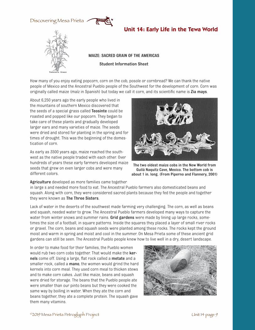
Discovering Mesa Prieta
Unit 14: Early Life in the Tewa World
Unit 14 page 9
MAIZE: SACRED GRAIN OF THE AMERICAS
Student Information Sheet
How many of you enjoy eating popcorn, corn on the cob, posole or cornbread? We can thank the native people of Mexico and the Ancestral Pueblo people of the Southwest for the development of corn. Corn was originally called maize (maíz in Spanish) but today we call it corn, and its scientific name is Zia mays.
About 6,250 years ago the early people who lived in the mountains of southern Mexico discovered that the seeds of a special grass called Teosinte could be roasted and popped like our popcorn. They began to take care of these plants and gradually developed larger ears and many varieties of maize. The seeds were dried and stored for planting in the spring and for times of drought. This was the beginning of the domes-tication of corn.
As early as 3500 years ago, maize reached the south-west as the native people traded with each other. Over hundreds of years these early farmers developed maize seeds that grew on even larger cobs and were many different colors.
Agriculture developed as more families came together in large s and needed more food to eat. The Ancestral Pueblo farmers also domesticated beans and squash. Along with corn, they were considered sacred plants because they fed the people and together they were known as The Three Sisters.
Lack of water in the deserts of the southwest made farming very challenging. The corn, as well as beans and squash, needed water to grow. The Ancestral Pueblo farmers developed many ways to capture the water from winter snows and summer rains. Grid gardens were made by lining up large rocks, some-times the size of a football, in square patterns. Inside the squares they placed a layer of small river rocks or gravel. The corn, beans and squash seeds were planted among these rocks. The rocks kept the ground moist and warm in spring and moist and cool in the summer. On Mesa Prieta some of these ancient grid gardens can still be seen. The Ancestral Pueblo people knew how to live well in a dry, desert landscape.
In order to make food for their families, the Pueblo women would rub two corn cobs together. That would make the ker-nels come off. Using a large, flat rock called a metate and a smaller rock, called a mano, the women would grind the hard kernels into corn meal. They used corn meal to thicken stews and to make corn cakes. Just like maize, beans and squash were dried for storage. The beans that the Pueblo people ate were smaller than our pinto beans but they were cooked the same way by boiling in water. When they ate the corn and beans together, they ate a complete protein. The squash gave them many vitamins.
©2019 Mesa Prieta Petroglyph Project
The two oldest maize cobs in the New World from Guilá Naquitz Cave, Mexico. The bottom cob is
about 1 in. long. (From Piperno and Flannery, 2001)

©2019 Mesa Prieta Petroglyph Project
Discovering Mesa Prieta
Unit 14: Early Life in the Tewa World
Unit 14 page 10
The Three Sisters kept the Pueblo people very healthy. When we eat the Three Sisters today it helps us to stay healthy.
The most important thing about corn is its sacredness. Native people in all parts of the Americas grow corn for food and also for use in ceremonies and for prayers. The corn plants are treated with great respect. Sacred corn meal and corn pollen are sometimes carried in a pouch and sprinkled on the ground as a prayer. Ears of corn are often carried during corn dances. As you watch the corn dance at a local Pueblo, you too can thank the corn for all the good food that it gives you. And before you leave the Pueblo, be sure to thank the spirits of the ancient Pueblo farmers who domesticated the corn.
Corn Dance Ceremony Myth, 1938, by Ignacio Moquino (Waka), Zia Pueblo.
NM Department of Cultural Affairs.

©2019 Mesa Prieta Petroglyph Project
Discovering Mesa Prieta
Unit 14: Early Life in the Tewa World
Unit 14 page 11
ANCESTRAL PUEBLO FARMING METHODS- DRAWINGS
Student Activity Sheet
Drawings by Roxanne Swentzell, from “Water Harvesting Traditions in the Desert Southwest,” by Joel Glanzberg, Permaculture Design Journal, No. 20, August 1994, pp. 8-12.

©2019 Mesa Prieta Petroglyph Project
Discovering Mesa Prieta
Unit 14: Early Life in the Tewa World
Unit 14 page 12
ANCESTRAL PUEBLO FARMING METHODS: CAPTIONS
Student Activity Sheet
Check Dams: Check dams were built across arroyos. They were used to catch the soil and slow down the water which reduces erosion. Many different crops were planted behind the dams.
Linear Borders: Linear borders were low lines of stones built across hills. Soil that was washed down the hillside was caught behind the borders and became a good place to plant.
Grid Gardens: Grid gardens were similar to waffle gardens but had walls made of stones rather than mud. They were much larger than waffle gardens and were probably used to grow corn and beans.
Gravel Mulched Fields: Mulch is any material that is placed on top of soil to hold the moisture in. The Ancestral Pueblo farmers often mulched their grid gardens with gravel and small stones. This reduced the wind and water erosion as well as holding in the moisture.
Irrigation: Irrigation was used to bring water from a stream or river to the fields. They did this by digging ditches from the stream or river to the fields. They blocked the ditch when they wanted the water to stop.

©2019 Mesa Prieta Petroglyph Project
Discovering Mesa Prieta
Unit 14: Early Life in the Tewa World
Unit 14 page 13
PUEBLO FOODS: AN ENDURING TRADITION*
Student Information Sheet
Traditional foods have been very important to Pueblo people for a long time. Traditional foods connect the Pueblo people to their land, to their community and to their traditional way of life. Pueblo people have lived in the Southwest for ten thousand years. During this time they have gotten their foods by hunting, gather-ing and gardening. For the Pueblo people, food was not just a way to survive. Food was special and sacred. Foods like corn are sacred in Pueblo traditions. “Corn is who we are,” is a phrase used by some Pueblo elders. It captures the way Pueblo people feel about the importance of corn.
In Pueblo tradition, corn is a symbol of how the people have survived in the Southwest environment. Corn, along with deer, elk, buffalo and other wild game, represents the plants and animals that have given life to the Pueblo people. This special life-giving relationship is celebrated in Pueblo planting, harvesting and rain dances. These ceremonies are done in a yearly cycle that represents how the earth gives life. Basket weaving and making pots are also part of the traditional “way” to show respect for the life-giving force of food.
In the last few generations, the traditional Pueblo way of life has changed. Some of these changes have taken place because Pueblo people have had to adapt to the stresses of “modern life.” ... These changes in the traditional way of life have brought about diseases like diabetes and heart disease.
Now that some Pueblo people have seen what these changes have done to the health and well being of their communities, they are going back to traditional ways. They are going back to traditional foods and becoming more active. They are looking back to Pueblo traditions so they can make wise choices and become stronger.
This reading was adapted from “Indigenous Foods, Indigenous Health: A Pueblo Perspective” from: Health, Nutrition and Traditional Foods, Cajete, et al., Health Resource Center of New Mexico - ®1998.
(Adapted from Life on the Rio Grande: A Diabetes Education Curriculum, Grades 3- 5. Ana Consuelo and Associates, Santa Fe, NM, n.d., p. 5)
By Dr. Gregory Cajete
(Dr. Gregory Cajete is from Santa Clara Pueblo and is a professor at the University of New Mexico.)
*Adapted from Life on the Rio Grande: A Diabetes Education Curriculum, Grades 3- 5. Ana Consuelo and Associates,Santa Fe, NM, n.d., p. 5.

©2019 Mesa Prieta Petroglyph Project
Discovering Mesa Prieta
GRANDMOTHER’S STORY
Student Information Sheet
This is my Grandmother, Lucy Cata. We live in San Juan Pueblo.* She has diabetes. Diabetes runs in our family. My Grandpa had it too. My Grandmother got diabetes when she was fifty years old. She is seventy years old now and she’s still going strong. She learned to take care of her diabetes. My Grandmother says she doesn’t want us to get diabe-tes. She wants us to be healthy and strong.
My Grandmother tells us stories about how things used to be. She says that a long time ago, Native people didn’t have diabetes. They lived a healthy life. They worked in the fields, hunted and gathered their food; they took care of their animals, chased after children and walked everywhere. The foods they ate were healthy and fresh.
Now, modern life has changed the way Native people live. They don’t work with their hands and bodies as much as they did before. They don’t chase the children because the children are watching TV. They don’t walk everywhere because they drive their cars. Another thing that has changed is the way Native people eat. Instead of eating fresh food that they have grown or traded for, they might eat too much food that comes in cans or bags. Some people call it junk food. They might eat stuff with too much fat, sugar and salt. Grandmother says things have changed. It’s not the “good old days” anymore.
When Grandmother found out she had diabetes, she went to a doctor and a wise medicine man. They both said the same thing. “Try to go back to the way it was in the ‘good old days.’ Go back to the way your ancestors used to live. Take the new but don’t leave the old ways behind.”
So my Grandmother started changing back to the way it was. She doesn’t eat junk food anymore, only once in a while. She eats healthy meals that include meat, vegetables, grains and fruit. She walks to her neighbor’s house instead of taking the car. She goes to the doctor and gets medicine and checks her diabetes.
The grandchildren can help too. When we come home from school, we tell her, “Let’s go for a walk, Grandma!” We walk in the fields sometimes. Sometimes we go by the river and she tells us stories about how things used to be... “in the good old days.”
*The people of San Juan Pueblo now use its Tewa name, Ohkay Owingeh.
*Adapted from Life on the Rio Grande: A Diabetes Education Curriculum, Grades 3- 5. Ana Consuelo and Associates,Santa Fe, NM, n.d., p. 16.
Unit 14: Early Life in the Tewa World
Unit 14 page 14
©2019 Mesa Prieta Petroglyph Project
Discovering Mesa Prieta
Unit 14: Early Life in the Tewa World
Unit 14 page 15

©2019 Mesa Prieta Petroglyph Project
Discovering Mesa Prieta
Unit 14: Early Life in the Tewa World
Unit 14 page 16

©2019 Mesa Prieta Petroglyph Project
Discovering Mesa Prieta
Vocabulario Unidad 14: Los Comienzos en el Mundo Tewa
☛ Agricultura y ganadería: el proceso de cultivar el suelo, sembrar cultivos y criar animales.
☛ Anasazi: el nombre Navajo para la gente de los pueblos ancestrales.
☛ Árido: seco. Un lugar árido recibe poca lluvia.
☛ Domesticación: el proceso de cuidar plantas y animales domesticados por el hombre porsu uso.
☛ Grano: Semillas secas del pasto del cereal.
☛ Jardín cuadriculado: una técnica agrícola usada por las gentes ancestrales de los pueblospara cultivar frijoles y maíz. Era un terreno cuadrado cercado por grandes rocas.
☛ Grano: las semillas de la planta y otros granos.
☛ Maize: el nombre temprano para maíz. Basado en la antigua palabra española maíz.
☛ Mano: la pequeña piedra del tamaño de una mano usado con el metate para moter grano demaíz.
☛ Metate: la piedra lisa y suave que se usaba para moler el maiz.
☛ Mudar: cambiar la piel.
☛ Sagrada: algo que es considerado divino y merecedor de respeto.
☛ Teosinte: el pasto antiguo de Nuevo México que evoluciono hasta lo que conocemos ahoracomo maíz.
☛ Las tres hermanas: las tres plantas domésticas sagradas de la gente Nativa. El maíz, el frijoly el calabacín. El término se refiere a la práctica de sembrar maíz, frijoles y calabacín por lagente.
Unidad 14: Los Comienzos en el Mundo Tewa
Unit 14 page 17

©2019 Mesa Prieta Petroglyph Project
Discovering Mesa Prieta
MÉTODOS ANCESTRALES PARA LA AGRICULTURA DE LOS PUEBLOSDEFINICIONES
Hoja de actividades para el estudiante
Diques: Los diques fueron construidos a lo largo de los arroyos. Se usaban para atrapar la tierra y disminuir la velocidad del agua, reduciendo así la erosión. Muchas cosechas se cultivaron gra-cias a estos diques.
Linderos: Los linderos eran pequeñas alineaciones de piedras a lo largo de la montaña. La tierra que bajaba de la ladera quedaba retenida entre los linderos convirtiéndose así en un buen lugar para cultivar.
Huertos en cuadrícula: Los huertos en cuadrícula eran muy parecidos a huertos con forma de gofre pero tenían las paredes hechas de piedra en lugar de barro. Eran mucho más amplios que estos últimos y probablemente se usaban para sembrar el grano y los frijoles.
Mantillo de grava en los campos: El mantillo se refiere a cualquier material que se coloca en-cima de la tierra para preservar la humedad. Los agricultores ancestrales de los Pueblos, solían colocar un mantillo a base de grava y piedras pequeñas encima de sus cultivos. Esto reducía la erosión producida por el viento y el agua y además mantenía la humedad.
Irrigación: La irrigación se usaba para llevar el agua desde un arroyo o un río hasta los campos. Lo hacían cavando acequias desde el arroyo o el río hasta dichos campos. Bloqueaban el dique cuando querían retener el agua.
Unidad 14: Los Comienzos en el Mundo Tewa
Unit 14 page 18

©2019 Mesa Prieta Petroglyph Project
Discovering Mesa Prieta
MÉTODOS PARA LA AGRICULTURA DE LOS PUEBLOS ANCESTRALES:
ILUSTRACIONES
Unidad 14: Los Comienzos en el Mundo Tewa
Unit 14 page 19
Dibujos de Roxanne Swentzell, de “Water Harvesting Traditions in the Desert South-west,” por Joel Glanzberg, Permaculture Design Journal, No. 20, Agosto 1994, pp.8-12.

©2019 Mesa Prieta Petroglyph Project
Discovering Mesa Prieta

©2019 Mesa Prieta Petroglyph Project
Discovering Mesa Prieta
Unit 15 page 1
UNIT 15: A VISIT TO A HISPANO VILLAGE
Introduction for Teachers
The goal of this unit is to engage students actively in a study of daily life andculture of the early Hispano settlers and to help them make connections to
the ongoing traditions which make New Mexico such a unique place.
We want this unit to be “user friendly” and we hope you will find it to be a relevant and dynamic teaching tool. For this reason we have put together a selection of activities
from which teachers can choose and adapt those lessons which will work in their classrooms. We understand that some teachers may not be able to go on the field trips which would
enhance this unit and that they may not have time to fully engage in such activities as adobe making, dyeing of wool, or cooking. For this reason also we offer simpler art activities,
writing assignments, and suggestions involving family and community members.
In the “Spanish Treasure Chest” resource trunk, we provide materials which will make it easier to carry out the suggested activities. These include such items as samples of raw wool and yarn, packets of remedial herbs, wheat seeds, garbanzos, CDs with rhymes and songs, and many other
useful materials. The Mesa Prieta Petroglyph Project in Velarde has available for lending: adobe forms and looms as well as a selection of children’s books and relevant resources for background material.
We are so fortunate to be surrounded by living cultures which reflect our past. We hope you enjoy using this curriculum as much as we enjoyed putting it together.
Special thanks for the development of this unit go from the Mesa Prieta Petroglyph Project to:
Lucia Ortíz y García, Alejandro López, Esta Gutierrez, Judith Chaddick New Mexico Historic Preservation Division, New Mexico Children’s Foundation
Katherine Wells

©2019 Mesa Prieta Petroglyph Project
Discovering Mesa Prieta
Unit 15 page 2

©2019 Mesa Prieta Petroglyph Project
Discovering Mesa Prieta
Unit 15 page 3
SUBJECTS: Social Studies, Language Arts, Reading, Arts, Math, Science.
MODALITIES: Visual, Auditory, Kinesthetic, Tactile.
SUGGESTED TIME: At least 8 and some may take more than one day.
MATERIALS: (listed with each activity)
BACKGROUND:
This unit is divided into eight chapters exploring El Pueblo de San Miguel, Casas y Comidas, Iglesia y Religión, El Tejedor, La Agricultura, La Curandera, Niñez and Celebraciones. Each chapter lists its own materials and activities.
UNIT 15: A VISIT TO A HISPANO VILLAGE
✔ Students will gain increased understanding of everydaylives and culture of the early Hispano settlers.
✔ Students will experience, through hands-on activities,some of the traditional practices of the early Hispanosettlers, such as adobe making, medicinal healing, cooking,agriculture, and religion.
✔ Students will further explore the cultural exchanges, ben-efits and challenges resulting from the interaction of theindigenous peoples and the Spanish.
✔ Students will develop interviewing skills as they talk withfamily and community members, and record responses.
✔ Students will enhance their appreciation of the livingHispano culture which reflects the traditions of the past.
✔ Students will hone cooperative learning skills as they workon group projects.
OBJECTIVES

©2019 Mesa Prieta Petroglyph Project
Discovering Mesa Prieta
Unit 15 page 4
Unit 15: A Visit to a Hispano Village
VOCABULARY:☛ Adobe: the Spanish word for the mud and straw used to make a structure.
☛ Bondad: the Spanish word for kindness
☛ Camino Real de Tierra Adentro: a Royal Road of Interior Lands, one of which the Spanishfollowed north to New Mexico from Mexico.
☛ Card: to comb or clean wool with a special comb.
☛ Casings: coverings or sleeves for sausages, often cleaned animal intestines.
☛ Devout: religious, reverent
☛ Dome: rounded ceiling or roof, such as is found on an horno.
☛ Furrows: plowed grooves for planting rows.
☛ Ghost town: town that has been abandoned by the people who lived there.
☛ Hispano: related to Spanish or Latin American culture or language.
☛ Horno: outdoor adobe oven (beehive oven).
☛ Humble: lowly, small in size, modest.
☛ Lather: cover with a slippery substance such as mud.
☛ Latilla: peeled sticks laid across vigas to form the ceiling of a structure.
☛ Midwife: woman who helps women give birth.
☛ Miraculous: marvelous, event caused by a miracle.
☛ Noria: Spanish word for a water well or spring.
☛ Sacred: something that is considered holy and worthy of respect.
☛ Santuario: sanctuary, holy place where people pray.
☛ Tributary: smaller river feeding into a major river. The Chama River is a tributaryof the Río Grande.
VOCABULARIO: ☛ El Camino Real de Tierra Adentro: El camino nombrado en honor de los Reyes de España,
uno era tomado por los Españoles via al norte de México.
☛ Cardar: cardar o limpiar lana con peine especial.
☛ Domo: domo, techo redondo como se encuentra en un horno.
☛ Enjabonar con: enjabonar con algo resbaladizo como barro
☛ Humilde: pequeño, modesto.
☛ Latilla: palo pelado que se ponen a través de las vigas para formar el techo de un edificio.
☛ Maravilloso: acontecimiento que resulta de un milagro.
☛ Partera: mujer que ayuda las mujeres que dan a luz.
☛ Pueblo abandonado: pueblo abandonado por sus habitantes.
☛ Religioso: reverente.
☛ Sagrado: algo que se considera santo y digno de respeto.
☛ Santuario: sitio sagrado donde ruegan la gente.
☛ Surcos: ranuras arados para plantar filas.
☛ Tributario: río mas pequeño que desemboca en un río major. El Río Chama es un tributariodel Río Grande.
☛ Tripa para embutido: cubrimientos para salchicha que muchas veces son entrañaslimpiadas de animales.

©2019 Mesa Prieta Petroglyph Project
Discovering Mesa Prieta
Unit 15 page 5
A Visit to Historic Los Luceros
Similarly to Unit 8’s field work day at the Wells Petroglyph Preserve on Tsik’aye / Mesa Prieta, a class trip to Historic Los Luceros, Alcalde, may be booked through the Mesa Prieta Petroglyph Project office. This early 19th Century adobe hacienda, was once the official courthouse when the Rio Arriba territory was under Mexican rule. Email Janet MacKenzie, Project Coordinator, at [email protected]
The docent-led tour of this historic property, which is mentioned in this unit, includes Assessment ques-tions to be answered by students back in the classroom. Teachers who choose this option will be sent the Assessment ahead of their tour.
Suggested Field Trips
Field trips are a very important component of the curriculum, helping to connect students to the mate-rial they are learning. Unfortunately, it is not always possible for teachers to do field trips. However, the following is a list that may be considered. Included are possible day trips which are very local, requiring a minimum of travel time and effort.
El Rancho de Las Golondrinas: Hands on living museum of Spanish Colonial life. Offers Fall and Spring Festivals, designed for school classes. Las Golondrinas offers some financial assistance to schools on limited budgets. Contact the tour office at 505-473-4169.
New Mexico History Museum / Palace of the Governors, Santa Fe. Contact Melanie LaBorwit, Educator, 505-476-5044 [email protected].
Museum of Spanish Colonial Arts, Museum Hill, Santa Fe. Contact the Education Department, 505-982-2226, Ext. 109, [email protected].
Museum of International Folk Art, Museum Hill, Santa Fe. Ask about hands-on crafts activities which are sometimes available. Contact Leslie at 505-476-1217.
Española Valley Fiber Arts Center. A wonderful hands on learning experience. Their very knowledgeable staff provide an exciting exploration of all phases of weaving, from fleece to finished product. Contact 505-747-3577, [email protected].
The Adobe Factory, Alcalde, New Mexico. This is the largest producer of adobes in the world. Mel, the owner, offers students a fascinating experience, looking at large scale adobe production, plus a little history of adobes in New Mexico and in the world. Contact Mel Medina at [email protected] 505-852-4131.
Santa Cruz de la Cañada Catholic Church, Santa Cruz near Española. Important historical landmark, church provides a docent to lead a tour and explain the historical context. Contact 505-753-3345.
Bond House Museum, Espanola. Small museum with changing exhibits, often relevant to New Mexicohistory. Contact 505-747-8535, [email protected].
Local Villages. Northern New Mexico is rich in historic small villages, such as Truchas, Trampas, Abiquiú and many others. We encourage you to gather contacts through your students or other staff members.
Unit 15: A Visit to a Hispano Village

©2019 Mesa Prieta Petroglyph Project
Discovering Mesa Prieta
Unit 15 page 6
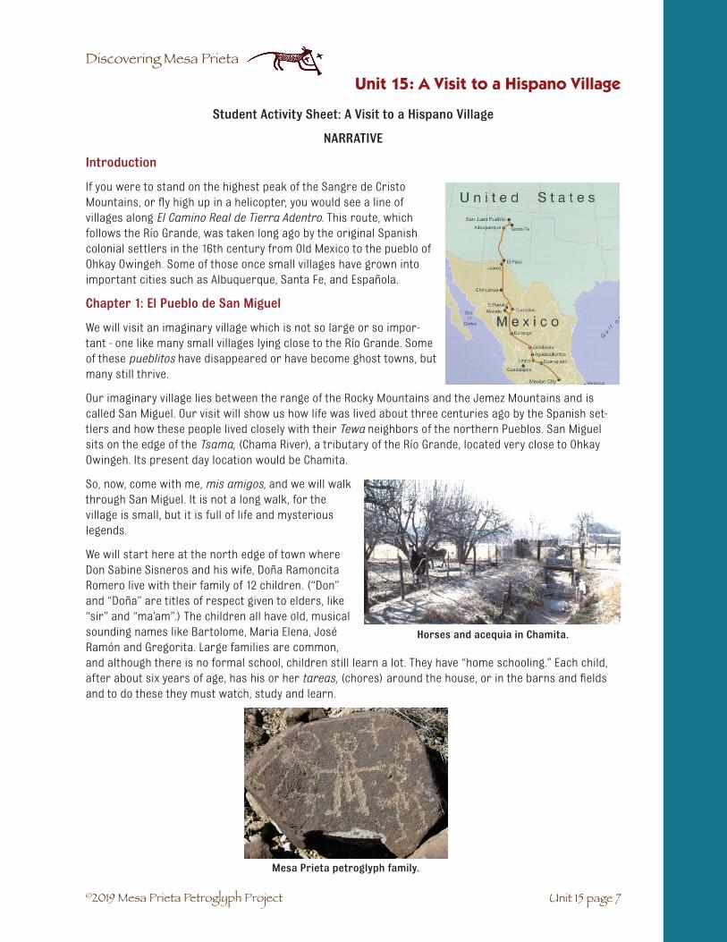
©2019 Mesa Prieta Petroglyph Project
Discovering Mesa Prieta
Unit 15 page 7
Unit 15: A Visit to a Hispano Village
Student Activity Sheet: A Visit to a Hispano Village
NARRATIVE
Introduction
If you were to stand on the highest peak of the Sangre de Cristo Mountains, or fly high up in a helicopter, you would see a line of villages along El Camino Real de Tierra Adentro. This route, which follows the Río Grande, was taken long ago by the original Spanish colonial settlers in the 16th century from Old Mexico to the pueblo of Ohkay Owingeh. Some of those once small villages have grown into important cities such as Albuquerque, Santa Fe, and Española.
Chapter 1: El Pueblo de San Miguel
We will visit an imaginary village which is not so large or so impor-tant - one like many small villages lying close to the Río Grande. Some of these pueblitos have disappeared or have become ghost towns, but many still thrive.
Our imaginary village lies between the range of the Rocky Mountains and the Jemez Mountains and is called San Miguel. Our visit will show us how life was lived about three centuries ago by the Spanish set-tlers and how these people lived closely with their Tewa neighbors of the northern Pueblos. San Miguel sits on the edge of the Tsama, (Chama River), a tributary of the Río Grande, located very close to Ohkay Owingeh. Its present day location would be Chamita.
So, now, come with me, mis amigos, and we will walk through San Miguel. It is not a long walk, for the village is small, but it is full of life and mysterious legends.
We will start here at the north edge of town where Don Sabine Sisneros and his wife, Doña Ramoncita Romero live with their family of 12 children. (“Don” and “Doña” are titles of respect given to elders, like “sir” and “ma’am”.) The children all have old, musical sounding names like Bartolome, Maria Elena, José Ramón and Gregorita. Large families are common, and although there is no formal school, children still learn a lot. They have “home schooling.” Each child, after about six years of age, has his or her tareas, (chores) around the house, or in the barns and fields and to do these they must watch, study and learn.
Horses and acequia in Chamita.
Mesa Prieta petroglyph family.
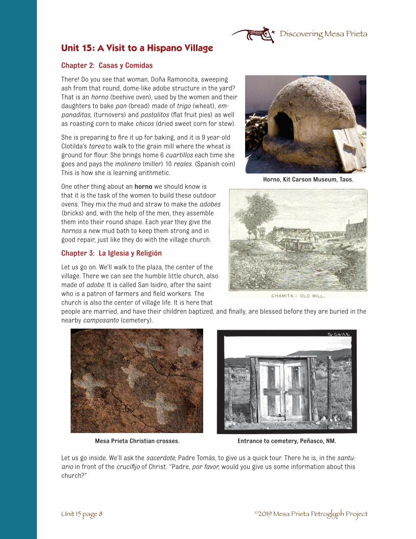
©2019 Mesa Prieta Petroglyph Project
Discovering Mesa Prieta
Unit 15 page 8
Unit 15: A Visit to a Hispano Village
Chapter 2: Casas y Comidas
There! Do you see that woman, Doña Ramoncita, sweeping ash from that round, dome-like adobe structure in the yard? That is an horno (beehive oven), used by the women and their daughters to bake pan (bread) made of trigo (wheat), em-panaditas, (turnovers) and pastalitos (flat fruit pies) as well as roasting corn to make chicos (dried sweet corn for stew).
She is preparing to fire it up for baking, and it is 9 year-old Clotilda’s tarea to walk to the grain mill where the wheat is ground for flour. She brings home 6 cuartillos each time she goes and pays the molinero (miller) 10 reales. (Spanish coin) This is how she is learning arithmetic.
One other thing about an horno we should know is that it is the task of the women to build these outdoor ovens. They mix the mud and straw to make the adobes (bricks) and, with the help of the men, they assemble them into their round shape. Each year they give the hornos a new mud bath to keep them strong and in good repair, just like they do with the village church.
Chapter 3: La Iglesia y Religión
Let us go on. We’ll walk to the plaza, the center of the village. There we can see the humble little church, also made of adobe. It is called San Isidro, after the saint who is a patron of farmers and field workers. The church is also the center of village life. It is here that people are married, and have their children baptized, and finally, are blessed before they are buried in the nearby camposanto (cemetery).
Let us go inside. We’ll ask the sacerdote, Padre Tomás, to give us a quick tour. There he is, in the santu-ario in front of the crucifijo of Christ. “Padre, por favor, would you give us some information about this church?”
Horno, Kit Carson Museum, Taos.
Mesa Prieta Christian crosses. Entrance to cemetery, Peñasco, NM.

©2019 Mesa Prieta Petroglyph Project
Discovering Mesa Prieta
Unit 15 page 9
Unit 15: A Visit to a Hispano Village
Padre Tomás begins: “The village people started making adobes for this iglesia (church) in 1772 and it was finished in 1774. There are two crossed hands visible above the carved double doors at the entrance, symbolizing the blessing of Saint Francis. Every spring since then, the women of the village or-ganize a celebration of mud. They mix the same kind of mud used for the adobe bricks. Then they lather the entire outside walls with a new coat of mud, using only their strong hands. This keeps the church viva, alive and breathing.”
One of our parishioners, Don Ramón José Man-zanares, is a very devout and talented man. He is in his workshop at this very moment painting a retablo for the sanctuary. Another artist, Francisco Buenaven-tura, who is a santero, is carving an image of Nuestra Señora del Rosario. It will be placed in a nicho alongside the retablo. We are fortunate to have such good artists to help us fill the church with santos, since we are too poor to purchase any.
Mesa Prieta petroglyph, possibly a priest. Mesa Prieta petroglyph, possibly a crucifix.
Making adobes in Chamisal, NM.
Small Spanish Colonial retablo, Harwood Museum, Taos, NM.
Santo bulto and painting of the Dolorosa, Trampas, NM.

©2019 Mesa Prieta Petroglyph Project
Discovering Mesa Prieta
Unit 15 page 10
A Legend of San Isidro
“Now, ”Padre Tomas continues, “let me tell you about a legend connected to this iglesia. Many of our elders tell a story of themiraculous origin of our church. The storygoes like this: Don Emmanuel Velarde, one of the oldest citizens of the newly founded San Miguel village, had become so sick that he could barely walk on his own. One day, as he was struggling to cross an acequia, he saw an image of San Isidro shimmering and motioning him to cross. The man, who was exhausted, crossed the acequia, but fell into the mud and suddenly his legs were cured. He declared that a church must be built on that spot and that is where you stand today.”
¡Muchas gracias, Padre, por su bondad! Now, we must continue our walk.
Chapter 4: El Tejedor – Weaving and Wool
Now, on to the home of Don Alfonso Ortega. It is that long, sprawling adobe house at the corner. Over many genera-tions, the house has had many rooms added to make room for a growing family. Don Alfonso is a tejedor - a weaver of mantas (blankets), alfombras (rugs), and ponchos (coats). He and his wife, Rosario Benavidez, raise the churro sheep (brought from Spain because they have the best wool for weaving). They also card and spin the wool, and weave the fabric for their clothing. Many of the other villagers also weave. They have to, because there are no stores. Clothing sold by the traders is rare and expensive.
The ovejas (sheep), which you can see in those pens across from that line of alamos (cottonwood trees), are raised not only for wool to weave yarn, but also for wool hides to use as floor rugs, and for food (mutton). Lambs are also used for meat, especial-ly around La Pascua (Easter). A lamb is roasted for a special meal, called the Paschal meal.
Sometimes, sheep are traded with the Navajo Indians who also weave, or with other Nuevo Méxicanos who live in distant villages and who perhaps raise vacas instead of ovejas.
Let us go inside and watch the Ortegas weave. They have two telares (looms) which were built by Don Alfonso. They are made of sturdy pinon or cedar wood that is hard enough to take a lot of wear and tear.Notice how Don Alfonso stands at his telar. He moves the pedales (treadles) with his feet and with his hands he moves the lanzadera (shuttle) back and forth across the stretched yarn.
San Isidro bulto.
Weaver at Costilla, NM, 1939.
Sheep in Taos County, NM.
Feet of Hispana woman on loom treadles, Costilla, NM.
Unit 15: A Visit to a Hispano Village

Discovering Mesa Prieta
Unit 15 page 11
The yarn is gray, brown, or black – the color of the sheep the wool was sheared from. Later on, this His-pano weaver will dye the wool with cochineal or native plants. Cochineal is an insect that gives a red dye when crushed. In this village of San Miguel, as in most other Nuevo Méxicano villages, the women clean the wool, card it, and spin it. The men do the weaving. Notice that Doña Rosario is busy spinning the mounds of cleaned wool lying at her side.
Chapter 5: La Agricultura
Farming and weaving are among the oldest human occu-pations. People needed food and clothing for survival. With this in mind, let us go out to the fields to watch the grow-ers of food. We’ll wave “adios” to Don Alfonso and Doña Rosario and make our way beyond the plaza to the campos (fields) belonging to Don Eulógio Gutierrez.
As you can see, Don Eulógio is busy plowing sembrado de trigo (wheat planting) with his best mula (mule). It is that time of year, la primavera (spring), when he must prepare the soil for planting trigo (wheat), maíz (corn) or other granos (grains). After the harvest they will be ground into flour or fed to his caballos (horses) and the few vacas (cows) and marranos, (pigs) he keeps. Much of the harvest will be stored for the winter.
When the time comes to slaughter a cow or a pig, the villagers gather for a matanza. After the animal is killed, the men cut up the meat for use in making carne para asar, carnitas or chorizo. These villagers do what butchers in our super markets do today to prepare the meat for sale.
©2019 Mesa Prieta Petroglyph Project
Hispana spinning wool by firelight.
Ploughing with horses in El Cerrito, NM.
Matanza, Los Padillas, NM.
Unit 15: A Visit to a Hispano Village

©2019 Mesa Prieta Petroglyph Project
Discovering Mesa Prieta
Unit 15 page 12
Afterwards, the women clean the hides and, when a pig is butchered, it is cut into small squares and fried in pork fat to make chicharrones (chitlings).The intestines are washed very carefully and are used for the casings for blood sausage or chorizo (spicy Mexican sausage). Very little is wasted. Every family takes a turn in hosting a matanza and each family shares the harvest of meat with its neighbors.
Sometimes the men ride horses into the mountains to hunt deer, or elk and that meat is stored or strung along a wire in the sun to make carne seca (dried meat).
Now, my young amigos, look in the direction of the Río. See that group of men gathered along the acequia? There is Don Sabine and his two
oldest sons, Bartolomé and José Ramón, and ten other men. The man wearing the dark blue picheras (overalls) is the mayordomo (ditch boss). He is Don Gregorio and his job as mayordomo is to organize the village men to clean the acequias each spring. This community work will make it possible for the water to flow freely from the river, to the ditches and into the fields.
Mesa Prieta petroglyph of man with firearm.
Meat drying for carne seca.
Northern New Mexico farmer cleaning a ditch.
All the village men, 70 years old and younger, including teenagers, and even boys as young as Don Sabine’s 12 year-old son, Gumersindo, are encouraged to help with this important work. Most men volunteer be-cause every family benefits from the work of each individual. After all, it is the water from the Río running cleanly through the furrows in the fields that helps to grow the food everyone needs.
Chapter 6: La Curandera – The Local Healer
It is now time to make another house call. This time we will visit with Señorita Gregorita Rodriguez. We call her señorita, a title of respect because, even though she is rather old, she never married. Señorita Rodri-guez lives just beyond the plaza, close to the camposanto and to the fields where many herbs grow. You might notice that a covered noria (well) sits in her front yard, facing the door. This well produces good, clean water, which she needs for her work, and which she draws by many buckets full to wash herself, the dishes, the laundry, to water the plants, and to prepare teas.
Unit 15: A Visit to a Hispano Village

©2019 Mesa Prieta Petroglyph Project
Discovering Mesa Prieta
Unit 15 page 13
Even though she is 73 years old, she must work to support herself. And her job is very special. It requires skill and long years of study, and everyone in the village has at one time or another needed her help. She is like a kind old aunt, a doctor, and wise teacher all rolled into one. Señorita Rodriguez is a curandera (healer).
Let us go knock on her door and ask her respectfully to tell us about what a curandera does. Senorita Rodriguez, smiling, begins: “I will tell you what I do as a curandera and perhaps that will answer all your questions. I learned when I was very young from my great-aunt, Valen-tina, how to identify remedios, (medicinal herbs), how to collect and store them, and how to prepare them as healing teas and poultices.
“Back then, and still today, there is a large wild field behind my house, near the camposanto where yerba buena, chimaja, and other herbs grow in abun-dance. Still other herbs, such as oshá, require me to go to the mountains to collect them. As I pick my remedios I am always grateful to our Tewa vecinos who taught us all about these plants. After gather the remedios I dry them by hanging them in bunches from a viga in my cuarto de dormir (bedroom). When a remedio is needed, I boil it in water, or make a thick paste, to cure a bad headache, a sore throat or a stomach ache.
“One other important part of my job as San Miguel’s only curandera is to act as the partera (midwife). I help women deliver their babies.”
Now, my young friends, do thank Señorita Rodriguez, accept her blessing and we will be on our way.
Chapter 7: Niñez – Childhood in the Village
During our little visit to San Miguel, we have learned a lot about how hard the people work, old and young and in between. Perhaps you are wondering, don’t the kids ever get to play and have fun? ¡Seguro que si! Of course they do. Look around and you will see children jumping rope, swimming in the ditches, riding horses in the fields, playing with dolls their Moms made for them at home, playing stick ball with actual sticks and rocks. Listen, over there…..do you hear their voices singing, “Los pollitos dicen pío, pío, pío, cuando tienen hambre, cuando tienen frío.” As we say in English, “All work and no play makes Jack a dull boy!”
Modern curandera in Albuquerque, NM. ©The University of New Mexico,
Albuquerque, NM.
Chimaja flower.
Unit 15: A Visit to a Hispano Village

©2019 Mesa Prieta Petroglyph Project
Discovering Mesa Prieta
Unit 15 page 14
Chapter 8: Celebraciones
I have a surprise for you. Because our journey is magical, we will travel a few months back in time to the Christmas season and see how our villagers celebrate a feast day.
Celebrations and holidays are important in a village. The preparations help the villagers come together for fun and give them a chance to socialize and relax after the hard work of daily living, and providing for the winter.
We’ll choose El día de los Manueles which falls on the first day of the New Year, el primer día del Año Nuevo. On this day all the men whose names are “Manuel” or “Emanuel” will gather with other men who play the violin, the guitar or who can sing. Early in the morn-ing they strum and sing various tunes as they walk through the village, stopping at each house. They stand in the yard until someone inside the house comes to the door. Then one man, chosen for his imagi-nation and sense of fun, will create un verso, a poem, about that person at the door, or his orher family. The versos are always comical and pleasing. So, then, the family invites the group into the house and they all drink a toast to each other and share in some food such as empanaditas, or bizcochitos with chocolate (hot chocolate) or café (coffee).
There are many other holidays, celebrations and feast days scattered through the year. We also enjoy visiting our Tewa vecinos across the Río at San Juan Pueblo. We join in their feast days by watching the sa-cred dances and sharing a good meal. I always bring a melón or some manzanas to share.
Now, mis amigos, we have seen much of the life in an 18th century Hispano village. Many traditions which our ancestors observed three or four hundred years ago still go on today. If you know an elder, an “anciano”, an abuelito or abuelita (grandfather/mother), you might ask them about their lives, their work and their memories of the past. This is another way to learn your history, and the history of the early Hispano settlers in this Valle de Española.
Unit 15: A Visit to a Hispano Village
Musicians of San José, NM, in 1898.
Jemez Pueblo feast day dance, 1908.
Mesa Prieta deer dancer.

Discovering Mesa Prieta
Unit 15 page 15
Unidad 15: Una Visita a un Pueblo Hispano
Hoja de actividades para el estudiante:
RELACIÓN
Introdución
Sí pudieran ustedes pararse en el punto más alto de la Sierra de la Sangre de Cristo, o si pudieran volar por el cielo en un helicoptero, verían una linea de pequeños pueblos a lo largo de todo El Camino Real de Tierra Adentro. Este camino sigue la ruta del Río Grande y fue transitado por los originales colonos españoles del siglo dieciséis. Por éste mismo camino atravesaban la distancia que hay entre el viejo México y el Pueblo de Ohkay Owingeh en Nuevo México. Desde entonces, algunas de estas pequeñas aldeas han ido creciendo hasta convertirese en ciudades importantes como lo son Albuquerque, Santa Fe y Española.
Capítulo 1: El Pueblo de San Miguel
Visitaremos uno de estos pequeños pueblos imaginarios que ni es muy grande ni muy mentado, sino que solo representa una de las muchas comunidades hispanas que fueron fundadas a un lado del Río Grande. Mientras que algunas de estas aldeas han quedado casi despobladas, otras tantas han sobrevivido hasta el dia de hoy.
Nuestra comunidad imaginaria queda entre la cordillera de las Rocasas y las montañas de Jemez. Se llama San Miguel. Nuestra visita nos mostrará lo que fue la vida de los pobladores españoles en ´sta parte del munco hace tres siglos. También nos revelara como ellos lograron vivir en estrecha relación con sus vecinos Tewa de los pueblos indigénas del norte de Nuevo Mexico.
San Miguel queda a una orilla del Río Tsama (Chama), uno de los tributarios del Río Grande. También queda cerca de Ohkay Owingeh en un lugar no muy lejos de lo que hoy día es la pequeña comunidad de Chamita.
Así que les invito, amiguitos míos, a que caminen conmigo por la aldea de San Miguel. No será una caminata larga puesto que el pueblo es pequeño aunque no por eso deja de tener mucha vida o faltarle leyendas misteriosas.
Empezaremos por la parte norte de ésta comunidad. Allí, Don Sabine Sisneros y su esposa, Doña Ramoncita Romero viven con sus doce hijos. Cada uno de sus hijos porta un nombre cantarino como es Bartolomé, María Elena, José Ramón y Gregorita. Las familias grandes son comunes por estos pueblos. Aunque no existe ninguna escuela, a los niños no les falta oportunidades para aprender. Al cumplir los seis años a cada uno de ellos se le da su tarea que debe de cumplir, ya sea en el hogar, en los campos o en los corrales donde viven los animales. Para poder llevar a cabo sus tareas como es debido, ellos deben observar, estudiar y aprendan con mucha atención.
©2019 Mesa Prieta Petroglyph Project
Caballos y acequia en Chamita.
Petrográfico de una familia, Mesa Prieta.

©2019 Mesa Prieta Petroglyph Project
Discovering Mesa Prieta
Unit 15 page 16
Unidad 15: Una Visita a un Pueblo Hispano
Capítulo 2: Casas y Comidas
Veán allí en el patio a Doña Ramoncita quien está barriendo la ceniza de una estructura redonda de adobe que parece un pequeño domo. Se trata de un horno que las señoras, junto con sus hijas, usan para hornear el pan de trigo, la empana-ditas y los pastelitos. También lo usan para asar maíz dulce y hacer chicos. Los chicos se secan y despues se les puede echar a los calditos. Doña Ramoncita se está alistando para encender una fogata. A su hija, Clotilde de solo nueve años, le toca ir al molino donde se muele el trigo en harina fina. Con cada viaje que ella hace, trae seis cuartillos de harina y le da al molinero diez reales. El real es una moneda antigua que usaban los españoles. Al hacer esto, ella va aprendiendo la aritmética.
Otra cosa que debemos saber de los hornos es que es la tarea de las mujeres construir estos hornos del aire libre. Mesclan el barro y la paja para hacer los adobes y, con la ayuda del los hombres, los construyen en for-ma redonda. Cada año dan los hornos una capa nueva de barro para mantenerlos fuerte y en buen estado, en la misma manera que hacen con las iglesias.
Capítulo 3: La Iglesia y Religión
Pues, seguimos adelante. Caminemos a la plaza que constituye el centro del pueblecillo. Allí se podrá apre-ciar la iglesia pequeña y humilde que fue construída de adobe en tiempos pasados. Se llama la iglesia de San Isidro en honor del santo patrón de los agricultores. La iglesia es el corazón de la comunidad. Es allí en la igesia donde las personas se casan, donde bautizan a sus hijos y finalmente, donde santifican a sus difuntos antes de sepultarlos en el camposanto.
Horno, Kit Carson Museum, Taos.
Cruces cristianas de Mesa Prieta. Entrada al camposanto, Peñasco, NM.

©2019 Mesa Prieta Petroglyph Project
Discovering Mesa Prieta
Unit 15 page 17
Unidad 15: Una Visita a un Pueblo Hispano
Pues, entremos. Le pediremos al sacerdote, o sea, al Padre Tomás, que por favor, nos haga un recor-rido de éste sitio. Por cierto, él se encuentra aquí en el santuario frente al Cristo crucificado tallado en madera.
Padre, ¿por favor, nos puede contar un poco sobre la historia de su iglesia?
El Padre Tomás contesta de ésta manera:
Sucede que la gente de ésta comunidad se puso a hacer adobes para la construcción de la iglesia en el año de 1772 y se completó en el año de 1774. Si se fijan, arribita de la puerta se encuentra un par de brazos cruzados. Esté simbolo representa la ben-dición de San Francisco de Assís. Desde que fue con-struída la iglesia, cada año durante la primavera, las mujeres de la comunidad organizan una celebración en la que se usa el lodo a cantidad. Mezclan un lodo similar al que se usó para hacer los adobes originales. Después, enbarran las paredes de afuera con una capa de lodo que le untan con sus manos fuertísimas. Esto asegura que la iglesia se mantenga fuerte y que a la vez respire.
Uno de nuestros párrocos, don Ramón José Manzanares, un hombre devoto y talentuoso está pintando ahora mismo un retablo en su taller. Lo instalará en el santuario. También, el santero, Don Francisco Buenaventura, está tal-lando una imagén de Nuestra Señora del Rosario. La imagén se pondrá en un
nicho que está al ladito del retablo. Esta-mos muy bendecidos al tener tantos buenos artistas en éste pueblo. Nos han ayudado a poblar nuestra iglesia con santos porque de otra manera no los podríamos comprar porque somos demasiado pobres.
Petrográfico de Mesa Prieta, quizá un sacerdote.
Petrográfico de Mesa Prieta, quizá un crucificio.
Fabricando adobes en Chamisal, NM.
Retablito español colonial, Harwood Museum, Taos, NM.
Bulto de santo y pintura de la Dolorosa, Trampas, NM.

©2019 Mesa Prieta Petroglyph Project
Discovering Mesa Prieta
Unit 15 page 18
Unidad 15: Una Visita a un Pueblo Hispano
Una Leyenda de San Isidro
Ahora, permítanme contarles una leyenda que tiene que ver con la fundación milagrosa de ésta iglesia según lo que platican los viejitos del pueblo. Se cuenta lo siguiente:
En los tiempos en que se fundó éste lugar había un viejito ya muy viejito que se lla-maba Emanuel Velarde. Tocó que estaba muy enfermo y que apenas podia caminar. Un día mientras iba cruzando la acequiecita que corría por acá, de repente vió una imagén luminosa de San Isidro. Le señalaba que pasara. Aunque ya casi no tenía fuerzas, el anciano lo obedeció pero cuando menos pensó, perdío su balance y se cayó en el lodo junto de la acequia. Allí mismo se curó. En agradecimiento por éste milagro, él pidió que se construiera una iglesía aquí mismo donde ustedes están pisando.
Muchas gracias, Padre, por su bondad. Ya es hora de caminar.
Capítulo 4: El Tejedor – Tejando y Lana
Ahora iremos a la casa de Don Alfonso Ortega. Su casa es aquella casa larga de la esquina. A través de muchas generaciones, se le ha añadiendo un cuarto tras otro para ir acomodando a su familia siempre en crecimiento. Don Alfonso es un tejedor. Teje mantas, alfombras y ponchos. El y su esposa, Doña Rosario Benavidez crian ovejas de una raza que se llama churro. Estas ovejas fueron traí-das desde España porque son las que producen la mejor lana. Está pareja carda e hila su propia lana y tambien la teje. De ésta manera, ellos producen la tela necearia para hacer la ropa que ellos requieren. Al igual que ellos, hay muchas otras personas en la comunidad que tejen tabmién. La gente debe de dedicarse al tejido porque no hay tiendas en donde comprarla o porque la ropa que venden los comerciantes es poca y muy cara.
Las ovejas que se ven allá en aquellos corrales junto a los alamos se es-tán criando para la lana que dan pero también por las zaleas que produ-cen. La gente usa las zaleas de alfombras que se tienden en los pisos de las casas. Estos animales también dan buena carne. En especial, son los corderos los que se aprovecha para la carne, sobre todo en tiempo de la pascua. Para esas fechas la carne de cordero se asa y se prepara en una comida especial que se llama <<la comida de la pascua>>.
A veces, las ovejas se comercian con los indios Navajo que también tejen, o con otros Nuevo Mejicanos que viven en pueblitos lejanos y tal vez crianvacas en vez de ovejas.
Bulto de San Isidro.
Tejadora de Costilla, NM, 1939.
Ovejas en el Distrito de Taos.

©2019 Mesa Prieta Petroglyph Project
Discovering Mesa Prieta
Unit 15 page 19
Entraremos para que vean a la familia Ortega tejer. La familia tiene dos telares que fueron construidos por Don Alfonso. Los hizo de madera de pino o quizás de cedro. Lo más seguro es que usó madera muy fuerte para que los telares pudieran aguantar muchos años de uso. Fíjense en como Don Alfonso se para sobre unas maderas bajitas del telar. Mueve los dos pedales con sus pies mientras que con sus manos avienta la lanzadera de un lado a otro a lo largo de una serie de hilos que atrapa la lana.
La lana que se usa ya bien puede ser gris, café o negra como las mismas ovejas que la produjeron. A veces, los tejedores hispanos tiñen la lana blanca usando cochinea o también plantas nativas. La cochinea viene siendo un insecto que cuando se muele produce un color rojo. En San Miguel como en la mayoría de los pueblecillos de Nuevo Mexico, las mujeres lavan, cardan e hilan la lana mientras que los hombres la tejen. Fíjense bien como Doña Roasrio se ocupa en hilar los montones de lana que hay a su lado.
Capítulo 5: La Agricultura
Tanto el tejido como la agricultura representan los oficios más antiguos del ser humano. La superviviencia de la gente dependía en que tuviera comida para comer y ropa para poderse abrigar. Tomando ésto en cuenta, les invito q que sálgamos al campo para ver a los aricultores que se ocupan en levantar nuestro sustento de la tierra.
Nos despedimos de Don Alfonso y de Doña Rosario con un saludo y caminamos más allá de la plaza
para podernos acercar a las tierras de Don Eulogio Gutier-rez. Vemos que está ocupado arando para poder sem-brar trigo con su buena mula. Al entrar la primavera, se siembra el trigo, el maíz y otros granos porque es la época para sembrar. Habiéndose cosechado éstos granos, se muelen en el molino para de ellos hacer harina. De otra manera los grano también sirven de comida para los cuantos caballos, vacas y marranos que posée la gente.
Unidad 15: Una Visita a un Pueblo Hispano
Pies de tejedora hispana sobre los pedales de tela, Costilla, NM.
Hispana hilando la lana por luz de lumbre.
Arrando con caballos en El Cerrito, NM.

©2019 Mesa Prieta Petroglyph Project
Discovering Mesa Prieta
Unit 15 page 20
Unidad 15: Una Visita a un Pueblo Hispano
Cuando se llega el tiempo de beneficiar una vaca o mar-rano, la gente de la comunidad se junta para la matanza. Después de que se mata el animal, los hombres se encar-gan de coratar la carne en trozos para que de ellos se hagan carnitas, chorizo o un asado. Durante la matanza, los hombres llevan a cabo las mismas tareas que hoy en día hacen los carniceros del supermercado al procesar la carne para la venta. Las mujeres se encargan de limpiar el cuero de los animales y en el caso de los marranos, lo trozan en pequeños pedacitos que se frién en manteca de marrano. De ésta manera hacen chicharrones. Los intestinos los lavan con mucho cuidado y los emplean de manera de tubitos que rellenan de carne y que terminan chorrizo. No se pierde nada del cuerpo del animal. A cada familia le toca organizar una matanza. La familia siempre convida a sus vecinos y reparte la carne entre ellos.
A veces los hombres del pueblo montan a caballo y suben a la sierra en pues de venado o alce. La carne del animal que cazan la cuelgan sobre unos alambres. De esa manera se hacen las ceci-nas de carne seca que se pueden guardar por mucho tiempo.
Ahora bien, amiguitos, les pido que dirigan su mirada al río. ¿Alcanzan a ver a ese grupo de señores parados allí al lado de la acequia? Allí está Don Sabine y sus dos hijos mayores, Bartolomé y José Ramón junto con otros diez hombres más. El señor vestido de pecheras es el mayordomo. Se llama Don Gregorio y él es el encar-gado de organizar a los hombres de la comunidad para que limpien las acequias todas las primaveras. Este trabajo comunitario asegura que las aguas corran libres por las acequias desde el río hasta los campos.
A los hombres que cuentan con doce años, para arriba como es el caso de Gumersindo, el hijo de Sabine, hasta los setenta años, se les pide que participen en este trabajo importante. La mayoría de los hombres consienten en hacer éste trabajo ya que todas las familias se benefician de los esfuerzos de cada quien. También es bien sabido por todos que las aguas que corren del río a los campos son las que provocan el crecimiento de las plantas y el rendimiento de los productos alimenticios que es la comida requerida por todo ser humano.
Matanza, Los Padillas, NM.
Petrográfico de hombre con fusil, Mesa Prieta.
Carne desecando.
Campesino norteño limpiando una acequia.

©2019 Mesa Prieta Petroglyph Project
Discovering Mesa Prieta
Unit 15 page 21
Capítulo 6: La Curandera
Hay que seguir adelante con nuestras visitas. Ahora, visitaremos a la Señorita Gregorita Rodríguez. Le llamamos señorita por respeto porque aunque ya tiene muchos años, nunca se ha casado. La Señori-ta Rodríguez vive un poco más allá de la plaza y bastante cerca del camposanto. También vive junto a las tierras donde crecen muchas hierbas beneficiosas. Tal vez ustedes ya se hayan dado cuenta que ella ocupa el lugar respetuoso de una muy amable tía mayor además de la de una doctora y maestra sabia. Esto es porque la Señorita Rodríguez es curandera. Andenle, vamos a tocarle la puerte y pedirle que nos hable sobre el trabajo de las curanderas. Con una gran son-risa, la Señorita Rodríguez nos cuenta lo siguiente:
Pues, les diré lo que yo hago y de esa manera espero poder conte-starles su pregunta. Cuando era joven aprendí de mi tía Valentina a juntar remedios. También aprendí a secarlos y guardarlos además de hacer de ellos te y emplastos. Desde entonces hasta el día de hoy se hallan muchas hierbas como es la yerba buena y la chimajá en los terrenos que quedan detrasito del camposanto. Otros remedios como la oshá, se hallan en los montes y uno tiene ir hasta allá para conseguirlos. Siempre que recojo remedios me recuerdo con mucho agradecimiento de nuestros vecinos, los Indígenas Tewa. Son ellos quienes nos han enseñado de estas plantas. Después de que haya recogido remedios los pongo a secar. Cuelgo los manojos de hierba de una viga que hay en el cuarto de dormir. Cuando se necesita un remedio, lo hiervo en agua o hago de las planta una pasta espesa.
Con esto se pueden curan los dolores de cabeza, de garganta o de estómago. Como soy la única curandera en todo el pueblo también me toca hacer el trabajo de partera. Yo les ayudo a las mujeres dar a luz.
Amiguitos, por favor denle las muchas gracias a la Señorita Rodríguez antes de irnos
Unidad 15: Una Visita a un Pueblo Hispano
Curandera de hoy en dia en Albuquerque. © The University of
NewMexico, Albuquerque, NM.
Chimaja flower.
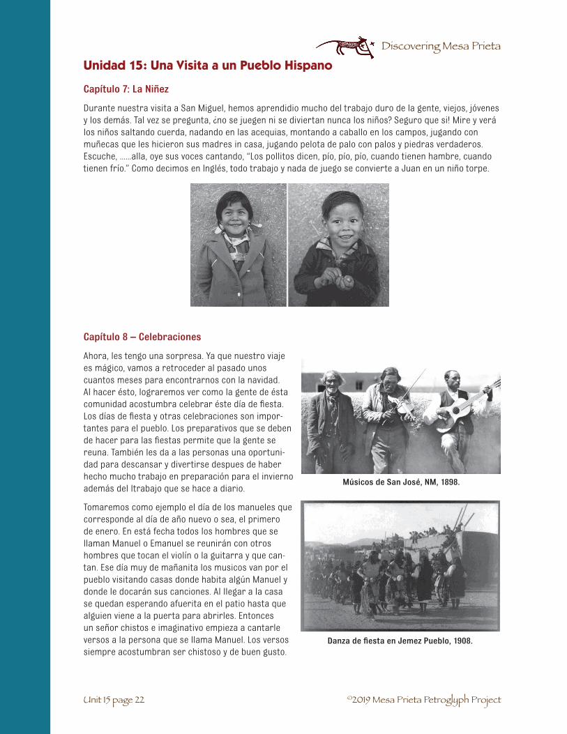
©2019 Mesa Prieta Petroglyph Project
Discovering Mesa Prieta
Unit 15 page 22
Unidad 15: Una Visita a un Pueblo Hispano
Capítulo 7: La Niñez
Durante nuestra visita a San Miguel, hemos aprendidio mucho del trabajo duro de la gente, viejos, jóvenes y los demás. Tal vez se pregunta, ¿no se juegen ni se diviertan nunca los niños? Seguro que si! Mire y verá los niños saltando cuerda, nadando en las acequias, montando a caballo en los campos, jugando con muñecas que les hicieron sus madres in casa, jugando pelota de palo con palos y piedras verdaderos. Escuche, ......alla, oye sus voces cantando, “Los pollitos dicen, pío, pío, pío, cuando tienen hambre, cuando tienen frío.” Como decimos en Inglés, todo trabajo y nada de juego se convierte a Juan en un niño torpe.
Capítulo 8 – Celebraciones
Ahora, les tengo una sorpresa. Ya que nuestro viaje es mágico, vamos a retroceder al pasado unos cuantos meses para encontrarnos con la navidad. Al hacer ésto, lograremos ver como la gente de ésta comunidad acostumbra celebrar éste día de fiesta. Los días de fiesta y otras celebraciones son impor-tantes para el pueblo. Los preparativos que se deben de hacer para las fiestas permite que la gente se reuna. También les da a las personas una oportuni-dad para descansar y divertirse despues de haber hecho mucho trabajo en preparación para el invierno además del ltrabajo que se hace a diario.
Tomaremos como ejemplo el día de los manueles que corresponde al día de año nuevo o sea, el primero de enero. En está fecha todos los hombres que se llaman Manuel o Emanuel se reunirán con otros hombres que tocan el violín o la guitarra y que can-tan. Ese día muy de mañanita los musicos van por el pueblo visitando casas donde habita algún Manuel y donde le docarán sus canciones. Al llegar a la casa se quedan esperando afuerita en el patio hasta que alguien viene a la puerta para abrirles. Entonces un señor chistos e imaginativo empieza a cantarle versos a la persona que se llama Manuel. Los versos siempre acostumbran ser chistoso y de buen gusto.
Músicos de San José, NM, 1898.
Danza de fiesta en Jemez Pueblo, 1908.

©2019 Mesa Prieta Petroglyph Project
Discovering Mesa Prieta
Unit 15 page 23
Terminandose la canción, se les invita a las personas a que entren. Todos hacen un brindís a la persona que se llama Manuel y prueben la comida que se les ofrece, ya sean bizcochitos o empanadas con café o chocolate.
Hay muchos otros días de fiesta durante el año. Para eso, nos complace visitar con nuestros amigos Tewa que viven en el pueblo de San Juan al otro lado del río. Participamos en sus fiestas con nuestra presencia en sus bailes sagra-dos y cuando nos sentamos a comer en su mesa. Siempre hay que llevarles algún regalito, ya sean manzanas o un melón.
Amiguitos, me doy cuenta que ya han visto bastante de lo que fue la vida en un pueblo hispano en el siglo diesíocho. Entre las tradiciones que practicaban nuestros antepasa-dos hace tres o cuatrocientos años muchas se siguen practicando hasta el día de hoy.
Si acaso ustedes conocen a un ancianito, ya sea un abuelito o una abuelita, quizás querán preguntarle sobre su viday las memorias que guardan del pasado. Esto sería otramanera de aprender su propia historia y la historia de lospobladores españoles de nuestro valle de Española.
Unidad 15: Una Visita a un Pueblo Hispano
Petrográfico danzante de venado, Mesa Prieta

©2019 Mesa Prieta Petroglyph Project
Discovering Mesa Prieta
Unit 15 page 24
Activities
1. Briefly review the arrival of the Spanish settlers who came with Oñate – elicit informationfrom students.
2. Read introductory paragraph of narration. Brainstorm – propose questions such as “Why doyou think the early colonists chose those particular places to establish their villages?” “Doyou live in a small village or have you visited one?” “Names of villages?” “Why do people live invillages?”
What would you see in a small village today (such as Dixon or Chimayó or Abiquiú)? Create a web with students – accept everything they suggest, stores, automobiles, bars, churches, houses, gardens, then ask which of these would not have been around 300 years ago.
3. Read Chapter 1 - “El Pueblo de San Miguel”. Discuss location of this imaginary villae. Locate allplaces mentioned on a map.
4. Share with the students any ongoing project, such as adobe making or weaving, you maychoose to use for this unit.
* Teacher may choose to do a reading of the entire narrative to give the students an overall sense ofthe unit.
MATERIALS:
Copy for students: Unit 15. A Visit to a Hispano Village – Narrative student activity sheet (15-7)
For the teacher: Teacher may need a large sheet of paper and marker for recording ideas.
Unit 15: A Visit to a Hispano Village
CHAPTER 1: EL PUEBLO DE SAN MIGUEL

©2019 Mesa Prieta Petroglyph Project
Discovering Mesa Prieta
Unit 15 page 25
PART 1: ADOBE
BACKGROUND INFORMATION:
Adobe is the Spanish word for mud brick and it provides the basic building material for some of the oldest structures in the world. It is still in common use throughout the world in villages, towns, and even cities.
The Pueblo Indian people built their adobe structures with handfuls or basketfuls of adobe mud, a technique called wattle and dob. They used wooden forms which they filled with the adobe mud to form their walls. The Spanish introduced them to the use of adobe bricks. Adobe bricks are composed of clay soil, mixed with water and an organic material such as straw or dung. The purpose of the organic material is to bind the mud and allow it to dry evenly without cracking.
The advantages of adobe use are many. It is an inexpen-sive, readily available material, easy to work with, and is especially useful in climates such as ours, with hot days and cool nights. Thick adobe walls allow houses to retain the coolness from the night temperatures in summer and the warmth from sunny days in winter. When the structure is no longer in use, eventually the adobe will “melt” back into the earth.
A traditional adobe house is built with large, round beams called vigas which support the roof. Peeled sticks, known as latillas, are then laid across the vigas. A layer of straw and then a thick layer of loose dirt were laid on top of the latillas. Since tin became readily available most homes have been built with pitched roofs.
MATERIALS:
Copy for students: Unit 15. A Visit to a Hispano Village – Narrative student activity sheet (15-7)
From the teacher: Adobe mix (a pile outdoors or boxes of pre-mixed dry dirt) (Teachers may acquirepre-mixed material from adobe factories if they are available in the area. If mixing your own: 65% clay, 30% sand, straw for binding.), cookie sheets or thin plywood pieces on which to dry adobes, sticks for vigas and latillas.
From the MPPP office: Adobe brick forms, buckets for mixing small quantities of adobe mud.
Unit 15: A Visit to a Hispano Village
CHAPTER 2: CASAS Y COMIDAS
Vigas support latillas on structure near Dulce, NM. (HABS NM)

©2019 Mesa Prieta Petroglyph Project
Discovering Mesa Prieta
Unit 15 page 26
Unit 15: A Visit to a Hispano Village
Activity 1: Adobe
1. Read or review Chapter 2. Casas yComidas.
2. Discuss the history of adobe, elicitinginformation from students and refer-ring to the “Background Information” asneeded. (Show relevant photos from thetrunk). Suggested questions – What areadobes made of? Why do people use thisbuilding material here in New Mexico andin certain other parts of the world? Couldthey be used in a rainforest? Did Indiansuse adobe before the Spanish came?, etc.
3. Students will mix small amounts of adobe dirt with water.
4. Cut straw into small pieces and add to mix.
5. Press mix into forms and allow to dry insun. When adobe bricks are firm and dry,students may begin construction of buildingsusing the wet mud for mortar. Demonstratehow to lay the bricks, staggering each row sothe joints do not line up.
6. Bricks will be two inches by four inches.Knowing this, you may choose to do a mathchallenge activity in which students deter-mine how many adobes they would need for acertain size building. Complete houses, usingsticks to create vigas and latillas.
ALTERNATIVE ACTIVITIES: Create village using cardboard, milk cartons, construction paper, small blocks, or other found materials. Add figures made of pipe cleaners or Plasticene®. Students may also work on individual or group dioramas.
Create a picture map of the village of San Miguel. This could be a cooperative class project. Children will draw and/or paint various structures and locations described in the story, cut them out and glue them on the large map.
*For all of the above projects, students can label structures in Spanish and English and write a briefparagraph on a 3X5 card explaining the history and relevance of the particular structure, person orlocation.

©2019 Mesa Prieta Petroglyph Project
Discovering Mesa Prieta
Unit 15 page 27
Unit 15: A Visit to a Hispano Village
PART 2: GRAINS AND LEGUMES
BACKGROUND INFORMATION:
The colonists on Oñate’s expedition and those who followed brought with them many different types of seeds and fruit trees. The apricot was brought to New Mexico by these settlers, possibly as early as 1743. The new plants had a big impact on the Pueblo people and also on us today. Grains like wheat and barley and legumes like garbanzo (chick peas) were especially important. Just think, there were no wheat tortillas in New Mexico before the arrival of the Span-ish!
The colonists brought metal tools and taught the Pueblo farmers how to plant in long rows. Their more complex acequia system allowed the large fields of crops to be watered regularly. A larger food supply allowed villages to grow into towns and cities.
Traditionally the Pueblo women ground corn and seeds on a metate with a mano and they taught the Spanish women this skill. The colonists brought the knowledge of how to build and run a grist mill and this allowed large quantities of grains such as wheat to be ground into flour. Money was a new concept to the Native Americans so in the early days they and the colonists traded or bartered for what they needed.
When you eat a grain like wheat or corn together with a legume like beans or garbanzo it becomes a com-plete protein. Eating a whole wheat tortilla with a garbanzo stew and a little meat was and still is a very healthy meal. The domestic animals that the colonists brought such as sheep, cows, pigs, and chickens also increased the protein in the Pueblo diet.
When grains and legumes are sprouted you will notice a difference in the leaves. Grains are all in the grass family and send up a single leaf (blade of grass) when they sprout. Legumes and many other plants usually have two seed leaves called cotyledons. They are usually thick and contain the food (starch) that the seedling needs before it can make its own food through photosynthesis.
MATERIALS:
For each student: 1 small white paper plate, 1 garbanzo and 1 wheat seed, pencil, Grains Venn Diagram student activity sheet (15-31), centimeter ruler.
For the class: 2 quart jars, 2 rubber bands, ¼ cup of wheat seeds, ¼ cup of garbanzo seeds, water.
From the Trunk: 2 squares of netting or window screen, photos of grains and grinding, ground wheat sample, panocha flour, photos of grains.
From the MPPP office: Private Eye or hand lens, wheat stalks.
Other: Grain grinder, frying pan or electric griddle, comal.
Un caldo de garbanzos.

©2019 Mesa Prieta Petroglyph Project
Discovering Mesa Prieta
Unit 15 page 28
VOCABULARY☛ Barley: the seed of a cereal grass most often used to feed cattle or for cereal or soup
☛ Barter: to trade for goods and services
☛ Comal: Spanish word for smooth flat griddle made of sandstone, iron or pottery
☛ Crop: cultivated plants such as grain, vegetable or fruit
☛ Garbanzo: the Spanish name for chickpea, an Asian plant in the legume family. It has a large,edible seed in a small pod.
☛ Germinate: to begin to sprout or grow
☛ Grain: the seed of a cereal grass
☛ Hummus: an Arabic dish made of mashed chickpeas, tahini, oil, lemon juice and garlic.Served as a dip with pita bread or chips.
☛ Legume: a plant of the pea family that has a pod that contains the seed(s)
☛ Metate and mano: grinding stone and grinder, used to grind grains and seeds
☛ Panocha: a northern New Mexican food made with sprouted wheat; traditionally eatenduring Holy Week
☛ Wheat: a type of cereal grass that originated in the Middle East. It is most commonly groundinto flour for bread and pasta.
Activity 1: How Seeds Differ
This is an observational activity. The students will be comparing and contrasting two different seeds that the Spanish colonists brought with them.
1. Review how to use the Private Eye jeweler’s loupes (2-5).
2. Pass out to each student the Grains Venn Diagram student activity sheet (15-31) comparingthe wheat and garbanzo seeds. Pass out to each student or pair of students a white paperplate, Private Eye or hand lens, ruler, a wheat seed and a garbanzo seed. Explain that theyshould first observe each seed with their magnifier. Carefully draw each seed in its respectivecircle. Measure each seed with a centimeter ruler and write the size under the drawing. Inthe space around each drawing, write descriptive words for each seed. If there is a word thatdescribes both seeds, write that in the middle where the circles overlap. Write a title abovethe diagram. The teacher may want to draw a sample on the board.
3. After the students are finished, they may plant the seeds outside or take them home. Collectthose that are not wanted.
4. If you are able to find wheat growing, bring in some for the students to observe. Have themnotice that the plant’s leaves are grass leaves. Wheat is a grass. The seeds grow at the topof the stalk. Pass out a seed head of wheat from the trunk to each pair of students. Wherewould the leaves have grown on a green stalk? (at the nodules) Do the seeds look like thosethat they observed earlier? If you were a farmer, how would you get the seeds from the stalk?(Show the students the photo from the trunk of the men threshing wheat).
Unit 15: A Visit to a Hispano Village

©2019 Mesa Prieta Petroglyph Project
Discovering Mesa Prieta
Unit 15 page 29
Unit 15: A Visit to a Hispano Village
Activity 2: Sprouting Seeds
1. Place ¼ cup of wheat seeds and ¼ cup ofgarbanzo seeds in two separate jars andsoak with water overnight. The next daycover each jar with a piece of windowscreen or mesh and secure with a rub-ber band. Pour off the water. From thenon rinse the wheat seeds twice a day. Analternative method is to use a zip lockbaggie and wet paper towel. Leave thezipper open for air circulation.The garbanzo seeds are difficult tosprout so we suggest instead that youpass out a soaked garbanzo seed toeach student along with a dry garbanzo and the Grains Venn Diagram (15-31) forgarbanzos. Have them compare the size, color, hardness, etc. They may eat the raw garbanzoif they wish.
2. If you are able to buy fresh garbanzos in their pods, have the students observe and draw apod and then remove the seed from the pod and draw it. Compare the green seed with thesoaked seed. Do they look and taste the same? See Enrichment Activity 2 (15-30) for roastingthe green seeds.
3. Observe and record as the wheat seeds germinate and grow. After the leaves develop (about3 -4 days), give a wheat sprout to each student to observe and compare with the dry seed.Encourage the students to taste them. See Enrichment Activity 1 (15-30).
Wheat grain sprouts.
Activity 3: Grain Grinding
Grinding wheat berries (seeds) into flour will help the students understand the most common way that wheat is eaten.
1. Show the students pictures from the trunk of people processing the wheat, a grist mill anda mill stone. Explain that the Spanish colonists brought the technology of a grist mill withthem to New Mexico. It uses water to turn a large wheel that turns the mill stones that grindthe grain. The miller was an important person in the village. Today wheat and other grainsare ground in factories but one can also grind grains in a grain grinder, a Magic Bullet (miniblender) or heavy duty blender. Show the ground wheat from the trunk.
2. Making tortillas in school, using part whole wheat and part white flour is a fairly easy cookingactivity. An electric griddle or fry pan works well or a hot plate and a comal.

©2019 Mesa Prieta Petroglyph Project
Discovering Mesa Prieta
Unit 15 page 30
Activity 4: Grains Research
Have each student research a different type of grain or legume and a recipe to go with it. Compile and make a class booklet for each student.
ENRICHMENT ACTIVITY 1: You may wish to buy a loaf of sprouted whole grain bread and let the students sample it: Panocha is a traditional dish served around Easter. It is made with sprouted wheat flour. Show the students the bag of panocha flour from the trunk. See Activity 2. Ask if a parent can make some for the students to taste.
ENRICHMENT ACTIVITY 2: Have the students shell green garbanzos, toss the seeds with olive oil and a little salt and either roast or fry. A toaster oven works well. You may also use them raw in a green salad.
ENRICHMENT ACTIVITY 3: Hummus is a delicious dip made with garbanzos. Ask if a parent can make some for or with the class.
Panocha
Unit 15: A Visit to a Hispano Village

©2019 Mesa Prieta Petroglyph Project
Discovering Mesa Prieta
Unit 15 page 31
Chapter 2, Part 2. Grains.
Grains Venn Diagram student activity sheet
Wheat Garbanzo
Unit 15: A Visit to a Hispano Village

©2019 Mesa Prieta Petroglyph Project
Discovering Mesa Prieta
Unit 15 page 32
MATERIALS:
From the teacher: Unit 15. A Visit to a Hispano Village student activity sheet (15-7), Unit 15. Christian Crosses of Mesa Prieta student information sheet (15-34)
From the Trunk: photos of Historic Period petroglyphs of Mesa Prieta, Big Spanish Heritage Activity Book by Walter Yoder, Interview with Santera Gloria Cordova, Interview with Efren Sánchez.
SETTING THE STAGE:
Display photos of Historic Period petroglyphs which indicate the presence of the Spanish on Mesa Prieta. Elicit ideas from the students with questions such as:
• When might these petroglyphs have been made?
• Who do you think made them?
• How do we know they were not made by the prehistoric Tewa Pueblo people?
• What do you think these people were doing on the mesa? (herding sheep is a likelyexplanation)
• Why would they have carved crosses on the rocks? (boredom, to express faith in God, prayfor safety from wild animals, etc. Accept all ideas offered)
Remind students that many of the indigenous petroglyphs had spiritual or religious significance for the people who made them.
Briefly review early colonial history and the place of religion in the exploration and settlement of Mexico and New Mexico. If useful, reread portions of Unit 13. La Entrada.
CHAPTER 3: IGLESIA Y RELIGIÓN
Activity 1: Religion in Context
Read Chapter 3, La Iglesia y Religión. Review Spanish vocabulary. Brainstorm Activity: How did the Padre and the church help the people in the villages? List on white board or paper. Ask the children to share about their own visits to churches (Catholic or other). Important questions to raise:
• Did all people in the Spanish villages practice the same religion?
• Do all people today practice the same religion?
• Do all people even follow a religion?
• Do all people go to a Christian church?
• What other religions do people practice?
Read Interview with Efren Sánchez.
Unit 15: A Visit to a Hispano Village

©2019 Mesa Prieta Petroglyph Project
Discovering Mesa Prieta
Unit 15 page 33
Activity 2: Choose One or Two of the Following Activities
1. Students will draw a picture of the inside of a church or synagogue or mosque which theyhave visited. They will write a short paragraph telling about their experience. If a child hasnever been inside a church, they may use a photograph for their illustration of what the fic-tional San Miguel church might have looked like and write a story based on the narrative.
2. Students may retell and illustrate the story of San Isidro that was included in the narrative.Read interview with santera Gloria Córdova.
3. Students may complete Hispano art activities from the Big Spanish Heritage Activity Book, pp.39, 40, 42.
4. Homework assignment - talk with family members about their own religion or spiritual beliefsand report back to their classmates.
Activity 3
Look at the photographs of Christian cross petroglyphs in the resource trunk and, using the Christian Crosses of Mesa Prieta student information sheet, see if you can name some of them. Choose yourfavorite and draw it.
Mesa Prieta Triumphant Cross.
Mesa Prieta Star of David.
Mesa Prieta Calvary Trio.
Unit 15: A Visit to a Hispano Village

©2019 Mesa Prieta Petroglyph Project
Discovering Mesa Prieta
Unit 15 page 34
Chapter 3: Iglesia y Religión
Christian Crosses of Mesa Prieta: student information sheet
When Juan de Oñate arrived at Ohkay Owingeh on the Camino Real de Tierra Adentro in 1598, he carried with him not only Conquistadors, cattle, sheep, horses, carts and seeds: he brought at least two new religions to our area.
More than 2000 Christian crosses have been found on Mesa Prieta. As well, there are images of churches, priests and crucifixes. The story of Crypto-Jews in New Mexico is beginning to be told: some colonists who came to New Spain were escaping from the Spanish Inquisition. Many of them hid their Jewish religion and became Catholics. Hundreds of years later, some New Mexicans are discovering their Jewish roots. The Mesa Prieta area has a few images of Stars of David and menoras that may have been made by Jew-ish New Mexicans.
Crosses are found, often high up on the mesa, near trails, lambing pens and grazing areas. They may have been a way of shepherds asking God for protection for themselves and their sheep and/or to celebrate re-ligious events such as feasts and holy days. We have found enough crosses now to understand that about 70% of Christian crosses are Latin crosses, shown below. Many of these have decorations on the top, bars and base.
The second most popular style is the Greek cross, the first Christian cross pattern, with bars of equal length. They are very similar to the Ancestral Tewa “cross or X” pattern.
Other cross styles found on the mesa include:
The Altar Cross
The Anchor Cross
Unit 15: A Visit to a Hispano Village
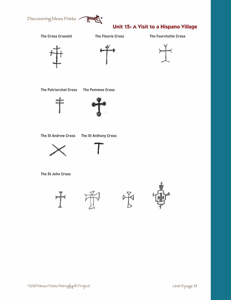
©2019 Mesa Prieta Petroglyph Project
Discovering Mesa Prieta
Unit 15 page 35
The Cross Crosslet The Fleurie Cross The Fourchette Cross
The Patriarchal Cross The Pommee Cross
The St Andrew Cross The St Anthony Cross
The St John Cross
Unit 15: A Visit to a Hispano Village

©2019 Mesa Prieta Petroglyph Project
Discovering Mesa Prieta
Unit 15 page 36
BACKGROUND INFORMATION:
Pueblo Indians of New Mexico have a long tradition of weaving which pre-dated the arrival of the Spanish by many centuries. Pueblo weavers were making and trading woven cloth from a variety of different plant materials, both domestic and wild. They sometimes incorporated human hair, dog hair, and wild animal hair into their fabrics. Plants included cotton, milkweed, hemp, yucca, and willow among others. Bird feathers were woven into warm blankets. Looms were in use here as early as 800 A.D.
Coronado and his entourage brought with them some 5000 churro sheep from Spain. New Spain turned out to be an ideal habitat for these sheep and they thrived here, becoming an important part of the Spanish colony’s economy.
Of course their wool was used by the settlers for blankets to protect against the extreme cold of mountain winters and in very early years as articles of clothing (the wearing blanket). A substantial industry developed in the 18th and 19th centuries, employing sheepherd-ers, spinners, and weavers. Although a variety of woven goods were produced, the single most popular item became known as the Río Grande Blanket. The Spanish also brought with them the European free-standing floor loom which was different from looms used by the Pueblo Indians.
MATERIALS:
From the teacher: Unit 15. A Visit to a Hispano Village student activity sheet (15-7)
From the Trunk: small rug sample, raw wool samples, yarn, samples of natural dyes, photos of rugs and weaving, Charlie Needs a Cloak by Tomie dePaola, Abuela’s Weave by Omar Castañeda, Interview with Weaver Cordelia Coronado.
From the MPPP office: simple looms, carder for combing wool, loupes.
Other: spindle, clothing items made of wool, such as scarves, gloves, hats, items made from other fab-rics, yucca roots, hot plate, large pot, strainer, small pieces of cloth, onion skins, tea leaves, marigolds, or other plants. Dye plants may also be purchased at the Española Fiber Arts Center.
INTRODUCTION:
• What do we know about weaving / wool?
1. Review or read for the first time A Visit to a Hispano Village Chapter 4: El Tejedor. Usephotos from trunk to illustrate. Read Abuela’s Weave or Charlie Needs a Cloak.
2. Hold up small items of clothing and ask children to identify what material items mightbe made of. Ask them about their own clothing and where that material might havecome from. Include cotton, wool, silk, as well as a synthetic material such as nylon.How does clothing made of silk get to us? Which materials would people in the 1700s inNew Mexico have?
CHAPTER 4: EL TEJEDOR
Unit 15: A Visit to a Hispano Village
Churro sheep.

©2019 Mesa Prieta Petroglyph Project
Discovering Mesa Prieta
Unit 15 page 37
Activity 1: The Step by Step Process from Sheep to Blanket
1. Give students an opportunity to closely observe wool sam-ples and yarns, noting different colors, differences betweenwashed and unwashed wool. Encourage students to feel thelanolin and smell the wool. Point out the churro wool fromsheep that were first brought here by the early Spanish set-tlers.
2. Use photos to illustrate. Guide the children to put in orderall the steps, as best they can. (shear the sheep, wash thewool, card wool, spin into yarn, dye yarn, weave on aloom). Students may illustrate the different steps in the pro-cess to create a class booklet or pictorial display. Studentswill then write captions for each illustration, briefly explain-ing what is going on in their picture.
Activity 2: Dyeing Cloth or Yarn
1. For this activity you will need a hot plate, large pot, strainer, natural dyes, a small piece ofcloth or yarn for each student. An alternative would be to dye a large amount of yarn anddistribute pieces to each student after the dyeing. Teachers will need to do some preparationthe night before by soaking the plant matter overnight.
2. Show a variety of pictures of rugs from the trunk and ask students where the dyes mighthave come from 300 years ago in a small village. (plants, insects) Do they know of any plantsor vegetables that might make natural dyes? Have children look closely, perhaps with PrivateEyes, at the plants which will be used to dye their cloths. These might include onion skins, tealeaves, marigolds, or other plants. Dye plants may also be purchased at the Española FiberArts Center.
3. Boil prepared plant material according to directions. After straining out the solid matter, re-heat the dye and add hot, wet fabric or yarn. Dye must be kept as hot as possible for at leastone hour before removing fabric or yarn.
Unit 15: A Visit to a Hispano Village

©2019 Mesa Prieta Petroglyph Project
Discovering Mesa Prieta
Unit 15 page 38
Activity 3: Weaving with a Small Loom
Read the Interview with Cordelia Coronado. Small looms are available through the Mesa Prieta Petroglyph Project. Loom weaving will require a basic weaving lesson. If the teacher does not have the particular skills required, it is often possible to find a volunteer from the community, perhaps even a parent. Stu-dents may work on individual looms or may create a group weaving by sewing together individual pieces. Parents may be willing to contribute yarn for this project.
New Mexico rugs.
Unit 15: A Visit to a Hispano Village

©2019 Mesa Prieta Petroglyph Project
Discovering Mesa Prieta
Unit 15 page 39
Unit 15: A Visit to a Hispano Village
INTRODUCTION:
The Egyptians may have been the first people to use irrigation, along the Nile River about 5000 BC. Soon after the people of the Middle East, China, India, Greece, Rome and Peru also developed ir-rigation canals, terraces and water catchment. The Moors of North Africa developed irrigation systems in the southern Iberian Peninsula over 700 years ago. They were called acequias, derived from an Arabic word meaning to irrigate. Common to all of these areas was a lack of rain to support crops.
In the Southwest, the prehistoric Pueblo people also used flood water farming, earthen canals and other water harvesting techniques (see Unit 14). Without the use of metal shovels, this must have been a very difficult process.
When Oñate established his colony, San Gabriel, across the Río from Ohkay Owingeh, one of the first things that he did was to enlarge the irrigation system of Yunque Pueblo. As new colonies and settlements were created, this was always the most important work to be done, even before the building of the church or government buildings.
In 1612 a Franciscan historian visited San Gabriel and observed: “San Gabriel is situated between two rivers. The small one (Río Chama) irrigates all varieties of wheat, barley and corn in cultivated fields, and other items that are planted in gardens, producing cabbage, onions, lettuce, beets and other small vegetables and many good melons and watermelons. The other river is very large; they call it Río del Norte (Río Grande), which provides lots of fish.”
The acequia system that Oñate developed in 1599 is the same acequia that the community of Chamita uses today.
The original presas were built of logs, brush, boulders and mud and looked like beaver dams. Today most of them are built of concrete. The presas are located on the river above the fields that are to be irrigated. The acequia madre extends along the far boundary of the flood plain for several miles. Lateral ditches are located along the acequia madre to bring water to the fields. At the south end of the acequia, the water returns to the main river through the desagüe.
Wilfred Gutierrez of Los Alamos was an important protector of community waters. His interview, describ-ing his childhood and later work with acequias, is in the resource trunk.
CHAPTER 5: LA AGRICULTURA
Acequia at Historic Los Luceros.

©2019 Mesa Prieta Petroglyph Project
Discovering Mesa Prieta
Unit 15 page 40
Unit 15: A Visit to a Hispano Village
VOCABULARY
☛ Acequia madre: main irrigation ditch.
☛ Big River / Río Grande: the large river which begins in Colorado and flows southwardthrough northern new Mexico to the Gulf of Mexico.
☛ Bordo / Levee: the bank that lines a river above an irrigation presa and helps keep the riverfrom flooding.
☛ Braided stream: when a river is not channeled, small shallow river channels cross over eachother.
☛ Compuerta / Head gate: an irrigation system structure that can be opened to allow waterfrom one ditch into another.
☛ Cropland / Tierra de sembra: the fields where grains, legumes and other vegetables aregrown.
☛ Dam: an irrigation system structure built across a river to divert some of the water into apresa.
☛ Diversion dam / Presa: irrigation system structure with head gates that allow diversion ofpart of the river water into the acequia madre.
☛ Dry Wash / Arroyo: a usually dry waterway that carries water towards the valley during therainy season.
☛ Floodplain/bottomlands / Esteros: Flat land next to a river where it sometimes floods in thespring.
☛ Foothills / Cerros: the low, round hills that are between the mountains and the grasslands(uplands).
☛ Highway / Carretera: a divided paved motorway for automobiles.
☛ Jaras: the willows that grow along a river, stream or acequia.
☛ Lateral ditch: an irrigation ditch that carries the water from a large ditch to a smaller ditch.
☛ Mayordomo: the manager of an acequia system.
☛ Meander: snake-like path of a river which forms as it moves over time across a flood plain
☛ Mountains / Montañas: Landforms high above the floodplain, from which rainfall flows tothe bottomlands.
☛ Orchard / Huerto: the place where fruit or nut tress are grown.
☛ Oxbow: a pond remains of a former river path which has an island in the middle.
☛ Pasture / Pasteo: the place where domestic animals graze.
☛ River Forest / Bosque: a forest of cottonwood trees and shrubs along a waterway.
☛ Stream / Rito: a small river.
☛ Uplands/High Desert Grasslands / Llano: the lands between foothills and flood plain.
☛ Water outlet / Desagüe: the place where the water in the acequia returns to the river.
☛ Watershed / Linea divisoria de las aguas: the area containing all of the water sources,including mountain streams and arroyos, that drain into a main river such as the Río Grande.

©2019 Mesa Prieta Petroglyph Project
Discovering Mesa Prieta
Unit 15 page 41
Unit 15: A Visit to a Hispano Village
Activity 3: Design an Acequia System
1. On the board list the vocabulary words needed for labeling. Now that the students havelearned about the acequia system they will use this knowledge to draw an engineering dia-gram of how an acequia system works. Review with the students the main components andthe vocabulary that will be needed for labeling. You may want to write them on the board inEnglish, Spanish or both languages. Use the large size of white construction paper if you canget it. Have the students use a pencil with a good eraser.
2. After the diagram is completed and labeled, the teacher should check for accuracy. The finalstep is to title the diagram and write their name and date on the paper.
Student’s painting of an acequia system, from source to field.
MATERIALS:
For the students: Large, white construction paper, pencil, eraser, ruler.
From the teacher: Unit 15. A Visit to a Hispano Village student activity sheet (15-7), Watershed Diagram student activity sheet (15-43)
For the teacher: Watershed Diagram student activity sheet teacher key (15-44)
From the Trunk: DVD Nuestras Acequias, Interview with Wilfred Gutierrez
Other: the Rolling River (see Activity 4), small shovels or trowels, hoes, small boards and pieces of wood, large container or bucket of water.
Activity 1
Discuss prior knowledge. View the DVD Nuestras Acequias.
Activity 2: Watershed Diagram
Review the vocabulary. Provide students with the Activity 2 Watershed Diagram student activity sheet. Have students fill in the blanks from the vocabulary, from the highest source of water to the lowest name blanks on the diagram. Students may wish to color their diagram when done.

©2019 Mesa Prieta Petroglyph Project
Discovering Mesa Prieta
Unit 15 page 42
Unit 15: A Visit to a Hispano Village
Activity 5: Build an Outdoor Model of an Acequia System
1. For each group of 3 students have 1 sheet of largewhite construction paper. Divide the studentsinto groups of 3 and have them sit together withtheir diagrams. Have them discuss how they cancombine the ideas from each diagram in order todesign a new irrigation system that will be built onthe playground. Suggest to the students that theyinclude 3 fields to be watered in succession.
2. When the system design is completed and ap-proved by the teacher, the team may go outsideand begin construction. The teacher should decidehow large the model can be and locate a quietarea of the playground. Encourage the parents tocome and work with the student teams.
3. When the construction is complete and ap-proved by the teacher, the water container maybe brought out. The water should be poured outslowly. There may need to be some repairs or revi-sions to the plan. Ask someone to take photos ofthe groups and their models.
4. The teacher will decide whether the models may be left for other students to see or the play-ground restored to its original condition.
ASSESSMENT: Back in the classroom, each team will meet to write up their final report describing what they learned from this activity and if the model worked as planned and if not, how they revised their plan. The reports may be shared in an “Engineering Symposium” where each team of engineers stands up and explains their design, problems they ran into, solutions and any new discoveries. This assessment may be adapted for Activities 3 and 4.
Log acequia at Rancho de las Golondrinas.
Activity 4: The Rolling River
1. In Española, the East Río Arriba Soil and Water Conservation District will lend, free of charge, agiant sand box on wheels with a water component built in. They will bring it to your school anddirect a lesson in watershed and river dynamics. To schedule this great hands-on activity, call(505) 753-0477 and speak with Esperanza Trujillo or Jasmine Serrano. They ask for two weeksnotice when scheduling.

©2019 Mesa Prieta Petroglyph Project
Discovering Mesa Prieta
Unit 15 page 43
Activity 2: Watershed Diagram: student activity sheet
Unit 15: A Visit to a Hispano Village

©2019 Mesa Prieta Petroglyph Project
Discovering Mesa Prieta
Unit 15 page 44
Activity 2: Watershed Diagram: student activity sheet: Teacher Key
Unit 15: A Visit to a Hispano Village

Discovering Mesa Prieta
Unit 15 page 45
Unit 15: A Visit to a Hispano Village
BACKGROUND INFORMATION:
If you lived during the early historic period when the Spanish colonists were learning to live in a strange, new land, you would notice that the Pueblo people had no medical doctors. There were no hospitals or shops to buy the medicine you might need for a sore throat or upset stomach. Yet some of the Pueblo people knew what plants were good for healing and how to use them. They shared this knowledge with the interested Spanish settlers who had also brought medicinal herbs and seeds with them from Mexico. They were known as curanderas (women) or curanderos (men). Today in northern New Mexico and southern Colorado curanderismo is still an accepted type of natural healing.
Most curanderas believe that the healing herbs (remedios) and their healing abilities are gifts from God. Yet they learn about the medicinal plants and how to use them by serving as an apprentice to an older family member. Often a young girl will go with her grandmother or aunt to pick the plants and then watch carefully as the remedio is made. She may work with her mentor for many years before she is considered a curandera.
When a person asks for help, the curandera usually has a discussion with the patient about the problem, does a physical exam, gives the patient advice and then prepares a remedy from the herbs and roots that she keeps in her house. If the patient has no money, she is sometimes paid with vegetables, a chicken or some firewood.
Nowadays some of the remedios are scarce or even endangered. Curanderas must learn sustainable ways to harvest the plants that they need. Sometimes they have to buy the herbs they need from an herb shop or health food store. There are not so many young girls learning to be curanderas today. Do you think that it is important to keep the knowledge of these healing plants alive?
Curanderismo includes four specialties: yerbera (herbalist), partera (midwife), sobadora (message thera-pist/chiropractor) and curandera espiritual (spiritual healer). Usually women are the curanderas. The area that we will study about is the yerbera who is more commonly called the curandera.
MATERIALS:
From the teacher: Unit 15. A Visit to a Hispano Village student activity sheet (15-7), Traditional Healing Crossword Puzzle student activity sheet (15-49)
For the teacher: Traditional Healing Crossword Puzzle Teacher Key (15-51)
Other: Sugar, Yerba Buena (supplied in the trunk, or mint leaves can be purchased in Walgreens or in a health food store or herb shop), fresh garlic, red chile powder, hot plate, pot, tablespoon, knife or chopper, cutting board, water, measuring cup, strainer, mortar and pestle, bottles to store the cough syrup.
Teacher Note: It is suggested that you do the first activity and at least one other activity with your students.
©2019 Mesa Prieta Petroglyph Project
CHAPTER 6: LA CURANDERA – TRADITIONAL HEALING
Dandelion

©2019 Mesa Prieta Petroglyph Project
Discovering Mesa Prieta
Unit 15 page 46
Unit 15: A Visit to a Hispano Village
VOCABULARY☛ Apprentice: a person who studies under a professional person to learn their skills.
☛ Curanderismo: a type of traditional Hispano or Native American healing.
☛ Herb: a strong smelling plant that is used in medicine or seasoning.
☛ Metate and mano: a large, flat rock and smaller grinding stone that traditional people haveused for thousands of years to grind seeds and herbs.
☛ Mentor: a person who teaches another the skills of his/her trade.
☛ Remedio: remedy - the medicine that is made from a healing herb.
☛ Sobadora: a traditional massage therapist or chiropractor.
☛ Sustainable: able to continue.
☛ Yerbera: an herbalist who knows which plants are good for healing and how to use them.
Activity 1: Introduction to Herbs
1. Have the students read as a class or in small groups Chapter 6 in A Visit to a Hispano Village.Ask the students to share what they already know about curanderismo and remedios. Do theyknow someone who is a curandera? Pass around the samples of herbs in the Resource Trunk.Ask the students to smell carefully but not to touch each herb.
2. Ask if anyone has used any of the herbs. Bring in a fresh dandelion plant (Taraxacum offici-nale) with the leaves and root, if possible. The young spring leaves are good in salads and theleaves and roots, as a tea, are good for the liver, kidneys and for heartburn.TEACHERS, PLEASE BE CAREFUL TO HARVEST PLANTS FROM PLACES THAT CAN HAVE HAD NOHERBICIDE APPLIED TO THEM, OR DRIFTED ONTO THEM.
Activity 2: Numbered Heads Together
1. Ask the students to read Traditional Healing – Background Information. Playing NumberedHeads Together (2-6) will help reinforce the concepts.
2. Ask the students to talk with their family members about what they know about curander-ismo and remedios. Are there any curanderas in your family now or in the past? Do you useremedios in your home? Is anyone in your family interested in learning more about curander-ismo? Have the students write about what they learn from their family. If they get no informa-tion from their family, have the students write what they would like to know more about in thearea of traditional healing.

©2019 Mesa Prieta Petroglyph Project
Discovering Mesa Prieta
Unit 15 page 47
Unit 15: A Visit to a Hispano Village
Activity 3: Herb Research
1. Have each student choose a remedio (healing herb) to research: name of the plant in Spanish,English and scientific name if possible, where the plant grows; what are the healing qualities,what part of the plant is used, how is the remedy prepared? Students can use the internet,plant reference books, or information from an herbalist. Write a report and present it to theclass.
2. These reports can be made into a book of Remedios and a copy given to each student. A list ofcommon medicinal herbs of northern New Mexico is at page 15-. Advise students that someherbs can be dangerous if used incorrectly.
Activity 4: Make Mint Tea
If you have a source for fresh mint (see herbicide warning above), give each student a sprig to observe: smell, taste, texture and shape of leaf, shape of stem (square), etc. Have the students take the leaves off the stem or use dried Yerba Buena (mint). Boil water, add mint and steep for 10 minutes; add honey or sugar and lemon to taste. Mint tea is good for indigestion and helps with relaxation.
Activity 5: Make a Remedio
Mint Cough Syrup. This recipe was shared by Camilla Trujillo. The cough syrup supports the immune sys-tem, is a blood tonic and lung cleanser as well as helping to suppress a cough. You can talk about preven-tive self care, where Yerba Buena grows, and how many uses it has. You may wish to increase the recipe if you want a larger amount.
Materials Needed: Sugar, Yerba Buena (can be purchased in Walgreens or in a health food store or herb shop), fresh garlic, red chile powder, hot plate, pot, tablespoon, knife or chopper, cutting board, water, measuring cup, strainer, mortar and pestle, bottles to store the cough syrup.
Mint

©2019 Mesa Prieta Petroglyph Project
Discovering Mesa Prieta
Unit 15 page 48
Recipe: Makes 1 cup of cough syrup
1 Tablespoon (T) of dried Yerba Buena. Grind into a powder with a mortar and pestle or metate and mano.
1 clove of garlic chopped fine
½ T of chile powder
Sugar
1. Mix together the ingredients with a little water and thenadd to 2 cups of water, boil down to 1 ½ cups of liquid. Thismay be used as a tea.
2. Strain and boil again until there is just 1 cup of cough syrup.
3. When cool, place in a half pint jar or small bottles. (Used bottles can be sterilized by boilingfor 20 minutes.) Refrigerate.
ASSESSMENT: Pass out to the students the cross-word puzzle for Traditional Healing (15-49). Students may work alone or with a partner. All of the words are found in the student reading – A Visit to a Hispano Village: La Curandera - Traditional Healing.
Garlic
Unit 15: A Visit to a Hispano Village

©2019 Mesa Prieta Petroglyph Project
Discovering Mesa Prieta
Unit 15 page 49
Name ____________________________ Date_____________
Across
2. Neighbors
8. A remedio that grows in the mountains
9. A healing herb
10. The people who taught the Spanish settlers about the healing herbs of the area
11. A strong smelling plant that is used in medicine or as a seasoning
Down
1. Some remedios are made into a paste for healing sores
3. A person who heals with the use of medicinal plants
4. You might visit a curandera if you had this
5. The remedios are hung to dry from here
6. The place where Senorita Rodriguez gets her water
7. A curandera who delivers babies
Traditional Healing Crossword Puzzle: La Curandera
Student Activity Sheet
Unit 15: A Visit to a Hispano Village

©2019 Mesa Prieta Petroglyph Project
Discovering Mesa Prieta
Unit 15 page 50
Hoja de Actividades para Estudiante: Palabras Cruzadas La Curandera
Nombre ____________________________ Fecha_____________
A través
2. Una yerba que cura
5. El sitio de donde la Señorita Rodriguez obtiene el agua
9. Debe visitar a una curandera si tuviera este problema
10. Unos remedios se hacen en engrudo para curar úlceras
11. Una persona que cura con el uso de plantas medicinales
Abajo
1. Los que viven cerca
3. La gente que enseñaron a los españoles de las yerbas que curan del área
4. Un remedio que crece en las montañas
6. Una planta de oler fuerte que se usa como medicina of condimento
7. Los remedios se cuelgan de aquí para secar
8. Una curandera que entrega los nenes
Unidad 15: Una Visita a un Pueblo Hispano

©2019 Mesa Prieta Petroglyph Project
Discovering Mesa Prieta
Unit 15 page 51
Traditional Healing Crossword Puzzle: Teacher’s Key
Across
2. Neighbors
8. A remedio that grows in the mountains
9. A healing herb
10. The people who taught the Spanish settlers about the healing herbs of the area
11. A strong smelling plant that is used in medicine or as a seasoning
Down
1. Some remedios are made into a paste for healing sores
3. A person who heals with the use of medicinal plants
4. You might visit a curandera if you had this
5. The remedios are hung to dry from here
6. The place where Senorita Rodriguez gets her water
7. A curandera who delivers babies
Possible answers: Poultice, Vecinos, Curandera, Sorethroat, Vigas, Noria, Partera, Osha, Yerbabuena, Tewa, Herb
Respuestas posibles: Vecinos, Yerbabuena, Tewa, Osha, Noria, Yerba, Vigas, Partera, Dolor de garganta, Emplasto, Curandera
Unit 15: A Visit to a Hispano Village

©2019 Mesa Prieta Petroglyph Project
Discovering Mesa Prieta
Unit 15 page 52
Common Medicinal Herbs of Northern New Mexico
Student Information Sheet
Alegría / Pigweed (Amaranthus species)
Lucerne / Alfalfa (Medicago sativa)
Alhucema / Lavender (Lavendula spp.)
Amole / Yucca (Yucca spp.)
Aníl del Muerto / Goldweed (Verbesina encelioides)
Capulín / Wild Cherry Bark (Prunus melanocarpa)
Chamiso Hediondo / Big Sage (Artemisia tridentate)
Chiciría / Dandelion Root (Tarazacum officinale)
Cola de Caballo / Horsetail (Equisetum spp.)
Cota / Indian or Hopi Tea (Thelesperma magapotamicum)
Echinacea (Echinacea angustifolia)
Flor de Sauco / Elderberry (Sambucus mexicana)
Malva / Cheese Plant (Malva neglecta)
Manzanilla / Chamomile (Matricaria chamomilla)
Oshá / Porers Lovage (Ligusticum porteri)
Red Clover (Trifolium pretense)
Rosa de Castilla / Rose Petals (Rosa spp.)
Trementina de Piñon / Pine Pitch (Pinus spp.)
Yerba Buena / Spearmint (Mentha spicata)
Yerba de la Negrita / Scarlet Globemallow (Sphaeralcea coccinea)
Yerba de la Vibora / Snakeweed (Gutierrezia spp)
Yerba del Buey / Gumweed (Grindelia spp.)
Yerba Mansa / Swamp Root (Anemopsis californica)
Cota
Oshá
Yerba Mansa
Unit 15: A Visit to a Hispano Village

©2019 Mesa Prieta Petroglyph Project
Discovering Mesa Prieta
Unit 15 page 53
Unit 15: A Visit to a Hispano Village
BACKGROUND:
“All work and no play makes Jack a dull boy.”
As we have learned in our visit to the village of San Miguel, life was not easy for the early Spanish settlers. Everyone, young and old, had to work hard and help one another to survive cold winters, build houses, make clothing, plant and harvest the crops, and stay healthy.
But children will be children, no matter how many hundreds of years ago they lived, and los ninos de an-tes loved to play back then, as they do today. In this chapter, we will explore and enjoy some of the stories, rhymes, games, songs, and dances, which have been handed down through the generations. The world we live in now is a very different one from that of our great, great grandparents. Yet mothers still sing lullabies and babies still giggle as they play peek a boo and patticake, just as Hispano niños used to play “tortillitas, tortillitas” and “Sol, sol, toma mi diente.” Some things never grow old!
CHAPTER 7: NIÑEZ – CHILDHOOD IN THE 18TH CENTURY HISPANO VILLAGE
Children play in Questa schoolyard, 1941.
MATERIALS:
For the students: Activity 4-Pitarria student activity sheet (15-58), Versos del Día de los Manueles student activity sheet (15-62).
For the teacher: Unit 15: Venn Diagram teacher resource sheet (15-56), Activity 4- Pitarria template teacher resource sheet (15-59)
From the Trunk: CD and book ¡Pío Peep! by Alma Flor Ada, Interview with Wilfred Gutierrez, Interview with Angelina Valdéz.

©2019 Mesa Prieta Petroglyph Project
Discovering Mesa Prieta
Unit 15 page 54
1. Tell or read a traditional folktale or fairytale fromthe Spanish tradition of northern New Mexico,such as La Llorona by Joe Hayes, available fromthe MPPP library. See Bibliography. If possibleread in both Spanish and English.
2. Discuss, compare with stories which may befamiliar to the children. Such stories often havea moral. (examples would be “The Three LittlePigs”, “Cinderella”, “Beauty and the Beast”). Whatis a moral? What can stories teach us? Why is thisstory still popular today?
3. Children may then write about and illustratedifferent parts of the story.
Activity 1: What do Children do to Have Fun Today, and Back Then in 1750?
Using a Venn diagram format, labeled 1750 and Present, ask students to brainstorm a list of activities which are fun for them. Write them in the section labeled Present. Which activities might have been en-joyed by children in the 18th century? Enter these in the appropriate circle. Name some activities that chil-dren might have enjoyed in the Hispano village of San Miguel, which children of today would not be likely to do? (stick ball, using rock and stick, make their own dolls and play with them, other ideas?) Ask students to look at both circles and select those activities which are common to both past and present.
Girl on a tire swing. Boys playing in El Cerrito, San Miguel Co., 1941.
Activity 2: Folktales
La Llorona by Melvin Callejas
Unit 15: A Visit to a Hispano Village

©2019 Mesa Prieta Petroglyph Project
Discovering Mesa Prieta
Unit 15 page 55
“El que canta sus malos espanta”
He who sings frightens troubles away
Ask the children what rhymes they may have learned from parents or grandparents (Mother Goose, jump rope rhymes, nonsense rhymes, ABC songs) It is helpful for the teacher to have some in mind ahead of time. Included (15-57) are three very simple Spanish rhymes, originating in Spain and Mexico. If the teach-er is not a Spanish speaker or does not feel comfortable teaching these rhymes, plan ahead to involve a Spanish speaking student, parent, grandparent or other Spanish speaker in the school, such as the cook, the custodian or a bilingual teacher.
Activity 3: Rhymes and Songs
An early board game: Teach the game of Pitarilla. This game, which dates back to ancient Egypt, has been played in New Mexico since the 16th century. It can also be played outside, using stones and lines drawn on the ground. Remind students that in Colonial times, children would probably not have had paper to play on. See 15-58 for instructions.
Read interviews with Wilfred Gutierrez and Angelina Valdéz. Lead a wide-ranging discussion of childhood topics addressed in the interviews.
Followup Activities: Home Connection
This is a wonderful topic for family input. Homework assignments might include:
1. Interview an elder in the family about what they did for fun when they were children.
2. Ask parents or grandparents to tell them a story they remember being told when they werelittle. Students can then share the story with classmates and/or write it up.
3. Collect rhymes or songs that older family members may remember from their childhood.Students may then teach rhymes or songs to the rest of the class. Included in the trunk is a CDwith simple songs and rhymes and matching book.
Activity 4: Games
Unit 15: A Visit to a Hispano Village
Activity 5

©2019 Mesa Prieta Petroglyph Project
Discovering Mesa Prieta
Unit 15 page 56
Venn Diagram: Teacher Resource Sheet
1750 Present
Unit 15: A Visit to a Hispano Village

©2019 Mesa Prieta Petroglyph Project
Discovering Mesa Prieta
Unit 15 page 57
Rimas para Niños: Student Resource Sheet
1. A rhyme to chant when you lose a tooth:
Sol, Sol, Toma este diente Sun, sun, take this tooth
Y tráeme uno mejor! And bring me a better one!
[Throw your baby tooth up in the air, while chanting this rhyme.]
2. A nonsense rhyme to make you laugh:
Pin Marin de Don Pigue
Cacara macara pipiri fue
A_E_I_O_U
El burro sabe más que tu [The donkey knows more than you.]
3. Stir the Hot Chocolate
Bate Bate Chocolate
Con arroz y con Tomate (with rice and with tomato)
Uno, dos tres, cho
Uno, dos, tres, co
Uno , dos, tres, la
Uno, dos, tres, te
Chocolate! Chocolate! Chocolate! Chocolate!
[Start slowly and keep repeating this rhyme faster and faster until your tongue trips over itself.]
From Ebinger, Virginia Nylander, Niñez, Sunstone Press, 1993.
For more children’s Spanish language rhymes, try The Learning Patio website at
http://www.thelearningpatio.com/spanish-nursery-rhymes.html
Unidad 15: Una Visita a un Pueblo Hispano

©2019 Mesa Prieta Petroglyph Project
Discovering Mesa Prieta
Unit 15 page 58
Activity 4. Pitarria
Student Activity Sheet
The ancient game that the Spanish colonial people called Pitarria is a game of strategy for two people. The object of the game is to place three markers along aline while blocking one’s opponent.
Each player starts with nine red or white beans. The first player places a bean on a dot and then the players take turns placing their beans, trying to get three in a row.
Instead of placing a new bean on a dot, a player may “jump” an opponent’s bean along a line. The jumped bean is then removed from play, as with checkers. The game continues until one player wins or a tie is declared.
A number of petroglyphs which look very like Pitarria patterns are found on Mesa Prieta. It is not known what these lines represent. They may not actually be Pitarria patterns since some are not on a level surface, but slope in one direction or another.
A pitarria-like petroglyph on Mesa Prieta.
Unit 15: A Visit to a Hispano Village

©2019 Mesa Prieta Petroglyph Project
Discovering Mesa Prieta
Unit 15 page 59
Activity 4: Pitarria Template
Teacher Resource Sheet
Unit 15: A Visit to a Hispano Village

©2019 Mesa Prieta Petroglyph Project
Discovering Mesa Prieta
Unit 15 page 60
¡Que Vivan Las Fiestas!: Hooray! Hooray! It’s a Holiday!
BACKGROUND:
During colonial times, most of the holidays cel-ebrated in the villages had their roots in religious practices and beliefs. Every village had a church named for a saint and, even today, many of the villages celebrate el día del santo/a, or saints day. In the village of Medanales, near Abiquiú, the people celebrate El Día de San Isidro, the patron saint of farmers. After the mass, the people carry the santo, a carving of a farmer ploughing, accom-panied by an angel, walking in a procession from the church to the fields. There they ask San Isidro to bless the earth and pray for a good crop. The Pueblo Indian people celebrate their saints day with feasting, traditional dancing, and family visits, wel-coming their neighbors from the surrounding communities to join them. San Juan Day, at Ohkay Owingeh Pueblo, takes place on June 24th, complete with a fair and rides. The day also marks a more ancient religious observance – the blessing of the river. Tewas and Hispanos alike say that one should not swim in the river until after June 24th!
Now, in the year 2014, many people from Mexico and Central America reside in our towns and villages. They have enriched our community with new traditions and holidays, some religious, such as El Día de los Muertos, The Day of the Dead. Other fiestas celebrate historical events, such as El Cinco de Mayo.
CHAPTER 8: CELEBRACIÓNES
Unit 15: A Visit to a Hispano Village
Matachines at Capilla de San Antonio, Alcalde, NM.

©2019 Mesa Prieta Petroglyph Project
Discovering Mesa Prieta
Unit 15 page 61
Of course today we also celebrate the history of the United States with such holidays as Labor Day, Veterans Day, and the 4th of July (Independence Day).
MATERIALS:
For the students: Versos del Día de los Manueles/Manuelito de los Reyes student activity sheet (15-62).
From the teacher: Drawing and coloring materials.
Read the nonsense verses by José Sánchez. If students can read a little Spanish, you may divide the class into two and have one half read aloud the Spanish and the other the English translation.
Ask the students what their favorite fiestas are and explain what they like about them. Have them write a story about attending a fiesta. Have students do a drawing of a fiesta.
EXTENSION ACTIVITY: If any of the students are traditional dancers, ask them if they will demonstrate for the class in traditional costume.
Veterans Day at Hollowman Air Force Base.
Unit 15: A Visit to a Hispano Village
Activity 1
Activity 2

©2019 Mesa Prieta Petroglyph Project
Discovering Mesa Prieta
Unit 15 page 62
Student Activity Sheet: Versos del Día de los Manueles/Manuelito de los Reyes
by José Sánchez
It is important to realize that some of these versos are rhymes and have no relation one to the other. Verse number four is a good example. They are simply exercises in rhymes for the fun of it.*
1.
Hemos venido de muy lejos
Con la nieve a las rodillas
¿Porque no me abren la puerta
Que vengo a darles los días?
From afar we’ve (I’ve) come
In snow up to my knees
Why do you not open your door
As I’ve come with greetings to please.
(notice that the verse begins in the plural and ends with a singular person)
2.
Yo no he sido cantador
Y no me quiero enseñar
Pero hoy el día del año nuevo
Los días le vengo a dar.
I am not known as a cantor (singer)
And I do not wish to boast
But today the first day of the New Year
I’ve come with a salutary toast.
3.
La despida no les doy
Porque no lo traigo aquí
Se les dejo a San José
Pa’ que se acuerda de mi.
I do not wish to say farewell
I did not bring goodbyes
I leave instead the blessing of San José
That you might remember me.
4.
Nombre de esta Alicia
No diga que yo la ignoro
Aquí en nuestra país de nosotros
Parece una onsita de oro.
Alicia, a name of this one at the door
I will not ignore
In this neighborhood of ours
She is weighty as a full ounce of gold.
* Translator Lucia Ortiz y Garcia hopes she does not do Mr Sánchez a disservice with her translation.
Unit 15: A Visit to a Hispano Village

©2019 Mesa Prieta Petroglyph Project
Discovering Mesa Prieta
Unit 16 page 1
SUBJECTS: Art, Social Studies.
SUGGESTED TIME: Two class periods.
MATERIALS:
Copy for students: Protecting the Past: To Do and Not To Do student information sheet (16 - 5), Federal Laws Protecting Archaeological Sites student information sheet (16 - 6).
From the trunk: A photograph of a petroglyph for each student, DVDs Visit with Respect and SilentWitness, 8” x 10” photos of vandalized petroglyphs.
From the teacher: For each student: a sheet of black construction paper or colored tissue paper, pencil, cotton swab, cup or lid of bleach solution (equal parts of bleach and water) to share with partner. (alter-native medium: white paper and black markers). For the class: roll of black or brown butcher paper or colored tissue paper.
BACKGROUND:
First the students will create a petroglyph design found on Mesa Prieta. Then the designs will be copied onto a long roll of butcher paper or colored tissue paper to simulate a petroglyph panel. This can be displayed in the classroom or hallway.
This is a fun project but care must be taken not to get the bleach on clothing. The bleach removes the color from the paper, simulating the removal of patina when creating a petroglyph. As an alternative, white paper and black markers may be used.
PREPARATION: Before class prepare enough jar lids of bleach solution so that students will work with partners; very little will be needed.
UNIT 16: CREATING A CLASS PETROGLYPH PANEL*
✔ Students will learn to work cooperatively.
✔ Students will develop an understanding about the problemof the vandalism of petroglyphs.
✔ Students will discover ways that they can help protectpetroglyphs and other archaeological sites.
OBJECTIVES
*Adapted from Intrigue of the Past. A Teacher’s Activity Guide for Fourth through Seventh Grades, Bureau of LandManagement, 1993, pp. 102-106.)

©2019 Mesa Prieta Petroglyph Project
Discovering Mesa Prieta
Unit 16 page 2
1. Explain to the students that they will be drawing a petroglyph design using a process ofbleaching dark paper with cotton swabs. This will simulate the removal of the black patina toreveal the gray basalt in the making of petroglyphs.
2. Give each student a piece of black construction paper and a cotton swab. First have themdraw their chosen design on the paper with a pencil.
3. Place a jar lid with a small amount of bleach on the desk for every two students. They will thendip their cotton swab in the bleach solution and draw their design with it. Care must be takennot to touch anything but the paper with their cotton swab.
Unit 16: Creating a Class Petroglyph Panel
Activity 1
VOCABULARY☛ Deface: Spoil or mar the surface or appearance of something.
☛ Graffiti: Scribbles, drawings or inscriptions on walls, rocks or other surfaces without per-mission and violating personal property. Often considered to be vandalism.
☛ Panel: A group of petroglyph or pictograph designs, usually on one face of a boulder.
☛ Vandalism: Willfully or maliciously defacing, tagging or destroying public or private property.
1. Lay the butcher paper on a table or the floor. Divide the class into groups of eight to 10 stu-dents. Have one group at a time draw their petroglyph design onto the butcher paper withpencil and then either the bleach solution or a black marker. Exhibit the “petroglyph panel” inthe classroom or hallway.
Activity 2

©2019 Mesa Prieta Petroglyph Project
Discovering Mesa Prieta
Unit 16 page 3
Unit 16: Creating a Class Petroglyph Panel
Activity 3
This lesson is designed to evoke feelings when petroglyphs are vandalized. After the panel has been up for a few days, you will need to decide the best approach for your students. If the students are mature, then anonymously deface the “Petroglyph Panel” with spray paint or by other means. Say nothing to the students until they begin to talk about it. Then lead a class discussion about how they felt when they saw their artwork ruined. Do not allow the discussion to go into a “witch hunt”. Alternatively, hold up a can of spray paint and ask the students how they would feel if you wrote your name all over their art work. Connect their feelings to how Native Americans, archaeologists, and the public might feel when they see vandalized sites.
Activity 4
1. Show the students photos of vandalism on MesaPrieta and other sites. Inform students about theproblem of people vandalizing ancient sites, petro-glyphs, cave sites, and historic buildings. Explainthat vandalism includes a range of behavior, frompicking up arrowheads to mining sites with a bull-dozer. Explain that the ancient site of Phiogeh, whichis located north of Ohkay Owingeh in Los Luceros,was bulldozed in order to build houses on the land.Since the land was privately owned, no one was ableto stop the destruction. Graves and grave goods arethe only things protected on private land.
2. Ask the students to brainstorm: What are the harm-ful results of vandalism? The answers may fall intocategories such as destruction of data, destructionof cultural heritage and destruction of historicalappreciation.
Modern vandalism on petroglyph

©2019 Mesa Prieta Petroglyph Project
Discovering Mesa Prieta
Unit 16 page 4
Unit 16: Creating a Class Petroglyph Panel
Activity 3
3. If you haven’t used the handouts Federal Laws Protecting Archaeological Sites and Protectingthe Past: To Do and Not To Do during the Unit 15. Mesa Prieta Ethics activity, review with classnow.
4. Ask the students to think of solutions for repairing the damage and preventing vandalismfrom happening in the future on Mesa Prieta and other archaeological sites. Students maywant to create a pamphlet, radio announcement, poster, advertisement, etc. that will commu-nicate to others the importance of protecting archaeological resources.
5. Adopt a Petroglyph – This is a program sponsored by Mesa Prieta Petroglyph Project. Yourclass may “adopt” a petroglyph that is located on the Wells Petroglyph Preserve by collectingmoney that will be used to help educate the community about the importance of petroglyphs.Your class will receive a photo of the petroglyph that you adopt. (See pamphlet in curriculumbinder pocket for more information.)
6. Show the DVDs Silent Witness and/or Visit with Respect that are in the trunk; they may also bechecked out from the Mesa Prieta Petroglyph Project office.
ASSESSMENT:
Ask the students to write about how they would improve or add to the Federal laws protecting petro-glyphs. Have the students assign realistic penalties to violations of these laws.
Bullet holes in petroglyph

©2019 Mesa Prieta Petroglyph Project
Discovering Mesa Prieta
Unit 16 page 5
Unit 16: Creating a Class Petroglyph Panel
PROTECTING THE PAST: TO DO AND NOT TO DO*
Student Information Sheet
1. Do not step on petroglyphs. Walk carefully, so as not to create erosion, cause rocks to fall ordisturb animals. If you see an animal, leave it alone. If you see a flower, leave it for others toenjoy. Watch out for cacti.
2. Admire petroglyphs with your eyes and record them with your camera or in your recordingbook. We do not touch petroglyphs, because they may be sacred and the oil from our handsmay damage them.
3. If you find an artifact, you may pick it up, and as you hold it, think about the person who madeit. Then put it back where you found it and draw it in your recording book. Do not make piles ofartifacts or take any home.
4. Even if the petroglyph is difficult to see, re-pecking, chalking or re-painting doesn’t restore it,but rather ruins the original.
5. Digging in an archaeological site ruins the layers of history.
6. If you build a campfire, be sure it is not near any petroglyph or archaeological site. The smokeand heat will create damage.
7. Respect the culture of the people who created the petroglyphs. Ancient sites are sacredplaces to the Pueblo people. Tagging, painting your name over petroglyphs or shooting at themis disrespectful and is against the law.
8. If you see litter such as modern cans, plastic or paper, please pick it up and put it into theclass trash bags. Do not pick up glass. Remember to put all of your lunch trash back into yourbackpack or lunch box.
*Adapted from Intrigue of the Past. A Teacher’s Activity Guide for Fourth through Seventh Grades, Bureau of LandManagement, 1993, pp. 25-26.)

©2019 Mesa Prieta Petroglyph Project
Discovering Mesa Prieta
Unit 16 page 6
Unit 16: Creating a Class Petroglyph Panel
FEDERAL LAWS PROTECTING ARCHAEOLOGICAL RESOURCES
Student Information Sheet
Federal laws provide for severe penalties to those who disturb and destroy sites more than 100 years old. The Archaeological Resources Protection Act (ARPA) was passed in 1979, and prohibits unauthorized digging and collecting of archaeological resources, including pottery, basketry, bottles, sites with coins or arrowheads, tools, structures, pit houses, petroglyphs and pictographs, graves and human skeletons. No person may sell or buy any archaeological resource which was illegally acquired. Penalties for those convicted of violating ARPA are:
1. First Offense: a person who breaks this law for the first time may be fined $100,000 and spendone year in jail. If the cost of repairing the damage exceeds $500, the offender may receive afine of $250,000 and spend two years in jail.
2. Second offense: a person who breaks this law for the second time may be fined $250,000 andspend five years in jail.
3. Vehicles and other equipment used in breaking this law may be confiscated. ARPA provides re-wards to people who supply information leading to the arrest and conviction of ARPA violators.
ARPA applies to all public lands, including those administered by the US Forest Service, Bureau of Land Management, the military, Fish and Wildlife Service, National Park Service and the Bureau of Reclamation.
People enjoying the out-of-doors occasionally find archaeological sites and wonder what they should do. Locations where there are petroglyphs or artifacts are sacred places to the descendants of the ancient people who made them. Always leave artifacts where they were found, including small surface finds such as potsherds and stone flakes. Discoveries of rare or unusual artifacts and sites should be reported to the land managing agency or in the case of private lands, to a local agency archaeologist or the State Historic Preservation Office.
Some people who dig in sites are engaged in an illegal market activity, may be armed with weapons, and should be considered dangerous. Never approach someone you see digging in sites or collecting arti-facts. Instead, record information about them - their physical description, what they were seen doing, the license number of their vehicle - and immediately report them to a local law enforcement agency.
*Adapted from Intrigue of the Past. A Teacher’s Activity Guide for Fourth through Seventh Grades, Bureau of LandManagement, 1993, p. 105.)
Bullet holes in petroglyph

©2019 Mesa Prieta Petroglyph Project
Discovering Mesa Prieta
Unit 16 page 7
Vocabulario Unidad 16: Creando un Panel Petrográfico en Clase☛ Spoil oDesfigurar: estropear la superficie o apariencia de algo.
☛ Graffiti: garabatos, pintadas o inscripciones en las paredes, piedras o otras superficieshechos sin permiso o violando la propiedad privado. Algunas veces considerado vandalismo.
☛ Panel: un grupo de petrográfico o pictográficos normalmente en una cara de una piedra.
☛ Vandalismo: pintarrajear, marcar o destruir maliciosamente e intencionadamente unapropiedad privada.
Unidad 16: Creando un Panel Petrográfico en Clase

©2019 Mesa Prieta Petroglyph Project
Discovering Mesa Prieta

©2019 Mesa Prieta Petroglyph Project
Discovering Mesa Prieta
SUBJECTS: Science, Math, Language Arts, Social Studies.
SUGGESTED TIME: One or two class periods.
MATERIALS:
Copy for students: Federal Laws Protecting Archaeological Resources student information sheet (17 - 4), Protecting the Past: To Do or Not To Do student information sheet (17 - 5).
From the trunk: Dilemma cards, DVDs Silent Witness and Visit with Respect; DVDs may also be checked out from the Mesa Prieta Petroglyph Project office.
UNIT 17: TSIKW’AYE (MESA PRIETA) ETHICS
VOCABULARY☛ Dilemma: a situation where it is difficult to decide what to do.
☛ Ethics: beliefs and behaviors about what is right and wrong; a system of moral principles.
✔ Students will learn to think about difficult issues and makeethical decisions.
✔ Students will come to realize that ethical issues are notalways black and white.
✔ Students will examine their own values and beliefs aboutarchaeological site protection.
✔ Students will develop critical thinking skills.
OBJECTIVES
Unit 17 page 1
*Adapted from “Ethni-reasoning,” Project WILD Elementary Activity Guide, Western Regional Environmental Educa-tion Council, 1983; Intrigue of the Past. A Teacher’s Activity Guide for Fourth through Seventh Grades, Bureau of LandManagement, 1993)

©2019 Mesa Prieta Petroglyph Project
Discovering Mesa Prieta
BACKGROUND:
The petroglyphs [are] a reminder of who we are, where we came from ... that connect us to the spirit world... Herman Agoyo, Ohkay Owingeh, 1992
Ancient sites in the United States and worldwide are being destroyed at an accelerated rate. As a result, native peoples are losing important parts of their heritage, scientific information is being destroyed and places where people lived long ago are aesthetically compromised. This activity encourages students to examine personal beliefs and feelings about the protection of archaeological sites and artifacts, to decide what action they would take in difficult situations, and to suggest solutions to the problem of archaeologi-cal destruction.
Federal and state antiquities preservation laws state that it is illegal to collect, deface, injure, or excavate sites and artifacts older than 100 years on public land. This includes all lands administered by any state or federal agency, such as the Bureau of Land Management, Forest Service, National Park Service, etc.
Ancient sites on private land have little protection except when grave sites and/or grave goods are involved. We hope that people who own the land where there are ancient sites will appreciate and protect them.
Sometimes the people who are illegally collecting artifacts, excavating sites or vandalizing sites are armed with weapons. Students should never confront someone they see vandalizing a site or collecting artifacts. They should record information about the people such as their physical descrip-tion and their license plate number. This information should immediately be reported to law enforcement authorities. You should also call the agency involved or call the New Mexico Historic Preservation Division in Santa Fe. (ph. (505) 827-6320)
SETTING THE STAGE: Ask the students to think of a situation such as observing a fellow student taking money from a teacher’s desk. Discuss the possible actions that could be taken by the observer. How will you decide what to do? Is it difficult to know what to do?
Explain that the following activity will require decision making about difficult situations. The dilemmas presented in the activity are intended to provide a range of behavioral choices for students and a plat-form for discussion about right and wrong and how one comes to difficult decisions. There is not neces-sarily a “correct” answer for the dilemmas, but the thoughtful student will reject those which might put him in danger, be hurtful to classmates, or cause damage to sacred sites. He or she will, rather, consider carefully and choose those which promote empathy and respect, for both classmates and sacred places, promote safe and lawful behavior and build citizenship.
Unit 17: Tsikw’aye (Mesa Prieta) Ethics
Unit 17 page 2
Bullet damage.

©2019 Mesa Prieta Petroglyph Project
Discovering Mesa Prieta
Activity 1
Unit 17: Tsikw’aye (Mesa Prieta) Ethics
Unit 17 page 3
Holes drilled during the theft of a pictograph.
1. If you do not have a Resource Trunk, copy the dilemma card pages at the end of this unit(17-6 – 17-14) and glue them to index cards or cardboard. (There is a set of laminated cards inthe trunk)
2. Read DILEMMA 1 to the class. Have a class discussion about which listed response would bethe best.
3. Divide the class into groups of 4 or 5 students and give each group a different dilemma card.Have the students read and discuss the different responses and decide how they would solvethe problem. They may also come up with a solution of their own. Allow about 15 minutes forthis discussion. Each group will select a reporter who will share their group’s decision andthe reason they choose it.
ASSESSMENT:
Have the students write about what response they thought was best and why, even if it wasn’t the group’s final choice.
Have the students express their opinions about archaeological resource protection through a story, poem, skit, song, drawing, etc.

©2019 Mesa Prieta Petroglyph Project
Discovering Mesa Prieta
Unit 17: Tsikw’aye (Mesa Prieta) Ethics
Unit 17 page 4
FEDERAL LAWS PROTECTING ARCHAEOLOGICAL RESOURCES
Student Information Sheet*
Federal laws provide for severe penalties to those who disturb and destroy sites more than 100 years old. The Archaeological Resources Protection Act (ARPA) was passed in 1979, and prohibits unauthorized digging and collecting of archaeological resources, including pottery, basketry, bottles, sites with coins or arrowheads, tools, structures, pit houses, petroglyphs and pictographs, graves and human skeletons. No person may sell or buy any archaeological resource which was illegally acquired. Penalties for those convicted of violating ARPA are:
1. First Offense: a person who breaks this law for the first time may be fined $100,000 and spendone year in jail. If the cost of repairing the damage exceeds $500, the offender may receive afine of $250,000 and spend two years in jail.
2. Second offense: a person who breaks this law for the second time may be fined $250,000 andspend five years in jail.
3. Vehicles and other equipment used in breaking this law may be confiscated. ARPA provides re-wards to people who supply information leading to the arrest and conviction of ARPA violators.
ARPA applies to all public lands, including those administered by the US Forest Service, Bureau of Land Management, the military, Fish and Wildlife Service, National Park Service and the Bureau of Reclamation.
People enjoying the out-of-doors occasionally find archaeological sites and wonder what they should do. Locations where there are petroglyphs or artifacts are sacred places to the descendants of the ancient people who made them. Always leave artifacts where they were found, including small surface finds such as potsherds and stone flakes. Discoveries of rare or unusual artifacts and sites should be reported to the land managing agency or in the case of private lands, to a local agency archaeologist or the State Historic Preservation Office.
Some people who dig in sites are engaged in an illegal market activity, may be armed with weapons, and should be considered dangerous. Never approach someone you see digging in sites or collecting arti-facts. Instead, record information about them - their physical description, what they were seen doing, the license number of their vehicle - and immediately report them to a local law enforcement agency.
*Adapted from Intrigue of the Past. A Teacher’s Activity Guide for Fourth through Seventh Grades, Bureau of LandManagement, 1993, p. 105.)
Modern vandalism.

©2019 Mesa Prieta Petroglyph Project
Discovering Mesa Prieta
Unit 17 page 5
Unit 17: Tsikw’aye (Mesa Prieta) Ethics
PROTECTING THE PAST: TO DO AND NOT TO DO
Student Information Sheet*
1. Do not step on petroglyphs. Walk carefully, so as not to create erosion, cause rocks to fall ordisturb animals. If you see an animal, leave it alone. If you see a flower, leave it for others toenjoy. Watch out for cacti.
2. Admire petroglyphs with your eyes and record them with your camera or in your recordingbook. We do not touch petroglyphs, because they may be sacred and the oil from our handsmay damage them.
3. If you find an artifact, you may pick it up, and as you hold it, think about the person who madeit. Then put it back where you found it and draw it in your recording book. Do not make piles ofartifacts or take any home.
4. Even if the petroglyph is difficult to see, re-pecking, chalking or re-painting doesn’t restore it,but rather ruins the original.
5. Digging in an archaeological site ruins the layers of history.
6. If you build a campfire, be sure it is not near any petroglyph or archaeological site. The smokeand heat will create damage.
7. Respect the culture of the people who created the petroglyphs. Ancient sites are sacredplaces to the Pueblo people. Tagging, painting your name over petroglyphs or shooting at themis disrespectful and is against the law.
8. If you see litter such as modern cans, plastic or paper, please pick it up and put it into theclass trash bags. Do not pick up glass. Remember to put all of your lunch trash back into yourbackpack or lunch box.
*Adapted from Intrigue of the Past. A Teacher’s Activity Guide for Fourth through Seventh Grades, Bureau of LandManagement, 1993, pp. 25-26.)
Lead air rifle pellet embedded in petroglyph.

©2019 Mesa Prieta Petroglyph Project
Discovering Mesa Prieta
Activity 1. Dilemma Cards
DILEMMA 1
You are with your class on a field trip to study the petroglyphs on Mesa Prieta. As you are all hiking up the Mesa, a man and woman pass you going down. You notice that the man is carrying a brown paper bag. When you reach one of the petroglyph panels, you see two names in fresh red paint that has been sprayed on several of the petroglyphs. What do you do?
1. Go back to the man and woman and tell them it is against the law to damage petroglyphs.
2. Do nothing, mind your own business.
3. Sneak back to their car and write down their license plate number.
4. Ask your teacher to make a citizen’s arrest.
5. Ask your teacher if you and one of the adults can hike up to Katherine Wells’ house to tellher what happened.
6. Ask your teacher to call the police on her cell phone.
7. Other.
Unit 17: Tsikw’aye (Mesa Prieta) Ethics
Unit 17 page 6

©2019 Mesa Prieta Petroglyph Project
Discovering Mesa Prieta
DILEMMA 2
On your class field trip to Mesa Prieta you notice that one of the students has found an arrow point and after looking at it she put it in her pocket. What do you do?
1. Act as if you didn’t see what happened and let her take the arrow point home.
2. Decide that if you find an arrow point you will also keep it.
3. Tell the teacher what you saw.
4. Ask the student to put it back where she found it.
5. Tell the student that if she doesn’t give the arrow point to you, you will tell the teacher.
6. Ask the teacher to call the police on her cell phone.
7. Other.
Unit 17 page 7
Unit 17: Tsikw’aye (Mesa Prieta) Ethics

©2019 Mesa Prieta Petroglyph Project
Discovering Mesa Prieta
DILEMMA 3
You and your parents are driving along County Road 57 and slow down by the Wells Petroglyph Pre-serve parking area to look at the petroglyphs. You see two teens with a pistol shooting at the petro-glyphs. What do you do?
1. Ask your dad to shout at the teens to stop shooting at the petroglyphs because it is againstthe law.
2. Ask your mom to drive slowly enough to write down a description of the teens.
3. Ask your dad to call the police as soon as you get to town.
4. Ask your mom to stop at a neighbor’s and phone Vecinos del Rio.
5. Ask your mom to speed up and get out of there before the teens start shooting at your car.
6. Do nothing because it would be dangerous to get involved.
7. Other.
Unit 17: Tsikw’aye (Mesa Prieta) Ethics
Unit 17 page 8

©2019 Mesa Prieta Petroglyph Project
Discovering Mesa Prieta
DILEMMA 4
Your class took a field trip to study the petroglyphs on Mesa Prieta. Your friends are angry because their class didn’t get to go so they decide go on their own. They ask you join them. You know that it is private property and you must have permission to hike there. What do you do?
1. Tell your friends that it is private property and they must have permission to hike there.
2. Suggest that you call Vecinos del Rio to ask for permission.
3. Don’t go with your friends because you don’t want to get in trouble.
4. Tell the principal what your friends are planning to do.
5. Since you know where the property is, you volunteer to lead your friends on a hike.
6. Other.
Unit 17 page 9
Unit 17: Tsikw’aye (Mesa Prieta) Ethics

©2019 Mesa Prieta Petroglyph Project
Discovering Mesa Prieta
DILEMMA 5
You are a judge in a case where a man has been charged with the removal of petroglyphs from Mesa Prieta and selling them through an illegal market. He has been unemployed and is using the money to buy food for his family. What do you do?
1. Put him in prison for nine months.
2. Fine him $5000.
3. Release him with a warning.
4. Fine him $100. Inform him that there are social services to help him support his family, sothat he does not have to destroy the rock art.
5. Sentence him to 100 hours of community service, requiring him to give talks to schoolsabout the importance of protecting archaeological sites.
6. Other.
Unit 17: Tsikw’aye (Mesa Prieta) Ethics
Unit 17 page 10

©2019 Mesa Prieta Petroglyph Project
Discovering Mesa Prieta
DILEMMA 6
On your class field trip to Mesa Prieta, the leader has asked everyone to stay on the trails so that the vegetation doesn’t get trampled and the hillside isn’t eroded. You notice a girl at the back of the line who cuts across the hillside to get to a petroglyph before some of her friends. What do you do?
1. Tell your teacher what she did.
2. Talk to the girl about the reasons for staying on the trail.
3. Jump out in front of her so that you can get to the petroglyph first.
4. Tell the leader that she is a troublemaker and never follows directions.
5. Other.
Unit 17 page 11
Unit 17: Tsikw’aye (Mesa Prieta) Ethics

©2019 Mesa Prieta Petroglyph Project
Discovering Mesa Prieta
DILEMMA 7
You are on a class hike up Mesa Prieta to see the petroglyphs. You have all climbed to the top of the ridge and the leader says that it is time for lunch. As everyone is taking out their lunch, you notice a boy who doesn’t like his sandwich, hiding it, wrapper and all, under a rock. What do you do?
1. Explain to the boy that it is not right to litter and if an animal tried to eat it, the wrappermight make it ill.
2. Tell the leader what the boy did.
3. Offer to eat the sandwich and make sure not to leave the wrapper.
4. Make an example of the boy so that no one else will leave trash.
5. Other.
Unit 17: Tsikw’aye (Mesa Prieta) Ethics
Unit 17 page 12
©2019 Mesa Prieta Petroglyph Project
Discovering Mesa Prieta
DILEMMA 8
At the beginning of the hike up Mesa Prieta, the leader explains that it is important not to touch the glyphs because the oil from your hands will damage them, and because they are sacred. He also asked that no one climb on the rocks with petroglyphs because the patina will wear off. You notice one of your friends has left the group, climbed up on a large boulder and is tracing a petroglyph with chalk. What do you do?
1. Quietly go up to your friend and remind him what the leader said. Ask him to come downright away.
2. Join your friend and help him outline another petroglyph.
3. Call out to the leader and point to where your friend is on the boulder.
4. When you get back to school, ask the principal to call the police and report the student whowas vandalizing the petroglyphs.
5. Other.
Unit 17 page 13
Unit 17: Tsikw’aye (Mesa Prieta) Ethics

©2019 Mesa Prieta Petroglyph Project
Discovering Mesa Prieta
DILEMMA 9
You are riding your bicycle with a friend when she suddenly pulls off the road. She has noticed that the Wells Petroglyph Preserve gate is open and this road leads up to the top of Mesa Prieta. You know that it is against the law to trespass and that bicycles often damage plants and archaeological sites. What do you do?
1. Explain to your friend the reasons why you should not go up the driveway.
2. Tell your friend that you just remembered that your father needs you to help him hoe thechile.
3. When you tell your friend not to go up the driveway, she calls you a scaredy cat. You decideto go along with your friend and hope you don’t get caught.
4. When you get near Katherine Wells’ house, you jump off your bike and run up to tell herwhat your friend is doing.
5. Other.
Unit 17: Tsikw’aye (Mesa Prieta) Ethics
Unit 17 page 14

©2019 Mesa Prieta Petroglyph Project
Discovering Mesa Prieta
Vocabulario Unidad 17: La ética de Tsikw’aye (Mesa Prieta)
☛ Dilema: una situación en la que es difícil decidir como proceder.
☛ Éticas: pensamientos y comportamientos sobre lo que está bien y lo que está mal. Unsistema de principios morales.
Unidad 17: La ética de Tsikw’aye (Mesa Prieta)
Unit 17 page 15

©2019 Mesa Prieta Petroglyph Project
Discovering Mesa Prieta

©2019 Mesa Prieta Petroglyph Project
Discovering Mesa Prieta
SUBJECTS: Careers, Science, Public Speaking.
SUGGESTED TIME: Two class periods; possible visitingarchaeologists.
MATERIALS:
Copy for students: One copy of a different Interview (beginning at18 - 4) for each student team.
For the teacher: DVD Enchanted Past: Finding New Mexico’s Cultural Resources in Our Own Backyard, 2006. (13 min.)
UNIT 18: CAREERS IN ARCHAEOLOGY AND RELATED FIELDS
VOCABULARY☛ Anthropology: the study of humans. There are four sub-disciplines:
☛ Archaeologists: study human cultures by analyzing material remains such as artifacts andancient sites.
☛ Cultural anthropologists: study living groups of people.
☛ Linguistic anthropologists: study languages- how they change, how they are related to oneanother, and the relationship between culture and language.
☛ Biological anthropologists: analyze the biological characteristics of human populations andhominid evolution.
✔ Students will gain a general understanding of and apprecia-tion for the careers of archaeologist, anthropologist andother related professions.
✔ Students will understand what educational background isneeded to become an archaeologist or anthropologist.
OBJECTIVES
Unit 18 page 1
*Adapted from Intrigue of the Past. A Teacher’s Activity Guide for Fourth through Seventh Grades, Bureau of LandManagement, 1993, pp. 89-94.
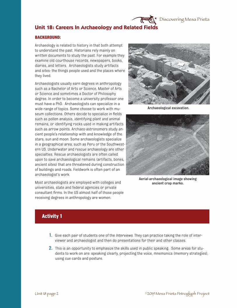
©2019 Mesa Prieta Petroglyph Project
Discovering Mesa Prieta
BACKGROUND:
Archaeology is related to history in that both attempt to understand the past. Historians rely mainly on written documents to study the past. For example they examine old courthouse records, newspapers, books, diaries, and letters. Archaeologists study artifacts and sites- the things people used and the places where they lived.
Archaeologists usually earn degrees in anthropology such as a Bachelor of Arts or Science, Master of Arts or Science and sometimes a Doctor of Philosophy degree. In order to become a university professor one must have a PhD. Archaeologists can specialize in a wide range of topics. Some choose to work with mu-seum collections. Others decide to specialize in fields such as pollen analysis, identifying plant and animal remains, or identifying rocks used in making artifacts such as arrow points. Archaeo-astronomers study an-cient people’s relationship with and knowledge of the stars, sun and moon. Some archaeologists specialize in a geographical area, such as Peru or the Southwest-ern US. Underwater and rescue archaeology are other specialties. Rescue archaeologists are often called upon to save archaeological remains (artifacts, bones, ancient sites) that are threatened during construction of buildings and roads. Fieldwork is often part of an archaeologist’s work.
Most archaeologists are employed with colleges and universities, state and federal agencies or private consultant firms. In the US almost half of those people receiving degrees in anthropology are women.
Unit 18: Careers In Archaeology and Related Fields
Unit 18 page 2
Archaeological excavation.
Aerial-archaeological image showing ancient crop marks.
Activity 1
1. Give each pair of students one of the Interviews. They can practice taking the role of inter-viewer and archaeologist and then do presentations for their and other classes.
2. This is an opportunity to emphasize the skills used in public speaking. Some areas for stu-dents to work on are: speaking clearly, projecting the voice, mnemonics (memory strategies),using cue cards and posture.

©2019 Mesa Prieta Petroglyph Project
Discovering Mesa Prieta
Activity 2
Unit 18: Careers In Archaeology and Related Fields
Unit 18 page 3
Surveying an archaeological site.
In small groups, students create a list of questions they would want to ask an archaeologist about his or her profes-sion. For example: “What kind of skills do you need for your job?”
Activity 3
Invite archaeologists to speak to your class.
ASSESSMENT:
Students write a short essay about why they will or will not consider a career in archaeology.
Conservation of an ancient ceramic pot.

©2019 Mesa Prieta Petroglyph Project
Discovering Mesa Prieta
My name is Kurt Anschuetz (pronounced “Ann SHOOTS”). I originally am from Michigan, but have lived in New Mexico most of my life. I was born in 1954. I spent much of my youth and early adult years living in Ann Arbor. In 1978 I moved to Albuquerque to begin my Masters degree in Anthropology, with a focus in Archaeology, at the University of New Mexico. Then I returned to the University of Michigan for my doctor-ate (Ph.D.) in 1988.
How did you become interested in archaeology?
I have been fascinated with history and anthropology for as long as I can remember. My interest in archae-ology really is a product of my combining these two in-terests into one. History was also among my favorite subjects in schools. I especially liked learning about the native peoples and civilizations that early European explorers “discovered” during their travels.
National Geographic Magazine and National Geographic television specials were among my favorite media. Pictures and discussions of Machu Picchu, the Egyptian pyramids, the Great Wall of China, and the Greek Parthenon in Athens made great impressions on me. How did such marvels come into existence? Why did the stories of their construction and use fall from memory? How did those great achievements and their meanings fall into a state of mystery? Some things, I reasoned, were just too good to forget.
When did you decide to be an archaeologist?
I knew while I was still in high school that I really wanted to be an archaeologist. When I learned that my local University of Michigan was a national leader in the studies of anthropology and archaeology, I could hardly wait for my first archaeology classes to begin.
What kinds of archaeology jobs have you had and what do you do now?
I spent two summers in New Mexico and six months in Peru learning about how to do field archaeology as a crew member. After this apprenticeship I got my first paid archaeology job as a crew chief of a three-person team assigned to find and describe archaeological sites along the North Rim of the Grand Canyon where land development threatened to destroy archaeological remains.
While earning my Masters degree at the University of New Mexico, I served as an archaeological crew member and crew chief all over New Mexico, but found that I preferred working in the north-central and northwest parts of the state that had been the homes of Pueblo people. Because I learned as much as I could about stone tool and pottery analysis, and because I committed myself to develop solid writing skills, I advanced to the position of Project Director quickly. Project Directors do many jobs, including field archaeology, laboratory analysis of artifacts, and report writing. They also hire workers, develop budgets and keep track of money, and understand state and federal laws.
Over the years I found I was doing more paperwork than fieldwork. I wanted to get back into the field and focus my work in the Pueblo World. I realized that I needed still more education and greater skills to achieve my goals. I decided to do a Ph.D. at University of Michigan and perhaps be a university professor. While doing my doctoral fieldwork in the Rio del Oso Valley northwest of Española, which is still my favorite place to work, I began thinking about how I could use my education to define an entirely different career path than I had imagined possible, and to live and work in New Mexico which I had come to love very much.
Unit 18: Careers In Archaeology and Related Fields
Unit 18 page 4
No. 1: INTERVIEW WITH AN ARCHAEOLOGIST
Kurt Anscheutz
In the field in northern New Mexico!

©2019 Mesa Prieta Petroglyph Project
Discovering Mesa Prieta
My dissertation thesis examined how Pueblo people grew corn, beans and squash in the valleys north of Santa Fe in the centuries before the Spanish arrived in New Mexico. I did not want just to look at the things that Pueblo people made, used, and discarded during their lives long ago, I wanted to know some-thing about the Pueblo people as human beings. How did they think about their world? What all did they have to do for their children, families, and communities to survive over the passing of countless genera-tions? I wanted to ask further: How do the present-day Pueblo people remember their ancestors and their traditional homelands? Lastly, I wanted to learn what I could about what people figured out in the past that might be valuable for humanity to remember as we face the challenges of living today and prepar-ing for the future. My doctoral education allowed me to pursue an alternative career path, in which I now regularly work in collaboration with people who are the descendants of the peoples that I study doing archaeology.
I helped begin a nonprofit foundation in Santa Fe. (The foundation has a long name: The Rio Grande Foundation for Communities and Cultural Landscapes.) It offers education and technical help to Indian and Hispanic communities with cultural heritage projects in which community members themselves are active. In one project, archaeological investigations were done at two old Pueblo sites before new con-struction could destroy them. I have also been part of a team assembled by the Pueblos of Acoma, Laguna and Zuni, the Navajo Nation, and the Hopi Tribe, to list Mount Taylor on the New Mexico State Register of Cultural Properties to save the mountain from being destroyed by development that does not consider the past as important. Recently, I have been helping Pueblo communities protect their water rights by doing archaeological studies to prove that these communities grew their food using canal irrigation long before the arrival of the Spanish explorers in New Mexico in 1540. As an “Expert Witness,” I often testify in court during important legal cases. The Pueblo communities have much to lose if I do not do my job to the very best of my abilities.
What area of archaeology do you have the most interest or expertise in?
My areas of archaeological interest and expertise are the same: the study of Pueblo history and culture in north-central New Mexico. I do a little archaeological excavation but a lot of walking the landscape to document evidence about how Pueblo people occupied and managed the land and used available water for growing crops, and maintained relationships with special places, such as old villages, springs, trails, and lava flows near rivers and productive farmland. Archaeologists call the work of walking across the land-scape in search of archaeological sites and features “survey.” It requires much experience, training, and patience to learn to read the land during archaeological survey. Though challenging, I think that survey work is the most fun of all “dirt” archaeology!
What do you like or dislike about being an archaeologist?
While I have always loved the idea of doing archaeology, sometimes I have disliked the work. I am happy to say that at this stage of my career I really like being an archaeologist because I am mostly doing the kind of archaeology that I like to do! Not only are my projects exciting because I get to conduct research into topics that fascinate me, I am delighted that my studies of the past are providing real benefits to the people who are the descendants of the Pueblo groups that I study. Moreover, when I am in the backcoun-try somewhere north, west, or east of Santa Fe, I feel that my work place is among the most beautiful places in the world! (I just can’t imagine how selling shoes to people with smelly feet could ever compare with doing archaeology!)
Have you made any important discoveries?
I have enjoyed being a part of many important little discoveries over my career. I still feel the same wave of excitement finding an arrow point today as I felt when I found the first one very many years ago. Doing archaeology is just plain fun!
Unit 18 page 5
Unit 18: Careers In Archaeology and Related Fields

©2019 Mesa Prieta Petroglyph Project
Discovering Mesa Prieta
Unit 18: Careers In Archaeology and Related Fields
Unit 18 page 6
I have seen many sites, artifacts, and features that have gone unrecognized—or have been underappreci-ated—whenever people have stumbled across them over the past two or three centuries. In combina-tion, these finds are opening my eyes to a story about Pueblo history and culture that is far richer than anything archaeologists have ever realized previously. Archaeologists still are very much only beginning to learn about the past and the many accomplishments of the peoples we study.
The best part of my work is helping to reintroduce present-day Pueblo people to the archaeological traces left by their ancestors. When I watch people react to seeing the sites, artifacts, and features that I have documented doing archaeology, I realize that they know a history of their families, communities, and cul-tures that is far richer than anything I will ever experience or understand. When I see that people will take the knowledge of these archaeological discoveries back to their families and communities, I know that something really important is happening: The communities are using archaeological finds to make their own discoveries about their history.
What advice would you give a young person considering a career in archaeology?
Archaeology is not an easy profession. A person really has to have a passion for doing it, because the pay, benefits, and security often are comparatively low considering the time and resources that one needs to invest in education and training. Fieldwork work can be physically hard, laboratory study requires atten-tion to detail, and report writing requires both perseverance and creativity.
Wealth and fame are rare in archaeology. Achievement does not happen overnight. If a person is steadfast in his commitment, however, he can carve a comfortable place for himself. He can earn the respect of his peers, enjoy a decent standard of living, and have the satisfaction of doing something he loves. I recom-mend that anyone considering a career in archaeology take the time to get involved in learning about ar-chaeology and doing archaeology as soon as he can to determine if he really wants to be an archaeologist. The Laboratory of Anthropology of the Museum of New Mexico hosts the Sun Mountain Gathering each fall in Santa Fe. Participants can learn about making pottery and stone tools, cooking with heated rocks, and using atlatls (spear throwers). The State of New Mexico’s Historic Preservation Division hosts both an Ar-chaeology Fair and Preservation Week each year. These programs give people more opportunities to learn about doing archaeology and using archaeology to learn about New Mexico’s history.
What else would you like to tell people about archaeology?
A famous American philosopher, George Santayana, said, “Those who cannot remember the past are con-demned to repeat it.” But is the past solely made up of a bunch of terrible mistakes that people should want to avoid repeating? My work with Indian Tribes has taught me that there are hard-learned lessons from the past that not only are good, but require repeating! The past has had its share of wonderful achievements, too. Machu Picchu, the Egyptian pyramids, the Great Wall of China, the Greek Parthenon, and traditional methods of Pueblo water and land management are all good things for people to remem-ber!
Archaeology can teach us about the ways through which people have interacted with the land, its water, plants and animals, and one another that have worked, as well as those that have not worked, in the past. People can use the lessons acquired through past ingenuity and stupidity—and the various successes and failures with which earlier generations have been able to sustain their families and communities over time—to live our lives today and to prepare for the future. Archaeology, for this reason, is important. It is not just an exercise for college professors or archaeological businesses. Archaeology really is for all of us, today and into the future.
We need archaeology, lest we forget the past. People need to know how we became who we are today as human beings.

©2019 Mesa Prieta Petroglyph Project
Discovering Mesa Prieta
Please tell us who you are.
My name is Anne R. Baldwin and I work for the US Forest Service - Santa Fe National Forest and I’m stationed at the Española Ranger District Office in Española. You may reach me at 505 753-7331 or [email protected].
How did you become interested in archaeology?
When I was a 6th grader, my folks bought me a book for Christmas entitled ‘Lost Cities’. It had an exciting illus-tration on the cover and made archaeologists look very glamorous!
When did you decide to be an archaeologist?
In high school I scouted out opportunities to work with ar-chaeologists in Maryland (where I grew up). Unfortunate-ly, nothing much came of those inquiries, but I decided to take classes in college (University of Arizona in Tucson) and to put myself in an environment (Arizona State Mu-seum in Tucson) where I saw professional archaeologists daily, in hopes something might happen. I also took jobs related to archaeology such as becoming the education coordinator for the museum so I might learn more from the exhibits on past cultures of Arizona.
What kinds of archaeology jobs have you had and what do you do now?
I’ve done just about everything. I love field work, have worked in a lab cataloging artifacts and I write a lot of reports. Field work is rewarding whether it is excavation or survey, lab work can be boring but you get to see many small parts of a culture by taking a close look at artifacts in the lab and writing can be tedious, but also very stimulating.
Most of my work is related to what is called compliance. I must make sure that archaeological sites on my parts of the forest, since the forest is considered federal land and we take care of it for the public, are protected from different kinds of projects, like fuelwooding, trail construction, prescribed burning, range management (improvement for cows permitted to stay on the forest), construction projects and so forth. I must find out where the sites are and decide how best to protect them from a project.
What do you enjoy about being an archaeologist?
I love working outside and seeing places many never have the opportunity to see. And I especially like ar-chaeological survey, where you walk across the landscape and see how people, past and present, placed themselves on the land. I like finding the remains of their houses and activities, and trying to figure out what it means.
No. 2: INTERVIEW WITH AN ARCHAEOLOGIST
Anne R. Baldwin
Unit 18 page 7
Unit 18: Careers In Archaeology and Related Fields

©2019 Mesa Prieta Petroglyph Project
Discovering Mesa Prieta
What do you dislike about being an archaeologist?
I dislike how people who do not appreciate cultures take advantage by picking up artifacts (potsherds and arrowheads), looting sites looking for pots, on land that does not belong to them. I dislike seeing how they treat the land and the archaeological sites and the impacts their ignorance has on the site. ( A site can be a scatter of chipped stone, potsherds, ‘melted’ adobe buildings and [ancient Pueblos], log cabins, rock art, etc).
Have you made any important discoveries?
I have found things in the field that probably most people might think are important discoveries, unusual ruins, cave houses, rock art, specially designed potsherds or large, finely made projectile points (ar-rowheads). But I think the most important discovery is one I’ve made about myself and how I understand people who lived in past and how I can use that to understand the present.
What advice would you give a young person considering a career in archaeology?
I strongly recommend kids stay in school and try for the college degree…a BA or a BS (Bachelor of Arts or Science). Because, even if archaeology or anthropology doesn’t seem right for you, you have many op-tions to take other courses where you might fit better.
Unit 18: Careers In Archaeology and Related Fields
Unit 18 page 8

©2019 Mesa Prieta Petroglyph Project
Discovering Mesa Prieta
Please tell us who you are.
My name is Ron Barber. I’m trained as a mechanical engineer. I’ve worked at Lawrence Livermore National Laboratory as well as Los Alamos, for a total of 29 years. I’m married, and I have 4 children, 2 daughters-in-law and 3 grandkids. [email protected] is my work email address.
How did you become interested in archaeology?
I was born and raised in South America, where there are lots of archaeological sites all over the place. As a young boy my family used to go to these sites and explore the areas. Ever since then I have had this interest in old cultures and ancient ruins.
When did you decide to be an archaeologist?
I’ll tell you about my decision to become an engineer. I always liked to work with objects, I liked to build things, work on models and design thinks on paper. I was also pretty good at math, and had an interest in technical subjects, science and stuff like that. When I was in high school I found out that I could do all of those things I was interested in and get paid for it as an engineer.
What kinds of engineering jobs have you had and what do you do now?
Almost all of my engineering jobs have been related to designing experiments, building them, and then testing them. I have worked on nuclear explosives, tunnel experiments, particle beam experiments, fabri-cation experiments and many other fun things.
What area of engineering do you have the most interest or expertise in?
I like working on tough projects, where I have to lead a team that has to work together to make a piece of hardware. It’s much like being on a football team where every body has a job to do, and we all have to work closely together in order to succeed. And when you get the job done, it’s like playing a tough game and coming out on top.
What do you like and/or dislike about being an engineer?
Sometimes the jobs are very tough and require a lot of time and dedication. This can keep you away from your wife and children for long periods of time.
Have you made any important discoveries?
I have been on project teams that have made many technical contributions to nuclear physics, spallation science, high energy nuclear physics and defense programs. One of my more interesting side lines has been the archeology work in understanding how early southwest Indians used the sun shadows as cal-endars. This discovery has come about because of my interest in archeology, but also my training as an engineer.
No. 2: INTERVIEW WITH AN ARCHAEO-ENGINEER
Ron Barber
Stalking the wild solar shadow.
Unit 18 page 9
Unit 18: Careers In Archaeology and Related Fields

©2019 Mesa Prieta Petroglyph Project
Discovering Mesa Prieta
What advice would you give a young person considering a career?
Think long and hard about what you enjoy doing, what you find interesting, what is challenging. When you go play, think about what part of playing you like doing. Think about the school subjects you are naturally good in, or that you find interesting. Then get with a councilor and look at the jobs that match what you think is fun to do. There are lots of fun jobs out there, you just have to find the one that you will like.
What else would you like to tell people about archaeology?
I have found out that you can pursue several interests in life. I have chosen engineering as my profession, in other words, that’s how I make my living (getting paid). But I can still pursue other interests in life that I have. I am an explorer by nature, and probably enjoy that as much as anything else. In figuring out how the solar calendars work, I have combined my passion for exploration along with my interest in ancient cultures and engineering skills.
Unit 18: Careers In Archaeology and Related Fields
Unit 18 page 10

©2019 Mesa Prieta Petroglyph Project
Discovering Mesa Prieta
Please tell us who you are.
I’m Eric Blinman, director of the Museum of New Mexico’s Office of Archaeological Studies.
How did you become interested in archaeology?
I had a class in earth sciences in junior high school, and my best friend was the son of a geology professor. My best friend and I spent a lot of time hiking around the back country look-ing for fossils and rocks and minerals. Occasionally we would find an arrowhead (but we knew that we weren’t supposed to collect them, so we left them where we found them). Finding those arrow heads started me thinking about archaeology.
When did you decide to be an archaeologist?
I took a summer school class in archaeology before 9th grade. It was so much fun, I looked for a chance to volunteer on a site that was being excavated by the local college. I kept working at the site through the rest of high school, eventually becoming a volunteer staff member. When I went to college, I took classes in archaeology as well as calculus and chemistry, and by the time I was a junior I decided to major in archaeology with the goal of making that my career.
What kinds of archaeology jobs have you had and what do you do now?
I did a lot of volunteer work as a laborer and as a map maker while I was in college, sometimes going on expeditions for the entire summer. Those positions didn’t pay, but the larger projects covered the costs of food and travel. When I graduated from college and went to graduate school, I worked in a variety of pay-ing jobs. They included preparing illustrations for reports, conducting laboratory analyses, and occasion-ally doing field work. I also held some part time teaching jobs, and eventually accepted a series of full time jobs doing field archaeology and eventually directing archaeological projects.
After I earned my Ph.D. degree, I was hired by the Museum of New Mexico as a laboratory supervisor, then as a deputy director, and now I’m the director of the archaeology program. We have more than 40 staff members, including members of three different tribes, and we carry out about $2 million in archaeologi-cal projects every year.
What area of archaeology do you have the most interest or expertise in?
Right now most of my time is spent doing administrative tasks. I meet with clients who need to have an ar-chaeological project carried out before they can build their road or building. After we decide what needs to be done and how much it costs, I assign the project to a senior archaeologist and I let them carry out the project. I have to go to a lot of meetings, and I have to read and comment on a lot of reports.
When I’m not handing paperwork, I am interested in reconstructing past climates, pottery technologies, basketry and cordage technologies, and a technique called archaeomagnetic dating.
No. 3: INTERVIEW WITH AN ARCHAEOLOGIST
Eric Blinman
Showing basketry reproductions.
Unit 18 page 11
Unit 18: Careers In Archaeology and Related Fields

©2019 Mesa Prieta Petroglyph Project
Discovering Mesa Prieta
What do you like and/or dislike about being an archaeologist?
The thing I like most is that I’m rarely bored. Even if I have to sort thousands of pottery sherds, I can see how each one is different. I get to apply a lot of science and math in my work, so I use a full range of sub-jects I studied in college. Just this morning I had conversations that included linguistics, biology, geophys-ics, astronomy, and statistics. Sometimes the problems are as simple as trying to figure out how to keep rain out of our excavation pits, while other problems require a detailed knowledge of clay minerals.
I don’t think I dislike anything about the subject, although as I get older I have a harder and harder time doing as much physical labor (digging) as our younger staff members.
Have you made any important discoveries?
All of us have at least contributed to important discoveries, but rarely is there one thing that stands out. I’m “famous” for discovering that many ancient ceremonial gatherings were more like potluck dinners than like banquets that were funded by a single individual. I’m probably also well known for my work trying to figure out how ancient black-on-white pottery was made. I’ve written book chapters on ceramic dating, pottery exchange in the Four Corners area, and the use of pollen grains to study the environmental effects of ancient volcanic ashfalls.
What advice would you give a young person considering a career in archaeology?
The best archaeologists know a lot about all of the natural sciences, as well as understanding about the way present day peoples live around the world. You need to have the natural instincts of a detective, find-ing and interpreting clues that lead you to reconstructions of the past. But at the same time, you have to be prepared to admit that you might be wrong. Just like the district attorney or police officer can occa-sionally be wrong despite what they thought the evidence pointed to, archaeologists are always learning more and correcting old interpretations. Archaeology is a science only because the stories we tell are supposed to be criticized.
The other advice is more of a warning. There aren’t a lot of opportunities to make money in archaeology. You have to be happy with a modest income, and you have to be happy working really hard for it. If you can be passionate about the subject, then you can have a great and satisfying career.
What else would you like to tell people about archaeology?
The most important thing to remember about archaeology is that sites and the information they contain are incredibly fragile. You can only excavate a site once, since the act of digging actually destroys the site. If you don’t take enough notes or photographs at the time you are doing the work, you can never go back and make up for holes in your observations. Digging sites therefore entails a tremendous responsibility.
Unit 18: Careers In Archaeology and Related Fields
Unit 18 page 12
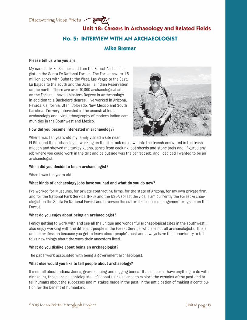
©2019 Mesa Prieta Petroglyph Project
Discovering Mesa Prieta
Please tell us who you are.
My name is Mike Bremer and I am the Forest Archaeolo-gist on the Santa Fe National Forest. The Forest covers 1.5 million acres with Cuba to the West, Las Vegas to the East, La Bajada to the south and the Jicarilla Indian Reservation on the north. There are over 10,000 archaeological sites on the Forest. I have a Masters Degree in Anthropology in addition to a Bachelors degree. I’ve worked in Arizona, Nevada, California, Utah, Colorado, New Mexico and South Carolina. I’m very interested in the ancestral Indian archaeology and living ethnography of modern Indian com-munities in the Southwest and Mexico.
How did you become interested in archaeology?
When I was ten years old my family visited a site near El Rito, and the archaeologist working on the site took me down into the trench excavated in the trash midden and showed me turkey guano, ashes from cooking, pot sherds and stone tools and I figured any job where you could work in the dirt and be outside was the perfect job, and I decided I wanted to be an archaeologist.
When did you decide to be an archaeologist?
When I was ten years old.
What kinds of archaeology jobs have you had and what do you do now?
I’ve worked for Museums, for private contracting firms, for the state of Arizona, for my own private firm, and for the National Park Service (NPS) and the USDA Forest Service. I am currently the Forest Archae-ologist on the Santa Fe National Forest and I oversee the cultural resource management program on the Forest.
What do you enjoy about being an archaeologist?
I enjoy getting to work with and see all the unique and wonderful archaeological sites in the southwest. I also enjoy working with the different people in the Forest Service, who are not all archaeologists. It is a unique profession because you get to learn about people’s past and always have the opportunity to tell folks new things about the ways their ancestors lived.
What do you dislike about being an archaeologist?
The paperwork associated with being a government archaeologist.
What else would you like to tell people about archaeology?
It’s not all about Indiana Jones, grave robbing and digging bones. It also doesn’t have anything to do with dinosaurs, those are paleontologists. It’s about using science to explore the remains of the past and to tell humans about the successes and mistakes made in the past, in the anticipation of making a contribu-tion for the benefit of humankind.
No. 5: INTERVIEW WITH AN ARCHAEOLOGIST
Mike Bremer
Unit 18 page 13
Unit 18: Careers In Archaeology and Related Fields

©2019 Mesa Prieta Petroglyph Project
Discovering Mesa Prieta
Please tell us who you are.
My name is Glenna Dean. I am the New Mexico State Archae-ologist and I work for the Historic Preservation Division, part of the Department of Cultural Affairs, State of New Mexico. My job is largely public outreach, meaning that I give talks to groups, write articles for publication, help get important archaeological sites listed on the State Register of Cultural Property and the National Register of Historic Places, and I stage the New Mexico Archaeology Fair in a different small town every year. I also work with the Office of the Medical Investigator, law enforcement officers, and Indian tribes on the best things to do after human bones are accidentally discov-ered by hikers or during construction. Sometimes my job involves a lot of driving to meet with city officials or the police or landowners on preservation issues that affect archaeologi-cal sites, but it’s always challenging and I enjoy the problem-solving. I have three college degrees, two in archaeology and one in botany. Before I became State Archaeologist, I was a practicing archaeobotanist, analyzing archaeological soil samples for pollen grains, burned seeds, and broken plant parts to find out what people were doing with plants in the past, and sometimes analyzing textiles as well. I came to work for the Historic Preservation Division in 1994 and have been the State Archaeologist since 1997.
How did you become interested in archaeology?
I guess I was born curious about the past – I’ve been fascinated by how people lived in the past ever since I learned to read. I’ve always wanted to be able to experience first-hand what I’ve read about too, so I learned to spin and weave and dye yarns and make clothes and tan hides and all kinds of things. I read about archaeological discoveries too, mostly in National Geographic, but when I was growing up (1950s), the only archaeologists I read about were men.
When did you decide to be an archaeologist?
In my senior year of high school (1968), a professor from the nearby university came to talk to my class about a career in archaeology. After his talk, I asked him if girls could be archaeologists too, and he said “of course”! So I enrolled in an archaeological field school, where excavation skills are taught, and started my archaeological studies the week after high school graduation. Many times over the next years, however, male archaeologists would come and tell me that women didn’t belong in the field. I’m very glad that that attitude has almost completely disappeared.
What kinds of archaeology jobs have you had and what do you do now?
My first job was washing artifacts and writing inventory numbers on them. Then I reconstructed bro-ken pots from little bitty sherds, and next came analyzing the kinds of knots that were used to tie things together. Then came analyzing how sandals were made from leaves and fibers, then typing archaeological reports for publication (computers weren’t invented yet), and I finally got to join survey crews who walked the project area for a proposed road or reservoir and looked for archaeological sites that might warrant investigation before being destroyed by the project. I helped excavate archaeological sites and, because I was studying pollen analysis in college at the same time, I began to analyze soil samples to recover the pollen grains left behind by human activities to understand what season of year people had used the site
No. 6: INTERVIEW WITH AN ARCHAEOLOGIST
Glenna Dean
Risking it all on the atlatl range.
Unit 18: Careers In Archaeology and Related Fields
Unit 18 page 14

©2019 Mesa Prieta Petroglyph Project
Discovering Mesa Prieta
and what plants they brought to the site to eat or use for some other purpose. I had the most fun analyz-ing human coprolites (desiccated feces) to find out what kinds of things people had eaten in the past, and I wrote my PhD dissertation on the analysis of human coprolites 7500 years old. Since I graduated from college in 1978, my jobs have been more and more administrative, shuffling papers and policy ideas instead of moving dirt.
What area of archaeology do you have the most interest or expertise in?
My expertise is in archaeobotany, ranging from microscopic pollen grains to burned seeds and plant parts that you can see, as well as textile analysis. I find these studies fascinating, especially the textiles because you can really appreciate how skillful and inventive people were in the past even though the com-mon attitude is that ancient people were primitive.
What do you like and/or dislike about being an archaeologist?
I love touching the past, whether it be an artifact or the pollen grains left in a pot from cooking supper a thousand years ago. I dislike that so many people think archaeology is a waste of time, and that archaeo-logical sites – and human graves – are only good for digging up artifacts to collect or sell. I wish there were a way for everyone to understand that we are all people, no matter when we live or what we have, and that archaeology is the story of our history as people. If more people understood this, it seems to me that people would appreciate each other more and there would be less violence in the world.
Have you made any important discoveries?
Yes! I discovered – through pollen analysis – that domesticated cotton was grown in northern New Mexico centuries before Columbus. Before my discovery, which also involved inventing a new way to count pollen under the microscope, archaeologists thought that all cotton used in New Mexico, and described by Spanish explorers when they came up the Rio Grande, came from the Hopi people in northeastern Arizona. Now we know that cotton was one of the crops grown in specialized fields invented and used between 1250 and 1500 AD at high elevations in the Española-Ojo Caliente-Abiquiú area. This means that farmers in prehistory were even more sophisticated that we thought they were. Old cotton fields continue to be discovered each year.
What advice would you give a young person considering a career in archaeology?
Stay in school, read widely, and nurture your curiosity about everything! Archaeology requires imagina-tion and skills in thinking, logic, reading, writing, and observation; discoveries are your reward. How would you like to have discovered that people were digging water wells during the Ice Age in New Mexico? Or what kinds of food were stored in baskets around a pithouse floor more than a thousand years ago? You probably watch the “crime scene investigation” shows on TV – field work in archaeology is very simi-lar except the evidence is hundreds if not thousands of years older.
The cure for boredom is curiosity; there is no cure for curiosity. You won’t be bored in archaeology but you won’t become super rich either – you should know that this is the kind of career you embark on because you love your work, not because you hope to make a lot of money. You’d be surprised how many people say they wish they had become an archaeologist like they wanted instead of the better-paying career they did choose.
What else would you like to tell people about archaeology?
Archaeology is the history of people who lived before writing was invented, and of people who wrote down only their side of the story. Archaeology is the only way to know some things and provides depth and color to stories handed down through generations and written in books. People are all there is in this life, and anything people do – or did – is automatically interesting, and for the 12,000 or more years people have lived in New Mexico, that means archaeology. We are smart today because our ancestors were smart – all the way back in time.
Unit 18 page 15
Unit 18: Careers In Archaeology and Related Fields

©2019 Mesa Prieta Petroglyph Project
Discovering Mesa Prieta
Please tell us who you are.
I am Dr. Richard Ford and I am a Professor of Anthropology at the Univer-sity of Michigan. I have several specialties within archaeology. One is that I identify plants that are found in archaeological excavations. A second is that I study pre-contact agriculture. The third is that I analyze petroglyphs.
How did you become interested in archaeology?
My interest in archaeology began in first grade when I found a projectile point. I was proud that I was the only student in my class who could spell “archaeology.” This remained an interest until college when I learned that archaeologists rarely made much money and then I switched to internation-al banking. In my junior year, I came to New Mexico to attend an archaeologi-cal field school. It was there that I discovered if you were an archaeologist who taught in a university you would have a rewarding and comfortable life. (Archaeologists never get rich!)
When did you decide to be an archaeologist?
As a senior in college I made a decision to go to graduate school and obtain a Ph.D. in anthropology with a specialty in archaeology.
What kinds of archaeology jobs have you had?
As an archaeologist I have been a professor at two universities and have been invited to teach at six other universities. I have also been a museum director and an associate dean for research. I have conducted fieldwork in the United States, Mexico, Poland, Tunisia, the Bahamas, and China.
What do you enjoy about being an archaeologist?
I still enjoy discovering new information about how people lived in the past and what they thought about their world.
What do you dislike about being an archaeologist?
There is nothing I don’t like about archaeology. The most discouraging part is having to spend so much time getting grants to do new research.
Have you made any important discoveries?
I have made important discoveries about the first maize agriculture in New Mexico and new rock art im-ages.
What advice would you give a young person considering a career in archaeology?
The most important thing is for students to get a solid general education (liberal arts in college). You will have to get a Ph.D. in Anthropology.
What else would you like to tell people about archaeology?
Archaeology is fun! You will get very dirty, sweaty, and anxious about what you are finding. When you are done, however, it is worth it. If you like doing jigsaw puzzles, you will love archaeology.
No. 7: INTERVIEW WITH AN ARCHAEOLOGIST
Richard Ford
Unit 18: Careers In Archaeology and Related Fields
Unit 18 page 16
On the Mesa during Youth Intern Training.

©2019 Mesa Prieta Petroglyph Project
Discovering Mesa Prieta
Please tell us who you are.
My name is Rory Gauthier and I have lived in New Mexico, Arizona, Utah and California. I have worked for the National Park Service for about 25 years and mostly worked in parks were archeology is the primary attraction. I have worked at Chaco Canyon, El Malpais, Glen Canyon and Bandelier. Before I worked for the National Park Service I worked for the Museum of New Mexico and the University of New Mexico and I worked with other archaeologists all over New Mexico involved in excavating and surveying archaeological sites. You are welcome to write me and I will answer your questions. My email ad-dress is [email protected]
How did you become interested in archaeology?
I decided I wanted to be an archaeologist when I was in the 6th grade. I was hiking in the mountains near Taos with a friend who lived near Petrified For-est in Arizona during the school year and during summer vacation he lived in Taos with his Grandfather. He was older than I was and he told me many wonderful stories about living in Arizona, about his friends who were Navajo and some who were Hopi. He also told me about all the ruins near his house and all the arrowheads he found. But this one day, as we were hiking, we came into a meadow and there were pieces of obsidian and basalt scattered all around. I realized that these rocks did not belong in the meadow (all of the other rocks were granite) and began to look closer. My friend had immediately rec-ognized these rocks – the basalt and obsidian – were artifacts, and someone a long time ago had carried these rocks here. But I could only wonder why and what these stones were doing in that meadow.
Today, it is easy for me to interpret and explain such an archaeological find. By looking at some of the fragments of basalt and obsidian I can tell how long ago someone carried the rocks to that meadow. I can also tell what they were doing with the rocks – if they were making tools such as scrapers or projectile points or if they were making knives to butcher an animal. But back then all I could do was wonder about what happened in that meadow. And that made me curious about the people who left behind these frag-ments of stone and what were they doing in that meadow.
When did you decide to be an archaeologist?
I was pretty young, about 11 years old. Once I became interested, I was hooked and began reading all I could find in our local library. I was also fortunate to live in an area where there were many archaeologi-cal sites (northern New Mexico) and parks such as Bandelier National Monument where I could visit ex-cavated sites. I would also make my parents take me to the museums in Santa Fe to look at the artifacts they have on display.
What kinds of archaeology jobs have you had and what do you do now?
I worked for many years doing what is sometimes called “salvage (rescue) archeology” which means when an archaeological site is going to be destroyed by building a new road or a new building or if the site will be flooded by a reservoir, the site is excavated. There are many jobs in this field because there are laws which make it mandatory to excavate an archaeological site if it is going to be destroyed in a feder-ally funded project.
No. 8: INTERVIEW WITH AN ARCHAEOLOGIST
Rory Gauthier
Unit 18 page 17
Unit 18: Careers In Archaeology and Related Fields

©2019 Mesa Prieta Petroglyph Project
Discovering Mesa Prieta
I now work for the National Park Service where my primary duties are making sure our archaeological sites are preserved for future generations. I work at Bandelier National Monument (which is managed by the National Park Service) and we have over 3,000 archaeological sites just within our boundaries. Taking care of all these sites is a big responsibility, but I love it! I do not excavate sites, but rather I map them and study the artifacts on the surface. The tools I use are a transit, sometimes a plane table and alidade (these are tools for surveying and making maps), calipers (to measure artifacts), a GPS unit (to let me know where the site is), digital and film cameras (to document the archaeological site and artifacts) and, of course, a computer. I study the site and the artifacts and write articles and books about our findings. I also spend a lot of time documenting the condition of the site and correct problems (such as areas being eroded on the site) by constructing check dams or diverting arroyos away from the site.
What area of archaeology do have the most interest or expertise in?
My interests are in architecture and agriculture. I am fascinated by all of the different house types you find in this area – from simple pit houses to huge villages with hundreds of rooms, surrounding expansive plazas and sometimes standing two or three stories high. We also have cliff dwellings, sometimes houses are built against the cliff and sometimes the rooms are carved right out of the solid rock, such as the dwellings we have here in Frijoles Canyon.
I like to study agriculture because, here in northern New Mexico, you can find many examples of old farm-ing areas. They are not at all like the farming you see today where fields were irrigated by a system of canals (acequias) and ditches, but rather elaborate water saving devices such as grid gardens, gravel mulch gardens and terraces were constructed. All of these devices are designed to save and conserve water and we can learn an important lesson from the people who used to live here – it is important to conserve resources such as water.
What do you like and/or dislike about being an archaeologist?
I like just about everything about being an archaeologist. I think I probably have the best job in the world. I get to spend most of my time outdoors when the weather is warm. I get to explore and discover things that no one has seen for hundreds of years. What can be better that that? When it is winter, I get to write about archaeological sites. Sometimes this can get tedious, but it is something I have to do. If I do not report my findings what good would that be? No one would ever know about the history of people who lived here before us.
Have you made any important discoveries?
I have not made any great discoveries. I do, however, report my findings by writing articles and books so the public can learn about the history of this area. To me it is important that we understand how people lived in the past – what was successful and what didn’t work. We need to know because if we do not learn from the past we will repeat old mistakes.
What advice would you give a young person considering a career in archaeology?
Go to school! I said it before, I have the best job in the world. For me, to get this job, I had to compete by getting through school (college). But that is true of all jobs – especially the fun jobs. If you want to be happy and successful in life, you need to go to school.
Unit 18: Careers In Archaeology and Related Fields
Unit 18 page 18

©2019 Mesa Prieta Petroglyph Project
Discovering Mesa Prieta
Please tell us who you are.
My name is Chuck Hannaford. I have been an archaeologist with the Office of Archaeological Studies in Santa Fe for nearly 29 years. I have had the privilege to work on archaeo-logical sites from many time periods, from many diverse cultures, and from nearly every New Mexico county. I am intrigued by what we can learn about the past through the discovery, study, and preservation of our state’s archaeologi-cal resources. My email address is: [email protected]
How did you become interested in archaeology?
I was originally interested in dinosaurs in early grade school, but soon saw the light and became a student of archaeology. I enjoyed exploring archaeological sites and wondering about the many kinds of artifacts left across the landscape by past peoples. Growing up in Los Alamos, I was especially interested in the archaeology around my home such as the caves dug into the volcanic tuff at Bandelier and across the Pajarito Plateau. I became interested in visiting museums, early churches, and also the various Native American Pueblos along the Rio Grande to watch the feast day dances. In addition to the archaeological sites, I became interested in the stories about the past told by New Mexico’s diverse peoples including the Pueblo, Navajo, Apache, Spanish, and Anglo.
When did you decide to be an archaeologist?
My roots of wanting to be an archaeologist go back to grade school, but by high school I definitely knew I wanted to study archaeology.
What kinds of archaeology jobs have you had and what do you do now?
My first job in archaeology was as a stabilization archaeologist with the Bureau of Land Management. Our job was to locate sites on Bureau of Land Management land across the site and then to preserve the standing architecture so the walls would not further collapse. I then became an archaeologist with the Office of Archaeological Studies. We often investigate sites that are in the construction zone of highway projects across the state. We excavate the portion of the site that will be destroyed by the highway con-struction. The recovered artifacts, photographs, and reports will then allow both the highway to be built and also recover material from the sites for future generations to study. This is what I am doing now.
In what area of archaeology do have the most interest or expertise?
I am most interested in the archaeology of northern New Mexico. I am still interested in the Pajarito Plateau around Los Alamos, the early Navajo sites dating from the 1700s in the Farmington area, and early hunting techniques and the use of the atlatl, or spear-thrower.
What do you like and/or dislike about being an archaeologist?
I like learning about the past lifeways of the various peoples who live and have lived in New Mexico. I also enjoy presenting what we have learned in the field of archaeology to the public so that other people can understand and enjoy the fascinating world of archaeology. Our office actually won the Society for Ameri-can Archaeology’s 2005 award for Excellence in Public Education.
No. 9: INTERVIEW WITH AN ARCHAEOLOGIST
Chuck Hannaford
Unit 18 page 19
Unit 18: Careers In Archaeology and Related Fields

©2019 Mesa Prieta Petroglyph Project
Discovering Mesa Prieta
Excavation can be physically hard and tiring work. The work often has to be accomplished during very hot days in the summer and very cold days in the winter, depending on when the excavation is taking place. Report writing and note taking can also be stressful and time consuming as you attempt to document and describe the results of your work.
Have you made any important discoveries?
I have excavated many thousands of artifacts during my career and the discovery of items that have been in the ground sometimes for thousands of years is always thrilling. However, excavation is somewhat like a puzzle and the real discovery is not just the excavation of an interesting artifact such as a whole pot, but putting all the pieces of an excavation together and figuring out the story of a site. This is the process of archaeology that then adds important pieces to our new and ever changing understanding of the past.
What advice would you give a young person considering a career in archaeology?
Archaeology is a very large field of study ranging from the earliest Palaeo-Indian big game hunters of 12,000 years ago to 1880 Anglo homestead sites. In between are Ancestral Pueblo farming sites, early Spanish Colonial sites, Civil War sites, and many, many more. In addition, there are many specialties in archaeology such as archaeologists that just study pottery and pot sherds, animal bones, seeds and plant remains, or stone tools. The field is wide open for study. The more education you have, the more secure and accomplished you will be in performing your job as an archaeologist. Archaeologists are special people that devote their lives to the study of the past. I hope that you may be one of these special people.
What else would you like to tell people about archaeology?
I have watched the known number of recorded sites in New Mexico grow from some 30,000 to over 150,000 during the course of my career. They range from the first Clovis discovery representing the earliest people in North America to the detonation of the first Atomic Bomb at the Trinity Site. I would not doubt that there over a million sites in New Mexico alone waiting to be discovered, studied, and preserved for the future. These important sites are out there on the landscape waiting to be discovered and studied by you as a future archaeologist.
Unit 18: Careers In Archaeology and Related Fields
Unit 18 page 20

©2019 Mesa Prieta Petroglyph Project
Discovering Mesa Prieta
Please tell us who you are.
My name is Larry Humetewa. I was born in Santa Fe, New Mexi-co and was raised at Santo Domingo Pueblo. I am an Assistant Conservator for the Museum Resources Division of the State of New Mexico’s Department of Cultural Affairs.
How did you become interested in conservation?
When I was in the 3rd grade, my teacher had a map of New Mexico hanging on the wall; on that map I noticed that there was a Pueblo which I had never heard of. It was Pecos Pueblo, and underneath the name in parenthesis the word “extinct” was written. After looking up the word extinct (English is not my first language), I became more interested in learning about the past and finding out if other Pueblos once existed that became “extinct.” Before this I thought museums were just places where dinosaur bones were displayed, and after asking a lot of questions I learned that museums, national parks and state parks were more than dinosaur bones. After that, my dream was to become a pro football player or to work in a museum or a park as a curator or park ranger.
After realizing how difficult it would be to become a pro football player I decided to go to college at East-ern New Mexico University for anthropology and history. It was not until I received my B.S. from ENMU in 1996 that I realized there were other fields in the museum world besides being a curator.
After college I worked for the Santo Domingo Pueblo’s education department for almost two years when I noticed an announcement for a Native or Hispanic pre-program internship position in conservation at the Museum of New Mexico. I applied for the position and was accepted as a pre-program intern in 1998. It was then that I realized I did not want to be a curator any more.
When did you decide to be a conservator?
I knew I wanted to become a conservator after I met the wonderful staff at the conservation department and the type of work that was done for the state museums and monuments. It was also at this time in my life when it was important for me to learn the traditional ways of my Pueblo and I learned that most graduate schools that offered conservation were located on the east coast. I was lucky to have a supervi-sor, Claire Munzenrider who was the Chief Conservator at that time, understand that I wanted to become a conservator while learning the traditional ways of my Pueblo and that I could not go to school on the east coast because of this. She, Dale Kronkright (former Senior Conservator for the State of New Mexico, now at the O’Keefe Museum) and other conservators have all played a big role in my being an assistant conservator today.
No. 10: INTERVIEW WITH A CONSERVATOR
Larry Humetewa
In the Conservation Department laboratory.
Unit 18 page 21
Unit 18: Careers In Archaeology and Related Fields

©2019 Mesa Prieta Petroglyph Project
Discovering Mesa Prieta
What kinds of conservation jobs have you had and what do you do now?
I have been with the Conservation Department for 10.5 years now; prior to that I was a student, worked at the Pueblo and was a chef’s assistant at the Jockey club at the Santa Fe Downs racetrack. What I do now as an assistant conservator is work on condition assessment and treatment of artifacts going on display or on loan to other institutions. I am Conservation Lab Manager for the department, I perform graffiti mitigation at Bandelier National Monument once a week, and I supervise our college work-study student.
What area of conservation do you have the most interest or expertise in?
I am most interested in ceramics (both low and high fired) and traditional northern New Mexican His-panic bultos (carved wooden and painted sculptures). My area of expertise is in Pre-contact to Historic Puebloan pottery.
What do you enjoy about being a conservator?
The thing I enjoy most about being a conservator is the non-stop work we do for the State such as the ongoing exhibitions/loans and of course being able to handle and help preserve the State’s wonderful col-lections. I enjoy learning about the history and method of manufacture of the artifacts in our museums’ collections.
What do you dislike about being a conservator?
The thing I dislike about being a conservator is wearing gloves while working on an object, washing dirty lab dishes and the commuting from Santo Domingo Pueblo to Santa Fe.
Have you worked on any important artifacts/buildings/landscape (etc.)?
In my 10.5 years of working in conservation I have worked on many artifacts from Mimbres bowls to early Spanish contact artifacts to a bowcase and quiver that may have belonged to the Apache Chief Geronimo. I have had the honor of working at Bandelier National Monument, at the Santuario de Chimayo and in a building at Pidgeon’s Ranch which is the only surviving structure in New Mexico that was used in battle during the Civil War, in the Battle of Glorieta.
What advice would you give a young person considering a career in Conservation?
If a young person was considering a career in conservation I would advise them to take a wide variety of courses such as art history, chemistry, anthropology, museum studies and studio art while in college. I would advise them to look into pre-program internships in conservation that may be offered at museums and perhaps get to know conservators.
Is there anything else that you would like to tell people about conservation?
When I tell people that I am an assistant conservator and the type of work I do, their response is usually “So you’re an art restorer.” Conservation is not only about restoration, it is about helping to preserve artifacts for future generations to learn from. The goal for conservators is to make preservation recom-mendations on how to care for artifacts while in storage, on display, or on loan (traveling). Restoration is only a small part of the work in conservation.
Unit 18: Careers In Archaeology and Related Fields
Unit 18 page 22
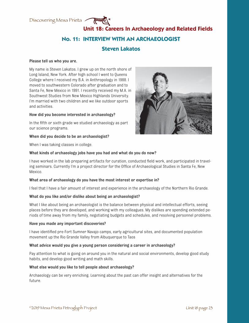
©2019 Mesa Prieta Petroglyph Project
Discovering Mesa Prieta
Please tell us who you are.
My name is Steven Lakatos. I grew up on the north shore of Long Island, New York. After high school I went to Queens College where I received my B.A. in Anthropology in 1988. I moved to southwestern Colorado after graduation and to Santa Fe, New Mexico in 1991. I recently received my M.A. in Southwest Studies from New Mexico Highlands University. I’m married with two children and we like outdoor sports and activities.
How did you become interested in archaeology?
In the fifth or sixth grade we studied archaeology as part our science programs.
When did you decide to be an archaeologist?
When I was taking classes in college.
What kinds of archaeology jobs have you had and what do you do now?
I have worked in the lab preparing artifacts for curation, conducted field work, and participated in travel-ing seminars. Currently I’m a project director for the Office of Archaeological Studies in Santa Fe, New Mexico.
What area of archaeology do you have the most interest or expertise in?
I feel that I have a fair amount of interest and experience in the archaeology of the Northern Rio Grande.
What do you like and/or dislike about being an archaeologist?
What I like about being an archaeologist is the balance between physical and intellectual efforts, seeing places before they are developed, and working with my colleagues. My dislikes are spending extended pe-riods of time away from my family, negotiating budgets and schedules, and resolving personnel problems.
Have you made any important discoveries?
I have identified pre-Fort Sumner Navajo camps, early agricultural sites, and documented population movement up the Rio Grande Valley from Albuquerque to Taos
What advice would you give a young person considering a career in archaeology?
Pay attention to what is going on around you in the natural and social environments, develop good study habits, and develop good writing and math skills.
What else would you like to tell people about archaeology?
Archaeology can be very enriching. Learning about the past can offer insight and alternatives for the future.
No. 11: INTERVIEW WITH AN ARCHAEOLOGIST
Steven Lakatos
Unit 18 page 23
Unit 18: Careers In Archaeology and Related Fields

©2019 Mesa Prieta Petroglyph Project
Discovering Mesa Prieta
Please tell us who you are.
I’m Janet MacKenzie and I live near Alcalde, NM. I am the Project Coordinator for the Mesa Prieta Petroglyph Project Petroglyph Project. I can be contacted at [email protected]
How did you become interested in archae-ology?
As a child, my parents let me run wild “down the riverbank” at home where I hunted turtles and dug up animal bones and fos-sils. Our family were always museum-goers and I spent many happy hours at the Royal Ontario Museum in Toronto looking at the mummies and totem poles. However, at that time, I never thought of becoming an archaeologist. I wanted to be a medical artist.
When did you decide to be an archaeologist?
After I finished art college, I went to university where I took a couple of courses in classical archaeology. When I graduated, I went to Europe for a couple of years and worked on excavations in England, mostly Roman and Iron Age. It was lots of fun, although it was hard work shovelling dirt and running wheelbar-rows! I went to Greece for a few months to see many ruins and museums and that was when I decided to become an archaeologist. I was very interested in Minoan archaeology at that time, but while getting a degree in anthropology back in Canada, I became much more interested in Mesoamerican and Peruvian archaeology.
What kinds of archaeology jobs have you had and what do you do now?
Besides excavating in Britain, I have worked at field survey and excavation in Canada and Peru. I’ve also done a great deal of site and topographical instrument surveying, and drawing of artifacts. I actually haven’t worked in the field for a number of years, and have recently been involved more in the museum end of things, doing research, writing story lines and labels for exhibits.
What area of archaeology do you have the most interest or expertise in?
I am interested in ideas about ancient frontiers, roads, boundaries and how groups of people in the past related to one another, how they saw themselves among their neighbors. Related to this, I am also very interested in the ancient landscape, and in New Mexico, there is a lot of landscape! I am new to New Mexico and am finding that there is a great deal to see and understand. I’ve become very interested in the petroglyphs of Mesa Prieta and would like to learn more about them, particularly the petroglyphs of the Historic Period.
No. 12: INTERVIEW WITH AN ARCHAEOLOGIST
Janet MacKenzie
Loading up for a field trip in Peru.
Unit 18: Careers In Archaeology and Related Fields
Unit 18 page 24

©2019 Mesa Prieta Petroglyph Project
Discovering Mesa Prieta
What do you like and/or dislike about being an archaeologist?
I have always liked digging in the earth and discovering things that have not been seen since ancient times! It’s such a personal connection to the past. Another thing I like about archaeology is that no matter where you dig in the world, there are always fascinating ancient sites to explore and ancient peoples to learn about. And, like many archaeologists, I love the natural world. In Peru, at high altitudes and in very remote places, the work was difficult but extremely enjoyable because of the ancient sites, the wildflow-ers, birds and other animals, and the scenery. The local people were wonderful. I can’t think of anything that I don’t like about archaeology. Perhaps the discomfort of being cooked by the sun on one side of my body and freezing in the shade on the other at high altitudes!
Have you made any important discoveries?
I discovered that ancient Peruvians knew a lot of ways to defend themselves! Some sites ‘way in the mid-dle of nowhere are really fascinating for their complicated arrangements of walls and doorways which made it very difficult for someone to get into a village without being pelted with slingstones from above. In fact, the piles of slingstones are still there, sitting on the parapets behind the defensive walls!
What advice would you give a young person considering a career in archaeology?
I think that getting to know an archaeologist and getting some field experience is important, perhaps before starting a degree in archaeology or anthropology. Becoming interested and knowledgeable in a wide variety of subjects is also important. Archaeologists need to know about rocks and animals, water and weather, math and science, people and how they behave. Another useful skill is camping and cooking outdoors.
What else would you like to tell people about archaeology?
Archaeology is one way to understand people- not just ancient people, but all people- how we like to live and bring up our families, how we see ourselves, how we have to respond to changes in our lives (climate change is not new!), how we work together, how we build things, how we think about where we come from and where we are going as we live and when we die. AND- it’s fun!
Unit 18 page 25
Unit 18: Careers In Archaeology and Related Fields

©2019 Mesa Prieta Petroglyph Project
Discovering Mesa Prieta
Please tell us who you are.
My name is Tessie Naranjo. I am Tewa from Santa Clara Pueblo. I have lived there all of my life. I earned a Ph.D. in Sociology from the University of New Mexico in 1992. I now work at the Northern Pueblos Institute at the Northern New Mexico College in Española. At the NPI my co-director, Sue-Ellen Jacobs (an anthropologist, who earned her Ph.D. in Anthropology from the University of Colorado in 1970) and I focus our attention on American Indian concerns. If you want to write me about what I do please write to: Tessie Naranjo, Northern Pueblos Institute, Northern New Mexico College, 921 Paseo de Onate, Española, NM 87532.
How did you become interested in sociology?
I have always been interested in groups of people and how they behave. I am especially interested in Pueblo Indians of New Mexico. Most of my work life has been spent doing research about Pueblo Indians; world-view, language, ceremonies, architecture, kinship system, songs, and archaeological evidences of the Pueblo people.
When did you decide to be a sociologist?
I went to graduate school when I was in my early forties and did not finish coursework and my disserta-tion in sociology until I was in my early fifties. Finishing school took a long time because I couldn’t decide on my dissertation topic until a very good friend told me, “Write about what you have a passion for”. So I wrote about “Social Change and Pottery Making at Santa Clara Pueblo”.
What kinds of sociology jobs have you had and what do you do now?
After I finished school I did consultation work for a few museums such as the National Museum of the American Indian in Washington, D.C. and the Heard Museum in Phoenix, Arizona. Another job that was not a paying job but one that was very important was to take care of my mother until she passed away in August 2004. She was very sick and I chose to take care of her. In January 2005 my very good friend, Sue-Ellen Jacobs, and I decided to be co-directors of the Northern Pueblos Institute. We have spent a good amount of time designing courses on Native American issues for example, “Introduction to Pueblo Indian Studies”, “Native American Literature”, and “Animals and Plants of the Tewa World”.
What do you enjoy about being a sociologist?
I have always enjoyed thinking about people and their behavior but especially about Tewa people and their long history and how they survived in spite of the many, many obstacles that they were faced with. As part of this interest I really enjoy doing research about Pueblo people. It is through library research and community interviews that I have come to a deeper appreciation of my Pueblo world.
No. 13: INTERVIEW WITH A SOCIOLOGIST
Tessie Naranjo
Unit 18: Careers In Archaeology and Related Fields
Unit 18 page 26

©2019 Mesa Prieta Petroglyph Project
Discovering Mesa Prieta
What do you dislike about being a sociologist?
There is nothing that I can think about that I dislike about being a sociologist.
Have you made any important discoveries?
I have always enjoyed learning. I discover who I am and who my Pueblo world is as I conduct and com-plete various research projects, and as I work at NNMC trying to bridge the college with Pueblo communi-ties.
What advice would you give a young person considering a career in sociology?
If a young person is interested in doing research about group behavior, sociology is a wonderful and rewarding field of work.
What else would you like to tell people about sociology?
There are not too many Native American sociologists in the country. It is a field of study that Native Americans can contribute to furthering the knowledge about tribal communities and about and for their specific tribe.
Unit 18 page 27
Unit 18: Careers In Archaeology and Related Fields

©2019 Mesa Prieta Petroglyph Project
Discovering Mesa Prieta
Please tell us who you are.
I am Diane Souder. I’m a park ranger at Petroglyph National Monument and my job is to help people understand what is so important about the past and their heritage. I have been a park ranger for 25 years and every day I try to have some fun in my job.
I was born in Detroit Michigan and went to college at Mount Holyoke in Massachusetts. I studied Urban Studies, which is what city life is like. Then I went to graduate school at the Uni-versity of Michigan to be an Urban Planner. That brought me to New Mexico. I was a VISTA volunteer trying to help people help their own communities. When I joined the National Park Service I still helped people create parks and trails and take care of their historic resources. In 1990, when Petroglyph National Monument was created I was the first employee.
We have over 20,000 petroglyphs and trying to make everyone appreciate them has been my job ever since!
How did you become interested in park rangers?
I know we all have a heritage, so learning about the past helps us appreciate how people lived. There is always something new to discover and archaeology is just one way to get a glimpse of the past.
When did you decide to be a park ranger?
I am actually a Park Ranger. As Park Rangers we are archaeologists, biologists, Law Enforcement Rang-ers, teachers and…I am a planner interested in all of these careers.
What kinds of similar jobs have you had and what do you do now?
When I started at Petroglyph I knew hardly anything about archaeology. Now I can help the public real-ize that you don’t have to dig up something to learn about its archaeological value. I would say my job is about Public Relations rather than archaeology itself and that teaching people the importance of archae-ology is my expertise.
What do you enjoy about being a park ranger?
Archaeology is both a science and an art. It takes patience and dedication. It’s a little bit of everything for most everyone who has a desire to learn about cultures of the past.
Have you made any important discoveries?
I have not made any discoveries but I have made people aware of the fragile archaeological resources so that they don’t dig them up or move them. When this happens, it makes me feel proud!
What advice would you give a young person considering a career in archaeology?
Don’t be afraid of trying something new. Every little piece of information adds to the great big puzzle. Oh, and have some fun every day!
No. 14: INTERVIEW WITH A PARK RANGER
Diane Souder
Serving the public at Petroglyph National Monument.
Unit 18: Careers In Archaeology and Related Fields
Unit 18 page 28

©2019 Mesa Prieta Petroglyph Project
Discovering Mesa Prieta
Please tell us who you are.
My name is Paul Williams. I have been the Archaeolo-gist with the Bureau of Land Management in Taos for the last 23 years. I grew up in Colorado, went to college at the University of the South in Sewanee, Tennessee, and got a Master of Science degree in Anthropology/Archaeology from Northern Arizona University in Flagstaff, Arizona in 1985.
How did you become interested in archaeology?
I think it started with my mother, who had a great in-terest in fossils and Native American arts and crafts. I graduated from college with a degree in Psychology, and started working in a cement factory pushing pow-dered cement around with a broom. I didn’t like the work but I made enough money to travel extensively in Europe and Mexico. I fell in love with history and archaeology during these trips through Greece and Italy (Rome, Pompeii) and the great archaeological sites in Mexico.
When did you decide to be an archaeologist?
After my travels, I took classes at the University of Colorado to see if I would be interested enough in Archaeology to pursue a degree. I spent that summer as a member of a 35-person archaeological crew doing various inventory and excavation projects around Mesa Verde in southwest Colorado. I was hooked!
What kinds of archaeology jobs have you had and what do you do now?
I have worked for universities including University of Colorado, Colorado State University and the Uni-versity of Northern Colorado. I have also worked for Northern Arizona University. I have worked for the National Park Service, the US Forest Service and for the past 23 years the Bureau of Land Management.
What do you enjoy about being an archaeologist?
I love to discover archaeological sites. It is exciting to locate the things that people leave behind like artifacts, such as stone tools and pottery, and features like fire hearths, house structures and rock art. I love being outdoors, and walking onto an archaeological site that hasn’t been seen by people since the inhabitants left hundreds or thousands of years ago is pretty cool.
What do you dislike about being an archaeologist?
I dislike the fact that some people vandalize and destroy important archaeological sites. This always makes me very sad.
No. 15: INTERVIEW WITH AN ARCHAEOLOGIST
Paul Williams
Teaching compass use during Youth Intern Training.
Unit 18 page 29
Unit 18: Careers In Archaeology and Related Fields
©2019 Mesa Prieta Petroglyph Project
Discovering Mesa Prieta
Have you made any important discoveries?
I have discovered many archaeological sites, and have found many wonderful artifacts. I’ll mention three. While walking in the Rio Grande Gorge, I found a nice Archaic Period campground on a flat terrace above the river. There were lots of stone tools, some scrapers and points. I tripped over a small rock that moved when I bumped it. It turned out to be a wonderful little grinding stone made out of basalt, and was prob-ably used to grind pinyon nuts. That artifact had been there for about 5,000 years before I bumped into it. During an excavation in southwest Colorado, I uncovered a small pendant shaped like a bear paw. It was made out of bone and was highly polished. It had likely been strung with turquoise beads since I found a few of the blue beads on the floor of the room near the pendant. During an archaeological inventory in a deep canyon in Utah I found a beautiful ceramic olla. It was beautifully made with 2 handles on the side and was decorated with black paint on a white background. This wonderful olla is now on display at the Edge of Cedars Museum in Blanding, Utah. Actually, I consider every archaeological site to be an impor-tant discovery.
What advice would you give a young person considering a career in archaeology?
Go with your heart. I have been blessed to have had the opportunity to do archaeological work for the past 35 years. I’ve visited some amazing places. It is not easy to make a living as an archaeologist, but it can be very rewarding.
What else would you like to tell people about archaeology?
Archaeology takes a great deal of imagination and thought. We will never be able to time travel back, but by using good archaeological methods and techniques we can learn a lot about the people who came before.
Unit 18: Careers In Archaeology and Related Fields
Unit 18 page 30

©2019 Mesa Prieta Petroglyph Project
Discovering Mesa Prieta
Please tell us who you are.
I am Martha Yates and I live in Vallecitos, NM. I am an archaeologist and a teacher.
How did you become interested in archaeology?
I like mysteries; and archaeology is the study of mysteries, of our pasts, yours and mine, but it is a very lengthy past, thousands of years. I am a very curious person and I like to discover things. You know the feel-ing: on a walk through the trees or along the river, you suddenly see something you’ve never seen before: an old well, a garden, an old pot, an arrowhead, a spear point. I start wondering, who made this? And did they live here? After you learn archaeological skills, you can often find the answers to these questions.
When did you decide to be an archaeologist?
I decided when I moved to New Mexico about 20 years ago. I had a back-ground in archaeology, but before I moved here I thought I would teach literature. But New Mexico is just too interesting so I stayed here, to work as an archaeologist.
What kinds of archaeology jobs have you had and what do you do now?
I was the District Archaeologist on the Coyote Ranger District of the Santa Fe National Forest and I am a consultant with the Mesa Prieta Petroglyph Project. I also teach archaeology at Santa Fe Community College and UNM (University of New Mexico), as well occasionally the University of Utah and Renesan, the Institute for Lifelong Learning.
What do you like about being an archaeologist?
I really answered this question already—it’s the adventure!
What do you like dislike about being an archaeologist?
Working for the government as an archaeologist can sometimes get bureaucratic with lots of meetings in-doors; and I love to be exploring outdoors. Otherwise, there’s nothing I don’t like about it. The bureaucratic nature of the government has nothing to do with the nature of archaeology—I just happened to be work-ing for the government as an archaeologist. I am afraid it was part of the job, not part of archaeology.
Have you made any important discoveries?
I, with the help of Chris Chavez, a Forest Service surveyor whose ancestors settled the area along the Monastery Road near Ghost Ranch, surveyed, mapped and documented all the historic Spanish home-steads in the Rio Chama valley. It had never been done before, and now they are protected from anything happening to what remains of them. I also mapped, and in some cases discovered, a number of Gallina towers, field houses, terrace gardens, shrines and pithouses and I helped protect Tsipin, a major ancient ancestral Tewa village from vandalism and helped the ranger station win a national award for the archae-ological work.
No. 16: INTERVIEW WITH AN ARCHAEOLOGIST
Martha Yates
Unit 18 page 31

©2019 Mesa Prieta Petroglyph Project
Discovering Mesa Prieta
What advice would you give a young person considering a career in archaeology?
Finish high school, work and/or volunteer on any archaeological survey project you can, get to know an archaeologist who will help you and take an interest in your future, study arts as well as the sciences, go on to a college or university, always believe in yourself and don’t worry if you don’t know everything all at one time: keep your trust in yourself and your love of discovering things about your world, and you will definitely achieve what you want to achieve. Mesa Prieta Petroglyph Project in Velarde has many pro-grams that can support your interest in archaeology, especially in the summer when you can work with the youth project that discovers, photographs and draws the petroglyphs on Mesa Prieta.
What else would you like to tell people about archaeology?
Archaeologists work all over the world, so if you have an interest in travel and meeting people from other cultures, it is a great way to do it.
Unit 18: Careers In Archaeology and Related Fields
Unit 18 page 32

©2019 Mesa Prieta Petroglyph Project
Discovering Mesa Prieta
Vocabulario Unidad 18: Carreras de Arqueología y campos relacionados
☛ Antropología: el estudio de los seres humanos. Hay cuatro sub-disciplinas:
☛ Arqueología: el estudio de la cultura humana, analizando los materiales que perduran comolos artefactos y los lugares antiguos.
☛ Antropología cultural: el estudio de las comunidades humanas actuales.
☛ Antropología lingüística: el estudio de las lenguas- cómo han cambiado y cómo estánrelacionadas unas con las otras, y la relación entre la cultura y la lengua.
☛ Antropología biológica: el studio que analiza las características biológicas de laspoblaciones humanas y de la evolución del hombre.
Unit 18 page 33
Unit 18: Carreras de Arqueología y campos relacionados

©2019 Mesa Prieta Petroglyph Project
Discovering Mesa Prieta

©2019 Mesa Prieta Petroglyph Project
Discovering Mesa Prieta
Unit 19 page 1
Thank you so much for participating in the Mesa Prieta Petroglyph Project’s curriculum project to cel-ebrate the achievements of northern New Mexico’s diverse communities. By sharing your life experiences here in northern New Mexico, you will be helping our young people to appreciate their culture and history and inspiring them to strive to reach their own personal goals. Your contributions will become part of new content in the 2014 edition of our 4th - 7th grade curriculum, “Discovering Mesa Prieta: The Petro-glyphs of Northern New Mexico and the People Who Made Them” and may be put up on the Internet on our new curriculum website. Please feel free to write as much as you choose.
1. Your name, year of birth, where you live, contact information if you wish.
2. Where did you grow up? Tell us about your immediate family and childhood experiences.
3. Did other relatives live with you? Who were they?
4. How was it growing up as a Hispano or Native American? Did you ever experience anydiscrimination?
5. What do you call yourself (name of your ethnic group): Native American, Indian, Hispanic,Chicano, Latino, Spanish American, other.
6. Did you ever explore Mesa Prieta (Black mesa) in Velarde?
7. Did you ever make your own petroglyphs?
8. Tell us about your school experience, as a young person, adolescent, or young adult?What level of schooling did you complete?
9. Tell us about any hobbies or interests you have? What is your field of work?Describe what you actually do on a daily basis.
10. How did you become interested in your occupation?
11. Have you ever experienced any other field of work?
12. Did your cultural background or upbringing influence your choice of a career?
13. What do you like or dislike about your work?
14. What advice would you give to a young person who is considering a career in yourfield of work?
UNIT 19: INTERVIEW WITH A NORTHERN NEW MEXICAN

©2019 Mesa Prieta Petroglyph Project
Discovering Mesa Prieta
Unidad 19: Entrevista con un Norteño/a
Unit 19 page 2
Muchísimas gracias por su participación en la Mesa Prieta Petroglyph Project programa de estudios para celebrar los logros de las communidades diversas del norte de Nuevo México. Por compartir las experien-cias de su vida aqui en el norte de Nuevo México, usted ayudará a nuestros jóvenes apreciarse su cultura e história y los inspirará luchar por sus objetos personales. Sus contribuciónes llegarán a ser una parte del contenido nuevo de la edición 2014 de nuestra curícula de estudios por los grados cuatro a siete, “Descubriendo Mesa Prieta: Los Petroglifos del Norte de Nuevo México y La Gente Que Los Crearon” y quizá puesto en el internet en nuestra curícula nueva website. Por favor escriba tanto como usted quiera.
1. ¿Su nombre, año de nacimiento, dónde vive e información de contacto si quiera.
2. ¿Dónde creció usted? Díganos de su familia próxima y sus experiencias de niñez.
3. ¿Vivieron otros parientes con ustedes? ¿Quien?
4. ¿Cómo era creciendo hispanoamericano/a? ¿Experienció distinciones injustas alguna vez?
5. ¿Cómo se identifica usted? (nombre de su grupo ético): hispano, chicano, latino, americanoespañol, indígena, indio, otro?
6. ¿Exploró en Mesa Prieta (Black Mesa) en Velarde alguna vez?
7. ¿Hizo su propio petroglifo alguna vez?
8. Díganos algo de sus experiencias escolares como niño, adolescente, o adulto. ¿Qúe nivel delescuela cumplió usted?
9. ¿Díganos algo de sus pasatiempos o intereses de usted. ¿Cual es su area de trabajo? Describaen realidad lo que usted hace diariamente.
10. ¿Cómo llegó a tener interes en su area de trabajo?
11. ¿Ha tenido experiencia en otra area de trabajo?
12. ¿Tenia influencia su fondo cultural o su crianza su selección de una carera?
13. ¿Que le gusta y/o no le gusta de su trabajo?
14. ¿Qúe consejo daría a un jóven que esta considerando una carrera en su tipo de trabajo?

©2019 Mesa Prieta Petroglyph Project
Discovering Mesa Prieta
GLOSSARY
Glossary page 1
☛ Abrading: The technique of rubbing a stone against the patina on a basalt boulder, sometimesuntil it is smooth.
☛ Acequia madre: Main irrigation ditch.
☛ Adobe: The Spanish word for the mud and straw used to make a structure.
☛ Adapted: Changed or got used to a new situation.
☛ Agriculture: Farming. The raising and caring for plants and/or animals for food and/or othermaterials.
☛ Amphibian: Vertebrate animal that lives part of its life in the water and lays its eggs in water.
☛ Anasazi: Navajo name for the Ancestral Pueblo people.
☛ Ancestral Pueblo: Ancient Pueblo people who lived from about 1200-1540 AD. Sometimesreferred to as “Anasazi”, a term that is out of date. It is a Navajo word for enemy ancestor. ThePueblo people did not want their ancestors referred to as enemies.
☛ Ancient: Very old.
☛ Ancient site: Place lived in or used by ancient people.
☛ Anthropology: The study of humans. There are four sub-disciplines: archaeology, culturalanthropology, linguistics and biological anthropology.
☛ Apprentice: A person who studies under a professional person to learn their skills.
☛ Archaeological site: A place where evidence of human activity in the past is preserved.
☛ Archaeologist: A scientist who studies ancient peoples and cultures by analyzing materialremains such as artifacts and ancient sites.
☛ Archaic: Ancient people or culture. The people who first started making petroglyphs onMesa Prieta have been designated Archaic.
☛ Arid: Dry. An arid land gets very little rain.
☛ Aspen: A type of tall, slender tree with light bark that grows in the mountains.
☛ Atlatl: Also called a spear thrower. A short stick which extends the length of the arm, forhunting large animals with a spear. First used by Paleo-Indian peoples before the develop-ment of the bow and arrow.
☛ Barley: The seed of a cereal grass most often used to feed cattle or for cereal or soup.
☛ Barter: To trade for goods and services.
☛ Basalt: A type of dark volcanic rock formed from runny, non-viscous lava.
☛ Biological anthropology: The study and analysis of the biological characteristics of humanpopulations and hominid evolution.
☛ Bison: Proper name for the large mammals that lived on the Great Plains and are sometimescalled buffalo.
☛ Bondad: Spanish word for kindness.

©2019 Mesa Prieta Petroglyph Project
Discovering Mesa Prieta
Glossary
Glossary page 2
☛ Bordo – levee: The bank that lines a river above an irrigation presa and helps keep the riverfrom flooding.
☛ Braided stream: When a river is not channeled, small shallow river channels cross over eachother
☛ Cacti: Plural of cactus, a plant that usually has thorns and lives in dry places.
☛ Camino Real de Tierra Adentro: A Royal Road of Interior Lands, one of which the Spanish fol-lowed north to New Mexico from Mexico.
☛ Cap rock: Hard rock on top of looser rock and soil that prevents erosion below it.
☛ Card: To comb or clean wool with a special comb.
☛ Casings: Coverings or sleeves for sausages, often cleaned animal intestines.
☛ Ceremonial: Having to do with ceremonies which are formal acts performed for religiousreasons.
☛ Cerro: Spanish word for hill. The shield volcanoes near Questa are called cerros.
☛ Chert: Type of flint rock that was often used to make arrow and spear points.
☛ Chronology: An arrangement of events in the order in which they occurred.
☛ Climate: Weather patterns averaged over many year; the average weather.
☛ Coelophysis: The first dinosaur and its bones were discovered at Ghost Ranch.
☛ Colonial: Spanish Colonial period, refers to the time period when the Spanish were startingsettlements in the Americas.
☛ Comal: Spanish word for smooth flat griddle made of sandstone, iron or pottery.
☛ Compass rose: Symbol indicating the four cardinal directions - north, south, east and west.
☛ Conquistador: a Spanish conqueror.
☛ Coordinates: The numbers and letters on the borders of a map that are used to locate aplace on a map.
☛ Crop: Cultivated plants such as grain, vegetable or fruit.
☛ Cropland – Tierra de sembra: The fields where grains, legumes and other vegetables aregrown.
☛ Cultural anthropology: The study of living groups of people.
☛ Curanderismo: A type of traditional Hispano or Native American healing.
☛ Cyclical: Moving in a spiral or circular path.
☛ Dam: An irrigation system structure built across a river to divert some of the water into apresa.
☛ Deface: Spoil or mar the surface or appearance of something.
☛ Deposition: the process of moving and depositing earth materials such as sand and rocks ina new location, thus building up that area. This process is part of erosion.

©2019 Mesa Prieta Petroglyph Project
Discovering Mesa Prieta
☛ Devout: Religious, reverent.
☛ Dilemma: A situation where it is difficult to decide what to do.
☛ Dire wolf: Very large wolf that lived during the Ice Age.
☛ Distance scale: Diagram indicating the miles and kilometers between places and the relation-ship to inches and centimeters.
☛ Diversion Dam - Presa: Irrigation system structure with head gates that allow diversion ofpart of the river water into the acequia madre.
☛ Dome: Rounded ceiling or roof, such as is found on an horno.
☛ Domestication: The process of developing of plants and animals that can be cared for bypeople and become dependent on people.
☛ Drought: A long period of very dry conditions.
☛ Dry Wash – Arroyo: A usually dry waterway that carries water towards the valley during therainy season.
☛ Element: Individual petroglyphs on a panel.
☛ Entrada: The entry into or arrival at a place.
☛ Erosion: The process of taking away or removing something such as soil and rocks.
☛ Ethics: Beliefs and behaviors about what is right and wrong; a system of moral princi-ples.
☛ Evolve: To change slowly or develop something new, often related to a changing climate.
☛ Exile: To force someone to leave their native land.
☛ Expedition: A journey by a group of people who have a common purpose (e.g. Oñate’s expedi-tion to settle in lands north of Mexico).
☛ Expulsion: The expelling or throwing out of someone out of a place.
☛ Extinction: The dying out of a species everywhere on Earth.
☛ Fall equinox: The day in the fall when day and night are of equal length.
☛ Fissure: A crack in the earth’s crust where lava spews out and flows like a river.
☛ Flicker: Type of woodpecker that lives in the bosque (cottonwood forest) along the RíoGrande.
☛ Flood irrigate: To water crops with water from a river.
☛ Flood plain – esteros: Flat land next to a river where it sometimes floods in the spring.
☛ Folsom spear point: Type of spear point made by early people in New Mexico who were hunt-ers and gatherers.
☛ Foothills – Cerros: The low round hills that are between the mountains and the grasslands(uplands).
☛ Furrows: Plowed grooves for planting rows.
Glossary
Glossary page 3

©2019 Mesa Prieta Petroglyph Project
Discovering Mesa Prieta
☛ Garbanzo: The Spanish name for chickpea, an Asian plant in the legume family. It has a large,edible seed in a small pod.
☛ Genísaros: Native people who were taken as slaves by the Spanish and later became free.
☛ Geologist: A scientist who studies the Earth’s crust and its processes such as rocks, miner-als, soils, erosion, mountain building and volcanoes.
☛ Germinate: To begin to sprout or grow.
☛ Glaciers: Large, thick areas of permanent ice.
☛ Ghost town: Town that has been abandoned by the people who lived there.
☛ Graffiti: Scribbles, drawings or inscriptions made on walls, rocks or other surfaces withoutpermission and violating personal property. Often considered to be vandalism.
☛ Grain: Dried seeds of a cereal grass.
☛ Grid garden: A farming method used by the Ancestral Pueblo people to grow corn and beans.It was a square that was lined with large stones.
☛ Head gate - Compuerta: An irrigation system structure that can be opened to allow waterfrom one ditch into another.
☛ Herb: A strong smelling plant that is used in medicine or seasoning.
☛ Highway - Carretera: A divided paved motorway for automobiles.
☛ Hispano: Related to Spanish or Latin American culture or language.
☛ Historic time period: Time period after the first Europeans arrived in what is now NewMexico, beginning about 500 years ago.
☛ Horno: Outdoor adobe oven (beehive oven).
☛ Humble: Lowly, small in size, modest.
☛ Hummus: An Arabic dish made of mashed chickpeas, tahini, oil, lemon juice and garlic. Servedas a dip with pita bread or chips.
☛ Hunter-Gatherers: People who harvest seasonally available plants and animals. Paleo-Indianswere hunter-gatherers who traveled in search of food.
☛ Hypothesis: An educated guess or idea about a set of facts that can be tested by investiga-tion.
☛ Ice age : A time in the Earth’s history when glaciers covered the northern part of North Amer-ica, Europe and Asia. The last ice age extended from 2.5 million years to 10,000 years ago.
☛ Incising: The technique of using a sharp rock edge or piece of metal to make lines in a rocksurface.
☛ Index of cities and towns: Alphabetized list of the names of all towns and cities that areincluded on a map.
☛ Inference: Conclusion made from observations.
☛ Inquisition: An office established by the Catholic Church in Spain to question people to findout if they were practicing other faiths and to convert them by force if they were. Somepeople such as Jews and Moors escaped to the New World.
Glossary
Glossary page 4

©2019 Mesa Prieta Petroglyph Project
Discovering Mesa Prieta
☛ Interglacial cycle: Time between Ice Ages when the climate was warm and dry.
☛ Invertebrate: Animal without a backbone.
☛ Irrigate: Provide water for crops.
☛ Jaras: The willows that grow along a river, stream or acequia.
☛ Kernel: The seed of a corn plant or other grain.
☛ Kiva: Ceremonial room in a Pueblo where people pray, do ceremony and practice for dances.
☛ Lather: Cover with a slippery substance such as mud.
☛ Lateral ditch: An irrigation ditch that carries the water from a large ditch to a smaller ditch.
☛ Latilla: Peeled sticks laid across vigas to form the ceiling of a structure.
☛ Lava dome: A steep sided hill of cooled, viscous lava that erupted from a volcanic vent.
☛ Legend: Symbols and their meanings that are used on a map.
☛ Legume: A plant of the pea family that has a pod that contains the seed(s).
☛ Linear: Moving in a straight line.
☛ Linguistics: The study of languages- how they change, how they are related to one another,and the relationship between culture and language.
☛ Logo: A symbol that is often used by a business; short for logogram.
☛ Maize: Another name for corn. It is based on the Spanish word, maíz.
☛ Mano: The small, hand-held stone that was rubbed against the corn kernels on the metate.
☛ Mayordomo: The manager of an acequia system.
☛ Meander: Snake-like path of a river which forms as it moves over time across a flood plain.
☛ Mentor: A person who teaches another the skills of his/her trade.
☛ Metate: The flat, smoothed stone that was used for grinding corn.
☛ Mica: a shiny, flaky mineral that is found in some types of rocks and clay.
☛ Midwife: Woman who helps women give birth.
☛ Mileage table: List of distances between well-known destinations on a map.
☛ Miraculous: Marvelous, event caused by a miracle.
☛ Missionary: A person who attempts to convert others from their religion. Missionaries cameto Mexico and lands north to convert the Indians to Catholicism.
☛ Modern: The time period after 1950.
☛ Molt: To shed feathers.
☛ Mulch: Protective gravel material placed around plants to prevent the evaporation of mois-ture, the roots from freezing and the growth of weeds.
☛ New World: Name used by Europeans to describe the Americas.
☛ Noria: Spanish word for a water well or spring.
Glossary
Glossary page 5

©2019 Mesa Prieta Petroglyph Project
Discovering Mesa Prieta
☛ Observation: Recognition or noting of a fact or occurrence.
☛ Orchard – Herto: The place where fruit or nut trees are grown.
☛ Oxbow: The pond remains of a former river path which has an idland in the middle.
☛ Paleo-Indian: New Mexico’s earliest people were nomadic families who lived during the IceAge and hunted large mammals such as giant bison, antelopes and horses.
☛ Panel: A group of petroglyph or pictograph designs, usually on a single rock boulder.
☛ Panocha: A northern New Mexican food made with sprouted wheat; traditionally eaten duringHoly Week.
☛ Pasture – Pasteo: The place where domestic animals graze.
☛ Patina: The dark coating that forms on rocks over hundreds of years in an arid climate.Sometimes called desert varnish.
☛ Pecking: The technique of using a hammer rock with a harder rock or antler to chip out littlepieces of rock in order to create petroglyphs. Also refers to the marks made with this tech-nique.
☛ Petroglyph: A design pecked, chipped, scratched or rubbed into a rock surface.
☛ Phiogeh: The Ancestral Pueblo village located in present day Los Luceros. The site has beendestroyed to build houses.
☛ Pictograph: A design painted or drawn on a rock surface.
☛ Pleistocene Epoch: The geologic time period of the last Ice Age, between 2.5 million years and10,000 years ago.
☛ Pó?káy: Tewa word for strong water; also refers to the Río Grande.
☛ Posongeh: Tewa name for Río Grande.
☛ Post European Contact: The time period between the Spanish arrival in northern NM in 1540AD until 1950.
☛ Reign: To rule.
☛ Remedio: Remedy - the medicine that is made from a healing herb.
☛ Repatination: The return of patina over many hundreds of years which darkens the petro-glyphs.
☛ Revolt: When people unite and rise up to defeat the ruling powers. (e.g. the Pueblo Revoltagainst the Spanish).
☛ Río Grande style: A particular style of petroglyph found along the Northern Río Grande drain-age that was made by Ancestral Pueblo people.
☛ River cobble: Medium size rock rounded by tumbling in a river or stream.
☛ River Forest – Bosque: A forest of cottonwood trees and shrubs along a waterway.
☛ Rock art: A misleading term for the pecking or painting of designs onto rock surfaces. It isbelieved that this was not an art form but was done for religious purposes.
☛ Room blocks: Rooms that are attached to each other, often in a line.
Glossary
Glossary page 6

©2019 Mesa Prieta Petroglyph Project
Discovering Mesa Prieta
☛ Sacred: Something that is considered holy and worthy of respect.
☛ Santa Fe Group: The formation of loose sediment deposited west from the Sangre de CristoMountains by the action of rain and streams.
☛ Santuario: Sanctuary, holy place where people pray.
☛ Scratching: The technique of penetrating the patina on the basalt with a sharp object.
☛ Sediment: Loose sand and gravel washed down through the process of erosion.
☛ Shield volcano: A volcano that is low in shape and spews out runny lava. The Hawaiian volca-noes are shield volcanoes as well as the cerros that formed Mesa Prieta.
☛ Sign: A graphic shape or design that may warn or inform about something that one is ap-proaching.
☛ Sobadora: A traditional massage therapist or chiropractor.
☛ Solar marker: Light, shadows and petroglyphs have been used by Native peoples to mark thechange of seasons.
☛ Spewed: Spit out or thrown out.
☛ Spring equinox: The day, usually March 21st, when day and night are of equal length.
☛ Stream – Rito: A small river.
☛ Summer solstice: The longest day and shortest night of the year. On this day, usually June21st, the sun appears to change its direction and begin to rise each day a little bit farthersouth.
☛ Sun Watcher: A person who observes the movement of the sun through the year, noting thechange of season, when it is time to plant and when it is time for certain ceremonies.
☛ Sustainable: Able to continue.
☛ Symbol: A graphic shape, design or object that represents a concept or idea.
☛ Tewa: The people of six Northern Pueblos (Ohkay Owingeh, Nambé, Pojoaque, San Ildefonso,Santa Clara and Tesuque) and many ancient Pueblos. Tewa also refers to their spoken lan-guage.
☛ Teosinte: An ancient grass from Mexico that evolved into our modern corn.
☛ Timeline: A visual model of the events in chronological order.
☛ The Three Sisters: The three sacred domestic plants of Native people- corn, beans, squash.The term refers to the practice of planting corn, beans and squash together by Native Ameri-can people.
☛ Tributary: Smaller river feeding into a major river. The Chama River is a tributary of the RíoGrande.
☛ Tsimaha – Chimaja: A small wild parsley plant that grows on dry, rocky hillsides.
☛ Uplands/High Desert Grasslands – Llano: The lands between foothills and flood plain.
Glossary
Glossary page 7

©2019 Mesa Prieta Petroglyph Project
Discovering Mesa Prieta
☛ Vandalism: Willfully or maliciously defacing, tagging or destroying public or private property.
☛ Vertebrate: Animal with a backbone.
☛ Vessicle: A small air bubble or cavity found in gas-filled volcanic rocks like basalt.
☛ Vigas: Large beams used to support the flat roof of an adobe house.
☛ Viscous lava: Lava that is thick and slow moving.
☛ Volcanic vent: An opening in the Earth’s crust where magma and volcanic gases escape.
☛ Water outlet - Desagüe: The place where the water in the acequia returns to the river.
☛ Watershed - Linea divisoria de las aguas: The area containing all of the water sources, in-cluding mountain streams and arroyos, that drain into a main river such as the Río Grande.
☛ Wheat: A type of cereal grass that originated in the Middle East. It is most commonly groundinto flour for bread and pasta.
☛ Winter solstice: After December 21st, the sun appears to rest and its northward climb in thesky is first noticeable to the naked eye on Christmas Day. This is the first day of the new yearfor the Pueblo people.
☛ Yerbera: An herbalist who knows which plants are good for healing and how to use them.
☛ Yucca: A desert plant with long, stiff sharp leaves.
Glossary
Glossary page 8

©2019 Mesa Prieta Petroglyph Project
Discovering Mesa Prieta
BIBLIOGRAPHY
Bibliography page 1
☛ Ada, Alma Flor and F. Isabel Campoy
�¡Pío�Peep!�Traditional�Spanish�Nursery�Rhymes.�Harper Collins Publishers, Inc., New York, NY, 2003.
Songs�from�¡Pío�Peep!�Traditional�Spanish�Nursery�Rhymes, by Alma Flor Ada et al. CD
☛ Ambler, Richard
Anazazi,�The. Museum of Northern Arizona, Flagstaff, AZ, 1984.
☛ Anaya, Rudolfo and Enrique Lamadrid
�Santero’s�Miracle,�The,�A�Bilingual�Story. University of New Mexico Press, Albuquerque, NM, 2004.
☛ Baca, Liz
�“Learning�About�Native�Americans�Through�Math,�Science�and�Art.” Webpage at http://www.unm.edu/~abqteach/math2002/02-02-01.htm, 2002. Creation of Math, The and Teacher’s Institute websites at http://www.unm.edu/~abqteach/math2002/math_index.htm and http://www.unm.edu/~abqteach/index.html, n.d.
☛ Barnes, F. A.
�Canyon�Country�Prehistoric�Rock�Art. Wasatch Publishers, Inc., Salt Lake City, UT, 1982.
☛ Baylor, Byrd
Before�You�Came�This�Way.��E. P. Dutton and Co. Inc., New York, NY, 1969.
When�Clay�Sings. Aladdin Books, Macmillan Publishers, New York, NY, 1972.
☛ Brandenberg, Aliki (nom de plume Aliki)
Corn�Is�Maize:�The�Gift�of�the�Indians. Thomas Y. Crowell, New York, NY, 1976.
☛ Bruchac, Joseph and Jonathan London
� �Thirteen�Moons�on�Turtle’s�Back:�A�Native�American�Year�of�Moons. Putnam Juvenile,New York, NY, 1997.
☛ Bureau of Land Management
�Intrigue�of�the�Past.�A�Teacher’s�Activity�Guide�for�Fourth�through�Seventh�Grades. Bureau of Land Management Heritage Education Program, US Government Printing Office, Wash-ington, DC, 1993.
�Visit�With�Respect. Bureau of Land Management, Department of the Interior, Washington, DC, 2008. (video, 9 min.)
☛ Caduto, Michael and Joseph Bruchac
�Keepers�of�the�Earth. Fulcrum Publishing, Golden, CO, 1988.
Keepers�of�the�Night. Fulcrum Publishing, Golden, CO, 1994.
☛ Cajete, Dr. Gregory
�“Pueblo�Foods:�An�Enduring�Tradition.”�Life on the Rio Grande: A Diabetes EducationCurriculum, Grades 3- 5, Ana Consuelo Matiella and Associates, Santa Fe, NM, n.d., p. 5.

©2019 Mesa Prieta Petroglyph Project
Discovering Mesa Prieta
Bibliography
Bibliography page 2
☛ Cameron, Catherine M. and Stephen K. Lekson
�Intrigue�of�the�Past:�Discovering�Archaeology�in�New�Mexico. Bureau of Land Management Heritage Education Program, US Government Printing Office, Washington, DC, 1997.
☛ Castañeda, Omar S.
Abuela’s�Weave. Lee & Low Books, Inc., New York, NY, 1993.
☛ Christie, Pamela
� �The�King’s�Lizard:�A�Tale�of�Murder�and�Deception�in�Old�Santa�Fe. Lone Butte Press,Santa Fe, NM, 2010.
☛ Chronic, Halka
� Roadside�Geology�of�New�Mexico. Mountain Press Publishing Co., Missoula, MT, 1987.
☛ Clark, Ann Nolan
In�My�Mother’s�House. Viking Press, New York, NY, 1941.
Sun�Journey:�A�Story�of�Zuni�Pueblo. Gibbs Smith, Publisher, Layton, UT, 1998.
☛ Clottes, Jean
World�Rock�Art. The Getty Conservation Institute, Los Angeles, CA, 2002.
☛ Crumpler, L. A. and Jayne Aubele
�New�Mexico:��Land�of�Volcanoes. Imagenés de la Historia Naturel, No. 3, New Mexico Natural History Museum, Albuquerque, NM, n.d. (poster)
�Volcano�Types�of�New�Mexico. Imagenés de la Historia Naturel, No. 2, New Mexico Natural History Museum, Albuquerque, NM, n.d. (poster)
☛ Dahl, Kevin
�Native�Harvest:�Authentic�Southwestern�Gardening. Western National Parks Association, Tucson, AZ, 2006.
☛ Delighted Eye Video
Nuestras�Acequias. Rivers & Birds, Santa Fe, NM, 2004. DVD
☛ dePaola, Tomie
Charlie�Needs�a�Cloak. Simon & Shuster, Inc., New York, NY, 1993.
☛ Dewey, Jennifer Owings
Stories�on�Stone. Little, Brown and Company, New York, NY, 1996.
☛ Diaz, Katacha
� Treasures�from�the�Loom. Waterford Institute, Sandy, UT, n.d.
☛ Ebinger, Virginia Nylander
�Niñez:�Spanish�Songs,�Games�and�Stories�from�Childhood. Sunstone Press,Santa Fe, NM, 1993.

©2019 Mesa Prieta Petroglyph Project
Discovering Mesa Prieta
☛ Eight Northern Indian Pueblo Communities
Eight�Northern�Indian�Pueblos�2007-08�Official�Guide. ENIPC, Pojoaque, NM, 2007.
☛ Exploratorium: The Museum of Science, Art and Human Perception
Ancient Observatories: Chaco Canyon website at http://www.exploratorium.edu/chaco/. Exploratorium: The Museum of Science, Art and Human Perception, San Francisco, CA, n.d.
☛ Florida Museum of Natural History
Fossil Horse Cybermuseum website at http://www.flmnh.ufl.edu/fhc/firstCM.htm. Florida Museum of Natural History, Gainesville, FL, n.d.
☛ Geologic Resources
The Great Ice Age: The Pleistocene Epoch of the Quaternary Period (Cenozoic Era) web-site at http://www.geologicresources.com/pleistocene_epoch.html. Geologic Resources, Worcester, MA, 2008.
☛ Gillette, J. Lynett
�Search�for�Seismosaurus�-�The�World’s�Longest�Dinosaur,�The. Dial Books for YoungReaders, New York, NY, 1994.
☛ Glanzberg, Joel
�“Water�Harvesting�Traditions�in�the�Desert�Southwest,” Permaculture Design Journal,No. 20, August 1994, pp. 8-12.
☛ Grambo, Rebecca
Dinosaurs. Kidsbooks, Inc., 2000.
☛ Gustafson, Sarah
� �Exploring�Bandelier�National�Monument. SW Parks and Monuments Association, Tucson, AZ, 1997.
☛ Harrington, John P.
�Ethnogeography�of�the�Tewa�Indians. 29th Annual Report, Bureau of American Ethnology, Washington, DC, 1907-1908.
☛ Hawley, J. W., compiler
�Guidebook�to�Rio�Grande�rift�in�New�Mexico�and�Colorado. New Mexico Bureau of Mines and Mineral Resources, Circular 163, Socorro, NM, 1978.
☛ Hayes, Joe
Heart�Full�of�Turquoise,�A. Mariposa Publishing, Santa Fe, NM, 1997.
� �Llorona,�The�Weeping�Woman,�La:�An�Hispanic�Legend�Told�in�Spanish�&�English. CincoPuntos Press, El Paso TX, 2004.
☛ Hewett, Edgar L.
�Pajarito�Plateau�and�its�Ancient�People. University of New Mexico Press, Albuquerque, NM, 1938.
Bibliography
Bibliography page 3

©2019 Mesa Prieta Petroglyph Project
Discovering Mesa Prieta
☛ INTERpark, Inc.
�Flintknapping�with�Bruce�Bradley�PhD. William C. Winkler, dir. INTERpark, Inc., Cortez, CO, n.d. (DVD, 45 min.)
☛ Jacobs, Sue-Ellen and Josephine Binford, eds.
�My�Life�in�San�Juan�Pueblo:�Stories�of�Esther�Martinez. University of Illinois Press, Chicago, IL. 2004.
☛ Jordan, Louann
� �El�Rancho�de�las�Golondrinas:�Spanish�Colonial�Life�in�New�Mexico. El Rancho de las Golond-rinas, Santa Fe, 2005.
☛ Ka ‘Io Productions, Inc.
�Spring�1996�Eruption�Update:�A�Firsthand�Account�of�the�Current�Eruption�of�Kilauea�Vol-cano. John I. Kjargaard, photographer, producer. Ka ‘Io Productions, Inc., 1996, Volcano, HI. (video, 62 min.)
☛ KNME-TV/Colores!
� �Sleeping�Monsters�-�Sacred�Fires:�Volcanoes�of�New�Mexico. Anthony Dell Flora, dir. KNME/Colores, Albuquerque, NM, 2006. (video, 27 min.)
�Understated�Sacredness,�An. Michael Kanins, dir. KNME/Colores, Albuquerque, NM, 1990. (video, 25 min.)
☛ KNME-TV/Institute of American Indian Arts
�Surviving�Columbus:�The�Story�of�the�Pueblo�People. Diane Reyna, dir., KNME-TV/Institute of American Indian Arts, Santa Fe, NM, 1992. (video, 1 hr, 53 min.)
☛ KOB Television
�“Acoma�Pueblo-�Sky�City”. Cavalcade of Enchantment, Gary R. Williams, dir., KOB Television/Video Enterprises, Inc., Albuquerque, NM, 1992. (video, 10 min.)
� �“Mysteries�in�Stone-�The�Petroglyphs”. Cavalcade of Enchantment, KOB Television/Video Enterprises, Inc., Albuquerque, NM, 1992. (video, 23 min.)
☛ Kues, Barry S.
� Fossils�of�New�Mexico. University of New Mexico Press, Albuquerque, NM, 1982.
☛ Lara, Jimmy
�Shield�Volcanoes.�Velarde Elementary School, Velarde, NM, 2008. (DVD-ROM PowerPoint program)
☛ Lippitt, Linda, Terrill L. Nickerson, Doreen Bailey, and Stephen L. Fosberg
�“Environmental�Technology�is�an�Ancient�Science:�The�Hupobi�Heritage�Project.” Bureau of Land Management, Education Resources website, http://www.blm.gov/education/00_ resources/articles/hupobi/index.html, n.d.
☛ Liptak, Karen
�Pangaea,�the�Mother�Continent. Harbinger Juvenile Natural History Series. Harbinger House, Inc., Tucson, AZ, 1989.
Bibliography
Bibliography page 4

©2019 Mesa Prieta Petroglyph Project
Discovering Mesa Prieta
☛ Matiella, Ana Consuelo and Associates
�Life�on�the�Rio�Grande:�A�Diabetes�Education�Curriculum,�Grades�3-5. Ana Consuelo andAssociates, Santa Fe, NM, n.d.
☛ Mera, H.P.
� �“Archaeolgical�Survey,�A�Survey�of�the�Biscuit�Ware�Area�in�Northern�New�Mexico.” Bulletin No. 6, May 15, 1934.
� �Spanish-American�Blanketry:�Its�Relationship�to�Aboriginal�Weaving�in�the�Southwest.�School of American Research Press, Santa Fe, NM, 1987
☛ Naranjo-Morse, Nora
First�Clay�Gathering,�A. Modern Curriculum Press, Cleveland, OH, 1994.
☛ National Aeronautics and Space Administration
�Traditions�of�the�Sun website at http://www.traditionsofthesun.org/. National Aeronautics and Space Administration, Washington, DC, 2005.
☛ National Park Service
�Ancestral�Pueblo�People�of�Bandelier,�A�Guide�for�4th�Grade�Teachers.�Jemez Mountain Explorer Guide. National Park Service, Washington, DC, 2006 (Draft). Also available online at http://www.nps.gov/band/forteachers/fourth-grade-lesson-plans.htm
�Chaco�Culture�National�Historical�Park website at http://www.nps.gov/chcu/. National Park Service, Washington, DC, 2008.
��Silent�Witness:�Protecting�American�Indian�Archeological�Heritage. Les Luse Lynse,director. National Park Service, Washington, DC, 1994. (video, 31 min.)
☛ New Mexico Office of the State Historian
�New�Mexico�Digital�History�Project,�The website at http://www.newmexicohistory.org/. New Mexico Office of the State Historian, Santa Fe, NM, 2008.
☛ Noble, David Grant
� �Ancient�Indians�of�the�Southwest.� Western National Parks Association, Tucson, AZ, 1998.
☛ O’Brien, Karen and Robin White, compilers
� �Petroglyph�National�Monument,�Teacher’s�Guide,�Grades�K-8.�SW Parks and Monuments Association, Tuscon, AZ, 1997.
☛ Ohkay Owingeh and National Park Service
�Petroglyph�Recording�Project,�The.� Derek Stokes and Catherine Angeles, dirs. Skalaltitude Productions, 2005. (video, 25 min.)
☛ Padilla, Carmella, ed.
�Conexiones:�Connections�in�Spanish�Colonial�Art. Museum of Spanish Colonial Art, Santa Fe, NM, 2002.
☛ Patterson, Alex
�Field�Guide�to�Rock�Art�Symbols�of�the�Greater�Southwest,�A. Johnson Books, Boulder, CO, 1992.
Bibliography
Bibliography page 5

©2019 Mesa Prieta Petroglyph Project
Discovering Mesa Prieta
☛ Patterson-Rudolph, Carol
�Petroglyphs�and�Pueblo�Myths�of�the�Rio�Grande. Avanyu Publishing Inc., Albuquerque, NM, 1993.
☛ Peckham, Stewart
�From�This�Earth,�The�Ancient�Art�of�Pueblo�Pottery.� Museum of New Mexico Press, Santa Fe, NM, 1990.
☛ Petroglyph National Monument
� �Petroglyph�National�Monument�Orientation�Movie. Petroglyph National Monument, Albu-querque, NM, Mach 2008. (video, 4 min.)
☛ Petroglyph National Monument and Bandelier National Monument
� �Enchanted�Past:�Finding�New�Mexico’s�Cultural�Resources�in�Our�Own�Back�Yard. Petro-glyph National Monument and Bandelier National Monument in collaboration with New Mexico Museum of Natural History and Science, 2006. (video, 13 min.)
☛ Petroglyph National Monument and New Mexico Museum of Natural History and Science
�New�Mexico,�The�Volcano�State:�Explore�the�Volcanoes�of�the�National�Parks�and�Monu-ments�in�the�Land�of�Enchantment.�Petroglyph National Monument and New MexicoMuseum of Natural History and Science, Video Series Program 1, 2003. (video, 14 min.)
☛ Pike, Donald G.
� �Anasazi,�Ancient�People�of�the�Rock.�American West Publishing Company, Palo Alto, CA, 1975.
☛ Piper, June-El, ed.
�Camino�Real�de�Tierra�Adentro,�El,�Vol.�Two. Bureau of Land Management, State Office, Santa Fe, NM, 1999.
☛ Piperno, D. R. and K. V. Flannery
�“The�earliest�archaeological�maize�(Zea�mays�L.)�from�highland�Mexico:�New�Accelerator�Mass�Spectrometry�Dates�and�Their�Implications.”�Proceedings of the National Academy of Science (U S A), Vol. 98, No. 4, February 13, 2001, pp. 2101–2103. At http://www.pubmedcen-tral.nih.gov/articlerender.fcgi?artid=29388
☛ Poeh Cultural Center and Museum
�Be�Po’�Wave�-�Welcome�to�the�Pueblo�of�Pojoaque�Poeh�Cultural�Center�and�Museum. Pueblo of Pojoaque, NM, n.d. (brochure)
☛ Price, V. B. and Baker H. Morrow
� �Canyon�Gardens:�The�Ancient�Pueblo�Landscapes�of�the�American�Southwest. University of New Mexico Press, Albuquerque, NM, 2006.
☛ Public Broadcasting Service, The
� �Thieves�of�Time. Don Hopfer, dir. KAET-TV/Phoenix, 1992. (video, 27 min.)
☛ Reed, Evelyn Dahl
Coyote�Tales�from�the�Indian�Pueblos.�Sunstone Press, Santa Fe, NM, 1998.
Bibliography
Bibliography page 6

©2019 Mesa Prieta Petroglyph Project
Discovering Mesa Prieta
☛ Rohn, Arthur H., William M. Ferguson and Lisa Ferguson
�Rock�Art�of�Bandelier�National�Monument.�University of New Mexico Press, Albuquerque, NM, 1989.
☛ Ruiz, Joseph J. and A. Samuel Adelo
�Little�Juan�Learns�a�Lesson.�El�Pequeño�Juan�Aprende�una�Lección. Sunstone Press, Santa Fe, NM, 1997.
☛ Sando, Joe S. and Herman Agoyo
� �Po’Pay,�Leader�of�the�First�American�Revolution. Clear Light Publishing, Santa Fe, NM, 2005.
☛ Santa Fe Community Foundation
� �Santa�Fe�Community�Foundation�-�Piñon�Award. Dotti Indyke, dir. Santa Fe Community Foun-dation, Santa Fe, NM, 2006. (video, 2 min.)
☛ Schaafsma, Polly,
�Indian�Rock�Art�of�the�Southwest.�University of New Mexico Press, Albuquerque, NM, 1980.
Warrior, Shield & Star: Imagery and Ideology of Pueblo Warfare. School of American Research Lecture Series 2002-2003, Doorways�to�the�Past:�Southwestern�Peoples�Through�Time, Santa Fe, NM, 2003. (video, 55 min.)
☛ Shuter, Jane
� Mesa�Verde�(Visiting�the�Past). Heinemann, Portsmouth, NH, 2000.
☛ Simmons, Marc
Coronado’s�Land:�Daily�Life�in�Colonial�New�Mexico. University of New Mexico Press, Albu-querque, NM, 1991.
�José’s�Buffalo�Hunt:�A�Story�from�History. University of New Mexico Press, Albuquerque, NM, 2003.
☛ Slifer, Dennis
�Signs�of�Life,�Rock�Art�of�the�Upper�Rio�Grande. Ancient City Press, Santa Fe, NM, 1998.
☛ Solstice Project, The
Mystery�of�Chaco�Canyo,�The.�The Solstice Project, Washington, DC, 1999. (video, AnnaSofaer, dir., 56 min.)
�Sun�Dagger,�The.� The Solstice Project, Washington, DC, 1982. (video, Anna Sofaer and Albert Ihde, dirs., 58 min.)
☛ State of New Mexico
�Educational�Standards�Portal website at http://www.mystandards.org/ New Mexico Public Education Department, Santa Fe, NM, 2008.
☛ Stevens, Jan Romero
Carlos�and�the�Cornfield. Northland Publishing, Flagstaff, AZ, 1995.
☛ Swentzell, Rina
�Children�of�Clay,�A�Family�of�Pueblo�Potters.�Lerner Publications Co., Minneapolis, MN, 1992.
Bibliography
Bibliography page 7

©2019 Mesa Prieta Petroglyph Project
Discovering Mesa Prieta
☛ Trimble, Stephen A.
�From�Out�of�the�Rocks,�Discovering�Ancient�Life�in�New�Mexico. Office of Cultural Affairs, State of New Mexico, Santa Fe, NM, 1980.
Village�of�Blue�Stone.�Macmillan Publishers, New York, NY, 1990.
☛ Underhill, Ruth
Life�in�the�Pueblos. Ancient City Press, Santa Fe, NM, 1991.
☛ Velarde, Pablita
Old�Father�Storyteller. Clear Light Publishers, Santa Fe, NM, 1989.
☛ Vlasich, James A.
Pueblo�Indian�Agriculture.��University of New Mexico Press, Albuquerque, NM, 2005.
☛ Wikipedia, The Free Encyclopedia
�Evolution�of�the�Horse webpage at http://en.wikipedia.org/wiki/Horse_evolution. Wikimedia Foundation, Inc., San Francisco, CA, 2008.
☛ Williams, Jerry L., ed.
� New�Mexico�in�Maps,�2nd�ed. University of New Mexico Press, Albuquerque, NM, 1986.
☛ Yoder, Walter D.
�Camino�Real�(The�King’s�Road)�Activity�Book,�The:�Spanish�Settlers�in�the�Southwest.Sunstone Press, Santa Fe, NM, 1994.
�Big�Spanish�Heritage�Activity�Book,�The:�Hispanic�Settlers�in�the�Southwest. Sunstone Press, Santa Fe, NM, 1997.
Bibliography
Bibliography page 8

©2019 Mesa Prieta Petroglyph Project
Discovering Mesa Prieta
ASSESSMENTS
Assessments page 1
School:____________________________________ Date:_____________
Grade:____________________________________
Discovering Mesa Prieta
Pre-Assessment
This is not a test. There are no right or wrong answers.
Please circle the number that best answers the question.
1. How much do you understand about volcanoes and erosion?
1 2 3 4 5
Nothing A lot
2. Can you explain why timelines help us understand history?
1 2 3 4 5
No Very well
3. Can you find different places on a road map?
1 2 3 4 5
No Very well
4. How much do you know about petroglyphs?
1 2 3 4 5
Nothing A lot
5. Are you able to draw accurately?
1 2 3 4 5
Not at all Very well
6. How well do you understand the difference between observation and inference?
1 2 3 4 5
Not at all Very well
7. How much have you hiked in the hills?
1 2 3 4 5
Never Often
©2019 Mesa Prieta Petroglyph Project
Discovering Mesa Prieta
Assessments
Assessments page 2
8. Do you understand how to use numbers to make a bar graph?
1 2 3 4 5
No Very well
9. How much do you know about the ancient Pueblo people?
1 2 3 4 5
Nothing A lot
10. How much do you know about the modern Pueblo people?
1 2 3 4 5
Nothing A lot
11. Do you think that the petroglyphs need to be protected?
1 2 3 4 5
No A lot
12. How do you feel about the importance of petroglyphs?
1 2 3 4 5
Not important Very important

©2019 Mesa Prieta Petroglyph Project
Discovering Mesa Prieta
School:____________________________________ Date:_____________
Grade:____________________________________
Discovering Mesa Prieta
Post Assessment
This is not a test. There are no right or wrong answers.
Please circle the number that best answers the question.
1. How much do you understand about volcanoes and erosion?
1 2 3 4 5
Nothing A lot
2. Can you explain why timelines help us understand history?
1 2 3 4 5
No Very well
3. Can you find different places on a road map?
1 2 3 4 5
No Very well
4. How much do you know about petroglyphs?
1 2 3 4 5
Nothing A lot
5. Are you able to draw accurately?
1 2 3 4 5
Not at all Very well
6. How well do you understand the difference between observation and inference?
1 2 3 4 5
Not at all Very well
7. How much have you hiked in the hills?
1 2 3 4 5
Never Often
Assessments
Assessments page 3

©2019 Mesa Prieta Petroglyph Project
Discovering Mesa Prieta
8. Do you understand how to use numbers to make a bar graph?
1 2 3 4 5
No Very well
9. How much do you know about the ancient Pueblo people?
1 2 3 4 5
Nothing A lot
10. How much do you know about the modern Pueblo people?
1 2 3 4 5
Nothing A lot
11. Do you think that the petroglyphs need to be protected?
1 2 3 4 5
No A lot
12. How do you feel about the importance of petroglyphs?
1 2 3 4 5
Not important Very important
13. I will share with others the importance of protecting petroglyphs.
1 2 3 4 5
Probably not Yes, I will
14. Write about one or more petroglyph(s).
____________________________________________________________________________________________________________________________________________________________________________________________________________________________________________________________________________________________________________________________________________________________________________________________________________________________________________________________________________________________________________________________________________________________
15. What I liked best about ”Discovering Mesa Prieta”:
____________________________________________________________________________________________________________________________________________________________________________________________________________________________________________________________________________________________________________________________________________________________________________________________________________
Assessments
Assessments page 4

©2019 Mesa Prieta Petroglyph Project
Discovering Mesa Prieta
Discovering Mesa Prieta
TEACHER SUMMARY
Report Date:__________
School:___________________________School Phone & Email:________________________
School Address:_____________________________________________________________
Teacher Name:_____________________Grade(s):____# of students in class:______________
Pre-Assessment Date:______________ Post Assessment Date:_________________________
Please check curriculum units you completed in your class:
___Unit 1. Following the Sun
___Unit 2. Geology of Tsikw’aye (Mesa Prieta)
___Unit 3. How Old is Old?
___Unit 4. Where in New Mexico is Tsikw’aye (Mesa Prieta)?
___Unit 5. Introduction to Petroglyphs and Pictographs
___Unit 6. Draw Like a Scientist
___Unit 7. Observation and Inference
___Unit 8. Field Work Day on Tsikw’aye (Mesa Prieta)
___Unit 9. Petroglyph Classification
___Unit 10. Signs and Symbols
___Unit 11. Making Plaster Petroglyphs
___Unit 12. Modern Pueblos-Ancient Sites
___Unit 13. Early Life in the Tewa World
___Unit 14. Creating a Class Petroglyph Panel
___Unit 15. La Entrada. The Spanish Enter New Mexico
___Unit 16. Tsikw’aye (Mesa Prieta) Ethics
___Unit 17. A Visit to a Hispano Village
___Unit 18. Careers in Archaeology and Related Fields
___Unit 19. Interviews with Norteña/os
Do you plan to implement the curriculum next year? ________________
Feedback on Curriculum/Comments:_____________________________________________
______________________________________________________________________
______________________________________________________________________
______________________________________________________________________
______________________________________________________________________
______________________________________________________________________
______________________________________________________________________
Please return pre- and post assessments and teacher summary to: Mesa Prieta Petroglyph Project, PO Box 407, Velarde, NM 87582 505-852-1351 [email protected]
Assessments
Assessments page 5

©2019 Mesa Prieta Petroglyph Project
Discovering Mesa Prieta