Embed Size (px)
Citation preview
fl/ff
1995
DISCOVERY & EXCAVATION
IN SCOTLAND
An Annual Survey of Scottish ArchaeologicalDiscoveries, Excavation and Fieldwork
EDITED BY
COLLEEN E BATEY
PUBLISHED BY THE COUNCIL FOR SCOTTISH ARCHAEOLOGY
ISBN 0901352 11 XISSN0419-411X
Editorial PolicyDES plays a vitally important role in Scottish archaeology. Each new issue offers a simple way to keep up to date with current fieldwork
and the back numbers provide a basic research tool for anyone seeking information about the archaeology of Scotland, in whole or in part.DES aims to provide a rapid, comprehensive summary of all archaeological fieldwork undertaken in Scotland each year. This imposes
a very tight timescale on the production process, between the deadline for submissions at the end of October, and publication the followingFebruary.
DES is not intended as a medium for final publication, but should be regarded as a summary, often interim statement, of work undertakenof which a fuller account will eventually appear in print elsewhere, and/or of which further detailed records are deposited in the NationalMonuments Record. As such, it is intended to try to keep people up to date with what is happening in the field, and facilitate the pursuit offurther information by interested parties.
CSA publishes DES as a service to its members and to archaeology generally, and its production represents the expenditure of a consider-able percentage of CSA's annual income. A small publication grant is provided by CBA and Society of Antiquaries of Scotland and financialsupport is received from Historic Scotland and RCAHMS for entries relating to their work, but further contributions are sought fromdeveloper funded projects in order to reduce these costs. The task of production is undertaken on behalf of CSA, virtually single-handed bythe Editor, who undertakes the work on a voluntary basis largely in her spare time.
The above considerations underlie and constrain editorial policy, which seeks to balance maximum information value with speed ofproduction and minimum cost.
AcknowledgementsI am grateful to Tarn Ward for help in the initial stages of preparation of the volume and to Liz Gray for work on the index.Thanks are due to the Royal Commission on the Ancient and Historical Monuments of Scotland for the Region/District map, and for the
detailed and finely illustrated report on the Commission's work. The continued assistance of Ian Fleming of the National Monuments Recordis very gratefully acknowledged. Thanks are due to Historic Scotland for reports of excavations and surveys funded by the Department.
Additional thanks are offered to HS and RCAHMS for their continued financial contributions towards publication as well as the Councilfor British Archaeology and Society of Antiquaries of Scotland for grants towards the costs of this volume.
As this is the final volume I will be editing, 1 would like to thank all those people who have ensured that the last five years have beenstimulating and challenging, as well as mostly enjoyable.
DrCEBateyGlasgow Museums
Notes for Contributors1. The Editor will accept accounts of all forms of archaeological discoveries undertaken in the year concerned. This includes
excavation, field survey, geophysical survey, environmental studies and records of stray finds. Failure to submit entriesin the year of discovery need not preclude later submission.
2. Contributions should be BRIEF statements of work undertaken.3. Each contribution should be on a separate page following the standard format (see pro forma supplied with volume),
and typed or clearly printed in double-spacing. Copy with disc would be gratefully received. Surveys should besubmitted in summary form.
4. TWO COPIES OF EACH CONTRIBUTION are required, one for editing and the other for deposition in unabridgedform in the NMRS.
5. The Editor reserves the right to shorten contributions. Because fieldwork observations can be replicated, these aresubject to heavier editing than excavation reports, which are unique records of unrepeatable work.
6. All entries will acknowledge the contributor(s) and appropriate sponsor(s). Anonymous contributions will not beaccepted. The contributors' contact addresses will be listed at the back of the volume.
7. Please note that it is a condition of receipt of funding from Historic Scotland that an entry be supplied.8. Accuracy of entries cannot be checked by the Editor. It must be the responsibility of the contributor, to whom all
enquiries concerning content should be referred.9. Poorly written or excessively lengthy contributions may be returned to the contributor for revision.
10. No proofs will be forwarded to contributors.11. Illustrations will be included where possible, because they both enhance the appearance of the volume, and its
information value, but the Editor cannot undertake the re-drawing of poor quality plans. Clear illustrations should besupplied in camera-ready form preferably at A4 or smaller size and will be returned only if specifically requested.
12. Final deadline for receipt of contributors is 31 October for publication in late February following.13. Contributions should be sent direct to CSA Office, c/o National Museums of Scotland, Queen Street, Edinburgh
EH2 1JD.
CONTENTS
Editorial Policy and Notes for Contributors 2
Map of Regions/Districts 4
Archaeological Contributions 5
National Surveys 113
RCAHMS Report 114
Index of Contributors 132
Subject Index 134
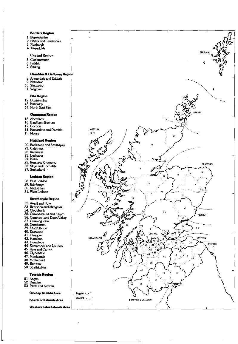
Borders Region1. Berwickshire2. Ettrick and Lauderdale3. Roxburgh4. Tweeddale
Central Region5. Clackmannan6. Faikirk7. Stirling
Dumfries & Galloway Region8. Annandale and Eskdale9. Nithsdale
10. Stewartry11. Wigtown
Fife Region12. Dunfermline13. Kirkcaldy14. North-East Fife
Grampian Region15. Aberdeen16. Banff and Buchan17. Gordon18. Kincardine and Deeside19. Moray
Highland Region20. Badenoch and Strathspey21. Caithness22. Inverness23. Lochaber24. Nairn25. Ross and Cromarty26. Skye and Lochalsh27. Sutherland
Lothian Region28. East Lothian29. Edinburgh30. Midlothian31. West Lothian
Strathclyde Region32. Argyll and Bute33. Bearsden and Milngavie34. Clydebank35. Cumbemauld and Kilsyth36. Cumnock and Doon Valley37. Cunninghame38. Dumbarton39. EastKilbride40. Eastwood41. Glasgow42. Hamilton43. Inverclyde44. Kilmamock and Loudon45. Kyle and Carrick46. Clydesdale47. Monklands48. Motherwell49. Renfrew50. Strathkehrin
Tayside Region51. Angus52. Dundee53. Perth and Kinross
Orkney Islands Area
Shetland Islands Area
Western Isles Islands Area
BORDERS
BORDERS REGION
BERWICKSHIRE DISTRICT
Paxton House (Mutton parish} A R Rees (CFA)Paxton boathouse
NT 9340 5195 In October 1994 recording and limited excava-tion was undertaken within the disused boathouse of Paxton House,prior to its reconstruction as a tourist attraction. The floor of theboathouse was examined and a trench 2.0m by 0.5m was dugparallel to the western wall to locate any buried features or earlierphasing. An earlier wall was noted, indicating that the boathousehad been partly demolished and subsequently widened andextended on its southern side. Later features of the boathouseincluded tramlines, comprising sandstone slabs set into the floor intwo parallel lines with 0.20m wide gaps between them to providewooden stays for the retention of boats. A setting for a winch wasplaced at the rear end of the tramlines.
A detailed report has been sent to the NMRS.Sponsor: The Paxton Trust.
Doons Law, Whitsome (Whitsome parish) C Clarke (CFA)Cist burial with beaker
NT 868 516 A cist burial on Doons Law was unearthed duringploughing in early January 1995. The cist was located approxim-ately 3m to the N of a prominent mound and enclosed by a stoneretaining wall on Doons Law. The capstone had been displaced bythe plough and damaged, and was shown to overlie a cist of fourupright sandstone slabs with the main axis aligned approximatelyE-W. The floor area of the cist measured 1.05m by 0.50m. Withinthe western end the vault of a skull was exposed and to the N of thisstood an intact decorated beaker. The skeleton was that of an adultfemale- The beaker is of the North British/Northern Rhine type.Excavation of the cist revealed four pieces of flint, fragments ofa copper awl and charcoal. An area of 'body stain', rich in organicmicrofossils, around the area of the skeleton was exposed. Palyno-logical work will be undertaken to detect the possible presence ofdeliberated floral tributes deposited at the time of burial.
A full report will be lodged with the NMRS. Post-excavation workis continuing.Sponsors: HS Q and Borders Regional Council.
ETTRICK & LAUDERDALE DISTRICT
Harelaw to Groundistone Height (Ashkirk; Lilliesleaf parish)Roman road traces W Lonie. F Newall
NT 533 231 to NT 495 202 The Craik Cross Roman road is wellestablished to Craik village, less certainly to Hoscote and its coursefrom there to Dere Street some 30km to the NE has been the subjectof speculation and a general route by Esdale Law, GroundistoneHeight and Harelaw suggested. Search-surveys by the contributorsalong and about this route, variously with D Mackinnon, M Sinclairand Mrs W Lonie, commenced in 1981 and continue in 1995. Roadlengths and features have been described from NE to SW.
Full details have been lodged with NMRS. Landowners andtenants along the route are thanked for their interest.
Eildon Wester Hill (Bowden parish) W LonieThorn platform (Bronze Age astronomical station)
NT 548 316 A terrace on Eildon Wester Hill is suggested asa Thorn platform, the antiquity indicated by the peat overgrowth.Bronze Age associations, the careful siting and construction, com-bine to indicate this function. The terrace is 25.6m long, uniformly
4.0m wide extending E-W about NT 5483 3165, some 60m down-slope northwards of and 7m below the 371m summit of EildonWester Hill.
A fuller report is lodged with the NMRS. Buccleuch Estates arethanked for their interest in this study.
Turfford Burn (Earlston parish) A L WiseEarthwork (possible)
NT 611 392 In 1993 K Clark from the Newstead ResearchProject undertook a geophysical survey of Turfford Burn. Thisearthwork is recorded in the NMRS as site NT 63 NW 11. Theenclosure is partly preserved in a neighbouring plantation,Sponsors: NMS, University of Bradford, British Academy, Borders
Regional Council.
Droveway sign-wall W LonieNT 185 064 Wind Fell (Ettrick parish)NT 329 161 Course Head (Kirkhope parish)NT 323 161 Craig Hill (Kirkhope parish)NT 320 161 Craig Hill (Kirkhope parish)NT 447 171 Gawndie's Knowe (Roberton parish)NT 451 172 Smasha Hill (Roberton parish)NT 397 326 Whltehope Rig (Yarrow parish)NT 200 241 Craigie Rig (Yarrow parish)
A new class of minor monument is suggested, that of 'drovewaysign-wall', so named by analogy with 'road sign-post'. Its functionwas to warn drovers that a droveway ahead was forbidden byreason of danger or trespass. Its structure is an isolated length of dry-stone wall, 3-50m in length. Eight examples are known to date.They also mark droveways and indicate the direction of droving.
Landowners and tenants are thanked for their interested accept-ance of this study.A R B Haldane 1952 The Droue Roads of Scotland Lochar 1995.RCAHMS 19% The Inventory of Roxburghshire
Groundistone Height to Woo Law (Hawick; Ashkirk parish)Roman road traces W Lonie, F Newall
NT 495 202 to NT 460 177 A report has been compiled fromsearch-surveys made in May and July 1981. November 1984and February 1995 variously by F Newall and W Lonie, withD Mackinnon and M Sinclair. The route of the Roman road fromHarelaw to Groundistone Height was traced across the main road atNT 4957 2024 continuing SW as a broad cambered way. Through-out its route it passes under enclosing banks and droveways, oftenlater routes sharing the earlier line of the road.
A full report is lodged with NMRS. Landowners and tenants alongthe way are thanked for their interest.
Oakwood to Fanns Bum (Kirkhope parish) W LonieProbable Roman road
NT 425 248 to NT 415 222 The Roman forts of Oakwood andMilton, in Ettrickdale and Annandale respectively, are separated by40km of moor and mountain upland about the head-waters of theEttrick and Moffat Waters, the latter a tributary of the Annan.Surveys along possible routes (Lonie, DES 1988) have beenencouraging but inconclusive. The work lends strong support to thesuggestion of a roadway linkage, but major gaps in the supposedroute remain.
A full report is lodged with NMRS. Landowners and tenants alongthe way are thanked for their interest.
Kirkhope Tower (Kirkhope parish) J O'SullivanTower house
NT 3787 2505 A watching brief was conducted at KirkhopeTower (NMRS NT 32 NE 6) by AOC (Scotland) Ltd on the excava-tion of a cable trench by Scottish Power, The trench was laid in the
BORDERS
course of a programme of building and restoration works andextended from the NE angle of the tower, across the adjacent farmtrack, and along the N side of the track for a distance of c 30m. Thisarea had previously been scarped by the creation of the farm trackand no archaeological deposits were recorded.
Four sherds of late medieval pottery were recovered frommachine spoil.Sponsor: Scottish Power.
Llttledean (Maxton parish) A L WiseFort
NT 632 313 In 1993 K Clark from the Newstead ResearchProject surveyed Littledean. This fort is recorded in the NMRS as siteNT 63 SW 51. Resistivity results show evidence for a promontoryenclosure comprised of at least three irregularly spaced ditches.Magnetometry results produce evidence for at least five enclosingditches. Littledean Tower sits within all of these earthworks.Sponsors: NMS, University of Bradford, British Academy, Borders
Regional Council.
Chester Knowe (Melrose parish)Earthwork
NT 554 356 In 1993 K Clark from the Newstead ResearchProject surveyed Chester Knowe. This earthwork is recorded in theNMRS as site NT 53 NE 31. Magnetometry results show a singleditched circular enclosure.Sponsors: NMS, University of Bradford, British Academy, Borders
Regional Council.
Chesterlee, Cairneymount (Melrose parish)Earthwork
NT 555 397 In 1993 K Clark from the Newstead ResearchProject surveyed Chesterlee, Cairneymount. This earthwork isrecorded in the NMRS as NT 53 NE 22. Although the magnetometrysurvey produced no evidence for archaeological features, theresistivity plots show roughly the northern half of a single ditchedovoid enclosure. No evidence for an entrance or internal featureswas recovered.Sponsors: NMS, University of Bradford, British Academy, Borders
Regional Council.
Drygrange Mains (Melrose parish)Enclosure
NT 572 361 In 1993 K Clark from the Newstead ResearchProject surveyed Drygrange Mains. This enclosure is recorded in theNMRS as site NT 53 NE 70. The resistivity plot shows the N, W andE sides of a single-ditched sub-rectangular enclosure with an abut-ting enclosure to the NW.Sponsors: NMS, University of Bradford, British Academy, Borders
Regional Council.
Kaeside (Melrose parish)Fort
NT 517 341 In 1993 K Clark from the Newstead ResearchProject surveyed Kaeside. This fort is recorded in the NMRS as siteNT 53 SW 8. Resistivity results show a poorly defined but roughlycircular enclosure located on a knoll. It appears to be circled to theS by three partial ditches. Magnetometry results show three circularanomalies within the enclosure which may represent structures.Sponsors: NMS, University of Bradford, British Academy, Borders
Regional Council.
Red Rig (Melrose parish)Enclosure
NT 569 336 In 1993 K Clark from the Newstead ResearchProject surveyed Red Rig. Geophysical survey was undertaken on
three of the four fields under which Red Rig enclosure currently lies.Resistivity survey was completed on the two southern fields, andmagnetometry was completed on all.but the northwestern field.Both surveys provide evidence for a double ditched sub-circularenclosure.Sponsors: NMS, University of Bradford, British Academy, Borders
Regional Council.
Cocklcc, Blainslie {Melrose parish) NMSRint scraper
NT 5475 4167 Flint scraper found by Mrs S Campbell. Returnedto finder after recording.Daybook no: DB 1995/71.
Melrose Bypass (Phase III) (Melrose parish) S Clarke?Roman ovens
NT 565 340 A group of three or possibly four ovens were excav-ated in 1994 and 1995 in advance of the Melrose Bypass. Eachconsisted of a circular chamber, c 1.20m across, cut into the ground.A flue and raking out pit lay on the NE side. The most elaborate hada stone floor of red sandstone. The only dating evidence was pro-vided by a single Roman courseware sherd, unabraided but notclosely datable.Sponsor: Borders Regional Council.
Newstead, Broomhill Camp (Melrose parish)Roman marching carnp
NT 578 341 Resistivity and magnetometer survey at Broomhillnear Newstead revealed parts of two small marching camps, one of140rn by 180m, the other 140m by 225m. The SW side of thesecarnps were already known from cropmarks and limited excavation,carried out in 1991 by the late Professor St Joseph. Another linearfracture may be part of a larger marching carnp or an element of thefield system known to have surrounded the Roman fort.Sponsor: Trimontium Trust.
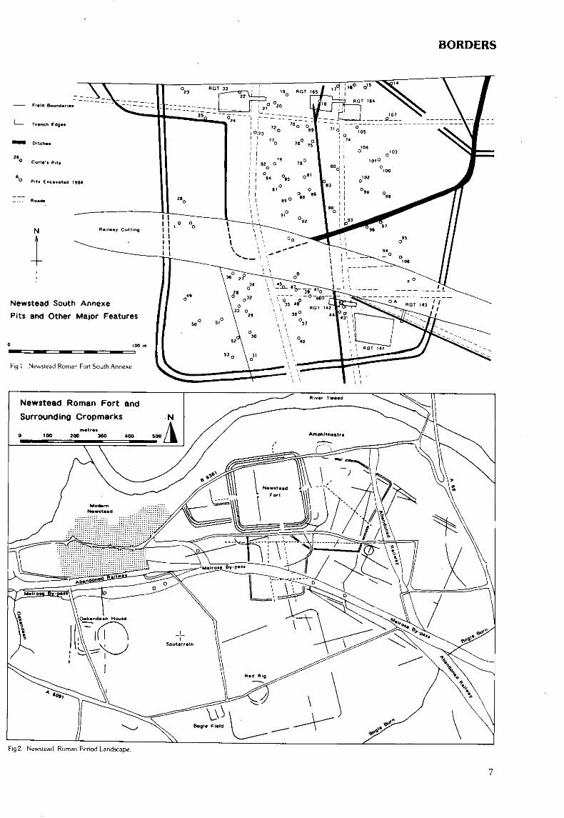
Newstead Roman Fort, South Annexe (Melrose parish)Roman settlement
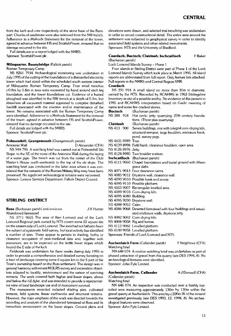
NT 570 341 Excavation in advance of the Melrose Bypass(Phase I I I ) examined the sides of the old railway cutting where itpassed through the S Annexe of Newstead Roman Fort. Bothphases of defensive ditches were examined along with interioroccupation, the most important of which were a series of pits(marked A-F on the plan provided (Fig 1. p7 ) ) . Several previouslyunknown roads were also discovered. The earliest defensive line,consisting of a single large ditch up to 7rn across, was found to dateto the late 1st century. The larger double ditched enclosure wasfound to contain only mid-2nd century pottery, similar to that of theinterior occupation. Four of the six pits were found to have served aswells, although only two were lined, one with wattle, the other stone.The latter was found to contain a ritual deposit at its base: horse andcattle skulls, an axe complete with handle, deer antlers and a com-plete pottery jar. This well's contents are probably relevant to theunderstanding of the 107 'deep pits' dug by James Curie, 1905-1910,Sponsor: Borders Regional Council.
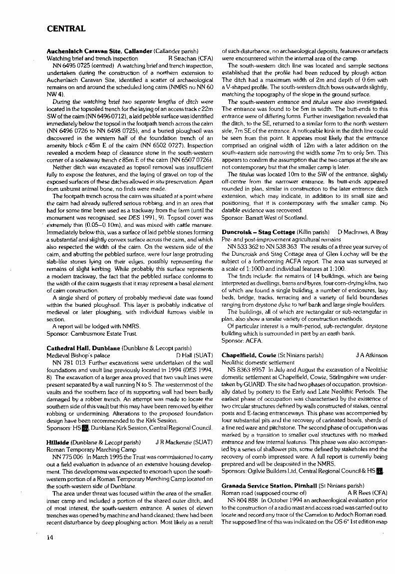
Newstead, Roman Period Landscape (Melrose parish)Marching camp and field system (see Fig2, p7)
NT 562 340 to NT 572 340 Excavation in advance of theMelrose Bypass (Phase 111) showed the examination of a Romanperiod landscape already known from cropmarks and Geophysics.The largest element examined was part of the so-called legionarymarching camp to the SW, partly overlying the S annexe. Ditchlengths excavated at NT 570 341. NT 562 340 and NT 567 342showed three sides of the 'camp' to be quite different in character,
BORDERS
Newstead South AnnexePits and Other Major Features
Fig 1 Newstead Roman Fort South Annexe
Newstead Roman Fort and
Surrounding Cropmarks
Fig 2. Newslead. Roman Period Landscape.
BORDERS
ranging from l-6m across and l-2m in depth. These features andanother at NT 572 340 seem much more likely to be part of a fieldsystem surrounding the fort in the mid-2nd century. Most containedno datable artefacts.
Another ditch at NT 571 341 does represent a marching campditch. It was almost 3m across and 1. 7m deep. The only find associ-ated with it was the lower stone of a rotary quern.Sponsor: Borders Regional Council.
The Battery (Melrose parish) W Lonie. J DentPossible medieval river-works
NT 554 347 to NT 557 349 Medieval riverside works along theright bank of the River Tweed by Melrose were reported in DES1994, 5. The full spate of 11 December 1994, estimated at c450cubic metres (tonnes) per second, ten times average flow, scouredout a considerable length of the grass-grown silt bank below TheBattery wall at NT 5549 3477, exposing the lower stone-work. In thespate of December 1994 this channel filled for its whole 1.4kmlength. The abnormally low water in late June 1995 then revealedboth the whole structure for some 20m about that point and alsobasal stone and timber-work intermittently along a 300m length ofwater's edge from NT 5546 3475 to NT 5578 3494. The exposurewas examined by the contributor and J Dent and R Macdonald.Detailed accurate survey was later undertaken by the RCAHMS.
A full report is lodged with the NMRS. The landowners andtenants involved are thanked for their interest.
Elldon Hills (Melrose parish) W LonieLazy-bed patches
NT 548 329 to NT 556 327 The characteristic narrow rigs of lazy-bed cultivation occur in variously sized patches around ihe EildonHill North: c50m by 50m at NT 5482 3296, altitude 150m, ex-posure to the NW; c 50m by 50m at NT 550 329, alt 240m, exp NW;c 100m by 50m at NT 554 332, alt 255m, exp N; c30m by 20m atNT 554 328, alt 370m, exp SW; c 100m by 50m at NT 555 326,alt 345m, exp S. The last of these patches is within the large stone-faced ha-ha enclosure on the broad S terrace of the North Hill, itsrigs parallel to but apparently overlying the broader rigs of theenclosure in general.
The hut-base of this type at NT 548 328 (Lonie, below), was some250m from and level with the nearest.
Buccleuch Estates are thanked for their interested acceptance ofthis study on their lands.
Eildon Hill North (Melrose parish)Bronze Age potsherds, calcined bone and charcoal
NT 554 328 Two sherds of Bronze Age pottery were found in therubble of small stones and gravel exposed at the back of a sheep-scrape into the front scarp of a scooped hut-base at NT 5544 3281,some 35m downslope SSW from the Roman Signal Station base onthe summit of Eildon Hill North. The sherds are in a coarse fabricwith large grits, brownish-black in colour with a leathery surfacetexture. In the same rubble there were a few fragments of each ofcharcoal and calcined bone.
The identification was made by comparison with authenticatedsamples from the Eildon Hill North held by the Trimontiurn TrustMuseum, Melrose. Finds retained by Mr J Dent.
Buccleuch Estates are thanked for their interested acceptance ofthis finding.
Newstead (Melrose parish)Probable Roman quern fragment
NT 564 342 The fragment of an upper quern-stone was pickedup as a surface find on ground disturbed in road development atNT 5647 3421 at the head of Newstead village near the W annexe ofthe fort. The fragment shows a grooved face 15cm by 10cm and
tapers in thickness from 4-8cm. The upper face is dressed flat andshows a few chisel marks. Similarities to a Roman upper quern-stone of Rhenish lava held by Trimontium Museum, Melrose.
Newstead (Melrose parish)Neolithic stone axe-head
NT 564 342 At NT 5647 3420 a surface find in field-soil muchdisturbed by road construction works, a Neolithic stone axe-head ofmaximum dimensions 165mm by 62mm by 32mm. The cuttingedge is smoothed and rounded but not chipped. The faces aresmoothed for c 120mm from the edge. Find retained by J Dent.
Eildon Hills (Melrose parish)Old mining complex and whim (horse-gin)
NT 548 328 Possible ore-veins exposed by over-burdenremoval and worked by open-cast and adit methods, mineral trackslinking these workings and a horse-whim sited to provide rope-haulto the main working combine to suggest an old ore-mining complexon the flanks of the hill-saddle between the Mid and North EildonHills. This work has been undertaken between January 1988 andOctober 1995.
A full detailed report has been lodged with the NMRS. Thanks aredue to Buccleuch Estates for their interested acceptance of this study.
Newstead (Melrose parish) J Hamilton (CFA)Melrose Bypass Road Phase 111: watching brief
NT 577 340 to NT 553 340 A watching brief was undertaken inJune and July 1995 on the construction of the Melrose Bypass Roadproject. The route is mainly set in agricultural land and directlyaffects a large area of Scheduled Ancient Monument centred roundthe Roman Military complex of Newstead. No archaeological fea-tures that had not previously been recorded by Bradford Universitywere noted during the watching brief. Two artefact scatters werelocated, at NT 5690 3415 and NT 5710 3410, both on the southernslope of the railway cutting. The material was located by field-walking, where it was eroding from an organic rich matrix exposedby excavation. Both scatters contained sherds of samian ware,mortaria, and other fine and coarse wares.Sponsor: Borders Regional Council through Bradford University.
Cllnthill (Mertoun parish) A L WiseEnclosure
NT 603 328 In 1993 K Clark from the Newstead ResearchProject surveyed Clmthill. This enclosure is recorded in the NMRS assite NT 63 SW 42. Only the southern half of the enclosure could besurveyed as the northern portion currently is overlain by a planta-tion. Resistivity results show a semi-circular single-ditched enclosurewith a possible entrance to the SE.Sponsors: NMS. University of Bradford, British Academy, Borders
Regional Council.
Heckslde 1 (Mertoun parish)Enclosure
NT 603 330 In 1993 K Clark from the Newstead ResearchProject surveyed Heckside 1. This enclosure is recorded in theNMRS as site NT 63 SW 7. Resistivity plots clearly show the south-eastern quadrant of the enclosure. Visible are two concentricditches, each with entrances in the SE. Up to four internal featurescan be seen on the plot, and these are likely to represent structures.Sponsors: NMS, University of Bradford, British Academy, Borders
Regional Council.
Heckside 2 (Mertoun parish)Enclosure
NT 608 331 In 1993 K Clark from the Newstead ResearchProject surveyed Heckside 2. This enclosure is recorded in the
BORDERS
NMRS as site NT 63 SW 40. The resistivity plot shows three con-centric ovoid enclosing ditches. The eastern portion of the secondditch appears to have been recut at some point as there are two ditchsegments at slightly different alignments. One concentric ring, poss-ibly representing a structure, is visible as a high resistance featurelying between the first and second ditches.Sponsors: NMS, University of Bradford, British Academy, Borders
Regional Council.
South Whitrlghlll (Mertoun parish)Enclosure (possible)
NT 621 344 In 1993 K Clark from the Newstead ResearchProject surveyed South Whitrighill. This site is currently registeredin the NMRS as NT 63 SW 45. Resistivity printouts suggest that theenclosure is single ditched and D-shaped with two possible adjoiningextensions Gaps appear in the enclosing ditch to the W and E butit is unclear whether these represent entrances. Magnetometryprintouts suggest that the enclosure had an entrance to the SE.Running perpendicular from this enclosure is a high magneticlinear anomaly that continues E past the boundary of the surveyarea.Sponsors: NMS. University of Bradford, British Academy, Borders
Regional Council.
Third (Mertoun parish}Earthwork
NT 614 351 In 1993 K Clark from the Newstead ResearchProject surveyed Third. This earthwork is recorded in the NMRSas site NT 63 NW 3. Resistivity results produce evidence for theNW, W, and SW sides of a sub-circular to ovoid double-ditchedenclosure. Abutting Ihe outermost ditch to the N are the W andE sides of a possible subrectangular enclosure. Abutting the outer-most ditch to the E appears the N, W, and S sides of a possible recti-linear enclosure Three possible internal structures appear as highresistivity signals in the western and southern portions of the mainenclosure.Sponsors; NMS. University of Bradford. British Academy, Borders
Regional Council.
Philip Haugh (Selkirk parish) D Alexander. T NeighbourGeophysical survey
NT 456 283 A geophysical survey of the cropmark site of thepossible Early Historic settlement at Philip Haugh was under-taken NMRS No NT 42 NE 71. A total of 22 grids. 30m by 30m.was surveyed using both resistivity and magnetometry. Many ofthe features visible on the aerial photographs were located withless clear definition. It will be useful to compare the results fromthis survey with other sites of a similar date where the cropmarkevidence is not as clear, eg Kilspindie Castle, Aberlady (see below,p48).
A report is being produced and a copy will be deposited with theNMRS.Sponsors: Hunter Archaeological Trust, CFA.
ROXBURGH DISTRICT
NMSAppletreehall, Hawick (Hawick parish)Romano-British sculptured figure of deity
NT 5180 1745 A shaped piece of sandstone carved witha human figure in relief was found in the garden at Appletreehallaround 1935. and has now been donated to NMS. It is 200mm high.and has an over-large head (damaged), wears a tunic which flaresbelow the waist, and stands full-face with its arms away from itssides, the forearms reaching downwards along the edges of the slab.
There are incised objects below the figure's arms on either side, buttheir identity is unclear.
Parallels suggest it is likely to be a relief of a Romano-British deity.Daybook no: DB 1995/80.
20—26 Drumlanrig Square, Hawick (Hawick parish)Assessment S Stronach (SUAT)
NT 5007 1427 Ten test pits were excavated in the back gardensof 20-26 Drumlanrig Square. These located natural subsoil c 0.10mbelow ground level next to the frontage; while deep levellingdeposits, at least 2.5m deep, were identified towards the rear of thegardens. Two test pits were also excavated in the front gardens of1-2 The Village, revealing c 1m of garden soil overlying natural. Alldeposits encountered were modern in origin. One residual sherd ofmedieval pottery was recovered.Sponsor: HS Q.
20-26 Drumlanrig Square (Hawick parish) A Cox (SUAT)Finds assemblage
NT 5007 1427 A small assemblage of artefacts was recoveredfrom the test pits excavated at this site. Much of the material is of19th century date, although a small number of finds may be slightlyearlier and there are several which date from the early decades of thepresent century.
A quantity of cinders, charcoal and partially burned fuel materialsrecovered from one of the test pits may have derived from rubbishburning on the site. Material such as this may also have been a com-ponent of levelling deposits used to create the artificial terrace onwhich the Drumlanrig gardens stand.Sponsor: HS Q.
Woo Burn to Blawearle (Hawick: Roberton parish) W Lonie.Roman road traces F Newall
NT 460 177 to NT 441 166 A report has been compiled fromsearch-surveys in May and July 1981, and two in February 1995.variously by the contributors with D Mackinnon and Mrs W Lonie.Several alternative routes were searched and much was learned ofroads and tracks of periods other than Roman.
The full detail of this work is lodged with the NMRS. Landownersand tenants along the way are thanked for their interest in this study.
Kilmun Court, Jedburgh (Jedburgh parish) J DentMedieval Friary (precinct wall)
NT 650 207 Landscaping of the garden of Kilmun Court {akaKilmuir Court) exposed further foundations of the presumedprecinct wall, which earlier had been located by excavation to theS of the friary church (PES 1991, Fig 1). The wall extended from thepreviously exposed length to the boundary with Friarsgate on the W.and had been terraced into the existing slope, to leave the higherground on the S.Sponsor: Borders Regional Council.
Borthwickbrae (Roberton parish) W LonieTumulus
NT 415 139 At NT 4153 1393. at an altitude of 267m, over-looking Borthwickbrae House park from its northern corner, isa prominent circular mound c22m in diameter, 1.7m high. Themound has no ditches and may have been made with material froma surface quarry, now overgrown with grass, some 50m to the S.This quarry area is crossed by the slumped turf dyke of the parkboundary between grass-land and woodland, now mature, offeringa crude chronology. The mound is deeply broken by small pits,3-4m in diameter, which appear dug out rather than cast up,though such sporadic gaining, say for road-stone, poses problems.
The landowner and tenant are thanked for their interested accept-ance of this study.
BORDERS
Borthwlckbrae to Mllslngton (Roberton parish)Roman road traces
NT 413 137 to NT 406 130 The Roman road traced to NT 41311374 on the NW edge of Berthwickbrae park is lost for some 700mabout the projected line SW. Survey from Burnfoot farm has locatedthe Roman crossing of the Borthwickbrae Burn and the approachesto it. These lie on the projected road-line. Survey is ongoing.
Detailed report lodged with NMRS. Thanks are due to land-owners and tenants along the way for their interest.
Howcleuch and Borthwlckbrae (Roberton parish)Roman road traces
NT 418 144 to NT 413 137 Previous survey traced a Romanroad to NT 4186 1443 on the N approach to a crossing of theHowcleuch Burn. From that point SSW for 100m runs an impress-ive embanked way, 9.0m wide between 3-4m wide side ditches,possible cart-way hollows. The hollow to the W side has been recutas a ditch. At NT 4183 1433 the embanked way with its side-worksnarrows and evolves over some 20m into a single 3.5m wide cart-way within a 6.0m wide cutting. 0.8m deep. A stone field-wall run-ning E-W across the cutting is gapped to pass the cart-way. Thecutting and cart-way continue SSW for 50m to the edge of theHowcleuch mill-pond at NT 4180 1425. Immediately to the Wa major drainage-ditch runs into the pond from the NW. Some 50maway SSW directly across the mill-pond a similar broad road-cuttingemerges from the water.
A detailed report is lodged with the NMRS. Landowners andtenants on the route are thanked for their interest in this study.
Borthwlckshlels and Howcleuchshiels (Roberton parish)Roman road traces
NT 425 155 to NT 418 144 The Roman road-line traced toNT 4257 1554 emerges below the terrace of the minor tarmac roadthere as a clOm broad cambered way between shallow ditcheswhich descends SW at a moderate gradient to the wet ground aboutNT 4248 1546 at the head of the Borthwickshiels Loch Burn. On thedescent the road-mound is cut across from S to N by the grass-grown embanked terrace of a cart-way rising to the tarmac road. Forsome 30m across the wet ground the cambered road structureis lost, perhaps washed out, but re-emerges at NT 4251 1546 torun for 350m to NT 4226 1522 as a mounded terrace, generally10-12m wide, broken in places. A cart-way hollow runs to the NW,upslope side of the earlier road-mound.
Full details of the route are lodged with the NMRS. Landownersand tenants along the route are thanked for their interest.
Blawearle, Borthwickshlel Horn, Hangingshaw HillRoman road traces {Roberton parish)
NT 441 166 to NT 425 155 The route of the Craik Cross Romanroad in its extension 30km NE to Dere Street has been the subject ofspeculation. Search-survey in April 1995 traced the probable routeover the 1.9km length from Blawearie to Hangingshaw Hill. Thisroad-length was not easily traced.
Full detail of this route is lodged with the NMRS. Thanks are dueto landowners and tenants on the route for their interest.
Teviothead (Teviothead parish) K TaylorField evaluation (possible chapel)
NT 404 049 Further investigation by GUARD, in the form of trialtrenching, took place at the site of a possible chapel at Teviothead(DES 1994, 6). Previous work, comprising a desk-based study andgeophysical survey, had identified three areas which were deemedto be of potential archaeological significance. All three were investig-ated by trial trenches; no remains of archaeological significance wereencountered.Sponsor: The Scottish Office Roads Directorate.
WLonie TWEED DALE DISTRICT
Lour (Drumelzier parish) S CarterBurnt mounds, banks, cultivation remains
NT 180 352 An archaeological survey was undertaken of roughly50ha of moorland at Lour near Dawyck as part of a research projectat the Department of Environmental Science, University of Stirlinginvestigating the behaviour of pollen in soil. Sixteen features ofarchaeological interest were noted, only two of these had previouslybeen recorded (as part of NMRS site NT 13 NE 1). Almost all of thesites were medieval or later in date but there were burnt moundsalong one of the watercourses. More recent features included areas ofcultivation, turf banks, tracks and two areas of lead slag of uncertainpurpose or origin. A full report has been deposited with NMRS.Sponsors: NERC, University of Stirling.
Caerlee Hill, Innerlelthen (Innerleithen parish)Watching brief D Alexander (CFA)
NT 324 367 A watching brief was carried out at the NE entranceof this scheduled fort (NMRS no NT 33 NW 7). This was to monitorthe removal of spoil which had accidentally been deposited in theditch terminals after recent construction work at the adjacent com-munications compound. The spoil was removed by hand andtransported by mini-digger away from the site. The earthworks werenot damaged and the site was left in a tidy condition. A flake of struckquartz was recovered from a molehill c30m S of the communica-tions compound.Sponsor: National Transcommunications Limited.
Manor Valley (Manor parish) I MacLeodThe Manor Valley Research Project, part of the Peeblesshire Arch
Soc, plans to conduct a total survey of the Manor Valley over thenext three years.
Castlehill (Manor parish)Burnt mounds, lead smelting site
NT 216 344 Three burnt mounds were discovered by thelate John Nash of Castlehill. Lying in a line on the N side of theHopeterrick Burn. Beside the higher up of the three, there is a 50mlong sterile patch of ground which has been a lead smelting site.
Manorhead (Manor parish)Cup and ring boulder
NT 1895 2829 An angular boulder of greywacke has threeincised designs - an oval groove, a lozenge-shaped groove anda cup and ring.
Cavalry Park, Peebles (Peebles parish) A Sheridan'Sponge finger stone'
NT 2635 3970 Found spring 1994 by Mr R Knox of Peebles,during inspection of soil recently disturbed by construction work onCavalry Park industrial site. Found near two sherds of prehistoricpottery; over 120 pieces of struck chert found in general area ofdisturbed ground. Incomplete, and surviving end damaged; of fairlysoft, fine-grained green stone. 'Sponge finger stones' may be aleatherworker's tool. Associations found elsewhere indicate an EarlyBronze Age date. Treasure Trove case 43/94; allocated to Tweed-dale Museum.Sponsor: NMS.
Cardrona (Traquair parish) NMSMBA palstave
NT c 30 38 (around this square) A MBA palstave was apparentlyfound by a metal-detectorist some years ago on the farm ofCardrona. The object cannot now be traced and no further detailsare available.
10
BORDERS/CENTRAL
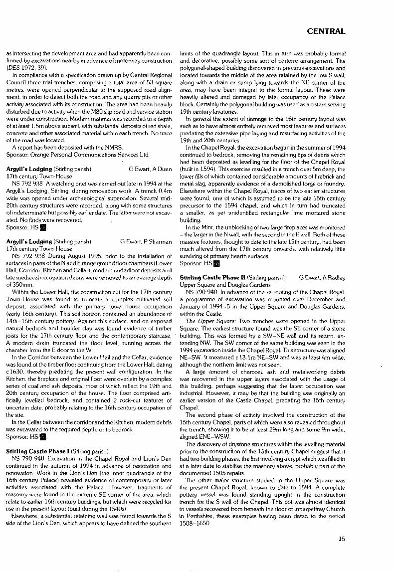
West Water Reservoir (West Union parish) F HunterPossible BA cemetery; hearth, wall and stone structures of uncertain(?prehistoric) date
NT 118 525 A long dry spell in 1994 exposed further features inWest Water Reservoir (DES 1992, 9-10; 1993, 10), which werereported to NMS by the reservoir keeper, Mr A Moffat and excav-ated in November 1994. Six areas (D—I) were investigated; G turnedout to be natural.
CENTRAL REGION
CLACKMANNAN DISTRICT
WEST WATER RESERVOIR 1992-1994
Fig. 3. Areas excavated at West Water Reservoir 1992-1994 The N shote of thereservoir is marked in a solid lint whe re surveyed in. and doited on elsewhere.
Erosion since 1992 had stripped topsoil and subsoil from theisland E of the original cemetery. In 1992, nothing had been visible,in 1994, six clusters of stone slabs, perhaps the collapsed remains ofarchaeological features, were revealed (area F). One overlay a shal-low pit, and was clearly not a burial. The others, on the summit ofthe island, may be the remains of destroyed cists, covering an areaof some 10m by 15m,.in a similar setting to the 1992 cemetery.Interpretation is uncertain due to the presence of large flat slabs inthe glacial till, although the clustering would be unusual in naturalfeatures, and by the lack of associated artefacts, although given thedamage this is unsurprising.
On the island immediately W of the 1992 site, a rectangular ortho-static chamber just under 1m in length was partly revealed at itssouthern tip (area H). but rapidly rising water levels preventedinvestigation.
Two sites were examined further W in the reservoir, where thevalley narrows; part of a curvilinear wall (area E) and an orthostat-lined feature interpreted as a hearth or cooking pit (area D). The wallwas only partly exposed, and had been damaged by meandering ofthe burn. A knife-sharpening stone in its makeup suggests an IronAge or later date. Its function is unclear, but is probably agricultural.The hearth comprised a sub-rectangular pit, 2.2m by l.lm by0.35m in size, orthostat-lined on three sides, with a shallow scoop atthe W end leading into a deeper pit, filled with charcoal-rich soil andfire-cracked stones. There was no evidence of associated structuresin the small area examined.
At the W of the reservoir, a shallow-sloping area has been partlystripped of turf by water action, exposing stone walls underlying thepeat (area I), possibly prehistoric field walls. Time did not permit fullstudy, but the remains were photographed and sketched.Sponsors; NMS, HS HI. Borders Regional Council.
S Stronach (SUAT)Klrkgate, Alloa (Alloa parish)Assessment
NS 8865 9262 Four trial trenches were excavated in advance ofa housing development. These revealed imported garden soil, andevidence for demolition. Several modem features, cut into natural.were located. Associated with the cut for an infilled cellar was a fineassemblage of rejects from the 19th century Alloa pottery. Alldeposits encountered were modern in origin.Sponsor: Ochilview Housing Association.
Kirkgate, Alloa (Alloa parish) A Cox (SUAT)Pottery assemblage
NS 8865 9262 An assemblage of 19th century Alloa pottery,consisting largely of wasters and incomplete vessels, was recoveredfrom the excavation at Kirkgate. The predominant fabric is Rocking-ham-type ware, which has a dark brown glaze, the main colouringagent of which is manganese binoxide. Both glazed and unglazedvessels are represented in this assemblage. The collection ofunglazed vessels includes examples of penny banks or pirley pigs.Four fragments of kiln spacers are also included in the assemblage.
The Alloa Pottery, established in c 1790 and closed in 1908, stoodonly a short distance to the N of the excavation site.Sponsor: Ochilview Housing Association.
Middlehall (Muckart parish) T M AllanFife peninsula Roman road survey
For much of the half-mile from NN 990 008 to NN 998 012 -ie along the border between the cultivated and uncultivated areas ofthe S slopes of the Ochil Hills - there runs a rock-hard agger, up to8 paces wide, with a ditch along much of its N side, and with manyloose cobbles strewn over it, doubtless from field-clearing. Atboth ends it bends southwards - at its W end to reach a ford atBaldies Burn.
FALKIRK DISTRICT
Inveravon Farm (Bo'ness & Carriden parish)A J Dunwell. I B M Ralston (CFA)
Desk-based assessment and fieldwalktng programmeNS 96 79 In order to provide supporting information associated
with a planning application for a proposed landfill facility, a desk-based assessment and field inspection, and a subsequent field-walking programme, have been undertaken during 1993-4. Theapplication site comprises a large, roughly triangular, arable fieldbounded on its three sides by an unclassified public road, the AvonGorge and the Bo'ness and Kinneil Railway.
The desk-based assessment identified through aerial photographsthe seventeen archaeological or potentially archaeological siteswithin the landfill application boundary: only no 17 is identifiable inthe field- Eight of the sites are known cropmark sites - Antonine Wallfrontier works, temporary camps and enclosures etc.9 NS 960 796 Network of removed field boundaries recorded
variously on 19th-20th map sources and aerial photographs.10 NS 962 798 Enclosure with possible rig-and-furrow.11 NS 962 795 Post-medieval settlement named Bogagich or
Bogg, recorded only on pre-OS maps.12 NS 961 797 Rectilinear parchmarks, possibly structures.13 NS 961 794 Small rectangular parchrnark, possibly an en-
closure and possibly associated with site 11.
11
CENTRAL
14 NS 963 794 Embankment projecting from Bo'ness andKinneil Railway embankment, recorded on first edition OScoverage of 1856 but now destroyed.
15 NS 9595 7944 An area of irregular cropmarks, possiblyarchaeological in nature.
16 N/A Raven Farm, as recorded only in Stuart'sCaledonia Romano, 2nd edition (1852, 361). 'Raven' is clearlya diminutive form of Inveravon, and the site is probably a mis-representation of the current farm (1852, 361).
17 NS 9639 7918 Modem concrete structures, probably associ-ated with Birkhill clay mine.
A fieldwalking programme was subsequently undertaken target-ting several of the above sites. The principal aims of the field-walking were: to assess the density of artefacts, whether Roman orotherwise, within the scheduled areas of the Roman TemporaryCamps to provide some indication of the date and function of a sub-rectangular enclosure; to locate more precisely and attempt to datea probable ring-ditch; to locate more precisely and, if possible,define the time depth of occupation of Bogagich farmstead (site 11);and to locate any artefactual evidence which might suggest anarchaeological origin for the irregular cropmarks (site 15). A total of15 grids, mostly measuring 90m square, and seven transects werewalked, with artefacts collected by 10m square block. All butpatently recent artefacts were collected. Areas with no recordedsites were walked to provide indications of background densities ofartefacts.
The total assemblage collected is estimated at 4,000-4,500items. The materials recovered were categorized as modern glazedpottery, other pottery, clay pipe, glass, brick and tile, slate, metalobjects, industrial residues, bone and shell, flint and chert, otherlithic materials, and miscellaneous objects. A handful of pottery,glass and tile finds from the areas of the Roman Temporary Campsare conceivably of Roman origin. A blue glass bead, stone whorl,small ceramic tile and a corroded coin or token were found fromareas adjacent to the enclosure. No evidence was found regardingthe date or precise position of the ring-ditch. There were no particu-lar densities of post-medieval material around site 11 which mightbetray the position of Bogagich. A clustering of iron slag was noted inthe area around site 15, but this is not enough to suggest that theirregular cropmarks are archaeological features.
A report detailing the work will be deposited with the NMRS.Sponsor: Scotia Environmental Services Ltd.
Rough Castle, Bonnybridge (Falkirk parish) A J Dunwell (CFA)Stone pavement
NS 8486 7989 In summer 1995 a stone pavement and a boulderalignment were discovered by Mr G Bailey of Falkirk District Councilin a narrow, dry stream valley within Roughcastle opencast coalmine, during archaeological monitoring of topsoiling operations inadvance of mining. The features were revealed following theremoval of an overburden of bedded peats, sands and gravels inplaces over 1 m deep. This could have represented a possible ford ofRoman date. CFA was commissioned by HS to conduct rescue workin order to obtain further information relating to the nature, date andpalaeoenvironmental context of the exposed features.
The pavement was revealed to be up to c 7.5m wide and orientedapproximately NE-SW. A clOm length of the pavement wasexposed within the area available for excavation. Its full length islikely to have been c 12m, and it is hoped that this will be confirmedby future monitoring adjacent to the NE stream bank. The pavementhad been laid across the near-level base of the stream valley, and didnot climb the bank on the SW side. Samples have been taken of thepeat immediately above the pavement in anticipation of receivinga terminus ante quern for the construction of the feature by radio-carbon dating. Fragmentary remains were recorded of a secondaryboulder spread overlying the pavement, and subsequently an open
drain had been cut along the stream channel and thus obliquelythrough the pavement A pit c 1.5m across truncated the SE side ofthe pavement.
The boulder alignment identified by Mr Bailey ran beside the baseof the NE stream bank. No definitive interpretation of this featurecould be made as a result of the excavation, although its stratigraphicposition within a complex sequence of peat and fluvial deposits wasidentified. Its relationship with the pavement has yet to be deter-mined, as the presumed point where the two meet lies beyond theavailable area.
Post-excavation analysis is under way, and a Data StructureReport is in preparation.Sponsors: HS Q and Coal Contractors Ltd.
Rough Castle, Bonnybridge {Falkirk parish) NMSRoman axehead
NS 843 798 A heavily-corroded Roman iron axehead was foundat Rough Castle, apparently where it had been discarded in thecourse of illegal metal-detecting. The find-spot lies within the fort,between the Principia and the E rampart. The find was reported toNMS and subsequently donated to Falkirk Museum.Daybook no: DB 1994/6.
Rough Castle, Bonnybridge (Falkirk parish) A Rees (CFA)Watching brief
NS 8465 7985 A watching brief was conducted in the vicinity ofRough Castle Roman fort, during the erection of an electricity pylon.Four small trenches were excavated (2.0m by 0.50m) to facilitatethe erection of the pylon. In addition, a watching brief was carriedout when a c 100m length of cable trench was excavated. This cabletrench was close to the alignment of the Military Way, forming part ofthe Roman frontier works. During both monitoring operations, noarchaeological features or deposits were located.Sponsor: ScottishPower pic.
Rough Castle, Bonnybridge (Falkirk parish) A Dunwell,Roman fort B Finlayson (CFA)
NS 8424 7985 Archaeological monitoring was undertaken inMay 1995 during the dismantling and removal of the electricitytower which had stood on the E bank of the Rowantree Burn,immediately W of Rough Castle Roman fort and within the sched-uled area. The tower was felled eastwards onto a protective coveringof canvas sheeting and tyres, causing only minor and isolated super-ficial damage to the ground beneath the tower. Four small holesexcavated around each tower leg foundation revealed only madeground associated with the original erection of the tower. Noarchaeological deposits or features were identified. Adherence toa Methods Statement for the removal of the tower, agreed in ad-vance between HS and ScottishPower, ensured that no damageoccurred to the site.
The removal of the electricity tower had markedly improved thevisual setting of Rough Castle fort.
Full details are in a report lodged with the NMRS.Sponsor: ScottishPower pic.
Park Street, High Bonnybridge {Falkirk parish)Antonine Wall
NS 8300 7971 Archaeological monitoring was undertaken inJuly 1995 of the cutting of the foundations of a dismantled electricitytower which had stood directly on the scheduled line of the Ram-part, still visible as a prominent earthwork at this location. Four smalltrenches c0.5m by 0.5m in area, and 0.5m deep, were excavatedby hand around each leg foundation, and the tower foundationscut. No in situ archaeological remains were identified. From thedisturbed backfill of the SE trench were recovered one dressedsandstone block and three sandstone chunks, probably derived
12
CENTRAL
from the kerb and core respectively of the stone base of the Ram-part. Chunks of sandstone were also removed from the NW trench.Adherence to a Methods Statement for the removal of the tower,agreed in advance between HS and Scottish Power, ensured that nodamage occurred to the site.
Full details are in a report lodged with the NMRS.Sponsor: ScottishPower pic.
Milnquarter, Bonnybridge (Falkirk parish)Roman Temporary Camp
NS 8261 7934 Archaeological monitoring was undertaken inJuly 1995 of the cutting of the foundations of a dismantled electricitytower which had stood within the scheduled south-eastern interiorof Milnquarter Roman Temporary Camp. Four small trenchescO.Sm by 0.8m in area were excavated by hand around each legfoundation, and the tower foundations cut. Evidence of a buriedploughsoil was identified in the NW trench at a depth of 0.3m, butelsewhere all excavated material appeared to comprise disturbedbackfill associated with the erection and/or maintenance of thetower. No remains associated with the Roman Temporary Campwere identified. Adherence to a Methods Statement for the removalof the tower, agreed in advance between HS and ScottishPower,ensured that no damage occurred to the site.
Full details are lodged with the NMRS.Sponsor: ScottishPower pic.
Polmonthill, Grangemouth (Grangemouth parish)Antonine Wall D Alexander (CFA)
NS 949 795 A watching brief was carried out at Polmonthill SkiSlope, to the SE of the route of the Antonine Wall during the layingof a water pipe. The trench was cut from the comer of the ClubMaster's House north-westwards to the top of the ski slope. Thewatching brief was conducted in the latter area where it was con-sidered that the remains of the Roman Military Way may have beenpreserved. No significant archaeological remains were recovered.Sponsor: Leisure Services Department, Falkirk District Council.
STIRLING DISTRICT
J R HunterRoss (Buchanan parish) and environsAbandoned farmstead
NS 3711 9655 The area of Ben Lomond and of the LochLomond Regional park owned by NTS covers some 22 square kmon the eastern side of Loch Lomond. The area had not hitherto beenthe subject of systematic field survey, but local activity has identifieda number of sites. These appear to pertain to shieling, bothy orclearance occupation of post-medieval date and, together withprecursors, are to be expected on the fertile lower slopes whichbound the E side of the loch.
Fieldwork was undertaken for three weeks during July 1995 inorder to provide a comprehensive and detailed survey focusing ona tract of landscape covering some 6 square km in the S part of theTrust's ownership based on the Ross settlement. The design was ingeneral harmony with recent MOLRS survey and excavation object-ives adapted to locality, environment and the nature of survivingremains. The work covered both higher and lower slopes, aboveand below the hill dyke, and was intended to provide a representat-ive view of local landscape use and of monument survival.
The monuments recorded included shieling sites, cultivatedterraces, field systems, linear earthworks and structural remains.However, the main emphasis of the work was directed towards therecording and analysis of the abandoned farmstead at Ross and itsimmediate environment on the lower slopes. Ground plans and
elevations were drawn, and selected trial trenching was undertakenin order to record constructional detail. The entire area around thesettlement was subjected to geophysical survey in order to identifyassociated field systems and other related monuments.Sponsors: NTS and the University of Bradford.
Ceardach; Bucincti; Clairlnsh; Inchcallloch F Baker(Buchanan parish)Loch Lomond Islands Survey - Phase 1
Four islands in Stirling District were part of Phase 1 of the LochLomond Islands Survey which took place in March 1995. All islandreports are abbreviated from full report. Only feature lists attached.Full reports in the NMRS and Central Region SMR.Ceardach
NS 391 918 A small island no more than 30m in diameter,owned by the NTS. Recorded by RCAHMS in 1963 StirlingshireInventory as site of a possible smithy. No evidence of this present in1995 and RCAHMS interpretation based on Gaelic meaning ofname and some fire-cracked stones.Bucinch (Buchanan parish)NS 388 918 Hut circle; jetty; quarrying; 20th century founda-
tions. (Three plus quarrying)Clairlnsh (Buchanan parish)NS 413 900 Seven buildings, one with integral corn-drying kiln,
structural remains, large boulders, enclosure bank,pond, survey pegs.
NS 4131 8989 Tree.NS 4139 8998 Field bank, clearance boulders, open area.NS 4126 8976 Jetty.NS 4124 8980 Two boulder scatters.Inchcallloch (Buchanan parish)NS 4111 9060 Chapel foundations and burial ground with fifteen
grave slabs.NS 4071 9013 Four clearance cairns.NS 4085 9012 Drystone wall, clearance wall.NS 4090 9010 Possible bank and scoop.NS 4095 9110 Possible platformNS 4105 9007 Rectangular levelled area.NS 4089 9018 Corn-drying kiln.NS 4095 4040 Building.NS 4095 9030 Drystone wall.NS 4098 9053 Caim.NS 4086 9068 Deserted farmstead with four buildings and associ-
ated enclosure walls, drystone jetty.NS 4082 9062 Corn-drying kiln.NS 4008 9058 Rig and furrow.NS 4113 9062 Levelled platform.NS 4100 9058 Levelled platform.Sponsors: Friends of Loch Lomond and NTS.
Auchenlaich Farm (Callander parish) T Neighbour (CFA)Watching brief
NN 648 074 A routine watching brief was undertaken as part ofphased extraction of gravel from this quarry (see DES 1994, 8). Noarchaeological features were identified.Sponsor: John Fyfe Limited.
Auchenlaich Farm, Callander A J Dunwell (CFA)(Callander parish)Watching brief
NN 646 074 An inspection was conducted over a freshly top-soiled area measuring approximately 130m by 130m within thegravel quarry at Auchenlaich. This area lay c 200m W of the moundinvestigated previously (see DES 1993, 12; 1994, 8). No archae-ological features were observed.Sponsor: John Fyfe Limited.
13
CENTRAL
Auchenlalch Caravan Site, Callander (Callander parish)Watching brief and trench inspection R Strachan (CFA)
NN 6495 0725 (centred) A watching brief and trench inspection,undertaken during the construction of a northern extension toAuchenlaich Caravan Site, identified a scatter of archaeologicalremains on and around the scheduled long cairn (NMRS no NN 60NW4).
During the watching brief two separate lengths of ditch werelocated in the topsoiled trench for the laying of an access track c 22mSW of the cairn (NN 6496 0712), a laid pebble surface was identifiedimmediately below the topsoil in the footpath trench across the cairn(NN 6496 0726 to NN 6498 0725), and a buried ploughsoil wasdiscovered in the western half of the foundation trench of anamenity block c45m E of the caim (NN 6502 0727). Inspectionrevealed a modem heap of clearance stone in the south-westerncomer of a soakaway trench c 85m E of the cairn (NN 6507 0726).
Neither ditch was excavated as topsoil removal was insufficientfully to expose the features, and the laying of gravel on top of theexposed surfaces of these ditches allowed in silu preservation. Apartfrom unbumt animal bone, no finds were made.
The footpath trench across the cairn was situated at a point wherethe cairn had already suffered serious robbing, and in an area thathad for some time been used as a trackway from the farm (until themonument was recognised, see DES 1991, 9). Topsoil cover wasextremely thin (0.05-0.10m). and was mixed with cattle manure.Immediately below this, was a surface of laid pebble stones forminga substantial and slightly convex surface across the cairn, and whichalso respected the width of the cairn. On the western side of thecairn, and abutting the pebbled surface, were four large protrudingslab-like stones lying on their edges, possibly representing theremains of slight kerbing. While probably this surface representsa modern trackway, the fact that the pebbled surface conforms tothe width of the caim suggests that it may represent a basal elementof caim construction.
A single sherd of pottery of probably medieval date was foundwithin the buried ploughsoii. This layer is probably indicative ofmedieval or later ploughing, with individual furrows visible insection.
A report will be lodged with NMRS.Sponsor: Cambusmore Estate Trust.
Cathedral Hall, Dunblane (Dunblane & Lecopt parish)Medieval Bishop's palace D Hall (SUAT)
NN 781 013 Further excavations were undertaken of the wallfoundations and vault line previously located in 1994 (DES 1994,8). The excavation of a larger area proved that two vault lines werepresent separated by a wall running N to S. The westernmost of thevaults and the southern face of its supporting wall had been badlydamaged by a robber trench. An attempt was made to locate thesouthern side of this vault but this may have been removed by eitherrobbing or undermining. Alterations to the proposed foundationdesign have been recommended to the Kirk Session.Sponsors: HS Q, Dunblane Kirk Session, Central Regional Council.
Hillside (Dunblane & Lecopt parish) J R Mackenzie (SUAT)Roman Temporary Marching Camp
NN 775 006 In March 1995 the Trust was commissioned to carryout a field evaluation in advance of an extensive housing develop-ment. This development was expected to encroach upon the south-western portion of a Roman Temporary Marching Camp located onthe south-western side of Dunblane.
The area under threat was focused within the area of the smaller,inner camp and included a portion of the shared outer ditch, andof most interest, the south-western entrance. A series of eleventrenches was opened by machine and hand cleaned; there had beenrecent disturbance by deep ploughing action. Most likely as a result
of such disturbance, no archaeological deposits, features or artefactswere encountered within the internal area of the camp.
The south-western ditch line was located and sample sectionsestablished that the profile had been reduced by plough action.The ditch had a maximum width of 2m and depth of 0.6m witha V-shaped profile. The south-western ditch bows outwards slightly,matching the topography of the slope in the ground surface.
The south-western entrance and titulus were also investigated.The entrance was found to be 5m in width. The butt-ends to thisentrance were of differing forms. Further investigation revealed thatthe ditch, to the SE, returned to a similar form to the north-westernside, 7m SE of the entrance. A noticeable kink in the ditch line couldbe seen from this point. It appears most likely that the entrancecomprised an original width of 12m with a later addition on thesouth-eastern side narrowing the width some 7m to only 5m. Thisappears to confirm the assumption that the two camps at the site arenot contemporary but that the smaller camp is later.
The titulus was located 10m to the SW of the entrance, slightlyoff-centre from the narrower entrance. Its butt-ends appearedrounded in plan, similar in construction to the later entrance ditchextension, which may indicate, in addition to its small size andpositioning, that it is contemporary with the smaller camp. Nodatable evidence was recovered.Sponsor: Barratt West of Scotland.
Duncrolsk — Stag Cottage (Killin parish) D Maclnnes, A BrayPre- and post-improvement agricultural remains
NN 533 362 to NN 538 363 The results of a three year survey ofthe Duncroisk and Stag Cottage area of Glen Lochay will be thesubject of a forthcoming AGFA report. The area was surveyed ata scale of 1:1000 and individual features at 1:100.
The finds include: the remains of 14 buildings, which are beinginterpreted as dwellings, barns and byres, four corn-drying kilns, twoof which are found a single building, a number of enclosures, lazybeds, bridge, tracks, terracing and a variety of field boundariesranging from drystone dyke to turf bank and large single boulders.
The buildings, all of which are rectangular or sub-rectangular inplan, also show a similar variety of construction methods.
Of particular interest is a multi-period, sub-rectangular, drystonebuilding which is surrounded in part by an earth bank.Sponsor: AGFA.
Chapelfield, Cowie (St Ninians parish) J A AtkinsonNeolithic domestic settlement
NS 8363 8957 In July and August the excavation of a Neolithicdomestic settlement at Chapelfield, Cowie, Stirlingshire was under-taken by GUARD. The site had two phases of occupation, provision-ally dated by pottery to the Early and Late Neolithic Periods. Theearliest phase of occupation was characterised by the existence oftwo circular structures defined by walls constructed of stakes, centralposts and E-facing entranceways. This phase was accompanied byfour substantial pits and the recovery of carinated bowls, sherds ofa fine red ware and pitchstone. The second phase of occupation wasmarked by a transition to smaller oval structures with no markedentrance and few internal features. This phase was also accompan-ied by a series of shallower pits, some defined by stakeholes and therecovery of comb impressed ware. A full report is currently beingprepared and will be desposited in the NMRS.Sponsors: Ogilvie Builders Ltd, Central Regional Council & HS Q
Granada Service Station, Pirnhall (St Ninians parish)Roman road (supposed course of) A R Rees (CFA)
NS 804 888 In October 1994 an archaeological evaluation priorto the construction of a radio mast and access road was carried out tolocate and record any trace of the Camelon to Ardoch Roman road.The supposed line of this was indicated on the OS 6" 1 st edition map
14
CENTRAL
as intersecting the development area and had apparently been con-firmed by excavations nearby in advance of motorway construction(DES 1972, 39).
In compliance with a specification drawn up by Central RegionalCouncil three trial trenches, comprising a total area of 53 squaremetres, were opened perpendicular to the supposed road align-ment, in order to detect both the road and any quarry pits or otheractivity associated with its construction. The area had been heavilydisturbed due to activity when the M80 slip road and service stationwere under construction. Modern material was recorded to a depthof at least 1.5m above subsoil, with substantial deposits of red shale,concrete and other associated material within each trench. No traceof the road was located.
A report has been deposited with the NMRS.Sponsor: Orange Personal Communications Services Ltd.
Argyll's Lodging (Stirling parish} G Ewart. A Dunn17th century Town-House
NS 792 938 A watching brief was carried out late in 1994 at theArgyll's Lodging, Stirling, during renovation work. A trench 0.4mwide was opened under archaeological supervision. Several mid-20th century structures were recorded, along with some structuresof indeterminate but possibly earlier date. The latter were not excav-ated. No finds were recovered.Sponsor: HS Q.
Argyll's Lodging (Stirling parish) G Ewart. P Sharman17th century Town-House
NS 792 938 During August 1995, prior to the installation ofsurfaces in parts of the N and E range ground floor chambers (LowerHall, Corridor, Kitchen and Cellar), modern underfloor deposits andlate medieval occupation debris were removed to an average depthof 350mm.
Within the Lower Hall, the construction cut for the 17th centuryTown-House was found to truncate a complex cultivated soildeposit, associated with the primary tower-house occupation(early 16th century). This soil horizon contained an abundance of14th-15th century pottery. Against this surface, and on exposednatural bedrock and boulder clay was found evidence of timberjoists for the 17th century floor and the contemporary staircase.A modern drain truncated the floor level, running across thechamber from the E door to the W.
In the Corridor between the Lower Hall and the Cellar, evidencewas found of the timber floor continuing from the Lower Hall, datingc!630. thereby predating the present wall configuration. In theKitchen, the fireplace and original floor were overlain by a complexseries of coal and ash deposits, most of which reflect the 19th and20th century occupation of the house. The floor comprised arti-ficially levelled bedrock, and contained 2 rock-cut features ofuncertain date, probably relating to the 16th century occupation ofthe site.
In the Cellar between the corridor and the Kitchen, modem debriswas excavated to the required depth, or to bedrock.Sponsor: HS Q
Stirling Castle Phase I (Stirling parish)NS 790 940 Excavation in the Chapel Royal and Lion's Den
continued in the autumn of 1994 in advance of restoration andrenovation. Work in the Lion's Den (the inner quadrangle of the16th century Palace) revealed evidence of contemporary or lateractivities associated with the Palace. However, fragments ofmasonry were found in the extreme SE corner of the area, whichrelate to earlier 16th century buildings, but which were recycled foruse in the present layout (built during the 1540s).
Elsewhere, a substantial retaining wall was found towards the Sside of the Lion's Den. which appears to have defined the southern
limits of the quadrangle layout. This in turn was probably formaland decorative, possibly some sort of parterre arrangement. Thepolygonal-shaped building discovered in previous excavations andlocated towards the middle of the area retained by the low S wall,along with a drain or sump lying towards the NE corner of thearea, may have been integral to the formal layout. These wereheavily altered and damaged by later occupancy of the Palaceblock. Certainly the polygonal building was used as a cistern serving19th century lavatories.
In general the extent of damage to the 16th century layout wassuch as to have almost entirely removed most features and surfacespredating the extensive pipe laying and resurfacing activities of the19th and 20th centuries
In the Chapel Royal, the excavation begun in the summer of 1994continued to bedrock, removing the remaining tips of debris whichhad been deposited as levelling for the floor of the Chapel Royal(built in 1594). This exercise resulted in a trench over 5m deep, thelower fills of which contained considerable amounts of firebrick andmetal slag, apparently evidence of a demolished forge or foundry,Elsewhere within the Chapel Royal, traces of two earlier structureswere found, one of which is assumed to be the late 15th centuryprecursor to the 1594 chapel, and which in turn had truncateda smaller, as yet unidentified rectangular lime mortared stonebuilding.
In the Mint, the unblocking of two targe fireplaces was monitored- the larger in the N wall, with the second in the E wall. Both of thesemassive features, thought to date to the late 15th century, had beenmuch altered from the 17th century onwards, with relatively littlesurviving of primary hearth surfaces.Sponsor: HS Q
Stirling Castle Phase II (Stirling parish) G Ewart, A RadleyUpper Square and Douglas Gardens
NS 790 940 In advance of the re-roofing of the Chapel Royal,a programme of excavation was mounted over December andJanuary of 1994-5 in the Upper Square and Douglas Gardens,within the Castle.
The Upper Square: Two trenches were opened in the UpperSquare. The earliest structure found was the SE comer of a stonebuilding. This was formed by a SW-NE wall and its return, ex-tending NW, The SW corner of the same building was seen in the1994 excavation inside the Chapel Royal. This structure was alignedNE-SW. It measured c 13.1m NE-SW and was at least 4m wide,although the northern limit was not seen.
A large amount of charcoal, ash and metalworking debriswas recovered in the upper layers associated with the usage ofthis building, perhaps suggesting that the latest occupation wasindustrial. However, it may be that the building was originally anearlier version of the Castle Chapel, predating the 15th centuryChapel.
The second phase of activity involved the construction of the15th century Chapel, parts of which were also revealed throughoutthe trench, showing it to be at least 29m long and some 9m wide,aligned ENE-WSW.
The discovery of drystone structures within the levelling materialprior to the construction of the 15th century Chapel suggest that ithad two building phases, the first involving a crypt which was filled inat a later date to stabilise the masonry above, probably part of thedocumented 1505 repairs.
The other major structure studied in the Upper Square wasthe present Chapel Royal, known to date to 1594. A completepottery vessel was found standing upright in the constructiontrench for the S wall of the Chapel. This pot was almost identicalto vessels recovered from beneath the floor of Innerpeffray Churchin Perthshire, these examples having been dated to the period1508-1650.
15
CENTRAL/DUMFRIES & GALLOWAY
There were at least eighteen different masons-marks noted onand around the string course of the S Chapel wall.
The Douglas Gardens: A total of six trenches were opened in theDouglas Gardens. The earliest remains comprised part of a wallaligned SE-NW, comparable to structures in the Upper Square, andfinds recovered from this period of activity seemed to indicate anearly-mid 14th century date for its demolition.
Built on top of this early wall was a retaining wall with a bankbehind (to the W of) it. This revetment may have incorporated partof the earlier wall, which had by this stage been partially demolished.The bank seems to have stood to a height of c 1.3m, and finds fromits surface indicate late 15th-early 16th century activity.Sponsor: HS Q.
Stirling Castle Phase III (Stirling parish) G Ewart, P SharmanNS 790 940 Fieldwork during summer 1995 concentrated
mainly on excavation in the Upper Square, over and immediatelyadjacent to the late 18th-early 19th century cistern, which lies to theW of the Great Hall Transe. Further work comprised the monitoringof the excavation of a series of 11 small pits to receive informationboards. One of these holes, located in the Queen Anne Gardens,revealed a lime-mortared wall, possibly that shown on the 17thcentury plan by Slezer. The remaining holes revealed little of archae-ological significance, aside from levelling material.
The earliest features revealed in the main excavation compriseda series of occupation surfaces, truncated during the construction ofthe cistern. These deposits were only revealed in a narrow strip, onaverage 1m in width, but represent a complex series of earlymedieval occupation horizons. The medieval occupation is mostobviously characterised by a hearth-site, which in turn probablyrelates to a series of crude structural timber settings, and floorsurfaces. Overlying this sequence of deposits were tip-lines andcourtyard levels associated with the construction, occupation anddemolition of the 15th century Chapel Royal.
The Transe wall was built in two phases, the upper section re-lating to the vaulting-over of the Transe itself during the later 16thcentury.
The cistern was revealed in its entirety, showing it to be 15.5mlong N-S by 4.25m wide, and of high quality sandstone con-struction. It had been much altered and repaired since its originalconstruction, affecting both its supply and capacity, and access to it.The capacity of the tank was c 120m3 (c 26,400 gallons), and it wasintended to provide water in the event of fire.Sponsor: HS BSJ.
Stirling Castle Phase IV (Stirling parish) G Ewart, A RadleyNS 790 940 Excavation within the Great Hall comprised the
recording of a series of cross-walls dating from the later 18th centuryconversion of the Hall to barrack accommodation. These walls sub-divided the ground floor into four chambers, with two staircasesleading to upper floors. The walls themselves were of massive lime-mortar construction, and two of them featured flues serving fire-places within the vaulted basement.
The Great Hall floor was recorded in detail, and evidence of bothits original pattern and its subsequent damage to receive later floorsurfaces and modifications to the internal arrangement of the Hallwas noted. It appears that the pattern of floor slabs reflected somesub-divisions within the Hall as completed during the early years ofthe 16th century.
In addition, two trenches were excavated in advance of the re-roofing of the Great Hall. Of these trenches, one lay to the S of theHall, and contained considerable deposits of charcoal, alongsidepottery of 14th and 15th century type. The second trench was cut atthe base of the E wall of the Palace. The excavation of this trenchwas curtailed by the presence of modem services.Sponsor: HS ̂ ,
Broad Street, Stirling (Stirling parish) J R Mackenzie (SUAT)Medieval street frontage
NS 792 937 In advance of the insertion of three substantial treeplanters as part of environmental improvements in the area, theTrust was commissioned to carry out an excavation in June 1995.The excavation comprised three areas, each measuring 2.8m by3.8m, located on a triangular piece of open ground on the southernside of Broad Street, set c 1 m back from the frontage and parallel toit. Area 1 was situated at the lower eastern end of the open ground,and areas 2 and 3 situated further up the slope of Broad Street.
The earliest evidence of activity found on the site was in the formof a garden soil that directly overlay weathered doleritic sill bedrock.This was found elm below ground surface in areas 1 and 2 and hada maxjmum thickness of 0.55m. Sherds of pottery recovered fromthis layer indicate a 13th-15th century date. Cut through this layer,in Area 1 only, was a remnant of a stone frontage wall, possiblyrepresenting the frontage of a building of post-medieval date. A thindeposit of midden, containing pottery of no earlier than 17th centurydate, was found in Area 2 only. In all three areas, the remains ofa late 18th century building and associated drainage were found.This later building utilised part of the foundation from the earlierstructure identified in Area 1. Evidence of a contemporary turnpikestair was also uncovered in Area 2. This building is undoubtedlythe same structure that was photographed by John Muir Wood inc!850. Map evidence indicates that this building was demolishedsometime between 1858 and 1896. Demolition rubble and modemlevelling deposits sealed the areas investigated.
No evidence of any metalled surfaces relating to an open marketarea, that was thought to have existed in this part of the burgh inantiquity, was found. This may be due to truncation from the late18th century development.Sponsor: The Dew Group Ltd.
Gowan Hill (Stirling parish) S DigneyEnclosure (Oppidum?)
NS 792 943 Between Stirling Castle and the small vitrified fort(Mote Hill) on the northern corner of the Gowan Hill, there arenumerous unrecorded features including an enclosure of approxim-ately 4.5 hectares in extent. The earth and stone banks of thisenclosure can be found along the edges of a wide sloping shelf, themost northern of the three main ridges which run down StirlingCastle Rock. Traces of medieval rig and furrow can be seen withinthe enclosure, and livestock were grazed on the hill in the past. How-ever the clearance of thick gorse (which obscures most of the site) atthree points on the steep NE-facing side of the shelf has revealeda further 3-5 banks below the perimeter of the enclosure, whichsuggests that it may represent a minor oppidum rather than an oldfield system.
The banks of the enclosure vary in thickness from c l-2.5m, andnone survive to much more than a metre in height. Urban develop-ment covers the south-eastern limits of the enclosure, and only onepossible 'hut scoop' has been seen within it. Slight banks have alsobeen located outside the enclosure, mainly along the length of theGowan Hill's precipitous north-western edge.Sponsor: Stirlingshire Educational Trust.
DUMFRIES & GALLOWAY REGION
ANNANDALE & ESKDALE DISTRICT
Dumfries — Annan Watcrfoot (Annan parish) G D B JonesRoman camp
NY 181 652 Further study of the camp at Waterfoot, Annan(NMRS no NY 18 NE 22) shows its situation more clearly. The site
16
DUMFRIES & GALLOWAY
lies on the western side of a former inswing of the River Annan closeto its tidal limit. The site itself measures 235m N-S by 150m E-W,an area of 3.5 ha. On the western side there is evidence of an outerdefensive ditch running due N-S at a slight angle to the maindefences. Its role remains unclear as does that of another ditch some150m further W which exhibits a zig-zag in its course. The twosections that were cut. one across the eastern defences of the campand the other across the irregular outer ditch, both exhibit ankle-breaker sumps. That of the eastern defences measured at least 1.8macross by 0.9m deep with a Punic profile, although these dimensionswere heavily reduced by erosion on the down-slope to the formerriver bed. The westernmost ditch was also sectioned and yieldeda width of 2.9m by 1.4m in depth. Although it too has a clearlydefined sump, its profile is more U-shaped and its purpose remainsunknown, perhaps forming part of an agricultural complex to the N.
Hallguards Quarry, Ecclefechan (Hoddom parish)• R Strachan (CFA)
Archaeological evaluation and monitoring programmeNY 1660 7317 Evaluative excavation of a faint cropmark en-
closure in May 1994 (NMRS NY 17 SE 26) was undertaken inadvance of sand and gravel extraction. Rectification of the aerialphotograph (NMRSAP: DF/5943 1983) followed by excavationlocated the heavily truncated remains of a roughly oval enclosure,orientated NW-SE. The enclosure was defined by a single dis-continuous ditch and measured 22m wide (SW-NE} by veryapproximately 40m long (NW-SE). Three shallow pits were alsorecorded outwith the enclosure. No features orientated NW-SEwere found and this may be a direct result of ploughing.
The fills of the discontinuous ditch defining the enclosure con-tained medium and large sub-rounded stones and compactredeposited subsoil suggesting that these features represent theremaining slots for a palisaded enclosure, the stone providingpacking for the uprights. The former existence of such intermittentuprights would help explain the compact nature of the redepositedsubsoil and the discontinuous character of the ditch. The shallow-ness of the excavated sections of the ditch (0.13-0.30m deep) andexternal pits, and the lack of artefactual evidence prevents dating ofthe enclosure. The complete lack of features and artefacts from theenclosure interior, however, possibly suggests that it may haveserved to hold livestock rather than for human habitation.
NY 165 730 An archaeological monitoring programme wascarried out between November 1993 and February 1994 duringtopsoiling operations in advance of sand and gravel extraction. Anarea of c8 hectares in total was inspected in order to identify anypotentially archaeological features which were then planned, photo-graphed and recorded. Previous excavations to the S of this site, onthe opposite side of the B725, had located the extensive remainsof a 7th-8th century monastic service sector (DES 1991, 10-12;DES 1992, 21-23: DES 1994, 12)
The probable foundation walls of an isolated, stone-built squarestructure, measuring c2.4m by c2.2m, were located cut into theslope of a gravel knoll (NY 1665 7304). The structure had clearlybeen heavily truncated, consisting only of a single course of roughlyhewn stones placed within, and reverting against, three sides ofa square cut depression. The fourth, downslope side of the founda-tion wall had all but been removed, most likely by the plough. Threeseparate deposits were visible within the confines of these walls andpieces of displaced masonry were recovered from its upper fill. Thelower fills were silty and had been displaced downslope through thedamaged wall of the structure. No secure dating evidence wasrecovered although the high lime content of the mortar bonding thestones suggests a date no earlier than post-Medieval.
Reports detailing the methods and results of this work are lodgedwith the NMRS.Sponsor: Hoddam Contracting Co Limited,
Waterhead of Dryfe (Mutton & Come parish) J A AtkinsonAssessment of Medieval and upland landscape
NY 185 955 Archaeological assessment by GUARD of a pro-posed forestry scheme lying to the N of Waterhead Farm, Borelandhas identified a number of significant archaeological sites and thepotential in other areas for archaeological activity. In general thesites date from the Medieval period onwards and offer an importantglimpse of upland settlement history. Previously recorded sites arenot listed here:NY 1894 9467 Cocklaw Rig Enclosure and field system.NY 1786 9449 Mactnaw Farm MOLRS site.NY 1794 9660 Disused Pit Disused gravel quarry,NY 1776 9608 Macmaw Hill Field systems.NY 1752 9549 Fringal MOLRS site.
A full report has been lodged with the NMRS.Sponsor: Fountain Forestry.
Kirkpatrick-Fleming (Kirkpatrick-Fleming parish) J BrannRoman Temporary camps
NY 278 704 The condition of the ditches forming the N angle ofthe larger Roman Temporary camp was uncertain following disturb-ance of the area during construction of the A74 dual carriageway in1968. Small scale development in the area was subject to watchingbriefs which were successful in showing that the NE ditch survivesaround NY 2786 7048. The N angle was not however located.
Details in DGSMR and copied to NMRS (see NMRS NY 27 SE 7).Sponsor: Dumfries and Galloway Regional Council.
Woodend Farm (Johnstone parish) I BanksDouble-banked enclosure (see Fig 4, p 18)
NY 1053 9516 In late summer 1994, GUARD carried out a geo-physical survey and an excavation on a double-banked enclosure atWoodend Farm, Annandale (NMRS no NY 19 NW 4) in advance ofthe construction of an access road relating to the upgrade of the A74to motorway. Although the major part of the enclosure was to bedestroyed, the side which included the putative entrance was notexcavated since this lay outside the construction area.
The geophysical survey was rather disappointing, indicating littleother than the presence of the banks of the enclosure. The one pointof interest was an indication of a possible third external bank whichwas not visibre on the ground.
Sections were machine-cut across the banks in three places, witha further trench hand-excavated to examine the top of the banks.A further six sections were machine-dug towards the end of theexcavation to trace the line of the ditch. The sections revealed a ditchlying between two banks, the inner bank being stone-capped, witha possible third bank on the outside and supporting the geophysicalsurvey. The banks consisted of dumps of topsoil. turf and subsoilwith no indication of an old ground surface. The presumption isthat the ground was cleared to subsoil before the banks were con-structed, the spoil being used to form the banks. This belief issupported by the size of the banks which are considerably moreextensive than the upcast from the ditch could explain.
Within the enclosure, eight separate blocks of structures wereobserved. Most of these blocks consisted of two phases of buildingsoverlying one another; in one case there was only one phase while inanother there was a sequence of six successive structures. A largerstructure was also identified, for which there was no evidence tosuggest a roof; this is interpreted as an animal pen. In advance ofradiocarbon dates, the sequence of structures suggests.occupationover a relatively long period. Artefacts were few, consisting ofworked stones, querns and three fragments of pottery There wereno artefacts of Roman date; it is suggested that the site operatedin the early Iron Age in view of the proximity of the site to theconcentration of Roman activity around Beattock.Sponsors: SOInD (Roads Directorate)/HS H-
17
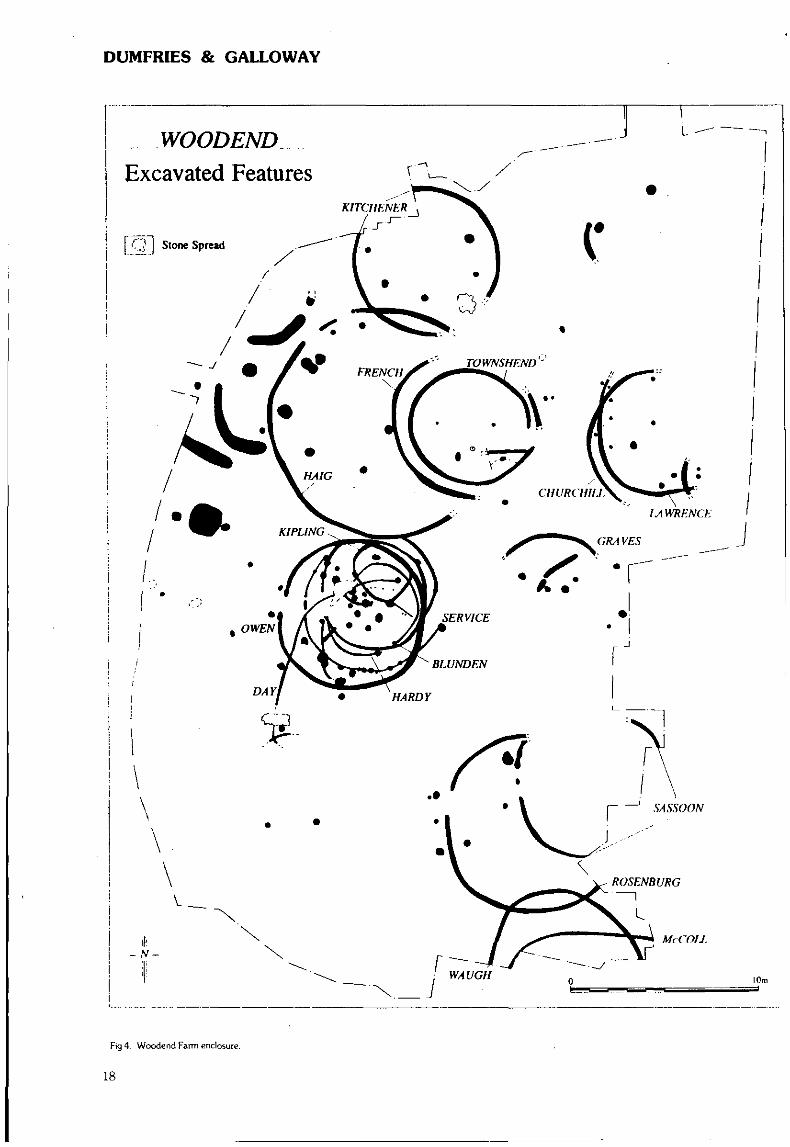
DUMFRIES & GALLOWAY
WOODENDExcavated Features
[ Q~] Stone Spread
Fig 4. Woodend Farm enclosure.
18
DUMFRIES & GALLOWAY
Halleaths, Lochmaben (Lochmaben parish} KCameron (CFA)Watching brief
NY 095 825 A watching brief was carried out during excavationsof a sand and gravel quarry at Halleaths in the vicinity of a Romanroad. No features of archaeological interest were identified.Sponsor: Hoddam Contracting Co Ltd.
Purdomstone (Middlebie parish) M DallandSurvey
NY 208 795 Archaeological survey at Purdomstone was com-missioned by HS and conducted by AOC (Scotland) Ltd in advanceof proposed forestry development. The survey area lies 5km N ofEcclefechan and is roughly rectangular, measuring 900m N-S and650m E-W, comprising an area of 0.59km2. The area containsone previously known archaeological site: NY 27 NW 1 at NY 20797995, formerly classified as an enclosure, but re-classified as a settle-ment during the Royal Commission's survey of the area in August1994.
Two features of archaeological and historical interest wererecorded by the survey: a track probably linked to peat cutting inthe area and daring back to the first half of the 19th century; anda circular platform of unknown origin but probably less than100 years old. No features were encountered that can be argued torelate to the prehistoric settlement at the N edge of the survey area.Sponsor: HS Q
Beattock Bank {Moffat parish) K Speller, R WillVarious sites
Trial trenching and excavation of 12 sites in advance of theupgrading of the A74 was undertaken by GUARD. The sites fall intotwo categories; cairns and standing buildings, scattered throughoutthe valley of the Evan Water, between Beattock summit andBeattock village.1. Six caims were investigated and all interpreted as either modern
or associated with the building of the railway in the mid-19thcentury. Their grid references are as follows: NT 000 145; NT 002143; NT 036 111; NT 036 110; NT 040 085; NT 040 087.
2. Possible house (NT 008 141). Badly damaged by forestry plough-ing. No evidence was found for structures but a large spread of19th/20th century pottery sherds were present.Ruttonside Farm (NT 041 080). This site consisted of an up-
standing cottage and outbuildings. The cottage was of rubble buildwith later additions of concrete and brick. The site appears on theOrdnance Survey 1st edition map.
Cottage (NT 044 073). A single rectangular building withmortared walls surviving to cl.SOm. 19th and 20th century glassand pottery were retrieved.
Wall remains (NT 056 060). Originally thought to be a possiblebuilding.
Raised platform (NT 076 035). Originally thought to be a possiblebuilding stance, excavation revealed it to be a natural outcrop ofsandstone.Sponsors: Solnd (Roads Directorate) and HS Q.
Gibsons (Tundergarth parish) W F CormackStone axe
NY 1545 7955 A polished axe of green stone with some smallwhite inclusions, flat along edges and butt slightly battered, 124mmlong by 82mm at widest by 33mm thick, was found by Sir RupertBuchanan-Jardine, Dixons, Lockerbie, in upcast from a recentlycleaned ditch. No associated finds or structures. With finder.
Boyken Bum Held system (Westerkirk parish) R McCullagh,Field system F Chrystall
NY 314 893 to NY 311 890 A series of limited area intensive,surface mapping surveys and a total of 30 excavated soil profile and
stratigraphy test trenches were undertaken during the first stage ofthe case study element of a doctoral research project to investigatingcomputer-aided methods of classification of Scottish field systems.The purpose of both the excavation and the surveys was to seekinformation on the sequence in which elements of the field systemaccreted through time and to combine this data with information -especially soil thin-section data - on land-use. The work at BoykenBurn demonstrated that the field system was a palimpsest of en-closures, only some of which were certainly associated with arable.The impressive remains of substantial platform, rectangular dwell-ings (one of which will be dated) and the extensive documentaryrecord, point to a vigorous phase of land-use in the late medievaland post-medieval periods, but massive circular enclosures ofprobable Iron Age date indicate earlier antecedents. This field-workpoints to a highly complex process of preservation of fragments ofsuperimposed land-uses from throughout these implied periods.
The assistance, advice and encouragement of the RCAHMS'Afforestable Land Survey team is gratefully acknowledged.Sponsors: HS H. The Department of Environmental Science, Stir-
ling University, AOC (Scotland) Ltd; and SERC.
NITHSDALE DISTRICT
73—75 Irish Street, Dumfries (Dumfries parish)Urban Medieval and Mesolithic J R Mackenzie (SUAT)
NX 971 759 An excavation was carried out by the Trust inDecember 1994 in advance of an office development on the siteof the old British Legion building This building, situated on thestreet frontage, was known to have been cellared, and so an areameasuring 10m2 was located in open ground to the rear wherearchaeological remains were found during trial work (DES 1989).
The earliest evidence of human occupation on the site was in theform of 60 worked stone artefacts typologically representative of theMesolithic period. These artefacts were recovered from a sandy siltdeposit overlying a bank of fluvial sand and gravels on the northernside of the River Nith at c 10.55m OD. One cut feature measuring1.56m by 0.58m was found in association and may represent awindbreak or the remains of a drying rack. Three charcoal patcheswere also found, stratigraphically linked to the artefact bearingdeposit. Samples will be sent for C14 dating. It is likely that theseremains represent a seasonal camp or work site whereupon theresources of the River Nith could be utilised.
Partially truncating, and sealing, the Mesolithic remains was a sub-stantial deposit of medieval garden soil c0.6m in depth. It is clearthat this deposit had been imported and pottery recovered fromit indicates a date of deposition of between the 13th and 15thcenturies. It is likely that this soil was first deposited as part of anextension of the backlands belonging to High Street properties,therefore pre-dating Irish Street.
Cut through the garden soil was a linear stone box drain leadingback from Irish Street towards the River. It is possible that thisdrain is of early modem date. Truncating the drain was a circular,drystone-built well, 0.9m in diameter. Sealing the well was a gardensoil, c0.4m in thickness, containing 19th century pottery.Sponsors: Callander Land Developments, HS Q.
Glenmaid (Kirkmahoe parish) M DallandSurvey
NX 965 899 Archaeological survey at Glenmaid was conductedby AOC (Scotland) Ltd in advance of proposed forestry develop-ment. The survey area lies 14km N of Dumfries and is about 2.5kmlong and between 400m and 900m wide, comprising an area of1.4km2. The area contains two previously known archaeologicalsites: NMRS NX 98 NE 4 (cairnfield) and NX 98 NE 27 (rectangularstructure).
19
DUMFRIES & GALLOWAY
Twenty-five features of archaeological and historical interest wererecorded by the survey, primarily cairns or groups of cairns but alsosome isolated rectangular structures. Many of the cairns had beenhollowed out by robbing for later stone structures, giving them theappearance of sub-rectangular structures.Sponsor: HS Q.
Sweetheart Abbey (New Abbey parish) J BrannPrecinct wall
NX 966 660 A series of large granite boulders were disturbedduring garden works in November 1994 at NX 9661 6603. to theW side of the A710. They probably represent the S side of theAbbey precinct wall. Record photographs are held in Dumfries andGalloway SMR.Sponsor: Dumfries and Galloway Regional Council.
STEWARTRY DISTRICT
Castle Douglas Forest District (various parishes) A N SmithVarious
In March 1993 AOC (Scotland) Ltd created an inventory ofarchaeological and historical features on Forest Enterprise ownedland in the Castle Douglas Forest District. A total of 72 sites werelisted, highlighting Scheduled Ancient Monuments and recom-mending sites thought to be of high archaeological value.Sponsor: Forest Enterprise.
Cup and Ring Marks (Anwoth parish) . Kaledon Naddair,Lagan Muilleann (7a) C MacKenzie, S Willett
NX 5506 5499 Further excavation greatly increased what wasknown at these 3 adjacent sites: 1 cup enclosed by 3 rings, the outerring ending in another cup enclosed by 1 ring: 2 cups enclosed by2 rings each, 1 with runnel from cup; 16 cups enclosed by 1 ringeach; 2 cups enclosed by 5 rings each; 62 solo cups; various adjoin-ing runnels; 6 large natural hollows.Lagan Muilleann (7b)
NX 5506 5499 15 cups enclosed by 1 ring each, some partialdue to broken rock, 1 with another smaller cup budding from thecentral cup; 30 solo cups; various runnels.Lagan Muilleann (7c). NX 5506 5499 1 ring enclosing 6 cups with a runnel from near
the edge of the ring outwards ending in 1 other cup that has a partialring around it; 4 cups (2 dumb-bells).Lagan Muilleann (8)
NX 5646 5504 1 cup contagiously enclosed by a ring which is inturn contagiously enclosed by another egg-shaped ring; 1 cup whichis at the centre of a wide ring depression; 1 cup enclosed by 2 rings;6 cups each enclosed by 1 ring each; 1 very large cup; 20 solo cups;3 runnels. On 2 outcrops adjacent to drystone dyke.Lagan Muilleann (9)
NX 5647 5503 2 cups enclosed by 1 ring adjoining 1 cup en-closed by 1- ring; 2 cups enclosed by 1 'heart-shaped' ring; 3 cupsenclosed by 1 ring, 2 adjoining; 5 solo cups. Situated by same dry-stone dyke as (8).Lagan Muilleann (10)
NX 5647 5505 1 cup enclosed by 2 very ovaloid rings, a runnelleads-oH from the outermost ring to enclose a cup with a similarlyshaped tail; an indented-ovaloid runnel encloses 1 cup and 1 ring,plus 1 solo cup; 3 associated cups surrounded by 2 ovaloid rings;1 cup surrounded by 2 rings; 1 cup enclosed by 1 ring; 3 solo cups.On outcrop some 14 paces from (9) down into field.Lagan Muilleann (11)
NX 5539 5498 2 solo cups (possibly natural) on large smoothoutcrop.
Mossyard (2a)NX 5453 5143 I seem to have been the first to notice 2 parallel
runnels which form 60% of a 'cartouche' (the other 40% has flakedoff the W side).Mossyard (7)
NX 5466 5155 Kerr McConachie (the farmer) pointed to whatturned out to be: 1 cup (very eroded) enclosed by 3 rings; 7 solocups (1 having a runnel). All motifs are highly eroded and faint onflat, smooth, highly fractured outcrop near hay racks.Mossyard (8)
NX 546 515 1 cup enclosed by 5 rings with 1 other cup in secondring; 1 cup enclosed by 1 ring with traces of a second. Tops of allrings have been fractured off on this small damaged outcrop near bya massive field-clearance boulder.Mossyard (9)
NX 5470 5205 Outcrop fractured into 3 parts showing 7 + 1 + 1(respectively) solo cups. Outcrop is SE of (5).Mossyard (10)
NX 5449 5242 8 solo cups (2 of which are large and deep) mostalso still retain clearly delineated pick-marks as this site was notpreviously uncovered much.Mossyard (11)
NX 5461 5241 1 cup enclosed by 3 gapped rings (runnel fromcup flows down into a natural oval); 1 cup enclosed by 2 rings(runnel from cup down to the same natural oval): 12 solo cups (8 ofwhich are small). Exposed outcrops near intersection of 2 walls.Sponsor: The Keltic Research Society.
Blackmark Farm (Balmaclellan parish) J O"SullivanSurvey
Archaeological survey at Blackmark Farm was conducted by AOC(Scotland) Ltd in advance of proposed forestry development. Thesurvey area is c2.5km2 in extent and is centred at NX 710 850 (OSSheets NX 78 NW and NX 78 SW at 1:10,000). It lies several kilo-metres SW of the village of Moniaive on the S side of the A702 road.
The survey recorded a miscellany of features representative of thesuccessive agricultural regimes which operated on the farm in themodern period. Clearance features, rig and furrow remnants andremains of embanked enclosures survive from the early modernperiod and appear to represent a mixed tillage and livestock regime.These were succeeded, in the late 18th or early 19th century, bysheep rees and drystone dykes, corresponding to the reorganisa-tion of the farm for sheep husbandry.No 1 NX 7158 8603 Quarry.No 2 NX 715 860 Dykes; cultivation remnants.No 3 NX 720 859 Dyke.No 4 NX 7213 8565 Dyke.No 5 NX 7140 8543 Dyke.No 6 NX 7130 8565 Dyke; cultivation remains.No 7 NX 7125 8558 Clearance cairn.No 8 NX 7105 8545 Enclosures; possible rectangular structure;
cultivation remains.No 9 NX 7117 8577 Dyke.No 10 NX 7136 8533 Dyke.Noll NX 7165 8527 Enclosure; cultivation remains.No 12 NX 7155 8496 Enclosure.No 13 NX 7116 8500 Enclosures; sheep ree.No 14 NX 7130 8485 Enclosure; cultivation remains; sheep ree.No 15 NX 7133 8462 Cairn (clearance?).Sponsor: HS BB-
Cup and Ring Marks (Borgue parish) Kaledon Naddair, S WillettBar-Gharabh > Barharrow (c 3 miles SE of Gatehouse of Fleet)
Nearly all the outcrops in this area are covered with numerousnatural solution holes which have in many instances been incorpor-ated into the petroglyph design.
20
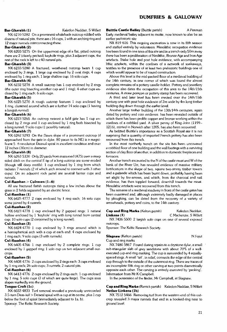
DUMFRIES & GALLOWAY
Bar-Gharabh (1) Kaledon Naddair. 5 WillettNX 6210 5282 On a prominent whaleback outcrop riddled with
dozens of natural pits, there are c 16 cups, 1 with an arching ring and12 major runnels interconnecting these.Bar-Gharabh (2)
NX 6203 5275 On the uppermost edge oi a flat, pitted outcropthere are 2 {clearly pecked) keyhole rings, plus 3 adjacent cups, therest of the rock is left to c 40 natural pits.Bar-Gharabh (3)
NX 6233 5280 A fractured, weathered outcrop bears 1 cupenclosed by 3 rings, 1 large cup enclosed by 2 oval rings; 4 cupsenclosed by 1 ring each; 1 large shallow cup; 16 solo cups.Bar-Gharabh (4)
NX 6232 5278 A small outcrop has 1 cup enclosed by 2 rings(the outer ring bisecting another cup and 1 ring); 4 other cups en-closed by 1 ring each; 6 solo cups.Bar-Gharabh (5)
NX 6225 5270 A rough outcrop features 1 cup enclosed by1 ring, clustered around which are a further 14 solo cups (1 havinga longish runnel).Bar-Gharabh {6)
NX 6223 5265 An outcrop nearest a field gate has 1 cup en-closed by 2 rings and 1 cup enclosed by 1 ring both bisected bya long runnel; 9 solo cups (1 possibly natural).Bar-Gharabh (7)
NX 6262 5293 On the Dawn slope of a prominent outcrop (ifapproached from the gate in dyke, 80 paces to its NE) is a magni-ficent 5-6 revolution Deasuil spiral in excellent condition and over12 inches (30cm) in diameter.Bar-Gharabh (8)
NX 6263 5330 Only 20 yards from main road (A75) over a steepsided ditch on the conical E tip of a long outcrop are some eroded(though still deep motifs): 1 cup enclosed by 1 ring from whichradiates 7 runnels (2 of which arch around to connect with 3 othercups). On an adjacent rock panel are several fainter cups andrunnels.Cul-Ramhan > Cutraven (1-6)
All are fractured flatish outcrops rising a few inches above thegrass in 2 fields separated by an electric fence.Cul-Ramhan (1 )
NX 6425 4777 2 cups enclosed by 1 ring each; 16 solo cupssome joined by 4 runnels.Cul-Ramhan (2)
NX 6423 4778 1 cup enclosed by 2 gapped rings; 1 naturalhollow enclosed by 1 'keyhole' ring with long runnel from centralcup; 10 solo cups (2 conjoined by a long runnel).Cul-Ramhan (3)
NX 6424 4770 1 cup enclosed by 3 rings around which isa hemispherical arch with a cup at each end; 4 cups enclosed by1 ring each; 9 solo cups (3 with runnels).Cul-Ramhan (4)
NX 6405 4766 1 cup enclosed by 2 complete rings; 1 cupenclosed by 1 gapped ring; 1 solo cup on two adjacent small out-crops.Cul-Ramhan (5)
NX 6408 4776 2 cups enclosed by 2 rings each; 3 cups enclosedby 1 ring each; 26 solo cups; 3 runnels; 2 natural pits.Cul-Ramhan (6)
NX 6413 4776 2 cups enclosed by 2 rings each; 1 cup enclosedby 1 ring; 5 solo cups (3 of which are quite large). The cups areaslopes markedly into the ground.Tongue Croft (Ic)
NX 6033 4833 Turf removal revealed a previously unrecorded3.5-turn Deas-iuil > Deiseal spiral with a cup at its centre, plus 1 cupbelow the foot of spiral (immediately adjacent to la, b).Sponsor: The Keltic Research Society.
Bulttle Castle Bailey (Buittle parish) A PenmanEarly medieval bailey adjacent to motte, now known to also be anearlier prehistoric site
NX 819 616 This ongoing excavation is now in its fifth seasonand staffed entirely by volunteers. Mesolithic occupation evidencehas been iound in one area of this site and in a trench only 50m awaythere has been a proliferation of Neolithic, Bronze Age and Iron Ageartefacts. Stake hole and post hole evidence, with accompanyinglithic artefacts, within the confines of a network of soakaways,testifies to the presence of at least two prehistoric buildings one ofwhich would appear to be of round construction.
Above this level is the mid-packed floor of a medieval building ofthe 14th century, in one corner of which was found the almostcomplete remains of a pottery candle-holder. Pottery and jewelleryevidence also dates the occupation of this area to the 14th/15thcenturies. A stone poincon or pottery stamp has been recovered.
A third and later level has been erected over the 14th/15thcentury one with post hole evidence of 2m wide by 4m long timberbuilding dug down through the earlier level.
Another large timber building of the 13th/14th centuries, againdated by pottery and coin evidence, has been revealed outside ofwhich there has been prolific copper and bronze working within theconfines of a cobbled yard. A silver penny of King John (1199-1216), minted in Norwich after 1205, has also been recovered.
As befitted Buittle's importance as a Scottish Royal site it is notsurprising that a quantity of imported French pottery has also beenrecovered from this trench.
In the most northerly trench on the site has been uncovereda cobbled floor of one building and the wall footings with a survivingsection of clay floor of another, in addition to domestic fireplaces andfurnaces.
Another trench excavated to the N of the castle moat and W of thebank of the River Urr, has revealed evidence of massive militaryfortifications in the shape of two, square two-storey timber towersand a palisade which has been burnt down, probably having beenset alight by tire-arrows, and which, from the charcoal and nailevidence, has then toppled forward, downhill towards the moat.Mesolithic artefacts were recovered from this trench.
The remains of a medieval roadway in front of the castle gates hasbeen examined and, although extremely badly damaged in placesby ploughing, can be dated from the recovery of a variety ofarrowheads, pottery and coins, to the 14th century.
Cup and Ring Marks (Kelton parish) Kaledon Naddair.Linkens (1) C Mackenzie, S Willett
NX 7436 5500 2 largish solo cups on one of several exposedoutcrops.Sponsor: The Keltic Research Society.
Slagnaw (Kelton parish) N FojutCup and ring marks
NX 7480 5867 Found during repairs to a drystone dyke, a smallsub-triangular slab of grey sandstone with about 70% of a well-executed cup-and-ring marking. The cup is surrounded by 4 equally-spaced rings. A small 'tail', in relief, connects the edge of the centralcup through to the outside of the outermost ring. There are traces ofan incomplete fifth ring or other carving at two points diametricallyopposite each other. The carving is entirely executed by 'pecking1.Information from Mr K Campbell.
In the possession of the finder, Mr Campbell, at Slagnaw.
Cup and Ring Marks (Rerrick parish) Kaledon Naddair, S WillettNether Linkens (Ib)
NX 7512 5466 Removing turf from the western end of this out-crop revealed 3 major runnels that end in a hooked-ring near toground level.
21
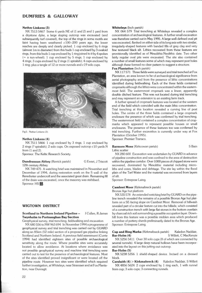
DUMFRIES & GALLOWAY
Nether Ltnkens (3)NX 7513 5467 Some 6 yards NE of (1 and 2) and 1 yard from
a drystone dyke, a large sloping outcrop was excavated (andsubsequently turf covered), the top of the rings in some motifs arefaint having been weathered c 100-200 years ago, the lowerreaches are deeply and clearly picked. 1 cup enclosed by 6 rings(almost 1m in diameter) from this buds 1 cup enclosed by 3 ovaloidrings, from this buds 1 cup enclosed by 1 ring joined to it by 4 spokes(= a sun-wheel); 1 cup enclosed by 5 rings; 1 cup enclosed by4 rings; 3 cups enclosed by 2 rings (1 spiralish); 4 cups enclosed by1 ring; plus a tangle of 12 or more runnels and c 19 solo cups.
Fig5 Nether Linkens (3).
Nether Linkens (4)NX 7511 5466 1 cup enclosed by 3 rings; 1 cup enclosed by
2 rings (? spiralish); 2 solo cups. On exposed outcrop clO yards Nfrom ( land 2).Sponsor: The Keltic Research Society.
Dundrennan Abbey (Rerrick parish) G Ewart, J Triscott12th century Abbey
NX 749 475 A watching brief was maintained in November andDecember of 1994, during restoration work on the S wall of theReredorter undercroft and the associated great drain. Remaining fillof the drain was excavated, once the masonry was stabilised.Sponsor: HS H
WIGTOWN DISTRICT
Scotland to Northern Ireland Pipeline — 1 Cullen, R JamesTwynholm to Portnaughan Bay SectionGeophysical survey, trial trenching, fieldwalking and excavation
NX 680 556 to NW 963 694 In November 1994 a programme ofgeophysical survey and trial trenching was carried out by GUARDalong an 85km (52 mile) section of a proposed gas pipeline linkingScotland and Northern Ireland. A previous field assessment (Currie1994) had identified eighteen sites of possible archaeologicalsensitivity along the route. Where possible sites were accuratelylocated to allow avoidance. At locations where avoidance wasnot possible geophysical survey and machine trial trenching werecarried out to test for the presence of archaeological features. Mostof the sites identified proved insignificant or were located off thepipeline route. However two sites were identified which requiredfurther investigation, at Whiteleys, near Stranraer and at Fox Planta-tion, near Dunragit
Whiteleys (Inch parish)NX 064 579 Trial trenching at Whiteleys revealed a complex
concentration of archaeological features. A further small excavationwas therefore carried out in May 1995. A large well-defined oval pitwas excavated, flanked on either side of its long axis with two similar,irregularly-shaped features with banded fills of grey clay and veryfine textured black silt. Lithics recovered from these features areprovisionally identified as of Mesolithic/Neolithic date. Two otherfairly regular oval pits were excavated. The site also containeda number of small features some of which may represent post holesalthough these formed no clear pattern to suggest a structure.Fox Plantation (Inch parish)
NX 117571 Three fields were surveyed and trial trenched at FoxPlantation, an area known to be of archaeological significance fromaerial photography and from the presence of lithic concentrationsidentified during fieldwalking. Each of the three fields containedcropmarks although the lithics were concentrated within the eastern-most field. The easternmost cropmark was a linear, apparentlydouble ditched feature. This was not located during trial trenchingand may represent an extension to an existing farm track.
A further spread of cropmark features was located at the westernend of the field which coincided with the main lithic concentration.Trial trenching at this location revealed a curving line of postholes. The centre of the three fields contained a large cropmarkenclosure the presence of which was confirmed by trial trenching.The westernmost field contained a complex concentration of crop-marks which appeared to represent possible houses or smallenclosures. The presence of these features too was confirmed bytrial trenching. Further excavation is currently under way at FoxPlantation (October 1995).Sponsor: Premier Transco.
Barmore Moss (Kirkcowan parish) S BainLithic scatter
NX 280 600 Excavation was undertaken by GUARD in advanceof pipeline construction and was confined to the area of destructionwithin the pipeline corridor. Over 1000 pieces of chipped stone wererecovered, dominated by Mesolithic material including micro-liths and cores, blades and debitage. The site lay within the floodplain of the Tarf Water and the material was recovered from layersof silt.Sponsor: Entrepose Laing.
Cambret Moor (Kirkmabreck parish)Bronze Age hut platform
NX 535 578 An extended watching brief by GUARD on the pipe-line trench revealed the remains of a possible Bronze Age hut plat-form on a SE-facing slope on Cambret Moor. Removal of hillwashrevealed part of a circular feature cut into the hillside, which consistedof a construction trench with large flat stones in the bottom overlainby charcoal rich soil surrounding a possible occupation layer. Down-hill from this feature was a possible midden area which produceda number of pottery sherds preliminarily dated to the Bronze Age.Sponsor: Entrepose Laing.
Cup and Ring Marks (Kirkmabreck parish) Kaledon Naddair,Bar Holm (4) S Willett, C MacKenzie
NX 5256 5411 Over 30 solo cups (8 of which are connected byseveral runnels). 4 large deep natural hollows have been incorpor-ated into the layout on this jutting-out outcrop.Bar-Holm (5)
NX 5238 5356 1 shield-shaped device. Incised on a dressedblock.Carslulth (4) > Kirkmabreck (4) Kaledon Naddair, S Willett
NX 4856 5624 2 cups enclosed by 1 ring each, 1 with runnelfrom cup; 3 solo cups; 3 connecting runnels.
22
DUMFRIES & GALLOWAY
Carsluith (5) > Kirkmabreck (5)NX 4857 5624 1 cup enclosed by 2 egg-shaped rings; 1 cup
enclosed by 1 ring; 1 oval ring without central cup; 1 solo cup. Onadjacent small outcrop of this grassy knoll.Kirk-Dale Mains (1) Kaledon Naddair, C MacKenzie, S Willett
NX 5135 5411 Excavation revealed a 3-tum spiral with centralcup, plus dozens of other glyphs in addition to what was previouslyknown of this site.Kirkmuir (6)
NX 5133 5433 Excavation of a rough and fractured outcroprevealed deep, clearly pecked - 13 cups enclosed by 1 ring each,'4 with runnels from cup; 7 solo cups, 1 with runnel; grooves. Belowfairly deep turf in field E of (3) and (4).Sponsor: The Keltic Research Society.
Mull of Galloway (Kirkmaiden parish) J PickinFlint scatter
NX 146 305 A scatter of 55 pieces of flint recovered from aneroded area surrounding the base of Kennedy's Cairn. Mainlyproduction waste from pebble cores but the scatter includes somelarge retouched flakes and 10 narrow blade fragments. The lattermight indicate a Mesolithic date.
Donated to Wigtown District Museum Service: 1994.44.
Lochnaw Castle, Isle of Lochnaw (Leswalt parish)14th century tower D Alexander (CFA)
NW 9933 6322 Excavations at Lochnaw Castle revealed theplan of the 14th century castle. This was a rectangular tower 15.4mlong and 10.1m wide with walls 2.4m thick.
Fig 6 Composite plan of Lochnaw Castle. Isle of Lochnaw.
Architectural features noted included a slit window, an aumbry,a drain and the bases of two possible latrine chutes. The cellarappears to have been barrel vaulted and a small room built into onecomer possibly acted as a prison. The floor consisted of layers ofdeposited material on top of subsoil between outcrops of bedrock.A reused millstone set in clay and burnt and fragmented possiblyrepresented the remains of an oven base. A silver penny of Robert HI
was found and dates from the period between when the castlewas supposed to have been attacked in 1390 and when it wasabandoned in favour of another site in 1426.
Once the tower was no longer in use it appears to have beensystematically dismantled, down to its basal courses in places, andmost of the dressed stone removed. However, the site appears tohave been reused at some point when a stone wall c 0.9m wide wasconstructed to the S of the tower, underlying the later drystone dyke.This wall overlay the remains of the tower and was subsequentlysupported by a buttress on the S side.
The recovery of a lead seal matrix bearing the name of AndrewMcCracken also testifies to later activity on the island in the 16th orearly 17th centuries. A stone cannon ball was sealed below depositsof mortar which overlay the southern side of the tower. A largenumber of animal bones and oyster shells found within the towermay relate to this later period of use. A poorly constructed lean-tostructure against the N wall of the tower may be contemporary withthe construction of the drystone dyke around the island when theloch was drained in the 18th century. Finally the site was subjectedto the excavation of three pits in the 20th century.Sponsor: Mr Christopher Nightingale.
Castle Bay (Portpatrick parish) J PickinPerforated stone tool
NX 005 535 Casual find of coarse sandstone cobble, 80mmby 135mm, with central hourglass perforation. Complete, withabrasion at butt end and flake scars at opposing end. Both surfacesexhibit striations, possibly from recent plough damage.
Donated to Wigtown District Museum Service: 1994.31.
50
Fig 7. Perforated stone tool.
Cup and Ring Marks (Sorbie parish) Kaledon Naddair,Cul-Sgadaln (3) > Culscadden (3) S Willett. B Bierley
NX 4708 4843 2 solo cups on a long low outcrop just over thefence into the main field.
23
DUMFRIES & GALLOWAY
Cul-Sgadatn (4)NX 4721 4838 27 solo cups, 7 with adjoining runnels. Situated
6 paces SW from wall and 20 paces NW from gate in wall.Cul-Sgadaln (5)
NX 4725 4839 1 cup enclosed by 1 ring with runnel from cup;3 solo cups.Cul-Sgadaln (6)
NX 4728 4840 2 cups enclosed by 3 rings, 1 with runnel fromcup; 1 cup enclosed by 2 rings with runnel from cup; 1 cup enclosedby 1 oval ring; 1 solo cup.Sponsor: The Keltic Research Society.
Cup and Ring Marks (Whithom parish)(Gallows-)Outon additions
NX 4480 4207 (Ib) 1 comma-like spiral; (lc)single spiral; 1 cup enclosed by 1 ring; 1 cup.Sponsor: The Keltic Research Society.
1 comma-like
A ClarkeWhlthorn Priory (Whithorn parish)Northumbrian and medieval graveyard
NX 444 402 In a 13 week season the 17m by 8m trench on theflat hilltop, opened by D Pollock in 1993 as an extension to his 1992trench (DES 1993, 26-27), was continued by York ArchaeologicalTrust. The 1995 season revealed a graveyard, originally bounded tothe N by a wall foundation of 8th/9th century or later date. Thisgraveyard remained in use for several centuries, with some of thegraves post-dating a fire radiocarbon dated to the llth/12thcentury. More than 50 burials were excavated in 1995, a proportionof which produced corroded iron hinges, brackets and locks, sug-gesting burial in wooden coffins. The orientation of the burials wasmainly E-W, although there was some variation and a degree ofintercutting. The bone preservation was generally poor. At least50 burials remain to be excavated in a future season. Investigationalso suggested that the graveyard had been encroached uponseveral times during its lifetime, probably by industrial structuresused for small-scale metalworking.
There are also indications of early occupation (5th/6th century) ofthe hilltop pre-dating the graveyard, associated with a narrow ditchunderlying the possible Northumbrian wall foundation and cuttinginto the bedrock. These early features will be investigated in 1996.
In addition to this main excavation, a 9m square trench, Trench B,was opened in the field to the W, at the foot of the hilltop. It wasintended that this trial trench would locate the limit of significantarchaeology, and it was positioned over a possible linear featureidentified by early survey work.
50m
FigSa. Whilhorn 1995 Trench A: Bunalsand Northumbrian Wall Foundation.
24
FigKb. Whithom 1995 Location of Trenches
Investigation revealed a conglomeration of linear alignments andstone surfaces running N down the slope towards the Kett burn. Nodating evidence was recovered from these deposits but they weresealed by 15th century and later plough soils. The results suggestthat further excavation here would prove fruitful.Sponsors: Whithorn Board of Management, Dumfries and Gallo-
way Regional Council, Wigtown District Council, Friendsof Whithorn Trust, The Mouswald Trust, The Jennie SGordon Memorial Foundation, The Russell Trust, TheHunter Trust, Society of Antiquaries of Scotland, Dum-fries and Galloway Natural History and AntiquarianSociety.
Torhousekle (Wigtown parish) J Pickin, A PenmanStone alignment
NX 383 565 The central stone of this three stone alignment(NMRS no NX 35 NE 12). situated NE of the Torhousekie stonecircle, fell during December 1994. The area of the socket wasexamined prior to re-erection in July 1995.
Excavation revealed that the stone had been sitting in a shallowcircular pit, 0.70m in diameter and 0.14m deep, cut into the naturalglacial clays. The pit sealed and in part truncated a steep-sided ovalfeature. No organic material was recovered from the fill of thisfeature but its form suggests a post hole. This might indicate a timberphase pre-dating the erection of the central stone.Sponsor: Wigtown District Council.
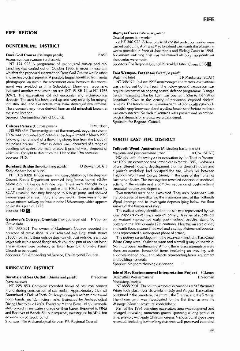
FIFE
FIFE REGION
DUNFERMLINE DISTRICT
Dora Golf Course (Ballingry parish) EASEAssessment excavations (prehistoric)
NT 174 925 A programme of geophysical survey and trialtrenching was carried out on October 1995, in order to ascertainwhether the proposed extension to Dora Golf Course would affectany archaeological remains. A possible henge, identified from aerialphotographs lay within the assessment area, however this monu-ment was avoided as it is Scheduled. Elsewhere, cropmarksindicated another monument on site (NT 19 SE 12 at NT 17659247). The excavations did not encounter any archaeologicaldeposits. The area has been used up unti l very recently for mining/industrial use, and this activity may have destroyed any remains.The cropmark may have derived from an old mineshaft known atthe same location.Sponsor: Dunferrnline District Council.
Culross Palace (Culross parish) R Murdoch.NS 985 859 The investigation of the courtyard, begun in autumn
1994. was completed by Scoria Archaeology Limited in March 1995following the removal of a flowering cherry tree from the E side ofthe palace precinct. Further evidence was uncovered of a range ofbuildings set against the multi-phased E precinct wall, elements ofwhich are thought to date from the 17th to the 19th centuries.Sponsor: NTS.
Boreland Bridge (Inverkeithing parish) D Bowler (SUAT)Early Modern horse burial
NT 1315 8320 Bridge repair and consolidation by Fife RegionalCouncil Roads Department revealed long bones buried c2.2mbelow ground, beside a bridge pier. These were thought to behuman and reported to the police and HS, but examination bySUAT revealed that they belonged to a large pony, and showedvarious signs of stress, injury and over-work. There was a horse-drawn mineral railway on this site in the 18th century, which appearson Ainslie's plan of 1775.Sponsor: HS BS1
Gardener's Cottage, Crombie (Torryburn parish) P YeomanGrave slabs
NT 030 851 The owner of Gardener's Cottage reported thepresence of grave slabs. A visit revealed two large tomb stonesc 1600 now in the floor outside dog kennels. Just outside, is a muchlarger slab with a raised flange which could be part of an altar base.These stones were probably all taken from Old Crombie ParishChurch to be reused.Sponsors: Fife Archaeological Service, Fife Regional Council.
K1RKCALDY DISTRICT
Burntisland Sea Outfall (Burntisland parish) P YeomanNaval cannon
NT 225 853 Complete corroded barrel of cast-iron cannonfound during construction of sea outfall. Approximately 1km offBurntisland in Firth of Forth. 2m length complete with trunnions andhoop bands; no identifying marks. Estimated by ArchaeologicalDiving Unit to be c 1760s. Found by Marine Blast Ltd and immedi-ately placed in sea water storage on their barge. Reported to NMSand Receiver of Wreck. Site subsequently investigated by ADU. butno evidence of wreck found.Sponsors: Fife Archaeological Service, Fife Regional Council.
Wemyss Caves (Wemyss parish)Coastal protection works
ce NT 346 972 A final phase of coastal protection works werecarried out during April and May to extend westwards the phase oneworks provided in front of Jonathan's and Sliding Caves in 1994.A constant watching brief was maintained although no significantdiscoveries were made.Sponsors: Fife Regional Council. Kirkcaldy District Council. HS EJ.
East Wemyss, Foreshore (Wemyss parish)Watching brief J R Mackenzie {SUAT}
NT 345 972 In June 1995 monitoring of contractors' excavationswas carried out by the Trust. The below ground excavation wasrequired as part of an ongoing coastal defence programme. A singletrench measuring 14m by 1.5m was opened c50m to the SW ofJonathan's Cave in the vicinity of previously exposed skeletalremains. The trench had a maximum depth of 0.6m, cutting througha reddish grey/brown sand and a yellow beach sand before bedrockwas encountered. No skeletal remains were present and no archae-ological deposits or artefacts were discovered.Sponsor: Fife Regional Council.
NORTH EAST FIFE DISTRICT
Tolbooth Wynd, Anstruther (Anstruther Easter parish)Medieval and post-medieval urban A Cox (SUAT)
NO 567 036 Following a site evaluation by the Trust in Novem-ber 1994, an excavation was carried out in March 1995, in advanceof a sheltered housing development. Former derelict houses anda joiner's workshop had occupied the site, which lies betweenTolbooth Wynd and Cunzie Street, in the core of the burgh ofAnstruther Easter. This investigation revealed evidence of medievalactivity in the vicinity and a complex sequence of post-medievalstructural remains and deposits.
Two trenches were hand excavated. They were positioned withthe objectives of investigating the maximum area of the TolboothWynd frontage and to investigate deposits lying below the floorsurface of the former workshop.
The earliest activity identified on the site was represented by twoloam deposits containing medieval pottery. A series of substantialcut features represented early post-medieval activity, dated bypottery to the 16th or early 17th centuries. Hearths, an area of clayand earth floor, a stone-lined well and a series of stone wall founda-tions represented a subsequent phase of activity.
The pottery assemblage from the excavation included East CoastWhite Gritty ware, Yorkshire ware and a small group of sherds ofNorth European earthenware. Among the artefact assemblage weredress accessories, household items (including an iron key witha kidney-shaped bow) and objects representing horse equipmentand building materials.Sponsor: Kingdom Housing Association.
Isle of May Environmental Interpretation Project H James(Anstruther Wester parish) P YeomanMonastery, burials
NT 6585 9901 The fourth season of excavations at St Ethernan'sPriory took place over six weeks in July and August. Excavationscontinued in the cemetery, the church, the E range, and the S range.The cloiser garth was investigated for the first time, as was theW range following structural consolidation.
Part of the 1994 cemetery excavation area was reopened andenlarged, revealing numerous graves spanning a long period oftime, possibly with early Christian origins. Various burial types wererecorded, including further long cists with well-preserved extended
25
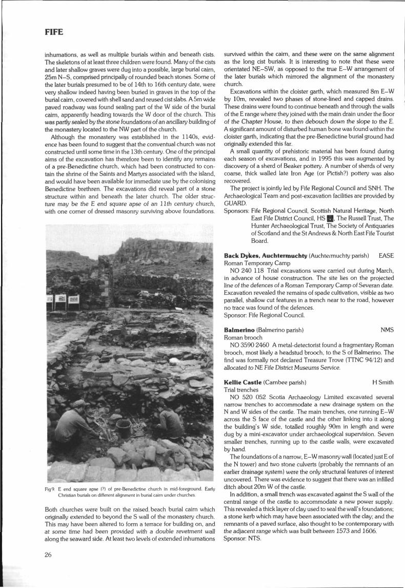
FIFE
inhumations, as well as multiple burials within and beneath cists.The skeletons of at least three children were found. Many of the cistsand later shallow graves were dug into a possible, large burial cairn,25m N-S, comprised principally of rounded beach stones. Some ofthe later burials presumed to be of 14th to 16th century date, werevery shallow indeed having been buried in graves in the top of theburial cairn, covered with shell sand and reused cist slabs. A 5m widepaved roadway was found sealing part of the W side of the burialcairn, apparently heading towards the W door of the church. Thiswas partly sealed by the stone foundations of an ancillary building ofthe monastery located to the NW part of the church.
Although the monastery was established in the 1140s, evid-ence has been found to suggest that the conventual church was notconstructed until some time in the 13th century. One of the principalaims of the excavation has therefore been to identify any remainsof a pre-Benedictine church, which had been constructed to con-tain the shrine of the Saints and Martyrs associated with the island,and would have been available for immediate use by the colonisingBenedictine brethren. The excavations did reveal part of a stonestructure within and beneath the later church. The older struc-ture may be the E end square apse of an llth century church,with one comer of dressed masonry surviving above foundations.
Rg9. E end square apse (?) of pre-Benedictine church in mid-foreground. EarlyChristian burials on different alignment in burial cairn under churches.
Both churches were built on the raised.beach burial caim whichoriginally extended to beyond the S wall of the monastery church.This may have been altered to form a terrace for building on, andat some time had been provided with a double revetment wallalong the seaward side. At least two levels of extended inhumations
survived within the caim, and these were on the same alignmentas the long cist burials. It is interesting to note that these wereorientated NE-SW, as opposed to the true E-W arrangement ofthe later burials which mirrored the alignment of the monasterychurch.
Excavations within the cloister garth, which measured 8m E-Wby 10m, revealed two phases of stone-lined and capped drains.These drains were found to continue beneath and through the wallsof the E range where they joined with the main drain under the floorof the Chapter House, to then debouch down the slope to the E.A significant amount of disturbed human bone was found within thecloister garth, indicating that the pre-Benedictine burial ground hadoriginally extended this far.
A small quantity of prehistoric material has been found duringeach season of excavations, and in 1995 this was augmented bydiscovery of a sherd of Beaker pottery A number of sherds of verycoarse, thick walled late Iron Age (or Pictish?) pottery was alsorecovered.
The project is jointly led by Fife Regional Council and SNH. TheArchaeological Team and post-excavation facilities are provided byGUARD.Sponsors: Fife Regional Council. Scottish Natural Heritage, North
East Fife District Council, HS Q, The Russell Trust, TheHunter Archaeological Trust, The Society of Antiquariesof Scotland and the St Andrews & North East Fife TouristBoard.
Back Dykes, Auchtermuchty (Auchtermuchty parish) EASERoman Temporary Camp
NO 240 118 Trial excavations were carried out during March,in advance of house construction. The site lies on the projectedline of the defences of a Roman Temporary Camp of Severan date.Excavation revealed the remains of spade cultivation, visible as twoparallel, shallow cut features in a trench near to the road, howeverno trace was found of the defences.Sponsor: Fife Regional Council.
Ba I merino (Balmerino parish) NMSRoman brooch
NO 3590 2460 A metal-detectorist found a fragmentary Romanbrooch, most likely a headstud brooch, to the S of Balmerino. Thefind was formally not declared Treasure Trove (TTNC 94/12) andallocated to NE Fife District Museums Service.
Kellie Castle (Carnbee parish) H SmithTrial trenches
NO 520 052 Scotia Archaeology Limited excavated severalnarrow trenches to accommodate a new drainage system on theN and W sides of the castle. The main trenches, one running E-Wacross the S face of the castle and the other linking into it alongthe building's W side, totalled roughly 90m in length and weredug by a mini-excavator under archaeological supervision. Sevensmaller trenches, running up to the castle walls, were excavatedby hand.
The foundations of a narrow, E-W masonry wall (located just E ofthe N tower) and two stone culverts (probably the remnants of anearlier drainage system) were the only structural features of interestuncovered. There was evidence to suggest that there was an infilledditch about 20m W of the castle.
In addition, a small trench was excavated against the S wall of thecentral range of the castle to accommodate a new power supply.This revealed a thick layer of clay used to seal the wall's foundations;a stone kerb which may have been associated with the clay; and theremnants of a paved surface, also thought to be contemporary withthe adjacent range which was built between 1573 and 1606.Sponsor: NTS.
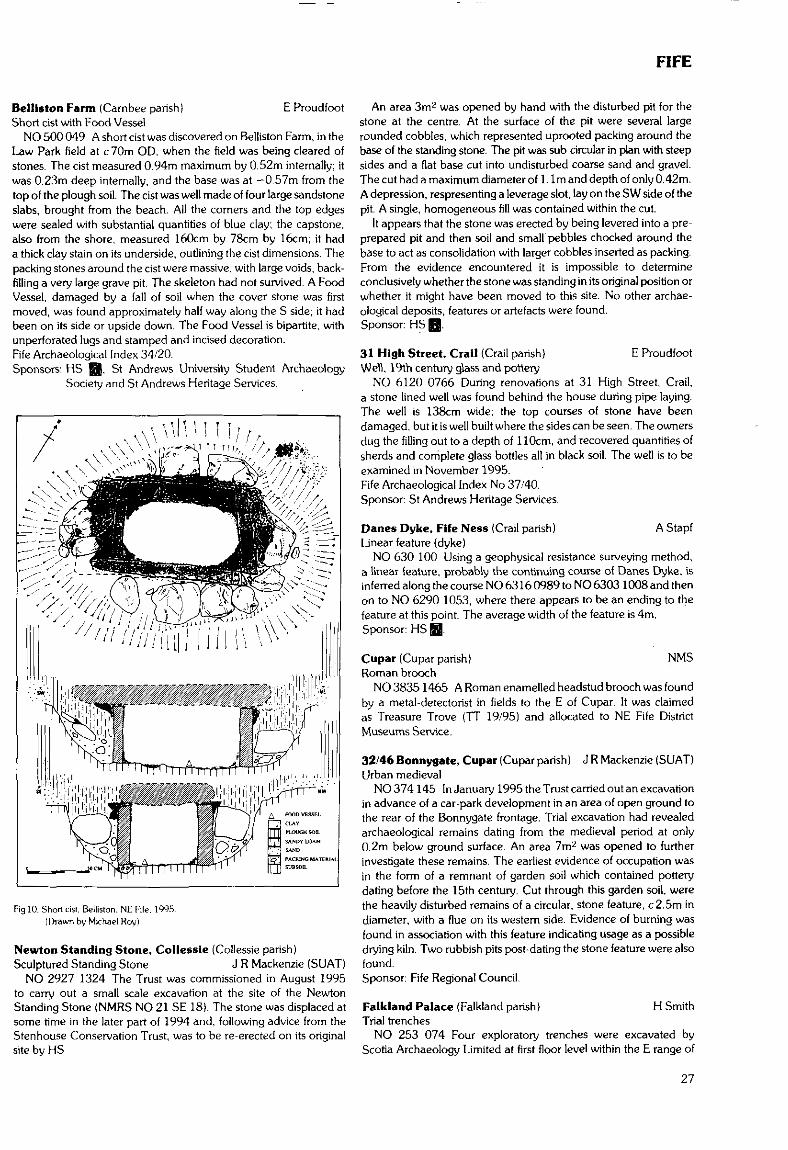
FIFE
Belliston Farm (Cambee parish) E ProudfootShort cist with Food Vessel
NO 500 049 A short cist was discovered on Belliston Farm, in theLaw Park field at c70m OD, when the field was being cleared ofstones. The cist measured 0.94m maximum by 0.52m internally; itwas 0.23m deep internally, and the base was at -0.57m from thetop of the plough soil. The cist was well made of four large sandstoneslabs, brought from the beach. All the corners and the top edgeswere sealed with substantial quantities of blue clay; the capstone,also from the shore, measured 160cm by 78cm by 16cm; it hada thick clay stain on its underside, outlining the cist dimensions. Thepacking stones around the cist were massive, with large voids, back-filling a very large grave pit. The skeleton had not survived. A FoodVessel, damaged by a fall of soil when the cover stone was firstmoved, was found approximately half way along the S side; it hadbeen on its side or upside down. The Food Vessel is bipartite, withunperforated lugs and stamped and incised decoration.Fife Archaeological Index 34/20.Sponsors; HS ffl. Si Andrews University Student Archaeology
Society and St Andrews Heritage Services.
Fig 10. Short cist. Belliston, NE Fife. 1995.(Drawn by Michael Roy)
Newton Standing Stone, Collessic (Collessie parish)Sculptured Standing Stone J R Mackenzie (SUAT)
NO 2927 1324 The Trust was commissioned in August 1995to carry out a small scale excavation at the site of the NewtonStanding Stone (NMRS NO 21 SE 18). The stone was displaced atsome time in the later part of 1994 and. following advice from theStenhouse Conservation Trust, was to be re-erected on its originalsite by HS
An area 3mz was opened by hand with the disturbed pit for thestone at the centre. At the surface of the pit were several largerounded cobbles, which represented uprooted packing around thebase of the standing stone. The pit was sub-circular in plan with steepsides and a flat base cut into undisturbed coarse sand and gravel.The cut had a maximum diameter of 1. 1m and depth of only 0.42m.A depression, respresenting a leverage slot, lay on the SW side of thepit. A single, homogeneous fill was contained within the cut.
It appears that the stone was erected by being levered into a pre-prepared pit and then soil and small pebbles chocked around thebase to act as consolidation with larger cobbles inserted as packing.From the evidence encountered it is impossible to determineconclusively whether the stone was standing in its original position orwhether it might have been moved to this site. No other archae-ological deposits, features or artefacts were found.Sponsor: HS Q.
31 High Street, Crail (Grail parish} E ProudfootWell, 19th century glass and pottery
NO 6120 0766 During renovations at 31 High Street, Crail,a stone-lined well was found behind the house during pipe laying.The well is 138cm wide; the top courses of stone have beendamaged, but it is well built where the sides can be seen. The ownersdug the filling out to a depth of 110cm, and recovered quantities ofsherds and complete glass bottles all in black soil. The well is to beexamined in November 1995.Fife Archaeological Index No 37/40.Sponsor: St Andrews Heritage Services.
Danes Dyke, Fife Ness (Crail parish) A StapfLinear feature (dyke)
NO 630 100 Using a geophysical resistance surveying method,a linear feature, probably the continuing course of Danes Dyke, isinferred along the course NO 6316 0989 to NO 6303 1008 and thenon to NO 6290 1053, where there appears to be an ending to thefeature at this point. The average width of the feature is 4m.Sponsor: HS £5B.
Cupar (Cupar parish) NMSRoman brooch
NO 3835 1465 A Roman enamelled headstud brooch was foundby a metal-detectorist in fields to the E of Cupar. It was claimedas Treasure Trove (TT 19/95) and allocated to NE Fife DistrictMuseums Service.
32/46 Bonnygate, Cupar (Cupar parish) J R Mackenzie (SUAT)Urban medieval
NO 374145 In January 1995 the Trust carried out an excavationin advance of a car-park development in an area of open ground tothe rear of the Bonnygate frontage. Trial excavation had revealedarchaeological remains daring from the medieval period at only0.2m below ground surface. An area 7m2 was opened to furtherinvestigate these remains. The earliest evidence of occupation wasin the form of a remnant of garden soil which contained potterydating before the 15th century. Cut through this garden soil, werethe heavily disturbed remains of a circular, stone feature, c2.5m indiameter, with a flue on its western side. Evidence of burning wasfound in association with this feature indicating usage as a possibledry'n9 kiln. Two rubbish pits post-dating the stone feature were alsofound.Sponsor: Fife Regional Council.
Falkland Palace (Falkland parish) H SmithTrial trenches
NO 253 074 Four exploratory trenches were excavated byScotia Archaeology Limited at first floor level within the E range of
27
FIFE
the palace to determine the age of the deposits that overlay thevaulted cellars below. All such materials, comprising concrete,bricks, felt/bitumen and ashy waste had been deposited during theMarquis of Bute's renovations in the late 19th century or when theconcrete floor was laid in the 1930s and 1960s.Sponsor: NTS.
Ballinbreich Castle (Risk parish) NMSIron Age metalwork
NO 272 204 A metal-detectorist found two pieces of Iron Agemetalwork, a button-and-loop fastener of Wild type 111 and a frag-ment of copper alloy tankard handle of unusual form, to the S ofBallinbreich Castle. The finds were formally not claimed as TreasureTrove {TTNC 94/11) and were donated to NE Fife District MuseumsService-
Wester Kllmux (Kennoway parish & Scoonie parish) R WillNO 361050 An archaeological assessment of the proposed
quarry site in and around the deserted settlement of Wester Kilmuxwas undertaken by GUARD. This consisted initially of a document-ary search and fieldwalking. This was followed up by geophysicalsurvey (resistivity) and trial trenching of several possible sites.
NO 3623 0482 'Site of Chapel1. This is marked on the firstedition Ordnance Survey map of 1855. Further historical referencesindicate the land was granted to a religious community in 1467, anddemolished in the 19th century. Both geophysics and trial excava-tion failed to produce evidence of this.
NO 360 050 Wester Kilmux Farmstead. The main building datesto the 1830s but has several outbuildings which may be earlier andare marked on the first edition Ordnance Survey as being ruined by1855. It was therefore decided to survey these buildings for evid-ence of daring or an earlier phase of activity. A change of alignmentalong the main N wall was uncovered but seems to be part of theoriginal build for which no dating evidence was found.
NO 3613 0508 Circular feature E of the farmstead, possiblelime-kiln. Trial trenching uncovered shelving bedrock which mayhave been quarried to form the circular shape.
NO 3615 0510 Circular feature, possible hut circle revealed asnatural.
NO 3617 0514 Cairn revealed as natural.Sponsor: Johnson, Poole and Bloomer (Scotland) Ltd.
Dunnicher Law (Kilconquhar parish) P YeomanFortification/Dun?
NO 449 082 Examined during fieldwork with B Crawford andS Taylor. Highligh ted by interesting place name on or near several ofsignificant long-established boundaries. Fragmentary and woodedremains of possible drystone ramparts occupying a knoll approxim-ately 40m diameter with possible entrance to S.Sponsors: Fife Archaeological Service, Fife Regional Council.
East Pitcorthie (Kilrenny parish)Agricultural artefact
NO 576 076 Possible barley 'knocking stone' ploughed up byMr Fleming, farmer, in low lying field next to the main road. Largelump of whinstone, 40cm cubed, roughly shaped on outside, butwith very smooth, deep indentation.Sponsors: Fife Archaeological Service, Fife Regional Council.
Lundln Mill Farm (Largo parish) J A Atkinson18th-19th century corn mill survey and watching brief
NO 4117 0295 Archaeological watching brief in the course of thedemolition programme at the farm steading and mill complex ofLundin Mill Farm, Lundin Links, Fife by GUARD, revealed that themill with its associated kiln had been the original building on site,followed in the early 19th century by the farm outbuildings. There
was no evidence to suggest the existence of earlier buildings at thelocation, although cartographic evidence indicates that the site wasbeing utilised for milling of grain from at least 1775. A full report hasbeen submitted to the NMRS.Sponsor: Bert Homes.
Drumofg (Cowbakie Hill and Craigle Hill) (Leuchars parish)Watching brief H James
NO 438 251 A watching brief on a golf course and housingdevelopment has taken place since March 1995. Aerial photographshad indicated the presence of prehistoric features in the area andgeophysical examination and trial trenching undertaken by GUARDin 1990 confirmed the presence of numerous archaeologicalfeatures. Several key areas were fenced off and excluded from thedevelopment and a watching brief was carried out on all topsoilstripping over the rest of the development. Full excavation has takenplace in several areas of the development where dense concentra-tions of archaeological features were revealed beneath the topsoil.
- Evidence for settlement dating from the Neolithic to the Medievalperiod has been produced including pottery and flint artefacts. Allthe features, post holes, pits and arcing ditches have been affected tovarying degrees by ploughing. Two pits of particular interest con-tained carbonised nut shells, fragments of cremated bone. One alsocontained a leaf-shaped arrowhead and the other a flint blade. Theremains of what may have been a souterrain has been excavatedand contained iron work and undecorated pottery.Sponsor: Drumoig Ltd.
Pusk Farm. Balmullo (Leuchars parish) NMSRoman brooches
NO 4405 2095 Two Roman brooches, an enamelled headstudbrooch and an enamelled bar brooch, were found by metal-detectorists on Pusk Farm, Balmullo. The finds were claimed asTreasure Trove (TT 25 & 26/94) and allocated to NE Fife DistrictMuseums Service.
St Mary's College, St Andrews A Barlow(St Andrews & St Leonards parish)Medieval backlands
NO 510 165 Scotia Archaeology Limited carried out a watchingbrief during the excavation of narrow cable trenches within thecourtyard of St Mary's College. The excavation yielded evidence ofseveral medieval backlands, each approximately 8.8m wide, run-ning southwards from South Street. These plots were defined byrubble walls to the sides of which were what appeared to be lanes,about 1.5m wide.Sponsor: Messrs Patience & Highmore.
Madras College, South Street, St Andrews D Hall (SUAT)(St Andrews & St Leonards parish)Dominican Friary
NO 5077 1655 A watching brief was carried out on new trenchesthat were being dug for the floodlighting of the Blackfriars chapeland the front of Madras College. Some of the trenches locateddemolition rubble at c0.50m below modern ground level, possiblyrepresenting the demolished remains of the friary church andsouthern range. The floodlight trenches around the chapel con-tained no archaeological deposits but natural sand was encounteredat 0.52m below modern ground level in two of them.Sponsor: Fife Enterprise.
125 Market Street, St Andrews C Moloney(St Andrews & St Leonards parish)Urban evaluation
NO 508 167 The evaluation, undertaken by AOC (Scotland)Ltd, was restricted to an area at the rear of the property. Two
28
FIFE/GRAMPIAN
trenches were excavated: below the modern tarmac and hardcoresurface was a midden deposit which contained finds dating from theearly post-medieval period up to modem times. This deposit sealeda linear arrangement of large, thin sandstone blocks which wereroughly squared and bonded with mortar. Two foundations wereidentified: one aligned E-W and a second, abutting the first, whichextended N-S. Beneath the stone foundation was a layer of middenmaterial which contained a substantial quantity of 13th to 14thcentury pottery, animal bone, fish and bird-bone, shell and plantremains. This was truncated by a number of rubbish pits. Thesecontained pottery, mortar and domestic debris of the later medievalperiod. The original ground surface, beneath the medieval midden,contained pottery of the 13th century, together with animal, fish andbird bone, marine shell and hammer-scale, indicating that smithingwas undertaken in the vicinity.Sponsor: Hood-Graham Ltd.
St Andrews War Memorial, North Street E Proudfoot{St Andrews & St Leonards parish)Foundations
NO 5134 1673 Following earlier work in 1993 and in preparationfor future restoration work, a second small sondage was dug belowthe steps of the War Memorial, St Andrews. The memorial sits on asandstone base. On the W of this were the remains of a wall, partiallytruncated to make room for the above foundations. This damagedwall could be the foundations of the cathedral boundary wall,removed where the War Memorial steps were laid, or it could relateto an early house on the site, known from cartographic evidence.Fife Archaeological Index 16/110.Sponsor: St Andrews Heritage Services.
Kincaple Farm (St Andrews & St Leonards parish)Stone features and medieval pottery R Coleman (SUAT)
NO 4626 1832 A one day watching brief was carried out atKincaple Farm in March 1995, in advance of a housing develop-ment. The field contained earthwork remains of possible latemedieval buildings on the E side of the site, adjacent to ruined farmbuildings, although these were not examined.
Rubble, floor bedding and a soakaway found in one trench areprobably associated with a range of outbuildings depicted on anestate map dating to 1850. Two curving alignments of unmortaTedstones, found in the cutting of a new access road, may also date tothis period. The fill comprised demolition rubble, including ceramicfloor tiles and Victorian crockery. An irregular arrangement ofstones, on a roughly E-W alignment, was also found on the lineof the new road, further to the S. During cleaning, six sherds ofmedieval pottery were found within the area defined by the stones.Sponsors: Colin Wallace, Wester Kincaple and Mike Hughes,
Callow Hill, Kinross.
125 Market Street, St Andrews J R Mackenzie (SUAT)(St Andrews & St Leonards parish)Urban medieval excavation and watching brief
NO5082 1674 Work was undertaken in advance of an extensiveredevelopment of a retail unit on the Market Street frontage.This focused on an area close to the frontage and measured 3.85mby 2.8m.
The earliest phase of human occupation on the site was repres-ented by a series of cut features found truncating the undisturbedsubsoil c l . lm below ground surface. These comprised threeelongated hearths, from which quantities of slag debris wererecovered, and two post holes. Pottery sherds in association withthese features date this period of possible smithing activity to the13th-15th century. It is likely that this early phase dates from theperiod when Market Street was no more than a lane separating thebacklands of North and South Street.
Sealing this phase was a layer of garden soil, from which pottery,also dating from the I3th-15th century, was recovered. Cutting thegarden soil was the single course remnant of a stone wall 0.9m inwidth. This was aligned parallel to the existing street frontage, setc2.5m back, and represents the frontage of a 16th/17th centurybuilding. Overlying the stone wall were 19th/20th century deposits,post-dating the demolition of this earlier structure and a number ofbrick wall remains indicating that the internal area of the existingstanding building had been remodelled at least twice.
A watching brief on contractors' groundworks to the rear of theproperty, after partial demolition had taken place, revealed a largecut feature c2m in width and 1.2m in depth. 13th-15th centurypottery was recovered. The feature was sealed by the medievalgarden soil identified during the excavation, and a heavily contamin-ated layer of possible late medieval midden. A watching brief ina neighbouring pend, included in the redevelopment, revealed thatthe frontage wall continued to the E. It too was cut through c 0.3m ofmedieval garden soil.Sponsor: Highland Improvements Ltd.
GRAMPIAN REGION
CITY OF ABERDEEN DISTRICT
The following cropmark site has been identified over the summerseason by aerial reconnaissance undertaken by Grampian RegionArchaeological Service. Full information is held in GRC SMR.Leuchar (Peterculter parish) M GreigCropmark
NJ 795 046 Possible circular enclosure showing as a faint darktrace.Sponsors: RCAHMS, GRC.
BANFF & BUCHAN DISTRICT
Bellarmine Jar M GreigCaught in fishing nets while fishing clOO miles E of Peterhead.
Salt-glazed; 380mm tall; rim 50mm external diameter; bodydiameter 230mm: base diameter 145mm.
Reported to Grampian Region's Archaeological Service by MrBruce Cordiner, 50 Glenugie Drive, Peterhead.
Leitchestown (Deskford parish) F HunterFind-spot of L1A carnyx; later prehistoric settlement and ?burialtraces; Roman potsherd
NJ 520 634 A second season of excavations was carried out atthe find-spot of the LIA war trumpet (camyx) from Deskford (seeDES 1994, 23-24). Excavation concentrated on two main areas:AX. around the carnyx find-spot, to the SW of 1994 trench A; andNX, on the summit around the settlement traces discovered in 1994in area N. Three smaller trenches (Q-S) investigated other specificquestions.
The find-spot: An area of peat between 1.5m and 3m wide wasexcavated to subsoil. This revealed a more extensive hillwash layerthan seen last year, which incorporated large stones, apparentlydeliberately dumped during field clearance, along with two lithicflakes. Apart from a single quartz flake, no other artefacts wererecovered from the peat. Environmental and dating -samples weretaken. Although firm conclusions await further work, the sparsity ofartefacts suggests the peat was not used as a rubbish dump in the IA,
29
GRAMPIAN
and hence implies that the carnyx (and the potsherds recovered in1994} are indeed more likely to be votive deposits.
The ridge: Three small trenches tackled specific points ofinterpretation. A slit trench (Q)of 12.6m by 1.6m, positioned on thebreak of slope between 1994 area H and the erosion scarp to theW found no continuation of the ditch noted in area H. The nature ofthis feature therefore remains enigmatic.
Two small trenches, R and S, positioned between 1994 areasE and O, investigated the buried soils discovered in these areas.Only a single buried soil survived under the ploughsoil in area R.However, S proved very useful in clarifying the sequence noted in E,where it had been disturbed by burrowing and cut features.
Area NX: Efforts concentrated on an area of c 18m by 20m whichincorporated 1994 area N, in an attempt to elucidate the complexseries of features noted in 1994. A large number of intercuttingfeatures were revealed. Time did not permit the examination of allof these, but the site has clearly seen a considerable intensity ofactivity.
The area excavated is too small to give a clear picture of the natureof the site. However, contra previous suggestions, there is no goodevidence of any enclosure ditch - the ditch noted last year turnedout to be much shorter than envisaged, and is similar to storageditches as found at Dalladies (PSAS 110, 1978-80). A number ofslots and fence lines were noted, and several substantial post holeswere excavated, including one for a post 0.5m in diameter and 1.4mdeep. These do not yet fall into any coherent pattern.
Finds were few, consisting largely of a scatter of lithics, a few pot-sherds of later prehistoric character and a few fragments of industrialwaste.
An enigmatic slot to the E of the area contained burnt animalbone, along with a broken copper alloy object and a sherd ofSamian ware. The Samian also provides the first clear indication ofactivity on the ridge when the camyx was deposited.
Thanks are due once again to Seafield Estates for their willingnessto permit excavation.Sponsor: NMS Dept of Archaeology.
Old Home Farm, Fyvie (Fyvie parish) R MurdochNJ 766 393 Old Home Farm, originally administered from
nearby Fyvie Castle, dates from 1777 when the main courtyard waslaid out. It was extended eastwards in the 1820s by the addition ofanother yard and was further enlarged at least once. The workingswithin the farm steading have been much reduced in recent yearsand it has become a partial ruin, overgrown with vegetation. ScotiaArchaeology Limited undertook to clear the steading of largequantities of debris; and to record the principal features of interestexposed within its buildings and in its two principal courtyards.
The main courtyard measured 36m E-W by 24m wide and wassurrounded by ranges of buildings; those on its N, E and S sidesopening onto cobbled paths around the sides of the yard. Thesebuildings included a threshing barn, diesel bay, byre, pig sty,wintering shed and stabling for ponies and traps. In the centre of thecourtyard was a sunken, rectangular dung pit which was lined with astone retaining wall. At some stage, the pit was foreshortened at itsW end; at a later date it was reduced further to form an almost squarepit whose sides were raised by the addition of concrete walls.
The smaller, E courtyard measured 21m N-S by 10.5m E-Wand was accessed through an arched pend over which sat a dovecottower (perhaps the original farm entrance). The inner courtyard wassurfaced with cobbles although many of these had been removed inrecent years. Along the E side of this area were open fronted cartsheds; at the S end of which was a chaumer which extended into theS range at first floor level. The ground floor of this building servedlatterly as a stable although this did not appear to have been itsoriginal function.Sponsor: NTS.
Fyvie Castle Earth Closet (Fyvie parish) R TurnerLate 18th century earth closet and associated footpath
NJ 762 393 The earth closet to the W of Fyvie Castle was builtaround 1777. As part of the restoration of this fine building, the lineof the original footpath which served it was sought. The path shownon the 1st and 2nd Editions OS maps was still discernible, and wasable to be followed with ease. All soil and leaf debris which haddeveloped within the past 50 or 60 years was cleared, but the gravelsurface of the path was not disturbed.
The path was found to have followed a sinuous route, designed toallow visitors the best view of the charming earth closet buildingrather than to allow the easiest and quickest access. Having beenuncovered, the path is being restored for use- by visitors, who cannow visit the restored building and see its fine working Victorianearth closet mechanism.Sponsor: NTS.
The following cropmark sites have been identified over the summerseason by aerial reconnaissance undertaken by Grampian RegionArchaeological Service. Full information is held in GRC SMR.Cropmarks M GreigAuchlee (Longside parish)
NK 044 481 Linear and curvilinear cropmarks.Old Rectory (Lonmay parish)
NK 034 599 Part of a rectangular enclosure, also possible ringditch and other indeterminate cropmarks.Sponsors: RCAHMS, GRC.
Sapllnbrae (Old Deer parish) S Carter18th and 19th century designed landscapes
NJ 973 484 Archaeological survey at Saplinbrae was conductedby AOC (Scotland) Ltd in advance of proposed forestry develop-ment. The survey area consisted of six small compartments arrangedin four blocks with a total area of c!3ha. They were centred atNJ 973 484 on the E side of Saplinbrae. a prominent hill rising toover 95m. The survey area lay within the S edge of the grounds ofPitfour House and was immediately to the NE of Deer Abbey. Nosites of archaeological interest were previously known to exist in thesurvey area.
Twenty features or groups of features of archaeological and his-torical interest were recorded by the survey. These included varioustracks, enclosures and banks that formed elements of the early 19.thcentury designed landscape around Pitfour House. These overlayfragments of an 18th century improved agricultural landscape,created by the Fergusons of Pitfour, comprising rectangular enclos-ures containing ridged cultivation. No features were encountered inthe survey area that can be argued to relate to Deer Abbey.Sponsor: HS jjjj.
GORDON DISTRICT
M GreigCowhill (Belhelvie parish)Stone font
NJ 961 209 Stone font with four lugs'; found built into wall ofgarden. May be the missing holy stoup, from Petten's Church,which once stood in the garden of Belhelvie Manse but disappeareda number of years ago.
Reported to Grampian Region Archaeology Service by MrMcRae, Black-Mhuilinn, Cowhill, Balmedie. Full information is heldin GRC SMR.
Bourtie Parish Church (Bourtie parish) M C YoungbloodEarly 19th century ceiling painting
NJ 804 248 With the assistance of J Currie, HS conservator,a preliminary investigation into the existence of a ceiling painting of
30
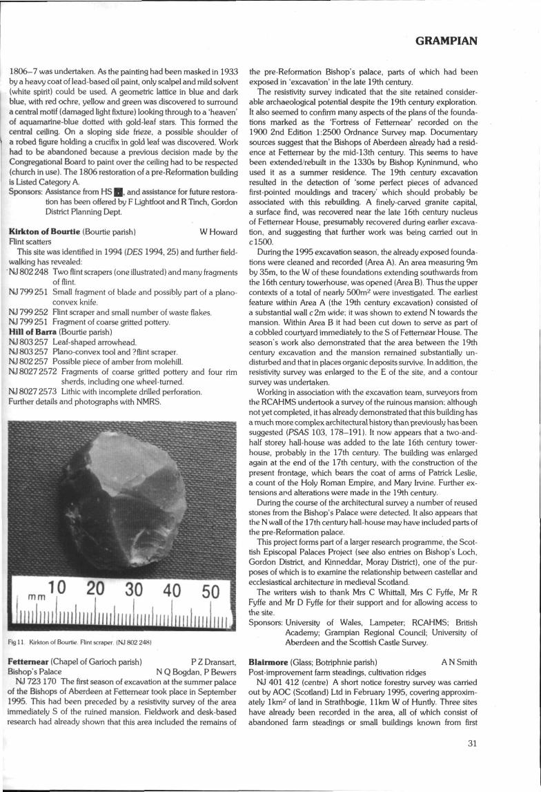
GRAMPIAN
1806-7 was undertaken. As the painting had been masked in 1933by a heavy coat of lead-based oil paint, only scalpel and mild solvent(white spirit) could be used. A geometric lattice in blue and darkblue, with red ochre, yellow and green was discovered to surrounda central motif (damaged light fixture) looking through to a 'heaven'of aquamarine-blue dotted with gold-leaf stars. This formed thecentral ceiling. On a sloping side frieze, a possible shoulder ofa robed figure holding a crucifix in gold leaf was discovered. Workhad to be abandoned because a previous decision made by theCongregational Board to paint over the ceiling had to be respected(church in use). The 1806 restoration of a pre-Reformation buildingis Listed Category A.Sponsors: Assistance from HS 0. and assistance for future restora-
tion has been offered by F Lightfoot and R Tinch, GordonDistrict Planning Dept.
Klrkton of Bourtle (Bourtie parish) W HowardRint scatters
This site was identified in 1994 {DES 1994, 25) and further field-walking has revealed:NJ 802 248 Two flint scrapers (one illustrated) and many fragments
of flint.NJ 799251 Small fragment of blade and possibly part of a piano
convex knife.NJ 799 252 Flint scraper and small number of waste flakes.NJ 799 251 Fragment of coarse gritted pottery.Hill of Barra {Bourtie parish)NJ 803 257 Leaf-shaped arrowhead.NJ 803 257 Plano-convex tool and ?flint scraper.NJ 802 257 Possible piece of amber from molehill.NJ 8027 2572 Fragments of coarse gritted pottery and four rim
sherds, including one wheel-turned.NJ 8027 2573 Lithic with incomplete drilled perforation.Further details and photographs with NMRS.
Fig 11 Kirkton of Bourtie Rint scraper (NJ 802 248)
Fetternear (Chapel of Garioch parish) P Z Dransart,Bishop's Palace N Q Bogdan, P Bewers
NJ 723 170 The first season of excavation at the summer palaceof the Bishops of Aberdeen at Fetternear took place in September1995. This had been preceded by a resistivity survey of the areaimmediately S of the ruined mansion. Fieldwork and desk-basedresearch had already shown that this area included the remains of
the pre-Reformation Bishop's palace, parts of which had beenexposed in 'excavation1 in the late 19th century.
The resistivity survey indicated that the site retained consider-able archaeological potential despite the 19th century exploration.It also seemed to confirm many aspects of the plans of the founda-tions marked as the 'Fortress of Fettemear' recorded on the1900 2nd Edition 1:2500 Ordnance Survey map. Documentarysources suggest that the Bishops of Aberdeen already had a resid-ence at Fettemear by the mid-13th century. This seems to havebeen extended/rebuilt in the 1330s by Bishop Kyninmund, whoused it as a summer residence. The 19th century excavationresulted in the detection of 'some perfect pieces of advancedfirst-pointed mouldings and tracery' which should probably beassociated with this rebuilding. A finely-carved granite capital,a surface find, was recovered near the late 16th century nucleusof Fettemear House, presumably recovered during earlier excava-tion, and suggesting that further work was being carried out inclSOO.
During the 1995 excavation season, the already exposed founda-tions were cleaned and recorded (Area A). An area measuring 9mby 35m, to the W of these foundations extending southwards fromthe 16th century towerhouse, was opened (Area B). Thus the uppercontexts of a total of nearly 500m2 were investigated. The earliestfeature within Area A (the 19th century excavation) consisted ofa substantial wall c 2m wide; it was shown to extend N towards themansion. Within Area B it had been cut down to serve as part ofa cobbled courtyard immediately to the S of Fetternear House. Theseason's work also demonstrated that the area between the 19thcentury excavation and the mansion remained substantially un-disturbed and that in places organic deposits survive. In addition, theresistivity survey was enlarged to the E of the site, and a contoursurvey was undertaken.
Working in association with the excavation team, surveyors fromthe RCAHMS undertook a survey of the ruinous mansion; althoughnot yet completed, it has already demonstrated that this building hasa much more complex architectural history than previously has beensuggested (PSAS 103, 178-191). It now appears that a two-and-half storey hall-house was added to the late 16th century tower-house, probably in the 17th century. The building was enlargedagain at the end of the 17th century, with the construction of thepresent frontage, which bears the coat of arms of Patrick Leslie,a count of the Holy Roman Empire, and Mary Irvine. Further ex-tensions and alterations were made in the 19th century.
During the course of the architectural survey a number of reusedstones from the Bishop's Palace were detected. It also appears thatthe N wall of the 17th century hall-house may have included parts ofthe pre-Reformation palace.
This project forms part of a larger research programme, the Scot-tish Episcopal Palaces Project (see also entries on Bishop's Loch,Gordon District, and Kinneddar, Moray District), one of the pur-poses of which is to examine the relationship between castellar andecclesiastical architecture in medieval Scotland.
The writers wish to thank Mrs C Whittall, Mrs C Fyffe, Mr RFyffe and Mr D Fyffe for their support and for allowing access tothe site.Sponsors: University of Wales, Lampeter; RCAHMS; British
Academy; Grampian Regional Council; University ofAberdeen and the Scottish Castle Survey.
Blairmore (Glass; Botriphnie parish) A N SmithPost-improvement farm steadings, cultivation ridges
NJ 401 412 (centre) A short notice forestry survey was carriedout by AOC (Scotland) Ltd in February 1995, covering approxim-ately Ikm^ of land in Strathbogie, llkm W of Huntly. Three siteshave already been recorded in the area, all of which consist ofabandoned farm steadings or small buildings known from first
31
GRAMPIAN
edition Ordnance Survey maps. These are: NJ 34 SE 37, Sheals;NJ 34 SE 38, Stripeside of Sheals; and NJ 44 SW 43, Blackhillock.Six features or groups of features were recorded by the survey,consisting in the main of cultivation remains in the form of fieldbanks or dykes, cultivation ridges and abandoned buildings.
List of sites recorded:1 NJ 3935 4115 Cultivation ridges
(Stripeside of Sheals, NJ 34 SE 38).2 NJ 3923 4088 Enclosure (Sheals, NJ 34 SE 37).3 NJ 3930 4088 Field bank.4NJ395 411 Field dyke and enclosure.5 NJ 3965 4105 Field dyke/enclosure.6 NJ 402 411 Blackhillock farm steading (NJ 44 SW 43) and
cultivation remains.Sponsor; HS H
Ratch-hill (Kintore parish) S CarterSurvey
NJ 774 168 Archaeological survey at Ratch-hill was conductedby AOC (Scotland) Ltd in advance of proposed forestry develop-ment. The survey area consisted of c 25ha of land in a single block tothe S of the farm buildings of Ratch-hill, 2km W of Kintore. Thecurrent land-use is rough grazing for cattle and the vegetation variesconsiderably over the area from open heather moorland to denseregenerating woodland.
Twenty-one features or groups of features of archaeological andhistorical interest were recorded by the survey. These included atleast six hut-circles with associated banks and cairns extending overan area of some 8ha. An oval embanked structure, measuring 20mby 17m with two opposed entrances, was tentatively identified asa henge. More recent features included a plantation enclosure bankof early 19th century date.Sponsor: HS Q.
Metkle Tarty (Logie-Buchan parish) M GreigStone ball
NJ 992 279 Small granite stone ball; c85mm in diameter; un-decorated.
Reported to Grampian Region Archaeology Service by MrAndrew Ferguson, 2 Meikle Tarty Cottages, Tarty, Newburgh. Fullinformation is held in GRC SMR.
The following sites have been identified while checking verticalaerial photographs on loan .from Sir Archibald Grant of MonymuskEstate to Grampian Regional Council. Full information is held inGRC SMR.Air photographsGallowhill Wood {Monymusk parish)
NJ 692 160 Area of rig and furrow.Enztian (Monymusk parish)
NJ 689 159 Cropmark of a possible circular enclosure.Knowhead Wood (Monymusk parish)
NJ 664 135 Possible sub-rectangular enclosure with internalfeature.Old Crow Wood (Monymusk parish)
NJ 699 135 Area of rig and furrow.Newfolds (Monymusk parish)
NJ 652 147 Remains of a farmstead.Newfolds Cottage (Monymusk parish)
NJ 661 144 Small area of rigs.Gallowhill Wood (Monymusk parish)
NJ 703 156 Area of rig and furrow.Haddoch (Monymusk parish)
NJ 708 169 Cropmark of a rectangular feature, ?house.Ardlebrown (Monymusk parish)
NJ 712 170 Small area of rig and furrow.
Mains of Afforok (Oyne parish)NJ 697 204 Area of rig and furrow.
Mains of Afforsk (Oyne parish)NJ 689 205 Rectangular banked enclosure.
Boghead Wood (Chapel of Garioch parish)NJ 704 188 Area of rig and furrow.
Newton Coullle (Monymusk parish)Stone tool
NJ 700 170 Five stone tools; four are axes, one of which is un-usually large. One tool is a rude implement similar to a cleaver;believed to have been found in the same field over a number ofyears. Found on Monymusk Estate and reported to GRC by SirArchibald Grant of Monymusk House.
Bishop's Loch (Loch Goul) (New Machar parish) N Q BogdanBishop's Palace
NJ 911 142 As part of the Scottish Episcopal Palaces Project,a desk-based survey of published sources relating to this site hasbeen carried out, copies of which have been deposited with HS, theNMRS and the Grampian Region SMR. Site inspection showed thatalthough this scheduled site is now under threat from rabbits,children and growth of saplings, it remains otherwise largely asdescribed in c!725 (Aberdeen University Review 30 (1943-44),312-314). It is anticipated that the site will be cleared of saplings andsurveyed during the winter/spring of 1995/6. The manor, at whichBishop Benholm died in c!280, does not seem to be recordedduring the Later Middle Ages. It is possible that it fell out of use afterthe Bishop's Palace in Old Aberdeen was erected early in the 14thcentury (DES 1965, 1).Sponsor: Scottish Castle Survey.
The following sites have been identified while checking verticalaerial photographs held by Grampian Regional Council. Fullinformation is held in GRC SMR.Newton Camaveron (Alford parish) M Greig
NJ 562 123 Faint trace of a possible circular enclosure.Oldtown of Carnaveron (Alford parish)
NJ 559 127 Possible ditched enclosure.Oldtown of Carnaveron (Alford parish)
NJ 559 130 Area of rig and furrow and possible enclosures.Klngsford Moss (Cluny parish)
NJ631 114 Remains of farmstead and small area of rig andfurrow.New Mains (Cluny parish)
NJ 632 111 Remains of farmstead.New Mains (Cluny parish)
NJ 634 114 Remains of small farmstead.Culthibert (Cluny parish)
NJ 633 115 Remains of small farmstead.Culthibert (Cluny parish)
NJ 634 117 Remains of small farmstead.Woodlands (Kintore parish)
NJ 757 167 Cropmark of a large rectangular enclosure withrounded comers.Woodlands (Kintore parish)
NJ 754 168 Grass-covered footings of a longhouse and sparseremains of enclosures.Rhynie (Rhynie parish)
NJ 495 269 Cropmarks of two enclosures; one large oval enclosure has two rectangular features within it, one of which has itselfinternal features. Immediately to the NE is a circular enclosure withan internal feature.Greens (Tough parish)
NJ 626 113 Remains of farmstead.Sponsor: GRC.
32
GRAMPIAN
The following sites have been identified by aerial reconnaissanceundertaken by Grampian Region Archaeological Service. Fullinformation is held in GRC SMR.Castle Hill (Auchindoir & Kearn parish) M Greig
NJ 515 286 Cropmark of a rectilinear enclosure with roundedcomers; entrance gap shows on the S side; possible internalfeatures.Slack (Kennethmont parish)
NJ 580 306 Faint trace of ring ditch; also a thin curvilinear line totheS.Glen Carvie (Strathdon parish)
NJ 348 083 Footings of a farmstead.Etnach Hillock (Strathdon parish)
NJ 351 082 Possible field banks.Kirk Hill (Strathdon parish)
NJ 354 126 Area of rig and furrow.Sponsors: RCAHMS. GRC.
Tullochpark Wood {Strathdon parish)Cairn (possible)
NJ 380 108 Possible cairn; fairly substantial; sits on 420mcontour on shelf of slope above the River Don; 10.27m by 8.75m,1.6m high. The stones on the N and E sides have fallen slightlydownslope; evidence of robbing on the W side.
Reported to Grampian Region Archaeological Service byA Thorn, District Forester, Forestry Commission. Full details inGRC SMR.Sponsor: Forestry Commission
The following sites have been identified while checking mapsheld by Grampian Regional Council. Full information is held inGRC SMR.Corriemore (Glenbuchat parish)
NJ 337 176 Remains of a small farmstead.Sluggie (Glenbuchat parish)
NJ 349 196 Remains of a small farmstead and enclosure.Dunanfiew (Strathdon parish)
NJ 231 095 Remains of two lime kilns.Badnabein (Strathdon parish)
NJ 236 095 Remains of lime kiln; longhouse c 100m to W of it.Badnabein (Strathdon parish)
NJ 241 095 Remains of lime kiln; longhouse c 100m to NE of it.Lotnherry (Strathdon parish)
NJ 244 094 Remains of a limekiln.Inchmore (Strathdon parish)
NJ 213 086 Remains of two longhousesInchmore (Strathdon parish)
NJ 219 076 Remains of a longhouse.Inchmore (Strathdon parish)
NJ 218 085 Remains of two longhouses with another lyingc 100m to S.Tom Dunan (Strathdon parish)
NJ 214 089 Remains of two longhouses.East ChapeIton (Strathdon parish)
NJ 387 088 Remains of a small farmstead, longhouses and en-closures.West Chape Iton (Strathdon parish)
NJ 383 087 Remains of small farmstead and enclosure.Hillockhead (Strathdon parish)
NJ 383 092 Remains of a lime kiln.Tlllyduke (Strathdon parish)
NJ 389 099 Remains of a lime kiln,Braeside (Strathdon parish)
NJ 396 097 Remains of a small farmstead and enclosure.Shiel (Strathdon parish)
NJ 301 166 Remains of a small farmstead.
Tolduquhlll (Strathdon parish)NJ 312 152 Remains of a lime kiln.
Duffdefiance (Strathdon parish)NJ 303 166 Remains of a smal! farmstead.
Righorach (Strathdon parish)NJ 303 163 Remains of houses and part of an enclosure.
Cllne Burn (Strathdon parish)NJ 347 158 Remains of house and enclosure.
Haugh (Strathdon parish)NJ 323 154 Remains of longhouses and enclosure.
Belnagauld (Strathdon parish)NJ351 100 Remains of a lime kiln.
Coull of Newe (Strathdon parish)NJ 371 127 Remains of a lime kiln.
Sponsor: GRC.
KINCARDINE & DEES1DE DISTRICT
Belrorie Hill (Aboyne & Glentanar parish) I Shepherd, I RossCairn
NO 486 976 Remains of a cairn; stands to a height of c 1.20m;centre robbed and stones scattered.
Reported to Grampian Region's Archaeological Service byMr Irvine Ross, Burnfoot Farmhouse, Dinnet, Aboyne. Full detailsin GRC SMR.
Calmwell Ring-cairn (Banchory-Devenick parish) T Rees,Ring-cairn J Barber
NO9071 9733 Total excavation of the scheduled Caimwell ring-cairn (NMRS no NO 99 NW 4) within Badentoy Park, Portlethen,Grampian was commissioned by G & J Investments Ltd in advanceof future development. After excavation the monument was re-located and accurately reconstructed within a landscaped site,accessible to the public, 175m to the NW. Fieldwork and re-construction supervision was conducted by AOC (Scotland) Ltd inJanuary and February 1995. Scheduled monument consent wasgranted for the excavation of an area around the caim, the caimitself, the cairn mound, post-excavation analysis and publication ofthe project.
The ring-cairn was found to have three main structural elements:the ring-cairn composed of an inner and outer kerb with rubblebetween; a stone circle, enclosing the ring-cairn, of which threeorthostats were still in situ, one fallen orthostat was revealed andthree possible stone sockets identified; and a later deposit of rubble,with an outer revetment, which expanded the ring-cairn to incorpor-ate the stone circle within this later outer revetment. Beneath thering-cairn an earlier timber enclosure with an entrance to the SE wasidentified. Within the interior of the site five possible cremation pitswere located. Twelve pits or post holes, either underneath the ring-cairn or outside it, were also excavated.
A full post-excavation and dating programme is currently underway. Archive will be deposited in NMRS.Sponsor: G & J Investments Ltd.
Tollohill Wood (Banchory-Devenick parish) M GreigNJ 920 021 Denuded remains of a possible rectangular struc-
ture. A line of five large stones sit on edge, with a spread of smallerstones to the E, scattered over 2.50m. Remains of a second wallappears to join the former, again with a wide spread of smallerstones to the exterior. One large upright stone sits on the edge. 20mto the SW is another group of scattered stones with two uprights.
NJ 919 023 Remains of what looks like a short cist and small ringcaim. A massive capstone, c 2m E-W by 1.20m N-S, 30cm thick, isstill in situ and held in position by a ring of large stones angling
33
GRAMPIAN
inwards slightly. Only the N side slab of the cist and the kerb aremissing, where it has been robbed in antiquity. A number of stoneslie around slightly downslope.
NJ 918 020 Denuded remains of a possible small rectangularstructure; only two sides and part of a third survive to 0.40m inheight and 0.50m in width.
Reported to Grampian Region's Archaeological Service byMr Walker, 74 Broomhill Road, Aberdeen. Full information is heldin GRC SMR.
Birse Manse (Birse parish) M Greig, J AddySymbol stone
NO 555 973 Fragment of a Pictish Class I stone c 0.30m by0.30m; built into garden wall. Bears a comb symbol and possiblepart of a beast.
Reported to Grampian Region's Archaeological Service by MrJohn Addy, Birseside, Birse, Aboyne. Full details are held byGRC SMR.
Mains of Balfour (Birse parish) H Cochrane, M GreigPossible medieval towerhouse
NO 551 963 Remains of rectangular foundations, part grass-covered. The NW corner comprises of massive boulders. Only onecourse visible, although not complete due to robbing, but enough toestimate size as being 13.5m by 10.50m by 1m thick. These mayrepresent the foundations of a medieval towerhouse. The remains ofa shallow stone-lined well lie c4m to the S in a damp hollow.
Reported to Grampian Region's Archaeological Service by HughCochrane, Balfour House, Birse. Full information is held in GRCSMR.
Glen Ey (Crathie & Braemar parish) J O'SullivanSurvey
NO 084 869 Fifteen features were recorded within a survey areaon the E-facing slope of Glen Ey by AOC (Scotland) Ltd. These formpart of a larger settlement and field system recorded as NMRSNO 08 NE 6. Presumably the township was still inhabited when itwas represented on early maps as 'Rhuichelich' (Arrowsmith 1807)or 'Ruachelich' (Roy 1747-55).
The pre-clearance buildings form two groups: (a) dispersedbuildings and enclosures which lie at the margins of a central area ofimproved land and (b) a more tightly knit cluster of buildings oneither side of the track or dirt road on the lower slopes of the glen bythe Ey burn (outwith the survey area, at NO 087 877).Recorded sites:No 1 NO 0822 8671 Rectangular structure.No 2 NO 0826 8675 Rectangular enclosure.No 3 NO 0827 8682 Rectangular structure; enclosures.No 4 NO 0838 8685 Rectangular structures; enclosure.No 5 NO 0835 8696 Rectangular structure.No 6 NO 0849 8692 Rectangular structure.No 7 NO 0847 8695 Linear clearance caim.No 8 NO 0850 8700 Cultivation terraces; clearance cairns.No 9 NO 0851 8701 Possible corn-drying kiln.No 10 NO 0846 8704 Rectangular structure; dyke.Noll NO 0838 8695 Clearance cairns.No 12 NO 0839 8691 Drain.No 13 NO 0852 8715 Rectangular structure.No 14 NO 0856 8715 Rectangular structure.No 15 NO 0847 8706 Clearance cairn.Sponsor: HS ̂ .
Park Quarry. Drumoak (Durris parish)Survey
NO 800 983 Archaeological assessment at Park Quarry wasundertaken by AOC (Scotland) Ltd in advance of a proposed
extension to ongoing sand and gravel extraction by Chap QuarriesLtd. The site overlooks the River Dee from a well-defined terracewithin a strong U-bend on the S bank and rises to 30m OD. A varietyof features were recorded by the assessment. Lithic debris recoveredfrom ploughsoil on the river bank represents tool manufacturing anda possible habitation area of early prehistoric date, though .associ-ated features are unlikely to survive. A curvilinear slot-trench withburnt timber inclusions may be a remnant of a later prehistoric roundhouse, but the evidence here is slight and this interpretation istentative. Of much more recent date, rubble foundation remnants,broad rig furrows and an earthen dyke are interpreted as features ofsettlement and agriculture in the early modem period. Numerousundated smaller, plough-truncated features were recorded. Ingeneral, the recorded features from all parts of the assessment wereneither extensive nor well preserved.Sponsor: Chap Quarries Ltd, Aberdeen.
Newdosk Church (Fettercairn parish) N AtkinsonRecumbent graveslab
NO 602 734 The stone was initially discovered by NiallRobertson, and thought to date to the Romanesque period.The 1307 date on it.was probably added in the 18th centuryor later.Sponsor: Angus District Museums.
Fetteresso Castle (Fetteresso parish) M Greig, 1 ShepherdCordoned urn
NO 844 855 In crown of a glacial mound exposed by animalerosion. The urn was inverted in a narrow pit with a large flat stoneoverlying it; decorated above upper cordon with horizontal lines andlarge triangles of twisted cord impressions. The um rim has beenbroken and a large crack ran down one side. It contained largepieces of cremated bone.
This site has been reported to Grampian Regional Council'sArchaeology Service by Mrs Grimes, Fetteresso Castle, by Stone-haven.Sponsor: GRC.
Ford on River Dee (Kincardine O'Neil parish) A StrangPolished stone axe
?NO 590 993 In 1951 a green-coloured, polished stone axe waspurchased from the antique shop in Kincardine O'Neil. It wasclaimed to have been found by the ford over the River Dee just to theS of the village. The axe is in excellent condition, approximatelyllcm long, 4.7cm wide at the blade and 2.2cm at its thickest andweighs 148 (150)g.
Retained by contributor.
The following sites have been identified over the winter season byaerial reconnaissance undertaken by Grampian Region Archae-ological Service.
Full information is held in GRC SMR.Hill of Beltle (Kincardine O'Neil parish) M Greig
NJ 635 001 Sub-rectangular enclosure with rounded corners;possible rigs within.Hill of Beltie (Kincardine O'Neil parish)
NO 631 998 Remains of a rectangular building; fields.Hill of Beltie (Kincardine O'Neil parish)
NO 637 996 Circular stone-walled enclosure; ?sheepfold.Dalbreck (Strachan parish)
NO 654 914 Foundations of a small depopulated settlement.Bucharn {Strachan parish)
NO 659 931 Remains of small farmstead plus enclosures.Idlestone (Strachan parish)
NO 642 933 Fields.Sponsors: RCAHMS, GRC.
34
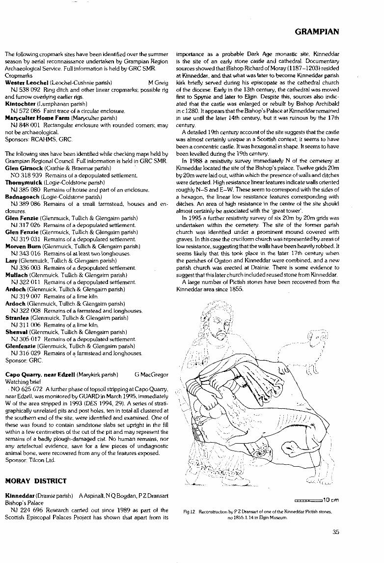
GRAMPIAN
The following cropmark sites have been identified over the summerseason by aerial reconnaissance undertaken by Grampian RegionArchaeological Service. Full information is held by GRC SMR.CropmavksWester Leochel (Leochel-Cushnie parish) M Greig
NJ 538 092 Ring ditch and other linear cropmarks; possible rigand furrow overlying earlier rigs.Kintochter (Lumphanan parish)
NJ 572 086 Faint trace of a circular enclosure.Maryculter Home Farm (Maryculter parish)
NJ 848 001 Rectangular enclosure with rounded corners; maynot be archaeological.Sponsors: RCAHMS, GRC.
The following sites have been identified while checking maps held byGrampian Regional Council. Full information is held in GRC SMR.Glen Glrnock (Crathie & Braemar parish)
NO 318 939 Remains of a depopulated settlement.Thornymulck (Logie-Coldstone parish)
NJ 385 080 Remains of house and part of an enclosure.Badnagoach (Logie-Coldstone parish)
NJ 389 086 Remains of a small farmstead, houses and en-closures.Glen Fenzie (Glenmuick, Tullich & Glengairn parish)
NJ 317 026 Remains of a depopulated settlement.Glen Fenzie (Glenmuick, Tullich & Glengairn parish)
NJ 319 031 Remains of a depopulated settlement.Morven Bum (Glenmuick. Tullich & Glengairn parish)
NJ 343 016 Remains of at least two longhouses.Lary (Glenmuick, Tullich & Glengairn parish)
NJ 336 003 Remains of a depopulated settlement.Mullach (Glenmuick. Tullich & Glengairn parish)
NJ 322 011 Remains of a depopulated settlement.Ardoch (Glenmuick, Tullich & Glengairn parish)
NJ 319 007 Remains of a lime kiln.Ardoch {Glenmuick, Tullich & Glengairn parish)
NJ 322 008 Remains of a farmstead and longhouses.Stranlea (Glenmuick, Tullich & Glengairn parish)
NJ 311 006 Remains of a lime kiln.Shenval (Glenmuick, Tullich & Glengairn parish)
NJ 305 017 Remains of a depopulated settlement.Glenfenzie (Glenmuick, Tullich & Glengairn parish)
NJ 316 029 Remains of a farmstead and longhouses.Sponsor: GRC.
Capo Quarry, near Edzell (Marykirk parish) G MacGregorWatching brief
• NO 625 672 A further phase of topsoil stripping at Capo Quarry,near Edzell. was monitored by GUARD in March 1995, immediatelyW of the area stripped in 1993 (D£S 1994, 29). A series of strati-graphically unrelated pits and post holes, ten in total all clustered atthe southern end of the site, were identified and examined. One ofthese was found to contain sandstone slabs set upright in the fillwithin a few centimetres of the cut of the pit and may represent theremains of a badly plough-damaged cist. No human remains, norany artefactual evidence, save for a few pieces of undiagnosticanimal bone, were recovered from any of the features exposed.Sponsor: Tilcon Ltd.
MORAY DISTRICT
Kinneddar (Drainie parish) A Aspinall, N Q Bogdan, P Z DransartBishop's Palace
NJ 224 696 Research carried out since 1989 as part of theScottish Episcopal Palaces Project has shown that apart from its
importance as a probable Dark Age monastic site, Kinneddaris the site of an early stone castle and cathedral. Documentarysources showed that Bishop Richard of Moray (1187-1203) residedat Kinneddar, and that what was later to become Kinneddar parishkirk briefly served during his episcopate as the cathedral churchof the diocese. Early in the 13th century, the cathedral was movedfirst to Spynie and later to Elgin. Despite this, sources also indic-ated that the castle was enlarged or rebuilt by Bishop Archibaldin c 1280. It appears that the Bishop's Palace at Kinneddar remainedin use until the later 14th century, but it was ruinous by the 17thcentury,
A detailed 19th century account of the site suggests that the castlewas almost certainly unique in a Scottish context; it seems to havebeen a concentric castle. It was hexagonal in shape. It seems to havebeen levelled during the 19th century.
In 1988 a resistivity survey immediately N of the cemetery atKinneddar located the site of the Bishop's palace. Twelve grids 20mby 20m were laid out, within which the presence of walls and ditcheswere detected. High resistance linear features indicate walls orientedroughly N-S and E-W. These seem to correspond with the sides ofa hexagon, the linear low resistance features corresponding withditches. An area of high resistance in the centre of the site shouldalmost certainly be associated with the 'great tower'.
In 1995 a further resistivity survey of six 20m by 20m grids wasundertaken within the cemetery. The site of the former parishchurch was identified under a prominent mound covered withgraves. In this case the cruciform church was represented by areas oflow resistance, suggesting that the walls have been heavily robbed. Itseems likely that this took place in the later 17th century whenthe parishes of Ogston and Kinneddar were combined, and a newparish church was erected at Drainie. There is some evidence tosuggest that this later church included reused stone from Kinneddar.
A large number of Pictish stones have been recovered from theKinneddar area since 1855.
i10cm
Fig 12. Reconstruction by P Z Dransart of one of the Kinneddar Pictish stones,no 1855.1.14 in Elgin Museum.
35
GRAMPIAN
The presence of the Pictish stones and the report in the New Statist-ical Account of a cist cemetery underneath the ramparts or ringworkindicate that Kinneddar is a multi-period site. The majority of thePictish stones may be assigned to Class III They include a frag-ment which is closely related to the long panel of the St Andrewssarcophagus, depicting David rending the jaws of a lion (see Fig 12).
The writers wish to thank Mr A Dunbar, D Forbes and MorayDistrict Council for allowing access to the site.Sponsors: British Academy, University of Wales, Lampeter and the
Scottish Castle Survey.
Kinneddar (Drainie parish) K Cameron (CFA)Evaluation of early stone castle and ringwork
NJ 224 696 An evaluative excavation and geophysical surveywere undertaken during September 1995 on the site of KinneddarCastle (the Bishop's Palace) near Lossiemouth. The prime require-ment was to define the extent and limits of features of archaeologicalinterest as an aid to future management strategies for the site.
A total of over 900 sq m was excavated in the form of twelveindividual trenches. Trenches were positioned primarily around theeastern limits of the known site to the N of the modern cemetery, andon and around the shingle ridge to the S of the cemetery.
To the S of the cemetery a range of archaeological features wasidentified. These took the form of pits, dump deposits and cultiva-tion traces.
To the N and E of the cemetery trenches revealed traces ofa substantial structure. Large walls and ditches were located in threetrenches corresponding to documentary and aerial photographicevidence of a concentric hexagonal-shaped structure. A numberof animal bones and sherds of medieval pottery were recoveredwithin this feature. Resistivity surveys conducted after excavationenhanced this picture.Sponsors: The Moray Society, Moray District Council, Moray,
Badenoch and Strathspey Enterprise Company, andGrampian Regional Council.
Brodle Castle (Dyke & Moy parish) G Ewart, J Triscott, A Dunn18th century stable block
NH 979 578 Excavations were undertaken in February 1995 inadvance of renovation work on the mid 18th century stable buildingin the grounds of Brodie Castle, a Z-plan tower-house dating to themiddle of the 16th century.
No dating material attributable to the primary use of the buildingswas recovered in the seven trenches opened. In c 1846, the easternhalf of the stables housed a smithy and store, whilst the western halfremained as stables. The date of the renovations is not clear, how-ever date stones on the relevant areas of the tower-house, a datedarchitect's watercolour, and a date-stone recovered from theblocking material of the SW central arch during the 1995 excava-tions, all date to 1846. The architect's illustration indicates that it wasthe owner's intention to oversee the construction of an elaboratetower (The Pigeon Tower') on the SE angle of the castle. This towerwas never built.
By the latter half of the 19th century the stable block was in a poorstate of repair, having suffered serious structural deterioration asa result of the abortive tower building attempt. Thereafter, thebuilding saw use only as a storage area.Sponsor: NTS.
High Street, Elgin (Elgin parish) J TerryNJ 215 627 The excavation of service trenches, tree planting
holes and a trench to house a water tank to feed a new fountain wascarried out by Scotia Archaeology Limited in advance of a pro-gramme of pedestrianisation to the E and W of St Giles Church inthe High Street.
Within the water tank trench, at a depth of 0.3m below the
modem concrete surface, were the foundations of a 1.1 m-wide wall,aligned E-W and with two other walls returning southwards fromit. All three walls were of clay-bonded, rubble masonry and arethought to have comprised elements of the third and final tolboothconstructed directly over its predecessor in 1716.
Twenty-three human skeletons, and numerous disarticulatedbones were retrieved during the excavation which took place withinthe former graveyard of St Giles Church which stands within themarket place of the medieval burgh.Sponsor: Moray District Council.
Queen Street/Greyfriars Street (Elgin parish)Urban site evaluation J R Mackenzie (SUAT)
NJ 22016277 This was an evaluation of a gap site in advance of asheltered-housing development. The site lay 60m to the N of the siteof the medieval Observantine House of the Franciscan Friars and itwas thought possible that associated archaeological remains may bepresent. The total area affected by the proposal extended to 1500m2.Seven trenches were machine excavated and hand cleaned.
Undisturbed sand was encountered at c0.6m below groundsurface. A substantial pit c 2.2m in width and 1.2m deep was foundcut into the sand in the SW corner of the site. The feature containedthree fills from which abraded sherds of medieval pottery wererecovered. It is likely that this feature represents a quarry pit for sand.This was sealed by a 19th century garden soil. No further evidencerelating to early burgh development or the Franciscan Friary wasfound, presumably obliterated by 19th/20th century development.Sponsor: Moray District Council.
The following sites were reported to Grampian Region ArchaeologyService by W Anderson, Head Forester of The Crown Estate,Glenlivet. Full information held in GRC SMR.Colre-na-h-Airnich (Inveravon parish) M Greig
NJ 187 252 Enclosure and longhouse.Westertown {Inveravon parish)
NJ 193 250 Enclosure and longhouse.Whitefolds Wood (Inveravon parish)
NJ 245 256 Enclosure and longhouse.Cnoc Fergan (Kirkmichael parish)
NJ 140 229 Foundations of several longhouses; walls thickerand size of house smaller than usual.Kylnadrochit Wood (Kirkmichael parish)
NJ 148 192 Three longhouses.Sponsor: Crown Estates.
Klnloss Abbey (Kinloss parish) J LewisNJ 065 615 As part of a programme of masonry consolidation,
the concrete capping had been removed from the upper floors of theN and S wings of the post-monastic building atop the N end of thepartially ruined E range of the abbey. The exposed features wereinvestigated and recorded by Scotia Archaeology Limited.
In the first storey of the N wing of the building the flagged floor wasreasonably intact and there was slight evidence of a hearth in theNW comer of the room. The floor was pierced on its E side by whatwas probably the chute of a slop drain. The original stair, on theW side of the building, had been replaced in recent times by anotherstair, built on a slightly different alignment. Most of the flags weremissing from the second floor of the S wing which was probablyentered by a doorway in its NW comer.Sponsor Moray District Council.
Burgle Estate: Bognte Farm and Monaughty Farm(Rafford; also Alves parish) J O'SullivanSurvey
NJ 134 600; NJ 102 559 Archaeological survey of two areas onBurgie Estate was conducted by AOC (Scotland) Ltd in advance of
36
GRAMPIAN/HIGHLAND
forestry planting and natural regeneration. The survey recorded fivefeatures of archaeological interest, including remnant post-medievalor early modern field banks and a possible shieling. The recordedsites are:
No 1 NJ 1342 6000 Monaughty Earth dyke.No 2 NJ 1353 6004 Monaughty Earth dyke.No 3 NJ 1347 6009 Monaughty Terrace.No 4 NJ 1353 5998 Monaughty Possible shieling.No 5 NJ 1025 5597 Bognie Earth banks.Sponsor: HS Q.
Spynie Palace (Spynie parish) R Murdoch, A BarlowNJ 228 658 A new custodian's house was to be erected within
the approximate limits of the recently demolished, early 19thcentury Castle Cottage which stood some 230m W of the palaceenclosure. The cottage stood on the edge of the cliff adjacent to theformer Loch of Spynie. Scotia Archaeology Limited mounteda watching brief during the initial excavation of the foundations ofthe new dwelling. During this stage several features of interest wereuncovered, resulting in a full-scale excavation of the area withina trench measuring 13m N-S by 11m E-W.
Five pits, cutting the sandy subsoil, were uncovered. Three ofthem contained substantial quantities of marine shells as well ascharcoal-rich deposits and heat-damaged stones. A linear gulley raneastwards from the W end of the trench, returning northwardstowards the cliff edge.
On the S side of the trench was an extensive, natural declivity,which had been levelled with substantial quantities of rubble,presumably when the adjacent metalled road was laid in the early19th century.Sponsor: HS Bj)
The following croprnark sites have been identified over the summerseason by aerial reconnaissance undertaken by Grampian RegionArchaeological Service. Full information is held in GRC SMR.Alves {Alves parish) M Greig
NJ 134626 Linear cropmark showing possible angled entrance.Auchenreath (Bellie parish)
NJ 378 633 Thin trace of part of a rectilinear enclosure.Rashcrook (Birnie parish)
NJ 226 569 Indeterminate cropmarks.Longley (Dyke & Moy parish)
NH 996 576 Small circular cropmark; may not be archaeological.Clackmarras {Elgin parish)
NJ 246 596 Indeterminate cropmarks: possible small sub-rectangular enclosure.Cowfords (Speymouth parish)
NJ 317 596 Cropmarks of field boundaries.Mldtown (Spynie parish)
NJ 198 657 Unenclosed settlement with ring ditches, enclosuresand possible square barrow. Also World War II search-light stations.Lochslde (Spynie parish)
NJ 209 655 Faint circular cropmark; also possible larger ovalcropmark to S, SW.Sponsors: RCAHMS, GRC.
HIGHLAND REGION
BADENOCH & STRATHSPEY DISTRICT
Easter Raitts (Alvie parish) M DallandArchaeological and contour survey
NH 777 023 The survey at Easter Raitts was commissioned byHighland Regional Council and was conducted by AOC (Scotland)
Ltd. The aim of the survey was to provide data which would enablea reconstruction of the township, at the Highland Folk Park, ona similar land form to the original. The survey area lies on the S-facing slopes on the N side of the river Spey some 2km NE ofKingussie. Two areas were targeted for the survey: to the W a squarearea c 60m by 60m, and to the E a rectangular area c 340m E to Wand 120m wide.
The W area contained a corn-drying kiln, an enclosure, a platformand two rectangular buildings. In the larger area to the E, 36 featureswere recorded: amongst these were 10 rectangular buildings. Someof these are mapped on the first edition OS map, surveyed in 1869,as part of a settlement called Baldow. Two of the features recordedin the E area may predate the main parts of the Baldow settlement;a platform to the W and the cairn to the E of Baldow. may both be ofprehistoric date.
A copy of the report is lodged with the Highland SMR.Sponsor: Highland Regional Council.
Easter Raitts (Alvie parish) K Cameron (CFA)Medieval township
NH 7774 0228 Excavation was carried out during June 1995 inadvance of the proposed reconstruction of the township of EasterRaitts for the development of the Highland Folk Park. The townshipis the easternmost of several similar settlements in the area known asUpper Raitts.
A total area of over 55 sq m was excavated. This took the form ofeight individual trenches positioned across the interior and exteriorof two domestic structures and outbuildings, associated terraces.dykes and lanes. One trench examined one of a pair of possible kilnslying adjacent to each other cut into a terrace.
The structures appear to be well built with faced stone, squaredcorners and paved byres. Floors of beaten earth were identifiedwithin the main chambers of two structures. The immediate exteriorof one of the structures appears to have been cobbled, withentrances either cobbled or flagstone-laid in both cases. A smallassemblage of finds consisting mainly of glass sherds and sherds ofporcelain was recovered during the excavation.Sponsor: Highland Folk Museum.
trenchB —<^fiC&—trenchD'•;-,-
Fig 13. Easter Raids, tiench locations
J A AtkinsonThe House, Grantown on Spey(Cromdale, Inverallan & Advie parish)Analytical demolition and excavation of a post and beam house
NJ 0314 2786 The analytical demolition (including survey andphotographic recording) of a post and beam cottage within thebacklands of 96 High Street, Grantown on Spey was undertaken inSeptember 1995. The work included the demolition and partial
37
HIGHLAND
excavation of the house, and backland plot. It revealed that thestructure dated from the beginning of the 19th century, though thetimber frame for the building appeared to be considerably earlier indate and utilised an all wood construction technology (hardwooddowels held the frame together). The work revealed four main(datable) phases of construction and evidence that indicatedthat the building had originally had an earthen floor to the N anda cobbled byre end to the S. A full report is currently being preparedand will be deposited in the NMRS.Sponsor: Grantown Heritage Trust.
Badan Dubh (Kingussie & Insh parish) G RobinsDepopulation dyke
NH 832 009 Widening of commercial forestry access necessit-ated the destruction of a dyke close to a depopulation site. Thoughin a ruinous state, sections through the dyke suggested a con-struction of turf and stone, with a narrow, paved path on the sideof the dyke facing away from the settlement. Two pieces of glazedceramic underlying the tumble on the settlement side of the dykegive a late 18th century date. A report has been deposited in theHighland SMR.Sponsor: Forest Enterprise.
CAITHNESS DISTRICT
K TaylorJohn O'Groats Hotel (Canisbay parish)Watching brief
ND 379 733 A watching brief, ahead of the laying of a sewagepipe, was conducted in May 1995 at John O'Groats Hotel, eitherside of the area assessed by GUARD in 1994 (DES 1994, 32).No archaeologically significant features were identified, thougha number of artefacts were recovered from the topsoil, includingseveral pieces of worked flint, two pieces of animal bone and a singlesherd of pottery, probably of 14th century date.Sponsor: Highland Regional Council Water and Sewerage Dept.
Marymas Green, Dunnet Bay (Dunnet parish) T PollardNorse settlement
ND 219 706 Limited investigation of a midden deposit wascarried out over seven days in September 1995, as part of HighlandArchaeology Week. The feature, which consisted of a deposit ofmarine shell and animal bone and elements of masonry, had beenpreviously identified eroding from the side of a sand dune (DES1992, 40). Excavation revealed that the deposit had accumulatedagainst a revetment wall, probably built in order to stabilise an activesand dune. A number of soil horizons were identified at a lower leveland these may indicate agricultural practice in an area periodicallyburied by active dune movement. A further portion of wall, possiblyfrom a building, was identified several metres to the N of the erodingsection. A well-preserved antler comb was recovered from themidden-rich matrix of this wall and indicates Late Norse activity.
The southernmost trench included further walling which appearsto represent another building, with a complex accumulation ofdeposits on both sides. A fine bone pin with decorated head wasrecovered from the western side of the wall and may indicate theuse of the site at an earlier date than that evidenced by the comb.A fragment of shale armlet was also recovered in close proximity tothis wall and the pin.Sponsors: Highland Regional Council, Caithness and Sutherland
Enterprise, Caithness Field Club.
Housle Cairn broch, Gerston (Halkirk parish) NMSEH glass bead
ND 119 596 A glass bead was found during fieldwalking besidethe remains of Housle Cairn broch, and reported to NMS. The bead
is opaque white with swirling darker bands. Parallels suggest a 5th-8th century AD date.Daybook no: DB 1994/51.
Hill of Fores (Thurso parish) R J Strachan (CFA)ND 065 680 (centre) An archaeological desk-based study was
undertaken in September 1994 as part of the environmental assess-ment for a planned windfarm development. The study was designedto identify and evaluate any archaeological monuments present,through the examination of documentary, cartographic and aerialphotographic sources. The study area covered approximatelylO.Ssqkm. Previous systematic fieldwork covering the majority ofthe proposed development area was led by Mr R J Mercer between1980-3. Sites located within the study area comprised: two brochs,seven longhouses, 12 lengths of wall, four enclosures, ten structures,a windmill, two cairns, a cist, a burnt mound, ten mounds, two fieldsystems and two areas of rig-and-furrow. No new sites or monu-ments were located as part of the current study.
A detailed report is lodged with the NMRS.Sponsor: EcoGen Limited.
Loch Watt en; Keiss Links (Watten; Wick parish) A JonesFlint scatters
ND 232 568, ND 331575, ND 329 581 Three flint scatters foundduring the systematic fieldwalking of arable land in the environs ofWick and Watten in Caithness.
The first at ND 232 568 is in close proximity to both Neolithic andBronze Age mortuary monuments on Lynegar Farm. Situated N ofLoch Watten, this scatter of worked flint and quartz may representactivity from both the Neolithic and Bronze Age. Associated with theassemblage was a fragment of shale bracelet indicating the Iron Ageuse of this area.
Both ND 331 575 and ND 329 581 were located in proximity tothe Keiss Links, both being situated in the lee of the dunes somedistance inland.
ND 331 575 was a concentrated scatter of flint and quartz mater-ial, mostly debitage which indicated the primary working of beachflint, the presence of a number of flint blades probably indicatesa Neolithic date.
ND 329 581 was a concentrated scatter of material. Again thismaterial consisted of primary debitage, cores and a few workedpieces. In particular the presence of a kite-shaped scraper probablyindicates a late Neolithic date, since these implement forms havestrong Grooved ware associations.Sponsor: Society of Antiquaries of Scotland.
Auction Mart, Wick (Wick parish) J WordsworthPost-medieval urban
ND 3633 5094 Development of this site evaded the usual plan-ning procedures and only a watching brief was possible. The area ofthe Auction Mart appeared to have been built on modem rubble orgarden soil dating to the 19th century and these deposits overlaywhat appeared to be sterile shell sand sloping down to the WickRiver. At the N of the area the derelict building at 1 Back BridgeStreet was demolished. This lay over post-medieval deposits andgarden soil.Sponsor: Caithness and Sutherland Enterprise.
INVERNESS DISTRICT
G Ewart, D Stewart, A DunnFort George (Ardersier parish)18th century fort
NH 759 567 A watching brief and excavations were carried outat the NE Battery during the summer of 1995, in the course of repairwork to the Battery and casemates. The sequence of construction of
38
HIGHLAND
the outer and inner rampart walls was derived, along with evidencefor the 18th century waterproofing. Contemporary graffiti wasrecorded on the mortared faces of some of the structures, and thesequence of repairs and alterations was recorded.Sponsor: HS Q.
Uchdachan Bridge (Boleskine & Abertarff parish) G Ewart,18th century bridge D Murray, D Connolly
NH 392 003 Uchdachan Bridge is a single span arched bridge,built between 1731 -32 across the Allt Coire Uchdachan on GeneralWade's road, running N from Dalwhinnie to Fort Augustus. Dueto subsidence of the arch the bridge is in a state of disrepair, andso a programme of archaeological recording was undertaken, priorto repair work being carried out. The bridge is oriented approxim-ately E-W, built onto unlevelled bedrock and subsoil. It is a pre-dominantly drystone structure, with some mortar rendering inplaces, and is composed of micaceous rocks, with the occasionalgranite slab. The angular stone is probably derived from a localquarry, possibly the quarry situated beside the next bridge tothe N along Wade's road. The span of the arch, spandrel tospandrel, measures 5.8m, and the bridge stands to a maximumheight of 2.9m
Two trenches were opened, Trench 1. measuring c90cm by90cm against the N parapet at the western end of the bridge andTrench 2. measuring c5Qcm by 50cm at the approximate centreof the span. Both trenches revealed a layer of dumped materialrepresenting an infill of the basic frame of the bridge.
No evidence of a clay lining was found, and the upper surfaces ofthe arch revealed in Trench 2 indicate that the build was quiteirregular (although the visible arch was more finely faced). Theparapet created by the side walls is still visible above the turf line inplaces, and it may once have stood some courses higher.Sponsor: Association for the Protection of Rural Scotland.
Balnuaran of Clava (Croy & Dalcoss parish) R BradleyMegalithic cemetery
NH 7576 4447 The second season of excavation (see D£S1994. 34-5) focused on the NE passage grave and investigated thechronological relationship between the five main elements on thesite: the internal structure of the cairn, its kerb, its entrance passage,the platform upon which the site appears to be built and the stonecircle which surrounds the entire monument. All proved to havebeen constructed during a single phase. The caim contained a coreof massive blocks and redeposited turf or topsoil which formeda stable structure supporting the corbelled burial chamber. This wascovered by a skin of smaller rubble which was revetted by the kerb-stones. These were only shallowly bedded in the ground and hadbeen held in position by a rubble ramp piled up against the exteriorof the monument. The composition of this ramp or platformmatched the constructional sequence in the cairn itself, withquarried slabs similar to those employed in the chamber towards thebase of this deposit and rounded boulders towards its surface. Thisfeature continued unbroken across the entrance to the tomb andextended outwards as far as the stone circle. One of the monolithsbelonging to this circle lacked any socket and was bedded in the tailof the ramp - thus it could not have been erected after that materialwas in position. The entrance passage had been cleared of anyarchaeological deposits during an unrecorded excavation. A fewflecks of cremated bone were found on the surface of the platform.Over a hundred lithic artefacts were recovered during the excava-tion and samples were taken for study by soil micromorphology,pollen analysis and radiocarbon dating.
A section was also cut through the rubble ramp of the SW passagegrave (NH 7568 4447) at the point where the kerbstones were attheir lowest. In this case the kerb lacked any sockets and again theramp must have been a primary feature of the monument. It was
constructed in exactly the same manner as the platform of the NEcairn, but in this case it had been surfaced with flat slabs.Sponsors: British Academy, HS Q, Reading University, the Society
of Antiquaries of London and the Society of Antiquariesof Scotland, with additional assistance from HighlandRegional Council and NTS.
Torness (Dores parish) R G HanleyThree rectangular buildings
NH 581 251 (centred at) Stone footings of three rectangularbuildings lying in heather adjacent to the line of mid-18th centurymilitary road. Long axis of buildings 1 and 2 aligned on military road.Building 3 is located in SW comer of large rectangular drystoneenclosure aligned with military road (OS marked).
Building 1 (NH58062512): 8.3m by 4.3m; Building2 (NH58072508): 18.1m by 3.9m with extension to NW; Building 3 (NH 58072506): 7.8m by 3.9m.Sponsor: Inverness District Council.
Culloden Battlefield T Neighbour (CFA)(Inverness & Bona; Daviot & Duntichty parishes)Geophysical surveys
NH 745 450 and NH 740 448 Resistance and gradiometer sur-veys were conducted on two discrete areas of the battlefield atCulloden: the area around Old Leanach and an area in the extremeW of the land owned by NTS.
The project was instigated after cartographic research, and hadthree main aims: to establish the presence of remains of otherstructures around the extant building at Old Leanach; to locate theremains, if any, of a pentangular turf-built enclosure at the W of thebattlefield; and to identify the position of the reputed 'grave of theEnglish dead'.
The survey around Old Leanach successfully identified tworegions of high resistance of similar surface area to the extantbuilding which probably reflect the footings of associated buildings.
The larger survey to the W identified nothing of any greatantiquity, save for a very faint anomaly noted on the gradiometersurvey This anomaly had a magnitude little greater than the back-ground, and would be very difficult to view as significant, if it werenot aligned on a similar orientation to the cartographic evidence forthe turf dyke. Only excavation could confirm this interpretation.Sponsor: NTS.
Slackbuie Avenue (Inverness & Bona parish) EASEAssessment excavation
NH 670 424 Assessment excavations were carried out inadvance of proposed development in the area. The proposed accessroad would cross one end of a scheduled monument area, withinwhich, to the S there are two cropmark sites identified from aerialphotographs {NH 64 SE 37 'Balloan Cottages'). Excavation un-covered deposits associated with periodic flooding, however nofeatures or deposits of an archaeological nature were encountered.Sponsor: M Mackenzie.
Unprovenanced (Inverness & Bona parish) R HanleyPart-polished flint axehead (see Fig 14, p 40)
Flint axehead in mottled brown flint with polished blade.Discovered in delivery of topsoil to address in Inverness. Probablyfrom Inverness area.
Length: 78mm; blade width: 33mm; butt width: 20mm.
Upper Glen Affrlc (Kilmorack parish) J WordsworthPost-medieval settlement and shielings
A survey of West Affric Estate was carried out on behalf of theNTS. Thirty sites were recorded including nine drystone structureswith a range of forms and sizes, a farm at NH 0985 2190 which
39
HIGHLAND
includes a possible pear-shaped byre with a central drain, sheepand cattle enclosures and six smaller structures that may be theremains of stills. Copies of the report have been lodged with HRCand NMRS.Sponsor: NTS,
CM*
Rg 14. Part-polished flint axehead (see p 39).
A G O HalePhopachy (Kirkhill parish)Intertidal crannog
NH 602 467 Further to the work carried out in July 1994 (DES1994, 35-6), a small trench was excavated on the southern flankof the site. Beneath the surface cover of stones and interstitialsediment was a fine grained sand amongst which substantial timberswere found. The timbers were aligned E-W and were very similarto those previously found on site. Samples were taken for radio-carbon assay. The results were: (GU-4098) 2060 ± 50 bp and(GU-4099) 1990±50bp.Sponsors: HS Q, Council for British Archaeology, University of
Edinburgh, Department of Archaeology and HighlandRegional Council.
LOCHABER DISTRICT
J E KirbyGearradh (Ardgour parish)Caim
NM 964 611 At the side of the A861, 0.5km NE of Gearradh isa circle of small boulders 15m in diameter, in the centre of which isa pile of stones approximately 9m across and 1m high, with anextensive plunder pit in the middle. There is the possibility of a sur-rounding ditch and bank, but features are obscured by vigorousbracken.
Ardnastang (Ardnamurchan parish)Grass-tempered sherd
NM 796 614 A body sherd of slightly grass-marked pottery wasrecovered from an old cattle-eroded field dyke on the ArdnastangCommon Grazing.
Ariundle (Ardnamurchan parish)Bloomery
NM 841 642 Bloomery waste was found in a mole cast at the sideof the Garbh Allt by Peter Madden of Strontian. The site is over-grown but slag can be seen on a small green 'island' amongst theboulders.
Stronian Lead Mines Two smiddies.
Survey (Ardnamurchan parish)NM 805 715 Gorstanvorran Two recessed platforms.NM 805 717 Gorstanvorran Depopulated settlement.NM 891 786 Innls Bhuidhe Three rectangular buildings and
enclosure.NM 906 801 PortnaCrelge Turf-walled enclosure
?droving stance.NM 836 736 Scamodale Rint flake.NM 801 659 Corrantree Lead Mine Bloomery waste and slag.NM 832 658NM 837 658NM 833 727 Allt na Slabhruidh, Scamodale Shieling.NM 737 626 Port na h-Uamha Boat landing.
(Arisaig & Moidart parish)NM 752 683 Eilean Fhianain Bloomery.Sponsor: Forest Enterprise Lochaber.
Arisaig (Arisaig & Moidart parish) D Alexander (CFA)Desk-based survey and field inspection.
The following new sites and monuments were recorded in a desk-based survey and field inspection in four areas proposed for naturalwoodland regeneration. Details of sites already recorded in theNMRS are not included here unless new features were identified,and details of isolated field banks and quarries are omitted.
NM 640 847 Cultivation rigs, which run N-S for 300m andwhich truncate a wider set of rigs, at their S end.
NM 6430 8507 Oval drystone structure with enclosures.NM 6435 8512 Rectilinear building with rounded comers.NM 6437 8519 Rectilinear structure with drystone walls; square
drystone enclosure, probably animal pen; degraded structure 20mE of enclosure.
NM 6438 8528 Settlement comprising three rectilinear struc-tures, one with a possible lean-to structure on its N side, and a poss-ible grain-drying kiln.
NM 6416 8531 Promontory fort, possible facing stones of S sidein rubble spread. The SW side of the promontory is protected bya rubble wall up to 3m wide and 1m high, which runs for 9m alongthe top of the crag before turning E to block access from the N upa steep gully. The sub-circular enclosed area of the promontory wasc 15m across.
NM 638 851 Cultivation rigs covering area 500m E-W by 400mN-S.
NM 6555 8466 Rectilinear structure, a lean-to structure possiblyonce abutted its N side.
NM 6668 8468 (centre) Rig-and-furrow cultivation marks withina large sub circular enclosure measuring c200m by 150m: theoutline of the enclosure is present on current OS 1:10,000 mapcoverage.
NM 6709 8444 Four rectilinear structures.NM 6720 8456 Three rectilinear structures.NM 6719 8443 Rectilinear structures: a drystone house with
turf-covered foundation immediately to its S. A second drystonehouse lies c 30m E of the first, with a possible lean-to structure on theN side.
NM 678 842 Rig-and-furrow cultivation covering an area c400mE-W by 300m.
NM 6648 8514 Possible building foundation of Glen Cottage, asmarked on first edition OS map coverage.
NM 6716 8501 Boat noost, 6m long, 3m wide and 1m high;separated from current edge of loch by marshy area.
NM 7150 8480 Series of tracks S of Beasdale Bridge, generally3-4m wide and terraced into hillslopes with stone retaining walls.
Assistance provided by the archaeological service of HighlandRegional Council is gratefully acknowledged.
A report is lodged with the NMRS.Sponsor: Scottish Woodlands Ltd.
40
HIGHLAND
Allt a' Chaolas Bhlg, Loch Hourn(Glenelg parish)Deserted township
NG 886 061 On gentle slopes on either side of Allt a' ChaolasBhig are the remains of field clearance cairns, enclosures and atleast five ruinous stone-walled buildings, some measuring as little as4m by 2m internally, none of which were shown on the 1st editionOS Map.
Full report with NMRS.
Klnloch Hourn {Glenelg parish)Dry dock
NG 946 068 On the S side of Loch Beag at the head of LochHourn above low water level parallel walls extend from the shorea short distance northwards into the loch. The W side and S end arelargely revetted, the E side is free-standing and supported by twobuttresses on its outer side. The N end is open to the sea. This wasoriginally used as a dry dock [P MacRae personal communication],
' Full report with NMRS.
Barre (Kilmallie parish) J E KtrbyDepopulation settlement
NN 121 828 Barre forms a fairly extensive but widely scatteredsettlement on the south-eastern side of the Allt Coire an Lightuinn.Three small enclosures have been located, each with an associatedbarn or house, and an additional seven buildings varying in size from6.0m by 3.0m to 13.7m by 5.0m. A small knoll has been scoopedout on top to form a hollow 9m by 6m by 1 m deep. At the N end isa well-preserved corn kiln with a second bowl-like feature also withinthe hollow. Another corn kiln occurs close to the burn. On the slopesof Tom a' Bharrach are prominent areas of runrig and some clearlydefined cultivation terraces.
Bane was burnt by the Hanoverian troops in 1746, when it wasoccupied by at least six families. The Forfeited Estate Papers ofc 1775 record that 'there were a few houses built with stone, but themajor part are of turf wattled with timber'.
Inverlochy Castle (Kilrnonivaig parish) H SmithNN 120754 Exploratory excavations were carried out by Scotia
Archaeology Limited at several locations within and adjacent to the13th century castle.
A small. L-shaped mound in the E corner of the castle courtyardproved to be of relatively recent origin.
Work outside the main (SE) entrance to the castle revealedthat the low terrace against the curtain wall was bounded by a wallwhich abuts and presumably post-dates the putative barbican whichsurvives to a height of at least 1.0m.
Several trenches were excavated against the outer enclosurewall which encircles the castle. It is thought that parts of the wall,which has a maximum width of only 0.5m, were once field bound-aries and that its SE side, including its turrets, are of 19th centurydate.Sponsor: HS Q.
Caulfield's Military Way J A Atkinson, K Speller(Lismore & Appin parish)Survey of 18th century military road
NN 2222 5632 to NN 2130 5820 (Section D: Altnafeadh to Allta'Choire Odhair Bhig) The survey and recording of a fourth sectionof Caulfield's Military Way (which is currently being utilised by theWest Highland Way) over the Devil's Staircase in Glencoe wasundertaken in May of 1995. The full details, which recorded infull the nature of the road and its associated features within a 20mcorridor centred on the road is currently being brought together ina full report for deposition in the NMRS.Sponsors: Highland Regional Council & Scottish Natural Heritage.
RCCallander NAIRN DISTRICT
R G Hanley, A GordonAuldearn (Auldearn parish)Rint scraper
NH 917 551 Corticated flint scraper struck from brown beachpebble flint. D-shaped with steep retouch across edge of arc. Topsoilfind in field. Dimensions: length 21mm; width 16mm.
The Garage Site, King Street, Nairn (Nairn parish) G RobinsTrial trenching
NH 883 566 Trial trenching was undertaken in May 1995 prior todevelopment of the former Macrae & Dick garage site, King Street,Nairn, which lies within the medieval centre of town. Nineteentrenches were opened, revealing the foundations of a stable blockand outbuildings, laid into natural dune-sand. The site was levelledin the 1950s, truncating any pre-existing features. Artefact evidencecoincides with evidence from deeds giving a date of 1798 for theearliest recorded development of the site. A watching brief was con-ducted in July 1995 during the laying of foundations and revealednothing more of archaeological significance.
Full report with NMRS.Sponsor: Tulloch Construction Group Ltd
Mill Road, Nairn (Nairn parish) . S FarrellTrial trenching; watching brief; burials
NH 8853 5625 Skeletal remains were found by workmen in thevicinity of the old parish church and cemetery.
Excavation revealed the remains of at least six individuals ata depth averaging c 450mm. The area had formerly been used asa nursery garden and some bone fragments were found in the uppertopsoil and subsoils.
To minimize the impact of the need for further work a redesignof the foundations and layout of the building was agreed upon.A watching brief was kept on the foundations and drainage trenchesand an amount of skeletal material recovered. Being mostlyfragmentary it was agreed for it to be reburied in the town cemetery.
The nearby church was originally built in 1658and rebuilt in 1810with a boundary wall, the finds of skeletal remains outside this wallmost likely represent a relation with the earlier church.Sponsor; Nairn District Council.
ROSS & CROMARTY DISTRICT
Novar Estate, near Evanton (Alness parish) J E Hamilton (CFA)Desk-based study and field inspection
The following new sites and monuments were recorded as partof a desk-based assessment and field inspection conducted inDecember 1994 as part of an environmental assessment for a pro-posed c 150 hectare windfarm development and access provision atMeall an Tuirc and surrounding area. The archaeological potentialof the area appears generally to be low, although it is possible thatfurther remains are buried beneath peat cover which extends acrossthe entire site.
NH 568 688 Abandoned farmstead of Auchnagaul; on line ofproposed access route.
NH 565 689 Abandoned farmstead of Balnarge; on line ofproposed access route.
NH 555 713 Penannular, peat grouse butt.All other recorded features were of recent origin.A detailed report will be lodged with the NMRS.
Sponsor: Bioscan Environmental Consultancy.
Abhainn a' Chracaich (Applecross parish)ce NG 766 553 Shieling,ce NG 764 563 Deserted settlement.
M Macdonald
41

HIGHLAND
Loch Torrldon (Applecross parish)Corn-drying kilnsNG 792 587 AratdNG 807 572 Lagaidh DhubhNG 888 568 Lub a' GhriogalaichNG 904 659 BalnabruaichNG 863 550 Aird MhorNG 838 546 Camas a'ChlarsairNG 816 553 Camas-beltheNG 781 560 Ardheslaig
CORN DRYING KILNS
M Macdonald
Loch Torrldon
Fig 15. Loch Torridon. Corn-drying kilns.
Balnabruaich/Bank, Torridon {Applecross parish)Settlement
NG 904 559 Small area of settlement covered with bracken andsome gorse, situated behind the Youth Hostel. It is outwith the maintownship dyke and lies to the E of the burn.
(a) Corn-drying kiln with bowl c2m diameter. The flue is notintact, but the lintel stone is nearby. The back wall is revetted intothe hillside and up to 1m still standing, (b) Remains of a long building, possibly two compartments, but very tumbled, c 7m by 3m.(c) 5m by 2.5m with large stones in three comers, (d) Small bothymeasuring 3m by 1.5m.
Lub a' Ghriogalaich. Loch Torridon (Applecross parish)Settlement {see Fig 16)
NG 885 570 to NG 888 567 An area of settlement, traditionallyassociated with a group of proscribed Macgregors. The site isbetween Allt Mheirliche and Allt Ghoibhle and is heavily infestedwith bracken. It consists of several buildings and enclosures anda corn-drying kiln. The old track between Doire na Fuaran andAlligin passes through it.
(1) Causeway. (2) Corn-drying kiln built onto the back of the'bam'. (3) Footings of a drystone feature. (4) L-shaped building withtwo compartments. (5) Building attached to a kaleyard, which is atright angles to the house. (6) Footings of building. (7) Further Wanduphill, perhaps the remains of the head dyke. Within this probablearea of cultivation are two enclosures. Clearance cairns. (8) Footingsof a building. (9) Enclosure with attached building and clearancecairns outwith the enclosure.
Torran nan Tlodhlacaidh, Alligin (Applecross parish)Burial mound
NG 834 582 The site name means 'the little mound of the burial',and is one of a group of mounds around Loch Torridon which areassociated locally with the burial of unbaptised infants. Sucha mound was the subject of a rescue excavation in the 1970s atShieldaig, and was dated to the Bronze Age. I would be interested tohear of other sites associated with the burial of unbaptised infants.
Camas Ralnteach, Loch Torridon (Applecross parish)Deserted settlement
NG 810 568 Substantial remains of a round-cornered building.NG 811569 A two-compartment building, totalling 7m by
2.75m.ce NG 812 572 An area with broad cultivation terraces and
clearance heaps. Four small bothy-like features are in the vicinity.One at NG 812 571 may be the remains of a kiln. Under a large rockatcNG 814572 is a collection of shells, various edible species.
Newton, Loch Torridon (Applecross parish)Remains of settlement
ce NG 904 553 A sheep fank/enclosure is seen from the road.A sunken area, now stone-filled, is on the W side. Between the fankand the road are the outlines of two other features. In the sheltered
TO
Fig 16. Lub a" Ghriogalaich. Loch Torridon.
42
HIGHLAND
lea of a small hill, facing the modern bungalow, are the footings ofa building. Uphill and to the E of this are the outlines of anotherbuilding.
Doire-chlaigionn, Loch Torridon (Applecross parish)Shell midden and shell deposits
NG 8254 and 8354 Two areas of eroding oyster shell middenunder a thin covering of turf, on a ledge just above the shore line.Around Ob Mheallaidh are other deposits of shells, one in a large,robbed cairn, which has a clearly defined rim. There are also at least14 deposits of oyster and other shells in cracks in, or under, largeboulders, which are dotted about this site.
Details with NMRS.
98 Shore Street, Cromarty (Cromarty parish) G RobinsUrban watching brief
NH 791 673 A watching brief was undertaken during foundationwork on the above site, which lies within the old Fishertown ofCromarty. Nothing of archaeological significance was discovered.
Creag an Fhlthlch. Strule Hill (Edderton parish) TAGProbable stock control or land boundary dyke
NH 684 867 Substantial denuded drystone dyke with siltedV-shaped ditch to SW. Located at c 170m on knoll on E ridge ofStruie Hill above Raven's Crag. Dyke cuts across ridge and has shortreturns at both ends. Probable ?estate boundary or stock controlfeature.
tub Dubh-alrd, Loch Tonidon (Applecross parish)Settlement
NG 873 549 An area of dense rhododendron thicket has beencleared near the old track as access to a small fish farm Footings ofthree drystone buildings were seen: (a) 6m by 4m; (b) 10m by 4m;(c) 5m by 4m; the stones were tumbled inwards in all buildings.
At the western end of the bay (NG 872 551) are two buildings,one with two compartments and up to five courses (6m by 3m and2m by 3m), the other measuring 4m by 2m. This site is also heavilyinfested by rhododendron. Down near the shoreline is another smallbothy.
Drochald an Ulllt Bhig, Applecross (Applecross parish)Shieling
NG 744 440 The site W of bridge over Allt Beag is overgrownwith heather, with some patches of rough grass. It consists of thefootings of five small bothies, four 'dairies' and a possible pen.
Allt Chumhaing, Bealach na Ba (Applecross parish)Shieling
NG 801 401 This site has several bothies and smaller 'dairies',some of which are in an area of improved pasture, indicated byDeschampsia caespitosa.
Rassal (Applecross parish) J WordsworthHut circle
NG 8473 4316 A hut circle survives below the copper mines andto the S of the ash wood.
Dounie Wood (Edderton parish)Hut circles
NH 691 869 Two hut circle sites damaged by forestry planting onlower N-facing slopes of Dounie Wood plantation. Reports of twofurther hut circles in vicinity (not visited).
Dun Alascalg (Edderton parish)Hut circle, clearance caims and drystone dykes
NH 656 866 Hut circle of 10.6m diameter on N-facing slopewithin scrub woodland. Entrance to E. Associated with a group ofclearance cairns and heavily denuded drystone dykes.
Coille Mhor (Edderton parish)Hut circles
(1) NH 663 873; (2) NH 665 873; (3) NH 667 873 Group ofthree hut circles located on N-facing slope within scrub woodland.Maximum diameters: (1) 11.4m; (2) 11.2m; (3) 11.2m.
Cadboll (Fearn parish)Square building - ?fishing shed
cNH 890 782 Footings of square stone building 4m by 4msituated on raised beach. Probable salmon fishing shed associatedwith small inlet. Slag deposit noted in surrounding pebble beds.
Cadboll (Feam parish) R G HanleyArea of runrig cultivation
NH 878 773 Remnants of small area of runrig cultivation onraised beach.
Alligin Shuas (Applecross parish)Post-medieval house
NG 8318 5768 Cruck slots still survive within this ruinousbuilding.
Drum Farm (Avoch parish)Flint core
NH 689 537 A yellow microlithic flint core and two flakes werefound during fieldwalking. The finds are held by Groam HouseMuseum.
Work undertaken by Rosemarkie Field Group.
Gleann Meinich (Contin parish) J Wordsworth, J MonighanIron slag
NH 240 544 Iron slag has been found here. The area is nowforested.
Glenmarskle (Contin parish) J Wordsworth, A Armstrong?Fort
NH 383 582 ?Small fort with drystone walled entrance at NWon a hill overlooking Loch, Luichart, Gleann Mareasaidh andScatwell. No obvious defensive wall survives other than beside theentrance.
Inverasdale Water Pipeline Survey (Gairloch parish) J TerryNG 808 910 - NG 812 888 Field survey was undertaken by
Scotia Archaeology Ltd along the proposed route of a new pipelineon the W side of Loch Ewe.NG 8082 9094 Terrace with drystone walling in S side.NG 8094 9005 Pre World War II quarry pit.NG 8091 8994 Pre World War II quarry pit.NG 8076 9054 Pre 19th century field dyke.NG 8077 9043 Pre 19th century field dyke.NG 8091 8994 Pre 19th century field dyke.Sponsor: RJMcLeod (Contractors) Ltd.
Allt an Fail, Kinlochewe (Gairloch parish) J Wordsworth,Illicit still E Maclean
NH 027 599 The remains of an illicit still survive as a decayed twochamber structure hidden beside the bank of the burn. The still wasworked within the memory of E Maclean's father, the copper wormhaving been hidden and lost in Glen Torridon.
Redcastle piles (Killeaman parish) A G C HalePossible fish-trap
NH 593 485 700m SE of the Redcastle intertidal crannog, at lowwater mark the tops of 12 piles were found. Protruding from the
43
HIGHLAND
intertidal sandflat, the piles were severely eroded. One of the pileswhen excavated was 300mm in length and the end removed fromthe sandflat showed well-preserved cut-marks and signatures.
A thirteenth pile was found, however, it was lying horizontally andwas over 2m in length. This pile showed cut-marks at both ends andany smaller twigs had also been cut off.
Three of the piles were excavated and will be analysed for cut-marks and samples will be submitted for dating.Sponsors: HS0, Council for British Archaeology, University of
Edinburgh, Department of Archaeology and HighlandRegional Council.
Redcastle (Killearnan parish)Intertidal crannog
NH 585 489 The fieldwork was carried out during low tideperiods of June and July 1995. Survey discovered a number offurther horizontal, sub-surface timbers associated with the SWtimbers found in 1994 (DES 1994, 39) and two substantial verticalpiles, probably driven through square mortise holes in the hori-zontals. A course of drystone walling was noted adjacent to thetimbers and a number of stone features seen elsewhere on the site.A contour survey of the site was carried out and the site was levelledinto OD for contemporary sea-level research.
Beyond the visible extent of the site, probing and two smalltrenches established that the margins are extensively covered byestuarine sediments. One of the trenches produced bones anda substantial timber, sampled for dating purposes.
Limited excavation inside one of the wattle-lined pits, found in1994, revealed the design of the wattle-work. Sampling beneath theinternal packing stones exposed fragments of animal hide. Otherremains found inside the pit included bark, beech seed cupules.twigs and a layer of organic debris. Scattered outside the two wattle-lined pits were substantial quantities of fragmentary and butcheredanimal bones.
Radiocarbon assay on two of the sails, one from wattle-linedpit 1 and one from pit 2 were: (GU-4094) 2310 ± 50 bp and(GU-4095) 2330 ± 50 bp. A radiocarbon date from one of thehorizontal cross piece timbers was: (GU-4097) 2480 ± 50 bp.Sponsors: HS^- Council for British Archaeology, University of
Edinburgh, Department of Archaeology and HighlandRegional Council.
Redcastle (Killeaman parish)Cauldron
NH 585 489 10m SSW of the visible extent of the Redcastleintertidal crannog, a stray find of a small cauldron was found. Therim, some of the body and part of the handle were exposed. Therewere substantial amounts of iron concretion build-up and theinterior was obscured by sediment. The rim was 260mm in diameterand the emergent body was 150mm high.
The find was excavated and packaged within a single block andtaken to Inverness Museum. It was declared to the Receiver of Wreck.Sponsors: HS0, Council for British Archaeology, University of
Edinburgh, Department of Archaeology and HighlandRegional Council.
Black Hill. Foulis {Kiltearn parish) J Wordsworth,Burnt mound H Munro
NH 573 639 A burnt mound some 12m long and uncertain widthhas been disturbed by forestry ploughing.
Black Hill, Foulis (Kiltearn parish)Hut circle
NH 5735 6375 The largely ploughed out remains of a hut circleestimated at c8m in diameter survive to the N of the previouslyrecorded cup-marked stone.
Teanord, Foulis (Kilteam parish)?Bumt mound
NH 5995 6471 A possible burnt mound survives in a hollow herewithin a ploughed field.
Meall an Dulbhe, Dundonnell (Lochbroom parish)Hut circle and field system J Wordsworth
NH 128 855 A low hut circle 6m in diameter is associated witha series of irregular low stone enclosure walls exposed by heatherburning. The walls presumably link this site with the hut circlespreviously recorded in this area.
Badentarbat (Lochbroom parish) R McCutlagh, F ChrystallField system
NC 011 101 A series of limited area intensive, surface mappingsurveys and a total of 18 excavated soil profile and stratigraphytest trenches were undertaken as part of the second stage of thecase-study element of a doctoral research project to investigatecomputer-aided methods of classification of Scottish field systemsin collaboration between Stirling University and AOC (Scotland)Ltd. The purpose of both the excavation and the surveys was to seekinformation on the sequence in which elements of the field systemaccreted through time and to combine this data with informa-tion - especially soil thin-section data - on land-use. The work atBadentarbat has demonstrated that the field system expanded froma series of small enclosures. There is cartographic evidence forthe existence of this core during the 18th century, from which itis concluded that most of the manufacture of the extensive head-dyke occurred at a later date. The field-work cast doubt on a directchronological relationship between the enclosing dyke and most ofthe rig-based land-use of the enclosed land. Accompanying soildepth, drainage and vegetation surveys indicate that the form andchronological intensity of land-use in any one area were highlyconstrained by drainage. As most of the enclosed land was coveredin ridged peat, it is assumed that much of what would be recorded asthe 'field system' consists of highly marginal land that probablyunderwent short term cultivation within specific social and economiccircumstances. The field-work also added further weight to thepersuasive evidence for extensive land-use and settlement withinand beyond the head-dyke.
The assistance, advice and encouragement.of the RCAHMS'Afforestable Land Survey team is gratefully acknowledged.Sponsors: HS0; The Department of Environmental Science, Stir-
ling University; AOC (Scotland) Ltd; and SERC.
Lag an Dutn, Kishorn (Lochcarron parish) J WordsworthCopper smelting
NH 8369 4046 Within a rectangular drystone enclosure to theE of the Dun, traces of copper slag have been exposed by erosion.As the mines to the E, worked at the beginning of this centuryexploited iron ore, this slag is probably connected with an earlierexploitation of the copper ore.
Auchmartin Farm (Resolis parish)Stone axehead
NH 6955 6695 A stone axehead was found here some 30 yearsago at the base of the raised beach. It remains in the possession ofthe finder. Mr A Ferguson. Various other flint tools have been foundon the farm over the years. These are mostly now dispersed.
Achandunte (Rosskeen parish) TAG?Denuded chambered caim
NH 642 727 Clearance within area of dense rhododendronrevealed part of a site referred to as 'druidical place of worship' andchapel in antiquarian reference. Located adjacent to pair of standingstones recorded by RCAHMS (1979), these were probably re-
44
HIGHLAND
erected during the 19th century. Exposed remains consist of arc of?kerb stones associated with off-centre settings for ?two small cham-bers. Possible remains of heavily denuded Orkney-Cromarty cairn.
Glenmorangte (Tain parish)Field walking finds
NH 763 840 Fieldwalking in the field adjacent to the site of theGlenmorangie Dun produced quartz, flint and chert debitage,a chert core, a calcined flint core, fragments of cremated bone anda probable urn body sherd. Posssible evidence for disturbedcremation burial.
Melkle Tarrel/Rockfleld Farm (Tarbat parish)NH 910 809 Rectangular enclosure 19m by 15m.NH 908 806 Rectangular enclosure 20m by 5m.NH 908 806 Square enclosure c3m by 3m.NH 913 815 Square enclosure 6.6m by 6.0m.NH 917 818(?) Rectangular building 15.6m by 3.8m.NH 903 802 Rectangular building with attached enclosure 13m
by 4rn; 18m by 7.3m. Associated with clearancecairns.
NH 904 802 Rectangular building with attached enclosure10.3m by 3m: 30m by 22m.
NH 895 789 Four rectangular buildings and associated en-closures.
Fuller details with NMRS.
Millbuie Wood, Ferintosh (Urquhart & Logie Wester parish)Hut circles and field system J Wordsworth
A survey of previously noted hut circles was carried out prior tofelling, A field system was recorded in association but no contempor-ary clearance caims.NH 5985 5575 Hut circle 10m internal diameter.NH 5985 5593 Hut circle 7m diameter with linked sinuous boulder
wall.NH 5993 5607 Hut circle clOm diameter.NH 5982 5625 ?Hut circle 8m diameter.NH 5964 5597 ''Cairn c 10m diameter.
Kinbeachle Farm (Urquhart & Logie Wester parish)Neolithic pottery, hut circles
cNH 623 627 A hut circle has been found within this matureplantation by Mr Fraser. It is heavily overgrown and its exact positionis uncertain. There are the remains of possible clearance cairns in thevicinity.
cNH 623 625 Possible hut circle, heavily disturbed.NH 6273 6253 In January 1993 an area of charcoal-blackened
stones was found 2ft below the ground surface during the laying ofa waterpipe. These were removed by the farmer, Mr Fraser, toreveal a stone cut basin 50in by 37 in and 1.5ft deep and filled withan apparently featureless deposit of yellow sand. One sherd ofpottery was found beneath the stones.
NH 6233 6217 In January 1993 ploughing the headland besidethe road disturbed a group of stones and examination by Mr Fraserproduced a sherd of pottery identified as early Neolithic by T Cowie,NMS. Limited excavation in September 1995 suggested this mayhave been a post socket and it is hoped to obtain a C14 date fromcarbonised hazelnut shells found within this feature.
Fieldwalking has produced a number of flint flakes from this farmincluding a leaf-shaped arrowhead. All finds have been depositedwith Inverness Museum & Art Gallery.
Mulrof Ord, Tarradale Schoolhouse (Urray parish)Well J Wordsworth, K Howie
NH 5290 5007 A well was discovered in the garden of the formerschoolhouse at Tarradale composed of dressed blocks of old red
sandstone. It was sealed by two. slabs with leaded iron settingssuggesting a pump had stood here. It is not recorded on the OS 1stand 2nd edition maps.
SKYE & LOCHALSH DISTRICT
Quoad Sacra Church, Barrisdale, Loch Houm R C Callander(Glenelg parish)Former church building
NG 873 059 On the E shore of Barrisdale Bay, Loch Houm is theroofless shell of a building, whose side walls and gables still stand totheir original height. Named Quoad Sacra church according to theFirst edition OS Map where it was shown as roofed, it measures13.0m N-S by 3.8m transversely within mortared walls of semi-dressed stone, plastered on the inner face, 0.7m thick, sidewalls2.5m and gables about 4m high.
Lying on the ground in the interior are the cast-iron side frames ofcombined seat and desk units, possibly indicating that the structuremay have been used as a school at some time.
Full report with NMRS.
Camas Ban, Loch Hourn {Glenelg parish)Deserted township
NG 916 067 On the S shore of Loch Houm to the E of CreagRaonabhal are the remains of at least three buildings. Internally onemeasures 6m by 2m and the other two about 9m by 4m. At the timeof the survey for the First Edition OS map only one of the latter wasroofed. Full report with NMRS.
Sklary, Loch Hourn (Glenelg parish)Deserted township
NG 929 071 On the S shore of Loch Hourn on either side of AlltCoire Mhicrail are the ruins of some 15 buildings both gabled andhip roofed, most of which stand to wall-head height. At the time ofthe survey for the First Edition OS map most were shown as roofed.Currently only one building is occupied. Full report with NMRS.
Oskalg and Holoman Isle of Raasay (Portree parish)Settlement survey J Macdonald, J S Wood
NG 547 383 and NG 552 402 The survey of Oskaig andHoloman was carried out by AGFA in April 1995 as part of a con-tinuing survey of the Island of Raasay The survey team were:I Hughson, A Johnstone, A Macdonald, W Duggan, G Hearns,D McKay, J Waterton, J Macdonald and J S Wood.OskaigNG 5481 3827 Sub-rectangular structure 14m by 10m.NG 5482 3822 Sub-rectangular structure 15m by 8m.NG 5483 3818 Sub-rectangular structure 15m by 8m.NG 5482 3816 Field system.NG 5482 3816 Clearance cairns.NG 5482 3816 Small enclosures/structures.NG 5482 3816 Robbed out walling.NG 5482 3816 Possible well.NG 5475 3829 Area of broad rig/lazy beds.NG 5478 3825 to NG 5484 3862 Drystone dyke.NG 5462 3825 Sub-rectangular structure 9m by 5.5m.NG 5455 3821 Sub-rectangular structure 17m by 5m.NG 5453 3811 Rectangular stone structure 14m by 5.8m.NG 5453 3812 A quay and boat noosts.NG 5460 3831 Enclosure 7m by 3m close to the beach.NG 5462 3837 Oval structure 4m by 2.5m.NG 5471 3850 Sub-rectangular structure 5m by 2.5m.NG 5472 3850 Oval scoop 2.5m by 1.5m.NG 5476 3852 Terrace of six houses called Manitoba.NG 5473 3851 Grassy mound 8m in diameter and 1.7m high.
45
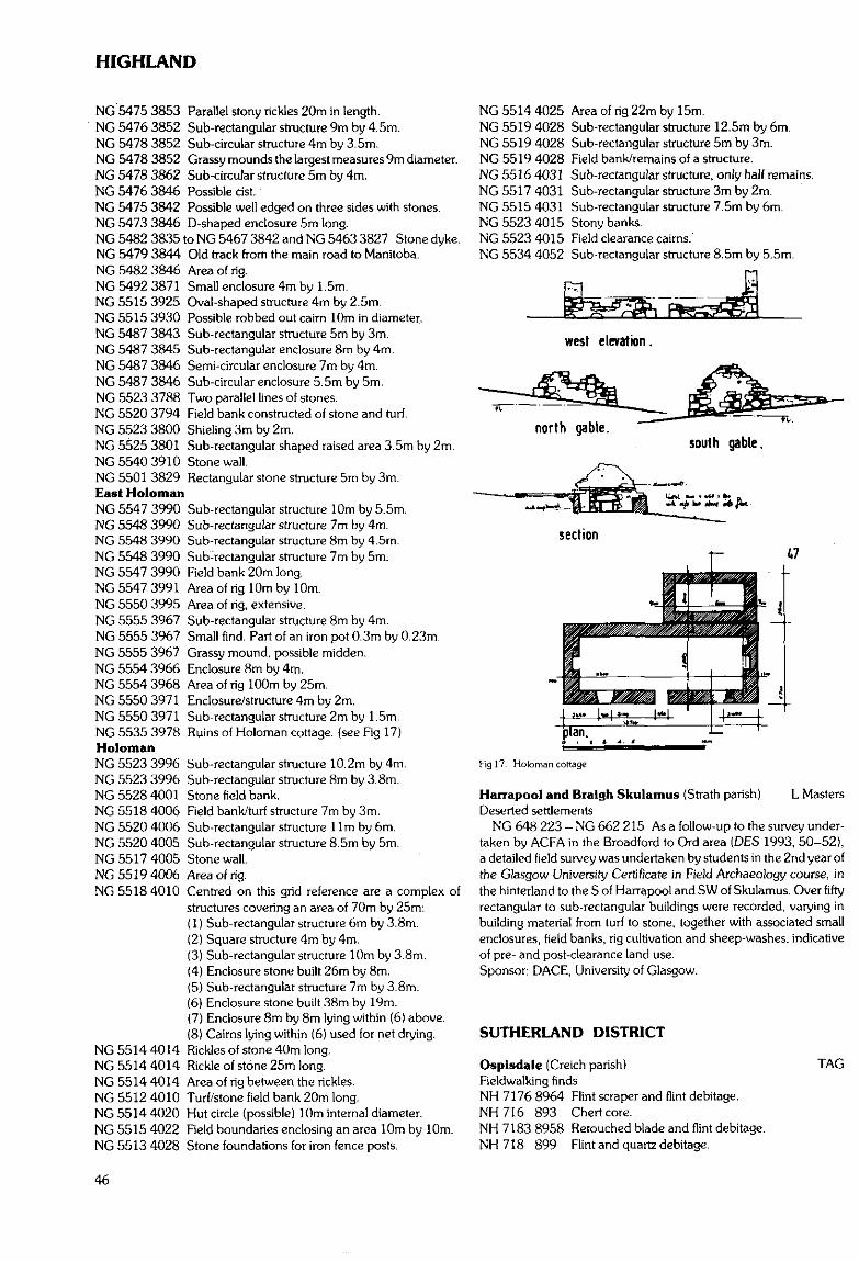
HIGHLAND
NG 5475 3853 Parallel stony rickles 20m in length.NG 5476 3852 Sub-rectangular structure 9m by 4.5m.NG 5478 3852 Sub-circular structure 4m by 3.5m.NG 5478 3852 Grassy mounds the largest measures 9m diameter.NG 5478 3862 Sub-circular structure 5m by 4m.NG 5476 3846 Possible cist.NG 5475 3842 Possible well edged on three sides with stones.NG 5473 3846 D-shaped enclosure 5m long.NG 5482 3835 to NG 5467 3842 and NG 5463 3827 Stone dyke.NG 5479 3844 Old track from the main road to Manitoba.NG 5482 3846 Area of rig.NG 5492 3871 Small enclosure 4m by 1.5m.NG 5515 3925 Oval-shaped structure 4m by 2.5m.NG 5515 3930 Possible robbed out cairn 10m in diameter.NG 5487 3843 Sub-rectangular structure 5m by 3m.NG 5487 3845 Sub-rectangular enclosure 8m by 4m.NG 5487 3846 Semi-circular enclosure 7m by 4m.NG 5487 3846 Sub-circular enclosure 5.5m by 5m.NG 5523 3788 Two parallel lines of stones.NG 5520 3794 Field bank constructed of stone and turf.NG 5523 3800 Shieling 3m by 2m.NG 5525 3801 Sub-rectangular shaped raised area 3.5m by 2m.NG 5540 3910 Stonewall.NG 5501 3829 Rectangular stone structure 5m by 3m.East HolomanNG 5547 3990 Sub-rectangular structure 10m by 5.5m.NG 5548 3990 Sub-rectangular structure 7m by 4m.NG 5548 3990 Sub-rectangular structure 8m by 4.5m.NG 5548 3990 Sub-rectangular structure 7m by 5m.NG 5547 3990 Field bank 20m long.NG 5547 3991 Area of rig 10m by 10m.NG 5550 3995 Area of rig, extensive.NG 5555 3967 Sub-rectangular structure 8m by 4m.NG 5555 3967 Small find. Part of an iron pot 0.3m by 0.23m.NG 5555 3967 Grassy mound, possible midden.NG 5554 3966 Enclosure 8m by 4m.NG 5554 3968 Area of rig 100m by 25m.NG 5550 3971 Enclosure/structure 4m by 2m.NG 5550 3971 Sub-rectangular structure 2m by 1.5m.NG 5535 3978 Ruins of Holoman cottage, {see Fig 17)HolomanNG 5523 3996 Sub-rectangular structure 10.2m by 4m.NG 5523 3996 Sub-rectangular structure 8m by 3.8m.NG 5528 4001 Stone field bank.NG 5518 4006 Field bank/turf structure 7m by 3m.NG 5520 4006 Sub-rectangular structure l lm by 6m.NG 5520 4005 Sub-rectangular structure 8.5m by 5m.NG 5517 4005 Stonewall.NG 5519 4006 Area of rig.NG 5518 4010 Centred on this grid reference are a complex of
structures covering an area of 70m by 25m:(1) Sub-rectangular structure 6m by 3.8m.(2) Square structure 4m by 4m.(3) Sub-rectangular structure 10mby3.8rn.(4) Enclosure stone built 26m by 8m.(5) Sub-rectangular structure 7m by 3.8m.(6) Enclosure stone built 38m by 19m.(7) Enclosure 8m by 8m lying within (6) above.(8) Caims lying within (6) used for net drying.
NG 5514 4014 Rickles of stone 40m long.NG 5514 4014 Rickle of stone 25m long.NG 5514 4014 Area of rig between the rickles.NG 5512 4010 Turf/stone field bank 20m long.NG 5514 4020 Hut circle (possible) 10m internal diameter.NG 5515 4022 Field boundaries enclosing an area 10m by 10m.NG 5513 4028 Stone foundations for iron fence posts.
NG 5514 4025 Area of rig 22m by 15m.NG 5519 4028 Sub-rectangular structure 12.5m by 6m.NG 5519 4028 Sub-rectangular structure 5m by 3m.NG 5519 4028 Field bank/remains of a structure.NG 5516 4031 Sub-rectangular structure, only half remains.NG 5517 4031 Sub-rectangular structure 3m by 2m.NG 5515 4031 Sub-rectangular structure 7.5m by 6m.NG 5523 4015 Stony banks.NG 5523 4015 Field clearance cairns.NG 5534 4052 Sub-rectangular structure 8.5m by 5.5m.
west elevation.
north gable.south gable.
Fig 17. Holoman cottage
Harrapool and Braigh Skulamus (Strath parish) L MastersDeserted settlements
NG 648 223 - NG 662 215 As a follow-up to the survey under-taken by AGFA in the Broadford to Ord area (DES 1993, 50-52),a detailed field survey was undertaken by students in the 2nd year ofthe Glasgow University Certificate in Field Archaeology course, inthe hinterland to the S of Harrapool and SW of Skulamus. Over fiftyrectangular to sub-rectangular buildings were recorded, varying inbuilding material from turf to stone, together with associated smallenclosures, field banks, rig cultivation and sheep-washes, indicativeof pre- and post-clearance land use.Sponsor: DACE, University of Glasgow.
SUTHERLAND DISTRICT
Ospisdale (Creich parish)Fieldwalking findsNH 7176 8964 Flint scraper and flint debitage.NH716 893 Chert core.NH 7183 8958 Retouched blade and flint debitage.NH 718 899 Flint and quartz debitage.
TAG
46
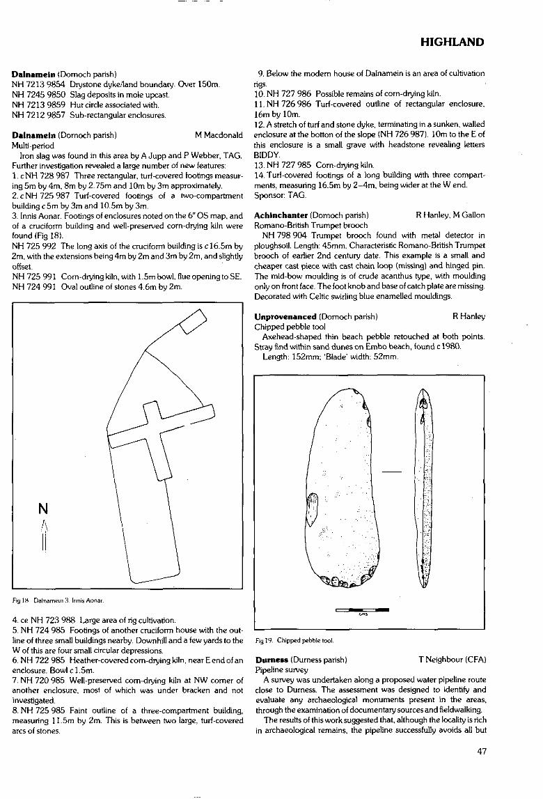
HIGHLAND
Dalnamein (Domoch parish)NH 7213 9854 Drvstone dyke/land boundary. Over 150m.NH 7245 9850 Slag deposits in mole upcast.NH 7213 9859 Hut circle associated with.NH 7212 9857 Sub-rectangular enclosures.
Dalnamein (Domoch parish) M MacdonaldMulti-period
Iron slag was found in this area by A Jupp and P Webber, TAG.Further investigation revealed a large number of new features:1. cNH 728 987 Three rectangular, turf-covered footings measur-ing 5m by 4m, 8m by 2.75m and 10m by 3m approximately.2. cNH725987 Turf-covered footings of a two-compartmentbuilding c 5m by 3m and 10.5m by 3m.3. Innis Aonar. Footings of enclosures noted on the 6" OS map, andof a cruciform building and well-preserved corn-drying kiln werefound (Fig 18).NH 725 992 The long axis of the cruciform building is c!6.5m by2m, with the extensions being 4m by 2m and 3m by 2m, and slightlyoffset.NH 725 991 Corn-drying kiln, with 1.5m bowl, flue opening to SE.NH 724 991 Oval outline of stones 4.6m by 2m.
N
Fig 18 Dalnamein 3 Innis Aonar.
4. ce NH 723 988 Large area of rig cultivation.5. NH 724 985 Footings of another cruciform house with the out-line of three small buildings nearby. Downhill and a few yards to theW of this are four small circular depressions.6. NH 722 985 Heather-covered corn-drying kiln, near E end of anenclosure. Bowl cl.5m.7. NH 720 985 Well-preserved corn-drying kiln at NW comer ofanother enclosure, most of which was under bracken and notinvestigated.8. NH 725 985 Faint outline of a three-compartment building,measuring 11.5m by 2m. This is between two large, turf-coveredarcs of stones.
9. Below the modem house of Dalnamein is an area of cultivationrigs.10. NH 727 986 Possible remains of corn-drying kiln.11.NH726986 Turf-covered outline of rectangular enclosure,16m by 10m.12. A stretch of turf and stone dyke, terminating in a sunken, walledenclosure at the botton of the slope (NH 726 987). 10m to the E ofthis enclosure is a small grave with headstone revealing lettersBIDDY.13. NH 727 985 Corn-drying kiln.14. Turf-covered footings of a long building with three compart-ments, measuring 16.5m by 2-4m, being wider at the W end.Sponsor: TAG.
Achinchanter (Dornoch parish) R Hanley, M GallonRomano-British Trumpet brooch
NH 798 904 Trumpet brooch found with metal detector inploughsoil. Length: 45mm. Characteristic Romano-British Trumpetbrooch of earlier 2nd century date. This example is a small andcheaper cast piece with cast chain loop (missing) and hinged pin.The mid-bow moulding is of crude acanthus type, with mouldingonly on front face. The foot knob and base of catch plate are missing.Decorated with Celtic swirling blue enamelled mouldings.
Unprovenanced (Domoch parish) R HanleyChipped pebble tool
Axehead-shaped thin beach pebble retouched at both points.Stray find within sand dunes on Embo beach, found c 1980.
Length: 152mm; 'Blade' width: 52mm.
Fig 19. Chipped pebble tool.
T Neighbour (CFA)Durness (Durness parish)Pipeline survey
A survey was undertaken along a proposed water pipeline routeclose to Durness. The assessment was designed to identify andevaluate any archaeological monuments present in the areas,through the examination of documentary sources and fieldwalking.
The results of this work suggested that, although the locality is richin archaeological remains, the pipeline successfully avoids all but
47
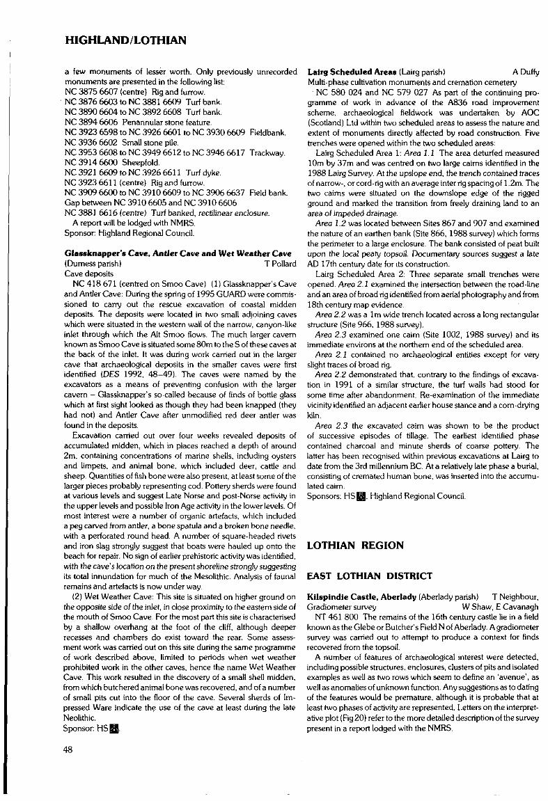
HIGHLAND/LOTHIAN
a few monuments of lesser worth. Only previously unrecordedmonuments are presented in the following list:NC 3875 6607 (centre) Rig and furrow.NC 3876 6603 to NC 3881 6609 Turf bank.NC 3890 6604 to NC 3892 6608 Turf bank.NC 3894 6606 Penannular stone feature.NC 3923 6598 to NC 3926 6601 to NC 3930 6609 FieldbankNC 3936 6602 Small stone pile.NC 3953 6608 to NC 3949 6612 to NC 3946 6617 Trackway.NC 3914 6600 Sheepfold.NC 3921 6609 to NC 3926 6611 Turf dyke.NC 3923 6611 (centre) Rig and furrow.NC 3909 6600 to NC 3910 6609 to NC 3906 6637 Field bank.Gap between NC 3910 6605 and NC 3910 6606NC 3881 6616 (centre) Turf banked, rectilinear enclosure.
A report will be lodged with NMRS.Sponsor: Highland Regional Council.
Glassknapper's Cave, Antler Cave and Wet Weather Cave(Dumess parish) T PollardCave deposits
NC 418 671 (centred on Smoo Cave) (1) Glassknapper's Caveand Antler Cave: During the spring of 1995 GUARD were commis-sioned to carry out the rescue excavation of coastal middendeposits. The deposits were located in two small adjoining caveswhich were situated in the western wall of the narrow, canyon-likeinlet through which the Alt Smoo flows. The much larger cavernknown as Smoo Cave is situated some 80m to the S of these caves atthe back of the inlet. It was during work carried out in the largercave that archaeological deposits in the smaller caves were firstidentified (DES 1992, 48-49). The caves were named by theexcavators as a means of preventing confusion with the largercavern - Glassknapper's so-called because of finds of bottle glasswhich at first sight looked as though they had been knapped (theyhad not) and Antler Cave after unmodified red deer antler wasfound in the deposits.
Excavation carried out over four weeks revealed deposits ofaccumulated midden, which in places reached a depth of around2m, containing concentrations of marine shells, including oystersand limpets, and animal bone, which included deer, cattle andsheep. Quantities of fish bone were also present, at least some of thelarger pieces probably representing cod. Pottery sherds were foundat various levels and suggest Late Norse and post-Norse activity inthe upper levels and possible Iron Age activity in the lower levels. Ofmost interest were a number of organic artefacts, which includeda peg carved from antler, a bone spatula and a broken bone needle,with a perforated round head. A number of square-headed rivetsand iron slag strongly suggest that boats were hauled up onto thebeach for repair. No sign of earlier prehistoric activity was identified.with the cave's location on the present shoreline strongly suggestingits total innundation for much of the Mesolithic. Analysis of faunalremains and artefacts is now under way.
(2) Wet Weather Cave: This site is situated on higher ground onthe opposite side of the inlet, in close proximity to the eastern side ofthe mouth of Smoo Cave. For the most part this site is characterisedby a shallow overhang at the foot of the cliff, although deeperrecesses and chambers do exist toward the rear. Some assess-ment work was carried out on this site during the same programmeof work described above, limited to periods when wet weatherprohibited work in the other caves, hence the name Wet WeatherCave. This work resulted in the discovery of a small shell midden,from which butchered animal bone was recovered, and of a numberof small pits cut into the floor of the cave. Several sherds of Im-pressed Ware indicate the use of the cave at least during the lateNeolithic.Sponsor: HS Q.
Lalrg Scheduled Areas (Lairg parish) A DuffyMulti-phase cultivation monuments and cremation cemetery
NC 580 024 and NC 579 027 As part of the continuing pro-gramme of work in advance of the A836 road improvementscheme, archaeological fieldwork was undertaken by AOC(Scotland) Ltd within two scheduled areas to assess the nature andextent of monuments directly affected by road construction. Fivetrenches were opened within the two scheduled areas:
Lairg Scheduled Area 1: Area 1.1 The area deturfed measured10m by 37m and was centred on two large caims identified in the1988 Lairg Survey. At the upslope end, the trench contained tracesof narrow-, or cord-rig with an average inter rig spacing of 1.2m. Thetwo cairns were situated on the downslope edge of the riggedground and marked the transition from freely draining land to anarea of impeded drainage.
Area 1.2 was located between Sites 867 and 907 and examinedthe nature of an earthen bank (Site 866, 1988 survey) which formsthe perimeter to a large enclosure. The bank consisted of peat builtupon the local peaty topsoil. Documentary sources suggest a lateAD 17th century date for its construction.
Lairg Scheduled Area 2: Three separate small trenches wereopened. Area 2.1 examined the intersection between the road-lineand an area of broad rig identified from aerial photography and from18th century map evidence.
Area 2.2 was aim wide trench located across a long rectangularstructure (Site 966, 1988 survey).
Area 2.3 examined one caim (Site 1002, 1988 survey) and itsimmediate environs at the northern end of the scheduled area.
Area 2.1 contained no archaeological entities except for veryslight traces of broad rig.
Area 2.2 demonstrated that, contrary to the findings of excava-tion in 1991 of a similar structure, the turf walls had stood forsome time after abandonment. Re-examination of the immediatevicinity identified an adjacent earlier house stance and a corn-dryingkiln.
Area 2.3 the excavated caim was shown to be the productof successive episodes of tillage. The earliest identified phasecontained charcoal and minute sherds of coarse pottery- Thelatter has been recognised within previous excavations at Lairg todate from the 3rd millennium BC. At a relatively late phase a burial,consisting of cremated human bone, was inserted into the accumu-lated cairn.Sponsors: HSH, Highland Regional Council.
LOTHIAN REGION
EAST LOTHIAN DISTRICT
Kilspindie Castle, Aberlady (Aberlady parish) T Neighbour,Gradiometer survey W Shaw, E Cavanagh
NT 461 800 The remains of the 16th century castle lie in a fieldknown as the Glebe or Butcher's Field N of Aberlady. A gradiometersurvey was carried out to attempt to produce a context for findsrecovered from the topsoil.
A number of features of archaeological interest were detected,including possible structures, enclosures, clusters of pits and isolatedexamples as well as two rows which seem to define an 'avenue', aswell as anomalies of unknown function. Any suggestions as to datingof the features would be premature, although it is probable that atleast two phases of activity are represented. Letters on the interpret-ative plot (Fig 20) refer to the more detailed description of the surveypresent in a report lodged with the NMRS.
48

LOTHIAN
It is hoped to carry out a resistivity survey on the area. This shouldproduce a more definite picture of any buried structural remains thatlie within the field.Sponsor: HSH.
itOOm
Fig20. Kilspindie Castle, interpretative plot
Barney Hill Enclosure, Haddlngton (Haddington parish)Archaeological assessment • R Strachan (CFA)
NT 513 760 An archaeological assessment was undertaken inJuly 1995. on the later prehistoric enclosure at Barney Hill, EastLothian (NMRS no: NT 57 NW 91).
The site is known from oblique aerial photographs and hasrecently been Scheduled. Parts of the enclosure can be detected onthe ground, most visibly on the northern and western sides, wherean upstanding bank and probable segmented ditch can be traced inplaces, and possible structural elements have been noted in theinterior
The foundation trench for a proposed communications mastmeasured 7.5m by 7.5m and. was linked to existing power lines bya cable trench c26m in length by 0.60m wide. No features ofarchaeological significance were located within the excavatedtrenches. This absence may be assumed to be the product of theerosion of a light, thin topsoil by ploughing.Sponsor: Orange Personal Communications Services Ltd.
Ardmore, West Road, Haddington (Haddington parish)Watching brief C Lowe, M Dalland
NT 501 737 A watching brief was undertaken by AOC (Scot-land) Ltd during the construction of a bungalow at Ardmore on WestRoad. The site lies on the principal Haddington to Edinburgh roadand opposite a leper hospital, recorded on early maps. No archae-ological deposits or features were identified on site.Sponsor: C Gaskin Architect.
Harperdean Farm (Haddington parish) S BainNT 505 750 A field at Harperdean Farm was walked and four
trial trenches dug prior to soil stripping. No archaeological featureswere discovered and all artefacts recovered were modern.Sponsor: Miller Civil Engineering Ltd.
Rosehall, Haddington (Haddington parish) N BridglandSupposed icehouse/coldstore
NT 5093 7373 During redevelopment of the site, workmenreported finding a circular stone-lined void. It was roughly 1.5mdeep and 1m across. The sides were rubble built and taperedinwards as it got higher. The contractors were asked to cap thestructure.
Park Lane Hospital, Musselburgh {Inveresk parish)T Neighbour (CFA)
Ring-groove house and putative Roman civilian granaryNT 350 722 Excavation was carried out prior to the redevelop-
ment of Park Lane Hospital, Musselburgh. Trial excavations hadidentified an area within the proposed development site as being ofarchaeological interest. The excavation uncovered the partialremains of a probable ring-groove house and a post-built structure,perhaps to be interpreted as a Roman civilian granary, attached toa curvilinear post-pit arrangement. Various ditches, the remains ofa possible rampart and a number of [eatures of unknown date andfunction were also recorded. The ground plan of the putativegranary is a slightly splayed rectangle, measuring c8.5m by c7m.and is composed of deeply-set posts on a dense grid system. Thedensity of posts indicates the presence of a raised floor designed tosupport a considerable weight.
The series of ditches and possible rampart may be part of a narrowenclosure around the granary and its associated curvilinear post-pitarrangement. They may however be of a completely different date.
A full report will be deposited with NMRS.Sponsor: Teague Homes Scotland Ltd.
Fig 21 Park Lane Hospital, trench locations and archaeological (eatures.
Wedderburn House, Inveresk (Inveresk parish)Ring-groove house (probable), ditches A J Dunwell (CFA)
NT 348 714 area An archaeological evaluation was carried out inMarch - April 1995 within the grounds of Wedderburn House(c2.4ha), in advance of the sale of the property by Lothian RegionalCouncil and the anticipated redevelopment of the site. Although noarchaeological features had previously been recorded, the propertylies within the area of field systems and Roman temporary militaryworks E of the Roman fort and civilian settlement at Inveresk.
Desk-based assessment, geophysical survey, trial trenching andsoils analyses were employed in order to establish the archaeologicalpotential of the gardens to the SW and NE of Wedderburn House,avoiding heavily landscaped areas and the positions of demolished
49
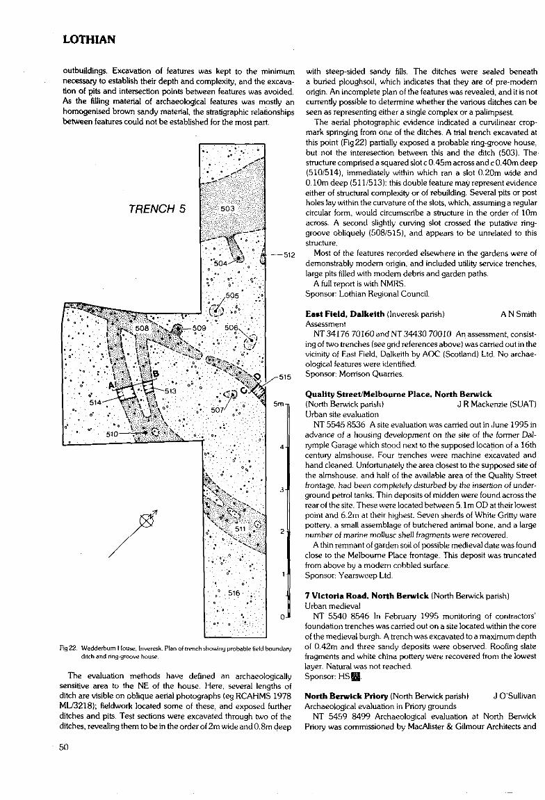
LOTHIAN
outbuildings. Excavation of features was kept to the minimumnecessary to establish their depth and complexity, and the excava-tion of pits and intersection points between features was avoided.As the filling material of archaeological features was mostly anhomogenised brown sandy material, the stratigraphic relationshipsbetween features could not be established for the most part.
TRENCH 5
516
-515
5m-i
4
3
0-
Fig 22. Wedderbum House. Inveresk. Plan of trench showing probable field boundaryditch and ring-groove house.
The evaluation methods have defined an archaeologicallysensitive area to the NE of the house. Here, several lengths ofditch are visible on oblique aerial photographs (eg RCAHMS 1978ML/3218); fieldwork located some of these, and exposed furtherditches and pits. Test sections were excavated through two of theditches, revealing them to be in the order of 2m wide and 0.8m deep
with steep-sided sandy fills. The ditches were sealed beneatha buried ploughsoil, which indicates that they are of pre-modernorigin. An incomplete plan of the features was revealed, and it is notcurrently possible to determine whether the various ditches can beseen as representing either a single complex or a palimpsest.
The aerial photographic evidence indicated a curvilinear crop-mark springing from one of the ditches. A trial trench excavated atthis point (Fig 22) partially exposed a probable ring-groove house,but not the intersection between this and the ditch (503). Thestructure comprised a squared slot c 0.45m across and c 0.40m deep(510/514), immediately within which ran a slot 0.20m wide and0.10m deep (511/513): this double feature may represent evidenceeither of structural complexity or of rebuilding. Several pits or postholes lay within the curvature of the slots, which, assuming a regularcircular form, would circumscribe a structure in the order of 10macross. A second slightly curving slot crossed the putative ring-groove obliquely (508/515), and appears to be unrelated to thisstructure,
Most of the features recorded elsewhere in the gardens were ofdemonstrably modern origin, and included utility service trenches,large pits filled with modern debris and garden paths.
A full report is with NMRS.Sponsor: Lothian Regional Council.
East Field, Dalkclth (Inveresk parish) A N SmithAssessment
NT 34176 70160 and NT 34430 70010 An assessment, consist-ing of two trenches (see grid references above) was carried out in thevicinity of East Field, Dalkeith by AOC (Scotland) Ltd. No archae-ological features were identified.Sponsor; Morrison Quarries.
Quality Street/Melbourne Place, North Berwick(North Berwick parish) J R Mackenzie (SUAT)Urban site evaluation
NT 5545 8536 A site evaluation was carried out in June 1995 inadvance of a housing development on the site of the former Dal-ryrnple Garage which stood next to the supposed location of a 16thcentury almshouse. Four trenches were machine excavated andhand cleaned. Unfortunately the area closest to the supposed site ofthe almshouse, and half of the available area of the Quality Streetfrontage, had been completely disturbed by the insertion of under-ground petrol tanks. Thin deposits of midden were found across therear of the site. These were located between 5.1m OD at their lowestpoint and 6.2m at their highest. Seven sherds of White Gritty warepottery, a small assemblage of butchered animal bone, and a largenumber of marine mollusc shell fragments were recovered.
A thin remnant of garden soil of possible medieval date was foundclose to the Melbourne Place frontage. This deposit was truncatedfrom above by a modern cobbled surface.Sponsor: Yearsweep Ltd.
7 Victoria Road, North Berwick (North Berwick parish)Urban medieval
NT 5540 8546 In February 1995 monitoring of contractors'foundation trenches was carried out on a site located within the coreof the medieval burgh. A trench was excavated to a maximum depthof 0.42m and three sandy deposits were observed. Roofing slatefragments and white china pottery were recovered from the lowestlayer. Natural was not reached.Sponsor:
North Berwick Priory (North Berwick parish) J O'SullivanArchaeological evaluation in Priory grounds
NT 5459 8499 Archaeological evaluation at North BerwickPriory was commissioned by MacAlister & Gilmour Architects and
50
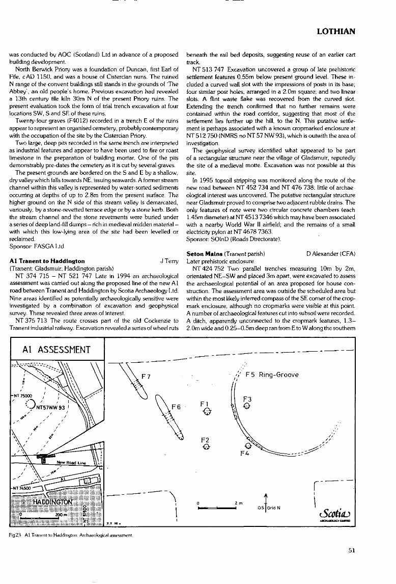
was conducted by AOC (Scotland) Ltd in advance of a proposedbuilding development.
North Berwick Priory was a foundation of Duncan, first Earl ofFife, cAD 1150. and was a house of Cistercian nuns. The ruinedN range of the convent buildings still stands in the grounds of TheAbbey', an old people's home. Previous excavation had revealeda 13th century tile kiln 30m N of the present Priory ruins. Thepresent evaluation took the form of trial trench excavation at fourlocations SW, S and SE of these ruins.
Twenty-four graves (F4012) recorded in a trench E of the ruinsappear to represent an organised cemetery, probably contemporarywith the occupation of the site by the Cistercian Priory.
Two large, deep pits recorded in the same trench are interpretedas industrial features and appear to have been used to fire or roastlimestone in the preparation of building mortar. One of the pitsdemonstrably pre-dates the cemetery as it is cut by several graves.
The present grounds are bordered on the S and E by a shallow,dry valley which falls towards NE, issuing seawards. A former streamchannel within this valley is represented by water-sorted sedimentsoccurring at depths of up to 2.8m from the present surface. Thehigher ground on the N side of this stream valley is demarcated,variously, by a stone-re vetted terrace edge or by a stone kerb. Boththe stream channel and the stone revetments were buried undera series of deep land-fill dumps - rich in medieval midden material -with which this low-lying area of the site had been levelled orreclaimed.Sponsor FASGA Ltd.
Al Tranent to Haddington J Terry(Tranent; Gladsmuir; Haddington parish)
NT 374 715 - NT 521 747 Late in 1994 an archaeologicalassessment was carried out along the proposed line of the new Alroad between Tranent and Haddington by Scotia Archaeology Ltd.Nine areas identified as potentially archaeologically sensitive wereinvestigated by a combination of excavation and geophysicalsurvey. These revealed three areas of interest.
NT 375 713 The route crosses part of the old Cockenzie toTranent industrial railway. Excavation revealed a series of wheel ruts
LOTHIAN
beneath the rail bed deposits, suggesting reuse of an earlier carttrack.
NT 513 747 Excavation uncovered a group of late prehistoricsettlement features 0.55m below present ground level. These in-cluded a curved wall slot with the impressions of posts in its base;four similar post holes, arranged in a 2.0m square; and two linearslots. A flint waste flake was recovered from the curved slot.Extending the trench confirmed that no further remains werecontained within the road corridor, suggesting that most of thesettlement lies further up the hill, to the N. This putative settle-ment is perhaps associated with a known cropmarked enclosure atNT 512 750 (NMRS no NT 57 NW 93), which is outwith the area ofinvestigation.
The geophysical survey identified what appeared to be partof a rectangular structure near the village of Gladsmuir, reputedlythe site of a medieval motte. Excavation was not possible at thissite.
In 1995 topsoil stripping was monitored along the route of thenew road between NT 452 734 and NT 476 738; little of archae-ological interest was uncovered. The putative rectangular structurenear Gladsmuir proved to comprise two adjacent rubble drains. Theonly features of note were two circular concrete chambers (each1.45m diameter) at NT 4513 7346 which may have been associatedwith a nearby World War II airfield; and the remains of a smallelectricity pylon at NT 4678 7363.Sponsor: SOlnD (Roads Directorate).
Seton Mains (Tranent parish) D Alexander (CFA)Later prehistoric enclosure
NT 424 752 Two parallel trenches measuring 10m by 2m,orientated NE-SW and placed 3m apart, were excavated to assessthe archaeological potential of an area proposed for house con-struction. The assessment area was outside the scheduled area butwithin the most likely inferred compass of the SE corner of the crop-mark enclosure, although no cropmarks were visible at this point.A number of archaeological features cut into subsoil were recorded.A ditch, apparently unconnected to the cropmark features, 1.3—2. Om wide and 0.25-0.5m deep ran from E to W along the southern
Al ASSESSMENT
Fig23. Al Tranent lo Haddington Archaeological assessment
51
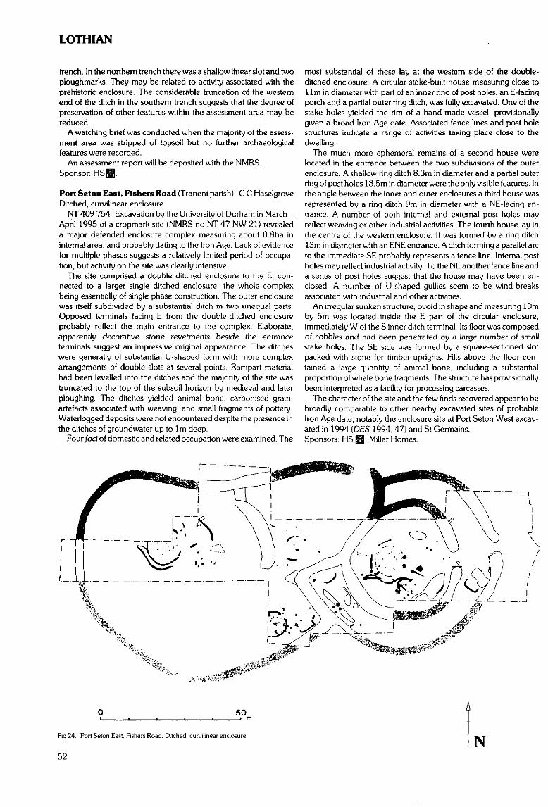
LOTHIAN
trench. In the northern trench there was a shallow linear slot and twoploughmarks. They may be related to activity associated with theprehistoric enclosure. The considerable truncation of the westernend of the ditch in the southern trench suggests that the degree ofpreservation of other features within the assessment area may bereduced.
A watching brief was conducted when the majority of the assess-ment area was stripped of topsoil but no further archaeologicalfeatures were recorded.
An assessment report will be deposited with the NMRS.Sponsor: HSffifl
Port Seton East, Fishers Road (Tranent parish) CCHaselgroveDitched, curvilinear enclosure
NT 409 754 Excavation by the University of Durham in March -April 1995 of a cropmark site (NMRS no NT 47 NW 21) revealeda major defended enclosure complex measuring about O.Sha ininternal area, and probably dating to the Iron Age. Lack of evidencefor multiple phases suggests a relatively limited period of occupa-tion, but activity on the site was clearly intensive.
The site comprised a double ditched enclosure to the E, con-nected to a larger single ditched enclosure, the whole complexbeing essentially of single phase construction. The outer enclosurewas itself subdivided by a substantial ditch in two unequal parts.Opposed terminals facing E from the double-ditched enclosureprobably reflect the main entrance to the complex. Elaborate,apparently decorative stone revetments beside the entranceterminals suggest an impressive original appearance. The ditcheswere generally of substantial U-shaped form with more complexarrangements of double slots at several points. Rampart materialhad been levelled into the ditches and the majority of the site wastruncated to the top of the subsoil horizon by medieval and laterploughing. The ditches yielded animal bone, carbonised grain,artefacts associated with weaving, and small fragments of pottery.Waterlogged deposits were not encountered despite the presence inthe ditches of groundwater up to 1m deep.
Four foci of domestic and related occupation were examined. The
most substantial of these lay at the western side of the- double-ditched enclosure. A circular stake-built house measuring close to11m in diameter with part of an inner ring of post holes, an E-facingporch and a partial outer ring ditch, was fully excavated. One of thestake holes yielded the rim of a hand-made vessel, provisionallygiven a broad Iron Age date. Associated fence lines and post holestructures indicate a range of activities taking place close to thedwelling.
The much more ephemeral remains of a second house werelocated in the entrance between the two subdivisions of the outerenclosure. A shallow ring ditch 8.3m in diameter and a partial outerring of post holes 13.5m in diameter were the only visible features. Inthe angle between the inner and outer enclosures a third house wasrepresented by a ring ditch 9m in diameter with a NE-facing en-trance. A number of both internal and external post holes mayreflect weaving or other industrial activities. The fourth house lay inthe centre of the western.enclosure. It was formed by a ring ditch13m in diameter with an ENE entrance. A ditch forming a parallel arcto the immediate SE probably represents a fence line. Internal postholes may reflect industrial activity. To the NE another fence line anda series of post holes suggest that the house may have been en-closed. A number of U-shaped gullies seem to be wind-breaksassociated with industrial and other activities.
An irregular sunken structure, ovoid in shape and measuring 10mby 5m was located inside the E part of the circular enclosure,immediately W of the S inner ditch terminal. Its floor was composedof cobbles and had been penetrated by a large number of smallstake holes. The SE side was formed by a square-sectioned slotpacked with stone for timber uprights. Fills above the floor con-tained a large quantity of animal bone, including a substantialproportion of whale bone fragments. The structure has provisionallybeen interpreted as a facility for processing carcasses.
The character of the site and the few finds recovered appear to bebroadly comparable to other nearby excavated sites of probableIron Age date, notably the enclosure site at Port Seton West excav-ated in 1994 (DES 1994, 47) and St Germains.Sponsors; HS I|J, Miller Homes.
50
Fig 24. Port Seton East. Fishers Road. Ditched, curvilinear enclosure.
52N
LOTHIAN
CITY OF EDINBURGH DISTRICT
Cramond Roman Fort (City parish of Edinburgh) D ReedMcsolithic features, artefacts
NT 1899 7698 Deposits containing Mesolithic struck lithics.identified during excavations undertaken by the Edinburgh Archae-ological Field Society (DES 1993, 59), were further investigated.The trenches (D and E) were located close to the edge of the raisedbeach to the N of the Roman fort.
Trench D measured 4.50m by 2.00m The removal of a 0.34mlithic-rich deposit revealed a large sub-circular pit (1.55m in dia-meter) and a sequence of smaller pits cutting into subsoil. Thedeposits within the pits contained concentrations of lithics andcarbonised hazelnut shells. A spread of stake holes was also identi-fied, all quite uniform in diameter and depth, but with no obviouspatterning. A further cluster of stake holes formed an elongated ovalgroup.
Trench E measured 4.50m by 2.00m. Although cut away by twopost-medieval pits in the northern half and the SE corner of thetrench a deposit up to 0.11m identical to that in trench D was excav-ated, again containing large quantities of struck lithic material. Afterits removal a small sub-circular pit and eight small stake holes werevisible cut into subsoil. The limited number and distribution of thestake holes did not allow any interpretation.
More than 2500 struck lithics [flint, chert, quartz, agate] wererecovered from the two trenches. A small stone bead was also found.Sponsor: City of Edinburgh District Council Archaeology Service.
Burgess Street Water Street/Shore Place, Leith J A Lawson(City parish of Edinburgh}Watching brief; urban medieval/post-medieval deposits & structures
NT 2706 7639 (centre) A watching brief was undertaken duringMay 1995 to monitor the excavation of service and foundationtrenches, for housing construction. Six areas were excavated (F-K)totalling cSOOOsqm. revealing a complex series of deposits whichcomplemented those previously revealed during the 1993 and 1994seasons (see DES 1993, 58-9; 1994, 48).
More extensive evidence for the previously recorded earlymedieval cultivation, pre-dating the accumulation of middendeposits in the 12th/13th centuries, was revealed within areas G, Jand K With the exception of area I. all areas contained middenlayers and associated pits, starting in the 12th/13th centuries andcontinuing into the post-medieval period. These midden depositswere found to extend beyond the limits of the site to the S andW (under Shore Place) and E (under Water Street). The maximumdepth of deposit was reached to the S of Bowies Close (1.70m), withthe average being between 0.50m and 1 .Om.
The limited remains of medieval clay-bonded structures were alsorecovered. These structures respected the modem street frontagesof both Shore Place and Bowies Close, and their alignment wasmaintained into the post-medieval period.Sponsors: Port of Leith Housing Association (on behalf of Scottish
Homes) and City of Edinburgh District Council.
23 Cramond Glebe Road {City parish of Edinburgh)Roman road and ditches, prehistoric artefacts and ?features
NT 1894 7673 Excavation was carried out in October 1995 inadvance of development within an area thought to contain both theouter Roman fort ditch and the road leading from the S gate Twotrenches and two test pits were excavated.
Trench A measured 10.8m by 1.4m. and confirmed the existenceof the Roman road running southwards from the S fort gate. Theroad itself was in a poor state of preservation having suffered fromrobbing, with only a single layer of metalling surviving. The trenchproduced small quantities of Roman and Medieval pottery as well asseveral struck lithics, some certainly Mesolithic in character.
Trench B measured 9.5m by 1.5m. The W edge of a Roman ditchwas excavated, running N-S along the length of the E baulk. Anextension trench showed that the ditch was V-shaped in profile 2.0mwide by 0.95m deep with a central 'ankle-breaker', producingRoman Grey Ware from the main fill. This ditch is not on the samealignment as the known fort, and may be of an earlier fort, possiblyFlavian. The expected outer ditch of the Antonine/Severn fort didnot occur on its projected alignment, though the S edge of a ditchwas located further N under the N baulk.
The main N-S Roman ditch cut through a linear feature, possiblyprehistoric, 1.08m by 0.14m running NE-SW across the S end ofthe trench, which was associated with two small pits close by. Thislater ditch produced two struck lithics.Sponsor: City of Edinburgh District Council Archaeology Service.
High Street/Lawnmarket/Hunter Square M A Collard.(City parish of Edinburgh) D ReedWatching brief: post-medieval building remains
NT 2557 7354 to NT 2613 7366 A watching brief during therelaying of the entire length of the main medieval street confirmedthe observations made during test-pitting {DES 1993,58) ie that thewhole length of the High Street had been scalped of any accumu-lated deposits or structures, most likely during remodelling of roadlevels for the construction of North and South Bridges in the late18th century.
Excavation close to John Knox House showed that the rebuiltforestair stood on its original foundations; the full extent of thefoundations of the front of the Moray-Knox church were exposed infront of the Netherbow Centre..Sponsor: City of Edinburgh District Council Archaeology Service.
'Marwood', 93 Whltehouse Road, Cramond M A Coliard(City parish of Edinburgh)Short cist
NT 1859 7610 A short cist, uncovered during construction work,was observed by V E Dean of Edinburgh Archaeological FieldSociety. Excavated in advance of the building works, the empty cistwas aligned due N-S and measured 0.50m by 0.90m internally. Itwas built of upright sandstone slabs with a single large slab as a lid.The side slabs were of irregular shape and gaps in the walls of the cistwere filled with blocks of sandstone, while the N end oi the Sid wassupported by three irregular slabs laid horizontally beneath it. Thefloor of the cist was formed of a sticky organic, alluvial clay, whichhad also been used as luting in the NE corner of the cist.Sponsor: City of Edinburgh District Council Archaeology Service.
St John's Hill (City parish of Edinburgh) D ReedUrban evaluation: medieval building, post-medieval garden, pre-historic flint flake
NT 2631 7347 An archaeological evaluation of a potentialdevelopment site within the medieval suburb of the Pleasance wasundertaken in February 1995. The site was approximately 10.3ha inextent, bounded to the N by Holyrood Road, the Pleasance to theW, Viewcraig Gardens to the E and the Pleasance annexe of theUniversity of Edinburgh on the S.
A total of 21 trial trenches totalling 325sqm were excavated. Inmost areas modern building and terracing had destroyed anyarchaeological remains which may once have existed. Two limitedareas of archaeological deposits/structures which pre-date the 19thcentury were identified, within Area A (Trench 1) and Area C(Trenches 2, 4 and 5). At the W end of Trench Al, fronting ontoHolyrood Road, clay-bonded wall foundations probably representthe remains of a medieval structure. No deposits or finds wereassociated with the excavated building remains. An area of 47sqmof dark cultivation soil, located within Trenches C2, C4 and C5contained 17th century finds. This represented the only remaining
53
LOTHIAN
element of the garden areas to the rear of the premises fronting ontothe Pleasance shown on Gordon of Rothiemay's bird's-eye view ofEdinburgh of 1647. A 17th century pit within Trench C2 containedprimary butchery waste (skulls, horn cores) from cattle and sheep.A single redeposited flint flake was recovered from the same pit.Sponsor: Morrison Developments Ltd.
Cralgtnillar Castle Park (City parish of Edinburgh) D ReedTrial excavation: post-medieval estate wall
NT 2900 7073 As part of a programme of repair to the scheduledboundary walls around Craigmillar Country Park, two smalltrenches were excavated within a gap in the wall along CraigmillarCastle Road. These showed the existence of wall footings within thegap and the wall has subsequently been rebuilt, although not at thesame alignment as the footings.Sponsor: City of Edinburgh District Council Archaeology Service.
Cramond Iron Mills (City parish of Edinburgh) V E DeanTramway
NT 1884 7677 Short length of iron rail, probably part of horserailway used for transport of iron products from Fair-a-Far andCockle mills, visible alongside River Almond walkway. Line of tram-way first shown on Carfrae's 1839 plan of the Lands of Fair-a-Far.
Corstorphine Hill (City parish of Edinburgh)Roman pottery
NT 207 738 Sherd of Samian ware found on upper slope ofS side of Corstorphine Hill. With finder.
Holyrood Palace (City parish of Edinburgh) S BainMedieval cemetery
NT 269 740 During the upgrading of the Victorian boilerhouse,human remains were uncovered. Excavation by GUARD revealedthe remains of a minimum of 38 individuals from two main phases ofburial which form part of the medieval and post-medieval cemeteryat the Abbey church. The initial phase of burial was badly disturbedby a large pit. After this filled up, a layer of building rubble and debriscovered the site; this included fragments of mortar, stained glass,lead came and architectural fragments. Through this a second phaseof burials were dug.
Two coins from the reign of Edward I/ll deposited cl330 wererecovered including one from a burial. A copper jetton or counterwas also recovered; this was minted in France in the 14th-15thcenturies.Sponsor: HS BIB.
Arthur's Seat (City parish of Edinburgh) D Alexander (CFA)Fort rampart
NT 276 729 Excavation was undertaken in advance of the pro-posed construction of a length of stone-pitched path on the easternapproaches to the summit of Arthur's Seat. This path is to run insidethe area enclosed by two ramparts which have been previouslysuggested as being Early Historic in date by R B K Stevenson. Theinvestigation comprised the excavation in January 1995 of sevenclosely-spaced trenches along the length of the proposed new path,the lower end of which ran along the inside of the inner rampart. Aneighth trench was excavated through the rampart to examine itsstructure and provide a possible date for its construction.
In the trenches adjacent to the rampart, the rubble core wasexposed. The trench through the rampart revealed that the rubbleforming the rampart core was at least 1.2m high. A possible col-lapsed outer wall face was located, making the exposed section oframpart at least 5.4m wide. No archaeologically significant artefactswere recovered from the core of the rampart or below this, and thedate of its construction remains unknown. A later dyke, c0.65mwide and one course high, had been built on top of the rampart
rubble. This dyke appears to be part of a rectilinear enclosure,situated in the slight valley between the summits of Arthur1 s Seat andCrow Hill to the SW, which contains traces of cultivation.
Erosion was apparent along the entire length of the proposed pathline. The upper, steeper section had eroded down to bedrock inmany places. Downslope, however, buried turf lines indicated thatthis erosion was episodic and artefacts suggested that it had occurredin the last 200 years.
A full report will be lodged with NMRS.Sponsor: HS Q.
Ashley, nr Ratho (Ratho parish) A SheridanFragment of axe hammer
NT 151 715 Blade half of axe hammer (length 93mm), iron-stone. Found 1994 in ploughsoil, by Mrs C Wicksted of Edinburgh,whilst metal detecting. Donated to City of Edinburgh MuseumService after clearance through Treasure Trove system (TT NotClaim 1994.4).Sponsor: NMS.
MIDLOTHIAN DISTRICT
Aikendean, nr Carrlngton (Carrington parish) A SheridanFragment of axe hammer
NT 321 616 Blade half of axe hammer (length 104mm), iron-stone. Found 1994 in ploughsoil, by Mrs C Wicksted of Edinburgh,whilst metal detecting. Donated to City of Edinburgh MuseumService after clearance through Treasure Trove system (TT NotClaim 1994.5).Sponsor: NMS.
Dalhousle Mains, Bonnyrigg (Cockpen parish) j O'SullivanSurvey
NT 318 645 Excavation by AOC (Scotland) Ltd at DalhousieMains recorded a sub-rectangular or trapezoidal, ditched enclosure,previously identified from aerial photographic evidence as a crop-mark (NMRS no NT 36 SW 13). No significant features or artefactswere recorded in the interior, but a sunken house floor and associ-ated hearth were excavated outwith the site in the SW. No entrancewas identified within the excavated area: this is thought to underliea farm track which traverses the site. Several trenches were cutacross the ditch which was found to be a broad feature with a U-shaped base. The fills were predominantly stone-free clay-silts and,in one of the section trenches, were found to include small quantitiesof well-preserved organic materials. These were predominantlyplant remains representing weeds of disturbed or cultivated ground.Sponsor: Walker Group (Scotland) Ltd.
Fuffet, Cousland (Cranston parish) R J Strachan (CFA)Engine House of Fuffet Coal Pit
NT 3693 6743 Three trenches opened as part of the archae-ological evaluation phase in advance of the proposed constructionof the A68 Dalkeith Northern Bypass (see below), located twolengths of wall at the site of the Engine House of Fuffet Coal Pit,Cousland (as shown on first edition Ordnance Survey map cover-age). The structure was not visible on the ground surface, andappeared upon excavation to have been revetted into the hillsideand subsequently overlain with dumped deposits of bing materials.Following the evaluation, further excavation was conducted duringFebruary and March 1995.
The engine house was found to be in fair condition. The structurewas built with walls of mortared stone, upstanding to 1.2-1,5m, anddefining three compartments, representing the boiler house, enginehouse and coal depository. Parts of the walls associated with the
54
LOTHIAN
boiler house and coal depository showed signs of having beensubjected to heat.
The boiler house was orientated approximately N-S and con-tained internal brick supports and a bricked floor. The stokingentrance was located to the S, adjacent to the coal depository, whichconsisted of a bowl-shaped flagged floor enclosed by a revetting wallon its E and S.
The engine house was located E of the boiler house. This structurewas orientated N-S, with a large opening in the eastern wall. Thefloor of the engine house was flagged with large blocks, apart fromtwo channels running E-W in the northern and southern ends ofthe room. A metal peg was located within the northern channel,suggesting that these features were the remains of foundation beds,presumably for the steam engine. Iron pegs were also located in siruin three square unflagged areas of the floor within the easternopening. These appear to represent the remains of supports,possibly for a fly wheel. Finds from the excavation were limited,comprising broken tiles, unmarked bricks, iron pegs and nails,part of the boiler house door, and modern glazed pottery- A largequantity of slag and cinder was present, presumably waste materialfrom firing the boiler.Sponsor: Roads Directorate of The Scottish Office Industry Depart-
ment, managed on its behalf by HS Q.
Pathhead (Crichron parish) NMSNeolithic axehead
NT 390 634 Neolithic unperforated polished stone axeheadfound by Mr J Bee. Treasure Trove case (TT.20/95), allocatedto NMS.
Smeaton, near Dalkeith (Dalkeith parish) M Cressey (CFA)Brick and tile works
NT 348 690 The site of Smeaton brick and tile works was subjectto a documentary study and limited excavations as part of the A68Dalkeith Northern Bypass (see below). The works, known to havebeen in operation during the 19th century, are now only visible ascropmark traces on aerial photographic coverage.
Documentary study indicated the considerable scale of pro-duction achieved by the works in the mid-19th century. Trenchinglocated a series of building foundations with two internal kilns.Kiln 1 was rectangular in shape and survived as a series of fire-boxes with an internal loading chamber or gallery 4.80m wide(its length was not established), within a building measuring 16mby 12m. This building originally comprised a series of severalcourses of red brick and mortar above a substantial sandstonefoundation c0.4m deep. Exterior floors of red brick were laid toform the stoking floors. Kiln 2, 5.80m wide, was enclosed withina rectangular building measuring 16.10m by 11.80m. The galleryof the kiln had an internal width of 3m with a mortared brick floorand fireboxes on the E and W walls. The stoking floor of this kilnwas composed of sandstone flags. In addition, an ancillary coalstore was identified; it appears to have been connected by a nearbytramway to the colliery at Smeaton Mains. Two large dumps ofwaster material were located and sampled to provide informationon the range of products.Sponsor: Roads Directorate of The Scottish Office Industry Depart-
ment, managed on its behalf by HS Q.
Elgtnhaugh {Dalkeith parish) S A McGregorPre-Roman native settlement
NT 321 673 It is suggested that the aerial photograph refA 65774/C5 of 1984 of this site shows numerous hut foundations ofpost-hole construction and other circular features, possibly stockenclosures, containing paved areas and connected by paths. Alsoapparent lengths of fencing.
Transcript lodged with NMRS.
Meiklc Law Field, Fala (Fala & Sourra parish) NMSIA glass bead
NT 4565 6090 An opaque green glass bead of Iron Age date wasfound casually in Meikle Law Field, Fala, and donated to NMS.Registration number: FJ 162.
Smeaton, near Dalkeith A J Dunwell (CFA)(Inveresk/Dalkeith parish)Roman Temporary Camp and prehistoric features
NT 345 692 area An excavation was conducted betweenNovember 1994 and January 1995 across the Roman TemporaryCamp (RTC) at Smeaton, within the proposed road corridor of theA68 Dalkeith Northern Bypass. Seven trenches totalling c 7500m2
in area were excavated within the c 60m wide road corridor runningfor c 400m between the River Esk and Salters Road. Archaeologicalfeatures of Roman, prehistoric, post-medieval and modern originwere recorded. Those demonstrated to be of pre-medieval datewere entirely restricted to the areas of gravel subsoil adjacent tothe river. To the E of this, where a heavy clay subsoil was prese/it,only a dense spread of cultivation furrows and land drains wasidentified.
Only the western alignment of the RTC perimeter ditch waslocated in Trench 1. A continuous length of 57.5m of this featurewas exposed, through which 13 sections were excavated. The ditchwas most substantial at the northern end of the trench, where it was3.5m wide and 1.7m deep, with a V-shaped profile and indicationsof a squared channel at its base. No evidence was identified for anystructural complexity within the ditch. It had not been deliberatelybackfilled. No trace of an adjacent rampart survived. Finds from theditch include a carved sandstone block, a fragment of stone armletand a chip of flint, all from the uppermost ploughsoil fill. Theabsence of the opposite, eastern, ditch alignment of the RTCaccords with the cropmark evidence - either this feature was neverdug or it has not survived later cultivation.
Three linear features and a series of pits were identified in thevicinity of the western RTC ditch. Artefact recovery and stratigraphicrelationships indicate that at least some of these features are of pre-Roman origin. The linear features, c0.2m deep, were truncated bythe RTC ditch: they may be some form of cultivation furrow (1018,1113, 1125). Two large pits, 2.5m and 3.0m long and each cl.5mwide by 0.3-0.5m deep, containing primary deposits of burnt cerealgrain and charcoal, are provisionally identified as cooking pits orovens (1076, 2027). Pending further analysis, these features canbe interpreted as being of either Roman or native in origin. Theremaining pits were generally sub-circular, measuring between0.5m and 1.5m across and less than 0.5m deep. Few showedevidence of multiple fills and none had been recut. Several sherds ofcoarse, native pottery were recovered from pits 2016 and 2017.Sponsor: Roads Directorate of The Scottish Office Industry Depart-
ment and managed on its behalf by HS Q.
Newton Old Church (Newton parish) T ReesChurch tower
NT 3342 6903 A series of limited excavations were carried outby AOC (Scotland) Ltd at Newton Old Church, NMRS site NT 36NW 3. The work exposed two portions of the S wall of the church toact as foundations for repair works to the tower. The rubble filledinterior of the tower was also reduced.Sponsor: Midlothian District Council.
A68 Dalkeith Northern Bypass R J Strachan, A R Rees (CFA)(Newton, Inveresk, Dalkeith, Cranston and Newbattle parishes)Archaeological evaluation and excavations
NT 335 695 - NT 378 667 An archaeological evaluation wasundertaken between September and November 1994 of theproposed route of the A68 Dalkeith Northern Bypass, from its
55
LOTHIAN
proposed junction with the Edinburgh City Bypass to its proposedjunction' with the existing A68 at Fordel Mains. The evaluationcomprised a desk-based assessment, field inspection, selectivefieldwalking, and trial trenching. A total area of 9872m2, dividedbetween 154 trenches in 23 land parcels, was sampled by trialtrenching along the road corridor. Separate entries have beencompiled for the excavations at Castle Steads pit alignment,Smeaton Temporary Camp and Smeaton Brick and Tile Works,which were previously known sites and thus not subject to prelimin-ary evaluation.
Several known sites lay adjacent to the evaluation corridor; andneighbouring areas were thus examined. The desk-based assess-ment discounted the site of the Langside cropmark enclosure(NMRS NT 36 NE 67) being of archaeological significance; itslocation corresponds with the site of a disused gravel pit recordedon the OS first and second edition maps. The evaluation did notlocate any archaeological evidence for a known pit alignment(NMRS NT 36 NW 52) where its extrapolated line intersectedthe road corridor immediately beside the Edinburgh City Bypass(NT 335 696). Excavation showed that the area had been severelyaffected during the construction of the Edinburgh City Bypass,and the pit alignment has most likely been destroyed here. Theevaluation did not find any direct evidence of the cist cemetery(NMRS NT 36 NW 5) known to lie adjacent to a proposed slip road(NT 348 688). However, the sand extraction pit mentioned in theNMRS record, and in which the cists were located, was found, aswas a pipe trench opened in the 1970s, in which two cists were alsopreviously located. Trenches excavated adjacent to the site ofSmeaton Brick and Tile Works in the same field (NT 349 689)revealed deposits of associated industrial waste material. An area ofpossible environmental interest was located around the BellyfordBum, comprising a peat deposit containing pieces of 'bog oak'(NT 368 676 area).
In addition, the evaluation produced evidence of isolated featuresof lesser significance, such as areas of rig-and-furrow, small(modem) pits, field drains, a probable ploughed out field dyke anda length of ditch of unknown date.
A Data Structure Report has been produced, and will be de-posited in the NMRS.Sponsor: Roads Directorate of The Scottish Office Industry Depart-
ment, managed on its behalf by HS jgjj.
Castle Steads, near Dalkelth (Newton parish)Pit alignment K J Cameron (CFA)
NT 337 695 An excavation was carried out in October andNovember 1994 where one of a series of pit alignments recordedaround Castle Steads was intersected by the proposed route of theA68 Dalkeith Northern Bypass. One large trench measuring c 50mby 30m was excavated over the pit alignment, and three 4m widerunner trenches with a combined length of c 290m were opened toexamine adjacent land where cropmark traces of former cultivationhad previously been identified.
Nine pits were recorded in the main trench, arranged in a singleline and orientated on a N-S axis. These varied in size from 3.5-5.5m long and 2.2-2.8m wide and were mostly elm deep. They donot appear to have held posts, and it appears unlikely that they weredeliberately infilled. Putatively medieval pottery was recovered fromthe upper layers of four pits, and a chert flake came from the primaryfill of a fifth. No trace of an adjacent bank was identified. To the E ofone of the pits a cluster of seven smaller pits and post holes wasidentified, three of which contained large fragments of later pre-historic pottery. The eroded remains of rig-and-furrow cultivationsystems were identified, representing a different, later pattern ofland-use.Sponsor: Roads Directorate of The Scottish Office Industry Depart-
ment, managed on its behalf by HS EB.
Castle Steads, near Dalkelth A Rees (CFA)(Newton/Inveresk parish)Stone paving and associated features
NT 3430 6910 An archaeological excavation of part of an area ofstone paving and associated features was conducted in spring 1995within the proposed road corridor of the A68 Dalkeith NorthernBypass. The site was initially discovered as a surface scatter ofchipped stone artefacts. Several negative features were then identi-fied by trial trenching, Subsequent test-pitting was undertaken toassess the artefact content of the topsoil. and an area of c 600m2 wasexcavated.
The principal feature excavated was the area of stone paving, withexposed dimensions of c!4m by 11,5m, situated in a shallowscoop beneath a deposit of possibly windblown silty loam. Someof the stones appeared to have been laid in an orderly fashion.Adjoining, and probably truncating, this paved feature was whatappeared to be a soakaway sink filled with loose stones andboulders. Several other minor negative features, comprisingthree pits, two post holes and a rickle of stones, were identified.They could not be related with confidence to the stone pavedfeature. Among the finds from the area of paving were a saddlequern and several flakes of flint and chert. Preliminary analysissuggested that the samples from the site are unsuitable for palyno-logical analysis.Sponsor: Roads Directorate of The Scottish Office Industry Depart-
ment, managed on its behalf by HS Q.
Castle Steads, near Dalkelth (Newton/Inveresk parish)Ring-groove houses
NT 3397 6935 An archaeological excavation of two ring-groovehouses and associated features was conducted between Februaryand March 1995 within the proposed road corridor of the A68Dalkeith Northern Bypass. The site was initially identified as a sur-face scatter of chipped stone artefacts. The presence of severalnegative features was then confirmed by trial trenching. Subsequenttest-pitting was undertaken to assess the artefact content of thetopsoil, and an area of c 1000m2 was excavated
An almost complete ring-groove structure measuring clOmacross was located, within which was a concentric ring of sevenpost holes. In its SW sector the ring-groove slot was heavily trun-cated and measured as little as 0.25m in width by 0.10m in depth.In some places the slot was entirely absent. In the remainingsections of the slot, there was less truncation and dimensions.typically from 0.40m to 0.50m wide by 0.25m to 0.35m deep wererecorded. No post holes were located in the trench. The entrance,possibly showing evidence of two structural phases, was locatedon the SE side of the structure. Within the ring-groove fill a smallnumber of quartz and chert flakes were found, along with a redchert scraper, charcoal, and a piece of material which appears tobe coal.
To the NE were the heavily truncated remains of a second ring-groove, within which four post holes of an inner ring were preserved.The ring-groove comprised three separate excavated units. Thisstructure was cut on its N side by a ditch, which appears to be anearlier version of the modem field boundary ditch which presentlyruns parallel to this, 4m due W.
To the SE of the ring-groove houses were three adjacent,elongated pits, of which the largest, central one had been re-cut. The function of these features remains unclear; althoughnot fully exposed, they do not appear to have formed the terminiof enclosing works around the ring-grooves structures. Withinthe fills of the central pit were found large numbers of flint andchert flakes, and a small quantity of chert scrapers and flintblades.Sponsor: Roads Directorate of The Scottish Office Industry Depart-
ment, managed on its behalf by HS Q.
56
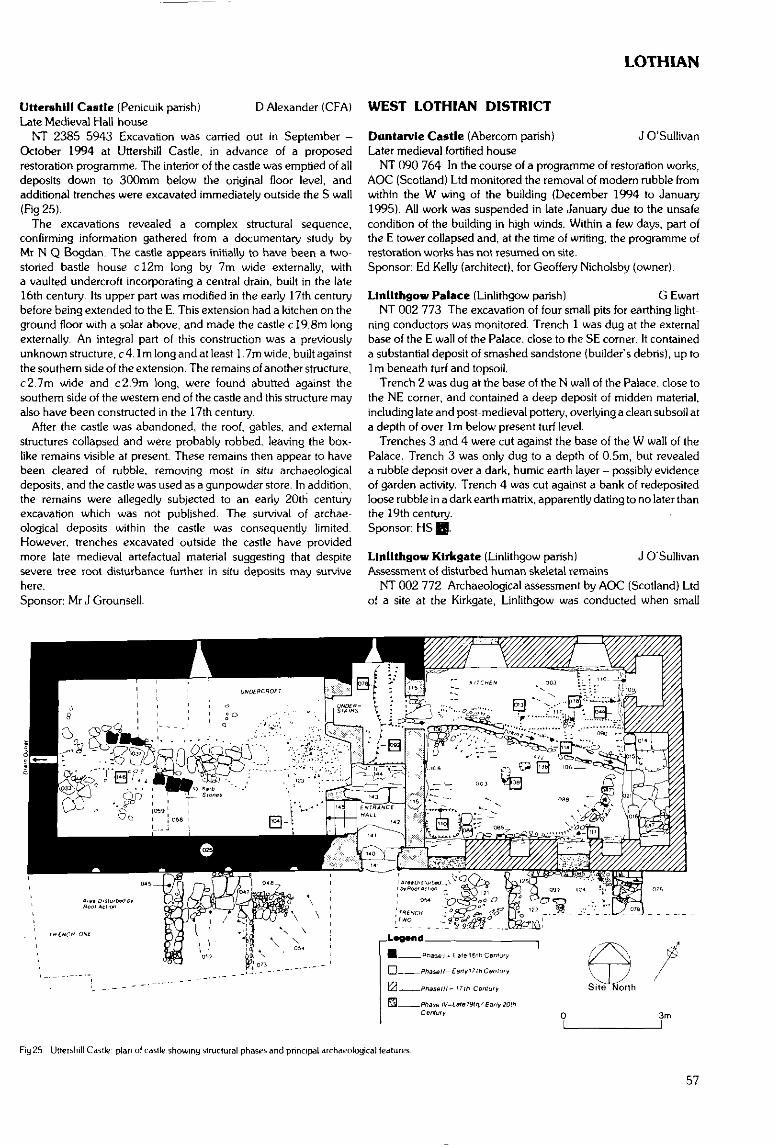
LOTHIAN
Utterohill Castle (Penicuik parish]Late Medieval Hall-house
NT 2385 5943 Excavation was carried out in September -October 1994 at Uttershill Castle, in advance of a proposedrestoration programme. The interior of the castle was emptied of alldeposits down to 300mm below the original floor level, andadditional trenches were excavated immediately outside the S wall(Fig 25).
The excavations revealed a complex structural sequence,confirming information gathered from a documentary study byMr N Q Bogdan. The castle appears initially to have been a two-storied bastle house c!2m long by 7m wide externally, witha vaulted undercroft incorporating a central drain, built in the late16th century. Its upper part was modified in the early 17th centurybefore being extended to the E. This extension had a kitchen on theground floor with a solar above, and made the castle c 19.8m longexternally. An integral part of this construction was a previouslyunknown structure, c 4.1m long and at least 1. 7m wide, built againstthe southern side of the extension. The remains of another structure,c2.7m wide and c2.9m long, were found abutted against thesouthern side of the western end of the castle and this structure mayalso have been constructed in the 17th century.
After the castle was abandoned, the roof, gables, and externalstructures collapsed and were probably robbed, leaving the box-like remains visible at present. These remains then appear to havebeen cleared of rubble, removing most in situ archaeologicaldeposits, and the castle was used as a gunpowder store. In addition,the remains were allegedly subjected to an early 20th centuryexcavation which was not published. The survival of archae-ological deposits within the castle was consequently limited.However, trenches excavated outside the castle have providedmore late medieval artefactual material suggesting that despitesevere tree root disturbance further in situ deposits may survivehere.Sponsor: Mr J Grounsell.
D Alexander (CFA) WEST LOTHIAN DISTRICT
Duntarvie Castle (Abercorn parish) J O'SullivanLater medieval fortified house
NT 090 764 In the course of a programme of restoration works,AOC (Scotland) Ltd monitored the removal of modem rubble fromwithin the W wing of the building (December 1994 to January1995). All work was suspended in late January due to the unsafecondition of the building in high winds. Within a few days, part ofthe E tower collapsed and, at the time of writing, the programme ofrestoration works has not resumed on site.Sponsor: Ed Kelly (architect), for Geoffery Nicholsby (owner).
Linllthgow Palace (Linlithgow parish) G EwartNT 002 773 The excavation of four small pits for earthing light-
ning conductors was monitored. Trench 1 was dug at the externalbase of the E wall of the Palace, close to the SE corner. It containeda substantial deposit of smashed sandstone (builder's debris), up to1m beneath turf and topsoil.
Trench 2 was dug at the base of the N wall of the Palace, close tothe NE corner, and contained a deep deposit of midden material,including late and post-medieval pottery, overlying a clean subsoil ata depth of over 1m below present turf level.
Trenches 3 and 4 were cut against the base of the W wall of thePalace. Trench 3 was only dug to a depth of 0.5m, but revealeda rubble deposit over a dark, humic earth layer - possibly evidenceof garden activity. Trench 4 was cut against a bank of redeposiredloose rubble in a dark earth matrix, apparently dating to no later thanthe 19th century.Sponsor: HS HI.
Linllthgow Kirkgate (Linlithgow parish) J O'SullivanAssessment of disturbed human skeletal remains
NT 002 772 Archaeological assessment by AOC (Scotland) Ltdof a site at the Kirkgate, Linlithgow was conducted when small
Fig 25 Ulletshill Castle plan of castle showing structural phases and principal archaeological features
57
LOTHIAN
quantities of human skeletal remains were exposed at two locationsin the course of road resurfacing works. These proved to be dis- NS 964 637turbed, redeposited remains lying (a) within the foundation trench NS 970 637of the cemetery wall which borders the Kirkgate on the E side and NS 9715 6368(b) in redeposited soil layers, cO.Sm beneath the present road NS 967 636surface, near the doorway of a cottage at No 3, Kirkgate. No in situburials were found and there is no evidence that the parish cemetery NS 972 630 -formerly extended beyond the present churchyard wall. NS 966 627 -
Elsewhere on the site, a group of assorted fills is tentatively inter-preted as evidence for a back-filled enclosing ditch, outwith the late NS 964 633medieval gate-house to the Palace yard.Sponsor: West Lothian District Council. NS 960 630
M6/M8 Fastllnk: R J Strachan, A J Dunwell (CFA) NS 966 630Hydrld Survey - Restricted Evaluation (Avoidance Phase) NS 9676 6295(Whitburn; Livingston; West Calder parish) NS 9684 6272
NS 97 66 - NS 95 57 An archaeological evaluation was con-ducted on 30 alternative route elements, with a combined length of NS 960 627c87km, for a proposed road linking the M8 near Whitburn, LothianRegion with the M6/M74 near Douglas, Clydesdale District, Strath- NS 966 626clyde Region. The evaluation comprised a desk-based assessment NS 964 623and field inspection of 500m wide corridors centred on each route NS 962 622element. NMRS records, a Desk Assessment produced by HS. NS 961 620Ordnance Survey and earlier map sources, vertical aerial photo-graphs held by RCAHMS, bibliographic references and raw data NS 96 SE 5from ongoing RCAHMS field survey, targeted principally at NS 9603 6162recording industrial landscapes in the grid square NS 95, were the NS 959 616principal desk-based sources examined. All land parcels within thesurvey corridors were visited apart from areas of dense conifer NS 961 614plantation, which are widespread between Breich, West Lothian NS 962 613District and Wilsontown, Clydesdale District. Listed and otheroccupied buildings, and designed landscapes, were not considered NS 958 607as part of the study.
This entry summarises the results of the Lothian Region section NS 96 SE 8only; for sites in Clydesdale District see Strathclyde Region entry.The lists of sites are ordered from N to S, and include all previously NS 960 605known and most newly identified sites, the former prefixed byNMRS reference number and the latter by NCR. Sites recorded by NS 957 604RCAHMS in NS 95 are included where independent confirmation NS 959 599 -was obtained by the current survey. CFA are grateful to RCAHMSfor the assistance provided during the evaluation. NS 956 603
In Lothian Region, only three sites were previously recorded,comprising two areas of rig-and-furrow cultivation and a poorly NS 962 603provenanced find-spot. The evaluation has identified over 60 newsites, nearly all of which can be related to post-medieval agricultural NS 964 602and industrial land-use, the former ubiquitous and the latter con-centrated between Breich and the District boundary. The most NS 955 601common agricultural site types were rig-and-furrow cultivationmarks and deserted farmsteads and cottages. Drove roads, field NS 9612 6005clearance and sheepfolds were also recorded. The range ofindustrial sites comprised principally 19th century stone quarries, NS 9573 6003collieries and other mineshafts concentrated on Rashiehill Muir. NS 954 599
Rlddoch-hlll NS 958 599NS975 663 Colliery. NS 953 598
Blackburn NS 964 598NS 9795 6599 Building. NS 963 597
Swinabbey NS 954 596Rig-and-furrow cultivation, building. NS 953 595Red Mill NS955 595Mill lade. NS 962 590-Foulshlels NS966 595(approx) Deserted settlement of Cockhill. NS 957 592Rig-and-furrow cultivation.Rig-and-furrow cultivation. NS 96 SE 2Deserted settlement of Hensnest.Rig-and-furrow cultivation. NS 9559 5895
NS973
NS967
NS967NS969NS973NS966NS968
658
655
643642642640640
Foulshlels (cont)Rig-and-furrow cultivation.Curvilinear cropmark.Deserted railway station.Rig-and-furrow cultivation.BentsNS 973 635 Rig-and-furrow cultivation.NS 970 634 Rig-and-furrow cultivation.FoulshlelsRig-and-furrow cultivation.South East LongridgeRig-and-furrow cultivation.BentsCropmark enclosures.Deserted settlement of Mansgrove.19th century water tank (possible).South East LongridgeRig-and-furrow cultivation.BentsRig-and-furrow cultivation.Rig-and-furrow cultivation.Rig-and-furrow cultivation.Industrial building and spoil heap.HolehouseburnRig-and-furrow cultivation.Deserted settlement, 'old houses'.Rig-and-furrow cultivation.RashiehillTrack.Cropmark enclosure.GlenhutchRig-and-furrow cultivation (possible).Rashiehill MuirRig-and-furrow cultivation.BreichQuarry.Jeanfield Cottage19th century quarry.NS 956 603 Drove road.Breich Station19th century quarries.Woodmuir BurnDeserted settlement of Backside. -Woodmuir FarmRig-and-furrow cultivation.Breich StationRig-and-furrow cultivation.Woodmuir BurnDeserted settlement of Backbum.Rashiehill MuirField clearance/shooting butts.Quarries.Walls (possible deserted settlement).Rig-and-furrow cultivation.Enclosures, rig-and-furrow cultivation.Tramways.Quarries.Quarry.Quarry.NS 962 595 Drove road/old fences.Woodmuir Colliery, coal pit.Quarry.Breich BraesFind-spot of flint arrowhead.Linn Bridge19th century quarry.
58
LOTHIAN/STRATHCLYDE
Paddy's RiverNS 964 578 - NS 961 588 Drove road.
Rashiehill MuirNS 9562 5864 Quarry scoop.NS 9540 5851 Quarry.NS 9556 5844 Quarries and trackway.NS 9552 5834 19th century quarryNS 9547 5832 19th century quarry.NS 9553 5827 19th century quarry.
TormywheelNS 9556 5820 19th century quarry.
Paddy's RiverNS961 582 Mine shafts
Rashiehill MuirNS 9528 5817 19th century quarry.
TormywheelNS 955 581 Deserted settlement of White House.'NS 9556 5807 19th century quarry.NS 9538 5764 19th century quarry.
Bye Law HillNS 9519 5748 19th century quarry.NS 9504 5719 19th century stone quarry.A detailed, illustrated report will be deposited with the NMRS.Sponsor: Roads Directorate of The Scottish Office Industry Depart-
ment, managed on their behalf by HS QQ.
STRATHCLYDE REGION
ARGYLL & BUTE DISTRICT
Argyll & Bute District SRC SMRNew sites added to the SMR. 1 November 1994 to 31 October 1995
Recent fieldwork by the staff of the Strathclyde Joint ArchaeologyService (funded by Strathclyde Regional Council and its constituentDistrict Councils) has resulted in the discovery and recording ofa number of new sites from the prehistoric period to the earlymodern era. Only a brief summary is provided here covering theperiod from 1 November 1994 to 31 October 1995. Full detailsare available in the Strathclyde Sites and Monuments Record. Inaddition a number of known sites were visited during fieldwork andcondition reports on these are held in the SMR, although not listedhere. A number of watching briefs were also carried out over theperiod and are reported separately under the appropriate Districtand Parish
Over the 12 month period the Strathclyde Joint ArchaeologyService dealt with 213 Woodland Grant Scheme referrals from theForestry Authority: identified 107 planning applications withpotential archaeological implications; answered 325 enquiries onarchaeological matters; and prepared 17 briefs for archaeologicalsurvey, evaluation, excavation, or watching briefs by archaeologicalcontractors implementing conditions on planning consents onbehalf of developers. Over the 12 month period the number ofWGS referrals and prepared briefs has remained at a similar level tothe preceding 12 month period. The number of identified planningapplications however is much less, as a result of less monitoring bythe Service whilst effort has been concentrated instead on SMR andGIS development, which in the long term should lead to much moreeffective monitoring of development for archaeological implicationsby local planning authorities. The number of enquiries has notice-ably increased by about 50%, mainly pre-planning applicationenquiries by developers and their agents. This appears to be a resultof the introduction of NPPG 5 and PAN 42 in January 1994.
(Ardchattan & Muckaim parish)Has Achadh Alrlgh
NN 0023 2786, NN 0024 2780, NN 0018 2772, NN 0009 2764,NN 0001 2751, NN 0055 2722
Platforms (probable charcoal burning stances).NM 9967 2774-NM 9962 2659 Head dyke.NN 0026 2778 Field dyke.NN 0023 2777, NN 0025 2774 Clearance cairns.
Barguillean FarmNM 9805 2882 Grinding mortar built into barn wall.
Am BarrNM 9771 2896, Platforms (probable charcoal burning stances).NM 9759 2867 (Information supplied to SMR by Mr S Macdonald)(Campbeltown parish)
KilkeddanNR 7385 2652 Carved rock.
Maol a' ChuirNR 7443 2738 Crash site of Lancaster bomber (WWII).
(Information from Forestry Authority)(Glenorchy & Inishail parish)
Lub-crichcNN 3202 4486 Deserted settlement(Inuerchaolain parish)
TighnuiltNS 0940 7479 Deserted settlement.(Kilchoman parish)
Buaile CoreNR 2734 7327 Circular enclosure. (Information on the above site
on Islay supplied by HS)(Kilchrenan & Dalavich parish)
Gleann na h'AirighNM 9730 1852 Shielings.(Kilfinan parish)
Dun MorNR 9822 7336 Standing stone (possibly natural).(Killean & Kilchenzie parish)
WestportNR 65372575 Shipwreck. (Site first reported by Mr A Graham)(Kilmartin parish)
Creaganterve MhorNM 8443 0114 WWII observation post and gun emplacement.(Kilmichael Glassary parish)
Upper BraevallichNM 9590 0693 Possible kerbed cairn.NM 9613 0662 Stony spread.(Kilmodan parish)
Clachan of GlendaruelNR 9947 8418 Mound protruding from western boundary of Kil-
modan graveyard.(Kilmore & Kilbride parish)
BarnabuckNM 8018 2840 Ruins of a building, stack bases.
Barr-nam-boc BayNM 7985 2845 Quay.
Gleann Mor nan UsraganNM 8074 2770 Shieling.
Gleann na CurraNM 8100 2823 Shieling.
Am MaolanNM 8070 2843 Enclosure.
LeacNM 8100 2968 Buildings, rig.
Slatrach BayNM8151 2954 Mill.
Rubha SeanachNM 8036 2560 Deserted settlement and field system.
59
STRATHCLYDE
Cnoc na FaireNM 7912 2707 Burial enclosure.NM 7910 2754 Chapel and burial ground (possible).NM 7935 2735 Shieling.
Ellean OrasaigNM 794 266 Shieling-type structures, rig, dyke.
(Information on the above sites on Kerrcra sup-plied by HS)
(Kilninian and Kilmore parish)Port na Ba
NM 3889 5479 Deserted settlement.Aird
NM 3915 5430 Deserted settlement.Dun Dubh
NM 4000 5318 Dun.Ball'a'Chlaldh
NM 3702 4036 Deserted cottages.NM 3690 4047 Graveyard, cross slab.NM 37114059 Deserted buildings.NM 3730 4064 Deserted buildings.NM 3720 4097 Deserted settlement.
Acairseld MhorNM 3565 4180 Deserted buildings.
Torr a' MhullaichNM 4083 5260 Deserted settlement.
Loch a' ChumhainnNM 4117 5298 Deserted settlement.NM 411 530 Rectangular structure.
Druim nan GeoidhNM411 529 Rectangular structure.NM 410 528 Turf mound, some stone protruding.NM410 526 Rectangular building.NM410 526 Rectangular building.NM 411 528 Rectangular structure.NM412 527 Deserted settlement.
(Information on the above sites on Mull andGometra supplied by HS)
(Lismore & Appin parish)Kilcheran Loch
NM 8304 3974 Deserted croft.NM 8330 3978 Deserted croft.
AchnachroishNM 8505 4114 Corn kiln.NM 8498 4114 Buildings and a rectangular enclosure.
Druim BuidheNM 8491 4119-NM 8475 4126 Old road
BalygrundleNM 8385 4051 Deserted croft.
Tlgh na StaralchNM 8389 4054 Ruin of the House of the Ford.
Dun MorNM 8363 4010 Single cell buildings, field bank.
BallgrundleNM 8355 3960 Deserted croft, kiln.
(Information on above sites on Lismore suppliedbyHS)
(Lochgoilhead & Kilmorich parish)Easan Dubh
NN 2368 0911 Shielings.(Reported by Forest Enterprise)Allt Belnn line
NN 2388 0926 Shielings.Beinn Lutbtiean
NN 2456 0890 Shielings.Croe Water 1
NN 2441 0619 Shielings.
Croe Water 2NN 2542 0683 Shielings.
Croe Water 3NN 2494 0666 Shielings.
Corran 1NS 2131 9394 Deserted (fishing?) village.
Corran 2NS 21639383 Possible platform and piles of stone.
GuananbegNS 24119706 Probable shieling.
The SaddleNS 2296 9663 Shielings.(North Knapdale parish)
AchanthcanbhaileNR 8131 9129 Deserted farmstead.(Southend parish)
St Ninian's ChapelNR 7291 0466 Well.
Brecanrldge PortNR 7249 0395 Corn-drying kiln.
(Information on above sites on Sanda Island sup-plied byHS).
(South Knapdale parish)Sron Doire
NR 84057856 Platform, cultivation remains, earth & stone banks.Muilichinn
NR 7423 6447 Deserted settlement.Buaile Innse
NR 72006315 Shieling.Cruach Alrde
NR 72766330 Deserted settlement and shielings.Breac-larach Mor
NR 84337816 Enclosures and structures.Allt Mor
NR 8523 7878 Possible clearance dumps.(Torosay parish)
Abhainn an't-SidheanNM 7012 3126 Deserted settlement.
GannonyreochNM 6750 2569 Deserted settlement.
GortendoilNM 7115 2689 Deserted farmstead.
KenandromaNM 7150 2700 Deserted settlement.
Balgamrie and BarnashoagNM 7160 2663 Deserted settlements.
ArinasliseigNM 6545 3168 Deserted farmstead.
Cnoc na CroicheNM 6253 2485 Donald Ban's house - roofless ruin.
(Information on the above sites on Mull suppliedbyHS)
Ardchattan Priory (Ardchattan & Muchaim parish) R MurdochNM 971 349 Small-scale excavation was carried out by Scotia
Archaeology Limited in advance of the construction of a stone shel-ter to house several late medieval grave slabs and an early Christiancross slab. There was no evidence of any priory buildings or burialsof any age within the area investigated, only a series of paths runningalongside a garden wall which probably dates to the 19th century.Sponsor: HS E8-
Lochan na Belthe (Ardchattan & Muckaim parish) J HamiltonWatching brief
NM 915 349 A watching brief was carried out during theexcavation of house foundations adjacent to the scheduled ancient
60
STRATHCLYDE
monument of Achnacree cairn (1) {NMRS NM 93 SW 15). Thelimited excavations revealed no evidence of any earlier activitywithin the environs of the proposed development.
Low Ugadale {Campbeltown parish) F HoodChambered cairn
NR 779 294 Mound with forecourt situated on a ridge Sofa gullycontaining Allt na Beiste, between High and Low Ugadale. Moundmeasures 4.6m long and 1.7m at its widest point. The horns of theforecourt measure 10. Om at their ends. The site is oriented W-E, theforecourt facing E.Sponsor: Kintyre Antiquarian and Natural History Society.
Surface finds from Duns {Coll parish) M W HolleyDun-beic
NM 154 564 13 sherds pottery.NM 1548 5642 23 sherds pottery.
Dun MorbhaidhNM 234 633 1 sherd pottery.
Dun an AchaldhNM 183 545 9 sherds pottery.Sponsors: Univ of Edinburgh Dept of Archaeology, Holley & Assoc.
Crannog Survey (Coll parish)Ballyhaugh
NM 1744 5845 Oval area with substantial causeway.Breachacha
NM 1561 5303 Oval mound set in marshy area;post-1903 'howking'.Dun Anlaimh
NM 18845684 Oval stone-covered mound with three buildingsand substantial causeway.Loch Anlaimh
NM 18855581 Circular mound with substantial causeway. Saddlequern.Loch Cllad no 1
NM 2072 5878 Circular mound.Loch Cliad no 2
NM 2074 5883 Oval mound with three buildings and causeway.Loch Cliad no 3
NM 2085 5847 Circular turf-covered mound with slight causeway.Three buildings.Loch an Duin
NM 2125 5781 Oval mound, two platforms and well-preservedperimeter walling. Causeway.Loch Fada
NM 2558 6203 Circular mound with no causeway.Loch na Cloiche
NM 2406 6106 Circular mound, no causeway.Loch Urbhaig
NM 2310 5778 Natural base with platform.Sponsors: Univ of Edinburgh Dept of Archaeology, Holley & Assoc.
Klllunaig Cemetery, Isle of Coll (Coll parish)Medieval chapel site R J Strachan (CFA)
NM 2214 6170 An archaeological evaluation was undertakenon the site of a proposed southward extension of the cemeteryat Killunaig. Within the grounds of the existing cemetery are theremains of a building, tentatively identified as the-site of the latemedieval church of St Fynnoga or Findoca of Coll (NMRS no NM 26SW3). A number of features, including cists and ash spreads, as wellas artefacts including pottery, flints, bronze objects and hammerstones have been reported previously from sand dunes to the W ofthe existing cemetery.
The proposed extension measured approximately 26m E-W by13m N-S. and was located in an area of stabilised sand. Following
an unsuccessful augering survey, four trenches were opened byhand, uncovering an area of approximately 30m2. Three trencheswere excavated to a depth of 1,2m. Two of these trenches were thensondagedto 1. Smatwhich level the water table was reached. Thesetrenches were then cored to a depth of 2m. No archaeologicallysignificant horizons or finds were made.
A report has been deposited with the NMRS.Sponsor: Argyll and Bute District Council.
Machrins, Colonsay (Colonsay & Oronsay parish) NMSNorse ringed pin
NR 361 936 Found by Mr James Hendry while metal detectingon the old 'Sports Field' at Machrins Farm. Colonsay The pin isa fine example of the type classified by Fanning as plain-ringed,polyhedral-headed pins, probably dated to the mid-lOth century.The head is decorated with a single dot on the lower angle of eachmain facet, and there appears to be further decoration on the faces{saltire motif?). There is also well-preserved decoration on the lowershank, including both stepped and running chevron motifs. On thetop of the head there is a small patch of organic material, almostcertainly the remains of textile. Dimensions: length 165mm; dia-meter of ring: 18mm.
The pin was claimed as Treasure Trove and allocated to NMS(NMS IL 970).
Buchailean Hill (Dunoon & Kilmun parish) E B RennieHill fort
NS 122 702 The summit of Achafour Hill known as Buchaileanwas noted as a 'fort' on all early maps and in the Argyll List ofAncient Monuments dated to 1916. Later lists and the OS mapspublished after 1976 have omitted the information. A survey madein January 1994 by E Rennie. F Newall, E & A-Garner. has shownthat the hilltop is fortified.
The summit is enclosed by a spread rampart - on the NE arc it is4m broad and incorporates an internal ditch; around the rest of theperimeter the spread rampart is 2.8m broad. The area enclosed(SW-NE 70m; NW-SE 103rn) being 7,210sqm, ie approximately0.75ha, A few upstanding boulders and a change in the hillslope onthe S shoulder may mark the remains of a lower rampart.
A sharply angled entrance 2.8m wide, leads up the N slope andthrough the rampart. The track can be followed southwards belowthe W shoulder of the hill.
Two hollows - one in the NE arc and one in the W - may mark thesite of hut platforms,
The fort is at a height of 345m (1131ft) and commands a wideview over the outer and inner Firth of Clyde. It is both the largest andthe highest Hill fort in Cowal, Bute and north Ayrshire. The com-plete summit is now masked with thick heather growth.
Chapelhall. Toward (Dunoon & Kilmun parish)Two stone heads
NS 139 689 Adjacent to the site construction plot at Chapelhall(reported in DES 1994, 52), two stone heads were found. They hadalways been known to the owner of the ground though a possiblesignificance to the 'chapel' name was overlooked.
Head I is of limestone which is local to the area. It measuresapproximately 200mm by 180mm by 150mm thick. The facialcharacteristics resemble those of the Celtic 'Stone Heads', Head IImay be of Old Red Sandstone which also is local. It measuresapproximately 300mm by 200mm by 130mm thick. It has beenaffixed to a wall by mortar which is still present on the back of thestone.
Indications of more graves than those already reported suggestthat the area of burial may extend to 100 sq m. Remains of chapelwere visible according to the Name Book of 1860. Place name evid-ence further suggests that an ecclesiastical site of some importance
61
STRATHCLYDE
has pre-datcd both the early village of Innellan centred at the ferry atSandy Beach, and Victorian Innellan centred on the pier.
Ardmlnlsh (Gigha & Cara parish) F HoodCup-marked stone
NR 648 484 Situated just inside gate and S of track leading toBrae House. Rat surfaced boulder measuring Irn by 0.06m with atleast 15 shallow cups.
Ardmlnish Point (Gigha & Cara parish)Jetties
NR 663 499 and NR 663 500 (1) Stone jetty, situated on W sideof Ardminish Point, measuring 25m long by 3m wide. Made ofnatural boulders. 2m high.
(2) 65m S of first jetty, on W side of Ardminish Point, measuring25m long by 3m wide. Made of natural boulders, 2m high.
Garbh Phort (Gigha & Cara parish)Bait holes
NR 661 496 Situated on W side of Garbh Phort on level sheet ofrock 6m above sea, two saucer-shaped depressions measuringapproximately 30cm across and 15cm deep.
Achamhinish (Gigha & Cara parish)Fish trap
NR 661 498 Stone-built wall 1m wide and 1m high. 55m long, itcuts off unnamed inlet at high tide.
Achamhinish {Gigha & Cara parish)Kelp kiln
NR 657 493 Stone-lined pit, 3m long by 0.05m wide, situated ingrassland above a sandy bay.Sponsor; Kintyre Antiquarian and Natural History Society.
Ardtaraig Estate (Inverchaolin parish) T Neighbour (CFA)Pre-afforestation survey
A survey was undertaken as part of the environmental assessmentprior to proposed afforestation on Ardtaraig Estate. The assessmentwas designed to identify and evaluate any archaeological monu-ments present, through the examination of documentary sourcesand fieldwalking of the area, The results of this work suggest that thesurvey area has pockets with sites of archaeological importance, butis generally of marginal significance.
Initial identification of a site by the Strathclyde Joint Archae-ological Service (SJAS) is credited below by the use of these initials.Four sites recorded in the NMRS lay within the survey area. Theirdetails are not repeated below.NS 0300 8310 to NS 0340 8305to NS 0345 8285 to NS 0335 8250to NS 0305 8235 Tamhnich settlement (SJAS).NS 0310 8205 to NS 0395 8270to bothNS 04208365 and NS 0465 8310 Drystone dykes.NS03408190 Shielings (SJAS).NS 0560 8570 to NS 0560 8580 Turf-covered, curvilinear dykes.NS 0575 8425 to NS 0575 8460 Drystone dyke,to NS 0565 8470 to NS 0560 8505 Drystone dyke.NS 0570 8465 to NS 0585 8515to NS 0560 8550 to NS 0565 8600 Drystone dyke.NS 0575 8435 to NS 0550 8430 Drystone dyke.NS 0575 8450 to NS 0560 8440 Drystone dyke.NS 0565 8470 to NS 0555 8465 Drystone dyke.NS 056 836 Standing stone and cup marking
(SJAS).Full details of the survey are in a report lodged with NMRS.Sponsor: Ardtaraig Estate via Scottish Woodlands Ltd.
Burg, Isle of Mull (Kilfinichen & Kilvickeon parish) NMSNeolithic axehead
NM 426 266 Neolithic unperforated polished stone axeheadfound by Mr J Ramsay and donated to the NMS.Daybook no: DB 1995/34.
Dun Bhoraraic (Kilarrow & Kilmeny parish) E B RennieStone setting
NR 415 658 On the NW slope of Dun Bhoraraic two settings ofstones which together resembled some of the stone ship settings atLindholm H0je in Denmark.
Stones forming a 'boat' shape are set into the ground at 160mOD, 600m NE of Lossit Farm and about 30m below Dun Bhoraraic.The setting is 11m long by 4m broad; it has slightly bowed sides. Atleast six stones form the WNW side and seven form the ESE sidewith a further two forming the 'prow'. The 'stern' appeared to be'open ended'. The ground slopes slightly towards the 'prow' whichpoints towards the smaller stone setting. It is 30m to the SW, itis round (2.5m in diameter) and composed of four or five largeboulders and some smaller stones.
Gartnagrenach — Cruach nam Fiadh F Baker(Kilcalmonell parish)Survey (centred at NR 815 565)NR 8018 5720 Standing stone. 0.80m high, schist.NR 8067 5725 Cairn 10m by 4m, 1m high.NR 8081 5630 Cairn. 2m diameter, 0.20m high.NR 8086 5628 197()'s rock sculpture.NR 8126 5663 Three oval mounds cS.OOm diameter, probablynatural.NR 8256 5590 Linear cairn utilising bedrock in its construction,8.50rn by 3.50m NW-SE, 0.40m high. Charnber/cist robbed inantiquity consists of drystone wall uprights and several capstones.NR 8256 5589 Cairn, 6.00m diameter, incorporates bedrock intoits construction, kerb up to 0.50m high on its SW side.NR 8139 5619 Shieling settlement remains: (1) Rectangular turfand stone buildings on slope and recessed into hillside. 11.50m by5.50m orientated E-W over walls 1.40m thick. Two rooms and twoentrances on the S side. (2) Circular hut foundation. 4.00rn diameterover walls 0.90m thick. (3) Sub-rectangular building, turf and stone.6.70m by 4.30m over walls 1.40m thick. Opposed entrances 0.60mwide in long walls on a prominent built up knoll with two circularenclosures on the N side. Of more than one phase. ?Winnowingbarn. (4) Possible hut platform to SE of above structures.NR 8139 5620 Recessed platform 3.50m by 2.00m orientatedE-W. Drystone walling on inner and outer edges. House site.Sponsor: Atlantic Energy Ltd.
Cnoc Donn, near Clachan, Kintyre (Kilcalmonell parish)Desk-based study and field inspection A J Dunwell (CFA)
The following new sites and monuments were recorded in a desk-based survey and field inspection conducted in October 1994 aspart of an environmental assessment for a proposed windfarm siteencompassing the summits of Craig Loisgte Talatoll and CnocDonn. The archaeological potential of the windfarm site appearslow, although much of the inspected area is covered by peat, whichmay mask traces of further archaeological remains.
NR 756 542 Penannular soil-mark with a diameter of clOm,visible on vertical aerial photographs but not located on the ground.
NR 753 536 Area of poorly preserved rig-and-furrow cultivationmarks identified by field inspection, covering an area 200m byc20-30rn.
NR 749 534 A clOOm length of drystone wall substantiallyburied beneath peat; exposed height of no more than 0.5m, witha maximum of four courses visible. This feature was not identified onany of the map coverage examined.
62
STRATHCLYDE
NR 742 535 Small quarry comprising principally several grass-covered depressions and exposed rock outcrops over an area c 40min diameter. The largest of these was c 5m across and 2-2.5m deep,with an upcast mound flanking its W side.
NR 747 527 An area of at least 50m by 50m of poorly definedpeat cuttings visible as several squared cuts measuring c5-10macross and with vertical faces up to 0.3m deep.
NR 747 531 Earth-and-stone field bank running slightly sinuousfor c200m. terminating in an area of low boggy ground, andmeasuring c2-2.5m wide by up to 0.8m high. It marks the NWcontinuation of a field boundary crossing Cnocan Tioram. which isindicated on current Ordnance Survey maps.
A report detailing the sources consulted, study methods and fullerresults of the project will be lodged with the NMRS.Sponsor: ScottishPower pic.
Corra Farm (Kilfinan parish) F Newall, W LonieAncient road
NR 9743 6589 Further inspection has established that, true totradition, this road does 'run to the sea' (DES 1981, 34).
Just W of a primary field boundary which runs S from near CorraFarm to the edge of the raised beach scarp above Ardlamont Bay,the road is indicated by a firm slightly cambered track, which passesthrough marsh and continues as an animal track. Probing suggeststhat a ditch follows the W side. The line is crossed by the 17thcentury road to Ardlamont House. Here wash-out and cattletrampling have exposed metalling beyond the limits of the laterroad.
From here a hard track continues to pass under the stone wall.NR 9749 6550, into the field on the E where a firm raised trackthrough marshy iris-grown ground develops as a broad rig whichreaches to the raised beach scarp.
Melldalloch Island (Kilf inan parish) E B RennieOccupied island with causeway
NR 936 745 Melldalloch Island within the loch of the same nameis just over an acre in extent. The loch lies on the E side of the B8000about 4 miles S of Kilfinan
The island has recently been cleared of undergrowth and a lightbridge built which joins the island to the mainland making accesspossible.
On the island are the foundations of two West Highland long-houses. They are both approximately 18m by 6m externally. Thewalls are completely tumbled and spread to 2m in breadth. Bothstructures are divided internally by cross walls.
The SW end of the island is partially enclosed by a bank rising 1 mabove the shore line and spread to about 1.5m. Enclosed by thisbank is a second mounding which curves inwards around a flat area.One of the longhouses may overlie a continuation of this moundedcurve. A gap in the outer bank about 3m wide may be the originalaccess from the shore. The drought this summer revealed the end ofa causeway 80m long leading from the S end of the island to theS shore of the loch. The causeway joins the island at a point adjacentto the gap in the outer bank.
The causeway is about 3m broad and in the drought conditions,was at no point more than 0.6m below the surface of the loch. Infolk memory it is said that at one time it was possible to cross tothe island dry shod. The causeway is composed for 25rn from theisland end. of flat slabs of rock. Within 30m of the mainland shorethe track leads on to a small island of vegetation which is joinedto the shore by a further stretch of laid stones. Between the firmmud and the small island there was a gap where the mud wassoft and formed a treacherous hole. The water continued to beshallow on each side of the causeway for considerable distancesbul apart from the bottomed track, the loch floor was muddyand soft.
Badden, Lochgllphead (Kilmichael Glassary parish) SRC SMRWatching brief
NR 8575 8895 The first phase of a housing development onthe outskirts of Lochgilphead was to come within 90m of the find-spot of the Badden cist slab (Glasgow Museums A6045). Strath-clyde Joint Archaeology Service carried out a watching brief duringearthrnoving works in case other prehistoric remains were disturbed.Two series of field drains were identified, being roughly parallelditches cut through the gravelly sands. The more recent serieshad ceramic drain-pipes, but the earlier series was stone filled.One ditch from the earlier drain series was roughly parallel toa line of double stake holes, but their stratigraphic relationshipwas not confirmed. A machine-excavated site inspection pit dugin the mid-1970s was uncovered. No prehistoric remains wereidentified.Sponsor: Strathclyde Joint Archaeology Service.
Achnabreck {Kilmichael Glassary parish) J O'SullivanCup-and-ring marks
NR 855 906 Excavation at the site of cup-and-ring marked rockoutcrops in Achnabreck Wood was undertaken by AOC (Scotland)Ltd in advance of the installation of new walkways, stiles, noticeboards and a drain. In several small cuttings immediately adjacent tothe carved rock exposures, the turf was stripped by hand and thetopsoil layer was excavated to the subsoil surface. Though hithertounexposed areas of bedrock were exposed, no new carvings wereidentified. Up to 10% of the topsoil was sieved in each area in anattempt to identify lithic debris associated with the carvings or theirproduction, but no such material was identified. A group of linearfeatures adjacent to the E or smaller carved outcrop is interpretedas ard or plough marks, but there is no evidence that these areassociated with the carvings.Sponsor: HS jfljwith Forestry Enterprise.
Ballymeanoch (Kilmichael Glassary parish) D AbernethyStanding Stones and Henge
NR 833 964, NR 833 962 During April 1995 landscape work wascarried out at these sites in order to improve their appearance. Thisinvolved the removal of modern clearance stone and the addition oftopsoil to cover plough damage on the ground immediately aroundthe monuments. In addition a trench was excavated at the site inorder to test the nature of some geophysical anomalies which hadbeen detected in 1993.
Whilst removing the modern clearance stone from around thebases of stones A-D (RCAHMS 1988. 128 Figure A) nothing ofadditional archaeological interest was encountered. Amongst theclearance stone around the bases of Stones E and F (RCAHMS1988, 128 Figure A) were two large flat stones; one measured0.78m by 0.43m and in one of its corners are two possible erodedcup-marks. The other stone measured 0.66m by 0.32m and wasthinner and squarer with a dressed appearance. Both stones wereleft in situ.
When clearance stones were removed from the ditch around thehenge on its W side a large flat stone measuring 1.2m by 0.5m wasfound. It is suspected that this is the missing northern end slab fromthe central cist in the Henge. Another smaller, flatter, and muchsquarer stone was also found in this area of the ditch. It measures0.5m by 0.3m and may have originally come from the satellite cist.Both stones were left in situ.
Geophysical prospection in 1993 had detected a series of linearanomalies on the same alignment as Stones A-D (RCAHMS 1988,128 Figure A) and running up to meet them at their SE end. A 50mby Irn trench was excavated across these anomalies as there isa good case to suggest that they represent the remains of a pre-historic earthwork avenue. There were no archaeological depositsencountered that might explain the cause of the linear anomalies
63
STRATHCLYDE
but a ditch was encountered running N-S. it measured an averageof 0.6m across and when sectioned proved to be only an average ofO.llm in depth. No finds were recovered but the W side of thisfeature contained more stone than the E possibly indicating thepresence of packing material for a palisade trench.Sponsor: Commissioned by HS ̂ and funded by Kilmartin Glen
Project.
Dunamuck Cottage (Kilmichael Glassary parish)Enclosure
NR 842 913 On the N side of a meandering dyke 120m N ofDunamuck Cottage is situated a circular enclosure. It consists ofa band of turf-covered rubble, 3-5m thick and up to a metre high inplaces which forms a circle 19m in diameter with large earthfastrectangular stones delineating the NE edge. The SW side appears toabut the meandering dyke and there is a possible entrance way onthe SE.
Monadh An Tairbh {Kilmichael Glassary parish)Flint scatter
NR 830 964 A number of worked flints, including fragments ofblade and debitage were recovered from molehills in the fieldoccupying the low terrace between the B8025 and Monadh AnTairbh. The first flints were discovered by David Clough, KilmartinHouse Trust.
Poltalloch (Kilmartin parish) A M KahaneCircular enclosure
NR 811 962 On an almost level E-facing grassy terrace c 200mN of the larger enclosure described in DES 1981,30. an area of c 7mdiameter surrounded by the tumbled remains of a wall originallycl.5m wide. For a short stretch on the N side a bottom course ofinner facing-stones appear to be in place.
Ormidale, Burial Ground (Kilmoden parish) E B RennieDefended homestead
NR 9991 8218 The burial ground of the Campbells of Ormidalehas recently been cleared of trees and undergrowth. This hasrevealed that the burial ground has been set within and on an earlierfoundation.
Surrounding the later rectangular mausoleum is a 'D'-shapedbank and ditch. The feature stands on a flat river terrace with thestraight side to the hill and to the W; the heavily curved side istowards the E and the river Ruel. The river terrace has been formedby the river which at present flows about 200m W of the feature.Further to the W the hill rises steeply to 250m OD. The flat landcontinues northwards and opens into Glendaruel.
The enclosure is deeply ditched on the curving N. E and W sides.To the W there is no evidence of ditch but here the bank fallsdirectly into the surrounding fields. The bank stands about 1mhigh above the field and the same internally. Where the banks areenclosed by ditch they are nearly 2m high as the ditch is about1m deep. The breadth of the bank at base and also of the ditch isabout 3m.
A gulley through the fields which could mark the position of anaccess track, meets the ditch. On the opposite side of the ditch at thesame point, there is a berm on the external side of the bank andabove the ditch. These collected features suggest that a previouscrossing point over the ditch has been destroyed.
The internal flat area now utilised by the mausoleum, extends toabout 18m by 15m. There is no evidence of an earlier foundation onthe internal area except for a ramp and a 'pier' of drystone workwhich might or might not be associated with access to the latermausoleum.
Survey work was undertaken by F Newall, H Sinclair andE Rennie.
Burg (Kilfinichen & Kilvickeon parish) R TurnerNeolithic polished stone axe
NM 426 266 A complete Neolithic polished stone axe was foundduring drystane dyking work at Burg. The small axe measures89mm by 54mrn, and is 19mm thick. The finder. Mr Jim Ramsay,has given the find to the NMS.Sponsor: NTS.
Am Bannas, Mull M Douglass, R C Callander(Kilfinichen & Kilvickeon parish)Probable shielings
NM 359 191 Near the crest of the valley between Loch MorArdalanish and Loch an Sgalain above an extensive area of rig arethe ruins of two adjoining structures. Probably shielings, eachstructure measures internally about 2.5m square.
Full report lodged with NMRS.
Beinn a' Bhearnais, Mull (Kilfinichen & Kilvickeon parish)Roomed kiln
NM 361 193 On hill slopes to the W of Loch Mor Ardalanish tothe N of several shielings (NM 361 192} is a ruinous roomed kiln.Built astride a head dyke, it measures internally 4.5m NW/SE by2.7m transversely with opposed entrances at the SE end which isgabled and has a small window. At the NW end where the floor levelis higher there is the probable location of the kiln bowl but no clearevidence of this was found.
Full report lodged with NMRS.
Beinn a' Bhearnais, Mull (Kilfinichen & Kilvickeon parish)Shielings
NM 361 192 On hill slopes to the W of Loch Mor Ardalanish tothe S of a ruinous roomed kiln (NM 361 193) is a line of three ruin-ous shielings on either side of a head dyke. All are two chambered.both sub-circular, one chamber about 2.5m in diameter, the other1,5m in diameter.
Full report lodged with NMRS.
Cnoc an t-Slonnalch, Ardalanish, Mull NMS{Kilfinichen & Kilvickeon parish)Cloth fragment
NM367 188 A fragment of woollen cloth was turned up by Mr AMackay of Ardaianish while digging peat, at a depth of 'about 3"(0.9rn). It is woven in an open tabby weave with S-spun threads.There is no indication as to date.Daybook no: DB 1995/5.
lona Abbey; lona Nunnery J O" Sullivan(Kilfinichen & Kilvickeon parish)Geophysical survey
NM 286 245 (Abbey); NM 284 240 (Nunnery) Resistivity andgeophysical surveys were undertaken at lona Abbey and Nunneryby Geophysical Surveys of Bradford for AOC (Scotland) Ltd.
At the Nunnery, a broad, curvilinear magnetic anomaly appearsto respect the NE corner of the convent buildings. While this maysimply represent an igneous geological feature, it may, alternatively,represent buried road metalling in igneous materials. In the samepart of the site, a rectilinear group of features offering high resistancemay represent buried wall-butts. At the Abbey, several magneticand high resistance anomalies correspond to known features(walls, paths or service structures). Other high resistance anomalies,S and E of the Abbey complex, form clear linear traces and maycorrespond to buried drains. A group of weakly-defined, linear,high resistance anomalies forms a rectilinear pattern within theNW angle of the present boundary wall. The appearance of thesefeatures is of buried walls, but they may simply be drains or gardenfeatures.
64
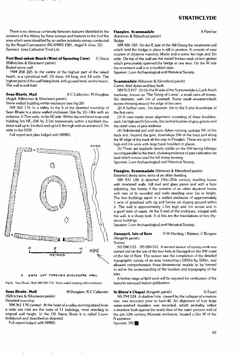
STRATHCLYDE
There is no obvious continuity between features identified in theenvirons of the Abbey by these surveys and features to the S of thisarea which were identified by an earlier resistivity survey conductedby the Royal Commission (RCAHMS 1981, Argyll 4: lona, 32).Sponsor: lona Cathedral Trust Ltd.
Port Beul-mholr Beach (West of Spouting Cave) G Szuca{Kilfinichen & Kilvickeon parish)Buried stone wall
?NM 258 225 In the centre of the highest part of the raisedbeach, is a cylindrical wall, 2ft deep, 6ft long, and 4ft wide. Thehighest point of the wall being level, with ground level, on the beach.The wall is well built.
Sean Bhaile, Mull R C Callander, M Douglass(Argyll, Kilfinichen & Kilvickeon parish)Stone walled building within enclosure (see Fig 26)
NM 360 176 In a valley to the S of the deserted township ofSean Bhaile is a stone walled enclosure 16m by 10-14m with anentrance, 0. 75m wide, in the SE side. Within the enclosure is an ovalbuilding 5m NE-SW by 2.5m transversely within a tumbled dry-stone wall up to 1 m thick and up to 0. 8m high with an entrance 0. 7mwide to the SSW.
Full report and plan lodged with NMRS.
FORD
to_J
METRES
X G-BPS CUT THROUGH ENCLOSURE WflLL
Fig26. Sean Bhaile, Mull 1NM 360 176). Stone walled building within enclosure
Sean Bhaile, Mull M Douglass, R C Callander(Kilfinichen & Kilvickeon parish)Deserted township
NM361 178 (centre) At the head of a valley running inland froma wide sea inlet are the ruins of 11 buildings, most standing tooriginal wall height. In the OS Name Book 'it is called LowerArdalanish and described as deserted.
Full report lodged with NMRS.
Flneglen, Scammadale 5 Retcher(Kilninver& Kilmelford parish)Bridge
NM 926 183 On the E side of the Allt Dearg the revetment wallwhich held the bridge in place is still in position. It consists of neatcourses of drystone masonry blocks and is some 4m high and 3mwide. On top of the wall are the rusted broken ends of iron girderswhich presumably spanned the bridge at one time. On the W sidethe revetment wall is in a rumbled state.Sponsor: Lorn Archaeological and Historical Society.
Scammadale (Kilninver & Kilmelford parish)Caims, field dykes and lazy beds
NM913197 (DOntheWsideoftheScammadaletoLochAvichtrackway, known as 'The String of Lome', a small cairn of stones,2m diameter, with 1m of overspill. Some small revetment/kerbstones showing around the edge of the caim.
(2) A further cairn, 1m diameter, 6m to the S and downslope ofthe first cairn.
(3) A man-made stone alignment consisting of three boulders,each 1m high and 0.5m wide, the central boulder of grey granite andthe outer ones of pink andesite.
(4) Substantial turf and stone dykes running upslope NE of thetrack and, beyond the gate, downslope SW of the track and alongthe W edge of the track all the way to Fineglen. These are up to 1mhigh and 1m wide with large basal boulders in places.
(5) There are lazybeds clearly visible on the SW-facing hillsloperunning parallel to the track, showing evidence of past cultivation onland which is now used for hill sheep farming.Sponsor: Lorn Archaeological and Historical Society.
Flneglen, Scammadale (Kilninver & Kilmelford parish)Deserted sheep farm; ruins of an older dwelling
NM 931 186 A deserted 19th-20th century dwelling housewith mortared walls, full roof and glass panes and with a byreadjoining, has beside it the remains of an older drystone housewith one of its rounded end walls standing over 1m in height.The two buildings stand in a walled enclosure of approximately1 acre of grassland with rig and furrow on sloping ground withinit. The wall is approximately 1.5m high and Irn across and ina good state of repair. At the S end of the enclosure, integral withthe wall, is a sheep fank. S of this are the foundations of two dry-stone buildings.Sponsor: Lorn Archaeological and Historical Society.
Dunagoil, Isle of Bute D W Harding, I Ralston, C Burgess(Kingarth parish)Survey
NS 086 533 - NS 084 531 A second season of survey work wascarried out on the site of the two forts at Dunagoil on the SW coastof the Isle of Bute. This season saw the completion of the detailedtopographic survey of an area measuring c 1000m by 500m, andallowed comprehensive three-dimensional models to be formedto aid in the understanding of the location and topography of thesites.
A further stage of field work will be required for verification of thefeatures surveyed before publication.
St Blane's Chapel (Kingarth parish) G EwartNS 094 534 A shallow hole, caused by the collapse of a mature
tree, was recorded prior to back-fill. An alignment of four largewater-washed boulders was recorded, which probably reflecta structure built against the inside face of the outer precinct wall ofthe pre-12th century Monastic enclosure, located c!2m W of theN entrance.Sponsor: HS H.
65
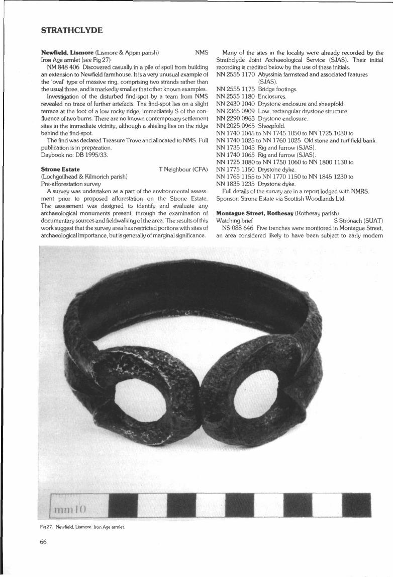
STRATHCLYDE
Newfleld, Llsmore (Lismore & Appin parish) NMSIron Age armlet (see Fig 27)
NM 848 406 Discovered casually in a pile of spoil from buildingan extension to Newfteld farmhouse. It is a very unusual example ofthe 'oval' type of massive ring, comprising two strands rather thanthe usual three, and is markedly smaller that other known examples.
Investigation of the disturbed find-spot by a team from NMSrevealed no trace of further artefacts. The find-spot lies on a slightterrace at the foot of a low rocky ridge, immediately S of the con-fluence of two burns. There are no known contemporary settlementsites in the immediate vicinity, although a shieling lies on the ridgebehind the find-spot.
The find was declared Treasure Trove and allocated to NMS. Fullpublication is in preparation.Daybook no: DB 1995/33.
Strone Estate T Neighbour (CFA)(Lochgoilhead & Kilmorich parish)Pre-afforestation survey
A survey was undertaken as a part of the environmental assess-ment prior to proposed afforestation on the Strone Estate.The assessment was designed to identify and evaluate anyarchaeological monuments present, through the examination ofdocumentary sources and fieldwalking of the area. The results of thiswork suggest that the survey area has restricted portions with sites ofarchaeological importance, but is generally of marginal significance.
Many of the sites in the locality were already recorded by theStrathclyde Joint Archaeological Service (SJAS). Their initialrecording is credited below by the use of these initials.NN 2555 1170 Abyssinia farmstead and associated features
(SJAS).NN 2555 1175 Bridge footings.NN 2555 1180 Enclosures.NN 2430 1040 Drystone enclosure and sheepfold.NN 2365 0909 Low, rectangular drystone structure.NN 2290 0965 Drystone enclosure.NN 2025 0965 Sheepfold.NN 1740 1045 to NN 1745 1050 to NN 1725 1030 toNN 1740 1025 to NN 1760 1025 Old stone and turf field bank.NN 1735 1045 Rig and furrow (SJAS).NN 1740 1065 Rig and furrow (SJAS).NN 1725 1080 to NN 1750 1060 to NN 1800 1130 toNN 1775 1150 Drystone dyke.NN 1765 1155 to NN 1770 1150 to NN 1845 1230 toNN 1835 1235 Drystone dyke.
Full details of the survey are in a report lodged with NMRS.Sponsor: Strone Estate via Scottish Woodlands Ltd.
Montague Street, Rothesay (Rothesay parish)Watching brief S Stro'nach (SUAT)
NS 088 646 Five trenches were monitored in Montague Street,an area considered likely to have been subject to early modern
Fig 27. Newfield. Lismore. Iron Age armlet
66
STRATHCLYDE
levelling and reclamation. The evidence confirmed this with homo-genous sand and gravel dumps containing Victorian finds lyingbeneath the modern roadway. In two places these were bottomedonto probable natural, the levels of which suggested that the areahad consisted of undulating shoreline prior to reclamation. Twoadditional trenches in Dean Hood Place and Tower Street were alsomonitored. The latter exposed the roof of the town's lade culvert,the former contained homogenous dumps, but also a possible line ofearlier frontage.Sponsor: HS Q.
15—19 Montague Street, Rothesay (Rothesay parish)Watching brief . SRC SMR
NS 0886 6466 The Strathclyde Joint Archaeology Servicecarried out a watching brief on behalf of Argyll & Bute DistrictCouncil during the excavation of planting trenches in a gap-site onthe southern side of Guildford Square (15-19 Montague Street).The site is of importance for the understanding of the developmentof the burgh. Two shallow" trenches parallel to the street frontage.and a number of separate pits approximately 0,6m square were dugto a depth of approximately 0.4m. The sandstone rubble founda-tions of the last building on the site were partially uncovered, anda brick-built internal wall foundation at right angles to the streetfrontage was identified, along with the remains of a sub-floorsurface. No cellarage was encountered. No artefactual remainsearlier than the 19th century were found.Sponsor: Strathclyde Joint Archaeology Service.
Montague Street, Rothesay (Rothesay parish)Watching brief
NS 0881 6468 The Strathclyde Joint Archaeology Servicecarried out a watching brief during roadworks in Montague Street.Rothesay, in front of numbers 26-32. Streetscape improvementsnecessitated the removal of a reinforced concrete slab from directlyunder the road surface, and excavation of the underlying deposits toa depth of approximately 0.55m below present ground surface.Several modern service trenches were observed to cut through whatappeared to be the upper surface of a naturally deposited sandygravel which outcropped over a large area at a depth of between0.45m and 0.5m. No pre-Victorian features were identified.Sponsor: Strathclyde Joint Archaeology Service.
Isle of Bute Deserted Settlement Survey A C Hannah,(North Bute; Kingarth parishes) E V W Proudfoot
Work has continued throughout the year, and the following newlydiscovered sites have been noted. Most sites are named by thenearest farm or hill.NS 046 585 Clachan Ard North: wall footings.NS 111 602 Scoulag Old Ferry House: house.NS 061 604 Barmore Butt: farmstead.NS 043 609 Daisy Cottage South: wall footings.NS 075 618 Woodend Butt: farmstead.NS 055 622 Old Quogach: farmstead.NS 056 626 Stewarthall Cottage: house.NS 039 627 Nether Ardroscadale North: structure.NS 049 650 North Largievrechtan: farmstead.NS 038 665 Ertrick Smithy: platform.NS 040 666 Ertrick Inn: bridge and roadway.NS 053 674 Edinmore Cottage: cottar house.NS 016 675 Leightan South: hut circle.NS 052 681 Slate Quarry Upper: hut circle group.NS 037 682 Upper Ettrick Butt: cottar house.NS 015 681 Lenihall Upper: cottar house.NS 053 683 Edinbeg Hill West: hut circle group.NS 056 683 Edinbeg Hill South: shieling?NS 043 683 Muirton Hill: hut circle.
NS 012 684 Altabruaich: house wall footings.NS 009 690 Glecnabae Hill: house wall footings.NS 010 698 Grey Craig: house wall footings.NR 998 698 North Lenihuline: farmstead.NS 056 702 Old Stuck: two houses.NR 999 708 Altmor South: hut circle.NS 027 715 Balnakeilly Burn upper: shieling.NS 025 718 Balnakeilly Bum lower: two shielings.NR 994 720 Barlia Hill East: circle.NR 995 722 Cat Craig: hut circle.NR 995 725 Corval 2: mound, enclosure.NR 995 726 Corval 1: hut circle.NS 010 726 Muclich: six oval buildings.NS 008 726 Muclich West: hut circle.
Harbour Quays and Ferry Ports I Maclagan(North Bute, Rothesay & Kingarth parish)Sea communications
A survey has been made (over several years) of the quays.piers and ferry ports which now or formerly served the Island ofBute.
NS 089 648 Rothesay Harbour dates from 1752. It is an extens-ive two basin undertaking built for local and overseas trade and toaccommodate the Loch Fyne herring busses.
NS 093 655 Remains of Craigmore steamer pier built 1877.NS 075 674 Remains of Port Bannatyne steamer pier built
1857.NS 105 547 Remains of Kilchattan Bay steamer pier built
1880.NS 073 673 Port Bannatyne stone quay built 1796/97 for local
trade.NS 103 550 Kilchattan Bay stone quay built 1822 for local
trade.NS 112 602 Scoulag Port. Remains of stone jetty which served
as terminus for ferry to Largs which has been traced back to 1680.NS 108613 Kerrycroy stone quay built 1804/05 by Marquess of
Bute as new terminus for Largs ferry on enlargement of policies ofMount Stuart.
NS 108 633 Ascog, Remains of stone quay built 1832 for localtrade.
NR 992 702 Ktlmichael ferry fort. Remains of stone breast forferry to Blair's Ferry, Argyll built 1769 and remains of ferryman'shouse and inn.
NS 015 668 Port Glas. Terminus of ferry to Blind Man's Bay,Argyll.
NS 026 745 Rhubodach. Site of terminus of ferry to Colintraive,Argyll which has been traced back to 1685.
NS 083 531 Port Dornach, Dunagoil. Terminus of ferry to Arranestablished 1684.
NS 035 615 Stein's Port, St Ninian's Bay. Remains of stonebreast for fishing boats.
NS 039 618 Port Mclver, St Ninian's Bay. Site of stone breast forfishing boats.Sponsor: Buteshire Natural History Society.
Thorn's Cuts (North Bute. Rothesay & Kingarth parish)Water conduits and reservoirs
A survey has been made of the 15.7km of water cuts and the fivedams constructed by Robert Thorn between 1813 and 1819 toincrease the water power for Rothesay's cotton mills. The previouslyknown cuts and dams have been fully recorded together withhitherto unknown sections of cut and sections which were thought tohave been destroyed. Twenty-two bridges and the sites of anothereighteen have been recorded as have the locations of fourteensluices. (See Fig 28, p 68.)Sponsor: Buteshire Natural History Society.
67
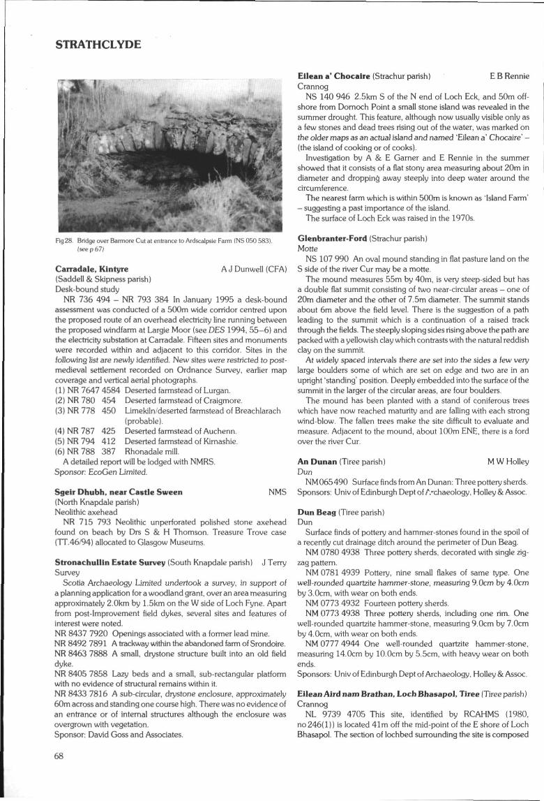
STRATHCLYDE
Fig28. Bridge over Barmore Cut at entrance to Ardscalpsie Farm (NS 050 583)(seep 67)
Carradale, Kintyre A J Dunwell (CFA)(Saddell & Skipncss parish)Desk-bound study
NR 736 494 - NR 793 384 In January 1995 a desk-boundassessment was conducted of a 500m wide corridor centred uponthe proposed route of an overhead electricity line running betweenthe proposed windfarm at Largie Moor (see DES 1994. 55-6) andthe electricity substation at Carradale. Fifteen sites and monumentswere recorded within and adjacent to this corridor. Sites in thefollowing list are newly identified. New sites were restricted to post-medieval settlement recorded on Ordnance Survey, earlier mapcoverage and vertical aerial photographs.(1) NR 7647 4584 Deserted farmstead of Lurgan.(2) NR 780 454 Deserted farmstead of Craigmore.(3) NR 778 450 Limekiln/deserted farmstead of Breachlarach
(probable).(4) NR 787 425 Deserted farmstead of Auchenn.(5) NR 794 412 Deserted farmstead of Kimashie.(6) NR 788 387 Rhonadale mill.
A detailed report will be lodged with NMRS.Sponsor: EcoGen Limited.
Sgeir Dhubh, near Castle Sween NMS(North Knapdale parish)Neolithic axehead
NR 715 793 Neolithic unperforated polished stone axeheadfound on beach by Drs S & H Thomson. Treasure Trove case(TT.46'94) allocated to Glasgow Museums.
Stronachullin Estate Survey (South Knapdale parish) J TerrySurvey
Scotia Archaeology Limited undertook a survey, in support ofa planning application for a woodland grant, over an area measuringapproximately 2.0km by 1.5km on the W side of Loch Fyne. Apartfrom post-Improvement field dykes, several sites and features ofinterest were noted.NR 8437 7920 Openings associated with a former lead mine.NR8492 7891 A trackway within the abandoned farm of Srondoire.NR 8463 7888 A small, drystone structure built into an old fielddyke.NR 8405 7858 Lazy beds and a small, sub-rectangular platformwith no evidence of structural remains within it.NR 8433 7816 A sub-circular, drystone enclosure, approximately60m across and standing one course high. There was no evidence ofan entrance or of internal structures although the enclosure wasovergrown with vegetation.Sponsor: David Goss and Associates.
Eilean a* Chocalre (Strachur parish) E B RennieCrannog
NS 140 946 2.5km S of the N end of Loch Eck, and 50m off-shore from Domoch Point a small stone island was revealed in thesummer drought This feature, although now usually visible only asa few stones and dead trees rising out of the water, was marked onthe older maps as an actual island and named 'Eilean a' Chocaire' -(the island of cooking or of cooks).
Investigation by A & E Gamer and E Rennie in the summershowed that it consists of a flat stony area measuring about 20m indiameter and dropping away steeply into deep water around thecircumference.
The nearest farm which is within 500m is known as 'Island Farm'- suggesting a past importance of the island.
The surface of Loch Eck was raised in the 1970s.
Glenbranter-Ford (Strachur parish)Motte
NS 107 990 An oval mound standing in flat pasture land on theS side of the river Cur may be a motte.
The mound measures 55m by 40m, is very steep-sided but hasa double flat summit consisting of two near-circular areas - one of20m diameter and the other of 7.5m diameter. The summit standsabout 6m above the field level. There is the suggestion of a pathleading to the summit which is a continuation of a raised trackthrough the fields. The steeply sloping sides rising above the path arepacked with a yellowish clay which contrasts with the natural reddishclay on the summit.
At widely spaced intervals there are set into the sides a few verylarge boulders some of which are set on edge and two are in anupright 'standing1 position. Deeply embedded into the surface of thesummit in the larger of the circular areas, are four boulders.
The mound has been planted with a stand of coniferous treeswhich have now reached maturity and are falling with each strongwind-blow. The fallen trees make the site difficult to evaluate andmeasure. Adjacent to the mound, about 100m ENE, there is a fordover the river Cur.
An Dunan (Tiree parish) M W HolleyDun
NM 065490 Surface finds from An Dunan: Three pottery sherds.Sponsors: Univ of Edinburgh Dept of A-chaeology, Holley & Assoc
Dun Beag (Tiree parish)Dun
Surface finds of pottery and hammer-stones found in the spoil ofa recently cut drainage ditch around the perimeter of Dun Beag.
NM 0780 4938 Three pottery sherds, decorated with single zig-zag pattern.
NM0781 4939 Pottery, nine small flakes of same type. Onewell-rounded quartzite hammer-stone, measuring 9.0cm by 4.0cmby 3.0cm, with wear on both ends.
NM 0773 4932 Fourteen pottery sherds.NM 0773 4938 Three pottery sherds, including one rim. One
well-rounded quartzite hammer-stone, measuring 9.0cm by 7.0cmby 4.0cm, with wear on both ends.
NM 0777 4944 One well-rounded quartzite hammer-stone,measuring 14.0cm by 10.0cm by 5.5cm, with heavy wear on bothends.Sponsors: Univ of Edinburgh Dept of Archaeology, Holley & Assoc.
Eilean Aird nam Bra than, Loch Bhasapol, Tiree (Tiree parish)Crannog
NL 9739 4705 This site, identified by RCAHMS (1980,no 246(1)) is located 41m off the mid-point of the E shore of LochBhasapol. The section of lochbed surrounding the site is composed
STRATHCLYDE
of firm sand with a slight growth of vegetation. No trace of a cause-way was found. The crannog is surrounded by water 1.0m to 1.3min depth with the shallower water located between the site andshore. Immediately to the SW of the site the water deepens toover 2.5m.
This artificial island is an oval-shaped mound of small andmedium sized stones which measures 29.2m by 41.5m at its base.The mound is capped by a fairly level, oval platform which measures14.0m by 23.0m with the long axis running perpendicular to theshore. The surface of the islet is heavily overgrown with reeds, andpeat is just beginning to encroach. Large boulders were found toencircle the base of the site but were not placed in any coherentfashion suggestive of walling.
Five separate sections of walling were found on the islet just belowthe water-line.
Several artefacts were found on the upper platform during thesurvey. Three sherds of pottery were found lying on the surface ofthe site near the E edge of the f i f th section of walling. The largestsherd measures 1.5cm by 2.5cm and appears to be part of a rim.Two hammer-stones were found on the outside edge of the thirdsection of walling.Sponsors: Univ of Edinburgh Dept of Archaeology, Holley & Assoc.
Ellean Mhic Conuill. Loch Bhasapol, Tiree (Tiree parish)Crannog
NL 9695 4677 This site, identified by RCAHMS (1980.no 246(2}) is located 82.0rn S of the large peninsula in the W end ofLoch Bhasapol. The section of lochbed surrounding the site iscomposed of firm sand with a slight growth of vegetation, no trace ofa causeway. At the time of survey the top of the site was covered by0.3m of water and showed no signs of vegetational growth. The siteis surrounded by water 1.2m to 1.5m in depth but deepens to 2.3mbetween the site and shore.
The artificial island is a circular mound of small, well-roundedstone which measures 31.6m by 34.5m at its base. The mound iscapped by a fairly level, circular platform which measures 24.0m indiameter and stands 1,0m above the surrounding lochbed. Thesides of the mound taper out gradually at an angle of 6 degrees overand average of 5.0m. No walling, shaped stone or timbers werefound.Sponsors: Univ of Edinburgh Dept of Archaeology, Holley & Assoc.
Loch na Bualle, Tiree (Tiree parish)Crannog
NM 0338 4490 This site, identified by RCAHMS (1980. no 248)is located off the E shore of Loch na Buaile 65m from the presentN end. The island is artificial and accessed by a causeway 10m inlength of large well-rounded boulders. The causeway is 3.4m wideat its base and provides a 1.5m wide level walkway which is 0.5mabove the surrounding loch bed.
The artificial island is a circular, turf-covered mound whichmeasures 15 1m by 15.9m at its base and is crowned by the remainsof an oval 6.2m by 8.6m structure. This structure appears to bea single ring of medium-sized boulders which have now been turfedover. Underwater investigation revealed that the islet was comprisedof small well-rounded stones.Sponsors: Univ of Edinburgh Dept of Archaeology, Holley & Assoc.
Loch na Gile Crannog, Tiree (Tiree parish)Crannog
NM 0260 4819 This site, identified by RCAHMS (1980. no 250)as a 'possible crannog' is located near the centre of the N end ofLoch na Gile, 24m from the W shore. It is surrounded by water lessthan 0.5m in depth and is easily accessed from shore. No trace wasfound of a causeway noted by Beveridge even though the loch bedwas probed.
The site is an oval-shaped bedrock islet, which measures 18m by25m at its base, that has been slightly enlarged by small stones. Theislet is crowned by a level grassy platform which resembles a lightbulb in shape and is 0.5m above water level and l.lm above thesurrounding lochbed. Only one comer of the sub-rectangularbuilding previously identified by the RCAHMS is clearly visible, theremainder of the structure has been broken up and is indistinct.A 5.5m long section of walling was identified on the NE edge of theplatform. This walling consisted of a single course of well-rounded,medium sized boulders. Underwater investigation revealed that theislet was natural and only slightly enlarged with small stones.Sponsors: Univ of Edinburgh Dept of Archaeology, Holley & Assoc.
BEARSDEN & MILNGAVIE DISTRICT
I BanksBearsden Roman Fort (New Kilpatrick parish)Roman Fort
NS 545 720 In May 1995, GUARD undertook a resistivity surveyacross the line of the southern extent of the ditch of the Roman Fortat Bearsden. The intention was to determine whether the ditch hada causeway on the southern side.
Conditions were poor for survey, the soil being loose and givingvery low resistance readings. However, two areas of anomalousreadings were encountered, one being interpreted as the excavationtrench from the 1980s and the other a possibility for a causeway.However, in view of the conditions, any interpretation remainstentative.Sponsor: HS EJ.
CLYDEBANK DISTRICT
D AbernethyCleddans Farm (Old Kilpatrick parish)Possible course of Antonine Wall
NS 512 723 During March 1995, GUARD were commissionedto excavate a trench at the above location before the construction offarm buildings adjacent to the scheduled course of the AntonineWall. The trench measured 45m by 1.5m and up to 1m in depthand was positioned at 90 degrees to the adjacent scheduled area.Throughout the entire exercise no archaeological deposits or finds ofany significance were encountered.Sponsor: Farm Engineering Ltd.
CUMBERNAULD & KILSYTH DISTRICT
SRC SMRCumbernauld & Kilsyth District(Kilsyth parish)
Craigdouffie Burn 1NS 7443 8080 Possible shieling.
Cralgdoufflc Burn 2NS 7565 8070 Industrial extraction, possibly coal.
Craigdouffie Burn 3NS 7484 8075 Possible enclosure.
CraigdouffieNS 75018082 Deserted farmstead.
Girnal HillNS 7457 7818 Unworked burnt flint, burnt bone, and a flint flake
found in molehill,
3-11 Main Street, Cumbernauld S Stronach (SUAT)(Cumbemauld parish)Urban Early Modern
NS 768 761 An excavation on a gap site identified very shallowstratigraphy, especially on the frontage where natural subsoil was
69
STRATHCLYDE
c 0.20m below ground level. The foundations of two adjoiningbuildings of probable 18th century date were uncovered, howeverthese had been substantially altered. Extensive truncation of archae-ology was evident across the site, however small areas of post-medieval deposits were identified. Much of the site consisted ofmodem garden soil deposits, outhouses and service trenches.A small assemblage of green-glazed pottery was recovered, much ofit residual, as were two medieval sherds.Sponsors: HS @, Cumbernauld Development Corporation.
Garnhall (Cumbernauld parish) D J WoolliscroftRoman tower
NS 780 779 A small trench opened to the S of the site confirmedits identity as a Roman tower (D£S 1994, 61) sitting just to the Softhe Antonine Wall inside its own ring ditch and linked by a track tothe Military Way to its S.Sponsors: University of Manchester and Soc Ants Scot.
CUMNOCK & DOON VALLEY DISTRICT
Broom Hill, near Patna (Dalrymple parish) M Cressey,Evaluation W L Finlayson (CFA)
An archaeological desk-based assessment and field inspectionwere undertaken in October - November 1994 within a proposed1.5km2 opencast coal extraction site. This exercise was designed toassess the proposed development area in terms of its archaeologicalpotential, particularly its industrial heritage. The survey identifiedseveral industrial sites, comprising six mineral extraction sites, fourbings or spoil heaps, a tileworks, a group of industrial structures ofuncertain function, and a railway line. Other recorded sites werea deserted farmstead and cottage. All sites appear to be of post-medieval origin.
The following sites and monuments were recorded during theevaluation.
1 NS435 147 Kerse Tileworks.2 NS425 138 Fire clay extraction site.3 NS436 147 Clay pit.4 NS 434 145 Clay pit.5 NS427 138 Stone quarry.6 NS429 138 Stone quarry.7 NS420 133 Gravel pit.8 NS 4283 1390 High Knockshinnoch farmstead & field system.9 NS431 143? Holehouse Branch Line of Glasgow and South
Western Railway: a single span bridge carriesthe line over the track to Knockshinnoch.
I O N S 429 143 Industrial buildings.11 NS 422 136 Levelled area of mining spoil.12 NS427 139 Linear bing of slate and shale waste.13 NS 430 142 Linear spoil tip accessed from railway line.14 NS432 143 Linear bing.15 NS 4308 1433 Knockshinnoch Cottage, partly demolished.
A report will be deposited with the NMRS.Sponsor: Coal Contractors Ltd via Natural Resource Consultancy.
W L Finlayson,D Alexander (CFA)
Skares Road, near Cumnock(Ochiltree & Old Cumnock parishes)Evaluation
A desk-based assessment and field inspection were undertakenby CFA within the accessible areas of a proposed opencast coalextraction site. The evaluation site comprised c 800 ha of uplandpasture and forestry land between the 200m and 270m contours.The assessment was designed to identify and evaluate knownmonuments, and sites present on the Ordnance Survey first editioncoverage, details of which were supplied by the Regional Archae-ologist for Strathclyde Region, and to locate and evaluate any other
visible archaeological monuments through a programme of field in-spection and analysis of aerial photographs. A palaeoenviron mentalassessment was also made of two areas of peat formations identifiedwithin the evaluation site. The identified sites and monuments datemostly to the post-medieval period, including principally farmbuildings, sheepfolds and other enclosures, as well as disused coalmine workings and small stone quarries. Several traces of possibleenclosures, both circular and rectilinear, may relate to either this orearlier activity.
The following sites and monuments were recorded during theevaluation:
1 NS 4944 1666 Auchencloigh Castle (outside site boundary).2 NS 4900 1622-NS 4941 1661 Two alleged Roman roads
NS4941 1661-NS 5078 1500 meet at Auchencloigh Castle.3 NS 4964 1664 Sheepfold {outside site boundary).4 NS4991 1679 Ruined structure recorded on first edition OS.5 NS 4982 1701 Auchlin Farm, farmstead.6 NS 5060 1686 Closs Farm, deserted farmstead.7 NS 5060 1645 Enclosures recorded on first edition OS.8 NS 5090 1562 Sheepfold; four rectangular drystone enclosures.9 NS 5107 1623 Modern sheepfold: rig-and-furrow cultivation.
10 NS 5126 1700 Darntaggart Farm, derelict farmstead andcottages.
11 NS 5152 1621 Sheepfoid and hay rees recorded on firstedition OS.
12 NS 5151 1581 Sheepfold and ruined dyke.13 NS 5188 1649 Hay ree and previous find-spot of flint scraper.14 NS5221 1675 Muir Farm, farmstead.15 NS 5296 1678 Hindsward Farm, occupied farmstead.16 NS 5310 1727 Smithy and old quarry recorded on first edition
OS.17 NS534 165 Skares Quarry (disused).18 NS 5337 1603 Knockdunder Farm, row of cottages.19 NS 5346 1597 Area of old coal mining activity.20 NS 5325 1591 Sheepfold.21 NS 5360 1682 Ward Farm, farm buildings.22 NS 536 174 Old quarries on first edition OS: now destroyed.23 NS 536 164; Disused mine workings;
NS 537 164 brick and concrete buildings.24 NS 5425 1740 Enclosure.25 NS 5431 1757 Garlaff Farm; outside site boundary.26 NS 547 176 Disused mine workings and brick building.27 NS 5468 1694 Disused quarry, recorded on first edition OS.28 NS548 171 Milzeoch Farm, derelict.29 NS 5490 1700 Mill lade and darn.30 NS 5023 1694 Single span stone bridge over the Closs Burn.31 NS 5068 1643 Quarry scoop into rock outcrop.32 NS5091 1713 Rectilinear structure foundations (possible).33 NS 5183 1665 Sheepfold.34 NS525 169-NS 527 169 Mine workings, structures, coal
bing and railway.35 NS 5388 1701 Two quarry scoops
Aerial Photographic Sites: The following sixteen sites were identi-fied on vertical aerial photographic coverage held by RCAHMS. butwere not located on the ground. Resistivity survey was carried out tolocate AP6, but without success, possibly due to the partly frozenand partly waterlogged ground conditions at the time of survey.API NS 545 176 Three annular traces.AP2 NS 5363 1752 Circular trace c 5m diameter.AP3 NS5349 1738 Possibly upstanding ditched feature -5-8m
diameter.AP4 NS 5362 1722 Sub-circular trace, c!4m diameter.AP5 NS 5475 1696 Sub-rectangular trace c8-10m long.AP6 NS 5062 1688 Rectilinear trace c8-10m long.AP7 NS 5014 1695 Rectilinear trace c 15m by 10m.APS NS 5063 1698 Squarish trace c5m across.
70
STRATHCLYDE
AP 9 NS 514 163 Three circular vegetation marks.AP10 NS 5173 1621 Possible circular enclosure and tracks.AP11 NS519 159-NS 519 160 Three possible circular traces.API2 NS 5203 1710 Three piles of rubble.AP13 NS 5270 1740 Sub-circular trace clO-15m diameter.AP14 NS 5263 1737 Faint circular trace, c20-25m diameter.AP15 NS 5305 1700 Faint circular trace, c!5-20m diameter.AP16 NS 5160 1690 Five circular traces cl5m-c30m diameter.
A report will be deposited in the NMRS. The advice and assistanceof the Regional Archaeologist for Strathclyde Region is gratefullyacknowledged.Sponsor: Natural Resource Consultancy, Ayr.
Lugar Street, Cumnock (Old Cumnock parish) SRC SMRWatching brief
NS 5672 2023 The Strathclyde Joint Archaeology Servicemaintained a salvage watching brief during the earthmoving opera-tions associated with the construction of the Lugar Street to BarrhillRoad relief road. The Lugar Street frontage was occupied by a muchmodified late 18th century cottage, and observations were made ofits foundation construction and sub-floor features. No earlier struc-tures were positively identified. The degree of disturbance fromthe earthmoving operations made observation difficult. No premodern features were identified elsewhere on the new road line.Sponsor: Strathclyde Joint Archaeology Service.
Drongan Pottery (Ochiltree parish) R D Golightly, S J Golightly,J Mair, A Johnstone, S Wood, T Mathews
18th-19th century potteryNS 4460 1992 Due to building on the site of the former Drongan
Pottery, fieldwork was undertaken by permission of the presentowner, Mr Wilson Kennedy.
The pottery was active in the late 18th-19th century and sub-sequent rebuilding on the site has caused much disturbance. Field-walking in July 1994 yielded a large collection of clayware andpottery sherds and excavation in 1994-1995 added to the size, butnot the range, of the collection.
The stratigraphy was badly damaged but one phase could berelated to the use of the pottery. The 1854 OS map indicatesa quadrangular setting of buildings with a kiln in the yard, a cottage,clay pit and enclosure. Excavations revealed part of the buildingrange behind the kiln, drainage details, yard and part of the kiln.
The pottery produced field drains of varying types and domesticwares - milk pans with jet glazing and other items of brown earthenrware. A selection of types was recovered in the excavation.
Fuller report with NMRS.
CUNNINGHAME DISTRICT
Cunninghame District SRC SMR(Dairy parish)
SpringsideNS 3264 4874 Deserted farmstead.(Kilmory parish)
Ballieklne, ArranNR 8722 3948-NR 8746 3920-NR 8752 3938-NR 8759 3925
Droveway.NR 8740 3920 Rig and furrow.NR 8750 3951 Cairn (possible).NR 874 389 Structure and field dyke.NR 8751 3953 Hut circle (possible) or enclosure.NR 8745 3860 Enclosures, structures, corn-drying kiln (possible).NR 8700 3962, NR 8727 3967 Deserted settlement (10 structures
and several small enclosures.NR 8709 4001 Stone structures/dykes.
Aucheleffan, ArranNR 982 249 Four poster (reported by Kerr Robertson of Forest
Enterprise via Tim Yarnell).Sliabh Fada, Arran
NR 919 268 Birch stakes recovered during improvement of millpond (also reported by Kerr Robertson).Glenree, Arran
NR 941 252 Semi-circular enclosure.NR 9398 2518 Circular enclosure, possible hut circle.NR 9420 2558 Two hollows with slight external banks.
Torr Bhruaich, ArranNR 9405 2576-NR 9425 2572 Alignment of boulders with some
groups of stones.NR 9417 2579 Possible cairn.NR 9417 2585 Possible caim/clearance.NR 9416 2587 Possible cairn.NR 9406 2590 Upstanding boulders.NR 9430 2610 Two circular enclosures, two shieling-type struc-
tures, earth and stone banksNR 9429 2600 Possible circular enclosure, possible shieling-type
structure, banks.NR 9407 2607-NR 94112616 Alignment of boulders, possible
robbed prehistoric boundary.Alltan Donn, Arran
NR 937 263 Two mounds, possible shielings.NR 9360 2632 Earth and stone bank.NR 9352 2605 Possible standing stone.NR 9366 2594 Mound with stone shieling-type structure on top.
Allt an t-Sluice, ArranNR 9292 2635 Ruined farmstead with associated kiln and en-
closures.NR 9303 2590 Concentration of stones.
Lean a' Chneamh, ArranNR 9435 2500-NR 9263 2740 Trackway.
Sliabh Fada, ArranNR929 263 Rig and furrow.
Allt na Palrce, ArranNR933 256 Rig and furrow.
Alltan Donn, ArranNR938 257 Rig and furrow.
Glenree, ArranNR942 252 Rig and furrow.(Largsparishl
Cott House, SkelmorlieNS 2026 6783 Structure, possible house.
A78 Ardrossan Bypass: Archaeological Evaluation(Ardrossan and Stevenston parishes) J E Hamilton (CFA)Linear survey
NS 223 438 and NS 281 426 An archaeological evaluation,comprising a desk-based assessment and field inspection, wasconducted in October -'November 1994 along the proposed roadcorridor of the A78 Ardrossan Bypass. The road corridor was up to1km wide, and ran for approximately 6km to the N of Ardrossan,Saltcoats and Stevenston. NMRS records, a Desk Assessmentproduced by HS, Ordnance Survey and earlier map coverage,vertical aerial photographs held by NMRS and bibliographic refer-ences were the principal sources examined. All land parcels wereinspected, with a number of sites subsequently surveyed to ensurethat their positions could be plotted to 5m accuracy. Several newsites and potential sites of cultural heritage interest were identified.Several field boundaries around Kerelaw may relate to a designedlandscape associated with the now destroyed Kerelaw Castle. Thesites located on vertical aerial photographs may indicate a richarchaeological landscape, but need verification by intrusive field-work to confirm their archaeological significance. The following
71
STRATHCLYDE
archaeological sites and monuments were recorded, from W to E:Montfode
NS224 439 Battle-axe find-spot {known site).NS 2240 4391 Linear, rectangular and circular cropmarks.
Mill FarmNS 2350 4450 Raised, triangular platform.
Stanley BurnNS 2374 4403 Two penannular cropmarks and linear feature.
WhltleesNS 2396 4391 Two annular cropmark enclosures.
DykesmainsNS 2450 4370 Possible cropmark enclosures and field boundaries.
SorbieNS 2456 4404 A single annular cropmark.NS 2460 4396 Cropmark of two parallel linear features.
SharphlllNS 2509 4330 Quarry scoop.NS 2511 4340 Quarry scoop.NS 2515 4376 Cropmarks.NS 2536 4374 Faint rectangular cropmark.
MiddlepartNS 256 431 Sub-rectilinear, annular and linear cropmarks.
MlddletonNS 257 433 Hammer-head find-spot (known site).
MiddlepartNS 2586 4307 Possible pit alignment cropmark.
Quarrel BurnNS 2594 4292 Faint rectilinear cropmark.
GreenheadNS 2638 4308 Two penannular enclosures and linear feature,NS 2648 4315 Penannular and linear cropmarks.
KerelawNS 2664 4294 Rig-and-furrow cultivation.NS 2674 4311 Disused quarry and relict field boundaries.NS 2675 4309 Rig-and-furrow cultivation.
Fellie HillNS 268 432 Field banks; rig-and-furrow cultivation.NS 2685 4323 Disused quarry.
KerelawNS 2696 4306 Disused quarry.NS 2706 4309 Limekiln.NS270 430-NS 273 432 Relict field boundaries.
HullerhtratNS 2740 4320 Three faint penannular cropmarks.NS 2763 4303 Limeworks; two limekilns.
A report will be deposited with the NMRS.Sponsor: Roads Directorate of The Scottish Office Industry Depart-
ment, managed on its behalf by HS ^J.
King's Cave, Arran (Kilmory parish) R HarryNatural sea caves
NR 884 309 A watching brief over the installation of a grille atthe mouth of the King's Cave was undertaken in March 1995. Theminimum of damage to the cave and soil deposits at the cave floorwas successfully achieved. The construction of the grille requiredseven holes to be dug at the entrance to the cave, each hole beingup to 0.6m in diameter and 0.75m to 1m deep. A shell deposit wasinvestigated and may have been a small midden. Nothing of archae-ological significance was otherwise recovered, apart from modemdebris and pieces of bone in good condition.Sponsor: HS Q.
Machrie, Arran (Kilmory parish) F Gorman, B Murray,Mesolithic site E Lambie
NR 898 329 This prolific site (DES 1993, 79) has now beenconfirmed as Mesolithic. It continues to produce a considerable
quantity of lithic material. The number of microliths now exceeds500; many are very well made having fine retouch.
Klldonan, Arran (Kilmory parish)Mesolithic site
NR 031 208 This is another area showing concentrated evidenceof Mesolithic activity. It was walked in 1994 and again this year andhas produced to date over 550 cores, 333 tested pebbles of flint, alsoscrapers, points, burins, blades, snapped blades, shell fragments,fire-crazed flint, debitage, large quartzite tools and many microliths,over half with steep retouch.
The lithics are predominantly flint, with a very small percentage ofpitchstone and quartz. Like the Machrie site, pebbles of smoothgood quality haematite were found but not in the rest of the field.There was also a concentration of fairly large pebbles (unstruck) ofwhite quartz.
There is some erosion of the site down a steep slope on thewestern edge. We have been told that in the next field (NS 032 210)whenever the ground around a central mound was ploughed in thepast, a mass of shells was repeatedly turned up.
Sllddery, Arran (Kilmory parish) F Gorman, B MurrayCists, stone settings, ?hut circle, pitchstone working sites
(1) NR 927 242 On the lower slopes of Cnoc Reamhar a sub-stantial chamber protrudes from a mound to the N. The axis is N/S.The internal measurements are 2.20m long by 1.05m wide. It isfilled to an unknown depth with grass-covered boulders. Two sub-stantial side stones and, to the S, a recumbent stone lying at an anglehave been noted; to the N an infill or walling of round boulders con-tinues into the mound. A large flat stone lies 45m to the NNW. Thisappears to have come from the chamber(?capstone or lintel). Thesite is c 120m above sea level and overlooks gently-sloping land.
(2) ?NR 929 243 On a high rocky spur of land 122m above sealevel there are the remains of a cist. The axis is N/S. The cist is insetinto a slightly raised and much eroded platform. The approximateinternal measurements are 1.46m long by 80cm wide. Lining thebase are three flagstones which are slightly stepped. Probingrevealed the presence of other buried stones.
(3) NR 929 244 At much the same height as the last setting thereare the remains of a substantial chamber with large stones visible. Tothe S a large stone lies at right angles to the axis of the chamber, andis flanked by a large stone on either side. These three stones appearto be on an arc. The whole site is covered by deep heather. A fewmetres to the N there is another setting of parallel stones.
(4) NR 929 243 17m SW from site no2 is another stone setting.Two parallel side stones protrude by a few centimetres through themiddle of a slightly raised area; one is 1.08m lortg and the other is1m long. Another smaller parallel stone can be seen 51cm to the E.
(5) NR 923 248 On a flat area set on a rough heather-coveredhillside there is a circle with an inner diameter of 10m. There is a lowbank to the NW but none to the S and E. There are 14 undressedirregular rocks and boulders round this circle; four are out of align-ment and three are recumbent. Probing revealed more buriedstones. The tallest stone is 81cm above ground level and thebroadest stone is 98cm. Thick heather and bracken grow round thecircumference but the inside area is flat and grass covered. To theS there is a heather-covered mound abutting the circle. In this areathe surviving stones of several more denuded cists/chambers ranbe seen.
(6) NR 935 242 AH of these stone settings are in close proximityto this habitation/working site (DES 1993, 79-80) which has nowbeen identified as predominantly Late Neolithic/Early Bronze Age.Magnetic susceptibility and phosphate surveys were carried out in1994. The association of the main magnetic anomaly with enhancedphospate values underneath the main concentration of lithics almostcertainly indicates a house-like structure.
72
STRATHCLYDE
(7} NR 937 236 Two fields away there is a smaller pitchstoneworking area producing similar lithic material.
Crochandoon, near Tormore, Arran (Kilmory parish] R HarryField evaluation
NR 897 315 In January 1995, GUARD undertook trial excava-tion on the proposed site of the Arran Discovery Centre, nearTormore. Two areas were assessed: one on the proposed site of theDiscovery Centre building (site A); the other on the proposed site ofthe extension to the existing car-park facility (site B). The evaluationwas achieved by means of a combination of fieldwalking alongexisting forestry plough furrows and trial pitting. Work at site Arevealed little of archaeological importance, no features beingobserved and only a few items of worked flint being recovered. Atsite B however, a series of archaeological deposits and ephemeralfeatures were located, together with flint debitage. two scrapers andblades and worked pitchstone waste. Further excavation has beenrecommended at site B, prior to any development taking place.Sponsors: Argyll and the Islands Enterprise and Cunninghame
District Council.
KUwinning Abbeygate IKilwinning parish) K SpellerAbbey remains
NS 3030 4330 A watching brief during piling operations forhousing and shop development was conducted by GUARD on a sitec 50m to the NW of Kilwinning Abbey ruins, a scheduled monumentdating from the 12th century. The development area compriseda rectangular plot fronting onto both the Main Street and Abbey-gate. Previous excavations had taken place on the site during 1994by Scotia Archaeology Ltd and immediately to the W in 1987 byHugh McBrien
The aim of the brief was to define and record any features,deposits or structures which might relate to the Abbey and/or theMain Street/Abbeygate frontages. No evidence, either structural orartefactual was revealed, for any Medieval activity on the site.Sponsor: Irvine Development Corporation.
Brisbane Glen (Largs parish) V E BickersTurf shieling
NS 219 627 Oval turf-banked structure, situated on unimprovedgrassland on the E side of Brisbane Glen, close to a small burn.There is a gap at the NW corner that contains some non-earth faststones. A further larger gap is evident in the SE corner but this couldbe where the structure has eroded away. The area enclosed by thebanking is 5m by 6m. The interior is smooth and grass covered.There are no obvious internal features. The NE section of bankingstands to a height of approximately 1m. The remainder is 0.5m orless. 25m to the SE is a hollow-way which leads up to the moor.Running from E to W is a line of ruined stone dyke, now partially turfcovered. From its location and construction this would appear to bea shieling.
Work on this side of the glen has been carried out by kind permis-sion of Mr P Robertson, the landowner, and Mr E Mclntyre, tenantfarmer of Middleton Farm.
Flatt Farm (Largs parish)Shieling
NS 217 596 Single cell stone shieling situated on a naturalterrace. 48m from a ruined stone dyke Structure reduced tofootings only. Work carried out by kind permission of Mr J Menzies,Holehouse Farm and Mr W Menzies, Flatt Farm.
Cralgton/West Grassyards/East Grassyards FarmsSite survey, photographic survey and archive search has been
carried out on the following sites as part of the ongoing project torecord the 'lost' farms of North Ayrshire.
Pre- and post-improvement farmsCralgton Farm, Brisbane Glen (Largs parish)
NS 218 626 By kind permission of Mr P Robertson, landownerand Mr E Mclntyre, tenant farmer of Middleton Farm.West Grassyards Farm, Brisbane Glen (Largs parish)
NS 2203 6416 The reputed site of the above farm was intens-ively walked. The only definite evidence of a structure was a piece ofdressed stone which was found in a bum at NS 220 644. This pieceof stone was donated to the finder by the landowner and will belodged at the museum in Largs. There is extensive rig and furrow inthe area, at the edges of which are what appear to be heaps of fieldgathered stones.East Grassyards Farm, Brisbane Glen {Largs parish)
NS 223 647 Two phases of occupation were noted on this site.The 19th century farmhouse and outbuildings are in a good state ofpreservation. To the NW of these lie the remains of what wouldappear to be the pre-improvement farmstead.
Work at E and W Grassyards carried out by kind permission ofMr H Scott, Constablewood Estate.
14 Gallowgate, Largs (Largs parish) SRC SMRWatching brief
NS 2021 5944 The Strathclyde Joint Archaeology Servicecarried out a watching brief during building works associated with anextension to 14 Gallowgate. Largs. The development site is in thecentre of the late medieval burgh, and is approximately 10m fromthe edge of a mound which is reputedly the burial place of Norse-men killed in the Battle of Largs in 1263.
A gravelly sand with many cobble-sized stones was encounteredwithin 0.6m of the present ground surface, but no pre-modernfeatures were identified in the small area excavated (c 12 sq m).Sponsor: Strathclyde Joint Archaeology Service.
Kelly Bridge, Wemyss Bay A Lee (LOCHIS)(Largs {Cunninghame): Inverkip (Inverclyde) parishes)Remains of old quay?
NS 194 684 Estuary of Kelly Burn, previously called Kelly Port.Substantial walling on land side of present bridge photographed inadvance of pipe laying and construction of sewage pumping stationon beach close to present bridge over Kelly (Mowlem 1995).Boulder pile(s) found on beachside riverbank are result of 'clear-ance' for hovercraft trials in the 1960s. Speculated remains of oldquay to be found in area. Interpretation to be confirmed by furtherresearch and fieldwork.
Skelmorlie, 'over Kelly' (Largs parish)Drystane wall
NS 195 682 - NS 204 681 A drystane wall divides deciduouswoodland from a previous sheepfold, and runs for a distance ofapproximately half a mile to a quarry entrance where it changesdirection and runs for about a quarter mile along the bottom ofa wooded hillside. There is documentary evidence that woodland,woodland paths and metalled track are features of estate manage-ment carried out by a previous estate owner over 150 years ago.
'Over Kelly' near 'The Bridge' (Largs parish)Horse trough?
NS 201 682 A shallow, rectangular, stone-lined water tank fedby stream from conduit in field nearby and draining away frombehind into the river at a point opposite the old sawmill site. Theriverbank behind the trough seems to have been terraced.
Skeltnorlie, The Path 'over Kelly' (Largs parish)Metalled track or road
NS 195 682 - NS 204 681 A metalled access track leads up toand beyond the entrance of a whinstone quarry which is found in
73
STRATHCLYDE
close proximity and opposite to a sinuous path leading down to theKelly Bum. The track is approximately 4.5m broad, widening outjust before the quarry entrance, and beyond, where the metallingdeteriorates. The path, earthen and banked after initial wallingon the right-hand side, is considerably narrower and quite steep,terminating above the river in close proximity to site of the KellySawmill dam. The track seems to have served two purposes, ie asa route from plantation to sawmill and (later) as access/egress toquarry. It progresses up into the area known presently as 'Nanny'sContent' and noted on the OS Pathfinder NS 26/36 as 'Craigengowr'- previously plantation {1857}. Deciduous woodland lines the trackfrom its several starting points in the village of Skelmorlie.
Skelmorlie, The Quarry (Largs parish)19th century quarry
NS 202 682 The substantial remains of pylons and loading rampremain in stru within this whinstone quarry. Documentary sourcesindicate that the quarry was opened between 1845 and 1855.A local resident recollects an activity during the early 1900s.
Photographic record made.
'The Hill* (Largs parish)Line of old road or land boundary?
NS 202 682 - NS 203 680 Cambered line of old road or landboundary? Earthen bank. 1.9m in width, with ditch on either side upto 2.7m in width. Runs from whinstone quarry to point above andbeyond a stone water tank on the hillside where it meets the presentbounding fence: and a crescentic and narrow dyke running downhilland separating golf course from heathery ground, recorded asplantation in 1855 (OS). From here, two narrow earthen banks,approximately 3m apart, run up the hill above the bank.
"The Tank' (Largs parish)Water cistern? and platform
NS 200 680 Stone 'tank' 4m long, 1.8m broad, cut out of/intohillside, filling apparently naturally and (now) draining throughcentral break in 0.5m wide cut stone front wall. Side walls lined (withmortar), rear wall rough natural stone, front wall built. To the front,hawthorn present on this otherwise mainly bracken and silver birchcovered hillside, previously wood and planting. Drystane dyke linesbottom of hillside above ground previously designated 'arable'.
Nearby, an apparent platform heavily obscured by bracken andscrub.
Pre-1960? the tank was covered with a corrugated iron 'roof,possibly a safety measure. Water levels have previously beenshallow enough to reveal timber and stone lying on the bottom butthese may simply have been thrown in by children.
Skelmorlie, 'The Hill beside the Golf Course' {Largs parish)Earthen banks
NS 202 680 - NS 204 680 Extending uphill from the line of anold road? or boundary line on the woodland side, two earthenbanks, approximately 3m apart, run in line with the presentbounding fence (lower reaches) and sandstone drystane wall (upperhill). The bank may have separated land designated arable fromwooded and planted ground in 1812.
Nanny's Content (Largs parish)Fallen wall or road
NS 207 679 A fallen wall leaving line of rubble, or a broad met-alled track running downhill into enclosed field. At least 5.5m broad.
Skelmorlie, 'Nanny's Content' (Largs parish)Remains of building walls
NS 208 682 In an enclosed area presently known as "Nanny'sContent', substantial remains of building walls built in local red
sandstone and grey whinstone. Random rubble, twin-leaved,mortared and tooled walls up to 1m high, 0.6m thick, formingstructure 61m long and 7m wide, facing uphill. At 30m a waterchannel under cover of stone appears to run through the buildingexiting on the downhill, northernmost side. There is no immediatelyclear indication of internal division. The structure may have servedas a shelter for animals, a six vertical-bar metal basket or gate beingfound inside beside the first opening on the initial visit. Finelycarved initials, with date, on stonework may indicate habitation in1855. Initials found elsewhere may reflect secondary occupation orgraffiti.
The ground has observably been scored with drainage ditches butphotographs of the hillside also reveal what appears to be rig andfurrow on the eastern slope close to the structure. This may supportthe possibility of habitation.
Two small rectangular platforms lie approximately 18m down-slope from the structure.
Documentary evidence indicates a plantation in 1855 at the top'eastern' end described as 'Craigngower Wood'.
Moor and Heath above Skelmorlie Golf Course (Largs parish)Enclosure and associated features (NS 200 670)
NS 2055 6715 A nearby roughly circular low mound - turf andstone - may have previously been recorded ('cairn', Lonie andNewall 1964) and/or may be the 'viewpoint' referred to by Boyd(1856). The sweeping view of the Clyde is impressive.
NS 203 672 The golf green downhill from the enclosure isknown locally as The bullfield'. Two small quarries in centre ofgreen now infilled. (Old) Path to 'Fardens' farm cuts diagonallyacross green to back gate, may be reflected in cambered bank(NS 2042 6710 - NS 2060 6705) running diagonally to top of slopeand field gate. Aerial photograph (1955) shows line running outtowards site of previous 'Fardens' farm site. A well-metalled track3m wide with ditch up to 4.5m, upcast bank 0.6m high runs from thefield gate (NS 2060 6705) for several hundred metres towards themound and the enclosure.
NS 204 677 Aerial photograph (1995) shows apparent faintcropmark running on through 'Nanny's Content' where groundpresently covered in deep sedge. A ditched rectangle occupies theN end of the site but this may date from 1970's work to extend thegolf course. Earthen banks in close proximity may or may not beconnected to this work. Further work to extend the golf course isanticipated
Moor and Heath above Skelmorlie Golf Course (Largs parish)NS 205 672 A double enclosure with walls of turf, and stone and
turf. Narrow drainage channels within (late?). Possibly animalsorting pens and/or previous plantation enclosure. 'Fardens' farmand previous 'Beithglass Farm', in close proximity.
Skelmorlie Golf Course (Largs parish)Documented site of old Cott House
NS 203 678 No immediately obvious evidence of house orgarden on ground surface.
Skelmorlie Golf Course and Village {Largs parish)March linefs} and land boundaryNS 200 678 to NS 212 678, NS 199 676 to NS 199 202,NS 196 680 to NS 204 680, NS 204 680 to NS 204 679,NS 204 679 to NS 212 679 Under suitable light and ground con-ditions, linear croprnarks may be observed on the hillslope of thegolf course above the village. One of these is likely to be a march linedescribed in documentation dated 1812.
Research and fieldwork in this area is ongoing. Please contactLOCH1S (Local History in Skelmorlie}, if interested.Sponsor: Local History in Skelmorlie.
74
STRATHCLYDE
DUMBARTON DISTRICT
Inveruglas Bam (Arrochar parish} F BakerStanding building
NN 319 094 Standing barn orientated N-S, 15.60m by 6.50rnover walls 0.60m thick with a stone lean-to outbuilding at S end ofW wall and a brick furnace chimney to NW. Traditional dalriadic-type mortared freestone, mostly schist, slate roof. Incorporatesre-used architectural fragments including a feline/bear headgargoyle water spout and three upside-down keyhole archery slits.Originally two gargoyles but one has been stolen. Stands beside A82just N of Inveruglas Farm.
Dumbarton District SRC 5MR(Arrochar parish)
BlairstaingeNN 3245 1728 Deserted settlement.
ArdleishNN323 108 Deserted settlement.
DouneNN 3320 1443 Deserted settlement.NN3334 1428 Sheepfold and boilers.
(Information on above sites supplied by HS)(Bonhill parish]
Auchenreoch MuirNS 4142 7941 Cultivation remains.(Dunbarton parish)
Pappert HillNS 4255 7964 Cist and possible kerbed cairn or chambered
cairn.Hazel Glen
NS 42147930 Shieling.Auchenreoch Muir
NS 4213 7856. NS 4185 7875, NS 4205 7907. NS 4212 7918NS 4254 7966 Cultivation remains (rig and furrow)(Old Kilpatrick parish)
Milton Tourist Information CentreNS 4325 7403 Horse trough found in redeposited context.(Rosneath parish]
Toman DubhNS 2439 8134 Enclosure.
Clachan FarmNS 2570 8240 Flint debris.
Elian Vhow; Inchmurrin; Inchc'onnachan; F BakerInchtavannach; Inchlonaig(Arrochar; Kilmaronock; Luss parishes)Loch Lomond Islands Survey Phase 1
The Loch Lomond Islands Survey is a three-phase archaeologicalassessment of the islands and crannogs in Loch Lomond. Phase 1took place in March 1995 and covered 12 islands. Four of these -Bucinch, Ceardach. Clairinsh and Inchcailloch are in Stirling District.Central Region. All the other islands are in Dumbarton District,Strathclyde Region; five of these are reported here. Inchgalbraith{NS 3692 9030). Elian Rossdhu (NS 3597 8940) and Inveruglas(NN 3226 0954) have been excluded as. although they have beenrecorded in detail for the first time, the castles are already onrecord.
The full report detailing 280 sites has been deposited in the NMRSand Strathclyde and Central Regions' SMRs.Elian Vhow (Arrocher parish)NS 359 894 Four rectangular drystone structures; one jetty/
breakwater; enclosures all along S and W of island.collapsed drystone walling; earthen bank, threeboat noosts and a hollow way. Nineteen featuresdistinguished in total.
Inchmurrin (Kilmaronock parish}NS 3730 8632 Rectangular drystone building.NS 3740 8632 Cairn.NS 3739 8637 Cairn.NS 3741 8636 Drilled hole in bedrock.NS 3732 8636 Cairn.NS374 864 Bank and ditch; rig and furrow.NS 3732 8636 Cairn.NS 3742 8645 Cairn.NS 374 865 Clearance walling.NS 3761 8664 Four recessed platforms.NS 3765 8664 Sub-rectangular platform and revetment.NS 3763 8669 Enclosure/hut circle.NS 3773 8652 Cairn.NS 3773 8652 Bank, enclosure.NS 3773 8652 Bank, enclosure.NS 3773 8652 Oval mound.NS 3759 8655 Complex of two recessed platforms and levelled
platform.NS 3750 8642 Stone/turf dyke.NS 3742 8621 Stone jetty.NS 3789 8661 Rectangular drystone building.NS 3783 8666 Enclosure, platform.NS 3775 8671 Recessed platform.NS 3773 8681 Two crescentic scoops.NS 3781 8680 Stone/turf dyke.NS 3773 8681 Scoop, platform.NS 3780 8690 Stone/turf dyke.NS 3886 8810 Sub-rectangular hollow.NS 3882 8810 Jetty.NS 3874 8810 Rectangular drystone building.NS 3795 8720 Rig and furrow.NS 3801 8719 Stone revetted platform 'Burial Ground'.NS3801 8719 Oval cairn.NS 3761 8634 Enclosed platform.NS 3761 8632 Modern dump.NS 3761 8631 Oval cairn, two field walls.NS 3761 8631 Oval mound ^modern.NS 3756 8637 Sub-circular scoop.NS 3729 8626 Jetty.NS 3790 8660 Jetty.NS 3784 8632 Jetty.NS 3832 8751 Watch tower site.NS 3820 8745 Enclosure.NS 3801 8700 Site of building.Inchconnachan (Luss parish)NS 3739 9193 Stone revetted track.ceNS 3735 9166 Deserted farmstead and associated
enclosures.NS 3733 9159 Trackway.NS 3742 9163 L-shaped ditch and bank.NS 3739 9179 L-shaped ditch and bank.NS 3773 9159 Hollow/ditch with bank.NS 3738 9199 Sub-rectangular stone platform,ce NS 376 915 Quarrying activity, hollows and scoops.NS 3725 9140 Cairn.NS 3732 9165 Platform.NS 3732 9135 Platform.NS 373 913 Platform and loose stone scatter.NS 3740 9150 Clearance, cultivation area,NS 3739 9150 Clearance cairn'J
NS 3730 9148 Clearance wall.NS 3732 9153 Sub-rectangular scoop.NS 3726 9148 Clearance wall.NS372 914 Natural hollow.NS 376 915 Sub-rectangular cut.
75
STRATHCLYDE
NS 3735 9166 Stone revetted track.NS375 913 Site of buildings.Inchtavannach (Luss parish)NS 3645 9072 Decorated stone.NS 364 907 Byre, dairy and bam; platform,NS365 907 Quarrying debris.NS365 907 Cairn.NS 3655 9080 Stone-lined hollow.NS365 907 Ditch and bank.NS 365 907 Sub-rectangular building.NS365 907 Corn-drying kiln.NS 365 907 Quartz pebbles - pet ferret burials.NS 3672 9090 Sub-rectangular drystone building.NS 3675 9095 Enclosure.NS367 908 Rig and furrow.NS 3673 9077 Line of boulders.NS 3680 9097 Bank and ditch.NS 3679 9110 Graffiti boulder.NS 3665 9135 Recessed platform.NS 3670 9135 Earthwork enclosure, site of byre.NS 3660 9132 Stone/turf enclosure bank.NS 3653 9130 Recessed platform.NS 3653 9131 Recessed platform.NS 3652 9131 Rectangular turf/stone building.NS 3660 9132 Enclosure wall.NS 3620 9063 Corn-drying kiln.NS 364 907 Grave slab fragment.NS3626906S Hearth.NS 3627 9066 Stone/turf enclosure bank.NS 3640 9069 Enclosure bank.NS364 907 House complex.NS 364 907 Rectangular mortared building.NS364 907 Drystone walling.NS 364 907 Rectangular platform.NS 3657 9069 Jetty/clearance wall.NS 3672 9077 Wall.NS 3673 9077 Worked sandstone.NS 3660 9070 Metalled track.NS 3652 9072 Field.NS 3660 9077 Field.NS368 909 Field.NS365 913 Field.NS 364 907 Stone revetted trackNS365 907 Stone revetted track.NS 3636 9065 Field.NS364 907 Long cist burial.NS 3670 9073 Cave.NS 366 909 Temporary encampment.NS 366 909 Sub-circular platform.NS366 909 Modern dump.NS 3682 9106 Recessed platform.NS 3672 9139 Recessed platform.NS 3660 9140 Quarry debris.NS 3652 9138 Clearance knoll.NS 3652 9150 Jetty.NS 3652 9150 Quarry debris.NS367 915 Stone revetted track.NS 367 915 Recessed rectangular scoop.NS367 915 Small scoop; revetted track wall.NS 3683 9163 The Hidden Glen'.NS 3674 9168 Quarry debris; sub-circular hollow.NS 3669 9766 Drystone walling.NS 3666 9162 Quarried depression.NS 3666 9160 Graffiti on bedrock.NS 3670 9167 Recessed sub-circular platform.NS 3675 9170 Sub-circular platform?
NS 3675 9170 Recessed sub-circular platform.NS 3682 9175 Drainage ditch.NS 3682 9175 Two recessed sub-circular platforms.NS 3683 9175 Hollow.NS 3699 9178 Recessed platform with stone revetment.NS 3702 9171 Rectangular buildings.NS 3718 9160 Stone jetty?NS 36319082 Recessed platform.NS 3632 9084 Two recessed platforms.NS 3632 9084 Run-off channel for charcoal burning?NS 3632 9103 Recessed platformNS 3632 9103 Rectangular building.NS 3640 9112 Track.NS 3643 9120 Recessed platform.NS 3712 9173 Iron ring in rock; flat topped rock.NS 3650 9062 Midden.Inchlonaig (Luss parish)NS 379 932 Two rectangular mortared buildings; rectangular
turf building.Bank and enclosure.Platform with possible stone revetment.Recessed platform.Drystone walling, wall and revetment.Rectangular building.'Raised circular platform.Boat noost, two stone jetties.
Collapsed wall/building.Platform.Scoop, hut circle.Three scoops.Circular kerbed structure.Four cairns.Bank with platform.Bedrock with graffiti .Two cairns.Five scoops.Mound, sub-rectangular building.Rectangular hollow/bank.Rectangular mortared building.Sub-rectangular platform.Rectangular building.Quarry and building, scoop.Cairn.Sub-rectangular scoop/quarrying.Cairn.Rectangular cultivation enclosure.Rectangular scoop and bank.Rectangular stone setting.Stone line.Cottage.
NS 3831 9390 D enclosure.NS 3812 9319 Site of limekiln.NS377 933 Building.NS 3770 9349 Crannog and jetty?NS 3800 9312 Jetty.Sponsor: Friends of Loch Lornond.
Dumbarton Castle (Dumbarton parish) G EwartWatching brief
NS 400 745 A watching brief was maintained during the excava-tion by HS staff of a power cable trench in an area immediately E ofthe Governor's House, latterly a garden. Masonry dating from theearlier Gatehouse {demolished in advance of the 18th centuryartillery fortification) was revealed running E-W close to the E wallof the Governor's House.Sponsor: HS flfll,
NS379NS379NS379NS379NS380NS380NS380NS379NS377NS377NS377NS377NS377NS377NS376NS376NS377NS376NS377NS378NS377NS381NS383NS383NS383NS383NS381NS378NS378NS375NS379
932932932932932932932932932932933933933933930930931933934934934935935931931931932935935932932
76
STRATHCLYDE
EAST KILBRIDE DISTRICT
Castle Street, Strathaven (Avondale parish) SRC SMRWatching brief
NS 7034 4449 The Strathclyde Joint Archaeology Servicecarried out a watching brief on behalf of East Kilbride DistrictCouncil during the construction of an on-site information board onthe landscaped area N of Strathaven (or Avondale} Castle. This areawas part of the medieval core of the town, but the sloping site wascleared in the 1960s, and has been planted with grass and trees.
A rectangular foundation cut measuring 1.9m by 1.25m was duginto the slope to a maximum depth of 0.35m. The upper surface ofa clay subsoil was exposed, and fragments of sandstone rubble wereseen to be pressed into this. One fragment of late medieval potterywas recovered from the cut. No features were identified in situ.Sponsor: Strathclyde Joint Archaeology Sen/ice
Side Hill to Goodbush Hill (Avondale parish) K Speller,Caims; hut platform A Leslie
NS 6805 3700 to NS 7160 3500 Archaeological assessment ofthe proposed site of a windfarm development along a line of hilltopsbetween Side Hill and Goodbush Hill, covering a distance of c 4km.was undertaken by GUARD. A series of features of potential archae-ological sensitivity of prehistoric date were identified, comprisingthree caims and a possible hut platform. Also noted was a significantaccumulation of peat which may mask surviving archaeologicalremains. Mitigation measures adopted involve the creation ofexclusion zones around the sensitive areas identified, within whichno development should take place. The monuments recorded are asfollows:
NS 68055 37000 Site 001: Side Hill Cairn A grass coveredcaim. c!2m in diameter with a centrally placed modern markercairn. Originally recorded by the RCAHMS in 1978.
NS 6818 3661 Site 002: Dauy's Caim, Side Hill This cairn isdepicted on the first series Ordnance Survey map positioned on theSE slopes of Side Hill. On the 1980 1:10,000 Ordnance Survey mapthe site is absent. The location indicated on the 19th century mapnow lies under extended trench forestry. No trace of the monumentwas found during the course of the field assessment.
NS 6861 3662 Site003:FeeshieCaim,HartingRig Thiscairnisdepicted on the 1980 Ordnance Survey map as standing on openground on a small promontory on the SW slope of Harting Rig. Thelocation is now under discrete tree forestry A limestone outcroplocated within the plantation, close to its eastern edge, appears torepresent the feature listed under this name.
NS 6944 3622 Site 004. Harting Rig Cairn A mostly grass-covered, circular cairn c8m in diameter with a centrally placedmodern marker cairn. Originally recorded by the RCAHMS in 1973,when possible remains of a stone kerb were noted, the site todaydisplays no indication of a possible kerb. This feature has eitherbecome overgrown or the stones in question have been removed.A possible outer ditch and bank exists on the SE side, extending forc5m. A barbed wire fence currently cuts approximately centrallyacross the cairn.
NS 69815 36038 Site 005. Possible Caim. Harting Rig A lowgrass-covered, stoney mound, oblong in shape, measuring c8malong its long axis (NW-SE) and c 6m across with an average heightof 0.30-0.40m, with the possibility of a shallow peripheral ditch andouter bank on the southern side.
NS 6997 3528 Site 006: Caim, Auchingilloch Hill This cairn isdepicted on the 1980 Ordnance Survey map as standing on the SWslopes of Auchingilloch Hill on open ground. This area is now underextended trench forestry and no remains of the cairn were locatedduring the field assessment.
NS 70630 35440 Site 007: Possible Hut Platform, AuchingillochHi!! An approximately circular area of grass within the heather.
measuring c20m in diameter, positioned on the eastern slopes ofAuchingilloch Hill. This possible hut platform has been cut into thegently sloping hillside on all but its south-eastern arc. where it is flushwith the natural slope. There is no evidence for any banks or ditcheswithin the platform area. A barbed wire fence runs across the area.This site has not been recorded previously.Sponsor: Energy Unlimited & Manweb Generation Holdings Ltd.
East Kilbride District SRC SMR(East Kilbride parish)
Relth Drive, East KilbrideNS 628 532 Site of bell pits.
Town Centre ParkNS 632 543 Rig and furrow.
Law KnoweNS 632 563 Limekiln?
(Information on above three sites supplied to the SMRby Charles Miller)
Kirtonholme School/East Mains C A Miller(East Kilbride parish)Limekilns?, quarrying
NS 632 551 to NS 634 553 A complex area some 50m wide by200m long. Aligned SW to NE. Showing 2/3 phases of quarryingand pits for extraction of limestone. Possible 'pit kilns/clamps' forlime burning in NW corner of area. Large, N/S hollow way withinarea to E of modern road. Area probable origin for name of'Lymekilns House' (now built over) -there are traces of landscapingaround SW edge of area. This may represent incorporation offormer lime quarries into house policies as a 'wilderness' feature in19th century garden.
Associated features to S of complex: ( i ) ridge and furrow betweenKirtonholme School and 'Wilderness' area; (ii) field boundaryon EW incorporating a spring/well? with access ramp for carts;(iii) driveway to Lymekilns House - fragment (100m plus) withremains of 19th century wrought iron fencing. All the above arecurrently threatened by housing (associated features), 'woodlandregeneration', landscaping and public access - (quarries, hollowway) etc.
Knocklegoll (East Kilbride parish)'Cairn (site of)'
NS 6280 5498 Site now built over without archaeologicalinvestigation (NMRS no NS 65 SW 1). Site reported in 1790s asstill being 'substantial' after having over 1000 cartloads of stoneremoved from what was largest caim in district. Modem observationthat monument was on floor of natural amphitheatre.
EASTWOOD DISTRICT
SRC SMREastwood District(Meams parish)
Mearnskirk HospitalNS 5363 5506 Possible site of medieval cross,
(Information reported by Mr McFadzean)NS 5361 5503 Pieces of possible burnt flint.
M77 Floak to Malletsheugh (Avoidance Phase) R Strachan,(Mearns parish) D Alexander (CFA)Evaluation
An avoidance oriented evaluation in advance of the proposedupgrading of the A77 to the motorway standard Fenwick inKilmarnock and Loudon District to Malletsheugh in EastwoodDistrict (for the first part of route see other districts) has beenconducted. The evaluation comprised, a desk-based documentary
77
STRATHCLYDE
assessment followed by field survey based on a 500m wide cor-ridor centred on the c!6km long proposed route. A number ofsites were located from an examination of vertical aerial photo-graphs (VAP).
The following finds, sites, monuments and listed buildings laywithin the study corridor:
Mid FloakNS45SE28 (NS 4977 5000) Windpump.
FloaksldeNS 4997 5038 VAP rectilinear vegetation mark.NS 5024 5067 Deserted farmstead.NS 5017 5072 Annular feature.
Threep KnoweNS 5023 5083-NS 5010 5108 Trackway, stone bank.NS 5020 5094 Quarry scoop.NS502 510 Clearance cairns.NS 505 509 - NS 507 508 Trackway and ford.NS 5053 5100 Annular features.NS504 511-NS506513 Rig-and-furrow.NS 5066 5130 Shieling.NS 5032 5116 VAP vegetation mark.
Blackloch HillNS 5015 5123 (centred) Rig-and-furrow cultivation.
Threep KnoweNS 5049 5114 VAP square feature.
Blackloch HillNS 5045 5122 Concrete foundationNS 5042 5128 Fieldbank enclosures.NS 5047 5130 Structure, trackway.
St MartinsNS 5037 5147 Possible structure.
Brown CastleNS 55 SW 6 (NS 504 517) Quarry and vegetation mark.NS 5055 5180 Vegetation mark/quarry.NS 5034 5176 (centred) Fieldbank.NS 5035 5180 Potential settlement.NS 5050 5179-NS 5067 5186 Field bank/drainage?NS 5032 5188-NS 5043 5202 Terraceway.
Byreside HillNS 5165 5205 Possible terraceway.NS 5080 5223 Quarry scoops.NS 5082 5231 Quarry.NS 5084 5233 Cairn {possible}.
BrownsideNS509 519 Fieldbank.NS511 521 (centred) Rig-and-furrow cultivation.
Byreside HillNS 5106 5239; NS 5119 5242; Quarries.NS51155245 (NS 55 SW 10) Enclosures (not located).(NS514526&NS514525)
LoganswellNS55SW23 (NS 5165 5256) Pollok Monument.
Mearns MuirNS 5153 5304-NS 5170 5317 Fieldbank.
Eastwood Golf CourseNS 518 530 (centred) Relocated milestones.NS519 531 (centred) Fieldbank, structure (possible), well.NS 5185 5323 Structures (possible).NS 5185 5332 Fieldbank.
SouthcroftNS 5192 5338 Stone heap.
Harelea HillNS 55 SW 8 (NS 5208 5345} Barrow (possible).NS55SW26 (NS 520 534) Fort (not located}, field banks.
The RidgeNS 55 SW 19 (NS 5205 5353) Mound.
Star and GarterNS 5237 5371 Quarry.NS 5245 5375 Quarry.
CrookNS 525 539 Rig-and-furrow cultivation.
South BillheadNS55SW29 {NS 5233 5385) Windpump.NS5221 5422 Quarry.
A report has been produced and a copy will be deposited withthe NMRS.Sponsor: Roads Directorate of The Scottish Office Industry Depart-
ment, managed on its behalf by HS B§B.
CITY OF GLASGOW DISTRICT
Glasgow District{Eastwood parish)
PattertonNS 532 583 Rifle range, probably WWI in date.
(Information supplied by Mr Parry)
SRC SMR
C BateyCathkin Braes (Carrnunnock parish)Neolithic axe
NS 60 57 Miniature stone axe recovered by Mr J Conley ofCroftfoot. Fine-grained igneous rock with slight secondary damage.8.1cm by 4.5cm by 1.2cm.
Accessioned by Glasgow Museums as A9531.
Cathkin Braes (Carmunnock parish) D TopenSurvey
NS 615 587 An archaeological field survey was carried out byAGFA in the Cathkin Braes area on the S side of Glasgow. The areaincluded (1} Cathkin Braes Country Park which lies to the S ofCastlemilk and E of Carrnunnock, just inside the city boundary.(2) The associated peripheral green spaces namely CastlemilkGlen. Blairbeth Golf Course, Cathkin Braes Golf Course and theopen farmland between Carmunnock road and the East Kilbrideboundary.
The survey was based on aerial photographs, maps and historicalsources as well as a detailed physical survey of the park itself andselected parts of the associated spaces. An arable fieldwalkingexercise was carried out immediately to the E of Carmunnock. Thesites already listed in the NMRS were checked; these are mainlypossible cairns. These were located and surveyed with the exceptionof the 'possible cairn base' (NS 6069 5822) which could not be con-firmed, only bedrock was visible at that location.
A number of new sites were located. (1) A possible cairn in BigWood within the park (NS 6149 5846). It is circular, 20m in dia-meter and Irn high.
(2) Two sites were identified from aerial photographs in theNMRS collections, (a) A soil feature on Blairbeth Golf Course(NS 622 589). It appears to be a long parallel sided feature 165m by16m (photo AP 3346 10.5.46). Nothing was visible on the ground,(b) A soil and shadow feature on Cathkin Braes Golf Courseattached to the rim of the known large enclosure at NS 6132 5777.This large enclosure has been variously described as a possibleearthwork castle (Talbot E, 1973) and as a possible site of the verylarge 'Queen Mary's cairn1 whose destruction was recorded by alocal historian Reverend Ure in the 1790s (Welsh. T C, notes onNMRS record card). The new site is a circular ditched feature 22m indiameter overall, the ditch 2.5m broad and containing a rectangularcentral feature 2m by 1m, probably a burial (photo AP F22 004524.11.54) {see Fig 29. p 79).
(3) A number of pre- and post-improvement banks, ditchesand areas of rigs were identified and were fitted into a developing
78
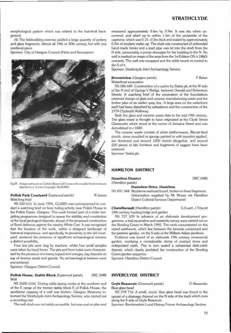
STRATHCLYDE
morphological pattern which was related to the historical back-ground.
(4) The fieldwalking exercise yielded a large quantity of potteryand glass fragments, almost all 19th or 20th century but with onemedieval piece.Sponsor: City of Glasgow Council (Parks and Recreation).
Fkj29. A large earthwork on Cathkin Braes Golf Course with a smaller burial enclosureattached to it. (Crown Copyright RCAHMS)
Pollok Park Courtyard (Eastwood parish) R JamesWatching brief
NS 550 615 In June 1995, GUARD was commissioned to con-duct a watching brief on bore holing activity near Pollok House inthe Pollok Estate, Glasgow. This work formed part of a wider test-pitting programme designed to assess the stability and constitutionof the local geological deposits, ahead of the proposed constructionof flood defences against the nearby White Cart. It was recognisedthat the location of the work, within a designed landscape ofhistorical importance, and specifically its proximity to the old court-yard, rendered the presence of significant archaeological remainsa distinct possibility.
Four test pits were dug by machine, whilst four small sampleswere taken by hand bores. The pits and bore holes were character-ised by the presence of a loamy topsoil and orangey clay deposits ontop of riverine sands and gravels. No archaeological features wereencountered.Sponsor: Glasgow District Council.
Pollok House, Stable Block (Eastwood parish)Well
NS 5500 6160 During cable-laying works at the southern endof the E range of the former stable block E of Pollok House, thesandstone capping of a well was broken. Glasgow Museums in-formed the Strathclyde Joint Archaeology Service, who carried outa recording visit.
The well-shaft was not safely accessible, but was oval on plan and
measured approximately 0.6m by 0.9m. It was dry when un-covered, and silted up to within 1.5m of the underside of thecapstone, which was 0.15-0.2m thick and sealed by approximately0,2m of modem make-up. The shaft was constructed of unbondedhand-made bricks and a lead pipe was let into the shaft from theN side, presumably a pump drawpipe for the building to the N. Nowell is marked on maps of the area from the 1st Edition OS (c 1860)onwards. The well was recapped and the cable trench re-routed tothe S of it.Sponsor: Strathclyde Joint Archaeology Service.
Brootnielaw (Glasgow parish) F BakerWaterfront excavation
NS 586 649 Construction of a casino by Stakis pic at the W sideof the N end of George V Bridge, between Oswald and RobertsonStreets. A watching brief of the excavation of the foundationsretrieved dumps of glass and ceramic manufacturing waste and thetimber piles of an earlier quay line. A large area on the waterfrontitself had been disturbed by subsidence and the construction of the1974 Clydeside Walkway.
Both the glass and ceramic waste date to the mid-19th century.The glass waste is thought to have originated at the Clyde StreetGlassworks which stood at the comer of Jamaica Street and wasdemolished in c!840.
The ceramic waste consists of white earthenwares. Biscuit-firedsherds, some moulded or sponge painted or with transfers applied,are dominant and around 1200 sherds altogether, and around250 pieces of kiln furniture and fragments of saggers have beenretrieved.Sponsor: Stakis pic.
HAMILTON DISTRICT
SRC SMRHamilton District(Hamilton parish)
Duriadeer Drive, HamiltonNS 691 544 Mudstone axehead found, broken in three fragments.
(Information supplied by Mr Moore via HamiltonDistrict Cultural Services Department)
Chatelherault (Hamilton parish) G Ewart, J Triscott18th century hunting lodge and garden
NS 737 539 In advance of an elaborate development pro-gramme, a trial excavation and resistivity survey were carried out onthe Bowling Green in March 1995. The work concentrated on thisraised earthwork, which lies between the kennels compound andthe parterre garden, on the S side of the William Adam pavilions.
Evidence was found of an elaborate 19th century ornamentalgarden, overlying a considerable dump of crushed stone andredeposited earth. This in turn sealed a substantial dark-earthdeposit, which clearly predated the construction of the BowlingGreen/garden sequence.Sponsor: Hamilton District Council.
SRC SMR INVERCLYDE DISTRICT
D AlexanderGryfe Reservoir (Greenock parish)Blue glass bead
NS 278 716 A small, ovoid, blue glass bead was found in theupcast of a drainage channel on the N side of the track which runsalong the S side of Gryfe Reservoir.Sponsor: Renfrewshire Local History Forum Archaeology Section.
79
STRATHCLYDE
WemyM Bay, Kelly Bank Cottage (Inverkip parish) A LeeCropmarks (LOCHIS)
NS £065 6850 Linear and circular cropmark observed insummer of 1991 and subsequently investigated. A substantialred sandstone wall of some height, now removed. A seeminglywell-founded wall, building stone could still be found in a ditchbehind the cottage pointed out as part of the line of the base of thewall. Removed stone had been retained for the construction of newwalls around Kelly Bank Cottage. The field above the cottage hasbeen thoroughly prepared, with new drainage put in, and grazingground recovered. Circular cropmarks may have reflected oldquarry pits.
Wemyss Bay, 'over Kelly*, The Sawmill (Inverkip parish)Remains of mill, channel, dam
NS 203 683 The reduced remains of the Kelly Sawmill, siltedwater channel and breached dam. Mill site on record for 150 years,and occupied up to the early 1900s. Fieldwork and research inprogress.
Wemyss Bay, 'over Kelly*. The Bridge (Inverkip parish)Remains of bridge piers and bridge
NS 201 683 Remains of piers and debris from previous stone-built bridge blown up in 1964 observable below replacement metalbridge. Previous bridge documented as 'Oakfield Bridge' anddescribed by local villager as having low walls and broad enough fortwo carts. The bridge would have provided access to the Kelly Saw-mill from woodland on the opposite side of the river.
Wemyss Bay, 'over Kelly*. The Waterfall, The RomanBridge, Craig's Bridge (Inverkip parish)Remains of estate feature
NS 198 685 Above a waterfall, features of the renowned 19thcentury Kelly Estate Gardens. Report in preparation. LOCHISliaising with the Garden History Society of Scotland.
Wemyss Bay, 'over Kelly', The Waterfall, The RomanBridge, Craig's Bridge (Inverkip parish)Remains of bridge platform
NS 199 685 Above a waterfall, cuts in bedrock. Remains of plat-form for narrow bridge - Craig's Bridge - destroyed in late 1950s.Bridge linked the broad riverside track with narrower path leadingthrough woodland on to estate sawmill road or metalled track onCunninghame/North Ayrshire side.
Wemyss Bay, 'over Kelly* (Inverkip parish)Track
NS 194 684, NS 203 683 Broad metalled, sometimes earthen,track, up to 6m wide in places, running alongside Kelly Burn fromjust above main entrance to Bourne Leisure Caravan Park,previously an entrance gate to the Kelly Estate. Track runs to site ofold sawmill.
Research and fieldwork in this area is ongoing. Please contactLOCHIS (Local History in Skelmorlie) if interested.Sponsor: Local History in Skelmorlie.
Ihverclyde District(Kilmacolm parish)
KnappsNS 3700 6833 Deserted farmstead.
SRC SMR
F NewallDevol Moor (Kilmacolm parish)Prehistoric platform
NS 3285 7295 Initially considered to be a possible Roman SignalPost (DES 1991, 60), this has been shown by excavation to bea prehistoric structure.
The site is a rocky platform composed of roughly concentricoverlapping volcanic sills. This has been rendered regularly circularby a clay and cobble facing, the downslope of which, counter to therock surface, formed the 'outer mound'. The 'inner mound' wasformed by the low edge of the upper sill.
Between outer and inner edges was a compacted layer of cobblesin brown earth, single coursed round the greater extent from NE toNW. Over the more irregular upper sill level, cobbles in earth wereplaced.
Towards the N front of the upper cobbles, chipped through to thelower rock surface, was a socket 14cm by 36cm deep. From thisextended a roughly chipped out slot with three flat stones. W ofcentre another socket likewise cut through to the lower sill was 20cmby 25cm deep.
From the surface came a micro-blade of dark obsidian.
Roman Signal Post (possible)NS 3274 7252 In view of the above results and the probability of
a Roman post lying in the High Auchenleck area of Devol Moor,a close search was carried out with Mr John Dunn, co-proprietor,for a site located with Mr William O Black in 1954 and then recordedas a homestead. This was re-located with difficulty.
Situated at the foot of a grid pylon this site is a slightly raisedmound c 9.25m in diameter over a peripheral mound c 3m wide. Anouter mound some 3m wide lies a like distance from the central rise.
Newark Castle (Port Glasgow parish) G EwartWatching brief
NS 328 745 A watching brief was maintained during theinvestigation of existing power cables serving the castle in advanceof upgrading of services. Nothing of archaeological significance wasrevealed.Sponsor: HS Q.
KILMARNOCK & LOUDOUN DISTRICT
M77 Fenwick to Floak (Avoidance Phase) R Strachan(Fenwick parish) D Alexander (CFA)Evaluation
An avoidance oriented evaluation in advance of the proposedupgrading of the A77 to motorway standard from Fenwick inKilmarnock and Loudoun District to Malletsheugh in EastwoodDistrict (for this second part see appropriate district) has beenconducted. The evaluation comprised a desk-based documentaryassessment followed by field survey based on a 500m wide corridorcentred on the c!6km long proposed route. The following finds,sites, monuments and listed buildings lay within the study corridor:
MeiklewoodNS 4505 4138 Possible settlement.NS 4523 4145 Quarry.
DalmusternockNS 4557 4170 Farmhouse, Grade B.NS451 415-NS 455 418 (centred) Rig-and-furrow.
MeiklewoodNS 4520 4178-NS 4517 4182 Field bank.
DalmusternockNS 455 420 Possible structure.NS457 419 (centred) Rig-and-furrow.NS459 421 (centred) Rig-and-furrow.
AikenheadNS44SE6 (NS 4606 4221) Mound.NS460 423 (centred) Potential settlement.
Laigh FenwickNS 4569 4232-NS 4569 4256 Farmtrack and bank.NS463 428 (centred) Village.
80
STRATHCLYDE
FenwickNS464 435 (centred) Village.
HallhouseNS 44 SE 10 (NS 4615 4279) Country House, Grade B.(NS44SE).
Laigh FenwickNS 4617 4275 (centred) Main Road, Nos 12, 14, 16, 18, 20
Grade B.NS 4621 4295 No39 Main Street, Grade C
FenwickNS 4632 4339 Main Street No66 (West Manse), Grade C mush-
room sundial/date stone.NS 4630 4345 (centred) Main Street. Nos 68-78 (even numbers)
Grade C.NS 4627 4341 (centred) Main Street, Nos 77-83 (odd numbers)
Grade CNS46354358 (centred) Main Street, Nos 82-88 (even numbers)
Grade C.NS 4637 4362 Main Street No 90, Grade C.NS 4637 4367 (centred) Main Street. Nos93-105 (odd
numbers} Grade C.NS4641 4356 Kirkton Road, Nos6and 8, Grade CNS 4641 4361 (centred) Main Street, Nos 92-106 (even
numbers) and No 2 Skernieland Road,Grade C.
Fenwick, (Hallhouse)NS 4620 4280 Milestone and possible tolbooth.
Fenwick, (Langslde)NS 4626 4309 Milestone.NS 4617 4332 Well.
FenwickNS 44 SE 16 (NS 4629 4336) United Presbyterian Church
(site of).Fenwick Hill
NS 461 434 Rig-and-furrow.Fenwick
NS 44 SE 4 (NS 46 43} Stone axe find-spot.Fenwick (Dunselma)
NS 4594 4338-NS 4608 4330 Field bank.Glaister Bridge
NS 461 437 (centred) Rig-and-furrow.Fenwick
NS 4652 4395-NS 4654 4411 Field bank (Rysland Drive)Gardrum
NS 4623 4423 (centred) Reservoir.Townend
NS467 443 (centred) Rig-and-furrow.NS468 445 Rig-and-furrow.
High GardrumNS 466 445 Rig-and-furrow.NS 4638 4434-NS 4636 4448 Trackway.NS 464 445 (centred) Rig-and-furrow.
Muiryet BridgeNS 4676 4476 Bridge.NS 4683 4471 Potential settlement.
GardrumNS 4646 4468-NS 4725 4528 Mill Lead.
Muiryet BridgeNS 4680 4481 Possible structure.
MooryetNS 4698 4501 Whinstone quarry.
RigghillNS 4718 4508 Aerial photographic feature.NS4711 4509 Quarry
MooryetNS475 451 Rig-and-furrow.
BridgeheadNS473 453 Field bank/levee.NS 4725 4526-NS 4728 4534 Trackway.
Glassock BridgeNS 4748 4554 Enclosure.
LaighmulrNS476 457 Farm.
Glassock BridgeNS 4774 4560-NS 4778 4574 Old road and building, field
bank.NS 4776 4563-NS 4830 4606 Field bank.
North GlassockNS 4812 4561 Farm.NS482 457 Rig-and-furrow.
Benthouse BridgeNS 44 NE 12 (NS 4823 4613) Bridge.
BenthouseNS483 462 (centred) Rig-and-furrow.NS 4858 4621 Deserted farmstead.NS 483 461 - NS 487 463 Rig-and-furrow.NS 4865 4640 Rig-and-furrow.
RaithlllNS 486 465 (centred) Platform settlements (possible).NS 487 465 Potential settlement.
Tarn's HillNS490 463 (centred) Rig-and-furrow.NS 490 464 (centred) Rig-and-furrow.
HarelawNS 44 NE 7 (NS 489 467} Stone axes.NS 4895 4683 Well.NS 4897 4684 & NS 4902 4685 Small stone platforms.NS 4898 4680 Footbridge.NS491 468-NS 495 469 Rig-and-furrow.NS 4873 4690-NS 4891 4693 Trackway.NS 4896 4704 Possible structureNS 4903 4693 Mound.NS 4894 4703 Farm, Grade C
Kingswell BridgeNS 44 NE 9 (NS 4955 4724) Monument, Grade C.
South DrumboyNS493 482 (centred) Rig-and-furrow.NS493 484 (centred) Rig-and-furrow.NS 44 NE 10 (NS 4927 4841) Windpump, trackway.NS 4933 4852 Well.NS 4948 4846 Farm.NS 4944 4848 VAP rectilinear structure and field bank.
North DrumboyNS494 486 & NS 492 488 Rig-and-furrow.NS494 488 (centred) Farm.
The HaciendaNS 4945 4896 Quarry (backfilled).
Floak BridgeNS 494 491 - NS 495 494 Rig-and-furrow, drainage ditches.NS 4950 4950 Quarry scoop.NS 4952 4948 Probable culvert.NS 4956 4944 Clearance cairn.NS 4955 4955 Quarry.
A report will be deposited with the NMRS.Sponsor: Roads Directorate of The Scottish Office Industry Depart-
ment, managed on its behalf by HS 0.
Kllmamock and Loudoun District SRC SMR(Galston parish)
East ThreepwoodNS 520 348 Covenanter's gravestone; deserted settlement.
(Information from Mr Campbell)
81
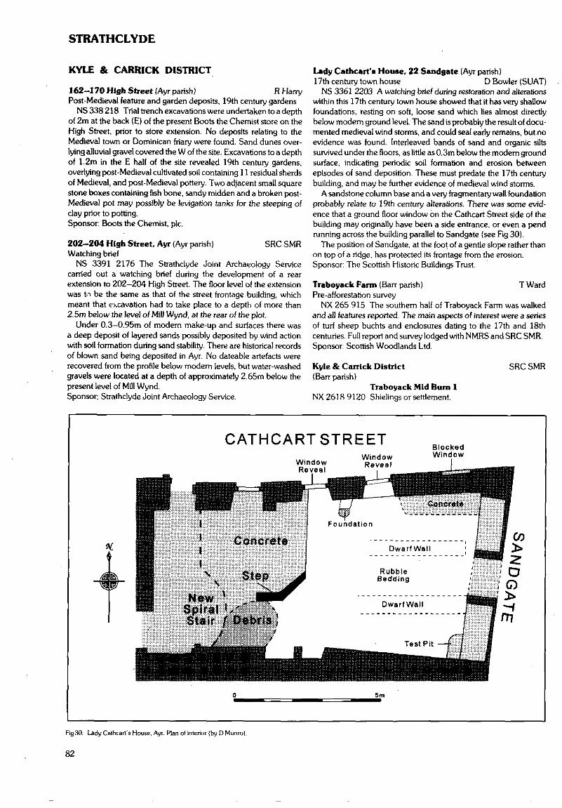
STRATHCLYDE
KYLE & CARRICK DISTRICT
162-170 High Street (Ayr parish) R HarryPost-Medieval feature and garden deposits, 19th century gardens
NS 338 218 Trial trench excavations were undertaken to a depthof 2m at the back (E) of the present Boots the Chemist store on theHigh Street, prior to store extension. No deposits relating to theMedieval town or Dominican friary were found. Sand dunes over-lying alluvial gravel covered the W of the site. Excavations to a depthof 1.2m in the E half of the site revealed 19th century gardens,overlying post-Medieval cultivated soil containing 11 residual sherdsof Medieval, and post-Medieval pottery. Two adjacent small squarestone boxes containing fish bone, sandy midden and a broken post-Medieval pot may possibly be levigation tanks for the steeping ofclay prior to potting.Sponsor: Boots the Chemist, pic.
202-204 High Street, Ayr (Ayr parish) SRC SMRWatching brief
NS 3391 2176 The Strathclyde Joint Archaeology Servicecarried out a watching brief during the development of a rearextension to 202-204 High Street. The floor level of the extensionwas tn be the same as that of the street frontage building, whichmeant that excavation had to take place to a depth of more than2.5m below the level of Mill Wynd, at the rear of the plot.
Under 0.3-0.95m of modem make-up and surfaces there wasa deep deposit of layered sands possibly deposited by wind actionwith soil formation during sand stability. There are historical recordsof blown sand being deposited in Ayr. No dateable artefacts wererecovered from the profile below modem levels, but water-washedgravels were located at a depth of approximately 2,65m below thepresent level of Mill Wynd.Sponsor: Strathclyde Joint Archaeology Service.
Lady Cathcart's House, 22 Sandgate (Ayr parish)17th century town house D Bowler (SUAT)
NS 3361 2203 A watching brief during restoration and alterationswithin this 17th century town house showed that it has very shallowfoundations, resting on soft, loose sand which lies almost directlybelow modem ground level. The sand is probably the result of docu-mented medieval wind storms, and could seal early remains, but noevidence was found. Interleaved bands of sand and organic siltssurvived under the floors, as little as 0.3m below the modern groundsurface, indicating periodic soil formation and erosion betweenepisodes of sand deposition. These must predate the 17th centurybuilding, and may be further evidence of medieval wind storms.
A sandstone column base and a very fragmentary wall foundationprobably relate to 19th century alterations. There was some evid-ence that a ground floor window on the Cathcart Street side of thebuilding may originally have been a side entrance, or even a pendrunning across the building parallel to Sandgate (see Fig 30).
The position of Sandgate, at the foot of a gentle slope rather thanon top of a ridge, has protected its frontage from the erosion.Sponsor: The Scottish Historic Buildings Trust.
Traboyack Farm (Barr parish} T WardPre-afforestation survey
NX 265 915 The southern half of Traboyack Farm was walkedand all features reported. The main aspects of interest were a seriesof turf sheep buchts and enclosures dating to the 17th and 18thcenturies. Full report and survey lodged with NMRS and SRC SMR.Sponsor: Scottish Woodlands Ltd.
Kyle & Carrick District(Barr parish)
Traboyack Mid Burn 1NX 2618 9120 Shielings or settlement.
SRC SMR
CATHCARTSTREETWindowReveal
WindowReveal
BlockedWindow
5m
Rg30. Lady Cathcart's House, Ayr. Plan of interior (by DMunro).
82
STRATHCLYDE
NX 2617 9108
NX 2611 9155
NX 2622 9144
NX 2640 9202(Craigie parish)
NS427 327
Traboyack Mid Bum 2Possible structure, robbed cairn.Traboyack Burn 1Deserted farmstead.Traboyack Burn 2Possible structure and agriculturalremains.KnockenayePossible cairn.
Campcastle, CraigieBuilding.
Gatehead Railway Viaduct (Dun dona Id parish] SRC SMRWatching brief
NS 3834 3689 During refurbishment of the Laigh Milton Via-duct, Barr Construction required an electricity supply to their sitecompound. The proposal to construct this supply was monitoredthrough the standard procedure already set up between theStrathclyde Joint Archaeology Service (SJAS) and Scottish Power.It was noted that the proposal as it stood would affect the easternend of the viaduct, where it meets the high river bank (a fluvio-glacial terrace). This is a location where information about theconstruction of the site could have been lost. Hence ScottishPower were asked to find an alternative way of supplying theelectricity.
The chosen route was examined in August 1995. The trench tohouse the cable was dug into the surface of the newly forged track toa depth of around 1m. It ran up the track to the top of the E end ofthe viaduct before being routed eastwards along an existing drain(which runs to the S of the hedge that marks the northern side of theoriginal line of the railway)
In this trench evidence for the artificial construction of theground in the form of a ramped platform between the end of theviaduct and the fluvio-glacial terrace was seen. The ramp ran fromthe top of the viaduct (from around 0.3m below the existing surface)N, running flat for 2m before sloping down steeply (at about 50degrees) until it ran out of the bottom of the trench at a point some4.2m from the northern edge of the viaduct and around 3m lowerthan the existing surface. Overlying this context was a mixed,blackened layer containing cinder, mortar and small bits of redbrick.
No artefacts were recovered from the clay layer but it wassufficiently different from the natural boulder clay that covered theterrace to tell it was not a natural deposit. Also it was directly overlainby obviously 20th or 19th century artificial material.Sponsor: Strathclyde Regional Council.
Crossraguel Abbey Car Park (Kirkoswald parish)Watching brief
NS 2759 0834 The Strathclyde Joint Archaeology Servicecarried out a watching brief during works in the car park adjoiningthe E side of the Scheduled Ancient Monument of CrossraguelAbbey. A series of fence post holes were dug through the moderncar park surface, but none of the holes penetrated the underlyingrubble hardcore.Sponsor: Strathclyde Roads.
Crossraguel Abbey (Kirkoswald parish) R JamesWatching brief
NS 275 083 An archaeological watching brief was carried out byGUARD in March 1995 during resurfacing and widening of the A77beside Crossraguel Abbey, near Maybole. Earth moving operationsdid not disturb sufficient soil to expose any archaeological featuresand no artefactual remains were recovered.Sponsor: Strathclyde Regional Council.
Culzean Castle (Kirkoswald parish) J Hamilton (CFA)Viaduct and relict terraces
NS 233 102 Excavations were carried out on the foundationsof Culzean Castle viaduct to evaluate the original planned land-scape and its subsequent history in the vicinity of the viaduct withparticular regard to its foundations and any adjacent accumulateddeposits.
The excavations revealed the foundations of the viaduct on theE elevation from the first pier at arch 1 to the outwork immediatelyS of arch 6. The foundations were not located N of arch 1.
The upper stratigraphy indicates a much disturbed sequence ofdeposits of mixed modern soils with dumps of rubble throughout.Generally this overlay a very clean sand into which the viaduct piers,at this section, would appear to have been cut.
The old ground surface S of arch 2 is much the same as the currentground surface, but at arch 2 and to the N the old ground surfacesloped away and may well be part of the gorge that the viaduct isreported to bridge. The overburden of organic material with mixedfinds belongs to a phase of landscaping to create the presentfountain garden.
Two hand-excavated trenches established the nature and age ofthe terraces on the area above Dolphin House Brae. With theexception of the lower third terrace no definition of the terraces wasseen other than on the surface of the section profiles.
The relief suggests that these terraces originally continued alongthe edge of Fountain Court on the flank of the hill facing CulzeanCastle - and the undeveloped soil profiles; it seems likely that theterraces belong to part of .the late 18th century developments atCulzean Castle and can probably be regarded as ornamental.Sponsor: NTS.
CLYDESDALE DISTRICT
M6/M8 Fastlink: A J Dunwell, R J Strachan (CFA)Hybrid Survey (Avoidance Phase) (Camwath, Carstairs, Lanark,Carmichael, Pettinain, Douglas & Lesmahagow parishes)Evaluation
NS 95 57 - NS 86 31 An archaeological evaluation was con-ducted on 30 alternative route elements, with a combined length ofc 87km, for a proposed road linking the M8 near Whitburn, LothianRegion with the M6/M74 near Douglas, Clydesdale District. Thisentry summarises the results relating to the Strathclyde Regionsection only. Further details regarding the working methods aredetailed above (see Lothian Region entry). Site and monumentsrecorded during ongoing survey by RCAHMS concentrating in grid-square NS 95 are included in the following list where independentconfirmation was obtained by the current survey. The Castledykescomplex of Roman remains was excluded from the survey at therequest of the sponsor.
The corpus of sites and monuments newly identified by the surveyis dominated by those of post-medieval agricultural and industrialorigin. Deserted farmsteads and cottages, areas of rig-and-furrowcultivation, and relict field boundaries and tracks are the mostcommon agricultural features recorded. Coal mines, mine shafts,and quarries were the most frequently identified classes of industrialmonument, and these clustered around Wilsontown and Rigside.Particular sites of interest located by the survey include a large earth-work with a raised platform and evidence of an encircling ditch atParkhall (NS 8620 3258), and a reference on Charles Ross's Mapof the Shire of Lanark of 1773 to a 'Druid's Temple', possiblya reference to a stone circle or prehistoric funerary monument, in thearea around Whitecastle Hill. Although no pre-medieval new siteswere confirmed by the survey, it is possible that a number of crop-mark enclosures may relate to early settlement.
83
STRATHCLYDE
Mouse WaterNS 9555 5679 Quarry. NS 9473 5368NS 958 566 Mine shafts. NS 9466 5363NS 9587 5657 Rifle range.NS 955 565 Mine shafts. NS 9324 5360NS 9564 5647 Coalmine.NS 954 564 Mine shafts. NS 9476 5354
Mulr RowNS953 564 Mine shafts. NS 930 532NS 9507 5635 SheepfoldNS 9511 5629 Coal pit. NS 95 SW 4NS 9528 5627 Coalpit.NS 9488 5625 Quarry. NS 9460 5306NS 9507 5619 Spoil heap.
Heathland NS 944 528NS 9410 5617 Sheepfold.
Mouse Water NS 927 526NS 9542 5612 Spoil heap.
Mulr Row NS926 525NS 9488 5610 Miners' cottages. NS 9267 5230
Easter Heathland NS 9289 5223NS 9482 5602 Deserted settlement of Easter Heathland. NS 934 522NS 9480 5594 Pond. NS 934 520
Wilsontown Colliery NS 929 519NS947 558 Coalpit.
WilsontownNS950 557 Coalpits. NS 95 SW 3
Wester Heathland NS 924 516NS944 557 Rig-and-furrow cultivation. NS 925 516
Climpy NS924 515NS 932 556 Mining activity, tramway.
Wilsontown NS 934 512NS949 556 Coalpits. NS 936 510
Wester HeathlandNS 9449 5556 Gravel pit. NS 932 507
WilsontownNS 9482 5550 Coal pit. NS 923 504
ClimpyNS 9331 5542 Disused limestone quarry. NS 9402 4959
WilsontownNS 95 SE 11 Ironworks complex. NS 920 495
ClimpyNS 9312 5517 Quarry scoop. NS 924 494NS 9294 5513 Building.NS931 551 Linear cropmarks. NS 940 494NS 9302 5503 Quarry pits.
Wester Greenwall NS918 491NS930 548 Rig-and-furrow cultivation. NS 922 491NS929 546 Rig-and-furrow cultivation. NS919 490
ForthNS932 543 Mines, sheepfold. NS 941 490
Cleugh BridgeNS 9510 5426 Spoil heap, mine shaft. NS 9200 4862
ForthNS 9484 5422 Mine shaft (possible). NS 9380 4837NS 9496 5422 Mine shaft (possible).NS 9476 5416 Mine shaft. NS 9426 4834NS 931 541 Deserted settlement of Highdyke.NS 9486 5404 Mine shaft. NS 942 483NS 931 540 Rig-and-furrow cultivation.NS 951 540 Rig-and-furrow cultivation. NS 9402 4797NS94665396 Coalpit.
Abbey Burn NS919 471NS927 530-NS 933 538 Rig-and-furrow cultivation.
Abbey . NS922 470NS 928 537 (approx) Deserted settlement of Langdales. NS 9243 4688
East ForthCoal pit.Coal road.ForthDeserted settlement of Hartside.East ForthCoal pit.Upper Throughburn(approx) Deserted settlement of W Hartside.ForthStone axe find-spot, linear cropmark.East ForthQuarry.ForthCropmark.WhitecleuchRig-and-furrow cultivation.Lower Throughburn{approx) Deserted settlement of Loanhead.Quarry.Pond.Cropmarks.Mounds, rig-and-furrow cultivation.Deserted settlement of Eastfield of Covenhill,tollbar.CovanhillAxe-hammer find-spotEnclosure (possible).Deserted farmstead of Eastfield of Netherton.Quarry.BrowshottDeserted settlement of Bankfoot.Limestone quarries.BrewshottDeserted settlement of Roughcrook.NethertonEnclosure, rig-and-furrow cultivation.MuirhouseDeserted settlement of Westdyke.Bumslde NurseryRig-and-furrow cultivation.CockrigRig-and-furrow cultivation, quarry.West YettLinear cropmark.MulrfootRectilinear cropmark (possible).Deserted settlement of Fallhills.Linear cropmarks.Shodshill MillMill race.Blacklaw MossSoil marks.Shodshill MossRig-and-furrow cultivation.ShodshillDeserted building.Shodshill MossRig-and-furrow cultivation.Cranley MossDeserted settlement of Stonyford.Harelaw(approx) Deserted settlement of Hairlawdyke.Cranley House(approx) Deserted settlement of ?Girdumstrait.Oval cropmarks.
84
STRATHCLYDE
Cranley WoodNS916 467 Rig-and-furrow cultivation. NS 9076 4217
Cranley HouseNS924 467 Oval and linear cropmarks. NS919 420NS925 466 Millstone levee.NS924 465 Millstone quarries. NS94SW10NS923 464 Lint mill.
Cranley Wood NS921 416NS 916 458 Field boundaries and rigs cropmark.
Newmill NS 94 SW 35NS 918 457 Mill buildings, race.
Newhouse Farm NS 9031 4120NS 9283 4568 Tollbooth.
Stobbilee NS 9185 4115NS915 456 Terraced platforms/quarries. NS919 410-
NewhouseNS927 456 Former settlement of Todhall. NS 9131 4104
HowfauldsNS 9210 4545 Rig-and-furrow cultivation marks. NS 9157 4083
RavenstrutherNS 94 SW 15.00 & 39 Roman road. NS 901 406
GorstaneNS 94 SW 2 Hollow-way. NS 9090 4040
SilvcrmuirNS94SW5 Cist. NS900 403
CastledykesNS 9330 4495 Cropmark (possible). NS914 403
Westwalk WoodNS 9346 4486 Trackways (possible). NS 898 402
StickhillNS 913 447 Hollow-way, quarry scoops.
Castledykes NS 9015 4015NS 94 SW 42 RX 1 Roman road (possible). NS 9014 4009
Carstair's HouseNS 936 445 Terrace-way, quarry-scoops, curvilinear channel, NS9051 4000
field banks.Castledykes NS 84 SE 38
NS 94 SW 40.0 & 40.02 RR6 Roman road.NS938 442 Roman road {supposed course of). NS 904 395
MlddlebankNS 9187 4415 Indistinct cropmarks. NS 8994 3941
Lanark MoorNS 9113 4402 Quarry. NS 9045 3940NS910 440-NS 913 441 Trackway.
HuntlyhlllNS915 440 Enclosure. NS 898 386-NS 94 SW 3 Multivallate fort.
CastledykesNS937 438 Cropmark NS913 394
Lanark MoorNS94SW4 Cists. NS 904 393
Sandyford BridgeNS918 435 ?Natural feature'. NS 908 389-
CastledykesNS94SW45RX8 Roman road (supposed course) NS 907 392
Lanark Race CourseNS 9110 4298 Field system (possible). NS 910 392
Springbank NS911 391NS 9167 4290 Deserted settlement of Springburn.
Lanark Race Course MS 8996 3908NS 9090 4285 Quarry, structure, field bank.
Springbank NS 83 NE 4NS 9153 4284 Linear cropmark.
Lanark Race Course NS 8974 3894NS909 428 Field system (possible).NS 94 SW 21 Barrow and enclosures. NS 8927 3886
HyndfordBleachfield mill.Charleston(approx) Deserted settlement of Braehead.HyndfordCrannog.Carmichael MillMill lade.Hyndford BridgeBridge.HyndfordUnspecified soilmark feature.NethertonDeserted structures.NS 918 411 Hollow-way.HowfordDeserted settlement of Burngreen.ShawsAnnular cropmarks.Prert's Mill(area) Trackways/footpath.HowfordClearance caim,BoathaughField bank.Shaws(area) Irregular cropmarks.Boathaugh(area) Deserted settlement, site of ferry;hollow-ways.Prett's MillCorn mill complex.Strip cultivation.Burn BraeToll barBoathaughCropmark enclosures.MillmoorRig-and-furrow cultivation.CrookboatCistern.Millmoor{centre) Cropmark enclosures and desertedsettlement.Drumalbin ParkNS 894 394 Hollow-way, Held bank, rig-and-furrow.DevonsldeWell (probable), find-spot, bomb dump.Millmoor(centre) Deserted buildings.DevonsideNS 911393 Rig-and-furrow cultivation.MlllmoorIrregular cropmarks.DevonsideIrregular cropmarks.(approx) Deserted settlement of Bumside.Drumalbin ParkQuarries.CrookboatFind-spot of ebony casket.DrumalbinCropmark.Bumhousi?Quarry and cropmark field boundary.
85
STRATHCLYDE
Drumalbln BurnNS897 387-NS 896 389 Field boundary.
DrumalblnNS 9018 3870 Deserted settlement of Hedgefoot.
Drumalbin BurnNS898 387 Hollow-way.NS898 387 (centred) Levees.
DrumalbinNS908 387 (centred) Hollow-ways/field bank.NS 90213862 Disused quarry.
Drumalbin ParkNS 9000 3855 Annular trace.
HeckleblrnleNS 8976 3824 Disused quarry.
BurnhouseNS894 380 (centred) Rig-and-funrow cultivation.
MlllmoorNS 90 38 'Druid's Temple'; destroyed stone circle?
HeckleblrnieNS 8987 3795 Deserted settlement of Smithfield, site of smithy.
BurnhouseNS894 378 (approx) Deserted building.
DykeNS886 372 Curling pond.
Stonehill WoodNS 83 NE 3 Find-spot of gold penannular armlets.
Dyke FarmNS882 366-NS 882 368 Field bank.
DykeNS 881 367 Deserted settlement of High Dyke.
Dyke FarmNS 8838 3663 Building.
DykeNS 883 366 Deserted settlement of Blinkie.NS 884 365 Site of Blinkie school, enclosure.NS 8822 3644 Deserted settlement of Fulwoods.
Douglas WaterNS 880 361 - NS 877 364 Trackway (possible).
ShieldsNS886 355-NS 888 361 Rig-and-furrowcultivation.NS 83 NE 13 Caims, possible platforms and enclosures.
Douglas WaterNS878 3656 Field bank.NS 8770 3628 Shale dump.
St RonansNS 878 361 (centred) Field bank, rig-and-furrow cultivation.
BurnengineNS874 361 (area) Coalpits.
ShieldsNS83NE12 Farm.NS 8867 3601 Deserted settlement of Shielsykes.
Douglas WaterNS870 359 Coalmine.
ShieldsNS 8865 3583 Unnamed deserted building.
HolmheadNS 874 358 (area) Soilmark enclosure.
CollierhallNS 870 356 - NS 871 346 Tramway (possible).
RigsideNS 8847 3540 Deserted settlement of Muirfoot.
CollierhallNS 866 352 Soilmark enclosure (possible), field bank.NS 87 35 Deserted settlements of Rigside and Gateside.
NewtonheadNS 8667 3488 (centred) Rig-and-furrow cultivation.
NewtonheadNS 8648 3480 Quarry.NS 8645 3456 (centred) Levee.NS 8663 3462 Deserted settlement of Howgill.
Newtonhead WoodNS870 330 ^NS 881 346 Rig.and-furrow cultivation,
trackway.Newtonhead
NS865 344-NS 866 343 Hollow-way.Broomfleld
NS 8757 3423 Deserted settlement of Hillhead.Tilework Wood
NS876 342 Quarry pits.Broomfleld
NS879 342 Hollow-ways.NS 8805 3410 Deserted settlement.
UddingtonNS 865 340 Deserted settlement of Craigburn.
Cralgburn WoodNS 83 SE 17 Cropmark, enclosure.
BroomfieldNS 8760 3404 Curling pond.
UddingtonNS 8655 3403 (centred) Palisade slot (possible).NS 8650 3400 Hollow-way.
Water of DouglasNS 8624 3400 (centred) Levee.
UddingtonNS 8618 3392 Enclosure.NS864 334-NS 864 337 Field system.NS 8637 3364 Quarry scoop.NS 8603 3370 (centre) Deserted settlement of Woodside.NS859 332-NS 862 334 Trackway; rig-and-furrow cultivation.
Roddenhlll WoodNS 868 334 Rig-and-furrow cultivation.
ParkhallNS 863 331 Earthwork, unspecified.NS 8604 3307 Mill (probable).NS862 330 Terrace-way.NS 864 330 Disused quarries.
MillbankNS 8607 3299 Field bank.
Parkhall BridgeNS 83 SE 6 Find-spot of bronze sword.
CastlemainsNS864 327 (area) Disused quarries.
Castle MainsNS 8620 3258 Raised ditched platform, possible settlement.
ParkhallNS 83 SE 2 Castle, hollow-way.
Parkhall BumNS 864 324 (area) Rig-and-furrow cultivation.
Robin's GillNS 865 318 Earthwork enclosure.
ParkheadNS 861 315 Rig-and-furrow cultivation, enclosures, quarry.NS863 314 (approx) Deserted settlement.
Cuff HillNS865 312 (area) Field banks.NS 83 SE 14 Deserted settlement of Old Cot.NS 8653 3105 Vegetation mark, possible platform.
MaidengillNS 83 SE 16 Thorril Castle'.
An illustrated report will be deposited with the NMRS.Sponsor: Roads Directorate of The Scottish Office Industry Depart-
ment, managed on its behalf by HS Q.
86
STRATHCLYDE
Biggar Common (Biggar parish) T WardNeolithic settlement date
NT 030 395 Radiocarbon date for Trench 2 reported DES 1993,87, is as follows: GU 4279, 3040 ± 110 bp, cal BC 3960 - 3690.
The sample was cory/us (hazel).Sponsors: HS Q, Lanark & District Archaeological Society, Biggar
Museum Trust.
Biggar Common (Biggar parish)Neolithic settlement date
NT 000 390 Radiocarbon date for FC 5 reported DES 1992, 66,is as follows: GU 4276, 2930 ± 50 bp, cal BC 3774 - 3637.
The sample was cory/us (hazel).Sponsors: HS Q, Lanark & District Archaeological Society, Biggar
Museum Trust
Camps Reservoir (Crawford parish)Bronze Age cremation dates
NT Oil 227 Radiocarbon dates for three of the cremationsreported DES 1994. 73, are as follows:Pit 1: GU 4265. 1610 ± 50 bp, cal BC 2011 - 1828Pit 4: GU 4264, 1640 ± 60 bp, cal BC 2034 - 1885Pit 8: GU 4266, 1560 ± 50 bp, cal BC 1910 - 1759
All samples were betula (birch).Sponsors. HS 0, Lanark & District Archaeological Society, Biggar
Museum Trust,
Cala Farm (Carnwath parish)Find-spot
NS 9985 4795 Arable fieldwalking produced a quantity of flintsincluding scrapers and blades, also a fragment of a jet napkin ring.Sponsor: Biggar Museum Trust
SurveyThe continuation of the archaeological survey of Clydesdale has
produced the following:(Culler parish}NT 0415 3303 NisbetFarm Burnt mound.NT 0400 3243 NisbetFarm Burnt mound.
Cornhlll (Culler parish)Find-spot
NT 023 348 Arable fieldwalking by Biggar Young ArchaeologyClub produced a quantity of struck chert and flint. This area hasproduced a large assemblage of such material, some of which maybe Mesolithic (see DES 1994, 72).Sponsor: Biggar Museum Trust.
Camps Water (Crawford parish) J O'SullivanSurvey
The survey of the site of a proposed water treatment plant in thevalley of the Camps Water was commissioned by SRC's Departmentof Physical Planning and was undertaken by AOC (Scotland) Ltd.
Twelve features of archaeological interest were recorded withinthe survey area and occurred in two areas: (a) N of the modern road,along the S bank of Camps Water and (b) S of the modern road,on the W-facing slope overlooking Rine Gill. Outwith the surveyarea, an additional site was noted: this was a rectangular structure,possibly a longhouse. on the N bank of Camps Water.
The features overlooking Rine Gill are two - possibly three - smallcairns and an adjacent orthostat (Site No 1). These are interpreted asprehistoric funerary monuments, though there was no evidence forany other prehistoric activity in this part of the survey area.
Other features recorded on the broad hillslope S of the roadincluded modem drainage ditches and areas of peat-cutting.Several narrow drainage ditches (typically 1.5m wide by 0.4m deep)
traversed the brow of the hill. These were obviously modernfeatures intended to improve the quality of pasture and were notrecorded. Peat-cutting was identified in the form of shallow,irregular, damp, mossy depressions, typically 5m to 15m wide and0.2m deep, randomly distributed across the brow of the hillslope.
The recorded sites are:1 NS 9826 2190 Cairns and orthostat.2 NS 9825 2222 Track.3 NS 98112224 Quarry.4 NS 9812 2222 Earth-banked enclosure.5 NS 9847 2224 Sheepfold.6 NS 9840 2225 Earth-banked enclosures.7 NS 9839 2222 Earth banks/structure?8 NS 9841 2226 Earth banks/structure?9 NS 9839 2228 Circular enclosure.
10 NS 9838 2221 Rig and furrow remnants.11 NS 9845 2227 Quarry.12 NS 9838 2226 Worked flints.13 NS 9845 2242 Rectangular structure.Sponsor: Strathclyde Water.
Fall Kneesend (Crawford parish) T WardFind-spot
NS 980 162 Two conjoining fragments of a jet napkin ring werefound on a caim during excavations.
Daer Reservoir (Crawford parish)Bastle house, cairns, find-spots, Mesolithic knapping site
NS 986 083 During the summer of 1995 the water level in thereservoir was reduced exposing large tracts of the normally sub-merged hillslope at c 300m OD.
NS 9676 0651 Bastle house The remains of Kirkhope Towerwere partially excavated to determine the architectural details andground floor plan. The building has lime-mortared random rubblewalls measuring 1.2m thick, vault springing at 1.7m above the gravelfloor, byre drain in basement 0.8m wide, roll moulded window anddoor frames, projecting stair turret on N wall. Site now interpreted asa bastle house.
Caim group and Hthic scatter, Burnt mound On the E shore of thereservoir a group of over 46 caims ranging in size from 1m diameterto 10m diameter, linear stone piles, chert tools and burnt flint.Dispersed burnt mound containing charcoal deposit (sampled).
NS 9860 0827 Mesolithic knapping site Over 2000 pieces ofchipped and flaked flint, chert and siltstone were retrieved froma surface scatter and trench of 26 square metres. Charcoal-filled pitswhich may be post holes were found.
NS 9842 0802 Chert knapping site Quantity of flaked chertincluding blades and cores.
NS 986 079 Ring caims Four ring cairns from 4m diameter to5m diameter.
Full interim report deposited with NMRS.Sponsors: Biggar Museum Trust, Lanark & District Archaeological
Society.
Wildshaw Burn Stone Circle (Crawfordjohn parish)Circle, observation
NS 8820 2716 In 1995, midsummer sunset was observed totake place on an accurate alignment over stone numbers 10 and 19(Ward 1992). The horizon of the sunset is featureless. Midsummersunrise was observed to take place from stone 16, the rising sunappeared between stones 5 and 6, again on a featureless horizon.
Hagshaw Hill, Douglas (Douglas parish) R Strachan (CFA)Watching brief
NS 795 305 (ce) A watching brief was conducted during allground breaking works associated with the construction of a c 400 ha
87
STRATHCLYDE
wind farm and access road on Hagshaw Hill, Avermarks Hill,Common Hill, Henry's Hill, Broomerside Hill and Windrow Hill,near Douglas. This work followed a desk-based survey and fieldinspection earned out in 1994 (DES 1994, 84). No features ofarchaeological interest were located.Sponsor: Oceans Engineering Limited.
Cralgnethan Castle (Lesmahagow parish) H SmithNS 815 463 Following exploratory trenching in late 1993 {DES
1993, 91), the entire area bounded by the E curtain wall, the towerhouse and the NE and SE towers was investigated by Scotia Archae-ology Limited. This area, which measured 13m N-S by 7.5m E-W,overlay a series of vaulted cellars and a connecting passage intowhich rainwater had been seeping through the masonry and con-crete capping above. The excavation preceded the consolidation ofthe masonry of the cellars.
Below the concrete and other recent deposits was a layer ofsubstantial rubble set in hard mortar which overlay the extrados ofthe vaults, the rubble being deepest against the E curtain. Betweenthe tower house and the top of the E wall of the passage wasa flagged path, probably contemporary with the rectangular cobbleswhich extended around the N and S sides of the tower house.
Recent disturbances to the immediate W of the SE tower wereprobably associated with the demolition of a lean-to building. Therewas no positive evidence of the stair illustrated by D MacGibbon andT Ross (The Castellated and Domestic Architecture of Scotland, I(Edinburgh 1887), 257) as being against the N wall of the same tower.Sponsor: HS Q.
Cloburn Cairn (Pettinain parish) E ArcherLate Neolithic/Early Bronze Age cairn
NS 946 413 The 1995 season examined the central area of thecaim. Previous excavators had removed the caim material itself butonly partially removed the subcairn deposits.
During the removal of this layer several types of Late Neolithicpottery were recovered and a small chert leaf-shaped arrowhead.
In addition to the pottery a number of stone artefacts were found,including a broken stone pounder. The stone artefacts were mostlywaste material and chiefly of light grey chert in addition to severaltiny pieces of the black Arran pitchstone.
Some pieces of charcoal were found, possibly associated withcremated bone already recovered.
A central post hole contained a charcoal deposit, and otherpossible post holes could suggest a structure.Sponsor: Lanark & District Archaeological Society.
Annieston Farm, Symington (Symington parish)Ring-ditches T Neighbour (CFA)
NT 001 364 area Excavation revealed three ring-ditches, a largepit-ring and a number of isolated features (Fig 31; for previous worksee DES 1992, 69). All the archaeological remains were negativefeatures, indicating truncation of the site. The excavated ring-ditchesall had a diameter of 12m, but probably served different functions,as their forms differed. Ceramic evidence suggests a minimum oftwo periods of human activity at the site, separated by a millenniumor more.
The ditch of the northern ring-ditch (trench 1) was between 3mand 4m wide and over 1 m deep at its deepest. There may have beena demolished stone feature at the entrance to the ring-ditch ora rubble causeway across the ditch. The, 3m to 4m diameter,internal area Contained a pit and two further post-pits were locatedoutside the eastern entrance. Examination of the nature of the fills ofthe ditch indicate deliberate backfilling. One of these fills containedsherds of approximately middle Iron Age pottery of a similar fabric tothat found in the ring-ditch in trench 2. The monument is almostcertainly ritual in character.
The southern ring-ditch (trench 2) was around 1m wide andbetween 0.3m and 0.4m deep, with an entrance to the E. Theenclosed area was about 9m diameter. Pottery from the ditch fillwas also of middle Iron Age date and some was of the same fabrictype as that recovered from the northern ring-ditch (trench 1).A large pit defined enclosure, centred on two large pits and basedon the southern ring-ditch, may have been the remains of a corral.An arc of ditch, associated with the ring of pits, was thought to bethe remains of a shelter. A number of other pits were less regularin their arrangement. One of these pits contained a sherd of Beakerpottery,
The third ring-ditch (trench 4) had a stonier fill and upon excava-tion proved to be segmented. This, combined with the 'lipped'entrance suggests that it was a house, typologically of Bronze Agedate. The absence of post holes is puzzling, but may indicatesubstantial truncation of the remains.
trench 4 ] trench 3
trench I
Fig 31. Annieston Farm. Symington. Ring-ditches
An assemblage of worked and unworked chert was recoveredfrom the ring ditches in trenches 1 and 2. The tip of a flint arrowheadwas recovered from the fill of the ring-ditch in trench 2.
A report has been produced and will be lodged with the NMRS.Sponsor: Tinto Sand and Gravel Ltd.
Melbourne Crossroads T Ward(Walston & Dolphinton parishes)Fieldwalking
NT 087 443 Arable and forestry plantation fieldwalking centredon the above NCR has produced quantities of flint and chert tools;leaf and B & T arrows, knives, scrapers, etc. Chert and pitch-stone knapping sites have been identifed. Western Neolithic andImpressed Ware sherds, a stone axe and hammer stones have allbeen collected indicating an area of prolonged prehistoric activity.Part of a larger fieldwalking exercise in the area.Sponsor: Biggar Museum Trust.
MONKLANDS DISTRICT
D AbernethyBargeddie (Old Monkland parish)Possible Bronze Age cemetery
NS 703 648 GUARD were contracted to undertake an assess-ment of a 40 acre site in advance of a proposed housing develop-ment at Coatbridge Road, Bargeddie. The previous discovery of aBronze Age Cemetery in the immediate vicinity pointed to thepossibility of archaeological deposits being present. A desk-topsurvey and field evaluation of the area was undertaken and estab-lished that the possibility of significant archaeological deposits beingpresent is slight. No archaeological features of importance werepresent within the trial trenches that were opened.Sponsor: SL Homes Ltd.
STRATHCLYDE
North Medrox, Mollinsburn (New Monkland parish)Limekiln and annular feature D Alexander (CFA)
Two excavations were carried out at North Medrox in advanceof the construction of the Loch Lomond Water Supply Scheme(1420mm Main - Balmore to Glenhove) pipeline.
NS 7275 7167 The excavation of a small, agricultural limekilnrevealed a stone-built, vertical draw-kiln (Oil); one wall is dated bydocumentary evidence to the first half of the 19th century, and waspossibly in use earlier.
NS 726 716 Excavation was also undertaken in January 1994on a small grass-covered annular feature situated NE of NorthMedrox Farm, and W of the limekiln. This site was originallyrecorded during the survey stage of the project as a small annularfeature c3m in diameter, consisting of a bank 1m wide and 0.5mhigh, with an internal diameter of 1m. A single trench measuringapproximately 20 square metres was excavated over the feature inan attempt to identify its nature, possible function and date. Fromthe excavated evidence, it was apparent that the feature compriseda simple single-phase annular bank measuring approximately 3.6min diameter. The bank was c 0.8m wide, c 0.2-0.4m high, and stoodon a layer of burnt soil containing organic material and modern arte-facts. The bank was composed of redeposited topsoil and subsoiland seems likely to be of modern origin. Its position in the corner ofthe field originally suggested that it was associated with stock-rearing. However, a local resident informed the excavation staff thata World War II gun emplacement had been positioned at approxim-ately this position, and it would appear that the annular featureexcavated was the remains of this.Sponsors: Crouch Hogg Waterman/Central Scotland Water Devel-
opment Board.
irregular, probably concentric, arc of shallow ditch was revealedwithin the centre of the circle. This shallow ditch was filled with largestones. No evidence for post holes was observed. To the N of thecircle immediately outside a number of sherds of coarse flat-rimmed,later prehistoric pottery were recovered. The majority of thesesherds appear to have come from one vessel c35-40cm in dia-meter, with only a slight shoulder below the rim interrupting what isan otherwise straight-sided profile. An area of cobbling 2.0m long,and 1.5m wide lay to the E of the hut circle.
Post-excavation work is being undertaken.-Sponsor: Renfrewshire Local History Forum Archaeology Section.
Craig of Nellston (Neilston parish) AGFA, RLHFField survey (Renfrewshire Local History Forum)
NS 475 555 In advance of site preparation and planting forthe East Renfrewshire Community Woodland, a field survey wascarried out in the lands of Craig of Neilstpn farm. The area of thesite, around the hill known as Neilston Pad, extended to over200 hectares (500 acres). The following list of (probably) post-medieval agricultural features were recorded. The remains of twofarmsteads and a dam are described in more detail. A watching briefcontinues during road and footpath construction and during tree-planting operations. Full report lodged with NMRS and SRC SMR.
MOTHERWELL DISTRICT
D Alexander (CFA)Tarn's Loup Quarry (Shorts parish)Archaeological assessment
A desk-based assessment and field inspection were undertakenprior to the proposed extension of the quarry. The following siteswere recorded, the first four of which have been identified by Strath-clyde Region Joint Archaeological Service:NS 874 637 Documentary sources indicate the site of a house.NS 8797 6377 Currently occupied farmsteading at Wellslea.NS 8742 6365 The remains of a lint mill reverted into a hillslopewith a wheel pit at its eastern end.NS 8745 6365 Low turf-covered rectilinear foundation of dry-stone structure.NS 8751 6364 and NS 8755 6367 Two areas of quarrying.NS 874 635 Remains of two lengths of an early 20th centuryLanark County Council Water Works reservoir dams and associatedfilter beds.
A report will be deposited in the NMRS.Sponsor: Pioneer Aggregates Limited.
RENFREW DISTRICT
D Alexander, B HenryPicket)aw (Neilston parish)Hut circle, excavation
NS 4680 5220 This site has been previously surveyed andreported as a possible robbed out cairn (DES 1991, 70); excavationof a trench over the NE quadrant of the site suggests its interpretationas a hut circle. Prior to excavation the hut circle consisted of a turf-covered stone bank 0.9-1.5m wide enclosing an oval area 9.0mlong by 7.4m wide, internally. Excavation revealed an arc of stonewall cl.2-1.3m wide, faced internally and externally with largerkerb stones revetting a smaller rubble core. The remains of an
Fig 32. Craighall settlement.
NS 4685 5500 Area of wide rig and furrow.NS 4687 5505 Rig and furrow.NS 4688 5517 Farmstead, Craighall (see Fig 32).NS 4695 5510 Boundary wall (remains).NS 4697 5486 Walling.NS 4702 5483 Quarry scoops.NS 4704 5521 Field bank - turf (appears on OS 1:10,000 map).NS 4706 5514 Quarry scoops.NS 4708 5514 Boat house 5.6m by 3.6m, walls 0.4m thick, small
jerry adjacent (both appear on OS 1:10,000 map).NS 4709 5517 Quarry scoop.NS 4714 5520 Quarry scoops - group of 4.NS 4715 5475 Field system.NS 4715 5527 Field wall (appears on OS 1:10,000 map).NS 4715 5540 Rectangular rockcut hollow 1.0m by 0.5m.NS 4717 5482 Ditch.NS 4718 5534 Quarry scoop 10m diameter.NS 4718 5543 Quarry scoop 20m diameter.NS 4718 5549 Quarry scoop 10m by 4m.NS472 552 Craighall dam.NS 4725 5529 Drainage channels.NS 4725 5552 Quarry scoop 15m diameter.NS 4730 5566 Circular depressions (3) each 2m diameter.NS 4736 5500 Field bank 2m wide, 0.4m high.NS 4738 5464 Field bank - 1m high
(appears on OS 1:10,000 map).
89
STRATHCLYDE
NS 4740 5480 Field bank 3m wide, 1m high, runs E-W (appearson OS 1:10,000 map).
NS 4742 5511 Field bank 2m wide, 0.4m high.NS 4743 5590 Stonewall.NS 4745 5510 Platform, semi-circular 3m diameter, 0.3m
high.NS 4745 5558 Rig and furrow.NS 4746 5518 Field bank becoming 2m high terrace.NS 4748 5580 Quarry.NS 4749 5464 Field wall (appears on OS 1:10,000 map).NS 4749 5488 Field bank 2m wide, 0.3m high, runs NNE-SSW.NS 475 557 Craig of Neilston fortified enclosure (DES
1974, 54) this site could not be identified. At thisgrid reference the only features were natural rockyoutcrop.
NS 4750 5510 Hollow, oval 3m by 2m. 0.4m deep.NS 4750 5520 Track or bank {appears on OS 1:10,000 map).NS 4750 5563 Drainage tank and ditch.NS 4750 5575 Field bank.NS 4755 5585 Rig and furrow.NS 4757 5516 Field bank of stone and turf 4m to 5m wide, 0.5m
high.NS 4760 5480 Rig and furrow (3m wide rig, 30-40m long).NS 4760 5557 Metal footbridge supported by earth banks.NS 4760 5557 Remains of earthen dam (possible).NS 4760 5613 Quarry scoop.NS 4760 5618 Hollow way.NS 4763 5537 Field system - strips 8m apart.NS 4763 5613 Field boundary - wall and lynchet.NS 4764 5511 Clearance cairn 2m diameter.NS 4765 5488 Field bank - stone and turf, 0.5m wide.NS 4765 5525 Drystone wall revetted against bank (appears on
OS 1:10,000 map).NS 4765 5555 Blocked up gateway in stone wall.NS 4765 5570 Field bank.NS 4765 5570 Cast-iron round trough [since destroyed by earth-
moving equipment building ditch and roadujay]NS 4766 5579 Earthen dam (for wild fowling?) 6m wide at base,
2m high [since restored as a feature in the Wood-land Project}.
NS 4767 5512 Field bank of stone and turf 2.5m wide, 0.3mhigh.
NS 4768 5538 Stone setting 1.5m diameter.NS 4769 5507 Quarry scoop.NS 4769 5604 Quarry scoop.NS 4770 5470 Field bank (feeder system for dam?).NS 4770 5541 Quarry scoop.NS 4770 5572 Field dyke.NS 4770 5603 Cropmark, linear cut by lynchet at W end .NS 4771 5509 Wall 0.5m wide, 0.4m high becoming 1m high.NS 4771 5581 Quarry 30m by 15m by 5m.NS 4772 5541 Stone setting 2m diameter.NS 4772 5545 Structure 10m by 5m remains 0.5m high, 1m wide
on platform, second possible structure adjacenttoW.
NS 4772 5580 Wall.NS 4773 5513 Hollow on edge of cliff 3m wide fronted by 2m long
low wall.NS 4776 5601 Turf mound 2m diameter, 1m high (cairn?).NS 4777 5601 Turf mound 1.5m diameter, 0.4m high, 10m from
above feature (cairn?).NS 4779 5493 Field bank 1m wide, 0.2-0.4m high (continuation
of NS 4765 5488?).NS 4779 5630-NS 4790 5628 Cropmark, possibly field boundary
or buried pipeline.NS 4780 5501 Field bank 0.5m high.
NS 4781 5539 Field bank, substantial over 1m wide and over 1mhigh running right round N tip of the Pad hill (pre-improvement boundary?) [a footpath has sincebeen built oner much of this feature damaging or atbest burying it].
NS 4783 5515 'Giant's Stone' large glacial erratic boulder.NS 4785 5510 Clearance cairn 10.3m by 4.3m and stony scatter
20m to S.NS 4786 5491 Levelled platform on hillside.NS 4786 5560 Stone setting (shepherds' shelter?).NS 4788 5602-NS 4793 5595 Wall (continuation of that shown
on OS 1:10,000 map).NS 4790 5640-NS 4791 5623 Drain.NS 47915539 Quarry scoop.NS 4792 5640 Field bank.NS 4797 5529 Settlement 'Pad Farm'.NS 4801 5559 Quarry scoop.NS 4807 5629 Turf mound-sub-rectangular 3m by 5m byO.5m.NS 4808 5548 Quarry.NS 4808 5592-NS 4813 5597 Drain 1.5m wide with bank on
downslope.NS 4812 5558 Quarry.NS 4812 5576 Quarry scoop.NS 4814 5568 Trackway.NS 4815 5578 Wall shown on OS l:10,000mapnolongervisible.NS 4820 5568 Structure, flat stony area.
NS 4688 5517 Craighall farmstead House structure 20m by7m by 1m, gable 0.8m thick. Three sides (N. E and S) survive toa height of four courses of mortared stone at NE corner. Possibleearlier structure underlying. Small annexe 5m by 5m at S end.Evidence that road-side dyke is constructed from dressed stonerobbed from the building. Other features include a semi-circularstructure 7m by 0.5m high. 10m to the N; an enclosure 30m by 40madjacent to the E and a possible well just outside the SE comer of theenclosure (steading appears on first edition OS 6 inch map).
NS 472 552 Cratghall Dam W Wall, earth bank with stonefacing - 11.6m wide, 5m high, 56m long; E wall, earth and stone -21m by 6m - breached [since the survey this has been restored tocreate a water feature in the Woodland]', overflow - 1m deep stone-lined channel with 1m high stone wall above — at E end of dam.
NS 4797 5529 Settlement (known locally as the 'Pad Farm') -pre-improvement longhouse of three compartments 20m by 7m;associated enclosure, walls, annexed structures (shown on Ainslie'smap, 18th century and 1st edition OS 6 inch map) [since suruey,finds from molehills include a piece of Late Medieval/early Post-Medieval pottery as well as usual late Victorian clay pipe bowl andchina].Sponsors: Elderslie Estates, Gluttons Estate Management Ltd.
Newton Wood (Paisley parish) D J CraigEarly medieval cross fragments
NS 452 625 Two cross fragments, published in ECMS 1903,460, figs 480, 481, but described as possibly lost in the recent bookGouan and Its Early Medieua! Sculpture, p90, are in storage at thePaisley Museum and Art Galleries. Information from R J Maiden.
Amochrle Primary School (Paisley parish) K SpellerDecorated stone socket
NS 4615 6170 Desk and field assessments were conducted onthe site of Amochrie Primary School by GUARD, ahead of housingdevelopment. The site was investigated as the presumed originallocation of the Stanelie (sic) Cross, an early Medieval monument ofwhich only a fragment remains, currently housed within the confinesof the nearby Stanely Reservoir, under the care of Strathclyde WaterServices.
90
Excavation within the proposed development area revealed thepartly disturbed location of the cross base, formed within a naturaloutcrop of limestone. No other archaeological features were dis-covered relating to the cross site or any other period ie the nearbyStanely Castle.
The socket stone for the cross was located within the reservoircompound (NS 4628 6161), to where it had been moved sometimeafter the reservoir construction in 1838.Sponsor: Bellway Homes Ltd.
Braehead (Renfrew parish) J Atkinson, K SpellerCastle site and causeway
Field assessment of two sites E of Renfrew, in advance ofdevelopment on and around the site of Braehead power station, onground that was formerly the Elderslie Estate. Undertaken byGUARD.
(a) Inch Castle. Documentary research had resulted in threepossible sites for the remains of Inch Castle (NS 5134 6748 -NMRS; NS 5135 6751 - SMR; NS 5127 6765 - OS). Extensivemachining resulted in no building remains being located at any ofthe locations,
(b) Marlinford Road (NS 5226 6693 to NS 5240 6725). Fieldassessment was carried out to ascertain the date of this monumentand any possible connections it may have with the Marlin Ford,thought to be an early river crossing point (c 250m to the E).
A number of machine-cut trenches were positioned across theline of this raised embankment which leads from the old Renfrewroad to the southern bank of the River Clyde. The slight, stoneless
STRATHCLYDE
structural form of the embankment argued against it being a roaddesigned to carry a steady stream of traffic to and from the MarlinFord. The embankment runs parallel to a brick-built culvert, issuinginto the Clyde. Deposition of debris beneath the embankment,associated with the construction of this culvert means that theMarlinford road, as it survives, must be contemporary with it (mid tolate 18th century).
The purpose of the embankment is interpreted as being two-fold:(1) To provide access to the drainage culvert. (2) To form a barrierbetween reclaimed land to the E and the next area to be reclaimed tothe W. Subsequently, the embankment is partly covered by thisreclaiming process, as evidenced by the dumping of spoil from theriver on to its western side, during the development of the ElderslieEstate from 1760AD.Sponsor: Environmental Sciences Unit.
STRATHKELVIN DISTRICT
D Maclnnes, J MarshallCralgmaddie Muir(Baldemock parish)Rectangular and circular building foundations
NS 582 763 - NS 580 764 Recent work on Craigmaddie Muirhas revealed a further seven features. These consist, with oneexception, of earth and stone foundations. Three of these arerectangular buildings, two of which measure 10m by 3m, are
Western limits of SCHEDULED AREAProposed Developments&
Exposed Archaeology
[TZ] Exislin
Archaeological Assessment Trenches
Modi Tied Alignmem of ihe ANTONINE WALL
'$*'<> ^Ri'mpirl CARPARK ^-,-'^ \ \' >v" N. Base .-r"1"1'. \ ' ^ \• \ ^ /' ' '' \ ' -i-\
Fig 33 St Rannan's Church (seep 92).
91
STRATHCLYDE/TAYSIDE
orientated E-W and have an interior dividing wall. The other isorientated N-S, measures 7m by 2.5m and is barely discernible,being defined by sections of low earth bank with occasionalboulders. There is a possible entrance in the mid E wall. A fewmetres from this latter feature is a circular foundation comprisinglarge boulders open to the S.
Two other circular structures were recorded. One is defined by anearth and boulder bank with its W side formed by sandstone out-cropping. The other would appear to be a hollow formed in the edgeof some bedrock. Its W side is open and the interior is filled with largeslabs of sandstone and smaller tumble.
Strathkelvin District SRC SMR(Campsie parish)
GlenmllnNS 6066 7935 Mound.
Warden HillNS 6098 7980 Possible enclosure.
Crow Road, Campsle MutrNS 6294 8203 Track, sunken in parts, crossing into Central Region
(Fintry parish).
St Flannan's Church (Kirkintilloch parish) K SpellerAntonine Wall
NS 662 743 Archaeological assessment in advance of proposeddevelopment in the grounds of the church, resulted in five trenchesbeing opened by GUARD. Three of these straddled the wall line, theother two being positioned immediately to the S of the wall to test forthe existence of any fortlet at this point (see Fig33, p91).
Trenches A. D and E: No surviving archaeological features wererecorded.
Trench B: A sparse spread of stones, much disturbed, signified theephemeral remains of the wall base.
Trench C: A well-preserved stretch of the wall was exposed, sur-viving to a height of 0.55m. Individual turves were recorded in planand section, overlying the undisturbed cobble base and kerbing.The berm and part of the ditch were also exposed, although thesetwo elements were disturbed in places by the later farm buildings onthe site.
The excellent preservation of the wall in trench C only is due to thesealing of this area by the cobbled yard of Cleddans Farm.Sponsor; Angle Property and Construction Co.
Bar Hill, Twcchar (Kirkintilloch parish) A Strang, J WalkerAntonine Wall: geophysical survey
NS 706 759 A geophysical survey was conducted in the fieldimmediately to the W of the Bar Hill Roman site. This was to confirmthe route of the Antonine Rampart and to test whether evid-ence of possible extensions of the wall-base, projecting to theS, could be detected. Significant variation in resistivity did occurat several zones (each possibly extending about 4m to the S)along the southern edge of the wall-base. Also S of the Wall, theMilitary Way (4-4.5m wide) appears to run about 8m distant butpossibly converging towards the wall near the western gate of thefield.
Shlrva (Kirkintilloch parish)Antonine Wall: geophysical survey
NS 688 755 A geophysical survey at Shirva Farm was initiallyconducted immediately to the N of the B8023 road. This was toconfirm the route of the Antonine Rampart and to test whetherevidence of possible extensions of the wall-base, projecting to the S.could be detected. Results did not confirm the Rampart route but itsalignment in the fields to the E and W seems to indicate that its mostlikely track is mainly through the main field and that it crosses theB8023 at the Board Bum.
TAYSIDE REGION
ANGUS DISTRICT
Mains of Balgavles (Aberlemno parish) R BenvieShort cist
NO 539 516 An update on the report in DES 1990. The skeletonwas of an adult, most probably male, aged about 25-30 years, offairly slight build and about 5ft 6in tall. There was no evidence as tothe cause of death or any pathological process or lesion.
The C14 age from the skeleton is: 3680 ± 50513C= -20.5%0
and calibrated age ranges 2acal BC 2200-1930, cal BP 4149-3979
Cllffburn Road (Arbroath & St Vigeans parish) M KingCoin
NO 650 413 A Charles II Copper Turner or Bodle was found inthe garden of 13 Cliffburn Road, Arbroath. It was retained by thefinder.Arbroath Museum Daybook Number: DBA 1924.
Victoria Park (Arbroath & St Vigeans parish) R BenvieBurial, possible long cist
NO 656 413 An update on DES 1988, 27, a report on theskeleton from a possible long cist burial.
The remains were of one individual - a relatively young adultmale, about 5ft Sin tall. The skeleton was rather poorly preservedwith few bones surviving in an intact state. The lumbar vertebraeshowed the individual had suffered from some destructive patho-logical condition affecting the lower spine. The location and appear-ance of the bone lesions were suggestive of tuberculosis, which maywell have been the immediate cause of death.
Whiting Ness (Arbroath & St Vigeans parish)Stone drain
NO 659 410 An update on the report in DES 1993,94. The threesoil samples from feature 1 yielded no botanical remains.
Benedict Road, Arbroath (Arbroath & St Vigeans parish)Pillow stone with cross in relief N Atkinson
NO 653 418 The stone, discovered in 1990 (reported in DES1990, 39), is now on display in the Meffan Institute, Forfar.
Bishop's Close/Church Lane, Brechln (Brechin parish)Cobbled road R Murdoch
NS 596 601 The resurfacing of parts of these roads was precededby the removal of 0,45-0.60m of deposits that underlay the existingtarmac, the exposed deposits and features being investigated byScotia Archaeology Limited. Below the make-up for the tarmacroad in Bishop's Close, were sections of an earlier road comprisingrounded pebbles, up to 0.12m across, set into sand. Artefactsindicated that the cobbled road was of 19th century date.
Trenching in Church Lane revealed several inhumations cut byan existing sewer pipe trench. These burials may once have beenwithin the nearby graveyard which had been foreshortened.Sponsor: Tayside Regional Council.
Boddin (Craig parish) R BenvieAssorted 19th century and 20th century metalwork, seals andtokens
NO 71 53 A lead bosse from a horse harness stamped 'Prain,Saddler. Montrose', a Montrose tea token '28. High Street,Montrose 1879', and 12 lead flax bale seals, were all found in topsoilat Boddin. They have been donated to Montrose Museum.Museum Accession Numbers: Horse Harness Bosse M1995.152;Tea Token M1995.154; Lead Rax Bale Seals M1995.155-166.
92
TAYSIDE
Rossle I«land, Montrose (Craig parish)Horse harness strap fitting
NO 709 571 A Victorian strap fitting for a horse harness, en-graved John Robertson, Montrose, was found on Rossie Island anddonated to Montrose Museum.Museum Accession Number: M1995.153.
Dunnlnald (Craig parish) N AtkinsonIncised cross
NO 715 539 A third incised cross was found on a stone in theN wall of the ruined parish church of Dunninald. The other two.crosses are on stones on the S wall, recorded by J R Sherriff in1983.
It is likely that all three are 13th century consecration crosses.
Fordhouse Barrow, House of Dun (Dun parish)Round barrow/ring caim R Peterson, R Turner, E Proudfoot
NO 665 605 A round barrow lying on the northern edge of theNTS property of House of Dun. Quarrying (probably 19th century)has cut into the mound on the southern side and rabbit warrens havefuther disturbed the site. Excavation was carried out due to theperceived threat from erosion of this quarry and of the mound (DES1994,81).
The monument appears to have been constructed as an earthenring bank of c30m diameter, overlaid by a stone capping togive the appearance of a ring caim. This appears to have beenof several phases or builds, with a layer of angular sandstoneblocks underlying rounded glacial boulders. The central area,approximately 6m in diameter, was then filled to give the finalappearance of a mound. In the 1995 season the uppermost fillsof the central feature were investigated. The final phase was anearth cap. which was subsequently revetted by the constructionof a drystone wall. Underlying the earth cap was an oval stone-filled feature, below which are successive stony fills which havenot been excavated. On the W side of the monument a post-medieval feature has cut through the earth cap - perhaps a trace ofantiquarian disturbance.
The excavation of the cairn material was continued in the E partof the monument. Numerous sherds of a Food Vessel Urn anda Collared Urn were excavated in the SE quadrant. Although thesesherds were not in situ, the presence of a large number of fragmentsof ?cremated bone points to there being two burials.
The removal of the rounded boulder caim over the wholemonument was completed this season, leading to the discovery oftwo further burials in vessels. One vessel, a Collared Urn, containedthe remains of an infant; the other was a Food Vessel Urn. These twosecondary cremations appear to have been inserted into the upperrounded boulder caim. The presence of a copper-alloy ring-pinof post-Roman or Viking date may indicate a long tradition ofsecondary burial.Sponsors: HS HI The Russell Trust, Jennie S Gordon Memorial
Foundation, NTS.
Edzell Cemetery (Edzell parish) N AtkinsonEarly Christian cross slab
NO 582 687 Originally found in 1870 in the old kirkyard wall, thecross slab was placed within the Lindsay Burial Vault. Having been'lost' for several years, it was rediscovered in 1988 buried in pigeondroppings. It was conserved by the Scottish Museums Council and isnow on display in the Meffan Institute, Forfar.
Famell Church (Farnell parish) R BenvieCoin
NO 627 554 A Charles I Copper Turner (Twopence or Bodle)was found at Famell Graveyard. It was retained by the finder.Museum Daybook Number: DBM 1805.
Shandford Farm (Fern parish)Cropmarks, souterrains
NO 494 625 and NO 484 628 A series of cropmarks of sou-terrains were recorded and photographed in August 1995 at theabove locations. The two locations arc known as souterrains,(NMRS no NO 46 SE 36; NO 46 SE 38). At NO 494 625, four ofthe most obvious souterrain shapes were sketched, although manymore were present. A series of circular clumps were also recorded,varying from 0.6-1.4m diameter over an area of at least 10m.At NO 484 628, the most distinct souterrain shape, measuring10-llm by 1.5m was recorded and nearby there was another areawith circular clumps c 0.6m diameter.
East High Street, Forfar (Forfar parish) R Cachart (SUAT)Medieval burgh land
NO 461 507 In February 1995 the Trust undertook an assess-ment, prior to development, of the site on the SE corner of the EastHigh Street/South Street junction. The site was considered to besignificant due to its location at the East Port, on the town's mainthoroughfare, adjacent to the historic core of the burgh.
Five trial trenches were machine excavated, hand cleaned,recorded and backfilled. The excavations revealed that the site hadbeen previously levelled and that the only archaeological remainsencountered related to 19th and 20th century occupation.Sponsor: Webster & Patullo Ltd.
3 Manor Street. Forfar (Forfar parish) D Hall (SUAT)Medieval royal manor
NO 4552 5079 A watching brief on groundworks for a newhouse extension located natural gravel at 0.90m below modernground level. No archaeological deposits relating to the Queen'sManor were located.Sponsor: Mr A M Coupar.
Glamis Church (Glamis parish) N AtkinsonArchitectural fragment of carved stone
NO 386 469 A fragment of what appears to be the corner ofa piece of church 'furniture1 with a pillar and scroll work suggestinga comer-post was discovered in the Manse Rockery. It is probably ofthe Romanesque period of the late 1 lth/12th century.
Glamis Church (Glamis parish)Early Christian cross slab fragment
NO 386 469 The fragment no 3, originally discovered in 1967,was removed from the Manse rockery. It has now been cleaned, andis displayed inside the Church.
Glamis Church (Glamis parish)Pictish symbol stone fragment
NO 386 469 The fragment, Glamis no 4, noticed in the Manserockery in 1984 and since lost, was rediscovered when the rockerywas relaid. The fragment has been cleaned and is now displayed inthe church.
St Margaret's Inch (Glamis parish)Stone with cross
NO 441 506 This portable stone, measuring only 0.17m byO.llm by 0.04m is of homeblende schist, which is not local toAngus. It has been shaped by hand, but natural fault lines in thestone form a cross. Originally found in 1992, it is now on display inthe Meffan Institute, Forfar.
Wester Denoon (Glamis parish)Pictish cross slab
NO 350 433 The Pictish cross slab found in 1994 (DES 1994,82) was awarded by the Queen's & Lord Treasurer's Remembrancer
93
TAYSIDE
to Angus Museums, and is now on display in the Meffan Institute,Forfar.
Ktrrlemuir Old Parish Church (Kirriemuir parish) R MurdochChurchyard boundary; Pictish stones
NO 385 539 The proposal to replace the path leading to theW side of the church with a vehicular road was preceded by anarchaeological investigation of the area by Scotia ArchaeologyLimited. Within a trench measuring 15.5m E-W by 3m wide anda northward extension measuring 3.5m by 2.5m were uncovered sixcourses of a 1.25m-wide, clay-bonded, rubble wall. That wall isthought to have formed the S boundary of the churchyard beforethe extant church was built in 1787. To the immediate N of the wallwere the lower courses of three walls, forming a U-shaped arrange-ment. Within the space between these walls were the disarticulatedskeletons of at least 15 individuals.Sponsor: Tayside Regional Council.
North Mains of Balllndarg(Kirriemuir parish) RStrachan(CFA)Enclosures
NO 405 515 Resistivity survey of 16,200sqm and excavation of20 trial trenches with a total area of c 920 sq m were conducted at thesite of a series of cropmarks identified through aerial photography in1982 (NMRS NO 45 SW 21), in advance of the proposed extensionto a bottling depot. The evaluation revealed a series of ditches,interpreted as rectilinear enclosures displaying at least two phases ofconstruction, and a scatter of pits E of the enclosures. No clearevidence of the date of the enclosures was obtained, although on thebasis of glazed pottery recovered from one excavated ditch sectionthey are provisionally considered to be medieval. An isolated pitrevealed by excavation cSOOm SE of the enclosures containeda body sherd from a coil-built vessel of probably late 1st millenniumBC date. All other features identified were of modern origin.
A report is lodged with the NMRS.Sponsor: Strathmore Mineral Water Company Ltd.
Auchlishle (Kiniemuir parish) A M DickLater Prehistoricf?) settlement, souterrain
NO 387 578 Excavation continued on a small scale. As in previ-ous years the majority of features were post holes. The end ofa broad shallow ditch was discovered. Its lower fill contained muchash, burnt wood and possible stone features, and from its upper fillcame waste products probably from iron-working. Its dimensions(variable, up to 3m wide and 0.3m deep) and fill were similar tothose of another ditch end discovered last year (DES 1994, 83).Between the two ditch ends there was a gap of about 3.2m. Withinthis gap an arrangement of post holes may have formed anentrance-way 2.6m wide; this can very tentatively be interpreted asthe entrance to a ring-ditch house. Finds included pottery sherdsand two flint scrapers.
A souterrain first found about 200 years ago (Wainwright's'Kirriemuir II1) but since 'lost' was re-discovered as a parch-mark ingrass adjacent to the area of excavation.
Kirriemuir Parish Church {Kirriemuir parish) N AtkinsonEarly Christian cross slabs
NO 390 545 The five cross slabs, originally found when thepresent Parish Church was built in 1787, were removed from thenew cemetery in 1988 to undergo conservation by the ScottishMuseums Council, They are now on display in the Meffan Institute,Forfar.
Kirriemuir Parish Church (Kirriemuir parish)Early Christian cross slab fragments
NO 386 539 Preceding churchyard access improvements, anexcavation carried out by Scotia Archaeology in March/April dis-
covered one complete cross slab and a further 11 fragments. Thefragments had all been re-used in the building of a wall, possiblycontemporary with the present church of 1787, and all appear tohave been deliberately broken.
Westmuir, Kirriemuir {Kirriemuir parish) G D B JonesRoman road
NO 357 518 - NO 374 562 In 1949 O G S Crawford publishedan air photograph of a section of double-ditched road betweenWestmuir and Reedie. W of Kirriemuir and wrote a brief descriptionof his 1939 ground examination. His identification of the alignmentas being of Roman origin could be inferred from the subsequentdiscovery of the presumed Flavian fort identified from the air atInverquharity 4km NE of Kirriemuir.
Recent investigation on the ground has extended the knownlength of the road considerably. The cropmark of the road wasobserved in 1994 running SW/NE 200m SE of Reedie and joiningwith the section observed from the air by Crawford at c NO 365 525,The line has been identified running NNE from Balbrydie Cottage(NO 374 538) towards Woodside at cNO 378 554 and on toNO 387 563. This alignment points directly NE towards the area ofInverquharity on the South Esk. The roadline can normally beobserved as a cropmark SE of Reedie in suitable conditions; theidentification of a built causeway with side ditches is reminiscent ofthat located by air photographs in 1939 SW of Scone.
East Campsie (Lintrathen parish) R Benvie, W G Watson,Short cist burial J Olson
NO 288 527 An update on the report in DES 1991, 70. Theskeleton was of a child, aged about 12 years and an extremelytentative diagnosis of female sex may be made on the evidence ofa wide sciatic notch. There was no evidence to suggest the cause ofdeath, nor was there any evidence of pathological lesions. Animalribs were also present in the burial.
Menmuir Church (Menmuir parish) N AtkinsonEarly Christian cross slabs
NO 534 643 The five Early Christian cross slabs found at this sitewere all removed following the closure of the church. They havenow been put on display in the Meffan Institute, Forfar.
The fragment discovered in 1987 was re-examined and does notbear worn interlace. The pitted surface most closely resembles the'fire-making stone' from Carlungie Souterrain.
Brown Caterthun (Menmuir parish) A J Dunwell,Hillfort survey and excavation R Strachan (CFA)
NO 555 668 (NO 56 NE 1) An archaeological survey andexcavation were conducted at Brown Caterthun between Augustand October 1995 in response to evidence of substantial rabbitdamage to the earthworks enclosing the hilltop. The principalmotive for the fieldwork was to assess the extent of rabbit-derivederosion, as a basis for future implementation of ameliorative landmanagement policies. The evaluative excavations have shown thatthe degree of rabbit {and other) damage to Brown Caterthun hill-fort is at least as extensive as surface traces indicate and in manyinstances the erosion was more severe. A total of eight trenches(Trenches 1-8, Fig 34) with a combined area of c222m2, wereinvestigated.
Trench 1 revealed the outermost rampart to be c2.9m wide,preserved only up to 0.4m high, and constructed as a simple dumprampart. The inner edge was sealed by cobbling. The outer edge ofthe rampart lay immediately beside a ditch which was revealed to bec2.3m wide, cl.6m deep and was rock-cut through bedded strataof soft red sandstone and conglomerates. The ditch was broadlyV-shaped. A counterscarp bank lay cO.Sm beyond the ditch.A decayed turf layer was sealed directly beneath the rampart.
94
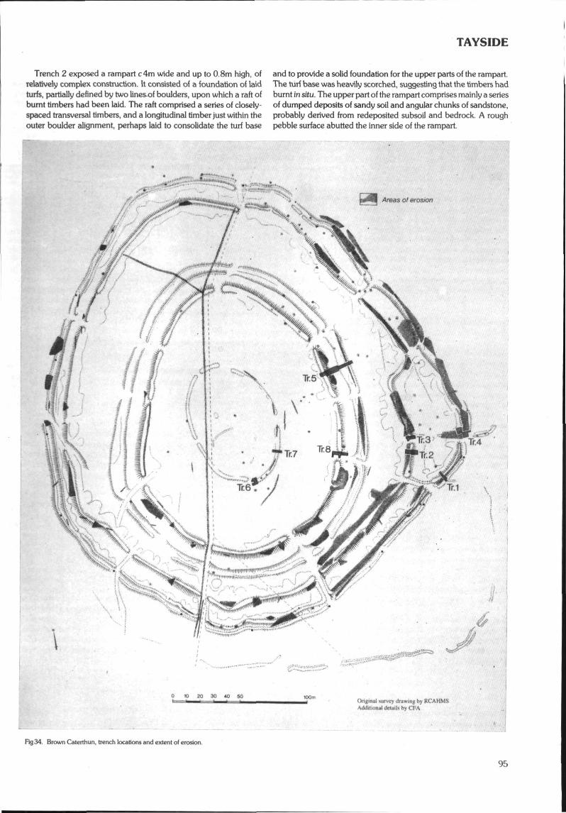
TAYSIDE
Trench 2 exposed a rampart c 4m wide and up to 0.8m high, ofrelatively complex construction. It consisted of a foundation of laidturfs, partially defined by two lines-of boulders, upon which a raft ofburnt timbers had been laid. The raft comprised a series of closely-spaced transversal timbers, and a longitudinal timber just within theouter boulder alignment, perhaps laid to consolidate the turf base
and to provide a solid foundation for the upper parts of the rampart.The turf base was heavily scorched, suggesting that the timbers hadburnt in situ. The upper part of the rampart comprises mainly a seriesof dumped deposits of sandy soil and angular chunks of sandstone,probably derived from redeposited subsoil and bedrock. A roughpebble surface abutted the inner side of the rampart.
'"' • • ' • •Areas of erosion
.ggtlffiMMfilfesM , tiu'.>"!r'""'"«t • • '"''''•".-,
v.^"'-"/ " ' -.I.' ',/X
// ^
'/#/r ^17-^>
mt ^mw ^m&i,'*. - M.
SSsfc
""<::• \& e>x4Kv..>?OvV• - ""%*L. \^
=:::-
^ V,/"•-,„ / ̂ ftiiimSS^̂ X -'"feNfr f̂e.,, "'"<; "1J^ ^X ;̂ »
,̂. S; |« f"""""""w ' :"-";"-
.•̂• • • ., • ; • • . • • • • '
i.".,,u...u, ,...»•'"
0 10 20 30 40Original >.ur\cy Jrawin^ by RCAHMSAddHmna! details by CFA
Rg34. Brown Caterthun, trench locations and extent of erosion.
TAYSIDE
Trench 3 revealed the rabbit damage to excavated deposits inthis entrance passage to be less extensive than from surface traces.A complex sequence of deposits and stone alignments was identi-fied, but not excavated. It appeared that the southern boundary ofa putative paddock between the outermost two encircling works atthis point was a secondary construction to the rampart. Post holeswere identified adjacent to the northern rampart terminal whichpossibly reflect the presence of gateway features.
Trench 4 demonstrated that both the outer work and the rampartwere of simple dump construction. A single post hole was located onthe intumed bank, cut through the rampart deposits.
Trench 5 revealed the largest rampart encircling the hill to havea complex construction. A primary boulder core with an outerrevetting face and rubble inner bank was identified. The remains ofa hurdle breastwork which had burnt down and collapsed inwardswas located on the summit of the capping. This rampart had sub-sequently been recapped with another turf layer. The rampartsrunning outside and parallel to this were demonstrated to be nomore than low dumps. A palisade trench was identified 3m withinthe inner of the two, and a post hole sealed beneath a patch ofcobbling abutted the outer dump.
Trench 6 demonstrated the rampart to comprise a low bank ofsandy soil containing a number of boulders spread to c 3m wide andup to 0.4m high. Sealed or partly beneath the bank were two parallelpalisade trenches c l.lm apart running approximately NE-SW andparallel to the bank. The northern palisade trench turned sharplynorthwards within the trench, and possibly defining the position ofan entrance. A laid cobble surface lay was sealed beneath a layerof sandy clay soil between the two palisades, above a possibleburied turf line. At least two structural phases are proposed and thearrangement of the double palisade feature suggests the presence ofa former box rampart with an intumed entrance. Trench 7 revealeda similar sequence.
Trench 8 exposed the entrance passage, which was c7.5m longand c2.8m wide. Potential structural features identified within theentrance passage comprise a transverse double cobble alignmentenclosing a probable slot, a pebble alignment running perpendicularto this and possibly related, and a negative linear feature witha distinct circular projection. Due to the complexity of featuresencountered in other trenches and the relatively less serious rabbitdamage encountered in this trench little more than cleaning, photo-graphy and planning of the deturfed areas was attempted within thetime available.
The excavation has shown that the erosion of the archaeologicalfeatures by rabbit infestation is at least as damaging and in mostcases more extensive than surface traces would indicate. A suite ofsamples was collected and an evaluation of the palaeoenvironmentalpotential of the site is being conducted. Trenches 1,2,5 and 7 pro-duced charcoal deposits which should be identifiable and may besuitable for 14C dating. Finds from the site were limited to two smallflint pieces and modern debris.Sponsor: HS Q.
Carlungie/Ardestie (Monikie parish) R BenvieCopper alloy ball
NO 5135/5136 and NO 5034 A copper alloy ball with a holepierced in one end, 3.5cm diameter, was discovered in the vicinity ofa souterrain in the Carlungie/Ardestie area, as a surface find. It wasbrought in as a verbal enquiry to Montrose Museum in 1994 and toGlasgow Museums in January 1995. It was retained by the finder.Glasgow Museums Enquiry Number 1306.
Renny Crescent, Montrose (Montrose parish)Medieval pottery and coin
NO 711 594 A collection of about 50 sherds of medieval potteryand a Charles I copper turner or twopence, Earl of Stirling Coinage
1632-9 have been discovered over a period of 9 years in the gardensoil of 50 Renny Crescent. They were probably brought in topsoilwhen the houses were built c 1970.Museum Daybook Numbers and Accession Numbers:DBM 474: 1 sherd (comb decoration) and Charles I copper turner.Retained by finder. DBM 1623: 2 sherds, retained by finder.M1989.20-26: 7 sherds. M1995.168 & 169: 2 sherds with fingermarks.
Renny Crescent, Montrose (Montrose parish)Coin
NO 712 594 A copper coin, Swedish (1620/21) of GustavusAdolphus 1611-1632, was discovered some years ago in thegarden soil of 48 Renny Crescent. It was probably brought in topsoilafter the building of the houses c 1970. The coin was retained by thefinder. Museum Daybook Number: DBM 1889.
Garrison Road — Barrack Road, Montrose (Montrose parish)Busby plume holder
NO 719 572 (approximate) A busby plume holder c 1855, fromthe Forfar and Kincardineshire Militia uniform was found at theLenlothian Sheds near Glaxochem, close to the original site of thePanmure Barracks, where the regiment was stationed. It was donatedto Montrose Museum. Size: 8.2cm (h) by 2.4cm (w) by 2cm (b).Museum Accession Number: M1995.151.
Christie's Lane, Montrose (Montrose parish)Coin
NO 720 577 A James VI Hardhead was found on the surfaceof the garden of 89 Christie's Lane. It was donated to MontroseMuseum. Museum Accession Number; M1995.150.
Royal Infirmary. Bridge Street, Montrose R Cachart (SUAT)(Montrose parish)Site of post-medieval fort within medieval burgh
NO 710 574 In February 1995 the Trust undertook an archae-ological evaluation in advance of the relocation of the physiotherapydepartment to the SW part of the garden at the rear of MontroseRoyal Infirmary. The site was identified as being archaeologicallysignificant due to its position within the boundaries of the medievalburgh and also because the infirmary was the site of a small 16thcentury fort.
Three trenches were excavated, recorded and backfilled. Norelevant archaeological features were found. The excavationsrevealed natural deposits of water-lain and wind-blown sand,garden features, evidence of site remodelling and the recent remainsof a tennis court surface.Sponsor: Angus NHS Trust.
34 High Street, Montrose (Montrose parish)Core of medieval burgh
NO 713 580 In February 1995 the Trust carried out a watchingbrief on the site of a demolished building in the backlands of 34 HighStreet. A stable/storehouse had been demolished and work wasunder way to reduce the floor level in advance of building. Thewatching brief revealed foundations, cobble flooring, interior wallsand modern deposits which produced a quantity of Victorianpottery. Nothing relating to the medieval period was identified.Sponsor: HS Q.
Ruthven Parish Church (Ruthven parish) N AtkinsonCross slab
NO 285 488 Of two stones built into the W gable of the church,one has what may be an Early Christian Cross. The stone wasbrought to my attention by photographer Tom Gray and is probablyone of the stones mentioned in 1879 by Andrew Jervise.
96
TAYSIDE
CITY OF DUNDEE DISTRICT
R Cachart (SUAT)Camperdown Park (Dundee parish)Pictish settlement
NO 370 330 In August 1995 the Trust undertook trial excava-tions in fields on the N side of the former Timex factory, in advanceof road making and site servicing work. It was considered that thegroundworks required for the development might disturb archae-ological evidence relating to Pitalpin Village, a possible site of Pictishsettlement. Nine trenches were excavated, revealing a shallow, siltyloam topsoil over a stony subsoil. Apart from a number of modernfield drains nothing of archaeological interest was found. It wasconcluded that any remains of Pictish settlement would probably liefurther S, beneath the factory and closer to the Coupar Angus Road.Sponsor: Scottish Enterprise Tayside.
Dundee High Street Environmental Improvements(Dundee parish)Medieval burgh
NO 403 302 In January 1995 the Trust undertook a watchingbrief to monitor groundworks for environmental improvements onthe N and S sides of High Street, Dundee. These areas had beenstripped to a depth of c0.40m in preparation for new surfaces andseveral tree pits, up to 2m in depth, had been excavated.
Archaeological deposits and features were recorded in ground-works for resurfacing and excavations for tree planters. Unstratifiedanimal bone, mainly from groundworks for services in front of thecity square, was also recovered. Of particular interest was the dis-covery of the foundation remains of the 1731 Adam's townhouse.Sponsor: Scottish Enterprise Tayside.
John Gardyne's Land, Dundee (Dundee parish) R Coleman,Urban medieval S Stronach (SUAT)
NO 4034 3030 Two test pits were hand excavated in the en-virons of John Gardyne's House, a 16th century merchant'sdwelling sited behind the frontage of the High Street. One test pitwas positioned in an area of open pend and despite truncation bymodern services established the survival of a medieval cultivationsoil, apparently predating the building. The other test pit, located ina courtyard, revealed a sequence of medieval layers, probablydating back to the 12th century, and a medieval drystone well,dating to the 12th-13th century. A small but diverse assemblage ofmedieval pottery, including several imports, was recovered. Naturalsubsoil was identified at a depth of 0.9-lm below present groundsurface.Sponsor: Dundee Preservation Trust.
Carmichael Cottages (Longforgan parish) I ArmitPossible cursus
NO 303 310 (centre) Routine examination, in the course ofplanning clearance work, of a series of photographs taken by theRCAHMS in 1984 revealed that a site recorded simply as 'crop-marks' (NO 33 SW 50) appears to represent part of a large cursusmonument of Neolithic date.
The site occupies a well-defined natural plateau with a moderatelysteep drop around three sides. The interior appears to be some 60mwide by at least 300m long, the ENE part disappearing under themodem road and presumably running into the next field. Theditches, running approximately ENE-WSW, are defined by singledark cropmarks of variable definition, except the ENE part of theS ditch which appears to be marked by two parallel narrow crop-marks. The latter feature is sufficiently unusual to instil a measure ofdoubt in the identification of the site as a cursus. The WSW terminusis marked by a transverse ditch, characteristic of several Scottishcursus monuments.Sponsor: HS H.
PERTH & KINROSS DISTRICT
45 Main Street, Abernethy (Abernethy parish)Site within area of Pictish settlement R Cachart (SUAT)
NO 1897 1636 In October 1995 the Trust conducted a watchingbrief on renovations to this property. The site is located within thetown's central core, close to the round tower and sites of earlyreligious establishments. It was considered that the depth of excava-tion required for the renewal of the ground floor could well revealarchaeological evidence relating to earlier phases of the presentbuilding and general site usage dating back to Pictish occupation.Observations were made on the make-up deposits of the floorsurface and a small trench in the garden. The floor make-up wasexamined to a depth of 0.25m and found to be relatively modern. Inthe garden trench the floor make-up extended outside the buildingand was a levelling layer for the initial erection of the building. Thelevelling layer was not bottomed and nothing of archaeologicalsignificance was recorded.Sponsor: Mr G White Esq.
Mornington Cottage Stables, School Wynd, Abernethy(Abemethy parish)Site within area of Pictish settlement
NO 1896 1645 A watching brief commenced in August 1995. Itrevealed a cobbled surface against the outside wall at the rear of thebuilding which had been buried below 0.30m of garden soil. Thecobbled surface was considered to be contemporary with the build-ing. Inside was a new cement floor with rubble make-up and in anadjoining room an earlier cobbled surface. These floors directlyoverlay a natural deposit of laminated silty clays and sands.Sponsor: Perth & Kinross District Council.
Mornington Cottage Stables, School Wynd, Abernethy(Abemethy parish) A Cox (SUAT)Finds assemblage
NO 1896 1645 Seven fragments of post-medieval, ceramicbuilding material were recovered during the investigation of this site.Five of these are fragments of ceramic roof tiles, in a moderatelycoarse, red to orange fabric. The remaining components of theassemblage consist of a circular, ceramic pipe set within a section offlat-bottomed, ceramic housing. These probably functioned as partof aland drain,Sponsor: Perth & Kinross District Council.
Upper Quolgs (Ardoch parish) N Lockett, D WoolliscroftPutative Roman watch tower
NN 822 063 A geophysical survey and trial excavation werecarried out on the site of a 'ring-ditch' seen from the air in 1984(RCAHMS A64658). The site lies approximately half way betweenthe Gask tower of Greenloaning and the fortlet of Glenbank andmust lie close to the Roman road between the two. The site has thusbeen tentatively put forward as a Roman tower.
The excavation sectioned a shallow V-shaped, sand-cut ditchmeasuring 1.55m wide and 0.55m deep which had been deliber-ately backfilled not long after being dug. This ditch appeared in onlyone of two sections dug on its projected line, however, and as nodatable finds were made little can be said about the form and originsof the site as a whole.Sponsor: University of Manchester, Department of Archaeology.
Greenloaning (Ardoch parish) D J WoolliscroftRoman tower
NN 830 071 The site has long been known from the air and hasnow been confirmed by excavation as a double ditched Gask seriestower. The two ring ditches were of the normal Roman 'V1 profilebut unexpectedly shallow. In all the site is c 25m in diameter with an
97
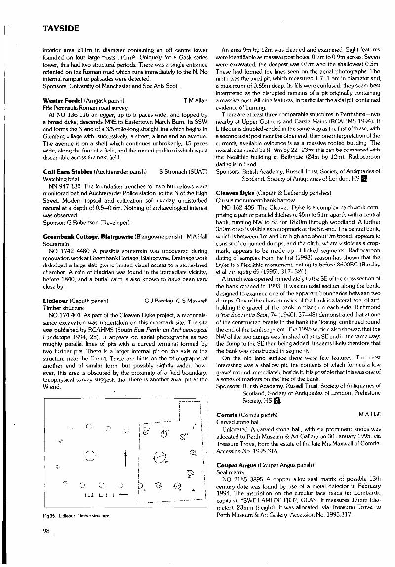
TAYSIDE
interior area dim in diameter containing an off centre towerfounded on four large posts c(4m)2. Uniquely for a Cask seriestower, this had two structural periods. There was a single entranceoriented on the Roman road which runs immediately to the N. Nointernal rampart or palisades were detected.Sponsors: University of Manchester and Soc Ants Scot.
Wester Fordel (Arngask parish) T M AllanFife Peninsula Roman road survey
At NO 136 116 an agger, up to 5 paces wide, and topped bya broad dyke, descends NNE to Eastertown March Bum. Its SSWend forms the N end of a 3/5-mile-long straight line which begins inGlenfarg village with, successively, a street, a lane and an avenue.The avenue is on a shelf which continues unbrokenly, 15 paceswide, along the foot of a field, and the ruined profile of which is justdiscernible across the next field.
Coll Earn Stables {Auchterarder parish) S Stronach (SUAT)Watching brief
NN 947 130 The foundation trenches for two bungalows weremonitored behind Auchterarder Police station, to the N of the HighStreet. Modern topsoil and cultivation soil overlay undisturbednatural at a depth of 0.5-0.6m. Nothing of archaeological interestwas observed.Sponsor: G Robertson (Developer).
Greenbank Cottage. Blalrgowrle (Blairgowrie parish) M A HallSouterrain
NO 1742 4480 A possible souterrain was uncovered duringrenovation work at Greenbank Cottage, Blairgowrie. Drainage workdislodged a large slab giving limited visual access to a stone-linedchamber. A coin of Hadrian was found in the immediate vicinity,before 1840, and a burial cairn is also known to have been veryclose by.
Llttleour (Caputh parish) G J Barclay, G S MaxwellTimber structure
NO 174 403 As part of the Cleaven Dyke project, a reconnais-sance excavation was undertaken on this cropmark site. The sitewas published by RCAHMS (South East Perth: an ArchaeologicalLandscape 1994, 28). It appears on aerial photographs as tworoughly parallel lines of pits with a curved terminal formed bytwo further pits. There is a larger internal pit on the axis of thestructure near the E end. There are hints on the photographs ofanother end of similar form, but possibly slightly wider; how-ever, this area is obscured by the proximity of a field boundary.Geophysical survey suggests that there is another axial pit at theWend.
o
Rg35. Littleour. Timber structure.
An area 9m by 12m was cleaned and examined. Eight featureswere identifiable as massive post holes, 0.7m to 0.9m across. Sevenwere excavated, the deepest was 0.9m and the shallowest 0.5m.These had formed the lines seen on the aerial photographs. Theninth was the axial pit, which measured 1.7—1.8m in diameter anda maximum of 0.65m deep. Its fills were confused; they seem bestinterpreted as the disrupted remains of a pit originally containinga massive post. All nine features, in particular the axial pit, containedevidence of burning.
There are at least three comparable structures in Perthshire - twonearby at Upper Gothens and Carsie Mains (RCAHMS 1994). IfLittleour is doubled-ended in the same way as the first of these, witha second axial post near the other end, then one interpretation of thecurrently available evidence is as a massive roofed building. Theoverall size could be 8-9m by 22-23m; this can be compared withthe Neolithic building at Balbridie (24m by 12m). Radiocarbondating is in hand.Sponsors: British Academy. Russell Trust, Society of Antiquaries of
Scotland, Society of Antiquaries of London, HS ̂ .
Cleaven Dyke {Caputh & Lethendy parishes)Cursus monument/bank barrow
NO 162 405 The Cleaven Dyke is a complex earthwork com-prising a pair of parallel ditches (c 45m to 51m apart), with a centralbank, running NW to SE for 1820m through woodland. A further350m or so is visible as a cropmark at the SE end. The central bank,which is between 1m and 2m high and about 9m broad, appears toconsist of conjoined dumps, and the ditch, where visible as a crop-mark, appears to be made up of linked segments. Radiocarbondating of samples from the first (1993) season has shown that theDyke is a Neolithic monument, dating to before 3600BC (Barclayetal, Antiquity 69 (1995), 317-326).
A trench was opened immediately to the SE of the cross section ofthe bank opened in 1993. It was an axial section along the bank,designed to examine one of the apparent boundaries between twodumps. One of the characteristics of the bank is a lateral 'toe' of turf,holding the gravel of the bank in place on each side. Richmond(Proc Soc Antiq Scot, 74 (1940), 37-48) demonstrated that at oneof the constructed breaks in the bank the 'toeing' continued roundthe end of the bank segment. The 1995 section also showed that theNW of the two dumps was finished off at its SE end in the same way;the dump to the SE then being added. It seems likely therefore thatthe bank was constructed in segments.
On the old land surface there were few features. The mostinteresting was a shallow pit, the contents of which formed a lowgravel mound immediately beside it. It is possible that this was one ofa series of markers on the line of the bank.Sponsors: British Academy, Russell Trust, Society of Antiquaries of
Scotland, Society of Antiquaries of London, PrehistoricSociety, HS @.
Comrte (Comrie parish) M A HallCarved stone ball
Unlocated A carved stone ball, with six prominent knobs wasallocated to Perth Museum & Art Gallery on 30 January 1995, viaTreasure Trove, from the estate of the late Mrs Maxwell of Comrie.Accession No: 1995.316.
Coupar Angus (Coupar Angus parish)Seal matrix
NO 2185 3895 A copper alloy seal matrix of possible 13thcentury date was found by use of a metal detector in February1994. The inscription on the circular face reads (in Lombardiccapitals): *SWILLAMI DE F[ilii?] GLAY. It measures 17mm (dia-meter), 23mm (height). It was allocated, via Treasurer Trove, toPerth Museum & Art Gallery. Accession No: 1995.317.
98
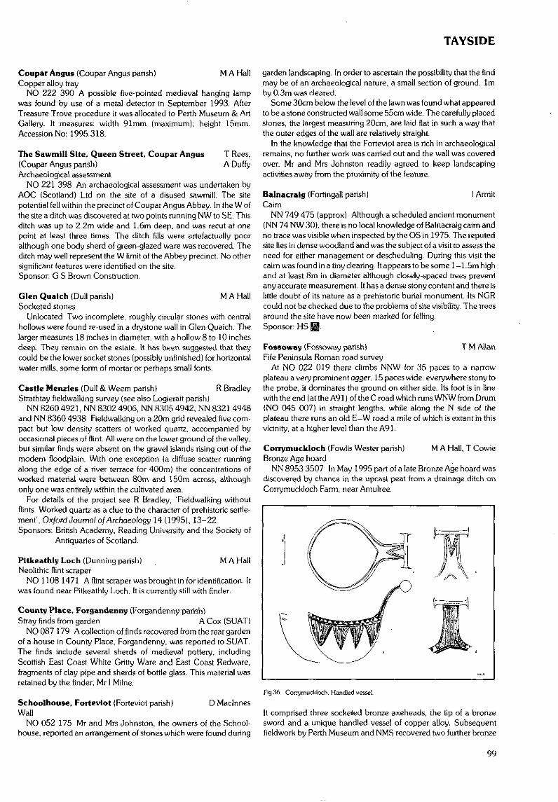
TAYSIDE
Coupar Angus (Coupar Angus parish) M A HallCopper alloy tray
NO 222 390 A possible five-pointed medieval hanging lampwas found by use of a metal detector in September 1993. AfterTreasure Trove procedure it was allocated to Perth Museum & ArtGallery. It measures: width 91mm (maximum); height 15mm.Accession No: 1995.318.
The Sawmill Site, Queen Street, Coupar Angus T Rees,(Coupar Angus parish) A DuffyArchaeological assessment
NO 221 398 An archaeological assessment was undertaken byAOC (Scotland) Ltd on the site of a disused sawmill. The sitepotential fell within the precinct of Coupar Angus Abbey. In the W ofthe site a ditch was discovered at two points running NW to SE, Thisditch was up to 2.2m wide and 1.6m deep, and was recut at onepoint at least three times. The ditch fills were artefactually pooralthough one body sherd of green-glazed ware was recovered. Theditch may well represent the W limit of the Abbey precinct. No othersignificant features were identified on the site.Sponsor: G S Brown Construction.
Glen Qualch (Dull parish) M A HallSocketed stones
Unlocated Two incomplete, roughly circular stones with centralhollows were found re-used in a drystone wall in Glen Quaich. Thelarger measures 18 inches in diameter, with a hollow 8 to 10 inchesdeep. They remain on the estate. It has been suggested that theycould be the lower socket stones (possibly unfinished) for horizontalwater mills, some form of mortar or perhaps small fonts.
Castle Menzles (Dull & Weem parish) R BradleyStrathtay fieldwalking survey (see also Logierait parish)
NN 8260 4921, NN 8302 4906, NN 8305 4942, NN 8321 4948and NN 8360 4938 Fieldwalking on a 20m grid revealed five com-pact but low density scatters of worked quartz, accompanied byoccasional pieces of flint. All were on the lower ground of the valley,but similar finds were absent on the gravel islands rising out of themodern floodplain. With one exception (a diffuse scatter runningalong the edge of a river terrace for 400m) the concentrations ofworked material were between 80m and 150m across, althoughonly one was entirely within the cultivated area.
For details of the project see R Bradley, 'Fieldwalking withoutflints. Worked quartz as a clue to the character of prehistoric settle-ment', Oxford Journal o/Arcfiaeo/ogy 14 (1995), 13-22.Sponsors: British Academy, Reading University and the Society of
Antiquaries of Scotland.
Pitkcathly Loch (Dunning parish) _ M A HallNeolithic flint scraper
NO 1108 1471 A flint scraper was brought in for identification. Itwas found near Pitkeathly Loch. It is currently still with finder.
County Place, Forgandenny (Forgandenny parish)Stray finds from garden A Cox (SUAT)
NO 087 179 A collection of finds recovered from the rear gardenof a house in County Place, Forgandenny, was reported to SUAT.The finds include several sherds of medieval pottery, includingScottish East Coast White Gritty Ware and East Coast Redware,fragments of clay pipe and sherds of bottle glass. This material wasretained by the finder, Mr I Milne.
Schoolhouse, Forteviot (Forteviot parish) D MaclnnesWall
NO 052 175 Mr and Mrs Johnston, the owners of the School-house, reported an arrangement of stones which were found during
garden landscaping. In order to ascertain the possibility that the findmay be of an archaeological nature, a small section of ground, 1mby 0.3m was cleared.
Some 30cm below the level of the lawn was found what appearedto be a stone constructed wall some 55cm wide. The carefully placedstones, the largest measuring 20cm, are laid flat in such a way thatthe outer edges of the wall are relatively straight.
In the knowledge that the Forteviot area is rich in archaeologicalremains, no further work was carried out and the wall was coveredover. Mr and Mrs Johnston readily agreed to keep landscapingactivities away from the proximity of the ieature.
Balnacralg (Fortingall parish) I ArmitCaim
NN 749 475 (approx) Although a scheduled ancient monument(NN 74 NW 30), there is no local knowledge of Balnacraig cairn andno trace was visible when inspected by the OS in 1975. The reputedsite lies in dense woodland and was the subject of a visit to assess theneed for either management or descheduling. During this visit thecairn was found in a tiny clearing. It appears to be some 1 -1.5m highand at least 8m in diameter although closely-spaced trees preventany accurate measurement. It has a dense stony content and there islittle doubt of its nature as a prehistoric burial monument. Its NGRcould not be checked due to the problems of site visibility. The treesaround the site have now been marked for felling.Sponsor: HS 0.
Fossoway (Fossoway parish) T M AllanFife Peninsula Roman road survey
At NO 022 019 there climbs NNW for 35 paces to a narrowplateau a very prominent agger, 15 paces wide, everywhere stony tothe probe, it dominates the ground on either side. Its foot is in linewith the end (at the A91) of the C road which runs WNW from Drum(NO 045 007) in straight lengths, while along the N side of theplateau there runs an old E-W road a mile of which is extant in thisvicinity, at a higher level than the A91.
Corrymuckloch (Fowlis Wester parish) M A Hall, T CowieBronze Age hoard
NN 8953 3507 In May 1995 part of a late Bronze Age hoard wasdiscovered by chance in the upcast peat from a drainage ditch onCorrymuckloch Farm, near Amulree.
Fig 36. Corrymuckloch. Handled vessel.
It comprised three socketed bronze axeheads, the tip of a bronzesword and a unique handled vessel of copper alloy. Subsequentfieldwork by Perth Museum and NMS recovered two further bronze
99
TAYSIDE
sword fragments and, in the surrounding fields, a palimpsest offeatures, including cairns, hut circles, cup-marked stones, long-houses, rig and furrow and Wade Road quarries. The hoard iscurrently with the NMS, pending a decision by the Treasure TroveAdvisory Panel.
Bumfoot, Glen Devon (Glendevon parish) T M AllanFife Peninsula Roman road survey
NN 990 042 An agger-like embankment descends NW towardsBumfoot accommodation-road, with a post-Roman road close by itsSW side.
Cleuch Farm and Hunthall (Glendevon parish)Fife Peninsula Roman road survey
From NN 967 054 to NN 961054, straight along three contiguousfields adjacent to the A823, the following features exist: (1) In thefirst field a low agger, 7 paces wide, and distinguishable also by longgrass which, in October, was slightly darker than that on either sideof it. (2) In the second field a sharply-defined belt, very slightlyraised, and 5 paces wide, of very much lighter-coloured earth(recently harrowed) than that on either side of it, and strewn morethickly with pebbles and small stones than the earth on either side ofit. (3) In the third field a prominent agger, 7 paces wide, which, half-way across the field, bends SW to become an intermittent low aggerpointing towards a modem bridge over Hillkitty Burn, therebyavoiding drumlins.
Castlehlll Reservoir, Glen Devon (Glendevon parish)Fife Peninsula Roman road survey
From NN 994 033 to NN 993 035 there runs NNW for 1 /5 mile ona shelf a green, short-grass agger, 7 paces wide, with a W-side ditch,and everywhere stony to the probe.
Milton of Lawera (Kenmore parish) D MaclnnesTownship
ce NN 681 397 As part of an ongoing study of archaeologicalremains in Glen Lochay and Loch Tayside by AGFA, a survey ofMilton of Lawers was carried out in October 1995. The site wasdrawn up at a scale of 1:1000 and individual features at 1:100 and1:50. The remains recorded include: The Laird's House. LawersChurch (constructed 1669), two mills, nine other buildings, a corn-drying kiln, mill-lade, bridge, pier, a number of enclosures anda possible ice-house. The nearby graveyard was also surveyed andan inventory of grave inscriptions made.
Pltcur Souterraln (Kettins parish) T Neighbour (CFA)Geophysical survey
NO 2529 3738 Resistance and gradiometer surveys were con-ducted in the immediate vicinity of Pitcur souterrain (NMRS noNO 23 NE 1). Although most of the souterrain lies within a fencedarea, the portion of passage that survives with lintels intact extendsunder a ploughed field. Ploughing has actively destabilised thelintels and brought about the risk of collapse.
The main objective was to ascertain the full extent of the sou-terrain passage. This information is to be used to mark out the line ofa new fence to enclose the whole site.
In addition to a number of features of modern origin, the surveywas successful in identifying the precise position of the survivingpassage.
Reports havt: been deposited with the NMRS.Sponsor: HS Q.
Old Kinnoull Church (Kinnoull parish) R Cachart (SUAT)Medieval graveyard
NO 122 232 During April and May 1995 the Trust undertook anexcavation in the south-western corner of the Old Kinnoull Church
graveyard in advance of the replacement of a section of the grave-yard revetting wall. The foundations of the old walls were to beremoved and a new wall constructed. The new wall was to havea massive concrete foundation which would require the excavationof a trench approximately 2m wide and 2.7m deep inside the grave-yard. Archaeological excavation was undertaken to identify andrecord any evidence of early Christian inhumations, deposits orfeatures pertaining to the original Kinnoull Church.
The remains of over 50 mainly coffined burials dating from earlymodem times were recorded and removed along with a consider-able amount of disarticulated bone. Coffin and coffin furnitureremains and some small artefacts associated with burials were alsorecovered. A small assemblage of residual medieval pottery wasrecovered but otherwise there was no evidence of remains earlierthan the 18th century.Sponsor: Perth & Kinross District Council.
Kinnoull Aisle (Kinnoull parish)Medieval church and graveyard
NO 123 233 In January 1995 the Trust undertook excavationsfor drainage around the recently refurbished Kinnoull Aisle (con-structed 1635) in the medieval Kinnoull Parish Churchyard. Thiswork consisted of excavating three trenches around the Aisle andone trench and a soakaway in the graveyard. The excavationsrevealed archaeological deposits relating to the graveyard and Aisle,human and animal bone, medieval pottery and tile and relativelymodem coffin nails and handles. A human skull was found close tothe surface against the W wall of the aisle, no doubt having beenreburied after being disturbed by a later burial. However, its locationwas regarded as sufficiently suspicious to warrant reporting it to thepolice, who removed it for further investigation.Sponsor: Perth and Kinross Heritage Trust.
Kinnoull Aisle (Kinnoull parish) A Cox (SUAT)Finds assemblage
NO 123 233 Among the artefact assemblage recovered from theexcavations adjacent to the Kinnoull Aisle was a small group of coffinhandles of post-medieval date. Each consists of a curved, iron orsteel handle with small lugs, attached to a thin, iron plate by eyebolts. The lugs at either end of the handle have been inserted into theeyes of the bolts. Fragments of wood, probably from the coffin sides,adhere to the undersides of the plates and to the shanks of the bolts.
Two fragments of ceramic floor tile were found lying adjacent tothe W wall of the Aisle. They are very probably of medieval date andthe presence of associated Perth Local pottery with a slip beneaththe glaze indicates that they could be as early in date as the 13th or14th centuries.Sponsor: Perth and Kinross Heritage Trust.
Lochleven Castle (Kinross parish) G Ewart, D StewartStone forestair; middens
NO 137 017 A short programme of excavation during Septem-ber and October of 1995 revealed the footings of a stone forestair,giving access to the Great Hall of the tower. The stonework com-prised a reverting wall and rubble core, with two surviving steps atits lowest level, access to which was via metalled pathways withinthe courtyard. Considerable deposits (up to 0.75m deep) hadaccumulated against the outer faces of the forestair, containingpottery of c!6th century date, and quantities of animal bone -midden from the occupation of the tower.Sponsor: HS 0.
Easter Bleaton Hill {Kirkmichael parish) M A HallIron slag from hut circle site
NO 1456 5702 A small sample of iron-working slag was donatedto Perth Museum & Art Gallery. Accession No: 1995.999.1 & 2.
100
TAYSIDE
The material was found in 1969 after initial ploughing by theForestry Commission. The site has been recorded by the RoyalCommission (NO 15 NW 8, and p 133 North East Perth). A previ-ously unrecorded settlement site directly behind the finder's housewas also brought to the attention of the Royal Commission.
Pittensorn Farm (Little Dunkeld parish)Fictish stone fragment
NO 0860 3905 This fragment of Pictish stone reported in DES1994, 88, has been allocated to Perth Museum & Art Gallery asTreasure Trove. Accession No: 1995.319,
Mains of Murthly (Logierait parish) R BradleyStrathtay fieldwalking survey (see also Dull & Weern parishes, p 99)
NN 8731 4920 Fieldwalking on a 20m grid revealed a lowdensity distribution of worked quartz and flint extending up thesouthern side of Strath Tay from NN 8718 4946 (the northern limitof the cultivated area) as far as the rock carvings at NN 8755 4907where the distribution of artefacts reached its minimum.Lundin (Logierait parish)
NN 8821 5050 Fieldwalking on a 20m grid revealed a scatter ofworked quartz occupying the entire field to the E of the Lundin stonecircle. This seems to have utilised raw material available on thesurface in this area.Sponsors: British Academy, Reading University and the Society of
Antiquaries of Scotland,
Upper Brae of CultulHch (Logierait parish) I ArmitSettlement
NN 887 490 Contained within a meander of the W bank of theCultullich Burn close to Aberfeldy are the remains of a small, prob-ably post-medieval settlement. An enclosing wall and numerouscurving and rectilinear foundations are obscured in dense broom.The vegetation makes interpretation of the site impossible but thereare plans to have the site grazed under and ESA scheme, whichshould enable further detail to be obtained within a few years.Sponsor: HS 03.
Balnacree (Logierait parish)Settlement
ce NN 9645 5710 During the course of inspection for an applica-tion under the Environmentally Sensitive Area scheme an area ofpre-Clearance settlement was identified some 250m NNW ofBalnacree Farm, Dalshian, near Pitlochry. All of the remains surviveas low stony banks exhibiting varying degrees of preservation. Theycomprise two rectilinear buildings within an enclosure, straddling thejunction of four modern fields. To the immediate NE is an area ofmarsh, beyond which are further, more residual structures sited ona slight knoll. A bank enclosing these remains has been modifiedby a recent drainage ditch. In another field just to the E of thecomplex are a series of ridged fields.Sponsor: HS Q.
Inchaffray (Madderty parish) M A HallSeal matrix
NN 954 226 A lead seal matrix dating to the 15th/16th centurywas found using a metal detector on land near Inchaffray Abbey. It isinscribed with the name Robert Lundy and bears a shield of armscomprising a lion rampant and three cushions. Declared TreasureTrove, it has been allocated to Perth Museum & Art Gallery.Accession No: 1995.1429. Diameter: 28mm.
Balgowan Home Farm (Methven parish)Cropmark
NN 9855 2451 Throughout May - June 1995 a very clear ring-ditch cropmark was visible in the field of Balgowan Farm as it runs
beside the A85 from Methven to Crieff. Other less visible marks ranthrough the field.
Auchnafree (Monzievaird & Strowan parish)Stone mortar
NN 819 336 Renovation work on an outbuilding approximately100 years old uncovered a large stone measuring 21 inches by25 inches, with a central hollow 15 inches deep. This cup hassmoothly polished sides. It is thought to be a mortar or pounder ofpost-medieval or later date. It remains on the Auchnafree estate.
Tullibole (Muckart parish; also Kinross parish) . T M AllanFife Peninsula Roman road survey
At NO 050 004 there runs WNW in rough grass across the westernthird of a wood a low, mostly stony agger, 5 paces wide, in line withthe C road running WNW from Drum (NO 045 007) in straightlengths. That road is itself in line with a mile-long straight length ofroad B9097 from NO 060 000 to NT 078 993, and with a half-mile-long straight length of road B9097 from NT 096 985 to NT 102 982(Carsegour).
Auchingarrich (Muthill parish)Highland Front Roman road survey
From a field-gate by a cottage at the foot of Auchingarrichaccommodation-road (NN 789 197) there runs SE across a narrowfield a low, continuous agger, up to 12 paces wide, with, midway.a slight northward bend. In April its grass was shorter than that oneither side of it, but it is only intermittently stony to the probe.
From here the likeliest course of a Roman road, at first avoidinga rushy area at NN 791 196, is along first the SSW, and then the W,side of Auchingarrich Burn, and thence S to Garadh Dubh (DES1994, 88). This suggested course supersedes the more westerly onesuggested in DES 1985, 52, lines 1-4.
Muthill (Muthill parish)Highland Front Roman road survey
At NN 876 176 there is a line of loose boulders, to a width of10 paces. And at NN 880 177 there are loose boulders and largecobbles, to a width of 11 paces, in the sloped W bank of a burn-Both of these features are in line with lengths of C road ending atNN 865 171 and NN 884 179, in the latter case en route to Mains ofSrrageath (see DES 1992, 75) and the resulting 2W>-mile-longalignment passes diagonally across a drive at NN 872 174 which isby local tradition Roman. This line supersedes the more northerlyone suggested in DES 1992, 76.
Culltbum {Muthill parish) D J Woolliscroft?Roman enclosure
NN 8923 1765 The site has long been known from the air asa rectangular enclosure sitting immediately E of (and parallel to) theRoman road c600m SW of the fort of Strageath, and suspected ofbeing a fortlet.
A resistivity survey showed one site to be rather too small, how-ever, at 18m (N-S) by c 23m (E-W). Trial excavations showed theN and S ditches to be flat bottomed, c2m wide and 1m deep and tohave been backfilled after only a brief period of use. Excavation inthe interior revealed no sign of a rampart or palisade, but a 7.2m(E-W) by 3m (N-S) structure, founded on three massive beams,was found just inside the N ditch, which yields a single Samianfragment.Sponsor: University of Manchester.
Machany Water (Muthill parish)Suspected Roman fortlet
NN 876 151 Resistivity survey at the site of the suspected fortlet(DES 1994, 88) revealed an enclosure (c60m)2 with an entrance in
101

TAYSIDE
its SE corner. Trial excavations showed this to be an old field and noother structures were detected.Sponsor: University of Manchester.
Tannerhall (Orwell parish) T M AllanFife Peninsula Roman road survey
At NO 121 077 the more westerly of the C roads from Milnathortto Glenfarg bends from NW to NNW, and on the W side of the roadhere there are two very large quarry-pits. From here, too, a flat shelfclimbs due S to half-way up to a high point at NO 121 073 whichcommands an extensive view including that towards Cowdenbeath(16 miles). Such a route would also have given a Roman roada straight course S by Tannerhall (NO 121 070) to Holestonburn(NO 121 063) in place of the existing eastward detour by Middleton(NO 124 068).
168 High Street, Perth (Perth parish) J R Mackenzie (SUAT)Urban medieval
NO 117 236 Monitoring of contractors' works during the removalof a cellar floor revealed a medieval midden deposit at c5m OD.Sherds of white gritty ware pottery and a small assemblage of but-chered animal bone were recovered. The truncated remnant of apossible wattle fence was found cut through the midden deposit. Thisfence lay parallel to the High Street c 7m to the rear of the frontage.A drystone well was also cut through the midden deposit. This wellwas 0.6m in diameter and was set back 3.6m from the street frontage.Sponsor: Axa Equity and Law.
Perth Business Park, Glasgow Road (Perth parish)Medieval monastic lands R Cachart (SUAT)
NO 109 236 Five trial trenches were hand excavated in Novem-ber 19941 in the north-western corner of the business park inadvance of development. It was hoped to find evidence relating tothe Whitefriars monastery, its graveyard, the precinct boundary oragricultural activity.
The excavated trenches revealed compact hardcore layers over-lying infill/levelling layers of redeposited silty clay which contained19th century pottery and some residual medieval sherds. Naturalclay was reached at a depth of 1.50m.
The silty clay dumps appeared to be related to infilling and level-ling for a large warehouse, recently demolished. Nothing relating tothe Whitefriars1 monastery was identified.Sponsor: Scottish Enterprise Tayside.
Gloag's, North William Street (Perth parish)Medieval monastic lands
NO 116 238 In November 1994 three trenches were excavatedprior to development on this site thought to occupy part of theBlackfriars' lands. Of specific interest was the possibility that a largepre-friary ditch found in a previous excavation on the Blackfriarsbuildings extended into the present site. Also of interest was earlyland usage and Jacobite defences.
Excavations revealed demolition rubble and foundations ofrecently demolished 19th century buildings. At approximately 0.30mbelow the present surface two layers of similar garden/cultivation soilswere encountered which contained modem pottery and some resid-ual sherds of medieval pottery. At 1.60m natural clay was reached.
The evidence suggested that the land here was cultivated untilfairly recent times. Nothing relating to the pre-Blackfriars ditch orJacobite defences was found.Sponsor: Matthew Gloag & Son Limited.
Perth (Perth parish) M A HallPilgrim badge
Unlocated A pewter/lead-alloy pilgrim badge was purchasedby Perth Museum & Art Gallery in June 1995. It is a badge of
St John the Baptist's shrine at Amiens. It has been in the vendor'sfamily for several generations. It may have been found in Perth,where the parish church is dedicated to St John. It was cast from thesame mould as a similar badge in Canterbury Museum. AccessionNo: 1995.1107. Diameter: 28mm (40mm across loop fasteners).
Butterwell Burn Bridge; Allt a Bheallch Bridge; FowllsWester; Binn Hill; Perth Aerodrome (Portmoak; Kenmore;Fowlis Wester; Kinfauns: St Martins parish)WWII defensive sites
NO 1536 0599; NN 7831 4530; NN 9231 2490 and NN 92482479; NO 1592 2291; NO 1488 2792 and centring on NO 15092849 Preliminary work towards the Defence of Britain project hasidentified the following sites in Perth and Kinross:1 NO 15360599 A brick-built, hexagonal pill box close to the
Butterwell Bum, near Wester Balgedie.2 NN 7831 4530 A concrete and stone heptagonal pill box
approximately 1 mile from Kenmore on the A827 to Aberfeldy.3 NN 9231 2490andNN 9248 2479 Two brick-built observation
huts on the moorland ridge above Fowlis Wester (close to theFowlis Wester stone circle).
4 NO 1592 2291 A brick-built hexagonal pill box overlookinga minor road above the River Tay, and Kinfauns.
5 All on the western boundary of Perth Aerodrome, Scone:NO 1488 2792 A brick-built vehicle shelter(?).NO 1505 2849 Concrete base and entry ramp for a vehiclestore/ammunition store(?).NO 1510 2847 Brick-built windowless building; air raid shelter/storage unit(?).NO 1511 2849 Brick-built windowless building of three cells; airraid shelter/storage unit(?).
Elcho Castle (Rhynd parish) ' R Cachart (SUAT)Tower-house, 16th century
NO 164 210 In August 1995 the Trust undertook a watching briefon a hand-dug trench for water services on the S side of the scheduled,post-reformation 16th century tower-house. Tht; trench ran acrossthe lines of the tower-house approach road and the S barmkin wall.
The watching brief failed to find evidence of either the S barmkinwall or the internal approach road. Modem services and make-updeposits have disturbed and removed archaeological deposits.However, one small section of original wall foundation remained,running beneath the guardian's house.
Across the lawn area, away from former service trenches, theground had been made up over the natural rock and clay. Potteryfinds within the make-up indicated that this was recent landscaping.Tile and brick fragments appeared to be evidence of the demolitionof small buildings outside the S barmkin wall.Sponsor: HS Q.
Cairnie Road, St Madoes (St Madoes parish) A N SmithFurther assessment
NO 193 208 AOC (Scotland) Ltd re-investigated trenches cutover a cropmark site by SUAT, and extended the trenches to explorethe immediate vicinity of the cropmark. Only one trench (C) pro-duced evidence of archaeological activity, in the form of a section ofouter ring ditch relating to the cropmark. The site has subsequentlybeen preserved by burial under geotextile and incorporation into thelandscaping of the development with a Section 50 Agreement toensure its continued preservation.Sponsor: Mr H Imlay per Miller Hendry.
Ruthvenfield (Tibbermore parish) NMSCopper alloy bracelet, probably West African
NO 08 25 A penannular copper alloy bracelet with facetedknobbed terminals and stamped decoration was discovered in
102
TAYSIDE/ORKNEY ISLANDS AREA
October 1994 by Mr J D Taylor in the garden of 1 Castle Brae.Ruthvenfield, Perth, Despite superficial similarity to the hoopsof Baltic brooches of Viking Age date, this is almost certainly ofrelatively recent ethnographic origin (probably West African).The find was claimed as Treasure Trove and allocated to the NMS(Arch DB 1994/112)!
Castle Menzies Farm, Weem (Weem parish) M A HallIron-working slag
Unlocated A small sample of slag recovered from the site byDr M Stewart was transferred from Dundee Museum, where it wasundocumented. Accession No: 1995.1.
ORKNEY ISLANDS AREA
J MorrisonBay of Stove (Cross & Burness parish)Late Neolithic settlement site
HY 612 353 In 1980, Lamb documented a Neolithic settlementsite eroding from the SE shore of the Bay of Stove, on Sanday. Thesite had been previously known due to the discovery of a polishedstone mace head in 1934. In 1992 a team from Bradford andGlasgow Universities carried out a survey of the eroding site whichincluded defining the limits of the settlement and drawing theeroding section. Although the site revealed in the section wasthought to extend back approximately 16m, a second, much largerlate Neolithic settlement was discovered through surface material inthe field behind. The excavation of a trial trench produced groovedware. This second site had the appearance of a very substantialmound.
An intensive fieldwalking survey was carried out over a period oftwo weeks in May 1995 to evaluate this second settlement, and ifpossible determine its relationship to the earlier settlement whichwas being seriously damaged by coastal erosion.
Over 1500 artefacts were recovered including many fine flintscrapers, arrowheads and blades. Cores, stone tools, burnt bone,pumice, worked quartz and a polished stone axe fragment were alsofound. The finds were mainly clustered in the SE corner of the fieldparticularly over the mound, and towards the edge of the field whichabutted the eroding section. Due to the size of the assemblage andthe quality of the finds it is hoped that a great deal of information willbe gained from the further study of the material and its distribution.
Coastal Erosion Monitoring in Orkney EASE(Eday; Stronsay parish)Prehistoric settlement, early Christian, Norse, medieval
In February 1995 EASE visited a selection of sites on Eday,Stronsay and Papa Stronsay, all known to be subject to erosion fromthe sea. The sites chosen were considered by the Orkney archae-ologist, Dr Raymond Lamb, to be classes worthy of attention. Theyincluded prehistoric, early Christian, Norse and early medievalsettlements. Monitoring showed that all were still undergoingerosion, and a photographic and written record was made of each.Work also involved assessment to gauge what work might be donein the future.Sponsor: Orkney Heritage Society.
Stonehall {Firth parish) C Richards, R JonesEarly and late Neolithic settlement
HY 365127 As part of the University of Glasgow based Cuween-Wideford Neolithic landscape project a second season of excavationwas undertaken during the summer at Stonehall Farm. Two areasbegun last year continued to provide the focus for excavation. First,the larger trench 'B' provided further evidence of late Neolithicsettlement with an area of ash and midden being piled up against
a later house. The house structure was partially uncovered andcontained a stone cist which will be fully examined next year.Overall, we are able to see a fairly long sequence of late Neolithicoccupation at this site with at least two phases of house construction.
The second trench 'C', located on a small knoll at the base ofCuween Hill, produced two ruinous houses found to be constructedon a large paved area extending from an extremely well-preservedearly Neolithic house. This house was only partially excavated but inthe area examined stone furniture was found collapsed in situ.Further work in this area is also planned for 1996.
The two years of excavation at Stonehall have been extremelyvaluable in that two early Neolithic houses have been uncovered inclose proximity and geophysical survey has detected two furtherstructures which may well date to the same period. Hence, thepossibility of the discovery of an early Neolithic village remains high.Also, the location of late Neolithic settlement extremely close to theearly Neolithic houses may represent a continuity of habitation atStonehall.Sponsors: Society of Antiquaries of Scotland, British Academy,
University of Glasgow.
Crossiecroum {Kirkwall & Srola parish)Bronze Age settlement
HY423 137 As part of the University of Glasgow based Cuween-Wideford Neolithic landscape project a spring season of fieldwalkingresulted in the discovery of a dense flint and stone scatter over twoadjoining mounds on the land of Quanterness Farm. The findsincluded a barbed-and-tanged arrowhead and a variety of stonetools assignable to the early Bronze Age. The importance of thisdiscovery cannot be too highly stressed as settlements of this periodremain virtually undetected on Mainland, Orkney,Sponsors; Society of Antiquaries of Scotland, British Academy,
University of Glasgow.
Orphir (Orphir parish) EASEPrehistoric, Norse
HY 334 045 Excavations were carried out in the vicinity of thesaga centre. Orphir during February and August 1995. The workwas undertaken to facilitate the construction of various elements ofthe saga centre, such as a patio area and a pipe trench.
Excavation of a pipe trench uncovered a sequence of depositsprobably spanning the prehistoric to the Norse period. Theseincluded burnt mound material and fragments of walling. To theW of the pipe trench a large pit dug for a septic tank was recorded bythe Orkney Archaeologist, Dr Raymond Lamb. More burnt moundmaterial was seen here, and probable Norse structure(s).
Excavations in the patio area, thought only deep enough to insertpaving, uncovered a series of deposits, including a large stone-linedsubterranean feature provisionally interpreted as being related tothe previously excavated horizontal mill nearby.
Excavations were also undertaken adjacent to the horizontalmill, in order to allow a building to be underpinned, however theprevious excavations here had already examined the archaeology(see DES 1993, 104-5).Sponsor: Orkney Islands Council.
Bay of Skalll (Sandwick parish)Assessment excavation
HY 235 185 Assessment excavations were carried out in the areaof a new access road and parking area planned to serve the pro-posed development of an Archaeological Heritage centre at Bay ofSkaill. Test trenches were dug to a depth consistent with that likely tobe disturbed by the development, in consultation with the OIC roadengineer. No features of deposits of an archaeological nature wereencountered.Sponsor: Orkney Islands Council.
103
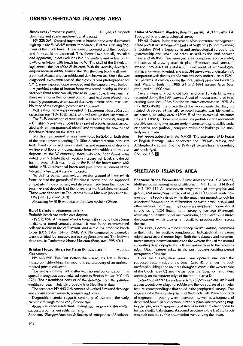
ORKNEY/SHETLAND ISLANDS AREA
Breckness (Stromness parish) D Lynn, 1 CampbellBroch site and ?early medieval burial ground
HY 225 093 Exposed fragments of human bone were discoveredhigh up in the E-W cliff section immediately E of the surviving frag-ment of the broch tower. These were uncovered until their positionand form could be discerned. This showed two partially revealedand apparently intact skeletons laid horizontally and in line on anE-W orientation, with heads facing W. The skull of the E skeletonlay between the feet of the W skeleton. Both skeletons lay directly onangular vacuous rubble, forming the fill of the outer broch wall, and ina context of small angular rubble and dark brown soil. Once this wasdiagnosed, excavation ceased, the exposure was photographed forSMR, some exposed bone removed and the exposure was buried.
A jumbled cache of human bone was found nearby in the cliffsection behind some casually placed vertical rubble. It was clear thatthese were not in their original position, and had been placed thererecently presumably as a result of discovery in similar circumstances.No trace of their original position was apparent.
Both sets of bone were deposited in Tankerness House Museum(accession no: THM 1995.16.1), who will arrange their examination.
The E-W orientation of the burials, with heads to the W, suggestsa Christian provenance, possibly as part of a burial ground associ-ated with an extraparochial chapel and predating the now ruinedBreckness House on the same site.
Significant settlement remains were noted for SMR on both sidesof the broch tower extending 20—30m in either direction in the cliffface. These comprised various stretches and sequences of drystonewalling and floors of indeterminate form with rubble and middendeposits. At the W extremity, three slab-sided floor drains werenoted running N into the cliff section at a very high level, and the cutfor the broch ditch was noted to the W of the broch tower, withrubble infill. A substantial broch and post-broch settlement of thetypical Orkney type is clearly indicated.
No distinct pattern was evident on the grassed cliff-top whichforms part of the grounds of Breckness House and the supposedchapel site. Finds of pottery and slag were made from the probablebroch-related deposits E of the tower, at a low level close to natural.These were deposited in Tankerness House Museum (accession no:THM 1995.16.2 and 16.3).
Recording for SMR was also undertaken by Julie Gibson.
Bu of Calrston (Stromness parish)Probable broch site under later deposits
HY 272 096 An animal knuckle bone, with a round hole c 5mmin diameter bored centrally through it, was found in unstratifiedcollapse rubble in the cliff section, and within the probable brochtower (DBS 1987, 34-5; 1988, 29). No comparative exampleswere identified, but possible use as a toggle is surmised. The find wasdeposited in Tankerness House Museum (Entry no: 1995.404).
Brinian House, Knarston Farm (Rousay parish) A JonesRint scatters
HY 443 296 Two flint scatters discovered, the first at BrinianHouse by fieldwalking, the second is the discovery of an undocu-mented private collection.
The first is a diffuse flint scatter with no real concentration; it isspread throughout three fields adjacent to Brinian House (HY 443278). The assemblage consists of the debitage from the primaryworking of beach flint; it is probably later Neolithic in date.
The second at HY 443 296 consists of worked flints and debitageand consists of arrowheads, scrapers and cores.
Diagnositic material suggests continuity of use from the earlyNeolithic through to the early Bronze Age.
Along with other artefactual material, such as pumice, this scattersuggests a permanent settlement site.Sponsors: Glasgow Arch Soc & Society of Antiquaries of Scotland.
Links of Noltland, Westray (Westray parish) AJ Dunwell (CFA)Topographic and archaeological survey
HY 42 49 area In order to provide a basis for future managementof the prehistoric settlement at Links of Noltland, HS commissionedin October 1994 a topographic and archaeological survey of theguardianship and scheduled areas, as well as the land betweenthese and MHWS. The surveyed area comprised approximately8 hectares of eroding machair plain. Processes and causes oferosion, processes of stabilisation, and areas of archaeologicalsignificance were recorded, and an EDM survey was undertaken. Bycomparison with the results of a similar survey undertaken in 1980-81, patterns of erosion during the intervening years can be identi-fied, Plans of both the 1980-81 and 1994 surveys have beenproduced at 1:500 scale.
Several areas of eroding old soils, and over 15 kelp kilns, wererecorded during the 1994 survey. A bed of midden was noted in aneroding dune face c25m E of the structures excavated in 1978-81(HY 4295 4938): the proximity of the two suggests that they arerelated. A spread of partially exposed remains was identified inan actively deflating area c!50m S of the excavated structures(HY 4301 4923). These remains include probable stone alignmentspossibly enclosing two square upright stone settings, possibly tanksor hearths, and probably comprise prehistoric buildings. No smallfinds were made.
Full report lodged with the NMRS. The assistance of D Eraserof English Heritage, who conducted the 1980-81 survey, andA Shepherd (representing the 1978-81 excavations) is gratefullyacknowledged.Sponsor: HS E3-
SHETLAND ISLANDS AREA
Scatness Broch Excavation (Dunrossness parish) S J Dockrill,Multi-period settlement mound with broch V E Turner, J M Bond
HU 390 111 An assessment programme of topographic andgeophysical survey was carried out at Easter 1995, to estimate howmuch of the broch existed within the settlement mound, to look forassociated features and to differentiate between broch-period andother features. Four main methods were employed: conventionalsurvey using EDM linked to a surveying package (Penmap),resistivity and conventional magnetometry, and a technique underdevelopment which creates a 'resistivity pseudosection' acrossthe site.
The surveys located a large and deep circular feature, interpretedas the broch. The resistivity pseudosection indicated that this featuremight stand several metres high. Both the resistance and magneto-meter surveys located anomalies on the western flank of the moundsuggesting deep deposits and a linear feature close to the mound'sedge. Other features relate to the post-medieval/crofting periodoccupation of the site.
Three main excavation areas were opened; one over thesupposed eastern edge of the broch (area B), one over the post-medieval buildings and the area thought to contain the western sideof the broch {area C) and the last over the 'deep soil' and linearanomaly on the western edge of the mound (area D).
Excavation of area B revealed a series of post-medieval walls anda deep topsoil over a layer of rubble and the top courses of a circularfeature, corresponding to that noted in the geophysical surveys. Thisappears to be the surviving circuit of the broch wall. Many hundredsof fragments of pottery were recovered, as well as a fragment ofdecorated broch-period pottery, a bronze plain wire projecting ring-headed pin, several fragments of steatite vessel and what appear tobe two steatite bakestones. A second structure to the E of the brochwas built into the rubble and midden surrounding the tower.
104
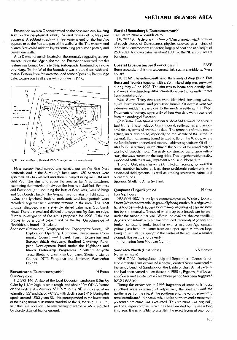
SHETLAND ISLANDS AREA
Excavation on area C concentrated on the post-medieval buildingseen on the geophysical survey. Several phases of building areapparent. A robbed structure at the eastern end of the buildingappears to be the flue and part of the wall of a kiln. The western endof area B revealed midden layers containing prehistoric pottery andcurvilinear walls.
Area D was the trench located on the anomaly suggesting a deep-soil feature on the edge of the mound. Excavation revealed that thisfeature was formed by in situ deep soil deposits, bordered by a stoneboundary. To the W of the boundary was a buried soil with ard-marks. Pottery from this area included some of possibly Bronze Agedate. Excavation in all areas will continue in 1996.
Fig37. Scatncss Broch. Shetland 1995. Surveyed and excavated areas.
Field suruey: Field survey was carried out on the Scat Nesspeninsula and in the Sumburgh head area. 130 hectares weresystematically fieldwalked and then surveyed using an EDM andGrid Pad. The aim is to cover the area as far N as Eastshore,examining the hinterland between the brochs al Jarlshof, Scatnessand Eastshore (and including the forts at Scat Ness, Ness of Burgiand Sumburgh Head). The fragmentary remains of field systems(dykes and lynchets) both of prehistoric and later periods wererecorded, together with wartime remains in the area. The mostunusual discovery was a possible stalled cairn near SumburghHead. The site is oval and divided into segments by slabs on edge.
.Further investigation of the site is proposed for 1996. If the siteproves to be a burial cairn it will be the first Orcadian-type ofNeolithic site found in Shetland.Sponsors: (Preliminary Geophysical and Topographic Survey) BP
Exploration Operating Company, Dunrossness Com-munity Council and Russell Trust; (Excavation andSurvey) British Academy, Bradford University, Euro-pean Development Fund under the Highlands andIslands Partnership Programme, Shetland AmenityTrust. Shetland Enterprise Company, Shetland IslandsCouncil, DITT, Farquahar and Jamieson, WackenhutUK Ltd.
Brownieston {Dunrossness parish) H ExtonStanding stone
HU 393 146 A slab of the local Devonian sandstone 0.8m by0.2m by 1.15m high, is set in rough land about 50m OD. A featureon the skyline at a distance of 1.9km to the NE is indicated at anazimuth of 52° and dip of —0°.25, with declination 18°. 6. During theepoch around 1800 years BC, this corresponded to the lower limbof the rising moon at its minor standstill to the N, that is e — i — s — A,with the usual notation. The reverse alignment to the SW is restrictedby closely situated higher ground.
Ward of Scousburgh (Dunrossness parish)Circular structure - possible cairn
HU387 187 Acircularstructureof3.5mdiameterwhichconsistsof rough pieces of Dunrossness phyllite, survives to a height of0.6m in an environment consisting largely of peat and at a height of260m OD. A known cairn lies about 100m to the NE among recentbuildings.
Coastal Erosion Survey (Lerwick parish) EASEBurnt mounds, prehistoric settlement, field systems, middens, Norsehouses
HU 33 42 The entire coastlines of the islands of West Burra, EastBurra and Trondra together with a 20m inland strip was surveyedduring May-June 1995. The aim was to locate and identify sitesand areas of archaeology either currently subject to, or under threatfrom coastal erosion.
West Buna: Thirty-five sites were identified, including cairns,dykes, burnt mounds, and prehistoric houses. Of interest were twoextensive midden areas close to the modern settlement at Papil.Fragments of pottery, apparently of Iron Age date were recoveredfrom the eroding cliff section.
East Burra: Twenty-nine sites were identified around the coast ofEast Burra. These included burnt mound, settlements, and associ-ated field systems of prehistoric date. The remnants of more recentactivity were also noted, especially on the W side of the island. Ingeneral, the monuments found tended to lie on the W side, wherethe land is better drained and more suitable for agriculture. Of all thesites found, a rectangular structure at the N end of the island may beworthy of especial note. Massively constructed using large ortho-stats, the walls curved on the long sides. This, together with possiblyassociated settlement may represent a house of Norse date.
Trondra: Only nine sites were identified on Trondra. however thissmall number includes at least three prehistoric settlements withassociated field systems, as well as eroding structures, cairns andburnt mounds.Sponsor: Shetland Amenity Trust.
Quoyness (Tingwall parish) N FojutIron Age house
HU 3979 4827 A low-lying promontory on the W side of Loch ofStrom (which is semi-tidal) is gradually being eroded. It is edged withlarge boulders which appear to form an oval outline of a house some6m by 8m internally. Traces of what may be a hearth can be seenunder the ruined outer wall. Within the oval are shallow stratifieddeposits of peat-ash which have produced fragments of pottery andbroken sandstone tools, together with a mid-Iron Age opaqueyellow glass bead.- the latter from an upper layer. A broken largetrough quern stands upright in the centre of the site, and a smallerexample lies on the shore nearby.
(Information from Mrs Jean Gunn.)
Sandwick North (Unst parish) S S HansenNorse farmstead
HP 617 025 During June -July and September-October Shet-land Amenity Trust excavated a heavily eroded Norse farmstead atthe sandy beach of Sandwick on the E side of Unst. A trial excava-tion had been carried out on the site in 1980 by Bigelow, McGovemand Butler and a date to the Late Norse period had been suggested(DES 1980, 26).
During the excavation in 1995 fragments of stone-built housestructures were examined at respectively the southern and thenorthern part of the site. At the southern end the very fragmentaryremains indicate 3-4 phases, while at the northern end a more well-preserved structure was excavated. This structure was originallypart of a larger complex which has been eroded by the sea a longtime ago. It was possible to establish the exact layout of one room
105
SHETLAND/WESTERN ISLES ISLANDS AREA
measuring approximately 8m by 2.5m. This room and a well-pavedpathway, leading through the complex, was totally excavated.
The artefact assemblage from the site is dominated by stoneitems, especially steatite and schist. They include a huge number ofvessel sherds, sinkers, gaming boards, spindle whorls, baking platesand whetstones. Other objects found include bone-combs, bone-pins and a bronze stick pin of Hiberno-Norse type. The conditionsfor preservation of bone were excellent and environmental samplingwas carried out. The bone assemblage appears to be dominated byfish bone.
The artefacts indicate a date within the 1 lth-13th centuries AD.Sponsors: HS Q, Shetland Amenity Trust.
Bayanne House (Yell parish) EASEIron Age settlement, HU 519 977 A short stretch of walling protruding from a low cliffnear to Bayanne House suggested the presence of an erodingstructure of some antiquity. An archaeological assessment of thesection face and inland deposits was carried out in May -June 1995.Investigation of the section revealed the remains of a domesticstructure, overlain by domestic debris and a later wall. A quantity ofartefacts were recovered and typologically dated to the Iron Ageperiod. Test pitting inland indicated the presence of a furtherstructure of unknown date.Sponsor: Shetland Amenity Trust.
WESTERN ISLES ISLANDS AREA
Clash na Beamaich, Hirta, St Kilda (Harris parish) A Fleming,Stone implements and mauls M Edmonds
NF 097 988 Surface survey of the dolerite screes of Clash naBeamaich ('The Chimney') produced implements, large stonemauls (originating on the beach), smaller beach-pebble hammers,
and waste material from quarries located at high levels (c 400ft,130m) to N and S of The Chimney, with one quarry (c 500ft, 160m)in The Chimney itself. The quarry faces have suffered from erosionand much of the quarry waste on the upper parts of the scree is nowgrassed over, though its locations are detectable.
Systematic survey of the structures in the Village Bay area pio-duced numerous mostly broken dolerite implements, some used aswedges in cleitean.
St Hilda (Harris parish) A Morrison, P Johnson, J HuntleyScree structures; earthen platforms (see Fig 38)
At Ruaival (centred on NF 098 985), excavation of two circularstructures was completed this summer. One of the biggest problemswas the attempt to distinguish the structures from the scree, sincemost of the main stone material for the structures was probablycollected from the vicinity It was eventually possible to see traces offacing stones and arrangements that suggest that the structures werebuilt and are not, for example, simply the remains of quarry pits.Apart from the remains of a few broken mortar-like stone vessels inthe structural material there was nothing that could give definiteevidence as to function or dating.
This season also saw the first examination of the earthen platformsat Ruaival. These lie within and under the more recent drystoneenclosures and show similarities to the terraces on An Lag. UnlikeAn Lag, Ruaival is freely drained. Because of this, little trace ofstratigraphy (eg tip lines) could be found in the Ruaival platforms.No traces of agricultural, horticultural or domestic activity werediscovered and no finds of any chronological significance. Despitethe missing evidence for, eg, pottery or tip lines, as found on An Lag,the results of the Ruaival investigations suggest that here, too,a series of artificial earthen platforms has been constructed forgrowing purposes.
During this season's field work, a built structure in the scree,higher up on the slopes of Mullach Sgar to the N of Ruaival, hadbeen noted. This structure is not visible from lower down the slope
-St. Kilda '9 5-
FigSH. Si Kilda. Scrue structures.
106
WESTERN ISLES ISLANDS AREA
and is not easy to see even from a few feet away. The remains standto a height of well over 1m-, it is drystone built, with traces oi cor-belled construction and there is a small kidney-shaped chamber atone end, plus a small niche built into one wall and a drain-likefeature running through the other (see Fig38, p!06). There iswhat appears to be a blind passage leading out of the chamber fora distance of about 2m and there is no apparent entrance to thestructure. One large roofing lintel survives in situ across the passage,with what might be the broken remains of another close to it. Themethod of construction is interesting. It appears that a level area hadbeen quarried back into the slope of the scree and the structure builton this platform. It then seems that the scree had been replacedaround the structure to support but also possibly to conceal it. Asa result of this work further examination of the general area wasundertaken and it became apparent that there are many examplesof walls, enclosures, structures and other features.Sponsor: NTS.
St Hilda, The Gap (Harris parish) R Turner?Prehistoric 'boat-shaped setting'
NF108 997 A fine example of a 'boat-shaped setting' at the edgeof the cliff known as The Gap was in grave danger of falling intothe sea through coastal erosion. Using expert mountaineeringadvice the site was able to be excavated. The site was built in an oldstream bed of geological age, but the ground may also have beende-turfed in preparation. The upright stones of the inner wall facewere then set, some being propped by smaller chock-stones. Aninner chamber of 1,45m by 1.65m was thereby formed. The stonesof the outer face of the wall were then installed, generally angleddownwards towards the middle of the monument, presumably forstability. The wall was about 0.75rn thick. Between the stones wasa peat-based mortar, some discernible sods of which survived.Inside, the floor level was raised by as much as 550mm using flat.irregular stone flags in a peat sod matrix. While this appeared to havebeen carried out in a single episode designed to raise the level abovethat of the unsightly chock stones, the persistence of roughlyhorizontal layers of flat stones indicates that the operation wasconducted with an extraordinary degree of care.
SK95
StKilda.NF 10816 99758
— B
Fig39. Si Kilda. The Gap '^Prehistoric 'boat-shaped setting'.
There was no clear indication of the original height of the walls,but the remains survived to over 0.70m high from the top of natural,and the largest internal upright stone was 1,26m high. The lack ofdebris within the post-use levels of the chamber suggests either noroof, or an easily removed or flimsy one. The upper parts of the wallsmay have been built up using peat sods, giving rise to a certaindegree of mounding around the monument. At some stage thenorthern splayed entrance may deliberately have been blocked off
which, in the absence of an alternative discernible entrance, wouldhave left the structure sealed (except perhaps from above).
The only finds to be recovered were a few fragments of quartz,plus two water-worn pebbles, which all must have deliberately beenbrought to the site - 650ft above sea level.
This is the best example of a 'boat-shaped setting' excavated todate, revealing crucial structural information. The Gap example isclearly not the chamber of a cairn-like structure, and it is certainly notboat-shaped. Nor does it resemble a St Kildan 'cleit' - a drystonestorage structure. We have, however, yet to find the date andfunction of these enigmatic features, the best guess being that theyare Bronze Age non-domestic monuments.Sponsors: Shell UK, HS 0, NTS.
Cnoc Dubh (Lochs parish) M R Curtis, G R CurtisPossible burial mound
NB 363 286 There is a conical grassy mound 13m to 14m dia-meter at the base, about 2m high above the lowest surroundingground.
It is surmounted by the remains of a shieling 2.15m by 4.0minternally with one doorway and a vertical stone 0.75m tall in thewall at its S end.
The mound is circular but it appears stoneless. The 'standingstone' suggests that there was a setting before the shieling was built.
It is located on the E side of a spur going in a SSW direction fromCnoc Dubh.
Loch Seaforth Head (Fangs) (Lochs parish)Possible kerb cairn
NB 2827 1655 There is a burial cairn about 4m diameter at thebase and nearly 1m high with about a dozen kerb stones visiblearound the mound of stones and grass, which is slightly hollow ontop. It is located at a change of slope of the ground.
Ceann nan Clachan (North Uist parish) I Armit. A BrabyBurnt mound and structures
NF 771 739 During survey of the Gerisclett area a small burntmound was identified close to the stream flowing from Loch nanClachan into the inter-tidal Vallay Strand. The site comprisesa crescentic, grassed-over mound being actively eroded by the tide,and areas of walling were clearly exposed in the eroding areas.Several sherds of pottery were recovered from the exposed sections.
Smalt scale trial excavations were carried out revealing that themound comprised rapidly accumulated, apparently burnt stone,forming a crescentic voided heap. In the eroding part of the moundwas set a square or rectilinear drystone structure containing a sub-stantial hearth and yielding small fragments of plain pottery.Although it is possible that the stone structures represent shielings ormedieval domestic buildings built into an already ancient burntmound, the apparent integrity of the surface features of the moundsuggest otherwise.
Ellean Maleit (North Uist parish) I ArmitWheelhouse and islet settlement
NF 7748.7388 Small scale excavations were carried out on thetidal islet settlement of Eilean Maleit, originally excavated byBeveridge in the early part of this century. The excavations weredesigned to test the hypothesis that the site represented a wheel-house built into an earlier Atlantic roundhouse or broch. It washoped that as at the nearby Sollas wheelhouse, Beveridge had leftunexcavated deposits in situ.
Two of the wheelhouse bays were re-excavated and a section wasexcavated through the wall in an attempt to identify any pre-wheel-house walling. It was quickly discovered that, in the re-excavatedareas, Beveridge had removed archaeological deposits down todecayed bedrock, apart from those under the wheelhouse piers and
107
WESTERN ISLES ISLANDS AREA
a small truncated pit within one of the bays. The section through thewall confirmed that the wheelhouse was a secondary structure,revetting dumped occupation material and sealing an earlier wall ofmuch larger angular stones; probably a massive-walled Atlanticroundhouse. The highly residual state of this early structure whenthe wheelhouse was built suggests the passage of a considerableperiod of time between the occupation of the two structures. Findswere restricted to a small pottery assemblage and included twostratified sherds with applied wavy cordons from the wheelhousewall core and the pit in the interior.
Geirisclett. North Uist (North Uist parish) I Armit, A DunwellSettlement survey
NF 75 75 area A walk-over survey has been undertaken in anarea of coastal land c2km long by 0.5km wide between LochOlabhat and Airigh Mhic Ruairidh. Early OS map editions had indic-ated much abandoned settlement in this area, and a chamberedtomb and likely prehistoric settlement site were previously known tobe present on the Geirisclett peninsula. Details of all identified siteswere recorded, and the locations of unmapped sites identified asaccurately as possible by manual methods.
Evidence of abandoned settlement, land boundaries and cultiva-tion were identified over much of the survey area. Approximately100 individual structures of varying antiquity have been recorded.Many of the previously mapped structures may relate to a period ofplanned early 19th century settlement associated with the clearanceof the nearby township at Foshigarry. However, evidence ofa range of earlier settlement forms was also recorded, includingrectilinear turf-built structures and enclosures around Airigh MhicRuairidh, sub-rectangular structures on knolls with closest parallelsto the nearby excavated site at Drium nan Dearcag {see DES 1989,70-71), small sub-rectangular cells c2m across internally withno evident parallels currently known to the authors, and an ovaldrystone hut on a knoll enclosed by a boulder wall at Bagh anAckara (see next entry). The time depth apparent in the archae-ological landscape appeared to be greatest on the Geirisclettpeninsula, in contrast to the less fertile land around Loch nanGarnach, where much of the activity can be attributed to the 18thand 19th centuries.
A full report will be deposited with the NMRS on completion.Sponsor: The Russell Trust.
Bagh an Ackara, Geirisclett (North Uist parish)Settlement site
NF 761 753 From surface traces this site appeared to compriseprincipally an oval drystone structure measuring 6m by 4m intern-ally with a 1.5m wide entrance on its E side, located on top of a lowknoll. Its walling was visible mostly as a grassy bank, although up tofour courses of an internal face were visible to the S. A secondarywall running between the entrance and the S wall seemed torepresent the creation of a secondary sub-rectangular structurewithin the first. Two rubble spreads situated on either side of theinterior of the entrance appeared to be tertiary bothies. The knollupon which the structure is set stands to 3m in height, with a verysteep-sided northern face. Stones resting on the steep face wereoriginally thought to have been deliberately placed, leading to thesuspicion that the whole knoll was artificial.
The apparent superficial similarity of the structure to the disturbedPhase 1 structure excavated nearby at Eilean Olabhat (see DES1989, 70) prompted the excavation of two small exploratorytrenches in September 1995. These excavations revealed the maindrystone structure to have at least two superimposed structuralphases, and undecorated coarse pottery was recovered from pre-sumed floor deposits associated with the different phases of walling.The N side of the knoll was revealed to be natural. During theexcavations a buried boulder wall was located which defined an
irregular oval enclosure c45m across around the knoll. The date ofthe structures excavated is unclear, although a medieval or earlierorigin for the site seems likely.
A report will be deposited with the NMRS.Sponsor: The Russell Trust.
Cille Donnaln (South Uist parish) M Parker PearsonNorse church and medieval settlement
NF 7315 2816 The site of the church and disused burial groundwas rediscovered in 1989 (Fleming & Woolf. PSAS 122 (1992),329-50). The complex, located on a promontory and island withinLoch Kildonan, is comparable to the political centre of Finlaggan onIslay and might have been the seat of a bishop. The shape of thechurch is comparable to plans of others in western and northernScotland and may be dated to around 1100.
Two small trenches were excavated, one on the loch edge on theS side of the promontory and the other across 'Building C and theeastern part of the platform on which the church complex waslocated. The purpose of the loch edge trench was to recover water-logged deposits of rubbish dumped from the promontory complex.In the deposits contemporary with the platform were the remains ofa leather artefact and ceramics including a piece of green-glazedpottery. Beneath these layers were organic deposits containing Earlyand Middle Iron Age pottery, indicating that the site was in use as anisland settlement over a thousand years before the church.
The trench on top of the platform revealed that Building C wasformed by lines of uprights which were probably late features suchas yard walls. They were set in a deep garden soil which musthave been imported to the promontory from nearby infields. Theadjacent Building D, and presumably the others in the range of fourcells, was constructed on top of this garden soil which containedpottery including wheelturned green-glazed sherds. These havebeen tentatively identified as wares of the 13th-15th centuries,possibly made in Ayrshire (David Caldwell. pers comm). Thebuildings and this part of the platform presumably date to the laterMedieval period, somewhat later than the church,
Burnish Mounds 2 & 3 (South Uist parish) M Parker Pearson.Viking Age houses and settlement N Sharpies, J Webster
NF 7294 3026 and NF 7299 3031 Field survey along the South ,Uist machair has demonstrated the survival of at least 80 settlementmounds in the southern half of the island. Forty-four of these havebeen found in an area of 5 square kilometres around the broch ofDun Vulan. They are grouped into clusters within each of the fivetownships in this area. Stoneybridge, Ormiclate, Upper Bornish,Lower Bornish and Kildonan. On the machair of Upper Bornishthere is a cluster of three mounds. Bomish 1 has not yet beenexcavated but it has produced pottery of Middle Iron Age (c 100BC-AD500) and Pre-Viking Late Iron Age date (cAD500-800).Bornish 2 and Bornish 3 have yielded grass-impressed sherds of theViking period. The spatial patterning of the mound clusters and theapparent chronological sequence of the three Bornish moundssuggest that the origin of the township territories and organizationmay lie in prehistory, possibly at the beginning of the Middle IronAge. These excavations are part of a long-term programme to testand explore this model.
Excavations on Mound 2 in 1994 demonstrated the existence ofa large stone building of the llth century, aligned E-W and con-taining a number of bone and iron artefacts. An earlier buildingappeared to have rounded rather than rectangular walls but it wasnot excavated. In June 1995 part of the trench was re-opened anda third stone building was located immediately above the house withrounded walls. Associated with the construction of this new buildingwere three fragments of a decorated whalebone plaque.
Mound 3 was also excavated in June 1993 to reveal the founda-tions of another two Viking Age buildings, one above the other.
108
WESTERN ISLES ISLANDS AREA
They cannot be dated precisely nor can their full dimensions bedetermined without further excavation.
This excavation took place within the South Uist MachairManagement Project, assessing the survival of archaeological sites.the threats to those sites and the potential management options tosecure their continued preservation. The 1994 excavations demon-strated that house walls were being damaged by ploughing. One ofthe main lessons learned in 1995 was that Viking Age buildingssurvive at a shallow depth of 20-50cm within the mounds and arevery easily damaged by the burrows of rabbits, which may go downat least a metre. Since this area is heavily colonized by rabbits thesesites remain under threat.Sponsor: HS E3.
Bornish House (South Uist parish) M Parker Pearson, T RoperPost-medieval settlement
NF 7362 3004 A group of four small trenches were excavated inFebruary 1995 to ascertain whether the site of Bornish House wasthe location of the medieval and post-medieval settlement of UpperBornish. Large quantities of 19th-20th century refuse were found inthree of the four trenches but only one trench (Trench 3), locatedimmediately N of the present farmhouse, produced evidence forearlier activity. This consisted of a single small sherd of medieval/prehistoric pottery and several small sherds of probable early post-medieval pottery. In the light of these results it appears that theconcentration of pre-clearance settlement at Bornish House, asshown on the Bold Map of 1805, is in error. The ruins of manyhouses S of the road, between the church and the hall, probablyconstitute this pre-clearance settlement. Whether its medievalprecursor was a dispersed or nucleated settlement (Dodgson, PSAS123 (1993), 419-38) is unknown. A medieval building has beendiscovered at Dun Vulan; other possible locations for medievalsettlement are the dun in Upper Loch Bornish and the site of the19th century tacksman's house between Bornish House andBornish Church.
Dun Vulan, Ardvule (South Uist parish) M Parker Pearson.Broch and associated settlement N Sharpies. H Smith
NF 7140 2980 Excavations on the Iron Age broch and its accom-panying settlement have been carried out since 1991 (see ParkerPearson & Sharpies. Past 19 (1995), 1-3). The main purpose ofexcavation in June 1995 was to clear rubble from the inside of thebroch and from its N side in order to enhance the monument'spresentation for improved public interpretation. This was carried outin tandem with the first stage of the construction of a concrete seadefence. These aspects were funded primarily by grants fromLEADER and from the TSB Foundation. Further work, funded bythe University of Sheffield, was carried out on the deep depositsunderneath the beach. These largely predated the construction ofthe broch'and associated structures and some deposits were rich inorganic remains, notably insects and wood. One of these depositswas full of animal bone and Late Bronze Age pottery, indicative ofoccupation on this site prior to the broch. Additionally, the sedi-ments on the S side sloped against the angle of the beach and seemto include lake sills, suggesting that the broch was built withina freshwater or brackish loch, which was later encroached upon bythe sea.
Within the sub-circular interior of the broch, an area of approxim-ately 11m diameter, a sequence of later rebuildings was identified.The earliest of these was the construction of a cellular roundhousewith two doorways and an external room. This was modified by theconstruction of a straight wall within the roundhouse. Finally, a smallfisherman's hut was constructed in the 1940s, covered by an up-turned German lifeboat as a roof. The entrance to the broch wascleared down to the top of the roof lintels. Outside the broch, onits NE side, a rectangular building, probably Medieval in date, had
been constructed against the broch wall. One entrance led into thebuilding from its S side next to the broch entrance. Its N wall wasrevetted into fallen masonry outside the broch's N side. The wall wasretained but the fallen masonry was removed to a depth below thepresent roadway to provide a view of the broch's impressive walling.
Cladh Hallan (South Uist parish) M Parker Pearson, J Mulvitle,Late Bronze Age house and settlement T Roper
NF 7305 2203 An unusual 'figure of eight' stone-walled housewas excavated by Sheffield University W of Cladh Hallan, nearDaliburgh, South Uist. Work begun in 1994 was completed in 1995.The house was revetted into a Late Bronze Age midden (dated bya single radiocarbon determination of 2960 ± 75 bp, and by thepresence of coarse, flat-rirnmed ceramic vessels. The walls of thestructure were well preserved on its W side, standing to over 1m.Floor layers were also intact. Bone and shell survive in the machairsand. The E and W ends of the building have been destroyed byquarrying and by wind erosion. Otherwise, the house survives inexcellent condition. There is evidence of some stone robbingperhaps in the 19th century but the doorway between the tworooms, with a lintel in place, is well preserved. The small quantity oftumbled stones and the lack of organic material above the floorssuggest that the structure was roofed neither with stone nor turf.
The floor levels in both rooms comprised a complex and com-pressed sequence of thin dark layers interspersed with thin layers ofwindblown sand. Otherwise the only internal features were the clay-lined stone trough and two post holes, one of which probably pro-vided a central roof support, in the W room and a group of eight postor stake holes, an informal hearth and a low stone bench or footingin the E room. The doorway (0.73m wide) connecting the roomshad an extremely low roof, only 40cm off the ground, yet the floorsurface under the door was worn thin from use. Connecting floorlayers indicate that both rooms were in use at the same time, with theW room going out of use whilst floor layers were still being put downin the E room. The heaps of sand around the walls of the E room, itslack of a central post and its use for bronze working suggest that itwas not roofed. The bronze debris in floor layer 233 includeddroplets, casting waste and part of a small bronze finger-ring.
On abandonment, the building filled up with clean windblownsand. This may well have been a rapid natural event. Amongst theblown sand were small, localized deposits of animal bones and largepottery sherds, from a dozen vessels, mainly coarse cooking wares.The generally rounded rims are similar to pottery from the earliestbroch layers at Dun Vulan. They may be ascribed to the Late BronzeAge on the basis of a TL date of 2860 ± 260 {1170-650BC).Sponsor: HS BBfl.
South Uist Machair (South Uist parish) M Parker PearsonNeolithic/Early Bronze Age - post-medieval settlements
NF 733 336 - NF 758 140 Almost half of the South Uist machairhas been surveyed between 1993 and 1995, in a single stretch fromWest Kilbride in the extreme S of the island to N of the Ard Michaelpromontory, a distance of 20krn with the width of the machairaveraging about 1km (see unpublished reports, Dept of Archae-ology, Univ of Sheffield). Existing RCAHMS records for prehistoricand early historic settlement sites number some 20 locations withinthis zone. The machair project has now increased this number to 81.Two of the RCAHMS sites, the broch/dun at Orosay (NF 730 173)and the broch of Dun Ruaidh (NF 739 219), are misidentifications.
The area most responsive to field survey on the machair is thesection between Kildonan and Stoneybridge. the N 5km portion ofthe survey area. Here, where most of the surviving machair plain hasnot been covered by dunes, some 44 sites have been recognized.Along with a grouping of Late Neolithic/Early Bronze Age settlementmounds in the Kildonan area, the main settlement pattern is a set ofclusters of Iron Age to Viking Age settlement mounds for each of the
109
WESTERN ISLES ISLANDS AREA
five townships. These Iron Age-Viking Age clusters may be viewedas predecessors to the township system first mapped in 1805 and stillin use today.
A second concentration of sites has been found further S in themachair of Daliburgh and Kilpheder, where a total of 19 sites havebeen discovered in an area of 3 square kilometres. This density is allthe more remarkable given the large extent of dune incursion on tothe machair plain in this area. Within this zone two key house sites,both well preserved, have been excavated. One is the Kilphederwheclhouse (NF 7337 2022) of Middle Iron Age date and the otheris the Cladh Hallan double roundhouse (NF 7305 2203) of LateBronze Age date. The most remarkable feature of prehistoric settle-ment in this area is the 500m long string of Late Bronze Age/EarlyIron Age settlement W of the modem cemetery of Cladh Hallan.Many of these buildings were damaged by stone robbing in the 19thcentury to build the western walls of the modern cemetery. How-ever, there is considerable potential for good preservation, asindicated by the 1994-95 excavations.
The results of the recent survey are by no means exhaustive butthey do indicate a remarkable density of later prehistoric and earlyhistoric settlements on the machair. The pattern of proto-townshipsthroughout the survey area holds reasonably well but there are gapsfor the townships of Garrynamonie and Garryheillie.Sponsor: HS H.
Olcote, Breasclete Park, Callanish (Dig parish) M R Curtis,Burial cairn and quartz scatter G R Curtis
NB 2179 3473 A prehistoric burial cairn and a scatter of quartzflakes (some 400 pieces) were found as a result of preliminary roadworks. This was followed by partial excavation by CFA on behalf ofHS, establishing that the cairn has an unusual kerb about 8.4mdiameter.
The cairn is located in a field, on a gently rising summit immedi-ately W of the existing road, A859.
Loch an Tulm (Dig parish)Two stone settings and quartz flakes
NB 2547 3589 and NB 2545 3590 There is a sub-peat stonesetting, in the form of an arc of a rough stone wall about 5m long, inpart two courses high, with which are associated many small stones.It is emerging from a peat bank as cutting proceeds. The depth ofpeat from turf to till is l.lm and the depth over the wall is 0.80m.
There is another stone setting, the visible part of which has about20 stones set on, not in, the fill with peat between them. It is 2.6mlong and 1m wide. It is emerging from a peat bank as cuttingproceeds. The depth of peat from turf to till is 1.0m and the depthover the highest stone is 0.6m.
A secondary quartz flake, 22mm by 18mm, and a possible struckquartz scraper, 24mm by 17mm by 8mm were found nearby.
Cnoc Gil an Ralnlch, Lochganvich (Uig parish)Prehistoric field walls, etc
NB 288 301 There is a sub-peat stone and turf wall enclosinga sub-rectangular area about 32m by 28m. Much of it is exposed intwo areas where peat has been cut. In part, it appears as individualstones, the largest being 0.6m by 0.4m by 0.6m high, in part as a rowof stones in the ground, and in other parts it has been proved byprobing. Inside, towards the eastern side, there is a stone wallsetting, possibly sub-circular about 4.5m across, with stones lyingclose together along most of its perimeter.
Airigh na Belnne Bige (Callanish Site 11) (Uig parish)Two kerb caims
NB 222 356 The larger cairn is 11.5m long by 9.3m broad, andstands 2.25m above the lowest surrounding ground to the SE.Eleven kerb stones can be traced around the perimeter, the largest
appearing to be 0.75m long, but much of the perimeter is buried bytumble and grass. Within the area it is disturbed and there ishummocky grass and many exposed stones, the largest being0.95m long. There is a hint of a chamber given by another flat slabnear the centre and two voids which could be rabbit holes.
Attached to the W side there is an arc, outside the kerb, formed bysix more kerb stones extending for about 1m by 2m.
The cairn has been robbed to build a semi-modern stone shelteron top. The walling, about 0.4m to 0.6m thick, with two or threecourses faced both to the inside and outside, has an outside dia-meter of about 2.4rn and appears to be D-shaped internally.
It is located on undulating ground on a natural 'shelf on theS shoulder of the hill, 39m E of the standing stone known asCallanish Site 11.
The smaller caim is 6.9m long and 5.1m broad, and stands about1.5m high above the lowest ground. Six kerb stones appear to be inplace, one being 0.85m long and another being 0.8m high. Intern-ally it is disturbed and there are many stones and uneven grass.
It has been robbed to build a now-ruined 'sunken' shelter orshieling, 4.5m by 2.25m internally, lying 9,5rn to the SE.
The cairn is 19m S of the larger cairn and 43m from the standingstone 11.
Cnoc Gearraidh Nighean Choinnich, Breasclete (Uig parish)Stone setting
NB 2220 3475 There is a circular ring of stones, three of whichare visible, standing only 0.3m to 0.4m above the surroundingground, and at least 12 of which are buried under well-establishedturf, the central area being slightly hollowed. The external diameterof the ring is about 4m.
Cnoc Righseodh, Loch Risay, Great Bernera (Uig parish)Probable burial cairn
NB 1737 3673 There is a mound made up mainly of stones lessthan 0.3m size, but there are much larger, stones lower down theS and W side slopes. It measures at least 15m by 16.5m around itsapparent base but may be as large as 17.5m by 17m respectively; islargely covered with uneven green grass with iris, bracken andnettles; and now has a flatfish top which is about 1.5m high abovethe apparent base but may be as high as 3m above the naturalground on the S side.
The mound is surmounted by a shieling almost complete exceptfor its roof. This structure has a 1.7m long horizontal foundationstone (which could suggest a chambered cairn). On the E or uphilledge of the cairn there is a raised stony causeway only some 2m long(which may be contemporary with the shieling) connecting the cairnto the rising hillside.
It is located where a shieling is shown on the map, with manyadjacent cultivation ridges, and above the peat banks of the valleybottom.
This structure was brought to our notice by Mr Jim Crawford ofGarynahine.
Tolanals, Baile na Cllle (Uig parish) M A MacLeodPrehistoric cairn (Late Bronze Age?)
NB 045 338 Two small assessment trenches were opened on thesouthern of two large mounds, in order to determine which featuresof the site were artificial, and to date these, if possible.
The mound proved to be essentially natural, consisting of fluvio-glacial sands and gravels, but with an insubstantial prehistoric cairnat the highest point. This cairn was overlain by a circular turf andstone structure, 2m in diameter.
A Late Bronze Age date has been suggested for two rim sherdsfrom the site - one from the cairn, the other from the secondarystructure.Sponsor: HS H|l.
110
WESTERN ISLES ISLANDS AREA
Tolanals, Baile na Cllle (Uig parish)Medieval boat naust
NB 045 338 In association with an assessment of the twomounds on this peninsula, a survey and small excavation wereearned out on the remains of a boat naust on the southern edge ofthe promontory, in order to date the structure.
Erosion damage was acute, and the excavation of the subsidiarystructure built into the eastern edge of the naust revealed no sur-viving archaeology. The naust itself is believed to be medieval on thebasis of structural similarities to the adjacent medieval sea defences.Sponsor: HS j|J.
Loch na Berle (Uig parish) D W Harding, S Gilmour. J HendersonBroch and post-broch settlement
NB 103351 Excavations continued on the post-broch phases ofoccupation at Berie from June to August 1995 (see DES 1994,98-9).(1) Cells la and Ib were removed in their entirety, together witha substantial part of the 'souterrain passage' between la and thesouth-eastern sector of the broch wall. This enabled the hearthwithin Cell 6 to be completely exposed, revealing the full extent of itsdecorated clay base and border of edge-set slabs with large cobblesat the undamaged corners. Similar, though less distinctive, con-structional elements characterised adjacent hearths to N and S.In the SW quadrant, coursed masonry which was at one stageregarded as the continuation of the Roundhouse wall proved to bepart of the Cellular complex, its lowest courses resting on thehard peat which over much of the interior underlay the Cellularoccupation.
This stonework slumped over piers projecting from the brochwall, and may well have formed part of a corbelled outbuildingattached to the Cell la and Ib group, and approximating to theputative 'shamrock' previously proposed. A distinctive feature of thestratigraphy underlying the Cellular buildings was the presence oflaid brushwood flooring and fallen timbers, uncarbonised but other-wise well-preserved in the sodden conditions of the site. In theNW quadrant. Cell 4 was found to overlie the continuation from theNE quadrant of Cell 5, defined only by edge-set slabs, but termin-ating at an entrance defined by a pair of post holes in which thetimber posts survived intact.
Cell 7 continued to produce quantities of industrial waste, notablybronze slag and fragments of moulds, including one recognisably ofa projecting ring-headed pin. Other finds from the Cellular occupa-tion included small fragments of glass and items of ornamentalbronzework.(2) Within the entrance an upper level of substantial paving wasremoved to reveal a lower level of paving, both presumed con-temporary with the Cellular horizon. To the N of the entrancepassage was a small Cell (8), between the inner broch wall andwalling which continues the alignment of the underlying Round-house wall around the northern circuit of the site, but which is cer-tainly secondary to it. Immediately outside the broch entrance wasa substantially-built forecourt. To the S of this forecourt, excava-tion at a lower level revealed structural features which couldbe contemporary with the Roundhouse or late Broch phases ofoccupation.(3) The Roundhouse wall is now clearly defined in an arc from justN of Cell 3 to the re-entrant into intra-mural Gallery 6 in the NEquadrant. Between this point and the main entrance there isevidence of secondary re-building. The projecting pier to the S of themain entrance, which previously had been regarded as part of anyunderlying wheelhouse. occupies the same relationship to theearlier Roundhouse. Around the southern half of its circuit, theRoundhouse wall is not so clearly defined, and may have beensubstantially contiguous with the broch wall itself. Excavation withinRoundhouse occupation contexts was limited, but yielded sherds of
incised decorated pottery, thus confirming the broad sequence ofpottery styles previously established.(4) An area immediately outwith the broch wall on its NE circuit wasopened to check the possible presence of extra-mural occupation.Around the edge of the broch wall at a relatively high level wasa paved catwalk, presumed to be contemporary with the CellularPhase. Below this was a sequence of structures, including a linearrevetment aligned tangentially with the main entrance, and possiblytherefore a feature of the forecourt facade of the Cellular Phase. Thiswas backed into the filling around an earlier curvilinear structure atthe W end of the cutting, defined by a double wall-face, and con-taining within it sherds of incised-decorated pottery. The lowest levelof external occupation was represented by a curved length of wallingat the E end of the cutting on an arc which would have carried it wellout to the edge of the natural platform on which the broch waslocated. The absolute level of this structure remains considerablyhigher than the presumed level of the primary broch floor, butflooding prevented further excavation this season.(5) An environmental sampling programme was carried out byM Church. There is every indication that the site is extremely rich inplant remains and related material.
Excavation at the foot of the intra-mural staircase in Gallery 5,leading to the entrance from that Gallery to the interior, revealed anarc of edge-set stone in the constructional style of the Cellular Phase,presumably preceding. The effect would appear to block accessto the inner section of Gallery 5, and to the broch interior, from theintra-mural staircase. The purpose and period of this feature is atpresent unclear. Investigation within intra-mural Gallery 6 showedthat the end of that Gallery was blocked in construction for half itswidth only, and that access to intra-mural Cell 7 was therefore fromGallery 6, rather than from the interior of the broch, as previouslysupposed.
What is significant about the 1995 season is that excavationscrossed the threshold of waterlogged preservation, yielding bothstructural and artefactual timbers in a good state of preservation.Subject to the ability to drain the site to a workable level, there istherefore every prospect of recovering from the Broch and Round-house occupation structural timbers which could provide uniqueinformation regarding the internal fittings and furnishings of thesebuildings, issues which have hitherto been subject to considerablecontroversy. Equally, the material assemblages of these phases ofoccupation may be expected to include organic material which isseldom preserved in the archaeological record.Sponsor-. Department of Archaeology, University of Edinburgh.
Uig Sands to Alrd Uig, Isle of Lewis (Uig parish) C Burgess,Survey M Church
NB 050 360 In spring 1995 a team from the Department ofArchaeology, University of Edinburgh carried out fieldwork ina 1000 hectare area between Uig sands and Aird Uig in Uigparish. The presence of the large machair area around Uig sandswithin this survey area lead to the examination of the state of coastalerosion not only on the machair but also along the cliff areas to theN and W along the Aird Uig Peninsula.
To aid in the description and quantification of the erosional effectwithin the Uig survey area where sites were being recorded for thefirst time, it was decided that the survey team should attempt toreassess the sites noted as being at risk to coastal erosion by Armitduring his survey of the Traigh na Berie area in 1990.
Survey of the area described above has lead to identification ofapproximately 300 previously unrecorded sites on the Uig Pen-insula. These sites range from prehistoric settlement to pre-clearance villages and shieling sites. For reasons of brevity only a fewhave been included here.NB 0464 3680 Loch Mheacleit: crannog.NB 0335 3615 Loch Ruadh Guinnerso: cellular settlement.
Ill
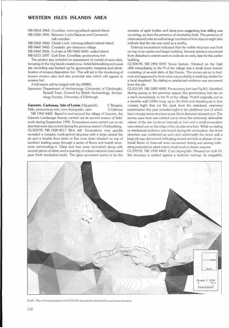
WESTERN ISLES ISLANDS AREA
NB 0454 3464 Crowlista: crannog/utilised natural island.NB 0366 3495 Between Lochs Baravat and Camasord:
mill complex.NB 0365 3436 Cleidir Loch: crannog/utilised natural island.NB 0460 3445 Crowlista: pre-clearance village.NB 0450 3436 S of site at NB 0460 3445: walled island.NB 0315 3397 Gob Eirer, Crowlista: promontory fort
The project also included an assessment of coastal erosion sites,focusing on the Uig Sands coastal zone. Initial fieldwalking and usualsite recording was backed up by geomorphic mapping and identi-fication of erosion/deposition foci. This will aid in the monitoring ofknown erosion sites and also potential sites which will appear inerosion foci.
A full report will be lodged with the NMRS.Sponsors: Department of Archaeology (University of Edinburgh),
Russell Trust, Council for British Archaeology, Archae-ology Society, University of Edinburgh.
Garenln, Carloway, Isle of Lewis (Uig parish) C Burgess.Stills; promontory fort; corn-drying kiln; caim S Gilmour
NB 1950 4400 Based in and around the village of Garenin, theGarenin Landscape Survey carried out its second season of field-work during September 1995. Excavations were carried out on sixsites that were discovered during the previous season's fieldwalking.GLS02/95 NB 1928 4517 Illicit still. Excavations very quicklyrevealed a complex multi-period structure with a large central firepit and a double floor drain or flue (one drain situated on top ofanother) leading away through a series of floors and hearth struc-tures surrounding it Glass and iron were recovered along withseveral pieces of fabric and a quantity of coked coal and charcoaledpeat (both smokeless fuels). The glass recovered seems to be the
remains of spirit bottles and demi-jons suggesting that stilling wasoccurring, as does the presence of smokeless fuels. The presence ofcharcoal and coke as well as large numbers of iron objects might alsoindicate that the site was used as a smithy.
External excavations indicated that the visible structure was builton top of an earlier and larger building. Several artefacts recoveredfrom disturbed contexts seem to indicate an early date for this earlierbuilding.GLS06/95 NB 1892 4495 Stone feature. Situated on the highcliffs immediately to the N of the village was a small stone featureconsisting of several slabs of flat Gneiss. The stones sat on to bed-rock and appeared to form what was probably a small day shelter fora local shepherd. No daring or artefactual evidence was recoveredfrom this site.GLS10/95 NB 1880 4490 Promontoryfort(seeFig40). Identifiedduring survey in the previous season this promontory fort sits ona stack immediately to the N of the village. Noted originally just asa sizeable wall (100m long, up to 3m thick and standing up to fourcourses high) that cut the stack from the mainland, extensiveexamination this year revealed eight to ten platforms one of whichhas a circular stone structure some 3m in diameter situated on it. Thesurvey seen here was carried out to show the extremely defensiblenature of the site (contour intervals at 1m) and a small excavationwas carried out on the edge of the circular structure. While no datingor artefactual evidence was found during the excavation, the stonestructure was confirmed as such and undzrneath the stone wall alarge pit was discovered indicating several periods or phases of use.Small flecks of charcoal were recovered during wet sieving indic-ating potential for plant macro fossil work in future seasons.GLS99/95 NB 1938 4402 Corn-drying kiln. Situated on croft 10,this structure is nestled against a bedrock outcrop. Its megalithic
Fig 40 Plan of the promontory fort GLS10/95 showing the deiensive line and stone structures.
112
WESTERN ISLES ISLANDS AREA
construction seemed to indicate a relatively early date of con-struction. This was confirmed by its relationship to a later blackhouse in the immediate vicinity, the construction of which dates toabout 1800.
Excavation revealed three periods of use, a final phase of use asa birthing chamber for larnbs, and two phases of use as a dryingkiln. These two phases of use as a kiln manifested themselves asa shortening and relaying of the flue floor.
Samples already taken have proved to be rich in plant macrofossils, and will allow the study of which varieties of crop were beingcultivated and dried at the time of use of the kiln.GLS190/95 NB 1934 4426 Cairn/shieling. This site, a small water-washed cairn, is situated less than 50m to the N of structure 4 in anarea that was not walked during 1994. Upon excavation it wasfound to be a habitational structure with drystone, earthcore wallsand a peat floor. Water damage had removed most of the N edge ofthe structure and detailed interpretation proved to be impossible,though it seems likely that this site is that of any early dwelling orpossibly a beehive cell.GLS191/95 NB 1925 4513 Illicit.still. This site was missed duringthe first season's fieldwaiking. Identified as a still when local know-ledge suggested that a second such site could be found in theimmediate vicinity of GLS02/95, it was decided to excavate a small
area within the structure to examine stilling technology and gatherdating and environmental evidence to compare to the first still.
Excavation revealed that the structure is of turf construction andindeed has all the features of GLS02/95. Differences were noted,including that the fire pit was offset to one side of the structure andthat the two drains running from the fire pit run side by side ratherthan on top of each other. Datable samples and artefacts (similar tothose found on GLS02/95) were recovered.
During the 1995 season fieldwalking was also carried out overan area of about 300 hectares of rough grazing land. This field-walking took the area covered to the N of the Dail Mor Grazingboundary and as far S as the edge of Loch Carloway. Sites identi-fied included a possible Norse settlement at Laimishader (NB 18454245) and the site of a third possible illicit still to the E of the twoalready recorded sites (NB 202 452). Detailed surveys were carriedout on five sites (one of which may be seen above) and it is hopedthat in future seasons more of this type of recording work will becarried out.
A full report will be lodged with the NMRS and interim availablealso through Lewis Library service.Sponsors: Garenin Trust, Department of Archaeology (University
of Edinburgh), Russell Trust, Society of Antiquities,Scotland.
NATIONAL SURVEYS
Archaeological database for the Scottish Raised Bogs: Mainland Scotland C Clarke (CFA)A database of finds and structures from Scottish raised and intermediate bogs, past and present, has been created. An accompanying
report outlines the value of the Scottish raised bogs as an archive of archaeological material given their lowland setting, their ability topreserve organic remains and the wealth of other palaeoenvironmental information which can be derived from them. The report alsoattempts to gauge the archaeological potential of existing areas of raised bogs. It can be used as a baseline survey for guiding forwardplanning and development control and in the integration of nature conservation and archaeological interest into land managementplanning. The exercise is an essential prerequisite for future wetlands survey and provides a pilot for the inventorying of the archaeologicalresources at the national level. In addition, it can be used to raise general awareness of Scottish wetlands through displays, talks and mediain addition to providing a research tool for academics.
A full report has been submitted to HS along with the database. It is the intention in the longer term to make the information on thedatabase available to a wide audience.Sponsors: HS Rfifl and Scottish Wildlife Trust.
113
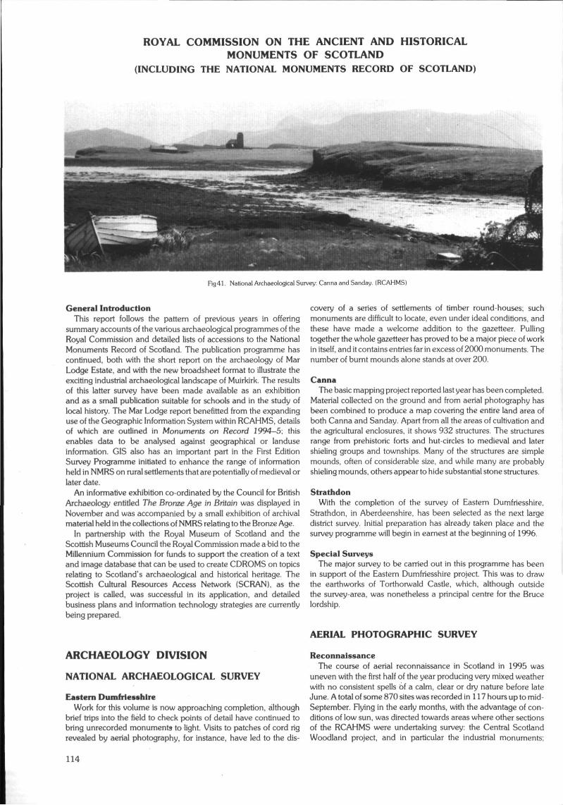
ROYAL COMMISSION ON THE ANCIENT AND HISTORICALMONUMENTS OF SCOTLAND
(INCLUDING THE NATIONAL MONUMENTS RECORD OF SCOTLAND)
Fig 41. National Archaeological Survey: Canna and Sanday. (RCAHMS)
General IntroductionThis report follows the pattern of previous years in offering
summary accounts of the various archaeological programmes of theRoyal Commission and detailed lists of accessions to the NationalMonuments Record of Scotland. The publication programme hascontinued, both with the short report on the archaeology of MarLodge Estate, and with the new broadsheet format to illustrate theexciting industrial archaeological landscape of Muirkirk. The resultsof this latter survey have been made available as an exhibitionand as a small publication suitable for schools and in the study oflocal history. The Mar Lodge report benefitted from the expandinguse of the Geographic Information System within RCAHMS, detailsof which are outlined in Monuments on Record 1994—5, thisenables data to be analysed against geographical or landuseinformation. GIS also has an important part in the First EditionSurvey Programme initiated to enhance the range of informationheld in NMRS on rural settlements that are potentially of medieval orlater date.
An informative exhibition co-ordinated by the Council for BritishArchaeology entitled The Bronze Age in Britain was displayed inNovember and was accompanied by a small exhibition of archivalmaterial held in the collections of NMRS relating to the Bronze Age.
In partnership with the Royal Museum of Scotland and theScottish Museums Council the Royal Commission made a bid to theMillennium Commission for funds to support the creation of a textand image database that can be used to create CDROMS on topicsrelating to Scotland's archaeological and historical heritage. TheScottish Cultural Resources Access Network (SCRAN), as theproject is called, was successful in its application, and detailedbusiness plans and information technology strategies are currentlybeing prepared.
ARCHAEOLOGY DIVISION
NATIONAL ARCHAEOLOGICAL SURVEY
Eastern DumfriesshireWork for this volume is now approaching completion, although
brief trips into the field to check points of detail have continued tobring unrecorded monuments to light. Visits to patches of cord rigrevealed by aerial photography, for instance, have led to the dis-
covery of a series of settlements of timber round-houses; suchmonuments are difficult to locate, even under ideal conditions, andthese have made a welcome addition to the gazetteer. Pullingtogether the whole gazetteer has proved to be a major piece of workin itself, and it contains entries far in excess of 2000 monuments. Thenumber of burnt mounds alone stands at over 200.
CannaThe basic mapping project reported last year has been completed.
Material collected on the ground and from aerial photography hasbeen combined to produce a map covering the entire land area ofboth Canna and Sanday. Apart from all the areas of cultivation andthe agricultural enclosures, it shows 932 structures. The structuresrange from prehistoric forts and hut-circles to medieval and latershieling groups and townships. Many of the structures are simplemounds, often of considerable size, and while many are probablyshieling mounds, others appear to hide substantial stone structures.
StrathdonWith the completion of the survey of Eastern Dumfriesshire,
Strathdon, in Aberdeenshire, has been selected as the next largedistrict survey. Initial preparation has already taken place and thesurvey programme will begin in earnest at the beginning of 1996.
Special SurveysThe major survey to be carried out in this programme has been
in support of the Eastern Dumfriesshire project. This was to drawthe earthworks of Torthorwald Castle, which, although outsidethe survey-area, was nonetheless a principal centre for the Brucelordship.
AERIAL PHOTOGRAPHIC SURVEY
ReconnaissanceThe course of aerial reconnaissance in Scotland in 1995 was
uneven with the first half of the year producing very mixed weatherwith no consistent spells of a calm, clear or dry nature before lateJune. A total of some 870 sites was recorded in 117 hours up to mid-September. Flying in the early months, with the advantage of con-ditions of low sun, was directed towards areas where other sectionsof the RCAHMS were undertaking survey: the Central ScotlandWoodland project, and in particular the industrial monuments;
114
Eastern Dumfriesshire; Kingussie; and Strathdon. The incidence ofsnow-cover, accompanied by good flying weather was limited,but the upper reaches of Strathdon provided fair conditions for theidentification of vestigial remains of settlement and cultivation.Attempts to carry out aerial survey in the Rogart area of Sutherlandwere regularly frustrated by adverse weather conditions, andreconnaissance was not carried out until June
The recording of Second World War installations has been anirregular feature of aerial reconnaissance for several years, beingundertaken when sites were threatened with demolition or pre-sented themselves as particularly eloquent examples of their typewhen viewed from the air. The Defence of Britain project, with itsaim of recording and documenting military sites, particularly those ofWorld War 11, has led to the formulation of a Royal Commissionproject on the defences of Scapa Flow, which has an aerial com-ponent; one flight has already been undertaken, but weatherconditions at suitable times have prevented a second sortie.
Winter, spring and early summer in Scotland were unsettled withregular rainfall and near-average temperatures, leading to a steadyand unstressed development of cereal crops. The Soil MoistureDeficit figures were low until the unheralded dry and sunny weatherof the last ten days of June Particular attention was directed, whenweather permitted, to the south-west of Scotland. This yielded someinteresting new sites, including a small ceremonial complex nearBallantrae and a series of palisaded settlements on the east side ofLoch Ryan. Reasonable conditions over the Grampians allowedthe area around Speyside and the Moray Firth to be successfullysurveyed. While, given the unusually prolonged absence of rain inJuly and August, the number of sites visible was not remarkable,except around the inner Moray Firth, some of the monumentsrevealed, such as square and round barrow cemeteries and pittedfeatures, will add significantly to the appreciation of the archaeologyof the area.
The effect of the lack of rainfall in late July and the first twenty-onedays of August was to produce parchmarks in pasture fields,particularly important in revealing sites in the area lying betweenthe cereal-growing fields and the moorland where upstandingmonuments survive, a section of the landscape rarely visible toarchaeologists and the Tweed Basin and Clydesdale were particu-larly productive The majority of the previously unrecorded sites,appearing in the form of parchmarks, were settlements, but a Romantemporary camp near West Linton also appeared as a positive mark.Reconnaissance in 1995 involved a higher proportion of more dis-tant sorties than in previous years, thus improving NMRS holdings.In sum, the weather pattern of the summer of 1995 yielded its shareof useful material, but it did not produce a year that could com-pare with these of 1989 and 1992 in the discovery of archaeologicalsites.
Sponsored FlyingReconnaissance by sponsored fliers, totalling 23 hours in the air
(up to mid-September) took place in Grampian, Fife and Strath-clyde, with good results in cropmark form being obtained inClydesdale, and especially in the Moray District of Grampian.
AFFORESTABLE LAND SURVEY
This summary report gives a brief outline, Region by Region, ofRCAHMS work relating to strategic survey of selected areas ofScotland likely to be at risk from afforestation. This is followed bya list of future areas of work and a report on the new RCAHMS FirstEdition Survey Programme.
GrampianMar Lodge Estate: a report on the work undertaken in 1993
was published in 1995 and copies are available from the RoyalCommission (£3.50 plus p & p).
Fig 42. Aerial Photographic Survey: Raw plot of flight traces January -November1995 produced from Global Positioning Syslem survey data. (RCAHMS)
Fig 43 Aerial Photographic Survey Fort. Shaw Craigs. Roxburgh District.Borders Region (RCAHMS)
HighlandRogart. fieldwork has been completed in a block of ground
covering about 68 square kilometres around the village of Rogart,Sutherland. Although the Ordnance Survey had previously demon-strated that this was an archaeologically rich area, the present surveyidentified a significant number of hitherto unknown monuments,including two chambered caims and two probable Pictish caimcemeteries.
To complement the archaeological work, and to provide a con-text for the monuments, the Royal Commission, with the financialsupport of Historic Scotland and Scottish Natural Heritage, has
115
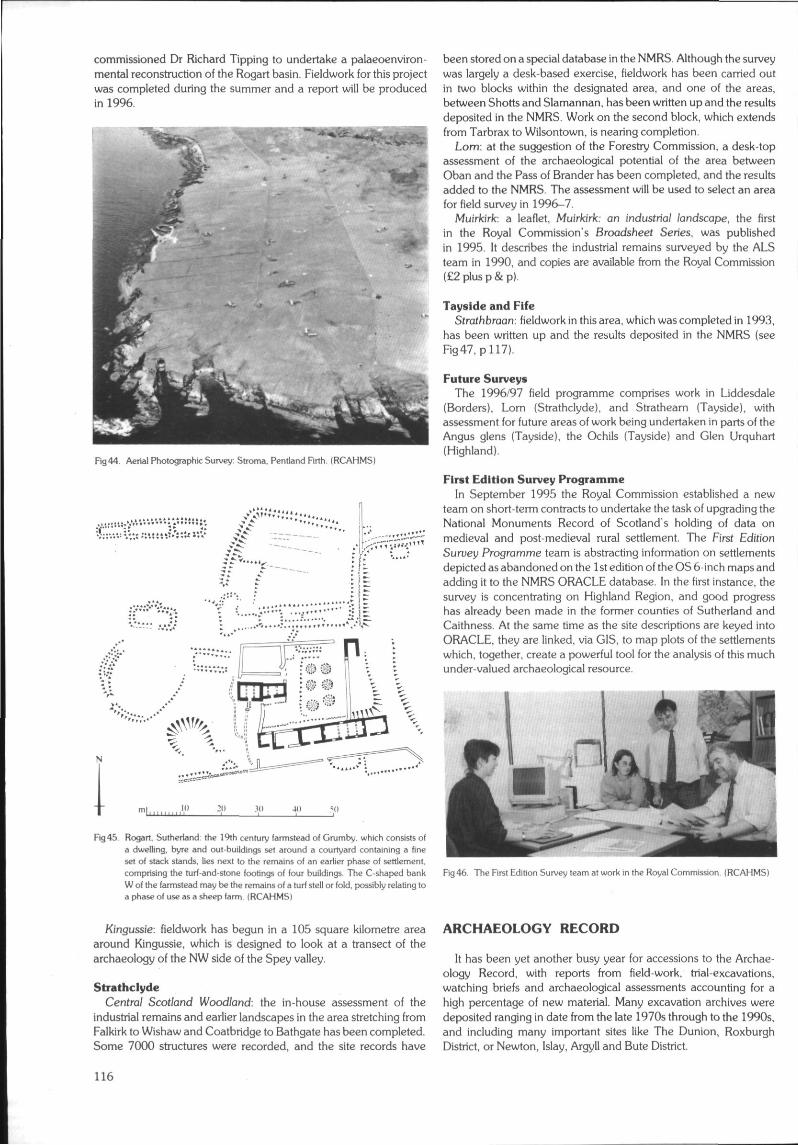
commissioned Dr Richard Tipping to undertake a palaeoenviron-mental reconstruction of the Rogart basin. Fieldwork for this projectwas completed during the summer and a report will be producedin 1996.
Rg44. Aerial Photographic Survey: Stroma. Pentland Firth. (RCAHMS}
'.! H',
.10
Fig45. Rogart. Sulherland: the 19th century farmstead of Crumby, which consists ofa dwelling, byre and out-buildings sel around a courtyard containing a fineset of stack stands, lies next lo the remains of an earlier phase of settlernenl,comprising the turl-and-stone lootings of four buildings. The C-shaped bankW of the farmstead may be the remains of a turf stell or fold, possibly relating toa phase of use as a sheep farm. (RCAHMS]
been stored on a special database in the NMRS. Although the surveywas largely a desk-based exercise, fieldwork has been carried outin two blocks within the designated area, and one of the areas,between Shorts and Slamannan, has been written up and the resultsdeposited in the NMRS. Work on the second block, which extendsfrom Tarbrax to Wilsontown, is nearing completion.
Lorn: at the suggestion of the Forestry Commission, a desk-topassessment of the archaeological potential of the area betweenOban and the Pass of Brander has been completed, and the resultsadded to the NMRS. The assessment will be used to select an areafor field survey in 1996-7.
Muirkirk: a leaflet, Muirkirk: an industrial landscape, the firstin the Royal Commission's Broadsheet Series, was publishedin 1995. It describes the industrial remains surveyed by the ALSteam in 1990, and copies are available from the Royal Commission(£2plusp&p).
Tayslde and FifeStrarribraan: fieldwork in this area, which was completed in 1993,
has been written up and the results deposited in the NMRS (seeFig47,
Future SurveysThe 1996/97 field programme comprises work in Liddesdale
(Borders), Lorn (Strathclyde), and Strathearn (Tayside), withassessment for future areas of work being undertaken in parts of theAngus glens (Tayside), the Ochils (Tayside) and Glen Urquhart(Highland).
First Edition Survey ProgrammeIn September 1995 the Royal Commission established a new
team on short-term contracts to undertake the task of upgrading theNational Monuments Record of Scotland's holding of data onmedieval and post-medieval rural settlement. The First EditionSuruey Programme team is abstracting information on settlementsdepicted as abandoned on the 1 st edition of the OS 6-inch maps andadding it to the NMRS ORACLE database. In the first instance, thesurvey is concentrating on Highland Region, and good progresshas already been made in the former counties of Sutherland andCaithness. At the same time as the site descriptions are keyed intoORACLE, they are linked, via GIS. to map plots of the settlementswhich, together, create a powerful tool for the analysis of this muchunder-valued archaeological resource.
Fig 46. The First Edition Survey leam at work in the Royal Commission. {RCAHMS)
Kingussie: fieldwork has begun in a 105 square kilometre areaaround Kingussie, which is designed to look at a transect of thearchaeology of the NW side of the Spey valley.
StrathclydeCentral Scotland Woodland: the in-house assessment of the
industrial remains and earlier landscapes in the area stretching fromFalkirk to Wishaw and Coatbridge to Bathgate has been completed.Some 7000 structures were recorded, and the site records have
ARCHAEOLOGY RECORD
It has been yet another busy year for accessions to the Archae-ology Record, with reports from field-work, trial-excavations,watching briefs and archaeological assessments accounting for ahigh percentage of new material. Many excavation archives weredeposited ranging in date from the late 1970s through to the 1990s,and including many important sites like The Dunion, RoxburghDistrict, or Newton, Islay, Argyll and Bute District.
116
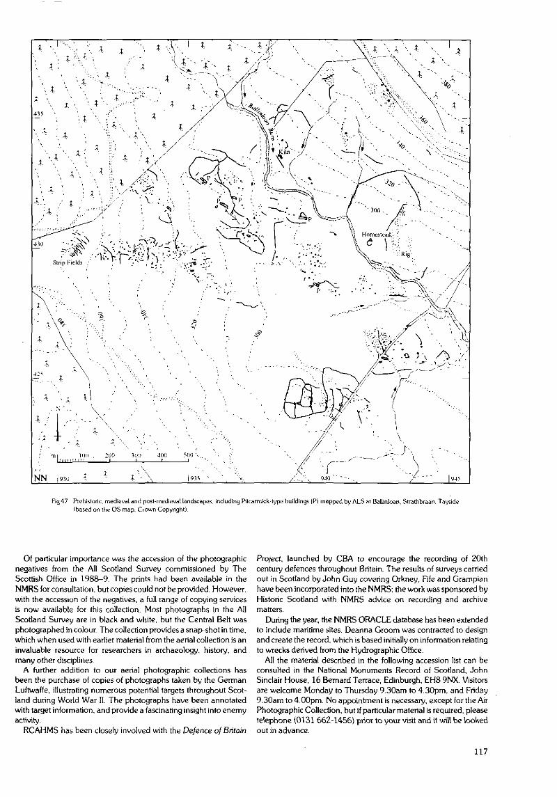
Fig47 Prehistoric, medieval and post-medieval landscapes, including Pitcarmick-type buildings (P) mapped by ALS at Ballinloan, Strathbraan. Tayside(based on the OS map. Crown Copyright).
Qt particular importance was the accession of the photographicnegatives from the All Scotland Survey commissioned by TheScottish Office in 1988-9. The prints had been available in theNMRS for consultation, but copies could not be provided. However,with the accession of the negatives, a full range of copying servicesis now available for this collection. Most photographs in the AllScotland Survey are in black and white, but the Central Belt wasphotographed in colour. The collection provides a snap-shot in time,which when used with earlier material from the aerial collection is aninvaluable resource for researchers in archaeology, history, andmany other disciplines.
A further addition to our aerial photographic collections hasbeen the purchase of copies of photographs taken by the GermanLuftwaffe, illustrating numerous potential targets throughout Scot-land during World War II. The photographs have been annotatedwith target information, and provide a fascinating insight into enemyactivity,
RCAHMS has been closely involved with the Defence of Britain
Project, launched by CBA to encourage the recording of 20thcentury defences throughout Britain. The results of surveys carriedout in Scotland by John Guy covering Orkney, Fife and Grampianhave been incorporated into the NMRS; the work was sponsored byHistoric Scotland with NMRS advice on recording and archivematters.
During the year, the NMRS ORACLE database has been extendedto include maritime sites. Deanna Groom was contracted to designand create the record, which is based initially on information relatingto wrecks derived from the Hydrographic Office.
All the material described in the following accession list can beconsulted in the National Monuments Record of Scotland, JohnSinclair House, 16 Bernard Terrace, Edinburgh, EH8 9NX. Visitorsare welcome Monday to Thursday 9.30am to 4.30pm, and Friday9.30am to 4.00pm. No appointment is necessary, except for the AirPhotographic Collection, but if particular material is required, pleasetelephone (0131 662-1456) prior to your visit and it will be lookedout in advance.
117
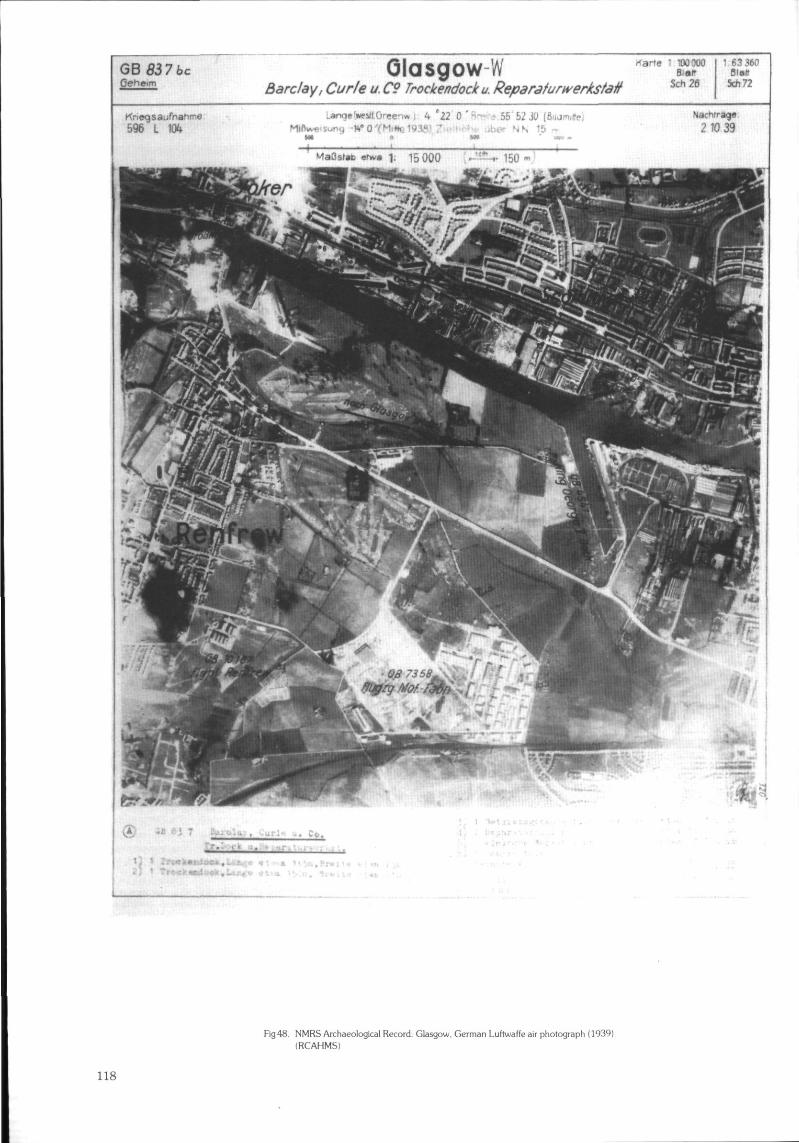
GB5376cOehcim Barclay, Curie u. C9 Trockendock u. Reparafurwerkstatf Scfi26
1.W3WBIBB
5ch72
Kriegsaufnanrne596 L
Fig48 NMRS Archaeological Record: Glasgow. German Luftwaffe air photograph (1939)(RCAHMS)
118
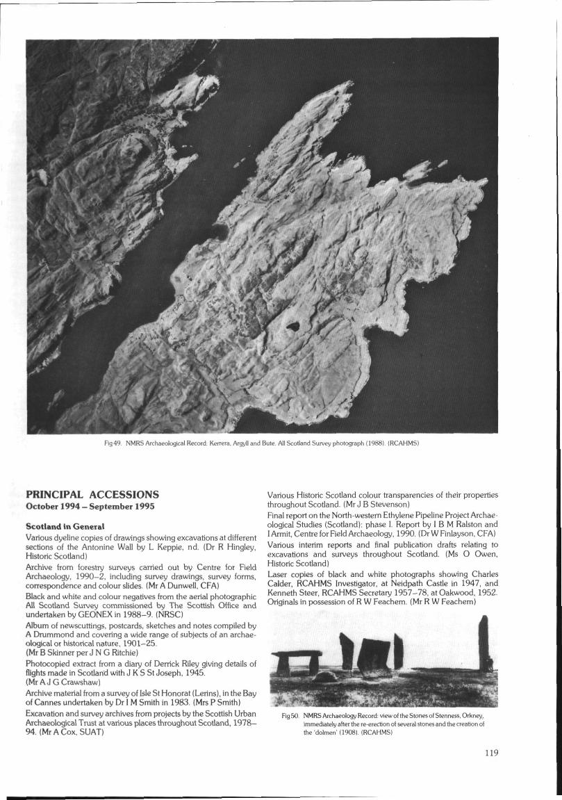
Fig49 NMRS Archaeological Record: Keirera. Argyll and Bule. All Scotland Survey photograph (1988). (RCAHMS)
PRINCIPAL ACCESSIONSOctober 1994 - September 1995
Scotland in GeneralVarious dyeline copies of drawings showing excavations at differentsections of the Antonine Wall by L Keppie, nd. (Dr R Hingley,Historic Scotland)Archive from forestry surveys carried out by Centre for FieldArchaeology, 1990-2, including survey drawings, survey forms,correspondence and colour slides. (Mr A Dunwell. CFA)Black and white and colour negatives from the aerial photographicAll Scotland Survey commissioned by The Scottish Office andundertaken by GEONEX in 1988-9. (NRSC)Album of newscuttings, postcards, sketches and notes compiled byA Drummond and covering a wide range of subjects of an archae-ological or historical nature, 1901-25.{Mr B Skinner per J N G Ritchie)Photocopied extract from a diary of Derrick Riley giving details offlights made in Scotland with J K S St Joseph, 1945.(Mr A J G Crawshaw)Archive material from a survey of Isle St Honorat (Lerins), in the Bayof Cannes undertaken by Dr I M Smith in 1983. (Mrs P Smith)Excavation and survey archives from projects by the Scottish UrbanArchaeological Trust at various places throughout Scotland, 1978-94. (Mr A Cox, SUAT)
Various Historic Scotland colour transparencies of their propertiesthroughout Scotland. (Mr J B Stevenson)Final report on the North-western Ethylene Pipeline Project Archae-ological Studies (Scotland): phase I. Report by I B M Ralston andI Armit, Centre for Field Archaeology, 1990. (Dr W Finlayson, CFA)Various interim reports and final publication drafts relating toexcavations and surveys throughout Scotland. (Ms O Owen,Historic Scotland)Laser copies of black and white photographs showing CharlesCalder, RCAHMS Investigator, at Neidpath Castle in 1947, andKenneth Steer, RCAHMS Secretary 1957-78, at Oakwood, 1952.Originals in possession of R W Feachem. (Mr R W Feachem)
Fig50. NMRS Archaeology Record; view of the Stones of Stenness. Orkney,immediately after the re-erection of several stones and the creation ofthe 'dolmen' (1908). (RCAHMS)
119
Black and white copy negatives of the Luftwaffe target documentsfor Scotland. {Purchased from the National Archives of America)Photocopies of archaeological letters from the collection of JamesYoung Simpson held in the Royal College of Surgeons, Edinburgh.(Royal College of Surgeons)Card-index of souterrains compiled by F T Wainwright, with addi-tional notes by G J Barclay. (Mr G J Barclay, Historic Scotland)Four lecture slides illustrating the progress of scheduling 1920-95,properties in care and the distribution of regional archaeologists andarchaeological units in Scotland. (Dr D J Breeze, Historic Scotland)List of known and theoretical milecastle positions on the AntonineWall compiled by D J Woolliscroft, University of Manchester, 1994.(MrRJMowat)
BORDERS REGION
On loan for copying. Fourteen colour slides and three annotatedmaps of unrecorded possible Roman roads in Borders Region, byJ W Elliot, nd. (Mr J W Elliot)Aerial photographs of various sites in Borders Region, by J Dent,1990-3. Colour slides lent for copying. (Mr J Dent, Borders Region)
Berwickshire DistrictColour slide of the earthwork at Hardacres Hill, Berwick District,Borders Region, by R Strathie. 1995. On loan for copying.< Mr J W Elliot)
Ettrick and Lauderdale DistrictReport on a geophysical survey on Broomhill Camp near Newstead.Ettrick and Lauderdale District, Borders Region, by S Clarke.D Robinson and A Tebbs, Department of Archaeological Sciences,University of Bradford, 1995. (Mr JW Elliot)Colour slide of possible Roman road at Kedslie Hill, Ettrick andLauderdale District, Borders Region, by R Strathie, 1995. On loanfor copying. (Mr J W Elliot)Archive from excavations at Hillslap Tower. Ettrick and LauderdaleDistrict, Borders Region, by J Lewis, Scotia Archaeology Limited,1984, including day book, drawings, black and white and colourphotographs, colour transparencies and draft report. (Mr J Lewis.Scotia Archaeology Limited)Archive from excavations at Newstead, Roman fort, Ettrick andLauderdale District, Borders Region, by G Wilson and H Moore,Environmental and Archaeological Services, Edinburgh, 1994.including reports, black and white and colour photographs andnegatives, colour slides and drawings. (Mr G Wilson, EASE)
Roxburgh DistrictReport (no 131.3) on an archaeological assessment at Teviothead,Roxburgh District, Borders Region of the route of the proposedupgrade of the A7 Edinburgh to Carlisle trunk road, Binks toCastleweary section for ASH Consulting Group, by GUARD, 1995.Report by K J Taylor. (GUARD)Colour slide of the settlement at Ancrum. Roxburgh District, BordersRegion, by R Strathie, 1995. On loan for copying. (Mr J W Elliot)Ink drawing of the cultivation terraces and field system at Braemore.Hownam, Roxburgh District, Borders Region, 1987.(Mr RJ Mercer)Report (no 131.2) on geophysical investigations at Teviotheadmanse, Roxburgh District. Borders Region, by R James and I Banks,GUARD. 1994. (GUARD)Archive from excavations at The Dunion, Roxburgh District,Borders Region, by J Rideout. 1984-5, including drawings, photo-graphs, negatives, site notebooks, administration papers, contextcards, and specialist reports.(Mr A Duffy, AOC (Scotland) Limited)
Tweeddale DistrictColour prints of the carved stones built into the wall of NewlandsManse, Tweeddale District, Borders Region, by S P Halliday, 1994.(MrSPHalliday)
CENTRAL REGION
Colour slides of industrial sites in Fife, and Central Regions byD Easton, 1993-4. (Mr D Easton)
Falklrfc DistrictArchive from survey and excavations at Rough Castle, FalkirkDistrict, Central Region, including drawings, notebook, colourslides, draft reports, specialist reports and black and white photo-graphs. (Mr G J Barclay, Historic Scotland)Photocopied drawing showing results of excavations at theAntonine Wall at Nether Kinneil, Falkirk District. Central Region,by E Price, 1974. (Dr R Hingley, Historic Scotland)Report on a watching brief at Beancross, Falkirk District, CentralRegion, in connection with a scheduled part of the Antonine Wall.by G Bailey, 1994. (Mr G Bailey, Falkirk Museum)Interim statement with photocopied illustrations on research on theCarron Company Canal, by G Bailey. 1994. (Mr G Bailey, FalkirkMuseum)Report on excavations at Castle Gary, Falkirk District, CentralRegion, by G Bailey, Falkirk Museum, 1995. (Mr G Bailey, FalkirkMuseum)Colour slides of various Roman excavations including TentfieldPlantation (NS87NE), Falkirk District, Central Region, by A SRobertson. (Dr D J Breeze. Historic Scotland)Various papers relating to excavations along the Antonine Wall,including Rough Castle. Falkirk District, Central Region in 1957-8.(Dr R Hingley, Historic Scotland)
Stirling DistrictReport (no 183) on an archaeological ex< dva*ion at the GranadaService Station, Pirnhall, Stirling District, Ctntrdl Region, by A Rees,Centre for Field Archaeology, 1994. (Dr W Finlayson, CFA)Archive from excavations at Gillies Hill. Stirling District. CentralRegion, by J S Rideout, 1984, including notebooks, photographs,negatives, drawings and colour slides. (Mr A Duffy, AOC (Scotland)Limited)Report and colour prints on World War II defences constructed atSheriff Muir. Stirling District, Central Region, by P and L Draper,1994. (Mr and Mrs L Draper)Report (no 226) on an archaeological watching brief and fieldinspection at Auchenlaich Caravan Park, by Callander, StirlingDistrict, Central Region, by R J Strachan, Centre for Field Archae-ology, 1995. (Mr R J Strachan, CFA)
DUMFRIES AND GALLOWAY REGION
Black and white aerial photographs of sites in south-west Scotlandby W S Hanson, nd. (Dr W S Hanson)Location maps, computer disc and descriptions of newly discoveredcup-and-ring marks in Dumfries and Galloway Region, by KaledonNaddair, 1995. (Mr Kaledon Naddair)Colour photographs of cup-and-ring marked stones in Dumfries andGalloway Region, by M A M van Hoek, 1994. Moms' PrehistoricRock Art of Galloway by M A M van Hoek, 1995.(Mr M A M van Hoek)
Annandale and Eskdale DistrictReport (no 193.2) on the excavation of an Iron Age enclosure atWoodend Farm. Annandale and Eskdale District, Dumfries andGalloway Region in advance of road construction on the M6extension on behalf of Scottish Office Industry Department (RoadsDirectorate) and Historic Scotland, by GUARD. Report by 1 Banks.(GUARD)Report (no 236) on trial trenching of various sites throughoutBeattock Bank, Clydesdale District, Strathclyde Region and Annan-dale and Eskdale District, Dumfries and Galloway Region, inadvance of the A74 upgrade to motorway status, for Scottish OfficeIndustry Department (Roads Directorate) and Historic Scotland,carried out by GUARD, 1994. Report by K Speller and R S Will.(GUARD)
120
Report (no 193.1} on survey and excavations to the east of Beattockvillage, Annandale and Eskdale District. Dumfries and GallowayRegion, in advance of the upgrading of the A74 to motorway status,for Scottish Office Industry Department (Roads Directorate) andHistoric Scotland, GUARD. 1995. Report by K Speller and A Leslie.(GUARD)Final ink and copy drawings from the survey of buildings and monu-ments in Kirkpatrick Fleming parish by R J Mercer. (Mr R J Mercer)Report with drawings from a forestry survey at Purdomstone,Annandale and Eskdale District, Dumfries and Galloway Region, byM Dalland and C Moloney, AOC (Scotland) Limited. 1995.(DrS Carter, AOC (Scotland) Limited)Typescript account of the Dinwoodie land and family by J Welsh.(MrHPDinwoodie)Archive from the excavations at Uppercleuch. settlement, Annan-dale and Eskdale District, Dumfries and Galloway Region, byJ Terry. GUARD. 1990, including draft report, specialist reports,colour slides, black and white negatives, finds records, site note-book, drawings and context sheets. (Mr J Terry, GUARD)Report (no 287) on an archaeological assessment at Waterhead ofDryfe, Annandale and Eskdale District. Dumfries and GallowayRegion, on behalf of Fountain Forestry by GUARD, 1995. Reportby J A Atkinson. (GUARD)Report of a watching brief at Kirkpatrick Fleming Roman temporarycamp, Annandale and Eskdale District. Dumfries and GallowayRegion, by J Brann. 1993 and 1995. (MsJBrann)Drawings from pre-afforestation survey at Beattock, Annandale andEskdale District, Dumfries and Galloway Region, by L J Masters,1981. (Mr G J Barclay. Historic Scotland)
Nithsdale DistrictReport and drawings from a forestry survey at Glenmaid Moor,Nithsdale District, Dumfries and Galloway Region, by M DallandandJO'Sullivan. 1995. (Mr JO'Sullivan. AOC (Scotland) Limited)Archive from excavations at Cavronbridge, Nithsdale District.Dumfries and Galloway Region, by D Johnston, 1989-90, in-cluding drawings, photographs, negatives, reports, context andfinds cards, and colour slides. (Mr A Duffy, AOC (Scotland) Limited)
Stewartry DistrictArchive from excavations at Park of Tongland. Stewartry District.Dumfries and Galloway Region, by R P J McCullagh. 1987. in-cluding colour slides, negatives, photographs, correspondence andspecialist reports. (Mr A Duffy, AOC (Scotland) Limited)Report and drawings from a forestry survey at Blackmark Farm,Stewartry District. Dumfries and Galloway Region, by J O'Sullivanand A Duffy, 1994. (Dr S Carter, AOC (Scotland) Limited)Report on a pre-afforestation archaeological field survey atComharrow Farm near Moniaive, Stewartry District. Dumfries andGalloway Region, commissioned by Tilhill Economic Forestry, byT Ward, Biggar Museum Trust, 1994. (MrT Ward, Biggar Museum)
Wigtown DistrictFurther original excavation drawings from Whithorn, WigtownDistrict. Dumfries and Galloway Region, by P Hill, Whithorn Trust,1986-91. (Mr P Hill and Mrs C Wilson, Whithorn Trust)User Guide to the Whithom Excavation database, 1994.(Mrs C Wilson, Whithorn Trust)
FIFE REGION
Colour slides of industrial sites in Fife and Central Regions byD Easton, 1993-4. (Mr D Easton)Fife Archaeological Service Annual report 1994-5.(Mr P J Yeoman, Fife Region)Report on the maritime archaeological potential in the area of theKilminning outfall, Fife Region, by I Oxley and M Dun. ScottishInstitute of Maritime Studies, 1995. (Dr R G W Prescott, Institute ofMaritime Studies)Inventory of World War I and II defences in Fife Region, by J Guy.1995. (Mr J Guy)
Dunfermline DistrictArchive from excavations at Dunfermline Old Lauder TechnicalCollege, Dunfermline District, Fife Region, by J Lewis, ScotiaArchaeology Limited, 1993, including day book, context sheets,drawings, black and white photographs and negatives, colourtransparencies and reports. (Mr J Lewis, Scotia ArchaeologyLimited)Report to the National Trust for Scotland on excavations at CulrossPalace, Dunfermline District, Fife Region, by Scotia ArchaeologyLimited, 1995. (Mr J Lewis, Scotia Archaeology Limited)Notebook from excavations at Inchcolm Abbey, DunfermlineDistrict, Fife Region, by J Wordsworth, Historic Scotland, 1984.(Mr J Wordsworth. Wordsworth Archaeology)
Klrkcaldy DistrictArchive from excavations at East Wemyss Caves, Kirkcaldy District,Fife Region in 1989, including black and white photographs.negatives, colour slides, drawings, notes, specialist reports andcorrespondence. (Mr G J Barclay, Historic Scotland)Report (no 234) of an archaeological assessment at Kilrnux Farm.Kirkcaldy District, Fife Region, undertaken on behalf of Johnson,Poole and Bloomer (Scotland) Ltd for Hewden Ltd by GUARD,1995. Report by J A Atkinson. (GUARD)
North-east Fife DistrictArchive from archaeological evaluation and excavation at BackDykes, Auchtermuchty, North-east Fife District, Fife Region, byH Moore and G Wilson. Environmental and Archaeological Ser-vices, Edinburgh, 1995. including colour slides, black and white andcolour photographs, negatives and data structures report.(Mr G Wilson, EASE)Further archive from the excavations at Balfarg Riding School,North-east Fife District, Fife Region, by G J Barclay 1983-5, in-cluding a burnt bone list and material and drawings relating to thestructural reconstruction. (MrGJ Barclay, Historic Scotland)Report (no 254) of archaeological watching briefs at Lundin FarmMill, North-east Fife District, Fife Region, for Bert Homes by GUARD,1995. Report by J A Atkinson, S Halliday and G MacGregor.(GUARD)Photocopies of drawings of various Pictish carvings, includingSt Andrews Cathedral Museum, North-east Fife District, FifeRegion, by I G Scott, 1994. (Mr I G Scott)Report on a watching brief and excavation at St Nicholas Farm.relating to the St Andrews interceptor sewer pipeline, North-east FifeDistrict, Fife Region, by E Proudfoot. St Andrews Heritage Services,1994. (Mrs E V W Proudfoot, St Andrews Archaeological Services)Report (no 101.3) on archaeological excavations on the Isle of May.North-east Fife District, Fife Region, undertaken by Fife RegionalCouncil, North East Fife District Council, and Scottish NaturalHeritage, with support from the Society of Antiquaries of Scotland,Historic Scotland, The Russell Trust. The Hunter ArchaeologicalTrust and Briggs Marine Contractors Ltd, by GUARD. Report byH F James. (Ms H F James, GUARD)Report on a watching brief within the courtyard and gardens atSt Mary's College, St Andrews. North-east Fife District, Fife Region.by A Barlow, Scotia Archaeology Limited. 1995. (Mr J Lewis, ScotiaArchaeology Limited)Archive from archaeological evaluation at Lathrisk House. North-east Fife District. Fife Region, by G Wilson and H Moore, Environ-mental and Archaeological Services, Edinburgh, 1995, includingreport, black and white photographs and negatives, colour slidesand drawings. (Mr G Wilson. EASE)Data structure report on excavations at Kellie Castle, North-east FifeDistrict. Fife Region, by H Smith, Scotia Archaeology Limited,1995. (Mr J Lewis, Scotia Archaeology Limited)Report on the Maritime Archaeological Potential in the area of theSt Andrews Outfall. North-east Fife District, Fife Region, by I Oxley.M Duns and A Wood, Scottish Institute of Maritime Studies, 1995.(Dr R G W Prescott, Institute of Maritime Studies)A collection of glass slides and negatives relating to work byF T Wainwright and others, including original drawings from cistexcavations at Kilminning, North-east Fife District, Fife Region.(Mr A Zealand, Dundee Museum)
121
Report on a watching brief within the courtyard and gardens atSt Mary's College, St Andrews, North-east Fife District, Fife Region,by A Barlow, Scotia Archaeology Limited, 1995. (Mr J Lewis, ScotiaArchaeology Limited)
GRAMPIAN REGION
Details of updates to the Grampian Region Sites and Monumentsrecord for September 1994 - August 1995. (Mrs M Greig, GrampianRegional Council)Details of the 1994 and 1995 flying programmes by AberdeenArchaeological Surveys, with contact prints of results. Report andcatalogue of aerial photographs by Aberdeen ArchaeologicalSurveys, 1994. (Mrs M Greig, Grampian Regional Council)Black and white aerial photographs of various sites in Strathdon,Grampian Region, by Aberdeen Archaeological Surveys, 1978-94.
City of Aberdeen DistrictColour slides on loan for copying from excavations at various siteswithin the City of Aberdeen, Grampian Region by the AberdeenArchaeological Unit. (Ms A Cameron, Aberdeen ArchaeologicalUnit)
Banff and Buchan DistrictReport with dyeline drawing from a forestry survey at Saplinbrae,Banff and Buchan District, Grampian Region, by S Carter andT Rees. AOC (Scotland) Limited, 1995. (Dr S Carter, AOC (Scot-land) Limited)Black and white aerial photographs of the Roman temporary campat Ythan Wells, Banff and Buchan District, Grampian Region, takenby CUCAP, 1968, 1973 and 1976. (Purchased CUCAP)Report of an archaeological assessment of the fish house, Peterhead,Banff and Buchan District, Grampian Region, by J Wordsworth,1994. (Ms J Harden)Report on the archaeological investigation of the footpath whichonce served the late 18th century earth closet to the west of Fyviecastle, Banff and Buchan District, Grampian Region, by R Turner,National Trust for Scotland, 1995. (Mr R Turner, National Trust forScotland)
Gordon DistrictReport with drawings from a forestry survey at Blairmore, GordonDistrict, Grampian Region, by A N Smith and M Dalland, AOC(Scotland) Limited, 1995. (Dr S Carter, AOC (Scotland) Limited)Five black and white aerial photographs of Barflat, Rhynie, GordonDistrict, Grampian Region, by Aberdeen Archaeological Surveys,1992. (Mrs M Greig, Grampian Region)Report with drawings from a forestry survey at Ratch-hill, Kintore,Gordon District, Grampian Region, by S Carter and J O'Sullivan,AOC (Scotland) Limited, 1995. (Dr S Carter, AOC (Scotland)Limited)Photocopies of drawings of various Pictish carvings includingTillytarmont 5 (NJ54NW 20). Gordon District. Grampian Region,by I G Scott, 1994. (Mr I G Scott)
Kincardine and Deeside DistrictReport and dyeline drawings from forestry survey at Matthew's Top.Kincardine and Deeside District, Grampian Region, by J O'Sullivanand C Moloney, AOC (Scotland) Limited, 1994. (Dr S Carter, AOC(Scotland) Limited)Archive from excavations at Capo Quarry. Kincardine and DeesideDistrict, Grampian Region, by A Gibson, 1984, including cor-respondence, photographs, daybook and reports. (Mr A Duffy,AOC (Scotland) Limited)Report with drawing from a forestry survey at Glen Ey, Kincardineand Deeside District, Grampian Region, by J O'Sullivan andA Smith, 1995. (Mr J O'Sullivan, AOC (Scotland) Limited)
Moray DistrictArchive relating to the excavations at Romancamp Gate, MorayDistrict, Grampian Region, by G J Barclay, 1990, including colour
negatives, polaroid photographs, sample list, specialist reports andcorrespondence. (Mr G J Barclay, Historic Scotland)Archive from excavation at Tulloch Wood, Moray District, GrampianRegion, by S Carter and FMcCormick, 1990-91, including contextcards and reports. (Mr A Duffy, AOC (Scotland) Limited)Report on investigations of the chambers over the east range atKinloss Abbey, Moray District, Grampian Region, by Mr J Lewis,Scotia Archaeology Limited, 1995. (Mr J Lewis, Scotia ArchaeologyLimited)Computer print-out structure report from excavations at SpyniePalace, Moray District, Grampian Region. (Mr G J Barclay, HistoricScotland)Report on excavations- at Leitchestown, Deskford, Banffshire, byF Hunter, National Museums of Scotland, 1994. (Mr F Hunter,National Museums of Scotland)Interim report on excavations adjacent to St Giles Church. Elgin,Moray District, Grampian Region, by J Terry and D Murray, ScotiaArchaeology Limited, 1995. (Mr J Lewis, Scotia ArchaeologyLimited)Photocopies of drawings of various Pictish carvings, includingElgin Cathedral (NJ26SW 2). Moray District, Grampian Region, byIG Scott, 1994. (Mr 1G Scott)
HIGHLAND REGION
Photocopied report with two photographs describing the excavationof intertidal sites in the Beauly Firth, Highland Region, by A Hale,1994. (Mr A Hale)Black and white negatives of various sites in Highland Region byDr J Close-Brooks, 1994. (DrJ Close-Brooks)Black and white and colour aerial photographs of various sites inHighland Region, by J Harden, 1994. (Ms J Harden)Catalogue of aerial photographs taken by Highland Region Archae-ology Section. 1981-1987, 1991 and black and white aerial prints."(Mr J Wood. Highland Region)
Badenoch and Strathspey DistrictAerial colour prints and negatives of a possible site marked ona 1771 estate map near Kingussie, Badenoch and StrathspeyDistrict, Highland Region, by I Keillar, 1987. (Mr I Keillar)Colour panorama print of the Old Packhorse Bridge, Carrbridge,Badenoch and Strathspey District, Highland Region, by W C Brown,1995. (Mr WC Brown)
Caithness DistrictArchive from excavations at John O'Groats, Caithness District,Highland Region, by APG, 1989, including context cards, black andwhite negatives, colour slides and final draft report. (Mr G J Barclay,Historic Scotland)Miscellaneous drawings relating to survey and excavations atFreswick Castle, Caithness District, Highland Region, by C E Batey.(Dr C E Batey. Glasgow Museums)Archive from excavations and surveys at Freswick Links, FreswickCastle and the Caithness Coastal Survey. Caithness District. High-land Region, including publication drawings, negatives, colour slidesand reports, by C E Batey and C D Morris, 1976-85. (Dr C E Batey,Glasgow Museums)Two black and white photographs of the caims at Camster, Caith-ness District, Highland Region, by Historic Scotland, 1968 andA S Henshall, 1990. (Miss A S Henshall)Dyeline illustrations from the survey of Dalchork, Caithness District,Highland Region, by R J Mercer, 1979. (Mr R McCullagh, AOC(Scotland) Limited)
Inverness DistrictArchive from excavations at Clava, Inverness District, HighlandRegion, by N Sharpies, 1990, including colour and black and whitenegatives, photographs, colour transparencies, sample cards, sitediary, correspondence, research notes, drawings and administrativepapers. (Mr N Sharpies, Historic Scotland)
122
Report and colour prints of a short cist found at Kilmartin, Glen-urquhart, Inverness District, Highland Region, by J Wordsworth,1993. (Ms J Harden)Report on excavations at Balnuaran of Clava, Inverness District.Highland Region, by R Bradley. 1994. (Professor R Bradley)Report of an archaeological watching brief on topsoil strip for a newtourist office. Beechwood, Inverness, Inverness District, HighlandRegion, by J Wordsworth, 1994- Report of an archaeological watch-ing brief at Beechwood, Inverness, Inverness District, HighlandRegion, for Morrison Construction Limited, byJ Wordsworth, 1994.{Ms J Harden)Report with colour prints from an archaeological watching brief at26-30 High Street, Inverness, Inverness District, Highland Region,by J Wordsworth, 1994 (Ms J Harden)Photocopies of drawings of various Pictish carvings, includingKnocknagael (NH64SE25), Inverness District. Highland Region, byI G Scott, 1994. (Mr 1 G Scott}Colour slides from excavations at Culdoich, Clava, InvernessDistrict, Highland Region, by J Barber, 1982. (Ms T Killin, AOC(Scotland) Limited)Archive from excavations at Slackbuie Avenue, Inverness. InvernessDistrict, Highland Region, by G Wilson and H Moore, Environ-mental and Archaeological Services, Edinburgh, 1995, includingdata structures report, black and white and colour photographs andnegatives, and drawings. (Mr G Wilson, EASE)Report, colour photographs and negatives from archaeologicalinvestigations at Castle Heather Farm, Inverness District, HighlandRegion, by J Wordsworth, 1994. (Ms J Harden)Archive from excavations at Hilton. Inverness District. HighlandRegion, by S P Carter and C J Russell-White, 1990, including aerialphotographs, reports, context cards and drawings. (Mr A Duffy,AOC (Scotland) Limited)
Lochaber DistrictPhotocopies of interim reports on archaeological surveys on the Isleof Eigg, Lochaber District, Highland Region, by R Rushbrooke,V Williams, J Bown, P Millington-Wallace and G Come, 1987-89.(Mr I Fisher)Notes from visits to various sites on Rhum, Lochaber District, High-land Region, by R Hingley, S Bardwell and S Dickinson, 1995.(Dr R Hingley, Historic Scotland)Field record sheets of various sites and monuments in the area ofLoch Houm. Lochaber District, Highland Region, and colour slideson loan for copying, by R C Callander, 1995. (Mr R C Callander)
Nairn DistrictReport on trial trenching of a garage site in King Street, Nairn, NairnDistrict, Highland Region, by G Robins. May 1995. (Miss D Low.Highland Region)Correspondence relating to the re-siting of the Market Cross. Nairn,Nairn District, Highland Region (NH85NE 1), 1966. (Mrs L Linge.Historic Scotland)
Ross and Cromarty DistrictReport of an archaeological survey undertaken prior to the watermains renewal programme at Inverasdale. Ross and CromartyDistrict. Highland Region, by J Lewis. Scotia Archaeology Limited.1995. (Mr J Lewis, Scotia Archaeology Limited)Report of an archaeological survey of the proposed route of theInverasdale water pipeline, Ross and Cromarty District, HighlandRegion, by J Wordsworth, 1994. (Ms J Harden)Report of a deskbound archaeological assessment of the proposeddevelopment at the garage site. Station Road, Dingwall, Ross andCromarty District, Highland Region, by J Wordsworth, 1994.(Ms J Harden)
Report (no 184) on trial excavations at Strome Castle. Wester Ross.Ross and Cromarty District, Highland Region, sponsored by theNational Trust for Scotland, Highland Regional Council and theUniversity of Glasgow, carried out by GUARD, 1994. Report byI S Cullen and S T Driscoll. (GUARD)Report of an archaeological survey at Millbuie Wood, FerintoshEstate, Ross and Cromarty District, Highland Region, by J Words-worth, 1995. (Mr J Wordsworth, Wordsworth Archaeology)
Black and white photograph of a stone basin built into a garden wallof the Manse of Kiltearn, Evanton, Ross and Cromarty District,Highland Region, by M Macdonald, 1994. (Mrs M Macdonald)Report on an archaeological assessment of the Alness SimplifiedPlanning Zone, Ross and Cromarty District, Highland Region, byJ Wordsworth, 1994. (Ms J Harden)Report and colour prints from an archaeological assessment at theTain Pilgrimage Centre, Ross and Cromarty District. HighlandRegion, by J Wordsworth, 1993. (Ms J Harden)Details of radiocarbon dates from intertidal crannogs in the BeaulyFirth, Ross and Cromarty District, Highland Region, by A Hale,1995. (Mr R J Mowat)
Skye and Lochalsh DistrictReport and colour prints from an archaeological survey of theproposed route of the Inverinate water supply scheme, Skye andLochalsh District. Highland Region, by J Wordsworth. 1994.(Ms J Harden)Black and white photographs of the brochs Dun Grugaig, Skye(NG51SW 1) and Dun Grugaig. Glenelg (NG81NE 3). both Skyeand Lochalsh District. Highland Region, from Professor J M Colesmaterial held in the National Museums of Scotland, nd.(Mr T Cowie, National Museums of Scotland)Report of an archaeological survey of two settlements at Oskaig andHoloman on Raasay, Skye and Lochalsh District. Highland Region,by the Association of Certificated Field Archaeologists, 1995. Reportedited by J Macdonald and J Scott Wood. (Mr J Macdonald, ACFA)Black and white photographs and negatives showing excavations atDun Fiadhairt, Skye, Skye and Lochalsh District, Highland Region,by Countess Baillet de Latour, 1892. Copied from originals held byHistoric Scotland. (Dr R Hingley. Historic Scotland)
Fig 51 NMRS Archaeology Record Dun Fiadhairt. Skye. excavations by CounlessBaillet de Latour (1892). (RCAHMS)
Sutherland DistrictBlack and white negatives and photographs on loan for copying ofvarious monuments, including Kintradwell broch, SutherlandDistrict, Highland Region, by J Hardie. 1960s. (Mr J Hardie)Black and white photographs and correspondence relating todamage to the Clach a'Charra, standing stone, Sutherland District,Highland Region, 1966-8. (Dr R Hingley, Historic Scotland)Report of an archaeological assessment of the sites of the proposedwindfarm at Gartymore, Helmsdale. Sutherland District, HighlandRegion, by J Wordsworth, 1995. (Mr J Wordsworth, WordsworthArchaeology)Report with colour prints from an archaeological assessment of theproposed wind farm at West Garty, Helmsdale, Sutherland District,Highland Region, by J Wordsworth. 1994. (Ms J Harden)Typescript notes on the location of artefacts found at The Ord North,Sutherland District, Highland Region, by A S Henshall, 1993.(Miss A S Henshall)
LOTHIAN REGION
East Lothian DistrictArchive from excavations at Four Winds, Longniddry, East LothianDistrict, Lothian Region, by M Dalland. 1989. including colour and
123
black and white photographs and negatives, reports, finds cards anddrawings. (Mr A Duffy, AOC (Scotland) Limited)Data structure report (no 230) on excavations of a possible Romangranary and ring-grooved house at Park Lane Hospital, Mussel-burgh, East Lothian District, Lothian Region, by TNeighbour, 1995.(Mr T Neighbour, CFA)Report on the repair and stabilising works to the existing masonrystructure at Redhouse Castle, Longniddry, East Lothian District,Lothian Region, by A G Giffen, 1995. (Mr N Bridgland, HistoricScotland)Correspondence and papers relating to the Aberlady cross-shaft,East Lothian District, Lothian Region (NT47NE 1), 1966-9; news-paper cuttings relating to Preston Tower, East Lothian District,Lothian Region (NT37SE 3), 1969-72. (Mrs L Linge, HistoricScotland)
City of Edinburgh DistrictReport on the excavations at Cramond. City of Edinburgh District,Lothian Region, by the Edinburgh Archaeological Field Society,1988 and 1990. (Mrs V E Dean, Edinburgh Archaeology FieldSociety)Report - Edinburgh Old Town Study with appendices by the City ofEdinburgh District Council Planning Department, 1984.(Mrs L Linge, Historic Scotland)Colour slides and hand-written diary describing excavation byEdinburgh University Extra-mural Department student at CockleMill, Cramond, City of Edinburgh District, Lothian Region, by JHowdle, 1978. (Mrs V E Dean, Cramond Heritage Society)
Midlothian DistrictReport on excavations at Newton Old Church, Midlothian District,Lothian Region, by T A Rees, AOC (Scotland) Limited, 1994.(Mr T A Rees, AOC (Scotland) Limited)Report and drawing from forestry survey at Toxside, RoseberryEstate, Midlothian District, Lothian Region, by J O'Sullivan andA Smith, AOC (Scotland) Limited. 1994. (Dr S Carter. AOC (Scot-land) Limited)
West Lothian DistrictBlack and white photographs and unmounted colour transparenciesof the cup-and-ring-marked stones at Crosswood, West LothianDistrict, Lothian Region, by F Hunter, 1994. (Mr F Hunter, NationalMuseums of Scotland)Archive from excavations at Avonmill Road, Linlithgow, WestLothian District, Lothian Region, by M Dalland, 1990, includinglocation plans, reports and correspondence. (Mr A Duffy, AOC(Scotland) Limited)
ORKNEY
Typescript account of post-war visits and excavations at Brough ofBirsay, Orkney, by J S Richardson, B H St J O'Neil, S H Cruden andC A Ralegh Radford, prepared from various sources includingoriginal notebooks, correspondence and newspaper cuttings byC D Moms, 1995. (Dr C E Batey, Glasgow Museums)Archive from excavations at Links of Noltland, Orkney, includinga catalogue of plans and sections, a printed out notebook and smallfinds data. (Mr G J Barclay, Historic Scotland)Black and white photographs of the excavation at Maes Howe,Orkney, by V G Childe, 1954-5. (Mr N Sharpies, Historic Scotland)Report (no 193) with two dyeline drawings on topographical surveyat Links of Noltland, Westray, Orkney, 1980-1 and 1994, byA Dunwell, Centre for Reid Archaeology, 1995. (Mr A Dunwell, CFA)Manuscripts and drawings relating to the publication of the excava-tions at The Howe, Orkney, by B Ballin-Smith, 1978-82, includingdraft reports and publication drawings. (Mrs A N Shepherd, Societyof Antiquaries of Scotland)Material relating to the publication of the excavations at The Howe,Orkney, by B Ballin-Smith, 1978-82, including microfiche, manu-scripts and publication drawings of finds. (Mrs A N Shepherd,Society of Antiquaries of Scotland)
Report (no59.2) on the archaeological excavation of a BronzeAge barrow cemetery at Linga Fold, Sandwick, Orkney, carriedout for Historic Scotland by GUARD. Report by J Downes andG MacGregor. (GUARD)Folder of contact sheets illustrating finds and excavations fromBeachview, Birsay Bay, Orkney, by VESARP, 1978-80. (ProfessorC D Morris, Glasgow University)Black and white photographs illustrating excavations at the Broughof Birsay, Orkney, 1938. Compilation of material relating to pre-war excavations on the Brough of Birsay, 1934-7. (ProfessorC D Morris, Glasgow University)Photocopy of V G Childe's site diary (original is in Scottish Office fileSC23393/2B) and colour transparencies from the excavations atMaes Howe, Orkney, 1955. (Mr N Sharpies, Historic Scotland)Publication archive relating to the Birsay Bay Project, Volume II,Orkney, 1977-80, by C D Morris. (Professor C D Morris, GlasgowUniversity)Four dyeline copies of elevation drawings of the church at Eynhallow,Orkney, by Photarc Surveys, 1995. (Mrs D Grove, HistoricScotland)
SHETLAND
Archive from excavations at Broch of Burland, Shetland, byJ Barber, 1983, including daybook, context and sample cards,drawing and report. (Mr A Duffy, AOC (Scotland) Limited)Archive from excavations at Ness of Burgi, Shetland, by J Barber,1983, including colour slides, daybook, context and sample cardsand drawings. (Mr A Duffy. AOC (Scotland) Limited)Archive from excavations at Fair Isle, Shetland, by J Barber, 1983,including colour slides, photographs, finds and context cards anddrawings. (Mr A Duffy, AOC (Scotland) Limited)Archive from excavations at Sands of Breckon, Shetland, byJ Barber, 1983, including colour slides, negatives, daybook, samplecards and specialist reports. (Mr A Duffy, AOC (Scotland) Limited)Archive from excavations at Upper Scalloway, Shetland, byN Sharpies, 1989-90, including notebooks, finds, sample and con-text cards, colour slides, photographs, negatives, and drawings.(Mr N Sharpies, Historic Scotland)
STRATHCLYDE REGION
Black and white aerial photographs of sites in south-west Scotlandby W S Hanson, nd. {Dr W S Hanson)
Argyll and Bute DistrictReport of an archaeological survey of the Stronachullin Estate, Argylland Bute District, Strathclyde Region, by J Terry, Scotia Archae-ology Limited. 1995. (Mr J Lewis, Scotia Archaeology Limited)Report and drawings from an archaeological evaluation atDunamuck, Argyll and Bute District, Strathclyde Region, bySCarterandBMcGill,AOC(Scotland)Limited, 1995. (DrSCarter,AOC (Scotland) Limited)Archive from excavations at Carding Mill Bay, Argyll and ButeDistrict, Strathclyde Region, by the Lom Archaeological Society,1988-9, including colour slides, draft report and environmentalprocessing sheets. (Mr A Duffy, AOC (Scotland) Limited)Report on geophysical survey and fieldwalking of a crop mark site atPoltalloch in the Kilmartin Glen, by D Abernethy, Department ofArchaeology, University of Glasgow, 1994, with an Appendix on theelectrical resistivity profiling by D Abemethy and P G Johnson,1994. (Mr D Abernethy, Glasgow University)Colour slides illustrating the removal of the Loch Glashan logboat,Argyll and Bute District, Strathclyde Region. Black and white photo-graphs mounted on board and two drawings of the excavations atLoch Glashan by J G Scott. (Dr C E Batey, Glasgow Museums)Archive from excavations at Achnasavil, Argyll and Bute District,Strathclyde Region, by S Carter, 1991, including sample and findcards, and specialist reports. (Mr A Duffy, AOC (Scotland) Limited)
124
Archive from excavations at St Ronan's Church, lona. Argyll andBute District, Strathclyde Region, by J O'Sullivan, AOC (Scotland)Limited, 1992, including negatives, colour slides, drawings, corres-pondence and reports. (Mr A Duffy, AOC (Scotland) Limited)Report on a watching brief at Lochnabeithe, North Connel, Argylland Bute District, Strathclyde Region, by J Hamilton, 1995.(Mr J Hamilton)Archive from excavations at Newton. Islay. Argyll and Bute District.Strathclyde Region, by R McCullagh, 1984, including drawings,notebooks, draft and specialist reports, sample and finds cards,black and white and colour negatives, prints, and colour slides.(Mr A Duffy, AOC (Scotland) Limited)Colour transparencies showing the re-erection of the stones atBrainport Bay, Argyll and Bute District, Strathclyde Region, byFIRAT, 1994. (Dr S M Foster, Historic Scotland)Field record sheets from various sites on Islay and Mull, Argyll andBute District, Strathclyde Region, by R C Callander, 1995, withcolour slides and prints on loan for copying. (Mr R C Callander)Report on clearance work at Ardmarnock, chambered cairn, Argylland Bute District, Strathclyde Region, by volunteers from ScottishConservation Projects. 1995. (Dr S M Foster, Historic Scotland)Report on recent archaeological work at Ballymeanoch andDunchraigaig, Kilmartin Glen, Argyll and Bute District, StrathclydeRegion, by D Abernethy. Department of Archaeology. University ofGlasgow. 1995. (Mr D Abernethy. Glasgow University)Scrapbook of notes, photographs and sketches of archaeologicaland historical sites on the island of Coll, Argyll and Bute District,Strathclyde Region, by K Bland, (Dr K Bland)Sketch, location map and details of cup-and-ring markings at Ford.Argyll and Bute District, Strathclyde Region, by A D L Griffiths.Forest Enterprise. 1994. (Mr A D L Griffiths. Forest Enterprise)Report on re-turfing works at Tort an Aba. lona, Argyll and ButeDistrict, Strathclyde Region, by John Renshaw Architects, 1991.(Mr J Renshaw)Report (nol!6-4/116.5) on archaeological investigations at lona,Argyll and Bute District. Strathclyde Region, on behalf of G LeslieLtd for Strathclyde Water, carried out by GUARD. Report byJ A Atkinson. J Fletcher. G MacGregor and G A Turnbull.(Mr J A Atkinson, GUARD)Report and archive relating to the re-erection of standing stones atBrainport Bay. Minard, Argyll and Bute District, Strathclyde Region,including drawings, field notes and record sheets, by F M C Baker,FIRAT, 1994. (Ms F M C Baker, FIRAT)Four colour prints of the motte at Ardenslate. Argyll and ButeDistrict, Strathclyde Region, by Miss J Bennett, 1995.(Miss J Bennett)Black and white negatives and colour slides from an aerial survey ofthe Kilfinan area, Argyll and Bute District, Strathclyde Region, byS Driscoll, GUARD, 1993. On loan for copying. (Dr S Driscoll,GUARD}Report on the relocation of St Matthew's Cross. Argyll and ButeDistrict, Strathclyde Region, by J Renshaw. 1992. (Mr J Renshaw)Archive from excavations at Colintraive, Argyll and Bute District,Strathclyde Region, by J Kendrick. 1979. including black and whitephotographs, negatives and drawings. (Mr G J Barclay. HistoricScotland)Black and white photographs and notes relating to Achnacree cairn,Argyll and Bute District, Strathclyde Region (NM93NW 1), 1966.(Mrs L Linge, Historic Scotland)
Clydesdale DistrictReport (no 203) of archaeological excavations at St NicholasChurch, Lanark, Clydesdale District, Strathclyde Region, under-taken for the Church of Scotland by GUARD. 1994. Report byS T Driscoll and J Terry. (GUARD)Report and drawing from an archaeological survey on the site ofa proposed water treatment works at Camps Valley, Crawford,Clydesdale District. Strathclyde Region, by J O'Sullivan, AOC(Scotland) Limited, 1994. (Dr C Swanson, Strathclyde Region)Archive from excavations at Bodsberry Hill, unenclosed platformsettlement, Clydesdale District, Strathclyde Region, by J Terry.GUARD, 1990, including black and white negatives, specialist
reports, site notebook, colour slides, drawings and feature sheets.(Mr J Terry. GUARD)Report (no 236) on trial trenching of various sites throughoutBeattock Bank, Clydesdale District. Strathclyde Region andAnnandale and Eskdale District, Dumfries and Galloway Region, inadvance of the A74 upgrade to motorway status, for Scottish OfficeIndustry Department (Roads Directorate) and Historic Scotland,carried out by GUARD, 1994. Report by K Speller and R S Will.(GUARD)Report (no 273) on a watching brief at Midlock Farm, Crawford,Clydesdale District. Strathclyde Region, by K Speller, GUARD.1995. (Mr K Speller, GUARD)Archive from the excavations at St Nicholas Church, Lanark,Clydesdale District. Strathclyde Region, including black and whitenegatives, colour transparencies, record sheets, photocopy of note-book, specialist reports, drawings and draft of final report byGUARD. 1994. (Dr S T Driscoll, GUARD)Data structure report on excavations at Craignethan Castle, Clydes-dale District, Strathclyde Region, by H Smith, Scotia ArchaeologyLimited, 1995. (Mr J Lewis, Scotia Archaeology Limited)
Clydebank DistrictReport (no 217) of archaeological excavations of the Old KilpatrickRoman fort at the Gavinburn Bus Depot. Old Kilpatrick, ClydebankDistrict. Strathclyde Region, for Kelvin Central Buses Ltd. byGUARD, 1994. Report by K Speller and A Leslie. (GUARD)
Cunninghame DistrictReport (no 179.3) on a watching brief at King's Cave. Arran,Cunningharne District. Strathclyde Region, by R Harry. GUARD,1995. (Ms R Harry, GUARD)Report (no 87.1) on an archaeological evaluation at Tormore.Arran, Cunninghame District, Strathclyde Region, for Argyll and theIslands Enterprise and Cunninghame District Council, by GUARD,1995. Report by R Harry. (GUARD)Report (no 179.2) on an archaeological survey at the King's Caves.Arran, Cunninghame District, Strathclyde Region, for Argyll and theIslands Enterprise and Historic Scotland, carried out by GUARD,1995. Report by R Harry. (GUARD)Miscellaneous notes, map extracts and sketches relating to work bythe predecessors of Historic Scotland on Arran, Cunninghame Dis-trict, Strathdyde Region, 1957-83. (Mrs M Rose, Historic Scotland)
Cumbernauld and Kilsyth DistrictDyeline plan showing excavations at Croy Hill, Cumbernauld andKilsyth District, Strathclyde Region, by W S Hanson. 1975-7.(Dr R Hingley, Historic Scotland)Colour slides of various Roman excavations including Tollpark(NS77NE), Cumbernauld and Kilsyth District. Strathclyde Region,by J J Wilkes, 1964. (Dr D J Breeze, Historic Scotland)Report of an archaeological evaluation at 3/11 Main Street,Cumbernauld, Cumbernauld District. Strathclyde Region, by Scot-tish Urban Archaeological Trust. 1994. (SUAT)Report (no 226) on archaeological assessment of a stretch ofthe Antonine Wall.for Angle Property and Construction Co atSt Flannan's Church, Kirkintilloch, Cumbernauld and KilsythDistrict, Strathclyde Region, carried out by GUARD, 1994. Reportby K Speller. (GUARD)
Dumbarton DistrictMiscellaneous black and white photographs and negatives ofancient sites in Strathclyde Region, including carved stones in LussParish Church, cup-and-ring marks at Greenland and the CollegiateChurch of St Mary, Dumbarton. (DrCEBatey. Glasgow Museums)Colour photographs of a cist on Auchenreoch Muir, DumbartonDistrict, Strathclyde Region, by R M MacGregor, 1995.(Mrs R M MacGregor)Black and white photographs of Carman, fort, Dumbarton District,Strathclyde Region (NS37NE 2), 1968. (Mrs L Linge, HistoricScotland)Structure report on fieldwork at Auchentorlie, Dumbarton District.Strathclyde Region, by C Barrowman and D Meller, 1994.(Mr C Barrowrnan)
125
City of Glasgow DistrictReport (no 175) on trial excavations at Govan Old Parish Church,City of Glasgow District, Strathclyde Region, by GUARD, 1994.Report by 1S Cullen.and S T Driscoll. (Dr S T Driscotl, GUARD)Report (no 224) on excavations of a drain at Provand's Lordship,City of Glasgow District, Strathclyde Region, by I Cullen, GUARD,1994. (Ms I Cullen, GUARD)Report on an archaeological field survey of Cathkin Braes CountryPark, City of Glasgow District, Strathclyde Region, edited byD Topen, Association of Certificated Field Archaeologists, 1995.(Mr D Topen, AGFA)Data structure report from excavations at High Street, CollegeStreet, Shuttle Street and Nicholas Street, Glasgow, City of GlasgowDistrict, Strathclyde Region, by Scottish Urban Archaeological Trustin 1992. (SUAT)Archaeological assessment report of George Street. High Street.Ingram Street, Shuttle Street, Glasgow, City of Glasgow District,Strathclyde Region, by Scottish Urban Archaeological Trust in1992. (SUAT)Report on Roman temporary camp and fortlet at Summerston,City of Glasgow District, Strathclyde Region (NS57SE 18), byG S Maxwell and W S Hanson, nd. (Mrs L Linge, Historic Scotland)
Kllmarnock and Loudoun DistrictReport (no 265) on an assessment of the peat cover at LoudounHill, Kilmamock and Loudoun District, Strathclyde Region, inadvance of a quarry extension application on behalf of Tilcon Ltd byGUARD, 1995. Report by S Ramsay and I Banks. (GUARD)
Kyle and Carrick DistrictReport (no 248) of an archaeological watching brief on the wideningof the A77 at Crossraguel Abbey, Kyle and Carrick District, Strath-clyde Region, on behalf of the Department of Physical Planning,Strathclyde Regional Council, by GUARD. 1995. Report byR James. (GUARD)Report on a pre-afforestation archaeological field survey atTraboyack Farm in the parish of Barr, Ayrshire, Kyle and CarrickDistrict. Strathclyde Region, by T Ward, The Biggar Museum Trust.1995. (Mr T Ward, Biggar Museum)
Monklands DistrictReport (no 269) of an archaeological assessment at CoatbridgeRoad, Bargeddie, Monklands District, Strathclyde Region, forS L Homes by GUARD, 1995. Report by G MacGregor andD Abernethy. (GUARD)
Renfrew DistrictReport of an archaeological field survey at Neilston, Renfrew Dis-trict, Strathclyde Region, by the Association of Certificated FieldArchaeologists, 1995. Report edited by J Macdonald.(MrJMacdonald, AGFA)Report (no277.2) of an archaeological assessment at AmochriePrimary School, Renfrew District, Strathclyde Region, for BellwayHomes Limited, carried out by GUARD. Report by K Speller, 1995.(GUARD)Correspondence relating to repairs carried out to the Arthurleecross, Renfrew District, Strathclyde Region (NS45NE 5). 1968.(Mrs L Linge, Historic Scotland)
Strathkelvin DistrictOriginal excavation drawings and maps from excavations atWilderness Plantation Roman fortlet, Strathkelvin District, Strath-clyde Region, by J J Wilkes, 1965-6. (Professor J J Wilkes perDr D J Breeze, Historic Scotland)Colour slides of various Roman excavations including WildernessPlantation (NS57SE). Strathkelvin District, Strathclyde Region, byJ J Wilkes, 1965-6. (Dr D J Breeze, Historic Scotland)Report on work undertaken on the documentary records for Bar Hillby L Leneman, 1986; plans and photographs of the excavations ofthe bath-house at Bar Hill, Strathkelvin District, Strathclyde Region,by L Keppie, 1977. (Dr R Hingley, Historic Scotland)Reports on geophysical surveys in the vicinity of the Antonine Wallat Shirva and Bar Hill, Strathkelvin District, Strathclyde Region, byA Strang and J Walker, 1995. (Dr A Strang)
TAYSIDE REGION
Angus DistrictPublication drawings relating to Brechin and Montrose and to thearticle Trial excavations in two Angus burghs', PSAS 122 (1992) byJSherriff. (Mr J Sherriff)Original pencil and ink drawings from the excavations at Douglas-muir, Angus District, Tayside Region, by J Kendrick, 1979.(Mr G J Barclay, Historic Scotland)Archive from excavations at Dun, Roman Temporary Camp, AngusDistrict, Tayside Region, by I Rodgers, 1990, including colour slides,specialist reports, notebook, context cards, photographs andnegatives. (Mr A Duffy, AOC (Scotland) Limited)Second interim report and colour transparencies from the excava-tions at Auchlishie, Angus District, Tayside Region, by A Dick, 1994.(Mr A Dick)Interim report on excavations at Kirriemuir Old Parish Church. AngusDistrict, Tayside Region, by R Murdoch, F Meek and D Montador,Scotia Archaeology Limited, 1995. (Mr J Lewis, Scotia ArchaeologyLimited)Archive from excavations at Douglasmuir, Angus District. TaysideRegion, byJ Kendrick, 1979-80. including site notebooks, featuresheets, black and white prints and negatives, colour slides, drawings,and reports. (Mr G J Barclay, Historic Scotland)Report on exploratory trenching at Bishop's Close, Brechin. AngusDistrict, Tayside Region, by Scotia Archaeology Limited, 1995.(Mr J Lewis, Scotia Archaeology Limited)Carnoustie Drainage Environmental Assessment: ArchaeologicalEvaluation. Angus District. Tayside Region, by A Smith. AOC (Scot-land) Limited, 1994. Report (number 94/95) on geophysical surveyat Carnoustie by Geophysical Surveys of Bradford, 1994.(Ms A Smith, AOC (Scotland) Limited)Information on the discovery of a cist in 1793 at Letham, AngusDistrict, Tayside Region, as described in a letter to John Walker,Professor of Natural History at Edinburgh University in the late 18thcentury. Details summarised by Dr A Sheridan, National Museumsof Scotland. 1995. (Dr A Sheridan, National Museums of Scotland)A collection of glass slides and negatives relating to work byF T Wainwright and others in Perthshire and Angus, including someillustrating excavations at Ardestie, souterrain, Angus District, Tay-side Region. (Mr A Zealand, Dundee Museum)
City of Dundee DistrictArchive from excavations at Dundee Law, City of Dundee District.Tayside Region, by S T Driscoll, GUARD, 1993, including colourslides, photographs, negatives, reports, context and finds lists,specialist reports, correspondence and drawings. (Dr S T Driscoll,GUARD)Original drawings from excavations at Whitehouse. Tealing,City of Dundee District, Tayside Region, relating to the work ofF T Wainwright. (Mr A Zealand, Dundee Museum)
Perth and Kinross DistrictVarious publication drawings by M E C Stewart at Balnaguard andCarse, Perth and Kinross District. Tayside Region. (Mr G J Barclay,Historic Scotland)Photocopies of letters and papers relating to a bronze axe found atInchtuthil, Perth and Kinross District, Tayside Region, 1953-63.{Mr T Cowie. National Museums of Scotland)Brief note regarding a resistivity survey at Machany Water, Perthand Kinross District, Tayside Region, by D J Woolliscroft, 1994.(MrDJWoolliscroft)Letter describing excavations at Upper Quoigs, Perth and KinrossDistrict, Tayside Region, by N Lockett, Manchester University,1995. {Mr N Lockett. Manchester University)Original drawings, card index and photographic copies of ink draw-ings from a survey of rock art in Strathtay, Perth and Kinross District,Tayside Region, by the Breadalbane Archaeological Society.(Mrs S Yellowlees)Archive from excavations at Dalginross, Perth and Kinross District,Tayside Region, by 1 Rodgers, 1990, including colour slides,correspondence, photographs, negatives and specialist reports.(Mr A Duffy, AOC (Scotland) Limited)
126
Archive from excavations at Elcho Castle. Perth and Kinross District,Tayside Region, by J Cannell, for SDD, Historic Buildings andMonuments, 1987. including colour slides, black and white photo-graphs and negatives, notebook and a sheet of drawings. Report onexcavations by J Lewis. Scotia Archaeology Limited. 1995.(Mr J Lewis, Scotia Archaeology Limited)On loan for copying. Several black and white prints and colour slideof various sites: Greenbank. possible souterrain; Glen Quaich, millstones and Balgowan, cropmark, all Perth and Kinross District,Tayside Region, 1995. (Mr M Hall, Perth Museum)Drawing from forestry survey at Auchtenny, Perth and KinrossDistrict, Tayside Region, by AOC (Scotland) Limited, 1995.(Dr S Carter, AOC (Scotland) Limited)Video - The Patient Art of Fieldwalking by the Dunning ParishHistorical Society, 1994. (Mr L Wallace, Dunning Parish)Draw/ing and report of a forestry survey at Plains Farm, Perth andKinross District, Tayside Region, by J O'Sullivan and S Carter, AOC(Scotland) Limited, 1994. (DrS Carter, AOC (Scotland) Limited)
WESTERN ISLES
Various reports detailing discoveries in the Western Isles, 1991-4,by Sheffield University SEARCH project. (Professor K Branigan.Sheffield University)Archive from excavations at Bharpa Carinish, North Uist, WesternIsles, by B A Crone, 1988-89, including drawings, sample cards,daybook, context cards and reports. (Mr A Duffy. AOC (Scotland)Limited)Report (no 187) on archaeological management options at CnipHeadland. Uig, Lewis, Western Isles, Viking Age and Bronze AgeCemeteries by A Dunwell, Centre for Field Archaeology. 1995.(CFA)Data structure report (no 168) on rescue excavations at Cnip Vikingcemetery. Lewis, Western Isles, by A Dunwell and A Rees, Centrefor Field Archaeology, 1994. (CFA)Final archive report (no 218) on the excavations at Cnip, Lewis,Western Isles, by A Dunwell, Centre for Field Archaeology, 1995.(CFA)Archive relating to the discovery and excavation of a possiblesouterrain at Gress, Lewis. Western Isles, by N Sharpies, 1983,including plans, correspondence, black and white negatives andreports. (Mr N Sharpies. Historic Scotland)Video - Callanish Kaleidoscope Circles and Seasons. A year in thelife of the Stones and the elements by M R and G R Curtis, 1994.(Mr and Mrs G R Curtis per Miss K Anderson)Drawings from the excavation at Bruach Ban, Western Isles, 1956.(Mr N Sharpies. Historic Scotland)
BUILDINGS DIVISION
BUILDINGS SURVEY
A full account of survey and record activities for the year ending31 March 1995 is presented in Monuments on Record 1994-5,which contains a list of surveys and principal accessions.
In the following six months major subjects of survey worthyof special mention here have included Kinloss Abbey, Moray,Fetternear House, Gordon, and the ICI/Nobel's explosives factoryat Ardeer (Cunninghame). The assessment phase of the ScottishFarms Buildings Survey has been completed and copies of thereport are available on application to RCAHMS.
Major new survey initiatives which are currently being formulatedinclude a programme to make detailed records of selected CategoryA Listed Buildings. A two-season survey of the 20th centurydefences of the principal fleet anchorage in Scapa Row. Orkney, isalso being organised as RCAHMS's contribution to the CBADefence of Britain project.
Publications planned for 1996 include an in-house productionbringing together papers given at an RCAHMS seminar in February1995 on the subject of 'Recording Scotland's Historic Buildings'.The study on Tolbooths and Town Houses 1560-1830 will go topress in early 1996. Other forthcoming tides planned for 1996 willinclude a monograph on the castles of Argyll in the care of HistoricScotland: Sween; Dunstaffnage and its chapel; Skipness andKilbrannan Chapel; Kilchum; and Camassarie. It will comprisedescriptive entries and illustrations extracted from the inventoryof Argyll series, updated where necessary in the light of recentexcavations.
In 1995 survey work at Kinloss Abbey accompanied a pro-gramme of vegetation clearance and masonry consolidation byMoray District Council; an illustrated broadsheet on this importantmonastery and its estates is envisaged.
ARCHITECTURE RECORD
An important purchase was a further addition to the Lorimerholdings, a large collection of plans, manuscripts and photographswhich includes a full set of designs for Galashiels Burgh Buildings.Another major acquisiton was a large photograph album from thefirm of Thomas Annan, which contains some previously unknownvariant plates; a collection of architectural designs by A T Clarke ofNairn sheds light on the 19th century amateur architect.
Fig 52 NMRS Architecture Record. University of Glasgow. Glasgow, view of the innercourt irorn an album of photographs by Thomas Annan (RCAHMS I
Deposits of office papers have been significant this year. A largecollection was presented by the west coast practice of A BuchananCampbell and, through the Scottish Survey of ArchitecturalPractices, plans and files were brought in from Hurd RollandArchitects and J & F Johnston.
The Survey of Private Collections continues to add important newmaterial to the collection. We have copied an illustrated Game Bookfrom Rossie Priory, which has yielded many useful photographicviews of Scottish houses at the turn of the century, and sets of plansfrom The Guynd and Beaufort Castle. This year also saw the com-pletion of a survey of a volume of Italian studies by Robert Adam.
PRINCIPAL ACCESSIONSOctober 1994 - September 1995
Scotland In GeneralA Decoration in Relief, the Cordoloua Company Ltd. An illustratedcatalogue with photographs of ceiling panels, dados, friezes andinterior views, c!900. (Purchased)
127
A collection of student drawings (from 1938) and designs bySir Anthony Wheeler including the Woodside Shopping Centre,Glenrothes 1951. (Presented to the RIAS Collection by Sir AnthonyWheeler)A very large collection of the office papers for Hurd Holland Archi-tects, including papers of Robert Hurd, Architect. A Collectioncomprising 225 rolls of drawings for pre- 1970s projects; 128 boxesof office files and correspondence including many early conserva-tion projects by Robert Hurd including Mavisbank and a smallcollection of photographs. The collection includes a number ofhistoric drawings including Wardrop and Reid's plans, someunexecuted, for Culzean Castle by Wardrop and Reid, 1877 andDavid Rhind's designs for the Life Association of Scotland, PrincesStreet, Edinburgh, 1855. (Deposited by Hurd Rolland in the RIASCollection)A very large collection of the office papers of A Buchanan Campbell.Architect, comprising the office drawings, but including some relatedpapers and many photographs and transparencies. Probably allof his projects are represented including his work in East Kilbrideand Dollan Baths. The collection also includes twenty exhibitionpanels and a miniature souvenir of Tail's Tower at the GlasgowEmpire Exhibition, 1938 and a large drafting table. (Presented byA Buchanan Campbell)Late 19th century photographic view of two chemists outside theirunidentified shop. (Presented by Ian Gow)A very large collection comprising a large portion of the office papersof J & F Johnston. St John's Place. Leith. Edinburgh the collectionincludes a number of pre-1951 designs including Ainslie ParkSecondary School, 1938 and Pilton Secondary School, 1946. Thepost-1960 projects include the Golden Wonder Crisp Factory andGoldberg's Department Store. More recent projects include theRoyal Commission's current premises, John Sinclair House.Because the firm played such a major part in office developments inrecent years it was decided to take in the office files for this period,but access to these is restricted. The collection includes some models
and photographs and part of the Library. A set of large size cabinet-made plan chests was also donated and these are now incorporatedin the Special Collections Room. (Presented by Sandy Brown andRobert Adams. Books presented to the RIAS)15 postcards of various subjects 1900-15 including Glasgow,Anstruther, Pilrig and Oban. (Purchased)15 dyeline copies of survey drawings of industrial subjects including10 for the Scottish Maritime Museum Trust, 1988. (Presented byJohn Hume, Historic Scotland)36 miscellaneous Ordnance Survey maps dating from 1893-1964including large scale maps of Edinburgh and Glasgow. (Presented tothe RIAS Collection by Sam Small)Miscellaneous collection of records, including trade catalogues,relating to a variety of industries including the British LeatherManufacturers Association. (Transferred from RCAHMS IndustrialSurvey)Winning entries from the Crichton Lang Measured DrawingsCompetition including a copy of that of New Mill, Inverkeilor,Angus, by Kevin Leadingham. (Presented as per competition rules)A large collection of transparencies commissioned by the MoubrayHouse Press for their Scottish Interiors Series, published asRenaissance. Georgian, Victorian and Edwardian, (1986-7),including views of Ardkinglas, Newhailes, Cardy House, MountStuart. Ayton. Kelburn etc. (Purchased)15 boxes of slides taken in the 1980s including views of work byThomas McCrae & Sanderson, the Building Design Partnershipand Michael Laird & Partners. (Presented to the RIAS Collection bySam Small)Colour photocopies of 36 water-colour conjectural reconstructionsof Scottish castles by Charles McKean. (Lent for copying by CharlesMcKean)A very large collection of plans and manuscripts from the office of SirRobert Lorimer including student drawings; photographs includingan exhibition panel of work for Sir William Burrell, Great Western
Fig53. NMRS Architecture Record: New Mill. Inverkeilor. Angus District. Tayside Region, by Kevin Leadingham, prize-winner in the Crichton Lang Measured DrawingCompetition. (RCAHMSI
128
Terrace; designs for the Thistle Chapel and Galashiels Burgh Build-ings; studio portrait of Lorirner by the photographer DrummondYoung; many miscellaneous designs for projects by Lorimerincluding St Andrew's Church Aldershot, Glenelg War Memorial,St Andrews War Memorial etc; correspondence from A N Patersonand a letter from Phyllis Bone illustrated with sketches for the panelscommemorating the animals that served in the War for the ScottishNational War Memorial. (Purchased)A hardbacked notebook, used as a photograph album by theLorimer office containing a collection of record photographs ofhistoric Scottish buildings, mainly commercial views, including:Traquair (photographed by R Milliken, Kirkcaldy who often workedfor Lorimer). Edzell Castle garden buildings; Hatton, Midlothian;Cawdor; Culross Town House and Palace; Elcho Castle; Drumlanrig;photographs of Lorimer's work at Briglands; and Doune Castle.(Purchased)A very large collection of approximately 2.250 plans relating to non-Guardianship sites (including many copies) accumulated by HistoricScotland and its predecessor bodies. The collection includes copiesof 18th century fortification plans for Fort George and Fort William;survey plans of 'Old Houses in Kirkcudbright', 1930s; plans foralterations to St Giles Cathedral, Edinburgh and surveys of buildingsin Culross, 1930s etc. A portion of the material duplicates planswhich have already accrued to NMRS. With a card index relating toapproximately 700 sites; this index is currently being incorporatedinto the NMRS Catalogue. (Deposited by Historic Scotland)A small collection of books and reports from the offices of Gillespieand Scott including technical pamphlets, instruction material forinsurance agents and two volumes of Materiaux et Documentsd'Architecture et de Sculpture, c!900. (Presented to the RIASCollection by Michael Scott on his retirement)Two photograph albums compiled by Miss Violet Hope of LuffnessHouse with views of houses she visited in the late 19th century,including Douglas Castle. Rosehaugh and Brodie Castle. [Lent forcopying by the National Trust for Scotland, Brodie Castle)Large photograph album with 19th century Scottish topographicalviews: it has been attributed to the Annan firm by Sara Stevenson.Scottish National Portrait Gallery. The album relates to two volumesin the Mitchell Library, Glasgow, but contains variant plates, some ofwhich were previously unknown. The album includes views of theOld College, Glasgow University. Annotated with attributions byDavid Walker. (Purchased: ex Honeyman, Keppie and Mackintosh)
BORDERS REGION
Photograph album, possibly compiled by a governess, with views ofMinto House. Kinfauns, .Methven and Scone Palace, views ofHawick during Princess Christian's visit, 1868, and photographs ofbattlefields from the Franco-Prussian War. (Purchased)Early 20th century postcard view of Kerfield House. Peebles.(Purchased)Water-colour view of Press House, Coldingham by 'J G M 1843'.(Purchased)18th century engraved view of Springwood Park. (Purchased)NMRS Photographic Survey of two elevations of unexecuted designfor Quothquan Lodge, Biggar. by Sir Basil Spence (omitted fromprevious survey). (Copied 1994. per Caroline McGregor)
CENTRAL REGION
NMRS Photographic Survey of a large collection of photographsand photograph albums showing Gargunnock House and Estate,c 1900. and a set of more recent survey photographs. (Lent by theTrustees of Gargunnock)Photograph album with views of Old Kinnaird House, Falkirk, homeof James Bruce (now replaced by a late 19th century house); theForrester family in the conservatory and the grounds. Two otheralburns compiled by the same family in the 1920s with views ofCraigour, Gullane, Braemar. Comrie and thatched cottages onlona. (Purchased)
Small selection of Stirling Dean of Guild plans including the Clydes-dale Bank, Baird & Thomson. 1899. (Lent for copying by StirlingDistrict Council)
DUMFRIES AND GALLOWAY REGION
Six photographic views of Lochnaw Castle including views ofGarthrie Lodge, c 1870, and a pencil sketch of the entrance prior toreconstruction. (Lent for copying by Bill and Rosemary McCormack)Framed photograph of 'Prince Charlie's Council Room', TheCounty Hotel, Dumfries, c 1950. (Presented to the RIAS Collectionby Sam Small)Five CAD printouts of plans, 1965-93, for the Gates RubberCompany, Old Edinburgh Road, Heathhall (formerly the ArrolJohnson Car Factory). (Presented by the Gates Rubber Company)
FIFE REGION
A collection of material relating to Dairsie Old Church includingdyelines of designs, October 1884, and photographs taken byStuart Cruden, September 1970. (Presented by L Linge, HistoricScotland)Amateur stereoscopic view. 19th century, of thatched dwellings.possibly in Fife. (Purchased)
GRAMPIAN REGION
Folio of measured survey drawings by Robert William Johnstoncompiled while he was a student at Robert Gordon's College, Aber-deen, comprising 20 student drawings of buildings in and aroundAberdeen, 1905-7. including Aberdeen Tolbooth; Provost Skene'sHouse; St Machar's Cathedral; and Balfluig Castle. (Presented byMiss M McLean per Mrs R J Mercer)Photograph of the Glen O'Dee Hospital, Banchory, c!910.(Purchased)Six late 19th century mounted photographs of Duff House, somewith family groups. Nineteen 19th century photographic views ofElgin Cathedral with two letters recording their deposit in AncientMonuments files. (Presented by Denys Pringle, Historic Scotland)Two copies of a plan of the south elevation of Old Aberdeen Town-house, by Geoffrey Hay, 1992. (Presented by Geoffrey Hay)31 plans relating to Inverurie Railway Works, 1902-63. (Presentedby Cruikshank and Partners Ltd, Inverurie)
HIGHLAND REGION
NMRS Photographic Survey of 22 plans relating to AndrewCarnegie's house, Skibo. Ross & Macbeth, 1898, and huntinglodge, Aultnagar. near Lairg by Macbeth alone, 1910. (Borrowedfor copying from the Wittet Collection, Elgin Library per ElizabethBeaton)NMRS Survey of Private Collections. Ten plans of Beaufort Castle.of which six show the kitchen wing and laundry. One plan byReginald Fairlie, dated 1907. (Lent for copying by the Lovat Estateper Professor J D Dunbar-Nasmith)Six photocopy survey plans for the Barracks. Brighouse, Melvich bythe Leet Rodgers Practice, 1994. (Presented by Lyndall Leet)Plan of the '4th order condensing fixed light apparatus for LochEriboll Beacon', signed 'D A Stevenson', (Deposited by the North-ern Lighthouse Board)A collection of architectural designs by Augustus Terry Clarke(1808-6), an amateur architect, who made additions to his ownhouse. Achareidh, Nairn and designed (and may have constructed)some of its furniture; Clarke also made designs for improvements tothe houses of his friends and relations and was involved in thealterations at Brodie Castle. Many of the designs relate to properties
129
in England including Coworth Park, Berkshire; Iping Parsonage.Sussex; Kidbrooke Park, Sussex. The Clarke Collection was cata-logued for NMRS by Alistair Mackenzie of Edinburgh Universitywhile on secondment to NMRS. (Presented jointly to NMRS and theRIAS Collection per Ian Gow, Hon FR1AS)Copies of five views of Relugas House and grounds, c 1875. (Froma photograph album lent for coyping by Ewan Lamont)Laser copy of an album comprising views of Dunbeath Castle,1917-78. (Lent for copying by Mr Bethane)
LOTHIAN REGION
Photograph album compiled by Gertrude Honoria Craik, thelender's grandmother; it relates to her Garden Notes, compiled1897-8 when she was living at Hailes House, Colinton, Edinburgh(copy in NMRS per SSAP). The photograph album includes interiorsof Hailes as well as 9 Eglinton Crescent, Edinburgh- (Lent for copy-ing by Mrs Cassidy)A set of designs by R Gray for an unidentified church, possibly inMusselburgh, clSOO. (Presented by Ian Begg)Eight presentation panels with photographs for four MerchantCompany Schools. George Watson's. George Watson's LadiesCollege. Edinburgh Ladies College and Daniel Stewart's showingbuildings, classrooms with lessons in progress etc. Possibly art workfor published prospectus. (Purchased)A photograph album recording the building of Addiston House,built on the Dalmahoy estate for the Smith sisters to the designs ofCharles G Soutar, 1937-8. The album gives an unusually completepicture of the building process, the layout of the grounds and issupplied with copious descriptive titles. (Presented per John Lowreyof the Department of Architecture, University of Edinburgh, by theexecutors of Dr Janet Smith)Photographic view of A Mackie Tool and Cutlery Warehouse,8 Melbourne Place, Edinburgh, c 1880. (Purchased)Framed view of Craigiehall House, Edinburgh by George AFothergill. 1913; this is the pair to Fothergill's view of the Doocotalready in NMRS, and they both relate to his Antiquities o/CraigieHall compiled for Lord Wavertree (photocopy in NMRS).(Purchased)An engraving entitled: 'A View in the Garden of Craigie-hall. theSeat of the honble. Charles Hope Weir', 'John Hope delineavit1762', 'John Browne Sculpsit.' Showing the bridge and a circularthatched temple. (Purchased)Small selection of Edinburgh Dean of Guild plans, including the Earand Throat Pavilion, Royal Infirmary, Sydney Mitchell & Wilson,1898. (Lent for copying by Edinburgh District Council)Set of 51 dyeline plans by Sir Frank Mears and Partners, 1970, for'Wester Hailes' Development. (Presented by Marcus Dean)20 colour slides of the interior of Loganbank, prior to redecoration,c 1980s, four slides of Woodhouselee tunnel, viaduct and railwayarch. (Presented by Richard Emerson, Historic Scotland)A small collection of plans and manuscripts relating to Dr ThomasRoss including a sketch survey and a description of Manuel Nun-nery, Linlithgow and a survey of Castle Rankine, Stirlingshire,c!901. (Purchased)Framed photograph of an exhibition stand for the 'Dairy SupplyCompany Ltd', Grassmarket, Edinburgh, c!900; framed photo-graph of 'Wrights Dairy Shop', c!890, framed photograph ofa saddler's shop, c 1890. (Purchased)Engraving with colour wash by A Cameron. 'A view of the Cross ofEdinburgh from the West. This ancient fabric was taken down 13 ofMarch 1756'. (Presented by Fiona Pearson, Scottish NationalGallery of Modem Art)Postcard album with fifty views of Edinburgh, West Lothian andMidlothian, c!912, including views of Valleyfield Mills, Penicuik.(Purchased)Nine finished pen sketches by James A M Archibald of Edinburghviews including Balemo Mills and Dean Village, 1950s. (Purchased)Five photographic copies of ceiling designs for 8 Queen Street.Edinburgh, by Robert Adam. (Presented by the British ArchitecturalLibrary Drawings Collection)
Dyeline plan by the Ministry of Works. 1954. recording demolitionof 19th additions to Mavisbank; photocopied plans from EdinburghDean of Guild including several by Robert Lorimer for 54 MelvilleStreet, Edinburgh; proposal for alterations to 34 George Street,Edinburgh, by James Robertson, 1946; design for the Playhouse,Leith Street, Edinburgh, by John Fairweather, 1927. (Presented byRichard Emerson, Historic Scotland)Photocopy plan for the Scottish Grain Distillers Bond No 37, WalterStreet, Leith, 1936. (Presented by Mark Watson, Historic Scotland)Lithograph of James Muir's drawing of Dalmeny Parish Churchinterior by Day & Son. 1845. (Presented by Ian Gow)11 copy survey plans and laser copies of 44 photographs bySimpson & Brown Architects of Blairesk Hall. (Presented by JohnSanders, Simpson & Brown)'Plan of the Estates of Firth and Old Woodhouselee, 1864'. printedby Mould and Tod, Edinburgh, with table listing feus and extent ofestates; annotated in pencil with details of crops sown in 1865. 1964Christmas card from the Merchants Company, Edinburgh, witha photograph of the new Music School at George Watson's College,Edinburgh. Dyeline design for 'Proposed wroMron railings at MorayPlace, Edinburgh' by Thomas Hadden, 1951. National Trust forScotland appeal leaflet for the restoration of the Bachelors' Club,Tarbolton. 'Regulation to be observed by the Proprietors of theMiddle District of Queen Street Gardens', 15 May, 1854. Estatebrochure, 'Dalquharran Castle to be furnished with shootings andfishings etc'. 'Report on Moray Place and Doune Terrace Gardens byAngus McLeod Sept. 90' (1890). (Presented by Richard Emerson)Bound set of 56 etchings by Paul Sandby. some 'etched on the spot'around Edinburgh in 1750- Buildings are depicted accurately andset in fantasy landscapes, an unusual approach comparable withCanaletto's views for . Consul Smith in the Royal Collection.(Purchased)Stereoscopic view of the National Gallery of Scotland, Edinburgh,c!890. (Presented by Ian Gow)Photographic copy of a pencil view of the drawing room of theGrange, Sir Thomas North Dick Lauder, 1897. (Presented byJoe Rock)
STRATHCLYDE REGION
View of an unidentified dealer's showroom with a doorcase fromHamilton Palace, Lanarkshire. One of a pair of duplicate viewsfound with the Detmar Blow papers in the British ArchitecturalLibrary Drawings Collection. Stamped John Avery and Co.,London. (Presented by the British Architectural Library DrawingsCollection)Printed pamphlet: Rules and Regulations for Measuring MasonWork, Sanctioned by the Dean of Guild Court of Glasgow, 1815.(Purchased)Dyeline design for a proposed waterwheel for mill No 4. NewLanark, by Heritage Engineering, 1992. (Presented by HeritageEngineering)NMRS Survey of Private Collections. Four photograph albumscovering the period 1884-1920 relating to Houston House andestate as well as other Scottish buildings. (Lent for copying byMr M Crichton Maitland)Photograph album insc; 'Valentine and Sons Ltd, Photographers'with photographs of Kilcreggan and Sandbank. This volume musthave acted as the local catalogue from which tourist could ordersouvenir photographic views. (Purchased)15 colour photographic views of Torrance Castle, East Kilbride.1993. (Presented by Stewart Tod & Partners, Architects)Photographic view of Regent Place Church, Dennistoun, Glasgow,prior to destruction by fire in 1983. (Presented by John Gerrard,Scottish Civic Trust)23 colour photographic views of the exterior of Spango Farm andthe interior of its dairy, c 1993. (Presented by Valerie Bog)Photograph album with amateur snapshots of the 1901 GlasgowInternational Exhibition. (Purchased)Panoramic photographic view of John Brown's shipyard, Clyde-bank, c 1912. (Purchased)
130
Copy of The Scots Pictorial, 26 August 1911. with an illustratedsupplement on Crawfurdland Castle and a copy of a sketch in-scribed 'Old Crawfurdland as believed to be in 1800', which isannotated with the positions of the rooms. (Presented by Ian Gow)A collection of manuscript material relating to the competition andbuilding of Dumbarton County Council Offices 1960-65 includingcommemorative material relating to its official opening. {Depositedin the R1AS Collection by John Lane to complement existingholding)Two photograph albums relating to the alginate industry in Kintyreand the Western Isles in the mid-1930s. (Lent for copying per JimBailey)Catalogue of Fireclay Goods and Sanitary Specialities from theBourtreehill Coal Company, Ayrshire, 1902. Illustrated with colourlithography by Leggat Brothers, Glasgow. (Purchased)Two designs for an unidentified 'lodging villa' near the RutherglenRoad, Glasgow, by James Jaffray, 1799. Front and back elevationsand floor plans showing the division into a flatted arrangement.(Purchased)
TAYSIDE REGION
A commemorative souvenir album compiled by the Rev John Kirkof Arbirlot, Angus, who joined the Free Church in 1843. The albumcontains papers relating to his presentation to Arbirlot in 1837:a sketch plan of The Glebe, Barry, 1830; plans of Arbirlot Manse,signed and dated '15 Castle Street, April 1835' and inscribed 'tookpossession 26 Deer. 1837, left it 7 June 1843'; printed papers andmemorials relating to Disruption; an engraving of the New GeneralAssembly hall, 1842 (Tolbooth St John's, Castlehill); two topo-graphical views of Kelly Castle (Angus) 1843 and 1845; printedillustrated circulars from the Architectural Sub-Committee Buildingsof the Free Church: lithograph plans type plans for proposed FreeChurches by the architects, Cousin and Gale; lithograph elevationsof proposed Free Churches and the Free Churches in Montreal,Canada, and Banff (by James Raebum, Architect, 3 Warriston Place,Edinburgh); Admission ticket of Rev Kirk to General Assembly ofthe Free Church, Glasgow, 1843, Free Church printed circulars onEducation, Manse Committee (by David Cousin); printed typespecimens for manses, plans and elevations by James Raebum,Architect: printed circular, illustrated, on stoves for churches: printedcircular for Knox's Monument, Edinburgh with lithograph of JohnKnox's House showing ceremony of laying foundation stone 18May 1846; designs for a Free Church Manse, Arbirlot, by A Kirk.Glasgow: lithograph of New College, Edinburgh; designs for a FreeChurch for Arbirlot by James Milne, Architect, 1852; lithographs ofFree Churches in Elgin, Inverbrothock and New College; printedsubscription circular for D O Hill's painting of the Disruption, 1843and printed circular inviting contributions towards Memorials of theDisruption. (Purchased)13 colour photographic views of Taymouth Castle, 1992. (Presentedby Gillian Haggart)Rules for the Measurement of Work in the Building Trades ofDundee and Vicinity, 1895. Printed manual. (Purchased)Three dyelines relating to industrial sites in Dundee, two for theTimex factory, 1991 and one for Dundee Industrial Estate, 1966.(Presented by Timex)
NMRS Survey of Private Collections. 12 plans by John Patersonfor The Guynd, 1799. A collection of amateur architectural viewsof buildings in Angus and Perthshire. (Lent for copying by MrJ A H Ochterlony)NMRS Survey of Private Collections. A game book compiled 1893-1913 and stamped 'D A K' which records days at Rossie Priory aswell as shooting parties at other estates in Scotland. Photographshave been pasted in to illustrate houses visited; these includeGordon Castle. Murthly Castle and Fingask. Plans for the priory byLutydns & Greenwood, 1946, and undated room plans showingpicture arrangement. (Lent for copying by Lord Kinnaird perMcNaughtan's Bookshop)
Miscellaneous10 pen sketches by the architect Reginald Morphew illustrating NorthAfrican and Mediterranean street scenes in the 1920s. Photocopyof a letter to Morphew from John Betjeman expressing admirationfor his work. (Presented by Michael Worthington, a descendant ofMorphew per the RIBA Drawings Collection)Model of proposed 'Lord Fraser Memorial Cairn', 'Scheme A' byIan G Lindsay & Partners, Architects. (Presented by the NationalTrust for Scotland)NMRS Photographic Survey of a volume of 118 studies inscribed'Views of Antiquity in and About Rome and Other Parts of Italy' and'Sketch book of Italian Views c!754, R Adam, Clerisseau andOthers'. This volume in the Clerk of Penicuik collection may oncehave formed part of the volumes of Adam drawings, most of whichwere subsequently purchased by Sir John Soane and are preservedin his Museum. The drawings were undertaken by Adam and hishired draughtsmen for his abortive publication.
Fig 54. NMRS Architecture Record: Farnese Palace. Rome, copied from an alburn atPenicuik House with the kind permission of Sir John Clerk of Penicuik.(RCAHMS)
Two trade catalogues of wallpaper, Relief Decorations, Anaglypta,1915, and Studies in Harmony Wallpaper, with designs for tempor-ary decorations to commemorate the Coronation of Edward VIII,1937. (Deposited by the National Trust for Scotland, 1992)Sketchbook by John Wilson with drawings undertaken while anarchitecture student at Glasgow School of Architecture, 1954.(Presented to the RIAS Collection by John Wilson)
131
INDEX OF CONTRIBUTORS
Contributors to this issue of Discovery and Excavation in Scotland are listed below.Comments or queries should be addressed to the contributors.
ABERNETHY, D: See GUARD.AGFA: Association of Certificated Field Archaeologists, c/o DACE,
59 Oakfield Avenue, Glasgow.ALEXANDER. D: See CFA.ALLAN, T M: 127 Broomhill Road, Aberdeen.AOC (SCOTLAND) LTD: The Schoolhouse, 4 Lochend Road,
Leith, Edinburgh.ARCHER, E: 18 Hope Street, Lanark.ARM1T, 1: See HS.ARMSTRONG, A: c/o J Wordsworth.ASP1NALL, A: Manor Vale, Halifax Road, Bradford.ATKINSON, J A: See GUARD.ATKINSON, N K: Forfar Museum and Art Gallery, Meffan Institute,
20 West High Street, Forfar.BAIN, S: See GUARD.BAKER. F: FIRAT. Westburn, Helensburgh.BANKS, I: See GUARD.BARBER, J: See AOC (Scotland) Ltd.BARCLAY, GJ: See HS.BARLOW, A: See Scotia Archaeology Ltd.BENVIE, R: Museum and Art Gallery, Montrose.BEWERS, P: Dept of Archaeology, University of Wales, Lampeter,
Dyfed.BICKERS, V E: 19 Moorburn Road, Largs.BOGDAN, N Q: Barra Castle. Old Meldrum, Inverurie,
Aberdeenshire.BOND, J: University of Bradford, West Yorkshire.BOWLER. D: See SUAT.BRABY, A: c/o Artefact Research Unit, NMS.BRADLEY, R: Dept of Archaeology, University of Reading.BRANN, J: Dumfries and Galloway Regional Council, 4 Market
Street, Castle Douglas.BRAY, A: See DACE.BRIDGLAND, N: See HS.BURGESS, C: Dept of Archaeology, University of Edinburgh.CACHART, R: See SUAT.CALLANDER, R C: 6 Learmouth Gardens, Edinburgh.CAMPBELL, I: c/o Rat 3/2, 4 Lawrence Street, Glasgow.CAMERON, K: See CFA.CARTER, S: 27 Montague Street, EdinburghCAVANAGH, E: c/o T Neighbour.CFA: Centre for Field Archaeology, University of Edinburgh.CHRYSTALL, F: Dept of Environmental Science. University of
, Stirling.CHURCH, M: Dept of Archaeology, University of Edinburgh.CLARKE. A: York Archaeological Trust, Pavement, York.CLARKE, C: See CFA.CLARKE, S: Dept of Archaeological Sciences, University of
Bradford.COLEMAN. R J: See SUAT.COLLARD, M: Archaeology Services, City of Edinburgh District
Council, 10 Broughton Market, Edinburgh.CONNOLLY, D: See Kirkdale Archaeology.CORMACK, W F: 16 Dryfe Road, Lockerbie.COUNCIL FOR SCOTTISH ARCHAEOLOGY: c/o National
Museums of Scotland, Edinburgh.COWIE. T: See NMS.COX, A: See SUAT.CRAIG, D J: Dept of Archaeology, University of Durham,
Durham.CRESSEY, M: See CFA.CURTIS, G R and M R: New Park, Callanish, Isle of Lewis.
DACE: Dept of Adult and Continuing Education. 59 OakfieldAvenue, Glasgow.
DALLAND, M: See AOC (Scotland) Ltd.DEAN, V E: 50 Whitehouse Road, Edinburgh.DENT, J S: Borders Regional Council, Newton St Boswells.
Melrose.DICK, A M: 3 Grampian Crescent, Kirriemuir, Angus.DIGNEY, S: 38 Millar Place, Riverside, Stirling.DOCKR1LL, S J: Dept of Archaeological Sciences. University of
Bradford.DOUGLASS, M: Bridges Cottage, Aros, Isle of Mull.DRANSART, P Z: Dept of Archaeology. Lampeter, University of
Wales.DUFFY, A: See AOC (Scotland) Ltd.DUNN, A: Kirkdale Archaeology, 4 Western Terrace, Edinburgh.DUNWELL. A J: See CFA.EASE: Environmental and Archaeological Services, Unit 8.
Abbeymount Techbase, 2 Easter Road, Edinburgh.EDMONDS, M: Dept of Archaeology. University of Sheffield.EWART, G: Kirkdale Archaeology, 4 Western Terrace, Edinburgh.FARRELL, S: 34 Huntly Drive, Glenrothes, Fife.FINLAYSON, W L: See CFA.FLEMING, A: Dept of Archaeology, University of Wales. Lampeter.FLETCHER, S: c/o Lorn Arch and Hist Soc, Streonshalh, Oban.FOJUT, N: See HS.GALLON. J: c/o R G Hanley.GARNER. A: c/o E Rennie.GILMOUR, S: Dept of Archaeology. University of Edinburgh.GORDON, A: c/o R G Hanley.GORMAN, F: Allt Beag, Corriegills. Isle of Arran.GOLIGHTLY. R D and S J: 47 Main Street, Symington,
Kilmarnock, Ayrshire.GREGORY, P: Borders Regional Council, Dept of Planning and
Development, Regional Headquarters, Newton St Boswells,Melrose.
GREIG. M: Grampian Regional Council. Westburn Road.Aberdeen.
GUARD: Dept of Archaeology, University of Glasgow.HALE, A G C: Dept of Archaeology, University of Edinburgh.HALL. D: See SUAT.HALL, M: Perth and Kinross District Council, George Street, Perth.HAMILTON, J: See CFA.HANLEY, R G: Museum and Art Gallery. Castle Wynd, Inverness
IV2 3ED.HANNAH, A: Bute Antiquarian and Natural History Society,
The Museum. Stewart Street, Rothesay.HANSEN, S S: c/o Shetland Amenity Trust, 22-4 North Road,
Lerwick.HARDING, D W: Dept of Archaeology, University of Edinburgh.HARRY. R: Dept of Archaeology, University of Glasgow,HASELGROVE, C C: Dept of Archaeology, University of Durham.HENRY, B: Pinewood, Broadie Road, Neilston, Glasgow.HOLLEY. M W: Dept of Archaeology. University of Edinburgh.HOOD, F: Craiglussa. Peninver. Campbeltown. Argyll.HOWARD, W T: Old Schoolhouse, Kirkton of Bourtie, Inverurie.HOWIE, K: c/o J Wordsworth.HS: Historic Scotland, Longmore House. Salisbury Place,
Edinburgh.HUNTER, F: See NMS.HUNTER, J R: University of Bradford.HUNTLEY, J: Dept of Archaeology, University of Durham.JAMES, H: See GUARD.
132
JAMES, R: See GUARD.JOHNSTONE, A: See AGFA.JOHNSON, P: Dept of Archaeology, University of Glasgow.JONES, A: Dept of Archaeology, University of Glasgow.JONES, G D B: Dept of Archaeology, University of Manchester.JONES, R: Dept oi Archaeology, University of Glasgow.KAHANE, Mrs A M: Kilchoan Lodge, Poltalloch, Argyll.KALEDON NADDAIR: Keltia Publications, P O Box 307,
Edinburgh.KING, M: Arbroath Museum, Signal Tower, Ladyloan, Arbroath,
Angus.KIRBY, J E: Forest Enterprise Lochaber, Torlundy, Fort William.KIRKDALE ARCHAEOLOGY: 4 Western Terrace, Edinburgh.LAMBIE, E: c/o F Gorman.LAWSON, J A: c/o Collard.LEE, A E: Ardview, 33 Skelmorlie Castle Road, Skelmorlie.
Ayrshire.LESLIE, A: See GUARD.LEWIS, J: See Scotia Archaeology Ltd.LOCKETT, N: Dept of Archaeology, University of Manchester.LONIE, W: 11 Dean Place, Newstead, Melrose.LOWE, C E: See AOC (Scotland) Ltd.LYNN, D: c/o Rat 3/2, 4 Lawrence Street, Glasgow.McCULLAGH, R: See AOC (Scotland) Ltd. .MacDONALD. J: 33 Cochran Street, Paisley.MACDONALD, M: 13 Ash Hill, Evanton, Ross-shire.McFADZEAN, H: 13 Dunster Road, Stirling.MCGREGOR. G: See GUARD.McGREGOR, S: 8 Greenhill Place, Edinburgh.MacINNES, D: See ACFA.MACKENZIE, J R: See SUAT.MacLAGAN, I: Carmonadh, Eastlands Road, Rothesay. Isle of
Bute.MacLEAN, E: c/o J Wordsworth.MacLEOD, I: Peeblesshire Archaeological Society, Linton Bank
Drive, West Linton.MacLEOD, M: Dept of Archaeology, University of Glasgow,MacSWEEN. A: See AOC (Scotland) Ltd.MAIR, J: 36 High Street, Newmilns, Ayrshire.MARSHALL, J: See ACFA.MASTERS, L: University of Glasgow, DACE, 59 Oakfield Avenue.
Glasgow.
MATHEWS, T: c/o Golightly.MAXWELL, G S: 72a High Street, Aberdour, Fife.MILLER, C A: 11 Valleyfield, East Kilbride.MOLONEY, C. See AOC (Scotland) Ltd.MONIGHAN, J: c/o J Wordsworth.MOORE. H: See EASE.MORRISON, A: Dept of Archaeology, University of Glasgow.MORRISON, J: 135 Maxwell Avenue, Bearsden, Glasgow.MULV1LLE, J: c/o M Parker Pearson.MUNRO. H: c/o J Wordsworth.MURDOCH, R: See Scotia Archaeology Ltd.MURRAY, B: c/o F Gorman.MURRAY, D: See Kirkdale Archaeology.NAGAHIRO, M: Friends of Grampian Stones, Old Manse of
Bourtie, Inverurie.NEIGHBOUR, T: See CFA.NEWALL, F: 6 Cherry Hill, Hunter Street, Kim, Dunoon.NMS: National Museums of Scotland, Museum of Antiquities,
Edinburgh.NTS: National Trust for Scotland, 5 Charlotte Square, Edinburgh.OLSON, J: Museum and Art Gallery, Montrose.O'SULLIVAN, J: See AOC (Scotland) Ltd.PARKER PEARSON, M: University of Sheffield, Northgate House,
West Street, Sheffield.PENMAN, A: Lochaber, 65 Academy Street, Castle Douglas.PETERSON, R: Dept of Archaeology, University of Southampton.
PICKEN, J: Wigtown District Museum Service, Old Town Hall,George Street, Stranraer.
POLLARD, A: See GUARD.PROUDFOOT, E: St Andrews Heritage Services, Westgate,
Wardlaw Gardens, St Andrews, Fife.RADLEY, A: See Kirkdale Archaeology.RALSTON. I: Dept of Archaeology, University of Edinburgh.RCAHMS: Royal Commission on the Ancient and Historical
Monuments of Scotland, John Sinclair House, 16 BernardTerrace, Edinburgh.
REED, D: See Scotia Archaeology Ltd.REES, A R: See CFA.REES, T: See AOC (Scotland) Ltd.RENNIE, E B: Upper Netherby, Kirn, Dunoon, Argyll.RICHARDS, C: Dept of Archaeology, University of Glasgow.RLHF: Renfrewshire Local History Forum, c/o D Alexander.ROBINS, G: Come Lodge, Millburn Road, Inverness.ROPER, T: c/o M Parker Pearson.ROSS, I: Burnfoot Farmhouse, Dinnet, Aboyne.SCOTIA ARCHAEOLOGY LTD: 29 Hillside Crescent,
Edinburgh.SHARMAN, P: See Kirkdale Archaeology.SHARPLES, N: Dept of Archaeology, University of Cardiff.SHAW, W: c/o T Neighbour.SHEPHERD, I; Grampian Regional Council, Westburn Road,
Aberdeen.SHERIDAN, A: See NMS.SINCLAIR, H; c/o E B Rennie.SMITH, A N: See AOC (Scotland) Ltd.SMITH, H: See Scotia Archaeology Ltd.SPELLER. K: See GUARD.SRC: Strathclyde Regional Council, Dept of Physical Planning,
20 India Street, Glasgow.STAPF, A; Arkensol, Unit 8, Abbeymount Techbase, 2 Easter Road,
Edinburgh.STEWART. D: See Kirkdale Archaeology.STEWART, F: Exchange Buildings. Back Street, Bridge of Earn,
Perthshire.STRACHAN, R: See CFA.STRANG, A: 19 Troutbeck Crescent, Bramcote, Nottingham.STRONACH, S: See SUAT.SUAT: Scottish Urban Archaeological Trust, 55 Methven Street,
Perth.SWANSON, C: See SRC.SZUCA, G: 34 Hillhead Street, Glasgow.TAG: Tain Archaeological Group, c/o Hanley.TAYLOR, K: See GUARD.TERRY, J: See GUARD.TOPEN, D: See ACFA.TRISCOTT, J: See Kirkdale Archaeology.TURNER, R: See NTS.TURNER, V: Shetland Amenity Trust, 22-4 North Road, Lerwick,
Shetland.WALKER, J: 97 Tumberry Gardens, Westerwood, Cumbemauld.WARD, T: Biggar Museum Trust, 4 James Square, Biggar, Lanark.WATSON, W G: Museum and Art Gallery. Montrose.WEBSTER, J: c/o M Parker Pearson.WILL. R: See GUARD.WILSON, G: See EASE.WISE, A: Dept oi Archaeological Sciences, University of Bradford.WOOD. J S: c/o J MacDonald.WOOD, S: c/o Mair.WOOLLISCROFT, DJ: Dept of Archaeology, University of
Manchester.WORDSWORTH, J: Balbeg, Balnain, Glenurquhart, Inverness.YEOMAN, P: Fife Regional Council, North Street, Glenrothes.YOUNGBLOOD, M C: The Old Manse of Bourtie, Inverurie,
Aberdeenshire.
133
SUBJECT INDEXTO THE ARCHAEOLOGICAL CONTRIBUTIONS
Compiled by Liz Gray
Agger. 11,98. 100, 101Air photographs, 9,11,29,32,33,34,35,39,48,
49, 50, 70Amber. 31Ankle breaker. 53Annular feature, 89Antler: comb, 38
cut, 48Antonine Wall, 11, 12, 13, 69, 92Ard marks, 63, 105Armlet: iron, 66
shale, 38stone, 55
Arran pitchstone, 88Arrowhead, 21, 28, 31, 45. 88, 103, 104Artefact assemblage, 25Aumbry, 23Avenue, 48, 63Axe: beach pebble, 47
bronze, 99flint, 39green stone, 19Roman, 6,12stone, 8,31,34,44,54,55,62,64, 68, 78, 79,
103
Backlands. 37medieval, 19, 28
Bait hole! 62Bakestone. 104. 106Ball: copper alloy, 96
stone, 23, 98Bank. 10, 17, 30. 32, 37, 48. 63. 64. 74. 78, 89.
93,95Barbican, 41Barley knocking stone, 28Bam. 30, 75Barrow, 93. 98Bastle house, 87Bead: blue glass, 12,79
glass. 38. 55, 105stone, 53
Beaker, 5, 26. 88Bellarminejar, 29Berm, 64. 92Birch, 87Black house, 113Blade, 31,54. 56, 87
Mesolithic, 22Neolithic, 38, 103
Bloomery, 40Boathouse, 5Boat jetty, 62Boat-shaped setting, 62. 107Bog: oak, 56
raised, 113Bone, 8, 100, 104, 108
animal, 23. 29. 36, 38. 44. 48. 50. 52. 94. 97,100. 102, 104, 109
comb, 106cremated. 28. 30. 34, 45. 48, 93. 103fish, 29, 48, 82needle, 48pin, 38, 106spatula, 48
Bottle, glass, 48, 99Boulder wall, 108Bowl, carinated, 14Box. stone. 82Bracelet: copper alloy, 102
shale, 38Brickworks, 55Bridge, 14, 39, 65. 67. 80. 100
revetment. 65
Broch. 38. 104, 109, 111Post-brochsettlement, 104, 111
Brooch: Roman, 26, 27, 28Romano-British, 47
Bronze: axehead, 99ornamental, 111pin, 104ring, 109slag, 111
Bronze Age: astronomical station, 5burial cairn, 88burial cist, 94caim. 110cemetery, 10, 88cremation, 87midden, 109occupation, 10.72, 109, 110pottery, 22, 105, 109
Building, 14, 19,21,37.39'cruciform, 47oval. 65remains, 25, 42, 53, 65, 74, 91, 101
Burgh, medieval, 97Burial, 25, 26, 41
adult. 92caim, 26, 99, 110cist. 27, 38, 92, 94ground, 104medieval, 24, 104mound, 42, 107
Burnt mound, 10, 38, 44, 87, 105, 107Busby plume holder, 96Butchery site. Neolithic, 48Burton, loop fastener, 28Byre. 30, 38, 40
Caim, 19.20, 26,32.33, 38.40.48, 65. 77,87.100
burial, 39, 99, 110chambered, 39. 44. 61,62circular. 78, 105kerb. 107. 110long, 14, 62prehistoric, 110ring, 33. 34, 87. 93stalled, 105
Camp, Roman, 6, 11, 13, 14, 16. 17. 26, 49Cannon, 25
ball, 23Capital, granite, 31Capstone, 34Cartouche, 20Castle. 15. 35, 36, 41. 48, 88, 91Cathedral, 35Catwalk, Roundhouse, 111Cauldron, iron. 44Causeway. 42, 63. 69, 91, 94Cave, occupied, 48Celtic stone heads, 61Cemetery, 51
Bronze Age, 10, 88cist, 5cremation, 48medieval, 54megalithic. 39
Channel, 74, 80Chapel, 10, 15, 61Charcoal, 55, 56, 88, 96Chaumer. 30Chert, 45, 56, 87
worked, 10, 88Church, 28, 45
medieval. 26. 100Norse. 108
Circle, stone, 33, 39. 87Cist, 5, 27. 34, 35, 38, 53, 62, 72, 92, 94, 103Cistern, 15, 16, 74Cloister, 26Closet, 30Coal: coked, 112
pit, 58, 83Coffin fittings, 24, 100Coin. 21.23, 54, 92. 93.%
Roman, 12Comb, 38,106Concrete, 51Conduit, water. 67Copper, 28, 30, 44, 54Copper alloy, 93, 96, 98, 99, 102Corn-drying kiln, 14, 27, 34, 37, 41, 42, 47, 48,
100, 112Crannog. 40, 43, 44, 68, 69Cremation, 28, 30, 33, 34, 45
Bronze Age, 87Cropmark, 9, 22, 29. 30, 32, 37. 50. 52. 80, 93,
97, 101Cross, 92
consecration, 93medieval, 90slab, 93, 94, 96
Cultivation: marks, 36remains, 10ridges, 31. 110terraces, 41
Culvert, 26, 91Cup marks, 20, 21, 23, 24, 62, 100Cup and ring mark. 10, 20, 21, 22, 24. 63Cursus, 97, 98
Dam, 67, 80, 90Defended homestead, 64Dere Street, 5Deserted settlement 28, 41,42, 45. 46, 65, 70, 83Designed landscape. 30Distillery site, 43Ditch. 14, 17, 50. 51, 64, 78, 95, 97
ovoid, 9ring, 12, 30,88,101Roman. 53. 94
Dovecote, 29Drain, 12, 19, 36, 40, 92
double floor, 112field. 63, 71medieval, 21,23, 26, 57slab, 104
Droveway, sign-wall. 5Dry dock, 41Drystone, 14, 15, 19, 20, 22, 23, 28, 39, 42, 44,
65, 73, 74, 106structure. 39, 68, 108wall, 104well, 97, 102
Dun, 68, 109Dykes, 14,20,22,23,27,36,37, 38,43.47, 65,
68. 98. 105
Earthwork, 5, 6, 9, 13. 78, 83, 94, 98avenue, 63
East Coast White gritty, 25, 50Enclosure, 9. 12, 14, 17. 22, 30, 37. 38, 42, 48,
74,100circular, 6, 8,19, 32, 64ditched. 6, 8double-banked, 17, 74drystone, 106oval, 6, 9, 32palisaded. 17prehistoric settlement, 19, 34, 51, 52
134
Enclosure (cont)rectangular, 47, 54, 65, 94sub-circular. 68timber, 33turf, 39, 108
Engine house, 54
Faimstead, 13. 31, 32. 33. 58, 70, 73,105Field system. 6, 13. 19. 38, 44. 45. 49. 105Fieldwatking, 11, 22. 45. 46, 56, 66, 73, 78, 87,
88,99, 101. 103, 104. 105, 112Firepit, 112Fireplace. 15.21Fish trap, 43. 62Fishing shed, 43Flavian fort, 53Flax, bale seal, 92Rint. 28, 38, 45. 87. 96, 99
arrowhead, 88. 103axe, 39blade, 23, 38. 72. 73burin. 72core, 23. 43, 45, 72, 103, 104flake. 23, 51scatter. 23. 31. 38. 41. 64. 87. 104scraper. 6, 31.72. 73. 94,99, 103, 104
Food vessel, 26, 93Font, 30Fort. 6. 10,38,43.%. 112
hill, 61.94Roman, 6. 12, 53, 69
Fortifications, 21,28Foundry. 15Friary, 9. 28
Gaming board, 106Garden. 16.53.79.82Gargoyle, 75Cask series tower. 97Geophysical survey, 6, 9. 17. 22, 25. 27. 28, 36,
39. 51. 64. 92. 97. 98, 100. 103. 104Glass. 37, 79, 111, 112
bead, 12.38,55,79, 105bottle, 27. 48, 99stained, 54
Grain, carbonised, 52, 55Granary, 49Granite capital, 31Grave. 51
inscription. 100slabs, 25, 34
Graveyard, 24, 100Grey Ware. 53Grooved ware. 38. 103
Hammer, pebble, 106Hammerstones. 68. 69. 88Hall-house. 31. 57Hazel, 87
nut shells, 53Hearth. 10. 25. 29. 36. 107. 108. 111. 112Henge. 25, 63Horse: harness seal, 92
harness strap fitting, 93trough. 73
House, 31,43, 90Bronze Age, 109circular. 52fortified. 57Iron Age. 105Neolithic, 103post and beam, 37ring-groove, 49, 50, 56
Hut, circle. 32. 43, 44, 45. 72. 89, 100platform. 22, 77
Icehouse. 49. 100Industrial landscape, 70Inscribed stone, 100Iron Age: house, 105
Iron Age (cont)metalwork, 28, 66pottery. 26, 48. 52, 88, 105, 108settlement, 19, 52, 105, 106
Iron, 108, 112cauldron, 44slag, 12, 45, 48, 100. 103working, 94
Jet. ring, 7Jetton, 54Jewellery. 21
Kerbcaim, 110Kerbstones. 39, 107Kiln, 71, 105
com, 14, 27,34,37; 41, 42,47.48, 100,112,113
draw. 89kelp, 62, 104lime, 28, 33, 77, 89roomed. 64tile, 51
King's Cave, 72Knife, 31
sharpening stone. 10
Lade, 100Latrine, chute, 23Lazybeds. 8. 14, 65Lead. 54
mine, 68seal, 23, 92, 101smelting site. 10
Leather. 108Lime kiln, 28, 33, 77, 89Limpet shells. 48Linear feature, 29Lintel: door, 109
roof, 107Lithics artefacts, 21,39
flake. 29scatter, 22, 30, 34, 53, 87
Lodge, hunting. 79Longhouse, 32, 33, 38, 63, 89, 90, 100Lynchet. 105
Macroplant, 52, 55, 112, 113Magnetic susceptibility survey, 6, 9March lines, 74Mason's marks, 16Maps, 35Maul. 106Medieval: backlands. 19. 28
burgh, 93. 97chapel, 61church, 100coin, 21.96drain, 21,23, 26, 57friary, 9inhumation, 24, 100midden, 51,53, 102pottery, 6, 9, 21,25.27, 29,36,38.53, 56,79,
96, 100river-works, 8road. 21settlement, 108tower-house, 34
Mesolithic. assemblage, 19, 22flint. 23. 53. 87settlement, 72
Metalwork: copper, 28. 30Iron Age, 28
Midden. 22, 29, 38, 50, 51. 53. 57. 100, 102.105
shell, 43, 48, 72Military Way, 12,70Mill. 80, 100
com, 28horizontal, 103
Mill (cont)lade, 100stone. 23
Mine: coal, 58, 83shaft, 83
Mineworkings, 8Moai. 21Monastery, 25Monastic site, 17, 65Mortaria. 8Mortar, 16, 17, 101Motte, 21. 68
and bailey, 21Mound, 9. 38, 69, 93, 103
burial. 42, 107burnt, 10, 38, 44, 87, 105, 107
Neck clasp, 83Neolithic, axehead, 18, 55. 62. 64, 68, 78, 88
blade, 38, 103butchery site, 48Early. 14. 103Late, 14, 103pin, 61scraper, 99
Noost. 111Norse: church. 108
comb, 106farmstead, 105pin. 61.93. 106pottery, 48. 106. 108settlement. 38, 105, 108, 113
North European ware, 25Northumbrian, graveyard. 24
Oppidum, 16Organic material, 52, 55, 111, 113Orthostat, 11,33,87. 105Ovens. 23
Painting, 30Palace, 14.25.31.35Palimpsest, 19Palisade, 17.64,96Palstave, 10Pavement. 12Passageway, 39Paving, 56. 106, 111Peat, charcoaled, 112Pewter/lead alloy. 102Photographic survey, 9, 11, 29, 32, 33, 34, 35.
39. 48. 49, 50, 70, 73Pictish: cross slab, 93
stone. 34. 35. 36, 93. 101Pier. 64Pilgrim badge, 102Pillow stone, 92Pin: bone, 38
bronze, 104copper alloy, 93mould, 111Norse. 61
Pipe, clay, 99Pit, 22, 28, 30, 35, 36, 54
alignment, 6. 49, 50, 56axial, 98cluster, 48coal, 58, 83cooking, 55cremation. 33sub-circular, 53wattle-lined, 44
Pitchstone, 14. 72. 88Platform. 19. 22. 37. 39. 69. 108
earthen, 106raised, 19, 83ramped, 83recessed, 62Thorn, 5
Poincon. 21
135
Porcelain. 37Post hole, 21, 22, 30, 35, 45, 55, 94, 98,
109Post-medieval, structural remains, 25, 58Pottery, 27, 31. 40. 50, 52, 55, 68. 69. 71.
105 108assemblage, 11,25, 70,97Beaker, 26, 88broch-period, 104Bronze Age, 22, 103, 109East Coast Redware, 99East Coast White gritty, 25, 50, 99, 102French, 21green glaze. 70, 99, 108Iron Age, 26, 48, 52, 88, 105, 108medieval, 6, 9, 21, 25, 27, 29, 36, 38, 53, 56,
70, 79, 82, 94,%, 97, 100, 109Norse, 48. 106. 108North European, 25post-medieval, 15, 16, 57, 82, 109prehistoric, 8, 10. 14. 17. 22, 30. 45, 48. 88.
89,94red ware, 14Rockingham, 11Roman, 6. 53. 54Samian. 8, 30, 101Victorian, 29, 96Yorkshire ware, 25
Precinct wall. 9. 20Prehistoric: cairn, 110
platform, 80pottery. 8, 10, 14, 17, 22, 30, 45, 48, 88, 89,
94Priory, 50Pumice, 103, 104
Quarry, 58. 74, 83, 100Quartz, 45
flake, 10/29, 110pebble, 72scraper. 110worked, 38, 99. 101. 103
Quay, 67, 73Quern. 17, 105
Roman, 8rotary, 8saddle. 56
Radiocarbon. 12.44Raft, timber, 95Railway, 70Rampart, 49. 52, 54, 61, 94Recessed platform. 62Rectangular structure, 3, 34Reredorter, 21Reservoir, 67Resistivity survey. 6, 9, 28, 31. 35Rig, 47, 48, 63, 78
and furrow, 16,32.34,38,56,58, 62, 73, 77,83,100
Ring ditch. 30Ring, bronze, 109River-works, 8Road, 21,63, 73, 74, 92
drove, 58military, 41Roman, 5,6,9,10,11, 14,53,94, 98,99, 100,
101, 102Roman: axehead. 6, 12
brooch, 26. 27, 28camp, 16coin, 12ditch, 53enclosure, 101fort, 6, 12, 53, 69granary, 49marching camp. 6.14oven,6pottery, 6, 53, 54quem, 8
Roman (cont)road, 5, 6, 9. 10. 11, 14, 53, 94. 98, 99, 100.
101, 102temporary camp, 11. 13, 17,26,49.55tower, 70, 97
Romano-British: brooch, 47sculpture, 9
Roof, lintel. 107tile. 97slate. 50
Rotary quem. 8Roundhouse, 110
Atlantic. 108cellular, 109, 111
Saddle quem, 56Samian, 8, 30, 101Sandstone, 6, 12, 29, 35, 55, 80Schist. 106Scraper, 6, 31, 38, 41, 56, 87, 94, 103, 104.
110Seal, 23,98, 101Settlement. 42, 43, 55
Bronze Age, 103. 109, 110deserted, 28. 41, 42, 45. 46. 65. 70. 83Iron Age, 19, 52medieval, 103,108Neolithic. 28. 87, 103Norse, 38, 103, 108, 113Post-medieval, 11, 101, 109prehistoric, 105
Shaft mine, 83Shale. 38Shell, 29, 37, 38, 50, 72
nut, 28, 53oyster, 23, 43. 48
Shieling, 13, 37, 39, 43, 62, 64, 73, 110Sinker, 106Skeleton, 5, 26,36,92,94,104
human remains, 41, 57skull, animal. 6. 54
Smithing, 29, 112Soakaway, 14, 21, 29, 56. 100Solar, 57Souterrain. 28, 94, 98, 100
cropmark, 93Spindle whorl, 106Sponge finger stone, 10Stables, 30, 36, 41Stained glass, 54Stakeholes, 14,21,53, 109Standing stone, 27, 44. 62. 63, 105Steatite, 106
vessel, 104Steps, 100Still, 113
whisky, 43Stone: alignment. 24, 29, 65, 104
axe. 31,34,44, 103ball, 23, 98bead. 53box. 82carved, 93circle, 33, 39, 87drain, 19.26,92feature. 112footing, 109head, 61mortar. 101setting, 62, 72, 104, 110socketed, 99standing, 27, 44, 62, 63. 105structure. 10tool, 23, 32, 103trough, 109worked, 17, 19.88
Structure, 38. 48. 101circular. 80, 92, 106drystone, 39, 68, 107hexagonal, 36
Structure (cont)post-built, 49rectangular, 33, 34, 107semi-circular, 90stone, 17,39,89timber, 95. 98turf-built, 108
Sumps, 17Survey, 13, 17.20.40.41-2, 43.45-46, 58,59.
61,62,66,67,68,69. 70,71, 75, 77, 78,80,83,84,87,89,102,108,109,111
auguring, 61gradiometer, 48magnetic susceptibility, 6, 9resistivity. 6, 9. 28, 31, 35
Tank. 73Terrace, 37, 64, 83Tiles, 12, 20, 97, 100
kiln, 51,55Timber. 38. 40, 44
building, 21enclosure, 33post, 111structural. 33structure, 95, 98tower, 21waterlogged, 111
Titulus, 14Token, tea, 92Tool, 23, 32, 47, 72, 103, 105Tower, 21,23, 55
house. 5. 15. 31. 34. 36. 82. 88. 102Roman, 70, 97timber, 21
Town-house, 15, 97Township. 100Trackway, 19, 30, 51, 68, 74, 80, 83Tramway, 54Tray, copper alloy, 99Tumulus, 9Turf walls, 48, 54. 62. 64. 65, 82
Urn: collared, 93cordoned. 34food vessel, 93
Viaduct, railway, 83Victorian crockery. 29Viking: see Norse
Wall, 10, 15, 16, 26, 29, 31, 36. 69. 80, 89, 99Antonine. 11. 12. 13.69.92boulder, 108cylindrical, 65drystone, 44, 62. 73. 104mortared. 16. 17prehistoric, 110revetmen.t, 65slot, 51turf. 48, 54. 62. 64, 65. 82
Watch-tower, 97Weaving artefacts, 52Well, 19, 45, 77, 79, 90, 102
wattle-lined. 6stone-lined, 6, 25, 27, 34, 97
Whale, bone, 52, 108Wheelhouse, 107. 110, 111Whetstone. 106Whim, 8Whisky still, 43White Gritty, 25, 50Whorl, 12, 106Window: slit, 23Windmill, 38World War II: airfield, 51
defensive sites. 102Wrought iron, 77
Yorkshire ware, 25
136
COUNCIL FOR SCOTTISH ARCHAEOLOGY
The Council for Scottish Archaeology (CSA) is an independent voluntary bodywhich promotes informed opinion concerning the study and conservation
of Scotland's archaeological heritage, and brings together individuals,societies and organisations in order to do so. CSA works with the Council for
British Archaeology to give a greater voice to the past.
Membership is open to all individuals, societies and institutions who support our aims:
* To advance the education of the public concerning Scotland's archaeological heritage.
* To encourage the better identification and conservation of material evidence of pasthuman activity in Scotland.
* To press for the adoption of improved policies for the preservation, management andinterpretation of Scotland's archaeological heritage.
* To facilitate liaison between statutory bodies, archaeological societies, other appropriategroups, organisations and the general public.
Publications produced by CSA are available direct from CSA or from booksellers and include:
Understanding Scottish Graveyards by Betty Willsher.Reprinted 1995. Members £4.99 (non-members £5.55).
How to Record Scottish Graveyards by Betty Willsher.Reprinted 1990. Members £2.75 (non-members £3.25).
Our Vanishing Heritage: Forestry and Archaeology edited by E Proudfoot,Printed 1989. Members £5 (non-members £6).
Back issues are available for most years of Discovery & Excavation in Scotland since 1968— price on application to the address below.
Organisations can receive Discouery & Excavation by becoming institutional membersof CSA.
All prices include postage and packing.
Available from:CSAc/o National Museums of ScotlandYork Buildings1 Queen StreetEDINBURGH EH2 1JD
CSACOUNCIL FOR SCOTTISH
ARCHAEOLOGY
Are you concerned about the past in Scotland?
Do you want to know more about the archaeological remains in your area?
Have you euer thought about joining your local Archaeological Society?
Do you fcnouj who is responsible for ancient sites in Scotland?
Do you know who to contact if you find an archaeological site or object?
If you want to know more about archaeology in Scotland contact:
The Council for Scottish Archaeology.
For further information and application for membership apply to:-CSAc/o The National Museums of ScotlandYork Buildings1 Queen StreetEDINBURGH EH2 1JD
Free to members