Embed Size (px)
Citation preview
DRAFT BASIC ASSESSMENT REPORT AND
ENVIRONMENTAL MANAGEMENT PROGRAMME REPORT
SUBMITTED FOR ENVIRONMENTAL AUTHORIZATIONS IN TERMS OF THE
NATIONAL ENVIRONMENTAL MANAGEMENT ACT, 1998 AND THE NATIONAL
ENVIRONMENTAL MANAGEMENT WASTE ACT, 2008 IN RESPECT OF LISTED
ACTIVITIES THAT HAVE BEEN TRIGGERED BY APPLICATIONS IN TERMS OF
THE MINERAL AND PETROLEUM RESOURCES DEVELOPMENT ACT, 2002
(MPRDA) (AS AMENDED).
NAME OF APPLICANT: Ga Re Lekeng Gape Construction CC TEL NO: Elias Nku (076 144 2609) FAX NO: N/A
POSTAL ADDRESS: P O Box 4390 Enkelbult Lephalale 0555 PHYSICAL ADDRESS: 120 Motsweding Street, Marapong, Lephalale, 0555
FILE REFERENCE NUMBER SAMRAD:This Draft BAR is submitted together with the
application for Environmental Authorisation, and as
such the reference number has not been issued at
this current stage.
Draft Basic Assessment Report and EMPr for a small-scale sand mining project proposed by Ga Re Lekeng Gape Construction at the Lephalale River near Abbotspoort Village, Limpopo – March 2018
1 | P a g e
Basic Assessment Process
Basic Assessment for the proposed establishment of a small-scale 5 hectares sand mining project within Lephalala River in Abbotspoort Village, Lephalale, Limpopo
CSIR Reference Number: CSIR/02100/EMS/IR/2016/0003/A
March 2018
Prepared for:
Ga Re Lekeng Gape Construction CC Prepared by:
CSIR
P O Box 320, Stellenbosch, 7599 Tel: +27 21 888 2408 Fax: +27 21 888 2693
Email: [email protected]
Lead Authors: Karabo Mashabela and Minnelise Levendal
Internal reviewer:
Paul Lochner
© CSIR 2018. All rights to the intellectual property and/or contents of this document remain vested
in the CSIR. This document is issued for the sole purpose for which it is supplied. No part of this publication may be reproduced, stored in a retrieval system or transmitted, in any form or by
means electronic, mechanical, photocopying, recording or otherwise without the express written permission of the CSIR. It may also not be lent, resold, hired out or otherwise disposed of by way of
trade in any form of binding or cover than that in which it is published.
Draft Basic Assessment Report and EMPr for a small-scale sand mining project proposed by Ga Re Lekeng Gape Construction at the Lephalale River near Abbotspoort Village, Limpopo – March 2018
2 | P a g e
1. IMPORTANT NOTICE
In terms of the Mineral and Petroleum Resources Development Act (Act 28 of 2002 as amended), the Minister must grant a prospecting or mining right if among others the mining “will not result in unacceptable pollution, ecological degradation or damage to the environment”. Unless an Environmental Authorisation can be granted following the evaluation of an Environmental Impact Assessment and an Environmental Management Programme Report in terms of the National Environmental Management Act (Act 107 of 1998) (NEMA), it cannot be concluded that the said activities will not result in unacceptable pollution, ecological degradation or damage to the environment. In terms of section 16(3)(b) of the EIA Regulations, 2014, any Report submitted as part of an application must be prepared in a format that may be determined by the Competent Authority and in terms of section 17 (1) (c) the competent Authority must check whether the application has taken into account any minimum requirements applicable or instructions or guidance provided by the competent authority to the submission of applications. It is therefore an instruction that the prescribed Reports required in respect of applications for an environmental authorisation for listed activities triggered by an application for a right or a permit are submitted in the exact format of, and provide all the information required in terms of, this template. Furthermore please be advised that failure to submit the information required in the format provided in this template will be regarded as a failure to meet the requirements of the Regulation and will lead to the Environmental Authorisation being refused. It is furthermore an instruction that the Environmental Assessment Practitioner must process and
interpret his/her research and analysis and use the findings thereof to compile the information
required herein. (Unprocessed supporting information may be attached as appendices). The EAP
must ensure that the information required is placed correctly in the relevant sections of the report,
in the order, and under the provided headings as set out below, and ensure that the report is not
cluttered with un-interpreted information and that it unambiguously represents the interpretation
of the applicant.
Draft Basic Assessment Report and EMPr for a small-scale sand mining project proposed by Ga Re Lekeng Gape Construction at the Lephalale River near Abbotspoort Village, Limpopo – March 2018
3 | P a g e
Draft Basic Assessment Report and EMPr for a small-scale sand mining project proposed by Ga Re Lekeng Gape Construction at the Lephalale River near Abbotspoort Village, Limpopo – March 2018
4 | P a g e
2. OBJECTIVE OF THE BASIC ASSESSMENT PROCESS
The objective of the basic assessment process is to, through a consultative process─ (a) determine the policy and legislative context within which the proposed activity is located and how the activity complies with and responds to the policy and legislative context; (b) identify the alternatives considered, including the activity, location, and technology alternatives; (c) describe the need and desirability of the proposed alternatives; (d) through the undertaking of an impact and risk assessment process inclusive of cumulative
impacts which focused on determining the geographical, physical, biological, social, economic, heritage, and cultural sensitivity of the sites and locations within sites and the risk of impact of the proposed activity and technology alternatives on the these aspects to determine: (i) the nature, significance, consequence, extent, duration, and probability of the impacts
occurring to; and
(ii) the degree to which these impacts— (aa) can be reversed;
(bb) may cause irreplaceable loss of resources; and
(cc) can be managed, avoided or mitigated; (e) through a ranking of the site sensitivities and possible impacts the activity and technology
alternatives will impose on the sites and location identified through the life of the activity to— (i) identify and motivate a preferred site, activity and technology alternative;
(ii) identify suitable measures to manage, avoid or mitigate identified impacts; and
(iii) identify residual risks that need to be managed and monitored.
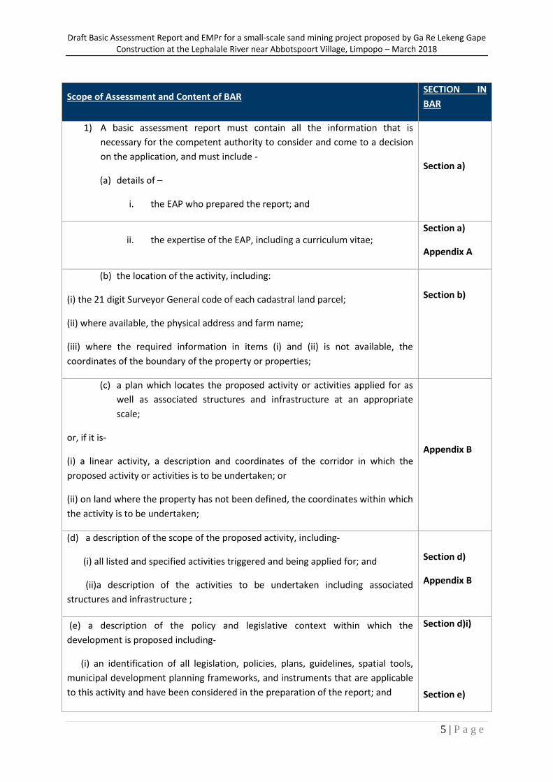
Requirements according to Appendix 1 of GNR 982 of 4 December 2014– Scope of Assessment and
Content of BAR.
Draft Basic Assessment Report and EMPr for a small-scale sand mining project proposed by Ga Re Lekeng Gape Construction at the Lephalale River near Abbotspoort Village, Limpopo – March 2018
5 | P a g e
Scope of Assessment and Content of BAR SECTION IN
BAR
1) A basic assessment report must contain all the information that is
necessary for the competent authority to consider and come to a decision
on the application, and must include -
(a) details of –
i. the EAP who prepared the report; and
Section a)
ii. the expertise of the EAP, including a curriculum vitae; Section a)
Appendix A
(b) the location of the activity, including:
(i) the 21 digit Surveyor General code of each cadastral land parcel;
(ii) where available, the physical address and farm name;
(iii) where the required information in items (i) and (ii) is not available, the
coordinates of the boundary of the property or properties;
Section b)
(c) a plan which locates the proposed activity or activities applied for as
well as associated structures and infrastructure at an appropriate
scale;
or, if it is-
(i) a linear activity, a description and coordinates of the corridor in which the
proposed activity or activities is to be undertaken; or
(ii) on land where the property has not been defined, the coordinates within which
the activity is to be undertaken;
Appendix B
(d) a description of the scope of the proposed activity, including-
(i) all listed and specified activities triggered and being applied for; and
(ii)a description of the activities to be undertaken including associated
structures and infrastructure ;
Section d)
Appendix B
(e) a description of the policy and legislative context within which the
development is proposed including-
(i) an identification of all legislation, policies, plans, guidelines, spatial tools,
municipal development planning frameworks, and instruments that are applicable
to this activity and have been considered in the preparation of the report; and
Section d)i)
Section e)
Draft Basic Assessment Report and EMPr for a small-scale sand mining project proposed by Ga Re Lekeng Gape Construction at the Lephalale River near Abbotspoort Village, Limpopo – March 2018
6 | P a g e
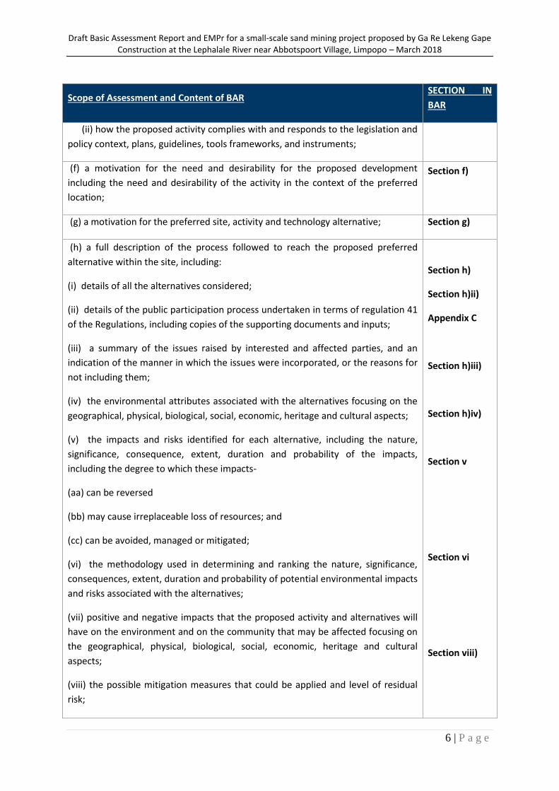
Scope of Assessment and Content of BAR SECTION IN
BAR
(ii) how the proposed activity complies with and responds to the legislation and
policy context, plans, guidelines, tools frameworks, and instruments;
(f) a motivation for the need and desirability for the proposed development
including the need and desirability of the activity in the context of the preferred
location;
Section f)
(g) a motivation for the preferred site, activity and technology alternative; Section g)
(h) a full description of the process followed to reach the proposed preferred
alternative within the site, including:
(i) details of all the alternatives considered;
(ii) details of the public participation process undertaken in terms of regulation 41
of the Regulations, including copies of the supporting documents and inputs;
(iii) a summary of the issues raised by interested and affected parties, and an
indication of the manner in which the issues were incorporated, or the reasons for
not including them;
(iv) the environmental attributes associated with the alternatives focusing on the
geographical, physical, biological, social, economic, heritage and cultural aspects;
(v) the impacts and risks identified for each alternative, including the nature,
significance, consequence, extent, duration and probability of the impacts,
including the degree to which these impacts-
(aa) can be reversed
(bb) may cause irreplaceable loss of resources; and
(cc) can be avoided, managed or mitigated;
(vi) the methodology used in determining and ranking the nature, significance,
consequences, extent, duration and probability of potential environmental impacts
and risks associated with the alternatives;
(vii) positive and negative impacts that the proposed activity and alternatives will
have on the environment and on the community that may be affected focusing on
the geographical, physical, biological, social, economic, heritage and cultural
aspects;
(viii) the possible mitigation measures that could be applied and level of residual
risk;
Section h)
Section h)ii)
Appendix C
Section h)iii)
Section h)iv)
Section v
Section vi
Section viii)
Draft Basic Assessment Report and EMPr for a small-scale sand mining project proposed by Ga Re Lekeng Gape Construction at the Lephalale River near Abbotspoort Village, Limpopo – March 2018
7 | P a g e
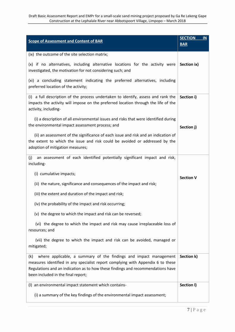
Scope of Assessment and Content of BAR SECTION IN
BAR
(ix) the outcome of the site selection matrix;
(x) if no alternatives, including alternative locations for the activity were
investigated, the motivation for not considering such; and
(xi) a concluding statement indicating the preferred alternatives, including
preferred location of the activity;
Section ix)
(i) a full description of the process undertaken to identify, assess and rank the
impacts the activity will impose on the preferred location through the life of the
activity, including-
(i) a description of all environmental issues and risks that were identified during
the environmental impact assessment process; and
(ii) an assessment of the significance of each issue and risk and an indication of
the extent to which the issue and risk could be avoided or addressed by the
adoption of mitigation measures;
Section i)
Section j)
(j) an assessment of each identified potentially significant impact and risk,
including-
(i) cumulative impacts;
(ii) the nature, significance and consequences of the impact and risk;
(iii) the extent and duration of the impact and risk;
(iv) the probability of the impact and risk occurring;
(v) the degree to which the impact and risk can be reversed;
(vi) the degree to which the impact and risk may cause irreplaceable loss of
resources; and
(vii) the degree to which the impact and risk can be avoided, managed or
mitigated;
Section V
(k) where applicable, a summary of the findings and impact management
measures identified in any specialist report complying with Appendix 6 to these
Regulations and an indication as to how these findings and recommendations have
been included in the final report;
Section k)
(l) an environmental impact statement which contains-
(i) a summary of the key findings of the environmental impact assessment;
Section l)
Draft Basic Assessment Report and EMPr for a small-scale sand mining project proposed by Ga Re Lekeng Gape Construction at the Lephalale River near Abbotspoort Village, Limpopo – March 2018
8 | P a g e
Scope of Assessment and Content of BAR SECTION IN
BAR
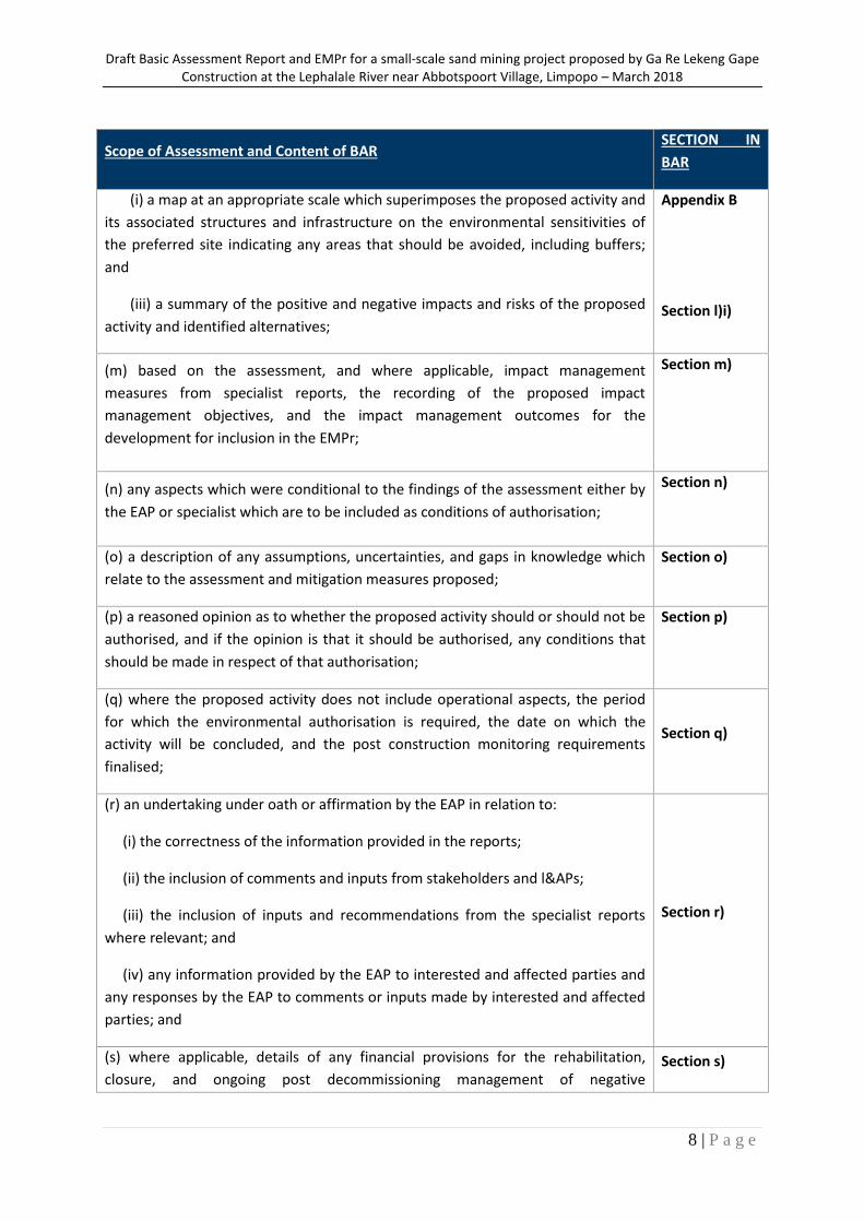
(i) a map at an appropriate scale which superimposes the proposed activity and
its associated structures and infrastructure on the environmental sensitivities of
the preferred site indicating any areas that should be avoided, including buffers;
and
(iii) a summary of the positive and negative impacts and risks of the proposed
activity and identified alternatives;
Appendix B
Section l)i)
(m) based on the assessment, and where applicable, impact management
measures from specialist reports, the recording of the proposed impact
management objectives, and the impact management outcomes for the
development for inclusion in the EMPr;
Section m)
(n) any aspects which were conditional to the findings of the assessment either by
the EAP or specialist which are to be included as conditions of authorisation;
Section n)
(o) a description of any assumptions, uncertainties, and gaps in knowledge which
relate to the assessment and mitigation measures proposed;
Section o)
(p) a reasoned opinion as to whether the proposed activity should or should not be
authorised, and if the opinion is that it should be authorised, any conditions that
should be made in respect of that authorisation;
Section p)
(q) where the proposed activity does not include operational aspects, the period
for which the environmental authorisation is required, the date on which the
activity will be concluded, and the post construction monitoring requirements
finalised;
Section q)
(r) an undertaking under oath or affirmation by the EAP in relation to:
(i) the correctness of the information provided in the reports;
(ii) the inclusion of comments and inputs from stakeholders and l&APs;
(iii) the inclusion of inputs and recommendations from the specialist reports
where relevant; and
(iv) any information provided by the EAP to interested and affected parties and
any responses by the EAP to comments or inputs made by interested and affected
parties; and
Section r)
(s) where applicable, details of any financial provisions for the rehabilitation,
closure, and ongoing post decommissioning management of negative Section s)

Draft Basic Assessment Report and EMPr for a small-scale sand mining project proposed by Ga Re Lekeng Gape Construction at the Lephalale River near Abbotspoort Village, Limpopo – March 2018
9 | P a g e
Scope of Assessment and Content of BAR SECTION IN
BAR
environmental impacts;
(t) any specific information that may be required by the competent authority; and N/A
(u) any other matters required in terms of section 24(4)(a) and (b) of the Act. N/A
Draft Basic Assessment Report and EMPr for a small-scale sand mining project proposed by Ga Re Lekeng Gape Construction at the Lephalale River near Abbotspoort Village, Limpopo – March 2018
10 | P a g e
PART A
SCOPE OF ASSESSMENT AND BASIC ASSESSMENT REPORT
3. Contact Person and correspondence address
a) Details of
i) Details of the EAP
Name of the Practitioner: (Council for Scientific and Industrial Research (CSIR)
Tel No.: 021 888 2495/08
Fax No.: 021 888 2693
Email address: [email protected]
ii) Expertise of the EAP
The Council for Scientific and Industrial Research has been one of the leading organisations in South
Africa contributing to the development and implementation of environmental assessment and
management methodologies. The CSIR’s Environmental Management Services (EMS) unit has over
20 years of experience in environmental management practices, involving conducting environmental
assessment and management studies in over 15 countries in Africa. Key sectors of CSIR’s work
include renewable energy, infrastructure, natural resource management, mining, industrial
development and oil and gas. CSIR’s environmental assessments are conducted with national legal
requirements as well as those of international agencies such as the World Bank, International
Finance Corporation and World Health Organisation.
(1) The qualifications of the EAP (with evidence)
Paul Lochner: MSc Masters in Environmental Science UCT
Technical Advisor, Internal Reviewer and Quality Assurance (EAPSA) Certified
Karabo Mashabela: MSc Geography and Environmental Science
Registered Candidate Natural Scientist (Cand.Sci.Nat. 116164& IAIAsa)
Minnelise Levendal: MSc Botany (Stellenbosch University) Pr.Sci.Nat (117078)
Draft Basic Assessment Report and EMPr for a small-scale sand mining project proposed by Ga Re Lekeng Gape Construction at the Lephalale River near Abbotspoort Village, Limpopo – March 2018
11 | P a g e
Please refer to Appendix A for the CVs
2) Summary of the EAP’s past experience
(In carrying out the Environmental Impact Assessment Procedure)
Paul Lochner: commenced work at CSIR in 1992, after completing a degree in Civil Engineering and a
Masters in Environmental Science, both at the University of Cape Town. His initial work at CSIR focused
on sediment dynamics and soft engineering applications in the coastal zone, in particular, beach and
dune management. He conducted several shoreline erosion analyses and prepared coastal zone
management plans for beaches. He also prepared wetland management plans.
As the market for environmental assessment work grew, he led Environmental Impact Assessments
(EIAs), in particular for coastal resort developments and large-scale industrial developments located on
the coast; and Environmental Management Plans (EMPs), in particular for wetlands, estuaries and coastal
developments. He has also been involved in researching and applying higher-level approaches to
environmental assessment and management, such as Strategic Environmental Assessment (SEA). In 1998-
1999, he coordinated the SEA research programme within the CSIR, which led to him being a lead author
of the Guideline Document for SEA in South Africa, published by CSIR and national Department of
Environmental Affairs (DEA) in February 2000.
In 1999 and 2000, he was the project manager for the legal, institutional, policy, financial and socio-
economic component of the Cape Action Plan for the Environment (“CAPE”), a large-scale multi-
disciplinary study to ensure the sustainable conservation of the Cape Floral Kingdom. This was funded by
the Global Environmental Fund (GEF) and prepared for WWF-South Africa. The study required extensive
stakeholder interaction, in particular with government institutions, leading to the development of a
Strategy and Action Plan for regional conservation.
In July 2003, he was certified as an Environmental Assessment Practitioner by the Interim Certification
Board for Environmental Assessment Practitioners of South Africa. He has authored several guidelines for
government. In 2004, he was lead author of the Overview of IEM document in the updated Integrated
Environmental Management (IEM) Information Series published by national Department of
Environmental Affairs and Tourism (DEAT). In 2005, he was part of the CSIR team that prepared the series
entitled Guidelines for involving specialists in EIA processes for the Western Cape Department of
Environmental Affairs and Development Planning (DEADP); and he authored the Guideline for
Environmental Management Plans published by Western Cape government in
2005. In 2006-2007, he worked closely with the (then) Dept of Minerals and Energy (DME) of South Africa
to prepare a Guideline for Scoping, Environmental Impact Assessment and Environmental Management
Plans for mining in South Africa.
Over the past 20 years has been closely involved with several environmental studies for industrial and
port-related projects in Coega Industrial Development Zone (IDZ), near Port Elizabeth. This included the
SEA for the establishment of the Coega IDZ in 1996/7, an EIA and EMP for a proposed aluminium smelter
Draft Basic Assessment Report and EMPr for a small-scale sand mining project proposed by Ga Re Lekeng Gape Construction at the Lephalale River near Abbotspoort Village, Limpopo – March 2018
12 | P a g e
in 2002/3, and assistance with environmental permit applications for air, water and waste. At the Coega
IDZ and port, he has also conducted environmental assessments for port development, LNG storage and
a combined cycle gas turbine power plant, manganese export, rail development, marine pipelines, and
wind energy projects.
Since 2009, he has undertaken numerous EIAs for the renewable energy sector, in particular for wind and
solar photovoltaic energy projects. In these EIAs, he has been project leader and integrated the specialist
findings from a range of specialist disciplines. He is currently project leader on two Strategic
Environmental Assessments (SEAs) that are being undertaken for national DEA. These SEAs are to support
the implementation of the Strategic Integrated Projects (SIPs) that are being promoted by the
Presidential Infrastructure Coordinating Committee (PICC). The SEA for Wind and Solar Photovoltaic
Energy for South Africa is being conducted over 2013-2014, and the SEA for electricity grid infrastructure
commenced January 2014.
Since 2009, Paul has been the manager of the Environmental Management Services (EMS) group within
CSIR. This group currently consists of approximately 20 environmental assessment practitioners and a
group assistant, with offices in Stellenbosch and Durban. EMS focuses on conducting complex
environmental studies in challenging environments, such as remote and data poor regions in Africa (e.g.
Cameroon, Gabon, Angola, Namibia and Ethiopia). We also specialise in environmental studies for
emerging and innovative technologies, drawing on research and applied scientific expertise within CSIR.
Our role is to assist in ensuring the sustainability of projects in terms of environmental and social criteria,
by providing a range of environmental services that extend across the project lifecycle, from the pre-
feasibility stage through to feasibility, commissioning, operations and closure. We provide this service to
government, international agencies, private sector and non-government organisations.
Minnelise Levendal is a Senior EAP in the EMS group of the CSIR and has a Master’s degree in Biological
Science (Botany). She has 16 years of experience in Environmental Management (which includes ten
years working as an EAP). Before she joined the CSIR she was employed at the Western Cape Department
of Environmetal Affairs and Development Planning (DEA&DP) where she assessed EIAs, BAs and EMPs.
Minnelise is currently managing various EIAs for wind and solar renewable energy projects in South
Africa. Minnelise was the CSIR project manager for the 100 MW Ubuntu Wind Energy Facility near
Jeffreys Bay (Environmental Authorisation granted in June 2012), as well as the 50 MW Banna Ba Pifhu
Wind Energy Facility proposed by WKN Windcurrent near Humansdorp in the Eastern Cape
(Environmental Authorisation granted in July 2014). She was the project manager of ten BAs for wind
monitoring masts in South Africa as part of the National Wind Atlas Project of the Department of Energy.
Environmental Authorisation from the DEA for all the ten masts was obtained in 2010. Minnelise is
currently the project manager for the Special Needs and Skills Development Programme, initiated by the
national Department of Environmental Affairs to assist people with special needs (i.e. financial) to obtain
Environmental Authorisation for their projects. This sand mining project falls under this programme.
Karabo Mashabela has 2 years of experience in the environmental management field, as an environmental scientist. She is currently a junior at the CSIR where she is a project assistant on the
Draft Basic Assessment Report and EMPr for a small-scale sand mining project proposed by Ga Re Lekeng Gape Construction at the Lephalale River near Abbotspoort Village, Limpopo – March 2018
13 | P a g e
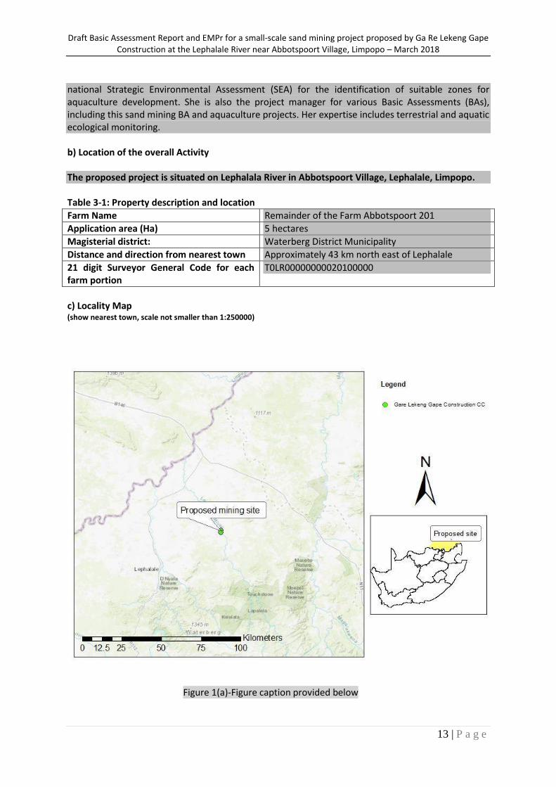
national Strategic Environmental Assessment (SEA) for the identification of suitable zones for aquaculture development. She is also the project manager for various Basic Assessments (BAs), including this sand mining BA and aquaculture projects. Her expertise includes terrestrial and aquatic ecological monitoring. b) Location of the overall Activity The proposed project is situated on Lephalala River in Abbotspoort Village, Lephalale, Limpopo. Table 3-1: Property description and location
Farm Name Remainder of the Farm Abbotspoort 201
Application area (Ha) 5 hectares
Magisterial district: Waterberg District Municipality
Distance and direction from nearest town Approximately 43 km north east of Lephalale
21 digit Surveyor General Code for each farm portion
T0LR00000000020100000
c) Locality Map (show nearest town, scale not smaller than 1:250000)
Figure 1(a)-Figure caption provided below
Draft Basic Assessment Report and EMPr for a small-scale sand mining project proposed by Ga Re Lekeng Gape Construction at the Lephalale River near Abbotspoort Village, Limpopo – March 2018
14 | P a g e
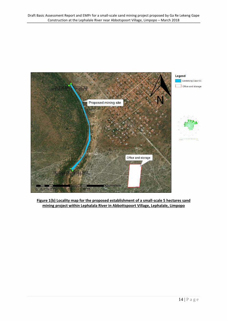
Figure 1(b) Locality map for the proposed establishment of a small-scale 5 hectares sand mining project within Lephalala River in Abbottspoort Village, Lephalale, Limpopo
Draft Basic Assessment Report and EMPr for a small-scale sand mining project proposed by Ga Re Lekeng Gape Construction at the Lephalale River near Abbotspoort Village, Limpopo – March 2018
15 | P a g e
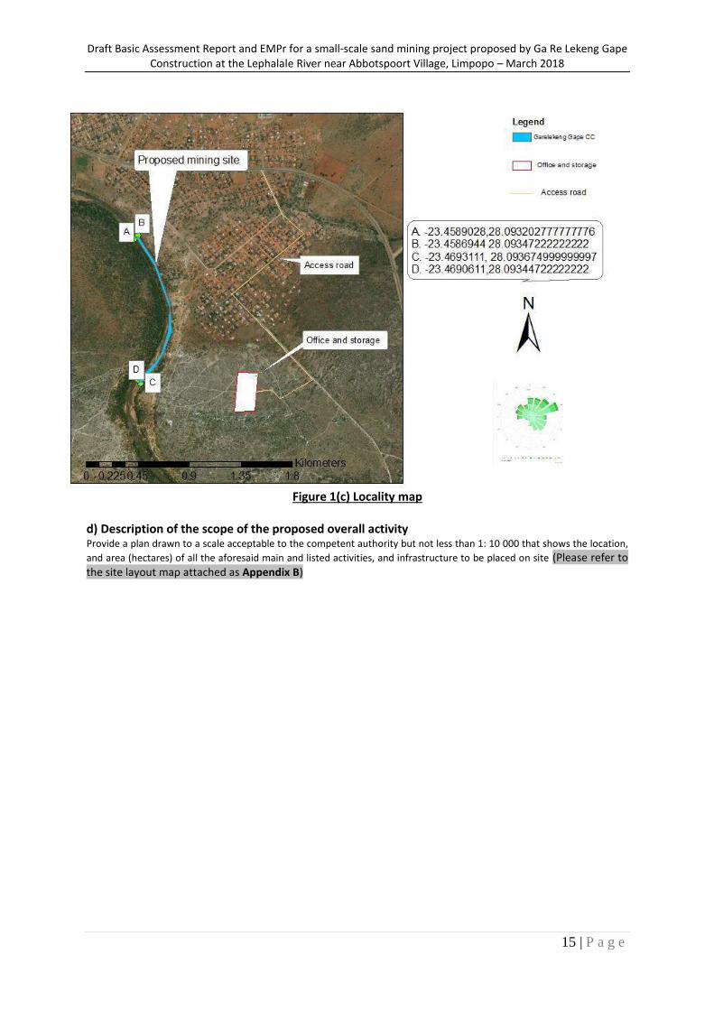
Figure 1(c) Locality map
d) Description of the scope of the proposed overall activity
Provide a plan drawn to a scale acceptable to the competent authority but not less than 1: 10 000 that shows the location,
and area (hectares) of all the aforesaid main and listed activities, and infrastructure to be placed on site (Please refer to the site layout map attached as Appendix B)
Draft Basic Assessment Report and EMPr for a small-scale sand mining project proposed by Ga Re Lekeng Gape Construction at the Lephalale River near Abbotspoort Village, Limpopo – March 2018
16 | P a g e
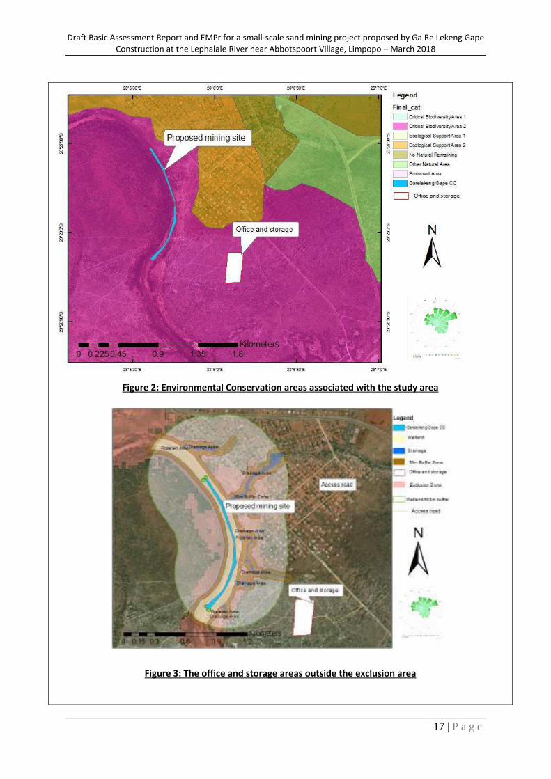
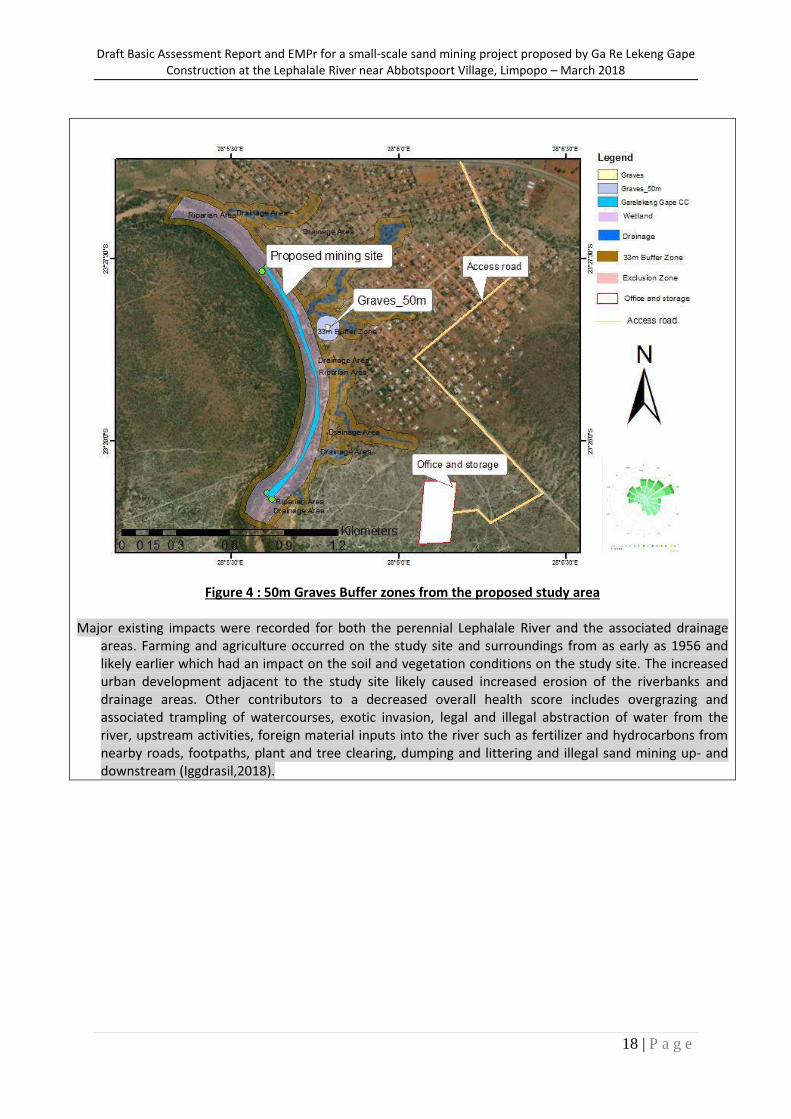
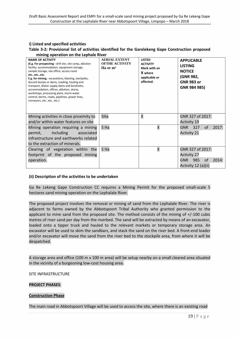
Ga Re Lekeng Gape Construction CC proposes to establish a small-scale 5 ha sand mining operation. The proposed mining site (hereafter referred to as the study area) is located in the Lephala River, Abbotspoort Village, Limpopo. The proposed project involves the removal or mining of sand from the Lephala River. The site is bounded by farms owned by the Abbotspoort Tribal Authority who granted permission to the applicant to mine sand from the proposed site. The method consists of the mining of +/-100 cubic metres of river sand per day from the riverbed. The sand will be extracted by means of an excavator, loaded onto a tipper truck and hauled to the relevant markets or temporary storage area. An excavator will be used to skim the sandbars, and stack the sand on the river bed. A front-end loader and/or excavator will move the sand from the river bed to the stockpile area, from where it will be despatched. An office and storage facility (100 m x 150 m area) will be developed on an open area outside any adjacent watercourse or buffer. The initial location of the facilities was within an exclusion area as determined from a Floodline Study that was undertaken by Iggdrasil for the project. The recommendation was that the facilities be moved to avoid the exclusion area. It is important that existing roads be used to travel from the storage and office areas to the mining area and that no thoroughfare be used that encroaches into the drainage areas. It is furthermore important to note that a graveyard was noted near the study site and subsequently the watercourse at the approximate coordinates of 23°27'41.20"S and 28° 5'47.33"E (Limosella Consulting Pty Ltd (2018). The layout for the office and storage facilities was subsequently amended to adhere to this recommendation (Figure 3). The advantages of the revised layout are as follow:
Office and storage facilities are outside the exclusion area;
The new layout avoids graves;
Access road between sand storage and the main local road is outside the residential area; and the
Facility area is reduced to one hectare (100 m x100 m) The study area falls within a Critical Biodiversity Area (CBA) 2 (see Figure 2).The study area is situated within the A50G quaternary catchment area which forms part of the Limpopo Water Management Area (WMA 1). Streamflow data of the Lephalale River in proximity of the study area were obtained from the Department of Water and Sanitation (DWS) gauging station A5R002. This comprises observed data on the Lephalale River and is located at latitude -23.379200°S and longitude 28.02360°E and provides a 48-year time series record of mean daily discharge for the period from the 1st of March 1968 to the 30th of June 2016. Several drainage areas drain into the Lephale river from the surrounding residential area (Limosella Consulting Pty Ltd (2018). Four specialist studies were undertaken to inform the Basic Assessment: Aquatic, Wetlands, Flood line and Heritage Impact Assessment studies.
Draft Basic Assessment Report and EMPr for a small-scale sand mining project proposed by Ga Re Lekeng Gape Construction at the Lephalale River near Abbotspoort Village, Limpopo – March 2018
17 | P a g e
Figure 2: Environmental Conservation areas associated with the study area
Figure 3: The office and storage areas outside the exclusion area
Draft Basic Assessment Report and EMPr for a small-scale sand mining project proposed by Ga Re Lekeng Gape Construction at the Lephalale River near Abbotspoort Village, Limpopo – March 2018
18 | P a g e
Figure 4 : 50m Graves Buffer zones from the proposed study area
Major existing impacts were recorded for both the perennial Lephalale River and the associated drainage areas. Farming and agriculture occurred on the study site and surroundings from as early as 1956 and likely earlier which had an impact on the soil and vegetation conditions on the study site. The increased urban development adjacent to the study site likely caused increased erosion of the riverbanks and drainage areas. Other contributors to a decreased overall health score includes overgrazing and associated trampling of watercourses, exotic invasion, legal and illegal abstraction of water from the river, upstream activities, foreign material inputs into the river such as fertilizer and hydrocarbons from nearby roads, footpaths, plant and tree clearing, dumping and littering and illegal sand mining up- and downstream (Iggdrasil,2018).
Draft Basic Assessment Report and EMPr for a small-scale sand mining project proposed by Ga Re Lekeng Gape Construction at the Lephalale River near Abbotspoort Village, Limpopo – March 2018
19 | P a g e
i) Listed and specified activities Table 3-2: Provisional list of activities identified for the Garelekeng Gape Construction proposed
mining operation on the Lephale River NAME OF ACTIVITY (E.g. For prospecting - drill site, site camp, ablution facility, accommodation, equipment storage, sample storage, site office, access route etc…etc…etc. E.g. for mining,- excavations, blasting, stockpiles, discard dumps or dams, Loading, hauling and transport, Water supply dams and boreholes, accommodation, offices, ablution, stores, workshops, processing plant, storm water control, berms, roads, pipelines, power lines, conveyors, etc…etc…etc.)
AERIAL EXTENT OFTHE ACTIVITY Ha or m²
LISTED ACTIVITY Mark with an
X where
applicable or affected.
APPLICABLE LISTING NOTICE (GNR 982, GNR 983 or GNR 984 985)
Mining activities in close proximity to and/or within water features on site
5Ha X GNR 327 of 2017: Activity 19
Mining operation requiring a mining permit, including associated infrastructure and earthworks related to the extraction of minerals.
5 Ha X GNR 327 of 2017: Activity 21
Clearing of vegetation within the footprint of the proposed mining operation.
5 Ha X GNR 327 of 2017: Activity 27 GNR 985 of 2014: Activity 12 (a)(ii)
(ii) Description of the activities to be undertaken Ga Re Lekeng Gape Construction CC requires a Mining Permit for the proposed small-scale 5 hectares sand mining operation on the Lephalale River. The proposed project involves the removal or mining of sand from the Lephalale River. The river is adjacent to farms owned by the Abbotspoort Tribal Authority who granted permission to the applicant to mine sand from the proposed site. The method consists of the mining of +/-100 cubic metres of river sand per day from the riverbed. The sand will be extracted by means of an excavator, loaded onto a tipper truck and hauled to the relevant markets or temporary storage area. An excavator will be used to skim the sandbars, and stack the sand on the river bed. A front-end loader and/or excavator will move the sand from the river bed to the stockpile area, from where it will be despatched. A storage area and office (100 m x 100 m area) will be setup nearby on a small cleared area situated in the vicinity of a burgeoning low-cost housing area. SITE INFRASTRUCTURE PROJECT PHASES: Construction Phase The main road in Abbotspoort Village will be used to access the site, where there is an existing road
Draft Basic Assessment Report and EMPr for a small-scale sand mining project proposed by Ga Re Lekeng Gape Construction at the Lephalale River near Abbotspoort Village, Limpopo – March 2018
20 | P a g e
leading to the mining area. Site infrastructure will include a chemical toilet and waste bin, and no buildings will be erected on site. Equipment to be used will include a Loader and truck for the transportation of sand material, and a vehicle for staff transport. Therefore no infrastructure associated with the mining site will require breaking down or demolishing at closure. The areas used for facilities or equipment will be less than 700 m2 and will be rehabilitated post-mining operations. Operational Phase The proposed project will include the mining of sand from the river bed of a 5 hectares section of the Lephalale River. Sand will be removed together with the water using a pump system, where sand will be temporarily piled into a pit on the bank. The sand will remain in the pit and the water will flow back into the river. Disturbance of the riparian zone, including the river bank will be avoided. The Loader or Tip-truck will haul the sand from the stockpile area. Decommissioning phase Closure and rehabilitation of the stockpile area will be undertaken when the project ceases operation. At the end of the project life cycle, a thick soil layer of approximately 33 mm will be spread across the disturbed areas; thereafter the soil will be ripped, fertilised and re-vegetated. Post-closure monitoring will assist in determining the success of the rehabilitation and also identify whether any additional measures need to be taken to ensure the area is restored to a reasonable and acceptable condition. The area where sand was mined will be rehabilitated naturally during the rainy season where flood waters will deposit more sand across the mined area. e) Policy and Legislative Context
APPLICABLE LEGISLATION AND GUIDELINES USED TO COMPILE THE REPORT (A description of the policy and legislative context within which the development is proposed including an identification of all legislation, policies, plans, guidelines, spatial tools, municipal development planning frameworks and instruments that are applicable to this activity and are to be considered in the assessment process
REFERENCE WHERE APPLIED
HOW DOES THIS DEVELOPMENT COMPLY WITH AND RESPOND TO THE LEGISLATION AND POLICY CONTEXT. (E.g. In terms of the National Water Act a Water Use License has/ has not been applied for)
The Minerals and Petroleum Resources Development Act, 2002 (Act No. 28 of 2002)
Mining activities This BA and EMP report has been compiled in accordance with the Act.
National Environmental Management Act (Act No. 107 of 1998)
Mining activities This BA is being undertaken in terms of NEMA in order to determine any possible impacts on the environment and to undertake mitigation measures

Draft Basic Assessment Report and EMPr for a small-scale sand mining project proposed by Ga Re Lekeng Gape Construction at the Lephalale River near Abbotspoort Village, Limpopo – March 2018
21 | P a g e
that reduce any potential harm to the environment.
Environmental Impact Assessment Regulations: GNR 324 to 327 of 7 Aoril 2017
Mining activities Listed activities as per the NEMA EIA Regulations have been considered and authorisation is thus required with regards to the triggering activities.
National Water Act, 1998 (Act No. 36 of 1998) Mining activities An application for a Water Use Licence has been submitted to the competent authority and all water uses associated with the proposed project will be exercised upon authorisation.
National Environmental Management: Waste Act, 2008 (Act No. 59 of 2008)
Not applicable Listed activities as per the 2013 NEM:WA Regulations have been considered and it has been determined that a waste licence is not required.
The National Heritage Resources Act (Act No. 25 of 1999)
Management/monitoring measures
An application for Heritage Resources review was submitted to SAHRA (Case ID: 9656) in terms of the National Heritage Resources Act, 1999 (Act No. 25 of 1999) as amended, in which consideration of heritage resources was requested. A heritage specialist study was undertaken for the proposed development and a report from ASHA Consulting has been included in Appendix G.
BGIS (www.bgis.sanbi.org.za) Baseline environmental description
Used during desktop research to identify sensitive environments within the proposed mining area.
Agricultural Geo-Referenced Information System (AGIS) Comprehensive Atlas
Baseline environmental description
Compilation of this report has made use of the atlas to determine land capability of the site with respect to the proposed development.
Municipal Integrated Development Plan (2015/2016 – 2017/2018)
Needs and desirability of the proposed activities
Municipal plans were used to identify relevant socio-economic information and spatial development information within which the area falls under.
Limpopo Provincial Development Plan Needs and desirability of the proposed activities
Municipal plans were used to identify relevant socio-
Draft Basic Assessment Report and EMPr for a small-scale sand mining project proposed by Ga Re Lekeng Gape Construction at the Lephalale River near Abbotspoort Village, Limpopo – March 2018
22 | P a g e
economic information and spatial development information within which the area falls under.
f) Need and desirability of the proposed activities. (Motivate the need and desirability of the proposed development including the need and desirability of the activity in the context of the preferred location).
For years, mining has been the driving force behind South Africa’s economy and continues to make a valuable contribution to the country’s economy and people’s livelihoods. The proposed project is for a small-scale mining operation in Lephalale (Iggdrasil, 2018). The Waterberg Municipality is faced with challenges of unemployment and poverty, making socio-economic development one of the municipality’s main priorities, with the aim to provide job opportunities and reduce poverty levels. The proposed mining operation will provide good quality sand to the local building industry for use in the construction of roads and buildings. It would ultimately contribute towards the wider socio-economic development of the area in the form of job opportunities and service delivery through promoting infrastructural development. The South African mining industry has its origin in small-scale mining activities, with these operations offering much needed employment opportunities and entrepreneurship, as well as contributing to the local economy. The municipality’s 2016/17 Integrated Development Plan (IDP) provides a long-term vision that includes creating an enabling environment for socio-economic opportunities through creating employment opportunities, alleviating poverty and promoting socio-economic development, creating opportunities for youth and women empowerment, and supporting cooperatives and SMMEs in growth opportunities. Ga Re Lekeng Gape Construction CC is an SMME from a previously disadvantaged background that has qualified for support under the DEA Special Needs program due to having limited financial resources. Ga Re Lekeng Gape Construction has identified this mining opportunity which will add socio-economic value to the Waterberg municipality. It could contribute to the local economic business opportunities, ultimately impacting socio-economic development of the area in support of the municipality and district’s development opportunities and targets/goals. g) Motivation for the overall preferred site, activities and technology alternative.
Mining is important for economic development, to construct durable, modern structures, employment creation and revenue collection. The proposed site was previously used for sand mining activities, and is known to provide good quality silica sand to the local building industry. This type of sand is commonly used for cement and concrete used in the construction of roads and buildings. According to the municipality’s 2016/17 Local Economic Development Strategy, the identified economic sectors of the municipality are Tourism, Agriculture, Manufacturing and Mining. The proposed sand mining project therefore falls within this last category. h) Full description of the process followed to reach the proposed preferred alternatives within the site. NB!! – This section is about the determination of the specific site layout and the location of infrastructure and activities on site, having taken into consideration the issues raised by interested and affected parties, and the consideration of alternatives to the initially proposed site layout.
Draft Basic Assessment Report and EMPr for a small-scale sand mining project proposed by Ga Re Lekeng Gape Construction at the Lephalale River near Abbotspoort Village, Limpopo – March 2018
23 | P a g e
(i) Details of the development footprint alternatives considered.
With reference to the site plan provided as Appendix 4 and the location of the individual activities on site, provide details of the alternatives considered with respect to:
(a) the property on which or location where it is proposed to undertake the activity; No property alternatives have been considered as the envisaged mining operations will occur in an area of existing mining operations, and also in close proximity to the access road and community in need of such a development. The applicant obtained permission from the Tribal Authority to mine only from this specific study area.
(b) the type of activity to be undertaken;
No alternatives to the mining of sand have been considered, as sand mining is a viable business opportunity for the applicant. The study site has viable volumes of sand deposits for sand mining, based on previous mining activities undertaken by the applicant’s relative.
(c ) the design or layout of the activity;
The site layout was determined by considering both spatial and practical mining operation aspects. An existing access road will be used to transport sand from the river to the storage facility or to the local markets as relevant.
The project layout was revised to incorporate the recommendation from the specialist who did the floodline study to move the office and storage facility from to outside the floodline exclusion area. The layout was therefore designed and revised to reduce associated impacts to the environment.
(d) the technology to be used in the activity;
No alternative technology has been considered for the proposed mining activity.
(e) the operational aspects of the activity; and
The optimal operational activities have been proposed, inclusive of the site layout and mobile infrastructure, in consideration of spatial aspects, post-mining appearance, as well as reducing costs associated with stripping down built infrastructure.
(f) the option of not implementing the activity.
The option of not implementing the activity has been considered, and assumes that should the proposed activity not proceed then the status quo would remain. This includes no clearing of any vegetation, no digging of sand pits, no sand mining operations on site and no decommissioning at the end of the project life cycle. It also assumes that the high possibility of this activity to lead to socio-economic gains will not be realised and, therefore the option of not implementing the activity will not be pursued at this stage.
(ii) Details of the public participation process followed Describe the process undertaken to consult interested and affected parties including public meetings and one on one consultation. NB the affected parties must be specifically consulted regardless of whether or not they attended public meetings. (Information to be provided to affected parties must include sufficient detail of the
Draft Basic Assessment Report and EMPr for a small-scale sand mining project proposed by Ga Re Lekeng Gape Construction at the Lephalale River near Abbotspoort Village, Limpopo – March 2018
24 | P a g e
intended operation to enable them to assess what impact the activities will have on them or on the use of their land.
A Basic Assessment is required to obtain Environmental Authorisation for Ga Relekeng Gape Construction proposed Sand Mining Project. A public participation process has been undertaken to date and will be ongoing for the duration of the project as part of the Basic Assessment process and has/will done in the following manner
Project Announcement and Draft BA Report Phase
Notice of the Basic Assessment process has been given by:
1. placing a Site Notice on the Farm fence;
2. posting and emailing written notice and Background Information Document (BID) regarding the proposed development to Interested and Affected Parties, including neighbours and Ward councillor, competent authority and other relevant Government departments on the 26 August 2017.
3. placing an advertisement in the Mogol Pos newspaper (on 26 August 2017), which allowed
potential Interested and Affected Parties to register and to submit comments within a 30-day period regarding the Basic Assessment of the proposed project;
4. a copy of the Draft Basic Assessment Report will be placed at the Lephalale Public Library,
Abbotspoort Higher Primary School and Abbotspoort Clinic on the 16 March 2018.
5. letters notifying I&AP’s of the release of the Draft Basic Assessment Report for 30-day review period will be sent out on the 16 March 2018
6. the Draft Basic Assessment Report is also available on the project website:
https://www.csir.co.za/environmental-impact-assessment
7. all comments raised by I&APs during the review of the BID were captured and addressed within the Draft BA Report;
8. the Draft BAR will be distributed for 30-days to registered I&APs and organs of state.
Comments from I&APs on the Draft BAR will be addressed and incorporated into the Final BAR which will be submitted to DMR for decision-making.
Draft Basic Assessment Report and EMPr for a small-scale sand mining project proposed by Ga Re Lekeng Gape Construction at the Lephalale River near Abbotspoort Village, Limpopo – March 2018
25 | P a g e
(iii) Summary of issues raised by I&Aps
*Please note that the comments are taken in verbatim from the comments provided by Interested and Affected Parties
Interested and Affected Parties Date Comments Received
Issues raised EAPs response to issues as mandated by the applicant
Section and paragraph reference in this Report where the issues and/or responses were incorporated
Name Organisation
Nokukhanya Khumalo
SAHRA Monday September 11, 2017
Basic Assessment for the proposed establishment of a small-scale 5 hectares sand mining project within Lephalala River in Abbottspoort Village, Lephalale, Limpopo. Our Ref: 11612 Enquiries:
Nokukhanya Khumalo Date: Monday September 11, 2017
Tel: 021 462 4502
Email: [email protected]
CaseID: 11612 Page No: 1 Response to NID (Notification of Intent to Develop) In terms of Section 38(8) of the National Heritage Resources Act (Act 25 of 1999) Attention: Elias Nku Ga Re Lekeng Gape Construction CC
Ga Re Lekeng Gape Construction CC, is located in Lephalale Limpopo. This enterprise proposes the establishment of a small-scale 5 hectares sand mining project. The proposed mining site is situated within the Lephalala River in Abbottspoort Village, Limpopo Ga Re Lekeng Gape Construction cc is proposing to
Thank you for the comments provided. Comments are noted. A heritage desktop analysis was undertaken for the project by Nicholas Wiltshire, Director CTS Heritage t/a Cedar Tower Services (Pty) Ltd
34 Harries Street, Plumstead, Cape
Town, 7800 Tel: +27 (0)21 013 0131/0236,
Cell: +27 (0)82 303 7870 [email protected] *www.cedartower.co.za
Kindly refer to Appendix D of this BAR. The BAR will be submitted to SAHRA for review.
Draft Basic Assessment Report and EMPr for a small-scale sand mining project proposed by Ga Re Lekeng Gape Construction at the Lephalale River near Abbotspoort Village, Limpopo – March 2018
26 | P a g e
mine sand out of the Lephalale River using a tipper truck and hauled to a storage area. CSIR are undertaking the Basic Assessment process in support of an Environmental Authorisation Process in terms of the National Environmental Management Act, 107 of 1998, as amended (NEMA) for listed activities in the NEMA Environmental Impact Assessment (EIA) Regulations, 2017, as amended. In terms of the National Heritage Resources Act, no 25 of 1999 (NHRA), heritage resources, including archaeological or palaeontological sites over 100 years old, graves older than 60 years, structures older than 60 years are generally protected. They may not be disturbed without a permit from the relevant heritage resources authority. In contexts of development applications, the developer must ensure that no heritage resources will be impacted by the proposed development, by lodging an application to SAHRA and submitting detailed development specifications as a notification of intent to develop. If the application is made in terms of s. 38 (8) of the NHRA then it is incumbent on the developer to ensure that a Heritage Impact Assessment (HIA) is undertaken, as s. 38(2)a does not apply. Such a study should follow the SAHRA impact assessment guidelines and section 38(3). SAHRA as a commenting authority in this application requires an assessment of heritage resources including palaeontological resources to be conducted by a qualified archaeologist and palaeontologist
Draft Basic Assessment Report and EMPr for a small-scale sand mining project proposed by Ga Re Lekeng Gape Construction at the Lephalale River near Abbotspoort Village, Limpopo – March 2018
27 | P a g e
respectively. As such SAHRA requires a Heritage desktop assessment and a desktop Palaeontological Impact Assessment for the proposed development to be conducted and submitted to SAHRA for comments. If you are unaware of any archaeologists and palaeontologists a list of them working within the Heritage Resources Management field are provided in the following websites: (see www.asapa.org.za) and (see www.palaeontologicalsocitey.co.za). SAHRA will comment further on this proposed development once the requested reports are submitted to the case.
Draft Basic Assessment Report and EMPr for a small-scale sand mining project proposed by Ga Re Lekeng Gape Construction at the Lephalale River near Abbotspoort Village, Limpopo – March 2018
28 | P a g e
(iv) The environmental attributes associated with the alternatives. (The environmental attributes
described must include socio-economic, social, heritage, cultural, geographical, physical and biological aspects)
1. Baseline Environment 1.1. Type of environment affected by the proposed activity. (its current geographical, physical, biological, socio-economic, and cultural character).
Site description
The study area lies on the east bank of the Lephalale River in Abbotspoort Village, Lephalale Municipality, Limpopo. The strip of proposed sand mining is about 5 hectares in size and does not extend beyond the confines of the flood plain. A storage area and office will be setup nearby on a small cleared area situated in the vicinity of a burgeoning low-cost housing area. The advantages for the new layout are that:
The facilities (Office and Storage) are outside the Flood line (1:50 and 1:100) exclusion zone
The new layout is far from the graves
Access road between sand storage and the main local road is now outside of the residential area.
The facility area has been reduced to 1ha (100mX100m).
Conducting the 2018 Baseline Aquatic Assessment The 2018 baseline aquatic biomonitoring assessment at the proposed sand mining project was conducted on the 22nd of January 2018 by Lorainmari den Boogert and Kimberley Perry (Iggdrasil ,2018), at sampling points LH1 and LH2. LH1 is situated upstream of Abbotspoort Village and the proposed location of the sand mining project. The main land-use activity surrounding this sampling point is bushveld, agriculture and dirt roads. Located approximately four (4) km upstream of LH1 is Ga-monyeki Village. Impacts located around the sampling point include bush encroachment, grazing, trampling, littering and dirt roads. Table 5 contains an overview of the conditions observed at sampling point LH1. LH2 is located approximately 360m downstream of the proposed sand mining area. The main land-use activities surrounding this sampling point include residential areas (Abbotspoort Village), dirt roads, pastoral activities, and bushveld. Impacts include residential areas, littering, grazing, and trampling.
At LH1, the upstream sampling point located in the Lephalale River, the chemical parameters were all within Target Water Quality Ranges (TWQR’s) for aquatic ecosystems except for the Dissolved Oxygen which was slightly below TWQR, but not considered to be sub-lethal or lethal;
The IHAS results at LH1 indicated that the in-stream habitats are suitable for supporting a diverse macro-invertebrate community. The SASS5 Ecological Category (EC) was determined to be “A”3. With regard to vegetation, the VEGRAI EC was determined to be “D”;
At LH2, the downstream sampling point located in the Lephalale River, the Dissolved Oxygen was considered high (133.7%), and the pH was considered high (8.66).
Geology, geomorphology, climate and vegetation (Limosella, 2018 SANBI BGIS, 2018)
Abbottspoort Village lies in the northern end of the Bushveld Complex in the southern domain of the east-northeast-trending Palala-Zoetfontein shear zone (Barton, Klemd, Zeh 2006). The southern domain is terminated on the south across the Abbottspoort shear zone by igneous rocks of the
Draft Basic Assessment Report and EMPr for a small-scale sand mining project proposed by Ga Re Lekeng Gape Construction at the Lephalale River near Abbotspoort Village, Limpopo – March 2018
29 | P a g e
Bushveld Complex. The proposed sand mining area predominantly straddles Palala Granite (~1.7 - 2.0 Ga in age) with a small section of Villa Nora gabbro on the southern end. The aeolian sands which are to be mined are of much more recent Quaternary origin and lie in the middle of a flood plain which is highly disturbed during the wet season. The application is situated in the Roodeberg Bushveld vegetation type (Mucina & Rutherford 2006, SANBI online Vegetation Map) (Limosella, 2018).
Soil Indicators
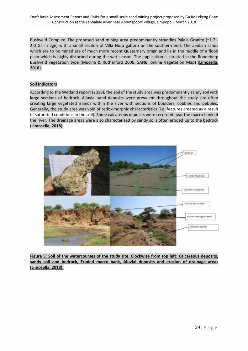
According to the Wetland report (2018), the soil of the study area was predominantly sandy soil with large sections of bedrock. Alluvial sand deposits were prevalent throughout the study site often creating large vegetated islands within the river with sections of boulders, cobbles and pebbles. Generally, the study area was void of redoximorphic characteristics (i.e. features created as a result of saturated conditions in the soil). Some calcareous deposits were recorded near the macro bank of the river. The drainage areas were also characterised by sandy soils often eroded up to the bedrock (Limosella, 2018).
Figure 5: Soil of the watercourses of the study site. Clockwise from top left: Calcareous deposits, sandy soil and bedrock, Eroded macro bank, Aluvial deposits and erosion of drainage areas (Limosella, 2018).
Draft Basic Assessment Report and EMPr for a small-scale sand mining project proposed by Ga Re Lekeng Gape Construction at the Lephalale River near Abbotspoort Village, Limpopo – March 2018
30 | P a g e
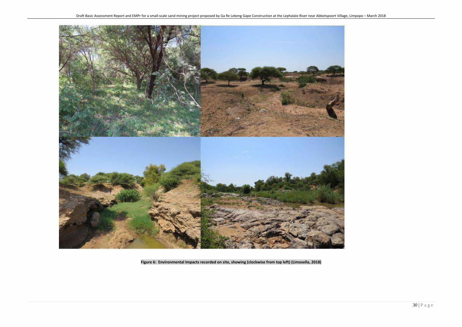
Figure 6: Environmental Impacts recorded on site, showing (clockwise from top left) (Limosella, 2018)
Draft Basic Assessment Report and EMPr for a small-scale sand mining project proposed by Ga Re Lekeng Gape Construction at the Lephalale River near Abbotspoort Village, Limpopo – March 2018
31 | P a g e
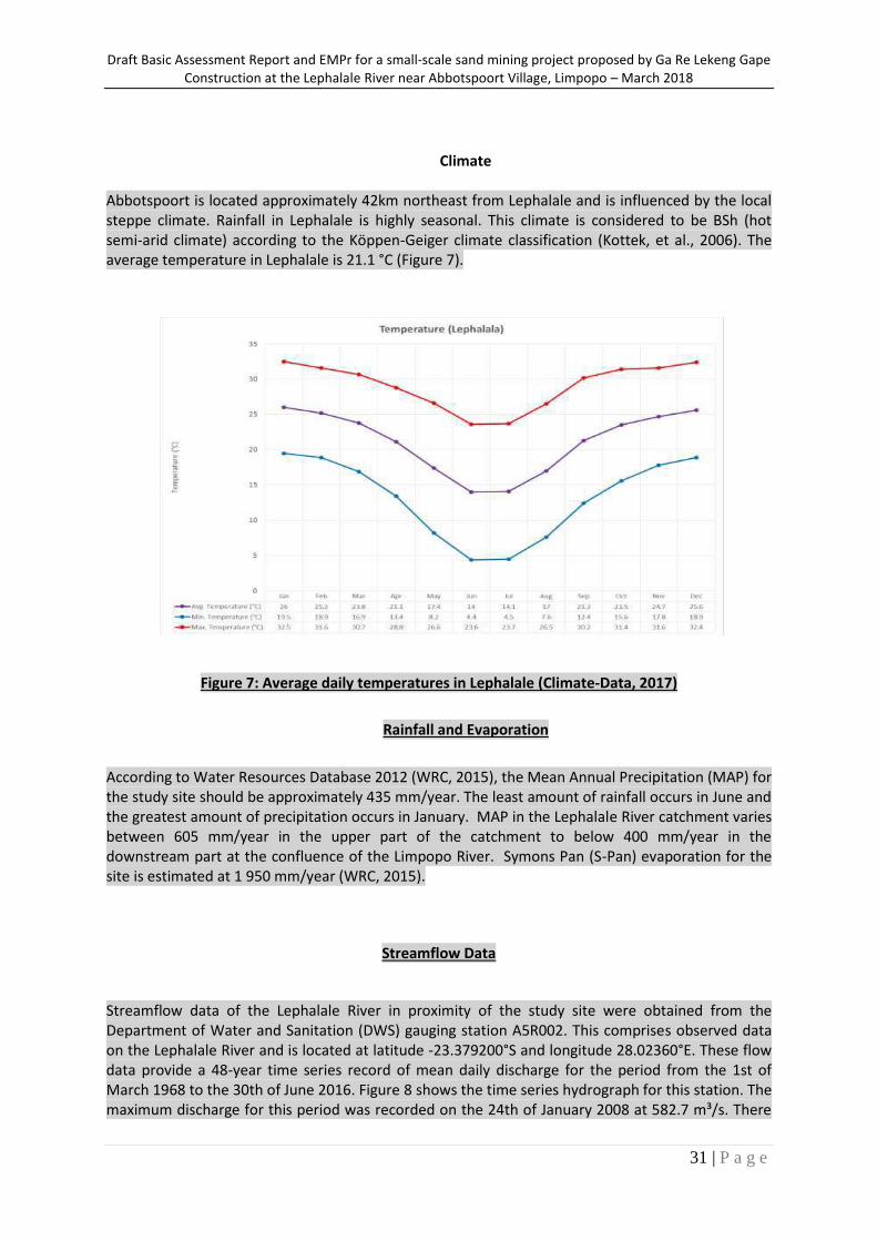
Climate
Abbotspoort is located approximately 42km northeast from Lephalale and is influenced by the local steppe climate. Rainfall in Lephalale is highly seasonal. This climate is considered to be BSh (hot semi-arid climate) according to the Köppen-Geiger climate classification (Kottek, et al., 2006). The average temperature in Lephalale is 21.1 °C (Figure 7).
Figure 7: Average daily temperatures in Lephalale (Climate-Data, 2017)
Rainfall and Evaporation
According to Water Resources Database 2012 (WRC, 2015), the Mean Annual Precipitation (MAP) for the study site should be approximately 435 mm/year. The least amount of rainfall occurs in June and the greatest amount of precipitation occurs in January. MAP in the Lephalale River catchment varies between 605 mm/year in the upper part of the catchment to below 400 mm/year in the downstream part at the confluence of the Limpopo River. Symons Pan (S-Pan) evaporation for the site is estimated at 1 950 mm/year (WRC, 2015).
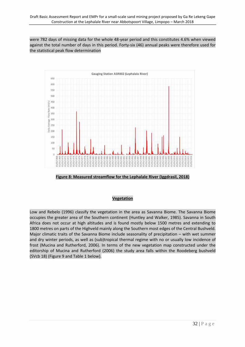
Streamflow Data
Streamflow data of the Lephalale River in proximity of the study site were obtained from the Department of Water and Sanitation (DWS) gauging station A5R002. This comprises observed data on the Lephalale River and is located at latitude -23.379200°S and longitude 28.02360°E. These flow data provide a 48-year time series record of mean daily discharge for the period from the 1st of March 1968 to the 30th of June 2016. Figure 8 shows the time series hydrograph for this station. The maximum discharge for this period was recorded on the 24th of January 2008 at 582.7 m³/s. There
Draft Basic Assessment Report and EMPr for a small-scale sand mining project proposed by Ga Re Lekeng Gape Construction at the Lephalale River near Abbotspoort Village, Limpopo – March 2018
32 | P a g e
were 782 days of missing data for the whole 48-year period and this constitutes 4.6% when viewed against the total number of days in this period. Forty-six (46) annual peaks were therefore used for the statistical peak flow determination
Figure 8: Measured streamflow for the Lephalale River (Iggdrasil, 2018)
Vegetation
Low and Rebelo (1996) classify the vegetation in the area as Savanna Biome. The Savanna Biome occupies the greater area of the Southern continent (Huntley and Walker, 1985). Savanna in South Africa does not occur at high altitudes and is found mostly below 1500 metres and extending to 1800 metres on parts of the Highveld mainly along the Southern most edges of the Central Bushveld. Major climatic traits of the Savanna Biome include seasonality of precipitation – with wet summer and dry winter periods, as well as (sub)tropical thermal regime with no or usually low incidence of frost (Mucina and Rutherford, 2006). In terms of the new vegetation map constructed under the editorship of Mucina and Rutherford (2006) the study area falls within the Roodeberg bushveld (SVcb 18) (Figure 9 and Table 1 below).
Draft Basic Assessment Report and EMPr for a small-scale sand mining project proposed by Ga Re Lekeng Gape Construction at the Lephalale River near Abbotspoort Village, Limpopo – March 2018
33 | P a g e
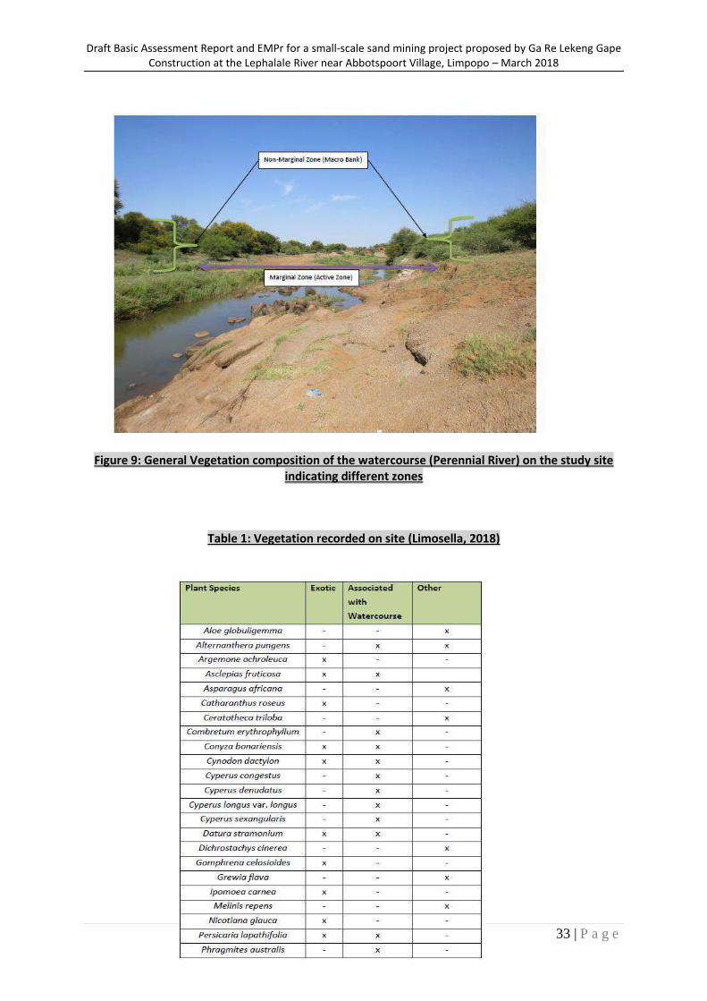
Figure 9: General Vegetation composition of the watercourse (Perennial River) on the study site
indicating different zones
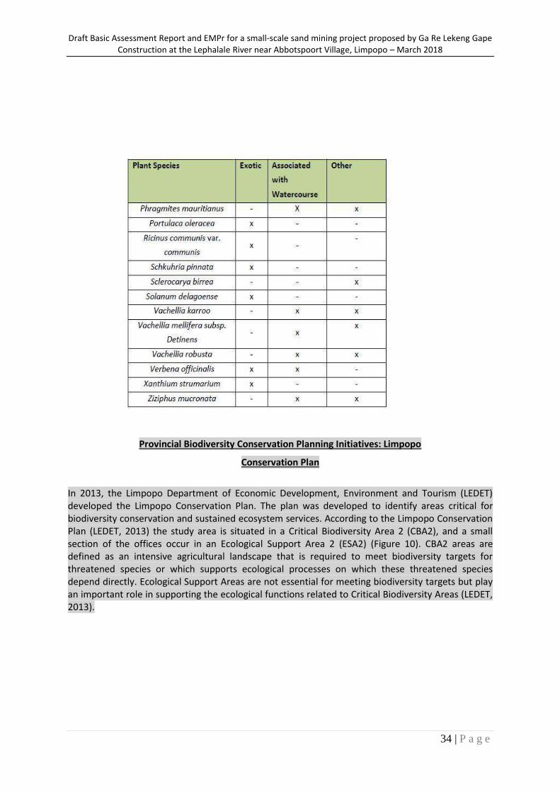
Table 1: Vegetation recorded on site (Limosella, 2018)
Draft Basic Assessment Report and EMPr for a small-scale sand mining project proposed by Ga Re Lekeng Gape Construction at the Lephalale River near Abbotspoort Village, Limpopo – March 2018
34 | P a g e
Provincial Biodiversity Conservation Planning Initiatives: Limpopo
Conservation Plan
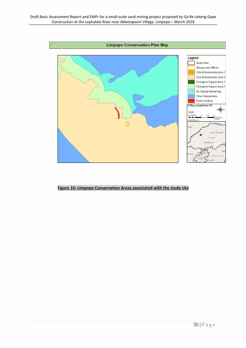
In 2013, the Limpopo Department of Economic Development, Environment and Tourism (LEDET) developed the Limpopo Conservation Plan. The plan was developed to identify areas critical for biodiversity conservation and sustained ecosystem services. According to the Limpopo Conservation Plan (LEDET, 2013) the study area is situated in a Critical Biodiversity Area 2 (CBA2), and a small section of the offices occur in an Ecological Support Area 2 (ESA2) (Figure 10). CBA2 areas are defined as an intensive agricultural landscape that is required to meet biodiversity targets for threatened species or which supports ecological processes on which these threatened species depend directly. Ecological Support Areas are not essential for meeting biodiversity targets but play an important role in supporting the ecological functions related to Critical Biodiversity Areas (LEDET, 2013).
Draft Basic Assessment Report and EMPr for a small-scale sand mining project proposed by Ga Re Lekeng Gape Construction at the Lephalale River near Abbotspoort Village, Limpopo – March 2018
35 | P a g e
Figure 10: Limpopo Conservation Areas associated with the study site
Draft Basic Assessment Report and EMPr for a small-scale sand mining project proposed by Ga Re Lekeng Gape Construction at the Lephalale River near Abbotspoort Village, Limpopo – March 2018
36 | P a g e
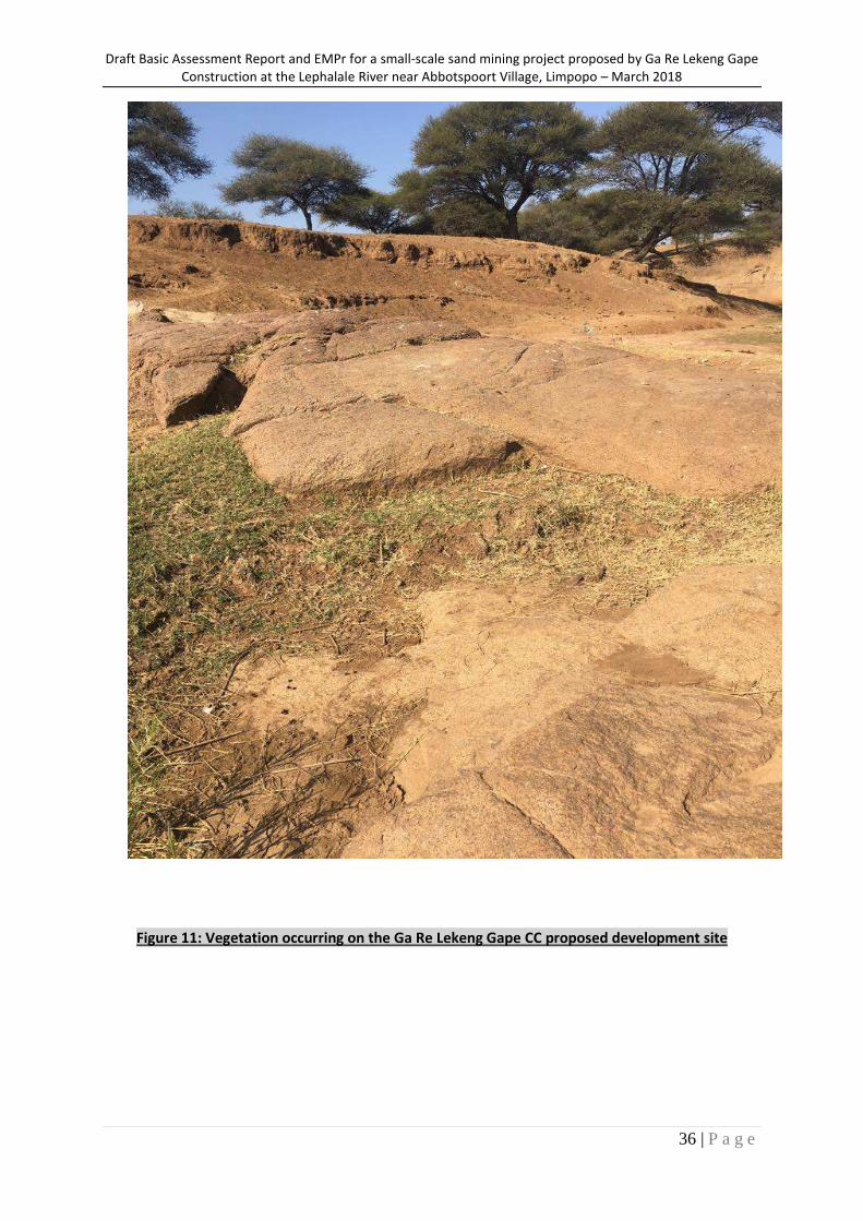
Figure 11: Vegetation occurring on the Ga Re Lekeng Gape CC proposed development site
Draft Basic Assessment Report and EMPr for a small-scale sand mining project proposed by Ga Re Lekeng Gape Construction at the Lephalale River near Abbotspoort Village, Limpopo – March 2018
37 | P a g e
Socio-economic profile of the area (as taken from Lephalale IDP, 2017)
The proposed mining site is located in Abbotspoort Village in Lephalale. According to Stats SA, Lephalale Local Municipality is named after the local river, a tributary of the Limpopo River, which has been the source of life to the people of this area for centuries. The town of Lephalale is located 280 km from Tshwane and is a recognised gateway to Botswana and other Southern African countries. Lephalale is the home of the Medupi Power Station that is currently under construction. The existing Matimba Power Station delivers 3 990 megawatts to the South African grid. The Lephalale Local Municipality is a Category B municipality located in the north-western part of the Waterberg District in the Limpopo Province. It borders with four local municipalities: Blouberg, Modimolle-Mookgophong, Mogalakwena and Thabazimbi. Its north-western border is also part of the international border between South Africa and Botswana. It is the largest of five municipalities in the district, making up a third of its geographical area.
Main Economic Sectors
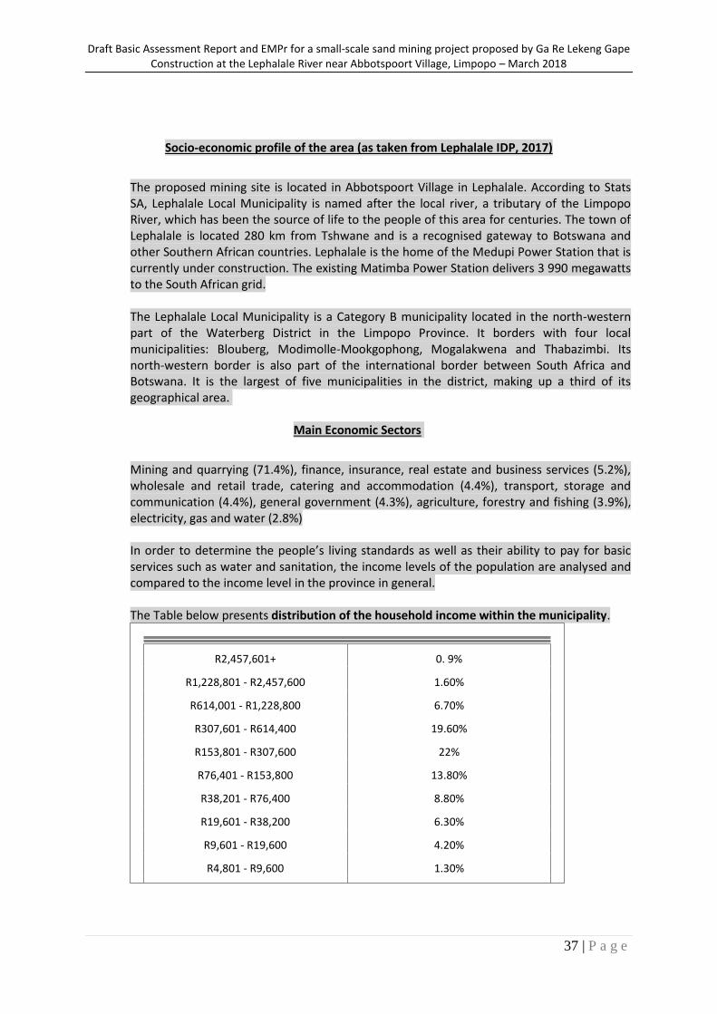
Mining and quarrying (71.4%), finance, insurance, real estate and business services (5.2%), wholesale and retail trade, catering and accommodation (4.4%), transport, storage and communication (4.4%), general government (4.3%), agriculture, forestry and fishing (3.9%), electricity, gas and water (2.8%) In order to determine the people’s living standards as well as their ability to pay for basic services such as water and sanitation, the income levels of the population are analysed and compared to the income level in the province in general. The Table below presents distribution of the household income within the municipality.
R2,457,601+ 0. 9%
R1,228,801 - R2,457,600 1.60%
R614,001 - R1,228,800 6.70%
R307,601 - R614,400 19.60%
R153,801 - R307,600 22%
R76,401 - R153,800 13.80%
R38,201 - R76,400 8.80%
R19,601 - R38,200 6.30%
R9,601 - R19,600 4.20%
R4,801 - R9,600 1.30%
R1 - R4,800 1.50%
No income 13.30%
Draft Basic Assessment Report and EMPr for a small-scale sand mining project proposed by Ga Re Lekeng Gape Construction at the Lephalale River near Abbotspoort Village, Limpopo – March 2018
38 | P a g e
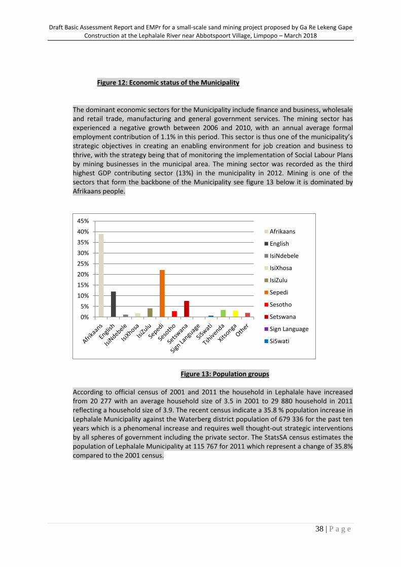
Figure 12: Economic status of the Municipality The dominant economic sectors for the Municipality include finance and business, wholesale and retail trade, manufacturing and general government services. The mining sector has experienced a negative growth between 2006 and 2010, with an annual average formal employment contribution of 1.1% in this period. This sector is thus one of the municipality’s strategic objectives in creating an enabling environment for job creation and business to thrive, with the strategy being that of monitoring the implementation of Social Labour Plans by mining businesses in the municipal area. The mining sector was recorded as the third highest GDP contributing sector (13%) in the municipality in 2012. Mining is one of the sectors that form the backbone of the Municipality see figure 13 below it is dominated by Afrikaans people.
Figure 13: Population groups
According to official census of 2001 and 2011 the household in Lephalale have increased from 20 277 with an average household size of 3.5 in 2001 to 29 880 household in 2011 reflecting a household size of 3.9. The recent census indicate a 35.8 % population increase in Lephalale Municipality against the Waterberg district population of 679 336 for the past ten years which is a phenomenal increase and requires well thought-out strategic interventions by all spheres of government including the private sector. The StatsSA census estimates the population of Lephalale Municipality at 115 767 for 2011 which represent a change of 35.8% compared to the 2001 census.
0%
5%
10%
15%
20%
25%
30%
35%
40%
45%
Afrikaans
English
IsiNdebele
IsiXhosa
IsiZulu
Sepedi
Sesotho
Setswana
Sign Language
SiSwati
Draft Basic Assessment Report and EMPr for a small-scale sand mining project proposed by Ga Re Lekeng Gape Construction at the Lephalale River near Abbotspoort Village, Limpopo – March 2018
39 | P a g e
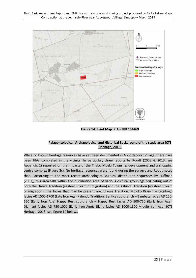
Figure 14: Inset Map PIA - NID 164469
Palaeontological, Archaeological and Historical Background of the study area (CTS
Heritage, 2018)
While no known heritage resources have yet been documented in Abbottspoort Village, there have
been HIAs completed in the vicinity. In particular, three reports by Roodt (2008 & 2013, see
Appendix 2) reported on the impacts of the Thabo Mbeki Township development and a shopping
centre complex (Figure 3c). No heritage resources were found during the surveys and Roodt noted
that,“according to the most recent archaeological cultural distribution sequences by Huffman
(2007), this area falls within the distribution area of various cultural groupings originating out of
both the Urewe Tradition (eastern stream of migration) and the Kalundu Tradition (western stream
of migration). The facies that may be present are: Urewe Tradition: Moloko Branch – Letsibogo
facies AD 1500-1700 (Late Iron Age) Kalundu Tradition: Benfica sub-branch – Bambata facies AD 150-
650 (Early Iron Age) Happy Rest sub-branch – Happy Rest facies AD 500-750 (Early Iron Age);
Diamant facies AD 750-1000 (Early Iron Age); Eiland facies AD 1000-1300(Middle Iron Age) (CTS
Heritage, 2018) see figure 14 below..
Draft Basic Assessment Report and EMPr for a small-scale sand mining project proposed by Ga Re Lekeng Gape Construction at the Lephalale River near Abbotspoort Village, Limpopo – March 2018
40 | P a g e
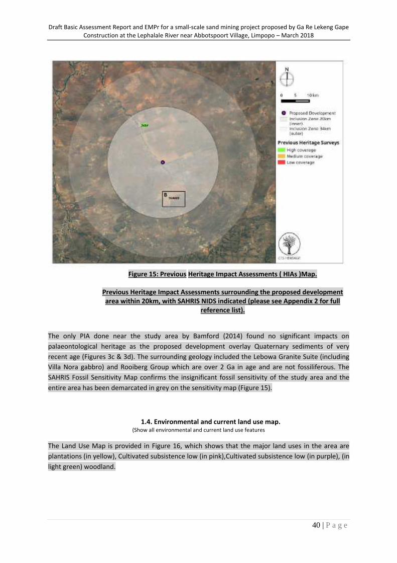
Figure 15: Previous Heritage Impact Assessments ( HIAs )Map.
Previous Heritage Impact Assessments surrounding the proposed development area within 20km, with SAHRIS NIDS indicated (please see Appendix 2 for full
reference list).
The only PIA done near the study area by Bamford (2014) found no significant impacts on
palaeontological heritage as the proposed development overlay Quaternary sediments of very
recent age (Figures 3c & 3d). The surrounding geology included the Lebowa Granite Suite (including
Villa Nora gabbro) and Rooiberg Group which are over 2 Ga in age and are not fossiliferous. The
SAHRIS Fossil Sensitivity Map confirms the insignificant fossil sensitivity of the study area and the
entire area has been demarcated in grey on the sensitivity map (Figure 15).
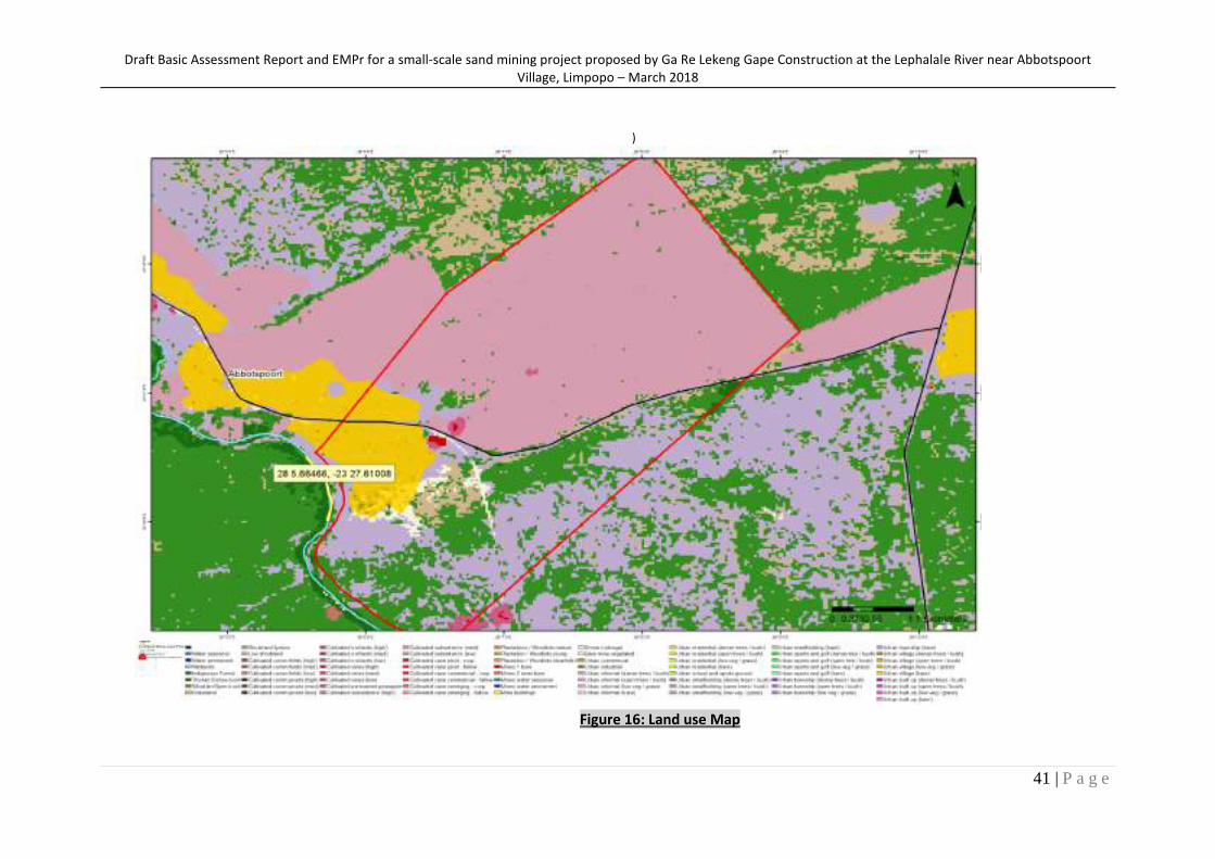
1.4. Environmental and current land use map. (Show all environmental and current land use features
The Land Use Map is provided in Figure 16, which shows that the major land uses in the area are
plantations (in yellow), Cultivated subsistence low (in pink),Cultivated subsistence low (in purple), (in
light green) woodland.
Draft Basic Assessment Report and EMPr for a small-scale sand mining project proposed by Ga Re Lekeng Gape Construction at the Lephalale River near Abbotspoort Village, Limpopo – March 2018
41 | P a g e
)
Figure 16: Land use Map
Draft Basic Assessment Report and EMPr for a small-scale sand mining project proposed by Ga Re Lekeng Gape Construction at the Lephalale River near Abbotspoort Village, Limpopo – March 2018
42 | P a g e
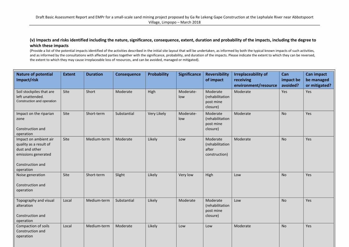
(v) Impacts and risks identified including the nature, significance, consequence, extent, duration and probability of the impacts, including the degree to which these impacts (Provide a list of the potential impacts identified of the activities described in the initial site layout that will be undertaken, as informed by both the typical known impacts of such activities, and as informed by the consultations with affected parties together with the significance, probability, and duration of the impacts. Please indicate the extent to which they can be reversed, the extent to which they may cause irreplaceable loss of resources, and can be avoided, managed or mitigated).
Nature of potential Impact/risk
Extent Duration Consequence Probability Significance Reversibility of impact
Irreplaceability of receiving environment/resource
Can impact be avoided?
Can impact be managed or mitigated?
Soil stockpiles that are left unattended. Construction and operation
Site Short Moderate High Moderate-low
Moderate (rehabilitation post mine closure)
Moderate Yes Yes
Impact on the riparian zone Construction and operation
Site Short-term Substantial Very Likely Moderate-low
Moderate (rehabilitation post mine closure)
Moderate No Yes
Impact on ambient air quality as a result of dust and other emissions generated Construction and operation
Site Medium-term Moderate Likely Low Moderate (rehabilitation after construction)
Moderate No Yes
Noise generation Construction and operation
Site Short-term Slight Likely Very low High Low No Yes
Topography and visual alteration Construction and operation
Local Medium-term Substantial Likely Moderate Moderate (rehabilitation post mine closure)
Low No Yes
Compaction of soils Construction and operation
Local Medium-term Moderate Likely Low Low Moderate No Yes
Draft Basic Assessment Report and EMPr for a small-scale sand mining project proposed by Ga Re Lekeng Gape Construction at the Lephalale River near Abbotspoort Village, Limpopo – March 2018
43 | P a g e
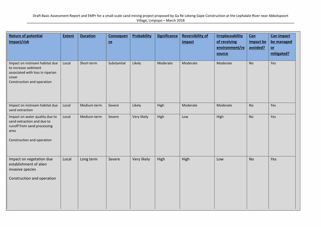
Nature of potential
Impact/risk
Extent Duration Consequen
ce
Probability Significance Reversibility of
impact
Irreplaceability
of receiving
environment/re
source
Can
impact be
avoided?
Can impact
be managed
or
mitigated?
Impact on instream habitat due to increase sediment associated with loss in riparian cover Construction and operation
Local Short-term Substantial Likely Moderate Moderate
Moderate No Yes
Impact on instream habitat due sand extraction
Local Medium-term Severe Likely High Moderate Moderate No Yes
Impact on water quality due to sand extraction and due to runoff from sand processing area Construction and operation
Local Medium-term Severe Very likely High Low High No Yes
Impact on vegetation due establishment of alien invasive species
Construction and operation
Local Long term Severe Very likely High High Low No Yes
Destruction of isolated fossils
Construction and operation
Site Permanent Slight Very unlikely
Very low Non-reversible High No Yes
Draft Basic Assessment Report and EMPr for a small-scale sand mining project proposed by Ga Re Lekeng Gape Construction at the Lephalale River near Abbotspoort Village, Limpopo – March 2018
44 | P a g e
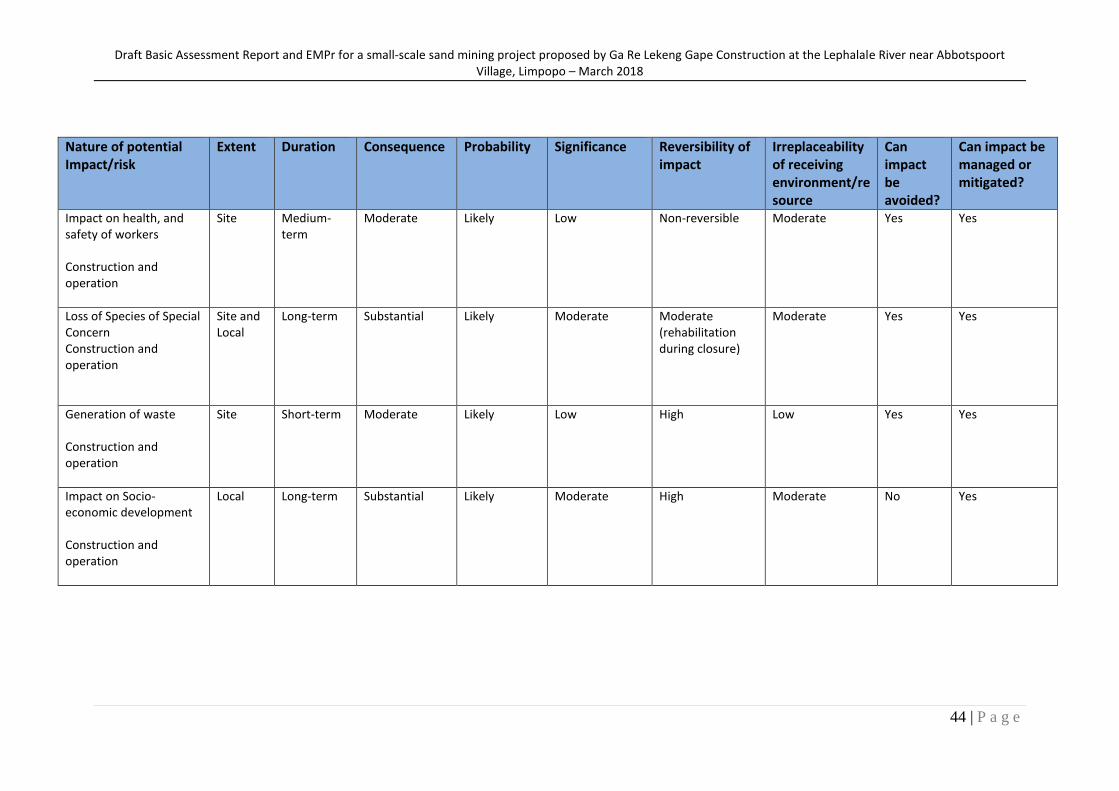
Nature of potential Impact/risk
Extent Duration Consequence Probability Significance Reversibility of impact
Irreplaceability of receiving environment/resource
Can impact be avoided?
Can impact be managed or mitigated?
Impact on health, and safety of workers Construction and operation
Site Medium-term
Moderate Likely Low Non-reversible Moderate Yes Yes
Loss of Species of Special Concern Construction and operation
Site and Local
Long-term Substantial Likely Moderate Moderate (rehabilitation during closure)
Moderate Yes Yes
Generation of waste Construction and operation
Site Short-term Moderate Likely Low High Low Yes Yes
Impact on Socio-economic development Construction and operation
Local Long-term Substantial Likely Moderate High Moderate No Yes
Draft Basic Assessment Report and EMPr for a small-scale sand mining project proposed by Ga Re Lekeng Gape Construction at the Lephalale River near Abbotspoort Village, Limpopo – March 2018
45 | P a g e
(vi) Methodology used in determining and ranking the nature, significance, consequence, extent, duration and probability of potential environmental impacts and risks; (Describe how the significance, probability, and duration of the aforesaid identified impacts that were identified through the consultation process was determined in order to decide the extent to which the initial site layout needs revision).
APPROACH TO THE BASIC ASSESSMENT 1) METHODOLOGY OF IMPACT ASSESSMENT According to the DEA IEM Series guideline on "Impact Significance" (2002), there are a number of quantitative and qualitative methods that can be used to identify the significance of impacts resulting from a development. The process of determining impact significance should ideally involve a process of determining the acceptability of a predicted impact to society. Making this process explicit and open to public comment and input would be an improvement of the EIA/BA process. The CSIR’s approach to determining significance is generally as follows: Use of expert opinion by the specialists ("professional judgement"), based on their experience, a site visit
and analysis, and use of existing guidelines and strategic planning documents and conservation mapping (e.g. SANBI biodiversity databases);
Review of specialist assessment by all stakeholders including authorities such as nature conservation officials, as part of the report review process (i.e. if a nature conservation official disagreed with the significance rating, then we could negotiate the rating); and
Our approach is more a qualitative approach - we do not have a formal matrix calculation of significance as is sometimes done.
2) SPECIALIST CRITERIA FOR IMPACT ASSESSMENT The following methodology has been provided by the CSIR to the specialist who conducted the Ecological assessment, NSS, for incorporation into their specialist assessment: Assessment of Potential Impacts The assessment of impact significance is based on the following conventions: Nature of Impact - this reviews the type of effect that a proposed activity will have on the environment and should include “what will be affected and how?” Spatial Extent - this should indicate whether the impact will be: Site specific; Local (<2 km from site); Regional (within 30 km of site); or National. Duration - The timeframe during which (lifetime of) the impact will be experienced: Temporary (less than 1 year); Short term (1 to 6 years); Medium term (6 to 15 years); Long term (the impact will cease after the operational life of the activity); or Permanent (mitigation will not occur in such a way or in such a time span that the impact can be
considered transient). Intensity - it should be established whether the impact is destructive or innocuous and should be described as either: High (severe alteration of natural systems, patterns or processes such that they temporarily or
permanently cease);
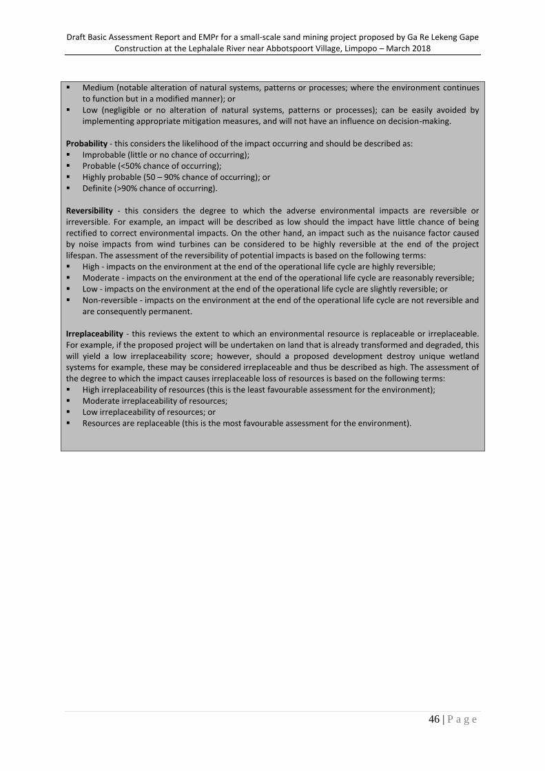
Draft Basic Assessment Report and EMPr for a small-scale sand mining project proposed by Ga Re Lekeng Gape Construction at the Lephalale River near Abbotspoort Village, Limpopo – March 2018
46 | P a g e
Medium (notable alteration of natural systems, patterns or processes; where the environment continues to function but in a modified manner); or
Low (negligible or no alteration of natural systems, patterns or processes); can be easily avoided by implementing appropriate mitigation measures, and will not have an influence on decision-making.
Probability - this considers the likelihood of the impact occurring and should be described as: Improbable (little or no chance of occurring); Probable (<50% chance of occurring); Highly probable (50 – 90% chance of occurring); or Definite (>90% chance of occurring). Reversibility - this considers the degree to which the adverse environmental impacts are reversible or irreversible. For example, an impact will be described as low should the impact have little chance of being rectified to correct environmental impacts. On the other hand, an impact such as the nuisance factor caused by noise impacts from wind turbines can be considered to be highly reversible at the end of the project lifespan. The assessment of the reversibility of potential impacts is based on the following terms: High - impacts on the environment at the end of the operational life cycle are highly reversible; Moderate - impacts on the environment at the end of the operational life cycle are reasonably reversible; Low - impacts on the environment at the end of the operational life cycle are slightly reversible; or Non-reversible - impacts on the environment at the end of the operational life cycle are not reversible and
are consequently permanent. Irreplaceability - this reviews the extent to which an environmental resource is replaceable or irreplaceable. For example, if the proposed project will be undertaken on land that is already transformed and degraded, this will yield a low irreplaceability score; however, should a proposed development destroy unique wetland systems for example, these may be considered irreplaceable and thus be described as high. The assessment of the degree to which the impact causes irreplaceable loss of resources is based on the following terms: High irreplaceability of resources (this is the least favourable assessment for the environment); Moderate irreplaceability of resources; Low irreplaceability of resources; or Resources are replaceable (this is the most favourable assessment for the environment).
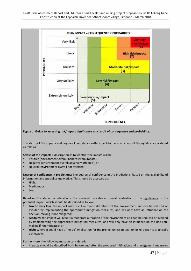
Draft Basic Assessment Report and EMPr for a small-scale sand mining project proposed by Ga Re Lekeng Gape Construction at the Lephalale River near Abbotspoort Village, Limpopo – March 2018
47 | P a g e
Figure…: Guide to assessing risk/impact significance as a result of consequence and probability. The status of the impacts and degree of confidence with respect to the assessment of the significance is stated as follows: Status of the impact: A description as to whether the impact will be: Positive (environment overall benefits from impact); Negative (environment overall adversely affected); or Neutral (environment overall not affected). Degree of confidence in predictions: The degree of confidence in the predictions, based on the availability of information and specialist knowledge. This should be assessed as: High; Medium; or Low. Based on the above considerations, the specialist provides an overall evaluation of the significance of the potential impact, which should be described as follows: Low to very low: the impact may result in minor alterations of the environment and can be reduced or
avoided by implementing the appropriate mitigation measures, and will only have an influence on the decision-making if not mitigated;
Medium: the impact will result in moderate alteration of the environment and can be reduced or avoided by implementing the appropriate mitigation measures, and will only have an influence on the decision-making if not mitigated; or
High: Where it could have a “no-go” implication for the project unless mitigation or re-design is practically achievable.
Furthermore, the following must be considered: Impacts should be described both before and after the proposed mitigation and management measures
Draft Basic Assessment Report and EMPr for a small-scale sand mining project proposed by Ga Re Lekeng Gape Construction at the Lephalale River near Abbotspoort Village, Limpopo – March 2018
48 | P a g e
have been implemented. All impacts should be evaluated for the construction, operation and decommissioning phases of the
project, where relevant. The impact evaluation should take into consideration the cumulative effects associated with this and
other facilities which are either developed or in the process of being developed in the region, if relevant. Management Actions: Where negative impacts are identified, mitigatory measures will be identified to avoid or reduce negative
impacts. Where no mitigatory measures are possible this will be stated. Where positive impacts are identified, augmentation measures will be identified to potentially enhance
these. Quantifiable standards for measuring and monitoring mitigatory measures and enhancements will be set.
This will include a programme for monitoring and reviewing the recommendations to ensure their ongoing effectiveness.
Monitoring: Specialists should recommend monitoring requirements to assess the effectiveness of mitigation actions, indicating what actions are required, by whom, and the timing and frequency thereof. Cumulative Impact: Consideration is given to the extent of any accumulative impact that may occur due to the proposed development. Such impacts are evaluated with an assessment of similar developments already in the environment. Such impacts will be either positive or negative, and will be graded as being of negligible, low, medium or high impact. Mitigation: The objective of mitigation is to firstly avoid and minimise impacts where possible and where these cannot be completely avoided, to compensate for the negative impacts of the development on the receiving environment and to maximise re-vegetation and rehabilitation of disturbed areas. For each impact identified, appropriate mitigation measures to reduce or otherwise avoid the potentially negative impacts are suggested. All impacts are assessed without mitigation and with the mitigation measures as suggested.
(vii) The positive and negative impacts that the proposed activity (in terms of the initial site layout) and alternatives will have on the environment and the community that may be affected (Provide a discussion in terms of advantages and disadvantages of the initial site layout compared to alternative layout options to accommodate concerns raised by affected parties)
Kindly see Section (i) above; the advantages and disadvantages of the proposed site layout have been discussed in the reasons provided in this section, inclusive of the reasons for not considering alternatives. (viii) The possible mitigation measures that could be applied and the level of risk. (With regard to the issues and concerns raised by affected parties provide a list of the issues raised and an assessment/ discussion of the mitigations or site layout alternatives available to accommodate or address their concerns, together with an assessment of the impacts or risks associated with the mitigation or alternatives considered).
Potential Impact Description
Significance Rating
(Positive or Negative)
Proposed Mitigation
Significance Rating after Mitigation
PROPOSAL (preferred alternative)
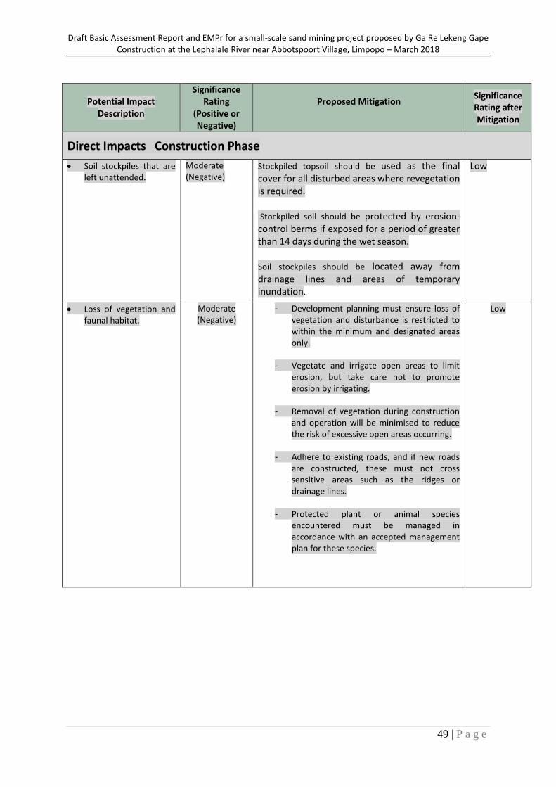
Draft Basic Assessment Report and EMPr for a small-scale sand mining project proposed by Ga Re Lekeng Gape Construction at the Lephalale River near Abbotspoort Village, Limpopo – March 2018
49 | P a g e
Potential Impact Description
Significance Rating
(Positive or Negative)
Proposed Mitigation
Significance Rating after Mitigation
Direct Impacts Construction Phase
Soil stockpiles that are left unattended.
Moderate (Negative)
Stockpiled topsoil should be used as the final cover for all disturbed areas where revegetation is required. Stockpiled soil should be protected by erosion-control berms if exposed for a period of greater than 14 days during the wet season. Soil stockpiles should be located away from drainage lines and areas of temporary inundation.
Low
Loss of vegetation and faunal habitat.
Moderate (Negative)
- Development planning must ensure loss of vegetation and disturbance is restricted to within the minimum and designated areas only.
- Vegetate and irrigate open areas to limit erosion, but take care not to promote erosion by irrigating.
- Removal of vegetation during construction and operation will be minimised to reduce the risk of excessive open areas occurring.
- Adhere to existing roads, and if new roads are constructed, these must not cross sensitive areas such as the ridges or drainage lines.
- Protected plant or animal species encountered must be managed in accordance with an accepted management plan for these species.
Low
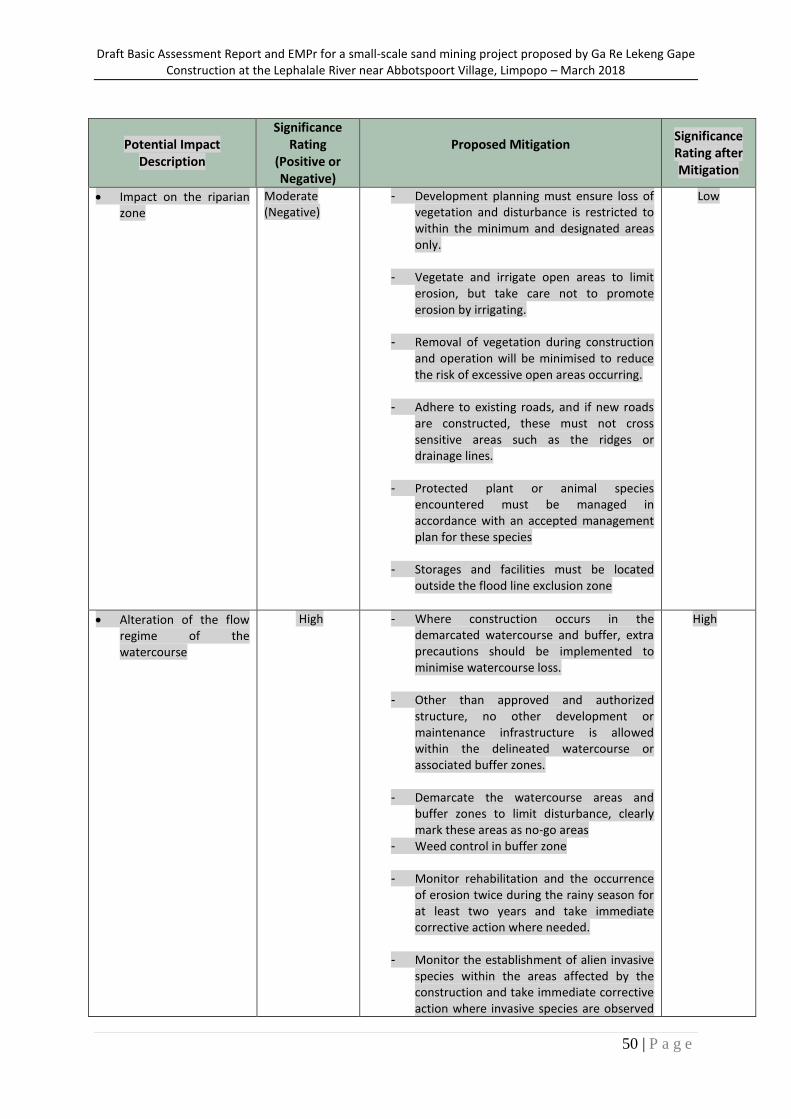
Draft Basic Assessment Report and EMPr for a small-scale sand mining project proposed by Ga Re Lekeng Gape Construction at the Lephalale River near Abbotspoort Village, Limpopo – March 2018
50 | P a g e
Potential Impact Description
Significance Rating
(Positive or Negative)
Proposed Mitigation
Significance Rating after Mitigation
Impact on the riparian zone
Moderate (Negative)
- Development planning must ensure loss of vegetation and disturbance is restricted to within the minimum and designated areas only.
- Vegetate and irrigate open areas to limit erosion, but take care not to promote erosion by irrigating.
- Removal of vegetation during construction and operation will be minimised to reduce the risk of excessive open areas occurring.
- Adhere to existing roads, and if new roads are constructed, these must not cross sensitive areas such as the ridges or drainage lines.
- Protected plant or animal species encountered must be managed in accordance with an accepted management plan for these species
- Storages and facilities must be located outside the flood line exclusion zone
Low
Alteration of the flow regime of the watercourse
High
- Where construction occurs in the demarcated watercourse and buffer, extra precautions should be implemented to minimise watercourse loss.
- Other than approved and authorized structure, no other development or maintenance infrastructure is allowed within the delineated watercourse or associated buffer zones.
- Demarcate the watercourse areas and buffer zones to limit disturbance, clearly mark these areas as no-go areas
- Weed control in buffer zone
- Monitor rehabilitation and the occurrence of erosion twice during the rainy season for at least two years and take immediate corrective action where needed.
- Monitor the establishment of alien invasive species within the areas affected by the construction and take immediate corrective action where invasive species are observed
High
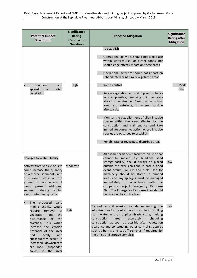
Draft Basic Assessment Report and EMPr for a small-scale sand mining project proposed by Ga Re Lekeng Gape Construction at the Lephalale River near Abbotspoort Village, Limpopo – March 2018
51 | P a g e
Potential Impact Description
Significance Rating
(Positive or Negative)
Proposed Mitigation
Significance Rating after Mitigation
to establish
- Operational activities should not take place within watercourses or buffer zones, nor should edge effects impact on these areas
- Operational activities should not impact on rehabilitated or naturally vegetated areas
Introduction and spread of alien vegetation
High - Weed control
- Retain vegetation and soil in position for as long as possible, removing it immediately ahead of construction / earthworks in that area and returning it where possible afterwards.
- Monitor the establishment of alien invasive species within the areas affected by the construction and maintenance and take immediate corrective action where invasive species are observed to establish.
- Rehabilitate or revegetate disturbed areas
- Moderate
Changes to Water Quality Activity from vehicle on site could increase the quantity of airborne sediments and dust would settle on the ground surface where it would present additional sediment during rainfall events into river systems;
Moderate High
- All “semi-permanent” facilities on site that cannot be moved (e.g. buildings, sand storage facility) should always be placed outside the exclusion zone in case a flood event occurs;- All oils and fuels used for machinery should be stored in bunded areas and any spillages must be managed immediately in accordance with the company’s project Emergency Response Plan. The Emergency Response Plan should be provided by contractors;
To reduce soil erosion include minimising the infrastructure footprint as far as possible, controlling storm water runoff, grouping infrastructure, marking construction areas accurately, scheduling construction as soon as possible after vegetation clearance and constructing water control structures such as berms and cut-off trenches if required for the office and storage complex;
Low Low
The proposed sand mining activity would require removal of vegetation and the disturbance of the riverbed. This would increase the erosion potential of the river bed locally and subsequently result in increased downstream silt load (suspended solids) in the river
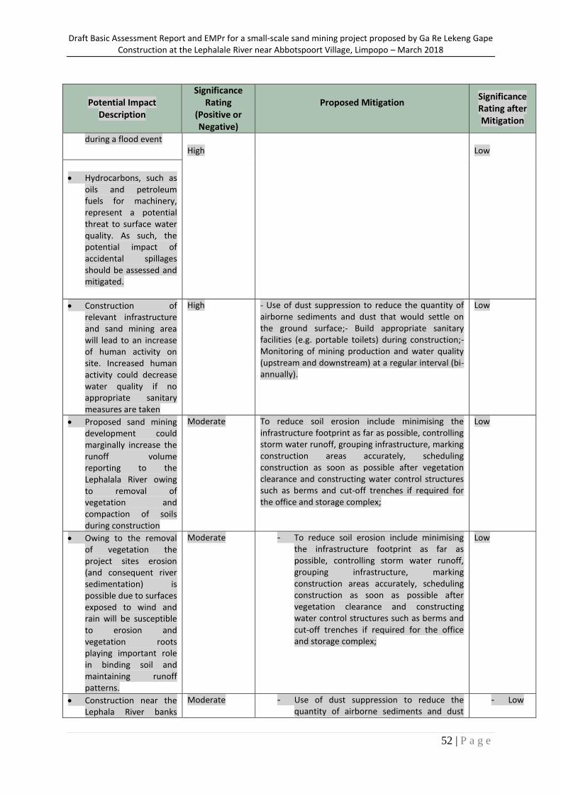
Draft Basic Assessment Report and EMPr for a small-scale sand mining project proposed by Ga Re Lekeng Gape Construction at the Lephalale River near Abbotspoort Village, Limpopo – March 2018
52 | P a g e
Potential Impact Description
Significance Rating
(Positive or Negative)
Proposed Mitigation
Significance Rating after Mitigation
during a flood event
High
Low
Hydrocarbons, such as oils and petroleum fuels for machinery, represent a potential threat to surface water quality. As such, the potential impact of accidental spillages should be assessed and mitigated.
Construction of relevant infrastructure and sand mining area will lead to an increase of human activity on site. Increased human activity could decrease water quality if no appropriate sanitary measures are taken
High - Use of dust suppression to reduce the quantity of airborne sediments and dust that would settle on the ground surface;- Build appropriate sanitary facilities (e.g. portable toilets) during construction;- Monitoring of mining production and water quality (upstream and downstream) at a regular interval (bi-annually).
Low
Proposed sand mining development could marginally increase the runoff volume reporting to the Lephalala River owing to removal of vegetation and compaction of soils during construction
Moderate To reduce soil erosion include minimising the infrastructure footprint as far as possible, controlling storm water runoff, grouping infrastructure, marking construction areas accurately, scheduling construction as soon as possible after vegetation clearance and constructing water control structures such as berms and cut-off trenches if required for the office and storage complex;
Low
Owing to the removal of vegetation the project sites erosion (and consequent river sedimentation) is possible due to surfaces exposed to wind and rain will be susceptible to erosion and vegetation roots playing important role in binding soil and maintaining runoff patterns.
Moderate - To reduce soil erosion include minimising the infrastructure footprint as far as possible, controlling storm water runoff, grouping infrastructure, marking construction areas accurately, scheduling construction as soon as possible after vegetation clearance and constructing water control structures such as berms and cut-off trenches if required for the office and storage complex;
Low
Construction near the Lephala River banks
Moderate - Use of dust suppression to reduce the quantity of airborne sediments and dust
- Low
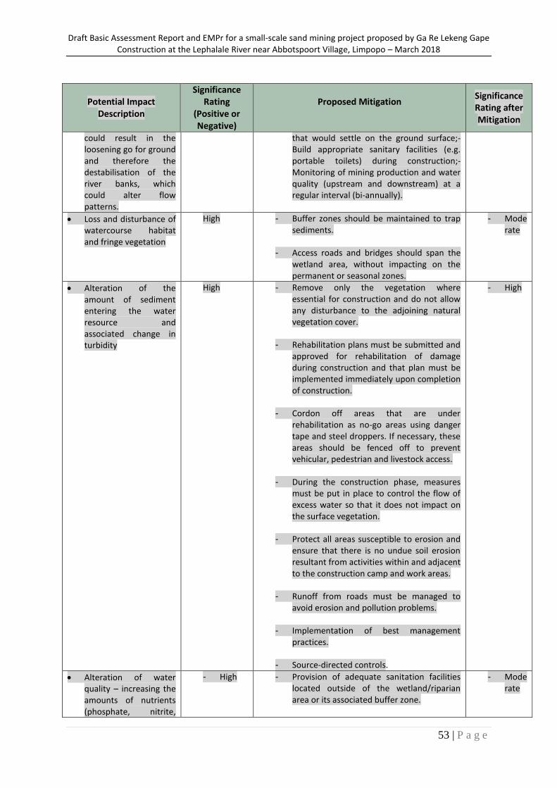
Draft Basic Assessment Report and EMPr for a small-scale sand mining project proposed by Ga Re Lekeng Gape Construction at the Lephalale River near Abbotspoort Village, Limpopo – March 2018
53 | P a g e
Potential Impact Description
Significance Rating
(Positive or Negative)
Proposed Mitigation
Significance Rating after Mitigation
could result in the loosening go for ground and therefore the destabilisation of the river banks, which could alter flow patterns.
that would settle on the ground surface;- Build appropriate sanitary facilities (e.g. portable toilets) during construction;- Monitoring of mining production and water quality (upstream and downstream) at a regular interval (bi-annually).
Loss and disturbance of watercourse habitat and fringe vegetation
High - Buffer zones should be maintained to trap sediments.
- Access roads and bridges should span the wetland area, without impacting on the permanent or seasonal zones.
- Moderate
Alteration of the amount of sediment entering the water resource and associated change in turbidity
High - Remove only the vegetation where essential for construction and do not allow any disturbance to the adjoining natural vegetation cover.
- Rehabilitation plans must be submitted and approved for rehabilitation of damage during construction and that plan must be implemented immediately upon completion of construction.
- Cordon off areas that are under rehabilitation as no-go areas using danger tape and steel droppers. If necessary, these areas should be fenced off to prevent vehicular, pedestrian and livestock access.
- During the construction phase, measures must be put in place to control the flow of excess water so that it does not impact on the surface vegetation.
- Protect all areas susceptible to erosion and ensure that there is no undue soil erosion resultant from activities within and adjacent to the construction camp and work areas.
- Runoff from roads must be managed to avoid erosion and pollution problems.
- Implementation of best management practices.
- Source-directed controls.
- High
Alteration of water quality – increasing the amounts of nutrients (phosphate, nitrite,
- High - Provision of adequate sanitation facilities located outside of the wetland/riparian area or its associated buffer zone.
- Moderate
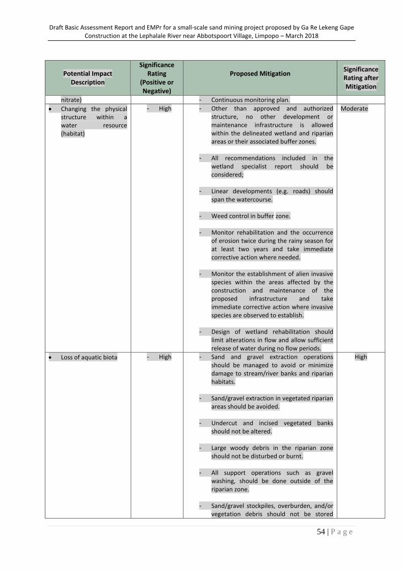
Draft Basic Assessment Report and EMPr for a small-scale sand mining project proposed by Ga Re Lekeng Gape Construction at the Lephalale River near Abbotspoort Village, Limpopo – March 2018
54 | P a g e
Potential Impact Description
Significance Rating
(Positive or Negative)
Proposed Mitigation
Significance Rating after Mitigation
nitrate) - Continuous monitoring plan.
Changing the physical structure within a water resource (habitat)
- High - Other than approved and authorized structure, no other development or maintenance infrastructure is allowed within the delineated wetland and riparian areas or their associated buffer zones.
- All recommendations included in the wetland specialist report should be considered;
- Linear developments (e.g. roads) should span the watercourse.
- Weed control in buffer zone.
- Monitor rehabilitation and the occurrence of erosion twice during the rainy season for at least two years and take immediate corrective action where needed.
- Monitor the establishment of alien invasive species within the areas affected by the construction and maintenance of the proposed infrastructure and take immediate corrective action where invasive species are observed to establish.
- Design of wetland rehabilitation should limit alterations in flow and allow sufficient release of water during no flow periods.
Moderate
Loss of aquatic biota - High - Sand and gravel extraction operations should be managed to avoid or minimize damage to stream/river banks and riparian habitats.
- Sand/gravel extraction in vegetated riparian areas should be avoided.
- Undercut and incised vegetated banks should not be altered.
- Large woody debris in the riparian zone should not be disturbed or burnt.
- All support operations such as gravel washing, should be done outside of the riparian zone.
- Sand/gravel stockpiles, overburden, and/or vegetation debris should not be stored
High
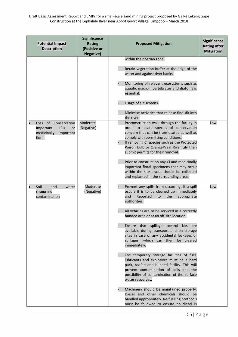
Draft Basic Assessment Report and EMPr for a small-scale sand mining project proposed by Ga Re Lekeng Gape Construction at the Lephalale River near Abbotspoort Village, Limpopo – March 2018
55 | P a g e
Potential Impact Description
Significance Rating
(Positive or Negative)
Proposed Mitigation
Significance Rating after Mitigation
within the riparian zone.
- Retain vegetation buffer at the edge of the water and against river banks.
- Monitoring of relevant ecosystems such as aquatic macro-invertebrates and diatoms is essential.
- Usage of silt screens.
- Minimise activities that release fine silt into the river.
Loss of Conservation Important (CI) or medicinally important flora.
Moderate (Negative)
- Preconstruction walk through the facility in order to locate species of conservation concern that can be translocated as well as comply with permitting conditions.
- If removing CI species such as the Protected Poison bulb or Orange/Vaal River Lily then submit permits for their removal.
- Prior to construction any CI and medicinally important floral specimens that may occur within the site layout should be collected and replanted in the surrounding areas.
Low
Soil and water resources contamination
Moderate (Negative)
- Prevent any spills from occurring; If a spill occurs it is to be cleaned up immediately and Reported to the appropriate authorities.
- All vehicles are to be serviced in a correctly bunded area or at an off-site location.
- Ensure that spillage control kits are available during transport and on storage sites in case of any accidental leakages of spillages, which can then be cleared immediately.
- The temporary storage facilities of fuel, lubricants and explosives must be a hard park, roofed and bunded facility. This will prevent contamination of soils and the possibility of contamination of the surface water resources.
- Machinery should be maintained properly. Diesel and other chemicals should be handled appropriately. Re-fuelling protocols must be followed to ensure no diesel is
Low
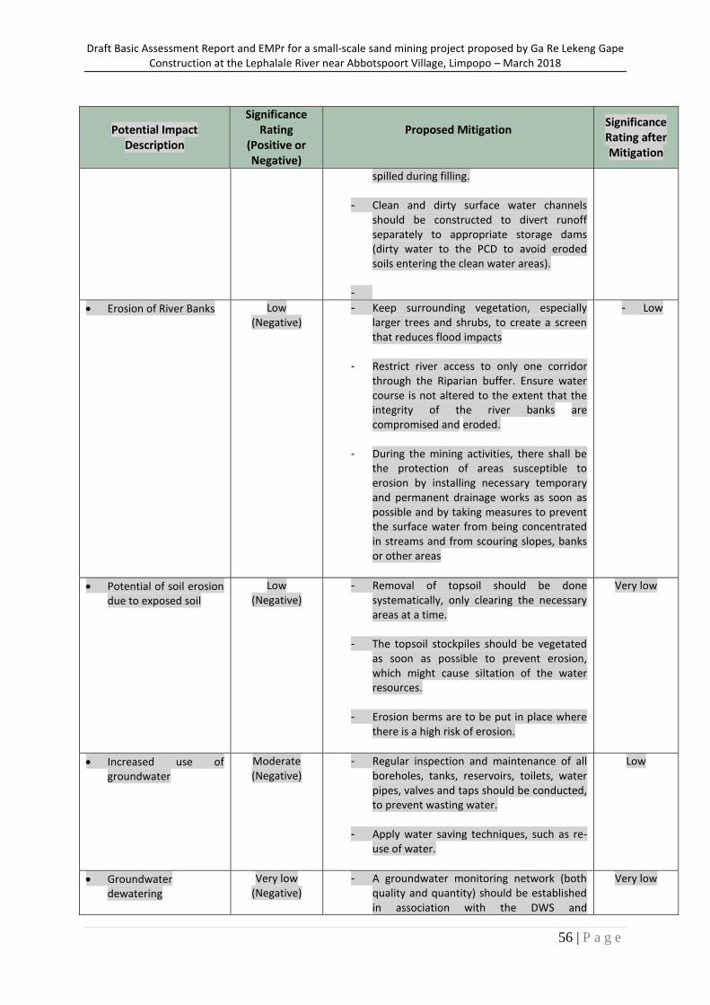
Draft Basic Assessment Report and EMPr for a small-scale sand mining project proposed by Ga Re Lekeng Gape Construction at the Lephalale River near Abbotspoort Village, Limpopo – March 2018
56 | P a g e
Potential Impact Description
Significance Rating
(Positive or Negative)
Proposed Mitigation
Significance Rating after Mitigation
spilled during filling.
- Clean and dirty surface water channels should be constructed to divert runoff separately to appropriate storage dams (dirty water to the PCD to avoid eroded soils entering the clean water areas).
-
Erosion of River Banks Low (Negative)
- Keep surrounding vegetation, especially larger trees and shrubs, to create a screen that reduces flood impacts
- Restrict river access to only one corridor through the Riparian buffer. Ensure water course is not altered to the extent that the integrity of the river banks are compromised and eroded.
- During the mining activities, there shall be the protection of areas susceptible to erosion by installing necessary temporary and permanent drainage works as soon as possible and by taking measures to prevent the surface water from being concentrated in streams and from scouring slopes, banks or other areas
- Low
Potential of soil erosion due to exposed soil
Low (Negative)
- Removal of topsoil should be done systematically, only clearing the necessary areas at a time.
- The topsoil stockpiles should be vegetated as soon as possible to prevent erosion, which might cause siltation of the water resources.
- Erosion berms are to be put in place where there is a high risk of erosion.
Very low
Increased use of groundwater
Moderate (Negative)
- Regular inspection and maintenance of all boreholes, tanks, reservoirs, toilets, water pipes, valves and taps should be conducted, to prevent wasting water.
- Apply water saving techniques, such as re-use of water.
Low
Groundwater dewatering
Very low (Negative)
- A groundwater monitoring network (both quality and quantity) should be established in association with the DWS and
Very low
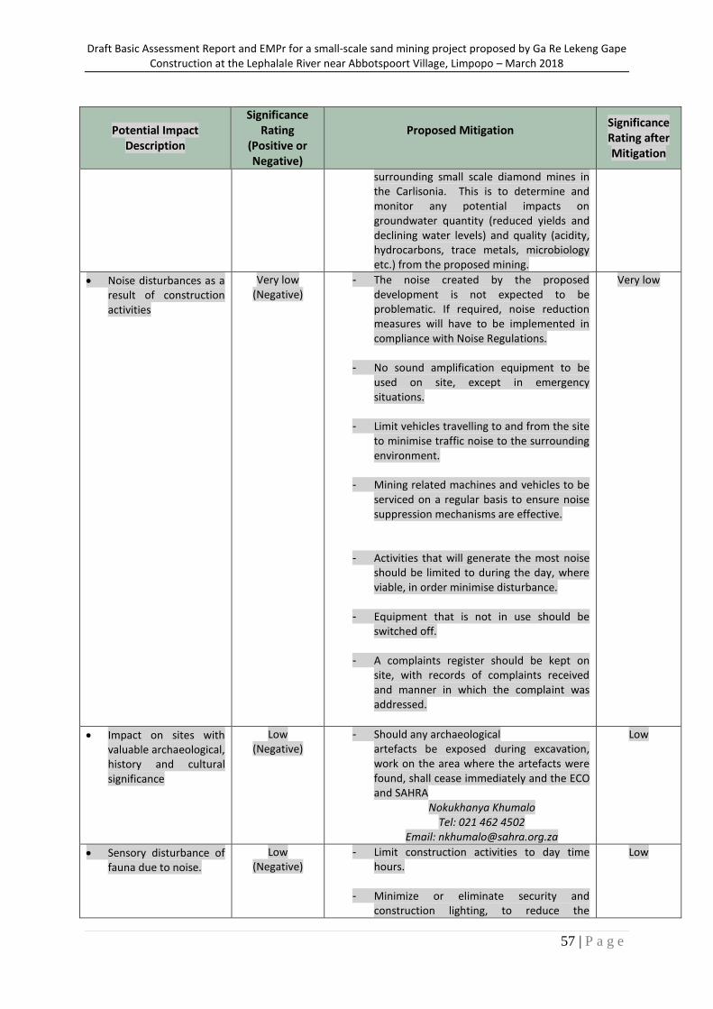
Draft Basic Assessment Report and EMPr for a small-scale sand mining project proposed by Ga Re Lekeng Gape Construction at the Lephalale River near Abbotspoort Village, Limpopo – March 2018
57 | P a g e
Potential Impact Description
Significance Rating
(Positive or Negative)
Proposed Mitigation
Significance Rating after Mitigation
surrounding small scale diamond mines in the Carlisonia. This is to determine and monitor any potential impacts on groundwater quantity (reduced yields and declining water levels) and quality (acidity, hydrocarbons, trace metals, microbiology etc.) from the proposed mining.
Noise disturbances as a result of construction activities
Very low (Negative)
- The noise created by the proposed development is not expected to be problematic. If required, noise reduction measures will have to be implemented in compliance with Noise Regulations.
- No sound amplification equipment to be used on site, except in emergency situations.
- Limit vehicles travelling to and from the site to minimise traffic noise to the surrounding environment.
- Mining related machines and vehicles to be serviced on a regular basis to ensure noise suppression mechanisms are effective.
- Activities that will generate the most noise should be limited to during the day, where viable, in order minimise disturbance.
- Equipment that is not in use should be switched off.
- A complaints register should be kept on site, with records of complaints received and manner in which the complaint was addressed.
Very low
Impact on sites with valuable archaeological, history and cultural significance
Low (Negative)
- Should any archaeological artefacts be exposed during excavation, work on the area where the artefacts were found, shall cease immediately and the ECO and SAHRA
Nokukhanya Khumalo Tel: 021 462 4502
Email: [email protected]
Low
Sensory disturbance of fauna due to noise.
Low (Negative)
- Limit construction activities to day time hours.
- Minimize or eliminate security and construction lighting, to reduce the
Low
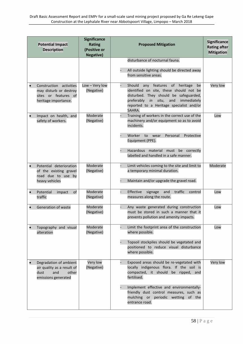
Draft Basic Assessment Report and EMPr for a small-scale sand mining project proposed by Ga Re Lekeng Gape Construction at the Lephalale River near Abbotspoort Village, Limpopo – March 2018
58 | P a g e
Potential Impact Description
Significance Rating
(Positive or Negative)
Proposed Mitigation
Significance Rating after Mitigation
disturbance of nocturnal fauna.
- All outside lighting should be directed away from sensitive areas.
Construction activities may disturb or destroy sites or features of heritage importance.
Low – Very low (Negative)
- Should any features of heritage be identified on site, these should not be disturbed. They should be safeguarded, preferably in situ, and immediately reported to a Heritage specialist and/or SAHRA.
Very low
Impact on health, and safety of workers.
Moderate (Negative)
- Training of workers in the correct use of the machinery and/or equipment so as to avoid incidents.
- Worker to wear Personal Protective Equipment (PPE).
- Hazardous material must be correctly labelled and handled in a safe manner.
Low
Potential deterioration of the existing gravel road due to use by heavy vehicles
Moderate (Negative)
- Limit vehicles coming to the site and limit to a temporary minimal duration.
- Maintain and/or upgrade the gravel road.
Moderate
Potential impact of traffic
Moderate (Negative)
- Effective signage and traffic control measures along the route.
Low
Generation of waste Moderate (Negative)
- Any waste generated during construction must be stored in such a manner that it prevents pollution and amenity impacts.
Low
Topography and visual alteration
Moderate (Negative)
- Limit the footprint area of the construction where possible.
- Topsoil stockpiles should be vegetated and positioned to reduce visual disturbance where possible.
Low
Degradation of ambient air quality as a result of dust and other emissions generated
Very low (Negative)
- Exposed areas should be re-vegetated with locally indigenous flora. If the soil is compacted, it should be ripped, and fertilised.
- Implement effective and environmentally-friendly dust control measures, such as mulching or periodic wetting of the entrance road.
Very low
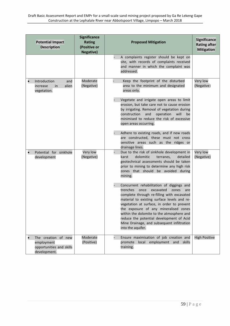
Draft Basic Assessment Report and EMPr for a small-scale sand mining project proposed by Ga Re Lekeng Gape Construction at the Lephalale River near Abbotspoort Village, Limpopo – March 2018
59 | P a g e
Potential Impact Description
Significance Rating
(Positive or Negative)
Proposed Mitigation
Significance Rating after Mitigation
- A complaints register should be kept on site, with records of complaints received and manner in which the complaint was addressed.
Introduction and increase in alien vegetation.
Moderate (Negative)
- Keep the footprint of the disturbed area to the minimum and designated areas only.
- Vegetate and irrigate open areas to limit
erosion, but take care not to cause erosion by irrigating. Removal of vegetation during construction and operation will be minimised to reduce the risk of excessive open areas occurring.
- Adhere to existing roads, and if new roads are constructed, these must not cross sensitive areas such as the ridges or drainage lines.
Very low (Negative)
Potential for sinkhole development
Very low (Negative)
- Due to the risk of sinkhole development in karst dolomitic terranes, detailed geotechnical assessments should be taken prior to mining to determine any high risk zones that should be avoided during mining.
- Concurrent rehabilitation of diggings and trenches once excavated zones are complete through re-filling with excavated material to existing surface levels and re-vegetation at surface, in order to prevent the exposure of any mineralised zones within the dolomite to the atmosphere and reduce the potential development of Acid Mine Drainage, and subsequent infiltration into the aquifer.
Very low (Negative)
The creation of new employment opportunities and skills development.
Moderate (Positive)
- Ensure maximisation of job creation and promote local employment and skills training.
High Positive
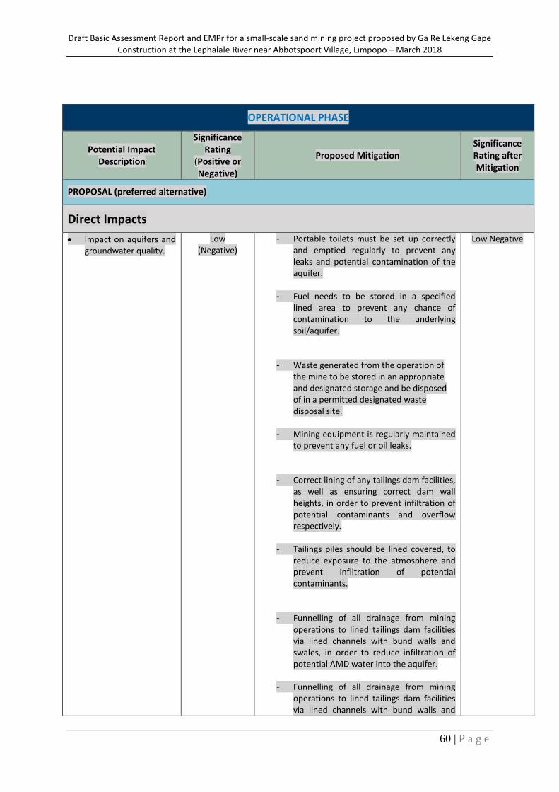
Draft Basic Assessment Report and EMPr for a small-scale sand mining project proposed by Ga Re Lekeng Gape Construction at the Lephalale River near Abbotspoort Village, Limpopo – March 2018
60 | P a g e
OPERATIONAL PHASE
Potential Impact Description
Significance Rating
(Positive or Negative)
Proposed Mitigation Significance Rating after Mitigation
PROPOSAL (preferred alternative)
Direct Impacts
Impact on aquifers and groundwater quality.
Low (Negative)
- Portable toilets must be set up correctly and emptied regularly to prevent any leaks and potential contamination of the aquifer.
- Fuel needs to be stored in a specified lined area to prevent any chance of contamination to the underlying soil/aquifer.
- Waste generated from the operation of the mine to be stored in an appropriate and designated storage and be disposed of in a permitted designated waste disposal site.
- Mining equipment is regularly maintained to prevent any fuel or oil leaks.
- Correct lining of any tailings dam facilities, as well as ensuring correct dam wall heights, in order to prevent infiltration of potential contaminants and overflow respectively.
- Tailings piles should be lined covered, to reduce exposure to the atmosphere and prevent infiltration of potential contaminants.
- Funnelling of all drainage from mining operations to lined tailings dam facilities via lined channels with bund walls and swales, in order to reduce infiltration of potential AMD water into the aquifer.
- Funnelling of all drainage from mining operations to lined tailings dam facilities via lined channels with bund walls and
Low Negative
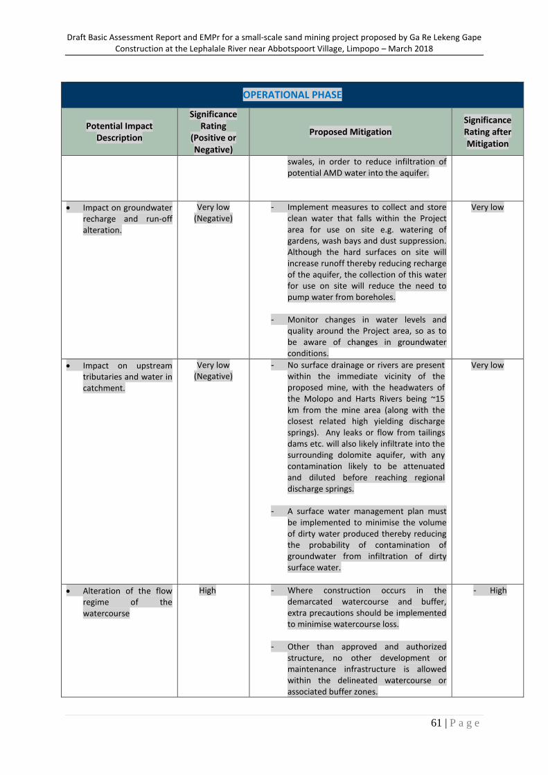
Draft Basic Assessment Report and EMPr for a small-scale sand mining project proposed by Ga Re Lekeng Gape Construction at the Lephalale River near Abbotspoort Village, Limpopo – March 2018
61 | P a g e
OPERATIONAL PHASE
Potential Impact Description
Significance Rating
(Positive or Negative)
Proposed Mitigation Significance Rating after Mitigation
swales, in order to reduce infiltration of potential AMD water into the aquifer.
Impact on groundwater recharge and run-off alteration.
Very low (Negative)
- Implement measures to collect and store clean water that falls within the Project area for use on site e.g. watering of gardens, wash bays and dust suppression. Although the hard surfaces on site will increase runoff thereby reducing recharge of the aquifer, the collection of this water for use on site will reduce the need to pump water from boreholes.
- Monitor changes in water levels and quality around the Project area, so as to be aware of changes in groundwater conditions.
Very low
Impact on upstream tributaries and water in catchment.
Very low (Negative)
- No surface drainage or rivers are present within the immediate vicinity of the proposed mine, with the headwaters of the Molopo and Harts Rivers being ~15 km from the mine area (along with the closest related high yielding discharge springs). Any leaks or flow from tailings dams etc. will also likely infiltrate into the surrounding dolomite aquifer, with any contamination likely to be attenuated and diluted before reaching regional discharge springs.
- A surface water management plan must be implemented to minimise the volume of dirty water produced thereby reducing the probability of contamination of groundwater from infiltration of dirty surface water.
Very low
Alteration of the flow regime of the watercourse
High - Where construction occurs in the demarcated watercourse and buffer, extra precautions should be implemented to minimise watercourse loss.
- Other than approved and authorized structure, no other development or maintenance infrastructure is allowed within the delineated watercourse or associated buffer zones.
- High
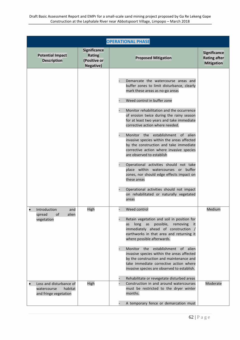
Draft Basic Assessment Report and EMPr for a small-scale sand mining project proposed by Ga Re Lekeng Gape Construction at the Lephalale River near Abbotspoort Village, Limpopo – March 2018
62 | P a g e
OPERATIONAL PHASE
Potential Impact Description
Significance Rating
(Positive or Negative)
Proposed Mitigation Significance Rating after Mitigation
- Demarcate the watercourse areas and buffer zones to limit disturbance, clearly mark these areas as no-go areas
- Weed control in buffer zone
- Monitor rehabilitation and the occurrence of erosion twice during the rainy season for at least two years and take immediate corrective action where needed.
- Monitor the establishment of alien invasive species within the areas affected by the construction and take immediate corrective action where invasive species are observed to establish
- Operational activities should not take place within watercourses or buffer zones, nor should edge effects impact on these areas
- Operational activities should not impact on rehabilitated or naturally vegetated areas
Introduction and spread of alien vegetation
High - Weed control
- Retain vegetation and soil in position for as long as possible, removing it immediately ahead of construction / earthworks in that area and returning it where possible afterwards.
- Monitor the establishment of alien invasive species within the areas affected by the construction and maintenance and take immediate corrective action where invasive species are observed to establish.
- Rehabilitate or revegetate disturbed areas
Medium
Loss and disturbance of watercourse habitat and fringe vegetation
High - Construction in and around watercourses must be restricted to the dryer winter months.
- A temporary fence or demarcation must
Moderate
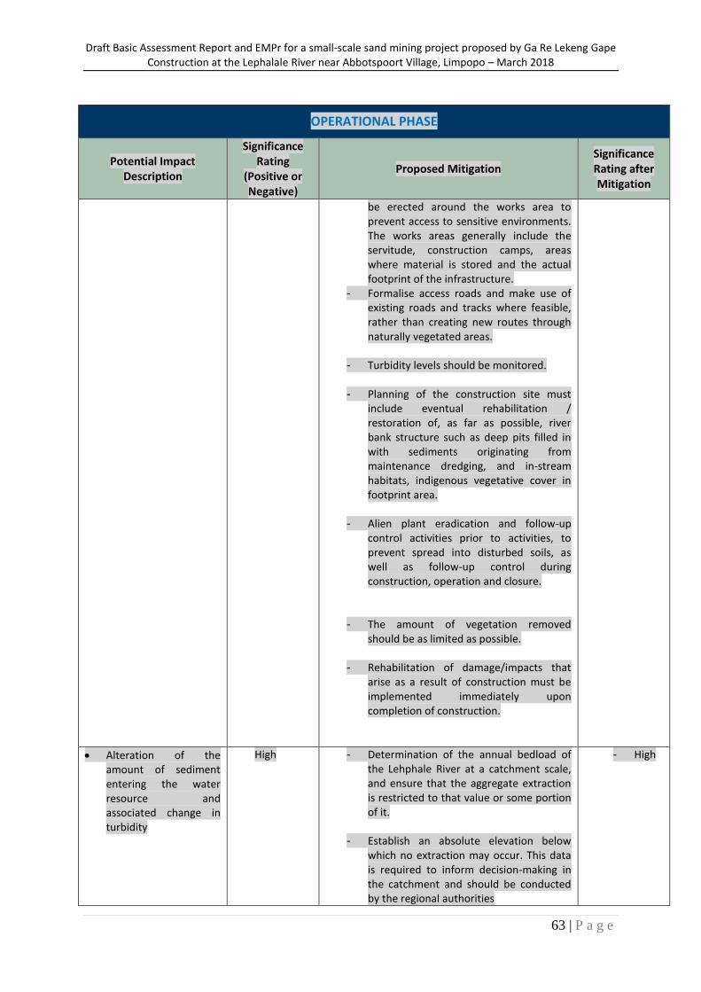
Draft Basic Assessment Report and EMPr for a small-scale sand mining project proposed by Ga Re Lekeng Gape Construction at the Lephalale River near Abbotspoort Village, Limpopo – March 2018
63 | P a g e
OPERATIONAL PHASE
Potential Impact Description
Significance Rating
(Positive or Negative)
Proposed Mitigation Significance Rating after Mitigation
be erected around the works area to prevent access to sensitive environments. The works areas generally include the servitude, construction camps, areas where material is stored and the actual footprint of the infrastructure.
- Formalise access roads and make use of existing roads and tracks where feasible, rather than creating new routes through naturally vegetated areas.
- Turbidity levels should be monitored.
- Planning of the construction site must include eventual rehabilitation / restoration of, as far as possible, river bank structure such as deep pits filled in with sediments originating from maintenance dredging, and in-stream habitats, indigenous vegetative cover in footprint area.
- Alien plant eradication and follow-up control activities prior to activities, to prevent spread into disturbed soils, as well as follow-up control during construction, operation and closure.
- The amount of vegetation removed should be as limited as possible.
- Rehabilitation of damage/impacts that arise as a result of construction must be implemented immediately upon completion of construction.
Alteration of the amount of sediment entering the water resource and associated change in turbidity
High - Determination of the annual bedload of the Lehphale River at a catchment scale, and ensure that the aggregate extraction is restricted to that value or some portion of it.
- Establish an absolute elevation below which no extraction may occur. This data is required to inform decision-making in the catchment and should be conducted by the regional authorities
- High
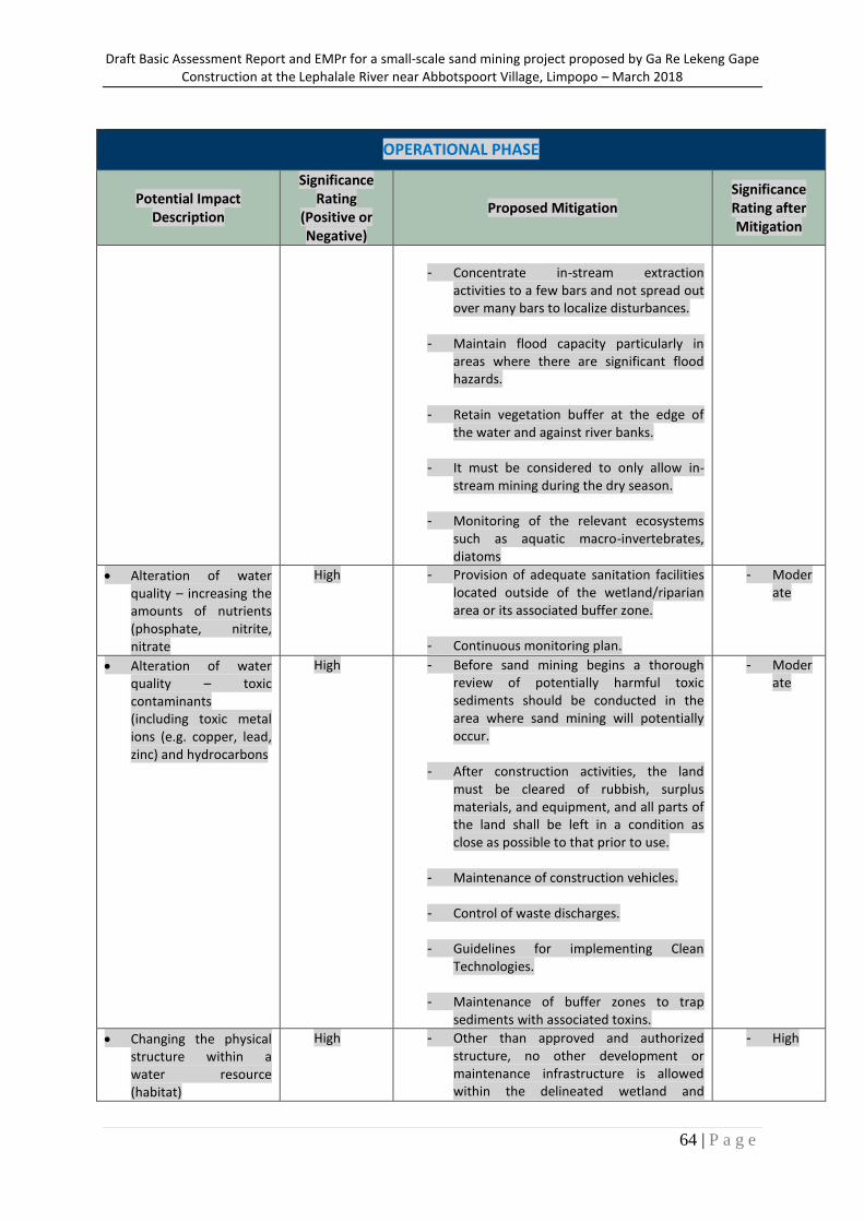
Draft Basic Assessment Report and EMPr for a small-scale sand mining project proposed by Ga Re Lekeng Gape Construction at the Lephalale River near Abbotspoort Village, Limpopo – March 2018
64 | P a g e
OPERATIONAL PHASE
Potential Impact Description
Significance Rating
(Positive or Negative)
Proposed Mitigation Significance Rating after Mitigation
- Concentrate in-stream extraction
activities to a few bars and not spread out over many bars to localize disturbances.
- Maintain flood capacity particularly in areas where there are significant flood hazards.
- Retain vegetation buffer at the edge of the water and against river banks.
- It must be considered to only allow in-stream mining during the dry season.
- Monitoring of the relevant ecosystems such as aquatic macro-invertebrates, diatoms
Alteration of water quality – increasing the amounts of nutrients (phosphate, nitrite, nitrate
High - Provision of adequate sanitation facilities located outside of the wetland/riparian area or its associated buffer zone.
- Continuous monitoring plan.
- Moderate
Alteration of water quality – toxic contaminants (including toxic metal ions (e.g. copper, lead, zinc) and hydrocarbons
High - Before sand mining begins a thorough review of potentially harmful toxic sediments should be conducted in the area where sand mining will potentially occur.
- After construction activities, the land must be cleared of rubbish, surplus materials, and equipment, and all parts of the land shall be left in a condition as close as possible to that prior to use.
- Maintenance of construction vehicles.
- Control of waste discharges.
- Guidelines for implementing Clean Technologies.
- Maintenance of buffer zones to trap sediments with associated toxins.
- Moderate
Changing the physical structure within a water resource (habitat)
High - Other than approved and authorized structure, no other development or maintenance infrastructure is allowed within the delineated wetland and
- High
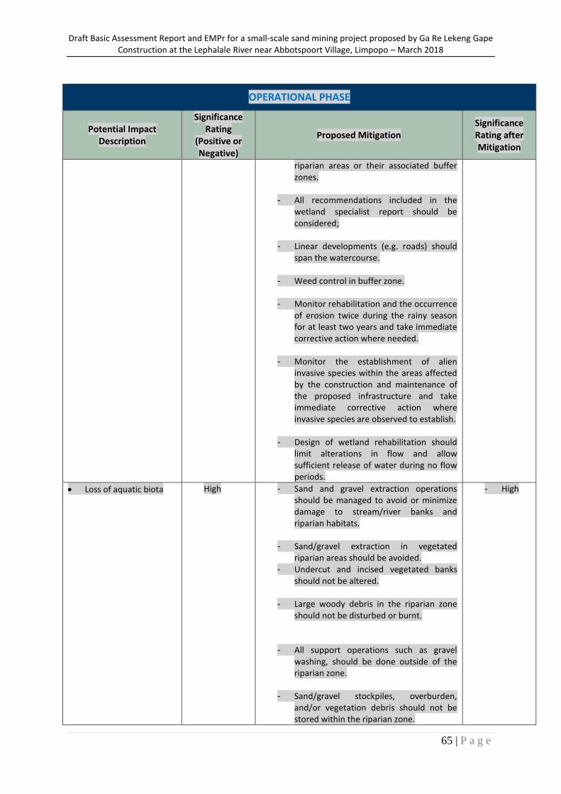
Draft Basic Assessment Report and EMPr for a small-scale sand mining project proposed by Ga Re Lekeng Gape Construction at the Lephalale River near Abbotspoort Village, Limpopo – March 2018
65 | P a g e
OPERATIONAL PHASE
Potential Impact Description
Significance Rating
(Positive or Negative)
Proposed Mitigation Significance Rating after Mitigation
riparian areas or their associated buffer zones.
- All recommendations included in the wetland specialist report should be considered;
- Linear developments (e.g. roads) should span the watercourse.
- Weed control in buffer zone.
- Monitor rehabilitation and the occurrence of erosion twice during the rainy season for at least two years and take immediate corrective action where needed.
- Monitor the establishment of alien invasive species within the areas affected by the construction and maintenance of the proposed infrastructure and take immediate corrective action where invasive species are observed to establish.
- Design of wetland rehabilitation should limit alterations in flow and allow sufficient release of water during no flow periods.
Loss of aquatic biota High - Sand and gravel extraction operations should be managed to avoid or minimize damage to stream/river banks and riparian habitats.
- Sand/gravel extraction in vegetated riparian areas should be avoided.
- Undercut and incised vegetated banks should not be altered.
- Large woody debris in the riparian zone should not be disturbed or burnt.
- All support operations such as gravel washing, should be done outside of the riparian zone.
- Sand/gravel stockpiles, overburden, and/or vegetation debris should not be stored within the riparian zone.
- High
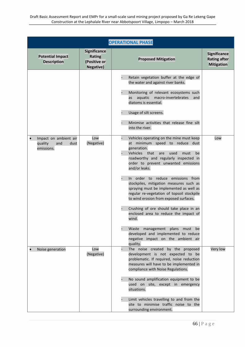
Draft Basic Assessment Report and EMPr for a small-scale sand mining project proposed by Ga Re Lekeng Gape Construction at the Lephalale River near Abbotspoort Village, Limpopo – March 2018
66 | P a g e
OPERATIONAL PHASE
Potential Impact Description
Significance Rating
(Positive or Negative)
Proposed Mitigation Significance Rating after Mitigation
- Retain vegetation buffer at the edge of
the water and against river banks.
- Monitoring of relevant ecosystems such as aquatic macro-invertebrates and diatoms is essential.
- Usage of silt screens.
- Minimise activities that release fine silt into the river.
Impact on ambient air quality and dust emissions.
Low (Negative)
- Vehicles operating on the mine must keep at minimum speed to reduce dust generation.
- Vehicles that are used must be roadworthy and regularly inspected in order to prevent unwanted emissions and/or leaks.
- In order to reduce emissions from stockpiles, mitigation measures such as spraying must be implemented as well as regular re-vegetation of topsoil stockpile to wind erosion from exposed surfaces.
- Crushing of ore should take place in an enclosed area to reduce the impact of wind.
- Waste management plans must be developed and implemented to reduce negative impact on the ambient air quality.
Low
Noise generation Low (Negative)
- The noise created by the proposed development is not expected to be problematic. If required, noise reduction measures will have to be implemented in compliance with Noise Regulations.
- No sound amplification equipment to be used on site, except in emergency situations.
- Limit vehicles travelling to and from the site to minimise traffic noise to the surrounding environment.
Very low
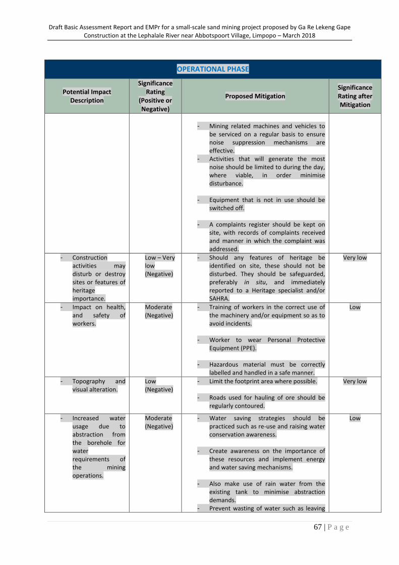
Draft Basic Assessment Report and EMPr for a small-scale sand mining project proposed by Ga Re Lekeng Gape Construction at the Lephalale River near Abbotspoort Village, Limpopo – March 2018
67 | P a g e
OPERATIONAL PHASE
Potential Impact Description
Significance Rating
(Positive or Negative)
Proposed Mitigation Significance Rating after Mitigation
- Mining related machines and vehicles to
be serviced on a regular basis to ensure noise suppression mechanisms are effective.
- Activities that will generate the most noise should be limited to during the day, where viable, in order minimise disturbance.
- Equipment that is not in use should be switched off.
- A complaints register should be kept on site, with records of complaints received and manner in which the complaint was addressed.
- Construction activities may disturb or destroy sites or features of heritage importance.
Low – Very low (Negative)
- Should any features of heritage be identified on site, these should not be disturbed. They should be safeguarded, preferably in situ, and immediately reported to a Heritage specialist and/or SAHRA.
Very low
- Impact on health, and safety of workers.
Moderate (Negative)
- Training of workers in the correct use of the machinery and/or equipment so as to avoid incidents.
- Worker to wear Personal Protective Equipment (PPE).
- Hazardous material must be correctly labelled and handled in a safe manner.
Low
- Topography and visual alteration.
Low (Negative)
- Limit the footprint area where possible.
- Roads used for hauling of ore should be regularly contoured.
Very low
- Increased water usage due to abstraction from the borehole for water requirements of the mining operations.
Moderate (Negative)
- Water saving strategies should be practiced such as re-use and raising water conservation awareness.
- Create awareness on the importance of these resources and implement energy and water saving mechanisms.
- Also make use of rain water from the existing tank to minimise abstraction demands.
- Prevent wasting of water such as leaving
Low
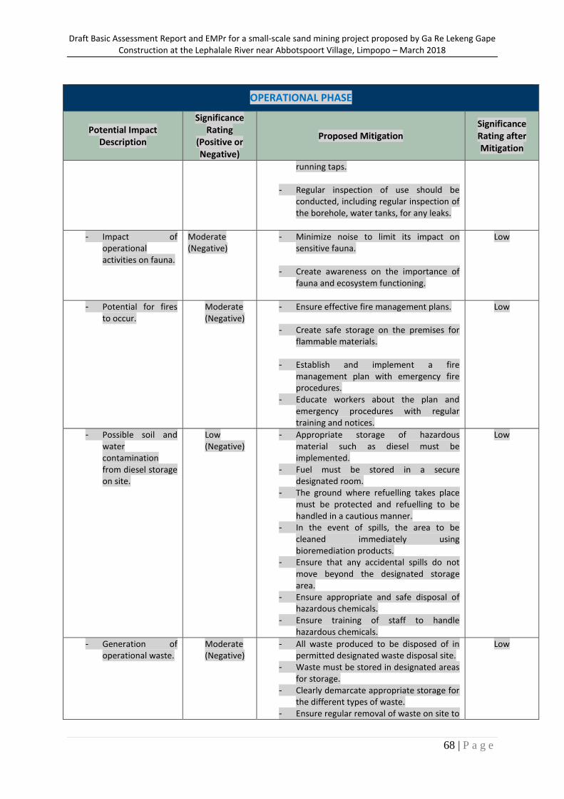
Draft Basic Assessment Report and EMPr for a small-scale sand mining project proposed by Ga Re Lekeng Gape Construction at the Lephalale River near Abbotspoort Village, Limpopo – March 2018
68 | P a g e
OPERATIONAL PHASE
Potential Impact Description
Significance Rating
(Positive or Negative)
Proposed Mitigation Significance Rating after Mitigation
running taps.
- Regular inspection of use should be conducted, including regular inspection of the borehole, water tanks, for any leaks.
- Impact of operational activities on fauna.
Moderate (Negative)
- Minimize noise to limit its impact on sensitive fauna.
- Create awareness on the importance of fauna and ecosystem functioning.
Low
- Potential for fires to occur.
Moderate (Negative)
- Ensure effective fire management plans.
- Create safe storage on the premises for flammable materials.
- Establish and implement a fire management plan with emergency fire procedures.
- Educate workers about the plan and emergency procedures with regular training and notices.
Low
- Possible soil and water contamination from diesel storage on site.
Low (Negative)
- Appropriate storage of hazardous material such as diesel must be implemented.
- Fuel must be stored in a secure designated room.
- The ground where refuelling takes place must be protected and refuelling to be handled in a cautious manner.
- In the event of spills, the area to be cleaned immediately using bioremediation products.
- Ensure that any accidental spills do not move beyond the designated storage area.
- Ensure appropriate and safe disposal of hazardous chemicals.
- Ensure training of staff to handle hazardous chemicals.
Low
- Generation of operational waste.
Moderate (Negative)
- All waste produced to be disposed of in permitted designated waste disposal site.
- Waste must be stored in designated areas for storage.
- Clearly demarcate appropriate storage for the different types of waste.
- Ensure regular removal of waste on site to
Low
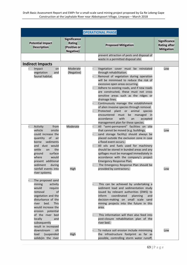
Draft Basic Assessment Report and EMPr for a small-scale sand mining project proposed by Ga Re Lekeng Gape Construction at the Lephalale River near Abbotspoort Village, Limpopo – March 2018
69 | P a g e
OPERATIONAL PHASE
Potential Impact Description
Significance Rating
(Positive or Negative)
Proposed Mitigation Significance Rating after Mitigation
prevent attraction of pests and disposal of waste in a permitted disposal site.
Indirect Impacts - Impact on
vegetation and faunal habitat.
Moderate (Negative)
- Vegetation cover must be reinstated through rehabilitation.
- Removal of vegetation during operation will be minimised to reduce the risk of excessive open areas occurring.
- Adhere to existing roads, and if new roads are constructed, these must not cross sensitive areas such as the ridges or drainage lines.
- Continuously manage the establishment of alien invasive species through removal.
- Protected plant or animal species encountered must be managed in accordance with an accepted management plan for these species.
Low
- Activity from vehicle onsite could increase the quantity of air borne sediments and dust would settle on the ground surface where would present additional sediment during rainfall events into river systems;
- The proposed sand mining activity would require removal of vegetation and the disturbance of the river bed. This would increase the erosion potential of the river bed locally and subsequently result in increased downstream silt load (suspended solids)in the river
Moderate
High
High
- All “semi-permanent” facilities on site that cannot be moved (e.g. buildings,
- sand storage facility) should always be placed outside the exclusion zone in case a flood event occurs;-
- All oils and fuels used for machinery should be stored in bunded areas and any spillages must be managed immediately in accordance with the company’s project Emergency Response Plan.
- The Emergency Response Plan should be provided by contractors;-
- This can be achieved by undertaking a sediment load and sedimentation study issued by relevant authorities (DWS) to inform coordinated planning and decision-making on small scale sand mining projects into the future in this area.
- This information will then also feed into post-closure rehabilitation plan of the river bed.-
- To reduce soil erosion include minimising the infrastructure footprint as far as possible, controlling storm water runoff,
Low
Low
Low
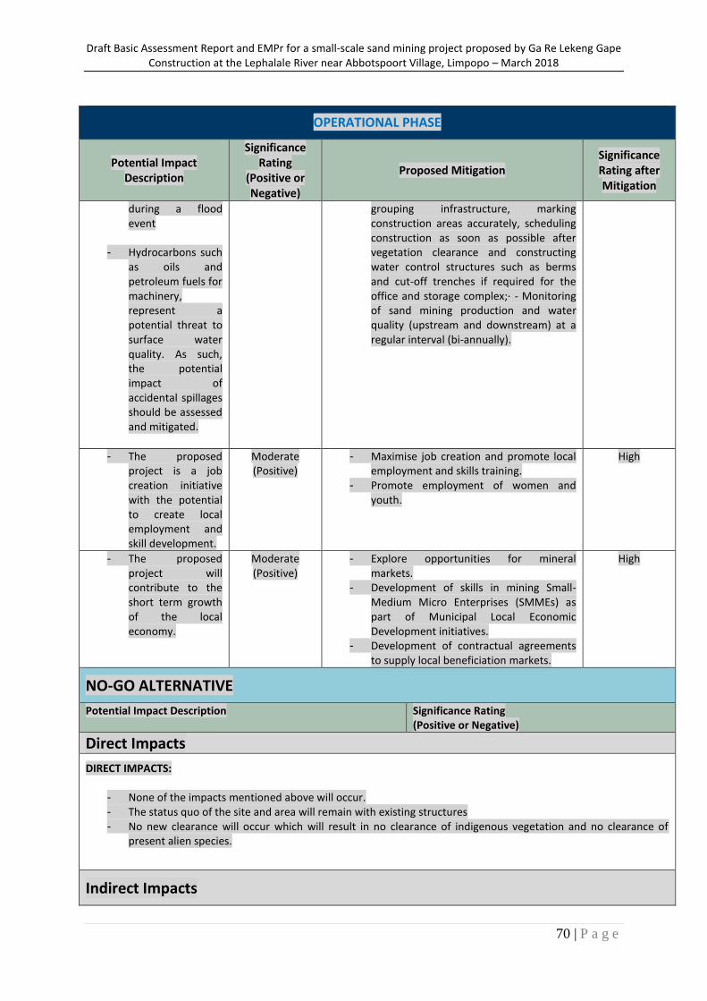
Draft Basic Assessment Report and EMPr for a small-scale sand mining project proposed by Ga Re Lekeng Gape Construction at the Lephalale River near Abbotspoort Village, Limpopo – March 2018
70 | P a g e
OPERATIONAL PHASE
Potential Impact Description
Significance Rating
(Positive or Negative)
Proposed Mitigation Significance Rating after Mitigation
during a flood event
- Hydrocarbons such as oils and petroleum fuels for machinery, represent a potential threat to surface water quality. As such, the potential impact of accidental spillages should be assessed and mitigated.
grouping infrastructure, marking construction areas accurately, scheduling construction as soon as possible after vegetation clearance and constructing water control structures such as berms and cut-off trenches if required for the office and storage complex;· - Monitoring of sand mining production and water quality (upstream and downstream) at a regular interval (bi-annually).
- The proposed project is a job creation initiative with the potential to create local employment and skill development.
Moderate (Positive)
- Maximise job creation and promote local employment and skills training.
- Promote employment of women and youth.
High
- The proposed project will contribute to the short term growth of the local economy.
Moderate (Positive)
- Explore opportunities for mineral markets.
- Development of skills in mining Small-Medium Micro Enterprises (SMMEs) as part of Municipal Local Economic Development initiatives.
- Development of contractual agreements to supply local beneficiation markets.
High
NO-GO ALTERNATIVE
Potential Impact Description Significance Rating (Positive or Negative)
Direct Impacts
DIRECT IMPACTS:
- None of the impacts mentioned above will occur. - The status quo of the site and area will remain with existing structures - No new clearance will occur which will result in no clearance of indigenous vegetation and no clearance of
present alien species.
Indirect Impacts
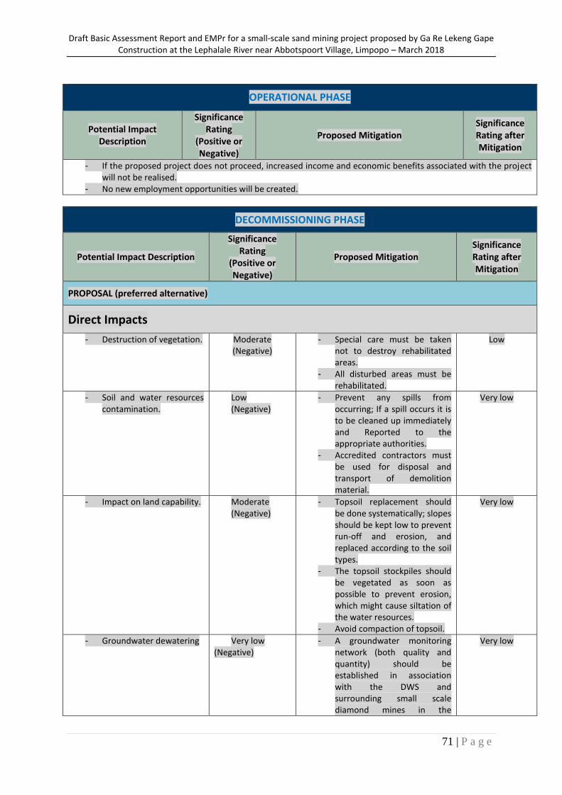
Draft Basic Assessment Report and EMPr for a small-scale sand mining project proposed by Ga Re Lekeng Gape Construction at the Lephalale River near Abbotspoort Village, Limpopo – March 2018
71 | P a g e
OPERATIONAL PHASE
Potential Impact Description
Significance Rating
(Positive or Negative)
Proposed Mitigation Significance Rating after Mitigation
- If the proposed project does not proceed, increased income and economic benefits associated with the project will not be realised.
- No new employment opportunities will be created.
DECOMMISSIONING PHASE
Potential Impact Description
Significance Rating
(Positive or Negative)
Proposed Mitigation Significance Rating after Mitigation
PROPOSAL (preferred alternative)
Direct Impacts
- Destruction of vegetation. Moderate (Negative)
- Special care must be taken not to destroy rehabilitated areas.
- All disturbed areas must be rehabilitated.
Low
- Soil and water resources contamination.
Low (Negative)
- Prevent any spills from occurring; If a spill occurs it is to be cleaned up immediately and Reported to the appropriate authorities.
- Accredited contractors must be used for disposal and transport of demolition material.
Very low
- Impact on land capability. Moderate (Negative)
- Topsoil replacement should be done systematically; slopes should be kept low to prevent run-off and erosion, and replaced according to the soil types.
- The topsoil stockpiles should be vegetated as soon as possible to prevent erosion, which might cause siltation of the water resources.
- Avoid compaction of topsoil.
Very low
- Groundwater dewatering Very low (Negative)
- A groundwater monitoring network (both quality and quantity) should be established in association with the DWS and surrounding small scale diamond mines in the
Very low
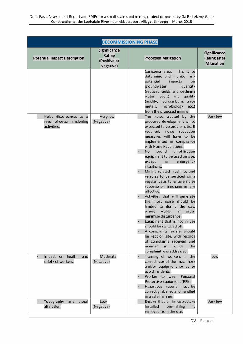
Draft Basic Assessment Report and EMPr for a small-scale sand mining project proposed by Ga Re Lekeng Gape Construction at the Lephalale River near Abbotspoort Village, Limpopo – March 2018
72 | P a g e
DECOMMISSIONING PHASE
Potential Impact Description
Significance Rating
(Positive or Negative)
Proposed Mitigation Significance Rating after Mitigation
Carlisonia area. This is to determine and monitor any potential impacts on groundwater quantity (reduced yields and declining water levels) and quality (acidity, hydrocarbons, trace metals, microbiology etc.) from the proposed mining.
- Noise disturbances as a result of decommissioning activities.
Very low (Negative)
- The noise created by the proposed development is not expected to be problematic. If required, noise reduction measures will have to be implemented in compliance with Noise Regulations.
- No sound amplification equipment to be used on site, except in emergency situations.
- Mining related machines and vehicles to be serviced on a regular basis to ensure noise suppression mechanisms are effective.
- Activities that will generate the most noise should be limited to during the day, where viable, in order minimise disturbance.
- Equipment that is not in use should be switched off.
- A complaints register should be kept on site, with records of complaints received and manner in which the complaint was addressed.
Very low
- Impact on health, and safety of workers.
Moderate (Negative)
- Training of workers in the correct use of the machinery and/or equipment so as to avoid incidents.
- Worker to wear Personal Protective Equipment (PPE).
- Hazardous material must be correctly labelled and handled in a safe manner.
Low
- Topography and visual alteration.
Low (Negative)
- Ensure that all infrastructure installed pre-mining is removed from the site.
Very low
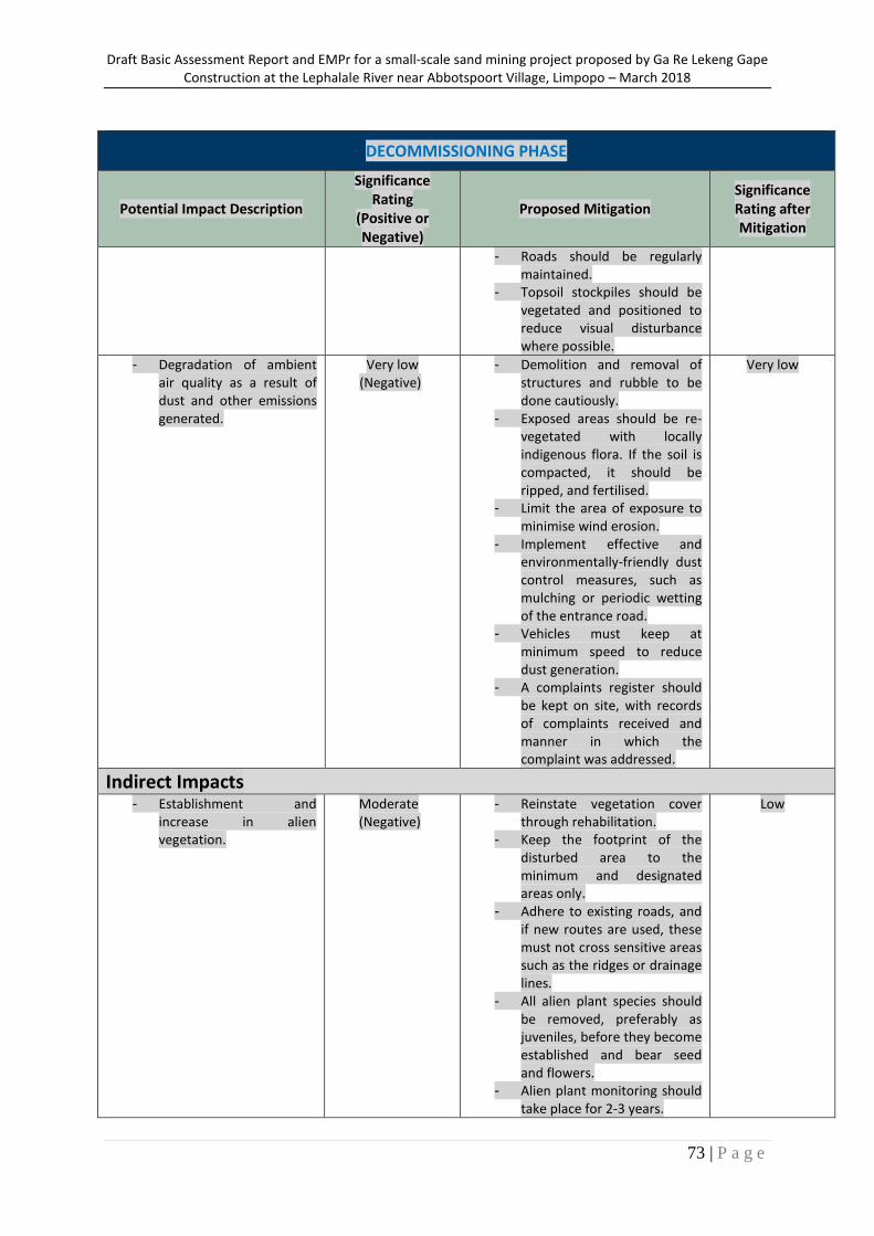
Draft Basic Assessment Report and EMPr for a small-scale sand mining project proposed by Ga Re Lekeng Gape Construction at the Lephalale River near Abbotspoort Village, Limpopo – March 2018
73 | P a g e
DECOMMISSIONING PHASE
Potential Impact Description
Significance Rating
(Positive or Negative)
Proposed Mitigation Significance Rating after Mitigation
- Roads should be regularly maintained.
- Topsoil stockpiles should be vegetated and positioned to reduce visual disturbance where possible.
- Degradation of ambient air quality as a result of dust and other emissions generated.
Very low (Negative)
- Demolition and removal of structures and rubble to be done cautiously.
- Exposed areas should be re-vegetated with locally indigenous flora. If the soil is compacted, it should be ripped, and fertilised.
- Limit the area of exposure to minimise wind erosion.
- Implement effective and environmentally-friendly dust control measures, such as mulching or periodic wetting of the entrance road.
- Vehicles must keep at minimum speed to reduce dust generation.
- A complaints register should be kept on site, with records of complaints received and manner in which the complaint was addressed.
Very low
Indirect Impacts - Establishment and
increase in alien vegetation.
Moderate (Negative)
- Reinstate vegetation cover through rehabilitation.
- Keep the footprint of the disturbed area to the minimum and designated areas only.
- Adhere to existing roads, and if new routes are used, these must not cross sensitive areas such as the ridges or drainage lines.
- All alien plant species should be removed, preferably as juveniles, before they become established and bear seed and flowers.
- Alien plant monitoring should take place for 2-3 years.
Low
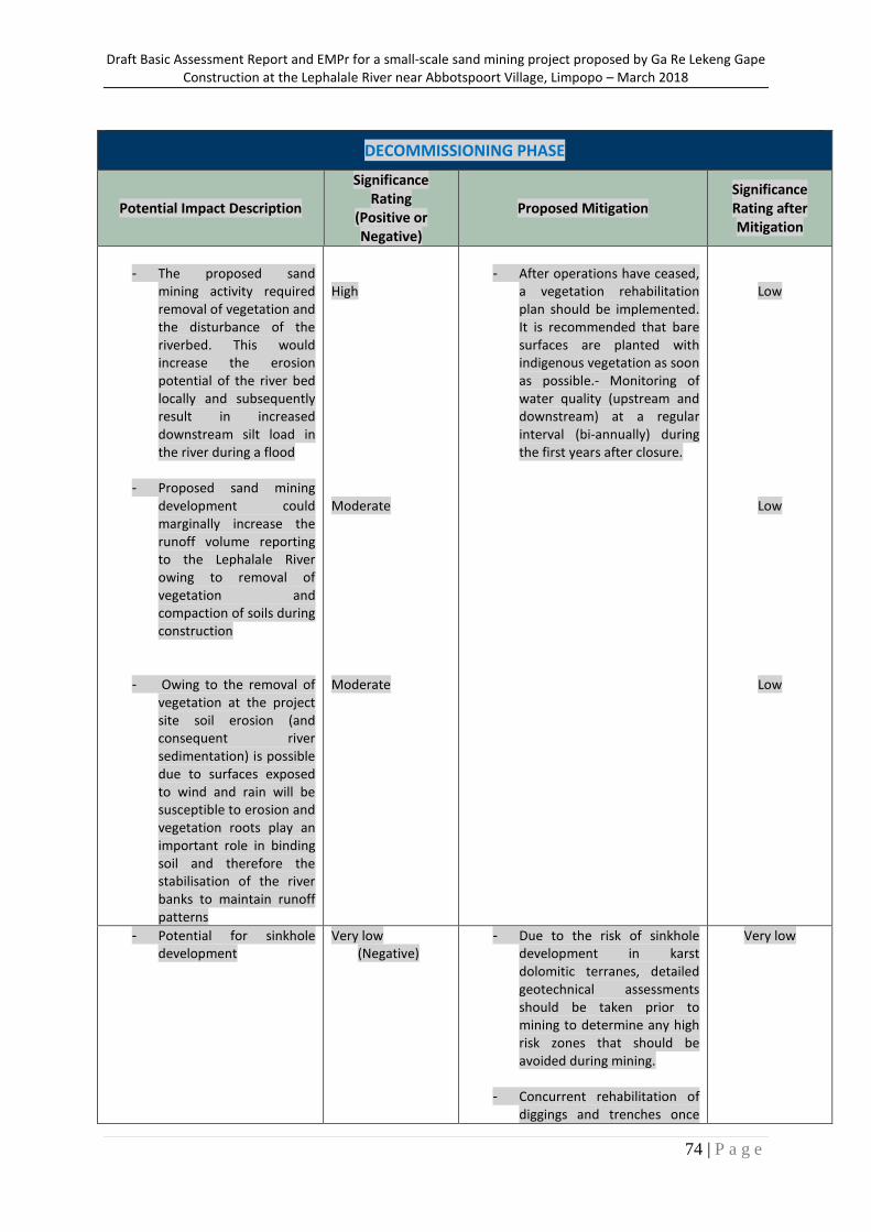
Draft Basic Assessment Report and EMPr for a small-scale sand mining project proposed by Ga Re Lekeng Gape Construction at the Lephalale River near Abbotspoort Village, Limpopo – March 2018
74 | P a g e
DECOMMISSIONING PHASE
Potential Impact Description
Significance Rating
(Positive or Negative)
Proposed Mitigation Significance Rating after Mitigation
- The proposed sand
mining activity required removal of vegetation and the disturbance of the riverbed. This would increase the erosion potential of the river bed locally and subsequently result in increased downstream silt load in the river during a flood
- Proposed sand mining development could marginally increase the runoff volume reporting to the Lephalale River owing to removal of vegetation and compaction of soils during construction
- Owing to the removal of vegetation at the project site soil erosion (and consequent river sedimentation) is possible due to surfaces exposed to wind and rain will be susceptible to erosion and vegetation roots play an important role in binding soil and therefore the stabilisation of the river banks to maintain runoff patterns
High
Moderate
Moderate
- After operations have ceased,
a vegetation rehabilitation plan should be implemented. It is recommended that bare surfaces are planted with indigenous vegetation as soon as possible.- Monitoring of water quality (upstream and downstream) at a regular interval (bi-annually) during the first years after closure.
Low
Low
Low
- Potential for sinkhole development
Very low (Negative)
- Due to the risk of sinkhole development in karst dolomitic terranes, detailed geotechnical assessments should be taken prior to mining to determine any high risk zones that should be avoided during mining.
- Concurrent rehabilitation of diggings and trenches once
Very low
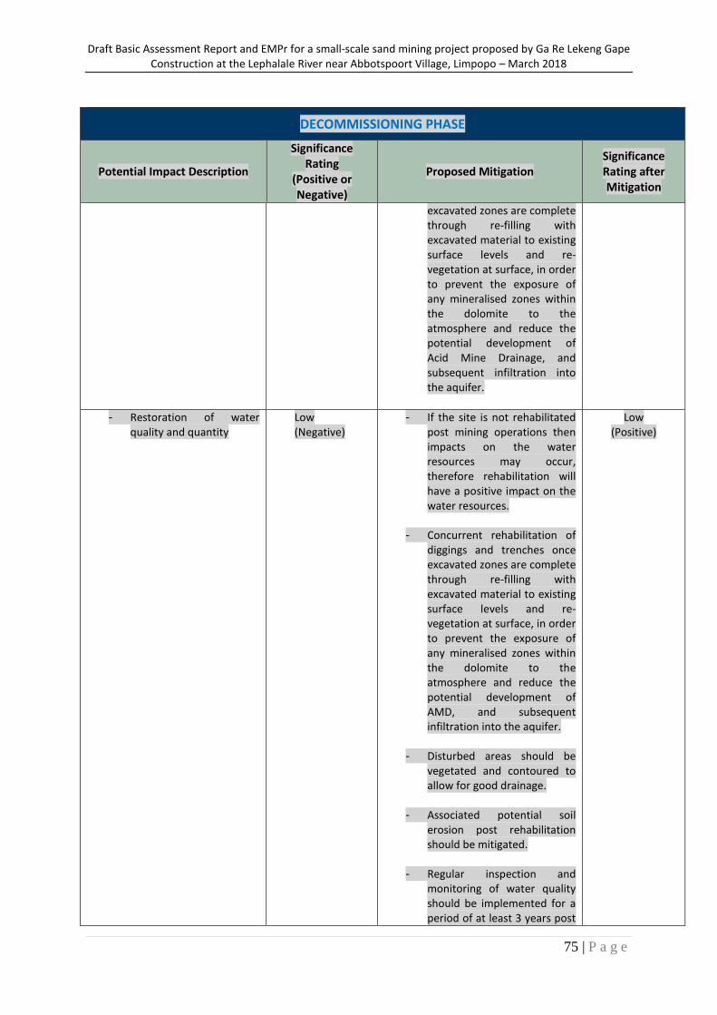
Draft Basic Assessment Report and EMPr for a small-scale sand mining project proposed by Ga Re Lekeng Gape Construction at the Lephalale River near Abbotspoort Village, Limpopo – March 2018
75 | P a g e
DECOMMISSIONING PHASE
Potential Impact Description
Significance Rating
(Positive or Negative)
Proposed Mitigation Significance Rating after Mitigation
excavated zones are complete through re-filling with excavated material to existing surface levels and re-vegetation at surface, in order to prevent the exposure of any mineralised zones within the dolomite to the atmosphere and reduce the potential development of Acid Mine Drainage, and subsequent infiltration into the aquifer.
- Restoration of water quality and quantity
Low (Negative)
- If the site is not rehabilitated post mining operations then impacts on the water resources may occur, therefore rehabilitation will have a positive impact on the water resources.
- Concurrent rehabilitation of diggings and trenches once excavated zones are complete through re-filling with excavated material to existing surface levels and re-vegetation at surface, in order to prevent the exposure of any mineralised zones within the dolomite to the atmosphere and reduce the potential development of AMD, and subsequent infiltration into the aquifer.
- Disturbed areas should be vegetated and contoured to allow for good drainage.
- Associated potential soil erosion post rehabilitation should be mitigated.
- Regular inspection and monitoring of water quality should be implemented for a period of at least 3 years post
Low (Positive)
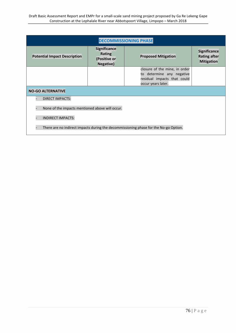
Draft Basic Assessment Report and EMPr for a small-scale sand mining project proposed by Ga Re Lekeng Gape Construction at the Lephalale River near Abbotspoort Village, Limpopo – March 2018
76 | P a g e
DECOMMISSIONING PHASE
Potential Impact Description
Significance Rating
(Positive or Negative)
Proposed Mitigation Significance Rating after Mitigation
closure of the mine, in order to determine any negative residual impacts that could occur years later.
NO-GO ALTERNATIVE
- DIRECT IMPACTS:
- None of the impacts mentioned above will occur.
- INDIRECT IMPACTS:
- There are no indirect impacts during the decommissioning phase for the No-go Option.

Draft Basic Assessment Report and EMPr for a small-scale sand mining project proposed by Ga Re Lekeng Gape Construction at the Lephalale River near Abbotspoort Village, Limpopo – March 2018
77 | P a g e
Figure 17: The DWS (2016) risk assessment matrix for the proposed sand mining and operation. Risk is determined after considering all listed control / mitigation measures
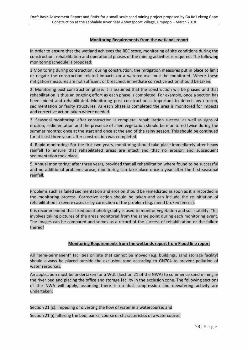
Draft Basic Assessment Report and EMPr for a small-scale sand mining project proposed by Ga Re Lekeng Gape Construction at the Lephalale River near Abbotspoort Village, Limpopo – March 2018
78 | P a g e
Monitoring Requirements from the wetlands report
In order to ensure that the wetland achieves the REC score, monitoring of site conditions during the construction, rehabilitation and operational phases of the mining activities is required. The following monitoring schedule is proposed:
1.Monitoring during construction: during construction, the mitigation measures put in place to limit or negate the construction related impacts on a watercourse must be monitored. Where these mitigation measures are not sufficient or breached, immediate corrective action should be taken.
2. Monitoring post construction phase: it is assumed that the construction will be phased and that rehabilitation is thus an ongoing effort as each phase is completed. For example, once a section has been mined and rehabilitated. Monitoring post construction is important to detect any erosion, sedimentation or faulty structures. As each phase is completed the area is monitored for impacts and corrective action taken where needed.
3. Seasonal monitoring: after construction is complete, rehabilitation success, as well as signs of erosion, sedimentation and the presence of alien vegetation should be monitored twice during the summer months: once at the start and once at the end of the rainy season. This should be continued for at least three years after construction was completed.
4. Rapid monitoring: For the first two years, monitoring should take place immediately after heavy rainfall to ensure that rehabilitated areas are intact and that no erosion and subsequent sedimentation took place.
5. Annual monitoring: after three years, provided that all rehabilitation where found to be successful and no additional problems arose, monitoring can take place once a year after the first seasonal rainfall.
Problems such as failed sedimentation and erosion should be remediated as soon as it is recorded in the monitoring process. Corrective action should be taken and can include the re-initiation of rehabilitation in severe cases or by correction of the problem (e.g. mend broken fences).
It is recommended that fixed point photography is used to monitor vegetation and soil stability. This involves taking pictures of the areas monitored from the same point during each monitoring event. The images can be compared and serves as a record of the success of rehabilitation or the failure thereof
Monitoring Requirements from the wetlands report from Flood line report
All “semi-permanent” facilities on site that cannot be moved (e.g. buildings, sand storage facility) should always be placed outside the exclusion zone according to GN704 to prevent pollution of water resources.
An application must be undertaken for a WUL (Section 21 of the NWA) to commence sand mining in the river bed and placing the office and storage facility in the exclusion zone. The following sections of the NWA will apply, assuming there is no dust suppression and dewatering activity are undertaken:
Section 21 (c): impeding or diverting the flow of water in a watercourse; and
Section 21 (i): altering the bed, banks, course or characteristics of a watercourse;
Draft Basic Assessment Report and EMPr for a small-scale sand mining project proposed by Ga Re Lekeng Gape Construction at the Lephalale River near Abbotspoort Village, Limpopo – March 2018
79 | P a g e
If dust suppression is applied to reduce the quantity of airborne sediments and/or dewatering (pumping) from the river to make mining possible, the following sections of the NWA will also apply for this application:
Section 21 (a): taking water from a water resource; and
Section 21 (j): removing, discharging or disposing of water found underground if it is necessary for the efficient continuation of an activity or for the safety of people.
All oils and fuels used for machinery should be stored in bunded areas and any spillages must be managed immediately in accordance with the company’s project Emergency Response Plan. The Emergency Response Plan should be provided by contractors.
To reduce soil erosion the following measures are proposed:
Include minimising the infrastructure footprint as far as possible;
Controlling storm water runoff, grouping infrastructure, scheduling construction as soon as possible after vegetation clearance; and
Constructing water control structures such as berms and cut-off trenches if required for the office and sand storage complex.
To provide more information on possible production rates and a more accurate prediction of the available river sand (bed load) a sediment load and sedimentation study can be undertaken by relevant authorities (DWS) to inform coordinated planning and decision-making on small scale sand mining projects into the future in this area. This information will then also feed into post-closure rehabilitation plan of the river bed.
(ix) Motivation where no alternatives sites were considered. No property alternatives have been considered as the envisaged mining operations will occur in an area of existing mining operations, and also in close proximity to the access road and community in need of such a development.
(x) Statement motivating the alternative development location within the overall site (Provide a
statement motivating the final site layout that is proposed)
The site layout was determined by considering both spatial and practical mining operation aspects. The proposed layout is more of a security measure, allowing for more effective management of mined ores. The site layout within the overall site is also supported by the specialist studies undertaken, in accordance with the recommended management measures.
i) Full description of the process undertaken to identify, assess and rank the impacts and risks the activity will impose on the preferred site (In respect of the final site layout plan) through the life of the activity. (Including (i) a description of all environmental issues and risks that erer identified during the
environmental impact assessment process and (ii) an assessment of the significance of each issue and risk and an indication of the extent to which the issue and risk could be avoided or addressed by the adoption of mitigation measures.) The identified risks and impacts for this study, specifically the proposed site layout, were informed by the environmental studies undertaken for this site, the socio-economic need of the surrounding area, as well as the evidence of historical diamond exploration on site and the landscape.
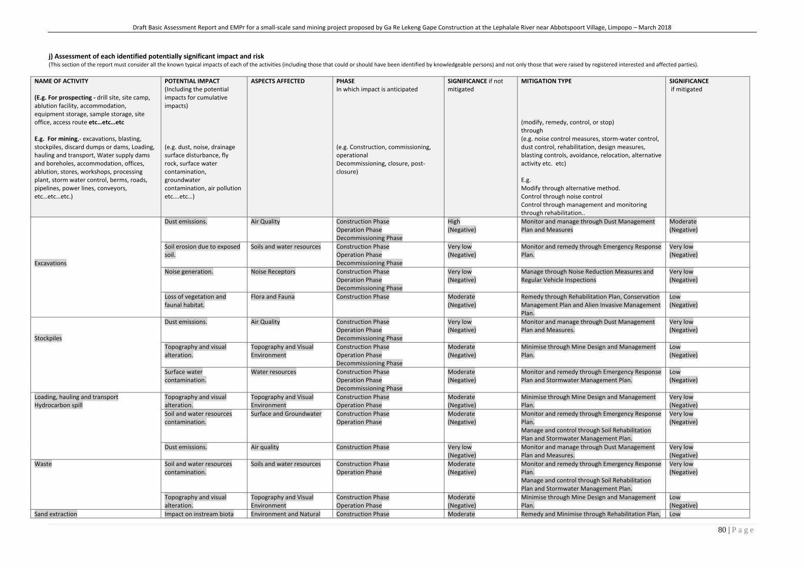
Draft Basic Assessment Report and EMPr for a small-scale sand mining project proposed by Ga Re Lekeng Gape Construction at the Lephalale River near Abbotspoort Village, Limpopo – March 2018
80 | P a g e
j) Assessment of each identified potentially significant impact and risk (This section of the report must consider all the known typical impacts of each of the activities (including those that could or should have been identified by knowledgeable persons) and not only those that were raised by registered interested and affected parties).
NAME OF ACTIVITY (E.g. For prospecting - drill site, site camp, ablution facility, accommodation, equipment storage, sample storage, site office, access route etc…etc…etc E.g. For mining,- excavations, blasting, stockpiles, discard dumps or dams, Loading, hauling and transport, Water supply dams and boreholes, accommodation, offices, ablution, stores, workshops, processing plant, storm water control, berms, roads, pipelines, power lines, conveyors, etc…etc…etc.)
POTENTIAL IMPACT (Including the potential impacts for cumulative impacts) (e.g. dust, noise, drainage surface disturbance, fly rock, surface water contamination, groundwater contamination, air pollution etc….etc…)
ASPECTS AFFECTED PHASE In which impact is anticipated (e.g. Construction, commissioning, operational Decommissioning, closure, post-closure)
SIGNIFICANCE if not mitigated
MITIGATION TYPE (modify, remedy, control, or stop) through (e.g. noise control measures, storm-water control, dust control, rehabilitation, design measures, blasting controls, avoidance, relocation, alternative activity etc. etc) E.g. Modify through alternative method. Control through noise control Control through management and monitoring through rehabilitation..
SIGNIFICANCE if mitigated
Excavations
Dust emissions. Air Quality Construction Phase Operation Phase Decommissioning Phase
High (Negative)
Monitor and manage through Dust Management Plan and Measures
Moderate (Negative)
Soil erosion due to exposed soil.
Soils and water resources Construction Phase Operation Phase Decommissioning Phase
Very low (Negative)
Monitor and remedy through Emergency Response Plan.
Very low (Negative)
Noise generation. Noise Receptors Construction Phase Operation Phase Decommissioning Phase
Very low (Negative)
Manage through Noise Reduction Measures and Regular Vehicle Inspections
Very low (Negative)
Loss of vegetation and faunal habitat.
Flora and Fauna Construction Phase Moderate (Negative)
Remedy through Rehabilitation Plan, Conservation Management Plan and Alien Invasive Management Plan.
Low (Negative)
Stockpiles
Dust emissions. Air Quality Construction Phase Operation Phase Decommissioning Phase
Very low (Negative)
Monitor and manage through Dust Management Plan and Measures.
Very low (Negative)
Topography and visual alteration.
Topography and Visual Environment
Construction Phase Operation Phase Decommissioning Phase
Moderate (Negative)
Minimise through Mine Design and Management Plan.
Low (Negative)
Surface water contamination.
Water resources Construction Phase Operation Phase Decommissioning Phase
Moderate (Negative)
Monitor and remedy through Emergency Response Plan and Stormwater Management Plan.
Low (Negative)
Loading, hauling and transport Hydrocarbon spill
Topography and visual alteration.
Topography and Visual Environment
Construction Phase Operation Phase
Moderate (Negative)
Minimise through Mine Design and Management Plan.
Very low (Negative)
Soil and water resources contamination.
Surface and Groundwater Construction Phase Operation Phase
Moderate (Negative)
Monitor and remedy through Emergency Response Plan. Manage and control through Soil Rehabilitation Plan and Stormwater Management Plan.
Very low (Negative)
Dust emissions. Air quality Construction Phase Very low (Negative)
Monitor and manage through Dust Management Plan and Measures.
Very low (Negative)
Waste Soil and water resources contamination.
Soils and water resources Construction Phase Operation Phase
Moderate (Negative)
Monitor and remedy through Emergency Response Plan. Manage and control through Soil Rehabilitation Plan and Stormwater Management Plan.
Very low (Negative)
Topography and visual alteration.
Topography and Visual Environment
Construction Phase Operation Phase
Moderate (Negative)
Minimise through Mine Design and Management Plan.
Low (Negative)
Sand extraction Impact on instream biota Environment and Natural Construction Phase Moderate Remedy and Minimise through Rehabilitation Plan, Low
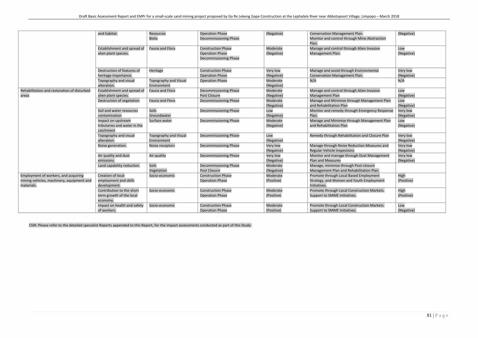
Draft Basic Assessment Report and EMPr for a small-scale sand mining project proposed by Ga Re Lekeng Gape Construction at the Lephalale River near Abbotspoort Village, Limpopo – March 2018
81 | P a g e
and habitat. Resources Biota
Operation Phase Decommissioning Phase
(Negative) Conservation Management Plan. Monitor and control through Mine Abstraction Plan.
(Negative)
Establishment and spread of alien plant species.
Fauna and Flora Construction Phase Operation Phase Decommissioning Phase
Moderate (Negative)
Manage and control through Alien Invasive Management Plan.
Low (Negative)
Destruction of features of heritage importance.
Heritage Construction Phase Operation Phase
Very low (Negative)
Manage and avoid through Environmental Conservation Management Plan.
Very low (Negative)
Topography and visual alteration.
Topography and Visual Environment
Operation Phase Moderate (Negative)
N/A N/A
Rehabilitation and restoration of disturbed areas
Establishment and spread of alien plant species.
Fauna and Flora Decommissioning Phase Post Closure
Moderate (Negative)
Manage and control through Alien Invasive Management Plan
Low (Negative)
Destruction of vegetation Fauna and Flora Decommissioning Phase Moderate (Negative)
Manage and Minimise through Management Plan and Rehabilitation Plan
Low (Negative)
Soil and water resources contamination
Soils Groundwater
Decommissioning Phase Low (Negative)
Monitor and remedy through Emergency Response Plan.
Very low (Negative)
Impact on upstream tributaries and water in the catchment
Surface water Decommissioning Phase Moderate (Negative)
Manage and Minimise through Management Plan and Rehabilitation Plan
Low (Negative)
Topography and visual alteration.
Topography and Visual Environment
Decommissioning Phase Low (Negative)
Remedy through Rehabilitation and Closure Plan Very low (Negative)
Noise generation. Noise receptors Decommissioning Phase Very low (Negative)
Manage through Noise Reduction Measures and Regular Vehicle Inspections
Very low (Negative)
Air quality and dust emissions.
Air quality Decommissioning Phase Very low (Negative)
Monitor and manage through Dust Management Plan and Measures
Very low (Negative)
Land capability reduction. Soils Vegetation
Decommissioning Phase Post Closure
Moderate (Negative)
Manage, minimise through Post-closure Management Plan and Rehabilitation Plan.
Employment of workers, and acquiring mining vehicles, machinery, equipment and materials.
Creation of local employment and skills development.
Socio-economic Construction Phase Operation Phase
Moderate (Positive)
Promote through Local Based Employment Strategy, and Women and Youth Employment Initiatives.
High (Positive)
Contribution to the short term growth of the local economy.
Socio-economic Construction Phase Operation Phase
Moderate (Positive)
Promote through Local Construction Markets. Support to SMME Initiatives.
High (Positive)
Impact on health and safety of workers.
Socio-economic Construction Phase Operation Phase
Moderate (Positive)
Promote through Local Construction Markets. Support to SMME Initiatives.
Low (Negative)
CSIR: Please refer to the detailed specialist Reports appended to this Report, for the impact assessments conducted as part of this Study:
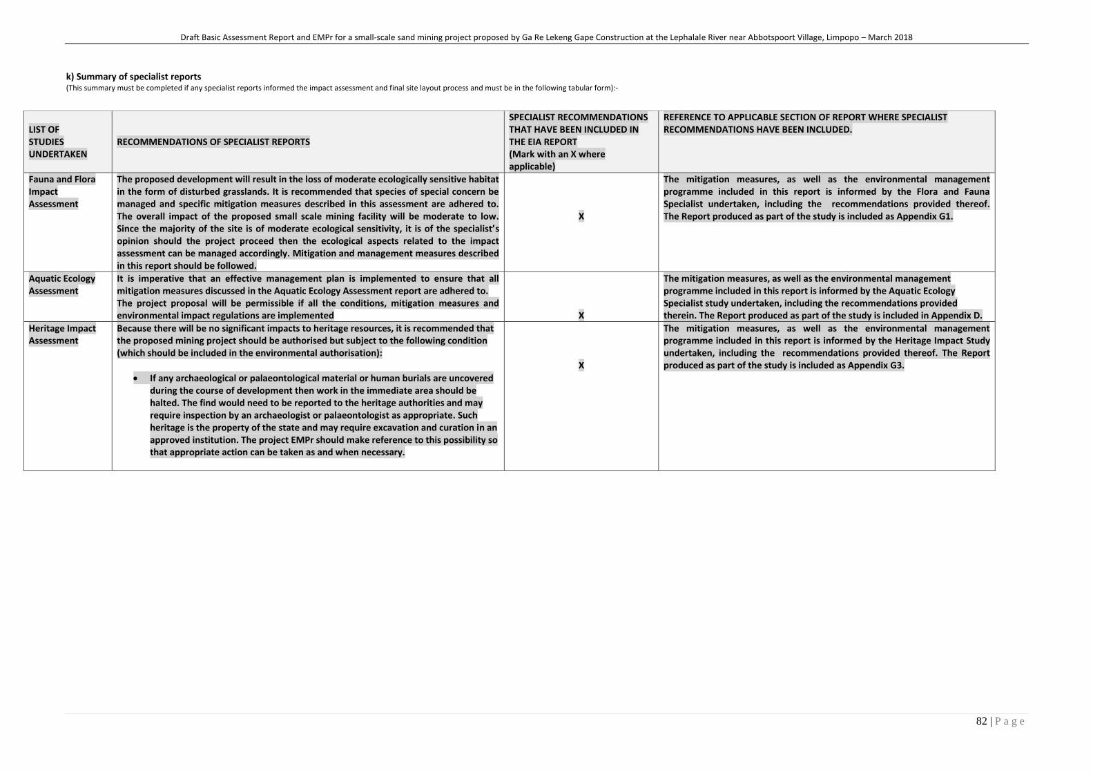
Draft Basic Assessment Report and EMPr for a small-scale sand mining project proposed by Ga Re Lekeng Gape Construction at the Lephalale River near Abbotspoort Village, Limpopo – March 2018
82 | P a g e
k) Summary of specialist reports (This summary must be completed if any specialist reports informed the impact assessment and final site layout process and must be in the following tabular form):-
LIST OF STUDIES UNDERTAKEN
RECOMMENDATIONS OF SPECIALIST REPORTS
SPECIALIST RECOMMENDATIONS THAT HAVE BEEN INCLUDED IN THE EIA REPORT (Mark with an X where applicable)
REFERENCE TO APPLICABLE SECTION OF REPORT WHERE SPECIALIST RECOMMENDATIONS HAVE BEEN INCLUDED.
Fauna and Flora Impact Assessment
The proposed development will result in the loss of moderate ecologically sensitive habitat in the form of disturbed grasslands. It is recommended that species of special concern be managed and specific mitigation measures described in this assessment are adhered to. The overall impact of the proposed small scale mining facility will be moderate to low. Since the majority of the site is of moderate ecological sensitivity, it is of the specialist’s opinion should the project proceed then the ecological aspects related to the impact assessment can be managed accordingly. Mitigation and management measures described in this report should be followed.
X
The mitigation measures, as well as the environmental management programme included in this report is informed by the Flora and Fauna Specialist undertaken, including the recommendations provided thereof. The Report produced as part of the study is included as Appendix G1.
Aquatic Ecology Assessment
It is imperative that an effective management plan is implemented to ensure that all mitigation measures discussed in the Aquatic Ecology Assessment report are adhered to. The project proposal will be permissible if all the conditions, mitigation measures and environmental impact regulations are implemented
X
The mitigation measures, as well as the environmental management programme included in this report is informed by the Aquatic Ecology Specialist study undertaken, including the recommendations provided therein. The Report produced as part of the study is included in Appendix D.
Heritage Impact Assessment
Because there will be no significant impacts to heritage resources, it is recommended that the proposed mining project should be authorised but subject to the following condition (which should be included in the environmental authorisation):
If any archaeological or palaeontological material or human burials are uncovered during the course of development then work in the immediate area should be halted. The find would need to be reported to the heritage authorities and may require inspection by an archaeologist or palaeontologist as appropriate. Such heritage is the property of the state and may require excavation and curation in an approved institution. The project EMPr should make reference to this possibility so that appropriate action can be taken as and when necessary.
X
The mitigation measures, as well as the environmental management programme included in this report is informed by the Heritage Impact Study undertaken, including the recommendations provided thereof. The Report produced as part of the study is included as Appendix G3.
l) Environmental impact statement. (i) Summary of the key findings of the environmental impact assessment
The main potential environmental impacts associated with the proposed project include: The mine procedure will only entail the mechanical excavation of the sand by means of an excavator, after which it will be loaded onto trucks and transported from site. No blasting, crushing or screening will be necessary on site. The existing road to the mine area can be used to gain access to the site. No new roads are needed. Impacts on wetlands According to (Limosella, 2018) the study site is located directly within a section of the perennial riparian river known as the Lephalale River. Several drainage areas drain into this river from the surrounding residential area. The proposed storage infrastructure and offices are located on an open area that does not encroach onto any nearby watercourse or buffer. It is important that existing roads be used to travel from the storage and office areas to the mining area and that no thoroughfare be used that encroaches into the drainage areas. It is furthermore important to note that a graveyard was noted near the study site and subsequently the watercourse at the approximate coordinates of 23°27'41.20"S and 28° 5'47.33"E. The expected risk score falls within the Medium risk category. The earthworks and construction phase of the falls in the High category since the loss of wetlands will have a negative effect on downstream watercourses. Activities which score in the Medium or High category refers to risk and impact on watercourses that are notable and require mitigation measures on a higher level, which cost more and require specialist input. Activities which fall within this category should be authorised through a Water Use Licence. Diatom based water quality Diatom analysis was conducted by Biotox for LH1 and LH2. Results LH1 According to Iggdrasil (2018) the diatom based water quality of site LH1 was Moderate with a SPI score of 10.5 (C/D Ecological Category). Organic pollution and nutrient levels were low while salinity levels were elevated. Moderate pollution levels prevailed and Pollution Tolerant Valves (PTVs) made up 1.3% of the total count. The diatom community was outrightly dominated by Fragilaria biceps, a cosmopolitan species found in the benthos of rivers and lakes and easily suspended in the plankton due to its relatively large surface area. It is often found in mesotrophic to eutrophic waters (Taylor et al., 2007b). The rest of the diatom community consisted of species with a preference for moderate water quality with a preference for higher organic loads and included Gomphonema parvulum and G. lagenula. Water temperatures were slightly elevated as reflected by the presence of Rhopalodia operculata (Taylor et al., 2007b). Results LH2 Diatom valve densities were very low at LH2 and a viable count could not be attained. Therefore, no assessment could be undertaken for this site. Flood Impact Assessment Potential impacts on the natural flood regime, due to sand mining, that were identified are relating to localised water quality deterioration (suspended solids) in Lephalale River and/or localised changes in catchment characteristics, runoff and peak flows of the Lephalale River. Significance after applying mitigation measures can be reduced to ‘Low’ impacts.
Draft Basic Assessment Report and EMPr for a small-scale sand mining project proposed by Ga Re Lekeng Gape Construction at the Lephalale River near Abbotspoort Village, Limpopo – March 2018
4 | P a g e
An application must be undertaken for a WUL (Section 21 of the NWA) to commence sand mining in the river bed and placing the office and storage facility in the exclusion zone. The following sections of the NWA will apply, assuming there is no dust suppression and dewatering activity are undertaken: Section 21 (c): impeding or diverting the flow of water in a watercourse; and Section 21 altering the bed, banks, course or characteristics of a watercourse. Noise generation Noise generation as a result of machinery and vehicles operated on site is likely to impact on the surrounding receptors in the nearby village. All reasonable measures need to be implemented to minimise noise levels to the nearby residents throughout the life cycle of the proposed mine. Due to the small-scale nature and size of the proposed mining activity, and therefore basic machinery and equipment, this impact is expected to be of very low significance. Air quality and dust emission Vehicles transporting mining material to and from the site, as well site preparation activities, excavation, processing and decommissioning activities will result in the generation of fugitive dust. Air quality emissions will also include the evaporation of fuels stored on site. Air quality emissions will be of low to very low significance. The recommended mitigation measures in this report should reduce the potential for these impacts on the ambient air quality. Topography and Visual Alteration Storage of material and equipment on site, vehicular activities, stockpiling of topsoil and excavation to extract minerals will alter the visual environment in the area. The impacts will be of moderate to low significance at the different phases and activities of the project. All reasonable measures need to be implemented to minimise and limit these impacts where possible, incorporating the recommended mitigation measures of the specialists included in this report. Rehabilitation of the disturbed areas to return the site to its similar visual state prior mining will have a neutral visual impact on the area. Soil erosion Mining activities on site will result in exposed soil, which could result in soil erosion. Erosion can lead to destruction of natural habitats and sedimentation of nearby watercourses. This impact will have a low probability of occurrence with implemented mitigation measures and ultimately low impact. Soil and water resources contamination The potential impact of contamination will arise throughout the life cycle of the proposed mine as a result of contaminants such as fuels, waste material on site, seepage of waste water, spills etc. These possible contaminants need to be managed and prevented through an effective Emergency Response Plan and Stormwater Management Plan, as well as the development of an appropriate Groundwater Monitoring Plan in order to reduce the significance of these impacts. Loss of vegetation and faunal habitat Vegetation loss is unavoidable during the activities of the proposed mining project. The majority of the site has been transformed and is degraded; however these degraded areas contain some indigenous vegetation thus necessitating high consideration of the vegetation on site. The developmental footprint of the proposed small-scale mining will impact on the natural vegetation and faunal habitats. Recommended mitigation measures described in the assessment must be adhered to in order to reduce the impacts from moderate to low and special care must be taken to manage any species of special concern.
Draft Basic Assessment Report and EMPr for a small-scale sand mining project proposed by Ga Re Lekeng Gape Construction at the Lephalale River near Abbotspoort Village, Limpopo – March 2018
5 | P a g e
Destruction of features of heritage importance It is of the opinion of the heritage study undertaken that any heritage resources (palaeontology, possible archaeology and the cultural landscape) that are affected by the proposed development would be impacted during the construction and operation phases when the site is cleared and then excavated. The impacts would be direct but because of their very low significance would not require any further studies or mitigation work prior to the commencement of development. It is recommended that the Environmental Control Officer (ECO) and mine staff should be made aware of the possibility of uncovering fossils such as wood in the gravels and large stromatolites in the dolomite bedrock. With this plan in place the significance of impacts would be reduced from low to very low. Groundwater quantity and quality It is expected that environmental impacts on groundwater will occur as result of potential contaminants being on site. The significance is expected to be of low significance and thus low risk of groundwater contamination on a local scale; however this impact may increase to moderate at a regional scale. Mining operations may also influence groundwater recharge as a result of excavations. Ground water dewatering is expected to be of very low risk, due to the fact that the proposed mining activities will occur above the highest encountered groundwater levels in the area. Monitoring and the implementation of the recommended mitigation measures can reduce the potential hydrogeological impacts to the environment. Surface water No surface drainage or rivers are present within the immediate vicinity of the proposed storage and facilities away and therefore any contamination will likely to be attenuated and diluted before reaching regional discharge springs. Surface water impacts are therefore considered very low risk. Land capability reduction Removal of soil for excavation and site preparation during the construction and operation phase will impact the land capability in that it will prevent the support of vegetation growth thereof. The removed soil should be stockpiled and managed correctly to minimise this impact. Soil replacement during rehabilitation has the potential to impact on the land capability as it will support the growth of vegetation, potentially returning land capability to its pre-mining state such as arable and/or grazing land. Establishment and spread of alien plant species Alien plant invasion is expected to occur in disturbed areas, however with the implementation of mitigation measures this impact can be reduced from moderate to low. This should be mitigated through the establishment of an alien invasive management plan to ensure the establishment of indigenous vegetation. Socio-economic Based on the environmental assessment presented in this report and the specialists’ reports, it is the conclusion of this Basic Assessment that the proposed project will have relatively low impacts on the environment. With effective implementation management and mitigation measures, as well as recommended monitoring plans suggested in this report and those of the specialists’, the significance of most potential environmental impacts on site from an environmental perspective will be reduced to low-very low. There will be potential impacts on vegetation and habitat, groundwater, soil, dust, air quality and visual environment as a result of earthworks associated with the activity, influx and movement of vehicles, infrastructure, waste and waste water generated by the project as a whole. The Environmental Management Programme supporting this BA outlines adequate methods and mitigation measures that need to be implemented in order for the identified impacts to not pose
Draft Basic Assessment Report and EMPr for a small-scale sand mining project proposed by Ga Re Lekeng Gape Construction at the Lephalale River near Abbotspoort Village, Limpopo – March 2018
6 | P a g e
any environmental flaws associated with the proposed establishment of a small-scale mining operation. Opinion of the EAP Based on the environmental assessment presented in this report and the specialists’ reports, it is the conclusion of this Basic Assessment that the proposed project commences all the recommendations and mitigation measures must be strictly adhered to. The sand storage and operations facilities have been moved to outside the flood line exclusion zone, based on the specialist studies for the BA.
(ii) Final Site Map Provide a map at an appropriate scale which superimposes the proposed overall activity and its associated structures and infrastructure on the environmental sensitivities of the preferred site indicating any areas that should be avoided, including buffers .Attach as Appendix
Note from CSIR: A Site map depicting the proposed mining area layout on the farm has been included as Map 2 in Appendix B.
(iii) Summary of the positive and negative implications and risks of the proposed activity and
identified alternatives; A summary of the positive and negative potential impacts associated with the project has been outlined in Section l(i) above.
m) Proposed impact management objectives and the impact management outcomes for inclusion in the
EMPR; Based on the assessment and where applicable the recommendations from specialist reports, the recording of proposed impact management objectives, and the impact management outcomes for the development for inclusion in the EMPr as well as for inclusion as conditions of authorisation.
The EMPr addresses the environmental impacts associated with the project during Construction, Operation, Decommissioning and Post Closure Phases of the proposed project. The objectives of the EMPr will be to provide detailed information that will advise the planning design of Ga Re Lekeng Gape Construction CC mining activities in order to avoid and/or reduce impacts that may be detrimental to the environment. The following environmental management objectives are recommended for the proposed mining development and associated infrastructure:
Alien plant monitoring should take place after construction, throughout the lifecycle of the mine, as well as post closure of the mine.
Development planning must restrict the area of impact to within the minimum and designated areas only.
Monitor and prevent contamination, and undertake appropriate remedial actions.
Limit the visual and noise impact on receptors.
Avoid impact on possible heritage finds.
Promote health and safety of workers.
Limit dust and other emissions to within allowable limits.
Manage soils to prevent erosion.
n) Aspects for inclusion as conditions of Authorisation. Any aspects which must be made conditions of the Environmental Authorisation
Draft Basic Assessment Report and EMPr for a small-scale sand mining project proposed by Ga Re Lekeng Gape Construction at the Lephalale River near Abbotspoort Village, Limpopo – March 2018
7 | P a g e
The following aspects as recommended by the specialist studies are emphasised to be included as conditions in the Environmental Authorisation: The following aspects as recommended by the specialist studies are emphasised to be included as
conditions in the Environmental Authorisation:
It is imperative that an effective management plan is implemented to ensure that all mitigation measures discussed in the report are adhered to. The project proposal will be permissible if all the conditions, mitigation measures and environmental impact regulations are implemented.
If any archaeological or palaeontological material or human burials are uncovered during the course of development then work in the immediate area should be halted.
The find would need to be reported to the heritage authorities and may require inspection by an archaeologist or palaeontologist as appropriate. The project EMPr should make reference to this possibility so that appropriate action can be taken as and when necessary.
o) Description of any assumptions, uncertainties and gaps in knowledge.
(Which relate to the assessment and mitigation measures proposed)
Uncertainties form part of any proposed development with regards to the actual degree of impact
that the development will have on the immediate environment. Any actual and/or site specific results will only be determined once development has commenced and throughout the life cycle of the proposed project. Gaps in knowledge were also identified in terms of the site-specific meteorological data that is unavailable.
The following assumptions have been made for this study in terms of the specialists’ reports:
All wetlands within 500 m of any developmental activities should be identified as per the DWS Water Use Licence application regulations. In order to meet the timeframes and budget constraints for the project, wetlands within the study sites were delineated on a fine scale based on detailed soil and vegetation sampling. Wetlands that fall outside of the site, but that fall within 500 m of the proposed activities were delineated based on desktop analysis of vegetation gradients visible from aerial imagery.
The detailed field study was conducted from a once off field trip and thus would not depict any seasonal variation in the wetland plant species composition and richness.
The recreation grade GPS used for wetland and riparian delineations is accurate to within five meters.
Wetland delineation plotted digitally may be offset by at least five meters to either side. Furthermore, it is important to note that, during the course of converting spatial data to final drawings, several steps in the process may affect the accuracy of areas delineated in the current report. It is therefore suggested that the no-go areas identified in the current report be pegged in the field in collaboration with the surveyor for precise boundaries. The scale at which maps and drawings are presented in the current report may become distorted should they be reproduced by for example photocopying and printing.
Draft Basic Assessment Report and EMPr for a small-scale sand mining project proposed by Ga Re Lekeng Gape Construction at the Lephalale River near Abbotspoort Village, Limpopo – March 2018
8 | P a g e
The calculation of buffer zones does not take into account climate change or future changes to watercourses resulting from increasing catchment transformation.
No details regarding operations, final footprint or methods were available at the time of the assessment. The risk assessments presented in this report are based on assumptions. Scores obtained may be altered once further details are known.
p) Reasoned opinion as to whether the proposed activity should or should not be authorised
i) Reasons why the activity should be authorized or not.
Mining is the most important economic sector in the Limpopo Province and the area proposed for the project is an area of existing sand mining activities. According to the municipality’s 2016 Local Economic Development Strategy, the identified flagship projects of this ward are sand, manganese mining and services. The proposed project is thus an initiative in meeting and/or addressing this socio-economic need. Specialists’ studies were conducted as part of this BA, providing mitigation measures and recommendations to ensure that environmental aspects of the site and surrounding area are not impacted severely. It is the opinion of the EAPs that the proposed project will comply with current relevant legislation, and that with the implementation of the mitigation measures suggested in this BAR, there are no environmental impacts identified as highly detrimental to the environment. It is therefore recommended that following the above, the proposed development be granted Environmental Authorisation.
ii) Conditions that must be included in the authorisation
The EMPr of this proposed project must form part of the contractual agreement and be adhered to by both the contractors and the applicant. The applicant must also ascertain that there is representation of the applicant on site, at all times of the project, ensuring compliance with the conditions of the EMPr and specialist reports, and Environmental Authorisation thereof.
q) Period for which the Environmental Authorisation is required.
The proposed sand mining project will have a Life of Mine of approximately 2 years upon commencement of operation r) Undertaking
Confirm that the undertaking required to meet the requirements of this section is provided at the end of the EMPr and is applicable to both the Basic assessment report and the Environmental Management Programme report. The undertaking is provided at the end of the EMPr.
s) Financial Provision
State the amount that is required to both manage and rehabilitate the environment in respect of rehabilitation.
i) The rehabilitation fee guarantee was calculated at R 28 000
Draft Basic Assessment Report and EMPr for a small-scale sand mining project proposed by Ga Re Lekeng Gape Construction at the Lephalale River near Abbotspoort Village, Limpopo – March 2018
9 | P a g e
ii) Explain how the aforesaid amount was derived. This amount was determined using and compiling the financial and technical competence report that will be submitted with the mine permit application.
iii) Confirm that this amount can be provided for from operating expenditure. (Confirm that
the amount, is anticipated to be an operating cost and is provided for as such in the Mining work programme, Financial and Technical Competence Report or Prospecting Work Programme as the case may be).
Mr Elias Nku (the Project Applicant) has confirmed that this amount can be provided for from operating expenditure.
t) Specific Information required by the competent Authority
i) Compliance with the provisions of sections 24(4)(a) and (b) read with section 24 (3) (a)
and (7) of the National Environmental Management Act (Act 107 of 1998). the EIA report must include the:- (1) Impact on the socio-economic conditions of any directly affected person. (Provide the
results of Investigation, assessment, and evaluation of the sand prospecting on any directly affected person including the landowner, lawful occupier, or, where applicable, potential beneficiaries of any land restitution claim, attach the investigation report as an Appendix . Kindly refer to the impact tables above for more detail. Sand mining is normally short to medium term in duration, creating job opportunities and the potential to contribute significantly to the local economy.
(2) Impact on any national estate referred to in section 3(2) of the National Heritage
Resources Act. (Provide the results of Investigation, assessment, and evaluation of the impact of the mining,
bulk sampling or sand prospecting on any national estate referred to in section 3(2) of the National Heritage Resources Act, 1999 (Act No. 25 of 1999) with the exception of the national estate contemplated in section 3(2)(i)(vi) and (vii) of that Act, attach the investigation report as Appendix 2.19.2 and confirm that the applicable mitigation is reflected in 2.5.3; 2.11.6.and 2.12.herein).
There are no significant heritages resources present on the site and significant impacts are thus not expected.
u) Other matters required in terms of sections 24(4)(a) and (b) of the Act. (the EAP managing the application must provide the competent authority with detailed, written proof of an investigation as required by section 24(4)(b)(i) of the Act and motivation if no reasonable or feasible alternatives, as contemplated in sub-regulation 22(2)(h), exist. The EAP must attach such motivation as Appendix 4).
Note from CSIR: Information on the preferred proposed alternative, as well the motivation has been included in Section g) and h), kindly refer to these sections above.
Draft Basic Assessment Report and EMPr for a small-scale sand mining project proposed by Ga Re Lekeng Gape Construction at the Lephalale River near Abbotspoort Village, Limpopo – March 2018
10 | P a g e
PART B
ENVIRONMENTAL MANAGEMENT PROGRAMME REPORT
1) Draft environmental management programme.
a) Details of the EAP, (Confirm that the requirement for the provision of the details and expertise of the EAP are
already included in PART A, section 1(a) herein as required).
The requirements for the provision of the details and expertise of the EAP are included in Part A, Section a)
and as Appendix A
b) Description of the Aspects of the Activity (Confirm that the requirement to describe the aspects of the
activity that are covered by the draft environmental management programme is already included in PART A, section (1)(h)
herein as required).
The requirement to describe the aspects of the activity that are covered by the environmental management programme is included in PART A, Section d).
c) Composite Map (Provide a map (Attached as an Appendix) at an appropriate scale which superimposes the proposed activity, its associated structures, and infrastructure on the environmental sensitivities of the preferred site, indicating any areas that any areas that should be avoided, including buffers)
The composite plan is included in Appendix B.
d) Description of Impact management objectives including management statements
The proposed impact management objectives and management statements are informed by the
environmental setting of the proposed mining site, as well as the desired state during closure and
post closure of the mine.
i) Determination of closure objectives. (ensure that the closure objectives are informed by the
type of environment described)
A large extent of the study area has been transformed in terms of the soil profile, vegetation, and geomorphology, mostly as a result of previous sand mining activities and sorghum fields. The transformed areas contain invasive species and little indigenous vegetation. The overall instream ecological integrity of the system is inferred as Largely Natural, but with a small loss in ecological integrity observed. The main potential environmental impacts associated with the proposed project include: • Impact on the riparian zone; • Impact on instream habitat and biota; • Soil erosion;
Draft Basic Assessment Report and EMPr for a small-scale sand mining project proposed by Ga Re Lekeng Gape Construction at the Lephalale River near Abbotspoort Village, Limpopo – March 2018
11 | P a g e
• Topography and Visual Alteration; • Soil and water resources contamination; • Impact on water quantity and quality;
• Land capability reduction; • Spread of alien plant species. Therefore, effective and practical measures need to be implemented to prevent, reduce or control and remedy any impacts that may be detrimental to the environment, as well as to rehabilitate the site to a desired state similar to that of the pre-mining state. These measures include: • Rehabilitate the site in accordance with a detailed closure plan, and implement an alien invasive management plan to ensure the establishment of indigenous vegetation. • Rehabilitation of the disturbed areas to return the site to its similar visual state prior mining. • Identify and attend to possible areas of erosion. • Implement an effective waste management plan to contain waste on site, as well as any spills that may occur • Closely monitor the sand extraction volumes and sediment recruitment rates. The active channel dimensions should remain relatively unchanged as annual wet season sediment recruitment should replace the mined sand.
ii) Volumes and rate of water use required for the operation.
Not applicable
iii) Has a water use licence has been applied for?
The Applicant has made contact with the Department of Water and Sanitation with regards to the application process for a Water Use Licence. In response to this, a wetland study was required to confirm whether an application for a Licence is required. A wetland study was undertaken and forms part of this report which was submitted to the Department for a response with regards to a Licence Application.
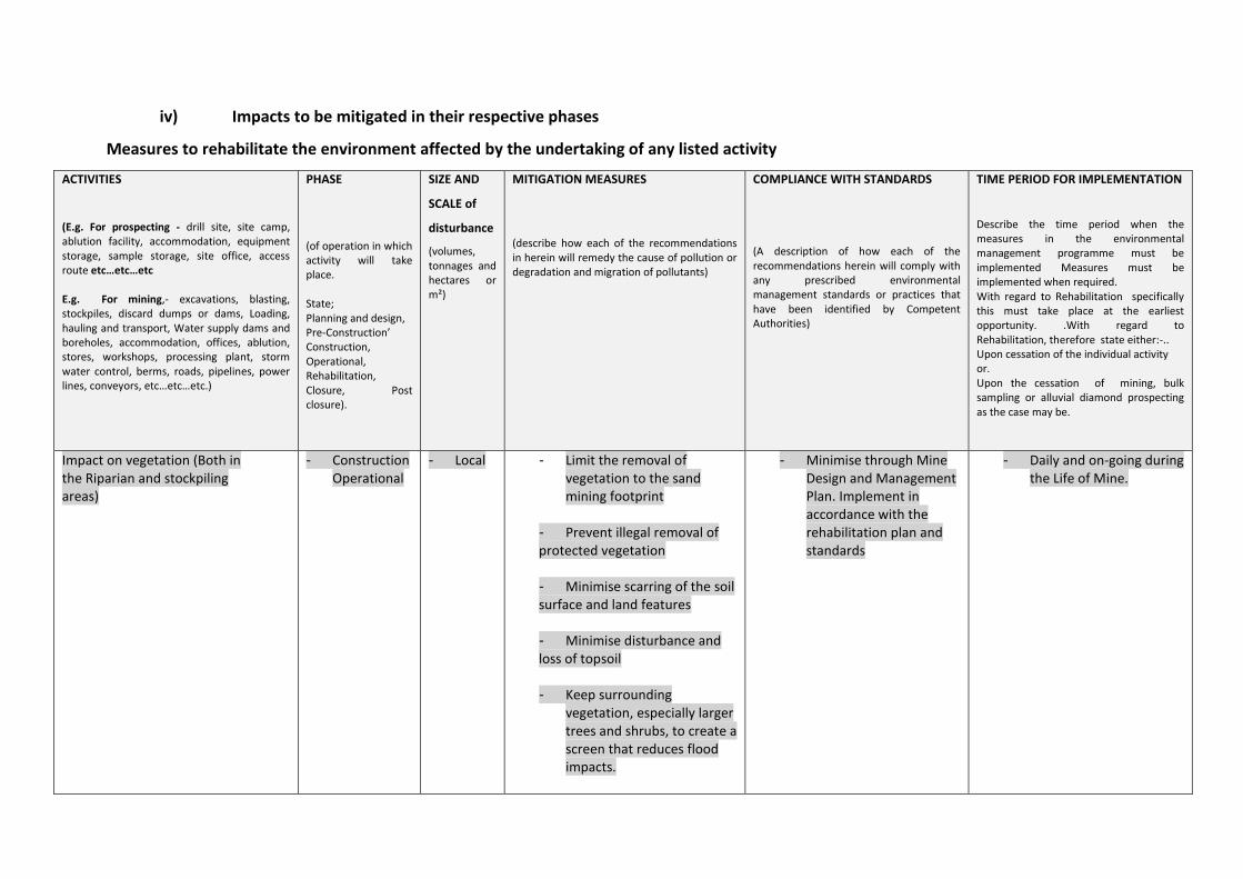
iv) Impacts to be mitigated in their respective phases
Measures to rehabilitate the environment affected by the undertaking of any listed activity
ACTIVITIES
(E.g. For prospecting - drill site, site camp, ablution facility, accommodation, equipment storage, sample storage, site office, access route etc…etc…etc E.g. For mining,- excavations, blasting, stockpiles, discard dumps or dams, Loading, hauling and transport, Water supply dams and boreholes, accommodation, offices, ablution, stores, workshops, processing plant, storm water control, berms, roads, pipelines, power lines, conveyors, etc…etc…etc.)
PHASE
(of operation in which activity will take place. State; Planning and design, Pre-Construction’ Construction, Operational, Rehabilitation, Closure, Post closure).
SIZE AND
SCALE of
disturbance
(volumes, tonnages and hectares or m²)
MITIGATION MEASURES
(describe how each of the recommendations in herein will remedy the cause of pollution or degradation and migration of pollutants)
COMPLIANCE WITH STANDARDS
(A description of how each of the recommendations herein will comply with any prescribed environmental management standards or practices that have been identified by Competent Authorities)
TIME PERIOD FOR IMPLEMENTATION
Describe the time period when the measures in the environmental management programme must be implemented Measures must be implemented when required. With regard to Rehabilitation specifically this must take place at the earliest opportunity. .With regard to Rehabilitation, therefore state either:-.. Upon cessation of the individual activity or. Upon the cessation of mining, bulk sampling or alluvial diamond prospecting as the case may be.
Impact on vegetation (Both in the Riparian and stockpiling areas)
- Construction Operational
- Local - Limit the removal of vegetation to the sand mining footprint
- Prevent illegal removal of protected vegetation - Minimise scarring of the soil surface and land features
- Minimise disturbance and loss of topsoil - Keep surrounding
vegetation, especially larger trees and shrubs, to create a screen that reduces flood impacts.
- Minimise through Mine Design and Management Plan. Implement in accordance with the rehabilitation plan and standards
- Daily and on-going during the Life of Mine.
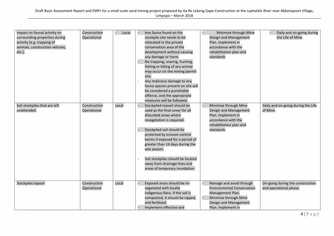
Draft Basic Assessment Report and EMPr for a small-scale sand mining project proposed by Ga Re Lekeng Gape Construction at the Lephalale River near Abbotspoort Village, Limpopo – March 2018
4 | P a g e
Impact on faunal activity on surrounding properties during activity (e.g. trapping of animals, construction vehicles, etc.).
Construction Operational
- Local - Any fauna found on the stockpile site needs to be relocated to the private conservation area of the development without causing any damage or harm.
- No trapping, snaring, hunting, fishing or killing of any animal may occur on the mining permit site.
- Any malicious damage to any fauna species present on site will be considered a punishable offence, and the appropriate measures will be followed.
- Minimise through Mine Design and Management Plan. Implement in accordance with the rehabilitation plan and standards
- Daily and on-going during the Life of Mine.
Soil stockpiles that are left unattended.
Construction Operational
Local - Stockpiled topsoil should be used as the final cover for all disturbed areas where revegetation is required.
- Stockpiled soil should be protected by erosion-control berms if exposed for a period of greater than 14 days during the wet season.
- Soil stockpiles should be located away from drainage lines and areas of temporary inundation.
- Minimise through Mine Design and Management Plan. Implement in accordance with the rehabilitation plan and standards
Daily and on-going during the Life of Mine.
Stockpiles topsoil Construction Operational
Local - Exposed areas should be re-vegetated with locally indigenous flora. If the soil is compacted, it should be ripped, and fertilised.
- Implement effective and
- Manage and avoid through Environmental Conservation Management Plan.
- Minimise through Mine Design and Management Plan. Implement in
On-going during the construction and operational phase.
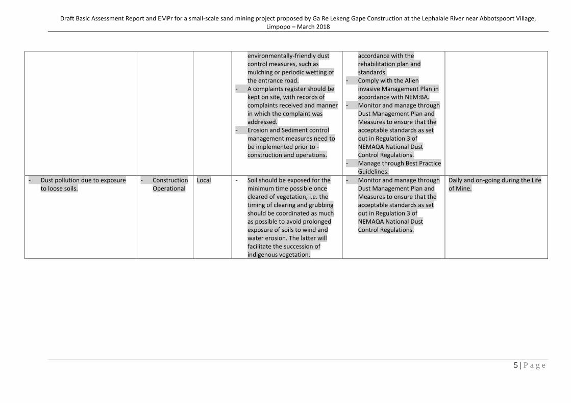
Draft Basic Assessment Report and EMPr for a small-scale sand mining project proposed by Ga Re Lekeng Gape Construction at the Lephalale River near Abbotspoort Village, Limpopo – March 2018
5 | P a g e
environmentally-friendly dust control measures, such as mulching or periodic wetting of the entrance road.
- A complaints register should be kept on site, with records of complaints received and manner in which the complaint was addressed.
- Erosion and Sediment control management measures need to be implemented prior to -construction and operations.
accordance with the rehabilitation plan and standards.
- Comply with the Alien invasive Management Plan in accordance with NEM:BA.
- Monitor and manage through Dust Management Plan and Measures to ensure that the acceptable standards as set out in Regulation 3 of NEMAQA National Dust Control Regulations.
- Manage through Best Practice Guidelines.
- Dust pollution due to exposure to loose soils.
- Construction Operational
Local - Soil should be exposed for the minimum time possible once cleared of vegetation, i.e. the timing of clearing and grubbing should be coordinated as much as possible to avoid prolonged exposure of soils to wind and water erosion. The latter will facilitate the succession of indigenous vegetation.
- Monitor and manage through Dust Management Plan and Measures to ensure that the acceptable standards as set out in Regulation 3 of NEMAQA National Dust Control Regulations.
Daily and on-going during the Life of Mine.
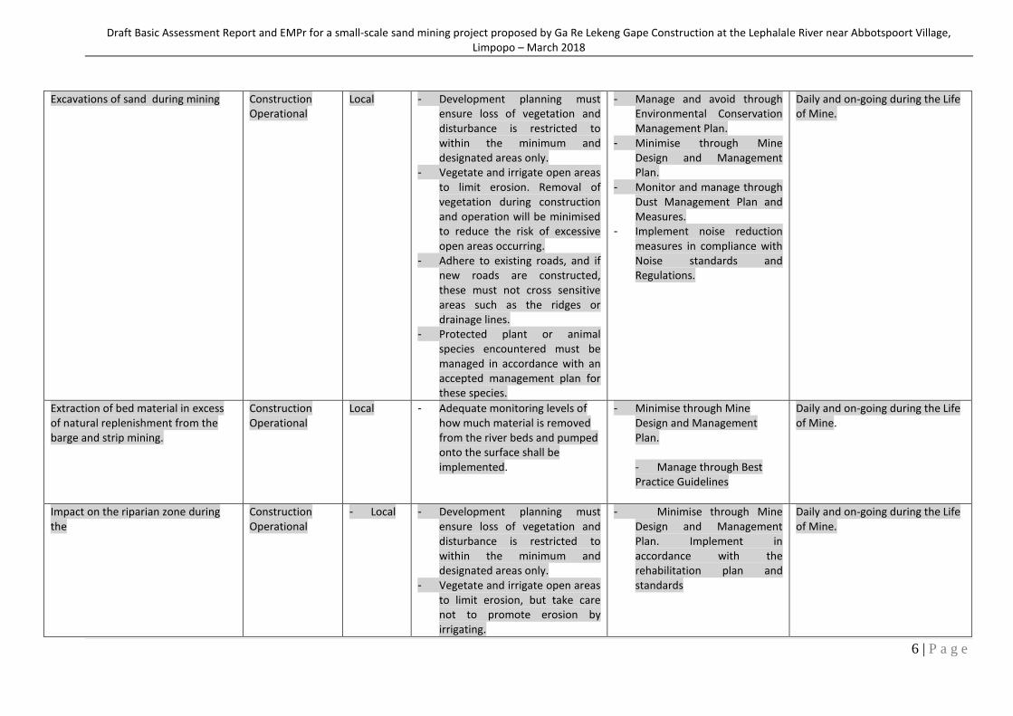
Draft Basic Assessment Report and EMPr for a small-scale sand mining project proposed by Ga Re Lekeng Gape Construction at the Lephalale River near Abbotspoort Village, Limpopo – March 2018
6 | P a g e
Excavations of sand during mining Construction Operational
Local - Development planning must ensure loss of vegetation and disturbance is restricted to within the minimum and designated areas only.
- Vegetate and irrigate open areas to limit erosion. Removal of vegetation during construction and operation will be minimised to reduce the risk of excessive open areas occurring.
- Adhere to existing roads, and if new roads are constructed, these must not cross sensitive areas such as the ridges or drainage lines.
- Protected plant or animal species encountered must be managed in accordance with an accepted management plan for these species.
- Manage and avoid through Environmental Conservation Management Plan.
- Minimise through Mine Design and Management Plan.
- Monitor and manage through Dust Management Plan and Measures.
- Implement noise reduction measures in compliance with Noise standards and Regulations.
Daily and on-going during the Life of Mine.
Extraction of bed material in excess of natural replenishment from the barge and strip mining.
Construction Operational
Local - Adequate monitoring levels of how much material is removed from the river beds and pumped onto the surface shall be implemented.
- Minimise through Mine Design and Management Plan. - Manage through Best Practice Guidelines
Daily and on-going during the Life of Mine.
Impact on the riparian zone during the
Construction Operational
- Local - Development planning must ensure loss of vegetation and disturbance is restricted to within the minimum and designated areas only.
- Vegetate and irrigate open areas to limit erosion, but take care not to promote erosion by irrigating.
- Minimise through Mine Design and Management Plan. Implement in accordance with the rehabilitation plan and standards
Daily and on-going during the Life of Mine.
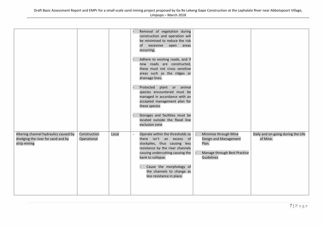
Draft Basic Assessment Report and EMPr for a small-scale sand mining project proposed by Ga Re Lekeng Gape Construction at the Lephalale River near Abbotspoort Village, Limpopo – March 2018
7 | P a g e
- Removal of vegetation during construction and operation will be minimised to reduce the risk of excessive open areas occurring.
- Adhere to existing roads, and if new roads are constructed, these must not cross sensitive areas such as the ridges or drainage lines.
- Protected plant or animal species encountered must be managed in accordance with an accepted management plan for these species
- Storages and facilities must be located outside the flood line exclusion zone
Altering channel hydraulics caused by dredging the river for sand and by strip mining
Construction Operational
Local - Operate within the thresholds so there isn’t an excess of stockpiles, thus causing less resistance by the river channels causing undercutting causing the bank to collapse.
- Cause the morphology of
the channels to change as less resistance in place.
- Minimise through Mine Design and Management Plan.
- Manage through Best Practice
Guidelines
Daily and on-going during the Life of Mine.
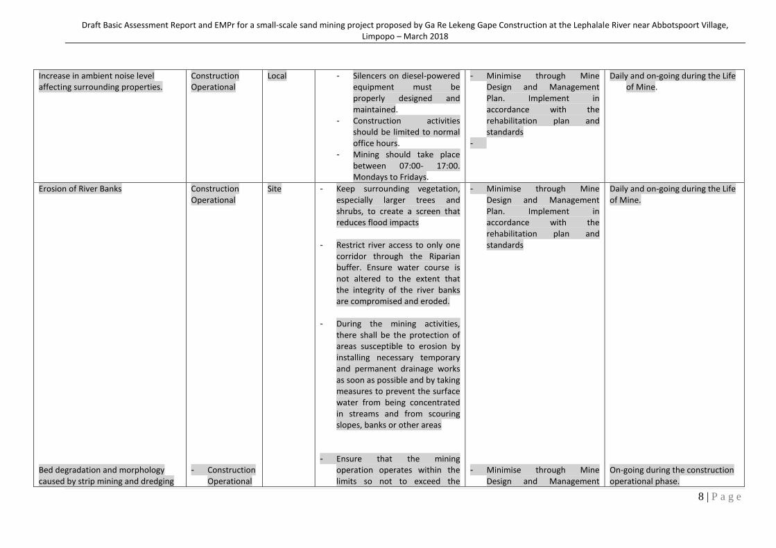
Draft Basic Assessment Report and EMPr for a small-scale sand mining project proposed by Ga Re Lekeng Gape Construction at the Lephalale River near Abbotspoort Village, Limpopo – March 2018
8 | P a g e
Increase in ambient noise level affecting surrounding properties.
Construction Operational
Local - Silencers on diesel-powered equipment must be properly designed and maintained.
- Construction activities should be limited to normal office hours.
- Mining should take place between 07:00- 17:00. Mondays to Fridays.
- Minimise through Mine Design and Management Plan. Implement in accordance with the rehabilitation plan and standards
-
Daily and on-going during the Life of Mine.
Erosion of River Banks Bed degradation and morphology caused by strip mining and dredging
Construction Operational - Construction
Operational
Site - Keep surrounding vegetation, especially larger trees and shrubs, to create a screen that reduces flood impacts
- Restrict river access to only one corridor through the Riparian buffer. Ensure water course is not altered to the extent that the integrity of the river banks are compromised and eroded.
- During the mining activities,
there shall be the protection of areas susceptible to erosion by installing necessary temporary and permanent drainage works as soon as possible and by taking measures to prevent the surface water from being concentrated in streams and from scouring slopes, banks or other areas
- Ensure that the mining
operation operates within the limits so not to exceed the
- Minimise through Mine Design and Management Plan. Implement in accordance with the rehabilitation plan and standards
- Minimise through Mine
Design and Management
Daily and on-going during the Life of Mine. On-going during the construction operational phase.
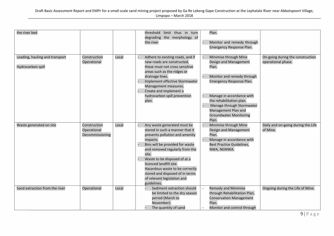
Draft Basic Assessment Report and EMPr for a small-scale sand mining project proposed by Ga Re Lekeng Gape Construction at the Lephalale River near Abbotspoort Village, Limpopo – March 2018
9 | P a g e
the river bed
threshold limit thus in turn degrading the morphology of the river
Plan.
- Monitor and remedy through Emergency Response Plan.
Loading, hauling and transport Hydrocarbon spill
Construction Operational
Local - Adhere to existing roads, and if new roads are constructed, these must not cross sensitive areas such as the ridges or drainage lines.
- Implement effective Stormwater Management measures.
- Create and implement a hydrocarbon spill prevention plan.
- Minimise through Mine Design and Management Plan.
- Monitor and remedy through Emergency Response Plan.
- Manage in accordance with the rehabilitation plan.
- Manage through Stormwater Management Plan and Groundwater Monitoring Plan.
On-going during the construction operational phase.
Waste generated on site
Construction Operational Decommissioning
Local - Any waste generated must be stored in such a manner that it prevents pollution and amenity impacts.
- Bins will be provided for waste and removed regularly from the site.
- Waste to be disposed of at a licenced landfill site. Hazardous waste to be correctly stored and disposed of in terms of relevant legislation and guidelines.
- Minimise through Mine Design and Management Plan.
- Manage in accordance with Best Practice Guidelines, NWA, NEMWA.
Daily and on-going during the Life of Mine.
Sand extraction from the river
Operational Local - Sediment extraction should be limited to the dry season period (March to November).
- The quantity of sand
- Remedy and Minimise through Rehabilitation Plan, Conservation Management Plan.
- Monitor and control through
Ongoing during the Life of Mine.
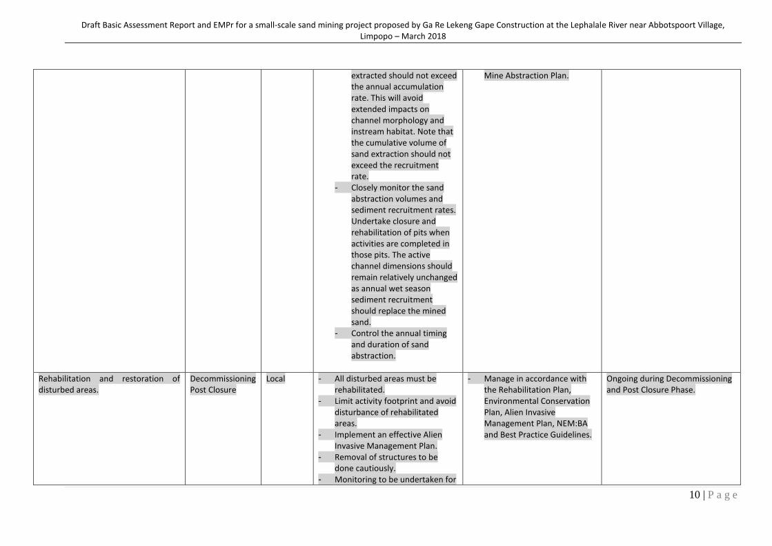
Draft Basic Assessment Report and EMPr for a small-scale sand mining project proposed by Ga Re Lekeng Gape Construction at the Lephalale River near Abbotspoort Village, Limpopo – March 2018
10 | P a g e
extracted should not exceed the annual accumulation rate. This will avoid extended impacts on channel morphology and instream habitat. Note that the cumulative volume of sand extraction should not exceed the recruitment rate.
- Closely monitor the sand abstraction volumes and sediment recruitment rates. Undertake closure and rehabilitation of pits when activities are completed in those pits. The active channel dimensions should remain relatively unchanged as annual wet season sediment recruitment should replace the mined sand.
- Control the annual timing and duration of sand abstraction.
Mine Abstraction Plan.
Rehabilitation and restoration of disturbed areas.
Decommissioning Post Closure
Local
- All disturbed areas must be rehabilitated.
- Limit activity footprint and avoid disturbance of rehabilitated areas.
- Implement an effective Alien Invasive Management Plan.
- Removal of structures to be done cautiously.
- Monitoring to be undertaken for
- Manage in accordance with the Rehabilitation Plan, Environmental Conservation Plan, Alien Invasive Management Plan, NEM:BA and Best Practice Guidelines.
Ongoing during Decommissioning and Post Closure Phase.
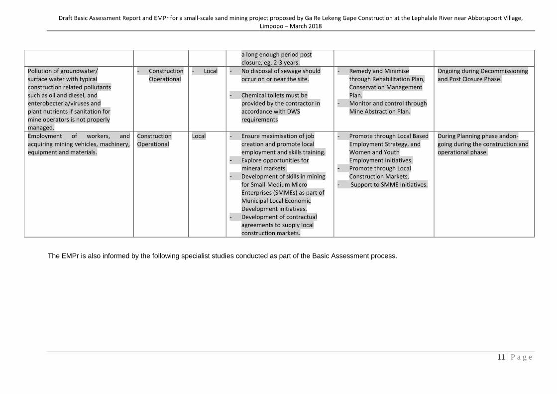
Draft Basic Assessment Report and EMPr for a small-scale sand mining project proposed by Ga Re Lekeng Gape Construction at the Lephalale River near Abbotspoort Village, Limpopo – March 2018
11 | P a g e
a long enough period post closure, eg, 2-3 years.
Pollution of groundwater/ surface water with typical construction related pollutants such as oil and diesel, and enterobecteria/viruses and plant nutrients if sanitation for mine operators is not properly managed.
- Construction Operational
- Local - No disposal of sewage should occur on or near the site.
- Chemical toilets must be
provided by the contractor in accordance with DWS requirements
- Remedy and Minimise through Rehabilitation Plan, Conservation Management Plan.
- Monitor and control through Mine Abstraction Plan.
Ongoing during Decommissioning and Post Closure Phase.
Employment of workers, and acquiring mining vehicles, machinery, equipment and materials.
Construction Operational
Local - Ensure maximisation of job creation and promote local employment and skills training.
- Explore opportunities for mineral markets.
- Development of skills in mining for Small-Medium Micro Enterprises (SMMEs) as part of Municipal Local Economic Development initiatives.
- Development of contractual agreements to supply local construction markets.
- Promote through Local Based Employment Strategy, and Women and Youth Employment Initiatives.
- Promote through Local Construction Markets.
- Support to SMME Initiatives.
During Planning phase andon-going during the construction and operational phase.
The EMPr is also informed by the following specialist studies conducted as part of the Basic Assessment process.
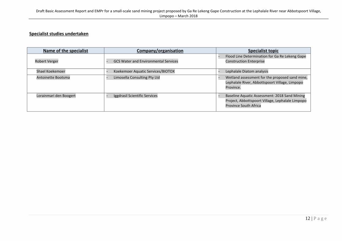
Draft Basic Assessment Report and EMPr for a small-scale sand mining project proposed by Ga Re Lekeng Gape Construction at the Lephalale River near Abbotspoort Village, Limpopo – March 2018
12 | P a g e
Specialist studies undertaken
Name of the specialist Company/organisation Specialist topic
Robert Verger
- GCS Water and Environmental Services
- Flood Line Determination for Ga Re Lekeng Gape Construction Enterprise
Shael Koekemoer - Koekemoer Aquatic Services/BIOTOX - Lephalale Diatom analysis
Antoinette Bootsma - Limosella Consulting Pty Ltd - Wetland assessment for the proposed sand mine, Lephalale River, Abbottspoort Village, Limpopo Province.
Lorainmari den Boogert - Iggdrasil Scientific Services - Baseline Aquatic Assessment: 2018 Sand Mining Project, Abbottspoort Village, Lephalale Limpopo Province South Africa
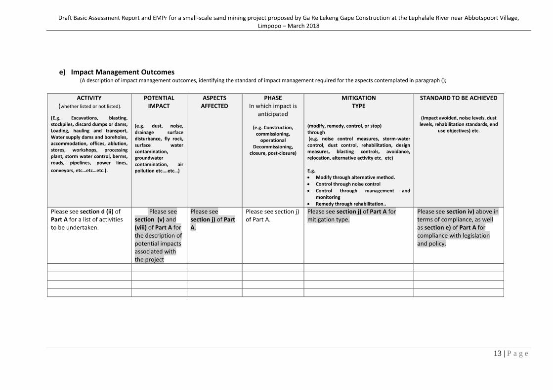
Draft Basic Assessment Report and EMPr for a small-scale sand mining project proposed by Ga Re Lekeng Gape Construction at the Lephalale River near Abbotspoort Village, Limpopo – March 2018
13 | P a g e
e) Impact Management Outcomes (A description of impact management outcomes, identifying the standard of impact management required for the aspects contemplated in paragraph ();
ACTIVITY
(whether listed or not listed).
(E.g. Excavations, blasting, stockpiles, discard dumps or dams, Loading, hauling and transport, Water supply dams and boreholes, accommodation, offices, ablution, stores, workshops, processing plant, storm water control, berms, roads, pipelines, power lines,
conveyors, etc…etc…etc.).
POTENTIAL IMPACT
(e.g. dust, noise, drainage surface disturbance, fly rock, surface water contamination, groundwater contamination, air pollution etc….etc…)
ASPECTS AFFECTED
PHASE In which impact is
anticipated
(e.g. Construction, commissioning,
operational Decommissioning,
closure, post-closure)
MITIGATION TYPE
(modify, remedy, control, or stop) through (e.g. noise control measures, storm-water control, dust control, rehabilitation, design measures, blasting controls, avoidance, relocation, alternative activity etc. etc) E.g.
Modify through alternative method.
Control through noise control
Control through management and monitoring
Remedy through rehabilitation..
STANDARD TO BE ACHIEVED
(Impact avoided, noise levels, dust levels, rehabilitation standards, end
use objectives) etc.
Please see section d (ii) of Part A for a list of activities to be undertaken.
Please see section (v) and (viii) of Part A for the description of potential impacts associated with the project
Please see section j) of Part A.
Please see section j) of Part A.
Please see section j) of Part A for mitigation type.
Please see section iv) above in terms of compliance, as well as section e) of Part A for compliance with legislation and policy.
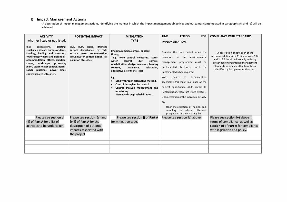
f) Impact Management Actions (A description of impact management actions, identifying the manner in which the impact management objectives and outcomes contemplated in paragraphs (c) and (d) will be achieved).
ACTIVITY
whether listed or not listed.
(E.g. Excavations, blasting, stockpiles, discard dumps or dams, Loading, hauling and transport, Water supply dams and boreholes, accommodation, offices, ablution, stores, workshops, processing plant, storm water control, berms, roads, pipelines, power lines,
conveyors, etc…etc…etc.).
POTENTIAL IMPACT (e.g. dust, noise, drainage surface disturbance, fly rock, surface water contamination, groundwater contamination, air pollution etc….etc…)
MITIGATION TYPE
(modify, remedy, control, or stop) through (e.g. noise control measures, storm-water control, dust control, rehabilitation, design measures, blasting controls, avoidance, relocation, alternative activity etc. etc) E.g.
Modify through alternative method.
Control through noise control
Control through management and monitoring Remedy through rehabilitation..
TIME PERIOD FOR
IMPLEMENTATION
Describe the time period when the
measures in the environmental
management programme must be
implemented Measures must be
implemented when required.
With regard to Rehabilitation
specifically this must take place at the
earliest opportunity. .With regard to
Rehabilitation, therefore state either:-..
Upon cessation of the individual activity
or.
Upon the cessation of mining, bulk sampling or alluvial diamond prospecting as the case may be.
COMPLIANCE WITH STANDARDS
(A description of how each of the recommendations in 2.11.6 read with 2.12
and 2.15.2 herein will comply with any prescribed environmental management standards or practices that have been identified by Competent Authorities)
Please see section d (ii) of Part A for a list of activities to be undertaken.
Please see section (v) and (viii) of Part A for the description of potential impacts associated with the project
Please see section j) of Part A for mitigation type.
Please see section iv) above. Please see section iv) above in terms of compliance, as well as section e) of Part A for compliance with legislation and policy.
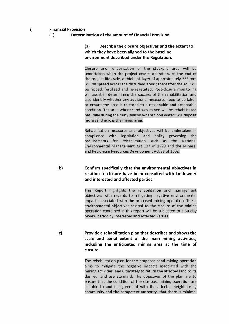
i) Financial Provision
(1) Determination of the amount of Financial Provision.
(a) Describe the closure objectives and the extent to which they have been aligned to the baseline environment described under the Regulation. Closure and rehabilitation of the stockpile area will be undertaken when the project ceases operation. At the end of the project life cycle, a thick soil layer of approximately 333 mm will be spread across the disturbed areas; thereafter the soil will be ripped, fertilised and re-vegetated. Post-closure monitoring will assist in determining the success of the rehabilitation and also identify whether any additional measures need to be taken to ensure the area is restored to a reasonable and acceptable condition. The area where sand was mined will be rehabilitated naturally during the rainy season where flood waters will deposit more sand across the mined area. Rehabilitation measures and objectives will be undertaken in compliance with legislation and policy governing the requirements for rehabilitation such as the National Environmental Management Act 107 of 1998 and the Mineral and Petroleum Resources Development Act 28 of 2002.
(b) Confirm specifically that the environmental objectives in relation to closure have been consulted with landowner and interested and affected parties.
This Report highlights the rehabilitation and management objectives with regards to mitigating negative environmental impacts associated with the proposed mining operation. These environmental objectives related to the closure of the mining operation contained in this report will be subjected to a 30-day review period by Interested and Affected Parties.
(c) Provide a rehabilitation plan that describes and shows the scale and aerial extent of the main mining activities, including the anticipated mining area at the time of closure. The rehabilitation plan for the proposed sand mining operation aims to mitigate the negative impacts associated with the mining activities, and ultimately to return the affected land to its desired land use standard. The objectives of the plan are to ensure that the condition of the site post mining operation are suitable to and in agreement with the affected neighbouring community and the competent authority, that there is minimal
Draft Basic Assessment Report and EMPr for a small-scale sand mining project proposed by Ga Re Lekeng Gape Construction at the Lephalale River near Abbotspoort Village, Limpopo – March 2018
2 | P a g e
loss to the biodiversity of the area, and that rehabilitation restores the land use and capability of the area/site.
The rehabilitation process will be undertaken during the mine closure phase. A more detailed closure plan will be developed during the life of mine, prior to the cessation of mining activities; adapted to the developed information and environmental impact status of the project in order to achieve a site-specific closure plan. A map showing the site layout and aerial extent of the proposed mining activities, depicting the anticipated mining permit area at the time of closure is included as Map 2 in Appendix B.
(d) Explain why it can be confirmed that the rehabilitation
plan is compatible with the closure objectives. The closure plan will assist the proposed mining operation to achieve the following objectives:
Comply with relevant legislation and policy requirements with regards to mine rehabilitation.
Avoid or mitigate impacts associated with the project which may be detrimental to the environment.
Land rehabilitation to a predetermined and agreed upon state that allows sustainable land use and capability of the site, that is to return the site to the condition that existed prior to mining or an agreed upon state.
Cost effective and efficient closure of mining operations.
Management and monitoring of the area post-closure.
The rehabilitation plan will thus be aligned to the closure objectives and tailored to the project to achieve these objectives. It will include information about the site prior to the mining operation and provide information on the maintenance of resources required for the rehabilitation process, as well detail how rehabilitation will be undertaken. It will also provide information on the management and monitoring of disturbance to avoid or minimise detrimental impacts, as well as an estimate of the financial closure provision. It will also include information associated with post-closure environmental monitoring of the site to ensure that the rehabilitation plan is followed and its objectives are achieved.

Draft Basic Assessment Report and EMPr for a small-scale sand mining project proposed by Ga Re Lekeng Gape Construction at the Lephalale River near Abbotspoort Village, Limpopo – March 2018
3 | P a g e
(e) Calculate and state the quantum of the financial provision required to manage and rehabilitate the environment in accordance with the applicable guideline.
This calculation is based on the DMR ―Guideline Document for the Evaluation of the Quantum of Closure-Related Financial Provision Provided by a Mine
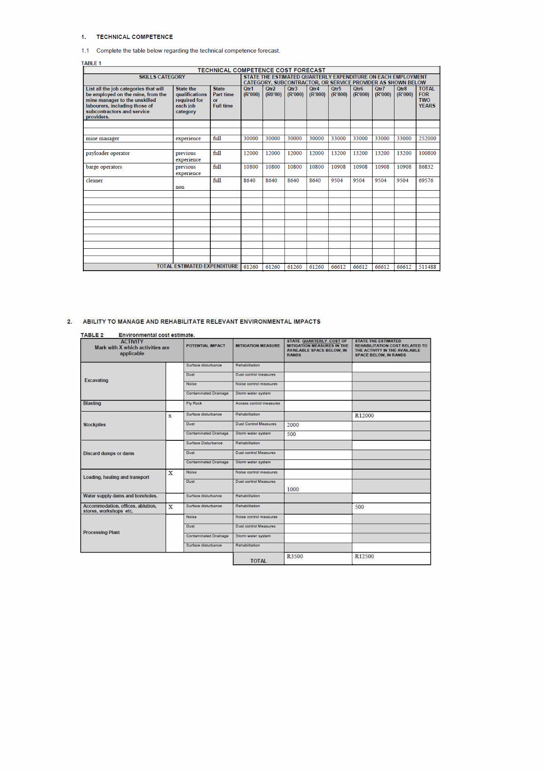
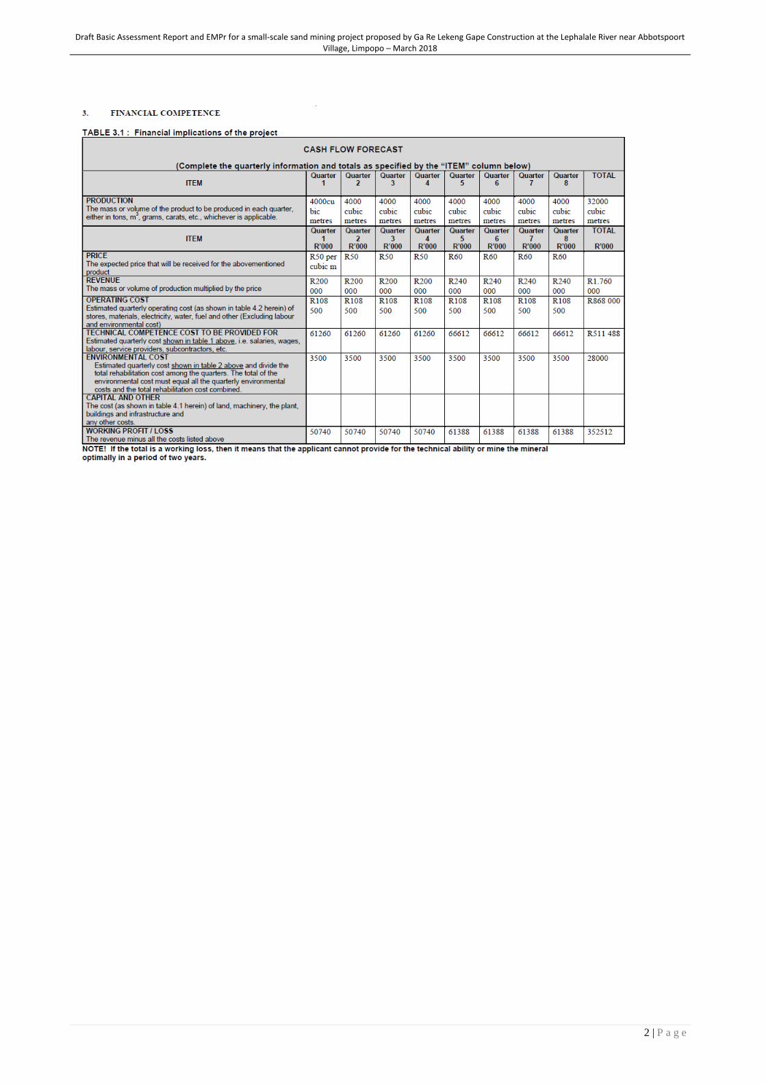
Draft Basic Assessment Report and EMPr for a small-scale sand mining project proposed by Ga Re Lekeng Gape Construction at the Lephalale River near Abbotspoort Village, Limpopo – March 2018
2 | P a g e

(f) Confirm that the financial provision will be provided as determined. Mr Nku confirms that the financial provision will be provided as determined.
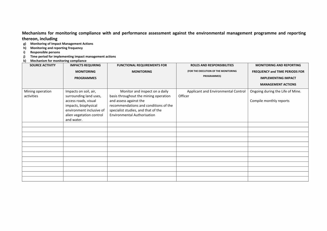
Mechanisms for monitoring compliance with and performance assessment against the environmental management programme and reporting thereon, including g) Monitoring of Impact Management Actions h) Monitoring and reporting frequency i) Responsible persons j) Time period for implementing impact management actions k) Mechanism for monitoring compliance
SOURCE ACTIVITY IMPACTS REQUIRING
MONITORING
PROGRAMMES
FUNCTIONAL REQUIREMENTS FOR
MONITORING
ROLES AND RESPONSIBILITIES
(FOR THE EXECUTION OF THE MONITORING
PROGRAMMES)
MONITORING AND REPORTING
FREQUENCY and TIME PERIODS FOR
IMPLEMENTING IMPACT
MANAGEMENT ACTIONS
Mining operation activities
Impacts on soil, air, surrounding land uses, access roads, visual impacts, biophysical environment inclusive of alien vegetation control and water.
Monitor and inspect on a daily basis throughout the mining operation and assess against the recommendations and conditions of the specialist studies, and that of the Environmental Authorisation
Applicant and Environmental Control Officer
Ongoing during the Life of Mine. Compile monthly reports
Draft Basic Assessment Report and EMPr for a small-scale sand mining project proposed by Ga Re Lekeng Gape Construction at the Lephalale River near Abbotspoort Village, Limpopo – March 2018
2 | P a g e
l) Indicate the frequency of the submission of the performance assessment/ environmental audit report. The Environmental Control Officer will undertake audits in compliance with the provided EMP contents and guidelines and will compile audit reports, which will ultimately be submitted to the DMR every two years.
m) Environmental Awareness Plan
(1) Manner in which the applicant intends to inform his or her employees of
any environmental risk which may result from their work.
Management of the proposed project has to appoint an independent Environmental Control Officer whose duty is to also implement an effective environmental awareness plan aimed to educate workers and contractors in terms of the biodiversity on site, environmental risks associated with the proposed development and land management of the site. Training and/or awareness should be raised and effectively communicated prior to the commencement of the construction phase. Training sessions should incorporate the management plans addressed in this EMPr as well as any new information and documentation provided by the ECO, as well as that of the Environmental Health & Safety Officer. The ECO would be the most suitable person to conduct these training sessions, identifying sensitive environments as well as all the risks and impacts associated with the mining operation and the methods in which to deal with the impacts in order to avoid environmental degradation. Training sessions can be monitored by providing an attendance register indicating the workers that received training as well as evidence of the training and/or awareness received. These sessions would also need to be carried out throughout the Life of Mine, at least once a year, or as new information becomes available.
(2) Manner in which risks will be dealt with in order to avoid pollution or the
degradation of the environment. Kindly refer to the table of possible mitigation measures that could be applied in section (viii) of Part A for an indication of the manner in which risks will be dealt with
n) Specific information required by the Competent Authority (Among others, confirm that the financial provision will be reviewed annually).
No specific information requirements have been made by the competent authority at this stage
Draft Basic Assessment Report and EMPr for a small-scale sand mining project proposed by Ga Re Lekeng Gape Construction at the Lephalale River near Abbotspoort Village, Limpopo – March 2018
3 | P a g e
2) UNDERTAKING The EAP herewith confirms a) the correctness of the information provided in the reports
b) the inclusion of comments and inputs from stakeholders and I&APs ;
c) the inclusion of inputs and recommendations from the specialist reports
where relevant; and
d) that the information provided by the EAP to interested and affected parties and any responses by the EAP to comments or inputs made by interested and affected. parties are correctly reflected herein.
Signature of the environmental assessment practitioner: Council for Scientific and Industrial Research
Name of company: March 2018
Date:
-END-
Basic Assessment for the proposed establishment of a small-scale 5 hectares sand
mining project within Lephalale River in Abbotspoort Village, Lephalale, Limpopo
Annexure A.1: Paul Lochner Technical Advisor, Internal Reviewer and Quality Assurance (EAPSA)
Certified)
Annexure A.2: Minnelise Levendal (Project Reviewer)
Annexure A.3: Karabo Mashabela (Project Manager): Junior EAP
APPENDIX A
CVs of the EAPs
Contents
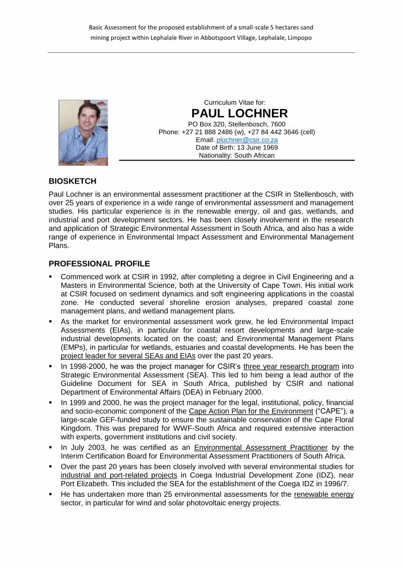
Basic Assessment for the proposed establishment of a small-scale 5 hectares sand
mining project within Lephalale River in Abbotspoort Village, Lephalale, Limpopo
Curriculum Vitae for:
PAUL LOCHNER PO Box 320, Stellenbosch, 7600
Phone: +27 21 888 2486 (w), +27 84 442 3646 (cell) Email: [email protected] Date of Birth: 13 June 1969 Nationality: South African
BIOSKETCH
Paul Lochner is an environmental assessment practitioner at the CSIR in Stellenbosch, with over 25 years of experience in a wide range of environmental assessment and management studies. His particular experience is in the renewable energy, oil and gas, wetlands, and industrial and port development sectors. He has been closely involvement in the research and application of Strategic Environmental Assessment in South Africa, and also has a wide range of experience in Environmental Impact Assessment and Environmental Management Plans. PROFESSIONAL PROFILE
Commenced work at CSIR in 1992, after completing a degree in Civil Engineering and a Masters in Environmental Science, both at the University of Cape Town. His initial work at CSIR focused on sediment dynamics and soft engineering applications in the coastal zone. He conducted several shoreline erosion analyses, prepared coastal zone management plans, and wetland management plans.
As the market for environmental assessment work grew, he led Environmental Impact Assessments (EIAs), in particular for coastal resort developments and large-scale industrial developments located on the coast; and Environmental Management Plans (EMPs), in particular for wetlands, estuaries and coastal developments. He has been the project leader for several SEAs and EIAs over the past 20 years.
In 1998-2000, he was the project manager for CSIR’s three year research program into Strategic Environmental Assessment (SEA). This led to him being a lead author of the Guideline Document for SEA in South Africa, published by CSIR and national Department of Environmental Affairs (DEA) in February 2000.
In 1999 and 2000, he was the project manager for the legal, institutional, policy, financial and socio-economic component of the Cape Action Plan for the Environment (“CAPE”), a large-scale GEF-funded study to ensure the sustainable conservation of the Cape Floral Kingdom. This was prepared for WWF-South Africa and required extensive interaction with experts, government institutions and civil society.
In July 2003, he was certified as an Environmental Assessment Practitioner by the Interim Certification Board for Environmental Assessment Practitioners of South Africa.
Over the past 20 years has been closely involved with several environmental studies for industrial and port-related projects in Coega Industrial Development Zone (IDZ), near Port Elizabeth. This included the SEA for the establishment of the Coega IDZ in 1996/7.
He has undertaken more than 25 environmental assessments for the renewable energy sector, in particular for wind and solar photovoltaic energy projects.
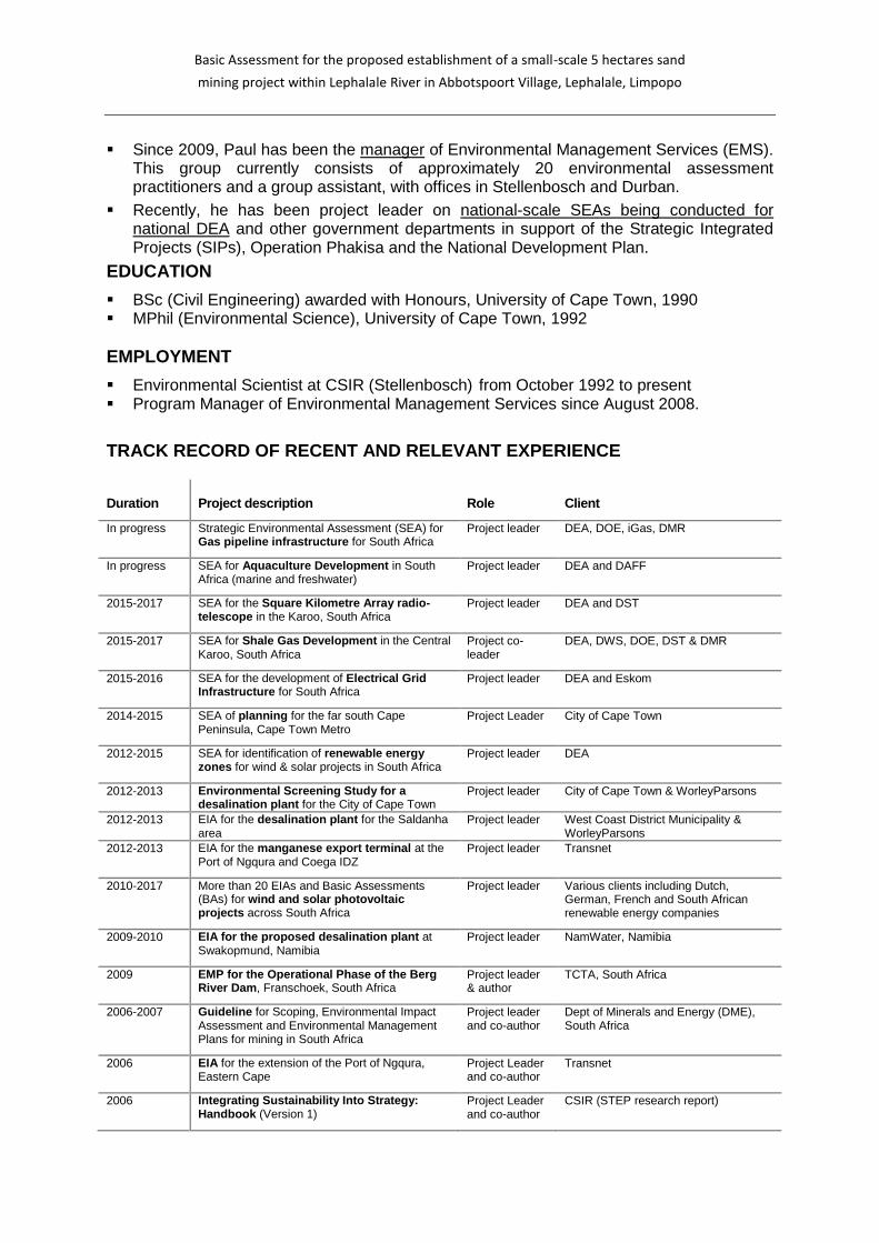
Basic Assessment for the proposed establishment of a small-scale 5 hectares sand
mining project within Lephalale River in Abbotspoort Village, Lephalale, Limpopo
Since 2009, Paul has been the manager of Environmental Management Services (EMS).
This group currently consists of approximately 20 environmental assessment practitioners and a group assistant, with offices in Stellenbosch and Durban.
Recently, he has been project leader on national-scale SEAs being conducted for national DEA and other government departments in support of the Strategic Integrated Projects (SIPs), Operation Phakisa and the National Development Plan.
EDUCATION
BSc (Civil Engineering) awarded with Honours, University of Cape Town, 1990 MPhil (Environmental Science), University of Cape Town, 1992 EMPLOYMENT
Environmental Scientist at CSIR (Stellenbosch) from October 1992 to present Program Manager of Environmental Management Services since August 2008.
TRACK RECORD OF RECENT AND RELEVANT EXPERIENCE
Duration Project description Role Client
In progress Strategic Environmental Assessment (SEA) for Gas pipeline infrastructure for South Africa
Project leader DEA, DOE, iGas, DMR
In progress SEA for Aquaculture Development in South Africa (marine and freshwater)
Project leader DEA and DAFF
2015-2017 SEA for the Square Kilometre Array radio-telescope in the Karoo, South Africa
Project leader DEA and DST
2015-2017 SEA for Shale Gas Development in the Central Karoo, South Africa
Project co-leader
DEA, DWS, DOE, DST & DMR
2015-2016 SEA for the development of Electrical Grid Infrastructure for South Africa
Project leader DEA and Eskom
2014-2015 SEA of planning for the far south Cape Peninsula, Cape Town Metro
Project Leader City of Cape Town
2012-2015 SEA for identification of renewable energy zones for wind & solar projects in South Africa
Project leader DEA
2012-2013 Environmental Screening Study for a desalination plant for the City of Cape Town
Project leader City of Cape Town & WorleyParsons
2012-2013 EIA for the desalination plant for the Saldanha area
Project leader West Coast District Municipality & WorleyParsons
2012-2013 EIA for the manganese export terminal at the Port of Ngqura and Coega IDZ
Project leader Transnet
2010-2017 More than 20 EIAs and Basic Assessments (BAs) for wind and solar photovoltaic projects across South Africa
Project leader Various clients including Dutch, German, French and South African renewable energy companies
2009-2010
EIA for the proposed desalination plant at Swakopmund, Namibia
Project leader NamWater, Namibia
2009 EMP for the Operational Phase of the Berg River Dam, Franschoek, South Africa
Project leader & author
TCTA, South Africa
2006-2007
Guideline for Scoping, Environmental Impact Assessment and Environmental Management Plans for mining in South Africa
Project leader and co-author
Dept of Minerals and Energy (DME), South Africa
2006 EIA for the extension of the Port of Ngqura, Eastern Cape
Project Leader and co-author
Transnet
2006 Integrating Sustainability Into Strategy: Handbook (Version 1)
Project Leader and co-author
CSIR (STEP research report)

Basic Assessment for the proposed establishment of a small-scale 5 hectares sand
mining project within Lephalale River in Abbotspoort Village, Lephalale, Limpopo
Duration Project description Role Client
2005 Technology Review for the proposed aluminium smelter at Coega, South Africa
Project Leader Alcan, Canada
2005 ESIA for the proposed alumina refinery near Sosnogorsk, Komi Republic, Russia
Project manager and co-author
Komi Aluminium, Russia, IFC, EBRD
2005 Guideline for Environmental Management Plans (EMPs) for the Western Cape province
Author Dept of Environmental Affairs & Development Planning, Western Cape
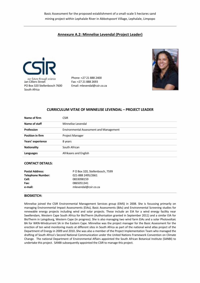
Basic Assessment for the proposed establishment of a small-scale 5 hectares sand
mining project within Lephalale River in Abbotspoort Village, Lephalale, Limpopo
Annexure A.2: Minnelise Levendal (Project Leader)
CSIR Jan Cilliers Street PO Box 320 Stellenbosch 7600 South Africa
Phone: +27 21 888 2400 Fax: +27 21 888 2693 Email: [email protected]
CURRICULUM VITAE OF MINNELISE LEVENDAL – PROJECT LEADER Name of firm CSIR
Name of staff Minnelise Levendal
Profession Environmental Assessment and Management
Position in firm Project Manager
Years’ experience 8 years
Nationality South African
Languages Afrikaans and English
CONTACT DETAILS: Postal Address: P O Box 320, Stellenbosch, 7599 Telephone Number: 021-888 2495/2661 Cell: 0833098159 Fax: 0865051341 e-mail: [email protected]
BIOSKETCH: Minnelise joined the CSIR Environmental Management Services group (EMS) in 2008. She is focussing primarily on managing Environmental Impact Assessments (EIAs), Basic Assessments (BAs) and Environmental Screening studies for renewable energy projects including wind and solar projects. These include an EIA for a wind energy facility near Swellendam, Western Cape South Africa for BioTherm (Authorisation granted in September 2011) and a similar EIA for BioTherm in Laingsburg, Western Cape (in progress). She is also managing two wind farm EIAs and a solar Photovoltaic BA for WKN-Windcurrent SA in the Eastern Cape. Minnelise was the project manager for the Basic Assessment for the erection of ten wind monitoring masts at different sites in South Africa as part of the national wind atlas project of the Department of Energy in 2009 and 2010..She was also a member of the Project Implementation Team who managed the drafting of South Africa’s Second National Communication under the United Nations Framework Convention on Climate Change. The national Department of Environmental Affairs appointed the South African Botanical Institute (SANBI) to undertake this project. SANBI subsequently appointed the CSIR to manage this project.
Basic Assessment for the proposed establishment of a small-scale 5 hectares sand
mining project within Lephalale River in Abbotspoort Village, Lephalale, Limpopo
EDUCATION:
M.Sc. (Botany) Stellenbosch University 1998 B.Sc. (Hons.) (Botany) University of the Western Cape 1994 B.Sc. (Education) University of the Western Cape 1993
MEMBERSHIPS:
International Association for Impact Assessment (IAIA), Western Cape (member of their steering committee from 2001-2003)
IUCN Commission on Education and Communication (CEC); World Conservation Learning Network (WCLN) American Association for the Advancement of Science (AAAS) Society of Conservation Biology (SCB)
EMPLOYMENT RECORD:
1995: Peninsula Technicon. Lecturer in the Horticulture Department. 1996: University of the Western Cape. Lecturer in the Botany Department. 1999: University of Stellenbosch. Research assistant in the Botany Department (3 months) 1999: Bengurion University (Israel). Research assistant (Working in the Arava valley, Negev – Israel; 2 months).
Research undertaken was published (see first publication in publication list) 1999-2004: Assistant Director at the Department of Environmental Affairs and Development Planning
(DEA&DP). Work involved assessing Environmental Impact Assessments and Environmental Management Plans; promoting environmental management and sustainable development.
2004 to present: Employed by the CSIR in Stellenbosch: September 2004 – May 2008: Biodiversity and Ecosystems Services Group (NRE) May 2008 to present: Environmental Management Services Group (EMS)
PROJECT EXPERIENCE RECORD: The following table presents a list of projects undertaken at the CSIR as well as the role played in each project:
Completion Date
Project description Role Client
2011 (in progress)
EIA for the proposed Electrawinds Swartberg wind energy project near Moorreesburg in the Western Cape
Project Manager
Electrawinds
2010-2011 (in progress)
EIA for the proposed Ubuntu wind energy project, Eastern Cape
Project Manager
WKN Windkraft SA
2010-2011 (in progress)
EIA for the proposed Banna ba pifhu wind energy project, Eastern Cape
Project Manager
WKN Windkraft SA
2010-2011
BA for a powerline near Swellendam in the Western Cape
Project Manager
BioTherm Energy (Pty Ltd
2010-2011 (Environmental Authorisation granted in September 2011)
EIA for a proposed wind farm near Swellendam in the Western Cape
Project Manager
BioTherm Energy (Pty Ltd
2010 (complete)
Basic Assessment for the erection of two wind monitoring masts near Swellendam and Bredasdorp in the Western Cape
Project Manager
BioTherm Energy (Pty Ltd
2010 (complete)
Basic Assessment for the erection of two wind monitoring masts near Jeffrey’s Bay in the Eastern Cape
Project Manager
Windcurrent (Pty Ltd
2009-2010 ((Environmental
Basic Assessment Process for the proposed erection of 10 wind monitoring masts in SA
Project Manager
Department of Energy through SANERI; GEF
Basic Assessment for the proposed establishment of a small-scale 5 hectares sand
mining project within Lephalale River in Abbotspoort Village, Lephalale, Limpopo
Completion
Date Project description Role Client
Authorisations granted during 2010)
as part of the national wind atlas project
2010
South Africa’s Second National Communication under the United Nations Framework Convention on Climate Change
Project Manager
SANBI
2009 (Environmental Authorisation granted in 2009)
Basic Assessment Report for a proposed boundary wall at the Port of Port Elizabeth, Eastern Cape
Project Manager
Transnet Ltd
2008
Developing an Invasive Alien Plant Strategy for the Wild Coast, Eastern Cape
Co-author Eastern Cape Parks Board
2006-2008 Monitoring and Evaluation of aspects of Biodiversity
Project Leader Internal project awarded through the Young Researchers Fund
2006 Integrated veldfire management in South Africa. An assessment of current conditions and future approaches.
Co- author Working on Fire
2004-2005 Biodiversity Strategy and Action Plan Wild Coast, Eastern Cape, SA
Co-author Wilderness Foundation
2005 Western Cape State of the Environment Report: Biodiversity section. (Year One).
Co- author and Project
Manager
Department of Environmental Affairs and Development Planning
PUBLICATIONS: Bowie, M. (néé Levendal) and Ward, D. (2004). Water status of the mistletoe Plicosepalus acaciae parasitic on isolated Negev Desert populations of Acacia raddiana differing in level of mortality. Journal of Arid Environments 56: 487-508. Wand, S.J.E., Esler, K.J. and Bowie, M.R (2001). Seasonal photosynthetic temperature responses and changes in 13C under varying temperature regimes in leaf-succulent and drought-deciduous shrubs from the Succulent Karoo, South Africa. South African Journal of Botany 67:235-243. Bowie, M.R., Wand, S.J.E. and Esler, K.J. (2000). Seasonal gas exchange responses under three different temperature treatments in a leaf-succulent and a drought-deciduous shrub from the Succulent Karoo. South African Journal of Botany 66:118-123.
LANGUAGES
Language Speaking Reading Writing
English Excellent Excellent Excellent
Afrikaans Excellent Excellent Excellent
Minnelise Levendal
31 August 2017
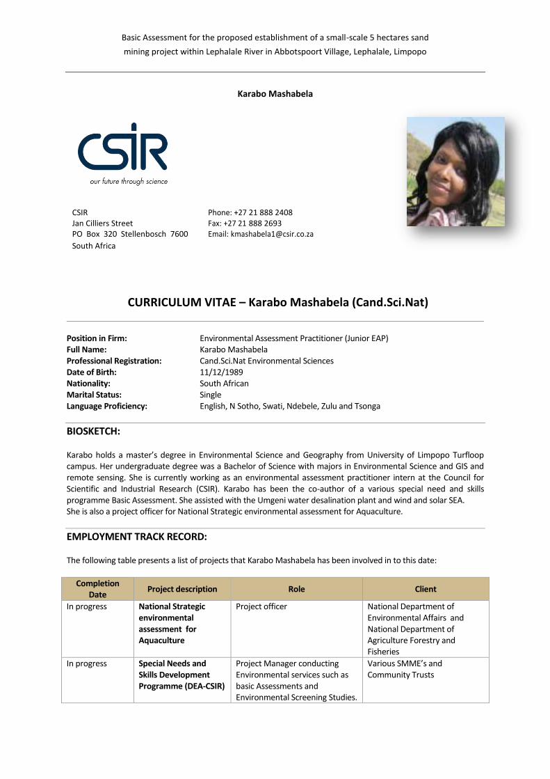
Basic Assessment for the proposed establishment of a small-scale 5 hectares sand
mining project within Lephalale River in Abbotspoort Village, Lephalale, Limpopo
Karabo Mashabela
CSIR Phone: +27 21 888 2408 Jan Cilliers Street Fax: +27 21 888 2693 PO Box 320 Stellenbosch 7600 Email: [email protected]
South Africa
CURRICULUM VITAE – Karabo Mashabela (Cand.Sci.Nat) Position in Firm: Environmental Assessment Practitioner (Junior EAP) Full Name: Karabo Mashabela Professional Registration: Cand.Sci.Nat Environmental Sciences Date of Birth: 11/12/1989 Nationality: South African Marital Status: Single Language Proficiency: English, N Sotho, Swati, Ndebele, Zulu and Tsonga
BIOSKETCH: Karabo holds a master’s degree in Environmental Science and Geography from University of Limpopo Turfloop campus. Her undergraduate degree was a Bachelor of Science with majors in Environmental Science and GIS and remote sensing. She is currently working as an environmental assessment practitioner intern at the Council for Scientific and Industrial Research (CSIR). Karabo has been the co-author of a various special need and skills programme Basic Assessment. She assisted with the Umgeni water desalination plant and wind and solar SEA. She is also a project officer for National Strategic environmental assessment for Aquaculture.
EMPLOYMENT TRACK RECORD: The following table presents a list of projects that Karabo Mashabela has been involved in to this date:
Completion Date
Project description Role Client
In progress National Strategic environmental assessment for Aquaculture
Project officer National Department of Environmental Affairs and National Department of Agriculture Forestry and Fisheries
In progress Special Needs and Skills Development Programme (DEA-CSIR)
Project Manager conducting Environmental services such as basic Assessments and Environmental Screening Studies.
Various SMME’s and Community Trusts
Basic Assessment for the proposed establishment of a small-scale 5 hectares sand
mining project within Lephalale River in Abbotspoort Village, Lephalale, Limpopo
Completion
Date Project description Role Client
In progress Strategic Environmental Assessment (SEA) Wind and solar
Project assistant National Department of Environmental Affairs
Complete EIA for Desalination plants on the KZN Tongaat.
Project member- Public Participation Process, stakeholder engagement and project support.
Umgeni Water
Complete Intubayethu screening study Eastern Cape
Project manager DEA
Final out waiting on competed authority
Basic Assessment for Blue-Green Aquaculture PTY Ltd
Project manager DEA
In progress Basic assessment for FishLab
Project manager DEA
In progress Ga Re Lekeng Gape Construction BAr
Project manager DEA
Final out waiting on competed authority
Khanyani Agricultural Cooperative BAr
Project manager DEA
In progress Makwarela Fisheries Project manager DEA
Complete Screening study for Sepeluli fishing Cooperative
Project manager DEA
EMPLOYMENT RECORD:
2017: Junior Environmental Scientist and Assessment Practitioner for National Strategic environmental
assessment. Council for Scientific and Industrial Research – Consulting and Analytical Services (CAS) –
Stellenbosch
2016 – 2017 Environmental Scientist and Assessment Practitioner (Intern) for National Strategic environmental assessment. Council for Scientific and Industrial Research – Consulting and Analytical Services (CAS) – Stellenbosch
2016 Environmental consultant and contractor trainer Dwarsrivier Chrome Mine
2011-2015 University of Limpopo Geography Department - GIS and Remote Sensing lab assistant, facilitating GIS practical’s using Quantum GIS and ARC-GIS software.
2010 National greening in the 2010 national environmental volunteer project ambassador for the department during the FiFa world cup (LEDET) Limpopo Department of Economic Development, Environment and Tourism
QUALIFICATIONS/EDUCATION:
Qualification Obtained: BSc (Environmental and Resource Studies)
Name of Institution: University of Limpopo
Duration: 3 years (2009-2011)
Major Subjects Passed: Environmental Management and Planning, Impact Studies (EIA, SEA, SIA, Risk Assessment, etc)
Basic Assessment for the proposed establishment of a small-scale 5 hectares sand
mining project within Lephalale River in Abbotspoort Village, Lephalale, Limpopo
Solid Waste Management, Water Treatment Processes and
Technology, Natural Resource Ecology, Remote Sensing and Geographic Information System (GIS)
Qualification obtained: BSc Honours (Geography and Environmental Sciences)
Name of Institution: University of Limpopo (2012)
Major Subjects Passed: Elements of Environmental Management
(Environmental Law, Environmental Management
Systems (ISO 14001), EIA, SEA, SIA, IEM, Risk Assessment,
Project Management, Environmental Monitoring and Auditing )
GIS-Applications
Demography
Geography Research Methods
Honours Research Topic: “Waste management strategies at Lebowakgomo Central Business Area”
Qualification obtained: MSc Geography and Environmental Sciences (GIS and Remote Sensing)
Name of Institution: University of Limpopo (2013-2015
Master of Science Research Topic:
Onsite greywater reuse as a water conservation Method: A case study of Lepelle-Nkumpi local Municipality, Limpopo province of South Africa
Masters results: Completed
TRAINING, CONFERENCES AND PROFFESIONAL REGISTRATIONS:
Media and Science Training Accreditation through Jive Media Africa (2016)
IAIA WC Workshop for roles and responsibilities of an environmental control officer (2016)
IAIAsa 2016 Annual National Conference Port Elizabeth (17-18 August 2016) Presented MSc study CSIR collaboration
Project Management accreditation through the CSIRs Innovation, Leadership and Learning Academy Project Management Course (2016)
Participated in the ACCESS Student Heritable planet workshop (2011)
Registered as a Candidate Natural Scientist with the South African Council for Natural Scientific Professions (SACNASP) (Reg #: 116164)
Member of the IAIAsa (Membership no: 5322)
Karabo Mashabela
Basic Assessment for the proposed establishment of a small-scale 5 hectares sand mining project within Lephalale River in Abbotspoort Village, Lephalale, Limpopo
Map B1: Site layout
Map B1.1: Regulation 2.2 plan map including co-ordinates
Map B2: Proposed Sand Mining Site Layout Plan
Map B3: Environmental and Current Land Use Features found in the area of the proposed Sand
Mining Site
Map B4: Map highlighting provincial terrestrial conservation priorities for the study area based on
the Freshwater Systematic Conservation Plan for Limpopo Province
APPENDIX B
Locality & Layout Maps
Contents
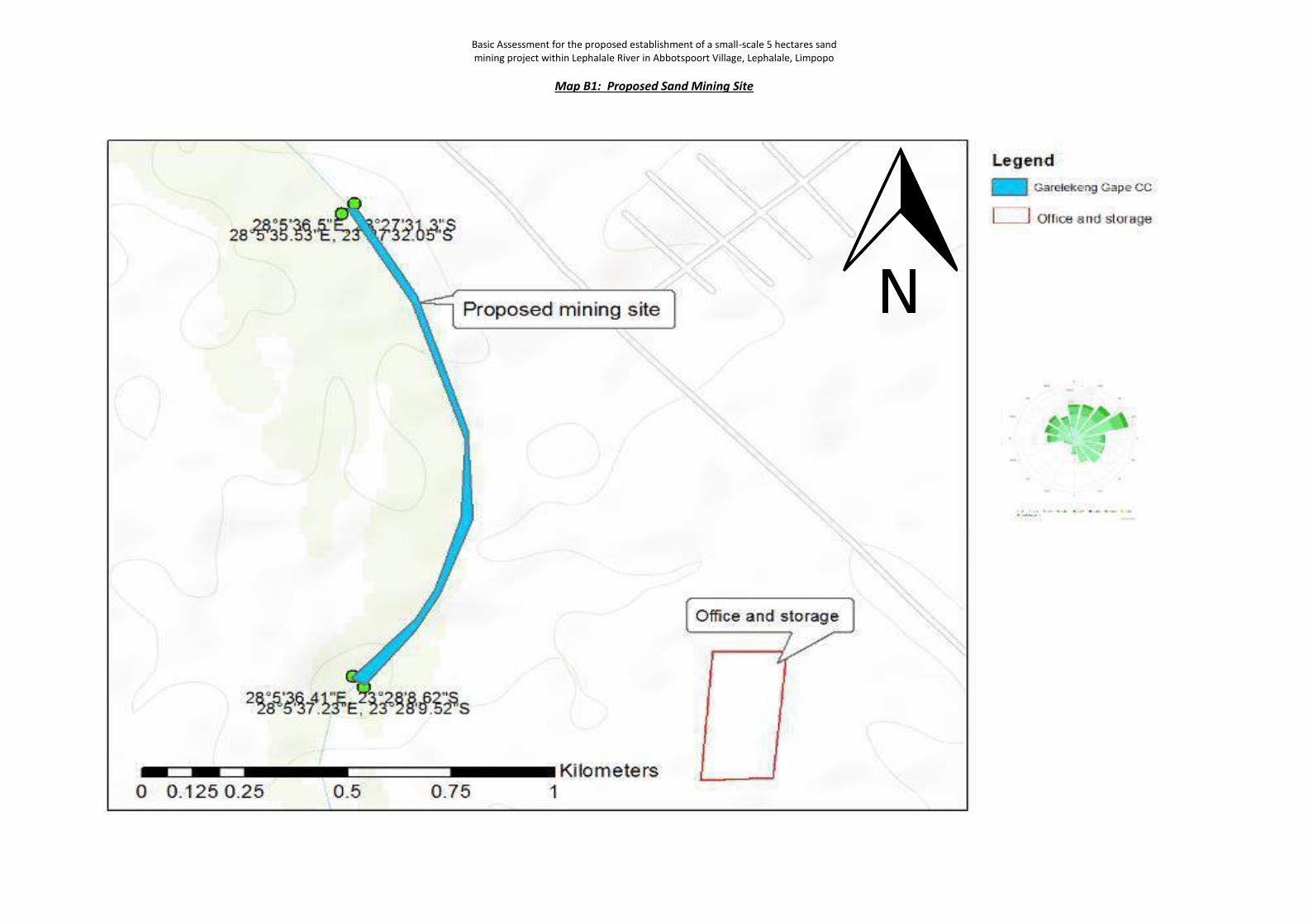
Basic Assessment for the proposed establishment of a small-scale 5 hectares sand mining project within Lephalale River in Abbotspoort Village, Lephalale, Limpopo
Map B1: Proposed Sand Mining Site
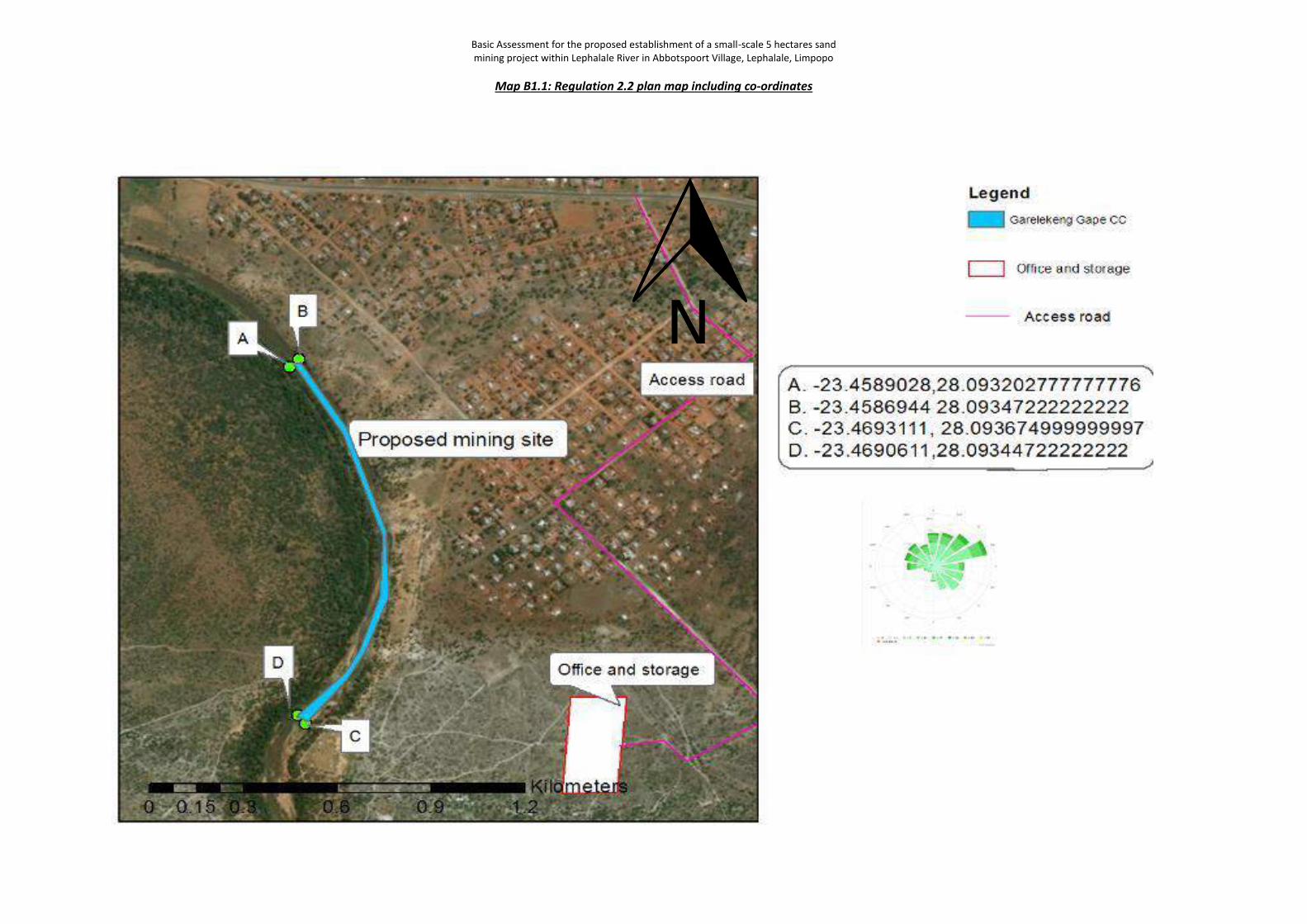
Basic Assessment for the proposed establishment of a small-scale 5 hectares sand mining project within Lephalale River in Abbotspoort Village, Lephalale, Limpopo
Map B1.1: Regulation 2.2 plan map including co-ordinates
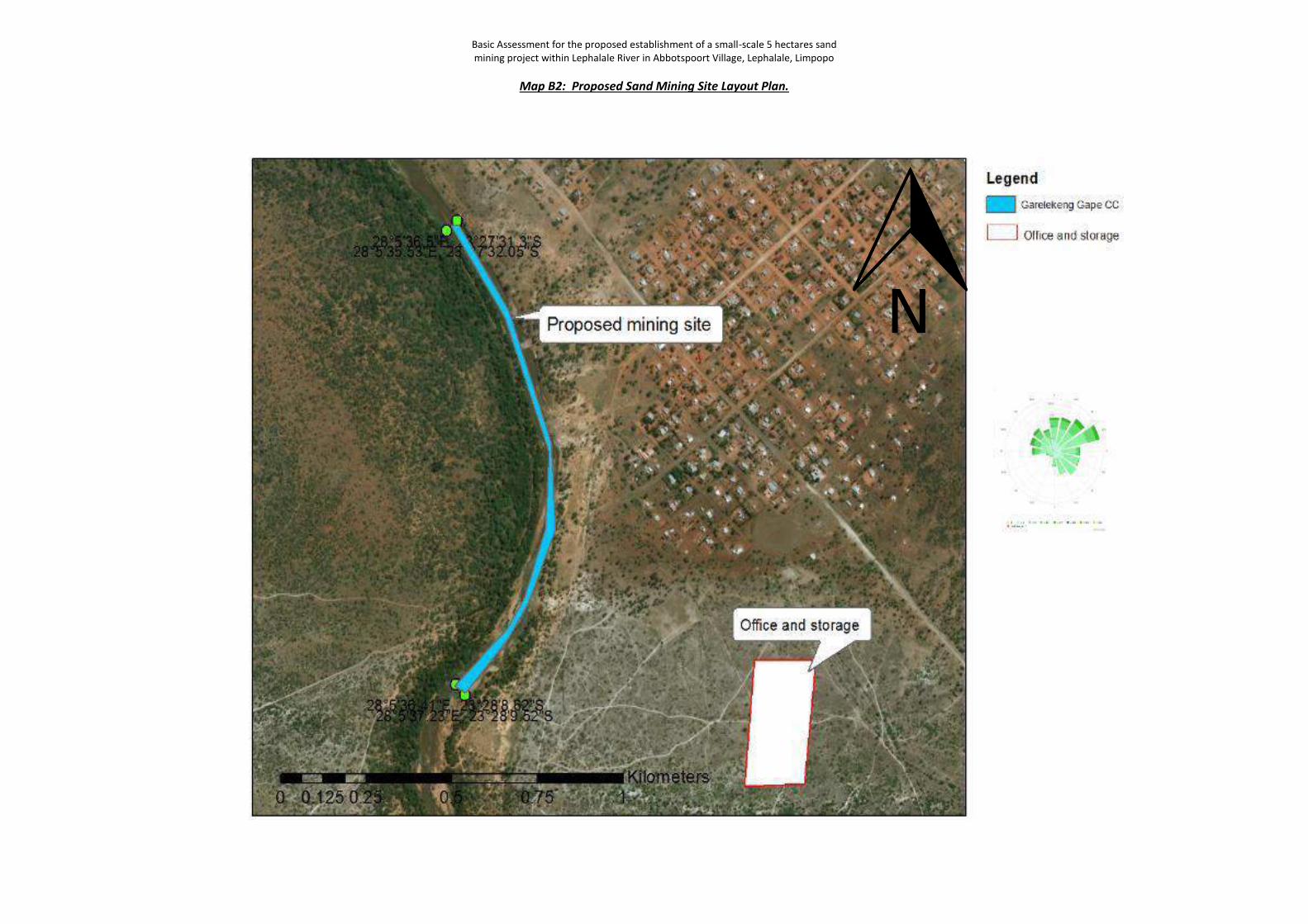
Basic Assessment for the proposed establishment of a small-scale 5 hectares sand mining project within Lephalale River in Abbotspoort Village, Lephalale, Limpopo
Map B2: Proposed Sand Mining Site Layout Plan.
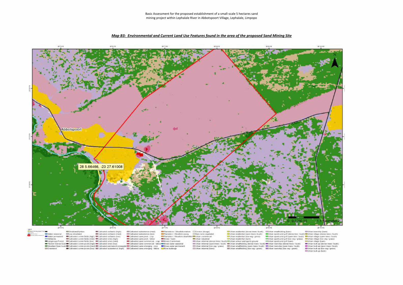
Basic Assessment for the proposed establishment of a small-scale 5 hectares sand mining project within Lephalale River in Abbotspoort Village, Lephalale, Limpopo
Map B3: Environmental and Current Land Use Features found in the area of the proposed Sand Mining Site
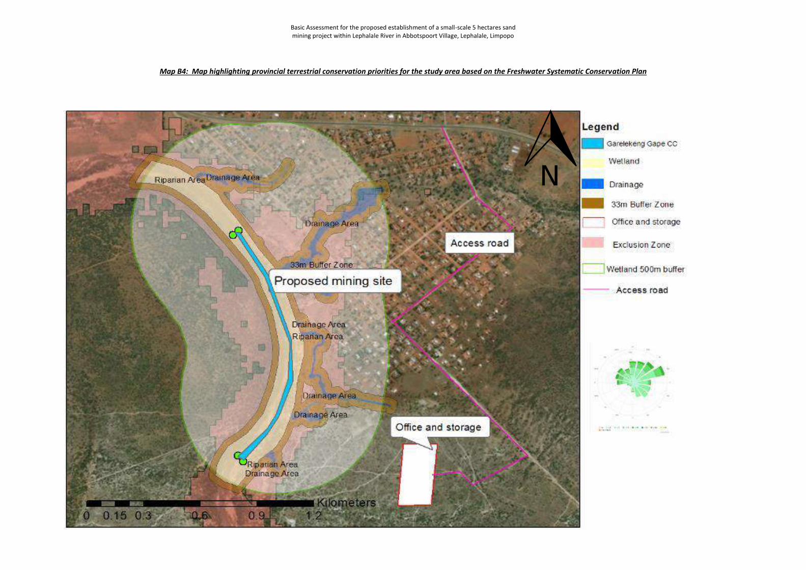
Basic Assessment for the proposed establishment of a small-scale 5 hectares sand mining project within Lephalale River in Abbotspoort Village, Lephalale, Limpopo
Map B4: Map highlighting provincial terrestrial conservation priorities for the study area based on the Freshwater Systematic Conservation Plan
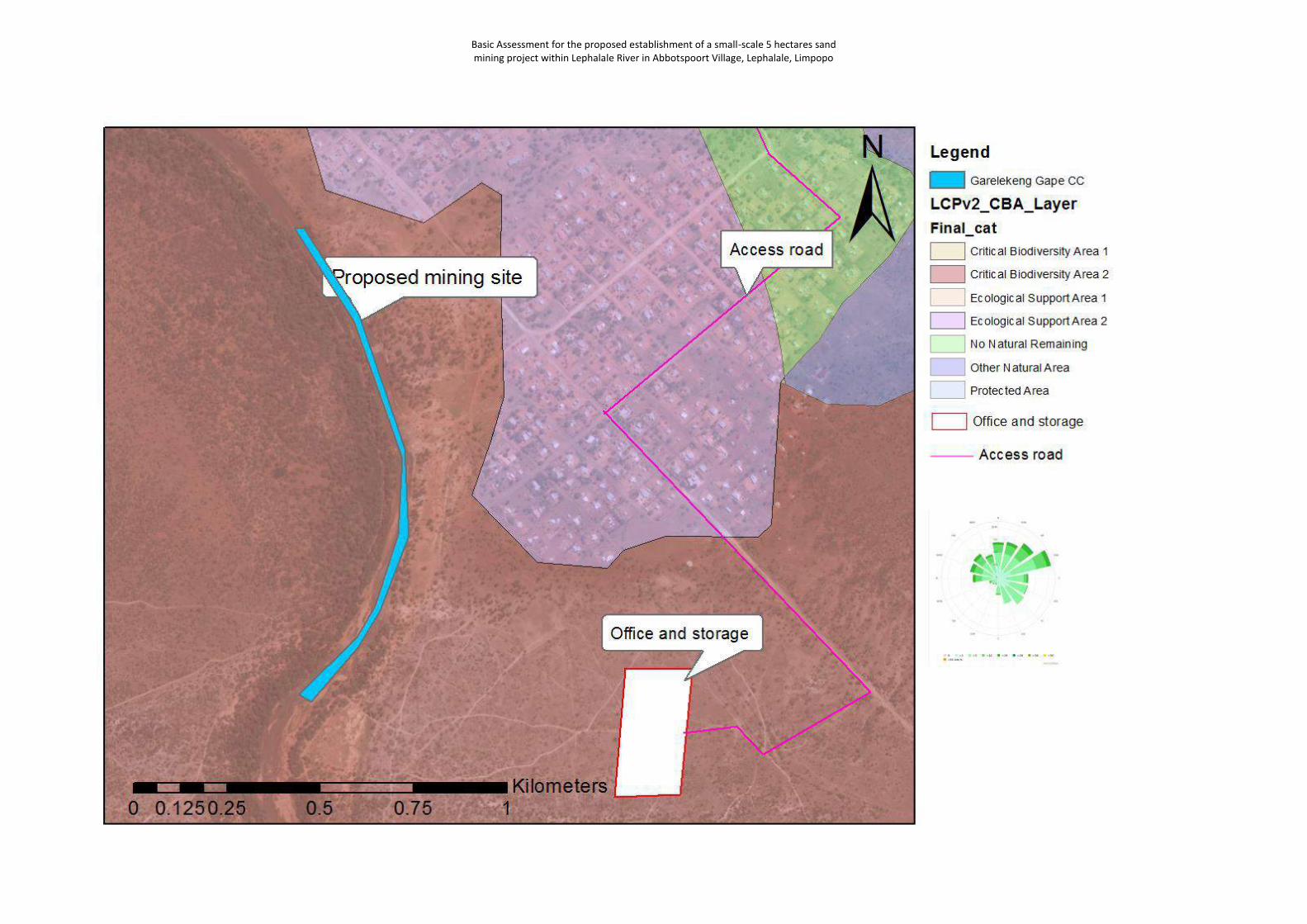
Basic Assessment for the proposed establishment of a small-scale 5 hectares sand mining project within Lephalale River in Abbotspoort Village, Lephalale, Limpopo
Basic Assessment for the proposed establishment of a small-scale 5 hectares sand mining project within Lephalale River in Abbotspoort Village, Lephalale, Limpopo
Appendix C1: Proof of Site Notice.
Appendix C2: Written notices issued as required in terms of the regulations.
Appendix C3: Proof of newspaper advertisements.
Appendix C4: Communications to and from interested and affected parties.
Appendix C5: Comments and Responses Report.
APPENDIX C
Public Participation
Information
Contents
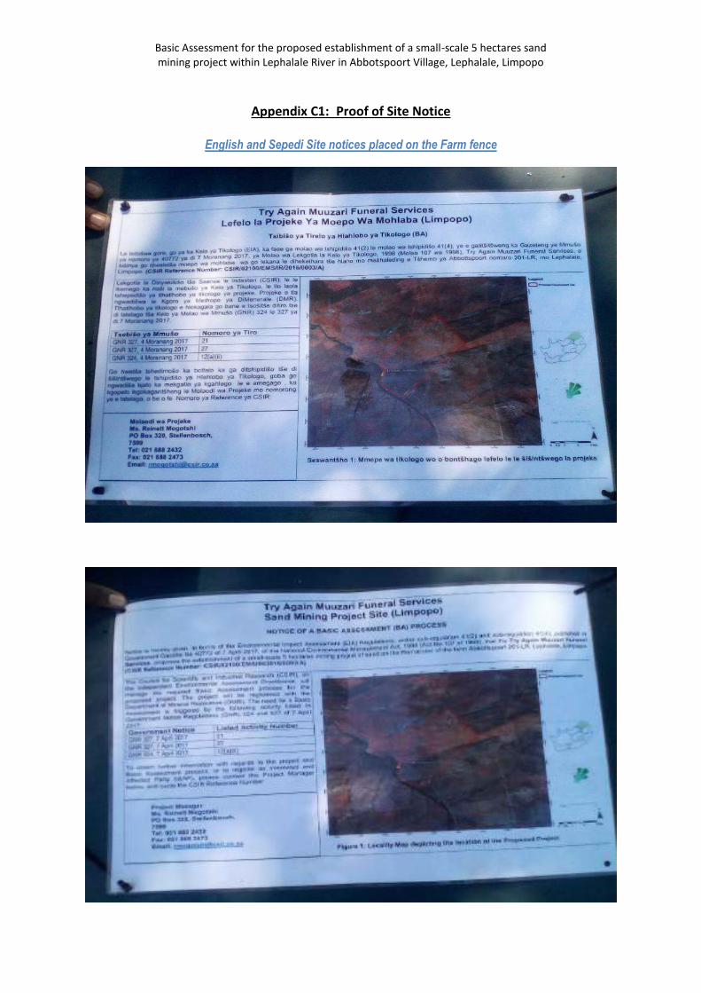
Basic Assessment for the proposed establishment of a small-scale 5 hectares sand mining project within Lephalale River in Abbotspoort Village, Lephalale, Limpopo
Appendix C1: Proof of Site Notice
English and Sepedi Site notices placed on the Farm fence
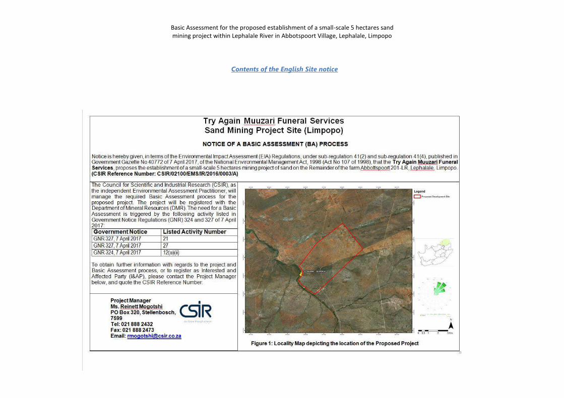
Basic Assessment for the proposed establishment of a small-scale 5 hectares sand mining project within Lephalale River in Abbotspoort Village, Lephalale, Limpopo
Contents of the English Site notice
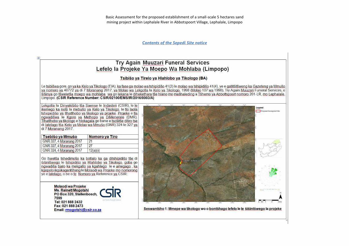
Basic Assessment for the proposed establishment of a small-scale 5 hectares sand mining project within Lephalale River in Abbotspoort Village, Lephalale, Limpopo
Contents of the Sepedi Site notice
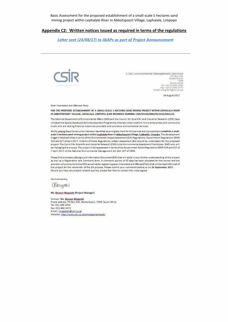
Basic Assessment for the proposed establishment of a small-scale 5 hectares sand mining project within Lephalale River in Abbotspoort Village, Lephalale, Limpopo
Appendix C2: Written notices issued as required in terms of the regulations
Letter sent (24/08/17) to I&APs as part of Project Announcement
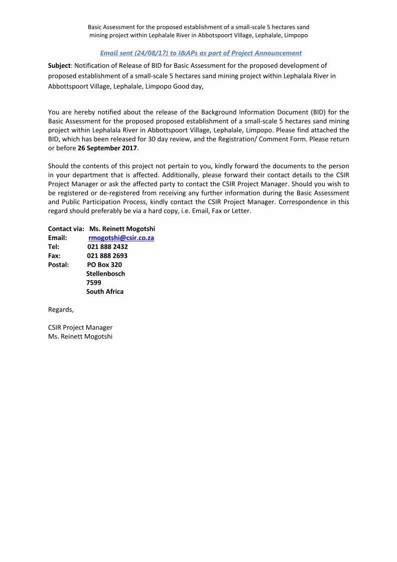
Basic Assessment for the proposed establishment of a small-scale 5 hectares sand mining project within Lephalale River in Abbotspoort Village, Lephalale, Limpopo
Email sent (24/08/17) to I&APs as part of Project Announcement
Subject: Notification of Release of BID for Basic Assessment for the proposed development of
proposed establishment of a small-scale 5 hectares sand mining project within Lephalala River in
Abbottspoort Village, Lephalale, Limpopo Good day,
You are hereby notified about the release of the Background Information Document (BID) for the Basic Assessment for the proposed proposed establishment of a small-scale 5 hectares sand mining project within Lephalala River in Abbottspoort Village, Lephalale, Limpopo. Please find attached the BID, which has been released for 30 day review, and the Registration/ Comment Form. Please return or before 26 September 2017. Should the contents of this project not pertain to you, kindly forward the documents to the person in your department that is affected. Additionally, please forward their contact details to the CSIR Project Manager or ask the affected party to contact the CSIR Project Manager. Should you wish to be registered or de-registered from receiving any further information during the Basic Assessment and Public Participation Process, kindly contact the CSIR Project Manager. Correspondence in this regard should preferably be via a hard copy, i.e. Email, Fax or Letter. Contact via: Ms. Reinett Mogotshi Email: [email protected] Tel: 021 888 2432 Fax: 021 888 2693 Postal: PO Box 320 Stellenbosch 7599 South Africa Regards, CSIR Project Manager Ms. Reinett Mogotshi
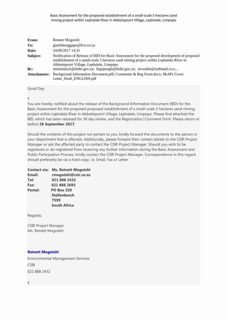
Basic Assessment for the proposed establishment of a small-scale 5 hectares sand mining project within Lephalale River in Abbotspoort Village, Lephalale, Limpopo
From: Reinett Mogotshi To: [email protected] Date: 24/08/2017 14:31 Subject:
Notification of Release of BID for Basic Assessment for the proposed development of proposed establishment of a small-scale 5 hectares sand mining project within Lephalala River in Abbottspoort Village, Lephalale, Limpopo
Bc: [email protected]; [email protected]; [email protected]... Attachments: Background Information Document.pdf; Comments & Reg Form.docx; I&APs Cover
Letter_Draft_ENGLISH.pdf
Good Day
You are hereby notified about the release of the Background Information Document (BID) for the
Basic Assessment for the proposed proposed establishment of a small-scale 5 hectares sand mining
project within Lephalala River in Abbottspoort Village, Lephalale, Limpopo. Please find attached the
BID, which has been released for 30 day review, and the Registration/ Comment Form. Please return or
before 26 September 2017.
Should the contents of this project not pertain to you, kindly forward the documents to the person in
your department that is affected. Additionally, please forward their contact details to the CSIR Project
Manager or ask the affected party to contact the CSIR Project Manager. Should you wish to be
registered or de-registered from receiving any further information during the Basic Assessment and
Public Participation Process, kindly contact the CSIR Project Manager. Correspondence in this regard
should preferably be via a hard copy, i.e. Email, Fax or Letter.
Contact via: Ms. Reinett Mogotshi
Email: [email protected]
Tel: 021 888 2432
Fax: 021 888 2693
Postal: PO Box 320
Stellenbosch
7599
South Africa
Regards,
CSIR Project Manager
Ms. Reinett Mogotshi
Reinett Mogotshi
Environmental Management Services
CSIR
021 888 2432
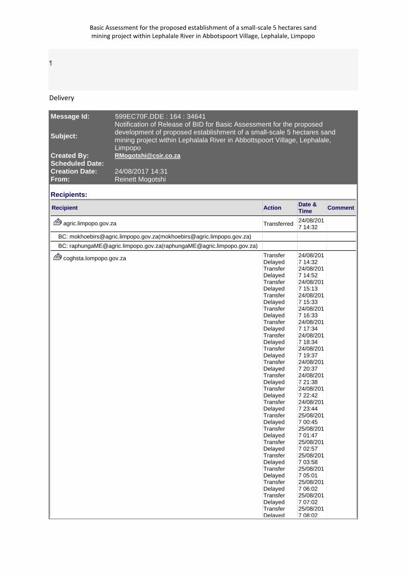
Basic Assessment for the proposed establishment of a small-scale 5 hectares sand mining project within Lephalale River in Abbotspoort Village, Lephalale, Limpopo
Delivery
Message Id: 599EC70F.DDE : 164 : 34641
Subject:
Notification of Release of BID for Basic Assessment for the proposed development of proposed establishment of a small-scale 5 hectares sand mining project within Lephalala River in Abbottspoort Village, Lephalale, Limpopo
Created By: [email protected]
Scheduled Date: Creation Date: 24/08/2017 14:31
From: Reinett Mogotshi
Recipients:
Recipient Action Date & Time Comment
agric.limpopo.gov.za Transferred 24/08/2017 14:32
BC: [email protected]([email protected]) BC: [email protected]([email protected])
coghsta.lompopo.gov.za Transfer Delayed Transfer Delayed Transfer Delayed Transfer Delayed Transfer Delayed Transfer Delayed Transfer Delayed Transfer Delayed Transfer Delayed Transfer Delayed Transfer Delayed Transfer Delayed Transfer Delayed Transfer Delayed Transfer Delayed Transfer Delayed Transfer Delayed Transfer Delayed Transfer Delayed Transfer Delayed
24/08/2017 14:32 24/08/2017 14:52 24/08/2017 15:13 24/08/2017 15:33 24/08/2017 16:33 24/08/2017 17:34 24/08/2017 18:34 24/08/2017 19:37 24/08/2017 20:37 24/08/2017 21:38 24/08/2017 22:42 24/08/2017 23:44 25/08/2017 00:45 25/08/2017 01:47 25/08/2017 02:57 25/08/2017 03:58 25/08/2017 05:01 25/08/2017 06:02 25/08/2017 07:02 25/08/2017 08:02
Basic Assessment for the proposed establishment of a small-scale 5 hectares sand mining project within Lephalale River in Abbotspoort Village, Lephalale, Limpopo
Transfer Delayed Transfer Delayed Transfer Delayed Transfer Delayed Transfer Delayed Transfer Delayed Transfer Delayed Transfer Delayed Transfer Delayed Transfer Delayed Transfer Delayed Transfer Delayed Transfer Delayed Transfer Delayed Transfer Delayed Transfer Delayed Transfer Delayed Transfer Delayed Transfer Delayed Transfer Delayed Transfer Delayed Transfer Delayed Transfer Delayed Transfer Delayed Transfer Delayed Transfer Delayed Transfer Delayed Transfer Delayed Transfer Delayed Transfer Delayed Transfer Delayed Transfer Delayed Transfer Delayed Transfer Delayed Transfer Delayed
25/08/2017 09:02 25/08/2017 10:02 25/08/2017 11:02 25/08/2017 12:03 25/08/2017 13:03 25/08/2017 14:03 25/08/2017 15:03 25/08/2017 16:03 25/08/2017 17:04 25/08/2017 18:06 25/08/2017 19:08 25/08/2017 20:09 25/08/2017 21:18 25/08/2017 22:28 25/08/2017 23:35 26/08/2017 00:49 26/08/2017 01:51 26/08/2017 02:52 26/08/2017 04:01 26/08/2017 05:06 26/08/2017 06:07 26/08/2017 07:14 26/08/2017 08:14 26/08/2017 09:20 26/08/2017 10:27 26/08/2017 11:28 26/08/2017 12:32 26/08/2017 13:33 26/08/2017 14:36 26/08/2017 15:37 26/08/2017 16:44 26/08/2017 17:47 26/08/2017 18:50 26/08/2017 19:51 26/08/2017 20:51
Basic Assessment for the proposed establishment of a small-scale 5 hectares sand mining project within Lephalale River in Abbotspoort Village, Lephalale, Limpopo
Transfer Delayed Transfer Delayed Transfer Delayed Transfer Delayed Transfer Delayed Transfer Delayed Transfer Delayed Transfer Delayed Transfer Delayed Transfer Delayed Transfer Delayed Transfer Delayed Transfer Delayed Transfer Delayed Transfer Delayed Transfer Delayed Transfer Delayed Transfer Delayed Transfer Delayed Transfer Delayed Transfer Delayed Transfer Delayed Transfer Delayed Transfer Delayed Transfer Delayed Transfer Delayed Transfer Delayed Transfer Delayed Transfer Delayed Transfer Delayed Transfer Delayed Transfer Delayed Transfer Delayed Transfer Delayed Transfer Delayed
26/08/2017 21:55 26/08/2017 22:57 26/08/2017 23:59 27/08/2017 01:00 27/08/2017 02:02 27/08/2017 03:03 27/08/2017 04:06 27/08/2017 05:07 27/08/2017 06:08 27/08/2017 07:09 27/08/2017 08:12 27/08/2017 09:14 27/08/2017 10:16 27/08/2017 11:16 27/08/2017 12:18 27/08/2017 13:18 27/08/2017 14:18 27/08/2017 15:19 27/08/2017 16:19 27/08/2017 17:19 27/08/2017 18:20 27/08/2017 19:21 27/08/2017 20:21 27/08/2017 21:22 27/08/2017 22:22 27/08/2017 23:23 28/08/2017 00:24 28/08/2017 01:24 28/08/2017 02:25 28/08/2017 03:25 28/08/2017 04:26 28/08/2017 05:26 28/08/2017 06:26 28/08/2017 07:27 28/08/2017 08:27
Basic Assessment for the proposed establishment of a small-scale 5 hectares sand mining project within Lephalale River in Abbotspoort Village, Lephalale, Limpopo
Transfer Delayed Transfer Delayed Transfer Delayed Transfer Delayed Transfer Delayed Transfer Delayed Transfer Failed
28/08/2017 09:27 28/08/2017 10:27 28/08/2017 11:28 28/08/2017 12:28 28/08/2017 13:28 28/08/2017 14:28 28/08/2017 15:28
BC: [email protected]([email protected]) Undeliverabl
e 28/08/2017 15:28
421 service unavailable
daff.gov.za Transferred 24/08/2017 14:32
BC: [email protected]([email protected])
dmr.gov.za Transferred 24/08/2017 14:32
BC: [email protected]([email protected]) BC: [email protected]([email protected]) BC: [email protected]([email protected]) BC: [email protected]([email protected])
drdlr.gov.za Transferred 24/08/2017 14:32
BC: [email protected]([email protected])
dwa.gov.za Transferred 24/08/2017 14:32
BC: [email protected]([email protected])
dws.gov.za Transferred 24/08/2017 14:32
BC: [email protected]([email protected])
environment.gov.za Transferred 24/08/2017 14:32
BC: [email protected]([email protected]) BC: [email protected]([email protected]) BC: [email protected]([email protected])
eskom.co.za Transfer Delayed Transferred
24/08/2017 14:32 24/08/2017 14:53
BC: [email protected]([email protected])
landbank.co.za Transferred 24/08/2017 14:32
BC: [email protected]([email protected])
ledet.gov.za Transferred 24/08/2017 14:32
BC: [email protected]([email protected]) BC: [email protected]([email protected])
lephalale.gov.za Transferred 24/08/2017 14:32
BC: [email protected]([email protected]) BC: [email protected]([email protected])
Basic Assessment for the proposed establishment of a small-scale 5 hectares sand mining project within Lephalale River in Abbotspoort Village, Lephalale, Limpopo
BC: [email protected]([email protected]) BC: [email protected]([email protected]) BC: [email protected]([email protected])
live.co.za Transferred 24/08/2017 14:36
BC: [email protected]([email protected])
mweb.co.za Transferred 24/08/2017 14:32
BC: [email protected]([email protected])
sapoultry.co.za Transfer Delayed Transferred
24/08/2017 14:32 24/08/2017 14:52
BC: [email protected]([email protected])
thedti.gov.za Transferred 24/08/2017 14:32
BC: [email protected]([email protected])
waterberg.gov.za Transferred 24/08/2017 14:32
BC: [email protected]([email protected]) BC: [email protected]([email protected])
webmail.co.za/ [email protected] Transfer Delayed Transfer Delayed Transfer Delayed Transfer Delayed Transfer Delayed Transfer Delayed Transfer Delayed Transfer Delayed Transfer Delayed Transfer Delayed Transfer Delayed Transfer Delayed Transfer Delayed Transfer Delayed Transfer Delayed Transfer Delayed Transfer Delayed Transfer Delayed Transfer Delayed Transfer Delayed Transfer Delayed Transfer
24/08/2017 14:32 24/08/2017 14:52 24/08/2017 15:12 24/08/2017 15:32 24/08/2017 16:33 24/08/2017 17:33 24/08/2017 18:34 24/08/2017 19:36 24/08/2017 20:37 24/08/2017 21:37 24/08/2017 22:39 24/08/2017 23:39 25/08/2017 00:41 25/08/2017 01:44 25/08/2017 02:51 25/08/2017 03:56 25/08/2017 04:59 25/08/2017 06:01 25/08/2017 07:01 25/08/2017 08:01 25/08/2017 09:01 25/08/201
Basic Assessment for the proposed establishment of a small-scale 5 hectares sand mining project within Lephalale River in Abbotspoort Village, Lephalale, Limpopo
Delayed Transfer Delayed Transfer Delayed Transfer Delayed Transfer Delayed Transfer Delayed Transfer Delayed Transfer Delayed Transfer Delayed Transfer Delayed Transfer Delayed Transfer Delayed Transfer Delayed Transfer Delayed Transfer Delayed Transfer Delayed Transfer Delayed Transfer Delayed Transfer Delayed Transfer Delayed Transfer Delayed Transfer Delayed Transfer Delayed Transfer Delayed Transfer Delayed Transfer Delayed Transfer Delayed Transfer Delayed Transfer Delayed Transfer Delayed Transfer Delayed Transfer Delayed Transfer Delayed Transfer Delayed Transfer Delayed Transfer
7 10:01 25/08/2017 11:02 25/08/2017 12:02 25/08/2017 13:03 25/08/2017 14:03 25/08/2017 15:03 25/08/2017 16:03 25/08/2017 17:04 25/08/2017 18:06 25/08/2017 19:06 25/08/2017 20:09 25/08/2017 21:16 25/08/2017 22:28 25/08/2017 23:45 26/08/2017 01:02 26/08/2017 02:20 26/08/2017 03:24 26/08/2017 04:36 26/08/2017 05:43 26/08/2017 06:44 26/08/2017 07:50 26/08/2017 08:54 26/08/2017 09:56 26/08/2017 10:58 26/08/2017 12:00 26/08/2017 13:05 26/08/2017 14:06 26/08/2017 15:07 26/08/2017 16:07 26/08/2017 17:09 26/08/2017 18:11 26/08/2017 19:17 26/08/2017 20:20 26/08/2017 21:23 26/08/2017 22:26 26/08/201

Basic Assessment for the proposed establishment of a small-scale 5 hectares sand mining project within Lephalale River in Abbotspoort Village, Lephalale, Limpopo
Delayed Transfer Delayed Transfer Delayed Transfer Delayed Transfer Delayed Transfer Delayed Transfer Delayed Transfer Delayed Transfer Delayed Transfer Delayed Transfer Delayed Transfer Delayed Transfer Delayed Transfer Delayed Transfer Delayed Transfer Delayed Transfer Delayed Transfer Delayed Transfer Delayed Transfer Delayed Transfer Delayed Transfer Delayed Transfer Delayed Transfer Delayed Transfer Delayed Transfer Delayed Transfer Delayed Transfer Delayed Transfer Delayed Transfer Delayed Transfer Delayed Transfer Delayed Transfer Delayed Transfer Delayed Transfer Delayed Transfer
7 23:26 27/08/2017 00:30 27/08/2017 01:32 27/08/2017 02:34 27/08/2017 03:35 27/08/2017 04:37 27/08/2017 05:41 27/08/2017 06:42 27/08/2017 07:44 27/08/2017 08:44 27/08/2017 09:44 27/08/2017 10:45 27/08/2017 11:46 27/08/2017 12:46 27/08/2017 13:47 27/08/2017 14:48 27/08/2017 15:49 27/08/2017 16:50 27/08/2017 17:51 27/08/2017 18:51 27/08/2017 19:53 27/08/2017 20:53 27/08/2017 21:54 27/08/2017 22:54 27/08/2017 23:55 28/08/2017 00:56 28/08/2017 01:56 28/08/2017 02:57 28/08/2017 03:57 28/08/2017 04:57 28/08/2017 05:57 28/08/2017 06:58 28/08/2017 07:58 28/08/2017 08:58 28/08/2017 09:58 28/08/201
Basic Assessment for the proposed establishment of a small-scale 5 hectares sand mining project within Lephalale River in Abbotspoort Village, Lephalale, Limpopo
Delayed Transfer Delayed Transfer Delayed Transfer Delayed Transfer Failed
7 10:58 28/08/2017 11:58 28/08/2017 12:58 28/08/2017 13:59 28/08/2017 14:59
BC: [email protected]/ [email protected]([email protected]/ [email protected]) Undeliverabl
e 28/08/2017 14:59
421 service unavailable
Post Offices
Post Office Delivered Route
agric.limpopo.gov.za agric.limpopo.gov.za
coghsta.lompopo.gov.za coghsta.lompopo.gov.za
daff.gov.za daff.gov.za
dmr.gov.za dmr.gov.za
drdlr.gov.za drdlr.gov.za
dwa.gov.za dwa.gov.za
dws.gov.za dws.gov.za
environment.gov.za environment.gov.za
eskom.co.za eskom.co.za
landbank.co.za landbank.co.za
ledet.gov.za ledet.gov.za
lephalale.gov.za lephalale.gov.za
live.co.za live.co.za
mweb.co.za mweb.co.za
sapoultry.co.za sapoultry.co.za
thedti.gov.za thedti.gov.za
waterberg.gov.za waterberg.gov.za
webmail.co.za/ [email protected] webmail.co.za/ [email protected]
Files
File Size Date & Time
Background Information Document.pdf 337 KB (345825 Bytes) 24/08/2017 11:15
Comments & Reg Form.docx 147 KB (151039 Bytes) 17/08/2017 13:56
I&APs Cover Letter_Draft_ENGLISH.pdf 272 KB (279431 Bytes) 24/08/2017 14:23
MESSAGE 3 KB (3187 Bytes) 24/08/2017 14:31
TEXT.htm 2 KB (3013 Bytes) 24/08/2017 14:31
Options
Auto Delete: No Concealed Subject: No Expiration Date: None Notify Recipients: No Priority: Standard Reply Requested By: None Security: Standard To Be Delivered: Immediate
Record Id
Record Id: 5A16837D.STELLBOS.POBOX1.100.1383869.1.20FA.1 Common Record Id: 5A16675D.STELLBOS.POBOX1.200.2000000.1.BF25.1
Basic Assessment for the proposed establishment of a small-scale 5 hectares sand mining project within Lephalale River in Abbotspoort Village, Lephalale, Limpopo
Postal List for mail sent 24/08/17: Project Announcement documents (BID, Letter dated and
Registration/Comment Form)
Name & Signature of person responsible for post: _______________________________
26 items – Registered Post (Garelekeng Gape) Reinett Mogotshi 021 8882432
Project Number: EMS0136/ 021SE
Department of Economic Development, Environment & Tourism Mr Abel Matsimela 20 Hans van Rensburg Street Polokwane 0700
Department of Economic Development, Environment & Tourism Mr Solly Kgopong 19 Biccard Street Polokwane 0700
Department of Economic Development, Environment & Tourism Ms NM Mdau Old Parliamentary Building Block E & F 0950
Department of Agriculture: Limpopo Mr Terries Salani Ndove 67 Biccard Street Temo Towers Polokwane 0700
Department of Agriculture: Limpopo Ms M.E. Raphunga Makwarela Government Office SIBASA 0970
Department of Cooperative Governance, Human Settlements & Traditional Affairs Mr TV Khuzwayo Hensa Towers Building 20 Rabe Street Polokwane 0700
Department of Cooperative Governance, Human Settlements & Traditional Affairs Ms SH Mabuda Private Bag X9485 Polokwane 0700
Waterberg District Municipality The Municipal Manager Private Bag X1018 Modimolle 0510
Lephalale Local Municipality Leonard Sole Private bag x136 Lephalale 0555
Lephalale Local Municipality Johanna Selokela Ward Councillor Private bag x136 Lephalale 0555
Lephalale Local Municipality Tukakgomo E Private bag x136 Lephalale 0555
Garelekeng Gape CC Elias Nku P O BOX 4390 Enkelbult Lephalale 0555
Abbotsspoort Traditional Council Langa M.L P O Box 177 Lephalale 0555
Department of Mineral Resources Rendani Mibva Private Bag X9467 Polokwane 0700
National Department of Rural Development and Land Reform Una- Bonginkosi Zulu Fedsure Building Private Bag X447 315 Pretorius Street Pretoria 0002
Basic Assessment for the proposed establishment of a small-scale 5 hectares sand mining project within Lephalale River in Abbotspoort Village, Lephalale, Limpopo
South African National Parks (SANParks) Dr. Howard Hendriks PO Box 787 Pretoria 0001
National Department of Agriculture, Forestry and Fisheries Mashudu Marubini Private Bag X138 Pretoria 0001
South African Heritage Resources Agency (SAHRA) Marie South PO Box 4637 Cape Town 8000
AgriLand Anneliza Collett Private Bag X120 Pretoria 0001
Department of Water and Sanitation Tshepo Mathebe Private Bag X 995 Pretoria 0001
Limpopo Tourism Agency Executive Manager PO Box 2814 Polokwane 0700
Limpopo Economic Development Agency Mr Humphrey Maphutha Enterprise Development Finance Main Road Lebowakgomo Polokwane, 0699
Limpopo Economic Development Agency Senior Manager Makhado Local Municipality Offices 98 Krogh Street Civic Centre 0920
Department of Mineral Resources Thivhulawi Kolani Private Bag X9467 Polokwane 0700
Department of Mineral Resources Happy Ramulondi Private Bag X9467 Polokwane 0700
Department of Mineral Resources Rendani Mibva Private Bag X9467 Polokwane 0700
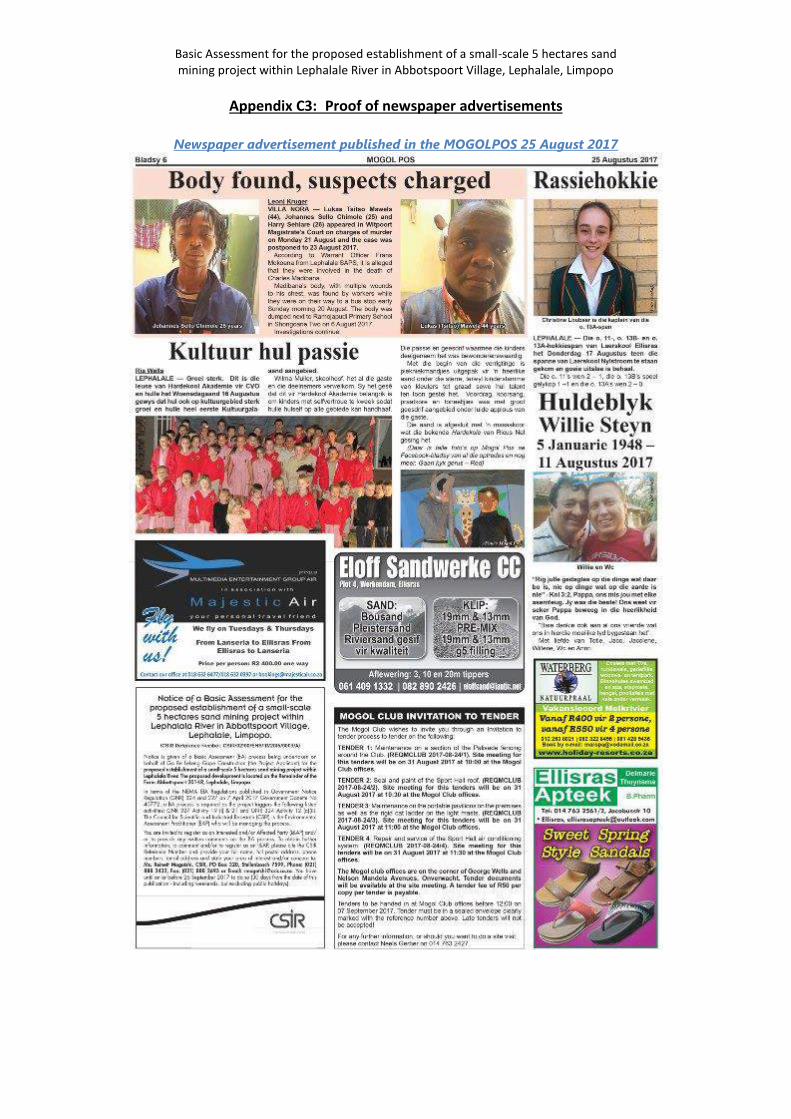
Basic Assessment for the proposed establishment of a small-scale 5 hectares sand mining project within Lephalale River in Abbotspoort Village, Lephalale, Limpopo
Appendix C3: Proof of newspaper advertisements
Newspaper advertisement published in the MOGOLPOS 25 August 2017
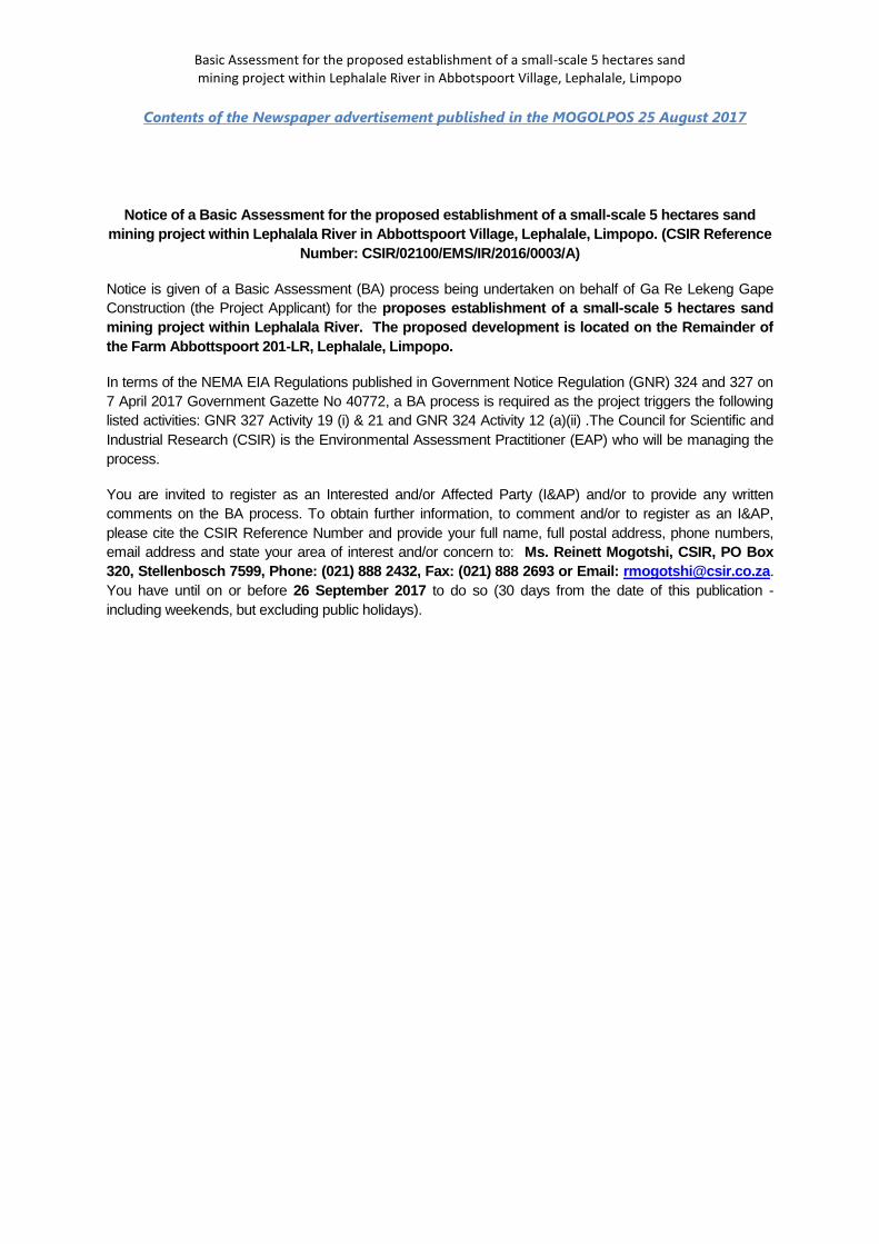
Basic Assessment for the proposed establishment of a small-scale 5 hectares sand mining project within Lephalale River in Abbotspoort Village, Lephalale, Limpopo
Contents of the Newspaper advertisement published in the MOGOLPOS 25 August 2017
Notice of a Basic Assessment for the proposed establishment of a small-scale 5 hectares sand mining project within Lephalala River in Abbottspoort Village, Lephalale, Limpopo. (CSIR Reference
Number: CSIR/02100/EMS/IR/2016/0003/A)
Notice is given of a Basic Assessment (BA) process being undertaken on behalf of Ga Re Lekeng Gape Construction (the Project Applicant) for the proposes establishment of a small-scale 5 hectares sand mining project within Lephalala River. The proposed development is located on the Remainder of the Farm Abbottspoort 201-LR, Lephalale, Limpopo.
In terms of the NEMA EIA Regulations published in Government Notice Regulation (GNR) 324 and 327 on 7 April 2017 Government Gazette No 40772, a BA process is required as the project triggers the following listed activities: GNR 327 Activity 19 (i) & 21 and GNR 324 Activity 12 (a)(ii) .The Council for Scientific and Industrial Research (CSIR) is the Environmental Assessment Practitioner (EAP) who will be managing the process.
You are invited to register as an Interested and/or Affected Party (I&AP) and/or to provide any written comments on the BA process. To obtain further information, to comment and/or to register as an I&AP, please cite the CSIR Reference Number and provide your full name, full postal address, phone numbers, email address and state your area of interest and/or concern to: Ms. Reinett Mogotshi, CSIR, PO Box 320, Stellenbosch 7599, Phone: (021) 888 2432, Fax: (021) 888 2693 or Email: [email protected]. You have until on or before 26 September 2017 to do so (30 days from the date of this publication - including weekends, but excluding public holidays).
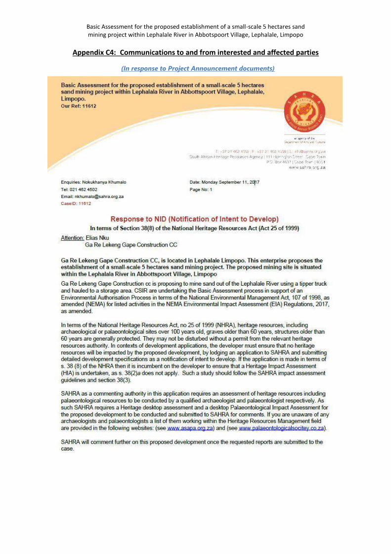
Basic Assessment for the proposed establishment of a small-scale 5 hectares sand mining project within Lephalale River in Abbotspoort Village, Lephalale, Limpopo
Appendix C4: Communications to and from interested and affected parties
(In response to Project Announcement documents)
Basic Assessment for the proposed establishment of a small-scale 5 hectares sand mining project within Lephalale River in Abbotspoort Village, Lephalale, Limpopo
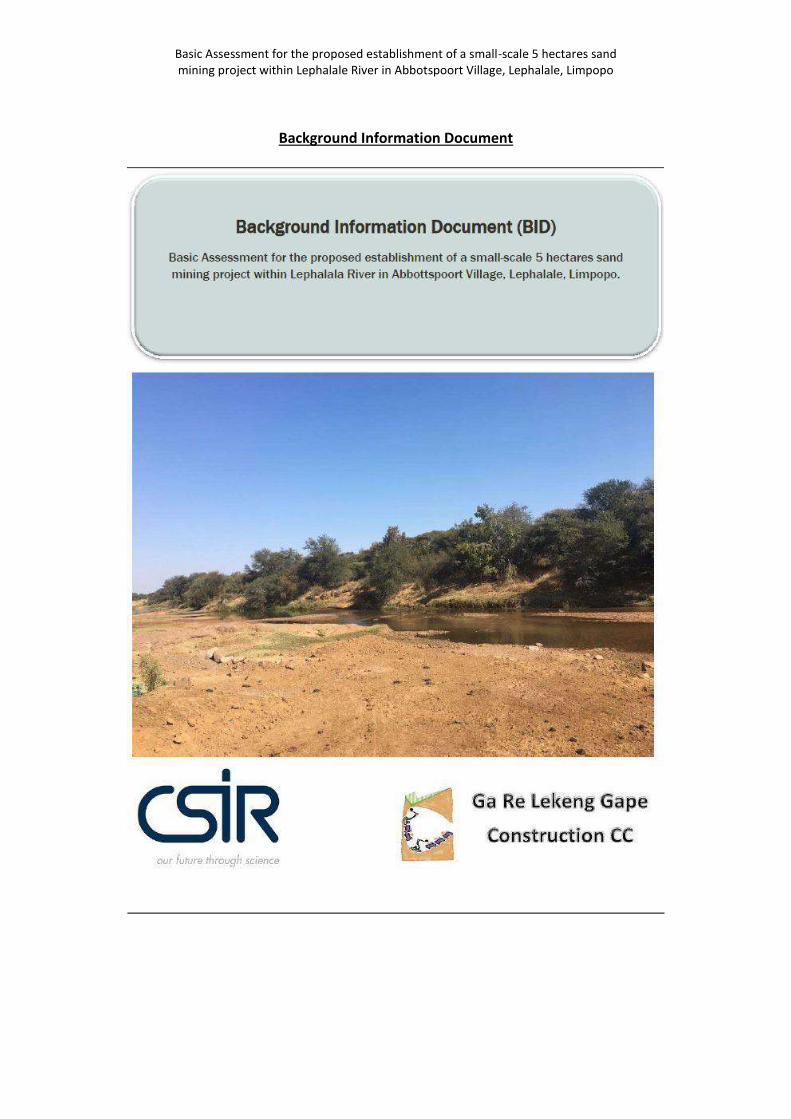
Basic Assessment for the proposed establishment of a small-scale 5 hectares sand mining project within Lephalale River in Abbotspoort Village, Lephalale, Limpopo
Background Information Document
Basic Assessment for the proposed establishment of a small-scale 5 hectares sand mining project within Lephalale River in Abbotspoort Village, Lephalale, Limpopo
Basic Assessment for the proposed establishment of a small-scale 5 hectares sand mining project within Lephalale River in Abbotspoort Village, Lephalale, Limpopo
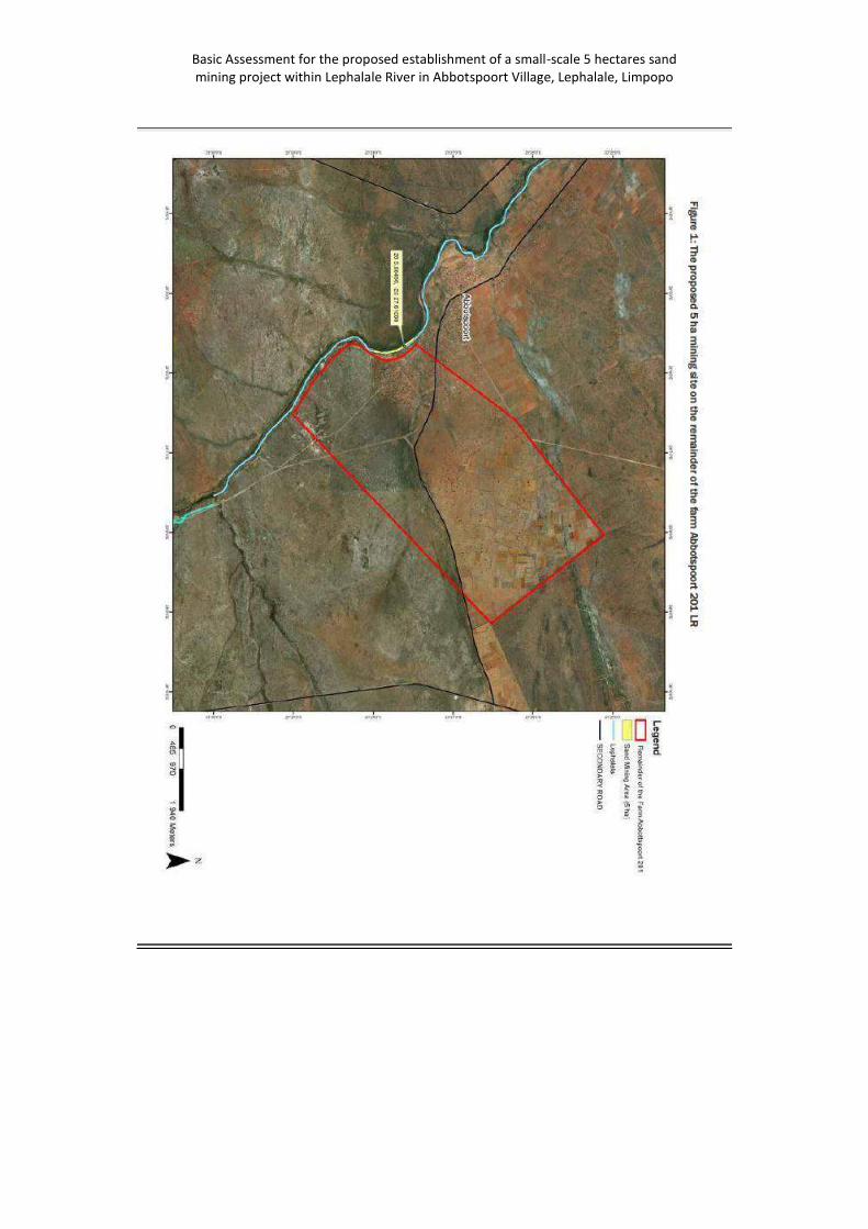
Basic Assessment for the proposed establishment of a small-scale 5 hectares sand mining project within Lephalale River in Abbotspoort Village, Lephalale, Limpopo
Basic Assessment for the proposed establishment of a small-scale 5 hectares sand mining project within Lephalale River in Abbotspoort Village, Lephalale, Limpopo
Appendix C5: Comments and Responses Report *Please note that the comments are taken verbatim from the comments provided by Interested and Affected Parties
Interested and Affected Parties Date Comments Received
Issues raised EAPs response to issues as mandated by the applicant
Section and paragraph reference in this Report where the issues and/or responses were incorporated
Name Organisation
Interested and Affected Parties Date Comments Received
Issues raised EAPs response to issues as mandated by the applicant
Section and paragraph reference in this Report where the issues and/or responses were incorporated
Name Organisation
Nokukhanya Khumalo
SAHRA Monday September 11, 2017
Basic Assessment for the proposed establishment of a small-scale 5 hectares sand mining project within Lephalala River in Abbottspoort Village, Lephalale, Limpopo. Our Ref: 11612 Enquiries:
Nokukhanya Khumalo Date: Monday September 11, 2017
Tel: 021 462 4502
Email: [email protected]
CaseID: 11612 Page No: 1 Response to NID (Notification of Intent to Develop) In terms of Section 38(8) of the National Heritage Resources Act (Act 25 of 1999) Attention: Elias Nku Ga Re Lekeng Gape Construction CC Ga Re Lekeng Gape Construction CC, is
Thank you for the comments provided. Comment is noted. A heritage desktop analysis was undertaken for the project by Nicholas Wiltshire, Director CTS Heritage t/a Cedar Tower Services (Pty) Ltd
34 Harries Street, Plumstead,
Cape Town, 7800 Tel: +27 (0)21 013 0131/0236,
Cell: +27 (0)82 303 7870 [email protected]
*www.cedartower.co.za
Kindly refer to Appendix D of this BAR.
Basic Assessment for the proposed establishment of a small-scale 5 hectares sand mining project within Lephalale River in Abbotspoort Village, Lephalale, Limpopo
located in Lephalale Limpopo. This enterprise proposes the establishment of a small-scale 5 hectares sand mining project. The proposed mining site is situated within the Lephalala River in Abbottspoort Village, Limpopo Ga Re Lekeng Gape Construction cc is proposing to mine sand out of the Lephalale River using a tipper truck and hauled to a storage area. CSIR are undertaking the Basic Assessment process in support of an Environmental Authorisation Process in terms of the National Environmental Management Act, 107 of 1998, as amended (NEMA) for listed activities in the NEMA Environmental Impact Assessment (EIA) Regulations, 2017, as amended. In terms of the National Heritage Resources Act, no 25 of 1999 (NHRA), heritage resources, including archaeological or palaeontological sites over 100 years old, graves older than 60 years, structures older than 60 years are generally protected. They may not be disturbed without a permit from the relevant heritage resources authority. In contexts of development applications, the developer must ensure that no heritage resources will be impacted by the proposed development, by lodging an application to SAHRA and submitting detailed development specifications as a notification of intent to develop. If the application is made in terms of s. 38 (8) of the NHRA then it is incumbent on the developer to ensure that a Heritage Impact Assessment (HIA) is undertaken, as s.
Basic Assessment for the proposed establishment of a small-scale 5 hectares sand mining project within Lephalale River in Abbotspoort Village, Lephalale, Limpopo
38(2)a does not apply. Such a study should follow the SAHRA impact assessment guidelines and section 38(3). SAHRA as a commenting authority in this application requires an assessment of heritage resources including palaeontological resources to be conducted by a qualified archaeologist and palaeontologist respectively. As such SAHRA requires a Heritage desktop assessment and a desktop Palaeontological Impact Assessment for the proposed development to be conducted and submitted to SAHRA for comments. If you are unaware of any archaeologists and palaeontologists a list of them working within the Heritage Resources Management field are provided in the following websites: (see www.asapa.org.za) and (see www.palaeontologicalsocitey.co.za). SAHRA will comment further on this proposed development once the requested reports are submitted to the case.

Basic Assessment for the proposed establishment of a small-scale 5 hectares sand mining project within Lephalale River in Abbotspoort Village, Lephalale, Limpopo
Aquatic Ecology Assessment
Heritage Impact Assessment Study
Wetlands Assessment Study
Flood line Assessment Study
APPENDIX D
Specialist Reports
Contents
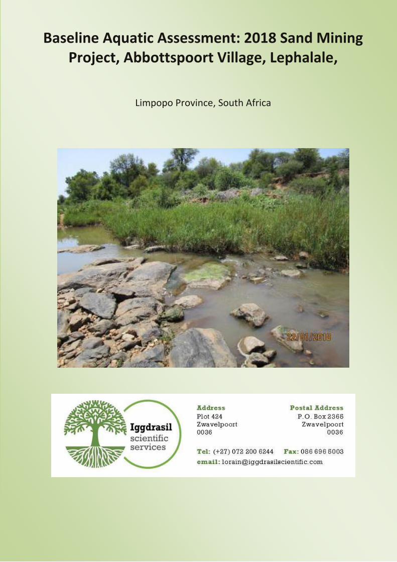
Baseline Aquatic Assessment: 2018 Sand Mining Project, Abbottspoort Village, Lephalale,
Limpopo Province, South Africa
Report Status
Report Title: Baseline Aquatic Assessment: 2018 Sand Mining Project, Abbottspoort
Village, Lephalale, Limpopo Province, South Africa.
Compiled by: Lorainmari den Boogert, (Pr.Sci.Nat Ecology and Botany), Kimberley
Perry (MSc. Water Resource Management)
Client: CSIR
Client Representative: Karabo Mashabela
Report Status: Final Draft
Date of Report: February 2018
Declaration
I, Lorainmari den Boogert, declare that -
• I act as the independent specialist;
• I will perform the work relating to the application in an objective manner, even if this results
in views and findings that are not favourable to the applicant;
• I declare that there are no circumstances that may compromise my objectivity in performing
such work;
• I have expertise in conducting the specialist report relevant to this application, including
knowledge of the National Environmental Management Act, 1998 (Act No. 107 of 1998),
regulations and any guidelines that have relevance to the proposed activity;
• I will comply with the Act, regulations and all other applicable legislation;
• I will take into account, to the extent possible, the matters listed in Regulation 8;
• I have no, and will not engage in, conflicting interests in the undertaking of the activity;
• I undertake to disclose to the applicant and the competent authority all material information
in my possession that reasonably has or may have the potential of influencing - any decision
to be taken with respect to the application by the competent authority; and - the objectivity
of any report, plan or document to be prepared by myself for submission to the competent
authority;
• All the particulars furnished by me in this form are true and correct; and
• I realise that a false declaration is an offence in terms of Regulation 71 and is punishable in
terms of section 24F of the Act.
Signature of specialist
Iggdrasil Scientific Services (Pty) Ltd.
Name of company
February 2018
Date
Draft: Baseline Aquatic Assessment: Sand Mining Project | i
2018
Executive Summary
The Ga Re Lekeng Gape Construction CC. is proposing the development of a small-scale 5 hectares sand
mining project (CSIR, 2017). The proposed mining site, further referred to as the study area, is situated
within the Lephalala River in Abbottspoort Village, Limpopo. The study area occurs within the A50G
quaternary catchment area which forms part of the Limpopo Water Management Area (WMA 1).
Iggdrasil Scientific Services (Pty) Ltd (“ISS”), an independent ecological specialist company based in
Pretoria, Gauteng, was commissioned by the CSIR to conduct the baseline aquatic assessment for the
mining activities associated with the Lephalala River, Abbottspoort Village, Limpopo Province, South
Africa. The project has one deliverable namely a Baseline Aquatic report after completion of the site
visit.
The study area is located in the perennial Lephalala River, which is a tributary of the Limpopo River.
According to NFEPA data, the Lephalala River is classified as class D which indicated a largely modified
river. According to national planning the study area is categorised as a non FEPA. The area surrounding
the study area has no wetland FEPA types. The Sub Quaternary Reach (SQR) of the study area, SQR
A50E-196, has a Present Ecological State (PES) of C indicating the SQR is moderately modified.
Additionally, the SQR has a high Ecological Importance (EI) and a high Ecological Sensitivity (ES). The
study area is located within a Critical Biodiversity Area 2 and an Ecological Support Area 2 according to
the Limpopo Conservation Plan (LEDET 2013).
The 2018 baseline aquatic biomonitoring assessment at the proposed sand mining project study area
was conducted on the 22nd of January 2018 at sampling points LH1 and LH2. The habitats at all
biomonitoring sampling points were firstly evaluated by means of observations with regard to their
surroundings, possible causes of impacts or disturbances on aquatic ecosystems, and their suitability
for future biomonitoring surveys. The outcome of this evaluation indicated that biomonitoring
sampling methods VEGRAI, IHAS, and SASS5 could be applied at both sampling points LH1 and LH2. In-
situ water quality results were obtained at sampling points LH1 and LH2. Diatom analysis was
conducted at sampling points LH1 and LH2.
For this 2018 baseline aquatic assessment, the results obtained from each of these sampling points can
be summarised as follows:
• At LH1, the upstream sampling point located in the Lephalala River, the chemical parameters
were all within Target Water Quality Ranges (TWQR’s) for aquatic ecosystems except for the
Dissolved Oxygen which was slightly below TWQR, but not considered to be sub-lethal or
lethal;
Draft: Baseline Aquatic Assessment: Sand Mining Project | i i
2018
• The IHAS results at LH1 indicated that the in-stream habitats are suitable for supporting a
diverse macro-invertebrate community. The SASS5 Ecological Category (EC) was determined
to be “A”1. With regard to vegetation, the VEGRAI EC was determined to be “D”;
• At LH2, the downstream sampling point located in the Lephalala River, the Dissolved Oxygen
was considered high (133.7%), and the pH was considered high (8.66);
• The IHAS results at LH2 indicated that in-stream habitats are suitable for supporting a diverse
macro-invertebrate community. The SASS5 EC was determined to be “B”. With regard to
vegetation, the VEGRAI EC was determined to be “D”;
• Although the desktop study indicated a system that is not considered to be in a pristine
condition, the SASS5 baseline assessment yielded results that indicate that the Lephalala
River, at sampling points LH1 and LH2, was in a condition that is unmodified and natural to
largely natural with few modifications;
• Diatom analysis conducted at LH1 indicated that the diatom communities were reflective of
moderate water quality with an SPI score of 10.5, and an Ecological Category of C/D, as well
as low organic pollution and nutrient levels, while salinity levels were high;
• At LH2, diatom valve densities were very low at LH2 and a viable count could not be attained
and therefore, no assessment could be undertaken for this site;
• No valve deformities were present at the time of the survey at either of the sampling points
which indicates that metal toxicity was below detection level at the time of sampling;
• Potential impacts were assessed in terms of consequence and probability and a significance
ranking was assigned to every impact;
• Potential impacts that will change the physical structure of the watercourse, alter the
amount of sediment entering the water resource, alter the flow, and cause a loss in aquatic
biota - due mainly to dredging during the operational phase of the project - are of a high
significance both before and after mitigation measures; and
• Potential impacts related to the alteration of water quality – due to increases in nutrients
and from toxic contaminants during dredging and construction activities - are of a high
significance before mitigation measures but rated as medium after mitigation measures.
In terms of key mitigation and monitoring actions, the following are considered to be important for the
study area:
• The formalisation of access roads and making use of existing roads and tracks where feasible,
rather than creating new routes through naturally vegetated areas will minimize loss of
aquatic biota in the area;
• All support operations, such as gravel washing, should be done outside of the riparian zone
to minimize the amount of sediment entering the water resource;
1 Ecological categories for SASS5 and VEGRAI assessment described as A: Unmodified/Natural; B: Largely natural with few modifications; C: Moderately modified; D: Largely modified; E: Seriously modified; F: Critically/Extremely modified.
Draft: Baseline Aquatic Assessment: Sand Mining Project | i i i
2018
• Control of waste discharges by providing bunding for areas where hydrocarbons are stored
or transferred to minimize the potential spillage of toxic contaminants in the watercourse.
Should spillage occur it should be dealt with according to the company’s Emergency
Response Plan. This should be provided by contractors;
• Rehabilitation of damage/impacts that arise as a result of construction, which should be
implemented immediately upon completion of construction;
• The control of overland storm water runoff by constructing water control structures such as
berms and cut-off trenches if required for the office and sand-storage complex will aid in
erosion and the amount of sediment entering the water resource;
• Biomonitoring of the relevant ecosystems on a bi-annual basis, such as aquatic macro-
invertebrates, diatoms, etc.;
• Sediment and water quality monitoring at a regular interval (upstream and downstream bi-
annually); and
• Monitoring of the establishment of alien invasive species within the areas affected by the
construction and maintenance of the proposed infrastructure and take immediate corrective
action where invasive species are observed to establish.
Of importance is to note that the successful rehabilitation of the site will depend on detailed knowledge
of the local geological conditions, ecology, and function of the study site, as well as the methods
involved with the mining. This will only be understood through detailed studies, extensive monitoring
of the ecosystem, and an effective management plan implemented throughout the lifecycle of the
project.
This study was informed by both the Wetland and the Flood Line Determination study conducted on
the proposed project area.
Draft: Baseline Aquatic Assessment: Sand Mining Project | iv
2018
Abbreviations
ASPT Average score per taxon
DEA Department of Environmental Affairs
DO Dissolved Oxygen
DWA (former) Department of Water Affairs
DWAF (former) Department of Water Affairs and Forestry
DWS Department of Water and Sanitation
EC Electrical Conductivity
EIA Environmental Impact Assessment
FEPA Freshwater Ecosystem Priority Areas
FRAI Fish Response Assessment Index
FROC Frequency of Occurrence (fish species)
FSA Fish Support Area
GPS Global Positioning System
GSM Gravel, Sand and Mud
IHAS Integrated Habitat Assessment System
IWULA Integrated Water Use Licence Application
IWWMP Integrated Water and Waste Management Plan
ISS Iggdrasil Scientific Services
LEDET Limpopo Department of Economic Development, Environment, and Tourism
mamsl Metres above mean sea level
NEMA National Environmental Management Act 107 of 1998
NFEPA National Freshwater Ecosystem Priority Areas
NWA National Water Act 36 of 1998
PEC Present Ecological Category
PES Present Ecological State
RHP River Health Programme
RIVCON River Condition
RWQO Receiving Water Quality Objective
SASS5 South African Scoring System version 5
SAWQG South African Water Quality Guideline
SQR Sub Quaternary Reaches
TDS Total Dissolved Salts
TWQR Target Water Quality Range
UP University of Pretoria
VEGRAI Riparian Vegetation Response Assessment Index
WMA Water Management Area
Draft: Baseline Aquatic Assessment: Sand Mining Project | v
2018
Definitions
TERM DEFINITION
Aquatic Ecosystems
Aquatic ecosystems are defined as the abiotic (physical and chemical) and biotic components, habitats and ecological processes contained within rivers and their riparian zones, reservoirs, lakes and wetlands and their fringing vegetation.
Aquatic
Biomonitoring
Aquatic biomonitoring is the science of inferring the ecological condition of rivers and streams by examining the types of organisms that live there, such as invertebrates, algae, aquatic and non-aquatic vegetation, fish, or amphibians. The method is based on the principle that different aquatic organisms have different tolerances to pollutants, and that certain organisms will appear under conditions of pollution, while others will disappear. The assessment of biota in freshwater ecosystems is a widely recognised means of determining the condition, or ‘health’ of the ecosystem.
Benthic Relating to or characteristic of the bottom of a water body, or the animals and plants that live there.
Bioaccumulation The accumulation of a harmful substance in an organism that forms part of the food chain.
Biota The animal and plant life of a particular region, habitat, or geological period.
Dystrophic Rich in organic matter, usually in the form of suspended plant colloids, but of a low nutrient content.
Ecoregions
Regions that share similar ecological characteristics and are based on the understanding that ecosystems and their biota display regional patterns that mirror causal factors such as climate, soils, geology, physical land surface and vegetation.
Eutrophic High primary productivity, rich in mineral nutrients required by plants.
FRAI
An assessment index based on the environmental intolerances and preferences of the reference fish assemblages and the response of the constituent species of the assemblage to particular groups of environmental determinants or drivers.
FROC
An index which has determined the frequency of occurrence for reference fish in a particular ecologically defined reach of a river. The FROC ratings are derived from conditions at the particular site as well as the available habitats for species expected under reference conditions.
Hypereutrophic Very high primary productivity, constantly elevated supply of mineral nutrients required by plants.
Macroinvertebrates
Invertebrates include all animals without backbones. In rivers this includes aquatic insects, larvae of insects with terrestrial (often flying) adult forms, as well as mussels, clams, snails and worms that are aquatic throughout their life cycle.
Mesotrophic Intermediate levels of primary productivity, with intermediate levels of mineral nutrients required by plants.
Oligotrophic Low levels or primary productivity, containing low levels of mineral nutrients required by plants.
Recruitment The arrival and establishment of new individuals into populations or communities.
Draft: Baseline Aquatic Assessment: Sand Mining Project | v i
2018
TERM DEFINITION
River A linear landform with clearly discernible bed and banks, which permanently or periodically carries a concentrated flow of water.
Riparian
Riparian habitat includes the physical structure and associated vegetation of the areas associated with a watercourse which are commonly characterised by alluvial soils, and which are inundated or flooded to an extent and with a frequency sufficient to support vegetation of species with a composition and physical structure distinct from those of adjacent land areas.
Spruit A small tributary stream or watercourse that is usually non-perennial.
Trophic level The position an organism occupies on the food chain. Examples include omnivores, herbivores, insectivores, planktivores, and piscivores.
Vegetation Plants of an area or region.
VEGRAI A model which determines the response of vegetation to impacts in a way which can be defended by sound scientific methods.
Wetlands
Land which is transitional between terrestrial and aquatic systems, where the water table is usually at or near the surface or the land is periodically covered with shallow water and which in normal circumstances supports or would support vegetation typically adapted to life in saturated soils.
Draft: Baseline Aquatic Assessment: Sand Mining Project | vi i
2018
Table of Contents
EXECUTIVE SUMMARY I
ABBREVIATIONS IV
DEFINITIONS V
1. INTRODUCTION ........................................................................................................................................... 10 1.1. Orientation and Context 10 1.2. Project Brief 10
1.2.1. Proposed Activities 10 1.3. Purpose, Approaches and Methodologies for Aquatic Biomonitoring 11
1.3.1. Methods for Conducting Biomonitoring Surveys 12 1.4. Objective of this Report 14 1.5. Report Structure 14
2. BACKGROUND: DRIVERS & GOVERNANCE REQUIREMENTS FOR THE STUDY AREA ................................................... 15 2.1. The Abiotic Environment 15 2.2. The Biotic Environment 19
2.2.1. Vegetation 19 2.2.2. Ecoregions and Ecological Importance 19
2.3. National Freshwater Ecosystem Priority Areas 20 2.4. Present Ecological State, Ecological Importance and Sensitivity 20 2.5. Provincial Biodiversity Conservation Planning Initiatives: Limpopo Conservation Plan 21 2.6. National Aquatic Ecosystem Health Monitoring Programme (NAEHMP) 21
3. DISCUSSION AND EVALUATION OF RESULTS ..................................................................................................... 27 3.1. Selection of Sampling Points for the Baseline Aquatic Assessment 27 3.2. Conducting the 2018 Baseline Aquatic Assessment 30 3.3. Results of Biomonitoring at Sampling Point LH1 30 3.4. Results of Biomonitoring at Sampling Point LH2 33
4. IMPACT ASSESSMENT AND SUGGESTED MITIGATION MEASURES .......................................................................... 34 4.1. Impact Assessment Matrix 35
5. CONCLUSIONS AND RECOMMENDATIONS ........................................................................................................ 49 5.1. Conclusions 49 5.2. Recommendations 51
6. PROFESSIONAL OPINION ............................................................................................................................... 52
REFERENCES 53
ANNEXURE A: METHODS 58
A.1: PHYSICAL HABITAT ASSESSMENT: THE IHAS METHOD 59
A.2: CHEMICAL HABITAT ASSESSMENT: IN SITU WATER QUALITY 59
A.3: SPECIES RESPONSE: VEGETATION AND THE VEGRAI METHOD 62
A.4: SPECIES RESPONSE: AQUATIC INVERTEBRATES & THE SASS5 METHOD 64
A.5: DIATOMS 65
A.5.1: DIATOM SAMPLE COLLECTION ...................................................................................................................... 65 A.5.2: DIATOM SAMPLE PREPARATION AND IDENTIFICATION ....................................................................................... 67 A.5.3: TERMINOLOGY FOR DIATOM RESULTS INTERPRETATION .................................................................................... 67 A.5.4: DIATOM-BASED WATER QUALITY INDICES ....................................................................................................... 68 A.5.5: DIATOM BASED ECOLOGICAL CLASSIFICATION .................................................................................................. 68
ANNEXURE B: RESULTS – IN SITU WATER QUALITY 69
ANNEXURE C: IHAS SCORE SHEETS 70
ANNEXURE D: SASS VERSION 5 SCORE SHEETS 73
Draft: Baseline Aquatic Assessment: Sand Mining Project | vi i i
2018
ANNEXURE E: RESULTS – VEGRAI DATA INTERPRETATION 76
ANNEXURE F: RESULTS – DIATOMS 77
F.1: DIATOM BASED WATER QUALITY SCORE .......................................................................................................... 78 F.2: RESULTS LH1 ............................................................................................................................................. 79 F.3: RESULTS LH2 ............................................................................................................................................. 80
ANNEXURE G: SPECIALIST CV 81
List of Tables
TABLE 1: SUMMARY OF THE ABIOTIC ENVIRONMENT ........................................................................................... 15
TABLE 2: PES, EI AND ES OF SQR A50E-196 ASSOCIATED WITH THE STUDY AREA ................................................... 21
TABLE 3: SAMPLING POINTS FOR THE BASELINE AQUATIC ASSESSMENT .................................................................. 27
TABLE 4: SUITABILITY AND IMPACTS EVALUATION ............................................................................................... 29
TABLE 5: OVERVIEW OF CONDITIONS OBSERVED AT SAMPLING POINT LH1 .............................................................. 31
TABLE 6: DRIVERS AND BIOTIC RESPONSES AT SAMPLING POINT LH1 ...................................................................... 31
TABLE 7: OVERVIEW OF CONDITIONS OBSERVED AT SAMPLING POINT LH2 .............................................................. 33
TABLE 8: DRIVERS AND BIOTIC RESPONSES AT SAMPLING POINT LH2 ...................................................................... 33
TABLE 9: RISK ASSESSMENT OF IMPACTS AND RESULTING SIGNIFICANCE PRIOR TO AND AFTER MITIGATION MEASURES .... 39
TABLE 10: IMPACTS AND SUGGESTED MANAGEMENT PROCEDURES RELEVANT TO THE PROPOSED SAND MINING
DEVELOPMENT (MODIFIED FROM MACFARLANE ET AL., 2010; ASHRAF ET AL., 2011) ................................. 41
TABLE 11: SUMMARISED TERMINOLOGY FOR DESCRIBING THE DIATOM BASED ECOLOGICAL CLASSIFICATION ................... 67
TABLE 12: ADJUSTED CLASS LIMIT BOUNDARIES FOR THE SPI INDEX APPLIED IN THIS STUDY .......................................... 68
TABLE 13: ADJUSTED CLASS LIMIT BOUNDARIES FOR THE SPI INDEX APPLIED IN THIS STUDY. ......................................... 78
TABLE 14: SUMMARY OF THE DIATOM RESULTS .................................................................................................... 78
Draft: Baseline Aquatic Assessment: Sand Mining Project | ix
2018
List of Figures
FIGURE 1: RELATIONSHIPS BETWEEN ECOSYSTEM RESPONSES TO DRIVERS OF CHANGE ............................................... 12
FIGURE 2: LOCALITY MAP OF THE STUDY AREA INCLUDING STORAGES AND OFFICES, SITUATED JUST SOUTH EAST OF
ABBOTTSPOORT VILLAGE IN THE LIMPOPO PROVINCE ............................................................................. 16
FIGURE 3: TOPOGRAPHY SURROUNDING THE STUDY AREA ...................................................................................... 17
FIGURE 4: REGIONAL DRAINAGE FOR THE STUDY AREA ........................................................................................... 18
FIGURE 5: BROAD VEGETATION MAP FOR THE STUDY AREA ................................................................................... 22
FIGURE 6: LIMPOPO CONSERVATION PLAN .......................................................................................................... 23
FIGURE 7: RIVCON (PES 1999) MAP FOR THE STUDY AREA .................................................................................. 24
FIGURE 8: PES, EI AND ES MAP FOR THE STUDY AREA........................................................................................... 25
FIGURE 9: NFEPA MAP FOR THE STUDY AREA ...................................................................................................... 26
FIGURE 10: BIOMONITORING SAMPLING POINTS .................................................................................................... 28
FIGURE 11: GUIDE TO ASSESSING RISK/IMPACT SIGNIFICANCE AS A RESULT OF CONSEQUENCE AND PROBABILITY. .............. 37
Baseline Aquat ic Assessment: Sand Mining Project | 10
2018
1. Introduction
1.1. Orientation and Context
The CSIR has been appointed by the Department of Environmental Affairs (DEA) Environmental
Advisory Services Chief Directorate to manage the Special Needs and Skills Development Programme.
The programme was implemented with the goal of assisting emerging or small-scale business
entrepreneurs, companies, and community trusts in the mining, waste, and agricultural sectors to meet
the regulatory requirements of the National Environmental Management Act (NEMA) (Act no.107 of
1998) including Environmental Impact Assessment (EIA) services.
The Ga Re Lekeng Gape Construction CC., is proposing the development of a small-scale 5 hectares
sand mining project (CSIR, 2017). The proposed mining site, further referred to as the study area, is
situated within the Lephalala River in Abbottspoort Village, Limpopo. The study area occurs within the
A50G quaternary catchment area which forms part of the Limpopo Water Management Area (WMA
1).
The National Water Act 36 of 1998 (“NWA”) requires the management of water resources (including
the ecological integrity of a resource) in South Africa, and Water Use Licenses (“WULs”) issued by the
Department of Water and Sanitation (“DWS”) in terms of Chapter 4 of the National Water Act 36 of
1998 (“NWA”) to govern water use at these mining operations, require the determination of the
aquatic health in water resources in their vicinity by means of a basic assessment, as well as regular
biomonitoring surveys, including the determination of the overall health of the aquatic ecosystems.
1.2. Project Brief
Iggdrasil Scientific Services (Pty) Ltd (“ISS”), an independent ecological specialist company based in
Pretoria, Gauteng, was commissioned by the CSIR to conduct the baseline aquatic assessment for the
sand mining activities associated with the Lephalala River, Abbottspoort Village, Limpopo Province,
South Africa. The project has one deliverable namely a Baseline Aquatic report after completion of the
site visit.
1.2.1. Proposed Activities
The proposed method consists of mining approximately 100 cubic metres of river sand per day from
the riverbed. The sand will be extracted by means of an excavator, loaded onto a tipper truck and
hauled to the relevant markets or temporary storage area (CSIR 2017).
Baseline Aquat ic Assessment: Sand Mining Project | 11
2018
1.3. Purpose, Approaches and Methodologies for Aquatic Biomonitoring
Aquatic ecosystems are defined as “the abiotic (physical and chemical) and biotic components, habitats
and ecological processes contained within rivers and their riparian zones, reservoirs, lakes and wetlands
and their fringing vegetation” (DWAF 1996). Terrestrial biota, other than humans dependent on
aquatic ecosystems for survival are included in this definition. Humankind depends on many “services”
provided by healthy aquatic ecosystems, including:
• Maintaining the assimilative capacity of water bodies for certain wastes through self-
purification;
• Providing an aesthetically pleasing environment;
• Serving as a resource used for recreation;
• Providing a livelihood to communities dependent on water bodies for food;
• Maintaining biodiversity and providing habitats to that biota dependent on aquatic
ecosystems; and
• Industrial and domestic uses.
Aquatic ecosystems, as a resource base, must therefore be effectively protected and managed to
ensure that South Africa's water resources remain fit for agricultural, domestic, recreational and
industrial uses on a sustained basis (DWAF 1996). Despite being South Africa’s most important
ecosystems, aquatic ecosystems are the most impacted by anthropogenic activities (Ferrar and Lötter
2007). A land-use activity, such as a colliery, can have a detrimental effect on the health of aquatic
ecosystems (in rivers, lakes, streams, and wetlands) which cannot be indicated through chemical
monitoring alone.
Aquatic biomonitoring is an integral component of ecological risk assessment, and is the science of
determining the condition, or ‘health’ of an aquatic ecosystem by examining the organisms that live
there, including their habitats, occurrence and composition. It is based on the principle that different
aquatic organisms have different responses to stressors to their habitats, and that certain organisms
will appear under conditions of stress, while others will disappear. Stressors include aspects such as
increased or decreased flow (resulting from the abstraction of water, or the discharge of clean
stormwater); changes in water quality (resulting from the discharge of stormwater or the introduction
of contaminants through the discharge and disposal of effluents or seepage, and littering); bed and
channel modification; changes in vegetation (resulting from the reduction of indigenous riparian plants
and the presence of invasive alien plants and fauna).
A variety of aquatic organisms require specific habitat types and habitat conditions for at least part of
their life cycles. The availability and diversity of suitable habitats for aquatic biota will therefore
determine the presence and species composition of the organisms living in the aquatic ecosystem.
Habitat conditions for aquatic biota are influenced by drivers such as climate, geomorphology, and land
use. The disturbance of the habitats of aquatic biota will result in stress to the aquatic population,
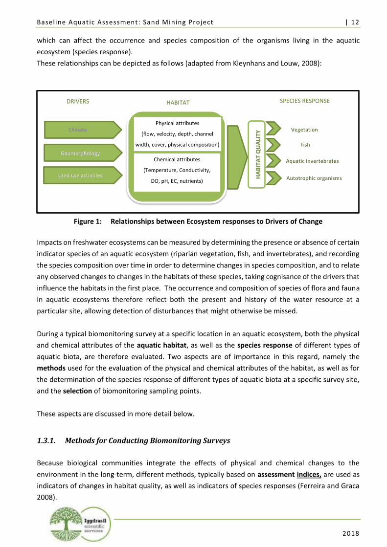
Baseline Aquat ic Assessment: Sand Mining Project | 12
2018
which can affect the occurrence and species composition of the organisms living in the aquatic
ecosystem (species response).
These relationships can be depicted as follows (adapted from Kleynhans and Louw, 2008):
Figure 1: Relationships between Ecosystem responses to Drivers of Change
Impacts on freshwater ecosystems can be measured by determining the presence or absence of certain
indicator species of an aquatic ecosystem (riparian vegetation, fish, and invertebrates), and recording
the species composition over time in order to determine changes in species composition, and to relate
any observed changes to changes in the habitats of these species, taking cognisance of the drivers that
influence the habitats in the first place. The occurrence and composition of species of flora and fauna
in aquatic ecosystems therefore reflect both the present and history of the water resource at a
particular site, allowing detection of disturbances that might otherwise be missed.
During a typical biomonitoring survey at a specific location in an aquatic ecosystem, both the physical
and chemical attributes of the aquatic habitat, as well as the species response of different types of
aquatic biota, are therefore evaluated. Two aspects are of importance in this regard, namely the
methods used for the evaluation of the physical and chemical attributes of the habitat, as well as for
the determination of the species response of different types of aquatic biota at a specific survey site,
and the selection of biomonitoring sampling points.
These aspects are discussed in more detail below.
1.3.1. Methods for Conducting Biomonitoring Surveys
Because biological communities integrate the effects of physical and chemical changes to the
environment in the long-term, different methods, typically based on assessment indices, are used as
indicators of changes in habitat quality, as well as indicators of species responses (Ferreira and Graca
2008).
DRIVERS HABITAT SPECIES RESPONSE
Physical attributes
(flow, velocity, depth, channel
width, cover, physical composition)
Chemical attributes
(Temperature, Conductivity,
DO, pH, EC, nutrients)
HA
BIT
AT
QU
ALI
TY
Baseline Aquat ic Assessment: Sand Mining Project | 13
2018
The current methods used for the evaluation of the physical and chemical attributes of the habitat at
a specific survey site can be summarised as follows:
• Evaluation of the physical attributes of the aquatic habitat: The physical attributes of the
instream and riparian habitat has a direct influence on the occurrence and composition the
aquatic community. Physical habitat features such as colour, anthropogenic disturbances
and riparian vegetation, as well as stream hydrology, average width and depth are
established by means of and evaluated with the Integrated Habitat Assessment System
(“IHAS”). IHAS was developed in 1998 by McMilan, and version 2 is the currently used
assessment index.
• Evaluation of the chemical attributes of the aquatic habitat: Although available water
quality monitoring data on variables such as pH, salinity (EC or TDS) and nutrients will give
an indication of the influence of these variables on the aquatic ecosystem, variables such as
Temperature, Dissolved Oxygen (“DO”), and Turbidity need to be determined in situ, as
these variables cannot be established away from the survey site.
The standardised, quantitative and replicable methods currently used for the species response of the
different aquatic organisms at a specific survey site can be summarised as follows:
• The South African Scoring System, version 5 (“SASS5”) is a rapid bio-assessment method
used to identify changes in species composition of aquatic invertebrates (e.g. snails, crabs,
worms, insect larvae, mussels, beetles). As most invertebrate species are fairly short-lived
and have limited migration patterns or are not free-moving during their aquatic life phase,
they are good indicators of localised conditions in a river over the short term, and can be
used to assess site-specific impacts (Dickens and Graham 2002).
• Vegetation is a readily observable expression of the ecology and relationships as well as a
series of interactions between biotic organisms and their abiotic environment, and thus
provide a physical representation of the health of an ecosystem. Healthy riparian vegetation
zones maintain channel form and serve as filters for light, nutrients and sediment. Changes
in the structure and function of riparian vegetation commonly result from changes in the
flow regime of a river, flooding, exploitation for firewood, mining, or use of the riparian zone
for grazing or ploughing. The Riparian Vegetation Response Assessment Index (“VEGRAI”)
is a model developed by the DWS for the qualitative assessment of the response of riparian
vegetation to impacts (Kleynhans et al., 2007). It must be noted that there is a distinct
difference between a VEGRAI and the evaluation of vegetation as part of the IHAS, as the
IHAS merely records vegetation as one of the physical attributes of the aquatic habitat, while
VEGRAI evaluates and assigns a rating to indicate species composition and diversity. As
vegetation can undergo rapid changes, for example due to flooding, veld fires or overgrazing,
Baseline Aquat ic Assessment: Sand Mining Project | 14
2018
the VEGRAI-method will record such changes in species composition, which will not be
determined by the IHAS method.
For this baseline aquatic assessment, the Integrated Habitat Assessment System (“IHAS”), South
African Scoring System, version 5 (“SASS5”), Riparian Vegetation Response Assessment Index
(“VEGRAI”), and Diatom-based water quality analysis methodologies will be used to assess the biotic
integrity of the study area.
1.4. Objective of this Report
The objective of this baseline aquatic report is to summarise the findings of the survey conducted on
the 22nd of January 2018 at the proposed sand mining site at Abbottspoort Village and to make
recommendations regarding future strategies for biomonitoring at the proposed site.
1.5. Report Structure
This Report is structured as follows:
Considering the above discussion on the purpose of aquatic assessments, the objective of this Report
is met by addressing the following aspects:
• Section 1 – this section – describes the project brief, the approaches and methodologies
followed for aquatic biomonitoring, the objective of this report, and the report structure;
• Section 2 discusses the background situation at the study area in order to determine the
drivers influencing local habitat conditions, including its location, land use activities, abiotic
factors such as climate and geomorphology, expected biotic conditions, as well as any
governance requirements for biomonitoring that applies to the area, including national and
provincial biodiversity conservation planning initiatives and statutory requirements;
• In Section 3, the selection of sampling points for the baseline assessment is described,
followed by a discussion of the results obtained during the 2018 baseline aquatic
assessment, both with regard to the evaluation of habitat conditions and disturbances, as
well as the species response of different types of aquatic biota (vegetation, fish, and
invertebrates) by determining their occurrence and composition;
• Section 4 contains the Impact Assessment for the proposed Sand Mining Operation, and
describes mitigation measures for the project;
• Section 5 contains conclusions and makes recommendations regarding future strategies for
biomonitoring at the study area; and
• Section 6 contains the professional opinion of the specialist.
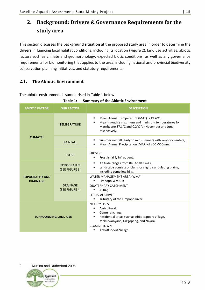
Baseline Aquat ic Assessment: Sand Mining Project | 15
2018
2. Background: Drivers & Governance Requirements for the
study area
This section discusses the background situation at the proposed study area in order to determine the
drivers influencing local habitat conditions, including its location (Figure 2), land use activities, abiotic
factors such as climate and geomorphology, expected biotic conditions, as well as any governance
requirements for biomonitoring that applies to the area, including national and provincial biodiversity
conservation planning initiatives, and statutory requirements.
2.1. The Abiotic Environment
The abiotic environment is summarised in Table 1 below.
Table 1: Summary of the Abiotic Environment
ABIOTIC FACTOR SUB FACTOR DESCRIPTION
CLIMATE2
TEMPERATURE
▪ Mean Annual Temperature (MAT) is 19.4°C; ▪ Mean monthly maximum and minimum temperatures for
Marnitz are 37.1°C and 0.2°C for November and June respectively.
RAINFALL ▪ Summer rainfall (early to mid summer) with very dry winters; ▪ Mean Annual Precipitation (MAP) of 400 -550mm.
FROST FROSTS
▪ Frost is fairly infrequent.
TOPOGRAPHY AND DRAINAGE
TOPOGRAPHY (SEE FIGURE 3)
▪ Altitude ranges from 840 to 843 masl; ▪ Landscape consists of plains or slightly undulating plains,
including some low hills.
DRAINAGE (SEE FIGURE 4)
WATER MANAGEMENT AREA (WMA) ▪ Limpopo WMA 1;
QUATERNARY CATCHMENT ▪ A50G;
LEPHALALA RIVER ▪ Tributary of the Limpopo River.
SURROUNDING LAND USE
NEARBY USES ▪ Agricultural; ▪ Game ranching; ▪ Residential areas such as Abbottspoort Village,
Mokurwanyane, Dikgopeng, and Nikara.
CLOSEST TOWN ▪ Abbottspoort Village.
2 Mucina and Rutherford 2006
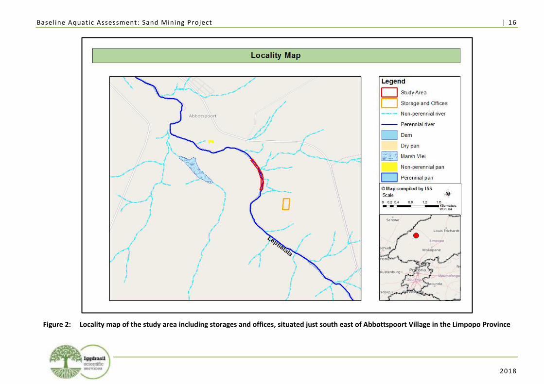
Baseline Aquat ic Assessment: Sand Mining Project | 16
2018
Figure 2: Locality map of the study area including storages and offices, situated just south east of Abbottspoort Village in the Limpopo Province

Baseline Aquat ic Assessment: Sand Mining Project | 17
2018
Figure 3: Topography surrounding the study area
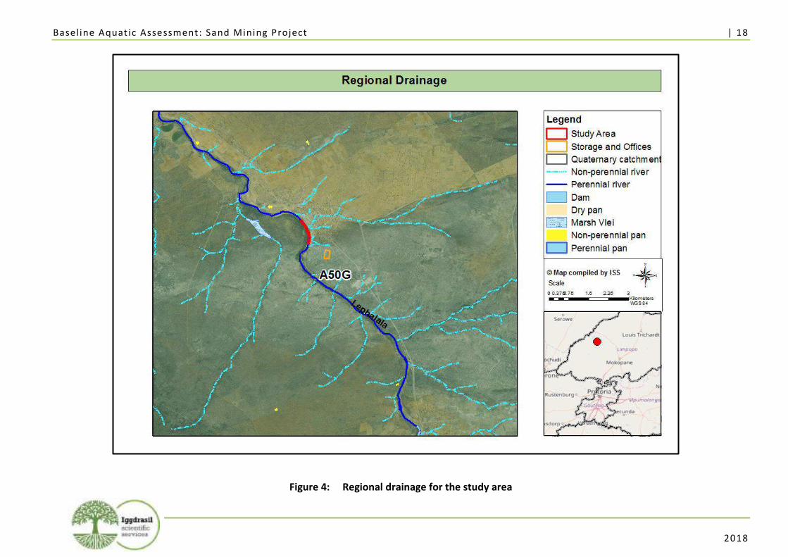
Baseline Aquat ic Assessment: Sand Mining Project | 18
2018
Figure 4: Regional drainage for the study area
Baseline Aquat ic Assessment: Sand Mining Project | 19
2018
2.2. The Biotic Environment
The vegetation, aquatic ecosystems, the ecoregion and the ecological importance of the area are
described below.
2.2.1. Vegetation
Low and Rebelo (1996) the vegetation in the area is classified under the Savanna Biome. The Savanna
Biome occupies the greater area of the Southern continents (Huntley and Walker, 1985). Savanna in
South Africa does not occur at high altitudes and is found mostly below 1500 metres and extending to
1800 metres on parts of the Highveld mainly along the Southern most edges of the Central Bushveld.
Major climatic traits of the Savanna Biome include seasonality of precipitation – with wet summer and
dry winter periods, as well as (sub)tropical thermal regime with no or usually low incidence of frost
(Mucina and Rutherford, 2006). In terms of the new vegetation map constructed under the editorship
of Mucina and Rutherford (2006) the study area falls within the Roodeberg bushveld (SVcb 18) (Figure
5).
Roodeberg bushveld (SVcb 18) occurs on plains and slightly undulating plains, including some low hills,
with short closed woodland to tall open woodland and poorly developed grass layer. Kirkia acuminata
trees are not limited to hills. Important taxa which occur in the Roodeberg bushveld include tall trees
such as Senegalia burkei (d), S. nigrescens (d), and Vachellia robusta (d). Small trees include Vachellia
erubescens (d), S. mellifera subsp. detinens (d), and Combretum apiculatum (d). Tall shrubs include
Grewia flava (d), Euclea crispa subsp. crispa, and E. undulata. Low shrubs include Commiphora africana,
Melhania acuminata, and Sida cordifolia. Graminoids include Aristida canescens (d), Chloris virgata (d),
and Panicum maximum (d). Herbs include Achyranthes aspera, Seddera capensis, and Waltheria indica.
Roodeberg bushveld is considered to be least threatened. About 18% of the vegetation type is
transformed, mainly by cultivation, with very little urban and built-up areas. Erosion is low to high
(Mucina and Rutherford, 2006).
2.2.2. Ecoregions and Ecological Importance
Ecoregions are regions that share similar ecological characteristics and according to Ferrar and Lötter
(2007) this characterisation is “based on the understanding that ecosystems and their biota display
regional patterns that mirror causal factors such as climate, soils, geology, physical land surface and
vegetation.”
The study area transverses the Limpopo Plain Ecoregion (1) (according to the delineation provided by
Kleynhans et al. 2005). The Limpopo Plain Ecoregion is an area of plains and lowlands with low to
moderate relief and vegetation consisting of Bushveld types and Mopane veld. This is generally a low
laying, dry to arid, hot region with virtually no perennial streams originating in the area itself. Perennial
Baseline Aquat ic Assessment: Sand Mining Project | 20
2018
rivers that transverse this region include the Crocodile (west), Marico, Mokolo, Lephalala, and the
Mogalakwena.
2.3. National Freshwater Ecosystem Priority Areas
The National Freshwater Ecosystem Priority Areas (“NFEPA”) project is a multi-partner project
between the CSIR, the Water Research Commission, the South African National Biodiversity Institute,
the Department of Environmental Affairs, the South African Institute of Aquatic Biodiversity and South
African National Parks.
The project responds to the reported degradation of freshwater ecosystem condition and associated
biodiversity, both globally and in South Africa. It uses systematic conservation planning to provide
strategic spatial priorities for conserving South Africa’s freshwater biodiversity, within the context of
equitable social and economic development.
The project has three inter-related components:
• A technical component to identify a national network of freshwater conservation areas;
• A national governance component to align DEA and DWA policies and approaches for
conserving freshwater ecosystems; and
• A sub-national governance and management component that conducts case studies to
demonstrate how NFEPA outcomes can be implemented (Nel et al., 2011).
River Condition (“RIVCON”) is a classification used by the NFEPA programme. RIVCON A and B are
considered intact rivers that are able to contribute towards river ecosystem targets. RIVCON C is
considered a moderately modified river and RIVCON D is considered to be a largely modified river. The
study area is located in the perennial Lephalala River, which is a tributary of the Limpopo River.
According to NFEPA data, the Lephalala River is classified as class D (Figure 7).
The study area is situated within the A50E-196 Sub-Quaternary Reach (SQR) and has no wetland FEPA
types. The study area transverses a non FEPA (Figure 9).
2.4. Present Ecological State, Ecological Importance and Sensitivity
The Present Ecological state (PES), Ecological Importance (EI) and Ecological Sensitivity (ES) of the Sub-
Quaternary Reach (SQRs) associated with the study area is presented in Table 2 and Figure 8
(Department of Water and Sanitation 2014).
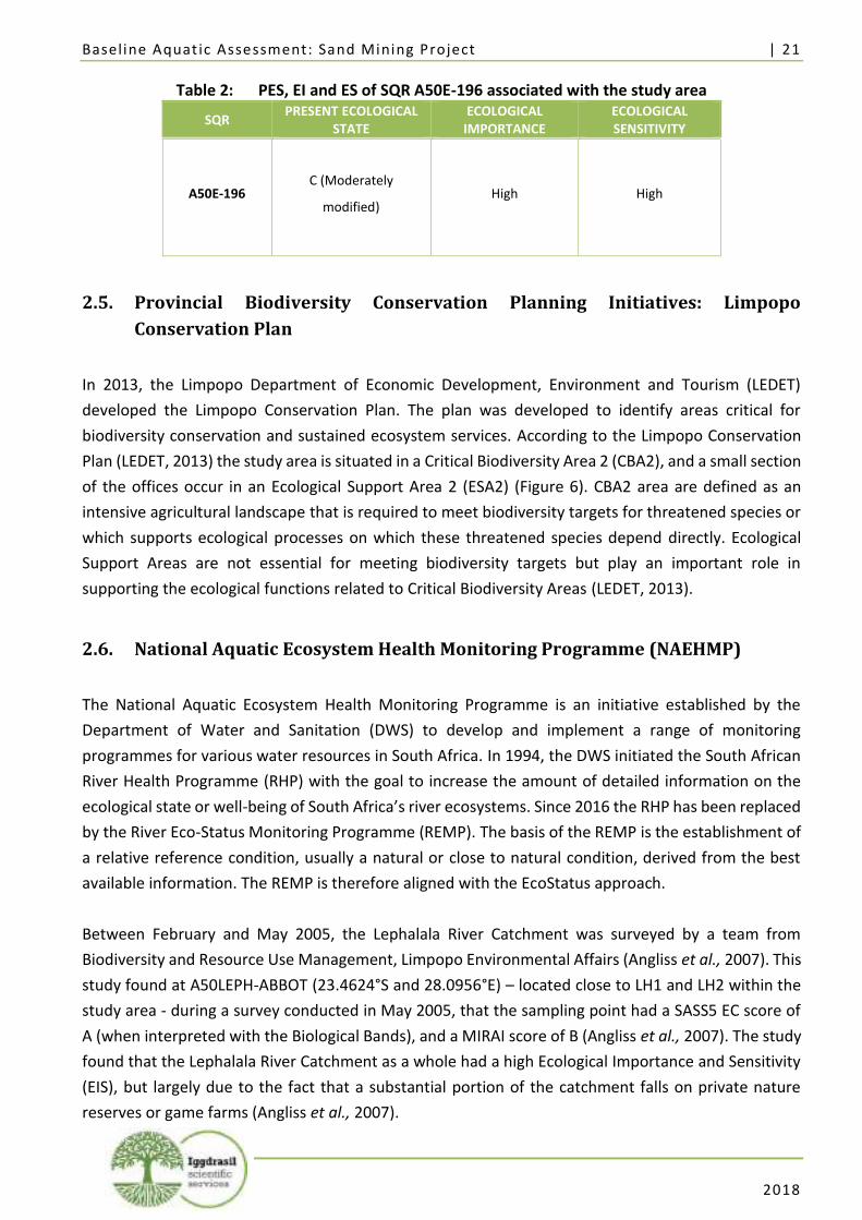
Baseline Aquat ic Assessment: Sand Mining Project | 21
2018
Table 2: PES, EI and ES of SQR A50E-196 associated with the study area
SQR PRESENT ECOLOGICAL
STATE ECOLOGICAL
IMPORTANCE ECOLOGICAL SENSITIVITY
A50E-196 C (Moderately
modified) High High
2.5. Provincial Biodiversity Conservation Planning Initiatives: Limpopo
Conservation Plan
In 2013, the Limpopo Department of Economic Development, Environment and Tourism (LEDET)
developed the Limpopo Conservation Plan. The plan was developed to identify areas critical for
biodiversity conservation and sustained ecosystem services. According to the Limpopo Conservation
Plan (LEDET, 2013) the study area is situated in a Critical Biodiversity Area 2 (CBA2), and a small section
of the offices occur in an Ecological Support Area 2 (ESA2) (Figure 6). CBA2 area are defined as an
intensive agricultural landscape that is required to meet biodiversity targets for threatened species or
which supports ecological processes on which these threatened species depend directly. Ecological
Support Areas are not essential for meeting biodiversity targets but play an important role in
supporting the ecological functions related to Critical Biodiversity Areas (LEDET, 2013).
2.6. National Aquatic Ecosystem Health Monitoring Programme (NAEHMP)
The National Aquatic Ecosystem Health Monitoring Programme is an initiative established by the
Department of Water and Sanitation (DWS) to develop and implement a range of monitoring
programmes for various water resources in South Africa. In 1994, the DWS initiated the South African
River Health Programme (RHP) with the goal to increase the amount of detailed information on the
ecological state or well-being of South Africa’s river ecosystems. Since 2016 the RHP has been replaced
by the River Eco-Status Monitoring Programme (REMP). The basis of the REMP is the establishment of
a relative reference condition, usually a natural or close to natural condition, derived from the best
available information. The REMP is therefore aligned with the EcoStatus approach.
Between February and May 2005, the Lephalala River Catchment was surveyed by a team from
Biodiversity and Resource Use Management, Limpopo Environmental Affairs (Angliss et al., 2007). This
study found at A50LEPH-ABBOT (23.4624°S and 28.0956°E) – located close to LH1 and LH2 within the
study area - during a survey conducted in May 2005, that the sampling point had a SASS5 EC score of
A (when interpreted with the Biological Bands), and a MIRAI score of B (Angliss et al., 2007). The study
found that the Lephalala River Catchment as a whole had a high Ecological Importance and Sensitivity
(EIS), but largely due to the fact that a substantial portion of the catchment falls on private nature
reserves or game farms (Angliss et al., 2007).
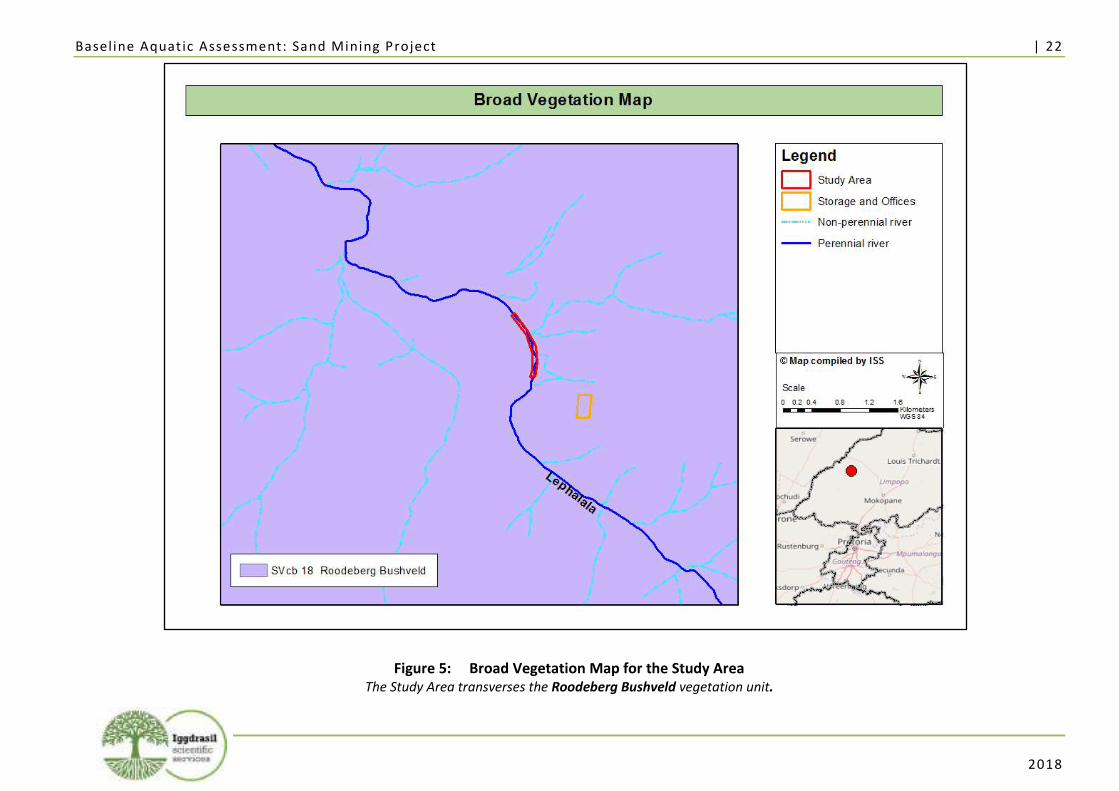
Baseline Aquat ic Assessment: Sand Mining Project | 22
2018
Figure 5: Broad Vegetation Map for the Study Area The Study Area transverses the Roodeberg Bushveld vegetation unit.
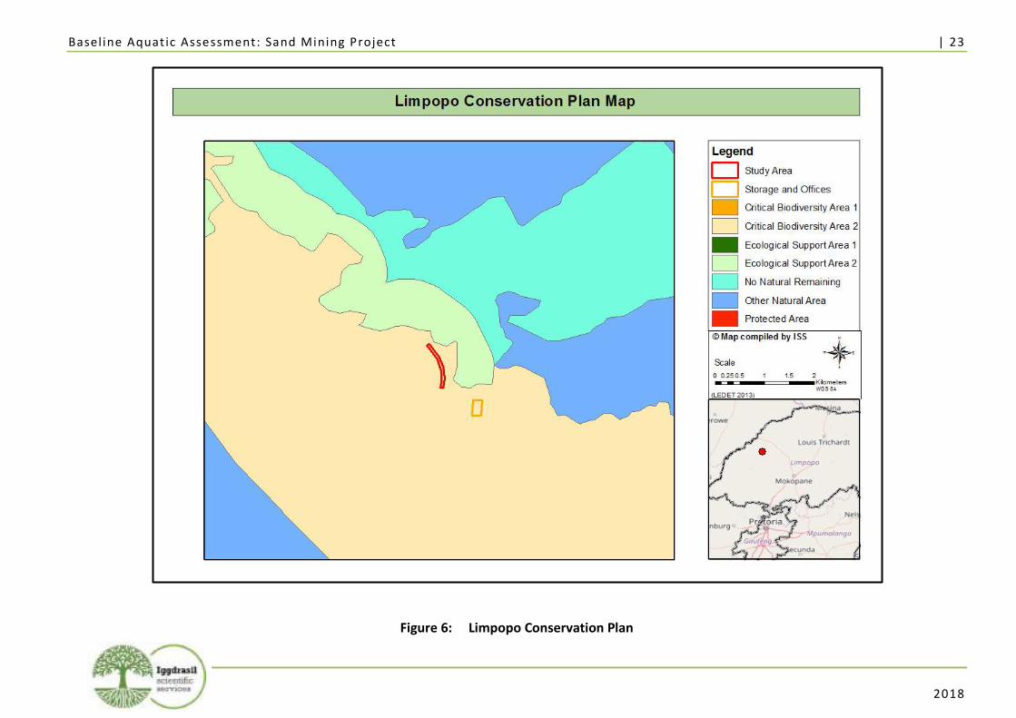
Baseline Aquat ic Assessment: Sand Mining Project | 23
2018
Figure 6: Limpopo Conservation Plan
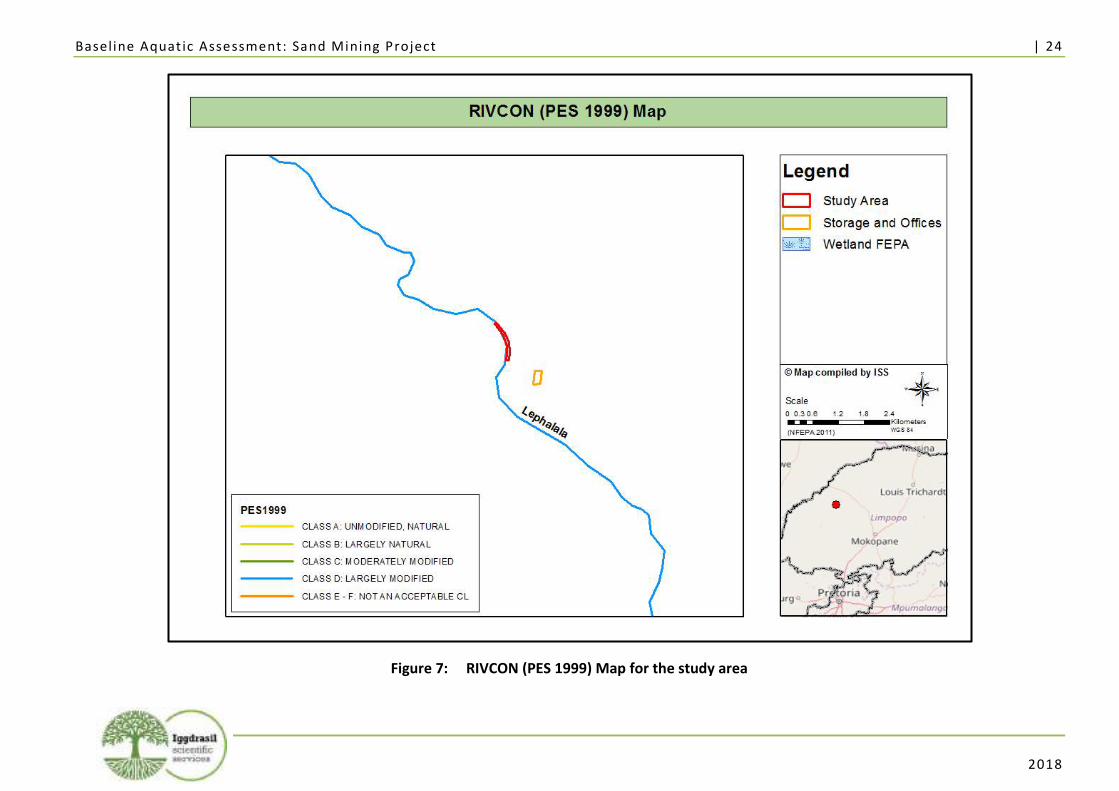
Baseline Aquat ic Assessment: Sand Mining Project | 24
2018
Figure 7: RIVCON (PES 1999) Map for the study area
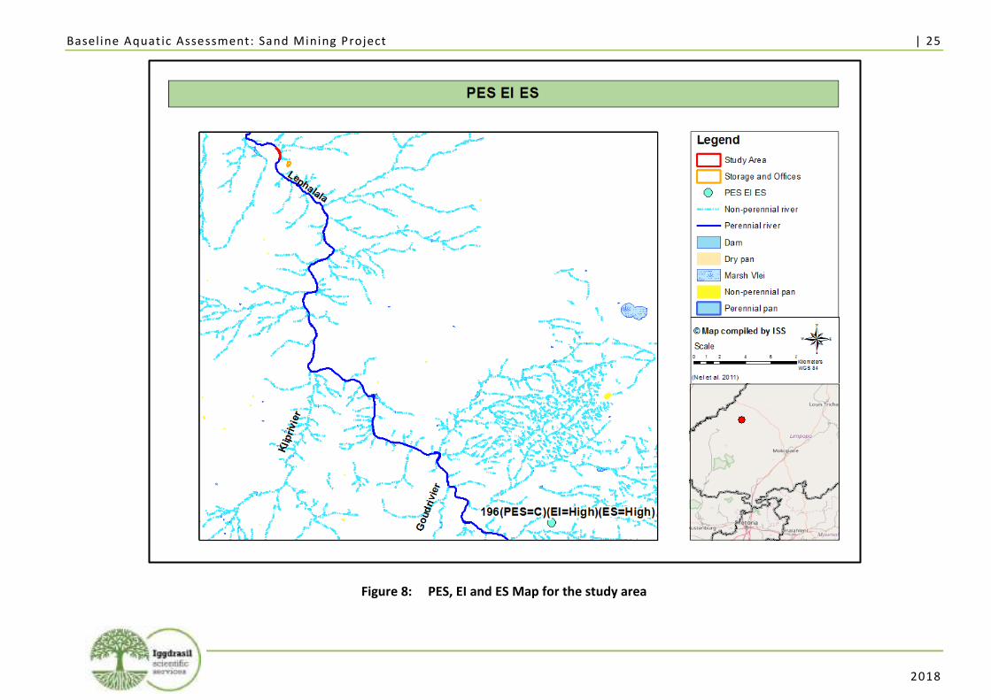
Baseline Aquat ic Assessment: Sand Mining Project | 25
2018
Figure 8: PES, EI and ES Map for the study area
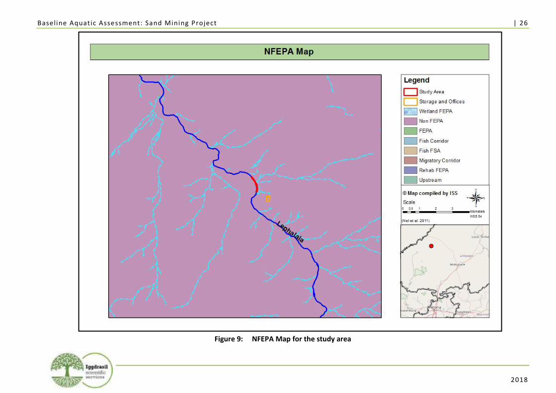
Baseline Aquat ic Assessment: Sand Mining Project | 26
2018
Figure 9: NFEPA Map for the study area
Baseline Aquat ic Assessment: Sand Mining Project | 27
2018
3. Discussion and Evaluation of Results
In this section, the selection of sampling points for the baseline aquatic assessment is firstly described,
followed by a discussion of the results obtained, both with regard to the evaluation of habitat
conditions and disturbances, as well as the species response by determining their occurrence and
composition at the sampling points described below.
3.1. Selection of Sampling Points for the Baseline Aquatic Assessment
A total of two (2) sampling points were selected for the 2018 baseline aquatic assessment at the study
area. Sampling points for the baseline aquatic assessment ideally can only be placed on rivers, since
SASS5, IHAS, and VEGRAI are methods that were designed to assess river health. No sampling should
be conducted in wetland systems using these methods, as the results, when compared to the biological
bands for the sampled region, will be inaccurate (Dickens and Graham 2002; Kleynhans, 2007;
Kleynhans et al., 2007).
Table 3 below indicates the sampling point number, the GPS coordinates, and a brief description of
each of the sampling points:
Table 3: Sampling Points for the Baseline Aquatic Assessment
SAMPLING POINT
LATITUDE LONGITUDE SITE DESCRIPTION
LH1 -23.490281° 28.114657° ▪ Situated in the perennial Lephalala River; ▪ Upstream of the proposed sand mining activities
LH2 -23.456010° 28.090588° ▪ Situated in the perennial Lephalala River; ▪ Site located downstream of the proposed sand mining
activities
The location of these sampling points is illustrated in Figure 10 on page 28.
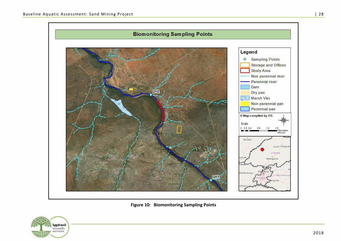
Baseline Aquat ic Assessment: Sand Mining Project | 28
2018
Figure 10: Biomonitoring Sampling Points
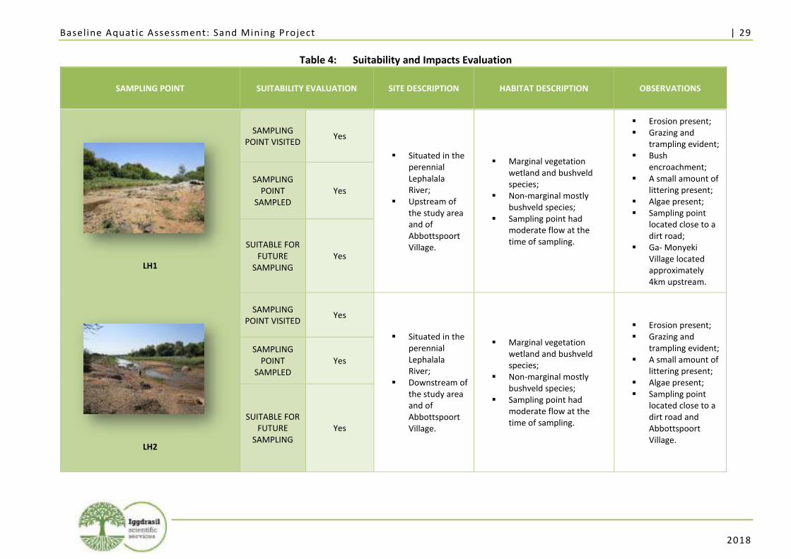
Baseline Aquat ic Assessment: Sand Mining Project | 29
2018
Table 4: Suitability and Impacts Evaluation
SAMPLING POINT SUITABILITY EVALUATION SITE DESCRIPTION HABITAT DESCRIPTION OBSERVATIONS
LH1
SAMPLING POINT VISITED
Yes
▪ Situated in the perennial Lephalala River;
▪ Upstream of the study area and of Abbottspoort Village.
▪ Marginal vegetation wetland and bushveld species;
▪ Non-marginal mostly bushveld species;
▪ Sampling point had moderate flow at the time of sampling.
▪ Erosion present; ▪ Grazing and
trampling evident; ▪ Bush
encroachment; ▪ A small amount of
littering present; ▪ Algae present; ▪ Sampling point
located close to a dirt road;
▪ Ga- Monyeki Village located approximately 4km upstream.
SAMPLING POINT
SAMPLED Yes
SUITABLE FOR FUTURE
SAMPLING Yes
LH2
SAMPLING POINT VISITED
Yes
▪ Situated in the perennial Lephalala River;
▪ Downstream of the study area and of Abbottspoort Village.
▪ Marginal vegetation wetland and bushveld species;
▪ Non-marginal mostly bushveld species;
▪ Sampling point had moderate flow at the time of sampling.
▪ Erosion present; ▪ Grazing and
trampling evident; ▪ A small amount of
littering present; ▪ Algae present; ▪ Sampling point
located close to a dirt road and Abbottspoort Village.
SAMPLING POINT
SAMPLED Yes
SUITABLE FOR FUTURE
SAMPLING Yes
Baseline Aquat ic Assessment: Sand Mining Project | 30
2018
3.2. Conducting the 2018 Baseline Aquatic Assessment
The 2018 baseline aquatic biomonitoring assessment at the proposed sand mining project was
conducted on the 22nd of January 2018 by Lorainmari den Boogert and Kimberley Perry, at sampling
points LH1 and LH2. The habitats at all sampling points were firstly evaluated by means of
observations with regard to their surroundings, possible causes of stressors or disturbances on
aquatic ecosystems, and the suitability of each sampling point for future biomonitoring surveys, as
summarised in Table 4 on page 29. The outcome of this evaluation indicated that biomonitoring
sampling methods could be applied at both sampling points LH1 and LH2. In-situ water quality results
were obtained at sampling points LH1 and LH2. The results obtained from the in-situ measurement
of temperature, pH, EC, and DO are summarised in Annexure B. Diatom analysis was conducted at
sampling points LH1 and LH2.
3.3. Results of Biomonitoring at Sampling Point LH1
LH1 is situated upstream of Abbottspoort Village and the proposed location of the sand mining
project. The main land-use activity surrounding this sampling point is bushveld, agriculture, and dirt
roads. Located approximately four (4) km upstream of LH1 is Ga-monyeki Village. Impacts located
around the sampling point include bush encroachment, grazing, trampling, littering and dirt roads.
Table 5 contains an overview of the conditions observed at sampling point LH1. The drivers, habitat
and biotic response observed at sampling point LH1 is summarised in Table 6.
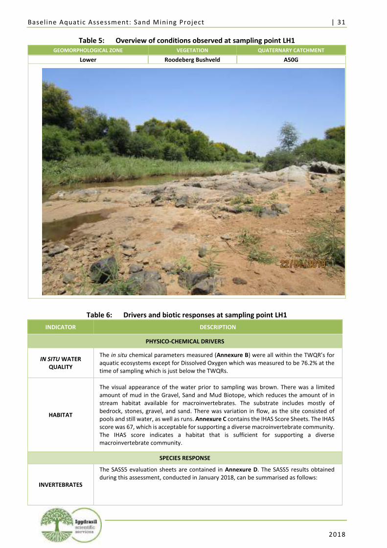
Baseline Aquat ic Assessment: Sand Mining Project | 31
2018
Table 5: Overview of conditions observed at sampling point LH1 GEOMORPHOLOGICAL ZONE VEGETATION QUATERNARY CATCHMENT
Lower Roodeberg Bushveld A50G
Table 6: Drivers and biotic responses at sampling point LH1
INDICATOR DESCRIPTION
PHYSICO-CHEMICAL DRIVERS
IN SITU WATER QUALITY
The in situ chemical parameters measured (Annexure B) were all within the TWQR’s for aquatic ecosystems except for Dissolved Oxygen which was measured to be 76.2% at the time of sampling which is just below the TWQRs.
HABITAT
The visual appearance of the water prior to sampling was brown. There was a limited amount of mud in the Gravel, Sand and Mud Biotope, which reduces the amount of in stream habitat available for macroinvertebrates. The substrate includes mostly of bedrock, stones, gravel, and sand. There was variation in flow, as the site consisted of pools and still water, as well as runs. Annexure C contains the IHAS Score Sheets. The IHAS score was 67, which is acceptable for supporting a diverse macroinvertebrate community. The IHAS score indicates a habitat that is sufficient for supporting a diverse macroinvertebrate community.
SPECIES RESPONSE
INVERTEBRATES
The SASS5 evaluation sheets are contained in Annexure D. The SASS5 results obtained during this assessment, conducted in January 2018, can be summarised as follows:
Baseline Aquat ic Assessment: Sand Mining Project | 32
2018
INDICATOR DESCRIPTION
January 2018
SASS5 EC A
SASS5 score 147
Number of Taxa 25
ASPT 5.88
The taxa present in moderate abundances included Oligochaeta (Earthworms), Libellulidae (Darters), Corixidae (Water boatmen), and Chironomidae (Midges). Taxa present with high SASS5 scores included Heptageniidae (Flatheaded Mayflies), Oligoneuridae (Brushlegged mayflies), more than 2 species of Baetidae (mayflies), and Calopterygidae (demoiselles).
VEGETATION
The VEGRAI evaluation is attached as Annexure E, which indicates a VEGRAI Ecological Category of D. The dominant state was reed-open. The dominant reed species in the marginal zone was Phragmites mauritianus. Woody species were mostly present in the upper zone, however a few individuals of Combretum erythrophyllum (River bushwillow) was present in the marginal and lower zone. A few individuals of Persicaria lapathifolia were present in the marginal zone. The dominant state in the non-marginal zone was open -reed. The dominant species included Phragmites mauritianus, Cynodon dactylon, Sesbania bispinosa and Xanthium strumarium. Woody species were scattered in the non-marginal zone included, Vachellia karroo, Ziziphus mucronata and Senegalia mellifera subsp. detinens. Invasive species included Xanthium strumarium (NEMBA category 1b), Datura stramonium(NEMBA category 1b), Ricinus communis (NEMBA category 2) and Sesbania bispinosa (Not listed).
DIATOMS
The Specific Pollution Sensitivity Index (SPI) was 10.5 which indicates an EC of C/D, and a class of Moderate Quality at the time of the survey. The results from the Trophic Diatom Index (TDI) (Kelly and Whitton, 1995) were also considered as this index provides the percentage pollution tolerant diatom valves (PTVs) in a sample and was developed for monitoring sewage outfall (orthophosphate-phosphorus concentrations), and not general stream quality. The %PTV was 1.3% which is indicative of moderate levels of organic pollution. The diatom community was outrightly dominated by Fragilaria biceps, a cosmopolitan species found in the benthos of rivers and lakes and easily suspended in the plankton due to its relatively large surface area. It is often found in mesotrophic to eutrophic waters. The rest of the diatom community consisted of species with a preference for moderate water quality with a preference for higher organic loads. Aerophilic species occurred at very low abundance suggesting that water levels did not fluctuate often. No valve deformities were noted suggesting that toxicity levels were below detection limits at the time of sampling.
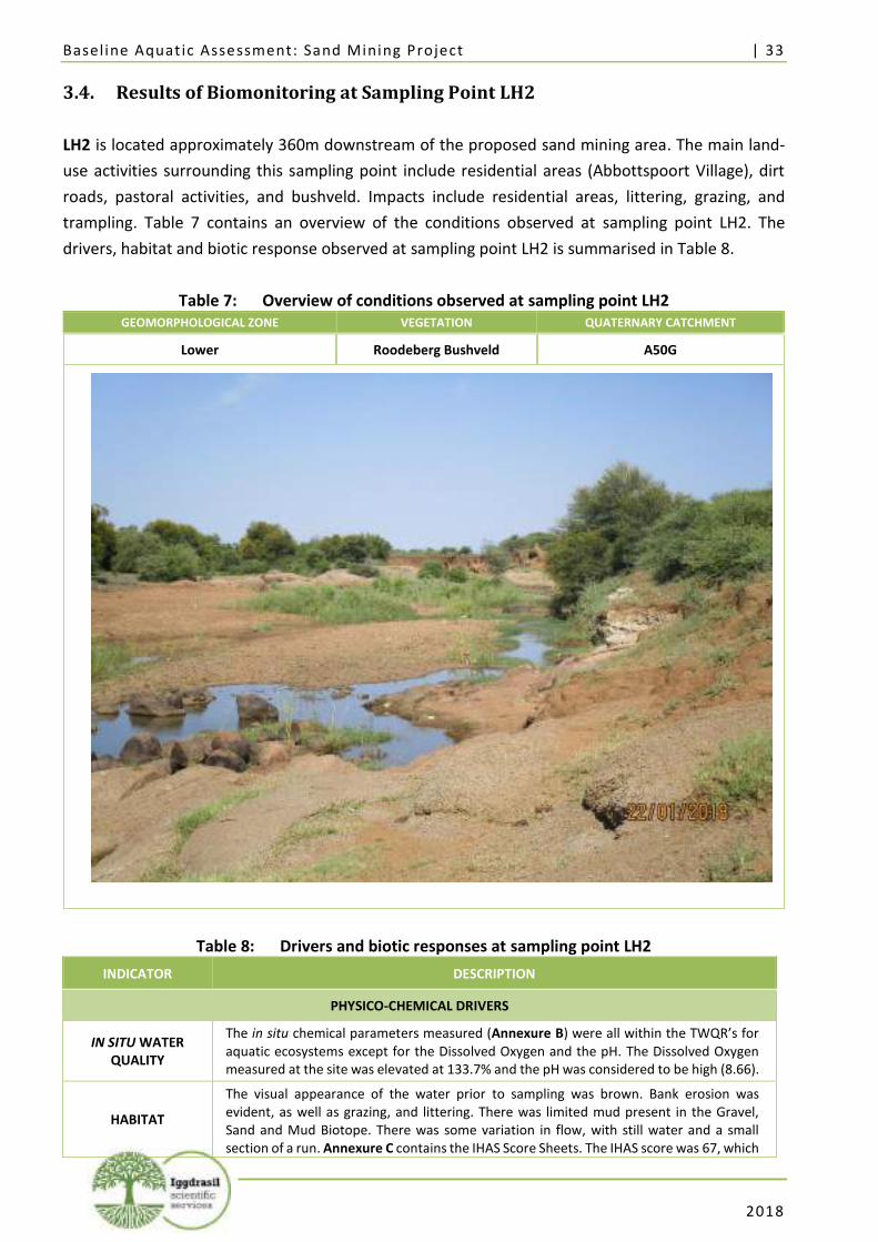
Baseline Aquat ic Assessment: Sand Mining Project | 33
2018
3.4. Results of Biomonitoring at Sampling Point LH2
LH2 is located approximately 360m downstream of the proposed sand mining area. The main land-
use activities surrounding this sampling point include residential areas (Abbottspoort Village), dirt
roads, pastoral activities, and bushveld. Impacts include residential areas, littering, grazing, and
trampling. Table 7 contains an overview of the conditions observed at sampling point LH2. The
drivers, habitat and biotic response observed at sampling point LH2 is summarised in Table 8.
Table 7: Overview of conditions observed at sampling point LH2 GEOMORPHOLOGICAL ZONE VEGETATION QUATERNARY CATCHMENT
Lower Roodeberg Bushveld A50G
Table 8: Drivers and biotic responses at sampling point LH2
INDICATOR DESCRIPTION
PHYSICO-CHEMICAL DRIVERS
IN SITU WATER QUALITY
The in situ chemical parameters measured (Annexure B) were all within the TWQR’s for aquatic ecosystems except for the Dissolved Oxygen and the pH. The Dissolved Oxygen measured at the site was elevated at 133.7% and the pH was considered to be high (8.66).
HABITAT
The visual appearance of the water prior to sampling was brown. Bank erosion was evident, as well as grazing, and littering. There was limited mud present in the Gravel, Sand and Mud Biotope. There was some variation in flow, with still water and a small section of a run. Annexure C contains the IHAS Score Sheets. The IHAS score was 67, which
Baseline Aquat ic Assessment: Sand Mining Project | 34
2018
INDICATOR DESCRIPTION
is acceptable for supporting a diverse macroinvertebrate community. The IHAS score indicates a habitat that is sufficient for supporting a diverse macroinvertebrate community.
SPECIES RESPONSE
INVERTEBRATES
The SASS5 evaluation sheets are contained in Annexure D. The SASS5 results obtained during this survey, conducted in January 2018, can be summarised as follows:
January 2018
SASS5 EC B
SASS5 score 134
Number of Taxa 26
ASPT 5.15
There was a moderate abundance of Oligochaeta (Earthworms), Coenagrionidae (Sprites and blues), Belostomatidae (Giant water bugs), Corixidae (Water boatmen), Chironomidae (Midges), and Physidae (pouch snails). Taxa with high SASS5 scores included Oligoneuridae (Brushlegged mayflies) and more than 2 species of Baetidae (mayflies).
VEGETATION
The VEGRAI evaluation is attached as Annexure E, which indicates a VEGRAI Ecological Category of D. Bank erosion and scouring of the banks were severe. The dominant state was reed - open in the marginal zone. The dominant reed species was Phragmites mauritianus. Several sedges were present in the marginal and lower zone including Cyperus congestus, Cyperus denudatus, Cyperus longus var. longus and Cyperus sexangularis. Aquatic macrophytes included Persicaria lapathifolia. The dominant state in the lower zone was reed open. The dominant reed species was Phragmites mauritianus. Woody species were limited in the lower zone. The dominant grass species was Cynodon dactylon. Invasive species included Xanthium strumarium (NEMBA category 1b), Datura stramonium(NEMBA category 1b), Ricinus communis (NEMBA category 2), Sesbania bispinosa (Not listed), Alternanthera pungens (Not listed) and Gomphrena celosiodes (Not listed).
DIATOMS Diatom valve densities were very low at LH2 and a viable count could not be attained. Therefore, no assessment could be undertaken for this site.
4. Impact Assessment and suggested mitigation measures
The impacts described in this report are limited to the aquatic ecosystems that will be affected by the
proposed activities associated with sand mining. The exact activities method statement was not
provided to the specialist at the time of writing this report.
Due to the extremely invasive nature of in-stream sand mining, the significance of the majority of the
impacts both prior and after mitigation were regarded as high. However, it is expected that the largest
impacts which currently face the proposed study area are the alteration of the amount of sediment
entering the water resource (Lephahala River) and the associated change in turbidity, as well as the
alteration of the physical structure within the water resource. Closely associated are impacts such as
alterations in flow and loss of aquatic biota. Excavation of gravel/sand from in-stream, as well as
Baseline Aquat ic Assessment: Sand Mining Project | 35
2018
riparian areas, will lead to decreased habitats for aquatic biota. Changes in the flow regime of the
watercourse can occur during both construction and operational phases of the sand mining project.
Infrastructure development can lead to increased run off. In-stream mining potentially reduces water
velocity or spreads out the flow of the watercourse over shallow areas. Additionally, sand mining
transforms riverbeds into large and deep pools which can potentially produce slower streamflow
velocities (Ashraf et al., 2011).
Impacts relating to the alteration of water quality, both from increases in nutrients and from toxic
contaminants, were regarded as high prior to mitigation, and medium post mitigation. Mitigation
measures such as studies which establish the presence of toxic contaminants in the sediment/sand
where mining will occur, as well as monitoring programmes, should be able to eliminate to some
extent the probability and consequence of these two impacts.
The assessment of impact significance is described below, the significance of potential impacts is
presented in Table 9 and the suggested mitigation/management procedures are provided in Table
10.
4.1. Impact Assessment Matrix
The assessment of impact significance is based on the following conventions and methods, provided
by the CSIR:
Nature of Impact - these review the type of effect that a proposed activity will have on the
environment and should include “what will be affected and how?”
Spatial Extent - this should indicate whether the impact will be:
• Site specific;
• Local (<2 km from site);
• Regional (within 30 km of site); or
• National.
Duration - The timeframe during which (lifetime of) the impact will be experienced:
• Temporary (less than 1 year);
• Short term (1 to 6 years);
• Medium term (6 to 15 years);
• Long term (the impact will cease after the operational life of the activity); or
• Permanent (mitigation will not occur in such a way or in such a time span that the impact
can be considered transient).
Intensity - it should be established whether the impact is destructive or innocuous and should be
described as either:
Baseline Aquat ic Assessment: Sand Mining Project | 36
2018
• High (severe alteration of natural systems, patterns or processes such that they temporarily
or permanently cease);
• Medium (notable alteration of natural systems, patterns or processes; where the
environment continues to function but in a modified manner); or
• Low (negligible or no alteration of natural systems, patterns or processes); can be easily
avoided by implementing appropriate mitigation measures, and will not have an influence
on decision-making.
Probability - this considers the likelihood of the impact occurring and should be described as:
• Improbable (little or no chance of occurring);
• Probable (<50% chance of occurring);
• Highly probable (50 – 90% chance of occurring); or
• Definite (>90% chance of occurring).
Reversibility - this considers the degree to which the adverse environmental impacts are reversible
or irreversible. For example, an impact will be described as low should the impact have little chance
of being rectified to correct environmental impacts. On the other hand, an impact such as the
nuisance factor caused by noise impacts from wind turbines can be considered to be highly reversible
at the end of the project lifespan. The assessment of the reversibility of potential impacts is based on
the following terms:
• High - impacts on the environment at the end of the operational life cycle are highly
reversible;
• Moderate - impacts on the environment at the end of the operational life cycle are
reasonably reversible;
• Low - impacts on the environment at the end of the operational life cycle are slightly
reversible; or
• Non-reversible - impacts on the environment at the end of the operational life cycle are
not reversible and are consequently permanent.
Irreplaceability - this reviews the extent to which an environmental resource is replaceable or
irreplaceable. For example, if the proposed project will be undertaken on land that is already
transformed and degraded, this will yield a low irreplaceability score. The assessment of the degree
to which the impact causes irreplaceable loss of resources is based on the following terms:
• High irreplaceability of resources (this is the least favourable assessment for the
environment);
• Moderate irreplaceability of resources;
• Low irreplaceability of resources; or
• Resources are replaceable (this is the most favourable assessment for the environment).
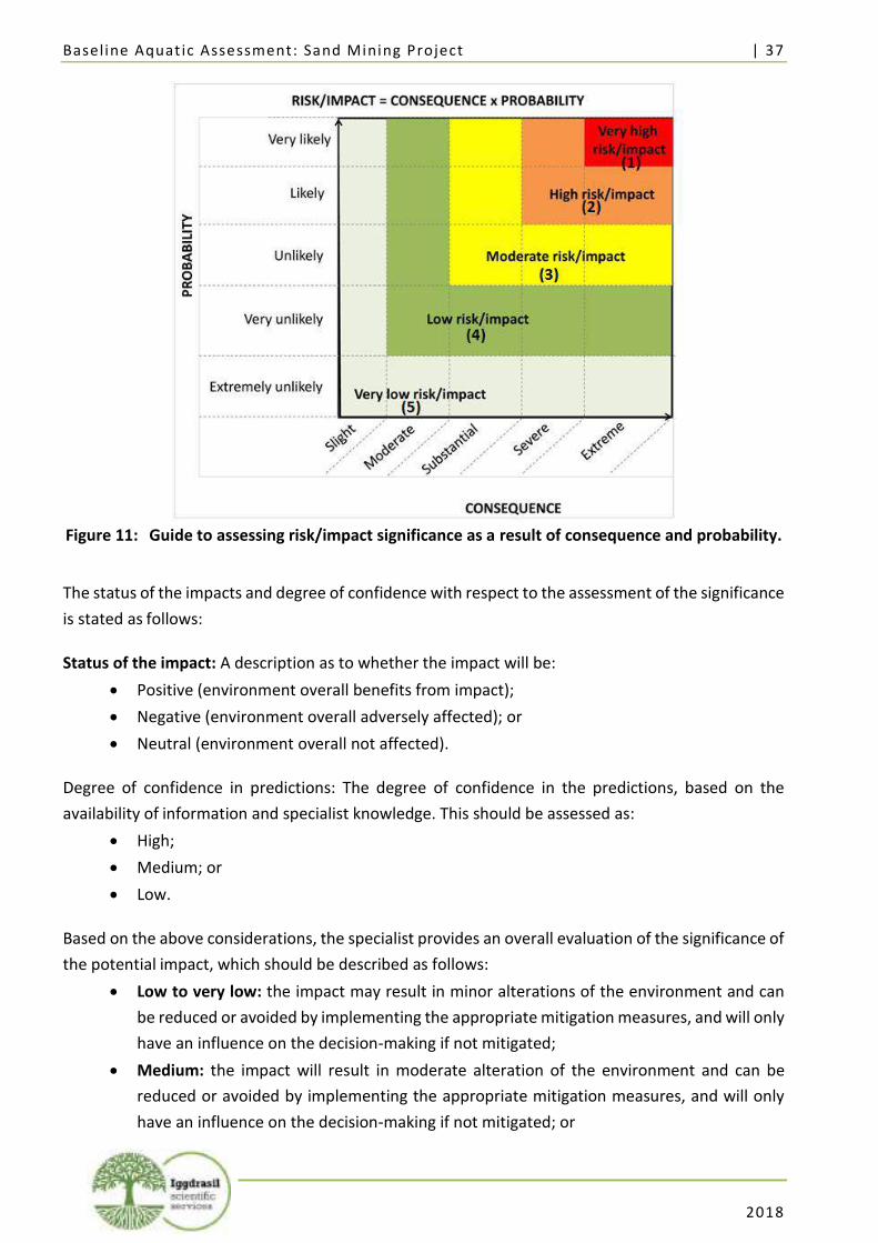
Baseline Aquat ic Assessment: Sand Mining Project | 37
2018
Figure 11: Guide to assessing risk/impact significance as a result of consequence and probability.
The status of the impacts and degree of confidence with respect to the assessment of the significance
is stated as follows:
Status of the impact: A description as to whether the impact will be:
• Positive (environment overall benefits from impact);
• Negative (environment overall adversely affected); or
• Neutral (environment overall not affected).
Degree of confidence in predictions: The degree of confidence in the predictions, based on the
availability of information and specialist knowledge. This should be assessed as:
• High;
• Medium; or
• Low.
Based on the above considerations, the specialist provides an overall evaluation of the significance of
the potential impact, which should be described as follows:
• Low to very low: the impact may result in minor alterations of the environment and can
be reduced or avoided by implementing the appropriate mitigation measures, and will only
have an influence on the decision-making if not mitigated;
• Medium: the impact will result in moderate alteration of the environment and can be
reduced or avoided by implementing the appropriate mitigation measures, and will only
have an influence on the decision-making if not mitigated; or
Baseline Aquat ic Assessment: Sand Mining Project | 38
2018
• High: Where it could have a “no-go” implication for the project unless mitigation or re-
design is practically achievable.
Furthermore, the following must be considered:
• Impacts should be described both before and after the proposed mitigation and
management measures have been implemented.
• All impacts should be evaluated for the construction, operation and decommissioning
phases of the project, where relevant.
• The impact evaluation should take into consideration the cumulative effects associated
with this and other facilities which are either developed or in the process of being
developed in the region, if relevant.
Management Actions:
• Where negative impacts are identified, mitigatory measures will be identified to avoid or
reduce negative impacts. Where no mitigatory measures are possible this will be stated.
• Where positive impacts are identified, augmentation measures will be identified to
potentially enhance these.
• Quantifiable standards for measuring and monitoring mitigatory measures and
enhancements will be set. This will include a programme for monitoring and reviewing the
recommendations to ensure their ongoing effectiveness.
Monitoring:
Specialists should recommend monitoring requirements to assess the effectiveness of mitigation
actions, indicating what actions are required, by whom, and the timing and frequency thereof.
Cumulative Impact:
Consideration is given to the extent of any accumulative impact that may occur due to the proposed
development. Such impacts are evaluated with an assessment of similar developments already in the
environment. Such impacts will be either positive or negative, and will be graded as being of
negligible, low, medium or high impact.
Mitigation:
The objective of mitigation is to firstly avoid and minimise impacts where possible and where these
cannot be completely avoided, to compensate for the negative impacts of the development on the
receiving environment and to maximise re-vegetation and rehabilitation of disturbed areas. For each
impact identified, appropriate mitigation measures to reduce or otherwise avoid the potentially
negative impacts are suggested. All impacts are assessed without mitigation and with the mitigation
measures as suggested.
Baseline Aquat ic Assessment: Sand Mining Project | 39
2018
Table 9: Risk assessment of impacts and resulting significance prior to and after mitigation measures
ACTIVITY IMPACT SUMMARY STATUS EXTENT DURATION INTENSITY REVERSIBILITY IRREPLACEABILITY PROBABILITY CONFIDENCE SIGNIFICANCE
BEFORE MITIGATION
SIGNIFICANCE AFTER
MITIGATION
PROPOSED MITIGATION
CONSTRUCTION
Infrastructure development within
the watercourse
Alteration of the flow regime of the watercourse
Negative Site
specific Temporary Medium Moderate Moderate
Highly probable
High High Medium
See Table 10
Infrastructure development within
the watercourse
Alteration of the amount of sediment entering the water
resource and associated change in
turbidity
Negative Site
specific Temporary Medium Low Low
Highly probable
High High Medium
Infrastructure development within
the watercourse; increase of human
numbers in the area
Alteration of water quality – increasing
the amounts of nutrients (phosphate,
nitrite, nitrate)
Negative Site
specific Temporary Medium High Low Probable High Medium Low
Infrastructure development within
the watercourse; increase of human
numbers; increased run off
Alteration of water quality – toxic contaminants
(including toxic metal ions (e.g. copper,
lead, zinc) and hydrocarbons
Negative Local Long term Medium Non-
reversible High Probable Medium High Medium
Construction activities leading to clearing of riparian
vegetation; increase in human numbers
Changing the physical structure within a
water resource (habitat)
Negative Site
specific Long term High
Non-reversible
High Highly
probable High High Medium
Construction activities leading to clearing of riparian
vegetation; increase in human numbers
Loss of aquatic biota Negative Site
specific Permanent High
Non-reversible
High Highly
probable High High Medium
INDIRECT IMPACTS: Sedimentation of habitats downstream; channel instability and sedimentation can result in damage to public infrastructure; changes to in situ chemical parameters (temperature and dissolved oxygen) with
possible change to water velocity and flow.
CUMULATIVE IMPACTS: Overall loss of biodiversity in the study area and close proximity; loss of recreational value to the sand mining area.
ACTIVITY IMPACT SUMMARY STATUS EXTENT DURATION INTENSITY REVERSIBILITY IRREPLACEABILITY PROBABILITY CONFIDENCE SIGNIFICANCE
BEFORE MITIGATION
SIGNIFICANCE AFTER
MITIGATION
PROPOSED MITIGATION
OPERATIONAL PHASE
Dredging from the watercourse;
clearing of vegetation
Alteration of the flow regime of the watercourse
Negative Local Permanent Medium Low Moderate Definite Medium High High
See Table 10
Dredging from the watercourse; wash-
water discharge; clearing of
vegetation leading to increased run off
Alteration of the amount of sediment entering the water
resource and associated change in
turbidity
Negative Local Long term Medium Low Moderate Definite High High High
Dredging from the watercourse; release
of pollutants from disturbed sediment; increase in human
numbers
Alteration of water quality – increasing
the amounts of nutrients (phosphate,
nitrite, nitrate)
Negative Local Long term Medium Moderate Moderate Highly
probable High High Medium
Dredging from the watercourse; oil
spills and leakage from excavation and
Alteration of water quality – toxic contaminants
(including toxic metal
Negative Local Long term Medium Non-
reversible Moderate
Highly probable
High High Medium
Baseline Aquat ic Assessment: Sand Mining Project | 40
2018
transport machinery and vehicles; release
of pollutants from disturbed sediment
ions (e.g. copper, lead, zinc) and hydrocarbons
Dredging from the watercourse leads to destabilized bed and banks and therefore
degraded river channels; removal of
substrate
Changing the physical structure within a
water resource (habitat)
Negative Local Permanent High Non-
reversible High High High High High
Clearing of riparian vegetation; removal
of watercourse substrate and
therefore habitat for macro-
invertebrates; increased human
numbers in the area
Loss of aquatic biota Negative Site
specific Permanent High
Non-reversible
High High High High High
INDIRECT IMPACTS: Sedimentation of riparian habitats downstream; “sediment-deficient” flow from the mining site can potentially pick up more sediment from the stream reach below and cause bed degradation; increase
in sedimentation can have a smothering effect on bottom-dwelling biota; reduction in photosynthesis due to increase in turbidity in the water column; channel instability and sedimentation can result in damage to public infrastructure; changes to in situ chemical parameters (temperature and dissolved oxygen) with possible change to water velocity and flow; alteration of flow and stream bed characteristics potentially hinder movement of fishes.
CUMULATIVE IMPACTS: Overall loss of biodiversity in the study area and close proximity; loss of recreational value to the sand mining area.
ACTIVITY IMPACT SUMMARY STATUS EXTENT DURATION INTENSITY REVERSIBILITY IRREPLACEABILITY PROBABILITY CONFIDENCE SIGNIFICANCE
BEFORE MITIGATION
SIGNIFICANCE AFTER
MITIGATION
PROPOSED MITIGATION
DECOMISSIONING – INCLUDING REHABILITATION OF THE ENVIRONMENT
Infrastructure development within
the watercourse
Alteration of the flow regime of the watercourse
Negative Site
specific Temporary Medium High Low Probable Medium Medium Low
See Table 10
Infrastructure development within
the watercourse
Alteration of the amount of sediment entering the water
resource and associated change in
turbidity
Negative Site
specific Temporary Medium High Low Probable Medium Medium Low
Infrastructure development within
the watercourse; increase of human
numbers in the area
Alteration of water quality – increasing
the amounts of nutrients (phosphate,
nitrite, nitrate)
Negative Site
specific Temporary Medium High Low Probable Medium Medium Low
Construction activities leading to clearing of riparian
vegetation; increase in human numbers
Changing the physical structure within a
water resource (habitat)
Negative Site
specific Long term High High Low Probable Medium Medium Low
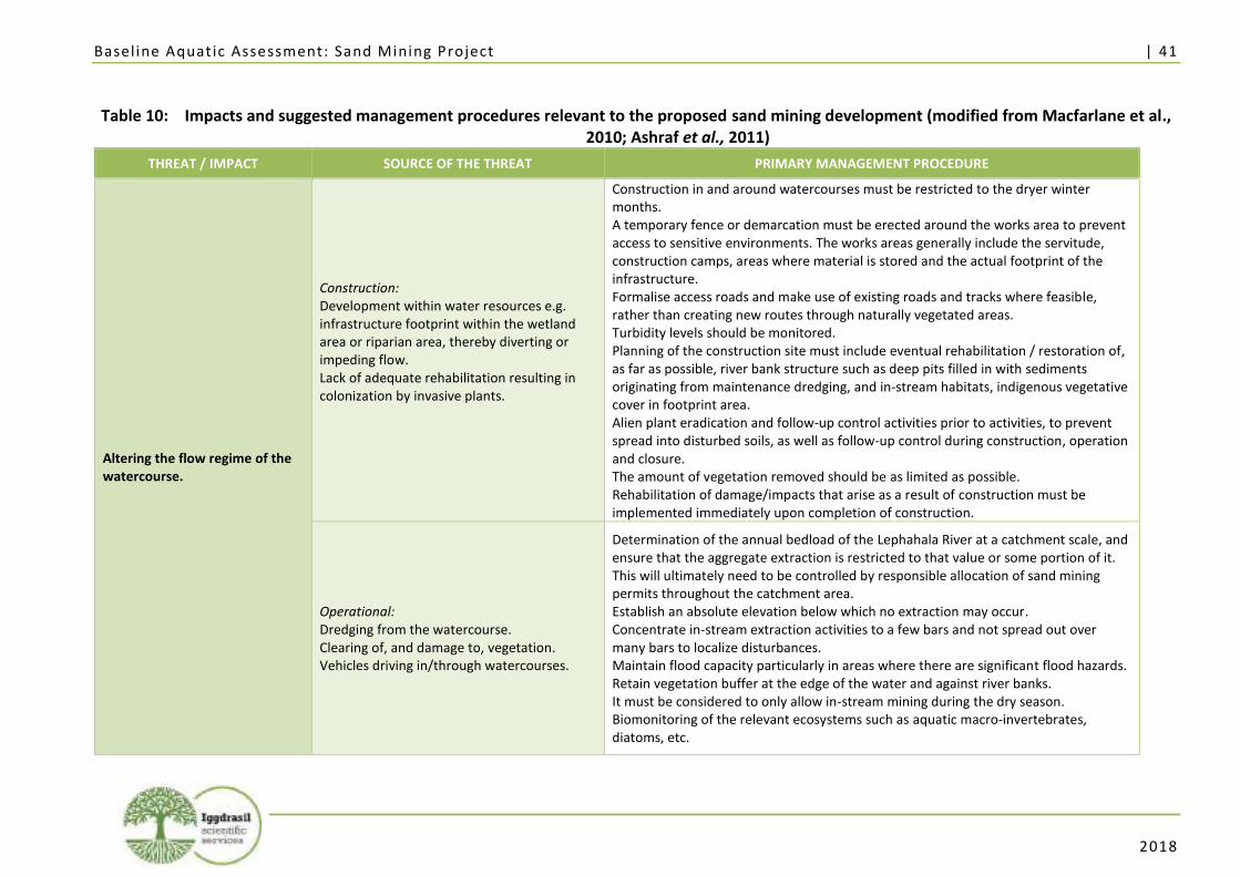
Baseline Aquat ic Assessment: Sand Mining Project | 41
2018
Table 10: Impacts and suggested management procedures relevant to the proposed sand mining development (modified from Macfarlane et al.,
2010; Ashraf et al., 2011)
THREAT / IMPACT SOURCE OF THE THREAT PRIMARY MANAGEMENT PROCEDURE
Altering the flow regime of the watercourse.
Construction: Development within water resources e.g. infrastructure footprint within the wetland area or riparian area, thereby diverting or impeding flow. Lack of adequate rehabilitation resulting in colonization by invasive plants.
Construction in and around watercourses must be restricted to the dryer winter months. A temporary fence or demarcation must be erected around the works area to prevent access to sensitive environments. The works areas generally include the servitude, construction camps, areas where material is stored and the actual footprint of the infrastructure. Formalise access roads and make use of existing roads and tracks where feasible, rather than creating new routes through naturally vegetated areas. Turbidity levels should be monitored. Planning of the construction site must include eventual rehabilitation / restoration of, as far as possible, river bank structure such as deep pits filled in with sediments originating from maintenance dredging, and in-stream habitats, indigenous vegetative cover in footprint area. Alien plant eradication and follow-up control activities prior to activities, to prevent spread into disturbed soils, as well as follow-up control during construction, operation and closure. The amount of vegetation removed should be as limited as possible. Rehabilitation of damage/impacts that arise as a result of construction must be implemented immediately upon completion of construction.
Operational: Dredging from the watercourse. Clearing of, and damage to, vegetation. Vehicles driving in/through watercourses.
Determination of the annual bedload of the Lephahala River at a catchment scale, and ensure that the aggregate extraction is restricted to that value or some portion of it. This will ultimately need to be controlled by responsible allocation of sand mining permits throughout the catchment area. Establish an absolute elevation below which no extraction may occur. Concentrate in-stream extraction activities to a few bars and not spread out over many bars to localize disturbances. Maintain flood capacity particularly in areas where there are significant flood hazards. Retain vegetation buffer at the edge of the water and against river banks. It must be considered to only allow in-stream mining during the dry season. Biomonitoring of the relevant ecosystems such as aquatic macro-invertebrates, diatoms, etc.
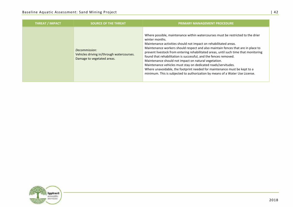
Baseline Aquat ic Assessment: Sand Mining Project | 42
2018
THREAT / IMPACT SOURCE OF THE THREAT PRIMARY MANAGEMENT PROCEDURE
Decommission: Vehicles driving in/through watercourses. Damage to vegetated areas.
Where possible, maintenance within watercourses must be restricted to the drier winter months. Maintenance activities should not impact on rehabilitated areas. Maintenance workers should respect and also maintain fences that are in place to prevent livestock from entering rehabilitated areas, until such time that monitoring found that rehabilitation is successful, and the fences removed. Maintenance should not impact on natural vegetation. Maintenance vehicles must stay on dedicated roads/servitudes. Where unavoidable, the footprint needed for maintenance must be kept to a minimum. This is subjected to authorization by means of a Water Use License.
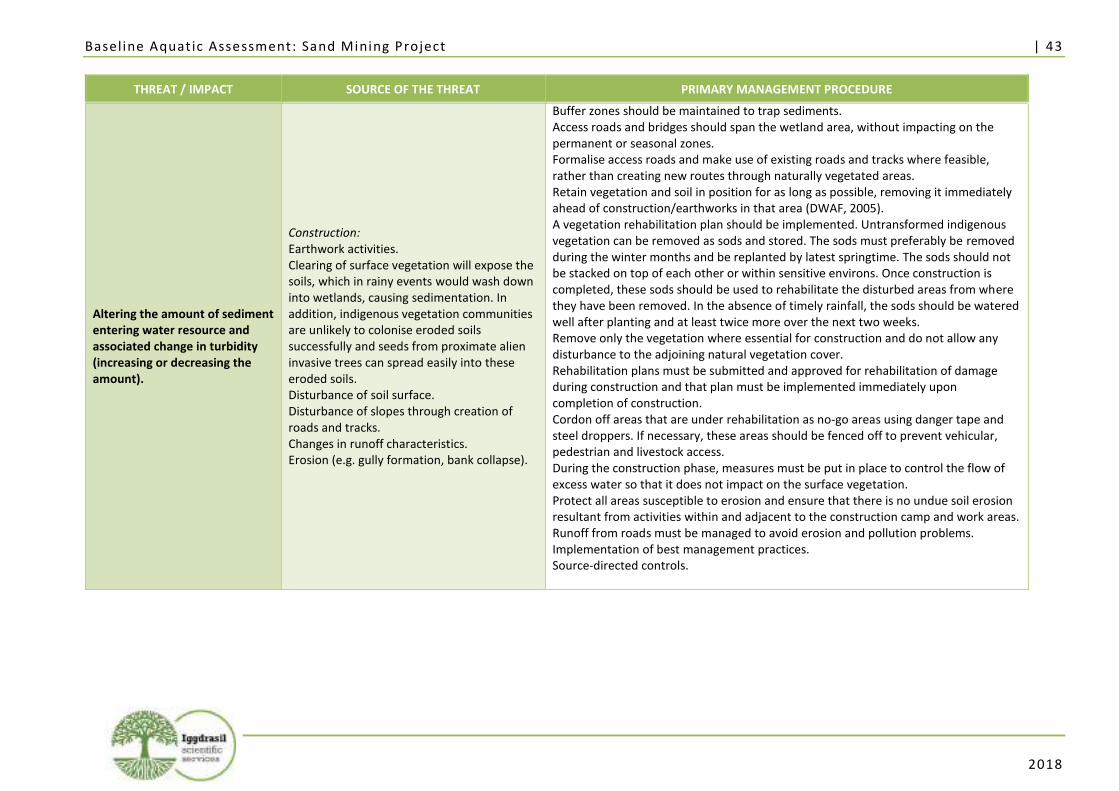
Baseline Aquat ic Assessment: Sand Mining Project | 43
2018
THREAT / IMPACT SOURCE OF THE THREAT PRIMARY MANAGEMENT PROCEDURE
Altering the amount of sediment entering water resource and associated change in turbidity (increasing or decreasing the amount).
Construction: Earthwork activities. Clearing of surface vegetation will expose the soils, which in rainy events would wash down into wetlands, causing sedimentation. In addition, indigenous vegetation communities are unlikely to colonise eroded soils successfully and seeds from proximate alien invasive trees can spread easily into these eroded soils. Disturbance of soil surface. Disturbance of slopes through creation of roads and tracks. Changes in runoff characteristics. Erosion (e.g. gully formation, bank collapse).
Buffer zones should be maintained to trap sediments. Access roads and bridges should span the wetland area, without impacting on the permanent or seasonal zones. Formalise access roads and make use of existing roads and tracks where feasible, rather than creating new routes through naturally vegetated areas. Retain vegetation and soil in position for as long as possible, removing it immediately ahead of construction/earthworks in that area (DWAF, 2005). A vegetation rehabilitation plan should be implemented. Untransformed indigenous vegetation can be removed as sods and stored. The sods must preferably be removed during the winter months and be replanted by latest springtime. The sods should not be stacked on top of each other or within sensitive environs. Once construction is completed, these sods should be used to rehabilitate the disturbed areas from where they have been removed. In the absence of timely rainfall, the sods should be watered well after planting and at least twice more over the next two weeks. Remove only the vegetation where essential for construction and do not allow any disturbance to the adjoining natural vegetation cover. Rehabilitation plans must be submitted and approved for rehabilitation of damage during construction and that plan must be implemented immediately upon completion of construction. Cordon off areas that are under rehabilitation as no-go areas using danger tape and steel droppers. If necessary, these areas should be fenced off to prevent vehicular, pedestrian and livestock access. During the construction phase, measures must be put in place to control the flow of excess water so that it does not impact on the surface vegetation. Protect all areas susceptible to erosion and ensure that there is no undue soil erosion resultant from activities within and adjacent to the construction camp and work areas. Runoff from roads must be managed to avoid erosion and pollution problems. Implementation of best management practices. Source-directed controls.
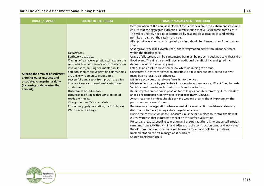
Baseline Aquat ic Assessment: Sand Mining Project | 44
2018
THREAT / IMPACT SOURCE OF THE THREAT PRIMARY MANAGEMENT PROCEDURE
Altering the amount of sediment entering water resource and associated change in turbidity (increasing or decreasing the amount).
Operational: Earthwork activities. Clearing of surface vegetation will expose the soils, which in rainy events would wash down into wetlands, causing sedimentation. In addition, indigenous vegetation communities are unlikely to colonise eroded soils successfully and seeds from proximate alien invasive trees can spread easily into these eroded soils. Disturbance of soil surface. Disturbance of slopes through creation of roads and tracks. Changes in runoff characteristics. Erosion (e.g. gully formation, bank collapse). Wash water discharge.
Determination of the annual bedload of the Lephahala River at a catchment scale, and ensure that the aggregate extraction is restricted to that value or some portion of it. This will ultimately need to be controlled by responsible allocation of sand mining permits throughout the catchment area. All support operations such as gravel washing, should be done outside of the riparian zone. Sand/gravel stockpiles, overburden, and/or vegetation debris should not be stored within the riparian zone. Usage of silt screens can be constructed but must be properly designed to withstand a flood event. The silt screen will have an additional benefit of increasing sediment deposition within the mining area. Establish an absolute elevation below which no mining can occur. Concentrate in-stream extraction activities to a few bars and not spread out over many bars to localize disturbances. Minimise activities that release fine silt into the river. Maintain flood capacity particularly in areas where there are significant flood hazards. Vehicles must remain on dedicated roads and servitudes. Retain vegetation and soil in position for as long as possible, removing it immediately ahead of construction/earthworks in that area (DWAF, 2005). Access roads and bridges should span the wetland area, without impacting on the permanent or seasonal zones. Remove only the vegetation where essential for construction and do not allow any disturbance to the adjoining natural vegetation cover. During the construction phase, measures must be put in place to control the flow of excess water so that it does not impact on the surface vegetation. Protect all areas susceptible to erosion and ensure that there is no undue soil erosion resultant from activities within and adjacent to the construction camp and work areas. Runoff from roads must be managed to avoid erosion and pollution problems. Implementation of best management practices. Source-directed controls.
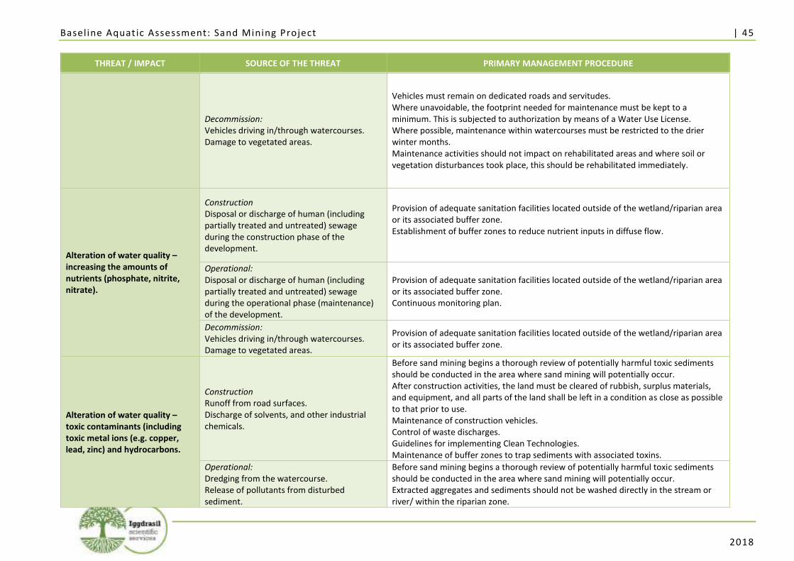
Baseline Aquat ic Assessment: Sand Mining Project | 45
2018
THREAT / IMPACT SOURCE OF THE THREAT PRIMARY MANAGEMENT PROCEDURE
Decommission: Vehicles driving in/through watercourses. Damage to vegetated areas.
Vehicles must remain on dedicated roads and servitudes. Where unavoidable, the footprint needed for maintenance must be kept to a minimum. This is subjected to authorization by means of a Water Use License. Where possible, maintenance within watercourses must be restricted to the drier winter months. Maintenance activities should not impact on rehabilitated areas and where soil or vegetation disturbances took place, this should be rehabilitated immediately.
Alteration of water quality – increasing the amounts of nutrients (phosphate, nitrite, nitrate).
Construction Disposal or discharge of human (including partially treated and untreated) sewage during the construction phase of the development.
Provision of adequate sanitation facilities located outside of the wetland/riparian area or its associated buffer zone. Establishment of buffer zones to reduce nutrient inputs in diffuse flow.
Operational: Disposal or discharge of human (including partially treated and untreated) sewage during the operational phase (maintenance) of the development.
Provision of adequate sanitation facilities located outside of the wetland/riparian area or its associated buffer zone. Continuous monitoring plan.
Decommission: Vehicles driving in/through watercourses. Damage to vegetated areas.
Provision of adequate sanitation facilities located outside of the wetland/riparian area or its associated buffer zone.
Alteration of water quality – toxic contaminants (including toxic metal ions (e.g. copper, lead, zinc) and hydrocarbons.
Construction Runoff from road surfaces. Discharge of solvents, and other industrial chemicals.
Before sand mining begins a thorough review of potentially harmful toxic sediments should be conducted in the area where sand mining will potentially occur. After construction activities, the land must be cleared of rubbish, surplus materials, and equipment, and all parts of the land shall be left in a condition as close as possible to that prior to use. Maintenance of construction vehicles. Control of waste discharges. Guidelines for implementing Clean Technologies. Maintenance of buffer zones to trap sediments with associated toxins.
Operational: Dredging from the watercourse. Release of pollutants from disturbed sediment.
Before sand mining begins a thorough review of potentially harmful toxic sediments should be conducted in the area where sand mining will potentially occur. Extracted aggregates and sediments should not be washed directly in the stream or river/ within the riparian zone.
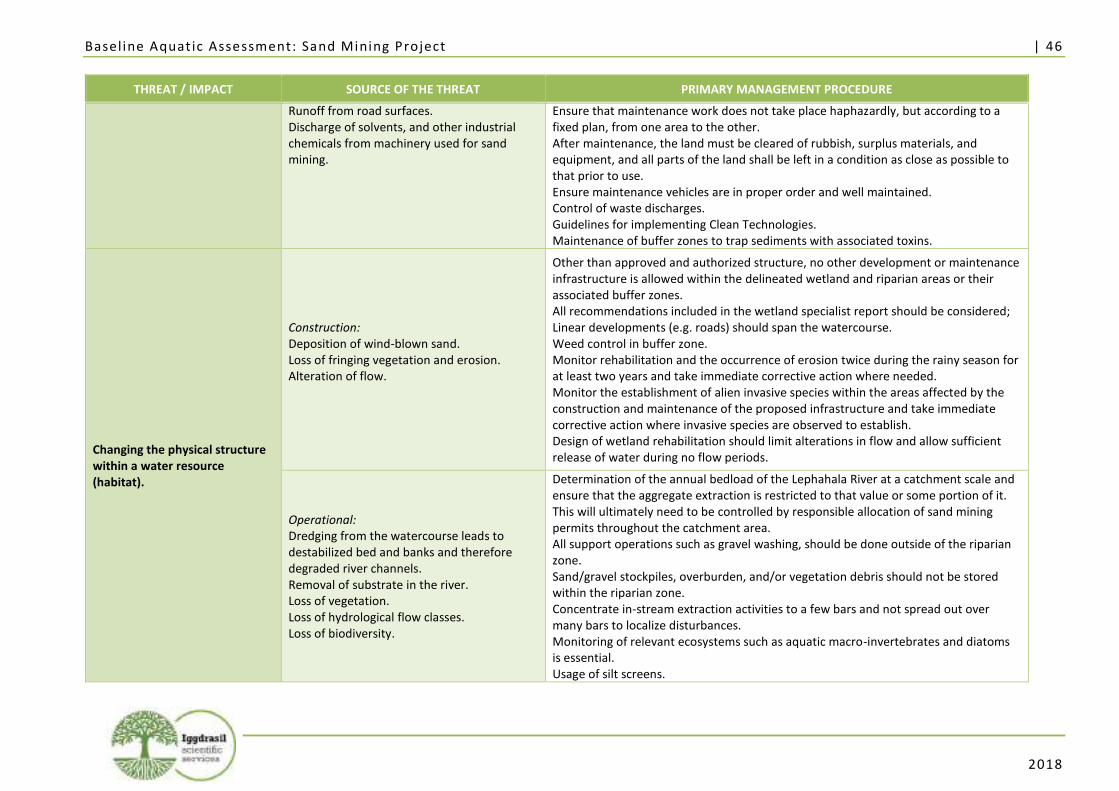
Baseline Aquat ic Assessment: Sand Mining Project | 46
2018
THREAT / IMPACT SOURCE OF THE THREAT PRIMARY MANAGEMENT PROCEDURE
Runoff from road surfaces. Discharge of solvents, and other industrial chemicals from machinery used for sand mining.
Ensure that maintenance work does not take place haphazardly, but according to a fixed plan, from one area to the other. After maintenance, the land must be cleared of rubbish, surplus materials, and equipment, and all parts of the land shall be left in a condition as close as possible to that prior to use. Ensure maintenance vehicles are in proper order and well maintained. Control of waste discharges. Guidelines for implementing Clean Technologies. Maintenance of buffer zones to trap sediments with associated toxins.
Changing the physical structure within a water resource (habitat).
Construction: Deposition of wind-blown sand. Loss of fringing vegetation and erosion. Alteration of flow.
Other than approved and authorized structure, no other development or maintenance infrastructure is allowed within the delineated wetland and riparian areas or their associated buffer zones. All recommendations included in the wetland specialist report should be considered; Linear developments (e.g. roads) should span the watercourse. Weed control in buffer zone. Monitor rehabilitation and the occurrence of erosion twice during the rainy season for at least two years and take immediate corrective action where needed. Monitor the establishment of alien invasive species within the areas affected by the construction and maintenance of the proposed infrastructure and take immediate corrective action where invasive species are observed to establish. Design of wetland rehabilitation should limit alterations in flow and allow sufficient release of water during no flow periods.
Operational: Dredging from the watercourse leads to destabilized bed and banks and therefore degraded river channels. Removal of substrate in the river. Loss of vegetation. Loss of hydrological flow classes. Loss of biodiversity.
Determination of the annual bedload of the Lephahala River at a catchment scale and ensure that the aggregate extraction is restricted to that value or some portion of it. This will ultimately need to be controlled by responsible allocation of sand mining permits throughout the catchment area. All support operations such as gravel washing, should be done outside of the riparian zone. Sand/gravel stockpiles, overburden, and/or vegetation debris should not be stored within the riparian zone. Concentrate in-stream extraction activities to a few bars and not spread out over many bars to localize disturbances. Monitoring of relevant ecosystems such as aquatic macro-invertebrates and diatoms is essential. Usage of silt screens.
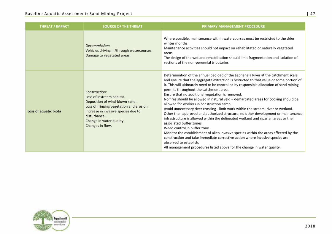
Baseline Aquat ic Assessment: Sand Mining Project | 47
2018
THREAT / IMPACT SOURCE OF THE THREAT PRIMARY MANAGEMENT PROCEDURE
Decommission: Vehicles driving in/through watercourses. Damage to vegetated areas.
Where possible, maintenance within watercourses must be restricted to the drier winter months. Maintenance activities should not impact on rehabilitated or naturally vegetated areas. The design of the wetland rehabilitation should limit fragmentation and isolation of sections of the non-perennial tributaries.
Loss of aquatic biota
Construction: Loss of instream habitat. Deposition of wind-blown sand. Loss of fringing vegetation and erosion. Increase in invasive species due to disturbance. Change in water quality. Changes in flow.
Determination of the annual bedload of the Lephahala River at the catchment scale, and ensure that the aggregate extraction is restricted to that value or some portion of it. This will ultimately need to be controlled by responsible allocation of sand mining permits throughout the catchment area. Ensure that no additional vegetation is removed. No fires should be allowed in natural veld – demarcated areas for cooking should be allowed for workers in construction camp. Avoid unnecessary river crossing - limit work within the stream, river or wetland. Other than approved and authorized structure, no other development or maintenance infrastructure is allowed within the delineated wetland and riparian areas or their associated buffer zones. Weed control in buffer zone. Monitor the establishment of alien invasive species within the areas affected by the construction and take immediate corrective action where invasive species are observed to establish. All management procedures listed above for the change in water quality.
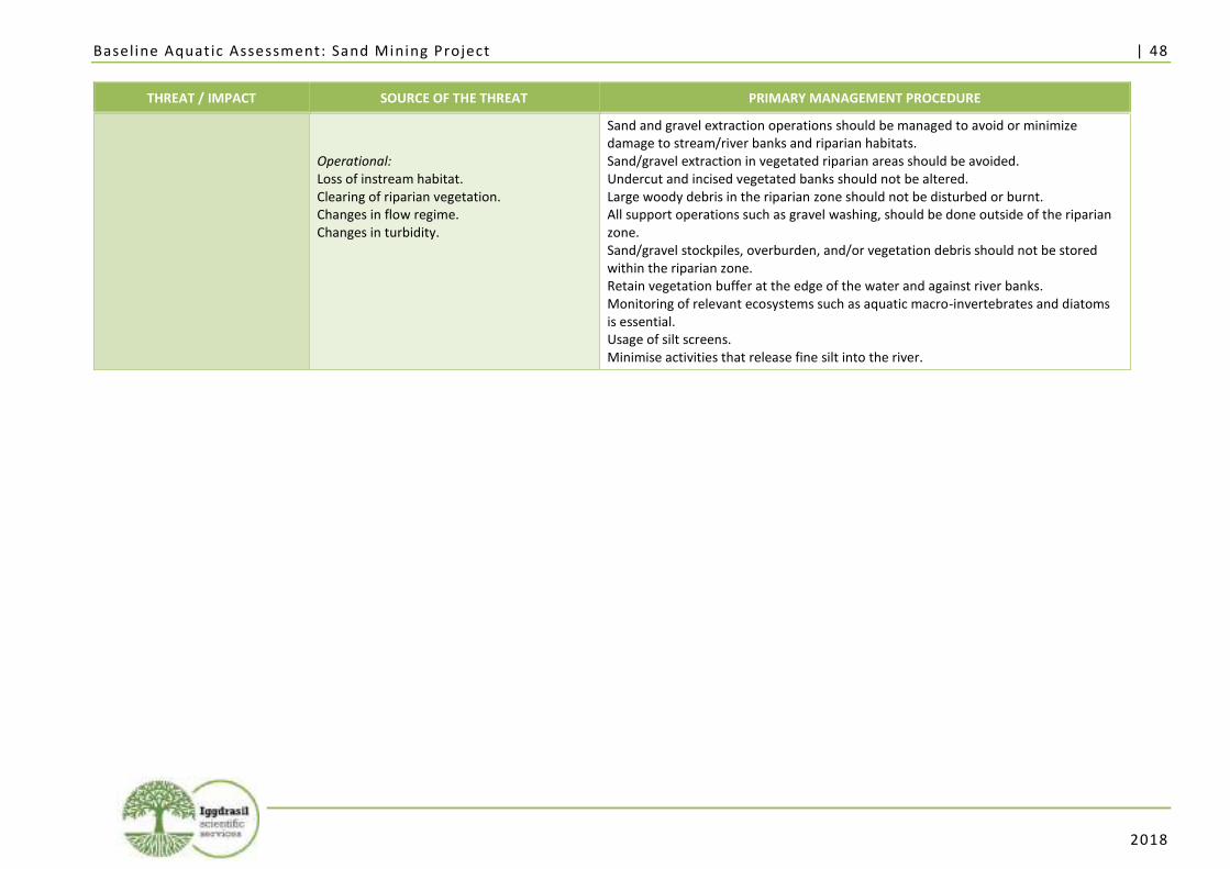
Baseline Aquat ic Assessment: Sand Mining Project | 48
2018
THREAT / IMPACT SOURCE OF THE THREAT PRIMARY MANAGEMENT PROCEDURE
Operational: Loss of instream habitat. Clearing of riparian vegetation. Changes in flow regime. Changes in turbidity.
Sand and gravel extraction operations should be managed to avoid or minimize damage to stream/river banks and riparian habitats. Sand/gravel extraction in vegetated riparian areas should be avoided. Undercut and incised vegetated banks should not be altered. Large woody debris in the riparian zone should not be disturbed or burnt. All support operations such as gravel washing, should be done outside of the riparian zone. Sand/gravel stockpiles, overburden, and/or vegetation debris should not be stored within the riparian zone. Retain vegetation buffer at the edge of the water and against river banks. Monitoring of relevant ecosystems such as aquatic macro-invertebrates and diatoms is essential. Usage of silt screens. Minimise activities that release fine silt into the river.
Baseline Aquat ic Assessment: Sand Mining Project | 49
2018
5. Conclusions and Recommendations
The 2018 baseline aquatic biomonitoring assessment at the proposed sand mining project study area
was conducted on the 22nd of January 2018 at sampling points LH1 and LH2. The habitats at all
biomonitoring sampling points were firstly evaluated by means of observations with regard to their
surroundings, possible causes of impacts or disturbances on aquatic ecosystems, and their suitability
for future biomonitoring surveys. The outcome of this evaluation indicated that biomonitoring
sampling methods VEGRAI, IHAS, and SASS5 could be applied at both sampling points LH1 and LH2. In-
situ water quality results were obtained at sampling points LH1 and LH2. The results obtained from the
in-situ measurement of temperature, pH, EC, and DO are summarised in Annexure B. Diatom analysis
was conducted at sampling points LH1 and LH2.
5.1. Conclusions
The study area is located in the perennial Lephalala River, which is a tributary of the Limpopo River.
According to NFEPA data, the Lephalala River is classified as class D which indicated a largely modified
river. According to national planning the study area is categorised as a non-FEPA. The area surrounding
the study area has no wetland FEPA types. The Sub Quaternary Reach (SQR) of the study area, SQR
A50E-196, has a Present Ecological State (PES) of C which is moderately modified. The SQR has a high
Ecological Importance (EI) and a high Ecological Sensitivity (ES). The study area is located within a
Critical Biodiversity Area 2 (CBA2) and an Ecological Support Area 2 (ESA2) according to the Limpopo
Conservation Plan (LEDET, 2013).
For this 2018 baseline aquatic assessment, the results obtained from each of these sampling points can
be summarised as follows:
• At LH1, the upstream sampling point located in the Lephalala River, the chemical parameters
were all within Target Water Quality Ranges (TWQR’s) for aquatic ecosystems except for the
Dissolved Oxygen which was slightly below TWQR, but not considered to be sub-lethal or
lethal;
• The IHAS results at LH1 indicated that the in-stream habitats are suitable for supporting a
diverse macro-invertebrate community. The SASS5 Ecological Category (EC) was determined
to be “A”3. With regard to vegetation, the VEGRAI EC was determined to be “D”;
• At LH2, the downstream sampling point located in the Lephalala River, the Dissolved Oxygen
was considered high (133.7%), and the pH was considered high (8.66);
3 Ecological categories for SASS5 and VEGRAI assessment described as A: Unmodified/Natural; B: Largely natural with few modifications; C: Moderately modified; D: Largely modified; E: Seriously modified; F: Critically/Extremely modified.
Baseline Aquat ic Assessment: Sand Mining Project | 50
2018
• The IHAS results at LH2 indicated that in-stream habitats are suitable for supporting a diverse
macro-invertebrate community. The SASS5 EC was determined to be “B”. With regard to
vegetation, the VEGRAI EC was determined to be “D”;
• Although the desktop study indicated a system that is not considered to be in a pristine
condition, the SASS5 baseline assessment yielded results that indicate that the Lephalala
River, at sampling points LH1 and LH2, was in a condition that is unmodified and natural to
largely natural with few modifications;
• Diatom analysis conducted at LH1 indicated that the diatom communities were reflective of
moderate water quality with an SPI score of 10.5, and an Ecological Category of C/D, as well
as low organic pollution and nutrient levels, while salinity levels were high;
• At LH2, diatom valve densities were very low at LH2 and a viable count could not be attained
and therefore, no assessment could be undertaken for this site;
• No valve deformities were present at the time of the survey at either of the sampling points
which indicates that metal toxicity was below detection level at the time of sampling;
• Potential impacts were assessed in terms of consequence and probability and a significance
ranking was assigned to every impact;
• Potential impacts that will change the physical structure of the watercourse, alter the
amount of sediment entering the water resource, alter the flow, and cause a loss in aquatic
biota - due mainly to dredging during the operational phase of the project - are of a high
significance both before and after mitigation measures; and
• Potential impacts related to the alteration of water quality – due to increases in nutrients
and from toxic contaminants during dredging and construction activities - are of a high
significance before mitigation measures but rated as medium after mitigation measures.
In terms of key mitigation and monitoring actions, the following are considered to be important for the
study area:
• The formalisation of access roads and making use of existing roads and tracks where feasible,
rather than creating new routes through naturally vegetated areas will minimize loss of
aquatic biota in the area;
• All support operations, such as gravel washing, should be done outside of the riparian zone
to minimize the amount of sediment entering the water resource;
• The control of overland storm water runoff by constructing water control structures such as
berms and cut-off trenches if required for the office and sand-storage complex will aid in
erosion and the amount of sediment entering the water resource;
• Control of waste discharges by providing bunding for areas where hydrocarbons are stored
or transferred to minimize the potential spillage of toxic contaminants in the watercourse.
Should spillage occur it should be dealt with according to the company’s Emergency
Response Plan. This should be provided by contractors;
• Rehabilitation of damage/impacts that arise as a result of construction, which should be
implemented immediately upon completion of construction;
Baseline Aquat ic Assessment: Sand Mining Project | 51
2018
• Biomonitoring of the relevant ecosystems on a bi-annual basis, such as aquatic macro-
invertebrates, diatoms, etc.;
• Sediment and water quality monitoring at a regular interval (upstream and downstream bi-
annually); and
• Monitoring of the establishment of alien invasive species within the areas affected by the
construction and maintenance of the proposed infrastructure and take immediate corrective
action where invasive species are observed to establish.
Of importance is to note that the successful rehabilitation of the site will depend on detailed knowledge
of the local geological conditions, ecology, and function of the study site, as well as the method of the
sand mining itself. This will only be understood through detailed studies, biomonitoring of the
ecosystem, and an effective management plan implemented throughout the process of the project.
This study was informed by both the Wetland and the Flood Line Determination study of the project
area.
5.2. Recommendations
A study determining annual bedload should be conducted at a catchment scale. Sand mining should be
conducted in a sustainable manner, this will ensure that rehabilitation efforts after sand mining
activities are more successful.
Of importance is to note that the successful rehabilitation of the site will depend on detailed knowledge
of the local geological conditions, ecology, and function of the study site, as well as the methods
involved with the mining. This will only be understood through detailed studies, extensive monitoring
of the ecosystem, and an effective management plan implemented throughout the lifecycle of the
project.
Mitigation measures detailed above should be adhered to should the proposed activities commence.
Surface water quality monitoring sites should, where possible, be the same as biomonitoring sites to
facilitate interpretation of datasets. Biomonitoring should be conducted on a bi-annual basis during
construction, operational, rehabilitation and post rehabilitation phases. Alien vegetation in the
marginal as well as non-marginal zones should be removed and monitored.
Baseline Aquat ic Assessment: Sand Mining Project | 52
2018
6. Professional opinion
A professional opinion is required as per the NEMA regulations with regards to the proposed activity.
The aquatic ecosystems in and around the study area were in a relatively natural state. Additionally,
they were earmarked for conservation on a provincial planning level (CBA2 and ESA2) and hence are
critical for meeting conservation goals. It is therefore recommended that the proposed development
should only be considered for approval once certain tests, such as the determination of the annual
bedload and a sustainable yield of sand removal have been established. Once the sustainable yield is
established and the sand mining operation strictly adheres to this maximum removal amount the
proposed sand mining activities could be considered for approval with caution. Should the sand mining
activities commence it is imperative that all the recommendations and mitigation measures must be
strictly adhered to.

Baseline Aquat ic Assessment: Sand Mining Project | 53
2018
References
AFNOR, 2000. Norme Française NF T 90–354. Détermination de l’Indice Biologique Diatomées IBD. Association
Française de Normalisation, 63 pp.
ASHRAF M.A., MAAH M.J., YUSOFF I., WAJID A. AND MAHMOOD K. 2011. Sand mining effects, causes and
concerns: A case study from Bestari Jaya, Selangor, Peninsular Malaysia. Scientific Research and
Essays Vol. 6 (6). Pp. 1216-1231.
BALLANCE A., HILL, L. ROUX, D., SILBERBAUER, M. AND STRYDOM W. 2001. State of the rivers report: Crocodile,
Sabie-Sand and Olifants River Systems, Resource Quality Services, DWAF, Pretoria, South Africa
(www.csir.co.za/rhp).
BATE, G.C, ADAMS, J.B. AND VAN DER MOLEN, J.S., 2002. Diatoms as indicators of water quality in South African
river systems. WRC Report No 814/1/02. Water Research Commission. Pretoria
BATTARBEE, R.W., 1986. Diatom Analysis. In Berglund BE (ed) Handbook of Holocene Paleoecology and
Paleohydrology. John Wiley & Sons Ltd. Chichester. Great Britain. pp 527-570.
BESSE A. 2007 Integrated Project to evaluate the Impacts of Global Change on European Freshwater Ecosystems:
Task 4 - Generation of an indicator value database for European freshwater species. Euro-limpacs.
Project No. GOCE-CT-2003-505540. ALTERRA, Green World Research, Wageningen, Netherlands.
BUNN S.E. AND ARTHINGTON A.H. 2002. Basic Principles and Ecological Consequences of Altered Flow Regimes
for Aquatic Biodiversity. Environmental Management. Vol. 30 (4) pp. 492–507
CATTANEO, A, COUILLARD, Y, WUNSAM, S, AND COURCELLES, M., 2004. Diatom taxonomic and morphological
changes as indicators of metal pollution and recovery in Lac Dufault Québec, Canada. Journal of
Paleolimnology 32: 163-175.
COMITÉ EUROPÉEN DE NORMALISATION (CEN) 2003. Water quality – Guidance standard for the routine
sampling and pre-treatment of benthic diatoms from rivers. European Standard. EN 13946:2003.
CSIR, 2017. Background Information Document (BID). Basic Assessment for the proposed establishment of a
small scale 5 hectares sand mining project within the Lephalala River in Abbottspoort Village,
Lephalale, Limpopo. CSIR Reference No. CSIR/02100/EMS/IR/2016/0003/A.
DALLAS HF AND DAY JA. 1993. The effect of water quality variables on Riverine ecosystems: A review. Water
Research Commission Report No TT61/93.
DALLAS, H.F. 2005. Volume 2 – Maps of national RHP monitoring sites – per water management area In:
Inventory of national river health programme monitoring sites. Report prepared for Environmentek
(CSIR) and Resource Quality Services, Department of Water Affairs and Forestry.
DALLAS, H.F. 2007. River Health Programme: South African Scoring System (SASS) data interpretation guidelines.
Report prepared for Institute of Natural Resources and Department of Water Affairs and Forestry.
DARWALL, W.R.T., SMITH, K.G., TWEDDLE, D. AND SKELTON, P. (EDS) 2009. The Status and Distribution of
Freshwater Biodiversity in Southern Africa. Gland, Switzerland: IUCN and Grahamstown, South
Africa: SAIAB. viii+120pp.
DAVIES, B. AND DAY, J. 1998. Vanishing Waters. Cape Town: University of Cape Town Press.
DE LA REY, PA, TAYLOR, JC, LAAS, A, VAN RENSBURG, L AND VOSLOO, A., 2004. Determining the possible
application value of diatoms as indicators of general water quality: A comparison with SASS 5.
Water SA 30: 325-332.
DEPARTMENT OF WATER AFFAIRS AND FORESTRY. 1996. South African Water Quality Guidelines (second
edition). Volume 1: Domestic Use. Volume 4: Agricultural Use: Irrigation. Volume 5: Agricultural
Use: Livestock Watering. Volume 7: Aquatic Ecosystems. Pretoria: Department of Water Affairs and
Forestry.
Baseline Aquat ic Assessment: Sand Mining Project | 54
2018
DEPARTMENT OF WATER AFFAIRS AND FORESTRY. 2005a. A practical field procedure for identification and
delineation of wetlands and riparian areas. Edition 1. Pretoria: Department of Water Affairs and
Forestry.
DEPARTMENT OF WATER AFFAIRS AND FORESTRY (DWAF). 2005b. River Ecoclassification: Manual for Ecostatus
Determination. First Draft for Training Purposes. Department of Water Affairs and Forestry.
DEPARTMENT OF WATER AFFAIRS (DWAF). 2006. River Health Programme.
https://www.dwaf.gov.za/iwqs/rhp/. Date accessed: 20 February 2015.
DEPARTMENT OF WATER AFFAIRS.2014. A Desktop Assessment of the Present Ecological State, Ecological
Importance and Ecological Sensitivity per Sub Quaternary Reaches for Secondary Catchments in
South Africa. Draft. Compiled by RQS-RDM.
DIATOMS FOR ASSESSING RIVER ECOLOGICAL STATUS (DARES) 2004. Sampling protocol. Version 1.
http://craticula.ncl.ac.uk/dares/methods.htm
DICKENS, C.W.S. AND GRAHAM, P.M. 2002. The South African Scoring System (SASS) Version 5 Rapid
Bioassessment Method for Rivers. African Journal of Aquatic Science 27: 1-10
DIXIT, S.S., SMOL, J.P., KINGSTON, J.C. AND CHARLES, D.F., 1992. Diatoms: Powerful indicators of environmental
change. Environmental Science and Technology 26: 23–33.
DOUDOROFF, P. AND SHUMWAY, D. L., 1970. Dissolved Oxygen Requirements of Freshwater Fish. In: Food and
Agricultural Organisation of the United Nations. Rome: FAO Fisheries Technical Paper No.86.
DRIVER, A., J.L. NEL, K. SNADDON, K. MURRAY, D.J. ROUX, L. HILL, E.R. SWARTZ, J. MANUAL, AND N. FUNKE.
2011. Implementation manual for freshwater ecosystem priority areas. WRC Report No.
1801/1/11. Pretoria: Water Research Commission.
ELLENDER, B.R., O.L.F. WEYL, AND E.R. SWARTZ. 2011. Invasion of a headwater stream by non-native fishes in
the Swartkops River system, South Africa. African Zoology 46(1): 39-46.
EZEMVELO KZN WILDLIFE (2007) Freshwater Systematic Conservation Plan: Best Selected Surface (Marxan).
Unpublished GIS Coverage [Freshwater_cons_plan_2007], Biodiversity Conservation Planning
Division, Ezemvelo KZN Wildlife, Pietermaritzburg, South Africa
FERRAR, A.A. AND LÖTTER, M.C. 2007. Mpumalanga Biodiversity Conservation Plan Handbook. Nelspruit:
Mpumalanga Tourism and Parks Agency.
GERBER, A. AND GABRIEL, M.J.M., 2002. Aquatic Invertebrates of South African Rivers Field Guide. Institute for
Water Quality Studies. Department of Water Affairs and Forestry. 150pp
HELLAWELL, J.M. 1977. Biological Surveillance and Water Quality Monitoring. In: JS Alabaster (Ed). Biological
monitoring of inland fisheries. Applied Science, London. Pp 69-88.
HUNTLEY, B, J., AND WALKER, B, H. (eds), (1982). Ecology of tropical savannas. Springer, Berlin.
IUCN RED LIST OF THREATENED SPECIES. 2017. Version 2015-3. <www.iucnredlist.org>. Downloaded on 15
October 2017.
KARR, J. R. 1981. Assessment of biotic integrity using fish communities. Fisheries 6:21-27.
KELLY, M.G and WHITTON, B.A., 1995, The Trophic Diatom Index: a new index for monitoring eutrophication in
rivers, Journal of Applied Phycology 7, 433- 444
KRAMMER, K AND LANGE-BERTALOT, H 1986-1991. Bacillario-phyceae. Süßwasserflora von Mitteleuropa 2 (1-
4). Spektrum Akademischer Verlag, Heidelberg. Berlin
KLEYNHANS C. J. 1996. A qualitative procedure for the assessment of the habitat integrity status of the Luvuvhu
River (Limpopo system, South Africa). Journal of Aquatic Ecosystem Health 5: 41-54
KLEYNHANS, C. J, THIRION, C AND MOOLMAN, J 2005. A Level I River Ecoregion classification System for South
Africa, Lesotho and Swaziland. Report No. N/0000/00/REQ0104. Resource Quality Services,
Department of Water Affairs and Forestry, Pretoria, South Africa.
Baseline Aquat ic Assessment: Sand Mining Project | 55
2018
KLEYNHANS, C. J. 2007. Module D: Fish Response Assessment Index (FRAI) in River Ecoclassification: Manual for
Ecostatus Determination (Version 2). Joint Water Research Commission and Department of Water
Affairs and Forestry report. WRC report nr: TT330/08
KLEYNHANS C.J., LOUW M.D. 2007. Module A: EcoClassification and EcoStatus determination in River
EcoClassification: Manual for EcoStatus Determination (version 2). Joint Water Research
Commission and Department of Water Affairs and Forestry report. TT330/08
KLEYNHANS, C.J. MACKENZIE, J. AND LOUW, M.D. 2007. Riparian Vegetation Response Index in River
EcoClassification: Manual for EcoStatus Determination (version 2). Joint Water Research
Commission and Department of Water Affairs and Forestry report. WRC report nr: TT333/08.
LANGE-BERTALOT H., 1979 Toleranzgrenzen und populationsdynamik bentischer Diatomeen bei untershiedlich
starker Abwasserbelastung. – Arch. Hydrobiol. Suppl. (Algological Studies 23) 56: 184–219.
LAVOIE, I., CAMPEAU, S., GRENIER, M. AND DILLON P.J., 2006 A diatom-based index for the biological assessment
of eastern Canadian rivers: an application of correspondence analysis (CA). Can. J. Fish. Aquat. Sci.
63(8): 1793–1811.
LECOINTE, C., COSTE, M. AND PRYGIEL, J., 1993. “Omnidia”: Software for taxonomy, calculation of diatom
indices and inventories management. Hydrobiologia 269/270: 509-513.
LEIRA, M. AND SABATER, S. 2005. Diatom assemblages distribution in Catalan rivers, NE Spain, in relation to
chemical and physiographical factors. Water Research 39: 73-82
LIMPOPO DEPARTMENT OF ECONOMIC DEVELOPMENT AND TOURISM (LEDET). 2013. Limpopo Conservation
Plan version 2. Available from the Biodiversity GIS websampling point, accessed on 12 June 2016.
LOW, A.B. AND REBELO, A.G. (eds.) 1996. Vegetation of South Africa, Lesotho and Swaziland. Pretoria: DEAT.
This publication is available online at
http://www.ngo.grida.no/soesa/nsoer/Data/vegrsa/vegstart.htm
LUÍS, A.T., TEIXEIRA, P., ALMEIDA, S.F.P., ECTOR, L., MATOS, J.X. AND FERREIRA DA SILVA, A., 2008. Impact of
Acid Mine Drainage (AMD) on Water Quality, Stream Sediments and Periphytic Diatom
Communities in the Surrounding Streams of Aljustrel Mining Area (Portugal). Water Air Soil
Pollution. DOI 10.1007/s11270-008-9900-z.
MUCINA, L. AND RUTHERFORD, M.C. (eds.) 2006. The vegetation of South Africa, Lesotho and Swaziland.
Strelitzia 19. Pretoria: South African National Biodiversity Institute.
MCMILAN, P.H. (1998). An Integrated Habitat Assessment System (IHAS v2) for the Rapid Biological Assessment
of Rivers and Streams. A CSIR research project. Number ENV-P-I 98132 for the water resources
management programme. CSIR.
NEL, J.L., A. DRIVER, W.F. STRYDOM, A. MAHERRY, C. PETERSEN, L. HILL, D.J. ROUX, S. NIENABER, H. VAN
DEVENTER, E.R. SWARTZ, L.B. SMITH-ADAO. 2011. Atlas of freshwater ecosystem priority areas in
South Africa: Maps to support sustainable development of water resources. Water Research
Commission, WRC Report NO. TT 500/11, South Africa.
PLAFKIN, J.L., BARBOUR, M.T., PORTER, K.D., GROSS S.K., HUGHES, R.M., 1989. Rapid Bio-assessment protocols
for use instreams and rivers: benthic macroinvertebrates and fish. U.S. Environmental Protection
Agency.
PRYGIEL J, CARPENTIER P, ALMEIDA S, COSTE M, DRUART JC, ECTOR L, GUILLARD D, HONORÉ MA, ISERENTANT
R, LEDEGANCK P, LALANNE-CASSOU C, LESNIAK C, MERCIER I, MONCAUT P, NAZART M, NOUCHET
N, PERES F, PEETERS V, RIMET F, RUMEAU A, SABATER S, STRAUB F, TORRISI M, TUDESQUE L, VAN
DER VIJVER B, VIDAL H, VIZINET J AND ZYDEK N., 2002. determination of the biological diatom index
(ibd nf t 90-354): results of an inter-comparison exercise. Journal of applied phycology 14: 27-39
Baseline Aquat ic Assessment: Sand Mining Project | 56
2018
RIVER HEALTH PROGRAMME (RHP) (2005) State-of-Rivers Report: Monitoring and Managing the Ecological State
of Rivers in the Crocodile (West) and Marico Water Management Area. Department of Water
Affairs and Forestry, Pretoria, South Africa.
ROUND, F.E. 1993. A Review and Methods for the Use of Epilithic Diatoms for Detecting and Monitoring Changes
in River Water Quality. Methods for the examination of water and associated materials. HMSO
Publications, London.
RSA (Republic of South Africa), 2011. National Environmental Management: Biodiversity Act (1 0/2004): National
list or ecosystems that are threatened and in need of protection section 52(1)(a) of the National
Environmental Management: Biodiversily Act 2004 (Act No. 10 of 2004)
RSA (Republic of South Africa). 2013. National Environmental Management: Biodiversity Act (10/2004): Alien
and Invasive Species Regulations. Government Gazette, South Africa 506 (33683).
SCHOEMAN, F.R., 1973. A systematical and ecological study of the diatom flora of Lesotho with special reference
to water quality. V&R Printers, Pretoria, South Africa.
SKELTON, P.H. 2001. A complete guide to the freshwater fishes of southern Africa. Struik Publishers, South Africa
STATISTICS SOUTH AFRICA (StatsSA). (2010). Water Management Areas in South Africa.
http://www.statssa.gov.za/publications/d04058/d04058.pdf. Accessed 20th February 2015.
TAYLOR, J.C. 2004 The Application of Diatom-Based Pollution Indices in The Vaal Catchment. Unpublished M.Sc.
thesis, North-West University, Potchefstroom Campus, Potchefstroom.
TAYLOR, JC, HARDING, WR, ARCHIBALD, CGM AND VAN RENSBURG, L., 2005. Diatoms as indicators of water
quality in the Jukskei-Crocodile River system in 1956 and 1957, a re-analysis of diatom count data
generated by BJ Cholnoky. Water SA 31 (2): 327-346.
TAYLOR, JC, HARDING, WR AND ARCHIBALD, C..G.M, 2007a. A methods manual for the collection, preparation
and analysis of diatom samples. Water Research Commission Report TT281/07. Water Research
Commission. Pretoria.
TAYLOR, JC, HARDING, WR AND ARCHIBALD, C.G.M., 2007b. An illustrated guide to some common diatom
species from South Africa. Water Research Commission Report TT282/07. Water Research
Commission. Pretoria.
TILMAN, D, KILHAM, SS, AND KILHAM, P. 1982. Phytoplankton community ecology: The role of limiting nutrients.
Annual Review of Ecology and Systematics 13: 349–372.
TIRMIZI, H. 2003. "Lernaea cyprinacea" (On-line), Animal Diversity Web. Accessed February 17, 2017 at
http://animaldiversity.org/accounts/Lernaea_cyprinacea
THIRION, C.A., MOCKE, A. AND WOEST, R. 1995. Biological monitoring of streams and rivers using SASS4. A User’s
Manual. Internal Report No. N 000/00REQ/1195. Institute for Water Quality Studies. Department
of Water Affairs and Forestry. 46.
THIRION, C. 2007. Module E: Macroinvertebrate Response Assessment Index in River EcoClassification: Manual
for EcoStatus Determination (version 2). Joint Water Research Commission and Department of
Water Affairs and Forestry report. WRC Report.
VAN DAM, H., MERTENS A., AND SINKELDAM, J., 1994. A coded checklist and ecological indicator values of
freshwater diatoms from The Netherlands. Aquatic Ecology 28(1): 117-133.
ZELINKA M AND MARVAN P, 1961. Zur Prikisierung der biologischen Klassifikation der Reinheit fliessender
Gewasser. Archiv. Hydrobiol. 57: 389-407
Baseline Aquat ic Assessment: Sand Mining Project | 57
2018
Limitations
It is acknowledged that the knowledge of the aquatic specialists could be limited and there could be
gaps in the information provided in this report.
The limited rainfall during prior to sampling could have influenced the biotic assemblages including
macroinvertebrates, and plants. It is likely that species diversity can be higher under normal rainfall as
well as high flow conditions.
Findings, recommendations and conclusions provided in this report are based on the authors’ best
scientific and professional knowledge and information available at the time of compilation. The
methods used for aquatic assessments often require the author to make a predicted estimation based
on prior knowledge and learning. These are however the methods as requested by the client and also
accepted methods in the field of aquatic ecology.
In order to obtain a comprehensive understanding of the dynamics of the aquatic ecosystem in an area,
ecological assessments should always consider investigations at different time scales (across
seasons/years) and through replication, as river systems are in constant change. The aquatic baseline
assessment was based on the results of a single survey only, and information provided should be
interpreted accordingly.
Assumptions
• All information provided to ISS was accurate and up to date.
• The position of the proposed mining area and associated infrastructure was accurate.
Copy right
Copyright to the text and other matter, including the manner of presentation, is the exclusively
property of the author. It is a criminal offence to reproduce and/or use, without written consent, any
matter, technical procedure and/or technique contained in this document. Criminal and civil
proceedings will be taken as a matter of strict routine against any person and/or institution infringing
the copyright of the author.

Baseline Aquat ic Assessment: Sand Mining Project | 58
2018
Annexure A: Methods
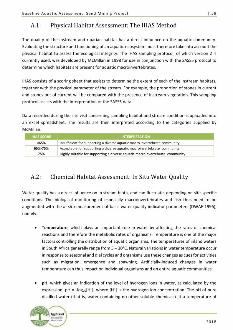
Baseline Aquat ic Assessment: Sand Mining Project | 59
2018
A.1: Physical Habitat Assessment: The IHAS Method
The quality of the instream and riparian habitat has a direct influence on the aquatic community.
Evaluating the structure and functioning of an aquatic ecosystem must therefore take into account the
physical habitat to assess the ecological integrity. The IHAS sampling protocol, of which version 2 is
currently used, was developed by McMillan in 1998 for use in conjunction with the SASS5 protocol to
determine which habitats are present for aquatic macroinvertebrates.
IHAS consists of a scoring sheet that assists to determine the extent of each of the instream habitats,
together with the physical parameter of the stream. For example, the proportion of stones in current
and stones out of current will be compared with the presence of instream vegetation. This sampling
protocol assists with the interpretation of the SASS5 data.
Data recorded during the site visit concerning sampling habitat and stream condition is uploaded into
an excel spreadsheet. The results are then interpreted according to the categories supplied by
McMillan:
IHAS SCORE INTERPRETATION
<65% Insufficient for supporting a diverse aquatic macro invertebrate community
65%-75% Acceptable for supporting a diverse aquatic macroinvertebrate community
75% Highly suitable for supporting a diverse aquatic macroinvertebrate community
A.2: Chemical Habitat Assessment: In Situ Water Quality
Water quality has a direct influence on in stream biota, and can fluctuate, depending on site-specific
conditions. The biological monitoring of especially macroinvertebrates and fish thus need to be
augmented with the in situ measurement of basic water quality indicator parameters (DWAF 1996),
namely:
• Temperature, which plays an important role in water by affecting the rates of chemical
reactions and therefore the metabolic rates of organisms. Temperature is one of the major
factors controlling the distribution of aquatic organisms. The temperatures of inland waters
in South Africa generally range from 5 – 30°C. Natural variations in water temperature occur
in response to seasonal and diel cycles and organisms use these changes as cues for activities
such as migration, emergence and spawning. Artificially-induced changes in water
temperature can thus impact on individual organisms and on entire aquatic communities.
• pH, which gives an indication of the level of hydrogen ions in water, as calculated by the
expression: pH = -log10[H+], where [H+] is the hydrogen ion concentration. The pH of pure
distilled water (that is, water containing no other soluble chemicals) at a temperature of
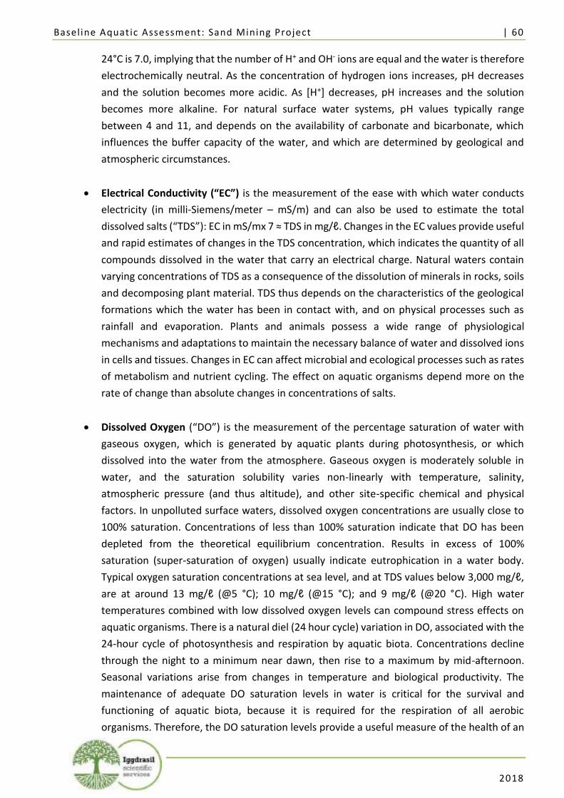
Baseline Aquat ic Assessment: Sand Mining Project | 60
2018
24°C is 7.0, implying that the number of H+ and OH- ions are equal and the water is therefore
electrochemically neutral. As the concentration of hydrogen ions increases, pH decreases
and the solution becomes more acidic. As [H+] decreases, pH increases and the solution
becomes more alkaline. For natural surface water systems, pH values typically range
between 4 and 11, and depends on the availability of carbonate and bicarbonate, which
influences the buffer capacity of the water, and which are determined by geological and
atmospheric circumstances.
• Electrical Conductivity (“EC”) is the measurement of the ease with which water conducts
electricity (in milli-Siemens/meter – mS/m) and can also be used to estimate the total
dissolved salts (“TDS”): EC in mS/mx 7 ≈ TDS in mg/ℓ. Changes in the EC values provide useful
and rapid estimates of changes in the TDS concentration, which indicates the quantity of all
compounds dissolved in the water that carry an electrical charge. Natural waters contain
varying concentrations of TDS as a consequence of the dissolution of minerals in rocks, soils
and decomposing plant material. TDS thus depends on the characteristics of the geological
formations which the water has been in contact with, and on physical processes such as
rainfall and evaporation. Plants and animals possess a wide range of physiological
mechanisms and adaptations to maintain the necessary balance of water and dissolved ions
in cells and tissues. Changes in EC can affect microbial and ecological processes such as rates
of metabolism and nutrient cycling. The effect on aquatic organisms depend more on the
rate of change than absolute changes in concentrations of salts.
• Dissolved Oxygen (“DO”) is the measurement of the percentage saturation of water with
gaseous oxygen, which is generated by aquatic plants during photosynthesis, or which
dissolved into the water from the atmosphere. Gaseous oxygen is moderately soluble in
water, and the saturation solubility varies non-linearly with temperature, salinity,
atmospheric pressure (and thus altitude), and other site-specific chemical and physical
factors. In unpolluted surface waters, dissolved oxygen concentrations are usually close to
100% saturation. Concentrations of less than 100% saturation indicate that DO has been
depleted from the theoretical equilibrium concentration. Results in excess of 100%
saturation (super-saturation of oxygen) usually indicate eutrophication in a water body.
Typical oxygen saturation concentrations at sea level, and at TDS values below 3,000 mg/ℓ,
are at around 13 mg/ℓ (@5 °C); 10 mg/ℓ (@15 °C); and 9 mg/ℓ (@20 °C). High water
temperatures combined with low dissolved oxygen levels can compound stress effects on
aquatic organisms. There is a natural diel (24 hour cycle) variation in DO, associated with the
24-hour cycle of photosynthesis and respiration by aquatic biota. Concentrations decline
through the night to a minimum near dawn, then rise to a maximum by mid-afternoon.
Seasonal variations arise from changes in temperature and biological productivity. The
maintenance of adequate DO saturation levels in water is critical for the survival and
functioning of aquatic biota, because it is required for the respiration of all aerobic
organisms. Therefore, the DO saturation levels provide a useful measure of the health of an
Baseline Aquat ic Assessment: Sand Mining Project | 61
2018
aquatic ecosystem (DWAF 1996). Measuring DO is measuring a dissolved gas, and is thus
best measured in situ, to prevent de-oxygenation or oxygenation during transportation.
It should be noted that the in situ measurement of these water quality parameters does not represent
the general water quality at the sampling points or the streams. It is not a laboratory analysis of water
quality, and does not measure macro anions and cations, metals or organic contaminants, nutrients or
pesticides. The in situ measurements of these parameters provide a snapshot of the water quality at
the survey site at the time the biological samples were taken, and thus can provide valuable insight
into the characteristics at a survey site that could have an influence on the aquatic biota at that site,
and at the time of conducting the sampling for biomonitoring.
In situ measurements of pH, temperature (in °C), and EC (in μS/cm) were taken by means of a calibrated
hand-held instrument (Hanna - HI 991300) in the main flow of the river or stream sampled, both prior
to conducting the sampling for biomonitoring as well as after the completion of conducting the
sampling for biomonitoring. The EC measurements in μS/cm were converted to mS/m (10 μS/cm = 1
mS/m) by dividing with a factor of 10.
Receiving water quality objectives (“RWQOs”) based on the water quality requirements for different
users, are contained in a set of documents first published by DWAF in 1993, and revised in 1996 (DWAF,
1996). These documents are collectively known as the “South African Water Quality Guidelines”
(“SAWQGs”) and contain guidelines for specific types of water users, namely:
• SAWQG Volume 1: Domestic Water Use
• SAWQG Volume 2: Recreational Water Use
• SAWQG Volume 3: Industrial Water Use
• SAWQG Volume 4: Agricultural Water Use: Irrigation
• SAWQG Volume 5: Agricultural Water Use: Livestock Watering
• SAWQG Volume 6: Agricultural Water Use: Aquaculture
• SAWQG Volume 7: Aquatic Ecosystems
These guidelines provide useful information on the effects of various chemical substances on water
resource quality, and establish objectives for the management of the water resource based on the
requirements of the different users of the water resource. The water quality requirements for
protecting and maintaining the health of aquatic ecosystems differ from those of other water uses. It
is difficult to determine the effects of changes in water quality on aquatic ecosystems, as the cause-
effect relationships are not well understood. Therefore, water quality guidelines have to be derived
indirectly through extrapolation of the known effects of water quality on a very limited number of
aquatic organisms. Certain quality ranges are required to protect and maintain aquatic ecosystem
health. For each constituent, guideline ranges are specified, including the No Effect Range (Target
Water Quality Range or “TWQR”), Minimum Allowable Values, Acceptable Range, and, for some
parameters, Intolerable levels.
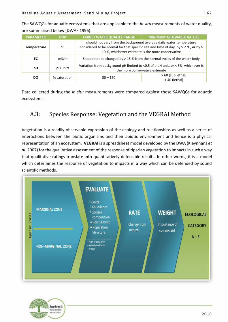
Baseline Aquat ic Assessment: Sand Mining Project | 62
2018
The SAWQGs for aquatic ecosystems that are applicable to the in situ measurements of water quality,
are summarised below (DWAF 1996):
PARAMETER UNIT TARGET WATER QUALITY RANGE MINIMUM ALLOWABLE VALUES
Temperature °C should not vary from the background average daily water temperature
considered to be normal for that specific site and time of day, by > 2 °C, or by > 10 %, whichever estimate is the more conservative
EC mS/m Should not be changed by > 15 % from the normal cycles of the water body
pH pH units Variation from background pH limited to <0.5 of a pH unit, or < 5%, whichever is
the more conservative estimate
DO % saturation 80 – 120 > 60 (sub lethal)
> 40 (lethal)
Data collected during the in situ measurements were compared against these SAWQGs for aquatic
ecosystems.
A.3: Species Response: Vegetation and the VEGRAI Method
Vegetation is a readily observable expression of the ecology and relationships as well as a series of
interactions between the biotic organisms and their abiotic environment and hence is a physical
representation of an ecosystem. VEGRAI is a spreadsheet model developed by the DWA (Kleynhans et
al. 2007) for the qualitative assessment of the response of riparian vegetation to impacts in such a way
that qualitative ratings translate into quantitatively defensible results. In other words, it is a model
which determines the response of vegetation to impacts in a way which can be defended by sound
scientific methods.
Baseline Aquat ic Assessment: Sand Mining Project | 63
2018
VEGRAI Level 3 Analysis Diagram: The metrics in the VEGRAI model can be used to compare an affected site with a reference condition site
to give a measure of vegetative response to impacts.
The VEGRAI spreadsheet model is composed of a series of metric groups (non-woody vs. woody) and
metrics (abundance, cover requirement, species composition and population structure) each of which
is rated in the field. The vegetative Ecological Category is determined by examining the marginal, lower
and upper zones of riparian vegetation and evaluating the metrics for the following metric groups in
each zone:
• Non-woody vegetation in terms of cover, abundance and species composition; and
• Woody vegetation in terms of cover, abundance, species composition and population
structure.
In a VEGRAI level 3 analysis, the riparian zone is divided into only marginal and non-marginal zones.
The marginal zone includes vegetation of the area from the water level at low or basal flow, if present
to those features that are hydrologically activated for the greater part of the year. The non-marginal
zone is subdivided into the lower and upper zones.
The lower zone consist of geomorphic features that are hydrologically activated on a seasonal basis
either yearly during high flow periods or every two to three years. The lower zone extends from the
marginal zone and ends where a marked increase in lateral elevation occurs. The upper zone extends
from the lower zone to the end of the riparian corridor.
The upper zone consists of geomorphic features that are hydrologically activated on an ephemeral
basis, less than every 3 years. The vegetative composition of the upper zone comprises of both
terrestrial and riparian species (Kleynhans et al. 2007).
The VEGRAI sampling methodology entails the following:
• Gather an overview of the section of the river at the selected monitoring station by walking
up and downstream, observing general characteristics, flow, geomorphic morphology,
substrata, elevation, vegetation structure and species as well as any impacts on these
features;
• Take photographs of features, both up and downstream, as well as of the non-marginal
vegetation;
• Compile a list of key/indicator/dominant species that are observed, indicating in which zone
the species occur and whether it is an exotic species;
• Assess the vegetation observed, and divide the vegetation into woody and non-woody
components;
• Estimate the relative proportion, as well as abundance, of vegetative cover;
• If exotic species are present, estimate the proportion of exotic species cover present on site.
Baseline Aquat ic Assessment: Sand Mining Project | 64
2018
If two sides of a river bank are markedly different in respect of these aspects, each river bank should
be treated as a separate site.
Data is interpreted with the VEGRAI spreadsheet model, and the results are used to establish the
VEGRAI Ecological Category. VEGRAI ecological category is determined based on the following
(Kleynhans et al., 2007).
ECOLOGICAL CATEGORY
DESCRIPTION OF SCORE PERCENTAGE
OF TOTAL
A Unmodified, natural 90-100
B Largely natural with few modifications. A small change in natural habitats and biota
may have taken place but the ecosystem functions are essentially unchanged 80-89
C Moderately modified. Loss and change of natural habitat and biota have occurred, but
the basic ecosystem functions are still predominantly unchanged. 60-79
D Largely modified. A large loss of natural habitat, biota and basic ecosystem functions
has occurred 40-59
E Seriously modified. The loss of natural habitat, biota and basic ecosystem functions is
extensive 20-39
F
Critically modified. Modifications have reached a critical level and the lotic system has been modified completely with an almost complete loss of natural habitat and biota. In
the worst instances the basic ecosystem functions have been destroyed and the changes are irreversible.
0-19
A.4: Species Response: Aquatic Invertebrates & the SASS5 Method
SASS5 is a rapid bio-assessment method used to identify changes in species composition of aquatic
invertebrates to indicate relative water quality (Dickens and Graham 2002). SASS5 requires the
identification of invertebrates to a family level in the field.
SASS5 is based on the principle that some invertebrate taxa are more sensitive than others to
pollutants. In particular, macroinvertebrate assemblages are good indicators of localized conditions in
rivers. Many macroinvertebrates have limited migration patterns or are not free-moving, which makes
them well-suited for assessing site specific impacts with upstream/downstream studies. Benthic
macroinvertebrates are abundant in most streams. Even small streams (1st and 2nd order) which may
have a limited fish population will support a diverse macroinvertebrate fauna. These groups of species
constitute a broad range of trophic levels and pollution tolerances. Thus, SASS5 is a useful method for
interpreting the cumulative effects of impacts on aquatic environments.
Using a 'kick net', the SASS5 sampling method entails prescribed time-periods and spatial areas for the
kicking of in-current and out-current stones and bedrock; sweeping of in-current and out-current
marginal and aquatic vegetation, as well as of gravel, stones and mud (“GSM”); followed by visual
observations and hand-picking. The results of each biotope are kept separate, until all observations are
noted. The entire sample is then returned to the river, retained alive, or preserved for further
identification.
Baseline Aquat ic Assessment: Sand Mining Project | 65
2018
In SASS5 analysis, species abundance are recorded on an SASS5 data sheet which weighs the different
taxons common to South African rivers from 1 (pollutant tolerant) to 15 (pollution sensitive). The SASS5
score will be high at a particular site if the taxa are pollution sensitive and low if they are mostly
pollution tolerant.
The SASS5 Score, the number of taxa observed, and the average score per taxon (“ASPT”) are calculated
for all of the biotopes combined. Dallas (2007) used available SASS5 Score and ASPT values for each
eco-region in South Africa to generate biological bands on standardised graphs that are used as a
guideline for interpreting any data obtained during the study. The meaning of each SASS5 Ecological
Category is as follows (Dallas 2007).
EC ECOLOGICAL CATEGORY DESCRIPTION
A Natural Unmodified natural
B Good Largely natural with few modifications
C Fair Moderately modified
D Poor Largely modified
E Seriously modified Seriously modified
F Critically modified Critically or extremely modified
A.5: Diatoms
Diatom-based water quality indices have recently been evaluated and implemented in South Africa
(Taylor, 2004; River Health Programme, 2005) for riverine ecosystems. De la Rey et al. (2004) and
Taylor (2004) showed that diatom-based pollution indices may be good bio-indicators of water quality
in aquatic ecosystems in South Africa by demonstrating a measurable relationship between water
quality variables such as pH, electrical conductivity, phosphorus and nitrogen, and the structure of
diatom communities as reflected by diatom index scores, allowing for conclusions to be drawn about
water quality. Diatoms can also indicate whether heavy metals are present in aquatic systems.
According to Luís et al. (2008) several studies on metal polluted waters have shown that diatoms
respond to perturbations not only at the community but also at the individual level with alteration in
cell wall morphology. In particular, size reduction and frustule deformations have been sometimes
associated with high metal concentrations.
A.5.1: Diatom Sample Collection
Select five cobbles in flowing water in a ten meter radius. Using a nail or tooth brush, brush the top of
the rock (only the top of the rock, as this is the part that has been exposed to the water) into the
sampling tray using a little water to wash each rock off after you are finished. Pour the contents of the
tray into the sampling bottle and add an equal quantity of ethanol to the sample. Wash the tray and
Baseline Aquat ic Assessment: Sand Mining Project | 66
2018
brush well in the water of the next site so that you don't leave diatoms behind on the equipment from
the previous site.
If you can't find cobbles, then you can use emergent or aquatic vegetation. Identify a stand of aquatic
vegetation or emergent vegetation where water is flowing. When using aquatic vegetation - select five
stands of aquatic vegetation and place in a ziplock with a small amount of water. Remove the air out
of the ziplock and seal the bag properly and rub the bag vigorously to ensure the diatoms are dislodged
from the aquatic vegetation discard the vegetation and add the sample to a bottle and preserve in the
same method as collecting cobbles.
In the instance that reeds are sampled, select five reeds, cut the top of the reed off above the water
and discard this part, then cut the reed just above the roots and place them in a tray and scrub the
surface of the reeds into the tray. Add contents of the sampling tray to the sample bottle and preserve
in the same method as collecting cobbles.
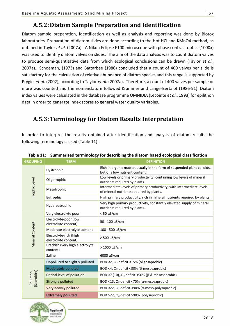
Baseline Aquat ic Assessment: Sand Mining Project | 67
2018
A.5.2: Diatom Sample Preparation and Identification
Diatom sample preparation, identification as well as analysis and reporting was done by Biotox
laboratories. Preparation of diatom slides are done according to the Hot HCl and KMnO4 method, as
outlined in Taylor et al. (2007a). A Nikon Eclipse E100 microscope with phase contrast optics (1000x)
was used to identify diatom valves on slides. The aim of the data analysis was to count diatom valves
to produce semi-quantitative data from which ecological conclusions can be drawn (Taylor et al.,
2007a). Schoeman, (1973) and Battarbee (1986) concluded that a count of 400 valves per slide is
satisfactory for the calculation of relative abundance of diatom species and this range is supported by
Prygiel et al. (2002), according to Taylor et al. (2007a). Therefore, a count of 400 valves per sample or
more was counted and the nomenclature followed Krammer and Lange-Bertalot (1986-91). Diatom
index values were calculated in the database programme OMNIDIA (Lecointe et al., 1993) for epilithon
data in order to generate index scores to general water quality variables.
A.5.3: Terminology for Diatom Results Interpretation
In order to interpret the results obtained after identification and analysis of diatom results the
following terminology is used (Table 11):
Table 11: Summarised terminology for describing the diatom based ecological classification
GROUPING TERM DEFINITION
Tro
ph
ic L
evel
Dystrophic Rich in organic matter, usually in the form of suspended plant colloids, but of a low nutrient content.
Oligotrophic Low levels or primary productivity, containing low levels of mineral nutrients required by plants.
Mesotrophic Intermediate levels of primary productivity, with intermediate levels of mineral nutrients required by plants.
Eutrophic High primary productivity, rich in mineral nutrients required by plants.
Hypereutrophic Very high primary productivity, constantly elevated supply of mineral nutrients required by plants.
Min
eral
Co
nte
nt
Very electrolyte poor < 50 µS/cm
Electrolyte-poor (low electrolyte content)
50 - 100 µS/cm
Moderate electrolyte content 100 - 500 µS/cm
Electrolyte-rich (high electrolyte content)
> 500 µS/cm
Brackish (very high electrolyte content)
> 1000 µS/cm
Saline 6000 µS/cm
Po
lluti
on
(Sap
rob
ity)
Unpolluted to slightly polluted BOD <2, O2 deficit <15% (oligosaprobic)
Moderately polluted BOD <4, O2 deficit <30% (β-mesosaprobic)
Critical level of pollution BOD <7 (10), O2 deficit <50% (β-ά-mesosaprobic)
Strongly polluted BOD <13, O2 deficit <75% (ά-mesosaprobic)
Very heavily polluted BOD <22, O2 deficit <90% (ά-meso-polysaprobic)
Extremely polluted BOD >22, O2 deficit >90% (polysaprobic)
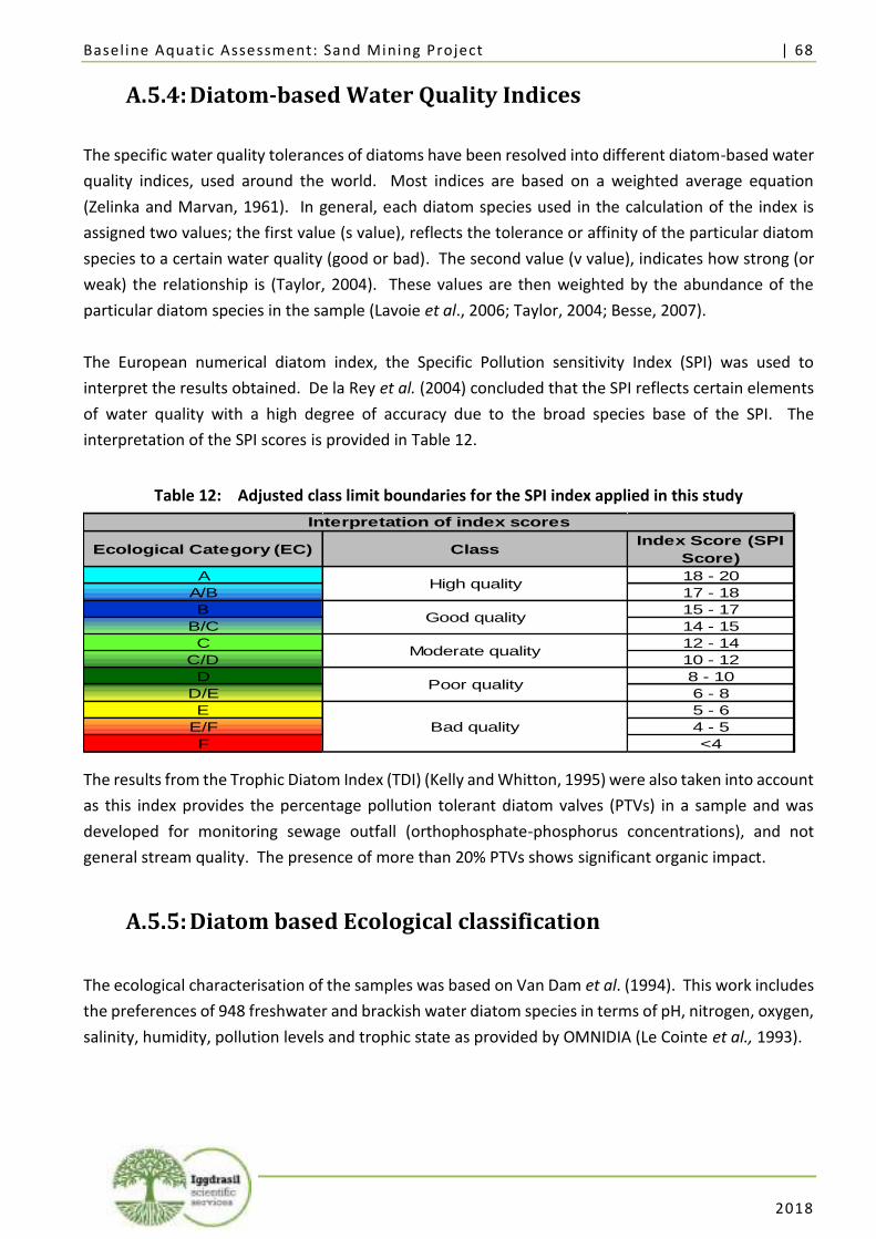
Baseline Aquat ic Assessment: Sand Mining Project | 68
2018
A.5.4: Diatom-based Water Quality Indices
The specific water quality tolerances of diatoms have been resolved into different diatom-based water
quality indices, used around the world. Most indices are based on a weighted average equation
(Zelinka and Marvan, 1961). In general, each diatom species used in the calculation of the index is
assigned two values; the first value (s value), reflects the tolerance or affinity of the particular diatom
species to a certain water quality (good or bad). The second value (v value), indicates how strong (or
weak) the relationship is (Taylor, 2004). These values are then weighted by the abundance of the
particular diatom species in the sample (Lavoie et al., 2006; Taylor, 2004; Besse, 2007).
The European numerical diatom index, the Specific Pollution sensitivity Index (SPI) was used to
interpret the results obtained. De la Rey et al. (2004) concluded that the SPI reflects certain elements
of water quality with a high degree of accuracy due to the broad species base of the SPI. The
interpretation of the SPI scores is provided in Table 12.
Table 12: Adjusted class limit boundaries for the SPI index applied in this study
The results from the Trophic Diatom Index (TDI) (Kelly and Whitton, 1995) were also taken into account
as this index provides the percentage pollution tolerant diatom valves (PTVs) in a sample and was
developed for monitoring sewage outfall (orthophosphate-phosphorus concentrations), and not
general stream quality. The presence of more than 20% PTVs shows significant organic impact.
A.5.5: Diatom based Ecological classification
The ecological characterisation of the samples was based on Van Dam et al. (1994). This work includes
the preferences of 948 freshwater and brackish water diatom species in terms of pH, nitrogen, oxygen,
salinity, humidity, pollution levels and trophic state as provided by OMNIDIA (Le Cointe et al., 1993).
Ecological Category (EC) ClassIndex Score (SPI
Score)A 18 - 20
A/B 17 - 18B 15 - 17
B/C 14 - 15C 12 - 14
C/D 10 - 12D 8 - 10
D/E 6 - 8E 5 - 6
E/F 4 - 5F <4
Bad quality
Interpretation of index scores
High quality
Good quality
Moderate quality
Poor quality
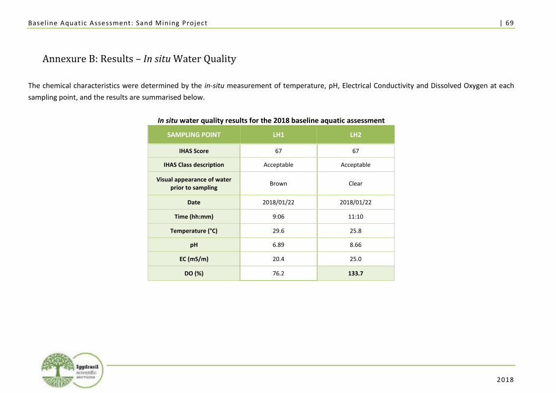
Baseline Aquat ic Assessment: Sand Mining Project | 69
2018
Annexure B: Results – In situ Water Quality
The chemical characteristics were determined by the in-situ measurement of temperature, pH, Electrical Conductivity and Dissolved Oxygen at each
sampling point, and the results are summarised below.
In situ water quality results for the 2018 baseline aquatic assessment
SAMPLING POINT LH1 LH2
IHAS Score 67 67
IHAS Class description Acceptable Acceptable
Visual appearance of water prior to sampling
Brown Clear
Date 2018/01/22 2018/01/22
Time (hh:mm) 9:06 11:10
Temperature (°C) 29.6 25.8
pH 6.89 8.66
EC (mS/m) 20.4 25.0
DO (%) 76.2 133.7
Baseline Aquat ic Assessment: Sand Mining Project | 70
2018
Annexure C: IHAS Score Sheets
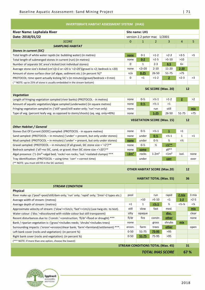
Baseline Aquat ic Assessment: Sand Mining Project | 71
2018
INVERTEBRATE HABITAT ASSESSMENT SYSTEM (IHAS)
River Name: Lephalala River Site name: LH1
Date: 2018/01/22 version 2.2 peter mac 1/2001
SCORE 0 1 2 3 4 5
SAMPLING HABITAT
Stones in current (SIC)
Total length of white water rapids (ie: bubbling water) (in metres) none 0-1 >1-2 >2-3 >3-5 >5
Total length of submerged stones in current (run) (in metres) none 0-2 >2-5 >5-10 >10
Number of separate SIC area’s kicked (not individual stones) 0 1 2-3 4-5 6+
Average stone size’s kicked (cm’s)(<2 or >20 is ‘<2>20’)(gravel is <2; bedrock is >20) none <2>20 2-10 11-20 2-20
Amount of stone surface clear (of algae, sediment etc.) (in percent %)* n/a 0-25 26-50 51-75 >75
PROTOCOL: time spent actually kicking SIC’s (in minutes)(gravel/bedrock = 0 min) 0 <1 >1-2 2 >2-3 >3
( * NOTE: up to 25% of stone is usually embedded in the stream bottom)
SIC SCORE (Max. 20) 12
Vegetation
Length of fringing vegetation sampled (river banks) (PROTOCOL - in metres) none 0-½ >½-1 >1-2 2 >2
Amount of aquatic vegetation/algae sampled (underwater) (in square metres) none 0-½ >½-1 >1
Fringing vegetation sampled in: (‘still’=pool/still water only; ‘run’=run only) none run still mix
Type of veg. (percent leafy veg. as opposed to stems/shoots) (aq. veg. only=49%) none 1-25 26-50 51-75 >75
VEGETATION SCORE (Max. 15) 12
Other Habitat / General
Stones Out Of Current (SOOC) sampled: (PROTOCOL - in square metres) none 0-½ >½-1 1 >1
Sand sampled: (PROTOCOL – in minutes) (‘under’ = present, but only under stones) none under 0-½ >½-1 1 >1
Mud sampled: (PROTOCOL – in minutes) (‘under’ = present, but only under stones) none under 0-½ ½ >½
Gravel sampled: (PROTOCOL – in minutes) (if all gravel, SIC stone size = ’<2’)** none 0-½ ½ >½**
Bedrock sampled: (‘all’=no SIC, sand, or gravel; then SIC stone size =’>20’)** none some all**
Algal presence: (‘1-2m²’=algal bed; ‘rocks’=on rocks; ‘isol.’=isolated clumps) *** >2m² rocks 1-2m² <1m² isol. none
Tray identification: (PROTOCOL – using time: ‘corr’ = correct time) under corr over
(** NOTE: you must still fill in the SIC section)
OTHER HABITAT SCORE (Max.20) 12
HABITAT TOTAL (Max. 55) 36
STREAM CONDITION
Physical
River make up: (‘pool’=pool/still/dam only; ‘run’ only; ‘rapid’ only; ‘2mix’=2 types etc.) pool run rapid 2 mix 3 mix
Average width of stream: (metres) >10 >5-10 <1 1-2 >2-5
Average depth of stream: (metres) >1 1 >½-1 ½ <½-¼ <¼
Approximate velocity of stream: (‘slow’=<½m/s; ‘fast’=>1m/s) (use twig etc. to test). still slow fast med. mix
Water colour: (‘disc.’=discoloured with visible colour but still transparent) silty opaque disc. clear
Recent disturbances due to: (‘constr.’=construction; ‘fl/dr’=flood or drought) *** fl/dr fire constr. other none
Bank / riparian vegetation is: (‘grass’=includes reeds; ‘shrubs’=includes trees) none grass shrubs mix
Surrounding impacts: (‘erosn’=erosion/shear bank; ‘farm’=farmland/settlement) ***. erosn. farm trees other open
Left bank cover (rocks and vegetation): (in percent %) 0-50 51-75 75-95 >95
Right bank cover (rocks and vegetation): (in percent %) 0-50 51-75 75-95 >95
(*** NOTE: if more than one option, choose the lowest)
STREAM CONDITIONS TOTAL (Max. 45) 31
TOTAL IHAS SCORE 67 %
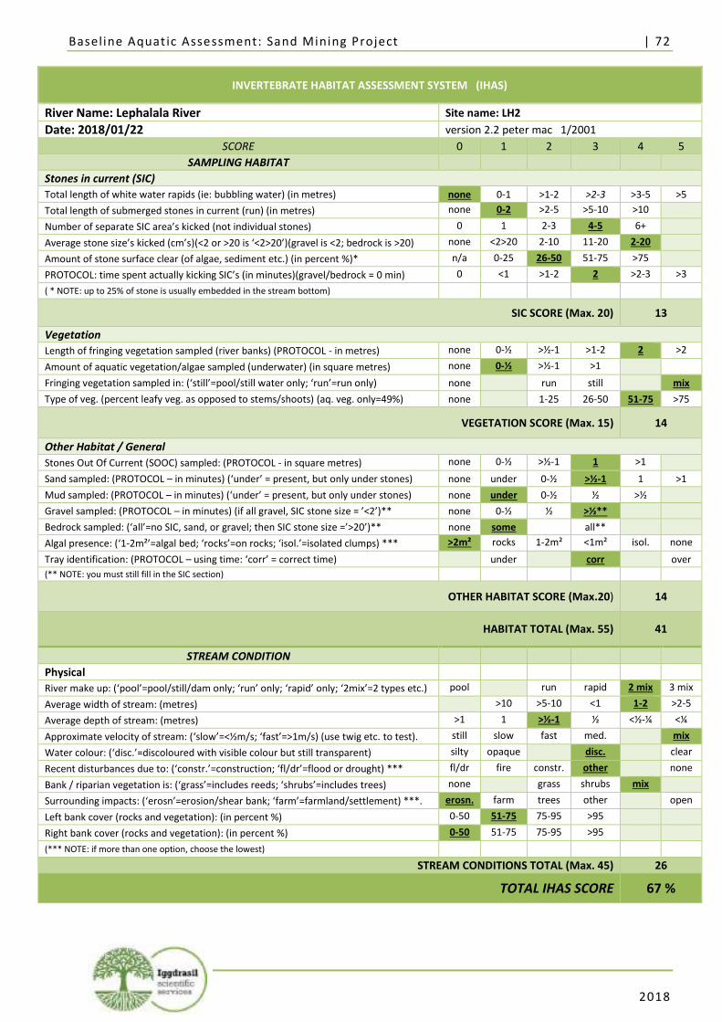
Baseline Aquat ic Assessment: Sand Mining Project | 72
2018
INVERTEBRATE HABITAT ASSESSMENT SYSTEM (IHAS)
River Name: Lephalala River Site name: LH2
Date: 2018/01/22 version 2.2 peter mac 1/2001
SCORE 0 1 2 3 4 5
SAMPLING HABITAT
Stones in current (SIC)
Total length of white water rapids (ie: bubbling water) (in metres) none 0-1 >1-2 >2-3 >3-5 >5
Total length of submerged stones in current (run) (in metres) none 0-2 >2-5 >5-10 >10
Number of separate SIC area’s kicked (not individual stones) 0 1 2-3 4-5 6+
Average stone size’s kicked (cm’s)(<2 or >20 is ‘<2>20’)(gravel is <2; bedrock is >20) none <2>20 2-10 11-20 2-20
Amount of stone surface clear (of algae, sediment etc.) (in percent %)* n/a 0-25 26-50 51-75 >75
PROTOCOL: time spent actually kicking SIC’s (in minutes)(gravel/bedrock = 0 min) 0 <1 >1-2 2 >2-3 >3
( * NOTE: up to 25% of stone is usually embedded in the stream bottom)
SIC SCORE (Max. 20) 13
Vegetation
Length of fringing vegetation sampled (river banks) (PROTOCOL - in metres) none 0-½ >½-1 >1-2 2 >2
Amount of aquatic vegetation/algae sampled (underwater) (in square metres) none 0-½ >½-1 >1
Fringing vegetation sampled in: (‘still’=pool/still water only; ‘run’=run only) none run still mix
Type of veg. (percent leafy veg. as opposed to stems/shoots) (aq. veg. only=49%) none 1-25 26-50 51-75 >75
VEGETATION SCORE (Max. 15) 14
Other Habitat / General
Stones Out Of Current (SOOC) sampled: (PROTOCOL - in square metres) none 0-½ >½-1 1 >1
Sand sampled: (PROTOCOL – in minutes) (‘under’ = present, but only under stones) none under 0-½ >½-1 1 >1
Mud sampled: (PROTOCOL – in minutes) (‘under’ = present, but only under stones) none under 0-½ ½ >½
Gravel sampled: (PROTOCOL – in minutes) (if all gravel, SIC stone size = ’<2’)** none 0-½ ½ >½**
Bedrock sampled: (‘all’=no SIC, sand, or gravel; then SIC stone size =’>20’)** none some all**
Algal presence: (‘1-2m²’=algal bed; ‘rocks’=on rocks; ‘isol.’=isolated clumps) *** >2m² rocks 1-2m² <1m² isol. none
Tray identification: (PROTOCOL – using time: ‘corr’ = correct time) under corr over
(** NOTE: you must still fill in the SIC section)
OTHER HABITAT SCORE (Max.20) 14
HABITAT TOTAL (Max. 55) 41
STREAM CONDITION
Physical
River make up: (‘pool’=pool/still/dam only; ‘run’ only; ‘rapid’ only; ‘2mix’=2 types etc.) pool run rapid 2 mix 3 mix
Average width of stream: (metres) >10 >5-10 <1 1-2 >2-5
Average depth of stream: (metres) >1 1 >½-1 ½ <½-¼ <¼
Approximate velocity of stream: (‘slow’=<½m/s; ‘fast’=>1m/s) (use twig etc. to test). still slow fast med. mix
Water colour: (‘disc.’=discoloured with visible colour but still transparent) silty opaque disc. clear
Recent disturbances due to: (‘constr.’=construction; ‘fl/dr’=flood or drought) *** fl/dr fire constr. other none
Bank / riparian vegetation is: (‘grass’=includes reeds; ‘shrubs’=includes trees) none grass shrubs mix
Surrounding impacts: (‘erosn’=erosion/shear bank; ‘farm’=farmland/settlement) ***. erosn. farm trees other open
Left bank cover (rocks and vegetation): (in percent %) 0-50 51-75 75-95 >95
Right bank cover (rocks and vegetation): (in percent %) 0-50 51-75 75-95 >95
(*** NOTE: if more than one option, choose the lowest)
STREAM CONDITIONS TOTAL (Max. 45) 26
TOTAL IHAS SCORE 67 %
Baseline Aquat ic Assessment: Sand Mining Project | 73
2018
Annexure D: SASS Version 5 Score Sheets
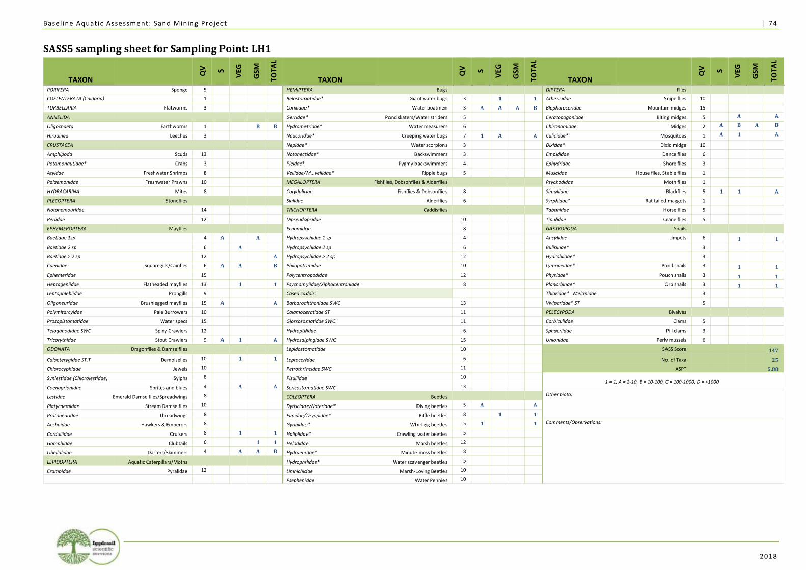
Baseline Aquat ic Assessment: Sand Mining Project | 74
2018
SASS5 sampling sheet for Sampling Point: LH1
TAXON Q
V
S
VEG
GSM
TOTA
L
TAXON Q
V
S
VEG
GSM
TOTA
L
TAXON Q
V
S
VEG
GSM
TOTA
L
PORIFERA Sponge 5 HEMIPTERA Bugs DIPTERA Flies
COELENTERATA (Cnidaria) 1 Belostomatidae* Giant water bugs 3 1 1 Athericidae Snipe flies 10
TURBELLARIA Flatworms 3 Corixidae* Water boatmen 3 A A A B Blepharoceridae Mountain midges 15
ANNELIDA Gerridae* Pond skaters/Water striders 5 Ceratopogonidae Biting midges 5 A A
Oligochaeta Earthworms 1 B B Hydrometridae* Water measurers 6 Chironomidae Midges 2 A B A B
Hirudinea Leeches 3 Naucoridae* Creeping water bugs 7 1 A A Culicidae* Mosquitoes 1 A 1 A
CRUSTACEA Nepidae* Water scorpions 3 Dixidae* Dixid midge 10
Amphipoda Scuds 13 Notonectidae* Backswimmers 3 Empididae Dance flies 6
Potamonautidae* Crabs 3 Pleidae* Pygmy backswimmers 4 Ephydridae Shore flies 3
Atyidae Freshwater Shrimps 8 Veliidae/M...veliidae* Ripple bugs 5 Muscidae House flies, Stable flies 1
Palaemonidae Freshwater Prawns 10 MEGALOPTERA Fishflies, Dobsonflies & Alderflies Psychodidae Moth flies 1
HYDRACARINA Mites 8 Corydalidae Fishflies & Dobsonflies 8 Simuliidae Blackflies 5 1 1 A
PLECOPTERA Stoneflies Sialidae Alderflies 6 Syrphidae* Rat tailed maggots 1
Notonemouridae 14 TRICHOPTERA Caddisflies Tabanidae Horse flies 5
Perlidae 12 Dipseudopsidae 10 Tipulidae Crane flies 5
EPHEMEROPTERA Mayflies Ecnomidae 8 GASTROPODA Snails
Baetidae 1sp 4 A A Hydropsychidae 1 sp 4 Ancylidae Limpets 6 1 1
Baetidae 2 sp 6 A Hydropsychidae 2 sp 6 Bulininae* 3
Baetidae > 2 sp 12 A Hydropsychidae > 2 sp 12 Hydrobiidae* 3
Caenidae Squaregills/Cainfles 6 A A B Philopotamidae 10 Lymnaeidae* Pond snails 3 1 1
Ephemeridae 15 Polycentropodidae 12 Physidae* Pouch snails 3 1 1
Heptageniidae Flatheaded mayflies 13 1 1 Psychomyiidae/Xiphocentronidae 8 Planorbinae* Orb snails 3 1 1
Leptophlebiidae Prongills 9 Cased caddis: Thiaridae* =Melanidae 3
Oligoneuridae Brushlegged mayflies 15 A A Barbarochthonidae SWC 13 Viviparidae* ST 5
Polymitarcyidae Pale Burrowers 10 Calamoceratidae ST 11 PELECYPODA Bivalves
Prosopistomatidae Water specs 15 Glossosomatidae SWC 11 Corbiculidae Clams 5
Teloganodidae SWC Spiny Crawlers 12 Hydroptilidae 6 Sphaeriidae Pill clams 3
Tricorythidae Stout Crawlers 9 A 1 A Hydrosalpingidae SWC 15 Unionidae Perly mussels 6
ODONATA Dragonflies & Damselflies Lepidostomatidae 10 SASS Score 147
Calopterygidae ST,T Demoiselles 10 1 1 Leptoceridae 6 No. of Taxa 25
Chlorocyphidae Jewels 10 Petrothrincidae SWC 11 ASPT 5.88
Synlestidae (Chlorolestidae) Sylphs 8 Pisuliidae 10 1 = 1, A = 2-10, B = 10-100, C = 100-1000, D = >1000
Coenagrionidae Sprites and blues 4 A A Sericostomatidae SWC 13
Lestidae Emerald Damselflies/Spreadwings 8 COLEOPTERA Beetles Other biota: Platycnemidae Stream Damselflies 10 Dytiscidae/Noteridae* Diving beetles 5 A A
Protoneuridae Threadwings 8 Elmidae/Dryopidae* Riffle beetles 8 1 1
Aeshnidae Hawkers & Emperors 8 Gyrinidae* Whirligig beetles 5 1 1 Comments/Observations:
Corduliidae Cruisers 8 1 1 Haliplidae* Crawling water beetles 5
Gomphidae Clubtails 6 1 1 Helodidae Marsh beetles 12
Libellulidae Darters/Skimmers 4 A A B Hydraenidae* Minute moss beetles 8
LEPIDOPTERA Aquatic Caterpillars/Moths Hydrophilidae* Water scavenger beetles 5
Crambidae Pyralidae 12 Limnichidae Marsh-Loving Beetles 10
Psephenidae Water Pennies 10
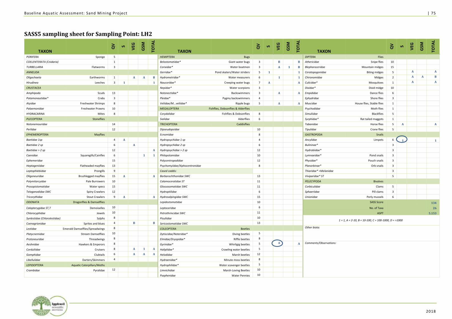
Baseline Aquat ic Assessment: Sand Mining Project | 75
2018
SASS5 sampling sheet for Sampling Point: LH2
TAXON Q
V
S
VEG
GSM
TOTA
L
TAXON Q
V
S
VEG
GSM
TOTA
L
TAXON Q
V
S
VEG
GSM
TOTA
L
PORIFERA Sponge 5 HEMIPTERA Bugs DIPTERA Flies
COELENTERATA (Cnidaria) 1 Belostomatidae* Giant water bugs 3 B B Athericidae Snipe flies 10
TURBELLARIA Flatworms 3 Corixidae* Water boatmen 3 A 1 B Blepharoceridae Mountain midges 15
ANNELIDA Gerridae* Pond skaters/Water striders 5 1 1 Ceratopogonidae Biting midges 5 A A
Oligochaeta Earthworms 1 A A B Hydrometridae* Water measurers 6 1 1 Chironomidae Midges 2 A A B
Hirudinea Leeches 3 1 1 Naucoridae* Creeping water bugs 7 A A Culicidae* Mosquitoes 1 A A
CRUSTACEA Nepidae* Water scorpions 3 Dixidae* Dixid midge 10
Amphipoda Scuds 13 Notonectidae* Backswimmers 3 A A Empididae Dance flies 6
Potamonautidae* Crabs 3 Pleidae* Pygmy backswimmers 4 Ephydridae Shore flies 3
Atyidae Freshwater Shrimps 8 Veliidae/M...veliidae* Ripple bugs 5 A A Muscidae House flies, Stable flies 1
Palaemonidae Freshwater Prawns 10 MEGALOPTERA Fishflies, Dobsonflies & Alderflies Psychodidae Moth flies 1
HYDRACARINA Mites 8 Corydalidae Fishflies & Dobsonflies 8 Simuliidae Blackflies 5
PLECOPTERA Stoneflies Sialidae Alderflies 6 Syrphidae* Rat tailed maggots 1
Notonemouridae 14 TRICHOPTERA Caddisflies Tabanidae Horse flies 5 A A
Perlidae 12 Dipseudopsidae 10 Tipulidae Crane flies 5
EPHEMEROPTERA Mayflies Ecnomidae 8 GASTROPODA Snails
Baetidae 1sp 4 A Hydropsychidae 1 sp 4 Ancylidae Limpets 6 1 1
Baetidae 2 sp 6 A Hydropsychidae 2 sp 6 Bulininae* 3
Baetidae > 2 sp 12 A Hydropsychidae > 2 sp 12 Hydrobiidae* 3
Caenidae Squaregills/Cainfles 6 1 1 Philopotamidae 10 Lymnaeidae* Pond snails 3
Ephemeridae 15 Polycentropodidae 12 Physidae* Pouch snails 3
Heptageniidae Flatheaded mayflies 13 Psychomyiidae/Xiphocentronidae 8 Planorbinae* Orb snails 3
Leptophlebiidae Prongills 9 Cased caddis: Thiaridae* =Melanidae 3
Oligoneuridae Brushlegged mayflies 15 A A Barbarochthonidae SWC 13 Viviparidae* ST 5
Polymitarcyidae Pale Burrowers 10 Calamoceratidae ST 11 PELECYPODA Bivalves
Prosopistomatidae Water specs 15 Glossosomatidae SWC 11 Corbiculidae Clams 5
Teloganodidae SWC Spiny Crawlers 12 Hydroptilidae 6 Sphaeriidae Pill clams 3
Tricorythidae Stout Crawlers 9 A A Hydrosalpingidae SWC 15 Unionidae Perly mussels 6
ODONATA Dragonflies & Damselflies Lepidostomatidae 10 SASS Score 134
Calopterygidae ST,T Demoiselles 10 Leptoceridae 6 No. of Taxa 26
Chlorocyphidae Jewels 10 Petrothrincidae SWC 11 ASPT 5.153
Synlestidae (Chlorolestidae) Sylphs 8 Pisuliidae 10 1 = 1, A = 2-10, B = 10-100, C = 100-1000, D = >1000
Coenagrionidae Sprites and blues 4 B B Sericostomatidae SWC 13
Lestidae Emerald Damselflies/Spreadwings 8 COLEOPTERA Beetles Other biota: Platycnemidae Stream Damselflies 10 Dytiscidae/Noteridae* Diving beetles 5
Protoneuridae Threadwings 8 Elmidae/Dryopidae* Riffle beetles 8
Aeshnidae Hawkers & Emperors 8 Gyrinidae* Whirligig beetles 5 A A Comments/Observations:
Corduliidae Cruisers 8 A 1 A Haliplidae* Crawling water beetles 5
Gomphidae Clubtails 6 A A A Helodidae Marsh beetles 12
Libellulidae Darters/Skimmers 4 Hydraenidae* Minute moss beetles 8
LEPIDOPTERA Aquatic Caterpillars/Moths Hydrophilidae* Water scavenger beetles 5
Crambidae Pyralidae 12 Limnichidae Marsh-Loving Beetles 10
Psephenidae Water Pennies 10
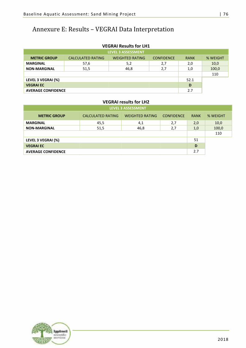
Baseline Aquat ic Assessment: Sand Mining Project | 76
2018
Annexure E: Results – VEGRAI Data Interpretation
VEGRAI Results for LH1 LEVEL 3 ASSESSMENT
METRIC GROUP CALCULATED RATING WEIGHTED RATING CONFIDENCE RANK % WEIGHT
MARGINAL 57,6 5,2 2,7 2,0 10,0
NON-MARGINAL 51,5 46,8 2,7 1,0 100,0
110
LEVEL 3 VEGRAI (%) 52.1
VEGRAI EC D
AVERAGE CONFIDENCE 2.7
VEGRAI results for LH2 LEVEL 3 ASSESSMENT
METRIC GROUP CALCULATED RATING WEIGHTED RATING CONFIDENCE RANK % WEIGHT
MARGINAL 45,5 4,1 2,7 2,0 10,0
NON-MARGINAL 51,5 46,8 2,7 1,0 100,0
110
LEVEL 3 VEGRAI (%) 51
VEGRAI EC D
AVERAGE CONFIDENCE 2.7

Baseline Aquat ic Assessment: Sand Mining Project | 77
2018
Annexure F: Results – Diatoms
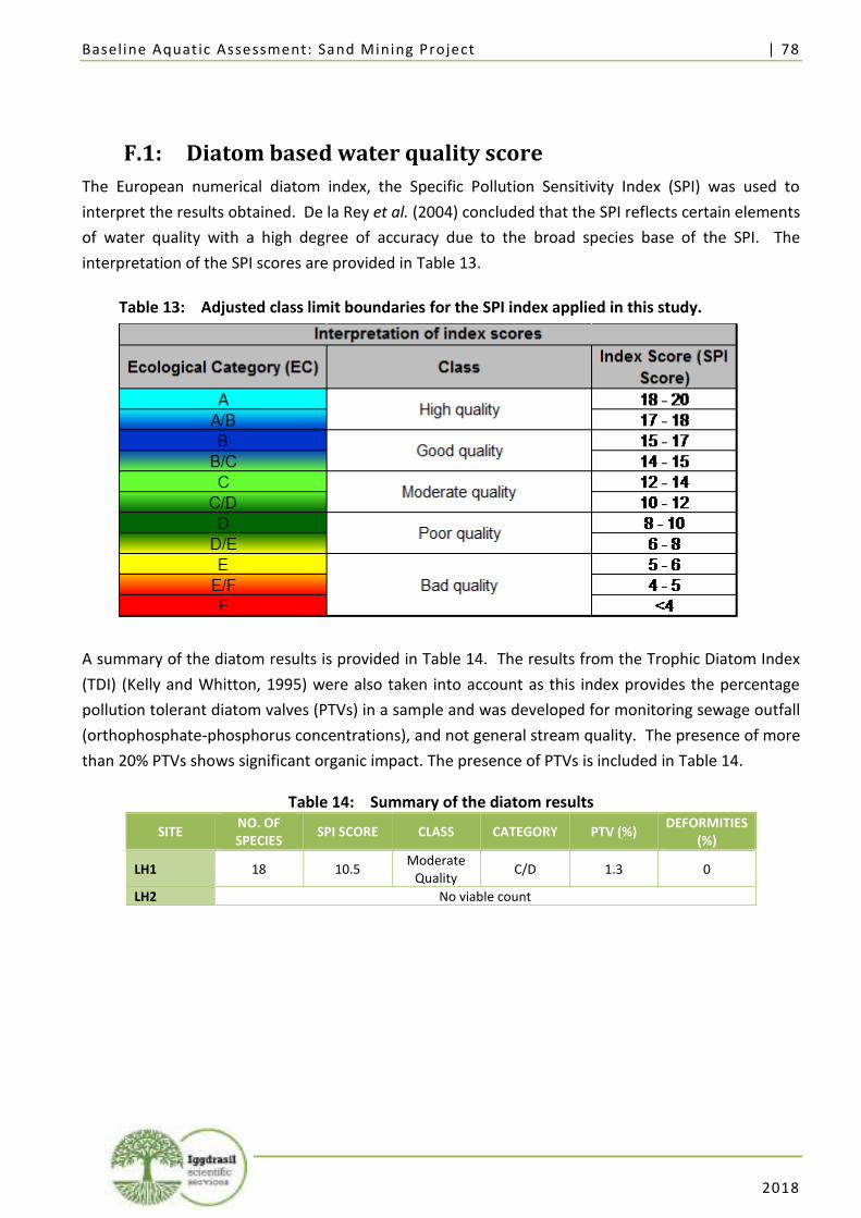
Baseline Aquat ic Assessment: Sand Mining Project | 78
2018
Table 13: Adjusted class limit boundaries for the SPI index applied in this study.
F.1: Diatom based water quality score
The European numerical diatom index, the Specific Pollution Sensitivity Index (SPI) was used to
interpret the results obtained. De la Rey et al. (2004) concluded that the SPI reflects certain elements
of water quality with a high degree of accuracy due to the broad species base of the SPI. The
interpretation of the SPI scores are provided in Table 13.
A summary of the diatom results is provided in Table 14. The results from the Trophic Diatom Index
(TDI) (Kelly and Whitton, 1995) were also taken into account as this index provides the percentage
pollution tolerant diatom valves (PTVs) in a sample and was developed for monitoring sewage outfall
(orthophosphate-phosphorus concentrations), and not general stream quality. The presence of more
than 20% PTVs shows significant organic impact. The presence of PTVs is included in Table 14.
Table 14: Summary of the diatom results
SITE NO. OF SPECIES
SPI SCORE CLASS CATEGORY PTV (%) DEFORMITIES
(%)
LH1 18 10.5 Moderate
Quality C/D 1.3 0
LH2 No viable count
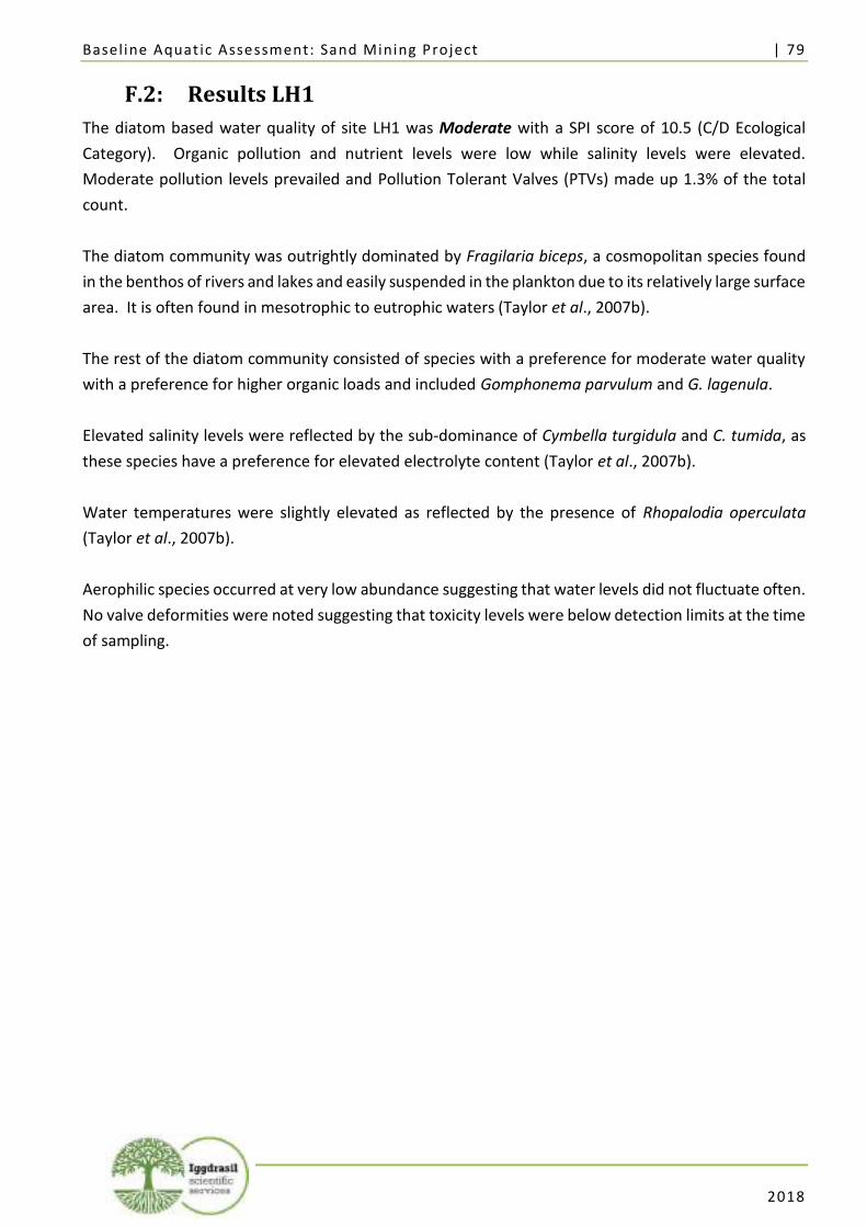
Baseline Aquat ic Assessment: Sand Mining Project | 79
2018
F.2: Results LH1
The diatom based water quality of site LH1 was Moderate with a SPI score of 10.5 (C/D Ecological
Category). Organic pollution and nutrient levels were low while salinity levels were elevated.
Moderate pollution levels prevailed and Pollution Tolerant Valves (PTVs) made up 1.3% of the total
count.
The diatom community was outrightly dominated by Fragilaria biceps, a cosmopolitan species found
in the benthos of rivers and lakes and easily suspended in the plankton due to its relatively large surface
area. It is often found in mesotrophic to eutrophic waters (Taylor et al., 2007b).
The rest of the diatom community consisted of species with a preference for moderate water quality
with a preference for higher organic loads and included Gomphonema parvulum and G. lagenula.
Elevated salinity levels were reflected by the sub-dominance of Cymbella turgidula and C. tumida, as
these species have a preference for elevated electrolyte content (Taylor et al., 2007b).
Water temperatures were slightly elevated as reflected by the presence of Rhopalodia operculata
(Taylor et al., 2007b).
Aerophilic species occurred at very low abundance suggesting that water levels did not fluctuate often.
No valve deformities were noted suggesting that toxicity levels were below detection limits at the time
of sampling.
Baseline Aquat ic Assessment: Sand Mining Project | 80
2018
F.3: Results LH2
Diatom valve densities were very low at LH2 and a viable count could not be attained. Therefore, no
assessment could be undertaken for this site.
Baseline Aquat ic Assessment: Sand Mining Project | 81
2018
Annexure G: Specialist CV

Baseline Aquat ic Assessment: Sand Mining Project | 82
2018
Lorainmari den Boogert Resume Summary
Contact: +27 722 006244 Email: [email protected] Languages: English, Afrikaans, Dutch
Education and Training
Degrees • Master of Science Plant Science 2010
University of Pretoria, SA and Wageningen University, The Netherlands • Bachelor of Science (Honours) Plant Science (Cum Laude) 2008
University of Pretoria, SA • Bachelor of Science Ecology 2007
University of Pretoria, SA
Certificates and Accreditations
• SASS5 Accreditation (freshwater Aquatic Zoology) 2011&2014 Department of Water Affairs, SA
• Dutch as a professional language 2011 CNaTV, Belgium
Additional Courses • Inventory and survey methods for invasive plants, Online Course, Department of land resource of environmental
Sciences, Montana State University, Bozeman, Montana, Canada. 2009
• A rapid method for water quality assessment, Nepid Consultants, Sabie SA. 2011
• EIA water use authorisation and waste activity licences, Carin Bossman Sustainable Solutions, Pretoria, SA. 2011
• Tools for wetland assessment, Rhodes University, Grahamstown, SA. 2011
• Invasive Species Training, South African Green Industries Council (SAGIC), Pretoria, SA. 2016
• Macroinvertebrate Response Assessment Index training, Department of Water Affairs, Pretoria, SA 2016
Career Highlights DIRECTOR / ECOLOGIST Iggdrasil Scientific Services Feb 2012 – Present A medium sized enterprise specialising in ecological assessments, covering fauna, flora, wetland and aquatic ecosystems.
PLANT ECOLOGIST GEM – Science, South Africa Oct 2010 – Feb 2012 A medium sized enterprise providing comprehensive geological and environmental consulting service for the mining industry.
JUNIOR ENVIRONMENTAL CONSULTANT Bokamoso Environmental Consultants, SA Jan 2010 – Oct 2010
PROJECT RESEARCH ASSISTANT Abiotic Research Group, Alterra, Wageningen, The Netherlands Jan 2009 – Jun 2009
Baseline Aquat ic Assessment: Sand Mining Project | 83
2018
BOTANY DEMONSTRATOR Jul 2008 – Nov 2008 University of Pretoria, Plant Sciences, SA FIELD ASSISTANT SA Nov 2007 – Feb 2007 University of Pretoria, Zoology, SA PROJECT RESEARCH ASSISTANT SA Jan 2006 – Aug 2006 University of Pretoria, Zoology, SA
Conference Presentations
• Course Presenter on Riparian Vegetation Assessment Methods 2017 Department of Water and Sanitation, Pretoria, SA
• Presentation on: Conservation Planning in Urban Open Spaces 2016 Botanical Society, Pretoria, SA
• Presentation on: The Vegetation ecology of Seringveld Conservancy, Cullinan South Africa 2010 South African Association of Botanist’s Annual Conference, Potchefstroom, SA.
• Presentation on: A comparison between Ellenberg and Wamelink Biological indicator values 2009 Wageningen Abiotic Research Group, Wageningen, The Netherlands
• Presentation on: The effect of the higher energy flow in the Ash River System, Bethlehem, SA 2003 Stockholm International Youth Science Seminar, Stockholm, Sweden.
• Presentation on: The youth of South Africa would like to see groundwater pollution addresses in light of the international summit for sustainable development 2003 Water Institute of South Africa, Annual Conference, Durban, SA.
Achievements • Overall Winner and gold medalist of the Eskom Expo for Young Scientist, representing south Africa in the Stockholm Sweden at
the Stockholm international youth seminar • Winner of the South Africa youth water prize of the department of water affairs and represented South Africa at the
international youth water prize during world water week in Stockholm Sweden.
Membership & Associations
• South African Council of Natural Scientific Professions Registered Professional Scientist (Pri.Sci.Nat: 400003/13), • South African Association for Botanists, • South African Botanical Society,
Committee member. • South African Society for Aquatic Scientist, • Department of Water Affairs SASS5 practitioners,
DESKTOP HERITAGE IMPACT ASSESSMENT
In terms of Section 38(8) of the NHRA for the
Sand mining project within Lephalala River in Abbottspoort Village,
Lephalale Municipality, Limpopo Province
Prepared by
For the CSIR
December 2017
Report by:
Nicholas Wiltshire
THE INDEPENDENT PERSON WHO COMPILED A SPECIALIST REPORT OR UNDERTOOK A SPECIALIST
PROCESS
I Nicholas Wiltshire, as the appointed independent specialist hereby declare that I: • act/ed as the independent specialist in this application; • regard the information contained in this report as it relates to my specialist input/study to be true and correct, and • do not have and will not have any financial interest in the undertaking of the activity, other than remuneration for work performed in terms of the NEMA, the Environmental Impact Assessment Regulations, 2010 and any specific environmental management Act; • have and will not have no vested interest in the proposed activity proceeding; • have disclosed, to the applicant, EAP and competent authority, any material information that have or may have the potential to influence the decision of the competent authority or the objectivity of any report, plan or document required in terms of the NEMA, the Environmental Impact Assessment Regulations, 2010 and any specific environmental management Act; • am fully aware of and meet the responsibilities in terms of NEMA, the Environmental Impact Assessment Regulations, 2010 (specifically in terms of regulation 17 of GN No. R. 543) and any specific environmental management Act, and that failure to comply with these requirements may constitute and result in disqualification; • have ensured that information containing all relevant facts in respect of the specialist input/study was distributed or made available to interested and affected parties and the public and that participation by interested and affected parties was facilitated in such a manner that all interested and affected parties were provided with a reasonable opportunity to participate and to provide comments on the specialist input/study; • have ensured that the comments of all interested and affected parties on the specialist input/study were considered, recorded and submitted to the competent authority in respect of the application; • have ensured that the names of all interested and affected parties that participated in terms of the specialist input/study were recorded in the register of interested and affected parties who participated in the public participation process; • have provided the competent authority with access to all information at my disposal regarding the application, whether such information is favourable to the applicant or not; and • am aware that a false declaration is an offence in terms of regulation 71 of GN No. R. 543.
Signature of the specialist Name of company: CTS Heritage Date: 31/12/2017
Nicholas Wiltshire (MSc) is an archaeologist and heritage practitioner with over 12 years experience in heritage, as
a researcher, field archaeologist and government employee. He is accredited for CRM work with the Association of
Southern African Professional Archaeologists and has previously worked for Heritage Western Cape and SAHRA as
a Heritage Officer and SAHRIS Project Manager respectively.
See Appendix 1 for the specialist’s CV.
1
CTS Heritage 34 Harries Street, Plumstead, Cape Town, 7800
Tel: (021) 0130131 Email: [email protected] Web: www.ctsheritage.com
EXECUTIVE SUMMARY This application relates to a small-scale sand mining project along 5ha of the banks of the Lephalala River in
Abbottspoort Village, Limpopo. The development triggers listed activities in terms of the Environmental Impact
Assessment (EIA) Regulations, Government Regulations (GNR) 324 and 327 of April 2017 promulgated under the
National Environmental Management Act (Act no 107 of 1998) (NEMA). In terms of these Regulations, a Basic
Assessment (BA) should be undertaken for the proposed project. The Council for Scientific and Industrial Research
(CSIR) will be managing the process. This BA is being undertaken as part of the Special Needs Programme initiated
by the national Department of Environmental Affairs to support disadvantaged communities who have “special
needs”, in particular, they have demonstrated they do not have the financial means to conduct the necessary studies
for environmental authorisations and associated permits. Environmental assessment services are being provided
across South Africa to poor rural communities to support their livelihoods in a responsible manner.
The method consists of the mining of +/-100 cubic metres of river sand per day from the riverbed; furthermore sand
will be extracted by means of an excavator, loaded on a tipper truck and hauled to the relevant markets or
temporary storage area. The South African mining industry has its origin in small-scale mining activities, with these
operations offering much needed employment opportunities and entrepreneurship, as well as contributing to local
economies. The proposed project will provide good quality sand to the local building industry for use in the
construction of roads and buildings. The mining operation would contribute towards the wider socio-economic
development of the area in the form of job opportunities and service delivery by promoting infrastructural
development.
The CSIR notified SAHRA of their intent to develop via SAHRIS in September 2017 (see SAHRIS Case ID 11612).
SAHRA responded with a request for a desktop HIA, inclusive of a desktop Palaeontological Impact Assessment
(PIA) in terms of Section 38(8) of the NHRA. CTS Heritage was contracted by the CSIR to compile the necessary
studies for submission to SAHRA. CTS Heritage used its Heritage Screening methodology to summarise known
heritage resources and characterise the likelihood of encountering as yet unknown heritage resources of
significance in the impacted area for the proposed sand mine. The desktop study drew on previous research sites
data, declared sites and previous HIAs in the area, particularly those of Frans Roodt which took place near the
proposed development area.
The assessment found that the likely physical and visual impacts of the sand mine on archaeological,
palaeontological, built environment, burial grounds and cultural landscape heritage resources will be extremely
low. A Letter of Exemption from further palaeontological studies has also been drawn up Dr John Almond as the
sand mining will take place in an area of insignificant fossil sensitivity.
2
CTS Heritage 34 Harries Street, Plumstead, Cape Town, 7800
Tel: (021) 0130131 Email: [email protected] Web: www.ctsheritage.com
CONTENTS
1. INTRODUCTION 4 1.1 Background Information on Project 4 1.2 Description of Property and affected Environment 5
2. METHODOLOGY 6 2.1 Purpose of Desktop HIA 6 2.2 Summary of steps followed 7
3. HISTORY AND EVOLUTION OF THE SITE AND CONTEXT 7 3.1 Definition of the property 7 3.2 Geology, geomorphology, climate and vegetation 7 3.3 Palaeontological, Archaeological and Historical Background of the study area 9
4. IDENTIFICATION OF HERITAGE RESOURCES 10 4.1 Summary of findings 10 4.2 Heritage Resources identified 11 4.3 Mapping and spatialisation of heritage resources 12
5. ASSESSMENT OF THE IMPACT OF THE DEVELOPMENT 12 5.1 Assessment of impact to Heritage Resources 12 5.2 Sustainable Social and Economic Benefit 12 5.3 Proposed development alternatives 13
6. RESULTS OF PUBLIC CONSULTATIONS 13
7. CONCLUSION AND RECOMMENDATIONS 13
8. REFERENCES 13
APPENDICES 15 APPENDIX 1: Specialist CVs 15 APPENDIX 2: Map Insets 16 APPENDIX 3: List of heritage resources within the 34km Inclusion Zone 20 APPENDIX 4: Screening Methodology & Guide to Acronyms 22
3
CTS Heritage 34 Harries Street, Plumstead, Cape Town, 7800
Tel: (021) 0130131 Email: [email protected] Web: www.ctsheritage.com
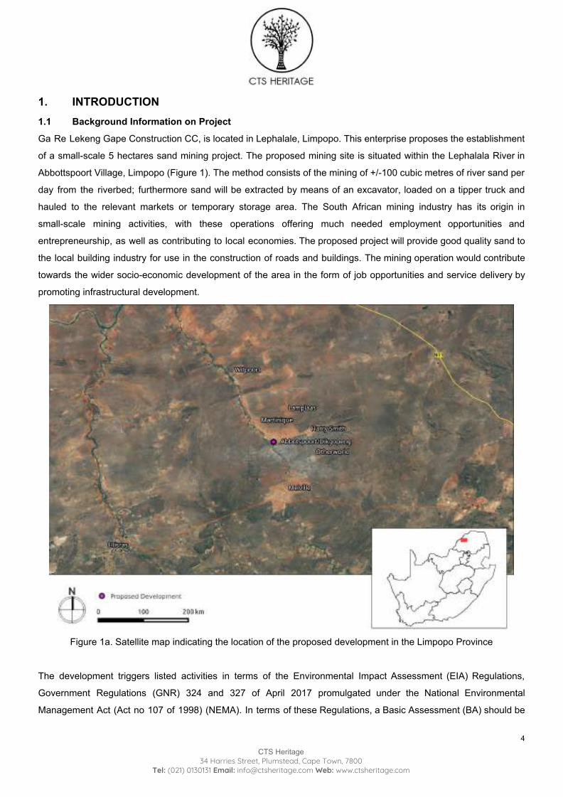
1. INTRODUCTION 1.1 Background Information on Project Ga Re Lekeng Gape Construction CC, is located in Lephalale, Limpopo. This enterprise proposes the establishment
of a small-scale 5 hectares sand mining project. The proposed mining site is situated within the Lephalala River in
Abbottspoort Village, Limpopo (Figure 1). The method consists of the mining of +/-100 cubic metres of river sand per
day from the riverbed; furthermore sand will be extracted by means of an excavator, loaded on a tipper truck and
hauled to the relevant markets or temporary storage area. The South African mining industry has its origin in
small-scale mining activities, with these operations offering much needed employment opportunities and
entrepreneurship, as well as contributing to local economies. The proposed project will provide good quality sand to
the local building industry for use in the construction of roads and buildings. The mining operation would contribute
towards the wider socio-economic development of the area in the form of job opportunities and service delivery by
promoting infrastructural development.
Figure 1a. Satellite map indicating the location of the proposed development in the Limpopo Province
The development triggers listed activities in terms of the Environmental Impact Assessment (EIA) Regulations,
Government Regulations (GNR) 324 and 327 of April 2017 promulgated under the National Environmental
Management Act (Act no 107 of 1998) (NEMA). In terms of these Regulations, a Basic Assessment (BA) should be
4
CTS Heritage 34 Harries Street, Plumstead, Cape Town, 7800
Tel: (021) 0130131 Email: [email protected] Web: www.ctsheritage.com
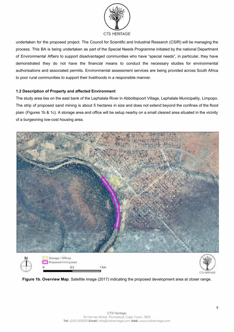
undertaken for the proposed project. The Council for Scientific and Industrial Research (CSIR) will be managing the
process. This BA is being undertaken as part of the Special Needs Programme initiated by the national Department
of Environmental Affairs to support disadvantaged communities who have “special needs”, in particular, they have
demonstrated they do not have the financial means to conduct the necessary studies for environmental
authorisations and associated permits. Environmental assessment services are being provided across South Africa
to poor rural communities to support their livelihoods in a responsible manner.
1.2 Description of Property and affected Environment
The study area lies on the east bank of the Lephalala River in Abbottspoort Village, Lephalale Municipality, Limpopo.
The strip of proposed sand mining is about 5 hectares in size and does not extend beyond the confines of the flood
plain (Figures 1b & 1c). A storage area and office will be setup nearby on a small cleared area situated in the vicinity
of a burgeoning low-cost housing area.
Figure 1b. Overview Map. Satellite image (2017) indicating the proposed development area at closer range.
5
CTS Heritage 34 Harries Street, Plumstead, Cape Town, 7800
Tel: (021) 0130131 Email: [email protected] Web: www.ctsheritage.com
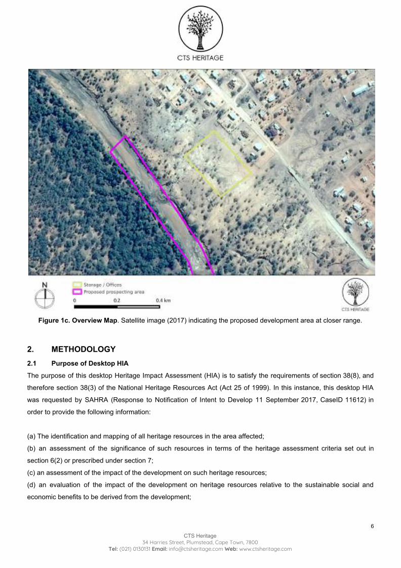
Figure 1c. Overview Map. Satellite image (2017) indicating the proposed development area at closer range.
2. METHODOLOGY 2.1 Purpose of Desktop HIA
The purpose of this desktop Heritage Impact Assessment (HIA) is to satisfy the requirements of section 38(8), and
therefore section 38(3) of the National Heritage Resources Act (Act 25 of 1999). In this instance, this desktop HIA
was requested by SAHRA (Response to Notification of Intent to Develop 11 September 2017, CaseID 11612) in
order to provide the following information:
(a) The identification and mapping of all heritage resources in the area affected;
(b) an assessment of the significance of such resources in terms of the heritage assessment criteria set out in
section 6(2) or prescribed under section 7;
(c) an assessment of the impact of the development on such heritage resources;
(d) an evaluation of the impact of the development on heritage resources relative to the sustainable social and
economic benefits to be derived from the development;
6
CTS Heritage 34 Harries Street, Plumstead, Cape Town, 7800
Tel: (021) 0130131 Email: [email protected] Web: www.ctsheritage.com
(e) the results of consultation with communities affected by the proposed development and other interested parties
regarding the impact of the development on heritage resources;
(f) if heritage resources will be adversely affected by the proposed development, the consideration of alternatives;
and
(g) plans for mitigation of any adverse effects during and after the completion of the proposed development.
2.2 Summary of steps followed
● The results of the consultation and public participation processes was sought from the EAP;
● The relevant literature was reviewed to assess the types of heritage resources likely to be found in the area,
including, inter alia, previous HIAs conducted in the area available on SAHRIS
● Mapping and assessment of previously identified heritage resources on SAHRIS and declared or formally
graded sites on the heritage register
● GIS mapping of the development proposal and heritage resources
● Screening of palaeontological sensitivities which have subsequently been peer-reviewed and formalised into
a Palaeontological Letter of Exemption by Dr John Almond
3. HISTORY AND EVOLUTION OF THE SITE AND CONTEXT 3.1 Definition of the property
The study area lies on the east bank of the Lephalala River in Abbottspoort Village, Lephalale Municipality, Limpopo.
Abbottspoort Village is a small farming village which has expanded in size in recent years due to low-cost housing
development for its inhabitants working on the neighbouring farms. Rhuma Ranch, a game farm, lies on the opposite
bank of the Lephalala River (west) and various agricultural smallholdings surround Abbottspoort to the north and
east.
3.2 Geology, geomorphology, climate and vegetation
Abbottspoort Village lies in the northern end of the Bushveld Complex in the southern domain of the
east-northeast-trending Palala-Zoetfontein shear zone (Barton, Klemd, Zeh 2006). The southern domain is
terminated on the south across the Abbottspoort shear zone by igneous rocks of the Bushveld Complex (Figure 3a).
The proposed sand mining area predominantly straddles Palala Granite (~1.7 - 2.0 Ga in age) with a small section of
Villa Nora gabbro on the southern end. The aeolian sands which are to be mined are of much more recent
Quarternary origin and lie in the middle of a flood plain which is highly disturbed during the wet season. The
application is situated in the Roodeberg Bushveld vegetation type (Mucina & Rutherford 2006, SANBI online
Vegetation Map).
7
CTS Heritage 34 Harries Street, Plumstead, Cape Town, 7800
Tel: (021) 0130131 Email: [email protected] Web: www.ctsheritage.com
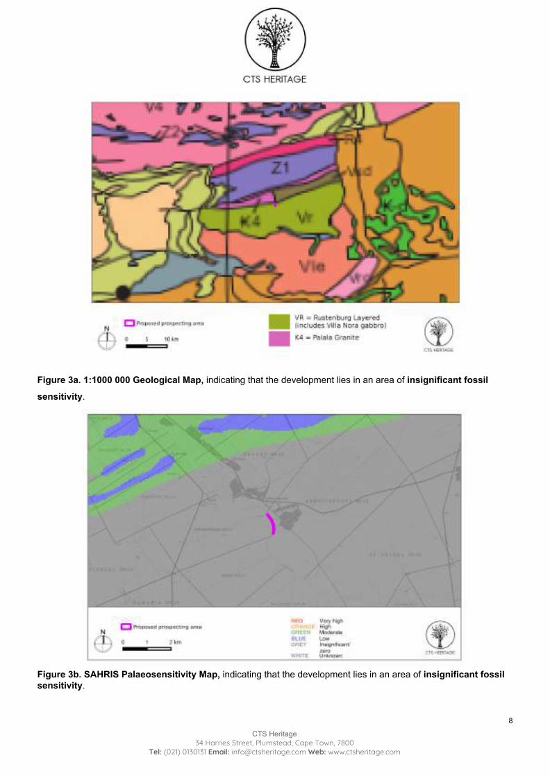
Figure 3a. 1:1000 000 Geological Map, indicating that the development lies in an area of insignificant fossil
sensitivity.
Figure 3b. SAHRIS Palaeosensitivity Map, indicating that the development lies in an area of insignificant fossil sensitivity.
8
CTS Heritage 34 Harries Street, Plumstead, Cape Town, 7800
Tel: (021) 0130131 Email: [email protected] Web: www.ctsheritage.com
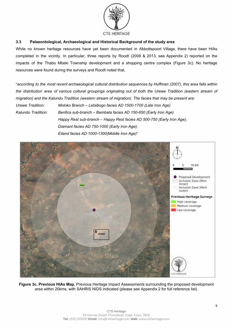
3.3 Palaeontological, Archaeological and Historical Background of the study area
While no known heritage resources have yet been documented in Abbottspoort Village, there have been HIAs
completed in the vicinity. In particular, three reports by Roodt (2008 & 2013, see Appendix 2) reported on the
impacts of the Thabo Mbeki Township development and a shopping centre complex (Figure 3c). No heritage
resources were found during the surveys and Roodt noted that,
“according to the most recent archaeological cultural distribution sequences by Huffman (2007), this area falls within
the distribution area of various cultural groupings originating out of both the Urewe Tradition (eastern stream of
migration) and the Kalundu Tradition (western stream of migration). The facies that may be present are:
Urewe Tradition: Moloko Branch – Letsibogo facies AD 1500-1700 (Late Iron Age)
Kalundu Tradition: Benfica sub-branch – Bambata facies AD 150-650 (Early Iron Age)
Happy Rest sub-branch – Happy Rest facies AD 500-750 (Early Iron Age);
Diamant facies AD 750-1000 (Early Iron Age);
Eiland facies AD 1000-1300(Middle Iron Age)”
Figure 3c. Previous HIAs Map. Previous Heritage Impact Assessments surrounding the proposed development
area within 20kms, with SAHRIS NIDS indicated (please see Appendix 2 for full reference list).
9
CTS Heritage 34 Harries Street, Plumstead, Cape Town, 7800
Tel: (021) 0130131 Email: [email protected] Web: www.ctsheritage.com
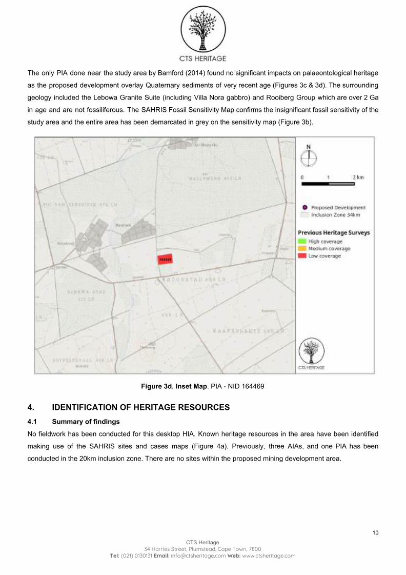
The only PIA done near the study area by Bamford (2014) found no significant impacts on palaeontological heritage
as the proposed development overlay Quaternary sediments of very recent age (Figures 3c & 3d). The surrounding
geology included the Lebowa Granite Suite (including Villa Nora gabbro) and Rooiberg Group which are over 2 Ga
in age and are not fossiliferous. The SAHRIS Fossil Sensitivity Map confirms the insignificant fossil sensitivity of the
study area and the entire area has been demarcated in grey on the sensitivity map (Figure 3b).
Figure 3d. Inset Map. PIA - NID 164469
4. IDENTIFICATION OF HERITAGE RESOURCES 4.1 Summary of findings
No fieldwork has been conducted for this desktop HIA. Known heritage resources in the area have been identified
making use of the SAHRIS sites and cases maps (Figure 4a). Previously, three AIAs, and one PIA has been
conducted in the 20km inclusion zone. There are no sites within the proposed mining development area.
10
CTS Heritage 34 Harries Street, Plumstead, Cape Town, 7800
Tel: (021) 0130131 Email: [email protected] Web: www.ctsheritage.com
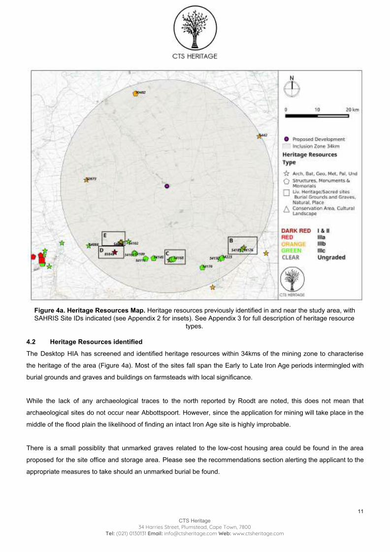
Figure 4a. Heritage Resources Map. Heritage resources previously identified in and near the study area, with SAHRIS Site IDs indicated (see Appendix 2 for insets). See Appendix 3 for full description of heritage resource
types. 4.2 Heritage Resources identified
The Desktop HIA has screened and identified heritage resources within 34kms of the mining zone to characterise
the heritage of the area (Figure 4a). Most of the sites fall span the Early to Late Iron Age periods intermingled with
burial grounds and graves and buildings on farmsteads with local significance.
While the lack of any archaeological traces to the north reported by Roodt are noted, this does not mean that
archaeological sites do not occur near Abbottspoort. However, since the application for mining will take place in the
middle of the flood plain the likelihood of finding an intact Iron Age site is highly improbable.
There is a small possiblity that unmarked graves related to the low-cost housing area could be found in the area
proposed for the site office and storage area. Please see the recommendations section alerting the applicant to the
appropriate measures to take should an unmarked burial be found.
11
CTS Heritage 34 Harries Street, Plumstead, Cape Town, 7800
Tel: (021) 0130131 Email: [email protected] Web: www.ctsheritage.com
4.3 Mapping and spatialisation of heritage resources
No heritage resources were found in or immediately near the proposed sand mining area.
5. ASSESSMENT OF THE IMPACT OF THE DEVELOPMENT 5.1 Assessment of impact to Heritage Resources
No built environment, cultural landscape or visual impacts (both primary and secondary) are anticipated due to
the proposed sand mining project in Abbottspoort Village. The development has a small footprint, is in the middle of
a flood plain, and is immediately adjacent to recently built low-cost housing that has expanded the urban footprint of
Abbottspoort in the last 20 years.
No impacts on fossils are anticipated given that the underlying geology is of igneous origin and the Quarternary
aeolian sands are of much more recent age in the middle of a disturbed and highly active flood plain along the banks
of the Lephalala River. A chance finds procedure will suffice should any fossils be found that have been washed
down and deposited in this zone.
Archaeological impacts of the proposed sand mining are also anticipated to be very low to insignificant. No
in-situ archaeological remains would be found in the middle of the flood plain. The area chosen for the small site
office and storage facility has also been located on an area previously cleared for low-cost housing and ancillary
activities related to the urbanisation of the Village.
There is almost always a possibility of encountering an unmarked burial during construction, particularly near
low-cost housing areas where residents cannot afford a formal burial. Should any unmarked human remains be
uncovered or exposed during mining or associated activities, these must immediately be reported to SAHRA (021
462 4502). Burials must not be removed or disturbed until inspected by a professional archaeologist.
5.2 Sustainable Social and Economic Benefit
Ga Re Lekeng Gape Construction CC will create local employment during the operation of the sand mine as well as
providing much needed building sand to the local area for roads and housing. The activity has a negligible heritage
impact, and, if managed appropriately, will have a negligible environmental impact. The mining operation would
therefore contribute positively towards the wider socio-economic development of the area in the form of
job opportunities and service delivery by promoting infrastructural development.
The Basic Assessment is being undertaken as part of the Special Needs Programme initiated by the national
Department of Environmental Affairs to support disadvantaged communities who have “special needs”, in particular,
they have demonstrated they do not have the financial means to conduct the necessary studies for environmental
12
CTS Heritage 34 Harries Street, Plumstead, Cape Town, 7800
Tel: (021) 0130131 Email: [email protected] Web: www.ctsheritage.com
authorisations and associated permits. Environmental assessment services are being provided across South Africa
to poor rural communities to support their livelihoods in a responsible manner.
5.3 Proposed development alternatives
No development alternatives have as yet been put forward.
6. RESULTS OF PUBLIC CONSULTATIONS The CSIR will submit the full documentation related to the public consultation process to SAHRA. Results of this
heritage study will be included in the information pack distributed to residents and interested and affected parties.
Should any as yet unidentified heritage resources or relevant heritage issues be uncovered during the public
consultation process, the HIA will be amended and updated to address the concerns with possible mitigatory
measures.
7. CONCLUSION AND RECOMMENDATIONS The desktop HIA has found no reason, on heritage grounds, for the proposed sand mining development to proceed
without further heritage studies or mitigatory measures. All forms of heritage resources were considered but none
were identified - it is therefore highly unlikely that additional costs incurred for fieldwork on this site will be warranted
given the small scale of the development in the middle of a flood plain.
If in situ archaeological resources or human burials are found, work must cease and these findings must be reported
to the Limpopo PHRA and SAHRA, and a suitably qualified archaeologist must be contacted.
8. REFERENCES Heritage Impact Assessments
Nid Type Author/s Date Title
5338 HIA Frans Roodt 08/08/2008 Phase 1 Heritage Resource Impact Assessment (Scoping & Evaluation): Shopping Complex Development, Lephalale, Limpopo
151461 HIA Frans Roodt 13/11/2013 Thabo Mbeki Amended Heritage Report
131996 HIA Frans Roodt 04/06/2013 Proposed Thabo Mbeki Township development of approximately 4 700 erven on Remainder of the farm Richards Lager 124 LR, Lephalale Local Municipality, Waterberg District Municipality, Limpopo
Palaeontological Impact Assessments
Nid Type Author/s Date Title
164469 PIA Marion Bamford 19/05/2014 Palaeontological Impact Assessment for the proposed Eskom Marken
Customer Network Centre (CNC) Project, Limpopo
13
CTS Heritage 34 Harries Street, Plumstead, Cape Town, 7800
Tel: (021) 0130131 Email: [email protected] Web: www.ctsheritage.com
Other References
Type Author/s Dat
e Title
Book Barton, Jr., J.M., Klemd, R. & Zeh,
A. 2006 The Limpopo Belt: A result of Archean to Proterozoic, Turkic-type orogenesis? In Processes
on the Early Earth. Geological Society of America, Special Paper 405. pp 316 - 332
Book
Mucina, L., & Rutherford
2006
The Vegetation of South Africa, Lesotho and Swaziland, Strelitzia 19, South African Biodiversity Institute, Pretoria
14
CTS Heritage 34 Harries Street, Plumstead, Cape Town, 7800
Tel: (021) 0130131 Email: [email protected] Web: www.ctsheritage.com

APPENDICES APPENDIX 1: Specialist CVs
15
CTS Heritage 34 Harries Street, Plumstead, Cape Town, 7800
Tel: (021) 0130131 Email: [email protected] Web: www.ctsheritage.com
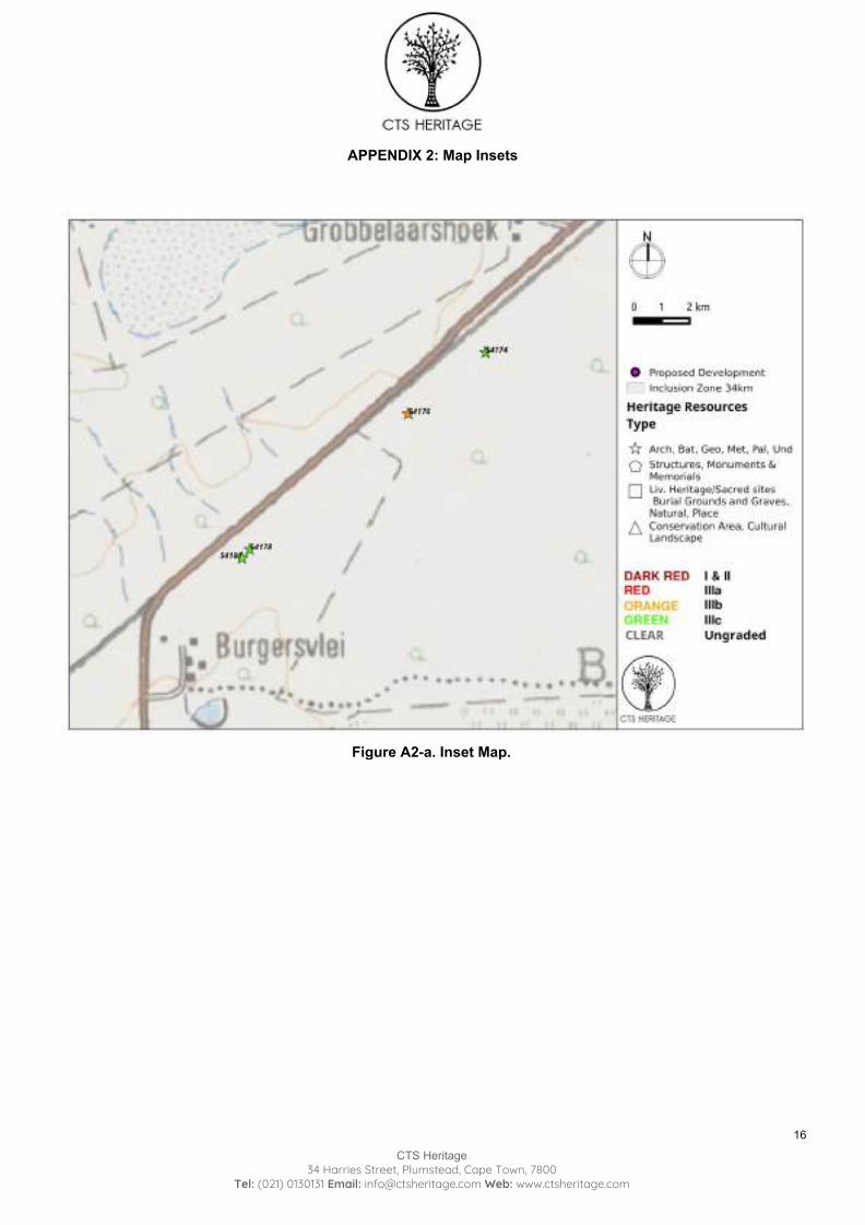
APPENDIX 2: Map Insets
Figure A2-a. Inset Map.
16
CTS Heritage 34 Harries Street, Plumstead, Cape Town, 7800
Tel: (021) 0130131 Email: [email protected] Web: www.ctsheritage.com
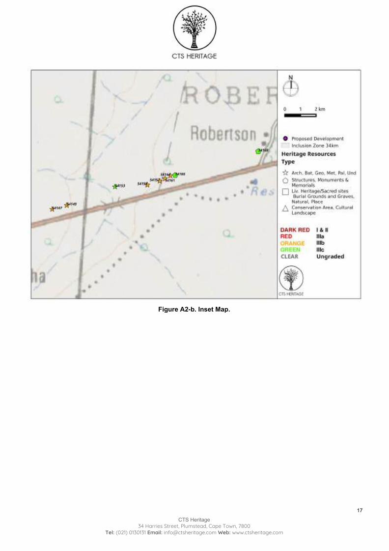
Figure A2-b. Inset Map.
17
CTS Heritage 34 Harries Street, Plumstead, Cape Town, 7800
Tel: (021) 0130131 Email: [email protected] Web: www.ctsheritage.com
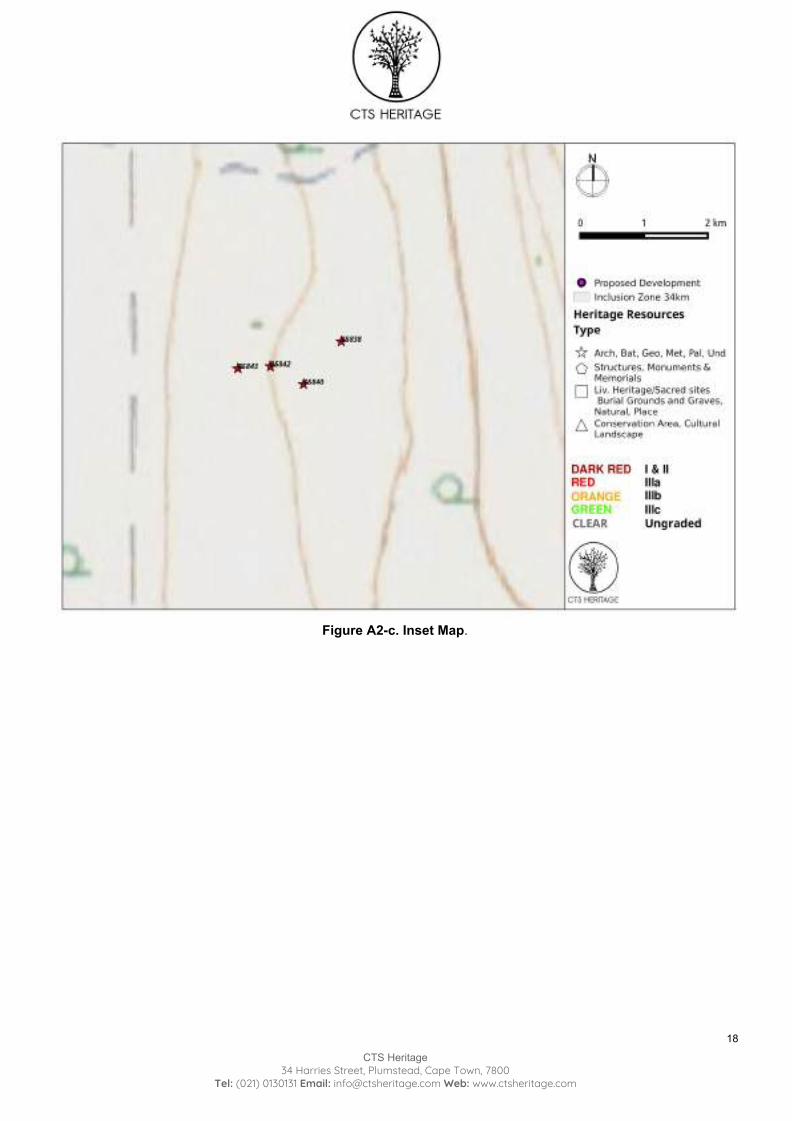
Figure A2-c. Inset Map.
18
CTS Heritage 34 Harries Street, Plumstead, Cape Town, 7800
Tel: (021) 0130131 Email: [email protected] Web: www.ctsheritage.com
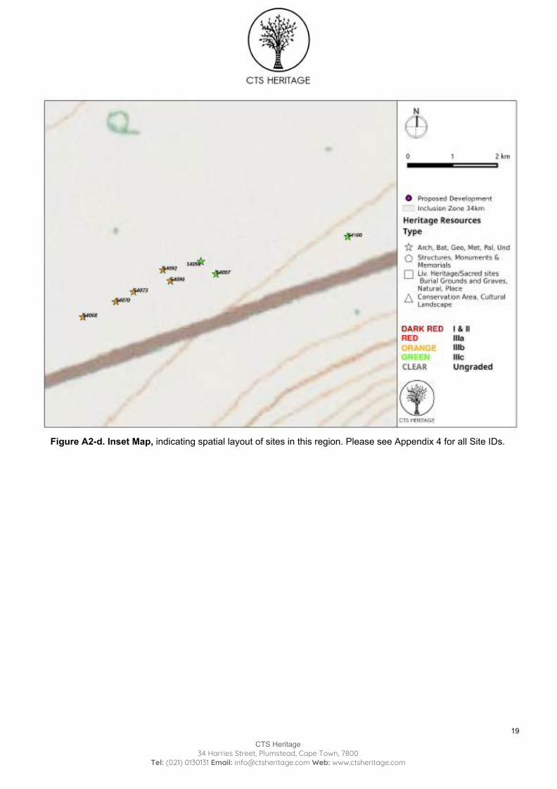
Figure A2-d. Inset Map, indicating spatial layout of sites in this region. Please see Appendix 4 for all Site IDs.
19
CTS Heritage 34 Harries Street, Plumstead, Cape Town, 7800
Tel: (021) 0130131 Email: [email protected] Web: www.ctsheritage.com
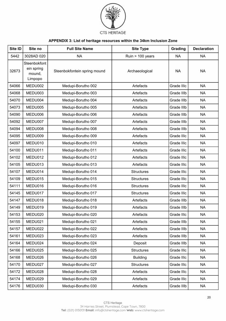
APPENDIX 3: List of heritage resources within the 34km Inclusion Zone
Site ID Site no Full Site Name Site Type Grading Declaration
5442 3028AD 020 NA Ruin > 100 years NA NA
32673
Steenbokfontein spring mound,
Limpopo
Steenbokfontein spring mound Archaeological NA NA
54066 MEDU002 Medupi-Borutho 002 Artefacts Grade IIIc NA
54068 MEDU003 Medupi-Borutho 003 Artefacts Grade IIIb NA
54070 MEDU004 Medupi-Borutho 004 Artefacts Grade IIIb NA
54073 MEDU005 Medupi-Borutho 005 Artefacts Grade IIIb NA
54090 MEDU006 Medupi-Borutho 006 Artefacts Grade IIIb NA
54092 MEDU007 Medupi-Borutho 007 Artefacts Grade IIIb NA
54094 MEDU008 Medupi-Borutho 008 Artefacts Grade IIIb NA
54095 MEDU009 Medupi-Borutho 009 Artefacts Grade IIIc NA
54097 MEDU010 Medupi-Borutho 010 Artefacts Grade IIIc NA
54100 MEDU011 Medupi-Borutho 011 Artefacts Grade IIIc NA
54102 MEDU012 Medupi-Borutho 012 Artefacts Grade IIIc NA
54105 MEDU013 Medupi-Borutho 013 Artefacts Grade IIIc NA
54107 MEDU014 Medupi-Borutho 014 Structures Grade IIIc NA
54109 MEDU015 Medupi-Borutho 015 Structures Grade IIIc NA
54111 MEDU016 Medupi-Borutho 016 Structures Grade IIIc NA
54145 MEDU017 Medupi-Borutho 017 Structures Grade IIIc NA
54147 MEDU018 Medupi-Borutho 018 Artefacts Grade IIIb NA
54149 MEDU019 Medupi-Borutho 019 Artefacts Grade IIIb NA
54153 MEDU020 Medupi-Borutho 020 Artefacts Grade IIIc NA
54155 MEDU021 Medupi-Borutho 021 Artefacts Grade IIIb NA
54157 MEDU022 Medupi-Borutho 022 Artefacts Grade IIIb NA
54161 MEDU023 Medupi-Borutho 023 Artefacts Grade IIIb NA
54164 MEDU024 Medupi-Borutho 024 Deposit Grade IIIb NA
54166 MEDU025 Medupi-Borutho 025 Structures Grade IIIc NA
54168 MEDU026 Medupi-Borutho 026 Building Grade IIIc NA
54170 MEDU027 Medupi-Borutho 027 Structures Grade IIIc NA
54172 MEDU028 Medupi-Borutho 028 Artefacts Grade IIIc NA
54174 MEDU029 Medupi-Borutho 029 Artefacts Grade IIIc NA
54176 MEDU030 Medupi-Borutho 030 Artefacts Grade IIIb NA
20
CTS Heritage 34 Harries Street, Plumstead, Cape Town, 7800
Tel: (021) 0130131 Email: [email protected] Web: www.ctsheritage.com
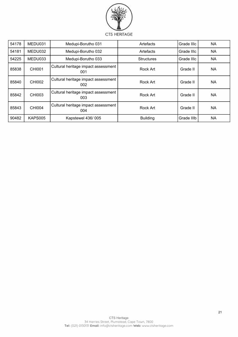
54178 MEDU031 Medupi-Borutho 031 Artefacts Grade IIIc NA
54181 MEDU032 Medupi-Borutho 032 Artefacts Grade IIIc NA
54225 MEDU033 Medupi-Borutho 033 Structures Grade IIIc NA
85838 CHI001 Cultural heritage impact assessment 001 Rock Art Grade II NA
85840 CHI002 Cultural heritage impact assessment 002 Rock Art Grade II NA
85842 CHI003 Cultural heritage impact assessment 003 Rock Art Grade II NA
85843 CHI004 Cultural heritage impact assessment 004 Rock Art Grade II NA
90482 KAPS005 Kapstewel 436/ 005 Building Grade IIIb NA
21
CTS Heritage 34 Harries Street, Plumstead, Cape Town, 7800
Tel: (021) 0130131 Email: [email protected] Web: www.ctsheritage.com
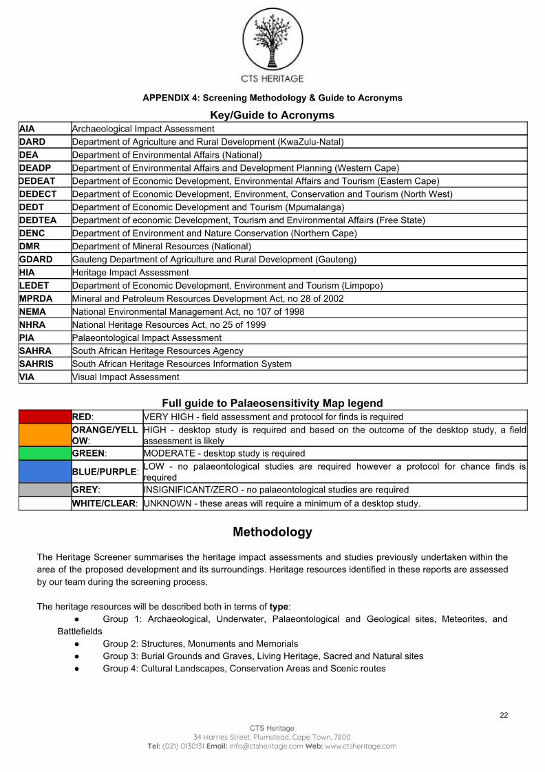
APPENDIX 4: Screening Methodology & Guide to Acronyms
Key/Guide to Acronyms AIA Archaeological Impact Assessment DARD Department of Agriculture and Rural Development (KwaZulu-Natal) DEA Department of Environmental Affairs (National) DEADP Department of Environmental Affairs and Development Planning (Western Cape) DEDEAT Department of Economic Development, Environmental Affairs and Tourism (Eastern Cape) DEDECT Department of Economic Development, Environment, Conservation and Tourism (North West) DEDT Department of Economic Development and Tourism (Mpumalanga) DEDTEA Department of economic Development, Tourism and Environmental Affairs (Free State) DENC Department of Environment and Nature Conservation (Northern Cape) DMR Department of Mineral Resources (National) GDARD Gauteng Department of Agriculture and Rural Development (Gauteng) HIA Heritage Impact Assessment LEDET Department of Economic Development, Environment and Tourism (Limpopo) MPRDA Mineral and Petroleum Resources Development Act, no 28 of 2002 NEMA National Environmental Management Act, no 107 of 1998 NHRA National Heritage Resources Act, no 25 of 1999 PIA Palaeontological Impact Assessment SAHRA South African Heritage Resources Agency SAHRIS South African Heritage Resources Information System VIA Visual Impact Assessment
Full guide to Palaeosensitivity Map legend
RED: VERY HIGH - field assessment and protocol for finds is required ORANGE/YELLOW:
HIGH - desktop study is required and based on the outcome of the desktop study, a field assessment is likely
GREEN: MODERATE - desktop study is required
BLUE/PURPLE: LOW - no palaeontological studies are required however a protocol for chance finds is required
GREY: INSIGNIFICANT/ZERO - no palaeontological studies are required WHITE/CLEAR: UNKNOWN - these areas will require a minimum of a desktop study.
Methodology
The Heritage Screener summarises the heritage impact assessments and studies previously undertaken within the area of the proposed development and its surroundings. Heritage resources identified in these reports are assessed by our team during the screening process. The heritage resources will be described both in terms of type:
● Group 1: Archaeological, Underwater, Palaeontological and Geological sites, Meteorites, and Battlefields
● Group 2: Structures, Monuments and Memorials ● Group 3: Burial Grounds and Graves, Living Heritage, Sacred and Natural sites ● Group 4: Cultural Landscapes, Conservation Areas and Scenic routes
22
CTS Heritage 34 Harries Street, Plumstead, Cape Town, 7800
Tel: (021) 0130131 Email: [email protected] Web: www.ctsheritage.com
and significance (Grade I, II, IIIa, b or c, ungraded), as determined by the author of the original heritage impact assessment report or by formal grading and/or protection by the heritage authorities. Sites identified and mapped during research projects will also be considered. DETERMINATION OF THE EXTENT OF THE INCLUSION ZONE TO BE TAKEN INTO CONSIDERATION The extent of the inclusion zone to be considered for the Heritage Screener will be determined by CTS based on:
● the size of the development, ● the number and outcome of previous surveys existing in the area ● the potential cumulative impact of the application.
The inclusion zone will be considered as the region within a maximum distance of 50 km from the boundary of the proposed development. DETERMINATION OF THE PALAEONTOLOGICAL SENSITIVITY The possible impact of the proposed development on palaeontological resources is gauged by:
● reviewing the fossil sensitivity maps available on the South African Heritage Resources Information System (SAHRIS)
● considering the nature of the proposed development ● when available, taking information provided by the applicant related to the geological background of the
area into account DETERMINATION OF THE COVERAGE RATING ASCRIBED TO A REPORT POLYGON Each report assessed for the compilation of the Heritage Screener is colour-coded according to the level of coverage accomplished. The extent of the surveyed coverage is labeled in three categories, namely low, medium and high. In most instances the extent of the map corresponds to the extent of the development for which the specific report was undertaken. Low coverage will be used for:
● desktop studies where no field assessment of the area was undertaken; ● reports where the sites are listed and described but no GPS coordinates were provided. ● older reports with GPS coordinates with low accuracy ratings; ● reports where the entire property was mapped, but only a small/limited area was surveyed. ● uploads on the National Inventory which are not properly mapped.
Medium coverage will be used for
● reports for which a field survey was undertaken but the area was not extensively covered. This may apply to instances where some impediments did not allow for full coverage such as thick vegetation, etc.
● reports for which the entire property was mapped, but only a specific area was surveyed thoroughly. This is differentiated from low ratings listed above when these surveys cover up to around 50% of the property.
High coverage will be used for
● reports where the area highlighted in the map was extensively surveyed as shown by the GPS track coordinates. This category will also apply to permit reports.
RECOMMENDATION GUIDE The Heritage Screener includes a set of recommendations to the applicant based on whether an impact on heritage resources is anticipated. One of three possible recommendations is formulated:
23
CTS Heritage 34 Harries Street, Plumstead, Cape Town, 7800
Tel: (021) 0130131 Email: [email protected] Web: www.ctsheritage.com
(1) The heritage resources in the area proposed for development are sufficiently recorded - The surveys undertaken in the area adequately captured the heritage resources. There are no known sites which require mitigation or management plans. No further heritage work is recommended for the proposed development. This recommendation is made when:
● enough work has been undertaken in the area ● it is the professional opinion of CTS that the area has already been assessed adequately from a heritage
perspective for the type of development proposed (2) The heritage resources and the area proposed for development are only partially recorded - The surveys undertaken in the area have not adequately captured the heritage resources and/or there are sites which require mitigation or management plans. Further specific heritage work is recommended for the proposed development. This recommendation is made in instances in which there are already some studies undertaken in the area and/or in the adjacent area for the proposed development. Further studies in a limited HIA may include:
● improvement on some components of the heritage assessments already undertaken, for instance with a renewed field survey and/or with a specific specialist for the type of heritage resources expected in the area
● compilation of a report for a component of a heritage impact assessment not already undertaken in the area
● undertaking mitigation measures requested in previous assessments/records of decision. (3) The heritage resources within the area proposed for the development have not been adequately surveyed yet - Few or no surveys have been undertaken in the area proposed for development. A full Heritage Impact Assessment with a detailed field component is recommended for the proposed development. Note: The responsibility for generating a response detailing the requirements for the development lies with the heritage authority. However, since the methodology utilised for the compilation of the Heritage Screeners is thorough and consistent, contradictory outcomes to the recommendations made by CTS should rarely occur. Should a discrepancy arise, CTS will immediately take up the matter with the heritage authority to clarify the dispute.
24
CTS Heritage 34 Harries Street, Plumstead, Cape Town, 7800
Tel: (021) 0130131 Email: [email protected] Web: www.ctsheritage.com
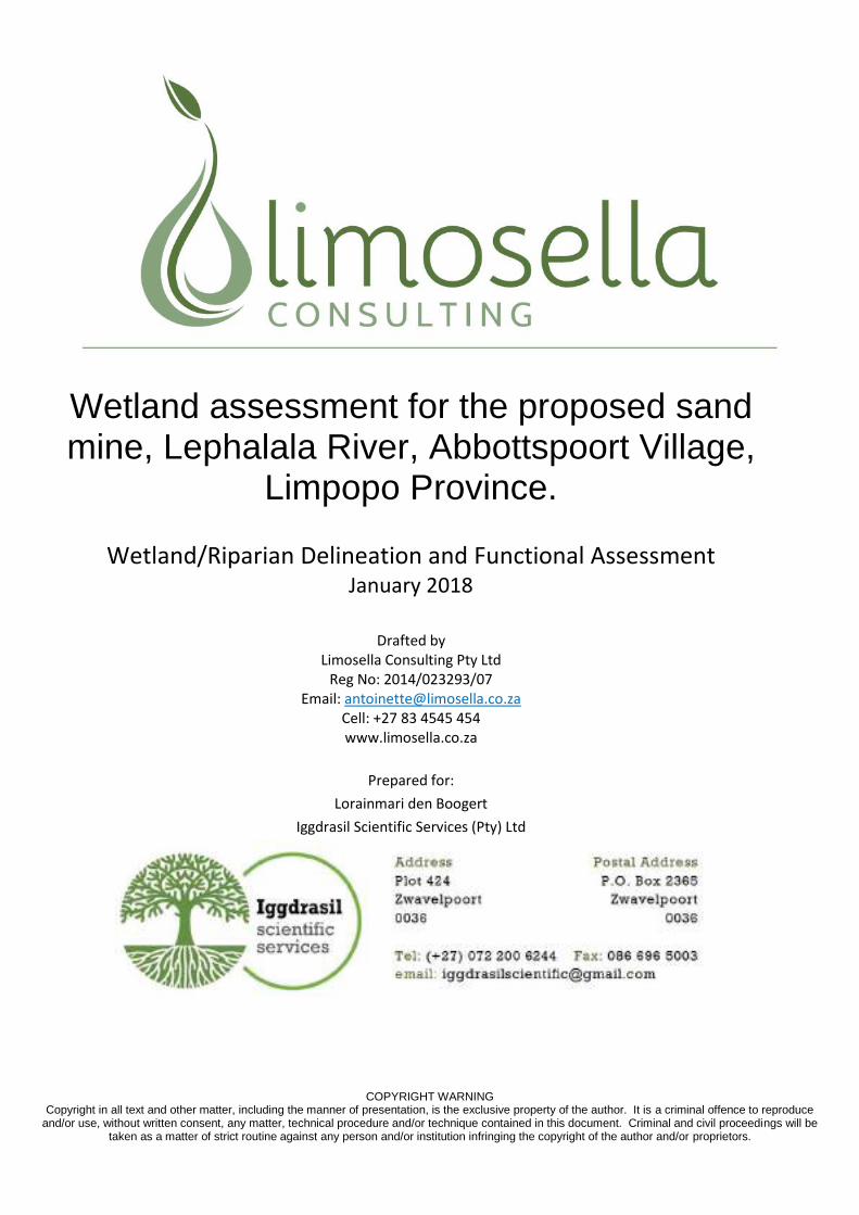
COPYRIGHT WARNING Copyright in all text and other matter, including the manner of presentation, is the exclusive property of the author. It is a criminal offence to reproduce
and/or use, without written consent, any matter, technical procedure and/or technique contained in this document. Criminal and civil proceedings will be taken as a matter of strict routine against any person and/or institution infringing the copyright of the author and/or proprietors.
Wetland assessment for the proposed sand mine, Lephalala River, Abbottspoort Village,
Limpopo Province.
Wetland/Riparian Delineation and Functional Assessment January 2018
Drafted by
Limosella Consulting Pty Ltd Reg No: 2014/023293/07
Email: [email protected] Cell: +27 83 4545 454 www.limosella.co.za
Prepared for:
Lorainmari den Boogert
Iggdrasil Scientific Services (Pty) Ltd
Wetland delineation and functional assessment for Proposed proposed sand mine, Lephalala River, Abbottspoort Village, Limpopo Province. January 2018
2
Declaration of Independence
I, Antoinette Bootsma, in my capacity as a specialist consultant, hereby declare that I -
Act as an independent consultant;
Do not have any financial interest in the undertaking of the activity, other than
remuneration for the work performed in terms of the National Environmental
Management Act, 1998 (Act 107 of 1998);
Undertake to disclose, to the competent authority, any material information that has or
may have the potential to influence the decision of the competent authority or the
objectivity of any report, plan or document required in terms of the National
Environmental Management Act, 1998 (Act 107 of 1998);
As a registered member of the South African Council for Natural Scientific Professions,
will undertake my profession in accordance with the Code of Conduct of the Council, as
well as any other societies to which I am a member; and
Based on information provided to me by the project proponent, and in addition to
information obtained during the course of this study, have presented the results and
conclusion within the associated document to the best of my professional judgement.
________________________ Antoinette Bootsma (PrSciNat)
Ecologist/Botanist
SACNASP Reg. No. 400222-09
2018.01.30 Date
Wetland delineation and functional assessment for Proposed proposed sand mine, Lephalala River, Abbottspoort Village, Limpopo Province. January 2018
3
COMPLIANCE WITH THE APPENDIX 6 OF THE 2017 EIA REGULATIONS
Requirements of Appendix 6 – GN R326 EIA Regulations 7 April 2017 Addressed in the Specialist Report
1. (1) A specialist report prepared in terms of these Regulations must contain- a) details of-
i. the specialist who prepared the report; and ii. the expertise of that specialist to compile a specialist report including a
curriculum vitae;
Yes
b) a declaration that the specialist is independent in a form as may be specified by the competent authority;
Yes
c) an indication of the scope of, and the purpose for which, the report was prepared; Yes
(cA) an indication of the quality and age of base data used for the specialist report;
Yes
(cB) a description of existing impacts on the site, cumulative impacts of the proposed development and levels of acceptable change;
Yes
d) the date and season of the site investigation and the relevance of the season to the outcome of the assessment;
Yes
e) a description of the methodology adopted in preparing the report or carrying out the specialised process inclusive of equipment and modelling used;
Yes
f) details of an assessment of the specific identified sensitivity of the site related to the proposed activity or activities and its associated structures and infrastructure, inclusive of a site plan identifying site alternatives;
Yes
g) an identification of any areas to be avoided, including buffers; Yes
h) a map superimposing the activity including the associated structures and infrastructure on the environmental sensitivities of the site including areas to be avoided, including buffers;
Yes
i) a description of any assumptions made and any uncertainties or gaps in knowledge; Yes
j) a description of the findings and potential implications of such findings on the impact of the proposed activity or activities;
Yes
k) any mitigation measures for inclusion in the EMPr; Yes
l) any conditions for inclusion in the environmental authorisation; Yes
m) any monitoring requirements for inclusion in the EMPr or environmental authorisation; Yes
n) a reasoned opinion- i. whether the proposed activity, activities or portions thereof should be
authorised; (iA) regarding the acceptability of the proposed activity or activities and
ii. if the opinion is that the proposed activity, activities or portions thereof should
be authorised, any avoidance, management and mitigation measures that should be included in the EMPr, and where applicable, the closure plan;
Yes
o) a description of any consultation process that was undertaken during the course of preparing the specialist report;
Yes
p) a summary and copies of any comments received during any consultation process and where applicable all responses thereto; and
NA
q) any other information requested by the competent authority. Yes
2) Where a government notice gazetted by the Minister provides for any protocol or minimum information requirement to be applied to a specialist report, the requirements as indicated in such notice will apply.
Yes
Wetland delineation and functional assessment for Proposed proposed sand mine, Lephalala River, Abbottspoort Village, Limpopo Province. January 2018
4
Indemnity This report is based on survey and assessment techniques which are limited by time and budgetary constraints relevant to the type and level of investigation undertaken. The findings, results, observations, conclusions and recommendations given in this report are based on the author’s best scientific and professional knowledge as well as information available at the time of study. Therefore the author reserves the right to modify aspects of the report, including the recommendations, if and when new information may become available from ongoing research or further work in this field, or pertaining to this investigation. Although the author exercised due care and diligence in rendering services and preparing documents, she accepts no liability, and the client, by receiving this document, indemnifies the author against all actions, claims, demands, losses, liabilities, costs, damages and expenses arising from or in connection with services rendered, directly or indirectly by the author and by the use of this document.
Qualification of Specialists
Report writing and
review
Antoinette Bootsma
Ecologist/Botanist/Wetland specialist
SACNASP Reg. No. 400222-09
Rudi Bezuidenhoudt
Wetland specialist / Ecologist
SACNASP Reg. No. 500024/13
Field work and data
analysis
Antoinette Bootsma
Ecologist/Botanist/Wetland specialist
SACNASP Reg. No. 400222-09
Rudi Bezuidenhoudt
Wetland specialist / Ecologist
SACNASP Reg. No. 500024/13
Wetland delineation and functional assessment for Proposed proposed sand mine, Lephalala River, Abbottspoort Village, Limpopo Province. January 2018
5
EXECUTIVE SUMMARY Limosella Consulting was appointed by Iggdrasil Scientific Services (Pty) Ltd to undertake a wetland and/or
riparian delineation and functional assessment for the proposed small-scale 5 hectares sand mining project
located adjacent to the Lephalala River in Abbottspoort Village, Limpopo Province.
Iggdrasil Scientific Services (Pty) Ltd (“ISS”), an independent ecological specialist company based in Pretoria,
Gauteng, was commissioned by the CSIR to conduct the baseline aquatic assessment for the mining activities
associated with the Lephalala River, Abbottspoort Village, Limpopo Province, South Africa.
Fieldwork was conducted on the 22nd of January 2018.
The terms of reference for the study were as follows:
Delineate the wetland and riparian areas;
Classify the watercourse according to the system proposed in the national wetlands inventory if relevant,
Undertake functional and integrity assessment of wetlands areas within the area assessed as specified in General Notice 267 of 24 March 2017;
Undertake a specialist study with an impact assessment as specified in the NEMA 20014 regulations,
Recommend suitable buffer zones, both generic (as required in GDARD, 2014) and scientific as specified in General Notice 267 of 24 March 2017, following Macfarlane et al 2015 ; and
Discuss appropriate mitigation and management procedures relevant to the conserving wetland
areas on the site.
The study site is located directly within a section of the perennial riparian river known as the Lephalala River.
Although facilities (i.e. office and storage area) are not encroaching on the watercourse, they are in the
Exclusion Area determined from the Floodline Study and the recommendation is being applied to move the
100mx150m facility block approx 250m northwards to be outside Exclusion Zone. Several drainage areas
drain into this river from the surrounding residential area. The proposed storage and offices are located on
an open area and do not encroach onto any nearby watercourse or buffer. It is important that existing roads
be used to travel from the storage and office areas to the mining area and that no thoroughfare be used that
encroaches into the drainage areas. It is furthermore important to note that a graveyard was noted near the
study site and subsequently the watercourse at the approximate coordinates of 23°27'41.20"S and 28°
5'47.33"E.
Major existing impacts were recorded for both the perennial Lephalala River and the associated drainage
areas. Farming and agriculture occurred on the study site and surroundings from as early as 1956 and likely
earlier which had an impact on the soil and vegetation conditions on the study site. The increased urban
development adjacent to the study site likely caused increased erosion of the riverbanks and drainage areas.
Other contributors to a decreased overall health score includes overgrazing and associated trampling of
watercourses, exotic invasion, legal and illegal abstraction of water from the river, upstream activities,
foreign material inputs into the river such as fertilizer and hydrocarbons from nearby roads, footpaths, plant
and tree clearing, dumping and littering and illegal sand mining up- and downstream.
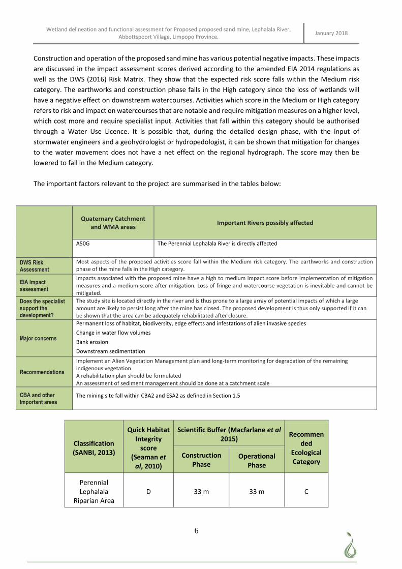
Wetland delineation and functional assessment for Proposed proposed sand mine, Lephalala River, Abbottspoort Village, Limpopo Province. January 2018
6
Construction and operation of the proposed sand mine has various potential negative impacts. These impacts
are discussed in the impact assessment scores derived according to the amended EIA 2014 regulations as
well as the DWS (2016) Risk Matrix. They show that the expected risk score falls within the Medium risk
category. The earthworks and construction phase falls in the High category since the loss of wetlands will
have a negative effect on downstream watercourses. Activities which score in the Medium or High category
refers to risk and impact on watercourses that are notable and require mitigation measures on a higher level,
which cost more and require specialist input. Activities that fall within this category should be authorised
through a Water Use Licence. It is possible that, during the detailed design phase, with the input of
stormwater engineers and a geohydrologist or hydropedologist, it can be shown that mitigation for changes
to the water movement does not have a net effect on the regional hydrograph. The score may then be
lowered to fall in the Medium category.
The important factors relevant to the project are summarised in the tables below:
Classification (SANBI, 2013)
Quick Habitat Integrity
score (Seaman et
al, 2010)
Scientific Buffer (Macfarlane et al 2015)
Recommended
Ecological Category
Construction Phase
Operational Phase
Perennial Lephalala
Riparian Area D 33 m 33 m C
Quaternary Catchment
and WMA areas Important Rivers possibly affected
A50G
The Perennial Lephalala River is directly affected
DWS Risk Assessment
Most aspects of the proposed activities score fall within the Medium risk category. The earthworks and construction phase of the mine falls in the High category.
EIA Impact assessment
Impacts associated with the proposed mine have a high to medium impact score before implementation of mitigation measures and a medium score after mitigation. Loss of fringe and watercourse vegetation is inevitable and cannot be mitigated.
Does the specialist support the development?
The study site is located directly in the river and is thus prone to a large array of potential impacts of which a large amount are likely to persist long after the mine has closed. The proposed development is thus only supported if it can be shown that the area can be adequately rehabilitated after closure.
Major concerns
Permanent loss of habitat, biodiversity, edge effects and infestations of alien invasive species
Change in water flow volumes
Bank erosion
Downstream sedimentation
Recommendations
Implement an Alien Vegetation Management plan and long-term monitoring for degradation of the remaining indigenous vegetation A rehabilitation plan should be formulated An assessment of sediment management should be done at a catchment scale
CBA and other Important areas
The mining site fall within CBA2 and ESA2 as defined in Section 1.5

Wetland delineation and functional assessment for Proposed proposed sand mine, Lephalala River, Abbottspoort Village, Limpopo Province. January 2018
7
Wetland delineation and functional assessment for Proposed proposed sand mine, Lephalala River, Abbottspoort Village, Limpopo Province. January 2018
8
Table of Contents
1 INTRODUCTION .................................................................................................................... 11
1.1 Terms of Reference..............................................................................................................11
1.2 Assumptions and Limitations ..............................................................................................11
1.3 Definitions and Legal Framework ........................................................................................12
1.4 Locality of the study site ......................................................................................................13
1.5 Description of the Receiving Environment ..........................................................................15
2 METHODOLOGY ................................................................................................................... 21
2.1 Wetland and Riparian Delineation ......................................................................................21
2.2 Wetland Classification and Delineation...............................................................................27
2.3 Buffer Zones .........................................................................................................................28
2.4 Impact Assessments ............................................................................................................30
2.4.1 NEMA (2014) Impact Ratings .......................................................................................30
2.4.2 DWS (2016) Impact Register and Risk Assessment ......................................................32
2.5 Wetland Functionality, Status and Sensitivity .....................................................................33
2.5.1 Quick Habitat Integrity Model ......................................................................................34
2.5.2 Recommended Ecological Category (REC) ...................................................................34
3 RESULTS ................................................................................................................................ 35
3.1 Land Use, Cover and Ecological State ..................................................................................35
3.1.1 Soil Indicators ...............................................................................................................37
3.1.2 Vegetation Indicators ...................................................................................................39
3.2 Wetland Classification and Delineation...............................................................................43
3.3 Watercourse Functional Assessment ..................................................................................45
3.4 Summary of Findings ...........................................................................................................45
3.5 Impacts and Mitigations ......................................................................................................46
3.5.1 Impacts .........................................................................................................................46
4 CONCLUSION ........................................................................................................................ 63
REFERENCES ..................................................................................................................................... 66
APPENDIX A: Abbreviated CVs of participating specialists .............................................................. 67
APPENDIX B: GLOSSARY OF TERMS ................................................................................................. 73
Figures Figure 1: Locality Map ........................................................................................................................14
Figure 2: Visual representation of the Strahler stream order of rivers. ............................................15
Figure 3: Regional hydrology of the study site and surroudings .......................................................18
Figure 4: Vegetation Type of the study area and surroundings .........................................................19
Figure 5: Limpopo Conservation Areas associated with the study site .............................................20
Figure 6: Typical cross section of a wetland (Ollis, 2013) ..................................................................22
Figure 7. Terrain units (DWAF, 2005). ................................................................................................22
Figure 8: Wetland Units based on hydrogeomorphic types (Ollis et al. 2013) ..................................23
Figure 9: Schematic diagram illustrating an example of where the 3 zones would be placed relative
to geomorphic diversity (Kleynhans et al, 2007) ...............................................................................24
Wetland delineation and functional assessment for Proposed proposed sand mine, Lephalala River, Abbottspoort Village, Limpopo Province. January 2018
9
Figure 10: A schematic representation of the processes characteristic of a river area (Ollis et al,
2013). ..................................................................................................................................................26
Figure 11: The four categories associated with rivers and the hydrological continuum. Dashed lines
indicate that boundaries are not fixed (Seaman et al, 2010). ...........................................................27
Figure 12: A represent the buffer zone setback for the wetland types discussed in this report ......30
Figure 13: 1956 aerial image (Top) of the study site and surroundings compared to 2018 aerial image
(Bottom) indicating the increased residential density and subsequent erosion. ..............................36
Figure 14: Soil of the watercourses of the study site. Clockwise from top left: Calcareous deposits,
sandy soil and bedrock, Eroded macro bank, Aluvial deposits and erosion of drainage areas. ........38
Figure 15: General Vegetation composition of the watercourse (Perennial River) on the study site
indicating different zones. ..................................................................................................................41
Figure 16: Clockwise from top right: Dense vegetation growth of the eastern banks compared with;
Scarcely populated area of the western bank.; Drainage area with erosion and exotic vegetation;
section of the perennial river. ............................................................................................................42
Figure 17: The watercourses associated with the study site and surroundings. ...............................44
Figure 18: Clockwise; bank erosion, littering and duping, grazing, water abstraction. .....................46
Tables Table 1: Conservation status of the Roodeberg Bushveld (Mucina & Rutherford, 2006) .................16
Table 2: List of types of sites that are difficult to delineate. (Job, 2009) ...........................................23
Table 3: Description of riparian vegetation zones (Kleynhans et al, 2007). ......................................25
Table 4: Wetland Types and descriptions ..........................................................................................28
Table 5: Generic functions of buffer zones relevant to the study site (adapted from Macfarlane et al,
2010) ...................................................................................................................................................29
Table 6: An extract from DWS (2016) indicating the risk scores and classes as well as the implication
for the appropriate authorization process .........................................................................................33
Table 7: Summary of the wetland soil conditions on site (Adapted from Job, 2010). ......................37
Table 8: Plant species recorded on the study site. ............................................................................39
Table 9: QHI for the perennial areas on the study site (Seaman et al, 2010). ...................................45
Table 10: Summary of scores obtained for each wetland system .....................................................45
Table 11: Risk assessment of impacts and resulting significance prior to and after mitigation
measures 47
Table 12: Impacts and suggested management procedures relevant to the proposed sand
mining development (modified from Macfarlane et al., 2010; Ashraf et al., 2011) ..........................51
Table 13: The DWS (2016) risk assessment matrix for the proposed dam construction and operation.
Risk is determined after considering all listed control / mitigation measures ..................................61
Table 14: Summary of important findings relevant to the proposed activities .................................64
Table 15: Summary of results for each watercourse .........................................................................65

Wetland delineation and functional assessment for Proposed proposed sand mine, Lephalala River, Abbottspoort Village, Limpopo Province. January 2018
10
Wetland delineation and functional assessment for Proposed proposed sand mine, Lephalala River, Abbottspoort Village, Limpopo Province. January 2018
11
1 INTRODUCTION
Limosella Consulting was appointed by Iggdrasil Scientific Services (Pty) Ltd to undertake a wetland and/or
riparian delineation and functional assessment for the proposed small-scale 5 hectares sand mining project
located adjacent to the Lephalala River in Abbottspoort Village, Limpopo Province.
Iggdrasil Scientific Services (Pty) Ltd (“ISS”), an independent ecological specialist company based in Pretoria,
Gauteng, was commissioned by the CSIR to conduct the baseline aquatic assessment for the mining activities
associated with the Lephalala River, Abbottspoort Village, Limpopo Province, South Africa.
Fieldwork was conducted on the 22nd of January 2018.
1.1 Terms of Reference The terms of reference for the study were as follows:
Delineate the wetland and riparian areas;
Classify the watercourse according to the system proposed in the national wetlands inventory if relevant,
Undertake functional and integrity assessment of wetlands areas within the area assessed as specified in General Notice 267 of 24 March 2017;
Undertake a specialist study with an impact assessment as specified in the NEMA 20014 regulations,
Recommend suitable buffer zones, both generic (as required in GDARD, 2014) and scientific as specified in General Notice 267 of 24 March 2017, following Macfarlane et al 2015 ; and
Discuss appropriate mitigation and management procedures relevant to the conserving wetland
areas on the site.
1.2 Assumptions and Limitations
The information provided by the client forms the basis of the planning and layouts discussed.
All wetlands within 500 m of any developmental activities should be identified as per the DWS Water
Use Licence application regulations. In order to meet the timeframes and budget constraints for the
project, wetlands within the study sites were delineated on a fine scale based on detailed soil and
vegetation sampling. Wetlands that fall outside of the site, but that fall within 500 m of the proposed
activities were delineated based on desktop analysis of vegetation gradients visible from aerial
imagery.
The detailed field study was conducted from a once off field trip and thus would not depict any
seasonal variation in the wetland plant species composition and richness.
Description of the depth of the regional water table and geohydrological and hydropedological
processes falls outside the scope of the current assessment
Floodline calculations fall outside the scope of the current assessment. GCS Water & Environmental
Consultants did a floodline study in order to determine an Exclusion Zone, which is either within
100m of the river or within the 1-in-100 year floodline. This Exclusion Zone is being applied to the
facilities for the mine (i.e. the office and sand storage area).
Wetland delineation and functional assessment for Proposed proposed sand mine, Lephalala River, Abbottspoort Village, Limpopo Province. January 2018
12
A Red Data scan, fauna and flora, and aquatic assessments were not included in the current study
The recreation grade GPS used for wetland and riparian delineations is accurate to within five meters.
Wetland delineation plotted digitally may be offset by at least five meters to either side.
Furthermore, it is important to note that, during the course of converting spatial data to final
drawings, several steps in the process may affect the accuracy of areas delineated in the current
report. It is therefore suggested that the no-go areas identified in the current report be pegged in
the field in collaboration with the surveyor for precise boundaries. The scale at which maps and
drawings are presented in the current report may become distorted should they be reproduced by
for example photocopying and printing.
The calculation of buffer zones does not take into account climate change or future changes to
watercourses resulting from increasing catchment transformation.
No details regarding operations, final footprint or methods were available at the time of the
assessment. The risk assessments presented in this report are based on assumptions. Scores
obtained may be altered once further details are known.
1.3 Definitions and Legal Framework
This section outlines the definitions, key legislative requirements and guiding principles of the wetland study
and the Water Use Authorisation process.
The National Water Act, 1998 (Act No. 36 of 1998) [NWA] provides for Constitutional water demands
including pollution prevention, ecological and resource conservation and sustainable utilisation. In terms of
this Act, all water resources are the property of the State and are regulated by the Department of Water and
Sanitation (DWS). The NWA sets out a range of water use related principles that are to be applied by DWS
when taking decisions that significantly affect a water resource. The NWA defines a water resource as
including a watercourse, surface water, estuary or aquifer. A watercourse includes a river or spring; a natural
channel in which water flows regularly or intermittently; a wetland, lake, pan or dam, into which or from
which water flows; any collection of water that the Minister may declare to be a watercourse; and were
relevant its beds and banks.
The NWA defines a wetland as “land which is transitional between terrestrial and aquatic systems where the
water table is usually at or near the surface or the land is periodically covered with shallow water, and which
land in normal circumstances supports or would support vegetation typically adapted to life in saturated
soil.” In addition to water at or near the surface, other distinguishing indicators of wetlands include
hydromorphic soils and vegetation adapted to or tolerant of saturated soils (DWA, 2005).
Riparian habitat often times performs important ecological and hydrological functions, some similar to those
performed by wetlands (DWA, 2005). Riparian habitat is also the accepted indicator used to delineate the
extent of a river’s footprint (DWAF, 2005). It is defined by the NWA as follows: “Riparian habitat includes the
physical structure and associated vegetation of the areas associated with a watercourse, which are
commonly characterised by alluvial soils, and which are inundated or flooded to an extent and with a
frequency sufficient to support vegetation of species with a composition and physical structure distinct from
those of adjacent land areas”.
Wetland delineation and functional assessment for Proposed proposed sand mine, Lephalala River, Abbottspoort Village, Limpopo Province. January 2018
13
Water uses for which authorisation must be obtained from DWS are indicated in Section 21 of the NWA.
Section 21 (c) and (i) is applicable to any activity related to a watercourse:
Section 21(c): Impeding or diverting the flow of water in a watercourse; and
Section 21(i): Altering the bed, banks, course or characteristics of a watercourse.
Authorisations related to wetlands are regulated by Government Notice 509 of 2016 regarding Section 21(c)
and (i). This notice grants General Authorisation (GA) for the above water uses on certain conditions. This
regulation also stipulates that water uses must the registered with the responsible authority. Any activity
that is not related to the rehabilitation of a wetland and which takes place within 500 m of a wetland are
excluded from a GA under either of these regulations, unless the impacts score as low in the requires risk
assessment matrix (DWS, 2016) Such an activity requires a Water Use Licence (WUL) from the relevant
authority.
Conditions for impeding or diverting the flow of water or altering the bed, banks, course or characteristics of
a watercourse (Section 21(c) and (i) activities) include:
9. (3) (b). The water user must ensure that the selection of a site for establishing any impeding or diverting
the flow or altering the bed, banks, course or characteristics of a watercourse works:
(i) is not located on a bend in the watercourse;
(ii) avoid high gradient areas, unstable slopes, actively eroding banks, interflow zones, springs, and seeps;.
In addition to the above, the proponent must also comply with the provisions of the following relevant
national legislation, conventions and regulations applicable to wetlands and riparian zones:
Convention on Wetlands of International Importance - the Ramsar Convention and the South African
Wetlands Conservation Programme (SAWCP).
National Environmental Management Act, 1998 (Act No. 107 of 1998) [NEMA].
National Environmental Management: Biodiversity Act, 2004 (Act 10 of 2004).
National Environment Management Protected Areas Act, 2003 (Act No. 57 of 2003).
Regulations GN R.982, R.983, R. 984 and R.985 of 2014, promulgated under NEMA.
Conservation of Agriculture Resources Act, 1983 (Act 43 of 1983).
Regulations and Guidelines on Water Use under the NWA.
South African Water Quality Guidelines under the NWA.
Mineral and Petroleum Resources Development Act, 2002 (Act No. 287 of 2002).
GN 267 (Regulations Regarding the Procedural Requirements for Water Use Licence Applications and
Appeals)
1.4 Locality of the study site
The study site is located near the town of Abbottspoort and Mokurwanyane in Limpopo Province. The nearest
regional road, the R518, is located approximately 15 km south of the study site. The approximate coordinates
of the study site is 23°27'38.56"S and 28° 5'44.12"E (Figure 1).

Wetland delineation and functional assessment for Proposed proposed sand mine, Lephalala River, Abbottspoort Village, Limpopo Province. January 2018
14
Figure 1: Locality Map
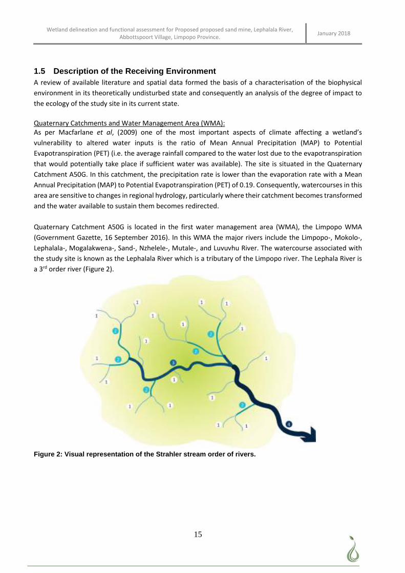
Wetland delineation and functional assessment for Proposed proposed sand mine, Lephalala River, Abbottspoort Village, Limpopo Province. January 2018
15
1.5 Description of the Receiving Environment A review of available literature and spatial data formed the basis of a characterisation of the biophysical
environment in its theoretically undisturbed state and consequently an analysis of the degree of impact to
the ecology of the study site in its current state.
Quaternary Catchments and Water Management Area (WMA): As per Macfarlane et al, (2009) one of the most important aspects of climate affecting a wetland’s
vulnerability to altered water inputs is the ratio of Mean Annual Precipitation (MAP) to Potential
Evapotranspiration (PET) (i.e. the average rainfall compared to the water lost due to the evapotranspiration
that would potentially take place if sufficient water was available). The site is situated in the Quaternary
Catchment A50G. In this catchment, the precipitation rate is lower than the evaporation rate with a Mean
Annual Precipitation (MAP) to Potential Evapotranspiration (PET) of 0.19. Consequently, watercourses in this
area are sensitive to changes in regional hydrology, particularly where their catchment becomes transformed
and the water available to sustain them becomes redirected.
Quaternary Catchment A50G is located in the first water management area (WMA), the Limpopo WMA
(Government Gazette, 16 September 2016). In this WMA the major rivers include the Limpopo-, Mokolo-,
Lephalala-, Mogalakwena-, Sand-, Nzhelele-, Mutale-, and Luvuvhu River. The watercourse associated with
the study site is known as the Lephalala River which is a tributary of the Limpopo river. The Lephala River is
a 3rd order river (Figure 2).
Figure 2: Visual representation of the Strahler stream order of rivers.
Wetland delineation and functional assessment for Proposed proposed sand mine, Lephalala River, Abbottspoort Village, Limpopo Province. January 2018
16
Hydrology:
Surface water spatial layers such as the National Freshwater Ecosystems Priority Areas (NFEPA) Wetland
Types for South Africa (SANBI, 2010) were consulted for the presence of wetlands and rivers. One large
perennial river, the Lephalala River, as well as several smaller non-perennial rivers that drains into the
Lephalala River is located on the study site (Figure 3)
Regional Vegetation:
The proposed mining area falls within the Least threatened Roodeberg bushveld biome (Table 1 & Figure 4)
(Mucina & Rutherford, 2012). Located at an altitude of around 850 – 1100 m on plains and slightly undulating
plains which includes low hill, short close woodlands and open woodlands. Important taxa occurring in this
region include tall trees such as Acacia burkei (d), A. nigrescens (d), and A. robusta (d). Small trees include
Acacia erubescens (d), A. mellifera subsp. detinens (d), and Combretum apiculatum (d). Tall shrubs include
Grewia flava (d), Euclea crispa subsp. crispa, and E. undulata. Low shrubs include Commiphora africana,
Melhania acuminata, and Sida cordifolia. Graminoids include Aristida canescens (d), Chloris virgata (d), and
Panicum maximum (d). Herbs include Achyranthes aspera, Seddera capensis, and Waltheria indica.
Table 1: Conservation status of the Roodeberg Bushveld (Mucina & Rutherford, 2006)
Name of Vegetation type Roodeberg bushveld
Code as used in the Book - contains space SVcb 18
Conservation Target (percent of area) 19%
Description of conservation status Least threatened
Name of the biome Grassland Biome
Threats and uses Cultivation
Game Ranching
Very little Urban and built up areas
Geology and soils:
“Mainly sandstone, conglomerate, siltstone and shale of the Kransberg and Matlabas Subgroups (Mokolian
Waterberg Group). Gneisses, metasediments and metavolcanic rocks of the Malala Drift Group, Beit Bridge
Complex (Swazian Erathem) occur in the north. Granite of the Lebowa Granite Suite (Bushveld Igneous
Complex) is also present. A variety of soil types, but mostly sandy soils, red-yellow apedal high base status,
also dystrophic or mesotrophic. Almost half the area is Ae land type, with remainder divided between mainly
Fa, Bc, Ac, Fc, Ia and Fb” (Mucina & Rutherford, 2006).
Limpopo Critical Biodiversity areas and Biodiversity Sector Plan
Critical Biodiversity Areas (CBA’s) are terrestrial and aquatic features in the landscape that are critical for
retaining biodiversity and supporting continued ecosystem functioning and services (SANBI 2007). These
form the key output of a systematic conservation assessment and are the biodiversity sectors inputs into
multi-sectoral planning and decision-making. CBA’s are therefore areas of the landscape that need to be
maintained in a natural or near-natural state in order to ensure the continued existence and functioning of
species and ecosystems and the delivery of ecosystem services. In other words, if these areas are not
maintained in a natural or near-natural state then biodiversity conservation targets cannot be met.
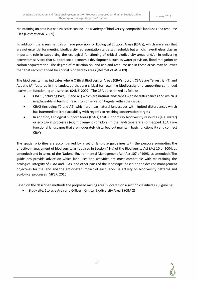
Wetland delineation and functional assessment for Proposed proposed sand mine, Lephalala River, Abbottspoort Village, Limpopo Province. January 2018
17
Maintaining an area in a natural state can include a variety of biodiversity-compatible land uses and resource
uses (Desmet et al, 2009).
In addition, the assessment also made provision for Ecological Support Areas (ESA’s), which are areas that
are not essential for meeting biodiversity representation targets/thresholds but which, nevertheless play an
important role in supporting the ecological functioning of critical biodiversity areas and/or in delivering
ecosystem services that support socio-economic development, such as water provision, flood mitigation or
carbon sequestration. The degree of restriction on land use and resource use in these areas may be lower
than that recommended for critical biodiversity areas (Desmet et al, 2009).
The biodiversity map indicates where Critical Biodiversity Areas (CBA’s) occur. CBA’s are Terrestrial (T) and
Aquatic (A) features in the landscape that are critical for retaining biodiversity and supporting continued
ecosystem functioning and services (SANBI 2007). The CBA’s are ranked as follows:
CBA 1 (including PA’s, T1 and A1) which are natural landscapes with no disturbances and which is
irreplaceable in terms of reaching conservation targets within the district
CBA2 (including T2 and A2) which are near natural landscapes with limited disturbances which
has intermediate irreplaceability with regards to reaching conservation targets
In addition, Ecological Support Areas (ESA’s) that support key biodiversity resources (e.g. water)
or ecological processes (e.g. movement corridors) in the landscape are also mapped. ESA’s are
functional landscapes that are moderately disturbed but maintain basic functionality and connect
CBA’s.
The spatial priorities are accompanied by a set of land-use guidelines with the purpose promoting the
effective management of biodiversity as required in Section 41(a) of the Biodiversity Act (Act 10 of 2004, as
amended) and in terms of the National Environmental Management Act (Act 107 of 1998, as amended). The
guidelines provide advice on which land-uses and activities are most compatible with maintaining the
ecological integrity of CBAs and ESAs, and other parts of the landscape, based on the desired management
objectives for the land and the anticipated impact of each land-use activity on biodiversity patterns and
ecological processes (MPSP, 2015).
Based on the described methods the proposed mining area is located on a section classified as (Figure 5):
Study site, Storage Area and Offices : Critical Biodiversity Area 2 (CBA 2)
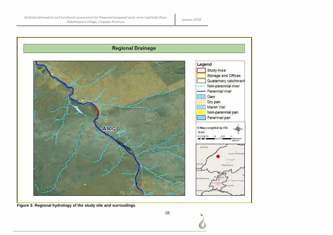
Wetland delineation and functional assessment for Proposed proposed sand mine, Lephalala River, Abbottspoort Village, Limpopo Province. January 2018
18
Figure 3: Regional hydrology of the study site and surroudings
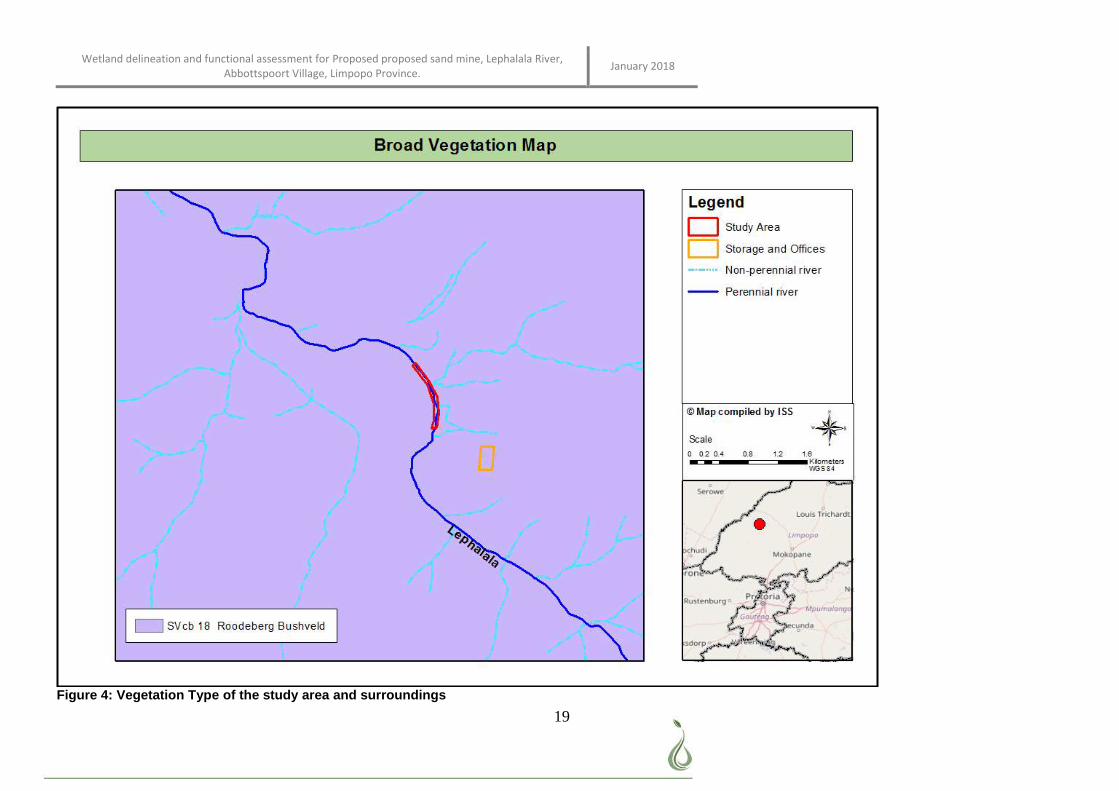
Wetland delineation and functional assessment for Proposed proposed sand mine, Lephalala River, Abbottspoort Village, Limpopo Province. January 2018
19
Figure 4: Vegetation Type of the study area and surroundings
Wetland delineation and functional assessment for Proposed proposed sand mine, Lephalala River, Abbottspoort Village, Limpopo Province. January 2018
20
Figure 5: Limpopo Conservation Areas associated with the study site
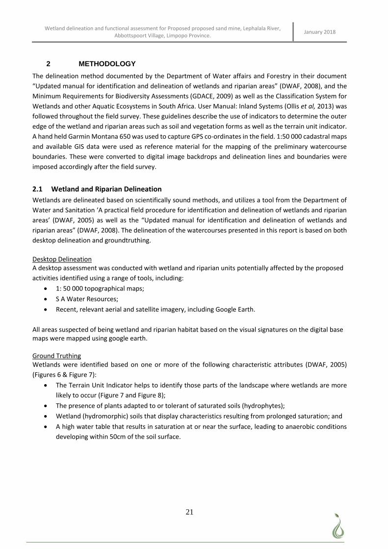
Wetland delineation and functional assessment for Proposed proposed sand mine, Lephalala River, Abbottspoort Village, Limpopo Province. January 2018
21
2 METHODOLOGY
The delineation method documented by the Department of Water affairs and Forestry in their document
“Updated manual for identification and delineation of wetlands and riparian areas” (DWAF, 2008), and the
Minimum Requirements for Biodiversity Assessments (GDACE, 2009) as well as the Classification System for
Wetlands and other Aquatic Ecosystems in South Africa. User Manual: Inland Systems (Ollis et al, 2013) was
followed throughout the field survey. These guidelines describe the use of indicators to determine the outer
edge of the wetland and riparian areas such as soil and vegetation forms as well as the terrain unit indicator.
A hand held Garmin Montana 650 was used to capture GPS co-ordinates in the field. 1:50 000 cadastral maps
and available GIS data were used as reference material for the mapping of the preliminary watercourse
boundaries. These were converted to digital image backdrops and delineation lines and boundaries were
imposed accordingly after the field survey.
2.1 Wetland and Riparian Delineation
Wetlands are delineated based on scientifically sound methods, and utilizes a tool from the Department of
Water and Sanitation ‘A practical field procedure for identification and delineation of wetlands and riparian
areas’ (DWAF, 2005) as well as the “Updated manual for identification and delineation of wetlands and
riparian areas” (DWAF, 2008). The delineation of the watercourses presented in this report is based on both
desktop delineation and groundtruthing.
Desktop Delineation A desktop assessment was conducted with wetland and riparian units potentially affected by the proposed
activities identified using a range of tools, including:
1: 50 000 topographical maps;
S A Water Resources;
Recent, relevant aerial and satellite imagery, including Google Earth.
All areas suspected of being wetland and riparian habitat based on the visual signatures on the digital base maps were mapped using google earth. Ground Truthing Wetlands were identified based on one or more of the following characteristic attributes (DWAF, 2005)
(Figures 6 & Figure 7):
The Terrain Unit Indicator helps to identify those parts of the landscape where wetlands are more
likely to occur (Figure 7 and Figure 8);
The presence of plants adapted to or tolerant of saturated soils (hydrophytes);
Wetland (hydromorphic) soils that display characteristics resulting from prolonged saturation; and
A high water table that results in saturation at or near the surface, leading to anaerobic conditions
developing within 50cm of the soil surface.
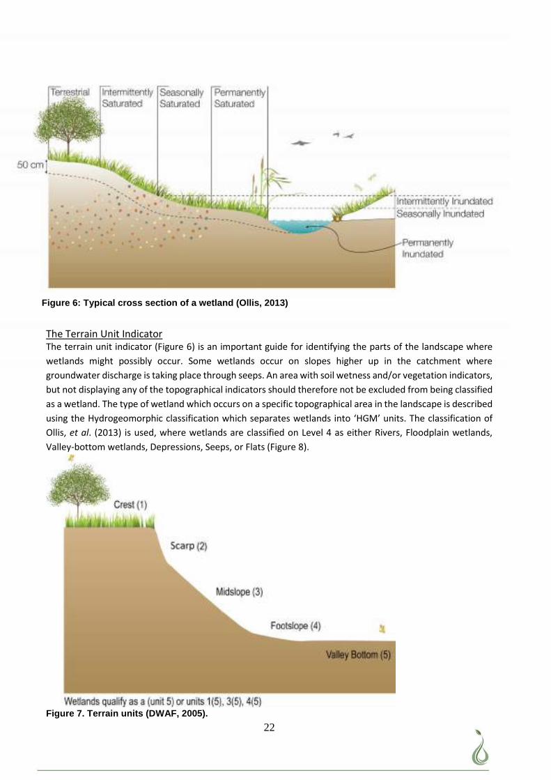
Wetland delineation and functional assessment for Proposed proposed sand mine, Lephalala River, Abbottspoort Village, Limpopo Province. January 2018
22
The Terrain Unit Indicator The terrain unit indicator (Figure 6) is an important guide for identifying the parts of the landscape where
wetlands might possibly occur. Some wetlands occur on slopes higher up in the catchment where
groundwater discharge is taking place through seeps. An area with soil wetness and/or vegetation indicators,
but not displaying any of the topographical indicators should therefore not be excluded from being classified
as a wetland. The type of wetland which occurs on a specific topographical area in the landscape is described
using the Hydrogeomorphic classification which separates wetlands into ‘HGM’ units. The classification of
Ollis, et al. (2013) is used, where wetlands are classified on Level 4 as either Rivers, Floodplain wetlands,
Valley-bottom wetlands, Depressions, Seeps, or Flats (Figure 8).
Figure 7. Terrain units (DWAF, 2005).
Figure 6: Typical cross section of a wetland (Ollis, 2013)
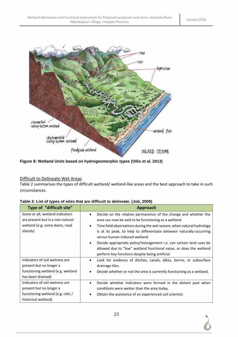
Wetland delineation and functional assessment for Proposed proposed sand mine, Lephalala River, Abbottspoort Village, Limpopo Province. January 2018
23
Figure 8: Wetland Units based on hydrogeomorphic types (Ollis et al. 2013)
Difficult to Delineate Wet Areas Table 2 summarises the types of difficult wetland/ wetland-like areas and the best approach to take in such
circumstances.
Table 2: List of types of sites that are difficult to delineate. (Job, 2009)
Type of “difficult site” Approach
Some or all, wetland indicators
are present but is a non-natural
wetland (e.g. some dams, road
islands)
Decide on the relative permanence of the change and whether the
area can now be said to be functioning as a wetland.
Time field observations during the wet season, when natural hydrology
is at its peak, to help to differentiate between naturally-occurring
versus human-induced wetland.
Decide appropriate policy/management i.e. can certain land uses be
allowed due to “low” wetland functional value, or does the wetland
perform key functions despite being artificial.
Indicators of soil wetness are
present but no longer a
functioning wetland (e.g. wetland
has been drained)
Look for evidence of ditches, canals, dikes, berms, or subsurface
drainage tiles.
Decide whether or not the area is currently functioning as a wetland.
Indicators of soil wetness are
present but no longer a
functioning wetland (e.g. relic /
historical wetland)
Decide whether indicators were formed in the distant past when
conditions were wetter than the area today.
Obtain the assistance of an experienced soil scientist.

Wetland delineation and functional assessment for Proposed proposed sand mine, Lephalala River, Abbottspoort Village, Limpopo Province. January 2018
24
Type of “difficult site” Approach
Some, or all, wetland indicators
are absent at certain times of year
(e.g. annual vegetation or
seasonal saturation)
Thoroughly document soil and landscape conditions, develop rationale
for considering the area to be a wetland.
Recommend that the site be revisited in the wet season.
Some, or all, wetland indicators
are absent due to human
disturbance (e.g. vegetation has
been cleared, wetland has been
ploughed or filled)
Thoroughly document landscape conditions and any remnant
vegetation, soil, hydrology indicators, develop rationale for
considering the area to be wetland.
Certain cases (illegal fill) may justify that the fill be removed and the
wetland rehabilitated.
Riparian Indicators
Riparian habitat is classified primarily by identifying riparian vegetation along the edge of the macro stream
channel. The macro stream channel is defined as the outer bank of a compound channel and should not be
confused with the active river bank. The macro channel bank often represents a dramatic change in the
energy with which water passes through the system. Rich alluvial soils deposit nutrients making the riparian
area a highly productive zone. This causes a very distinct change in vegetation structure and composition
along the edges of the riparian area (DWAF, 2008). The marginal zone includes the area from the water level
at low flow, to those features that are hydrologically activated for the greater part of the Year (WRC Report
No TT 333/08 April, 2008). The non-marginal zone is the combination of the upper and lower zones (Figure
9).
Figure 9: Schematic diagram illustrating an example of where the 3 zones would be placed relative to
geomorphic diversity (Kleynhans et al, 2007)
The vegetation of riparian areas is divided into three zones, the marginal zone, lower non-marginal zone
and the upper non-marginal zone (Table 3). The different zones have different vegetation growth.
Wetland delineation and functional assessment for Proposed proposed sand mine, Lephalala River, Abbottspoort Village, Limpopo Province. January 2018
25
Table 3: Description of riparian vegetation zones (Kleynhans et al, 2007).
Marginal (Non-marginal) Lower (Non-marginal) Upper
Alternative
descriptions
Active features
Wet bank
Seasonal features
Wet bank
Ephemeral features
Dry bank
Extends from Water level at low flow Marginal zone Lower zone
Extends to Geomorphic features /
substrates that are
hydrologically activated
(inundated or
moistened) for the
Greater part of the year.
Usually a marked
increase in lateral
Elevation.
Usually a marked
decrease in lateral
elevation
Characterized
by
See above ; Moist
substrates next to
water’s edge; water
loving- species usually
vigorous due to near
permanent
access to
soil moisture
Geomorphic features
that are hydrologically
activated (inundated or
moistened) on a
Seasonal basis.
May have different
species than marginal
zone
Geomorphic features
that are hydrological
activated (inundated or
moistened) on an
Ephemeral basis.
Presence of riparian
and terrestrial species
Terrestrial species with
increased stature
Riparian Area:
A riparian area can be defined as a linear fluvial, eroded landform which carries channelized flow on a
permanent, seasonal or ephemeral/episodic basis. The river channel flows within a confined valley (gorge)
or within an incised macro-channel. The “river” includes both the active channel (the portion which carries
the water) as well as the riparian zone (Figure 10) (Kotze, 1999).
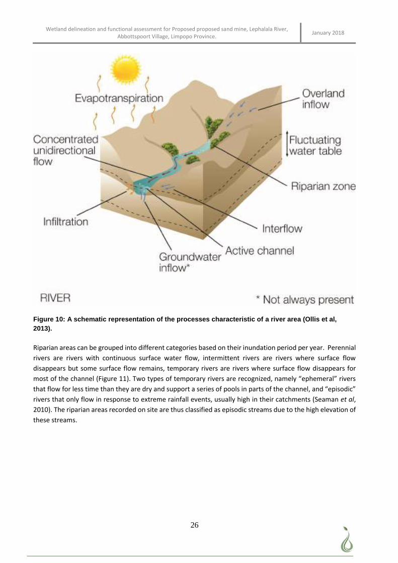
Wetland delineation and functional assessment for Proposed proposed sand mine, Lephalala River, Abbottspoort Village, Limpopo Province. January 2018
26
Figure 10: A schematic representation of the processes characteristic of a river area (Ollis et al, 2013).
Riparian areas can be grouped into different categories based on their inundation period per year. Perennial
rivers are rivers with continuous surface water flow, intermittent rivers are rivers where surface flow
disappears but some surface flow remains, temporary rivers are rivers where surface flow disappears for
most of the channel (Figure 11). Two types of temporary rivers are recognized, namely “ephemeral” rivers
that flow for less time than they are dry and support a series of pools in parts of the channel, and “episodic”
rivers that only flow in response to extreme rainfall events, usually high in their catchments (Seaman et al,
2010). The riparian areas recorded on site are thus classified as episodic streams due to the high elevation of
these streams.
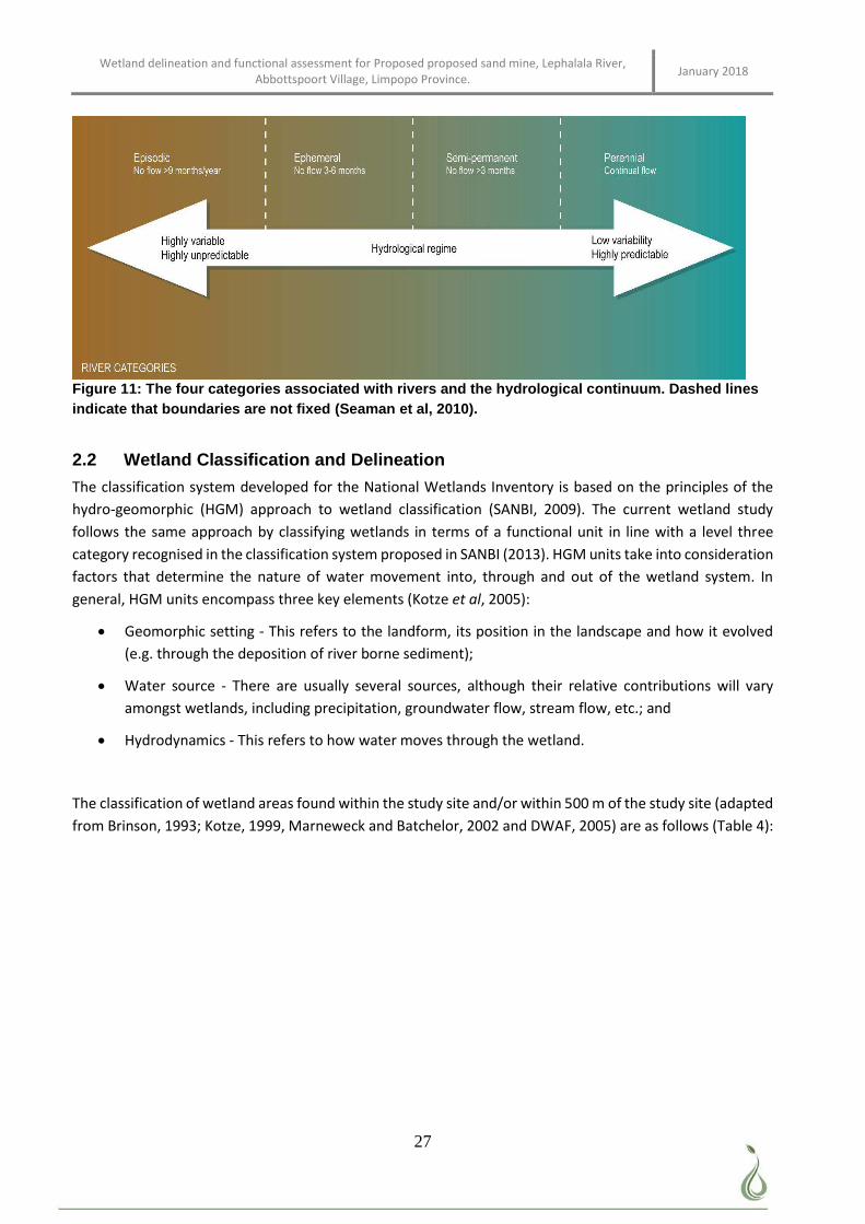
Wetland delineation and functional assessment for Proposed proposed sand mine, Lephalala River, Abbottspoort Village, Limpopo Province. January 2018
27
Figure 11: The four categories associated with rivers and the hydrological continuum. Dashed lines indicate that boundaries are not fixed (Seaman et al, 2010).
2.2 Wetland Classification and Delineation
The classification system developed for the National Wetlands Inventory is based on the principles of the
hydro-geomorphic (HGM) approach to wetland classification (SANBI, 2009). The current wetland study
follows the same approach by classifying wetlands in terms of a functional unit in line with a level three
category recognised in the classification system proposed in SANBI (2013). HGM units take into consideration
factors that determine the nature of water movement into, through and out of the wetland system. In
general, HGM units encompass three key elements (Kotze et al, 2005):
Geomorphic setting - This refers to the landform, its position in the landscape and how it evolved
(e.g. through the deposition of river borne sediment);
Water source - There are usually several sources, although their relative contributions will vary
amongst wetlands, including precipitation, groundwater flow, stream flow, etc.; and
Hydrodynamics - This refers to how water moves through the wetland.
The classification of wetland areas found within the study site and/or within 500 m of the study site (adapted
from Brinson, 1993; Kotze, 1999, Marneweck and Batchelor, 2002 and DWAF, 2005) are as follows (Table 4):
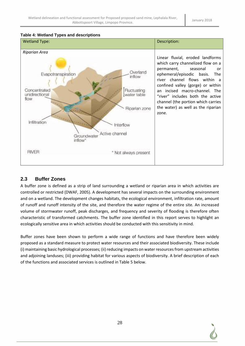
Wetland delineation and functional assessment for Proposed proposed sand mine, Lephalala River, Abbottspoort Village, Limpopo Province. January 2018
28
Table 4: Wetland Types and descriptions
Wetland Type: Description:
Riparian Area
Linear fluvial, eroded landforms which carry channelized flow on a permanent, seasonal or ephemeral/episodic basis. The river channel flows within a confined valley (gorge) or within an incised macro-channel. The “river” includes both the active channel (the portion which carries the water) as well as the riparian zone.
2.3 Buffer Zones A buffer zone is defined as a strip of land surrounding a wetland or riparian area in which activities are
controlled or restricted (DWAF, 2005). A development has several impacts on the surrounding environment
and on a wetland. The development changes habitats, the ecological environment, infiltration rate, amount
of runoff and runoff intensity of the site, and therefore the water regime of the entire site. An increased
volume of stormwater runoff, peak discharges, and frequency and severity of flooding is therefore often
characteristic of transformed catchments. The buffer zone identified in this report serves to highlight an
ecologically sensitive area in which activities should be conducted with this sensitivity in mind.
Buffer zones have been shown to perform a wide range of functions and have therefore been widely
proposed as a standard measure to protect water resources and their associated biodiversity. These include
(i) maintaining basic hydrological processes; (ii) reducing impacts on water resources from upstream activities
and adjoining landuses; (iii) providing habitat for various aspects of biodiversity. A brief description of each
of the functions and associated services is outlined in Table 5 below.
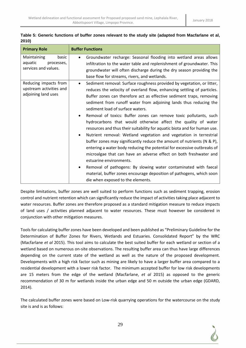
Wetland delineation and functional assessment for Proposed proposed sand mine, Lephalala River, Abbottspoort Village, Limpopo Province. January 2018
29
Table 5: Generic functions of buffer zones relevant to the study site (adapted from Macfarlane et al, 2010)
Primary Role Buffer Functions
Maintaining basic aquatic processes, services and values.
Groundwater recharge: Seasonal flooding into wetland areas allows
infiltration to the water table and replenishment of groundwater. This
groundwater will often discharge during the dry season providing the
base flow for streams, rivers, and wetlands.
Reducing impacts from upstream activities and adjoining land uses
Sediment removal: Surface roughness provided by vegetation, or litter,
reduces the velocity of overland flow, enhancing settling of particles.
Buffer zones can therefore act as effective sediment traps, removing
sediment from runoff water from adjoining lands thus reducing the
sediment load of surface waters.
Removal of toxics: Buffer zones can remove toxic pollutants, such
hydrocarbons that would otherwise affect the quality of water
resources and thus their suitability for aquatic biota and for human use.
Nutrient removal: Wetland vegetation and vegetation in terrestrial
buffer zones may significantly reduce the amount of nutrients (N & P),
entering a water body reducing the potential for excessive outbreaks of
microalgae that can have an adverse effect on both freshwater and
estuarine environments.
Removal of pathogens: By slowing water contaminated with faecal
material, buffer zones encourage deposition of pathogens, which soon
die when exposed to the elements.
Despite limitations, buffer zones are well suited to perform functions such as sediment trapping, erosion
control and nutrient retention which can significantly reduce the impact of activities taking place adjacent to
water resources. Buffer zones are therefore proposed as a standard mitigation measure to reduce impacts
of land uses / activities planned adjacent to water resources. These must however be considered in
conjunction with other mitigation measures.
Tools for calculating buffer zones have been developed and been published as “Preliminary Guideline for the
Determination of Buffer Zones for Rivers, Wetlands and Estuaries. Consolidated Report” by the WRC
(Macfarlane et al 2015). This tool aims to calculate the best suited buffer for each wetland or section of a
wetland based on numerous on-site observations. The resulting buffer area can thus have large differences
depending on the current state of the wetland as well as the nature of the proposed development.
Developments with a high risk factor such as mining are likely to have a larger buffer area compared to a
residential development with a lower risk factor. The minimum accepted buffer for low risk developments
are 15 meters from the edge of the wetland (Macfarlane, et al 2015) as opposed to the generic
recommendation of 30 m for wetlands inside the urban edge and 50 m outside the urban edge (GDARD,
2014).
The calculated buffer zones were based on Low-risk quarrying operations for the watercourse on the study
site is and is as follows:
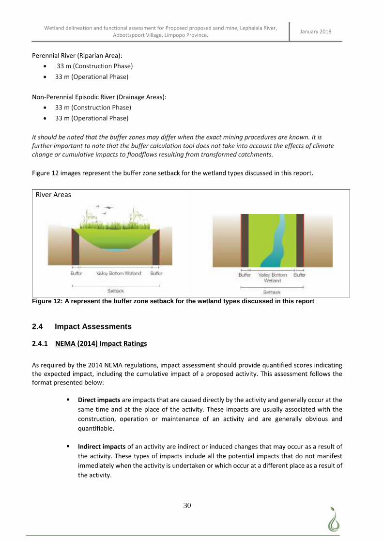
Wetland delineation and functional assessment for Proposed proposed sand mine, Lephalala River, Abbottspoort Village, Limpopo Province. January 2018
30
Perennial River (Riparian Area):
33 m (Construction Phase)
33 m (Operational Phase)
Non-Perennial Episodic River (Drainage Areas):
33 m (Construction Phase)
33 m (Operational Phase)
It should be noted that the buffer zones may differ when the exact mining procedures are known. It is further important to note that the buffer calculation tool does not take into account the effects of climate change or cumulative impacts to floodflows resulting from transformed catchments.
Figure 12 images represent the buffer zone setback for the wetland types discussed in this report.
River Areas
Figure 12: A represent the buffer zone setback for the wetland types discussed in this report
2.4 Impact Assessments
2.4.1 NEMA (2014) Impact Ratings
As required by the 2014 NEMA regulations, impact assessment should provide quantified scores indicating the expected impact, including the cumulative impact of a proposed activity. This assessment follows the format presented below:
Direct impacts are impacts that are caused directly by the activity and generally occur at the
same time and at the place of the activity. These impacts are usually associated with the
construction, operation or maintenance of an activity and are generally obvious and
quantifiable.
Indirect impacts of an activity are indirect or induced changes that may occur as a result of
the activity. These types of impacts include all the potential impacts that do not manifest
immediately when the activity is undertaken or which occur at a different place as a result of
the activity.
Wetland delineation and functional assessment for Proposed proposed sand mine, Lephalala River, Abbottspoort Village, Limpopo Province. January 2018
31
Cumulative impacts are impacts that result from the incremental impact of the proposed
activity on a common resource when added to the impacts of other past, present or
reasonably foreseeable future activities. Cumulative impacts can occur from the collective
impacts of individual minor actions over a period of time and can include both direct and
indirect impacts.
Spatial extent – The size of the area that will be affected by the impact:
o Site specific;
o Local
o Regional (within 30 km of site); or
o National.
Intensity –The anticipated severity of the impact:
o High (severe alteration of natural systems, patterns or processes);
o Medium (notable alteration of natural systems, patterns or processes; or
o Low (negligible alteration of natural systems, patterns or processes).
Duration –The timeframe during which the impact will be experienced:
o Temporary (less than 1 year);
o Short term (1 to 6 years);
o Medium term (6 to 15 years);
o Long term (the impact will only cease after the operational life of the activity); or
o Permanent (mitigation will not occur in such a way or in such a time span that the
impact can be considered transient).
Reversibility of impacts -
o High reversibility of impacts (impact is highly reversible at end of project life);
o Moderate reversibility of impacts;
o Low reversibility of impacts; or
o Impacts are non- reversible (impact is permanent).
Irreplaceability of resource loss caused by impacts –
o High irreplaceability of resources (project will destroy unique resources that cannot
be replaced);
o Moderate irreplaceability of resources;
o Low irreplaceability of resources; or
o Resources are replaceable (the affected resource is easy to replace/ rehabilitate.
Using the criteria above, the impacts were further assessed in terms of the following:
Probability – The probability of the impact occurring:
o Improbable (little or no chance of occurring);
o Probable (<50% chance of occurring);
o Highly probable (50 – 90% chance of occurring); or
o Definite (>90% chance of occurring).
Significance – Will the impact cause a notable alteration of the environment?
Wetland delineation and functional assessment for Proposed proposed sand mine, Lephalala River, Abbottspoort Village, Limpopo Province. January 2018
32
o Low to very low (the impact may result in minor alterations of the environment and
can be easily avoided by implementing appropriate mitigation measures, and will not
have an influence on decision-making);
o Medium (the impact will result in moderate alteration of the environment and can
be reduced or avoided by implementing the appropriate mitigation measures, and
will only have an influence on the decision-making if not mitigated); or
o High (the impacts will result in major alteration to the environment even with the
implementation on the appropriate mitigation measures and will have an influence
on decision-making).
Status - Whether the impact on the overall environment (social, biophysical and economic)
will be:
o Positive - environment overall will benefit from the impact;
o Negative - environment overall will be adversely affected by the impact; or
o Neutral - environment overall will not be affected.
Confidence – The degree of confidence in predictions based on available information and
specialist knowledge:
o Low;
o Medium; or
o High.
Impacts will then be collated into an EMP and these will include the following:
Management actions and monitoring of the impacts;
Identifying negative impacts and prescribing mitigation measures to avoid or reduce negative
impacts; and
Positive impacts will be identified and enhanced where possible.
2.4.2 DWS (2016) Impact Register and Risk Assessment
Section 21(c) and (i) water uses (Impeding or diverting low and/or impacts to the bed and banks of
watercourses) are non-consumptive and their impacts more difficult to detect and manage. They are also
generally difficult to clearly quantify. However, if left undetected these impacts can significantly change
various attributes and characteristics of a watercourse, and water resources, especially if left unmanaged
and uncontrolled.
Risk-based management has value in providing an indication of the potential for delegating certain categories
of water use “risks” to DWS regional offices (RO) or Catchment Management Agencies (CMA). Risk categories
obtained through this assessment serve as a guideline to establish the appropriate channel of authorisation
of these water uses
The DWS has therefore developed a risk assessment matrix to assist in quantifying expected impacts. The
scores obtained in this assessment are useful in evaluating how the proposed activities should be authorised.
The formula used to derive a risk score is as follows:
RISK = CONSEQUENCE x LIKELIHOOD
CONSEQUENCE = SEVERITY + SPATIAL SCALE + DURATION
LIKELIHOOD = FREQUENCY OF THE ACTIVITY + FREQUENCY OF THE IMPACT +LEGAL ISSUES + DETECTION
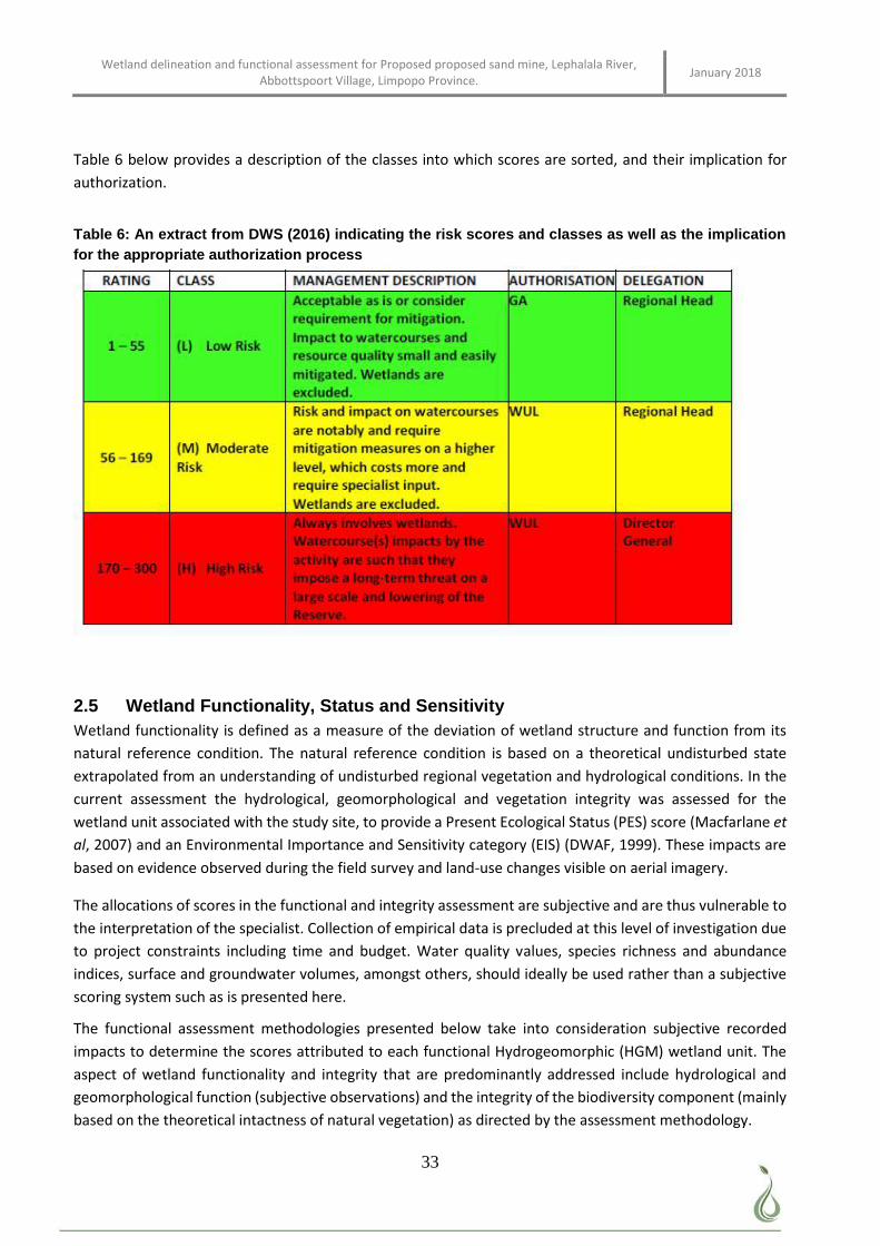
Wetland delineation and functional assessment for Proposed proposed sand mine, Lephalala River, Abbottspoort Village, Limpopo Province. January 2018
33
Table 6 below provides a description of the classes into which scores are sorted, and their implication for
authorization.
Table 6: An extract from DWS (2016) indicating the risk scores and classes as well as the implication for the appropriate authorization process
2.5 Wetland Functionality, Status and Sensitivity Wetland functionality is defined as a measure of the deviation of wetland structure and function from its
natural reference condition. The natural reference condition is based on a theoretical undisturbed state
extrapolated from an understanding of undisturbed regional vegetation and hydrological conditions. In the
current assessment the hydrological, geomorphological and vegetation integrity was assessed for the
wetland unit associated with the study site, to provide a Present Ecological Status (PES) score (Macfarlane et
al, 2007) and an Environmental Importance and Sensitivity category (EIS) (DWAF, 1999). These impacts are
based on evidence observed during the field survey and land-use changes visible on aerial imagery.
The allocations of scores in the functional and integrity assessment are subjective and are thus vulnerable to
the interpretation of the specialist. Collection of empirical data is precluded at this level of investigation due
to project constraints including time and budget. Water quality values, species richness and abundance
indices, surface and groundwater volumes, amongst others, should ideally be used rather than a subjective
scoring system such as is presented here.
The functional assessment methodologies presented below take into consideration subjective recorded
impacts to determine the scores attributed to each functional Hydrogeomorphic (HGM) wetland unit. The
aspect of wetland functionality and integrity that are predominantly addressed include hydrological and
geomorphological function (subjective observations) and the integrity of the biodiversity component (mainly
based on the theoretical intactness of natural vegetation) as directed by the assessment methodology.
Wetland delineation and functional assessment for Proposed proposed sand mine, Lephalala River, Abbottspoort Village, Limpopo Province. January 2018
34
In the current study the wetland was assessed using the QHI (Quick Habitat Integrity) assessment model.
2.5.1 Quick Habitat Integrity Model
To accommodate a less-detailed process, a desktop habitat integrity assessment (using the Quick Habitat Integrity model) that allows for a coarse assessment was developed. This assessment rates the habitat according to a scale of 0 (close to natural) to 5 (critically modified) according to the following metrics (Seaman et al, 2010):
Bed modification.
Flow modification.
Introduced Instream biota.
Inundation.
Riparian / bank condition.
Water quality modification.
2.5.2 Recommended Ecological Category (REC)
The REC is determined by the Present Ecological State of the water resource and the importance and/or
sensitivity of the water resource. Water resources which have Present Ecological State categories in an E or
F ecological category are deemed unsustainable by the DWS. In such cases the REC must automatically be
increased to a D.
Where the PES is in the A, B, C, D or E the EIS components must be checked to determine if any of the aspects
of importance and sensitivity (Ecological Importance; Hydrological Functions and Direct Human Benefits) are
high or very high. If this is the case, the feasibility of increasing the PES (particularly if the PES is in a low C or
D category) should be evaluated. This is recommended to enable important and/or sensitive wetland water
resources to maintain their functionality and continue to provide the goods and services for the environment
and society.
If:
PES is in an E or F category:
The REC should be set at at least a D, since E and F EC’s are considered unsustainable.
o The PES category is in a A, B, C or D category, AND the EIS criteria are low or moderate OR
the EIS criteria are high or even very high, but it is not feasible or practicable for the PES to
be improved:
The REC is set at the current PES.
o The PES category is in a B, C or D category, AND the EIS criteria are high or very high AND it
is feasible or practicable for the PES to be improved:
The REC is set at least one Ecological Category higher than the current PES.” (Rountree et al, 2013)
Wetland delineation and functional assessment for Proposed proposed sand mine, Lephalala River, Abbottspoort Village, Limpopo Province. January 2018
35
3 RESULTS
3.1 Land Use, Cover and Ecological State The dominant land use in the area is farming and nature and hunting resorts. The area adjacent to the study
site was historically used for low density residential housing and farming. The area adjacent to the study site
is now used for more high density residential housing as well as small scale farming (Figure 13). As a result of
land clearing and tree removal the drainage areas linked to the main perennial riparian river known as the
Lephalala River has become eroded and contributes to an increase in sediment deposits into the main river
channel. Farther away from the study area some sand mining was also observed.
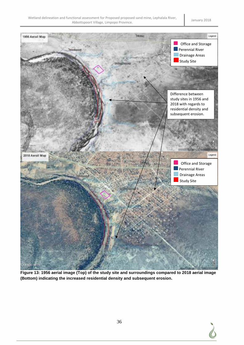
Wetland delineation and functional assessment for Proposed proposed sand mine, Lephalala River, Abbottspoort Village, Limpopo Province. January 2018
36
Figure 13: 1956 aerial image (Top) of the study site and surroundings compared to 2018 aerial image (Bottom) indicating the increased residential density and subsequent erosion.
Difference between study sites in 1956 and 2018 with regards to residential density and subsequent erosion.
Office and Storage Perennial River Drainage Areas Study Site
Office and Storage
Perennial River
Drainage Areas
Study Site
Office and Storage
Perennial River
Drainage Areas
Study Site
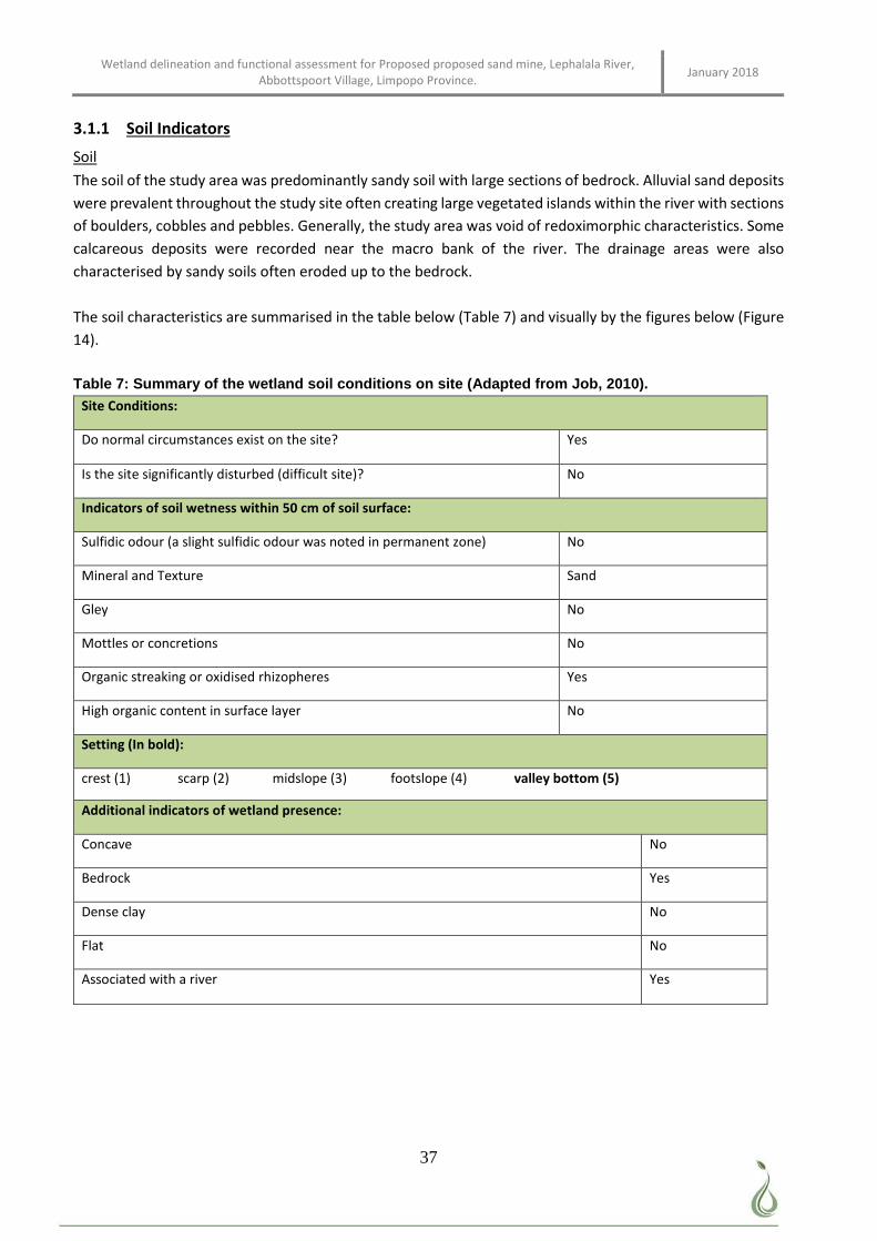
Wetland delineation and functional assessment for Proposed proposed sand mine, Lephalala River, Abbottspoort Village, Limpopo Province. January 2018
37
3.1.1 Soil Indicators
Soil
The soil of the study area was predominantly sandy soil with large sections of bedrock. Alluvial sand deposits
were prevalent throughout the study site often creating large vegetated islands within the river with sections
of boulders, cobbles and pebbles. Generally, the study area was void of redoximorphic characteristics. Some
calcareous deposits were recorded near the macro bank of the river. The drainage areas were also
characterised by sandy soils often eroded up to the bedrock.
The soil characteristics are summarised in the table below (Table 7) and visually by the figures below (Figure
14).
Table 7: Summary of the wetland soil conditions on site (Adapted from Job, 2010). Site Conditions:
Do normal circumstances exist on the site? Yes
Is the site significantly disturbed (difficult site)? No
Indicators of soil wetness within 50 cm of soil surface:
Sulfidic odour (a slight sulfidic odour was noted in permanent zone) No
Mineral and Texture Sand
Gley No
Mottles or concretions No
Organic streaking or oxidised rhizopheres Yes
High organic content in surface layer No
Setting (In bold):
crest (1) scarp (2) midslope (3) footslope (4) valley bottom (5)
Additional indicators of wetland presence:
Concave No
Bedrock Yes
Dense clay No
Flat No
Associated with a river Yes
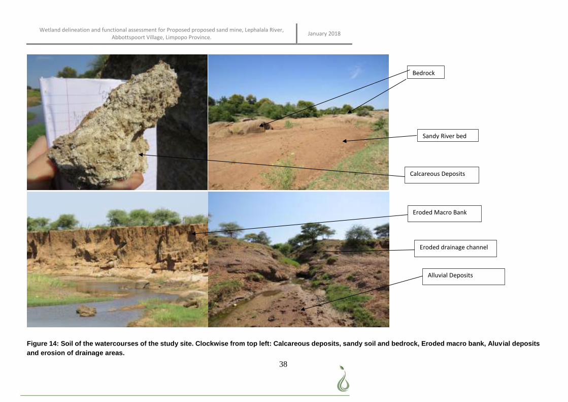
Wetland delineation and functional assessment for Proposed proposed sand mine, Lephalala River, Abbottspoort Village, Limpopo Province. January 2018
38
Figure 14: Soil of the watercourses of the study site. Clockwise from top left: Calcareous deposits, sandy soil and bedrock, Eroded macro bank, Aluvial deposits and erosion of drainage areas.
Bedrock
Sandy River bed
Calcareous Deposits
Eroded Macro Bank
Eroded drainage channel
Alluvial Deposits
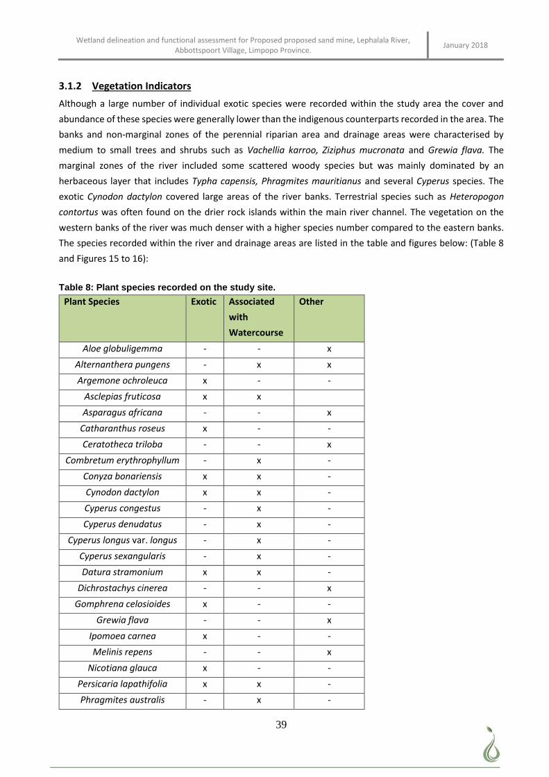
Wetland delineation and functional assessment for Proposed proposed sand mine, Lephalala River, Abbottspoort Village, Limpopo Province. January 2018
39
3.1.2 Vegetation Indicators
Although a large number of individual exotic species were recorded within the study area the cover and
abundance of these species were generally lower than the indigenous counterparts recorded in the area. The
banks and non-marginal zones of the perennial riparian area and drainage areas were characterised by
medium to small trees and shrubs such as Vachellia karroo, Ziziphus mucronata and Grewia flava. The
marginal zones of the river included some scattered woody species but was mainly dominated by an
herbaceous layer that includes Typha capensis, Phragmites mauritianus and several Cyperus species. The
exotic Cynodon dactylon covered large areas of the river banks. Terrestrial species such as Heteropogon
contortus was often found on the drier rock islands within the main river channel. The vegetation on the
western banks of the river was much denser with a higher species number compared to the eastern banks.
The species recorded within the river and drainage areas are listed in the table and figures below: (Table 8
and Figures 15 to 16):
Table 8: Plant species recorded on the study site.
Plant Species Exotic Associated
with
Watercourse
Other
Aloe globuligemma - - x
Alternanthera pungens - x x
Argemone ochroleuca x - -
Asclepias fruticosa x x
Asparagus africana - - x
Catharanthus roseus x - -
Ceratotheca triloba - - x
Combretum erythrophyllum - x -
Conyza bonariensis x x -
Cynodon dactylon x x -
Cyperus congestus - x -
Cyperus denudatus - x -
Cyperus longus var. longus - x -
Cyperus sexangularis - x -
Datura stramonium x x -
Dichrostachys cinerea - - x
Gomphrena celosioides x - -
Grewia flava - - x
Ipomoea carnea x - -
Melinis repens - - x
Nicotiana glauca x - -
Persicaria lapathifolia x x -
Phragmites australis - x -
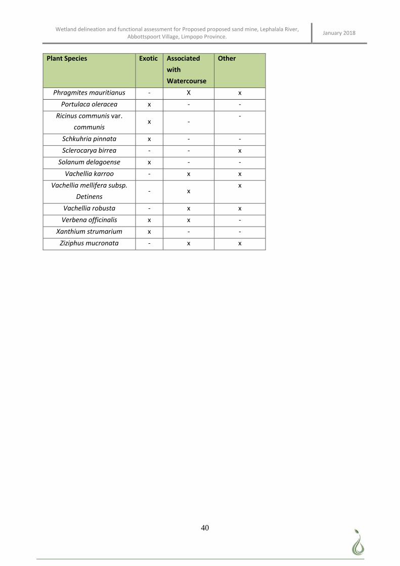
Wetland delineation and functional assessment for Proposed proposed sand mine, Lephalala River, Abbottspoort Village, Limpopo Province. January 2018
40
Plant Species Exotic Associated
with
Watercourse
Other
Phragmites mauritianus - X x
Portulaca oleracea x - -
Ricinus communis var.
communis x -
-
Schkuhria pinnata x - -
Sclerocarya birrea - - x
Solanum delagoense x - -
Vachellia karroo - x x
Vachellia mellifera subsp.
Detinens - x
x
Vachellia robusta - x x
Verbena officinalis x x -
Xanthium strumarium x - -
Ziziphus mucronata - x x
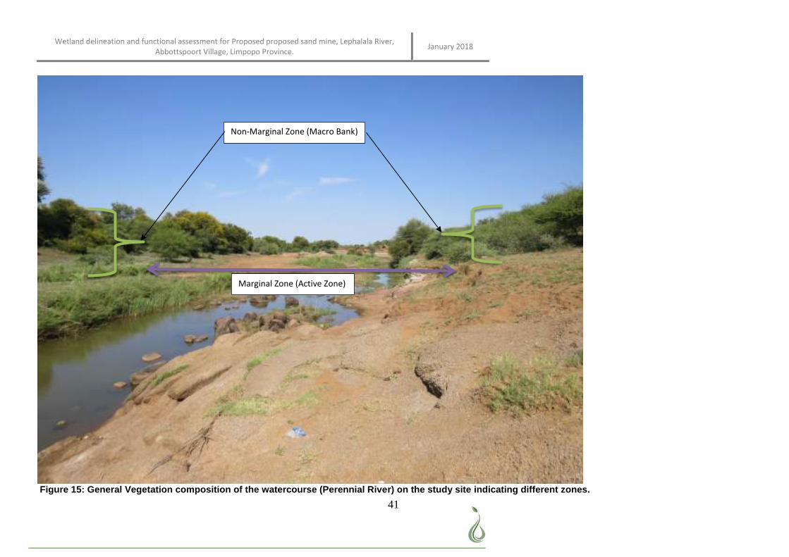
Wetland delineation and functional assessment for Proposed proposed sand mine, Lephalala River, Abbottspoort Village, Limpopo Province. January 2018
41
Figure 15: General Vegetation composition of the watercourse (Perennial River) on the study site indicating different zones.
Marginal Zone (Active Zone)
Non-Marginal Zone (Macro Bank)
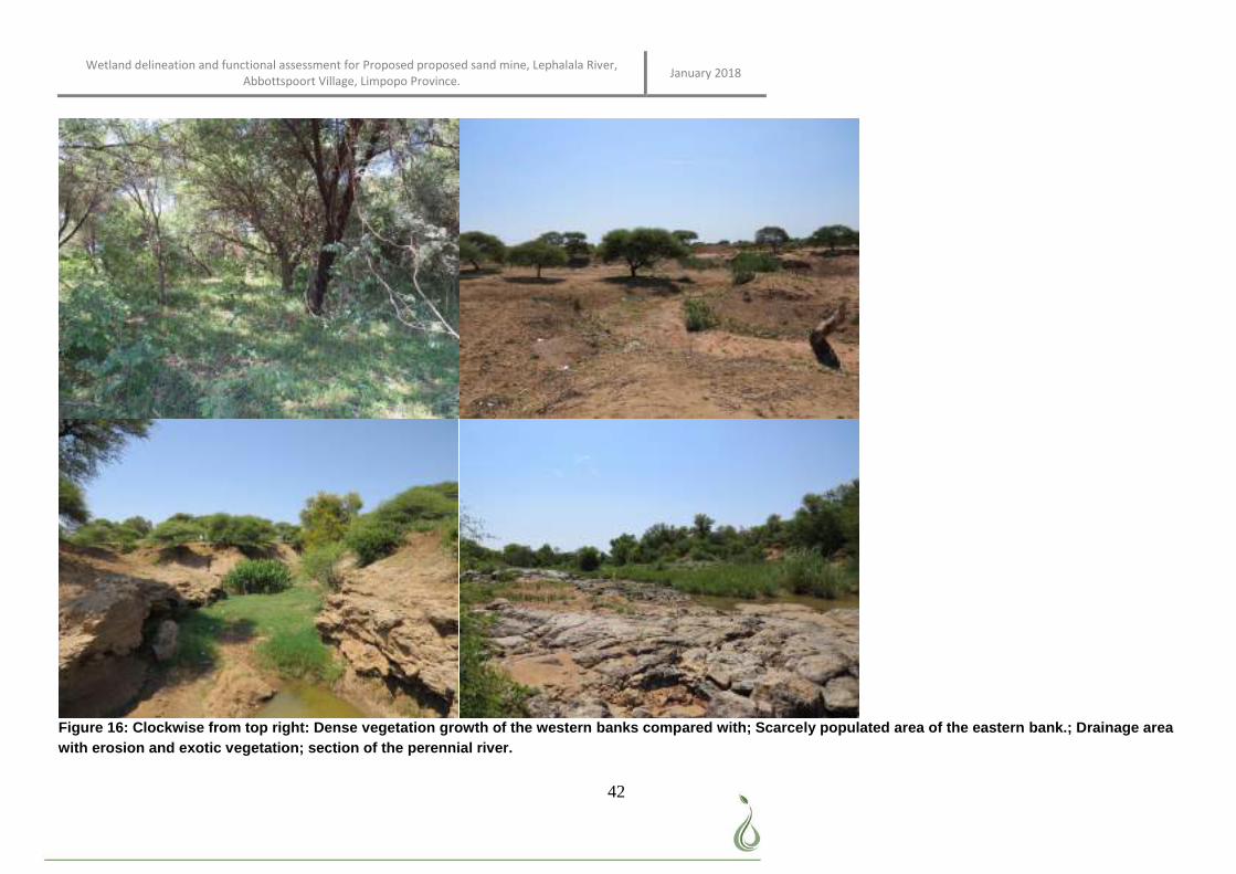
Wetland delineation and functional assessment for Proposed proposed sand mine, Lephalala River, Abbottspoort Village, Limpopo Province. January 2018
42
Figure 16: Clockwise from top right: Dense vegetation growth of the western banks compared with; Scarcely populated area of the eastern bank.; Drainage area with erosion and exotic vegetation; section of the perennial river.
Wetland delineation and functional assessment for Proposed proposed sand mine, Lephalala River, Abbottspoort Village, Limpopo Province. January 2018
43
3.2 Wetland Classification and Delineation
The study site is located directly within a section of the perennial riparian river known as the Lephalala River
(Figure 17). Several drainage areas drain into this river from the surrounding residential area. The proposed
storage infrastructure and offices are located on an open area that does not encroach onto any nearby
watercourse or buffer.
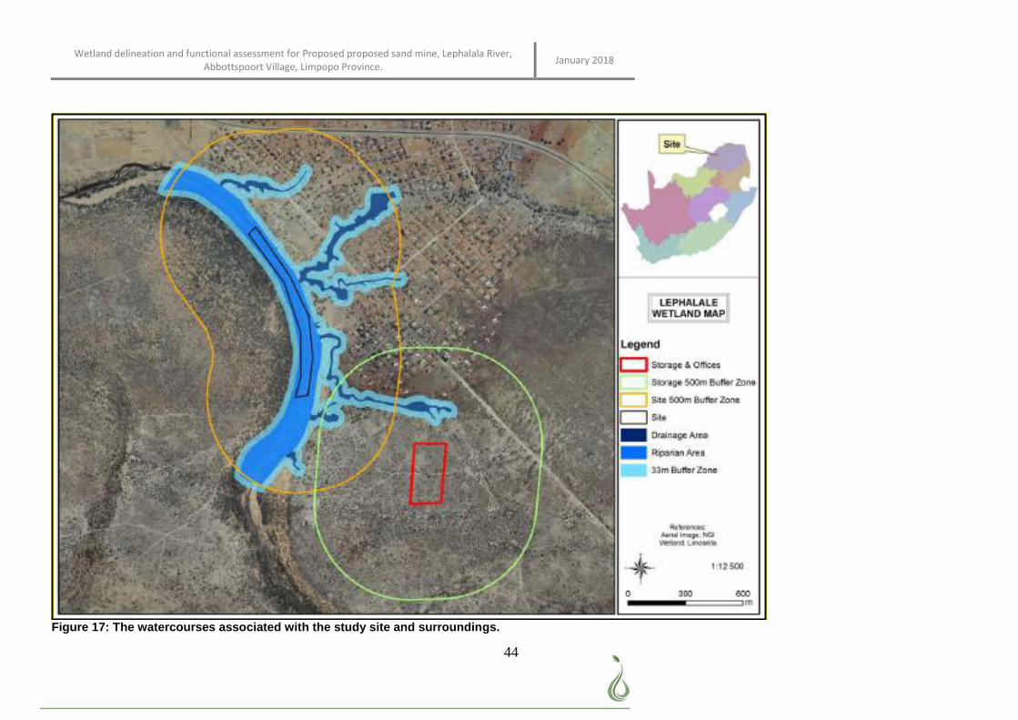
Wetland delineation and functional assessment for Proposed proposed sand mine, Lephalala River, Abbottspoort Village, Limpopo Province. January 2018
44
Figure 17: The watercourses associated with the study site and surroundings.
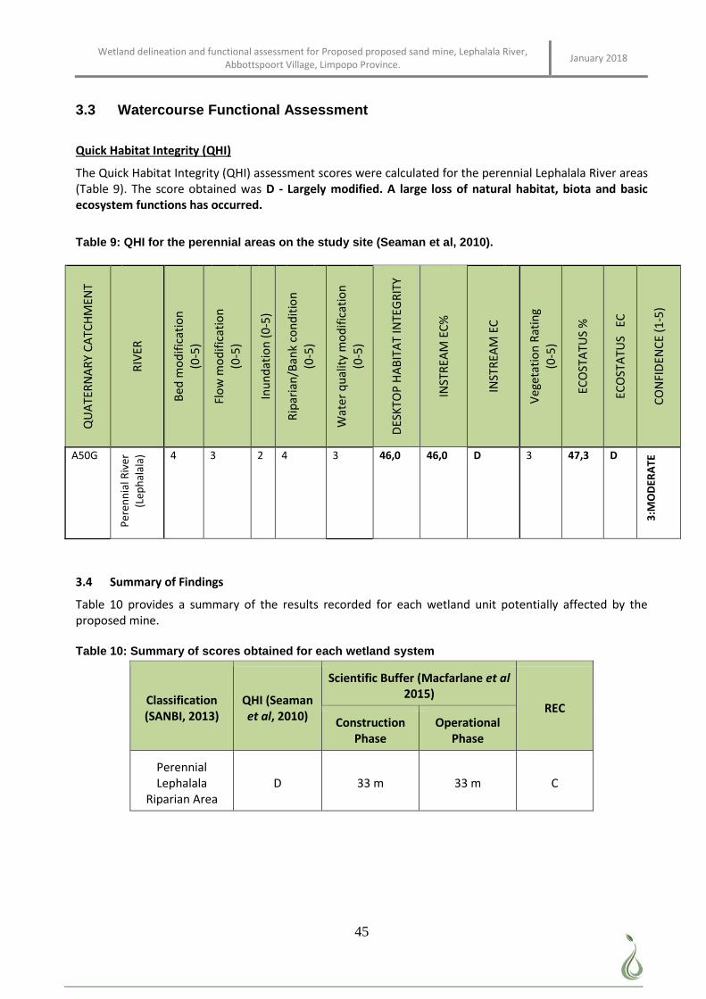
Wetland delineation and functional assessment for Proposed proposed sand mine, Lephalala River, Abbottspoort Village, Limpopo Province. January 2018
45
3.3 Watercourse Functional Assessment
Quick Habitat Integrity (QHI)
The Quick Habitat Integrity (QHI) assessment scores were calculated for the perennial Lephalala River areas (Table 9). The score obtained was D - Largely modified. A large loss of natural habitat, biota and basic ecosystem functions has occurred.
Table 9: QHI for the perennial areas on the study site (Seaman et al, 2010).
QU
ATE
RN
AR
Y C
ATC
HM
ENT
RIV
ER
Bed
mo
dif
icat
ion
(0-5
)
Flo
w m
od
ific
atio
n
(0-5
)
Inu
nd
atio
n (
0-5
)
Rip
aria
n/B
ank
con
dit
ion
(0
-5)
Wat
er
qu
alit
y m
od
ific
atio
n
(0-5
)
DES
KTO
P H
AB
ITA
T IN
TEG
RIT
Y
INST
REA
M E
C%
INST
REA
M E
C
Veg
etat
ion
Rat
ing
(0
-5)
ECO
STA
TUS
%
ECO
STA
TUS
EC
CO
NFI
DEN
CE
(1-5
)
A50G
Per
enn
ial R
iver
(Lep
hal
ala)
4 3 2 4 3 46,0 46,0 D 3 47,3 D
3:M
OD
ERA
TE
3.4 Summary of Findings
Table 10 provides a summary of the results recorded for each wetland unit potentially affected by the proposed mine. Table 10: Summary of scores obtained for each wetland system
Classification (SANBI, 2013)
QHI (Seaman et al, 2010)
Scientific Buffer (Macfarlane et al 2015)
REC Construction
Phase Operational
Phase
Perennial Lephalala
Riparian Area D 33 m 33 m C
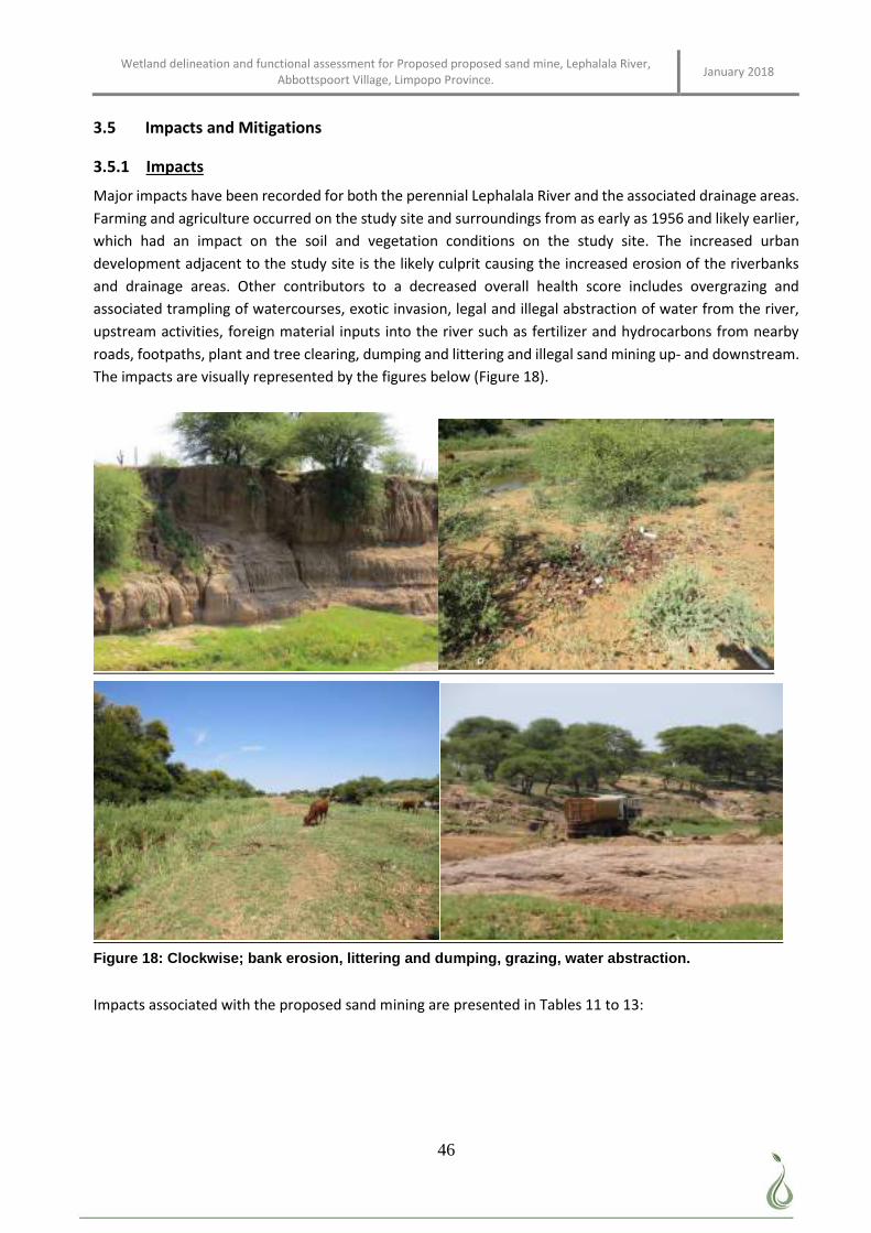
Wetland delineation and functional assessment for Proposed proposed sand mine, Lephalala River, Abbottspoort Village, Limpopo Province. January 2018
46
3.5 Impacts and Mitigations
3.5.1 Impacts
Major impacts have been recorded for both the perennial Lephalala River and the associated drainage areas.
Farming and agriculture occurred on the study site and surroundings from as early as 1956 and likely earlier,
which had an impact on the soil and vegetation conditions on the study site. The increased urban
development adjacent to the study site is the likely culprit causing the increased erosion of the riverbanks
and drainage areas. Other contributors to a decreased overall health score includes overgrazing and
associated trampling of watercourses, exotic invasion, legal and illegal abstraction of water from the river,
upstream activities, foreign material inputs into the river such as fertilizer and hydrocarbons from nearby
roads, footpaths, plant and tree clearing, dumping and littering and illegal sand mining up- and downstream.
The impacts are visually represented by the figures below (Figure 18).
Figure 18: Clockwise; bank erosion, littering and dumping, grazing, water abstraction.
Impacts associated with the proposed sand mining are presented in Tables 11 to 13:
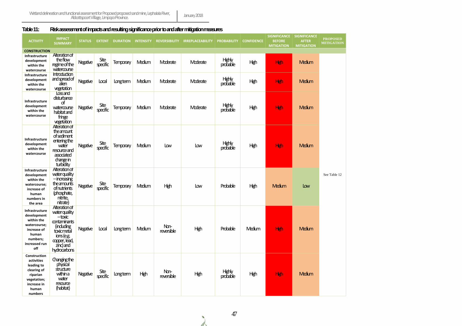
Wetland delineation and functional assessment for Proposed proposed sand mine, Lephalala River, Abbottspoort Village, Limpopo Province. January 2018
47
Table 11: Risk assessment of impacts and resulting significance prior to and after mitigation measures
ACTIVITY IMPACT
SUMMARY STATUS EXTENT DURATION INTENSITY REVERSIBILITY IRREPLACEABILITY PROBABILITY CONFIDENCE
SIGNIFICANCE BEFORE
MITIGATION
SIGNIFICANCE AFTER
MITIGATION
PROPOSED MITIGATION
CONSTRUCTION
Infrastructure development
within the watercourse
Alteration of the flow
regime of the watercourse
Negative Site specific Temporary Medium Moderate Moderate Highly
probable High High Medium
See Table 12
Infrastructure development
within the watercourse
Introduction and spread of
alien vegetation
Negative Local Long term Medium Moderate Moderate Highly probable High High Medium
Infrastructure development
within the watercourse
Loss and disturbance
of watercourse habitat and
fringe vegetation
Negative Site specific Temporary Medium Moderate Moderate Highly
probable High High Medium
Infrastructure development
within the watercourse
Alteration of the amount of sediment entering the
water resource and associated change in turbidity
Negative Site specific Temporary Medium Low Low Highly
probable High High Medium
Infrastructure development
within the watercourse;
increase of human
numbers in the area
Alteration of water quality – increasing the amounts of nutrients (phosphate,
nitrite, nitrate)
Negative Site specific Temporary Medium High Low Probable High Medium Low
Infrastructure development
within the watercourse;
increase of human
numbers; increased run
off
Alteration of water quality
– toxic contaminants
(including toxic metal ions (e.g.
copper, lead, zinc) and
hydrocarbons
Negative Local Long term Medium Non-reversible High Probable Medium High Medium
Construction activities leading to clearing of
riparian vegetation; increase in
human numbers
Changing the physical structure within a water
resource (habitat)
Negative Site specific Long term High Non-
reversible High Highly probable High High Medium
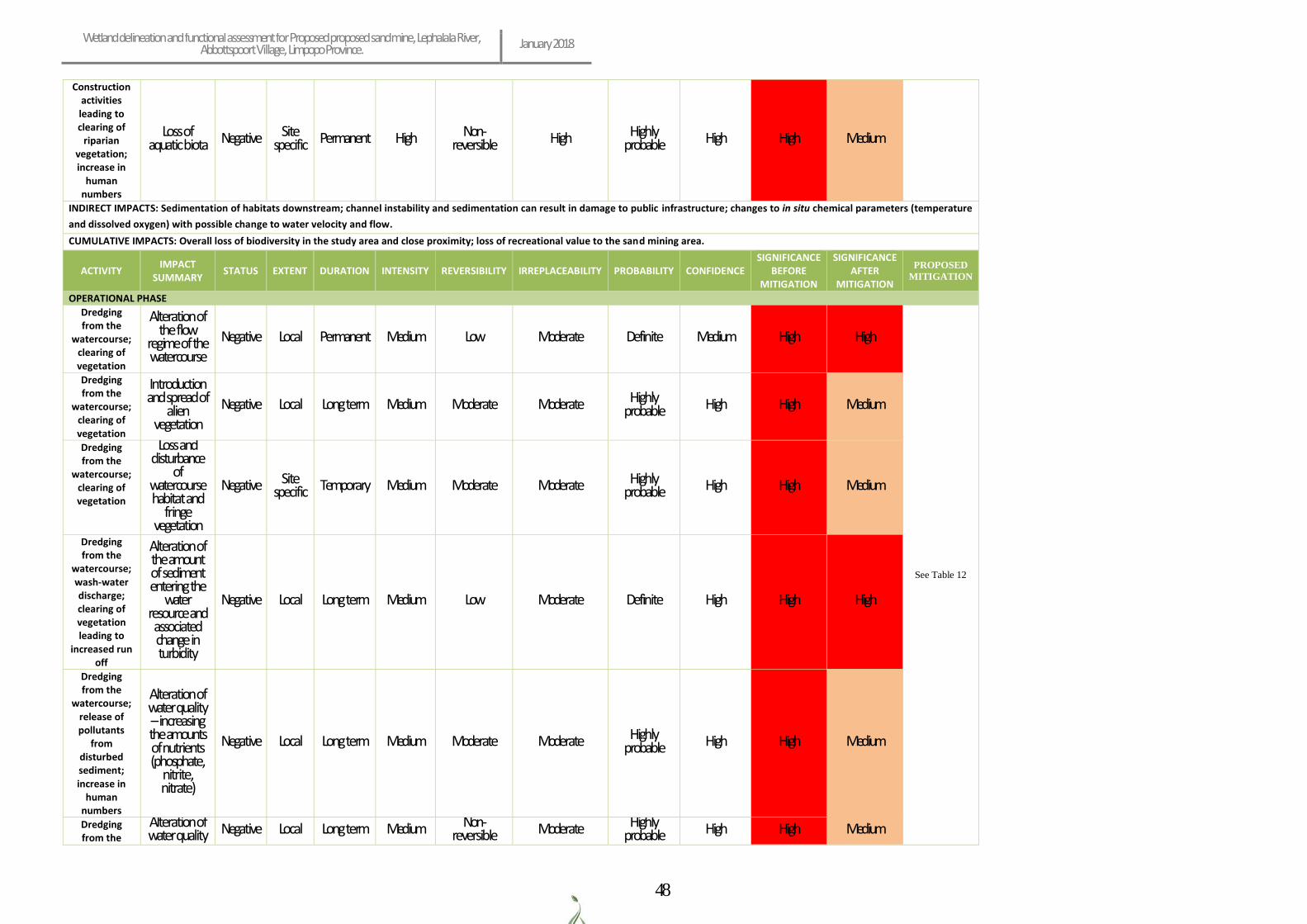
Wetland delineation and functional assessment for Proposed proposed sand mine, Lephalala River, Abbottspoort Village, Limpopo Province. January 2018
48
Construction activities leading to clearing of
riparian vegetation; increase in
human numbers
Loss of aquatic biota Negative Site
specific Permanent High Non-reversible High Highly
probable High High Medium
INDIRECT IMPACTS: Sedimentation of habitats downstream; channel instability and sedimentation can result in damage to public infrastructure; changes to in situ chemical parameters (temperature
and dissolved oxygen) with possible change to water velocity and flow.
CUMULATIVE IMPACTS: Overall loss of biodiversity in the study area and close proximity; loss of recreational value to the sand mining area.
ACTIVITY IMPACT
SUMMARY STATUS EXTENT DURATION INTENSITY REVERSIBILITY IRREPLACEABILITY PROBABILITY CONFIDENCE
SIGNIFICANCE BEFORE
MITIGATION
SIGNIFICANCE AFTER
MITIGATION
PROPOSED MITIGATION
OPERATIONAL PHASE
Dredging from the
watercourse; clearing of vegetation
Alteration of the flow
regime of the watercourse
Negative Local Permanent Medium Low Moderate Definite Medium High High
See Table 12
Dredging from the
watercourse; clearing of vegetation
Introduction and spread of
alien vegetation
Negative Local Long term Medium Moderate Moderate Highly probable High High Medium
Dredging from the
watercourse; clearing of vegetation
Loss and disturbance
of watercourse habitat and
fringe vegetation
Negative Site specific Temporary Medium Moderate Moderate Highly
probable High High Medium
Dredging from the
watercourse; wash-water discharge; clearing of vegetation leading to
increased run off
Alteration of the amount of sediment entering the
water resource and associated change in turbidity
Negative Local Long term Medium Low Moderate Definite High High High
Dredging from the
watercourse; release of pollutants
from disturbed sediment; increase in
human numbers
Alteration of water quality – increasing the amounts of nutrients (phosphate,
nitrite, nitrate)
Negative Local Long term Medium Moderate Moderate Highly probable
High High Medium
Dredging from the
Alteration of water quality Negative Local Long term Medium Non-
reversible Moderate Highly probable High High Medium
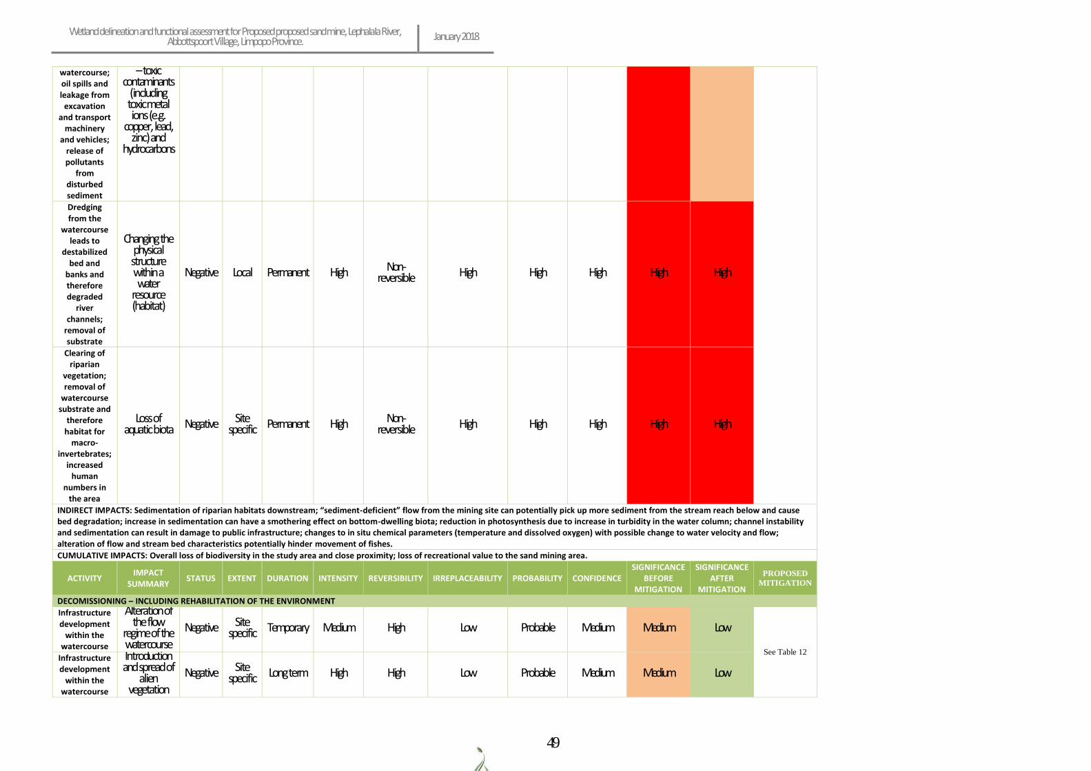
Wetland delineation and functional assessment for Proposed proposed sand mine, Lephalala River, Abbottspoort Village, Limpopo Province. January 2018
49
watercourse; oil spills and leakage from
excavation and transport
machinery and vehicles;
release of pollutants
from disturbed sediment
– toxic contaminants
(including toxic metal ions (e.g.
copper, lead, zinc) and
hydrocarbons
Dredging from the
watercourse leads to
destabilized bed and
banks and therefore degraded
river channels;
removal of substrate
Changing the physical structure within a water
resource (habitat)
Negative Local Permanent High Non-reversible High High High High High
Clearing of riparian
vegetation; removal of
watercourse substrate and
therefore habitat for
macro-invertebrates;
increased human
numbers in the area
Loss of aquatic biota
Negative Site
specific Permanent High Non-reversible High High High High High
INDIRECT IMPACTS: Sedimentation of riparian habitats downstream; “sediment-deficient” flow from the mining site can potentially pick up more sediment from the stream reach below and cause bed degradation; increase in sedimentation can have a smothering effect on bottom-dwelling biota; reduction in photosynthesis due to increase in turbidity in the water column; channel instability and sedimentation can result in damage to public infrastructure; changes to in situ chemical parameters (temperature and dissolved oxygen) with possible change to water velocity and flow; alteration of flow and stream bed characteristics potentially hinder movement of fishes.
CUMULATIVE IMPACTS: Overall loss of biodiversity in the study area and close proximity; loss of recreational value to the sand mining area.
ACTIVITY IMPACT
SUMMARY STATUS EXTENT DURATION INTENSITY REVERSIBILITY IRREPLACEABILITY PROBABILITY CONFIDENCE
SIGNIFICANCE BEFORE
MITIGATION
SIGNIFICANCE AFTER
MITIGATION
PROPOSED MITIGATION
DECOMISSIONING – INCLUDING REHABILITATION OF THE ENVIRONMENT
Infrastructure development
within the watercourse
Alteration of the flow
regime of the watercourse
Negative Site specific Temporary Medium High Low Probable Medium Medium Low
See Table 12 Infrastructure development
within the watercourse
Introduction and spread of
alien vegetation
Negative Site specific Long term High High Low Probable Medium Medium Low
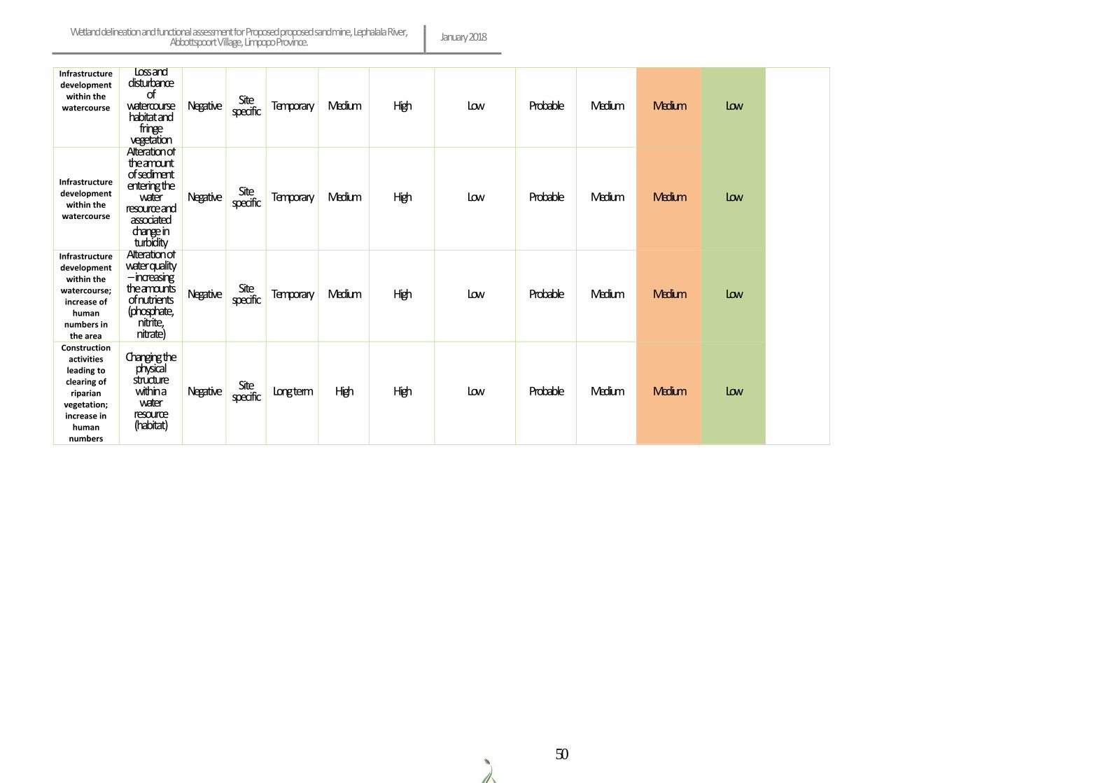
Wetland delineation and functional assessment for Proposed proposed sand mine, Lephalala River, Abbottspoort Village, Limpopo Province. January 2018
50
Infrastructure development
within the watercourse
Loss and disturbance
of watercourse habitat and
fringe vegetation
Negative Site specific Temporary Medium High Low Probable Medium Medium Low
Infrastructure development
within the watercourse
Alteration of the amount of sediment entering the
water resource and associated change in turbidity
Negative Site specific Temporary Medium High Low Probable Medium Medium Low
Infrastructure development
within the watercourse;
increase of human
numbers in the area
Alteration of water quality – increasing the amounts of nutrients (phosphate,
nitrite, nitrate)
Negative Site specific Temporary Medium High Low Probable Medium Medium Low
Construction activities leading to clearing of
riparian vegetation; increase in
human numbers
Changing the physical structure within a water
resource (habitat)
Negative Site specific Long term High High Low Probable Medium Medium Low
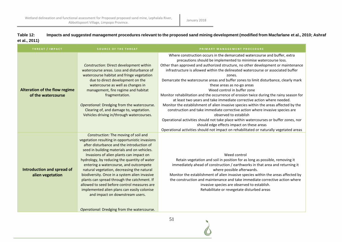
Wetland delineation and functional assessment for Proposed proposed sand mine, Lephalala River, Abbottspoort Village, Limpopo Province. January 2018
51
Table 12: Impacts and suggested management procedures relevant to the proposed sand mining development (modified from Macfarlane et al., 2010; Ashraf et al., 2011)
T H R E A T / I M P A C T S O U R C E O F T H E T H R E A T P R I M A R Y M A N A G E M E N T P R O C E D U R E
Alteration of the flow regime of the watercourse
Construction: Direct development within watercourse areas. Loss and disturbance of watercourse habitat and fringe vegetation
due to direct development on the watercourse as well as changes in
management, fire regime and habitat fragmentation.
Operational: Dredging from the watercourse.
Clearing of, and damage to, vegetation. Vehicles driving in/through watercourses.
Where construction occurs in the demarcated watercourse and buffer, extra precautions should be implemented to minimise watercourse loss.
Other than approved and authorized structure, no other development or maintenance infrastructure is allowed within the delineated watercourse or associated buffer
zones. Demarcate the watercourse areas and buffer zones to limit disturbance, clearly mark
these areas as no-go areas Weed control in buffer zone
Monitor rehabilitation and the occurrence of erosion twice during the rainy season for at least two years and take immediate corrective action where needed.
Monitor the establishment of alien invasive species within the areas affected by the construction and take immediate corrective action where invasive species are
observed to establish Operational activities should not take place within watercourses or buffer zones, nor
should edge effects impact on these areas Operational activities should not impact on rehabilitated or naturally vegetated areas
Introduction and spread of alien vegetation
Construction: The moving of soil and vegetation resulting in opportunistic invasions
after disturbance and the introduction of seed in building materials and on vehicles.
Invasions of alien plants can impact on hydrology, by reducing the quantity of water
entering a watercourse, and outcompete natural vegetation, decreasing the natural
biodiversity. Once in a system alien invasive plants can spread through the catchment. If allowed to seed before control measures are implemented alien plans can easily colonise
and impact on downstream users.
Operational: Dredging from the watercourse.
Weed control Retain vegetation and soil in position for as long as possible, removing it
immediately ahead of construction / earthworks in that area and returning it where possible afterwards.
Monitor the establishment of alien invasive species within the areas affected by the construction and maintenance and take immediate corrective action where
invasive species are observed to establish. Rehabilitate or revegetate disturbed areas
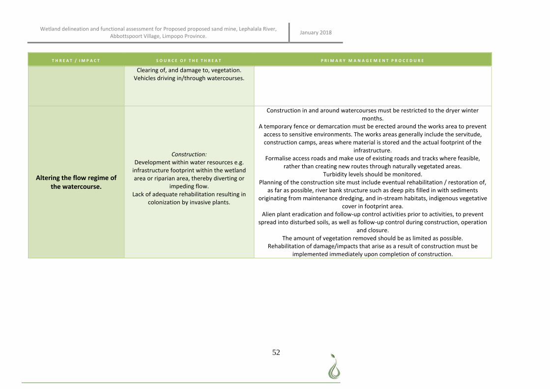
Wetland delineation and functional assessment for Proposed proposed sand mine, Lephalala River, Abbottspoort Village, Limpopo Province. January 2018
52
T H R E A T / I M P A C T S O U R C E O F T H E T H R E A T P R I M A R Y M A N A G E M E N T P R O C E D U R E
Clearing of, and damage to, vegetation. Vehicles driving in/through watercourses.
Altering the flow regime of the watercourse.
Construction: Development within water resources e.g.
infrastructure footprint within the wetland area or riparian area, thereby diverting or
impeding flow. Lack of adequate rehabilitation resulting in
colonization by invasive plants.
Construction in and around watercourses must be restricted to the dryer winter months.
A temporary fence or demarcation must be erected around the works area to prevent access to sensitive environments. The works areas generally include the servitude, construction camps, areas where material is stored and the actual footprint of the
infrastructure. Formalise access roads and make use of existing roads and tracks where feasible,
rather than creating new routes through naturally vegetated areas. Turbidity levels should be monitored.
Planning of the construction site must include eventual rehabilitation / restoration of, as far as possible, river bank structure such as deep pits filled in with sediments
originating from maintenance dredging, and in-stream habitats, indigenous vegetative cover in footprint area.
Alien plant eradication and follow-up control activities prior to activities, to prevent spread into disturbed soils, as well as follow-up control during construction, operation
and closure. The amount of vegetation removed should be as limited as possible.
Rehabilitation of damage/impacts that arise as a result of construction must be implemented immediately upon completion of construction.
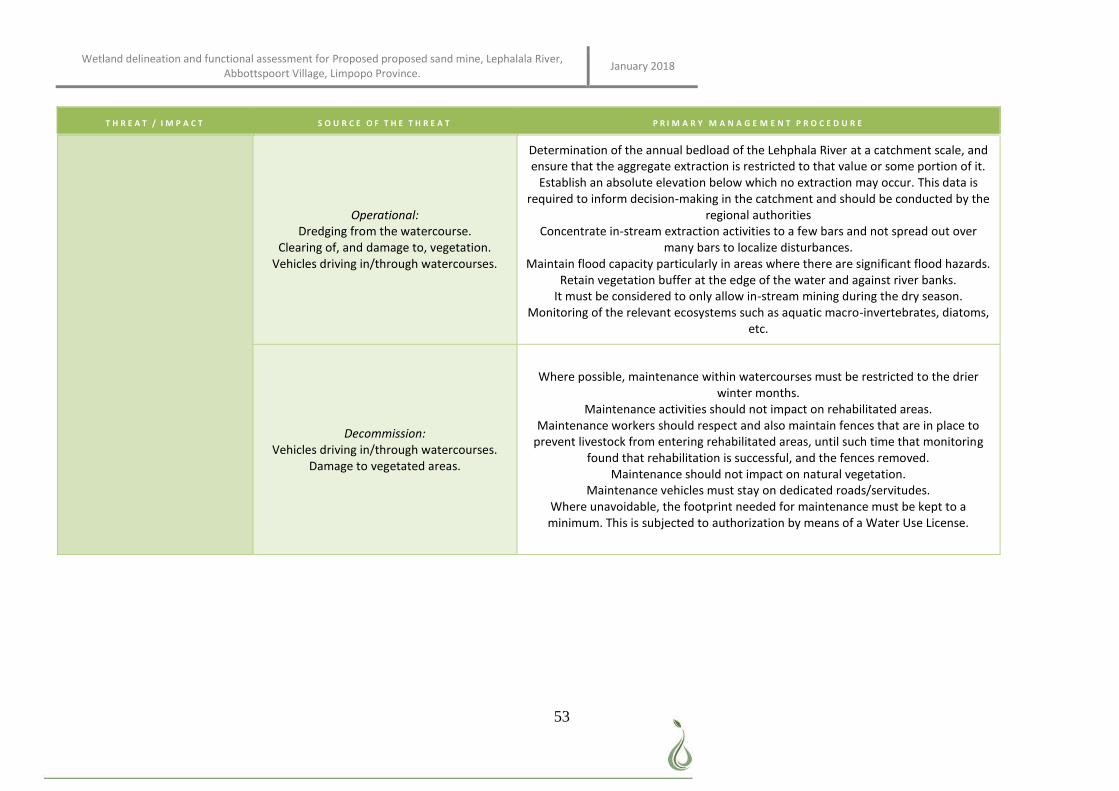
Wetland delineation and functional assessment for Proposed proposed sand mine, Lephalala River, Abbottspoort Village, Limpopo Province. January 2018
53
T H R E A T / I M P A C T S O U R C E O F T H E T H R E A T P R I M A R Y M A N A G E M E N T P R O C E D U R E
Operational: Dredging from the watercourse.
Clearing of, and damage to, vegetation. Vehicles driving in/through watercourses.
Determination of the annual bedload of the Lehphala River at a catchment scale, and ensure that the aggregate extraction is restricted to that value or some portion of it.
Establish an absolute elevation below which no extraction may occur. This data is required to inform decision-making in the catchment and should be conducted by the
regional authorities Concentrate in-stream extraction activities to a few bars and not spread out over
many bars to localize disturbances. Maintain flood capacity particularly in areas where there are significant flood hazards.
Retain vegetation buffer at the edge of the water and against river banks. It must be considered to only allow in-stream mining during the dry season.
Monitoring of the relevant ecosystems such as aquatic macro-invertebrates, diatoms, etc.
Decommission: Vehicles driving in/through watercourses.
Damage to vegetated areas.
Where possible, maintenance within watercourses must be restricted to the drier winter months.
Maintenance activities should not impact on rehabilitated areas. Maintenance workers should respect and also maintain fences that are in place to
prevent livestock from entering rehabilitated areas, until such time that monitoring found that rehabilitation is successful, and the fences removed.
Maintenance should not impact on natural vegetation. Maintenance vehicles must stay on dedicated roads/servitudes.
Where unavoidable, the footprint needed for maintenance must be kept to a minimum. This is subjected to authorization by means of a Water Use License.
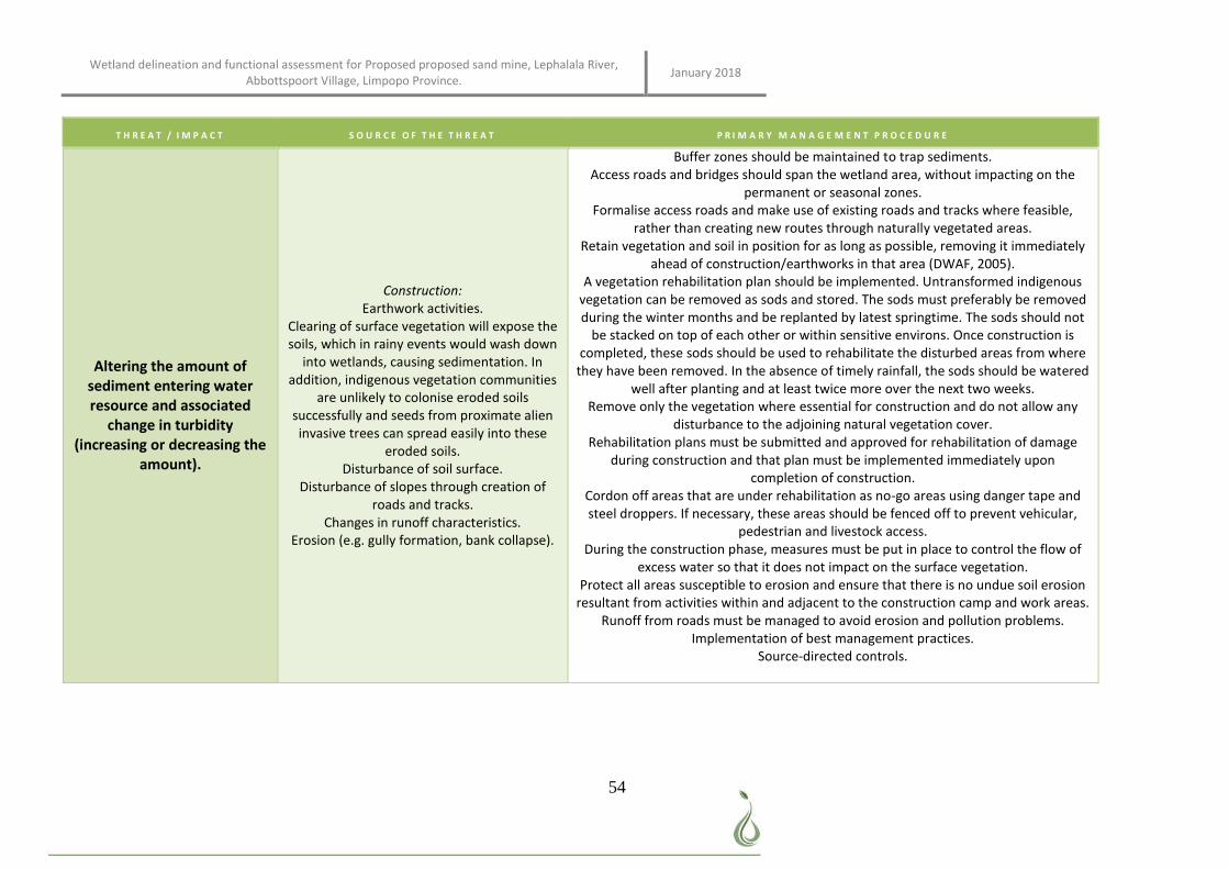
Wetland delineation and functional assessment for Proposed proposed sand mine, Lephalala River, Abbottspoort Village, Limpopo Province. January 2018
54
T H R E A T / I M P A C T S O U R C E O F T H E T H R E A T P R I M A R Y M A N A G E M E N T P R O C E D U R E
Altering the amount of sediment entering water resource and associated
change in turbidity (increasing or decreasing the
amount).
Construction: Earthwork activities.
Clearing of surface vegetation will expose the soils, which in rainy events would wash down
into wetlands, causing sedimentation. In addition, indigenous vegetation communities
are unlikely to colonise eroded soils successfully and seeds from proximate alien invasive trees can spread easily into these
eroded soils. Disturbance of soil surface.
Disturbance of slopes through creation of roads and tracks.
Changes in runoff characteristics. Erosion (e.g. gully formation, bank collapse).
Buffer zones should be maintained to trap sediments. Access roads and bridges should span the wetland area, without impacting on the
permanent or seasonal zones. Formalise access roads and make use of existing roads and tracks where feasible,
rather than creating new routes through naturally vegetated areas. Retain vegetation and soil in position for as long as possible, removing it immediately
ahead of construction/earthworks in that area (DWAF, 2005). A vegetation rehabilitation plan should be implemented. Untransformed indigenous
vegetation can be removed as sods and stored. The sods must preferably be removed during the winter months and be replanted by latest springtime. The sods should not
be stacked on top of each other or within sensitive environs. Once construction is completed, these sods should be used to rehabilitate the disturbed areas from where
they have been removed. In the absence of timely rainfall, the sods should be watered well after planting and at least twice more over the next two weeks.
Remove only the vegetation where essential for construction and do not allow any disturbance to the adjoining natural vegetation cover.
Rehabilitation plans must be submitted and approved for rehabilitation of damage during construction and that plan must be implemented immediately upon
completion of construction. Cordon off areas that are under rehabilitation as no-go areas using danger tape and steel droppers. If necessary, these areas should be fenced off to prevent vehicular,
pedestrian and livestock access. During the construction phase, measures must be put in place to control the flow of
excess water so that it does not impact on the surface vegetation. Protect all areas susceptible to erosion and ensure that there is no undue soil erosion
resultant from activities within and adjacent to the construction camp and work areas. Runoff from roads must be managed to avoid erosion and pollution problems.
Implementation of best management practices. Source-directed controls.
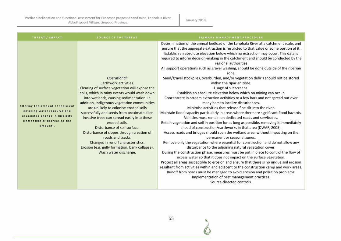
Wetland delineation and functional assessment for Proposed proposed sand mine, Lephalala River, Abbottspoort Village, Limpopo Province. January 2018
55
T H R E A T / I M P A C T S O U R C E O F T H E T H R E A T P R I M A R Y M A N A G E M E N T P R O C E D U R E
A l t e r i n g t h e a m o u n t o f s e d i m e n t
e n t e r i n g w a t e r r e s o u r c e a n d
a s s o c i a t e d c h a n g e i n t u r b i d i t y
( i n c r e a s i n g o r d e c r e a s i n g t h e
a m o u n t ) .
Operational: Earthwork activities.
Clearing of surface vegetation will expose the soils, which in rainy events would wash down
into wetlands, causing sedimentation. In addition, indigenous vegetation communities
are unlikely to colonise eroded soils successfully and seeds from proximate alien invasive trees can spread easily into these
eroded soils. Disturbance of soil surface.
Disturbance of slopes through creation of roads and tracks.
Changes in runoff characteristics. Erosion (e.g. gully formation, bank collapse).
Wash water discharge.
Determination of the annual bedload of the Lehphala River at a catchment scale, and ensure that the aggregate extraction is restricted to that value or some portion of it.
Establish an absolute elevation below which no extraction may occur. This data is required to inform decision-making in the catchment and should be conducted by the
regional authorities All support operations such as gravel washing, should be done outside of the riparian
zone. Sand/gravel stockpiles, overburden, and/or vegetation debris should not be stored
within the riparian zone. Usage of silt screens.
Establish an absolute elevation below which no mining can occur. Concentrate in-stream extraction activities to a few bars and not spread out over
many bars to localize disturbances. Minimise activities that release fine silt into the river.
Maintain flood capacity particularly in areas where there are significant flood hazards. Vehicles must remain on dedicated roads and servitudes.
Retain vegetation and soil in position for as long as possible, removing it immediately ahead of construction/earthworks in that area (DWAF, 2005).
Access roads and bridges should span the wetland area, without impacting on the permanent or seasonal zones.
Remove only the vegetation where essential for construction and do not allow any disturbance to the adjoining natural vegetation cover.
During the construction phase, measures must be put in place to control the flow of excess water so that it does not impact on the surface vegetation.
Protect all areas susceptible to erosion and ensure that there is no undue soil erosion resultant from activities within and adjacent to the construction camp and work areas.
Runoff from roads must be managed to avoid erosion and pollution problems. Implementation of best management practices.
Source-directed controls.
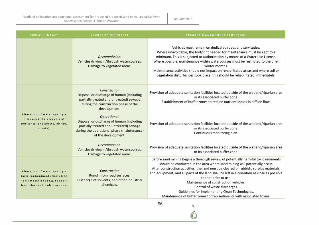
Wetland delineation and functional assessment for Proposed proposed sand mine, Lephalala River, Abbottspoort Village, Limpopo Province. January 2018
56
T H R E A T / I M P A C T S O U R C E O F T H E T H R E A T P R I M A R Y M A N A G E M E N T P R O C E D U R E
Decommission: Vehicles driving in/through watercourses.
Damage to vegetated areas.
Vehicles must remain on dedicated roads and servitudes. Where unavoidable, the footprint needed for maintenance must be kept to a minimum. This is subjected to authorization by means of a Water Use License.
Where possible, maintenance within watercourses must be restricted to the drier winter months.
Maintenance activities should not impact on rehabilitated areas and where soil or vegetation disturbances took place, this should be rehabilitated immediately.
A l t e r a t i o n o f w a t e r q u a l i t y –
i n c r e a s i n g t h e a m o u n t s o f
n u t r i e n t s ( p h o s p h a t e , n i t r i t e ,
n i t r a t e ) .
Construction Disposal or discharge of human (including partially treated and untreated) sewage
during the construction phase of the development.
Provision of adequate sanitation facilities located outside of the wetland/riparian area or its associated buffer zone.
Establishment of buffer zones to reduce nutrient inputs in diffuse flow.
Operational: Disposal or discharge of human (including partially treated and untreated) sewage
during the operational phase (maintenance) of the development.
Provision of adequate sanitation facilities located outside of the wetland/riparian area or its associated buffer zone. Continuous monitoring plan.
Decommission: Vehicles driving in/through watercourses.
Damage to vegetated areas.
Provision of adequate sanitation facilities located outside of the wetland/riparian area or its associated buffer zone.
A l t e r a t i o n o f w a t e r q u a l i t y –
t o x i c c o n t a m i n a n t s ( i n c l u d i n g
t o x i c m e t a l i o n s ( e . g . c o p p e r ,
l e a d , z i n c ) a n d h y d r o c a r b o n s .
Construction Runoff from road surfaces.
Discharge of solvents, and other industrial chemicals.
Before sand mining begins a thorough review of potentially harmful toxic sediments should be conducted in the area where sand mining will potentially occur.
After construction activities, the land must be cleared of rubbish, surplus materials, and equipment, and all parts of the land shall be left in a condition as close as possible
to that prior to use. Maintenance of construction vehicles.
Control of waste discharges. Guidelines for implementing Clean Technologies.
Maintenance of buffer zones to trap sediments with associated toxins.
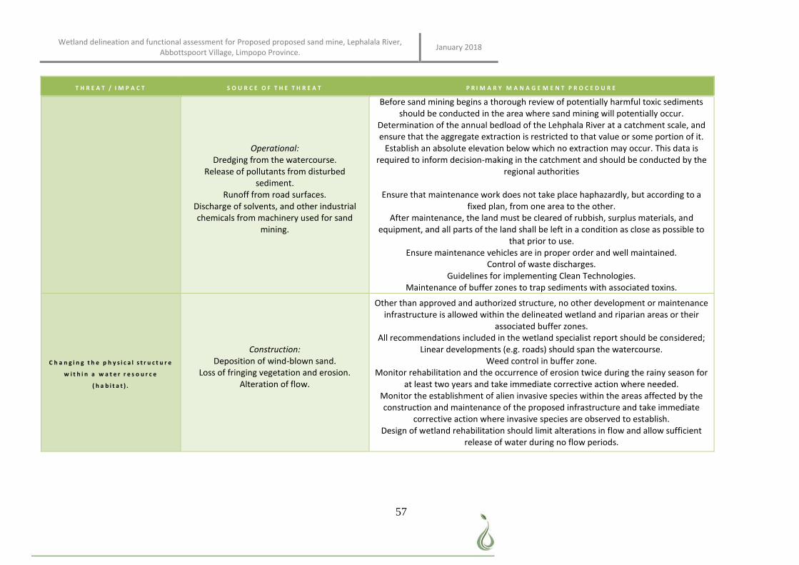
Wetland delineation and functional assessment for Proposed proposed sand mine, Lephalala River, Abbottspoort Village, Limpopo Province. January 2018
57
T H R E A T / I M P A C T S O U R C E O F T H E T H R E A T P R I M A R Y M A N A G E M E N T P R O C E D U R E
Operational: Dredging from the watercourse.
Release of pollutants from disturbed sediment.
Runoff from road surfaces. Discharge of solvents, and other industrial chemicals from machinery used for sand
mining.
Before sand mining begins a thorough review of potentially harmful toxic sediments should be conducted in the area where sand mining will potentially occur.
Determination of the annual bedload of the Lehphala River at a catchment scale, and ensure that the aggregate extraction is restricted to that value or some portion of it.
Establish an absolute elevation below which no extraction may occur. This data is required to inform decision-making in the catchment and should be conducted by the
regional authorities
Ensure that maintenance work does not take place haphazardly, but according to a fixed plan, from one area to the other.
After maintenance, the land must be cleared of rubbish, surplus materials, and equipment, and all parts of the land shall be left in a condition as close as possible to
that prior to use. Ensure maintenance vehicles are in proper order and well maintained.
Control of waste discharges. Guidelines for implementing Clean Technologies.
Maintenance of buffer zones to trap sediments with associated toxins.
C h a n g i n g t h e p h y s i c a l s t r u c t u r e
w i t h i n a w a t e r r e s o u r c e
( h a b i t a t ) .
Construction: Deposition of wind-blown sand.
Loss of fringing vegetation and erosion. Alteration of flow.
Other than approved and authorized structure, no other development or maintenance infrastructure is allowed within the delineated wetland and riparian areas or their
associated buffer zones. All recommendations included in the wetland specialist report should be considered;
Linear developments (e.g. roads) should span the watercourse. Weed control in buffer zone.
Monitor rehabilitation and the occurrence of erosion twice during the rainy season for at least two years and take immediate corrective action where needed.
Monitor the establishment of alien invasive species within the areas affected by the construction and maintenance of the proposed infrastructure and take immediate
corrective action where invasive species are observed to establish. Design of wetland rehabilitation should limit alterations in flow and allow sufficient
release of water during no flow periods.
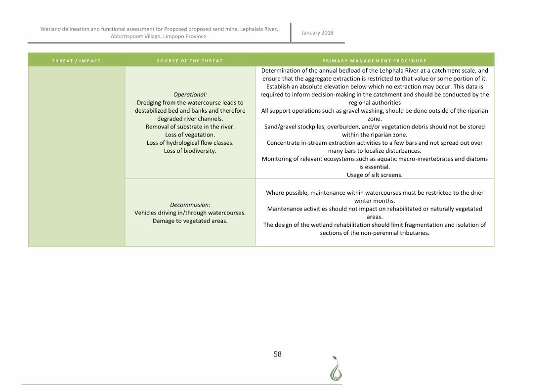
Wetland delineation and functional assessment for Proposed proposed sand mine, Lephalala River, Abbottspoort Village, Limpopo Province. January 2018
58
T H R E A T / I M P A C T S O U R C E O F T H E T H R E A T P R I M A R Y M A N A G E M E N T P R O C E D U R E
Operational: Dredging from the watercourse leads to
destabilized bed and banks and therefore degraded river channels.
Removal of substrate in the river. Loss of vegetation.
Loss of hydrological flow classes. Loss of biodiversity.
Determination of the annual bedload of the Lehphala River at a catchment scale, and ensure that the aggregate extraction is restricted to that value or some portion of it.
Establish an absolute elevation below which no extraction may occur. This data is required to inform decision-making in the catchment and should be conducted by the
regional authorities All support operations such as gravel washing, should be done outside of the riparian
zone. Sand/gravel stockpiles, overburden, and/or vegetation debris should not be stored
within the riparian zone. Concentrate in-stream extraction activities to a few bars and not spread out over
many bars to localize disturbances. Monitoring of relevant ecosystems such as aquatic macro-invertebrates and diatoms
is essential. Usage of silt screens.
Decommission: Vehicles driving in/through watercourses.
Damage to vegetated areas.
Where possible, maintenance within watercourses must be restricted to the drier winter months.
Maintenance activities should not impact on rehabilitated or naturally vegetated areas.
The design of the wetland rehabilitation should limit fragmentation and isolation of sections of the non-perennial tributaries.
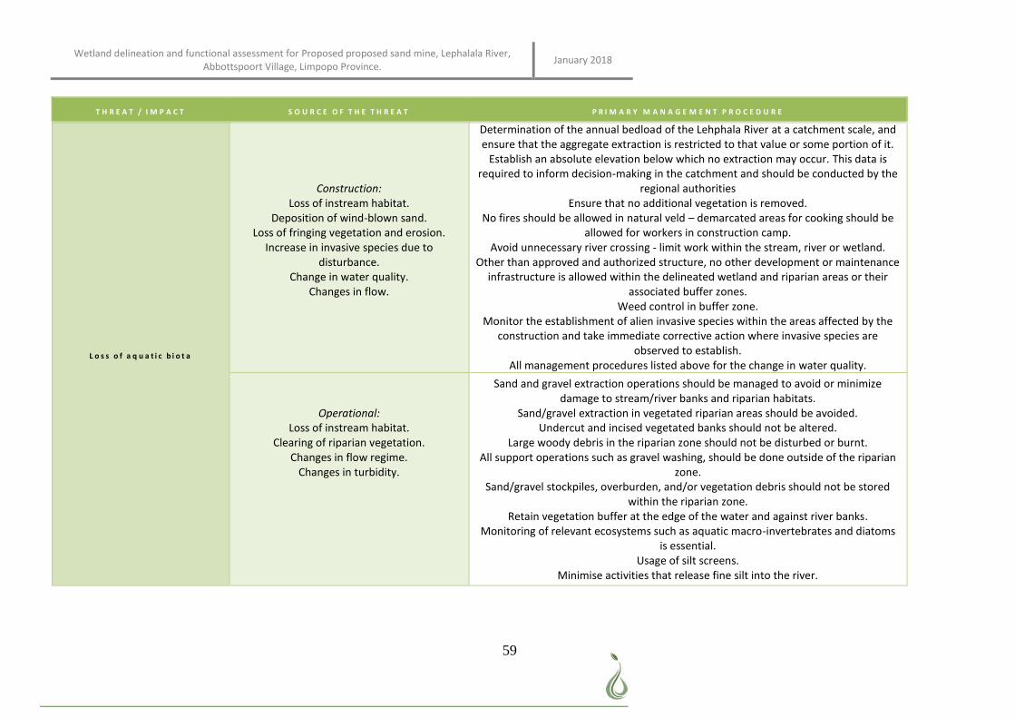
Wetland delineation and functional assessment for Proposed proposed sand mine, Lephalala River, Abbottspoort Village, Limpopo Province. January 2018
59
T H R E A T / I M P A C T S O U R C E O F T H E T H R E A T P R I M A R Y M A N A G E M E N T P R O C E D U R E
L o s s o f a q u a t i c b i o t a
Construction: Loss of instream habitat.
Deposition of wind-blown sand. Loss of fringing vegetation and erosion.
Increase in invasive species due to disturbance.
Change in water quality. Changes in flow.
Determination of the annual bedload of the Lehphala River at a catchment scale, and ensure that the aggregate extraction is restricted to that value or some portion of it.
Establish an absolute elevation below which no extraction may occur. This data is required to inform decision-making in the catchment and should be conducted by the
regional authorities Ensure that no additional vegetation is removed.
No fires should be allowed in natural veld – demarcated areas for cooking should be allowed for workers in construction camp.
Avoid unnecessary river crossing - limit work within the stream, river or wetland. Other than approved and authorized structure, no other development or maintenance
infrastructure is allowed within the delineated wetland and riparian areas or their associated buffer zones.
Weed control in buffer zone. Monitor the establishment of alien invasive species within the areas affected by the
construction and take immediate corrective action where invasive species are observed to establish.
All management procedures listed above for the change in water quality.
Operational: Loss of instream habitat.
Clearing of riparian vegetation. Changes in flow regime.
Changes in turbidity.
Sand and gravel extraction operations should be managed to avoid or minimize damage to stream/river banks and riparian habitats.
Sand/gravel extraction in vegetated riparian areas should be avoided. Undercut and incised vegetated banks should not be altered.
Large woody debris in the riparian zone should not be disturbed or burnt. All support operations such as gravel washing, should be done outside of the riparian
zone. Sand/gravel stockpiles, overburden, and/or vegetation debris should not be stored
within the riparian zone. Retain vegetation buffer at the edge of the water and against river banks.
Monitoring of relevant ecosystems such as aquatic macro-invertebrates and diatoms is essential.
Usage of silt screens. Minimise activities that release fine silt into the river.
Wetland delineation and functional assessment for Proposed proposed sand mine, Lephalala River, Abbottspoort Village, Limpopo Province. January 2018
60
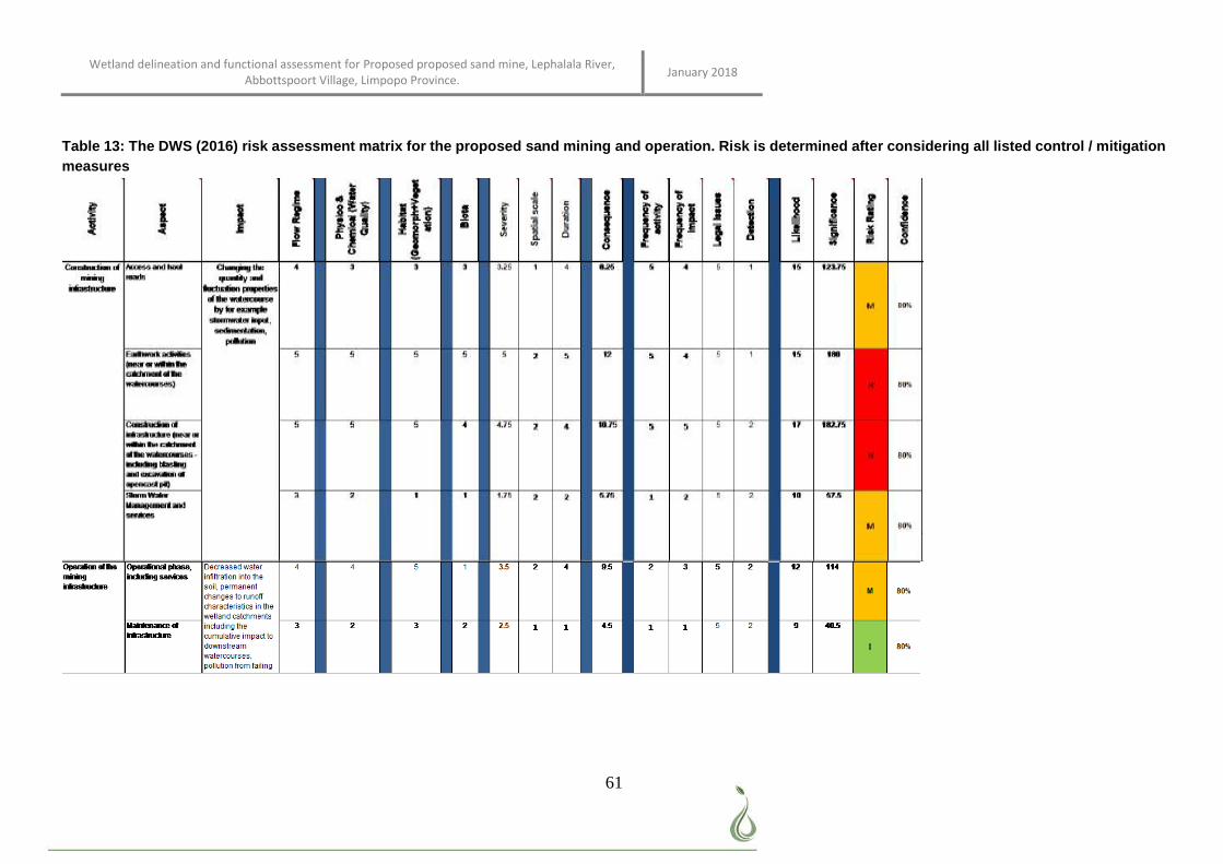
Wetland delineation and functional assessment for Proposed proposed sand mine, Lephalala River, Abbottspoort Village, Limpopo Province. January 2018
61
Table 13: The DWS (2016) risk assessment matrix for the proposed sand mining and operation. Risk is determined after considering all listed control / mitigation measures
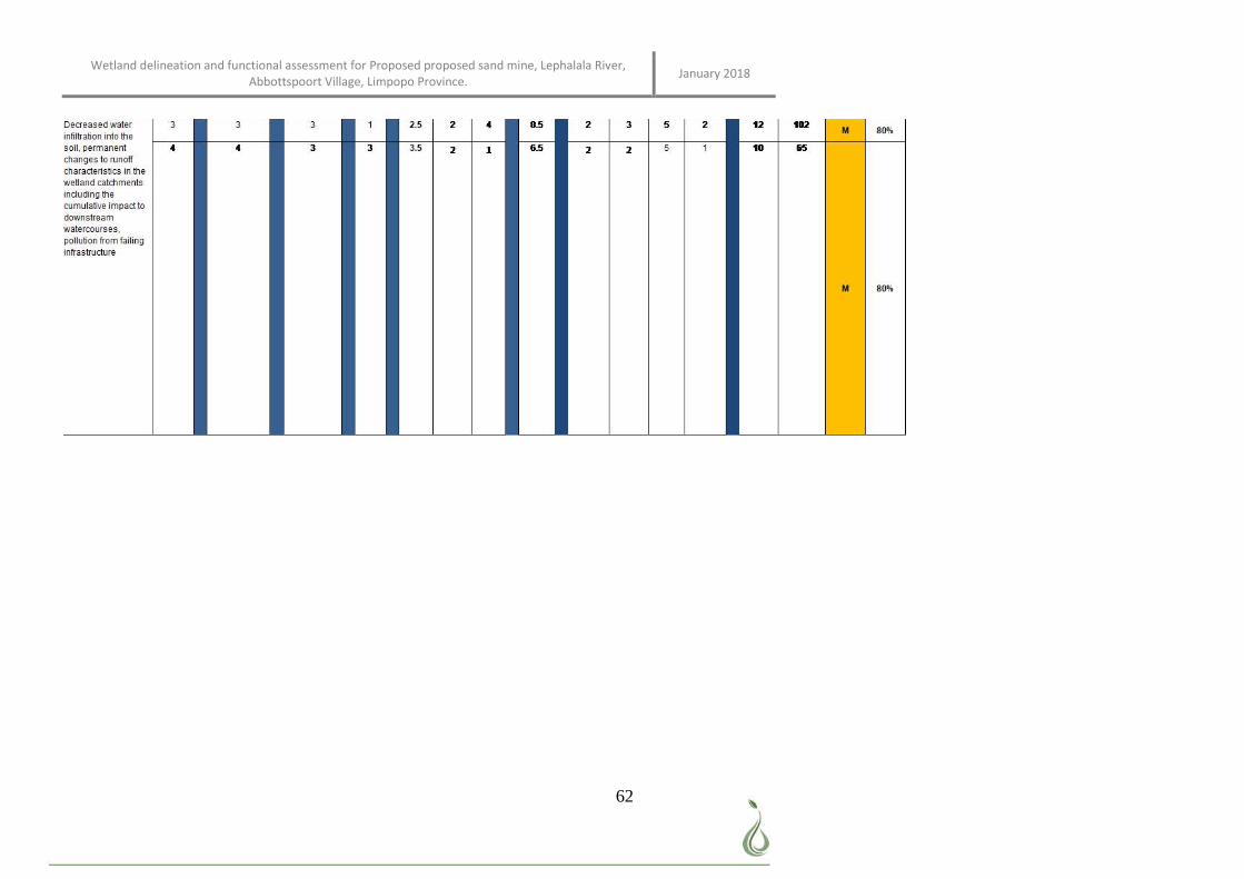
Wetland delineation and functional assessment for Proposed proposed sand mine, Lephalala River, Abbottspoort Village, Limpopo Province. January 2018
62
Wetland delineation and functional assessment for Proposed proposed sand mine, Lephalala River, Abbottspoort Village, Limpopo Province. January 2018
63
3.5.2 Monitoring Requirements
In order to ensure that the wetland achieves the REC score, monitoring of site conditions during the
construction, rehabilitation and operational phases of the mining activities is required. The following
monitoring schedule is proposed:
1. Monitoring during construction: during construction, the mitigation measures put in place to limit or
negate the construction related impacts on a watercourse must be monitored. Where these
mitigation measures are not sufficient or breached, immediate corrective action should be taken.
2. Monitoring post construction phase: it is assumed that the construction will be phased and that
rehabilitation is thus an ongoing effort as each phase is completed. For example, once a section has
been mined and rehabilitated. Monitoring post construction is important to detect any erosion,
sedimentation or faulty structures. As each phase is completed the area is monitored for impacts and
corrective action taken where needed.
3. Seasonal monitoring: after construction is complete, rehabilitation success, as well as signs of
erosion, sedimentation and the presence of alien vegetation should be monitored twice during the
summer months: once at the start and once at the end of the rainy season. This should be continued
for at least three years after construction was completed.
4. Rapid monitoring: For the first two years, monitoring should take place immediately after heavy
rainfall to ensure that rehabilitated areas are intact and that no erosion and subsequent
sedimentation took place.
5. Annual monitoring: after three years, provided that all rehabilitation where found to be successful
and no additional problems arose, monitoring can take place once a year after the first seasonal
rainfall.
Problems such as failed sedimentation and erosion should be remediated as soon as it is recorded in the
monitoring process. Corrective action should be taken and can include the re-initiation of rehabilitation in
severe cases or by correction of the problem (e.g. mend broken fences).
It is recommended that fixed point photography is used to monitor vegetation and soil stability. This involves
taking pictures of the areas monitored from the same point during each monitoring event. The images can
be compared and serves as a record of the success of rehabilitation or the failure thereof
4 CONCLUSION
The study site is located directly within a section of the perennial riparian river known as the Lephalala River.
Although facilities (i.e. office and storage area) are not encroaching on the watercourse, they are in the
Exclusion Area determined from the Floodline Study and the recommendation is being applied to move the
100mx150m facility block approx 250m northwards to be outside Exclusion Zone. Several drainage areas
drain into this river from the surrounding residential area. The proposed storage and offices are located on
an open area and do not encroach onto any nearby watercourse or buffer. It is important that existing roads
be used to travel from the storage and office areas to the mining area and that no thoroughfare be used that
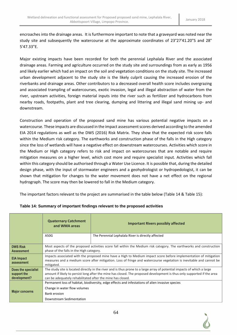
Wetland delineation and functional assessment for Proposed proposed sand mine, Lephalala River, Abbottspoort Village, Limpopo Province. January 2018
64
encroaches into the drainage areas. It is furthermore important to note that a graveyard was noted near the
study site and subsequently the watercourse at the approximate coordinates of 23°27'41.20"S and 28°
5'47.33"E.
Major existing impacts have been recorded for both the perennial Lephalala River and the associated
drainage areas. Farming and agriculture occurred on the study site and surroundings from as early as 1956
and likely earlier which had an impact on the soil and vegetation conditions on the study site. The increased
urban development adjacent to the study site is the likely culprit causing the increased erosion of the
riverbanks and drainage areas. Other contributors to a decreased overall health score includes overgrazing
and associated trampling of watercourses, exotic invasion, legal and illegal abstraction of water from the
river, upstream activities, foreign material inputs into the river such as fertilizer and hydrocarbons from
nearby roads, footpaths, plant and tree clearing, dumping and littering and illegal sand mining up- and
downstream.
Construction and operation of the proposed sand mine has various potential negative impacts on a
watercourse. These impacts are discussed in the impact assessment scores derived according to the amended
EIA 2014 regulations as well as the DWS (2016) Risk Matrix. They show that the expected risk score falls
within the Medium risk category. The earthworks and construction phase of the falls in the High category
since the loss of wetlands will have a negative effect on downstream watercourses. Activities which score in
the Medium or High category refers to risk and impact on watercourses that are notable and require
mitigation measures on a higher level, which cost more and require specialist input. Activities which fall
within this category should be authorised through a Water Use Licence. It is possible that, during the detailed
design phase, with the input of stormwater engineers and a geohydrologist or hydropedologist, it can be
shown that mitigation for changes to the water movement does not have a net effect on the regional
hydrograph. The score may then be lowered to fall in the Medium category.
The important factors relevant to the project are summarised in the table below (Table 14 & Table 15):
Table 14: Summary of important findings relevant to the proposed activities
Quaternary Catchment
and WMA areas Important Rivers possibly affected
A50G
The Perennial Lephalala River is directly affected
DWS Risk Assessment
Most aspects of the proposed activities score fall within the Medium risk category. The earthworks and construction phase of the falls in the High category.
EIA Impact assessment
Impacts associated with the proposed mine have a High to Medium impact score before implementation of mitigation measures and a medium score after mitigation. Loss of fringe and watercourse vegetation is inevitable and cannot be mitigated.
Does the specialist support the development?
The study site is located directly in the river and is thus prone to a large array of potential impacts of which a large amount if likely to persist long after the mine has closed. The proposed development is thus only supported if the area can be adequately rehabilitated after the mine has closed.
Major concerns
Permanent loss of habitat, biodiversity, edge effects and infestations of alien invasive species
Change in water flow volumes
Bank erosion
Downstream Sedimentation
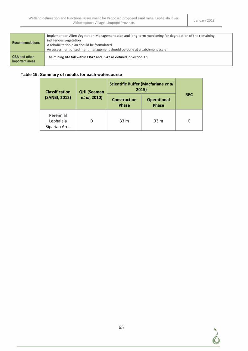
Wetland delineation and functional assessment for Proposed proposed sand mine, Lephalala River, Abbottspoort Village, Limpopo Province. January 2018
65
Table 15: Summary of results for each watercourse
Classification (SANBI, 2013)
QHI (Seaman et al, 2010)
Scientific Buffer (Macfarlane et al 2015)
REC Construction
Phase Operational
Phase
Perennial Lephalala
Riparian Area D 33 m 33 m C
Recommendations
Implement an Alien Vegetation Management plan and long-term monitoring for degradation of the remaining indigenous vegetation A rehabilitation plan should be formulated An assessment of sediment management should be done at a catchment scale
CBA and other Important areas
The mining site fall within CBA2 and ESA2 as defined in Section 1.5
Wetland delineation and functional assessment for Proposed proposed sand mine, Lephalala River, Abbottspoort Village, Limpopo Province. January 2018
66
REFERENCES
Department of Water Affairs and Forestry, (2005): Environmental Best Practice Specifications: Construction
for Construction Sites, Infrastructure Upgrades and Maintenance Works. Version 3
Department of Water Affairs (2008): Updated Manual for the Identification and Delineation of Wetlands and
Riparian areas.
Department of Water Affairs (2010). National Water Act, 1998 (Act No 36 of 1998) S21(c) & (i) Water Uses.
Version: February 2010. Training Manual.
Gauteng Department of Agriculture Conservation & Environment (2002). Gauteng Agricultural Potential
Atlas. Johannesburg
Gauteng Department of Agriculture, Conservation & Environment (2014) GDARD Minimum Requirements for
Biodiversity Assessments Version 3. Directorate Nature Conservation, Johannesburg.
Gauteng Department of Agriculture and Rural Development, (2011): Gauteng Conservation Plan Version 3
ArcGIS Spatial data
Gauteng Department of Agriculture and Rural Development (2012). Approval of the Environmental
Management Plan (EMP) for Project Reference GAUT: 002/456: Proposed Development of a Filling
Station on Portion 125 (a Portion of Portion 1) of the Farm Leeuwpoort 113 IR, Boksburg, Gauteng.
Kleynhans, C.J. (1999): A procedure for the determination of the for the determination of the ecological
reserve for the purpose of the national water balance model for South African Rivers. Institute for Water
Quality Studies Department of Water Affairs and Forestry, Pretoria.
Kleynhans C.J., MacKenzie J. and Louw M.D. (2007). Module F: Riparian Vegetation Response Assessment
Index in River Classification: Manual for EcoStatus Determination (version 2). Joint Water Research
Commission and Department of Water Affairs and Forrestry report. WRC Report No. TT 333/08
Kotze D C, (1999): A system for supporting wetland management decisions. Ph.D. thesis. School of Applied
Environmental Sciences, University of Natal, Pietermaritzburg.
Macfarlane D.M., Kotze D.C., Ellery W.N., Walters D, Koopman V, Goodman P and Goge C. (2008). WET-
Health: A technique for rapidly assessing wetland health. Water Research Commission, Pretoria. WRC
Rport TT340/08 February 2008
Macfarlane D.M., Teixeira-Leite A., Goodman P., Bate G and Colvin C. (2010) Draft Report on the
Development of a Method and Model for Buffer Zone Determination. Water Research Commission
project K5/1789. The Institute of Natural Resources and its Associates
Mucina L., & Rutherford M. C. (2006). Vegetation Map of South Africa, Lesotho and Swaziland, 1:1 000 000
scale sheet maps. South African National Biodiversity Institute., Pretoria.
Schultze R.E. (1997). South African Atlas of Agrohydrology and Climatology. Water Research Commission,
Pretoria, Report TT82/96
Wetland delineation and functional assessment for Proposed proposed sand mine, Lephalala River, Abbottspoort Village, Limpopo Province. January 2018
67
APPENDIX A: Abbreviated CVs of participating specialists
Name: ANTOINETTE BOOTSMA nee van Wyk
ID Number 7604250013088
Name of Firm: Limosella Consulting
SACNASP Status: Professional Natural Scientist # 400222-09 Botany and Ecology
EDUCATIONAL QUALIFICATIONS
MSc Ecology, University of South Africa (2017) Awarded with distinction. Project Title: Natural
mechanisms of erosion prevention and stabilization in a Marakele peatland; implications for
conservation management
Short course in wetland soils, Terrasoil Science (2009)
Short course in wetland delineation, legislation and rehabilitation, University of Pretoria (2007)
B. Sc (Hons) Botany, University of Pretoria (2003-2005). Project Title: A phytosociological
Assessment of the Wetland Pans of Lake Chrissie
B. Sc (Botany & Zoology), University of South Africa (1997 - 2001)
PUBLICATIONS
A.A. Boostma, S. Elshehawi, A.P. Grootjans, P.L Grundling, S. Khosa. In Press. Ecohydrological
analysis of the Matlabas Mountain mire, South Africa. Mires and Peat
P.L. Grundling, A Lindstrom., M.L. Pretorius, A. Bootsma, N. Job, L. Delport, S. Elshahawi, A.P
Grootjans, A. Grundling, S. Mitchell. 2015. Investigation of Peatland Characteristics and
Processes as well as Understanding of their Contribution to the South African Wetland Ecological
Infrastructure Water Research Comission KSA 2: K5/2346
A.P. Grootjans, A.J.M Jansen , A, Snijdewind, P.C. de Hullu, H. Joosten, A. Bootsma and P.L.
Grundling. (2014). In search of spring mires in Namibia: the Waterberg area revisited. Mires and
Peat. Volume 15, Article 10, 1–11, http://www.mires-and-peat.net/, ISSN 1819-754X © 2015
International Mire Conservation Group and International Peat Society
Haagner, A.S.H., van Wyk, A.A. & Wassenaar, T.D. 2006. The biodiversity of herpetofauna of the
Richards Bay Minerals leases. CERU Technical Report 32. University of Pretoria.
van Wyk, A.A., Wassenaar, T.D. 2006. The biodiversity of epiphytic plants of the Richards Bay
Minerals leases. CERU Technical Report 33. University of Pretoria.
Wassenaar, T.D., van Wyk, A.A., Haagner, A.S.H, & van Aarde, R.J.H. 2006. Report on an
Ecological Baseline Survey of Zulti South Lease for Richards Bay Minerals. CERU Technical
Report 29. University of Pretoria
Wetland delineation and functional assessment for Proposed proposed sand mine, Lephalala River, Abbottspoort Village, Limpopo Province. January 2018
68
KEY EXPERIENCE The following projects provide an example of the application of wetland ecology on strategic as well as fine
scale as well as its implementation into policies and guidelines. (This is not a complete list of projects
completed, rather an extract to illustrate diversity);
More than 90 external peer reviews as part of mentorship programs for companies including Gibb,
Galago Environmental Consultants, Lidwala Consulting Engineers, Bokamoso Environmental
Consultants, 2009 ongoing
More than 300 fine scale wetland and ecological assessments in Gauteng, Mpumalanga, KwaZulu
Natal, Limpopo and the Western Cape 2007, ongoing
Strategic wetland specialist input into the Open Space Management Framework for Kyalami and
Ruimsig, City of Johannesburg, 2016
Fine scale wetland specialist input into the ESKOM Bravo Integration Project 3, 4, 5 and Kyalami –
Midrand Strengthening.
Wetland/Riparian delineation and functional assessment for the proposed maintenance work of the
rand water pipelines and valve chambers exposed due to erosion in Casteel A, B and C in
Bushbuckridge Mpumalanga Province
Wetland/Riparian delineation and functional assessment for the Proposed Citrus Orchard
Establishment, South of Burgersfort (Limpopo Province) and North of Lydenburg (Mpumalanga
Province).
Scoping level assessment to inform a proposed railway line between Swaziland and Richards Bay.
April 2013.
Environmental Control Officer. Management of onsite audit of compliance during the construction
of a pedestrian bridge in Zola Park, Soweto, Phase 1 and Phase 2. Commenced in 2010, ongoing.
Fine scale wetland delineation and functional assessments in Lesotho and Kenya. 2008 and 2009;
Analysis of wetland/riparian conditions potentially affected by 14 powerline rebuilds in Midrand,
Gauteng, as well submission of a General Rehabilitation and Monitoring Plan. May 2013.
Wetland specialist input into the Environmental Management Plan for the upgrade of the Firgrove
Substation, Western Cape. April 2013
An audit of the wetlands in the City of Johannesburg. Specialist studies as well as project
management and integration of independent datasets into a final report. Commenced in August
2007
Input into the wetland component of the Green Star SA rating system. April 2009;
A strategic assessment of wetlands in Gauteng to inform the GDACE Regional Environmental
Management Framework. June 2008.
As assessment of wetlands in southern Mozambique. This involved a detailed analysis of the
vegetation composition and sensitivity associated with wetlands and swamp forest in order to inform
the development layout of a proposed resort. May 2008.
Wetland delineation and functional assessment for Proposed proposed sand mine, Lephalala River, Abbottspoort Village, Limpopo Province. January 2018
69
An assessment of three wetlands in the Highlands of Lesotho. This involved a detailed assessment
of the value of the study sites in terms of functionality and rehabilitation opportunities. Integration of
the specialist reports socio economic, aquatic, terrestrial and wetland ecology studies into a final
synthesis. May 2007.
Ecological studies on a strategic scale to inform an Environmental Management Framework for the
Emakazeni Municipality and an Integrated Environmental Management Program for the Emalahleni
Municipality. May and June 2007
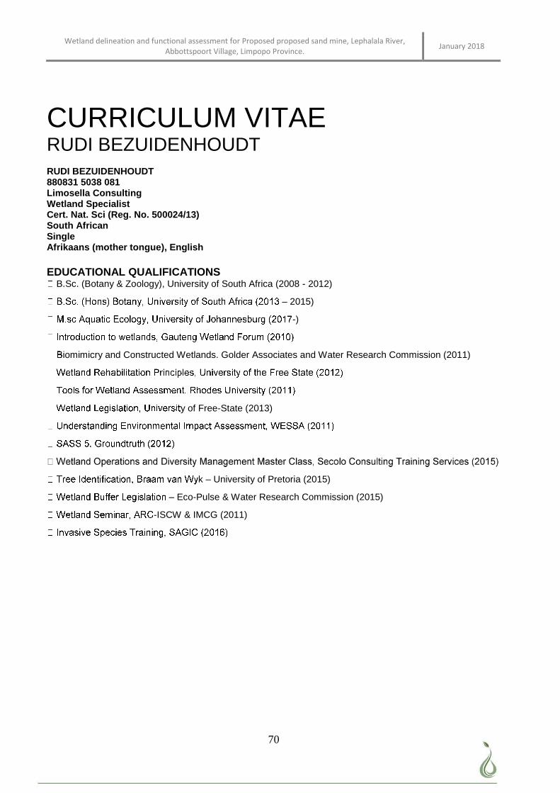
Wetland delineation and functional assessment for Proposed proposed sand mine, Lephalala River, Abbottspoort Village, Limpopo Province. January 2018
70
CURRICULUM VITAE RUDI BEZUIDENHOUDT RUDI BEZUIDENHOUDT 880831 5038 081 Limosella Consulting Wetland Specialist Cert. Nat. Sci (Reg. No. 500024/13) South African Single Afrikaans (mother tongue), English EDUCATIONAL QUALIFICATIONS
B.Sc. (Botany & Zoology), University of South Africa (2008 - 2012)
– 2015)
-)
iomimicry and Constructed Wetlands. Golder Associates and Water Research Commission (2011)
y of Free-State (2013)
k – University of Pretoria (2015)
– Eco-Pulse & Water Research Commission (2015)
-ISCW & IMCG (2011)
Wetland delineation and functional assessment for Proposed proposed sand mine, Lephalala River, Abbottspoort Village, Limpopo Province. January 2018
71
KEY EXPERIENCE WETLAND SPECIALIST This entails all aspects of scientific investigation associated with a consultancy that focuses on wetland specialist investigations. This includes the following: Approximately 200+ specialist investigations into wetland and riparian conditions on strategic, as well as fine scale levels in Gauteng, Limpopo, North-West Province Mpumalanga KwaZulu Natal, North-West Province, Western Cape, Eastern Cape & Northern Cape
Ensuring the scientific integrity of wetland reports including peer review and publications. Major Projects Involve:
evelopments BIODIVERSITY ACTION PLAN This entails the gathering of data and compiling of a Biodiversity action plan. WETLAND REHABILITATION This entailed the management of wetland vegetation and rehabilitation related projects in terms of developing proposals, project management, technical investigation and quality control. COURSES PRESENTED
WETLAND ECOLOGY Experience in the delineation and functional assessment of wetlands and riparian areas in order to advise proposed development layouts, project management, report writing and quality control. ENVIRONMENTAL CONTROL OFFICER: Routine inspection of construction sites to ensure compliance with the City’s environmental ordinances, the Environmental Management Program and other laws and by-laws associated with development at or near wetland or riparian areas. Soweto Zola Park 2011-2013
Orange Farm Pipeline 2010-2011 WETLAND AUDIT: Audit of Eskom Kusile power station to comply with the Kusile Section 21G Water Use Licence (Department of Water Affairs, Licence No. 04/B20F/BCFGIJ/41, 2011), the amended Water Use Licence (Department of water affairs and forestry, Ref. 27/2/2/B620/101/8, 2009) and the WUL checklist provided by Eskom. Kusile Powerstation 2012-2013. INVASIVE SPECIES CONTROL PLAN Libradene Filling Station, Boksburg, Gauteng PUBLICATIONS Bezuidenhoudt. R., De Klerk. A. R., Oberholster. P.J. (2017). Assessing the ecosystem processes of ecological infrastructure on post-coal mined land. COALTECH RESEARCH ASSOCIATION NPC. University of South Africa. Council for Scientific Industrial Research.
Wetland delineation and functional assessment for Proposed proposed sand mine, Lephalala River, Abbottspoort Village, Limpopo Province. January 2018
72
Employee Experience: GIS Specialist – AfriGIS January 2008 – August 2010 Tasks include:
Wetland Specialist - Limosella Consulting September 2010 – Ongoing Tasks include:
ollection and analysis.
Planning and executing of fieldwork.
MEMBERSHIPS IN SOCIETIES
Wetland delineation and functional assessment for Proposed proposed sand mine, Lephalala River, Abbottspoort Village, Limpopo Province. January 2018
73
APPENDIX B: GLOSSARY OF TERMS
Buffer A strip of land surrounding a wetland or riparian area in which activities are
controlled or restricted, in order to reduce the impact of adjacent land uses on the wetland or riparian area
Hydrophyte any plant that grows in water or on a substratum that is at least periodically deficient in oxygen as a result of soil saturation or flooding; plants typically found in wet habitats
Hydromorphic soil
soil that in its undrained condition is saturated or flooded long enough during the growing season to develop anaerobic conditions favouring the growth and regeneration of hydrophytic vegetation (vegetation adapted to living in anaerobic soils)
Seepage A type of wetland occurring on slopes, usually characterised by diffuse (i.e. unchannelled, and often subsurface) flows
Sedges Grass-like plants belonging to the family Cyperaceae, sometimes referred to as nutgrasses. Papyrus is a member of this family.
Soil profile the vertically sectioned sample through the soil mantle, usually consisting of two or three horizons (Soil Classification Working Group, 1991)
Wetland: “land which is transitional between terrestrial and aquatic systems where the water table is usually at or near the surface, or the land is periodically covered with shallow water, and which land in normal circumstances supports or would support vegetation typically adapted to life in saturated soil.” (National Water Act; Act 36 of 1998).
Wetland delineation
the determination and marking of the boundary of a wetland on a map using the DWAF (2005) methodology. This assessment includes identification of suggested buffer zones and is usually done in conjunction with a wetland functional assessment. The impact of the proposed development, together with appropriate mitigation measures are included in impact assessment tables
Wetland delineation and functional assessment for Proposed proposed sand mine, Lephalala River, Abbottspoort Village, Limpopo Province. January 2018
74
Leopard Court Building, 1st Floor, South Wing 56 Jerome Street, Lynnwood Glen, Pretoria, South Africa Tel: +27 (0) 12 348 1114 Fax: +27 (0) 12 348 1180 Web: www.gcs-sa.biz
GCS (Pty) Ltd. Reg No: 2004/000765/07 Est. 1987
Offices: Durban Gaborone Johannesburg Lusaka Maseru Ostrava Pretoria Windhoek
Directors: AC Johnstone (Managing) PF Labuschagne AWC Marais S Napier W Sherriff (Financial)
Non-Executive Director: B Wilson-Jones
www.gcs-sa.biz
Flood Line Determination for Ga Re Lekeng Gape Construction Enterprise
Report
Prepared as input to a Basic Assessment for a proposed sand mining
project on the Lephalala River
Version – 3 (Final)
14 February 2018
Prepared for:
Iggdrasil Scientific Services (Pty) Ltd
GCS Project Number: 18-0027
Client Reference: GCS Flood Line
Iggdrasil Scientific Services (Pty) Ltd Flood Line Determination
18-0027 14 February 2018 Page ii
Report Version – 3 (Final)
14 February 2018
Prepared for: Iggdrasil Scientific Services (Pty) Ltd
18-0027
DOCUMENT ISSUE STATUS
Report Issue Version – 3 (Final)
GCS Reference Number GCS Ref - 18-0027
Client Reference GCS Flood Line
Title Flood Line Determination for Ga Re Lekeng Gape Construction Enterprise
Name Signature Date
Author Robert Verger
14th of February 2018
Director Alkie Marais
14th of February 2018
LEGAL NOTICE This report or any portion thereof and any associated documentation remain the property of GCS until the mandator effects payment of all fees and disbursements due to GCS in terms of the GCS Conditions of Contract and Project Acceptance Form. Notwithstanding the aforesaid, any reproduction, duplication, copying, adaptation, editing, change, disclosure, publication, distribution, incorporation, modification, lending, transfer, sending, delivering, serving or broadcasting must be authorised in writing by GCS.
Iggdrasil Scientific Services (Pty) Ltd Flood Line Determination
18-0027 14 February 2018 Page iii
LIST OF ACRONYMS
ALOS Advanced Land Observing Satellite
DEA Department of Environmental Affairs
DWS Department of Water and Sanitation
EV1 Extreme Value (Type 1) Gumbel distribution
GN704 General Notice 704
JAXA Japan Aerospace Exploration Agency
LN Lognormal distribution
LP3 Log Pearson 3 distribution
mamsl Metres above mean sea level
MIPI Midgley and Pitman
MAP Mean Annual Precipitation
NWA National Water Act 36 of 1998
SDF Standard Design Flood
UHM Unit Hydrograph Method
UPD Utility Programmes for Drainage
WMA Water Management Area
WUL Water Use License
Iggdrasil Scientific Services (Pty) Ltd Flood Line Determination
18-0027 14 February 2018 Page iv
LIST OF DEFINITIONS
Term Definition
Catchment A catchment defines an area from which water will naturally drain to a defined point.
Exclusion Zone
An exclusion zone defines an area where certain activities are restricted to limit the potential impact of an activity on an entity that needs to be protected. The exclusion zone would reduce the likelihood that certain activities could potentially pollute the water resource.
Flooding Flooding is a result of heavy or continuous rainfall exceeding the absorptive capacity of soil and the flow capacity of rivers and streams.
Hydrograph A description of streamflow or stage versus time, with the flow on the vertical axis (y-axis) and time on the horizontal axis (x-axis)
Hydrology
Hydrology describes a field of study that analyses natural cycles of water as it passes through the environment. Aspects analysed include rainfall, evaporation, transpiration, infiltration, recharge and runoff. Hydrology also refers to the results of analysis of certain aspects of hydrological cycles, such as river flow, or likely peak floods.
Peak flow The point of a hydrograph that has the highest flow
River / Stream
A river is a natural flowing watercourse, usually freshwater, flowing towards an ocean, sea, lake or another river. In some cases a river flows into the ground and becomes dry at the end of its course without reaching another body of water. Small rivers can be referred to using a name such as a stream.
Runoff The excess water that flows overland after a rainfall event
WR2012 WR2012 is a database and describes the water resources of South Africa, Lesotho and Swaziland. It is the culmination of a number of water resource appraisals that have been carried out over the past four decades.
Iggdrasil Scientific Services (Pty) Ltd Flood Line Determination
18-0027 14 February 2018 Page v
EXECUTIVE SUMMARY
Iggdrasil Scientific Services (Pty) Ltd (Iggdrasil) appointed GCS Water and Environment (pty) Ltd (GCS)
to undertake a flood line assessment for a proposed sand mine. The Ga Re Lekeng Gape Construction
CC is proposing the development of a small-scale 5 hectares sand mining project (CSIR, 2017). The
proposed method consists of mining approximately 100 m3 of river sand per day from the riverbed.
The sand will be extracted by means of an excavator, loaded onto a tipper truck and hauled to the
relevant markets or temporary storage area (CSIR, 2017). The flood line of the Lephalala River at the
proposed activity must be determined, as part of a basic assessment (BA), to verify whether the
proposed activity will be outside the 100m buffer or 1:100-year flood line of the modelled river
sections as stipulated by the National Water Act, 36 of 1998 (whichever is the greatest) and an
application for a Water Use License (WUL) must be made.
Study Site
The proposed mining site, further referred to as the study area, is situated within the Lephalala River
in Abbottspoort Village, Limpopo. The study area is situated within the A50G quaternary catchment
area which forms part of the Limpopo Water Management Area (WMA 1).
Streamflow data of the Lephalala River in proximity of the study site were obtained from the
Department of Water and Sanitation (DWS) gauging station A5R002. This comprises observed data on
the Lephalala River and is located at latitude -23.379200°S and longitude 28.02360°E and provides a
48-year time series record of mean daily discharge for the period from the 1st of March 1968 to the
30th of June 2016.
Peak Flood Calculations
Both statistical and deterministic methods were used to determine the 1:50 and 1:100 year flood peak
events at the study site. Statistical probability models, namely the Gumbel (EV1), Log Pearson Type
3 (LP3) and the Log Normal (LN) were tested to calculate peak flows for the Lephalala River. Owing
to missing data in the historical flow data record, forty-six (46) annual peaks were used for the
statistical peak flow determination. Three deterministic methods, namely the Unit Hydrograph
Method (UHM), the Midgley and Pitman (MIPI) and the Standard Design Flood (SDF) were also employed
by using the Utility Programmes for Drainage (UPD) software for hydraulic analysis to determine design
flood peaks for the delineated Lephalale River catchment.
Flood peaks obtained, closest to the statistical LN, were selected as input flows for hydraulic
modelling of the flood line hydrology. A 1:50 year flood event was modelled at ~600 m3/s and the
1:100 year flood event at ~900 m3/s.
Iggdrasil Scientific Services (Pty) Ltd Flood Line Determination
18-0027 14 February 2018 Page vi
Flood Line Determination
Legislation guides the minimum requirements for placement of infrastructure in relation to a natural
watercourse and The South African General Notice 704 (GN704) was used in the current flood line
study. GN704 of the NWA (No. 36 of 1998) stipulates that no mining infrastructure is allowed to be
placed and constructed closer than 100 m from a river or from the 1:100-year flood line; whichever
of the two is farthest from the Lephalala River in question. The area within this designation is termed
the Exclusion Zone.
Topographical data, based on 1-arcsecond grid cells (~30m), were obtained from The Japan Aerospace
Exploration Agency (JAXA). A site visit provided insight into the nature of the Lephalala River
influencing the flood line assessment and surrounding vegetation which enabled the ‘ground-truthing’
of pre-determined Manning’s roughness coefficients (n). Manning’s Roughness Coefficients for the
channels were set at 0.05, and those for river banks were determined to be 0.075 representing natural
channels with bush and shrubs on the flood plains.
Flood line analyses were modelled using the HEC-RAS software (US Army Corps of Engineers, 2015) by
modelling peak flows for an approximate 2km long section of the Lephalala River. Calculated flood
levels for the 1:100 year flood will not exceed 840.63mamsl at the upstream part the proposed mining
activity and 838.52mamsl at the downstream part of the proposed mining activity. The proposed
office and sand storage area are located within the calculated exclusion zone.
Flood Impact Assessment
Potential impacts on the natural flood regime, due to sand mining, that were identified are relating
to localised water quality deterioration (suspended solids) in Lephalala River and/or localised changes
in catchment characteristics, runoff and peak flows of the Lephalala River. Significance after applying
mitigation measures can be reduced to ‘Low’ impacts.
Recommendations
All “semi-permanent” facilities on site that cannot be moved (e.g. buildings, sand storage
facility) should always be placed outside the exclusion zone according to GN704 to prevent
pollution of water resources.
An application must be undertaken for a WUL (Section 21 of the NWA) to commence sand
mining in the river bed and placing the office and storage facility in the exclusion zone. The
following sections of the NWA will apply, assuming there is no dust suppression and
dewatering activity are undertaken:
o Section 21 (c): impeding or diverting the flow of water in a watercourse; and
Iggdrasil Scientific Services (Pty) Ltd Flood Line Determination
18-0027 14 February 2018 Page vii
o Section 21 (i): altering the bed, banks, course or characteristics of a watercourse;
If dust suppression is applied to reduce the quantity of airborne sediments and/or dewatering
(pumping) from the river to make mining possible, the following sections of the NWA will also
apply for this application:
o Section 21 (a): taking water from a water resource; and
o Section 21 (j): removing, discharging or disposing of water found underground if it is
necessary for the efficient continuation of an activity or for the safety of people.
All oils and fuels used for machinery should be stored in bunded areas and any spillages must
be managed immediately in accordance with the company’s project Emergency Response
Plan. The Emergency Response Plan should be provided by contractors.
To reduce soil erosion the following measures are proposed:
o Include minimising the infrastructure footprint as far as possible;
o Controlling storm water runoff, grouping infrastructure, scheduling construction as
soon as possible after vegetation clearance; and
o Constructing water control structures such as berms and cut-off trenches if required
for the office and sand storage complex.
To provide more information on possible production rates and a more accurate prediction of
the available river sand (bed load) a sediment load and sedimentation study can be
undertaken by relevant authorities (DWS) to inform coordinated planning and decision-making
on small scale sand mining projects into the future in this area. This information will then
also feed into post-closure rehabilitation plan of the river bed.
Constructing a silt fence will reduce the downstream silt loads to values that approximate
pre-development conditions. The silt fence will also have a secondary benefit of increasing
sediment depositions within the mining area.
Vegetation will be removed during the construction process and operations, and it is
recommended that this be replaced after operations have finished by means of a vegetation
rehabilitation plan. It is recommended that bare surfaces are planted with indigenous
vegetation as soon as possible. If possible, the vegetation removed should be re-used. and
Build appropriate sanitary facilities (e.g. portable toilets) during construction.
Iggdrasil Scientific Services (Pty) Ltd Flood Line Determination
18-0027 14 February 2018 Page viii
CONTENTS PAGE
1 INTRODUCTION ........................................................................................................................................ 1
2 SCOPE OF WORK ....................................................................................................................................... 3
3 STUDY SITE ............................................................................................................................................... 4
3.1 CLIMATE ..................................................................................................................................................... 4 3.2 CATCHMENT CHARACTERISTICS ....................................................................................................................... 4 3.3 RAINFALL AND EVAPORATION ......................................................................................................................... 5 3.4 STREAMFLOW DATA ..................................................................................................................................... 5
4 PEAK FLOOD CALCULATIONS .................................................................................................................... 7
4.1 PEAK FLOOD DETERMINATION AND METHODS ................................................................................................... 7 4.1.1 Statistical Methods .......................................................................................................................... 7 4.1.2 Deterministic Methods .................................................................................................................... 7
4.2 PEAK FLOOD RESULTS ................................................................................................................................... 8
5 FLOOD LINE DETERMINATION .................................................................................................................. 9
5.1 STANDARDS AND LEGISLATION FRAMEWORK ..................................................................................................... 9 5.2 MODELLING GUIDELINES AND METHODS .......................................................................................................... 9
5.2.1 Topographical Data ......................................................................................................................... 9 5.2.2 Roughness Coefficients .................................................................................................................. 10 5.2.3 Engineering Structures .................................................................................................................. 12 5.2.4 Software ........................................................................................................................................ 12
5.3 FLOOD LINE RESULTS .................................................................................................................................. 12
6 ASSESSMENT OF IMPACTS OF THE SAND MINE ON THE NATURAL FLOOD REGIME ................................ 16
6.1 SURFACE WATER IMPACTS ........................................................................................................................... 16 6.1.1 Changes to water quality of the Lephalala River........................................................................... 16 6.1.2 Changes in Catchment Characteristics, Runoff and Peak flows of the Lephalala River................. 16
7 CONCLUSIONS ........................................................................................................................................ 21
8 RECOMMENDATIONS ............................................................................................................................. 22
9 REFERENCES ........................................................................................................................................... 24
LIST OF FIGURES
Figure 1-1: Locality and sub-catchment area for the study site .............................................. 2 Figure 3-1: Average daily temperatures in Lephalala (Climate-Data, 2017) ................................ 4 Figure 3-2: Measured streamflow for the Lephalala River ..................................................... 6 Figure 5-1: Water surface profile for the 1:100 year flood event .......................................... 13 Figure 5-2: 1:50 year and 1:100 year flood lines for the Lephalala river .................................. 14 Figure 5-3: Exclusion zone for the proposed sand mining activity .......................................... 15
LIST OF PHOTOGRAPHS
Photograph 5-1: Dense Vegetation along the River Bed of the Lephalala River .......................... 11 Photograph 5-2: Meandering and Highly Eroded River Banks of the Lephalala River .................... 11 Photograph 5-3: Typical Vegetation of the Floodplains of the Lephalala River during Wet Season .. 12
LIST OF TABLES
Table 4-1: Peak Flows for the Lephala River at A5R002 ........................................................ 8

Iggdrasil Scientific Services (Pty) Ltd Flood Line Determination
18-0027 14 February 2018 Page ix
Table 6-1: Risk assessment of surface water impacts during the construction phase ................... 18 Table 6-2: Risk assessment of surface water impacts during the operational phase .................... 19 Table 6-3: Risk assessment of surface water impacts during the decommissioning phase ............. 20
LIST OF APPENDICES
APPENDIX A ................................................................................................................................................... 25
APPENDIX B.................................................................................................................................................... 28
APPENDIX C .................................................................................................................................................... 34
Iggdrasil Scientific Services (Pty) Ltd Flood Line Determination
18-0027 14 February 2018 Page 1
1 INTRODUCTION
Iggdrasil Scientific Services (Pty) Ltd (Iggdrasil) appointed GCS Water and Environment (pty) Ltd (GCS)
to undertake a flood line assessment for a proposed sand mine. The Ga Re Lekeng Gape Construction
CC is proposing the development of a small-scale 5 hectares sand mining project (CSIR, 2017). The
proposed mining site, further referred to as the study area, is situated within the Lephalala River in
Abbottspoort Village, Limpopo. The study area is situated within the A50G quaternary catchment area
which forms part of the Limpopo Water Management Area (WMA 1) (Figure 1-1).
The proposed method consists of mining approximately 100 m3 of river sand per day from the riverbed.
The sand will be extracted by means of an excavator, loaded onto a tipper truck and hauled to the
relevant markets or temporary storage area (CSIR, 2017).
The flood line of the Lephalala River at the proposed activity must be determined, as part of a basic
assessment (BA), to verify whether the proposed activity will be outside the 100m buffer or 1:100-
year flood line of the modelled river sections as stipulated by the National Water Act, 36 of 1998
(whichever is the greatest) and an application for a Water Use License (WUL) must be made.
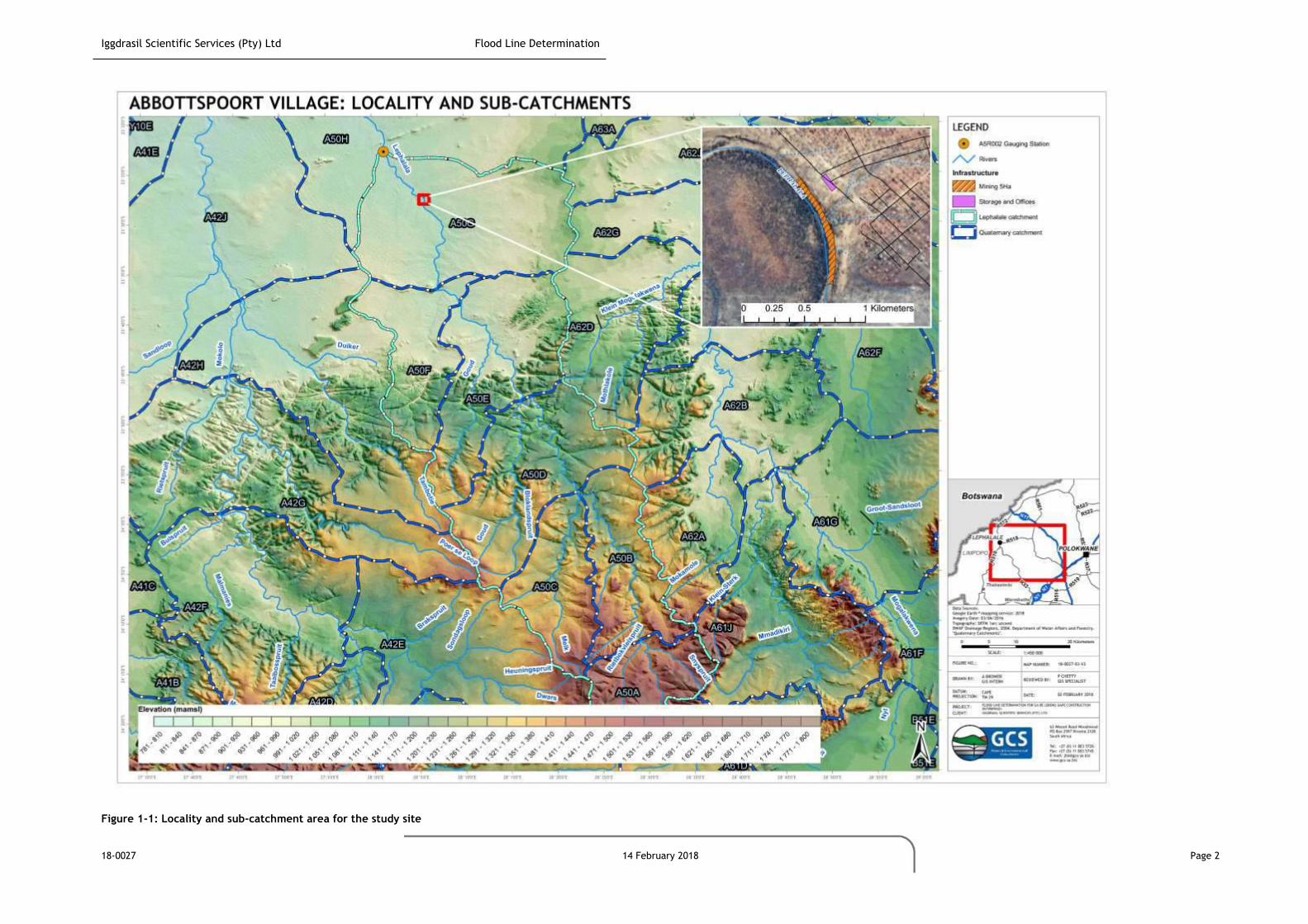
Iggdrasil Scientific Services (Pty) Ltd Flood Line Determination
18-0027 14 February 2018 Page 2
Figure 1-1: Locality and sub-catchment area for the study site

Iggdrasil Scientific Services (Pty) Ltd Flood Line Determination
18-0027 14 February 2018 Page 3
2 SCOPE OF WORK
Iggdrasil and GCS have committed to undertake a flood line investigation on the following terms:
1:50 and 1:100-year flood line determination for one river section of approximately 2km; and
A summary report that details and presents:
o Methods;
o Flood line and exclusion zone mapping; and
o Flood Impact assessment.
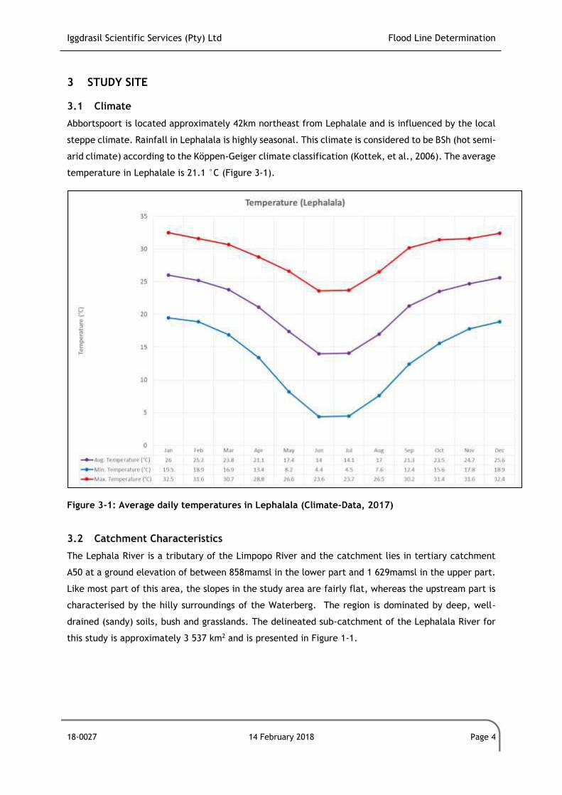
Iggdrasil Scientific Services (Pty) Ltd Flood Line Determination
18-0027 14 February 2018 Page 4
3 STUDY SITE
3.1 Climate
Abbortspoort is located approximately 42km northeast from Lephalale and is influenced by the local
steppe climate. Rainfall in Lephalala is highly seasonal. This climate is considered to be BSh (hot semi-
arid climate) according to the Köppen-Geiger climate classification (Kottek, et al., 2006). The average
temperature in Lephalale is 21.1 °C (Figure 3-1).
Figure 3-1: Average daily temperatures in Lephalala (Climate-Data, 2017)
3.2 Catchment Characteristics
The Lephala River is a tributary of the Limpopo River and the catchment lies in tertiary catchment
A50 at a ground elevation of between 858mamsl in the lower part and 1 629mamsl in the upper part.
Like most part of this area, the slopes in the study area are fairly flat, whereas the upstream part is
characterised by the hilly surroundings of the Waterberg. The region is dominated by deep, well-
drained (sandy) soils, bush and grasslands. The delineated sub-catchment of the Lephalala River for
this study is approximately 3 537 km2 and is presented in Figure 1-1.

Iggdrasil Scientific Services (Pty) Ltd Flood Line Determination
18-0027 14 February 2018 Page 5
3.3 Rainfall and Evaporation
According to Water Resources Database 2012 (WRC, 2015), the Mean Annual Precipitation (MAP) for
the study site should be approximately 435 mm/year. The least amount of rainfall occurs in June and
the greatest amount of precipitation occurs in January.
MAP in the Lephalala River catchment varies between 605 mm/year in the upper part of the
catchment to below 400 mm/year in the downstream part at the confluence of the Limpopo River.
Symons Pan (S-Pan) evaporation for the site is estimated at 1 950 mm/year (WRC, 2015).
3.4 Streamflow Data
Streamflow data of the Lephalala River in proximity of the study site were obtained from the
Department of Water and Sanitation (DWS) gauging station A5R002. This comprises observed data on
the Lephalala River and is located at latitude -23.379200°S and longitude 28.02360°E (see Figure 1-1).
These flow data provide a 48-year time series record of mean daily discharge for the period from the
1st of March 1968 to the 30th of June 2016. Figure 3-2 shows the time series hydrograph for this
station.
The maximum discharge for this period was recorded on the 24th of January 2008 at 582.7 m³/s. There
were 782 days of missing data for the whole 48-year period and this constitutes 4.6% when viewed
against the total number of days in this period. Forty-six (46) annual peaks were therefore used for
the statistical peak flow determination (Section 4.1.1)
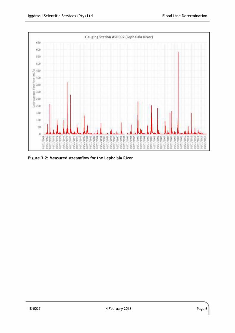
Iggdrasil Scientific Services (Pty) Ltd Flood Line Determination
18-0027 14 February 2018 Page 6
Figure 3-2: Measured streamflow for the Lephalala River
Iggdrasil Scientific Services (Pty) Ltd Flood Line Determination
18-0027 14 February 2018 Page 7
4 PEAK FLOOD CALCULATIONS
4.1 Peak Flood Determination and Methods
4.1.1 Statistical Methods
Probability models, namely the Gumbel (EV1), Log Pearson Type 3 (LP3) and the Log Normal (LN) were
used to calculate peak flows for the Lephalala River. The Weibull plotting position was adopted in the
statistical analyses and computations were undertaken using the Utility Programmes for Drainage
(“UPD”) software.
4.1.2 Deterministic Methods
Three deterministic methods, namely the Unit Hydrograph Method (UHM), the Midgley and Pitman
(MIPI) and the Standard Design Flood (SDF) were employed by using the Utility Programmes for
Drainage (UPD) software for hydraulic analysis to determine design flood peaks for the delineated
Lephalale River catchment. These methods were chosen as they are suitable for medium to large
catchment sizes. A short description of the methods to determine flood flows which were used in this
study is given below.
4.1.2.1 Unit Hydrograph (UHM)
The UHM is suitable for the determination of flood peaks as well as hydrographs for medium sized
rural catchments (15 to 5 000 km2). The method is mainly based on regional analyses of historical data
and is independent of personal judgement. The results are generally reliable, although some natural
variability in the hydrological occurrences is lost through the broad regional divisions and the averaged
forms of hydrographs. This is especially true in the case of catchments smaller than 100km2 in size
(SANRAL, 2013).
4.1.2.2 Empirical Method: Midgley and Pitman (MIPI)
MIPI is an empirical method and is based on correlation between peak flows and some catchment
characteristics. Regional parameters are then mapped out for South Africa and the border with
Botswana. These methods are mostly suitable for medium to large catchments (SANRAL, 2013).
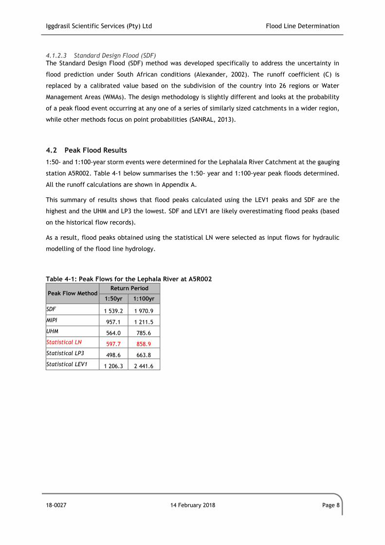
Iggdrasil Scientific Services (Pty) Ltd Flood Line Determination
18-0027 14 February 2018 Page 8
4.1.2.3 Standard Design Flood (SDF)
The Standard Design Flood (SDF) method was developed specifically to address the uncertainty in
flood prediction under South African conditions (Alexander, 2002). The runoff coefficient (C) is
replaced by a calibrated value based on the subdivision of the country into 26 regions or Water
Management Areas (WMAs). The design methodology is slightly different and looks at the probability
of a peak flood event occurring at any one of a series of similarly sized catchments in a wider region,
while other methods focus on point probabilities (SANRAL, 2013).
4.2 Peak Flood Results
1:50- and 1:100-year storm events were determined for the Lephalala River Catchment at the gauging
station A5R002. Table 4-1 below summarises the 1:50- year and 1:100-year peak floods determined.
All the runoff calculations are shown in Appendix A.
This summary of results shows that flood peaks calculated using the LEV1 peaks and SDF are the
highest and the UHM and LP3 the lowest. SDF and LEV1 are likely overestimating flood peaks (based
on the historical flow records).
As a result, flood peaks obtained using the statistical LN were selected as input flows for hydraulic
modelling of the flood line hydrology.
Table 4-1: Peak Flows for the Lephala River at A5R002
Peak Flow Method Return Period
1:50yr 1:100yr
SDF 1 539.2 1 970.9
MIPI 957.1 1 211.5
UHM 564.0 785.6
Statistical LN 597.7 858.9
Statistical LP3 498.6 663.8
Statistical LEV1 1 206.3 2 441.6
Iggdrasil Scientific Services (Pty) Ltd Flood Line Determination
18-0027 14 February 2018 Page 9
5 FLOOD LINE DETERMINATION
5.1 Standards and Legislation Framework
Legislation guides the minimum requirements for placement of infrastructure in relation to a natural
watercourse and The South African General Notice 704 (GN704) was used in the current flood line
study. GN704 of the NWA (No. 36 of 1998) stipulates that no mining infrastructure is allowed to be
placed and constructed closer than 100 m from a river or from the 1:100-year flood line; whichever
of the two is farthest from the Lephalala River in question. The area within this designation is termed
the Exclusion Zone.
Legislation also guides whether an application must be made for a WUL (Section 21 of the NWA) to
commence sand mining in the river bed and placing the office and storage facility potentially within
the flood line and/or Exclusion Zone. The following sections of the NWA will then be relevant:
Section 21 (c): impeding or diverting the flow of water in a watercourse; and
Section 21 (i): altering the bed, banks, course or characteristics of a watercourse;
If any river water abstraction is required the following sections of the NWA must also be considered
for a WUL:
Section 21 (a): taking water from a water resource; and
Section 21 (j): removing, discharging or disposing of water found underground if it is necessary
for the efficient continuation of an activity or for the safety of people.
5.2 Modelling Guidelines and Methods
The following describes the modelling process of the flood line determination.
5.2.1 Topographical Data
Topographical data, based on 1-arcsecond grid cells (~30m), were obtained from The Japan Aerospace
Exploration Agency (JAXA). JAXA releases the global digital surface model (DSM) dataset with a
horizontal resolution of approximately 30-meter mesh (1 arcsec) free of charge. The dataset has been
compiled with images acquired by the Advanced Land Observing Satellite (ALOS) (Tadono, et al.,
2014) (Tadono, et al., 2016) (Takaku, et al., 2014) (Takaku, et al., 2016)).
This dataset was also compared with the Republic of South Africa (RSA) Geospatial Institute 5m
contour topography series (RSA National Geospatial Institute, 2017) and it appeared to be more
accurate as it includes more detailed information of the river bed and flood plain at the study site.
Hence, ALOS was used to determine elevations of river cross-sections of the Lephalala River.
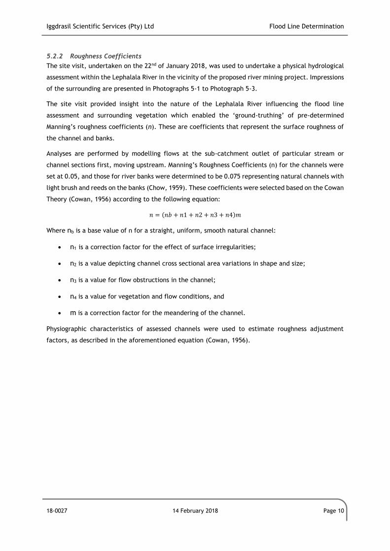
Iggdrasil Scientific Services (Pty) Ltd Flood Line Determination
18-0027 14 February 2018 Page 10
5.2.2 Roughness Coefficients
The site visit, undertaken on the 22nd of January 2018, was used to undertake a physical hydrological
assessment within the Lephalala River in the vicinity of the proposed river mining project. Impressions
of the surrounding are presented in Photographs 5-1 to Photograph 5-3.
The site visit provided insight into the nature of the Lephalala River influencing the flood line
assessment and surrounding vegetation which enabled the ‘ground-truthing’ of pre-determined
Manning’s roughness coefficients (n). These are coefficients that represent the surface roughness of
the channel and banks.
Analyses are performed by modelling flows at the sub-catchment outlet of particular stream or
channel sections first, moving upstream. Manning’s Roughness Coefficients (n) for the channels were
set at 0.05, and those for river banks were determined to be 0.075 representing natural channels with
light brush and reeds on the banks (Chow, 1959). These coefficients were selected based on the Cowan
Theory (Cowan, 1956) according to the following equation:
𝑛 = (𝑛𝑏 + 𝑛1 + 𝑛2 + 𝑛3 + 𝑛4)𝑚
Where nb is a base value of n for a straight, uniform, smooth natural channel:
n1 is a correction factor for the effect of surface irregularities;
n2 is a value depicting channel cross sectional area variations in shape and size;
n3 is a value for flow obstructions in the channel;
n4 is a value for vegetation and flow conditions, and
m is a correction factor for the meandering of the channel.
Physiographic characteristics of assessed channels were used to estimate roughness adjustment
factors, as described in the aforementioned equation (Cowan, 1956).
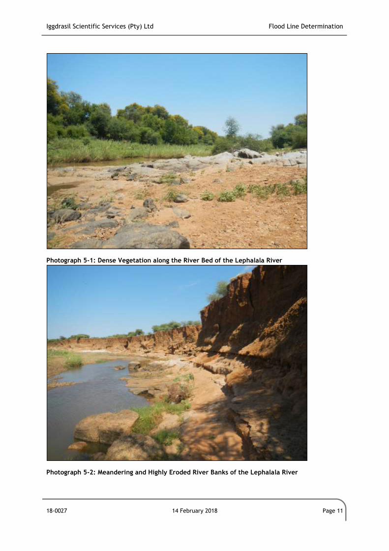
Iggdrasil Scientific Services (Pty) Ltd Flood Line Determination
18-0027 14 February 2018 Page 11
Photograph 5-1: Dense Vegetation along the River Bed of the Lephalala River
Photograph 5-2: Meandering and Highly Eroded River Banks of the Lephalala River
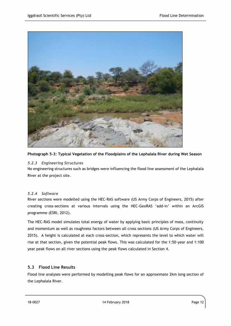
Iggdrasil Scientific Services (Pty) Ltd Flood Line Determination
18-0027 14 February 2018 Page 12
Photograph 5-3: Typical Vegetation of the Floodplains of the Lephalala River during Wet Season 5.2.3 Engineering Structures
No engineering structures such as bridges were influencing the flood line assessment of the Lephalala
River at the project site.
5.2.4 Software
River sections were modelled using the HEC-RAS software (US Army Corps of Engineers, 2015) after
creating cross-sections at various intervals using the HEC-GeoRAS ‘add-in’ within an ArcGIS
programme (ESRI, 2012).
The HEC-RAS model simulates total energy of water by applying basic principles of mass, continuity
and momentum as well as roughness factors between all cross sections (US Army Corps of Engineers,
2015). A height is calculated at each cross-section, which represents the level to which water will
rise at that section, given the potential peak flows. This was calculated for the 1:50-year and 1:100
year peak flows on all river sections using the peak flows calculated in Section 4.
5.3 Flood Line Results
Flood line analyses were performed by modelling peak flows for an approximate 2km long section of
the Lephalala River.
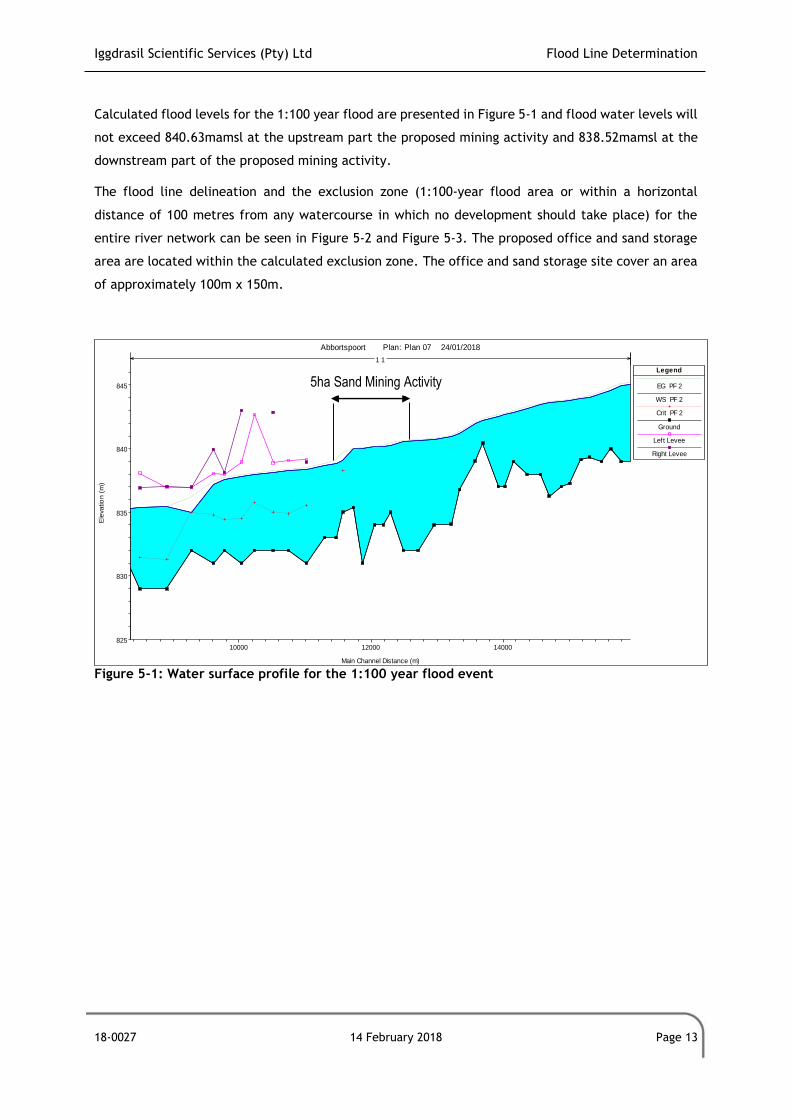
Iggdrasil Scientific Services (Pty) Ltd Flood Line Determination
18-0027 14 February 2018 Page 13
Calculated flood levels for the 1:100 year flood are presented in Figure 5-1 and flood water levels will
not exceed 840.63mamsl at the upstream part the proposed mining activity and 838.52mamsl at the
downstream part of the proposed mining activity.
The flood line delineation and the exclusion zone (1:100-year flood area or within a horizontal
distance of 100 metres from any watercourse in which no development should take place) for the
entire river network can be seen in Figure 5-2 and Figure 5-3. The proposed office and sand storage
area are located within the calculated exclusion zone. The office and sand storage site cover an area
of approximately 100m x 150m.
Figure 5-1: Water surface profile for the 1:100 year flood event
10000 12000 14000825
830
835
840
845
Abbortspoort Plan: Plan 07 24/01/2018
Main Channel Distance (m)
Ele
vatio
n (m
)
Legend
EG PF 2
WS PF 2
Crit PF 2
Ground
Left Levee
Right Levee
1 1
5ha Sand Mining Activity
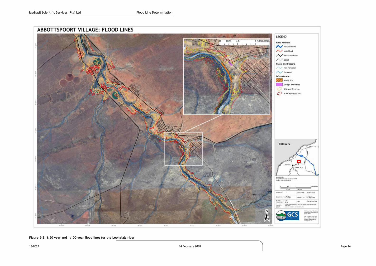
Iggdrasil Scientific Services (Pty) Ltd Flood Line Determination
18-0027 14 February 2018 Page 14
Figure 5-2: 1:50 year and 1:100 year flood lines for the Lephalala river
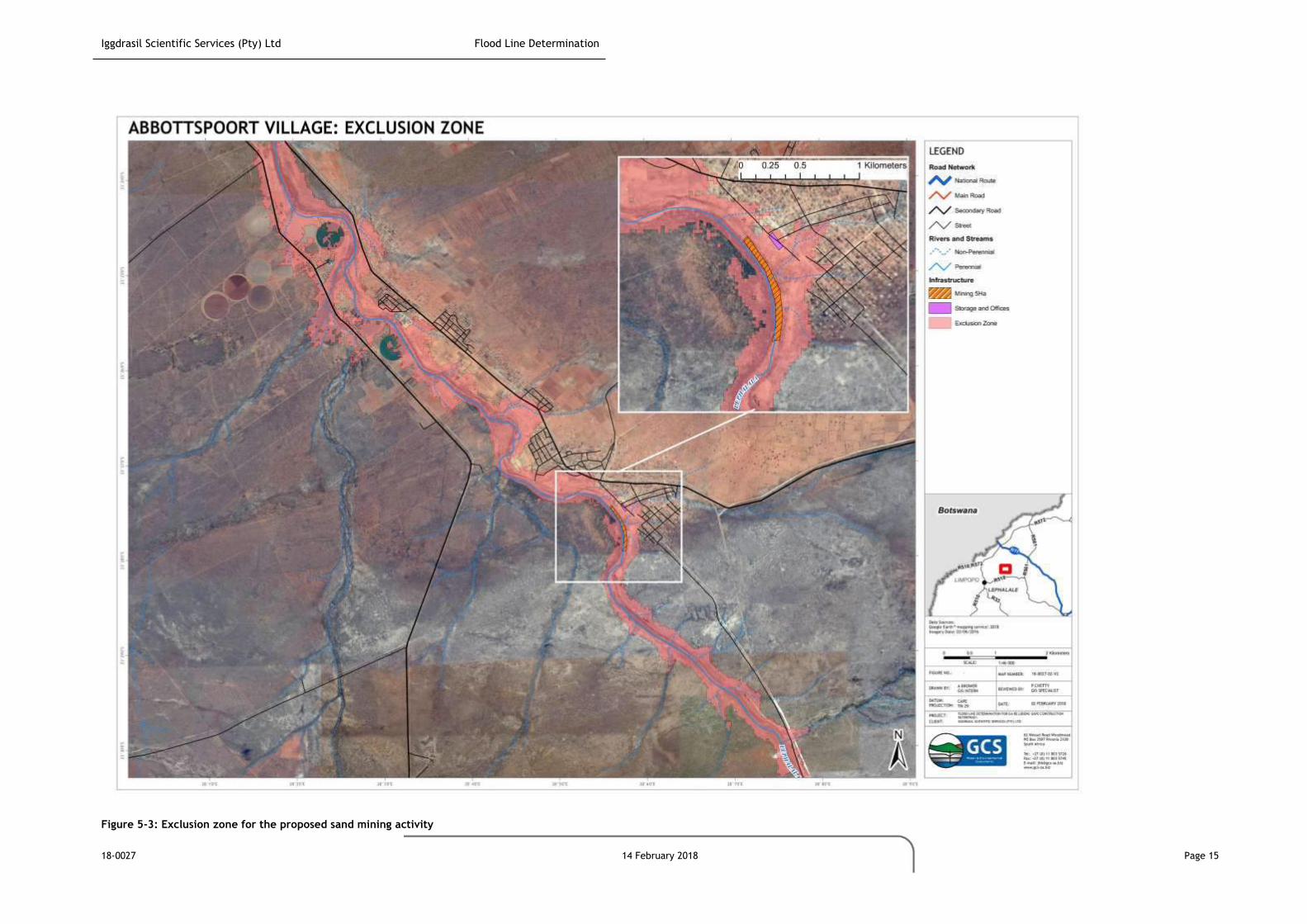
Iggdrasil Scientific Services (Pty) Ltd Flood Line Determination
18-0027 14 February 2018 Page 15
Figure 5-3: Exclusion zone for the proposed sand mining activity
Iggdrasil Scientific Services (Pty) Ltd Flood Line Determination
18-0027 14 February 2018 Page 16
6 ASSESSMENT OF IMPACTS OF THE SAND MINE ON THE NATURAL FLOOD REGIME
The following environmental risks associated with sand mining on the natural flood regime were
identified (these risks affect typical features of the natural environment, which is anticipated to be
affected by proposed development). Criteria that were be applied to the impact assessment were
provided by CSIR and are described in Appendix B. The resulting value is assigned an impact ranking
of low, moderate or high for each impact as shown in Table 6-1 to Table 6-3.
6.1 Surface Water Impacts
6.1.1 Changes to water quality of the Lephalala River
Surface water quality in the Lephalala River may be impacted upon. This could occur as a result of:
The construction of haul roads and transport of product (sand) material could increase the
quantity of airborne sediments. This dust would settle on the ground surface where it would
present additional sediment during rainfall events into river systems;
The proposed sand mining activity would require removal of vegetation on the flood plain and
the disturbance of the riverbed. This would increase the erosion potential of the river bed
locally and subsequently result in increased downstream silt load (suspended solids) in the
river during a flood event; and
Hydrocarbons, such as oils and petroleum fuels, represent a potential threat to surface water
quality. As such, the potential impact of accidental spillages should be assessed and avoided.
6.1.2 Changes in Catchment Characteristics, Runoff and Peak flows of the Lephalala River
Proposed sand mining development could marginally increase the runoff volume reporting to
the Lephalala River locally for a short term owing to removal of vegetation and compaction
of soils during construction and operation;
Soil erosion (and consequent river sedimentation) is possible due to removal of vegetation at
the project site. Surfaces exposed to wind and rain will be susceptible to erosion and
vegetation roots play an important role in binding soil; and
Construction near the rivers could result in the loosening of ground and therefore the
destabilisation of the river banks.
6.2 Development of Mitigation Measures
All “semi-permanent” facilities on site that cannot be moved (e.g. buildings, sand storage
facility) should always be placed outside the exclusion zone in case a flood event occurs. If
this is not possible, an application for a WUL should be made for Section 21(c) of the NWA:
Iggdrasil Scientific Services (Pty) Ltd Flood Line Determination
18-0027 14 February 2018 Page 17
o Section 21 (c): impeding or diverting the flow of water in a watercourse; and
o Section 21 (i): altering the bed, banks, course or characteristics of a watercourse;
All oils and fuel facilities used for machinery should be moved outside the Exclusion Zone and
provide bunding for areas where hydrocarbons are stored or transferred stored. In case a
spillage occurs, it must be managed immediately in accordance with the company’s project
Emergency Response Plan. The Emergency Response Plan should be provided by contractors;
Use of dust suppression to reduce the quantity of airborne sediments and dust that would
settle on the ground surface;
To reduce soil erosion the following measures are proposed:
o Include minimising the infrastructure footprint as far as possible. The proposed
facility footprint (i.e. office and sand storage site) covers approximately 100m x 150m
and this footprint area should not be exceeded; and
o Controlling overland storm water runoff by constructing water control structures such
as berms and cut-off trenches if required for the office and sand storage complex,
grouping infrastructure (office and storage facility), scheduling construction as soon
as possible after vegetation clearance.
To provide more information on possible production rates and a more accurate prediction of
the available river sand (bed load) a sediment load and sedimentation study can be
undertaken by relevant authorities (DWS) to inform coordinated planning and decision-making
on small scale sand mining projects into the future in this area. This information will then
also feed into post-closure rehabilitation plan of the river bed.
To reduce the impact of increased sediment yields and to re-establish the sediment balance
to approximate pre-development conditions, a silt fence in the riverbed can be constructed.
During a flood event heavier sediments will be deposited upstream of the silt fence. These
silt fences are cheap and easy to install, but must be properly designed to withstand a flood
event. The silt fence will also have a secondary benefit of increasing sediment depositions
within the mining area;
Vegetation will be removed during the construction process and operations, and it is
recommended that this be replaced after operations have finished by means of a vegetation
rehabilitation plan. It is recommended that bare surfaces are planted with indigenous
vegetation as soon as possible. If possible, the vegetation removed should be re-used;
Build appropriate sanitary facilities during construction; and
Monitoring of sand production and water quality at a regular interval (upstream and
downstream bi-annually).
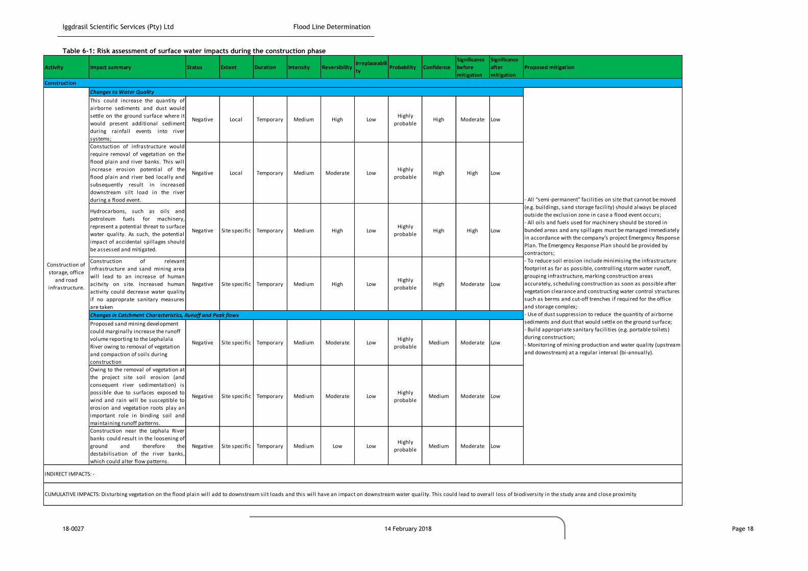
Iggdrasil Scientific Services (Pty) Ltd Flood Line Determination
18-0027 14 February 2018 Page 18
Table 6-1: Risk assessment of surface water impacts during the construction phase
Activity Impact summary Status Extent Duration Intensity ReversibilityIrreplaceabili
tyProbability Confidence
Significance
before
mitigation
Significance
after
mitigation
Proposed mitigation
This could increase the quantity of
airborne sediments and dust would
settle on the ground surface where it
would present additional sediment
during rainfall events into river
systems;
Negative Local Temporary Medium High LowHighly
probableHigh Moderate Low
Constuction of infrastructure would
require removal of vegetation on the
flood plain and river banks. This will
increase erosion potential of the
flood plain and river bed locally and
subsequently result in increased
downstream silt load in the river
during a flood event.
Negative Local Temporary Medium Moderate LowHighly
probableHigh High Low
Hydrocarbons, such as oils and
petroleum fuels for machinery,
represent a potential threat to surface
water quality. As such, the potential
impact of accidental spillages should
be assessed and mitigated.
Negative Site specific Temporary Medium High LowHighly
probableHigh High Low
Construction of relevant
infrastructure and sand mining area
will lead to an increase of human
acitvity on site. Increased human
activity could decrease water quality
if no approprate sanitary measures
are taken
Negative Site specific Temporary Medium High LowHighly
probableHigh Moderate Low
Proposed sand mining development
could marginally increase the runoff
volume reporting to the Lephalala
River owing to removal of vegetation
and compaction of soils during
construction
Negative Site specific Temporary Medium Moderate LowHighly
probableMedium Moderate Low
Owing to the removal of vegetation at
the project site soil erosion (and
consequent river sedimentation) is
possible due to surfaces exposed to
wind and rain will be susceptible to
erosion and vegetation roots play an
important role in binding soil and
maintaining runoff patterns.
Negative Site specific Temporary Medium Moderate LowHighly
probableMedium Moderate Low
Construction near the Lephala River
banks could result in the loosening of
ground and therefore the
destabilisation of the river banks,
which could alter flow patterns.
Negative Site specific Temporary Medium Low LowHighly
probableMedium Moderate Low
Construction
Construction of
storage, office
and road
infrastructure.
Changes to Water Quality
Changes in Catchment Characteristics, Runoff and Peak flows
INDIRECT IMPACTS: -
CUMULATIVE IMPACTS: Disturbing vegetation on the flood plain will add to downstream silt loads and this will have an impact on downstream water quality. This could lead to overall loss of biodiversity in the study area and close proximity
- All “semi-permanent” facil ities on site that cannot be moved
(e.g. buildings, sand storage facil ity) should always be placed
outside the exclusion zone in case a flood event occurs;
- All oils and fuels used for machinery should be stored in
bunded areas and any spillages must be managed immediately
in accordance with the company’s project Emergency Response
Plan. The Emergency Response Plan should be provided by
contractors;
- To reduce soil erosion include minimising the infrastructure
footprint as far as possible, controlling storm water runoff,
grouping infrastructure, marking construction areas
accurately, scheduling construction as soon as possible after
vegetation clearance and constructing water control structures
such as berms and cut-off trenches if required for the office
and storage complex;·
- Use of dust suppression to reduce the quantity of airborne
sediments and dust that would settle on the ground surface;
- Build appropriate sanitary facil ities (e.g. portable toilets)
during construction;
- Monitoring of mining production and water quality (upstream
and downstream) at a regular interval (bi-annually).
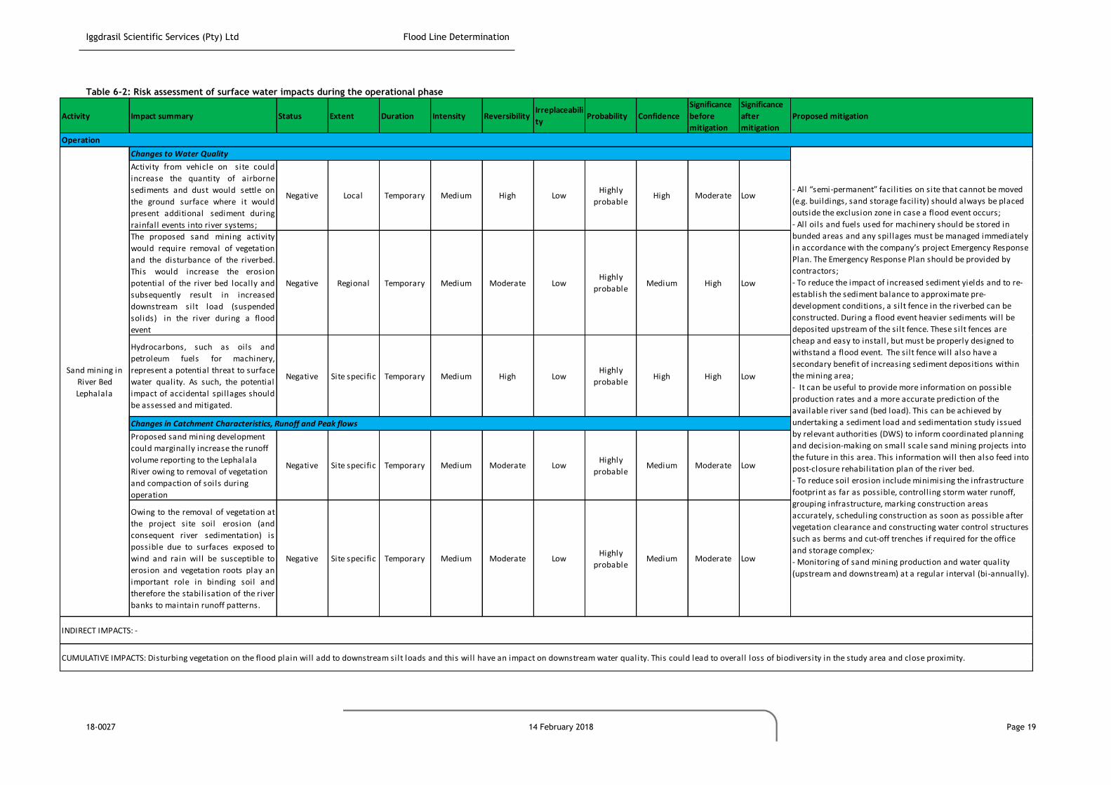
Iggdrasil Scientific Services (Pty) Ltd Flood Line Determination
18-0027 14 February 2018 Page 19
Table 6-2: Risk assessment of surface water impacts during the operational phase
Activity Impact summary Status Extent Duration Intensity ReversibilityIrreplaceabili
tyProbability Confidence
Significance
before
mitigation
Significance
after
mitigation
Proposed mitigation
Activity from vehicle on site could
increase the quantity of airborne
sediments and dust would settle on
the ground surface where it would
present additional sediment during
rainfall events into river systems;
Negative Local Temporary Medium High LowHighly
probableHigh Moderate Low
The proposed sand mining activity
would require removal of vegetation
and the disturbance of the riverbed.
This would increase the erosion
potential of the river bed locally and
subsequently result in increased
downstream silt load (suspended
solids) in the river during a flood
event
Negative Regional Temporary Medium Moderate LowHighly
probableMedium High Low
Hydrocarbons, such as oils and
petroleum fuels for machinery,
represent a potential threat to surface
water quality. As such, the potential
impact of accidental spillages should
be assessed and mitigated.
Negative Site specific Temporary Medium High LowHighly
probableHigh High Low
Proposed sand mining development
could marginally increase the runoff
volume reporting to the Lephalala
River owing to removal of vegetation
and compaction of soils during
operation
Negative Site specific Temporary Medium Moderate LowHighly
probableMedium Moderate Low
Owing to the removal of vegetation at
the project site soil erosion (and
consequent river sedimentation) is
possible due to surfaces exposed to
wind and rain will be susceptible to
erosion and vegetation roots play an
important role in binding soil and
therefore the stabilisation of the river
banks to maintain runoff patterns.
Negative Site specific Temporary Medium Moderate LowHighly
probableMedium Moderate Low
CUMULATIVE IMPACTS: Disturbing vegetation on the flood plain will add to downstream silt loads and this will have an impact on downstream water quality. This could lead to overall loss of biodiversity in the study area and close proximity.
INDIRECT IMPACTS: -
Operation
Sand mining in
River Bed
Lephalala
Changes to Water Quality
- All “semi-permanent” facil ities on site that cannot be moved
(e.g. buildings, sand storage facil ity) should always be placed
outside the exclusion zone in case a flood event occurs;
- All oils and fuels used for machinery should be stored in
bunded areas and any spillages must be managed immediately
in accordance with the company’s project Emergency Response
Plan. The Emergency Response Plan should be provided by
contractors;
- To reduce the impact of increased sediment yields and to re-
establish the sediment balance to approximate pre-
development conditions, a silt fence in the riverbed can be
constructed. During a flood event heavier sediments will be
deposited upstream of the silt fence. These silt fences are
cheap and easy to install, but must be properly designed to
withstand a flood event. The silt fence will also have a
secondary benefit of increasing sediment depositions within
the mining area;
- It can be useful to provide more information on possible
production rates and a more accurate prediction of the
available river sand (bed load). This can be achieved by
undertaking a sediment load and sedimentation study issued
by relevant authorities (DWS) to inform coordinated planning
and decision-making on small scale sand mining projects into
the future in this area. This information will then also feed into
post-closure rehabilitation plan of the river bed.
- To reduce soil erosion include minimising the infrastructure
footprint as far as possible, controlling storm water runoff,
grouping infrastructure, marking construction areas
accurately, scheduling construction as soon as possible after
vegetation clearance and constructing water control structures
such as berms and cut-off trenches if required for the office
and storage complex;·
- Monitoring of sand mining production and water quality
(upstream and downstream) at a regular interval (bi-annually).
Changes in Catchment Characteristics, Runoff and Peak flows

Iggdrasil Scientific Services (Pty) Ltd Flood Line Determination
18-0027 14 February 2018 Page 20
Table 6-3: Risk assessment of surface water impacts during the decommissioning phase
Activity Impact summary Status Extent Duration Intensity ReversibilityIrreplaceabili
tyProbability Confidence
Significance
before
mitigation
Significance
after
mitigation
Proposed mitigation
The proposed sand mining activity
required removal of vegetation and
the disturbance of the riverbed. This
would increase the erosion potential
of the river bed locally and
subsequently result in increased
downstream silt load in the river
during a flood event
Negative Regional Temporary Medium Moderate LowHighly
probableMedium High Low
Proposed sand mining development
could marginally increase the runoff
volume reporting to the Lephalala
River owing to removal of vegetation
and compaction of soils during
construction
Negative Site specific Temporary Medium Moderate LowHighly
probableMedium Moderate Low
Owing to the removal of vegetation at
the project site soil erosion (and
consequent river sedimentation) is
possible due to surfaces exposed to
wind and rain will be susceptible to
erosion and vegetation roots play an
important role in binding soil and
therefore the stabilisation of the river
banks to maintain runoff patterns.
Negative Site specific Temporary Medium Moderate LowHighly
probableMedium Moderate Low
INDIRECT IMPACTS: -
CUMULATIVE IMPACTS: Disturbing vegetation on the flood plain will add to downstream silt loads and this will have an impact on downstream water quality. This could lead to overall loss of biodiversity in the study area and close proximity.
Decommisioning
Decommisioning
of the sand
mining activity
and
rehabilatation of
the site area
Changes to Water Quality
- After operations have ceased, a vegetation rehabilitation plan
should be implemented. It is recommended that bare surfaces
are planted with indigenous vegetation as soon as possible.
- Monitoring of water quality (upstream and downstream) at a
regular interval (bi-annually) during the first years after
closure.
Changes in Catchment Characteristics, Runoff and Peak flows
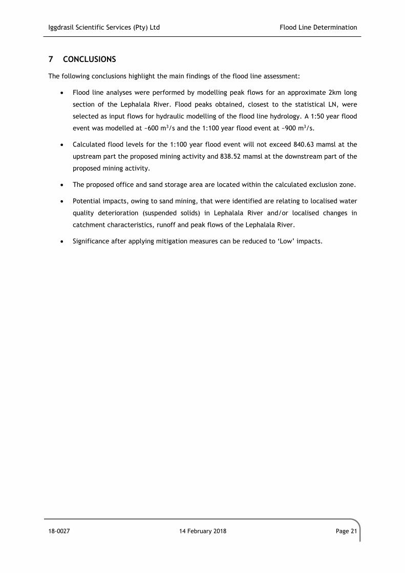
Iggdrasil Scientific Services (Pty) Ltd Flood Line Determination
18-0027 14 February 2018 Page 21
7 CONCLUSIONS
The following conclusions highlight the main findings of the flood line assessment:
Flood line analyses were performed by modelling peak flows for an approximate 2km long
section of the Lephalala River. Flood peaks obtained, closest to the statistical LN, were
selected as input flows for hydraulic modelling of the flood line hydrology. A 1:50 year flood
event was modelled at ~600 m3/s and the 1:100 year flood event at ~900 m3/s.
Calculated flood levels for the 1:100 year flood event will not exceed 840.63 mamsl at the
upstream part the proposed mining activity and 838.52 mamsl at the downstream part of the
proposed mining activity.
The proposed office and sand storage area are located within the calculated exclusion zone.
Potential impacts, owing to sand mining, that were identified are relating to localised water
quality deterioration (suspended solids) in Lephalala River and/or localised changes in
catchment characteristics, runoff and peak flows of the Lephalala River.
Significance after applying mitigation measures can be reduced to ‘Low’ impacts.
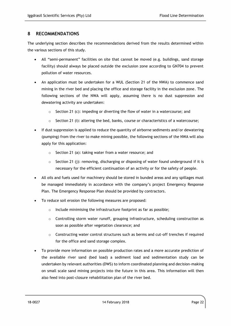
Iggdrasil Scientific Services (Pty) Ltd Flood Line Determination
18-0027 14 February 2018 Page 22
8 RECOMMENDATIONS
The underlying section describes the recommendations derived from the results determined within
the various sections of this study.
All “semi-permanent” facilities on site that cannot be moved (e.g. buildings, sand storage
facility) should always be placed outside the exclusion zone according to GN704 to prevent
pollution of water resources.
An application must be undertaken for a WUL (Section 21 of the NWA) to commence sand
mining in the river bed and placing the office and storage facility in the exclusion zone. The
following sections of the NWA will apply, assuming there is no dust suppression and
dewatering activity are undertaken:
o Section 21 (c): impeding or diverting the flow of water in a watercourse; and
o Section 21 (i): altering the bed, banks, course or characteristics of a watercourse;
If dust suppression is applied to reduce the quantity of airborne sediments and/or dewatering
(pumping) from the river to make mining possible, the following sections of the NWA will also
apply for this application:
o Section 21 (a): taking water from a water resource; and
o Section 21 (j): removing, discharging or disposing of water found underground if it is
necessary for the efficient continuation of an activity or for the safety of people.
All oils and fuels used for machinery should be stored in bunded areas and any spillages must
be managed immediately in accordance with the company’s project Emergency Response
Plan. The Emergency Response Plan should be provided by contractors.
To reduce soil erosion the following measures are proposed:
o Include minimising the infrastructure footprint as far as possible;
o Controlling storm water runoff, grouping infrastructure, scheduling construction as
soon as possible after vegetation clearance; and
o Constructing water control structures such as berms and cut-off trenches if required
for the office and sand storage complex.
To provide more information on possible production rates and a more accurate prediction of
the available river sand (bed load) a sediment load and sedimentation study can be
undertaken by relevant authorities (DWS) to inform coordinated planning and decision-making
on small scale sand mining projects into the future in this area. This information will then
also feed into post-closure rehabilitation plan of the river bed.

Iggdrasil Scientific Services (Pty) Ltd Flood Line Determination
18-0027 14 February 2018 Page 23
Constructing a silt fence will reduce the downstream silt loads to values that approximate
pre-development conditions. The silt fence will also have a secondary benefit of increasing
sediment depositions within the mining area.
Vegetation will be removed during the construction process and operations, and it is
recommended that this be replaced after operations have finished by means of a vegetation
rehabilitation plan. It is recommended that bare surfaces are planted with indigenous
vegetation as soon as possible. If possible, the vegetation removed should be re-used. and
Build appropriate sanitary facilities (e.g. portable toilets) during construction.
Iggdrasil Scientific Services (Pty) Ltd Flood Line Determination
18-0027 14 February 2018 Page 24
9 REFERENCES
Alexander, J., 2002. The Standard Design Flood. South African Institution of Engineers, pp. 26-30.
Chow, 1959. Open Channels Hydraulics, USA: McGraw-Hill.
Climate-Data, 2017. Climate Data For Cities Worldwide. [Online]
Available at: http://en.climate-data.org/
Cowan, W., 1956. Estimating hydraulic roughness coefficients. Agricultural Engineering Journal 377,
pp. 473-475.
CSIR, 2017. Background Information Document (BID). Basic Assessment for the proposed
establishment of a small scale 5 hectares sand mining project within the Lephalala River in
Abbottspoort Village , s.l.: s.n.
ESRI, 2012. Environmental Systems Research Institute: ArcView10.1. s.l.:ESRI.
Kottek, M. et al., 2006. World Map of KöppenGeiger Geiger Climate Classification updated.
Meteorologische Zeitschrift, Issue 15, pp. 259-263.
SANRAL, 2013. South African Drainage Manual, Pretoria: SANRAL.
Tadono, T. et al., 2014. : Precise Global DEM Generation By ALOS PRISM, ISPRS Annals of the
Photogrammetry. Remote Sensing and Spatial Information Sciences, Volume Vol.II-4, pp. 71-76.
Tadono, T. et al., 2016. Initial Validation of the 30 m-mesh Global Digital Surface Model Generated
by ALOS PRISM, The International Archives of the Photogrammetry. Remote Sensing and Spatial
Information, Volume Vol. XLI-B4, pp. 157-162.
Takaku, J., Tadono, T. & Tsutsui, K., 2014. Generation of High Resolution Global DSM from ALOS
PRISM, The International Archives of the Photogrammetry. Remote Sensing and Spatial Information
Sciences, Volume Vol. XL-4, pp. 243-248.
Takaku, J., Tadono, T., Tsutsui, K. & Ichikawa, M., 2016. Validation of ‘AW3D’ Global DSM Generated
from ALOS PRISM, ISPRS Annals of the Photogrammetry,. Remote Sensing and Spatial Information
Sciences, Volume Vol.III-4, pp. 25-31.
US Army Corps of Engineers, 2015. HEC-RAS River Analysis System. Hydraulic Reference Manual.
Version 5.0.
WRC, 2015. http://www.waterresourceswr2012.co.za/resource-centre/. [Online].

Iggdrasil Scientific Services (Pty) Ltd Flood Line Determination
18-0027 14 February 2018 Page 25
APPENDIX A
Peak Flow Calculations
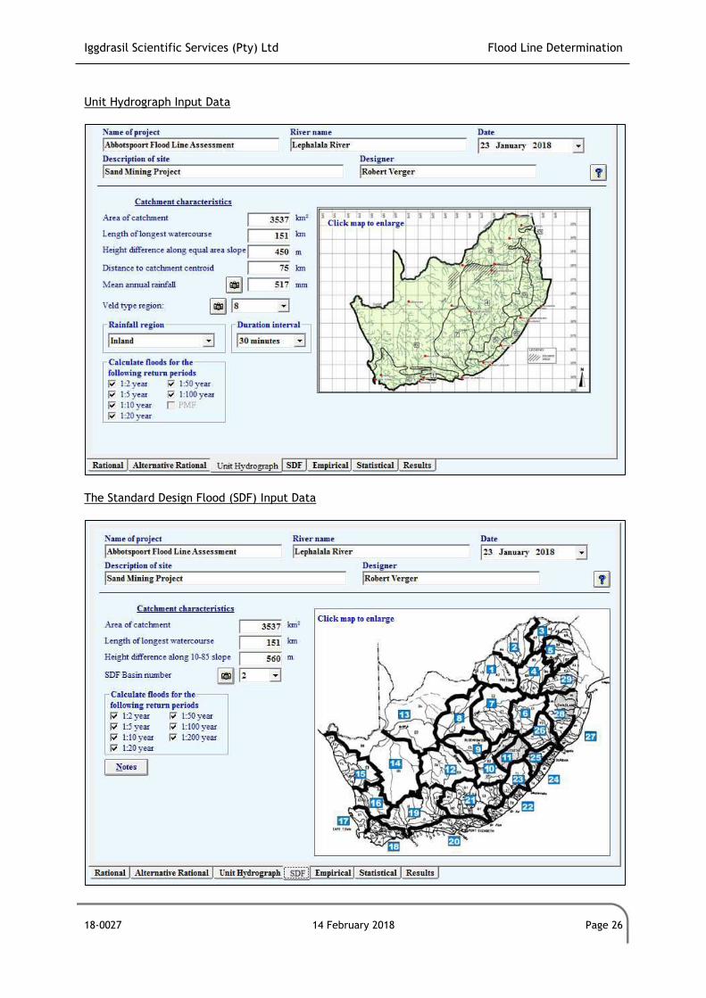
Iggdrasil Scientific Services (Pty) Ltd Flood Line Determination
18-0027 14 February 2018 Page 26
Unit Hydrograph Input Data
The Standard Design Flood (SDF) Input Data
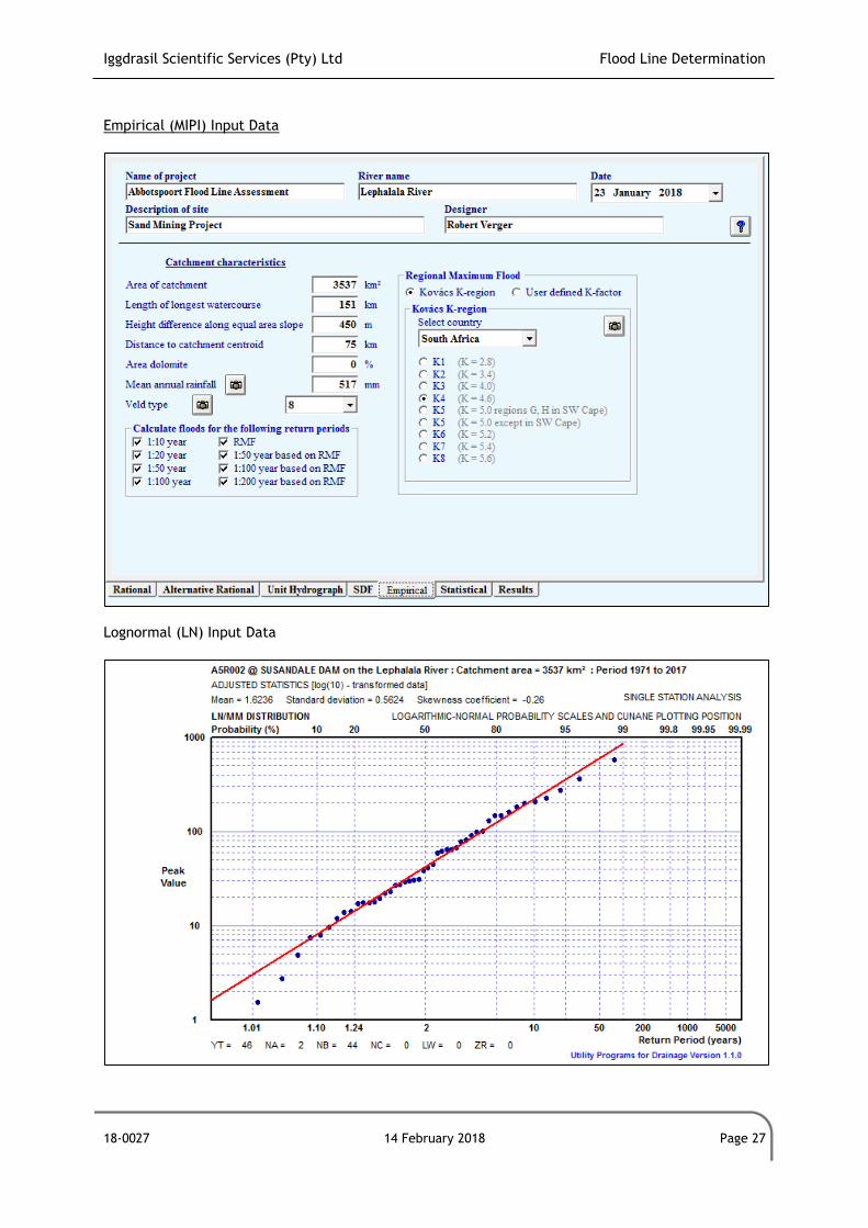
Iggdrasil Scientific Services (Pty) Ltd Flood Line Determination
18-0027 14 February 2018 Page 27
Empirical (MIPI) Input Data
Lognormal (LN) Input Data

Iggdrasil Scientific Services (Pty) Ltd Flood Line Determination
18-0027 14 February 2018 Page 28
APPENDIX B
Impact Assessment Methodology
Iggdrasil Scientific Services (Pty) Ltd Flood Line Determination
18-0027 14 February 2018 Page 29
Specialist Criteria for Impact Assessment
The following methodology was provided by the main client (CSIR) and the assessment of impact
significance is based on the following conventions:
Nature of Impact - this reviews the type of effect that a proposed activity will have on the
environment and should include “what will be affected and how?”
Spatial Extent - this should indicate whether the impact will be:
Site specific;
Local (<2 km from site);
Regional (within 30 km of site); or
National.
Duration - The timeframe during which (lifetime of) the impact will be experienced:
Temporary (less than 1 year);
Short term (1 to 6 years);
Medium term (6 to 15 years);
Long term (the impact will cease after the operational life of the activity); or
Permanent (mitigation will not occur in such a way or in such a time span that the impact can
be considered transient).
Intensity - it should be established whether the impact is destructive or innocuous and should be
described as either:
High (severe alteration of natural systems, patterns or processes such that they temporarily
or permanently cease);
Medium (notable alteration of natural systems, patterns or processes; where the environment
continues to function but in a modified manner); or
Low (negligible or no alteration of natural systems, patterns or processes); can be easily
avoided by implementing appropriate mitigation measures, and will not have an influence on
decision-making.
Probability - this considers the likelihood of the impact occurring and should be described as:
Improbable (little or no chance of occurring);
Iggdrasil Scientific Services (Pty) Ltd Flood Line Determination
18-0027 14 February 2018 Page 30
Probable (<50% chance of occurring);
Highly probable (50 – 90% chance of occurring); or
Definite (>90% chance of occurring).
Reversibility - this considers the degree to which the adverse environmental impacts are reversible
or irreversible. For example, an impact will be described as low should the impact have little chance
of being rectified to correct environmental impacts. On the other hand, an impact such as the
nuisance factor caused by noise impacts from wind turbines can be considered to be highly reversible
at the end of the project lifespan. The assessment of the reversibility of potential impacts is based
on the following terms:
High - impacts on the environment at the end of the operational life cycle are highly
reversible;
Moderate - impacts on the environment at the end of the operational life cycle are reasonably
reversible;
Low - impacts on the environment at the end of the operational life cycle are slightly
reversible; or
Non-reversible - impacts on the environment at the end of the operational life cycle are not
reversible and are consequently permanent.
Irreplaceability - this reviews the extent to which an environmental resource is replaceable or
irreplaceable. For example, if the proposed project will be undertaken on land that is already
transformed and degraded, this will yield a low irreplaceability score. The assessment of the degree
to which the impact causes irreplaceable loss of resources is based on the following terms:
High irreplaceability of resources (this is the least favourable assessment for the
environment);
Moderate irreplaceability of resources;
Low irreplaceability of resources; or
Resources are replaceable (this is the most favourable assessment for the environment).
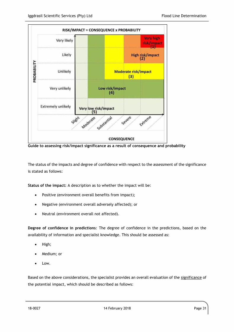
Iggdrasil Scientific Services (Pty) Ltd Flood Line Determination
18-0027 14 February 2018 Page 31
Guide to assessing risk/impact significance as a result of consequence and probability
The status of the impacts and degree of confidence with respect to the assessment of the significance
is stated as follows:
Status of the impact: A description as to whether the impact will be:
Positive (environment overall benefits from impact);
Negative (environment overall adversely affected); or
Neutral (environment overall not affected).
Degree of confidence in predictions: The degree of confidence in the predictions, based on the
availability of information and specialist knowledge. This should be assessed as:
High;
Medium; or
Low.
Based on the above considerations, the specialist provides an overall evaluation of the significance of
the potential impact, which should be described as follows:
Iggdrasil Scientific Services (Pty) Ltd Flood Line Determination
18-0027 14 February 2018 Page 32
Low to very low: the impact may result in minor alterations of the environment and can be
reduced or avoided by implementing the appropriate mitigation measures, and will only have
an influence on the decision-making if not mitigated;
Medium: the impact will result in moderate alteration of the environment and can be reduced
or avoided by implementing the appropriate mitigation measures, and will only have an
influence on the decision-making if not mitigated; or
High: Where it could have a “no-go” implication for the project unless mitigation or re-design
is practically achievable.
Furthermore, the following must be considered:
Impacts should be described both before and after the proposed mitigation and management
measures have been implemented.
All impacts should be evaluated for the construction, operation and decommissioning phases
of the project, where relevant.
The impact evaluation should take into consideration the cumulative effects associated with
this and other facilities which are either developed or in the process of being developed in
the region, if relevant.
Management Actions:
Where negative impacts are identified, mitigatory measures will be identified to avoid or
reduce negative impacts. Where no mitigatory measures are possible this will be stated.
Where positive impacts are identified, augmentation measures will be identified to
potentially enhance these.
Quantifiable standards for measuring and monitoring mitigatory measures and enhancements
will be set. This will include a programme for monitoring and reviewing the recommendations
to ensure their ongoing effectiveness.
Monitoring:
Specialists should recommend monitoring requirements to assess the effectiveness of mitigation
actions, indicating what actions are required, by whom, and the timing and frequency thereof.
Cumulative Impact:
Consideration is given to the extent of any accumulative impact that may occur due to the proposed
development. Such impacts are evaluated with an assessment of similar developments already in the
environment. Such impacts will be either positive or negative, and will be graded as being of
negligible, low, medium or high impact.
Iggdrasil Scientific Services (Pty) Ltd Flood Line Determination
18-0027 14 February 2018 Page 33
Mitigation:
The objective of mitigation is to firstly avoid and minimise impacts where possible and where these
cannot be completely avoided, to compensate for the negative impacts of the development on the
receiving environment and to maximise re-vegetation and rehabilitation of disturbed areas. For each
impact identified, appropriate mitigation measures to reduce or otherwise avoid the potentially
negative impacts are suggested. All impacts are assessed without mitigation and with the mitigation
measures as suggested.

Iggdrasil Scientific Services (Pty) Ltd Flood Line Determination
18-0027 14 February 2018 Page 34
APPENDIX C
Declaration of Specialist
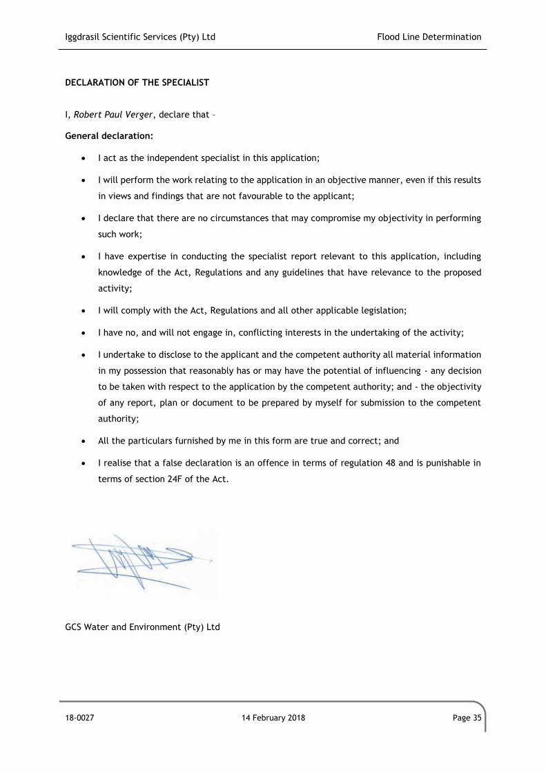
Iggdrasil Scientific Services (Pty) Ltd Flood Line Determination
18-0027 14 February 2018 Page 35
DECLARATION OF THE SPECIALIST I, Robert Paul Verger, declare that – General declaration:
I act as the independent specialist in this application;
I will perform the work relating to the application in an objective manner, even if this results
in views and findings that are not favourable to the applicant;
I declare that there are no circumstances that may compromise my objectivity in performing
such work;
I have expertise in conducting the specialist report relevant to this application, including
knowledge of the Act, Regulations and any guidelines that have relevance to the proposed
activity;
I will comply with the Act, Regulations and all other applicable legislation;
I have no, and will not engage in, conflicting interests in the undertaking of the activity;
I undertake to disclose to the applicant and the competent authority all material information
in my possession that reasonably has or may have the potential of influencing - any decision
to be taken with respect to the application by the competent authority; and - the objectivity
of any report, plan or document to be prepared by myself for submission to the competent
authority;
All the particulars furnished by me in this form are true and correct; and
I realise that a false declaration is an offence in terms of regulation 48 and is punishable in
terms of section 24F of the Act.
GCS Water and Environment (Pty) Ltd


