Embed Size (px)
Citation preview
DRAFT ENVIRONMENTAL IMPACT ASSESSMENT _______________________________________________________________
For
OVER AN EXTENT OF 8.000 HECTARES OF QUARTZITE & SILICA SAND MINE
In
Sy.No. 677 (Old Sy.No. 425) of Chinthakunta Village, Muddanur Mandal, Y.S.R Kadapa District, Andhra Pradesh.
Proposed By
Sri P. VENKATA SIVA REDDY D.No. 1/21, Gundlakunta Village, Peddamudium Mandal,
Y.S.R Kadapa District, Andhra Pradesh
Prepared By
____________________________________________________________________________________
M/s. GLOBAL ENVIRO LABS (Accredited by Quality Council of India – NABET, New Delhi)
2-2-1075/14/A/1, Tilaknagar “X” Roads, Bagh Amberpet, Hyderabad – 500 013. Ph.: 040-27407969
Email: [email protected]
Scanned with CamScanner
21
STANDARD TERMS OF REFERENCE (TOR) FOR EIA/EMP REPORT FORPROJECTS/ACTIVITIES REQUIRING ENVIRONMENT CLEARANCE
Terms of Reference (TOR) for preparation of Environmental Impact Assessment (EIA) and
Environmental Management Plan (EMP) for "Mining of Minerals" as per the EIA Notification, 2006 has
been devised to improve the quality of the reports and facilitate decision-making transparent and easy.
TOR will help the project proponents to prepare report with relevant project specific data and easily
interpretable information. TOR for mining of minerals is expected to cover all environmental related
features.
Mining of minerals plays a positive role in the process of country's economic development. In addition
to the contribution towards economic growth, mining can also be a major source of degradation of physical
as well as social environment, unless it is properly managed. Environmental impacts can arise during all
activities of the mining process. Minimizing the damage due to mining operations depends on sound
environmental practices in a framework of balanced environmental legislation. The potential adverse effects
of mining activities include air pollution, surface and groundwater pollution, noise and vibration, damage to
local ecology, natural topography and drainage, depletion of water resources etc. All these environmental
components are required to be considered while selecting a proper methodology of mining, mitigation
measures to reduce pollution load, conservation of natural resources etc.
The projects of mining of minerals as stated in the schedule require prior environment clearance
under the EIA notification, 2006. Category 'A' Projects are handled in the MoEF&CC and Category 'B'
projects are being handled by the respective State Environment Impact Assessment Authorities (SEIAAs)
notified by MoEF&CC and following the procedure prescribed under the EIA Notification, 2006. As per
this Notification, as amended, the projects of mining of minerals with mining lease area equal to or greater
than 50 hectare are to be handled at the level of the MoEF&CC for grant of EC. Such projects with mining
lease area less than 50 hectare are to be handled by the respective State Environment Impact Assessment
Authority (SEIAA).
1(a):STANDARD TERMS OF REFERENCE FOR CONDUCTING ENVIRONMENTIMPACT ASSESSMENT STUDY FOR NON-COAL MINING PROJECTS ANDINFORMATION TO BE INCLUDED IN EIA/EMP REPORT
1) Year-wise production details since 1994 should be given, clearly stating the highest production achieved
in any one year prior to 1994. It may also be categorically informed whether there had been any
increase in production after the EIA Notification 1994 came into force, w.r.t. the highest production
achieved prior to 1994.
2) A copy of the document in support of the fact that the Proponent is the rightful lessee of the mine
should be given.
3) All documents including approved mine plan, EIA and Public Hearing should be compatible with one
another in terms of the mine lease area, production levels, waste generation and its management,
mining technology etc. and should be in the name of the lessee.
4) All corner coordinates of the mine lease area, superimposed on a High Resolution Imagery/ toposheet,
topographic sheet, geomorphology and geology of the areashould be provided. Such an Imagery of
the proposed area should clearly show the land use and other ecological features of the study area
(core and buffer zone).
22
STANDARD TERMS OF REFERENCE (TOR) FOR EIA/EMP REPORT FOR PROJECTS/ACTIVITIES REQUIRING ENVIRONMENT CLEARANCE
5) Information should be provided in Survey of India Toposheet in 1:50,000 scale indicating geological
map of the area, geomorphology of land forms of the area, existing minerals and mining history of
the area, important water bodies, streams and rivers and soil characteristics.
6) Details about the land proposed for mining activities should be givenwith information as to whether
mining conforms to the land use policy of the State; land diversion for mining should have approval
from State land use board or the concerned authority.
7) It should be clearly stated whether the proponent Company has a well laid down Environment
Policy approved by its Board of Directors? If so, it may be spelt out in the EIA Report with description
of the prescribed operating process/procedures to bring into focus any infringement/deviation/
violation of the environmental or forest norms/ conditions? The hierarchical system or administrative
order of the Company to deal with the environmental issues and for ensuring compliance with the
EC conditions may also be given. The system of reporting of non-compliances / violations of
environmental norms to the Board of Directors of the Company and/or shareholders or stakeholders
at large,may also be detailed in the EIA Report.
8) Issues relating to Mine Safety, including subsidence study in case of underground mining and slope
study in case of open cast mining, blasting study etc. should be detailed. The proposed safeguard
measures in each case should also be provided.
9) The study rea will comprise of 10 km zone around the mine lease from lease periphery and the data
contained in the EIA such as waste generation etc. should be for the life of the mine / lease period.
10) Land use of the study rea delineating forest area, agricultural land, grazing land, wildlife sanctuary,
national park, migratory routes of fauna, water bodies, human settlements and other ecological
features should be indicated. Land use plan of the mine lease area should be prepared to encompass
preoperational, operational and post operational phases and submitted. Impact, if any, of change of
land use should be given.
11) Details of the land for any Over Burden Dumps outside the mine lease, such as extent of land area,
distance from mine lease, its land use, R&R issues, if any, should be given.
12) A Certificate from the Competent Authority in the State Forest Department should be provided,
confirming the involvement of forest land, if any, in the project area. In the event of any contrary
claim by the Project Proponent regarding the status of forests, the site may be inspected by the State
Forest Department along with the Regional Office of the Ministry to ascertain the status of forests,
based on which, the Certificate in this regard as mentioned above be issued. In all such cases, it
would be desirable for representative of the State Forest Department to assist the Expert Appraisal
Committees.
13) Status of forestry clearance for the broken up area and virgin forestland involved in the Project
including deposition of net present value (NPV) and compensatory afforestation (CA) should be
indicated. A copy of the forestry clearance should also be furnished.
14) Implementation status of recognition of forest rights under the Scheduled Tribes and other Traditional
Forest Dwellers (Recognition of Forest Rights) Act, 2006 should be indicated.
23
STANDARD TERMS OF REFERENCE (TOR) FOR EIA/EMP REPORT FORPROJECTS/ACTIVITIES REQUIRING ENVIRONMENT CLEARANCE
15) The vegetation in the RF / PF areas in the study area, with necessary details, should be given.
16) A study shall be got done to ascertain the impact of the Mining Project on wildlife of the study area
and details furnished. Impact of the project on the wildlife in the surrounding and any other protected
area and accordingly, detailed mitigative measures required, should be worked out with cost
implications and submitted.
17) Location of National Parks, Sanctuaries, Biosphere Reserves, Wildlife Corridors, Ramsar site Tiger/
Elephant Reserves/(existing as well as proposed), if any, within 10 km of the mine lease should be
clearly indicated, supported by a location map duly authenticated by Chief Wildlife Warden.
Necessary clearance, as may be applicable to such projects due to proximity of the ecologically
sensitive areas as mentioned above, should be obtained from the Standing Committee of National
Board of Wildlife and copy furnished.
18) A detailed biological study of the study area [core zone and buffer zone (10 km radius of the periphery
of the mine lease)] shall be carried out. Details of flora and fauna, endangered, endemic and RET
Species duly authenticated, separately for core and buffer zone should be furnished based on such
primary field survey, clearly indicating the Schedule of the fauna present. In case of any scheduled-
I fauna found in the study area, the necessary plan alongwith budgetary provisions for their
conservation should be prepared in consultation with State Forest and Wildlife Department and
details furnished. Necessary allocation of funds for implementing the same should be made as part
of the project cost.
19) Proximity to Areas declared as 'Critically Polluted' or the Project areas likely to come under the
'Aravali Range', (attracting court restrictions for mining operations), should also be indicated and
where so required, clearance certifications from the prescribed Authorities, such as the SPCB or
State Mining Department should be secured and furnished to the effect that the proposed mining
activities could be considered.
20) Similarly, for coastal Projects, A CRZ map duly authenticated by one of the authorized agencies
demarcating LTL. HTL, CRZ area, location of the mine lease w.r.t CRZ, coastal features such as
mangroves, if any, should be furnished. (Note: The Mining Projects falling under CRZ would also
need to obtain approval of the concerned Coastal Zone Management Authority).
21) R&R Plan/compensation details for the Project Affected People (PAP) should be furnished. While
preparing the R&R Plan, the relevant State/National Rehabilitation & Resettlement Policy should
be kept in view. In respect of SCs /STs and other weaker sections of the society in the study area, a
need based sample survey, family-wise, should be undertaken to assess their requirements, and
action programmes prepared and submitted accordingly, integrating the sectoral programmes of
line departments of the State Government. It may be clearly brought out whether the village(s)
located in the mine lease area will be shifted or not. The issues relating to shifting of village(s)
including their R&R and socio-economic aspects should be discussed in the Report.
22) One season (non-monsoon) [i.e. March-May (Summer Season); October-December (post monsoon
season) ; December-February (winter season)]primary baseline data on ambient air quality as per
24
STANDARD TERMS OF REFERENCE (TOR) FOR EIA/EMP REPORT FOR PROJECTS/ACTIVITIES REQUIRING ENVIRONMENT CLEARANCE
CPCB Notification of 2009, water quality, noise level, soil and flora and fauna shall be collected and
the AAQ and other data so compiled presented date-wise in the EIA and EMP Report. Site-specific
meteorological data should also be collected. The location of the monitoring stations should be such
as to represent whole of the study area and justified keeping in view the pre-dominant downwind
direction and location of sensitive receptors. There should be at least one monitoring station within
500 m of the mine lease in the pre-dominant downwind direction. The mineralogical composition of
PM10, particularly for free silica, should be given.
23) Air quality modeling should be carried out for prediction of impact of the project on the air quality
of the area. It should also take into account the impact of movement of vehicles for transportation of
mineral. The details of the model used and input parameters used for modeling should be provided.
The air quality contours may be shown on a location map clearly indicating the location of the site,
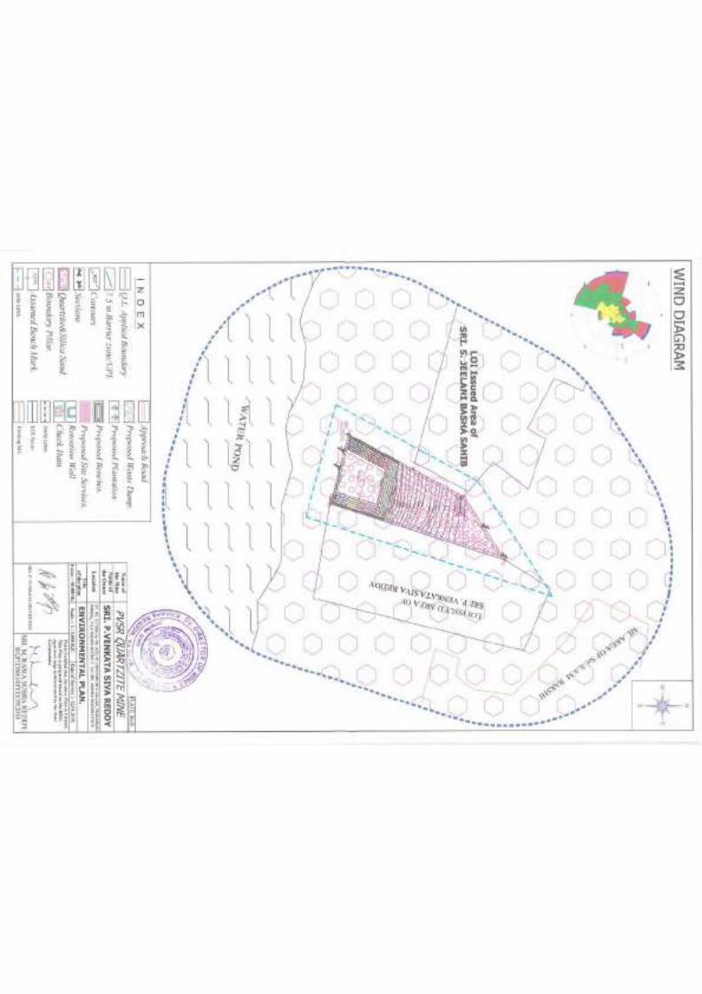
location of sensitive receptors, if any, and the habitation. The wind roses showing pre-dominant
wind direction may also be indicated on the map.
24) The water requirement for the Project, its availability and source should be furnished. A detailed
water balance should also be provided. Fresh water requirement for the Project should be indicated.
25) Necessary clearance from the Competent Authority for drawl of requisite quantity of water for the
Project should be provided.
26) Description of water conservation measures proposed to be adopted in the Project should be given.
Details of rainwater harvesting proposed in the Project, if any, should be provided.
27) Impact of the Project on the water quality, both surface and groundwater, should be assessed and
necessary safeguard measures, if any required, should be provided.
28) Based on actual monitored data, it may clearly be shown whether working will intersect groundwater.
Necessary data and documentation in this regard may be provided. In case the working will intersect
groundwater table, a detailed Hydro Geological Study should be undertaken and Report furnished.
The Report inter-alia, shall include details of the aquifers present and impact of mining activities on
these aquifers. Necessary permission from Central Ground Water Authority for working below
ground water and for pumping of ground water should also be obtained and copy furnished.
29) Details of any stream, seasonal or otherwise, passing through the lease area and modification /
diversion proposed, if any, and the impact of the same on the hydrology should be brought out.
30) Information on site elevation, working depth, groundwater table etc. Should be provided both in
AMSL and bgl. A schematic diagram may also be provided for the same.
31) A time bound Progressive Greenbelt Development Plan shall be prepared in a tabular form (indicating
the linear and quantitative coverage, plant species and time frame) and submitted, keeping in mind,
the same will have to be executed up front on commencement of the Project. Phase-wise plan of
plantation and compensatory afforestation should be charted clearly indicating the area to be covered
under plantation and the species to be planted. The details of plantation already done should be
given.The plant species selected for green belt should have greater ecological value and should be
25
STANDARD TERMS OF REFERENCE (TOR) FOR EIA/EMP REPORT FORPROJECTS/ACTIVITIES REQUIRING ENVIRONMENT CLEARANCE
of good utility value to the local population with emphasis on local and native species and the
species which are tolerant to pollution.
32) Impact on local transport infrastructure due to the Project should be indicated. Projected increase in
truck traffic as a result of the Project in the present road network (including those outside the
Project area) should be worked out, indicating whether it is capable of handling the incremental
load. Arrangement for improving the infrastructure, if contemplated (including action to be taken
by other agencies such as State Government) should be covered. Project Proponent shall conduct
Impact of Transportation study as per Indian Road Congress Guidelines.
33) Details of the onsite shelter and facilities to be provided to the mine workers should be included in
the EIA Report.
34) Conceptual post mining land use and Reclamation and Restoration of mined out areas (with plans
and with adequate number of sections) should be given in the EIA report.
35) Occupational Health impacts of the Project should be anticipated and the proposed preventive
measures spelt out in detail. Details of pre-placement medical examination and periodical medical
examination schedules should be incorporated in the EMP. The project specific occupational health
mitigation measures with required facilities proposed in the mining area may be detailed.
36) Public health implications of the Project and related activities for the population in the impact zone
should be systematically evaluated and the proposed remedial measures should be detailed along
with budgetary allocations.
37) Measures of socio economic significance and influence to the local community proposed to be
provided by the Project Proponent should be indicated. As far as possible, quantitative dimensions
may be given with time frames for implementation.
38) Detailed environmental management plan (EMP) to mitigate the environmental impacts which,
should inter-alia include the impacts of change of land use, loss of agricultural and grazing land, if
any, occupational health impacts besides other impacts specific to the proposed Project.
39) Public Hearing points raised and commitment of the Project Proponent on the same along with time
bound Action Plan with budgetary provisions to implement the same should be provided and also
incorporated in the final EIA/EMP Report of the Project.
40) Details of litigation pending against the project, if any, with direction /order passed by any Court of
Law against the Project should be given.
41) The cost of the Project (capital cost and recurring cost) as well as the cost towards implementation
of EMP should be clearly spelt out.
42) A Disaster management Plan shall be prepared and included in the EIA/EMP Report.
43) Benefits of the Project if the Project is implemented should be spelt out. The benefits of the Project
shall clearly indicate environmental, social, economic, employment potential, etc.
26
STANDARD TERMS OF REFERENCE (TOR) FOR EIA/EMP REPORT FOR PROJECTS/ACTIVITIES REQUIRING ENVIRONMENT CLEARANCE
44) Besides the above, the below mentioned general points are also to be followed:-
a) Executive Summary of the EIA/EMP Report
b) All documents to be properly referenced with index and continuous page numbering.
c) Where data are presented in the Report especially in Tables, the period in which the data
were collected and the sources should be indicated.
d) Project Proponent shall enclose all the analysis/testing reports of water, air, soil, noise etc.
using the MoEF&CC/NABL accredited laboratories. All the original analysis/testing reports
should be available during appraisal of the Project.
e) Where the documents provided are in a language other than English, an English translation
should be provided.
f) The Questionnaire for environmental appraisal of mining projects as devised earlier by the
Ministry shall also be filled and submitted.
g) While preparing the EIA report, the instructions for the Proponents and instructions for the
Consultants issued by MoEF&CC vide O.M. No. J-11013/41/2006-IA.II(I) dated 4th August,
2009, which are available on the website of this Ministry, should be followed.
h) Changes, if any made in the basic scope and project parameters (as submitted in Form-I and
the PFR for securing the TOR) should be brought to the attention of MoEF&CC with reasons
for such changes and permission should be sought, as the TOR may also have to be altered.
Post Public Hearing changes in structure and content of the draft EIA/EMP (other than
modifications arising out of the P.H. process) will entail conducting the PH again with the
revised documentation.
i) As per the circular no. J-11011/618/2010-IA.II(I) dated 30.5.2012, certified report of the
status of compliance of the conditions stipulated in the environment clearance for the existing
operations of the project, should be obtained from the Regional Office of Ministry of
Environment, Forest and Climate Change, as may be applicable.
i) The EIA report should also include (i) surface plan of the area indicating contours of main
topographic features, drainage and mining area, (ii) geological maps and sections and (iii)
sections of the mine pit and external dumps, if any, clearly showing the land features of the
adjoining area.
****
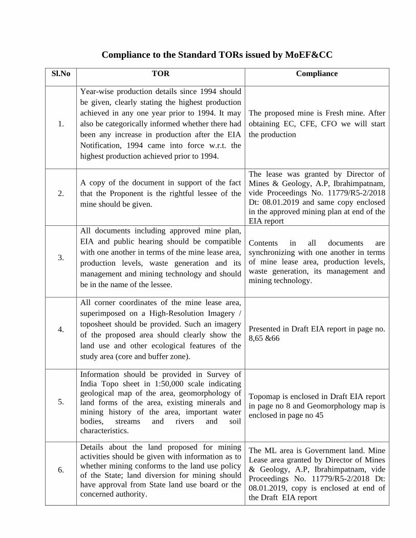
Compliance to the Standard TORs issued by MoEF&CC
Sl.No TOR Compliance
1.
Year-wise production details since 1994 should be given, clearly stating the highest production achieved in any one year prior to 1994. It may also be categorically informed whether there had been any increase in production after the EIA Notification, 1994 came into force w.r.t. the highest production achieved prior to 1994.
The proposed mine is Fresh mine. After obtaining EC, CFE, CFO we will start the production
2. A copy of the document in support of the fact that the Proponent is the rightful lessee of the mine should be given.
The lease was granted by Director of Mines & Geology, A.P, Ibrahimpatnam, vide Proceedings No. 11779/R5-2/2018 Dt: 08.01.2019 and same copy enclosed in the approved mining plan at end of the EIA report
3.
All documents including approved mine plan, EIA and public hearing should be compatible with one another in terms of the mine lease area, production levels, waste generation and its management and mining technology and should be in the name of the lessee.
Contents in all documents are synchronizing with one another in terms of mine lease area, production levels, waste generation, its management and mining technology.
4.
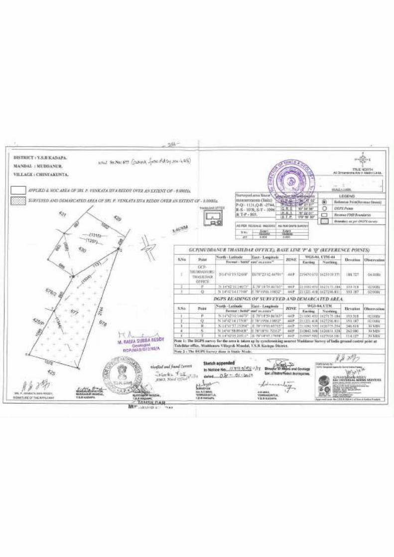
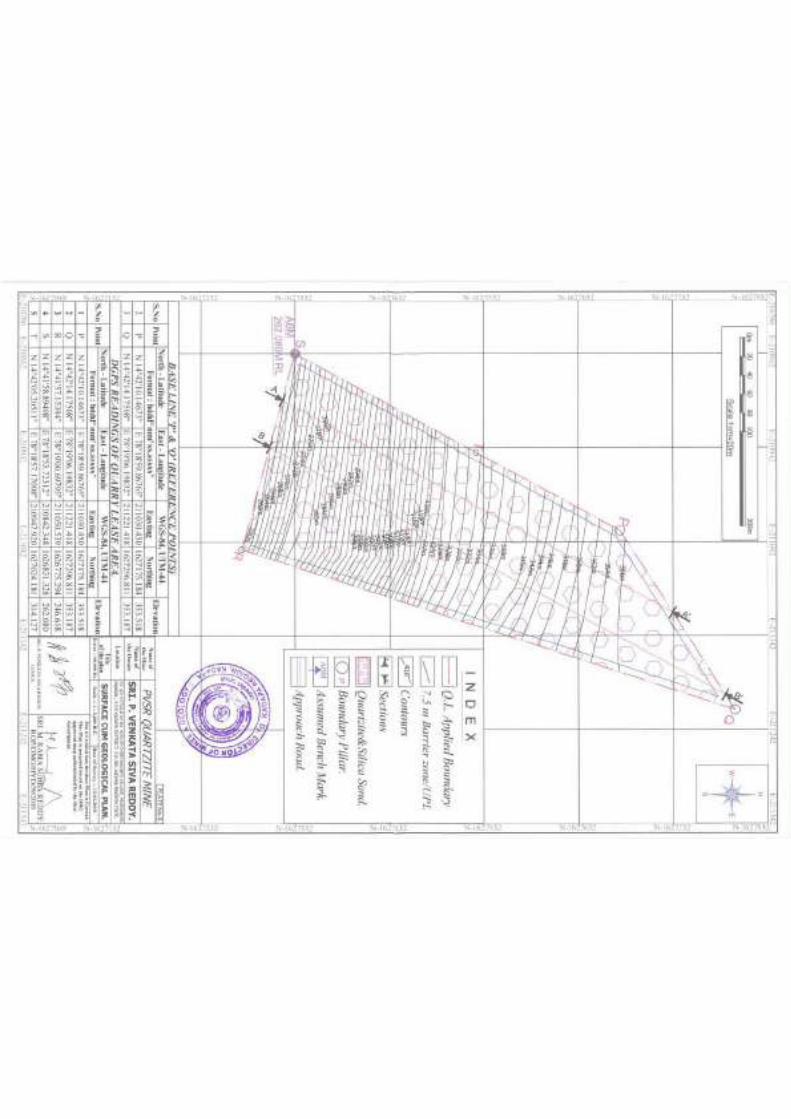
All corner coordinates of the mine lease area, superimposed on a High-Resolution Imagery / toposheet should be provided. Such an imagery of the proposed area should clearly show the land use and other ecological features of the study area (core and buffer zone).
Presented in Draft EIA report in page no. 8,65 &66
5.
Information should be provided in Survey of India Topo sheet in 1:50,000 scale indicating geological map of the area, geomorphology of land forms of the area, existing minerals and mining history of the area, important water bodies, streams and rivers and soil characteristics.
Topomap is enclosed in Draft EIA report in page no 8 and Geomorphology map is enclosed in page no 45
6.
Details about the land proposed for mining activities should be given with information as to whether mining conforms to the land use policy of the State; land diversion for mining should have approval from State land use board or the concerned authority.
The ML area is Government land. Mine Lease area granted by Director of Mines & Geology, A.P, Ibrahimpatnam, vide Proceedings No. 11779/R5-2/2018 Dt: 08.01.2019, copy is enclosed at end of the Draft EIA report
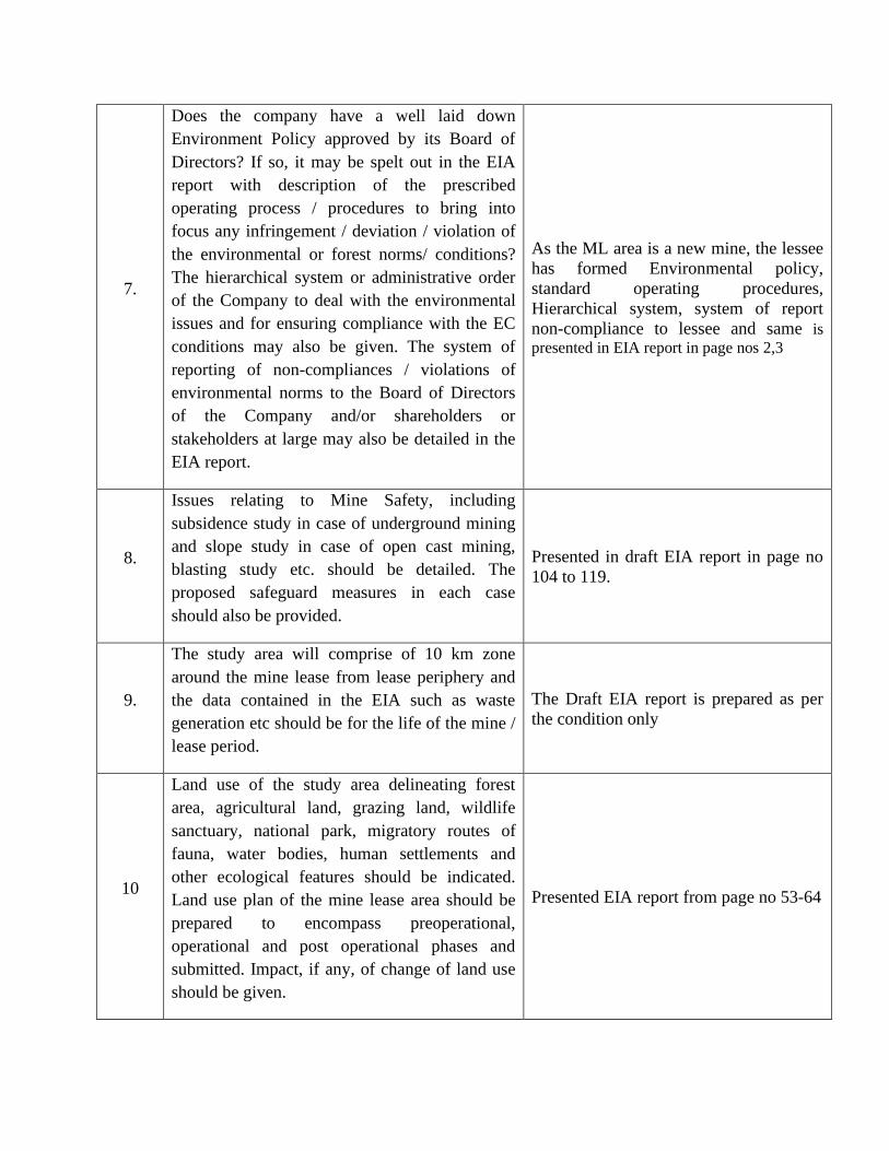
7.
Does the company have a well laid down Environment Policy approved by its Board of Directors? If so, it may be spelt out in the EIA report with description of the prescribed operating process / procedures to bring into focus any infringement / deviation / violation of the environmental or forest norms/ conditions? The hierarchical system or administrative order of the Company to deal with the environmental issues and for ensuring compliance with the EC conditions may also be given. The system of reporting of non-compliances / violations of environmental norms to the Board of Directors of the Company and/or shareholders or stakeholders at large may also be detailed in the EIA report.
As the ML area is a new mine, the lessee has formed Environmental policy, standard operating procedures, Hierarchical system, system of report non-compliance to lessee and same is presented in EIA report in page nos 2,3
8.
Issues relating to Mine Safety, including subsidence study in case of underground mining and slope study in case of open cast mining, blasting study etc. should be detailed. The proposed safeguard measures in each case should also be provided.
Presented in draft EIA report in page no 104 to 119.
9.
The study area will comprise of 10 km zone around the mine lease from lease periphery and the data contained in the EIA such as waste generation etc should be for the life of the mine / lease period.
The Draft EIA report is prepared as per the condition only
10
Land use of the study area delineating forest area, agricultural land, grazing land, wildlife sanctuary, national park, migratory routes of fauna, water bodies, human settlements and other ecological features should be indicated. Land use plan of the mine lease area should be prepared to encompass preoperational, operational and post operational phases and submitted. Impact, if any, of change of land use should be given.
Presented EIA report from page no 53-64
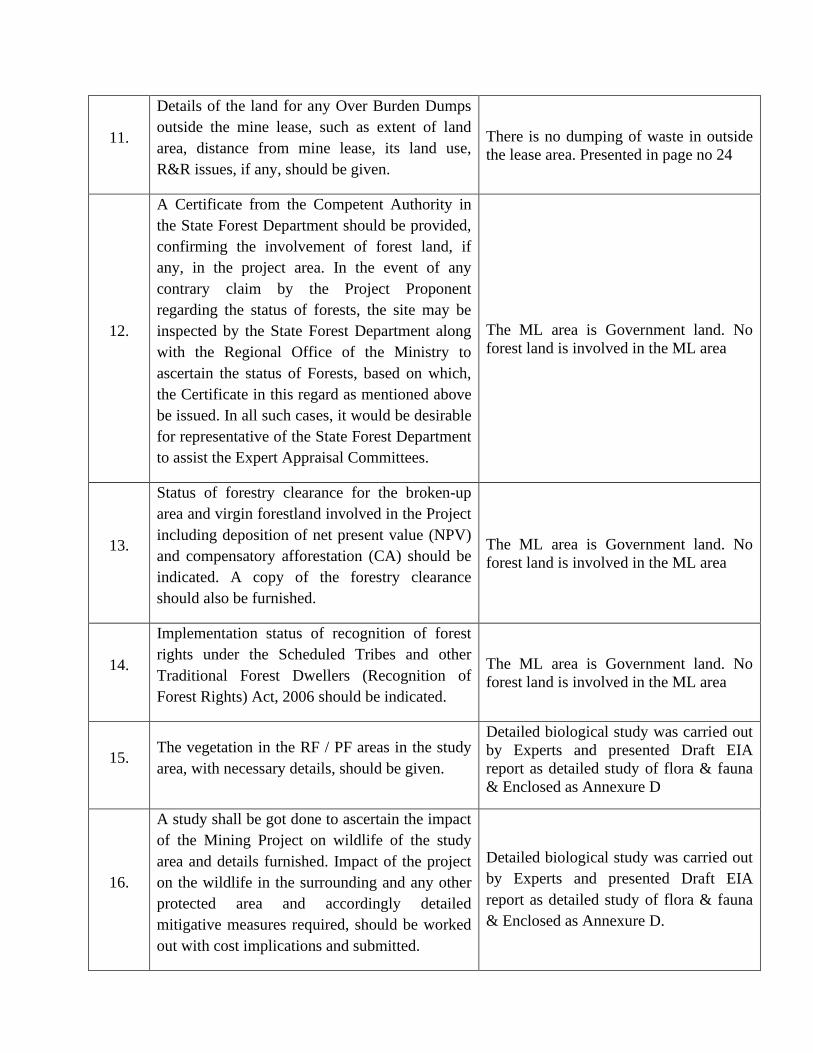
11.
Details of the land for any Over Burden Dumps outside the mine lease, such as extent of land area, distance from mine lease, its land use, R&R issues, if any, should be given.
There is no dumping of waste in outside the lease area. Presented in page no 24
12.
A Certificate from the Competent Authority in the State Forest Department should be provided, confirming the involvement of forest land, if any, in the project area. In the event of any contrary claim by the Project Proponent regarding the status of forests, the site may be inspected by the State Forest Department along with the Regional Office of the Ministry to ascertain the status of Forests, based on which, the Certificate in this regard as mentioned above be issued. In all such cases, it would be desirable for representative of the State Forest Department to assist the Expert Appraisal Committees.
The ML area is Government land. No forest land is involved in the ML area
13.
Status of forestry clearance for the broken-up area and virgin forestland involved in the Project including deposition of net present value (NPV) and compensatory afforestation (CA) should be indicated. A copy of the forestry clearance should also be furnished.
The ML area is Government land. No forest land is involved in the ML area
14.
Implementation status of recognition of forest rights under the Scheduled Tribes and other Traditional Forest Dwellers (Recognition of Forest Rights) Act, 2006 should be indicated.
The ML area is Government land. No forest land is involved in the ML area
15. The vegetation in the RF / PF areas in the study area, with necessary details, should be given.
Detailed biological study was carried out by Experts and presented Draft EIA report as detailed study of flora & fauna & Enclosed as Annexure D
16.
A study shall be got done to ascertain the impact of the Mining Project on wildlife of the study area and details furnished. Impact of the project on the wildlife in the surrounding and any other protected area and accordingly detailed mitigative measures required, should be worked out with cost implications and submitted.
Detailed biological study was carried out by Experts and presented Draft EIA report as detailed study of flora & fauna & Enclosed as Annexure D.
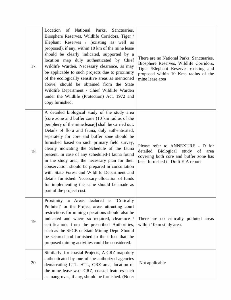
17.
Location of National Parks, Sanctuaries, Biosphere Reserves, Wildlife Corridors, Tiger / Elephant Reserves / (existing as well as proposed), if any, within 10 km of the mine lease should be clearly indicated, supported by a location map duly authenticated by Chief Wildlife Warden. Necessary clearance, as may be applicable to such projects due to proximity of the ecologically sensitive areas as mentioned above, should be obtained from the State Wildlife Department / Chief Wildlife Warden under the Wildlife (Protection) Act, 1972 and copy furnished.
There are no National Parks, Sanctuaries, Biosphere Reserves, Wildlife Corridors, Tiger /Elephant Reserves existing and proposed within 10 Kms radius of the mine lease area
18.
A detailed biological study of the study area [core zone and buffer zone (10 km radius of the periphery of the mine lease)] shall be carried out. Details of flora and fauna, duly authenticated, separately for core and buffer zone should be furnished based on such primary field survey, clearly indicating the Schedule of the fauna present. In case of any scheduled-I fauna found in the study area, the necessary plan for their conservation should be prepared in consultation with State Forest and Wildlife Department and details furnished. Necessary allocation of funds for implementing the same should be made as part of the project cost.
Please refer to ANNEXURE - D for detailed Biological study of area covering both core and buffer zone has been furnished in Draft EIA report
19.
Proximity to Areas declared as ‘Critically Polluted’ or the Project areas attracting court
restrictions for mining operations should also be indicated and where so required, clearance / certifications from the prescribed Authorities, such as the SPCB or State Mining Dept. Should be secured and furnished to the effect that the proposed mining activities could be considered.
There are no critically polluted areas within 10km study area.
20.
Similarly, for coastal Projects, A CRZ map duly authenticated by one of the authorized agencies demarcating LTL. HTL, CRZ area, location of the mine lease w.r.t CRZ, coastal features such as mangroves, if any, should be furnished. (Note:
Not applicable
The Mining Projects falling under CRZ would also need to obtain approval of the concerned Coastal Zone Management Authority).
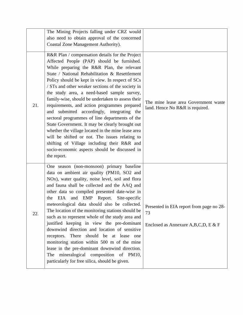
21.
R&R Plan / compensation details for the Project Affected People (PAP) should be furnished. While preparing the R&R Plan, the relevant State / National Rehabilitation & Resettlement Policy should be kept in view. In respect of SCs / STs and other weaker sections of the society in the study area, a need-based sample survey, family-wise, should be undertaken to assess their requirements, and action programmes prepared and submitted accordingly, integrating the sectoral programmes of line departments of the State Government. It may be clearly brought out whether the village located in the mine lease area will be shifted or not. The issues relating to shifting of Village including their R&R and socio-economic aspects should be discussed in the report.
The mine lease area Government waste land. Hence No R&R is required.
22.
One season (non-monsoon) primary baseline data on ambient air quality (PM10, SO2 and NOx), water quality, noise level, soil and flora and fauna shall be collected and the AAQ and other data so compiled presented date-wise in the EIA and EMP Report. Site-specific meteorological data should also be collected. The location of the monitoring stations should be such as to represent whole of the study area and justified keeping in view the pre-dominant downwind direction and location of sensitive receptors. There should be at lease one monitoring station within 500 m of the mine lease in the pre-dominant downwind direction. The mineralogical composition of PM10, particularly for free silica, should be given.
Presented in EIA report from page no 28-73
Enclosed as Annexure A,B,C,D, E & F
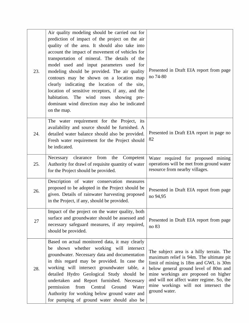
23.
Air quality modeling should be carried out for prediction of impact of the project on the air quality of the area. It should also take into account the impact of movement of vehicles for transportation of mineral. The details of the model used and input parameters used for modeling should be provided. The air quality contours may be shown on a location map clearly indicating the location of the site, location of sensitive receptors, if any, and the habitation. The wind roses showing pre-dominant wind direction may also be indicated on the map.
Presented in Draft EIA report from page no 74-80
24.
The water requirement for the Project, its availability and source should be furnished. A detailed water balance should also be provided. Fresh water requirement for the Project should be indicated.
Presented in Draft EIA report in page no 82
25. Necessary clearance from the Competent Authority for drawl of requisite quantity of water for the Project should be provided.
Water required for proposed mining operations will be met from ground water resource from nearby villages.
26.
Description of water conservation measures proposed to be adopted in the Project should be given. Details of rainwater harvesting proposed in the Project, if any, should be provided.
Presented in Draft EIA report from page no 94,95
27
Impact of the project on the water quality, both surface and groundwater should be assessed and necessary safeguard measures, if any required, should be provided.
Presented in Draft EIA report from page no 83
28.
Based on actual monitored data, it may clearly be shown whether working will intersect groundwater. Necessary data and documentation in this regard may be provided. In case the working will intersect groundwater table, a detailed Hydro Geological Study should be undertaken and Report furnished. Necessary permission from Central Ground Water Authority for working below ground water and for pumping of ground water should also be
The subject area is a hilly terrain. The maximum relief is 94m. The ultimate pit limit of mining is 18m and GWL is 30m below general ground level of 80m and mine workings are proposed on higher and will not affect water regime. So, the mine workings will not intersect the ground water.
obtained and copy furnished.
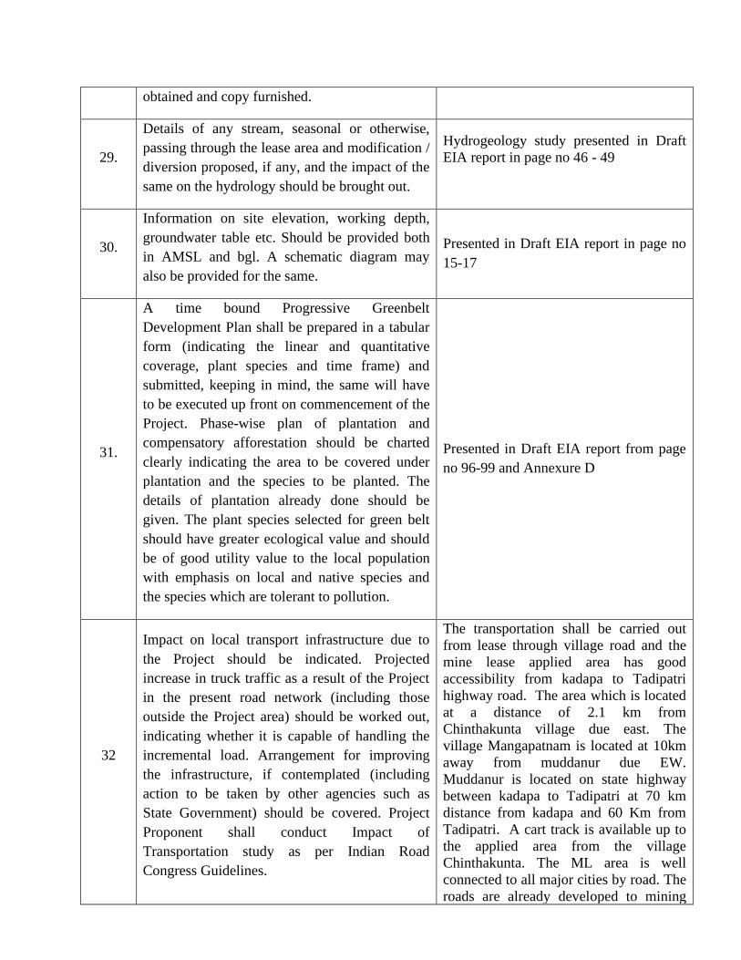
29.
Details of any stream, seasonal or otherwise, passing through the lease area and modification / diversion proposed, if any, and the impact of the same on the hydrology should be brought out.
Hydrogeology study presented in Draft EIA report in page no 46 - 49
30.
Information on site elevation, working depth, groundwater table etc. Should be provided both in AMSL and bgl. A schematic diagram may also be provided for the same.
Presented in Draft EIA report in page no 15-17
31.
A time bound Progressive Greenbelt Development Plan shall be prepared in a tabular form (indicating the linear and quantitative coverage, plant species and time frame) and submitted, keeping in mind, the same will have to be executed up front on commencement of the Project. Phase-wise plan of plantation and compensatory afforestation should be charted clearly indicating the area to be covered under plantation and the species to be planted. The details of plantation already done should be given. The plant species selected for green belt should have greater ecological value and should be of good utility value to the local population with emphasis on local and native species and the species which are tolerant to pollution.
Presented in Draft EIA report from page no 96-99 and Annexure D
32
Impact on local transport infrastructure due to the Project should be indicated. Projected increase in truck traffic as a result of the Project in the present road network (including those outside the Project area) should be worked out, indicating whether it is capable of handling the incremental load. Arrangement for improving the infrastructure, if contemplated (including action to be taken by other agencies such as State Government) should be covered. Project Proponent shall conduct Impact of Transportation study as per Indian Road Congress Guidelines.
The transportation shall be carried out from lease through village road and the mine lease applied area has good accessibility from kadapa to Tadipatri highway road. The area which is located at a distance of 2.1 km from Chinthakunta village due east. The village Mangapatnam is located at 10km away from muddanur due EW. Muddanur is located on state highway between kadapa to Tadipatri at 70 km distance from kadapa and 60 Km from Tadipatri. A cart track is available up to the applied area from the village Chinthakunta. The ML area is well connected to all major cities by road. The roads are already developed to mining
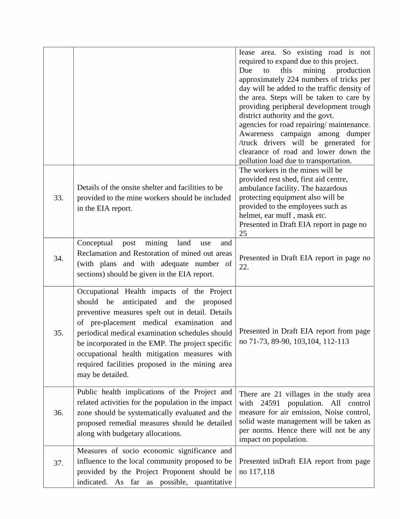
lease area. So existing road is not required to expand due to this project. Due to this mining production approximately 224 numbers of tricks per day will be added to the traffic density of the area. Steps will be taken to care by providing peripheral development trough district authority and the govt. agencies for road repairing/ maintenance. Awareness campaign among dumper /truck drivers will be generated for clearance of road and lower down the pollution load due to transportation.
33. Details of the onsite shelter and facilities to be provided to the mine workers should be included in the EIA report.
The workers in the mines will be provided rest shed, first aid centre, ambulance facility. The hazardous protecting equipment also will be provided to the employees such as helmet, ear muff , mask etc. Presented in Draft EIA report in page no 25
34.
Conceptual post mining land use and Reclamation and Restoration of mined out areas (with plans and with adequate number of sections) should be given in the EIA report.
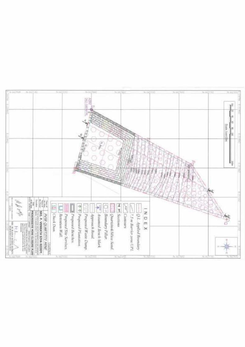
Presented in Draft EIA report in page no 22.
35.
Occupational Health impacts of the Project should be anticipated and the proposed preventive measures spelt out in detail. Details of pre-placement medical examination and periodical medical examination schedules should be incorporated in the EMP. The project specific occupational health mitigation measures with required facilities proposed in the mining area may be detailed.
Presented in Draft EIA report from page no 71-73, 89-90, 103,104, 112-113
36.
Public health implications of the Project and related activities for the population in the impact zone should be systematically evaluated and the proposed remedial measures should be detailed along with budgetary allocations.
There are 21 villages in the study area with 24591 population. All control measure for air emission, Noise control, solid waste management will be taken as per norms. Hence there will not be any impact on population.
37.
Measures of socio economic significance and influence to the local community proposed to be provided by the Project Proponent should be indicated. As far as possible, quantitative
Presented inDraft EIA report from page no 117,118
dimensions may be given with time frames for implementation.
38.
Detailed environmental management plan to mitigate the environmental impacts which, should inter-alia include the impacts of change of land use, loss of agricultural and grazing land, if any, occupational health impacts besides other impacts specific to the proposed Project.
Presented in EIA report from page no 91-105
39.
Public hearing points raised and commitment of the project proponent on the same along with time bound action plan to implement the same should be provided and also incorporated in the final EIA / EMP Report of the Project.
-
40. Details of litigation pending against the project, if any, with direction / order passed by any Court of Law against the project should be given.
No litigation or court cases are pending against the project.
41. The cost of the project (capital cost and recurring cost) as well as the cost towards implementation of EMP should clearly be spelt out.
Presented in Draft EIA report from page no 105
42. A Disaster management Plan shall be prepared and included in the EIA/EMP Report.
Presented in Draft EIA report from page no 114-115
43
Benefits of the Project if the Project is implemented should be spelt out. The benefits of the Project shall clearly indicate environmental, social, economic, employment potential, etc.
Presented in EIA report from page no 120-121
44 Besides the above, the below mentioned general points are also to be followed
a. Executive Summary of the EIA/EMP Report Executive Summary is provided over and above the Draft EIA report
b. All documents to be properly referenced with index and continuous page numbering.
Index and Page numbers are given in EIA report
c.
Where data are presented in the Report especially in Tables, the period in which the data were collected and the sources should be indicated.
Draft EIA report is prepared with compliances of the condition
d. Project Proponent shall enclose all the analysis/testing reports of water, air, soil, noise
All the original analysis reports will be submitted along with Final EIA report to
etc. using the MoEF&CC/NABL accredited laboratories. All the original analysis/testing reports should be available during appraisal of the Project.
the SEAC committee at the time of appraisal.
Air, Water, Noise and Soil analysis data is enclosed in Draft EIA report as annexure A, B, C
e. Where the documents provided are in a language other than English, an English translation should be provided
The Drat EIA report and all the enclosures are prepared in English.
f. The Questionnaire for environmental appraisal of mining projects as devised earlier by the Ministry shall also be filled and submitted.
The Questionnaire for environmental appraisal of mining projects will be submitted along with Final EIA report to the SEAC committee at the time of appraisal.
g.
While preparing the EIA report, the instructions for the Proponents and instructions for the Consultants issued by MoEF&CC vide O.M. No. J-11013/41/2006-IA. II(I) dated 4th August, 2009, which are available on the website of this Ministry, should be followed.
The instructions are fallowed as per the condition.
h.
Changes, if any made in the basic scope and project parameters (as submitted in Form-I and the PFR for securing the TOR) should be brought to the attention of MoEF&CC with reasons for such changes and permission should be sought, as the TOR may also have to be altered. Post Public Hearing changes in structure and content of the draft EIA/EMP (other than modifications arising out of the P.H. process) will entail conducting the PH again with the revised documentation.
NO changes yet.
We will fallow the condition if any changes proposed.
I
As per the circular no. J-11011/618/2010-IA.II(I) dated 30.5.2012, certified report of the status of compliance of the conditions stipulated in the environment clearance for the existing operations of the project, should be obtained from the Regional Office of Ministry of Environment, Forest and Climate Change, as may be applicable.
Not Applicable, as it is a NEW project.
J
The EIA report should also include (i) surface plan of the area indicating contours of main topographic features, drainage and mining area, (ii) geological maps and sections and (iii) sections of the mine pit and external dumps, if any, clearly showing the land features of the adjoining area.
All the maps are provided in Draft EIA report.
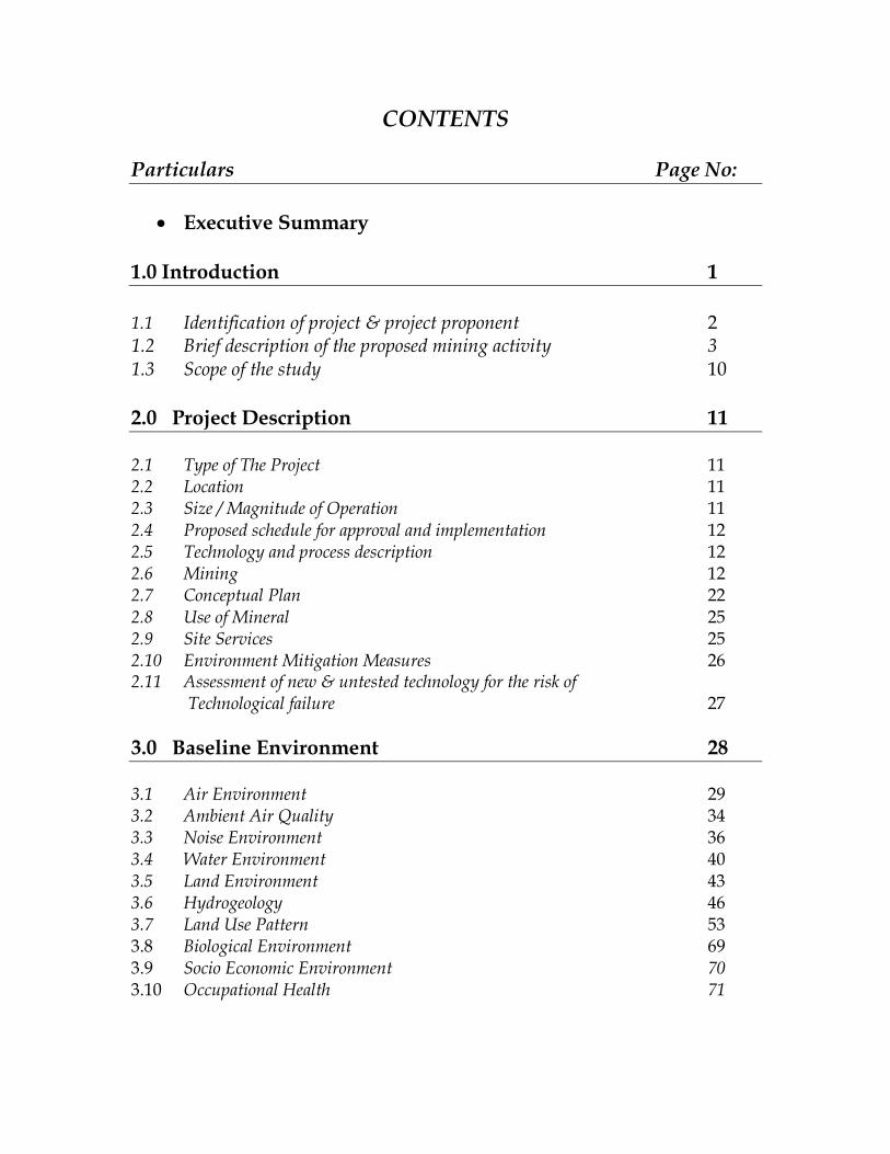
CONTENTS Particulars Page No:
• Executive Summary 1.0 Introduction 1
1.1 Identification of project & project proponent 2 1.2 Brief description of the proposed mining activity 3 1.3 Scope of the study 10
2.0 Project Description 11 2.1 Type of The Project 11 2.2 Location 11 2.3 Size / Magnitude of Operation 11 2.4 Proposed schedule for approval and implementation 12 2.5 Technology and process description 12 2.6 Mining 12 2.7 Conceptual Plan 22 2.8 Use of Mineral 25 2.9 Site Services 25 2.10 Environment Mitigation Measures 26 2.11 Assessment of new & untested technology for the risk of
Technological failure 27
3.0 Baseline Environment 28 3.1 Air Environment 29 3.2 Ambient Air Quality 34 3.3 Noise Environment 36 3.4 Water Environment 40 3.5 Land Environment 43 3.6 Hydrogeology 46 3.7 Land Use Pattern 53 3.8 Biological Environment 69 3.9 Socio Economic Environment 70 3.10 Occupational Health 71
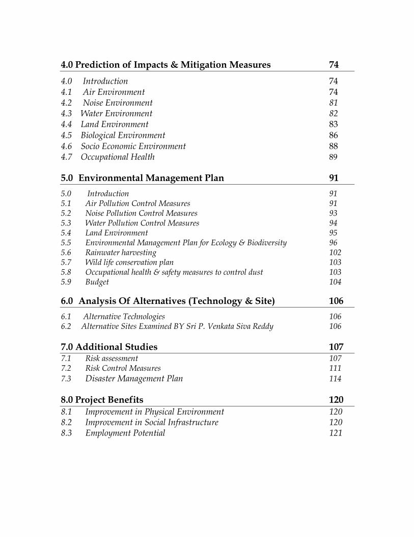
4.0 Prediction of Impacts & Mitigation Measures 74
4.0 Introduction 74 4.1 Air Environment 74 4.2 Noise Environment 81 4.3 Water Environment 82 4.4 Land Environment 83 4.5 Biological Environment 86 4.6 Socio Economic Environment 88 4.7 Occupational Health 89
5.0 Environmental Management Plan 91
5.0 Introduction 91 5.1 Air Pollution Control Measures 91 5.2 Noise Pollution Control Measures 93 5.3 Water Pollution Control Measures 94 5.4 Land Environment 95 5.5 Environmental Management Plan for Ecology & Biodiversity 96 5.6 Rainwater harvesting 102 5.7 Wild life conservation plan 103 5.8 Occupational health & safety measures to control dust 103 5.9 Budget 104
6.0 Analysis Of Alternatives (Technology & Site) 106
6.1 Alternative Technologies 106 6.2 Alternative Sites Examined BY Sri P. Venkata Siva Reddy 106
7.0 Additional Studies 107 7.1 Risk assessment 107 7.2 Risk Control Measures 111
7.3 Disaster Management Plan 114
8.0 Project Benefits 120 8.1 Improvement in Physical Environment 120 8.2 Improvement in Social Infrastructure 120 8.3 Employment Potential 121
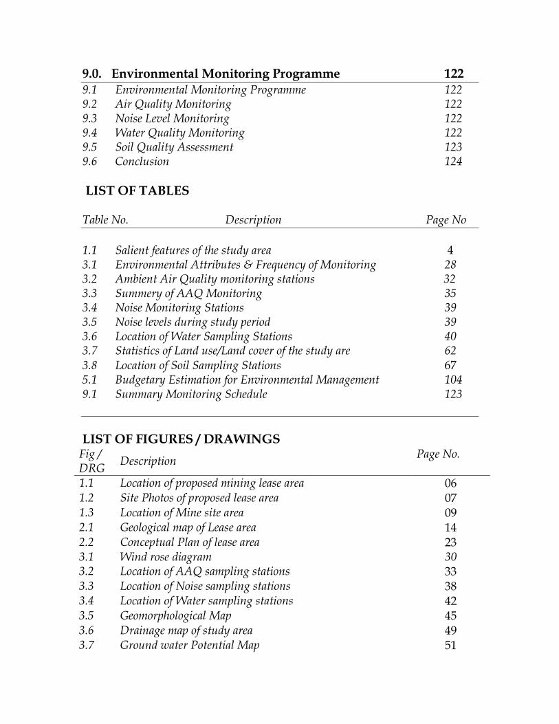
9.0. Environmental Monitoring Programme 122 9.1 Environmental Monitoring Programme 122 9.2 Air Quality Monitoring 122 9.3 Noise Level Monitoring 122 9.4 Water Quality Monitoring 122 9.5 Soil Quality Assessment 123 9.6 Conclusion 124
LIST OF TABLES Table No. Description Page No
1.1 Salient features of the study area 4 3.1 Environmental Attributes & Frequency of Monitoring 28 3.2 Ambient Air Quality monitoring stations 32 3.3 Summery of AAQ Monitoring 35 3.4 Noise Monitoring Stations 39 3.5 Noise levels during study period 39 3.6 Location of Water Sampling Stations 40 3.7 Statistics of Land use/Land cover of the study are 62 3.8 Location of Soil Sampling Stations 67 5.1 Budgetary Estimation for Environmental Management 104 9.1 Summary Monitoring Schedule 123
LIST OF FIGURES / DRAWINGS Fig / DRG
Description Page No.
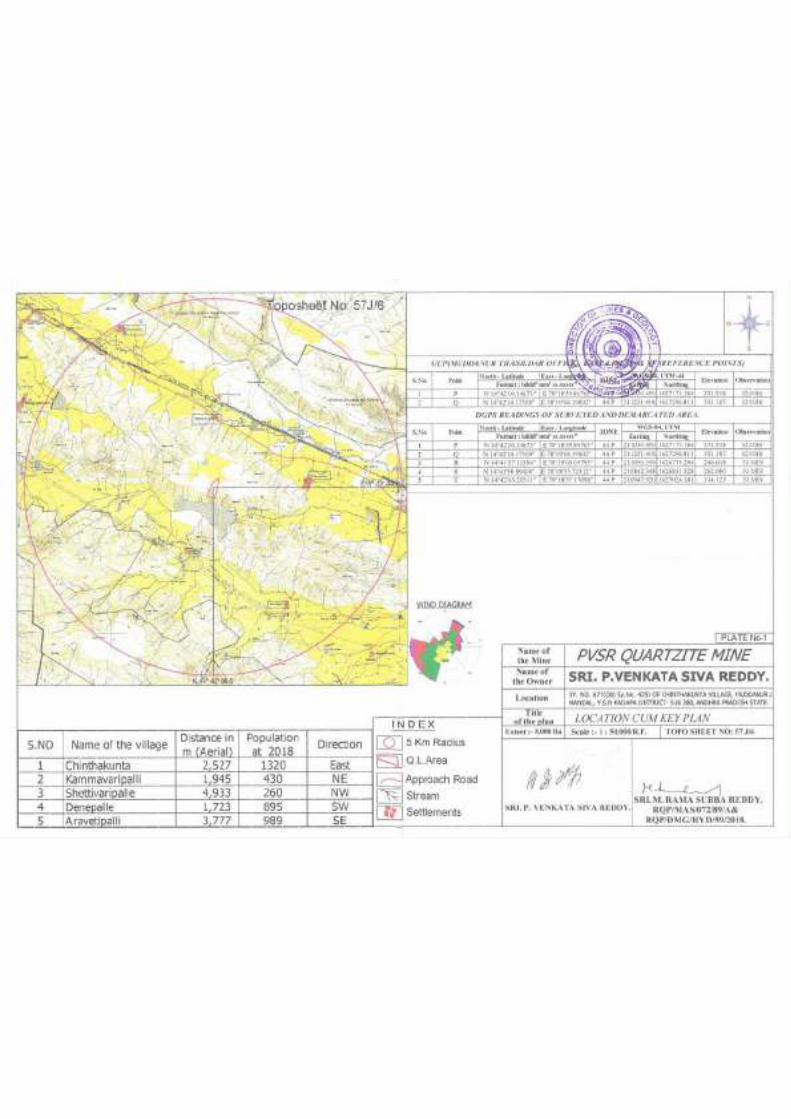
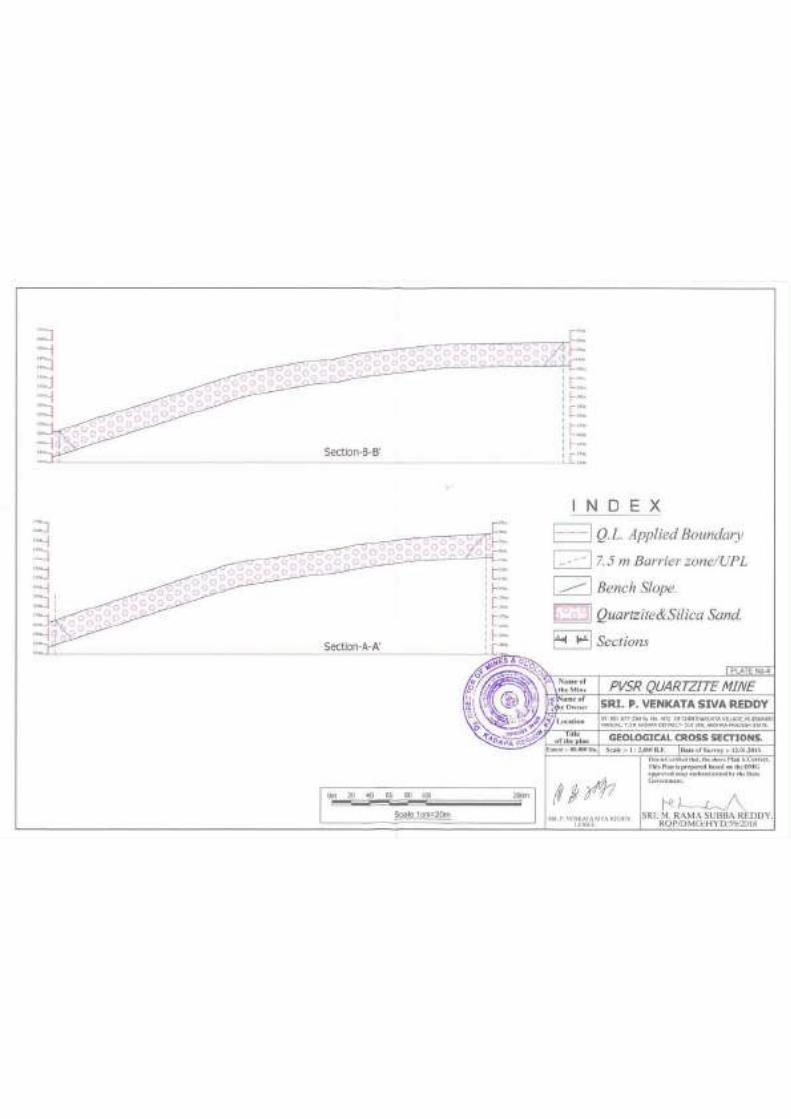
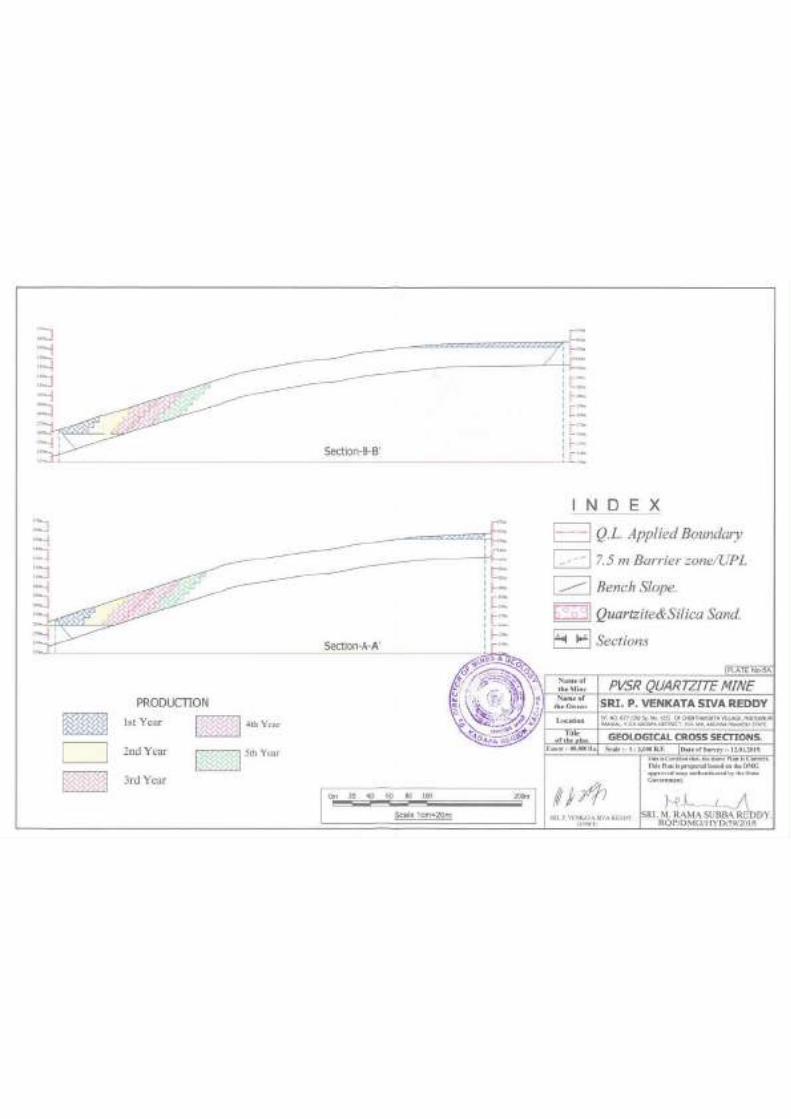
1.1 Location of proposed mining lease area 06 1.2 Site Photos of proposed lease area 07 1.3 Location of Mine site area 09 2.1 Geological map of Lease area 14 2.2 Conceptual Plan of lease area 23 3.1 Wind rose diagram 30 3.2 Location of AAQ sampling stations 33 3.3 Location of Noise sampling stations 38 3.4 Location of Water sampling stations 42 3.5 Geomorphological Map 45 3.6 Drainage map of study area 49 3.7 Ground water Potential Map 51
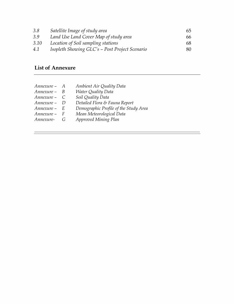
3.8 Satellite Image of study area 65 3.9 Land Use Land Cover Map of study area 66 3.10 Location of Soil sampling stations 68 4.1 Isopleth Showing GLC’s – Post Project Scenario 80
List of Annexure
Annexure – A Ambient Air Quality Data Annexure – B Water Quality Data Annexure – C Soil Quality Data Annexure – D Detailed Flora & Fauna Report Annexure – E Demographic Profile of the Study Area Annexure – F Mean Meteorological Data Annexure- G Approved Mining Plan
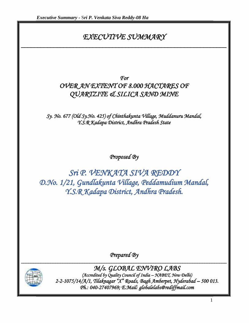
Executive Summary - Sri P. Venkata Siva Reddy-08 Ha
1
EXECUTIVE SUMMARY
_______________________________________________________________
For
OVER AN EXTENT OF 8.000 HACTARES OF QUARTZITE & SILICA SAND MINE
Sy. No. 677 (Old Sy.No. 425) of Chinthakunta Village, Muddanuru Mandal, Y.S.R Kadapa District, Andhra Pradesh State
Proposed By
Sri P. VENKATA SIVA REDDY D.No. 1/21, Gundlakunta Village, Peddamudium Mandal,
Y.S.R Kadapa District, Andhra Pradesh.
Prepared By
____________________________________________________________________________________
M/s. GLOBAL ENVIRO LABS (Accredited by Quality Council of India – NABET, New Delhi)
2-2-1075/14/A/1, Tilaknagar “X” Roads, Bagh Amberpet, Hyderabad – 500 013. Ph.: 040-27407969; E.Mail: [email protected]
Executive Summary - Sri P. Venkata Siva Reddy-08 Ha
2
EXECUTIVE SUMMARY 1.0 INTRODUCTION
The Mining Lease area of 08.000 Ha. Quartzite & Silica Sand Mine of Sri. P. Venkata
Siva Reddy, located in Sy.No. 677 (Old Sy.No. 425) of Chinthakunta Village, Muddanur
Mandal, Y.S.R Kadapa District, Andhra Pradesh State
The lease was granted by Director of Mines & Geology, A.P, Ibrahimpatnam, vide
Proceedings No. 11779/R5-2/2018 Dt: 08.01.2019 for a period of 20 years. A mining
plan was approved by the Deputy Directorate of Mines & Geology, Y.S.R Kadapa vide
Letter No. 463/MP/YGL/2019 Dt:05.02.2019 for a period of 5 years.
The proposed mine is Fresh mine. and proposed maximum production is 3,75,000 TPA
(average production is 2,92,678 TPA) of Quartzite and Silica Sand. The total cost of the
project is 25 Lakhs only.
As per TOR Letter No: SEIAA/AP/KDP/MIN/03/2019/851-283 dated 14th May, 2019,
issued by SEIAA, A.P. the lessee has to obtain Environmental Clearance from State
Environmental Impact Assessment Authority, Andhra Pradesh.
Accordingly, the lessee has evaluated the possible environmental aspects and their
associated impacts that will be arise due to the proposed maximum production of
3,75,000 TPA (average production is 2,92,678 TPA) of Quartzite and Silica Sand and to
delineate the management plan to prevent, control, mitigate or minimize the adverse
environmental impacts envisaged. The data collected for this mining project during post
monsoon season i.e. for the months of October 2019 to December 2019. M/s. Global
Enviro Labs have prepared a Draft EIA covering an area of 10 kms radius from the
project site.
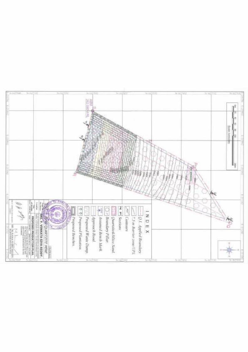
2.0 DETAILS ABOUT THE MINE The proposed mine deals with the proposed maximum production is 3,75,000 TPA
(average production is 2,92,678 TPA) of Quartzite and Silica Sand, in Survey No. 677
(Old Sy.No. 425) of Chinthakunta Village, Muddanur Mandal, Y.S.R Kadapa District,
Andhra Pradesh State. The lease area will be worked by opencast other than fully
mechanized mining method with drilling and controlled blasting.
Executive Summary - Sri P. Venkata Siva Reddy-08 Ha
3
The applied area is located about 1.3 km from Denepalli Village and it is about 10 kms
from Muddanur mandal and Renigunta air port is about 150 km. The applied area is
accessible by means of Jeeps and Lorries.
2.1 MINING
This is a fresh mine. The proposed mining is planned to be carried out by opencast other
than fully mechanized mining method with drilling and controlled blasting. The ROM
will be sorted into different sizes by feeding it to the crusher proposed to be established
outside the applied area. The ROM will be loaded into tippers and tractors using
Excavator. Mining will be carried out by formation of benches of each 6.0m high. The
site inspection reveals that the East to West portion of the applied area is suitable for
development during first 5 years. As the workings are proposed on higher elevations no
ground water is expected into the working pits. The rainwater that accumulates in the
workings during monsoon will be bailed out by installing a diesel operated pump set. The
mine will work in one shift of eight hours duration and six days in a week, for 300 days
in a year.
3.0 COLLECTION OF BASELINE DATA
The data collected for this mining project to know the existing quality of air, water, soil
characteristics, flora & fauna, noise levels and socio-economic details of the study area
during the post monsoon season i.e. for the months of October 2019 to December 2019.
3.1 AIR ENVIRONMENT In order to assess the existing ambient air quality in the study area of 10 km radius of the
mine area, a network of 8 ambient air quality stations were selected and samples were
collected to analyze for various parameters like PM2.5, PM10, SO2, and NOx
concentrations. The sampling stations were selected based on the Topography/ Terrain of
the study area, Populated areas, Residential areas etc.
The values of ambient air quality of all the monitoring stations for various parameters
during the study period (October 2019 to December 2019) will be as following.
The maximum value of PM2.5 in the proposed project area (core zone) is 27 μg/m3,
PM10 is 33 μg/m3, SO2 is 6.1 μg/m3 and NOx is 6.7 μg/m3.
Executive Summary - Sri P. Venkata Siva Reddy-08 Ha
4
The average value of PM2.5 in the buffer zone in the range of 15-29 μg/m3, PM10 in the
range of 25-48 μg/m3, SO2 in the range of 5.2 – 7.1 μg/m3 and NOx in the range of 6.6 –
7.9 μg/m3.
The concentrations of various parameters in the air quality of the study area were found
to be well within the norms prescribed by NAAQ.
3.2 NOISE ENVIRONMENT In order to know the baseline noise levels, in and around the Mine site, Noise levels were
measured at the Mine complex and also at 6 villages in the study area. The day-night
noise levels were monitored at all locations and the maximum noise levels ranging from
55.2 dBA to 65.3 dBA the noise levels recorded at all the stations were found to be less
than the standards prescribed.
3.3 WATER ENVIRONMENT
In order to assess the Groundwater quality impacts 6 nos of samples were collected.
These samples were analyzed for various physical and chemical and bacteriological
parameters to know the potability levels.
All the water samples collected shows that the parameters well within the drinking water
standards specified in IS 10500.
3.4 LAND ENVIRONMENT
6 nos. of soil samples were collected and analyzed for Physical & Chemical parameters.
3.5 BIOLOGICAL ENVIORONMENT
The details of flora and fauna present in the study area were described elaborately in the
EIA report
3.6 SOICIO-ECONOMIC ENVIRONMENT
The detailed description of the Socio-Economic Environment is presented in the EIA
report.
Executive Summary - Sri P. Venkata Siva Reddy-08 Ha
5
4.0 ENVIRONMENTAL IMPACTS
4.1 AIR ENVIRONMENT
The impacts on air environment from a mining activity depend on various factors like
production capacity, machinery involved, operations and maintenance of various
equipments and vehicle. Apart from these, there will be other activities associated viz
transportation of mineral and waste, stocking facilities and dump management within the
mine lease area that may contribute to pollution.
An attempt has been made to predict the incremental rise of various ground level
concentrations above the baseline status in respect of air pollution due to proposed
production for a max. quantity of 3,75,000 TPA of Quartzite and Silica sand has been
considered. The Industrial Source Complex – Short Term model (ISCST3) is a
computerized air quality model, which was approved by United States Environmental
Protection Agency for mining applications is used for predicting the Ground Level
Concentrations (GLC) due to the mining activity.
The maximum ground level concentration is estimated to be about 11.16 μg/m3 within the
mine area, where mining operations are being carried out. The concentration was found
to reduce to a value of less than 3.72 μg/m3 at a distance of about 0.5 km from the mining
operations. The impact of mining operations would be negligible beyond 1.0 km.
The net concentration of PM10 in the mine area and buffer zone is well within the
National Ambient Air Quality Standards (NAAQS). Hence there will not be any adverse
impact on air environment due to the proposed mining activity.
Executive Summary - Sri P. Venkata Siva Reddy-08 Ha
6
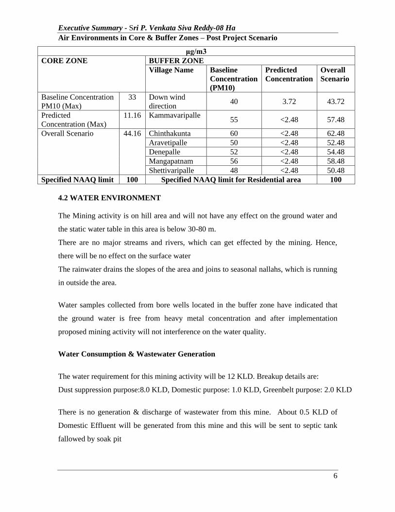
Air Environments in Core & Buffer Zones – Post Project Scenario
μg/m3 CORE ZONE BUFFER ZONE
Village Name Baseline Concentration (PM10)
Predicted Concentration
Overall Scenario
Baseline Concentration PM10 (Max)
33 Down wind direction
40 3.72 43.72
Predicted Concentration (Max)
11.16 Kammavaripalle 55 <2.48 57.48
Overall Scenario 44.16 Chinthakunta 60 <2.48 62.48 Aravetipalle 50 <2.48 52.48 Denepalle 52 <2.48 54.48 Mangapatnam 56 <2.48 58.48 Shettivaripalle 48 <2.48 50.48
Specified NAAQ limit 100 Specified NAAQ limit for Residential area 100 4.2 WATER ENVIRONMENT The Mining activity is on hill area and will not have any effect on the ground water and
the static water table in this area is below 30-80 m.
There are no major streams and rivers, which can get effected by the mining. Hence,
there will be no effect on the surface water
The rainwater drains the slopes of the area and joins to seasonal nallahs, which is running
in outside the area.
Water samples collected from bore wells located in the buffer zone have indicated that
the ground water is free from heavy metal concentration and after implementation
proposed mining activity will not interference on the water quality.
Water Consumption & Wastewater Generation
The water requirement for this mining activity will be 12 KLD. Breakup details are:
Dust suppression purpose:8.0 KLD, Domestic purpose: 1.0 KLD, Greenbelt purpose: 2.0 KLD
There is no generation & discharge of wastewater from this mine. About 0.5 KLD of
Domestic Effluent will be generated from this mine and this will be sent to septic tank
fallowed by soak pit
Executive Summary - Sri P. Venkata Siva Reddy-08 Ha
7
4.3 NOISE ENVIRONMENT The ambient noise levels in the mine area will be in with in stipulated standards. Hence,
there will not be any adverse impact on noise environment due to the proposed mining
activity.
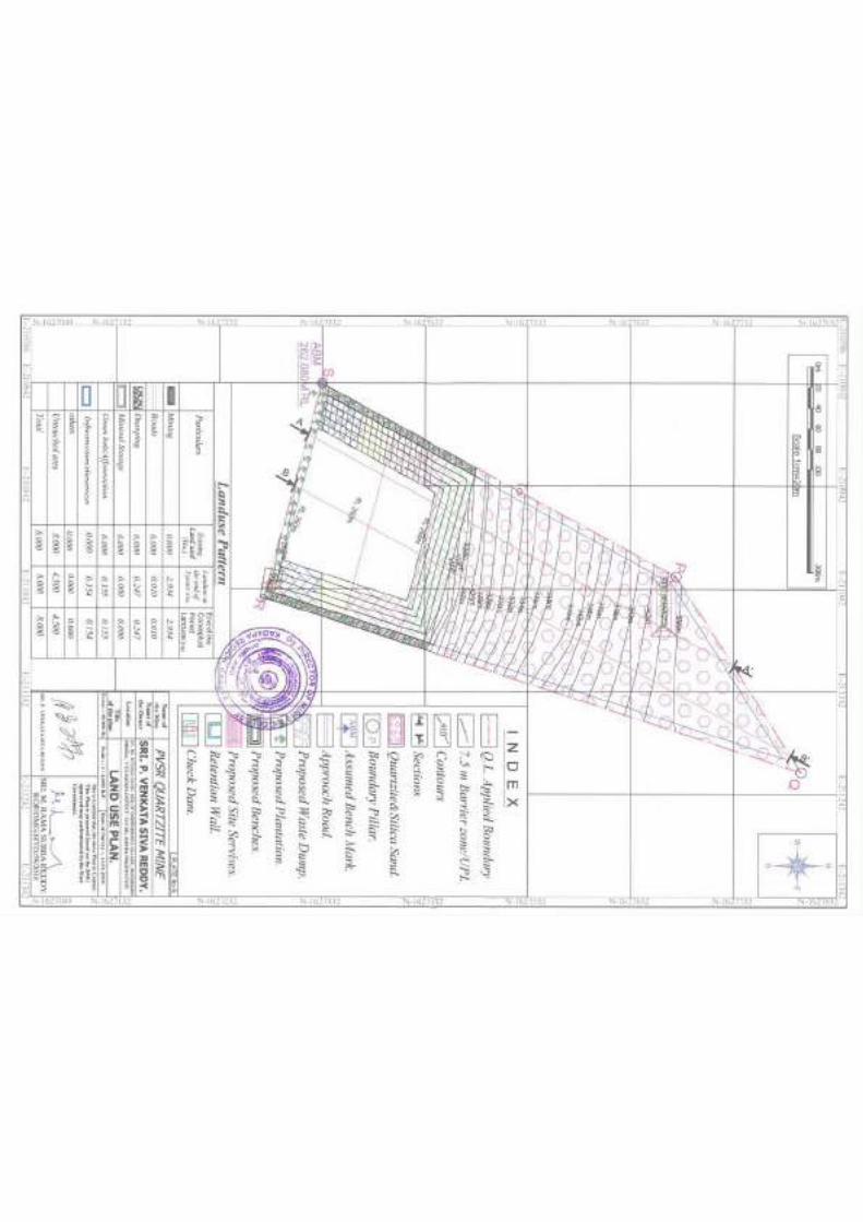
4.4 LAND ENVIRONMENT
RECLAMATION Reclamation of mined out portions are not proposed during plan period as the mining
operations will not reach to the full extent of mineral deposit. Progressive trenching and
embankment by safety bunding will be taken up. As a measure of protection 2m corridor
all along the lease corridor a protection bund will be raised, a safety pit will be excavated
with 1.5m width and one-meter depth will be excavated to avoid the trespassing of the
human and cattle / wild life into the lease hold area. The pit slope will be maintained a
23o in order to protect humans and cattle / wild life protection.
WASTE GENERATION
About 5% intercalated waste will generate and average waste per annum is 12,323.2
Tons and maximum waste per annum is 15,789 Tones and total waste in 5 years is
61616 Tons will be generated which will be dump over an area of 0.247 Ha (height is
40 m) in E& W side of the Quarry Lease area. The generated waste will be utilized to
strengthen the internal roads of the quarry lease area.
As the ore body is exposed on the hill top, open cast method has been adopted. A bench
height of 3m is proposed and width of the bench will be more than 6 m. The total area is
proposed to be opened into benches in descending order. All active dumps will be
reclaimed concurrent to mining operations and at the foot of the dump retaining walls
will be constructed to avoid wash off the material. At foot of the hills the check dams
will be constructed across the valleys & also gully plugs will be constructed at the gullies.
Nature of top soil/ waste and mineral rejects
There is little top soil will be generated during the scheme period however this will be
utilized for afforestation purpose.
Executive Summary - Sri P. Venkata Siva Reddy-08 Ha
8
4.5 BIOLOGICAL ENVIRONMENT
The direct and the most destructive impacts of the project are limited to the mine lease
area only. There is going to be a change in the land use and land cover owing to the
mining activity. The existing flora and vegetation of the mine lease is going to be lost
slowly in a phased manner owing to digging or dumping of overburden and waste.
Among the plant species that are going to be lost, the annuals and therophytes are highly
resilient and they can come back once the intensity and frequency of disturbances
decrease. As there are no rare or endangered or endemic or threatened (REET) species,
continuation of mining will not pose any additional problem to any REET species.
Hence, the impact of the project on flora is negligible. As far as the fauna s concerned,
the proposed mining could endanger the habitat of some unseen reptiles and rodents that
may be present in burrows. But it is incapable of posing any additional threat to any
Schedule I species either directly or indirectly.
i). Loss of the existing flora and trees: The flora of the project site is going to be damaged
or lost to a when a mine pit is opened and when dump is created. Since there are no RET
species, there shall not be any loss of any species.
ii). Loss of fodder and grazing land for locals: Green fodder is produced only during the
rainy season. During that time, shortage of green fodder is uncommon. During the rest of
the year when there is shortage of both green and dry fodder, the core area contributes
very little. Hence the overall loss of fodder can be made good by growing forage crops.
iii). Enhanced soil erosion due mining: Operations relating to mining shall enhance the
chances of soil erosion and dust emissions. Integrated soil and water conservation
measures involving physical and biological systems are incorporated. Legumes like
Subabul and Hamata are proposed to be grown for soil conservation, improvement of soil
fertility and perennial fodder production.
4.6 SOCIO-ECONOMIC ENVIRONMENT
It will be obvious to assume that the activities of the mining operations have to be
produced some improvements in the socio-economic levels in the study area.
The proposed mining activities will provide employment to local persons of different
skills and trades. The employment potential ameliorated economic conditions of these
families directly and provided employment to many other families indirectly who are
Executive Summary - Sri P. Venkata Siva Reddy-08 Ha
9
involved in business and service-oriented activities. This in-turn will improve the socio-
economic conditions of the area.
5.0 ENVIRONMENTAL MANAGEMENT PLAN
The major objective and benefit of utilizing EIA in mining initial stage itself is to prevent
avoidable losses of environmental resources and values as a result of well-planned EMP.
Environmental Management Plan includes protection/mitigation/enhancement measures
as well as suggestions for the post project-monitoring programme to implemented y the
project proponent.
5.1 AIR ENVIRONMENT
Dust is the major pollutant generated from the mining operations. Dust control measures
are as fallowes.
• Watering blast hole followed by charging of blast holes.
• Avoiding blasting under unfavorable wind and atmospheric conditions.
• Applying water for dust suppression on mine haul roads.
• Regular Compaction & grading of haul roads and service roads to clear
accumulation of loose material.
• Compaction & gradation on both sides of Haul Roads.
• Controlling speed of dumpers / trucks.
• Avoid overloading of dumpers and consequent spillage on the roads.
• Good maintenance of vehicles & machinery.
• Water sprinklers of fixed type will be provided at the mine approach roads from
mine face / benches to crush hopper to prevent the generation of dust.
• Transfer chutes will be provided at mineral discharge points, loading points etc.,
to minimize discharge height and spread of air borne dust.
• The operators cabin in the drills, dumpers and other HEMMs are provided with
dust free enclosure and persons working at high dust prone areas will be provided
with dust mask.
• Good housekeeping at the mining, loading will be practiced.
• Avoiding over filling of tippers and consequent spillage on the roads.
Executive Summary - Sri P. Venkata Siva Reddy-08 Ha
10
• Silica sand and quartzite carrying trucks will be effectively covered by tarpaulin
to avoid escape of silica sand and quartzite to the atmosphere.
• Air quality will be regularly monitored both in the core zone and the buffer zone.
5.2 WATER ENVIRONMENT There will not be any wastewater generation from the proposed mining activity.
The salient features on the mitigation measures are:
❖ Garland drain will be provided to check soil wash off during monsoons.
❖ Construction of check dams & Gully plugs across seasonal/perennial nallahs
flowing through the ML area
❖ Run-off from the mining area will be passed through a series of arrestor dams
with filter beds to allow settling of solid particles.
❖ Contour bunding and trenches are proposed during monsoon to minimize soil
erosion.
❖ Arrestor wall, protective bunds and trenches will be provided
❖ Water quality monitoring will be carried out in all the seasons
5.3 NOISE ENVIRONMENT To control noise pollution during the proposed mining operations following steps will be
practiced.
• Actual noise emissions of the equipment will be ensured that they will be as
low as possible.
• Fitting effective mufflers to the equipment wherever required.
• The high temperature time in the afternoon will be selected for blasting which
will naturally reduce the noise pollution.
• For further reduction of noise and vibration, well-advanced and effective
technique of blasting with non-electrical initiation system will be adopted.
• All roads will be maintained in good condition to reduce vehicle noise. Vehicle
noise is exacerbated by high speed and by deceleration and acceleration and
these will be avoided.
Executive Summary - Sri P. Venkata Siva Reddy-08 Ha
11
• The workers will be provided with protection equipment, earmuffs and
earplugs as a protection from the high noise level generated at the mine site
wherever required.
• Noise levels will be controlled by using optimum explosive charge, proper
delay detonators and proper stemming to prevent blow out of holes as well as
usage of the sequential blasting machine in combination with non-electric
initiation systems.
• Speed of trucks will be limited to moderate speed of 25 KMPH to prevent
undue noise form empty trucks.
• Planting of trees has been taken up along the mining lease boundary for
controlling noise apart from earmarking the limit of the mine pit boundary.
• Proper maintenance will be done for noise generating machinery including
transport vehicles
5.4 LAND ENVIRONMENT 5.4.1 WASTE MANAGEMENT
About 5% intercalated waste will generate and average waste per annum is 12,323.2
Tons and maximum waste per annum is 15,789 Tones and total waste in 5 years is
61616 Tons will be generated which will be dump over an area of 0.247 Ha (height is
40 m) in E& W side of the Quarry Lease area. The generated waste will be utilized to
strengthen the internal roads of the quarry lease area.
As the ore body is exposed on the hill top, open cast method has been adopted. A bench
height of 3m is proposed and width of the bench will be more than 6 m. The total area is
proposed to be opened into benches in descending order. All active dumps will be
reclaimed concurrent to mining operations and at the foot of the dump retaining walls
will be constructed to avoid wash off the material. At foot of the hills the check dams
will be constructed across the valleys & also gully plugs will be constructed at the gullies.
Nature of top soil/ waste and mineral rejects
There is little top soil will be generated during the scheme period however this will be
utilized for afforestation purpose.
Executive Summary - Sri P. Venkata Siva Reddy-08 Ha
12
5.5 BIOLOGICAL ENVIRONEMNT The project proponent is duty bound to strictly follow the procedures outlined in the
approved mining plan including the progressive mine closure and restoration plan. To
begin with, they are going to one row of Hill Neem (Chukrasia tabularis), the only tree
that remains green even during the hot summer in Kadapa region. It can be easily grown
from stem cuttings. It has thick foliage and evergreen. This will be done during the first
year at a cost of Rs.1,00,000/-. Stem cuttings can be procured from the hills and seeds
are readily available as there are road-side avenue trees in the district. Seedlings will be
grown in seed beds and the saplings shall be transplanted at a spacing of 2x3m during the
rainy season. It is cost effective and performance is ensured.
The top fertile soil shall be stored in paces / areas where deposits are not found.
Overburden shall be stored separately as stated in the approved mining plan. Once the
mining is over in any pit, it shall be back filled with the stone waste at the bottom level
followed by the overburden and then with the top soil at the top. After filling and
levelling is over, nitrogen enriching leguminous fodder plants like Hamata
(Stylosanthes hamata) shall be grown. Once the Hamata grass establishes, pits shall be
made at a spacing of 2m x 3m and saplings of Chukrasia tabularis, Conocarpus
lancifolius, Acacia holosericea, neem etc are transplanted. After transplantation, regular
maintenance of weeding, watering, application of fertilizers and other protective and
productive measures shall be undertaken. Acacia holosericea, neem and Hill Neem
(Chukrasia tabularis) are already grown in the similar mine lease areas in the District.
Scarified seeds of Conocarpus lancifolius, and Silver wattle (Acacia holosericea) will be
pelletized with dung and placed in small pits in the backfilled areas of the mine lease
areas. The seeds germinate and some of them are going to survive. All gaps will be filled
with stem cuttings of Hill Neem (Chukrasia tabularis) which grows well. There shall
be sufficient water in the mining area for dust suppression and afforestation and watering
the plants.
The proposed Afforestation plan is provided in Draft EIA report. Because of semiarid
conditions, nutrient poor soils, dry climate and acute shortage of water, it is practically
impossible to grow 1500 to 2000 trees per Ha. It is beyond the carrying capacity of the
Executive Summary - Sri P. Venkata Siva Reddy-08 Ha
13
soil and climate. A list of plants suggested for greenbelt, avenue plantations and eco-
restoration of back filled areas is provided in Draft EIA report.
5.6 OCCUPATIONAL HEALTH & SAFETY
❖ Providing a working environment that is conducive to safety & health
❖ The management of occupational safety & health is the prime responsibility of
mine management from the executive level to the first line supervisory level
❖ Employee involvement and commitment in the implementation of health and
safety guidelines
❖ Provision of all necessary resources
❖ Implementing safety and health management system and assessing the
effectiveness through periodic audits
❖ Setting of safety and health objectives based on comprehensive strategic plans
and measure performance against these plans
❖ Monitoring the effects of mining activities on safety and health and conducting
regular performance reviews
❖ Provision of necessary personal protective equipments
❖ Establishing and maintaining a system of medical surveillance for employees
❖ Ensuring employees at all levels receive appropriate training and are competent to
carry out their duties and responsibilities
5.7 IMPLEMENTATION OF EMP & MONITORING PROGRAMME The lessee will ensure the implementation of the measures within the mine area and
carryout efficient monitoring. In order to implement the measures suggested for
mitigating the adverse impacts on the environment, it is suggested to monitor the
environmental parameters regularly.
5.8 CONCLUSION The mine is proposed to produce maximum production of 3,75,000 TPA (average
production is 2,92,678 TPA) of Quartzite & Silica Sand. The mine shall be worked,
fulfilling all statutory obligations as prescribed by DMG, DGMS, MoEF and APPCB.
The proposals are submitted for Environmental clearance to SEIAA, A.P.
Draft EIA Report for 08.000 Ha. of Quartzite & Silica Sand Mine located in Chinthakunta (V), Muddanuru (M), Kadapa District, A.P.
Sri. P. Venkata Siva Reddy
Global Enviro Labs, Hyderabad
1
1. INTRODUCTION 1.0. PREAMBLE
The Mining Lease area of 08.000 Ha. Quartzite & Silica Sand Mine of Sri. P. Venkata
Siva Reddy, located in Sy.No. 677 (Old Sy.No. 425) of Chinthakunta Village, Muddanur
Mandal, Y.S.R Kadapa District, Andhra Pradesh State.
The lease was granted by Director of Mines & Geology, A.P, Ibrahimpatnam, vide
Proceedings No. 11779/R5-2/2018 Dt: 08.01.2019 for a period of 20 years. A mining
plan was approved by the Deputy Directorate of Mines & Geology, Y.S.R Kadapa vide
Letter No. 463/MP/YGL/2019 Dt:05.02.2019 for a period of 5 years.
The proposed mine is Fresh mine and proposed maximum production is 3,75,000 TPA
(average production is 2,92,678 TPA) of Quartzite and Silica Sand. The total cost of the
project is 25 Lakhs only.
As per the Honorable Ministries Notification S.O. 1533, the proposed mine lease area
shall obtain Environmental clearance before starting operations. Accordingly, Form-I
along with Draft TOR for EIA study and Pre-feasibility report has been submitted to the
SEIAA, A.P. A presentation was made before the State Expert Appraisal Committee
(SEAC) on 30 March, 2019 for the approval of TOR for EIA study. And accordingly,
TOR has been issued by the SEIAA vide letter No. SEIAA/AP/KDP/MIN/03/2019/851-
283 dated 14th May, 2019.
This report furnishes the details of location of Site, Description of the project, prevailing
baseline status w.r.t Air Environment, Water Environment, Noise Environment, Land
Environment, Biological Environment and Socio-economic Environment. This report
also helps in identification of environmental impacts and suggesting mitigation measures
to be followed during Operation of the project as part of Environmental Management
Plan. This report also acts as guidance manual for the proponent for following the
Environmental Management Plan (EMP) and for adopting post project Environmental
Monitoring Program as per statutory norms.
Draft EIA Report for 08.000 Ha. of Quartzite & Silica Sand Mine located in Chinthakunta (V), Muddanuru (M), Kadapa District, A.P.
Sri. P. Venkata Siva Reddy
Global Enviro Labs, Hyderabad
2
1.1 IDENTIFICATION OF PROJECT & PROJECT PROPONENT:
The applicant Sri. P. Venkata Siva Reddy, is a Lessee. He is having more than 10 years’
experience in mining business and he is resident of Gundlakunta Village,Peddamudium
Mandal, Y.S.R Kadapa. Having come to know the availability of Quartzite in
disintegrated highly weathered Quartzite and Silica Sand near Chintakunta Village,
Muddanur Mandal, Y.S.R Kadapa District they have applied for mining lease. The
Quartzite is having good quality and easily poundable by (it is economically highly
feasible). In local area few mines are already working and they are supplying quartzite to
few industries situated at Hyderabad. They have examined the area thoroughly and then
satisfied themselves with the quality and quantity of the mineral available in the area. The
Director of Mines and Geology have recommended for sanction of mining lease in their
favour.
Environment Policy:
Resolution: On this 1st day of October, 2019 the Lessee has taken a decision on
Environment policy of the mine.
Sri Jelani Basha Sahib is committed to operate the 08.000 Ha. ML Area in Survey No.
677 (Old Sy.No.425) of Chintakunta Village, Muddanur Mandal, Y.S.R Kadapa District,
Andhra Pradesh with the following objectives.
• To produce quartzite strictly complying with all the Environmental regulations.
• Strict monitoring and compliance of the conditions stipulated in Environmental
clearance.
• Strict monitoring and compliance of the conditions stipulated in Consent for
Establishment issued by APPCB.
• Ensuring Implementation and regular operation of air emission control measures
such as water sprinklers, etc.
• Periodical monitoring of all environmental parameters such as Ambient air
quality, water quality, noise levels, soil quality, etc. and submission of the same to
statutory authorities periodically.
• Maintaining good housekeeping practices.
Draft EIA Report for 08.000 Ha. of Quartzite & Silica Sand Mine located in Chinthakunta (V), Muddanuru (M), Kadapa District, A.P.
Sri. P. Venkata Siva Reddy
Global Enviro Labs, Hyderabad
3
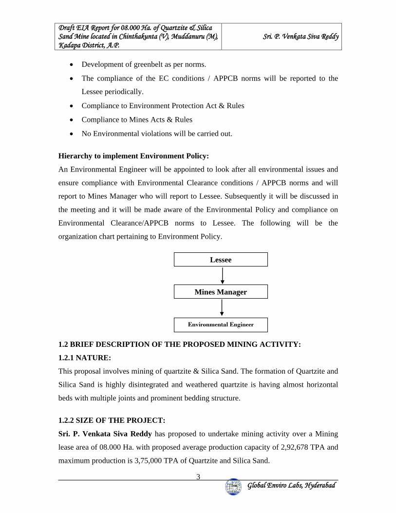
Lessee
Mines Manager
Environmental Engineer
• Development of greenbelt as per norms.
• The compliance of the EC conditions / APPCB norms will be reported to the
Lessee periodically.
• Compliance to Environment Protection Act & Rules
• Compliance to Mines Acts & Rules
• No Environmental violations will be carried out.
Hierarchy to implement Environment Policy:
An Environmental Engineer will be appointed to look after all environmental issues and
ensure compliance with Environmental Clearance conditions / APPCB norms and will
report to Mines Manager who will report to Lessee. Subsequently it will be discussed in
the meeting and it will be made aware of the Environmental Policy and compliance on
Environmental Clearance/APPCB norms to Lessee. The following will be the
organization chart pertaining to Environment Policy.
1.2 BRIEF DESCRIPTION OF THE PROPOSED MINING ACTIVITY:
1.2.1 NATURE:
This proposal involves mining of quartzite & Silica Sand. The formation of Quartzite and
Silica Sand is highly disintegrated and weathered quartzite is having almost horizontal
beds with multiple joints and prominent bedding structure.
1.2.2 SIZE OF THE PROJECT:
Sri. P. Venkata Siva Reddy has proposed to undertake mining activity over a Mining
lease area of 08.000 Ha. with proposed average production capacity of 2,92,678 TPA and
maximum production is 3,75,000 TPA of Quartzite and Silica Sand.
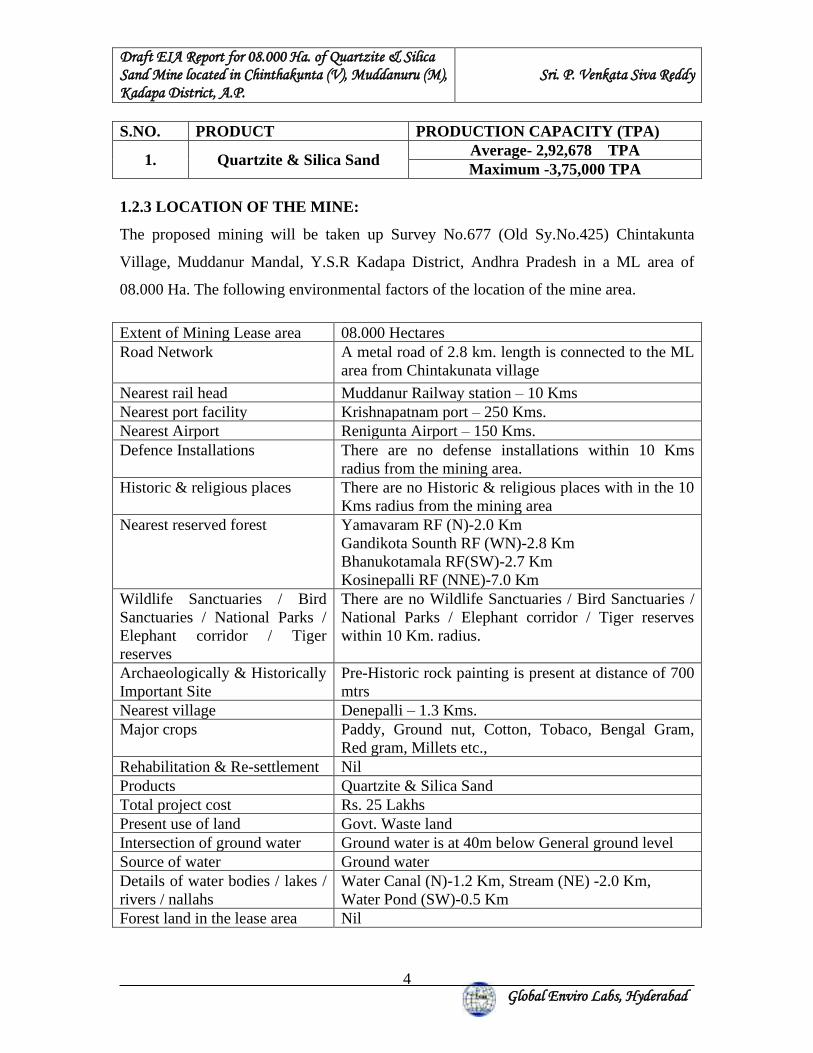
Draft EIA Report for 08.000 Ha. of Quartzite & Silica Sand Mine located in Chinthakunta (V), Muddanuru (M), Kadapa District, A.P.
Sri. P. Venkata Siva Reddy
Global Enviro Labs, Hyderabad
4
S.NO. PRODUCT PRODUCTION CAPACITY (TPA)
1. Quartzite & Silica Sand Average- 2,92,678 TPA Maximum -3,75,000 TPA
1.2.3 LOCATION OF THE MINE:
The proposed mining will be taken up Survey No.677 (Old Sy.No.425) Chintakunta
Village, Muddanur Mandal, Y.S.R Kadapa District, Andhra Pradesh in a ML area of
08.000 Ha. The following environmental factors of the location of the mine area.
Extent of Mining Lease area 08.000 Hectares Road Network A metal road of 2.8 km. length is connected to the ML
area from Chintakunata village
Nearest rail head Muddanur Railway station – 10 Kms Nearest port facility Krishnapatnam port – 250 Kms. Nearest Airport Renigunta Airport – 150 Kms. Defence Installations There are no defense installations within 10 Kms
radius from the mining area. Historic & religious places There are no Historic & religious places with in the 10
Kms radius from the mining area Nearest reserved forest Yamavaram RF (N)-2.0 Km
Gandikota Sounth RF (WN)-2.8 Km Bhanukotamala RF(SW)-2.7 Km Kosinepalli RF (NNE)-7.0 Km
Wildlife Sanctuaries / Bird Sanctuaries / National Parks / Elephant corridor / Tiger reserves
There are no Wildlife Sanctuaries / Bird Sanctuaries / National Parks / Elephant corridor / Tiger reserves within 10 Km. radius.
Archaeologically & Historically Important Site
Pre-Historic rock painting is present at distance of 700 mtrs
Nearest village Denepalli – 1.3 Kms. Major crops Paddy, Ground nut, Cotton, Tobaco, Bengal Gram,
Red gram, Millets etc., Rehabilitation & Re-settlement Nil Products Quartzite & Silica Sand Total project cost Rs. 25 Lakhs Present use of land Govt. Waste land Intersection of ground water Ground water is at 40m below General ground level Source of water Ground water Details of water bodies / lakes / rivers / nallahs
Water Canal (N)-1.2 Km, Stream (NE) -2.0 Km, Water Pond (SW)-0.5 Km
Forest land in the lease area Nil
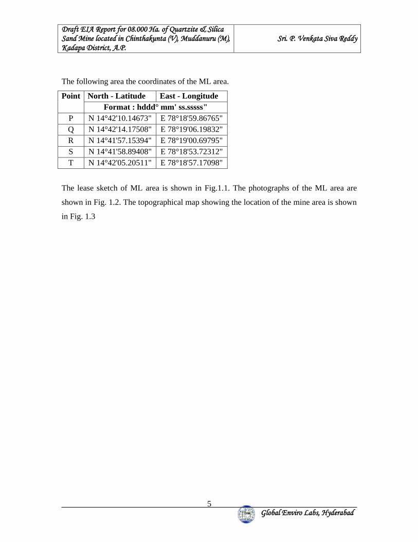
Draft EIA Report for 08.000 Ha. of Quartzite & Silica Sand Mine located in Chinthakunta (V), Muddanuru (M), Kadapa District, A.P.
Sri. P. Venkata Siva Reddy
Global Enviro Labs, Hyderabad
5
The following area the coordinates of the ML area.
Point North - Latitude East - Longitude Format : hddd° mm' ss.sssss"
P N 14°42'10.14673" E 78°18'59.86765" Q N 14°42'14.17508" E 78°19'06.19832" R N 14°41'57.15394" E 78°19'00.69795" S N 14°41'58.89408" E 78°18'53.72312" T N 14°42'05.20511" E 78°18'57.17098"
The lease sketch of ML area is shown in Fig.1.1. The photographs of the ML area are
shown in Fig. 1.2. The topographical map showing the location of the mine area is shown
in Fig. 1.3
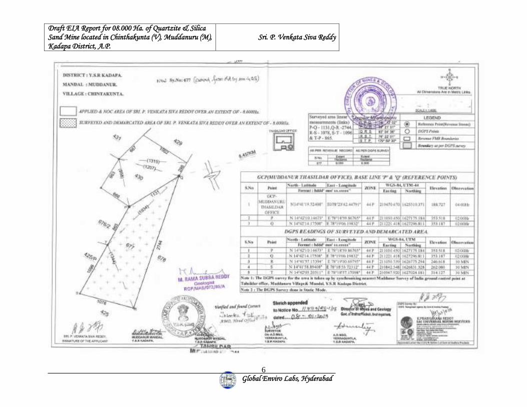
Draft EIA Report for 08.000 Ha. of Quartzite & Silica Sand Mine located in Chinthakunta (V), Muddanuru (M), Kadapa District, A.P.
Sri. P. Venkata Siva Reddy
Global Enviro Labs, Hyderabad
6
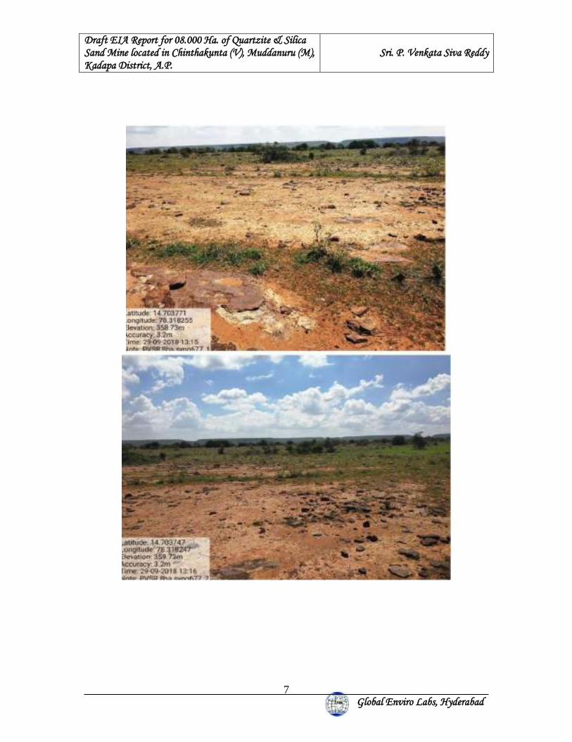
Draft EIA Report for 08.000 Ha. of Quartzite & Silica Sand Mine located in Chinthakunta (V), Muddanuru (M), Kadapa District, A.P.
Sri. P. Venkata Siva Reddy
Global Enviro Labs, Hyderabad
7
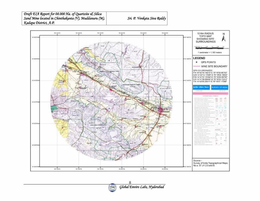
Draft EIA Report for 08.000 Ha. of Quartzite & Silica Sand Mine located in Chinthakunta (V), Muddanuru (M), Kadapa District, A.P.
Sri. P. Venkata Siva Reddy
Global Enviro Labs, Hyderabad
8
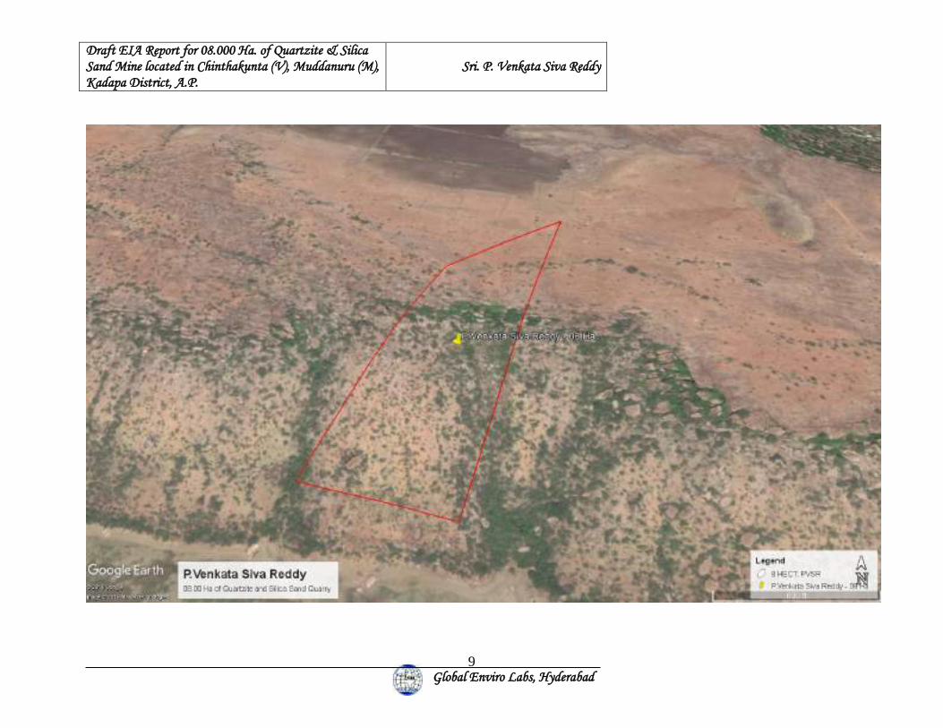
Draft EIA Report for 08.000 Ha. of Quartzite & Silica Sand Mine located in Chinthakunta (V), Muddanuru (M), Kadapa District, A.P.
Sri. P. Venkata Siva Reddy
Global Enviro Labs, Hyderabad
9
Draft EIA Report for 08.000 Ha. of Quartzite & Silica Sand Mine located in Chinthakunta (V), Muddanuru (M), Kadapa District, A.P.
Sri. P. Venkata Siva Reddy
Global Enviro Labs, Hyderabad
10
1.2.4 IMPORTANCE OF PROJECT:
The proposed project is to mine the quartzite present in 08.000 Ha of land in Survey No.
677 (old Sy No.425), Chinthakunta Village, Muddanur Mandal, Y.S.R Kadapa District,
Andhra Pradesh using manual opencast method by using drilling & Controlled blasting.
The mineral quartzite will be crushed and screened for different mesh sizes as required by
the user industry. After crushing it is mainly used in the industry such as Castings,
foundries, Ceramics, paint etc. A small portion of the quartzite (Silica sand) produced in
this area will be in the construction industry. This will replace the river/stream sand
which is causing severe adverse effect to ground water potential.
Mineral Chemical Specification Physical Size
Quartzite and Silica sand + 99% Silica 10 mm to 100 mm
Benefit to the region:
With the establishment of the proposed mining activity, there will be employment
opportunities to the local people during operation of the mining. Priority will be given to
locals in employment. There will be upliftment of the socio-economic status of the people
in the area due to the proposed project.
In the light of the above scenario Sri. P. Venkata Siva Reddy is proposed to Quartzite &
Silica sand mining at Survey No. 677 (old Sy No.425), Chinthakunta Village, Muddanur
Mandal, Y.S.R Kadapa District, Andhra Pradesh.
1.3. SCOPE OF THE STUDY:
The scope of work includes a detailed characterization of the environment in an area of
10 Km. radius of the Mine Lease Area for various environmental parameters like Air,
Water, Noise, Land, Biological and Social-economic aspects. This Draft EIA Report is
prepared in accordance with the Terms of Reference issued vide No. Lr.No:
SEIAA/AP/KDP/MIN/03/2019/851-283 dated 14th May, 2019 by the Honorable
SEIAA,A.P.
Draft EIA Report for 08.000 Ha. of Quartzite & Silica Sand Mine located in Chinthakunta (V), Muddanuru (M), Kadapa District, A.P.
Sri. P. Venkata Siva Reddy
Global Enviro Labs, Hyderabad
11
2. PROJECT DESCRIPTION 2.1 TYPE OF THE PROJECT:
The proposed project is for mining of Quartzite & Silica sand by manual open cast
method by using drilling & Controlled blasting in 08.000 Ha. in Survey No. 677 (old Sy
No.425), Chinthakunta Village, Muddanur Mandal, Y.S.R Kadapa District, Andhra
Pradesh.
Use of Silica sand and quartzite:
Silica sand and quartzite used for water purification and manufacture of glass, synthetic
foundry moulding catalysts, disodium ultramarine etc. it is also used for acid heat
resistant ceramics, refractories, pottery glaze, enamel etc. Silica sand and quartzite of 150
mesh is used in Sawing stone, grinding and surfacing glass and polishing marble
Rounded Grains of silica sand and quartzite are used for sand blasting it is also used as a
filler in paints 'Wood Paste' moulded hard rubber goods, gypsum Plasters, oxychloride
acoustic plasters and soap.
2.2 LOCATION:
The proposed mining activity in the ML area, located at Survey No. 677 (old Sy No.425),
Chinthakunta Village, Muddanur Mandal, Y.S.R Kadapa District, Andhra Pradesh. Land
use of the ML area is Government waste land.
DISTRICT/STATE MANDAL VILLAGE SURVEY No. AREA
Y.S.R Kadapa (A.P.) Muddanur Chinthakunta 677 (old Sy No.425)
08.000 Ha.
2.3 SIZE / MAGNITUDE OF OPERATION:
Sri. P. Venkata Siva Reddy has proposed to undertake mining activity over a Mining
lease area of 08.000 Ha. with proposed maximum production of 3,75,000 TPA (average
production is 2,92,678 TPA) of Quartzite and Silica Sand.
Draft EIA Report for 08.000 Ha. of Quartzite & Silica Sand Mine located in Chinthakunta (V), Muddanuru (M), Kadapa District, A.P.
Sri. P. Venkata Siva Reddy
Global Enviro Labs, Hyderabad
12
S.NO. PRODUCT PRODUCTION CAPACITY (TPA)
1. Quartzite & Silica Sand Average- 2,92,678 TPA Maximum -3,75,000 TPA
The Mining Lease area of 08.000 Ha. Quartzite & Silica Sand Mine of Sri. P. Venkata
Siva Reddy, located in Sy.No. 677 (old Sy No.425) of Chinthakunta Village, Muddanur
Mandal, Y.S.R Kadapa District, Andhra Pradesh State.
The lease was granted by Director of Mines & Geology, A.P Ibrahimpatnam, vide
Proceedings No. 11779/R5-2/2018 Dt: 08.01.2019 for a period of 20 years. A mining
plan was approved by the Deputy Directorate of Mines & Geology, Y.S.R Kadapa vide
Letter No. 463/MP/YGL/2019 Dt:05.02.2019 for a period of 5 years.
2.4 PROPOSED SCHEDULE FOR APPROVAL AND IMPLEMENTATION:
Excavation with proposed capacities will be taken up after obtaining Environmental
Clearance from SEIAA, A.P & CFE from APPCB.
2.5 TECHNOLOGY AND PROCESS DESCRIPTION:
2.5.1 NUMBER OF TRUCKS:
73 No’s of trucks per day (Truck capacity 17Tons) will be required to transport quartzite
and Silica Sand to outside agencies. All the trucks will be covered with tarpaulins. The
existing road is capable of absorbing this additional truck movement.
2.6. MINING:
2.6.1 TOPOGRAPHY OF THE AREA:
The subject area is a hilly terrain. The highest R.L is from the assumed bench mark 356m
and lowest R.L is 262m. The maximum relief is 94m. There is no perennial water course
in around the area. Natural vegetation is scanty. The applied area falling in South
eastern flank of the hillock. Below the hill is plain ground where cultivated with crops
like groundnut, Maize, Sunflower etc.
Draft EIA Report for 08.000 Ha. of Quartzite & Silica Sand Mine located in Chinthakunta (V), Muddanuru (M), Kadapa District, A.P.
Sri. P. Venkata Siva Reddy
Global Enviro Labs, Hyderabad
13
2.6.2 REGIONAL GEOLOGY:
Geologically the area falls in Gandikota Quartzite and Tadipatri formation of Chitravathi
Group of Cuddapah Super group. It is mainly consisting of Quartzite and Shale.
2.6.3 LOCAL GEOLOGY:
Quartzite (Silica Sand) and shales are the main rock units exposed in the subject area.
During the geological mapping the formations encountered in the subject area are the
Shales belongs to Tadipatri formation, Chitravati group of lower Cuddapah and this
Shales over lain by Quartzite’s belongs to Panyam stage of Kurnool group of Proterozoic
age. Geology and structural map of study area is shown in Fig.2.1
The lithounits are as follows.
1. Quartzite sand stones (Silica Sand).
2. Shale.
Quartzite is used in the manufacture of silica refractoriness and as a flux in iron and steel
industry, and manufacture of silica sand which is mostly used in the glass, sodium silicate
industries and foundries.
LITHOLOGY:
By ground observation in the area the lithological sequence is found as under:
Surface Soil; Quartzite (Silica sand); Shale
The rock units exposed in the ML area are belong to Cuddapah and Kurnool groups of
proterozoic age and consisting of quartzite and shales.
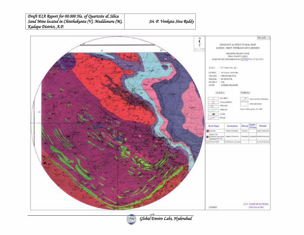
Draft EIA Report for 08.000 Ha. of Quartzite & Silica Sand Mine located in Chinthakunta (V), Muddanuru (M), Kadapa District, A.P.
Sri. P. Venkata Siva Reddy
Global Enviro Labs, Hyderabad
14
Draft EIA Report for 08.000 Ha. of Quartzite & Silica Sand Mine located in Chinthakunta (V), Muddanuru (M), Kadapa District, A.P.
Sri. P. Venkata Siva Reddy
Global Enviro Labs, Hyderabad
15
2.6.4 EXPLORATION:
(i) Already carried out in the area:
Quarry Lease area is covered by sheetrock and partly covered by boulders. The lessee
was carried out bore hole at time of prospecting. 25m depth of Quartzite and Slica Sand
available. Corners of the lease area were having any boundary pillars fixed with DGPS
by the time of site visit. Applicant has agreed to install pyramidal monuments of suitable
size with concrete properly painted and labeled with high visible colour for every corner
of the lease boundary. The subject area is demarcated on the ground with reference to
revenue stones. Later topographical survey of the area was carried out. The ABM ‘B’
(262.080) is connected to Grid of N1627332 & E210842 located in south West Corner of
the QL area. Based on topographical survey and geological features, collected from the
surface data, the surface geological plan is prepared on 1:2000 scale with 2.0 m contour
interval and the geology of the applied area, and section lines are shown in the Geological
plan of ML area is shown in Fig.2.2.
2.6.5 RESERVES:
Reserves estimated as are follows.
Category Quartzite & Silica Sand Total Geological Resources 62,02,476 tons Blocked Under buffer zone (7.5 m) + Bench Slopes 4,20, 585 tons
Mineable Quartzite Reserves 57,81,891 tons
The total mineable geological reserves are as follows:
Total Mineable reserves 1,03,38,298 tons
Proposed annual production after the ensuing scheme period will be around 57,81,891
tons. So, life of the mine based on average production is 57,81,891 / 2,92,678 =
19.76years Say 20 Years and Life of the mine based on maximum production is
57,81,891 / 3,75,000 = 15.4 years Say 15 Years. After the proposed exploration during
scheme period the reserves will be re-assessed and the life of the mine will be changed as
per the re assessed reserves and then a clear conceptual plan will be drawn and submitted.
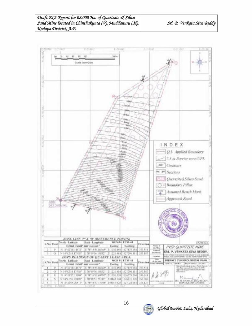
Draft EIA Report for 08.000 Ha. of Quartzite & Silica Sand Mine located in Chinthakunta (V), Muddanuru (M), Kadapa District, A.P.
Sri. P. Venkata Siva Reddy
Global Enviro Labs, Hyderabad
16
Draft EIA Report for 08.000 Ha. of Quartzite & Silica Sand Mine located in Chinthakunta (V), Muddanuru (M), Kadapa District, A.P.
Sri. P. Venkata Siva Reddy
Global Enviro Labs, Hyderabad
17
2.6.6 LIFE OF THE MINE:
Total Mineable Reserves = 57,81,891 tons
Life of the Mine based on average production = 57,81,891 / 2,92,678 = 19.76 years Say
20 Years
Life of the Mine based on Maximum production = 57,81,891 / 3,75,000 = 15.4 years Say
15 Years.
2.6.7 MINING METHODOLOGY:
This is a fresh mine. The proposed mining is planned to be carried out by opencast other
than fully mechanized mining method with drilling and controlled blasting. The ROM
will be sorted into different sizes by feeding it to the crusher proposed to be established
outside the applied area. The ROM will be loaded into tippers and tractors using
Excavator. Mining will be carried out by formation of benches of each 6.0m high. The
site inspection reveals that the East to West portion of the applied area is suitable for
development during first 5 years programme and as shown in production and
Development plan is shown in figure 2.3
YEAR WISE PRODUCTION PLAN PROPOSED FOR THREE YEARS AS PER AMP: Year Production 1st year 180532 tons 2nd year 253654 tons 3rd year 324774 tons 4th year 329431 tons 5th year 375000 tons (Max) Total 1463391 tons Average 2,92,678 tons
Draft EIA Report for 08.000 Ha. of Quartzite & Silica Sand Mine located in Chinthakunta (V), Muddanuru (M), Kadapa District, A.P.
Sri. P. Venkata Siva Reddy
Global Enviro Labs, Hyderabad
18
Draft EIA Report for 08.000 Ha. of Quartzite & Silica Sand Mine located in Chinthakunta (V), Muddanuru (M), Kadapa District, A.P.
Sri. P. Venkata Siva Reddy
Global Enviro Labs, Hyderabad
19
2.6.8 DRILLING AND BLASTING:
Since the mining is proposed to work by other than fully mechanized and the benches are
kept 06m height and the Quartzite is a material which is hard to very hard in nature it
requires the drilling and blasting to exploit the same.
The broad blasting parameters are determined for the blasting pattern and blast design,
which are as follows:
Blast whole diameter is normally 115mm and the depth of the hole is 6.6m inclusive of
sub grade drilling of 0.5 to 1.0 meters to avoid toe formation.
Blasting pattern is generally square or staggered with burden ranging from 3.0 to 3.5
meters and spacing of 3.5 to 4.0 meters.
Usually single / double row of holes is blasted along free face to achieve optimum
powder factor, best fragmentation and minimized adverse impacts on account of blasting.
Maximum numbers of holes will be blasted at a time in a round are generally limited to
15 to 20 with normal delay detonators to mitigate adverse impacts such as air blast, throw
and the ground vibration.
Holes are electrically detonated using electric detonators. ANFO types of explosives are
used for blasting with 20 to 25 percent, proportion of primer/ booster cartridges and rest
as column charge. About 20 kgs of explosives are loaded in 115 mm diameter holes and
powder factor ranging between 8 to 10 tons per kgs of explosives will be achieved.
For using the ANFO necessary permission from DGMS under rule 155 (1) of MMR 1960
will be taken.
The proposed bench heights will maintain 06m. The orientations of the proposed benches
are South- Northern direction & advancing from South to North. The yearly average
ROM proposed will be 3,05,001 tonnes/annum.
DRILLING:
Type Nos. Size of hole mm
Size of Capacity
Make Motive Power
1)Tractor Mounted compressor 2)DTH Drilling Rig
1 1
- 115mm
140 m3
-
VT4 Atlas Atlas copco
Diesel (Fuel) Compressed Air
Draft EIA Report for 08.000 Ha. of Quartzite & Silica Sand Mine located in Chinthakunta (V), Muddanuru (M), Kadapa District, A.P.
Sri. P. Venkata Siva Reddy
Global Enviro Labs, Hyderabad
20
Drilling will be carried out by using down the hole rigs having the diameter of 100 mm.
Holes will be drilled vertically to a depth of 6.6metres with spacing and Burden as 3.0 x
2.5metres.
DRILLING EQUIPMENT: Drilling is proposed to be operated with 1 wagon drill and 1
compressor.
The detailed calculations are given below:
Yearly average quantity is 3,05,001 tons.
The total handling mineral and waste estimated is about 2,92,678 Tons ore + 12323 Tons
waste = 3,05,001 Tons shall require drilling and blasting. Drilling shall be done using 3.5
m x 4.0 m burden and spacing. The calculations requirement of drilling machines is as
given below: Total material handled (max) per annum shall be 3,05,001 Tons.
Hole depth -6.6 m
Burden -3.5 m
Spacing -4 m
Therefore, the drills required per year are calculated as under:
Rock broken / hole of 6.6 m depth
Burden x Spacing x Depth x bulk density
3.5 m x 4 m x 6.6m x2.5 t/cum = 231 Tons
Therefore, rock broken /m = 231/7m = 33 Tons /m
Drilling meterage required /annum = 305001 /33 = 9242 m
Therefore, drilling required per day =9242M/300 days = 30.81/day
(6m + 10% = 6.6m) = 9242 M/annum or 31 m per day
Average drilling rate per day : 5.14m / hr
Output of machine for 1shifs : 5.14m x 6hrs x 1 shifts = 31m
Number of machines required : 31/67 =0.46
So 1 Wagon drill will be sufficient.
BLASTING:
Burden x Spacing x Depth x bulk density (3.5m x 4m x 6 x 2.5 t/cum)
Total maximum material requires drilling and blasting shall be 3,05,001 Tons
Quantity broken /hole = 3.5 m x 4 m x 07 m x2.5 t/cum = 245 Tons
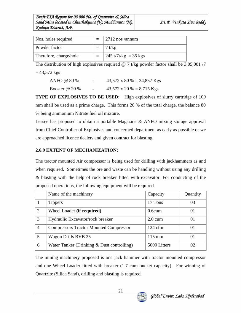
Draft EIA Report for 08.000 Ha. of Quartzite & Silica Sand Mine located in Chinthakunta (V), Muddanuru (M), Kadapa District, A.P.
Sri. P. Venkata Siva Reddy
Global Enviro Labs, Hyderabad
21
Nos. holes required = 2712 nos /annum
Powder factor = 7 t/kg
Therefore, charge/hole = 245 t/7t/kg = 35 kgs
The distribution of high explosives required @ 7 t/kg powder factor shall be 3,05,001 /7
= 43,572 kgs
ANFO @ 80 % - 43,572 x 80 % = 34,857 Kgs
Booster @ 20 % - 43,572 x 20 % = 8,715 Kgs
TYPE OF EXPLOSIVES TO BE USED: High explosives of slurry cartridge of 100
mm shall be used as a prime charge. This forms 20 % of the total charge, the balance 80
% being ammonium Nitrate fuel oil mixture.
Lessee has proposed to obtain a portable Magazine & ANFO mixing storage approval
from Chief Controller of Explosives and concerned department as early as possible or we
are approached licence dealers and given contract for blasting.
2.6.9 EXTENT OF MECHANIZATION:
The tractor mounted Air compressor is being used for drilling with jackhammers as and
when required. Sometimes the ore and waste can be handling without using any drilling
& blasting with the help of rock breaker fitted with excavator. For conducting of the
proposed operations, the following equipment will be required.
Name of the machinery Capacity Quantity
1 Tippers 17 Tons 03
2 Wheel Loader (if required) 0.6cum 01
3 Hydraulic Excavator/rock breaker 2.0 cum 01
4 Compressors Tractor Mounted Compressor 124 cfm 01
5 Wagon Drills BVB 25 115 mm 01
6 Water Tanker (Drinking & Dust controlling) 5000 Litters 02
The mining machinery proposed is one jack hammer with tractor mounted compressor
and one Wheel Loader fitted with breaker (1.7 cum bucket capacity). For winning of
Quartzite (Silica Sand), drilling and blasting is required.
Draft EIA Report for 08.000 Ha. of Quartzite & Silica Sand Mine located in Chinthakunta (V), Muddanuru (M), Kadapa District, A.P.
Sri. P. Venkata Siva Reddy
Global Enviro Labs, Hyderabad
22
Drilling: Jack hammer is used for drilling. The diameter of the jack hammer hole is 33m
m and depth of hole is 1.5m. Tractor mounted compressor will be deployed.
2.7 CONCEPTUAL PLAN:
Total Geological resources estimated in the lease area is around 62,02,476 tons. The
Mineable reserves are estimated by excluding the reserves blocked below the safety zone
and ultimate pit limit and available quantity is around 4,20,585 tons. Out of which the
saleable reserves are about 57,81,891 tons are available in this applied area and the
proposed average production is 2,92,678 tons per year.
The expected life of the mine is 20 years. However, the life of the mine may change
based on the further exploration during the course of mining.
During the ensuing plan period proposal of Drilling is not required because entail
reserves are available as out crop.
About 1 to 2 scheme periods are expected to come across within the life of the mine.
Total Quartzite and Silica Sand produced (Minable Reserves) is 57,81,891 tons, total
waste to be generated in the lease area is 2,43,448 tons & this plan period average
quartzite is 2,92,678 and waste will be 12,323 tons. The generated waste quantity will be
dumped temporarily on the surface of the lease area, some quantity is used for road
making and remaining waste will be re-handled and backfilled in the mined-out area. No
backfilling proposed in the present plan period.
Exploration: No exploration is proposed to delineate the mineral in further depths as the
entire deposit can be identified on the bottom shales. It is proposed to reclaim the mined-
out portion after complete extraction of the mineral into a water storage tank by following
the norms and parameters prescribed by the concerned Panchayat Raj department
(Irrigation Division). The waste that stacked during the life of mine will be utilized
properly as per the instructions of Irrigation division while reclaiming the mined-out
portion.
The Progressive closer plan of ML area is shown in Fig.2.4.
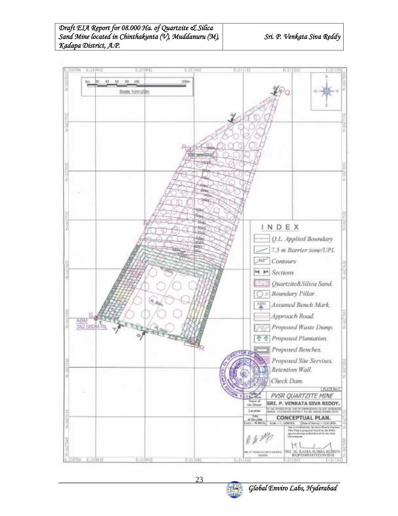
Draft EIA Report for 08.000 Ha. of Quartzite & Silica Sand Mine located in Chinthakunta (V), Muddanuru (M), Kadapa District, A.P.
Sri. P. Venkata Siva Reddy
Global Enviro Labs, Hyderabad
23
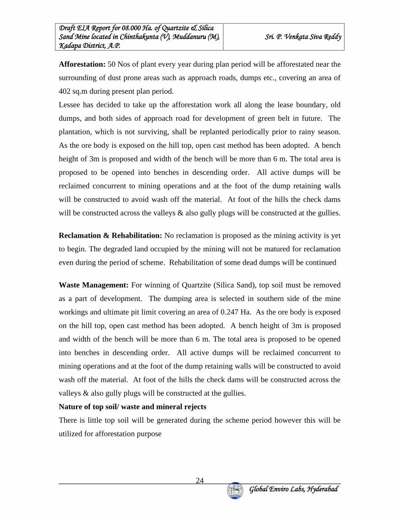
Draft EIA Report for 08.000 Ha. of Quartzite & Silica Sand Mine located in Chinthakunta (V), Muddanuru (M), Kadapa District, A.P.
Sri. P. Venkata Siva Reddy
Global Enviro Labs, Hyderabad
24
Afforestation: 50 Nos of plant every year during plan period will be afforestated near the
surrounding of dust prone areas such as approach roads, dumps etc., covering an area of
402 sq.m during present plan period.
Lessee has decided to take up the afforestation work all along the lease boundary, old
dumps, and both sides of approach road for development of green belt in future. The
plantation, which is not surviving, shall be replanted periodically prior to rainy season.
As the ore body is exposed on the hill top, open cast method has been adopted. A bench
height of 3m is proposed and width of the bench will be more than 6 m. The total area is
proposed to be opened into benches in descending order. All active dumps will be
reclaimed concurrent to mining operations and at the foot of the dump retaining walls
will be constructed to avoid wash off the material. At foot of the hills the check dams
will be constructed across the valleys & also gully plugs will be constructed at the gullies.
Reclamation & Rehabilitation: No reclamation is proposed as the mining activity is yet
to begin. The degraded land occupied by the mining will not be matured for reclamation
even during the period of scheme. Rehabilitation of some dead dumps will be continued
Waste Management: For winning of Quartzite (Silica Sand), top soil must be removed
as a part of development. The dumping area is selected in southern side of the mine
workings and ultimate pit limit covering an area of 0.247 Ha. As the ore body is exposed
on the hill top, open cast method has been adopted. A bench height of 3m is proposed
and width of the bench will be more than 6 m. The total area is proposed to be opened
into benches in descending order. All active dumps will be reclaimed concurrent to
mining operations and at the foot of the dump retaining walls will be constructed to avoid
wash off the material. At foot of the hills the check dams will be constructed across the
valleys & also gully plugs will be constructed at the gullies.
Nature of top soil/ waste and mineral rejects
There is little top soil will be generated during the scheme period however this will be
utilized for afforestation purpose
Draft EIA Report for 08.000 Ha. of Quartzite & Silica Sand Mine located in Chinthakunta (V), Muddanuru (M), Kadapa District, A.P.
Sri. P. Venkata Siva Reddy
Global Enviro Labs, Hyderabad
25
Impact of land use due to mining activity:
• Present land use of the Mine lease area is Govt. waste land.
• Now it is proposed to mine quartzite by manual opencast mining method by using
drilling and blasting.
• Extraction of mineral will not be completed in first five years as working will be
in progress for further extraction of mineral. Therefore, reclamation of the mined-
out area is not proposed.
• But greenbelt will be developed in an area of 0.155 ha.
• Waste generated from mine will be stored in ML area only with protection
measures.
• The mined-out pits will be utilized for rain water harvesting.
2.8 USE OF MINERALS:
Silica sand and quartzite used for water purification and manufacture of glass, synthetic
foundry moulding catalysts, disodium ultramarine etc. it is also used for acid heat
resistant ceramics, refractories, pottery glaze, enamel etc. Silica sand and quartzite of 150
mesh is used in Sawing stone, grinding and surfacing glass and polishing marble
Rounded Grains of silica sand and quartzite are used for sand blasting it is also used as a
filler in paints 'Wood Paste' moulded hard rubber goods, gypsum Plasters, oxychloride
acoustic plasters and soap.
2.9 SITE SERVICES:
The site services provided by the company area in the ML. Shelter to the workers, toilets
& water will be provided to the workers in the mining area. Drinking water has been
provided to all workers. Office cum store room will be provided with first aid room.
Safety measures like helmets, safety shoes etc. will be provided to all the workers. A bus
shuttles will be provided from mine to the district head quarter for medical checkup, apart
from regular visits by the doctors to the mine site.
Draft EIA Report for 08.000 Ha. of Quartzite & Silica Sand Mine located in Chinthakunta (V), Muddanuru (M), Kadapa District, A.P.
Sri. P. Venkata Siva Reddy
Global Enviro Labs, Hyderabad
26
2.10 ENVIRONMENTAL MITIGATION MEASURES: 1. Air Emission:
The air emission of concern from this mining activity will be dust generation. The
following measures will be undertaken to control dust.
• Applying water for dust suppression on mine haul roads.
• Regular Compaction & grading of haul roads and service roads to clear
accumulation of loose material.
• Compaction & gradation on both sides of Haul Roads.
• Controlling speed of dumpers / trucks.
• Avoid overloading of dumpers and consequent spillage on the roads.
• Good maintenance of vehicles & machinery.
• Good housekeeping at the mining, loading will be practiced.
2. Water Pollution:
• No waste water generation from proposed mining activity. Only waste water
generation will be sanitary waste water, which will be treated in septic tank
followed by soak pit. Garland drains will be constructed to collect the runoff from
the area and will enter into settling tank. Clear water will be used for dust
suppression.
3. Noise Pollution:
• Only source of noise generation will be due to mining activities, drilling and
blasting and movement of trucks.
• The machinery will be maintained properly to reduce the noise
• The protective noise reducing gear like earmuffs, the company will provide
earplugs
• Proper maintenance of equipment
• The Ambient noise levels will be within the standards stipulated by MoEF i.e. less
than 75 dBA during day time and less than 70 dBA during night time.
Draft EIA Report for 08.000 Ha. of Quartzite & Silica Sand Mine located in Chinthakunta (V), Muddanuru (M), Kadapa District, A.P.
Sri. P. Venkata Siva Reddy
Global Enviro Labs, Hyderabad
27
The following measures will help in further reducing the noise levels.
• Proper and regular maintenance of vehicles and other equipment.
• Speed of trucks entering or leaving the ML area will be limited to moderate speed
of 25 Kmph to prevent undue noise from empty trucks.
• All roads will be maintained in good conditions to reduce vehicle noise.
4. Solid Waste:
• For winning of Quartzite (Silica Sand), top soil must be removed as a part of
development. The dumping area is selected in southern side of the mine workings
and ultimate pit limit covering an area of 0.247 Ha. There is little top soil will be
generated during the scheme period however this will be utilized for afforestation
purpose.
5. Green belt:
• Afforestation is proposed in the buffer zone along the ML area covering an area
of 0.402 Ha during the first plan period.
2.11. ASSESSMENT OF NEW & UNTESTED TECHNOLOGY FOR THE RISK OF TECHNOLOGICAL FAILURE: In this lease area manual open cast mining method by using drilling & blasting will be
adopted. Hence no technology failure involved in the proposed mining.
Draft EIA Report for 08.000 Ha. of Quartzite & Silica Sand Mine located in Chinthakunta (V), Muddanuru (M), Kadapa District, A.P.
Sri. P. Venkata Siva Reddy
Global Enviro Labs, Hyderabad
28
3. BASELINE ENVIRONMENT
This chapter gives an idea and description of environmental status of the study area with
reference to the prominent environmental attributes. The study area covers 10 km. radius
of the mine lease area. Baseline data has been collected from October 2019 to
December 2019.
The impact identification always commences with the collection of baseline data such as
ambient air quality, ground water quality, surface water quality, noise levels, soil quality,
land use pattern, flora & fauna and socio-economic aspects within the study zone of 10
km. radius.
Table 3.1: Environmental Attribute and Frequency of Monitoring Attribute Parameters Frequency of Monitoring
Ambient Air Quality
PM2.5, PM10, SO2, NOx 24 hourly samples twice a week for twelve weeks at eight locations
Meteorology Surface: Wind Speed, direction, Temperature, relative humidity and rainfall
Surface: Continuous monitoring stations for entire study period on hourly basis and also data collection from secondary sources.
Water Quality Physical, Chemical and Bacteriological parameters
Once during the study period
Biology Existing Flora and Fauna Through field visit during the study period and substantiated through secondary sources.
Noise Levels Noise levels in dB(A) Hourly observations for 24 hours per location
Soil Characteristics
Parameters related to agricultural and afforestation potential
Once during the study period.
Land Use Trend of land use change for Different categories
Remote sensing and GIS Study
Socio-economic Aspects
Socio-economic characteristics, labour force characteristics, population statistics and existing amenities in the study area.
(Census Data, 2011)
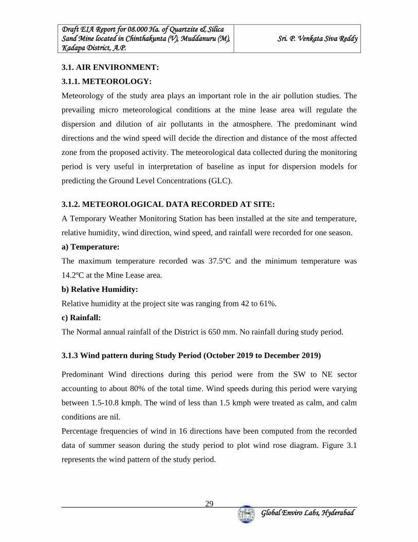
Draft EIA Report for 08.000 Ha. of Quartzite & Silica Sand Mine located in Chinthakunta (V), Muddanuru (M), Kadapa District, A.P.
Sri. P. Venkata Siva Reddy
Global Enviro Labs, Hyderabad
29
3.1. AIR ENVIRONMENT:
3.1.1. METEOROLOGY:
Meteorology of the study area plays an important role in the air pollution studies. The
prevailing micro meteorological conditions at the mine lease area will regulate the
dispersion and dilution of air pollutants in the atmosphere. The predominant wind
directions and the wind speed will decide the direction and distance of the most affected
zone from the proposed activity. The meteorological data collected during the monitoring
period is very useful in interpretation of baseline as input for dispersion models for
predicting the Ground Level Concentrations (GLC).
3.1.2. METEOROLOGICAL DATA RECORDED AT SITE:
A Temporary Weather Monitoring Station has been installed at the site and temperature,
relative humidity, wind direction, wind speed, and rainfall were recorded for one season.
a) Temperature:
The maximum temperature recorded was 37.5ºC and the minimum temperature was
14.2ºC at the Mine Lease area.
b) Relative Humidity:
Relative humidity at the project site was ranging from 42 to 61%.
c) Rainfall:
The Normal annual rainfall of the District is 650 mm. No rainfall during study period.
3.1.3 Wind pattern during Study Period (October 2019 to December 2019) Predominant Wind directions during this period were from the SW to NE sector
accounting to about 80% of the total time. Wind speeds during this period were varying
between 1.5-10.8 kmph. The wind of less than 1.5 kmph were treated as calm, and calm
conditions are nil.
Percentage frequencies of wind in 16 directions have been computed from the recorded
data of summer season during the study period to plot wind rose diagram. Figure 3.1
represents the wind pattern of the study period.
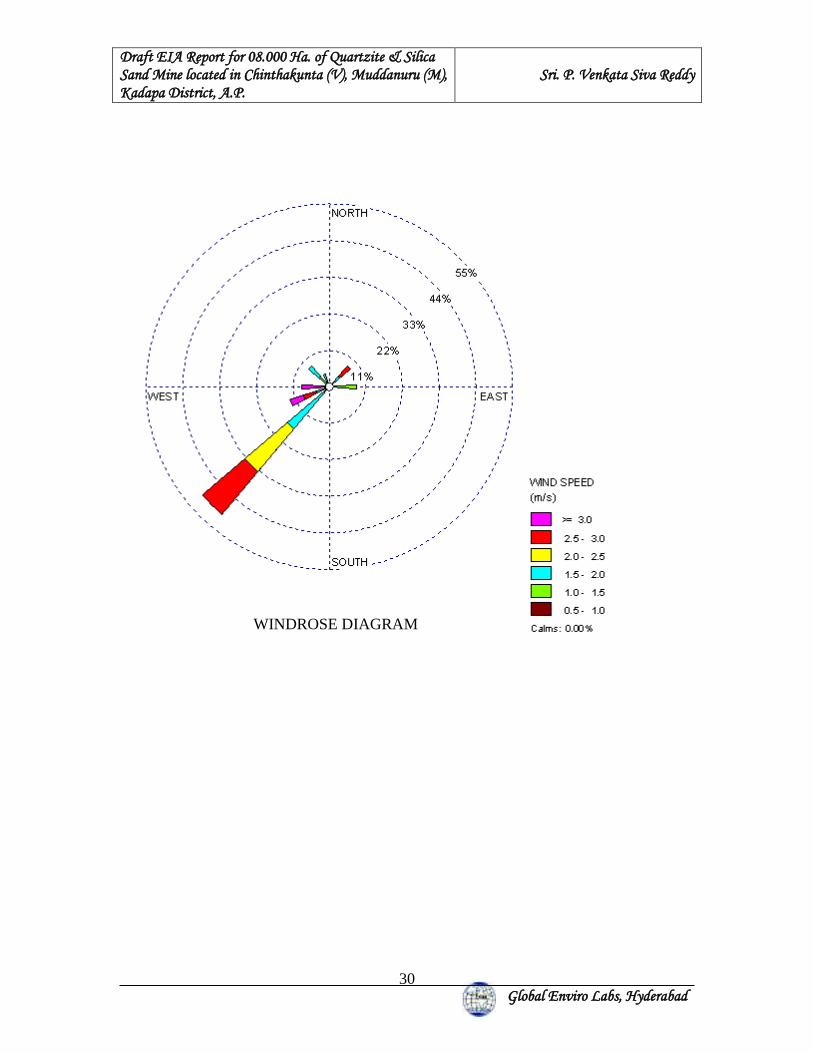
Draft EIA Report for 08.000 Ha. of Quartzite & Silica Sand Mine located in Chinthakunta (V), Muddanuru (M), Kadapa District, A.P.
Sri. P. Venkata Siva Reddy
Global Enviro Labs, Hyderabad
30
WINDROSE DIAGRAM
Draft EIA Report for 08.000 Ha. of Quartzite & Silica Sand Mine located in Chinthakunta (V), Muddanuru (M), Kadapa District, A.P.
Sri. P. Venkata Siva Reddy
Global Enviro Labs, Hyderabad
31
3.1.4. AIR QUALITY:
The ambient air quality with respect to the study zone of 10 km. radius around the project
forms the baseline information. The study area represents mostly rural environment. The
various sources of air pollution in the region are vehicular traffic, dust arising from
unpaved village roads & domestic fuel burning. The Prime objective of baseline air
quality survey is to assess the existing air quality of the area. This will also be useful in
assessing the conformity to standards of the ambient air quality during the mine
operation.
3.1.5 SELECTION OF SAMPLING STATIONS:
The base line status of the ambient air quality can be accessed through scientifically
designed Ambient Air Quality Monitoring Network.
The selection of sampling locations in the air quality surveillance programme is based on
the following.
a) Representation of mine area.
b) Representation of the down wind direction and cross-sectional distribution.
c) Representation of residential areas.
d) Representation of regional background levels.
e) Representation of sensitive receptor.
To assess the ambient air quality level, 8 monitoring stations were set up. Out of these 8
stations, one was set up in core zone, while the rest were outside the mining lease and
within a radius of 10.0 km. Table 3.2 and Fig. No 3.2, presents the location of the air
quality monitoring stations
3.1.6 PARAMETERS MONITORED:
At each Monitoring Station, Particulate Matter (PM2.5), Particulate Matter (PM10), SO2
and NOx are monitored. The sampling was0 carried out for 2 days in a week for one
season (October 2019 to December 2019) to assess the existing status of air pollution
and pollution dispersion pattern over the whole air basin of project site. PM2.5, PM10,
SO2 & NOx were sampled as per MoEF guidelines.
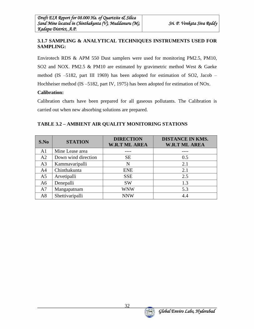
Draft EIA Report for 08.000 Ha. of Quartzite & Silica Sand Mine located in Chinthakunta (V), Muddanuru (M), Kadapa District, A.P.
Sri. P. Venkata Siva Reddy
Global Enviro Labs, Hyderabad
32
3.1.7 SAMPLING & ANALYTICAL TECHNIQUES INSTRUMENTS USED FOR SAMPLING: Envirotech RDS & APM 550 Dust samplers were used for monitoring PM2.5, PM10,
SO2 and NOX. PM2.5 & PM10 are estimated by gravimetric method West & Gaeke
method (IS –5182, part III 1969) has been adopted for estimation of SO2, Jacob –
Hochheiser method (IS –5182, part IV, 1975) has been adopted for estimation of NOx.
Calibration:
Calibration charts have been prepared for all gaseous pollutants. The Calibration is
carried out when new absorbing solutions are prepared.
TABLE 3.2 – AMBIENT AIR QUALITY MONITORING STATIONS
S.No STATION DIRECTION
W.R.T ML AREA DISTANCE IN KMS.
W.R.T ML AREA A1 Mine Lease area ---- ---- A2 Down wind direction SE 0.5 A3 Kammavaripalli N 2.1 A4 Chinthakunta ENE 2.1 A5 Arvetipalli SSE 2.5 A6 Denepalli SW 1.3 A7 Mangapatnam WNW 5.3 A8 Shettivaripalli NNW 4.4
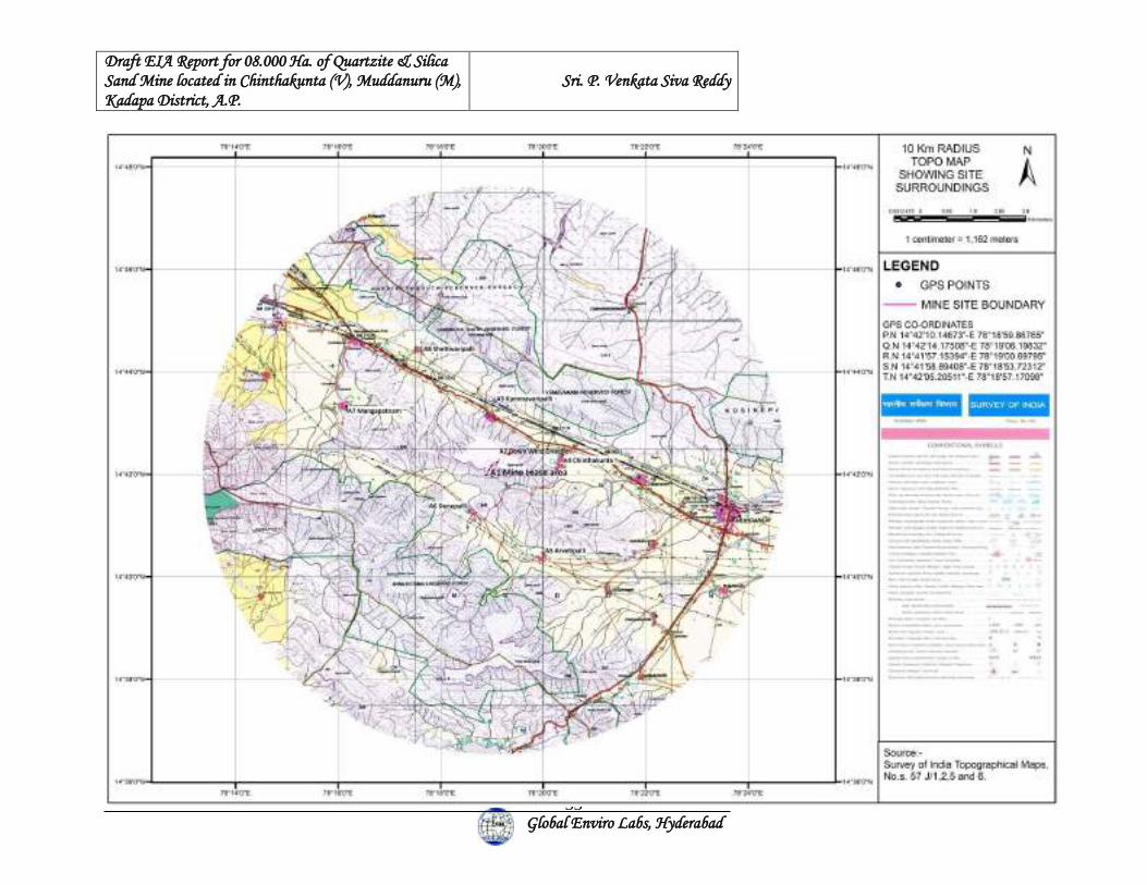
Draft EIA Report for 08.000 Ha. of Quartzite & Silica Sand Mine located in Chinthakunta (V), Muddanuru (M), Kadapa District, A.P.
Sri. P. Venkata Siva Reddy
Global Enviro Labs, Hyderabad
33
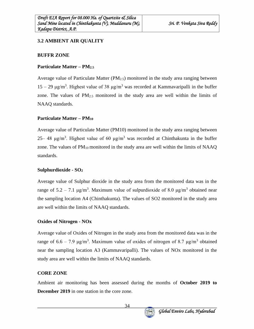
Draft EIA Report for 08.000 Ha. of Quartzite & Silica Sand Mine located in Chinthakunta (V), Muddanuru (M), Kadapa District, A.P.
Sri. P. Venkata Siva Reddy
Global Enviro Labs, Hyderabad
34
3.2 AMBIENT AIR QUALITY
BUFFR ZONE
Particulate Matter – PM2.5
Average value of Particulate Matter (PM2.5) monitored in the study area ranging between
15 – 29 μg/m3. Highest value of 38 μg/m3 was recorded at Kammavaripalli in the buffer
zone. The values of PM2.5 monitored in the study area are well within the limits of
NAAQ standards.
Particulate Matter – PM10 Average value of Particulate Matter (PM10) monitored in the study area ranging between
25– 48 μg/m3. Highest value of 60 μg/m3 was recorded at Chinthakunta in the buffer
zone. The values of PM10 monitored in the study area are well within the limits of NAAQ
standards.
Sulphurdioxide - SO2 Average value of Sulphur dioxide in the study area from the monitored data was in the
range of 5.2 – 7.1 μg/m3. Maximum value of sulpurdioxide of 8.0 μg/m3 obtained near
the sampling location A4 (Chinthakunta). The values of SO2 monitored in the study area
are well within the limits of NAAQ standards.
Oxides of Nitrogen - NOx Average value of Oxides of Nitrogen in the study area from the monitored data was in the
range of 6.6 – 7.9 μg/m3. Maximum value of oxides of nitrogen of 8.7 μg/m3 obtained
near the sampling location A3 (Kammavaripalli). The values of NOx monitored in the
study area are well within the limits of NAAQ standards.
CORE ZONE
Ambient air monitoring has been assessed during the months of October 2019 to
December 2019 in one station in the core zone.
Draft EIA Report for 08.000 Ha. of Quartzite & Silica Sand Mine located in Chinthakunta (V), Muddanuru (M), Kadapa District, A.P.
Sri. P. Venkata Siva Reddy
Global Enviro Labs, Hyderabad
35
Particulate Matter – PM2.5
Average value of Particulate Matter (PM2.5) monitored in the core zone is 20 μg/m3. The
highest value of PM2.5 level 27 μg/m3 was observed. The value of PM2.5 monitored in the
core zone is well within the limits of NAAQ standards.
Particulate Matter – PM10
Average value of Particulate Matter (PM10) monitored in the core zone is 29 μg/m3. The
highest value of PM10 level 33 μg/m3 was observed. The value of PM10 monitored in the
core zone is well within the limits of NAAQ standards.
Sulphur dioxide - SO2
Average value of Sulphur dioxide in the core zone is 5.5 μg/m3. The maximum value of
sulphur dioxide of 6.1 μg/m3 was observed. The values of SO2 monitored in the study
area are well within the limits of NAAQ standards.
Oxides of Nitrogen - NOx
Average value of Nitrogen oxides in the core zone is 6.2 μg/m3. The maximum value of
nitrogen oxides of 6.7 μg/mx was observed.
Summary of AAQ monitoring at each location is given in Table – 3.2 and Percentile
values of ambient air quality is enclosed in Annexure - A.
Table – 3.3: SUMMARY OF AAQ MONITORING Locations 98th Percentile Values * Free silica content in PM10
is observed to be between PM2.5 *PM10 SO2 NOx Mine Lease area 27 33 6.0 6.6 0.9 to 1.4 µg/m3 Down wind direction 22.54 40 5.7 6.9 1.0 to 1.5 µg/m3 Kammavaripalle 38 55 7.0 8.6 1.5 to 2.6 µg/m3 Chinthakunta 35.6 60 7.9 8.7 1.7 to 2.9 µg/m3 Aravetipalle 26.54 50 7.3 7.8 1.2 to 2.4 µg/m3 Denepalle 33.08 52 6.5 8.0 1.3 to 2.2 µg/m3 Mangapatnam 32 54.6 7.4 8.5 1.5 to 2.5 µg/m3 Shettivaripalle 31.54 47.54 6.1 8.1 1.6 to 2.7 µg/m3
Draft EIA Report for 08.000 Ha. of Quartzite & Silica Sand Mine located in Chinthakunta (V), Muddanuru (M), Kadapa District, A.P.
Sri. P. Venkata Siva Reddy
Global Enviro Labs, Hyderabad
36
3.3 NOISE ENVIRONMENT
The acoustical environment varies dynamically in magnitude and character through out
most communities. The noise level variation can be temporal, spectral and spatial. The
residential noise level is that level below which the ambient noise does not seem to
dropdown during the given interval of time and is generally characterized by unidentified
sources. Ambient noise level is characterized by significant variations above a base or a
residential noise level. The maximum impact of noise is felt on urban areas, which is
mostly due to the commercial activities and vehicular movement during peak hours of the
day.
Measured noise levels displayed as a function of time provides a useful scheme for
describing the acoustical climate of a community. Noise levels records at each station
with a time interval of about 30 minutes are computed for equivalent noise levels.
Equivalent noise level is a single number descriptor for describing time varying noise
levels. The equivalent noise level is defined as mathematically.
10Log1/ TΣ (10Ln/10)
Where L = sound pressure level a function of time dB (A) & T = Time interval of observations Noise levels during the night time generally drop, therefore to compute Equivalent noise
levels for the night time, noise levels are increased by 10 dB (A) as the night time high
noise levels are judged more annoying compared to the day time.
Noise levels at a particular station are represented as Day- Night equivalent (Ldn). Day-
Night equivalent is the single number index designed to rate environmental noise on daily
/24 hourly basis. Mathematically Ldn is given by
Ldn = 10 log {1/24 (15 x 10(Ld/10) + 9 x 10 (Ln + 10)/10)}
Where
Ld = A weighed equivalent for day time period (7 am to 10 pm) Ln = A weighed equivalent for night time period (10 pm to 7 am)
Draft EIA Report for 08.000 Ha. of Quartzite & Silica Sand Mine located in Chinthakunta (V), Muddanuru (M), Kadapa District, A.P.
Sri. P. Venkata Siva Reddy
Global Enviro Labs, Hyderabad
37
Noise levels were measured near highways, residential areas and other settlements
located within 10 km radius around the Mine site.
In order o know the baseline noise levels, in and around the Mine site, Noise levels were
measured at the Mine complex and also at 6 villages in the study area. The day equivalent
noise levels were found to be relatively high due to local activities in the villages. Noise
levels recorded in the nighttime were found to be less.
In order to assess the noise levels in the study area, monitoring was carried out at 7
different locations within 10 km radius of the study area. Noise levels were recorded at
each station with a time interval of one minute for about 30 minutes in each hour and
were computed for equivalent noise levels for day-equivalent, night-equivalent & day-
night equivalent. Details of noise monitoring stations are given in Table – 3.3.
The noise recording stations are shown in Figure – 3.3 and the summary of the minimum,
maximum, day - equivalent, night - equivalent and day-night equivalent values computed
for various location in the study area is given in Table – 3.4
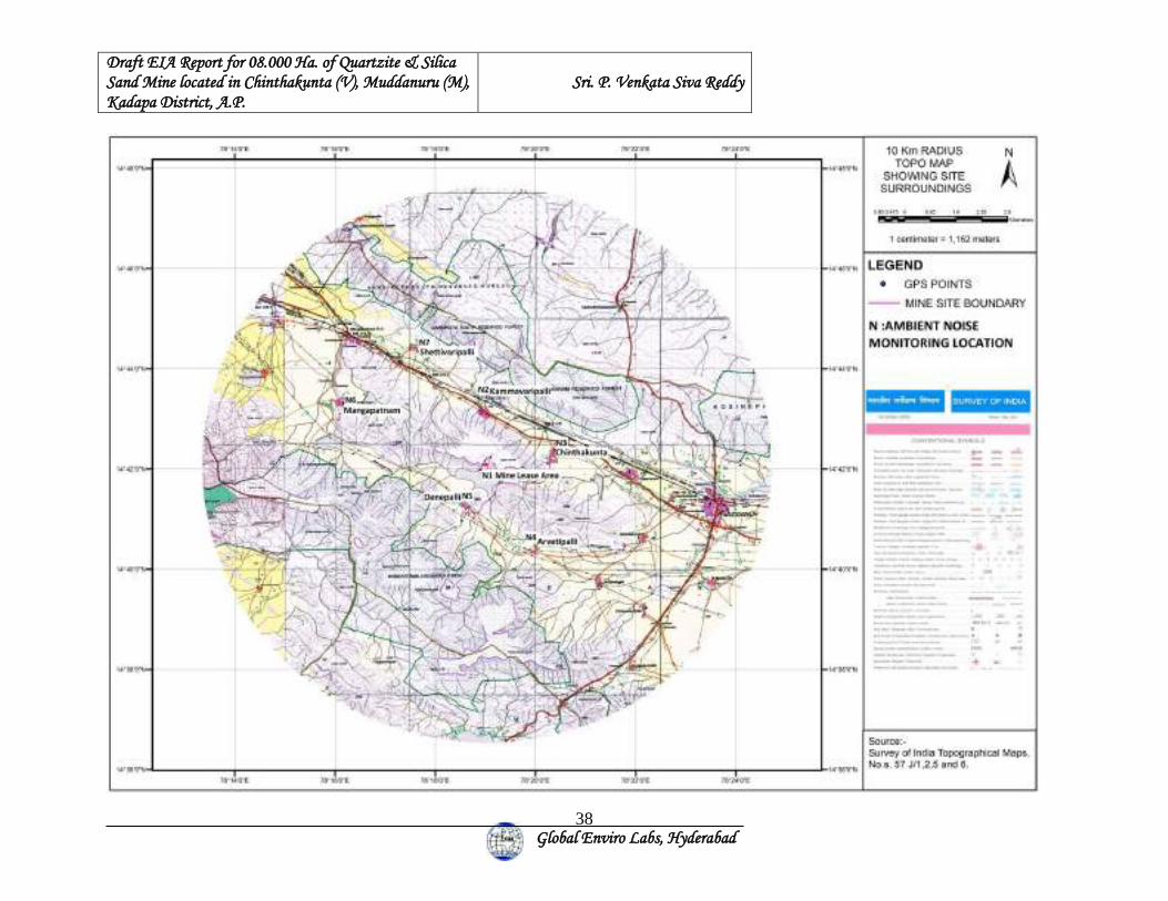
Draft EIA Report for 08.000 Ha. of Quartzite & Silica Sand Mine located in Chinthakunta (V), Muddanuru (M), Kadapa District, A.P.
Sri. P. Venkata Siva Reddy
Global Enviro Labs, Hyderabad
38
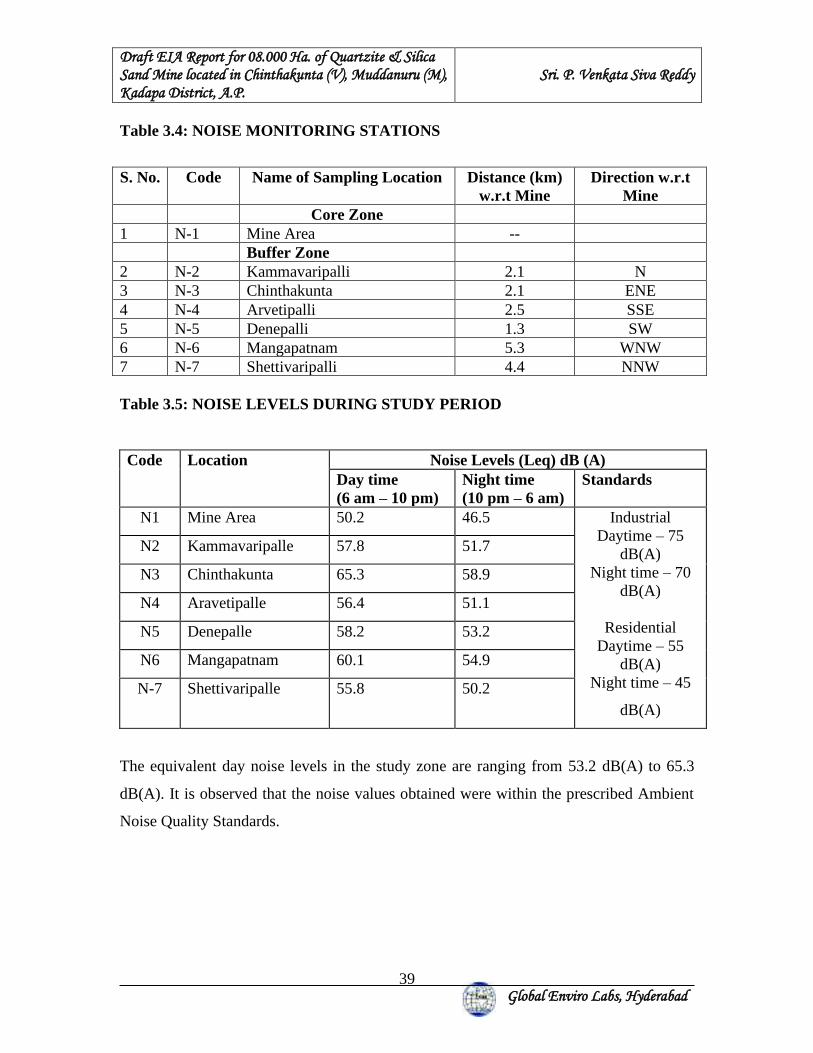
Draft EIA Report for 08.000 Ha. of Quartzite & Silica Sand Mine located in Chinthakunta (V), Muddanuru (M), Kadapa District, A.P.
Sri. P. Venkata Siva Reddy
Global Enviro Labs, Hyderabad
39
Table 3.4: NOISE MONITORING STATIONS
S. No. Code Name of Sampling Location Distance (km)
w.r.t Mine Direction w.r.t
Mine Core Zone
1 N-1 Mine Area -- Buffer Zone 2 N-2 Kammavaripalli 2.1 N 3 N-3 Chinthakunta 2.1 ENE 4 N-4 Arvetipalli 2.5 SSE 5 N-5 Denepalli 1.3 SW 6 N-6 Mangapatnam 5.3 WNW 7 N-7 Shettivaripalli 4.4 NNW Table 3.5: NOISE LEVELS DURING STUDY PERIOD Code Location Noise Levels (Leq) dB (A)
Day time (6 am – 10 pm)
Night time (10 pm – 6 am)
Standards
N1 Mine Area 50.2 46.5 Industrial Daytime – 75
dB(A) Night time – 70
dB(A)
Residential Daytime – 55
dB(A) Night time – 45
dB(A)
N2 Kammavaripalle 57.8 51.7
N3 Chinthakunta 65.3 58.9
N4 Aravetipalle 56.4 51.1
N5 Denepalle 58.2 53.2
N6 Mangapatnam 60.1 54.9
N-7 Shettivaripalle 55.8 50.2
The equivalent day noise levels in the study zone are ranging from 53.2 dB(A) to 65.3
dB(A). It is observed that the noise values obtained were within the prescribed Ambient
Noise Quality Standards.
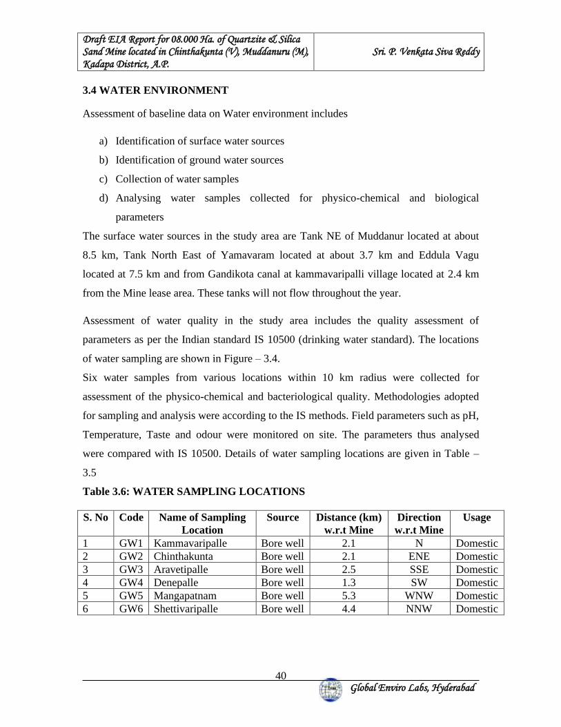
Draft EIA Report for 08.000 Ha. of Quartzite & Silica Sand Mine located in Chinthakunta (V), Muddanuru (M), Kadapa District, A.P.
Sri. P. Venkata Siva Reddy
Global Enviro Labs, Hyderabad
40
3.4 WATER ENVIRONMENT Assessment of baseline data on Water environment includes
a) Identification of surface water sources
b) Identification of ground water sources
c) Collection of water samples
d) Analysing water samples collected for physico-chemical and biological
parameters
The surface water sources in the study area are Tank NE of Muddanur located at about
8.5 km, Tank North East of Yamavaram located at about 3.7 km and Eddula Vagu
located at 7.5 km and from Gandikota canal at kammavaripalli village located at 2.4 km
from the Mine lease area. These tanks will not flow throughout the year.
Assessment of water quality in the study area includes the quality assessment of
parameters as per the Indian standard IS 10500 (drinking water standard). The locations
of water sampling are shown in Figure – 3.4.
Six water samples from various locations within 10 km radius were collected for
assessment of the physico-chemical and bacteriological quality. Methodologies adopted
for sampling and analysis were according to the IS methods. Field parameters such as pH,
Temperature, Taste and odour were monitored on site. The parameters thus analysed
were compared with IS 10500. Details of water sampling locations are given in Table –
3.5
Table 3.6: WATER SAMPLING LOCATIONS S. No Code Name of Sampling
Location Source Distance (km)
w.r.t Mine Direction w.r.t Mine
Usage
1 GW1 Kammavaripalle Bore well 2.1 N Domestic 2 GW2 Chinthakunta Bore well 2.1 ENE Domestic 3 GW3 Aravetipalle Bore well 2.5 SSE Domestic 4 GW4 Denepalle Bore well 1.3 SW Domestic 5 GW5 Mangapatnam Bore well 5.3 WNW Domestic 6 GW6 Shettivaripalle Bore well 4.4 NNW Domestic
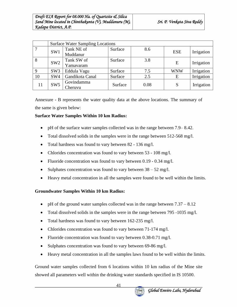
Draft EIA Report for 08.000 Ha. of Quartzite & Silica Sand Mine located in Chinthakunta (V), Muddanuru (M), Kadapa District, A.P.
Sri. P. Venkata Siva Reddy
Global Enviro Labs, Hyderabad
41
Surface Water Sampling Locations 7
SW1 Tank NE of Muddanur
Surface 8.6 ESE Irrigation
8 SW2
Tank SW of Yamavaram
Surface 3.8 E Irrigation
9 SW3 Eddula Vagu Surface 7.5 WNW Irrigation 10 SW4 Gandikota Canal Surface 2.5 E Irrigation
11 SW5 Govindamma Cheruvu
Surface 0.08 S Irrigation
Annexure - B represents the water quality data at the above locations. The summary of
the same is given below:
Surface Water Samples Within 10 km Radius:
• pH of the surface water samples collected was in the range between 7.9– 8.42.
• Total dissolved solids in the samples were in the range between 512-568 mg/l.
• Total hardness was found to vary between 82 - 136 mg/l.
• Chlorides concentration was found to vary between 53 - 108 mg/l.
• Fluoride concentration was found to vary between 0.19 - 0.34 mg/l.
• Sulphates concentration was found to vary between 38 – 52 mg/l.
• Heavy metal concentration in all the samples were found to be well within the limits.
Groundwater Samples Within 10 km Radius:
• pH of the ground water samples collected was in the range between 7.37 – 8.12
• Total dissolved solids in the samples were in the range between 795 -1035 mg/l.
• Total hardness was found to vary between 162-235 mg/l.
• Chlorides concentration was found to vary between 71-174 mg/l.
• Fluoride concentration was found to vary between 0.38-0.71 mg/l.
• Sulphates concentration was found to vary between 69-86 mg/l.
• Heavy metal concentration in all the samples laws found to be well within the limits.
Ground water samples collected from 6 locations within 10 km radius of the Mine site
showed all parameters well within the drinking water standards specified in IS 10500.
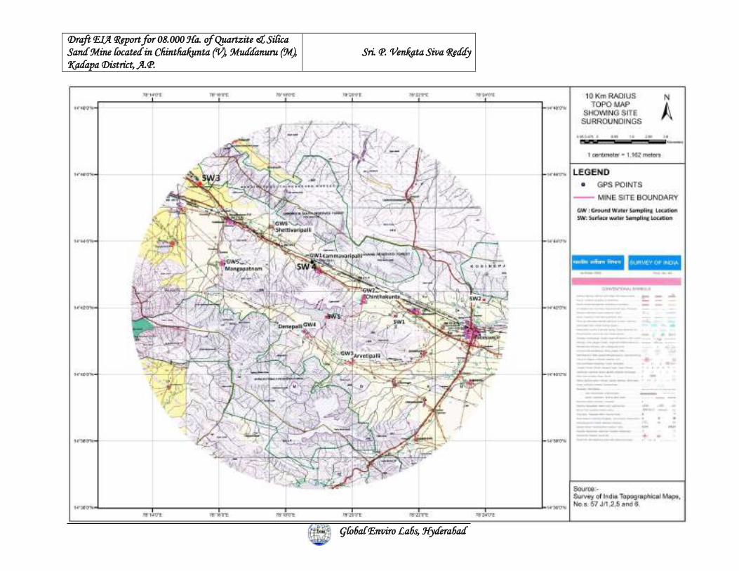
Draft EIA Report for 08.000 Ha. of Quartzite & Silica Sand Mine located in Chinthakunta (V), Muddanuru (M), Kadapa District, A.P.
Sri. P. Venkata Siva Reddy
Global Enviro Labs, Hyderabad
42
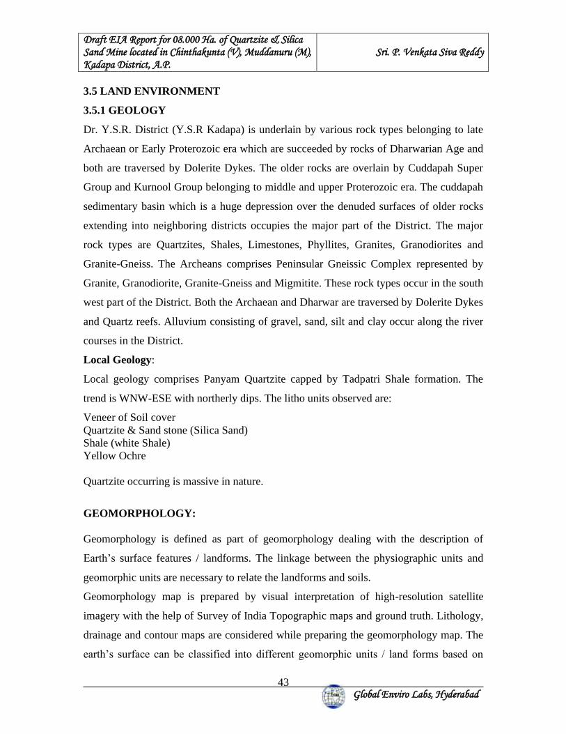
Draft EIA Report for 08.000 Ha. of Quartzite & Silica Sand Mine located in Chinthakunta (V), Muddanuru (M), Kadapa District, A.P.
Sri. P. Venkata Siva Reddy
Global Enviro Labs, Hyderabad
43
3.5 LAND ENVIRONMENT
3.5.1 GEOLOGY
Dr. Y.S.R. District (Y.S.R Kadapa) is underlain by various rock types belonging to late
Archaean or Early Proterozoic era which are succeeded by rocks of Dharwarian Age and
both are traversed by Dolerite Dykes. The older rocks are overlain by Cuddapah Super
Group and Kurnool Group belonging to middle and upper Proterozoic era. The cuddapah
sedimentary basin which is a huge depression over the denuded surfaces of older rocks
extending into neighboring districts occupies the major part of the District. The major
rock types are Quartzites, Shales, Limestones, Phyllites, Granites, Granodiorites and
Granite-Gneiss. The Archeans comprises Peninsular Gneissic Complex represented by
Granite, Granodiorite, Granite-Gneiss and Migmitite. These rock types occur in the south
west part of the District. Both the Archaean and Dharwar are traversed by Dolerite Dykes
and Quartz reefs. Alluvium consisting of gravel, sand, silt and clay occur along the river
courses in the District.
Local Geology:
Local geology comprises Panyam Quartzite capped by Tadpatri Shale formation. The
trend is WNW-ESE with northerly dips. The litho units observed are:
Veneer of Soil cover Quartzite & Sand stone (Silica Sand) Shale (white Shale) Yellow Ochre Quartzite occurring is massive in nature.
GEOMORPHOLOGY: Geomorphology is defined as part of geomorphology dealing with the description of
Earth’s surface features / landforms. The linkage between the physiographic units and
geomorphic units are necessary to relate the landforms and soils.
Geomorphology map is prepared by visual interpretation of high-resolution satellite
imagery with the help of Survey of India Topographic maps and ground truth. Lithology,
drainage and contour maps are considered while preparing the geomorphology map. The
earth’s surface can be classified into different geomorphic units / land forms based on

Draft EIA Report for 08.000 Ha. of Quartzite & Silica Sand Mine located in Chinthakunta (V), Muddanuru (M), Kadapa District, A.P.
Sri. P. Venkata Siva Reddy
Global Enviro Labs, Hyderabad
44
their physiographic expression, origin, material content and climatic conditions, etc.
Technical guidelines of National Remote Sensing Centre are taken into consideration in
the classification of geomorphic units. In the study area, the following eight geomorphic
units are delineated from the satellite imagery. Geomorphology map showing figure 3.5.
PPS : Pediplain Shallow Weathered
VFS : Valley Fill Shallow
PD : Pediment
PIC : Pediment-Inselberg Complex
I : Inselberg
DR : Dyke Ridge
RH : Residual Hill
DH : Denudation Hill
Geomorphology map is used for the preparation of ground water prospects map.
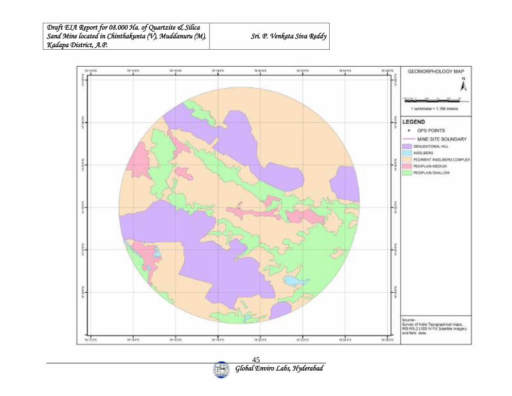
Draft EIA Report for 08.000 Ha. of Quartzite & Silica Sand Mine located in Chinthakunta (V), Muddanuru (M), Kadapa District, A.P.
Sri. P. Venkata Siva Reddy
Global Enviro Labs, Hyderabad
45
Draft EIA Report for 08.000 Ha. of Quartzite & Silica Sand Mine located in Chinthakunta (V), Muddanuru (M), Kadapa District, A.P.
Sri. P. Venkata Siva Reddy
Global Enviro Labs, Hyderabad
46
3.6 HYDROGEOLOGY The Mining Lease is located over the escarpment portion of the plateau. The ML area is over the
run off zone. No streams are passing through the proposed QL Area. The catchment area of the
proposed site is small and recharge conditions are poor. However, the buffer zone of 10Kms
radius has good catchment and recharge potential with streams and tanks of considerable storage
potential. The area is a part of Penna River catchment.
All the stream courses are ephemeral in character and carry large volumes of storm flows during
rainy season and remain dry during non - monsoon season. The width of the streams is narrow
and follows the weak planes within the hard rock formations. A drainage map of the area around
the proposed plant is shown as figure 3.6
DRAINAGE MAP
This map consists of all water bodies, rivers, tributaries, perennial & ephemeral streams,
reservoirs, tanks, ponds and the entire drainage network from first order originating in the area to
the last order joining the rivers, tributaries and tanks based on topography. Understanding the
importance of drainage depends on the purpose and the objective of the project. For the present
study purpose the following factors have to be understood and extracted from the study of the
drainage pattern. Drainage network helps in delineation of watersheds. Drainage density and type
of drainage gives information related to runoff, infiltration relief and permeability.
Below Table Showing drainage density-based criteria by smith and Strahler.
Drainage Density
Texture Runoff Infiltration Relief Stratum
< 5.0 Coarse (High) High Low High High Impermeable 5.0 - 13.7 Medium Medium Medium Medium Medium Permeable 13.7 - 155.3 Ultra fine
(Low) Low High Low Good Permeable
Draft EIA Report for 08.000 Ha. of Quartzite & Silica Sand Mine located in Chinthakunta (V), Muddanuru (M), Kadapa District, A.P.
Sri. P. Venkata Siva Reddy
Global Enviro Labs, Hyderabad
47
Below Table Showing drainage density-based criteria proposed by Long Bein
Drainage Density Areas Runoff 0.55 - 2.09 Steep Impervious Areas High 1.03 Humid Regions High
Below Table showing Drainage Density Based Criteria Proposed by Horton
Drainage Density Stratum Runoff 0.9 - 1.29 Steep Impervious Areas High < 0.9 Permeable High Infiltration Areas Low
Dendritic drainage indicates homogenous rocks, the trellis, rectangular and parallel
drainage patterns indicate structural and lithological controls. The coarse drainage texture
indicates highly porous and permeable rock formations; whereas fine drainage texture is
more common in less pervious formations. Weathering profile controls of ground water
and above all discharge of surface water along the major streams and rivers. Fractured
pattern and other structural features control drainage pattern in hard rocks. Slope /
gradient of area coupled with drainage density decide the weathering profile. These two
factors synthesized with rainfall (of a given area) provide information on the ground
water potential (weathering profile, structural factors) and discharge of surface water
along streams. Weathering profile increases groundwater potential, slope/gradient
together with runoff controls the thickness of weathered zone. Major faults, lineaments
sometimes connects two are more watersheds (Drainage Basins) and act as conduits
(Interconnecting channel ways). Flow of groundwater along these week zones is an
established fact. A proper understanding of the major faults, their influence of
groundwater flow has to be understood from drainage system and its controls. The study
of the drainage for the present purpose is to understand that, to what extent the ground
water would be affected by the water pollutants. Survey of India Topomaps, satellite data
of summer season are the main input data for preparation of drainage map. The drainage
map is prepared using Toposheets of Survey of India on 1:50,000 scale and updated using
latest satellite data wherever deviations and new developments are observed.
Draft EIA Report for 08.000 Ha. of Quartzite & Silica Sand Mine located in Chinthakunta (V), Muddanuru (M), Kadapa District, A.P.
Sri. P. Venkata Siva Reddy
Global Enviro Labs, Hyderabad
48
Step I: All the rivers its tributaries and drainage network shown on the Toposheets are
captured. The boundaries of all rivers / water bodies with names appearing are captured
from Toposheets. The drainage is drawn from whole to part, i.e., from the rivers to
tributaries to first drains to second order drains to third order drains.
Step II: Based on the post monsoon satellite image extent of water spread and dry parts
are updated. The water bodies which did not exist at the time of survey of Toposheets, if
any are also captured based on satellite imagery. The study area forms part of Mahanadi
river basin the southern of the area from western part, towards East. All these rivers and
rivulets get dry for major part of the year and carry heavy floods during rainy season. The
drainage map of study area has showing in figure below
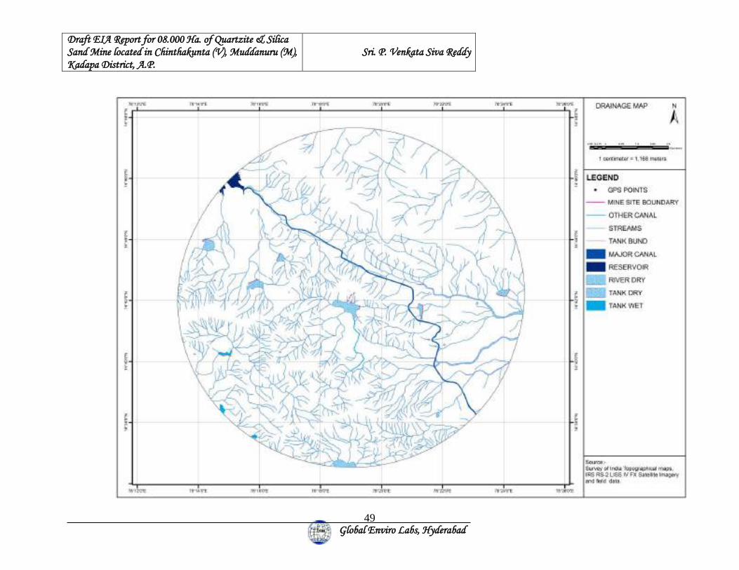
Draft EIA Report for 08.000 Ha. of Quartzite & Silica Sand Mine located in Chinthakunta (V), Muddanuru (M), Kadapa District, A.P.
Sri. P. Venkata Siva Reddy
Global Enviro Labs, Hyderabad
49
Draft EIA Report for 08.000 Ha. of Quartzite & Silica Sand Mine located in Chinthakunta (V), Muddanuru (M), Kadapa District, A.P.
Sri. P. Venkata Siva Reddy
Global Enviro Labs, Hyderabad
50
GROUND WATER CONDITIONS Groundwater occurs in the hard rocks occur under water table conditions in the
weathered zone and semi- confined conditions in fractured zones. Eight bore wells and
Two dug wells were inventoried to assess the groundwater conditions. The depth to water
levels in bore wells is reported between 30-80 m with yields ranging between of 50 – 100
lpm. The quality of water is found to be potable.
As the extent of the proposed mine is small the runoff during monsoon is to be diverted
to the first order streams on the south west after duly passing the water through a series of
settling ponds to avoid the sedimentation in the stream. As the mining lease is over run
off zone and only sheet wash is expected very minimal affect on surface water flow. The
artificial recharge is not feasible in the ML area. As such it is suggested to approach the
local government authorities for planning water harvesting measures like de-silting of
tanks, Check dams and percolation pits are suggested to augment the declining water
levels.
GROUND WATER POTENTIAL MAP Ground water prospects of an area depend mainly on Lithology unit (rock type) occurring
at that area. However, within each Lithology unit, the ground water conditions vary
significantly depending upon the geomorphology, structure, slope, soil thickness, depth
and nature of weathered material, presence of fractures / lineaments, surface water
bodies, canals, irrigated areas, etc. All the parameters of the study area are studied and
integrated to arrive at the ground water prospects. Ground water potential map showing
figure 3.6.
The proposed area is categorized as Semi-critical by the Central Groundwater department
and scope for development & stage of groundwater is limited. As the site is not feasible
for extracting groundwater arrangements by way of tanker supply from nearby villages is
suggested for the water requirement of 12 KLD. As the area falls under semi-critical area
thrust should be on providing artificial recharge structures and utilization of surface water
tanks located nearby with due permission from the State Government.
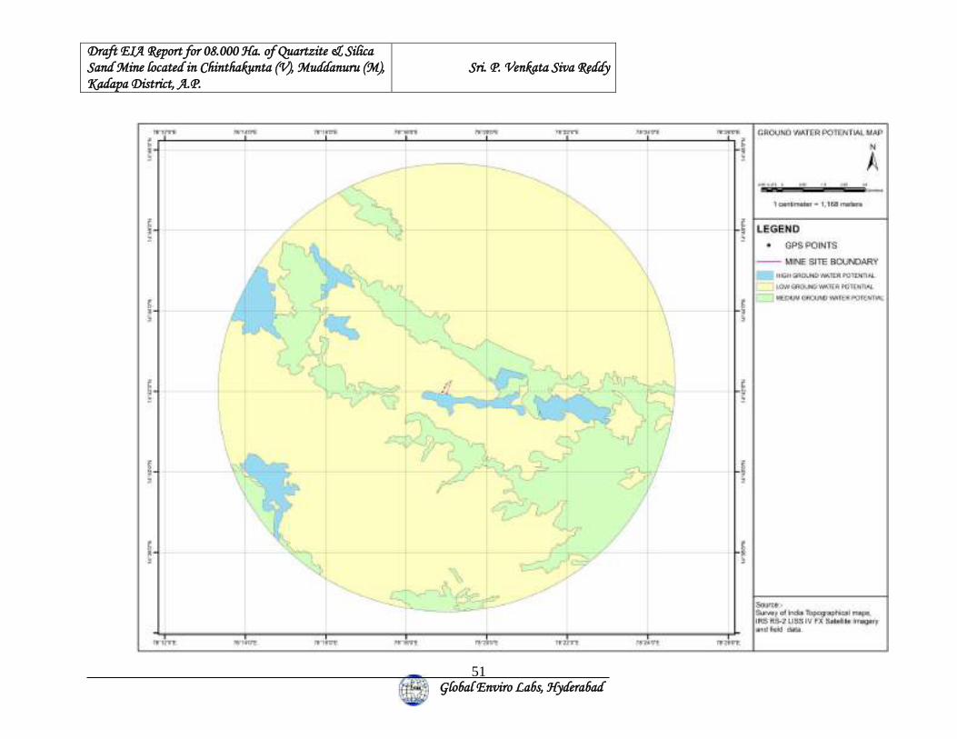
Draft EIA Report for 08.000 Ha. of Quartzite & Silica Sand Mine located in Chinthakunta (V), Muddanuru (M), Kadapa District, A.P.
Sri. P. Venkata Siva Reddy
Global Enviro Labs, Hyderabad
51
Draft EIA Report for 08.000 Ha. of Quartzite & Silica Sand Mine located in Chinthakunta (V), Muddanuru (M), Kadapa District, A.P.
Sri. P. Venkata Siva Reddy
Global Enviro Labs, Hyderabad
52
Bore well water samples have been collected once during study period from six locations
and surface water samples collected from two locations which are listed in the previous
table:
(I) POSSIBLE IMPACT ON GEOLOGY & MITIGATION
1) The area will be broken to a depth of 18.0 mts by forming benches to win the
mineral which results in the formation of a large deep pit of about 65,000 m2
extent. - Although it cannot be reversed the pit can be used for water harvesting to
raise aquaculture at the end of mining operations. A fence to be erected and
watchmen posted for safety and security of men and animals.
2) The top soil should be removed and stacked separately to be utilized for
plantation.
3) The drilling and blasting activity, movement of workmen, quarrying of mineral
and haulage of tractors/ trailers will generate dust and there is likely chance to
settle in the stream, inhalation by workmen and also will have sedimentation
affect over the wind ward side. This should be arrested at the origin by regular
sprinkling of water & placing moist clay bags while blasting and sprinkling of
water at regular intervals on haul roads. The workers should be provided with
masks and earplugs, safety eye glass wear will contain or minimize health hazard.
(II) POSSIBLE IMPACT ON HYDROGEOLOGY & MITIGATION
1. No streams within the proposed QL Area.
2. The site is not feasible for groundwater extraction.
3. Water for the project usage will be met through purchase of water tankers
from the nearby villages.
Hence, no mitigation suggested.
Draft EIA Report for 08.000 Ha. of Quartzite & Silica Sand Mine located in Chinthakunta (V), Muddanuru (M), Kadapa District, A.P.
Sri. P. Venkata Siva Reddy
Global Enviro Labs, Hyderabad
53
3.7 LAND USE PATTERN:
3.7.1 INTRODUCTION
Land Use (LU) refers to man’s activities and various uses, which are carried on land.
Land Cover (LC) refers to natural vegetation, water bodies, rock / soil, artificial cover
and others resulting due to land transformation. Although land use is generally inferred
based on the cover, yet both the terms land use and land cover are closely related and
interchangeable.
Information on the rate and kind of change in the use of land resources is essential to the
proper planning, management and regulation of the use of such resources. Knowledge
about the existing land use and trends of change is essential if the nation is to tackle the
problems associated with the haphazard and uncontrolled growth. A systematic
framework is needed for updating the land use and land cover maps that will be timely,
relatively inexpensive and appropriate for different needs at both national and state
levels. The rapidly developing technology of remote sensing offers an efficient and
timely approach to the mapping and collection of basic land use and land cover data over
large area. The satellite imageries are potentially more amenable to digital processing
because the remote sensor output can be obtained in digital format. Land use data are
needed in the analysis of environmental processes and problems that must be understood
if living conditions and standards are to be improved from or maintained at current levels.
It is required to carry out the land use / land cover study for the project study area (10 km
radius) to obtain the necessary environmental clearances from statutory authorities. The
objective of the study is to carryout land use / land cover study for the proposed project.
The LU / LC study is carried out using the Satellite Imageries (IRS RS2 LISS III Rabi
and Khariff) in addition to Survey of India toposheets. Appropriate guidelines are
followed while preparing the LU / LC map for the project study area.
3.7.2 OBJECTIVE
The objective of the assignment is to carry out Land use / Land cover study for Sri
P.Venkata Siva Reddy over an Extent of 08.000 Hectare Mine, Sy No: 677 (old Sy
Draft EIA Report for 08.000 Ha. of Quartzite & Silica Sand Mine located in Chinthakunta (V), Muddanuru (M), Kadapa District, A.P.
Sri. P. Venkata Siva Reddy
Global Enviro Labs, Hyderabad
54
No.425), Chintakunta Village, Muddanur Mandal, Y.S.R. Kadapa District, Andhra
Pradesh.
3.7.3 SCOPE OF THE WORK
(STANDARD OPERATION PROCEDURE FOR LAND USE / LAND COVER
STUDY)
❖ The lu/lc study shall be carried out for a study area of 10 km radius taking site as
centre using the satellite imageries (IRS RS2 III / IV 5.8m Resolution) for Rabi /
Khariff season.
❖ Procurement of latest satellite imagery (IRS RS2 III / IV 5.8m Resolution) based
on availability) Rabi or Khariff seasons.
❖ Satellite imagery processing and interpretation of land use as per land use classification
covering 10 km radius of proposed Project Site.
❖ Calculation of land use breakup w. r. t. each land use category covering 10 km of
proposed Project Site.
❖ Preparation and submission of reports, satellite imageries and maps.
PRE-FIELD INTERPRETATION:
❖ Collection of Survey of India Topographical maps on 1: 50,000 scale from Survey of
India (SOI).
❖ Procurement of Satellite Imagery from National Remote Sensing Centre (NRSC) site Geo
Co-ordinates from site center taken 10 Km radius.
❖ Using ERDAS image processing software processed the raw satellite data.
❖ Using ARCGIS software converting the all base features from the toposheet, and
overlaying the same features on the satellite imagery.
❖ Using remote Sensing techniques tone, color, texture and shadow etc. draft land use map
is prepared.
❖ Before site / ground truthing randomly mark field data checked. With which field work
will be carried out.
Draft EIA Report for 08.000 Ha. of Quartzite & Silica Sand Mine located in Chinthakunta (V), Muddanuru (M), Kadapa District, A.P.
Sri. P. Venkata Siva Reddy
Global Enviro Labs, Hyderabad
55
SITE / GROUND TRUTHING:
❖ Site visit - capture the Geo-Coordinates of Boundary Pillars and record in field note
book.
❖ Take traverses and observe the land use categories and map it on the field map on draft
map with field photographs.
❖ Observe each land use category like single crop/double crop, industrial area, settlements,
forest lands, water bodies, waste lands and etc.
❖ The buffer zone area will randomly traverse for correlating mapping units.
❖ Collecting secondary data from agricultural department and local people.
❖ POST FIELD WORK:
❖ Using ARCGIS software plotting the data collected during ground truth maps.
❖ Preparation of maps
❖ Preparation of report incorporating identification of impacts, quantification of impacts
and suggesting mitigative measures in consultation with other FAEs.
3.7.4 ROLE OF REMOTE SENSING AND GIS
Remote sensing and GIS are the modern techniques of terrain analysis and information
generation. They not only ensure faster and easier analysis / interpretation but also help to
modify / manipulate the data at will so as to meet the objective of the study.
3.7.4.1 REMOTE SENSING (RS)
➢ Remote Sensing (RS) generally involves in processing of remotely sensed data in
digital form using image-processing techniques, which created a new and wider
dimension in analysis and interpretation. Remote sensing enables one to acquire
information about an object or phenomena from a distance through detection or
measurement of electromagnetic energy coming from the object. The use of remote
sensing techniques for the study of natural resources has been found to be of
considerable value. The information derived from the remote sensing is compatible
with topographic maps of Survey of India on 1:50,000 or 1:25,000 scale. With the use
of high-altitude sensor platform, it is now possible to record extensive areas on a
Draft EIA Report for 08.000 Ha. of Quartzite & Silica Sand Mine located in Chinthakunta (V), Muddanuru (M), Kadapa District, A.P.
Sri. P. Venkata Siva Reddy
Global Enviro Labs, Hyderabad
56
single image, which covers a maximum of 34,000 sq. km (185x185km) and minimum
of 3600-sq.km area. Thus, one can have a synoptic view over large area and also an
integrated picture of the landscape. By using the satellite imagery, it is possible to
conduct surveys in areas, which are difficult to access. Some of the advantages of
utilizing remote sensing techniques are given below:
➢ Satellite image serves as a permanent record of a landscape at a point of time from
which land use changes can be monitored and evaluated.
➢ Satellite data is cost effective when compared to conventional methods. It can be
obtained quickly; its information is accurate, reliable and up to date.
➢ Preparation of thematic layers by using satellite imagery is time saving when
compared to conventional method.
➢ Satellite data can be effectively integrated with the conventional data for analysis,
planning and decision-making.
3.7.5 GIS
Geographic Information System (GIS) is a powerful set of tool, which can perform
correlation. GIS is a system for manipulating and analyzing spatial data to provide
information to support planning and decision-making. GIS can also be defined as
“decision support system involving the integration of spatially referenced data in a
problem solving environment’ (Cowen, 1988). It comprises facilities for the input,
management, retrieval, manipulation, analysis and display of spatial data. Its functions
can be grouped as data acquisition, data utilization, data management, output and display.
GIS technology is useful as planning / decision-making tool for resource management.
The selective retrieval and analysis capabilities of GIS are used to manipulate the
database and provide a variety of information for resource management. GIS is an aid to
analyze the thematic maps prepared through remote sensing and field visits. It stores all
the maps prepared and database attached to them in digital format, which permits rapid
access and processing. Combination of Remote sensing and GIS technologies are very
important for assessment and management of natural resources, where integration of data
from different sources is an essential requirement.
Draft EIA Report for 08.000 Ha. of Quartzite & Silica Sand Mine located in Chinthakunta (V), Muddanuru (M), Kadapa District, A.P.
Sri. P. Venkata Siva Reddy
Global Enviro Labs, Hyderabad
57
3.7.6 DATA USED
The data is used for the preparation of different maps for the study natural resources. The
data is used by using the application of Remote Sensing and GIS technologies.
Details of Sources & the Maps Prepared
Sl. No. Source Maps Prepared 1. Survey of India’s topographic maps and
satellite imageries Base map and Drainage map
2. Satellite Imageries Land use / Land cover
3.7.7 DETAILS OF THE DATA USED
Survey of India’s Topographic Maps
Sl. No. Topographic Map No. Scale Year of Survey Year of Publication
1. 57 J/1 1: 50,000 2010 2011
2. 57 J/2 1: 50,000 2010 2011
3. 57 J/5 1: 50,000 2010 2011
4. 57 J/6 1: 50,000 2010 2011
Satellite data of National Remote Sensing Centre
Sl. No. Season Sensor
path/row Satellite/Sensor Date of Pass
1. Summer 100-63-B IRS RS-2 LISS IV FX 25-March-2019
3.7.7 PROJECT SITE LOCATION
The project site is located at Sy No: 677 (old Sy No.425), Chintakunta Village, Muddanur
Mandal, Y.S.R. Kadapa District, Andhra Pradesh. The project site covers an Extent of 314 q2
kilometers.
3.7.8 STUDY AREA
As per the Review meeting held in the Office of M/s. Global Enviro Labs site has been
visited in December 2019. A study area of 10 km radius is delineated taking the
Draft EIA Report for 08.000 Ha. of Quartzite & Silica Sand Mine located in Chinthakunta (V), Muddanuru (M), Kadapa District, A.P.
Sri. P. Venkata Siva Reddy
Global Enviro Labs, Hyderabad
58
proposed project site as centre. Please refer to Figure No. 1.1 for complete Geo-co-
ordinates of the Project Site. A study area of 10 km radius is delineated taking the
proposed project site as centre
(Latitude - 14°42'10.14673"N & Longitude - 78°18'59.86765"E).
3.7.9 LAND USE / LAND COVER MAP
Land use / land cover map is prepared by visual interpretation of high-resolution satellite
data with the help of Survey of India Topographic maps on 1:50,000 scale. Two seasons’
data (Summer year 2019) is used for the delineation of different units. The units are
confirmed by the ground truth/field visits.
Level-II classification of National (Natural) Resources Information System (NRIS) has
been followed for the delineation of units.
Land use / Land cover map of the study area is integrated with village map and analyzed
with the help of GIS to get the village wise findings of the present land use of the study
area, which is given elaborately in the following tables:
Land use refers to man’s activities and various uses, which are carried on land. Land
cover refers to natural vegetation, water bodies, rock/soil, artificial cover and others
resulting due to land transformation. Although land use is generally inferred based on the
cover, yet both the terms land use and land cover are closely related and interchangeable.
Information on the rate and kind of change in the use of land resources is essential to the
proper planning, management and regulation of the use of such resources.
Knowledge about the existing land use and trends of change is essential if the nation is to
tackle the problems associated with the haphazard and uncontrolled growth. A systematic
framework is needed for updating the land use and land cover maps that will be timely,
relatively inexpensive and appropriate for different needs at national and state level. The
rapidly developing technology of remote sensing offers an efficient and timely approach
to the mapping and collection of basic land use and land cover data over large area. The
satellite imageries are potentially more amenable to digital processing because the remote
sensor output can be obtained in digital format. Land use data are needed in the analysis
of environmental processes and problems that must be understood if living conditions and
standards are to be improved or maintained at current levels.
Draft EIA Report for 08.000 Ha. of Quartzite & Silica Sand Mine located in Chinthakunta (V), Muddanuru (M), Kadapa District, A.P.
Sri. P. Venkata Siva Reddy
Global Enviro Labs, Hyderabad
59
Basic Concepts of Land Use
Clawson has given nine major ideas or concepts about land. These are:
➢ Location or the relation of a specific parcel of land to the poles, the equator, and the
major oceans and landmasses. There is also relationship between various tracts of
land, as well as a political location.
➢ Activity on the land, for what purpose this piece of land or tract is used.
➢ Natural qualities of land, including its surface and subsurface characteristics and its
vegetative cover.
➢ Improvements to and on the land. This is closely related to the activity.
➢ Intensity of land use or amount of activity per unit area.
➢ Land tenure, i.e. who owns the land, which uses it.
➢ Land prices, land market activity and credit as applied to land.
➢ Interrelations between activities on the land and other economic and social activities.
➢ Interrelations in the use between different tracts of land.
3.7.10 METHODOLOGY FOR LAND USE / LAND COVER MAPPING
The land use / land cover map is prepared by adopting the interpretation techniques of the
image in conjunction with collateral data such as Survey of India topographical maps and
census records. Image classification can be done by using visual interpretation techniques
and digital classification using any of the image processing software. For the present study,
ERDAS 9.1 version software is used for preprocessing, rectification, enhancements and
classifying the satellite data for preparation of land use land cover map for assessing and
monitoring the temporal changes in land use land cover and land developmental activities.
The imagery is interpreted and ground checked for corrections. The final map is prepared
after field check. Flow chart showing the methodology adopted is given in the different land
use / land cover categories in the study area has been carried out based on the NRSC land use
/ land cover classification system.
For analysis and interpretation, and preparation of Lu / Lc map, two types of data are needed:
1. Basic data 2. Ground data
Draft EIA Report for 08.000 Ha. of Quartzite & Silica Sand Mine located in Chinthakunta (V), Muddanuru (M), Kadapa District, A.P.
Sri. P. Venkata Siva Reddy
Global Enviro Labs, Hyderabad
60
Basic data includes:
❖ Fused data of LISS IV
❖ Toposheets on 1 : 50,000
❖ Local knowledge
❖ Area map on any scale to transfer details
❖ Reports and other literature of the study area
Ground data: Ground data is very much essential to verify and to increase the accuracy
of the interpreted classes and also to minimize the field work.
Data analysis: For analysis and interpretation of satellite data, the study can be divided
into three parts:
A. Preliminary work
B. Field work
C. Post field work
A. Preliminary work includes:
❖ To see the limitation of satellite data
❖ To lay down the criteria for land use classification to be adopted
❖ To fix the size of mapping units, which depends upon the scale
❖ Interpretation of different land use/land cover classes
❖ Demarcation of doubtful areas
❖ Preparation of field land use/land cover map
B. Field work:
❖ Type of ground data to be collected
❖ Selection of sample area for final classification
❖ Checking of doubtful areas
❖ Change in land use/ land cover due to wrong identification, fresh Development,
nomenclature.
❖ General verification
C. Post field work:
❖ Reinterpretation or analysis or correction of doubtful areas
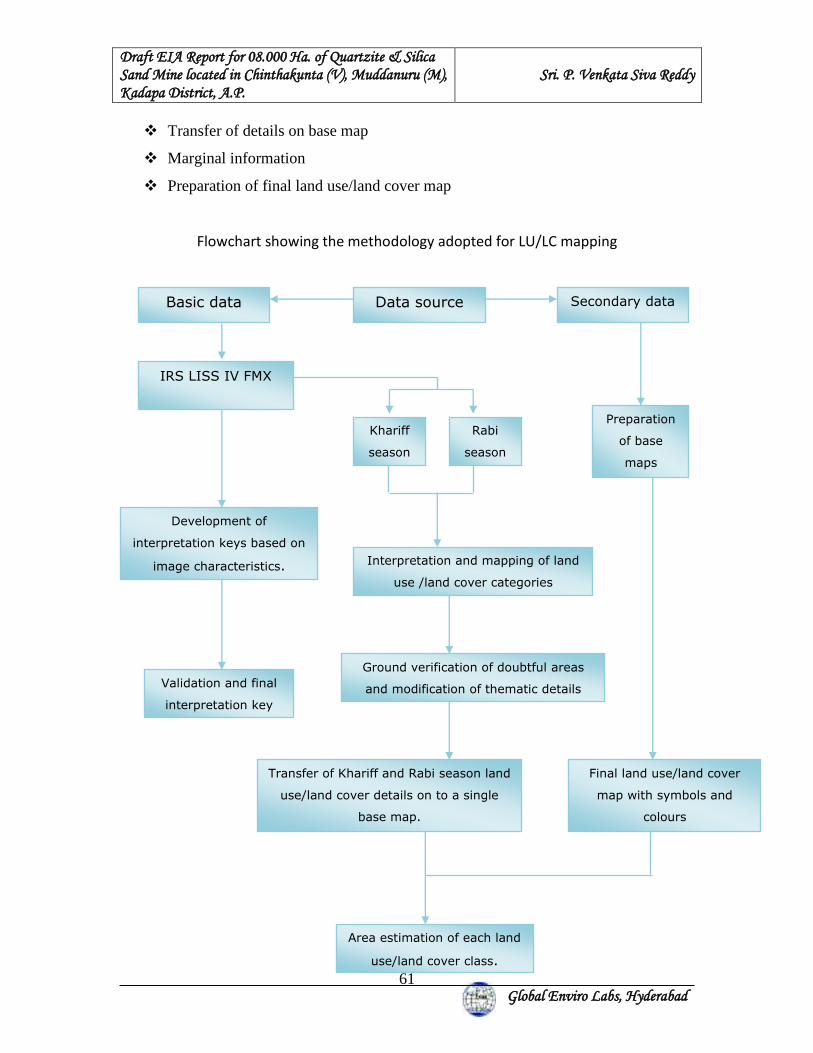
Draft EIA Report for 08.000 Ha. of Quartzite & Silica Sand Mine located in Chinthakunta (V), Muddanuru (M), Kadapa District, A.P.
Sri. P. Venkata Siva Reddy
Global Enviro Labs, Hyderabad
61
❖ Transfer of details on base map
❖ Marginal information
❖ Preparation of final land use/land cover map
Flowchart showing the methodology adopted for LU/LC mapping
Basic data
Data source
IRS LISS IV FMX
Khariff
season
Rabi
season
Preparation
of base
maps
Interpretation and mapping of land
use /land cover categories
Ground verification of doubtful areas
and modification of thematic details
Transfer of Khariff and Rabi season land
use/land cover details on to a single
base map.
Area estimation of each land
use/land cover class.
Final land use/land cover
map with symbols and
colours
Development of
interpretation keys based on
image characteristics.
Validation and final
interpretation key
Secondary data
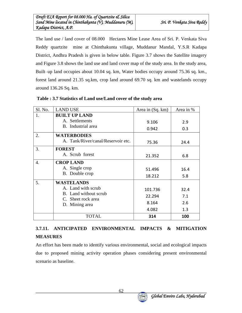
Draft EIA Report for 08.000 Ha. of Quartzite & Silica Sand Mine located in Chinthakunta (V), Muddanuru (M), Kadapa District, A.P.
Sri. P. Venkata Siva Reddy
Global Enviro Labs, Hyderabad
62
The land use / land cover of 08.000 Hectares Mine Lease Area of Sri. P. Venkata Siva
Reddy quartzite mine at Chinthakunta village, Muddanur Mandal, Y.S.R Kadapa
District, Andhra Pradesh is given in below table. Figure 3.7 shows the Satellite imagery
and Figure 3.8 shows the land use and land cover map of the study area. In the study area,
Built–up land occupies about 10.04 sq. km, Water bodies occupy around 75.36 sq. km.,
forest land around 21.35 sq.km, crop land around 69.70 sq. km and wastelands occupy
around 136.26 Sq. km.
Table : 3.7 Statistics of Land use/Land cover of the study area Sl. No. LAND USE Area in (Sq. km) Area in % 1. BUILT UP LAND
A. Settlements B. Industrial area
9.106
0.942
2.9
0.3
2. WATERBODIES A. Tank/River/canal/Reservoir etc.
75.36
24.4
3. FOREST A. Scrub forest
21.352
6.8
4. CROP LAND A. Single crop B. Double crop
51.496
18.212
16.4
5.8
5. WASTELANDS A. Land with scrub B. Land without scrub C. Sheet rock area D. Mining area
101.736
22.294
8.164
4.082
32.4
7.1
2.6
1.3
TOTAL 314 100
3.7.11. ANTICIPATED ENVIRONMENTAL IMPACTS & MITIGATION
MEASURES
An effort has been made to identify various environmental, social and ecological impacts
due to proposed mining activity operation phases considering present environmental
scenario as baseline.
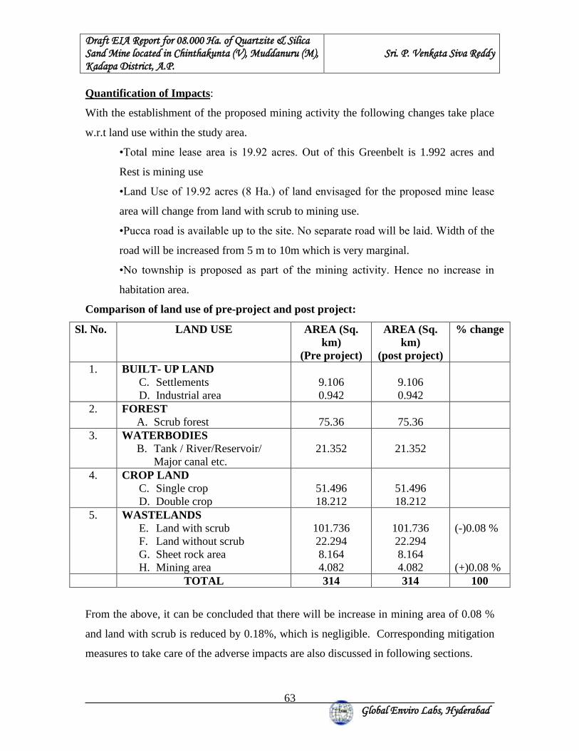
Draft EIA Report for 08.000 Ha. of Quartzite & Silica Sand Mine located in Chinthakunta (V), Muddanuru (M), Kadapa District, A.P.
Sri. P. Venkata Siva Reddy
Global Enviro Labs, Hyderabad
63
Quantification of Impacts:
With the establishment of the proposed mining activity the following changes take place
w.r.t land use within the study area.
•Total mine lease area is 19.92 acres. Out of this Greenbelt is 1.992 acres and
Rest is mining use
•Land Use of 19.92 acres (8 Ha.) of land envisaged for the proposed mine lease
area will change from land with scrub to mining use.
•Pucca road is available up to the site. No separate road will be laid. Width of the
road will be increased from 5 m to 10m which is very marginal.
•No township is proposed as part of the mining activity. Hence no increase in
habitation area.
Comparison of land use of pre-project and post project:
Sl. No. LAND USE AREA (Sq. km)
(Pre project)
AREA (Sq. km)
(post project)
% change
1. BUILT- UP LAND C. Settlements D. Industrial area
9.106 0.942
9.106 0.942
2. FOREST A. Scrub forest
75.36
75.36
3. WATERBODIES B. Tank / River/Reservoir/
Major canal etc.
21.352
21.352
4. CROP LAND C. Single crop D. Double crop
51.496 18.212
51.496 18.212
5. WASTELANDS E. Land with scrub F. Land without scrub G. Sheet rock area H. Mining area
101.736 22.294 8.164 4.082
101.736 22.294 8.164 4.082
(-)0.08 % (+)0.08 %
TOTAL 314 314 100
From the above, it can be concluded that there will be increase in mining area of 0.08 %
and land with scrub is reduced by 0.18%, which is negligible. Corresponding mitigation
measures to take care of the adverse impacts are also discussed in following sections.
Draft EIA Report for 08.000 Ha. of Quartzite & Silica Sand Mine located in Chinthakunta (V), Muddanuru (M), Kadapa District, A.P.
Sri. P. Venkata Siva Reddy
Global Enviro Labs, Hyderabad
64
3.7.12. MITIGATION IMPACT OF LAND USE
Impact on water bodies:
As there are no major water bodies within the one-kilometer radius of the proposed
mining activity. There is a proposed Gandikota back water canal is passing within the 10
Kilometers radius from north west to east and is far away i.e., around 2 kilometers. Hence
there is no adverse impact on the water bodies because of the proposed mining activity.
Impact on agriculture:
Based on the SOI Topo Graphical Maps, NRSC satellite imagery and the ground truth
studies within 2 kilometers radius from the proposed mining activity observed only single
crop and double crop lands. Major land with scrub and land without scrub presently the
proposed mine lease area. Hence there is no adverse impact on agriculture by the
proposed mining activity.
Impact on change in topography of the land & on drainage pattern.
There is no change in the topography as the proposed mining activity is an undulating
land with scrub or waste land.
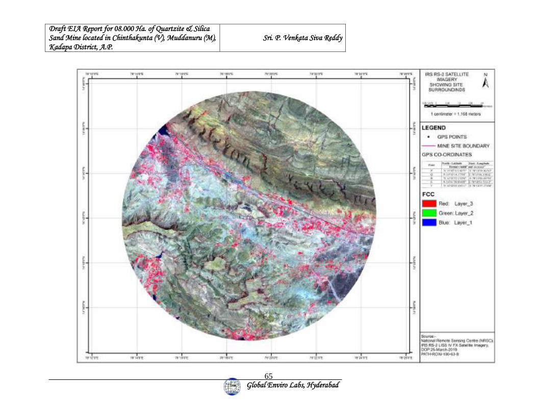
Draft EIA Report for 08.000 Ha. of Quartzite & Silica Sand Mine located in Chinthakunta (V), Muddanuru (M), Kadapa District, A.P.
Sri. P. Venkata Siva Reddy
Global Enviro Labs, Hyderabad
65
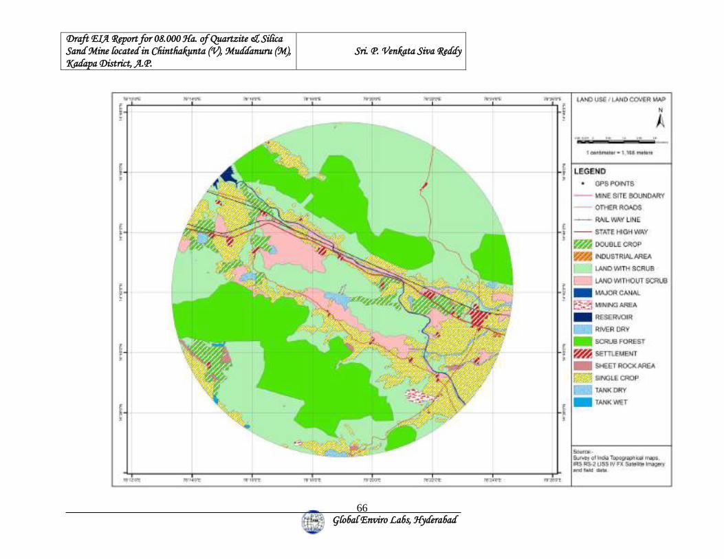
Draft EIA Report for 08.000 Ha. of Quartzite & Silica Sand Mine located in Chinthakunta (V), Muddanuru (M), Kadapa District, A.P.
Sri. P. Venkata Siva Reddy
Global Enviro Labs, Hyderabad
66
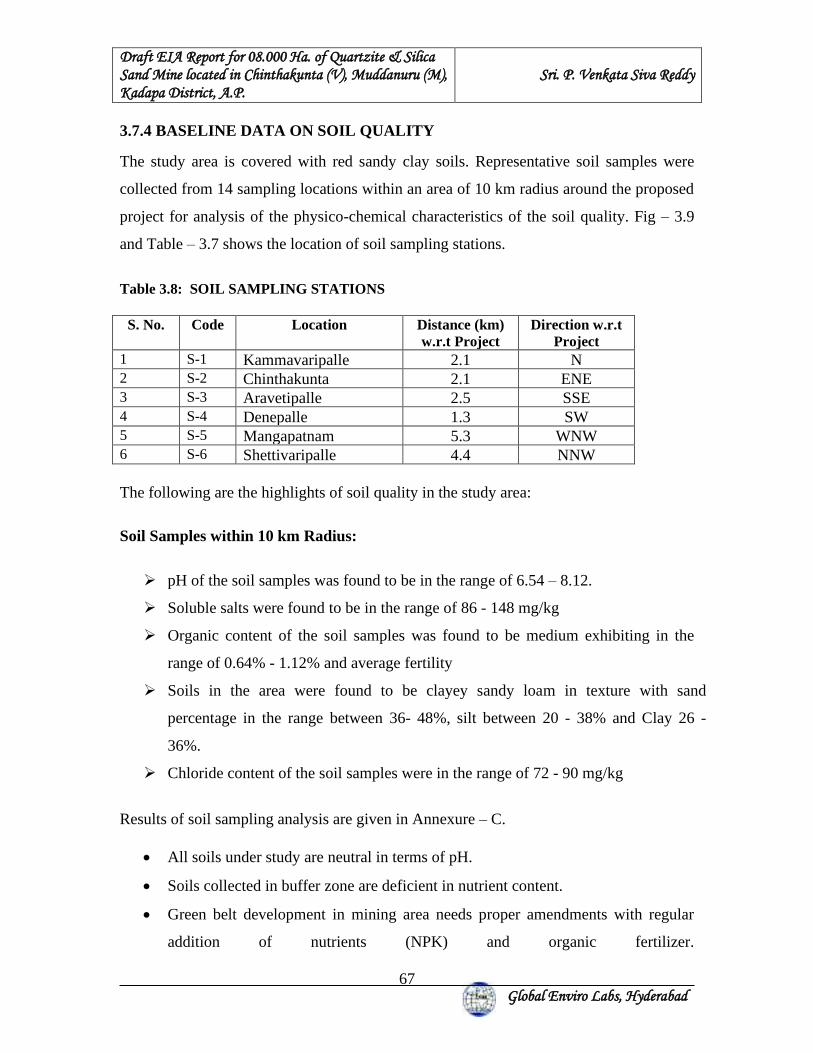
Draft EIA Report for 08.000 Ha. of Quartzite & Silica Sand Mine located in Chinthakunta (V), Muddanuru (M), Kadapa District, A.P.
Sri. P. Venkata Siva Reddy
Global Enviro Labs, Hyderabad
67
3.7.4 BASELINE DATA ON SOIL QUALITY
The study area is covered with red sandy clay soils. Representative soil samples were
collected from 14 sampling locations within an area of 10 km radius around the proposed
project for analysis of the physico-chemical characteristics of the soil quality. Fig – 3.9
and Table – 3.7 shows the location of soil sampling stations.
Table 3.8: SOIL SAMPLING STATIONS
S. No. Code Location Distance (km) w.r.t Project
Direction w.r.t Project
1 S-1 Kammavaripalle 2.1 N 2 S-2 Chinthakunta 2.1 ENE 3 S-3 Aravetipalle 2.5 SSE 4 S-4 Denepalle 1.3 SW 5 S-5 Mangapatnam 5.3 WNW 6 S-6 Shettivaripalle 4.4 NNW The following are the highlights of soil quality in the study area:
Soil Samples within 10 km Radius:
➢ pH of the soil samples was found to be in the range of 6.54 – 8.12.
➢ Soluble salts were found to be in the range of 86 - 148 mg/kg
➢ Organic content of the soil samples was found to be medium exhibiting in the
range of 0.64% - 1.12% and average fertility
➢ Soils in the area were found to be clayey sandy loam in texture with sand
percentage in the range between 36- 48%, silt between 20 - 38% and Clay 26 -
36%.
➢ Chloride content of the soil samples were in the range of 72 - 90 mg/kg
Results of soil sampling analysis are given in Annexure – C.
• All soils under study are neutral in terms of pH.
• Soils collected in buffer zone are deficient in nutrient content.
• Green belt development in mining area needs proper amendments with regular
addition of nutrients (NPK) and organic fertilizer.
Draft EIA Report for 08.000 Ha. of Quartzite & Silica Sand Mine located in Chinthakunta (V), Muddanuru (M), Kadapa District, A.P.
Sri. P. Venkata Siva Reddy
Global Enviro Labs, Hyderabad
68
Draft EIA Report for 08.000 Ha. of Quartzite & Silica Sand Mine located in Chinthakunta (V), Muddanuru (M), Kadapa District, A.P.
Sri. P. Venkata Siva Reddy
Global Enviro Labs, Hyderabad
69
3.8 BIOLOGICAL ENVIRONMENT
A survey of the flora and fauna of the MLA and the buffer zone was carried out keeping
in view of the following terms of reference.
“A detailed biological study for the study area [core zone and buffer zone (10 Km radius
of the periphery of the mine lease)] shall be carried out. Details of flora and fauna, duly
authenticated, separately for core and buffer zone should be furnished based on field
survey clearly indicating the Schedule of the fauna present. In case of any scheduled-I
fauna found in the study area, the necessary plan for their conservation should be
prepared in consultation with State Forest and Wildlife Department and details furnished.
Necessary allocation of funds for implementing the same should be made as part of the
project cost”
Based on the above, primary survey of flora, both primary and secondary survey of fauna
of the mine lease area (core area) and its buffer zone extending up to a radius of 10 Km
was carried during December 2019 by Dr.K.B.Reddy, Retired Professor of
Environmental Sciences, Acharya Nagarjuna University and the NABET Empaneled
Functional Area Expert in EB and SC. Appropriate data / information available with the
State Forest and Wildlife Department, Biodiversity Board and Botanical Survey of India
as well as the Zoological Survey of India have also been referred and used during the
survey. In addition, relevant publications on flora and fauna of the area have been
consulted.
The basic objectives of the study is to evaluate the status of the flora and fauna of the
Quartzite mine lease area of 08.000 Ha located in Survey No No.677 (old Sy No.425) of
Chinthakunta Village, Muddanur Mandal, Y.S.R Kadapa District , Andhra Pradesh.
and its buffer zone of 10 Km radius with specific reference to the rare or endangered or
endemic or threatened (REET) species in accordance with the approved T.o.R. The study
is also designed to evaluate the adverse impacts of the proposed iron ore mine and to
suggest remedial / mitigation measures in accordance with the objectives as desired by
Draft EIA Report for 08.000 Ha. of Quartzite & Silica Sand Mine located in Chinthakunta (V), Muddanuru (M), Kadapa District, A.P.
Sri. P. Venkata Siva Reddy
Global Enviro Labs, Hyderabad
70
the IAIA (International Association for Impact Assessment) and the Ministry of
Environment and Forests (M.o.E&F), Government of India (GoI). With these objectives
in mind, the following work was undertaken by a team of experienced professional:
i). Documentation and evaluation of the status of the terrestrial flora of the core area and
surrounding areas (buffer area).
ii) Inventorization of the terrestrial flora of the core area and buffer area.
iii). Prediction of the impacts of the proposed activity on the REET species.
iv). Development of a management / mitigation plan to minimize the impacts the
proposed activity on the biotic environment so that there is no net loss of biodiversity.
Kindly refer to Annexure - D for Detailed Biological Environment report of the study
area.
3.9 SOCIO ECONOMIC ENVIRONMENT 3.9.1 BASELINE STATUS
A detailed socio-economic survey was conducted covering all villages in the 10 km
radius from the center. The information of socio-economic aspects has been compiled
from various secondary sources including various government and semi-government
offices. The demographic profile of the study area is enclosed in Annexure – E.
The methodology adopted for the study is mainly includes review of secondary data
(Census Statistical Data -2011 and Primary Census Abstract of Census- 2011) with
respect to population, occupational structure and infrastructure facilities available for 10-
km radius study area.
The main occupation of villagers is agriculture and sheep raring. The commencement of
mining activity in this area improves the socio-economic status of the local people by
creation of employment.
The salient observations obtained as a result of the study are discussed hereunder.
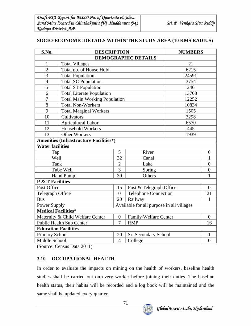
Draft EIA Report for 08.000 Ha. of Quartzite & Silica Sand Mine located in Chinthakunta (V), Muddanuru (M), Kadapa District, A.P.
Sri. P. Venkata Siva Reddy
Global Enviro Labs, Hyderabad
71
SOCIO-ECONOMIC DETAILS WITHIN THE STUDY AREA (10 KMS RADIUS)
S.No. DESCRIPTION NUMBERS DEMOGRAPHIC DETAILS
1 Total Villages 21 2 Total no. of House Hold 6215 3 Total Population 24591 4 Total SC Population 3754 5 Total ST Population 246 6 Total Literate Population 13708 7 Total Main Working Population 12252 8 Total Non-Workers 10834 9 Total Marginal Workers 1505 10 Cultivators 3298 11 Agricultural Labor 6570 12 Household Workers 445 13 Other Workers 1939
Amenities (Infrastructure Facilities*) Water facilities Tap 5 River 0 Well 32 Canal 1 Tank 2 Lake 0 Tube Well 3 Spring 0 Hand Pump 30 Others 1 P & T Facilities Post Office 15 Post & Telegraph Office 0 Telegraph Office 0 Telephone Connection 21 Bus 20 Railway 1 Power Supply Available for all purpose in all villages Medical Facilities* Maternity & Child Welfare Center 0 Family Welfare Center 0 Public Health Sub Center 7 RMP 16 Education Facilities Primary School 20 Sr. Secondary School 1 Middle School 4 College 0 (Source: Census Data 2011)
3.10 OCCUPATIONAL HEALTH
In order to evaluate the impacts on mining on the health of workers, baseline health
studies shall be carried out on every worker before joining their duties. The baseline
health status, their habits will be recorded and a log book will be maintained and the
same shall be updated every quarter.
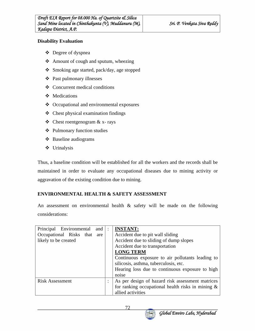
Draft EIA Report for 08.000 Ha. of Quartzite & Silica Sand Mine located in Chinthakunta (V), Muddanuru (M), Kadapa District, A.P.
Sri. P. Venkata Siva Reddy
Global Enviro Labs, Hyderabad
72
Disability Evaluation
❖ Degree of dyspnea
❖ Amount of cough and sputum, wheezing
❖ Smoking age started, pack/day, age stopped
❖ Past pulmonary illnesses
❖ Concurrent medical conditions
❖ Medications
❖ Occupational and environmental exposures
❖ Chest physical examination findings
❖ Chest roentgenogram & x- rays
❖ Pulmonary function studies
❖ Baseline audiograms
❖ Urinalysis
Thus, a baseline condition will be established for all the workers and the records shall be
maintained in order to evaluate any occupational diseases due to mining activity or
aggravation of the existing condition due to mining.
ENVIRONMENTAL HEALTH & SAFETY ASSESSMENT An assessment on environmental health & safety will be made on the following
considerations:
Principal Environmental and Occupational Risks that are likely to be created
: INSTANT: Accident due to pit wall sliding Accident due to sliding of dump slopes Accident due to transportation LONG TERM Continuous exposure to air pollutants leading to silicosis, asthma, tuberculosis, etc. Hearing loss due to continuous exposure to high noise
Risk Assessment : As per design of hazard risk assessment matrices for ranking occupational health risks in mining & allied activities
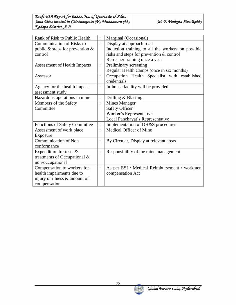
Draft EIA Report for 08.000 Ha. of Quartzite & Silica Sand Mine located in Chinthakunta (V), Muddanuru (M), Kadapa District, A.P.
Sri. P. Venkata Siva Reddy
Global Enviro Labs, Hyderabad
73
Rank of Risk to Public Health : Marginal (Occasional) Communication of Risks to public & steps for prevention & control
: Display at approach road Induction training to all the workers on possible risks and steps for prevention & control Refresher training once a year
Assessment of Health Impacts : Preliminary screening Regular Health Camps (once in six months)
Assessor : Occupation Health Specialist with established credentials
Agency for the health impact assessment study
: In-house facility will be provided
Hazardous operations in mine : Drilling & Blasting Members of the Safety Committee
: Mines Manager Safety Officer Worker’s Representative Local Panchayat’s Representative
Functions of Safety Committee : Implementation of OH&S procedures Assessment of work place Exposure
: Medical Officer of Mine
Communication of Non-conformance
: By Circular, Display at relevant areas
Expenditure for tests & treatments of Occupational & non-occupational
: Responsibility of the mine management
Compensation to workers for health impairments due to injury or illness & amount of compensation
: As per ESI / Medical Reimbursement / workmen compensation Act
Draft EIA Report for 08.000 Ha. of Quartzite & Silica Sand Mine located in Chinthakunta (V), Muddanuru (M), Kadapa District, A.P.
Sri. P. Venkata Siva Reddy
Global Enviro Labs, Hyderabad
74
4. PREDICTION OF IMPACTS & MITIGATION MEASURES 4.0 INTRODUCTION
Impact prediction is a very important phenomenon in evaluating the environmentally
potential adverse impacts for any proposed mine project. The impact prediction is always
carried out under worst possible conditions so as to mitigate or to eliminate the
environmental hazards. These predictions thus calculated are superimposed over the
baseline data to calculate the net impact on the environment after the proposed mine
Project comes into production.
4.1 AIR ENVIRONMENT The impacts on air environment from a mining activity depend on various factors like
production capacity, machinery involved, operations and maintenance of various
equipments and vehicle. Apart from these, there will be other activities associated viz
transportation of mineral and waste, stocking facilities and dump management within the
mine lease area that may contribute to pollution.
4.1.1 Air Emissions
Prediction of impacts on air environment has been carried out taking into consideration of
the proposed production and increase in emissions.
The proposal for average production of 2,92,678 TPA of Quartzite and silica sand.
Hence, to estimate the impacts, max. production of 3,75,000 TPA of Quartzite and Silica
Sand has been considered. The proposed mining is carried out by manual open cast
method by using drilling & blasting. The air borne particulate matter is the main air
pollutant contributed by mining and mineral process operations. Resultant ground level
concentration for the prevailing meteorological conditions using the mathematical model
were estimated.
Draft EIA Report for 08.000 Ha. of Quartzite & Silica Sand Mine located in Chinthakunta (V), Muddanuru (M), Kadapa District, A.P.
Sri. P. Venkata Siva Reddy
Global Enviro Labs, Hyderabad
75
4.1.2 QUANTITATIVE ESTIMATION OF IMPACTS ON AIR ENVIRONMENT An attempt has been made to predict the incremental rise of various ground level
concentrations above the baseline status in respect of air pollution due to proposed
production for a max. quantity of 3,75,000 TPA of Quartzite and Silica sand. The
mathematical model employed for predictions in the present study is ISCST3 model,
which was approved by United States Environmental Protection Agency for mining
applications.
The Industrial Source Complex – Short Term model (ISCST3) is a computerized air
quality model specifically designed for computing concentrations and deposition impacts
of various emission sources. The model is based on the well-known Gaussain Plume
formulation for computing concentrations and also the model has been specifically
adapted to incorporate an improved gradient transfer deposition algorithm. Emissions for
each source are apportioned into a series of particle size classes. Gravitational settling
velocity and deposition velocity are calculated.
Salient features of the ISCST3 model are given hereunder.
❖ Excavation operations are considered as area sources.
❖ Transportation of material on haulage roads has been considered as line source
The predicted ground level concentrations for study period computed using EPA
approved ISCST3 model are plotted as isopleths.
4.1.3 SOURCES OF DUST EMISSION The proposed mining is carried out by manual opencast method by using drilling &
blasting. The air borne particulate matter generated by ore handling operations,
transportation and screening of ore is the main air pollutant. The emissions of Sulphur
dioxide (SO2), Oxides of Nitrogen (NOx) contributed by diesel operated
excavation/loading equipment and vehicles plying on haul roads are marginal. Prediction
of impacts on air environment has been carried out taking into consideration proposed
Draft EIA Report for 08.000 Ha. of Quartzite & Silica Sand Mine located in Chinthakunta (V), Muddanuru (M), Kadapa District, A.P.
Sri. P. Venkata Siva Reddy
Global Enviro Labs, Hyderabad
76
production and net increase in emissions. Based on the various operations involved in the
production of minerals, the various emission sources have been identified as given below.
a. Area sources.
b. Line sources.
Extraction of mineral from mine, are considered as area sources. Transportation of
material from mining benches to various end points are considered as line sources. The
impact of above sources on air environment is discussed below:
The other sources of air pollution are the dust generated during the movement of tippers
on the haul road. Water tankers with spraying arrangement will be used for regular water
sprinkling on the haul roads to ensure effective dust suppression. The tippers are well
maintained so that exhaust smoke does not contribute abnormal values of noxious gases
and un-burnt hydrocarbons.
4.1.4 EMISSION DETAILS
All the emissions discussed above are quantified for proposed production of 3,75,000
TPA of Quartzite and Silica Sand. The existing air quality levels are covered in the
baseline scenario.
Excavation, loading and transportation through tippers and screening and crushing are the
major sources, which are of significance. Therefore, the emissions considered for
modeling are from excavation, transportation and screening of quartzite
The emissions are computed based on AP-42 emission factors. Operational hours,
activity rate, wind speed and moisture content have been considered for estimation of
emissions from point and area sources. For line source, apart from operational hours,
activity rate, moisture, silt content and vehicle weight have been considered.
Predictions are carried out for the worst-case scenario of simultaneous operation of
excavators (area sources) and tippers for transportation from mine pit to loading pit (line
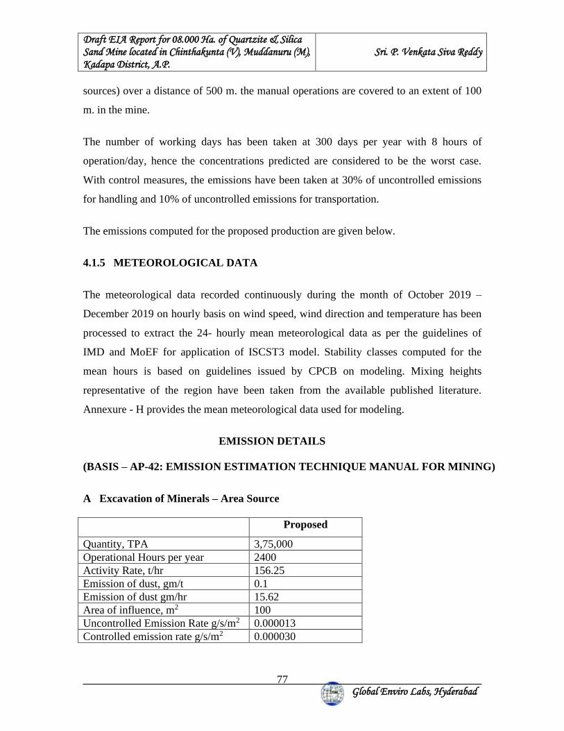
Draft EIA Report for 08.000 Ha. of Quartzite & Silica Sand Mine located in Chinthakunta (V), Muddanuru (M), Kadapa District, A.P.
Sri. P. Venkata Siva Reddy
Global Enviro Labs, Hyderabad
77
sources) over a distance of 500 m. the manual operations are covered to an extent of 100
m. in the mine.
The number of working days has been taken at 300 days per year with 8 hours of
operation/day, hence the concentrations predicted are considered to be the worst case.
With control measures, the emissions have been taken at 30% of uncontrolled emissions
for handling and 10% of uncontrolled emissions for transportation.
The emissions computed for the proposed production are given below.
4.1.5 METEOROLOGICAL DATA
The meteorological data recorded continuously during the month of October 2019 –
December 2019 on hourly basis on wind speed, wind direction and temperature has been
processed to extract the 24- hourly mean meteorological data as per the guidelines of
IMD and MoEF for application of ISCST3 model. Stability classes computed for the
mean hours is based on guidelines issued by CPCB on modeling. Mixing heights
representative of the region have been taken from the available published literature.
Annexure - H provides the mean meteorological data used for modeling.
EMISSION DETAILS (BASIS – AP-42: EMISSION ESTIMATION TECHNIQUE MANUAL FOR MINING)
A Excavation of Minerals – Area Source Proposed
Quantity, TPA 3,75,000 Operational Hours per year 2400 Activity Rate, t/hr 156.25 Emission of dust, gm/t 0.1 Emission of dust gm/hr 15.62 Area of influence, m2 100 Uncontrolled Emission Rate g/s/m2 0.000013 Controlled emission rate g/s/m2 0.000030
Draft EIA Report for 08.000 Ha. of Quartzite & Silica Sand Mine located in Chinthakunta (V), Muddanuru (M), Kadapa District, A.P.
Sri. P. Venkata Siva Reddy
Global Enviro Labs, Hyderabad
78
B Transport of Minerals – Haulage Emissions Proposed
Quantity, TPA 3,75,000 Operational Hours per year 2400 Capacity of each Tipper (T) 17 Total No. of Tippers/year 22058 Lead length/trip, Km 0.5 Total VKT/year Km 11029 +Emission kg/VKT 0.91 Total emission kg/year 10036.3 Uncontrolled emission rate g/s/m 0.00011 Controlled emission rate g/s/m 0.0010 Note: Emission factor computed based on wind speed of 2m/sec and silt content of 10% and moisture of 10% 4.1.6. SUMMARY OF PREDICTED GROUND LEVEL CONCENTRATIONS
Ground level concentrations due to the mining activities have been estimated to know the
incremental raise and extent of impact in the study area.
The maximum ground level concentration is estimated to be about 11.16 μg/m3 within the
mine area, where mining operations are being carried out. The concentration was found
to reduce to a value of less than 3.72 μg/m3 at a distance of about 0.5 km from the mining
operations. The impact of mining operations would be negligible beyond 1.0 km.
Figure – 5.1 represents the spatial distribution of the predicted ground level
concentrations of SPM due to emissions from mine and the following table shows the
over all scenario:
Predicted value superimposed on the existing baseline value gives the overall scenario,
which would prevail during study period once mine is operated for the proposed
production. The following table shows the overall scenario:
Draft EIA Report for 08.000 Ha. of Quartzite & Silica Sand Mine located in Chinthakunta (V), Muddanuru (M), Kadapa District, A.P.
Sri. P. Venkata Siva Reddy
Global Enviro Labs, Hyderabad
79
OVERALL SCENARIO:
μg/m3 CORE ZONE BUFFER ZONE
Village Name Baseline Concentration (PM10)
Predicted Concentration
Overall Scenario
Baseline Concentration PM10 (Max)
33 Down wind direction
40 3.72 43.72
Predicted Concentration (Max)
11.16 Kammavaripalle 55 <2.48 57.48
Overall Scenario 44.16 Chinthakunta 60 <2.48 62.48 Aravetipalle 50 <2.48 52.48 Denepalle 52 <2.48 54.48 Mangapatnam 56 <2.48 58.48 Shettivaripalle 48 <2.48 50.48
Specified NAAQ limit 100 Specified NAAQ limit for Residential area 100 4.1.7 PROPOSED MITIGATION MEASURES FOR DUST SUPPRESSION
• Dust suppression arrangements at all dust generation points
• Grading of haul roads time to time and cleaning to remove the accumulated dusty
material.
• Regular maintenance of the transport vehicles
• Avoiding of overloading of tippers and covering of loaded tippers with tarpaulins
during ore transportation.
• Dust mask provision to workers.
• 50 m barrier zone will be maintained all along the mine lease boundary and green
belt will be maintained in the barrier zone.
• Human habitation is on the north direction i.e. (Denepalli at 1.3 km) from the lease
area. Apart from the 50 m barrier zone a 30 m width of wind break of 3 tiers of 10
m each is provided.
• Periodical monitoring of air quality to take steps to control the pollutants.
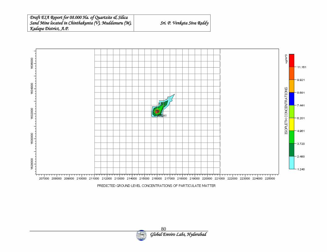
Draft EIA Report for 08.000 Ha. of Quartzite & Silica Sand Mine located in Chinthakunta (V), Muddanuru (M), Kadapa District, A.P.
Sri. P. Venkata Siva Reddy
Global Enviro Labs, Hyderabad
80
Draft EIA Report for 08.000 Ha. of Quartzite & Silica Sand Mine located in Chinthakunta (V), Muddanuru (M), Kadapa District, A.P.
Sri. P. Venkata Siva Reddy
Global Enviro Labs, Hyderabad
81
4.2 NOISE ENVIRONMENT 4.2.1 ANTICIPATED IMPACTS To reduce the noise levels at source, proper and timely maintenance and up keeping of
mining machinery is being carried out as per instructions of manufacturers.
The main sources of noise in the mine are classified as follows:
• Stationary mining equipment
• Mobile Mining equipment
• Transportation vehicles
• Screening
Impacts of vibrations on the surrounding environment
The drilling & blasting is confined to the mine lease area, so the impact on the
surrounding environment is negligible.
The vibration developed due to haulage of vehicles and drilling will be less feeble with 8
Hz.
4.2.2 PROPOSED MITIGATING MEASURES
The operations of the mining equipment, plying of vehicles and mining machinery
operation are the major sources of undesirable noise in the proposed project area.
The following control measures are proposed for brining down the noise levels.
• Greenbelt will be made around the working areas to screen the noise and also for
arresting fugitive dust
• Maintenance and tuning of machinery would be ensured to reduce undesirable
noise.
• Earplugs and earmuffs will be provided to the workmen.
• Limiting time exposure of workers to excessive noise.
• Carrying out blasting only during daytime and avoiding the same on cloudy days
and when strong wind blows across.
Draft EIA Report for 08.000 Ha. of Quartzite & Silica Sand Mine located in Chinthakunta (V), Muddanuru (M), Kadapa District, A.P.
Sri. P. Venkata Siva Reddy
Global Enviro Labs, Hyderabad
82
4.3 WATER ENVIRONMENT 4.3.1 Impact on Surface Water Mining activities cause adverse impacts due to mine drainage and siltation due to storm
water. The impact on water environment has been considered under the following heads:
• Water consumption
• Mine seepage and impact on ground water
• Impact on surface water bodies
• Storm water management
4.3.2 Water Consumption The water requirement for this proposed mining activity will be 12 KLD. Breakup details
are:
Sl. No: Purpose Quantity (KLD) 1 Dust suppression purpose 8.0 2 Domestic purpose 1.0 3 Greenbelt purpose 2.0 Total 12 There is no generation & discharge of wastewater from this mine. 4.3.3 ANTICIPATED IMPACTS The stream courses should be well protected by leaving a safety margin of 15.0 m on
either side with raised bunds to prevent storm water entering the natural courses in and
around the quarry lease area during rainy days. No adverse effect is anticipated to water
regime of the area.
4.3.4 IMPACT ON SURROUNDING WATER BODIES:
Water will be required for mining operations mainly for sprinkling on haulage roads and
at open cast faces during mining activity for suppression of dust. Water is also required
for domestic and greenbelt purposes. The water requirement will be 12 KLD. This will be
sourced from ground water.
Draft EIA Report for 08.000 Ha. of Quartzite & Silica Sand Mine located in Chinthakunta (V), Muddanuru (M), Kadapa District, A.P.
Sri. P. Venkata Siva Reddy
Global Enviro Labs, Hyderabad
83
Impact on surface water quality:
There are no major water bodies present within 10 km. radius. No waste water generation
from mining operation. Only wastewater generation will be sanitary wastewater, which
will be treated in septic tank followed by soak pit. Hence there will not be any impact on
surface water due to mining operations.
Impact on Ground Water Quality:
The mining operation will be maximum of 24 m depth from 356m max. RL the ground
water table is at 40m below General ground level of 262m RL and will not affect water
regime. Hence there will not be any intersect of mining operation with ground water
table. Hence there will not be impact on ground water quality due to mining operations.
4.3.5 MITIGATION MEASURES
• Construction of check dams and gully plugs
• Systematic drainage system for diverting the surface run-off during monsoon
• Plantation of local varieties of species
• Regular monitoring and analyzing the quality of water
• De-silting will be carried out before and immediately after the monsoon season
4.4 LAND ENVIRONMENT 4.4.1 POSSIBLE IMPACT ON GEOLOGY & MITIGATION
1) The area will be broken to a depth of 18.0 mts by forming benches to win the
mineral which results in the formation of a large deep pit of about 65,000 m2 extent. -
Although it cannot be reversed the pit can be used for water harvesting to raise
aquaculture at the end of mining operations. A fence to be erected and watchmen posted
for safety and security of men and animals.
2) The top soil should be removed and stacked separately to be utilized for
plantation.
3) The drilling and blasting activity, movement of workmen, quarrying of mineral
and haulage of tractors/ trailers will generate dust and there is likely chance to settle in
the stream, inhalation by workmen and also will have sedimentation affect over the wind
Draft EIA Report for 08.000 Ha. of Quartzite & Silica Sand Mine located in Chinthakunta (V), Muddanuru (M), Kadapa District, A.P.
Sri. P. Venkata Siva Reddy
Global Enviro Labs, Hyderabad
84
ward side. This should be arrested at the origin by regular sprinkling of water & placing
moist clay bags while blasting and sprinkling of water at regular intervals on haul roads.
The workers should be provided with masks and earplugs, safety eye glass wear will
contain or minimize health hazard.
4.4.2 ANTICIPATED IMPACTS ON LAND ENVIRMENT
An effective programme of land restoration will be drawn and implanted to bring back
the status to as near the pre-mining conditions as possible. The salient features are as
enumerated below. A green belt development will be planted meticulously. It is
proposed to reclaim all the worked-out area by suitable soil conservation and
afforestation methods. This operation is carried out concurrent to mining during next
scheme period onwards. The roads shall have avenue trees and thus a green belt
developed. Land degradation will take place by dumping of waste, and the reclamation
of this dumping area shall also be included in the programme. It is always necessary to
keep the area under disturbance at any stage to the minimum possible. This can be
achieved by ensuring reclamation of the excavated area simultaneously with mining
activates by reducing the gap between reclamation and excavation to the minimum.
4.4.3. RECLAMATION
Reclamation of mined out portions are not proposed during first scheme period as the
mining operations will not reach to the full extent of mineral deposit. Progressive
trenching and embankment by safety bunding will be taken up. As a measure of
protection 2m corridor all along the lease corridor a protection bund will be raised, a
safety pit will be excavated with 1.5m width and one-meter depth will be excavated to
avoid the trespassing of the human and cattle / wild life into the lease hold area. The pit
slope will be maintained a 23o in order to protect humans and cattle / wild life protection.
➢ The current land use type of project site is land with scrub. This land will be
converted in to mining area.
➢ As per land break up single crop land, double crop lands and plantations are the
major land use type covering the study area. Crop land and mining area are
influencing factors to the environment.
Draft EIA Report for 08.000 Ha. of Quartzite & Silica Sand Mine located in Chinthakunta (V), Muddanuru (M), Kadapa District, A.P.
Sri. P. Venkata Siva Reddy
Global Enviro Labs, Hyderabad
85
➢ There are small scale industries within in the study area
➢ Nearest village is Denepalli (1.3 Km) village.
➢ Railway line is observed within the study area of 10 km radius. Muddanur is the
nearest railway station.
➢ The reserved forest areas are devoid of any species of economic value. The forest
is mostly of scrub type consisting of thorny bushes and shrubs of xerophytes
group.
➢ Sugarcane, Jowar, Paddy and groundnut are major rain fed and canal irrigation
crops categorized as single and double crops.
The mining area is hilly and undulating land. The waste filled dump sites shall be
terraced with overall slope in the direction of natural ground level slope. In most cases,
the overall slope of back filled surface shall merge with natural slope.
The topographical impact will be mainly one of color contrast between then mined rock
surfaces and surrounding vegetation (shrubs and grasses). However, the topographical
impact will remain localized, given that the site is contained and the change in
topography will not have appreciable impact on drainage and aesthetics.
The top soil in the mining area is scanty. Whatever is available will have to be excavated
during the development of the mine pits. Most of this soil is rocky in nature and will get
mixed with the over burden. Temporary storage of top soil over burden may cause some
loss of nutrients and this cannot be avoided. The top soil will be subjected to water borne
erosion during rainy season from reclamation areas when in unconsolidated state. A
combination of diversion ditches and garland drains will be constructed to minimize soil
loss. A large amount of soil loss can be arrested in contour trenches, which will be
collected and put back to the reclamation areas. Since the mining area is contained to
only 08.000 Ha. The effect on the land environment will be negligible. There shall be
no leachate from the lease area. There shall be soil erosion of the loose soil of waste
dumps which shall be contained. The adverse effect of the mining activity on the bio
diversity shall be mitigated by employing proper mitigating measures.
Draft EIA Report for 08.000 Ha. of Quartzite & Silica Sand Mine located in Chinthakunta (V), Muddanuru (M), Kadapa District, A.P.
Sri. P. Venkata Siva Reddy
Global Enviro Labs, Hyderabad
86
4.4.4 PROPOSED MITIGATING MEASURES The land management plays an important role in reducing the adverse impacts caused by
surface mining operation. Land management is required in the key areas like land use
scheme within the ML area, calendar plan, mine bench advancement to arrest
indiscriminate degradation of landform, top soil preservation, overburden management,
soil erosion control and the restoration of the mine pits. On each of these prime areas of
land management, the following schemes are proposed.
Land use
The project covers a total ML area of 08.000 Ha of Government Revenue land. The ML
area is principally degraded land and has sporadic patches of very little shrub vegetal
cover in the hill slopes. It may be observed from the proposed mine general layout. The
core zone landscape can be improved by tree plantation, shrub growth etc., which are
outlined separately under eco-restoration.
4.5 BIOLOGICAL ENVIRONMENT 4.5.1 ANTICIPATED IMPACTS
Biological Impact Assessment (BIA) is an important ant integral part of the EIA. For the
purposes of the BIA, the study area is divided in the core and buffer areas. The direct
impacts shall be limited to the core area. Mine lease area is a Govt. land. There are no
National Parks, Wildlife sanctuaries, Biosphere reserves or other protected areas either in
the core area or in the buffer zone.
Prediction of impacts is based both on the direct and indirect; short-term as well as long-
term; irreversible and irreversible impacts that are most likely to occur owing to the
proposed industrial activity during establishment and operation. The ecological factors
that are considered most significant as far as the impact on flora and fauna are concerned:
1. Whether there shall be any reduction in species diversity
2. Whether there shall be any habitat loss or fragmentation
Draft EIA Report for 08.000 Ha. of Quartzite & Silica Sand Mine located in Chinthakunta (V), Muddanuru (M), Kadapa District, A.P.
Sri. P. Venkata Siva Reddy
Global Enviro Labs, Hyderabad
87
3. Whether there shall be any additional risk or threat to the rare or endangered or
endemic or threatened (REET)species
4. Whether there shall be any impairment of ecological functions such as
(i) Disruption of food chains, (ii) decline in species population and or (iii) alterations in
predator-prey relationships.
The direct and the most destructive impacts of the project are limited to the mine lease
area only. There is going to be a change in the land use and land cover owing to the
mining activity. The existing flora and vegetation of the mine lease is going to be lost
slowly in a phased manner owing to digging or dumping of overburden and waste.
Among the plant species that are going to be lost, the annuals and therophytes are highly
resilient and they can come back once the intensity and frequency of disturbances
decrease. As there are no rare or endangered or endemic or threatened (REET) species,
continuation of mining will not pose any additional problem to any REET species.
Hence, the impact of the project on flora is negligible. As far as the fauna s concerned,
the proposed mining could endanger the habitat of some unseen reptiles and rodents that
may be present in burrows. But it is incapable of posing any additional threat to any
Schedule I species either directly or indirectly.
Negative Impacts:
i). Loss of the existing flora and trees: The flora of the project site is going to be damaged
or lost to a when a mine pit is opened and when dump is created. Since there are no RET
species, there shall not be any loss of any species.
ii). Loss of fodder and grazing land for locals: Green fodder is produced only during the
rainy season. During that time, shortage of green fodder is uncommon. During the rest of
the year when there is shortage of both green and dry fodder, the core area contributes
very little. Hence the overall loss of fodder can be made good by growing forage crops.
iii). Enhanced soil erosion due mining: Operations relating to mining shall enhance the
chances of soil erosion and dust emissions. Integrated soil and water conservation
measures involving physical and biological systems are incorporated. Legumes like
Subabul and Hamata are proposed to be grown for soil conservation, improvement of soil
fertility and perennial fodder production.
Draft EIA Report for 08.000 Ha. of Quartzite & Silica Sand Mine located in Chinthakunta (V), Muddanuru (M), Kadapa District, A.P.
Sri. P. Venkata Siva Reddy
Global Enviro Labs, Hyderabad
88
Most probable Scenario:
It is a new mine located in an area where mining and quarrying is common. The ambient
air quality is good as revealed by the air quality monitoring results. Mining activity and
its impacts are restricted to the mining site only. The mine is adjacent to the other mine
leases and there are no problems relating to road connectivity and transport. The mining
activity is unlikely to have any adverse impact on the flora and fauna of the buffer
zone.
4.5.2 PROPOSED MITIGATING MEASURES The mined-out areas will be backfilled and reclaimed with dense poly-culture plantation
with the local species. Water reservoirs will be creating in the abandoned mine pit that
will increase the water availability on the plateau.
4.6 SOCIO- ECONOMIC ENVIRONMENT
4.6.1 ANTICIPATED IMPACTS The local areas will be benefited by way of generation of employment opportunities,
increased demand for local products and services. There will be an overall improvement
in the income level of the local people.
The project creates employment to about 42 persons once the mine in operation. Priority
will be given to locals for Semi-Skilled and Unskilled jobs. With the development of this
project there will be lot of scope for more industrial investments which in turn will
benefit the nation.
There will be a certain enhancement of educational and medical standards of people in
the study area. There will be generally positive and beneficial impacts by way of
economic improvements, transportation, aesthetic environment and business generation.
There will be an overall upliftment of socio-economic status of people in the area.
4.6.2 PROPOSED MITIGATING MEASURES
Employment opportunities will be provided to the local people. Financial assistance will
be provided for conducting local sports, religious and cultural activities. Medical camps
will be arranged regularly for the villagers.
Draft EIA Report for 08.000 Ha. of Quartzite & Silica Sand Mine located in Chinthakunta (V), Muddanuru (M), Kadapa District, A.P.
Sri. P. Venkata Siva Reddy
Global Enviro Labs, Hyderabad
89
4.7 OCCUPATIONAL SAFETY & HEALTH ENVIRONMENT
Occupational health and safety hazards occur during the operational phase of mining and
primarily include the following:
❖ Respiratory hazards
❖ Noise
❖ Physical hazards
❖ Explosive storage and handling
4.7.1 RESPIRATORY HAZARDS
Long-term exposure to silica dust may cause silicosis The following measures are proposed:
❖ Excavators, dumpers, dozers, drills other automated equipments will be enclosed
❖ Use of personal breathing protection will be made compulsory.
NOISE Workers are likely to get exposed to excessive noise levels during quarrying activities The following measures are proposed for implementation
❖ No employee will be exposed to a noise level greater than 75 dB(A) for a duration
of more than 8 hours per day without hearing protection
❖ The use of hearing protection will be enforced actively when the equivalent sound
level reaches <75 dB(A).
❖ Ear muffs provided will be capable of reducing sound levels at the ear to at least
75 dB(A)
❖ Periodic medical hearing checks will be performed on workers exposed to high
noise levels
4.7.2 PHYSICAL HAZARDS The following measures are proposed for control of physical hazards
Draft EIA Report for 08.000 Ha. of Quartzite & Silica Sand Mine located in Chinthakunta (V), Muddanuru (M), Kadapa District, A.P.
Sri. P. Venkata Siva Reddy
Global Enviro Labs, Hyderabad
90
❖ Specific personnel training on work-site safety management will be taken up;
❖ Work site assessment will be done by rock scaling of each surface exposed to
workers to prevent accidental rock falling and / or landslide, especially after
blasting activities;
❖ Natural barriers, temporary railing, or specific danger signals will be provided
along rock benches or other pit areas where work is performed at heights more
than 2m from ground level;
❖ Maintenance of yards, roads and footpaths, providing sufficient water drainage
and preventing slippery surfaces with an all-weather surface, such as coarse
gravel will be taken up.
4.7.3 OCCUPATIONAL HEALTH SURVEY All the persons will undergo preplacement examination at the time of joining for the
following test
❖ General physics tests
❖ Audiometric tests
❖ Full chest, X-ray, Lung function tests, Spirometric tests
Essential medicines will be provided at the site. The medicines and other test facilities
will be provided at free of cost.
The first aid box will be made available at the mine for immediate treatment. Employees
are monitored for occupational diseases by conducting the following tests
❖ Periodic medical examination – yearly
❖ Lung function test – yearly, those who are exposed to dust
❖ Audiometry – yearly
❖ Chest X-ray once in five years
❖ Eye test
First aid training is imparted to the selected employees regularly. The list of first aid
members are displayed at strategic places.
Draft EIA Report for 08.000 Ha. of Quartzite & Silica Sand Mine located in Chinthakunta (V), Muddanuru (M), Kadapa District, A.P.
Sri. P. Venkata Siva Reddy
Global Enviro Labs, Hyderabad
91
5. ENVIRONMENTAL MANAGEMENT PLAN
5.0 INTRODUCTION
The mining development in the study area needs to intertwined with judicious utilization
natural resources within the limits of permissible assimilative capacity. The assimilative
capacity of the study area is the maximum amount of pollution load that can be
discharged in the environment without affecting the designated use and is governed by
dilution, dispersion and removal due to natural physio-chemical and biological processes.
The Environmental Management Plan (EMP) is required to ensure sustainable
development in the study area.
This chapter covers the genesis of pollution, the principal sources of pollution, the nature
of pollution, the proposed measures required for meeting the prevailing statutory
requirements of gaseous emissions, wastewater discharge characteristics, noise levels etc.
for environmental management purpose in connection with the mining and mining related
activities in the study area.
This section discusses the management plan for mitigation/abatement impacts and
enhancement of beneficial impacts due to mining. The Environmental Management Plan
(EMP) has been designed within the framework of various Indian legislative and
regulatory requirements on environmental and socio-economic aspects.
Environmental Management Plan giving the environmental protection measures at mine
to meet the stipulated norms of IBM/MoEF are as detailed.
5.1 AIR POLLUTION CONTROL MEASURES Mitigative measures suggested for air pollution control are based on the baseline ambient
air quality monitoring data. From the point of view of maintenance of an acceptable
ambient air quality in the region, it is desirable that air quality should be monitored on a
regular basis to check it vis-à-vis the standards prescribed by CPCB and in cases of non-
compliance, appropriate mitigative measures shall be adopted.
Draft EIA Report for 08.000 Ha. of Quartzite & Silica Sand Mine located in Chinthakunta (V), Muddanuru (M), Kadapa District, A.P.
Sri. P. Venkata Siva Reddy
Global Enviro Labs, Hyderabad
92
As per the results of ambient air quality monitoring data, the background concentrations
of SPM, SO2, NOX are within the stipulated CPCB standards.
CONTROLLING DUST LEVELS
Dust is major emission generated in the mining activities. Dust would be generated in the
mines from Drilling, Blasting, and Transportation of ore in Tippers etc. In the proposed
project the following air emission control measures will be provided:
• Watering blast hole followed by charging of blast holes.
• Avoiding blasting under unfavorable wind and atmospheric conditions.
• Applying water for dust suppression on mine haul roads.
• Regular Compaction & grading of haul roads and service roads to clear
accumulation of loose material.
• Compaction & gradation on both sides of Haul Roads.
• Controlling speed of dumpers / trucks.
• Avoid overloading of dumpers and consequent spillage on the roads.
• Good maintenance of vehicles & machinery.
• Water sprinklers of fixed type will be provided at the mine approach roads from
mine face / benches to crush hopper to prevent the generation of dust.
• Transfer chutes will be provided at mineral discharge points, loading points etc.,
to minimize discharge height and spread of air borne dust.
• The operator’s cabin in the drills, dumpers and other HEMMs are provided with
dust free enclosure and persons working at high dust prone areas will be provided
with dust mask.
• Good housekeeping at the mining, loading will be practiced.
• Avoiding over filling of tippers and consequent spillage on the roads.
• Quartzite carrying trucks will be effectively covered by tarpaulin to avoid escape
of quartzite to the atmosphere.
• Air quality will be regularly monitored both in the core zone and the buffer zone
Draft EIA Report for 08.000 Ha. of Quartzite & Silica Sand Mine located in Chinthakunta (V), Muddanuru (M), Kadapa District, A.P.
Sri. P. Venkata Siva Reddy
Global Enviro Labs, Hyderabad
93
Measures to minimize dust Inhalation
All the above measures would be adopted to prevent dust generation at site and to be
dispersed in the outside environment. However, for the safety of workers at site, engaged
at strategic locations/dust generation points like loading etc., dust masks would be
provided. Dust masks would prevent inhalation of PM thereby reducing the risk of lung
diseases and other respiratory disorders.
CONTROLLING OF SO2 & NOX LEVELS
The source of SO2 & Nox would be due to vehicular emissions. This can be controlled
by proper & regular maintenance and servicing of vehicles. The emissions of all vehicles
used for transport will be in accordance with the MOEF norms.
5.2 NOISE POLLUTION CONTROL MEASURES
The ambient noise level monitoring carried out in and around the proposed mine shows
that ambient noise levels are well within the stipulated limits of CPCB. In an operational
mine major noise sources are operation of mine machineries, equipment & vehicles.
Noise generation may be for an instant, intermittent or continuous period, with low to
high decibels. The noise level predicted at boundary of ML due to the increased in
production level of the mine will be well within the MOEF standards.
In the proposed project the following Noise control measures will be provided.
• Actual noise emissions of the equipment will be ensured that they will be as
low as possible.
• Fitting effective mufflers to the equipment wherever required.
• The high temperature time in the afternoon will be selected for blasting which
will naturally reduce the noise pollution.
• For further reduction of noise and vibration, well-advanced and effective
technique of blasting with non-electrical initiation system will be adopted.
• All roads will be maintained in good condition to reduce vehicle noise. Vehicle
noise is exacerbated by high speed and by deceleration and acceleration and
these will be avoided.
Draft EIA Report for 08.000 Ha. of Quartzite & Silica Sand Mine located in Chinthakunta (V), Muddanuru (M), Kadapa District, A.P.
Sri. P. Venkata Siva Reddy
Global Enviro Labs, Hyderabad
94
• The workers will be provided with protection equipment, earmuffs and
earplugs as a protection from the high noise level generated at the mine site
wherever required.
• Noise levels will be controlled by using optimum explosive charge, proper
delay detonators and proper stemming to prevent blow out of holes as well as
usage of the sequential blasting machine in combination with non-electric
initiation systems.
• Speed of trucks will be limited to moderate speed of 25 KMPH to prevent
undue noise form empty trucks.
• Planting of trees has been taken up along the mining lease boundary for
controlling noise apart from earmarking the limit of the mine pit boundary.
• Proper maintenance will be done for noise generating machinery including
transport vehicles
5.3 WATER POLLUTION CONTROL MEASURES The lease area is a part of elevated hillock. It does not have any water body. The
surrounding area is also free from any water tanks or big nallahs in 500m circumference.
To avoid soil erosion, rain water entering on to the waste dumps which are located along
the hill slopes, thus affecting their stability, the mine management proposed to provide
suitable garland drains and Check dams along the ridges of the hills. Therefore, the
impacts due to storm water flow there by soil erosion followed by siltation are minimal.
The salient features on the mitigation measures are:
❖ Garland drain will be provided to check soil wash off during monsoons.
❖ Construction of check dams & Gully plugs across seasonal/perennial nallahs
flowing through the ML area
❖ Run-off from the mining area will be passed through a series of arrestor dams
with filter beds to allow settling of solid particles.
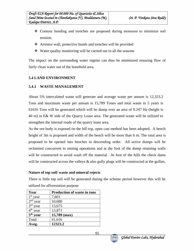
Draft EIA Report for 08.000 Ha. of Quartzite & Silica Sand Mine located in Chinthakunta (V), Muddanuru (M), Kadapa District, A.P.
Sri. P. Venkata Siva Reddy
Global Enviro Labs, Hyderabad
95
❖ Contour bunding and trenches are proposed during monsoon to minimize soil
erosion.
❖ Arrestor wall, protective bunds and trenches will be provided
❖ Water quality monitoring will be carried out in all the seasons
The impact on the surrounding water regime can thus be minimized ensuring flow of
fairly clean water out of the leasehold area.
5.4 LAND ENVIRONMENT 5.4.1 WASTE MANAGEMENT
About 5% intercalated waste will generate and average waste per annum is 12,323.2
Tons and maximum waste per annum is 15,789 Tones and total waste in 5 years is
61616 Tons will be generated which will be dump over an area of 0.247 Ha (height is
40 m) in E& W side of the Quarry Lease area. The generated waste will be utilized to
strengthen the internal roads of the quarry lease area.
As the ore body is exposed on the hill top, open cast method has been adopted. A bench
height of 3m is proposed and width of the bench will be more than 6 m. The total area is
proposed to be opened into benches in descending order. All active dumps will be
reclaimed concurrent to mining operations and at the foot of the dump retaining walls
will be constructed to avoid wash off the material. At foot of the hills the check dams
will be constructed across the valleys & also gully plugs will be constructed at the gullies.
Nature of top soil/ waste and mineral rejects
There is little top soil will be generated during the scheme period however this will be
utilized for afforestation purpose
Year Production of waste in tons 1st year 7,601 2nd year 10,680 3rd year 13,675 4th year 13,871 5th year 15,789 (max) Total 61,616 Aveg. 12323.2
Draft EIA Report for 08.000 Ha. of Quartzite & Silica Sand Mine located in Chinthakunta (V), Muddanuru (M), Kadapa District, A.P.
Sri. P. Venkata Siva Reddy
Global Enviro Labs, Hyderabad
96
5.5 ENVIRONMENTAL MAPANAGEMENT PLANT FOR ECOLOGY & BIODIVERSITY The project proponent is duty bound to strictly follow the procedures outlined in the
approved mining plan including the progressive mine closure and restoration plan. To
begin with, they are going to one row of Hill Neem (Chukrasiatabularis), the only tree
that remains green even during the hot summer in Kadapa region. It can be easily grown
from stem cuttings. It has thick foliage and evergreen. This will be done during the first
year at a cost of Rs.2,00,000/-.Stem cuttings can be procured from the hills and seeds are
readily available as there are road-side avenue trees in the district. Seedlings will be
grown in seed beds and the saplings shall be transplanted at a spacing of 2x3m during the
rainy season. It is cost effective and performance is ensured.
The top fertile soil shall be stored in paces / areas where deposits are not found.
Overburden shall be stored separately as stated in the approved mining plan. Once the
mining is over in any pit, it shall be back filled with the stone waste at the bottom level
followed by the overburden and then with the top soil at the top. After filling and
levelling is over, nitrogen enriching leguminous fodder plants like Hamata
(Stylosantheshamata) shall be grown. Once the Hamata grass establishes, pits shall be
made at a spacing of 2m x 3m and saplings ofChukrasiatabularis, Conocarpuslancifolius,
Acacia holosericea, neem etc are transplanted. After transplantation, regular maintenance
of weeding, watering, application of fertilizers and other protective and productive
measures shall be undertaken. Acacia holosericea, neem and Hill Neem
(Chukrasiatabularis) are already grown in the similar mine lease areas in the District.
Scarified seeds ofConocarpuslancifolius, and Silver wattle (Acacia holosericea) willbe
pelletized with dung and placed in small pits in the backfilled areas of the mine lease
areas. The seeds germinate and some of them are going to survive. All gaps will be filled
with stem cuttings of Hill Neem (Chukrasiatabularis) which grows well. There shall
be sufficient water in the mining area for dust suppression and afforestation and watering
the plants.
Based on suitability, desirability and adaptability, a short list of plants is chosen for
greenbelt, avenue and block plantations and presented below Table.
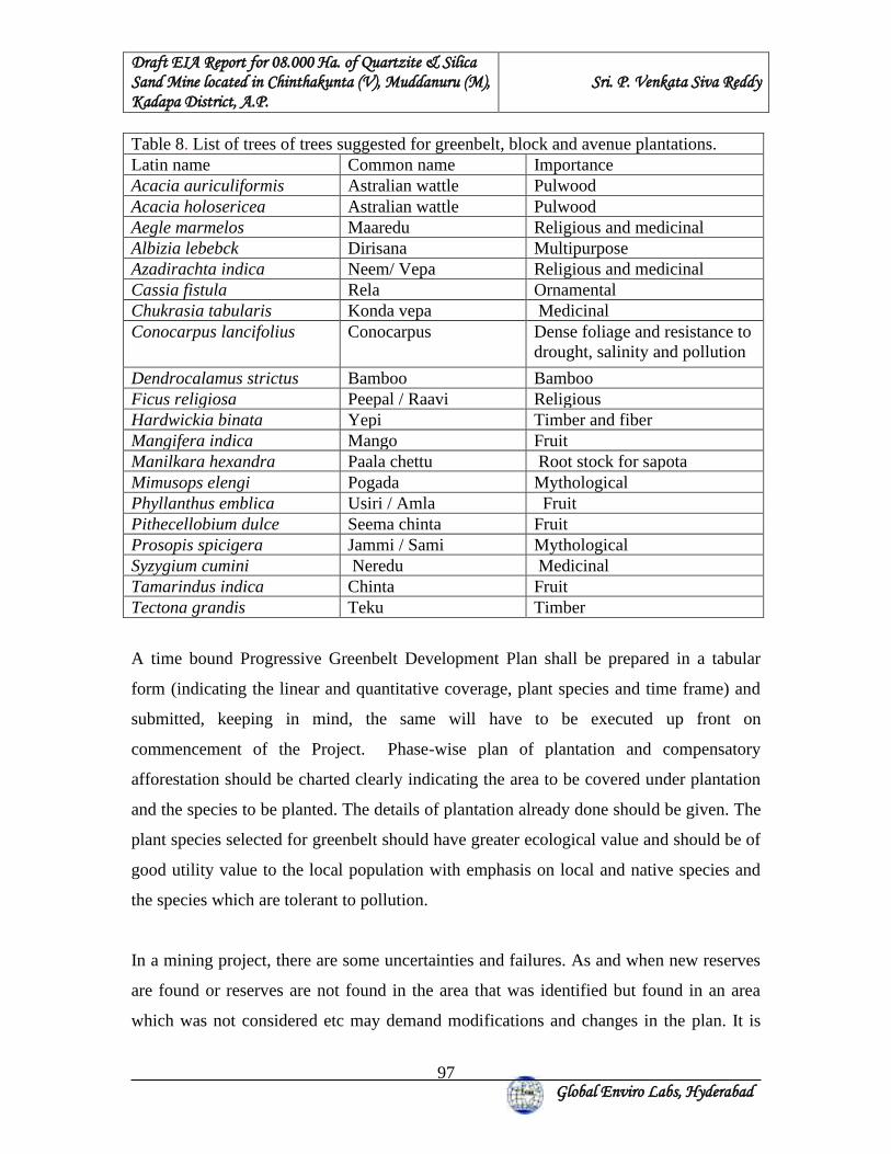
Draft EIA Report for 08.000 Ha. of Quartzite & Silica Sand Mine located in Chinthakunta (V), Muddanuru (M), Kadapa District, A.P.
Sri. P. Venkata Siva Reddy
Global Enviro Labs, Hyderabad
97
Table 8. List of trees of trees suggested for greenbelt, block and avenue plantations. Latin name Common name Importance Acacia auriculiformis Astralian wattle Pulwood Acacia holosericea Astralian wattle Pulwood Aegle marmelos Maaredu Religious and medicinal Albizia lebebck Dirisana Multipurpose Azadirachta indica Neem/ Vepa Religious and medicinal Cassia fistula Rela Ornamental Chukrasia tabularis Konda vepa Medicinal Conocarpus lancifolius Conocarpus Dense foliage and resistance to
drought, salinity and pollution
Dendrocalamus strictus Bamboo Bamboo Ficus religiosa Peepal / Raavi Religious Hardwickia binata Yepi Timber and fiber Mangifera indica Mango Fruit Manilkara hexandra Paala chettu Root stock for sapota Mimusops elengi Pogada Mythological Phyllanthus emblica Usiri / Amla Fruit Pithecellobium dulce Seema chinta Fruit Prosopis spicigera Jammi / Sami Mythological Syzygium cumini Neredu Medicinal Tamarindus indica Chinta Fruit Tectona grandis Teku Timber
A time bound Progressive Greenbelt Development Plan shall be prepared in a tabular
form (indicating the linear and quantitative coverage, plant species and time frame) and
submitted, keeping in mind, the same will have to be executed up front on
commencement of the Project. Phase-wise plan of plantation and compensatory
afforestation should be charted clearly indicating the area to be covered under plantation
and the species to be planted. The details of plantation already done should be given. The
plant species selected for greenbelt should have greater ecological value and should be of
good utility value to the local population with emphasis on local and native species and
the species which are tolerant to pollution.
In a mining project, there are some uncertainties and failures. As and when new reserves
are found or reserves are not found in the area that was identified but found in an area
which was not considered etc may demand modifications and changes in the plan. It is
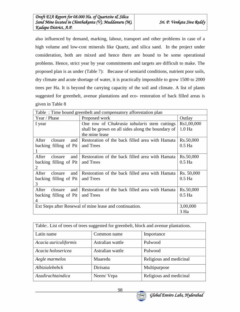
Draft EIA Report for 08.000 Ha. of Quartzite & Silica Sand Mine located in Chinthakunta (V), Muddanuru (M), Kadapa District, A.P.
Sri. P. Venkata Siva Reddy
Global Enviro Labs, Hyderabad
98
also influenced by demand, marking, labour, transport and other problems in case of a
high volume and low-cost minerals like Quartz, and silica sand. In the project under
consideration, both are mixed and hence there are bound to be some operational
problems. Hence, strict year by year commitments and targets are difficult to make. The
proposed plan is as under (Table 7): Because of semiarid conditions, nutrient poor soils,
dry climate and acute shortage of water, it is practically impossible to grow 1500 to 2000
trees per Ha. It is beyond the carrying capacity of the soil and climate. A list of plants
suggested for greenbelt, avenue plantations and eco- restoration of back filled areas is
given in Table 8
Table : Time bound greenbelt and compensatory afforestation plan Year / Phase Proposed work Outlay I year One row of Chukrasia tabularis stem cuttings
shall be grown on all sides along the boundary of the mine lease
Rs1,00,000 1.0 Ha
After closure and backing filling of Pit 1
Restoration of the back filled area with Hamata and Trees
Rs.50,000 0.5 Ha
After closure and backing filling of Pit 2
Restoration of the back filled area with Hamata and Trees
Rs.50,000 0.5 Ha
After closure and backing filling of Pit 3
Restoration of the back filled area with Hamata and Trees
Rs. 50,000 0.5 Ha
After closure and backing filling of Pit 4
Restoration of the back filled area with Hamata and Trees
Rs.50,000 0.5 Ha
Ext Steps after Renewal of mine lease and continuation. 3,00,000 3 Ha
Table:. List of trees of trees suggested for greenbelt, block and avenue plantations.
Latin name Common name Importance
Acacia auriculiformis Astralian wattle Pulwood
Acacia holosericea Astralian wattle Pulwood
Aegle marmelos Maaredu Religious and medicinal
Albizialebebck Dirisana Multipurpose
Azadirachtaindica Neem/ Vepa Religious and medicinal
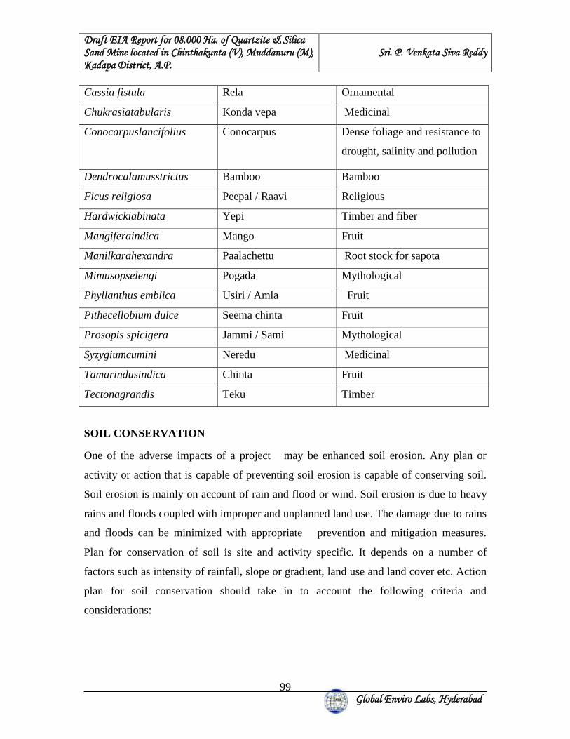
Draft EIA Report for 08.000 Ha. of Quartzite & Silica Sand Mine located in Chinthakunta (V), Muddanuru (M), Kadapa District, A.P.
Sri. P. Venkata Siva Reddy
Global Enviro Labs, Hyderabad
99
Cassia fistula Rela Ornamental
Chukrasiatabularis Konda vepa Medicinal
Conocarpuslancifolius Conocarpus Dense foliage and resistance to
drought, salinity and pollution
Dendrocalamusstrictus Bamboo Bamboo
Ficus religiosa Peepal / Raavi Religious
Hardwickiabinata Yepi Timber and fiber
Mangiferaindica Mango Fruit
Manilkarahexandra Paalachettu Root stock for sapota
Mimusopselengi Pogada Mythological
Phyllanthus emblica Usiri / Amla Fruit
Pithecellobium dulce Seema chinta Fruit
Prosopis spicigera Jammi / Sami Mythological
Syzygiumcumini Neredu Medicinal
Tamarindusindica Chinta Fruit
Tectonagrandis Teku Timber
SOIL CONSERVATION
One of the adverse impacts of a project may be enhanced soil erosion. Any plan or
activity or action that is capable of preventing soil erosion is capable of conserving soil.
Soil erosion is mainly on account of rain and flood or wind. Soil erosion is due to heavy
rains and floods coupled with improper and unplanned land use. The damage due to rains
and floods can be minimized with appropriate prevention and mitigation measures.
Plan for conservation of soil is site and activity specific. It depends on a number of
factors such as intensity of rainfall, slope or gradient, land use and land cover etc. Action
plan for soil conservation should take in to account the following criteria and
considerations:
Draft EIA Report for 08.000 Ha. of Quartzite & Silica Sand Mine located in Chinthakunta (V), Muddanuru (M), Kadapa District, A.P.
Sri. P. Venkata Siva Reddy
Global Enviro Labs, Hyderabad
100
i) Soil: Extent or area of vacant land; topography of soil; slope or gradient;
texture, structure and composition of soil; land use and land cover;
connectivity with the adjacent land mass
ii) Rainfall: Intensity and frequency of rainfall and drainage.
Based on the above, engineering or biological or integrated land, water and afforestation
programme are designed. Measures for prevention of surface runoff and water
conservation are capable of preventing soil erosion.
Integrated land, water and greenbelt development Programme:
Integrated land and soil conservation; water, wasteland utilization and greenbelt
development programme is based on the aforesaid practical considerations. It involves
integration of physical or engineering systems and biological systems for sustainable
development. The main objectives of the programme are:
1. Rain water harvesting and ground water recharge
2. Prevention of soil erosion and nutrient enrichment
3. Greenbelt development and fodder production
In order to achieve the objectives in an integrated manner, we plan to integrate physical
or engineering and biological methods and mechanisms. A brief plan is as under:
A: Engineering or Physical methods:
1. Digging of 1m deep, 2 m wide trenches continuous or discontinuous depending
on rocks and gradient along the boundary of the mining site. Trenches shall be
filled with top soil and organic manure in such a way that the trench will be 30
Cm below the adjacent land surface.
2. Bunds will be formed towards the lower part with the soil and rock taken out from
the trench. The trenches will be made in to beds with bunds so that the whole
systems resemble terrace cultivation. Rain water is diverted in to these beds
and only the excess storm water goes down.
Draft EIA Report for 08.000 Ha. of Quartzite & Silica Sand Mine located in Chinthakunta (V), Muddanuru (M), Kadapa District, A.P.
Sri. P. Venkata Siva Reddy
Global Enviro Labs, Hyderabad
101
3. In addition, infiltration pits, trenches, rock fill check dams and ponds for
temporary storage and infiltration of rain water shall be provided.
4. Locally available farm yard manure (goat manure) and poultry litter shall be used
liberally to promote plant growth and to increase the water holding capacity of the
soil.
B: Biological methods:
Development of two layered thick plant cover is the most effective solution for
integrated land, water, wasteland utilization and greenbelt development.
Drought resistant, non-palatable succulents such as Agave americana will be grown on
the bunds. Rooted stem cuttings of Chukrasia tabularis and Ficus species will be planted
in the beds in trenches during the rainy season. Scarified and soaked seeds of Subabul
will be sown in large numbers after heavy shower. Hamata grass will be grown for
prevention of erosion, trapping of rain water, nutrients and nitrogen fixation. Saplings
grown in poly bags shall be planted in the beds during the rainy season. Drip irrigation
shall be provided to improve water use efficiency.
How it works:
1. Rain water or storm water will flow in to the series of beds which are 30 Cm
below the adjacent land. The top spoil is trapped and the rain water percolates in
to the ground leading to ground water recharge. Run off is reduced and erosion is
checked. All fine soil particles that are carried by the rain water are deposited in
the beds where a two-layer plant cover is developed.
2. As the plants start growing, they bind the soil; reduce the velocity of rain drops
by intercepting the rain drops by plant canopy and enhancing the percolation rate.
Deposition of plant litter will improve the ability of the soils to hold water and
moisture which in turn promotes the growth of ground flora and soil biota such as
earthworms. The trenches get filled up slowly with the transported soils, litter
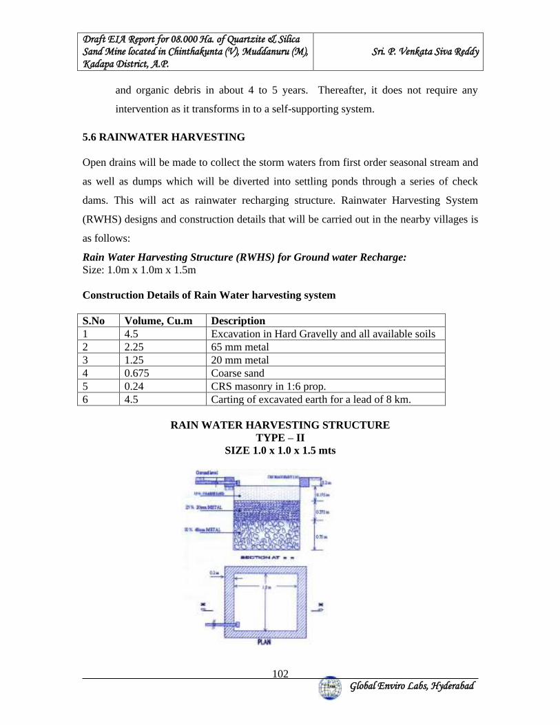
Draft EIA Report for 08.000 Ha. of Quartzite & Silica Sand Mine located in Chinthakunta (V), Muddanuru (M), Kadapa District, A.P.
Sri. P. Venkata Siva Reddy
Global Enviro Labs, Hyderabad
102
and organic debris in about 4 to 5 years. Thereafter, it does not require any
intervention as it transforms in to a self-supporting system.
5.6 RAINWATER HARVESTING Open drains will be made to collect the storm waters from first order seasonal stream and
as well as dumps which will be diverted into settling ponds through a series of check
dams. This will act as rainwater recharging structure. Rainwater Harvesting System
(RWHS) designs and construction details that will be carried out in the nearby villages is
as follows:
Rain Water Harvesting Structure (RWHS) for Ground water Recharge: Size: 1.0m x 1.0m x 1.5m Construction Details of Rain Water harvesting system S.No Volume, Cu.m Description 1 4.5 Excavation in Hard Gravelly and all available soils 2 2.25 65 mm metal 3 1.25 20 mm metal 4 0.675 Coarse sand 5 0.24 CRS masonry in 1:6 prop. 6 4.5 Carting of excavated earth for a lead of 8 km.
RAIN WATER HARVESTING STRUCTURE TYPE – II
SIZE 1.0 x 1.0 x 1.5 mts
Draft EIA Report for 08.000 Ha. of Quartzite & Silica Sand Mine located in Chinthakunta (V), Muddanuru (M), Kadapa District, A.P.
Sri. P. Venkata Siva Reddy
Global Enviro Labs, Hyderabad
103
5.7 WILD LIFE CONSERVATION PLAN
FENCING THE MINE PITS
The mine will be properly fenced by appropriate methods to prevent accidental fall of any
animal. For this purpose, rubble wall fencing shall be quite useful and cost effective.
BARRIER ZONE
7.5 m all along the Mine lease boundary will be planted with thick vegetation which will
act as a barrier. No mining activity will be carried out in this area.
WATER HOLES & SALT LICKS
Water holes & Salt licks will be made and maintained in the area as per the guidelines of
Local Forest Officer. The mine management will contribute to the conservation plan
prepared by Forest authorities for wild life conservation in the area.
5.8 OCCUPATIONAL HEALTH & SAFETY MEASURES TO CONTROL DUST INHALATION
❖ Providing a working environment that is conducive to safety & health
❖ The management of occupational safety & health is the prime responsibility of
mine management from the executive level to the first line supervisory level
❖ Employee involvement and commitment in the implementation of health and
safety guidelines
❖ Provision of all necessary resources
❖ Implementing safety and health management system and assessing the
effectiveness through periodic audits
❖ Setting of safety and health objectives based on comprehensive strategic plans
and measure performance against these plans
❖ Monitoring the effects of mining activities on safety and health and conducting
regular performance reviews
❖ Provision of necessary personal protective equipments
❖ Establishing and maintaining a system of medical surveillance for employees
❖ Ensuring employees at all levels receive appropriate training and are competent to
carry out their duties and responsibilities
Draft EIA Report for 08.000 Ha. of Quartzite & Silica Sand Mine located in Chinthakunta (V), Muddanuru (M), Kadapa District, A.P.
Sri. P. Venkata Siva Reddy
Global Enviro Labs, Hyderabad
104
NOISE INDUCED HEARING LOSS (NIHL) Hearing conservation programs exists at all operations. Baseline audiogram forms the
basis for future assessment of employees in terms of hearing loss.
Using engineering initiatives to reduce noise at source is the priority management tool The hearing conservation programme includes the provision of Hearing Protection
Devises (HPDs) and annual audiometry examination of all employees. Apart from
provision of HPDs emphasis is also laid on training the employees responsibility to
protect his/her hearing.
OCCUPATIONAL LUNG DISEASES (OLD) There will be regular health camps for all the workers. Lung function tests, chest X-rays
etc shall be carried out and any health disorders will be evaluated. In house facility for
carrying out this tests and occupation specialists are employed for this facility.
5.9 BUDGET The capital cost for environmental protection and the recurring expenses towards the
pollution control and environmental management measures, socio-economic development
and occupational health and safety, etc are given in details in Table 5.1.
TABLE 5.1: BUDGETARY ESTIMATION FOR ENVIRONMENTAL MANAGEMENT
Sl.No Description Item Capital
Cost in RS. Recurring Cost
in Rs. Remarks
1 Air Pollution Dust Suppression Through Water sprinkling.
80,000.00 200,000.00 Water tanker cost @ three Two per day for 8 months
Draft EIA Report for 08.000 Ha. of Quartzite & Silica Sand Mine located in Chinthakunta (V), Muddanuru (M), Kadapa District, A.P.
Sri. P. Venkata Siva Reddy
Global Enviro Labs, Hyderabad
105
2 Water
pollution
Garland drain 500m length with 0.5m depth and Siltation Pond with 10m length with 2mt depth & 2mt width and Retaining wall around dump with 40m length with 1m height & 1m width
200,000.00 100,000.00 regular maintenance
3 Green Belt Plantation Development
300,000.00 100,000.00 watering and maintenance
4 Noise Pollution Maintenance of machinery suitably
10,000.00 10,000.00 Included in main cost
PPE’s like Ear muffs 10,000.00 10,000.00 Once in six months
5 Occupational
Health & Safety
Providing First aid kits and fire extinguishers
15,000.00 5,000.00 Once in year, replace by conducting periodical checkup
Providing Personal protective equipment’s to all
employees (Nose Masks, hand gloves, safety shoe and helmets)
300,000.00 467,625.00 Included in air pollution and noise pollution
Training and awareness programs on risk factors during emergencies by the experts
50,000.00 15,000.00
Once in six months and create sign boards about the risk and safety precautions regularly
Periodical medical checkup and supply of medicines
50,000.00 10,000.00 Once in a year and supply of medicines for every three months
6 Environmental
monitoring
Ambient air quality studies – Once in six months – 3 locations
-
25,000.00
MoEF /NABL recognized laboratories
Water quality studies – Once a year – 3 Locations
-
8,000.00
Noise studies – once in six months – 3 Locations
-
7,000.00
Vibration studies – Once in year – 1 location
-
10,000.00
TOTAL 1,015,000.00 967,625.00
Draft EIA Report for 08.000 Ha. of Quartzite & Silica Sand Mine located in Chinthakunta (V), Muddanuru (M), Kadapa District, A.P.
Sri. P. Venkata Siva Reddy
Global Enviro Labs, Hyderabad
106
6 ANALYSIS OF ALTERNATIVES (TECHNOLOGY & SITE)
6.1. ALTERNATIVE TECHNOLOGIES:
Mining of quartzite will be taken up by Open cast Semi mechanized method. Hence no
technological failures are anticipated. Hence no alternative technologies are considered
for mining.
6.2. ALTERNATIVE SITES EXAMINED BY SRI P. VENKATA SIVA REDDY:
Sri. P. Venkata Siva Reddy proposed Quartzite & Silica Sand mine over an extent of
08.000 Hect. in Survey No. 677 of Chinthakunta village, Muddanur Mandal, Y.S.R.
Kadapa District, Andhra Pradesh. In principle of application of quarry lease Proceedings
issued by Director of Mines and Geology, Ibrahimpatnam, Govt. of A.P for 20 years vide
Proceedings no. 11779/R5-2/2018 Dt: 08.01.2019. Mining Plan was approved by the
Deputy Director of Mines and Geology, Kadapa, Government of Andhra Pradesh vide
Letter No. 463/MP/YGL/2019 Dt: 05.02.2019.
Sri. Sri. P. VenkataSiva Reddy have proposed to taken up mining to produce maximum
production of 3,75,000 TPA (average production is 2,92,678 TPA). No alternative sites
have been examined as the Mining lease was granted Dept. of Industries of Commerce
(Mine – I), Govt. of Andhra Pradesh.
Draft EIA Report for 08.000 Ha. of Quartzite & Silica Sand Mine located in Chinthakunta (V), Muddanuru (M), Kadapa District, A.P.
Sri. P. Venkata Siva Reddy
Global Enviro Labs, Hyderabad
107
7. ADDITIONAL STUDIES
7.1 RISK ASSESSMENT:
Risk assessment is all about prevention of accidents and there is a need to be aware that
there is a risk of an accident before steps can be taken to prevent it happening. This is the
reason, why risk assessments will be carried out. The proposed mining activity will be
opencast semi-mechanized mining project. The anticipated risks are mentioned below:
7.1.1 INUNDATION:
Mining operations will not intercept the ground water table. Therefore, disturbance to
ground water quality or depletion are not envisaged. In order to control the in-rush of
water from the surface or through seepage from the strata during monsoon, sufficient
garland drains will be constructed around the opencast excavation as proposed.
The rain water falling directly into the open excavation will automatically drain out and
there is no need to install pumps except to pump out the rain water collected in the pit
during monsoons from bottom most benches to facilitate mining.
7.1.2. BLASTING:
Blasting causes accidents due improper use of explosives, not taking precautions during
the blasting and release of excessive ground vibrations and fly rocks due to unsystematic
blasting. Control blasting techniques are adopted to minimize the ground vibrations and
ejection of fly rocks. Predesigned blasting parameters will be adopted for the safe
blasting and blasting will be done by the qualified persons taking all the precautions as
prescribed under the Metalli Ferrous Mines Regulations 1961 and the related circular
issued by the Directorate of Mines Safety.
7.1.3. FAILURE OF PIT SLOPE:
Slope failures in mines are mostly associated with circular failure, which is controlled by
the rock mechanics properties such as cohesion, angle of internal friction, joint/shear
planes, ground water
Draft EIA Report for 08.000 Ha. of Quartzite & Silica Sand Mine located in Chinthakunta (V), Muddanuru (M), Kadapa District, A.P.
Sri. P. Venkata Siva Reddy
Global Enviro Labs, Hyderabad
108
flow conditions, rock density and the heights to be maintained. To control the above
factors the pits are designed to be developed with benches, with an overall slope angle of
30o. Further the top benches of the will be afforested to provide long term stability. Thus,
the chances of slope failures for the pits are remote. All necessary precautions will be
taken.
7.1.4. FAILURE OF WASTE DUMPS:
Sliding of waste dump will be a severe risk compared with quarry slope failure. Hence, it
is imperative that the degree of hazard against potential failure of waste dump slope
should be identified and that precautionary measures will be adopted, if required. The
height of outside dumps will be restricted to 10m.
The waste dumps will be designed with intermittent berms with an overall slope of 30o. A
strong retaining wall will be constructed at the bottom of the dump to give toe support
and for proper drainage from the waste dump. Garland drains will be provided to collect
the drainage flow. Since the waste dumps will be proposed to be constructed over a hard
rock surface, chances of foundation failures will be remote. As controlled blasting
techniques will be implemented with small size Jackhammer blast holes with limited
explosive charge, there are no chances ground vibrations to reach the dump area and
creating problems of liquefaction. Further the slopes of waste dumps will be afforested to
provide long term stability. Thus, the chances of slope failures for the dumps are remote.
7.1.5. SURFACE FIRE:
Sufficient fire extinguishers will be installed at selected locations on surface like office,
workshop, Garage, Stores etc. for fire protection.
7.1.6. DUST FROM THE DRILLING OPERATION:
The hazard is the inhalation of dust which is created during the drilling operation. While
it is not presently possible to totally remove the hazard, properly applied control
measures can substantially reduce the risk. Control measures vary from using water
during the drilling operation to the provision of local exhaust ventilation which removes
Draft EIA Report for 08.000 Ha. of Quartzite & Silica Sand Mine located in Chinthakunta (V), Muddanuru (M), Kadapa District, A.P.
Sri. P. Venkata Siva Reddy
Global Enviro Labs, Hyderabad
109
the dust from the head of the hole to a dust collection unit to the provision of a ventilated
cabin provided for the operator. The most effective of these precautions will be the
provision of a control cabin on the drilling rig provided with a suitable ventilation system
fitted with a dust filter to remove harmful dust and maintain the dust level within the
cabin to below acceptable control levels. Any ventilation equipment should periodically
be examined to ensure that it is maintained to its designed standard.
7.1.7. NOISE:
Drilling, Blasting & movement of vehicles will be given rise to harmful levels of noise.
Both drilling the hole and the operation of the drill rig itself creates noise. It is
impractical to remove the hazard at the hole but new generations of drill rig should be
quieter by virtue of its design. The noise created is harmful to anyone who is within a
zone around the operation of the machine at which the noise level will be above that
considered to be safe for persons to work without having to use control measures.
The noise levels around drilling & blasting equipments should be measured and the risk
assessed. Unless control measures are in place no-one, except those necessary for the
work in hand, should be allowed inside the designated noisy area. In most cases this will
be the operator of the machine. The risk will be highest at older drilling machines. Newer
large drilling machines will be provided with sound insulated operating cabins which
control the noise level within the cabins to acceptable levels. Other control measures will
include providing enclosure, development of green belts in the surrounding areas,
training the operators and providing them with ear protection, although the latter should
only be seen as an interim precaution until a permanent solution can be found. The risk is
very high when no control measures are provided. However, if all the mitigation
measures are provided the risk will be very low.
7.1.8. LOADING:
The main hazard associated with loading is toppling over due to uneven ground, failure
of hydraulic systems, fires and falls while gaining access to operating cabins.
Draft EIA Report for 08.000 Ha. of Quartzite & Silica Sand Mine located in Chinthakunta (V), Muddanuru (M), Kadapa District, A.P.
Sri. P. Venkata Siva Reddy
Global Enviro Labs, Hyderabad
110
7.1.9. TRANSPORT VEHICLES:
The main hazards arising from the use transport vehicles will be incompetent drivers,
brake failure, lack of all-around visibility from the driver’s position, access to the cab,
vehicle movements particularly reversing, roll over, vibration, noise, dust and
maintenance. The possible risks include the driver and pedestrians likely to be struck by
the vehicle, and drivers of smaller vehicles, which cannot be seen from the cabs of large
vehicles. Visibility defects can be eliminated by the use of visibility aids such rear-view
mirrors.
Good maintenance and regular testing are necessary to reduce the possibility of brake
failure. An area should be earmarked as a testing area where daily tests are carried out on
the effectiveness of a vehicles braking system. Careful attention must be paid to guarding
dangerous parts of the equipment and handling heavy components during maintenance
work. Those most at risk will be the users of the system although casual pedestrians and
vehicle operators may also be at risk.
7.1.10. EXPLOSIVES:
Explosives by virtue of their nature have the potential for the most serious and
catastrophic accidents in the mining industry yet the way they will be used is an excellent
example of how risk assessment is properly applied. For example, no one would allow
any person to use explosives without first having been properly trained in its handling
and use.
Increasingly use of explosives is specialist work. Planning for a round of shots is
necessary to ensure that the face is properly surveyed, holes correctly drilled, direction
logged, the weight of explosive suitable for good fragmentation and the continuity of the
initiator are but a few of the steps necessary to ensure its safe use. Poorly designed shots
can result in misfires, early ignition and flying rock. The more sophisticated type of
explosive demands properly trained persons to carry out the blast design, charge and fire
a round of explosives. Only competent person should be engaged to do this work.
Draft EIA Report for 08.000 Ha. of Quartzite & Silica Sand Mine located in Chinthakunta (V), Muddanuru (M), Kadapa District, A.P.
Sri. P. Venkata Siva Reddy
Global Enviro Labs, Hyderabad
111
7.2. RISK CONTROL MEASURES:
7.2.1 HOUSE KEEPING:
The provision and maintenance of a safe and healthy workplace will be the most basic
principle of health and safety. Dirty and untidy workplaces or walkways contribute to a
very large proportion of toppling and fall accidents. In the context of surface mining the
provision of well-defined roadways and walkways clear of obstruction, and regular
cleaning up of spillage will greatly reduce the potential for this type of accident. Lack of
maintenance may lead to roadways and walkways being unsuitable for their use.
7.2.2 THE WORK:
The application of risk assessment depends upon a full understanding of all aspects of the
job being undertaken. In carrying out a risk assessment in relation to a particular task the
evaluation must include a review of the knowledge, experience and training of those
persons carrying out the work.
7.2.3 PERSONAL COMPETENCE
If follows that the knowledge, experience and training of personnel involved in work is
critical to the result of any risk assessment. A knowledgeable, experienced well-trained
and competently supervised workforce will be at a lower risk of accidents occurring than
a poorly trained and badly supervised workforce.
7.2.4 CO-ORDINATION:
A qualified & trained person should be given the responsibility for overseeing and
coordinating work. It is essential that the coordinator ensures that everyone engaged in
the work is capable and understands the role of others and their responsibility for each
other. This is particularly important when contract workers undertake part or all of the
work to be carried out.
Draft EIA Report for 08.000 Ha. of Quartzite & Silica Sand Mine located in Chinthakunta (V), Muddanuru (M), Kadapa District, A.P.
Sri. P. Venkata Siva Reddy
Global Enviro Labs, Hyderabad
112
7.2.5 DANGEROUS PARTS OF MACHINERY:
Parts of machinery such as revolving parts, in running nips and entrapment between
reciprocating parts as defined in European and National standards should be protected to
those standards.
7.2.6 WORKPLACES:
Access to both above and below ground workplaces should be by well constructed and
maintained permanent fixed means. When practical stairways and shallow inclined
walkways are preferred to vertical ladders, which in some circumstances can be the cause
of very high risk. The sides of all workplaces from which persons may fall should always
be protected.
7.2.7 HEALTH HAZARDS:
For the purposes of this document health hazards should be interpreted as being harmful
dust, which will be emitted during surface mining operations, as well as the handling of
heavy loads.
While elimination and often complete suppression at source is not practicable, the norms
for control of health hazards shall be made applicable.
7.2.8 PERSONAL PROTECTIVE EQUIPMENT (PPE):
The PPE should meet ISI standard, suitable for the hazard e.g. a dust respirator fitted with
the correct filter to capture the particular hazardous dust, and maintained to
recommended standards.
As personal protective equipment only affords limited protection it should only be used
as a last resort and then as an interim arrangement until other steps are taken to reduce the
risk of personal injury to an acceptable level.
7.2.9 TRAFFIC MOVEMENT:
The traffic movement should only take place within designated areas and over suitable
roadways.
Adopting one-way traffic movement systems are preferred to two directional traffic
systems. The risk of accidents due to traffic movement is much less with a one.
Draft EIA Report for 08.000 Ha. of Quartzite & Silica Sand Mine located in Chinthakunta (V), Muddanuru (M), Kadapa District, A.P.
Sri. P. Venkata Siva Reddy
Global Enviro Labs, Hyderabad
113
Whenever mineral will be mined, the first step in winning the product is the preparation
of the site. The four main stages in the site preparation are:
1. Planning 2. Surveying 3. Laying out Planning:
The risk of injuries can be significantly reduced if sufficient regard will be given to
health and safety at the planning stage of a new mine. Using trained drivers can largely
eliminate the danger of being struck by large moving vehicles and providing the vehicles
with suitable appliances, such as aids to ensure the driver has all round visibility.
Designing and implementing one-way traffic systems and ensuring that open edges of
roadways are suitably protected to prevent accidental driving off the edge can further
reduce the danger. Additionally, ensuring that the vehicles are properly maintained in
good working condition, particularly the braking system, will go a long way to help the
driver control the vehicle. Well-designed access and working platforms will also reduce
the possibility of a fall.
Surveying:
Surveying has its hazards, for example surveyors are likely to be seriously injured if they
fall from heights or are thrown out of overturning vehicles. Since the hazards are created
by ground formation it is unlikely that they can be removed. Those normally at risk
would be the surveying team of the surveyor and assistants. Individuals working at the
edge of vertical faces or on very steep undulating ground will be at greater risk than those
working on level ground. Driving over steep rough terrain is more dangerous than driving
over gentle slopes. It is necessary to give clear positive instruction and ensure vehicles
used to gain access to the areas to be surveyed are well maintained and suitable for the
terrain over which access is to be gained.
Lay Out:
There are many different ways of opening of mines, but careful planning particularly
concerning the mine layout will reduce hazards. Good well-maintained equipment is
essential to reduce the risk of injuries. If suitable equipment will not be used, for example
if poor and badly constructed scaffolding is used there will be a much higher probability
Draft EIA Report for 08.000 Ha. of Quartzite & Silica Sand Mine located in Chinthakunta (V), Muddanuru (M), Kadapa District, A.P.
Sri. P. Venkata Siva Reddy
Global Enviro Labs, Hyderabad
114
of persons falling from heights or the scaffolding collapsing than if good properly
constructed scaffolding will be used. To reduce the risk of injuries, the vehicle drivers
and those giving signals should be well trained. The lack of training and competence in
the use of such equipment is the biggest cause of accidents.
7.3. DISASTER MANAGEMENT PLAN:
The complete mining operation will be carried out under the management control and
direction of a qualified mine manager. The DGMS have been issuing a number of
standing orders, model standing orders and circulars to be followed by the mine
management in case of disaster, if any. Moreover, mining staff is being sent to refresher
courses from time to time to keep them alert. Natural calamities such as earthquakes,
landslides, floods etc., can also contribute to disaster. However, following
natural/industrial hazards may occur during normal operation.
• Inundation of mine pit due to flood/excessive rains.
• Accident due to transport & others.
In order to take care of above hazard/disasters the following control measures have been
adopted.
• Regular inspection of the mine for the observance of any visible cracks.
• Checking and regular maintenance of garland drains and earthen bunds to avoid
any inflow of surface water in the mine pit during rainy season.
• Provision of high capacity pumps for pumping out water from the mining pit.
• All safety precautions and provisions of metalliferous mine regulation 1961 is
strictly followed during all mining operations.
• Entry of unauthorized persons is prohibited.
• Fire fighting and first-aid provisions in the mine’s office complex and mining
area.
• Provisions of all the safety appliances such as safety boot, helmets, goggles etc.
are made available to the employees and regular check for their use.
• Cleaning of mine faces is regularly done.
• Regular maintenance and testing of all mining equipment as per manufacture’s
guidelines.
Draft EIA Report for 08.000 Ha. of Quartzite & Silica Sand Mine located in Chinthakunta (V), Muddanuru (M), Kadapa District, A.P.
Sri. P. Venkata Siva Reddy
Global Enviro Labs, Hyderabad
115
• Suppression of dust on the haulage roads.
• Increasing the awareness of safety and disaster through competitions, posters and
other similar drives.
The management is able to deal with the situation efficiently to reduce confusion keeping
in view of the likely sources of danger in the mine.
7.3.1. STRUCTURE OF THE DISASTER MANAGEMENT PLAN OUTLINE OF
DISASTER MANAGEMENT PLAN:
The purpose of disaster management plan is to restore the normalcy for early resumption
of mining operation due to an unexpected, sudden occurrence resulting to abnormalities
in the course of mining activity leading to a serious danger to workers or any machinery
or the environment.
7.3.2 SYSTEM OF COMMUNICATION:
Having an internal direct communication system for the department head and to their line
of command. Having the telephone nos. and addresses of adjoining mines, rescue station,
police station, Fire service station, local hospital, electricity supply agency and standing
consultative committee members.
7.3.3 FACILITIES & ACCOMMODATION:
Accommodation and facilities for medical centre, rescue room and for various working
groups will be provided.
7.3.4 FIRST AID & MEDICAL FACILITIES:
The mine management will be provided first aid / medical centre for use in emergency
situation. All casualties would be registered and will be given first aid. It will have proper
telephone / wireless set for quick communication with hospitals where the complicated
cases are to be sent.
Draft EIA Report for 08.000 Ha. of Quartzite & Silica Sand Mine located in Chinthakunta (V), Muddanuru (M), Kadapa District, A.P.
Sri. P. Venkata Siva Reddy
Global Enviro Labs, Hyderabad
116
7.3.5 DISASTER MANAGEMENT TEAM:
In order to handle disaster/emergency situations, an organization chart entrusting
responsibility to various project personnel has been prepared with their specific roles
during emergency.
The composition of the management team:
1. Agent (Mines)
2. Mines Manager
7.3.6 INFRASTRUCTURE:
Following infrastructure and operational system shall be provided to meet any
emergencies.
Emergency control room:
This is situated in an area away from the places of fire and has been provided with the
following facilities:
a. Master plan of the mines.
b. First aid boxes.
c. Telephone line
d. Emergency lighting system.
e. Transport facility.
Emergency control room will function as control base.
Transport Services:
Transportation will be provided to deal with the situation.
Functions of Public Relations Group:
To make a cordial relation with government officials and other social service
organization and working groups. To liaise with representatives of the mine to ameliorate
the situation of panic, tension, sentiments, grievances and misgivings created by any
disaster. To ameliorate the injured, survivors and family members of affected persons by
providing material, finance, moral support and establishing contact with relatives of
victims.
Security:
Manning of security posts
Draft EIA Report for 08.000 Ha. of Quartzite & Silica Sand Mine located in Chinthakunta (V), Muddanuru (M), Kadapa District, A.P.
Sri. P. Venkata Siva Reddy
Global Enviro Labs, Hyderabad
117
7.3.7 CARE AND MAINTENANCE DURING TEMPORARY DISCONTINUANCE: If the mine will be discontinued temporarily for more than 120 days, notice will be given
30 days before the date of such discontinuance to the concerned authorities. During
discontinuance period safety arrangement and fencing will be provided to avoid the entry
of unauthorized persons. The accessibility to the mine from the surface will be prevented
by providing fencing arrangement.
7.3.8 OCCUPATIONAL HEALTH AND PROTECTIVE MEASURES:
The effects of air pollution on human health are well documented. There are
controversies in many respects, but there is ample evidence to show that air pollution is
definitely a contributing factor to chronic bronchitis and emphysema. Health and Safety
Measures to control dust inhalation; precautions would be adopted to prevent dust
generation at site and dispersing in the environment. For the safety of workers at site,
engaged at strategic dust generation points like loading and unloading points etc., dust
masks would be provided. Dust masks would prevent inhalation of PM thereby reducing
the risk of lung diseases and other respiratory disorders.
Regular health monitoring of workers will be carried out. Lung function test and
audiometry test are the essential part of health checkups as mine workers are prone to
these. To attenuate noise levels, mostly the silencers will be used during operations
wherever possible. Mufflers will be provided to all workers.
The mines management prepares particular budget of Rs.3000 per employee/year for the
health maintenance of all the employees who will be employed at the mine site. Peak
labour force at the site will be 42 during operations, leading to an expenditure of Rs.3.36
lakhs per annum.
Training will be imparted to all the workers for health and safety measures so that they
can use the protective equipment’s essentially and effectively. One resource person will
be developed within the organization to impart the training to all the employees on
regular basis.
Anticipated Occupational & Safety Hazards:
• Health Impact due to
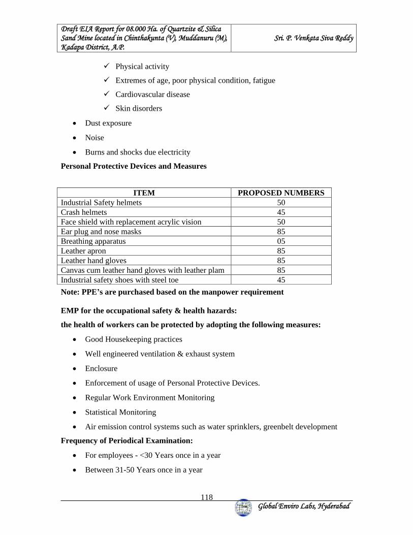
Draft EIA Report for 08.000 Ha. of Quartzite & Silica Sand Mine located in Chinthakunta (V), Muddanuru (M), Kadapa District, A.P.
Sri. P. Venkata Siva Reddy
Global Enviro Labs, Hyderabad
118
✓ Physical activity
✓ Extremes of age, poor physical condition, fatigue
✓ Cardiovascular disease
✓ Skin disorders
• Dust exposure
• Noise
• Burns and shocks due electricity
Personal Protective Devices and Measures
Note: PPE’s are purchased based on the manpower requirement EMP for the occupational safety & health hazards:
the health of workers can be protected by adopting the following measures:
• Good Housekeeping practices
• Well engineered ventilation & exhaust system
• Enclosure
• Enforcement of usage of Personal Protective Devices.
• Regular Work Environment Monitoring
• Statistical Monitoring
• Air emission control systems such as water sprinklers, greenbelt development
Frequency of Periodical Examination:
• For employees - <30 Years once in a year
• Between 31-50 Years once in a year
ITEM PROPOSED NUMBERS Industrial Safety helmets 50 Crash helmets 45 Face shield with replacement acrylic vision 50 Ear plug and nose masks 85 Breathing apparatus 05 Leather apron 85 Leather hand gloves 85 Canvas cum leather hand gloves with leather plam 85 Industrial safety shoes with steel toe 45
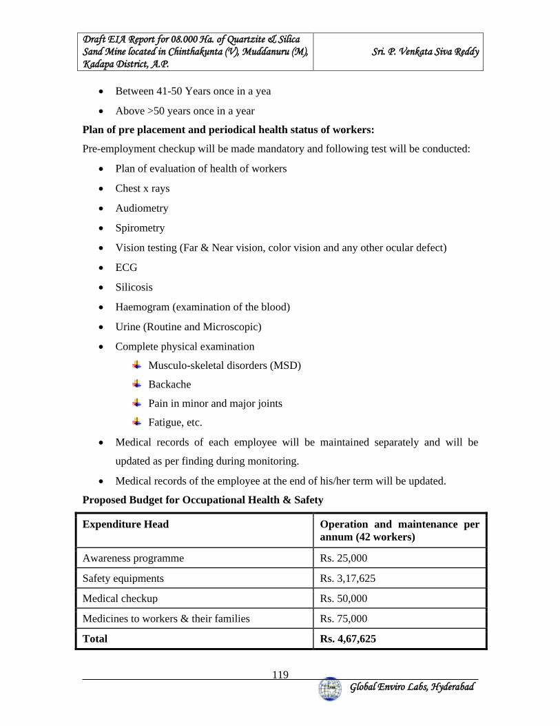
Draft EIA Report for 08.000 Ha. of Quartzite & Silica Sand Mine located in Chinthakunta (V), Muddanuru (M), Kadapa District, A.P.
Sri. P. Venkata Siva Reddy
Global Enviro Labs, Hyderabad
119
• Between 41-50 Years once in a yea
• Above >50 years once in a year
Plan of pre placement and periodical health status of workers:
Pre-employment checkup will be made mandatory and following test will be conducted:
• Plan of evaluation of health of workers
• Chest x rays
• Audiometry
• Spirometry
• Vision testing (Far & Near vision, color vision and any other ocular defect)
• ECG
• Silicosis
• Haemogram (examination of the blood)
• Urine (Routine and Microscopic)
• Complete physical examination
Musculo-skeletal disorders (MSD)
Backache
Pain in minor and major joints
Fatigue, etc.
• Medical records of each employee will be maintained separately and will be
updated as per finding during monitoring.
• Medical records of the employee at the end of his/her term will be updated.
Proposed Budget for Occupational Health & Safety
Expenditure Head Operation and maintenance per annum (42 workers)
Awareness programme Rs. 25,000
Safety equipments Rs. 3,17,625
Medical checkup Rs. 50,000
Medicines to workers & their families Rs. 75,000
Total Rs. 4,67,625
Draft EIA Report for 08.000 Ha. of Quartzite & Silica Sand Mine located in Chinthakunta (V), Muddanuru (M), Kadapa District, A.P.
Sri. P. Venkata Siva Reddy
Global Enviro Labs, Hyderabad
120
8. PROJECT BENEFITS 8.1 IMPROVEMENT IN THE PHYSICAL ENVIRONMENT:
8.1.1 AFFORESTATION PLAN:
Under plantation program, it is suggested to develop green belt all along the boundary of
mine lease area. The species to be grown in the areas will be dust tolerant and fast-
growing species so that a permanent green belt is created. The greenbelt will be in
accordance with the CPCB guidelines.
Apart from the green belts and aesthetic plantation for eliminating fugitive emission and
noise control, all other massive plantation efforts will be executed with the assistance of
experts and cooperation of the local community.
8.2. IMPROVEMENT IN THE SOCIAL INFRASTRUCTURE:
Local people mainly depend upon agricultural, where the income is irregular and low.
Jobs in the mines will increase there per capital income and improve the life style of the
people. Proper arrangements will be made for safe and healthy conditions such as dust
suppression during loading, unloading & transporting etc. Development of allied business
centers will help to improve social standards of the surrounding villagers.
Infrastructural facilities and earning avenues will improve due to mining activities.
General economic level within the buffer zone will improve, which in turn improves
quality of life; level of education and training, Direct and indirect employment
opportunities will go up. Awareness of Safety and Environment, through the conducting
of Mines Safety & Environment Week, is likely to go up.
CSR activities will be taken up in the villages mainly consisting of contribution to
education, health, training of women self-help groups and contribution to infrastructure.
CSR budget is allocated based 2% of annual quartzite production.
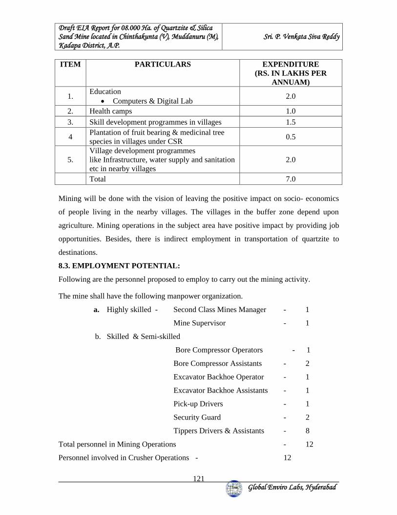
Draft EIA Report for 08.000 Ha. of Quartzite & Silica Sand Mine located in Chinthakunta (V), Muddanuru (M), Kadapa District, A.P.
Sri. P. Venkata Siva Reddy
Global Enviro Labs, Hyderabad
121
ITEM PARTICULARS EXPENDITURE (RS. IN LAKHS PER
ANNUAM)
1. Education
• Computers & Digital Lab 2.0
2. Health camps 1.0
3. Skill development programmes in villages 1.5
4 Plantation of fruit bearing & medicinal tree species in villages under CSR
0.5
5. Village development programmes like Infrastructure, water supply and sanitation etc in nearby villages
2.0
Total 7.0 Mining will be done with the vision of leaving the positive impact on socio- economics
of people living in the nearby villages. The villages in the buffer zone depend upon
agriculture. Mining operations in the subject area have positive impact by providing job
opportunities. Besides, there is indirect employment in transportation of quartzite to
destinations.
8.3. EMPLOYMENT POTENTIAL:
Following are the personnel proposed to employ to carry out the mining activity.
The mine shall have the following manpower organization.
a. Highly skilled - Second Class Mines Manager - 1
Mine Supervisor - 1
b. Skilled & Semi-skilled
Bore Compressor Operators - 1
Bore Compressor Assistants - 2
Excavator Backhoe Operator - 1
Excavator Backhoe Assistants - 1
Pick-up Drivers - 1
Security Guard - 2
Tippers Drivers & Assistants - 8
Total personnel in Mining Operations - 12
Personnel involved in Crusher Operations - 12
Draft EIA Report for 08.000 Ha. of Quartzite & Silica Sand Mine located in Chinthakunta (V), Muddanuru (M), Kadapa District, A.P.
Sri. P. Venkata Siva Reddy
Global Enviro Labs, Hyderabad
122
9: ENVIRONMENTAL MONITORING PROGRAMME
9.1 ENVIRONMENTAL MONITORING PROGRAMME All the environmental parameters viz. air, water, noise, soil will be monitored regularly in
order to detect any changes from the baseline status. Monitoring program will be
followed till the mining operations continue; every year as per the schedule given below:
9.2 AIR QUALITY MONITORING Four locations in core zone and four locations in the buffer zone will be monitored for
four weeks in every season except monsoon. The Respirable particulate matter shall be
analyzed every 6 months for quartzite concentration.
9.3 NOISE LEVELS MONITORING Noise levels in the working area will be monitored once in every season till the
continuation of operations. Ambient noise levels will also be monitored once in a season
in the buffer zone order to get the overall look of the noise status and its effects on the
surrounding community.
9.4 WATER QUALITY MONITORING Water quality will be monitored in every season. The concentration of heavy metals
especially manganese shall be checked for likely contamination. Seasonal streams near
the mine lease will be used to study the surface water quality. Ground water quality will
also be monitored in order to know the impacts of mining operations. This data will be
compared to baseline to evaluate the weightage of the adopted mitigation measures and if
further corrective measures are needed. Water levels will also be monitored on seasonal
basis in surrounding wells, to assess the impact on ground water regime quantitatively.
Draft EIA Report for 08.000 Ha. of Quartzite & Silica Sand Mine located in Chinthakunta (V), Muddanuru (M), Kadapa District, A.P.
Sri. P. Venkata Siva Reddy
Global Enviro Labs, Hyderabad
123
9.5 SOIL QUALITY ASSESSMENT Soil samples will be collected from the core and buffer core zone in the areas where
plantation has started and quality will be checked once every year except monsoon in
order to observe any deviations in the impacts of the operations and the corresponding
improvement in the fertility of the soil in core zone soil.
The monitoring system will also include: (i) Study for slope failures and excess erosions both along the pit and the waste
dumps.
(ii) Study the efficiency of dust collection units established in the screening &
crushing plant.
(iii) Periodic analysis of mine drainage and settling pond discharge water at regular
intervals to monitor suspended solid content in particular and other parameters in
general.
(iv) Study of bunds at the waste dumps area and to maintain the slit arresting
arrangement.
TABLE 9.1: SUMMARY – MONITORING SCHEDULE
S.
No. Monitoring
activity Location Frequency of monitoring
Major parameters to be monitored
1. Micrometeorology At Mine office Weekly once Temp., R.H., rainfall wind speed and directions.
2. Ambient air quality (AAQ)
At least 2 fixed locations in the ML area and 3 fixed locations at the foot hills/ nearby villages based on wind direction and one should be at down wind direction
Preferably monthly once for 24 hours period.
PM2.5, RPM, SO2
and NOx
3. Dust fall rate At one of the AAQ stations in ML area.
Quarterly Total dust fall rate MT/sq.km/month.
4. Work zone noise Noise prone areas of ML area
Bi-monthly once Leq. noi.
Draft EIA Report for 08.000 Ha. of Quartzite & Silica Sand Mine located in Chinthakunta (V), Muddanuru (M), Kadapa District, A.P.
Sri. P. Venkata Siva Reddy
Global Enviro Labs, Hyderabad
124
5. Drinking water From drinking water tap
Quarterly As per IS:10500 (91)
6. Inventory of flora Core zone Every year status, survival rate. 7. Soil quality Core zone Every year Soil fertility for
growth of plants
Environment for implementation of Environment Management Plan Environment
Management Cell will be formed under the control of the Project Manager. The
responsibilities of this cell will be:
1. Implementation of pollution control measures.
2. Monitoring programme implementation.
3. Post-plantation care.
4. To check the efficiency of pollution control measures taken.
5. Any other activity as may be related to environment
6. Seeking expert’s advice when needed.
9.6 CONCLUSION
The mine is proposed to produce maximum production of 3,75,000 TPA (average
production is 2,92,678 TPA) of Quartzite & Silica Sand. The mine shall be worked,
fulfilling all statutory obligations as prescribed by DMG, DGMS, MoEF and APPCB.
The proposals are submitted for Environmental clearance to SEIAA, A.P.
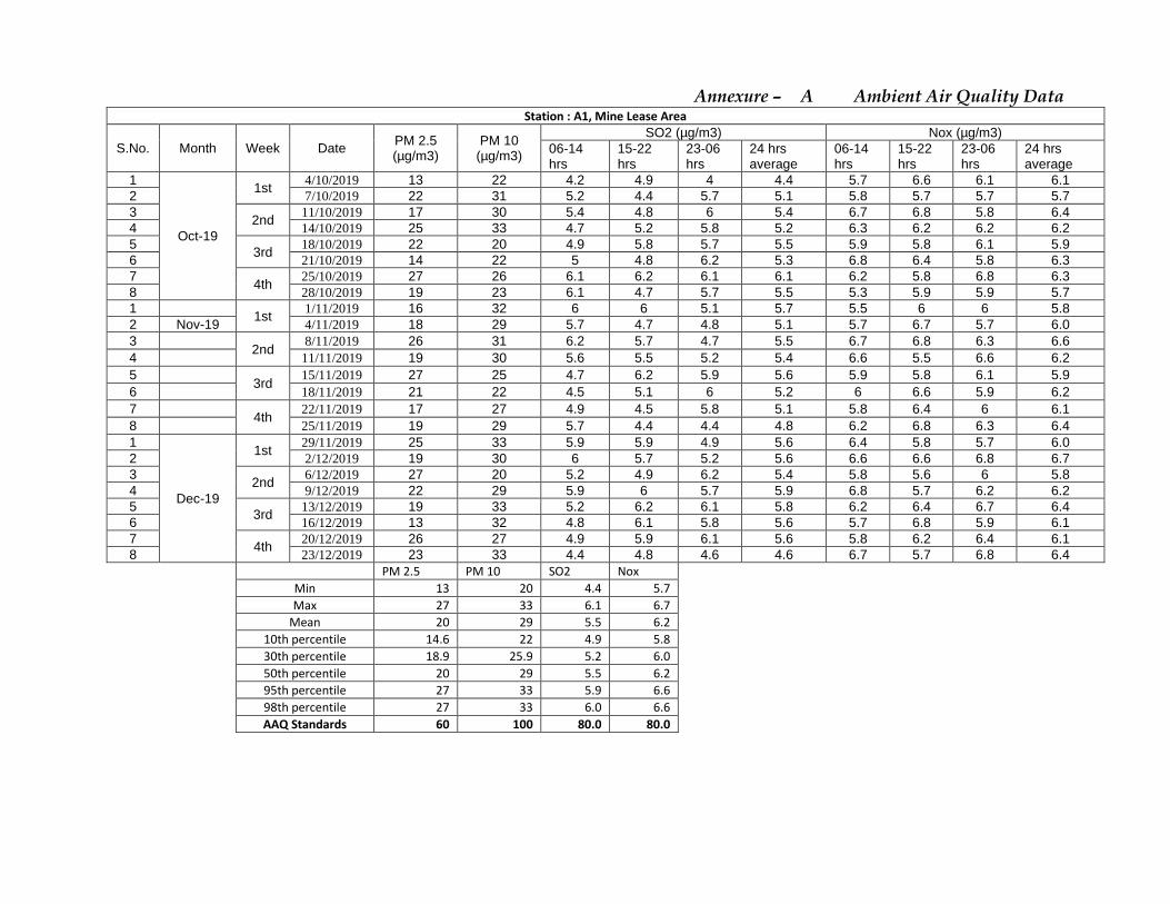
Annexure – A Ambient Air Quality Data Station : A1, Mine Lease Area
S.No. Month Week Date PM 2.5 (µg/m3)
PM 10 (µg/m3)
SO2 (µg/m3) Nox (µg/m3) 06-14 hrs
15-22 hrs
23-06 hrs
24 hrs average
06-14 hrs
15-22 hrs
23-06 hrs
24 hrs average
1
Oct-19
1st 4/10/2019 13 22 4.2 4.9 4 4.4 5.7 6.6 6.1 6.1
2 7/10/2019 22 31 5.2 4.4 5.7 5.1 5.8 5.7 5.7 5.7 3
2nd 11/10/2019 17 30 5.4 4.8 6 5.4 6.7 6.8 5.8 6.4
4 14/10/2019 25 33 4.7 5.2 5.8 5.2 6.3 6.2 6.2 6.2 5
3rd 18/10/2019 22 20 4.9 5.8 5.7 5.5 5.9 5.8 6.1 5.9
6 21/10/2019 14 22 5 4.8 6.2 5.3 6.8 6.4 5.8 6.3 7
4th 25/10/2019 27 26 6.1 6.2 6.1 6.1 6.2 5.8 6.8 6.3
8 28/10/2019 19 23 6.1 4.7 5.7 5.5 5.3 5.9 5.9 5.7 1
1st 1/11/2019 16 32 6 6 5.1 5.7 5.5 6 6 5.8
2 Nov-19 4/11/2019 18 29 5.7 4.7 4.8 5.1 5.7 6.7 5.7 6.0 3
2nd 8/11/2019 26 31 6.2 5.7 4.7 5.5 6.7 6.8 6.3 6.6
4 11/11/2019 19 30 5.6 5.5 5.2 5.4 6.6 5.5 6.6 6.2 5
3rd 15/11/2019 27 25 4.7 6.2 5.9 5.6 5.9 5.8 6.1 5.9
6 18/11/2019 21 22 4.5 5.1 6 5.2 6 6.6 5.9 6.2 7
4th 22/11/2019 17 27 4.9 4.5 5.8 5.1 5.8 6.4 6 6.1
8 25/11/2019 19 29 5.7 4.4 4.4 4.8 6.2 6.8 6.3 6.4 1
Dec-19
1st 29/11/2019 25 33 5.9 5.9 4.9 5.6 6.4 5.8 5.7 6.0
2 2/12/2019 19 30 6 5.7 5.2 5.6 6.6 6.6 6.8 6.7 3
2nd 6/12/2019 27 20 5.2 4.9 6.2 5.4 5.8 5.6 6 5.8
4 9/12/2019 22 29 5.9 6 5.7 5.9 6.8 5.7 6.2 6.2 5
3rd 13/12/2019 19 33 5.2 6.2 6.1 5.8 6.2 6.4 6.7 6.4
6 16/12/2019 13 32 4.8 6.1 5.8 5.6 5.7 6.8 5.9 6.1 7
4th 20/12/2019 26 27 4.9 5.9 6.1 5.6 5.8 6.2 6.4 6.1
8 23/12/2019 23 33 4.4 4.8 4.6 4.6 6.7 5.7 6.8 6.4
PM 2.5 PM 10 SO2 Nox Min 13 20 4.4 5.7 Max 27 33 6.1 6.7 Mean 20 29 5.5 6.2 10th percentile 14.6 22 4.9 5.8 30th percentile 18.9 25.9 5.2 6.0 50th percentile 20 29 5.5 6.2 95th percentile 27 33 5.9 6.6 98th percentile 27 33 6.0 6.6 AAQ Standards 60 100 80.0 80.0
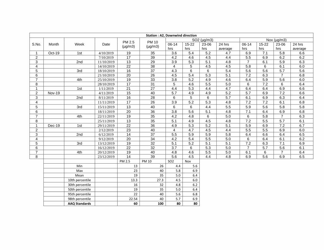
Station : A2, Downwind direction
S.No. Month Week Date PM 2.5 (µg/m3)
PM 10 (µg/m3)
SO2 (µg/m3) Nox (µg/m3) 06-14 hrs
15-22 hrs
23-06 hrs
24 hrs average
06-14 hrs
15-22 hrs
23-06 hrs
24 hrs average
1 Oct-19 1st 4/10/2019 19 35 3.6 5.4 5.2 4.7 6.9 7.1 5.8 6.6 2 7/10/2019 17 39 4.2 4.6 4.5 4.4 5.5 6.9 6.2 6.2 3 2nd 11/10/2019 13 29 3.9 5.3 5.1 4.8 7 6.1 5.9 6.3 4 14/10/2019 22 38 4 5 4.5 4.5 5.8 6 6.1 6.0 5 3rd 18/10/2019 16 37 4.3 6 6 5.4 5.6 5.6 5.7 5.6 6 21/10/2019 20 26 4.5 5.4 5.3 5.1 7.2 6.3 7 6.8 7 4th 25/10/2019 19 33 3.8 5.2 4.9 4.6 6.4 5.9 5.6 6.0 8 28/10/2019 17 31 5 4.6 5.5 5.0 6 7.2 6 6.4 1 1st 1/11/2019 21 27 4.4 5.3 4.4 4.7 6.4 6.4 6.9 6.6 2 Nov-19 4/11/2019 15 40 5.7 4.9 4.9 5.2 5.7 6.9 7.2 6.6 3 2nd 8/11/2019 16 28 6 5 6 5.7 6.1 6.9 6.3 6.4 4 11/11/2019 17 26 3.9 5.2 5.3 4.8 7.2 7.2 6.1 6.8 5 3rd 15/11/2019 13 40 6 6 4.4 5.5 5.9 5.6 5.8 5.8 6 18/11/2019 20 36 3.8 5.6 5.1 4.8 7.1 6.4 6.9 6.8 7 4th 22/11/2019 19 35 4.2 4.8 6 5.0 6 5.8 7 6.3 8 25/11/2019 13 35 5.1 4.9 4.5 4.8 7.2 5.5 5.7 6.1 1 Dec-19 1st 29/11/2019 22 36 4.9 5.3 5.2 5.1 5.9 6.9 7.2 6.7 2 2/12/2019 23 40 4 4.7 4.5 4.4 5.5 5.5 6.9 6.0 3 2nd 6/12/2019 14 37 5.5 5.9 5.9 5.8 6.4 6.6 6.4 6.5 4 9/12/2019 20 34 4.2 5.4 5.5 5.0 6 6.4 6.1 6.2 5 3rd 13/12/2019 19 32 5.1 5.2 5.1 5.1 7.2 6.3 7.1 6.9 6 16/12/2019 22 32 3.7 6 5.3 5.0 7 5.7 5.6 6.1 7 4th 20/12/2019 19 40 4.8 4.6 5.5 5.0 6.1 6 7 6.4 8 23/12/2019 14 39 5.6 4.5 4.4 4.8 6.9 5.6 6.9 6.5
PM 2.5 PM 10 SO2 Nox Min 13 26 4.4 5.6 Max 23 40 5.8 6.9 Mean 19 35 5.0 6.4 10th percentile 13.3 27.3 4.5 6.0 30th percentile 16 32 4.8 6.2 50th percentile 19 35 5.0 6.4 95th percentile 22 40 5.6 6.8 98th percentile 22.54 40 5.7 6.9 AAQ Standards 60 100 80 80

Station : A3,Kammavaripalle
S.No. Month Week Date PM 2.5 (µg/m3)
PM 10 (µg/m3)
SO2 (µg/m3) Nox (µg/m3) 06-14 hrs
15-22 hrs
23-06 hrs
24 hrs average
06-14 hrs
15-22 hrs
23-06 hrs
24 hrs average
1
Oct-19
1st 4/10/2019 27 47 6.5 5.8 6.5 6.3 7.3 8.8 7.2 7.8
2 7/10/2019 25 51 7 6.4 6.1 6.5 7 7.1 7 7.0 3
2nd 11/10/2019 36 55 7.2 6 6.7 6.6 8.5 7.8 8.7 8.3
4 14/10/2019 29 40 6 7.3 7.4 6.9 9 9 7.9 8.6 5
3rd 18/10/2019 30 42 7.5 6.3 5.7 6.5 7.1 7.4 7 7.2
6 21/10/2019 25 41 5.5 6.8 5.9 6.1 7.2 6.4 8.6 7.4 7
4th 25/10/2019 26 48 6.1 5.5 6.3 6.0 8.8 8.3 7.1 8.1
8 28/10/2019 33 46 6.3 5.7 7 6.3 7.5 8.7 8.4 8.2 1
1st 1/11/2019 24 44 5.6 7.4 6.8 6.6 7 7.2 7.6 7.3
2 Nov-19 4/11/2019 37 45 7.5 5.6 5.9 6.3 8.6 8.4 8.4 8.5 3
2nd 8/11/2019 24 49 6.9 7.2 7.2 7.1 7.2 7.2 7.4 7.3
4 11/11/2019 29 55 6.3 6.8 7 6.7 7.9 8.5 9 8.5 5
3rd 15/11/2019 30 46 5.7 6.4 5.7 5.9 7.1 8.3 8.9 8.1
6 18/11/2019 24 40 6.5 6.7 6 6.4 8.2 7.1 8.8 8.0 7
4th 22/11/2019 25 42 6 7.3 6.3 6.5 7.3 8.9 7.5 7.9
8 25/11/2019 38 48 5.7 5.7 5.9 5.8 7.5 8.5 7.1 7.7 1
Dec-19
1st 29/11/2019 27 55 7 7.2 6.5 6.9 9 7.6 8.4 8.3
2 2/12/2019 28 44 6.1 5.9 7.4 6.5 7.2 8.8 7.5 7.8 3
2nd 6/12/2019 38 48 5.7 7.3 7.3 6.8 8.8 7 7.9 7.9
4 9/12/2019 29 41 6.3 6.1 6.3 6.2 8.9 7.4 8.4 8.2 5
3rd 13/12/2019 30 50 5.5 5.5 5.9 5.6 7 7.8 7 7.3
6 16/12/2019 32 46 5.7 6 6.3 6.0 7.2 7.5 8.4 7.7 7
4th 20/12/2019 28 42 7.4 6.4 6 6.6 8.4 8.5 8.7 8.5
8 23/12/2019 33 47 6.5 5.8 5.7 6.0 7.1 8.7 7 7.6
PM 2.5 PM 10 SO2 Nox Min 24 40 5.6 7.0 Max 38 55 7.1 8.6 Mean 29 46 6.4 7.9 10th percentile 24.3 41 5.9 7.3 30th percentile 26.9 43.8 6.2 7.7 50th percentile 29 46 6.4 7.9 95th percentile 37.85 55 6.9 8.5 98th percentile 38 55 7.0 8.6 AAQ Standards 60 100 80 80
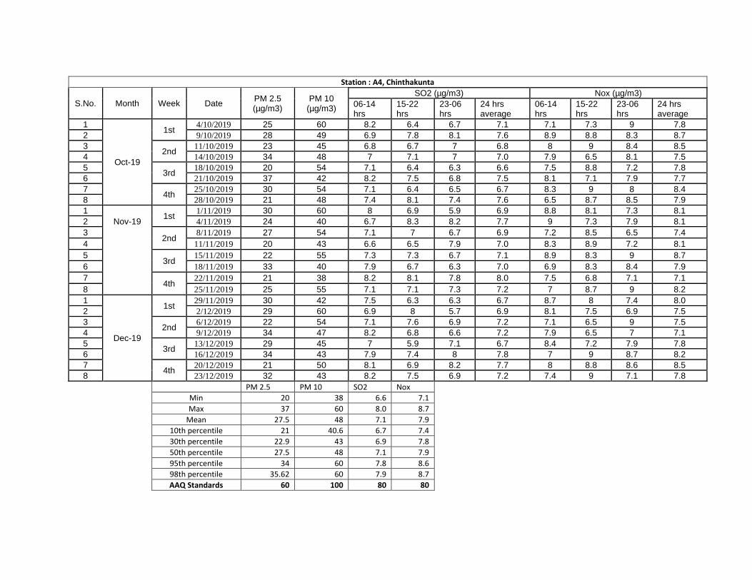
Station : A4, Chinthakunta
S.No. Month Week Date PM 2.5 (µg/m3)
PM 10 (µg/m3)
SO2 (µg/m3) Nox (µg/m3) 06-14 hrs
15-22 hrs
23-06 hrs
24 hrs average
06-14 hrs
15-22 hrs
23-06 hrs
24 hrs average
1
Oct-19
1st 4/10/2019 25 60 8.2 6.4 6.7 7.1 7.1 7.3 9 7.8
2 9/10/2019 28 49 6.9 7.8 8.1 7.6 8.9 8.8 8.3 8.7 3
2nd 11/10/2019 23 45 6.8 6.7 7 6.8 8 9 8.4 8.5
4 14/10/2019 34 48 7 7.1 7 7.0 7.9 6.5 8.1 7.5 5
3rd 18/10/2019 20 54 7.1 6.4 6.3 6.6 7.5 8.8 7.2 7.8
6 21/10/2019 37 42 8.2 7.5 6.8 7.5 8.1 7.1 7.9 7.7 7
4th 25/10/2019 30 54 7.1 6.4 6.5 6.7 8.3 9 8 8.4
8 28/10/2019 21 48 7.4 8.1 7.4 7.6 6.5 8.7 8.5 7.9 1
1st 1/11/2019 30 60 8 6.9 5.9 6.9 8.8 8.1 7.3 8.1
2 Nov-19 4/11/2019 24 40 6.7 8.3 8.2 7.7 9 7.3 7.9 8.1 3
2nd 8/11/2019 27 54 7.1 7 6.7 6.9 7.2 8.5 6.5 7.4
4 11/11/2019 20 43 6.6 6.5 7.9 7.0 8.3 8.9 7.2 8.1 5
3rd 15/11/2019 22 55 7.3 7.3 6.7 7.1 8.9 8.3 9 8.7
6 18/11/2019 33 40 7.9 6.7 6.3 7.0 6.9 8.3 8.4 7.9 7
4th 22/11/2019 21 38 8.2 8.1 7.8 8.0 7.5 6.8 7.1 7.1
8 25/11/2019 25 55 7.1 7.1 7.3 7.2 7 8.7 9 8.2 1
Dec-19
1st 29/11/2019 30 42 7.5 6.3 6.3 6.7 8.7 8 7.4 8.0
2 2/12/2019 29 60 6.9 8 5.7 6.9 8.1 7.5 6.9 7.5 3
2nd 6/12/2019 22 54 7.1 7.6 6.9 7.2 7.1 6.5 9 7.5
4 9/12/2019 34 47 8.2 6.8 6.6 7.2 7.9 6.5 7 7.1 5
3rd 13/12/2019 29 45 7 5.9 7.1 6.7 8.4 7.2 7.9 7.8
6 16/12/2019 34 43 7.9 7.4 8 7.8 7 9 8.7 8.2 7
4th 20/12/2019 21 50 8.1 6.9 8.2 7.7 8 8.8 8.6 8.5
8 23/12/2019 32 43 8.2 7.5 6.9 7.2 7.4 9 7.1 7.8
PM 2.5 PM 10 SO2 Nox Min 20 38 6.6 7.1 Max 37 60 8.0 8.7 Mean 27.5 48 7.1 7.9 10th percentile 21 40.6 6.7 7.4 30th percentile 22.9 43 6.9 7.8 50th percentile 27.5 48 7.1 7.9 95th percentile 34 60 7.8 8.6 98th percentile 35.62 60 7.9 8.7 AAQ Standards 60 100 80 80
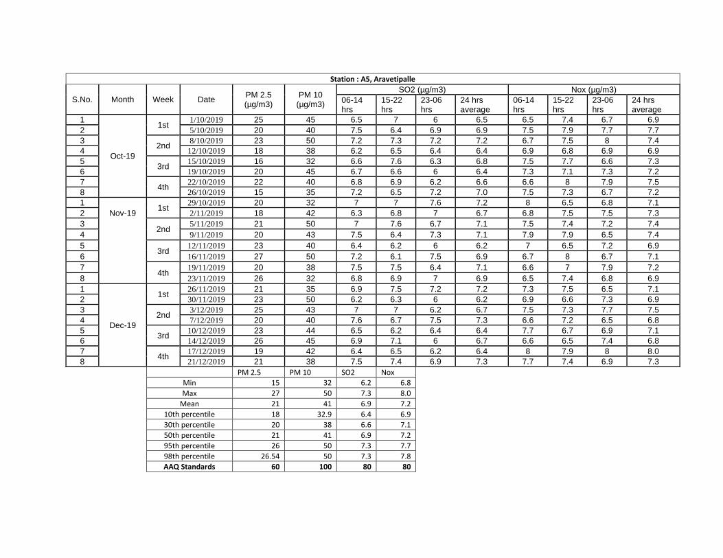
Station : A5, Aravetipalle
S.No. Month Week Date PM 2.5 (µg/m3)
PM 10 (µg/m3)
SO2 (µg/m3) Nox (µg/m3) 06-14 hrs
15-22 hrs
23-06 hrs
24 hrs average
06-14 hrs
15-22 hrs
23-06 hrs
24 hrs average
1
Oct-19
1st 1/10/2019 25 45 6.5 7 6 6.5 6.5 7.4 6.7 6.9
2 5/10/2019 20 40 7.5 6.4 6.9 6.9 7.5 7.9 7.7 7.7 3
2nd 8/10/2019 23 50 7.2 7.3 7.2 7.2 6.7 7.5 8 7.4
4 12/10/2019 18 38 6.2 6.5 6.4 6.4 6.9 6.8 6.9 6.9 5
3rd 15/10/2019 16 32 6.6 7.6 6.3 6.8 7.5 7.7 6.6 7.3
6 19/10/2019 20 45 6.7 6.6 6 6.4 7.3 7.1 7.3 7.2 7
4th 22/10/2019 22 40 6.8 6.9 6.2 6.6 6.6 8 7.9 7.5
8 26/10/2019 15 35 7.2 6.5 7.2 7.0 7.5 7.3 6.7 7.2 1
1st 29/10/2019 20 32 7 7 7.6 7.2 8 6.5 6.8 7.1
2 Nov-19 2/11/2019 18 42 6.3 6.8 7 6.7 6.8 7.5 7.5 7.3 3
2nd 5/11/2019 21 50 7 7.6 6.7 7.1 7.5 7.4 7.2 7.4
4 9/11/2019 20 43 7.5 6.4 7.3 7.1 7.9 7.9 6.5 7.4 5
3rd 12/11/2019 23 40 6.4 6.2 6 6.2 7 6.5 7.2 6.9
6 16/11/2019 27 50 7.2 6.1 7.5 6.9 6.7 8 6.7 7.1 7
4th 19/11/2019 20 38 7.5 7.5 6.4 7.1 6.6 7 7.9 7.2
8 23/11/2019 26 32 6.8 6.9 7 6.9 6.5 7.4 6.8 6.9 1
Dec-19
1st 26/11/2019 21 35 6.9 7.5 7.2 7.2 7.3 7.5 6.5 7.1
2 30/11/2019 23 50 6.2 6.3 6 6.2 6.9 6.6 7.3 6.9 3
2nd 3/12/2019 25 43 7 7 6.2 6.7 7.5 7.3 7.7 7.5
4 7/12/2019 20 40 7.6 6.7 7.5 7.3 6.6 7.2 6.5 6.8 5
3rd 10/12/2019 23 44 6.5 6.2 6.4 6.4 7.7 6.7 6.9 7.1
6 14/12/2019 26 45 6.9 7.1 6 6.7 6.6 6.5 7.4 6.8 7
4th 17/12/2019 19 42 6.4 6.5 6.2 6.4 8 7.9 8 8.0
8 21/12/2019 21 38 7.5 7.4 6.9 7.3 7.7 7.4 6.9 7.3
PM 2.5 PM 10 SO2 Nox Min 15 32 6.2 6.8 Max 27 50 7.3 8.0 Mean 21 41 6.9 7.2 10th percentile 18 32.9 6.4 6.9 30th percentile 20 38 6.6 7.1 50th percentile 21 41 6.9 7.2 95th percentile 26 50 7.3 7.7 98th percentile 26.54 50 7.3 7.8 AAQ Standards 60 100 80 80
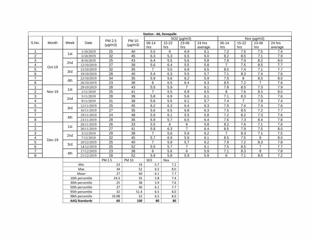
Station : A6, Denepalle
S.No. Month Week Date PM 2.5 (µg/m3)
PM 10 (µg/m3)
SO2 (µg/m3) Nox (µg/m3) 06-14 hrs
15-22 hrs
23-06 hrs
24 hrs average
06-14 hrs
15-22 hrs
23-06 hrs
24 hrs average
1
Oct-19
1st 1/10/2019 25 40 5.5 6 6.9 6.1 7.2 7.5 7.5 7.4
2 5/10/2019 32 45 6.3 5.3 6.5 6.0 8.2 8.5 7.1 7.9 3
2nd 8/10/2019 25 43 6.4 5.5 5.6 5.8 7.8 7.9 8.2 8.0
4 12/10/2019 27 39 5.6 6.4 5.5 5.8 7 7.5 8.5 7.7 5
3rd 15/10/2019 32 35 7 5.5 6.9 6.5 8.5 7.4 7.1 7.7
6 19/10/2019 28 40 5.4 6.3 5.5 5.7 7.1 8.3 7.4 7.6 7
4th 22/10/2019 34 35 5.9 5.6 6.2 5.9 7.5 8 8.5 8.0
8 26/10/2019 23 38 6 6.5 6.4 6.3 8.5 7.2 7 7.6 1
1st 29/10/2019 28 43 5.5 5.9 7 6.1 7.8 8.5 7.3 7.9
2 Nov-19 2/11/2019 25 41 7 5.5 6.9 6.5 8 7.6 8.3 8.0 3
2nd 5/11/2019 28 39 5.8 6.9 5.6 6.1 7.1 8.3 7.5 7.6
4 9/11/2019 31 38 5.6 5.5 6.1 5.7 7.4 7 7.9 7.4 5
3rd 12/11/2019 25 45 6.2 6.3 6.4 6.3 7.9 7.4 7.4 7.6
6 16/11/2019 27 35 5.6 6.5 6.8 6.3 7.5 8.5 7.2 7.7 7
4th 19/11/2019 24 48 5.9 6.1 5.5 5.8 7.2 8.2 7.3 7.6
8 23/11/2019 28 36 6.9 5.7 6.5 6.4 7.6 7.3 8.4 7.8 1
Dec-19
1st 26/11/2019 26 33 5.5 6 6 5.8 8.2 7.6 7.1 7.6
2 30/11/2019 27 41 5.8 6.3 7 6.4 8.5 7.9 7.5 8.0 3
2nd 3/12/2019 29 38 7 5.6 5.9 6.2 7 8.3 7.1 7.5
4 7/12/2019 32 45 5.7 6.9 5.6 6.1 8.5 7.5 8 8.0 5
3rd 10/12/2019 25 40 7 5.9 5.7 6.2 7.9 7.2 8.3 7.8
6 14/12/2019 25 52 5.5 5.7 7 6.1 7.5 8.5 7 7.7 7
4th 17/12/2019 23 38 6 5.6 6 5.9 7.1 8.3 8 7.8
8 21/12/2019 28 52 5.9 5.8 5.9 5.9 6 7.1 8.5 7.2
PM 2.5 PM 10 SO2 Nox Min 23 33 5.7 7.2 Max 34 52 6.5 8.0 Mean 27 40 6.1 7.7 10th percentile 24.3 35 5.8 7.4 30th percentile 25 38 5.9 7.6 50th percentile 27 40 6.1 7.7 95th percentile 32 51.4 6.5 8.0 98th percentile 33.08 52 6.5 8.0 AAQ Standards 60 100 80 80
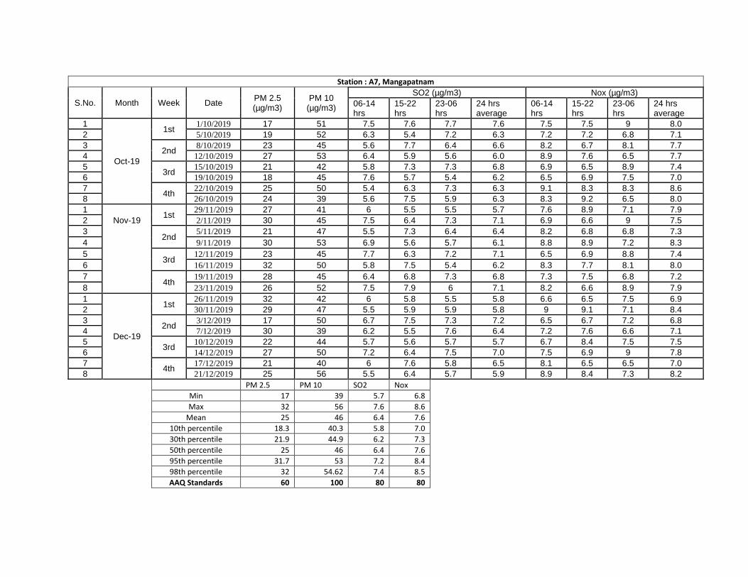
Station : A7, Mangapatnam
S.No. Month Week Date PM 2.5 (µg/m3)
PM 10 (µg/m3)
SO2 (µg/m3) Nox (µg/m3) 06-14 hrs
15-22 hrs
23-06 hrs
24 hrs average
06-14 hrs
15-22 hrs
23-06 hrs
24 hrs average
1
Oct-19
1st 1/10/2019 17 51 7.5 7.6 7.7 7.6 7.5 7.5 9 8.0
2 5/10/2019 19 52 6.3 5.4 7.2 6.3 7.2 7.2 6.8 7.1 3
2nd 8/10/2019 23 45 5.6 7.7 6.4 6.6 8.2 6.7 8.1 7.7
4 12/10/2019 27 53 6.4 5.9 5.6 6.0 8.9 7.6 6.5 7.7 5
3rd 15/10/2019 21 42 5.8 7.3 7.3 6.8 6.9 6.5 8.9 7.4
6 19/10/2019 18 45 7.6 5.7 5.4 6.2 6.5 6.9 7.5 7.0 7
4th 22/10/2019 25 50 5.4 6.3 7.3 6.3 9.1 8.3 8.3 8.6
8 26/10/2019 24 39 5.6 7.5 5.9 6.3 8.3 9.2 6.5 8.0 1
1st 29/11/2019 27 41 6 5.5 5.5 5.7 7.6 8.9 7.1 7.9
2 Nov-19 2/11/2019 30 45 7.5 6.4 7.3 7.1 6.9 6.6 9 7.5 3
2nd 5/11/2019 21 47 5.5 7.3 6.4 6.4 8.2 6.8 6.8 7.3
4 9/11/2019 30 53 6.9 5.6 5.7 6.1 8.8 8.9 7.2 8.3 5
3rd 12/11/2019 23 45 7.7 6.3 7.2 7.1 6.5 6.9 8.8 7.4
6 16/11/2019 32 50 5.8 7.5 5.4 6.2 8.3 7.7 8.1 8.0 7
4th 19/11/2019 28 45 6.4 6.8 7.3 6.8 7.3 7.5 6.8 7.2
8 23/11/2019 26 52 7.5 7.9 6 7.1 8.2 6.6 8.9 7.9 1
Dec-19
1st 26/11/2019 32 42 6 5.8 5.5 5.8 6.6 6.5 7.5 6.9
2 30/11/2019 29 47 5.5 5.9 5.9 5.8 9 9.1 7.1 8.4 3
2nd 3/12/2019 17 50 6.7 7.5 7.3 7.2 6.5 6.7 7.2 6.8
4 7/12/2019 30 39 6.2 5.5 7.6 6.4 7.2 7.6 6.6 7.1 5
3rd 10/12/2019 22 44 5.7 5.6 5.7 5.7 6.7 8.4 7.5 7.5
6 14/12/2019 27 50 7.2 6.4 7.5 7.0 7.5 6.9 9 7.8 7
4th 17/12/2019 21 40 6 7.6 5.8 6.5 8.1 6.5 6.5 7.0
8 21/12/2019 25 56 5.5 6.4 5.7 5.9 8.9 8.4 7.3 8.2
PM 2.5 PM 10 SO2 Nox Min 17 39 5.7 6.8 Max 32 56 7.6 8.6 Mean 25 46 6.4 7.6 10th percentile 18.3 40.3 5.8 7.0 30th percentile 21.9 44.9 6.2 7.3 50th percentile 25 46 6.4 7.6 95th percentile 31.7 53 7.2 8.4 98th percentile 32 54.62 7.4 8.5 AAQ Standards 60 100 80 80

Station : A8, Shettivaripalle
S.No. Month Week Date PM 2.5 (µg/m3)
PM 10 (µg/m3)
SO2 (µg/m3) Nox (µg/m3) 06-14 hrs
15-22 hrs
23-06 hrs
24 hrs average
06-14 hrs
15-22 hrs
23-06 hrs
24 hrs average
1
Oct-19
1st 1/10/2019 16 33 5.4 5.4 6.3 5.7 7.3 7.1 6.1 6.8
2 5/10/2019 27 40 5.1 4.8 6.5 5.5 7.9 8.4 6.3 7.5 3
2nd 8/10/2019 22 36 6.2 5.9 5.4 5.8 8.4 7.2 6.2 7.3
4 12/10/2019 15 39 5.4 5.7 5 5.4 6.1 6.1 8.4 6.9 5
3rd 15/10/2019 19 29 5.9 5 6.2 5.7 8.2 8.3 7.9 8.1
6 19/10/2019 30 25 6.3 6.1 5.1 5.8 6.5 7.3 7.3 7.0 7
4th 22/10/2019 25 38 6 5 5.5 5.5 7.9 6.5 6.5 7.0
8 26/10/2019 20 32 5 5.9 6.4 5.8 6.3 7.5 8.2 7.3 1
1st 29/10/2019 19 47 6.1 5.4 6.3 5.9 8.3 7.3 8.5 8.0
2 Nov-19 2/11/2019 27 29 6.2 6.3 5.7 6.1 6.5 7.8 6.9 7.1 3
2nd 5/11/2019 15 48 5.9 5 5.1 5.3 6 7.5 8.4 7.3
4 9/11/2019 31 34 5.5 5.4 5.9 5.6 8.4 8.3 6 7.6 5
3rd 12/11/2019 17 36 5.9 5.9 5.3 5.7 6.2 6.2 7.4 6.6
6 16/11/2019 27 40 6.3 5.7 6.3 6.1 8.5 6.5 7.2 7.4 7
4th 19/11/2019 20 38 5.7 6.1 6 5.9 8.2 8.2 6.1 7.5
8 23/11/2019 31 47 5 6.3 5.5 5.6 6.5 8.1 8.1 7.6 1
Dec-19
1st 26/11/2019 16 32 5.9 5.5 6.3 5.9 7.5 7.5 6.1 7.0
2 30/11/2019 27 39 5.3 6 5.7 5.7 8.4 7.4 7.1 7.6 3
2nd 3/12/2019 30 40 5.9 5.7 6.1 5.9 7.9 6.1 6 6.7
4 7/12/2019 22 38 5 5.5 5 5.2 7.3 6.5 6.5 6.8 5
3rd 10/12/2019 31 29 5.4 6.2 5.4 5.7 6 8.4 7.9 7.4
6 14/12/2019 21 32 5.1 5 6.2 5.4 7.2 7.1 7.3 7.2 7
4th 17/12/2019 32 39 5.4 6.3 5.1 5.6 8.5 7.8 6 7.4
8 21/12/2019 25 45 6.1 5 6.1 5.7 6.2 6.1 8.4 6.9
PM 2.5 PM 10 SO2 Nox Min 15 25 5.2 6.6 Max 32 48 6.1 8.1 Mean 23.5 38 5.7 7.3 10th percentile 16 29 5.4 6.8 30th percentile 19.9 32.9 5.6 7.0 50th percentile 23.5 38 5.7 7.3 95th percentile 31 47 6.0 8.0 98th percentile 31.54 47.54 6.1 8.1 AAQ Standards 60 100 80 80
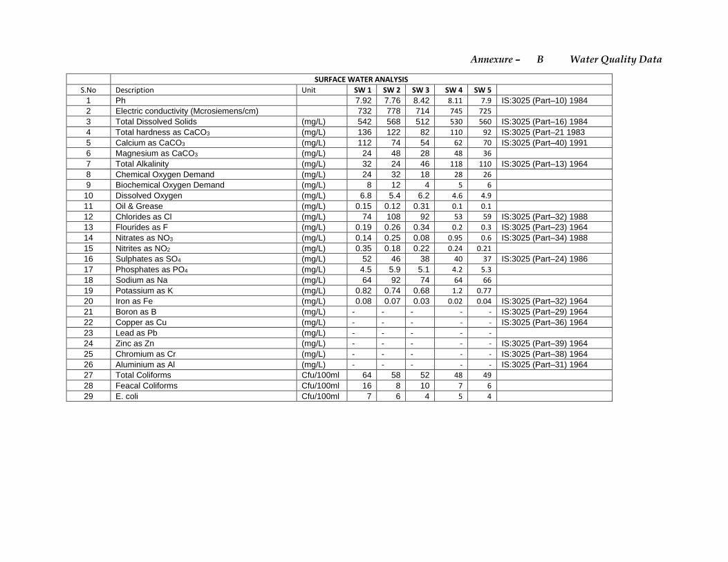
Annexure – B Water Quality Data
SURFACE WATER ANALYSIS
S.No Description Unit SW 1 SW 2 SW 3 SW 4 SW 5
1 Ph 7.92 7.76 8.42 8.11 7.9 IS:3025 (Part–10) 1984 2 Electric conductivity (Mcrosiemens/cm) 732 778 714 745 725 3 Total Dissolved Solids (mg/L) 542 568 512 530 560 IS:3025 (Part–16) 1984 4 Total hardness as CaCO3 (mg/L) 136 122 82 110 92 IS:3025 (Part–21 1983 5 Calcium as CaCO3 (mg/L) 112 74 54 62 70 IS:3025 (Part–40) 1991 6 Magnesium as CaCO3 (mg/L) 24 48 28 48 36 7 Total Alkalinity (mg/L) 32 24 46 118 110 IS:3025 (Part–13) 1964 8 Chemical Oxygen Demand (mg/L) 24 32 18 28 26 9 Biochemical Oxygen Demand (mg/L) 8 12 4 5 6
10 Dissolved Oxygen (mg/L) 6.8 5.4 6.2 4.6 4.9 11 Oil & Grease (mg/L) 0.15 0.12 0.31 0.1 0.1 12 Chlorides as Cl (mg/L) 74 108 92 53 59 IS:3025 (Part–32) 1988 13 Flourides as F (mg/L) 0.19 0.26 0.34 0.2 0.3 IS:3025 (Part–23) 1964 14 Nitrates as NO3 (mg/L) 0.14 0.25 0.08 0.95 0.6 IS:3025 (Part–34) 1988 15 Nitrites as NO2 (mg/L) 0.35 0.18 0.22 0.24 0.21 16 Sulphates as SO4 (mg/L) 52 46 38 40 37 IS:3025 (Part–24) 1986 17 Phosphates as PO4 (mg/L) 4.5 5.9 5.1 4.2 5.3 18 Sodium as Na (mg/L) 64 92 74 64 66 19 Potassium as K (mg/L) 0.82 0.74 0.68 1.2 0.77 20 Iron as Fe (mg/L) 0.08 0.07 0.03 0.02 0.04 IS:3025 (Part–32) 1964 21 Boron as B (mg/L) - - - - - IS:3025 (Part–29) 1964 22 Copper as Cu (mg/L) - - - - - IS:3025 (Part–36) 1964 23 Lead as Pb (mg/L) - - - - - 24 Zinc as Zn (mg/L) - - - - - IS:3025 (Part–39) 1964 25 Chromium as Cr (mg/L) - - - - - IS:3025 (Part–38) 1964 26 Aluminium as Al (mg/L) - - - - - IS:3025 (Part–31) 1964 27 Total Coliforms Cfu/100ml 64 58 52 48 49 28 Feacal Coliforms Cfu/100ml 16 8 10 7 6 29 E. coli Cfu/100ml 7 6 4 5 4
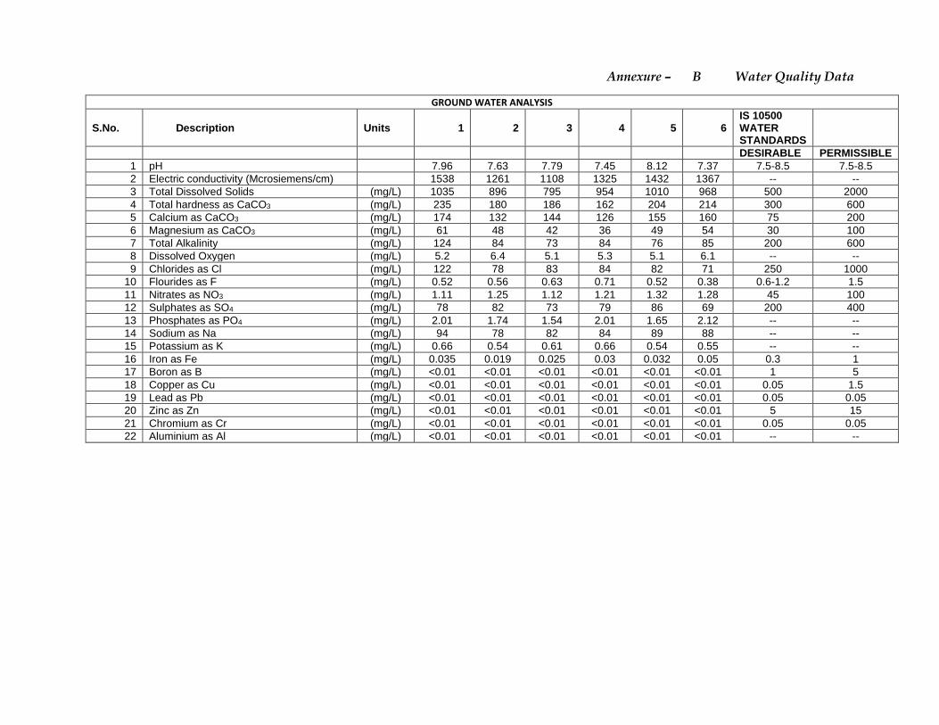
Annexure – B Water Quality Data
GROUND WATER ANALYSIS
S.No. Description Units 1 2 3 4 5 6 IS 10500 WATER STANDARDS
DESIRABLE PERMISSIBLE 1 pH 7.96 7.63 7.79 7.45 8.12 7.37 7.5-8.5 7.5-8.5 2 Electric conductivity (Mcrosiemens/cm) 1538 1261 1108 1325 1432 1367 -- -- 3 Total Dissolved Solids (mg/L) 1035 896 795 954 1010 968 500 2000 4 Total hardness as CaCO3 (mg/L) 235 180 186 162 204 214 300 600 5 Calcium as CaCO3 (mg/L) 174 132 144 126 155 160 75 200 6 Magnesium as CaCO3 (mg/L) 61 48 42 36 49 54 30 100 7 Total Alkalinity (mg/L) 124 84 73 84 76 85 200 600 8 Dissolved Oxygen (mg/L) 5.2 6.4 5.1 5.3 5.1 6.1 -- -- 9 Chlorides as Cl (mg/L) 122 78 83 84 82 71 250 1000
10 Flourides as F (mg/L) 0.52 0.56 0.63 0.71 0.52 0.38 0.6-1.2 1.5 11 Nitrates as NO3 (mg/L) 1.11 1.25 1.12 1.21 1.32 1.28 45 100 12 Sulphates as SO4 (mg/L) 78 82 73 79 86 69 200 400 13 Phosphates as PO4 (mg/L) 2.01 1.74 1.54 2.01 1.65 2.12 -- -- 14 Sodium as Na (mg/L) 94 78 82 84 89 88 -- -- 15 Potassium as K (mg/L) 0.66 0.54 0.61 0.66 0.54 0.55 -- -- 16 Iron as Fe (mg/L) 0.035 0.019 0.025 0.03 0.032 0.05 0.3 1 17 Boron as B (mg/L) <0.01 <0.01 <0.01 <0.01 <0.01 <0.01 1 5 18 Copper as Cu (mg/L) <0.01 <0.01 <0.01 <0.01 <0.01 <0.01 0.05 1.5 19 Lead as Pb (mg/L) <0.01 <0.01 <0.01 <0.01 <0.01 <0.01 0.05 0.05 20 Zinc as Zn (mg/L) <0.01 <0.01 <0.01 <0.01 <0.01 <0.01 5 15 21 Chromium as Cr (mg/L) <0.01 <0.01 <0.01 <0.01 <0.01 <0.01 0.05 0.05 22 Aluminium as Al (mg/L) <0.01 <0.01 <0.01 <0.01 <0.01 <0.01 -- --
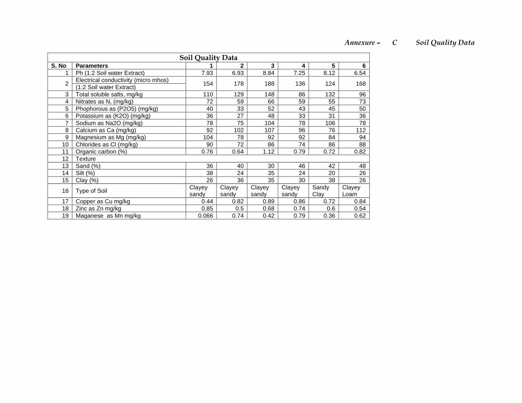
Annexure – C Soil Quality Data
Soil Quality Data
S. No Parameters 1 2 3 4 5 6 1 Ph (1:2 Soil water Extract) 7.93 6.93 8.84 7.25 8.12 6.54
2 Electrical conductivity (micro mhos)
154 178 188 136 124 168 (1:2 Soil water Extract)
3 Total soluble salts, mg/kg 110 129 148 86 132 96 4 Nitrates as N, (mg/kg) 72 59 66 59 55 73 5 Phophorous as (P2O5) (mg/kg) 40 33 52 43 45 50 6 Potassium as (K2O) (mg/kg) 36 27 48 33 31 36 7 Sodium as Na2O (mg/kg) 78 75 104 78 106 78 8 Calcium as Ca (mg/kg) 92 102 107 96 76 112 9 Magnesium as Mg (mg/kg) 104 78 92 92 84 94
10 Chlorides as Cl (mg/kg) 90 72 86 74 86 88 11 Organic carbon (%) 0.76 0.64 1.12 0.79 0.72 0.82 12 Texture 13 Sand (%) 36 40 30 46 42 48 14 Silt (%) 38 24 35 24 20 26 15 Clay (%) 26 36 35 30 38 26
16 Type of Soil Clayey sandy
Clayey sandy
Clayey sandy
Clayey sandy
Sandy Clay
Clayey Loam
17 Copper as Cu mg/kg 0.44 0.82 0.89 0.86 0.72 0.84 18 Zinc as Zn mg/kg 0.85 0.5 0.68 0.74 0.6 0.54 19 Maganese as Mn mg/kg 0.066 0.74 0.42 0.79 0.36 0.62
Annexure – D Detailed Flora & Fauna Report
1
Ecology and Biodiversity of P.Venkatasiva Reddy Quartzite and Silica
Sand Mine (08.00 Ha)
T.o.R Lr.No. SEIAA/AP/KDP/MIN/03/2019/851-283 dt.14-5-2019
1(a):STANDARD TERMS OF REFERENCE FOR CONDUCTING ENVIRONMENT
IMPACT ASSESSMENT STUDY FOR NON-COAL MINING PROJECTS AND
INFORMATION TO BE INCLUDED IN EIA/EMP REPORT
Brief Introduction to the mine lease area:
It is a new Quartzite and Silica sand mine of 37,500 TPA located on the slopes
of a hill in survey No.677 of Chintakunta Village, Muddanuru Mandal, Kadapa District , Andhra Pradesh. The total mine lease area (MLA) is 8 Ha. It is a non-
forest wasteland covered with thorny bushes. It extends from the base to the slopes of a hill. It is densely covered with thorny bushes at the bottom of the hill while the slopes are sparsely covered thorny shrubs, grasses, rocks and huge
boulders. Since it is a non-forest wasteland coved by thorny bushes and non-palatable perennial grasses it is unsuitable for cultivation. There are no trees but
many thorny bushes were found. There are no plantations or croplands or water bodies or human settlements in the mine lease area. There are a total of six
similar mines within a radius of 500 m.
There are dry deciduous scrub forests or firewood forests in the buffer zone but
no ecologically sensitive areas such as Biosphere Reserves, National Parks or Wildlife Sanctuaries or Important Bird Areas (IBAs) other protected areas within a distance of 10 Km from the MLA. There are no wetlands or reservoirs or rivers
either in the core area or its buffer zone. Only small seasonal streams and dry village tanks were present. Similarly, there are no reports or indications of
presence of any rare or endangered or threatened (RET) species of flora or fauna
either in the core area or its buffer zone.
Wherever ground water was available, Battayi (Batavia sp), Curry leaf (Murraya koenigii), Muskmelon (Cumis melo), Watermelon (Citrullus lanatus), Honeydew
melon (Cumis melo variety) and vegetables were grown. Jowar, Sorghum, Maize, Sunflower, Cotton, Chillies, Tomato, Groundnut, Red gram, Green gram, Black gram, Horse gram, Chickpea, Onion as well Chrysanthimum, Tagetus were grown.
There are also small plantations of Eucalyptus, Teak and orchards of Batavia, Mango, Sapota, Gauva, Pomegranate, Papaya and Lime. Croplands are small,
scattered and isolated. There is no assured irrigation. Cultivation is dependent on rains and groundwater. There are scattered hillocks sparsely covered with succulents and thorny bushes of Ziziphus horrida. But the most conspicuous
feature of these dry hillocks is the presence of hill neem (Chukrasia tabularis) as
isolated trees especially on hill tops
The mine lease area is not eco-sensitive and there are no National Parks,
Sanctuaries, Biosphere Reserves, Wildlife Corridors, Ramsar site Tiger/ Elephant
Reserves/(existing as well as proposed), within 10 Km of the mine lease. A
survey of flora and fauna of the mine lease area (core area) and the buffer zone
of 10Km radius was undertaken by the NABET Accredited FAE in E&B (Category
A) during December 2019.
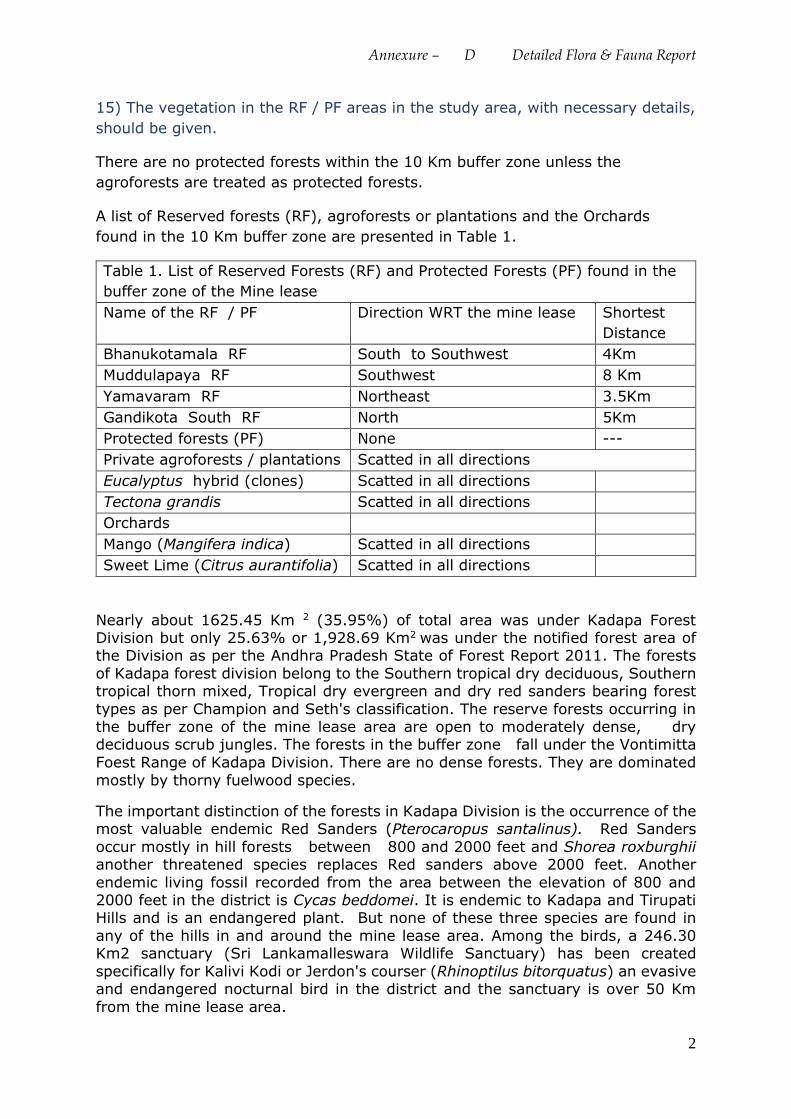
Annexure – D Detailed Flora & Fauna Report
2
15) The vegetation in the RF / PF areas in the study area, with necessary details,
should be given.
There are no protected forests within the 10 Km buffer zone unless the
agroforests are treated as protected forests.
A list of Reserved forests (RF), agroforests or plantations and the Orchards
found in the 10 Km buffer zone are presented in Table 1.
Table 1. List of Reserved Forests (RF) and Protected Forests (PF) found in the
buffer zone of the Mine lease
Name of the RF / PF Direction WRT the mine lease Shortest
Distance
Bhanukotamala RF South to Southwest 4Km
Muddulapaya RF Southwest 8 Km
Yamavaram RF Northeast 3.5Km
Gandikota South RF North 5Km
Protected forests (PF) None ---
Private agroforests / plantations Scatted in all directions
Eucalyptus hybrid (clones) Scatted in all directions
Tectona grandis Scatted in all directions
Orchards
Mango (Mangifera indica) Scatted in all directions
Sweet Lime (Citrus aurantifolia) Scatted in all directions
Nearly about 1625.45 Km 2 (35.95%) of total area was under Kadapa Forest Division but only 25.63% or 1,928.69 Km2 was under the notified forest area of the Division as per the Andhra Pradesh State of Forest Report 2011. The forests
of Kadapa forest division belong to the Southern tropical dry deciduous, Southern tropical thorn mixed, Tropical dry evergreen and dry red sanders bearing forest
types as per Champion and Seth's classification. The reserve forests occurring in the buffer zone of the mine lease area are open to moderately dense, dry deciduous scrub jungles. The forests in the buffer zone fall under the Vontimitta
Foest Range of Kadapa Division. There are no dense forests. They are dominated
mostly by thorny fuelwood species.
The important distinction of the forests in Kadapa Division is the occurrence of the most valuable endemic Red Sanders (Pterocaropus santalinus). Red Sanders
occur mostly in hill forests between 800 and 2000 feet and Shorea roxburghii another threatened species replaces Red sanders above 2000 feet. Another
endemic living fossil recorded from the area between the elevation of 800 and 2000 feet in the district is Cycas beddomei. It is endemic to Kadapa and Tirupati Hills and is an endangered plant. But none of these three species are found in
any of the hills in and around the mine lease area. Among the birds, a 246.30 Km2 sanctuary (Sri Lankamalleswara Wildlife Sanctuary) has been created
specifically for Kalivi Kodi or Jerdon's courser (Rhinoptilus bitorquatus) an evasive and endangered nocturnal bird in the district and the sanctuary is over 50 Km
from the mine lease area.
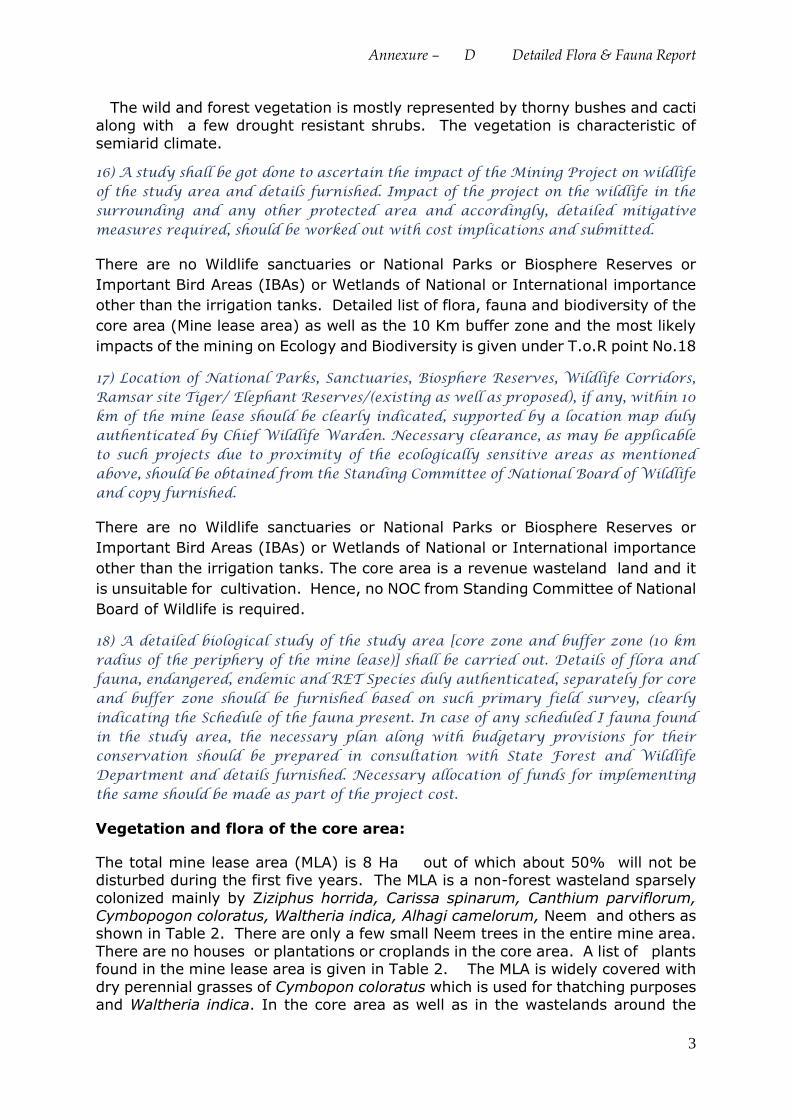
Annexure – D Detailed Flora & Fauna Report
3
The wild and forest vegetation is mostly represented by thorny bushes and cacti
along with a few drought resistant shrubs. The vegetation is characteristic of
semiarid climate.
16) A study shall be got done to ascertain the impact of the Mining Project on wildlife of the study area and details furnished. Impact of the project on the wildlife in the surrounding and any other protected area and accordingly, detailed mitigative measures required, should be worked out with cost implications and submitted.
There are no Wildlife sanctuaries or National Parks or Biosphere Reserves or
Important Bird Areas (IBAs) or Wetlands of National or International importance
other than the irrigation tanks. Detailed list of flora, fauna and biodiversity of the
core area (Mine lease area) as well as the 10 Km buffer zone and the most likely
impacts of the mining on Ecology and Biodiversity is given under T.o.R point No.18
17) Location of National Parks, Sanctuaries, Biosphere Reserves, Wildlife Corridors, Ramsar site Tiger/ Elephant Reserves/(existing as well as proposed), if any, within 10 km of the mine lease should be clearly indicated, supported by a location map duly authenticated by Chief Wildlife Warden. Necessary clearance, as may be applicable to such projects due to proximity of the ecologically sensitive areas as mentioned above, should be obtained from the Standing Committee of National Board of Wildlife and copy furnished.
There are no Wildlife sanctuaries or National Parks or Biosphere Reserves or
Important Bird Areas (IBAs) or Wetlands of National or International importance
other than the irrigation tanks. The core area is a revenue wasteland land and it
is unsuitable for cultivation. Hence, no NOC from Standing Committee of National
Board of Wildlife is required.
18) A detailed biological study of the study area [core zone and buffer zone (10 km radius of the periphery of the mine lease)] shall be carried out. Details of flora and fauna, endangered, endemic and RET Species duly authenticated, separately for core and buffer zone should be furnished based on such primary field survey, clearly indicating the Schedule of the fauna present. In case of any scheduled I fauna found in the study area, the necessary plan along with budgetary provisions for their conservation should be prepared in consultation with State Forest and Wildlife Department and details furnished. Necessary allocation of funds for implementing the same should be made as part of the project cost.
Vegetation and flora of the core area:
The total mine lease area (MLA) is 8 Ha out of which about 50% will not be disturbed during the first five years. The MLA is a non-forest wasteland sparsely
colonized mainly by Ziziphus horrida, Carissa spinarum, Canthium parviflorum, Cymbopogon coloratus, Waltheria indica, Alhagi camelorum, Neem and others as shown in Table 2. There are only a few small Neem trees in the entire mine area.
There are no houses or plantations or croplands in the core area. A list of plants found in the mine lease area is given in Table 2. The MLA is widely covered with
dry perennial grasses of Cymbopon coloratus which is used for thatching purposes and Waltheria indica. In the core area as well as in the wastelands around the
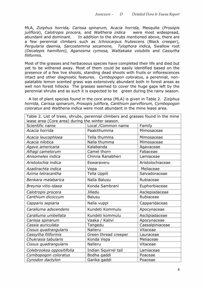
Annexure – D Detailed Flora & Fauna Report
4
MLA, Ziziphus horrida, Carissa spinarum, Acacia horrida, Mesquite (Prosopis
juliflora), Calotropis procera, and Waltheria indica were most widespread, abundant and dominant. In addition to the shrubs mentioned above, there are
a few perennial climbers such as Ichnocarpus frutescens (Black creeper), Pergularia daemia, Sarcostemma secamone, Tylophora indica, Swallow root (Decalepis hamiltoni), Aganosma cymosa, Wattakaka volubilis and Cassytha
filiformis.
Most of the grasses and herbaceous species have completed their life and died but yet to be withered away. Most of them could be easily identified based on the presence of a few live shoots, standing dead shoots with fruits or inflorescences
intact and other diagnostic features. Cymbopogon coloratus, a perennial, non-palatable lemon scented grass was extensively abundant both in forest areas as
well non forest hillocks The grasses seemed to cover the huge gaps left by the
perennial shrubs and as such it is expected to be green during the rainy season.
A list of plant species found in the core area (MLA) is given in Table 2. Ziziphus horrida, Carissa spinarum, Prosopis juliflora, Canthium parviflorum, Cymbopogon
coloratus and Waltheria indica were most abundant in the mine lease area.
Table 2. List of trees, shrubs, perennial climbers and grasses found in the mine
lease area (Core area) during the winter season.
Scientific name Local /Common name Family
Acacia horrida Paakithumma Mimosaceae
Acacia leucophloea Tella thumma Mimosaceae
Acacia nilotica Nalla thumma Mimosaceae
Agave americana Kalabanda Agavaceae
Alhagi camelorum Camel thorn Fabaceae
Anisomeles indica Chinna Ranabheri Lamiaceae
Aristolochia indica Eswaraveru Aristolochiaceae
Azadirachta indica Vepa Meliaceae
Azima tetracantha Tella Uppili Salvadoraceae
Benkara malabarica Nalla Balusu Rubiaceae
Breynia vitis-idaea Konda Sambrani Euphorbiaceae
Calotropis procera Jilledu Asclepiadaceae
Canthium dicoccum Balusu Rubiaceae
Capparis sepiaria Nalla vuppi Capparidaceae
Caralluma adscendens Kundeti Kommulu Apocynaceae
Caralluma umbellata Kundeti kommulu Asclipiadaceae
Carissa spinarum Vaaka / Kalivi Apocynaceae
Cassia auriculata Tangedu Caesalpiniaceae
Cissus quadrangularis Nalleru Vitaceae
Cassytha filiformis Green thread creeper Lauraceae
Chukrasia tabularis Konda Vepa Meliaceae
Cissus quadrangularis Nalleru Vitaceae
Colebrookea oppositifolia Indian Squirrel tail Lamiaceae
Cymbopogon coloratus Bodha gaddi Poaceae
Cynodon dactylon Garika gaddi Poaceae
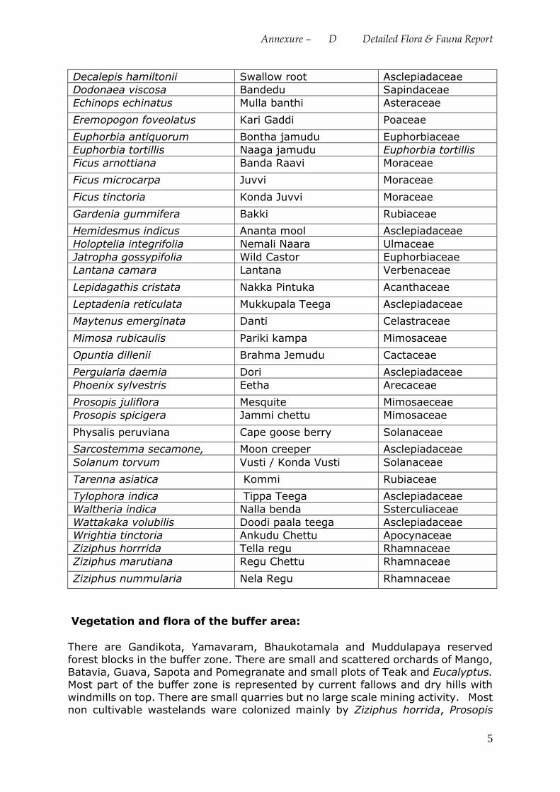
Annexure – D Detailed Flora & Fauna Report
5
Decalepis hamiltonii Swallow root Asclepiadaceae
Dodonaea viscosa Bandedu Sapindaceae
Echinops echinatus Mulla banthi Asteraceae
Eremopogon foveolatus Kari Gaddi Poaceae
Euphorbia antiquorum Bontha jamudu Euphorbiaceae
Euphorbia tortillis Naaga jamudu Euphorbia tortillis
Ficus arnottiana Banda Raavi Moraceae
Ficus microcarpa Juvvi Moraceae
Ficus tinctoria Konda Juvvi Moraceae
Gardenia gummifera Bakki Rubiaceae
Hemidesmus indicus Ananta mool Asclepiadaceae
Holoptelia integrifolia Nemali Naara Ulmaceae
Jatropha gossypifolia Wild Castor Euphorbiaceae
Lantana camara Lantana Verbenaceae
Lepidagathis cristata Nakka Pintuka Acanthaceae
Leptadenia reticulata Mukkupala Teega Asclepiadaceae
Maytenus emerginata Danti Celastraceae
Mimosa rubicaulis Pariki kampa Mimosaceae
Opuntia dillenii Brahma Jemudu Cactaceae
Pergularia daemia Dori Asclepiadaceae
Phoenix sylvestris Eetha Arecaceae
Prosopis juliflora Mesquite Mimosaeceae
Prosopis spicigera Jammi chettu Mimosaceae
Physalis peruviana Cape goose berry Solanaceae
Sarcostemma secamone, Moon creeper Asclepiadaceae
Solanum torvum Vusti / Konda Vusti Solanaceae
Tarenna asiatica Kommi Rubiaceae
Tylophora indica Tippa Teega Asclepiadaceae
Waltheria indica Nalla benda Ssterculiaceae
Wattakaka volubilis Doodi paala teega Asclepiadaceae
Wrightia tinctoria Ankudu Chettu Apocynaceae
Ziziphus horrrida Tella regu Rhamnaceae
Ziziphus marutiana Regu Chettu Rhamnaceae
Ziziphus nummularia Nela Regu Rhamnaceae
Vegetation and flora of the buffer area:
There are Gandikota, Yamavaram, Bhaukotamala and Muddulapaya reserved
forest blocks in the buffer zone. There are small and scattered orchards of Mango, Batavia, Guava, Sapota and Pomegranate and small plots of Teak and Eucalyptus. Most part of the buffer zone is represented by current fallows and dry hills with
windmills on top. There are small quarries but no large scale mining activity. Most non cultivable wastelands ware colonized mainly by Ziziphus horrida, Prosopis
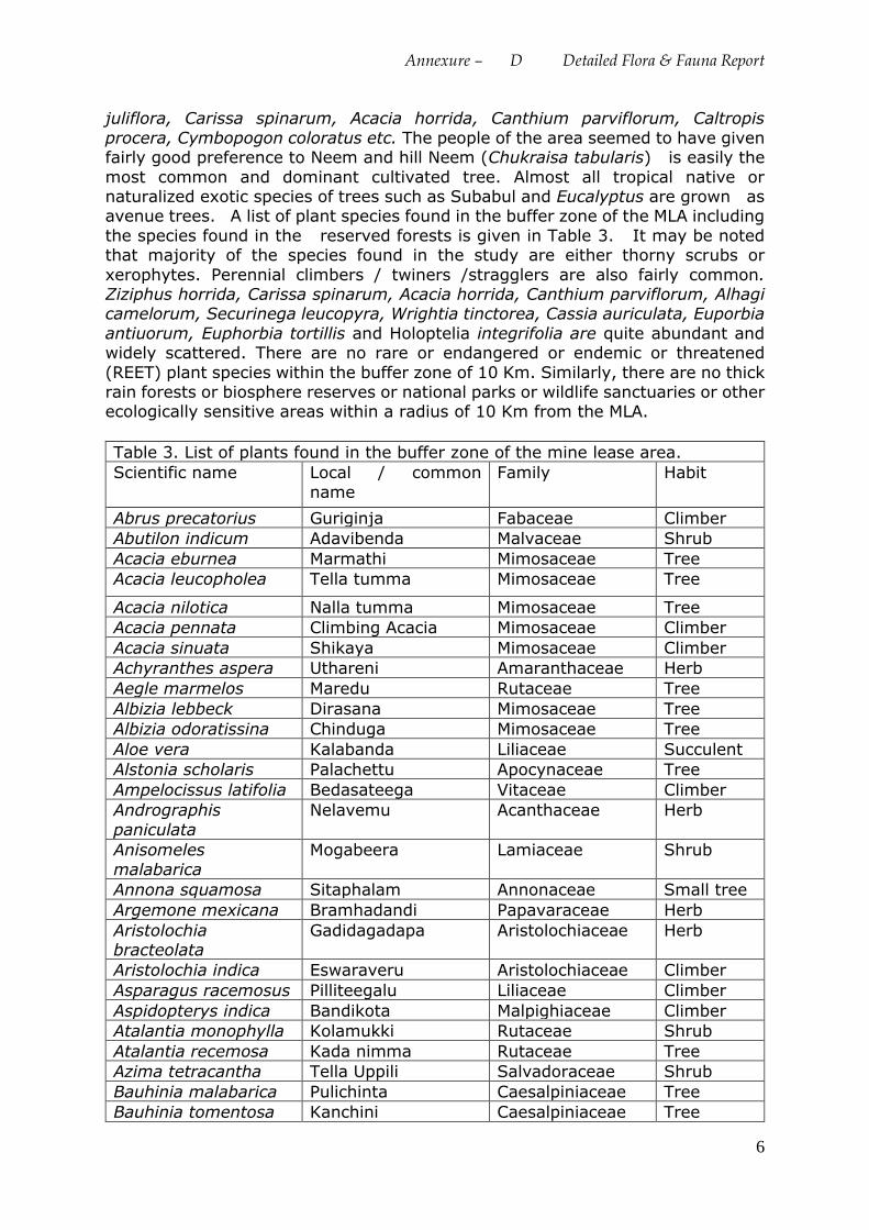
Annexure – D Detailed Flora & Fauna Report
6
juliflora, Carissa spinarum, Acacia horrida, Canthium parviflorum, Caltropis
procera, Cymbopogon coloratus etc. The people of the area seemed to have given fairly good preference to Neem and hill Neem (Chukraisa tabularis) is easily the
most common and dominant cultivated tree. Almost all tropical native or naturalized exotic species of trees such as Subabul and Eucalyptus are grown as avenue trees. A list of plant species found in the buffer zone of the MLA including
the species found in the reserved forests is given in Table 3. It may be noted that majority of the species found in the study are either thorny scrubs or
xerophytes. Perennial climbers / twiners /stragglers are also fairly common. Ziziphus horrida, Carissa spinarum, Acacia horrida, Canthium parviflorum, Alhagi camelorum, Securinega leucopyra, Wrightia tinctorea, Cassia auriculata, Euporbia
antiuorum, Euphorbia tortillis and Holoptelia integrifolia are quite abundant and widely scattered. There are no rare or endangered or endemic or threatened
(REET) plant species within the buffer zone of 10 Km. Similarly, there are no thick rain forests or biosphere reserves or national parks or wildlife sanctuaries or other ecologically sensitive areas within a radius of 10 Km from the MLA.
Table 3. List of plants found in the buffer zone of the mine lease area.
Scientific name Local / common
name
Family Habit
Abrus precatorius Guriginja Fabaceae Climber
Abutilon indicum Adavibenda Malvaceae Shrub
Acacia eburnea Marmathi Mimosaceae Tree
Acacia leucopholea Tella tumma Mimosaceae Tree
Acacia nilotica Nalla tumma Mimosaceae Tree
Acacia pennata Climbing Acacia Mimosaceae Climber
Acacia sinuata Shikaya Mimosaceae Climber
Achyranthes aspera Uthareni Amaranthaceae Herb
Aegle marmelos Maredu Rutaceae Tree
Albizia lebbeck Dirasana Mimosaceae Tree
Albizia odoratissina Chinduga Mimosaceae Tree
Aloe vera Kalabanda Liliaceae Succulent
Alstonia scholaris Palachettu Apocynaceae Tree
Ampelocissus latifolia Bedasateega Vitaceae Climber
Andrographis
paniculata
Nelavemu Acanthaceae Herb
Anisomeles
malabarica
Mogabeera Lamiaceae Shrub
Annona squamosa Sitaphalam Annonaceae Small tree
Argemone mexicana Bramhadandi Papavaraceae Herb
Aristolochia bracteolata
Gadidagadapa Aristolochiaceae Herb
Aristolochia indica Eswaraveru Aristolochiaceae Climber
Asparagus racemosus Pilliteegalu Liliaceae Climber
Aspidopterys indica Bandikota Malpighiaceae Climber
Atalantia monophylla Kolamukki Rutaceae Shrub
Atalantia recemosa Kada nimma Rutaceae Tree
Azima tetracantha Tella Uppili Salvadoraceae Shrub
Bauhinia malabarica Pulichinta Caesalpiniaceae Tree
Bauhinia tomentosa Kanchini Caesalpiniaceae Tree
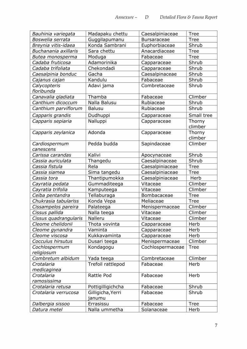
Annexure – D Detailed Flora & Fauna Report
7
Bauhinia variegata Madapaku chettu Caesalpiniaceae Tree
Boswelia serrata Guggilapumanu Bursaraceae Tree
Breynia vitis-idaea Konda Sambrani Euphorbiaceae Shrub
Buchanania axillaris Sara chettu Anacardiaceae Tree
Butea monosperma Moduga Fabaceae Tree
Cadaba fruticosa Adamorinika Capparaceae Shrub
Cadaba trifoliata Chekondadi Capparaceae Shrub
Caesalpinia bonduc Gacha Caesalpinaceae Shrub
Cajanus cajan Kandulu Fabaceae Shrub
Calycopteris floribunda
Adavi jama Combretaceae Shrub
Canavalia gladiata Thamba Fabaceae Climber
Canthium dicoccum Nalla Balusu Rubiaceae Shrub
Canthium parviflorum Balusu Rubiaceae Shrub
Capparis grandis Dudhuppi Capparaceae Small tree
Capparis sepiaria Nalluppi Capparaceae Thorny climber
Capparis zeylanica Adonda Capparaceae Thorny climber
Cardiospermum canescens
Pedda budda Sapindaceae Climber
Carissa carandas Kalivi Apocynaceae Shrub
Cassia auriculata Thangedu Caesalpinaceae Shrub
Cassia fistula Rela Caesalpiniaceae Tree
Cassia siamea Sima tangedu Caesalpiniaceae Tree
Cassia tora Thantipumokka Caesalpiniaceae Herb
Cayratia pedata Gummaditeega Vitaceae Climber
Cayratia trifolia Kamputeega Vitaceae Climber
Ceiba pentandra Tellaburaga Bombacaceae Tree
Chukrasia tabulariss Konda Vepa Meliaceae Tree
Cissampelos pareira Palateega Menispermaceae Climber
Cissus pallida Nalla teega Vitaceae Climber
Cissus quadrangularis Nalleru Vitaceae Climber
Cleome chelidonii Thota vovinta Capparaceae Herb
Cleome gynandra Vaminta Capparaceae Herb
Cleome viscosa Kukkavaminta Capparaceae Herb
Cocculus hirsutus Dusari teega Menispermaceae Climber
Cochlospermum religiosum
Kondagogu Cochlospermaceae Tree
Combretum albidum Yada teega Combretaceae Climber
Crotalaria
medicaginea
Trefoil rattlepod Fabaceae Herb
Crotalaria
ramosissima
Rattle Pod Fabaceae Herb
Crotalaria retusa Pottigilligichcha Fabaceae Shrub
Crotalaria verrucosa Gilligicha,Yerri janumu
Fabaceae Shrub
Dalbergia sissoo Errasissu Fabaceae Tree
Datura metel Nalla ummetha Solanaceae Herb
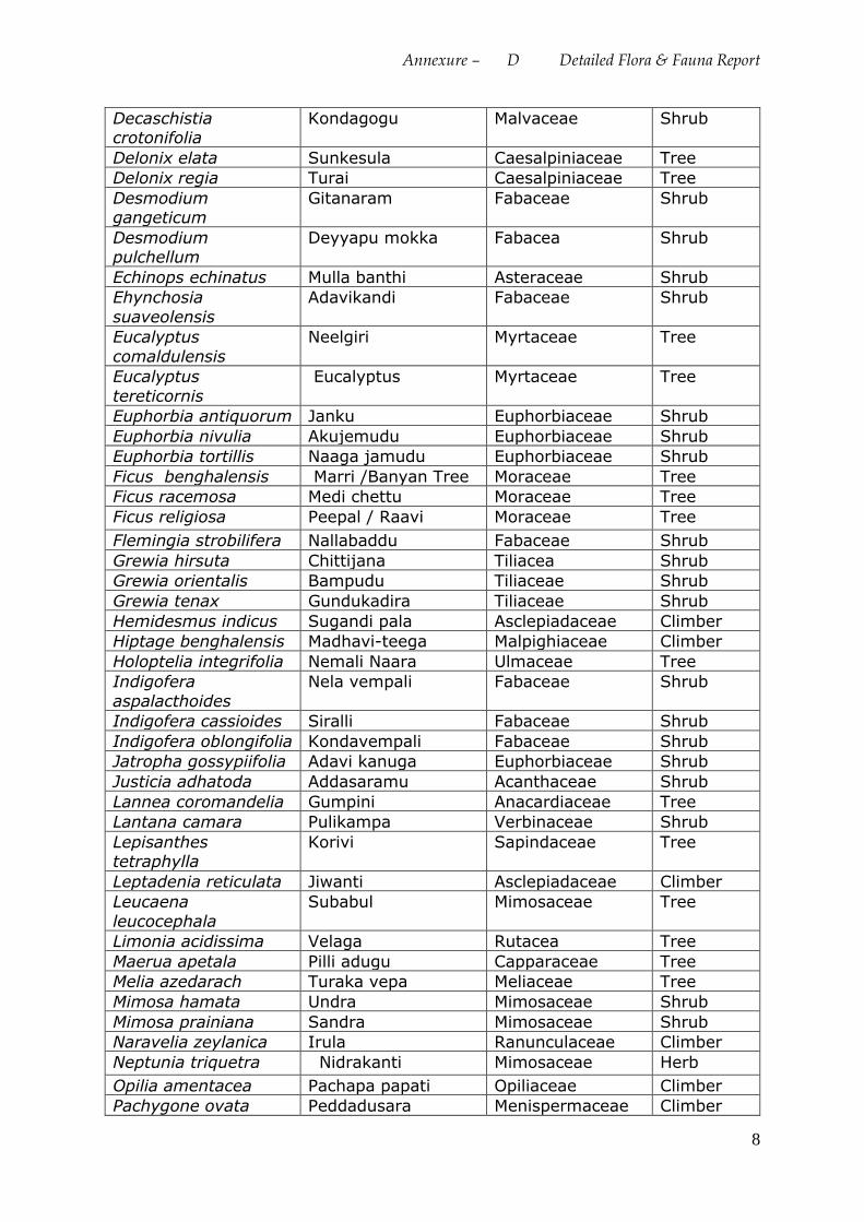
Annexure – D Detailed Flora & Fauna Report
8
Decaschistia crotonifolia
Kondagogu Malvaceae Shrub
Delonix elata Sunkesula Caesalpiniaceae Tree
Delonix regia Turai Caesalpiniaceae Tree
Desmodium gangeticum
Gitanaram Fabaceae Shrub
Desmodium pulchellum
Deyyapu mokka Fabacea Shrub
Echinops echinatus Mulla banthi Asteraceae Shrub
Ehynchosia
suaveolensis
Adavikandi Fabaceae Shrub
Eucalyptus
comaldulensis
Neelgiri Myrtaceae Tree
Eucalyptus
tereticornis
Eucalyptus Myrtaceae Tree
Euphorbia antiquorum Janku Euphorbiaceae Shrub
Euphorbia nivulia Akujemudu Euphorbiaceae Shrub
Euphorbia tortillis Naaga jamudu Euphorbiaceae Shrub
Ficus benghalensis Marri /Banyan Tree Moraceae Tree
Ficus racemosa Medi chettu Moraceae Tree
Ficus religiosa Peepal / Raavi Moraceae Tree
Flemingia strobilifera Nallabaddu Fabaceae Shrub
Grewia hirsuta Chittijana Tiliacea Shrub
Grewia orientalis Bampudu Tiliaceae Shrub
Grewia tenax Gundukadira Tiliaceae Shrub
Hemidesmus indicus Sugandi pala Asclepiadaceae Climber
Hiptage benghalensis Madhavi-teega Malpighiaceae Climber
Holoptelia integrifolia Nemali Naara Ulmaceae Tree
Indigofera
aspalacthoides
Nela vempali Fabaceae Shrub
Indigofera cassioides Siralli Fabaceae Shrub
Indigofera oblongifolia Kondavempali Fabaceae Shrub
Jatropha gossypiifolia Adavi kanuga Euphorbiaceae Shrub
Justicia adhatoda Addasaramu Acanthaceae Shrub
Lannea coromandelia Gumpini Anacardiaceae Tree
Lantana camara Pulikampa Verbinaceae Shrub
Lepisanthes tetraphylla
Korivi Sapindaceae Tree
Leptadenia reticulata Jiwanti Asclepiadaceae Climber
Leucaena
leucocephala
Subabul Mimosaceae Tree
Limonia acidissima Velaga Rutacea Tree
Maerua apetala Pilli adugu Capparaceae Tree
Melia azedarach Turaka vepa Meliaceae Tree
Mimosa hamata Undra Mimosaceae Shrub
Mimosa prainiana Sandra Mimosaceae Shrub
Naravelia zeylanica Irula Ranunculaceae Climber
Neptunia triquetra Nidrakanti Mimosaceae Herb
Opilia amentacea Pachapa papati Opiliaceae Climber
Pachygone ovata Peddadusara Menispermaceae Climber
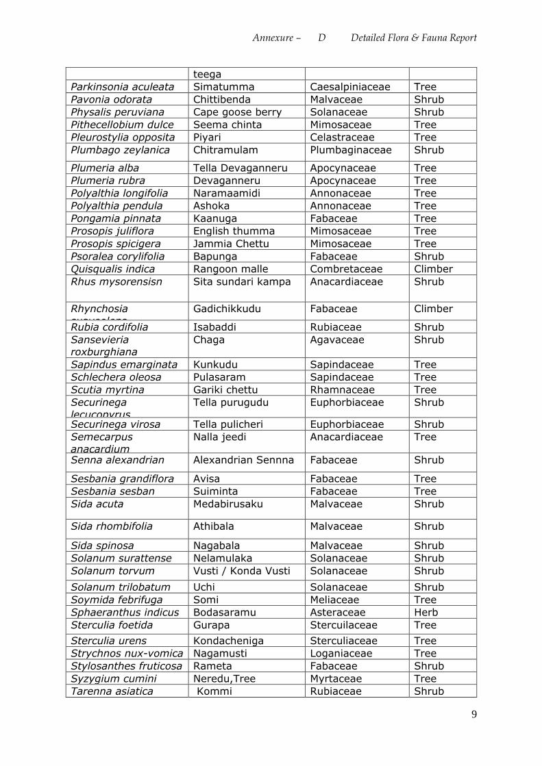
Annexure – D Detailed Flora & Fauna Report
9
teega
Parkinsonia aculeata Simatumma Caesalpiniaceae Tree
Pavonia odorata Chittibenda Malvaceae Shrub
Physalis peruviana Cape goose berry Solanaceae Shrub
Pithecellobium dulce Seema chinta Mimosaceae Tree
Pleurostylia opposita Piyari Celastraceae Tree
Plumbago zeylanica Chitramulam Plumbaginaceae Shrub
Plumeria alba Tella Devaganneru Apocynaceae Tree
Plumeria rubra Devaganneru Apocynaceae Tree
Polyalthia longifolia Naramaamidi Annonaceae Tree
Polyalthia pendula Ashoka Annonaceae Tree
Pongamia pinnata Kaanuga Fabaceae Tree
Prosopis juliflora English thumma Mimosaceae Tree
Prosopis spicigera Jammia Chettu Mimosaceae Tree
Psoralea corylifolia Bapunga Fabaceae Shrub
Quisqualis indica Rangoon malle Combretaceae Climber
Rhus mysorensisn Sita sundari kampa Anacardiaceae Shrub
Rhynchosia
suaveolens
Gadichikkudu Fabaceae Climber
Rubia cordifolia Isabaddi Rubiaceae Shrub
Sansevieria roxburghiana
Chaga Agavaceae Shrub
Sapindus emarginata Kunkudu Sapindaceae Tree
Schlechera oleosa Pulasaram Sapindaceae Tree
Scutia myrtina Gariki chettu Rhamnaceae Tree
Securinega
lecucopyrus
Tella purugudu Euphorbiaceae Shrub
Securinega virosa Tella pulicheri Euphorbiaceae Shrub
Semecarpus
anacardium
Nalla jeedi Anacardiaceae Tree
Senna alexandrian Alexandrian Sennna Fabaceae Shrub
Sesbania grandiflora Avisa Fabaceae Tree
Sesbania sesban Suiminta Fabaceae Tree
Sida acuta Medabirusaku Malvaceae Shrub
Sida rhombifolia Athibala Malvaceae Shrub
Sida spinosa Nagabala Malvaceae Shrub
Solanum surattense Nelamulaka Solanaceae Shrub
Solanum torvum Vusti / Konda Vusti Solanaceae Shrub
Solanum trilobatum Uchi Solanaceae Shrub
Soymida febrifuga Somi Meliaceae Tree
Sphaeranthus indicus Bodasaramu Asteraceae Herb
Sterculia foetida Gurapa Stercuilaceae Tree
Sterculia urens Kondacheniga Sterculiaceae Tree
Strychnos nux-vomica Nagamusti Loganiaceae Tree
Stylosanthes fruticosa Rameta Fabaceae Shrub
Syzygium cumini Neredu,Tree Myrtaceae Tree
Tarenna asiatica Kommi Rubiaceae Shrub
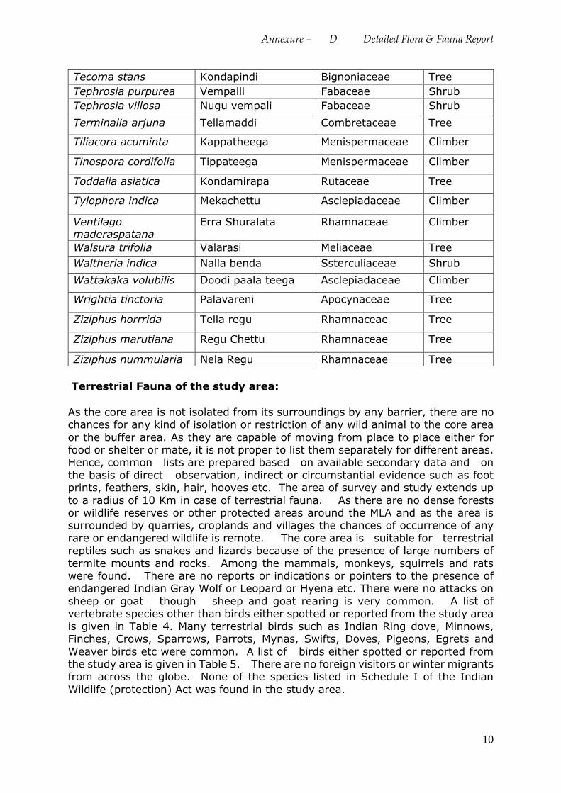
Annexure – D Detailed Flora & Fauna Report
10
Tecoma stans Kondapindi Bignoniaceae Tree
Tephrosia purpurea Vempalli Fabaceae Shrub
Tephrosia villosa Nugu vempali Fabaceae Shrub
Terminalia arjuna Tellamaddi Combretaceae Tree
Tiliacora acuminta Kappatheega Menispermaceae Climber
Tinospora cordifolia Tippateega Menispermaceae Climber
Toddalia asiatica Kondamirapa Rutaceae Tree
Tylophora indica Mekachettu Asclepiadaceae Climber
Ventilago maderaspatana
Erra Shuralata Rhamnaceae Climber
Walsura trifolia Valarasi Meliaceae Tree
Waltheria indica Nalla benda Ssterculiaceae Shrub
Wattakaka volubilis Doodi paala teega Asclepiadaceae Climber
Wrightia tinctoria Palavareni Apocynaceae Tree
Ziziphus horrrida Tella regu Rhamnaceae Tree
Ziziphus marutiana Regu Chettu Rhamnaceae Tree
Ziziphus nummularia Nela Regu Rhamnaceae Tree
Terrestrial Fauna of the study area:
As the core area is not isolated from its surroundings by any barrier, there are no chances for any kind of isolation or restriction of any wild animal to the core area
or the buffer area. As they are capable of moving from place to place either for food or shelter or mate, it is not proper to list them separately for different areas. Hence, common lists are prepared based on available secondary data and on
the basis of direct observation, indirect or circumstantial evidence such as foot prints, feathers, skin, hair, hooves etc. The area of survey and study extends up
to a radius of 10 Km in case of terrestrial fauna. As there are no dense forests or wildlife reserves or other protected areas around the MLA and as the area is surrounded by quarries, croplands and villages the chances of occurrence of any
rare or endangered wildlife is remote. The core area is suitable for terrestrial reptiles such as snakes and lizards because of the presence of large numbers of
termite mounts and rocks. Among the mammals, monkeys, squirrels and rats were found. There are no reports or indications or pointers to the presence of endangered Indian Gray Wolf or Leopard or Hyena etc. There were no attacks on
sheep or goat though sheep and goat rearing is very common. A list of vertebrate species other than birds either spotted or reported from the study area
is given in Table 4. Many terrestrial birds such as Indian Ring dove, Minnows, Finches, Crows, Sparrows, Parrots, Mynas, Swifts, Doves, Pigeons, Egrets and
Weaver birds etc were common. A list of birds either spotted or reported from the study area is given in Table 5. There are no foreign visitors or winter migrants from across the globe. None of the species listed in Schedule I of the Indian
Wildlife (protection) Act was found in the study area.
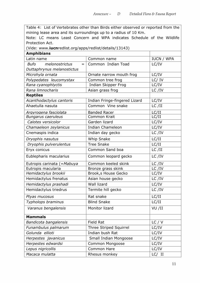
Annexure – D Detailed Flora & Fauna Report
11
Table 4: List of Vertebrates other than Birds either observed or reported from the
mining lease area and its surroundings up to a radius of 10 Km.
Note: LC means Least Concern and WPA indicates Schedule of the Wildlife
Protection Act.
(Vide: www.iucnredlist.org/apps/redlist/details/13143)
Amphibians
Latin name Common name IUCN / WPA
Bufo melonostrictus =
Duttaphrynus melanostictus
Common Indian Toad LC/IV
Microhyla ornata Ornate narrow mouth frog LC/IV
Polypedates leucomystax Common tree frog LC/ IV
Rana cyanophlyctis Indian Skipper Frog LC/IV
Rana limnocharis Asian grass frog LC /IV
Reptiles
Acanthodactylus cantoris Indian Fringe-fingered Lizard LC/IV
Ahaetulla nasuta Common Vine snake LC /II
Argyrogena fasciolata Banded Racer LC/II Bungarus caeruleus Common Krait LC/II
Calotes versicolor Garden lizard LC/IV
Chamaeleon zeylanicus Indian Chameleon LC/IV
Cnemaspis indica Indian day gecko LC /IV
Dryophis nasutus Whip Snake LC/II
Dryophis pulverulentus Tree Snake LC/II
Eryx conicus Common Sand boa LC /II
Eublepharis macularius Common leopard gecko LC /IV
Eutropis carinata (=Mabuya
carinata)
Common keeled skink LC /IV
Eutropis macularia Bronze grass skink LC /IV
Hemidactylus brookii Brook,s House Gecko LC/IV
Hemidactylus frenatus Asian house gecko LC /IV
Hemidactylus prashadi Wall lizard LC/IV
Hemidactylus triedrus Termite hill gecko LC /IV
Ptyas mucosus Rat snake LC/II
Typholops braminus Blind Snake LC/II
Varanus bengalensis Monitor lizard VU /II
Mammals
Bandicota bangalensis Field Rat LC / V
Funambulus palmarum Three Striped Squirrel LC/IV
Golunda ellioti Indian bush Rat LC/IV
Herpestes javanicus Small Indian Mongoose LC/IV
Herpestes edwardsi Common Mongoose LC/IV
Lepus nigricollis Common Hare LC/IV
Macaca mulatta Rhesus monkey LC/ II
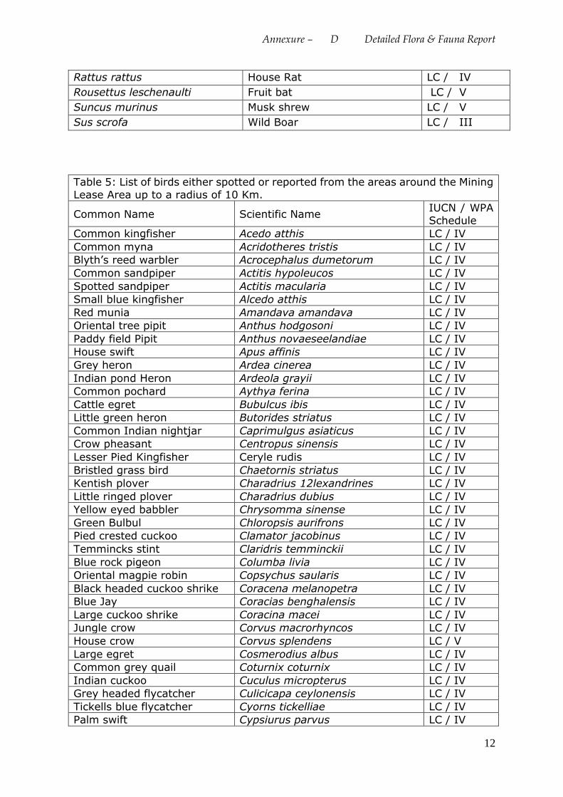
Annexure – D Detailed Flora & Fauna Report
12
Rattus rattus House Rat LC / IV
Rousettus leschenaulti Fruit bat LC / V
Suncus murinus Musk shrew LC / V
Sus scrofa Wild Boar LC / III
Table 5: List of birds either spotted or reported from the areas around the Mining
Lease Area up to a radius of 10 Km.
Common Name Scientific Name IUCN / WPA
Schedule
Common kingfisher Acedo atthis LC / IV
Common myna Acridotheres tristis LC / IV
Blyth’s reed warbler Acrocephalus dumetorum LC / IV
Common sandpiper Actitis hypoleucos LC / IV
Spotted sandpiper Actitis macularia LC / IV
Small blue kingfisher Alcedo atthis LC / IV
Red munia Amandava amandava LC / IV
Oriental tree pipit Anthus hodgosoni LC / IV
Paddy field Pipit Anthus novaeseelandiae LC / IV
House swift Apus affinis LC / IV
Grey heron Ardea cinerea LC / IV
Indian pond Heron Ardeola grayii LC / IV
Common pochard Aythya ferina LC / IV
Cattle egret Bubulcus ibis LC / IV
Little green heron Butorides striatus LC / IV
Common Indian nightjar Caprimulgus asiaticus LC / IV
Crow pheasant Centropus sinensis LC / IV
Lesser Pied Kingfisher Ceryle rudis LC / IV
Bristled grass bird Chaetornis striatus LC / IV
Kentish plover Charadrius 12lexandrines LC / IV
Little ringed plover Charadrius dubius LC / IV
Yellow eyed babbler Chrysomma sinense LC / IV
Green Bulbul Chloropsis aurifrons LC / IV
Pied crested cuckoo Clamator jacobinus LC / IV
Temmincks stint Claridris temminckii LC / IV
Blue rock pigeon Columba livia LC / IV
Oriental magpie robin Copsychus saularis LC / IV
Black headed cuckoo shrike Coracena melanopetra LC / IV
Blue Jay Coracias benghalensis LC / IV
Large cuckoo shrike Coracina macei LC / IV
Jungle crow Corvus macrorhyncos LC / IV
House crow Corvus splendens LC / V
Large egret Cosmerodius albus LC / IV
Common grey quail Coturnix coturnix LC / IV
Indian cuckoo Cuculus micropterus LC / IV
Grey headed flycatcher Culicicapa ceylonensis LC / IV
Tickells blue flycatcher Cyorns tickelliae LC / IV
Palm swift Cypsiurus parvus LC / IV
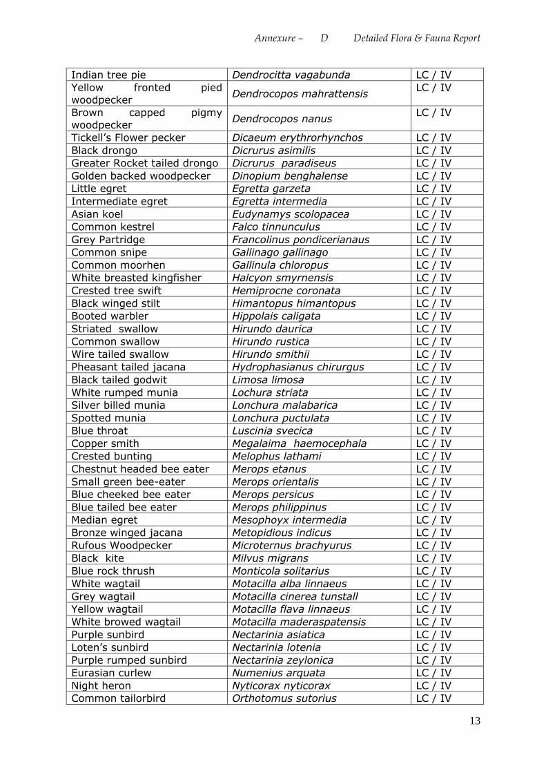
Annexure – D Detailed Flora & Fauna Report
13
Indian tree pie Dendrocitta vagabunda LC / IV
Yellow fronted pied
woodpecker Dendrocopos mahrattensis
LC / IV
Brown capped pigmy
woodpecker Dendrocopos nanus
LC / IV
Tickell’s Flower pecker Dicaeum erythrorhynchos LC / IV
Black drongo Dicrurus asimilis LC / IV
Greater Rocket tailed drongo Dicrurus paradiseus LC / IV
Golden backed woodpecker Dinopium benghalense LC / IV
Little egret Egretta garzeta LC / IV
Intermediate egret Egretta intermedia LC / IV
Asian koel Eudynamys scolopacea LC / IV
Common kestrel Falco tinnunculus LC / IV
Grey Partridge Francolinus pondicerianaus LC / IV
Common snipe Gallinago gallinago LC / IV
Common moorhen Gallinula chloropus LC / IV
White breasted kingfisher Halcyon smyrnensis LC / IV
Crested tree swift Hemiprocne coronata LC / IV
Black winged stilt Himantopus himantopus LC / IV
Booted warbler Hippolais caligata LC / IV
Striated swallow Hirundo daurica LC / IV
Common swallow Hirundo rustica LC / IV
Wire tailed swallow Hirundo smithii LC / IV
Pheasant tailed jacana Hydrophasianus chirurgus LC / IV
Black tailed godwit Limosa limosa LC / IV
White rumped munia Lochura striata LC / IV
Silver billed munia Lonchura malabarica LC / IV
Spotted munia Lonchura puctulata LC / IV
Blue throat Luscinia svecica LC / IV
Copper smith Megalaima haemocephala LC / IV
Crested bunting Melophus lathami LC / IV
Chestnut headed bee eater Merops etanus LC / IV
Small green bee-eater Merops orientalis LC / IV
Blue cheeked bee eater Merops persicus LC / IV
Blue tailed bee eater Merops philippinus LC / IV
Median egret Mesophoyx intermedia LC / IV
Bronze winged jacana Metopidious indicus LC / IV
Rufous Woodpecker Microternus brachyurus LC / IV
Black kite Milvus migrans LC / IV
Blue rock thrush Monticola solitarius LC / IV
White wagtail Motacilla alba linnaeus LC / IV
Grey wagtail Motacilla cinerea tunstall LC / IV
Yellow wagtail Motacilla flava linnaeus LC / IV
White browed wagtail Motacilla maderaspatensis LC / IV
Purple sunbird Nectarinia asiatica LC / IV
Loten’s sunbird Nectarinia lotenia LC / IV
Purple rumped sunbird Nectarinia zeylonica LC / IV
Eurasian curlew Numenius arquata LC / IV
Night heron Nyticorax nyticorax LC / IV
Common tailorbird Orthotomus sutorius LC / IV
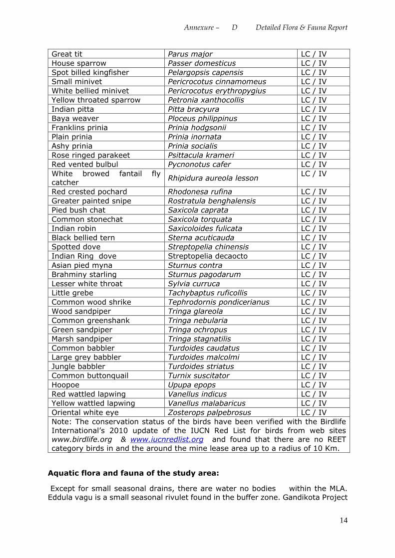
Annexure – D Detailed Flora & Fauna Report
14
Great tit Parus major LC / IV
House sparrow Passer domesticus LC / IV
Spot billed kingfisher Pelargopsis capensis LC / IV
Small minivet Pericrocotus cinnamomeus LC / IV
White bellied minivet Pericrocotus erythropygius LC / IV
Yellow throated sparrow Petronia xanthocollis LC / IV
Indian pitta Pitta bracyura LC / IV
Baya weaver Ploceus philippinus LC / IV
Franklins prinia Prinia hodgsonii LC / IV
Plain prinia Prinia inornata LC / IV
Ashy prinia Prinia socialis LC / IV
Rose ringed parakeet Psittacula krameri LC / IV
Red vented bulbul Pycnonotus cafer LC / IV
White browed fantail fly catcher
Rhipidura aureola lesson LC / IV
Red crested pochard Rhodonesa rufina LC / IV
Greater painted snipe Rostratula benghalensis LC / IV
Pied bush chat Saxicola caprata LC / IV
Common stonechat Saxicola torquata LC / IV
Indian robin Saxicoloides fulicata LC / IV
Black bellied tern Sterna acuticauda LC / IV
Spotted dove Streptopelia chinensis LC / IV
Indian Ring dove Streptopelia decaocto LC / IV
Asian pied myna Sturnus contra LC / IV
Brahminy starling Sturnus pagodarum LC / IV
Lesser white throat Sylvia curruca LC / IV
Little grebe Tachybaptus ruficollis LC / IV
Common wood shrike Tephrodornis pondicerianus LC / IV
Wood sandpiper Tringa glareola LC / IV
Common greenshank Tringa nebularia LC / IV
Green sandpiper Tringa ochropus LC / IV
Marsh sandpiper Tringa stagnatilis LC / IV
Common babbler Turdoides caudatus LC / IV
Large grey babbler Turdoides malcolmi LC / IV
Jungle babbler Turdoides striatus LC / IV
Common buttonquail Turnix suscitator LC / IV
Hoopoe Upupa epops LC / IV
Red wattled lapwing Vanellus indicus LC / IV
Yellow wattled lapwing Vanellus malabaricus LC / IV
Oriental white eye Zosterops palpebrosus LC / IV
Note: The conservation status of the birds have been verified with the Birdlife
International’s 2010 update of the IUCN Red List for birds from web sites www.birdlife.org & www.iucnredlist.org and found that there are no REET
category birds in and the around the mine lease area up to a radius of 10 Km.
Aquatic flora and fauna of the study area:
Except for small seasonal drains, there are water no bodies within the MLA. Eddula vagu is a small seasonal rivulet found in the buffer zone. Gandikota Project
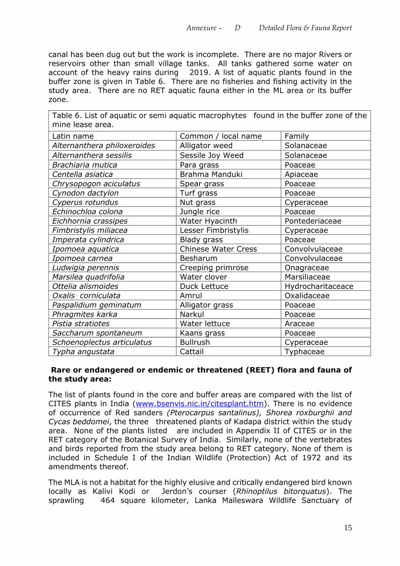
Annexure – D Detailed Flora & Fauna Report
15
canal has been dug out but the work is incomplete. There are no major Rivers or
reservoirs other than small village tanks. All tanks gathered some water on account of the heavy rains during 2019. A list of aquatic plants found in the
buffer zone is given in Table 6. There are no fisheries and fishing activity in the study area. There are no RET aquatic fauna either in the ML area or its buffer
zone.
Table 6. List of aquatic or semi aquatic macrophytes found in the buffer zone of the
mine lease area.
Latin name Common / local name Family
Alternanthera philoxeroides Alligator weed Solanaceae
Alternanthera sessilis Sessile Joy Weed Solanaceae
Brachiaria mutica Para grass Poaceae
Centella asiatica Brahma Manduki Apiaceae
Chrysopogon aciculatus Spear grass Poaceae
Cynodon dactylon Turf grass Poaceae
Cyperus rotundus Nut grass Cyperaceae
Echinochloa colona Jungle rice Poaceae
Eichhornia crassipes Water Hyacinth Pontederiaceae
Fimbristylis miliacea Lesser Fimbristylis Cyperaceae
Imperata cylindrica Blady grass Poaceae
Ipomoea aquatica Chinese Water Cress Convolvulaceae
Ipomoea carnea Besharum Convolvulaceae
Ludwigia perennis Creeping primrose Onagraceae
Marsilea quadrifolia Water clover Marsiliaceae
Ottelia alismoides Duck Lettuce Hydrocharitaceace
Oxalis corniculata Amrul Oxalidaceae
Paspalidium geminatum Alligator grass Poaceae
Phragmites karka Narkul Poaceae
Pistia stratiotes Water lettuce Araceae
Saccharum spontaneum Kaans grass Poaceae
Schoenoplectus articulatus Bullrush Cyperaceae
Typha angustata Cattail Typhaceae
Rare or endangered or endemic or threatened (REET) flora and fauna of
the study area:
The list of plants found in the core and buffer areas are compared with the list of CITES plants in India (www.bsenvis.nic.in/citesplant.htm). There is no evidence
of occurrence of Red sanders (Pterocarpus santalinus), Shorea roxburghii and Cycas beddomei, the three threatened plants of Kadapa district within the study
area. None of the plants listed are included in Appendix II of CITES or in the RET category of the Botanical Survey of India. Similarly, none of the vertebrates and birds reported from the study area belong to RET category. None of them is
included in Schedule I of the Indian Wildlife (Protection) Act of 1972 and its
amendments thereof.
The MLA is not a habitat for the highly elusive and critically endangered bird known locally as Kalivi Kodi or Jerdon’s courser (Rhinoptilus bitorquatus). The
sprawling 464 square kilometer, Lanka Malleswara Wildlife Sanctuary of
Annexure – D Detailed Flora & Fauna Report
16
Rhinoptilus bitorquatus located in Lankamalla Reserved forest is more than 50 Km
away from the MLA.
Predicted Impacts due to the proposed Quartz, Silica sand Mining:
Biological Impact Assessment (BIA) is an important ant integral part of the EIA. For the purposes of the BIA, the study area is divided in the core and buffer areas. The direct impacts shall be limited to the core area. Mine lease area is a private
land. There are no National Parks, Wildlife sanctuaries, Biosphere reserves or other protected areas either in the core area or in the buffer zone.
Prediction of impacts is based both on the direct and indirect; short-term as well
as long-term; irreversible and irreversible impacts that are most likely to occur
owing to the proposed industrial activity during establishment and operation. The
ecological factors that are considered most significant as far as the impact on flora
and fauna are concerned:
1. Whether there shall be any reduction in species diversity
2. Whether there shall be any habitat loss or fragmentation
3. Whether there shall be any additional risk or threat to the rare or endangered or endemic or threatened (REET)species
4. Whether there shall be any impairment of ecological functions such as
(i) Disruption of food chains, (ii) decline in species population and or (iii)
alterations in predator-prey relationships.
The direct and the most destructive impacts of the project are limited to the mine
lease area only. There is going to be a change in the land use and land cover
owing to the mining activity. The existing flora and vegetation of the mine lease
is going to be lost slowly in a phased manner owing to digging or dumping of
overburden and waste. Among the plant species that are going to be lost, the
annuals and therophytes are highly resilient and they can come back once the
intensity and frequency of disturbances decrease. As there are no rare or
endangered or endemic or threatened (REET) species, continuation of mining will
not pose any additional problem to any REET species. Hence, the impact of the
project on flora is negligible. As far as the fauna s concerned, the proposed mining
could endanger the habitat of some unseen reptiles and rodents that may be
present in burrows. But it is incapable of posing any additional threat to any
Schedule I species either directly or indirectly.
Negative Impacts:
i). Loss of the existing flora and trees: The flora of the project site is going to be
damaged or lost to a when a mine pit is opened and when dump is created. Since
there are no RET species, there shall not be any loss of any species.
ii). Loss of fodder and grazing land for locals: Green fodder is produced only
during the rainy season. During that time, shortage of green fodder is uncommon.
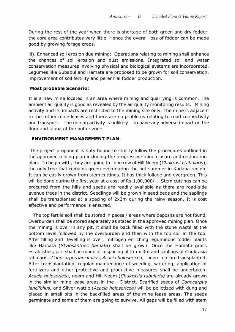
Annexure – D Detailed Flora & Fauna Report
17
During the rest of the year when there is shortage of both green and dry fodder,
the core area contributes very little. Hence the overall loss of fodder can be made
good by growing forage crops.
iii). Enhanced soil erosion due mining: Operations relating to mining shall enhance
the chances of soil erosion and dust emissions. Integrated soil and water
conservation measures involving physical and biological systems are incorporated.
Legumes like Subabul and Hamata are proposed to be grown for soil conservation,
improvement of soil fertility and perennial fodder production.
Most probable Scenario:
It is a new mine located in an area where mining and quarrying is common. The
ambient air quality is good as revealed by the air quality monitoring results. Mining
activity and its impacts are restricted to the mining site only. The mine is adjacent
to the other mine leases and there are no problems relating to road connectivity
and transport. The mining activity is unlikely to have any adverse impact on the
flora and fauna of the buffer zone.
ENVIRONMENT MANAGEMENT PLAN:
The project proponent is duty bound to strictly follow the procedures outlined in
the approved mining plan including the progressive mine closure and restoration
plan. To begin with, they are going to one row of Hill Neem (Chukrasia tabularis),
the only tree that remains green even during the hot summer in Kadapa region.
It can be easily grown from stem cuttings. It has thick foliage and evergreen. This
will be done during the first year at a cost of Rs.1,00,000/-. Stem cuttings can be
procured from the hills and seeds are readily available as there are road-side
avenue trees in the district. Seedlings will be grown in seed beds and the saplings
shall be transplanted at a spacing of 2x3m during the rainy season. It is cost
effective and performance is ensured.
The top fertile soil shall be stored in paces / areas where deposits are not found.
Overburden shall be stored separately as stated in the approved mining plan. Once
the mining is over in any pit, it shall be back filled with the stone waste at the
bottom level followed by the overburden and then with the top soil at the top.
After filling and levelling is over, nitrogen enriching leguminous fodder plants
like Hamata (Stylosanthes hamata) shall be grown. Once the Hamata grass
establishes, pits shall be made at a spacing of 2m x 3m and saplings of Chukrasia
tabularis, Conocarpus lancifolius, Acacia holosericea, neem etc are transplanted.
After transplantation, regular maintenance of weeding, watering, application of
fertilizers and other protective and productive measures shall be undertaken.
Acacia holosericea, neem and Hill Neem (Chukrasia tabularis) are already grown
in the similar mine lease areas in the District. Scarified seeds of Conocarpus
lancifolius, and Silver wattle (Acacia holosericea) will be pelletized with dung and
placed in small pits in the backfilled areas of the mine lease areas. The seeds
germinate and some of them are going to survive. All gaps will be filled with stem
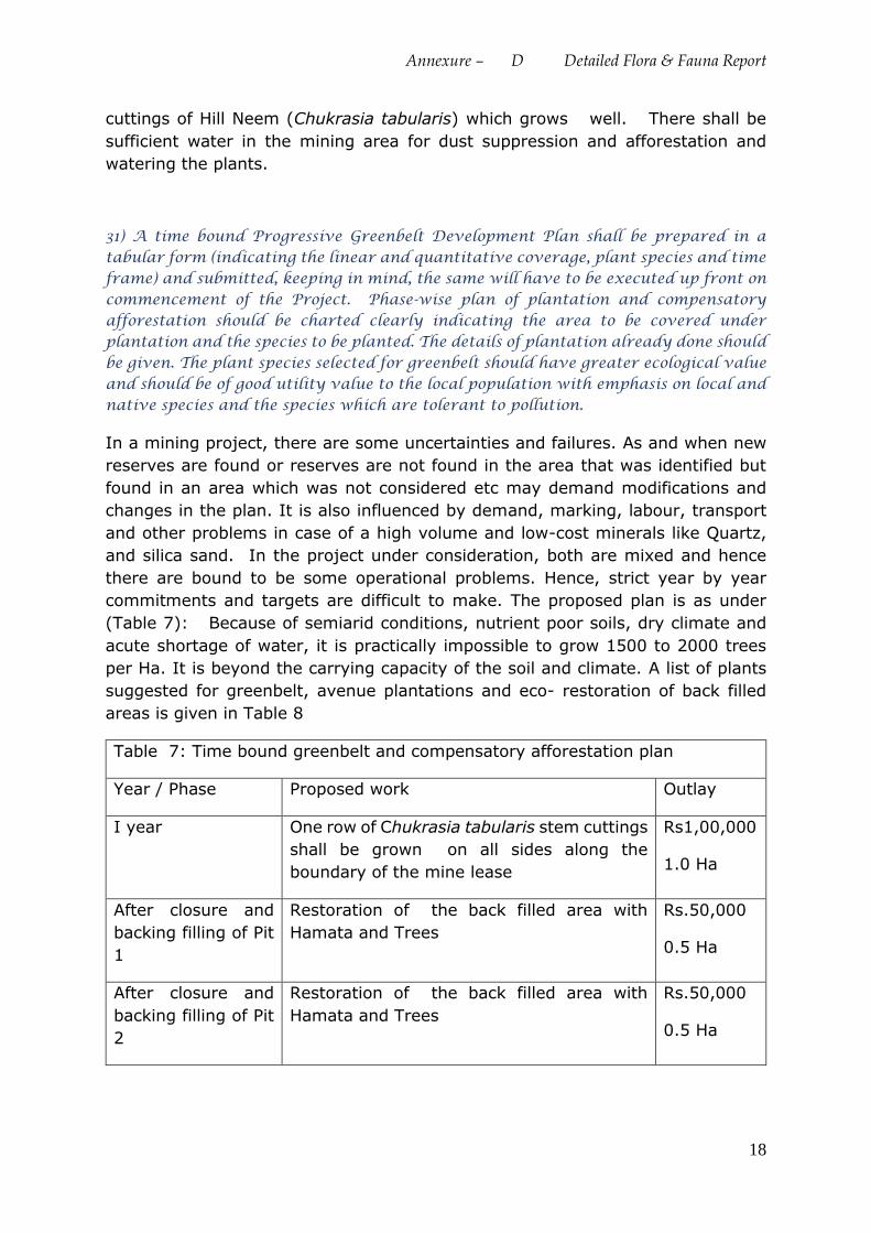
Annexure – D Detailed Flora & Fauna Report
18
cuttings of Hill Neem (Chukrasia tabularis) which grows well. There shall be
sufficient water in the mining area for dust suppression and afforestation and
watering the plants.
31) A time bound Progressive Greenbelt Development Plan shall be prepared in a tabular form (indicating the linear and quantitative coverage, plant species and time frame) and submitted, keeping in mind, the same will have to be executed up front on commencement of the Project. Phase-wise plan of plantation and compensatory afforestation should be charted clearly indicating the area to be covered under plantation and the species to be planted. The details of plantation already done should be given. The plant species selected for greenbelt should have greater ecological value and should be of good utility value to the local population with emphasis on local and native species and the species which are tolerant to pollution.
In a mining project, there are some uncertainties and failures. As and when new
reserves are found or reserves are not found in the area that was identified but
found in an area which was not considered etc may demand modifications and
changes in the plan. It is also influenced by demand, marking, labour, transport
and other problems in case of a high volume and low-cost minerals like Quartz,
and silica sand. In the project under consideration, both are mixed and hence
there are bound to be some operational problems. Hence, strict year by year
commitments and targets are difficult to make. The proposed plan is as under
(Table 7): Because of semiarid conditions, nutrient poor soils, dry climate and
acute shortage of water, it is practically impossible to grow 1500 to 2000 trees
per Ha. It is beyond the carrying capacity of the soil and climate. A list of plants
suggested for greenbelt, avenue plantations and eco- restoration of back filled
areas is given in Table 8
Table 7: Time bound greenbelt and compensatory afforestation plan
Year / Phase Proposed work Outlay
I year One row of Chukrasia tabularis stem cuttings
shall be grown on all sides along the
boundary of the mine lease
Rs1,00,000
1.0 Ha
After closure and
backing filling of Pit
1
Restoration of the back filled area with
Hamata and Trees
Rs.50,000
0.5 Ha
After closure and
backing filling of Pit
2
Restoration of the back filled area with
Hamata and Trees
Rs.50,000
0.5 Ha
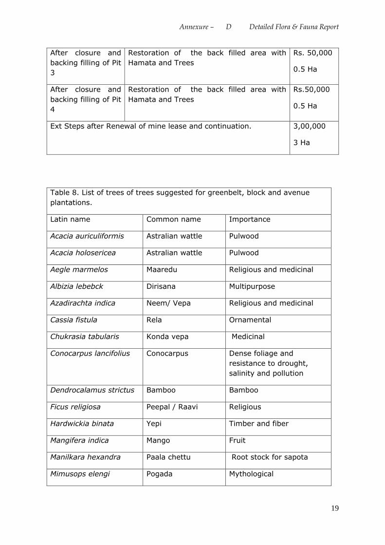
Annexure – D Detailed Flora & Fauna Report
19
After closure and
backing filling of Pit
3
Restoration of the back filled area with
Hamata and Trees
Rs. 50,000
0.5 Ha
After closure and
backing filling of Pit
4
Restoration of the back filled area with
Hamata and Trees
Rs.50,000
0.5 Ha
Ext Steps after Renewal of mine lease and continuation. 3,00,000
3 Ha
Table 8. List of trees of trees suggested for greenbelt, block and avenue
plantations.
Latin name Common name Importance
Acacia auriculiformis Astralian wattle Pulwood
Acacia holosericea Astralian wattle Pulwood
Aegle marmelos Maaredu Religious and medicinal
Albizia lebebck Dirisana Multipurpose
Azadirachta indica Neem/ Vepa Religious and medicinal
Cassia fistula Rela Ornamental
Chukrasia tabularis Konda vepa Medicinal
Conocarpus lancifolius Conocarpus Dense foliage and
resistance to drought,
salinity and pollution
Dendrocalamus strictus Bamboo Bamboo
Ficus religiosa Peepal / Raavi Religious
Hardwickia binata Yepi Timber and fiber
Mangifera indica Mango Fruit
Manilkara hexandra Paala chettu Root stock for sapota
Mimusops elengi Pogada Mythological
Annexure – D Detailed Flora & Fauna Report
20
Phyllanthus emblica Usiri / Amla Fruit
Pithecellobium dulce Seema chinta Fruit
Prosopis spicigera Jammi / Sami Mythological
Syzygium cumini Neredu Medicinal
Tamarindus indica Chinta Fruit
Tectona grandis Teku Timber
Sources of Secondary data and References
1. Alfred J.R.B., A.K Das & A.K Sanyal (2001) Eds. Ecosystems of India: Envis
Centre, Zoological Survey of India, Kolkata.
2. Andhra Pradesh Forest Department
http://www.forests.ap.gov.in/wildlife_new.html
3. Andhra Pradesh State Biodiversity Board : http://apbiodiversity.ap.nic.in/
4. Avibase - Bird Checklists of the World: Andhra Pradesh
https://avibase.bsc-eoc.org/checklist.jsp?region=INseap®ion=INseap
5. Checklist of Indian Snakes with English Common names
http://www.bio.utexas.edu/grad/sp/pubs/Indian%20Snakes-Checklist.pdf
6. David Hill, Matthew Fasham, Graham Tucker, Michael Shewary and Philip
Shaw (2005) Eds. Handbook of Biodiversity Methods: Survey, Evaluation and
Monitoring, by Published by Cambridge University Press.
7. Dinesh K.P., C. Radhakrishnan , B.H. Channakeshavamurthy and Nirmal U
Kulkarni (2015): A Checklist of Amphibians of India (Updated till January
2015)
http://mhadeiresearchcenter.org/wp-content/uploads/2015/02/Checklist-of-
Amphibia-of-India_2015-2_updated.pdf
8. India Biodiversity Portal: Checklist of threatened plants of Andhra Pradesh:
https://indiabiodiversity.org/checklist/show/249
9. IRC SP 021: Guidelines on Landscaping and Tree Plantation
by Indian Roads Congress Published 2009
10.Naidu, V.S.G.R (2012). Handbook on Weed Identification. Directorate of
Weed Science Research, Jabalpur, India: PP 354.
11.Official flora and fauna of India
http://www.biodiversityofindia.org/index.php?title=Official_flora_and_fauna
_of_India
Annexure – D Detailed Flora & Fauna Report
21
12.The IUCN Red List of Threatened Species. 2016
13.Taj S.A., & B.S. Balakumar (2014).Predominant Flora of Udayagiri Hills -
Eastern Ghats, Andhra Pradesh, India. Scholars Academic Journal of
Biosciences (SAJB): 2(5): 354-363
14.Wildlife Crime Control Bureau (2011). A Manual on Wildlife species in Trade
by Wildlife Crime Control Bureau, Ministry of Environment and Forests, New
Delhi
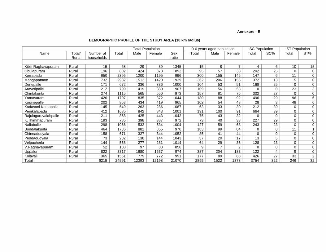
Annexure - E
DEMOGRAPHIC PROFILE OF THE STUDY AREA (10 km radius)
Total Population 0-6 years aged population SC Population ST Population Name Total/
Rural Number of households
Total Male Female Sex ratio
Total Male Female Total SC% Total ST%
Kibili Raghavapuram Rural 15 68 29 39 1345 15 8 7 4 6 10 15 Obulapuram Rural 196 802 424 378 892 95 57 38 202 25 0 0 Korrapadu Rural 650 2395 1200 1195 996 300 155 145 147 6 11 0 Mangapatnam Rural 732 2932 1512 1420 939 362 206 156 372 13 5 0 Denepalle Rural 171 672 336 336 1000 104 53 51 168 25 0 0 Aravetipalle Rural 212 799 419 380 907 109 56 53 0 0 23 3 Chintakunta Rural 274 1115 565 550 973 157 81 76 302 27 0 0 Yamavaram Rural 426 1707 835 872 1044 180 88 92 496 29 96 6 Kosinepalle Rural 202 853 434 419 965 102 54 48 28 3 48 6 Kadasani Kothapalle Rural 145 549 263 286 1087 63 33 30 212 39 0 0 Penikalapadu Rural 412 1685 842 843 1001 191 100 91 664 39 0 0 Rajulaguruvaiahpalle Rural 211 868 425 443 1042 75 43 32 0 0 0 0 K.Thimmapuram Rural 193 785 398 387 972 73 40 33 227 29 0 0 Nallaballe Rural 298 1066 532 534 1004 127 59 68 243 23 0 0 Bondalakunta Rural 464 1736 881 855 970 183 99 84 0 0 11 1 Chinnadudyala Rural 158 671 327 344 1052 85 41 44 0 0 0 0 Peddadudyala Rural 73 282 138 144 1043 37 20 17 13 5 0 0 Velpucherla Rural 144 558 277 281 1014 64 29 35 128 23 0 0 V.Raghavapuram Rural 52 180 97 83 856 9 7 2 0 0 0 0 Uppalur Rural 822 3317 1680 1637 974 387 204 183 122 4 9 0 Kolavali Rural 365 1551 779 772 991 177 89 88 426 27 33 2 Total 6215 24591 12393 12198 21070 2895 1522 1373 3754 322 246 32
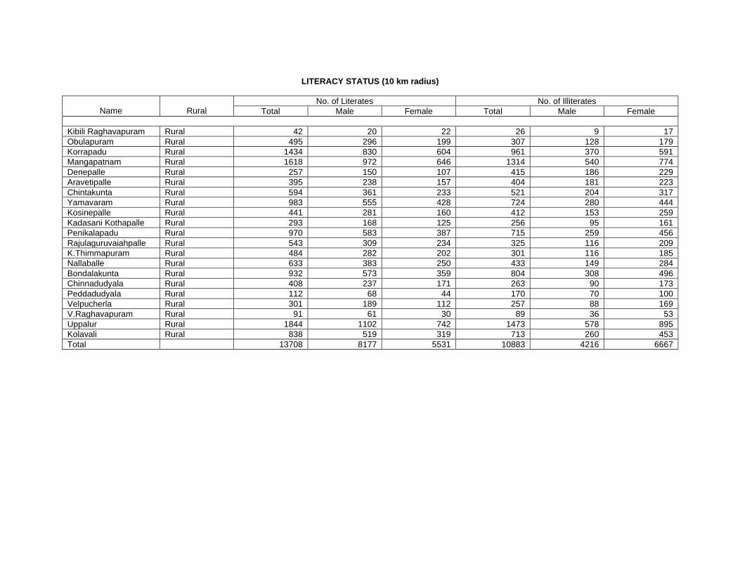
LITERACY STATUS (10 km radius)
Name
Rural No. of Literates No. of Illiterates
Total Male Female Total Male Female Kibili Raghavapuram Rural 42 20 22 26 9 17 Obulapuram Rural 495 296 199 307 128 179 Korrapadu Rural 1434 830 604 961 370 591 Mangapatnam Rural 1618 972 646 1314 540 774 Denepalle Rural 257 150 107 415 186 229 Aravetipalle Rural 395 238 157 404 181 223 Chintakunta Rural 594 361 233 521 204 317 Yamavaram Rural 983 555 428 724 280 444 Kosinepalle Rural 441 281 160 412 153 259 Kadasani Kothapalle Rural 293 168 125 256 95 161 Penikalapadu Rural 970 583 387 715 259 456 Rajulaguruvaiahpalle Rural 543 309 234 325 116 209 K.Thimmapuram Rural 484 282 202 301 116 185 Nallaballe Rural 633 383 250 433 149 284 Bondalakunta Rural 932 573 359 804 308 496 Chinnadudyala Rural 408 237 171 263 90 173 Peddadudyala Rural 112 68 44 170 70 100 Velpucherla Rural 301 189 112 257 88 169 V.Raghavapuram Rural 91 61 30 89 36 53 Uppalur Rural 1844 1102 742 1473 578 895 Kolavali Rural 838 519 319 713 260 453 Total 13708 8177 5531 10883 4216 6667
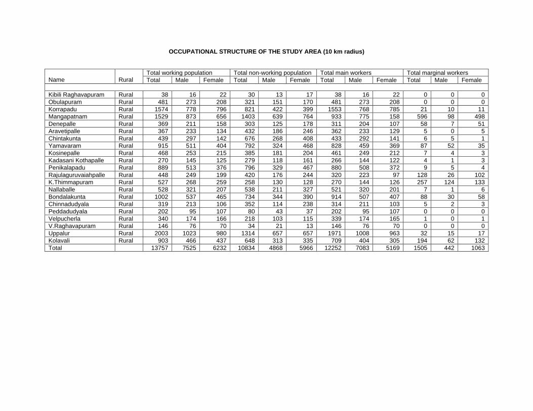
OCCUPATIONAL STRUCTURE OF THE STUDY AREA (10 km radius)
Name
Rural
Total working population Total non-working population Total main workers Total marginal workers Total Male Female Total Male Female Total Male Female Total Male Female
Kibili Raghavapuram Rural 38 16 22 30 13 17 38 16 22 0 0 0 Obulapuram Rural 481 273 208 321 151 170 481 273 208 0 0 0 Korrapadu Rural 1574 778 796 821 422 399 1553 768 785 21 10 11 Mangapatnam Rural 1529 873 656 1403 639 764 933 775 158 596 98 498 Denepalle Rural 369 211 158 303 125 178 311 204 107 58 7 51 Aravetipalle Rural 367 233 134 432 186 246 362 233 129 5 0 5 Chintakunta Rural 439 297 142 676 268 408 433 292 141 6 5 1 Yamavaram Rural 915 511 404 792 324 468 828 459 369 87 52 35 Kosinepalle Rural 468 253 215 385 181 204 461 249 212 7 4 3 Kadasani Kothapalle Rural 270 145 125 279 118 161 266 144 122 4 1 3 Penikalapadu Rural 889 513 376 796 329 467 880 508 372 9 5 4 Rajulaguruvaiahpalle Rural 448 249 199 420 176 244 320 223 97 128 26 102 K.Thimmapuram Rural 527 268 259 258 130 128 270 144 126 257 124 133 Nallaballe Rural 528 321 207 538 211 327 521 320 201 7 1 6 Bondalakunta Rural 1002 537 465 734 344 390 914 507 407 88 30 58 Chinnadudyala Rural 319 213 106 352 114 238 314 211 103 5 2 3 Peddadudyala Rural 202 95 107 80 43 37 202 95 107 0 0 0 Velpucherla Rural 340 174 166 218 103 115 339 174 165 1 0 1 V.Raghavapuram Rural 146 76 70 34 21 13 146 76 70 0 0 0 Uppalur Rural 2003 1023 980 1314 657 657 1971 1008 963 32 15 17 Kolavali Rural 903 466 437 648 313 335 709 404 305 194 62 132 Total 13757 7525 6232 10834 4868 5966 12252 7083 5169 1505 442 1063
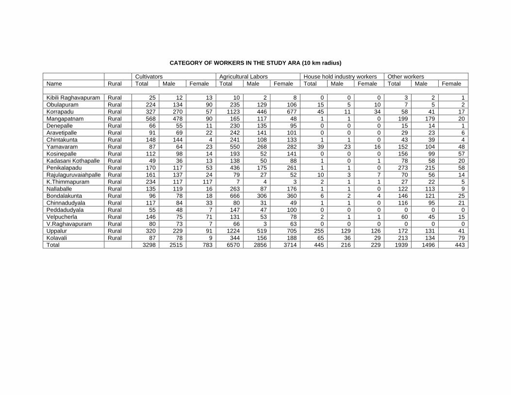
CATEGORY OF WORKERS IN THE STUDY ARA (10 km radius)
Cultivators Agricultural Labors House hold industry workers Other workers Name Rural Total Male Female Total Male Female Total Male Female Total Male Female Kibili Raghavapuram Rural 25 12 13 10 2 8 0 0 0 3 2 1 Obulapuram Rural 224 134 90 235 129 106 15 5 10 7 5 2 Korrapadu Rural 327 270 57 1123 446 677 45 11 34 58 41 17 Mangapatnam Rural 568 478 90 165 117 48 1 1 0 199 179 20 Denepalle Rural 66 55 11 230 135 95 0 0 0 15 14 1 Aravetipalle Rural 91 69 22 242 141 101 0 0 0 29 23 6 Chintakunta Rural 148 144 4 241 108 133 1 1 0 43 39 4 Yamavaram Rural 87 64 23 550 268 282 39 23 16 152 104 48 Kosinepalle Rural 112 98 14 193 52 141 0 0 0 156 99 57 Kadasani Kothapalle Rural 49 36 13 138 50 88 1 0 1 78 58 20 Penikalapadu Rural 170 117 53 436 175 261 1 1 0 273 215 58 Rajulaguruvaiahpalle Rural 161 137 24 79 27 52 10 3 7 70 56 14 K.Thimmapuram Rural 234 117 117 7 4 3 2 1 1 27 22 5 Nallaballe Rural 135 119 16 263 87 176 1 1 0 122 113 9 Bondalakunta Rural 96 78 18 666 306 360 6 2 4 146 121 25 Chinnadudyala Rural 117 84 33 80 31 49 1 1 0 116 95 21 Peddadudyala Rural 55 48 7 147 47 100 0 0 0 0 0 0 Velpucherla Rural 146 75 71 131 53 78 2 1 1 60 45 15 V.Raghavapuram Rural 80 73 7 66 3 63 0 0 0 0 0 0 Uppalur Rural 320 229 91 1224 519 705 255 129 126 172 131 41 Kolavali Rural 87 78 9 344 156 188 65 36 29 213 134 79 Total 3298 2515 783 6570 2856 3714 445 216 229 1939 1496 443
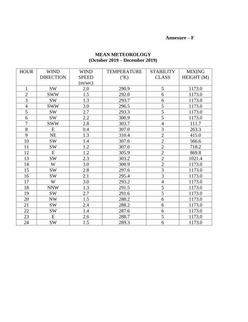
Annexure – F MEAN METEOROLOGY (October 2019 – December 2019)
HOUR WIND
DIRECTION WIND SPEED (m/sec)
TEMPERATURE (oK)
STABILITY CLASS
MIXING HEIGHT (M)
1 SW 2.0 290.9 5 1173.0 2 SWW 1.5 292.0 6 1173.0 3 SW 1.3 293.7 6 1173.0 4 SWW 3.0 296.5 5 1173.0 5 SW 2.7 293.3 5 1173.0 6 SW 2.2 300.9 5 1173.0 7 SWW 2.8 303.7 4 111.7 8 E 0.4 307.0 3 263.3 9 NE 1.3 310.4 2 415.0
10 SW 1.4 307.6 2 566.6 11 SW 1.2 307.0 2 718.2 12 E 1.2 305.9 2 869.8 13 SW 2.3 303.2 2 1021.4 14 W 3.0 300.9 2 1173.0 15 SW 2.8 297.6 3 1173.0 16 SW 2.1 295.4 3 1173.0 17 W 3.0 293.2 4 1173.0 18 NNW 1.3 291.5 5 1173.0 19 SW 2.7 291.6 5 1173.0 20 NW 1.5 288.2 6 1173.0 21 SW 2.4 288.2 6 1173.0 22 SW 1.4 287.6 6 1173.0 23 E 2.6 288.7 5 1173.0 24 SW 1.5 289.3 6 1173.0
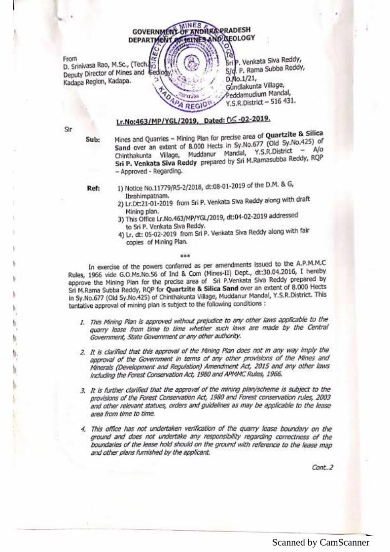
Scanned by CamScanner
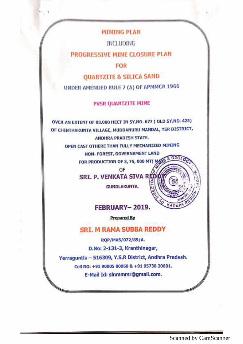
Scanned by CamScanner
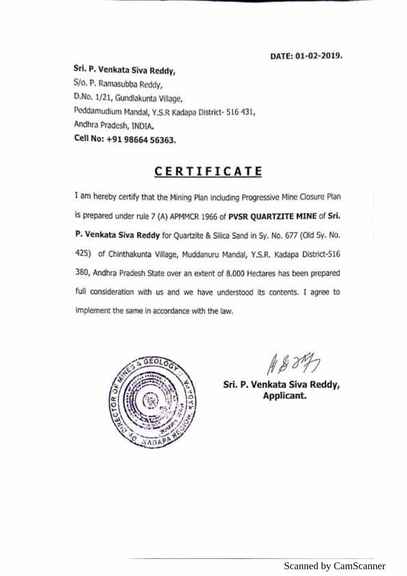
Scanned by CamScanner
Scanned by CamScanner
Scanned by CamScanner
Scanned by CamScanner
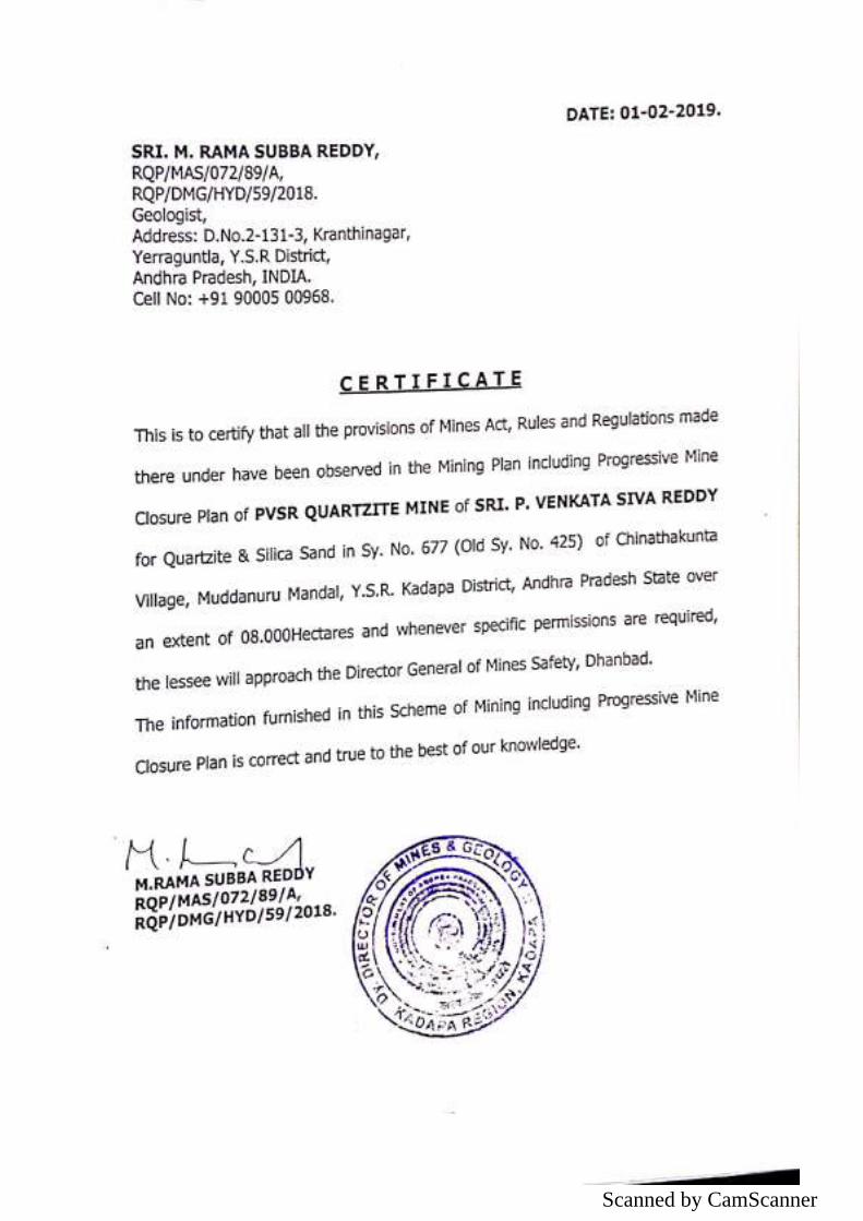
Scanned by CamScanner
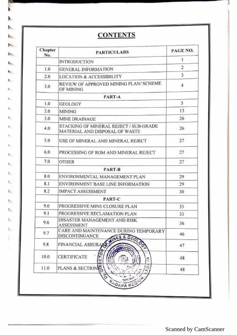
Scanned by CamScanner
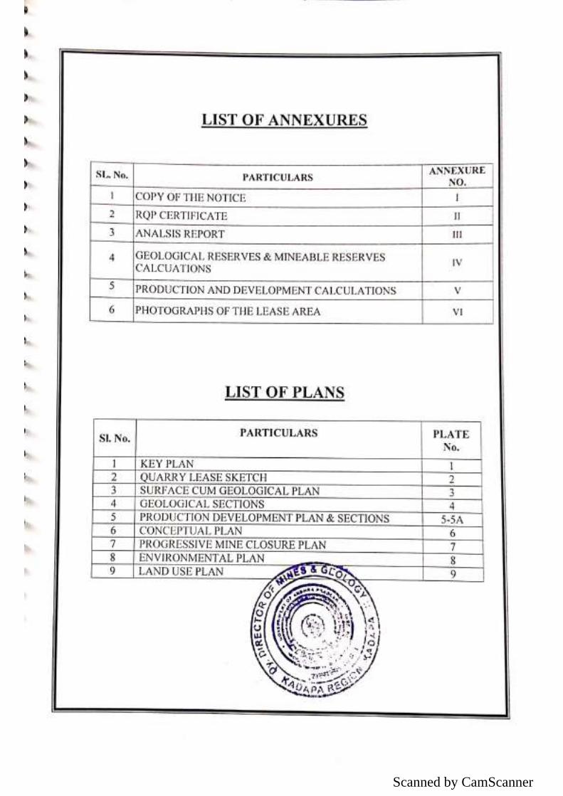
Scanned by CamScanner
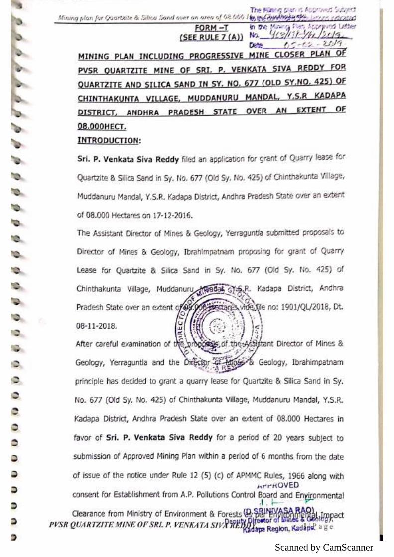
Scanned by CamScanner
Scanned by CamScanner
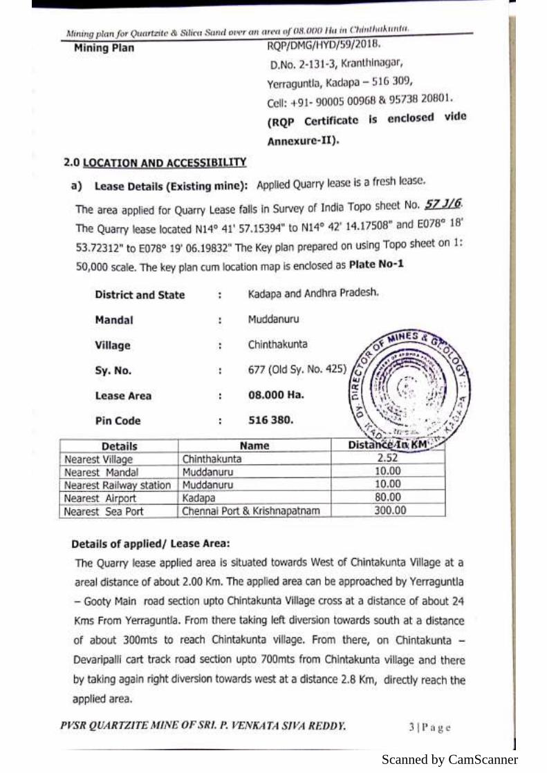
Scanned by CamScanner
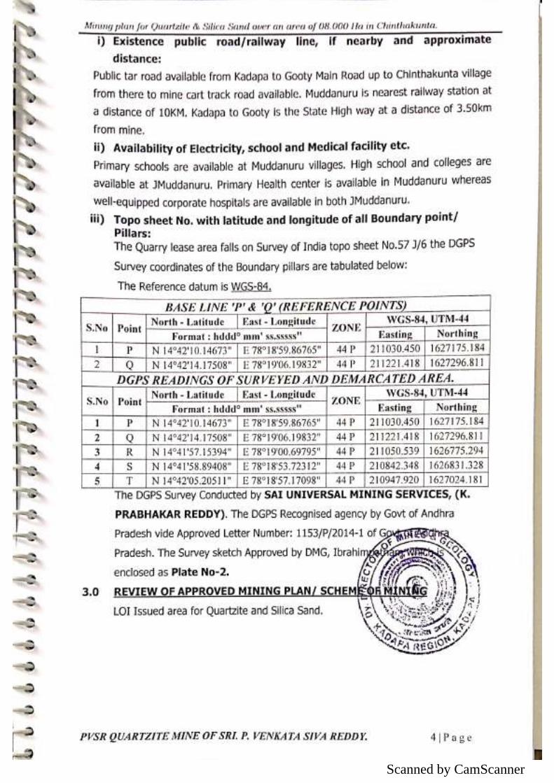
Scanned by CamScanner
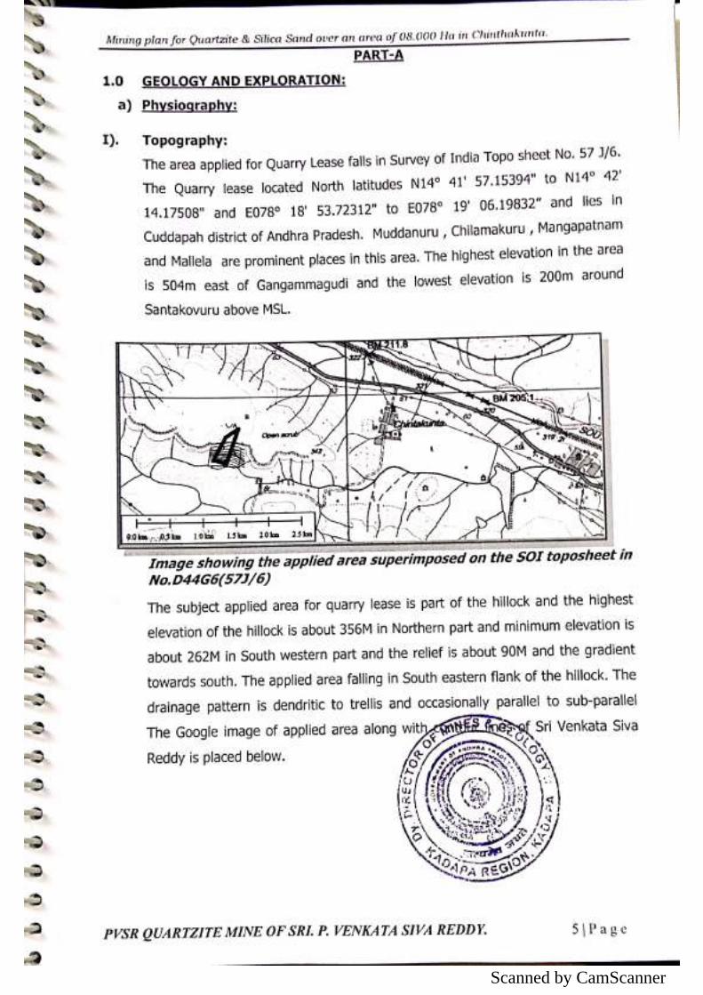
Scanned by CamScanner
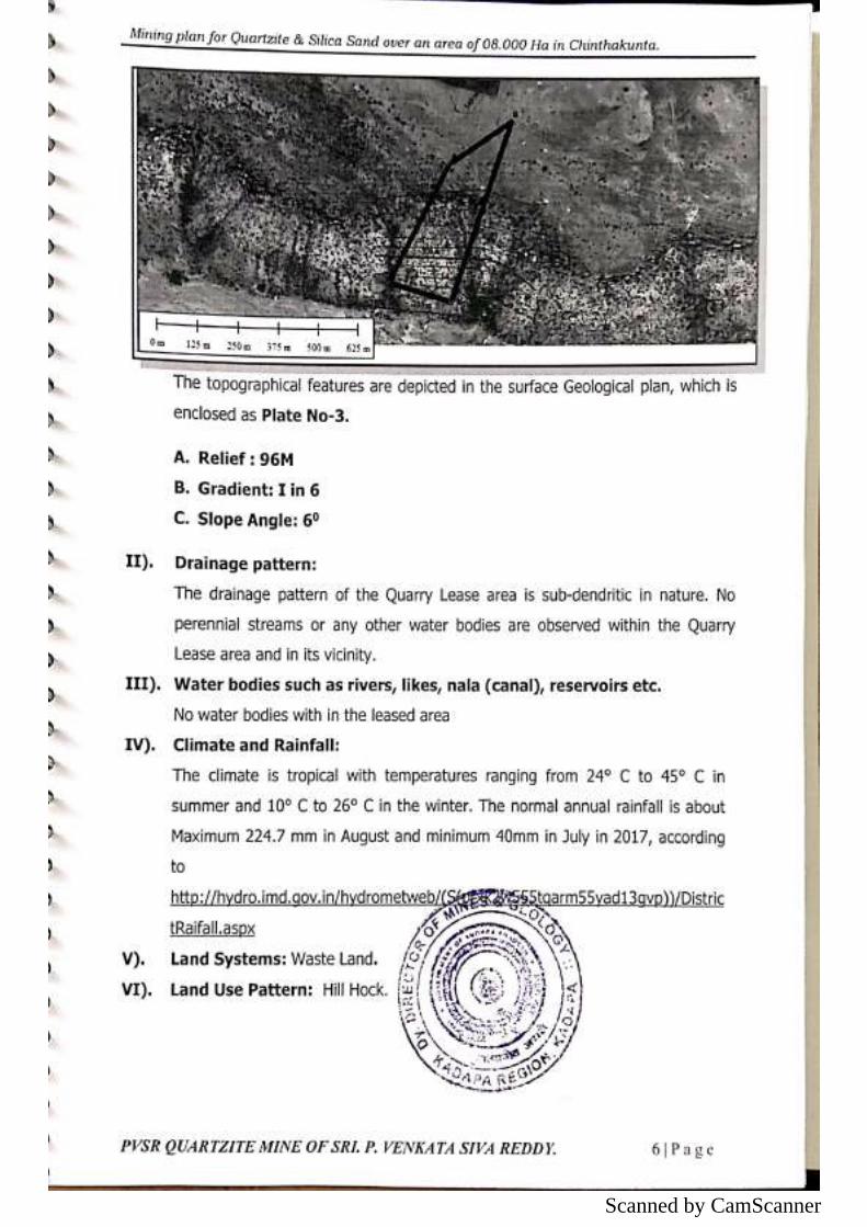
Scanned by CamScanner
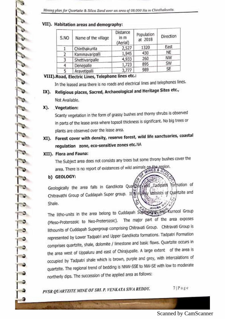
Scanned by CamScanner
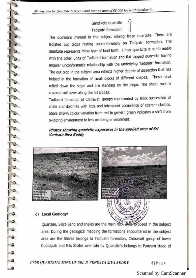
Scanned by CamScanner
Scanned by CamScanner
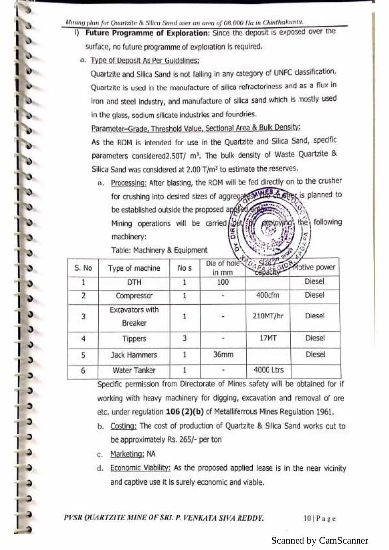
Scanned by CamScanner
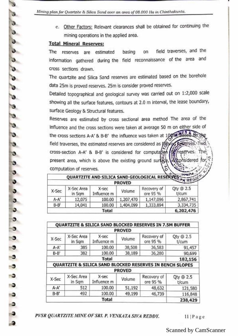
Scanned by CamScanner
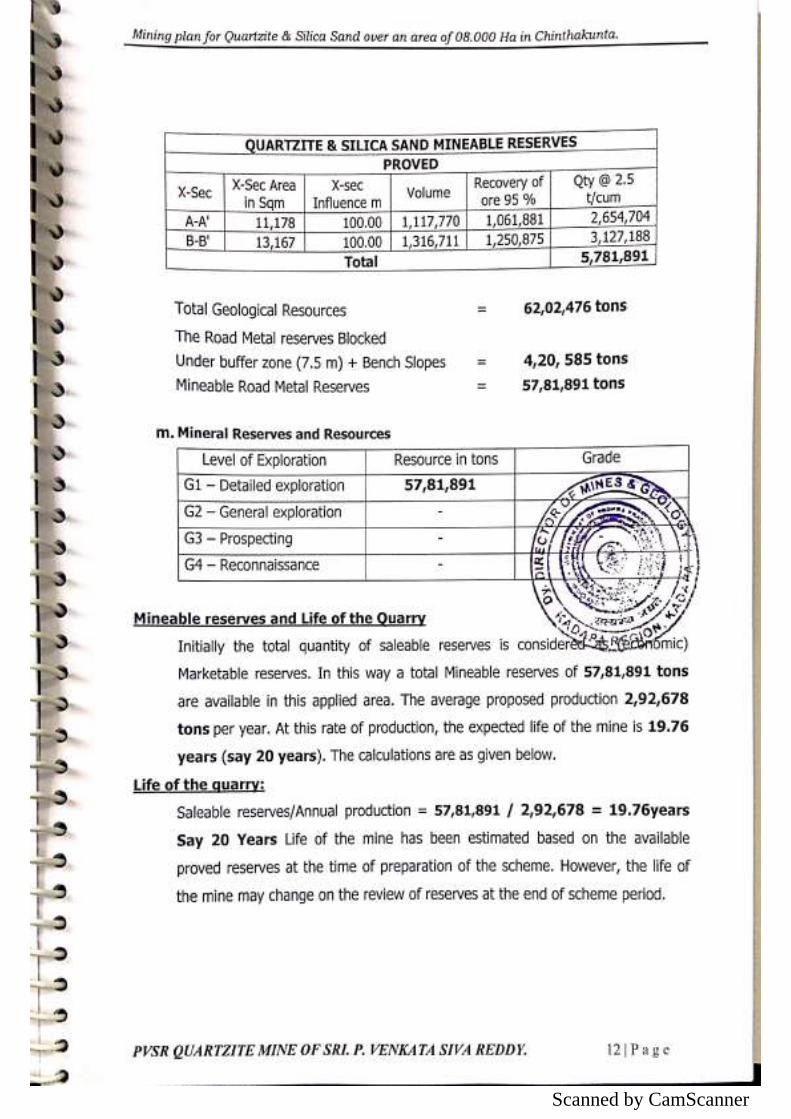
Scanned by CamScanner
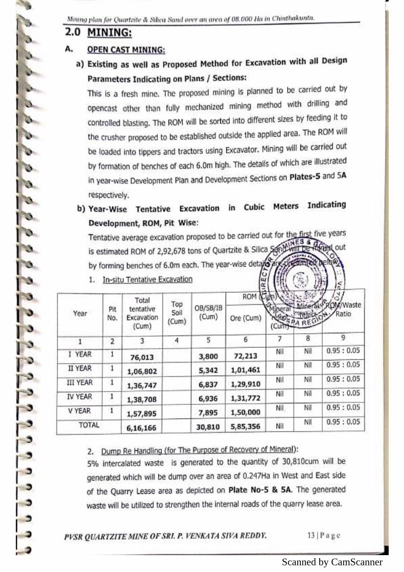
Scanned by CamScanner
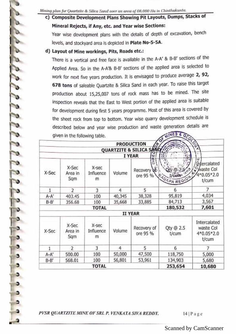
Scanned by CamScanner
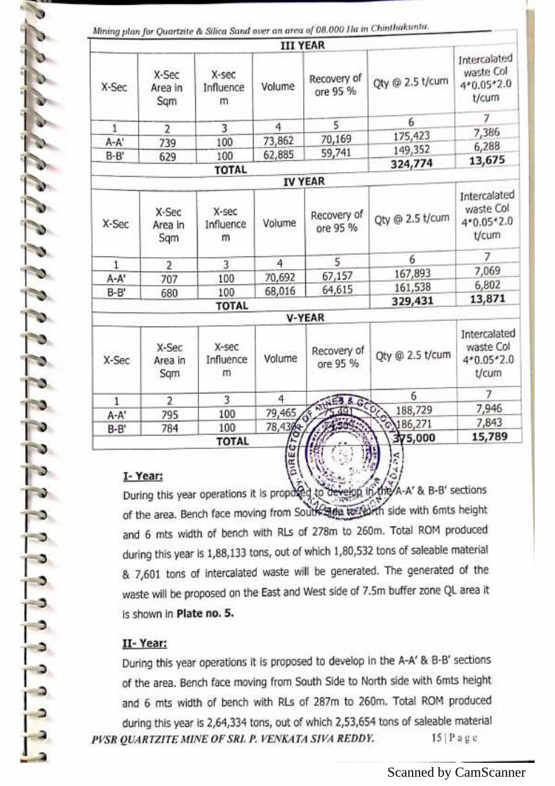
Scanned by CamScanner
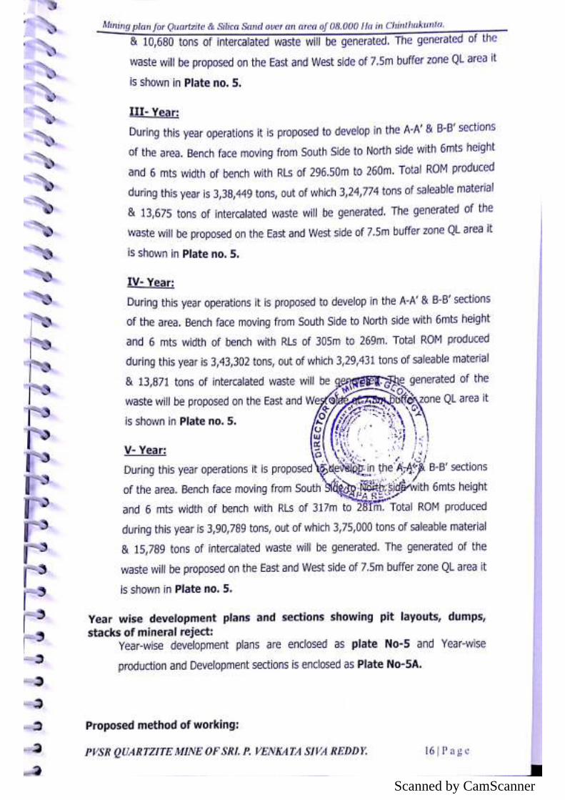
Scanned by CamScanner
Scanned by CamScanner
Scanned by CamScanner
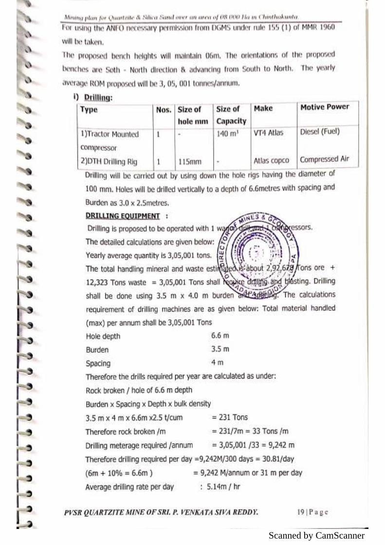
Scanned by CamScanner
Scanned by CamScanner
Scanned by CamScanner
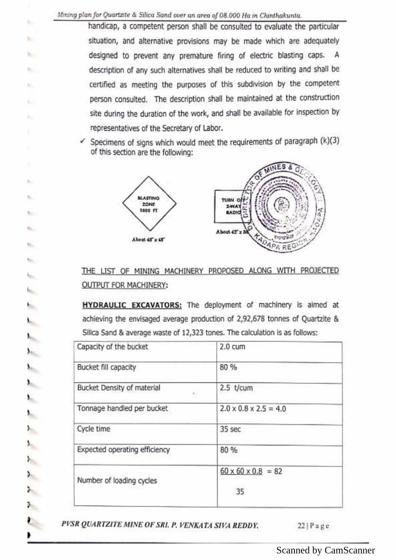
Scanned by CamScanner
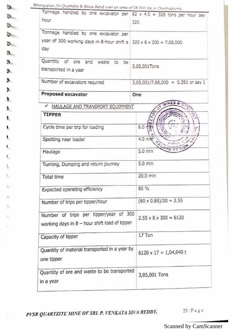
Scanned by CamScanner
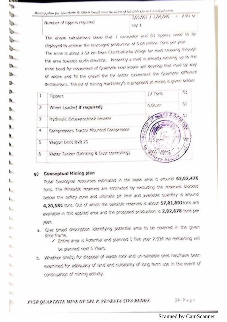
Scanned by CamScanner
Scanned by CamScanner
Scanned by CamScanner
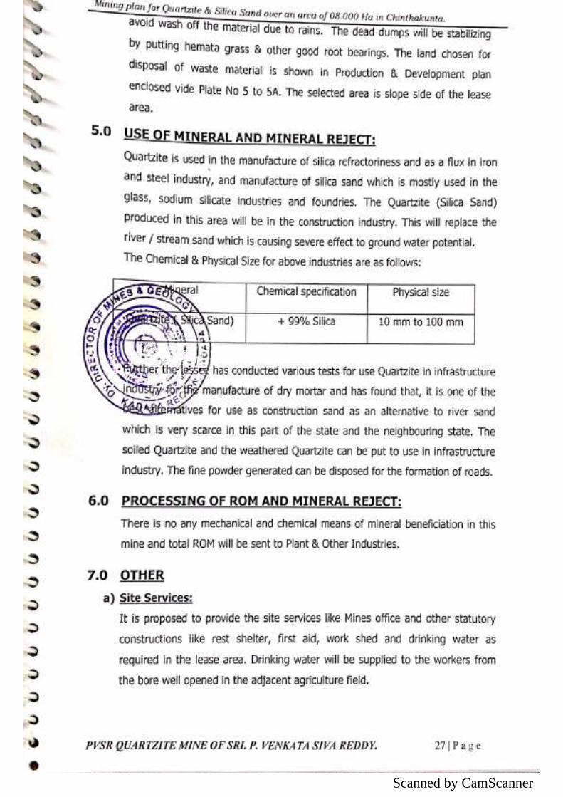
Scanned by CamScanner
Scanned by CamScanner
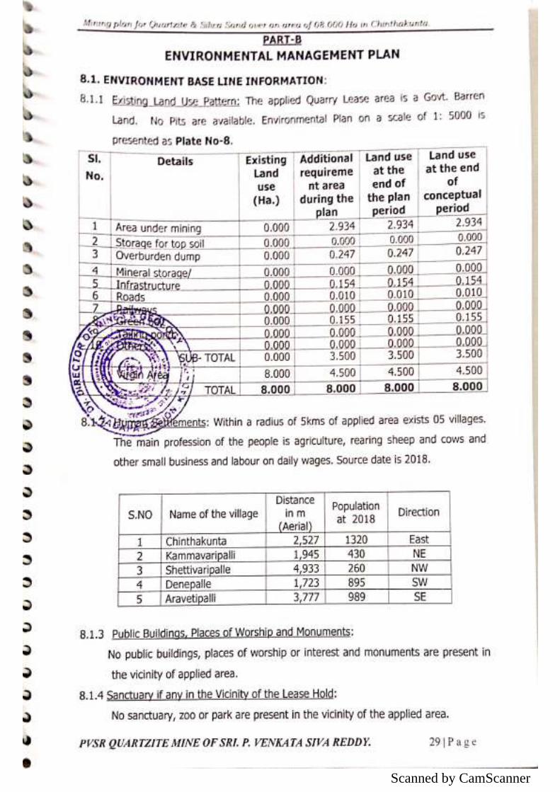
Scanned by CamScanner
Scanned by CamScanner
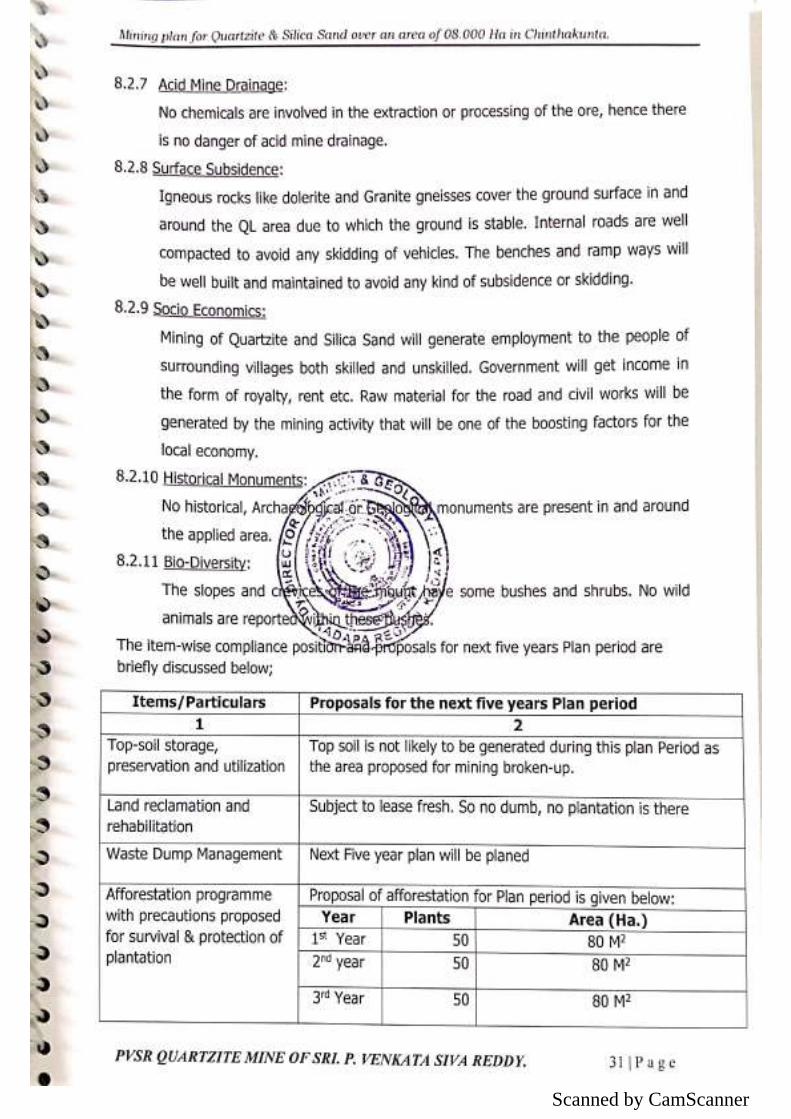
Scanned by CamScanner
Scanned by CamScanner
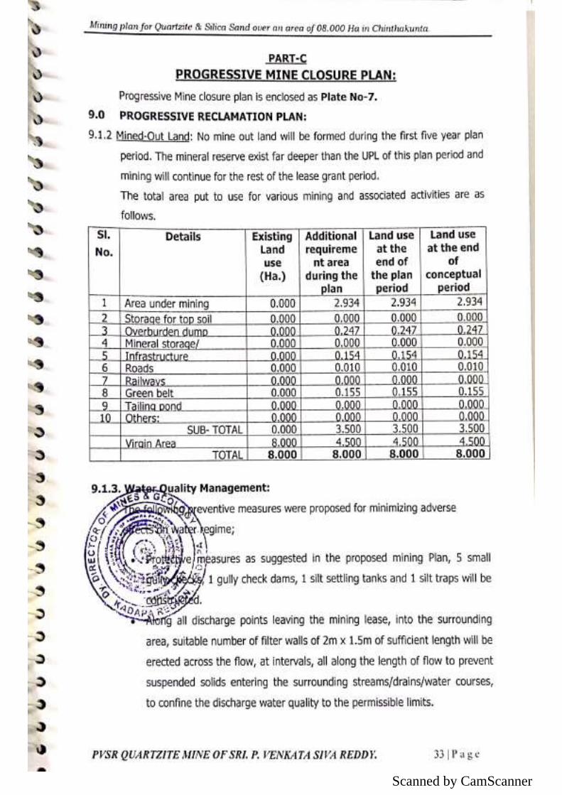
Scanned by CamScanner
Scanned by CamScanner
Scanned by CamScanner
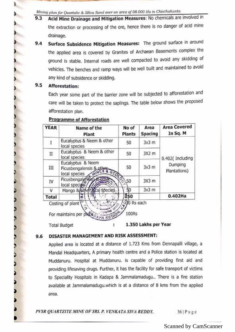
Scanned by CamScanner
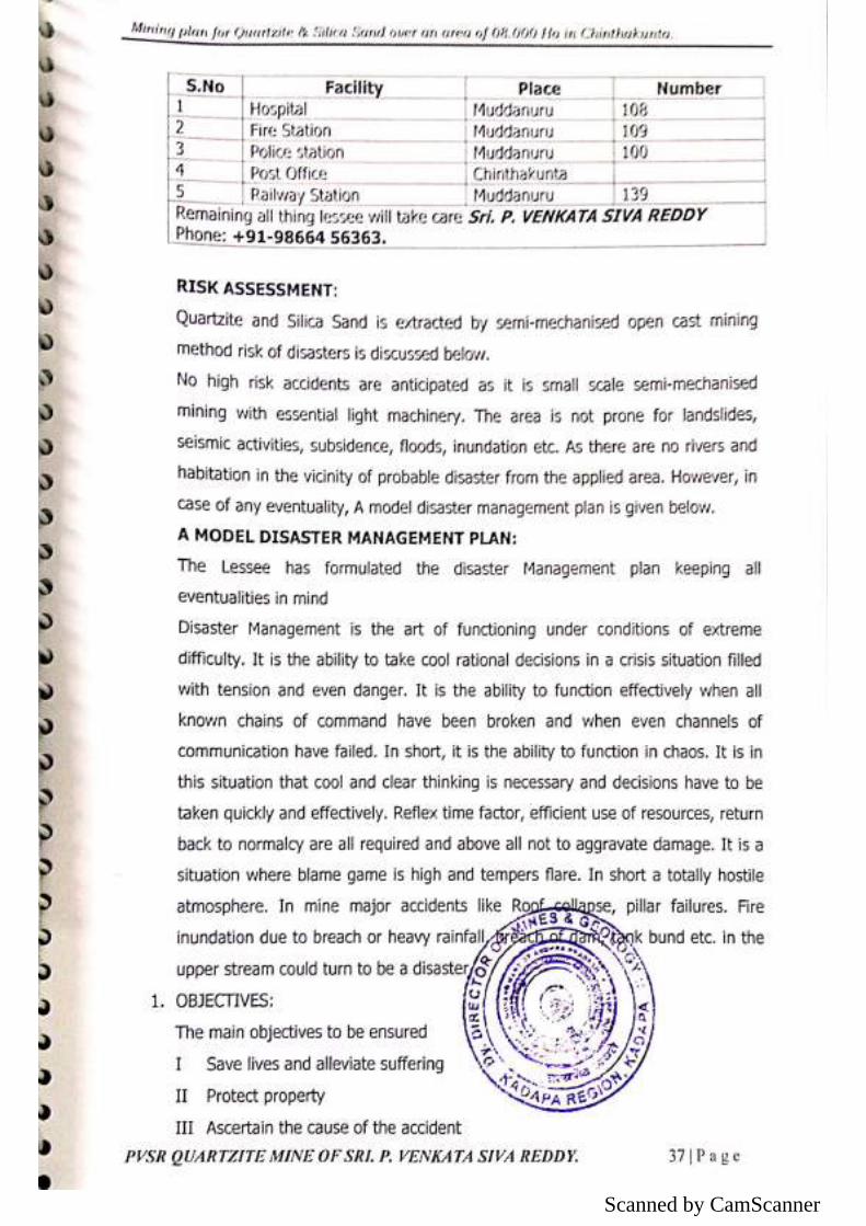
Scanned by CamScanner
Scanned by CamScanner
Scanned by CamScanner
Scanned by CamScanner
Scanned by CamScanner
Scanned by CamScanner
Scanned by CamScanner
Scanned by CamScanner
Scanned by CamScanner
Scanned by CamScanner
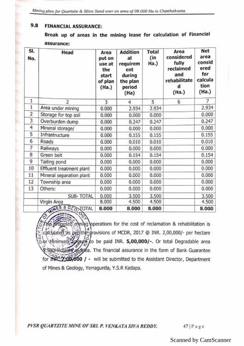
Scanned by CamScanner
Scanned by CamScanner
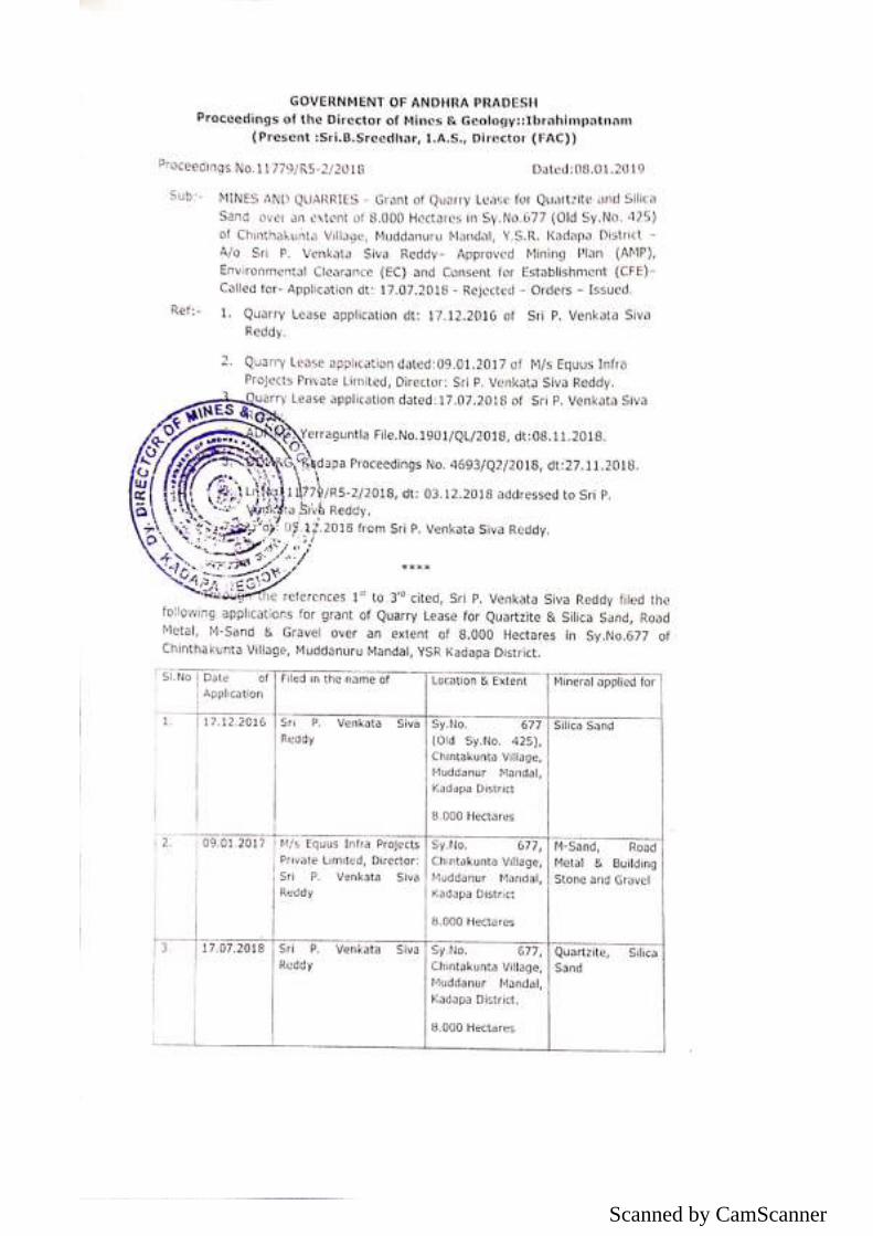
Scanned by CamScanner
Scanned by CamScanner
Scanned by CamScanner
Scanned by CamScanner
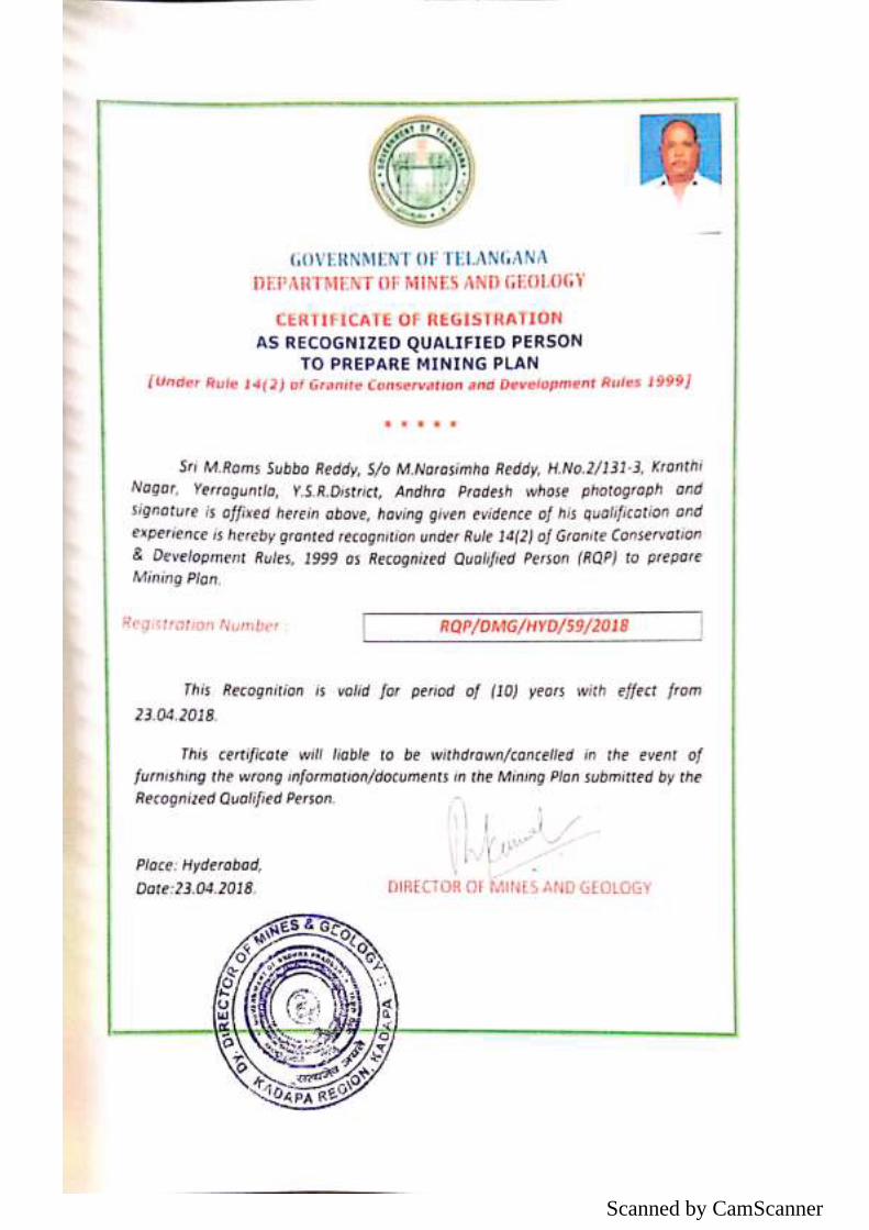
Scanned by CamScanner
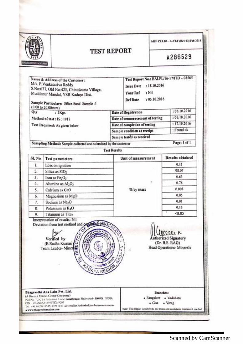
Scanned by CamScanner
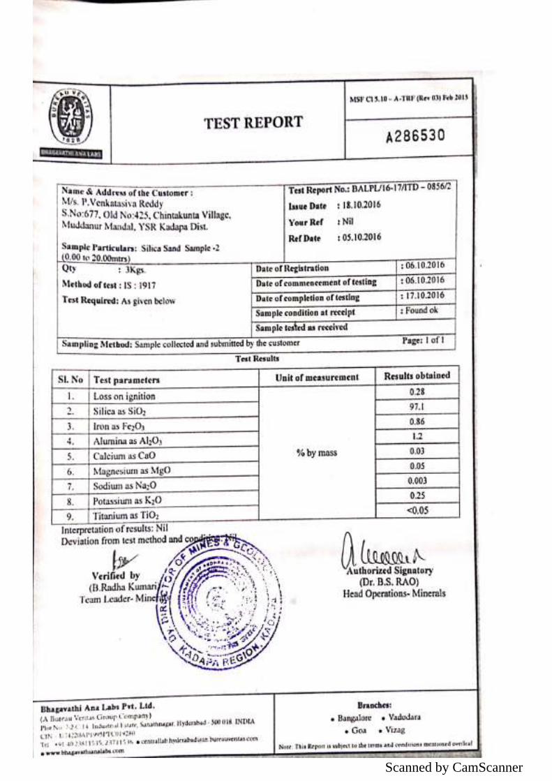
Scanned by CamScanner
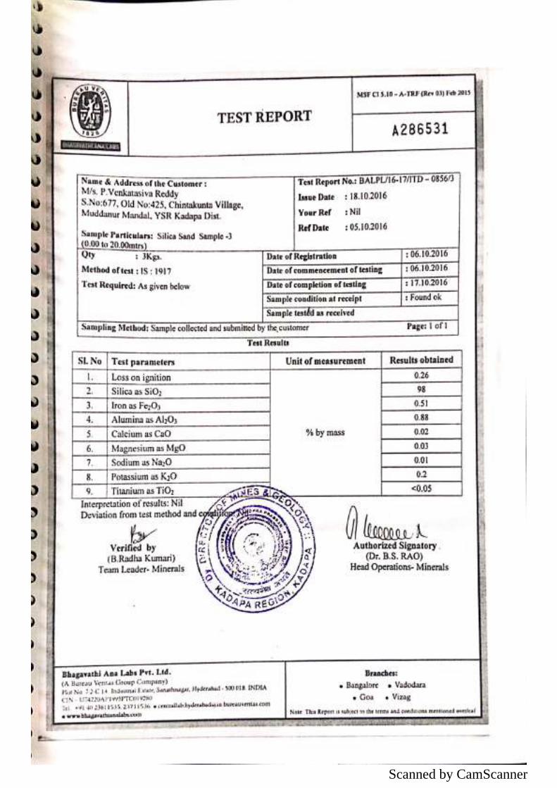
Scanned by CamScanner
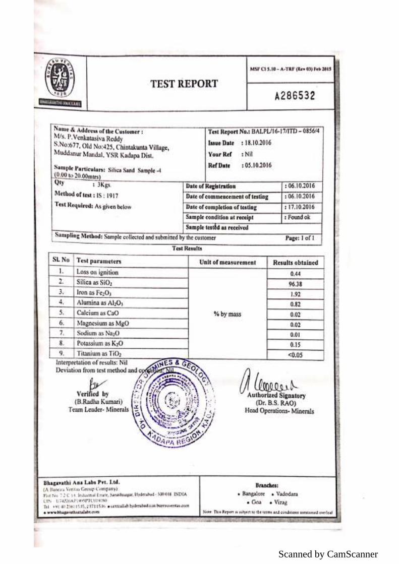
Scanned by CamScanner
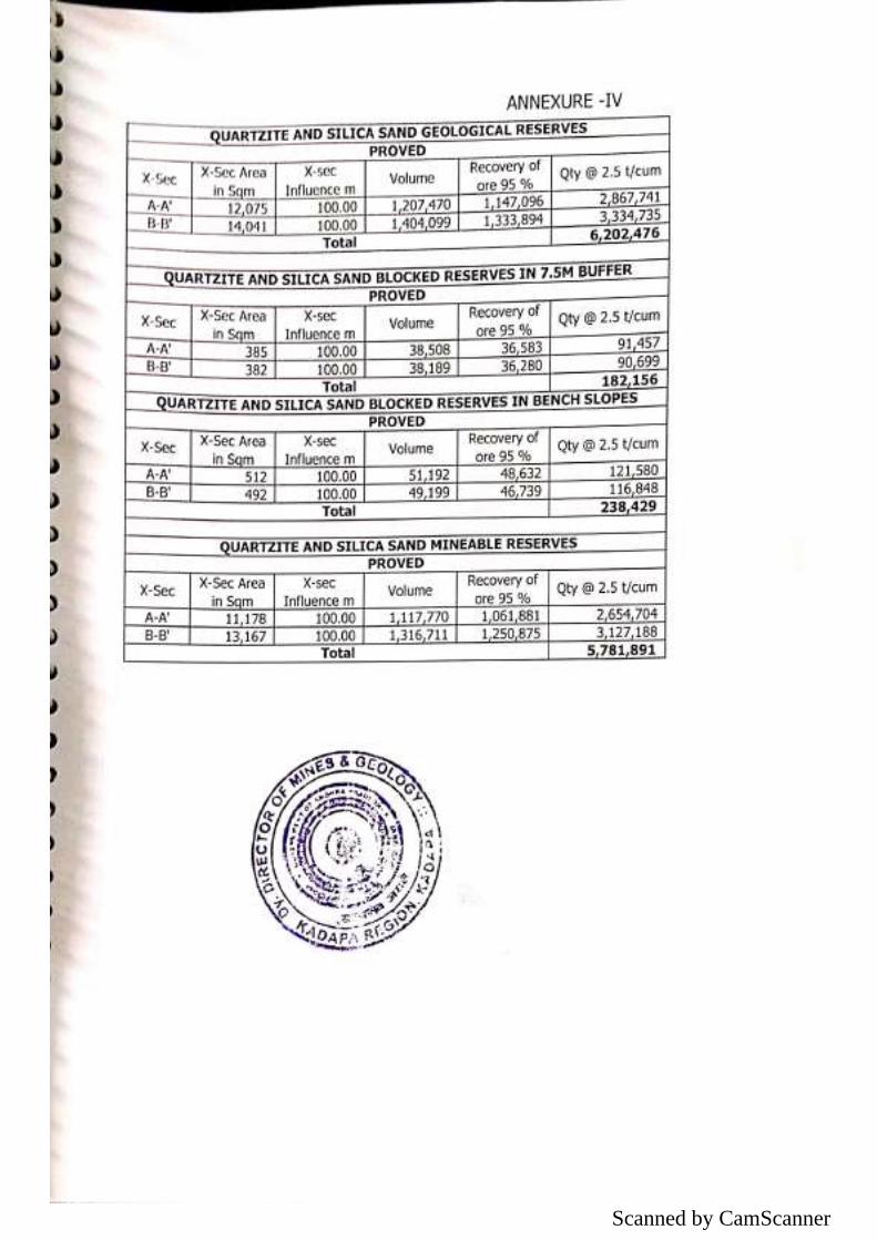
Scanned by CamScanner
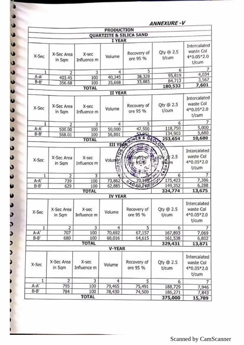
Scanned by CamScanner
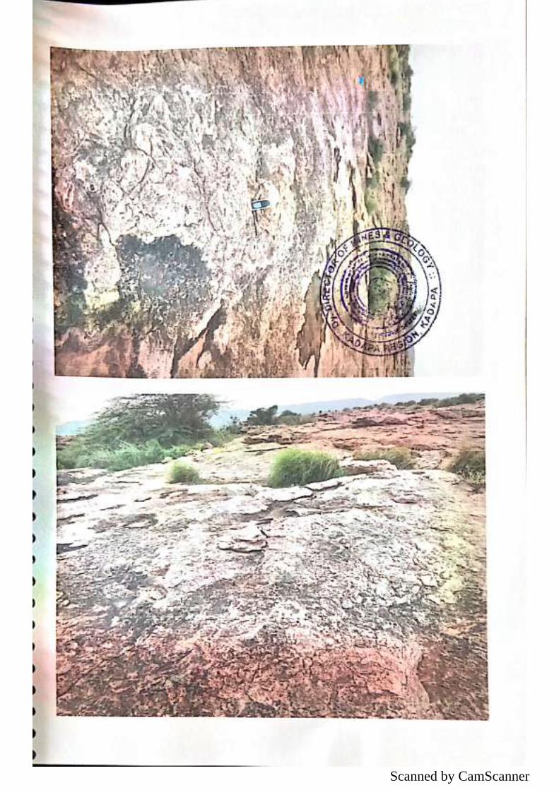
Scanned by CamScanner
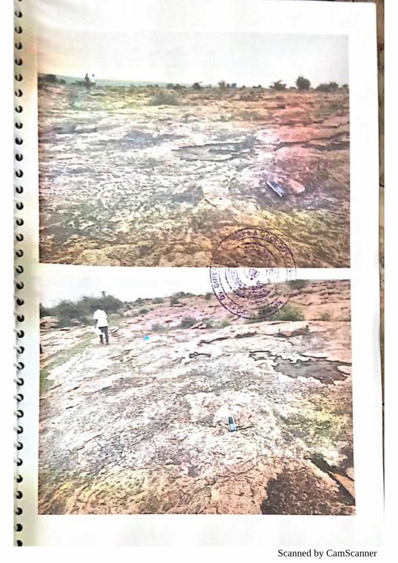
Scanned by CamScanner