Embed Size (px)
Citation preview
Earth-Science Reviews 160 (2016) 350–385
Contents lists available at ScienceDirect
Earth-Science Reviews
j ourna l homepage: www.e lsev ie r .com/ locate /earsc i rev
Invited review
Plio-Pleistocene exhumation of the eastern Himalayan syntaxis and itsdomal ‘pop-up’
Laura Bracciali a,b,⁎, Randall R. Parrish c, Yani Najman b, Andrew Smye d, Andrew Carter e, Jan R. Wijbrans f
a NERC Isotope Geosciences Laboratory, British Geological Survey, Keyworth, Nottingham, United Kingdomb Lancaster Environment Centre, Lancaster University, Lancaster, United Kingdomc British Geological Survey, Keyworth, Nottingham and Department of Earth and Environmental Sciences, University of Portsmouth, Portsmouth, United Kingdomd Department of Geosciences, The Pennsylvania State University, University Park, USAe Department of Earth and Planetary Sciences, Birkbeck College, University of London, London, United Kingdomf Petrology Department, Vrije Universiteit, Amsterdam, Netherlands
⁎ Corresponding author at: NERC Isotope Geosciences LE-mail address: [email protected] (L. Bracciali).
http://dx.doi.org/10.1016/j.earscirev.2016.07.0100012-8252/© 2016 The Authors. Published by Elsevier B.V
a b s t r a c t
a r t i c l e i n f oArticle history:Received 19 December 2015Received in revised form 24 July 2016Accepted 25 July 2016Available online 27 July 2016
The eastern termination of theHimalayan orogen forms a structural syntaxis that is characterised by young (from10 to b1 Ma) mineral growth and cooling ages that document Late Miocene to Pleistocene structural, metamor-phic, igneous and exhumation events. This region is a steep antiformal and in part domal structure that folds thesuture zone between the Indian and Asian plates. It is dissected by the Yarlung Tsangpo, one of themajor rivers ofthe eastern Himalayan–Tibet region, which becomes the Brahmaputra River in the Indian foreland basin beforeemptying into the Bay of Bengal. Exceptionally high relief and one of the deepest gorges on Earth have developedwhere the river's tortuous route crosses the Namche Barwa–Gyala Peri massif (N7 km in elevation) in the core ofthe syntaxis. Very high erosion rates documented in sediment downstream of the gorge at the foot of theHimalaya contribute ~50% of total detritus to the sediment load of the Brahmaputra.The initiation of very high rates of exhumation has been attributed either to the extreme erosive power of a riverflowing across a deforming indentor corner and the associated positive feedback, or to the geometry of the Indianplate indentor, with the corner being thrust beneath the Asian plate resulting in buckling which accommodatesshortening; both processes may be important.The northern third of the syntaxis corresponds to a steep domal ‘pop-up’ structure bounded by the India–Asia su-ture on three sides and a thrust zone to the south. Within the dome, Greater Himalaya rocks equilibrated at~800 °C and 25–30kmdepth during theMiocene,with these conditions potentially persisting into the latestMio-cene and possibly the Pliocene, with modest decompression prior to ~4 Ma. This domal ‘pop-up’ corresponds tothe area of youngest bedrock ages on a wide variety of thermochronometers and geochronometers.In this paper we review the extensive scientific literature that has focused on the eastern syntaxis and providenew chronological data on its bedrock and erosion products to constrain the age of inception of the very rapiduplift and erosion. We then discuss its cause, with the ultimate aim to reconstruct the exhumation history ofthe syntaxis and discuss the tectonic context for its genesis. We use zircon and rutile U–Pb, white mica Ar–Arand zircon fission track dating methods to extract age data from bedrock, Brahmaputra modern sediments (in-cluding an extensive compilation of modern detrital chronometry from the eastern Himalaya) and Neogenepalaeo-Brahmaputra deposits of the Surma Basin (Bangladesh). Numerical modelling of heat flow and erosionis also used to model the path of rocks from peak metamorphic conditions of ~800 °C to b250 °C. Our newdata include U–Pb bedrock rutile ages as young as 1.4 Ma from the Namche Barwa massif and 0.4 Ma from theriver downstream of the syntaxis.Combinedwith existing data, our newdata and heatflowmodelling show that: i) the detrital age signature of themodern syntaxis is unique within the eastern Himalayan region; ii) the rocks within the domal pop-up wereN575 ± 75 °C only 1–2 Myr ago; iii) the Neogene Surma Basin does not record evidence of the rise and erosionof the domal pop-up until latest Pliocene–Pleistocene time; iv) Pleistocene exhumation of the north-easternmostpart of the syntaxis took place at rates of at least 4 km/Myr, with bedrock erosion of 12–21 km during the last3 Ma; v) the inception of rapid syntaxial exhumation may have started as early as 7 Ma or as late as 3 Ma; andvi) the Yarlung Tsangpo is antecedent and subsequently distorted by the developing antiform. Together ourdata and modelling demonstrate that the domal pop-up with its exceptional erosion and topographic relief is
Keywords:Eastern Himalayan syntaxisNamche BarwaSurma BasinYarlung Tsangpo–BrahmaputraU–Pb rutile datingThermal modelling
aboratory, British Geological Survey, Keyworth, Nottingham, United Kingdom.
. This is an open access article under the CC BY license (http://creativecommons.org/licenses/by/4.0/).
351L. Bracciali et al. / Earth-Science Reviews 160 (2016) 350–385
likely a Pleistocene feature that overprinted earlier structural and metamorphic events typical of Himalayanevolution.
© 2016 The Authors. Published by Elsevier B.V. This is an open access article under the CC BY license(http://creativecommons.org/licenses/by/4.0/).
Contents
1. Introduction . . . . . . . . . . . . . . . . . . . . . . . . . . . . . . . . . . . . . . . . . . . . . . . . . . . . . . . . . . . . . . 3512. Geological framework and previous chronological constraints . . . . . . . . . . . . . . . . . . . . . . . . . . . . . . . . . . . . . . . 355
2.1. General geological framework . . . . . . . . . . . . . . . . . . . . . . . . . . . . . . . . . . . . . . . . . . . . . . . . . . 3552.2. Structure and geology of the eastern Himalayan syntaxis . . . . . . . . . . . . . . . . . . . . . . . . . . . . . . . . . . . . . . 3562.3. Metamorphic evolution of the eastern Himalayan syntaxis . . . . . . . . . . . . . . . . . . . . . . . . . . . . . . . . . . . . . . 3562.4. Thermochronology of the eastern Himalayan syntaxis . . . . . . . . . . . . . . . . . . . . . . . . . . . . . . . . . . . . . . . . 3572.5. The palaeo-Brahmaputra sedimentary record (Surma Basin) . . . . . . . . . . . . . . . . . . . . . . . . . . . . . . . . . . . . . 358
3. Samples and analytical methods . . . . . . . . . . . . . . . . . . . . . . . . . . . . . . . . . . . . . . . . . . . . . . . . . . . . . 3593.1. Sample details and preparation . . . . . . . . . . . . . . . . . . . . . . . . . . . . . . . . . . . . . . . . . . . . . . . . . . 3593.2. LA U–Pb dating of zircon and rutile . . . . . . . . . . . . . . . . . . . . . . . . . . . . . . . . . . . . . . . . . . . . . . . . 3593.3. Ar–Ar dating of white mica . . . . . . . . . . . . . . . . . . . . . . . . . . . . . . . . . . . . . . . . . . . . . . . . . . . . 3613.4. Zircon fission track dating . . . . . . . . . . . . . . . . . . . . . . . . . . . . . . . . . . . . . . . . . . . . . . . . . . . . 361
4. The isotopic fingerprint of the eastern Himalayan syntaxis in the modern detritus . . . . . . . . . . . . . . . . . . . . . . . . . . . . . . 3614.1. New detrital chronology from the modern Brahmaputra drainage . . . . . . . . . . . . . . . . . . . . . . . . . . . . . . . . . . 3614.2. Review of published modern detrital chronology from the eastern Himalaya . . . . . . . . . . . . . . . . . . . . . . . . . . . . . 365
4.2.1. Detrital U–Pb zircon data . . . . . . . . . . . . . . . . . . . . . . . . . . . . . . . . . . . . . . . . . . . . . . . . 3654.2.2. Detrital rutile U–Pb data . . . . . . . . . . . . . . . . . . . . . . . . . . . . . . . . . . . . . . . . . . . . . . . . . 3664.2.3. Detrital white mica Ar–Ar data . . . . . . . . . . . . . . . . . . . . . . . . . . . . . . . . . . . . . . . . . . . . . . 3674.2.4. Detrital zircon fission track data . . . . . . . . . . . . . . . . . . . . . . . . . . . . . . . . . . . . . . . . . . . . . 367
4.3. Comparison of detrital data with new U–Pb rutile bedrock data from Namche Barwa . . . . . . . . . . . . . . . . . . . . . . . . . . 3705. Detrital chronology of Neogene Himalayan sedimentary deposits . . . . . . . . . . . . . . . . . . . . . . . . . . . . . . . . . . . . . . 371
5.1. Neogene palaeo-Brahmaputra deposits from the Surma Basin . . . . . . . . . . . . . . . . . . . . . . . . . . . . . . . . . . . . 3715.2. Neogene Siwalik foreland deposits in the easternmost Himalaya . . . . . . . . . . . . . . . . . . . . . . . . . . . . . . . . . . . 373
6. Initiation and pace of rapid exhumation within the syntaxis, as determined from the Surma Basin palaeo-Brahmaputra deposits . . . . . . . . . 3737. The syntaxial domal ‘pop-up’ and its cause . . . . . . . . . . . . . . . . . . . . . . . . . . . . . . . . . . . . . . . . . . . . . . . . 375
7.1. Coincidence of domal shape and youngest thermochronometry . . . . . . . . . . . . . . . . . . . . . . . . . . . . . . . . . . . 3757.2. Reconciling the metamorphic, cooling and tectonic evolution of the syntaxis . . . . . . . . . . . . . . . . . . . . . . . . . . . . . 3757.3. Himalayan mid-crustal context of the syntaxis and its domal pop-up . . . . . . . . . . . . . . . . . . . . . . . . . . . . . . . . . 3767.4. Thermal modelling of uplift and erosion: methods, parameters, constraints . . . . . . . . . . . . . . . . . . . . . . . . . . . . . . 3777.5. Thermal modelling: results and discussion . . . . . . . . . . . . . . . . . . . . . . . . . . . . . . . . . . . . . . . . . . . . . 3787.6. Synthesis: the pop-up dome in the context of the Himalaya . . . . . . . . . . . . . . . . . . . . . . . . . . . . . . . . . . . . . 379
8. Pleistocene climate-tectonic feedbacks in the eastern Himalayan syntaxis . . . . . . . . . . . . . . . . . . . . . . . . . . . . . . . . . . 3809. Summary and conclusions . . . . . . . . . . . . . . . . . . . . . . . . . . . . . . . . . . . . . . . . . . . . . . . . . . . . . . . 38110. Future work . . . . . . . . . . . . . . . . . . . . . . . . . . . . . . . . . . . . . . . . . . . . . . . . . . . . . . . . . . . . . 382Acknowledgements . . . . . . . . . . . . . . . . . . . . . . . . . . . . . . . . . . . . . . . . . . . . . . . . . . . . . . . . . . . . . 382Appendix A. Supplemental data . . . . . . . . . . . . . . . . . . . . . . . . . . . . . . . . . . . . . . . . . . . . . . . . . . . . . . 382References . . . . . . . . . . . . . . . . . . . . . . . . . . . . . . . . . . . . . . . . . . . . . . . . . . . . . . . . . . . . . . . . . 382
1. Introduction
Due to its ongoing deformation and scale, the Himalayan orogen(Fig. 1) is one of the best natural laboratories to investigate causes andconsequences of continental scale crustal deformation and its surfaceexpression and processes, including the complex links between conti-nental tectonics, surface processes and climate feedbacks (e.g. Searleet al., 1987; Molnar and England, 1990; Raymo and Ruddiman, 1992;Prell and Kutzbach, 1992; Krishnaswami et al., 1992; Willett et al.,1993; Houseman and England, 1993; Molnar et al., 1993; Royden etal., 1997; Beaumont et al., 2001; Tapponnier et al., 2001; Zeitler et al.,2001a; Koons et al., 2002; Burbank et al., 2003, 2013; Thiede et al.,2005; Harris, 2006; Owen, 2008; Whipple, 2009; Ouimet et al., 2010;Iaffaldano et al., 2011; Copley et al., 2011).
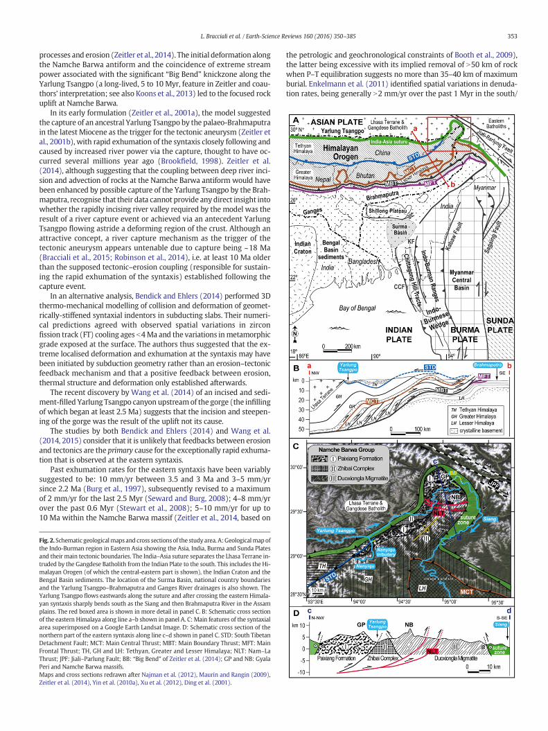
The easternmost Himalaya is characterised by an arcuate geologywith the suture zone between the Asian and Indian plates trending~E–W in southeast Tibet, then bending about 180° in a mostly continu-ous fashion around the Namche Barwa–Gyala Perimassif before turningto a southeast and then southerly trend in western Myanmar (Fig. 2A).
This location corresponds to the north-eastern edge of the Indianplate indentor. There is widespread deformation and seismicity of
rocks within this zone but the essential feature of the syntaxis is thatthe underlying Indian plate rocks have deformed into a sharp andnortheast-terminating complex antiformal uplift that has lifted andbent the Asian plate above it (Burg et al., 1997) and caused the suturepattern to resemble a sharp bend in map view (Fig. 2C; Ding et al.,2001; Quanru et al., 2006; Kidd et al., 2006; Booth et al., 2009; Liu etal., 2011; Xu et al., 2012). Within the Indian plate of the syntaxis arehigh grade metamorphic rocks, locally at granulite facies (Liu andZhong, 1997; Burg et al., 1998; Ding et al., 2001; Zhang et al., 2012a;Guilmette et al., 2011) and with very young cooling ages (Section 2.4).
Many studies have addressed the relationship between Cenozoictectonic and erosion processes in the eastern Tibet–Himalayan regionand the coeval development of topography and the regional drainagenetwork (Gansser, 1966; Seeber and Gornitz, 1983; Harrison et al.,1992; Brookfield, 1998; Hallet and Molnar, 2001; Zeitler et al., 2001b;Clark et al., 2004; Seward and Burg, 2008; Robl et al., 2008; Cina et al.,2009; Ouimet et al., 2010; Chirouze et al., 2013; Lang and Huntington,2014; Zeitler et al., 2014; Bracciali et al., 2015). Clark et al. (2004)showed that a number of river courses have been modified by progres-sive deformation of this region and the eastward extrusion of the east-ern Asian plate.
Fig. 1.General view of the Himalaya and its syntaxial terminations. The Himalayan orogen is the result of the collision between the Asian and Indian plates. National boundaries andmaingeological elements are superimposed on a NASA (www.nasa.gov) Landsat 7 image. Inset shows the location of the figure within eastern Asia.
352 L. Bracciali et al. / Earth-Science Reviews 160 (2016) 350–385
The main river in the eastern Himalaya is the Brahmaputra, with acatchment area of 580,000 km2 and an average erosional flux of~1 × 10⁹ t/yr (Galy and France-Lanord, 2001). The river originates insouthern Tibet as the Yarlung Tsangpo and is called the Siang as itflows into the Indian plain.With the Ganges, which it joins before emp-tying into the Bay of Bengal (Fig. 2), the Brahmaputra is themain carrierof the erosion products of the central–eastern Himalaya (Galy et al.,2010). Current erosion rates averaged over the area of the entire Brah-maputra catchment are estimated to be ~2.9 mm/yr (Galy and France-Lanord, 2001).
The Yarlung Tsangpo afterflowing eastward along the India–Asia su-ture with a low gradient cuts a peculiar and tortuous course across theeastern Himalayan syntaxis (Fig. 2). Here it carves a canyon that hasup to 5.6 km of local relief (Korup et al., 2010) with glaciers terminatingas low as ~3000m elevation beneath the Namche Barwa (7782m) andGyala Peri (7294 m) massifs (Fig. 3). As a result, although the easternHimalaya has peak elevations lower than the central Himalaya, it boastsamongst the highest topographic relief on Earth. As the river exits theplateau through this gorge with the Namche Barwa and Gyala Peripeaks on either side, it bends its course by nearly 180° (Fig. 2; the “BigBend” of Zeitler et al., 2014 and references therein), locally crossingthe structural grain of the orogen but largely following the curvedsyntaxial geology. This peculiar drainage pattern has been interpretedas resulting fromone ormore river capture events including the captureof the Yarlung Tsangpo drainage by the Brahmaputra (e.g. Seeber andGornitz, 1983; Brookfield, 1998; Clark et al., 2004; Stüwe et al., 2008;Bracciali et al., 2015). The distortion by the developing syntaxis of an an-tecedent (with respect to the uplift of the syntaxis; Seward and Burg,2008; Lang and Huntington, 2014) Yarlung Tsangpo–Brahmaputra inthe last 4 Ma has also been suggested (Seward and Burg, 2008).
A further striking feature of the syntaxial region occurs along the“Big Bend”, where an impressive knickzone has developed, with adrop in downstream river level of ~2 km along a reach of only~200 km (Zeitler et al., 2001b), resulting in one of the deepestgorges in the world. Modern erosion rates suggested to be as high as10 mm/yr or more (Burbank et al., 1996; Singh, 2006; Stewart et al.,2008; Enkelmannet al., 2011) testify to themost rapid erosional exhuma-tion recorded anywhere (Finlayson et al., 2002; Seward and Burg, 2008).
The syntaxial area, despite comprising only ~2% of the vast drainagebasin of the Yarlung Tsangpo covering southern Tibet and the easternHimalaya (Stewart et al., 2008), alone supplies an estimated ~50% ofthe bulk sediment flux of the Brahmaputra (Singh and France-Lanord,
2002; Garzanti et al., 2004; Stewart et al., 2008; Lang et al., 2013; upto 70% according to Enkelmann et al., 2011). High exhumation ratesfor the eastern syntaxis are supported by exceptionally young bedrockand detrital mineral cooling ages of different isotopic systems (e.g.Burg et al., 1997; Seward and Burg, 2008; Finnegan et al., 2008;Stewart et al., 2008; Booth et al., 2009; Enkelmann et al., 2011. SeeSection 2 for a comprehensive description of these data).
The striking geological and geomorphological features of the easternsyntaxis and themechanisms and processes leading to its developmenthave generated wide interest and debate amongst the Earth sciencecommunity that has produced a large number of studies and publica-tions. These include and combine: mapping and structural analysis(Quanru et al., 2006; Kidd et al., 2006; Liu et al., 2011; Xu et al., 2012),igneous and metamorphic petrology (Liu and Zhong, 1997; Burg et al.,1998; Ding and Zhong, 1999; Ding et al., 2001; Guilmette et al., 2011;Zhang et al., 2010a, 2012a; Zeng et al., 2012; Palin et al., 2014), seismol-ogy (Sol et al., 2007), bedrock and detrital geo- and thermo-chronology(Burg et al., 1997; Booth et al., 2004, 2009; Seward and Burg, 2008;Finnegan et al., 2008; Xu et al., 2010; Enkelmann et al., 2011; Xu et al.,2013; Lang and Huntington, 2014; Lang et al., 2016), geomorphology(Korup and Montgomery, 2008; Korup et al., 2010; Larsen andMontgomery, 2012; Lang et al., 2013;Wang et al., 2014) and numericalmodelling of surface and lithospheric processes (Burg andPodladchikov, 1999, 2000; Burg and Schmalholz, 2008; Robl et al.,2008; Stüwe et al., 2008).
Despite intensive study, profound questions remain concerning thetiming and cause of the exceptionally rapid exhumation in the syntaxis.Many explanations have been advocated, such as structural buckling(Burg et al., 1997) due to contraction in the corner of the acute indentorof the orogen or fluvial erosion-driven tectonic uplift and incision (the“tectonic aneurysm” model of Zeitler et al., 2001a; see also Koons etal., 2002; 2013). The latter model suggests that focused, very rapid ero-sion has partially removed cold, strongupper crust, facilitating a domingof upper crust because of local flow of weaker lower crust with ductilebehaviour in the region of maximum erosion (hence the “aneurysm”,in the sense of “a self-sustained failure of a normally strong boundary”,Zeitler et al., 2001b). This is suggested to generate a self-sustaining feed-back arrangement between erosion, deformation and rock uplift. In thisinterpretation, metamorphism, partial melting and focused deforma-tion (related to the evolving indentor corner) began at ~10 Ma (thetime when the southeastern Tibetan Plateau was uplifted, Zeitler et al.,2014) and likely remained active due to feedback between these
353L. Bracciali et al. / Earth-Science Reviews 160 (2016) 350–385
processes and erosion (Zeitler et al., 2014). The initial deformation alongthe Namche Barwa antiform and the coincidence of extreme streampower associated with the significant “Big Bend” knickzone along theYarlung Tsangpo (a long-lived, 5 to 10 Myr, feature in Zeitler and coau-thors' interpretation; see also Koons et al., 2013) led to the focused rockuplift at Namche Barwa.
In its early formulation (Zeitler et al., 2001a), the model suggestedthe capture of an ancestral Yarlung Tsangpo by the palaeo-Brahmaputrain the latest Miocene as the trigger for the tectonic aneurysm (Zeitler etal., 2001b), with rapid exhumation of the syntaxis closely following andcaused by increased river power via the capture, thought to have oc-curred several millions year ago (Brookfield, 1998). Zeitler et al.(2014), although suggesting that the coupling between deep river inci-sion and advection of rocks at the Namche Barwa antiform would havebeen enhanced by possible capture of the Yarlung Tsangpo by the Brah-maputra, recognise that their data cannot provide anydirect insight intowhether the rapidly incising river valley required by the model was theresult of a river capture event or achieved via an antecedent YarlungTsangpo flowing astride a deforming region of the crust. Although anattractive concept, a river capture mechanism as the trigger of thetectonic aneurysm appears untenable due to capture being ~18 Ma(Bracciali et al., 2015; Robinson et al., 2014), i.e. at least 10 Ma olderthan the supposed tectonic–erosion coupling (responsible for sustain-ing the rapid exhumation of the syntaxis) established following thecapture event.
In an alternative analysis, Bendick and Ehlers (2014) performed 3Dthermo-mechanical modelling of collision and deformation of geomet-rically-stiffened syntaxial indentors in subducting slabs. Their numeri-cal predictions agreed with observed spatial variations in zirconfission track (FT) cooling ages b4Ma and the variations inmetamorphicgrade exposed at the surface. The authors thus suggested that the ex-treme localised deformation and exhumation at the syntaxis may havebeen initiated by subduction geometry rather than an erosion–tectonicfeedback mechanism and that a positive feedback between erosion,thermal structure and deformation only established afterwards.
The recent discovery by Wang et al. (2014) of an incised and sedi-ment-filled Yarlung Tsangpo canyon upstreamof the gorge (the infillingof which began at least 2.5 Ma) suggests that the incision and steepen-ing of the gorge was the result of the uplift not its cause.
The studies by both Bendick and Ehlers (2014) and Wang et al.(2014, 2015) consider that it is unlikely that feedbacks between erosionand tectonics are the primary cause for the exceptionally rapid exhuma-tion that is observed at the eastern syntaxis.
Past exhumation rates for the eastern syntaxis have been variablysuggested to be: 10 mm/yr between 3.5 and 3 Ma and 3–5 mm/yrsince 2.2 Ma (Burg et al., 1997), subsequently revised to a maximumof 2 mm/yr for the last 2.5 Myr (Seward and Burg, 2008); 4–8 mm/yrover the past 0.6 Myr (Stewart et al., 2008); 5–10 mm/yr for up to10 Ma within the Namche Barwa massif (Zeitler et al., 2014, based on
Fig. 2. Schematic geologicalmaps and cross sections of the study area. A:Geologicalmapofthe Indo-Burman region in Eastern Asia showing the Asia, India, Burma and Sunda Platesand their main tectonic boundaries. The India–Asia suture separates the Lhasa Terrane in-truded by the Gangdese Batholith from the Indian Plate to the south. This includes the Hi-malayan Orogen (of which the central-eastern part is shown), the Indian Craton and theBengal Basin sediments. The location of the Surma Basin, national country boundariesand the Yarlung Tsangpo–Brahmaputra and Ganges River drainages is also shown. TheYarlung Tsangpo flows eastwards along the suture and after crossing the eastern Himala-yan syntaxis sharply bends south as the Siang and then Brahmaputra River in the Assamplains. The red boxed area is shown in more detail in panel C. B: Schematic cross sectionof the eastern Himalaya along line a–b shown in panel A. C: Main features of the syntaxialarea superimposed on a Google Earth Landsat Image. D: Schematic cross section of thenorthern part of the eastern syntaxis along line c–d shown in panel C. STD: South TibetanDetachment Fault; MCT: Main Central Thrust; MBT: Main Boundary Thrust; MFT: MainFrontal Thrust; TH, GH and LH: Tethyan, Greater and Lesser Himalaya; NLT: Nam–LaThrust; JPF: Jiali–Parlung Fault; BB: “Big Bend” of Zeitler et al. (2014); GP and NB: GyalaPeri and Namche Barwa massifs.Maps and cross sections redrawn after Najman et al. (2012), Maurin and Rangin (2009),Zeitler et al. (2014), Yin et al. (2010a), Xu et al. (2012), Ding et al. (2001).
the petrologic and geochronological constraints of Booth et al., 2009),the latter being excessive with its implied removal of N50 km of rockwhen P–T equilibration suggests no more than 35–40 km of maximumburial. Enkelmann et al. (2011) identified spatial variations in denuda-tion rates, being generally N2 mm/yr over the past 1 Myr in the south/
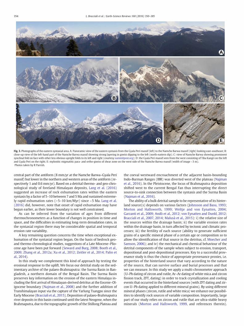
Fig. 3. Photographs of the eastern syntaxial area. A: Panoramic view of the eastern syntaxis from the Gyala Peri massif (left) to theNamche Barwamassif (right) looking east-southeast; B:close-up view of the left-hand part of the Namche Barwa massif showing strong layering in gneiss dipping to the left (north-eastern dip); C: view of Namche Barwa showing prominentsynclinal fold on face with other less obvious upright folds to its left and right (courtesy summitpost.org); D: the Gyala Peri massif seen from the west consisting of Tiba Kangri on the leftand Gyala Peri on the right; E: mylonitic migmatitic para- and ortho-gneiss of shear zone on the west side of the Namche Barwa massif (width of image ~3 m).Photos taken by R Parrish.
354 L. Bracciali et al. / Earth-Science Reviews 160 (2016) 350–385
central part of the antiform (8 mm/yr at the Namche Barwa–Gyala Perimassif) but lower in the northern andwestern areas of the antiform (re-spectively 1 and 0.6 mm/yr). Based on a detrital thermo- and geo-chro-nological study of foreland Himalayan deposits, Lang et al. (2016)suggested an increase of rock exhumation rates within the easternsyntaxis by a factor of 5–10 between 7 and 5Ma and sustained extreme-ly rapid exhumation rates (N5–10 km/Myr) since ~5 Ma. Lang et al.(2016) did, however, note that onset of rapid exhumation may havebegun earlier, as their lower boundary is not well constrained.
As can be inferred from the variation of ages from differentthermochronometers as a function of changes in position in time andspace, and the difficulties in estimating long-term denudation rates, inthe syntaxial region there may be considerable spatial and temporalerosion rate variability.
A key remaining question concerns the time when exceptional ex-humation of the syntaxial region began. On the basis of bedrock geo-and thermo-chronological studies, suggestions of a Late Miocene–Plio-cene age have been put forward (Seward and Burg, 2008; Booth et al.,2009; Zhang et al., 2012a; Xu et al., 2012; Zeitler et al., 2014; Palin etal., 2014).
In this study we complement this kind of approach by testing theerosional response to the uplift. We focus our detrital study on the sed-imentary archive of the palaeo-Brahmaputra: the Surma Basin in Ban-gladesh, a northern domain of the Bengal Basin. The Surma Basinpreserves key information on the erosion of the eastern Himalaya in-cluding the first arrival of Himalayan-derived detritus at the Eocene–Ol-igocene boundary (Najman et al., 2008) and the further addition ofTranshimalayan input via the capture of the Yarlung Tsangpo since theEarlyMiocene (Bracciali et al., 2015). Deposition of palaeo-Brahmaputrariver deposits in this basin continued until the latest Neogene, when theBrahmaputra, due to the topographic growth of the Shillong Plateau and
the coeval westward encroachment of the adjacent basin-boundingIndo-Burman Ranges (IBR) was diverted west of the plateau (Najmanet al., 2016). In the Pleistocene, the locus of Brahmaputra depositionshifted west to the current Bengal Fan thus interrupting the directsource-to-sink connection between the syntaxis and the Surma Basin(Najman et al., 2016).
The ability of a bulk detrital sample to be representative of its hinter-land source(s) depends on various factors (Johnsson and Basu, 1993;Morton and Hallsworth, 1999; Weltje and von Eynatten, 2004;Garzanti et al., 2009; Andò et al., 2012; von Eynatten and Dunkl, 2012;Bracciali et al., 2007, 2014; Malusà et al., 2015): i) the relative size ofthe sources within the drainage basin; ii) the variable erosion rateswithin the drainage basin, in turn affected by tectonic and climatic pro-cesses; iii) the fertility of each source (ability to generate sufficientgrains of a specific mineral phase of a certain age or composition so toallow the identification of that source in the detritus, cf. Moecher andSamson, 2006); and iv) the mechanical and chemical behaviour of thedetrital components of the sample when subject to erosion, transport,depositional and post-depositional processes. Key to a successful prov-enance study is thus the choice of appropriate provenance proxies, i.e.properties of the hinterland source that vary according to the natureof the source, that can survive surface and burial processes and thatwe can measure. In this study we apply a multi-chronometer approach(U–Pb dating of zircon and rutile, Ar–Ar dating of whitemica and zirconfission track, ZFT, dating) in order to track crystallization and coolingevents that occurred in the hinterland sources (with ZFT dating and zir-con U–Pb dating applied to different mineral grains). By using differentmineral phases (zircon, rutile andwhitemica)we enhance our possibil-ities to identify rock sources of variable composition. Importantly, largepart of our study relies on zircon and rutile that are ultra-stable heavyminerals (Morton and Hallsworth, 1999, and references therein).
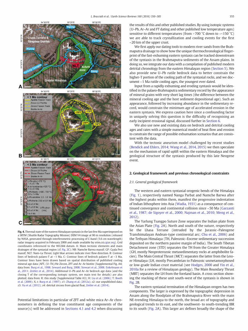
Fig. 4.Thermal state of the easternHimalayan syntaxis in the last fewMa superimposedona SRTM (Shuttle Radar Topography Mission) DEM V4 image at 90 m resolution (releasedby NASA, generated through interferometric processing of C-band (5.6 cm wavelength)radar imagery acquired in February 2000 and made available by srtm.csi.cgiar.org). Gridcoordinates referenced to the WGS84 datum. A: Main tectonic elements and maindrainages of the syntaxial region (cf. Fig. 2C); NB: Namche Barwa massif; GP: Gyala Perimassif; NLT: Nam–La Thrust. Light blue arrows indicate river flow direction. B: Contourlines of bedrock palaeo-T at b1 Ma. C: Contour lines of bedrock palaeo-T at b3 Ma.Contour lines have been drawn based on spatial distribution of published coolingmineral age data (AFT, (U–Th)/He Zircon, ZFT and Ar–Ar biotite (Supplemental Fig. A4;data from: Burg et al., 1998; Seward and Burg, 2008; Stewart et al., 2008; Enkelmann etal., 2011; Zeitler et al., 2014). Additional U–Pb and Ar–Ar bedrock age data (and theclosing T of the corresponding isotopic system, see main text for details) are alsoplotted; data from: R: this study (Supplemental Table A3); H: Liu et al. (2006); T: Boothet al. (2009); X, t: Burg et al. (1997); z1: Zhang et al. (2012a); z2: our unpublished data;z3: Xu et al. (2012); z4: detrital zircons from glacial float, Zeitler et al. (2014).
355L. Bracciali et al. / Earth-Science Reviews 160 (2016) 350–385
Potential limitations in particular of ZFT and white mica Ar–Ar chro-nometers in defining the true constituent age components of thesource(s) will be addressed in Sections 4.1 and 4.2 when discussing
the results of this and other published studies. By using isotopic systems(U–Pb, Ar–Ar and FT dating and other published low temperature ages)sensitive to different temperatures (from N700 °C down to ~b150 °C)we are able to track crystallization and cooling events for the first~20 km of the upper crust.
We first apply our dating tools tomodern river sands from the Brah-maputra drainage to show how the unique thermochronological finger-print of the fast-exhuming eastern syntaxis can be tracked downstreamof the syntaxis in the Brahmaputra sediments of the Assam plains. Indoing so, we integrate our data with a compilation of publishedmoderndetrital chronology from the eastern Himalayan region (Section 5). Wealso provide new U–Pb rutile bedrock data to better constrain thehigher-T portion of the cooling path of the syntaxial rocks, and we doc-ument ~1 Ma rutile cooling ages, the youngest ever dated.
Input from a rapidly exhuming and eroding syntaxis would be iden-tified in the palaeo-Brahmaputra sedimentary record by the appearanceof mineral grains with very short lag times (the difference between themineral cooling age and the host sediment depositional age). Such anappearance, followed by increasing abundance in the sedimentary re-cord, would constrain the minimum age of accelerated erosion in theeastern syntaxis. We express caution here since a confounding factorin uniquely solving this question is the difficulty of recognising anearly incipient erosional signal, discussed further in Section 6.
We also use new and existing data on bedrock and detrital coolingages and rates with a simple numerical model of heat flow and erosionto constrain the range of possible exhumation scenarios that are consis-tent with the data.
With the tectonic aneurism model challenged by recent studies(Bendick and Ehlers, 2014; Wang et al., 2014, 2015) we then speculateon the mechanism of rapid uplift within the eastern Himalaya and thegeological structure of the syntaxis produced by this late Neogeneevent.
2. Geological framework and previous chronological constraints
2.1. General geological framework
The western and eastern syntaxial orogenic bends of the Himalaya(Fig. 1), respectively named Nanga Parbat and Namche Barwa afterthe highest peaks within them, manifest the progressive indentationof Indian lithosphere into Asia (Wadia, 1931) as a consequence of con-tinued convergence and continental collision since ~50 Ma (Garzantiet al., 1987; de Sigoyer et al., 2000; Najman et al., 2010; Meng et al.,2012).
The Yarlung Tsangpo Suture Zone separates the Indian plate fromthe Asian Plate (Fig. 2A). North and south of the suture, respectivelylie the Lhasa Terrane (intruded by the Jurassic–PaleogeneTranshimalayan Andean-type continental arc; Chu et al., 2006) andthe Tethyan Himalaya (TH, Paleozoic–Eocene sedimentary successiondeposited on the northern passive margin of India). The South TibetanDetachment zone (STD) separates the TH from the Greater Himalaya(GH, mostly Neoproterozoic metasedimentary rocks at amphibolite fa-cies). TheMain Central Thrust (MCT) separates the latter from the Less-er Himalaya (LH, mostly Precambrian to Paleozoic unmetamorphosedor low-grade Indian crust material (see Hodges, 2000 and Yin et al.,2010a for a review of Himalayan geology). The Main Boundary Thrust(MBT) separates the LH from the foreland basin. A cross section show-ing the stacking of these unit south-west of the syntaxis is shown inFig. 2B.
The eastern syntaxial termination of the Himalayan orogen has twocomponents. The larger is expressed by the topographic depression inAssam along the floodplain of the Brahmaputra River with the mainNE-trending Himalaya to the north, the broad arc of topography andgeological trends to its east, and the southwest- to south-trending IBRto its south (Fig. 2A). This larger arc defines broadly the shape of the
356 L. Bracciali et al. / Earth-Science Reviews 160 (2016) 350–385
north-eastern Indian craton as it collided and subducted beneath east-ern Asia.
Within this larger arc lies a much tighter and smaller arc defined bythe trend of the suture zone as it bounds on three sides the Indian platerockswith theNamche Barwa and Gyala Peri massifs in its core (Figs. 2Cand D). This smaller syntaxis is the subject of this study as it is the areawhere very high exhumation rates are taking place.
2.2. Structure and geology of the eastern Himalayan syntaxis
The structure of the eastern syntaxis is an elongate (~40 km by~120 km) steep-sided anticline plunging steeply dominantly to thenortheast and less steeply to the southwest, as described by Burg et al.(1997; 1998).
Whilst relatively poorlymapped and understood in detail, the struc-ture of the northern part of the syntaxis has been addressed by manyauthors and is characterised by major folds, one or more major thrustfaults, thick mylonite zones around the syntaxis and adjacent to the su-ture zone boundary, and both thrust and strike-slip bounding faults/shear zones. To the northeast of the arcuate syntaxial suture zonetrace is the dextral Jiali–Parlung fault zone (Fig. 2) for which Lee et al.(2003) constrained the timing of the main stage of right-lateral motionbetween 18 and 12 Ma.
From periphery to core, three main lithotectonic units comprise thesyntaxial area (Fig. 2C): the Asian plate Gangdese unit (belonging to theLhasa Terrane of the Asian plate and the associated TranshimalayanArc), the Yarlung Tsangpo suture zone and the GH unit of the Indianplate (Namche Barwa Group) in the core of the antiform (Burg et al.,1997; Liu and Zhong, 1997; Ding et al., 2001; Quanru et al., 2006).
These units are separated by strike-slip faults and shear zones in-cluding extensive and thickmylonites that define an inverted U-shapedpattern in map view. Various authors have inferred that the sense ofshear on the northeast-trending bounding shear zones is left-lateralon the west and right-lateral on the east (Burg et al., 1998; Ding et al.,2001; Booth et al., 2009; Zeitler et al., 2014; Palin et al., 2014). Theboundary zone between GH and the suture zone rocks comprises sub-stantial quartzo-feldspathic mylonites (Fig. 3E) of probable GH affinityand for themost part at amphibolite faciesmetamorphic grade (thoughretrogressed).
The Yarlung Tsangpo Suture Zone in the syntaxial area (Fig. 2C) is a2–10 kmwide continuous shear zone,wider in the east than in thewest,consisting of rocks highly deformed and metamorphosed undergreenschist-facies conditions that include ultramafic rocks, meta-gab-bro,meta-basalt andmeta-quartzites (possiblymeta-cherts). Accordingto Quanru et al. (2006) these represent a dismembered ophiolitic suite.Booth et al. (2009) recognised remnants of the suture zone inamphibolitic mylonites containing blue-green amphiboles but also ob-served staurolite–kyanite-bearingmetasediments that they interpretedto be part of the TH.
TheGangdese unit in the syntaxial area includes themiddle- to high-grade metamorphic Nyingchi Group and Bomi Groups of the Lhasa Ter-rane, intruded by Gangdese and other granites. These were mainlyemplaced in the Late Cretaceous–Paleocene (Burg et al., 1998; Boothet al., 2004; Zhang et al., 2010b; Guo et al., 2011, 2012). Post-collisional25–30 Ma granites intruding the Lhasa Terrane along the western andeastern margin of the syntaxis (Booth et al., 2004; Zhang et al., 2010b;Guo et al., 2011; Pan et al., 2012) have been interpreted as adakiticmelts derived from partial melting of thickened lower crust of theLhasa Terrane (Zhang et al., 2010b; Pan et al., 2012), in analogy withother adakites from southern Tibet (Chung et al., 2003, 2009). Somearemuscovite-bearing and resemble the GH leucogranites in terms of li-thology (Zhang et al., 2010b).
The Namche Barwa Group (Quanru et al., 2006), structurally thelowest of the three units, is part of the Indian plate and is mostly equiv-alent to the GH of the main Himalaya (though some older basementgneisses are likely extensive). The Namche Barwa Group (Fig. 2C)
includes felsic para- and orthogneiss containing sporadic lenses ofhigh-P granulite and minor amphibolite and clinopyroxenite (ZhibaiComplex), migmatitic gneiss and amphibolite (Duoxiongla migmatite)and felsic gneiss with subordinate marble (Paixiang Formation). The af-finity of the high-P rocks with the GH unit is suggested byPaleoproterozic protoliths, as constrained by U–Pb zircon dating andNd isotopic data (Xu et al., 2010; Liu et al., 2011; Zhang et al., 2012a;Guo et al., 2016).
The main structural features and tectonic boundaries between thedifferent lithotectonic units are variablymapped on the existing geolog-ical maps of the syntaxial area, especially in its inaccessible, highest el-evation core (e.g. Ding et al., 2001; Quanru et al., 2006; Kidd et al.,2006; Booth et al., 2009; Liu et al., 2011; Xu et al., 2012). In all maps, afew km south of the Namche Barwa peak a main thrust fault system isidentified, mapped as a mainly ~E–W trending, N-dipping fault namedNam–La Thrust (Liu and Zhong, 1997; Ding et al., 2001; Quanru et al.,2006; Kidd et al., 2006; Booth et al., 2009; Zeitler et al., 2014; Fig. 2C).The Nam–La (or Namula) thrust system is regarded as a very importanttectonic boundary within the syntaxis by Liu and Zhong (1997). Citingthe early mapping by Chinese geologists, Liu and Zhong map the thrustas a E–W trending continuous structure cropping out for ca. 20 kmsouth of the Namche Barwa peak and describe it as “a set of moderatelynorth-dipping structures that displaced the granulite facies rocks south-wards over the amphibolite facies thrust rocks”. As such the thrust be-longs to an early phase of deformation within the syntaxis and isassociated with east-striking folds. According to Ding et al. (2001), thethrust acts as the southern boundary of a pop-up structure with theNamche Barwa massif at its core (Fig. 2D), in analogy with a similarstructural model suggested for the western Himalayan syntaxis(Schneider et al., 1999). Craw et al. (2005) and Kidd et al. (2006) recog-nise and map the Nam–La Thrust as an arcuate thrust zone, E-trendingsouth of the Namche Barwa massif and passing into the shear andfault zone along the suture bounding the syntaxis to the west (Fig.2C). Zeitler et al. (2014) suggest that the Nam–La Thrust remains an ac-tive structure likely accumulating strain, although it is virtually aseismic(at least during a 16-month observation period; Sol et al., 2007). In Liuet al. (2011), Xu et al. (2012) and a recent compilation by Palin et al.(2014) based mainly on various Chinese research contributions, theNam–La thrust (also namedUpper or DF2 Thrust) is somewhat differentin terms of its trace and complexity and is mapped as the tectonicboundary between the higher grade rocks to the north and the lowergrademigmatites to the south. As such it continues within the southernsyntaxis as an ~SW trending structure.
Despite these differences, a similar fundamental structure resultsfrom both interpretations, with a south- to southeast-vergent thrustemplacing folded deeper rocks with an overall domal geometry uponpanel(s) of rock that dip more broadly and which can be traced withcontinuity to the southwest into the main part of the Himalaya. Clearlymuch more structural and lithological mapping is needed to refine thispattern further.
2.3. Metamorphic evolution of the eastern Himalayan syntaxis
The peak metamorphic conditions in the core of the antiform havebeen variably estimated at 17–18 kbar and ~890 °C (Liu and Zhong,1997), 8–10 kbar and 720–760 °C (Burg et al., 1998); 14–18 kbar and750–850 °C (Ding et al., 2001); 11–14 kbar and 800–950 °C (Booth etal., 2009), 14 kbar and 825 °C (Guilmette et al., 2011). The age of peakmetamorphism for the high-P granulites has been estimated as 16 ±2 Ma (Burg et al., 1998), 40 Ma (Ding et al., 2001), 37–32 Ma (Zhanget al., 2010b) or 24 Ma (Xu et al., 2010). An ~24 Ma metamorphicevent is also recorded by a Ca-rich granulite-facies leucosome likelygenerated by melting of the host metapelite at high pressure (Zeng etal., 2012). Palin et al. (2015) present a summary of most of these dataalong with an additional P–T–t path within the margin of the syntaxis.As of yet there is no definitive geochronological evidence of uppermost
357L. Bracciali et al. / Earth-Science Reviews 160 (2016) 350–385
amphibolite facies metamorphism persisting into the Plio-Pleistocene,but this has yet to be thoroughly investigated.
Retrograde mineral assemblages overprinting the high-P progradeparagenesis of the Namche Barwamassif granulites provide constraintson the exhumation path towards the surface of these rocks (Liu andZhong, 1997; Ding et al., 2001; Xu et al., 2010; Guilmette et al., 2011).Guilmette et al. (2011) modelled, for an anatectic kyanite-bearingparagneiss from the Zhibai Group west of the Namche Barwa peak, an~isothermal path from lower crustal conditions higher than 14 kbarand ~825 °C to middle crust conditions at ~9 kbar and 800 °C. Thepeak metamorphic event was accompanied by biotite-dehydrationmelting in the kyanite stability field. This decompression is thought tobe Miocene in age.
A much younger phase of volumetrically-limited melt production isrecorded by 3–10 Ma U–Pb dates of granitic dykes and leucosomes oc-curring in the Namche Barwa–Gyala Peri massif (Booth et al., 2004;Zeitler et al., 2014). Zircon rims as young as ~1Ma occur in granitic, peg-matitic and aplitic glacial float from the Layo glacier on the northernflank of the Gyala Peri (Zeitler et al., 2014). These rims correspond to aseries of oscillatory cathodoluminescence (CL)-zones within each crys-tal indicatingmultiple b10Ma episodes of zircon growth and have beeninterpreted to have formed in response to fluid infiltration and/or par-tial melting during decompression. The timing of emplacement ofthese graniticmelts overlaps the ~5–8MaU–Th–Pb dates (weighted av-erages) of monazites separated from the matrix of metapelitic rocks(Booth et al., 2009). U–Pb titanite dates from the core of the syntaxisare 4.9 ± 3.9 and 2.8 ± 1.4 Ma (lower intercepts with Concordia ofalignments of datapoints with variable common Pb content), whilsttitanite and monazite outside of the syntaxis are 20 Ma and older.Booth et al. (2009) estimated a pressure decrease of ~5 kbar duringgrowth of garnet north of the Gyala Peri peak over a period of severalmillion years, as indicated by P–T estimates for the core (8.3 kbar and800 °C) and the rim (3.5 kbar and 670 °C) of the garnet and in situ U–Th–Pb dates of monazite (~11 to 6 Ma) included in the garnet. This is inagreement with ~11 Ma concordant zircon rims (with a 17 Ma core)from mafic granulite boudins occurring within garnet–kyanite gneiss inthe Zhibai Complex west of the Namche Barwa (Ding et al., 2001), corre-sponding to a moderate pressure (8–10 kbar and ~800 °C) high-grademetamorphic event. As we will report later (Section 4), rutile U–Pbdates range from ≥9 Ma in the southern part of the syntaxis antiform toas young as ~1.4 Ma within the area of youngest cooling ages.
Additional geochronological evidence for b10 Ma metamorphicevents in the eastern syntaxis is provided by: 6–11 and 4–5 Ma mona-zites from migmatites respectively sampled north of the Gyala Peripeak and in the Yarlung Tsangpo gorge at an elevation of 2400 m (Liuet al., 2011); ~10 and 5 Ma zircon rims frommylonitic gneisses respec-tively north of the Namche Barwa peak and south of the Nam–La thrust(Xu et al., 2012); ~8 Ma rims of Paleozoic zircons from a calc-silicaterock metamorphosed under dominant amphibolite facies conditionswest of the Namche Barwa peak (Zhang et al., 2012a).
2.4. Thermochronology of the eastern Himalayan syntaxis
The first recorded time constraints pointing to a very recent evolu-tion of the Namche Barwa antiform were biotites as young as 1.2 Ma(determined by K–Ar dating) from migmatite gneisses within theinner Yarlung Tsangpo gorge, as opposed to biotites 18 Ma and olderoutside of the syntaxis (Zhang et al., 1981). Further studies by Burg etal. (1997, 1998) reported 3.9–3.3 Ma xenotime and 2.9 Ma thorite crys-tals from a leucosome layer interpreted to date the last anatectic event(~600–700 °C) in the syntaxis. Additionally, statistically equivalent FTzircon and apatite ages (central ages of ~2.5 and ~1.1 Ma) were deter-mined in migmatites sampled at different elevations (2900 and4100 m) within the Namche Barwa antiform. The lack of FT age varia-tion with altitude, and the small range of crystallization ages indicatedby xenotime and thorite were taken as evidence for very rapid
exhumation at cooling rates of 100 °C/Myr or more. With the additionalconstraint of peakmetamorphic conditions estimated for a garnetmeta-pelite at 8–10 kbar and 720–760 °C and the 16.0 ± 2.5 Ma Sm–Nd iso-chron date for the garnet, Burg et al. (1998) proposed a decompressionhistory associated with the growth of the Namche Barwa antiform. Themodelled P–t path required a decrease of the exhumation rate from~10 mm/yr between 3.5 and 3.2 Ma to 3–5 mm/yr since 2.2 Ma. Asthe antiform developed, a positive feedback between folding and ero-sion may have caused an acceleration of fold amplification, resultingin localised lithospheric uplift and exhumation under near-isothermalconditions and allowing for decompression melting (Whitney et al.,2004). Themodelwas further refined by envisaging pure shear thicken-ing and symmetric buckling as a means to accommodate shorteninguntil, at a certain strain, an asymmetric thrust occurs on a crustal to lith-ospheric scale (Burg and Podladchikov, 2000) based on numericallymodelled viscous shear heating (Burg and Schmalholz, 2008). Thechange to the thrustingmodewithin a few% shortening inhibits furtherfold amplification and lateral propagation that may account for the iso-lation of crustal-scale folds in continental lithosphere.
Seward and Burg (2008) integrated the earlier FT dataset of Burg etal. (1997) with new data from within and outside the core of theantiform. The new bedrock data showed that the young cooling wasnot limited to the core of the antiform, but zircon and apatite FT agesyounger than 4 Ma and as young as 0.5 Ma occurred in a wider areadelimited to theNWand theNE by theMilin–Tungmai and Jiali–ParlungFaults, respectively (Fig. 4A). Outside these fault bounds, the FT ageswere systematically older (Fig. 2 of Seward and Burg, 2008; our Supple-mental Fig. A4). This led to estimates of exhumation rates of ~2 mm/yrfor the last 2 Myr for the whole area inside the fault bounds. Based onthis finding and the earlier geochronological constraints on the verticalgrowth of the syntaxis via folding and efficient metamorphic decom-pression since 4 Ma, Seward and Burg refined their evolution model toinclude the Asian plate in the growth of the syntaxis. This was achievedvia lateral expansion and associated erosion of the growing antiform to-wards and limited by the Jiali–Parlung Fault, as shown by the FT data. Asa consequence, according to the authors an antecedent Yarlung Tsang-po–Brahmaputra was displaced, along with the suture, in a left-lateralsense along the exhuming north-plunging dome. This was thought toexplain the U turn of the Yarlung Tsangpo course in the NamcheBarwa–Gyala Peri massif area.
The bedrock thermochronology of the syntaxis iswell represented inits erosion products, with ~45% of the detrital zircons in the modernriver sediment load downstream from the Yarlung Tsangpo Gorge (atPasighat in Arunachal Pradesh; cf. location S in our map of Fig. 5) be-longing to a FT age population averaging 0.6 Ma (Stewart et al., 2008).
In Fig. 4 we infer the thermal state of the syntaxial area at b1 Ma(panel B) and b3 Ma (panel C) by drawing contour lines of equal Tbased on the spatial distribution of published thermochronologicaldata (plotted on the maps of Supplemental Fig. A4) and the closure/an-nealing temperature (Tc) of the corresponding isotopic system. For thecontour lines we took into account the following thermochronometers:fission tracks in apatite (Tc ≈ 75–125 °C; Wagner and Reimer, 1972;Laslett et al., 1987; Ketcham et al., 2007); (U–Th)/He in zircon(Tc ≈ 170–190 °C; Reiners et al., 2004); fission tracks in zircon(Tc ≈ 250 °C; Tagami et al., 1996) and Ar–Ar in biotite (Tc ≈ 350 °C;McDougall and Harrison, 1999). We note that with the exceptionallyhigh cooling rate documented in this region in excess of 100 °C/Myr,the closure temperature applicable may be higher than listed above byup to 20–30 °C.
The closure temperature of rutile U–Pb has been estimated empiri-cally (Mezger et al., 1989) and experimentally (Cherniak, 2010), butthere is disagreement (N600 °C for experiments, ~500 °C for empiricalstudies in slowly-cooled terranes), as recently discussed on the basisof depth of Pb in rutile in the Ivrea zone by Smye and Stockli (2014),aswell as the complication that cooling rate and grain size issueswill in-fluence closure temperature. Because this remains unresolved, we use a
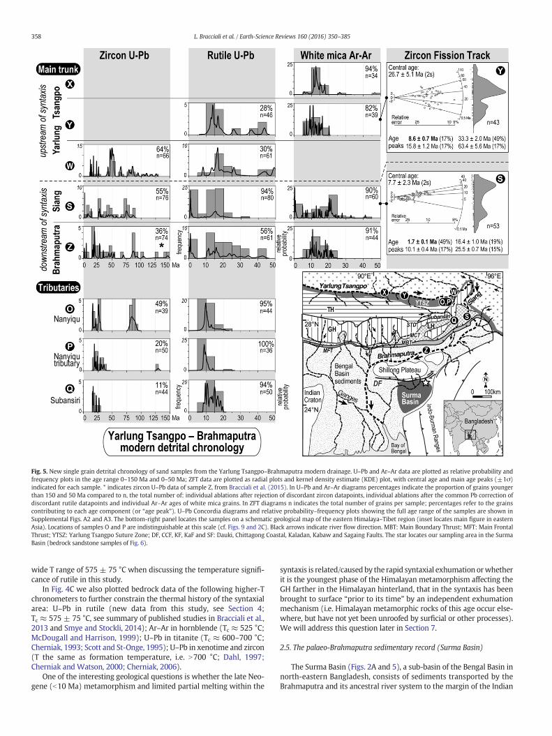
Fig. 5. New single grain detrital chronology of sand samples from the Yarlung Tsangpo–Brahmaputra modern drainage. U–Pb and Ar–Ar data are plotted as relative probability andfrequency plots in the age range 0–150 Ma and 0–50 Ma; ZFT data are plotted as radial plots and kernel density estimate (KDE) plot, with central age and main age peaks (±1σ)indicated for each sample. * indicates zircon U–Pb data of sample Z, from Bracciali et al. (2015). In U–Pb and Ar–Ar diagrams percentages indicate the proportion of grains youngerthan 150 and 50 Ma compared to n, the total number of: individual ablations after rejection of discordant zircon datapoints, individual ablations after the common Pb correction ofdiscordant rutile datapoints and individual Ar–Ar ages of white mica grains. In ZFT diagrams n indicates the total number of grains per sample; percentages refer to the grainscontributing to each age component (or “age peak”). U–Pb Concordia diagrams and relative probability–frequency plots showing the full age range of the samples are shown inSupplemental Figs. A2 and A3. The bottom-right panel locates the samples on a schematic geological map of the eastern Himalaya–Tibet region (inset locates main figure in easternAsia). Locations of samples O and P are indistinguishable at this scale (cf. Figs. 9 and 2C). Black arrows indicate river flow direction. MBT: Main Boundary Thrust; MFT: Main FrontalThrust; YTSZ: Yarlung Tsangpo Suture Zone; DF, CCF, KF, KaF and SF: Dauki, Chittagong Coastal, Kaladan, Kabaw and Sagaing Faults. The star locates our sampling area in the SurmaBasin (bedrock sandstone samples of Fig. 6).
358 L. Bracciali et al. / Earth-Science Reviews 160 (2016) 350–385
wide T range of 575 ± 75 °C when discussing the temperature signifi-cance of rutile in this study.
In Fig. 4C we also plotted bedrock data of the following higher-Tchronometers to further constrain the thermal history of the syntaxialarea: U–Pb in rutile (new data from this study, see Section 4;Tc ≈ 575 ± 75 °C, see summary of published studies in Bracciali et al.,2013 and Smye and Stockli, 2014); Ar–Ar in hornblende (Tc ≈ 525 °C;McDougall and Harrison, 1999); U–Pb in titanite (Tc ≈ 600–700 °C;Cherniak, 1993; Scott and St-Onge, 1995); U–Pb in xenotime and zircon(T the same as formation temperature, i.e. N700 °C; Dahl, 1997;Cherniak and Watson, 2000; Cherniak, 2006).
One of the interesting geological questions is whether the late Neo-gene (b10 Ma) metamorphism and limited partial melting within the
syntaxis is related/caused by the rapid syntaxial exhumation orwhetherit is the youngest phase of the Himalayan metamorphism affecting theGH farther in the Himalayan hinterland, that in the syntaxis has beenbrought to surface “prior to its time” by an independent exhumationmechanism (i.e. Himalayan metamorphic rocks of this age occur else-where, but have not yet been unroofed by surficial or other processes).We will address this question later in Section 7.
2.5. The palaeo-Brahmaputra sedimentary record (Surma Basin)
The Surma Basin (Figs. 2A and 5), a sub-basin of the Bengal Basin innorth-eastern Bangladesh, consists of sediments transported by theBrahmaputra and its ancestral river system to the margin of the Indian
359L. Bracciali et al. / Earth-Science Reviews 160 (2016) 350–385
continental margin since the Eocene (Lietz and Kabir, 1982; Johnsonand Alam, 1991; Reimann, 1993; Uddin and Lundberg, 1998, 1999;Najman et al., 2008; Bracciali et al., 2015). The Surma Basin is borderedto the north by the Shillong Plateau, the only raised topography in theforeland of the Himalaya, consisting of Indian plate Precambrian base-ment partially overlain by Cenozoic sediments (Yin et al., 2010b). Tothe east the basin is bordered by the Cenozoic westward-propagatingIBR fold and thrust belt which is responsible for the north–southtrending folding in the Bengal Basin (Maurin and Rangin, 2009).
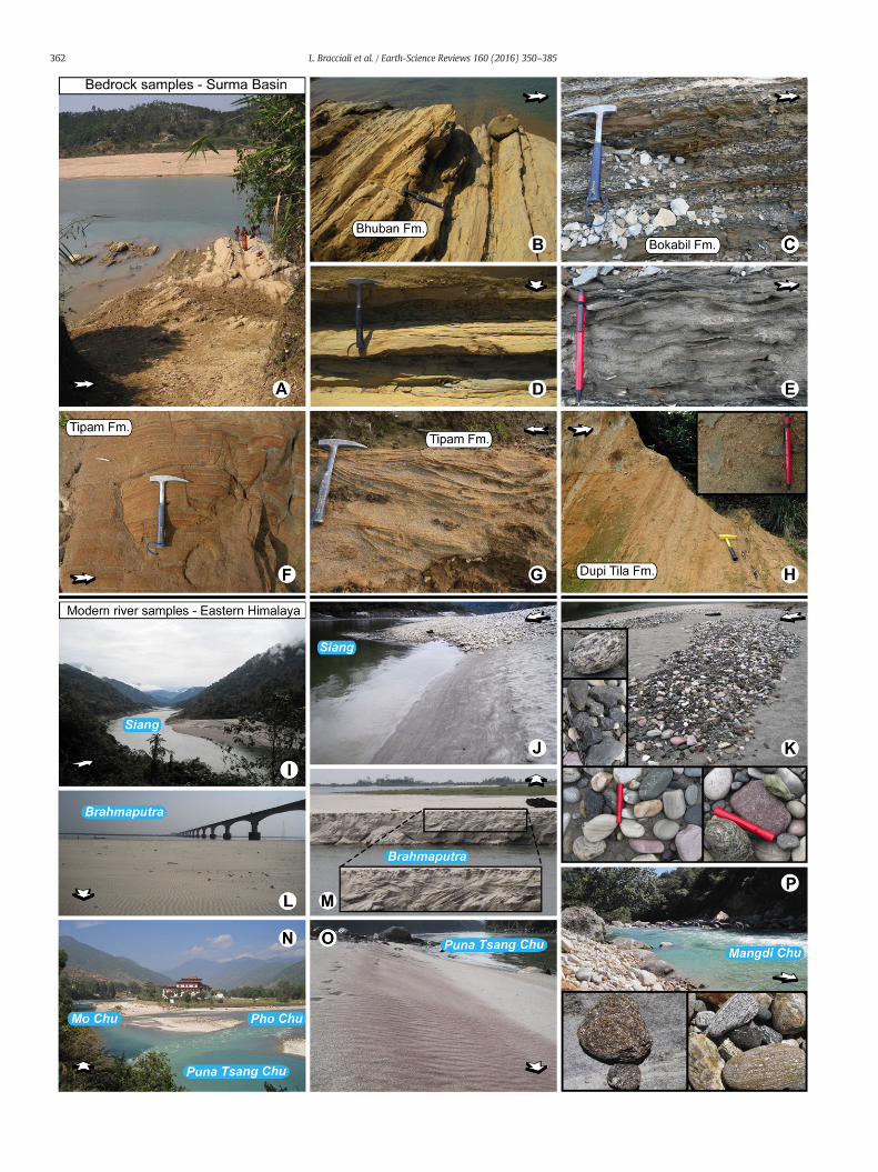
Our study focuses on both modern river sands along the course ofthe Brahmaputra and its tributaries (Fig. 5) and the Neogene SurmaBasin deposits, for which a schematic stratigraphic section is presentedin Fig. 6, where the samples are arranged in stratigraphic order with theexception of Dupi Tila sample 35 (from a different locality) whose strat-igraphic position is not known relative to the other two Dupi Tila sam-ples. A selection of images of sampling locations and key features ofboth modern and ancient deposits is presented in Fig. 7.
The Surma Basin is affected by ~N–S trending folding (Johnson andAlam, 1991) related to the frontal deformation zone of the IBR whichpropagated as far west as this location in the Pliocene (Maurin andRangin, 2009; Najman et al., 2016). The anticline structures are evidentin subsurface 3D map of top seismic reflector and thickness map of theTipam Formation showing thinning of strata over anticlines (Najman etal., 2016). As a result of the folding, theNeogene deposits are exposed asa tilted succession in the sampling area (e.g. Figs. 7A and B).
In order to overcome the early lithostratigraphic correlation ap-proach to dating (Evans, 1932) that proved problematic within a deltaicsystemwith high rates of subsidence and rapid facies changes, the Neo-gene succession has been divided into biostratigraphically dated, seis-mically distinct, unconformity-bounded and regionally correlatableMegasequences (MS in Fig. 6; Najman et al., 2012). MS1 is equivalentto the Bhuban and Bokabil Formations (Surma Group), MS2 to theTipam and Dupi Tila Formations.
In the Surma Basin the boundary between the marine-deltaic MS1and the fluvial MS2 has been constrained by magnetostratigraphy at3.5 Ma (Worm et al., 1998) in agreement with nannoplankton data(Najman et al., 2012). Magnetostratigraphy also constrains the top ofMS2 at 1.4 Ma in the study area (Worm et al., 1998). The Early Plioceneage for the upper Bhuban Formation is indicated by stratigraphic (Lietzand Kabir, 1982) and magnetostratigraphic data (Worm et al., 1998).Below MS1, the Eocene–Early Miocene deltaic sandstone of the BarailFormation records the first major clastic influx from the Himalaya(Najman et al., 2008). The lower boundary of MS1 is constrained atb18 Ma by the occurrence of detrital white mica in uppermost Barailand lowermost Bhuban samples dated by Ar–Ar at 21 ± 3 (Najman etal., 2008) and 14 ± 4Ma (this study), respectively. This is in agreementwith prominent modes of Ar–Ar white mica ages of 16–18 Ma inBhuban samples from well penetrations (Uddin et al., 2010), in whichthe youngest mica grains in three Bhuban samples of increasing strati-graphic depth are dated at 12.3 ± 0.6 Ma (upper Bhuban, well Beani–Bazar-1X; cf. well stratigraphy in Reimann, 1993), 16.8 ± 0.6 Ma and19.3 ± 0.8 (lower Bhuban, well Fenchuganj-2; cf. well stratigraphy inDeb et al., 2014).
The clay mineralogy of the Paleogene to Neogene deposits in theSurma Basin indicates that burial temperatures were b200 °C (Najmanet al., 2008). It follows that the isotopic clocks of our samples (ZFT andmica Ar–Ar ages) were not reset in the sedimentary basin and are indic-ative of thermochronological events in the source regions.
3. Samples and analytical methods
3.1. Sample details and preparation
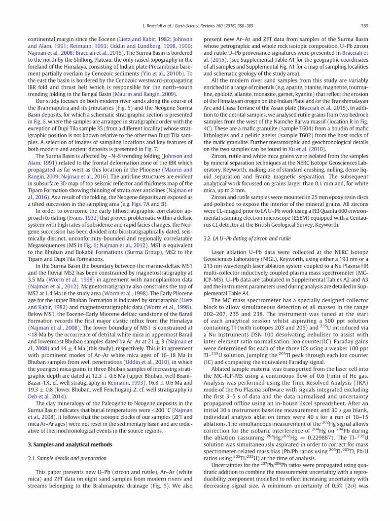
This paper presents new U–Pb (zircon and rutile), Ar–Ar (whitemica) and ZFT data on eight sand samples from modern rivers andstreams belonging to the Brahmaputra drainage (Fig. 5). We also
present new Ar–Ar and ZFT data from samples of the Surma Basinwhose petrographic and whole rock isotopic composition, U–Pb zirconand rutile U–Pb provenance signatures were presented in Bracciali etal. (2015). (see Supplemental Table A1 for the geographic coordinatesof all samples and Supplemental Fig. A1 for a map of sampling localitiesand schematic geology of the study area).
All the modern river sand samples from this study are variablyenriched in a range ofminerals (e.g. apatite, titanite,magnetite, tourma-line, epidote, allanite, monazite, garnet, kyanite) that reflect the erosionof theHimalayan orogen on the Indian Plate and/or the TranshimalayanArc and Lhasa Terrane of the Asian plate (Bracciali et al., 2015). In addi-tion to the detrital samples, we analysed rutile grains from two bedrocksamples from the west of the Namche Barwa massif (location R in Fig.4C). These are a mafic granulite (sample T604) from a boudin of maficlithologies and a pelitic gneiss (sample T602) from the host rocks ofthe mafic granulite. Further metamorphic and geochronological detailson the two samples can be found in Xu et al. (2010).
Zircon, rutile and white mica grains were isolated from the samplesby mineral separation techniques at the NERC Isotope Geosciences Lab-oratory, Keyworth, making use of standard crushing, milling, dense liq-uid separation and Frantz magnetic separation. The subsequentanalytical work focussed on grains larger than 0.1 mm and, for whitemica, up to 2 mm.
Zircon and rutile samplesweremounted in 25mmepoxy resin discsand polished to expose the interior of the mineral grains. All zirconswere CL-imaged prior to LA U–Pbwork using a FEI Quanta 600 environ-mental scanning electron microscope (ESEM) equipped with a Centau-rus CL detector at the British Geological Survey, Keyworth.
3.2. LA U–Pb dating of zircon and rutile
Laser ablation U–Pb data were collected at the NERC IsotopeGeosciences Laboratory (NIGL), Keyworth, using either a 193 nm or a213 nm wavelength laser ablation system coupled to a Nu Plasma HRmulti-collector inductively coupled plasma mass spectrometer (MC-ICP-MS). U–Pb data are tabulated in Supplemental Tables A2 and A3and the instrument parameters used during analysis are detailed in Sup-plemental Table A4.
The MC mass spectrometer has a specially designed collectorblock to allow simultaneous detection of all masses in the range202–207, 235 and 238. The instrument was tuned at the startof each analytical session whilst aspirating a 500 ppt solutioncontaining Tl (with isotopes 203 and 205) and 235U introduced viaa Nu Instruments DSN-100 desolvating nebuliser to assist withinter-element ratio normalisation. Ion counter(IC)-Faraday gainswere determined for each of the three ICs using a weaker 100 pptTl–235U solution, jumping the 205Tl peak through each ion counter(IC) and comparing the equivalent Faraday signal.
Ablated sample material was transported from the laser cell intothe MC-ICP-MS using a continuous flow of 0.6 l/min of He gas.Analysis was performed using the Time Resolved Analysis (TRA)mode of the Nu Plasma software with signals integrated excludingthe first 3–5 s of data and the data normalised and uncertaintypropagated offline using an in-house Excel spreadsheet. After aninitial 30 s instrument baseline measurement and 30 s gas blank,individual analysis ablation times were 40 s for a run of 10–15ablations. The simultaneous measurement of the 202Hg signal allowscorrection for the isobaric interference of 204Hg on 204Pb duringthe ablation (assuming 204Hg/202Hg = 0.229887). The Tl–235Usolution was simultaneously aspirated in order to correct for massspectrometer-related mass bias (Pb/Pb ratios using 205Tl/203Tl, Pb/Uratios using 205Tl/235U) at the time of analysis.
Uncertainties for the 207Pb/206Pb ratios were propagated using qua-dratic addition to combine the measurement uncertainty with a repro-ducibility component modelled to reflect increasing uncertainty withdecreasing signal size. A minimum uncertainty of 0.5% (2σ) was
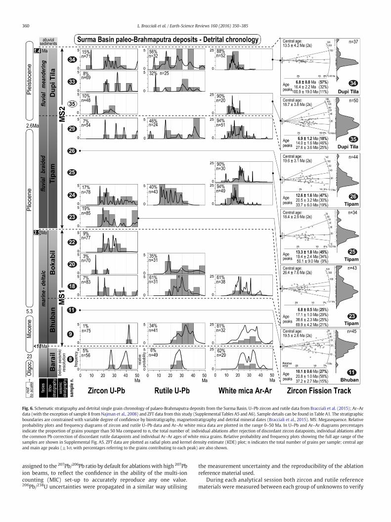
Fig. 6. Schematic stratigraphy and detrital single grain chronology of palaeo-Brahmaputra deposits from the Surma Basin. U–Pb zircon and rutile data from Bracciali et al. (2015); Ar–Ardata (with the exception of sample 8 from Najman et al., 2008) and ZFT data from this study (Supplemental Tables A5 and A6). Sample details can be found in Table A1. The stratigraphicboundaries are constrained with variable degree of confidence by biostratigraphy, magnetostratigraphy and detrital mineral dates (Bracciali et al., 2015). MS: Megasequence. Relativeprobability plots and frequency diagrams of zircon and rutile U–Pb data and Ar–Ar white mica data are plotted in the range 0–50 Ma. In U–Pb and Ar–Ar diagrams percentagesindicate the proportion of grains younger than 50 Ma compared to n, the total number of: individual ablations after rejection of discordant zircon datapoints, individual ablations afterthe common Pb correction of discordant rutile datapoints and individual Ar–Ar ages of white mica grains. Relative probability and frequency plots showing the full age range of thesamples are shown in Supplemental Fig. A5. ZFT data are plotted as radial plots and kernel density estimate (KDE) plot; n indicates the total number of grains per sample; central ageand main age peaks (±1σ, with percentages referring to the grains contributing to each peak) are also shown.
360 L. Bracciali et al. / Earth-Science Reviews 160 (2016) 350–385
assigned to the 207Pb/206Pb ratio by default for ablationswith high 207Pbion beams, to reflect the confidence in the ability of the multi-ioncounting (MIC) set-up to accurately reproduce any one value.206Pb/238U uncertainties were propagated in a similar way utilising
the measurement uncertainty and the reproducibility of the ablationreference material used.
During each analytical session both zircon and rutile referencematerials were measured between each group of unknowns to verify
361L. Bracciali et al. / Earth-Science Reviews 160 (2016) 350–385
that 207Pb/206Pb ratios were correct, to determine the degree andmatrix effect of elemental fractionation and to assess more generallyinstrumental accuracy (Supplemental Table A4).
Where zircon thin rims b10–5 μmwere identified on CL images, thegrainswere removed frommount and theouter surface ablated (follow-ing the approach of Bracciali et al., 2015). Discordant zircon data (Sup-plemental Fig. A2) were not included in the probability plots(Supplemental Table A2, column: “data for probability plot”; Fig. A3,A5 and 5). Discordant rutile data (Supplemental Fig. A2) were commonPb-corrected as described in Bracciali et al. (2013) and are shown initalics in Supplemental Table A3 (column: “data for probability plot”).When two zircon or rutile dates from the same grain overlappedwithinuncertainty, only the one determined with the lower uncertainty wasincluded in the final probability plot (Figs. A3, A5 and 6).
3.3. Ar–Ar dating of white mica
40Ar–39Ar single fusion experiments (Supplemental Table A5) werecarried out in the geochronology laboratory at the Vrije Universiteit,Amsterdam. For each sample N100 grains varying in diameter from0.1 to 2 mm were packed in 9 mm diameter Al-foil packages. Samplepackages and Al packages containing ca. 5 mg aliquots of a mineral ref-erence material (DRA-2 sanidine, 25.26 Ma; Renne et al., 1998) werestacked into a 10mmdiameter quartz glass tube. The glass tube was ir-radiated in a standard Al-irradiation capsule for 7 h in a Cd-lined rotat-ing facility (RODEO) of the NRG-Petten HFR facility in The Netherlands.The neutron flux profile across the reactor is optimised such as to give anegligible flux gradient across the central part of the tube. Rotation ofthe tube during irradiation helps to minimize the horizontal flux gradi-ent in the tube.
Upon return to the laboratory the samples and reference materialswere loaded in two Cu sample trays (diameter 66mm) each containing185 sample holes (depth 3 mm, diameter 2 mm) and placed in a lowvolume vacuum UHV gas sample purification line. The single grainswere fused with a CO2 laser (Synrad 48-5, 25 W + 25 W dual plasmatube instrument, 10.5 μmwave length). The laser power can be adjustedthrough a 0–5 V analogue signal from Eurotherm 900 series controllerto the laser control/power supply units. Positioning of the laser beamwas achieved using an analogue Raylease scanhead fitted with a dualmirror system (X-axis and Y-axis adjustment) and a ZnS 300mm focus-ing lens. The beam delivery system achieved a beam diameter of ca.300 μm at the focal point. At these settings a 5% laser power settingwas sufficient to fuse the samples. Complete heating of even largergrains was achieved by using a computer controlled motor stage thatmoved the sample in 4 circles with increasing radius. Ca. 40 grains persample were measured in sequence, and before, during and after eachrun system blanks weremeasured. System blankswere found to be sta-ble and predictable during the runs.
The five isotopes of Argon (m/e 40–36) and their low mass sidebaselines (at half mass distance) were measured sequentially by mag-net field controlled peak hopping on a MAP 215-50 double focusingnoble gas mass spectrometer. The beam signals on all 10 mass stepswere measured on a Balzers 217 SEM detector. Aliquots of air and of38Ar spiked air are measured routinely during the measurement pro-gram to monitor the mass discrimination. For off-line data reduction,we used ArArCalc2.2c (Koppers, 2002). The ages are reported with un-certainties at 2σ uncertainty level.
The main difficulty with measuring micas with the single fusiontechnique is sample beam intensity. Younger and smaller grains becomeprogressively more difficult to measure, and it was found empiricallythat when sample to blank ratios were lower than ca. 10, uncertaintiesin the calculated age became very high, preventing the use of thesegrains. Accepted analyses all yielded ages that are reproducible.
In addition to single-grain fusion experiments, we carried out step-heating experiments on a few grains (per sample) larger than 0.5 mm,in order to check for potential age zoning. All grains resulted to be
homogeneous, and for each grain we used a plateau age (SupplementalTable A5) as the individual date for that grain to use in the probabilitydensity plot (Fig. A3, A5, 5 and 6) along with the single fusion datesfrom the same sample.
3.4. Zircon fission track dating
Zircon concentrates were mounted, polished and etched followingstandard procedures at the London Fission Track Research Groupusing KOH–NaOH at 225 °C with multiple Teflon mounts each etchedfor different durations up to 48 h. Mounts were irradiated with musco-vite external detectors and dosimeter glass CN-2 in the FRM 11 thermalneutron facility at the University ofMunich, Germany. FT densitiesweremeasured using an optical microscope at 1250×magnification (Supple-mental Table A6). Ages were calibrated by the zeta method (Hurford,1990) using a zeta factor of 127 ± 5 for dosimeter glass CN2, deter-mined by multiple analysis of zircon reference materials following therecommendation of Hurford (1990). Data were plotted as radial plotsand kernel density distributions (Figs. 5 and 6) using the Radial Plottersoftware (Vermeesch, 2009). The central age is a modal age, weightedfor different precisions of individual crystals (see Galbraith and Laslett,1993). Mixed age data were deconvolved into age peaks using themethod of Galbraith and Green (1990).
Although every effort is made to sample the range of FT ages in asample, due to the nature of zircon etching and associated bias (Malusàet al., 2013) the ZFT datasets cannot give a robust definition of the trueconstituent age components and their proportions, regardless of thenumbers of analysed grains. For example some grains can be uncountabledue to high spontaneous track densities. The deconvolved data may alsobe affected by low numbers of grains within an age mode that does notadequately capture the natural Poisson variation hence we focus our in-terpretations on those age modes with the largest numbers of grainages and the youngest exhumation ages (Sections 4 and 5). Referencesto the proportions of grains belonging to an age mode in followingsections are provided in order to describe the data rather than indicatethe natural proportions present in the sample.
4. The isotopic fingerprint of the eastern Himalayan syntaxis in themodern detritus
In the following sections we present the results of the application ofour four-fold chronometer approach, described in the Introduction,aimed at tracking the erosion of the eastern syntaxis (Section 4.1), com-pare our data with previously published detrital data from the easternHimalaya (4.2) and with new U–Pb rutile bedrock data from NamcheBarwa (4.3). A list of detrital samples (our new chronometry and com-piled from previous studies) is presented in Table 1.
4.1. New detrital chronology from the modern Brahmaputra drainage
The new U–Pb, Ar–Ar and FT data presented in this section (Fig. 5)complement our previous U–Pb work carried out on other zircon andrutile samples from the modern Brahmaputra drainage (Bracciali et al.,2013, 2015). References to the proportions of grains belonging to cer-tain age intervals are here provided in order to describe the data, keep-ing inmind that themeasured age distributions can only approximatelyrepresent the natural proportions present in the sample.
In the Yarlung Tsangpo upstream of the syntaxis (sample W, Fig. 5)more than 60% of the sample is characterised by Cretaceous and youn-ger zircons (as young as 12 Ma, U–Pb data), with the main age popula-tion around 50 Ma, reflecting the erosion of the Cretaceous–Paleogenegranitoids of the Gangdese Batholith in the Lhasa Terrane (Chu et al.,2006; see Fig. 4 of Bracciali et al., 2015 for a summary of knownN40Ma igneous sources across southern Tibet). A few zircons in sampleW are between ~12 and 25Ma andwere likely contributed from south-ern tributaries of the Yarlung Tsangpo draining Cenozoic metamorphic
363L. Bracciali et al. / Earth-Science Reviews 160 (2016) 350–385
or igneous (post-collisional) Himalayan sources or from northern tribu-taries draining 30–9 Ma adakites of the southern Lhasa Terrane (Chunget al., 2009), although these are of limited extent compared to Himala-yan sources. Similar (15–30 Ma) populations occur in the NanyiquRiver (sample O) that joins the Yarlung Tsangpo SW of the syntaxisjust upstream of location W, and in a tributary to the Nanyiqu River(sample P). We interpret the 80–90 Ma age population in the Nanyiqusample as derived from the erosion of amphibolite facies rocks fromthe Lhasa Terrane, similar to those that ca. 30 km to the NW of locationO yielded 85 to 95 Ma zircons (Zhang et al., 2010c).
The same two samples (O and P, from tributaries draining only theIndian plate) are dominated by rutile Miocene grains as young as ~8–9 Ma (Fig. 5). This is the same age as the youngest rutile grain in theYarlung Tsangpo at location W, downstream of the junction with theNanyiqu, whilst in the Yarlung sample further upstream (Y) rutilegrains are older than 18 Ma.
Rutile grains as young as 0.4 ± 0.1 Ma in the Siang downstream ofthe syntaxis (locality S, in the vicinity of Pasighat) readily identify thedistinct input from the syntaxis to the modern detritus. Similarly,whitemicas in the same sample are as young as 0.3±0.1Ma, in contrastto samples X and Y upstream of the syntaxis yielding white mica agedistributions dominated by 6–20 Ma grains, with no younger grains(Fig. 5).
Importantly, in our zircon samples we identified (by CL-imaging)and U–Pb dated very thin (b5 μm) zircon rims. This allowed to trackthe latest growth events of the grains (that otherwise would be misseddue to the difficulty in analysing these narrow zones of zircon) such as afew zircon rims determined by this “thin rim” dating approach (Section3.2) in the Siang sample S younger than 10 Ma (Fig. 5; youngest: 2.0 ±0.1Ma), similar to those from theNamche Barwa–Gyala Perimassif (Fig.4C). These b1–2 Ma rutile and zircon grains alone prove that cooling inthe source area progressed at rates N250 °C/Myr.
The ZFT data of sample S (described in terms of main age groups, orage peaks, in Fig. 5) yield a central age of ~8 Ma and youngest age peakof 1.7±0.1Ma (corresponding to ~50%of the sample), in sharp contrastwith the ZFT data of sample Y upstreamof the syntaxis, characterised bya central age of ~27 Ma and youngest peak of 8.6 ± 0.7 Ma.
To better represent the different provenance signatures across thedrainage basin, we plotted in Fig. 8 the detrital data of samples fromthe main trunk of the Yarlung Tsangpo–Brahmaputra as cumulativeage distribution diagrams (the cumulative distribution of themeasureddates; Vermeesch, 2007).
The cumulative age distribution curves show the increase of old zir-cons downstream (U–Pb data), as quantitatively indicated by b70 Magrains being ~50% of the sample in both the Yarlung Tsangpo and theSiang but only ~25% in the Brahmaputra. This likely reflects the dilutionof the Transhimalayan juvenile zircons in the Brahmaputra sedimentload (at location Z) following the addition of older (inherited) compo-nents by the Siang–Brahmaputra and its tributaries draining the south-ern flanks of the Himalaya, where the Indian crust of TH and GH isexposed (as observed by Cina et al., 2009 and further discussed by
Fig. 7. Photographs of a selection of sampling localities from the Surma Basin (sandstone samplsamples and locations is in Table 1, Supplemental Table A1 and Fig. A1. White arrows point towalong the Shari River in north-eastern Bangladesh. In B to H note the intense weathering affectpart of Bhuban Formation (SurmaGroup, location of sample 15, Fig. 6). C: Intercalations of centimsample 22). D: Close-up of the same outcrop shown in B. E: Close-up of the same outcrop showngrained Tipam sandstone (location of sample 23). H: Poorly consolidated Dupi Tila sandstone (lPradesh, India. J: Sandy-pebbly beach along the Siang River (location of sample S, Fig. 5). K: Cen(same location as J). L: Right bank of the Brahmaputra River (location of sample Z) below the ca.along the side of one of the several sandy islands of the up-to-20 km wide Brahmaputra Rivertributaries of the Brahmaputra, at the confluence of the Mo Chu and Po Chu (Bhutan; PunakChu (location of sample E); the purple-brown colour of the sand results from enrichment inkyanite, sillimanite, titanite); P: boulders and centimetric pebbles along the Mangdi Chu, a Bhthe erosion of GH rocks comprising most of the Mangdi Chu drainage basin (Bracciali et al., 20
Zhang et al., 2012b). The diagram also shows that the b10 Ma detritalzircons derived from the syntaxis account for a 10% component in theSiang and 5% in the Brahmaputra. All curves exhibit a sharp break inslope around 500Ma, reflecting the input from late Pan-African granitesintruding GH (Cawood et al., 2007; see also Zhang et al., 2012b).
The two Yarlung Tsangpo rutile samples (Y and W) show strikinglysimilar curves despite their locations being ~300 km apart, indicatingthat the Yarlung Tsangpo drainage basin upstream of sample W ischaracterised by a fairly homogeneous cooling history through~575 ± 75 °C and also through ~300–450 °C (Tc of white mica;Hames and Bowring, 1994; Harrison et al., 2009), as indicated by thewhite mica cumulative age distributions of sample X and Y overlappingby ~80%. The b2 Ma rutile age population corresponds to ~10% of thesample in the Brahmaputra and ~25% in the Siang.
We interpret the prominent 500–600 Ma rutile population in thetwo Yarlung Tsangpo samples upstream of the syntaxis (correspondingto the steep portion of theWandY curves accounting formore than 50%of the sample in Fig. 8) as derived from a metamorphic rock source inthe Lhasa Terrane basement. A derivation of this ~500 Ma populationfrom a GH source in the Indian plate drained by the southern tributariesof the Yarlung Tsangpo is unlikely because Himalayan metamorphismand exhumation of GH units has reset the U–Pb isotopic clock in rutile(e.g. samples O and P; Fig. 5). Even in the Subansiri sample (Q) thatfor most of its upper course drains TH, we only found 2 rutile grainsolder than 23 Ma (340 and 550 Ma). Grains of similar age occur inboth the Siang (sample S, two grains 490–500 Ma) and in the Brahma-putra sample (sample Z: 25% of the population between 480 and590 Ma).
TheU–Pb rutile data plotted as cumulative age distribution diagramshighlight the effectiveness of this isotopic tool in capturing differencesin provenance related to the T–t evolution of the rock sources at uppercrustal levels. The rutile age distribution of the Brahmaputra sample,whose curve plots between the Siang and the Yarlung Tsangpo curves,indeed effectively visualizes how the Brahmaputra rutile detrital signa-ture results from the integration of the extremely young syntaxial com-ponent that dominates the Siang and the variably older componentscontributed by the Lhasa Terrane and the Himalayan units as in theYarlung Tsangpo.
In agreement with the other chronometers, the ZFT main age com-ponents plotted as cumulative age distribution diagrams (Fig. 8) permitto sharply distinguish the upstream and downstream (with respect tothe syntaxis) isotopic signature of the modern detritus.
Remarkably, our zircon and rutile data show that the unique ther-mo-chronological features of the fast-exhuming syntaxis in the contextof the eastern Himalaya can be successfully tracked even hundreds ofkm downstream of the syntaxis in the Assam plains (locality Z). Wenote however that the distinctly young white mica population of theSiang (~15% of the grains b1Ma) is lacking in our Brahmaputra sample,where the youngest grain is ~5Ma (Fig. 8). This could be due in part to:i) white mica being less abundant in the high grade lithologies of thesyntaxis resulting in a limited proportion of datable mineral grains in
es) and the eastern Himalayanmodern drainage network (sand samples). Complete list ofards the north. A: View of the palaeo-Brahmaputra deposits (Surma Group) cropping outing the outcrops. B: Decimetric sandstone beds alternating to silty to muddy layers, upperetricfine-sand andmud layers, top of SurmaGroup (upper Bokabil Formation, location of
in C. F: Layering in Tipam Sandstone (location of sample 29). G: Cross-bedding inmedium-ocation of sample 33). I: Siang River ca. 40 kmupstream of the town of Pasighat, Arunachaltimetric pebbles of igneous, (meta-)sedimentary and high-grademetamorphic lithologies3 km bridge crossing the river south of the town of Tezpur, Assam, India.M: Cross-beddingas it flows in the Assam plain, NE of Dibrugarh. N: The Puna Tsang Chu, one of the right
ha Dzong in the centre of image). O: Sandy beach along the left bank of the Puna Tsanggarnet, a major constituent of the sand along with other heavy minerals (zircon, rutile,utanese tributary of the Brahmaputra; the high grade metamorphic lithologies testify to13).
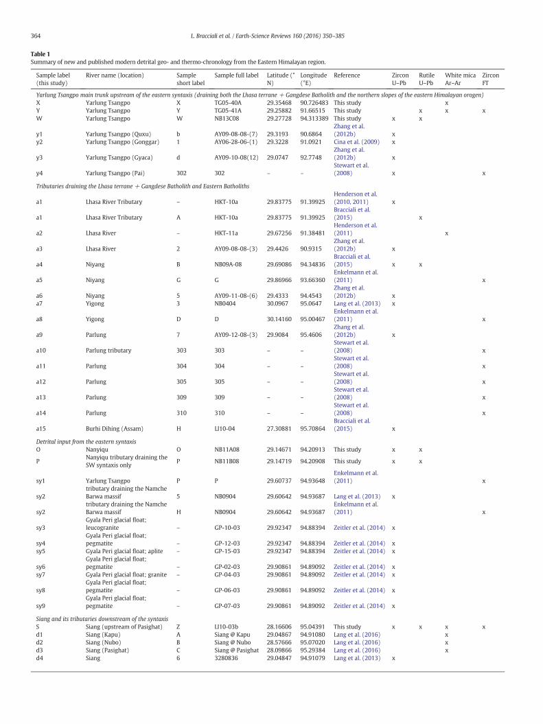
Table 1Summary of new and published modern detrital geo- and thermo-chronology from the Eastern Himalayan region.
Sample label(this study)
River name (location) Sampleshort label
Sample full label Latitude (°N)
Longitude(°E)
Reference ZirconU–Pb
RutileU–Pb
White micaAr–Ar
ZirconFT
Yarlung Tsangpo main trunk upstream of the eastern syntaxis (draining both the Lhasa terrane + Gangdese Batholith and the northern slopes of the eastern Himalayan orogen)X Yarlung Tsangpo X TG05-40A 29.35468 90.726483 This study xY Yarlung Tsangpo Y TG05-41A 29.25882 91.66515 This study x x xW Yarlung Tsangpo W NB13C08 29.27728 94.313389 This study x x
y1 Yarlung Tsangpo (Quxu) b AY09-08-08-(7) 29.3193 90.6864Zhang et al.(2012b) x
y2 Yarlung Tsangpo (Gonggar) 1 AY06-28-06-(1) 29.3228 91.0921 Cina et al. (2009) x
y3 Yarlung Tsangpo (Gyaca) d AY09-10-08(12) 29.0747 92.7748Zhang et al.(2012b) x
y4 Yarlung Tsangpo (Pai) 302 302 – –Stewart et al.(2008) x x
Tributaries draining the Lhasa terrane + Gangdese Batholith and Eastern Batholiths
a1 Lhasa River Tributary – HKT-10a 29.83775 91.39925Henderson et al.(2010, 2011) x
a1 Lhasa River Tributary A HKT-10a 29.83775 91.39925Bracciali et al.(2015) x
a2 Lhasa River – HKT-11a 29.67256 91.38481Henderson et al.(2011) x
a3 Lhasa River 2 AY09-08-08-(3) 29.4426 90.9315Zhang et al.(2012b) x
a4 Niyang B NB09A-08 29.69086 94.34836Bracciali et al.(2015) x x
a5 Niyang G G 29.86966 93.66360Enkelmann et al.(2011) x
a6 Niyang 5 AY09-11-08-(6) 29.4333 94.4543Zhang et al.(2012b) x
a7 Yigong 3 NB0404 30.0967 95.0647 Lang et al. (2013) x
a8 Yigong D D 30.14160 95.00467Enkelmann et al.(2011) x
a9 Parlung 7 AY09-12-08-(3) 29.9084 95.4606Zhang et al.(2012b) x
a10 Parlung tributary 303 303 – –Stewart et al.(2008) x
a11 Parlung 304 304 – –Stewart et al.(2008) x
a12 Parlung 305 305 – –Stewart et al.(2008) x
a13 Parlung 309 309 – –Stewart et al.(2008) x
a14 Parlung 310 310 – –Stewart et al.(2008) x
a15 Burhi Dihing (Assam) H LI10-04 27.30881 95.70864Bracciali et al.(2015) x
Detrital input from the eastern syntaxisO Nanyiqu O NB11A08 29.14671 94.20913 This study x x
PNanyiqu tributary draining theSW syntaxis only
P NB11B08 29.14719 94.20908 This study x x
sy1 Yarlung Tsangpo P P 29.60737 94.93648Enkelmann et al.(2011) x
sy2tributary draining the NamcheBarwa massif 5 NB0904 29.60642 94.93687 Lang et al. (2013) x
sy2tributary draining the NamcheBarwa massif H NB0904 29.60642 94.93687
Enkelmann et al.(2011) x
sy3Gyala Peri glacial float;leucogranite – GP-10-03 29.92347 94.88394 Zeitler et al. (2014) x
sy4Gyala Peri glacial float;pegmatite – GP-12-03 29.92347 94.88394 Zeitler et al. (2014) x
sy5 Gyala Peri glacial float; aplite – GP-15-03 29.92347 94.88394 Zeitler et al. (2014) x
sy6Gyala Peri glacial float;pegmatite – GP-02-03 29.90861 94.89092 Zeitler et al. (2014) x
sy7 Gyala Peri glacial float; granite – GP-04-03 29.90861 94.89092 Zeitler et al. (2014) x
sy8Gyala Peri glacial float;pegmatite – GP-06-03 29.90861 94.89092 Zeitler et al. (2014) x
sy9Gyala Peri glacial float;pegmatite – GP-07-03 29.90861 94.89092 Zeitler et al. (2014) x
Siang and its tributaries downstream of the syntaxisS Siang (upstream of Pasighat) Z LI10-03b 28.16606 95.04391 This study x x x xd1 Siang (Kapu) A Siang @ Kapu 29.04867 94.91080 Lang et al. (2016) xd2 Siang (Nubo) B Siang @ Nubo 28.57666 95.07020 Lang et al. (2016) xd3 Siang (Pasighat) C Siang @ Pasighat 28.09866 95.29384 Lang et al. (2016) xd4 Siang 6 3280836 29.04847 94.91079 Lang et al. (2013) x
364 L. Bracciali et al. / Earth-Science Reviews 160 (2016) 350–385
Table 1 (continued)
Sample label(this study)
River name (location) Sampleshort label
Sample full label Latitude (°N)
Longitude(°E)
Reference ZirconU–Pb
RutileU–Pb
White micaAr–Ar
ZirconFT
d5 Siang 7 TUTING 28.99628 94.90344 Lang et al. (2013) xd6 Siang 8 3250816 28.57666 95.07020 Lang et al. (2013) x
d7 Siang Q Q 29.04938 94.91017Enkelmann et al.(2011) x
d8 Siang tributary I I 28.96166 94.86376Enkelmann et al.(2011) x
d9 Siang tributary J J 28.90998 94.7740Enkelmann et al.(2011) x
d10 Siang tributary K K 28.97833 94.90471Enkelmann et al.(2011) x
d11 Siang R R 28.57713 95.07036Enkelmann et al.(2011) x
d12 Siang tributary L L 28.33640 94.95766Enkelmann et al.(2011) x
d13 Siang tributary M M 28.21978 94.85535Enkelmann et al.(2011) x
d14 Siang tributary N N 28.18498 95.22018Enkelmann et al.(2011) x
d15 Siang S S 28.09970 95.29385Enkelmann et al.(2011) x
d16 Siang (Pasighat) 301 301 – –Stewart et al.(2008) x x
d17 Siang tributary Y Yang Sang River 28.97737 94.90473 Lang et al. (2016) xd18 Siang tributary X Siyom River 28.21933 94.86589 Lang et al. (2016) xd19 Siang tributary Z Yamne River 28.18604 95.22274 Lang et al. (2016) x
Tributaries draining the southern slopes of the eastern Himalayan orogen and the Indo-Burman RangesQ Subansiri (Arunachal Pradesh) Q LI10-02b 28.00542 94.20242 This study x xb1 Subansiri (Arunachal Pradesh) 7 AY01-05-09-(1A) 28.0054 94.2028 Cina et al. (2009) x
b2 Mo Chu (Bhutan) C BH0108 27.72219 89.75536Bracciali et al.(2013, 2015) x x
b3 Pho Chu (Bhutan) D BH0208 27.58825 89.87000Bracciali et al.(2015) x
b4 Puna Tsang Chu (Bhutan) E LB09-03b 27.03051 90.07346Bracciali et al.(2013, 2015) x x
b5 Mau Khola (Bhutan) F LB09-02b 26.94194 90.51898Bracciali et al.(2013, 2015) x x
b6 Mangdi Chu (Bhutan) G LB09-01b 27.14777 90.68972Bracciali et al.(2013, 2015) x x
b7 Dhansiri (Assam) I LI10-05b 26.62281 93.74142Bracciali et al.(2015) x x
b8 Kameng – KAM 20 – –Chirouze et al.(2013) x
b9 Kameng – KAM 30 – –Chirouze et al.(2013) x
Brahmaputra main trunk in the Assam plainZ Brahmaputra Z LI10-06b 26.609694 92.85569 This study x x
Z Brahmaputra Z LI10-06b 26.609694 92.85569Bracciali et al.(2015) x
b10 Brahmaputra 3 AY02-21-06-(2) 26.6108 92.8536 Cina et al. (2009) x
365L. Bracciali et al. / Earth-Science Reviews 160 (2016) 350–385
the detritus (fertility bias; Malusà et al., 2015); and/or ii) a preservationbias: micas could be less preserved in the sampled bar sands comparedto rutile (cf. the ~15% of b2Mawhitemica grains and ~25% of b2Ma ru-tile grains in sample S), resulting in a relative proportion of very youngwhite mica grains smaller than very young rutile in the first cycle detri-tus. We will further discuss the potentially limited ability of white micaAr–Ar detrital data in representing its hinterland source(s) in Section4.2.3.
4.2. Review of published modern detrital chronology from the easternHimalaya
In this sectionwe review (and compare to our newdata presented inSection 4.1) published modern detrital chronology from the easternHimalayan region (see: Table 1 for sample details and references;Fig. 9 for sample locations). All data are plotted as cumulative age distri-bution diagrams to allow for easy comparison of the detrital samples.
4.2.1. Detrital U–Pb zircon dataThe detrital zircon U–Pb signature of the Yarlung Tsangpo sampled
at various locations (up to 400 km apart) upstream of the syntaxis isstrikingly homogeneous (Fig. 10A). Tributaries draining the southernLhasa Terrane (Lhasa and Niyang Rivers: a1, a3, a4; Fig. 10B) typicallycontribute a large proportion of 50–70 Ma Gangdese zircons of theTranshimalayan Arc as well as older zircons. The Yigong and ParlungRivers (a7, a9) draining the Eastern Batholiths are enriched in 110–130 Ma zircons. (see Zhu et al., 2011 and Liang et al., 2008 for a reviewof pre-collisional igneous rocks of the southern Tibet–Burma region, andFig. 4 of Bracciali et al., 2015 for a visual summary of U–Pb data and theirspatial distribution).
Various Siang samples downstreamof the syntaxis (Fig. 10C) exhibitsimilar cumulative curve patterns, with our Siang sample S (n = 75)yielding ~20% of the data in the range 2–30 Ma as a results of our“thin rim” dating approach (see Methods Section 3.2). In samplesfrom other studies (with n up to 150) the youngest dated zircons are
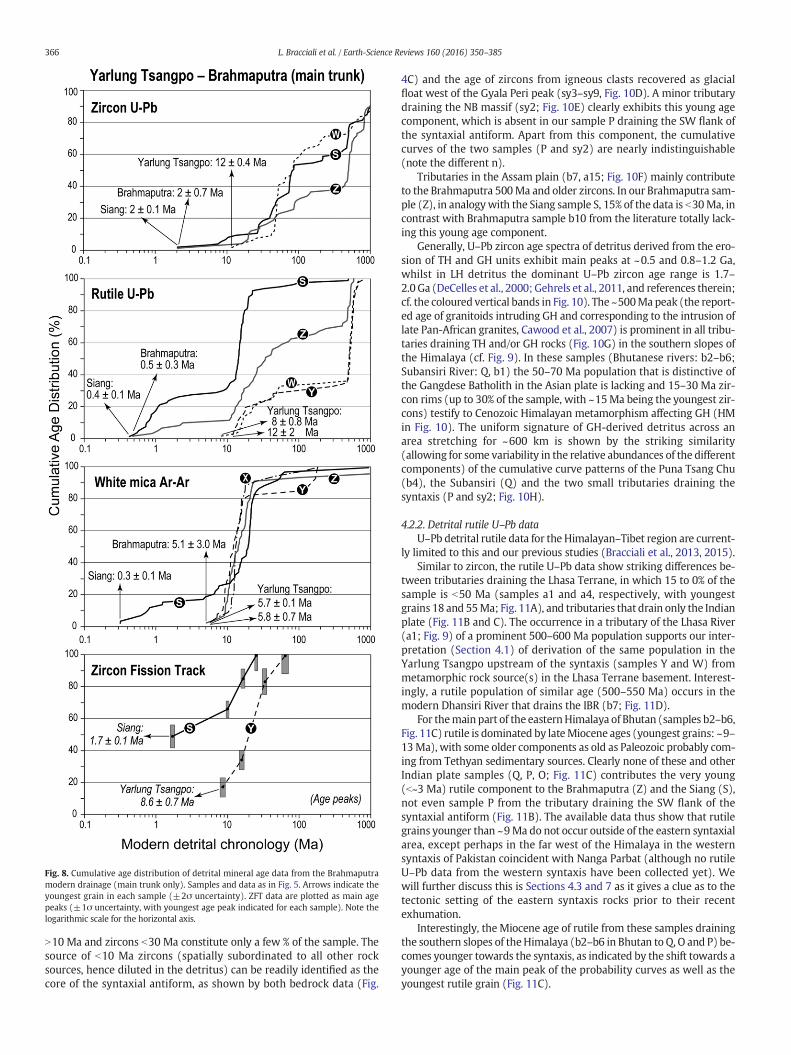
Fig. 8. Cumulative age distribution of detrital mineral age data from the Brahmaputramodern drainage (main trunk only). Samples and data as in Fig. 5. Arrows indicate theyoungest grain in each sample (±2σ uncertainty). ZFT data are plotted as main agepeaks (±1σ uncertainty, with youngest age peak indicated for each sample). Note thelogarithmic scale for the horizontal axis.
366 L. Bracciali et al. / Earth-Science Reviews 160 (2016) 350–385
N10 Ma and zircons b30 Ma constitute only a few % of the sample. Thesource of b10 Ma zircons (spatially subordinated to all other rocksources, hence diluted in the detritus) can be readily identified as thecore of the syntaxial antiform, as shown by both bedrock data (Fig.
4C) and the age of zircons from igneous clasts recovered as glacialfloat west of the Gyala Peri peak (sy3–sy9, Fig. 10D). A minor tributarydraining the NB massif (sy2; Fig. 10E) clearly exhibits this young agecomponent, which is absent in our sample P draining the SW flank ofthe syntaxial antiform. Apart from this component, the cumulativecurves of the two samples (P and sy2) are nearly indistinguishable(note the different n).
Tributaries in the Assam plain (b7, a15; Fig. 10F) mainly contributeto the Brahmaputra 500Ma and older zircons. In our Brahmaputra sam-ple (Z), in analogywith the Siang sample S, 15% of the data is b30Ma, incontrast with Brahmaputra sample b10 from the literature totally lack-ing this young age component.
Generally, U–Pb zircon age spectra of detritus derived from the ero-sion of TH and GH units exhibit main peaks at ~0.5 and 0.8–1.2 Ga,whilst in LH detritus the dominant U–Pb zircon age range is 1.7–2.0 Ga (DeCelles et al., 2000; Gehrels et al., 2011, and references therein;cf. the coloured vertical bands in Fig. 10). The ~500Ma peak (the report-ed age of granitoids intruding GH and corresponding to the intrusion oflate Pan-African granites, Cawood et al., 2007) is prominent in all tribu-taries draining TH and/or GH rocks (Fig. 10G) in the southern slopes ofthe Himalaya (cf. Fig. 9). In these samples (Bhutanese rivers: b2–b6;Subansiri River: Q, b1) the 50–70 Ma population that is distinctive ofthe Gangdese Batholith in the Asian plate is lacking and 15–30 Ma zir-con rims (up to 30% of the sample, with ~15Ma being the youngest zir-cons) testify to Cenozoic Himalayan metamorphism affecting GH (HMin Fig. 10). The uniform signature of GH-derived detritus across anarea stretching for ~600 km is shown by the striking similarity(allowing for some variability in the relative abundances of the differentcomponents) of the cumulative curve patterns of the Puna Tsang Chu(b4), the Subansiri (Q) and the two small tributaries draining thesyntaxis (P and sy2; Fig. 10H).
4.2.2. Detrital rutile U–Pb dataU–Pb detrital rutile data for the Himalayan–Tibet region are current-
ly limited to this and our previous studies (Bracciali et al., 2013, 2015).Similar to zircon, the rutile U–Pb data show striking differences be-
tween tributaries draining the Lhasa Terrane, in which 15 to 0% of thesample is b50 Ma (samples a1 and a4, respectively, with youngestgrains 18 and 55Ma; Fig. 11A), and tributaries that drain only the Indianplate (Fig. 11B and C). The occurrence in a tributary of the Lhasa River(a1; Fig. 9) of a prominent 500–600 Ma population supports our inter-pretation (Section 4.1) of derivation of the same population in theYarlung Tsangpo upstream of the syntaxis (samples Y and W) frommetamorphic rock source(s) in the Lhasa Terrane basement. Interest-ingly, a rutile population of similar age (500–550 Ma) occurs in themodern Dhansiri River that drains the IBR (b7; Fig. 11D).
For themain part of the easternHimalaya of Bhutan (samples b2–b6,Fig. 11C) rutile is dominated by lateMiocene ages (youngest grains: ~9–13Ma), with some older components as old as Paleozoic probably com-ing from Tethyan sedimentary sources. Clearly none of these and otherIndian plate samples (Q, P, O; Fig. 11C) contributes the very young(b~3 Ma) rutile component to the Brahmaputra (Z) and the Siang (S),not even sample P from the tributary draining the SW flank of thesyntaxial antiform (Fig. 11B). The available data thus show that rutilegrains younger than ~9Ma do not occur outside of the eastern syntaxialarea, except perhaps in the far west of the Himalaya in the westernsyntaxis of Pakistan coincident with Nanga Parbat (although no rutileU–Pb data from the western syntaxis have been collected yet). Wewill further discuss this is Sections 4.3 and 7 as it gives a clue as to thetectonic setting of the eastern syntaxis rocks prior to their recentexhumation.
Interestingly, the Miocene age of rutile from these samples drainingthe southern slopes of theHimalaya (b2–b6 in Bhutan to Q, O and P) be-comes younger towards the syntaxis, as indicated by the shift towards ayounger age of the main peak of the probability curves as well as theyoungest rutile grain (Fig. 11C).
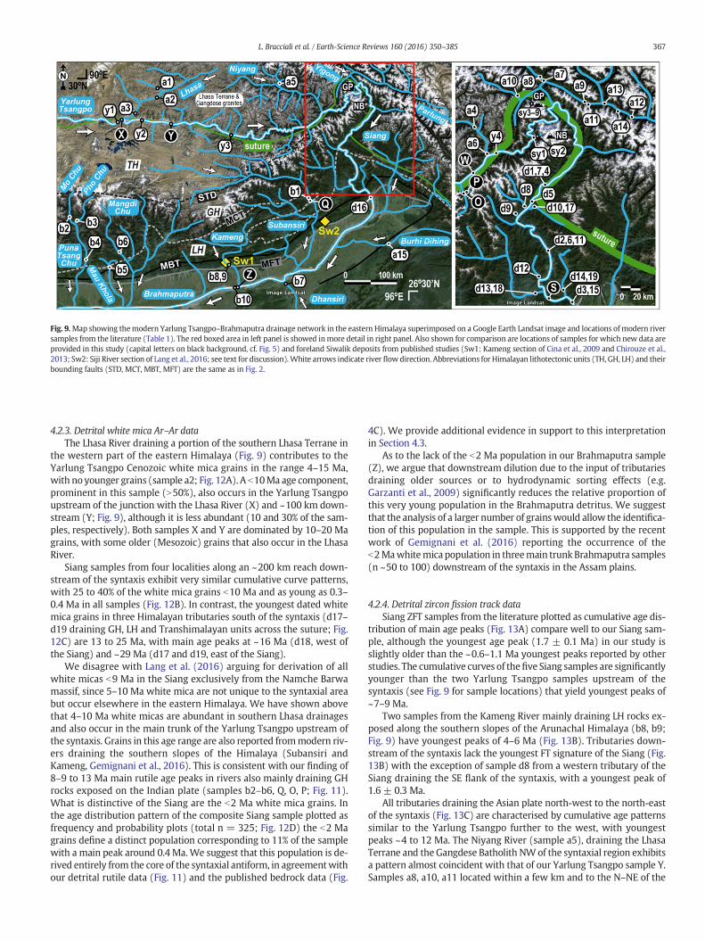
Fig. 9.Map showing themodern Yarlung Tsangpo–Brahmaputra drainage network in the eastern Himalaya superimposed on a Google Earth Landsat image and locations of modern riversamples from the literature (Table 1). The red boxed area in left panel is showed inmore detail in right panel. Also shown for comparison are locations of samples for which new data areprovided in this study (capital letters on black background, cf. Fig. 5) and foreland Siwalik deposits from published studies (Sw1: Kameng section of Cina et al., 2009 and Chirouze et al.,2013; Sw2: Siji River section of Lang et al., 2016; see text for discussion).White arrows indicate river flowdirection. Abbreviations for Himalayan lithotectonic units (TH, GH, LH) and theirbounding faults (STD, MCT, MBT, MFT) are the same as in Fig. 2.
367L. Bracciali et al. / Earth-Science Reviews 160 (2016) 350–385
4.2.3. Detrital white mica Ar–Ar dataThe Lhasa River draining a portion of the southern Lhasa Terrane in
the western part of the eastern Himalaya (Fig. 9) contributes to theYarlung Tsangpo Cenozoic white mica grains in the range 4–15 Ma,with noyounger grains (sample a2; Fig. 12A). A b10Ma age component,prominent in this sample (N50%), also occurs in the Yarlung Tsangpoupstream of the junction with the Lhasa River (X) and ~100 km down-stream (Y; Fig. 9), although it is less abundant (10 and 30% of the sam-ples, respectively). Both samples X and Y are dominated by 10–20 Magrains, with some older (Mesozoic) grains that also occur in the LhasaRiver.
Siang samples from four localities along an ~200 km reach down-stream of the syntaxis exhibit very similar cumulative curve patterns,with 25 to 40% of the white mica grains b10 Ma and as young as 0.3–0.4 Ma in all samples (Fig. 12B). In contrast, the youngest dated whitemica grains in three Himalayan tributaries south of the syntaxis (d17–d19 draining GH, LH and Transhimalayan units across the suture; Fig.12C) are 13 to 25 Ma, with main age peaks at ~16 Ma (d18, west ofthe Siang) and ~29 Ma (d17 and d19, east of the Siang).
We disagree with Lang et al. (2016) arguing for derivation of allwhite micas b9 Ma in the Siang exclusively from the Namche Barwamassif, since 5–10 Ma white mica are not unique to the syntaxial areabut occur elsewhere in the eastern Himalaya. We have shown abovethat 4–10 Ma white micas are abundant in southern Lhasa drainagesand also occur in the main trunk of the Yarlung Tsangpo upstream ofthe syntaxis. Grains in this age range are also reported frommodern riv-ers draining the southern slopes of the Himalaya (Subansiri andKameng, Gemignani et al., 2016). This is consistent with our finding of8–9 to 13 Ma main rutile age peaks in rivers also mainly draining GHrocks exposed on the Indian plate (samples b2–b6, Q, O, P; Fig. 11).What is distinctive of the Siang are the b2 Ma white mica grains. Inthe age distribution pattern of the composite Siang sample plotted asfrequency and probability plots (total n = 325; Fig. 12D) the b2 Magrains define a distinct population corresponding to 11% of the samplewith a main peak around 0.4 Ma.We suggest that this population is de-rived entirely from the core of the syntaxial antiform, in agreementwithour detrital rutile data (Fig. 11) and the published bedrock data (Fig.
4C). We provide additional evidence in support to this interpretationin Section 4.3.
As to the lack of the b2 Ma population in our Brahmaputra sample(Z), we argue that downstream dilution due to the input of tributariesdraining older sources or to hydrodynamic sorting effects (e.g.Garzanti et al., 2009) significantly reduces the relative proportion ofthis very young population in the Brahmaputra detritus. We suggestthat the analysis of a larger number of grainswould allow the identifica-tion of this population in the sample. This is supported by the recentwork of Gemignani et al. (2016) reporting the occurrence of theb2Mawhitemica population in threemain trunk Brahmaputra samples(n ~50 to 100) downstream of the syntaxis in the Assam plains.
4.2.4. Detrital zircon fission track dataSiang ZFT samples from the literature plotted as cumulative age dis-
tribution of main age peaks (Fig. 13A) compare well to our Siang sam-ple, although the youngest age peak (1.7 ± 0.1 Ma) in our study isslightly older than the ~0.6–1.1 Ma youngest peaks reported by otherstudies. The cumulative curves of thefive Siang samples are significantlyyounger than the two Yarlung Tsangpo samples upstream of thesyntaxis (see Fig. 9 for sample locations) that yield youngest peaks of~7–9 Ma.
Two samples from the Kameng River mainly draining LH rocks ex-posed along the southern slopes of the Arunachal Himalaya (b8, b9;Fig. 9) have youngest peaks of 4–6 Ma (Fig. 13B). Tributaries down-stream of the syntaxis lack the youngest FT signature of the Siang (Fig.13B) with the exception of sample d8 from a western tributary of theSiang draining the SE flank of the syntaxis, with a youngest peak of1.6 ± 0.3 Ma.
All tributaries draining the Asian plate north-west to the north-eastof the syntaxis (Fig. 13C) are characterised by cumulative age patternssimilar to the Yarlung Tsangpo further to the west, with youngestpeaks ~4 to 12 Ma. The Niyang River (sample a5), draining the LhasaTerrane and the Gangdese Batholith NWof the syntaxial region exhibitsa pattern almost coincident with that of our Yarlung Tsangpo sample Y.Samples a8, a10, a11 located within a few km and to the N–NE of the
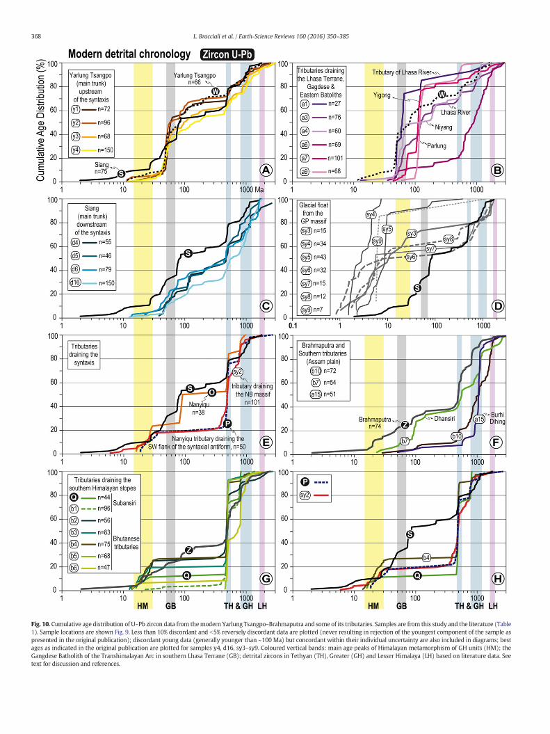
Fig. 10. Cumulative age distribution of U–Pb zircon data from themodern Yarlung Tsangpo–Brahmaputra and some of its tributaries. Samples are from this study and the literature (Table1). Sample locations are shown Fig. 9. Less than 10% discordant and b5% reversely discordant data are plotted (never resulting in rejection of the youngest component of the sample aspresented in the original publication); discordant young data (generally younger than ~100 Ma) but concordant within their individual uncertainty are also included in diagrams; bestages as indicated in the original publication are plotted for samples y4, d16, sy3–sy9. Coloured vertical bands: main age peaks of Himalayan metamorphism of GH units (HM); theGangdese Batholith of the Transhimalayan Arc in southern Lhasa Terrane (GB); detrital zircons in Tethyan (TH), Greater (GH) and Lesser Himalaya (LH) based on literature data. Seetext for discussion and references.
368 L. Bracciali et al. / Earth-Science Reviews 160 (2016) 350–385
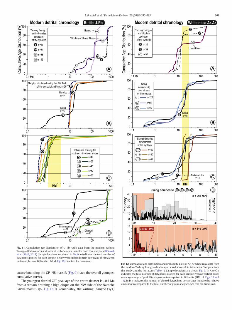
Fig. 11. Cumulative age distribution of U–Pb rutile data from the modern YarlungTsangpo–Brahmaputra and some of its tributaries. Samples from this study and Braccialiet al. (2013, 2015). Sample locations are shown in Fig. 9; n indicates the total number ofdatapoints plotted for each sample. Yellow vertical band: main age peaks of Himalayanmetamorphism of GH units (HM; cf. Fig. 10). See text for discussion.
Fig. 12. Cumulative age distribution and probability plots of Ar–Ar white mica data fromthe modern Yarlung Tsangpo–Brahmaputra and some of its tributaries. Samples fromthis study and the literature (Table 1). Sample locations are shown Fig. 9; in A to C nindicates the total number of datapoints plotted for each sample; yellow vertical band:main age-range of peak Himalayan metamorphism in GH units (HM; cf. Figs. 10 and11). In D n indicates the number of plotted datapoints; percentages indicate the relativeamount of n compared to the total number of grains analysed. See text for discussion.
369L. Bracciali et al. / Earth-Science Reviews 160 (2016) 350–385
suture bounding the GP–NB massifs (Fig. 9) have the overall youngestcumulative curves.
The youngest detrital ZFT peak age of the entire dataset is ~0.3 Mafrom a stream draining a high cirque on the NW side of the NamcheBarwa massif (sy2, Fig. 13D). Remarkably, the Yarlung Tsangpo (sy1)
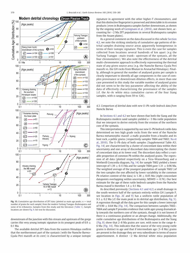
Fig. 13. Cumulative age distribution of ZFT data (plotted as main age peaks; n = totalnumber of grains for each sample) from the modern Yarlung Tsangpo–Brahmaputra andsome of its tributaries. Samples from this study and the literature (Table 1). Samplelocations are shown Fig. 9. See text for discussion.
370 L. Bracciali et al. / Earth-Science Reviews 160 (2016) 350–385
downstreamof the junctionwith this stream and upstreamof the gorgecarries this very young isotopic signature in its youngest peak of 0.9 ±0.1 Ma.
The available detrital ZFT data from the eastern Himalaya confirmthat the northernmost part of the syntaxis (with the Namche Barwa–Gyala Peri massifs at its core) is characterised by a unique isotopic
signature in agreement with the other higher-T chronometers, andthat this distinctive fingerprint is preserved and detectable in its erosionproducts (even in Brahmaputra samples further downstream, as shownby the ongoing work of Gemignani et al. (2016), not shown here, ac-counting for b2 Ma ZFT populations in several Brahmaputra samplesfrom the Assam plains).
As a general comment on the data discussed in this whole Section4.2, we note the striking similarity of cumulative age patterns of de-trital samples draining source areas apparently homogeneous interms of their isotopic signature. This is even the case for samplescollected from locations several hundreds of km apart (e.g theYarlung Tsangpo –main trunk– upstream of the syntaxis, all thefour chronometers). We also note the effectiveness of the detritalmulti-chronometer approach in effectively representing the thermalstate of any given source area (e.g. the Namche Barwa–Gyala Perimassifs vs. the GH rocks from Bhutan to Arunachal Himalaya). Final-ly, although in general the number of analysed grains per sample isclearly important to identify all age components in the case of com-plex provenance or downstream dilution effects, in more than onecase presented in this study the variable number of analysed grainsdid not seem to be the key parameter affecting the ability of thedata of effectively characterising the provenance of the samples(cf. the Ar–Ar white mica cumulative curves of the four Siangsamples, with n ranging from 59 to 126).
4.3. Comparison of detrital data with new U–Pb rutile bedrock data fromNamche Barwa
In Sections 4.1 and 4.2 we have shown that both the Siang and theBrahmaputra modern sand samples yielded a b3 Ma rutile populationthat we interpret to derive entirely from the erosion of the northerncore of the syntaxis.
This interpretation is supported by our newU–Pb bedrock rutile datadetermined on two high grade rocks from the west of the NamcheBarwa metamorphic massif: a mafic granulite from a boudin and itshost rock, a pelitic gneiss (respectively samples T604 and T602; Xu etal., 2010). The U–Pb data of both samples (Supplemental Table A3;Fig. 14) are characterised by a cluster of concordant data within theiruncertainty and one array of discordant data intercepting the clusterof concordant data at its lower end. The discordant data reflect a vari-able proportion of common Pb within the analysed grains. The regres-sion of all data (plotted respectively on a Tera–Wasserburg and aWetherill Concordia diagram, Fig. 14) for sample T602 yielded a lowerintercept of 1.39 ± 0.13 Ma and for sample T604 gave 1.31 ± 0.96 Ma.The weighted average of the youngest population of sample T602 (ofthe two samples the one affected by lower variability in the commonPb relative content of the data) is 1.38 ± 0.05 Ma (eight concordantdatapoints overlapping within uncertainty; MSWD = 0.76). Our bestestimate for the age of these rutile bedrock samples from the NamcheBarwa massif is therefore 1.4 ± 0.1 Ma.
As described previously (Sections 4.1 and 4.2) a small drainage inthe south-western half of the syntaxis entirely within GH (sample P,see location in Figs. 2C and 9) has a uniform rutile population of9.3 ± 0.2 Ma (cf. the main peak in its detrital age distribution, Fig. 5).A regression through all the data gave for this sample a lower interceptof 9.90 ± 0.64 Ma (Fig. 14). The comparison between samples T602–T604 and sample P provides evidence that rutile ages young dramatical-ly towards the northern core of the syntaxis, though it is not known ifthere is a continuous gradient or an abrupt change. Additionally, therutile cumulative age distributions of the Brahmaputra and the Siang(Fig. 8) show that 2–8 Ma grains are rare, with none in the range 4–6 Ma (Fig. 14). This indicates that the source of the very young rutilegrains is distinct in age and that if intermediate age (3–8 Ma) grainsare present in the drainage they are very subordinate in terms of sourceapportionment. A distinct b2 Ma detrital white mica population
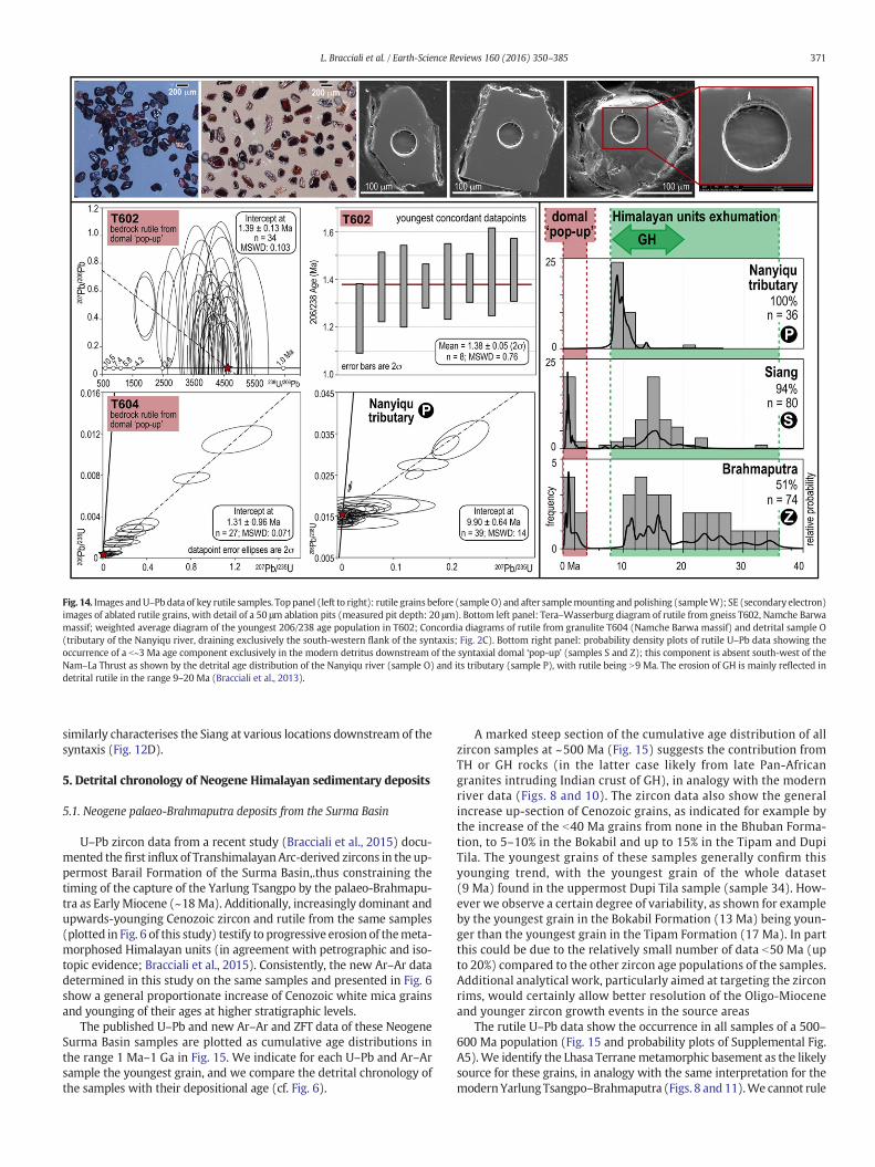
Fig. 14. Images andU–Pbdata of key rutile samples. Toppanel (left to right): rutile grains before (sample O) and after samplemounting and polishing (sampleW); SE (secondary electron)images of ablated rutile grains, with detail of a 50 μm ablation pits (measured pit depth: 20 μm). Bottom left panel: Tera–Wasserburg diagram of rutile from gneiss T602, Namche Barwamassif; weighted average diagram of the youngest 206/238 age population in T602; Concordia diagrams of rutile from granulite T604 (Namche Barwa massif) and detrital sample O(tributary of the Nanyiqu river, draining exclusively the south-western flank of the syntaxis; Fig. 2C). Bottom right panel: probability density plots of rutile U–Pb data showing theoccurrence of a b~3 Ma age component exclusively in the modern detritus downstream of the syntaxial domal ‘pop-up’ (samples S and Z); this component is absent south-west of theNam–La Thrust as shown by the detrital age distribution of the Nanyiqu river (sample O) and its tributary (sample P), with rutile being N9 Ma. The erosion of GH is mainly reflected indetrital rutile in the range 9–20 Ma (Bracciali et al., 2013).
371L. Bracciali et al. / Earth-Science Reviews 160 (2016) 350–385
similarly characterises the Siang at various locations downstream of thesyntaxis (Fig. 12D).
5. Detrital chronology of Neogene Himalayan sedimentary deposits
5.1. Neogene palaeo-Brahmaputra deposits from the Surma Basin
U–Pb zircon data from a recent study (Bracciali et al., 2015) docu-mented the first influx of TranshimalayanArc-derived zircons in the up-permost Barail Formation of the Surma Basin,.thus constraining thetiming of the capture of the Yarlung Tsangpo by the palaeo-Brahmapu-tra as Early Miocene (~18Ma). Additionally, increasingly dominant andupwards-younging Cenozoic zircon and rutile from the same samples(plotted in Fig. 6 of this study) testify to progressive erosion of themeta-morphosed Himalayan units (in agreement with petrographic and iso-topic evidence; Bracciali et al., 2015). Consistently, the new Ar–Ar datadetermined in this study on the same samples and presented in Fig. 6show a general proportionate increase of Cenozoic white mica grainsand younging of their ages at higher stratigraphic levels.
The published U–Pb and new Ar–Ar and ZFT data of these NeogeneSurma Basin samples are plotted as cumulative age distributions inthe range 1 Ma–1 Ga in Fig. 15. We indicate for each U–Pb and Ar–Arsample the youngest grain, and we compare the detrital chronology ofthe samples with their depositional age (cf. Fig. 6).
A marked steep section of the cumulative age distribution of allzircon samples at ~500 Ma (Fig. 15) suggests the contribution fromTH or GH rocks (in the latter case likely from late Pan-Africangranites intruding Indian crust of GH), in analogy with the modernriver data (Figs. 8 and 10). The zircon data also show the generalincrease up-section of Cenozoic grains, as indicated for example bythe increase of the b40 Ma grains from none in the Bhuban Forma-tion, to 5–10% in the Bokabil and up to 15% in the Tipam and DupiTila. The youngest grains of these samples generally confirm thisyounging trend, with the youngest grain of the whole dataset(9 Ma) found in the uppermost Dupi Tila sample (sample 34). How-ever we observe a certain degree of variability, as shown for exampleby the youngest grain in the Bokabil Formation (13 Ma) being youn-ger than the youngest grain in the Tipam Formation (17 Ma). In partthis could be due to the relatively small number of data b50 Ma (upto 20%) compared to the other zircon age populations of the samples.Additional analytical work, particularly aimed at targeting the zirconrims, would certainly allow better resolution of the Oligo-Mioceneand younger zircon growth events in the source areas
The rutile U–Pb data show the occurrence in all samples of a 500–600 Ma population (Fig. 15 and probability plots of Supplemental Fig.A5). We identify the Lhasa Terranemetamorphic basement as the likelysource for these grains, in analogy with the same interpretation for themodernYarlungTsangpo–Brahmaputra (Figs. 8 and 11).We cannot rule
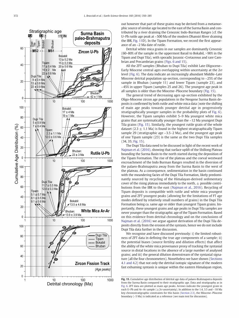
372 L. Bracciali et al. / Earth-Science Reviews 160 (2016) 350–385
out however that part of these grains may be derived from a metamor-phic source of similar age located to the east of the SurmaBasin and con-tributed by a river draining the Cenozoic Indo-Burman Ranges (cf. theU–Pb rutile age peak at ~500Ma of the modern Dhansiri River drainingthe IBR, Fig. 11D). In the Tipam Formation, we record the first appear-ance of an ~2 Ma date of rutile.
Detrital white mica grains in our samples are dominantly Cenozoic(60–80% of the sample in the uppermost Barail to Bokabil, N90% in theTipam and Dupi Tila), with sporadic Jurassic–Cretaceous and rare Cam-brian and Precambrian grains (Figs. 6 and 15).
All the ZFT samples (Bhuban to Dupi Tila) exhibit Late Oligocene–Early Miocene central ages overlapping within uncertainty at the 2σlevel (Fig. 6). The data indicate an increasingly abundant Middle–LateMiocene detrital population up-section, corresponding to ~25% of thesample in Bhuban (sample 11) and lower Tipam (sample 23), and~45% in upper Tipam (samples 25 and 26). The youngest age peak inall samples is older than the Miocene–Pliocene boundary (Fig. 15).
The general trend of decreasing ages up-section exhibited by theOligo-Miocene zircon age populations in the Neogene Surma Basin de-posits is confirmed by both rutile andwhitemica data (note the shiftingof main age peaks towards younger detrital age in progressivelystratigraphically younger samples in the probability plots of Fig. 6).However, the Tipam samples exhibit 5–9 Ma youngest white micagrains that are systematically younger than the ~12 Ma youngest DupiTila grains (Fig. 15). Similarly, the youngest rutile grain of the wholedataset (2.3 ± 1.1 Ma) is found in the highest stratigraphically Tipamsample 29 (stratigraphic age ~3.5–2 Ma), and the youngest age peakof one Tipam sample (23) is the same as the two Dupi Tila samples(34, 35; Fig. 15).
The Dupi Tila data need to be discussed in light of the recentwork ofNajman et al. (2016), showing that surface uplift of the Shillong Plateaubounding the Surma Basin to the north started during the deposition ofthe Tipam Formation. The rise of the plateau and the coeval westwardencroachment of the Indo Burman Ranges resulted in the diversion ofthe palaeo-Brahmaputra away from the Surma Basin to the west ofthe plateau. As a consequence, sedimentation in the basin continuedwith the meandering facies of the Dupi Tila Formation, likely predomi-nantly sourced by recycling of the Himalayan-derived sedimentarycover of the rising plateau immediately to the north, ± possible contri-butions from the IBR to the east (Najman et al., 2016). Recycling ofTipam deposits is compatible with rutile and white mica youngestgrains and ZFT youngest peaks (allowing for the limitations of FT agemodes defined by relatively small numbers of grains) in the Dupi TilaFormation being ca. same age or older than youngest Tipam grains. Im-portantly, these youngest grains and age peaks in Dupi Tila samples arenever younger than the stratigraphic age of the Tipam Formation. Basedon this evidence from detrital chronology and on the conclusions ofNajman et al. (2016) we argue against derivation of the Dupi Tila de-posits directly from the erosion of the syntaxis, hencewe do not includeDupi Tila data further in the discussion.
We recognise and have discussed previously: i) the limited robust-ness of ZFT data in defining the true age components of a sample; ii)the potential biases (source fertility and dilution effects) that affectthe ability of the white mica provenance proxy of tracking the syntaxialsource in distal locations in the absence of a large number of analysedgrains; and iii) the general dilution downstream of the syntaxial signa-ture (all the four chronometers). Nonetheless we have shown (Sections4.1 and 4.2) that not only the detrital isotopic signature of the modernfast exhuming syntaxis is unique within the eastern Himalayan region,
Fig. 15. Cumulative age distribution of detrital age data of palaeo-Brahmaputra depositsfrom the Surma Basin compared to their stratigraphic age. Data and stratigraphy as inFig. 6. ZFT data are plotted as main age peaks. Arrows indicate the youngest grain ineach U–Pb and Ar–Ar sample (±2σ uncertainty). In addition to the 1.4, 3.5 and b18 Makey chronostratigraphic constraints for this basin (Section 2.3), the Miocene–Plioceneboundary (~5 Ma) is indicated as a reference (see main text for discussion).
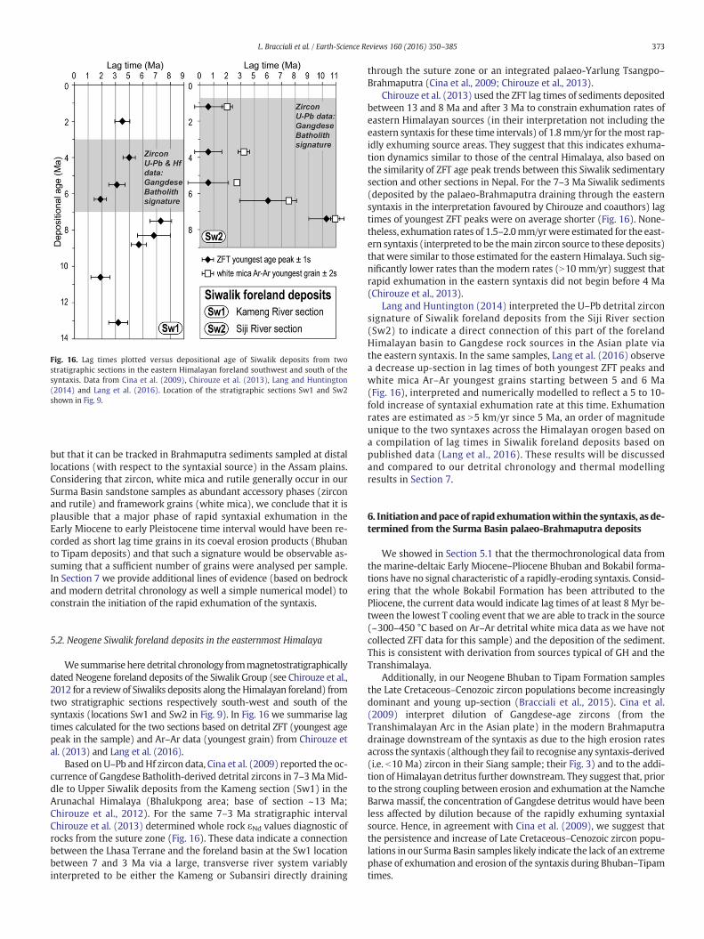
Fig. 16. Lag times plotted versus depositional age of Siwalik deposits from twostratigraphic sections in the eastern Himalayan foreland southwest and south of thesyntaxis. Data from Cina et al. (2009), Chirouze et al. (2013), Lang and Huntington(2014) and Lang et al. (2016). Location of the stratigraphic sections Sw1 and Sw2shown in Fig. 9.
373L. Bracciali et al. / Earth-Science Reviews 160 (2016) 350–385
but that it can be tracked in Brahmaputra sediments sampled at distallocations (with respect to the syntaxial source) in the Assam plains.Considering that zircon, white mica and rutile generally occur in ourSurma Basin sandstone samples as abundant accessory phases (zirconand rutile) and framework grains (white mica), we conclude that it isplausible that a major phase of rapid syntaxial exhumation in theEarly Miocene to early Pleistocene time interval would have been re-corded as short lag time grains in its coeval erosion products (Bhubanto Tipam deposits) and that such a signature would be observable as-suming that a sufficient number of grains were analysed per sample.In Section 7 we provide additional lines of evidence (based on bedrockand modern detrital chronology as well a simple numerical model) toconstrain the initiation of the rapid exhumation of the syntaxis.
5.2. Neogene Siwalik foreland deposits in the easternmost Himalaya
Wesummarise heredetrital chronology frommagnetostratigraphicallydated Neogene foreland deposits of the Siwalik Group (see Chirouze et al.,2012 for a review of Siwaliks deposits along the Himalayan foreland) fromtwo stratigraphic sections respectively south-west and south of thesyntaxis (locations Sw1 and Sw2 in Fig. 9). In Fig. 16 we summarise lagtimes calculated for the two sections based on detrital ZFT (youngest agepeak in the sample) and Ar–Ar data (youngest grain) from Chirouze etal. (2013) and Lang et al. (2016).
Based on U–Pb andHf zircon data, Cina et al. (2009) reported the oc-currence of Gangdese Batholith-derived detrital zircons in 7–3MaMid-dle to Upper Siwalik deposits from the Kameng section (Sw1) in theArunachal Himalaya (Bhalukpong area; base of section ~13 Ma;Chirouze et al., 2012). For the same 7–3 Ma stratigraphic intervalChirouze et al. (2013) determined whole rock εNd values diagnostic ofrocks from the suture zone (Fig. 16). These data indicate a connectionbetween the Lhasa Terrane and the foreland basin at the Sw1 locationbetween 7 and 3 Ma via a large, transverse river system variablyinterpreted to be either the Kameng or Subansiri directly draining
through the suture zone or an integrated palaeo-Yarlung Tsangpo–Brahmaputra (Cina et al., 2009; Chirouze et al., 2013).
Chirouze et al. (2013) used the ZFT lag times of sediments depositedbetween 13 and 8 Ma and after 3 Ma to constrain exhumation rates ofeastern Himalayan sources (in their interpretation not including theeastern syntaxis for these time intervals) of 1.8mm/yr for themost rap-idly exhuming source areas. They suggest that this indicates exhuma-tion dynamics similar to those of the central Himalaya, also based onthe similarity of ZFT age peak trends between this Siwalik sedimentarysection and other sections in Nepal. For the 7–3 Ma Siwalik sediments(deposited by the palaeo-Brahmaputra draining through the easternsyntaxis in the interpretation favoured by Chirouze and coauthors) lagtimes of youngest ZFT peaks were on average shorter (Fig. 16). None-theless, exhumation rates of 1.5–2.0mm/yrwere estimated for the east-ern syntaxis (interpreted to be themain zircon source to these deposits)that were similar to those estimated for the eastern Himalaya. Such sig-nificantly lower rates than the modern rates (N10 mm/yr) suggest thatrapid exhumation in the eastern syntaxis did not begin before 4 Ma(Chirouze et al., 2013).
Lang and Huntington (2014) interpreted the U–Pb detrital zirconsignature of Siwalik foreland deposits from the Siji River section(Sw2) to indicate a direct connection of this part of the forelandHimalayan basin to Gangdese rock sources in the Asian plate viathe eastern syntaxis. In the same samples, Lang et al. (2016) observea decrease up-section in lag times of both youngest ZFT peaks andwhite mica Ar–Ar youngest grains starting between 5 and 6 Ma(Fig. 16), interpreted and numerically modelled to reflect a 5 to 10-fold increase of syntaxial exhumation rate at this time. Exhumationrates are estimated as N5 km/yr since 5 Ma, an order of magnitudeunique to the two syntaxes across the Himalayan orogen based ona compilation of lag times in Siwalik foreland deposits based onpublished data (Lang et al., 2016). These results will be discussedand compared to our detrital chronology and thermal modellingresults in Section 7.
6. Initiationandpaceof rapid exhumationwithin the syntaxis, as de-termined from the Surma Basin palaeo-Brahmaputra deposits
We showed in Section 5.1 that the thermochronological data fromthe marine-deltaic Early Miocene–Pliocene Bhuban and Bokabil forma-tions have no signal characteristic of a rapidly-eroding syntaxis. Consid-ering that the whole Bokabil Formation has been attributed to thePliocene, the current data would indicate lag times of at least 8 Myr be-tween the lowest T cooling event that we are able to track in the source(~300–450 °C based on Ar–Ar detrital white mica data as we have notcollected ZFT data for this sample) and the deposition of the sediment.This is consistent with derivation from sources typical of GH and theTranshimalaya.
Additionally, in our Neogene Bhuban to Tipam Formation samplesthe Late Cretaceous–Cenozoic zircon populations become increasinglydominant and young up-section (Bracciali et al., 2015). Cina et al.(2009) interpret dilution of Gangdese-age zircons (from theTranshimalayan Arc in the Asian plate) in the modern Brahmaputradrainage downstream of the syntaxis as due to the high erosion ratesacross the syntaxis (although they fail to recognise any syntaxis-derived(i.e. b10 Ma) zircon in their Siang sample; their Fig. 3) and to the addi-tion of Himalayan detritus further downstream. They suggest that, priorto the strong coupling between erosion and exhumation at the NamcheBarwa massif, the concentration of Gangdese detritus would have beenless affected by dilution because of the rapidly exhuming syntaxialsource. Hence, in agreement with Cina et al. (2009), we suggest thatthe persistence and increase of Late Cretaceous–Cenozoic zircon popu-lations in our Surma Basin samples likely indicate the lack of an extremephase of exhumation and erosion of the syntaxis during Bhuban–Tipamtimes.
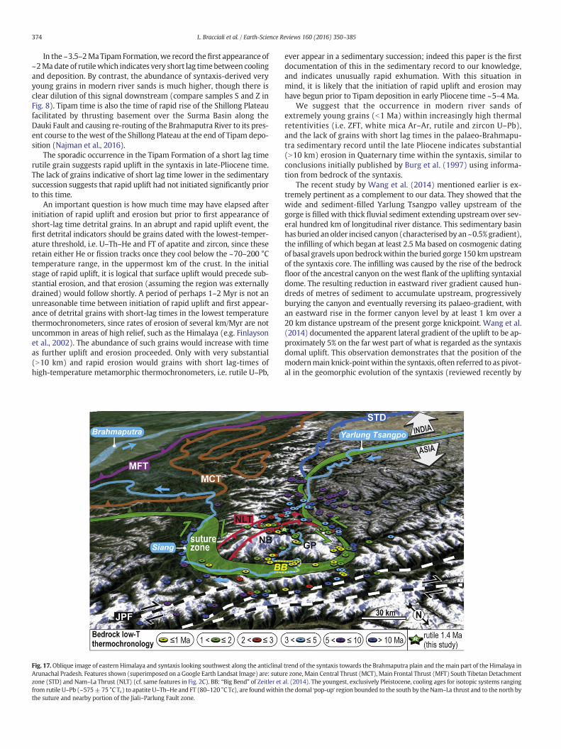
374 L. Bracciali et al. / Earth-Science Reviews 160 (2016) 350–385
In the ~3.5–2MaTipam Formation,we record thefirst appearance of~2Madate of rutilewhich indicates very short lag timebetween coolingand deposition. By contrast, the abundance of syntaxis-derived veryyoung grains in modern river sands is much higher, though there isclear dilution of this signal downstream (compare samples S and Z inFig. 8). Tipam time is also the time of rapid rise of the Shillong Plateaufacilitated by thrusting basement over the Surma Basin along theDauki Fault and causing re-routing of the Brahmaputra River to its pres-ent course to the west of the Shillong Plateau at the end of Tipam depo-sition (Najman et al., 2016).
The sporadic occurrence in the Tipam Formation of a short lag timerutile grain suggests rapid uplift in the syntaxis in late-Pliocene time.The lack of grains indicative of short lag time lower in the sedimentarysuccession suggests that rapid uplift had not initiated significantly priorto this time.
An important question is how much time may have elapsed afterinitiation of rapid uplift and erosion but prior to first appearance ofshort-lag time detrital grains. In an abrupt and rapid uplift event, thefirst detrital indicators should be grains dated with the lowest-temper-ature threshold, i.e. U–Th–He and FT of apatite and zircon, since theseretain either He or fission tracks once they cool below the ~70–200 °Ctemperature range, in the uppermost km of the crust. In the initialstage of rapid uplift, it is logical that surface uplift would precede sub-stantial erosion, and that erosion (assuming the region was externallydrained) would follow shortly. A period of perhaps 1–2 Myr is not anunreasonable time between initiation of rapid uplift and first appear-ance of detrital grains with short-lag times in the lowest temperaturethermochronometers, since rates of erosion of several km/Myr are notuncommon in areas of high relief, such as the Himalaya (e.g. Finlaysonet al., 2002). The abundance of such grains would increase with timeas further uplift and erosion proceeded. Only with very substantial(N10 km) and rapid erosion would grains with short lag-times ofhigh-temperature metamorphic thermochronometers, i.e. rutile U–Pb,
Fig. 17. Oblique image of eastern Himalaya and syntaxis looking southwest along the anticlinalArunachal Pradesh. Features shown (superimposed on a Google Earth Landsat Image) are: sutuzone (STD) and Nam–La Thrust (NLT) (cf. same features in Fig. 2C). BB: “Big Bend” of Zeitler etfrom rutile U–Pb (~575± 75 °C Tc) to apatite U–Th–He and FT (80–120 °C Tc), are foundwithinthe suture and nearby portion of the Jiali–Parlung Fault zone.
ever appear in a sedimentary succession; indeed this paper is the firstdocumentation of this in the sedimentary record to our knowledge,and indicates unusually rapid exhumation. With this situation inmind, it is likely that the initiation of rapid uplift and erosion mayhave begun prior to Tipam deposition in early Pliocene time ~5–4 Ma.
We suggest that the occurrence in modern river sands ofextremely young grains (b1 Ma) within increasingly high thermalretentivities (i.e. ZFT, white mica Ar–Ar, rutile and zircon U–Pb),and the lack of grains with short lag times in the palaeo-Brahmapu-tra sedimentary record until the late Pliocene indicates substantial(N10 km) erosion in Quaternary time within the syntaxis, similar toconclusions initially published by Burg et al. (1997) using informa-tion from bedrock of the syntaxis.
The recent study by Wang et al. (2014) mentioned earlier is ex-tremely pertinent as a complement to our data. They showed that thewide and sediment-filled Yarlung Tsangpo valley upstream of thegorge is filled with thick fluvial sediment extending upstream over sev-eral hundred km of longitudinal river distance. This sedimentary basinhas buried anolder incised canyon (characterised by an ~0.5% gradient),the infilling of which began at least 2.5 Ma based on cosmogenic datingof basal gravels upon bedrockwithin the buried gorge 150 kmupstreamof the syntaxis core. The infilling was caused by the rise of the bedrockfloor of the ancestral canyon on the west flank of the uplifting syntaxialdome. The resulting reduction in eastward river gradient caused hun-dreds of metres of sediment to accumulate upstream, progressivelyburying the canyon and eventually reversing its palaeo-gradient, withan eastward rise in the former canyon level by at least 1 km over a20 km distance upstream of the present gorge knickpoint. Wang et al.(2014) documented the apparent lateral gradient of the uplift to be ap-proximately 5% on the far west part of what is regarded as the syntaxisdomal uplift. This observation demonstrates that the position of themodernmain knick-pointwithin the syntaxis, often referred to as pivot-al in the geomorphic evolution of the syntaxis (reviewed recently by
trend of the syntaxis towards the Brahmaputra plain and the main part of the Himalaya inre zone, Main Central Thrust (MCT), Main Frontal Thrust (MFT) South Tibetan Detachmental. (2014). The youngest, exclusively Pleistocene, cooling ages for isotopic systems rangingthe domal ʻpop-upʼ region bounded to the south by the Nam–La thrust and to the north by
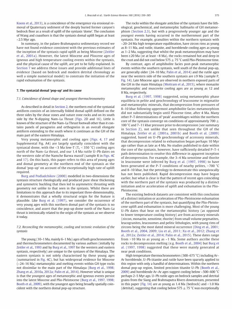
375L. Bracciali et al. / Earth-Science Reviews 160 (2016) 350–385
Koons et al., 2013), is a coincidence of the emergence via erosional re-moval of Quaternary sediment of the deeply buried former canyon'sbedrock floor as a result of uplift of the syntaxis ‘dome’. The conclusionof Wang and coauthors is that the syntaxis domal uplift began at least~2.5 Myr ago.
In summary, in the palaeo-Brahmaputra sedimentary record wehave not found evidence consistent with the previous estimates ofthe inception of the syntaxis rapid uplift as being Miocene (Zeitleret al., 2001a). However, the latest Miocene and Pliocene ages ofigneous and high temperature cooling events within the syntaxis,and the physical cause of the uplift, are yet to be fully explained. InSection 7 we address these issues and provide additional lines ofevidence (based on bedrock and modern detrital chronology aswell a simple numerical model) to constrain the initiation of therapid exhumation of the syntaxis.
7. The syntaxial domal ‘pop-up’ and its cause
7.1. Coincidence of domal shape and youngest thermochronometry
As described in detail in Section 2, the northern end of the syntaxialantiform consists of an internally folded domal uplift defined on thethree sides by the shear zones and suture zone rocks and on its southside by the N-dipping Nam–La Thrust (Figs. 2D and 16). Little isknown of the structure of theNam–La Thrust footwall other than it con-tains panels of paragneiss and orthogneiss in an overall elongateantiform extending to the south where it continues as the GH of themain part of the eastern Himalaya.
Very young metamorphic and cooling ages (Figs. 4, 17 andSupplemental Fig. A4) are largely spatially coincident with thesyntaxial dome, with the b3 Ma low-T (Tc b 350 °C) cooling agesnorth of the Nam–La thrust, and our 1.4 Ma rutile U–Pb dates onthe western side of the Namche Barwa massif (sample R in Figs. 4Cand 17). On this basis, this paper refers to this area of young agesand domal geometry at the northern end of the syntaxis as thedomal ‘pop-up’ on account of the exceptionally high rate of upliftrequired.
Burg and Podladchikov (2000) modelled in two-dimensions thesyntaxis structure rheologically and produced pure shear thickeningand symmetric buckling that then led to asymmetric thrusting withgeometry not unlike to that seen in the syntaxis. Whilst there arelimitations to this approach due to its important three-dimensionality,it demonstrates that a wholly structural origin for the feature isplausible. Like Burg et al. (1997), we consider the occurrence ofvery young ages with this northern domal part of the syntaxis is nocoincidence, and assert that the pop-up dome north of the Nam–Lathrust is intrinsically related to the origin of the syntaxis as we observeit today.
7.2. Reconciling the metamorphic, cooling and tectonic evolution of thesyntaxis
The young (10–1Ma,mainly 6–1Ma) ages of both geochronometersand thermochronometers documented by various authors (initially byZeitler et al., 1993 and by Burg et al., 1997 for the western and easternsyntaxis, respectively) are unique to the syntaxes of the Himalaya. Theeastern syntaxis is not solely characterised by these young ages(summarised in Fig. 4C), but has widespread evidence for Miocene(~24–16 Ma) metamorphic and melting events within GH type rocksnot dissimilar to the main part of the Himalaya (Burg et al., 1998;Zhang et al., 2010a, 2012a; Palin et al., 2014). However what is uniqueis that the youngest ages of metamorphic and igneous events persistinto the latest Miocene and Plio-Pleistocene (Burg et al., 1997, 1998;Booth et al., 2009), with the youngest ages being broadly spatially coin-cident with the northern domal pop-up structure.
The rocks within the elongate anticline of the syntaxis have the lith-ological, geochemical, and metamorphic hallmarks of GH metamor-phism (Section 2.3), but with a progressively younger age and theyoungest events having occurred in the northernmost part of thesyntaxis. For example, granulites within the northern syntaxis with~20–24 Ma high temperature equilibration, have zircon rims as youngas 8–11 Ma, and rutile, titanite, and hornblende cooling ages as youngas 1–2 Ma, suggesting that whilst the peak metamorphism may havebeen ≥20 Ma (or at least N8 Ma), the rocks remained hot and deep inthe crust and did not cool below 575±75 °C until Plio-Pleistocene time.
By contrast, ages of amphibolite facies post-peak metamorphicevents within the southern syntaxis, well south of the domal pop-up,are generally older (24–10 Ma; Palin et al., 2014) and the rutile agesnear the western side of the southern syntaxis are ≥9 Ma (sample P,Fig. 14). Late Miocene ages are observed in northern exposed parts ofthe GH in the main Himalaya (Mottram et al., 2015), where monazitemetamorphic and muscovite cooling ages are as young as 12 and8 Ma, respectively.
Burg et al. (1997, 1998) suggested, using metamorphic phaseequilibria in pelite and geochronology of leucosome in migmatiteand metamorphic minerals, that decompression from pressures of8–10 kbar following uppermost amphibolite facies metamorphismdid not substantially begin until Pliocene time, after 4 Ma. Manyother P–T determinations of ‘peak’ assemblages within the northerncore of the syntaxis converge on conditions of approximately 700 ±100 °C and 7–11 kbar pressure prior to decompression (see summaryin Section 2), not unlike that seen throughout the GH of theHimalaya. Zeitler et al. (2001a, 2001b) and Booth et al. (2009)suggested, based on U–Pb geochronology of accessory minerals,that decompression related to exhumation began perhaps 10 Myrago rather than as late as 4 Ma. No studies published to date withinthe core of the syntaxis, however, have sufficiently detailed P–T–tpath determination to resolve this difference in apparent inceptionof decompression. For example, the 3–4 Ma xenotime and thoritein leucosome were inferred by Burg et al. (1997, 1998) to havebeen generated at the P–T conditions of nearby pelites, N700 °Cand 8–10 kbar, but the petrology to demonstrate this unequivocallyhas not been published. Rapid decompression may have begunearlier, but what is clear is that the pattern of recent ages coincidingwith the northern part of the syntaxis was produced by a distinctinitiation and/or acceleration of uplift and exhumation in the Plio-Pleistocene.
The existing bedrock datasets are consistent with this conclusionof a distinct initiation or acceleration of Plio-Pleistocene exhumationof the northern part of the syntaxis, but quantifying the Plio-Pleisto-cene uplift and exhumation is more challenging. Most of the youngU–Pb dates that bear on the metamorphic history (as opposedto lower temperature cooling history) are from accessory minerals(zircon, monazite, xenotime, thorite) from small volume pegmatites,leucogranites, leucosomes and pelitic lithologies, with young rims ofzircons being the most dated mineral occurrence (Ding et al., 2001;Booth et al., 2004, 2009; Liu et al., 2011; Xu et al., 2012; Zhang etal., 2012a; Zeitler et al., 2014; Palin et al., 2015). These dates rangefrom N10 Ma to as young as ~1 Ma. Some authors ascribe theserocks to decompression melting (e.g. Booth et al., 2004) but Burg etal. (1997, 1998) suggested that these were mainly generated atnear peak conditions.
High temperature thermochronometers (500–675 °C) including Ar–Ar hornblende, U–Pb titanite and rutile have been sparsely applied tothis region with only a handful of determinations. Within the northerndomal pop-up region, limited precision titanite U–Pb (Booth et al.,2009) and hornblende Ar–Ar ages suggest cooling below ~500–600 °Cperhaps 2–5 Myr ago. U–Pb rutile ages on bedrock samples and detritalgrains from the Siang and Brahmaputra Rivers downstream, presentedin this paper (Fig. 14) are as young as 1.4 Ma (bedrock) and b1.0 Ma(detrital), suggesting that cooling below 575± 75 °Cwas exceptionally
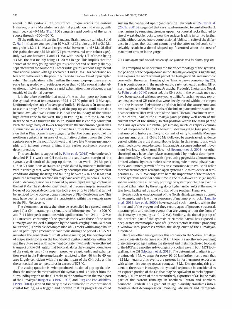
376 L. Bracciali et al. / Earth-Science Reviews 160 (2016) 350–385
recent in the syntaxis. The occurrence, unique across the easternHimalaya, of a b2 Ma white mica detrital population in the Siang, withmain peak at ~0.4 Ma (Fig. 11D) suggests rapid cooling of the samesource through ~300–450 °C.
Of the rutile grains from the Siang and Brahmaputra (samples S andZ; Fig. 14) that are younger than 10Ma, 21 of 22 grains are 0.5 to 2.0Ma,one grain is 3.2±1.1Ma, and no grains fall between 4 and 8Ma. Of all ofthe grains that are b35 Ma old (74 grains measured with robust ages),only two are between 4 and 11 Ma, with nearly 1/3 of these being≤3 Ma, the rest mainly being 11–20 Ma in age. This implies that thesource of the very young rutile grains is distinct and relatively sharplyseparated from the source of all other rutile grains, without a significant‘transitional’ sourcewith ages between 3 and 11Ma. This conclusion re-fers both to the area of thepop-upbut also to its ~5–7 kmof topographicrelief. The implication is that within the domal pop-up, there are norocks being eroded with rutile ages older than ~3Ma, even at higher el-evations, implying much more rapid exhumation than adjacent areasoutside of the domal pop-up.
It is therefore plausible that most of the northern pop-up dome ofthe syntaxis was at temperatures N575 ± 75 °C prior to 1–3 Myr ago.Unfortunately the lack of coverage of rutile U–Pb dates is far too sparseto use this proxy for the boundary of the pop-up, and until more databecome available we assume it is near the boundary of the suturehigh-strain zone to the west, the Jiali Parlung fault to the N-NE andnear the Nam–La thrust to the south. Whilst this is entirely consistentwith the large body of lower temperature thermochronological datasummarised in Figs. 4 and 17, this magnifies further the amount of ero-sion that is Pleistocene in age, suggesting that the domal pop-up of thenorthern syntaxis is an area of exhumation distinct from the oldersyntaxis rocks to the south/southwest that have lateMiocenemetamor-phic and igneous events arising from earlier post-peak pressuredecompression.
This conclusion is supported by Palin et al. (2015) who undertookdetailed P–T–t work on GH rocks to the southwest margin of thesyntaxis well south of the pop-up dome. In that work, ~24 Ma peak(~610 °C) conditions at staurolite grade, dated by monazite inclusionswithin zoned garnet, were followed by decompression and greenschistconditions during shearing and faulting between ~16 and 8 Ma thatproduced retrograde reactions inmajor and accessoryminerals. This pe-riod of decompression was followed by more rapid average cooling inthe last 8 Ma. The study demonstrated that in some samples, several ki-lobars of post-peak decompression took place prior to 8Ma that cannotbe ascribed to the pop-up domal structure of Plio-Pleistocene age. Thismay have been a more general characteristic within the syntaxis priorto the Plio-Pleistocene.
The elements that must therefore be reconciled in a general modelare: (1) a GH metamorphic signature of Miocene age from ≥700 °Cand 7–11 kbar peak conditions with equilibration from 24 to ~12 Ma;(2) structural continuity of the syntaxis rocks with those of the mainHimalaya and its local disruption by the south-verging Nam–La thrustfault zone; (3) probable decompression of GH rocks within amphiboliteand in part upper greenschist conditions during the period ~15–5 Maincluding the generation of small volume melts; (4) the developmentof major shear zones on the boundary of syntaxis antiform within GHand the suture zonewithmovement consistentwith relative northwardtransport of the GH ‘antiformal’ footwall along the elongate boundariesof the syntaxis; and (5) a superimposed very rapid uplift and exhuma-tion event in the Pleistocene largely restricted to the ~40 km by 40 kmarea largely coincident with the northern part of the GH rocks withinthe syntaxis, from temperatures in excess of 575 °C.
The vexing question is: what produced the domal pop-up that de-fines the unique characteristics of the syntaxis and is distinct from thesurrounding region or the GH rocks to the southwest in the main partof the Himalaya? Burg et al. (1997, 1998) and Burg and Podladchikov(1999, 2000) ascribed this very rapid exhumation to compressionalcrustal folding, as a trigger, and showed that its progression could
sustain the continued uplift (and erosion). By contrast, Zeitler et al.(2001a, 2001b) suggested that very rapid erosion led to crustal feedbackmechanism by removing stronger uppermost crustal rocks that led torise of weak ductile rocks to near the surface, leading in turn to furtheruplift, without appealing to compressional folding. In spite of the differ-ence in origins, the resultant geometry of the latter model could con-ceivably result in a domal-shaped uplift centred about the area ofmaximum erosion in the gorge.
7.3. Himalayan mid-crustal context of the syntaxis and its domal pop-up
In attempting to understand the thermochronology of the syntaxis,the position of the pop-up dome in the Himalayan orogen is significant,as it exposes the northernmost part of the high-grade GHmetamorphiccorewithin the easternHimalaya, the Namche Barwa complex (Fig. 2C).This is continuouswith themainly east to east-northeast trendingGH ofnorth-eastern India (Sikkim and Arunachal Pradesh), Bhutan andNepal.As Palin et al. (2014) suggested, the GH rocks in the syntaxis may nothave been exposed without very young uplift. As such, they may repre-sent exposures of GH rocks that were deeply buried within the orogenuntil the Pliocene–Pleistocene uplift that folded the suture zone andare analogous to similar GH rocks of the Indian plate underthrusted be-neath southern Tibet well north of the South Tibetan Detachment with-in the central part of the Himalaya (and possibly well north of thecurrent trace of the suture). In this position within the main part ofthe Himalaya where substantial, presumably much less rapid, exhuma-tion of deep-seated GH rocks beneath Tibet has yet to take place, themetamorphic history is likely to consist of early to middle Miocenepeakmetamorphism (~24 to 10Ma) followed by a protracted residenceperiod within the crust at amphibolite facies. In this scenario and withcontinued convergence between India andAsia, some southwardmove-ment (via low angle channel flow – cf. Beaumont et al., 2001 – or othershearing) may have taken place accompanied by modest decompres-sion potentially driving anatexis (producing pegmatites, leucosomes,limited volume hydrous melts), some retrograde mineral phase reac-tions, and limited growth of rims on zircon/monazite whilst all otherthermochronometers remained open systems due to residence at tem-peratures N575 °C. We emphasize here the importance of the residenceof the syntaxial rocks for some time in the mid–lower crust (at supra-solidus conditions), effectively priming the systemprior to their eventu-al rapid exhumation by thrusting along higher angle faults at themoun-tain front, facilitated by rapid erosion of the southern Himalaya.
Events such as emplacement of the North Himalayan gneiss domes,for example, and a few other exposures of metamorphic rocks (Langilleet al., 2012; Lee et al., 2000) have exposed such materials within thehinterland of the orogen and they record ages of igneous, structural,metamorphic and cooling events that are younger than the front ofthe Himalaya (as young as ~9–12 Ma). Similarly, the domal pop-up ofthe northern part of the syntaxis at Namche Barwa has exposed adeep-seatedmetamorphic zone of GH rocks “before its time”, providinga window into processes within the deep crust of the Himalayanhinterland.
There are other analogues for this scenario. In the Sikkim Himalayaover a cross-strike distance of ~50 km there is a northward-youngingof metamorphic ages within the sheared and metamorphosed footwallof theMCT and a northward-younging of cooling ages in bothMCT foot-wall and the GH (Mottram et al., 2015). The determined gradient is ap-proximately 1 Ma younger for every 10–20 km farther north, such that~12 Ma metamorphic events are present in northernmost exposureswith white mica cooling ages as young as ~8Ma. Extrapolating this gra-dient to the eastern Himalaya, the syntaxial region can be considered asan exposed portion of the GH that may be equivalent to rocks approxi-mately 100 kmnorth of themost northerly exposures of GH in themainpart of the eastern Himalaya in northern Bhutan and northernArunachal Pradesh. This gradient in age plausibly translates into athrust-related decompression involving late melts and retrograde
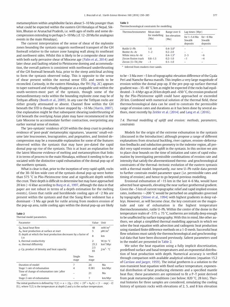
Table 3Thermochronological constraints for modelling.
Thermochronometer Mean datefor modelling(Ma)
Range over 6km elevation(Ma)
Lag times (Myr)
for 1–5.4 MaSiwalikdeposits
for N6 MaSiwalikdeposits
Rutile U–Pb 1.4 0.4–3.0a – –Biotite Ar–Ar 1–2 0.2–2.0 – –White mica Ar–Ar – 0.4–1.5a 2–3 N6Zircon fission track 0.8–1.5 0.2–1.0 b1 N4Zircon (U–Th)/He ~1 0.1–1.0 – –
a Inferred from modern river sands.
377L. Bracciali et al. / Earth-Science Reviews 160 (2016) 350–385
metamorphism within amphibolite facies about 5–10Ma younger thanwhat could be expected within the eastern GH Himalaya of Nepal, Sik-kim, Bhutan or Arunachal Pradesh, i.e. with ages of melts and some de-compression extending to perhaps 5–10Ma (cf. 12–20Ma for analogousevents in the main Himalaya).
The current interpretation of the sense of shear of the mylonitezones bounding the syntaxis suggests northward transport of the GHfootwall relative to the suture zone hanging wall along its southeastand northwest sides. Whilst this is likely to be a composite shear zonewith both early pervasive shear of Miocene age (Palin et al., 2014) andlater shear and faulting related to Pleistocene doming and accommoda-tion, the overall pattern is consistent with northward underthrustingof the GH footwall beneath Asia, prior to the steep anticlinal archingto form the syntaxis observed today. This is opposite to the senseof shear present within the normal sense STD, and needs to bereconciled. Curiously, in the eastern Himalaya, the TH (Fig. 2C) appearsto taper eastward and virtually disappear as amappable unit within thesouth-western-most part of the syntaxis, though some of themetasedimentary rocks within the bounding mylonite zone may be ofTethyan affinity (Booth et al., 2009). In any case the Tethyan rocks areeither greatly attenuated or absent. Channel flow within the GHbeneath the STD is thought to have stopped by ~16 Ma (Harris, 2007).One explanation might be that subsequent shearing/underthrusting ofGH beneath the overlying Asian plate may have recommenced in theLate Miocene to accommodate further contraction, overprinting anyearlier normal sense of motion.
The ‘pre-syntaxis’ residence of GH within the deep crust to produceevidence of ‘post-peak’ metamorphic signatures, ‘anaemic’ small-vol-ume late leucosomes, leucogranites, and pegmatites, and limited de-compression may be a reasonable explanation for some of the featuresobserved within the syntaxis that may have pre-dated the rapiddomal pop-up rise of the syntaxis. This is at least an explanation forthe latest Miocene evidence of melting and metamorphism that linksit in terms of process to themain Himalaya, without it needing to be as-sociated with the distinctive rapid exhumation of the domal pop-up ofthe northern syntaxis.
What is clear is that, prior to the inception of very rapid uplift, rocksof the 30–50 km wide core of the syntaxis domal pop-up were hotterthan 575 °C in Plio-Pleistocene time and at significant depth withinthe crust. Their depth is difficult to determine butmay have approached20 km (N6 kbar according to Burg et al., 1997, although the data in thatpaper are not robust in terms of a depth estimation for the meltingevents). Given that rutile and hornblende cooling ages of b2 Ma arepresent within the syntaxis and that the Siang River sediment has adominant b3 Ma age peak for rutile arising from modern erosion ofthe pop-up area, rutile cooling ages within the domal pop-up are likely
Table 2Thermal model parameters.
Parameter Value Unit
Q0, basal heat flow 48 mW/m2
A0, heat production at surface at start 5 μW/m3
D, depth at which the heat production decreases by a factor of1/e
8 km
k, thermal conductivity 2 W/m·°Cα, thermal diffusivity 25.3 km2/Myr
ρ·Cp, product of density and heat capacity2.5E6
J/m3· °C
Singlestage
Twostage
Duration of model 7 24 MaStage 1 rate of exhumation 4 0.381 km/MyrTime of change of exhumation rate (afterstart)
– 21 Ma
Stage 2 rate of exhumation – 7 km/Myr
The initial geotherm is defined by: T(Z)= a+ (Q0 × Z/k) + (D2 × A0/k) × (1− exp(−Z/D)), where T(Z) is the temperature at depth Z and a is the surface temperature.
to be b3Ma over N5 km of topographic elevation difference of the GyalaPeri and Namche Barwa massifs. This implies a very large magnitude oferosion within the domal pop-up. If the pre-pop-up surface thermalgradientwas ~35–40 °C/km asmight be expected if the rocks had equil-ibrated ~3–4Myr ago at 20 kmdepth and ~650 °C, the erosion producedby the Plio-Pleistocene uplift could have approached or exceeded20 km. Combined with numerical solution of the thermal field, thesethermochronological data can be used to constrain the permissiblerange of erosion rates and durations as it has been done by several au-thors, most recently by Zeitler et al. (2014) and Lang et al. (2016).
7.4. Thermal modelling of uplift and erosion: methods, parameters,constraints
Models for the origin of the extreme exhumation in the syntaxis(discussed in the Introduction) although propose a range of differentexplanations from structural buckling, river capture, erosion–deforma-tion feedbacks and subduction geometry in the indentor region, all pre-dict very rapid erosion and uplift in the syntaxis. In this section we aimto place clear bounds on the time of initiation and rates of rapid exhu-mation by investigating permissible combinations of erosion rate andintensity that satisfy the aforementioned thermo- and geochronologicalconstraints of the thermal–tectonic evolution of the eastern syntaxiswith a thermal model. Importantly, our new U–Pb rutile data permitto further constrain model parameter space (i.e. permissible rates andtiming of erosion) and hence to go beyond previous modelling.
Erosional exhumation of N15 km in the last 4–6 Ma, would haveadvected heat upwards, elevating the near surface geothermal gradient.Given the ~5 kmof current topographic relief and rapid implied erosionrates, isotherms b~200 °C would be perturbed on amplitudes governedby topography (Stüwe et al., 1994) with highest gradients in deep val-leys. However, as will become clear, the key constraint on the magni-tude and rate of exhumation is the highest temperaturethermochronometer, rutile U–Pb. Within the centre of the dome in thetemperature realm of ~575±75 °C, isotherms are initially deep enoughto be unaffected by surface topography.With this inmind, like other au-thors, we adopt a simplified thermal modelling approach in which wesolve the heat equation with advection and radiogenic heat productionusing standard finite differencemethods on a 1-Dmesh. Successful heatflow solutionsmust satisfy the thermochronological and geochronolog-ical data that have been discussed previously. Salient parameters usedin the model are presented in Table 2.
We solve the heat equation using a fully implicit discretization,predefined surface and basal temperatures and an exponential distribu-tion of heat production with depth. Numerical accuracy is verifiedthrough comparison with available analytical solutions (equation 15.2of Carslaw and Jaeger, 1959). The initial geotherm is a solution to thenon-transient heat equation with fixed surface temperature, exponen-tial distribution of heat producing elements and a specified mantleheat flux; these parameters are optimised to fit a P–T point derivedfrom peak metamorphic conditions (see below; 820 °C, 28 km). Ther-mal histories for three samples are considered, simulating the coolinghistory of syntaxis rocks with elevations of 2, 5, and 8 km elevation

Fig. 18. Results of numericalmodelling of heat flow and erosion in the domal ‘pop-up’. Two different models (single stage and two stage) are shown as depth temperature plots (A, C) andtemperature time plots (B, D). The duration and exhumation rates are listed above each set of diagrams. Green, blue and red dotted lines connect the paths of nominal samples at 8, 5, and2 km elevation above sea level for the Namche Barwa–Gayla Peri massif. In A) and C) thewet granite solidus and the evolving geotherms at 1 Ma time intervals are also shown (the latterlabelled as black numbers within the plots). The calculated dates of three thermochronometers are shown in the lower right part of panels B and D. The equilibrium mean geothermalgradients for the upper 1 and 5 km of the crust are ~40 °C/km and 36 °C/km, respectively; at 20 and 28 km depths the temperatures are ~630 °C and 820 °C, respectively. The sampleinitially at 820 °C and ~28 km depth is assigned to the 5 km elevation sample in the massif.
378 L. Bracciali et al. / Earth-Science Reviews 160 (2016) 350–385
today in the Namche Barwa–Gyala Peri massif. The 2 and 5 km samples'thermochronological constraints are provided by existing publisheddata and new data from this paper (Table 3). The erosion of the upperpart (N5 km elevation) of the syntaxis has few thermochronologicaldata but its rutile dates are unlikely to be older than 3 Ma, given our in-terpretation of the rutile age and other dates of grains in the Siang Riversediments downstream (Section 7.2). The cooling history for each of thesample nodes is used as input to a forward kinetic model that calculatessingle-grain ages for the U–Pb and 40Ar/39Ar (K–Ar) systems. For the U–Pb rutile system we employ the Cherniak Pb diffusion law (Cherniak,2000), 20 ppm U concentration and rectangular grain dimensions(150 × 100 × 100 μm). For the white mica 40Ar/39Ar forward model,we used the Ar diffusion law of Harrison et al. (2009), 10 wt.% K2Oand a sheet-like geometry (300 × 300 × 50 μm). Grain dimensionswere recast into equivalent sphere dimensions. Due to the uncertaintyover the kinetics of FT annealing, we chose to record the timing atwhich a sample traversed the 220 °C isotherm as representing closureof the ZFT system.
We explored a range of candidate erosion histories and comparedcalculated ages to both bedrock (using in part a summary of datafrom the pop-up dome from Zeitler et al., 2014) and detrital
thermochronological constraints presented in Table 3. Specifically, weused detrital thermochronological data of Lang et al. (2016) from 1 to6 Ma Siwalik foreland deposits (Fig. 16) to assess if our solutions arealso consistent with the ages and lag times resulting from past erosionrecorded in these foreland Plio-Pleistocene sediment archives.
Our starting pointwas to assume a “peak” P–T condition that definesthe depth and temperature of the highest grade rocks of the syntaxis sothat themaximum exhumation does not exceed themaximumdepth ofburial. An initial “Himalayan” geothermal gradientwas used that is con-sistent with the P–T paths of GH rocks and peak P–T conditions inferredfrom themetamorphic studies, which includemigmatite and granulites.We have set the initial geotherm to be consistent with ~28 km depth at~820 °C at 24 Myr ago, based on consistency with P–T–t data that hasbeen summarised recently by Palin et al. (2015). This is not dissimilarto pre-uplift P–T estimates as discussed earlier in Section 2.3.
7.5. Thermal modelling: results and discussion
Results for two plausible erosion scenarios are shown in Fig. 18 asdepth–temperature curves (panels A and C) and temperature–timecurves (panels B and D), respectively. The first model has the initial
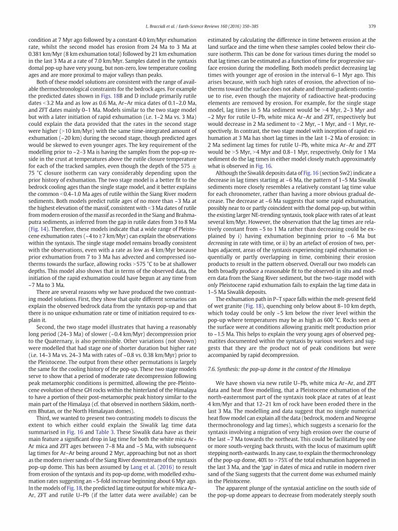
379L. Bracciali et al. / Earth-Science Reviews 160 (2016) 350–385
condition at 7 Myr ago followed by a constant 4.0 km/Myr exhumationrate, whilst the second model has erosion from 24 Ma to 3 Ma at0.381 km/Myr (8 km exhumation total) followed by 21 km exhumationin the last 3 Ma at a rate of 7.0 km/Myr. Samples dated in the syntaxisdomal pop-up have very young, but non-zero, low temperature coolingages and are more proximal to major valleys than peaks.
Both of these model solutions are consistent with the range of avail-able thermochronological constraints for the bedrock ages. For examplethe predicted dates shown in Figs. 18B and D include primarily rutiledates b3.2 Ma and as low as 0.6 Ma, Ar–Ar mica dates of 0.1–2.0 Ma,and ZFT dates mainly 0–1 Ma. Models similar to the two stage modelbut with a later initiation of rapid exhumation (i.e. 1–2 Ma vs. 3 Ma)could explain the data provided that the rates in the second stagewere higher (N10 km/Myr) with the same time-integrated amount ofexhumation (~20 km) during the second stage, though predicted ageswould be skewed to even younger ages. The key requirement of themodelling prior to ~2–3 Ma is having the samples from the pop-up re-side in the crust at temperatures above the rutile closure temperaturefor each of the tracked samples, even though the depth of the 575 ±75 °C closure isotherm can vary considerably depending upon theprior history of exhumation. The two stage model is a better fit to thebedrock cooling ages than the single stage model, and it better explainsthe common b0.4–1.0 Ma ages of rutile within the Siang River modernsediments. Both models predict rutile ages of no more than ~3 Ma atthe highest elevation of themassif, consistentwith b3Ma dates of rutilefrommodern erosion of themassif as recorded in the Siang andBrahma-putra sediments, as inferred from the gap in rutile dates from 3 to 8 Ma(Fig. 14). Therefore, these models indicate that a wide range of Pleisto-cene exhumation rates (~4 to ≥7 km/Myr) can explain the observationswithin the syntaxis. The single stage model remains broadly consistentwith the observations, even with a rate as low as 4 km/Myr becauseprior exhumation from 7 to 3 Ma has advected and compressed iso-therms towards the surface, allowing rocks N575 °C to be at shallowerdepths. This model also shows that in terms of the observed data, theinitiation of the rapid exhumation could have begun at any time from~7 Ma to 3 Ma.
There are several reasons why we have produced the two contrast-ing model solutions. First, they show that quite different scenarios canexplain the observed bedrock data from the syntaxis pop-up and thatthere is no unique exhumation rate or time of initiation required to ex-plain it.
Second, the two stage model illustrates that having a reasonablylong period (24–3 Ma) of slower (~0.4 km/Myr) decompression priorto the Quaternary, is also permissible. Other variations (not shown)were modelled that had stage one of shorter duration but higher rate(i.e. 14–3 Ma vs. 24–3 Ma with rates of ~0.8 vs. 0.38 km/Myr) prior tothe Pleistocene. The output from these other permutations is largelythe same for the cooling history of the pop-up. These two stage modelsserve to show that a period of moderate rate decompression followingpeak metamorphic conditions is permitted, allowing the pre-Pleisto-cene evolution of these GH rocks within the hinterland of the Himalayato have a portion of their post-metamorphic peak history similar to themain part of the Himalaya (cf. that observed in northern Sikkim, north-ern Bhutan, or the North Himalayan domes).
Third, we wanted to present two contrasting models to discuss theextent to which either could explain the Siwalik lag time datasummarised in Fig. 16 and Table 3. These Siwalik data have as theirmain feature a significant drop in lag time for both the white mica Ar–Ar mica and ZFT ages between 7–8 Ma and ~5 Ma, with subsequentlag times for Ar–Ar being around 2 Myr, approaching but not as shortas themodern river sands of the Siang River downstreamof the syntaxispop-up dome. This has been assumed by Lang et al. (2016) to resultfrom erosion of the syntaxis and its pop-up dome, withmodelled exhu-mation rates suggesting an ~5-fold increase beginning about 6Myr ago.In themodels of Fig. 18, thepredicted lag timeoutput forwhitemicaAr–Ar, ZFT and rutile U–Pb (if the latter data were available) can be
estimated by calculating the difference in time between erosion at theland surface and the time when these samples cooled below their clo-sure isotherm. This can be done for various times during the model sothat lag times can be estimated as a function of time for progressive sur-face erosion during the modelling. Both models predict decreasing lagtimes with younger age of erosion in the interval 6–1 Myr ago. Thisarises because, with such high rates of erosion, the advection of iso-therms toward the surface does not abate and thermal gradients contin-ue to rise, even though the majority of radioactive heat-producingelements are removed by erosion. For example, for the single stagemodel, lag times in 5 Ma sediment would be N4 Myr, 2–3 Myr and~2 Myr for rutile U–Pb, white mica Ar–Ar and ZFT, respectively butwould decrease in 2 Ma sediment to b2 Myr, ~1 Myr, and b1 Myr, re-spectively. In contrast, the two stage model with inception of rapid ex-humation at 3 Ma has short lag times in the last 1–2 Ma of erosion: in2 Ma sediment lag times for rutile U–Pb, white mica Ar–Ar and ZFTwould be N5 Myr, N4 Myr and 0.8–1 Myr, respectively. Only for 1 Masediment do the lag times in either model closely match approximatelywhat is observed in Fig. 16.
Although the Siwalik deposits data of Fig. 16 (section Sw2) indicate adecrease in lag times starting at ~6 Ma, the pattern of 1–5 Ma Siwaliksediments more closely resembles a relatively constant lag time valuefor each chronometer, rather than having a more obvious gradual de-crease. The decrease at ~6 Ma suggests that some rapid exhumation,possibly near to or partly coincident with the domal pop-up, but withinthe existing larger NE-trending syntaxis, took placewith rates of at leastseveral km/Myr. However, the observation that the lag times are rela-tively constant from ~5 to 1 Ma rather than decreasing could be ex-plained by i) having exhumation beginning prior to ~6 Ma butdecreasing in rate with time, or ii) by an artefact of erosion of two, per-haps adjacent, areas of the syntaxis experiencing rapid exhumation se-quentially or partly overlapping in time, combining their erosionproducts to result in the pattern observed. Overall our two models canboth broadly produce a reasonable fit to the observed in situ and mod-ern data from the Siang River sediment, but the two-stage model withonly Pleistocene rapid exhumation fails to explain the lag time data in1–5 Ma Siwalik deposits.
The exhumation path in P–T space falls within themelt-present fieldof wet granite (Fig. 18), quenching only below about 8–10 km depth,which today could be only ~5 km below the river level within thepop-up where temperatures may be as high as 600 °C. Rocks seen atthe surface were at conditions allowing granitic melt production priorto ~1.5 Ma. This helps to explain the very young ages of observed peg-matites documented within the syntaxis by various workers and sug-gests that they are the product not of peak conditions but wereaccompanied by rapid decompression.
7.6. Synthesis: the pop-up dome in the context of the Himalaya
We have shown via new rutile U–Pb, white mica Ar–Ar, and ZFTdata and heat flow modelling, that a Pleistocene exhumation of thenorth-easternmost part of the syntaxis took place at rates of at least4 km/Myr and that 12–21 km of rock have been eroded there in thelast 3 Ma. The modelling and data suggest that no single numericalheatflowmodel can explain all the data (bedrock,modern andNeogenethermochronology and lag times), which suggests a scenario for thesyntaxis involving a migration of very high erosion over the course ofthe last ~7 Ma towards the northeast. This could be facilitated by oneor more south-verging back thrusts, with the locus of maximum upliftstepping north-eastwards. In any case, to explain the thermochronologyof the pop-up dome, 40% to N75% of the total exhumation happened inthe last 3 Ma, and the ‘gap’ in dates of mica and rutile in modern riversand of the Siang suggests that the current dome was exhumed mainlyin the Pleistocene.
The apparent plunge of the syntaxial anticline on the south side ofthe pop-up dome appears to decrease from moderately steeply south
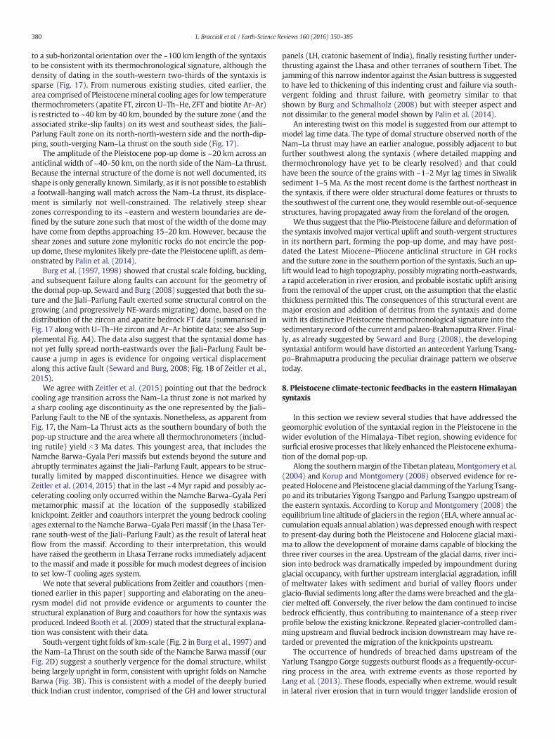
380 L. Bracciali et al. / Earth-Science Reviews 160 (2016) 350–385
to a sub-horizontal orientation over the ~100 km length of the syntaxisto be consistent with its thermochronological signature, although thedensity of dating in the south-western two-thirds of the syntaxis issparse (Fig. 17). From numerous existing studies, cited earlier, thearea comprised of Pleistocenemineral cooling ages for low temperaturethermochrometers (apatite FT, zircon U–Th–He, ZFT and biotite Ar–Ar)is restricted to ~40 km by 40 km, bounded by the suture zone (and theassociated strike-slip faults) on its west and southeast sides, the Jiali–Parlung Fault zone on its north-north-western side and the north-dip-ping, south-verging Nam–La thrust on the south side (Fig. 17).
The amplitude of the Pleistocene pop-up dome is ~20 km across ananticlinal width of ~40–50 km, on the north side of the Nam–La thrust.Because the internal structure of the dome is not well documented, itsshape is only generally known. Similarly, as it is not possible to establisha footwall-hanging wall match across the Nam–La thrust, its displace-ment is similarly not well-constrained. The relatively steep shearzones corresponding to its ~eastern and western boundaries are de-fined by the suture zone such that most of the width of the dome mayhave come from depths approaching 15–20 km. However, because theshear zones and suture zone mylonitic rocks do not encircle the pop-up dome, thesemylonites likely pre-date the Pleistocene uplift, as dem-onstrated by Palin et al. (2014).
Burg et al. (1997, 1998) showed that crustal scale folding, buckling,and subsequent failure along faults can account for the geometry ofthe domal pop-up. Seward and Burg (2008) suggested that both the su-ture and the Jiali–Parlung Fault exerted some structural control on thegrowing (and progressively NE-wards migrating) dome, based on thedistribution of the zircon and apatite bedrock FT data (summarised inFig. 17 alongwith U–Th–He zircon and Ar–Ar biotite data; see also Sup-plemental Fig. A4). The data also suggest that the syntaxial dome hasnot yet fully spread north-eastwards over the Jiali–Parlung Fault be-cause a jump in ages is evidence for ongoing vertical displacementalong this active fault (Seward and Burg, 2008; Fig. 1B of Zeitler et al.,2015).
We agree with Zeitler et al. (2015) pointing out that the bedrockcooling age transition across the Nam–La thrust zone is not marked bya sharp cooling age discontinuity as the one represented by the Jiali–Parlung Fault to the NE of the syntaxis. Nonetheless, as apparent fromFig. 17, the Nam–La Thrust acts as the southern boundary of both thepop-up structure and the area where all thermochronometers (includ-ing rutile) yield b3 Ma dates. This youngest area, that includes theNamche Barwa–Gyala Peri massifs but extends beyond the suture andabruptly terminates against the Jiali–Parlung Fault, appears to be struc-turally limited by mapped discontinuities. Hence we disagree withZeitler et al. (2014, 2015) that in the last ~4 Myr rapid and possibly ac-celerating cooling only occurred within the Namche Barwa–Gyala Perimetamorphic massif at the location of the supposedly stabilizedknickpoint. Zeitler and coauthors interpret the young bedrock coolingages external to the Namche Barwa–Gyala Peri massif (in the Lhasa Ter-rane south-west of the Jiali–Parlung Fault) as the result of lateral heatflow from the massif. According to their interpretation, this wouldhave raised the geotherm in Lhasa Terrane rocks immediately adjacentto the massif and made it possible for much modest degrees of incisionto set low-T cooling ages system.
We note that several publications from Zeitler and coauthors (men-tioned earlier in this paper) supporting and elaborating on the aneu-rysm model did not provide evidence or arguments to counter thestructural explanation of Burg and coauthors for how the syntaxis wasproduced. Indeed Booth et al. (2009) stated that the structural explana-tion was consistent with their data.
South-vergent tight folds of km-scale (Fig. 2 in Burg et al., 1997) andthe Nam–La Thrust on the south side of the Namche Barwa massif (ourFig. 2D) suggest a southerly vergence for the domal structure, whilstbeing largely upright in form, consistent with upright folds on NamcheBarwa (Fig. 3B). This is consistent with a model of the deeply buriedthick Indian crust indentor, comprised of the GH and lower structural
panels (LH, cratonic basement of India), finally resisting further under-thrusting against the Lhasa and other terranes of southern Tibet. Thejamming of this narrow indentor against the Asian buttress is suggestedto have led to thickening of this indenting crust and failure via south-vergent folding and thrust failure, with geometry similar to thatshown by Burg and Schmalholz (2008) but with steeper aspect andnot dissimilar to the general model shown by Palin et al. (2014).
An interesting twist on this model is suggested from our attempt tomodel lag time data. The type of domal structure observed north of theNam–La thrust may have an earlier analogue, possibly adjacent to butfurther southwest along the syntaxis (where detailed mapping andthermochronology have yet to be clearly resolved) and that couldhave been the source of the grains with ~1–2 Myr lag times in Siwaliksediment 1–5 Ma. As the most recent dome is the farthest northeast inthe syntaxis, if there were older structural dome features or thrusts tothe southwest of the current one, theywould resemble out-of-sequencestructures, having propagated away from the foreland of the orogen.
We thus suggest that the Plio-Pleistocene failure and deformation ofthe syntaxis involved major vertical uplift and south-vergent structuresin its northern part, forming the pop-up dome, and may have post-dated the Latest Miocene–Pliocene anticlinal structure in GH rocksand the suture zone in the southern portion of the syntaxis. Such an up-lift would lead to high topography, possiblymigrating north-eastwards,a rapid acceleration in river erosion, and probable isostatic uplift arisingfrom the removal of the upper crust, on the assumption that the elasticthickness permitted this. The consequences of this structural event aremajor erosion and addition of detritus from the syntaxis and domewith its distinctive Pleistocene thermochronological signature into thesedimentary record of the current and palaeo-Brahmaputra River. Final-ly, as already suggested by Seward and Burg (2008), the developingsyntaxial antiform would have distorted an antecedent Yarlung Tsang-po–Brahmaputra producing the peculiar drainage pattern we observetoday.
8. Pleistocene climate-tectonic feedbacks in the eastern Himalayansyntaxis
In this section we review several studies that have addressed thegeomorphic evolution of the syntaxial region in the Pleistocene in thewider evolution of the Himalaya–Tibet region, showing evidence forsurficial erosive processes that likely enhanced the Pleistocene exhuma-tion of the domal pop-up.
Along the southernmargin of the Tibetan plateau,Montgomery et al.(2004) and Korup and Montgomery (2008) observed evidence for re-peatedHolocene and Pleistocene glacial damming of the Yarlung Tsang-po and its tributaries Yigong Tsangpo and Parlung Tsangpo upstream ofthe eastern syntaxis. According to Korup and Montgomery (2008) theequilibrium line altitude of glaciers in the region (ELA, where annual ac-cumulation equals annual ablation)was depressed enoughwith respectto present-day during both the Pleistocene and Holocene glacial maxi-ma to allow the development of moraine dams capable of blocking thethree river courses in the area. Upstream of the glacial dams, river inci-sion into bedrock was dramatically impeded by impoundment duringglacial occupancy, with further upstream interglacial aggradation, infillof meltwater lakes with sediment and burial of valley floors underglacio-fluvial sediments long after the damswere breached and the gla-cier melted off. Conversely, the river below the dam continued to incisebedrock efficiently, thus contributing to maintenance of a steep riverprofile below the existing knickzone. Repeated glacier-controlled dam-ming upstream and fluvial bedrock incision downstream may have re-tarded or prevented the migration of the knickpoints upstream.
The occurrence of hundreds of breached dams upstream of theYarlung Tsangpo Gorge suggests outburst floods as a frequently-occur-ring process in the area, with extreme events as those reported byLang et al. (2013). These floods, especially when extreme, would resultin lateral river erosion that in turn would trigger landslide erosion of
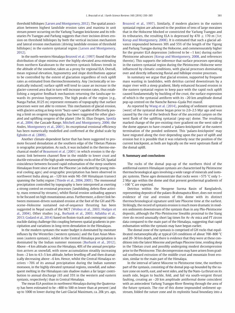
381L. Bracciali et al. / Earth-Science Reviews 160 (2016) 350–385
threshold hillslopes (Larsen andMontgomery, 2012). The spatial associ-ation between highest landslide erosion rates and maxima in unitstream power occurring on the Yarlung Tsangpo knickzone and its trib-utaries Po Tsangpo and Parlung suggests that river incision drives ero-sion on threshold hillslopes by both the vertical incision mechanismand lateral erosion mechanism (driving landslide erosion of thresholdhillslopes) in the eastern syntaxial region (Larsen and Montgomery,2012).
In the north-western Himalaya Brozović et al. (1997) found that thedistribution of slope minima over the highly elevated area extendingfrom northern Karakoram to the western syntaxis follows trends inthe altitude of the snowline, taken as a proxy for regional ELA. Overall,mean regional elevation, hypsometry and slope distributions appearto be controlled by the extent of glaciation regardless of rock upliftrates as estimated from thermochronometry. Any (tectonically or iso-statically induced) surface uplift will tend to cause an increase in theglacier-covered area that in turn will increase erosion rates, thus estab-lishing a negative feedback mechanism returning the landscape to-wards its previous hypsometry. The high peaks of the region (e.g.,Nanga Parbat, 8125 m) represent remnants of topography that surfaceprocesses were not able to remove. This mechanism of glacial erosion,with glaciers acting as long-term “buzz-saws” capable of effectively pos-ing a limit on orogenic topography, has been suggested for other glaci-ated and uplifting orogens of the planet (the St. Elias Orogen, Spotilaet al., 2004; the Cascade Range, Mitchell and Montgomery, 2006; theAndes, Montgomery et al., 2001). Its exceptional erosional efficiencyhas been numerically modelled and confirmed at the global scale byEgholm et al. (2009).
Another climate-dependent factor that has been suggested to pro-mote focused denudation at the southern edge of the Tibetan Plateauis orographic precipitation. As such, it was included in the thermo-me-chanical model of Beaumont et al. (2001) in which erosion is the dy-namic link between channel flow in the middle to lower crust andductile extrusion of the high grademetamorphic rocks of theGH. Spatialcoincidence between focused rapid exhumation of the steep southernHimalayan front since at least the Pliocene (as indicated by young min-eral cooling ages) and orographic precipitation has been observed innorthwest India along an ~120 km wide NE–SW Himalayan transectspanning the Sutlej region (Thiede et al., 2004, 2005). The monsoonalprecipitation controlled by topography is here interpreted as exertinga strong control on erosional processes (landsliding, debris-flow activi-ty, mass removal by streams), whilst fluvial erosion unloading appearsto be focused on highmountainous areas. Furthermore, a direct link be-tween monsoon-driven sustained erosion at the foot of the GH and Pli-ocene–Holocene sustained out-of-sequence thrusting has beensuggested in Nepal south of the MCT (Wobus et al., 2003; Hodges etal., 2004). Other studies (e.g., Burbank et al., 2003; Adlakha et al.,2013; Godard et al., 2014) based on fission-track and cosmogenic radio-nuclide dating challenge this coupling between spatial gradients in pre-cipitation and variations in long-term denudation in the Himalayas.
In the modern syntaxes the water budget is dominated by moistureinfluxes by the Westerlies (western syntaxis) and the East Asian Mon-soon (eastern syntaxis), whilst in the Central Himalaya precipitation isdominated by the Indian summer monsoon (Burbank et al., 2012).Above ~4 km altitude across the Himalaya, 40% of the annual precipita-tion arrives as snowfall, with snow accumulation steadily increasingfrom ~2 km to 4.5–5 km altitude, before levelling off and then dramat-ically decreasing above ~6 km. Hence, whilst the Central Himalaya re-ceives N70% of its annual precipitation during the Indian summermonsoon, in the highly elevated syntaxial regions, snowfall, and subse-quent melting in the Himalayan rain shadow makes a far larger contri-bution to annual discharge (65 and 35% in the western and easternsyntaxis, respectively) than in Central Himalaya.
The mean ELA position in northwest Himalaya during the Quaterna-ry has been estimated to be ~400 to 500 m lower than at present (andup to 1000 m lower during the Last Glacial Maximum, ca. 20k yrs. ago,
Brozović et al., 1997). Similarly, if modern glaciers in the easternsyntaxial region are advanced to the position of tens of large morainesthat in the Holocene blocked or constricted the Yarlung Tsangpo andits tributaries, the resulting ELA is depressed by 470 ± 170 m (1σ;Korup and Montgomery, 2008). It is estimated that such a glacial ad-vance impounded between 30% and 55% of the length of the Yigongand Parlung Tsangpo during the Holocene, and commensurately higherfor the greater ELA depression (inferred to be ~1 km) during earlierPleistocene advances (Korup and Montgomery, 2008, and referencestherein). This supports the inference that surface processes operatingin the eastern syntaxial region during the Pleistocene–Holocene wereinfluenced by climatic conditions, with glacial processes dominatingover and directly influencing fluvial and hillslope erosive processes.
In summary we argue that glacial erosion, supported by frequentmass wasting in landslides, with detritus carried downstream by amajor river with a steep gradient, likely enhanced focused erosion inthe eastern syntaxial region to keep pace with the rapid rock upliftcaused fundamentally by buckling of the crust, the surface expressionof which is the syntaxial antiform with its ~20 km amplitude domalpop-up centred on the Namche Barwa–Gyala Peri massif.
As reported by Wang et al. (2014), ponding of sediment upstream(west) of the syntaxial dome began prior to 2.0–2.5 Myr ago and wascaused by the rise of the bedrock floor of the ancestral canyon on thewest flank of the uplifting syntaxial (pop-up) dome. The resultingmarked change of the pre-existing river gradient on the west side ofthe dome appears to have created a ‘palaeo-knickpoint’ at the easterntermination of the ponded sediment. This ‘palaeo-knickpoint’ mayhave migrated along the river depending upon the pace of uplift anderosion but it is possible that it was relatively near the position of thecurrent knickpoint, as both are logically on the west upstream flank ofthe domal uplift.
9. Summary and conclusions
The rocks of the domal pop-up of the northern third of theantiformal eastern Himalayan syntaxis are characterised by Pleistocenethermochronological ages involving awide range ofminerals and isoto-pic systems. These ages demonstrate that rocks were N575 °C only 1–2 Myr ago within the dome and that present geothermal gradients ofN100 °C are expected.
Detritus within the Neogene Surma Basin of Bangladesh,representing deposits of the palaeo-Brahmaputra River, does not recordevidence of rise and erosion of this dome with its distinctthermochronological signature until late Pliocene time at the earliest.Strikingly, the record of syntaxis erosion ismuchmore dramatic inmod-ern sediments downstream of the syntaxis than in any Plio-Pleistocenedeposits, although the Plio-Pleistocene Siwaliks proximal to the Siangriver do record unusually short lag times for Ar–Ar mica and FT zircondata compared to the main part of the Himalaya, suggesting that rapidexhumation within the syntaxis may have begun earlier.
The domal zone of the syntaxis is comprised of GH rocks that equil-ibrated metamorphically at typical GH conditions of about 700–800 °Cand 20–30 kmdepth, and there is evidence that they were at these con-ditions into the latestMiocene and perhaps Pliocene time, residing deepin the Tibetan crust and possibly undergoing modest decompressionprior to the Pleistocene. This decompressionmayhave arisen fromgrad-ual southward extrusion of the middle crust and mountain front ero-sion, similar to the main part of the Himalaya.
In the interval of latest Miocene to Pleistocene time, the northernpart of the syntaxis, consisting of the domal pop-up bounded by the su-ture zone on north, east, andwest sides, and by theNam–La thrust on itssouth side, began to buckle, fold, and fail via south-vergent thrustfaulting, creating an ~20 km amplitude antiformal dome coincidentwith an antecedent Yarlung Tsangpo River flowing through the area ofthe future syntaxis. The rise of this dome impounded sediment up-stream, folded the suture zone and its mylonitic basal boundary into a
382 L. Bracciali et al. / Earth-Science Reviews 160 (2016) 350–385
steep anticline, distorted the course of the Yarlung Tsangpo and re-versed the gradient of the former river bedrock gorge, creating a buriedcanyon prior to ~2.5Myr ago. The river successfullymaintained itsmaincourse and steepened its gradient downstream of the Pleistoceneponded sediment above the palaeo-knickpoint.
In the Pleistocene between ~12 and 21 km of rockwere uplifted anderodedwithin the core of the syntaxis, exposing rocks at amphibolite fa-cies conditions to surface erosion as shown by some of the youngest U–Pb and other thermochronological mineral cooling ages anywhere onEarth at rates of at least 4 km/Myr. This changed dramatically the char-acteristics of the sediment delivered downstream of the gorge to com-prise, as it is observed today, up to 50% of the sediment load derivedfrom the domal uplift. The lag time data of 1–5 Ma foreland Himalayandeposits, interpreted to be derived from erosion of the syntaxis and de-creasing between ~7 and 5 Ma, recorded a period of rapid exhumationof a source within the syntaxis near to or along strike to the southwestof the current domal pop-up. This source could be a migrating domalfeature produced by the indentation process of the Indian plateprogressing north-eastwards.
The data collected in this study and in other related studies of this re-gion are consistent with: antecedence (to the development of thesyntaxis) of the Yarlung–Tsangpo River; gradual exhumation of up to~8 km in Late Miocene–Pliocene time linked to typical Himalayan pro-cesses; antiformal development of the broader syntaxis region and thelate Pliocene–Pleistocene pop-up dome of ~20 km amplitude in thenorth-easternmost part of the syntaxis exhuming rocks to the surfacethat were in excess of 575 °C just 1.4 Myr ago; inception of highsustained exhumation rates with at least 12 km of material removedby erosion in the last 3 Ma.
10. Future work
The area of the syntaxis remains seismically very active, eroding atvery high rate, and needs to be better investigated geophysically andgeologically to fully understand how these discrete syntaxial featuresoriginate and evolve.
In particular, improved knowledge of the structure and thermo-barometric evolution of the domal pop-up and in general the easternsyntaxial antiform would allow existing thermomechanical numericalmodels to be better constrained and as such to shed light onmechanismand processes generating and currently sustaining the syntaxialantiform and its domal pop-up. If there has been a migration of thesite of the pop-up dome and its high rate of exhumation, this canbe tested by tectonic studies and geo- and thermochronology inthe much less studied region of the syntaxis to the southwest of theNam–La thrust towards the foreland. Although the bedrock and detritalthermochronology acquired so far in this remote region has led toseveral significant studies, more systematic spatial and verticalthermochronology datasets, including rutile U–Pb data, would greatlyimprove our ability to constrain and model the exhumation history ofthis region, and to track its erosion products in the past sedimentary ar-chives and in the present-day Bengal Basin sink.
We also appeal to better structural geological investigations bothwithin and at the margins of the domal pop-up, especially on thenorth and south sides, to evaluate the history of displacement and theextent to which the northern boundary is a fault/shear zone with nor-mal sense displacement, as it would be predicted from its exhumationhistory.
Recently, the IODP expedition Leg 354 drilled seven sites along ona proximal (°8N) east–west transect in the Bay of Bengal coveringthe Late Paleogene to present time interval (France-Lanord et al.,2015). Ongoing post-expedition studies are expected to test varia-tions in accumulation rates generated by the Tibet–Himalayan ero-sion and thus to shed new light on the complex relationshipsbetween this source and its sink.
Acknowledgements
The authors wish to thank TimHorscroft at Elsevier for inviting us tosubmit a review article on this topic. Special thanks are due to S.H.Akhter for logistical support and advice during sampling of SurmaBasin deposits. L. Bracciali warmly thanks: Matt Horstwood (NIGL) fornumerous and valuable “five minute” discussions on analytical issuesand approaches, Vanessa Pashley (NIGL) for precious technical supportwith the U–Pbwork and Francesca Cigna (British Geological Survey) forhelping with geospatial data visualization in the GIS environment.Hongfei Zhang is thanked for allowing access to two granulite faciessamples dated in this study. The manuscript greatly benefited fromthe constructive comments of two anonymous reviewers. This researchwas supported by NERC (UK Natural Environment Research Council)through grants NE/F01807X/1 to Y. Najman and NE/F017588/1 to R.Parrish.
Appendix A. Supplemental data
Supplemental material to this article can be found online at http://dx.doi.org/10.1016/j.earscirev.2016.07.010 and includes: list and loca-tion of samples from the Surma Basin (Table A1), zircon U-Pb data(Table A2), rutile U-Pb data (Table A3), LA-MC-ICP-MS instrument pa-rameters (Table A4), white mica Ar–Ar data (Table A5) and ZFT data(Table A6). Supplemental figures show: the geographic location of sam-ples and schematic geology of the Surma Basin (Fig. A1), U–PbConcordia diagrams (Fig. A2) and relative probability plots – frequencydiagrams of zircon U–Pb, rutile U–Pb and white mica Ar–Ar data (in the0–2.5, 0–0.8 and 0–1.0 Ga age range, respectively) from modern riversands (Fig. A3), bedrock thermochronology data from the literatureused to draw the contour lines of Fig. 4 (Fig. A4), relative probabilityplots – frequency diagrams of zircon U–Pb, rutile U–Pb and whitemica Ar–Ar data (in the 0–2.5, 0–0.8 and 0–1.0 Ga age range, respective-ly) from the Surma Basin (Fig. A5).
References
Adlakha, V., Lang, K.A., Patel, R.C., Lal, N., Huntington, K.W., 2013. Rapid long-term erosionin the rain shadow of the Shillong Plateau, Eastern Himalaya. Tectonophysics 582,76–83.
Andò, S., Garzanti, E., Padoan, M., Limonta, M., 2012. Corrosion of heavy minerals duringweathering and diagenesis: a catalog for optical analysis. Sediment. Geol. 280,165–178.
Beaumont, C., Jamieson, R.A., Nguyen, M.H., Lee, B., 2001. Himalayan tectonics explainedby extrusion of a low-viscosity crustal channel coupled to focused surface denuda-tion. Nature 414, 738–742.
Bendick, R., Ehlers, T.A., 2014. Extreme localized exhumation at syntaxes initiated by sub-duction geometry. Geophys. Res. Lett. 41, 5861–5867.
Booth, A.L., et al., 2004. U–Pb zircon constraints on the tectonic evolution of southeasternTibet, Namche Barwa Area. Am. J. Sci. 304, 889–929.
Booth, A.L., Chamberlain, C.P., Kidd, W.S.F., Zeitler, P.K., 2009. Constraints on the meta-morphic evolution of the eastern Himalayan syntaxis from geochronologic and petro-logic studies of Namche Barwa. Geol. Soc. Am. Bull. 121, 385–407.
Bracciali, L., Marroni, M., Pandolfi, L., Rocchi, S., 2007. Geochemistry and petrography ofWestern Tethys Cretaceous sedimentary covers (Corsica and Northern Apennines):from source area to configuration of margins. In: Arribas, J., Critelli, S., Johnsson,M.J. (Eds.), Sedimentary Provenance and Petrogenesis: Perspectives FromPetrography and Geochemistry. Geological Society of America, Special Paper 420,pp. 73–93.
Bracciali, L., Parrish, R.R., Horstwood, M.S.A., Condon, D.J., Najman, Y., 2013. U–Pb LA-(MC)-ICP-MS dating of rutile: new reference materials and applications to sedimen-tary provenance. Chem. Geol. 347, 82–101.
Bracciali, L., Pandolfi, L., Rocchi, S., 2014. A snapshot of the Late Jurassic Western Tethysseafloor composition and morphology provided by the geochemistry of pelitic sedi-ments (Corsica, Central Alps and Northern Apennines). Basin Res. 26, 461–485.
Bracciali, L., Najman, Y., Parrish, R.R., Akhter, S.H., Millar, I., 2015. The Brahmaputra tale oftectonics and erosion: Early Miocene river capture in the Eastern Himalaya. EarthPlanet. Sci. Lett. 415, 25–37.
Brookfield, M.E., 1998. The evolution of the great river systems of southern Asia duringthe Cenozoic India–Asia collision: rivers draining southwards. Geomorphology 22,285–312.
Brozović, N., Burbank, D.W., Meigs, A.J., 1997. Climatic limits on landscape development inthe Northwestern Himalaya. Science 276, 571–574.
383L. Bracciali et al. / Earth-Science Reviews 160 (2016) 350–385
Burbank, D.W., Leland, J., Fielding, E., Anderson, R.S., Brozovic, N., Reid, M.R., Duncan, C.,1996. Bedrock incision, rock uplift and threshold hillslopes in the northwesternHimalayas. Nature 379, 505–510.
Burbank, D.W., et al., 2003. Decoupling of erosion and precipitation in the Himalayas. Na-ture 426, 652–655.
Burbank, D.W., Bookhagen, B., Gabet, E.J., Putkonen, J., 2012. Modern climate and erosionin the Himalaya. Compt. Rendus Geosci. 344, 610–626.
Burbank, D.W., Bookhagen, B., Gabet, E.J., Putkonen, J., 2013. Modern climate and erosionin the Himalaya. Compt. Rendus Geosci. 344, 610–626.
Burg, J.-P., Podladchikov, Y., 1999. Lithospheric scale folding: numerical modelling and ap-plication to the Himalayan syntaxes. Int. J. Earth Sci. 88, 190–200.
Burg, J.-P., Podladchikov, Y., 2000. From buckling to asymmetric folding of the continentallithosphere: numerical modelling and application to the Himalayan syntaxes. Geol.Soc. Lond., Spec. Publ. 170, 219–236.
Burg, J.-P., Schmalholz, S., 2008. Viscous heating allows thrusting to overcome crustal-scale buckling: numerical investigation with application to the Himalayan syntaxes.Earth Planet. Sci. Lett. 274, 189–203.
Burg, J.-P., Davy, P., Nievergelt, P., Oberli, F., Seward, D., Diao, Z., Meier, M., 1997. Exhumationduring crustal folding in the Namche–Barwa syntaxis. Terra Nova 9, 53–56.
Burg, J.-P., et al., 1998. The Namche Barwa syntaxis: evidence for exhumation related tocompressional crustal folding. J. Asian Earth Sci. 16, 239–252.
Carslaw, H.S., Jaeger, J.C., 1959. Conduction of Heat in Solids. second ed. Clarendon Press,Oxford.
Cawood, P.A., Johnson,M.R.W., Nemchin, A.A., 2007. Early Palaeozoic orogenesis along theIndian margin of Gondwana: tectonic response to Gondwana assembly. Earth Planet.Sci. Lett. 255, 70–84.
Cherniak, D., 1993. Lead diffusion in titanite and preliminary results on the effects of ra-diation damage on Pb transport. Chem. Geol. 110, 177–194.
Cherniak, D.J., 2000. Pb diffusion in rutile. Contrib. Mineral. Petrol. 139, 198–207.Cherniak, D., 2006. Pb and rare earth element diffusion in xenotime. Lithos 88, 1–14.Cherniak, D.J., 2010. Diffusion in accessoryminerals: zircon, titanite, apatite, monazite and
xenotime. Rev. Mineral. Geochem. 72, 827–869.Cherniak, D., Watson, E., 2000. Pb diffusion in zircon. Chem. Geol. 172, 5–24.Chirouze, F., Dupont-Nivet, G., Huyghe, P., Beek, P.v.d., Chakraborti, T., Bernet, M., Erens,
V., 2012. Magnetostratigraphy of the Neogene Siwalik Group in the far easternHimalaya: Kameng section, Arunachal Pradesh, India. J. Asian Earth Sci. 44, 117–135.
Chirouze, F., Huyghe, P., van der Beek, P., Chauvel, C., Chakraborty, T., Dupont-Nivet, G.,Bernet, M., 2013. Tectonics, exhumation, and drainage evolution of the easternHimalaya since 13 Ma from detrital geochemistry and thermochronology, KamengRiver Section, Arunachal Pradesh. Geol. Soc. Am. Bull. 125, 523–538.
Chu, M.-F., et al., 2006. Zircon U–Pb and Hf isotope constraints on the Mesozoic tectonicsand crustal evolution of southern Tibet. Geology 34, 745–748.
Chung, S.-L., et al., 2003. Adakites from continental collision zones: melting of thickenedlower crust beneath southern Tibet. Geology 31, 1021–1024.
Chung, S.-L., et al., 2009. The nature and timing of crustal thickening in Southern Tibet:geochemical and zircon Hf isotopic constraints from postcollisional adakites.Tectonophysics 477, 36–48.
Cina, S.E., et al., 2009. Gangdese arc detritus within the eastern Himalayan Neogene fore-land basin: implications for the Neogene evolution of the Yalu–Brahmaputra Riversystem. Earth Planet. Sci. Lett. 285, 150–162.
Clark, M.K., et al., 2004. Surface uplift, tectonics, and erosion of eastern Tibet from large-scale drainage patterns. Tectonics 23, TC1006.
Copley, A., Avouac, J.-P., Wernicke, B.P., 2011. Evidence for mechanical coupling andstrong Indian lower crust beneath southern Tibet. Nature 472, 79–81.
Craw, D., Koons, P.O., Zeitler, P.K., Kidd, W.S.F., 2005. Fluid evolution and thermal struc-ture in the rapidly exhuming gneiss complex of Namche Barwa–Gyala Peri, easternHimalayan syntaxis. J. Metamorph. Geol. 23, 829–845.
Dahl, P.S., 1997. A crystal–chemical basis for Pb retention and fission-track annealing sys-tematics in U-bearing minerals, with implications for geochronology. Earth Planet.Sci. Lett. 150, 277–290.
de Sigoyer, J., et al., 2000. Dating the Indian continental subduction and collisional thick-ening in the northwest Himalaya: multichronology of the Tso Morari eclogites.Geology 28, 487–490.
Deb, P.K., Howladar, M.F., Miah, M.I., Faruque, M.O., Islam, M.S., Mia, M.B.,Quamruzzaman, C., 2014. Structural Interpretation of Fenchuganj Gas Field. J. Eng.Geol. Hydrogeol. 2, 29–36.
DeCelles, P., Gehrels, G., Quade, J., LaReau, B., Spurlin, M., 2000. Tectonic implications of U–Pb zircon ages of the Himalayan orogenic belt in Nepal. Science 288, 497–499.
Ding, L., Zhong, D., 1999. Metamorphic characteristics and geotectonic implications of thehigh-pressure granulites from Namjagbarwa, eastern Tibet. Sci. China Ser. D Earth Sci.42, 491–505.
Ding, L., Zhong, D., Yin, A., Kapp, P., Harrison, T.M., 2001. Cenozoic structural and meta-morphic evolution of the eastern Himalayan syntaxis (Namche Barwa). Earth Planet.Sci. Lett. 192, 423–438.
Egholm, D., Nielsen, S., Pedersen, V.K., Lesemann, J.-E., 2009. Glacial effects limiting moun-tain height. Nature 460, 884–887.
Enkelmann, E., Ehlers, T.A., Zeitler, P.K., Hallet, B., 2011. Denudation of the Namche Barwaantiform, eastern Himalaya. Earth Planet. Sci. Lett. 307, 323–333.
Evans, P., 1932. The Tertiary succession in Assam. Trans. Miner. Geol. Metall. Inst. India 30,174–233.
Finlayson, D.P., Montgomery, D.R., Hallet, B., 2002. Spatial coincidence of rapidinferred erosion with young metamorphic massifs in the Himalayas. Geology 30,219–222.
Finnegan, N.J., Hallet, B., Montgomery, D.R., Zeitler, P.K., Stone, J.O., Anders, A.M., Yuping,L., 2008. Coupling of rock uplift and river incision in the Namche Barwa–Gyala Perimassif, Tibet. Geol. Soc. Am. Bull. 120, 142–155.
France-Lanord, C., Spiess, V., Klaus, A., the Expedition 354 Scientists, 2015. Bengal Fan:Neogene and late Paleogene record of Himalayan orogeny and climate: a transectacross the Middle Bengal Fan. International Ocean Discovery Program PreliminaryReport 353.
Galbraith, R., Green, P., 1990. Estimating the component ages in a finite mixture. Int.J. Radiat. Appl. Instrum Part D Nucl. Tracks Radiat. Meas. 17, 197–206.
Galbraith, R., Laslett, G., 1993. Statistical models for mixed fission track ages. Nucl. TracksRadiat. Meas. 21, 459–470.
Galy, A., France-Lanord, C., 2001. Higher erosion rates in the Himalaya: geochemical con-straints on riverine fluxes. Geology 29, 23–26.
Galy, V., France-Lanord, C., Peucker-Ehrenbrink, B., Huyghe, P., 2010. Sr–Nd–Os evidencefor a stable erosion regime in the Himalaya during the past 12 Myr. Earth Planet. Sci.Lett. 290, 474–480.
Gansser, A., 1966. The Indian Ocean and the Himalayas: a geological interpretation.Eclogae Geol. Helv. 59.
Garzanti, E., Baud, A., Mascle, G., 1987. Sedimentary record of the northward flight ofIndia and its collision with Eurasia (Ladakh Himalaya, India). Geodin. Acta 1,297–312.
Garzanti, E., Vezzoli, G., Andò, S., France-Lanord, C., Singh, S.K., Foster, G., 2004. Sand pe-trology and focused erosion in collision orogens: the Brahmaputra case. Earth Planet.Sci. Lett. 220, 157–174.
Garzanti, E., Andò, S., Vezzoli, G., 2009. Grain-size dependence of sediment compositionand environmental bias in provenance studies. Earth Planet. Sci. Lett. 277, 422–432.
Gehrels, G., et al., 2011. Detrital zircon geochronology of pre-Tertiary strata in the Tibet-an–Himalayan orogen. Tectonics 30, TC5016.
Gemignani, L., Wijbrans, J.R., Najman, Y., van der Beek, P., Bernet, M., 2016. DownstreamEvolution of the Eastern Himalayan Detrital Signal as Recorded by Thermochronologyin the Tsangpo–Siang–Brahmaputra River Sediments. Himalayan–Karakorum–TibetWorkshop, Aussois, France.
Godard, V., et al., 2014. Dominance of tectonics over climate in Himalayan denudation.Geology 42, 243–246.
Guilmette, C., Indares, A., Hébert, R., 2011. High-pressure anatectic paragneisses from theNamche Barwa, Eastern Himalayan Syntaxis: textural evidence for partial melting,phase equilibria modeling and tectonic implications. Lithos 124, 66–81.
Guo, L., Zhang, H.-F., Harris, N., Pan, F.-B., Xu, W.-C., 2011. Origin and evolution of multi-stage felsic melts in eastern Gangdese belt: constraints from U–Pb zircon dating andHf isotopic composition. Lithos 127, 54–67.
Guo, L., Zhang, H.-F., Harris, N., Parrish, R., Xu, W.-C., Shi, Z.-L., 2012. Paleogene crustalanatexis and metamorphism in Lhasa terrane, eastern Himalayan syntaxis: evidencefrom U–Pb zircon ages and Hf isotopic compositions of the Nyingchi Complex. Gond-wana Res. 21, 100–111.
Guo, L., Zhang, H.-F., Harris, N., Xu, W.-C., Pan, F.-B., 2016. Detrital zircon U–Pb geochro-nology, trace-element and Hf isotope geochemistry of the metasedimentary rocksin the Eastern Himalayan syntaxis: tectonic and paleogeographic implications. Gond-wana Res. (in press).
Hallet, B., Molnar, P., 2001. Distorted drainage basins as markers of crustal strain east ofthe Himalaya. J. Geophys. Res. Solid Earth 106, 13697–13709.
Hames, W.E., Bowring, S.A., 1994. An empirical evaluation of the Argon diffusion geome-try in muscovite. Earth Planet. Sci. Lett. 124, 161–169.
Harris, N., 2006. The elevation history of the Tibetan Plateau and its implications for theAsian monsoon. Palaeogeogr. Palaeoclimatol. Palaeoecol. 241, 4–15.
Harris, N., 2007. Channel flow and the Himalayan–Tibetan orogen: a critical review.J. Geol. Soc. 164, 511–523.
Harrison, T.M., Copeland, P., Kidd, W.S.F., Yin, A., 1992. Raising Tibet. Science 255,1663–1670.
Harrison, T.M., Célérier, J., Aikman, A.B., Hermann, J., Heizler, M.T., 2009. Diffusion of 40Arin muscovite. Geochim. Cosmochim. Acta 73, 1039–1051.
Henderson, A.L., Najman, Y., Parrish, R., BouDagher-Fadel, M., Barford, D., Garzanti, E.,Andò, S., 2010. Geology of the Cenozoic Indus Basin sedimentary rocks:paleoenvironmental interpretation of sedimentation from thewestern Himalaya dur-ing the early phases of India–Eurasia collision. Tectonics 29, TC6015.
Henderson, A.L., Najman, Y., Parrish, R., Mark, D.F., Foster, G.L., 2011. Constraints to thetiming of India–Eurasia collision; a re-evaluation of evidence from the Indus Basinsedimentary rocks of the Indus–Tsangpo Suture Zone, Ladakh, India. Earth Sci. Rev.106, 265–292.
Hodges, K.V., 2000. Tectonics of the Himalaya and southern Tibet from two perspectives.Geol. Soc. Am. Bull. 112, 324–350.
Hodges, K.V., Wobus, C., Ruhl, K., Schildgen, T., Whipple, K., 2004. Quaternary deforma-tion, river steepening, and heavy precipitation at the front of the Higher Himalayanranges. Earth Planet. Sci. Lett. 220, 379–389.
Houseman, G., England, P., 1993. Crustal thickening versus lateral expulsion in theIndian–Asian continental collision. J. Geophys. Res. Solid Earth 98, 12233–12249.
Hurford, A.J., 1990. Standardization of fission track dating calibration: recommendationby the Fission TrackWorking Group of the I.U.G.S. Subcommission on Geochronology.Chem. Geol. Isot. Geosci. Sect. 80, 171–178.
Iaffaldano, G., Husson, L., Bunge, H.-P., 2011. Monsoon speeds up Indian plate motion.Earth Planet. Sci. Lett. 304, 503–510.
Johnson, S.Y., Alam, A.M.N., 1991. Sedimentation and tectonics of the Sylhet Trough, Ban-gladesh. Geol. Soc. Am. Bull. 103, 1513–1527.
Johnsson, M.J., Basu, A., 1993. Processes controlling the composition of clastic sediments.GSA Special Paper 284. Geological Society of America, Boulder, CO.
Ketcham, R.A., Carter, A., Donelick, R.A., Barbarand, J., Hurford, A.J., 2007. Improvedmodeling of fission-track annealing in apatite. Am. Mineral. 92, 799–810.
Kidd, W.F., et al., 2006. Structural and tectonic geology of the Namche Barwa–Gyala PeriAntiform, Southeastern Tibet. AGU Fall Meeting. EOS Trans. Amer. Geophys. Union(Abstract T23B-0480).
384 L. Bracciali et al. / Earth-Science Reviews 160 (2016) 350–385
Koons, P., Zeitler, P., Chamberlain, C., Craw, D., Meltzer, A., 2002. Mechanical links be-tween erosion and metamorphism in Nanga Parbat, Pakistan Himalaya. Am. J. Sci.302, 749–773.
Koons, P.O., Zeitler, P., Hallet, B., 2013. Tectonic aneurysm and mountain building. In:Shroder, J.E.i.C., Owen, L.A.E. (Eds.), Treatise on Geomorphology. Academic Press,San Diego, CA, pp. 318–349.
Koppers, A.A., 2002. ArArCALC— software for 40Ar/39 Ar age calculations. Comput. Geosci.28, 605–619.
Korup, O., Montgomery, D.R., 2008. Tibetan plateau river incision inhibited by glacial sta-bilization of the Tsangpo gorge. Nature 455, 786–789.
Korup, O., Montgomery, D.R., Hewitt, K., 2010. Glacier and landslide feedbacks to topo-graphic relief in the Himalayan syntaxes. Proc. Natl. Acad. Sci. 107, 5317–5322.
Krishnaswami, S., Trivedi, J.R., Sarin, M.M., Ramesh, R., Sharma, K.K., 1992. Strontium iso-topes and rubidium in the Ganga–Brahmaputra river system: weathering in theHimalaya, fluxes to the Bay of Bengal and contributions to the evolution of oceanic87Sr/86Sr. Earth Planet. Sci. Lett. 109, 243–253.
Lang, K.A., Huntington, K.W., 2014. Antecedence of the Yarlung–Siang–BrahmaputraRiver, eastern Himalaya. Earth Planet. Sci. Lett. 397, 145–158.
Lang, K.A., Huntington, K.W., Montgomery, D.R., 2013. Erosion of the Tsangpo Gorge byMegafloods. Eastern Himalaya, Geology.
Lang, K.A., Huntington, K.W., Burmester, R., Housen, B., 2016. Rapid exhumation ofthe eastern Himalayan syntaxis since the late Miocene. Geol. Soc. Am. Bull.(B31419.1).
Langille, J., Jessup, M., Cottle, J., Lederer, G., Ahmad, T., 2012. Timing of metamorphism,melting and exhumation of the Leo Pargil dome, northwest India. J. Metamorph.Geol. 30, 769–791.
Larsen, I.J., Montgomery, D.R., 2012. Landslide erosion coupled to tectonics and river inci-sion. Nat. Geosci. 5, 468–473.
Laslett, G.M., Green, P.F., Duddy, I.R., Gleadow, A.J.W., 1987. Thermal annealing offission tracks in apatite 2. A quantitative analysis. Chem. Geol. Isot. Geosci. Sect. 65,1–13.
Lee, J., et al., 2000. Evolution of the Kangmar Dome, southern Tibet: structural, petrologic,and thermochronologic constraints. Tectonics 19, 872–895.
Lee, H.-Y., et al., 2003. Miocene Jiali faulting and its implications for Tibetan tectonic evo-lution. Earth Planet. Sci. Lett. 205, 185–194.
Liang, Y.-H., et al., 2008. Detrital zircon evidence from Burma for reorganization of theeastern Himalayan river system. Am. J. Sci. 308, 618–638.
Lietz, J.K., Kabir, J., 1982. Prospects and Constraints of Oil Exploration in Bangladesh,Fourth Offshore South East Asia Show. Society of Petroleum Engineers, Singapore,pp. 1–6.
Liu, Y., Zhong, D., 1997. Petrology of high-pressure granulites from the eastern Himalayansyntaxis. J. Metamorph. Geol. 15, 451–466.
Liu, Y., Berner, Z., Massonne, H.-J., Zhong, D., 2006. Carbonatite-like dykes from the east-ern Himalayan syntaxis: geochemical, isotopic, and petrogenetic evidence for meltingof metasedimentary carbonate rocks within the orogenic crust. J. Asian Earth Sci. 26,105–120.
Liu, Y., Siebel, W., Theye, T., Massonne, H.-J., 2011. Isotopic and structural constraints onthe late Miocene to Pliocene evolution of the Namche Barwa area, eastern Himalayansyntaxis, SE Tibet. Gondwana Res. 19, 894–909.
Malusà, M.G., Carter, A., Limoncelli, M., Villa, I.M., Garzanti, E., 2013. Bias in detrital zircongeochronology and thermochronometry. Chem. Geol. 359, 90–107.
Malusà, M.G., Resentini, A., Garzanti, E., 2015. Hydraulic sorting and mineral fertility biasin detrital geochronology. Gondwana Res. 31, 1–19.
Maurin, T., Rangin, C., 2009. Structure and kinematics of the Indo-BurmeseWedge: recentand fast growth of the outer wedge. Tectonics 28, TC2010.
McDougall, I., Harrison, T.M., 1999. Geochronology and Thermochronology by the40Ar/39Ar Method. Oxford University Press, New York (269 pp.).
Meng, J., Wang, C., Zhao, X., Coe, R., Li, Y., Finn, D., 2012. India–Asia collision was at 24°Nand 50 Ma: palaeomagnetic proof from southernmost Asia. Sci. Rep. 2.
Mezger, K., Hanson, G.N., Bohlen, S.R., 1989. High-precision U–Pb ages of metamorphicrutile: application to the cooling history of high-grade terranes. Earth Planet. Sci.Lett. 96, 106–118.
Mitchell, S.G., Montgomery, D.R., 2006. Influence of a glacial buzzsaw on the height andmorphology of the Cascade Range in central Washington State, USA. Quat. Res. 65,96–107.
Moecher, D.P., Samson, S.D., 2006. Differential zircon fertility of source terranes and nat-ural bias in the detrital zircon record: implications for sedimentary provenance anal-ysis. Earth Planet. Sci. Lett. 247, 252–266.
Molnar, P., England, P., 1990. Late Cenozoic uplift of mountain ranges and global climatechange: chicken or egg? Nature 346, 29–34.
Molnar, P., England, P., Martinod, J., 1993. Mantle dynamics, uplift of the Tibetan Plateau,and the Indian Monsoon. Rev. Geophys. 31, 357–396.
Montgomery, D.R., Balco, G., Willett, S.D., 2001. Climate, tectonics, and the morphology ofthe Andes. Geology 29, 579–582.
Montgomery, D.R., Hallet, B., Yuping, L., Finnegan, N., Anders, A., Gillespie, A., Greenberg,H.M., 2004. Evidence for Holocene megafloods down the Tsangpo River gorge, south-eastern Tibet. Quat. Res. 62, 201–207.
Morton, A.C., Hallsworth, C.R., 1999. Processes controlling the composition of heavy min-eral assemblages in sandstones. Sediment. Geol. 124, 3–29.
Mottram, C.M., Parrish, R.R., Regis, D., Warren, C.J., Argles, T.W., Harris, N.B., Roberts, N.M.,2015. Using U–Th–Pb petrochronology to determine rates of ductile thrusting: timewindows into the Main Central Thrust, Sikkim Himalaya. Tectonics.
Najman, Y., et al., 2008. The Paleogene record of Himalayan erosion: Bengal Basin,Bangladesh. Earth Planet. Sci. Lett. 273, 1–14.
Najman, Y., et al., 2010. Timing of India–Asia collision: geological, biostratigraphic, andpalaeomagnetic constraints. J. Geophys. Res. 115, B12416.
Najman, Y., et al., 2012. The record of Himalayan erosion preserved in the sedimentaryrocks of the Hatia Trough of the Bengal Basin and the Chittagong Hill Tracts,Bangladesh. Basin Res. 24, 499–519.
Najman, Y., Bracciali, L., Parrish, R.R., Chisty, E., Copley, A., 2016. Evolving strainpartitioning in the Eastern Himalaya: the growth of the Shillong Plateau. Earth Planet.Sci. Lett. 433, 1–9.
Ouimet, W., Whipple, K., Royden, L., Reiners, P., Hodges, K., Pringle, M., 2010. Regional in-cision of the eastern margin of the Tibetan Plateau. Lithosphere 2, 50–63.
Owen, L.A., 2008. Geomorphology: how Tibet might keep its edge. Nature 455,748–749.
Palin, R., et al., 2014. Monazite geochronology and petrology of kyanite- and sillimanite-grade migmatites from the northwestern flank of the eastern Himalayan syntaxis.Gondwana Res. 26, 323–347.
Palin, R.M., et al., 2015. Two-stage cooling history of pelitic and semi-pelitic mylonite(sensu lato) from the Dongjiu–Milin shear zone, northwest flank of the easternHimalayan syntaxis. Gondwana Res. 28, 509–530.
Pan, F.-B., Zhang, H.-F., Harris, N., Xu, W.-C., Guo, L., 2012. Oligocene magmatism in theeastern margin of the east Himalayan syntaxis and its implication for the India–Asia post-collisional process. Lithos 154, 181–192.
Prell, W.L., Kutzbach, J.E., 1992. Sensitivity of the Indian monsoon to forcing parametersand implications for its evolution. Nature 360, 647–652.
Quanru, G., et al., 2006. The Eastern Himalayan syntaxis: major tectonic domains,ophiolitic mélanges and geologic evolution. J. Asian Earth Sci. 27, 265–285.
Raymo, M.E., Ruddiman, W.F., 1992. Tectonic forcing of late Cenozoic climate. Nature 359,117–122.
Reimann, K.-U., 1993. Geology of Bangladesh. Borntraeger, Berlin (154 pp.).Reiners, P.W., Spell, T.L., Nicolescu, S., Zanetti, K.A., 2004. Zircon (U–Th)/He
thermochronometry: He diffusion and comparisons with 40Ar/39Ar dating. Geochim.Cosmochim. Acta 68, 1857–1887.
Renne, P., Swisher, C.C., Deino, A.L., Karner, D.B., Owens, T.L., DePaolo, D.J., 1998. Intercal-ibrations of standards, absolute ages and uncertainties in 40Ar–39Ar dating. Chem.Geol. 145, 117–152.
Robinson, R.A.J., et al., 2014. Large rivers and orogens: the evolution of the Yarlung Tsang-po–Irrawaddy system and the eastern Himalayan syntaxis. Gondwana Res. 26,112–121.
Robl, J., Stüwe, K., Hergarten, S., 2008. Channel profiles around Himalayan river anticlines:constraints on their formation from digital elevation model analysis. Tectonics 27,TC3010.
Royden, L.H., Burchfiel, B.C., King, R.W., Wang, E., Chen, Z., Shen, F., Liu, Y., 1997. Surfacedeformation and lower crustal flow in eastern Tibet. Science 276, 788–790.
Schneider, D., Edwards, M., Kidd, W., Khan, M.A., Seeber, L.t., Zeitler, P., 1999. Tectonics ofNanga Parbat, western Himalaya: synkinematic plutonism within the doubly vergentshear zones of a crustal-scale pop-up structure. Geology 27, 999–1002.
Scott, D.J., St-Onge, M.R., 1995. Constraints on Pb closure temperature in titanite based onrocks from the Ungava orogen, Canada: implications for U–Pb geochronology and P–T–t path determinations. Geology 23, 1123–1126.
Searle, M., et al., 1987. The closing of Tethys and the tectonics of the Himalaya. Geol. Soc.Am. Bull. 98, 678–701.
Seeber, L., Gornitz, V., 1983. River profiles along the Himalayan arc as indicators of activetectonics. Tectonophysics 92, 335–367.
Seward, D., Burg, J.-P., 2008. Growth of the Namche Barwa Syntaxis and associated evolu-tion of the Tsangpo Gorge: constraints from structural and thermochronological data.Tectonophysics 451, 282–289.
Singh, S.K., 2006. Spatial variability in erosion in the Brahmaputra basin: causes and im-pacts. Curr. Sci. 90, 1272–1275.
Singh, S.K., France-Lanord, C., 2002. Tracing the distribution of erosion in the Brahmaputrawatershed from isotopic compositions of stream sediments. Earth Planet. Sci. Lett.202, 645–662.
Smye, A.J., Stockli, D.F., 2014. Rutile U–Pb age depth profiling: a continuous record of lith-ospheric thermal evolution. Earth Planet. Sci. Lett. 408, 171–182.
Sol, S., et al., 2007. Geodynamics of the southeastern Tibetan Plateau from seismic anisot-ropy and geodesy. Geology 35, 563–566.
Spotila, J.A., Buscher, J.T., Meigs, A.J., Reiners, P.W., 2004. Long-term glacial erosion of ac-tive mountain belts: example of the Chugach–St. Elias Range, Alaska. Geology 32,501–504.
Stewart, R.J., Hallet, B., Zeitler, P.K., Malloy, M.A., Allen, C.M., Trippett, D., 2008. Brahmapu-tra sediment flux dominated by highly localized rapid erosion from the easternmostHimalaya. Geology 36, 711–714.
Stüwe, K., White, L., Brown, R., 1994. The influence of eroding topography on steady-stateisotherms. Application to fission track analysis. Earth Planet. Sci. Lett. 124, 63–74.
Stüwe, K., Robl, J., Hergarten, S., Evans, L., 2008. Modeling the influence of horizontal ad-vection, deformation, and late uplift on the drainage development in the India–Asiacollision zone. Tectonics 27, TC6011.
Tagami, T., Carter, A., Hurford, A.J., 1996. Natural long-term annealing of the zircon fis-sion-track system in Vienna Basin deep borehole samples: constraints upon the par-tial annealing zone and closure temperature. Chem. Geol. 130, 147–157.
Tapponnier, P., Zhiqin, X., Roger, F., Meyer, B., Arnaud, N., Wittlinger, G., Jingsui, Y., 2001.Oblique stepwise rise and growth of the Tibet Plateau. Science 294, 1671–1677.
Thiede, R.C., Bookhagen, B., Arrowsmith, J.R., Sobel, E.R., Strecker, M.R., 2004. Climatic con-trol on rapid exhumation along the Southern Himalayan Front. Earth Planet. Sci. Lett.222, 791–806.
Thiede, R.C., Arrowsmith, J.R., Bookhagen, B., McWilliams, M.O., Sobel, E.R., Strecker, M.R.,2005. From tectonically to erosionally controlled development of the Himalayanorogen. Geology 33, 689–692.
Uddin, A., Lundberg, N., 1998. Cenozoic history of the Himalayan–Bengal system: sandcomposition in the Bengal basin, Bangladesh. Geol. Soc. Am. Bull. 110, 497–511.
385L. Bracciali et al. / Earth-Science Reviews 160 (2016) 350–385
Uddin, A., Lundberg, N., 1999. A paleo-Brahmaputra? Subsurface lithofacies analysis ofMiocene deltaic sediments in the Himalayan–Bengal system, Bangladesh. Sediment.Geol. 123, 239–254.
Uddin, A., Hames, W.E., Zahid, K.M., 2010. Laser 40Ar/39Ar age constraints on Miocene se-quences from the Bengal basin: implications for middle Miocene denudation of theeastern Himalayas. J. Geophys. Res. Solid Earth 115, B07416.
Vermeesch, P., 2007. Quantitative geomorphology of the White Mountains (California)using detrital apatite fission track thermochronology. J. Geophys. Res. Earth Surf. 112.
Vermeesch, P., 2009. RadialPlotter: a Java application for fission track, luminescence andother radial plots. Radiat. Meas. 44, 409–410.
von Eynatten, H., Dunkl, I., 2012. Assessing the sediment factory: the role of single grainanalysis. Earth Sci. Rev. 115, 97–120.
Wadia, D.N., 1931. The syntaxis of the northwest Himalaya: its rocks, tectonics andorogen. Rec. Geol. Surv. India 65, 189–220.
Wagner, G.A., Reimer, G.M., 1972. Fission track tectonics: the tectonic interpretation of fis-sion track apatite ages. Earth Planet. Sci. Lett. 14, 263–268.
Wang, P., Scherler, D., Liu-Zeng, J., Mey, J.r., Avouac, J.-P., Zhang, Y., Shi, D., 2014. Tectoniccontrol of Yarlung Tsangpo Gorge revealed by a buried canyon in Southern Tibet. Sci-ence 346, 978–981.
Wang, P., Scherler, D., Liu-Zeng, J., Mey, J., Avouac, J.-P., Zhang, Y., Shi, D., 2015. Responseto Comment on “Tectonic control of Yarlung Tsangpo Gorge revealed by a buried can-yon in Southern Tibet”. Science 349, 799.
Weltje, G.J., von Eynatten, H., 2004. Quantitative provenance analysis of sediments: re-view and outlook. Sediment. Geol. 171, 1–11.
Whipple, K.X., 2009. The influence of climate on the tectonic evolution of mountain belts.Nat. Geosci. 2, 97–104.
Whitney, D.L., Teyssier, C., Fayon, A.K., 2004. Isothermal decompression, partial meltingand exhumation of deep continental crust. Geol. Soc. Lond., Spec. Publ. 227, 313–326.
Willett, S., Beaumont, C., Fullsack, P., 1993. Mechanical model for the tectonics of doublyvergent compressional orogens. Geology 21, 371–374.
Wobus, C.W., Hodges, K.V., Whipple, K.X., 2003. Has focused denudation sustained activethrusting at the Himalayan topographic front? Geology 31, 861–864.
Worm, H.-U., Ahmed, A.M.M., Ahmed, N.U., Islam, H.O., Huq, M.M., Hambach, U., Lietz, J.,1998. Large sedimentation rate in the Bengal delta: magnetostratigraphic dating ofCenozoic sediments from northeastern Bangladesh. Geology 26, 487–490.
Xu, W.-C., Zhang, H.-F., Parrish, R., Harris, N., Guo, L., Yuan, H.-L., 2010. Timing of granu-lite-facies metamorphism in the eastern Himalayan syntaxis and its tectonic implica-tions. Tectonophysics 485, 231–244.
Xu, Z., Ji, S., Cai, Z., Zeng, L., Geng, Q., Cao, H., 2012. Kinematics and dynamics of theNamche Barwa Syntaxis, eastern Himalaya: constraints from deformation, fabricsand geochronology. Gondwana Res. 21, 19–36.
Xu, W.-C., Zhang, H.-F., Harris, N., Guo, L., Pan, F.-B., 2013. Rapid Eocene erosion, sedimen-tation and burial in the eastern Himalayan syntaxis and its geodynamic significance.Gondwana Res. 23, 715–725.
Yin, A., Dubey, C.S., Kelty, T.K., Webb, A.A.G., Harrison, T.M., Chou, C.Y., Célérier, J., 2010a.Geologic correlation of the Himalayan orogen and Indian craton: part 2. Structural ge-ology, geochronology, and tectonic evolution of the Eastern Himalaya. Geol. Soc. Am.Bull. 122, 360–395.
Yin, A., Dubey, C.S., Webb, A.A.G., Kelty, T.K., Grove, M., Gehrels, G.E., Burgess,W.P., 2010b.Geologic correlation of the Himalayan orogen and Indian craton: part 1. Structural ge-ology, U–Pb zircon geochronology, and tectonic evolution of the Shillong Plateau andits neighboring regions in NE India. Geol. Soc. Am. Bull. 122, 336–359.
Zeitler, P.K., Chamberlain, C.P., Smith, H.A., 1993. Synchronous anatexis, metamorphism,and rapid denudation at Nanga Parbat (Pakistan Himalaya). Geology 21, 347–350.
Zeitler, P.K., et al., 2001a. Crustal reworking at Nanga Parbat, Pakistan: metamorphic con-sequences of thermal–mechanical coupling facilitated by erosion. Tectonics 20,712–728.
Zeitler, P.K., et al., 2001b. Erosion, Himalayan geodynamics, and the geomorphology ofmetamorphism. GSA Today 11, 4–8.
Zeitler, P.K., Meltzer, A.S., Brown, L., Kidd, W.S.F., Lim, C., Enkelmann, E., 2014. Tectonicsand topographic evolution of Namche Barwa and the easternmost Lhasa Block. In:Nie, J., Hoke, G.D., Horton, B. (Eds.), Towards an Improved Understanding of UpliftMechanisms and the Elevation History of the Tibetan Plateau. Geological Society ofAmerica Special Paper, pp. 23–58.
Zeitler, P.K., Koons, P.O., Hallet, B., Meltzer, A.S., 2015. Comment on “Tectonic control ofYarlung Tsangpo Gorge revealed by a buried canyon in Southern Tibet”. Science349, 799.
Zeng, L., Gao, L.-E., Dong, C., Tang, S., 2012. High-pressure melting of metapelite and theformation of Ca-rich granitic melts in the Namche Barwa Massif, southern Tibet.Gondwana Res. 21, 138–151.
Zhang, Y., Dai, T., Hong, A., 1981. Isotopic geochronology of granitoid rocks in southern Xi-zang plateau. Proc. Symp. Qinghai Xizang (Tibet) Plateau. Science Press, Beijing,pp. 483–495.
Zhang, Z.M., Zhao, G.C., Santosh, M., Wang, J.L., Dong, X., Liou, J.G., 2010a. Two stages ofgranulite facies metamorphism in the eastern Himalayan syntaxis, south Tibet: pe-trology, zircon geochronology and implications for the subduction of Neo-Tethysand the Indian continent beneath Asia. J. Metamorph. Geol. 28, 719–733.
Zhang, H., Harris, N., Guo, L., Xu, W., 2010b. The significance of Cenozoic magmatism fromthe western margin of the eastern syntaxis, southeast Tibet. Contrib. Mineral. Petrol.160, 83–98.
Zhang, Z., Zhao, G., Santosh, M., Wang, J., Dong, X., Shen, K., 2010c. Late Cretaceouscharnockite with adakitic affinities from the Gangdese batholith, southeasternTibet: evidence for Neo-Tethyan mid-ocean ridge subduction? Gondwana Res. 17,615–631.
Zhang, Z., et al., 2012a. Petrology and geochronology of the Namche Barwa Complex inthe eastern Himalayan syntaxis, Tibet: constraints on the origin and evolution ofthe north-eastern margin of the Indian Craton. Gondwana Res. 21, 123–137.
Zhang, J., Yin, A., Liu, W., Wu, F., Lin, D., Grove, M., 2012b. Coupled U–Pb dating and Hf iso-topic analysis of detrital zircon of modern river sand from the Yalu River (YarlungTsangpo) drainage system in southern Tibet: constraints on the transport processesand evolution of Himalayan rivers. Geol. Soc. Am. Bull. 124, 1449–1473.
Zhu, D.-C., et al., 2011. The Lhasa Terrane: record of a microcontinent and its histories ofdrift and growth. Earth Planet. Sci. Lett. 301, 241–255.