Embed Size (px)
Citation preview
Global Advanced Research Journal of Geography and Regional Planning (ISSN: 2315-5018) Vol. 2(6) pp. 121-138, September, 2013 Available online http://garj.org/garjgrp/index.htm Copyright © 2013 Global Advanced Research Journals
Full Length Research Paper
Ecological Impact Assessment and Analysis of Camili (Macahel) Biosphere Reserve Area (Artvin, NE, Turkey)
Emre Özşahin1 and Çağlar Kıvanç Kaymaz2
1University of Namık Kemal, Kampus of Değirmenaltı Faculty of Art and Science, Department of Geography, 59030 Tekirdağ – Turkey
2University of Atatürk, Faculty of Art, Department of Geography, Erzurum-TURKEY
Accepted 16 September, 2013
Current study assessed and analyzed the elements that could cause ecological impact in Camili (Macahel), the first and only biosphere reserve area in Turkey and their possible effects. The ecological character of the biosphere reserve area was identified and assessment was provided for appropriate planning to preserve and maintain sustainability of resources. In this process, Geographical Information Systems and Remote Sensing method and techniques were used. The result of analysis was used to generate the ecological map of the biosphere reserve area. According to assessment; natural disasters, construction of a hydroelectric plant, road construction, tourism activities and tourist pressure were found to be the main ecological impact factors in Camili (Macahel) biosphere reserve area. Results of analysis show that the reserve area mostly contains nonimpact areas (15172 ha - 60%). The areas with the highest risk correspond to the settlements in the center of the biosphere reserve area. Keywords: Ecological Impact, Geographical Information Systems (CIS), Ecological Impact Analysis, Ecological Impact Assessment, Biosphere Reserve Area, Camili (Macahel).
INTRODUCTION Impact of the mankind on ecosystems is increasing severely along with rapid population increase, advancing technologies and industrial activities (Gürpınar, 1994; Muslu, 2000; Tozar, 2006; Tağıl, 2006). This situation causes pressure on natural resources and accelerates the degradation of ecological balance (Sütgibi, 2008). Detailed ecological studies which protect ecological balance and takes natural resources into consideration are needed to deflect this process into positive outcomes (Çelikyay, 2006; Tağıl, 2006).
These types of studies which will create the foundation for managing natural resources in a correct and rational manner *Corresponding Author’s E-mail address: [email protected]; [email protected]; Tel: +90 326 245 58 67 – 1110; Fax: +90 326 245 58 66
can be planned in the framework of ecological analyses. In this context, analyses based on ecological modeling provide the foundation for ecological planning (Kocataş, 2010; Çelikyay, 2006). Hence, comprehending ecological conditions in detail is crucial in the organization of the relationships between mankind and the environment (Atalay, 2011a).
In recent years, ecology based studies can be easily undertaken through the use of Geographical Information Systems (GIS) and Remote Sensing (RS) data (Tağıl, 2006). Advances in Geographical Information Systems (GIS) and Remote Sensing (RS) techniques provide different opportunities for undertaking ecological analyses. (Vogelmann, 1995; Tağıl, 2006; Kocataş, 2010). Hence more objective ad healthier results can be obtained by using different and wide range of parameters.
122. Glo. Adv. Res. J. Geogr. Reg. Plann.
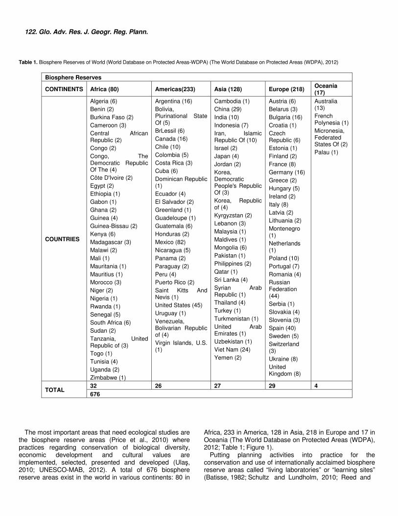
Table 1. Biosphere Reserves of World (World Database on Protected Areas-WDPA) (The World Database on Protected Areas (WDPA), 2012)
Biosphere Reserves
CONTINENTS Africa (80) Americas(233) Asia (128) Europe (218) Oceania (17)
COUNTRIES
Algeria (6) Benin (2) Burkina Faso (2) Cameroon (3) Central African Republic (2) Congo (2) Congo, The Democratic Republic Of The (4) Côte D'Ivoire (2) Egypt (2) Ethiopia (1) Gabon (1) Ghana (2) Guinea (4) Guinea-Bissau (2) Kenya (6) Madagascar (3) Malawi (2) Mali (1) Mauritania (1) Mauritius (1) Morocco (3) Niger (2) Nigeria (1) Rwanda (1) Senegal (5) South Africa (6) Sudan (2) Tanzania, United Republic of (3) Togo (1) Tunisia (4) Uganda (2) Zimbabwe (1)
Argentina (16) Bolivia, Plurinational State Of (5) BrLessil (6) Canada (16) Chile (10) Colombia (5) Costa Rica (3) Cuba (6) Dominican Republic (1) Ecuador (4) El Salvador (2) Greenland (1) Guadeloupe (1) Guatemala (6) Honduras (2) Mexico (82) Nicaragua (5) Panama (2) Paraguay (2) Peru (4) Puerto Rico (2) Saint Kitts And Nevis (1) United States (45) Uruguay (1) Venezuela, Bolivarian Republic of (4) Virgin Islands, U.S. (1)
Cambodia (1) China (29) India (10) Indonesia (7) Iran, Islamic Republic Of (10) Israel (2) Japan (4) Jordan (2) Korea, Democratic People's Republic Of (3) Korea, Republic of (4) Kyrgyzstan (2) Lebanon (3) Malaysia (1) Maldives (1) Mongolia (6) Pakistan (1) Philippines (2) Qatar (1) Sri Lanka (4) Syrian Arab Republic (1) Thailand (4) Turkey (1) Turkmenistan (1) United Arab Emirates (1) Uzbekistan (1) Viet Nam (24) Yemen (2)
Austria (6) Belarus (3) Bulgaria (16) Croatia (1) Czech Republic (6) Estonia (1) Finland (2) France (8) Germany (16) Greece (2) Hungary (5) Ireland (2) Italy (8) Latvia (2) Lithuania (2) Montenegro (1) Netherlands (1) Poland (10) Portugal (7) Romania (4) Russian Federation (44) Serbia (1) Slovakia (4) Slovenia (3) Spain (40) Sweden (5) Switzerland (3) Ukraine (8) United Kingdom (8)
Australia (13) French Polynesia (1) Micronesia, Federated States Of (2) Palau (1)
TOTAL 32 26 27 29 4 676
The most important areas that need ecological studies are
the biosphere reserve areas (Price et al., 2010) where practices regarding conservation of biological diversity, economic development and cultural values are implemented, selected, presented and developed (Ulaş, 2010; UNESCO-MAB, 2012). A total of 676 biosphere reserve areas exist in the world in various continents: 80 in
Africa, 233 in America, 128 in Asia, 218 in Europe and 17 in Oceania (The World Database on Protected Areas (WDPA), 2012; Table 1; Figure 1).
Putting planning activities into practice for the conservation and use of internationally acclaimed biosphere reserve areas called “living laboratories” or “learning sites” (Batisse, 1982; Schultz and Lundholm, 2010; Reed and
Özşahin and Kaymaz. 123
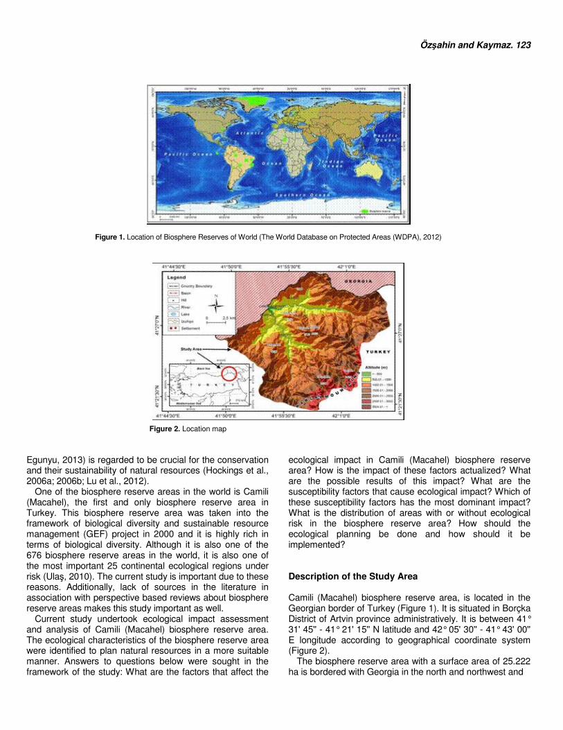
Figure 1. Location of Biosphere Reserves of World (The World Database on Protected Areas (WDPA), 2012)
Figure 2. Location map Egunyu, 2013) is regarded to be crucial for the conservation and their sustainability of natural resources (Hockings et al., 2006a; 2006b; Lu et al., 2012).
One of the biosphere reserve areas in the world is Camili (Macahel), the first and only biosphere reserve area in Turkey. This biosphere reserve area was taken into the framework of biological diversity and sustainable resource management (GEF) project in 2000 and it is highly rich in terms of biological diversity. Although it is also one of the 676 biosphere reserve areas in the world, it is also one of the most important 25 continental ecological regions under risk (Ulaş, 2010). The current study is important due to these reasons. Additionally, lack of sources in the literature in association with perspective based reviews about biosphere reserve areas makes this study important as well.
Current study undertook ecological impact assessment and analysis of Camili (Macahel) biosphere reserve area. The ecological characteristics of the biosphere reserve area were identified to plan natural resources in a more suitable manner. Answers to questions below were sought in the framework of the study: What are the factors that affect the
ecological impact in Camili (Macahel) biosphere reserve area? How is the impact of these factors actualized? What are the possible results of this impact? What are the susceptibility factors that cause ecological impact? Which of these susceptibility factors has the most dominant impact? What is the distribution of areas with or without ecological risk in the biosphere reserve area? How should the ecological planning be done and how should it be implemented? Description of the Study Area Camili (Macahel) biosphere reserve area, is located in the Georgian border of Turkey (Figure 1). It is situated in Borçka District of Artvin province administratively. It is between 41° 31' 45'' - 41° 21' 15'' N latitude and 42° 05' 30'' - 41° 43' 00'' E longitude according to geographical coordinate system (Figure 2).
The biosphere reserve area with a surface area of 25.222 ha is bordered with Georgia in the north and northwest and
124. Glo. Adv. Res. J. Geogr. Reg. Plann. Karçal Mountains in the south, southeast and southwest (Figure 1).
The main soil in the biosphere reserve area composed of various age and type lithological units from Mezosoic to the present consists of Alpine orogenesis which started in Mesozoic and lasted until the end of Neocene period and volcanism products created in the same period. The oldest unit is the product of Upper Cretaceous old acid and alkaline underwater volcanism. These units generated thick volcano-sedimentary deposits based on the continuation of volcanism and sedimentation in the same environment from Paleocene to the end of Eocene (Sever and Kopar, 2009).
The area subjected to vertical and horizontal directional tectonic movements in the Upper Pliocene, epirogenic ascents were effective during Quaternary (Gattinger, 1962; Yılmaz et.al., 1998). Again in the same period, reverse faults and imbricated structures that had small angled overthrusts were created in the land where Karçal Mountains exist (Sever and Kopar, 2009).
The biosphere reserve area with an average elevation of 1609 m shows that characteristics of a rugged and high relief fragmented by rivers. Therefore geomorphologic units are mostly represented by mountains, hills or ridges (Koday and Kaymaz, 2013).
The area between Black Sea and the high mountains beyond it show mild and humid climate features with subtropical oceanic character (İnandık, 1969). Annual average temperature value is 11.9 ºC and annual average precipitation is 1315 mm (Kaymaz, 2012).
Biosphere reserve area where precipitation is observed in each season according to climate characteristics is rich in terms of hydrographic elements. The water in the area is drained by Efeler, Uğur and Düzenli rivers (Koday and Kaymaz, 2013).
Entisol, Inceptisol and Mollisol type soils are common in biosphere reserve area. Entisols were generated in the recent past (Atalay, 2011) on the alluvial materials in the river valleys (Efe, 2010). Found mostly on clayed main materials, they are in the initial period of their development (Atalay, 2011) and they can be observed in the whole biosphere reserve area. Mollisols are mostly found in the meadows situated in the high segments of the biosphere reserve area with their rich humus and clay content (Efe, 2010). These areas are mostly used in summer months as pastures (Zaman, 2007; Atalay and Mortan, 2011).
The biosphere reserve area located in the border of Karçal Mountains (Özhatay et.al., 2003) which is identified to be one of the 122 important flora areas is also rich in terms of flora the area with approximately 1021 different types of flora represents about 10% of flora in Turkey. It is located in Kolşik Flora world (Kaymaz, 2012) composed of lush plant assemblies (Atalay, 1994; 2008) made up of broad-leafed trees according to Turkey plant geography and flora regions (Atalay, 1994; 2002, 2011).
There are 6 settlements that bear village status in Camili (Macahel) biosphere reserve area. According to 2011
census, 1136 individuals live in the biosphere reserve area with an average population density of 4.5 individuals per km² (Koday and Kaymaz, 2013).
With the support of several public and private organizations (TEMA, TAR-GEL, UNESCO etc.), various types of economic activities such as beekeeping and organic agriculture have developed in the biosphere reserve area where agriculture and animal husbandry were once fundamental economic activities (Kaymaz, 2012). Also, Karagöl (Kopar and Sever, 2008) and Maral waterfall (Sever ve Kopar, 2009) are important tourism attractions and added value for tourism activities in the area due to the fauna and natural landscape of the attractions respectively (Kaymaz, 2012).
Based on all these reasons, Camili (Macahel) was declared by UNESCO to be the first “Biosphere Reserve Area” in Turkey in June 29, 2005. World Wide Fund for Nature (WWF) registered this area as one of the 20 Ecologic Regions. There are also two nature reserve areas (Camili-Efeler ve Camili-Gorgit) in the biosphere reserve area. The area was also declared “Pure Caucasian HoneyBee Genetic Region” by T.R. Ministry of Food, Agriculture and Livestock (Kaymaz, 2012). MATERIALS AND METHOD The study undertaken in the framework of ecological planning approach was completed in two phases. The first phase evaluated the elements that could result in ecological impact and their possible effects in the framework of Ecological Risk Assessment (ERA) method identified by “United States Environmental Protection Agency” (USEPA). In the second phase, factors that were identified during the first phase were analyzed. This analysis was undertaken by adapting the identified ecological factors with the help of weighted overlay technique based on “Ecological Risk Assessment” (ERA) and transferring the data to Geographical Information Systems (GIS) (Ndubisi, 2002; Tozar, 2006) database.
During the adaptation process, 60 factor maps with 10x10 m resolution were generated in grid format by considering the impact values identified during the stages (Çelik, 2000; Salihoğlu and Karael, 2005; Bozhüyük Ardahanlıoğlu et.al., 2012) of assigning impact values to identified problems, problem identification, analysis and risk identification. These factor maps were overlaid to obtain the densities of the ecological impact classes and their spatial distributions. In this phase, ArcInfo/ArcMap 10.0 package program based Geographical Information Systems (GIS) method and techniques which were generally utilized in environmental (Tecim, 2008) and ecological (Hogsett et.al., 1997; Lemly, 1997; Kooistra et.al., 2001; Preston, 2002; Solomon and Sibley, 2002; Salihoğlu and Karael, 2005) practices were used. Maps of various scales and Remote Sensing (RS) supported Land sat Satellite Image of 11.07. 2009 were
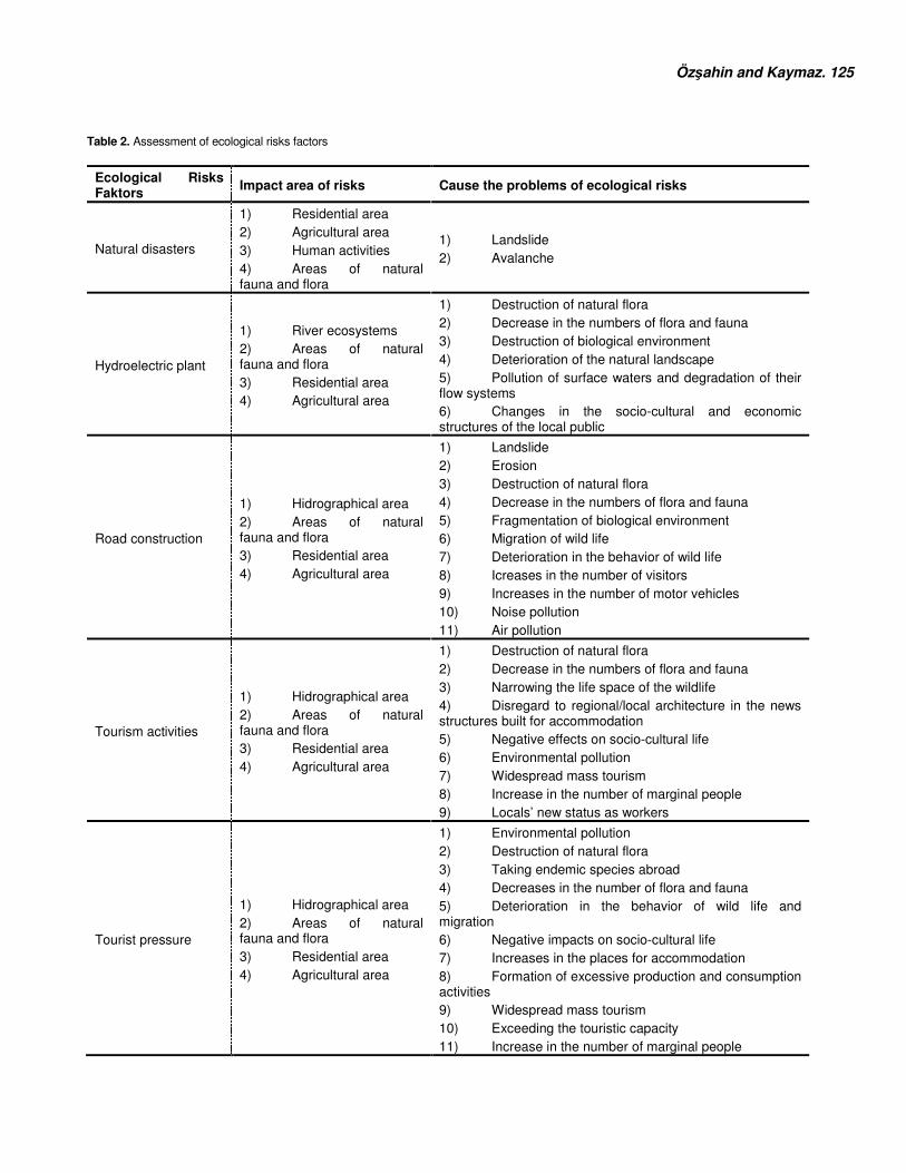
Özşahin and Kaymaz. 125 Table 2. Assessment of ecological risks factors
Ecological Risks Faktors
Impact area of risks Cause the problems of ecological risks
Natural disasters
1) Residential area 2) Agricultural area 3) Human activities 4) Areas of natural fauna and flora
1) Landslide 2) Avalanche
Hydroelectric plant
1) River ecosystems 2) Areas of natural fauna and flora 3) Residential area 4) Agricultural area
1) Destruction of natural flora 2) Decrease in the numbers of flora and fauna 3) Destruction of biological environment 4) Deterioration of the natural landscape 5) Pollution of surface waters and degradation of their flow systems 6) Changes in the socio-cultural and economic structures of the local public
Road construction
1) Hidrographical area 2) Areas of natural fauna and flora 3) Residential area 4) Agricultural area
1) Landslide 2) Erosion 3) Destruction of natural flora 4) Decrease in the numbers of flora and fauna 5) Fragmentation of biological environment 6) Migration of wild life 7) Deterioration in the behavior of wild life 8) Icreases in the number of visitors 9) Increases in the number of motor vehicles 10) Noise pollution 11) Air pollution
Tourism activities
1) Hidrographical area 2) Areas of natural fauna and flora 3) Residential area 4) Agricultural area
1) Destruction of natural flora 2) Decrease in the numbers of flora and fauna 3) Narrowing the life space of the wildlife 4) Disregard to regional/local architecture in the news structures built for accommodation 5) Negative effects on socio-cultural life 6) Environmental pollution 7) Widespread mass tourism 8) Increase in the number of marginal people 9) Locals’ new status as workers
Tourist pressure
1) Hidrographical area 2) Areas of natural fauna and flora 3) Residential area 4) Agricultural area
1) Environmental pollution 2) Destruction of natural flora 3) Taking endemic species abroad 4) Decreases in the number of flora and fauna 5) Deterioration in the behavior of wild life and migration 6) Negative impacts on socio-cultural life 7) Increases in the places for accommodation 8) Formation of excessive production and consumption activities 9) Widespread mass tourism 10) Exceeding the touristic capacity 11) Increase in the number of marginal people
126. Glo. Adv. Res. J. Geogr. Reg. Plann. utilized in generating Factor 1 maps. Findings obtained at the end of study were checked both with the use of literature and in situ field studies. Suggestions were developed following these checks. RESULTS AND DISCUSSION The natural environment is composed of two main elements: living and non living beings. There is a balanced and close relationship between these two elements. Deterioration in this relationship due to various factors damages the ecological environment (Atalay, 2008). Therefore identification of factors that affect the ecological environment is crucial (Van Lynden, 2000).
In this section, the factors that threaten the ecological environment in the first and single biosphere reserve area, Camili (Macahel) were identified, assessed and analyzed in the framework of ecological planning criteria. Assessment of Ecological Effect Ecological Impact Assessment both acts as a strong support for comparing, ranking and prioritizing the potential risks (Schierow, 1994) and allows the realization of a planning process that foresees the possible risks on the natural resources which will help estimate the negative environmental impact that can be experienced in the future (Bozhüyük Ardahanlıoğlu et.al., 2012).
In the light of both the literature (Ulaş, 2010; Kaymaz, 2012) and the field trips, natural disasters, construction of a hydroelectric plant, road construction, tourism activities and tourist pressure were found to be the main ecological impact factors in Camili (Macahel) biosphere reserve area (Table 2). Although these factors are shaped according to the conditions and the time, they cause the problems identified in Table 2.
The first problem in terms of ecological impact in Camili (Macahel) biosphere reserve area is natural disasters (Table 2). The area is under risk for landslides and avalanche (Koday and Kaymaz, 2013; Özşahin and Kaymaz, 2013). Some settlements were founded ın flatland (Kaymaz, 2012; Koday and Kaymaz, 2013) that are termed as surfaces with landslides (Sever and Kopar, 2009). In the winter, avalanche may be experienced after severe snowfall caused by the snow cover of about 10 m (Kaymaz, 2012). There has been no loss of life or property until now due to natural disasters in the area. However, wild life and forest areas are negatively impacted because of these natural disasters (Kaymaz, 2012).
The second element that threatens the ecological environment in Camili (Macahel) biosphere reserve area is the construction of the hydroelectric plant (Table 2). There are 9 initiatives in project stage in this framework (Board of Trustees Meeting, 2009). It has been stressed that putting
these projects into practice will harm the river ecosystems, natural fauna and flora areas and settlements and agricultural land in the ecological sense (Ulaş, 2010). As a result of these damages, destruction of natural flora, decrease in the numbers of flora and fauna, destruction of biological environment, deterioration of the natural landscape, pollution of surface waters and degradation of their flow systems and changes in the socio-cultural and economic structures of the local public may be experienced (Table 2).
Another problem that threatens the ecological environment in Camili (Macahel) biosphere reserve area is road construction (Table 2). The area consists of a total of 99.5 km road, 13.5 km of which are forest road; 30 km is village road, 35 km is plateau road and 21 km is highway. Road density in the area is 3.9 m/ha (Albayrak, 2010). In case road construction in the biosphere reserve area continues in a manner devoid of ecological understanding, degradation of the naturalness of the area will be inevitable (Kurdoğlu, 2001). Especially the hydrographic areas, natural flora and fauna areas, settlements and agricultural areas may be affected more in this case. As a result of negative ecological factors present in the area, primarily natural disasters such as landslides and erosion may occur in addition to destruction of the natural flora, decreases in the number of flora and fauna, fragmentation of the biological environment, deterioration in the behavior of wild life and migration, increases in the number of visitors and motor vehicles, noise and air pollution (Table 2).
The fact that Camili (Macahel) biosphere reserve area is untouched and suitable has facilitated eco tourism activities (Table 2). In this context, many different types of eco tourism activities are undertaken such as plateau and mountain tourism, trekking, bird watching, wildlife (fauna) watching, botanic tourism and adventure tourism. However, each passing day, “eco tourism” is turning into “ego tourism” (Munt, 1994; Arı, 2009) because of insensible human behavior and ecological environment may be damaged (Özgüç, 2007). For instance, it was identified that some tourists damage the flora on the forest floor and pollute the environment around Karagöl which is located in the biosphere reserve area (Kopar and Sever, 2008). Along the same lines, environmental pollution reported around Maral Falls, another tourism value; was linked to tourism activities (Sever and Kopar, 2009).
Hydrographic areas, natural flora and fauna areas, settlements and agricultural areas in the biosphere reserve area can face negative ecological impact as a result of insensible and unplanned tourism activities (Table 2). As a matter of fact, this situation has often been emphasized in the literature (Özgüç, 2007; Kopar and Sever, 2008; Sever and Kopar, 2009; Kaymaz, 2012). Especially the destruction of natural flora, decreases in the number of flora and fauna, narrowing the life space of the wildlife, disregard to regional/local architecture in the news structures built for accommodation, negative effects on socio-cultural life,
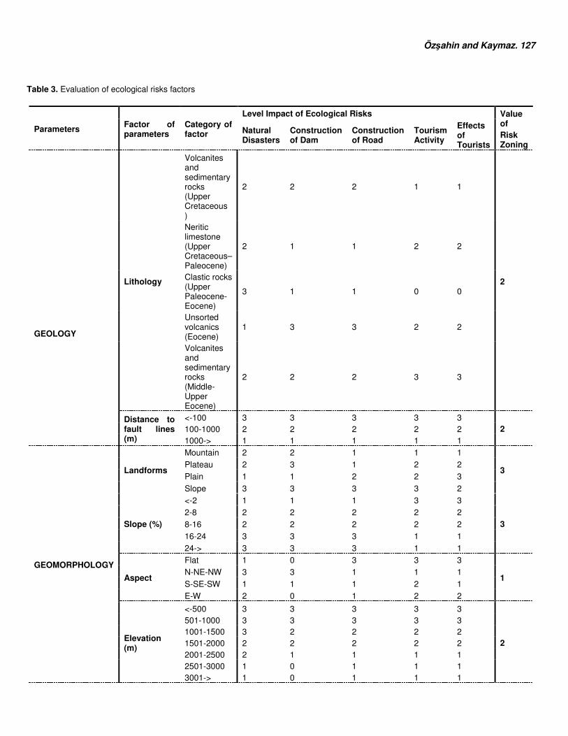
Özşahin and Kaymaz. 127 Table 3. Evaluation of ecological risks factors
Parameters Factor of parameters
Category of factor
Level Impact of Ecological Risks Value of Risk Zoning
Natural Disasters
Construction of Dam
Construction of Road
Tourism Activity
Effects of Tourists
Lithology
Volcanites and sedimentary rocks (Upper Cretaceous )
2 2 2 1 1
2
GEOLOGY
Neritic limestone (Upper Cretaceous–Paleocene)
2 1 1 2 2
Clastic rocks (Upper Paleocene-Eocene)
3 1 1 0 0
Unsorted volcanics (Eocene)
1 3 3 2 2
Volcanites and sedimentary rocks (Middle-Upper Eocene)
2 2 2 3 3
Distance to fault lines (m)
<-100 3 3 3 3 3 2 100-1000 2 2 2 2 2
1000-> 1 1 1 1 1
GEOMORPHOLOGY
Landforms
Mountain 2 2 1 1 1
3 Plateau 2 3 1 2 2
Plain 1 1 2 2 3
Slope 3 3 3 3 2
Slope (%)
<-2 1 1 1 3 3
3 2-8 2 2 2 2 2
8-16 2 2 2 2 2
16-24 3 3 3 1 1
24-> 3 3 3 1 1
Aspect
Flat 1 0 3 3 3
1 N-NE-NW 3 3 1 1 1
S-SE-SW 1 1 1 2 1
E-W 2 0 1 2 2
Elevation (m)
<-500 3 3 3 3 3
2
501-1000 3 3 3 3 3 1001-1500 3 2 2 2 2 1501-2000 2 2 2 2 2 2001-2500 2 1 1 1 1 2501-3000 1 0 1 1 1 3001-> 1 0 1 1 1
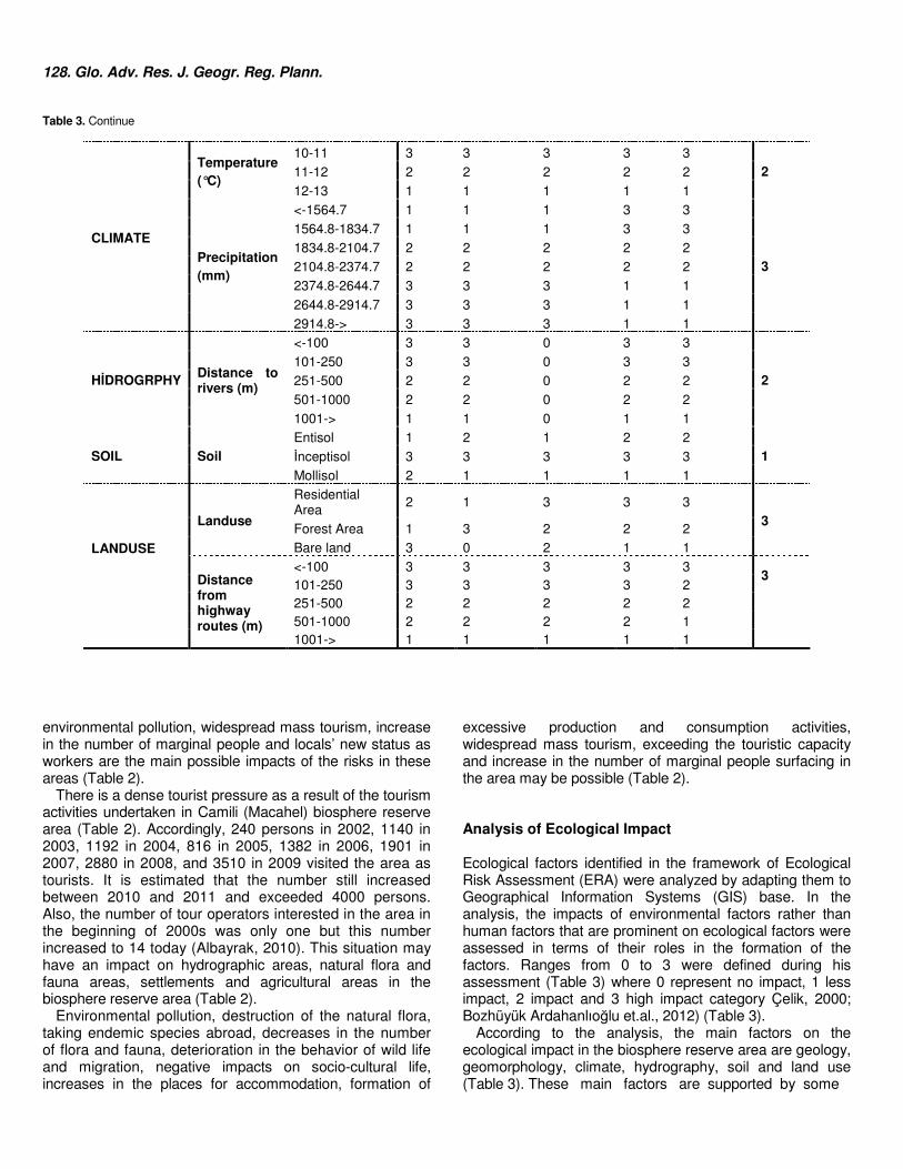
128. Glo. Adv. Res. J. Geogr. Reg. Plann. Table 3. Continue
CLIMATE
Temperature (°C)
10-11 3 3 3 3 3 2 11-12 2 2 2 2 2
12-13 1 1 1 1 1
Precipitation (mm)
<-1564.7 1 1 1 3 3
3
1564.8-1834.7 1 1 1 3 3
1834.8-2104.7 2 2 2 2 2
2104.8-2374.7 2 2 2 2 2
2374.8-2644.7 3 3 3 1 1
2644.8-2914.7 3 3 3 1 1
2914.8-> 3 3 3 1 1
HİDROGRPHY Distance to rivers (m)
<-100 3 3 0 3 3
2 101-250 3 3 0 3 3
251-500 2 2 0 2 2
501-1000 2 2 0 2 2
1001-> 1 1 0 1 1
SOIL Soil Entisol 1 2 1 2 2
1 İnceptisol 3 3 3 3 3
Mollisol 2 1 1 1 1
LANDUSE
Landuse
Residential Area
2 1 3 3 3 3
Forest Area 1 3 2 2 2
Bare land 3 0 2 1 1
Distance from highway routes (m)
<-100 3 3 3 3 3 3
101-250 3 3 3 3 2 251-500 2 2 2 2 2
501-1000 2 2 2 2 1 1001-> 1 1 1 1 1
environmental pollution, widespread mass tourism, increase in the number of marginal people and locals’ new status as workers are the main possible impacts of the risks in these areas (Table 2).
There is a dense tourist pressure as a result of the tourism activities undertaken in Camili (Macahel) biosphere reserve area (Table 2). Accordingly, 240 persons in 2002, 1140 in 2003, 1192 in 2004, 816 in 2005, 1382 in 2006, 1901 in 2007, 2880 in 2008, and 3510 in 2009 visited the area as tourists. It is estimated that the number still increased between 2010 and 2011 and exceeded 4000 persons. Also, the number of tour operators interested in the area in the beginning of 2000s was only one but this number increased to 14 today (Albayrak, 2010). This situation may have an impact on hydrographic areas, natural flora and fauna areas, settlements and agricultural areas in the biosphere reserve area (Table 2).
Environmental pollution, destruction of the natural flora, taking endemic species abroad, decreases in the number of flora and fauna, deterioration in the behavior of wild life and migration, negative impacts on socio-cultural life, increases in the places for accommodation, formation of
excessive production and consumption activities, widespread mass tourism, exceeding the touristic capacity and increase in the number of marginal people surfacing in the area may be possible (Table 2). Analysis of Ecological Impact Ecological factors identified in the framework of Ecological Risk Assessment (ERA) were analyzed by adapting them to Geographical Information Systems (GIS) base. In the analysis, the impacts of environmental factors rather than human factors that are prominent on ecological factors were assessed in terms of their roles in the formation of the factors. Ranges from 0 to 3 were defined during his assessment (Table 3) where 0 represent no impact, 1 less impact, 2 impact and 3 high impact category Çelik, 2000; Bozhüyük Ardahanlıoğlu et.al., 2012) (Table 3).
According to the analysis, the main factors on the ecological impact in the biosphere reserve area are geology, geomorphology, climate, hydrography, soil and land use (Table 3). These main factors are supported by some
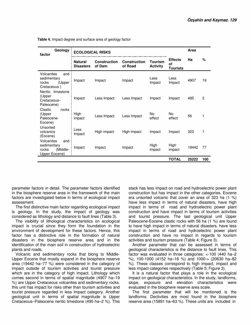
Özşahin and Kaymaz. 129 Table 4. Impact degree and surface area of geology factor
Geology factor
ECOLOGICAL RISKS Area
Natural Disasters
Construction of Dam
Construction of Road
Tourism Activity
Effects of Tourists
Ha %
Volcanites and sedimentary rocks (Upper Cretaceous )
Impact Impact Impact Less Impact
Less Impact
4907 19
Neritic limestone (Upper Cretaceous–Paleocene)
Impact Less Impact Less Impact Impact Impact 495 2
Clastic rocks (Upper Paleocene-Eocene)
High impact
Less Impact Less Impact No effect
No effect
56 1
Unsorted volcanics (Eocene)
Less Impact
High impact High impact Impact Impact 323 1
Volcanites and sedimentary rocks (Middle-Upper Eocene)
Impact Impact Impact High impact
High impact
19442 77
TOTAL 25222 100
parameter factors in detail. The parameter factors identified in the biosphere reserve area in the framework of the main factors are investigated below in terms of ecological impact assessment.
The first distinctive main factor regarding ecological impact is geology. In the study, the impact of geology was considered as lithology and distance to fault lines (Table 3).
The visibility of lithological characteristics on ecological impact is crucial since they form the foundation in the environment of development for these factors. Hence, this factor has a distinctive role in the formation of natural disasters in the biosphere reserve area and in the identification of the main soil in construction of hydroelectric plants and roads.
Volcanic and sedimentary rocks that blong to Middle-Upper Eocene that mostly expand in the biosphere reserve area (19442 ha–77 %) were considered in the category of impact outside of tourism activities and tourist pressure which are in the category of high impact. Lithology which comes second in terms of spatial magnitude (4907 ha–19 %) are Upper Cretaceous volcanites and sedimentary rocks. this unit has impact for risks other than tourism activities and tourist pressure regarded in less impact category. Another geological unit in terms of spatial magnitude is Upper Cretaceous–Paleocene neritic limestone (495 ha–2 %). This
stack has less impact on road and hydroelectric power plant construction but has impact in the other categories. Eocene era unsorted volcanic that cover an area of 323 ha (1 %) have less impact in terms of natural disasters, have high impact in terms of road and hydroelectric power plant construction and have impact in terms of tourism activities and tourist pressure. The last geological unit Upper Paleocene-Eocene clastic rocks with 56 ha (1 %) are found to have high impact in terms of natural disasters, have less impact in terms of road and hydroelectric power plant construction and have no impact in regards to tourism activities and tourism pressure (Table 4; Figure 3).
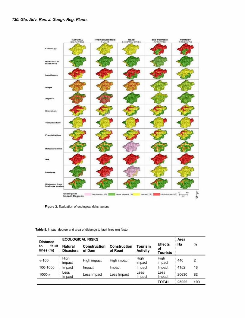
Another parameter that can be assessed in terms of geological characteristics is the distance to fault lines. This factor was evaluated in three categories: <-100 (440 ha–2 %), 100-1000 (4152 ha–16 %) and 1000-> (20630 ha–82 %). These classes correspond to high impact, impact and less impact categories respectively (Table 5; Figure 3).
It is a natural factor that plays a role in the ecological impact on geological characteristics. In the study, landforms, slope, exposure and elevation characteristics were evaluated in the biosphere reserve area scale.
The first parameter that will be mentioned is the landforms. Declivities are most found in the biosphere reserve area (15891 ha–63 %). These units are included in
130. Glo. Adv. Res. J. Geogr. Reg. Plann.
Figure 3. Evaluation of ecological risks factors Table 5. Impact degree and area of distance to fault lines (m) factor
Distance to fault lines (m)
ECOLOGICAL RISKS Area
Natural Disasters
Construction of Dam
Construction of Road
Tourism Activity
Effects of Tourists
Ha %
<-100 High impact
High impact High impact High impact
High impact
440 2
100-1000 Impact Impact Impact Impact Impact 4152 16
1000-> Less Impact
Less Impact Less Impact Less Impact
Less Impact
20630 82
TOTAL 25222 100
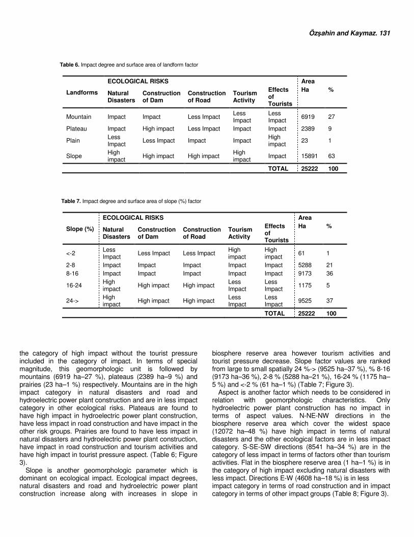
Özşahin and Kaymaz. 131 Table 6. Impact degree and surface area of landform factor
Landforms
ECOLOGICAL RISKS Area
Natural Disasters
Construction of Dam
Construction of Road
Tourism Activity
Effects of Tourists
Ha %
Mountain Impact Impact Less Impact Less Impact
Less Impact
6919 27
Plateau Impact High impact Less Impact Impact Impact 2389 9
Plain Less Impact
Less Impact Impact Impact High impact
23 1
Slope High impact
High impact High impact High impact
Impact 15891 63
TOTAL 25222 100
Table 7. Impact degree and surface area of slope (%) factor
Slope (%)
ECOLOGICAL RISKS Area
Natural Disasters
Construction of Dam
Construction of Road
Tourism Activity
Effects of Tourists
Ha %
<-2 Less Impact
Less Impact Less Impact High impact
High impact
61 1
2-8 Impact Impact Impact Impact Impact 5288 21 8-16 Impact Impact Impact Impact Impact 9173 36
16-24 High impact
High impact High impact Less Impact
Less Impact
1175 5
24-> High impact
High impact High impact Less Impact
Less Impact
9525 37
TOTAL 25222 100
the category of high impact without the tourist pressure included in the category of impact. In terms of special magnitude, this geomorphologic unit is followed by mountains (6919 ha–27 %), plateaus (2389 ha–9 %) and prairies (23 ha–1 %) respectively. Mountains are in the high impact category in natural disasters and road and hydroelectric power plant construction and are in less impact category in other ecological risks. Plateaus are found to have high impact in hydroelectric power plant construction, have less impact in road construction and have impact in the other risk groups. Prairies are found to have less impact in natural disasters and hydroelectric power plant construction, have impact in road construction and tourism activities and have high impact in tourist pressure aspect. (Table 6; Figure 3).
Slope is another geomorphologic parameter which is dominant on ecological impact. Ecological impact degrees, natural disasters and road and hydroelectric power plant construction increase along with increases in slope in
biosphere reserve area however tourism activities and tourist pressure decrease. Slope factor values are ranked from large to small spatially 24 %-> (9525 ha–37 %), % 8-16 (9173 ha–36 %), 2-8 % (5288 ha–21 %), 16-24 % (1175 ha–5 %) and <-2 % (61 ha–1 %) (Table 7; Figure 3).
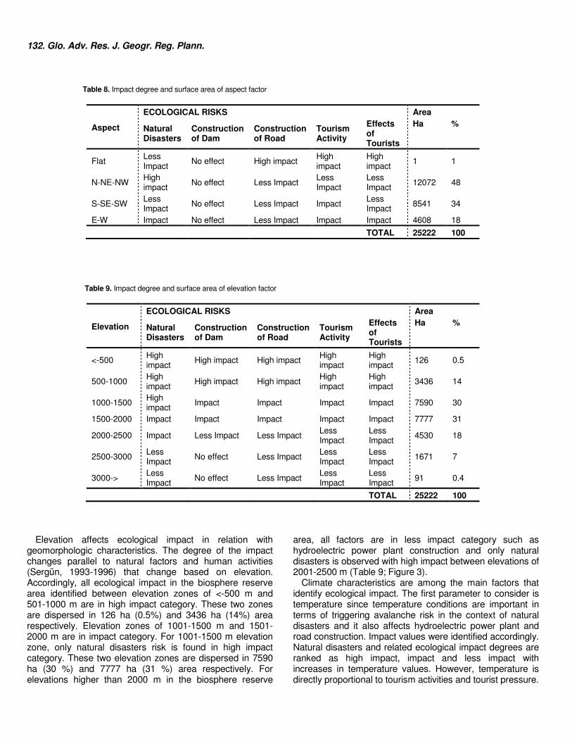
Aspect is another factor which needs to be considered in relation with geomorphologic characteristics. Only hydroelectric power plant construction has no impact in terms of aspect values. N-NE-NW directions in the biosphere reserve area which cover the widest space (12072 ha–48 %) have high impact in terms of natural disasters and the other ecological factors are in less impact category. S-SE-SW directions (8541 ha–34 %) are in the category of less impact in terms of factors other than tourism activities. Flat in the biosphere reserve area (1 ha–1 %) is in the category of high impact excluding natural disasters with less impact. Directions E-W (4608 ha–18 %) is in less impact category in terms of road construction and in impact category in terms of other impact groups (Table 8; Figure 3).
132. Glo. Adv. Res. J. Geogr. Reg. Plann.
Table 8. Impact degree and surface area of aspect factor
Aspect
ECOLOGICAL RISKS Area
Natural Disasters
Construction of Dam
Construction of Road
Tourism Activity
Effects of Tourists
Ha %
Flat Less Impact
No effect High impact High impact
High impact
1 1
N-NE-NW High impact
No effect Less Impact Less Impact
Less Impact
12072 48
S-SE-SW Less Impact
No effect Less Impact Impact Less Impact
8541 34
E-W Impact No effect Less Impact Impact Impact 4608 18
TOTAL 25222 100
Table 9. Impact degree and surface area of elevation factor
Elevation
ECOLOGICAL RISKS Area
Natural Disasters
Construction of Dam
Construction of Road
Tourism Activity
Effects of Tourists
Ha %
<-500 High impact
High impact High impact High impact
High impact
126 0.5
500-1000 High impact
High impact High impact High impact
High impact
3436 14
1000-1500 High impact
Impact Impact Impact Impact 7590 30
1500-2000 Impact Impact Impact Impact Impact 7777 31
2000-2500 Impact Less Impact Less Impact Less Impact
Less Impact
4530 18
2500-3000 Less Impact
No effect Less Impact Less Impact
Less Impact
1671 7
3000-> Less Impact
No effect Less Impact Less Impact
Less Impact
91 0.4
TOTAL 25222 100
Elevation affects ecological impact in relation with
geomorphologic characteristics. The degree of the impact changes parallel to natural factors and human activities (Sergün, 1993-1996) that change based on elevation. Accordingly, all ecological impact in the biosphere reserve area identified between elevation zones of <-500 m and 501-1000 m are in high impact category. These two zones are dispersed in 126 ha (0.5%) and 3436 ha (14%) area respectively. Elevation zones of 1001-1500 m and 1501-2000 m are in impact category. For 1001-1500 m elevation zone, only natural disasters risk is found in high impact category. These two elevation zones are dispersed in 7590 ha (30 %) and 7777 ha (31 %) area respectively. For elevations higher than 2000 m in the biosphere reserve
area, all factors are in less impact category such as hydroelectric power plant construction and only natural disasters is observed with high impact between elevations of 2001-2500 m (Table 9; Figure 3).
Climate characteristics are among the main factors that identify ecological impact. The first parameter to consider is temperature since temperature conditions are important in terms of triggering avalanche risk in the context of natural disasters and it also affects hydroelectric power plant and road construction. Impact values were identified accordingly. Natural disasters and related ecological impact degrees are ranked as high impact, impact and less impact with increases in temperature values. However, temperature is directly proportional to tourism activities and tourist pressure.
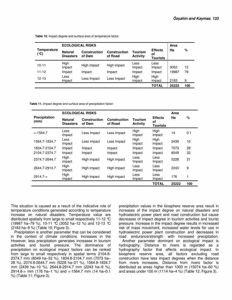
Özşahin and Kaymaz. 133 Table 10. Impact degree and surface area of temperature factor
Temperature (°C)
ECOLOGICAL RISKS Area
Natural Disasters
Construction of Dam
Construction of Road
Tourism Activity
Effects of Tourists
Ha %
10-11 High impact
High impact High impact Less Impact
Less Impact 3052 12
11-12 Impact Impact Impact Impact Impact 19987 79
12-13 Less Impact
Less Impact Less Impact High impact
High impact 2183 9
TOTAL 25222 100
Table 11. Impact degree and surface area of precipitation factor
Precipitation (mm)
ECOLOGICAL RISKS Area
Natural Disasters
Construction of Dam
Construction of Road
Tourism Activity
Effects of Tourists
Ha %
<-1564.7 Less Impact
Less Impact Less Impact High impact
High impact
14 0.1
1564.7-1834.7 Less Impact
Less Impact Less Impact High impact
High impact
2439 10
1834.7-2104.7 Impact Impact Impact Impact Impact 7073 28 2104.7-2374.7 Impact Impact Impact Impact Impact 8049 32
2374.7-2644.7 High impact
High impact High impact Less Impact
Less Impact
5228 21
2644.7-2914.7 High impact
High impact High impact Less Impact
Less Impact
2243 9
2914.7-> High impact
High impact High impact Less Impact
Less Impact
176 1
TOTAL 25222 100
This situation is caused as a result of the indicative role of temperature conditions generated according to temperature increase on natural disasters. Temperature value are distributed spatially from large to small respectively 11-12 °C (19987 ha–79 %), 10-11 °C (3052 ha–12 %) and 12-13 °C (2183 ha–9 %) (Table 10; Figure 3).
Precipitation is another parameter that can be considered in the context of climate conditions. Increases in the
precipitation values in the biosphere reserve area result in increases of the impact degree on natural disasters and hydroelectric power plant and road construction but cause decreases of impact degree in tourism activities and tourist pressure. Increase in the impact degree results in increased risk of mass movement, increased water levels for use in hydroelectric power plant construction and decreases in road endurance/strength with increased precipitation.
However, less precipitation generates increases in tourism activities and tourist pressure. The dominance of precipitation on ecological impact factors can be ranked from large to small respectively in spatial terms 2104.8-2374.7 mm (8049 ha–32 %), 1834.8-2104.7 mm (7073 ha–28 %), 2374.8-2644.7 mm (5228 ha–21 %), 1564.8-1834.7 mm (2439 ha–10 %), 2644.8-2914.7 mm (2243 ha–9 %), 2914.8-> mm (176 ha–1 %) and <-1564.7 mm (14 ha–0.1 %) (Table 11; Figure 3).
Another parameter dominant on ecological impact is hydrography. Distance to rivers is regarded as a hydrography factor that affects ecological impact. In biosphere reserve area, all factors excluding road construction have less impact degrees when the distance from rivers increases. Distance from rivers factor is distributed as areas higher than 1000 m (15074 ha–60 %) and areas under 100 m (1114 ha–4 %) (Table 12; Figure 3).
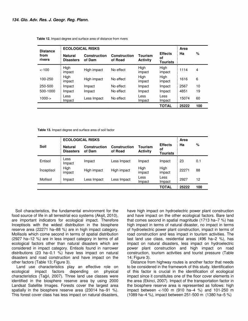
134. Glo. Adv. Res. J. Geogr. Reg. Plann.
Table 12. Impact degree and surface area of distance from rivers
Distance from rivers
ECOLOGICAL RISKS Area
Natural Disasters
Construction of Dam
Construction of Road
Tourism Activity
Effects of Tourists
Ha %
<-100 High impact
High impact No effect High impact
High impact
1114 4
100-250 High impact
High impact No effect High impact
High impact
1616 6
250-500 Impact Impact No effect Impact Impact 2567 10 500-1000 Impact Impact No effect Impact Impact 4851 19
1000-> Less Impact
Less Impact No effect Less Impact
Less Impact
15074 60
TOTAL 25222 100
Table 13. Impact degree and surface area of soil factor
Soil
ECOLOGICAL RISKS Area
Natural Disasters
Construction of Dam
Construction of Road
Tourism Activity
Effects of Tourists
Ha %
Entisol Less Impact
Impact Less Impact Impact Impact 23 0.1
İnceptisol High impact
High impact High impact High impact
High impact
22271 88
Mollisol Impact Less Impact Less Impact Less Impact
Less Impact
2927 12
TOTAL 25222 100
Soil characteristics, the fundamental environment for the
food source of life in all terrestrial eco systems (Akşit, 2010), are important indicators for ecological impact. Therefore Inceptisols with the widest distribution in the biosphere reserve area (22271 ha–88 %) are in high impact category. Mollisols which come second in terms of spatial distribution (2927 ha–12 %) are in less impact category in terms of all ecological factors other than natural disasters which are considered in impact category. Entisols found in narrower distributions (23 ha–0.1 %) have less impact on natural disasters and road construction and have impact on the other factors (Table 13; Figure 3).
Land use characteristics play an effective role on ecological impact factors depending on physical characteristics (Tağıl, 2007). Three land use classes were identified in the biosphere reserve area by using 2000 Landsat Satellite Images. Forests cover the largest area spatially in the biosphere reserve area (23014 ha–91 %). This forest cover class has less impact on natural disasters,
have high impact on hydroelectric power plant construction and have impact on the other ecological factors. Bare land that comes second in spatial magnitude (1713 ha–7 %) has high impact in terms of natural disaster, no impact in terms of hydroelectric power plant construction, impact in terms of road construction and less impact in tourism activities. The last land use class, residential areas (496 ha–2 %), has impact on natural disasters, less impact on hydroelectric power plant construction and high impact on road construction, tourism activities and tourist pressure (Table 14; Figure 3).
Distance from highway routes is another factor that needs to be considered in the framework of this study. Identification of this factor is crucial in the identification of ecological impact since it constitutes one of the floor cover elements in the area (Ekinci, 2007). Impact of the transportation factor in the biosphere reserve area is represented as follows: high impact between <-100 m (910 ha–4 %) and 101-250 m (1089 ha–4 %), impact between 251-500 m (1380 ha–5 %)
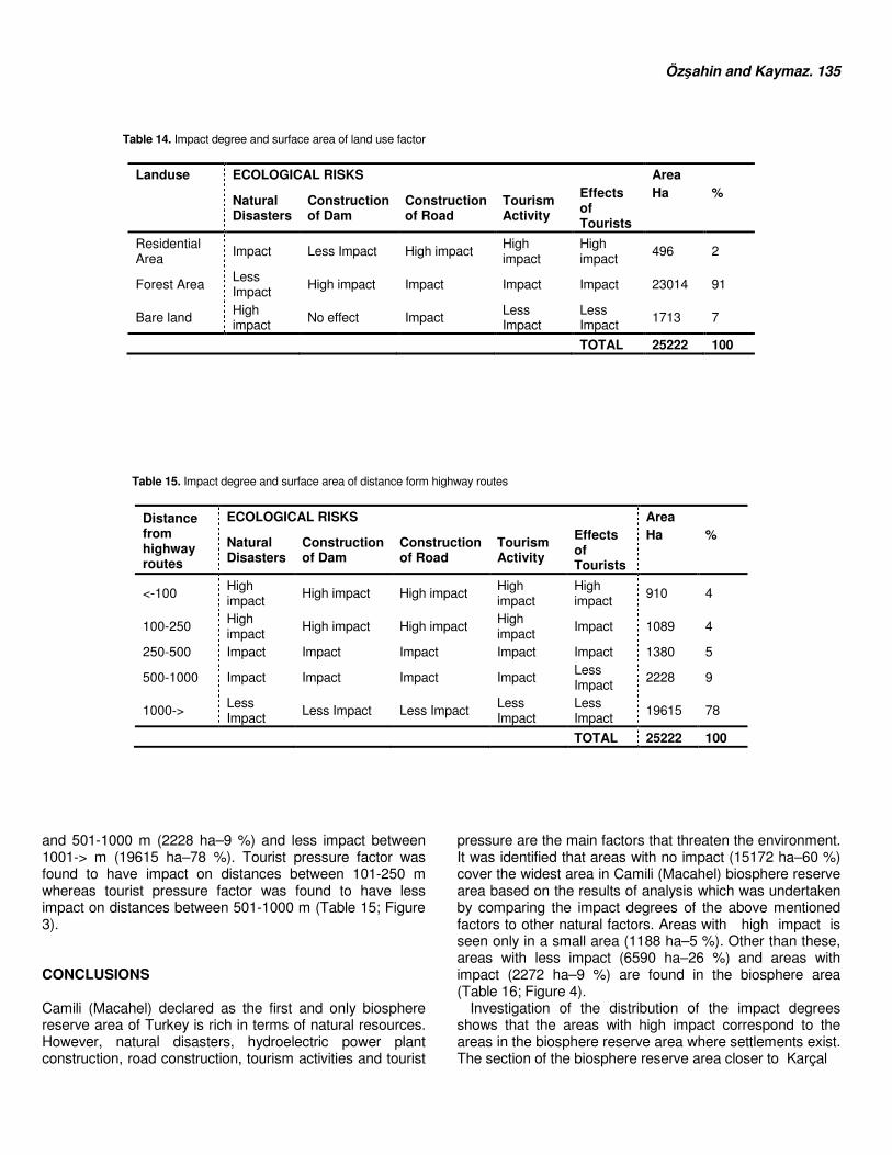
Özşahin and Kaymaz. 135 Table 14. Impact degree and surface area of land use factor
Landuse ECOLOGICAL RISKS Area
Natural Disasters
Construction of Dam
Construction of Road
Tourism Activity
Effects of Tourists
Ha %
Residential Area
Impact Less Impact High impact High impact
High impact
496 2
Forest Area Less Impact
High impact Impact Impact Impact 23014 91
Bare land High impact
No effect Impact Less Impact
Less Impact
1713 7
TOTAL 25222 100
Table 15. Impact degree and surface area of distance form highway routes
Distance from highway routes
ECOLOGICAL RISKS Area
Natural Disasters
Construction of Dam
Construction of Road
Tourism Activity
Effects of Tourists
Ha %
<-100 High impact
High impact High impact High impact
High impact
910 4
100-250 High impact
High impact High impact High impact
Impact 1089 4
250-500 Impact Impact Impact Impact Impact 1380 5
500-1000 Impact Impact Impact Impact Less Impact
2228 9
1000-> Less Impact
Less Impact Less Impact Less Impact
Less Impact
19615 78
TOTAL 25222 100
and 501-1000 m (2228 ha–9 %) and less impact between 1001-> m (19615 ha–78 %). Tourist pressure factor was found to have impact on distances between 101-250 m whereas tourist pressure factor was found to have less impact on distances between 501-1000 m (Table 15; Figure 3). CONCLUSIONS Camili (Macahel) declared as the first and only biosphere reserve area of Turkey is rich in terms of natural resources. However, natural disasters, hydroelectric power plant construction, road construction, tourism activities and tourist
pressure are the main factors that threaten the environment. It was identified that areas with no impact (15172 ha–60 %) cover the widest area in Camili (Macahel) biosphere reserve area based on the results of analysis which was undertaken by comparing the impact degrees of the above mentioned factors to other natural factors. Areas with high impact is seen only in a small area (1188 ha–5 %). Other than these, areas with less impact (6590 ha–26 %) and areas with impact (2272 ha–9 %) are found in the biosphere area (Table 16; Figure 4).
Investigation of the distribution of the impact degrees shows that the areas with high impact correspond to the areas in the biosphere reserve area where settlements exist. The section of the biosphere reserve area closer to Karçal
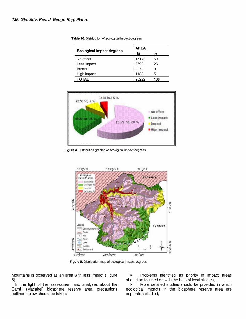
136. Glo. Adv. Res. J. Geogr. Reg. Plann. Table 16. Distribution of ecological impact degrees
Ecological impact degrees AREA Ha %
No effect 15172 60 Less impact 6590 26 Impact 2272 9 High impact 1188 5
TOTAL 25222 100
Figure 4. Distribution graphic of ecological impact degrees
Figure 5. Distribution map of ecological impact degrees Mountains is observed as an area with less impact (Figure 5).
In the light of the assessment and analyses about the Camili (Macahel) biosphere reserve area, precautions outlined below should be taken:
� Problems identified as priority in impact areas should be focused on with the help of local studies, � More detailed studies should be provided in which
ecological impacts in the biosphere reserve area are separately studied,
� An ecologically appropriate planning system should be developed, � Care should be given not to damage the cultural
texture in the biosphere reserve area � All types of activities and events should be realized
by paying attention to ecological issues which requires prior education and awareness raising � Local public should be involved in all
implementations � Public and tourists should cooperate in conserving
the natural resources which provide added value to this area � Sustainability approach should be prominent in all
implementations The study has confirmed that some methods developed in
ecological framework can be analyzed with the help of Geographical Information Systems (GIS) and Remote Sensing (RS) methods and techniques. Study also shows that the proposed method is suitable for these types of fields. REFERENCES Akşit S (2010). Toprak Coğrafyası. Bölüm V, Genel Fiziki Coğrafya (Editör:
Cemalettin ŞAHİN), Ankara: Gündüz Eğitim ve Yayıncılık. Albayrak FF (2010). Korunan Alanların Ekoturizm Gelişimine Etkileri: Camili
Biyosfer Rezervi Örneği. Yayınlanmamış Yüksek Lisans Tezi, Artvin: Artvin Çoruh Üniversitesi, Orman Mühendisliği Anabilim Dalı.
Arı Y (2009). Eko turizm mi ego turizm mi? Kazdağı (Balıkesir) Örneği. Ankara Üniversitesi DTCF Türkiye Coğrafyası Araştırma ve Uygulama Merkezi, V. Ulusal Coğrafya Sempozyumu, 16-17 Ekim 2008, Ankara
Atalay İ (1994). Türkiye Vejetasyon Coğrafyası. İzmir: Ege Üniv. Basımevi Atalay İ (2002). Türkiye’nin Ekolojik Bölgeleri, Ankara: Orman Bakanlığı
Yayınları, No: 163. Atalay İ (2008). Ekosistem Ekolojisi ve Coğrafyası, Cilt: I, İzmir: META
Basım Matbaacılık Hizmetleri. Atalay İ (2011a). Türkiye Coğrafyası ve Jeopolitiği, 8. Baskı, İzmir:: Meta
Basım Matbaacılık Hizmetleri. Atalay İ (2011b). Toprak Oluşumu, Sınıflandırması ve Coğrafyası, 4. Baskı, İzmir: Meta Basım Matbaacılık Hizmetleri.
Atalay İ, Mortan K (2011). Resimli ve Haritalı Türkiye Bölgesel Coğrafyası, İnkılap Kitabevi, İstanbul.
Batisse M (1982). The BR: a tool for environmental conservation and management. Environmental Conservation 9, 101–111.
Bozhüyük AZR, Çınar İ, Bulut Y (2012). Saklıkent Milli Parkı’nın Ekolojik Risk Değerlendirmesi Üzerine Bir Araştırma. Atatürk Üniversitesi Edebiyat Fakültesi Coğrafya Bölümü I. Ulusal Coğrafya Sempozyumu 28-30 Mayıs 2012 Bildiriler Kitabı, s.: 869-877, Erzurum.
Çelik G (2000). Çevre Yönetiminde Ekolojik Risk Değerlendirmesi ve Uluabat Ramsar Alanı İçin Problem Formülasyonu. Yayımlanmamış Yüksek Lisans Tezi, Bursa: Uludağ Üniversitesi Fen Bilimleri Enstitüsü Çevre Mühendisliği Anabilim Dalı.
Çelikyay S (2006). Ekolojik Planlama Sürecinde Stratejik Çevresel Etki Değerlendirmesi ve Bartın Şehri Üzerinde Bir Örnek Çalışma, ZKÜ Bartın Orman Fakültesi Dergisi, Cilt: 8, Sayı: 9, s.: 10-22.
Efe R (2010). Biyocoğrafya (2. Baskı), Bursa: Marmara Kitap Merkezi. Ekinci D (2007). Zonguldak-Hisarönü Arasındaki Karadeniz Akaçlama
Havzasının Kütle Hareketleri Duyarlılık Analizi. Çantay Kitabevi, İstanbul. Gattinger TE (1962). 1/500 000 Ölçekli Türkiye Jeoloji Haritası. Trabzon
Paftası. Ankara: Maden Tetkik ve Arama Enstitüsü Yayınları. Gürpınar E1(994). Bir Çevresel Analiz Örneği Trakya, Der Yayınları, Yayın
No: 128, İstanbul. Hockings M, Leverington F, James R (2006a). Evaluating management
effectiveness. In: Lockwood, M., Worboys, G.L., Kothan, A. (Eds.),
Özşahin and Kaymaz. 137
Managing Protected Areas: A Global Guide. Earthscan, Camden, UK, pp.
635–655. Hockings M, Stolton S, Leverington F, Dudley N, Courrau J (2006b).
Evaluating Effectiveness: A Framework for Assessing Management Effectiveness of Protected Areas, 2nd ed. IUCN/WCPA/WRI, Gland/Switzerland/Cambridge.
Hogsett WE, Weber JE, Tingey D, Herstrom A, Lee EH, ve Laurence JA (1997). An approach for characterizing tropospheric ozone risk to forests. Environmental Management, Volume: 21, Issue: 1, pp. 105-120.
İnandık H (1969). Bitkiler Coğrafyası. İstanbul: İstanbul Üniversitesi Coğrafya Enstitüsü Yayınları.
Kaymaz ÇK (2012). Camili (Macahel)’nin Coğrafi Etüdü (ARTVİN-BORÇKA). Yayınlanmamış Yüksek Lisans Tezi, Erzurum: Atatürk Üniversitesi Sosyal Bilimler Enstitüsü Coğrafya Anabilim Dalı.
Kocataş A (2010). Ekoloji ve Çevre Biyolojisi, 11. Baskı, Ege Üniversitesi Basımevi, İzmir.
Koday Z, Kaymaz ÇK (2013). Camili (Macahel) Havzasında Jeomorfolojik Özelliklerin Yerleşmeler Üzerine Etkisi (ARTVİN-BORÇKA), III. Ulusal Jeomorfoloji Sempozyumu Bildiriler Kitabı, Antakya/HATAY.
Kooistra L, Leuven RSEW, Nienhuis PH, Wehrens R ve Buydens LMC (2001). A procedure for incorporating spatial variabilty in ecological risk assessment of Dutch river floodplains, Environmental Management, Volume: 28, Issue: 3, pp.: 359-373.
Kopar İ, Sever R (2008). Karagöl (Borçka-Artvin), Atatürk Üniversitesi Sosyal Bilimler Enstitüsü Dergisi, Atatürk Üniversitesi Sosyal Bilimler Enstitüsü Dergisi, Cilt: 11, Sayı: 1, s.: 17-29.
Kurdoğlu O (2001). Koruma Alanları ve Ekoturizmin Karadeniz Bölgesi Açısından İrdelenmesi. Türkiye Ormancılar Derneği Yayını, Orman ve Av, Sayı: 4, s: 4.
Lemly AD (1997). Risk assessment as an environmental management tool: considerations for freshwater wetlands, Environmental Management, Volume: 21, Issue: 3, pp. 343-358.
Lu DI, Kao CW, Chao CL (2012). Evaluating the management effectiveness of five protected areas in Taiwan using WWF’s RAPPAM. Environmental Management, Volume: 50, Issue: 2, pp. 272-282.
Munt I (1994). Eco-tourism or ego-tourism?. Race and Class, Issue: 36, Volume: 1, pp.: 49-60.
Muslu Y (2000). Ekoloji ve Çevre Sorunları, Aktif Yayınevi, İstanbul. Mütevelli HT (2009). Macahel ve HES Projeleri. Camili Köyler Birliği Gecesi, İzmir.
Ndubisi F (2002). Ecological Planning-A Historical and Comparative Synthesis. Baltimore and London: The Johns Hopkins University Press.
Özhatay N, Byfield A, Atay S (2003). Türkiye’nin Önemli Bitki Alanları. İstanbul: WWF Türkiye (Doğal Hayatı Koruma Vakfı).
Preston BL (2002). Indirect effects in aquatic ecotoxicology: implications for ecological risk assessment, Environmental Management, Volume: 29, Issue: 3, pp. 311-323.
Price MF, Park JJ, Bouamrane M (2010). Reporting progress on internationally designated sites: The periodic review of biosphere reserves. Environmental Science and Policy, Volume: 13, pp. 549-557.
Reed MG, Egunyu F (2013). Management effectiveness in UNESCO Biosphere Reserves: Learning from Canadian periodic reviews. Environmental Science and Policy, Volume: 25, pp. 107-117.
Salihoğlu G, Karaer F (2005). Uluabat Gölü İçin Ekolojik Risk Değerlendirmesi. İstanbul Teknik Üniversitesi Su Kirlenmesi Kontrolü, Cilt: 15, s.: 17-28.
Schultz L, Lundholm C (2010). Learning for resilience? Exploring learning opportunities in BRs. Environ. Edu. Res. 16, 645–663.
Sergün Ü (1993-1996). Türkiye’de Kır Nüfusunun Yükselti Kademelerine Göre Dağılışı. İstanbul Üniversitesi Edebiyat Fakültesi Coğrafya Dergisi, Sayı: 4, s.: 7-17.
Sever R, Kopar İ (2009). Maral Şelalesi (Borçka-Artvin). Doğal Ortam Özellikleri ve Ekonomik Potansiyeli”, Türk Coğrafya Dergisi, C: 1, S: 11, s.: 21-38.
Solomon KR, Sibley P (2002). New concepts in ecological risk assessment: where do we go from here?, Marine Pollution Bulletin, Issue: 44 pp. 279-285.
Sütgibi S (2008). Türkiye'de Yerleşim Ekolojisi Üzerine Bazı Değerlendirmeler. Ege Coğrafya Dergisi, Cilt: 17, Sayı: 1-2, s.: 61-71.
138 Glo. Adv. Res. J. Geogr. Reg. Plann. Tağıl Ş (2006). Peyzaj Patern Metrikleriyle Balıkesir Ovası ve Yakınında
Habitat Parçalılığında ve Kalitesinde Meydana Gelen Değişim (1975-2000), Ekoloji, Sayı: 15, s.: 24-36.
Tağıl Ş (2007). Tuzla Çayı Havzasında (Biga Yarımadası) CBS-Tabanlı RUSLE Modeli Kullanarak Arazi Degradasyonu Risk Deðerlendirmesi, Ekoloji, Sayı: 17, s.: 11-20.
Tecim V (2008). Coğrafi Bilgi Sistemleri, Harita Tabanlı Bilgi Yönetimi. Ankara: RENK FORM Ofset Matbaacılık Ltd. Şti.
The World Database on Protected Areas (WDPA). (2012). Protected Planet The Protected Areas Portal. Data Standards for the World Database on Protected Areas, United Nations Environment Programme World Conservation Monitoring Centre (WCMC), Cambridge, UK.
Tozar T (2006). Doğal Kaynakların Sürdürülebilirliği İçin Geliştirilen Ekolojik Planlama Yöntemleri. Yayınlanmamış Yüksek Lisans Tezi, İstanbul: Yıldız Teknik Üniversitesi Fen Bilimleri Enstitüsü.
Ulaş D (2010). Macahel’de Hidroelektrik Santrallerin ve Ekoturizmin Çevreye ve Yöre Halkına Etkileri. Anatolia: Turizm Araştırmaları Dergisi (Prof. Dr. Hasan Işın Dener Özel Sayısı), C: 21, S: 1, s.: 151-158.
UNESCO-MAB (2012). Biosphere Reserves – Learning Sites for
Sustainable Development. Man and the Biosphere (MAB) Programme, http://www.unesco.org/new/en/natural-sciences/environment/ecological-sciences/biosphere-reserves/.
Van Lynden GWJ (2000). Guidelines for the Assessment of Soil Degradation in Central and Eastern Europe. Food and Agriculture Organization and International Soil and Reference Informational Centre, Report No: 97/08b, Rome.
Vogelmann JE (1995). Assessment of forest fragmentation in southern New England using Remote Sensing and Geographic Information Systems technology. Conservation Biology, Volume: 9, Issue: 2, pp. 439-449.
Yılmaz BS, Gülibrahimoğlu İ, Konak O, Yazıcı EN, Köse Z, Yaprak S, Çuvalcı F, Saraloğlu A, Tosun CY (1998). Artvin İlinin Çevre Jeolojisi ve Doğal Olanakları. MTA Genel Müdürlüğü, Jeoloji Etütleri Dairesi, Ankara.
Zaman M (2007). Doğu Karadeniz Kıyı Dağları’nda Dağ ve Yayla Turizmi. Erzurum: Mega Ofset Matbaacılık.


