Embed Size (px)
Citation preview
EIA Scoping Report Appendices (Part 1 of 4):
Chapters 3-9
Prepared by Lanpro
January 2022
West Burton Solar Project: EIA Scoping Report – Appendices January 2022
Contents
Appendix 3 Figures: Site and Development Plans 4
Appendix 5 Legislative Context and Energy Policy 17
Appendix 7 Landscape And Visual 35
Appendix 8 Ecology And Biodiversity 52
Appendix 9 Hydrology, Flood Risk And Drainage 173
West Burton Solar Project: EIA Scoping Report – Appendices January 2022
Issue Sheet
Report Prepared for: West Burton Solar Project Ltd.
EIA Scoping Report Submission
West Burton Solar Project: EIA Scoping Report
Appendices (Part 1 of 4): Chapters 3-9
Prepared by: Name: Jane Crichton MRTPI Title: Associate Director Approved by: Name: Ian Douglass MRTPI Title: Associate Director Date: January 2022 Revision: 1
EIA Scoping Report Appendix to Chapter 3:
Figures: Site and Development Plans
January 2022
West Burton Solar Project: EIA Scoping Report – AppendicesJanuary 2022
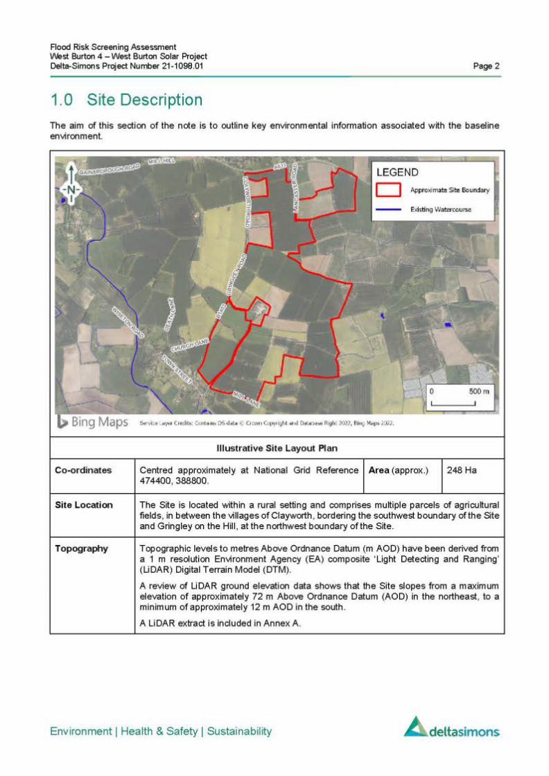
3.1 Figures to Chapter 3
Figure 3.1 Site Plan
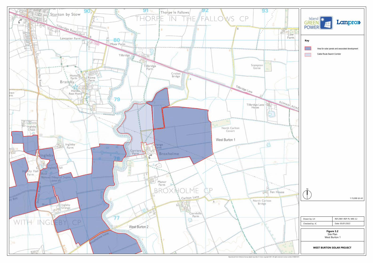
Figure 3.2 Site Plan: West Burton 1
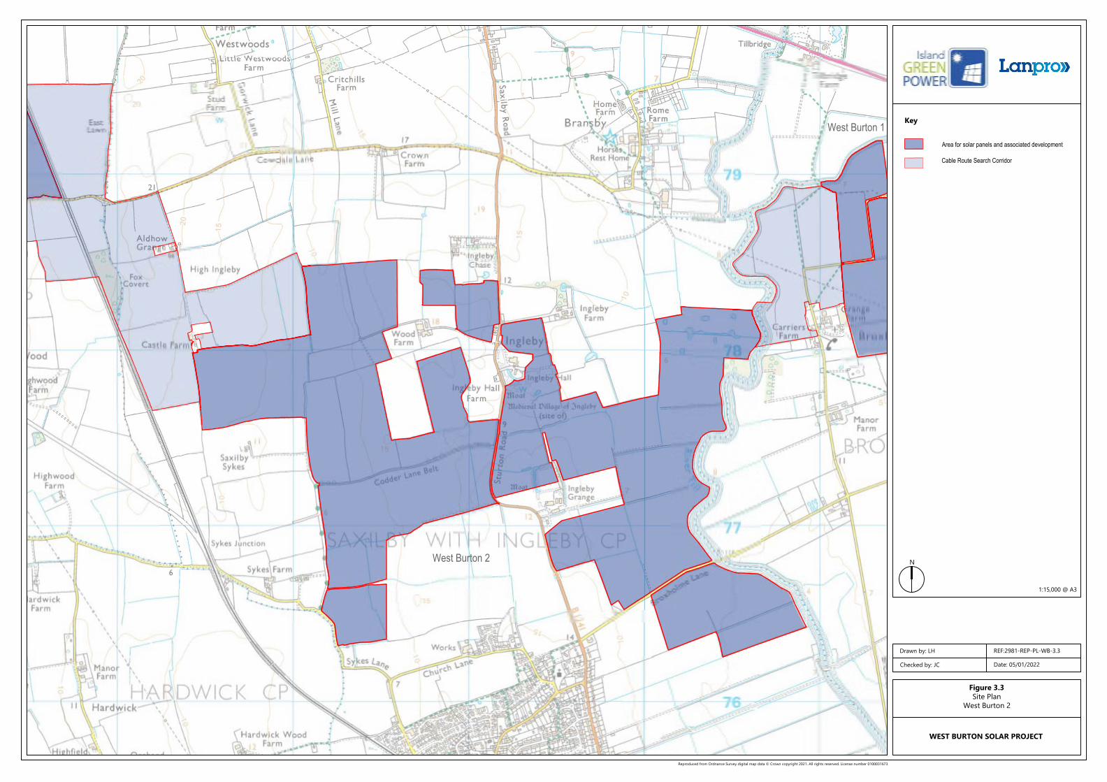
Figure 3.3 Site Plan: West Burton 2
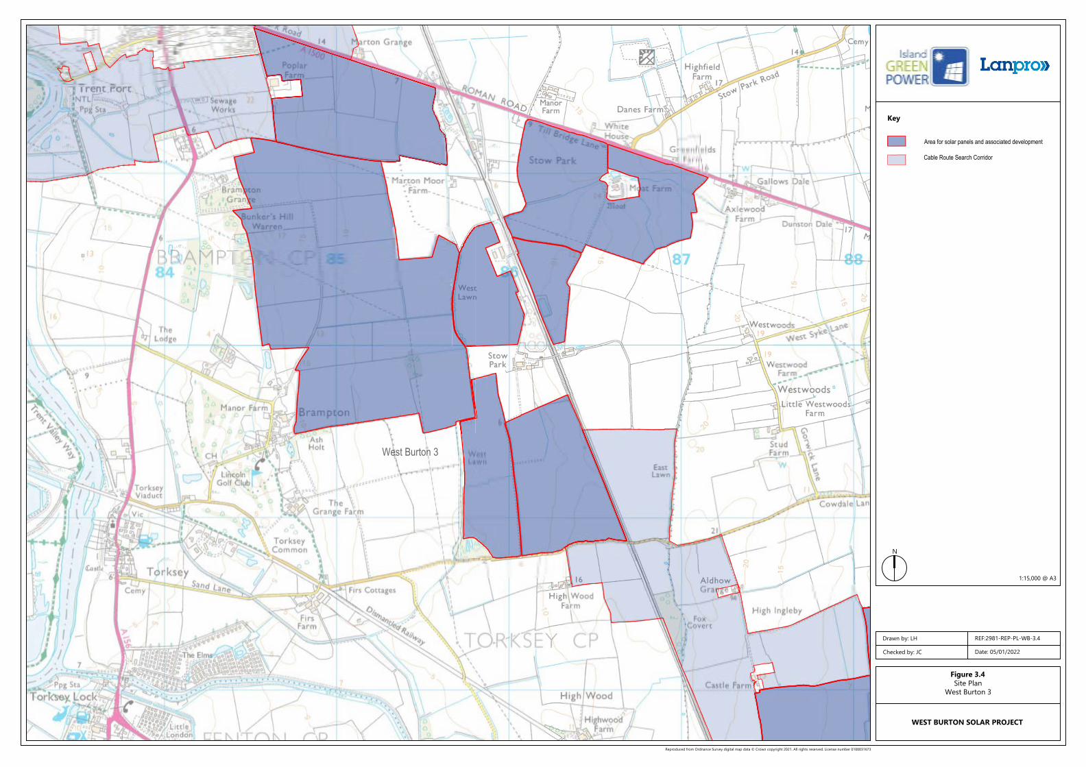
Figure 3.4 Site Plan: West Burton 3
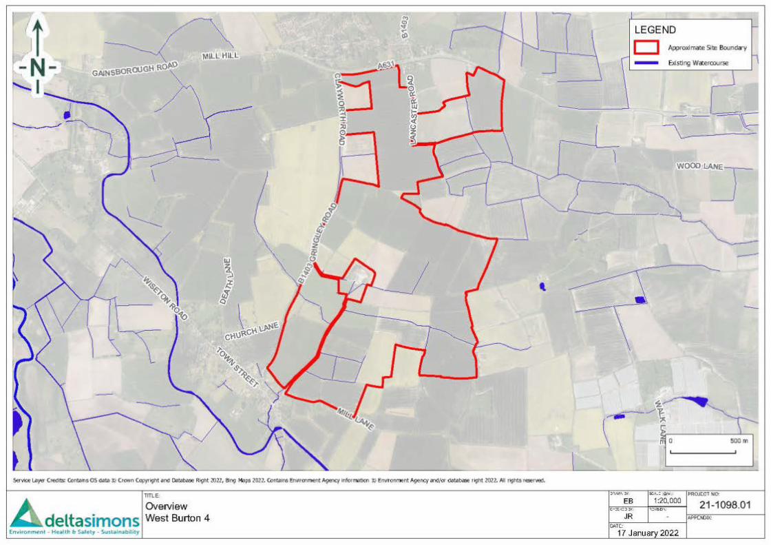
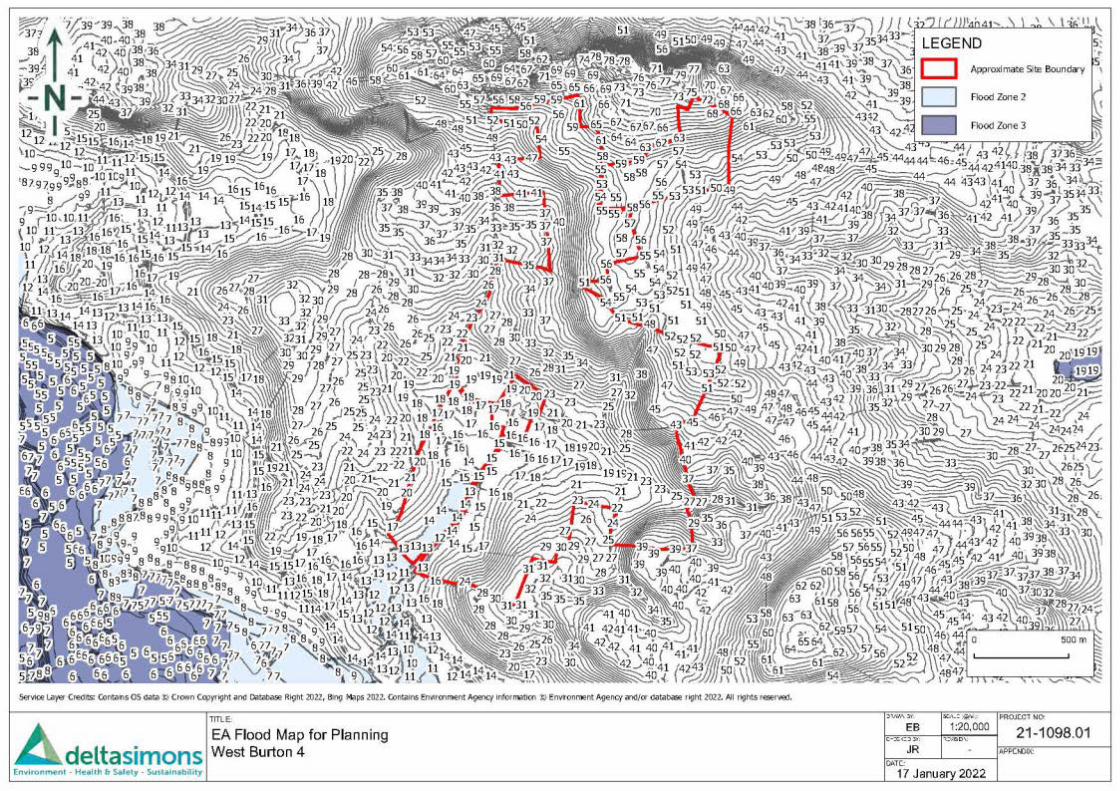
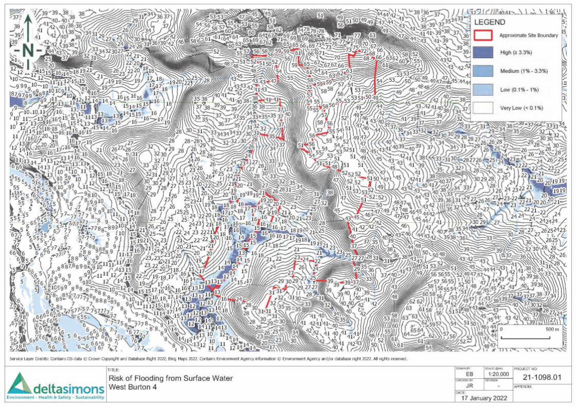
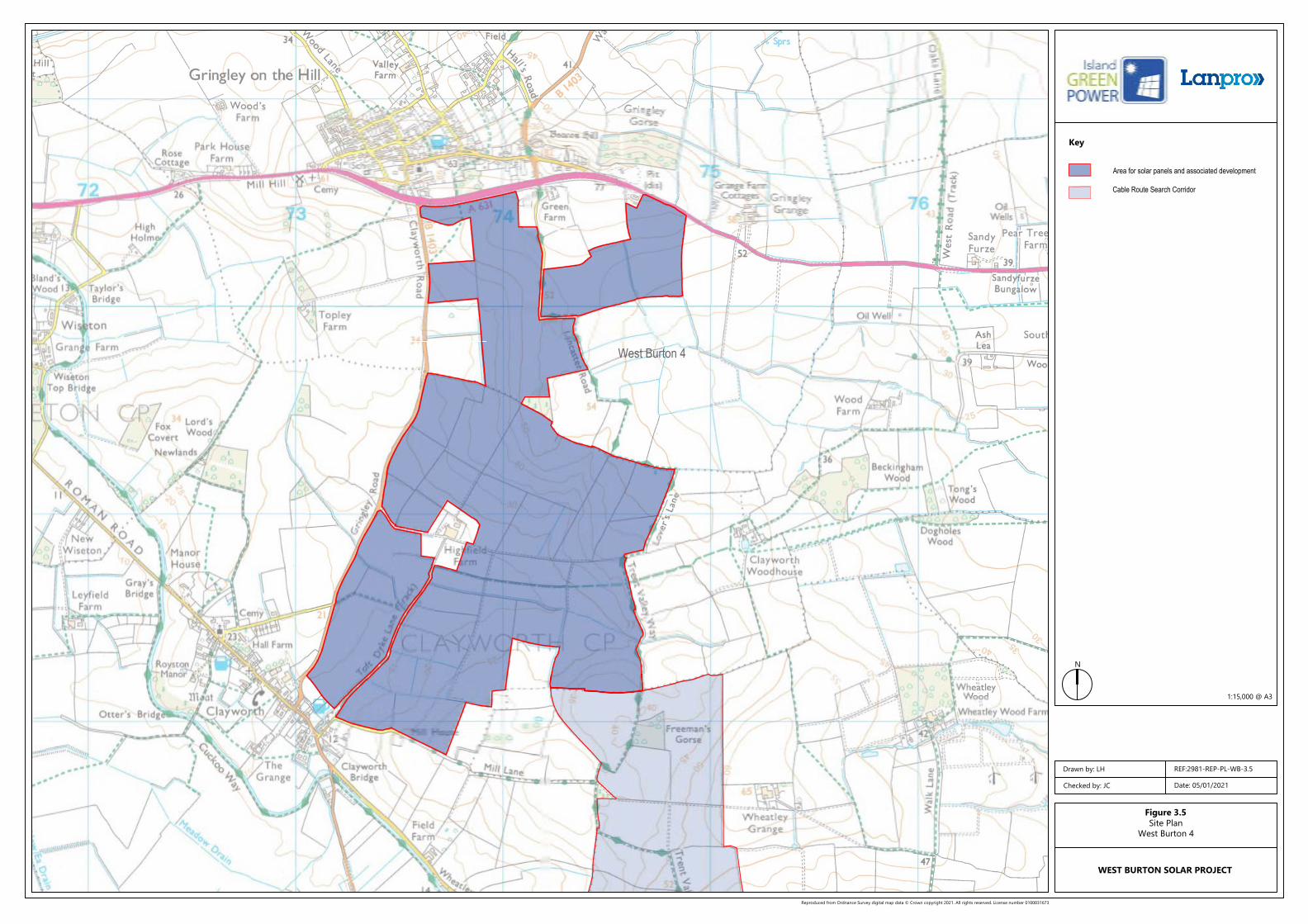
Figure 3.5 Site Plan: West Burton 4
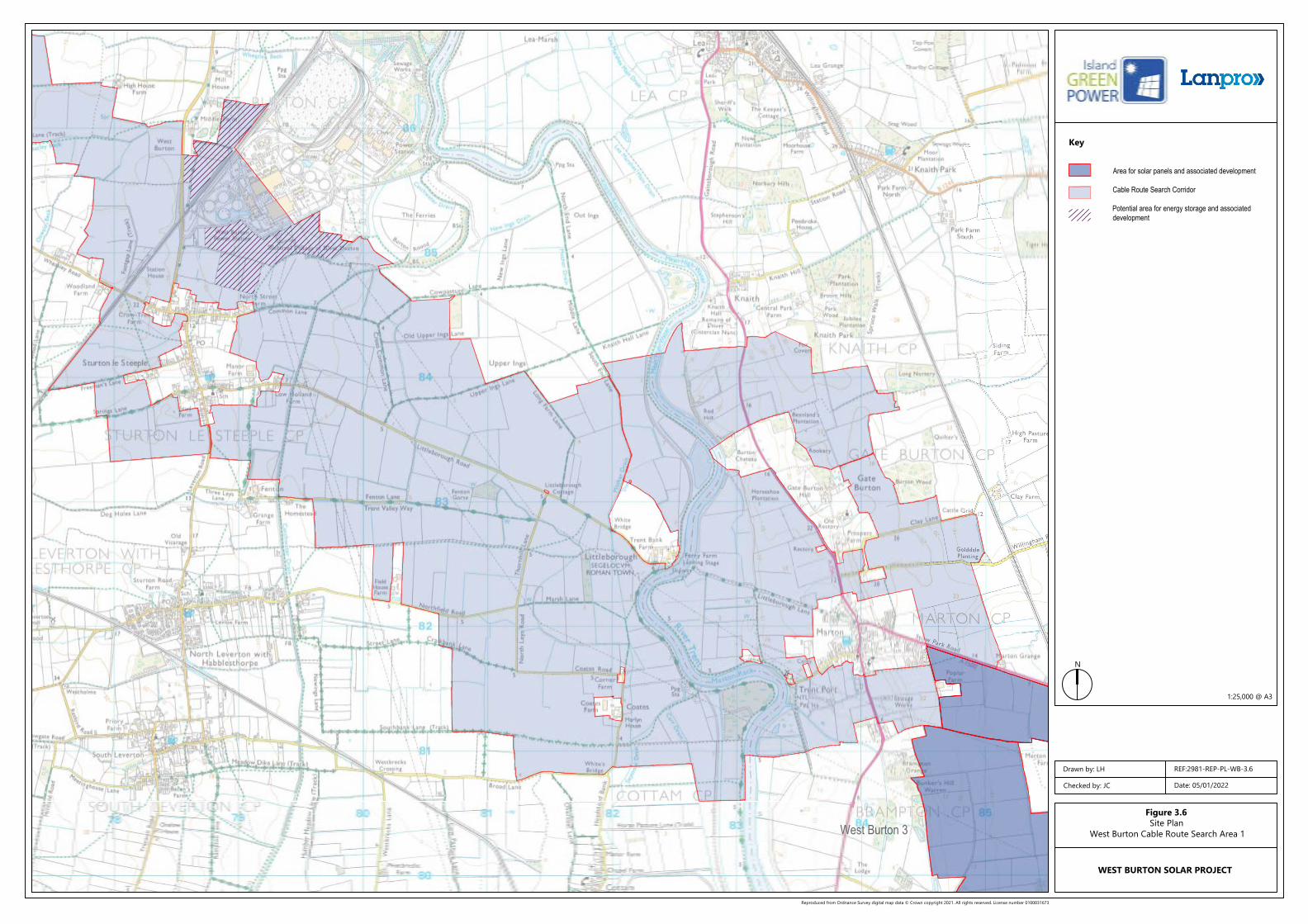
Figure 3.6 Site Plan: West Burton Cable Route Search Area 1
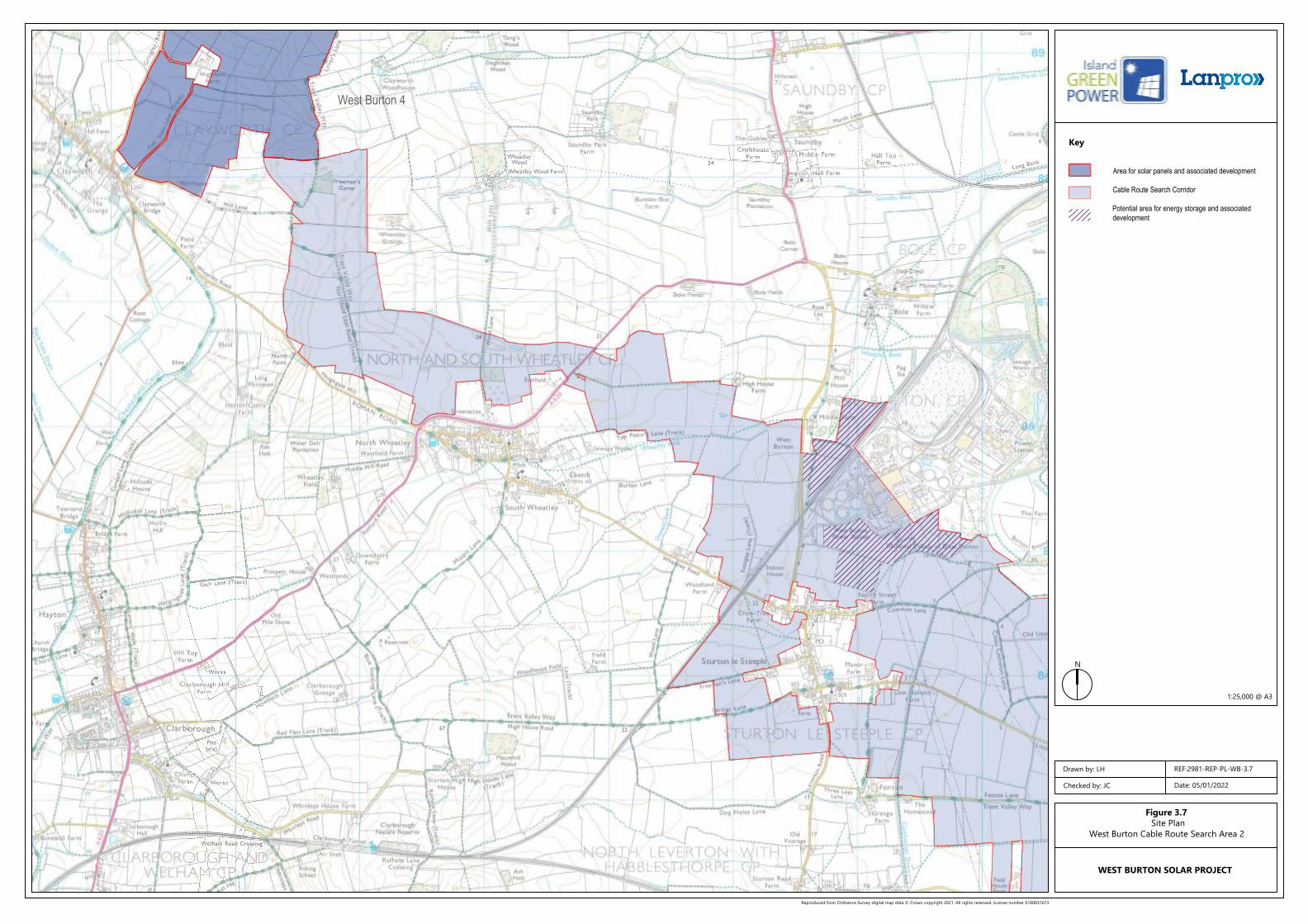
Figure 3.7 Site Plan: West Burton Cable Route Search Area 2
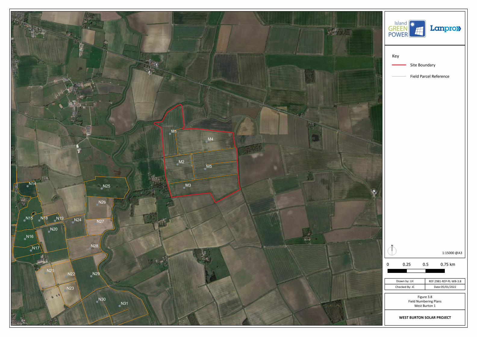
Figure 3.8 Field Parcel Numbering Plan: West Burton 1
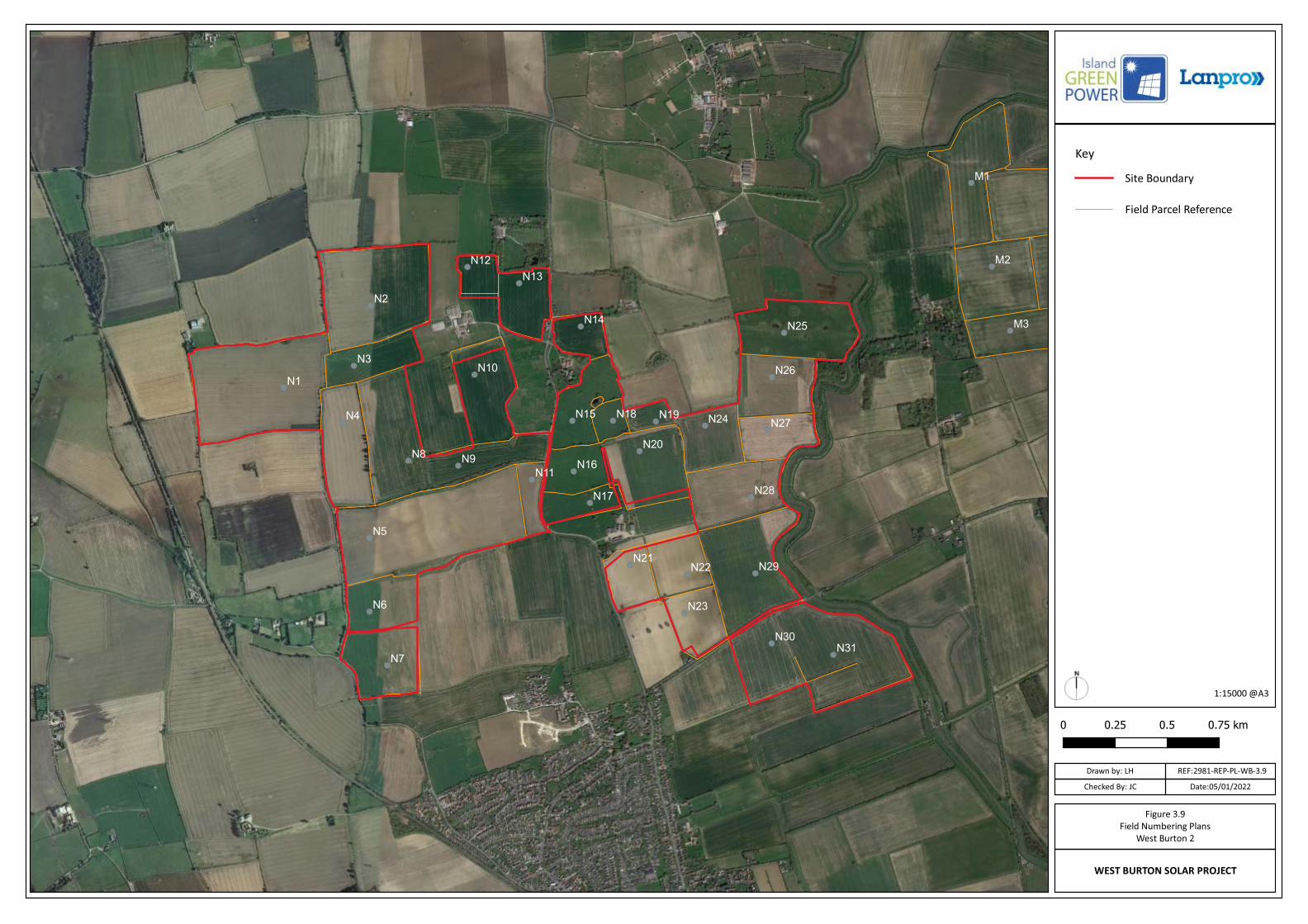
Figure 3.9 Field Parcel Numbering Plan: West Burton 2
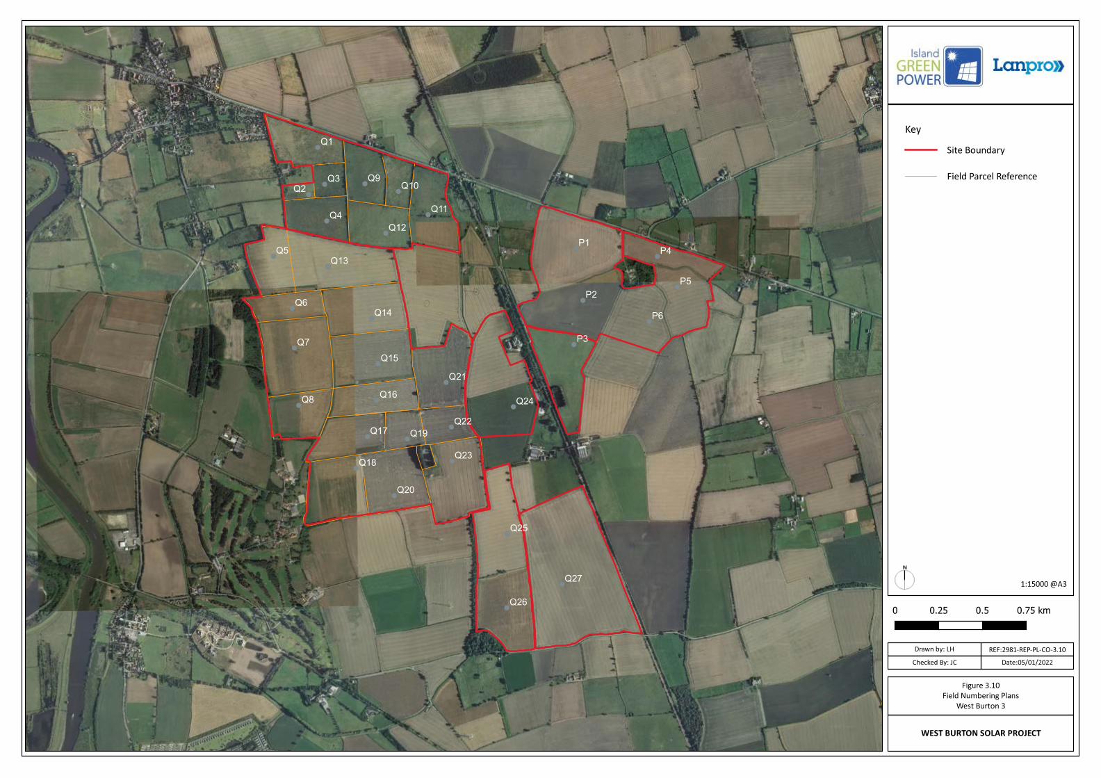
Figure 3.10 Field Parcel Numbering Plan: West Burton 3
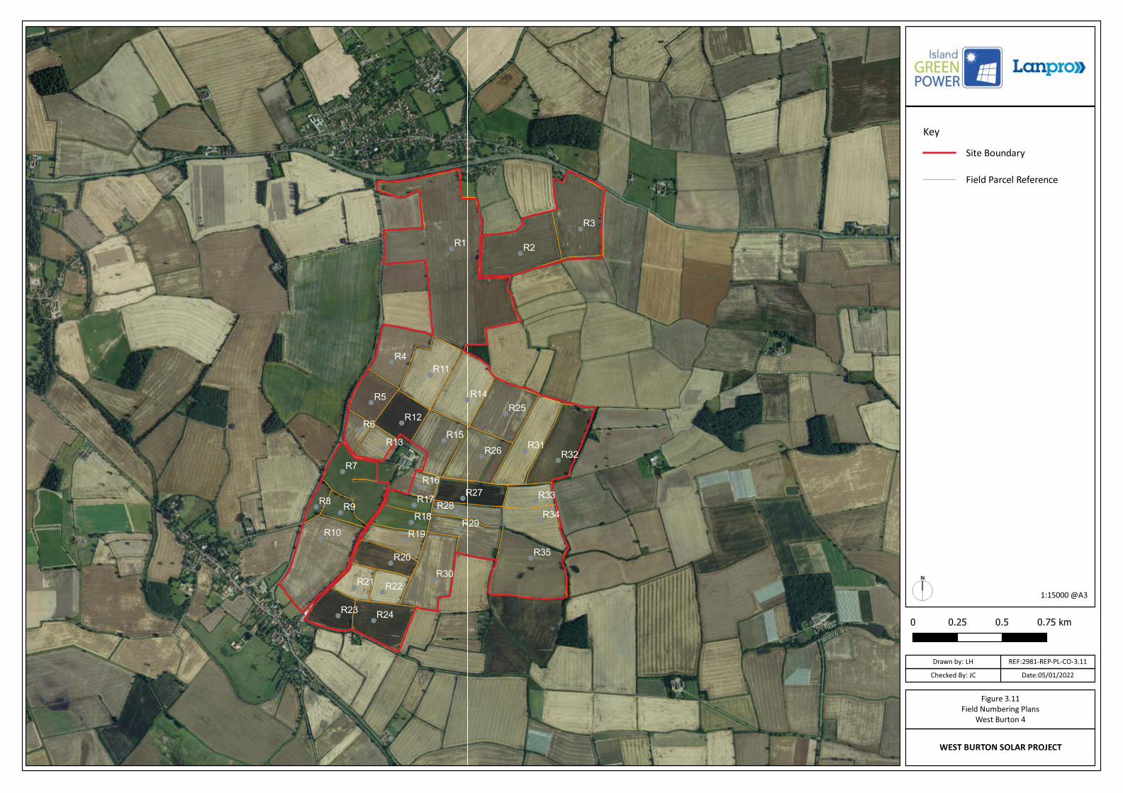
Figure 3.11 Field Parcel Numbering Plan: West Burton 4
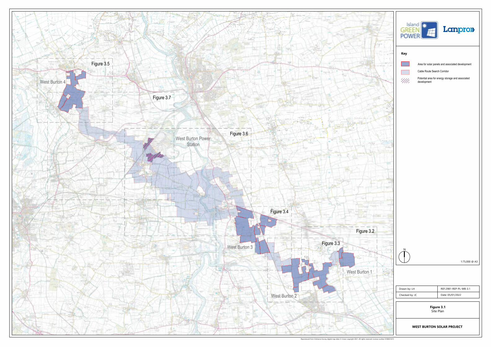
Area for solar panels and associated development
Cable Route Search Corridor
Potential area for energy storage and associateddevelopment
Reproduced from Ordnance Survey digital map data © Crown copyright 2021. All rights reserved. License number 0100031673
Key
N
Figure 3.1Site Plan
WEST BURTON SOLAR PROJECT
Drawn by: LH
Checked by: JC Date: 05/01/2022
1:75,000 @ A3
West Burton PowerStation
West Burton 1
West Burton 2
West Burton 3
West Burton 4
REF:2981-REP-PL-WB-3.1
Figure 3.2
Figure 3.3
Figure 3.4
Figure 3.6
Figure 3.7
Figure 3.5
Area for solar panels and associated development
Cable Route Search Corridor
Reproduced from Ordnance Survey digital map data © Crown copyright 2021. All rights reserved. License number 0100031673
Key
N
Figure 3.2Site Plan
West Burton 1
WEST BURTON SOLAR PROJECT
Drawn by: LH
Checked by: JC Date: 05/01/2022
1:15,000 @ A3
West Burton 1
West Burton 2
REF:2981-REP-PL-WB-3.2
Area for solar panels and associated development
Cable Route Search Corridor
Reproduced from Ordnance Survey digital map data © Crown copyright 2021. All rights reserved. License number 0100031673
Key
N
Figure 3.3Site Plan
West Burton 2
WEST BURTON SOLAR PROJECT
Drawn by: LH
Checked by: JC Date: 05/01/2022
1:15,000 @ A3
West Burton 1
West Burton 2
REF:2981-REP-PL-WB-3.3
Area for solar panels and associated development
Cable Route Search Corridor
Reproduced from Ordnance Survey digital map data © Crown copyright 2021. All rights reserved. License number 0100031673
Key
N
Figure 3.4Site Plan
West Burton 3
WEST BURTON SOLAR PROJECT
Drawn by: LH
Checked by: JC Date: 05/01/2022
1:15,000 @ A3
West Burton 3
REF:2981-REP-PL-WB-3.4
Area for solar panels and associated development
Cable Route Search Corridor
Reproduced from Ordnance Survey digital map data © Crown copyright 2021. All rights reserved. License number 0100031673
Key
N
Figure 3.5Site Plan
West Burton 4
WEST BURTON SOLAR PROJECT
Drawn by: LH
Checked by: JC Date: 05/01/2021
1:15,000 @ A3
West Burton 4
REF:2981-REP-PL-WB-3.5
Area for solar panels and associated development
Cable Route Search Corridor
Potential area for energy storage and associateddevelopment
Reproduced from Ordnance Survey digital map data © Crown copyright 2021. All rights reserved. License number 0100031673
Key
N
Figure 3.6Site Plan
West Burton Cable Route Search Area 1
WEST BURTON SOLAR PROJECT
Drawn by: LH
Checked by: JC Date: 05/01/2022
1:25,000 @ A3
West Burton 3
REF:2981-REP-PL-WB-3.6
Area for solar panels and associated development
Cable Route Search Corridor
Potential area for energy storage and associateddevelopment
Reproduced from Ordnance Survey digital map data © Crown copyright 2021. All rights reserved. License number 0100031673
Key
N
Figure 3.7 Site Plan
West Burton Cable Route Search Area 2
WEST BURTON SOLAR PROJECT
Drawn by: LH
Checked by: JC Date: 05/01/2022
1:25,000 @ A3
West Burton 4
REF:2981-REP-PL-WB-3.7
WEST BURTON SOLAR PROJECT
Figure 3.8Field Numbering Plans
West Burton 1
Site Boundary
Field Parcel Reference
Key
Drawn by: LH
Checked By: JC Date:05/01/2022
1:15000 @A3
REF:2981-REP-PL-WB-3.8
WEST BURTON SOLAR PROJECT
Figure 3.9Field Numbering Plans
West Burton 2
Site Boundary
Field Parcel Reference
Key
Drawn by: LH
Checked By: JC Date:05/01/2022
1:15000 @A3
REF:2981-REP-PL-WB-3.9
WEST BURTON SOLAR PROJECT
Figure 3.10Field Numbering Plans
West Burton 3
Site Boundary
Field Parcel Reference
Key
Drawn by: LH
Checked By: JC Date:05/01/2022
1:15000 @A3
REF:2981-REP-PL-CO-3.10
WEST BURTON SOLAR PROJECT
Figure 3.11Field Numbering Plans
West Burton 4
Site Boundary
Field Parcel Reference
Key
Drawn by: LH
Checked By: JC Date:05/01/2022
1:15000 @A3
REF:2981-REP-PL-CO-3.11
EIA Scoping Report Appendices to Chapter 5: Legislative Context and Energy
Policy
January 2022

West Burton Solar Project: EIA Scoping Report – Appendices January 2022
Contents
Appendix 5.1 Introduction 19
Appendix 5.2 Primary Legislation 19
Appendix 5.3 Energy Policy 19
West Burton Solar Project: EIA Scoping Report – AppendicesJanuary 2022
5.1 Introduction
5.1.1 The ES will contain a chapter on Legislative Context and Energy Policy.
5.1.2 Regard will be had to the primary legislation and Energy Policy, national planning polices and guidance, and local planning policies in establishing receptors, likely effects and potential mitigation.
5.2 Primary Legislation
5.2.1 The Planning Act 2008 (the Act) sets out the process for the consenting ofmajor infrastructure projects and is the principal legislation governing an application for development consent for a Nationally Significant Infrastructure Project (NSIP). The Act therefore forms the basis for the decision to grant a development consent order (DCO).
5.2.2 Under the Act the Scheme constitutes an NSIP if:
• it consists of “the construction or extension of a generating station” (Section 14(1)(a) of the Act);
• “it is in England” (Section 15(2)(a) of the Act); and
• “its capacity is more than 50 megawatts” (Section 15(2)(c) of the Act).
5.2.3 If a national policy statement (NPS) has effect in relation to the type of development to which the DCO relates then the Secretary of State must decide the DCO application in accordance with the relevant NPS (unless an exception applies) (Section 104 of the Act). If the DCO application relates to a type of development where no NPS has effect then the Secretary of State must have regard to the local impact report and any other important and relevant matters (Section 105 of the Act).
5.3 Energy Policy
5.3.1 National Policy Statements (NPS) set out the policy basis for NSIPs. At present, there is no NPS which specifically deals with ground mounted solar developments, and therefore Section 105 of the Act applies. However there are aspects of three Energy NPSs which are relevant to decision making and are important material considerations, in addition to other relevant and important national and local planning policies.. The Secretary of State will therefore have regard to: -
• National Policy Statement for Energy (EN-1);
• National Policy Statement for Renewable Energy Infrastructure (EN-3); and,
• National Policy Statement for Electricity Networks (EN-5)
5.3.2 It should be noted that the Department for Business, Energy and Industrial Strategy is currently undertaking a review of the six NPSs for energy infrastructure which was due to be complete by the end of 2021. As drafted the updated NPS EN3 on renewable energy has been expanded to provide policy on solar developments. Once the updated NPS EN3 has effect, the DCO application for the Scheme will be determined under s104 of the Act. Until the updated NPSs are designated, the existing NPSs remain the applicable national policy.
5.3.3
West Burton Solar Project: EIA Scoping Report – AppendicesJanuary 2022
5.3.4 However, as confirmed in paragraph 1.6.3 of draft NPS EN-1, any emerging draft NPSs (or those designated but not having effect) are potentially capable of being important and relevant considerations in the decision-making process. The extent to which they are relevant is a matter for the Secretary of State to consider within the framework of the Planning Act and with regard to the specific circumstances of each development consent order application. The relevant provisions of the emerging draft of NPS EN-3 are set out below for information and the relevant provisions of draft EN-1 and EN-5 will be included in the ES.
Adopted NPS EN-1: Energy
5.3.5 The key points from each of the five sections for these applications are set out below.
Part 1
5.3.6 This section introduces the role of the NPS in the planning system in providing national policy for energy infrastructure development, setting out the scope and geographic extent of the policies’ application. Thissection describes the relationship between the overarching policy set out in the rest of NPS EN-1 with the other five associated energy NPSs, and the way in which the Planning Inspectorate (PINS) will use the NPSs for decision making is set out.
Part 2
5.3.7 This confirms the Government’s commitments to meeting legally bindingtargets to reduce greenhouse gas emissions; acknowledges the need to transition to a low carbon economy; and emphasises the importance of maintaining a secure and reliable energy supply in that transition to a low carbon economy.
Part 3
5.3.8 The need for energy infrastructure is set out, confirming that the UK needsall the types of energy infrastructure covered in this NPS in order to achieve energy security at the same time as significantly reducing greenhouse gas emissions. The need is described as urgent.
5.3.9 The NPS is clear that NSIP applications should therefore be assessed onthe basis that the Government has already demonstrated that there is a need for those types of infrastructure and that the scale and urgency of that need is as described in NPS EN-1.
5.3.10 In considering the importance of the need for these projects the NPS isclear that the determining authority should give substantial weight to the contribution which projects would make towards satisfying this need for energy infrastructure when considering applications for development consent under the Planning Act 2008.
5.3.11 Part 3.4 of EN-1 covers renewable energy, including its importance intackling climate change, reducing carbon dioxide emissions and job creation.
Part 4
5.3.12 Part 4 covers the provisions to be covered in making an assessment of energy applications. Importantly, this includes:
• The determining authority should start with a presumption in favour of granting consent to applications for energy NSIPs. That presumption applies unless any more specific and relevant polices
West Burton Solar Project: EIA Scoping Report – AppendicesJanuary 2022
set out in the relevant NPSs clearly indicate that consent should be refused.
• In making a judgement, the determining authority shouldconsider the development’s potential benefits including its contribution to meeting the need for energy infrastructure, job creation and any long-term or wider benefits; and its potential adverse impacts, including any long-term and cumulative adverseimpacts, as well as any measures to avoid, reduce or compensate for any adverse impacts.
5.3.13 Development Consent Obligations should be relevant to planning, necessary to make the proposed development acceptable in planning terms, directly relates to the proposed development, fairly and reasonably related in scale and kind to the proposed development, and reasonable in all other respects.
5.3.14 Whilst applicants are required to consider alternatives through the EIA process, the NPS does not require this, and it states that there is no requirement to establish whether the proposed project represents thebest option.
5.3.15 Part 4 also covers design and capacity considerations, which are summarised below:
• Design: Applying “good design” to energy projects should produce sustainable infrastructure sensitive to place, efficient in the use of natural resources and energy used in their construction and operation, matched by an appearance that demonstrates goodaesthetic as far as possible. It is acknowledged, however that the nature of much energy infrastructure development will often limitthe extent to which it can contribute to the enhancement of the quality of the area.
• Capacity: The connection of a proposed electricity generation plant to the electricity network is an important consideration for applicants wanting to construct or extend generation plant. In the market system, it is for the applicant to ensure that there will be necessary infrastructure and capacity within an existing or planned transmission or distribution network to accommodate the electricity generated.
• Land Use: Justification should be provided for locating sites on best and most versatile (BMV) agricultural land and impacts on BMVagricultural land must be mitigated where it is affected.
• Landscape and Visual: Projects need to be designed carefully, having regard to siting, operational and other relevant constraintsthe aim should be to minimise harm to the landscape, providing reasonable mitigation where possible and appropriate.
• Biodiversity and Geological Conservation: Development should aim to avoid significant harm to biodiversity and geological conservation interests, including through mitigation andconsideration of reasonable alternatives. Where significant harm cannot be avoided, then appropriate compensation measures should be sought.
• Historic Environment: As part of the ES the applicant should provide a description of the significance of the heritage assets affected by the proposed development and the contribution of
West Burton Solar Project: EIA Scoping Report – AppendicesJanuary 2022
their setting to that significance. The level of detail should be proportionate to the importance of the heritage asset and no more than is sufficient to understand the potential impact of the proposal on the significance of the heritage asset. In considering the impact of the proposed development on any heritage asset, thedetermining authority should take into account the particular nature of the significance of the heritage assets and the value that they hold for this and future generations. This understanding should be used to avoid or minimise conflict between conservation of that significance and proposals for development.
• Dust, Odour and Artificial Lighting: Some impacts on amenity for local communities is likely to be unavoidable. The aim should be to keep impacts to a minimum, and at a level that is acceptable.
• Flood Risk: Projects should not increase the volume or flow rate of surface water leaving the site.
• Air Quality and Emissions: Where the project is likely to have adverse effects on air quality the applicant should undertake an assessment of the impacts of the proposed project as part of theEnvironmental Statement. This should cover emissions at different stages of the projects, including construction. Environmental impacts need to also be considered, including eutrophication.
• Socio Economic: Impacts should be considered through the ES. These should include services, infrastructure, tourism, phasing, population change and social cohesion and cumulative effects.
• Traffic and Transport: If the project is likely to have significant transport implications, the Environmental Statement should include a transport assessment. Impacts should be mitigated where possible.
• Water Quality: Where the project is likely to have effects on the water environment, the applicant should undertake an assessment of the existing status of, and impacts of the proposed project on, water quality, water resources and physical characteristics of the water environment as part of the ES or equivalent
Adopted NPS EN-3: Renewable Energy Infrastructure
5.3.16 EN-3 applies to renewable energy projects but does not cover ground mounted solar projects and therefore is not considered to be relevant to the Scheme as currently adopted.
Adopted NPS EN-5: Electricity Networks
5.3.17 EN-5 should be applied where an application includes an electricitygenerating station and any associated underground cables and substations therefore constitute associated development. Part 2 of the Statement outlines technical and assessment criteria, as well as outlining the technical relationship between existing electrical infrastructure and the location of new generating developments.
Draft revised National Policy Statement EN-3 ‘Renewable EnergyInfrastructure’
Description of Development and Flexibility
West Burton Solar Project: EIA Scoping Report – AppendicesJanuary 2022
5.3.18 Draft EN3 outlines the key considerations which should be had in relationto flexibility. The draft (p.85, paragraphs 2.49.14-2.49.17) outlines:
‘Many different makes and models of solar panel arrays are available, each with differing size, mounting, and generating capacity. Associated infrastructure (such as inverters or transformers) may also vary depending on the model of the panels.As set out in Chapter 4 of EN-1, at the time of application, solar farm operators may have multiple commercial agreements under consideration and may not know precisely which panels will be procured for the site until sometime after any consent has been granted. If panel details, or any other relevant information, are not available, then the applicant shouldassess the worst-case effects that the project could have (as set out in EN-1 paragraph 4.2.6) to ensure that the project as it may be constructed has been properly assessed. In this respect some flexibility should be provided in the consent.In the case of solar farms, it is likely that this flexibility will be needed in relation to the dimensions of the panels and their layout and spacing. It may also be the case that applicants seek flexibility for the installation of energy storage, with the option to install further panels as a substitute. When this is the case, applications may include a range of options based on different panel numbers, types, and layout, with and without storage. The maximum impact case scenario will be assessed, and the Secretary of State will consider the maximum adverse effects in its consideration of the application and consent.Where other specific details of the design of the site are uncertain at the time of application, this should be made clear by the applicant with the reasons for the uncertainty given. Where elements of the design of the scheme are unknown, the maximum impact case scenario should be assessed, and the Secretary of State should consider the maximum adverse effects in its consideration of the application and consent’.Temporary nature of solar farms
5.3.19 Draft EN3 outlines the key considerations which should be had in relationto the temporary nature of solar farms, and their decommissioning. The draft (pp.84-85, paragraphs 2.49.9-2.49.13) outlines:
‘Solar panels typically have a design life of between 25 and 30 years, although this can sometimes be longer, and can be decommissioned relatively easily and cheaply. Solar panel efficiency deteriorates over time and applicants may elect to replace panels during the lifetime of the site.Applicants may apply for consent for a specified period, based on the design life of the panels. Such consent, where granted, is described as temporary because there is a finite period for which it exists, after whichthe project would cease to have consent and therefore must seek to extend the period of consent or be decommissioned and removed.The nature and extent of decommissioning of a site can vary. Generally, the panel arrays and mounting structures will always be decommissioned with any underground cabling dug out to ensure that prior use of the site can continue.Applications should set out what would be decommissioned and removed from the site at the end of the operational life of the generating station.There may be some instances where it may be less harmful for theecology of the site to keep or retain certain types of infrastructure. Furthermore, there may be socio-economic benefits in retaining site
West Burton Solar Project: EIA Scoping Report – AppendicesJanuary 2022
infrastructure after the operational life, such as retaining pathways through the site or a site substation.Where the consent for a solar farm is to be time-limited, the DCO shouldimpose a requirement setting that time-limit from the date the solar farm starts to generate electricity. Such a requirement should also secure thedecommissioning of the generating station after the expiration of its permitted operation to ensure that inoperative plant is removed after its operational life. A limit of 25 years is typical, although applicants may seekconsent for differing time-periods for operation. The time-limited nature of solar farms, where a time-limit is sought by an applicant as a condition of consent, is likely to be an important consideration for the Secretary of State when assessing impacts such as landscape and visual effects and potential effects on the settings of heritage assets. Such judgements should include consideration of the period of time sought by the applicants for the generating station tooperate. The extent to which the site will return to its original state mayalso be a relevant consideration’.Site Selection
5.3.20 The Draft National Policy Statement for Renewable Energy Infrastructureoutlines what the Government consider to be the ‘key considerations involved in the siting of a solar farm’ (p.79, paragraph 2.48.1). They are generally representative of how the industry undertakes site selection:
Considerations 1 and 3: Irradiance and site topography and capacity of a site
Irradiance5.3.21 Draft EN3 (pp.79-80, paragraph 2.48.2-2.483) outlines:
‘Irradiance will be a key consideration for the applicant in identifying a potential site as the amount of electricity generated on site is directly affected by irradiance levels. Irradiance of a site will in turn be affected by surrounding topography, with an uncovered or exposed site of good elevation and favourable south-facing aspect more likely to increase year-round irradiance levels. This in turn affects the carbon emission savings and the commercial viability of the site.In order to maximise irradiance, applicants may choose a site and design its layout with variable and diverse panel aspects, and panel arrays may also follow the movement of the sun in order to further maximise the solar resource.’Capacity
5.3.22 Draft EN3 (pp.80-81, paragraphs 2.48.5-2.48.9) outlines:
‘In order for a solar farm to generate electricity efficiently, site layout must be designed so as to maximise irradiance levels, and the panel array spacing should also seek to maximise the potential power output of the site. The type, spacing and aspect of panel arrays will depend on the physical characteristics of the site such as site elevation. However, this is a matter for the applicant.Solar panels generate electricity in direct current (DC) form. A number of panels feed an external inverter, which is used to convert the electricity to alternating current (AC). After inversion a transformer will step-up the voltage for export to the grid. Because the inverter is separate from the panels, the total capacity of a solar farm can be measured either in terms
West Burton Solar Project: EIA Scoping Report – AppendicesJanuary 2022
of the combined capacity of installed solar panels (measured in DC) or in terms of combined capacity of installed inverters (measured in AC).For the purposes of determining the capacity thresholds in Section 15 of the 2008 Act, all forms of generation other than solar are currentlyassessed on an AC basis, while solar farms are assessed on their DC capacity. Having reviewed this matter, the Secretary of State is now content that this disparity should end, particularly as electricity from some other forms of generation is switched between DC and AC within a generator before it is measured. Therefore, from the date of designation of this NPS, for the purposes of Section 15, the combined capacity of the installed inverters (measured in AC) should be used for the purposes of determining solar site capacity. The capacity threshold is 50MW (AC) in England and 350MW (AC) in Wales.It should also be noted that the DC installed generating capacity of a solarfarm will decline over time in correlation with the reduction in panel arrayefficiency. Light induced degradation affects most solar panels and on average panels degrade at a rate of up to 1% each year. Applicants may account for this by overplanting solar panel arrays. Therefore, AC installed export capacity should not be seen as an appropriate tool to constrain the impacts of a solar farm. Other measurements, such as panel size, total area and percentage of ground cover should be used to set the maximumextent of development when determining the planning impacts of an application. Nothing in this section should be taken to change any development consent or other planning permission granted prior to the designation of this NPS. Any such permission should be interpreted on the basis upon which it was examined and granted. In particular, any permissions granted on the basis of a DC installed generating capacity should be built on that basis, unless an amendment is made to that permission and the difference in impacts is considered.’Consideration 2: Proximity of a site to dwellings
5.3.23 Draft EN3 (p.80, paragraph 2.48.4) outlines:
‘Utility-scale solar farms are large sites that may have a significant zone of visual influence. The two main impact issues that determine distances to sensitive receptors are therefore likely to be visual amenity and glint and glare. These are considered in Landscape, Visual and Residential Amenity (Section 2.51) and Glint and Glare (Section 2.52) impact sections below.’Consideration 4: Grid connection
5.3.24 Draft EN3 (p.81, paragraphs 2.48.10-2.48.12) outlines:
‘The connection of the proposed solar farm into the relevant electricitynetwork will be an important consideration for applicants of solar. The gridconnection text at Section 4.10 in EN-1 sets out the important issues.Most solar farms are connected into the local distribution network. The capacity of the local grid network to accept the likely output from a proposed solar farm is critical to the technical feasibility of a development and as such some larger developments may seek connection to the transmission network if there is available network capacity and/or supportive infrastructure. The connection voltage, availability of networkcapacity, and the distance from the solar farm to the existing network can have a significant effect on the commercial feasibility of a development proposal.
West Burton Solar Project: EIA Scoping Report – AppendicesJanuary 2022
The applicant may choose a site based on nearby available grid export capacity. Locating solar farms at places with grid connection capacity enables the applicant to maximise existing grid infrastructure, minimise disruption to local community infrastructure or biodiversity and reduce overall costs. Where this is the case, consideration should be given to the cumulative impacts of situating a solar farm in proximity to other energy generating stations and infrastructure’.Consideration 5: Agriculture land classification and land type
5.3.25 Draft EN3 (p.82, paragraphs 2.48.13-2.48.15) outlines:
‘Solar is a highly flexible technology and as such can be deployed on a wide variety of land types. Where possible, ground mounted Solar PV projects should utilise previously developed land, brownfield land, contaminated land, industrial land, or agricultural land preferably ofclassification 3b, 4, and 5 (avoiding the use of “Best and Most Versatile” cropland where possible). However, land type should not be apredominating factor in determining the suitability of the site location.The Agricultural Land Classification (ALC) is the only approved system forgrading agricultural quality in England and Wales and should be used to establish the ALC and identify the soil types to inform soil management at the construction, operation and decommissioning phases. This should be extended to the underground cabling and access routes. The soil survey may also inform the suitable beneficial use of the land during the operational phase. Criteria for grading the quality of agricultural land using the Agricultural Land Classification (ALC) of England and Wales is decidedby Natural England and considerations relating to land classification are expected to be made with reference to this guidance, or any successor to it.Whilst the development of ground mounted solar arrays is not prohibited on sites of agricultural land classified 1, 2 and 3a, or designated for their natural beauty, or recognised for ecological or archaeological importance, the impacts of such are expected to be considered and are discussedunder paragraphs 2.50 and 2.53. It is recognised that at this scale, it is likely that applicants’ developments may use some agricultural land, however applicants should explain their choice of site, noting the preference for development to be on brownfield and non-agricultural land’.Consideration 6: Accessibility
5.3.26 Draft EN3 (p.82, paragraph 2.48.16) outlines:
‘Applicants will need to consider the suitability of the access routes to the proposed site for both the construction and operation of the solar farm with the former likely to raise more issues. Section 5.14 of EN-1 advises on generic traffic and transport impacts while those which are specific tosolar farms are considered under Section 2.54 of this NPS. Given that potential solar farm sites are largely in rural areas, access for the delivery of solar arrays and associated infrastructure during construction can be a significant consideration for solar farm siting.’Site Layout, Design and Appearance
5.3.27 Draft EN3 (pp.83-84, paragraphs 2.49.3-2.49.8) outlines:
‘Developers will consider several factors when considering the location and layout of sites including levels of solar irradiance, proximity to available grid capacity to accommodate the scale of generation, predominance of
West Burton Solar Project: EIA Scoping Report – AppendicesJanuary 2022
open land, topography (a flat topography is often favoured), previous land use and ability to mitigate environmental impacts and any flood risk.In terms of design and layout, developers may favour a south-facing arrangement of panels to maximise output although other orientations may be chosen. For example, an east-west layout, whilst likely to result in reduced output compared to south-facing panels on a panel-by-panel basis, may allow for a greater density of panels to compensate andtherefore for generation to be spread more evenly throughout the day.Considering the likely extent of solar sites, it is possible that proposed developments may affect the provision of local footpath networks and public rights of way. Public rights of way may need to be temporarilystopped up to enable construction; however it should be the applicant’sintention, where practicable and safe, to keep all public rights of way that cross the proposed development site open during construction and to protect users where a public right of way borders or crosses the site. Developers are encouraged to design the layout and appearance of the site to ensure continued recreational use of public rights of way, where possible during construction, but in particular across the operation of the site, and to minimise as much as possible the visual outlook from existing footpaths. It should be noted that sites may provide the opportunity to facilitate enhancements to the local footpath network and the adoption of new public rights of way through site layout and design of access.It is anticipated that detail on how public rights of way would be managed to ensure they are safe to use is detailed in an outline Public Rights of Way Management Plan.It is likely that extensive underground cabling will be required to connect the electrical assets of the site, such as from the substation to the panel arrays or storage facilities. In the case of underground cabling, developers are expected to provide a method statement describing cable trench design, installation methodology, as well as details of the operation and maintenance regime.Security of the site is likely to be a key consideration for developers. When considering sites, developers may wish to consider the availability of natural defences such as steep gradients, hedging and rivers. Perimeter security measures such as fencing, electronic security, CCTV and lighting may also be needed, with the measures chosen considered on a site-specific basis. The visual impact of these security measures, as well as theimpacts on local residents, including for example issues relating to intrusion from CCTV and light pollution in the vicinity of the site, should be assessed’.Landscape and Arboriculture
5.3.28 Draft EN3 section 2.51 outlines:
‘Generic landscape and visual impacts are covered in Section 5.10 of EN-1. In addition, there are specific considerations which apply to solar panels,which are set out in the following paragraphs.The approach to assessing cumulative landscape and visual impact of large-scale solar farms is likely to be the same as assessing other onshore energy infrastructure. Solar farms are likely to be in low lying areas of good exposure and as such may have a wider zone of visual influence than other types of onshore energy infrastructure. However, whilst it may be the case that the development covers a significant surface area, in the case of ground-mounted solar panels it should be noted that with
West Burton Solar Project: EIA Scoping Report – AppendicesJanuary 2022
effective screening and appropriate land topography the area of a zone of visual influence could be zero.Applicant’s assessmentThe applicant should carry out a landscape and visual assessment and report it in the ES. Visualisations may be required to demonstrate the effects of a proposed solar farm on the setting of heritage assets and any nearby residential areas or viewpoints.Applicants should follow the criteria for good design set out in Section 4.6 of EN-1 when developing projects and will be expected to direct considerable effort towards minimising the landscape/visual impact of solar PV arrays. Whilst there is an acknowledged need to ensure solar PV installations are adequately secured, required security measures such as fencing should consider the need to minimise the impact on the landscape and visual impact.The applicant should have regard in both the design layout of the solar farm, and future maintenance plans, to the retention of growth of vegetation on boundaries, including the opportunity for individual trees within the boundaries to grow on to maturity. The landscape and visualimpact should be considered carefully at the pre-application stage. Existinghedges and established vegetation, including mature trees, should be retained wherever possible. Trees and hedges should be protected during construction. The impact of the proposed development on established trees and hedges should be informed by a tree survey or a hedge assessment as appropriate.MitigationApplicants should consider the potential to mitigate landscape and visual impacts through, for example, screening with native hedges. Efforts should be made to minimise the use and height of security fencing. Where possible projects should utilise existing features, such as hedges orlandscaping, to screen security fencing and use natural features, such as vegetation planting, to assist in site security. Projects should minimise the use of security lighting. Any lighting should utilise a passive infra-red (PIR) technology and should be designed and installed in a manner which minimises impact.Secretary of State decision makingThe Secretary of State will consider visual impact of any proposed solar PV farm, taking account of any sensitive visual receptors, and the effect of the development on landscape character, together with the possible cumulative effect with any existing or proposed development’.Ecology and Biodiversity
5.3.29 Draft EN3 section 2.50 outlines:
‘Generic biodiversity, ecology and geological impacts are covered in Section 5.4 of EN-1. In addition, there are specific considerations which apply to solar farms as set out below.AssessmentThe applicant’s ecological assessments should identify any ecological risk from developing on the proposed site. Issues that may need assessment include habitats, ground nesting birds, wintering birds, bats, dormice, reptiles, great crested newts, water voles and badgers. The use of anadvising ecologist during the design process can ensure that adverse
West Burton Solar Project: EIA Scoping Report – AppendicesJanuary 2022
impacts are mitigated, and biodiversity enhancements are maximised, although this is a decision for the individual applicant. The assessment may be informed by a ‘desk study’ of existing ecological records, an evaluation of the likely impacts of the solar farm upon ecological features and shouldspecify mitigation to avoid or minimise these impacts, and any further surveys required.The assessment should consider earthworks associated with construction compounds, access roads and cable trenching. Where such soil stripping occurs topsoil and subsoil should be stripped, stored, and replaced separately in order to minimise soil damage and to provide optimal conditions for site restoration. Soil handling may be informed through a soil and Agricultural Land Classification (ALC) survey, with detailed guidance available in Defra’s guidance on Construction Code of Practice for the Sustainable Use of Soils on Construction Sites46 or any subsequent updates.The assessment should consider how security and lighting installations may impact on the local ecology. Where pole mounted CCTV facilities are proposed the location of these facilities should be carefully considered in order to minimise impact. If lighting is necessary, it should be minimisedand directed away from areas of likely habitat.The assessment should consider how site boundaries are managed. If any hedges/scrub are to be removed, further surveys may be necessary to account for impacts. Buffer strips between perimeter fencing and hedges may be proposed, and the construction and design of any fencing should account for enabling mammal, reptile and other fauna access into the site if required to do so in the ecological report.The assessment should consider the impacts of mobile arrays or trackers (if proposed) to avoid animals becoming trapped in moving parts….The assessment should consider enhancement, management, and monitoring of biodiversity. Solar farms have the potential to increase the biodiversity value of a site, especially if the land was previously intensivelymanaged. In some instances, the increase in biodiversity caused by the repurposing of previously developed or intensely managed land for solar generation may equate to a net positive impact….MitigationProposed enhancements should take account of the above factors and as set out in Section 5.4 of EN1 and aim to achieve environmental and biodiversity net gain in line with the ambition set out in the 25 Year Environment Plan. This might include maintaining or extending existing habitats and potentially creating new important habitats, for example by instating: cultivated strips/plots for rare arable plants, rough grassland margins, bumble bee plant mixes, and wild bird seed mixes. It is advised that an ecological monitoring programme is developed to monitor impacts upon the flora of the site and upon any particular ecological receptors (e.g., bats and wintering birds). Results of the monitoring will then inform any changes needed to the land management of the site, including, if appropriate, any livestock grazing regime.Secretary of State decision making……In addition to Section 5.4 of EN-1 there are specific considerations which should inform Secretary of State decision-making where developments
West Burton Solar Project: EIA Scoping Report – AppendicesJanuary 2022
are proposed on peat. In these cases, the Secretary of State should be satisfied that the solar farm layout and construction methods have been designed to minimise soil disturbance when building and maintaining roads and tracks and other infrastructure. This is to ensure the development will result in minimal disruption to the ecology, or release of CO2 and that the carbon balance savings of the scheme are maximised’.Built Heritage and Archaeology
5.3.30 Draft EN3 section 2.53 outlines:
‘Historic environment impacts are covered in Section 5.9 of EN-1. However, with respect to solar farms, the following considerations also apply.The impacts of solar PV developments on the historic environment willrequire expert assessment in most cases. Solar PV developments may affect heritage assets (sites, monuments, buildings, and landscape) bothabove and below ground. Above ground impacts may include the effects of applications on the setting of Listed Buildings and other designated heritage assets as well as on Historic Landscape Character. Below ground impacts may include direct impacts on archaeological deposits through ground disturbance associated with trenching, cabling, foundations, fencing, temporary haul routes etc. Equally archaeological finds may be protected by a solar PV farm as the site is removed from regular ploughing and shoes or low-level piling is stipulated.Applicant’s assessmentIt is anticipated that the applicant’s assessment will be informed by aconsultation with the Historic Environment Record (HER). Alternatively, the applicant may contact the local authority for this information. Where a site on which development is proposed includes or has the potential to include heritage assets with archaeological interest, the applicant should submit an appropriate desk-based assessment and, where necessary, a fieldevaluation. These are expected to be carried out, using expertise where necessary and in consultation with the local planning authority, and should identify archaeological study areas and propose appropriate schemes of investigation, and design measures, to ensure the protection of relevant heritage assets.In some instances, field studies may include investigative work such as trial trenching beyond the boundary of the proposed site to assess the impacts of any underground cabling on archaeological assets. The extent of investigative work should be proportionate to the sensitivity of, and extent of proposed cabling in, the associated study area.Applications should take account of the results of historic environment assessments in their design, for instance through the sensitive planning ofinstallations. The applicant should consider what steps can be taken to ensure heritage assets are conserved in a manner appropriate to their significance, including the impact of proposals on views important to their setting. As the significance of a heritage asset derives not only from its physical presence, but also from its setting, careful consideration should begiven to the impact of large-scale solar farms on such assets. Depending on their scale, design and prominence, a large-scale solar farm within thesetting of a heritage asset may cause substantial harm to the significanceof the asset. Visualisations may be required to demonstrate the effects of a proposed solar farm on the setting of heritage assets.Mitigation
West Burton Solar Project: EIA Scoping Report – AppendicesJanuary 2022
The ability of the applicants to microsite specific elements of the proposed development during the construction phase should be an important consideration by the Secretary of State when assessing the risk of damage to archaeology. Therefore, where requested by the applicant, the Secretary of State should consider granting consents which allow for the micro siting within a specified tolerance of elements of the permitted infrastructure so that precise locations can be amended during the construction phase in the event that unforeseen circumstances, such as the discovery of previously unknown archaeology, arise.Secretary of State decision makingConsistent with the generic policy on historic environmental impacts in EN1 (Section 5.9) the Secretary of State should be satisfied that solar farms and associated infrastructure have been designed sensitively taking into account known heritage assets and their status.Solar farms are generally consented on the basis that they will be time-limited in operation. The Secretary of State should therefore consider the length of time for which consent is sought when considering the impacts of any indirect effect on the historic environment, such as effects on the setting of designated heritage assets’.Flood Risk and Drainage
5.3.31 Draft EN3 section 2.50 outlines:
‘The applicant’s assessment may be accompanied by a Flood Risk Assessment. This will need to consider the impact of drainage. As solar PV panels will drain to the existing ground, the impact will not in general be significant. Where access tracks need to be provided, permeable tracks should be used, and localised Sustainable Drainage Systems (SuDS), such as swales and infiltration trenches, should be used to control any run-offwhere recommended. Given the temporary nature of solar PV farms, sites should be configured or selected to avoid the need to impact on existing drainage systems and watercourses. Culverting existing watercourses/drainage ditches should be avoided. Where culverting for access is unavoidable, it should be demonstrated that no reasonablealternatives exist and where necessary it will only be in place temporarily for the construction period…The applicant should consider whether they need to provide geotechnical and hydrological information (such as identifying the presence of peat at each site) including the risk of landslide connected to any development work…Secretary of State decision makingWater management is a critical component of site design for groundmount solar plants. Where previous management of the site has involved intensive agricultural practice, solar sites can deliver significant ecosystem services value in the form of drainage, flood attenuation, natural wetland habitat, and water quality management. The maximum impact case scenario will be assessed, and the Secretary of State will consider the maximum adverse effects in its consideration of the application and consent’.Highways and Access
5.3.32 Draft EN3 (p.83, paragraph 2.49.2) outlines:
West Burton Solar Project: EIA Scoping Report – AppendicesJanuary 2022
‘Applicants will sometimes need to construct access tracks to connect solar farms to the public road network. Applications should include the full extent of the access tracks necessary and an assessment of their effects. Developers will usually need to construct on-site access routes for operation and maintenance activities, such as footpaths, earthworks or landscaping. Applications should include the full extent of the access routes for operation and maintenance and their effects’.
5.3.33 Draft EN3 section 2.54 outlines:
‘Generic traffic and transport impacts are covered in EN-1, Section 5.14. In addition, there are specific considerations which apply to solar farms as set out below. Public perception of the construction phase of solar farm will derive mainly from the effects of traffic movements. Many solar farms will be sited in areas served by a minor road network. Modern solar farms are large sites that are mainly comprised of small structures that can be transported separately and constructed on-site. It is likely that applicants will designate a construction compound on-site for the delivery and assemblage of the necessary components. Traffic is likelyto involve smaller vehicles than typical onshore energy infrastructure but may be more voluminous. It is important that all sections of roads andbridges on the proposed delivery route can accommodate the weight and volume of the loads. Applicant’s assessment The applicant should have assessed the various potential routes to the site for delivery of materials and components where the source of the materials is known at the time of the application and selected the route that is the most appropriate. It is possible that the exact location of the source of construction materials, such as crushed stone or concrete will not be known at the time of the application to the Secretary of State. Inthese circumstances, the impact of additional vehicles on the likelypotential routes should have been assessed. The applicant should assess whether the access roads are suitable for the transportation of components which will include whether they are sufficiently wide for the proposed vehicles, or bridges sufficiently strong for the heavier components to be transported to the site. It is unlikely that sections of the route will require modification to allow for the transportation of components to the site, given the nature of solar developments, but any potential modifications should be identified, and potential effects assessed as part of the ES. There may be several other energy infrastructure developments proposed that use a common port and/or access route and pass through the same towns. It is common for solar farms to locate where there is existing or surplus grid capacity, for instance. Where a cumulative impact is likely then a cumulative transport assessment should form part of the ES to considerthe impacts of abnormal traffic movements relating to the project in question in combination with those from any other relevant development. Consultation with the relevant local highways authorities is likely to be necessary.MitigationIn some cases, the local highways authority may request that the Secretary of State impose controls on the number of vehicle movements to and from the solar farm site in a specified period during its construction and, possibly, on the routeing of such movements particularly by heavy
West Burton Solar Project: EIA Scoping Report – AppendicesJanuary 2022
vehicles. Where the Secretary of State agrees that this is necessary considering all representations, this could be achieved by imposing suitable requirements on development consent.Where cumulative effects on the local road network or residential amenity are predicted from multiple solar farm developments, it may be appropriate for applicants for various projects to work together to ensure that the number of abnormal loads and deliveries are minimised, and the timings of deliveries are managed and coordinated to ensure that disruption to local residents and other highway users is reasonably minimised. It may also be appropriate for the highway authority to setlimits for and coordinate these deliveries through active management of the delivery schedules through the abnormal load approval process.Once consent for a scheme has been granted, applicants should liaise withthe relevant local highway authority (or other coordinating body) regarding the start of construction and the broad timing of deliveries. It may be necessary for an applicant to agree a planning obligation to secure appropriate measures, including restoration of roads and verges. It may be appropriate for any non-permanent highway improvements carried out for the development (such as temporary road widening) to be made available for use by other subsequent solar farm developments.Secretary of State decision makingConsistent with the generic policy set out in EN-1, the Secretary of Stateshould be satisfied, taking into account the views of the relevant local highway authorities, that if there are abnormal loads proposed, they can be safely transported in a way that minimises inconvenience to other road users and that the environmental effects of this and other construction traffic, after mitigation, are acceptable.Once solar farms are in operation, traffic movements to and from the site are generally very light, in some instances as little as a few visits each month by a light commercial vehicle or car. Should there be a need toreplace machine components, this may generate heavier commercialvehicle movements, but these are likely to be infrequent. Therefore, it is very unlikely that traffic or transport impacts from the operational phaseof a project would prevent it from being approved by the Secretary of State’.Glint and Glare
5.3.34 Draft EN3 section 2.52 outlines:
‘Solar panels may reflect the sun’s rays, causing glint and glare. Glint is defined as a momentary flash of light that may be produced as a direct reflection of the sun in the solar panel. Glare is a continuous source of excessive brightness experienced by a stationary observer located in thepath of reflected sunlight from the face of the panel. The effect occurswhen the solar panel is stationed between or at an angle of the sun and the receptor.In some instances, it may be necessary to seek a glint and glare assessment as part of the application. This may need to account for‘tracking’ panels if they are proposed as these may cause differential diurnal and/or seasonal impacts. The potential for solar PV panels, frames and supports to have a combined reflective quality should be assessed. This assessment needs to consider the likely reflective capacity of all of the materials used in the construction of the solar PV farm.
West Burton Solar Project: EIA Scoping Report – AppendicesJanuary 2022
MitigationApplicants should consider using, and in some cases the Secretary of State may require, solar panels to be of a non-glare/ non-reflective type and the front face of the panels to comprise of (or be covered) with a non-reflective coating for the lifetime of the permission.Secretary of State decision makingSolar PV panels are designed to absorb, not reflect, irradiation. However, the Secretary of State should assess the potential impact of glint and glare on nearby homes and motorists.There is no evidence that glint and glare from solar farms interferes in any way with aviation navigation or pilot and aircraft visibility or safety.Therefore, the Secretary of State is unlikely to have to give any weight to claims of aviation interference as a result of glint and glare from solar farms’.
EIA Scoping Report Appendix to Chapter 7:
Landscape and Visual
January 2022
West Burton Solar Project: EIA Scoping Report – Appendices January 2022
7.1 Landscape and Visual Figures
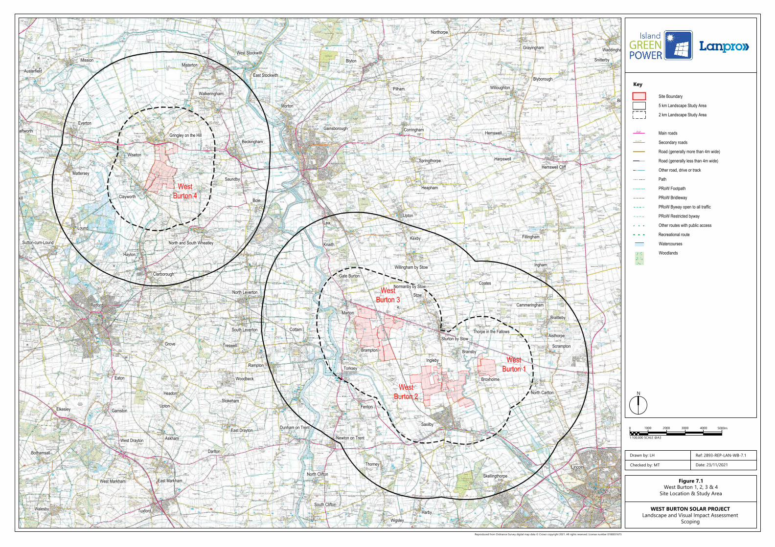
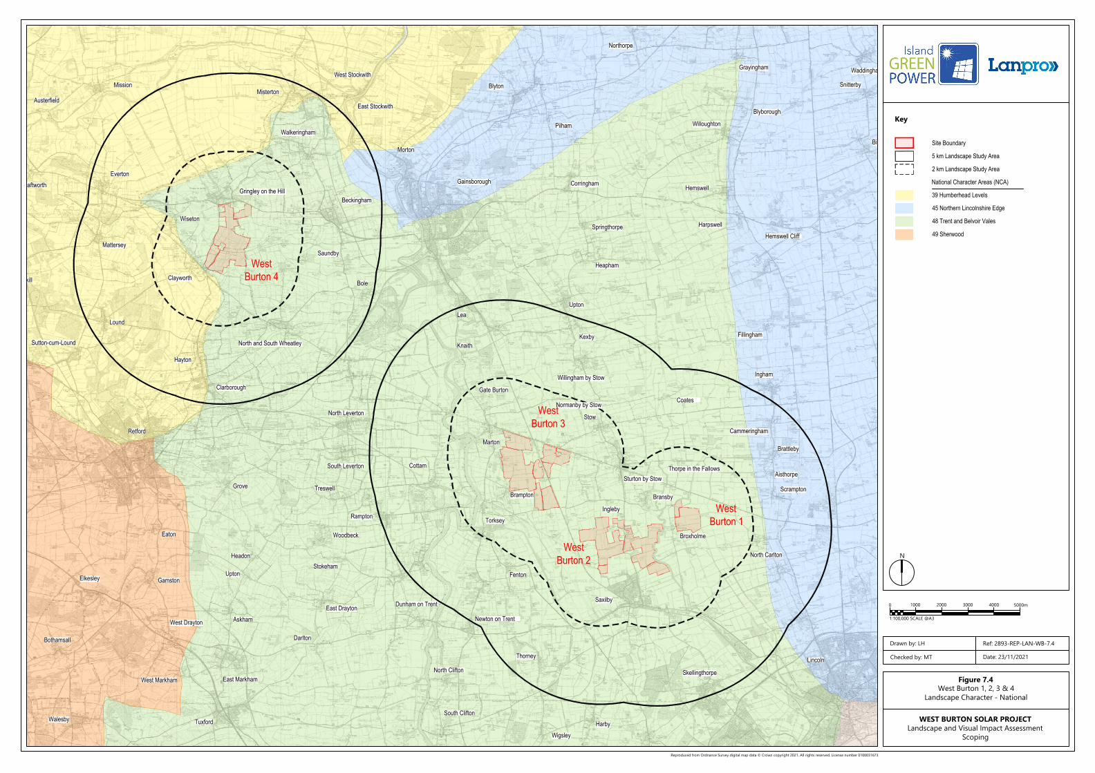
Figure 7.1 Site Location and Study Area
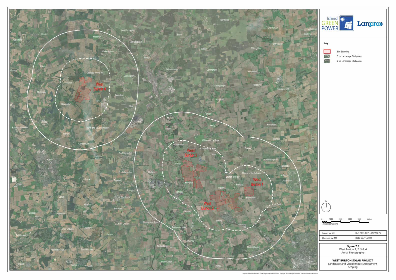
Figure 7.2 Aerial Photography
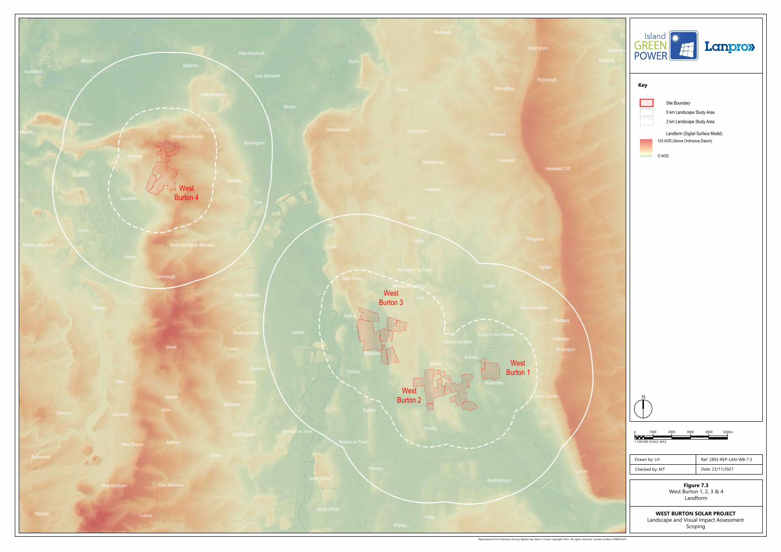
Figure 7.3 Landform
Figure 7.4 Landscape Character: National
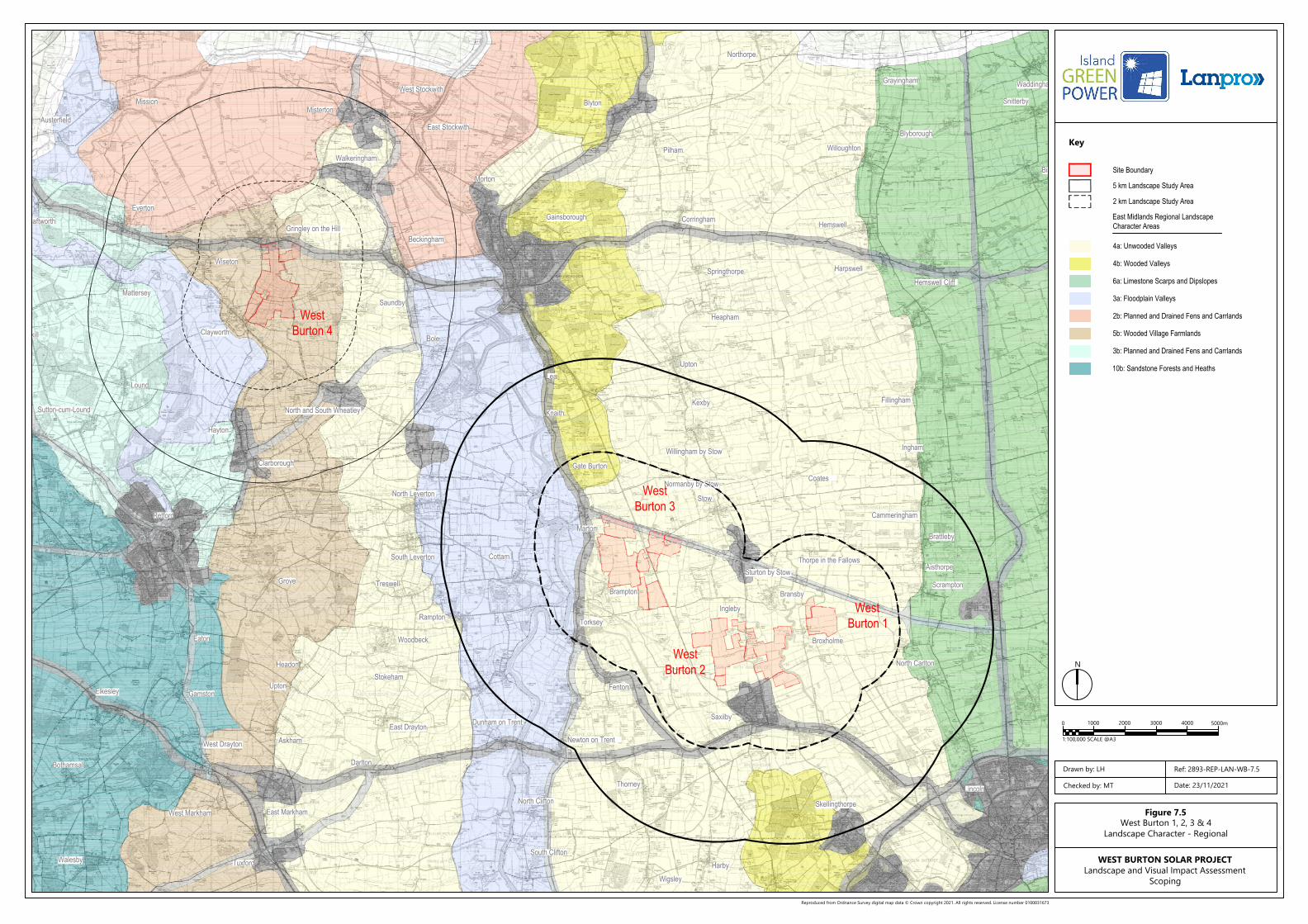
Figure 7.5 Landscape Character: Regional
Figure 7.6 Landscape Receptors
Figure 7.7 Visual Receptors
Figure 7.8 Bare Earth ZTV: West Burton 1
Figure 7.9 Bare Earth ZTV: West Burton 2
Figure 7.10 Bare Earth ZTV: West Burton 3
Figure 7.11 Bare Earth ZTV: West Burton 4
Figure 7.12 Augmented ZTV: West Burton 1
Figure 7.13 Augmented ZTV: West Burton 2
Figure 7.14 Augmented ZTV: West Burton 3
Figure 7.15 Augmented ZTV: West Burton 4
Misterton
Gainsborough
Springthorpe
Heapham
Corringham
Hemswell Cliff
Scrampton
Northorpe
Grayingham
Willoughton
Blyborough
Waddingham
Snitterby
Bishop Norton
Lincoln
HarbyWigsley
South Clifton
Darlton
Askham
Upton
Headon
Grove
Gamston
West Drayton
East Markham
Tuxford
West Markham
Walesby
Bothamsall
Elkesley
Eaton
Retford
Hayton
Clarborough
North and South WheatleySutton-cum-Lound
Lound
Mattersey
Ranskill Clayworth
Beckingham
Saundby
Wiseton
Gringley on the Hill
Everton
Walkeringham
Morton
East Stockwith
West StockwithBlyton
Pilham
Mission
Austerfield
Scaftworth Hemswell
Harpswell
UptonLea
Fillingham
Ingham
Aisthorpe
Brattleby
Bransby
Sturton by Stow
Stow
Cammeringham
Willingham by Stow
KexbyKnaith
Gate Burton
Cottam
Marton
Torksey
Brampton
Fenton
Ingleby
Broxholme
North Carlton
Coates
Skellingthorpe
Thorney
Newton on Trent
North Clifton
Dunham on TrentEast Drayton
Rampton
Woodbeck
Stokeham
Treswell
South Leverton
North Leverton
Bole
Saxilby
Thorpe in the Fallows
Normanby by Stow
3000200010000 4000 5000m
1:100,000 SCALE @A3
1:60,000 SCALE @ A3
Site Boundary
5 km Landscape Study Area
2 km Landscape Study Area
Main roads
Secondary roads
Road (generally more than 4m wide)
Road (generally less than 4m wide)
Other road, drive or track
Path
PRoW Footpath
PRoW Bridleway
PRoW Byway open to all traffic
PRoW Restricted byway
Other routes with public access
Recreational route
Watercourses
Woodlands
Reproduced from Ordnance Survey digital map data © Crown copyright 2021. All rights reserved. License number 0100031673
Key
N
Figure 7.1West Burton 1, 2, 3 & 4
Site Location & Study Area
Drawn by: LH
Checked by: MT Date: 23/11/2021
Ref: 2893-REP-LAN-WB-7.1
WEST BURTON SOLAR PROJECTLandscape and Visual Impact Assessment
Scoping
WestBurton 1
WestBurton 2
WestBurton 3
WestBurton 4
Misterton
Gainsborough
Springthorpe
Heapham
UptonLea
Corringham
Hemswell Cliff
Fillingham
Ingham
Scrampton
Aisthorpe
Brattleby
Bransby
Sturton by Stow
Stow
Cammeringham
Willingham by Stow
KexbyKnaith
Gate Burton
Cottam
Marton
Torksey
Brampton
Fenton
Ingleby
Broxholme
North Carlton
Coates
Northorpe
Grayingham
Willoughton
Blyborough
Waddingham
Snitterby
Bishop Norton
Lincoln
Skellingthorpe
HarbyWigsley
Thorney
Newton on Trent
South Clifton
North Clifton
Darlton
Dunham on TrentEast DraytonAskham
Upton
Headon
Rampton
Woodbeck
Stokeham
TreswellGrove
South Leverton
North Leverton
Gamston
West Drayton
East Markham
Tuxford
West Markham
Walesby
Bothamsall
Elkesley
Eaton
Retford
Hayton
Clarborough
North and South WheatleySutton-cum-Lound
Lound
Mattersey
Ranskill Clayworth
Beckingham
Saundby
Bole
Wiseton
Gringley on the Hill
Everton
Walkeringham
Morton
East Stockwith
West Stockwith
Blyton
Pilham
Mission
Austerfield
Scaftworth
Saxilby
Thorpe in the Fallows
Normanby by Stow
Hemswell
Harpswell
3000200010000 4000 5000m
1:100,000 SCALE @A3
1:60,000 SCALE @ A3
Site Boundary
5 km Landscape Study Area
2 km Landscape Study Area
Reproduced from Ordnance Survey digital map data © Crown copyright 2021. All rights reserved. License number 0100031673
Key
N
Figure 7.2West Burton 1, 2, 3 & 4
Aerial Photography
Drawn by: LH
Checked by: MT Date: 23/11/2021
Ref: 2893-REP-LAN-WB-7.2
WEST BURTON SOLAR PROJECTLandscape and Visual Impact Assessment
Scoping
WestBurton 1
WestBurton 2
WestBurton 3
WestBurton 4
Misterton
Gainsborough
Springthorpe
Heapham
UptonLea
Corringham
Hemswell Cliff
Fillingham
Ingham
Scrampton
Aisthorpe
Brattleby
Bransby
Sturton by Stow
Stow
Cammeringham
Willingham by Stow
KexbyKnaith
Gate Burton
Cottam
Marton
Torksey
Brampton
Fenton
Ingleby
Broxholme
North Carlton
Coates
Northorpe
Grayingham
Willoughton
Blyborough
Waddingham
Snitterby
Bishop Norton
Lincoln
Skellingthorpe
HarbyWigsley
Thorney
Newton on Trent
South Clifton
North Clifton
Darlton
Dunham on TrentEast DraytonAskham
Upton
Headon
Rampton
Woodbeck
Stokeham
TreswellGrove
South Leverton
North Leverton
Gamston
West Drayton
East Markham
Tuxford
West Markham
Walesby
Bothamsall
Elkesley
Eaton
Retford
Hayton
Clarborough
North and South WheatleySutton-cum-Lound
Lound
Mattersey
Ranskill Clayworth
Beckingham
Saundby
Bole
Wiseton
Gringley on the Hill
Everton
Walkeringham
Morton
East Stockwith
West StockwithBlyton
Pilham
Mission
Austerfield
Scaftworth
Saxilby
Thorpe in the Fallows
Normanby by Stow
Hemswell
Harpswell
3000200010000 4000 5000m
1:100,000 SCALE @A3
1:60,000 SCALE @ A3
Site Boundary
5 km Landscape Study Area
2 km Landscape Study Area
Landform (Digital Surface Model)103 AOD (Above Ordinance Datum)
O AOD
Reproduced from Ordnance Survey digital map data © Crown copyright 2021. All rights reserved. License number 0100031673
Key
N
Figure 7.3West Burton 1, 2, 3 & 4
Landform
Drawn by: LH
Checked by: MT Date: 23/11/2021
Ref: 2893-REP-LAN-WB-7.3
WEST BURTON SOLAR PROJECTLandscape and Visual Impact Assessment
Scoping
WestBurton 1
WestBurton 2
WestBurton 3
WestBurton 4
Misterton
Gainsborough
Springthorpe
Heapham
Corringham
Hemswell Cliff
Scrampton
Northorpe
Grayingham
Willoughton
Blyborough
Waddingham
Snitterby
Bishop Norton
Lincoln
HarbyWigsley
South Clifton
Darlton
Askham
Upton
Headon
Grove
Gamston
West Drayton
East Markham
Tuxford
West Markham
Walesby
Bothamsall
Elkesley
Eaton
Retford
Hayton
Clarborough
North and South WheatleySutton-cum-Lound
Lound
Mattersey
Ranskill Clayworth
Beckingham
Saundby
Wiseton
Gringley on the Hill
Everton
Walkeringham
Morton
East Stockwith
West StockwithBlyton
Pilham
Mission
Austerfield
Scaftworth Hemswell
Harpswell
UptonLea
Fillingham
Ingham
Aisthorpe
Brattleby
Bransby
Sturton by Stow
Stow
Cammeringham
Willingham by Stow
KexbyKnaith
Gate Burton
Cottam
Marton
Torksey
Brampton
Fenton
Ingleby
Broxholme
North Carlton
Coates
Skellingthorpe
Thorney
Newton on Trent
North Clifton
Dunham on TrentEast Drayton
Rampton
Woodbeck
Stokeham
Treswell
South Leverton
North Leverton
Bole
Saxilby
Thorpe in the Fallows
Normanby by Stow
3000200010000 4000 5000m
1:100,000 SCALE @A3
1:60,000 SCALE @ A3
Site Boundary
5 km Landscape Study Area
2 km Landscape Study Area
39 Humberhead Levels
45 Northern Lincolnshire Edge
48 Trent and Belvoir Vales
49 Sherwood
National Character Areas (NCA)
Reproduced from Ordnance Survey digital map data © Crown copyright 2021. All rights reserved. License number 0100031673
Key
N
Figure 7.4West Burton 1, 2, 3 & 4
Landscape Character - National
Drawn by: LH
Checked by: MT Date: 23/11/2021
Ref: 2893-REP-LAN-WB-7.4
WEST BURTON SOLAR PROJECTLandscape and Visual Impact Assessment
Scoping
WestBurton 1
WestBurton 2
WestBurton 3
WestBurton 4
Misterton
Gainsborough
Springthorpe
Heapham
Corringham
Hemswell Cliff
Scrampton
Northorpe
Grayingham
Willoughton
Blyborough
Waddingham
Snitterby
Bishop Norton
Lincoln
HarbyWigsley
South Clifton
Darlton
Askham
Upton
Headon
Grove
Gamston
West Drayton
East Markham
Tuxford
West Markham
Walesby
Bothamsall
Elkesley
Eaton
Retford
Hayton
Clarborough
North and South WheatleySutton-cum-Lound
Lound
Mattersey
Ranskill Clayworth
Beckingham
Saundby
Wiseton
Gringley on the Hill
Everton
Walkeringham
Morton
East Stockwith
West StockwithBlyton
Pilham
Mission
Austerfield
Scaftworth Hemswell
Harpswell
UptonLea
Fillingham
Ingham
Aisthorpe
Brattleby
Bransby
Sturton by Stow
Stow
Cammeringham
Willingham by Stow
KexbyKnaith
Gate Burton
Cottam
Marton
Torksey
Brampton
Fenton
Ingleby
Broxholme
North Carlton
Coates
Skellingthorpe
Thorney
Newton on Trent
North Clifton
Dunham on TrentEast Drayton
Rampton
Woodbeck
Stokeham
Treswell
South Leverton
North Leverton
Bole
Saxilby
Thorpe in the Fallows
Normanby by Stow
3000200010000 4000 5000m
1:100,000 SCALE @A3
1:60,000 SCALE @ A3
Site Boundary
5 km Landscape Study Area
2 km Landscape Study Area
4a: Unwooded Valleys
East Midlands Regional LandscapeCharacter Areas
4b: Wooded Valleys
6a: Limestone Scarps and Dipslopes
3a: Floodplain Valleys
2b: Planned and Drained Fens and Carrlands
5b: Wooded Village Farmlands
3b: Planned and Drained Fens and Carrlands
10b: Sandstone Forests and Heaths
Reproduced from Ordnance Survey digital map data © Crown copyright 2021. All rights reserved. License number 0100031673
Key
N
Figure 7.5West Burton 1, 2, 3 & 4
Landscape Character - Regional
Drawn by: LH
Checked by: MT Date: 23/11/2021
Ref: 2893-REP-LAN-WB-7.5
WEST BURTON SOLAR PROJECTLandscape and Visual Impact Assessment
Scoping
WestBurton 1
WestBurton 2
WestBurton 3
WestBurton 4
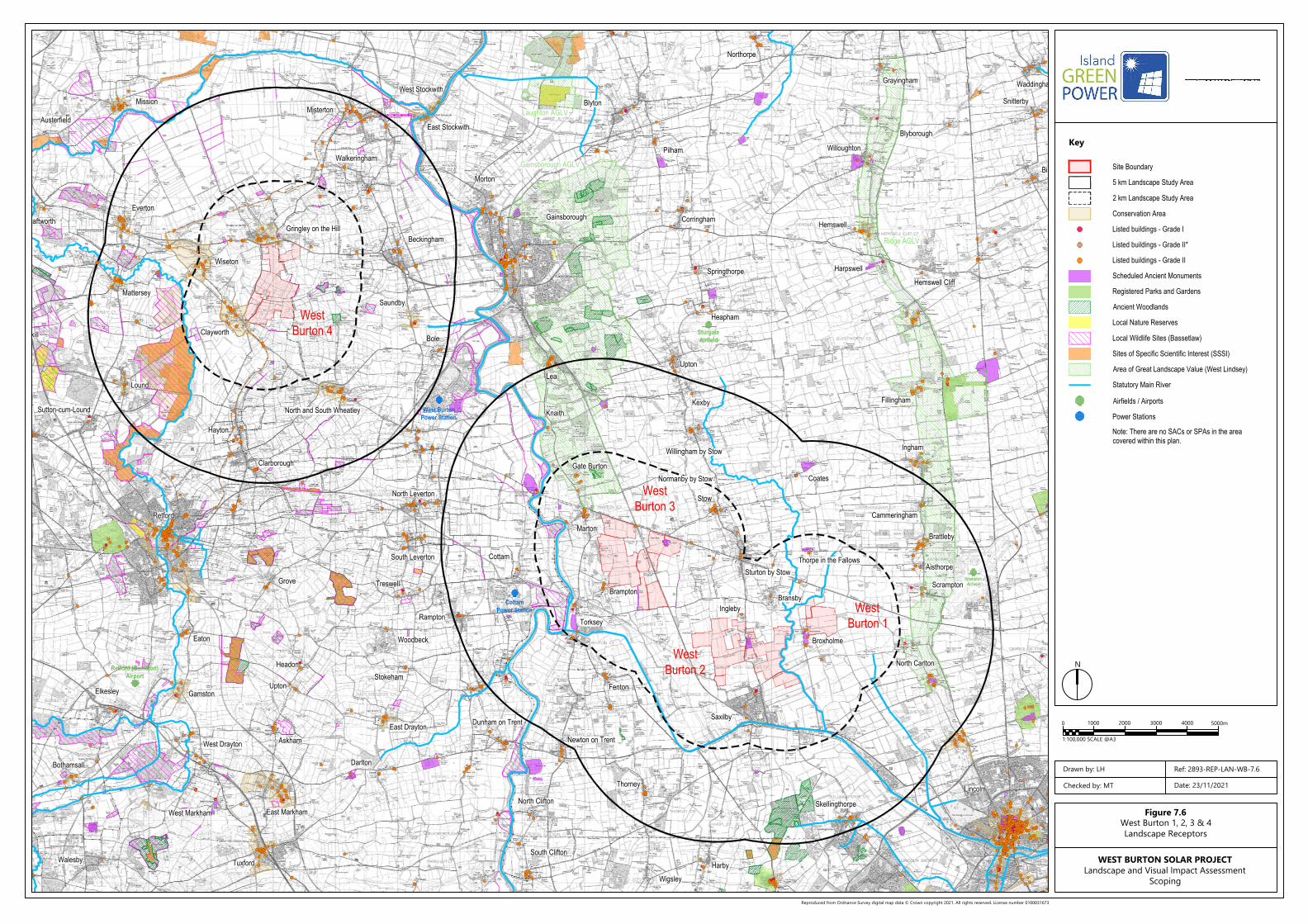
West BurtonPower Station
CottamPower Station
Retford (Gamston)Airport
SturgateAirfield
ScamptonAirfield
Misterton
Gainsborough
Springthorpe
Heapham
UptonLea
Corringham
Hemswell Cliff
Fillingham
Ingham
Scrampton
Aisthorpe
Brattleby
Bransby
Sturton by Stow
Stow
Cammeringham
Willingham by Stow
KexbyKnaith
Gate Burton
Cottam
Marton
Torksey
Brampton
Fenton
Ingleby
Broxholme
North Carlton
Coates
Northorpe
Grayingham
Willoughton
Blyborough
Waddingham
Snitterby
Bishop Norton
Lincoln
Skellingthorpe
HarbyWigsley
Thorney
Newton on Trent
South Clifton
North Clifton
Darlton
Dunham on TrentEast DraytonAskham
Upton
Headon
Rampton
Woodbeck
Stokeham
TreswellGrove
South Leverton
North Leverton
Gamston
West Drayton
East Markham
Tuxford
West Markham
Walesby
Bothamsall
Elkesley
Eaton
Retford
Hayton
Clarborough
North and South WheatleySutton-cum-Lound
Lound
Mattersey
Ranskill Clayworth
Beckingham
Saundby
Bole
Wiseton
Gringley on the Hill
Everton
Walkeringham
Morton
East Stockwith
West StockwithBlyton
Pilham
Mission
Austerfield
Scaftworth
Saxilby
Thorpe in the Fallows
Normanby by Stow
Hemswell
Harpswell
Ridge AGLV
Gainsborough AGLV
Laughton AGLV
3000200010000 4000 5000m
1:100,000 SCALE @A3
1:60,000 SCALE @ A3
Site Boundary
5 km Landscape Study Area
2 km Landscape Study Area
Listed buildings - Grade I
Scheduled Ancient Monuments
Conservation Area
Registered Parks and Gardens
Ancient Woodlands
Local Nature Reserves
Sites of Specific Scientific Interest (SSSI)
Listed buildings - Grade II*
Listed buildings - Grade II
Area of Great Landscape Value (West Lindsey)
Note: There are no SACs or SPAs in the areacovered within this plan.
Local Wildlife Sites (Bassetlaw)
Statutory Main River
Airfields / Airports
Power Stations
Reproduced from Ordnance Survey digital map data © Crown copyright 2021. All rights reserved. License number 0100031673
Key
N
Figure 7.6West Burton 1, 2, 3 & 4Landscape Receptors
Drawn by: LH
Checked by: MT Date: 23/11/2021
Ref: 2893-REP-LAN-WB-7.6
WEST BURTON SOLAR PROJECTLandscape and Visual Impact Assessment
Scoping
WestBurton 1
WestBurton 2
WestBurton 3
WestBurton 4
Misterton
Gainsborough
Springthorpe
Heapham
UptonLea
Corringham
Hemswell Cliff
Fillingham
Ingham
Scrampton
Aisthorpe
Brattleby
Bransby
Sturton by Stow
Stow
Cammeringham
Willingham by Stow
KexbyKnaith
Gate Burton
Cottam
Marton
Torksey
Brampton
Fenton
Ingleby
Broxholme
North Carlton
Coates
Northorpe
Grayingham
Willoughton
Blyborough
Waddingham
Snitterby
Bishop Norton
Lincoln
Skellingthorpe
HarbyWigsley
Thorney
Newton on Trent
South Clifton
North Clifton
Darlton
Dunham on TrentEast DraytonAskham
Upton
Headon
Rampton
Woodbeck
Stokeham
TreswellGrove
South Leverton
North Leverton
Gamston
West Drayton
East Markham
Tuxford
West Markham
Walesby
Bothamsall
Elkesley
Eaton
Retford
Hayton
Clarborough
North and South WheatleySutton-cum-Lound
Lound
Mattersey
Ranskill Clayworth
Beckingham
Saundby
Bole
Wiseton
Gringley on the Hill
Everton
Walkeringham
Morton
East Stockwith
West StockwithBlyton
Pilham
Mission
Austerfield
Scaftworth
Saxilby
Thorpe in the Fallows
Normanby by Stow
Hemswell
Harpswell
Ridge AGLV
Gainsborough AGLV
Laughton AGLV
3000200010000 4000 5000m
1:100,000 SCALE @A3
1:60,000 SCALE @ A3
Site Boundary
5 km Landscape Study Area
2 km Landscape Study Area
Conservation Area
PRoW Footpath
PRoW Bridleway
PRoW Byway open to all traffic
PRoW Restricted byway
Main A Roads
B Roads
Railway
Listed buildings - Grade I
Scheduled Ancient Monuments
Registered Parks and Gardens
Listed buildings - Grade II*
Listed buildings - Grade II
Area of Great Landscape Value (West Lindsey)
Statutory Main River
Reproduced from Ordnance Survey digital map data © Crown copyright 2021. All rights reserved. License number 0100031673
Key
N
Figure 7.7West Burton 1, 2, 3 & 4
Visual Receptors
Drawn by: LH
Checked by: MT Date: 23/11/2021
Ref: 2893-REP-LAN-WB-7.7
WEST BURTON SOLAR PROJECTLandscape and Visual Impact Assessment
Scoping
WestBurton 1
WestBurton 2
WestBurton 3
WestBurton 4
Hackthorn
Scrampton
Lincoln
HarbyWigsley
South Clifton
Lea
Fillingham
Ingham
Aisthorpe
Brattleby
Bransby
Sturton by Stow
Stow
Cammeringham
Willingham by Stow
KexbyKnaith
Gate Burton
Cottam
Marton
Torksey
Brampton
Fenton
Ingleby
Broxholme
North Carlton
Coates
Skellingthorpe
Thorney
Newton on Trent
North Clifton
Dunham on Trent Saxilby
Thorpe in the Fallows
Normanby by Stow
3000200010000 4000
1:60,000 SCALE @ A3
Site Boundary
5 km Landscape Study Area
2 km Landscape Study Area
Views of the Development may be visible
Bare Earth Zone of Theoretical Visibility to 5km
Reproduced from Ordnance Survey digital map data © Crown copyright 2021. All rights reserved. License number 0100031673
Key
N
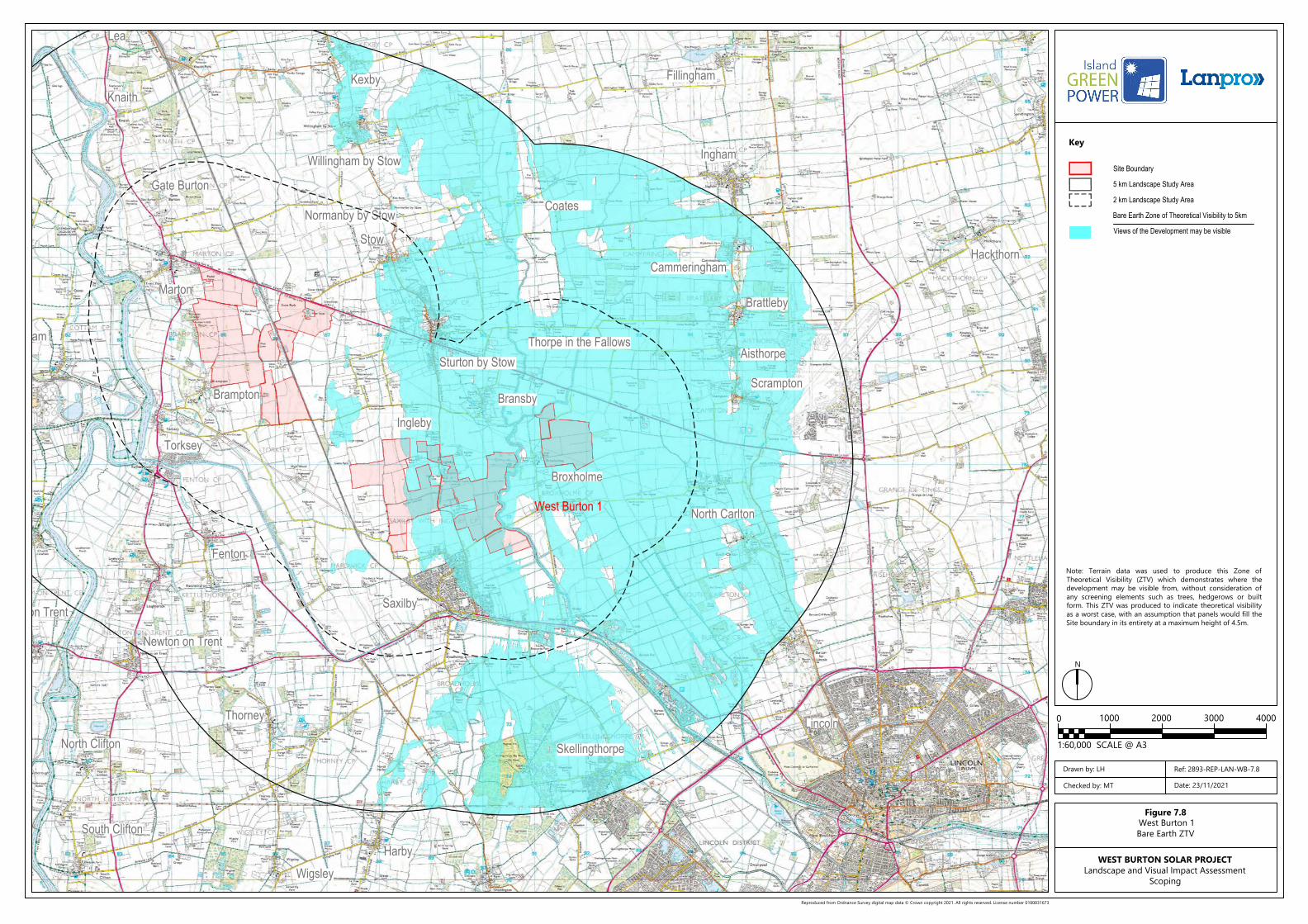
Figure 7.8West Burton 1Bare Earth ZTV
WEST BURTON SOLAR PROJECTLandscape and Visual Impact Assessment
Scoping
Drawn by: LH
Checked by: MT
Ref: 2893-REP-LAN-WB-7.8
Date: 23/11/2021
West Burton 1
Note: Terrain data was used to produce this Zone ofTheoretical Visibility (ZTV) which demonstrates where thedevelopment may be visible from, without consideration ofany screening elements such as trees, hedgerows or builtform. This ZTV was produced to indicate theoretical visibilityas a worst case, with an assumption that panels would fill theSite boundary in its entirety at a maximum height of 4.5m.
Scrampton
Lincoln
HarbyWigsley
South Clifton
Lea
Fillingham
Ingham
Aisthorpe
Brattleby
Bransby
Sturton by Stow
Stow
Cammeringham
Willingham by Stow
KexbyKnaith
Gate Burton
Cottam
Marton
Torksey
Brampton
Fenton
Ingleby
Broxholme
North Carlton
Coates
Skellingthorpe
Thorney
Newton on Trent
North Clifton
Dunham on Trent
Rampton
Saxilby
Thorpe in the Fallows
Normanby by Stow
3000200010000 4000
1:60,000 SCALE @ A3
Site Boundary
5 km Landscape Study Area
2 km Landscape Study Area
Views of the Development may be visible
Bare Earth Zone of Theoretical Visibility to 5km
Reproduced from Ordnance Survey digital map data © Crown copyright 2021. All rights reserved. License number 0100031673
Key
N
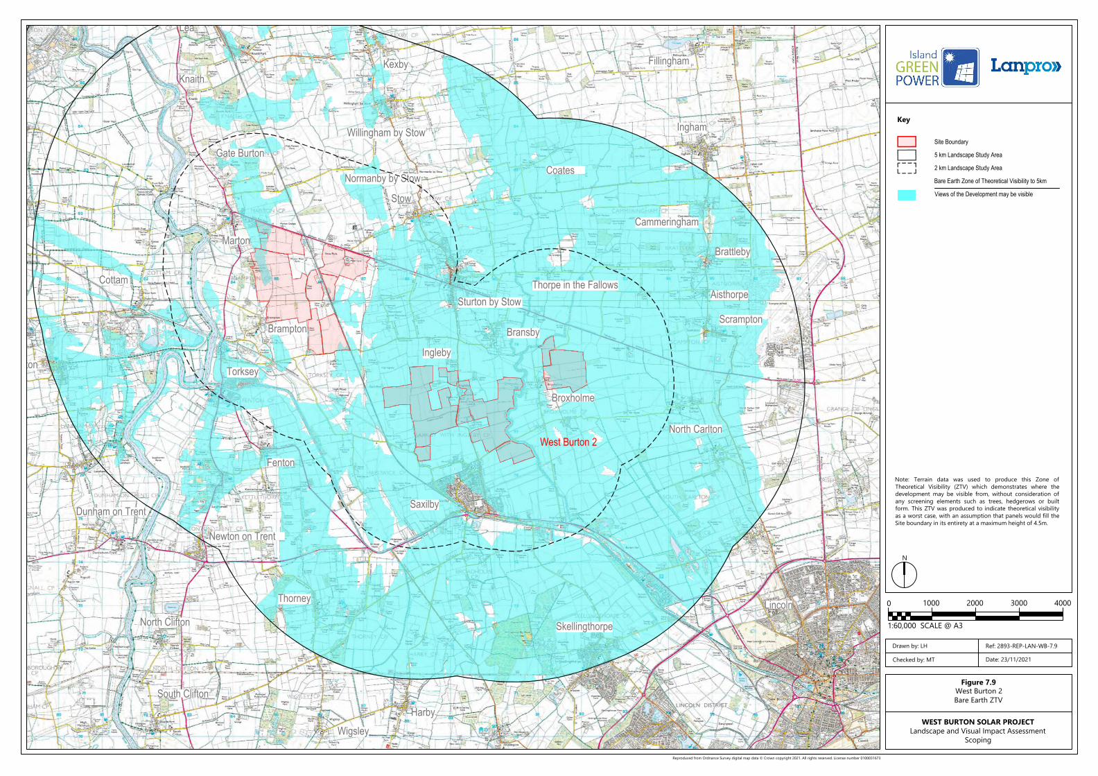
Figure 7.9West Burton 2Bare Earth ZTV
WEST BURTON SOLAR PROJECTLandscape and Visual Impact Assessment
Scoping
Drawn by: LH
Checked by: MT
Ref: 2893-REP-LAN-WB-7.9
Date: 23/11/2021
West Burton 2
Note: Terrain data was used to produce this Zone ofTheoretical Visibility (ZTV) which demonstrates where thedevelopment may be visible from, without consideration ofany screening elements such as trees, hedgerows or builtform. This ZTV was produced to indicate theoretical visibilityas a worst case, with an assumption that panels would fill theSite boundary in its entirety at a maximum height of 4.5m.
Heapham
Scrampton
Darlton
North and South Wheatley
UptonLea
Fillingham
Ingham
Aisthorpe
Brattleby
Bransby
Sturton by Stow
Stow
Cammeringham
Willingham by Stow
KexbyKnaith
Gate Burton
Cottam
Marton
Torksey
Brampton
Fenton
Ingleby
Broxholme
North Carlton
Coates
Skellingthorpe
Thorney
Newton on Trent
North Clifton
Dunham on TrentEast Drayton
Rampton
Woodbeck
Stokeham
Treswell
South Leverton
North Leverton
Bole
Saxilby
Thorpe in the Fallows
Normanby by Stow
3000200010000 4000
1:60,000 SCALE @ A3
Site Boundary
5 km Landscape Study Area
2 km Landscape Study Area
Views of the Development may be visible
Bare Earth Zone of Theoretical Visibility
Reproduced from Ordnance Survey digital map data © Crown copyright 2021. All rights reserved. License number 0100031673
Key
N
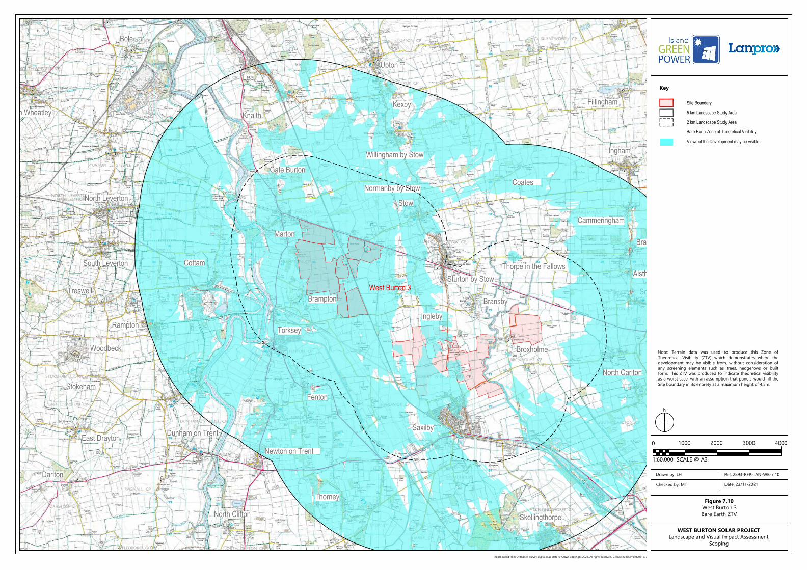
Figure 7.10West Burton 3Bare Earth ZTV
WEST BURTON SOLAR PROJECTLandscape and Visual Impact Assessment
Scoping
Drawn by: LH
Checked by: MT
Ref: 2893-REP-LAN-WB-7.10
Date: 23/11/2021
West Burton 3
Note: Terrain data was used to produce this Zone ofTheoretical Visibility (ZTV) which demonstrates where thedevelopment may be visible from, without consideration ofany screening elements such as trees, hedgerows or builtform. This ZTV was produced to indicate theoretical visibilityas a worst case, with an assumption that panels would fill theSite boundary in its entirety at a maximum height of 4.5m.
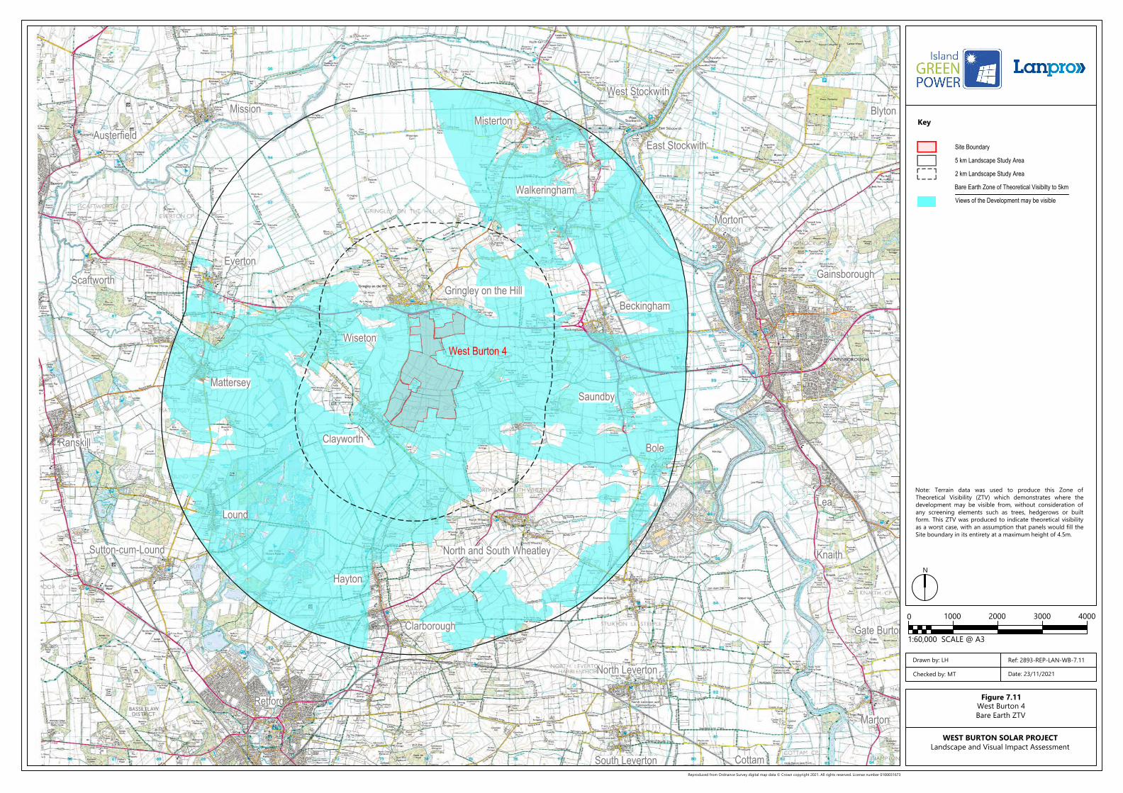
Misterton
Gainsborough
Retford
Hayton
Clarborough
North and South WheatleySutton-cum-Lound
Lound
Mattersey
Ranskill Clayworth
Beckingham
Saundby
Wiseton
Gringley on the Hill
Everton
Walkeringham
Morton
East Stockwith
West StockwithBlytonMission
Austerfield
Scaftworth
Lea
Knaith
Gate Burton
Cottam
Marton
South Leverton
North Leverton
Bole
3000200010000 4000
1:60,000 SCALE @ A3
Site Boundary
5 km Landscape Study Area
2 km Landscape Study Area
Views of the Development may be visible
Bare Earth Zone of Theoretical Visibilty to 5km
Reproduced from Ordnance Survey digital map data © Crown copyright 2021. All rights reserved. License number 0100031673
Key
N
Figure 7.11West Burton 4Bare Earth ZTV
WEST BURTON SOLAR PROJECTLandscape and Visual Impact Assessment
Drawn by: LH
Checked by: MT
Ref: 2893-REP-LAN-WB-7.11
Date: 23/11/2021
West Burton 4
Note: Terrain data was used to produce this Zone ofTheoretical Visibility (ZTV) which demonstrates where thedevelopment may be visible from, without consideration ofany screening elements such as trees, hedgerows or builtform. This ZTV was produced to indicate theoretical visibilityas a worst case, with an assumption that panels would fill theSite boundary in its entirety at a maximum height of 4.5m.
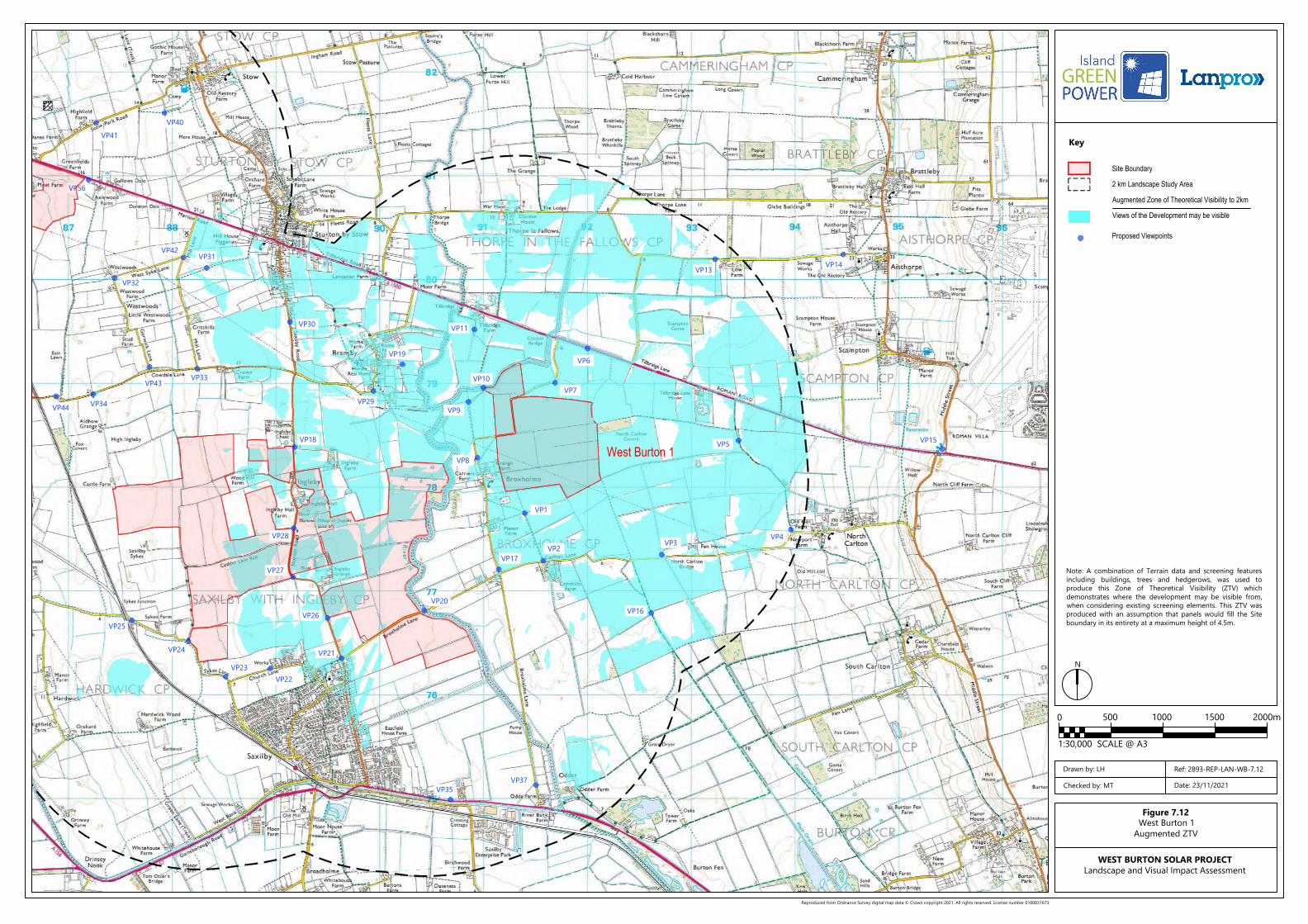
VP15
VP14VP13
VP5
VP4VP3
VP16
VP2VP17
VP8
VP9
VP10
VP11
VP7
VP6
VP20
VP37VP35
VP1
VP19
VP29
VP21
VP26
VP22VP23
VP24
VP25
VP27
VP28
VP18
VP33
VP30
VP43
VP34VP44
VP32
VP42VP31
VP56
VP41
VP40
150010005000 2000m
1:30,000 SCALE @ A3
Site Boundary
2 km Landscape Study Area
Views of the Development may be visible
Augmented Zone of Theoretical Visibility to 2km
Proposed Viewpoints
Reproduced from Ordnance Survey digital map data © Crown copyright 2021. All rights reserved. License number 0100031673
Key
N
Figure 7.12West Burton 1
Augmented ZTV
WEST BURTON SOLAR PROJECTLandscape and Visual Impact Assessment
Drawn by: LH
Checked by: MT
Ref: 2893-REP-LAN-WB-7.12
Date: 23/11/2021
West Burton 1
Note: A combination of Terrain data and screening featuresincluding buildings, trees and hedgerows, was used toproduce this Zone of Theoretical Visibility (ZTV) whichdemonstrates where the development may be visible from,when considering existing screening elements. This ZTV wasproduced with an assumption that panels would fill the Siteboundary in its entirety at a maximum height of 4.5m.
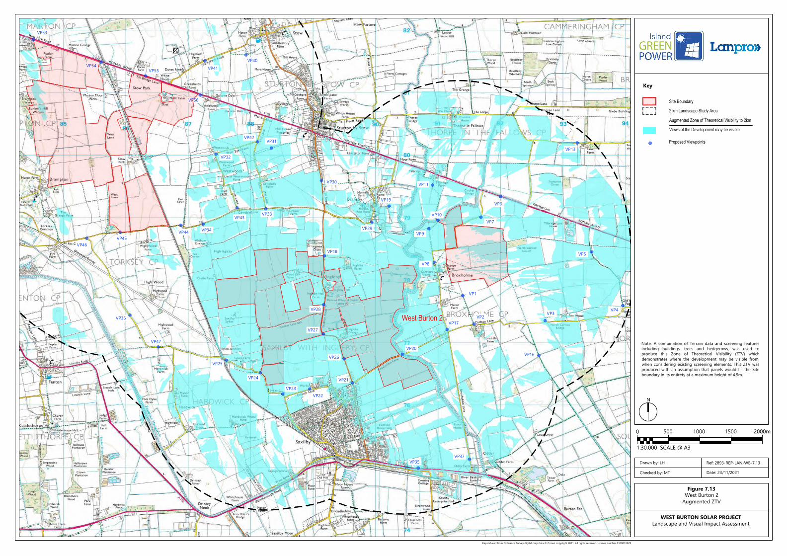
VP13
VP5
VP4VP3
VP16
VP2VP17
VP8
VP9
VP10
VP11
VP7
VP6
VP20
VP37VP35
VP1
VP19
VP29
VP21
VP26
VP22VP23
VP24
VP25
VP47
VP36
VP27
VP28
VP18
VP33
VP30
VP43
VP34VP44
VP32
VP42VP31
VP56
VP41
VP40
VP55VP54
VP53
VP46VP45
150010005000 2000m
1:30,000 SCALE @ A3
Site Boundary
2 km Landscape Study Area
Views of the Development may be visible
Augmented Zone of Theoretical Visibility to 2km
Proposed Viewpoints
Reproduced from Ordnance Survey digital map data © Crown copyright 2021. All rights reserved. License number 0100031673
Key
N
Figure 7.13West Burton 2
Augmented ZTV
WEST BURTON SOLAR PROJECTLandscape and Visual Impact Assessment
Drawn by: LH
Checked by: MT
Ref: 2893-REP-LAN-WB-7.13
Date: 23/11/2021
West Burton 2
Note: A combination of Terrain data and screening featuresincluding buildings, trees and hedgerows, was used toproduce this Zone of Theoretical Visibility (ZTV) whichdemonstrates where the development may be visible from,when considering existing screening elements. This ZTV wasproduced with an assumption that panels would fill the Siteboundary in its entirety at a maximum height of 4.5m.
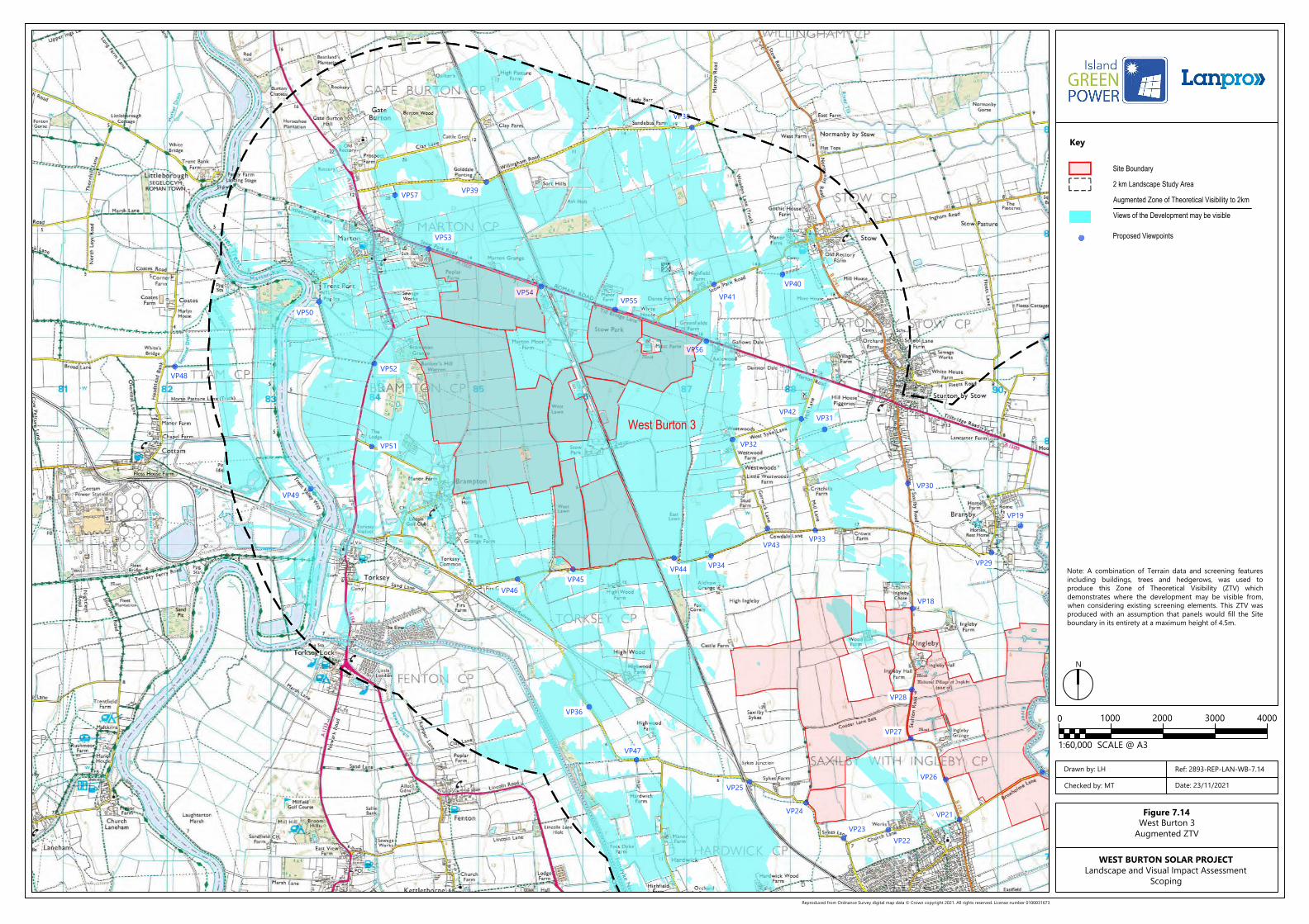
VP20
VP19
VP29
VP21
VP26
VP22VP23
VP24
VP25
VP47
VP36
VP27
VP28
VP18
VP33
VP30
VP43
VP34VP44
VP32
VP42VP31
VP56
VP41
VP40
VP55VP54
VP53
VP39VP57
VP52
VP51
VP49
VP50
VP46VP45
VP38
VP48
3000200010000 4000
1:60,000 SCALE @ A3
Site Boundary
2 km Landscape Study Area
Views of the Development may be visible
Augmented Zone of Theoretical Visibility to 2km
Proposed Viewpoints
Reproduced from Ordnance Survey digital map data © Crown copyright 2021. All rights reserved. License number 0100031673
Key
N
Figure 7.14West Burton 3
Augmented ZTV
WEST BURTON SOLAR PROJECTLandscape and Visual Impact Assessment
Scoping
Drawn by: LH
Checked by: MT
Ref: 2893-REP-LAN-WB-7.14
Date: 23/11/2021
West Burton 3
Note: A combination of Terrain data and screening featuresincluding buildings, trees and hedgerows, was used toproduce this Zone of Theoretical Visibility (ZTV) whichdemonstrates where the development may be visible from,when considering existing screening elements. This ZTV wasproduced with an assumption that panels would fill the Siteboundary in its entirety at a maximum height of 4.5m.
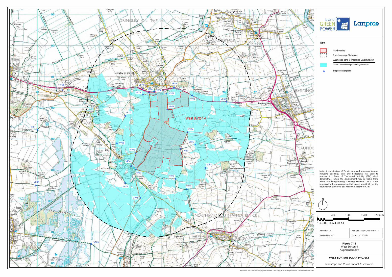
VP61VP60
VP59
VP62
VP63
VP58VP80VP78
VP79
VP77
VP76
VP75
VP74
VP73
VP72
VP71
VP67
VP69
VP68
VP65
VP66
VP64
VP70
VP81
VP82
VP83
150010005000 2000m
1:30,000 SCALE @ A3
Site Boundary
2 km Landscape Study Area
Views of the Development may be visible
Augmented Zone of Theoretical Visibility to 2km
Proposed Viewpoints
Reproduced from Ordnance Survey digital map data © Crown copyright 2021. All rights reserved. License number 0100031673
Key
N
Figure 7.15West Burton 4
Augmented ZTV
WEST BURTON SOLAR PROJECT
Landscape and Visual Impact Assessment
Drawn by: LH
Checked by: MT
Ref: 2893-REP-LAN-WB-7.15
Date: 23/11/2021
West Burton 4
Note: A combination of Terrain data and screening featuresincluding buildings, trees and hedgerows, was used toproduce this Zone of Theoretical Visibility (ZTV) whichdemonstrates where the development may be visible from,when considering existing screening elements. This ZTV wasproduced with an assumption that panels would fill the Siteboundary in its entirety at a maximum height of 4.5m.
EIA Scoping Report Appendices to Chapter 8:
Ecology
January 2022

West Burton Solar Project: EIA Scoping Report – Appendices January 2022
Contents
Appendix 8.1 Preliminary Ecological Appraisal 54
Appendix 8.2 Extended Phase 1 Habitat Survey Maps 168

West Burton Solar Project: EIA Scoping Report – AppendicesJanuary 2022
8.1 Preliminary Ecological Appraisal
PRELIMINARY ECOLOGICAL APPRAISAL
WEST BURTON SOLAR PROJECT
carried out by
commissioned by
WEST BURTON SOLAR PROJECT LTD.
NOVEMBER 2021
West Burton Solar Project 2 Preliminary Ecological Appraisal
CONTENTS
KEY ECOLOGICAL CONSTRAINTS AND OPPORTUNITIES .................................................................................................................................................................................................................................... 4
1 INTRODUCTION ................................................................................................................................................................................................................................................................................... 6 1.2 Report Aims ............................................................................................................................................................................................................................................................................................................................................... 6
1.3 Appraisal Scope and Limitations ........................................................................................................................................................................................................................................................................................... 6
1.4 Consultation ............................................................................................................................................................................................................................................................................................................................................. 7
1.5 Site Description Summary ............................................................................................................................................................................................................................................................................................................. 8
1.6 Surveys Carried out to Date ....................................................................................................................................................................................................................................................................................................... 8
2 DESK STUDY ........................................................................................................................................................................................................................................................................................ 8 2.1 Local Planning Policy........................................................................................................................................................................................................................................................................................................................ 9
2.2 Protected and Designated Sites .......................................................................................................................................................................................................................................................................................... 10
2.3 Ancient Woodland ........................................................................................................................................................................................................................................................................................................................... 13
2.4 Biodiversity Opportunities Mapping................................................................................................................................................................................................................................................................................... 13
3 HABITAT SURVEY ............................................................................................................................................................................................................................................................................... 16 3.2 Common Habitat Constraints and Opportunities ................................................................................................................................................................................................................................................. 16
3.3 West Burton 1 Habitat Assessment ...................................................................................................................................................................................................................................................................................... 23
3.4 West Burton 2 Habitat Assessment ...................................................................................................................................................................................................................................................................................... 24
3.5 West Burton 3 Habitat Assessment ...................................................................................................................................................................................................................................................................................... 27
3.6 West Burton 4 Habitat Assessment ...................................................................................................................................................................................................................................................................................... 30
4 SPECIES INFORMATION COLLATED TO DATE ..................................................................................................................................................................................................................................... 34 4.2 Badgers ....................................................................................................................................................................................................................................................................................................................................................... 34
4.3 Bats ................................................................................................................................................................................................................................................................................................................................................................. 35
4.4 Otter .............................................................................................................................................................................................................................................................................................................................................................. 39
4.5 Water Vole ............................................................................................................................................................................................................................................................................................................................................... 40
4.6 Dormouse.................................................................................................................................................................................................................................................................................................................................................. 41
4.7 Great Crested Newts and Other Amphibians .......................................................................................................................................................................................................................................................... 41
4.8 Reptiles ........................................................................................................................................................................................................................................................................................................................................................ 44
4.9 Birds ................................................................................................................................................................................................................................................................................................................................................................ 46
4.10 Invertebrates .......................................................................................................................................................................................................................................................................................................................................... 50
4.11 Other Protected Species and Species of Conservation Concern ......................................................................................................................................................................................................... 50
5 FURTHER WORK AND NEXT STEPS ...................................................................................................................................................................................................................................................... 52 5.1 Recommended and Optional Further Surveys ........................................................................................................................................................................................................................................................ 52
5.2 Anticipated Reporting/Design Milestones ................................................................................................................................................................................................................................................................... 53
5.3 Construction and Landscape Environmental Management Plans (CEMP and LEMP) ....................................................................................................................................................... 53
5.4 Cumulative Impacts ........................................................................................................................................................................................................................................................................................................................ 54
5.5 Future Baseline and Decommissioning Effects......................................................................................................................................................................................................................................................... 54
APPENDIX A: WILDLIFE LEGISLATION SUMMARY ............................................................................................................................................................................................................................................. 55
APPENDIX B – SUMMARY OF METHODOLOGIES ............................................................................................................................................................................................................................................. 60
APPENDIX C – DESIGNATED SITES MAPS ........................................................................................................................................................................................................................................................ 62
APPENDIX D – SPECIES RECORDS WITHIN 2KM OF WEST BURTON 1 (BROXHOLME) ..................................................................................................................................................................................... 66
APPENDIX E – SPECIES RECORDS WITHIN 2KM OF WEST BURTON 2 (INGLEBY) ............................................................................................................................................................................................. 69
APPENDIX F – SPECIES RECORDS WITHIN 2KM OF WEST BURTON 3 (BELLWOOD AND BRAMPTON) .............................................................................................................................................................. 76
APPENDIX G – SPECIES RECORDS WITHIN 2KM OF WEST BURTON 4 (CLAYWORTH) ..................................................................................................................................................................................... 84
APPENDIX H: LOCAL PLANNING POLICY...................................................................................................................................................................................................................................................... 103
APPENDIX I – PHASE 1 HABITATS MAPS ....................................................................................................................................................................................................................................................... 112
West Burton Solar Project 3 Preliminary Ecological Appraisal
Project title: West Burton Solar Project
Document title: Preliminary Ecological Appraisal Project number: 7479
Client: West Burton Project Ltd. Author: Harry Fox
Version 1 Final Report Issued on: August 2021
Quality
Assurance
Checked by: Approved by:
Tom Clarkson Tom Clarkson
The information, data and advice which has been prepared and provided is true, and has been prepared and provided in accordance
with the Chartered Institute of Ecology and Environmental Management’s (CIEEM) Code of Professional Conduct. We confirm that the
opinions expressed are our true and professional bona fide opinions. This report and its contents remain the property of Clarkson and Woods
Ltd. until payment has been made in full.
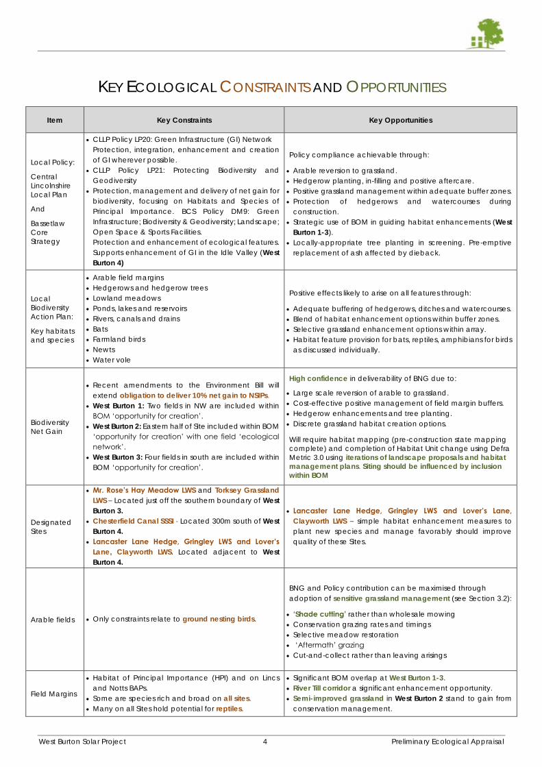
West Burton Solar Project 4 Preliminary Ecological Appraisal
KEY ECOLOGICAL CONSTRAINTS AND OPPORTUNITIES
Item Key Constraints Key Opportunities
Local Policy:
Central
Lincolnshire
Local Plan
And
Bassetlaw
Core
Strategy
CLLP Policy LP20: Green Infrastructure (GI) Network
Protection, integration, enhancement and creation
of GI wherever possible.
CLLP Policy LP21: Protecting Biodiversity and
Geodiversity
Protection, management and delivery of net gain for
biodiversity, focusing on Habitats and Species of
Principal Importance. BCS Policy DM9: Green
Infrastructure; Biodiversity & Geodiversity; Landscape;
Open Space & Sports Facilities.
Protection and enhancement of ecological features.
Supports enhancement of GI in the Idle Valley (West
Burton 4)
Policy compliance achievable through:
Arable reversion to grassland.
Hedgerow planting, in-filling and positive aftercare.
Positive grassland management within adequate buffer zones.
Protection of hedgerows and watercourses during
construction.
Strategic use of BOM in guiding habitat enhancements (West
Burton 1-3).
Locally-appropriate tree planting in screening. Pre-emptive
replacement of ash affected by dieback.
Local
Biodiversity
Action Plan:
Key habitats
and species
Arable field margins
Hedgerows and hedgerow trees
Lowland meadows
Ponds, lakes and reservoirs
Rivers, canals and drains
Bats
Farmland birds
Newts
Water vole
Positive effects likely to arise on all features through:
Adequate buffering of hedgerows, ditches and watercourses.
Blend of habitat enhancement options within buffer zones.
Selective grassland enhancement options within array.
Habitat feature provision for bats, reptiles, amphibians for birds
as discussed individually.
Biodiversity
Net Gain
Recent amendments to the Environment Bill will
extend obligation to deliver 10% net gain to NSIPs.
West Burton 1: Two fields in NW are included within
BOM ‘opportunity for creation’.
West Burton 2: Eastern half of Site included within BOM
‘opportunity for creation’ with one field ‘ecological
network’.
West Burton 3: Four fields in south are included within
BOM ‘opportunity for creation’.
High confidence in deliverability of BNG due to:
Large scale reversion of arable to grassland.
Cost-effective positive management of field margin buffers.
Hedgerow enhancements and tree planting.
Discrete grassland habitat creation options.
Will require habitat mapping (pre-construction state mapping
complete) and completion of Habitat Unit change using Defra
Metric 3.0 using iterations of landscape proposals and habitat
management plans. Siting should be influenced by inclusion
within BOM
Designated
Sites
Mr. Rose’s Hay Meadow LWS and Torksey Grassland
LWS – Located just off the southern boundary of West
Burton 3.
Chesterfield Canal SSSI - Located 300m south of West
Burton 4.
Lancaster Lane Hedge, Gringley LWS and Lover’s
Lane, Clayworth LWS. Located adjacent to West
Burton 4.
Lancaster Lane Hedge, Gringley LWS and Lover’s Lane,
Clayworth LWS – simple habitat enhancement measures to
plant new species and manage favorably should improve
quality of these Sites.
Arable fields Only constraints relate to ground nesting birds.
BNG and Policy contribution can be maximised through
adoption of sensitive grassland management (see Section 3.2):
‘Shade cutting’ rather than wholesale mowing
Conservation grazing rates and timings
Selective meadow restoration
‘Aftermath’ grazing
Cut-and-collect rather than leaving arisings
Field Margins
Habitat of Principal Importance (HPI) and on Lincs
and Notts BAPs.
Some are species rich and broad on all sites.
Many on all Sites hold potential for reptiles.
Significant BOM overlap at West Burton 1-3.
River Till corridor a significant enhancement opportunity.
Semi-improved grassland in West Burton 2 stand to gain from
conservation management.
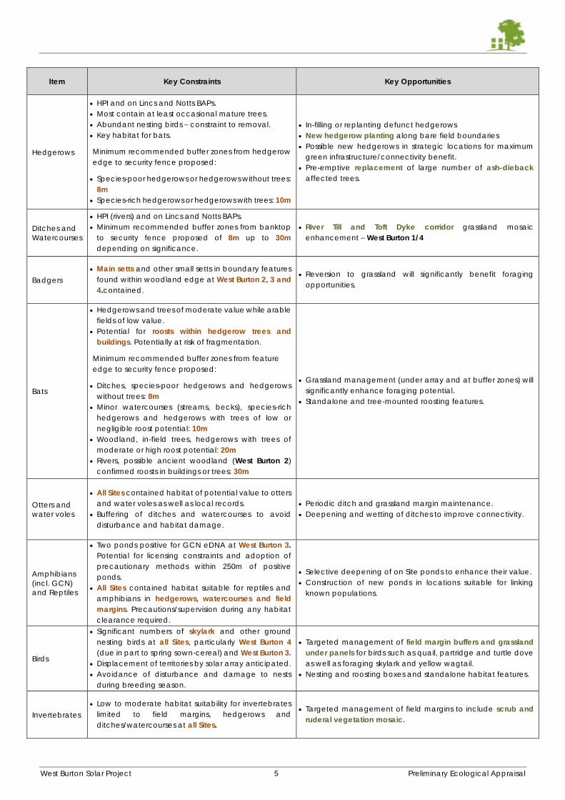
West Burton Solar Project 5 Preliminary Ecological Appraisal
Item Key Constraints Key Opportunities
Hedgerows
HPI and on Lincs and Notts BAPs.
Most contain at least occasional mature trees.
Abundant nesting birds – constraint to removal.
Key habitat for bats.
Minimum recommended buffer zones from hedgerow
edge to security fence proposed:
Species-poor hedgerows or hedgerows without trees:
8m
Species-rich hedgerows or hedgerows with trees: 10m
In-filling or replanting defunct hedgerows
New hedgerow planting along bare field boundaries
Possible new hedgerows in strategic locations for maximum
green infrastructure/connectivity benefit.
Pre-emptive replacement of large number of ash-dieback
affected trees.
Ditches and
Watercourses
HPI (rivers) and on Lincs and Notts BAPs.
Minimum recommended buffer zones from banktop
to security fence proposed of 8m up to 30m
depending on significance.
River Till and Toft Dyke corridor grassland mosaic
enhancement – West Burton 1/4
Badgers
Main setts and other small setts in boundary features
found within woodland edge at West Burton 2, 3 and
4.contained.
Reversion to grassland will significantly benefit foraging
opportunities.
Bats
Hedgerows and trees of moderate value while arable
fields of low value.
Potential for roosts within hedgerow trees and
buildings. Potentially at risk of fragmentation.
Minimum recommended buffer zones from feature
edge to security fence proposed:
Ditches, species-poor hedgerows and hedgerows
without trees: 8m
Minor watercourses (streams, becks), species-rich
hedgerows and hedgerows with trees of low or
negligible roost potential: 10m
Woodland, in-field trees, hedgerows with trees of
moderate or high roost potential: 20m
Rivers, possible ancient woodland (West Burton 2)
confirmed roosts in buildings or trees: 30m
Grassland management (under array and at buffer zones) will
significantly enhance foraging potential.
Standalone and tree-mounted roosting features.
Otters and
water voles
All Sites contained habitat of potential value to otters
and water voles as well as local records.
Buffering of ditches and watercourses to avoid
disturbance and habitat damage.
Periodic ditch and grassland margin maintenance.
Deepening and wetting of ditches to improve connectivity.
Amphibians
(incl. GCN)
and Reptiles
Two ponds positive for GCN eDNA at West Burton 3.
Potential for licensing constraints and adoption of
precautionary methods within 250m of positive
ponds.
All Sites contained habitat suitable for reptiles and
amphibians in hedgerows, watercourses and field
margins. Precautions/supervision during any habitat
clearance required.
Selective deepening of on Site ponds to enhance their value.
Construction of new ponds in locations suitable for linking
known populations.
Birds
Significant numbers of skylark and other ground
nesting birds at all Sites, particularly West Burton 4
(due in part to spring sown-cereal) and West Burton 3.
Displacement of territories by solar array anticipated.
Avoidance of disturbance and damage to nests
during breeding season.
Targeted management of field margin buffers and grassland
under panels for birds such as quail, partridge and turtle dove
as well as foraging skylark and yellow wagtail.
Nesting and roosting boxes and standalone habitat features.
Invertebrates
Low to moderate habitat suitability for invertebrates
limited to field margins, hedgerows and
ditches/watercourses at all Sites.
Targeted management of field margins to include scrub and
ruderal vegetation mosaic.
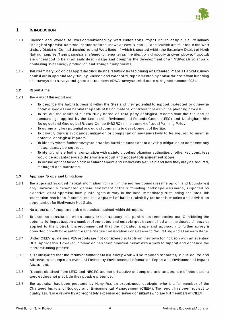
West Burton Solar Project 6 Preliminary Ecological Appraisal
1 INTRODUCTION
1.1.1 Clarkson and Woods Ltd. was commissioned by West Burton Solar Project Ltd. to carry out a Preliminary
Ecological Appraisal across four parcels of land known as West Burton 1, 2 and 3 which are situated in the West
Lindsey District of Central Lincolnshire and West Burton 4 which is situated within the Bassetlaw District of North
Nottinghamshire. These parcels are referred to hereafter as ‘the Sites’, or individually as given above. Proposals
are understood to be in an early design stage and comprise the development of an NSIP-scale solar park,
containing solar energy production and storage components.
1.1.2 This Preliminary Ecological Appraisal discusses the results collected during an Extended Phase 1 Habitats Survey
carried out in April and May 2021 by Clarkson and Woods Ltd, supplemented by partial datasets from breeding
bird surveys, bat surveys and great crested newt eDNA surveys carried out in spring and summer 2021.
1.2 Report Aims
1.2.1 The aims of this report are:
To describe the habitats present within the Sites and their potential to support protected or otherwise
notable species and habitats capable of being material considerations within the planning process.
To set out the results of a desk study based on third party ecological records from the Site and its
surroundings supplied by the Lincolnshire Environmental Records Centre (LERC) and Nottinghamshire
Biological and Geological Record Centre (NBGRC) in the context of Local Planning Policy.
To outline any key potential ecological constraints to development of the Site.
To broadly discuss avoidance, mitigation or compensation measures likely to be required to minimise
potential ecological impacts.
To identify where further surveys to establish baseline conditions or develop mitigation or compensatory
measures may be required.
To identify where further consultation with statutory bodies, planning authorities or other key consultees
would be advantageous to determine a robust and acceptable assessment scope.
To outline options for ecological enhancement and Biodiversity Net Gain and how they may be secured,
managed and monitored.
1.3 Appraisal Scope and Limitations
1.3.1 The appraisal recorded habitat information from within the red line boundaries (the option land boundaries)
only. However, a desk-based general assessment of the surrounding landscape was made, supported by
extensive visual appraisal from public rights of way in the land immediately surrounding the Sites. This
information has been factored into the appraisal of habitat suitability for certain species and advice on
opportunities for Biodiversity Net Gain.
1.3.2 No appraisal of proposed cable routes is contained within this report.
1.3.3 To date, no consultation with statutory or non-statutory third parties has been carried out. Considering the
potential for impacts upon a number of protected and notable species combined with the desired timescales
applied to the project, it is recommended that the indicated scope and approach to further survey is
consulted on with local authorities, their nature conservation consultees and Natural England at an early stage.
1.3.4 Under CIEEM guidelines, PEA reports are not considered suitable on their own for inclusion with an eventual
DCO application. However, information has been provided below with a view to support and enhance the
masterplanning process.
1.3.5 It is anticipated that the results of further detailed survey work will be reported separately in due course and
will serve to underpin an eventual Preliminary Environmental Information Report and Environmental Impact
Assessment.
1.3.6 Records obtained from LERC and NBGRC are not exhaustive or complete and an absence of records for a
species does not preclude their possible presence.
1.3.7 The appraisal has been prepared by Harry Fox, an experienced ecologist, who is a full member of the
Chartered Institute of Ecology and Environmental Management (CIEEM). The report has been subject to
quality assurance review by appropriately experienced senior consultants who are full members of CIEEM.
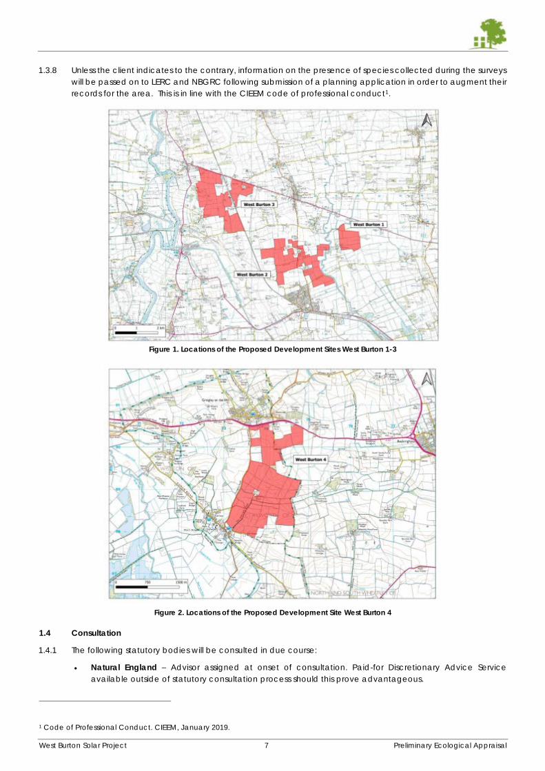
West Burton Solar Project 7 Preliminary Ecological Appraisal
1.3.8 Unless the client indicates to the contrary, information on the presence of species collected during the surveys
will be passed on to LERC and NBGRC following submission of a planning application in order to augment their
records for the area. This is in line with the CIEEM code of professional conduct1.
Figure 1. Locations of the Proposed Development Sites West Burton 1-3
Figure 2. Locations of the Proposed Development Site West Burton 4
1.4 Consultation
1.4.1 The following statutory bodies will be consulted in due course:
Natural England – Advisor assigned at onset of consultation. Paid-for Discretionary Advice Service
available outside of statutory consultation process should this prove advantageous.
1 Code of Professional Conduct. CIEEM, January 2019.
West Burton Solar Project 8 Preliminary Ecological Appraisal
West Lindsey District Council – No district ecology officer. Ecology issues dealt with by planning officer
team with reference to Natural England Standing Advice. Therefore, pre-application consultation
response likely to be very limited.
Lincolnshire County Council – No County ecologist – ecology matters likely referred to Environmental
Services Team and Wildlife Trusts/NE Standing Advice referenced.
Bassetlaw District Council – No district ecology officer. BDC refer to Nottinghamshire Wildlife Trust to
provide consultation opinion on their behalf.
Nottinghamshire County Council – County ecology officer present: [email protected]
1.4.2 It is recommended due to the specific impacts and constraints at the sites that the following organisations are
consulted with at the appropriate stage:
RSPB have been approached for consultation but have declined due to a lack of capacity.
Lincolnshire and Nottinghamshire Wildlife Trust will be consulted in due course as part of the pre-
application process.
1.5 Site Description Summary
1.5.1 West Burton 1, 2 and 3 are located within the West Lindsey District, Lincolnshire and are situated within 8km of
each other close to the settlements of Broxholme (West Burton 1), Ingleby (West Burton 2) and Brampton (West
Burton 3). West Burton 4 is located 12km north-west of West Burton 3 and is located within the Bassetlaw District
of North Nottinghamshire. The Sites have been mapped in Figure 1 and Figure 2. West Burton 1, 2 and 3
predominantly comprise large, open and generally flat arable fields characterised by winter-sown cereal
crops with some fields of permanent pasture (West Burton 2), bounded by a network of managed hedgerows
and ditches with narrow field margins, where present. West Burton 4 comprises more undulating and generally
smaller fields with a mixture of arable and permanent pasture characterised by fields of winter-sown cereal,
legumes and sheep grazing that are bounded by a network of managed hedgerows and ditches with narrow
field margins, where present.
1.5.2 These Sites’ habitats are very much typical of the surrounding landscapes which are dominated by arable
farmland and occasional pasture grassland that is interspersed with small settlements and farmsteads linked
by minor and single track roads. The landscape surrounding West Burton 1 – 3 is mostly flat but to the east of
the Sites at the ‘Lincoln Cliff’, a significant north-south escarpment, located 3km east of West Burton 1. The
River Trent is located west of West Burton 1 – 3 and east of West Burton 4 and is located 1.4km from West Burton
3 at its closest point as it flows north towards the Humber Estuary, itself some 36km north of West Burton 4. While
no woodland is present within the Sites, several small stands of managed and unmanaged woodland are
present adjacent and in the surrounding landscape, often the result of historical game management. Standing
water is generally absent from the Sites and the surroundings following the in-filling of traditional livestock
drinking ponds, save for a very small number of agricultural pools/pits, decoy ponds or managed recreational
fisheries. Flowing water occurs occasionally in proximity to the Sites , with the River Till running adjacent to the
eastern boundary of West Burton 2 and 0.4km west of West Burton 1 the River Trent running 1.4km west of West
Burton 3 and the River Idle running 1.8km west of West Burton 4. Various feeder streams for the above
watercourses are managed as agricultural drainage ditches within or adjacent to the Sites which regularly dry
out.
1.6 Surveys Carried out to Date
1.6.1 To date, the following surveys have been carried out across all the above sites in 2021:
Extended Phase 1 Habitats Survey of all land within red line boundaries (completed April/May 2021)
Four breeding bird survey visits of all land within red line boundaries (May - July 2021)
One nocturnal/crepuscular bird survey visit (focus on quail and owls) of all land within red line boundaries (late
June to early July 2021)
GCN eDNA survey of all accessible ponds within red line boundaries and land within 250m under same land
ownership (June 2021)
Monthly static bat detector surveys utilising 42 detector locations per month between June and September
2021 inclusive.
Autumn survey of all water courses and ditches within red line boundaries for water vole and otters.
West Burton Solar Project 9 Preliminary Ecological Appraisal
1.6.2 Surveys currently planned to be carried out at the Sites are:
Extended Phase 1 Habitats Survey of cable route corridor (estimated Q1 2022)
Additional early-season breeding bird survey visit of all land within red line boundaries (April 2022)
Four wintering bird surveys of all land within red line boundaries (monthly November 2021 to February 2022).
GCN eDNA survey of all accessible ponds within 250m of red line boundaries on third-party land (Mid-April -
June 2022)
Ground-based assessment of all trees within red line boundaries for potential to support roosting bats (under
way – expected completion December 2021).
Daytime inspections of all buildings within red line boundaries for their potential to support roosting bats
(December 2021).
Spring survey of all water courses and ditches within red line boundaries for water vole and otters (May 2022).
2 DESK STUDY
2.1 Local Planning Policy
2.1.1 The following nature conservation-related policies taken from the Central Lincolnshire Local Plan are
considered pertinent to West Burton 1 - 3 and the proposals. The text of each policy is given in turn in Appendix
C at the end of this report.
Central Lincolnshire Local Plan (Adopted April 2017)
Policy LP19: Renewable Energy Proposals
Policy LP20: Green Infrastructure Network
Policy LP21: Biodiversity and Geodiversity
Central Lincolnshire Local Plan (Under Consultation - Anticipated adoption of revised plan in April 2022)
Policy S13: Renewable Energy
Policy S58: Green Infrastructure Network
Policy S59: Protecting Biodiversity and Geodiversity
Policy S60: Biodiversity Opportunity and Delivering Measurable Net Gains
Policy S65: Trees, Woodland and Hedgerows
2.1.2 In the local area, Neighborhood Areas have been designated for the purposes of creating Neighborhood
Plans. The Saxilby with Ingleby Neighborhood Plan (2016 – 2036) was pertinent to West Burton 2, with no other
Neighborhood Plans relevant to the Sites. Relevant policies are as follows and are also detailed in Appendix
C.
Policy 11: Minimising The Impact Of Development On The Natural Environment
Policy 12: Green Infrastructure
Policy 13: Development Along The Fossdyke Canal
Policy 15: Designated Local Green Spaces
2.1.3 The following nature conservation-related policies taken from the Bassetlaw Core Strategy (2011) are
considered pertinent to West Burton 4 and the proposals. The text of each policy is given in turn in Appendix C
at the end of this report.
Bassetlaw Core Strategy (2011)
Policy DM9: Green Infrastructure; Biodiversity & Geodiversity; Landscape; Open Space & Sports
Facilities
2.1.4 The Draft Bassetlaw Local Plan (emerging), once adopted, will replace the Bassetlaw Core Strategy (2011)
and will set out the Council’s development strategy, planning policies and proposals, including site allocations,
to guide land use and planning decisions in the District up to 2037. The following nature conservation-related
policies taken from the Draft Bassetlaw Local Plan (2011) are considered pertinent to West Burton 4 and the
proposals.
West Burton Solar Project 10 Preliminary Ecological Appraisal
Draft Bassetlaw Local Plan (emerging)
Policy ST40: Green Gaps
Policy ST41: Green and Blue Infrastructure
Policy ST42: Biodiversity and Geodiversity
Policy ST43: Trees, Woodlands and Hedgerows
Policy ST53: Renewable and Low Carbon Energy Generation Local Biodiversity Action Plan
2.1.5 The following habitats and species have been identified within Lincolnshire Biodiversity Action Plan (BAP) 2011-
2020 (3rd Edition) and are considered relevant to the Site. As mentioned above, it is anticipated that alongside
the re-drafting and eventual adoption of the new Central Lincolnshire Local Plan, the Lincolnshire BAP will be
replaced by a Local Nature Recovery Strategy.
Habitats Species
Arable field margins
Grazing marsh
Hedgerows and hedgerow trees
Lowland calcareous grassland
Lowland meadows
Lowland dry acid grassland
Ponds, lakes and reservoirs
Rivers, canals and drains
Lowland mixed deciduous woodland
Wet woodland
Bats
Farmland birds
Freshwater fish
Greater water-parsnip
Newts
Water vole
White-clawed crayfish
Invasive non-native species
2.1.6 The following habitats and species have been identified within Nottinghamshire Biodiversity Action Plan (BAP)
2011-2020 (3rd Edition) and are considered relevant to West Burton 4.
Habitats Species
Hedgerows: Including ancient and/or
species-rich hedgerows
Mixed ash-dominated woodland
Oak-birch woodland
Parkland and wood pasture
Planted coniferous woodland
Wet broadleaved woodland
Ditches
Eutrophic and Mesotrophic standing
waters
Rivers and streams
Farmland: arable farmland, arable field
margins and improved grassland
Lowland calcareous grassland
Lowland dry acid grassland
Lowland neutral grassland
Lowland wet grassland
Black Poplar
Depford Pink
Nottingham autumn crocus and
Nottingham spring crocus
Dingy Skipper
Green Hairstreak
Grizzled Skipper
Hazel Pot Beetle
White-clawed Crayfish
Barn Owl
Bats
Harvest mouse
Hedgehog
Nightjar
Otter
Slow-worm
Water vole
Willow Tit
Habitats
2.2 Protected and Designated Sites
2.2.1 Statutory and non-statutory sites designated for nature conservation were identified within the desk study and
are summarised for each Site in Tables 1 and 2 below. Appendix C provides maps showing the relationship
between the designated sites and the development Sites.
West Burton Solar Project 11 Preliminary Ecological Appraisal
2.2.2 Many of these sites present potential ecological opportunities for the enhancement of local biodiversity and
ecological connectivity.
2.2.3 ‘International’ designated sites are statutory sites designated in response to international law or conventions,
including Special Protection Areas (SPAs), Special Areas of Conservation (SACs) and Ramsar wetland sites. The
search radius from each Site for these sites used was 10Km
2.2.4 National sites are statutorily protected sites which include Sites of Special Scientific Interest (SSSIs) and National
Nature Reserves (NNRs). The search radius from each Site for these sites used was 5Km. Local Nature Reserves
(LNRs) are statutorily protected local sites and thus are searched for within 5Km.
2.2.5 Local sites are predominantly non-statutory sites designated by Local Planning Authorities (in this case West
Lindsey in collaboration with the Greater Lincolnshire Nature Partnership), including Sites of Nature
Conservation Interest (SNCIs) and Local Wildlife Sites (LWSs). The search radius from each Site for these sites
used was 2Km.
West Burton 1
2.2.6 No designated sites were identified in proximity to West Burton 1 within the desk study.
West Burton 2
2.2.7 One SSSI, Doddington Clay Woods SSSI, was identified during the desk study which was located 4.7km south
of West Burton 2 and supports several types of woodland that are scarce in Britain. Three non-statutorily
designated Sites were identified within 2km of West Burton 2 which comprise a disused railway embankment
that supports a diverse range of flora within a mosaic of habitats and two sites of species-rich agricultural
grassland (see Table 1 below).
Table 1: Designated Sites in Proximity to West Burton 2
Site Name Size
(Ha)
Distance
and
Direction
from Site
Reason for Designation
National Sites
1. Doddington
Clay Woods SSSI
23.9
4.7km south
Old Hag and Little Sale Woods are two ancient semi-natural woodlands containing
representative examples of several stand types now scarce in lowland Britain, such as
wet ash-wych elm woodland, acid birch-ash-lime woodland and lowland maple-ash-
lime woodland. They also have a rich and varied ground flora. Old Hag Wood is the
site of a large heronry and also supports a varied community of other breeding birds
including woodcock and five species of warbler.
Local Sites
2. Torksey
Common to
Sykes Junction
Disused Railway
LWS
6.4
0.5km west Disused railway embankments with a range of habitats including grassland, scrub,
trees and arable supporting a diverse assemblage of flora.
3. Mr. Rose's Hay
Meadow LWS
5 0.7km
north-west
The main hay meadow is quite species-rich, but dominated by coarse vegetation
resulting from annual application of artificial fertiliser and infrequent aftermath
grazing. Calcareous species are present in places.
4. Torksey
Grassland LWS
3.6
1.6km
north-west
This is a first class, quite large, pasture field, the major part being herb-rich neutral to
acidic grassland on the dry ridges between furrows, but there is also some excellent
damp and wet grassland. Boundary features are a significant element of the site,
including old trees, ditches, hedges and dry acidic banks with anthills.
West Burton 3
2.2.8 No statutorily protected sites were found during the desk study within the search radiuses set out above for
International and National designated sites. Seven non-statutorily designated Sites were identified within 2km
of West Burton 3 and are described in Table 2 below.
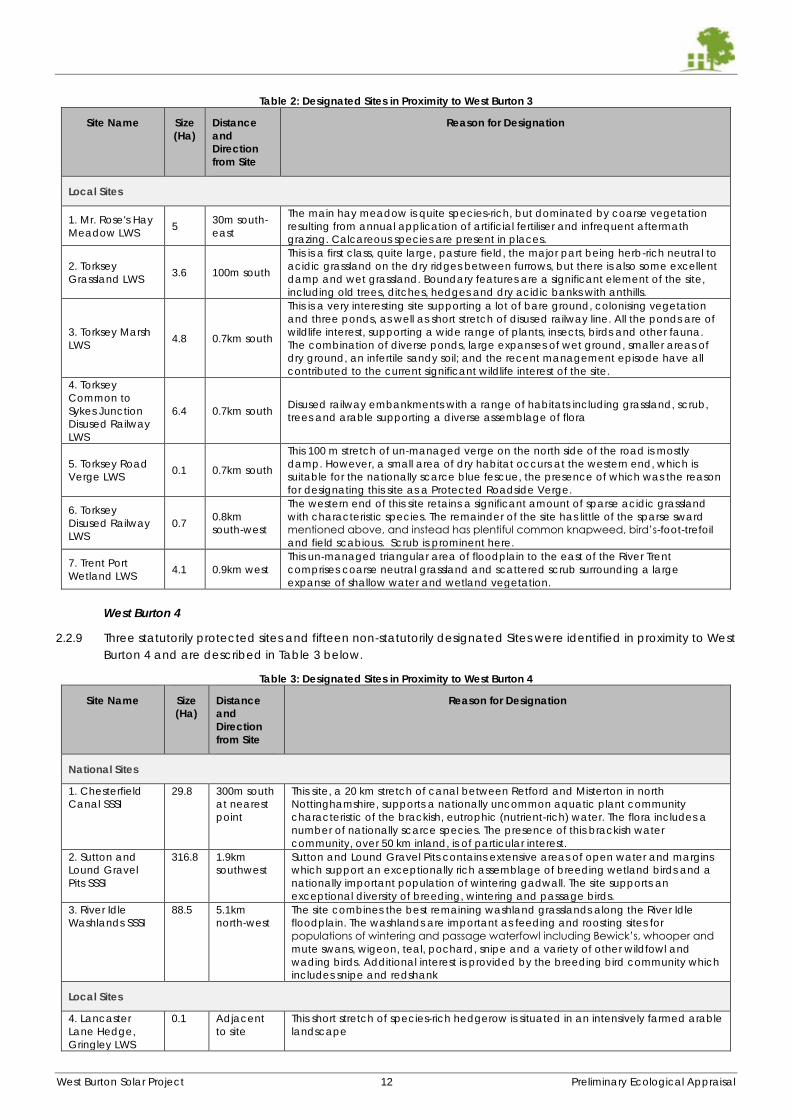
West Burton Solar Project 12 Preliminary Ecological Appraisal
Table 2: Designated Sites in Proximity to West Burton 3
Site Name Size
(Ha)
Distance
and
Direction
from Site
Reason for Designation
Local Sites
1. Mr. Rose's Hay
Meadow LWS 5
30m south-
east
The main hay meadow is quite species-rich, but dominated by coarse vegetation
resulting from annual application of artificial fertiliser and infrequent aftermath
grazing. Calcareous species are present in places.
2. Torksey
Grassland LWS 3.6 100m south
This is a first class, quite large, pasture field, the major part being herb-rich neutral to
acidic grassland on the dry ridges between furrows, but there is also some excellent
damp and wet grassland. Boundary features are a significant element of the site,
including old trees, ditches, hedges and dry acidic banks with anthills.
3. Torksey Marsh
LWS 4.8 0.7km south
This is a very interesting site supporting a lot of bare ground, colonising vegetation
and three ponds, as well as short stretch of disused railway line. All the ponds are of
wildlife interest, supporting a wide range of plants, insects, birds and other fauna.
The combination of diverse ponds, large expanses of wet ground, smaller areas of
dry ground, an infertile sandy soil; and the recent management episode have all
contributed to the current significant wildlife interest of the site.
4. Torksey
Common to
Sykes Junction
Disused Railway
LWS
6.4 0.7km south Disused railway embankments with a range of habitats including grassland, scrub,
trees and arable supporting a diverse assemblage of flora
5. Torksey Road
Verge LWS 0.1 0.7km south
This 100 m stretch of un-managed verge on the north side of the road is mostly
damp. However, a small area of dry habitat occurs at the western end, which is
suitable for the nationally scarce blue fescue, the presence of which was the reason
for designating this site as a Protected Roadside Verge.
6. Torksey
Disused Railway
LWS
0.7 0.8km
south-west
The western end of this site retains a significant amount of sparse acidic grassland
with characteristic species. The remainder of the site has little of the sparse sward
mentioned above, and instead has plentiful common knapweed, bird’s-foot-trefoil
and field scabious. Scrub is prominent here.
7. Trent Port
Wetland LWS 4.1 0.9km west
This un-managed triangular area of floodplain to the east of the River Trent
comprises coarse neutral grassland and scattered scrub surrounding a large
expanse of shallow water and wetland vegetation.
West Burton 4
2.2.9 Three statutorily protected sites and fifteen non-statutorily designated Sites were identified in proximity to West
Burton 4 and are described in Table 3 below.
Table 3: Designated Sites in Proximity to West Burton 4
Site Name Size
(Ha)
Distance
and
Direction
from Site
Reason for Designation
National Sites
1. Chesterfield
Canal SSSI
29.8 300m south
at nearest
point
This site, a 20 km stretch of canal between Retford and Misterton in north
Nottinghamshire, supports a nationally uncommon aquatic plant community
characteristic of the brackish, eutrophic (nutrient-rich) water. The flora includes a
number of nationally scarce species. The presence of this brackish water
community, over 50 km inland, is of particular interest.
2. Sutton and
Lound Gravel
Pits SSSI
316.8 1.9km
southwest
Sutton and Lound Gravel Pits contains extensive areas of open water and margins
which support an exceptionally rich assemblage of breeding wetland birds and a
nationally important population of wintering gadwall. The site supports an
exceptional diversity of breeding, wintering and passage birds.
3. River Idle
Washlands SSSI
88.5 5.1km
north-west
The site combines the best remaining washland grasslands along the River Idle
floodplain. The washlands are important as feeding and roosting sites for
populations of wintering and passage waterfowl including Bewick’s, whooper and
mute swans, wigeon, teal, pochard, snipe and a variety of other wildfowl and
wading birds. Additional interest is provided by the breeding bird community which
includes snipe and redshank
Local Sites
4. Lancaster
Lane Hedge,
Gringley LWS
0.1 Adjacent
to site
This short stretch of species-rich hedgerow is situated in an intensively farmed arable
landscape
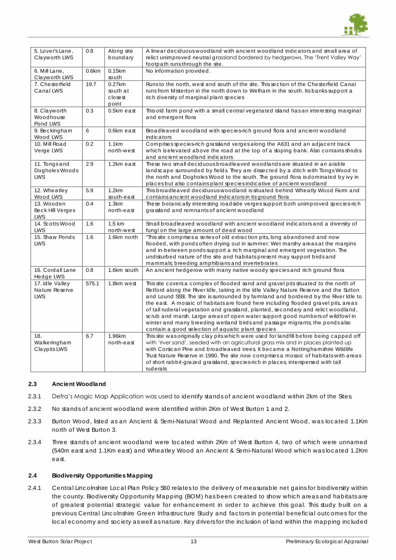
West Burton Solar Project 13 Preliminary Ecological Appraisal
5. Lover's Lane,
Clayworth LWS
0.8 Along site
boundary
A linear deciduous woodland with ancient woodland indicators and small area of
relict unimproved neutral grassland bordered by hedgerows. The ‘Trent Valley Way’
footpath runs through the site.
6. Mill Lane,
Clayworth LWS
0.6km 0.15km
south
No information provided.
7. Chesterfield
Canal LWS
19.7 0.27km
south at
closest
point
Runs to the north, west and south of the site. This section of the Chesterfield Canal
runs from Misterton in the north down to Welham in the south. Its banks support a
rich diversity of marginal plant species
8. Clayworth
Woodhouse
Pond LWS
0.3 0.5km east This old farm pond with a small central vegetated island has an interesting marginal
and emergent flora
9. Beckingham
Wood LWS
6 0.6km east Broadleaved woodland with species-rich ground flora and ancient woodland
indicators
10. Mill Road
Verge LWS
0.2 1.1km
north-west
Comprises species-rich grassland verges along the A631 and an adjacent track
which is elevated above the road at the top of a sloping bank. Also contains shrubs
and ancient woodland indicators
11. Tongs and
Dogholes Woods
LWS
2.9 1.2km east These two small deciduous broadleaved woodlands are situated in an arable
landscape surrounded by fields. They are dissected by a ditch with Tongs Wood to
the north and Dogholes Wood to the south. The ground flora is dominated by ivy in
places but also contains plant species indicative of ancient woodland
12. Wheatley
Wood LWS
5.9 1.2km
south-east
This broadleaved deciduous woodland is situated behind Wheatly Wood Farm and
contains ancient woodland indicators in its ground flora
13. Wooden
Beck Hill Verges
LWS
0.4 1.3km
north-east
These botanically interesting roadside verges support both unimproved species-rich
grassland and remnants of ancient woodland
14. Scotts Wood
LWS
1.6 1.5 km
north-west
Small broadleaved woodland with ancient woodland indicators and a diversity of
fungi on the large amount of dead wood
15. Shaw Ponds
LWS
1.6 1.6km north "This site comprises a series of old extraction pits, long abandoned and now
flooded, with ponds often drying out in summer. Wet marshy areas at the margins
and in-between ponds support a rich marginal and emergent vegetation. The
undisturbed nature of the site and habitats present may support birds and
mammals; breeding amphibians and invertebrates
16. Cordall Lane
Hedge LWS
0.8 1.6km south An ancient hedgerow with many native woody species and rich ground flora
17. Idle Valley
Nature Reserve
LWS
575.1 1.8km west This site covers a complex of flooded sand and gravel pits situated to the north of
Retford along the River Idle, taking in the Idle Valley Nature Reserve and the Sutton
and Lound SSSI. The site is surrounded by farmland and bordered by the River Idle to
the east. A mosaic of habitats are found here including flooded gravel pits, areas
of tall ruderal vegetation and grassland, planted, secondary and relict woodland,
scrub and marsh. Large areas of open water support good numbers of wildfowl in
winter and many breeding wetland birds and passage migrants; the ponds also
contain a good selection of aquatic plant species
18.
Walkeringham
Claypits LWS
6.7 1.96km
north-east
This site was originally clay pits which were used for landfill before being capped off
with ‘river sand’, seeded with an agricultural grass mix and in places planted up
with Corsican Pine and broadleaved trees. It became a Nottinghamshire Wildlife
Trust Nature Reserve in 1990. The site now comprises a mosaic of habitats with areas
of short rabbit-grazed grassland, species-rich in places, interspersed with tall
ruderals
2.3 Ancient Woodland
2.3.1 Defra’s Magic Map Application was used to identify stands of ancient woodland within 2km of the Sites.
2.3.2 No stands of ancient woodland were identified within 2Km of West Burton 1 and 2.
2.3.3 Burton Wood, listed as an Ancient & Semi-Natural Wood and Replanted Ancient Wood, was located 1.1Km
north of West Burton 3.
2.3.4 Three stands of ancient woodland were located within 2Km of West Burton 4, two of which were unnamed
(540m east and 1.1Km east) and Wheatley Wood an Ancient & Semi-Natural Wood which was located 1.2Km
east.
2.4 Biodiversity Opportunities Mapping
2.4.1 Central Lincolnshire Local Plan Policy S60 relates to the delivery of measurable net gains for biodiversity within
the county. Biodiversity Opportunity Mapping (BOM) has been created to show which areas and habitats are
of greatest potential strategic value for enhancement in order to achieve this goal. This study built on a
previous Central Lincolnshire Green Infrastructure Study and factors in potential beneficial outcomes for the
local economy and society as well as nature. Key drivers for the inclusion of land within the mapping included
West Burton Solar Project 14 Preliminary Ecological Appraisal
agri-environment scheme targeting, restoring, buffering and connecting Local Wildlife Sites, and targets under
Lincolnshire’s Biodiversity Action Plan.
2.4.2 Figure 3 overleaf show the layout of BOM in relation to the Sites (within approximately 2Km).
2.4.3 West Burton 1 and 2 fall within and close to the Biodiversity Opportunity Area known as River Till and Fossdyke
Navigation Biodiversity Opportunity Area.
2.4.4 West Burton 3 falls approximately 250m east of the Trent Vale Biodiversity Opportunity Area.
2.4.5 According to “Central Lincolnshire Policy S60: Biodiversity Opportunity and Net Gain Evidence Report”, dated
June 2021, work has begun on the preparation of a Local Nature Recovery Strategy (LNRS) for Lincolnshire
which will replace the BAP. The LNRS will be a new system of spatial strategies for nature to support the delivery
of biodiversity net gain and provide a tool for the public authorities to guide their approach. The LNRS will map
the most valuable habitats for nature and provide specific proposals for effecting net gain opportunities. This
will build upon the existing Biodiversity Opportunity Mapping and Areas work.
2.4.6 No Biodiversity Opportunities Mapping has been carried out for the Bassetlaw District within which West Burton
4 is located.
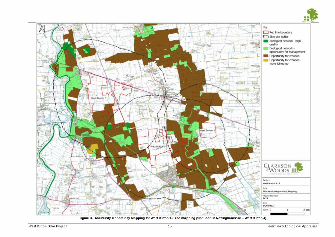
West Burton Solar Project 15 Preliminary Ecological Appraisal
Figure 3. Biodiversity Opportunity Mapping for West Burton 1-3 (no mapping produced in Nottinghamshire – West Burton 4).
West Burton Solar Project 16 Preliminary Ecological Appraisal
3 HABITAT SURVEY
3.1.1 The findings of the habitat survey are discussed in this section, beginning with an overview of habitats common
to each Site and a discussion of general opportunities for Biodiversity Net Gain. Thereafter, habitat features
and findings particular to each Site are discussed in turn, with suggestions for Site-specific enhancements.
Phase 1 habitat maps of each Site are given in Appendix H (supplied as a separate volume) and referred to
in the text, along with target notes relating to specific habitat features. Each boundary is given a reference
code (D# for ditch and H# for hedgerow), however hedgerows with ditches are referred to with an H# code
only.
3.2 Common Habitat Constraints and Opportunities
Arable Fields
3.2.1 The arable fields occupied the vast majority of the Site’s areas and were intensively farmed monocultures
which are likely to receive periodic fertiliser and pesticide treatments. Vegetated field boundaries were sparse
and historical field boundaries can be expected to have been progressively removed over preceding years
since the industrialisation of farming. The arable fields across all Sites are therefore generally botanically poor
and contained little particular ecological interest, save for their value to a relatively small number of ground-
nesting bird species and arable specialists including hunting raptors (several of which are notable species of
conservation concern) and brown hare, as described later in this document.
3.2.2 The removal of arable fields is unlikely to result in any intrinsic loss of ecological importance, particularly given
the local abundance of this habitat. The arrays and the creation of grassland should help to promote local
ecological diversity.
Opportunities for Enhancement and Biodiversity Net Gain
3.2.3 Considerable opportunities for the enhancement of these fields’ ecological value compatible with a solar
array are available. The reversion from intensive agriculture to low (or no) inputs (fertiliser and soil improvers)
grassland alone would be expected to provide a modest net gain in plant and invertebrate species diversity.
When multiplied over the large combined area of the Sites, this effect is likely to be significant at a County or
District scale.
3.2.4 The benefit described above is able to be further enhanced through favourable and ecologically-led
approaches to the ongoing management of the grassland. It is recommended that if grazing is desired, it forms
a component of an overall management plan where grassland cutting and meadow management is also
present, whereby some areas are not grazed. The establishment of a network of species-rich meadow within
the ongoing site management would help realise especially significant net gain. Lowland meadows are a
Habitat of Principal Importance under the NERC Act (2006) and are a Lincolnshire BAP priority. Areas identified
within the Lincolnshire Biodiversity Opportunities Mapping (especially within West Burton 2 and 3) would be well
suited to creation of this habitat. Furthermore, the proximity to nesting habitat for skylark and ground nesting
birds (either on or off-site, if secured) could be another consideration for the most beneficial siting of high-
value grassland management.
3.2.5 Further options for grassland habitat management and creation which could be incorporated under panels
are given in 3.2.25 below, in relation to field margins and buffers.
3.2.6 While grazing is not necessarily incompatible with net gain for biodiversity or the creation of ecologically
valuable grassland, grazing too often or too densely carries the risk of depleting botanical diversity through
the raising of nutrient levels, favouring of fewer vigorous species, and inhibition of flowering and seed-setting.
Ideal grazing regimes would include the limiting of number of animals per hectare/acre to ‘conservation
grazing’ or Higher Level Stewardship (agri-environment scheme) rates, the seasonal restriction of animals from
the land to allow flowering and recovery, or the use of sheep in ‘aftermath’ grazing in short periods following
hay cuts.
3.2.7 Cutting or mowing can be carried out relatively quickly and cost-effectively, although cutting under panels
can present a problem where weeds and scrubby vegetation takes hold. This should be treated through
spraying or specialist cutting – advances are being made in these areas within solar arrays.
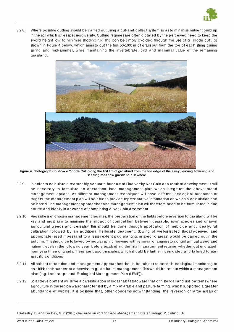
West Burton Solar Project 17 Preliminary Ecological Appraisal
3.2.8 Where possible cutting should be carried out using a cut-and-collect system so as to minimise nutrient build up
in the soil which stifles species diversity. Cutting regimes are often dictated by the perceived need to keep the
sward height low to minimise shading risk. This can be simply avoided through the use of a ‘shade cut’, as
shown in Figure 4 below, which aims to cut the first 50-100cm of grass out from the toe of each string during
spring and mid-summer, while maintaining the invertebrate, bird and mammal value of the remaining
grassland.
Figure 4. Photographs to show a ‘Shade Cut’ along the first 1m of grassland from the toe edge of the array, leaving flowering and
seeding meadow grassland elsewhere.
3.2.9 In order to calculate a reasonably accurate forecast of Biodiversity Net Gain as a result of development, it will
be necessary to formulate an operational land management plan which integrates the above broad
management options. As different management techniques will have different ecological outcomes or
targets, the management plan will be able to provide representative information on which a calculation can
be based. The management approaches and management plan will therefore need to be formulated in due
course and ideally in advance of completing a Net Gain assessment.
3.2.10 Regardless of chosen management regimes, the preparation of the fields before reversion to grassland will be
key and must aim to minimise the impact of competition between desirable, sown species and unsown
agricultural weeds and cereals.2 This should be done through application of herbicide and, ideally, full
cultivation followed by an additional herbicide treatment. Sowing of well-selected (locally-derived and
appropriate) seed mixes (and to a lesser extent plug planting, in specific areas) would be carried out in the
autumn. This should be followed by regular spring mowing with removal of arisings to control annual weed and
nutrient levels in the following year, before establishing the final management regime, whether cut or grazed,
from year three onwards. These are basic principles, which should be further investigated and tailored to site-
specific conditions.
3.2.11 All habitat restoration and management approaches should be subject to periodic ecological monitoring to
establish their success or otherwise to guide future management. This would be set out within a management
plan (e.g. Landscape and Ecological Management Plan (LEMP)).
3.2.12 Solar development will drive a diversification of local habitats toward that of historical land use patterns where
agriculture in the region was characterised by a mix of arable and pasture farming, which supported a greater
abundance of wildlife. It is possible that, other concerns notwithstanding, the reversion of large areas of
2 Blakesley, D. and Buckley, G.P. (2016) Grassland Restoration and Management. Exeter: Pelagic Publishing, UK
West Burton Solar Project 18 Preliminary Ecological Appraisal
intensive arable to grassland, especially if managed with an emphasis on ecological benefit, would be
perceived favourably in the local area.
Hedgerows
3.2.13 Hedgerows and Hedgerow Trees are a Habitat of Principal Importance and listed on the Lincolnshire BAP.
3.2.14 The hedgerow network is extensive across the majority of the Sites and is generally well-managed and species-
poor, although several sections of species-rich hedgerow are present. It is also generally intact, with few gaps.
3.2.15 Roughly half of the hedgerows were accompanied by drainage ditches or streams, most of which were dry or
partially wetted and were relatively narrow features.
3.2.16 Roughly half of the hedgerows contained at least sporadic mature and semi-mature trees. Trees were
predominantly restricted to outer boundary hedgerows, while minor internal hedgerows were normally devoid
of trees. Typical tree species recorded included ash (showing extensive signs of dieback), field maple, oak,
rowan, holly, elder and grey willow. Woody shrub species most frequently recorded in hedgerows were
hawthorn, blackthorn, and field rose.
3.2.17 Should any loss of hedgerow or boundary feature be required, it should be replaced on a 2:1 basis through
supplementary planting in appropriate locations nearby.
3.2.18 The hedgerow network is probably the single most valuable habitat feature within the Sites and should be
protected adequately during construction and operation with sufficient buffers. As a general rule, and in line
with recommendations for watercourses and field margins below, recommended minimum buffer widths from
hedgerow edge to the security fence are:
Species-poor hedgerows or hedgerows without trees: 8m
Species-rich hedgerows or hedgerows with trees: 10m
Woodland: 20m
Ancient woodland: 30m
3.2.19 Perhaps the most pertinent driver of buffer width is the hedgerow’s value to bats, therefore recommended
buffer widths are likely to vary and increase according to the value of the hedgerows and trees present to
bats, as discussed further in the species section.
Opportunities for Enhancement and Biodiversity Net Gain
3.2.20 Much of the hedgerow network will require periodic cutting to maintain a reasonable height and structure.
While specific hedgerows may require different management, cutting should generally be carried out on a 3-
yearly rotation, with only either side or the top being cut each year. Significant net gains can be had by
allowing the currently highly-managed hedgerows to fill out and broaden, encouraging a height of 3m or
more, where currently they are often below 1.5m.
3.2.21 Additional hedgerow, tree or shrub planting would also provide significant net gains for biodiversity while
contributing to visual screening. This can take the form both of in-filling of gaps in defunct or patchy hedgerows
or new hedgerows laid at bare fenced boundaries. Additionally, it may be possible to reinstate a small number
of old historical hedgerows which have been grubbed out in the past where the scheme allows (e.g. where
advantageous for screening or at easements for PROW and services etc.). Maps such as those on www.old-
maps.co.uk can be consulted for this. The planting of a small number of new hedgerows parallel to current
ones to create a double hedgerow would contribute significantly to Green Infrastructure policies and aid the
connectivity across sites if strategically located.
3.2.22 Species suitable for additional planting due to their abundance locally include blackthorn, hawthorn, elder,
field maple, field and dog rose, grey willow, oak and dogwood. Site specific planting recommendations are
given in the appropriate sections below.
3.2.23 It may be appropriate and well-received if an emphasis is placed on planting long-lived standard native trees,
especially oak, sycamore and disease-resistant elm (but also potentially field maple, birch, lime, rowan, and
alder) in order to replace the many ash trees which can be expected to be lost in the next five years due to
ash dieback.
West Burton Solar Project 19 Preliminary Ecological Appraisal
Field Margins and Semi-Improved Grassland
3.2.24 Arable field margins are a Habitat of Principal Importance and listed on the Lincolnshire BAP.
3.2.25 The uncultivated arable field margins across the Sites are predominantly absent or very narrow (<2m wide),
apart from some areas in West Burton 2 and West Burton 3 which have be purposefully left wide, in places
approximately 5-6m or more. Generally they are species poor and poor in terms of structure, being mown most
years in order to halt any scrub encroachment from hedgerows. Parcels of richer grassland habitat have been
individually noted within the corresponding Site maps, although these are infrequent.
Opportunities for Enhancement and Biodiversity Net Gain
3.2.26 Considerable cost-effective opportunities for the enhancement of field margins to become wider and more
diverse are present. Diversification of grassland management maximises the available niches for invertebrates
to lay eggs, overwinter and feed and in turn drive opportunities for diversification up the food chain.
Furthermore, widening of existing margins as ecological buffer zones has the beneficial effect of enhancing
the neighbouring hedgerows and ditches they frequently run parallel with. This in turn increases the
interconnectedness of habitats within the site and within the neighbouring landscape, a key tenet of the NPPF
and local planning policy.
3.2.27 The field margins lend themselves to being incorporated into wider buffer zones between hedgerows/field
boundaries and the security fence line. Within these, a variety of straightforward management options can be
pursued and ideally a mosaic of several techniques would be incorporated into the management of each
Site according to Site-specific species conservation opportunities (dealt with separately in sections below).
Management would ideally seek to avoid a uniform, regularly-mown grassland habitat as this reduces habitat
structure and species diversity and instead follow a low-maintenance regime. Management options include:
Tussocky grassland, mown no more than once per year (arisings can be left in situ). This can be extended
to once per two or three years on a rotational basis where monitoring indicates. A very low-maintenance
technique providing habitat for small mammals, invertebrates and winter bird seed sources. See Figure 5.
Sown and annually mown (arisings removed using cut-and-collect systems) species-rich meadow,
potentially with aftermath grazing. Promotes low-growing flowering plants key for spring and summer
invertebrate lifestages. See Figure 6.
Sown wild bird-seed crop (millet, quinoa, kale, linseed, teasel etc). Requires annual or bi-annual
cultivation. Provides excellent autumn and winter food for birds.
Encouragement of a scattered scrub/ruderal vegetation habitat mosaic on a three-year rotational cut
basis. Provides invertebrate overwintering habitats as well as year-round foraging habitat for many bird
species. See Figure 7.
Pollen and nectar strips. Fine grassland dominated by low-growing nectar rich species such as clover,
bird’s-foot trefoil and sainfoin. Requires cultivation and/or sowing approximately every 3 years. See Figure
8.
3.2.28 It is recommended that these field margin buffer zones measure a minimum of approximately 7-10m from
boundary (e.g. nearest hedgerow edge) to security fence in order to realise most ecological benefits3. Specific
ecological constraints can be expected to increase this recommendation as discussed accordingly in the Site-
specific species sections.
3.2.29 Locations within West Burton 1-3 which appear on the Biodiversity Opportunities Mapping would be well suited
to the more diverse habitat management options and mosaics. It is considered that sympathetically managed
grassland buffer zones would constitute Arable Field Margin habitat in line with the Lincolnshire BAP.
3 BRE (2014) Biodiversity Guidance for Solar Developments. Eds G E Parker and L Greene.
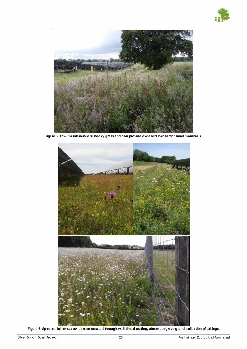
West Burton Solar Project 20 Preliminary Ecological Appraisal
Figure 5. Low-maintenance tussocky grassland can provide excellent habitat for small mammals.
Figure 6. Species-rich meadow can be created through well-timed cutting, aftermath grazing and collection of arisings.
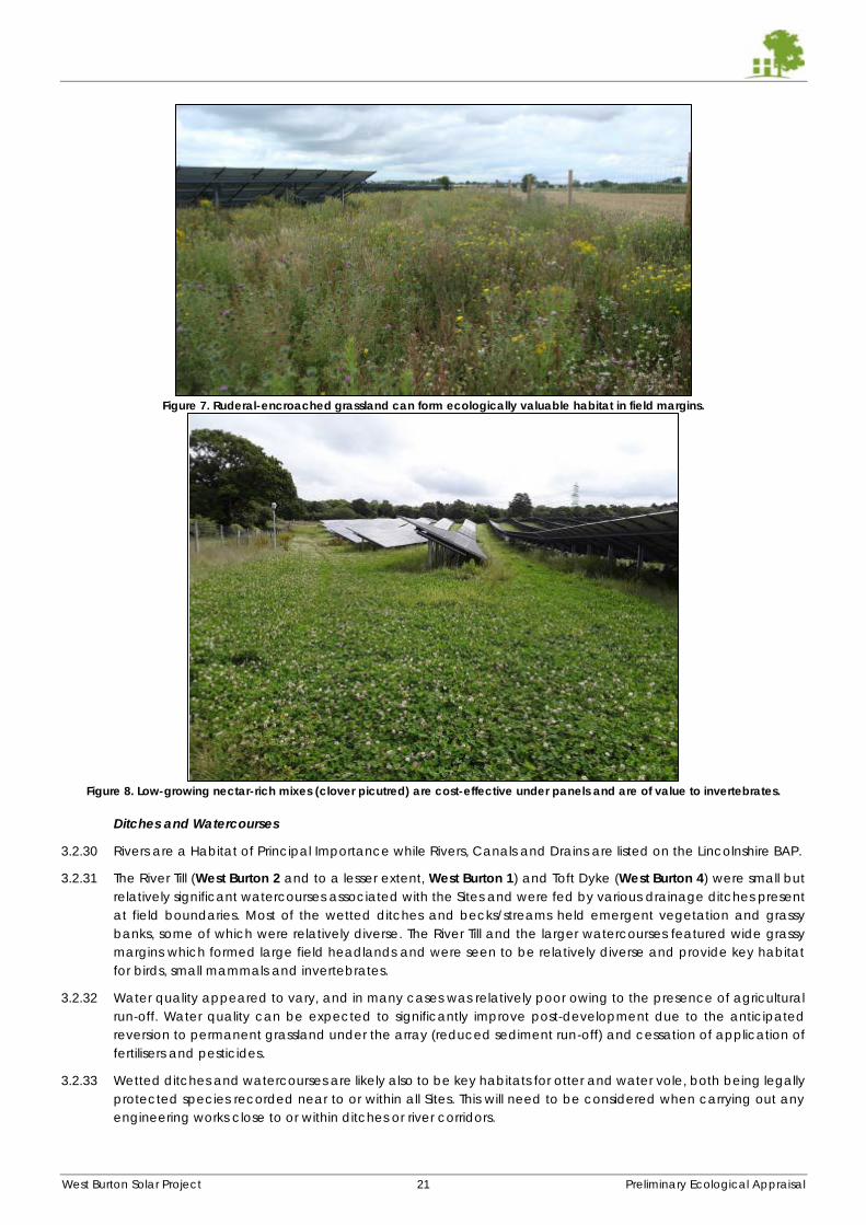
West Burton Solar Project 21 Preliminary Ecological Appraisal
Figure 7. Ruderal-encroached grassland can form ecologically valuable habitat in field margins.
Figure 8. Low-growing nectar-rich mixes (clover picutred) are cost-effective under panels and are of value to invertebrates.
Ditches and Watercourses
3.2.30 Rivers are a Habitat of Principal Importance while Rivers, Canals and Drains are listed on the Lincolnshire BAP.
3.2.31 The River Till (West Burton 2 and to a lesser extent, West Burton 1) and Toft Dyke (West Burton 4) were small but
relatively significant watercourses associated with the Sites and were fed by various drainage ditches present
at field boundaries. Most of the wetted ditches and becks/streams held emergent vegetation and grassy
banks, some of which were relatively diverse. The River Till and the larger watercourses featured wide grassy
margins which formed large field headlands and were seen to be relatively diverse and provide key habitat
for birds, small mammals and invertebrates.
3.2.32 Water quality appeared to vary, and in many cases was relatively poor owing to the presence of agricultural
run-off. Water quality can be expected to significantly improve post-development due to the anticipated
reversion to permanent grassland under the array (reduced sediment run-off) and cessation of application of
fertilisers and pesticides.
3.2.33 Wetted ditches and watercourses are likely also to be key habitats for otter and water vole, both being legally
protected species recorded near to or within all Sites. This will need to be considered when carrying out any
engineering works close to or within ditches or river corridors.
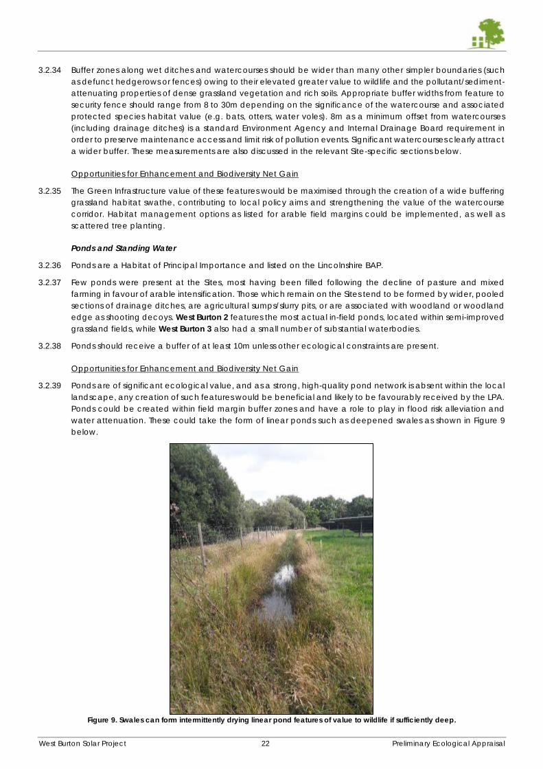
West Burton Solar Project 22 Preliminary Ecological Appraisal
3.2.34 Buffer zones along wet ditches and watercourses should be wider than many other simpler boundaries (such
as defunct hedgerows or fences) owing to their elevated greater value to wildlife and the pollutant/sediment-
attenuating properties of dense grassland vegetation and rich soils. Appropriate buffer widths from feature to
security fence should range from 8 to 30m depending on the significance of the watercourse and associated
protected species habitat value (e.g. bats, otters, water voles). 8m as a minimum offset from watercourses
(including drainage ditches) is a standard Environment Agency and Internal Drainage Board requirement in
order to preserve maintenance access and limit risk of pollution events. Significant watercourses clearly attract
a wider buffer. These measurements are also discussed in the relevant Site-specific sections below.
Opportunities for Enhancement and Biodiversity Net Gain
3.2.35 The Green Infrastructure value of these features would be maximised through the creation of a wide buffering
grassland habitat swathe, contributing to local policy aims and strengthening the value of the watercourse
corridor. Habitat management options as listed for arable field margins could be implemented, as well as
scattered tree planting.
Ponds and Standing Water
3.2.36 Ponds are a Habitat of Principal Importance and listed on the Lincolnshire BAP.
3.2.37 Few ponds were present at the Sites, most having been filled following the decline of pasture and mixed
farming in favour of arable intensification. Those which remain on the Sites tend to be formed by wider, pooled
sections of drainage ditches, are agricultural sumps/slurry pits, or are associated with woodland or woodland
edge as shooting decoys. West Burton 2 features the most actual in-field ponds, located within semi-improved
grassland fields, while West Burton 3 also had a small number of substantial waterbodies.
3.2.38 Ponds should receive a buffer of at least 10m unless other ecological constraints are present.
Opportunities for Enhancement and Biodiversity Net Gain
3.2.39 Ponds are of significant ecological value, and as a strong, high-quality pond network is absent within the local
landscape, any creation of such features would be beneficial and likely to be favourably received by the LPA.
Ponds could be created within field margin buffer zones and have a role to play in flood risk alleviation and
water attenuation. These could take the form of linear ponds such as deepened swales as shown in Figure 9
below.
Figure 9. Swales can form intermittently drying linear pond features of value to wildlife if sufficiently deep.
West Burton Solar Project 23 Preliminary Ecological Appraisal
3.3 West Burton 1 Habitat Assessment
Habitat Map and Target Notes
3.3.1 Please see Appendix H (separate document) for a Phase 1 habitat survey map for West Burton 1. Table 4,
below, gives a description of the features referred to on the map by numbered Target Notes.
Table 4: Target Notes For West Burton 1 (Constraints and Opportunities)
No. Description
TN1 3m tall ruderal margin on a south facing bank adjacent a wet ditch
TN2(x4) Wide grassy margin of value for invertebrates and reptiles
TN3 Two white willows, growing very close to one another
TN4 Single white willow
TN5 Appears to have been in-filled with whip planting in recent years
TN6(x3) Tree rooted halfway down a steep bank to the relatively large ditch (drain)
Habitat Overview
3.3.2 West Burton 1 is the smallest Site and measures approximately 90ha, being is characterised by five large wheat
fields (presumed winter sown) surrounded by a network of moderately managed, species-poor hedgerows
with ditches. Most of the hedgerows contained at least intermittent mature trees. Field margins were generally
narrow and comprised unmanaged grass, although in certain locations these were wider, up to 6m, with
encroaching ruderal vegetation and tussocky in nature. No agricultural buildings were present on or adjacent
to the Site. Two small copses or woodland stands were present adjacent to the Site (west and east boundary
respectively). No ponds were present on Site.
Arable Fields and Field Margins
3.3.3 The arable fields are all of low botanical interest and general ecological value, being monocultures, save for
their value to ground nesting birds and hares, predominantly.
3.3.4 Field margins were mostly narrow, being up to 2m wide, although in certain locations, such as H8, H11 and
H12, as indicated by TN2, these measured up to 6m wide, although mostly on the northern sides to hedgerows.
All field margins were left unmanaged and had become coarse and tussocky. These comprised species
including Timothy-grass, cocks-foot, cough grass, creeping bent, red fescue, thistles, hogweed, willowherb
species, common nettle, redshank and hedge bindweed. Ragwort, meadowsweet, chamomile, bittersweet
and kidney vetch were occasionally recorded.
3.3.5 Consequently, several of the existing grassy field margins mentioned above hold some moderate ecological
value and should be retained and incorporated into buffer zones extending from their corresponding
hedgerows/ditches wherever possible.
Opportunities for Enhancement and Biodiversity Net Gain
3.3.6 As West Burton 1 was dominated by cultivated land and did not include any discrete semi-improved grassland
or pasture fields, there are few locations where traditional meadow creation would be considered a natural
succession of existing habitats, although widening and low-key management to tussocky grassland of all
currently narrow margins in order to match those noted as bearing wildlife value would be beneficial.
3.3.7 Field 1 is located within a BOM zone listed as ‘opportunity for creation’, presumably on account of its proximity
to the River Till and priority habitat in the form of plantation woodland to the north east of the Site. Therefore,
Field 1 would be the best single field candidate for high-value meadow grassland creation, although arguably
this could extend to Field 3 and the western half of Field 5 for the same reason.
3.3.8 All cereal fields would benefit from their reversion to permanent grassland receiving ecologically-sympathetic
management as set out in Section 3.2.
Hedgerows
3.3.9 While all hedgerows were considered species-poor, the majority featured at least intermittent mature and
semi-mature trees with accompanying, mostly wet, drainage ditches and had been allowed to grow to
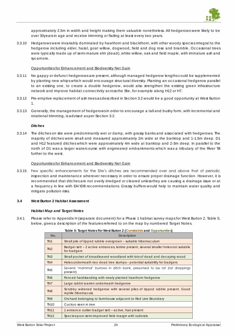
West Burton Solar Project 24 Preliminary Ecological Appraisal
approximately 2.5m in width and height making them valuable nonetheless. All hedgerows were likely to be
over 30years in age and receive trimming or flailing at least every two years.
3.3.10 Hedgerows were invariably dominated by hawthorn and blackthorn, with other woody species integral to the
hedgerow including elder, hazel, goat willow, dogwood, field and dog rose and bramble. Occasional trees
were typically made up of semi-mature elm (dead), white willow, oak and field maple, with immature ash and
sycamore.
Opportunities for Enhancement and Biodiversity Net Gain
3.3.11 No gappy or defunct hedgerows are present, although managed hedgerow lengths could be supplemented
by planting new whips which would encourage structural diversity. Planting an occasional hedgerow parallel
to an existing one, to create a double hedgerow, would also strengthen the existing green infrastructure
network and improve habitat connectivity across the Site, for example along H12 or H7.
3.3.12 Pre-emptive replacement of ash trees as described in Section 3.2 would be a good opportunity at West Burton
1.
3.3.13 Generally, the management of hedgerows in order to encourage a tall and bushy form, with incremental and
rotational trimming, is advised as per Section 3.2.
Ditches
3.3.14 The ditches on site were predominantly wet or damp, with grassy banks and associated with hedgerows. The
majority of ditches were small and measured approximately 2m wide at the banktop and 1-1.5m deep. D1
and H12 featured ditches which were approximately 4m wide at banktop and 2-3m deep. In parallel to the
north of D1 was a larger watercourse with engineered embankments which was a tributary of the River Till
further to the west.
Opportunities for Enhancement and Biodiversity Net Gain
3.3.15 Few specific enhancements for the Site’s ditches are recommended over and above that of periodic
inspection and maintenance wherever necessary in order to ensure proper drainage function. However, it is
recommended that ditches are not overly dredged or cleared unless they are causing a drainage issue or at
a frequency in line with EA/IDB recommendations. Grassy buffers would help to maintain water quality and
mitigate pollution risks.
3.4 West Burton 2 Habitat Assessment
Habitat Map and Target Notes
3.4.1 Please refer to Appendix H (separate document) for a Phase 1 habitat survey maps for West Burton 2. Table 5,
below, gives a description of the features referred to on the map by numbered Target Notes.
Table 5: Target Notes For West Burton 2 (Constraints and Opportunities)
No. Description
TN1 Small pile of tipped rubble overgrown – suitable hibernaculum
TN2 Badger sett – 2 active entrances, latrine present, several smaller holes not suitable
for badgers
TN3 Small pocket of broadleaved woodland with lots of dead and decaying wood
TN4 Holes underneath two dead tree stumps – potential suitability for badgers
TN5 Several ‘mammal’ burrows in ditch bank, presumed to be rat (rat droppings
present)
TN6 Fenced hardstanding with newly planted hawthorn hedgerow
TN7 Large rabbit warren underneath hedgerow
TN8 Scrubby widened hedgerow with several piles of tipped rubble present. Good
reptile hibernacula
TN9 Orchard belonging to farmhouse adjacent to Red Line Boundary
TN10 Cuckoo seen in tree
TN11 1 entrance outlier badger sett – active, hair present
TN12 Species-poor semi-improved field margin with ruderals
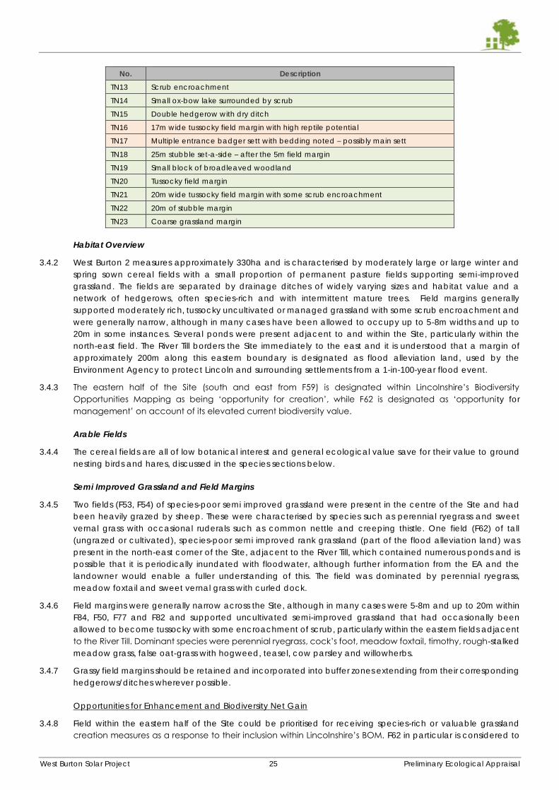
West Burton Solar Project 25 Preliminary Ecological Appraisal
No. Description
TN13 Scrub encroachment
TN14 Small ox-bow lake surrounded by scrub
TN15 Double hedgerow with dry ditch
TN16 17m wide tussocky field margin with high reptile potential
TN17 Multiple entrance badger sett with bedding noted – possibly main sett
TN18 25m stubble set-a-side – after the 5m field margin
TN19 Small block of broadleaved woodland
TN20 Tussocky field margin
TN21 20m wide tussocky field margin with some scrub encroachment
TN22 20m of stubble margin
TN23 Coarse grassland margin
Habitat Overview
3.4.2 West Burton 2 measures approximately 330ha and is characterised by moderately large or large winter and
spring sown cereal fields with a small proportion of permanent pasture fields supporting semi-improved
grassland. The fields are separated by drainage ditches of widely varying sizes and habitat value and a
network of hedgerows, often species-rich and with intermittent mature trees. Field margins generally
supported moderately rich, tussocky uncultivated or managed grassland with some scrub encroachment and
were generally narrow, although in many cases have been allowed to occupy up to 5-8m widths and up to
20m in some instances. Several ponds were present adjacent to and within the Site, particularly within the
north-east field. The River Till borders the Site immediately to the east and it is understood that a margin of
approximately 200m along this eastern boundary is designated as flood alleviation land, used by the
Environment Agency to protect Lincoln and surrounding settlements from a 1-in-100-year flood event.
3.4.3 The eastern half of the Site (south and east from F59) is designated within Lincolnshire’s Biodiversity
Opportunities Mapping as being ‘opportunity for creation’, while F62 is designated as ‘opportunity for
management’ on account of its elevated current biodiversity value.
Arable Fields
3.4.4 The cereal fields are all of low botanical interest and general ecological value save for their value to ground
nesting birds and hares, discussed in the species sections below.
Semi Improved Grassland and Field Margins
3.4.5 Two fields (F53, F54) of species-poor semi improved grassland were present in the centre of the Site and had
been heavily grazed by sheep. These were characterised by species such as perennial ryegrass and sweet
vernal grass with occasional ruderals such as common nettle and creeping thistle. One field (F62) of tall
(ungrazed or cultivated), species-poor semi improved rank grassland (part of the flood alleviation land) was
present in the north-east corner of the Site, adjacent to the River Till, which contained numerous ponds and is
possible that it is periodically inundated with floodwater, although further information from the EA and the
landowner would enable a fuller understanding of this. The field was dominated by perennial ryegrass,
meadow foxtail and sweet vernal grass with curled dock.
3.4.6 Field margins were generally narrow across the Site, although in many cases were 5-8m and up to 20m within
F84, F50, F77 and F82 and supported uncultivated semi-improved grassland that had occasionally been
allowed to become tussocky with some encroachment of scrub, particularly within the eastern fields adjacent
to the River Till. Dominant species were perennial ryegrass, cock’s foot, meadow foxtail, timothy, rough-stalked
meadow grass, false oat-grass with hogweed, teasel, cow parsley and willowherbs.
3.4.7 Grassy field margins should be retained and incorporated into buffer zones extending from their corresponding
hedgerows/ditches wherever possible.
Opportunities for Enhancement and Biodiversity Net Gain
3.4.8 Field within the eastern half of the Site could be prioritised for receiving species-rich or valuable grassland
creation measures as a response to their inclusion within Lincolnshire’s BOM. F62 in particular is considered to
West Burton Solar Project 26 Preliminary Ecological Appraisal
hold the potential to be significantly enhanced to a species-rich traditional lowland meadow through
cessation of regular grazing and introduction of a single hay cut (cut-and-collect) potentially with aftermath
grazing. This should have the effect of stifling ryegrass dominance and allowing finer grasses and flowering
plants to compete. The sward can be further diversified through over sowing within an appropriate meadow
seed mix. Depending on the regime of inundation it receives (awaiting further EA information), this treatment
should be adjusted to reflect its wetter conditions through skewing a seeding mix towards wet/floodplain
meadow or marshy grassland.
3.4.9 All cereal fields would benefit from their reversion to permanent grassland receiving ecologically-sympathetic
management as set out in Section 3.2.
3.4.10 Field margins are wide in places, particularly in F84 alongside the River Till embankments, and should be
retained and enhanced. Enhancements in these margins would lend themselves to simple tussocky grassland
management, with desirable encroachment by ruderal and scattered scrub habitats, in line with the
conditions of the similar habitat fragments found on Site mentioned above.
3.4.11 The margins along the western edge of F63 (TN16), southern edge of F50, the northern, southern and western
edges of F77 (alongside the woodland strip and D2) and western edge of F82 (alongside D5) are also
particularly wide and should be preserved and enhanced. These locations would lend themselves to wild bird
cover crop (millet, kale, quinoa etc) or ruderal-encroached tussocky grassland in line with their current
condition. The above treatments at F50 and F77 would help buffer the strip of woodland located between the
two fields and enhance its connectivity and Green Infrastructure at the Site.
Hedgerows and Woodland
3.4.12 Hedgerows were absent from many field boundaries, with fields being demarcated with drainage ditches and
grassy field margins in these instances. Hedgerows, where present, were a roughly even mixture of species-
poor and species-rich with dominant species being hawthorn and blackthorn, with rose, field maple, grey
willow, ash, crab apple, elder all regularly present. Hedgerows generally received minimal management,
causing many to have become quite tall and bushy, improving their ecological value. Several internal
hedgerows were gappy and classed as defunct. Hedgerows should be adequately buffered as set out in
Section 3.2.
3.4.13 Woodland was present on Site in the form of a relatively diverse strip of broadleaved woodland separating
F50 and F77 (known locally as Codder Lane Belt) which was seen to contain a good variety of species,
including mature ash, oak with an understorey of field maple and dog rose and ground flora featuring ramsons,
cleavers, bluebell, garlic mustard, yellow archangel, dog’s mercury and ground ivy. While not officially
designated as ancient woodland, several of the above species are indicators of ancient woodland and
therefore the habitat should be buffered and maintained as such.
3.4.14 Further woodland fragments were present at the corner junction of F55, F60 and F61 (TN19), TN3 south of F77
and around the northern boundaries of F40 and F41, with another copse alongside the north western boundary
of F48.
Opportunities for Enhancement and Biodiversity Net Gain
3.4.15 The woodland blocks given above should receive a buffer of at least 20m, potentially 30m for the long
woodland strip at F50/77 due to the presence of ancient woodland species. These buffers should be managed
to enhance their interconnectivity with hedgerows and neighbouring off-site woodland. Scrub and tussocky
grassland would be desirable within these zones.
3.4.16 The gappy hedgerows (H2, H3, H6, H27, H28, H41, H56, H66,) would lend themselves to being made intact
through new planting, including standard trees managed to become emergent above the surrounding
hedgerow as per existing trees.
3.4.17 Bare ditches could have hedgerows or individual trees planted, for instance along D2, D3, D4, D5, D6, D7, D9,
D11, D16, D21, D24 and D25. However, this should be carefully considered as it may be more appropriate to
encourage wide tussocky grassland margins. The copse of woodland at TN3 could be offered greater habitat
connectivity through the planting of a hedgerow along D4, combined with a wide buffer strip along H18.
3.4.18 Many ash trees were suffering from dieback and would benefit from pre-emptive replacement as described
in Section 3.2.
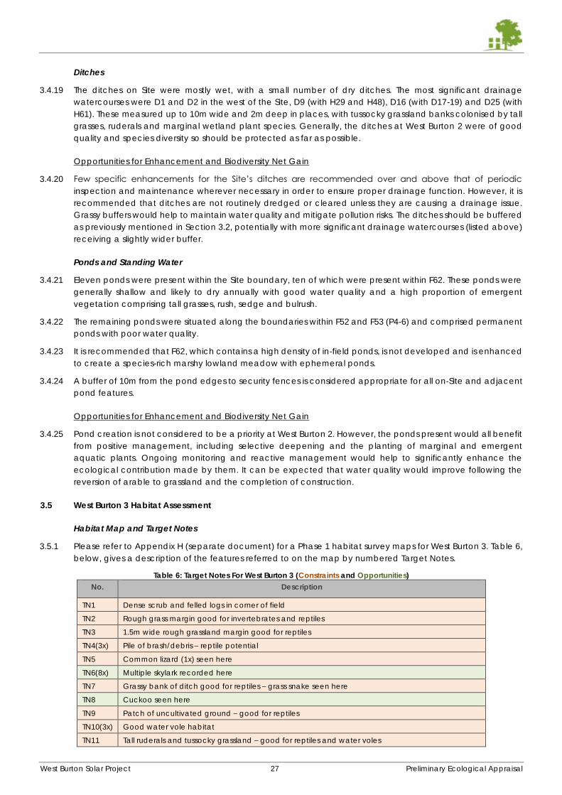
West Burton Solar Project 27 Preliminary Ecological Appraisal
Ditches
3.4.19 The ditches on Site were mostly wet, with a small number of dry ditches. The most significant drainage
watercourses were D1 and D2 in the west of the Site, D9 (with H29 and H48), D16 (with D17-19) and D25 (with
H61). These measured up to 10m wide and 2m deep in places, with tussocky grassland banks colonised by tall
grasses, ruderals and marginal wetland plant species. Generally, the ditches at West Burton 2 were of good
quality and species diversity so should be protected as far as possible.
Opportunities for Enhancement and Biodiversity Net Gain
3.4.20 Few specific enhancements for the Site’s ditches are recommended over and above that of periodic
inspection and maintenance wherever necessary in order to ensure proper drainage function. However, it is
recommended that ditches are not routinely dredged or cleared unless they are causing a drainage issue.
Grassy buffers would help to maintain water quality and mitigate pollution risks. The ditches should be buffered
as previously mentioned in Section 3.2, potentially with more significant drainage watercourses (listed above)
receiving a slightly wider buffer.
Ponds and Standing Water
3.4.21 Eleven ponds were present within the Site boundary, ten of which were present within F62. These ponds were
generally shallow and likely to dry annually with good water quality and a high proportion of emergent
vegetation comprising tall grasses, rush, sedge and bulrush.
3.4.22 The remaining ponds were situated along the boundaries within F52 and F53 (P4-6) and comprised permanent
ponds with poor water quality.
3.4.23 It is recommended that F62, which contains a high density of in-field ponds, is not developed and is enhanced
to create a species-rich marshy lowland meadow with ephemeral ponds.
3.4.24 A buffer of 10m from the pond edges to security fences is considered appropriate for all on-Site and adjacent
pond features.
Opportunities for Enhancement and Biodiversity Net Gain
3.4.25 Pond creation is not considered to be a priority at West Burton 2. However, the ponds present would all benefit
from positive management, including selective deepening and the planting of marginal and emergent
aquatic plants. Ongoing monitoring and reactive management would help to significantly enhance the
ecological contribution made by them. It can be expected that water quality would improve following the
reversion of arable to grassland and the completion of construction.
3.5 West Burton 3 Habitat Assessment
Habitat Map and Target Notes
3.5.1 Please refer to Appendix H (separate document) for a Phase 1 habitat survey maps for West Burton 3. Table 6,
below, gives a description of the features referred to on the map by numbered Target Notes.
Table 6: Target Notes For West Burton 3 (Constraints and Opportunities)
No. Description
TN1 Dense scrub and felled logs in corner of field
TN2 Rough grass margin good for invertebrates and reptiles
TN3 1.5m wide rough grassland margin good for reptiles
TN4(3x) Pile of brash/debris – reptile potential
TN5 Common lizard (1x) seen here
TN6(8x) Multiple skylark recorded here
TN7 Grassy bank of ditch good for reptiles – grass snake seen here
TN8 Cuckoo seen here
TN9 Patch of uncultivated ground – good for reptiles
TN10(3x) Good water vole habitat
TN11 Tall ruderals and tussocky grassland – good for reptiles and water voles
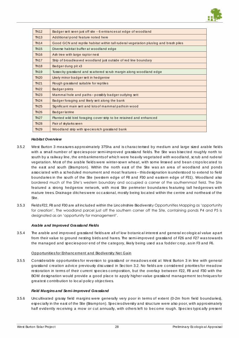
West Burton Solar Project 28 Preliminary Ecological Appraisal
TN12 Badger sett seen just off site – 6 entrances at edge of woodland
TN13 Additional pond feature noted here
TN14 Good GCN and reptile habitat within tall ruderal vegetation plus log and brash piles
TN15 Diverse habitat buffer at woodland edge
TN16 Ash tree with large raptor nest
TN17 Strip of broadleaved woodland just outside of red line boundary
TN18 Badger dung pit x3
TN19 Tussocky grassland and scattered scrub margin along woodland edge
TN20 Likely minor badger sett in hedgerow
TN21 Rough grassland suitable for reptiles
TN22 Badger prints
TN23 Mammal hole and paths – possibly badger outlying sett
TN24 Badger foraging and likely sett along the bank
TN25 Significant main sett and lots of mammal paths in wood
TN26 Badger latrine
TN27 Planted wild bird foraging cover strip to be retained and enhanced
TN28 Pair of skylarks seen
TN29 Woodland strip with species rich grassland bank
Habitat Overview
3.5.2 West Burton 3 measures approximately 375ha and is characterised by medium and large sized arable fields
with a small number of species-poor semi-improved grassland fields. The Site was bisected roughly north to
south by a railway line, the embankments of which were heavily vegetated with woodland, scrub and ruderal
vegetation. Most of the arable fields were winter-sown wheat, with some linseed and bean crops located to
the east and south (Brampton). Within the north east of the Site was an area of woodland and ponds
associated with a scheduled monument and moat features – this designation is understood to extend to field
boundaries in the south of the Site (western edge of F8 and F30 and eastern edge of F31). Woodland also
bordered much of the Site’s western boundary and occupied a corner of the southernmost field. The Site
featured a strong hedgerow network, with most Site perimeter boundaries featuring tall hedgerows with
mature trees. Drainage ditches were occasional, mostly being located within the centre and northeast of the
Site.
3.5.3 Fields F22, F8 and F30 are all included within the Lincolnshire Biodiversity Opportunities Mapping as ‘opportunity
for creation’. The woodland parcel just off the southern corner off the Site, containing ponds P4 and P5 is
designated as an ‘opportunity for management’.
Arable and Improved Grassland Fields
3.5.4 The arable and improved grassland fields are all of low botanical interest and general ecological value apart
from their value to ground nesting birds and hares. The semi-improved grassland of F26 and F27 was towards
the managed and species-poor end of the category, likely being used as a fodder crop, as in F3 and F6.
Opportunities for Enhancement and Biodiversity Net Gain
3.5.5 Considerable opportunities for reversion to grassland or meadows exist at West Burton 3 in line with general
grassland creation advice previously discussed in Section 3.2. No fields are considered priorities for meadow
restoration in terms of their current species composition, but the overlap between F22, F8 and F30 with the
BOM designation would provide a good place to apply higher-value grassland management techniques for
greatest contribution to local policy objectives.
Field Margins and Semi-Improved Grassland
3.5.6 Uncultivated grassy field margins were generally very poor in terms of extent (0-2m from field boundaries),
especially in the east of the Site (Brampton). Species diversity and structure were also poor, with approximately
half evidently receiving a mow or cut annually, with others left to become rough. Species typically present
West Burton Solar Project 29 Preliminary Ecological Appraisal
included cock’s-foot, Yorkshire fog, perennial ryegrass, meadow foxtail, meadowsweet, docs, ground ivy, cow
parsley, hogweed and nettles.
3.5.7 A small number of field margins within fields F5-8 in the north west of the Site (Bellwood) were slightly wider and
more diverse, measuring up to 4m wide in places and with greater value and structure for reptiles and
amphibians.
3.5.8 Other wide grassland margins or patches of uncultivated rough vegetation were present at TN25 (west of F8
and F30 associated with broadleaved woodland), TN16 in F22, TN27 in F31, alongside woodland in the west of
F13, TN21 in F28 and along the railway embankments (e.g. at TN19).
Opportunities for Enhancement and Biodiversity Net Gain
3.5.9 The field margins on Site would benefit significantly from reduced management and extension in width to
create either tussocky grassland, species-rich meadow habitat, cultivated wild bird cover crop or scrub-ruderal
grassland mosaic. Those listed above would be good candidates for enhancement treatments.
3.5.10 Small patches of semi-improved grassland and tall ruderal scrub were present in corners of some fields which
were difficult to cultivate or maintain and as such had become tall and tussocky. Although they hold little
botanical interest, they offer invertebrate habitat and habitat for small mammals which are hunted by birds of
prey. These are located at TN9, TN16 (and surrounding P9), margins surrounding P12, the southwest corner of
F9 and along the western boundary of F13 where the land slopes away towards woodland and is dominated
by scrub and tall ruderal vegetation.
Hedgerows
3.5.11 Relatively few species rich hedgerows were present, although most featured mature trees. Only very few, short
lengths of hedgerows were considered defunct or gappy.
3.5.12 The strongest tree lines and largest, most mature hedgerows were present along the wooded western
perimeter of F11, F13 and F15, along H13 and H15, H27, H36, H38, H49, adjacent woodland containing P3-5
and the woodland strip at TN29. These should be considered to attract a wider buffer than the standard
minimum owing to their elevated conservation value. Woodland should be buffered by at least 20m.
3.5.13 Common mature and semi-mature trees present included ash, oak, beech, horse chestnut, hazel, rowan,
alder, sycamore and English elm. Woody hedgerow species were generally hawthorn and blackthorn with
occasional elder, Viburnum opulus, field rose and spindle.
3.5.14 Internal hedgerows, i.e. those which did not describe the Site perimeter were generally species poor and
without emergent mature trees, being dominated by hawthorn and blackthorn. These were generally well
managed and maintained to between 1.5m to 2m in height and width.
Opportunities for Enhancement and Biodiversity Net Gain
3.5.15 The west side of West Burton 3 presented relatively few options for hedgerow planting, although several were
considered species-poor and lacking trees, therefore these should be targeted for enhancement.
3.5.16 The land east of the railway featured several ditches without any associated hedgerow. The planting of such
a feature on one banktop, with approximately a 2m setback could be a suitable enhancement. Examples of
suitable locations would be D4, D5 and D8, with D15 in the south of the Site.
3.5.17 Bare access tracks, for example those between F9 and F10, F11 and F12 and between F8 and F31 would be
appropriate locations for new hedgerow planting, potentially double hedgerows to create an avenue
feature.
3.5.18 Pre-emptive compensation for ash trees suffering from dieback as described in Section 3.2 would be a good
opportunity at West Burton 3.
Ditches and Ponds
3.5.19 Significant ditches are only present within the north west and north east of the Site and a limited number in the
Site centre. The strongest watercourse feature was D2, which was a stream flowing north to south, connecting
with D3 in the centre of the Site.
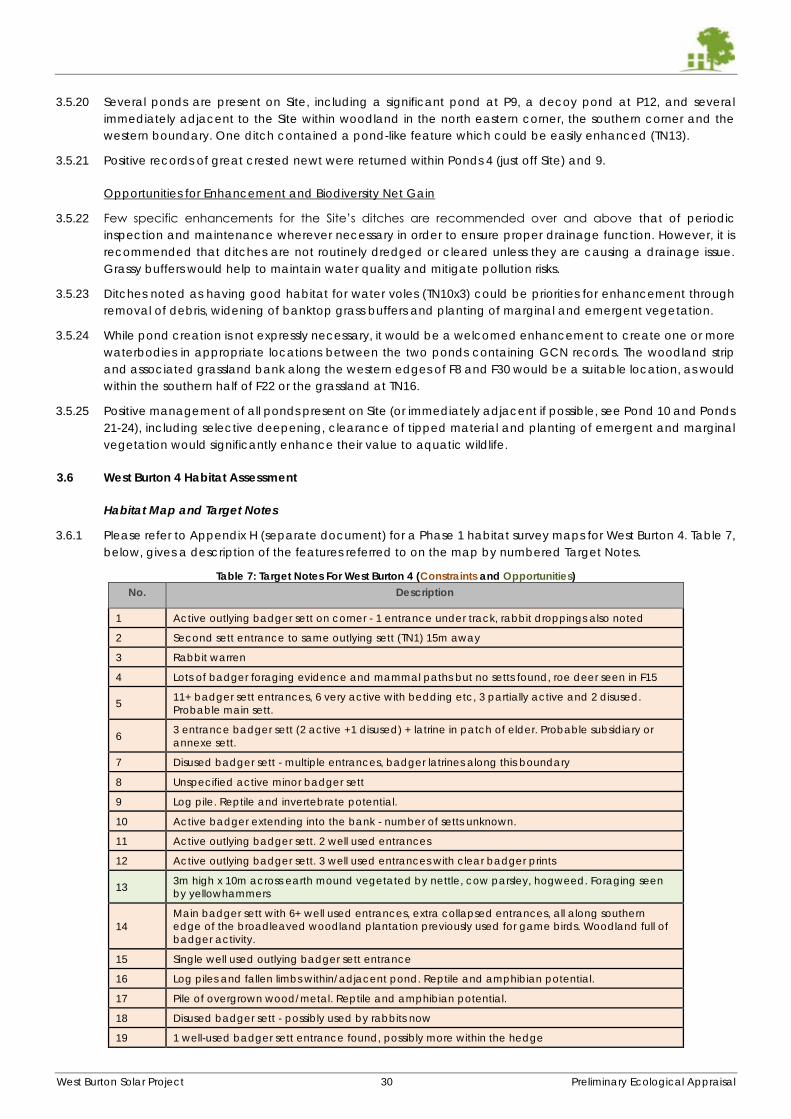
West Burton Solar Project 30 Preliminary Ecological Appraisal
3.5.20 Several ponds are present on Site, including a significant pond at P9, a decoy pond at P12, and several
immediately adjacent to the Site within woodland in the north eastern corner, the southern corner and the
western boundary. One ditch contained a pond-like feature which could be easily enhanced (TN13).
3.5.21 Positive records of great crested newt were returned within Ponds 4 (just off Site) and 9.
Opportunities for Enhancement and Biodiversity Net Gain
3.5.22 Few specific enhancements for the Site’s ditches are recommended over and above that of periodic
inspection and maintenance wherever necessary in order to ensure proper drainage function. However, it is
recommended that ditches are not routinely dredged or cleared unless they are causing a drainage issue.
Grassy buffers would help to maintain water quality and mitigate pollution risks.
3.5.23 Ditches noted as having good habitat for water voles (TN10x3) could be priorities for enhancement through
removal of debris, widening of banktop grass buffers and planting of marginal and emergent vegetation.
3.5.24 While pond creation is not expressly necessary, it would be a welcomed enhancement to create one or more
waterbodies in appropriate locations between the two ponds containing GCN records. The woodland strip
and associated grassland bank along the western edges of F8 and F30 would be a suitable location, as would
within the southern half of F22 or the grassland at TN16.
3.5.25 Positive management of all ponds present on Site (or immediately adjacent if possible, see Pond 10 and Ponds
21-24), including selective deepening, clearance of tipped material and planting of emergent and marginal
vegetation would significantly enhance their value to aquatic wildlife.
3.6 West Burton 4 Habitat Assessment
Habitat Map and Target Notes
3.6.1 Please refer to Appendix H (separate document) for a Phase 1 habitat survey maps for West Burton 4. Table 7,
below, gives a description of the features referred to on the map by numbered Target Notes.
Table 7: Target Notes For West Burton 4 (Constraints and Opportunities)
No. Description
1 Active outlying badger sett on corner - 1 entrance under track, rabbit droppings also noted
2 Second sett entrance to same outlying sett (TN1) 15m away
3 Rabbit warren
4 Lots of badger foraging evidence and mammal paths but no setts found, roe deer seen in F15
5 11+ badger sett entrances, 6 very active with bedding etc, 3 partially active and 2 disused.
Probable main sett.
6 3 entrance badger sett (2 active +1 disused) + latrine in patch of elder. Probable subsidiary or
annexe sett.
7 Disused badger sett - multiple entrances, badger latrines along this boundary
8 Unspecified active minor badger sett
9 Log pile. Reptile and invertebrate potential.
10 Active badger extending into the bank - number of setts unknown.
11 Active outlying badger sett. 2 well used entrances
12 Active outlying badger sett. 3 well used entrances with clear badger prints
13 3m high x 10m across earth mound vegetated by nettle, cow parsley, hogweed. Foraging seen
by yellowhammers
14
Main badger sett with 6+ well used entrances, extra collapsed entrances, all along southern
edge of the broadleaved woodland plantation previously used for game birds. Woodland full of
badger activity.
15 Single well used outlying badger sett entrance
16 Log piles and fallen limbs within/adjacent pond. Reptile and amphibian potential.
17 Pile of overgrown wood/metal. Reptile and amphibian potential.
18 Disused badger sett - possibly used by rabbits now
19 1 well-used badger sett entrance found, possibly more within the hedge
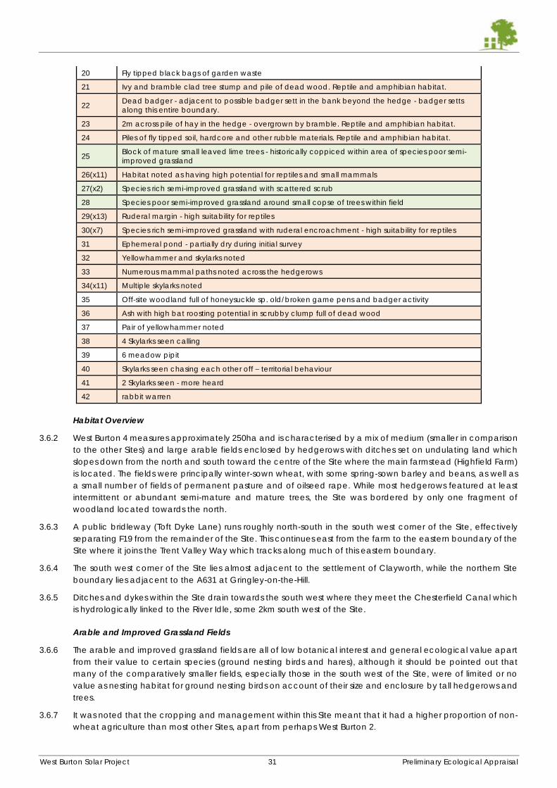
West Burton Solar Project 31 Preliminary Ecological Appraisal
20 Fly tipped black bags of garden waste
21 Ivy and bramble clad tree stump and pile of dead wood. Reptile and amphibian habitat.
22 Dead badger - adjacent to possible badger sett in the bank beyond the hedge - badger setts
along this entire boundary.
23 2m across pile of hay in the hedge - overgrown by bramble. Reptile and amphibian habitat.
24 Piles of fly tipped soil, hardcore and other rubble materials. Reptile and amphibian habitat.
25 Block of mature small leaved lime trees - historically coppiced within area of species poor semi-
improved grassland
26(x11) Habitat noted as having high potential for reptiles and small mammals
27(x2) Species rich semi-improved grassland with scattered scrub
28 Species poor semi-improved grassland around small copse of trees within field
29(x13) Ruderal margin - high suitability for reptiles
30(x7) Species rich semi-improved grassland with ruderal encroachment - high suitability for reptiles
31 Ephemeral pond - partially dry during initial survey
32 Yellowhammer and skylarks noted
33 Numerous mammal paths noted across the hedgerows
34(x11) Multiple skylarks noted
35 Off-site woodland full of honeysuckle sp. old/broken game pens and badger activity
36 Ash with high bat roosting potential in scrubby clump full of dead wood
37 Pair of yellowhammer noted
38 4 Skylarks seen calling
39 6 meadow pipit
40 Skylarks seen chasing each other off – territorial behaviour
41 2 Skylarks seen - more heard
42 rabbit warren
Habitat Overview
3.6.2 West Burton 4 measures approximately 250ha and is characterised by a mix of medium (smaller in comparison
to the other Sites) and large arable fields enclosed by hedgerows with ditches set on undulating land which
slopes down from the north and south toward the centre of the Site where the main farmstead (Highfield Farm)
is located. The fields were principally winter-sown wheat, with some spring-sown barley and beans, as well as
a small number of fields of permanent pasture and of oilseed rape. While most hedgerows featured at least
intermittent or abundant semi-mature and mature trees, the Site was bordered by only one fragment of
woodland located towards the north.
3.6.3 A public bridleway (Toft Dyke Lane) runs roughly north-south in the south west corner of the Site, effectively
separating F19 from the remainder of the Site. This continues east from the farm to the eastern boundary of the
Site where it joins the Trent Valley Way which tracks along much of this eastern boundary.
3.6.4 The south west corner of the Site lies almost adjacent to the settlement of Clayworth, while the northern Site
boundary lies adjacent to the A631 at Gringley-on-the-Hill.
3.6.5 Ditches and dykes within the Site drain towards the south west where they meet the Chesterfield Canal which
is hydrologically linked to the River Idle, some 2km south west of the Site.
Arable and Improved Grassland Fields
3.6.6 The arable and improved grassland fields are all of low botanical interest and general ecological value apart
from their value to certain species (ground nesting birds and hares), although it should be pointed out that
many of the comparatively smaller fields, especially those in the south west of the Site, were of limited or no
value as nesting habitat for ground nesting birds on account of their size and enclosure by tall hedgerows and
trees.
3.6.7 It was noted that the cropping and management within this Site meant that it had a higher proportion of non-
wheat agriculture than most other Sites, apart from perhaps West Burton 2.
West Burton Solar Project 32 Preliminary Ecological Appraisal
Opportunities for Enhancement and Biodiversity Net Gain
3.6.8 Considerable opportunities for reversion to grassland or meadows exist at West Burton 4 in line with general
grassland creation advice previously discussed in Section 3.2. For example, it is recommended to maintain a
small degree of set aside-mimicking habitat mosaic (such as inclusion of ruderal habitat, bird seed crop or
scattered scrub) of particular value to species such as turtle dove which are of high conservation concern
and have been recorded within the Idle Valley approximately 2km south west of the Site.
3.6.9 Of all the pasture grassland on Site, Field F16 is perhaps the most diverse, potentially able to be classed as
species-poor semi-improved grassland, however a full assessment was hindered by the level of grazing present.
Nevertheless, this field would probably be the best candidate for enhancement to a species-rich meadow.
It’s location at the edge of the Site would also aid its contribution to local invertebrate pollinator and foraging
bird populations.
3.6.10 The in-field small-leaved lime trees present in the south east corner of the site at TN 24 and TN27 are mature
and contain significant habitat suitability for invertebrates, birds and bats and should be adequately buffered
(TBC following investigations for bats and arboriculturalist work), with potentially the surrounding habitat
enhanced to a meadow or tussocky grassland-ruderal mosaic. The same approach should be taken at the in-
field mature tree located within F1 in the north of the Site.
Field Margins and Semi-Improved Grassland
3.6.11 Uncultivated grassy field margins were generally poor in terms of extent (0-2m from field boundaries) and
species diversity, although in nearly all cases they had been left unmanaged and tussocky, with
encroachment by ruderal vegetation and some scrub which adds some basic habitat value. A relatively small
number of wider grassy field margins, some of which were species-rich, were present measuring up to 6m in
width. These are shown on the Phase 1 map as semi-improved grassland and target noted accordingly (TN27,
TN30 etc. and notably associated with H45 and H46 in the centre of the Site).
3.6.12 Field margins typically contained species such as cocks-foot, Yorkshire fog, false-oat grass, cleavers, perennial
ryegrass, common nettle, hogweed, ground ivy, cow parsley, lords-and-ladies, greater stitchwort, hedge
woundwort, cowslip, dandelion and creeping thistle.
Opportunities for Enhancement and Biodiversity Net Gain
3.6.13 The field margins on Site would benefit significantly from targeted management and extension in width to
create either tussocky grassland, species-rich meadow habitat, cultivated wild bird cover crop or scrub-ruderal
grassland mosaic.
Hedgerows
3.6.14 Approximately half of the hedgerows on Site were considered species-rich. Most hedgerows contained
mature or semi-mature trees and most hedgerows had been allowed to grow to at least 2m in height and
width, with several (e.g. H1, H54, H74 and H90) being at least 6m, comprising many trees. Nearly all hedgerows
were managed by flailing and cutting at least every two years. The entire hedgerow network was considered
to be well over 30years of age, up to 70 or more in places.
3.6.15 A significant number of hedgerows on Site were also considered gappy and defunct and would benefit from
in-filling and targeted management.
3.6.16 Dominant species within hedgerows were hawthorn and blackthorn, with occasional field rose, elder, field
maple, ash, privet, holly, sycamore and dogwood. The most common mature trees within the hedgerows were
oak and ash (showing signs of dieback).
Opportunities for Enhancement and Biodiversity Net Gain
3.6.17 West Burton 4 contains many opportunities for new hedgerow planting, particularly at either side of access
tracks (at H60, H63 and between F20 and F21 for example), bare ditches (especially in the southern half of the
Site) and within defunct hedgerows.
3.6.18 Defunct hedgerows considered to be most in need of in-filling and maintenance include H55 (a key landscape
feature which is in danger of degradation), H54 (a key eastern boundary feature where several trees are
failing), H48 (several failing trees along this prominent tree line), H24 (a perimeter feature in need of bolstering),
West Burton Solar Project 33 Preliminary Ecological Appraisal
and H10-12 (which describe the north eastern perimeter. H45 and H60 would benefit from further planting or a
parallel hedgerow alongside the bare edge of the track to enhance east-west green infrastructure linking to
the strong tree lines further afield. H2 in the north has been partially cleared, potentially by the neighbouring
landowner to preserve views from their property. The hedgerows and tree lines of the Toft Dyke Lane (H72, H91
and H92) would also benefit from bolstering and maintenance for this key landscape feature.
3.6.19 New hedgerows to bisect fields are not considered a priority option at this Site considering the current size of
the fields, apart from potentially at F1 which is a very large field, potentially as an easterly extension of H22.
Parallel, double hedgerows where currently there is a single hedgerow would be an additional option,
potentially.
3.6.20 Pre-emptive replacement of ash trees as described in Section 3.2 would be a good opportunity, as would
planting of slower growing species such as oak.
Ditches and Standing Water
3.6.21 The drainage ditch network across the Site is extensive and made up of generally minor features, being almost
entirely 2m wide and 1-2m deep with grassy vegetation on the banks and with marginal/emergent vegetation
such as hemlock, soft rush, garlic mustard, willowherbs, meadowsweet, floatgrass, water mint and water forget-
met-not.
3.6.22 The Toft Dyke, running southwards along H72, H91 and H92 in the south west corner of the Site, along with the
drains feeding this which run east-west along H78, H80 and H55, are considered the most significant
watercourses at the Site.
3.6.23 One pond and one ephemeral pond are present on Site. Others appear to have been historically in-filled.
Opportunities for Enhancement and Biodiversity Net Gain
3.6.24 Few specific enhancements for the Site’s ditches are recommended over and above that of periodic
inspection and maintenance wherever necessary in order to ensure proper drainage function. However, it is
recommended that ditches are not routinely dredged or cleared unless they are causing a drainage issue.
Grassy buffers would help to maintain water quality and mitigate pollution risks.
3.6.25 The Toft Dyke and watercourses mentioned above be the focus of any enhancement to benefit aquatic
wildlife, such as additional emergent planting and habitat management within associated buffers being
tailored to marginal planting mixes.
3.6.26 Pond creation is not considered to be a priority at West Burton 4. The single pond-like feature at TN3 could be
deepened and widened to provide an online pond connected to flowing watercourses, within a linear feature
of ecological value.
West Burton Solar Project 34 Preliminary Ecological Appraisal
4 SPECIES INFORMATION COLLATED TO DATE
4.1.1 This section sets out the results of preliminary species survey work and an appraisal of the Sites’ value to various
protected and notable species. It also gives recommendations and suggestions for mitigation of potential
impacts and opportunities for biodiversity net gain. In the interests of brevity and to avoid repetition, the site-
specific results and recommendations are given together under each species’ sub-heading in turn.
4.2 Badgers
Desk Study Information
4.2.1 The desk study revealed 16 records of badger within 2km of West Burton 1 since 2000. All records were more
than 250m from the boundary of the Site with the closest located 260m north.
4.2.2 The desk study revealed 5 records within the red line boundary for West Burton 2, recorded between 2004 and
2011. 34 records were returned of setts within 2km of the Site boundary with exact locations not revealed. A
further 18 records are present beyond 250m from the Site boundary.
4.2.3 The desk study revealed 6 records within the red line boundary for West Burton 3, recorded between 2010 and
2015, all of which were road casualties. A total of 30 setts had been recorded within 2km of the Site boundary
with exact locations not revealed. A further 3 records are present within 250m from the Site boundary and 31
records are present from beyond 250m from the Site boundary.
4.2.4 The desk study revealed 32 records of badger within 2km of West Burton 4, three of which were within 250m of
the Site. 8 records were returned of setts within 2km of the Site boundary with exact locations not revealed.
Field Survey Results
4.2.5 Woodlands were not extensively searched for badgers during the extended Phase 1 survey as they generally
lay outside of the red line boundary. Setts were noted where there was clear evidence visible from the field
edges, or within hedgerows.
4.2.6 No badger setts were recorded at West Burton 1, thereby indicating badgers were absent from the Site.
4.2.7 At West Burton 2, three, possibly four, badger setts were located, with one (TN17) being a likely main sett.
4.2.8 One significant main badger sett (TN25) was recorded in woodland edge at West Burton 3, located in the
south of the Site.
4.2.9 A large number of badger setts, including at least one main sett (TN14) were recorded within boundary
features at West Burton 4. The Site contains several grassy banks at field boundaries that are conducive to
digging of setts by badgers as well as strong tree lines and large hedgerows with trees. These setts were
predominantly located at the south of F1 in the north of the Site and along the eastern Site boundary at F22.
Badger activity was sporadically recorded across the remainder of the Site’s boundaries.
Potential Constraints, Mitigation and Further Work
4.2.10 An operational solar array would most likely present at worst a neutral impact on badgers provided that
appropriate protective measures outlined below are undertaken during construction and maintenance.
Potentially, the diversification of habitats by introduction of permanent grassland may help to provide better
foraging opportunities for badger in the long term.
4.2.11 The grassland habitats beneath the array are highly likely remain conducive to foraging by badgers (whether
grazed or cut) and access to other woodland and farmland likely to remain unimpeded.
4.2.12 The perimeter fencing of the array is not considered to pose a limitation to badger dispersal unless it is deeply
buried and of a tight mesh size which is not typical of solar arrays. For this reason, buried fencing is not advised
as it would risk leading to its excavation by the badgers in the long term and potential fragmentation of badger
social groups.
4.2.13 The use of badger gates in perimeter fencing is also not recommended although is something that is commonly
encountered. This is considered unnecessary unless fencing is significantly buried and in our experience of
monitoring arrays across the UK we have not encountered a single badger gate in a section of linear fencing
which showed any evidence of use. By contrast we have recorded multiple locations where badgers squeeze
West Burton Solar Project 35 Preliminary Ecological Appraisal
beneath fencing (often adjacent to a badger gate). Badger gates represent an unnecessary expense and
likely just compromise the integrity of the fencing should the intention be to graze areas with livestock.
Protection and Avoidance of Setts
4.2.14 Badgers and their setts are legally protected from disturbance and damage when active (likely to be
occupied). Badgers are unlikely to pose a significant constraint to the development at the Site given the
general lack of activity at the Site and potential for impact onto significant setts. Constraints are likely only to
apply to the construction phase of the development.
4.2.15 As badgers are liable to dig new setts at any time, a pre-construction survey (approximately 3-6months prior)
of woodland edges and hedgerows within approximately 30m of any development activities is recommended
to ensure any new setts can be mitigated for in advance of commencement. Any setts capable of being
impacted should be examined to determine whether they are active or disused. Disused setts generally do
not pose a constraint. Such investigation work may require monitoring using cameras over a (minimum) three-
week period.
4.2.16 To ensure that construction and operational maintenance works do not cause unlawful impacts on badgers
and setts, a 20-30m buffer zone should be established from the perimeter of any active sett. The size of the
buffer zone should reflect the status and activity levels within the sett and the nature of the local topography
and the direction of tunnels associated with the sett entrances. Within this buffer zone, there should be no
movement of plant, excavations or installation of array structures or buried cabling for the life of the scheme.
Protective fencing and signage should be installed at the beginning of the construction phase.
4.2.17 If it is not possible to retain an active sett within the proposals, or maintain adequate buffer zones, it is likely to
be possible to close (either temporarily or permanently) them under a licence from Natural England. For any
main setts, it is probable that an alternative badger sett will need to be constructed in a suitable nearby
location in order to ensure sufficient alternative shelter. The artificial sett will also need to be created well in
advance of closure operations and uptake by the badgers will need to have been demonstrated by means
of video surveillance or similar. It is therefore advisable to undertake artificial sett creation at least six months
in advance of sett closure. Sett closure under licence can only take place between the months of July and
November inclusive so as to avoid impacts on dependent young underground.
4.2.18 Badgers will forage within grassland creating shallow pits and scrapes down to approximately 15-20mm when
excavating earthworms and grubs. To date we have not come across any examples of badger activity
causing issues with buried cabling on active solar arrays. We believe that the standard armouring surrounding
buried cabling is sufficiently robust enough to not be damaged by badger foraging or digging activity.
Opportunities for Enhancement and Biodiversity Net Gain
4.2.19 The substitution of grassland within areas previously supporting arable land will provide a greater diversity of
habitats. Badgers are reliant upon a diversity of foraging opportunities, exploiting different habitat types and
areas through the year in response to availability.
4.2.20 The grasslands within arrays generally present good opportunities for forage, the stability and undisturbed
nature of soils promotes earth worm abundance, and invertebrate and small mammal populations are
generally improved within arrays, all of which provide foraging opportunities for badger.
4.2.21 Consideration might be given to the incorporation of fruiting trees (crab apple, apple and pear for example)
within marginal areas as windfall fruits provide an important foraging resource in the autumn when badgers
are looking to build weight for the winter period.
4.3 Bats
Desk Study Information
4.3.1 For West Burton 1, approximately 60 records for four species were recorded within the desk study data, none
of which were recorded within the red line boundary and the vast majority beyond 250m of the Site. The most
commonly recorded species was common pipistrelle, with the remaining three species (soprano pipistrelle,
brown-long eared bat, and noctule bat) having only one record each. This represents a low diversity of
species, all of which can be expected to roost within buildings and/or trees in the local area. The species
present in the data were generally common and widespread. Most records were made post-2000.
West Burton Solar Project 36 Preliminary Ecological Appraisal
4.3.2 For West Burton 2 approximately 160 records for six species were recorded within the desk study data, none of
which were recorded within the red line boundary and the vast majority beyond 250m of the Site. The most
commonly recorded species was common pipistrelle, followed by Daubenton's bat, brown long-eared,
noctule bat, soprano pipistrelle and natterer’s bat.
4.3.3 For West Burton 3, approximately 230 records for six species were recorded within the desk study data. Two
records of an unidentified bat are located within the red line boundary with the vast majority of the remaining
records located beyond 250m from the Site. The most commonly recorded species was common pipistrelle,
followed by soprano pipistrelle, brown long-eared bat, noctule bat, Daubenton's bat and natterer’s bat.
4.3.4 For West Burton 4 approximately 190 records for seven species were recorded within the desk study data, none
of which were located within the red line boundary. The most commonly recorded species was common
pipistrelle, followed by brown long-eared bat, soprano pipistrelle, noctule bat, Daubenton's bat, natterer’s bat
and Nathusius’ pipistrelle.
4.3.5 Bats are Species of Principal Importance under the NERC Act (2006) and are listed on the Lincolnshire BAP.
Field Survey Results
Bat Detector Survey
4.3.6 22 bat detector locations were utilised, with two at West Burton 1, six at West Burton 2, eight at West Burton 3
and six at West Burton 4.
4.3.7 A preliminary inspection of data gathered indicated that a relatively moderate diversity of species was present
across the Sites.
4.3.8 The majority of activity was made up of common and soprano pipistrelle, noctule bat and several Myotis
species, which was expected. Brown long-eared bat is another relatively common species which featured
regularly within the assemblage.
4.3.9 Two rarer species featured sporadically and in very low numbers, which were barbastelle and Nathusius’
pipistrelle. The Sites are located at the northern edge of the range for these two species. Barbastelle are rare
and Nathusius’ pipistrelle uncommon in Lincolnshire according to the Lincolnshire BAP. Both species are
considered to be most closely linked with woodland edge habitats and tree roosts although they will
occasionally roost in buildings. A significant colony of barbastelle bats is known in Norfolk. Nathusius’ pipistrelle
bats are known to migrate long distances and have strongholds in the east and south east of England. Leisler’s
bat may also be present within the dataset. This is a rarer species but is difficult to fully separate from noctule
bats by call so further analysis will be necessary.
4.3.10 It is considered probable that roosts for all the species recorded within the data occur either in trees within the
Sites, or in trees and buildings in proximity to the Sites.
Habitat Appraisal
4.3.11 Initial fieldwork determined that the suitability of habitats for bats across the option land was generally low,
being dominated by monoculture arable and a simple network of managed hedgerows. The arable and
relatively small proportion of pasture are intensively farmed environments, receiving pesticide treatments, and
would be expected to support a lower abundance and diversity of prey items upon which bats feed.
4.3.12 The linear natural features along which bats tend to navigate and disperse, as well as forage in preference to
monoculture arable, were generally highly managed and restricted in size and structure. Woodland stands
were sparse within the landscape and generally poorly interlinked, with historic hedgerow removal resulting in
large open expanses of arable.
4.3.13 Mature trees are only sporadically present within the hedgerow networks and field edges, along with at the
edges of any woodland adjacent to the option land. In-field trees are absent from the option land. Many of
these trees hold potential for roosting by bats.
4.3.14 A relatively small number of agricultural buildings and farm dwellings (of varying levels of use and disuse) were
present adjacent to the red line boundary
4.3.15 At West Burton 1, few hedgerows contained trees, mainly at the Site perimeter, especially mature ash with signs
of dieback. No in-field trees were present. No buildings were present on or immediately adjacent to the Site.
West Burton Solar Project 37 Preliminary Ecological Appraisal
A small number of ditches were present at the Site perimeter only, and a tributary of the River Till ran along the
northernmost outline.
4.3.16 At West Burton 2, the hedgerow network was moderately diverse, with many hedgerows containing trees and
a small number of species-rich hedgerows. However, there were many fields bounded by bare ditches only.
A strip of well-established broadleaved woodland ran along the middle of the western half of the Site.
Woodland also bordered several fields in the north. Buildings associated with the settlement of Ingleby and
Ingleby Grange (mostly agricultural) may hold potential to support roosting bats and some potential for
fragmentation of movement is possible considering their proximity to the Site. There were also a small number
of in-field trees.
4.3.17 At West Burton 3, the hedgerow network was extensive and without gaps and approximately half of the
hedgerows contained trees. Some stands of well established broadleaved woodland was located just off Site
to the west, in the north east of the site and just off the southern corner. Several farm buildings and a small
number of farmhouses were located immediately off Site including several buildings. This Site also contained
a small number of in-field trees.
4.3.18 At West Burton 4, the hedgerow network was very extensive and featured generally smaller fields than at other
Sites. There were a large number of species-rich hedgerows and hedgerows containing multiple trees. A small
number of substantial watercourses ran through the Site, principally the Toft Dyke. The Site contained a small
number of in-field trees in the south east and the north. While no buildings were present on Site, the farmstead
and associated agricultural buildings were located in close proximity.
Potential Constraints, Mitigation and Further Work
4.3.19 It is unclear to what extent roosting, foraging and dispersing bats are affected by large scale solar
development as research evidence is sparse. Arrays have been demonstrated to increase invertebrate
abundance in comparison with surrounding arable landscapes4 which is likely to be of benefit to foraging bats,
particularly around the perimeters of the arrays. Whether bats use or avoid the centres or arrays and forage
within or commute along array strings is currently ambiguous. Montag et al found non-significant reduction in
abundance of bats from within the centres of arrays compared with surrounding arable fields. There is currently
no evidence to indicate significant change in the sizes or abundance of populations of bats in proximity to
established array sites, although research on the subject is sparse. As such the most reasonable assumption at
this stage is that arrays are broadly neutral upon foraging and commuting bats with the potential to offer
enhancement where they are able to promote night flying invertebrate abundance and reinforce or enhance
green infrastructure as well as retain all potential roosting features.
Roosts in Buildings and Trees
4.3.20 Clarkson and Woods should be consulted to review any proposals to prune or fell any mature or semi-mature
trees, or remove built structures, within or adjacent to the option land.
4.3.21 Buildings immediately adjacent to the red line boundaries which are considered at risk of fragmentation of
bat roosts by their proximity to the array should be inspected for bat roosts should be carried out to determine
the potential for impacts from an array of this scale. Daytime inspections can take place at any time of year
to determine levels of potential. Structures with roost potential can be followed up with emergence surveys or
static detector surveys completed between May and September.
4.3.22 It may be prudent to carry out close inspections (via a climbing survey) of any semi-mature and mature trees
situated in locations at risk of being encircled or at least partially enclosed by solar array. Severely decaying
trees, especially ash, would be avoided. This would establish the potential for impacts upon any roosts therein.
Close inspections should be preceded by ground-based inspections to ascertain levels of potential for roosting
from negligible to high. Alternatively, a pre-emptive buffer of c.30+m may be appropriate. Such inspection
work can be carried out at any time of year, with the potential for follow-up emergence surveys within the
months of May and September inclusive.
4 Montag, H., Parker, G.T., Clarkson, T. (2016) The effects of solar farms on local biodiversity: a comparative study. Clarkson and
Woods and Wychwood Biodiversity, UK.
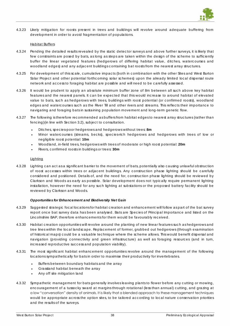
West Burton Solar Project 38 Preliminary Ecological Appraisal
4.3.23 Likely mitigation for roosts present in trees and buildings will revolve around adequate buffering from
development in order to avoid fragmentation of populations.
Habitat Buffers
4.3.24 Pending the detailed results revealed by the static detector surveys and above further surveys, it is likely that
few constraints are posed by bats, as long as steps are taken within the design of the scheme to sufficiently
buffer the linear vegetated features (hedgerows of differing habitat value, ditches, watercourses and
woodland edges) and any adjacent buildings containing bat roosts from the nearest array structures.
4.3.25 For development of this scale, cumulative impacts (both in combination with the other Sites and West Burton
Solar Project and other potential forthcoming solar schemes) upon the already limited local dispersal route
network and access to foraging habitat are possible and will need to be carefully assessed.
4.3.26 It would be prudent to apply an absolute minimum buffer zone of 8m between all such above key habitat
features and the nearest panels. It can be expected that this would increase to around habitat of elevated
value to bats, such as hedgerows with trees, buildings with roost potential (or confirmed roosts), woodland
edges and watercourses such as the River Till and other rivers and streams. This reflects their importance to
navigating and foraging bats in sustaining population movement and long-term genetic flow.
4.3.27 The following is therefore recommended as buffers from habitat edges to nearest array structures (rather than
fencing)(in line with Section 3.2), subject to consultation.
Ditches, species-poor hedgerows and hedgerows without trees: 8m
Minor watercourses (streams, becks), species-rich hedgerows and hedgerows with trees of low or
negligible roost potential: 10m
Woodland, in-field trees, hedgerows with trees of moderate or high roost potential: 20m
Rivers, confirmed roosts in buildings or trees: 30m
Lighting
4.3.28 Lighting can act as a significant barrier to the movement of bats, potentially also causing unlawful obstruction
of roost accesses within trees or adjacent buildings. Any construction phase lighting should be carefully
considered and positioned. Details of, and the need for, construction phase lighting should be reviewed by
Clarkson and Woods as early as possible. Solar development does not typically require permanent lighting
installation, however the need for any such lighting at substations or the proposed battery facility should be
reviewed by Clarkson and Woods.
Opportunities for Enhancement and Biodiversity Net Gain
4.3.29 Suggested strategic focal locations for habitat creation and enhancement will follow as part of the bat survey
report once bat survey data has been analysed. Bats are Species of Principal Importance and listed on the
Lincolnshire BAP, therefore enhancements for them would be favourably received.
4.3.30 Habitat creation opportunities will revolve around the planting of new linear features such as hedgerows and
tree lines within the local landscape. Replacement of former, grubbed out hedgerows (through examination
of historical maps) could be a valuable technique where the scheme allows. This would benefit dispersal and
navigation (providing connectivity and green infrastructure) as well as foraging resources (and in turn,
increased reproductive success and population viability).
4.3.31 The most significant habitat enhancement opportunities revolve around the management of the following
locations sympathetically for bats in order to maximise their productivity for invertebrates.
Buffers between boundary habitats and the array
Grassland habitat beneath the array
Any off site mitigation land
4.3.32 Sympathetic management for bats generally involves leaving plants to flower before any cutting or mowing,
encouragement of a tussocky sward at margins through rotational (less than annual) cutting, and grazing at
a low “conversation” density of animals. It is likely that a blended approach to these management techniques
would be appropriate across the option sites, to be tailored according to local nature conservation priorities
and the results of the surveys.
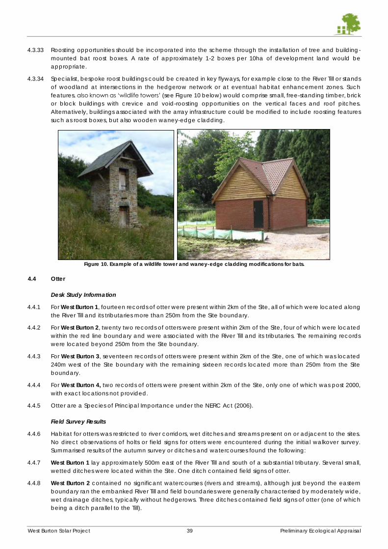
West Burton Solar Project 39 Preliminary Ecological Appraisal
4.3.33 Roosting opportunities should be incorporated into the scheme through the installation of tree and building-
mounted bat roost boxes. A rate of approximately 1-2 boxes per 10ha of development land would be
appropriate.
4.3.34 Specialist, bespoke roost buildings could be created in key flyways, for example close to the River Till or stands
of woodland at intersections in the hedgerow network or at eventual habitat enhancement zones. Such
features, also known as ‘wildlife towers’ (see Figure 10 below) would comprise small, free-standing timber, brick
or block buildings with crevice and void-roosting opportunities on the vertical faces and roof pitches.
Alternatively, buildings associated with the array infrastructure could be modified to include roosting features
such as roost boxes, but also wooden waney-edge cladding.
Figure 10. Example of a wildlife tower and waney-edge cladding modifications for bats.
4.4 Otter
Desk Study Information
4.4.1 For West Burton 1, fourteen records of otter were present within 2km of the Site, all of which were located along
the River Till and its tributaries more than 250m from the Site boundary.
4.4.2 For West Burton 2, twenty two records of otters were present within 2km of the Site, four of which were located
within the red line boundary and were associated with the River Till and its tributaries. The remaining records
were located beyond 250m from the Site boundary.
4.4.3 For West Burton 3, seventeen records of otters were present within 2km of the Site, one of which was located
240m west of the Site boundary with the remaining sixteen records located more than 250m from the Site
boundary.
4.4.4 For West Burton 4, two records of otters were present within 2km of the Site, only one of which was post 2000,
with exact locations not provided.
4.4.5 Otter are a Species of Principal Importance under the NERC Act (2006).
Field Survey Results
4.4.6 Habitat for otters was restricted to river corridors, wet ditches and streams present on or adjacent to the sites.
No direct observations of holts or field signs for otters were encountered during the initial walkover survey.
Summarised results of the autumn survey or ditches and watercourses found the following:
4.4.7 West Burton 1 lay approximately 500m east of the River Till and south of a substantial tributary. Several small,
wetted ditches were located within the Site. One ditch contained field signs of otter.
4.4.8 West Burton 2 contained no significant watercourses (rivers and streams), although just beyond the eastern
boundary ran the embanked River Till and field boundaries were generally characterised by moderately wide,
wet drainage ditches, typically without hedgerows. Three ditches contained field signs of otter (one of which
being a ditch parallel to the Till).
West Burton Solar Project 40 Preliminary Ecological Appraisal
4.4.9 West Burton 3 contained a limited number of wetted ditches although a significant stream was present (D2
and D3) flowing north to south through the centre of the Site. Further substantial ditches were present in the
north east of the Site. Two ditches contained field signs of otter.
4.4.10 West Burton 4 contained an extensive network of minor ditches. The Toft Dyke present in the south west of the
Site and its main tributary which flowed east to west within the centre of the Site (H55, H80 and H78) were
considered the most significant watercourses. Two ditches contained field signs of otter.
Potential Constraints, Mitigation and Further Work
4.4.11 Otters, as well as their resting places, are legally protected. Should any habitat clearance, excavation or
engineering works be required within 5m of any ditch and 10m of any watercourse, a prior survey of the
affected area for signs of otters and its suitability should be undertaken. In the event that evidence of any otter
shelter is discovered (either in advance through a specific otter survey or during supervised works), works may
require a licence from Natural England in order to proceed. In the absence of evidence of a holt or other
shelter, the potential for disturbance or damage to habitat should be mitigated for by carrying works out under
an Ecological Watching Brief attended by an experienced ecologist.
4.4.12 Otters are able to range over considerable distances and use small streams and ditches occasionally for
dispersal and reaching inland waterbodies for hunting. Consequently, the potential for otters within field
boundary features should not be entirely ruled out at any of the Sites. The most effective design based
mitigation would be to adopt sufficient buffers (>10m) between watercourses and the nearest zone of
development activity.
Opportunities for Enhancement and Biodiversity Net Gain
4.4.13 All sites were considered relatively well connected to significant river and stream networks, with the River Till
being located in close proximity to both West Burton 1 and West Burton 2, while the River Trent is associated
with West Burton 3, as well as extensive waterbodies associated with the Lincoln Golf Course just off the south
west corner of the Site. West Burton 4 lies just east of the River Idle valley and contains the Toft Dyke which
drains into it.
4.4.14 Habitat enhancements for otter are mostly limited to the favourable management of river and stream banks
to encourage a dense growth of vegetation cover in the form of tussocky grassland, as well as thick shrubs
and mature trees. Consequently, new tree planting schemes could include a small degree of planting of alder,
willow and birch whips at stream and river banks. Grassland field margins should be left to grow long and
tussocky within approximately 5-10m from streams and rivers where possible.
4.4.15 Depending on the results of the field surveys, further opportunities to provide habitat links and improve
connectivity between watercourses potentially by deepening or wetting ditches and planting scrub and trees
may be possible. Any new waterbodies (for example as GCN enhancement) and swales may also contribute
positively to otter conservation.
4.4.16 The potential for pollution events and discharge of sediments and excess agricultural and soil runoff during
construction should be avoided through best practice construction measures.
4.5 Water Vole
Desk Study Information
4.5.1 For West Burton 1, 30 records of water vole were present within 2km of the Site, all of which were located more
than 250m from the Site boundary.
4.5.2 For West Burton 2, 92 records of water vole were present within 2km of the Site, ten of which were located
within the red line boundary between 1990 and 2012. 58 records were located beyond 250m of the Site with
the exact location of a further 24 records not provided.
4.5.3 For West Burton 3, 62 records of water vole were present within 2km of the Site, three of which were located
within 250m of the Site boundary and the remaining records location more than 250m from the Site boundary.
4.5.4 For West Burton 4, 50 records of water vole were present within 2km of the Site, none of which were located
within 250m of the Site boundary, the closest being 690m south-west of the Site.
West Burton Solar Project 41 Preliminary Ecological Appraisal
4.5.5 Water voles are a Species of Principal Importance under the NERC Act (2006) and listed on the Lincolnshire
BAP.
Field Survey Results
4.5.6 As with otters, suitable habitat for water vole was restricted to river corridors, wet ditches and streams present
on or adjacent to the Sites. Habitat requirements for water vole are simpler than for otter, just requiring shelter
(diggable earth banks), aquatic vegetation and reliable access to water. Considering the abundance of
suitable habitat across much of each Site in the form of strong vegetated ditch networks, target noted habitat
for this species and the large number of nearby records, all four Sites, are likely to support water vole to some
extent.
4.6 In summary, the autumn survey results recorded no field signs at West Burton 4, two ditches with field signs at
West Burton 3, seven ditches with field signs at West Burton 2 and one with many signs at West Burton 1.
Potential Constraints, Mitigation and Further Work
4.6.1 Water voles are legally protected from harm as well as disturbance while within burrows. As with otters, should
any habitat clearance, excavation or engineering works be required within 5m of any ditch and 10m of any
watercourse, a prior survey of the affected area for signs of water voles and its suitability should be undertaken.
In the event that evidence of any burrows is discovered (either in advance through a specific water vole
survey or during supervised works), works may require a licence from Natural England in order to proceed. In
the absence of water voles signs, the potential for minor disturbance or damage to habitat should be
mitigated for by carrying works out under an Ecological Watching Brief attended by an experienced ecologist.
The most effective design-based mitigation for water voles would be to adopt sufficient buffers (>10m)
between watercourses and the nearest zone of development activity.
Opportunities for Enhancement and Biodiversity Net Gain
4.6.2 Enhancements for water voles are similar to those given for otters and revolve around the preservation of
stream and river banks, protection from disturbance and damage by buffering and avoidance of pollution
events.
4.7 Dormouse
4.7.1 Dormice are not known to be present in the Lincoln to Gainsborough area and are only very locally distributed
in Lincolnshire at all. No records for dormice were revealed by the desk study. Habitats on the Sites were
considered poor for dormice, being restricted to managed simple hedgerow networks alone. It is highly unlikely
that the Sites could be functionally linked to any populations of dormice, therefore this species is not
considered a potential constraint to development.
4.8 Great Crested Newts and Other Amphibians
Desk Study Information
4.8.1 For West Burton 1, 7 records of toad were present in the dataset, the closest being located 900m west of the
Site. 65 great crested newt records are present beyond 250m of the Site, the closest being 1.4km north-west of
the Site. A small number of other amphibian records (smooth newt and common frog) were revealed between
250m and 2km form the Site.
4.8.2 For West Burton 2, 11 records of toad were present in the dataset, the closest being located 460m north of the
Site. 23 great crested newt records are present beyond 250m of the Site, the closest being 1.9km south-west
of the Site. 28 records of common frog and 22 records of smooth newt were revealed between 250m and 2km
form the Site.
4.8.3 For West Burton 3, 18 records of toad were present in the dataset, one of which was located within 250m of
the Site. 6 great crested newt records are present with exact locations not provided. 18 records of common
frog and 9 records of smooth newt were revealed between 250m and 2km form the Site.
4.8.4 For West Burton 4, 6 records of toad were present between 250m and 2km from the Site, none of which were
post-2000. In addition, there were 9 records of common frog, one of which was post-2000, and 2 records of
smooth newt, none of which were post-2000.
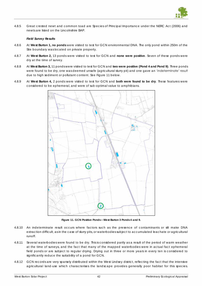
West Burton Solar Project 42 Preliminary Ecological Appraisal
4.8.5 Great crested newt and common toad are Species of Principal Importance under the NERC Act (2006) and
newts are listed on the Lincolnshire BAP.
Field Survey Results
4.8.6 At West Burton 1, no ponds were visited to test for GCN environmental DNA. The only pond within 250m of the
Site boundary was located on private property.
4.8.7 At West Burton 2, 13 ponds were visited to test for GCN and none were positive. Seven of these ponds were
dry at the time of survey.
4.8.8 At West Burton 3, 11 ponds were visited to test for GCN and two were positive (Pond 4 and Pond 9). Three ponds
were found to be dry, one was deemed unsafe (agricultural slurry pit) and one gave an ‘indeterminate’ result
due to high sediment or pollutant content. See Figure 11 below.
4.8.9 At West Burton 4, 2 ponds were visited to test for GCN and both were found to be dry. These features were
considered to be ephemeral, and were of sub-optimal value to amphibians.
Figure 11. GCN Positive Ponds – West Burton 3 Ponds 4 and 9.
4.8.10 An indeterminate result occurs where factors such as the presence of contaminants or silt make DNA
extraction difficult, as in the case of slurry pits, or waterbodies subject to accumulated leachate or agricultural
runoff.
4.8.11 Several waterbodies were found to be dry. This is considered partly as a result of the period of warm weather
at the time of surveys, and the fact that many of the mapped waterbodies were in actual fact ephemeral
field ponds or are subject to regular drying. Drying out in three or more years in every ten is considered to
significantly reduce the suitability of a pond for GCN.
4.8.12 GCN records are very sparsely distributed within the West Lindsey district, reflecting the fact that the intensive
agricultural land-use which characterises the landscape provides generally poor habitat for this species.
West Burton Solar Project 43 Preliminary Ecological Appraisal
Nevertheless, the West Burton project sites are considered to be consistently sub-optimal for GCN in terms of
intrinsic habitat value and local population densities.
Potential Constraints and Mitigation
4.8.13 Legal protection afforded to GCN extends to their habitat (breeding and resting places), which includes both
aquatic and terrestrial types. Arable and actively cut grassland or grazed pasture, which make up the vast
majority of the option land, are considered sub-optimal habitats. Scrub, tussocky or uncultivated grassland,
woodland and hedgerows are all optimal (as well as wetland and other aquatic habitat). These habitats
typically occur within field margins and boundaries and at field headlands, or in a relatively low number of
uncultivated fields. Hard standing and bare ground are considered unsuitable.
4.8.14 Despite the majority of the option land - or certainly the likely development footprints - occupying sub-optimal
habitat, a zoned approach to the risk of unlawful habitat clearance or direct disturbance to GCN should be
adopted, in accordance best practice guidance. This recognises the fact that the likelihood of encountering
newts within potentially suitable habitat decreases with distance from ponds known to support them. Table 8
provides general constraints during the construction phase and working methods recommended for all Sites
containing or adjacent to positive GCN ponds.
Table 8. Summary of Constraints and Working Methods in Proximity to GCN Breeding Ponds
Zone
(Distance from
perimeter of
nearest known
breeding pond)
Temporary or Permanent Loss of, or Disturbance to:
Optimal Habitat Sub-Optimal Habitat
0-100m Licence from Natural England likely to be required
– see further information below.
Newt exclusion exercise likely required, involving
installation of partially buried fencing and pitfall
traps, to be checked daily for 30+ days to declare
habitat clear of GCN in advance of works
commencing.
Constrained to active season (March to October
inclusive, weather depending) in order to avoid
impacts on hibernating individuals.
Ecological Clerk of Works (ECoW) required to
supervise.
Destructive Search methodology to precede
works – consists of a staged cutting (mowing or
strimming) of vegetation before being
methodically removed using an excavator.
Licence from Natural England potentially
required, but unlikely. To be informed through
pre-application consultation with LPA and NE.
Due to negligible hibernation potential within
these habitats, works likely to be constrained to
winter period (November to February inclusive,
weather depending).
Ecological Clerk of Works (ECoW) required to
give tool-box talk to contractors.
101-250m Licence only required where approx. 5000m2
(0.5ha) impacted.
Additional constraints as above.
Licensing constraints unlikely - to be informed
through pre-application consultation with LPA
and NE.
Potential for restriction to winter working
methodology.
251m + Licence only required where approx. 50,000m2
(5ha) impacted.
Additional constraints as above.
Licensing constraints highly unlikely.
4.8.15 The above construction phase constraints will be the subject of discussion with LPA consultees and Natural
England. An acceptable approach to construction during the DCO process will need to be established,
therefore the information given in Table 6 above is indicative at this stage subject to amendment. The final,
agreed approach to construction and licensing will be detailed within an eventual EIA (and its great crested
newt survey report technical appendix) and Construction Ecological Management Plan, or similar document.
4.8.16 Currently, licensing for great crested newts in this region generally involves recourse to a traditional mitigation
licence. This typically requires the need for an exclusion, trapping and translocation exercise where suitable
habitats in close proximity to breeding ponds are to be lost or temporarily affected. This is seasonally
West Burton Solar Project 44 Preliminary Ecological Appraisal
constrained and may require 30 or more days to undertake prior to construction commencement. Licence
determination post-construction also takes a statutory 30-day period.
4.8.17 An alternative option exists, known as the Low Impact Class Licence, which is applicable for developments
where impacts in proximity to breeding ponds are considered to be small, and do not affect the ponds
themselves. These licences are streamlined and far less onerous to apply for and have determined. Should the
scheme be designed to minimise impacts to suitable habitats within 100m as far as possible, this licence type
may be available. Further consultation will be necessary to determine this.
4.8.18 Finally, it is probable that by the time the scheme is consented, Lincolnshire will be added to the regions eligible
to use the District Licence scheme for GCN mitigation. This scheme permits all but the most damaging impacts
to breeding ponds and habitat in return for a tailored and proportionate financial contribution to local great
crested newt conservation schemes.
Further Work
4.8.19 To underpin the DCO application and finalisation of ES, CEMP and any future licence, water testing of ponds
within 250m of the site should be carried out. Best efforts to gain access to third party land should be made.
Samples can only be taken between the months of mid-April to end June each year.
4.8.20 It is recommended that a proportion of the indeterminate or dry ponds encountered during the 2021 surveys
are re-visited in 2022 for completeness and to demonstrate best efforts.
4.8.21 Survey requirements for the cable routes should be determined and planned for the 2022 survey season.
4.8.22 Recommendations and constraints given above would apply to any newly confirmed breeding ponds.
Opportunities for Enhancement and Biodiversity Net Gain
4.8.23 Construction of new waterbodies within 250m of known breeding ponds would improve the long-term viability
of currently sparse and poorly connected local populations. This would contribute substantially to local and
national green infrastructure policy and the restoration of local biodiversity.
4.8.24 Planting of new hedgerows, woodland strips and scrub/shrub vegetation in locations strategic to improving
corridors for dispersal between existing (and any new) ponds would serve to improve green infrastructure for
amphibians and long-term population sustainability.
4.8.25 Management of field edges, hedgerow/woodland/ditch/watercourse buffer zones, wayleaves and
easements within 250m of known breeding ponds to create coarse, tussocky grassland or meadow habitat
would also contribute to the above aims.
4.8.26 Sympathetic management of fields beneath arrays within 250m of known breeding ponds to form a taller,
more diverse grassland sward (managed through low-density/intensity conservation grazing or collection of a
late-season hay cut.
4.8.27 As set out in Section 3.4, basic water and habitat quality enhancements at the ponds on Site at or immediately
adjacent to West Burton 2, West Burton 3 and West Burton 4 would be of benefit for any amphibian populations
present. This includes selective deepening and planting.
4.9 Reptiles
Desk Study Information
4.9.1 At West Burton 1, 3 historical (pre-2000) records for common lizard were located within 2km of the Site, as well
as 18 records for grass snake (6 post 2000) located beyond 250m from the Site.
4.9.2 At West Burton 2, 1 historical (pre-2000) record for common lizard was located within 2km of the Site, as well as
29 records for grass snake (9 post 2000) two of which were located within the red line boundary for the Site
and three of which were located within 250m of the Site.
4.9.3 At West Burton 3, 1 record for common lizard was located within 250m of the Site, as well as 19 records for grass
snake (6 post 2000) all of which were located beyond 250m of the Site. 5 records of slow worm were recorded
within 2km of the Site with the exact locations not provided.
West Burton Solar Project 45 Preliminary Ecological Appraisal
4.9.4 At West Burton 4, 2 records (1 post-2000) for common lizard was located within 2km of the Site, as well as 12
records for grass snake (5 post 2000) all of which were located beyond 250m of the Site.
4.9.5 Reptiles are Species of Principal Importance under the NERC Act (2006).
Field Survey Results
4.9.6 Habitats for reptiles are generally limited in quality and extent across all the sites, being restricted to hedgerow
bases, tussocky field margins and woodland edges only. Almost universally, the development will be sited on
land of poor habitat quality for reptiles. Furthermore, the desk study data shows a lack of records for reptile
species within 2km of the sites, with an absence generally within 250m.
4.9.7 West Burton 1 contained occasional habitat of potential suitability for reptiles in field margins and the banks of
more substantial watercourses/ditches only.
4.9.8 At West Burton 2, Most of the grass margins were uncultivated or managed and had become tussocky. Several
of these, including the feature at TN8 were noted to be of particularly good value to reptiles, although none
were seen.
4.9.9 At West Burton 3, A grass snake was seen in the vegetated banks of a stream at D2, while a common lizard
was seen within the hedgerow margin in F8 (TN5). Margins were mostly narrow but were uncultivated and
unmanaged and had become tussocky. Several of these were noted to be good for reptiles.
4.9.10 At West Burton 4, the narrow field margins and vegetated banks of the larger ditches were all unmanaged
and had therefore developed significant potential to support reptiles (TN26x11, TN27x2). Other features
including tipped material and log piles were also of value (TN9, TN16, TN17, TN21, TN23, TN24). No reptiles were
observed during the survey, however.
Potential Constraints, Mitigation and Further Work
4.9.11 Reptiles are legally protected from reckless and intentional harm, therefore it is recommended that all field
margins and hedgerows, as well as target noted locations of discrete reptile habitat are retained and
protected wherever possible.
4.9.12 Given the limited records, habitat quality and extent within the development footprint, it is unlikely that a
targeted reptile survey would be necessary. Should proposals seek to significantly remove or alter boundary
features, the requirement for a reptile survey may need to be re-assessed. Further consultation with LPAs would
determine acceptability of this approach.
4.9.13 It should be possible to avoid any impacts on reptiles through the installation of sufficient protective fencing,
adherence to a construction methodology which avoids damage to such habitats and the avoidance of any
widening of field accesses. A suitable buffer of at least 5m from these habitats would ensure accidental
damage during construction and ongoing maintenance is avoided.
4.9.14 A best practice approach to habitat clearance and management is considered appropriate. Where habitat
suitable for reptiles (all field margins, hedgerows, tussocky grassland and river corridors) is proposed for
clearance, a Reasonable Avoidance Method Statement should be followed. Depending on the amount of
land affected, this is likely to involve the phased removal of vegetation in order to dissuade reptiles from that
area, followed by a destructive search supervised by an ecologist. Should particularly large areas of habitat
be earmarked for removal, a survey and translocation exercise may be a last resort, although such an
approach is considered unlikely to be required.
4.9.15 Should any of the arable fields become dominated by a long or tussocky sward, either through the cessation
of cultivation or cutting prior to development, site clearance/preparation may need to be carried out in a
sensitive manner. This is to avoid impacts to any reptiles which may have dispersed onto the development
footprint as the habitat has increased in suitability. A suitable habitat cutting/clearance methodology (Risk
Avoidance Method Statement) would be set out in an eventual Construction Environmental Management
Plan.
Opportunities for Enhancement and Biodiversity Net Gain
4.9.16 Optimal reptile habitat includes tussocky grassland, scattered scrub and ruderal vegetation interspersed with
physical features conducive to basking on and hibernating in. Considerable net gains for
West Burton Solar Project 46 Preliminary Ecological Appraisal
4.9.17 The local area is unlikely to support significant populations of reptile species and therefore enhancements
specifically for these species are of a low priority, however the following basic measures are suggested.
4.9.18 The creation of a number of appropriately located reptile hibernaculum would improve the Sites’ habitat
suitability by providing features within which to hibernate during the winter and to bask during the summer.
The construction of these habitat piles using partially buried dead wood, earth and stone would also provide
invertebrate prey items. Further advice on numbers and locations can be given as the proposals evolve.
4.9.19 The reversion of intensive agriculture to diverse grassland is encouraged as this would improve the plant
species diversity and habitat structure within the Sites. In turn, this would provide improved foraging and
hibernation habitat for reptiles. Advice on the favourable management of the grasslands on Site for the benefit
of reptiles and other wildlife would be agreed with you and provided within a Landscape Environmental
Management Plan.
4.10 Birds
Desk Study Information
4.10.1 At West Burton 1, numerous records of 40 species of notable birds, or birds of conservation concern, were
revealed by the Desk Study, none of which were located within the Red Line Boundary of the Site, as detailed
in Appendix B. One record of both kingfisher and skylark were recorded within 250m of the Site with the
remaining records located between 250m and 2km from the Site. The recorded notable species comprise
farmland birds such as corn bunting, quail, barn owl and turtle dove as well as waders and raptors.
4.10.2 For West Burton 2, numerous records of 44 species of birds were recorded, as detailed in Appendix C. Reed
bunting has been recorded within the Red Line Boundary of the Site with kingfisher and lapwing recorded
within 250m of the Site since 2000. All other bird species were recorded beyond 250m from the Site, including
curlew, tree sparrow and yellowhammer.
4.10.3 For West Burton 3, numerous records of 57 bird species were recorded within 2km of the Site as detailed in
Appendix D. One record of house sparrow was located within the Red Line Boundary and starling and song
thrush have been recorded within 250m of the Site. All other records were located beyond 250m of the Site,
including species such as yellowhammer, yellow wagtail, lapwing and barn owl.
4.10.4 For West Burton 4, numerous records of 140 bird species were recorded within 2km of the Site, as detailed in
Appendix E. The records have been extracted from Nottinghamshire Birdwatchers data from 2008 to 2018 but
no exact locations have been provided. A large number of species records are likely to come from wetland
sites within 2km of West Burton 4 including Sutton and Lound Gravel Pits SSSI which is located 1.9km southwest
and supports an exceptional diversity of breeding, wintering and passage birds.
4.10.5 Farmland birds are listed on the Lincolnshire BAP and many species are Species of Principal Importance under
the NERC Act (2006).
Field Survey Results
4.10.6 Four daytime breeding bird surveys and one dusk, nocturnal bird survey (with a focus on quail) has been
carried out. Winter bird surveys are scheduled for November 2021 to February 2022.
4.10.7 In general, considering the broad similarities in habitat arrangement, topography, field size and agricultural
management, the breeding bird species assemblage is consistent across the option sites. Results can be
broadly divided into those for ground-nesting birds, birds of hedgerows and boundaries and other bird species.
Ground-nesting Birds
Skylark
4.10.8 This is a red-listed species on account of its declining population trend as a result of agricultural intensification
and land-use change. It is also a Species of Principal Importance (SPI) under the NERC Act 2006. Skylark are a
resident species whose numbers swell each winter from an influx of visitors from northern Europe. Skylark require
long, unbroken sightlines in grassland (including arable or set-aside up to 40cm high) of at least approximately
200m for predator avoidance.
West Burton Solar Project 47 Preliminary Ecological Appraisal
4.10.9 Skylark were recorded on all Sites in varying densities. On average, territories occurred at a density of 1 per
5ha. This means there would be approximately 200 territories among all West Burton sites combined.
4.10.10 Particularly dense populations were located at West Burton 2 and West Burton 3 as these featured some of the
largest arable fields within a similarly open landscape. In addition, some of the barley (predominantly West
Burton 4) was planted in the spring, allowing for greater nesting success on second broods (due to the lower
sward height) and better wintering habitat in the form of stubbles. Together, West Burton supports significant
populations of skylark, although this would be expected to be in line with population densities in the local
landscape.
4.10.11 Winter-sown wheat - as is ubiquitous across most of the Sites - is considered to be a suitable but sub-optimal
habitat for skylark on account of its growth above 60cm at a time when skylark are looking to have second or
third broods in the mid-late summer. It can reasonably be assumed that a large proportion of the nests present,
if not all, would be displaced from solar arrays. There is no robust, long-term evidence indicating that skylark
nest within solar arrays, although the reversion from arable to grassland in solar development has been shown
to improve foraging opportunities for skylark which are able to include array land within their adjacent
territories. This effect is likely to increase nesting and breeding success in adjacent suitable (non-array) habitats.
Some nesting may persist within buffers and wayleaves, although it is considered that this reflects a tendency
for site-fidelity which may persist for approximately one to three seasons post-construction.
Yellow wagtail
4.10.12 For the same reasons as skylark, yellow wagtail are also red listed, and a SPI. Yellow wagtail migrate to the UK
from Africa each spring. Yellow wagtail are a far less numerous bird than skylark and were recorded across all
Sites at significantly lower rates than skylark. Sites supporting greater numbers were West Burton 4 and West
Burton 2. As for skylark, it is likely that yellow wagtail nests would be displaced through solar development,
although solar development could be expected to improve foraging opportunities for birds with nearby
territories.
Grey Partridge
4.10.13 This is a red listed species and an SPI, typical of lowland arable farmland although having suffered marked
recent declines. Grey partridge were recorded in low to moderate numbers across all Sites. These are not
thought to be the result of introduction for shooting. The effects of solar development on grey partridge is
unknown. Preferring field edges and proximity to sources of cover, grey partridge may continue to use solar
arrays, although potentially at the edges and in lower overall densities. It may also transpire that solar array
may provide a desirable shelter from nearby game shooting and therefore provide a valuable refuge for the
population.
Quail
4.10.14 This is an amber-listed species for which population and conservation research in the UK is limited on account
of its cryptic nature and difficulty of survey. Quail are a summer migrant from Africa and the Mediterranean
and closely associated with arable habitats. Quail were recorded on relatively few occasions at West Burton
4 only. It is not understood whether quail would be displaced by solar development as they do not rely on
surveillance for predator avoidance, rather camouflage, secrecy and restriction of most activity to evenings
and early mornings. In some regions and countries, quail rely on open woodland and a landscape with a
mosaic of grassland and woody cover. It is possible that quail may continue to use solar arrays although further
research is needed as the extent and type of cover and shading created by solar installations is not directly
analogous to such open woodland habitat. This project would pose a good opportunity to study this effect
further.
Birds of Field Boundary Habitats
4.10.15 Significant populations of birds typical of hedgerows, woodland edges, scrub and river corridors in a lowland
agricultural setting were recorded throughout the Sites, principally yellowhammer, linnet, common
whitethroat, lesser whitethroat, tree sparrow, reed bunting and great spotted woodpecker. Many of these
birds will forage within arable field edges or nest in ditches, hedgerow bases or grassy margins as well as the
hedgerows themselves. It is expected that the assemblage and abundance would not be significantly
affected provided that sufficient buffering is designed into the schemes. These species have been seen to
West Burton Solar Project 48 Preliminary Ecological Appraisal
persist on established small and medium-scale solar arrays, although impacts are largely untested at this scale.
Given the scale of proposals and likely unbroken expanse of array, it would be prudent to instigate an
increased degree of buffering compared to small and medium sized array schemes.
Other Birds
4.10.16 Curlew and lapwing are red listed species and also SPIs. These waders were recorded at West Burton 2, close
to the banks of the River Till. Solar development can be expected to displace nesting locations for these
species for the same reasons of predator surveillance as listed for skylark.
4.10.17 Turtle dove are a red listed species and an SPI and were not observed at any site, they are known to have a
population centre in the Idle Valley, not far west from West Burton 4. This species is increasingly rare and in
danger of extinction in the UK. Turtle dove rely on uncultivated land and arable weeds for seeds, as well as tall
hedgerows, open woodland and scrub. Again, no research exists on the effect of solar development on turtle
dove, however opportunities exist for the enhancement of foraging habitat and planting of nesting habitat for
this key species of local conservation concern.
4.10.18 Barn owl, little owl, short-eared owl and tawny owl were all recorded during the evening surveys, with barn owl
being recorded at almost every site in good numbers. Tawny owl and little owl were only recorded in stands
of woodland adjacent to the option land. Barn owl and short-eared owl were the most likely owl species to be
recorded within the arable fields themselves. River banks, especially at the River Till were regularly-used
foraging corridors for these species. The impacts of solar development on owls are unclear as barn owls in
particular as associated with open hunting habitat. However, it is likely that tussocky margins and buffers, as
well as sympathetically managed grassland beneath arrays (longer grassland suitable for voles and other small
rodents) would support a far greater abundance of prey items than intensive arable.
4.10.19 Buzzard, peregrine, hobby, kestrel, marsh harrier and red kite were all observed during the bird surveys. Nesting
buzzard were regularly recorded within woodland edge at the majority of the sites. Potential hobby and
peregrine nesting activity was observed within tree and pylon habitat respectively at West Burton 3.
Potential Constraints and Options for Mitigation
4.10.20 On account of their status as birds listed on Schedule 1 of the Wildlife and Countryside Act 1981 (as amended)
nests of hobby, peregrine, barn owl, quail and red kite will need to be protected from disturbance during any
development activity. Consequently, pre-commencement precautionary survey work is likely to be required
to establish risks immediately prior to the construction phase.
4.10.21 Similarly, all nests for other species are protected from harm, therefore any potential nesting habitat clearance
will need to be carried out either during the period September to February inclusive, under the supervision of
an ecologist, or following further survey to confirm absence.
4.10.22 In order to ensure that boundary habitats remain suitable for use by the species recorded, as well as being
able to be re-visited and discovered, it is recommended that sufficient buffers to the nearest arrays are
implemented. The size of these should be coordinated with other constraints, for example bats, in due course
following the completion of survey work and analysis. The following is therefore likely to be recommended,
subject to consultation. Hedgerows: 10m. Ditches and minor watercourses: 15m. Woodland, in-field trees and
major watercourses: 20m. Ancient woodland: 30m
Skylark and Other Ground Nesting Birds
4.10.23 Impacts on ground nesting birds can be mitigated for either by the creation of newly-available (i.e. not already
suitable) compensatory nesting habitat, or the enhancement of existing habitat by the improvement of
foraging opportunities causing an increase in carrying capacity and likely knock-on nesting success. Given
the scale of likely impacts on these species, mitigation should be achieved through a blend of different
mitigation techniques and land management approaches on Site and, potentially locally off-Site. As has been
described, solar arrays are not considered suitable nesting habitat for ground nesting species which require
long sightlines for predator monitoring, therefore mitigation for these will need to occupy contiguous blocks of
land free of solar array and other structures.
4.10.24 On Site, land unviable for development could be managed specifically for ground nesting birds, ideally
reverting from intensive arable to non-rotational set-aside or meadow for the greatest capacity to absorb
West Burton Solar Project 49 Preliminary Ecological Appraisal
displaced territories. Careful site selection will be necessary as suitable mitigation land for skylark in particular
usually requires a radius of >100m from all vegetation and structures above 100cm in height.
4.10.25 Off site, winter sown cereals can be reverted to spring (March) sown crop to enable existing birds to
successfully rear a second or third brood. This technique should be supplemented through the inclusion of ‘bird
foraging plots’ whereby 5x5m squares of unsown land are introduced at a rate of at least 2 per hectare into
fields by temporarily halting the seed drill during sowing. This has the effect of increasing invertebrate food item
abundance, improving the breeding success, number of young reared and densities of territories able to be
supported. Additionally, agricultural land can be reverted from unsuitable or sub-optimal habitat to meadow,
long cut-rotation silage (>7weeks), and have reduced application of inorganic fertiliser and insecticide. Again,
only large, open fields with vegetation below 50-60cm during the majority of the breeding season would be
considered suitable.
4.10.26 The precise quantum of land required to achieve an acceptable mitigation for the species can be calculated
once bird survey data has been analysed. This would then be refined according to the combination of
mitigation techniques listed above that are employed. It is likely that impacts in terms of territory displacement
would be greatest at West Burton 4 owing to the already productive field margins (for invertebrate prey items)
and proportion of spring sown barley and winter stubbles.
4.10.27 Furthermore, consultation with Natural England and Local Authorities would be key in establishing an
acceptable approach. Indeed, Local Authorities (as well as consultees such as the RSPB and BTO) may be in
a position to assist with recommending local conservation initiatives to which the schemes can contribute. The
above mitigation techniques can be expected to be of benefit to a wide variety of birds, not limited to the
listed ground nesting species.
Opportunities for Enhancement and Biodiversity Net Gain
4.10.28 Beyond the mitigation options for ground-nesting birds outlined above, substantial nesting and foraging
habitat can be created through the planting of new hedgerows, lines of trees and scrub, as well as the
management of buffers, wayleaves and other easements for invertebrate and seed eating species. These
measures can be tailored to each site and particular bird species of note. For example the creation of tall,
bushy hedgerows and thickets at West Burton 4 for turtle dove would increase nesting opportunities, while
sowing strips of wild-bird cover containing kale, quinoa and millet within buffers would create ideal foraging
habitat for this key species within agreed buffers and would also benefit other seed-eating birds such as
yellowhammer, goldfinch and linnet.
4.10.29 Buffer areas and easements can be managed preferentially for different species. Where raptors such as owls
and kestrels are targeted, tussocky grassland valuable for small rodents can be encouraged. This can be
diversified with ruderal and flowering meadow plants to be of greater benefit to invertebrate-eating species
such as whitethroat, skylark and yellow wagtail. Hobby can be targeted through the inclusion of waterbodies
to encourage dragonflies. Further options would be discussed within the dedicated bird survey reports.
4.10.30 An additional consideration for siting grassland enhancement measures would be the proximity to any on or
off-site land secured for skylark mitigation. The success of skylark nesting enhancement can be further
improved by better access to productive foraging grounds. As young skylarks are almost exclusively fed on
invertebrates, it would be of benefit to have these treatments adjacent to known or targeted skylark nesting
habitats. While arrays are not known to support optimally nesting skylarks, they have been found to support
foraging skylarks.
4.10.31 Nesting opportunities should be incorporated into the scheme through the installation of tree and building-
mounted bird boxes. A rate of approximately 1-2 boxes per 10ha of development land would be appropriate.
4.10.32 Specialist boxes for raptors and owls can be installed in appropriate key locations within the schemes.
Further Survey Considerations
4.10.33 Wintering bird surveys will need to be carried out to determine the potential for impacts upon wetland birds,
winter migrants and bird associated with the Humber Estuary SPA.
4.10.34 It may be prudent to carry out further daytime inspection of buildings and mature trees adjacent to the sites
capable of being encircled or at least partially surrounded by arrays (for example, all buildings at West Burton
West Burton Solar Project 50 Preliminary Ecological Appraisal
4), to determine any impacts on movements or access to habitat by birds such as barn owls nesting or roosting
within them.
4.11 Invertebrates
4.11.1 Habitat quality for invertebrates within the development sites is generally low, owing to the intensive
agricultural land use and regularity of pesticide use. Boundary habitats are also generally poor for
invertebrates, while the River Till corridor, waterbodies and watercourses represent some elevated habitat
value. The desk study data on invertebrates will be fully analysed in due course, alongside further consultation,
to determine whether any further targeted invertebrate survey may be useful. At this stage, this is considered
unlikely.
Desk Study Information
4.11.2 At West Burton 1, the Desk Study revealed historic records of three notable invertebrate species including small
heath and wall butterflies and large-mouthed valve snail.
4.11.3 At West Burton 2, the Desk Study revealed records of numerous notable invertebrate species including small
heath and wall butterflies, large-mouthed valve snail and 49 species of moth, which are listed in full in Appendix
C.
4.11.4 At West Burton 3, the Desk Study revealed records of numerous notable invertebrate species including small
heath and wall butterflies, mud snail and 42 species of moth, which are listed in full in Appendix D.
4.11.5 The only records of invertebrates given within 2Km of West Burton 4 were one record each of brown argus and
small copper butterflies and hairy dragonfly.
Field Survey Results
4.11.6 Habitat quality for invertebrates within the development sites is generally low, owing to the intensive
agricultural land use and regularity of pesticide use. Boundary habitats are also generally of lower to moderate
value for invertebrates, while the species rich hedgerows, trees, River Till corridor, waterbodies and
watercourses represent relatively elevated habitat value.
Potential Constraints, Mitigation and Further Work
4.11.7 The desk study data on invertebrates did not raise any concerns regarding the need for further survey.
Opportunities for Enhancement and Biodiversity Net Gain
4.11.8 The creation of more diverse grassland over time (both under panels and within field margin buffer zones)
should provide an increase in habitat value for invertebrates. Alternatively, a new meadow or diverse
grassland can be created by cultivation and over seeding, followed by monitoring and timed cutting as
described in the Habitats section. The final approach can be discussed for inclusion within an Ecological
Management Plan.
4.12 Other Protected Species and Species of Conservation Concern
Desk Study Information
West Burton 1
4.12.1 29 records of brown hare are present between 250m and 2km from the Site.
4.12.2 2 records of feral ferret are located 1.3km from the Site.
4.12.3 58 records of hedgehog are located within 2km of the Site, one of which was located within the Red Line
Boundary and 3 records within 250m of the Site.
4.12.4 1 historic record of harvest mouse within 2km of the Site.
4.12.5 21 records of European eel (2 post-2000) and 24 records of spiny loach (11 post-2000) within 2km of the Site.
West Burton Solar Project 51 Preliminary Ecological Appraisal
West Burton 2
4.12.6 53 records of brown hare are present within 2km of the Site, one of which was located within the Red Line
Boundary.
4.12.7 2 records of feral ferret are located 1.6km from the Site.
4.12.8 131 records of hedgehog are located within 2km of the Site, four of which were located within the Red Line
Boundary and 8 records within 250m of the Site.
4.12.9 3 historic records of harvest mouse within 2km of the Site.
4.12.10 65 records of European eel (15 post-2000) and 25 records of spiny loach (11 post-2000) are present within 2km
of the Site.
4.12.11 The only flowering plant records present are for Tubular Water-dropwort, of which there were 3 records within
2km of the Site.
West Burton 3
4.12.12 127 records of brown hare are present within 2km of the Site, four of which were located within the Red Line
Boundary.
4.12.13 3 records of feral ferret are present within 2km of the Site, two of which were located within the Red Line
Boundary.
4.12.14 167 records of hedgehog are located within 2km of the Site, 14 of which were located within the Red Line
Boundary and 20 records within 250m of the Site.
4.12.15 5 records of harvest mouse are present within 2km of the Site, 2 of which are post-2000.
4.12.16 21 records of European eel (11 post-2000) are present within 2km of the Site.
4.12.17 The only flowering plant records present are for annual knawel, of which there were 1 record within 2km of the
Site.
West Burton 4
4.12.18 17 records of brown hare are present within 2km of the Site, one of which was located within 250m of the Site.
4.12.19 4 records of stoat and 1 record of weasel within 2km of the Site.
4.12.20 3 records of hedgehog are located within 2km of the Site, with exact locations not provided.
4.12.21 1 records of harvest mouse is present within 250m of the Site.
4.12.22 34 records of European eel (all of which are post-2000) are present within 2km of the Site.
Field Survey Results
4.12.23 At all sites, large numbers of brown hare were noted within the fields. All sites were conducive to the presence
of species such as hedgehog, polecat and other small mammals within hedgerows and field margins. Harvest
mice are assumed to be present to some degree. The larger watercourses are likely to support several species
of fish and other aquatic life.
Potential Constraints, Mitigation and Further Work
4.12.24 It is unlikely that significant effects on any of these species would arise from the development provided that
steps are taken to protect existing boundary features and maximise their habitat value through simple and
sympathetic management practices for the life of the scheme. Mitigation measures given for other species
above would serve species mentioned here well. It has been observed that brown hare, in particular, appear
to benefit from solar array installations and favour the shelter and longer grass associated with them in
preference to pasture grassland. Security fencing is not considered likely to impede movement by these
species as long as the mesh size is large enough (e.g. standard deer fencing).
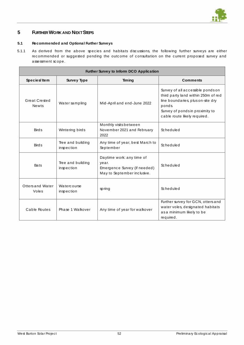
West Burton Solar Project 52 Preliminary Ecological Appraisal
5 FURTHER WORK AND NEXT STEPS
5.1 Recommended and Optional Further Surveys
5.1.1 As derived from the above species and habitats discussions, the following further surveys are either
recommended or suggested pending the outcome of consultation on the current proposed survey and
assessment scope.
Further Survey to Inform DCO Application
Species/Item Survey Type Timing Comments
Great Crested
Newts Water sampling Mid-April and end-June 2022
Survey of all accessible ponds on
third party land within 250m of red
line boundaries, plus on-site dry
ponds.
Survey of ponds in proximity to
cable route likely required.
Birds Wintering birds
Monthly visits between
November 2021 and February
2022
Scheduled
Birds Tree and building
inspection
Any time of year, best March to
September Scheduled
Bats Tree and building
inspection
Daytime work: any time of
year.
Emergence Survey (if needed)
May to September inclusive.
Scheduled
Otters and Water
Voles
Watercourse
inspection spring Scheduled
Cable Routes Phase 1 Walkover Any time of year for walkover
Further survey for GCN, otters and
water voles, designated habitats
as a minimum likely to be
required.
West Burton Solar Project 53 Preliminary Ecological Appraisal
5.2 Anticipated Reporting/Design Milestones
Input into Pre-App/Early Consultation Docs. Basis formed by PEA but with relevant additions – September
2021
Opinions received on proposed survey scope and early mitigation approach – August-October 2021
Breeding Bird Survey Report – October 2021 –
Expanded thereafter following completion of any tree/building surveys.
Will enable finalisation of on and off-Site mitigation requirements for skylark and associated species.
Bat Survey Report – October/November 2021
Expanded thereafter following completion of any tree/building surveys.
Will enable finalisation of buffer widths from hedgerows and trees to security fence.
Preliminary Biodiversity Net Gain Analysis – October/November 2021 –
Will facilitate habitat management plan and landscape enhancement design.
Wintering Bird Survey Report – March/April 2022 –
May have implications for on and off-Site bird mitigation if not already catered for.
Otter and Water Vole Survey Report (if required by consultees – considered likely) - March/April 2022
Interim report can be provided on basis of 2021 data for purposes or PEIR, scoping and consultation.
Will help refine recommendations for watercourse buffering and habitat management.
Great Crested Newt Survey Report following 2022 survey of off-Site ponds – May 2022
Interim report can be provided on basis of 2021 data.
Will refine constraints in proximity to some ponds.
PEIR – Spring 2022
ES Chapter – Summer/Autumn 2022
Construction Ecological Management Plan (or similar) – TBC in support of PEIR/ES
Landscape and Ecological Management Plan (or similar) – TBC in support of PEIR/ES
Final Biodiversity Net Gain Analysis Report - TBC in support of PEIR/ES
5.3 Construction and Landscape Environmental Management Plans (CEMP and LEMP)
5.3.1 The PEIR and ES will likely need to be supported by a document setting out how construction-phase impacts
upon sensitive ecological receptors will be avoided and minimised. Typically, a Construction Environmental
Management Plan is prepared in collaboration with other environmental and landscape disciplines and an
ecology chapter produced. Alternatively, a specific Construction Ecological Protection Plan can be
produced as a standalone document.
5.3.2 This document would set out the following:
Details of protective and permanent fencing including distances from habitat features etc.
Working methods adopted to avoid accidental damage (including root compaction, contamination
and pollution) to retained features such as trees, hedgerows and watercourses.
Examples of and a plan to show where signage will be installed.
The roles of different site personnel in protecting and maintaining retained habitat during construction.
The role of an Ecological Clerk of Works to ensure inspections are carried out and that activities carrying
a risk of harm to protected and notable species and habitats can be appropriately planned and carried
out.
Steps taken to prevent the spread of invasive non-native species potentially present.
Considerations for the minimisation of damage to the ground during the winter months.
5.3.3 The achievement and success of Biodiversity Net Gain is likely to be contingent on the efforts made in the long
term management of the Site’s habitats. A Landscape and Ecological Management Plan (LEMP) would set
out the agreed habitat creation and planting to be undertaken during and immediately after the construction
phase as well as an ecologically-sensitive management schedule for a period of at least 20years. Details on
the installation of features of value to wildlife including reptile hibernacula, invertebrate habitats and bird and
bat habitat boxes will also be given alongside a monitoring and maintenance schedule. The LEMP is likely to
be a requirement of an eventual PEIR/ES in order to demonstrate how proposed mitigation and enhancement
will be secured and the various roles and responsibilities for carrying this out.
West Burton Solar Project 54 Preliminary Ecological Appraisal
5.4 Cumulative Impacts
5.4.1 An assessment of cumulative impacts arising from between the sub-sites, between Cottam and West Burton
applications and with other large-scale solar in the District will be an essential part of the PEIR/ES. Given the
similarities of habitat and value to protected and notable species between the Sites and other applications,
the potential for significant cumulative impacts on certain receptors, especially ground nesting birds. This
factor will be a key consideration when formulating acceptable mitigation (i.e. its location, quantity and
habitat management), not least for ground nesting birds. Preliminary recommendations given in this
document, such as buffer widths etc., attempt to take this effect (and the effect of the project scale) into
account and apply a precautionary approach.
5.5 Future Baseline and Decommissioning Effects
5.5.1 An assessment of a potential future baseline will be necessary as part of the PEIR/ES in understanding possible
effects of decommissioning. Fundamentally, it is impossible to accurately predict the nature of future legal and
planning constraints related to ecology in 30-40 years’ time. However, on the basis of the current legal and
policy situation, it is likely that the biodiversity value of the Sites within the red lines boundaries will overall
increase moderately over time and in response to Biodiversity Net Gain-led management principles.
5.5.2 The majority of land where new habitats of value will be created, and colonisation by species of conservation
concern most likely to take place, will be at the Sites’ boundaries and relatively separated from array
infrastructure. This means that future constraints would likely remain similarly distributed to how they are at
present. It is considered that the likely DCO requirement (and that of Policy S13 of Central Lincolnshire Local
Plan) of an eventual reversion to pre-construction state following decommissioning is compatible with the
management of the Sites up to that point as grassland of varying management types.
5.5.3 It is worth noting our experience to date that PINS have been broadly accepting of the view that whilst a
robust strategy to protecting valuable ecological features will be required they have also agreed that it is
difficult, if not impossible, to prepare or write an ecological strategy to decommissioning now as the conditions
and legislative framework at this future point will direct how it would proceed.
West Burton Solar Project 55 Preliminary Ecological Appraisal
APPENDIX A: WILDLIFE LEGISLATION SUMMARY
BADGERS
Badgers and their setts are protected under the Protection of Badgers Act 1992 (as amended) against damage or destruction of a
sett, or disturbance, death or injury to the badgers. The Act defines a sett as “any structure or place which displays signs indicating
current use by a badger”. The definition of current use is subject to considerable debate. Natural England have produced guidance
on the definition of current use. (Badgers and Development – A guide to best practice and development. Natural England 2011).
Given the ambiguity surrounding the definition in all circumstances we would recommend an assessment of current use is always
undertaken by a qualified ecologist. Natural Resources Wales (NRW) have a slightly different definition of current use. Please see the
NRW website for further information. Penalties for offences against badgers or their setts include fines of up to £5,000 and/or up to six
months in prison.
Disturbance of badgers could be caused by any digging activity or scrub clearance within 30 metres of an occupied sett and
therefore every case needs to be assessed individually. Felling of trees close to a badger sett may also cause disturbance in some
situations. Some activities such as pile driving may cause disturbance at even greater distances, and should be discussed with Natural
England or NRW.
Licences are issued by Natural England (or NRW in Wales) to allow the disturbance of badgers, and the destruction of their setts in
certain circumstances, in relation to development. Full planning permission must be obtained before a licence application will be
considered. Although licences can be applied for at any time of year, disturbance of badgers or exclusion of badgers from a sett
can only take place between 1 July and 30 November, to avoid the breeding season when dependant young may be underground.
This restriction may be relaxed in some cases where a sett is seasonal and badgers can be shown to be absent from a sett at that
time of year.
This report contains information of a confidential nature relating to the location of badger setts. Public access to this data should be
restricted to those who have a legitimate need to assess the information and to know the exact situation of the setts rather than
simply that badgers are present.
BATS
All 17 species of bat known to breed in England and Wales, and their roost sites, are protected under the Conservation of Habitats
and Species Regulations 2017, known as the ‘Habitats Regulations’. This makes it an offence to deliberately kill or injure a bat, or to
deliberately disturb a bat such that its ability to hibernate, breed or rear young, or such that the species’ distribution, were significantly
affected. It is also an offence to damage or destroy any breeding site or resting place. Intentional or reckless disturbance of bats in
their resting places, and damage to or obstruction of resting places are also offences under the Wildlife and Countryside Act 1981
(as amended). Under UK law a bat roost is “any structure or place which any wild [bat]...uses for shelter or protection”. As bats tend
to reuse the same roosts, legal opinion is that the roost is protected whether or not the bats are present at the time. Penalties for
offences against bats or their roosts include fines of up to £5,000 and/or up to six months in prison.
As a result, development works which are likely to involve the loss of or alteration to roost sites, or which could result in killing of or injury
to bats, need to take place under licence. Works which could disturb bats may also be licensable, though this needs to be assessed
on a case by case basis, as bats’ sensitivity to disturbance varies depending on normal background levels, and the definition of
disturbance offences under the Habitats Regulations is complex. In practice this means that works involving modification or loss of
roosts (typically in buildings, trees or underground sites) or significant disturbance to bats in roosts are likely to be licensable.
Licences can be obtained from Natural England or the Welsh Government to permit works that would otherwise be illegal, provided
it can be demonstrated that the proposed works are needed to protect public health or safety, or for other reasons of overriding
public interest including social and economic reasons. It is also necessary to demonstrate that there is no satisfactory alternative to
the proposed works, and that the conservation status of bats in the area will be maintained. Appropriate mitigation and post-
construction monitoring are therefore a requirement of all licences.
AMPHIBIANS
Great Britain supports seven native amphibian species. The four most widespread species; smooth and palmate newts, common
frog, and common toad, receive partial protection under the Wildlife and Countryside Act 1981 (as amended) which prohibits sale,
barter, exchange, transporting for sale and advertising to sell or to buy. The great crested newt, pool frog and natterjack toad are
also fully protected in England and Wales under the Conservation of Habitats and Species Regulations 2017. Penalties for offences
against amphibian species include fines of up to £5,000 and/or up to six months in prison.
Four amphibian species (great crested newt, pool frog, common toad, natterjack toad) are listed as priority species under the UK
Biodiversity Action Plan, and are therefore considered to be Species of Principal Importance in England and Wales (excluding the
pool frog, which does not occur in Wales) under the Natural Environment and Rural Communities (NERC) Act 2006. All public bodies
including local and regional authorities have a duty under this legislation to have regard for the conservation of biodiversity.
West Burton Solar Project 56 Preliminary Ecological Appraisal
GREAT CRESTED NEWTS
Great crested newts are protected in England and Wales under the Conservation of Habitats and Species Regulations 2017, known
as the ‘Habitats Regulations’. This makes it an offence to deliberately kill or injure a great crested newt, or to deliberately disturb a
great crested newt such that its ability to hibernate, breed or rear young, or such that the species’ distribution, were significantly
affected. It is also an offence to damage or destroy any breeding site or resting place for great crested newts. Intentional or reckless
disturbance of great crested newts in places of shelter (ponds or terrestrial refuges), and damage to or obstruction of places of shelter
are also offences under the Wildlife and Countryside Act 1981 (as amended). Penalties for offences against great crested newts
include fines of up to £5,000 and/or up to six months in prison.
As a result, development works which are likely to involve the loss of ponds or terrestrial habitat, or which could result in killing of or
injury to great crested newts, need to take place under licence. Works which could disturb great crested newts may also be
licensable, though this is rarely the case unless loss of great crested newt habitat is also proposed, and should be assessed on a case
by case basis. In practice this means that works involving any removal of or significant modification to ponds or terrestrial habitats
(typically rough grassland, scrub, hedgerow bases and woodland) supporting great crested newts are likely to be licensable.
Licences can be obtained from Natural England or the Welsh Government to permit works that would otherwise be illegal, provided
it can be demonstrated that the proposed works are needed to protect public health or safety, or for other reasons of overriding
public interest including social and economic reasons. It is also necessary to demonstrate that there is no satisfactory alternative to
the proposed works, and that the conservation status of great crested newts in the area will be maintained. Appropriate mitigation
and post-construction monitoring are therefore a requirement of all licences.
REPTILES
All six native reptile species receive protection under the Wildlife and Countryside Act 1981 (as amended). The four more common
species (common lizard Zootoca vivipara, slow-worm Anguis fragilis, adder Vipera berus and grass snake Natrix natrix) receive partial
protection which makes it an offence to intentionally kill or injure a reptile. The two other reptile species (smooth snake Coronella
austriaca and sand lizard Lacerta agilis), both of which are rare with very restricted UK ranges receive full protection under the
Conservation of Habitats and Species Regulations 2017. Penalties for offences against reptile species include fines of up to £5,000
and/or up to six months in prison.
Works such as site clearance or topsoil stripping which could result in killing or injury of reptiles could be considered result in an offence
unless measures are taken to minimise the risk of this occurring. Any inadvertent impacts on common reptile species despite these
mitigation measures being in place would be considered an ‘incidental result of an otherwise lawful operation’ which ‘could not
reasonably have been avoided’ and therefore not an offence. Works which could affect smooth snakes or sand lizards, or their
habitats, would need to take place under licence from Natural England or Natural Resources Wales. However sites supporting smooth
snakes or sand lizards are very rarely affected by development proposals.
In practice, mitigation for impacts of development on common reptiles generally comprise one or more of the following techniques:
displacement, in which reptiles are encouraged to move to suitable retained habitat by changing the management of areas
affected by development; exclusion, where reptile-resistant fencing is provided between a development site and suitable retained
habitat allowing reptiles to be trapped from the development footprint and released elsewhere on the site; and translocation, where
animals are trapped from a development site and released on another suitable site nearby. Reptile mitigation proposals, particularly
those involving translocation of animals, should be agreed in advance with the local planning authority.
BIRDS
All British birds, their nests and eggs (with certain exceptions) are protected under the Wildlife & Countryside Act 1981 (as amended)
which makes it an offence to: intentionally kill, injure or take a wild bird; intentionally take, damage or destroy nests which are in use
or being built; intentionally take or destroy birds’ eggs; or possess live or dead wild birds or eggs. A number of species receive
additional protection through inclusion on Schedule 1 of the Wildlife and Countryside Act; for these it is also an offence to intentionally
or recklessly disturb birds while nest building, or at a nest containing eggs or young, or to disturb the dependant young of such a bird.
Penalties for offences against bird species include fines of up to £5,000 and/or up to six months in prison.
General licences for control of some bird species are issued by Natural England and Natural Resources Wales in order to prevent
damage or disease, or to preserve public health or public safety, but it is not possible to obtain a licence for control of birds or removal
of eggs/nests for development purposes. Consequently if nesting birds are present on a development site when works are
programmed to start it is usually necessary to delay works, at least in the areas supporting nests, until any chicks have fledged and
left the nest. It is usually possible, once chicks have hatched, for an experienced ecologist to predict approximately when they are
likely to fledge, in order to inform programming of works on site.
OTTERS
Otters and their holts are protected in England and Wales under the Conservation of Habitats and Species Regulations 2017, known
as the ‘Habitats Regulations’. This makes it an offence to deliberately kill or injure an otter, or to deliberately disturb an otter such that
its ability to breed or rear young, or such that the species’ distribution, were significantly affected. It is also an offence to damage or
destroy any breeding site or resting place. Intentional or reckless disturbance of otters in their holts, and damage to or obstruction of
West Burton Solar Project 57 Preliminary Ecological Appraisal
holts are also offences under the Wildlife and Countryside Act 1981 (as amended). Penalties for offences against otters or their holts
include fines of up to £5,000 and/or up to six months in prison.
Any development works which are likely to involve the loss of holts, or which could result in killing of or injury to otters (which are only
likely to occur extremely rarely), need to take place under licence. Works which could disturb otters may also be licensable, though
this is also rarely the case as the majority of developments on watercourses and coastal areas where otters are present can be carried
out in a way which avoids significant disturbance.
Where it is necessary, licences can be obtained from Natural England or the Welsh Government to permit works that would otherwise
be illegal, provided it can be demonstrated that the proposed works are needed to protect public health or safety, or for other
reasons of overriding public interest including social and economic reasons. It is also necessary to demonstrate that there is no
satisfactory alternative to the proposed works, and that the conservation status of otters in the area will be maintained. Appropriate
mitigation and post-construction monitoring are therefore a requirement of all licences.
WATER VOLES
Water voles Arvicola amphibius receive protection under the Wildlife and Countryside Act 1981 (as amended), which makes it an
offence to: intentionally kill, injure, or take a water vole; intentionally or recklessly disturb a water vole whilst in its place of shelter;
intentionally or recklessly damage, obstruct or destroy a water vole’s place of shelter; or intentionally or recklessly obstruct access to
a place of shelter. Penalties for offences against water voles include fines of up to £5,000 and/or up to six months in prison.
Works such as watercourse re-profiling, installing culverts, or topsoil stripping close to watercourses and ponds which could result in
destruction or obstruction of burrows could be considered reckless, and/or could be considered intentional if water voles are killed
or injured, unless measures are taken to minimise the risk of this occurring. Any inadvertent impacts on water voles despite these
mitigation measures being in place would be considered an ‘incidental result of an otherwise lawful operation’ which ‘could not
reasonably have been avoided’ and therefore not an offence.
In practice, mitigation for impacts of development on water voles generally comprise one or more of the following techniques:
displacement, in which water voles are encouraged to move to suitable retained habitat by changing the management of areas
affected by development; exclusion, where water vole-resistant fencing is provided between a development site and suitable
retained habitat allowing animals to be trapped from the development footprint and released elsewhere on the site; and
translocation, where animals are trapped from a development site and released on another suitable site nearby. Water vole
mitigation proposals, particularly those involving translocation of animals, should be agreed in advance with Natural England or
Natural Resources Wales.
PLANNING POLICY IN RELATION TO BIODIVERSITY
The National Planning Policy Framework (NPPF), was published in March 2012 and revised in July 2021. Additional guidance can be
found online at http://planningguidance.planningportal.gov.uk/blog/guidance/. The NPPF simplifies and collates a number of
previous planning documents and outlines the government’s objective towards biodiversity.
The NPPF identifies ways in which the planning system should contribute to and enhance the natural and local environment
(Paragraph 174), including:
(a) protecting and enhancing valued landscapes, sites of biodiversity or geological value and soils (in a manner
commensurate with their statutory status or identified quality in the development plan);
(b) recognising the intrinsic character and beauty of the countryside, and the wider benefits from natural capital and
ecosystem services – including the economic and other benefits of the best and most versatile agricultural land, and of
trees and woodland;
(d) minimising impacts on and providing net gains for biodiversity, including by establishing coherent ecological networks
that are more resilient to current and future pressures;
(e) preventing new and existing development from contributing to, being put at unacceptable risk from, or being adversely
affected by, unacceptable levels of soil, air, water or noise pollution or land instability. Development should, wherever
possible, help to improve local environmental conditions such as air and water quality, taking into account relevant
information such as river basin management plans; and
(f) remediating and mitigating despoiled, degraded, derelict, contaminated and unstable land, where appropriate.
protecting and enhancing valued landscapes, geological conservation interests and soils;
It also emphasises the importance of conserving biodiversity and areas covered by landscape designations (Paragraph 176):
Great weight should be given to conserving landscape and scenic beauty in National Parks, the Broads and Areas of Outstanding
Natural Beauty, which have the highest status of protection in relation to landscape and scenic beauty. The conservation of wildlife
and cultural heritage are important considerations in all these areas, and should be given great weight in National Parks and the
Broads. The scale and extent of development within all these designated areas should be limited, while development within their
setting should be sensitively located and designed to avoid or minimise adverse impacts on the designated areas.
When determining planning applications, the NPPF states that local planning authorities should aim to conserve and enhance
biodiversity (Paragraph 175) by applying principles including:
(a) if significant harm to biodiversity resulting from a development cannot be avoided (through locating on an alternative
site with less harmful impacts), adequately mitigated, or, as a last resort, compensated for, then planning permission should
be refused;
West Burton Solar Project 58 Preliminary Ecological Appraisal
(b) development on land within or outside a Site of Special Scientific Interest, and which is likely to have an adverse effect
on it (either individually or in combination with other developments), should not normally be permitted. The only exception
is where the benefits of the development in the location proposed clearly outweigh both its likely impact on the features of
the site that make it of special scientific interest, and any broader impacts on the national network of Sites of Special
Scientific Interest;
(c) development resulting in the loss or deterioration of irreplaceable habitats (such as ancient woodland and ancient or
veteran trees) should be refused, unless there are wholly exceptional reasons6 and a suitable compensation strategy exists;
and
(d) development whose primary objective is to conserve or enhance biodiversity should be supported; while opportunities
to improve biodiversity in and around developments should be integrated as part of their design, especially where this can
secure measurable net gains for biodiversity or enhance public access to nature where this is appropriate..
The following should be given the same protection as habitats sites:
(a) potential Special Protection Areas and possible Special Areas of Conservation;
(b) listed or proposed Ramsar sites7; and
(c) sites identified, or required, as compensatory measures for adverse effects on habitats sites, potential Special Protection
Areas, possible Special Areas of Conservation, and listed or proposed Ramsar sites.
There is a general presumption in favour of sustainable development within the NPPF. It is noted in Paragraph 182 that this presumption
does not apply where the plan or project is likely to have a significant effect on a habitat site (either alone or in combination with
other plans or projects), unless an appropriate assessment has concluded that the plan or project will not adversely affect the integrity
of the habitats site.
The Natural Environment and Rural Communities Act (2006) states that a public authority must, “in exercising its functions, have regard,
so far as is consistent with the proper exercise of those functions, to the purpose of conserving biodiversity; Conserving biodiversity
includes, in relation to a living organism or type of habitat, restoring or enhancing a population or habitat”. DEFRA issued further
guidance on implementation of this act in the document; Guidance for Local Authorities on Implementing the Biodiversity Duty (May
2007), which notes that “Conserving biodiversity includes restoring and enhancing species populations and habitats, as well as
protecting them”.
ECOLOGICAL ENHANCEMENTS
The Natural Environment and Rural Communities Act (2006) states that a public authority must, “in exercising its functions, have regard,
so far as is consistent with the proper exercise of those functions, to the purpose of conserving biodiversity; Conserving biodiversity
includes, in relation to a living organism or type of habitat, restoring or enhancing a population or habitat”. DEFRA issued further
guidance on implementation of this act in the document; Guidance for Local Authorities on Implementing the Biodiversity Duty (May
2007), which notes that “Conserving biodiversity can include restoring or enhancing a population or habitat"”.
In England, the National Planning Policy Framework (NPPF), issued in July 2021, states that the planning system should contribute to
“minimising impacts on and providing net gains for biodiversity, including by establishing coherent ecological networks that are more
resilient to current and future pressures;. It also states that “opportunities to incorporate biodiversity in and around developments
should be encouraged, especially where this can secure measurable net gains for biodiversity”.
UK BIODIVERSITY ACTION PLANS
The UK Biodiversity Action Plan (UK BAP) 2011 is a policy first published in 1994 to protect biodiversity and stems from the 1992 Rio
Biodiversity Earth Summit. The policy is continuously revised to combine new and existing conservation initiatives to conserve and
enhance species and habitats, promote public awareness and contribute to international conservation efforts. Each plan details the
status, threats and unique conservation strategies for the species or habitat concerned, to encourage spread and promote
population numbers.
Species or habitats identified as priorities under the UK Biodiversity Action Plan receive some status in the planning process through
their identification as Species/Habitats of Principal Importance in England and Wales, under the Natural Environment and Rural
Communities (NERC) Act 2006 (as amended).
Current planning guidance in England, the National Planning Policy Framework, does not specifically refer to Species or Habitats of
Principal Importance, though it includes guidance for conservation of biodiversity in general. Supplementary guidance is available
online at http://planningguidance.planningportal.gov.uk/blog/guidance/ and this guidance indicates that it is ‘useful to consider’
the potential effects of a development on the habitats or species on the Natural Environment and Rural Communities Act 2006 section
41 list.
PROTECTED PLANTS
All wild plants receive some protection under the Wildlife and Countryside Act 1981 (as amended), which makes it an offence for
any unauthorised person to intentionally uproot any wild plant. Additionally, certain rare species of plants listed on Schedule 8 of the
Act are given greater protection. For these species, it an offence to intentionally pick, uproot or destroy them, or to possess or sell
them (live or dead), or anything derived them. Penalties for offences under this legislation include fines of up to £5,000 and/or up to
six months in prison.
West Burton Solar Project 59 Preliminary Ecological Appraisal
Schedule 8 of the Act is reviewed every 5 years, but currently it includes 185 species or sub-species of vascular plants, bryophytes
(mosses, liverworts and hornworts), lichens and stoneworts (see www.jncc.gov.uk for current list), all protected due to their rarity and/or
restricted distributions.
Works which could result in uprooting or destruction of plants listed on Schedule 8 of the Act could result in an offence being
committed, unless measures are taken to minimise the risk of this occurring. Any inadvertent impacts on Schedule 8 plants despite
these mitigation measures being in place, and impacts on other plant species during development works, would be considered an
‘incidental result of an otherwise lawful operation’ which ‘could not reasonably have been avoided’ and therefore not an offence.
In practice, the mitigation measures required on the very rare occasions when Schedule 8 plants are affected by development
proposals will be determined by the ecological requirements of the species concerned, and any mitigation strategy should be agreed
in advance with Natural England or Natural Resources Wales.
THE HEDGEROWS REGULATIONS
In England and Wales the Hedgerows Regulations (1997) as amended confer a level of protection on hedgerows (though hedgerows
within or bordering domestic gardens are excluded), particularly those hedgerows classified as ‘Important’ under the legislation. The
Regulations require those wishing to remove hedgerows to submit a Hedgerow Removal Notice to the Local Planning Authority (LPA),
which will then determine whether the hedgerow affected is classified as ‘Important’ under the Regulations. If it is, the LPA will either
approve the proposed hedgerow removal, or issue a retention notice. It is an offence to remove or destroy a hedgerow which is
subject to a retention notice, or to remove one without a removal notice.
Routine management of hedgerows, removal of hedgerows for development which has been granted planning consent, and certain
other situations are allowed under the Regulations, which also specifically exclude hedgerows within or bordering domestic gardens.
Determination of whether a hedgerow should be classified as ‘Important’ is based on a number of criteria including assessment of its
likely historic value (e.g. old parish boundary or part of an ancient monument), ecological value (e.g. presence of protected species,
and/or diversity of tree/shrub species in the hedgerow), and landscape value (e.g. associated with a public footpath, or being
associated with hedgebanks, ditches, hedgerow trees etc).
Ancient and species-rich hedgerows are listed as a priority habitat in the UK Biodiversity Action Plan (2011)
JAPANESE KNOTWEED
Japanese knotweed Fallopia japonica is a non-native invasive species listed on Schedule 9 of the Wildlife and Countryside Act 1981
(as amended). This Act states that it is an offence to plant or otherwise cause this species to grow in the wild. Penalties for offences
under this legislation include fines of up to £25,000 and/or up to six months in prison.
In addition to this legislation, all parts of the plant and soil contaminated with plant fragments, is classified as contaminated waste
under the Environmental Protection Act 1990, and will require a special waste licence and/or waste transfer note under the
Environmental Protection (Duty of Care) Regulations 1991 (as amended).
The Environment Agency has produced a ‘Code of Practice for the Management, Destruction and Disposal of Japanese Knotweed’
(2001), which provides guidance for developers.
HIMALAYAN BALSAM
Himalayan balsam Impatiens glandulifera is a non-native invasive species listed on Schedule 9 of the Wildlife and Countryside Act
1981 (as amended). This Act states that it is an offence to plant or otherwise cause this species to grow in the wild. Penalties for
offences under this legislation include fines of up to £25,000 and/or up to six months in prison.
Advice on management and control of Himalayan balsam is provided in the Environment Agency’s leaflet ‘Managing Invasive Non-
native Plants’ (2010).
West Burton Solar Project 60 Preliminary Ecological Appraisal
APPENDIX B – SUMMARY OF METHODOLOGIES
Desk Study Methodology Statutory designated sites for nature conservation were identified using the Natural England/DEFRA web-based MAGIC map
database (www.MAGIC.gov.uk). International-level sites such as Special Areas of Conservation (SACs) and Special Protection Areas
(SPAs) within 10km from the Site were searched for. National-level sites such as National Nature Reserves (NNRs) and Sites of Special
Scientific Interest (SSSIs) within 5km of the Site were searched for.
The Lincolnshire Environmental/ Biological Records Centre (LERC) was consulted for records of protected species and species of
conservation concern within 2km of the Site as well as details of locally-designated and non-statutory sites for nature conservation
within 2km of the Site.
Ordnance Survey maps (1:25,000) and aerial images of the Site were examined online (bing.com/maps and maps.google.co.uk) to
allow a better understanding of the context of the Site and its connections to potentially important habitats, known species records
and protected sites.
The data presented within this report constitutes a summary of the data obtained from the local records centre. Should additional
detail be required on any of the records described within this report Clarkson and Woods Ltd. should be contacted.
Species of Conservation Concern are defined as those appearing in any of the following; Priority Habitats and Species under Section
41 of the Natural Environment and Rural Communities Act (2006); red or amber-listed birds within the British Trust for Ornithology’s Birds
of Conservation Concern (2015); and any specific local conservation priority species such as those listed in Red Data Books.
Habitat Survey Methodology A habitat survey was carried out based on standard field methodology set out in the Handbook for Phase 1 Habitat Survey (2010
edition)5. The survey was co-ordinated and led by Harry Fox BSc MCIEEM, Principal Ecologist. Harry has 13 years’ experience
undertaking ecological surveys and has a BSc in ecology. Harry was assisted by the following personnel in completing the Phase 1
surveys:
Peter Timms BSc MSc MCIEEM – Senior Ecologist
Henry Sturgess BSc MCIEEM – Senior Ecologist
Belinda Howell BSc MCIEEM – Senior Ecologist
Joel Wright BSc MSc MCIEEM – Senior Ecologist
Mike Hockey BSc ACIEEM – Senior Ecologist
Charlie Durigan BSc MSc PgCert ACIEEM - Ecologist
Botanical names follow Stace (1997)6 for higher plants and Edwards (1999)7 for bryophytes.
Badgers
A search was made for badger Meles meles setts, and any sett entrances found were checked for signs of use by badgers or other
mammals. Setts were classified into the following categories; Main, Subsidiary, Annexe or Outlying8. Sett entrances found were
counted and mapped to record tunnel direction and their relative level of usage.
Field signs such as ‘snuffle holes’ (holes dug by badgers when searching for invertebrates), pathways through vegetation, ‘latrines’
(small pits in which badgers deposit their faeces) and ‘day nests’ (nests of bedding material made by badgers for sleeping above
ground) were also mapped, if found.
Areas with dense ground cover (hedges, scrub, woodland etc. were examined closely. If impenetrable vegetation prevented entry
then the perimeter was examined in order to detect badger paths suggesting a hidden sett within the area. It cannot be guaranteed
that all the entrances have been located, especially if a small sett is currently inactive or used seasonally and concealed in an area
of thick scrub. Badgers may dig new holes and create new setts in a very short space of time.
Bats
The assessment of the suitability of the site for foraging and roosting bats was based on current guidance set out by the Bat
Conservation Trust9.
The habitats within the sites were appraised for their suitability for use by foraging and commuting bats. In particular, the connectivity
of the habitats on site to those lying beyond was taken into account. Vegetated linear features are typically important for many
species to navigate around the landscape, while the presence of woodland, scrub, gardens, grassland and wetland features
increases a site’s foraging resource value to bats. The potential for noise or lighting disturbance which may affect commuting links
was also recorded.
5 Nature Conservancy Council. (1990 - 2010 edition). Handbook for Phase 1 Habitat Survey – A Technique for Environmental Audit,
Joint Nature Conservation Committee 6 Stace, C. (1997). New Flora of the British Isles Second Edition. Cambridge University Press 7 Edwards, S.R. (1999). English Names for British Bryophytes. BBS, Cardiff 8 Lewns, P., Clarkson, T. & Lewns, D. (2019). Badger Survey and Mitigation Guidelines (The Mammal Society Mitigation Guidance
Series). Eds. Fiona Mathews and Paul Chanin. The Mammal Society, London. (as yet unpublished) 9 Collins, J. (ed) (2016) Bat Surveys for Professional Ecologists: Good Practice Guidelines (3rd edn). The Bat Conservation Trust,
London. ISBN-13 978-1-872745-96-1.
West Burton Solar Project 61 Preliminary Ecological Appraisal
It was considered impractical to conduct walked evening transect of all option land given their extent. In accordance with best
practice guidance, it was elected that baseline data would be most effectively collected through the use of static bat detectors.
An elevated number of detectors and deployments compared to that recommended within The Bat Conservation Trusts’ Good
Practice Guidelines was used in lieu of walked transect surveys. The guidelines also recommend that, “if the habitat has been classified
as having low suitability for bats, an ecologist should make a professional judgment on how to proceed based on all of the evidence
available. It may or may not be appropriate for bat activity survey to be carried out in low suitability habitats.” It was therefore
considered that 42 static bat detector locations spread across all option land, installed at field boundaries and surveyed once per
month between June and September inclusive, would enable the proportionate collection of an adequate baseline. It was
considered impractical to install detectors within the centres of fields on account of ongoing agricultural activities such as crop
spraying and harvesting. In any case, these arable habitats are of comparatively the lowest value to bats within the option sites and
the field edges were considered the most conducive to bat activity.
Otter
A brief search was made along the banks of water courses and water bodies and their adjacent habitats for otter Lutra lutra signs
including spraints, tracks, castling, and rolling. The banks of any water courses were searched for the presence or potential for holts
or other sheltering areas.
Water Vole The banks of the water course were searched for water vole Arvicola amphibius signs including latrines, burrow entrances, feeding
stations, ‘runways’ and footprints. Surveys and field recording followed the protocol set out within the Water Vole Mitigation
Handbook10
GCN and Toads All waterbodies within 250m / 500m of the Sites were identified using Ordnance Survey maps and aerial imagery. Waterbodies within
the site ownership were assessed during the field survey for their suitability to support amphibian species where access was possible.
Where suitable water bodies were identified on accessible land a Habitat Suitability Index (HSI) score was calculated for each one
following the methodology described by Oldham et al11. HSI scores give a relative indication of the likelihood that a water body
would support breeding great crested newts. Factors which increase these scores include the presence of other ponds nearby, water
quality, pond size, absence of fish/waterfowl, vegetation cover and shading.
Terrestrial habitats were also assessed for their suitability for foraging and sheltering great crested newts. This species requires habitats
such as grassland, scrub, woodland and hedgerows for dispersal and hibernation. Further hibernation features include buried rubble
and logs, or mammal burrows.
Where eDNA surveys were taken, a standard methodology was followed according to Natural England best practice guidance and
ADAS’ laboratory requirements, carried out between the period of 15th April and 30th June.
Reptiles
Features on the Sites were assessed for their potential to provide suitable habitats for use by reptile species. These include rough,
tussocky grassland, scrub, disturbed land or refugia such as wood piles, rubble or compost heaps. Where present, suitable existing
refugia were inspected for sheltering reptiles, and the ground was scanned whilst walking to look for basking species.
Birds Any buildings and vegetation were surveyed for signs of use by nesting birds and any birds seen or heard during the survey were
noted. The site’s potential to support bird species of particular conservation concern (i.e. Schedule 1, NERC S41 and Red List species)
was assessed, taking into consideration the bird species assemblage observed during the survey, the habitats present on and around
the site, the context of the site in the wider landscape and the results of the desk study.
10 Dean, M., Strachan, R., Gow, D. and Andrews, R. (2016). The Water Vole Mitigation Handbook (The Mammal Society Mitigation
Guidance Series). Eds. Fiona Mathews and Paul Chanin. The Mammal Society, London. 11 Oldham. R.S., Keeble L., Swan M.J.S. & Jeffcote M. (2000). Evaluating the suitability of habitat for the Great Crested Newt (Triturus
cristatus). Herpetological Journal 10 (4), 143-155.
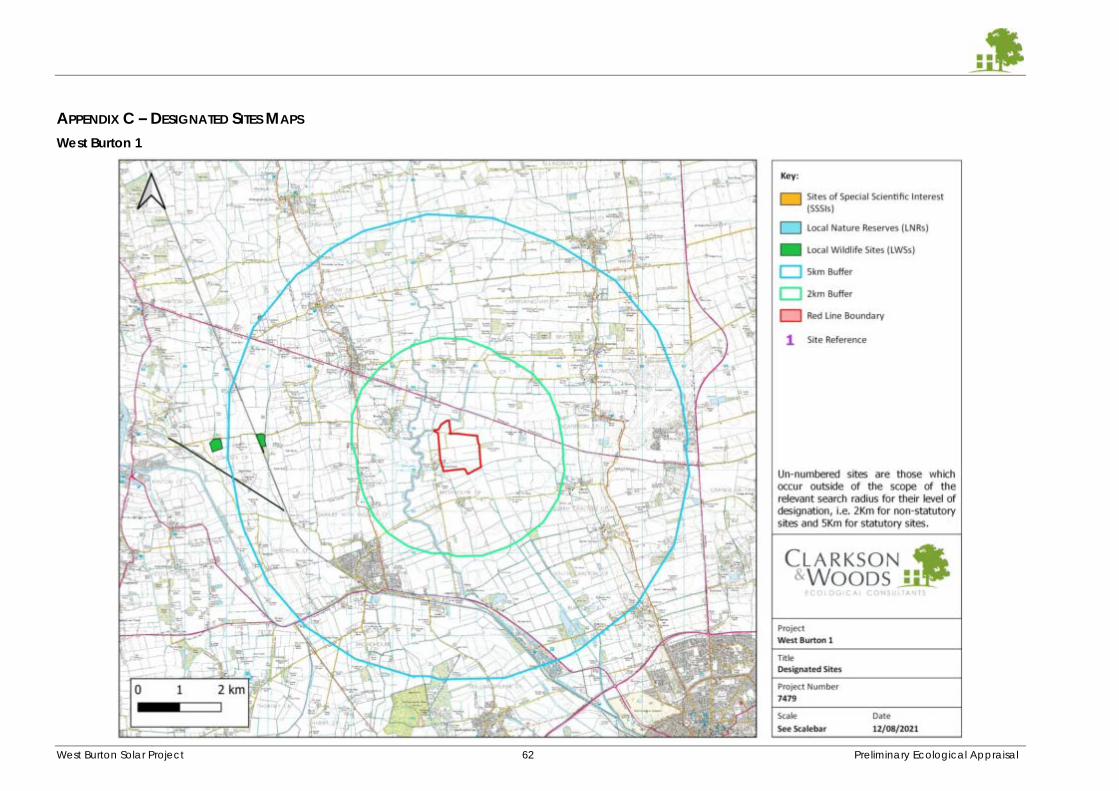
West Burton Solar Project 62 Preliminary Ecological Appraisal
APPENDIX C – DESIGNATED SITES MAPS
West Burton 1
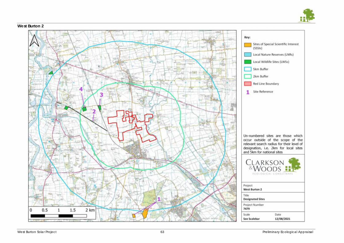
West Burton Solar Project 63 Preliminary Ecological Appraisal
West Burton 2
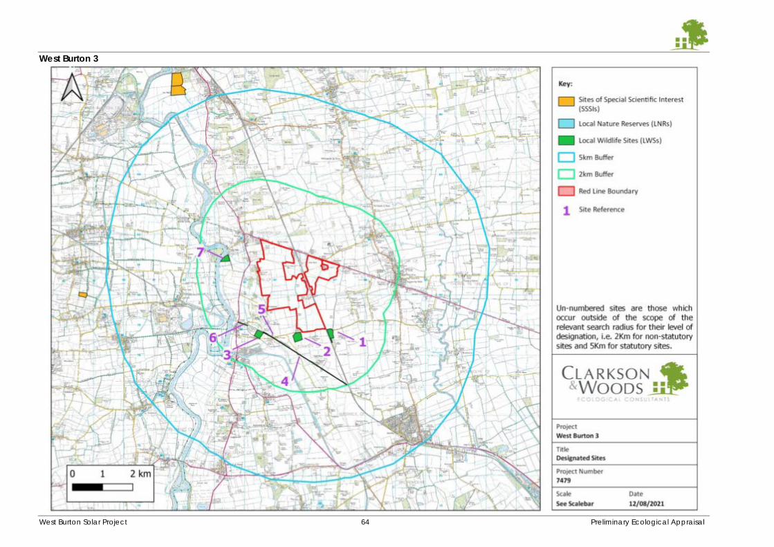
West Burton Solar Project 64 Preliminary Ecological Appraisal
West Burton 3
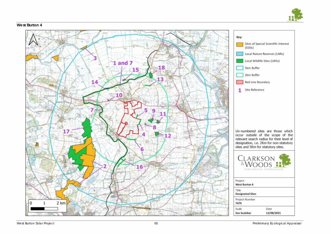
West Burton Solar Project 65 Preliminary Ecological Appraisal
West Burton 4
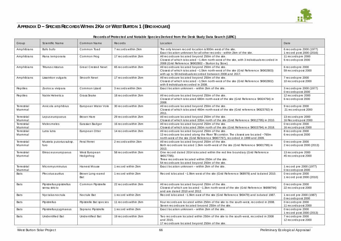
West Burton Solar Project 66 Preliminary Ecological Appraisal
APPENDIX D – SPECIES RECORDS WITHIN 2KM OF WEST BURTON 1 (BROXHOLME)
Records of Protected and Notable Species Derived from the Desk Study Data Search (LERC)
Group Scientific Name Common Name Records Location Date
Amphibians Bufo bufo Common Toad 7 records within 2km The only known record location is 900m west of the site.
Exact location unknown for all other records – within 2km of the site.
6 records pre 2000 (1977)
1 record post 2000 (2016)
Amphibians Rana temporaria Common Frog 17 records within 2km All records are located beyond 250m of the site.
Closest of which is located ~1.4km north-west of the site, with 3 individuals recorded in
2008 (Grid Reference SK902802 – Sturton by Stow)
11 records pre 2000
6 records post 2000
Amphibians Triturus cristatus Great Crested Newt 65 records within 2km All records are located beyond 250m of the site.
Closest of which is located ~1.5km north-west of the site (Grid Reference SK902803)
with up to 59 individuals recorded between 2008 and 2017.
6 records pre 2000
59 records post 2000
Amphibians Lissotriton vulgaris Smooth Newt 17 records within 2km All records are located beyond 250m of the site.
Closest of which is located ~1.5km north-west of the site (Grid Reference SK902802)
with 8 individuals recorded in 2008.
7 records pre 2000
10 records post 2000
Reptiles Zootoca vivipara Common Lizard 3 records within 2km Exact location unknown – within 2km of the site. 3 records pre 2000 (1977)
0 records post 2000
Reptiles Natrix Helvetica Grass Snake 18 records within 2km All records are located beyond 250m of the site.
Closest of which is located 680m north-east of the site (Grid Reference SK924794) in
2008.
12 records pre 2000
6 records post 2000
Terrestrial
Mammal
Arvicola amphibius European Water Vole 30 records within 2km All records are located beyond 250m of the site.
Closest of which is located 460m north-east of the site (Grid reference SK923792) in
2011.
9 records pre 2000
21 records post 2000
Terrestrial
Mammal
Lepus europaeus Brown Hare 29 records within 2km All records are located beyond 250m of the site.
Closest of which is located 335m north of the site (Grid Reference SK912795) in 2010.
13 records pre 2000
16 Records post 2000
Terrestrial
Mammal
Meles meles Eurasian Badger
16 records within 2km All records are located beyond 250m of the site.
Closest of which is located 260m north of the site (Grid Reference SK915794) in 2018.
0 records pre 2000
16 records post 2000
Terrestrial
Mammal
Lutra lutra
European Otter
14 records within 2km All records are located beyond 250m of the site.
13 records are located along the River Till corridor. The closest are located ~760m
north-west of the site (Grid Reference SK907797), recorded in 1999 and 2009.
8 records pre 2000
6 records post 2000
Terrestrial
Mammal
Mustela putorius subsp.
furo
Feral Ferret
2 records within 2km All records are located beyond 250m of the site.
Both records are located 1.3km north-west of the site (Grid Reference SK901799) in
2013.
0 records pre 2000
2 records post 2000 (2013)
Terrestrial
Mammal
Erinaceus europaeus West European
Hedgehog
58 records within 2km One record dated 2014 is located within the red line boundary (Grid Reference
SK917785).
Three records are located within 250m of the site.
54 records are located beyond 250m of the site.
13 records pre 2000
45 records post 2000
Terrestrial
Mammal
Micromys minutus Harvest Mouse 1 record within 2km Exact location unknown – within 2km of the site. 1 record pre 2000 (1977)
0 records post 2000
Bats Plecotus auritus Brown Long-eared
Bat
1 record within 2km Record is located ~1.9km west of the site (Grid Reference SK8979) and is dated 2010. 0 records pre 2000
1 record post 2000 (2010)
Bats Pipistrellus pipistrellus
sensu stricto
Common Pipistrelle
22 records within 2km All records are located beyond 250m of the site.
Closest of which are located ~1.3km north-west of the site (Grid Reference SK898794)
and are dated 2010 and 2012.
0 records pre 2000
22 records post 2000
Bats Nyctalus noctula Noctule Bat
1 record within 2km Record is located ~1.9km east of the site (Grid Reference SK9479) and is dated 1987. 1 record pre 2000 (1987)
0 records post 2000
Bats Pipistrellus Pipistrelle Bat species
11 records within 2km Four records are located within 250m of the site to the south-west, recorded in 2008.
Seven records are located beyond 250m of the site.
0 records pre 2000
11 records post 2000
Bats Pipistrellus pygmaeus Soprano Pipistrelle
1 record within 2km Exact location unknown – within 2km of the site. 0 records pre 2000
1 record post 2000 (2013)
Bats Unidentified Bat Unidentified Bat
19 records within 2km Two records are located within 250m of the site to the south-west, recorded in 2008
and 2015.
17 records are located beyond 250m of the site.
7 records pre 2000
12 records post 2000
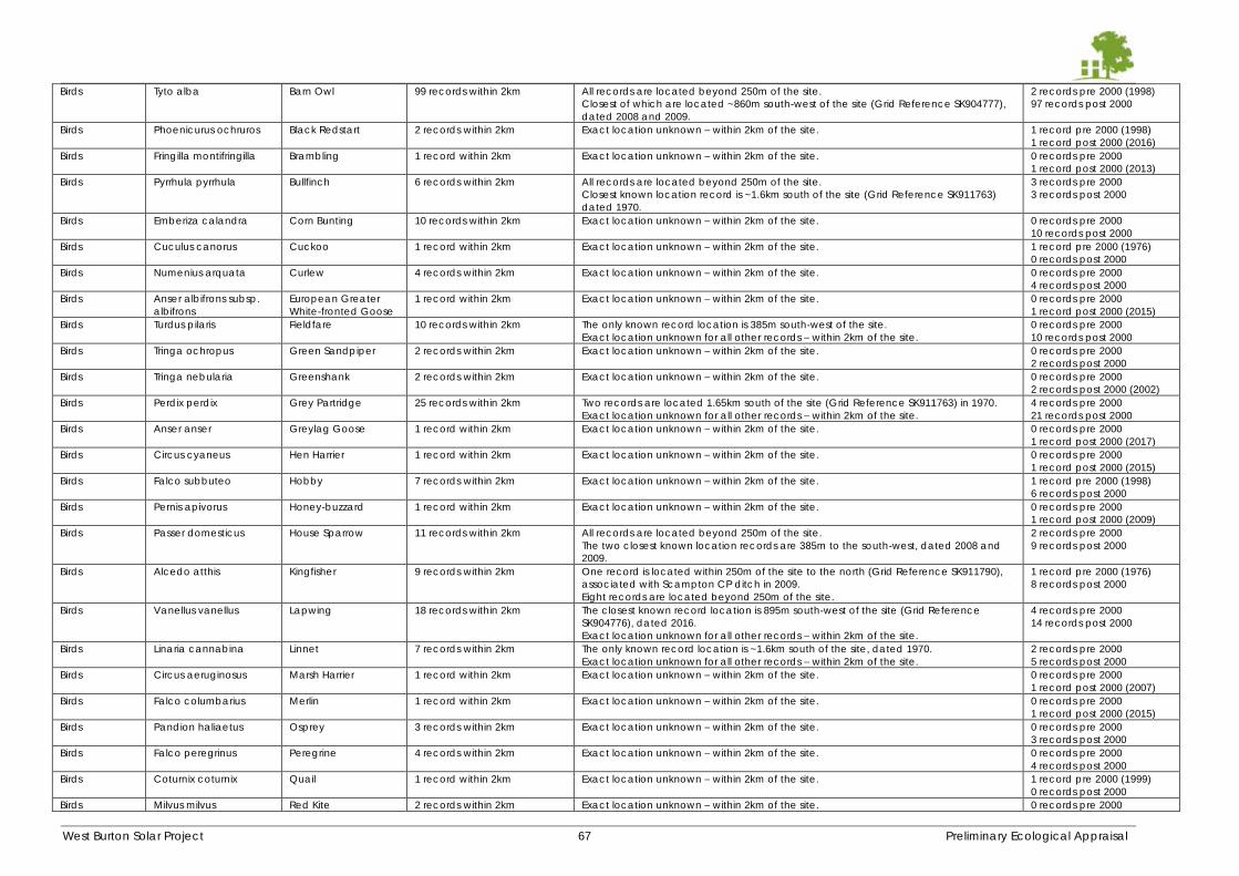
West Burton Solar Project 67 Preliminary Ecological Appraisal
Birds Tyto alba Barn Owl 99 records within 2km All records are located beyond 250m of the site.
Closest of which are located ~860m south-west of the site (Grid Reference SK904777),
dated 2008 and 2009.
2 records pre 2000 (1998)
97 records post 2000
Birds Phoenicurus ochruros Black Redstart 2 records within 2km Exact location unknown – within 2km of the site. 1 record pre 2000 (1998)
1 record post 2000 (2016)
Birds Fringilla montifringilla Brambling 1 record within 2km Exact location unknown – within 2km of the site. 0 records pre 2000
1 record post 2000 (2013)
Birds Pyrrhula pyrrhula Bullfinch 6 records within 2km All records are located beyond 250m of the site.
Closest known location record is ~1.6km south of the site (Grid Reference SK911763)
dated 1970.
3 records pre 2000
3 records post 2000
Birds Emberiza calandra Corn Bunting 10 records within 2km Exact location unknown – within 2km of the site. 0 records pre 2000
10 records post 2000
Birds Cuculus canorus Cuckoo 1 record within 2km Exact location unknown – within 2km of the site. 1 record pre 2000 (1976)
0 records post 2000
Birds Numenius arquata Curlew 4 records within 2km Exact location unknown – within 2km of the site. 0 records pre 2000
4 records post 2000
Birds Anser albifrons subsp.
albifrons
European Greater
White-fronted Goose
1 record within 2km Exact location unknown – within 2km of the site. 0 records pre 2000
1 record post 2000 (2015)
Birds Turdus pilaris Fieldfare 10 records within 2km The only known record location is 385m south-west of the site.
Exact location unknown for all other records – within 2km of the site.
0 records pre 2000
10 records post 2000
Birds Tringa ochropus Green Sandpiper 2 records within 2km Exact location unknown – within 2km of the site. 0 records pre 2000
2 records post 2000
Birds Tringa nebularia Greenshank 2 records within 2km Exact location unknown – within 2km of the site. 0 records pre 2000
2 records post 2000 (2002)
Birds Perdix perdix Grey Partridge 25 records within 2km Two records are located 1.65km south of the site (Grid Reference SK911763) in 1970.
Exact location unknown for all other records – within 2km of the site.
4 records pre 2000
21 records post 2000
Birds Anser anser Greylag Goose 1 record within 2km Exact location unknown – within 2km of the site. 0 records pre 2000
1 record post 2000 (2017)
Birds Circus cyaneus Hen Harrier 1 record within 2km Exact location unknown – within 2km of the site. 0 records pre 2000
1 record post 2000 (2015)
Birds Falco subbuteo Hobby 7 records within 2km Exact location unknown – within 2km of the site. 1 record pre 2000 (1998)
6 records post 2000
Birds Pernis apivorus Honey-buzzard 1 record within 2km Exact location unknown – within 2km of the site. 0 records pre 2000
1 record post 2000 (2009)
Birds Passer domesticus House Sparrow 11 records within 2km All records are located beyond 250m of the site.
The two closest known location records are 385m to the south-west, dated 2008 and
2009.
2 records pre 2000
9 records post 2000
Birds Alcedo atthis Kingfisher 9 records within 2km One record is located within 250m of the site to the north (Grid Reference SK911790),
associated with Scampton CP ditch in 2009.
Eight records are located beyond 250m of the site.
1 record pre 2000 (1976)
8 records post 2000
Birds Vanellus vanellus Lapwing 18 records within 2km The closest known record location is 895m south-west of the site (Grid Reference
SK904776), dated 2016.
Exact location unknown for all other records – within 2km of the site.
4 records pre 2000
14 records post 2000
Birds Linaria cannabina Linnet 7 records within 2km The only known record location is ~1.6km south of the site, dated 1970.
Exact location unknown for all other records – within 2km of the site.
2 records pre 2000
5 records post 2000
Birds Circus aeruginosus Marsh Harrier 1 record within 2km Exact location unknown – within 2km of the site. 0 records pre 2000
1 record post 2000 (2007)
Birds Falco columbarius Merlin 1 record within 2km Exact location unknown – within 2km of the site. 0 records pre 2000
1 record post 2000 (2015)
Birds Pandion haliaetus Osprey 3 records within 2km Exact location unknown – within 2km of the site. 0 records pre 2000
3 records post 2000
Birds Falco peregrinus Peregrine 4 records within 2km Exact location unknown – within 2km of the site. 0 records pre 2000
4 records post 2000
Birds Coturnix coturnix Quail 1 record within 2km Exact location unknown – within 2km of the site. 1 record pre 2000 (1999)
0 records post 2000
Birds Milvus milvus Red Kite 2 records within 2km Exact location unknown – within 2km of the site. 0 records pre 2000
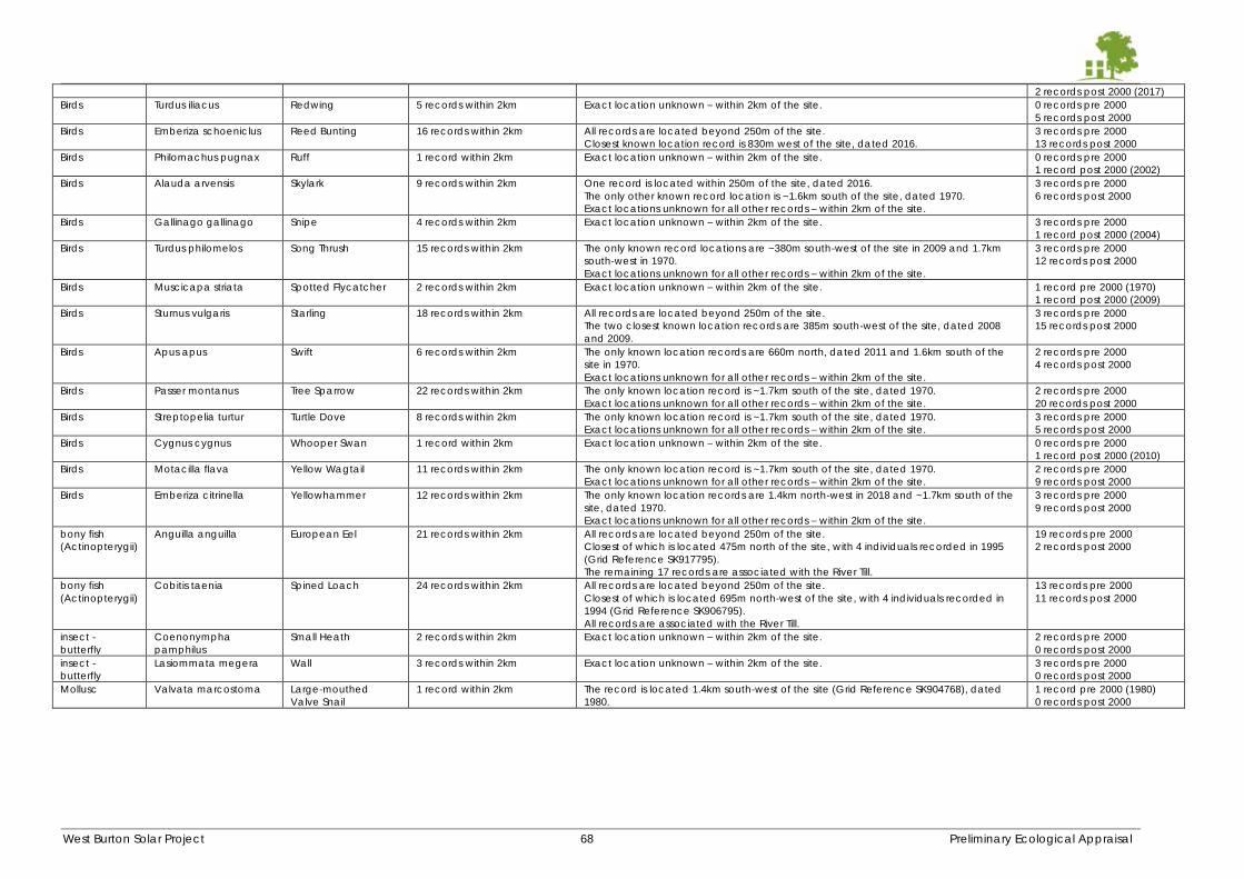
West Burton Solar Project 68 Preliminary Ecological Appraisal
2 records post 2000 (2017)
Birds Turdus iliacus Redwing 5 records within 2km Exact location unknown – within 2km of the site. 0 records pre 2000
5 records post 2000
Birds Emberiza schoeniclus Reed Bunting 16 records within 2km All records are located beyond 250m of the site.
Closest known location record is 830m west of the site, dated 2016.
3 records pre 2000
13 records post 2000
Birds Philomachus pugnax Ruff 1 record within 2km Exact location unknown – within 2km of the site. 0 records pre 2000
1 record post 2000 (2002)
Birds Alauda arvensis Skylark 9 records within 2km One record is located within 250m of the site, dated 2016.
The only other known record location is ~1.6km south of the site, dated 1970.
Exact locations unknown for all other records – within 2km of the site.
3 records pre 2000
6 records post 2000
Birds Gallinago gallinago Snipe 4 records within 2km Exact location unknown – within 2km of the site. 3 records pre 2000
1 record post 2000 (2004)
Birds Turdus philomelos Song Thrush 15 records within 2km The only known record locations are ~380m south-west of the site in 2009 and 1.7km
south-west in 1970.
Exact locations unknown for all other records – within 2km of the site.
3 records pre 2000
12 records post 2000
Birds Muscicapa striata Spotted Flycatcher 2 records within 2km Exact location unknown – within 2km of the site. 1 record pre 2000 (1970)
1 record post 2000 (2009)
Birds Sturnus vulgaris Starling 18 records within 2km All records are located beyond 250m of the site.
The two closest known location records are 385m south-west of the site, dated 2008
and 2009.
3 records pre 2000
15 records post 2000
Birds Apus apus Swift 6 records within 2km The only known location records are 660m north, dated 2011 and 1.6km south of the
site in 1970.
Exact locations unknown for all other records – within 2km of the site.
2 records pre 2000
4 records post 2000
Birds Passer montanus Tree Sparrow 22 records within 2km The only known location record is ~1.7km south of the site, dated 1970.
Exact locations unknown for all other records – within 2km of the site.
2 records pre 2000
20 records post 2000
Birds Streptopelia turtur Turtle Dove 8 records within 2km The only known location record is ~1.7km south of the site, dated 1970.
Exact locations unknown for all other records – within 2km of the site.
3 records pre 2000
5 records post 2000
Birds Cygnus cygnus Whooper Swan 1 record within 2km Exact location unknown – within 2km of the site. 0 records pre 2000
1 record post 2000 (2010)
Birds Motacilla flava Yellow Wagtail 11 records within 2km The only known location record is ~1.7km south of the site, dated 1970.
Exact locations unknown for all other records – within 2km of the site.
2 records pre 2000
9 records post 2000
Birds Emberiza citrinella Yellowhammer 12 records within 2km The only known location records are 1.4km north-west in 2018 and ~1.7km south of the
site, dated 1970.
Exact locations unknown for all other records – within 2km of the site.
3 records pre 2000
9 records post 2000
bony fish
(Actinopterygii)
Anguilla anguilla European Eel 21 records within 2km All records are located beyond 250m of the site.
Closest of which is located 475m north of the site, with 4 individuals recorded in 1995
(Grid Reference SK917795).
The remaining 17 records are associated with the River Till.
19 records pre 2000
2 records post 2000
bony fish
(Actinopterygii)
Cobitis taenia Spined Loach 24 records within 2km All records are located beyond 250m of the site.
Closest of which is located 695m north-west of the site, with 4 individuals recorded in
1994 (Grid Reference SK906795).
All records are associated with the River Till.
13 records pre 2000
11 records post 2000
insect -
butterfly
Coenonympha
pamphilus
Small Heath 2 records within 2km Exact location unknown – within 2km of the site. 2 records pre 2000
0 records post 2000
insect -
butterfly
Lasiommata megera Wall 3 records within 2km Exact location unknown – within 2km of the site. 3 records pre 2000
0 records post 2000
Mollusc Valvata marcostoma Large-mouthed
Valve Snail
1 record within 2km The record is located 1.4km south-west of the site (Grid Reference SK904768), dated
1980.
1 record pre 2000 (1980)
0 records post 2000
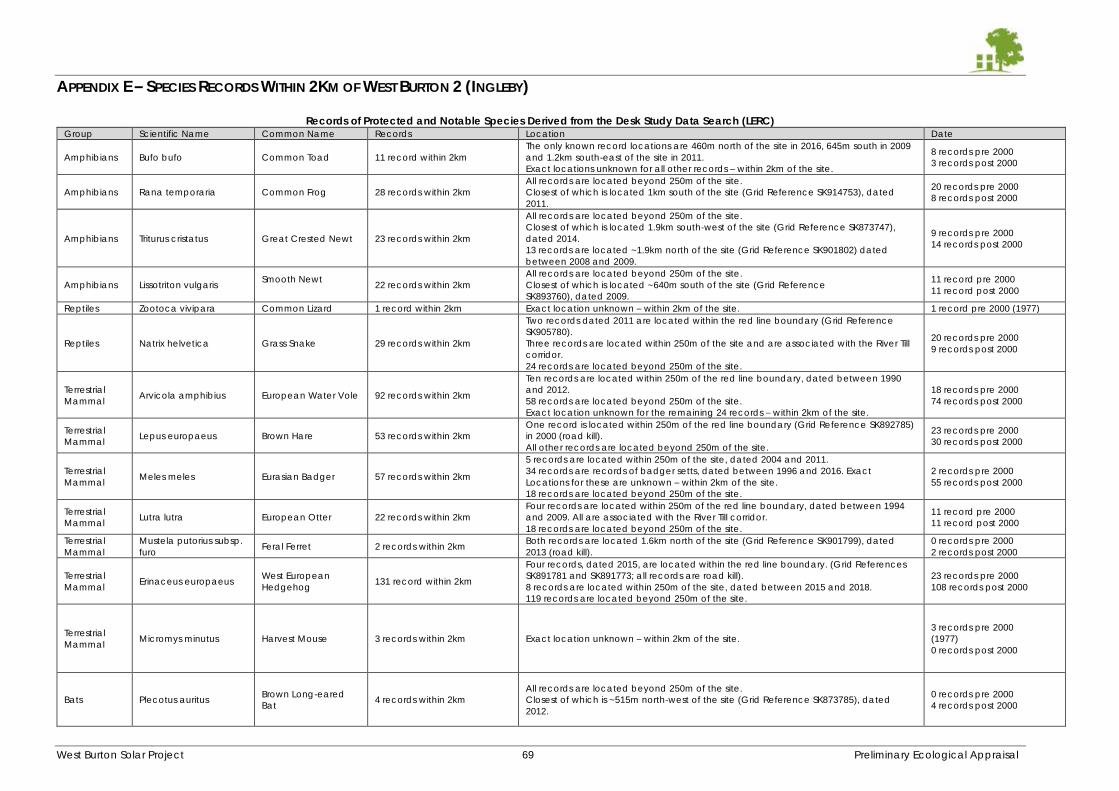
West Burton Solar Project 69 Preliminary Ecological Appraisal
APPENDIX E – SPECIES RECORDS WITHIN 2KM OF WEST BURTON 2 (INGLEBY)
Records of Protected and Notable Species Derived from the Desk Study Data Search (LERC) Group Scientific Name Common Name Records Location Date
Amphibians Bufo bufo Common Toad 11 record within 2km
The only known record locations are 460m north of the site in 2016, 645m south in 2009
and 1.2km south-east of the site in 2011.
Exact locations unknown for all other records – within 2km of the site.
8 records pre 2000
3 records post 2000
Amphibians Rana temporaria Common Frog 28 records within 2km
All records are located beyond 250m of the site.
Closest of which is located 1km south of the site (Grid Reference SK914753), dated
2011.
20 records pre 2000
8 records post 2000
Amphibians Triturus cristatus Great Crested Newt 23 records within 2km
All records are located beyond 250m of the site.
Closest of which is located 1.9km south-west of the site (Grid Reference SK873747),
dated 2014.
13 records are located ~1.9km north of the site (Grid Reference SK901802) dated
between 2008 and 2009.
9 records pre 2000
14 records post 2000
Amphibians Lissotriton vulgaris Smooth Newt
22 records within 2km
All records are located beyond 250m of the site.
Closest of which is located ~640m south of the site (Grid Reference
SK893760), dated 2009.
11 record pre 2000
11 record post 2000
Reptiles Zootoca vivipara Common Lizard 1 record within 2km Exact location unknown – within 2km of the site. 1 record pre 2000 (1977)
Reptiles Natrix helvetica Grass Snake 29 records within 2km
Two records dated 2011 are located within the red line boundary (Grid Reference
SK905780).
Three records are located within 250m of the site and are associated with the River Till
corridor.
24 records are located beyond 250m of the site.
20 records pre 2000
9 records post 2000
Terrestrial
Mammal Arvicola amphibius European Water Vole 92 records within 2km
Ten records are located within 250m of the red line boundary, dated between 1990
and 2012.
58 records are located beyond 250m of the site.
Exact location unknown for the remaining 24 records – within 2km of the site.
18 records pre 2000
74 records post 2000
Terrestrial
Mammal Lepus europaeus Brown Hare 53 records within 2km
One record is located within 250m of the red line boundary (Grid Reference SK892785)
in 2000 (road kill).
All other records are located beyond 250m of the site.
23 records pre 2000
30 records post 2000
Terrestrial
Mammal Meles meles Eurasian Badger 57 records within 2km
5 records are located within 250m of the site, dated 2004 and 2011.
34 records are records of badger setts, dated between 1996 and 2016. Exact
Locations for these are unknown – within 2km of the site.
18 records are located beyond 250m of the site.
2 records pre 2000
55 records post 2000
Terrestrial
Mammal Lutra lutra European Otter 22 records within 2km
Four records are located within 250m of the red line boundary, dated between 1994
and 2009. All are associated with the River Till corridor.
18 records are located beyond 250m of the site.
11 record pre 2000
11 record post 2000
Terrestrial
Mammal
Mustela putorius subsp.
furo Feral Ferret 2 records within 2km
Both records are located 1.6km north of the site (Grid Reference SK901799), dated
2013 (road kill).
0 records pre 2000
2 records post 2000
Terrestrial
Mammal Erinaceus europaeus
West European
Hedgehog 131 record within 2km
Four records, dated 2015, are located within the red line boundary. (Grid References
SK891781 and SK891773; all records are road kill).
8 records are located within 250m of the site, dated between 2015 and 2018.
119 records are located beyond 250m of the site.
23 records pre 2000
108 records post 2000
Terrestrial
Mammal Micromys minutus Harvest Mouse 3 records within 2km Exact location unknown – within 2km of the site.
3 records pre 2000
(1977)
0 records post 2000
Bats Plecotus auritus Brown Long-eared
Bat 4 records within 2km
All records are located beyond 250m of the site.
Closest of which is ~515m north-west of the site (Grid Reference SK873785), dated
2012.
0 records pre 2000
4 records post 2000
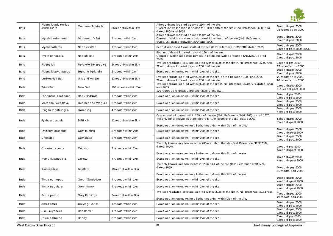
West Burton Solar Project 70 Preliminary Ecological Appraisal
Bats
Pipistrellus pipistrellus
sensu stricto
Common Pipistrelle
36 records within 2km
All records are located beyond 250m of the site.
Closest known location records are 1.1km north of the site (Grid Reference SK882796),
dated 2004 and 2006.
0 records pre 2000
35 records post 2000
Bats Myotis daubentonii Daubenton's Bat 7 record within 2km
All records are located beyond 250m of the site.
Closest of which are 4 records located 1.1km north of the site (Grid Reference
SK882796), dated between 2004 and 2006.
0 records pre 2000
7 record post 2000
Bats Myotis nattereri Natterer's Bat 1 record within 2km Record is located 1.4km south of the site (Grid Reference SK895748), dated 2005. 0 records pre 2000
1 record post 2000 (2005)
Bats Nyctalus noctula Noctule Bat 2 records within 2km
Both records are located beyond 250m of the site.
Closest of which is located 1km south of the site (Grid Reference SK895752), dated
2010.
0 records pre 2000
2 record post 2000
Bats Pipistrellus Pipistrelle Bat species 24 records within 2km Two records dated 2007 are located within 250m of the site (Grid Reference SK892779).
22 records are located beyond 250m of the site.
1 record pre 2000
23 records post 2000
Bats Pipistrellus pygmaeus Soprano Pipistrelle 2 record within 2km Exact location unknown – within 2km of the site. 0 records pre 2000
2 record post 2000
Bats Unidentified Bat Unidentified Bat 83 records within 2km Five records are located within 250m of the site, dated between 1999 and 2015.
78 records are located beyond 250m of the site.
20 records pre 2000
63 records post 2000
Birds Tyto alba Barn Owl 103 records within 2km
Two records are located within 250m of the site (Grid Reference SK904777), dated 2008
and 2009.
101 records are located beyond 250m of the site.
2 records pre 2000
101 record post 2000
Birds Phoenicurus ochruros Black Redstart 1 record within 2km Exact location unknown – within 2km of the site. 0 record pre 2000
1 record post 2000
Birds Motacilla flava flava Blue-headed Wagtail 2 record within 2km Exact location unknown – within 2km of the site. 0 records pre 2000
2 record post 2000
Birds Fringilla montifringilla Brambling 4 record within 2km Exact location unknown – within 2km of the site. 0 records pre 2000
4 record post 2000
Birds Pyrrhula pyrrhula Bullfinch 12 records within 2km
One record is located within 250m of the site (Grid Reference SK911763), dated 1970.
The only other known location record is ~1km south of the site, dated 2009.
Exact location unknown for all other records – within 2km of the site.
5 records pre 2000
7 records post 2000
Birds Emberiza calandra Corn Bunting 3 records within 2km Exact location unknown – within 2km of the site. 0 records pre 2000
3 records post 2000
Birds Crex crex Corncrake 2 record within 2km Exact location unknown – within 2km of the site. 0 records pre 2000
2 record post 2000
Birds Cuculus canorus Cuckoo 7 records within 2km
The only known location record is 700m south of the site (Grid Reference SK890758),
dated 2006).
Exact location unknown for all other records – within 2km of the site.
2 record pre 2000
5 records post 2000
Birds Numenius arquata Curlew 4 records within 2km Exact location unknown – within 2km of the site. 0 records pre 2000
4 records post 2000
Birds Turdus pilaris Fieldfare 19 record within 2km
The only known location record is 620m east of the site (Grid Reference SK911776),
dated 2009.
Exact location unknown for all other records – within 2km of the site.
0 records pre 2000
19 record post 2000
Birds Tringa ochropus Green Sandpiper 4 records within 2km Exact location unknown – within 2km of the site. 0 records pre 2000
4 records post 2000
Birds Tringa nebularia Greenshank 4 records within 2km Exact location unknown – within 2km of the site. 0 records pre 2000
4 records post 2000
Birds Perdix perdix Grey Partridge 34 record within 2km
Two records dated 1970 are located within 250m of the site (Grid Reference SK911763).
Exact location unknown for all other records – within 2km of the site.
7 records pre 2000
27 record post 2000
Birds Anser anser Greylag Goose 1 record within 2km Exact location unknown – within 2km of the site. 0 records pre 2000
1 record post 2000
Birds Circus cyaneus Hen Harrier 1 record within 2km Exact location unknown – within 2km of the site. 0 records pre 2000
1 record post 2000
Birds Falco subbuteo Hobby 3 record within 2km Exact location unknown – within 2km of the site. 2 record pre 2000
1 record post 2000
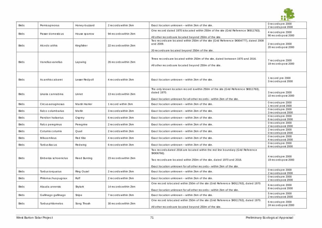
West Burton Solar Project 71 Preliminary Ecological Appraisal
Birds Pernis apivorus Honey-buzzard 2 records within 2km Exact location unknown – within 2km of the site. 0 records pre 2000
2 records post 2000
Birds Passer domesticus House sparrow 94 records within 2km
One record dated 1970 is located within 250m of the site (Grid Reference SK911763).
All other records are located beyond 250m of the site.
4 records pre 2000
90 records post 2000
Birds Alcedo atthis Kingfisher 22 records within 2km
Two records are located within 250m of the site (Grid Reference SK904777), dated 2008
and 2009.
20 records are located beyond 250m of the site.
2 records pre 2000
20 records post 2000
Birds Vanellus vanellus Lapwing 26 records within 2km
Three records are located within 250m of the site, dated between 1970 and 2016.
All other records are located beyond 250m of the site.
7 records pre 2000
19 records post 2000
Birds Acanthis cabaret Lesser Redpoll 4 records within 2km Exact location unknown – within 2km of the site. 1 record pre 2000
3 records post 2000
Birds Linaria cannabina Linnet 13 records within 2km
The only known location record is within 250m of the site (Grid Reference SK911763),
dated 1970.
Exact location unknown for all other records – within 2km of the site.
3 records pre 2000
10 records post 2000
Birds Circus aeruginosus Marsh Harrier 1 record within 2km Exact location unknown – within 2km of the site. 0 records pre 2000
1 record post 2000
Birds Falco columbarius Merlin 3 records within 2km Exact location unknown – within 2km of the site. 0 records pre 2000
3 records post 2000
Birds Pandion haliaetus Osprey 6 records within 2km Exact location unknown – within 2km of the site. 0 records pre 2000
6 records post 2000
Birds Falco peregrinus Peregrine 2 records within 2km Exact location unknown – within 2km of the site. 0 records pre 2000
2 records post 2000
Birds Coturnix coturnix Quail 2 records within 2km Exact location unknown – within 2km of the site. 2 records pre 2000
0 records post 2000
Birds Milvus milvus Red Kite 4 records within 2km Exact location unknown – within 2km of the site. 0 records pre 2000
4 records post 2000
Birds Turdus iliacus Redwing 6 records within 2km Exact location unknown – within 2km of the site. 0 records pre 2000
6 records post 2000
Birds Emberiza schoeniclus Reed Bunting 23 records within 2km
Two records dated 2016 are located within the red line boundary (Grid Reference
SK906766).
Two records are located within 250m of the site, dated 1970 and 2016.
Exact location unknown for all other records – within 2km of the site.
4 records pre 2000
19 records post 2000
Birds Turdus torquatus Ring Ouzel 2 records within 2km Exact location unknown – within 2km of the site. 0 records pre 2000
2 records post 2000
Birds Philomachus pugnax Ruff 2 records within 2km Exact location unknown – within 2km of the site. 0 records pre 2000
2 records post 2000
Birds Alauda arvensis Skylark 14 records within 2km
One record is located within 250m of the site (Grid Reference SK911763), dated 1970.
Exact location unknown for all other records – within 2km of the site.
6 records pre 2000
8 records post 2000
Birds Gallinago gallinago Snipe 7 records within 2km Exact location unknown – within 2km of the site. 5 records pre 2000
2 records post 2000
Birds Turdus philomelos Song Thrush 30 records within 2km
One record is located within 250m of the site (Grid Reference SK911763), dated 1970.
All other records are located beyond 250m of the site.
6 records pre 2000
24 records post 2000
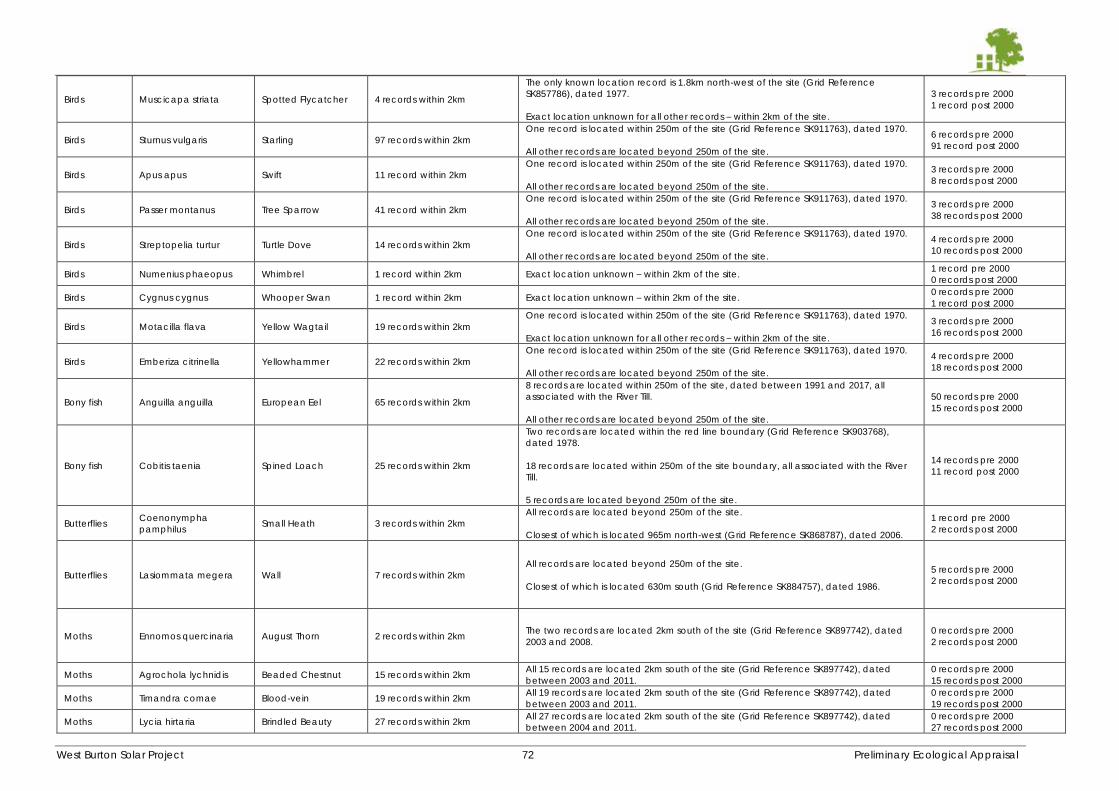
West Burton Solar Project 72 Preliminary Ecological Appraisal
Birds Muscicapa striata Spotted Flycatcher 4 records within 2km
The only known location record is 1.8km north-west of the site (Grid Reference
SK857786), dated 1977.
Exact location unknown for all other records – within 2km of the site.
3 records pre 2000
1 record post 2000
Birds Sturnus vulgaris Starling 97 records within 2km
One record is located within 250m of the site (Grid Reference SK911763), dated 1970.
All other records are located beyond 250m of the site.
6 records pre 2000
91 record post 2000
Birds Apus apus Swift 11 record within 2km
One record is located within 250m of the site (Grid Reference SK911763), dated 1970.
All other records are located beyond 250m of the site.
3 records pre 2000
8 records post 2000
Birds Passer montanus Tree Sparrow 41 record within 2km
One record is located within 250m of the site (Grid Reference SK911763), dated 1970.
All other records are located beyond 250m of the site.
3 records pre 2000
38 records post 2000
Birds Streptopelia turtur Turtle Dove 14 records within 2km
One record is located within 250m of the site (Grid Reference SK911763), dated 1970.
All other records are located beyond 250m of the site.
4 records pre 2000
10 records post 2000
Birds Numenius phaeopus Whimbrel 1 record within 2km Exact location unknown – within 2km of the site. 1 record pre 2000
0 records post 2000
Birds Cygnus cygnus Whooper Swan 1 record within 2km Exact location unknown – within 2km of the site. 0 records pre 2000
1 record post 2000
Birds Motacilla flava Yellow Wagtail 19 records within 2km
One record is located within 250m of the site (Grid Reference SK911763), dated 1970.
Exact location unknown for all other records – within 2km of the site.
3 records pre 2000
16 records post 2000
Birds Emberiza citrinella Yellowhammer 22 records within 2km
One record is located within 250m of the site (Grid Reference SK911763), dated 1970.
All other records are located beyond 250m of the site.
4 records pre 2000
18 records post 2000
Bony fish Anguilla anguilla European Eel 65 records within 2km
8 records are located within 250m of the site, dated between 1991 and 2017, all
associated with the River Till.
All other records are located beyond 250m of the site.
50 records pre 2000
15 records post 2000
Bony fish Cobitis taenia Spined Loach 25 records within 2km
Two records are located within the red line boundary (Grid Reference SK903768),
dated 1978.
18 records are located within 250m of the site boundary, all associated with the River
Till.
5 records are located beyond 250m of the site.
14 records pre 2000
11 record post 2000
Butterflies Coenonympha
pamphilus Small Heath 3 records within 2km
All records are located beyond 250m of the site.
Closest of which is located 965m north-west (Grid Reference SK868787), dated 2006.
1 record pre 2000
2 records post 2000
Butterflies Lasiommata megera Wall 7 records within 2km
All records are located beyond 250m of the site.
Closest of which is located 630m south (Grid Reference SK884757), dated 1986.
5 records pre 2000
2 records post 2000
Moths Ennomos quercinaria August Thorn 2 records within 2km The two records are located 2km south of the site (Grid Reference SK897742), dated
2003 and 2008.
0 records pre 2000
2 records post 2000
Moths Agrochola lychnidis Beaded Chestnut 15 records within 2km All 15 records are located 2km south of the site (Grid Reference SK897742), dated
between 2003 and 2011.
0 records pre 2000
15 records post 2000
Moths Timandra comae Blood-vein 19 records within 2km All 19 records are located 2km south of the site (Grid Reference SK897742), dated
between 2003 and 2011.
0 records pre 2000
19 records post 2000
Moths Lycia hirtaria Brindled Beauty 27 records within 2km All 27 records are located 2km south of the site (Grid Reference SK897742), dated
between 2004 and 2011.
0 records pre 2000
27 records post 2000
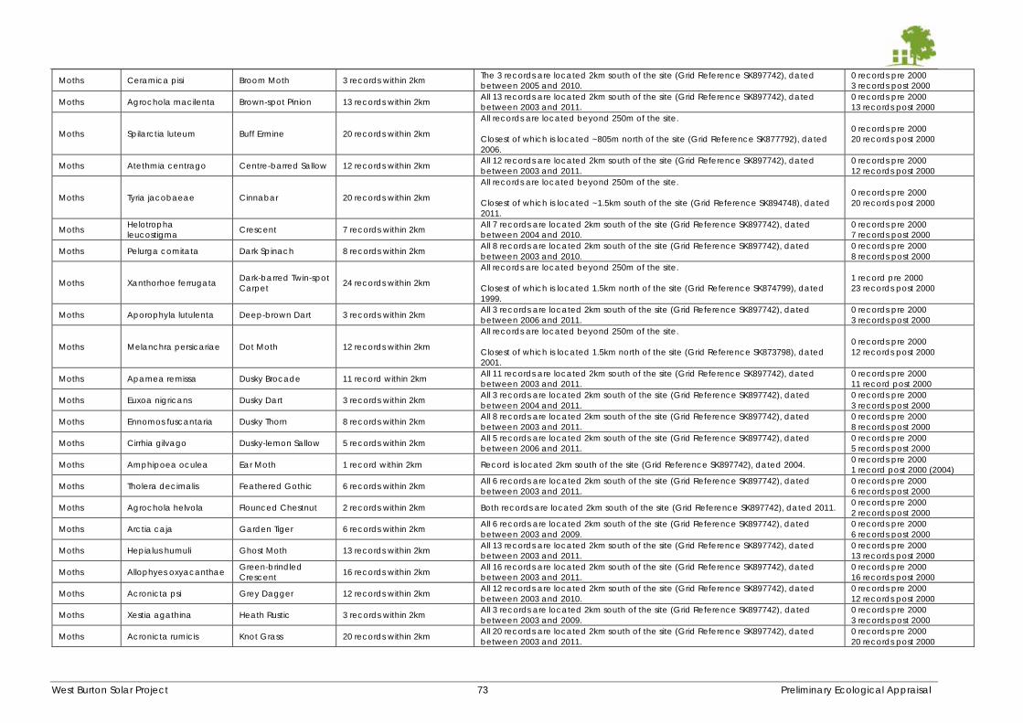
West Burton Solar Project 73 Preliminary Ecological Appraisal
Moths Ceramica pisi Broom Moth 3 records within 2km The 3 records are located 2km south of the site (Grid Reference SK897742), dated
between 2005 and 2010.
0 records pre 2000
3 records post 2000
Moths Agrochola macilenta Brown-spot Pinion 13 records within 2km All 13 records are located 2km south of the site (Grid Reference SK897742), dated
between 2003 and 2011.
0 records pre 2000
13 records post 2000
Moths Spilarctia luteum Buff Ermine 20 records within 2km
All records are located beyond 250m of the site.
Closest of which is located ~805m north of the site (Grid Reference SK877792), dated
2006.
0 records pre 2000
20 records post 2000
Moths Atethmia centrago Centre-barred Sallow 12 records within 2km All 12 records are located 2km south of the site (Grid Reference SK897742), dated
between 2003 and 2011.
0 records pre 2000
12 records post 2000
Moths Tyria jacobaeae Cinnabar 20 records within 2km
All records are located beyond 250m of the site.
Closest of which is located ~1.5km south of the site (Grid Reference SK894748), dated
2011.
0 records pre 2000
20 records post 2000
Moths Helotropha
leucostigma Crescent 7 records within 2km
All 7 records are located 2km south of the site (Grid Reference SK897742), dated
between 2004 and 2010.
0 records pre 2000
7 records post 2000
Moths Pelurga comitata Dark Spinach 8 records within 2km All 8 records are located 2km south of the site (Grid Reference SK897742), dated
between 2003 and 2010.
0 records pre 2000
8 records post 2000
Moths Xanthorhoe ferrugata Dark-barred Twin-spot
Carpet 24 records within 2km
All records are located beyond 250m of the site.
Closest of which is located 1.5km north of the site (Grid Reference SK874799), dated
1999.
1 record pre 2000
23 records post 2000
Moths Aporophyla lutulenta Deep-brown Dart 3 records within 2km All 3 records are located 2km south of the site (Grid Reference SK897742), dated
between 2006 and 2011.
0 records pre 2000
3 records post 2000
Moths Melanchra persicariae Dot Moth 12 records within 2km
All records are located beyond 250m of the site.
Closest of which is located 1.5km north of the site (Grid Reference SK873798), dated
2001.
0 records pre 2000
12 records post 2000
Moths Apamea remissa Dusky Brocade 11 record within 2km All 11 records are located 2km south of the site (Grid Reference SK897742), dated
between 2003 and 2011.
0 records pre 2000
11 record post 2000
Moths Euxoa nigricans Dusky Dart 3 records within 2km All 3 records are located 2km south of the site (Grid Reference SK897742), dated
between 2004 and 2011.
0 records pre 2000
3 records post 2000
Moths Ennomos fuscantaria Dusky Thorn 8 records within 2km All 8 records are located 2km south of the site (Grid Reference SK897742), dated
between 2003 and 2011.
0 records pre 2000
8 records post 2000
Moths Cirrhia gilvago Dusky-lemon Sallow 5 records within 2km All 5 records are located 2km south of the site (Grid Reference SK897742), dated
between 2006 and 2011.
0 records pre 2000
5 records post 2000
Moths Amphipoea oculea Ear Moth 1 record within 2km Record is located 2km south of the site (Grid Reference SK897742), dated 2004. 0 records pre 2000
1 record post 2000 (2004)
Moths Tholera decimalis Feathered Gothic 6 records within 2km All 6 records are located 2km south of the site (Grid Reference SK897742), dated
between 2003 and 2011.
0 records pre 2000
6 records post 2000
Moths Agrochola helvola Flounced Chestnut 2 records within 2km Both records are located 2km south of the site (Grid Reference SK897742), dated 2011. 0 records pre 2000
2 records post 2000
Moths Arctia caja Garden Tiger 6 records within 2km All 6 records are located 2km south of the site (Grid Reference SK897742), dated
between 2003 and 2009.
0 records pre 2000
6 records post 2000
Moths Hepialus humuli Ghost Moth 13 records within 2km All 13 records are located 2km south of the site (Grid Reference SK897742), dated
between 2003 and 2011.
0 records pre 2000
13 records post 2000
Moths Allophyes oxyacanthae Green-brindled
Crescent 16 records within 2km
All 16 records are located 2km south of the site (Grid Reference SK897742), dated
between 2003 and 2011.
0 records pre 2000
16 records post 2000
Moths Acronicta psi Grey Dagger 12 records within 2km All 12 records are located 2km south of the site (Grid Reference SK897742), dated
between 2003 and 2010.
0 records pre 2000
12 records post 2000
Moths Xestia agathina Heath Rustic 3 records within 2km All 3 records are located 2km south of the site (Grid Reference SK897742), dated
between 2003 and 2009.
0 records pre 2000
3 records post 2000
Moths Acronicta rumicis Knot Grass 20 records within 2km All 20 records are located 2km south of the site (Grid Reference SK897742), dated
between 2003 and 2011.
0 records pre 2000
20 records post 2000
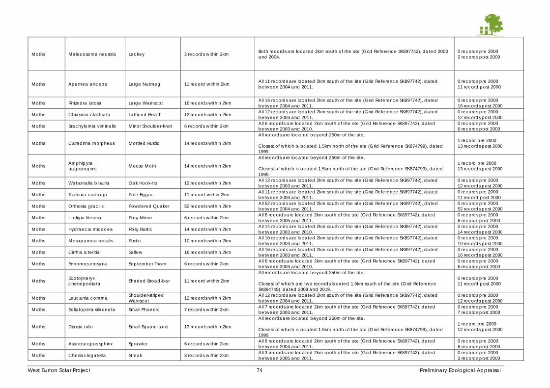
West Burton Solar Project 74 Preliminary Ecological Appraisal
Moths Malacosoma neustria Lackey 2 records within 2km Both records are located 2km south of the site (Grid Reference SK897742), dated 2003
and 2004.
0 records pre 2000
2 records post 2000
Moths Apamea anceps Large Nutmeg 11 record within 2km All 11 records are located 2km south of the site (Grid Reference SK897742), dated
between 2004 and 2011.
0 records pre 2000
11 record post 2000
Moths Rhizedra lutosa Large Wainscot 16 records within 2km All 16 records are located 2km south of the site (Grid Reference SK897742), dated
between 2004 and 2011.
0 records pre 2000
16 records post 2000
Moths Chiasmia clathrata Latticed Heath 12 records within 2km All 12 records are located 2km south of the site (Grid Reference SK897742), dated
between 2003 and 2011.
0 records pre 2000
12 records post 2000
Moths Brachylomia viminalis Minor Shoulder-knot 6 records within 2km All 6 records are located 2km south of the site (Grid Reference SK897742), dated
between 2003 and 2010.
0 records pre 2000
6 records post 2000
Moths Caradrina morpheus Mottled Rustic 14 records within 2km
All records are located beyond 250m of the site.
Closest of which is located 1.5km north of the site (Grid Reference SK874799), dated
1999.
1 record pre 2000
13 records post 2000
Moths Amphipyra
tragopoginis Mouse Moth 14 records within 2km
All records are located beyond 250m of the site.
Closest of which is located 1.5km north of the site (Grid Reference SK874799), dated
1999.
1 record pre 2000
13 records post 2000
Moths Watsonalla binaria Oak Hook-tip 12 records within 2km All 12 records are located 2km south of the site (Grid Reference SK897742), dated
between 2003 and 2011.
0 records pre 2000
12 records post 2000
Moths Trichiura crataegi Pale Eggar 11 record within 2km All 11 records are located 2km south of the site (Grid Reference SK897742), dated
between 2003 and 2011.
0 records pre 2000
11 record post 2000
Moths Orthosia gracilis Powdered Quaker 52 records within 2km All 52 records are located 2km south of the site (Grid Reference SK897742), dated
between 2004 and 2011.
0 records pre 2000
52 records post 2000
Moths Litoligia literosa Rosy Minor 6 records within 2km All 6 records are located 2km south of the site (Grid Reference SK897742), dated
between 2005 and 2011.
0 records pre 2000
6 records post 2000
Moths Hydraecia micacea Rosy Rustic 14 records within 2km All 14 records are located 2km south of the site (Grid Reference SK897742), dated
between 2003 and 2010.
0 records pre 2000
14 records post 2000
Moths Mesapamea secalis Rustic 10 records within 2km All 10 records are located 2km south of the site (Grid Reference SK897742), dated
between 2004 and 2011.
0 records pre 2000
10 records post 2000
Moths Cirrhia icteritia Sallow 16 records within 2km All 16 records are located 2km south of the site (Grid Reference SK897742), dated
between 2003 and 2011.
0 records pre 2000
16 records post 2000
Moths Ennomos erosaria September Thorn 6 records within 2km All 6 records are located 2km south of the site (Grid Reference SK897742), dated
between 2003 and 2010.
0 records pre 2000
6 records post 2000
Moths Scotopteryx
chenopodiata Shaded Broad-bar 11 record within 2km
All records are located beyond 250m of the site.
Closest of which are two records located 1.5km south of the site (Grid Reference
SK894748), dated 2008 and 2019.
0 records pre 2000
11 record post 2000
Moths Leucania comma Shoulder-striped
Wainscot 12 records within 2km
All 12 records are located 2km south of the site (Grid Reference SK897742), dated
between 2004 and 2011.
0 records pre 2000
12 records post 2000
Moths Ecliptopera silaceata Small Phoenix 7 records within 2km All 7 records are located 2km south of the site (Grid Reference SK897742), dated
between 2003 and 2011.
0 records pre 2000
7 records post 2000
Moths Diarsia rubi Small Square-spot 13 records within 2km
All records are located beyond 250m of the site.
Closest of which is located 1.5km north of the site (Grid Reference SK874799), dated
1999.
1 record pre 2000
12 records post 2000
Moths Asteroscopus sphinx Sprawler 6 records within 2km All 6 records are located 2km south of the site (Grid Reference SK897742), dated
between 2004 and 2011.
0 records pre 2000
6 records post 2000
Moths Chesias legatella Streak 3 records within 2km All 3 records are located 2km south of the site (Grid Reference SK897742), dated
between 2005 and 2011.
0 records pre 2000
3 records post 2000
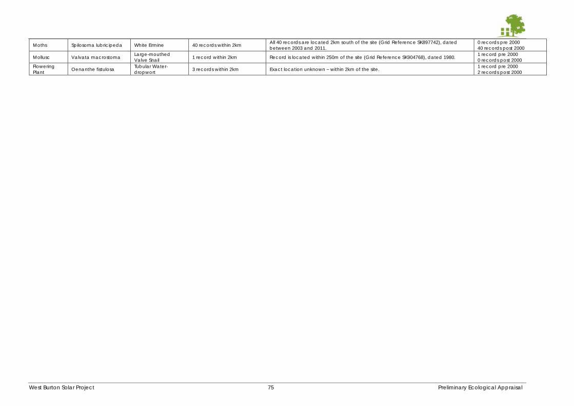
West Burton Solar Project 75 Preliminary Ecological Appraisal
Moths Spilosoma lubricipeda White Ermine 40 records within 2km All 40 records are located 2km south of the site (Grid Reference SK897742), dated
between 2003 and 2011.
0 records pre 2000
40 records post 2000
Mollusc Valvata macrostoma Large-mouthed
Valve Snail 1 record within 2km Record is located within 250m of the site (Grid Reference SK904768), dated 1980.
1 record pre 2000
0 records post 2000
Flowering
Plant Oenanthe fistulosa
Tubular Water-
dropwort 3 records within 2km Exact location unknown – within 2km of the site.
1 record pre 2000
2 records post 2000
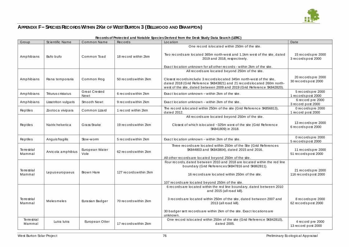
West Burton Solar Project 76 Preliminary Ecological Appraisal
APPENDIX F – SPECIES RECORDS WITHIN 2KM OF WEST BURTON 3 (BELLWOOD AND BRAMPTON)
Records of Protected and Notable Species Derived from the Desk Study Data Search (LERC)
Group Scientific Name Common Name Records Location Date
Amphibians Bufo bufo Common Toad 18 record within 2km
One record is located within 250m of the site.
Two records are located 365m north-west and 1.1km west of the site, dated
2019 and 2018, respectively.
Exact location unknown for all other records – within 2km of the site.
15 records pre 2000
3 records post 2000
Amphibians Rana temporaria Common Frog 50 records within 2km
All records are located beyond 250m of the site.
Closest records include 3 records located 345m north-west of the site,
dated 2018 (Grid Reference SK843821) and 21 records located 260m north-
west of the site, dated between 2009 and 2019 (Grid Reference SK842820).
20 records pre 2000
30 records post 2000
Amphibians Triturus cristatus Great Crested
Newt 6 records within 2km Exact location unknown – within 2km of the site.
5 records pre 2000
1 records post 2000
Amphibians Lissotriton vulgaris Smooth Newt 9 records within 2km Exact location unknown – within 2km of the site. 6 record pre 2000
3 record post 2000
Reptiles Zootoca vivipara Common Lizard 1 record within 2km The record is located within 250m of the site (Grid Reference SK856813),
dated 2012.
0 records pre 2000
1 record post 2000
Reptiles Natrix helvetica Grass Snake 19 records within 2km
All records are located beyond 250m of the site.
Closest of which is located ~325m west of the site (Grid Reference
SK841809) in 2018.
13 records pre 2000
6 records post 2000
Reptiles Anguis fragilis Slow-worm 5 records within 2km Exact location unknown – within 2km of the site. 0 records pre 2000
5 records post 2000
Terrestrial
Mammal Arvicola amphibius
European Water
Vole 62 records within 2km
Three records are located within 250m of the Site (Grid References
SK844803 and SK843804), dated 2015 and 2016.
All other records are located beyond 250m of the site.
11 records pre 2000
51 records post 2000
Terrestrial
Mammal Lepus europaeus Brown Hare 127 records within 2km
Four records, dated between 2010 and 2018 are located within the red line
boundary (Grid References SK847816 and SK862811).
16 records are located within 250m of the site.
107 records are located beyond 250m of the site.
21 records pre 2000
116 records post 2000
Terrestrial
Mammal Meles meles Eurasian Badger 70 records within 2km
6 records are located within the red line boundary, dated between 2010
and 2015 (all road kill).
3 records are located within 250m of the site, dated between 2007 and
2013 (all road kill).
30 badger sett records are within 2km of the site. Exact locations are
unknown.
8 records pre 2000
62 records post 2000
Terrestrial
Mammal
Lutra lutra
European Otter
17 records within 2km
One record is located within 250m of the site (Grid Reference SK842810),
dated 2005.
4 record pre 2000
13 record post 2000
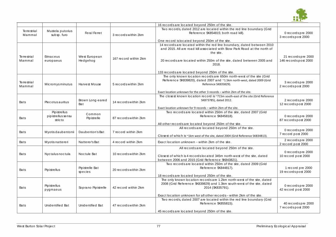
West Burton Solar Project 77 Preliminary Ecological Appraisal
16 records are located beyond 250m of the site.
Terrestrial
Mammal
Mustela putorius
subsp. furo
Feral Ferret
3 records within 2km
Two records, dated 2012 are located within the red line boundary (Grid
Reference SK854815; both road kill).
One record is located beyond 250m of the site.
0 records pre 2000
3 records post 2000
Terrestrial
Mammal
Erinaceus
europaeus
West European
Hedgehog 167 record within 2km
14 records are located within the red line boundary, dated between 2010
and 2015. All are road kill associated with Stow Park Road at the north of
the site.
20 records are located within 250m of the site, dated between 2005 and
2018.
133 records are located beyond 250m of the site.
21 records pre 2000
146 records post 2000
Terrestrial
Mammal Micromys minutus Harvest Mouse 5 records within 2km
The only known location records are 650m north-west of the site (Grid
Reference SK839820), dated 2007 and ~1.5km north-west, dated 2009 (Grid Reference SK835829).
Exact location unknown for the other 3 records – within 2km of the site.
3 records pre 2000
2 records post 2000
Bats Plecotus auritus Brown Long-eared
Bat 14 records within 2km
The closest known location record is ~715m south-east of the site (Grid Reference SK873785), dated 2012.
Exact location unknown for 9 records – within 2km of the site.
2 records pre 2000
12 records post 2000
Bats
Pipistrellus
pipistrellus sensu
stricto
Common
Pipistrelle
87 records within 2km
Two records are located within 250m of the site, dated 2007 (Grid
Reference SK845818).
All other records are located beyond 250m of the site.
0 records pre 2000
87 records post 2000
Bats Myotis daubentonii Daubenton's Bat 7 record within 2km
All records are located beyond 250m of the site.
Closest of which is ~1km west of the site, dated 2004 (Grid Reference SK834813).
0 records pre 2000
7 record post 2000
Bats Myotis nattereri Natterer's Bat 4 record within 2km Exact location unknown – within 2km of the site. 2 records pre 2000
2 record post 2000
Bats Nyctalus noctula Noctule Bat 10 records within 2km
All records are located beyond 250m of the site.
Closest of which is 4 records located 345m north-west of the site, dated
between 2006 and 2015 (Grid Reference SK843821).
0 records pre 2000
10 record post 2000
Bats Pipistrellus Pipistrelle Bat
species 20 records within 2km
Two records are located within 250m of the site, dated 2009 (Grid
Reference SK844817).
18 records are located beyond 250m of the site.
1 record pre 2000
19 records post 2000
Bats Pipistrellus
pygmaeus Soprano Pipistrelle 42 record within 2km
The only known location records are 1.2km north-west of the site, dated
2008 (Grid Reference SK839829) and 1.3km south-west of the site, dated
2014 (SK835791).
Exact location unknown for all other records – within 2km of the site.
0 records pre 2000
42 record post 2000
Bats Unidentified Bat Unidentified Bat 47 records within 2km
Two records, dated 2007 are located within the red line boundary (Grid
Reference SK855815).
45 records are located beyond 250m of the site.
40 records pre 2000
7 records post 2000
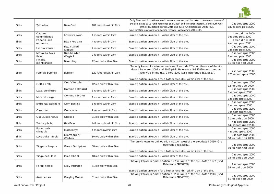
West Burton Solar Project 78 Preliminary Ecological Appraisal
Birds Tyto alba Barn Owl 182 records within 2km
Only 5 record locations are known – one record located ~370m north-west of the site, dated 2015 (Grid Reference SK842820) and 4 records located 1.8km south-west
of the site, dated between 2015 and 2019 (Grid Reference SK836780). Exact location unknown for all other records – within 2km of the site.
2 records pre 2000
180 record post 2000
Birds Cygnus
columbianus Bewick’s Swan 1 record within 2km Exact location unknown – within 2km of the site.
1 record pre 2000
0 record post 2000
Birds Phoenicurus
ochruros Black Redstart 4 record within 2km Exact location unknown – within 2km of the site.
0 record pre 2000
4 record post 2000
Birds Limosa limosa Black-tailed
Godwit 2 record within 2km Exact location unknown – within 2km of the site.
0 records pre 2000
2 record post 2000
Birds Motacilla flava
flava
Blue-headed
Wagtail 2 record within 2km Exact location unknown – within 2km of the site.
0 records pre 2000
2 record post 2000
Birds Fringilla
montifringilla Brambling 12 record within 2km Exact location unknown – within 2km of the site.
1 records pre 2000
11 record post 2000
Birds Pyrrhula pyrrhula Bullfinch 129 records within 2km
The only known location records are 3 records 375m north-west of the site,
dated between 2009 and 2015 (Grid Reference SK842820) and 1 record
740m west of the site, dated 2009 (Grid Reference SK838817).
Exact location unknown for all other records – within 2km of the site.
4 records pre 2000
125 records post 2000
Birds Cettia cetti Cetti's Warbler
12 records within 2km Exact location unknown – within 2km of the site. 0 records pre 2000
12 records post 2000
Birds Loxia curvirostra Common Crossbill
1 record within 2km Exact location unknown – within 2km of the site. 0 records pre 2000
1 records post 2000
Birds Melanitta nigra Common Scoter
1 record within 2km Exact location unknown – within 2km of the site. 0 records pre 2000
1 records post 2000
Birds Emberiza calandra Corn Bunting 1 record within 2km Exact location unknown – within 2km of the site. 0 records pre 2000
1 records post 2000
Birds Crex crex Corncrake 2 records within 2km Exact location unknown – within 2km of the site. 0 records pre 2000
2 records post 2000
Birds Cuculus canorus Cuckoo 31 records within 2km Exact location unknown – within 2km of the site. 0 records pre 2000
31 records post 2000
Birds Turdus pilaris Fieldfare 147 records within 2km Exact location unknown – within 2km of the site. 4 records pre 2000
143 records post 2000
Birds Bucephala
clangula Goldeneye 4 records within 2km Exact location unknown – within 2km of the site.
0 records pre 2000
4 records post 2000
Birds Locustella naevia Grasshopper
Warbler 30 records within 2km Exact location unknown – within 2km of the site.
0 records pre 2000
30 records post 2000
Birds Tringa ochropus Green Sandpiper 60 records within 2km
The only known record location is 1.1km west of the site, dated 2010 (Grid
Reference SK833811).
Exact location unknown for all other records – within 2km of the site.
0 records pre 2000
60 records post 2000
Birds Tringa nebularia Greenshank 18 records within 2km Exact location unknown – within 2km of the site. 0 records pre 2000
18 records post 2000
Birds Perdix perdix Grey Partridge 61 record within 2km
The only known record location is 270m south of the site, dated 1977 (Grid
Reference SK857786).
Exact location unknown for all other records – within 2km of the site.
2 records pre 2000
59 record post 2000
Birds Anser anser Greylag Goose 51 record within 2km
The only known record location is 825m south of the site, dated 2006 (Grid
Reference SK845787).
0 records pre 2000
51 record post 2000
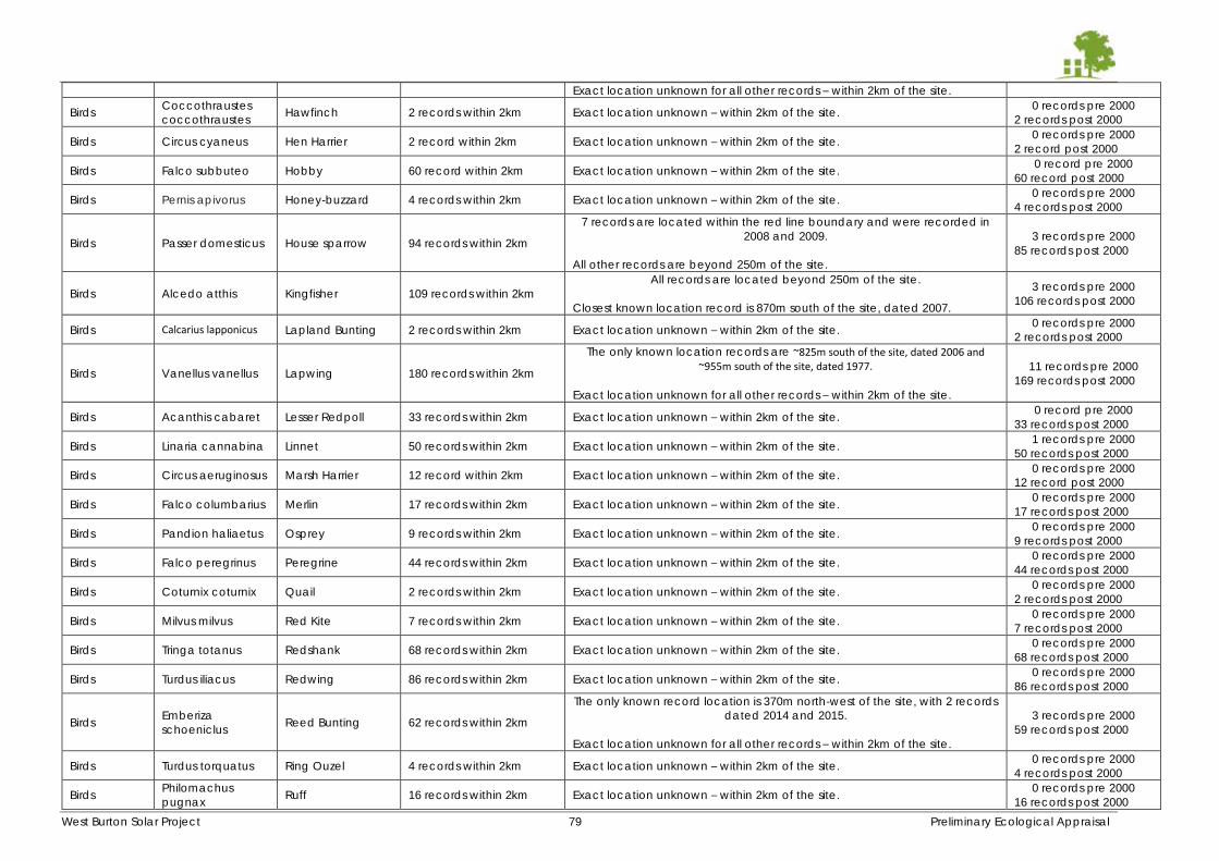
West Burton Solar Project 79 Preliminary Ecological Appraisal
Exact location unknown for all other records – within 2km of the site.
Birds Coccothraustes
coccothraustes Hawfinch 2 records within 2km Exact location unknown – within 2km of the site.
0 records pre 2000
2 records post 2000
Birds Circus cyaneus Hen Harrier 2 record within 2km Exact location unknown – within 2km of the site. 0 records pre 2000
2 record post 2000
Birds Falco subbuteo Hobby 60 record within 2km Exact location unknown – within 2km of the site. 0 record pre 2000
60 record post 2000
Birds Pernis apivorus Honey-buzzard 4 records within 2km Exact location unknown – within 2km of the site. 0 records pre 2000
4 records post 2000
Birds Passer domesticus House sparrow 94 records within 2km
7 records are located within the red line boundary and were recorded in
2008 and 2009.
All other records are beyond 250m of the site.
3 records pre 2000
85 records post 2000
Birds Alcedo atthis Kingfisher 109 records within 2km
All records are located beyond 250m of the site.
Closest known location record is 870m south of the site, dated 2007.
3 records pre 2000
106 records post 2000
Birds Calcarius lapponicus Lapland Bunting 2 records within 2km Exact location unknown – within 2km of the site. 0 records pre 2000
2 records post 2000
Birds Vanellus vanellus Lapwing 180 records within 2km
The only known location records are ~825m south of the site, dated 2006 and ~955m south of the site, dated 1977.
Exact location unknown for all other records – within 2km of the site.
11 records pre 2000
169 records post 2000
Birds Acanthis cabaret Lesser Redpoll 33 records within 2km Exact location unknown – within 2km of the site. 0 record pre 2000
33 records post 2000
Birds Linaria cannabina Linnet 50 records within 2km Exact location unknown – within 2km of the site. 1 records pre 2000
50 records post 2000
Birds Circus aeruginosus Marsh Harrier 12 record within 2km Exact location unknown – within 2km of the site. 0 records pre 2000
12 record post 2000
Birds Falco columbarius Merlin 17 records within 2km Exact location unknown – within 2km of the site. 0 records pre 2000
17 records post 2000
Birds Pandion haliaetus Osprey 9 records within 2km Exact location unknown – within 2km of the site. 0 records pre 2000
9 records post 2000
Birds Falco peregrinus Peregrine 44 records within 2km Exact location unknown – within 2km of the site. 0 records pre 2000
44 records post 2000
Birds Coturnix coturnix Quail 2 records within 2km Exact location unknown – within 2km of the site. 0 records pre 2000
2 records post 2000
Birds Milvus milvus Red Kite 7 records within 2km Exact location unknown – within 2km of the site. 0 records pre 2000
7 records post 2000
Birds Tringa totanus Redshank 68 records within 2km Exact location unknown – within 2km of the site. 0 records pre 2000
68 records post 2000
Birds Turdus iliacus Redwing 86 records within 2km Exact location unknown – within 2km of the site. 0 records pre 2000
86 records post 2000
Birds Emberiza
schoeniclus Reed Bunting 62 records within 2km
The only known record location is 370m north-west of the site, with 2 records
dated 2014 and 2015.
Exact location unknown for all other records – within 2km of the site.
3 records pre 2000
59 records post 2000
Birds Turdus torquatus Ring Ouzel 4 records within 2km Exact location unknown – within 2km of the site. 0 records pre 2000
4 records post 2000
Birds Philomachus
pugnax Ruff 16 records within 2km Exact location unknown – within 2km of the site.
0 records pre 2000
16 records post 2000
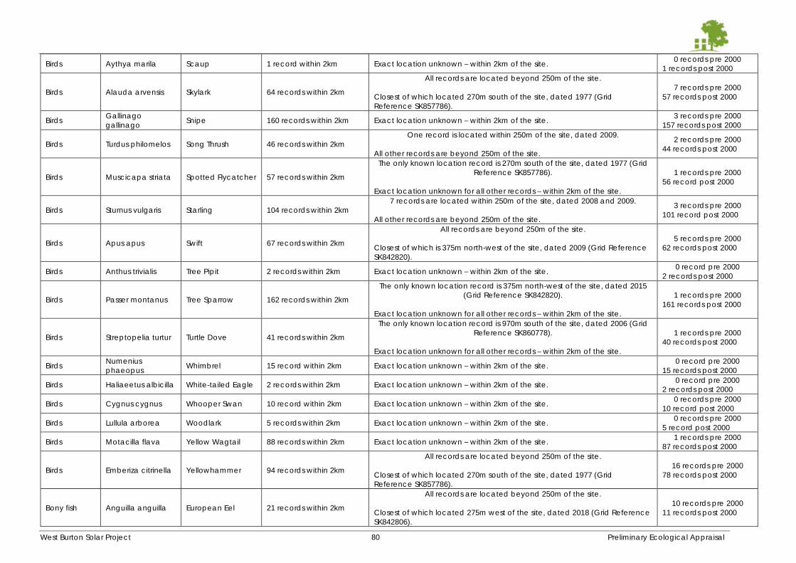
West Burton Solar Project 80 Preliminary Ecological Appraisal
Birds Aythya marila Scaup 1 record within 2km Exact location unknown – within 2km of the site. 0 records pre 2000
1 records post 2000
Birds Alauda arvensis Skylark 64 records within 2km
All records are located beyond 250m of the site.
Closest of which located 270m south of the site, dated 1977 (Grid
Reference SK857786).
7 records pre 2000
57 records post 2000
Birds Gallinago
gallinago Snipe 160 records within 2km Exact location unknown – within 2km of the site.
3 records pre 2000
157 records post 2000
Birds Turdus philomelos Song Thrush 46 records within 2km
One record is located within 250m of the site, dated 2009.
All other records are beyond 250m of the site.
2 records pre 2000
44 records post 2000
Birds Muscicapa striata Spotted Flycatcher 57 records within 2km
The only known location record is 270m south of the site, dated 1977 (Grid
Reference SK857786).
Exact location unknown for all other records – within 2km of the site.
1 records pre 2000
56 record post 2000
Birds Sturnus vulgaris Starling 104 records within 2km
7 records are located within 250m of the site, dated 2008 and 2009.
All other records are beyond 250m of the site.
3 records pre 2000
101 record post 2000
Birds Apus apus Swift 67 records within 2km
All records are beyond 250m of the site.
Closest of which is 375m north-west of the site, dated 2009 (Grid Reference
SK842820).
5 records pre 2000
62 records post 2000
Birds Anthus trivialis Tree Pipit 2 records within 2km Exact location unknown – within 2km of the site. 0 record pre 2000
2 records post 2000
Birds Passer montanus Tree Sparrow 162 records within 2km
The only known location record is 375m north-west of the site, dated 2015
(Grid Reference SK842820).
Exact location unknown for all other records – within 2km of the site.
1 records pre 2000
161 records post 2000
Birds Streptopelia turtur Turtle Dove 41 records within 2km
The only known location record is 970m south of the site, dated 2006 (Grid
Reference SK860778).
Exact location unknown for all other records – within 2km of the site.
1 records pre 2000
40 records post 2000
Birds Numenius
phaeopus Whimbrel 15 record within 2km Exact location unknown – within 2km of the site.
0 record pre 2000
15 records post 2000
Birds Haliaeetus albicilla White-tailed Eagle 2 records within 2km Exact location unknown – within 2km of the site. 0 record pre 2000
2 records post 2000
Birds Cygnus cygnus Whooper Swan 10 record within 2km Exact location unknown – within 2km of the site. 0 records pre 2000
10 record post 2000
Birds Lullula arborea Woodlark 5 records within 2km Exact location unknown – within 2km of the site. 0 records pre 2000
5 record post 2000
Birds Motacilla flava Yellow Wagtail 88 records within 2km Exact location unknown – within 2km of the site. 1 records pre 2000
87 records post 2000
Birds Emberiza citrinella Yellowhammer 94 records within 2km
All records are located beyond 250m of the site.
Closest of which located 270m south of the site, dated 1977 (Grid
Reference SK857786).
16 records pre 2000
78 records post 2000
Bony fish Anguilla anguilla European Eel 21 records within 2km
All records are located beyond 250m of the site.
Closest of which located 275m west of the site, dated 2018 (Grid Reference
SK842806).
10 records pre 2000
11 records post 2000
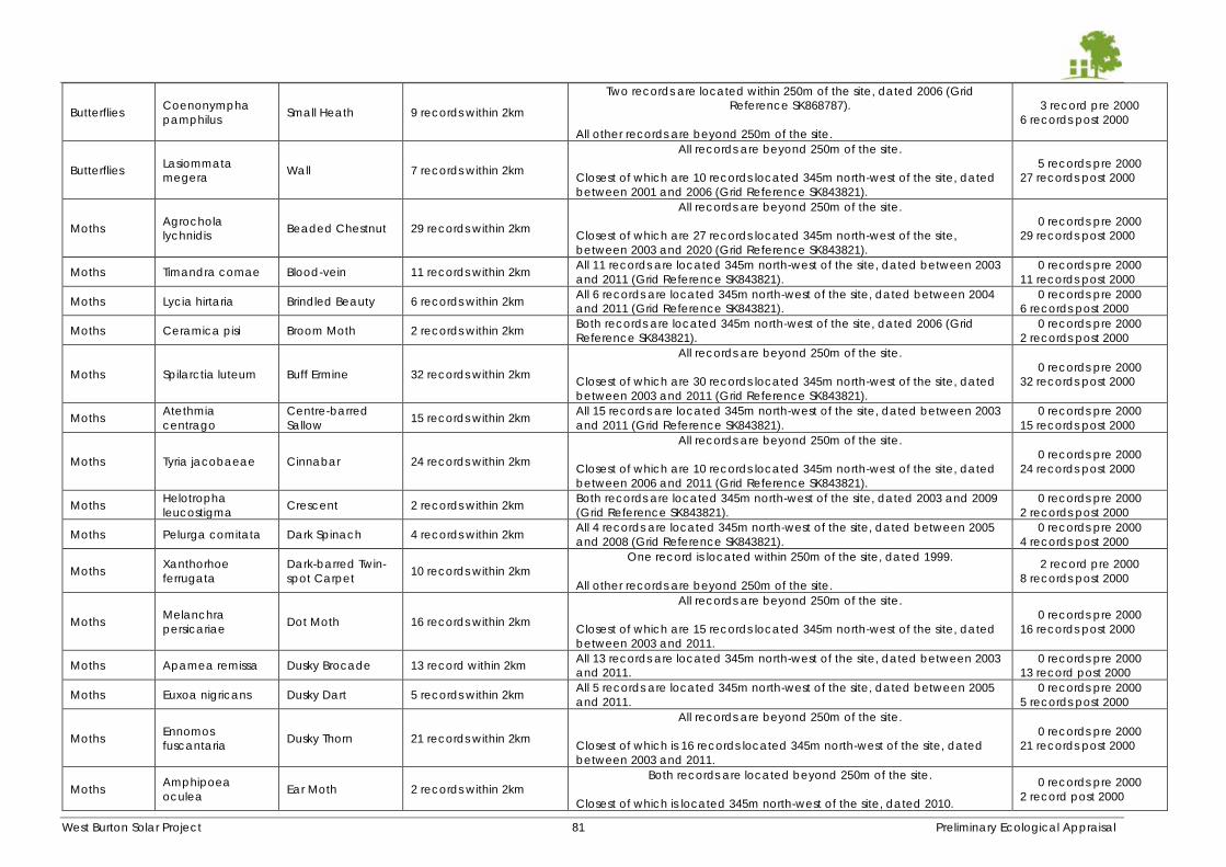
West Burton Solar Project 81 Preliminary Ecological Appraisal
Butterflies Coenonympha
pamphilus Small Heath 9 records within 2km
Two records are located within 250m of the site, dated 2006 (Grid
Reference SK868787).
All other records are beyond 250m of the site.
3 record pre 2000
6 records post 2000
Butterflies Lasiommata
megera Wall 7 records within 2km
All records are beyond 250m of the site.
Closest of which are 10 records located 345m north-west of the site, dated
between 2001 and 2006 (Grid Reference SK843821).
5 records pre 2000
27 records post 2000
Moths Agrochola
lychnidis Beaded Chestnut 29 records within 2km
All records are beyond 250m of the site.
Closest of which are 27 records located 345m north-west of the site,
between 2003 and 2020 (Grid Reference SK843821).
0 records pre 2000
29 records post 2000
Moths Timandra comae Blood-vein 11 records within 2km All 11 records are located 345m north-west of the site, dated between 2003
and 2011 (Grid Reference SK843821).
0 records pre 2000
11 records post 2000
Moths Lycia hirtaria Brindled Beauty 6 records within 2km All 6 records are located 345m north-west of the site, dated between 2004
and 2011 (Grid Reference SK843821).
0 records pre 2000
6 records post 2000
Moths Ceramica pisi Broom Moth 2 records within 2km Both records are located 345m north-west of the site, dated 2006 (Grid
Reference SK843821).
0 records pre 2000
2 records post 2000
Moths Spilarctia luteum Buff Ermine 32 records within 2km
All records are beyond 250m of the site.
Closest of which are 30 records located 345m north-west of the site, dated
between 2003 and 2011 (Grid Reference SK843821).
0 records pre 2000
32 records post 2000
Moths Atethmia
centrago
Centre-barred
Sallow 15 records within 2km
All 15 records are located 345m north-west of the site, dated between 2003
and 2011 (Grid Reference SK843821).
0 records pre 2000
15 records post 2000
Moths Tyria jacobaeae Cinnabar 24 records within 2km
All records are beyond 250m of the site.
Closest of which are 10 records located 345m north-west of the site, dated
between 2006 and 2011 (Grid Reference SK843821).
0 records pre 2000
24 records post 2000
Moths Helotropha
leucostigma Crescent 2 records within 2km
Both records are located 345m north-west of the site, dated 2003 and 2009
(Grid Reference SK843821).
0 records pre 2000
2 records post 2000
Moths Pelurga comitata Dark Spinach 4 records within 2km All 4 records are located 345m north-west of the site, dated between 2005
and 2008 (Grid Reference SK843821).
0 records pre 2000
4 records post 2000
Moths Xanthorhoe
ferrugata
Dark-barred Twin-
spot Carpet 10 records within 2km
One record is located within 250m of the site, dated 1999.
All other records are beyond 250m of the site.
2 record pre 2000
8 records post 2000
Moths Melanchra
persicariae Dot Moth 16 records within 2km
All records are beyond 250m of the site.
Closest of which are 15 records located 345m north-west of the site, dated
between 2003 and 2011.
0 records pre 2000
16 records post 2000
Moths Apamea remissa Dusky Brocade 13 record within 2km All 13 records are located 345m north-west of the site, dated between 2003
and 2011.
0 records pre 2000
13 record post 2000
Moths Euxoa nigricans Dusky Dart 5 records within 2km All 5 records are located 345m north-west of the site, dated between 2005
and 2011.
0 records pre 2000
5 records post 2000
Moths Ennomos
fuscantaria Dusky Thorn 21 records within 2km
All records are beyond 250m of the site.
Closest of which is 16 records located 345m north-west of the site, dated
between 2003 and 2011.
0 records pre 2000
21 records post 2000
Moths Amphipoea
oculea Ear Moth 2 records within 2km
Both records are located beyond 250m of the site.
Closest of which is located 345m north-west of the site, dated 2010.
0 records pre 2000
2 record post 2000
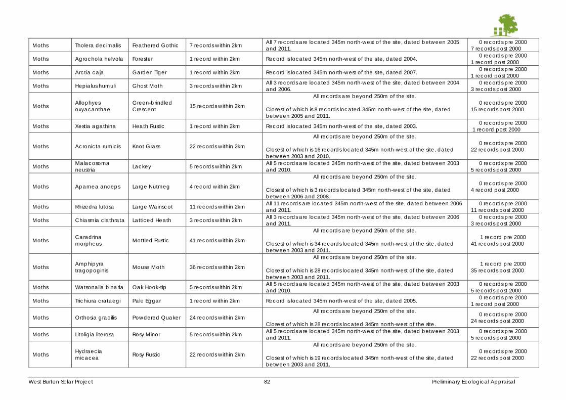
West Burton Solar Project 82 Preliminary Ecological Appraisal
Moths Tholera decimalis Feathered Gothic 7 records within 2km All 7 records are located 345m north-west of the site, dated between 2005
and 2011.
0 records pre 2000
7 records post 2000
Moths Agrochola helvola Forester 1 record within 2km Record is located 345m north-west of the site, dated 2004. 0 records pre 2000
1 record post 2000
Moths Arctia caja Garden Tiger 1 record within 2km Record is located 345m north-west of the site, dated 2007. 0 records pre 2000
1 record post 2000
Moths Hepialus humuli Ghost Moth 3 records within 2km All 3 records are located 345m north-west of the site, dated between 2004
and 2006.
0 records pre 2000
3 records post 2000
Moths Allophyes
oxyacanthae
Green-brindled
Crescent 15 records within 2km
All records are beyond 250m of the site.
Closest of which is 8 records located 345m north-west of the site, dated
between 2005 and 2011.
0 records pre 2000
15 records post 2000
Moths Xestia agathina Heath Rustic 1 record within 2km Record is located 345m north-west of the site, dated 2003. 0 records pre 2000
1 record post 2000
Moths Acronicta rumicis Knot Grass 22 records within 2km
All records are beyond 250m of the site.
Closest of which is 16 records located 345m north-west of the site, dated
between 2003 and 2010.
0 records pre 2000
22 records post 2000
Moths Malacosoma
neustria Lackey 5 records within 2km
All 5 records are located 345m north-west of the site, dated between 2003
and 2010.
0 records pre 2000
5 records post 2000
Moths Apamea anceps Large Nutmeg 4 record within 2km
All records are beyond 250m of the site.
Closest of which is 3 records located 345m north-west of the site, dated
between 2006 and 2008.
0 records pre 2000
4 record post 2000
Moths Rhizedra lutosa Large Wainscot 11 records within 2km All 11 records are located 345m north-west of the site, dated between 2006
and 2011.
0 records pre 2000
11 records post 2000
Moths Chiasmia clathrata Latticed Heath 3 records within 2km All 3 records are located 345m north-west of the site, dated between 2006
and 2011.
0 records pre 2000
3 records post 2000
Moths Caradrina
morpheus Mottled Rustic 41 records within 2km
All records are beyond 250m of the site.
Closest of which is 34 records located 345m north-west of the site, dated
between 2003 and 2011.
1 record pre 2000
41 records post 2000
Moths Amphipyra
tragopoginis Mouse Moth 36 records within 2km
All records are beyond 250m of the site.
Closest of which is 28 records located 345m north-west of the site, dated
between 2003 and 2011.
1 record pre 2000
35 records post 2000
Moths Watsonalla binaria Oak Hook-tip 5 records within 2km All 5 records are located 345m north-west of the site, dated between 2003
and 2010.
0 records pre 2000
5 records post 2000
Moths Trichiura crataegi Pale Eggar 1 record within 2km Record is located 345m north-west of the site, dated 2005. 0 records pre 2000
1 record post 2000
Moths Orthosia gracilis Powdered Quaker 24 records within 2km
All records are beyond 250m of the site.
Closest of which is 28 records located 345m north-west of the site.
0 records pre 2000
24 records post 2000
Moths Litoligia literosa Rosy Minor 5 records within 2km All 5 records are located 345m north-west of the site, dated between 2003
and 2011.
0 records pre 2000
5 records post 2000
Moths Hydraecia
micacea Rosy Rustic 22 records within 2km
All records are beyond 250m of the site.
Closest of which is 19 records located 345m north-west of the site, dated
between 2003 and 2011.
0 records pre 2000
22 records post 2000
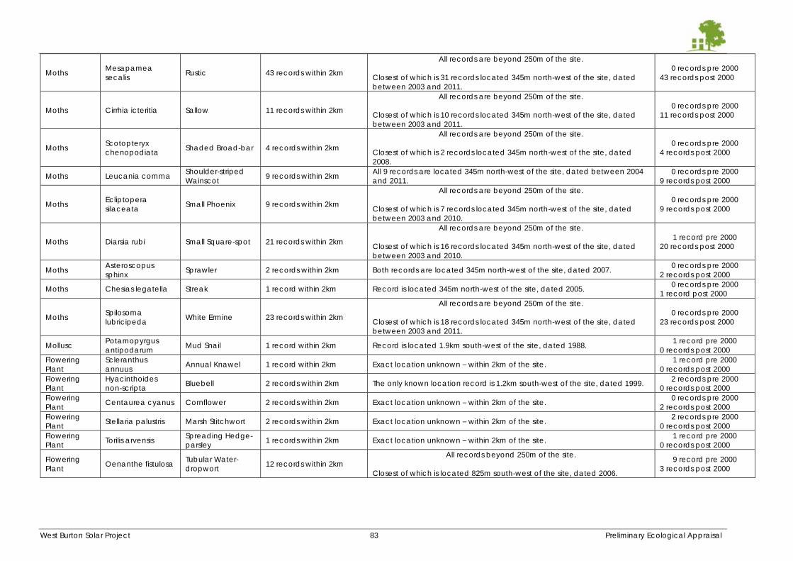
West Burton Solar Project 83 Preliminary Ecological Appraisal
Moths Mesapamea
secalis Rustic 43 records within 2km
All records are beyond 250m of the site.
Closest of which is 31 records located 345m north-west of the site, dated
between 2003 and 2011.
0 records pre 2000
43 records post 2000
Moths Cirrhia icteritia Sallow 11 records within 2km
All records are beyond 250m of the site.
Closest of which is 10 records located 345m north-west of the site, dated
between 2003 and 2011.
0 records pre 2000
11 records post 2000
Moths Scotopteryx
chenopodiata Shaded Broad-bar 4 records within 2km
All records are beyond 250m of the site.
Closest of which is 2 records located 345m north-west of the site, dated
2008.
0 records pre 2000
4 records post 2000
Moths Leucania comma Shoulder-striped
Wainscot 9 records within 2km
All 9 records are located 345m north-west of the site, dated between 2004
and 2011.
0 records pre 2000
9 records post 2000
Moths Ecliptopera
silaceata Small Phoenix 9 records within 2km
All records are beyond 250m of the site.
Closest of which is 7 records located 345m north-west of the site, dated
between 2003 and 2010.
0 records pre 2000
9 records post 2000
Moths Diarsia rubi Small Square-spot 21 records within 2km
All records are beyond 250m of the site.
Closest of which is 16 records located 345m north-west of the site, dated
between 2003 and 2010.
1 record pre 2000
20 records post 2000
Moths Asteroscopus
sphinx Sprawler 2 records within 2km Both records are located 345m north-west of the site, dated 2007.
0 records pre 2000
2 records post 2000
Moths Chesias legatella Streak 1 record within 2km Record is located 345m north-west of the site, dated 2005. 0 records pre 2000
1 record post 2000
Moths Spilosoma
lubricipeda White Ermine 23 records within 2km
All records are beyond 250m of the site.
Closest of which is 18 records located 345m north-west of the site, dated
between 2003 and 2011.
0 records pre 2000
23 records post 2000
Mollusc Potamopyrgus
antipodarum Mud Snail 1 record within 2km Record is located 1.9km south-west of the site, dated 1988.
1 record pre 2000
0 records post 2000
Flowering
Plant
Scleranthus
annuus Annual Knawel 1 record within 2km Exact location unknown – within 2km of the site.
1 record pre 2000
0 records post 2000
Flowering
Plant
Hyacinthoides
non-scripta Bluebell 2 records within 2km The only known location record is 1.2km south-west of the site, dated 1999.
2 records pre 2000
0 records post 2000
Flowering
Plant Centaurea cyanus Cornflower 2 records within 2km Exact location unknown – within 2km of the site.
0 records pre 2000
2 records post 2000
Flowering
Plant Stellaria palustris Marsh Stitchwort 2 records within 2km Exact location unknown – within 2km of the site.
2 records pre 2000
0 records post 2000
Flowering
Plant Torilis arvensis
Spreading Hedge-
parsley 1 records within 2km Exact location unknown – within 2km of the site.
1 record pre 2000
0 records post 2000
Flowering
Plant Oenanthe fistulosa
Tubular Water-
dropwort 12 records within 2km
All records beyond 250m of the site.
Closest of which is located 825m south-west of the site, dated 2006.
9 record pre 2000
3 records post 2000
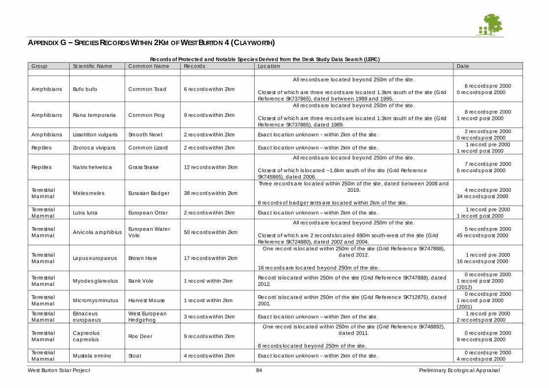
West Burton Solar Project 84 Preliminary Ecological Appraisal
APPENDIX G – SPECIES RECORDS WITHIN 2KM OF WEST BURTON 4 (CLAYWORTH)
Records of Protected and Notable Species Derived from the Desk Study Data Search (LERC)
Group Scientific Name Common Name Records Location Date
Amphibians Bufo bufo Common Toad 6 records within 2km
All records are located beyond 250m of the site.
Closest of which are three records are located 1.3km south of the site (Grid
Reference SK737865), dated between 1989 and 1995.
6 records pre 2000
0 records post 2000
Amphibians Rana temporaria Common Frog 9 records within 2km
All records are located beyond 250m of the site.
Closest of which are three records are located 1.3km south of the site (Grid
Reference SK737865), dated 1989.
8 records pre 2000
1 record post 2000
Amphibians Lissotriton vulgaris Smooth Newt 2 records within 2km Exact location unknown – within 2km of the site. 2 records pre 2000
0 records post 2000
Reptiles Zootoca vivipara Common Lizard 2 records within 2km Exact location unknown – within 2km of the site. 1 record pre 2000
1 record post 2000
Reptiles Natrix helvetica Grass Snake 12 records within 2km
All records are located beyond 250m of the site.
Closest of which is located ~1.6km south of the site (Grid Reference
SK745865), dated 2006.
7 records pre 2000
5 records post 2000
Terrestrial
Mammal Meles meles Eurasian Badger 38 records within 2km
Three records are located within 250m of the site, dated between 2008 and
2019.
8 records of badger setts are located within 2km of the site.
4 records pre 2000
34 records post 2000
Terrestrial
Mammal Lutra lutra European Otter 2 records within 2km Exact location unknown – within 2km of the site.
1 record pre 2000
1 record post 2000
Terrestrial
Mammal Arvicola amphibius
European Water
Vole 50 records within 2km
All records are located beyond 250m of the site.
Closest of which are 2 records located 690m south-west of the site (Grid
Reference SK724880), dated 2002 and 2004.
5 records pre 2000
45 records post 2000
Terrestrial
Mammal Lepus europaeus Brown Hare 17 records within 2km
One record is located within 250m of the site (Grid Reference SK747888),
dated 2012.
16 records are located beyond 250m of the site.
1 record pre 2000
16 records post 2000
Terrestrial
Mammal Myodes glareolus Bank Vole 1 record within 2km
Record is located within 250m of the site (Grid Reference SK747888), dated
2012.
0 records pre 2000
1 record post 2000
(2012)
Terrestrial
Mammal Micromys minutus Harvest Mouse 1 record within 2km
Record is located within 250m of the site (Grid Reference SK712875), dated
2001.
0 records pre 2000
1 record post 2000
(2001)
Terrestrial
Mammal
Erinaceus
europaeus
West European
Hedgehog 3 records within 2km Exact location unknown – within 2km of the site.
1 record pre 2000
2 records post 2000
Terrestrial
Mammal
Capreolus
capreolus Roe Deer 9 records within 2km
One record is located within 250m of the site (Grid Reference SK748892),
dated 2011.
8 records located beyond 250m of the site.
0 records pre 2000
9 records post 2000
Terrestrial
Mammal Mustela ermine Stoat 4 records within 2km Exact location unknown – within 2km of the site.
0 records pre 2000
4 records post 2000
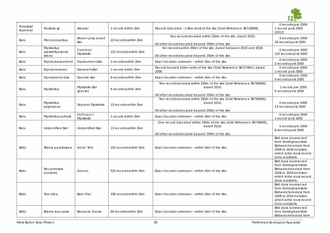
West Burton Solar Project 85 Preliminary Ecological Appraisal
Terrestrial
Mammal Mustela sp. Weasel 1 record within 2km Record is located ~1.8km west of the site (Grid Reference SK718899).
0 records pre 2000
1 record post 2000
(2012)
Bats Plecotus auritus Brown Long-eared
Bat 22 records within 2km
Two records located within 250m of the site, dated 2010.
All other records located beyond 250m of the site.
4 records pre 2000
18 records post 2000
Bats
Pipistrellus
pipistrellus sensu
stricto
Common
Pipistrelle 122 records within 2km
Ten records within 250m of the site, dated between 2015 and 2018.
All other records located beyond 250m of the site.
0 records pre 2000
122 records post 2000
Bats Myotis daubentonii Daubenton's Bat 2 records within 2km Exact location unknown – within 2km of the site. 0 records pre 2000
2 records post 2000
Bats Myotis nattereri Natterer's Bat 1 record within 2km Record located 615m north of the site (Grid Reference SK717897), dated
2006.
0 records pre 2000
1 record post 2000
Bats Nyctalus noctula Noctule Bat 9 records within 2km Exact location unknown – within 2km of the site. 0 records pre 2000
9 records post 2000
Bats Pipistrellus Pipistrelle Bat
species 6 records within 2km
Two records located within 250m of the site (Grid Reference SK736906),
dated 2010.
All other records located beyond 250m of the site.
1 record pre 2000
5 records post 2000
Bats Pipistrellus
pygmaeus Soprano Pipistrelle 13 records within 2km
Two records located within 250m of the site (Grid Reference SK736906),
dated 2010.
All other records located beyond 250m of the site.
0 records pre 2000
13 records post 2000
Bats Pipistrellus nathusii Nathusius’s
Pipistrelle 1 record within 2km Exact location unknown – within 2km of the site.
0 records pre 2000
1 record post 2000
Bats Unidentified Bat Unidentified Bat 13 records within 2km
One record is located within 250m of the site (Grid Reference SK738905),
dated 2016.
All other records located beyond 250m of the site.
5 records pre 2000
8 records post 2000
Birds Sterna paradisaea Arctic Tern 102 records within 2km Exact location unknown – within 2km of the site.
Bird data is extracted
from Nottinghamshire
Birdwatchers data from
2008 to 2018 inclusive,
which is the most recent
data available.
Birds Recurvirostra
avosetta Avocet 525 records within 2km Exact location unknown – within 2km of the site.
Bird data is extracted
from Nottinghamshire
Birdwatchers data from
2008 to 2018 inclusive,
which is the most recent
data available.
Birds Tyto alba Barn Owl 336 records within 2km Exact location unknown – within 2km of the site.
Bird data is extracted
from Nottinghamshire
Birdwatchers data from
2008 to 2018 inclusive,
which is the most recent
data available.
Birds Branta leucopsis Barnacle Goose 80 records within 2km Exact location unknown – within 2km of the site.
Bird data is extracted
from Nottinghamshire
Birdwatchers data from
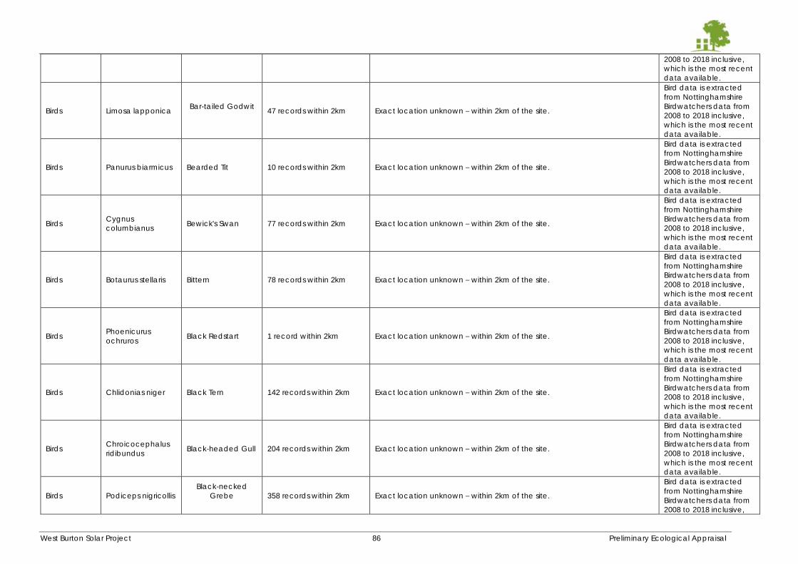
West Burton Solar Project 86 Preliminary Ecological Appraisal
2008 to 2018 inclusive,
which is the most recent
data available.
Birds Limosa lapponica Bar-tailed Godwit
47 records within 2km Exact location unknown – within 2km of the site.
Bird data is extracted
from Nottinghamshire
Birdwatchers data from
2008 to 2018 inclusive,
which is the most recent
data available.
Birds Panurus biarmicus Bearded Tit 10 records within 2km Exact location unknown – within 2km of the site.
Bird data is extracted
from Nottinghamshire
Birdwatchers data from
2008 to 2018 inclusive,
which is the most recent
data available.
Birds Cygnus
columbianus Bewick's Swan 77 records within 2km Exact location unknown – within 2km of the site.
Bird data is extracted
from Nottinghamshire
Birdwatchers data from
2008 to 2018 inclusive,
which is the most recent
data available.
Birds Botaurus stellaris Bittern 78 records within 2km Exact location unknown – within 2km of the site.
Bird data is extracted
from Nottinghamshire
Birdwatchers data from
2008 to 2018 inclusive,
which is the most recent
data available.
Birds Phoenicurus
ochruros Black Redstart 1 record within 2km Exact location unknown – within 2km of the site.
Bird data is extracted
from Nottinghamshire
Birdwatchers data from
2008 to 2018 inclusive,
which is the most recent
data available.
Birds Chlidonias niger Black Tern 142 records within 2km Exact location unknown – within 2km of the site.
Bird data is extracted
from Nottinghamshire
Birdwatchers data from
2008 to 2018 inclusive,
which is the most recent
data available.
Birds Chroicocephalus
ridibundus Black-headed Gull 204 records within 2km Exact location unknown – within 2km of the site.
Bird data is extracted
from Nottinghamshire
Birdwatchers data from
2008 to 2018 inclusive,
which is the most recent
data available.
Birds Podiceps nigricollis
Black-necked
Grebe
358 records within 2km Exact location unknown – within 2km of the site.
Bird data is extracted
from Nottinghamshire
Birdwatchers data from
2008 to 2018 inclusive,
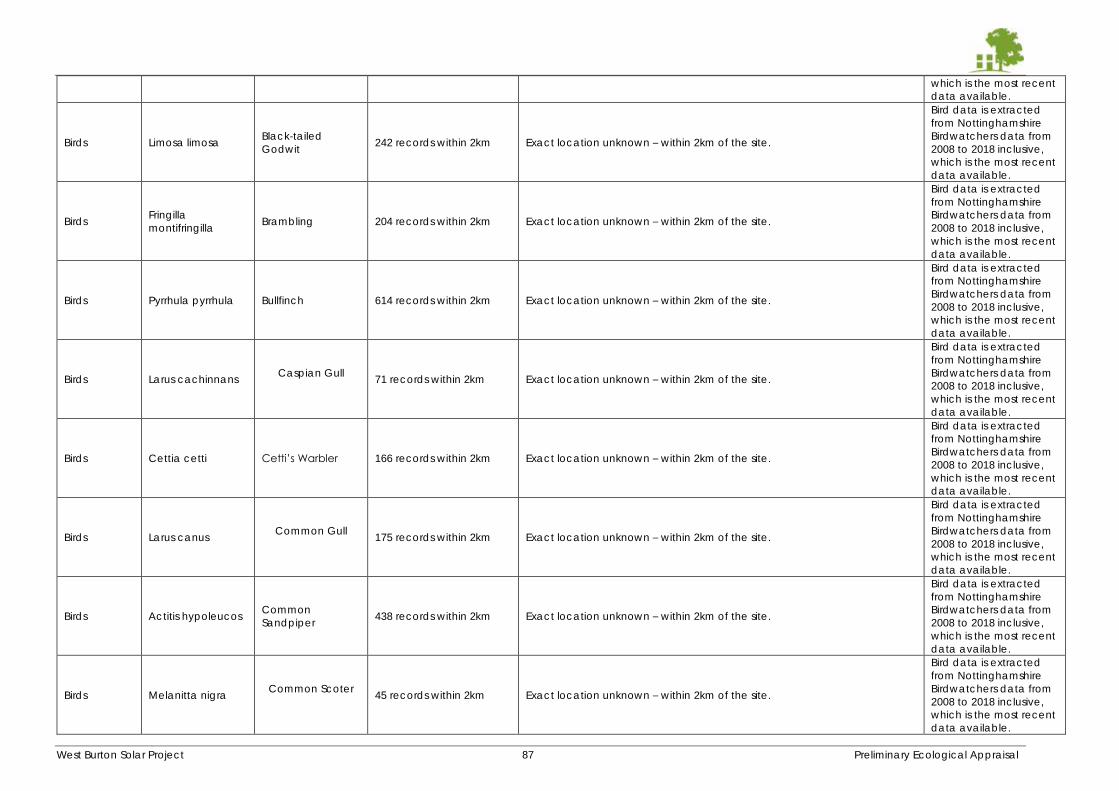
West Burton Solar Project 87 Preliminary Ecological Appraisal
which is the most recent
data available.
Birds Limosa limosa Black-tailed
Godwit 242 records within 2km Exact location unknown – within 2km of the site.
Bird data is extracted
from Nottinghamshire
Birdwatchers data from
2008 to 2018 inclusive,
which is the most recent
data available.
Birds Fringilla
montifringilla Brambling 204 records within 2km Exact location unknown – within 2km of the site.
Bird data is extracted
from Nottinghamshire
Birdwatchers data from
2008 to 2018 inclusive,
which is the most recent
data available.
Birds Pyrrhula pyrrhula Bullfinch 614 records within 2km Exact location unknown – within 2km of the site.
Bird data is extracted
from Nottinghamshire
Birdwatchers data from
2008 to 2018 inclusive,
which is the most recent
data available.
Birds Larus cachinnans Caspian Gull
71 records within 2km Exact location unknown – within 2km of the site.
Bird data is extracted
from Nottinghamshire
Birdwatchers data from
2008 to 2018 inclusive,
which is the most recent
data available.
Birds Cettia cetti Cetti’s Warbler 166 records within 2km Exact location unknown – within 2km of the site.
Bird data is extracted
from Nottinghamshire
Birdwatchers data from
2008 to 2018 inclusive,
which is the most recent
data available.
Birds Larus canus Common Gull
175 records within 2km Exact location unknown – within 2km of the site.
Bird data is extracted
from Nottinghamshire
Birdwatchers data from
2008 to 2018 inclusive,
which is the most recent
data available.
Birds Actitis hypoleucos Common
Sandpiper 438 records within 2km Exact location unknown – within 2km of the site.
Bird data is extracted
from Nottinghamshire
Birdwatchers data from
2008 to 2018 inclusive,
which is the most recent
data available.
Birds Melanitta nigra Common Scoter
45 records within 2km Exact location unknown – within 2km of the site.
Bird data is extracted
from Nottinghamshire
Birdwatchers data from
2008 to 2018 inclusive,
which is the most recent
data available.
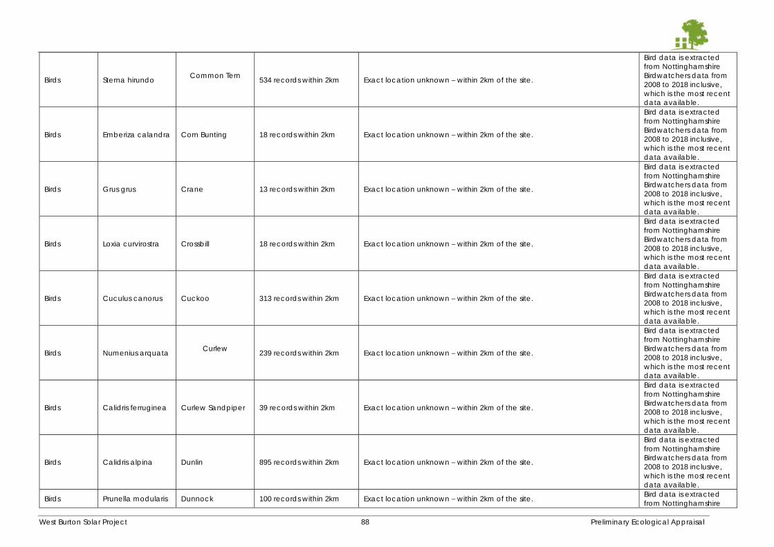
West Burton Solar Project 88 Preliminary Ecological Appraisal
Birds Sterna hirundo Common Tern
534 records within 2km Exact location unknown – within 2km of the site.
Bird data is extracted
from Nottinghamshire
Birdwatchers data from
2008 to 2018 inclusive,
which is the most recent
data available.
Birds Emberiza calandra Corn Bunting 18 records within 2km Exact location unknown – within 2km of the site.
Bird data is extracted
from Nottinghamshire
Birdwatchers data from
2008 to 2018 inclusive,
which is the most recent
data available.
Birds Grus grus Crane 13 records within 2km Exact location unknown – within 2km of the site.
Bird data is extracted
from Nottinghamshire
Birdwatchers data from
2008 to 2018 inclusive,
which is the most recent
data available.
Birds Loxia curvirostra Crossbill 18 records within 2km Exact location unknown – within 2km of the site.
Bird data is extracted
from Nottinghamshire
Birdwatchers data from
2008 to 2018 inclusive,
which is the most recent
data available.
Birds Cuculus canorus Cuckoo 313 records within 2km Exact location unknown – within 2km of the site.
Bird data is extracted
from Nottinghamshire
Birdwatchers data from
2008 to 2018 inclusive,
which is the most recent
data available.
Birds Numenius arquata Curlew
239 records within 2km Exact location unknown – within 2km of the site.
Bird data is extracted
from Nottinghamshire
Birdwatchers data from
2008 to 2018 inclusive,
which is the most recent
data available.
Birds Calidris ferruginea Curlew Sandpiper 39 records within 2km Exact location unknown – within 2km of the site.
Bird data is extracted
from Nottinghamshire
Birdwatchers data from
2008 to 2018 inclusive,
which is the most recent
data available.
Birds Calidris alpina Dunlin 895 records within 2km Exact location unknown – within 2km of the site.
Bird data is extracted
from Nottinghamshire
Birdwatchers data from
2008 to 2018 inclusive,
which is the most recent
data available.
Birds Prunella modularis Dunnock 100 records within 2km Exact location unknown – within 2km of the site. Bird data is extracted
from Nottinghamshire
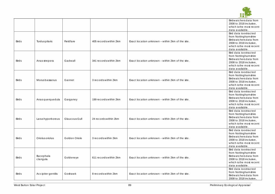
West Burton Solar Project 89 Preliminary Ecological Appraisal
Birdwatchers data from
2008 to 2018 inclusive,
which is the most recent
data available.
Birds Turdus pilaris Fieldfare 405 records within 2km Exact location unknown – within 2km of the site.
Bird data is extracted
from Nottinghamshire
Birdwatchers data from
2008 to 2018 inclusive,
which is the most recent
data available.
Birds Anas strepera Gadwall 341 records within 2km Exact location unknown – within 2km of the site.
Bird data is extracted
from Nottinghamshire
Birdwatchers data from
2008 to 2018 inclusive,
which is the most recent
data available.
Birds Morus bassanus Gannet 3 records within 2km Exact location unknown – within 2km of the site.
Bird data is extracted
from Nottinghamshire
Birdwatchers data from
2008 to 2018 inclusive,
which is the most recent
data available.
Birds Anas querquedula Garganey 199 records within 2km Exact location unknown – within 2km of the site.
Bird data is extracted
from Nottinghamshire
Birdwatchers data from
2008 to 2018 inclusive,
which is the most recent
data available.
Birds Larus hyperboreus Glaucous Gull 24 records within 2km Exact location unknown – within 2km of the site.
Bird data is extracted
from Nottinghamshire
Birdwatchers data from
2008 to 2018 inclusive,
which is the most recent
data available.
Birds Oriolus oriolus Golden Oriole 3 records within 2km Exact location unknown – within 2km of the site.
Bird data is extracted
from Nottinghamshire
Birdwatchers data from
2008 to 2018 inclusive,
which is the most recent
data available.
Birds Bucephala
clangula Goldeneye 611 records within 2km Exact location unknown – within 2km of the site.
Bird data is extracted
from Nottinghamshire
Birdwatchers data from
2008 to 2018 inclusive,
which is the most recent
data available.
Birds Accipiter gentilis Goshawk 8 records within 2km Exact location unknown – within 2km of the site.
Bird data is extracted
from Nottinghamshire
Birdwatchers data from
2008 to 2018 inclusive,
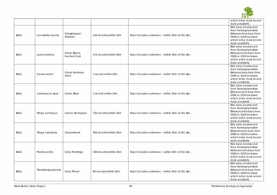
West Burton Solar Project 90 Preliminary Ecological Appraisal
which is the most recent
data available.
Birds Locustella naevia Grasshopper
Warbler 144 records within 2km Exact location unknown – within 2km of the site.
Bird data is extracted
from Nottinghamshire
Birdwatchers data from
2008 to 2018 inclusive,
which is the most recent
data available.
Birds Larus marinus Great Black-
backed Gull 170 records within 2km Exact location unknown – within 2km of the site.
Bird data is extracted
from Nottinghamshire
Birdwatchers data from
2008 to 2018 inclusive,
which is the most recent
data available.
Birds Gavia immer Great Northern
Diver 1 record within 2km Exact location unknown – within 2km of the site.
Bird data is extracted
from Nottinghamshire
Birdwatchers data from
2008 to 2018 inclusive,
which is the most recent
data available.
Birds Catharacta skua Great Skua 1 record within 2km Exact location unknown – within 2km of the site.
Bird data is extracted
from Nottinghamshire
Birdwatchers data from
2008 to 2018 inclusive,
which is the most recent
data available.
Birds Tringa ochropus Green Sandpiper 720 records within 2km Exact location unknown – within 2km of the site.
Bird data is extracted
from Nottinghamshire
Birdwatchers data from
2008 to 2018 inclusive,
which is the most recent
data available.
Birds Tringa nebularia Greenshank 450 records within 2km Exact location unknown – within 2km of the site.
Bird data is extracted
from Nottinghamshire
Birdwatchers data from
2008 to 2018 inclusive,
which is the most recent
data available.
Birds Perdix perdix Grey Partridge 339 records within 2km Exact location unknown – within 2km of the site.
Bird data is extracted
from Nottinghamshire
Birdwatchers data from
2008 to 2018 inclusive,
which is the most recent
data available.
Birds Pluvialis squatarola
Grey Plover 80 records within 2km Exact location unknown – within 2km of the site.
Bird data is extracted
from Nottinghamshire
Birdwatchers data from
2008 to 2018 inclusive,
which is the most recent
data available.
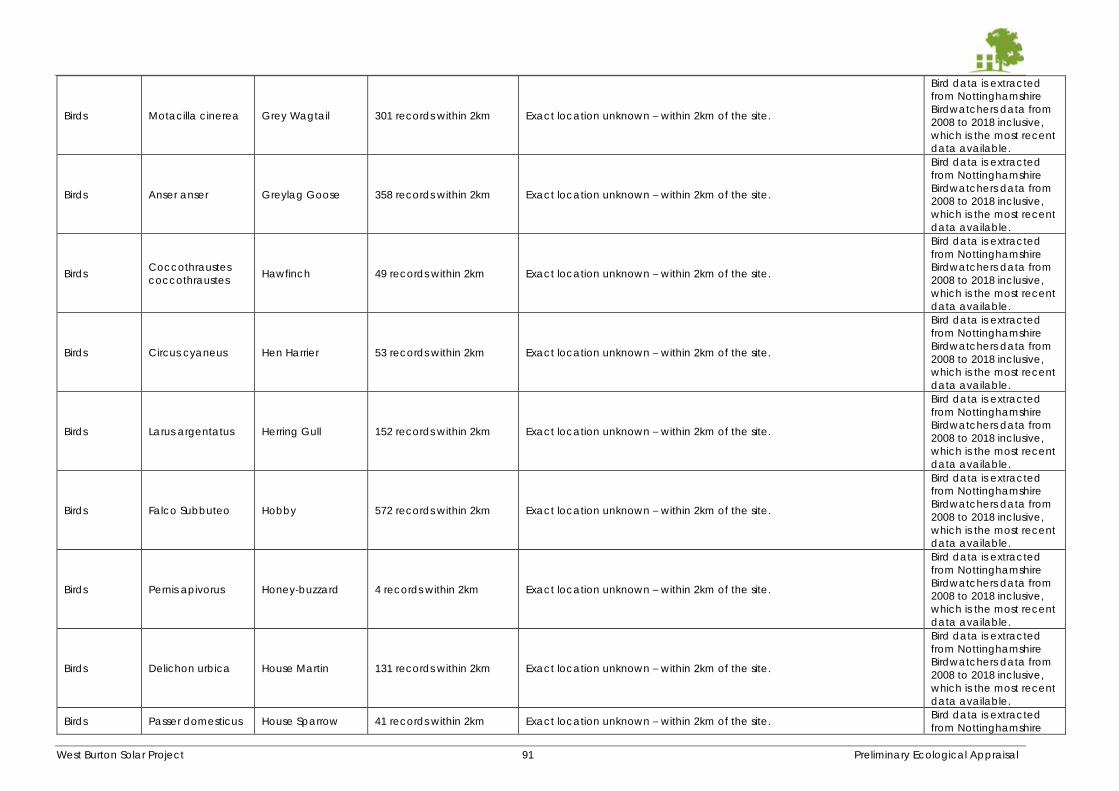
West Burton Solar Project 91 Preliminary Ecological Appraisal
Birds Motacilla cinerea Grey Wagtail 301 records within 2km Exact location unknown – within 2km of the site.
Bird data is extracted
from Nottinghamshire
Birdwatchers data from
2008 to 2018 inclusive,
which is the most recent
data available.
Birds Anser anser Greylag Goose 358 records within 2km Exact location unknown – within 2km of the site.
Bird data is extracted
from Nottinghamshire
Birdwatchers data from
2008 to 2018 inclusive,
which is the most recent
data available.
Birds Coccothraustes
coccothraustes Hawfinch 49 records within 2km Exact location unknown – within 2km of the site.
Bird data is extracted
from Nottinghamshire
Birdwatchers data from
2008 to 2018 inclusive,
which is the most recent
data available.
Birds Circus cyaneus Hen Harrier 53 records within 2km Exact location unknown – within 2km of the site.
Bird data is extracted
from Nottinghamshire
Birdwatchers data from
2008 to 2018 inclusive,
which is the most recent
data available.
Birds Larus argentatus Herring Gull 152 records within 2km Exact location unknown – within 2km of the site.
Bird data is extracted
from Nottinghamshire
Birdwatchers data from
2008 to 2018 inclusive,
which is the most recent
data available.
Birds Falco Subbuteo Hobby 572 records within 2km Exact location unknown – within 2km of the site.
Bird data is extracted
from Nottinghamshire
Birdwatchers data from
2008 to 2018 inclusive,
which is the most recent
data available.
Birds Pernis apivorus Honey-buzzard 4 records within 2km Exact location unknown – within 2km of the site.
Bird data is extracted
from Nottinghamshire
Birdwatchers data from
2008 to 2018 inclusive,
which is the most recent
data available.
Birds Delichon urbica House Martin 131 records within 2km Exact location unknown – within 2km of the site.
Bird data is extracted
from Nottinghamshire
Birdwatchers data from
2008 to 2018 inclusive,
which is the most recent
data available.
Birds Passer domesticus House Sparrow 41 records within 2km Exact location unknown – within 2km of the site. Bird data is extracted
from Nottinghamshire
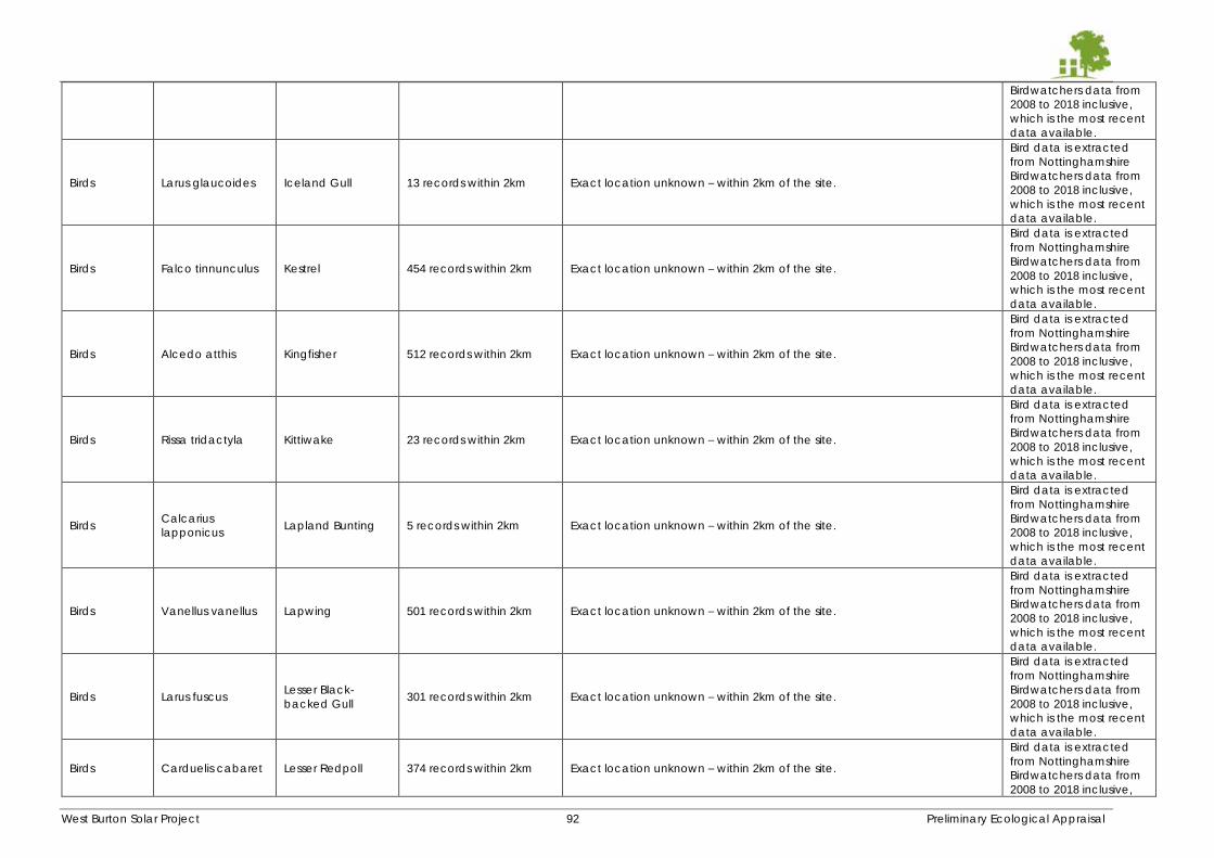
West Burton Solar Project 92 Preliminary Ecological Appraisal
Birdwatchers data from
2008 to 2018 inclusive,
which is the most recent
data available.
Birds Larus glaucoides Iceland Gull 13 records within 2km Exact location unknown – within 2km of the site.
Bird data is extracted
from Nottinghamshire
Birdwatchers data from
2008 to 2018 inclusive,
which is the most recent
data available.
Birds Falco tinnunculus Kestrel 454 records within 2km Exact location unknown – within 2km of the site.
Bird data is extracted
from Nottinghamshire
Birdwatchers data from
2008 to 2018 inclusive,
which is the most recent
data available.
Birds Alcedo atthis Kingfisher 512 records within 2km Exact location unknown – within 2km of the site.
Bird data is extracted
from Nottinghamshire
Birdwatchers data from
2008 to 2018 inclusive,
which is the most recent
data available.
Birds Rissa tridactyla Kittiwake 23 records within 2km Exact location unknown – within 2km of the site.
Bird data is extracted
from Nottinghamshire
Birdwatchers data from
2008 to 2018 inclusive,
which is the most recent
data available.
Birds Calcarius
lapponicus Lapland Bunting 5 records within 2km Exact location unknown – within 2km of the site.
Bird data is extracted
from Nottinghamshire
Birdwatchers data from
2008 to 2018 inclusive,
which is the most recent
data available.
Birds Vanellus vanellus Lapwing 501 records within 2km Exact location unknown – within 2km of the site.
Bird data is extracted
from Nottinghamshire
Birdwatchers data from
2008 to 2018 inclusive,
which is the most recent
data available.
Birds Larus fuscus Lesser Black-
backed Gull 301 records within 2km Exact location unknown – within 2km of the site.
Bird data is extracted
from Nottinghamshire
Birdwatchers data from
2008 to 2018 inclusive,
which is the most recent
data available.
Birds Carduelis cabaret Lesser Redpoll 374 records within 2km Exact location unknown – within 2km of the site.
Bird data is extracted
from Nottinghamshire
Birdwatchers data from
2008 to 2018 inclusive,
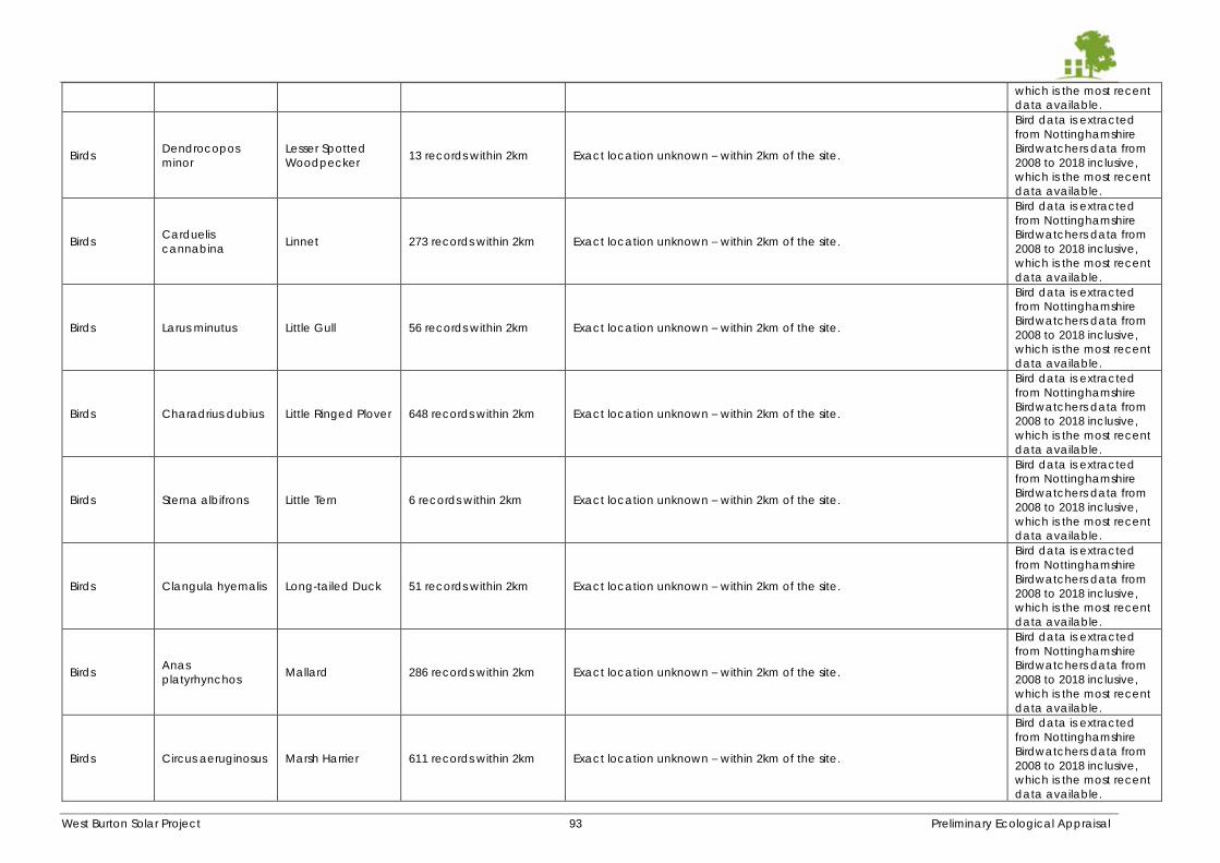
West Burton Solar Project 93 Preliminary Ecological Appraisal
which is the most recent
data available.
Birds Dendrocopos
minor
Lesser Spotted
Woodpecker 13 records within 2km Exact location unknown – within 2km of the site.
Bird data is extracted
from Nottinghamshire
Birdwatchers data from
2008 to 2018 inclusive,
which is the most recent
data available.
Birds Carduelis
cannabina Linnet 273 records within 2km Exact location unknown – within 2km of the site.
Bird data is extracted
from Nottinghamshire
Birdwatchers data from
2008 to 2018 inclusive,
which is the most recent
data available.
Birds Larus minutus Little Gull 56 records within 2km Exact location unknown – within 2km of the site.
Bird data is extracted
from Nottinghamshire
Birdwatchers data from
2008 to 2018 inclusive,
which is the most recent
data available.
Birds Charadrius dubius Little Ringed Plover 648 records within 2km Exact location unknown – within 2km of the site.
Bird data is extracted
from Nottinghamshire
Birdwatchers data from
2008 to 2018 inclusive,
which is the most recent
data available.
Birds Sterna albifrons Little Tern 6 records within 2km Exact location unknown – within 2km of the site.
Bird data is extracted
from Nottinghamshire
Birdwatchers data from
2008 to 2018 inclusive,
which is the most recent
data available.
Birds Clangula hyemalis Long-tailed Duck 51 records within 2km Exact location unknown – within 2km of the site.
Bird data is extracted
from Nottinghamshire
Birdwatchers data from
2008 to 2018 inclusive,
which is the most recent
data available.
Birds Anas
platyrhynchos Mallard 286 records within 2km Exact location unknown – within 2km of the site.
Bird data is extracted
from Nottinghamshire
Birdwatchers data from
2008 to 2018 inclusive,
which is the most recent
data available.
Birds Circus aeruginosus Marsh Harrier 611 records within 2km Exact location unknown – within 2km of the site.
Bird data is extracted
from Nottinghamshire
Birdwatchers data from
2008 to 2018 inclusive,
which is the most recent
data available.
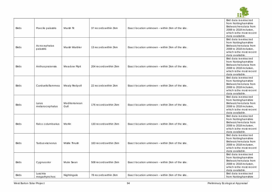
West Burton Solar Project 94 Preliminary Ecological Appraisal
Birds Poecile palustris Marsh Tit 37 records within 2km Exact location unknown – within 2km of the site.
Bird data is extracted
from Nottinghamshire
Birdwatchers data from
2008 to 2018 inclusive,
which is the most recent
data available.
Birds Acrocephalus
palustris Marsh Warbler 13 records within 2km Exact location unknown – within 2km of the site.
Bird data is extracted
from Nottinghamshire
Birdwatchers data from
2008 to 2018 inclusive,
which is the most recent
data available.
Birds Anthus pratensis Meadow Pipit 204 records within 2km Exact location unknown – within 2km of the site.
Bird data is extracted
from Nottinghamshire
Birdwatchers data from
2008 to 2018 inclusive,
which is the most recent
data available.
Birds Carduelis flammea Mealy Redpoll 22 records within 2km Exact location unknown – within 2km of the site.
Bird data is extracted
from Nottinghamshire
Birdwatchers data from
2008 to 2018 inclusive,
which is the most recent
data available.
Birds Larus
melanocephalus
Mediterranean
Gull 176 records within 2km Exact location unknown – within 2km of the site.
Bird data is extracted
from Nottinghamshire
Birdwatchers data from
2008 to 2018 inclusive,
which is the most recent
data available.
Birds Falco columbarius Merlin 133 records within 2km Exact location unknown – within 2km of the site.
Bird data is extracted
from Nottinghamshire
Birdwatchers data from
2008 to 2018 inclusive,
which is the most recent
data available.
Birds Turdus viscivorus Mistle Thrush 163 records within 2km Exact location unknown – within 2km of the site.
Bird data is extracted
from Nottinghamshire
Birdwatchers data from
2008 to 2018 inclusive,
which is the most recent
data available.
Birds Cygnus olor Mute Swan 508 records within 2km Exact location unknown – within 2km of the site.
Bird data is extracted
from Nottinghamshire
Birdwatchers data from
2008 to 2018 inclusive,
which is the most recent
data available.
Birds Luscinia
megarhynchos Nightingale 78 records within 2km Exact location unknown – within 2km of the site.
Bird data is extracted
from Nottinghamshire
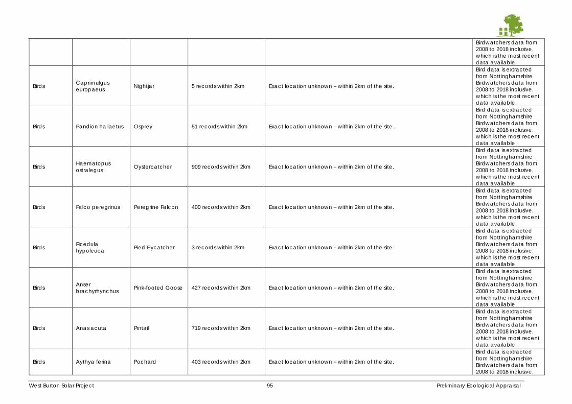
West Burton Solar Project 95 Preliminary Ecological Appraisal
Birdwatchers data from
2008 to 2018 inclusive,
which is the most recent
data available.
Birds Caprimulgus
europaeus Nightjar 5 records within 2km Exact location unknown – within 2km of the site.
Bird data is extracted
from Nottinghamshire
Birdwatchers data from
2008 to 2018 inclusive,
which is the most recent
data available.
Birds Pandion haliaetus Osprey 51 records within 2km Exact location unknown – within 2km of the site.
Bird data is extracted
from Nottinghamshire
Birdwatchers data from
2008 to 2018 inclusive,
which is the most recent
data available.
Birds Haematopus
ostralegus Oystercatcher 909 records within 2km Exact location unknown – within 2km of the site.
Bird data is extracted
from Nottinghamshire
Birdwatchers data from
2008 to 2018 inclusive,
which is the most recent
data available.
Birds Falco peregrinus Peregrine Falcon 400 records within 2km Exact location unknown – within 2km of the site.
Bird data is extracted
from Nottinghamshire
Birdwatchers data from
2008 to 2018 inclusive,
which is the most recent
data available.
Birds Ficedula
hypoleuca Pied Flycatcher 3 records within 2km Exact location unknown – within 2km of the site.
Bird data is extracted
from Nottinghamshire
Birdwatchers data from
2008 to 2018 inclusive,
which is the most recent
data available.
Birds Anser
brachyrhynchus Pink-footed Goose 427 records within 2km Exact location unknown – within 2km of the site.
Bird data is extracted
from Nottinghamshire
Birdwatchers data from
2008 to 2018 inclusive,
which is the most recent
data available.
Birds Anas acuta Pintail 719 records within 2km Exact location unknown – within 2km of the site.
Bird data is extracted
from Nottinghamshire
Birdwatchers data from
2008 to 2018 inclusive,
which is the most recent
data available.
Birds Aythya ferina Pochard 403 records within 2km Exact location unknown – within 2km of the site.
Bird data is extracted
from Nottinghamshire
Birdwatchers data from
2008 to 2018 inclusive,
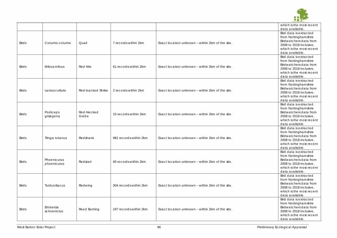
West Burton Solar Project 96 Preliminary Ecological Appraisal
which is the most recent
data available.
Birds Coturnix coturnix Quail 7 records within 2km Exact location unknown – within 2km of the site.
Bird data is extracted
from Nottinghamshire
Birdwatchers data from
2008 to 2018 inclusive,
which is the most recent
data available.
Birds Milvus milvus Red Kite 61 records within 2km Exact location unknown – within 2km of the site.
Bird data is extracted
from Nottinghamshire
Birdwatchers data from
2008 to 2018 inclusive,
which is the most recent
data available.
Birds Lanius collurio Red-backed Shrike 2 records within 2km Exact location unknown – within 2km of the site.
Bird data is extracted
from Nottinghamshire
Birdwatchers data from
2008 to 2018 inclusive,
which is the most recent
data available.
Birds Podiceps
grisegena
Red-Necked
Grebe 15 records within 2km Exact location unknown – within 2km of the site.
Bird data is extracted
from Nottinghamshire
Birdwatchers data from
2008 to 2018 inclusive,
which is the most recent
data available.
Birds Tringa totanus Redshank 981 records within 2km Exact location unknown – within 2km of the site.
Bird data is extracted
from Nottinghamshire
Birdwatchers data from
2008 to 2018 inclusive,
which is the most recent
data available.
Birds Phoenicurus
phoenicurus Redstart 65 records within 2km Exact location unknown – within 2km of the site.
Bird data is extracted
from Nottinghamshire
Birdwatchers data from
2008 to 2018 inclusive,
which is the most recent
data available.
Birds Turdus iliacus Redwing 304 records within 2km Exact location unknown – within 2km of the site.
Bird data is extracted
from Nottinghamshire
Birdwatchers data from
2008 to 2018 inclusive,
which is the most recent
data available.
Birds Emberiza
schoeniclus Reed Bunting 247 records within 2km Exact location unknown – within 2km of the site.
Bird data is extracted
from Nottinghamshire
Birdwatchers data from
2008 to 2018 inclusive,
which is the most recent
data available.
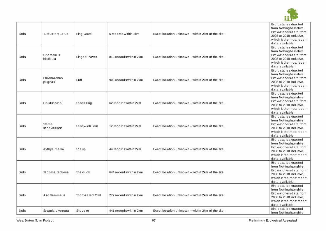
West Burton Solar Project 97 Preliminary Ecological Appraisal
Birds Turdus torquatus Ring Ouzel 6 records within 2km Exact location unknown – within 2km of the site.
Bird data is extracted
from Nottinghamshire
Birdwatchers data from
2008 to 2018 inclusive,
which is the most recent
data available.
Birds Charadrius
hiaticula Ringed Plover 818 records within 2km Exact location unknown – within 2km of the site.
Bird data is extracted
from Nottinghamshire
Birdwatchers data from
2008 to 2018 inclusive,
which is the most recent
data available.
Birds Philomachus
pugnax Ruff 903 records within 2km Exact location unknown – within 2km of the site.
Bird data is extracted
from Nottinghamshire
Birdwatchers data from
2008 to 2018 inclusive,
which is the most recent
data available.
Birds Calidris alba Sanderling 62 records within 2km Exact location unknown – within 2km of the site.
Bird data is extracted
from Nottinghamshire
Birdwatchers data from
2008 to 2018 inclusive,
which is the most recent
data available.
Birds Sterna
sandvicensis Sandwich Tern 12 records within 2km Exact location unknown – within 2km of the site.
Bird data is extracted
from Nottinghamshire
Birdwatchers data from
2008 to 2018 inclusive,
which is the most recent
data available.
Birds Aythya marila Scaup 44 records within 2km Exact location unknown – within 2km of the site.
Bird data is extracted
from Nottinghamshire
Birdwatchers data from
2008 to 2018 inclusive,
which is the most recent
data available.
Birds Tadorna tadorna Shelduck 644 records within 2km Exact location unknown – within 2km of the site.
Bird data is extracted
from Nottinghamshire
Birdwatchers data from
2008 to 2018 inclusive,
which is the most recent
data available.
Birds Asio flammeus Short-eared Owl 272 records within 2km Exact location unknown – within 2km of the site.
Bird data is extracted
from Nottinghamshire
Birdwatchers data from
2008 to 2018 inclusive,
which is the most recent
data available.
Birds Spatula clypeata Shoveler 441 records within 2km Exact location unknown – within 2km of the site. Bird data is extracted
from Nottinghamshire
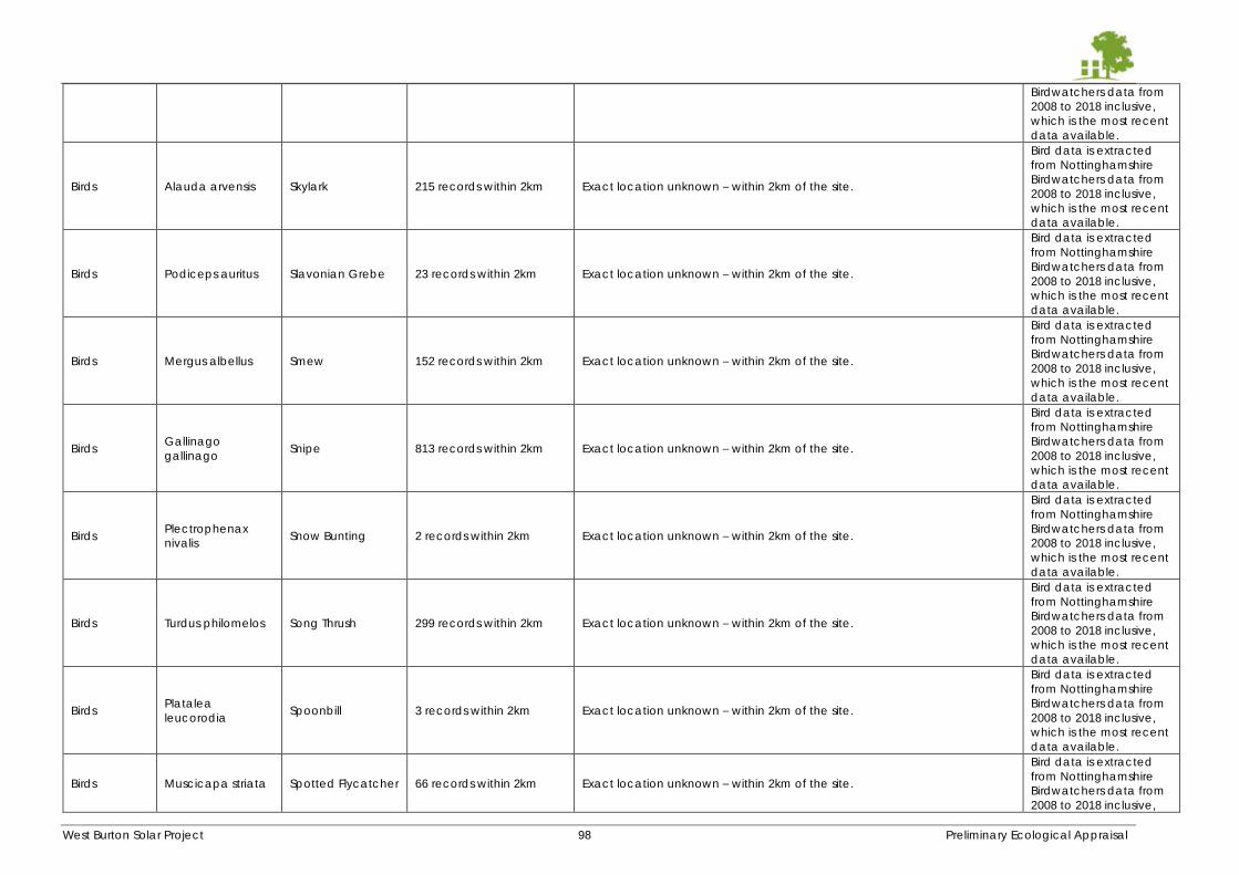
West Burton Solar Project 98 Preliminary Ecological Appraisal
Birdwatchers data from
2008 to 2018 inclusive,
which is the most recent
data available.
Birds Alauda arvensis Skylark 215 records within 2km Exact location unknown – within 2km of the site.
Bird data is extracted
from Nottinghamshire
Birdwatchers data from
2008 to 2018 inclusive,
which is the most recent
data available.
Birds Podiceps auritus Slavonian Grebe 23 records within 2km Exact location unknown – within 2km of the site.
Bird data is extracted
from Nottinghamshire
Birdwatchers data from
2008 to 2018 inclusive,
which is the most recent
data available.
Birds Mergus albellus Smew 152 records within 2km Exact location unknown – within 2km of the site.
Bird data is extracted
from Nottinghamshire
Birdwatchers data from
2008 to 2018 inclusive,
which is the most recent
data available.
Birds Gallinago
gallinago Snipe 813 records within 2km Exact location unknown – within 2km of the site.
Bird data is extracted
from Nottinghamshire
Birdwatchers data from
2008 to 2018 inclusive,
which is the most recent
data available.
Birds Plectrophenax
nivalis Snow Bunting 2 records within 2km Exact location unknown – within 2km of the site.
Bird data is extracted
from Nottinghamshire
Birdwatchers data from
2008 to 2018 inclusive,
which is the most recent
data available.
Birds Turdus philomelos Song Thrush 299 records within 2km Exact location unknown – within 2km of the site.
Bird data is extracted
from Nottinghamshire
Birdwatchers data from
2008 to 2018 inclusive,
which is the most recent
data available.
Birds Platalea
leucorodia Spoonbill 3 records within 2km Exact location unknown – within 2km of the site.
Bird data is extracted
from Nottinghamshire
Birdwatchers data from
2008 to 2018 inclusive,
which is the most recent
data available.
Birds Muscicapa striata Spotted Flycatcher 66 records within 2km Exact location unknown – within 2km of the site.
Bird data is extracted
from Nottinghamshire
Birdwatchers data from
2008 to 2018 inclusive,
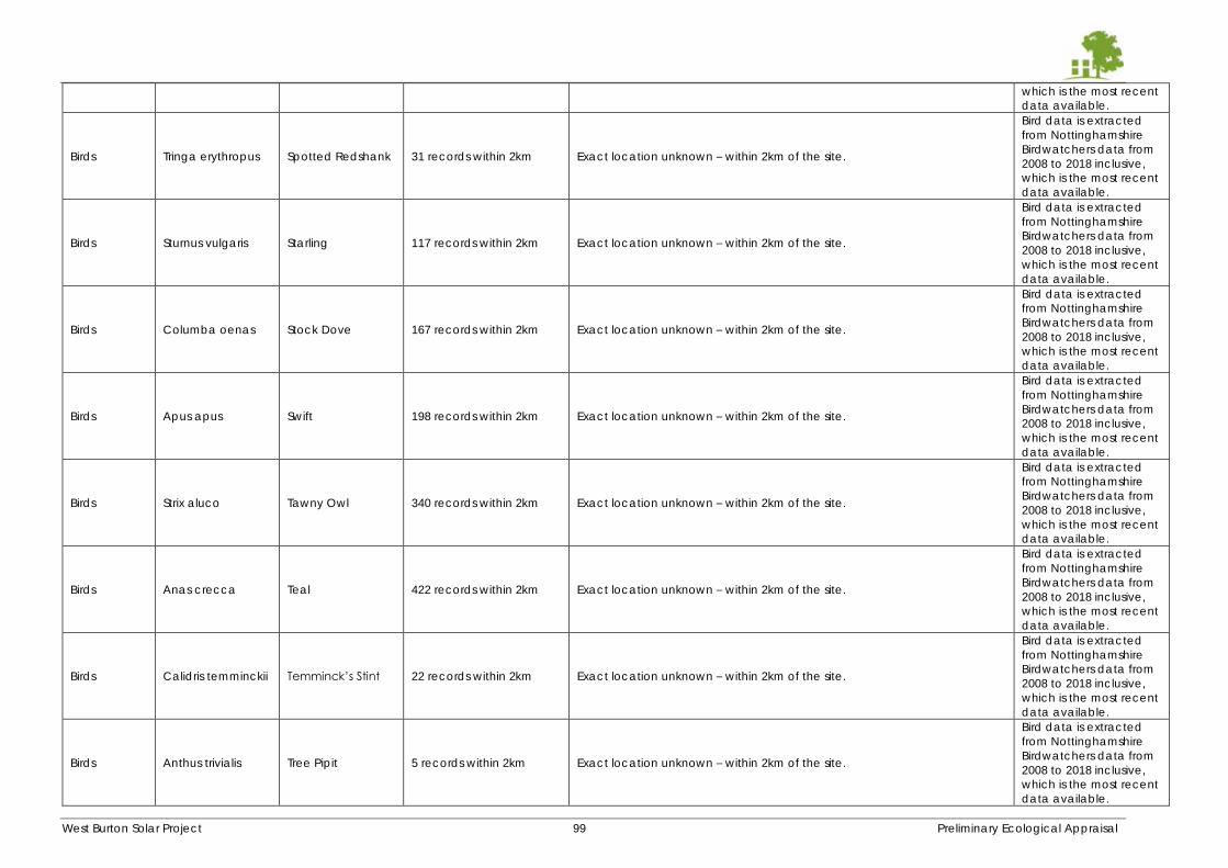
West Burton Solar Project 99 Preliminary Ecological Appraisal
which is the most recent
data available.
Birds Tringa erythropus Spotted Redshank 31 records within 2km Exact location unknown – within 2km of the site.
Bird data is extracted
from Nottinghamshire
Birdwatchers data from
2008 to 2018 inclusive,
which is the most recent
data available.
Birds Sturnus vulgaris Starling 117 records within 2km Exact location unknown – within 2km of the site.
Bird data is extracted
from Nottinghamshire
Birdwatchers data from
2008 to 2018 inclusive,
which is the most recent
data available.
Birds Columba oenas Stock Dove 167 records within 2km Exact location unknown – within 2km of the site.
Bird data is extracted
from Nottinghamshire
Birdwatchers data from
2008 to 2018 inclusive,
which is the most recent
data available.
Birds Apus apus Swift 198 records within 2km Exact location unknown – within 2km of the site.
Bird data is extracted
from Nottinghamshire
Birdwatchers data from
2008 to 2018 inclusive,
which is the most recent
data available.
Birds Strix aluco Tawny Owl 340 records within 2km Exact location unknown – within 2km of the site.
Bird data is extracted
from Nottinghamshire
Birdwatchers data from
2008 to 2018 inclusive,
which is the most recent
data available.
Birds Anas crecca Teal 422 records within 2km Exact location unknown – within 2km of the site.
Bird data is extracted
from Nottinghamshire
Birdwatchers data from
2008 to 2018 inclusive,
which is the most recent
data available.
Birds Calidris temminckii Temminck’s Stint 22 records within 2km Exact location unknown – within 2km of the site.
Bird data is extracted
from Nottinghamshire
Birdwatchers data from
2008 to 2018 inclusive,
which is the most recent
data available.
Birds Anthus trivialis Tree Pipit 5 records within 2km Exact location unknown – within 2km of the site.
Bird data is extracted
from Nottinghamshire
Birdwatchers data from
2008 to 2018 inclusive,
which is the most recent
data available.
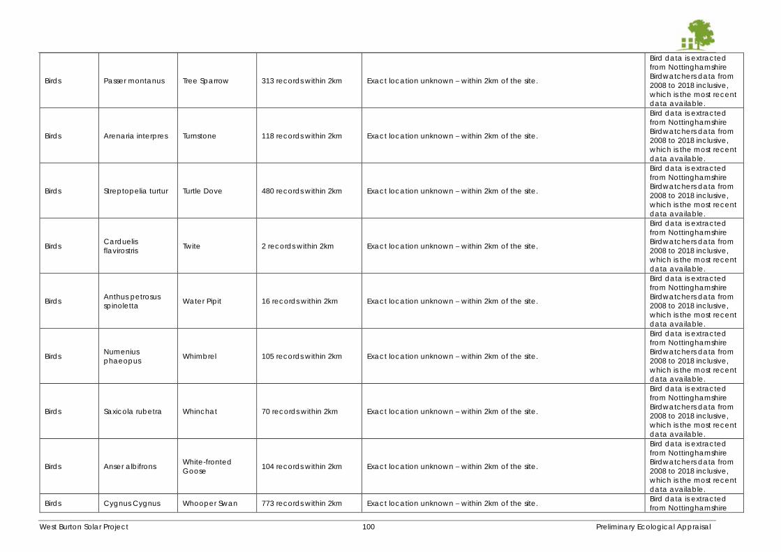
West Burton Solar Project 100 Preliminary Ecological Appraisal
Birds Passer montanus Tree Sparrow 313 records within 2km Exact location unknown – within 2km of the site.
Bird data is extracted
from Nottinghamshire
Birdwatchers data from
2008 to 2018 inclusive,
which is the most recent
data available.
Birds Arenaria interpres Turnstone 118 records within 2km Exact location unknown – within 2km of the site.
Bird data is extracted
from Nottinghamshire
Birdwatchers data from
2008 to 2018 inclusive,
which is the most recent
data available.
Birds Streptopelia turtur Turtle Dove 480 records within 2km Exact location unknown – within 2km of the site.
Bird data is extracted
from Nottinghamshire
Birdwatchers data from
2008 to 2018 inclusive,
which is the most recent
data available.
Birds Carduelis
flavirostris Twite 2 records within 2km Exact location unknown – within 2km of the site.
Bird data is extracted
from Nottinghamshire
Birdwatchers data from
2008 to 2018 inclusive,
which is the most recent
data available.
Birds Anthus petrosus
spinoletta Water Pipit 16 records within 2km Exact location unknown – within 2km of the site.
Bird data is extracted
from Nottinghamshire
Birdwatchers data from
2008 to 2018 inclusive,
which is the most recent
data available.
Birds Numenius
phaeopus Whimbrel 105 records within 2km Exact location unknown – within 2km of the site.
Bird data is extracted
from Nottinghamshire
Birdwatchers data from
2008 to 2018 inclusive,
which is the most recent
data available.
Birds Saxicola rubetra Whinchat 70 records within 2km Exact location unknown – within 2km of the site.
Bird data is extracted
from Nottinghamshire
Birdwatchers data from
2008 to 2018 inclusive,
which is the most recent
data available.
Birds Anser albifrons White-fronted
Goose 104 records within 2km Exact location unknown – within 2km of the site.
Bird data is extracted
from Nottinghamshire
Birdwatchers data from
2008 to 2018 inclusive,
which is the most recent
data available.
Birds Cygnus Cygnus Whooper Swan 773 records within 2km Exact location unknown – within 2km of the site. Bird data is extracted
from Nottinghamshire
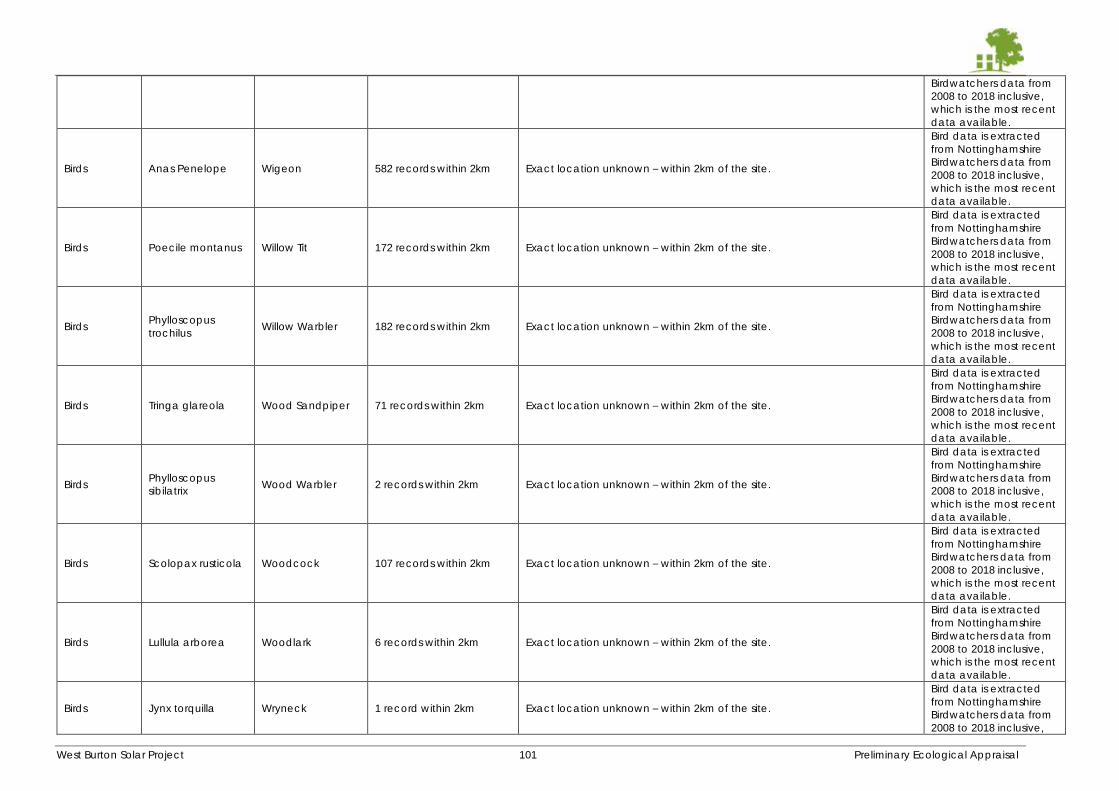
West Burton Solar Project 101 Preliminary Ecological Appraisal
Birdwatchers data from
2008 to 2018 inclusive,
which is the most recent
data available.
Birds Anas Penelope Wigeon 582 records within 2km Exact location unknown – within 2km of the site.
Bird data is extracted
from Nottinghamshire
Birdwatchers data from
2008 to 2018 inclusive,
which is the most recent
data available.
Birds Poecile montanus Willow Tit 172 records within 2km Exact location unknown – within 2km of the site.
Bird data is extracted
from Nottinghamshire
Birdwatchers data from
2008 to 2018 inclusive,
which is the most recent
data available.
Birds Phylloscopus
trochilus Willow Warbler 182 records within 2km Exact location unknown – within 2km of the site.
Bird data is extracted
from Nottinghamshire
Birdwatchers data from
2008 to 2018 inclusive,
which is the most recent
data available.
Birds Tringa glareola Wood Sandpiper 71 records within 2km Exact location unknown – within 2km of the site.
Bird data is extracted
from Nottinghamshire
Birdwatchers data from
2008 to 2018 inclusive,
which is the most recent
data available.
Birds Phylloscopus
sibilatrix Wood Warbler 2 records within 2km Exact location unknown – within 2km of the site.
Bird data is extracted
from Nottinghamshire
Birdwatchers data from
2008 to 2018 inclusive,
which is the most recent
data available.
Birds Scolopax rusticola Woodcock 107 records within 2km Exact location unknown – within 2km of the site.
Bird data is extracted
from Nottinghamshire
Birdwatchers data from
2008 to 2018 inclusive,
which is the most recent
data available.
Birds Lullula arborea Woodlark 6 records within 2km Exact location unknown – within 2km of the site.
Bird data is extracted
from Nottinghamshire
Birdwatchers data from
2008 to 2018 inclusive,
which is the most recent
data available.
Birds Jynx torquilla Wryneck 1 record within 2km Exact location unknown – within 2km of the site.
Bird data is extracted
from Nottinghamshire
Birdwatchers data from
2008 to 2018 inclusive,
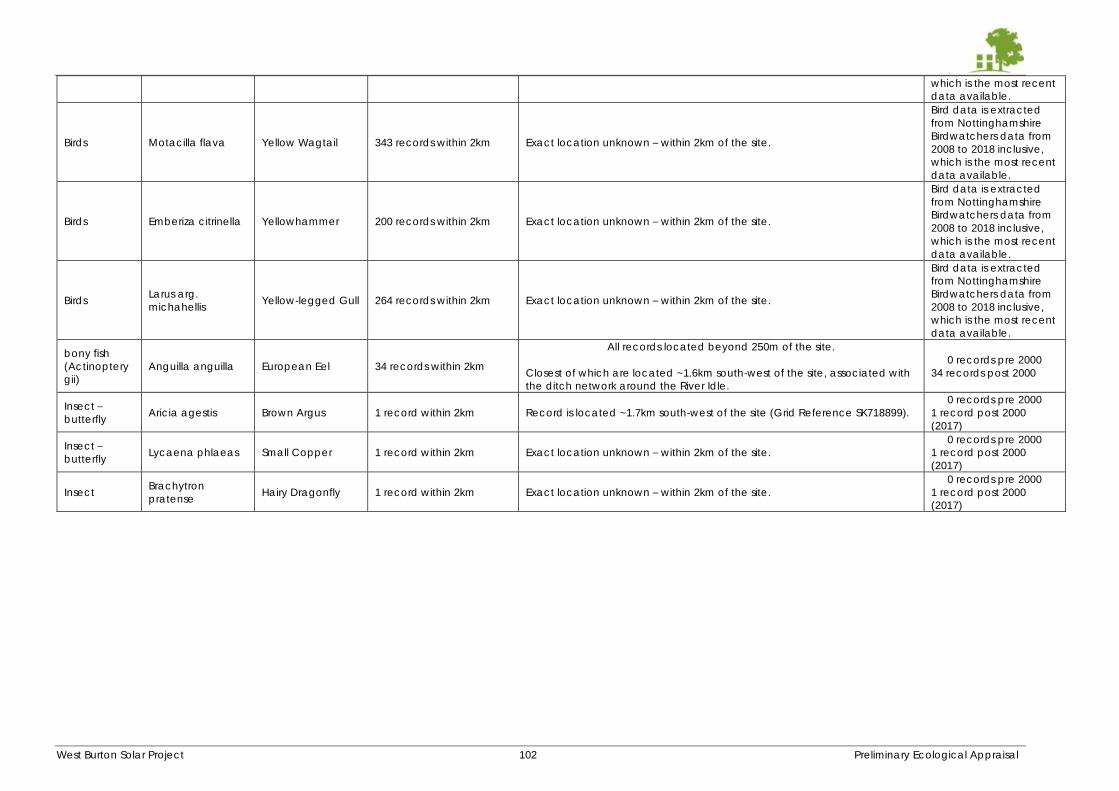
West Burton Solar Project 102 Preliminary Ecological Appraisal
which is the most recent
data available.
Birds Motacilla flava Yellow Wagtail 343 records within 2km Exact location unknown – within 2km of the site.
Bird data is extracted
from Nottinghamshire
Birdwatchers data from
2008 to 2018 inclusive,
which is the most recent
data available.
Birds Emberiza citrinella Yellowhammer 200 records within 2km Exact location unknown – within 2km of the site.
Bird data is extracted
from Nottinghamshire
Birdwatchers data from
2008 to 2018 inclusive,
which is the most recent
data available.
Birds Larus arg.
michahellis Yellow-legged Gull 264 records within 2km Exact location unknown – within 2km of the site.
Bird data is extracted
from Nottinghamshire
Birdwatchers data from
2008 to 2018 inclusive,
which is the most recent
data available.
bony fish
(Actinoptery
gii)
Anguilla anguilla European Eel 34 records within 2km
All records located beyond 250m of the site.
Closest of which are located ~1.6km south-west of the site, associated with
the ditch network around the River Idle.
0 records pre 2000
34 records post 2000
Insect –
butterfly Aricia agestis Brown Argus 1 record within 2km Record is located ~1.7km south-west of the site (Grid Reference SK718899).
0 records pre 2000
1 record post 2000
(2017)
Insect –
butterfly Lycaena phlaeas Small Copper 1 record within 2km Exact location unknown – within 2km of the site.
0 records pre 2000
1 record post 2000
(2017)
Insect Brachytron
pratense Hairy Dragonfly 1 record within 2km Exact location unknown – within 2km of the site.
0 records pre 2000
1 record post 2000
(2017)
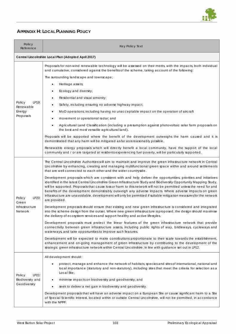
West Burton Solar Project 103 Preliminary Ecological Appraisal
APPENDIX H: LOCAL PLANNING POLICY
Policy
Reference Key Policy Text
Central Lincolnshire Local Plan (Adopted April 2017)
Policy LP19:
Renewable
Energy
Proposals
Proposals for non-wind renewable technology will be assessed on their merits, with the impacts, both individual
and cumulative, considered against the benefits of the scheme, taking account of the following:
The surrounding landscape and townscape;
Heritage assets;
Ecology and diversity;
Residential and visual amenity;
Safety, including ensuring no adverse highway impact;
MoD operations, including having no unacceptable impact on the operation of aircraft
movement or operational radar; and
Agricultural Land Classification (including a presumption against photovoltaic solar farm proposals on
the best and most versatile agricultural land).
Proposals will be supported where the benefit of the development outweighs the harm caused and it is
demonstrated that any harm will be mitigated as far as is reasonably possible.
Renewable energy proposals which will directly benefit a local community, have the support of the local
community and / or are targeted at residents experiencing fuel poverty, will be particularly supported.
Policy LP20:
Green
Infrastructure
Network
The Central Lincolnshire Authorities will aim to maintain and improve the green infrastructure network in Central
Lincolnshire by enhancing, creating and managing multifunctional green space within and around settlements
that are well connected to each other and the wider countryside.
Development proposals which are consistent with and help deliver the opportunities, priorities and initiatives
identified in the latest Central Lincolnshire Green Infrastructure Study and Biodiversity Opportunity Mapping Study,
will be supported. Proposals that cause loss or harm to this network will not be permitted unless the need for and
benefits of the development demonstrably outweigh any adverse impacts. Where adverse impacts on green
infrastructure are unavoidable, development will only be permitted if suitable mitigation measures for the network
are provided.
Development proposals should ensure that existing and new green infrastructure is considered and integrated
into the scheme design from the outset. Where new green infrastructure is proposed, the design should maximise
the delivery of ecosystem services and support healthy and active lifestyles.
Development proposals must protect the linear features of the green infrastructure network that provide
connectivity between green infrastructure assets, including public rights of way, bridleways, cycleways and
waterways, and take opportunities to improve such features.
Development will be expected to make contributions proportionate to their scale towards the establishment,
enhancement and on-going management of green infrastructure by contributing to the development of the
strategic green infrastructure network within Central Lincolnshire, in line with guidance set out in LP12.
Policy LP21:
Biodiversity and
Geodiversity
All development should:
protect, manage and enhance the network of habitats, species and sites of international, national and
local importance (statutory and non-statutory), including sites that meet the criteria for selection as a
Local Site;
minimise impacts on biodiversity and geodiversity; and
seek to deliver a net gain in biodiversity and geodiversity.
Development proposals that will have an adverse impact on a European Site or cause significant harm to a Site
of Special Scientific Interest, located within or outside Central Lincolnshire, will not be permitted, in accordance
with the NPPF.
West Burton Solar Project 104 Preliminary Ecological Appraisal
Policy
Reference Key Policy Text
Planning permission will be refused for development resulting in the loss, deterioration or fragmentation of
irreplaceable habitats, including ancient woodland and aged or veteran trees, unless the need for, and benefits
of, the development in that location clearly outweigh the loss or harm.
Proposals for major development should adopt an ecosystem services approach, and for large scale major
development schemes (such as Sustainable Urban Extensions) also a landscape scale approach, to biodiversity
and geodiversity protection and enhancement identified in the Central Lincolnshire Biodiversity Opportunity
Mapping Study.
Development proposals should create new habitats, and links between habitats, in line with Biodiversity
Opportunity Mapping evidence to maintain a network of wildlife sites and corridors to minimise habitat
fragmentation and provide opportunities for species to respond and adapt to climate change. Development
should seek to preserve, restore and re-create priority habitats, ecological networks and the protection and
recovery of priority species set out in the Lincolnshire Biodiversity Action Plan and Geodiversity Action Plan.
Where development is within a Nature Improvement Area (NIA), it should contribute to the aims and aspirations
of the NIA.
Development proposals should ensure opportunities are taken to retain, protect and enhance biodiversity and
geodiversity features proportionate to their scale, through site layout, design of new buildings and proposals for
existing buildings.
Mitigation
Any development which could have an adverse effect on sites with designated features and / or protected
species, either individually or cumulatively, will require an assessment as required by the relevant legislation or
national planning guidance.
Where any potential adverse effects to the biodiversity or geodiversity value of designated sites are identified,
the proposal will not normally be permitted. Development proposals will only be supported if the benefits of the
development clearly outweigh the harm to the habitat and/or species.
In exceptional circumstances, where adverse impacts are demonstrated to be unavoidable, developers will be
required to ensure that impacts are appropriately mitigated, with compensation measures towards loss of habitat
used only as a last resort where there is no alternative. Where any mitigation and compensation measures are
required, they should be in place before development activities start that may disturb protected or important
habitats and species.
Policy LP22:
Green Wedges
Green Wedges, as identified on the Policies Map, have been identified to fulfil one or more of the following
functions and policy aims:
Prevention of the physical merging of settlements, preserving their separate identity, local character and
historic character;
Creation of a multi-functional ‘green lung’ to offer communities a direct and continuous link to the open
countryside beyond the urban area;
Provision of an accessible recreational resource, with both formal and informal opportunities, close to
where people live, where public access is maximised without compromising the integrity of the Green
Wedge;
Conservation and enhancement of local wildlife and protection of links between wildlife sites to support
wildlife corridors.
Within the Green Wedges planning permission will not be granted for any form of development, including
changes of use, unless:
a) it can be demonstrated that the development is not contrary or detrimental to the above functions and
aims; or
b) it is essential for the proposed development to be located within the Green Wedge, and the benefits of
which override the potential impact on the Green Wedge.
Development proposals within a Green Wedge will be expected to have regard to:
c) the need to retain the open and undeveloped character of the Green Wedge, physical separation
between settlements, historic environment character and green infrastructure value;
West Burton Solar Project 105 Preliminary Ecological Appraisal
Policy
Reference Key Policy Text
d) the maintenance and enhancement of the network of footpaths, cycleways and bridleways, and their
links to the countryside, to retain and enhance public access, where appropriate to the role and
function of the Green Wedge;
e) opportunities to improve the quality and function of green infrastructure within the Green Wedge with
regard to the Central Lincolnshire Green Infrastructure network and Biodiversity Opportunity Mapping.
Development proposals adjacent to the Green Wedges will be expected to demonstrate that:
f) they do not adversely impact on the function of the Green Wedge, taking into account scale, siting,
design, materials and landscape treatment;
g) They have considered linkages to and enhancements of the adjacent Green Wedge.
Policy LP23:
Local Green
Space and
other Important
Open Space
An area identified as a Local Green Space on the Policies Map will be protected from development in line with
the NPPF, which rules out development on these sites other than in very special circumstances.
An area identified as an Important Open Space on the Policies Map is safeguarded from development unless it
can be demonstrated that:
a) In the case of publicly accessible open space, there is an identified over provision of that particular type
of open space in the community area and the site is not required for alternative recreational uses or
suitable alternative open space can be provided on a replacement site or by enhancing existing open
space serving the community area; and
b) In the case of all Important Open Spaces, there are no significant detrimental impacts on the character
and appearance of the surrounding area, ecology and any heritage assets.
Central Lincolnshire Local Plan Review – Consultation Draft (June 2021)
Policy S13:
Renewable
Energy
The Central Lincolnshire Joint Strategic Planning Committee is committed to supporting the transition to a net zero
carbon future and will seek to maximise appropriately located renewable energy generated in Central
Lincolnshire (such energy likely being wind and solar based).
Proposals for renewable energy schemes, including ancillary development, will be supported where the direct,
indirect, individual and cumulative impacts on the following considerations are,or will be made, acceptable:
i. As a result of its scale, siting or design, the impacts on the following issues are satisfactorily addressed:
landscape character; visual amenity; biodiversity; geodiversity; flood risk; townscape; historic assets; and
highway safety…
Testing compliance with part (i) above will be via applicable policies elsewhere in a development plan document
for the area (i.e. this Local Plan; a Neighbourhood Plan, if one exists; any applicable policies in a Minerals or Waste
Local Plan; and any further guidance set out in a Supplementary Planning Document).
For all matters in (i)-(iii), the applicable local planning authority may commission its own independent assessment
of the proposals, to ensure it is satisfied what the degree of harm may be and whether reasonable mitigation
opportunities are being taken.
Where significant adverse effects are concluded by the local planning authority following consideration of the
above assessment(s), such effects will be weighed against the wider environmental, economic, social and
community benefits provided by the proposal. In this regard, and as part of the planning balance, significant
additional weight in favour of the proposal will arise for any proposal which is community-led for the benefit of
that community.
In areas that have been designated for their national importance, as identified in the National Planning Policy
Framework, renewable energy infrastructure will only be permitted where it can be demonstrated that it would
be appropriate in scale, located in areas that do not contribute positively to the objectives of the designation, is
sympathetically designed and includes any necessary mitigation measures.
Additional matters for solar based energy proposals Proposals for solar thermal or photovoltaics panels to be
installed on existing property will be under a presumption in favour of permission unless there is clear and
demonstrable significant harm arising.
Proposals for ground based photovoltaics, including commercial large scale proposals, will be under a
presumption in favour unless:
there is clear and demonstrable significant harm arising; or
West Burton Solar Project 106 Preliminary Ecological Appraisal
Policy
Reference Key Policy Text
the proposal is (following a site specific soil assessment) to take place on Best and Most Versatile (BMV)
agricultural land, unless such land is peat based and the proposal is part of a wider scheme to protect
or enhance the carbon sink of such land; or
the land is allocated for another purpose in this Local Plan or other statutory based document (such as
a nature recovery strategy or a Local Transport Plan), and the proposal is not compatible with such other
allocation.
Decommissioning renewable energy infrastructure
Permitted proposals will be subject to a condition that will require the facility to be removed and the site fully
restored to its original condition (or as near as reasonably practical to its original condition) within one year of that
facility becoming non-operational.
Policy S58:
Green
Infrastructure
Network
The Central Lincolnshire Authorities will safeguard green infrastructure in Central Lincolnshire from inappropriate
development and work actively with partners to maintain and improve the quantity, quality, accessibility and
management of the green infrastructure network.
Proposals that cause loss or harm to the green infrastructure network will not be supported unless the need for
and benefits of the development demonstrably outweigh any adverse impacts. Where adverse impacts on green
infrastructure are unavoidable, development will only be supported if suitable mitigation measures for the network
are provided.
Development proposals should ensure that existing and new green infrastructure is considered and integrated
into the scheme design from the outset. Where new green infrastructure is proposed, the design and layout should
take opportunities to incorporate a range of green infrastructure to maximise the delivery of multi-functionality
and ecosystem services, support climate change adaptation and encourage healthy and active lifestyles.
Development proposals must protect the linear features of the green infrastructure network that provide
connectivity between green infrastructure assets, including public rights of way, bridleways, cycleways and
waterways, and take opportunities to improve and expand such features.
Development will be expected to make a contribution proportionate to their scale towards the establishment,
enhancement and on-going management of green infrastructure by contributing to the development of the
strategic green infrastructure network within Central Lincolnshire, in accordance with the Developer Contributions
SPD.
Policy S59:
Protecting
Biodiversity and
Geodiversity
All development should:
a) protect, manage and enhance the ecological network of habitats, species and sites of international,
national and local importance (statutory and non-statutory), including sites that meet the criteria for
selection as a Local Site;
b) minimise impacts on biodiversity and features of geodiversity value;
c) deliver measurable and proportionate net gains in biodiversity; and
d) protect and enhance the aquatic environment within or adjoining the site, including water quality and
habitat.
Part One: Designated Sites
The following hierarchy of sites will apply in the consideration of development proposals:
1. International Sites
The highest level of protection will be afforded to internationally protected sites. Development proposals that will
have an adverse impact on the integrity of such areas, will not be supported other than in exceptional
circumstances, in accordance with the NPPF.
Development proposals that are likely to result in a significant adverse effect, either alone or in combination, on
any internationally designated site, must satisfy the requirements of the Habitats Regulations (or any superseding
similar UK legislation). Development requiring Appropriate Assessment will only be allowed where it can be
determined, taking into account mitigation, that the proposal would not result in significant adverse effects on
the site’s integrity.
2. National Sites (NNRs and SSSIs as shown on the Policies Map)
West Burton Solar Project 107 Preliminary Ecological Appraisal
Policy
Reference Key Policy Text
Development proposals should avoid impact on these nationally protected sites. Development proposals within
or outside a national site, likely to have an adverse effect, either individually or in combination with other
developments, will not normally be supported unless the benefits of the development, at this site clearly outweigh
both the adverse impacts on the features of the site and any adverse impacts on the wider network of nationally
protected sites.
3. Irreplaceable Habitats
Planning permission will be refused for development resulting in the loss, deterioration or fragmentation of
irreplaceable habitats, including ancient woodland and aged or veteran trees, unless there are wholly
exceptional reasons and a suitable compensation strategy will be delivered.
4. Local Sites (LNR, LWS and LGS as shown on the Policies Map)
Development likely to have an adverse effect on locally designated sites, their features or their function as part
of the ecological network, will only be supported where the need and benefits of the development clearly
outweigh the loss, and the coherence of the local ecological network is maintained. Where significant harm
cannot be avoided, the mitigation hierarchy should be followed.
Part Two: Species and Habitats of Principal Importance
All development proposals will be considered in the context of the relevant Local Authority’s duty to promote the
protection and recovery of priority species and habitats.
Development should seek to preserve, restore and re-create priority habitats, ecological networks and the
protection and recovery of priority species set out in the Natural Environment and Rural Communities Act 2006,
Lincolnshire Biodiversity Action Plan, Lincolnshire Geodiversity Strategy and Local Nature Recovery Strategy.
Where adverse impacts are likely, development will only be supported where the need for and benefits of the
development clearly outweigh these impacts. In such cases, appropriate mitigation or compensatory measures
will be required.
Part Three: Mitigation of Potential Adverse Impacts
Development should avoid adverse impact on existing biodiversity and geodiversity features as a first principle, in
line with the mitigation hierarchy. Where adverse impacts are unavoidable they must be adequately and
proportionately mitigated. If full mitigation cannot be provided, compensation will be required as a last resort
where there is no alternative.
Development will only be supported where the proposed measures for mitigation and/or compensation along
with details of net gain are acceptable to the Local Planning Authority in terms of design and location, and are
secured for the lifetime of the development with appropriate funding mechanisms that are capable of being
secured by condition and/or legal agreement.
If significant harm to biodiversity resulting from development cannot be avoided, adequately mitigated, or, as a
last resort, compensated for, then planning permission will be refused.
Policy S60:
Biodiversity
Opportunity
and Delivering
Measurable
Net Gains
Following application of the mitigation hierarchy, development proposals should ensure opportunities are taken
to retain, protect and enhance biodiversity and geodiversity features proportionate to their scale, through site
layout, design of new buildings and proposals for existing buildings.
Development proposals should create new habitats, and links between habitats, in line with Central Lincolnshire
Biodiversity Opportunity and Green Infrastructure Mapping evidence, the biodiversity opportunity area principles
set out in Appendix 4 to this Plan and the Local Nature Recovery Strategy, to maintain a network of wildlife sites
and corridors, to minimise habitat fragmentation and provide opportunities for species to respond and adapt to
climate change.
Proposals for major and large scale development should seek to deliver wider environmental net gains where
feasible.
All development proposals must deliver, as a minimum, a 10% measurable biodiversity net gain attributable to the
development. The net gain for biodiversity should be calculated using DEFRA’s biodiversity metric.
Appendix 4: Principles for Development within Biodiversity
Opportunity Areas
The following guidance provides a set of development principles which should be used when considering site
allocations and determining planning applications in the context of the Central Lincolnshire Biodiversity
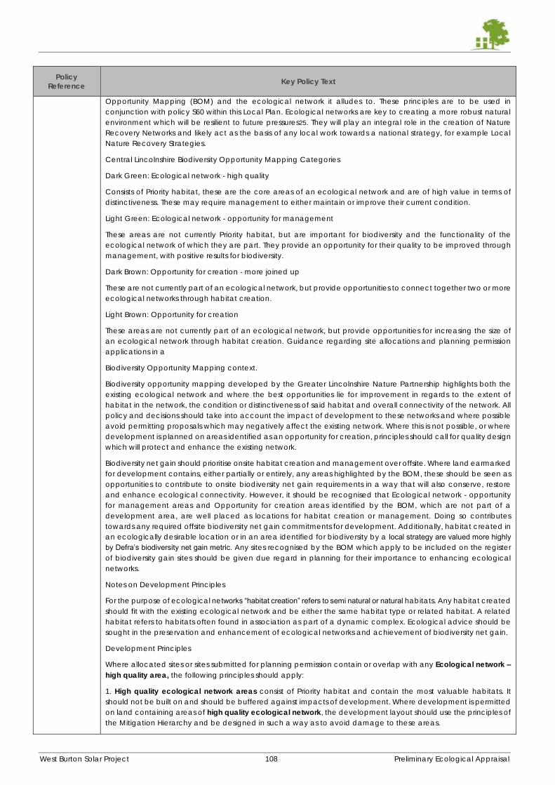
West Burton Solar Project 108 Preliminary Ecological Appraisal
Policy
Reference Key Policy Text
Opportunity Mapping (BOM) and the ecological network it alludes to. These principles are to be used in
conjunction with policy S60 within this Local Plan. Ecological networks are key to creating a more robust natural
environment which will be resilient to future pressures25. They will play an integral role in the creation of Nature
Recovery Networks and likely act as the basis of any local work towards a national strategy, for example Local
Nature Recovery Strategies.
Central Lincolnshire Biodiversity Opportunity Mapping Categories
Dark Green: Ecological network - high quality
Consists of Priority habitat, these are the core areas of an ecological network and are of high value in terms of
distinctiveness. These may require management to either maintain or improve their current condition.
Light Green: Ecological network - opportunity for management
These areas are not currently Priority habitat, but are important for biodiversity and the functionality of the
ecological network of which they are part. They provide an opportunity for their quality to be improved through
management, with positive results for biodiversity.
Dark Brown: Opportunity for creation - more joined up
These are not currently part of an ecological network, but provide opportunities to connect together two or more
ecological networks through habitat creation.
Light Brown: Opportunity for creation
These areas are not currently part of an ecological network, but provide opportunities for increasing the size of
an ecological network through habitat creation. Guidance regarding site allocations and planning permission
applications in a
Biodiversity Opportunity Mapping context.
Biodiversity opportunity mapping developed by the Greater Lincolnshire Nature Partnership highlights both the
existing ecological network and where the best opportunities lie for improvement in regards to the extent of
habitat in the network, the condition or distinctiveness of said habitat and overall connectivity of the network. All
policy and decisions should take into account the impact of development to these networks and where possible
avoid permitting proposals which may negatively affect the existing network. Where this is not possible, or where
development is planned on areas identified as an opportunity for creation, principles should call for quality design
which will protect and enhance the existing network.
Biodiversity net gain should prioritise onsite habitat creation and management over offsite. Where land earmarked
for development contains, either partially or entirely, any areas highlighted by the BOM, these should be seen as
opportunities to contribute to onsite biodiversity net gain requirements in a way that will also conserve, restore
and enhance ecological connectivity. However, it should be recognised that Ecological network - opportunity
for management areas and Opportunity for creation areas identified by the BOM, which are not part of a
development area, are well placed as locations for habitat creation or management. Doing so contributes
towards any required offsite biodiversity net gain commitments for development. Additionally, habitat created in
an ecologically desirable location or in an area identified for biodiversity by a local strategy are valued more highly by Defra’s biodiversity net gain metric. Any sites recognised by the BOM which apply to be included on the register
of biodiversity gain sites should be given due regard in planning for their importance to enhancing ecological
networks.
Notes on Development Principles
For the purpose of ecological networks “habitat creation” refers to semi natural or natural habitats. Any habitat created
should fit with the existing ecological network and be either the same habitat type or related habitat. A related
habitat refers to habitats often found in association as part of a dynamic complex. Ecological advice should be
sought in the preservation and enhancement of ecological networks and achievement of biodiversity net gain.
Development Principles
Where allocated sites or sites submitted for planning permission contain or overlap with any Ecological network – high quality area, the following principles should apply:
1. High quality ecological network areas consist of Priority habitat and contain the most valuable habitats. It
should not be built on and should be buffered against impacts of development. Where development is permitted
on land containing areas of high quality ecological network, the development layout should use the principles of
the Mitigation Hierarchy and be designed in such a way as to avoid damage to these areas.
West Burton Solar Project 109 Preliminary Ecological Appraisal
Policy
Reference Key Policy Text
2. High quality ecological network areas should be recognised as a potential opportunity to achieve biodiversity
net gain requirements by improving condition through sensitive management. Where allocated sites or sites
submitted for planning permission contain or overlap with any
Ecological network – opportunity for management area, the following development principles should apply:
1. Proposals should avoid development on Ecological network – opportunity for management areas where
possible.
2. Where this is not possible, the development layout should ensure that connectivity of the network is maintained.
This can be achieved through quality design, for example by leaving strategically important habitat in place to
create wildlife corridors or the use of green/brown roofing to act as stepping stones between larger areas of
habitat; or through the effective creation of new habitat as part of a landscaping scheme which allows for the
migration and dispersal of species.
3. Proposals should fulfil onsite net gain requirements through creation and sensitive management of habitats, in
a way that will enhance the ecological network either by ensuring connectivity or improving condition.
Where allocated sites or sites submitted for planning permission contain or overlap with any mapped Opportunity
for creation areas, the following development principles should apply:
1. Where development takes place on Opportunity for creation areas, applications should include information
clearly demonstrating how opportunities to maintain or enhance the ecological network (in regards to the extent
of habitat in the network, the condition or distinctiveness of said habitat) and overall connectivity in the network,
have or will be taken. It should include aspects of quality design; for example, by leaving strategically important
habitat in place where possible to create wildlife corridors or the use of green/brown roofing to act as stepping
stones between larger areas of habitat. It should also take any opportunities for effective habitat creation as part
of a landscaping scheme which ensures connectivity between habitats for the species which utilise them.
2. Proposals should prioritise any Opportunity for creation areas within the development site for habitat creation.
This will ensure that requirements for both biodiversity net gain and the enhancement of ecological networks are
achieved in an effective way. Habitat creation onsite should maximise the potential for the ecological network
in regards to: the extent of habitat in the network, the condition or distinctiveness of said habitat and the overall
connectivity of the network. Additionally, habitat created onsite in an ecologically desirable location or in an
area identified by a local strategy, are valued more highly by Defra’s biodiversity net gain metric.
Policy S65:
Trees,
Woodland and
Hedgerows
Development proposals should be prepared based on the overriding principle that:
the existing tree and woodland cover is maintained, improved and expanded; and
opportunities for expanding woodland are actively considered, and implemented where practical and
appropriate to do so.
Existing Trees and Woodland
Planning permission will only be granted if the proposal provides evidence that it has been subject to adequate
consideration of the impact of the development on any existing trees and woodland found on-site (and off-site,
if there are any trees near the site, with ‘near’ defined as the distance comprising 12 times the stem diameter of
the off-site tree). If any trees exist on or near the development site, ‘adequate consideration’ is likely to mean the
completion of a British Standard 5837 Tree Survey and, if applicable, an Arboricultural Method Statement.
Where the proposal will result in the loss or deterioration of:
a) ancient woodland; and/or
b) the loss of aged or veteran trees found outside ancient woodland,
permission will be refused, unless and on an exceptional basis the need for, and benefits of, the development in
that location clearly outweigh the loss.
Where the proposal will result in the loss or deterioration of a tree protected by a Tree Preservation Order or a tree
within a Conservation Area, then permission will be refused unless:
c) there is no net loss of amenity value which arises as a result of the development; or
d) the need for, and benefits of, the development in that location clearly outweigh the loss.
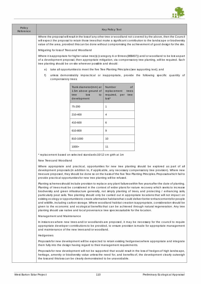
West Burton Solar Project 110 Preliminary Ecological Appraisal
Policy
Reference Key Policy Text
Where the proposal will result in the loss of any other tree or woodland not covered by the above, then the Council
will expect the proposal to retain those trees that make a significant contribution to the landscape or biodiversity
value of the area, provided this can be done without compromising the achievement of good design for the site.
Mitigating for loss of Trees and Woodland
Where it is appropriate for higher value tree(s) (category A or B trees (BS5837)) and/or woodland to be lost as part
of a development proposal, then appropriate mitigation, via compensatory tree planting, will be required. Such
tree planting should be on-site wherever possible and should:
e) take all opportunities to meet the five Tree Planting Principles (see supporting text); and
f) unless demonstrably impractical or inappropriate, provide the following specific quantity of
compensatory trees:
Trunk diameter(mm) at
1.5m above ground of
tree lost to
development
Number of
replacement trees
required, per tree
lost*
75-200 1
210-400 4
410-600 6
610-800 9
810-1000 10
1000+ 11
* replacement based on selected standards 10/12 cm girth at 1m
New Trees and Woodland
Where appropriate and practical, opportunities for new tree planting should be explored as part of all
development proposals (in addition to, if applicable, any necessary compensatory tree provision). Where new
trees are proposed, they should be done so on the basis of the five Tree Planting Principles. Proposals which fail to
provide practical opportunities for new tree planting will be refused.
Planting schemes should include provision to replace any plant failures within five years after the date of planting.
Planting of trees must be considered in the context of wider plans for nature recovery which seeks to increase
biodiversity and green infrastructure generally, not simply planting of trees, and protecting / enhancing soils,
particularly peat soils. Tree planting should only be carried out in appropriate locations that will not impact on
existing ecology or opportunities to create alternative habitats that could deliver better enhancements for people
and wildlife, including carbon storage. Where woodland habitat creation is appropriate, consideration should be
given to the economic and ecological benefits that can be achieved through natural regeneration. Any tree
planting should use native and local provenance tree species suitable for the location.
Management and Maintenance
In instances where new trees and/or woodlands are proposed, it may be necessary for the council to require
appropriate developer contributions to be provided, to ensure provision is made for appropriate management
and maintenance of the new trees and/or woodland.
Hedgerows
Proposals for new development will be expected to retain existing hedgerows where appropriate and integrate
them fully into the design having regard to their management requirements.
Proposals for new development will not be supported that would result in the loss of hedges of high landscape,
heritage, amenity or biodiversity value unless the need for, and benefits of, the development clearly outweigh
the loss and this loss can be clearly demonstrated to be unavoidable.
West Burton Solar Project 111 Preliminary Ecological Appraisal
Policy
Reference Key Policy Text
Development requiring the loss of a hedgerow protected under The Hedgerow Regulations will only be supported
where it would allow for a substantially improved overall approach to the design and landscaping of the
development that would outweigh the loss of the hedgerow. Where any hedges are lost, suitable replacement
planting or restoration of existing hedges, will be required within the
West Burton Solar Project 112 Preliminary Ecological Appraisal
APPENDIX I – PHASE 1 HABITATS MAPS
A3 maps supplied as a separate volume:
West Burton 1
West Burton 2
West Burton 3
West Burton 4

Clarkson and Woods Ltd.Overbrook Business Centre,Poolbridge Road, Blackford,Somerset BS28 4PA
t: 01934 712500e: [email protected]
www.clarksonwoods.co.uk

West Burton Solar Project: EIA Scoping Report – AppendicesJanuary 2022
8.2 Extended Phase 1 Habitat Survey Maps
Project
Date25/08/2021
Scale
Title
Red line boundary - approx. loca on
Target note
Arable
Tall ruderal vegeta on
Poor semi-improved grassland
Rich semi-improved grassland
Bare ground
Pond
Dry ditch
Wet ditch
Intact species poor hedgerow
Intact species poor hedgerow with trees
Key:
West Burton 1
Phase 1 Habitat Survey Map
Please note the field margins are not all fullyvisible at this scale. They include a variety ofspecies rich and species poor semi-improvedgrassland with some ruderal or scrubencroachment.
Project
Date19/08/2021
Title
West Burton 2- Ingleby
Phase 1 Habitat Survey Map
Red line boundary - approx. location
Target note
In-field broadleaved tree
Dry ditch
Wet ditch
Fence
Bank of semi-improved grass
Intact species rich hedgerow
Intact species poor hedgerow
Defunct species rich hedgerow
Defunct species poor hedgerowIntact species rich hedgerowwith trees
Intact species poor hedgerowwith treesDefunct species rich hedgerowwith treesDefunct species poor hedgerowwith treesLine of trees
Arable
Poor semi-improved grassland
Bare ground
Semi-natural broadleaved woodland
Wild bird cover
Pond
Key:
Please note the field margins are not visibleat this scale. They include a variety of speciesrich and species poor semi-improvedgrassland with some ruderal or scrubencroachment.
Scale
Project
Date
26/08/2021
Scale
Title
Red line boundary - approx. location
Target note
In-field broadleaved tree
Dry ditch
Wet ditch
Fence
Bank of semi-improved grass
Intact species rich hedgerow
Intact species poor hedgerow
Defunct species rich hedgerow
Defunct species poor hedgerow
Intact species rich hedgerowwith treesIntact species poor hedgerowwith treesDefunct species rich hedgerowwith treesDefunct species poor hedgerowwith trees
Line of trees
Arable
Poor semi-improved grassland
Rich semi-improved grassland
Semi-natural broadleaved woodland
Dense scrub
Scattered scrub
Tall ruderal vegeation
Wild bird cover
Bare ground
Pond
Key:
West Burton 3
Phase 1 Habitat Survey Map
Please note the field margins are not all fullyvisible at this scale. They include a variety ofspecies rich and species poor semi-improvedgrassland with some ruderal or scrubencroachment.
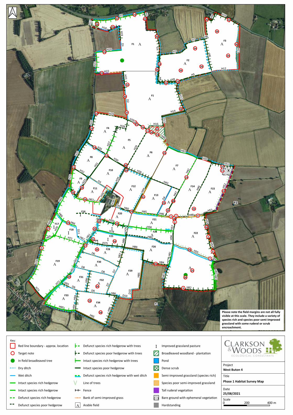
Project
Date25/08/2021
Scale
Title
Red line boundary - approx. loca on
Target note
In field broadleaved tree
Dry ditch
Wet ditch
Intact species rich hedgerow
Intact species rich hedgerow
Defunct species rich hedgerow
Defunct species poor hedgerow
Defunct species rich hedgerow with trees
Defunct species poor hedgerow with trees
Intact species rich hedgerow with trees
Intact species poor hedgerow
Defunct species rich hedgerow with wet ditch
Line of trees
Fence
Bank of semi-improved grass
Arable field
Improved grassland pasture
Broadleaved woodland - planta on
Pond
Dense scrub
Semi-improved grassland (species rich)
Species poor semi-improved grassland
Tall ruderal vegeta on
Bare ground with ephemeral vegeta on
Hardstanding
Key:
West Buton 4
Phase 1 Habitat Survey Map
Please note the field margins are not all fullyvisible at this scale. They include a variety ofspecies rich and species poor semi-improvedgrassland with some ruderal or scrubencroachment.
EIA Scoping Report Appendices to Chapter 9:
Hydrology, Flood Risk and Drainage
January 2022

West Burton Solar Project: EIA Scoping Report – Appendices January 2022
Contents
Appendix 9.1 Flood Risk Screening Report – West Burton 1 175
Appendix 9.2 Flood Risk Screening Report – West Burton 2 189
Appendix 9.3 Flood Risk Screening Report – West Burton 3 203
Appendix 9.4 Flood Risk Screening Report – West Burton 4 217

West Burton Solar Project: EIA Scoping Report – AppendicesJanuary 2022
9.1 Flood Risk Screening Report – West Burton 1
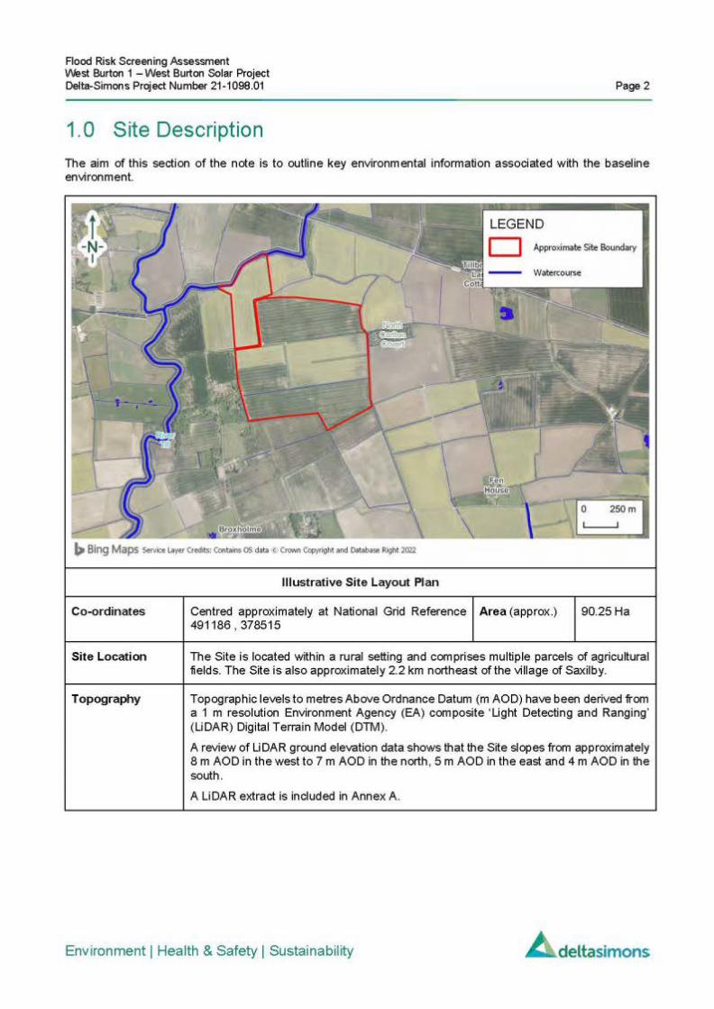
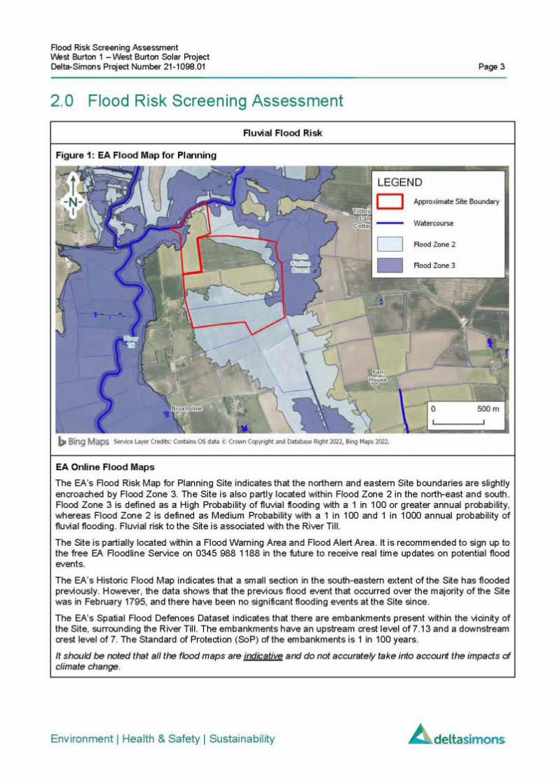
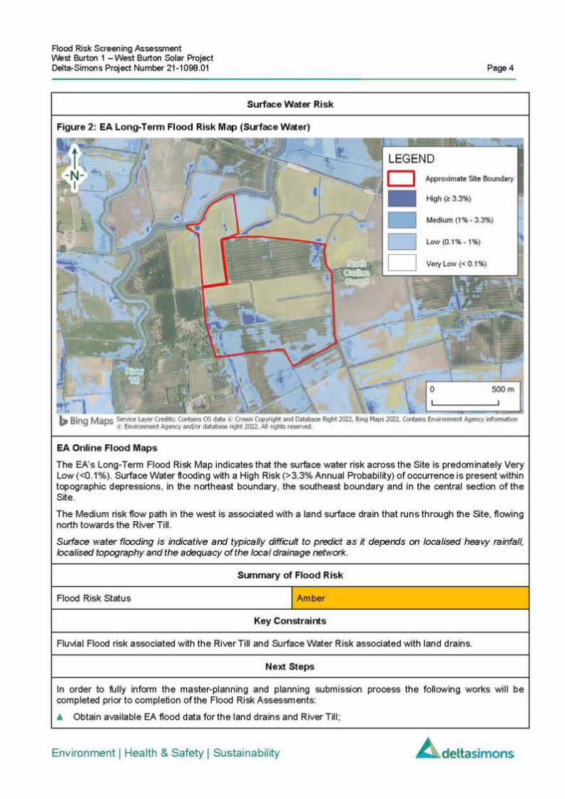


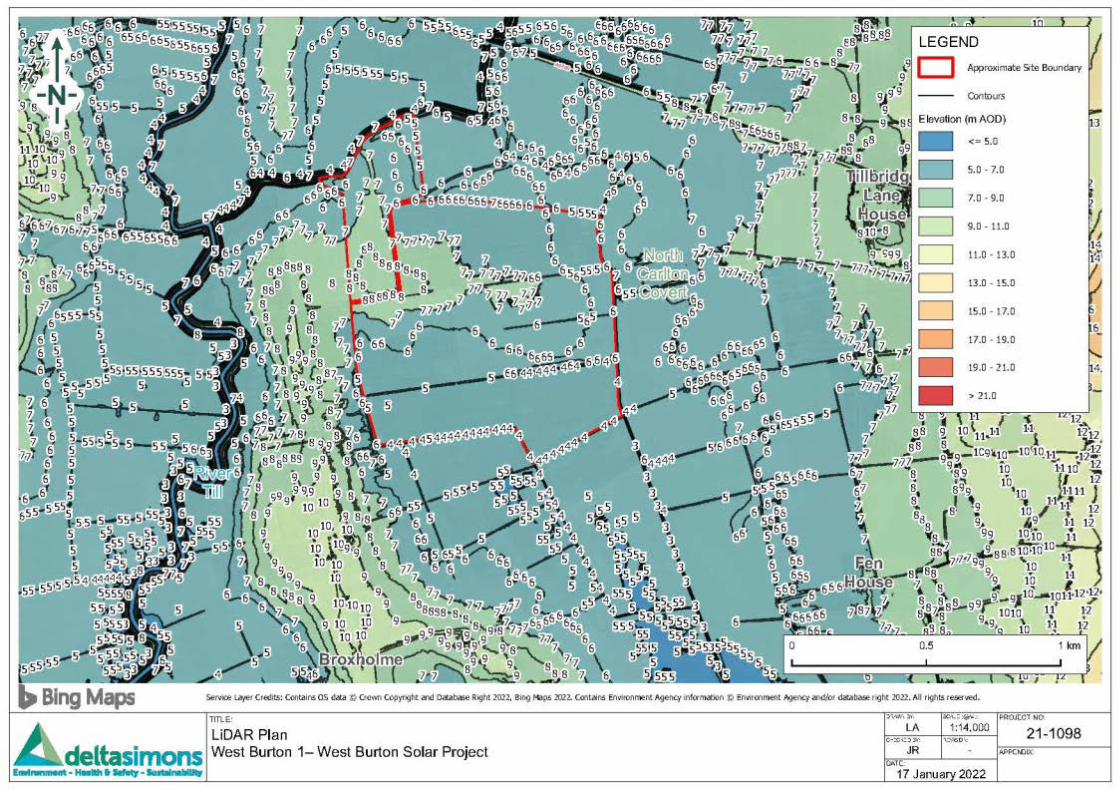

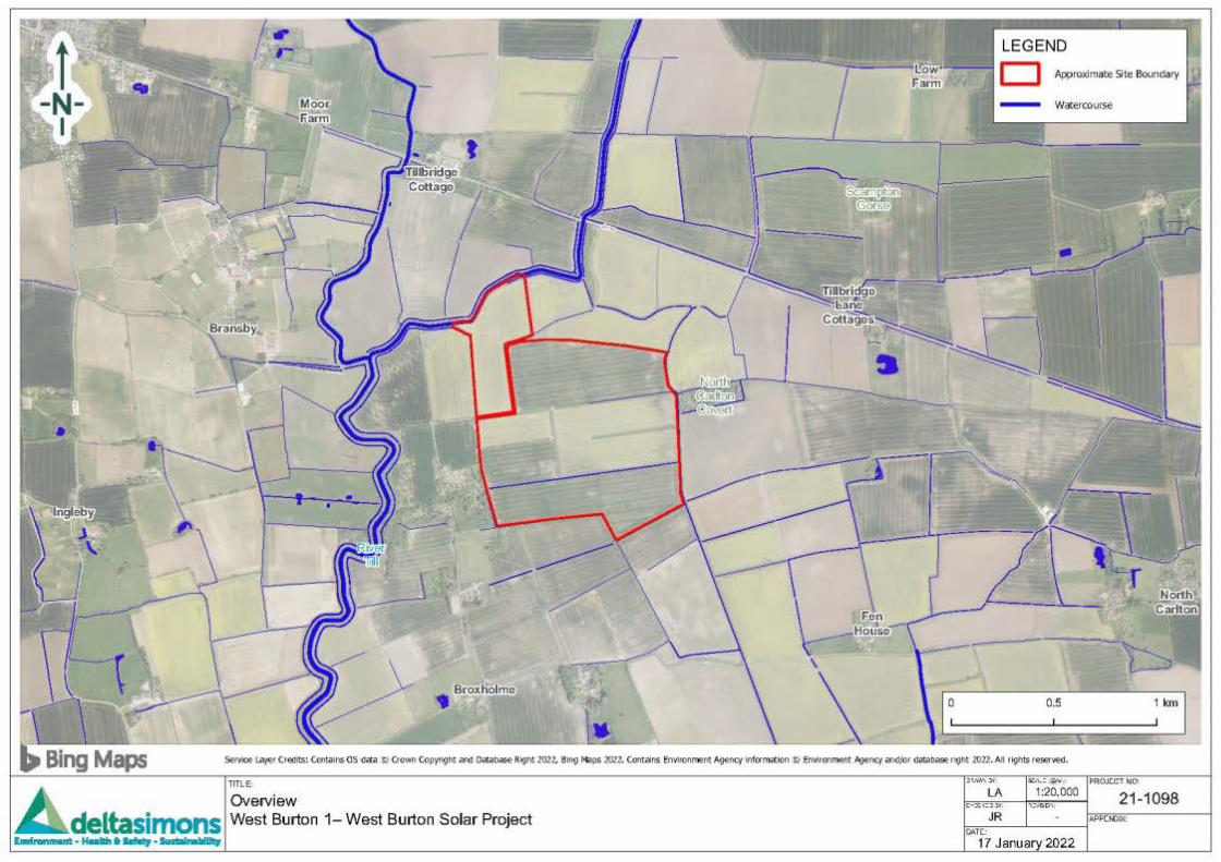

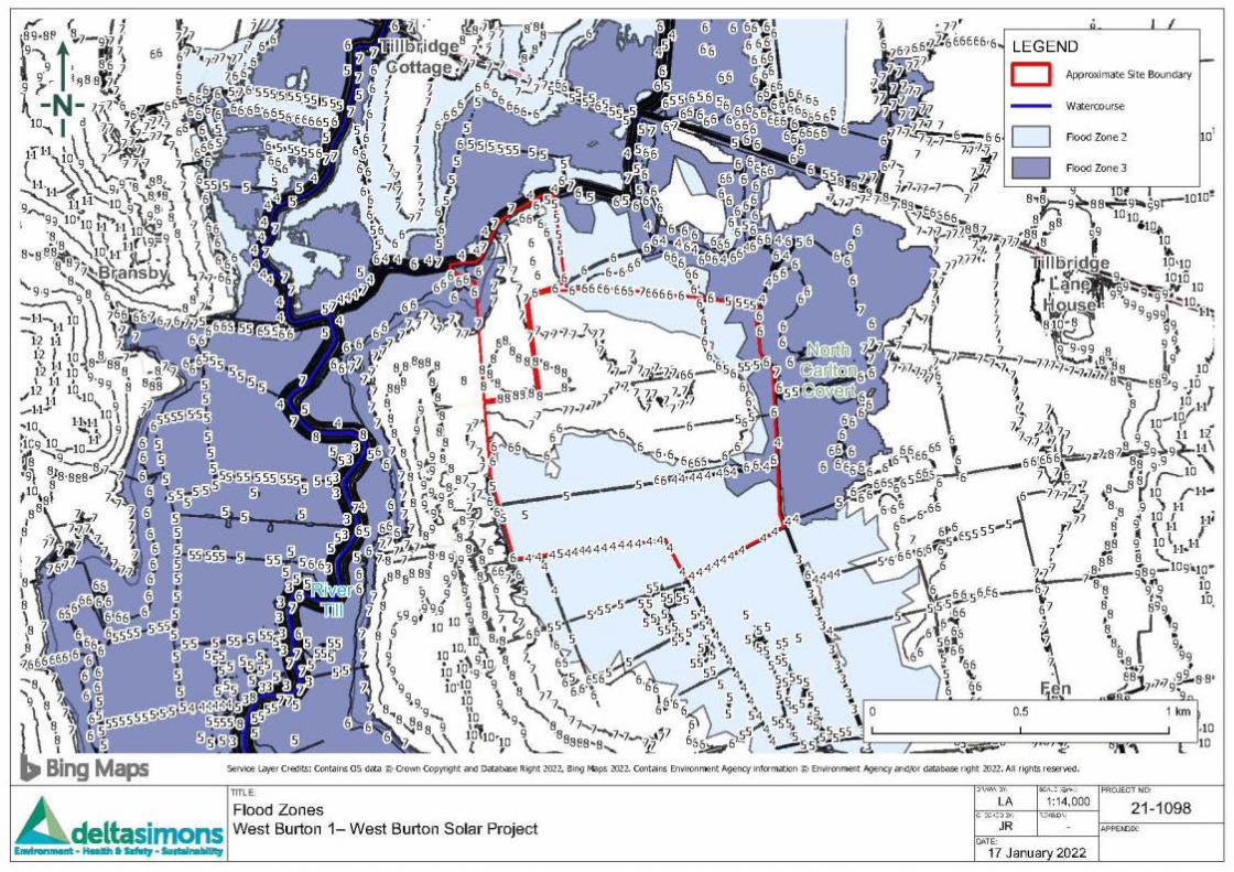

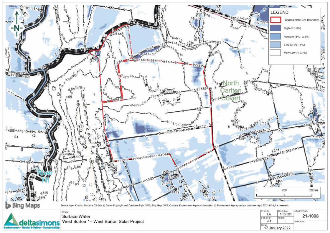

West Burton Solar Project: EIA Scoping Report – AppendicesJanuary 2022
9.2 Flood Risk Screening Report – West Burton 2
Flood Risk Screening AssessmentWest Burton 2 – West Burton Solar ProjectDelta-Simons Project Number 21-1098.01 Page 1
Environment | Health & Safety | Sustainability
Appendix – Flood Risk Screening Assessment West Burton 2 – West Burton Solar ProjectPresented to Island Green PowerIssued: January 2022
Delta-Simons Project No. 21-1098.01
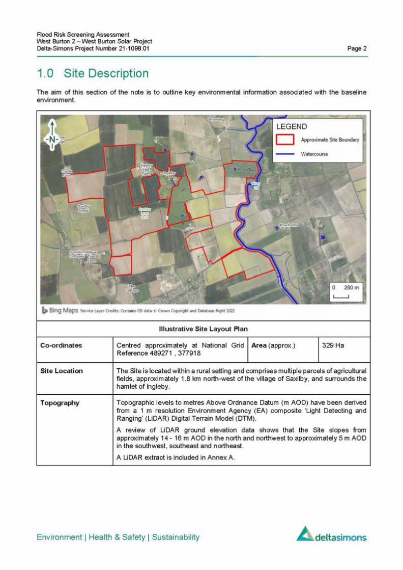
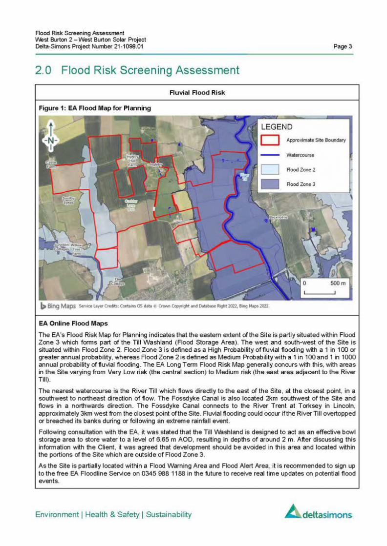
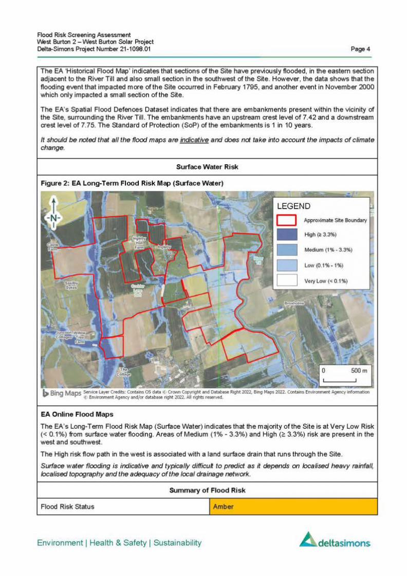
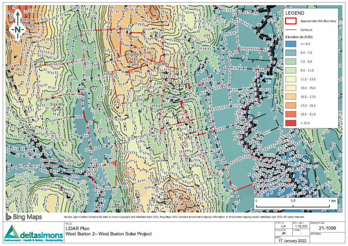

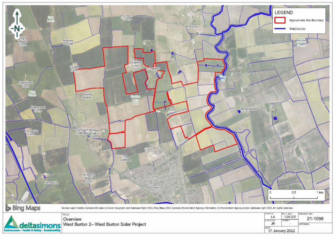

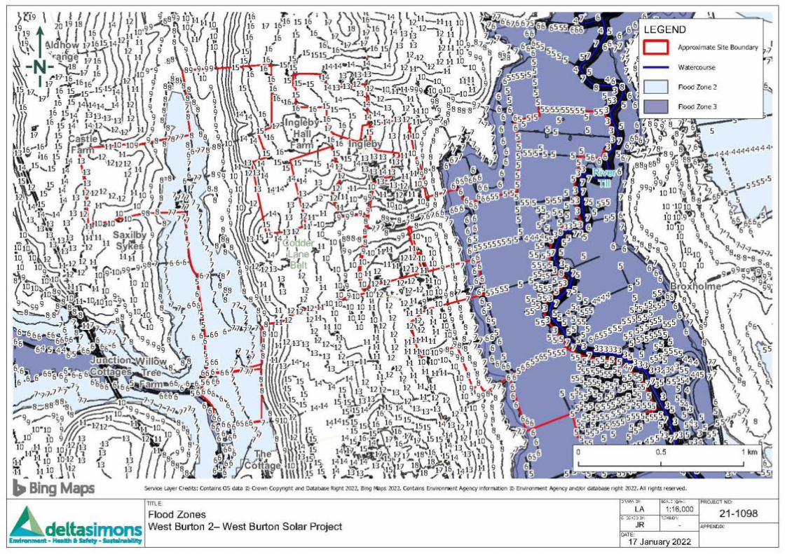

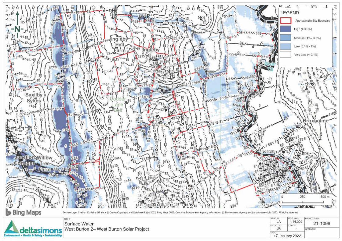

West Burton Solar Project: EIA Scoping Report – AppendicesJanuary 2022
9.3 Flood Risk Screening Report – West Burton 3
Flood Risk Screening AssessmentWest Burton 3 – West Burton Solar ProjectDelta-Simons Project Number 21-1098.01 Page 1
Environment | Health & Safety | Sustainability
Appendix J – Flood Risk Screening AssessmentWest Burton 3 – West Burton Solar ProjectPresented to Island Green PowerIssued: January 2022Delta-Simons Project No. 21-1098.01
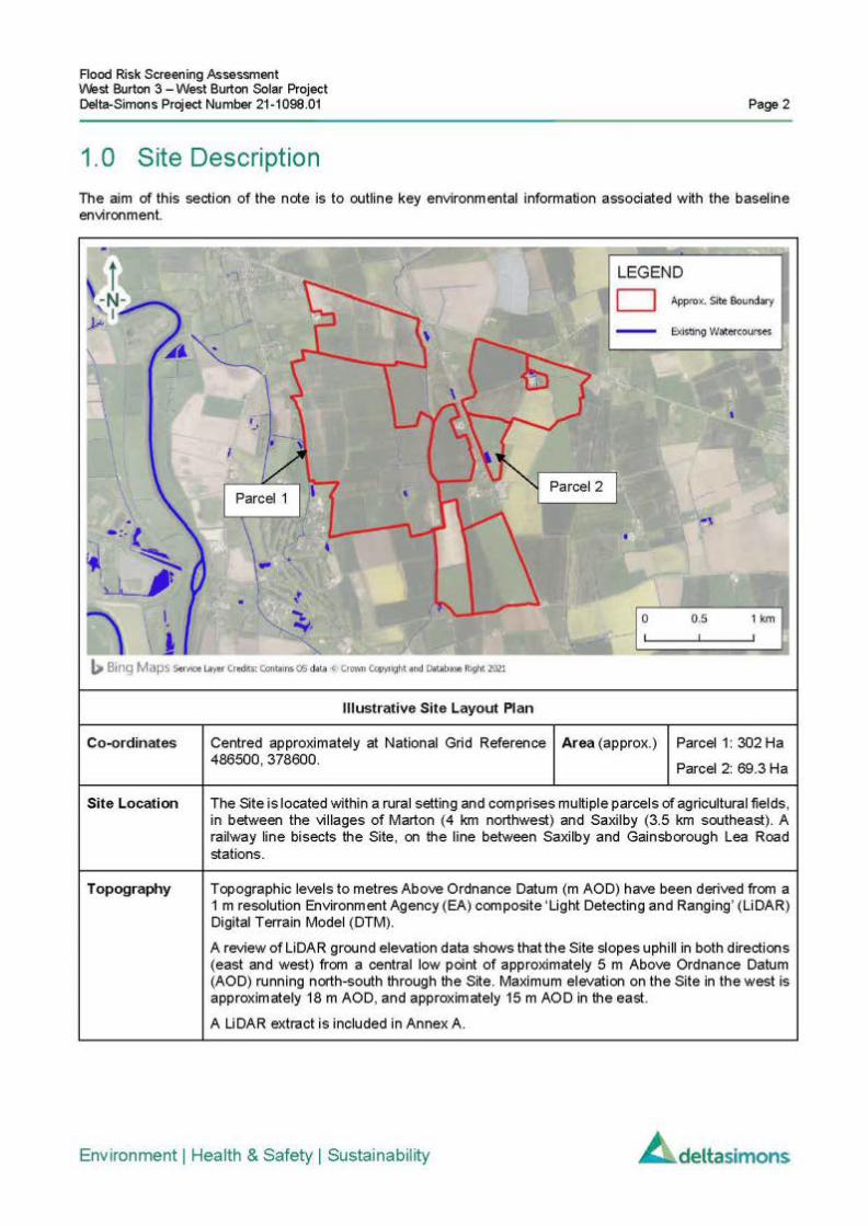
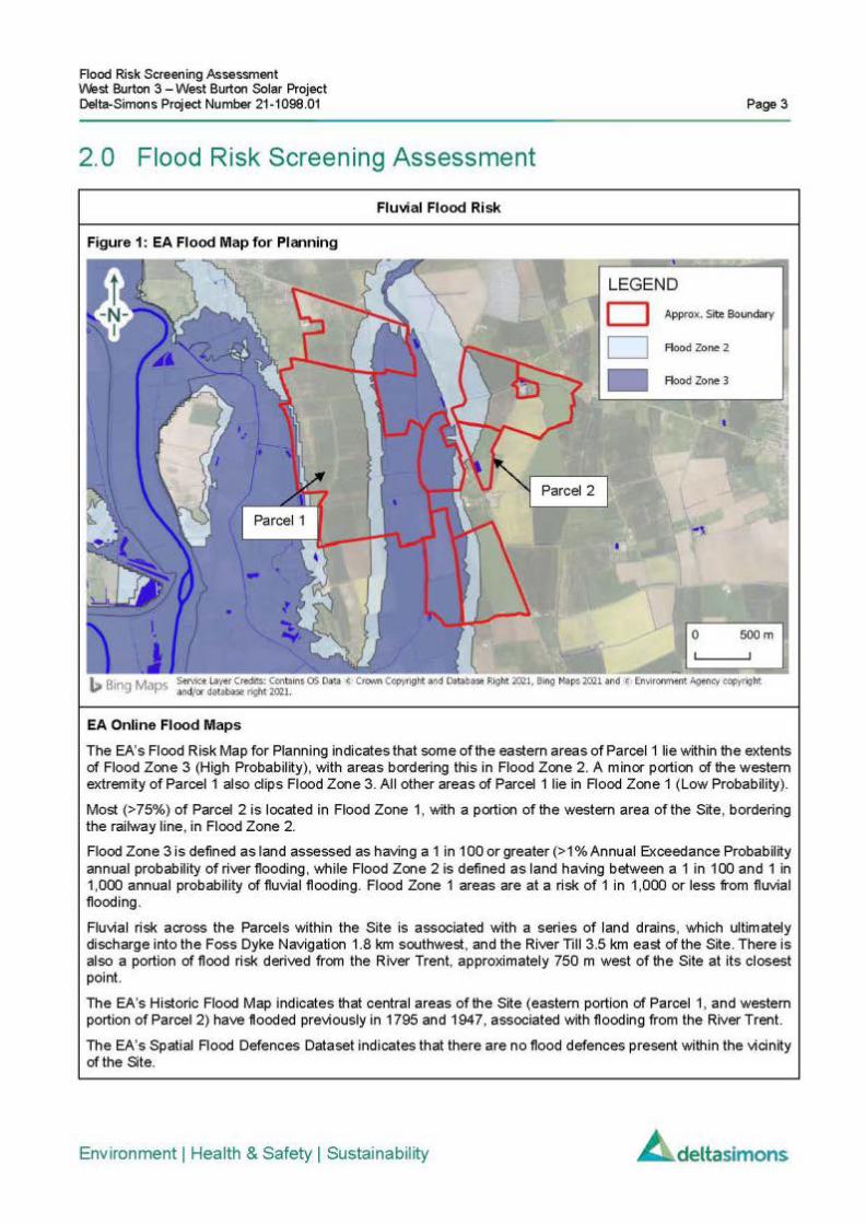
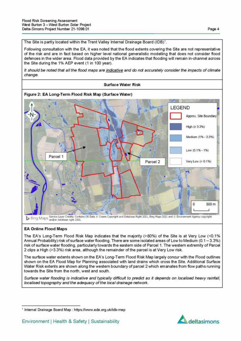
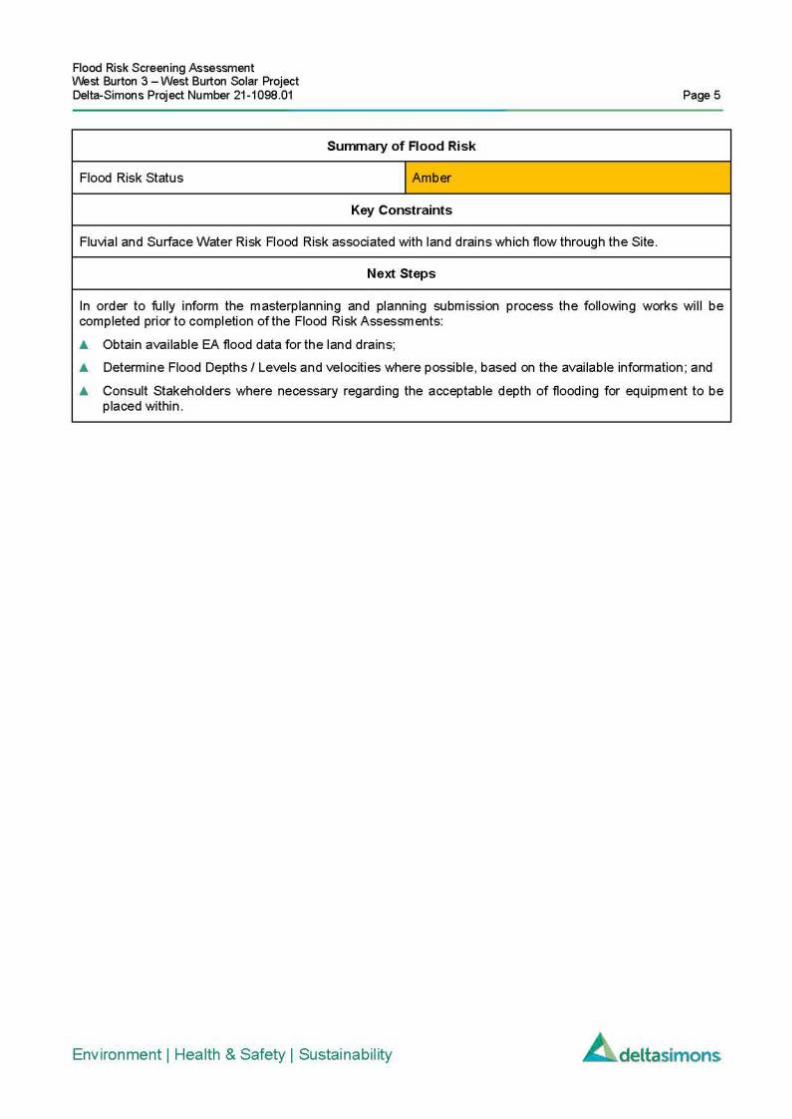

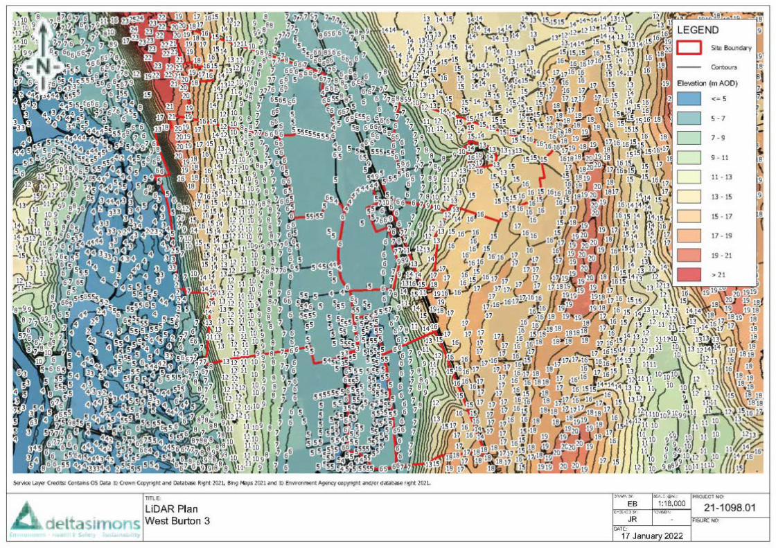

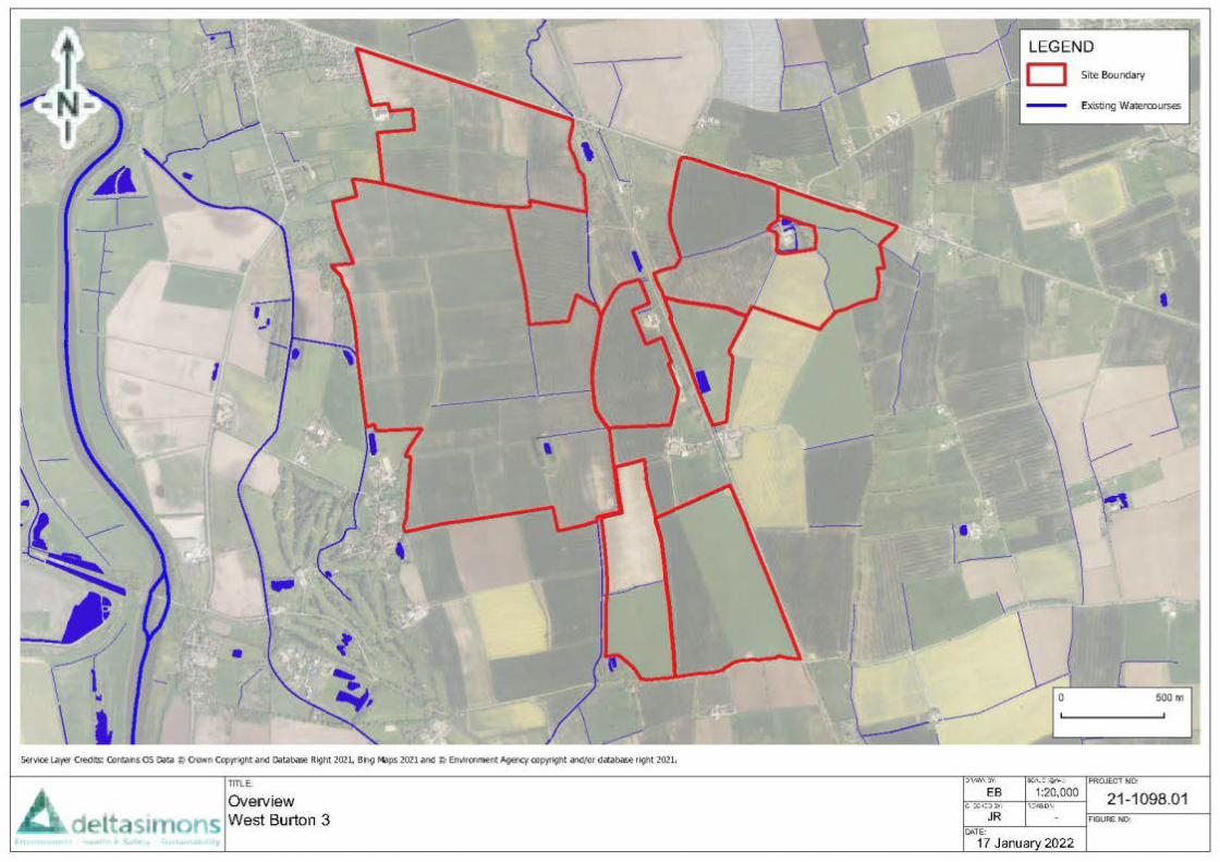


West Burton Solar Project: EIA Scoping Report – AppendicesJanuary 2022
9.4 Flood Risk Screening Report – West Burton 4
Flood Risk Screening AssessmentWest Burton 4 – West Burton Solar ProjectDelta-Simons Project Number 21-1098.01 Page 1
Environment | Health & Safety | Sustainability
Appendix K - Flood Risk Screening AssessmentWest Burton 4 – West Burton Solar ProjectPresented to Island Green PowerIssued: January 2022Delta-Simons Project No. 21-1098.01