Embed Size (px)
Citation preview
United States Department of t..griculture
,':orest Service
Engineering Staff
Washington, D.C.
Engineering Field Notes Engineering Technical Information System
Regional Engineers' Meeting in WO
New, Improved Chain Saw Chaps
Volume 16 February-March
1984
Computerized Listing of Roads on the Five Year Timber Sale Action Plan
Use of Geotextiles as Bridge Paving Under layment
Big Lightning Creek Flood Repairs
GSA's Consolidated List of Debarred, Suspended, & Ineligible Contractors
Laws Governing Rights-of-Way Across Arizona Lands
Awards for 1983 Field Notes Articles

e Engineering Field Notes Administrative Distribution
• Professional Development
• Management
• Data Retrieval
This publication is an administrative document that was developed for the guidance of employees of the Forest Ser-vice- U.S. Department of Agriculture, its contractors, and its cooperating Federal and State Government Agencies. The text in the publication represents the personal opinions of the respective authors. This information has not been approved for distribution to the public, and must not be construed as recom-mended or approved policy, procedures, or mandatory instruc-tions, except by Forest Service Manual references.
The Forest Service- U.S. Department of Agriculture assumes no responsibility for the interpretation or application of this in-formation by other than its own employees. The use of trade names and identification of firms or corporations is for the con-venience of the reader; such use does not constitute an official endorsement or approval by the United States Government of any product or service to the exclusion of others that may be suitable.
This information is the sole property of the Government, with unlimited rights in the usage thereof, and cannot be copyrighted by private parties.
Please direct any comments or recommendations about this publication to the following address:
FOREST SERVICE -- USDA Engineering Staff - Washington Office Att: G.L. Rome, Editor
D.J. Carroll, Editorial Assistant P.O. Box 2417 - Washington, D.C. 20013 Telephone: Area Code 703/FTS-235-8198

OBJECTIVES
MEETING OUR GOALS
Regional Engineers' Meeting In WO
The Regional Directors of Engineering and a few guests. Left to right: (standing) NFS Associate Deputy Chief Gary Cargill; Sterling Wilcox (R-4); "Jack" Frost (R-3); Milford Jones (R-lO); Dick Deleisseques (R-5); Peg Daniels (secretary to Director of Engineering); Ken Rikard (R-8); Dave Trask (R-6); Floyd Curfman (R-9); (kneeling) Beryl Johnston (R-I); Walt FUren (AD/C&S); Stan Bean (AD/Oper); Sotero Muniz (Director); Hal Strickland (AD/TI); Don Loff (R-2).
The Regional Engineers' Meeting opened on November 1, 1983, in Washington, D.C. In addition to all the Regional Engineers, attendees were Director of Engineering Sotero Muniz, the three WO Assistant Directors of Engineering, NFS Associate Deputy Chief Gary Cargill, NFS Deputy Chief R. M. Housley, and FS Chief R. Max Peterson.
The Director of Engineering set forth the two main objectives at the opening session: (1) an open exchange of information, and (2) an understanding of the important role that uniformity plays in applying policy and standards.
After the review of some key points from last year's Regional Engineers' Meeting and a session on the
1
UNIFORM REGIONAL PERFORMANCE
COMMUNICATION
PEOPLE ARE the KEY
Washington Office Responsibilities Assessment, Chief Peterson remarked that Engineering had done very well--in terms of getting its job done--Iast year. He said that Engineering had been able to reduce its costs significantly, while we continued to meet heavy demands; but he stressed the importance of reducing costs even further through the use of value analysis. NFS Deputy Chief Housley continued on that theme, adding that because of Engineering's management team in the field, as well as in the Washington Office, we are in a good position to finish the job of tightening up--while still doing our basic job of resource management.
In addition to the discussion of special topics (the funding processes for the Forest Highway program and for Transportation System Development and Operation; Engineering Skill Needs to the Year 2000; Efforts of the productivity Improvement Team (PIT); and more), the Regional Engineers spent one session on the measurement of Regional performance and the goal of managing toward more uniform performance across all Engineering functions and Regions. Activities receiving the most consideration (using a point system on more than 40 Engineering areas represented in the FSM) were as follows:
( I ) Roads (Safety, Design, Construction)
(2) Buildings and Related Facilities
( 3 ) Geometronics
( 4 ) Transportation Planning and Analysis
( 5 ) Traffic Management Operations
In closing the meeting on November 3, Sotero Muniz stressed the benefits that the Forest Service can derive from working relationships that are based on open and honest communication. He pointed out that Engineering is making good progress in meeting its mission and pursuing its goals and objectives; he emphasized the importance of technology transfer-and the fact that we must learn to manage it even better than we do today.
sotero reiterated his belief that our people are our most important resource, and that effective training is a' key opportunity both to improve our performance on the job and to develop our employees professionally.
2
THE NEED for IMPROVEMENT
TESTING NEW MATERIALS
DEpIGN FEATURES
New, Improved Chain Saw Chaps
Stuart E. Putnam Equipment Specialist Missoula Equipment Development Center Missoula, Montana
For many years, the Forest Service and other government agencies have used chain saw chaps designed at the Missoula Equipment Development Center (MEDC). MEDC's initial design work, completed in 1965, was based on pads tested by the Quebec Pulp and Paper Association and the American Pulpwood Association.
Basic pad materials have remained essentially unchanged since the mid-1960's, while improved chain saw and chain cutter designs have reduced the pads' effectiveness. Forest Service field units recognized this problem and requested chaps that provided better protection and that were more comfortable.
A questionnaire sent to field units provided the ba~is for MEDC's redesign work. MEDC redesigned its chain saw pad tester to accommodate the latest improvements in chain saws and chain cutters, and it evaluated a variety of new materials for weight, cost, and degree of protection. A value analysis method combining these three factors indicated the best pad materials for Forest Service chaps.
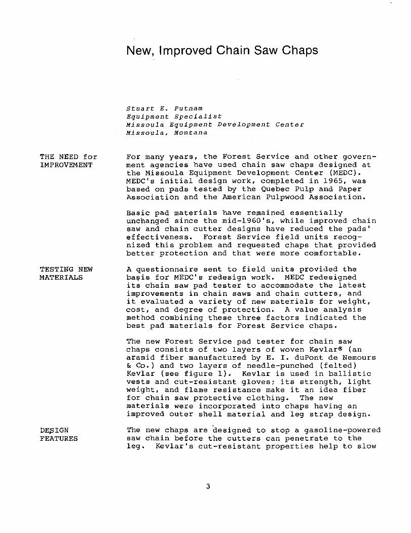
The new Forest Service pad tester for chain saw chaps consists of two layers of woven Kevlar® (an aramid fiber manufactured by E. I. duPont de Nemours & Co.) and two layers of needle-punched (felted) Kevlar (see figure 1). Kevlar is used in ballistic vests and cut-resistant glovesi its strength, light weight, and flame resistance make it an idea fiber for chain saw protective clothing. The new materials were incorporated into chaps having an improved outer shell material and leg strap design.
The new chaps are designed to stop a gasoline-powered saw chain before the cutters can penetrate to the leg. Kevlar's cut-resistant properties help to slow
3
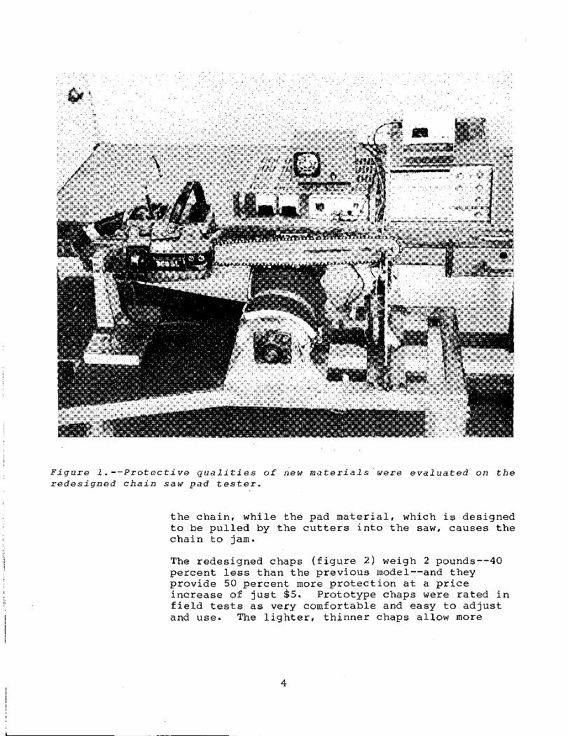
Figure l.--Protective qualities of new materials were evaluated on the redesigned chain saw pad tester.
the chain, while the pad material, which is designed to be pulled by the cutters into the saw, causes the chain to jam.
The redesigned chaps (figure 2) weigh 2 pounds--40 percent less than the previous model--and they provide 50 percent more protection at a price increase of just $5. Prototype chaps were rated in field tests as very comfortable and easy to adjust and use. The lighter, thinner chaps allow more
4
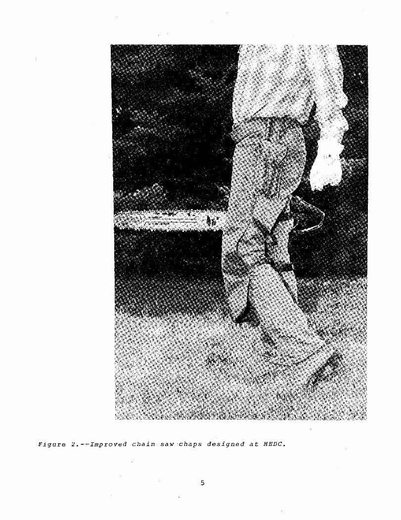
Figure 2.--Improved chain saw chaps designed at MEDC.
5
AVAILABILITY & INFORMATION
freedom of movement, yet stay in place better than present chaps.
The new chaps will be available from the General Services Administration when its present stock of chaps is depleted. For a detailed report discussing the test methods and how various pad combinations were rated for protection, write to MEDC at the following address:
Missoula Equipment Development Center Fort Missoula Missoula, Montana 59801
6
BACKGROUND
ROAD PLAN & PROGRESS REPORT
Computerized Listing of Roads on the Five Year Timber Sale Action Plan
Allan A. Johnson Supervisory Civil Engineer Nicolet National Forest Region 9
Keeping track of all road projects involved in the Five Year Timber Sale Action Plan can be difficult and time consuming. Yet it is important for planning, programing, budgeting, and scheduling purposes that all road projects be accurately listed and updated. To assist in this process, the Nicolet National Forest developed in 1982 a computerized method of listing all the timber sales on the Five Year Timber Sale Actio~ Plan. This development represented a big step beyond the handwritten or typed listings that were used previously.
The computerized Five Year Timber Sale Action Plan runs on a Texas Instruments TI990 Model 1 Microprocessor and DS990 Modell Floppy Disc Unit. It employs the INFO 990 Program, Version 3.1.4, which was developed by the USDA Forest Service, Data Management Staff, Washington Office.
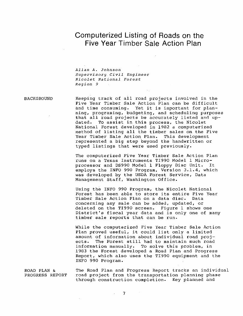
Using the INFO 990 Program, the Nicolet National Forest has been able to store its entire Five Year Timber Sale Action Plan on a data disc. Data concerning any sale can be added, updated, or deleted on the TI990 screen. Figure 1 shows one District's fiscal year data and is only one of many timber sale reports that can be run.
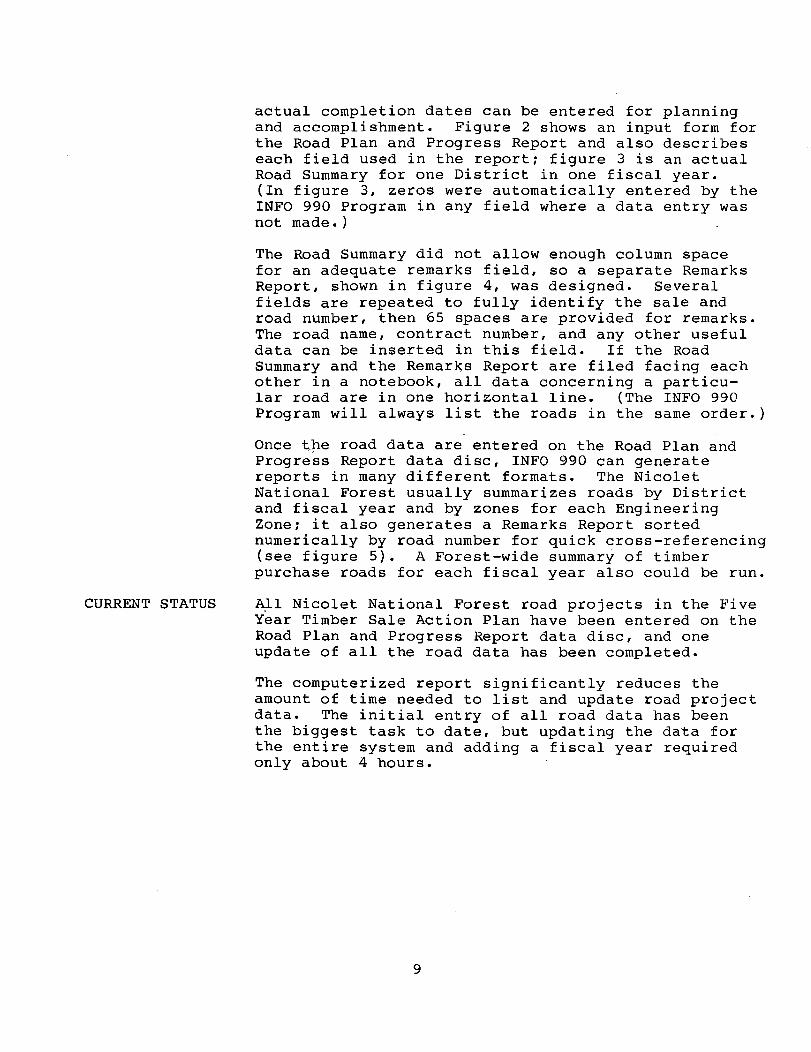
While the computerized Five Year Timber Sale Action Plan proved useful, it could list only a limited amount of information about individual roa,d projects. The Forest still had to maintain much road information manually. To solve this problem, in 1983 the Forest developed a Road Plan and Progress Report, which also uses the TI990 equipment and the INFO 990 Program.
The Road Plan and Progress Report tracks an individual road project from the transportation planning phase through construction completion. Key planned and
7
00
LAl<alOOD 10/03/83 PAGE 1
REPORT 1 A..,.FIVE YEAR TIMBER SALE· ACTION PLAI\ LAKEWOOD RANGER DISTRICT
ROADS & FUNDiNG MILES MILES CASES MILES (MBF) (MSF) (CCF) (CCF) (MSF)
NO. :3ALE NAME FY COMP CON CM REC RM· ROW LLL H. SAl·l S. SPJ~J HF'UlP S:PULF' TOTAL VOLUME ============ -- ---- ._-- == --- == --- ==== ----- ----- -------- --.--- ============
"':tt:'o ... 10_1,_, MCCASLIN BOG :34 61 1.4 TP 0.0 0 0.8 400 50 2200 0 1:::~4:3
359 BIG BEAR 84 119 1.4 TP 0.0 0 ::::.0 ::;:47 20 2296 0 2:~:20
451 BF:OWN SILO f:4 169 1.1 TP 0.0 1 4.0 100 300 2:=:00 5000 5:~::~:7
45~: LITTLE MAlON 84 124 0"") --:. ,,:.. • --I FS 0.0 1 3.3 400 0 2500 0 1';':;::3 455 ADA LOOKOUT :34 102 0.0 0.0 0 6. E: ::::50 0 1400 0 12::::6 451;. RIVERSIDE RD 84 ~.o::;-';;'--' 1.7 iF' 0.0 0 1.3 1'~0
.., . ..., 217"1 14:::2 254:=: I I
457 blUEBERRY MR f:4 105 :3.0 TP 0.0 0 0.0 850 0 5::::00 c· .' 4205 4~,:=: ;::UJEGILL LK. ::;:4 14 0.6 TP 0.0 0 .-. t::"
~'. v 60 0 5:=:0 20 440 459 STEER FARM :=:4 27 2.4 TP 4.0 FS 0 1.5 90 40 11::::8 9~55 1455 4·60 MISC. SMALL 84 0 0.0 -- 0.0 0 0.0 leu=-
'-'~I ::;:00 790 1027 16::=:::::: ------------
13.9 4.0 2 24.2 :3475 7:::::7 21175 :'::~434 2:;:004
Figure l.--A computerized Five Year Timber Sale Action Plan for one District in one fiscal year.
CURRENT STATUS
actual completion dates can be entered for planning and accomplishment. Figure 2 shows an input form for the Road Plan and Progress Report and also describes each field used in the report~ figure 3 is an actual Road Summary for one District in one fiscal year. (In figure 3, zeros were automatically entered by the INFO 990 Program in any field where a data entry was not made.)
The Road Summary did not allow enough column space for an adequate remarks field, so a separate Remarks Report, shown in figure 4, was designed. Several fields are repeated to fully identify the sale and road number, then 65 spaces are provided for remarks. The road name, contract number, and any other useful data can be inserted in this field. If the Road Summary and the Remarks Report are filed facing each other in a notebook, all data concerning a particular road are in one horizontal line. (The INFO 990 Program will always list the roads in the same order.)
Once ~pe road data are entered on the Road Plan and Progress Report data disc, INFO 990 can generate reports in many different formats. The Nicolet National Forest usually summarizes roads by District and fiscal year and by zones for each Engineering Zone~ it also generates a Remarks Report sorted numerically by road number for quick cross-referencing (see figure 5). A Forest-wide summary of timber purchase roads for each fiscal year also could be run.
A~l Nicolet National Forest road projects in the Five Year Timber Sale Action Plan have been entered on the Road Plan and Progress Report data disc, and one update of all the road data has been completed.
The computerized report significantly reduces the amount of time needed to list and update road project data. The initial entry of all road data has been the biggest task to date, but updating the data for the entire system and adding a fiscal year required only about 4 hours.
9
I-' 0
l. 2. 3· 4. 5. 6. 7. 8.
9. 10. 11. 12. 13. 14. 15. 16. 17· 18. 19. 20. 2l. 22. 23.
24.
ROAD PLAN & PROGRESS REPORT
NO. D
COLUMN NO. D
MAX NO. OF SPACES
3 1
FY FY 2 SALE NAME SALE NAME 12 COM - - - - - - - - - - - - COM 3 RD. NO. _ _ _ _ _ _ RD # 6 TTl CM CM 2
LEN LEN 3 TPD TPD 4 - - -- 4 TPR TPR - - --TLD TLD 4 - - --TLA TLA 4 - - --FJ_ FJ 2 SUD SUD 4 - - --SUR SUR 4 - - -- 4 RWD RWD - ---RWR RWR 4 - - --DED DED 4 - - --DER DER 4 - - --PC PC 2 AC AC 2 - -C% . -- C% 3
REMARKS 65
REMARKS
DESCRIPTION Index number Dist.rict Number, 2-E.R. 3-FLO. 4=LK. 5=LA. Fiscal Year of Sale, i.e. 82, 83, 84, etc. Name of Timber Sale, Abbreviate to 12 spaces to fit. Compartment Number, Multi-Compartment Sale, use lowest #. Road No., i.e. 2153, 2153D, etc. List all raods on sale. Type of Project. Enter C or R. C=ConstructionR=Reconstruction. Construction Method. Enter TP for Timber Purchaser Road,
FS for Preroad Length. Enter Road Length to nearest 1/10, i.e. 2.3, 3.6, etc. Transportation Plan Done by Eng., year then mon, i.e. 8302. Transportation Plan Reviewed by Eng. & District, year & mono Tag Dine Completed by Eng., year and mon., i.e. 8410. Tag Line Reviewed and Approved by District, year and mono Form 7700-3 Rec'd and Road Added to Trans.·3ystem Y=Yes NaNo. Planned Survey Due Date, year and mon, i.e. 8312. Date Survey Rec'd in Design Section, year & mono Right of Way Due, year and mon., i.e. 8401. Right of Way Received, year and mono Design Due, i.e. Planned Completion Date, year & mono Design Rec'd, i.e. done, year and mono Planned Cost in M $ to nearest thousand, 1 to 99 M $ Actual Cost of Road, Purchaser Credits or Low Bid Rec'd. % of Construction Completed, 0 to 100. Remarks, if any, abbreviate to "spaces or less.
Figure 2.--Road Plan and Progress Report Input Form.
-------_ ... _-.-.... -------- ------.~-.-.--- ... -- .... ---. .. _ .. -._- -.~.--
"
ROAD PLAN ~ PROGRESS 08/31183 PAGE 2
ROAD SUMMARY (SOUTH ZONE) FOR LAKEWOOD &< LAONA RANGER DISTRICTS
NO. 0 FY SALE NAME COM RD NO. T CM LEN TPD TPR TLD TLA F3 SUD SUR RWD RWR OED DER PC AC C% 10 =_:s=-_=_=-= 11
12
358 4 84 MCCASLIN BOG 61 2070 C TP 1.4 0 0 0 0 y 0 8206 0 '0 8307 8307 21 0 0 359 4 84 BIG BEAR 119 2085 C TP 0.9 0 0 0 0 Y 0 9212 0 0 0 0 0 0 0 35'~ 4 84 BIG BEAR 119 2084 C TP 0.6 0 0 0 0 Y 0 8212 0 0 0 0 0 0 0 451 4 84 BROWN SILO 169 2311A C TP 0.6 0 0 0 0 Y 0 9109 0 0 9306 8306 3 0 0 451 4 84 BROWN SILO Ib9 2b33 C TP 0.5 0 0 0 0 Y 0 8109 0 0 830b 830b :5 0 0 453 4 84 LITTLE MA I ON 124 2245 C FS 0.8 0 0 0 0 Y 0 0 0 0 0 0 15 12 50 453 4 84 LITTLE MAlON 124 2246 C FS 1.2 0 0 0 0 Y 0 0 0 0 0 0 16 17 34 453 4 84 LITTLE MAlON 124 224bA C FS 0.1 0 0 0 0 Y 0 0 0 0 0 0 2 3 17 453 4 84 LITTLE MAlON 124 2245A C FS 0.2 0 0 0 0 y 0 0 0 0 0 0 2 2 71 456 4 84 RIVERS IDE RD 25 2236BA C TP 0.3 0 0 0 0 Y 8307 8306 0 0 0 0 0 0 0 456 4 84 RIVERSIDE RD 25 22368 C TP 1.1 0 0 0 0 y 8307 8305 0 0 0 0 0 0 0 456 4 84 RIVERSIDE RD 25 2236A C TP 0.2 0 0 0 0 Y 8307 8305 0 0 0 0 0 0 0 456 4 84 RIVERSIDE RD 25 2235A C TP 0.1 0 0 0 0 Y 8307 8305 0 0 0 0 0 0 0 457 4 94 BLUEBERRY MR 105 2778A C TP 0.7 0 0 0 0 Y 0 8209 0 0 0 0 0 0 0 457 4 84 BLUEBERRYMR 105 2779 C TP 2.3 0 0 0 0 Y 0 8208 0 0 0 0 0 0 0 458 4 94 BLUEGILL LK 14 C TP O.b 0 0 0 0 8308 0 0 0 0 0 0 0 0 459 4 84 STEER FARM 28 2259B C TP 0 .. 2 0 0 0 0 y 8306 8306 0 0 0 0 0 0 0 459 4 94 STEER FARM 27 2259G C TP 0.2 0 0 0 0 y 8306 8306 0 0 0 0 0 0 0
~. 459 4 84 STEER FARM 27 2259D C TP 0.2 0 0 0 0 Y 8306 830b 0 0 0 0 0 0 0
~ 459 4 84 STEER FARM 28 2052 C TP 0.1 0 0 0 0 y 9306 830b 0 0 0 0 0 0 0 459 4 84 STEER FARM 28 2259A C TP 0.4 0 0 0 0 y 8306 8306 0 0 0 0 0 0 0 459 4 84 STEER FARM 27 2259C C TP 0.3 0 0 0 0 Y 8306 830b 0 0 0 0 0 0 0 459 4 84 STEERFARM 27 2259 C FS 4.0 0 0 0 0 y 0 0 0 0 0 0 81 64 20 459 4 84 STEER FARM 28 2053 C TP 0.3 0 0 0 0 Y 9306 930b 0 0 0 0 0 0 0 459 4 84 STEER FARM 28 2259E C TP o ., .¥ 0 0 0 0 Y 8306 8306 0 0 0 0 0 0 0 459 4 94 STEER FARM 28 2259F C TP 0.4 0 0 0 0 Y 8306 930b 0 0 0 .0 0 0 0
17.9 145 98
------------------------------------_.
Figure 3.--Samp~e Road Summary.
ROAD PLAN 3< PROGRESS 08/31/83 PAGE 2
REMARKS (SOUTH ZONE) FOR LAKEWOOD 8. LAONA RANGER DISTRICTS
NO. D FY SAL~ NAME COM RD NO. REMARKS ============ ====== =================================================================
358 4 84 MCCASLIN BDG 61 2070 SNOWFALLS RD. 359 4 84 BIG BEAR 119 2085 MARKET RD 359 4 84 BIG BEAR 119 2084 PRAIRIE RD 451 4 84 BROWN SILO 169 2311A MCCOMB SP 451 4 84 BROWN SILO 169 2633 PINE CONE 453 4 84 LITTLE MAIDN 124 2245 N. ACCES SEUBERT 4-82 DC8207 CD 8307 50-569-2-00084 4C:--:'
~''''' 4 84 LITTLE MAIDN 124 2246 BADLANDS SEUBERT DC 8207 CD 8307 50-569R-2-00084 453 4 84 LITTLE MAIDN 124 2246A BADLANDS SP SEUBERT DC 8207 CD 8307 50-569R-2-00084 453 4 84 LITTLE MAIDN 124 2245A N. ACCESS SP SEUBERT DC 8207 CD 8307 50-569R-2-00084 456 4 84 RIVERSIDE RD :25 22368A WAUBEE LAKE SOUTH SP 456 4 84 RIVERSIDE RD 25 22368 WAU8EE LAKE SOUTH SP 456 4 84 RIVERSIDE RD 25 2236A WAUBEE LAKE SOUTH 456 4 84 RIVERSIDE RD· 25 2235A WAU8EE LAKE SPUR 457 4 84 BLUEBERRY MR 105 2778A SHINGLE SP
I-' 457 4 84 BLUEBERRY MR 105 2779 HATCHET N 458 4 84 BLUEGILL LK 14 WIO ROAD
459 4 84 STEER FARM 28 2259B PEEKS SPUR B 459 4 84 STEER FARM 27 2259G PEEKS SPUR G 459 4 84 STEER FARM 27 2259D PEEKS SPUR D 459 4 84 STEER FARM :28 2052 SMALLTOOTH 459 4 84 STEER FARM 28 2259A PEEKS SPUR A 459 4 84 STE;~R FARM 27 2259C PEEKS SPUR C 459 4 84 STEER FARM 27 2259 PEEK RD. MARSHALL DC 8301 CD 8311 50-56A6-3-00018 459 4 84 STEER FARM 28 2053 BIG TOOTH 459 4 84 STEER FARM 28 2259E PEEKS SPUR E 459 4 84 STEER FARM 28 2259F PEEKS SPUR F
Figure 4.--Sample Remarks Report.
---------------------------------- ------_ .. _---------------• 4
ROAD PLAN & PROGRESS 08/31;83------------ PAGE 1
SUOTH ZONE ROAD REMARKS SORTED BY ROAD N9.
COM RD NO. REMARKS " " -~~~~~~~=~=~=~=================~==~~~~~~=================================~=====~=~=-=-=-===~==================~=~=================================================~=~=~===---------------------"
581 5 87 RIVER BEND 85 2017 wUNCTION PINE RD. -:35Z-4-S3SASACAT 104 2038 LAKE-VIEW ROGER MOEDE DC8305 SE8710 06-18031
352 4 83 SASACAT 104 2041 HARMONY ROGER MOEDE De8S05 SE8710 06-18031 --353-4-83- ADA LAKE 101 204~TUMNORT--LUMBER--DC830S--SES'iio-06-18056 --'---------------------
353 4 83 ADA LAKE 101 2042A AUTUMN RD -SP ORT LUMBER DC8305 SE8710 06-18056 459 4 84 STEER FARM 28 2052 SMALL TOOTH 459 4 84 STEER FARM 28 2053 BIG TOOTH
--377583 -;-ORPEECREEK 183 2060-,---'EI~N"'D'=I-=A~N:"::C=R'--::D:::E:::F"'A".U::-L-=T:--::R:-::E:-:A:-:D:-:5=-1"'2:c;8=-/"'8"'0=--:E=-A"'R"'T=H:-:-'=IN=C-. -------------------------------377 5 83 TORPEE CREEK 183 20bOA INDIAN CR SP P&B LEBOEUF 50-56A6-3-00085 CD8408
--35S--4--84-MCCASLXN-BD~612670-sNOWFALLS RD. ='--~"'-='-'-"'-"'-"=='-==="-------------------------551 4 85 CHUTE POND 92 2071A KINGSTON SP ROW DESIGN COMP ADD 0.5 MI. 476 5 84 VALLEY LAKE 108 2080 HALLEY CREEK SOUTH 359 4 84 BIG BEAR 119 2084 PRAIRIE RD
-:3594"--S'i---BIO--BEAR --~208~MARKET-RD~---~ 452 4 85 FROST POCKET 4 2102.1 CHICKADEE (COLLECTOR) MARSHALL DC 8210 CD 8311 50-S6A6-3-00002
--5795-86-H"ONEY-CREEK 79 :2j"2j~PLE L. N. SP FY84 CONT 579 5 86 HONEY CREEK 79 2127AA POPPLE L. W. SP FY84 CONT 579 5 86 HONEY CREEK 79 2127AB POPPLE L. E. SP FY84 CONT
__ 3~"- ___ 4 __ 83 BONITA GRADE 182 2187 BONITA CR DON OLSON DC8212 SE8710 06-17827 383 5 83 SHINER LAKE--ie82i9-1--CEMETERY COMP188~89 06-17975 SE8'S9O;;O~7;"--'-'='-'------------------------483 ___ ~_~~_ DENDRO ECO S8 2229 CAMP THREE LAKE 8-83
--456 4 84 RI VERSiDE -"RO--252235A WAUBEE-CAKE - SPUR "-------------------------------------------456 4 84 RIVERSIDE RD 25 2236A WAUBEE LAKE SOUTH 456 4 84 RIVERSIDE RD 25 2236B WAUBEE LAKE SOUTH SP 456 4 84 RIVERSIDE RD 25 2236BA WAUBEE LAKE SOUTH SP
-452-"4-ss-FRosr-PoC-KE;-T--4 2237A---;JACKPlNE~S;;P---;'C:;;O"'N:-":;4'--~8"=3c--;:M;:A:-:R;::S""H7:A""L-;:L-;C:;;D"'8""4=-1:-c0;c--c5;:-0=---5=6"'A76---=3--""0""0::1-:0"'3c-------------------------452 4 85 FROST POCKET 4 2237B wACKPINE SP
--36i--4-S3-CAIJE -LA~:E--- 125 2233 MAGN-O"'L"'I;-:A;-''''---------- ---------.----'-----------------------------------3~,1 4 83 CAVE ~f\KE -125 2239 QUILL LAKE 351 4 83 NINE MILE 118 2244A ALPHABET RD. ORT LUMBER DC8304 SE8810 06 17983 351 4 83 NINE MILE 118 2244B ALAPHABET -ORTS LUMBER (IC8304 SE8810 06-17983
--35i--4--83-NINE -i-iiLE---118' 2244CALPHABET ORTLLiMBER -- DC3304-sEssio - -06:1'793""'32""------------------------
--~;1-1-~~--~i~~--~it~_____f}~-~~~-~~ ~t~~~~+-g~l-r~~~~~-gg~~ci~--{~~~~g g~~~~~~-------------------------351 4 8LJilJljE MILE 118 2244F - ALPHA~RT LIIM8ER pcJ>,~-:'-,Q74=--::s=;:""E=S=8~1~Q:_~Q":t'-'-~1:-<7-'9:.:.8~3~:-:-=:_---------------------------------453 4 84 LITTLE MAlON 124 2245 N. ACCES SEUBERT 4-82 DC8207 CD 8307 50-569-2-00084
--~;~--~--~: t ~ ~~t~--~~ ~ ~}-~: ~;1ill--~AD~~~~~~ -~~u~~~~E~t -~~o~"'-g~-~~o~~9~o~~~;~£~~~~~~~084:!.----------------------------__ 453 .. __ "1 __ 84 _ L !TTLE _ MAl D~~~! .. _2246A __ BAOLANDS SP Se:UBERT __ DC_ 8207 CD 8307 _____ 50"7569R-:-2=0.c>9~_'1
452 4 85 FROST POCKET 3 2247 BACKWOODS CON 4-83 DC 8304 MARSHALL CD8410 50-56A6-3-00103 452 4 85 FRQST Pp.cY-ET 3 224liL...Jffi.~H.QQP!'; SP. CON 4-83 PC 839_4'!-:-M"'=A'::R~S"'H""A":L~L.,..,.C~p:'!8::4~I~Q~5'"Q"'-?5~6~A:!'6~-?3~-"'Q~Q~fQ~3~::_---------_____________ _ 452 4 85 FROST POCKET 3 2247B BACKWOODS SP. CON 4-83 DC 8304 MARSHALL CD8410 50-56A6-3-00103 45L~_8:;; __ FROST POCKET 4 2248 LOG LANDING S,.!.P=-:--::-:::-:~~-= 459 4 84 STEER FARM 27 2259--PEEi<--RD. --MARSHALL DC 8301 CD 8311 50-56A6-3-00018
__ 429 __ 4_84_$TEe:"-_FFRt'1 ___ 2~_22_~~~~~~Ji2f'!,J_R ,oA'-_______ _ 459 4 84 STEER FARM 28 2259B PEEKS SPUR B
~9~~TEEB_EA8~ 27 2~~~~~K~S~S=P~UR~C~--------------------~----------------________________________________ ___ 459 4 84 STEER FARM 27 22590 PEEKS SPUR D
_ 359 _! _ 8~ __ STEER ff\_RM ___ 2E!_~259E Pe:EK_S __ S~I,J_'L~ _________________________ ~- -------------------.. _ .. ------
Figure 5.--Remarks Report sorted numerically by road number.

STATEMENT of PROBLEM
MATERIALS
Use of Geotextiles as Bridge Paving Underlayment
Richard A. Faurot, P.E. Ci viI Engineer Chequamegon National Forest Region 9
One problem associated with a paved wearing surface on wooden bridges is the cracking and breaking up of the paved surfacing. The deterioration results principally from the natural flexing of the wooden structure under loading.
In Region 9, many modern wooden bridges were built in which glue-laminated deck panels were used. Pavement overlays of these decks tend to crack at the traverse joints between panels, causing a major maintenance problem. In an attempt to inhibit this refractive cracking, the Chequamegon National Forest Engineering Staff decided to experiment with geotextile fabric as an underlayment in conjunction with the paving.
Three double-lane wooden bridge decks needed a new wearing surface; the following table shows length, construction, and underlay for each bridge deck.
Bridge Underlay Deck Len9:th Construction Used
A 84' Glue-Laminated REEPAV B 77' Nail-Laminated REEPAV C 71' Glue-Laminated PETROTAC
These bridges had been designed to support a wearing surface, but placing of the surface had been postponed until the preservative carrier had evaporated.
Two different geotextile products were used for a simple comparative experiment. One was a standard pavement underlayment fabric; E. I. duPont de Nemours was the low bidder with the geotextile REEPAV®. The other material was the Phillips Petroleum Company's PETROTAC®, a nonwoven fabric within a prepared asphalt backing, which is sold in 50-foot rolls-either 1 foot or 3 feet wide.
15
INSTALLATION PLAN
The plan was to pave the bridge decks and at least 75 feet of each approach to provide a smooth transition and to keep loose gravel particles off the deck. The REEPAV was used on Bridges A and B, and the PETROTAC was tried on Bridge C.
We placed the rolls (3 feet wide) transversely across the deck over each panel seam; one strip was also centered on the abutment/fill seam. The gluelaminated panels were 43.5 inches wide, permitting a bare area of 7.5 inches to remain between each transverse strip.
On Bridges A and B, which would be treated with REEPAV, an MC30 tack coat of 0.3 gallon per square yard was to be applied on the approaches--and approximately one-half that rate on the bridge decks--to bond the REEPAV to the deck surface. (Bridge C, on which the PETROTAC would be used, did not require application of tack coat because the tack coat was already on the fabric.)
The REEPAV was placed on Bridges A and B, with approximately 5 feet extending onto the approaches to ensure continuity between each bridge and its approach; the fabric was not installed on the remainder of either road.
The paving contract was let in September 1982, during one of the wettest falls on record. When the weather cleared so that paving could proceed, the aggregate road surface was too moist for adequate penetration of a tack coat. Rather than postpone the project until spring, we eliminated application of the tack coat and had the contractor use a cement block sealing compound cut with gasoline to bond the REEPAV on the two bridge decks. This worked quite well, but not as well as we would have expected from a light MC30 tack coat.
Installation of REEPAV fabric was prepared on the same day for both Bridges A and B. The temperature that day was between 42° and 50 0 --not ideal for paving. Shortly after starting work on the second lane of Bridge B, it started to rain hard for about 15 minutes; when the rain stopped, the bridge was swept and paving work was completed.
It snowed the day after REEPAV was applied to Bridges A and B. Bridge C could not be paved with the PETROTAC for 2 weeks; it had some ice along the
16
RESULTS
COST COMPARISON
shoulders on the day we resumed paving, and ice was melting as we began laying out the PETROTAC~ This made the deck damp, so the PETROTAC did not bond before the asphalt was applied. The material tended to gather under the paver and form pleats under the asphalt, particularly at the center of the bridge. The temperature of the asphaltic concrete during placement was between 260° and 295°, which should have evaporated the moisture on the deck and caused the PETROTAC to bondi therefore, the possible influence of the pleating is unknown.
The project was completed toward the end of October 1982; all three bridge decks were closely inspected in the spring of 1983, and the only transverse refractive cracking that showed up was one crack at center span on Bridge B (possibly caused by deflection and cracks at both abutments), and on one of the glue-laminated bridges (possibly the result of frost heaving of the soil).
The asphalt paving was applied on these bridges under very unfavorable conditions. The air temperature was near the minimum allowed for paving, and the bridge deck was wet during placement of the PETROTAC. Although the results of the experiment will not be known for some time, better results can be expected if better conditions prevail when the paving is done.
Of the two products, the REEPAV is less expensive and easier to place. Cost of the fabric was $493 for two rolls of REEPAV and $583 for the PETROTACi but the total of $1,076 is small compared to the cost ~or the 2-inch hot-mix asphaltic concrete wearing surface.
If this experiment meets with some success and the results for each of the two materials appear to be approximately equal, we would opt for using the standard pavement underlayment fabric on future projects.
17

FLOOD STUDY
Big Lightning Creek Flood Repairs
Mervin Eriksson Structural Engineer Region 1 and Lou Leibbrand Supervisory Civil Engineer Idaho Panhandle National Forest Region 1
In December 1980, a storm and subsequent flood substantially damaged the Lightning Creek watershed, which is located on the Sandpoint District of the Kaniksu National Forest (see figure 1). Two bridges were completely destroyed, a third was damaged heavily, and numerous slides and washouts occurred over 15 miles of roadway. Resulting damages were estimated initially at $1,000,000. Hydraulic capacities of all structures destroyed in the flood were adequate for peak flow; however, these structures were incapable of handling the debris load which accompanied the flooding. Analysis of the area indicates that a severe flood with a damaging debris transport occurs at least once every 10 to 15 years. Therefore, to protect the Government's investment in the transportation facility, replacement structures had to be designed to withstand the calculated flows plus a highly variable debris load while maintaining fish passage during moderate and low discharges.
This article will discuss briefly the roadway repair design and, in more detail, designs developed for the Lightning Creek and East Fork Creek Bridge sites. These concepts have potential for wide-scale application in areas that have unstable channels, high debris-load potential, and a history of frequent high-peak flooding. The concepts are cost effective and provide the necessary flood protection and fish passage.
Shortly after the floodwaters had receded, we undertook a detailed watershed study to analyze the area and fully identify the problem and potential solutions. This process began with a hydrologic
19
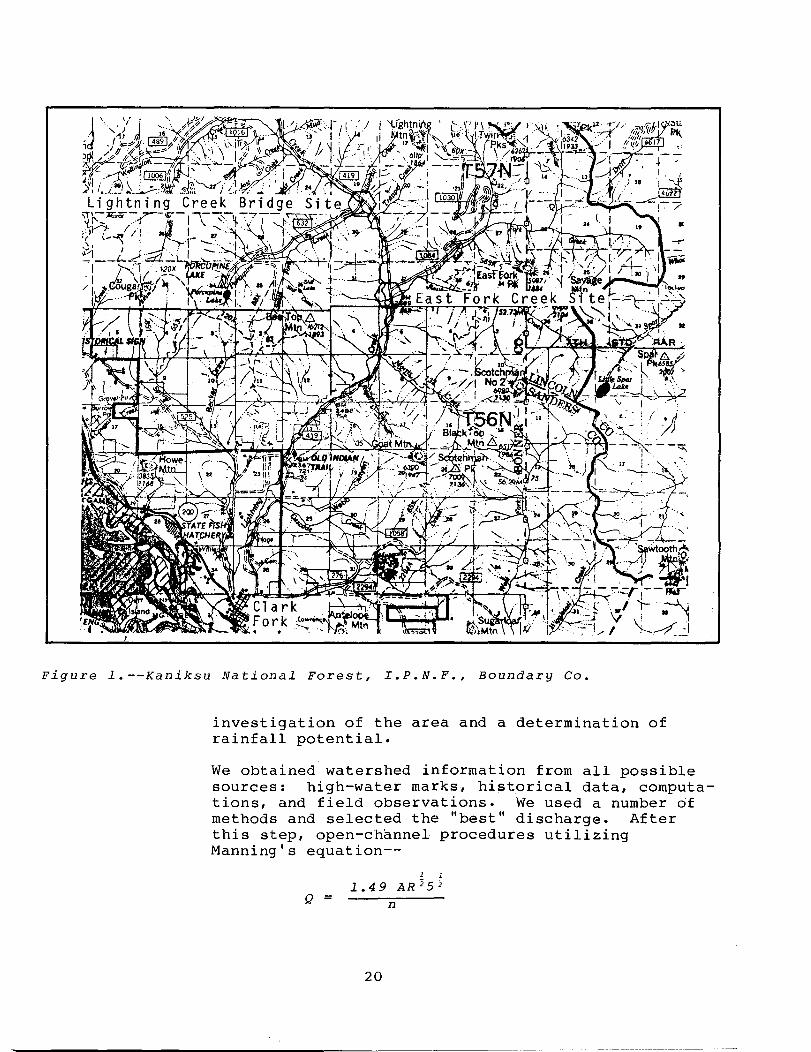
Figure l.--Kaniksu National Forest, I.P.N.F., Boundary Co.
investigation of the area and a determination of rainfall potential.
We obtained watershed information from all possible sources: high-water marks, historical data, computations, and field observations. We used a number of methods and selected the "best" discharge. After this step, open-channel procedures utilizing Manning's equation--
1 1
1.49 AR;; 5 ;; Q n
20
ROADWAY REPAIR
--and observed "n" values were used to determine velocity, high-water elevations, and flood cross sections.
Close attention to existing stream velocities and open-channel hydraulics was essential to avoid scour problems. An increase in velocity of just a few feet per second would create a scour hole and impede fish passage; conversely, a reduction in velocity would cause deposition. Therefore, all flow regimes were checked, and energy dissipators or stream armoring was incorporated into the design where necessary. We measured actual stream velocities, and design velocities through the structures closely corresponded to those in the natural channel.
After surveying the roads and establishlng elevations and temporary bench marks (TBMs) over the entire area, we plotted an existing road profile along with the identification of damaged sections and high-water marks. We tied cross sections of the streqm and flood plain into the survey, and used the Corps of Engineers' HEC-2 program to generate flood profiles for the 25-year, 35-year, 50-year, and lOa-year storm events. We then plotted these profiles along with the existing road profiles and identified areas that were subject to creek flooding. This information was valuable in determining whlch roadway areas should be reconstructed and to what elevations.
Using value engineering principles, we generated alternative solutions to the high debris load and roadway erosion problems. Ideas were critiqued, refined, field reviewed, and finally adopted for design.. The actual design began only after we completed this evaluative process for all areas of the project.
Roadway damage was analyzed to determine the source. Water flowing down the road for great distances eroded many miles of road on this project. Rolling dips provided the best solution in this case to shunt water off of the roadway at half-mile intervals. These dips were designed to be 200 feet long and easily drivable at 30 miles per hour. Fifty-foot vertical curves were utilized to facilitate maintenance and improve driver comfort.
Many large-diameter corrugated metal pipes (CMPs) were destroyed after being plugged by debris.
21
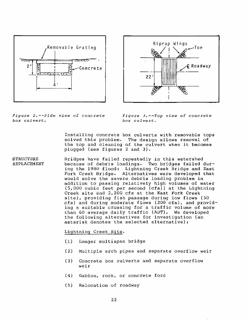
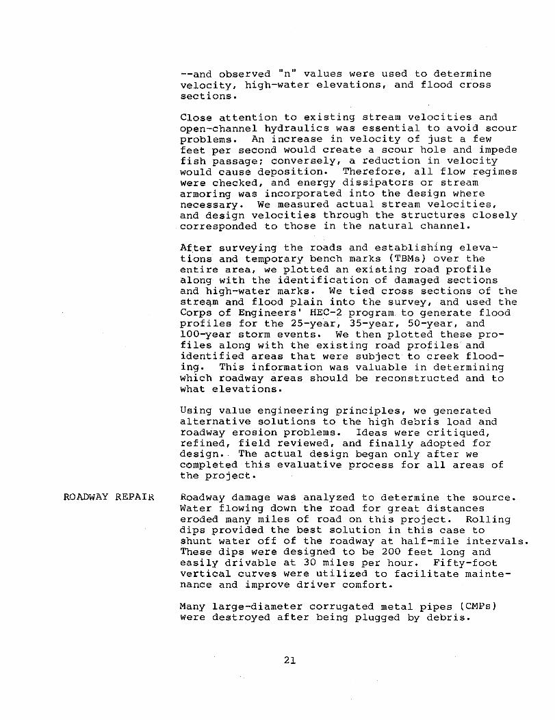
~Removable Grating
..... -m.:\'i.,77r/'l1c.=~~~~~~-t~~~~~~~-;/m" ",\,\ v.':<l '(,,7"f0 f'... '''~- ,
2 1 n I tff--Concrete /€ Roadway ---'.:0:,-: ..... : ..• : .•. ::b·::;:.O··~::: .• :
221 -
I. J 4 1
Figure 2.--Side view of concrete box culvert.
Figure 3.--Top view of concrete box culvert.
STRUCTURE REPLACEMENT
Installing concrete box culverts with removable tops solved this problem. The design allows removal of the top and cleaning of the culvert when it becomes plugged (see figures 2 and 3).
Bridges have failed repeatedly in this watershed because of debris loadings. Two bridges failed during the 1980 flood: Lightning Creek Bridge and East Fork Creek Bridge. Alternatives were developed that would solve the severe debris loading problem in addition to passing relatively high volumes of water (5,000 cubic feet per second (cfs» at the Lightning Creek site and 2,200 cfs at the East Fork Creek site), providing fish passage during low flows (50 cfs) and during moderate flows (200 cfs), and providing a suitable crossing for a traffic volume of more than 60 average daily traffic (ADT). We developed the following alternatives for investigation (an asterisk denotes the selected alternative):
Lightning Creek Site.
(1) Longer multi span bridge
(2) Multiple arch pipes and separate overflow weir
(3) Concrete box culverts and separate overflow weir
(4) Gabion, rock, or concrete ford
(5) Relocation of roadway
22
LIGHTNING CREEK BRIDGE
(6) Replacement-in-kind
(7)* Replace bridge and provide separate overflow
East Fork Site.
(1) Higher, longer bridge
(2) Arch pipe with integral overflow weir
(3)* Concrete box culverts with removable tops and armored integral overflow weir
(4) Gabion, rock, or concrete ford
(5) Relocation of roadway
(6) Replacement-in-kind
Before making a selection, access requirements, costs, esthetic quality, fish passage, and all other suitable criteria were evaluated for each alternative. At both sites, debris was a significant factor because it was uncontrollable as well as unpredictable.
The previous 60-foot span, single-lane steel stringer and treated timber deck bridge with 12-foot clear height retaining wall abutments washed out when large log debris jammed across the span. This blockage backed up flow until the south abutment scoured out (see figure 4).
The original bridge and causeway severely restricted the flood plain; consequently, during a flood, all floodwater and debris concentrated in a 60-foot-wide area instead of spreading over the entire 300-foot flood plain. A distinct overflow channel exists approximately 50 feet north of the main channel. However, the 15- to 20-foot roadfill blocked this channel.
The flows at this site were too large (5,000 cfs) to effectively construct a simple low-water crossing, and an adequate design to pass the 100-year flow and associated debris would require a two-span bridge approximately 200 feet long. Our estimated cost for this structure was $195,000.
This 100-year design life bridge had a higher cost than was justifiable for this site. The alternative of reconstructing to the original, 10- to IS-year
23
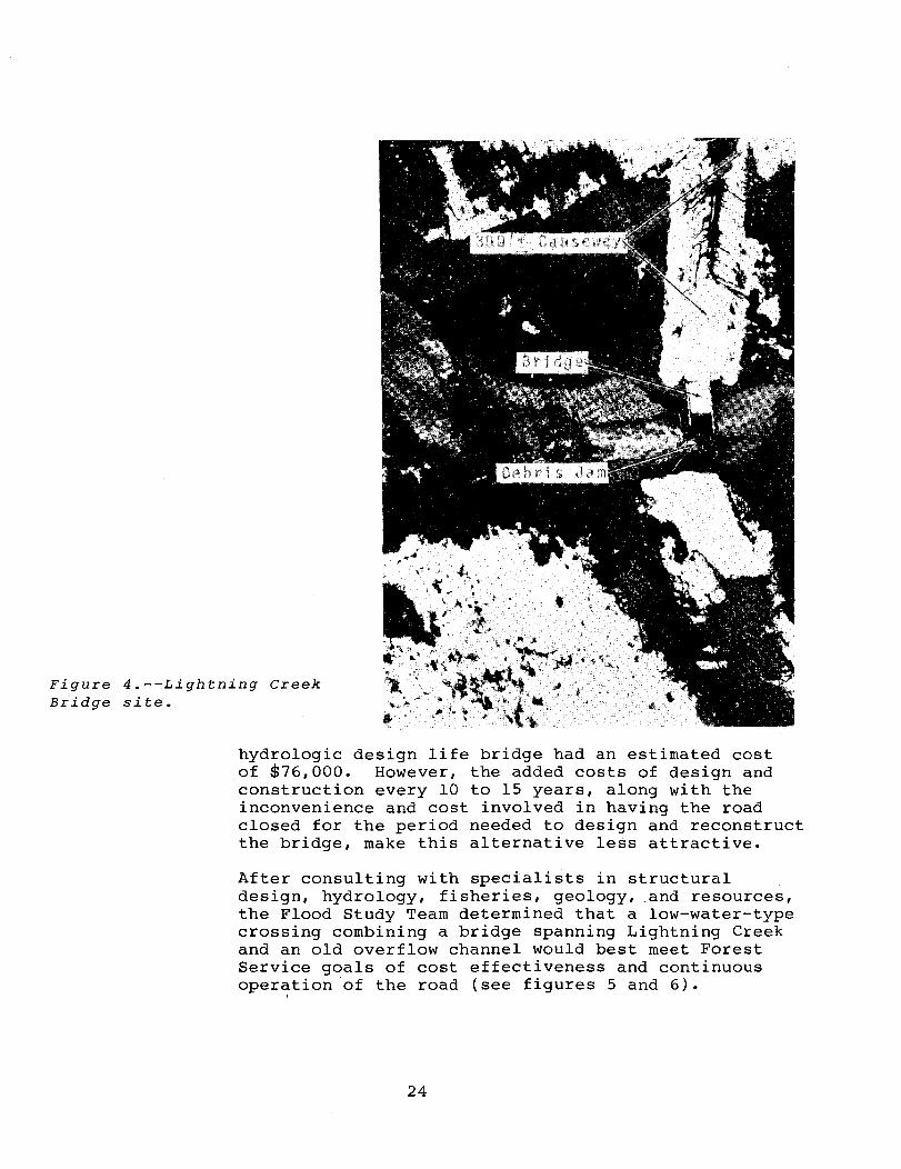
Figure 4.--Lightning Creek Bridge site.
hydrologic design life bridge had an estimated cost of $76,000. However, the added costs of design and construction every 10 to 15 years, along with the inconvenience and cost involved in having the road closed for the period needed to design and reconstruct the bridge, make this alternative less attractive.
After consulting with specialists in structural design, hydrology, fisheries, geology, .and resources, the Flood Study Team determined that a low-water-type crossing combining a bridge spanning Lightning Creek and an old overflow channel would best meet Forest Service goals of cost effectiveness and continuous oper~tion of the road (see figures 5 and 6).
24
Overfl ow Channel
x
Figure 5.--Lightning Creek Bridge site, plan view.
/Ex;stin g Ground
------------- -- -.......
x Debris
Deflectors
x
---/ 0 v e r fl 0 w wei; 1 ~ -- -·~:b=~==7::::: .......... :::= __ =-
...........,--<--------- 2.._ - . - - --::M"ri'""T\
0% 51
I· 120 I
·1
Figure 6.--Lightning Creek Bridge site, profile view.
25
Lightning Creek
We designed a bridge with approximately the same hydraulic capacity and at the same location as the previous bridge. We lengthened the bridge to 85 feet and laid the abutment fills back on a l~:l slope to give a spill-through-type cross section. This bridge costs no more than the 60-foot retaining wall bridge and will have less chance of snagging the long log debris that it may have to pass.
The bridge was designed to pass the 20-year floodflow and all associated debris.
The overflow channel begins at a curve in the stream 300 feet upstream from the crossing site. The streambank height is such that the stream will begin flowing over the bank and into the overflow channel when flow exceeds the 10-year floodflow. The gradient of the overflow channel is slightly steeper than the regular channel. Therefore, most flow above the 10-year floodflow will move into the overflow channel, and discharge in the main channel will not exceed the 20-year floodflow. The overflow channel will pass the full 100-year discharge and associated debris in case the bridge should become blocked.
The road across the overflow weir was designed to be 1.5 feet above the bottom of the channel, and the fill is constructed of riprap with a I-foot thick gravel driving surface.
The overflow weir has a bottom width of 120 feet, and the riprap fill extends to a height of 5 feet up the vertical curves on either side of the overflow channel.
When water begins flowing through the overflow channel and over the road, the gravel surfacing will wash off. However, a pit run gravel surfacing source is nearby, and repair should not cause major traffic delays or costs.
A debris deflector constructed upstream at the point the overflow channel leaves the main channel encourages debris to move ~nto the overflow channel. The debris deflector consists of four steel H pilings driven on a line across the stream parallel to the overflow channel. The pilings stand 30 feet apart. The debris deflector will begin to function when debris hangs up on the piling. This blockage will assist in moving both streamflow and floating debris into the overflow channel.
26
EAST FORK SITE
Each structure by itself can accommodate the 100-year discharge. However, only the overflow can effectively pass the accompanying debris: therefore, the debris deflectors became a critical part of this design.
The bid cost of the new bridge at Lightning Creek is $73,900: the bid cost of the riprap and surfacing through the overflow channel is $11,700: and the bid cost of the deflector system is $4,000. This results in a total cost of $89,600, which is substantially lower than the estimated $195,000 cost of the bridge that would span the overflow and main flow channels. The bridge, in combination with the overflow channel, will pass flows in excess of the 100-year flood with only minor damage.
This stream, which is a tributary to Lightning Creek, transported a large quantity of log debris in addition to a large gravel bedload. The previous 50-foot span, two-lane treated timber bridge with 7-foot clear height retaining wall abutments washed out when debris jammed across the bridge opening and cau~ed one abutment to scour out (see figure 7). The stream then moved behind the remaining abutment and scoured out several hundred feet of roadway.
The calculated 100-year floodflow is 2,200 cfs. Passing this 100-year flood and associated debris would require a bridge approximately 125 feet long with an estimated cost of $200,000. The alternative of reconstructing to the original 10- to IS-year hydrologic design life bridge had an estimated cost of $60,000. The flood plain at this site is not conducive to construction of a bridge and a separate overflow channel. The stream channel is also very unstable and is constantly moving back and forth ,across the flood plain. The stream carries a large gravel bedload at times and has a high scour potential.
The cost of constructing the longer span bridge to avoid frequent bridge replacements was considered to be prohibitive. However, the option of having to replace the shorter span bridge every 10 to 15 years with the resulting road closures and traffic delays was also undesirable. The Flood Study Team decided to construct a low-water-type crossing.
Because this stream is a very important kamloop and Dolly Varden spawning stream, the fisheries
27
Figure 7., --East Fork Creek Bridge site.
placed several additional constraints on the design. The maximum velocity during the average spring runoff (200 cfs) must not exceed 5 feet per second, and the minimum waterflow depth during the average annual flow (50 cfs) must not be less than 1.0 foot.
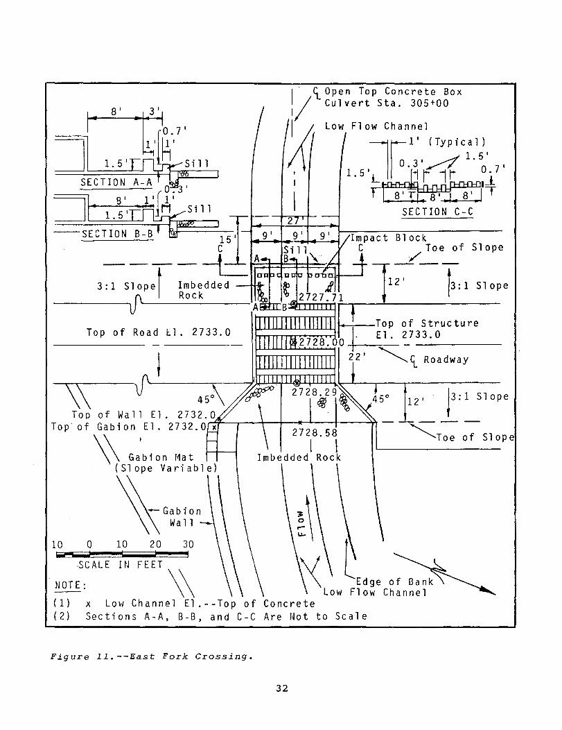
To meet the above constraints, we designed a threebarrel, rein£orced concrete box culvert with a removable steel grating top (see figure 8). The box culvert was designed to pass up to the 5-year design flood and was centered in the 200-foot wide channel. The roadway surface would be approximately 5 feet higher than the channel and is paved through the entire 200-foot width.
The weir provides a restriction-free route for debris flow while the removable grating (section weighs 2,500 pounds) allows cleaning of the structure in the event it becomes plugged with rock or debris. The invert of the middle barrel is 1 foot lower than either of the outer barrels, and the floor of the concrete barrels was roughened by placement of angular rocks during the final pour of the slab. This procedure was necessary to increase the Manning's "n" value for concrete (0.012) to
28
3'
..
+ 8"
.. ! .
. ~ . .
f 1----_8
' -----it· 8" 8"
t 8"
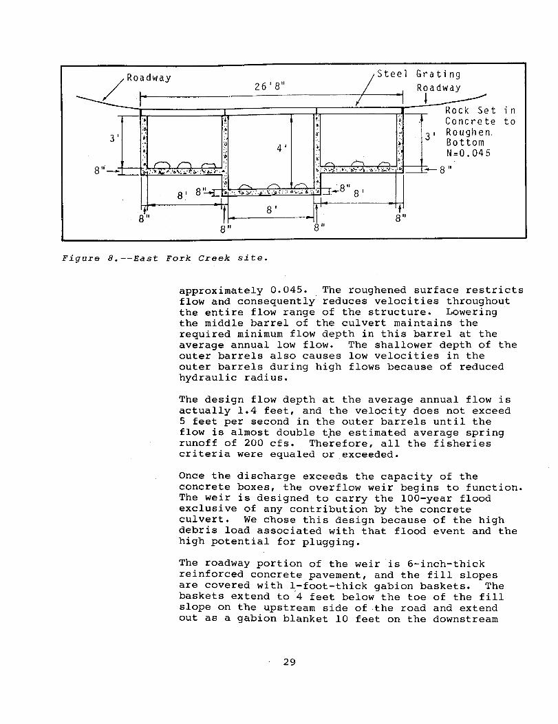
Figure 8.--East Fork Creek site.
approximately 0.045. The roughened surface restricts flow and consequently reduces velocities throughout the entire flow range of the structure. Lowering the middle barrel of the culvert maintains the required minimum flow depth in this barrel at the average annual low flow. The shallower depth of the outer barrels also causes low velocities in the outer barrels during high flows because of reduced hydraulic radius.
The design flow depth at the average annual flow is actually 1.4 feet, and the velocity does not exceed 5 feet per second in the outer barrels until the flow is almost double tpe estimated average spring runoff of 200 cfs. Therefore, all the fisheries criteria were equaled or .exceeded.
Once the discharge exceeds the capacity of the concrete boxes, the overflow weir begins to function. The weir is designed to carry the 100-year flood exclusive of any contribution by the concrete culvert. We chose this design because of the high debris load associated with that flood event and the high potential for plugging.
The roadway portion of the weir is 6-inch-thick reinforced concrete pavement, and the fill slopes are covered with I-foot-thick gabion baskets. The baskets extend to '4 feet below the toe of the fill slope on the upstream side of the road and extend out as a gabion blanket 10 feet on the downstream
29
SUMMARY
side. Class IX riprap (median size 1200#) is to, be installed in a 5-foot mat 50 feet dowstream of the structure for additional channel stability.
Because of the instability of the stream channel, a portion of the channel bank upstream is stabilized with gabions that tie into the gabions in the weir.
,The bid cost of the low water structure at East Fork Creek is $51,000: the bid cost of the concrete paving is $11,500; and the bid cost of the gabion baskets for the weir is $15,000. This results in a total cost of $77,500, which is substantially lower than the estimated $200,000 cost of the bridge needed to pass the 100-year floodflow. The only traffic interruptions that should occur with this structure are the 2 to 3 days every 5 years (plus or minus) when the water overflows the culvert and when the culverts require cleaning (see figures 9 through 14).
The design concepts developed for the Lightning Creek drainage could have a wide range of applications to other areas with debris loading problems. Bridges are satisfactory in many areas: however, if analysis indicates the potential for high debris loads, a bridge without overflow capability may have a high potential for failure.
Each area that requires a major crossing should be analyzed from the hydraulic and hydrologic standpoint. The study should consider all aspects of the watershed and proposed uses of the transportation facility •. From this information, a crossing may be designed. Low-flow designs have a definite application potential, but must be carefully designed to pass the floodflow and debris load, while still providing fish passage and stream bottom protection.
Other Regions use, with varying degrees of success, "open tap" concrete box culverts with modified cattleguard roadways where bedload movement is a problem (for example, on the Eldorado National Forest in Region 5). One design factor not mentioned in this article--the hydraulic slope of the culvert bottom as compared with the entering and exiting slope of the stream for a considerable distance--is critical to the "self-cleaning" performance of the structure.
Economics is a major concern, and all alternatives must be compared over th~ anticipated design life. Short-term replacement-in-kind structures at Lightning
30
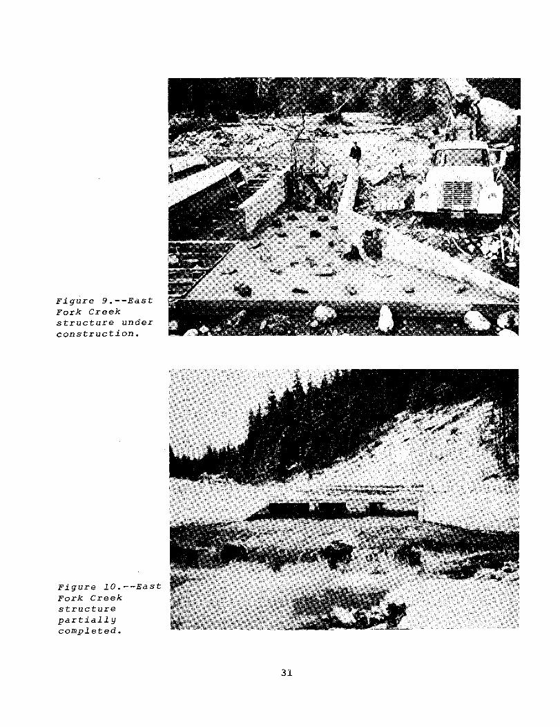
Figure 9.--East Fork Creek structure under construction.
Figure lO.--East Fork Creek structure partially completed.
31
8 1 3 1 I <t Open Top Concrete Box 1/ Cu1 vert Sta. 305+00
~ Low Flow Channel
l~11 (TYP;Ct 1)1
o 31~ .5 I 1. 5 I LU I' 11 0i7 I
t~IT SECTION C-C
C Toe of Slope 111 .. -.... 9_,~ ..... 2 9-;'~~-. B 1 0 c k
--t-L A _/ __ - - - - L-~' ::::f=::t::::t:=~
3:1 slopel Imbedded an 1+---' 121 /3:1 Slope
--------__ ~ Rock A ~~~~~~ __ ~ ______________ __
Top of Road E1. 2733.0 ....................... ~ ...................... "'""I ~~_Top of Structure El.2733.0
----------~<t Roadway
12' Slope
Top of Wall El. 2732.0 Top of Gabion El. 2732.0~x9-~--~-+~2~72~8-.-5-8~---~
\ \ G:blon Ma t Imbedded'Rock
~Toe :; Slop e
(Slope Variable)
10 o 10 .-; ;
·SCALE ItJ
NOTE:
20 30 I
FEET \\
(1) X Lovi Channel El.--Top of Concrete (2) Sections A-A, B-B, and C-C Are Not to Scale
Figure ll.--East Fork Crossing.
32
By pas s
Gabion A \
\ \
East Fork Cre ek
\ \ __ Existing
'\ Bank
\ \ \ \
Gabion Channel Control Structure
Figure 12.--East Fork Creek, plan.
Concrete paVing~
~~~
Figure 13.--East Fork Creek, section A-A.
1-- Overflow Weir _I Roadway
~QI00~ Gabion-_~ Gabion
Bqx Culverts
Figure l4.--East Fork Creek, profile.
33
Creek and East Fork Creek would have had a lower initial cost than the selected structures. However, the difference in design lives (10 years versus 100 years) made the selected alternatives much more cost effective.
Creativity is the key to success in developing viable alternatives. Past solutions mayor may not be the optimum present solution. A conventional design should not be used simply because "that's the way we've always done it." A replacement structure should not be designed to the same standards as the previous structure without considering other options.
Often the quick solution is wrong, and too often we shortcut the evaluative process just to get something constructed. This may be politically expedient, but it is professionally unsound. Time and money spent in the preliminary design phase are time and money well spent.
34
PURPOSE of the LIST
GSA's Consolidated List of Debarred, Suspended, & Ineligible Contractors
The General Services Administration (GSA) maintains and publishes monthly the "Consolidated List of Debarred, Suspended, and Ineligible Contractors." A comprehensive listing of business concerns and individuals excluded from receiving Federal contracts, the List is to be used by Federal agencies pursuant to the Office of Federal Procurement Policy's Policy Letter 82-1.
The List supersedes the consolidated lists of administrative debarments previously published by GSA and the Department of Defense (DOD). Individual agency lists of debarred, suspended, and ineligible contractors, formerly required by the Federal Procurement Regulations, are no longer necessary.
The first purpose of the List is to notify Federal agency contracting officials of those contractors that are barred from participating in Federal contracting programs throughout the Government. These exclusions may be based on the administrative debarment or suspension of a contractor by any agency on or after August 30, 1982 (in accordance with Policy Letter 82-1), or may be the result of a similar action taken by an agency under authority provided by statute or Executive order.
Second, the List provides information concerning those contractors administratively debarred or suspended by agencies before August 30, 1982. Generally, these exclusions apply only to the contracting programs of the agency that took the action. However, DOD contracting officials are subject to the special rules of Public Law 97-86, section 914 (see "For DOD Users" at Code A under the heading "Cause and Treatment Codes").
The specific treatment directed to the listed contractors may differ depending on the type of exclusionary action and the authority under which it is taken. The basis for the listings and the effect of the exclusionary actions are described under the heading "Cause and Treatment Codes."
35
HOW TO USE the LIST
HOW TO OBTAIN COPIES
To reduce paperwork and printing costs, the List is presented in a concise format with the names of debarred, suspended, and ineligible contractors listed alphabetically in main and cross-reference entries.
In a cross-reference, the name under which the entry is listed is in lighter type followed by the name, in boldface, under which the main entry is indexed. Generally, all information about the contractor, the action, and the term of action is discussed in the main entry, except if the address or termination date is different from the main entry.
Federal agencies may purchase their annual List requirements for internal distribution in bulk from the U.S. Government Printing Office at cost. Specific instructions concerning List subscriptions have been given to each agency's designated procurement executive.
36
INTRODUCTION
HISTORY
Laws Governing Rights-of-Way Across Arizona Lands
Janet L. Travis Soil Scientist Prescott National Forest Region 3
While assigned to the Engineering Section recently, I was asked to research right-of-way ownership, including not only roads on abandoned railway grades, but toll roads and any roads the cognizant county had agreed to build--both before and after the Prescott National Forest had come into existence. The purpose of the research was to identify which roads crossing the Forest are county roads and therefore should be maintained by the county. This research not only would assist the Forest Service in keeping the roads maintained, but also would help determine who would be liable in lawsuits arising from any accidents that might occur on these roads located within the National Forest boundaries.
As the research progressed, I discovered that rightof-way ownership in Arizona was governed by several authorities. Prior to 1860, Arizona was considered part of the New Mexico Territory, and Spanish Land Grant laws that were passed by the New Mexico Territorial Legislature affected Arizona lands. From February 23, 1860, to February 14, 1912, Arizona was
. a Territory of the United States; during this period, right-of-way acquisition for railroads and toll roads was governed by Arizona Territorial and Federal laws. On February 14, 1912, Arizona became a State, governed by State and applicable Federal laws. Since 1898, Presidents have been setting aside lands in Arizona for the "Forest Reserve"-later, the Forest Service, after the agency name change in 1905. All these entities have promulgated laws governing right-of-way ownership. Choosing which laws take precedence seems to be the point at which the problems arise, as my research produced several Federal, State, and Territorial laws and acts pertaining to rights-of-way for railroads, public roads, and toll roads.
37
RAILROADS
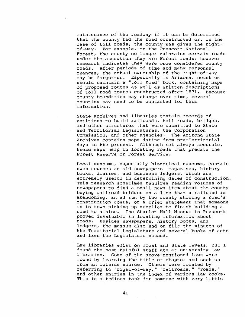
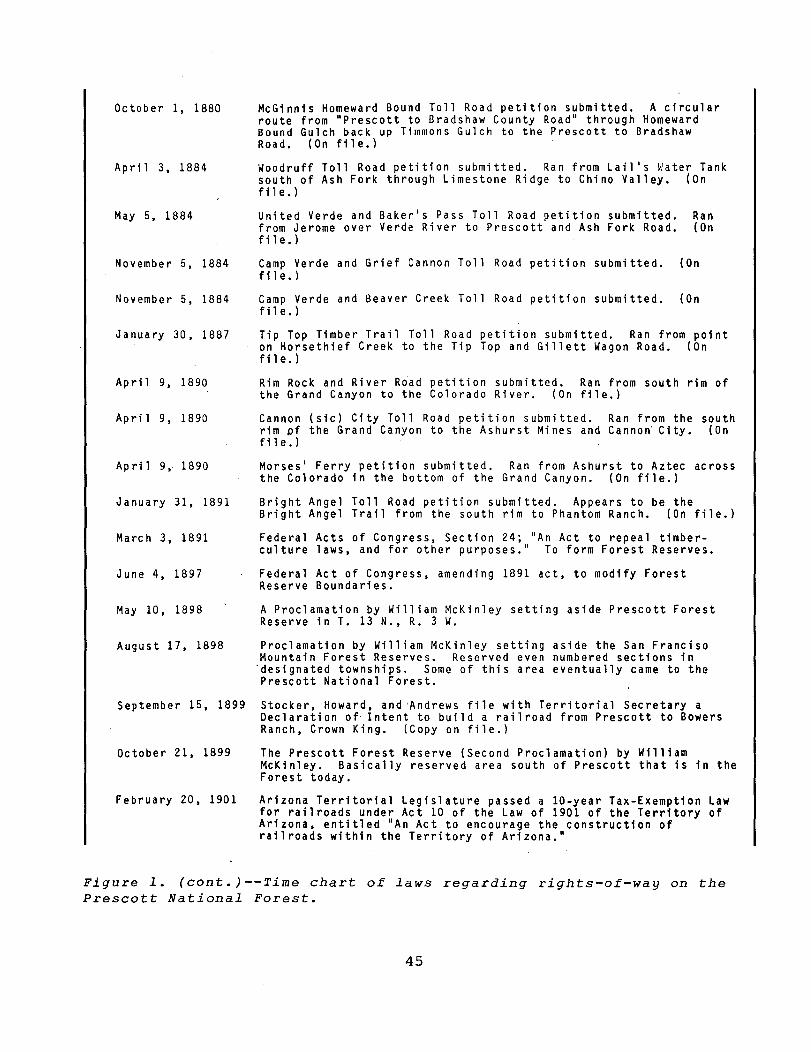
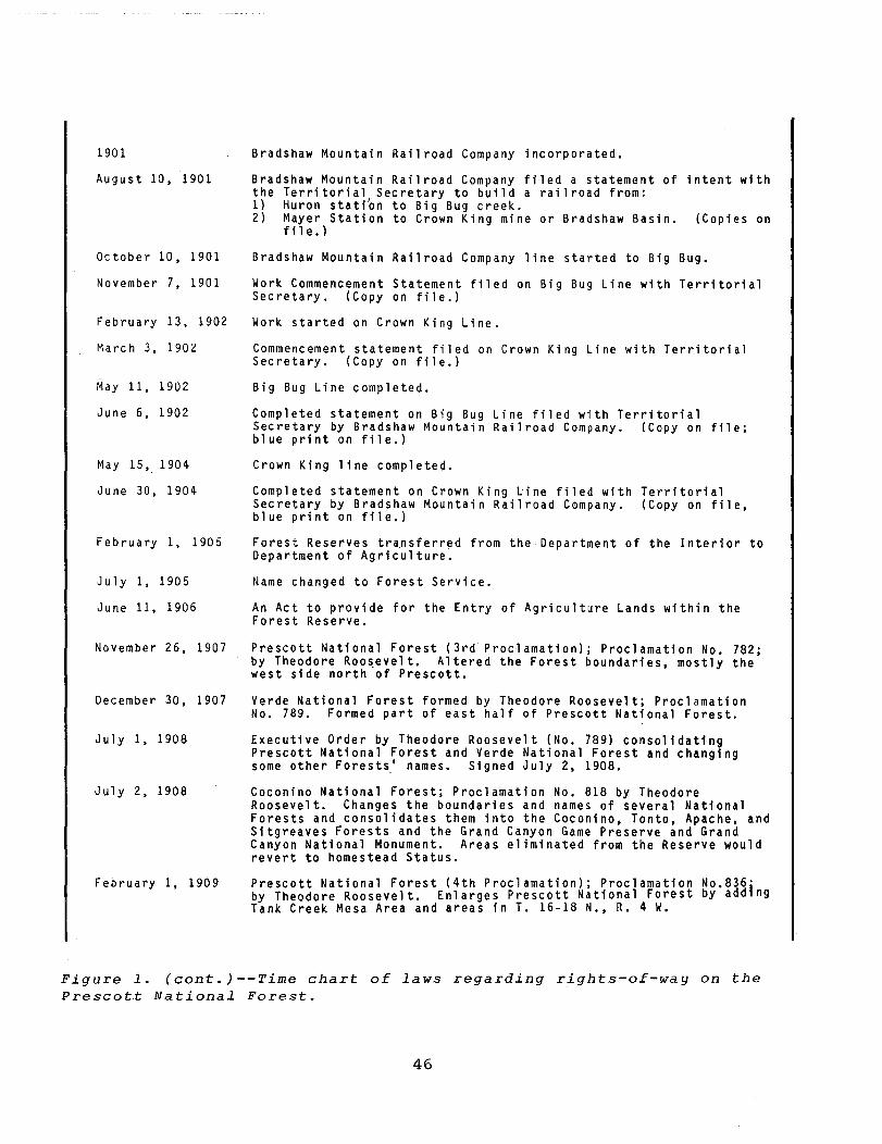
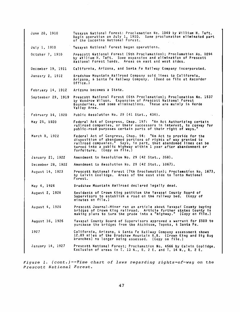
I found it helpful to construct a time chart (see figure 1) to facilitate tracking of which laws were in effect when various events took place, such as the construction of a road or railroad or the issuance of a Forest Reserve Proclamation.
Because Arizona was still a Territory when most of the Prescott Forest Reserve, or Prescott National Forest, was reserved, Territorial laws and acts regulated the roads and railroads that existed before the Federal Government set aside the land.
The Arizona Territorial Legislature passed several acts governing the right-of-way of railroads and toll roads within the Territory: these ranged from specific legislation for specific railroads and toll roads to general laws covering all railroads or toll roads. Because of the population influx during the late 1800's, the Territorial Legislature passed several acts as incentives to build railroads and toll roads: generally, these acts involved la-year tax exemptions.
Two such tax exemption laws that had a bearing on the railroad right-of-way that I was researching were those acts passed by the Arizona Territorial Legislature in March 1899, and Act 10 of the Law of 1901, passed on February 20, 1901. Both acts granted la-year tax exemptions for railroads for which petitions were made within 6 months of the act's passage, provided work started within a specified time and was finished within a specified period. The petitions were to be filed with the Territorial Secretary. The railroads filed a plat of the final route with a certificate of completion of the line when the work was actually finished. These petitions and final filings are stored at the Arizona State Archives, which is now in the old Capitol Building in Phoenix, Arizona.
On March 3, 1875, the 43rd Congress of the United States passed into law "Chap. l52.--An act granting to railroads the right of way through the public lands of the United States." Section 1 of this act states, in part, that a railroad must file with the Secretary of the Interior a copy of its articles of incorporation and proof of its organization. Other rulings and laws pertaining to railroads can be found in Title 43 U.S.C., section 934-939.
Section 5 of the March 3, 1875, act dealt with railroads that would cross land in any "military, park,
38
TOLL ROADS
or Indian Reservation, or other lands specially reserved from sale." The first entry under "Notes of Decisions" in Title 43 U.S.C., section 938, pertains to railroads crossing Forest reservations. The second paragraph reads:
In view of exceptions in this the Act of March 3, 1899, can acquire right of way to a reserve only through approval Secretary of Interior.
section and • a railroad forest of the
This rule would apply to any railroads begun after an area became part of the Forest Reserve, or the Forest Service. The Arizona Territory would handle petitions and rights-of-way for nonreserve areas. However, there appears to have been some confusion concerning this matter. At least two railroads that crossed Forest Reserve lands filed petitions with the Territorial Secretary, following all the Territorial laws for filing; the petitions were accepted and the lines built. Yet, I could locate no record of these lines being petitioned to and authorized by the Secretary of the Interior. Therefore, the railroads and the roads that now run on the bedding (the lines were abandoned and the tracks removed) could be considered in "trespass," with no legal right-of-way.
On May 25, 1920, the 66th Congress enacted "Chap. 197--An Act authorizing certain railroad companies, or their successors in interest, to convey for public road purposes certain parts of their right of way." This act gives railroad companies the right to convey their rights-of-way across public lands to a State, county, or municipality for use as a public road.
On March 8, 1922, the 67th Congress approved "Chap. 194--An Act to provide for the disposition of abandoned portions of rights of way granted to railroad companies." This act states, in part, that the right-of-way of abandoned lines across public lands reverts to the Federal Government, unless it is taken over as a public highway within 1 year of abandonment. Checking county board of supervisor minutes will help determine whether the county took over the right-of-way as part of the county road system, thereby establishing road ownership.
Petitions for toll roads in the Arizona Territory prior to 1871 were filed with the Territorial
39
SOURCES of INFORMATION
Legislature, and a separate act was written for each one approved. These acts set policies for right-ofway acquisition and stipulated the length of time the road could remain as a toll road. At the end of the allotted time, the road usually became part of the county road system to be used as a free public road or a toll road.
On February 18, 1981, the Territorial Legislature approved "Chapter XC--Providing for constructing and maintaining Toll Roads, Bridges, and Ferries in the Arizona Territory." Section 1 of this act stated that a plat of a proposed route must be filed with the county recorder of the county or counties that the road would cross. These plats, ranging from very rough sketches to detailed maps, are very helpful in locating the exact routes of toll roads and areas where roads once existed.
Section 2 of the toll road act allowed owners to operate their toll road for 10 years. When the time expired, or when the franchise was forfeited, the road would become the property of the county, as stated in section 7. County supervisors could declare the road a free highway or maintain it as a county toll road.
Toll roads were quite prevalent in Yavapai County and across areas that are now part of the Prescott National Forest, other neighboring Forests, and National Parks. In checking the plats at the county recorder's office, I discovered that the Kaibab and Bright Angel Trails into the Grand Canyon were originally toll roads to mines. The franchise for most of these roads expired before the area was reserved as park and forest lands. Therefore, unless they were formally abandoned, these trails are county roads.
Several agencies and resource areas maintain information helpful in determining the dates of road, bridge, or railroad construction and those responsible for the work. Cognizant county board of supervisors' minutes will mention petitions for roads, railroads, and the like, and the county's decision regarding the petition. Dates, names, and amounts of payments can be obtained by reviewing the list of warrants that were issued. Generally, if work was to be done, it was referred to the county engineer, whose records also should be available for public use. A good case can be made for county
40
maintenance of the roadway if it can be determined that the county had the road constructed or, in the case of toll roads, the county was given the rightof-way. For example, on the Prescott National Forest, the county no longer maintains certain roads under the assertion they are Forest roads; however research indicates they were once considered county roads. After periods of time and many personnel changes, the actual ownership of the right-of-way may be forgotten. Especially in Arizona, counties should maintain a "toll road" book, containing maps of proposed routes as well as written descriptions of toll road routes constructed after 1871. Because county boundaries may change over time, several counties may need to be contacted for this information.
State archives and libraries contain records of petitions to build railroads, toll roads, bridges, and other structures that were submitted to State and Territorial Legislatures, the Corporation Commission, and other agencies. The Arizona State Archives contains maps dating from pre-Territorial days to the present~ Although not always accurate, these maps help in locating roads that predate the Forest Reserve or Forest Service.
Local museums, especially historical museums, contain such sources as old newspapers, magazines, history books, diaries, and business ledgers, which are extremely useful in determining dates of construction. This research sometimes requires reading volumes of newspapers to find a small news item about the county buying railroad bridges on a line that a railroad is abandoning, an ad run by the county showing a road's construction costs, or a brief statement that someone is in town picking up supplies to finish building a road to a mine. The Sharlot Hall Museum in Prescott proved invaluable in locating information about roads. Besides newspapers, history books, and ledgers, the museum also had on file the minutes of the Territorial Legislature and several books of acts and laws the Legislature passed.
Law libraries exist on local and State levels, but I found the most helpful staff are at university law libraries. Some of the above-mentioned laws were found by learning the title or chapter and section from an outside source. Others were located by referring to "right-of-way," "railroads," "roads," and other entries in the index of various law books. This is a tedious task for someone with very little
41
CONCLUSION
law background, and a good contact at a law library almost becomes a necessity.
Even after gathering extensive information about the roads crossing the Prescott National Forest, many questions still exist about right-of-way ownership, questions that may require a court decision to answer. When information overwhelmingly indicates Forest Service, county, or private ownership, a meeting can resolve questions and achieve an agreement. Such negotiations can result in savings to the Forest Service. For example, in the case of a road that predates the private acquisition of a section of land, the Government can save money by showing that the road was not originally considered private, but rather was a county, State, or federally constructed road. The Government should not pay for right-of-way acquisition from the private party since it already owns the right-of-way. By researching rights-of-way and determining legal ownership, the Forest Service can be saved the expense of obtaining unneeded rights-of-way, of maintaining roads that should be the responsibility of the county, and, in the case of an accident and lawsuit, of bearing the liability for the road's maintenance.
42
June 21, 1860
February 24, 1863
October 24, 1864
November 3, 1864
June 7, 1865
December 3D, 1865
December 3D, 1865
June 25, 1866
October 26, 1866
February 18, 1871
May 3D, 1871
June 7, 1871
January 8, 1874
March 3, 1875
October 10, 1876
April 18, 1877
New Mexico Territorial Legislature passes an act to let Luis Maria Baca and his heirs select lands for a property trade.
Territory of Arizona formed from Territory of New Mexico.
"An act declaring certain routes as a Country Road in the Territory of Arizona" passed by the Legislature. This act is for the road from Prescott to Woolsey's Ranch (Humboldt-Dewey area), down the creek to Big Bug Creek and on to Black Canyon.
Territorial legislature passes "An Act to Incorporate the Mojave and Prescott Toll Road Company." (Copy of Act on file.) Rufus Farrington, T.M. Alexander, and John Dunn applied for this toll road.
Letter to Surveyor General's Office, New Mexico Territory stating the Baca family had chosen the location for Float a5 and giving the location.
Territorial Legislature passes an act for the incorporation of the Prescott and Lynx Creek Toll Road Company.
Territorial Legislature passes an act amending the act for the Mojave and Prescott Toll Road Company. Amendment deals with ri ghts-of-way.
William Hardy purchased large section of Mojave to Prescott Toll Road from Rufus Farrington and T.M. Alexander to become largest shareholder in the road.
"An act declaring certain routes County Roads in Arizona Territory" passed by the Legislature. This was for the "Walnut Grove-Turkey Creek Trail."
"An act providing for constructing and maintaining Toll Roads, Bridges and Ferries in Arizona Territory" passed by Territorial Legislature. This act explains acquiring right-of-way. Upon expiration or forfeiture of the franchise, the road would go to the county or counties it crossed. A plat of the route was to be filed at the county recorder's office. (Copy of act on file.)
John Watts purchased the Luis Maria Baca Float #5 from the Baca heirs. (Deed on file at County Recorder's Office.)
Bradshaw Toll Road Company filed petition for a toll road from Bradshaw City to Walnut Grove. (On file.)
Prescott and Phoenix Toll Road petition submitted. (On file.)
The 43rd Congress passed "Chap. 152 -- An act granting to railroads the right of way through the public lands of the United States." (On file.)
Iron Springs Toll Road petition submitted. This ran from Mint Wash across the north side of Granite Mountain. (On file.)
Minnehaha Flat and Bradshaw Basin Toll Road petition submitted. Ran from Luke's Mill in Bradshaw Rasin to Steve Condron's Ranch by Walnut Grove. (On file.)
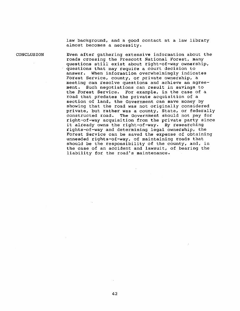
Figure l.--Time chart of laws regarding rights-of-way on the Prescott National Forest.
43
May 22, 1877
May 28, 1877
July 13, 1877
July 23, 1877
July 30, 1877
August 13, 1877
August 22, 1877
September 3, 1877
October 1, 1877,
January 14, 1878
January 15, 1878
June 3, 1878
December 26, 1878
December 30, 1878
January 25, 1879
June 30, 1879
Yavapai County contracted with James Patterson to build a road from Prescott to Swillings' Ranch via Black Canyon. Territorial Act of Fberuary 9, 1877, authorized a loan to county to pay for the road. (Note on file.)
wagon Ari zona the
Yavapai County contracted with Foster and Thomas to locate survey, and map a route from Prescott to Bradshaw City. (Note on file.)
The road from Prescott to Swilling Ranch was completed. (Note on fi 1 e. )
The plans for the Prescott to Bradshaw City Wagon Road were approved. Yavapai County Board of Supervisors approved an advertisement to be rUn for bids to construct this road. (Note on file.)
Foster and Thomas paid $1990 for their survey of the Prescott and Bradshaw City Wagon Road. (Note on file.)
Yavapai County Board of Supervisors issues bonds worth $10,000 to S. C. Miller for the Iron Springs Toll Road. (Note of file.)
Yavapai County Board of Supervisors awarded James Patterson the contract to construct the Prescott to Bradshaw City Wagon Road from Prescott to Battleflat for $32,000. (Copy on file.)
Yavapai County Board of Supervisors established ten (10) Road Districts. (Note on file.)
Patterson Toll Road petition submitted. Ran from Big Bug Creek to War Eagle Gulch. (On file.)
The Prescott and Bradshaw Wagon Road was inspected and approved. Yavapai County Board of Supervisors authorized final payment to be made to James Patterson. (Note on file.)
Yavapai County Board of Supervisors authorized an article to be run in the "Arizona Miner" showing how the $34,407.44 was spent for the Prescott and Bradshaw City Wagon Road. (Copy on file.)
Yavapai County Board of Supervisors accepted a petition from James Patterson to construct a road from the "terminus of the Prescott and Bradshaw City Wagon Road" to the Peck Mine Road. (Note on fil e.)
The War Eagle and Del Pasco Toll Road petition submitted. Ran from War Eagle Gulch to Del Pasco Springs. (On file.)
Yavapai County Board of Supervisors to petition a contract with the Territorial Legislature to pay Patterson for the road to Peck Mine. (Copy on file.)
Patterson Toll Road petition submitted. Ran from Tiger Mine through Castle Creek to Frog Tanks. (On file.)
"Old Government Road from Prescott to the San Francisco Mountains declared a public highway by Yavapai County Board of Supervisors. (On file.)
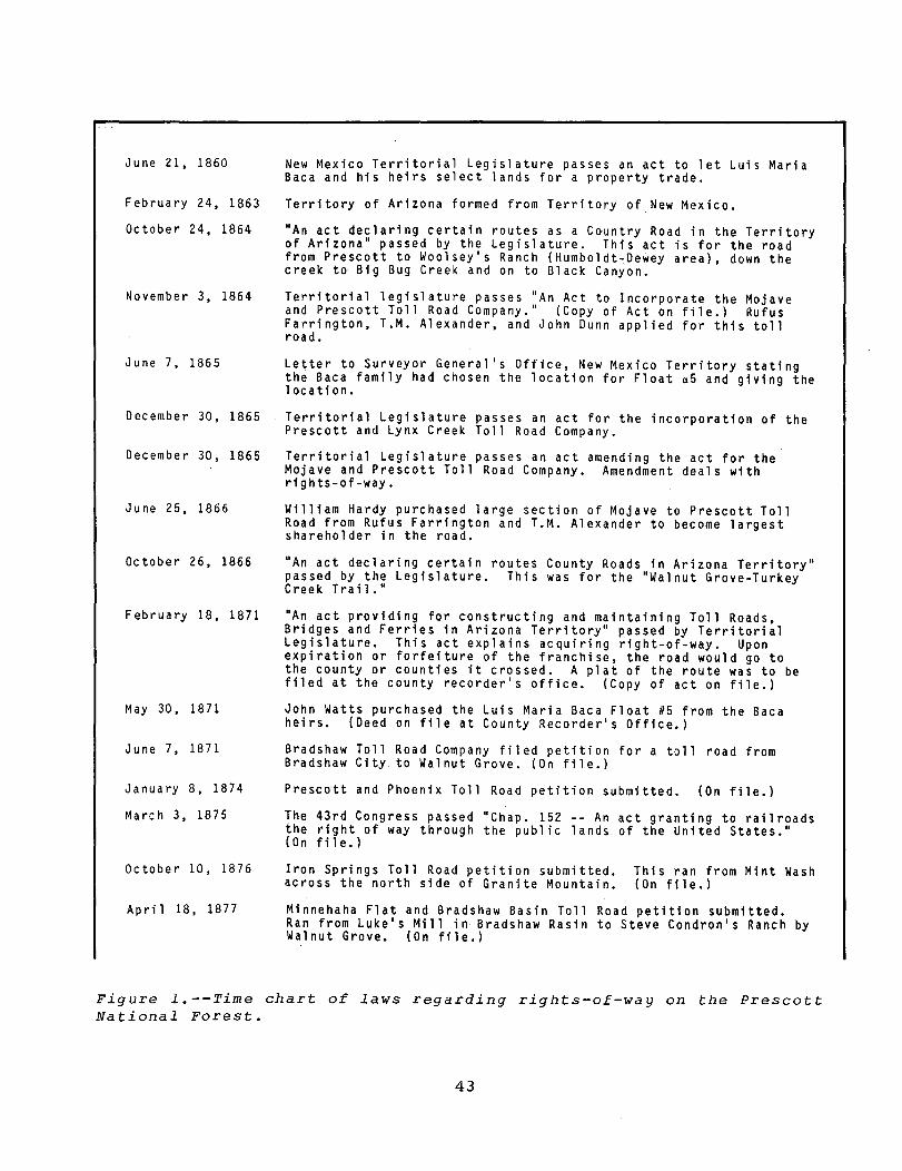
Figure 1. (cont.)--Time chart of l~ws regarding rights-of-way on the Prescott National Forest.
44
October 1. 1880
Apri 1 3. 1884
May 5. 1884
November 5. 1884
November 5. 1884
January 30. 1887
April 9. 1890
April 9. 1890
April 9. 1890
January 31. 1891
March 3. 1891
June 4. 1897
May 10. 1898
August 17.1898
McGinnis Homeward Bound Toll Road petition submitted. A circular route from "Prescott to Bradshaw County Road" through Homeward Bound Gulch back up Timmons Gulch to the Prescott to Bradshaw Road. (On file.)
Woodruff Toll Road petition submitted. Ran from Lail's Water Tank south of Ash Fork through Limestone Ridge to Chino Valley. (On fil e.)
United Verde and Baker's Pass Toll Road petition submitted. Ran from Jerome over Verde Ri~er to Prescott and Ash Fork Road. (On fi 1 e. )
Camp Verde and Grief Cannon Toll Road petition sUbmitted. (On fil e. )
Camp Verde and Beaver Creek Toll Road petition submitted. (On fil e. )
Tip Top Timber Trail Toll Road petition submitted. Ran from point on Horsethief Creek to the Tip Top and Gillett Wagon Road. (On fil e.)
Rim Rock and River Road petition submitted. Ran from south rim of the Grand Canyon to the Colorado River. (On file.)
Cannon (sic) City Toll Road petition submitted. Ran from the south rim Df the Grand Canyon to the Ashurst Mines and Cannon" City. (On fil e.)
Morses' Ferry petition submitted. Ran from Ashurst to Aztec across the Colorado in the bottom of the Grand Canyon. (On file.)
Bright Angel Toll Road petition submitted. Appears to be the Bright Angel Trail from the south rim to Phantom Ranch. (On file.)
Federal Acts of Congress. Section 24; "An Act to repeal timberculture laws. and for other purposes." To form Forest Reserves.
Federal Act of Congress. amending 1891 act. to modify Forest Reserve Boundaries.
A Proclamation by William McKinley setting aside Prescott Forest Reserve in T. 13 N •• R. 3 W.
Proclamation by William McKinley setting aside the San Franciso Mountain Forest Reserves. Reserved even numbered sections in
"designated townships. Some of this area eventually came to the Prescott National Forest.
September 15. 1899 Stocker. Howard. and 'Andrews file with Territorial Secretary a Declaration of Intent to build a railroad from Prescott to Bowers Ranch. Crown King. (Copy on file.)
October 21. 1899 The Prescott Forest Reserve (Second Proclamation) by William McKinley. Basically reserved area south of Prescott that is in the Forest today.
February 20. 1901 Arizona Territorial Legislature passed a la-year Tax-Exemption Law for railroads under Act 10 of the Law of 1901 of the Territory of Arizona. entitled "An Act to encourage the construction of railroads within the Territory of Arizona."
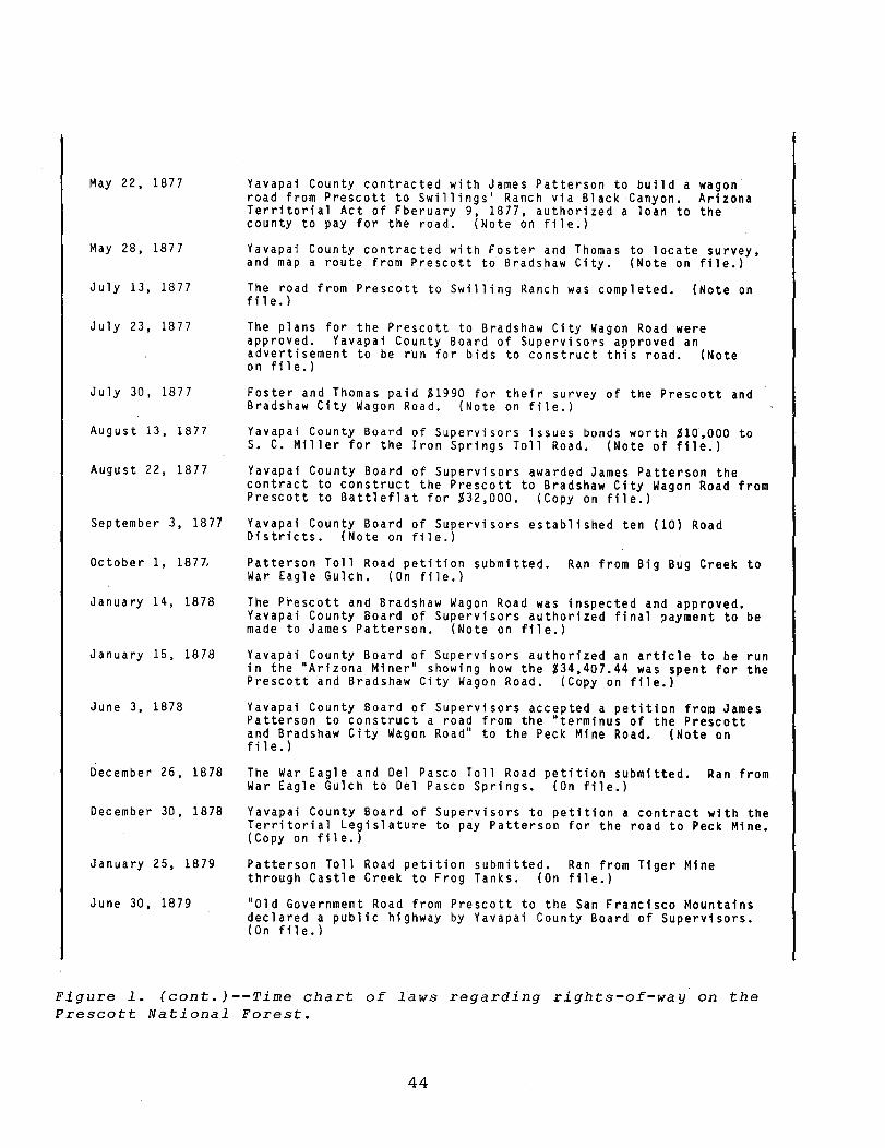
Figure 1. (cont.)--Time chart of laws regarding rights-of-way on the Prescott National Forest.
45
1901
August 10, 1901
Oc tober 10, 1901
November 7, 1901
February 13,
March 3, 1902
May 11, 1902
June 6, 1902
May 15" 1904
June 30, 1904
1902
February 1, 1905
July 1, 1905
June 11, 1906
November 26, 1907
December 30, 1907
July 1, 1908
July 2, 1908
February 1, 1909
Bradshaw Mountain Railroad Company incorporated.
Bradshaw Mountain Railroad Company filed a statement of intent with the Territorial Secretary to build a railroad from: 1) Huron stati~n to Big Bug creek. 2) Mayer Station to Crown King mine or Bradshaw Basin. (Copies on
file. )
Bradshaw Mountain Railroad Company line started to Big Bug.
Work Commencement Statement filed on Big Bug Line with Territorial Secretary. (Copy on file.)
Work started on Crown King Line.
Commencement statement filed on Crown King Line with Territorial Secretary. (Copy on file.)
Big Bug Line completed.
Completed statement on Big Bug Line filed with Territorial Secretary by Bradshaw Mountain Railroad Company. (Copy on file; blue print on file.)
Crown King line completed.
Completed statement on Crown King Line filed with Territorial Secretary by Bradshaw Mountain Railroad Company. (Copy on file, blue print on file.)
Forest Reserves tra,nsferred from the Department of the Interior to Department of Agriculture.
Name changed to Forest Service.
An Act to provide for the Entry of Agriculture Lands within the Forest Reserve.
Prescott National Forest (3rd Proclamation); Proclamation No. 782; by Theodore Roo~evelt. Altered the Forest boundaries, mostly the westside north of Prescott.
Verde National Forest formed by Theodore Roosevelt; Proclamation No. 789. Formed part of east half of Prescott National Forest.
Executive Order by Theodore Roosevelt (No. 789) consolidating Prescott National Forest and Verde National Forest and changing some other Forests' names. Signed July 2, 1908.
Coconino National Forest: Proclamation No. 818 by Theodore Roosevelt. Changes the boundaries and names of several National Forests and consolidates them into the Coconino, Tonto, Apache, and Sitgreaves Forests and the Grand Canyon Game Preserve and Grand Canyon National Monument. Areas eliminated from the Reserve would revert to homestead Status.
Prescott National Forest (4th Proclamation); Proclamation No.836· by Theodore Roosevelt. Enlarges Prescott National Forest by adding Tank Creek Mesa Area and areas in T. 16-18 N., R. 4 W.
Figure 1. (cont.)--Time chart of laws regarding rights-of-way on the Prescott National Forest.
46
June 28, 1910
July 1, 1910
October 7, 1910
December 19, 1911
January 2, 1912
February 14, 1912
Tusayan National Forest: Proclamation No. 1049 by William H. Taft. Begin operation on July 1, 1910. Same proclamation eliminated part of the Coconino National Forest.
Tusayan National Forest began operations.
Prescott National Forest (5th Proclamation); Proclamation No. 1094 by William H. Taft. Some expansion and elimination of Prescott National Forest lands. Areas on east and west sides.
California, Arizona, and Santa Fe Railway Company incorporated.
Bradshaw Mountain Railroad Company sold lines to California, Arizona, & Santa Fe Railway Company. (Deed on file at Recorder Office.)
Arizona becomes a State.
September 29, 1919 Prescott National Forest (6th Proclamation); Proclamation No. 1537 by Woodrow Wilson. Expansion of Prescott National Forest Boundaries, and some eliminations. These are mainly in Verde Valley Area.
February 14, 1920
May 25, 1920
March 8, 1922
January 21, 1922
December 28, 1922
August 14, 1923
May 4, 1926
August 2, 1926
August 4, 1926
August 16, 1926
1927
January 14, 1927
Public Resolution No. 29 (41 Stat., 434).
Federal Act of Congress, Chap. 197: "An Act Authorizing certain railroad companies, or their successors in interest, to convey for public-road purposes certain parts of their right of ways."
Federal Act of Congress, Chap. 94: "An Act to provide for the disposition of abandoned portions of rights of way granted to railroad companies." Says, in part, that abandoned lines can be turned into a public highway within 1 year after abandonment or forfeiture. (Copy on file.)
Amendment to Resolution No. 29 (42 Stat., 358).
Amendment to Resolution No. 29 (42 Stat., 1067).
Prescott National Forest (7th P.roclamation); Proclamation No. 1673, by Calvin Coolidge. Areas of the east side to Tonto National Forest.
Bradshaw Mountain Railroad declared legally dead.
Residents of Crown King petition the Yavapai County Board of Supervisors to establish a road on the railway bed. (Copy of minutes on file.)
Prescott Journal-Miner ran an article about Yavapai County buying bridges of Crown King railroad. Article further states Cou~ty is making plans to turn the grade into a "highway." (Copy on file.)
Yavapai County Board of Supervisors approved a warrant for $500 to purchase the bridges from the Atchison, Topeka, & Santa Fe.
California, Arizona, & Santa Fe Railway Company assessment shows 12.89 miles of the Bradshaw Mountain R.R. (Crown King and Big Bug branches) no longer being assessed. (Copy on file.)
Prescott National Forest; Proclamation No. 4566 by Calvin Coolidge. Exclusion of areas in T. 13 N., R. 2 E. and T. 14 N., R. 2 E.
Figure 1. (cont.)--Time chart of laws regarding rights-of-way on the Prescott National Forest.
47
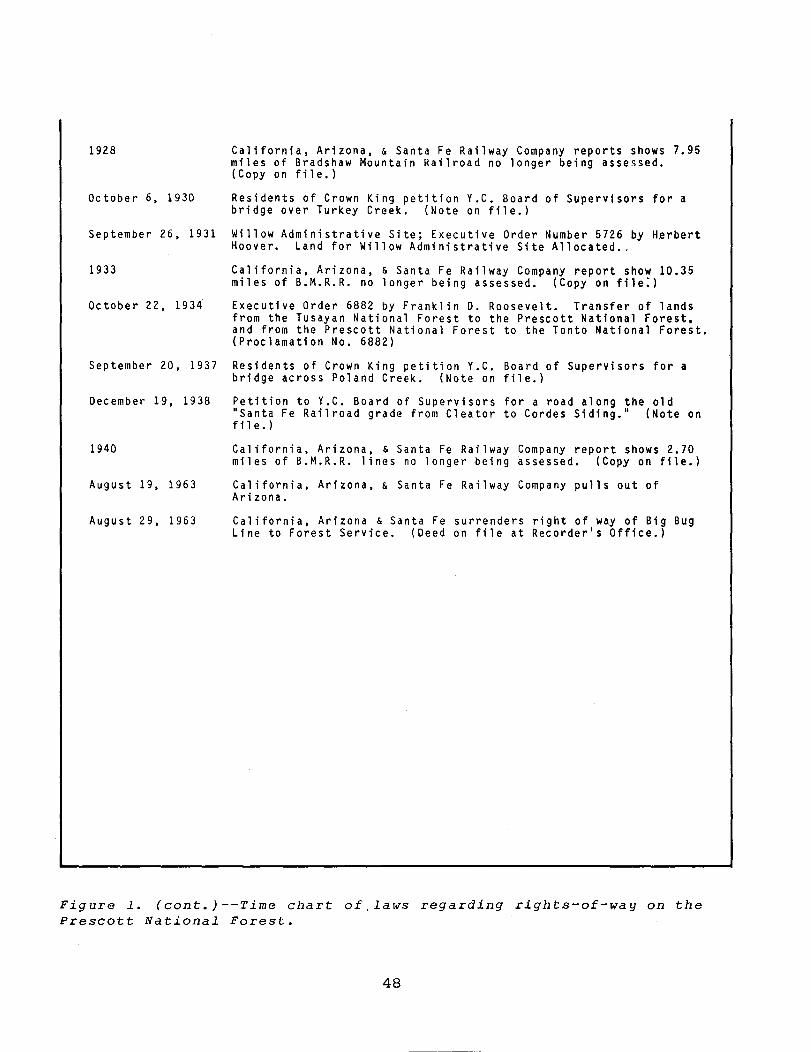
1928 California, Arizona, & Santa Fe Railway Company reports shows 7.95 miles of Bradshaw Mountain Railroad no longer being assessed. (Copy on file.)
October 6, 1930 Residents of Crown King petition Y.C. Board of Supervisors for a bridge over Turkey Creek. (Note on file.)
September 26, 1931 Willow Administrative Site; Executive Order Number 5726 by H~rbert Hoover. Land for Willow Administrative Site Allocated •.
1933 California, Arizona, & Santa Fe Railway Company report show 10.35 miles of B.M.R.R. no longer being assessed. (Copy on file:)
October 22, 1934 Executive Order 6882 by Franklin D. Roosevelt. Transfer of lands from the Tusayan National Forest to the Prescott National Forest, and from the Prescott National Forest to the Tonto National Forest. (Proclamation No. 6882)
September 20, 1937 Residents of Crown King petition Y.C. Board of Supervisors for a bridge across Poland Creek. (Note on file.)
December 19, 1938 Petition to Y.C. Board of Supervisors for a road along the old "Santa Fe Railroad grade from Cleator to Cordes Siding." (Note on fll e.)
1940 California, Arizona, & Santa Fe Railway Company report shows 2.70 miles of B.M.R.R. lines no longer being assessed. (Copy on file.)
August 19, 1963 California, Arizona, & Santa Fe Railway Company pulls out of Arizona.
August 29, 1963 California, Arizona & Santa Fe surrenders right of way of Big Bug Line to Forest Service. (Deed on file at Recorder's Office.)
Figure 1. (cont.) --Time chart of, laws regarding rights-of-way on the Prescott National Forest.
48
Awards for 1983 Field Notes Articles
We finished the review of your ratings for the 1983 Engineering Field Notes articles • • • many ran neckand-neck right down to the final count. The point value assigned to each article reflects the readers' choices (first = 3 points, second = 2 points, and third = 1 point).
Congratulations to the high-scoring authors; toprated were one Westerner and two Southeasterners.
Ted Fitzgerald, Construction Engineer in Region 4, wrote the "Welded Wire Retaining Walls" article; Ron MCNemar, Civil Engineer in Region 8, gave us the description of "Use of Concrete Ramp Planks" (probably very interesting for this coming wet spring season)~ and Edgar Hedgecock, another Region 8 Civil Engineer, wrote about "In-Place Preservative Treatment of Deteriorating Wood Bridges."
More than 30 writers took the time to write good articles, in spite of their heavy workloads. The responses of Field Notes' readers prove that our authors' articles were, indeed, read Servicewide • • • and their efforts were appreciated by their peers in the field.
Spring of 1984 is almost here, and the really busy season is rushing on us. Don't get left out--send in YOUR masterpiece for the 1984 Field Notes Articles Awards. Tell your friends in the field how you found a way to make your job--and the whole Forest Service-more effective, or why you found some aspect of your work challenging and solving problems rewarding.
G. L. "Scotty" Rome EDITOR
49
The Series:
Distribution:
Submittals:
Inquiries:
Regional Coordinators:
Engineering Technical Information System THE ENGINEERING FIELD NOTES SERIES is published periodically as a means of exchanging engineering-related ideas and information on activities, problems encountered and solutions developed, or other data that may be of value to engineers Service-wide. Articles are usually less than six pages, and include material that is not appropriate for an Engineering Technical Report, or suitable for Engineering Management publications (FSM 1630 and 7113).
Each Field Notes edition is distributed to the Engineering Staff at Regional Offices, Forests, Stations, and Area Headquarters, as well as to Forest Service Engineering Retirees. If your office is not receiving the Field Notes, ask your Office Manager or Regional Information Coordinator to increase the number of copies for your location. Copies of back issues are available in limited quantities from the Washington Office.
Every reader is a potential author of a Field Notes article. If you have a news item or short description about your work that you wish to share with Forest Service Engineers, we invite you to submit the article for publication. Field Personnel should send material to their Regional Information Coordinator for review by the Regional Office to assure inclusion of information that is accurate, timely, and of interest Service-wide; short articles and news items are preferred. Type the manuscript double-spaced; include original drawings and black-and-white photographs (if only color photographs are available, send transparencies or negatives), and two machine copies of the manuscript.
Regional Information Coordinators should send articles for publication and direct questions concerning format, editing, publishing schedules, etc., to:
FOREST SERVICE - USDA Engineering Staff - Washington Office Att: G.L. Rome, Editor
D.J. Carroll, Editorial Assistant P.O. Box 2417 - Washington, D.C. 20013 Telephone: Area Code 703/FTS-235-8198
R-1 Larry Bruesch R-2 Mike Clinton R-3 Jerry Martinez
R-4 Ted Wood R-5 Phillip Russell R-6 Kjell Bakke R-8 Tom Poulin -
R-9 Mujeebul Hasan R-10 Mel Dittmer WO AI Colley
• ·u.s, GOVERNJo:F.NT PRINTING OFFICE: 1984 0-420-932!FS-2060

Volume 16 February-March 1984 Engineering Field Notes


