Embed Size (px)
Citation preview

Durmus CesurPh.D., PMP, P.E….
Application Support ManagerDCHC MPO

Agenda
• Title VI – Basics• EJ Background• GIS Data and Analysis for Title VI and EJ Reporting• DCHC MPO Title VI and EJ Reporting Final Outcomes

What is Title VI?• Federal law from The Civil Rights Act of 1964
that states:– No person in the United States shall on the
ground of race, color, or national origin be excluded from participation in, be denied the benefits of, or be subjected to discrimination under any program or activity receiving Federal financial assistance.
• Nondiscrimination in the Federal-Aid Program
Title VI Training: NCRPO Association
3

What is Discrimination?Title VI Training: NCRPO Association
• Federal Highway Administration (FHWA):– That act (action or inaction), whether
intentional or unintentional, through which a person in the United States solely because of race, color, national origin, sex, age, or disability is subjected to disparate treatment or impact, in any program or activity receiving Federal financial assistance from FHWA.
4

Why do MPOs have to follow Title VI?
Title VI Training: NCRPO Association
• 1987 Civil Rights Restoration Act– Title VI includes all programs and activities of
Federal-aid recipients and contractors whether federally funded or not
• Any subrecipient of NCDOT must abide by Title VI
• Local, state- or federally-assisted activities of federal-aid MPOs
5

Other Nondiscrimination Acts/Orders
Title VI Training: NCRPO Association
• Related Nondiscrimination Authorities include:– The Civil Rights Act of 1964 (race)– 1973 Federal-aid Highway Act (sex)– Age Discrimination Act of 1975 (age)– Section 504 of the 1973 Rehabilitation Act and Americans with Disabilities Act
(ADA) of 1990 (disability)– Uniform Act of 1970 (persons displaced or property acquired)– Executive Order 12898 on Environmental Justice (EJ)
• US DOT Order 5610.2a and FHWA Order 6640.23A
– Executive Order 13166 on Limited English Proficiency (LEP)• US DOT LEP Guidance
• Title VI Implementing Regulations:– 49 C.F.R. 21 – US Department of Transportation (DOT) Title VI Regulation– 23 C.F.R. 200 – FHWA Title VI Regulation
6

7
Title VI Nondiscrimination ProgramTitle VI Training: NCRPO Association
• Race• Color• National Origin• LEP• Low Income• Color• Creed/Religion• Sex• Age

Title VI - Responsibilities• FHWA
– Provides stewardship and oversight– Approves Implementation Plans and conducts processreviews– Provide policy and technical assistance training
• State DOTs– Perform required actions under 23 C.F.R. Part 200– Submit annual Plan, assurances, and Report to FHWADivision– Conducts internal and external reviews– Process and investigate complaints against subrecipients
• Local Agency Recipients- Conform to State DOT Implementation Plan, including: Collection and analysis of demographic data, complaint procedures, training requirements and LEP, submit annual assurances to State DOT and use contract inserts, submit reports on demographic data requested from State DOT

Title VI Program Plan Sections
Title VI Training: NCRPO Association
9
Sections1. Policy Statement and Notice of Nondiscrimination2. Standard USDOT Title VI Assurances3. Organization & Staffing4. Environmental Justice5. Data Collection/Analysis/Reporting6. Limited English Proficiency (LEP)7. Dissemination of Information8. External Discrimination Complaints9. Review of Organization Directives10. Title VI Training11. Compliance & Enforcement Training Procedures
Section 6: Safe Harbor Threshold
– 5% or 1,000 persons, whichever is less• Margin of Error
– “Limited ability” means less than very well (U.S. Census)
– Free written translation of vital documents for each eligible LEP population
– 5% and < 50 LEP persons (written notice of freeoral interpretation services)
10
Title VI Training: NCRPO Association

GIS Analysis, Charting and Mapping for Title VI and EJ
11

GIS Data and Analysis for Title VI
GIS Data for Title VI:• Population
• Age and Sex• Race and Ethnicity
• Household Income • Poverty• Disability• Limited English Proficiency

LEP Trends for DCHC MPO
13
0
1
2
3
4
5
6
7
8
9
2010 2011 2012 2013 2014 2015 2016 2017
% o
f Pop
ulat
ion
Year
Limited English Proficiency Trends for DCHC Region
Spanish
Asian
Other
Total

LEP for DCHC MPO
14
0.00%
1.00%
2.00%
3.00%
4.00%
5.00%
6.00%
7.00%
8.00%
9.00%
Alamance Chatham Durham Granville Orange Person Wake
Limited English Proficiency, as % of Total Population
Spanish
Asian
Other
Total

LEP for DCHC MPO
15
0.00%
20.00%
40.00%
60.00%
80.00%
100.00%
120.00%
Alamance Chatham Durham Granville Orange Person Wake
Limited English Proficiency, as % ofLEP Population
Spanish
Asian
Other

LEP for DCHC MPO
16
7%
4%
5%
8% 8%
6% 6%
0%
1%
2%
3%
4%
5%
6%
7%
8%
9%
United States North Carolina Triangle Region DCHC MPO Durham County Orange County Chatham County
Share of LEP Speakers

LEP Distribution in DCHC MPO Region
17

Race and Ethnicity
18

Age and Sex
19

Disability
20

Poverty
21

Household Income
22

Environmental Justice (EJ)Certification Review• Every four years, review of MPO planning processes• EJ Plan includes:
• Policy statement • Goals and objectives • Demographic profile • Overlays of demographic information on defined past, future, and
planned projects • Measures for identifying burdens and benefits of the MPO’s
transportation system • An analysis of identified burdens and benefits • Public involvement strategies to engage minority and low-income
populations
• Upcoming review May 2019
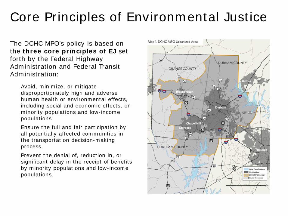
The DCHC MPO’s policy is based on the three core principles of EJ set forth by the Federal Highway Administration and Federal Transit Administration:
• Avoid, minimize, or mitigate disproportionately high and adverse human health or environmental effects, including social and economic effects, on minority populations and low-income populations.
• Ensure the full and fair participation by all potentially affected communities in the transportation decision-making process.
• Prevent the denial of, reduction in, or significant delay in the receipt of benefits by minority populations and low-income populations.
Core Principles of Environmental Justice

GIS Data and Analysis for Environmental Justice Reporting
GIS Data for EJ:• Demographic information at block group level• Population • Minority Population • Household Income • Block groups • Limited English Proficiency• No Access to Vehicle: Smart Location Database, EPA

Project Information with associated financial data:
• Metropolitan Transportation Plan Projects• Highway• Intersection• Bicycle and Pedestrian• Others (Bridges etc.)
• Transportation Improvement Program Projects• Highway• Intersection• Bike and Pedestrian• Others (Bridges etc.)

• Standardize/QA/QC of of datasets based on the GIS standards established at DCHC MPO
• Extract data sets based on DCH MPO boundary using Clip tool and selection tools• Map population in DCHC MPO boundary and derive population density per acre in
block group level to spotlight denser population areas (provide insights for population needing transportation services)
• Compute minority population as sum of Black, American Indian and Pacific Islander populations in the MPO region and deriving minority population percentage by dividing total population in DCHC MPO area
• Compute minority population over 65 is derived as sum of age over 65 to 80 and percentage is found by dividing DCHC MPO total minority population
• Determine Percent of Household poverty level is determined by number of household income in the past 12 months below poverty level divided with total MPO household.
• Compute Limited English Proficiency as the sum of Spanish, Other Indo-European, Asian and Pacific, and Other language speakers with no one 14 and over speaks English only or speaks English “Very well”.
• Populate/Update metadata for the critical layers and migrate into enterprise GIS database
• * No vehicle access information is readily available with the values for zero auto owners within block group in EPA smart location database

Locating EJ “Communities of Concern”
1. Interrelate the datasets
2. Merge the EJ indicators
3. Dissolve & aggregate
4. Join!
5. Merge to create new composite layer
6. Python scripting to identify overlapping areas
7. New GIS layer is generated which combines the selected block group that exceeds the threshold value

EJ Demographic ProfilesRacial Minority Populations (37.9%)

Overlapping EJ Block Groups
Many block groups had more than one EJ community of concern living there.
The GIS data layer was revised to display the number of EJ communities of concern that live within the same block group.
The greatest number of overlaps in a single block group was four, which means there were five different EJ communities of concern living there.

Overlapping EJ Block Groups

Overlapping EJ Block Groups

• The MTP and TIP projects were mapped.
• A buffer was applied to mapped highway projects to account for future proposed project area.
• The estimated total project costs and the FY2012-2018 total project costs were distributed by project segment for linear features.
• The segment was split to locate beginning and ending road intersection points.
• The “select by location” tool was used to determine the projects located within overlapping EJ communities of concern.
Locating MTP & TIP Projects Relative to EJ Communities of Concern

• Title VI EJ Report is a reference for local, regional, state organizations and is a best state-wide best practice example
• MPO received FHWA approval for the report by meeting all FHWA TMA Certification Requirements for EJ
• GIS processing can be speeded up further through collaborative editing using versioning and automation using more scripting
• GIS feature representations can be improved to better delineate and represent projects
• Methodology and GIS processing can be modified to incorporate spatial correlation effects and better cost estimation
• Data can be summarized based on population and better resolution (detailed) and more up-to-date data can be used for analysis if made available
Conclusions & Lessons LearnedTitle VI and EJ Conclusions

• Provide data & maps to MPO members and partners.
• Develop strategic outreach efforts for historically underrepresented populations and update Public Involvement Policy.
• Title VI/EJ Report methodology adjustments as MPO grows and populations transition. These adjustments to the methodology may include:
• Summary/report on the block group population.
• Assess projects based on road/project lengths with possible spatial correlation effects on adjacent neighborhoods.
• Further evaluate potential benefits and burdens related to TIP and MTP project TYPE. Not all project types are beneficial or burdensome to every neighborhood/community.
• More specific, unique, or customized delineation/geographical representation of project location.
• Additional indicators for EJ populations and Others?
Next StepsTitle VI and EJ Conclusions

Thank you !!!
Thank you !!! Questions???


