Embed Size (px)
Citation preview

EVERGREEN LAKE NORTH TRAIL Evergreen Park and Recreation District
September 2018
Prepared by:Funding by:
PHASE II: PLANNING STUDY

EVERGREEN LAKE NORTH TRAIL | PLANNING STUDY

ACKNOWLEDGMENTS
Evergreen Park and Recreation District (EPRD) | Staff
Great Outdoors Colorado (GOCO)
Evergreen Park and Recreation District | Board of Directors
Stakeholder Group
Consultant Team
Ellen O’Connor | Executive Director
Liz Cohen | Grant & Development Coordinator
Ann Marie Edwards | Executive Manager
Heart Cameron | Park Operations Manager
Funding for this planning study was provided by a grant from Great Outdoors Colorado (GOCO)
Bill May | President
Peter Lindquist | First Vice President Peg Linn | Second Vice President
John Ellis | Treasurer
Monty Estis | Secretary
Jana Spiker | CDOT
Robert Van Horn | CDOT
Stephen Harelson | CDOT
Bob Finch | Denver Mountain Parks
Brad Eckert | Denver Mountain Parks
Dave Lighthart | Evergreen Metro District (EMD)
Marc Rosenberg | Evergreen Metro District (EMD)
Tom Hoby | Jefferson County Open Space
Yelena Onnen | Jefferson County Transportation
Chris Vogelsang | PE | OV Consulting
Fernando Abbud | Urban Planner | OV Consulting
Dean Dalvit | AIA, PE | EV Studio
Brian Welch | PE ||EV Studio
EVERGREEN LAKE NORTH TRAIL | PLANNING STUDY

ABOUT THE PROJECT TEAM
Founded in 2002, OV consulting is a Denver area leader on planning and problem solving, specializing in planning, engineering, design of solutions, and implementation of connectivity and mobility improvements. Some focus areas include multi-modal and active transportation, land use integration, community healthy living practices, and policy and programming. OV Consulting brings a unique blend of planning and engineering skills to their projects and supplements those skills with innovative and significant expertise in community and stakeholder outreach and consensus building. Over the last decade, OV has led multi-modal planning and healthy communities efforts integrating transit operations and active transportation design for numerous Colorado jurisdictions. Some examples include the Evergreen Trails Master Plan, the Broadway & I-25 Station Area Plan, Brighton Boulevard Preliminary Design and Final Design, the National Western Center Master Plan, City and County of Denver Bicycle Facilities Design and Implementation Capital Improvement Programs of 2013-2015, the 38th/Blake “Next Steps” Study, and the FHWA sponsored Bicycle Traffic Signal Efficacy Study, among others.
EVstudio was founded in 2006 when the founders wanted to create a sustainable multi-disciplinary A/E firm to provide a one-stop shop for design services. With multiple disciplines at the ready, EVstudio can assist clients with their needs, and provide a seamless collaborative process.EVstudio features full-service civil, structural, mechanical, electrical and plumbing engineering disciplines with a design history of projects that include parks and recreation, municipal, commercial and education. Some examples include the Buchanan Park, Clement Park, Prospect Lake Beach House, Hillside Community Center, WIT Soldier and Family Assistance Center at Fort Hood. EVstudio focus areas within the parks and recreation field include wayfinding and pedestrian facilities, ADA access and improvements, retaining walls, and complex master planning.Our collaborative efforts extend beyond our office walls. We have well-established partnerships with a variety of city and county planners, inspectors and city officials in Denver and the surrounding areas. EVstudio team members communicate daily via meetings, phone calls, and digitally to ensure our projects are on-track and through permitting as seamlessly as possible. The disciplines also work interdependently with outside design firms, general contractors, developers and government agencies. EVstudio believes that through our natural integration, we can offer other companies a breadth of knowledge that individual architecture or engineering firms typically do not have on hand. Just another way EVstudio stands out against other design studios in the region.
OV Consulting
EVstudio
Planning Study and Multimodal Lead
Engineering and Preliminary Design Lead
EVERGREEN LAKE NORTH TRAIL | PLANNING STUDY

Chris is a Traffic Engineer with more than twenty years of experience in the transportation field including specific areas of expertise in bicycle and pedestrian facilities planning and design. His recent work on bicycle facility design, traffic operational design, and parking along with his expertise in multi-modal corridor planning and design make him a leader in the Denver region. His approach in successfully completing projects is to bring innovative multi-modal planning, traffic engineering and feasible implementation together in the development of complete streets and related projects relevant to each community. He has served as the consultant Project Manager or Design Lead on numerous area projects including Evergreen Trails Master Plan, the Denver Parks and Recreation (DPR) Ruby Hill Park Mobility Operational Study and Signing and Striping Plan, the Regulatory Sign Manual Development Project for DPR, and the Hale Parkway Traffic Study for Denver Pubic Works.
OV Consulting | Founding Principal and Engineer
Chris Vogelsang | PE
EVstudio | Founding Principal, Architect & Engineer
Dean Dalvit | AIA , PE Dean is a founding principal of EVstudio. Dean is licensed as an Architect and Professional Engineer, and as such, takes an integrated approach to all of his projects to seamlessly blend architectural design with practical engineering, resulting in projects that are both visually stunning and efficient and cost effective to construct. Dean’s personal pursuits include volunteering for Evergreen community master planning and fundraising effort for main street revitalization. Relationships with public entities and understanding the grant writing process for development is central to Dean’s role on the board of this Economic Development Council. Dean also owns and manages commercial property in Evergreen and Denver, and is very mindful of life cycle costs and how they can be controlled by virtue of the design. Some of Dean’s recent projects include the Ovation a mixed-use apartment complex in Denver, the Dell an affordable housing design project in Evergreen, and Nola Ruth mixed-use community master plan in Harker Heights Texas.
EVstudio | Director of Civil Engineering
Brian Welch | PE Brian is a Civil Engineer with over eight years of experience working at an Architecture/Engineering firm. His attention to detail and drive has helped Brian accomplish some amazing work in the civil engineering arena. Brian has tackled challenging projects in a variety of areas such as 1000+ acre silica mine, 15,000+ head of cattle dairy, to elementary/middle/high/collegiate facilities including multiple athletic complexes.
EVERGREEN LAKE NORTH TRAIL | PLANNING STUDY

EVERGREEN LAKE NORTH TRAIL | PLANNING STUDY
F
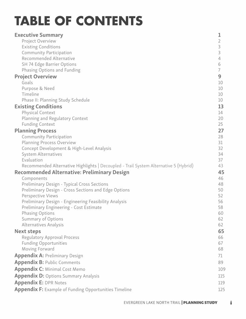
TABLE OF CONTENTSExecutive Summary 1
Project Overview 2Existing Conditions 3Community Participation 3Recommended Alternative 4SH 74 Edge Barrier Options 6Phasing Options and Funding 7
Project Overview 9Goals 10Purpose & Need 10Timeline 10Phase II: Planning Study Schedule 10
Existing Conditions 13Physical Context 14Planning and Regulatory Context 20Funding Context 25
Planning Process 27Community Participation 28Planning Process Overview 31Concept Development & High-Level Analysis 32System Alternatives 34Evaluation 37Recommended Alternative Highlights | Decoupled - Trail System Alternative 5 (Hybrid) 43
Recommended Alternative: Preliminary Design 45Components 46Preliminary Design - Typical Cross Sections 48Preliminary Design - Cross Sections and Edge Options 50Perspective Views 52Preliminary Design - Engineering Feasibility Analysis 56Preliminary Engineering - Cost Estimate 58Phasing Options 60Summary of Options 62Alternatives Analysis 62
Next steps 65Regulatory Approval Process 66Funding Opportunities 67Moving Forward 68
Appendix A: Preliminary Design 71Appendix B: Public Comments 89Appendix C: Minimal Cost Memo 109Appendix D: Options Summary Analysis 115Appendix E: DPR Notes 119Appendix F: Example of Funding Opportunities Timeline 125
iEVERGREEN LAKE NORTH TRAIL | PLANNING STUDY

EVERGREEN LAKE NORTH TRAIL | PLANNING STUDY
ii

Figure 01: Existing Typical Section from Preliminary Eng. Study 3Figure 02: Typical 10’ Upper Trail Cross Section 5Figure 03: Typical 8’ Upper Trail Cross Section 5Figure 04: Typical 5’ Natural Trail 5Figure 05: Typical 5’ Boardwalk-One Rail 5Figure 06: Typical 5’ Boardwalk-Two Rails 5Figure 07: Cross Section with Guardrail 6Figure 08 Cross Section with Curb and Gutter 6Figure 09: Study Area Map 14Figure 10: Water Transmission Line Options Diagram 15Figure 11: Structural Wall System Recommendation from Preliminary Engineering Study 18Figure 12: Alternative A from Preliminary Eng. Study 18Figure 13: Alternative B from Preliminary Eng. Study 18Figure 14: Topographic Survey 19Figure 15: Evergreen Trails Master Plan - Trail Overview Map 21Figure 16: Jefferson County Open Space Master Plan - Trails Map 22Figure 17: Jefferson County Bicycle and Pedestrian Plan - Bicycle Plan 23Figure 18: EPRD Master Plan - Trails Recommendations Map 24Figure 19: Planning Process Overview Diagram 31Figure 20: Concept Development Plan View Diagram 32Figure 21: Trail Concept Descriptions and High Level Analysis 33Figure 22: Evaluation Criteria 37Figure 23: Decoupled - Road System Alternative 1 - Cross Sections 38Figure 24: Decoupled - Road System Alternative 1 - Evaluation 38Figure 25: Decoupled - Road System Alternative 2 - Cross Sections 39Figure 26: Decoupled - Road System Alternative 2 - Evaluation 39Figure 27: Coupled - Trail System Alternative 3 - Cross Sections 40Figure 28: Coupled - Trail System Alternative 3 - Evaluation 40Figure 29: Coupled - Trail System Alternative 4 - Cross Sections 41Figure 30: Coupled - Trail System Alternative 4 - Evaluation 41Figure 31: Decoupled - Trail System Alternative 5 (hybrid) - Cross Sections 42Figure 32: Decoupled - Trail System Alternative 5 (hybrid) - Evaluation 42Figure 33: Recommended Alternative Plan View with Components 46Figure 34: Recommended Alternative Typical Trail Types 48Figure 35: Typical 10’ Upper Trail Cross Section 48Figure 36: Typical 8’ Upper Trail Cross Section 48Figure 37: Typical 5’ Lower Natural Pedestrian Trail Cross Section 49Figure 38: Typical 5’ Lower Boardwalk with Rail on One Side Cross Section 49Figure 39: Typical 5’ Lower Boardwalk with Rail on Two Sides Cross Section 49Figure 40: Recommended Alternative Plan View with Sections 50Figure 41: Recommended Alternative Cross Sections 50Figure 42: Cross Section with Guardrail 51Figure 43: Cross Section with Curb and Gutter 51Figure 44: Wall and Boardwalk Details 57Figure 45: Planning Level Opinion of Probable Cost (2018 dollars) 59Figure 46: Recommended Alternative Phasing Diagram 60
LIST OF FIGURES
iiiEVERGREEN LAKE NORTH TRAIL | PLANNING STUDY

EVERGREEN LAKE NORTH TRAIL | PLANNING STUDY

EXECUTIVE SUMMARYProject Overview | Existing Conditions | Community Participation | Recommended Alternative | SH 74 Barrier Options | Phasing Options and Funding
1EVERGREEN LAKE NORTH TRAIL | PLANNING STUDY

The Evergreen Lake North Trail Project was created in response to the Spring 2016 closure of the Evergreen Lake North Trail due to unstable conditions. Evergreen Park and Recreation District (EPRD) secured funding to develop a short-term and long-term solution, and created the Evergreen Lake North Trail Project. The project consists of three phases: Phase I: Preliminary Engineering Study, Phase II: Planning Study, and Phase III: Final Design.This report captures the 11-month Phase II: Planning Study whose purpose was to engage the community in a dialogue about a long-term vision and solutions to the Evergreen Lake North Trail unstable conditions and develop a community driven recommended alternative. Even though the trail is currently reopened to the public because of the short-term maintenance work performed by EPRD and Evergreen Metro District (EMD), there is still a need for a long-term vision and plan for the Evergreen Lake North Trail.
PROJECT OVERVIEW
Failure of trail during the Spring of 2016Trail reopened November 2017
Maintenance work by EPRD and EMD
2
EVERGREEN LAKE NORTH TRAIL | PLANNING STUDY

The Evergreen Park and Recreation District (EPRD) maintains the 1.25-mile Lake Loop trail around the Evergreen Lake. The 1,240 feet along the north shore of the Lake represents the Evergreen Lake North trail. The City and County of Denver owns the property where the trail is located and the Evergreen Metro District (EMD) owns a 12” water transmission main located under the trail. The space along the trail is highly constrained by SH 74 to the north and the Evergreen Lake to the south. CDOT operates and maintains SH 74 located directly adjacent to the trail. Drainage and structural issues have caused unstable conditions in the past. The previous Phase I: Preliminary Engineering Study and an additional topographic survey provided existing conditions information.
A goal of the Phase II: Planning Study was to engage the community in a dialogue around the long term vision and solutions to the Evergreen Lake North Trail. A robust stakeholder and community engagement component was present throughout the process.The stakeholder group, composed of representatives from key municipalities and organizations, gathered on three different occasions. The community was able to engage in the process, learn about the study, and share their concerns in two different community meetings and anytime through the project website.
The stakeholder group and the community were part of the different stages of the planning process that included: idea development, system alternatives, evaluation, and the final recommended alternative stage.
EXISTING CONDITIONS
COMMUNITY PARTICIPATION
Figure 01: Existing Typical Section from Preliminary Eng. Study
Cross Section of Existing Trail showing the approximate location of the transmission line (Source: Preliminary Engineering Report from Muller)
Community Meeting #2
Community Meeting #1
3
EXECUTIVE SUMMARY
EVERGREEN LAKE NORTH TRAIL | PLANNING STUDY

The Recommended Alternative performed well in all of the three evaluation categories and allows for flexibility of approval, funding and implementation processes. The main components of the recommended alternative include upper (road level) and lower (lake level) trails. The vision for the upper trail is a hard surface trail that can accommodate bicycles and pedestrians and connects the Pioneer Trail with downtown Evergreen. The vision for the lower trail is a pedestrian only trail consisting of a combination of natural surface and wooden boardwalk depending on the terrain.The render above illustrates how the two trails would work together. The rendering is taken from the middle of the trail looking east.
RECOMMENDED ALTERNATIVE
This rendering shows both the upper and lower boardwalk trail.Evergreen Lake North Trail | Middle Section | Looking East
4
EVERGREEN LAKE NORTH TRAIL | PLANNING STUDY

The typical cross sections vary based on the available space.The cross sections show how the 10’ and 8’ typical upper trail cross sections are applied in plan view. Towards the west/east ends the 10’ section is applied. In highly constrained areas, mostly in the middle section, a 8’ typical cross section is applied.The lower natural trail and boardwalk both are 5’. On the west, there is a 5’ natural pedestrian trail. As we move east, the trail transitions to a 5’ boardwalk. In the middle section, the boardwalk only has railing on the lake side, since on the other side it is adjacent to the slope. On the eastern section, the boardwalk has two rails since it becomes separated from the slope. The boardwalk begins to ramp up as it progresses to the east.For a more detail look at the preliminary design see Appendix A.
Figure 02: Typical 10’ Upper Trail Cross Section
Figure 03: Typical 8’ Upper Trail Cross Section
Figure 04: Typical 5’ Natural Trail Figure 05: Typical 5’ Boardwalk-One Rail
Figure 06: Typical 5’ Board-walk-Two Rails
Typical 10’ Upper Trail Cross Section
Typical 8’ Upper Trail Cross Section
Typical 5’ Lower Natural Pedestrian Trail
Typical 5’ Lower Boardwalk with Rail on One Side
Typical 5’ Lower Boardwalk with Rail on Two Sides
5
EXECUTIVE SUMMARY
EVERGREEN LAKE NORTH TRAIL | PLANNING STUDY
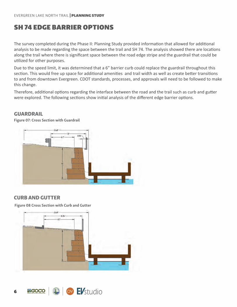
GUARDRAIL
The survey completed during the Phase II: Planning Study provided information that allowed for additional analysis to be made regarding the space between the trail and SH 74. The analysis showed there are locations along the trail where there is significant space between the road edge stripe and the guardrail that could be utilized for other purposes.Due to the speed limit, it was determined that a 6” barrier curb could replace the guardrail throughout this section. This would free up space for additional amenities and trail width as well as create better transitions to and from downtown Evergreen. CDOT standards, processes, and approvals will need to be followed to make this change.Therefore, additional options regarding the interface between the road and the trail such as curb and gutter were explored. The following sections show initial analysis of the different edge barrier options.
CURB AND GUTTER
SH 74 EDGE BARRIER OPTIONS
Figure 07: Cross Section with Guardrail
Figure 08 Cross Section with Curb and Gutter
6
EVERGREEN LAKE NORTH TRAIL | PLANNING STUDY

BA
BA
BA
CB
D
A
B
BA
C D
C D
C D
Road
Road
The recommended alternative includes a segment and phasing approach that allows for funding and implementation flexibility. Three phasing options were developed utilizing the four segments outlined in the diagram to the right. The phasing options include a minimum option, an upper/lower phasing option, and an all-at-once option. They all include constructing a portion or all of the upper trail first. This is primary due to the requirement (constraint) to protect the EMD water transmission line. The option selected will depend on funding sources, availability, and timing. The last chapter of this report “Next Steps” includes more detail about the different funding opportunities.
Segment A: Western upper segment where no wall failures have occurred
Segment B: Upper segment that needs to occur during phase one because of high risk conditions
Segment C: Western lower segment where natural trail occurs.
Segment C: Lower segment where boardwalk is needed and will happen during phase two.
PHASING OPTIONS AND FUNDING
PHASE 1 PHASE 2OPTION 1 MINIMUM COST
PHASE 1OPTION 2 UPPER/LOWER SPLIT
OPTION 3 FULL BUILD
PHASE 2
PHASE 1
7
EXECUTIVE SUMMARY
EVERGREEN LAKE NORTH TRAIL | PLANNING STUDY

8
EVERGREEN LAKE NORTH TRAIL | PLANNING STUDY

The Evergreen Park and Recreation District (EPRD) maintains a 1.25 mile-long Evergreen Lake Loop Trail. The focus of this Planning Study is the portion of the trail called the Evergreen Lake North Trail located along the north shore of the lake and directly adjacent to the south side of SH 74.
The Evergreen Lake North Trail Project was created in response to the Spring 2016 closure of the trail between Upper Bear Creek Road and Evergreen Dam along Highway 74. During later part of 2016 Evergreen Park and Recreation District (EPRD) secured funding for a short-term and long-term solution, and created the Evergreen Lake North Trail Project. The project consists of three phases: Phase I Preliminary Engineering Study, Phase II Planning Study, and Phase III Final Design.
This reports documents the existing conditions, planning process, system alternatives, evaluation, recommended alternative, and next steps for the Phase II Planning Study.
Goals | Purpose | Need | Timeline | Schedule
PROJECT OVERVIEW
9EVERGREEN LAKE NORTH TRAIL | PLANNING STUDY
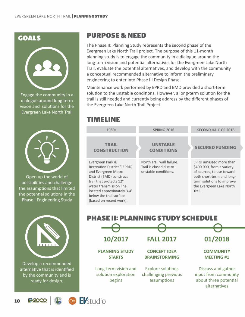
The Phase II: Planning Study represents the second phase of the Evergreen Lake North Trail project. The purpose of this 11-month planning study is to engage the community in a dialogue around the long-term vision and potential alternatives for the Evergreen Lake North Trail, evaluate the potential alternatives, and develop with the community a conceptual recommended alternative to inform the preliminary engineering to enter into Phase III Design Phase.Maintenance work performed by EPRD and EMD provided a short-term solution to the unstable conditions. However, a long-term solution for the trail is still needed and currently being address by the different phases of the Evergreen Lake North Trail Project.
PURPOSE & NEED
Engage the community in a dialogue around long term vision and solutions for the Evergreen Lake North Trail
Open up the world of possibilities and challenge
the assumptions that limited the potential solutions in the
Phase I Engineering Study
Develop a recommended alternative that is identified
by the community and is ready for design.
TRAIL CONSTRUCTION
UNSTABLE CONDITIONS SECURED FUNDING
Evergreen Park & Recreation District “(EPRD) and Evergreen Metro District (EMD) construct trail that protects 12” water transmission line located approximately 3-4’ below the trail surface (based on recent work).
North Trail wall failure. Trail is closed due to unstable conditions.
EPRD amassed more than $400,000, from a variety of sources, to use toward both short-term and long-term solutions to improve the Evergreen Lake North Trail.
TIMELINE1980s SPRING 2016 SECOND HALF OF 2016
PHASE II: PLANNING STUDY SCHEDULE
GOALS
10/2017
PLANNING STUDY STARTS
Long-term vision and solution exploration
begins
FALL 2017
CONCEPT IDEA BRAINSTORMING
Explore solutions challenging previous
assumptions
01/2018
COMMUNITY MEETING #1
Discuss and gather input from community about three potential
alternatives
10
EVERGREEN LAKE NORTH TRAIL | PLANNING STUDY
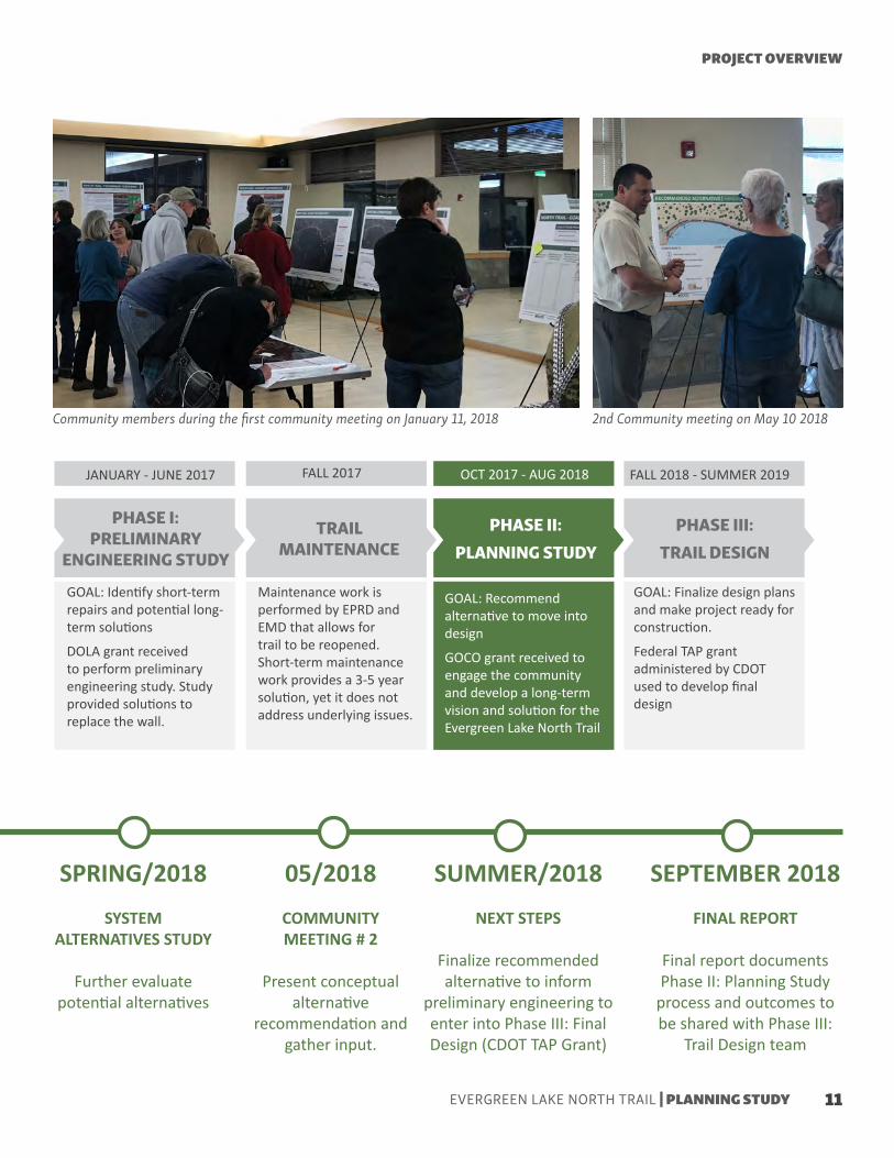
PHASE I: PRELIMINARY
ENGINEERING STUDY
PHASE II: PLANNING STUDY
PHASE III: TRAIL DESIGN
TRAIL MAINTENANCE
GOAL: Identify short-term repairs and potential long-term solutions
DOLA grant received to perform preliminary engineering study. Study provided solutions to replace the wall.
GOAL: Finalize design plans and make project ready for construction.
Federal TAP grant administered by CDOT used to develop final design
Maintenance work is performed by EPRD and EMD that allows for trail to be reopened. Short-term maintenance work provides a 3-5 year solution, yet it does not address underlying issues.
GOAL: Recommend alternative to move into design
GOCO grant received to engage the community and develop a long-term vision and solution for the Evergreen Lake North Trail
FALL 2017JANUARY - JUNE 2017 FALL 2018 - SUMMER 2019OCT 2017 - AUG 2018
Community members during the first community meeting on January 11, 2018 2nd Community meeting on May 10 2018
SPRING/2018
SYSTEM ALTERNATIVES STUDY
Further evaluate potential alternatives
05/2018
COMMUNITY MEETING # 2
Present conceptual alternative
recommendation and gather input.
SUMMER/2018
NEXT STEPS
Finalize recommended alternative to inform
preliminary engineering to enter into Phase III: Final Design (CDOT TAP Grant)
SEPTEMBER 2018
FINAL REPORT
Final report documents Phase II: Planning Study
process and outcomes to be shared with Phase III:
Trail Design team
PROJECT OVERVIEW
11EVERGREEN LAKE NORTH TRAIL | PLANNING STUDY

12
EVERGREEN LAKE NORTH TRAIL | PLANNING STUDY

The Evergreen Park and Recreation District (EPRD) maintains the 1.25-mile Lake Loop trail around the Evergreen Lake. The 1,240 feet along the north shore of the Lake represents the Evergreen Lake North trail which is the focus of this study.
The City and County of Denver owns the property where the trail is located and the Evergreen Metro District (EMD) owns a 12” water transmission line located under the trail. Through intergovernmental agreements, EPRD manages the park and trails. CDOT operates and maintains SH 74 located directly adjacent to the trail.
The space along the trail is highly constrained by SH 74 to the north and Evergreen Lake to the south. Drainage and structural issues have caused unstable conditions in the past.
The previous Phase I: Preliminary Engineering Study and an additional topographic survey provided existing conditions information. This chapter documents the existing conditions regarding the Evergreen Lake North trail seen from a physical, regulatory and funding contexts.
Physical Context | Planning & Regulatory Context | Funding Context
EXISTING CONDITIONS
13EVERGREEN LAKE NORTH TRAIL | PLANNING STUDY

Study Area
Evergreen Lake North Trail Background and HistoryStudy Area
PHYSICAL CONTEXT
Figure 09: Study Area Map
Existing Trails Proposed Trails Evergreen Lake North Trail
The study area is a 1,240 feet segment of the 1.25 Evergreen Lake Loop Trail called the Evergreen Lake North Trail. The trail is located along the north shore of the lake and directly adjacent to the south side of SH 74. This trail serves as a key connection between the west and east sides of the lake. It helps connect amenities and trails on the west side of the lake with the east side of the lake and Downtown Evergreen.
The Evergreen Lake North Trail was constructed in 1988 using a galvanized steel bin gravity wall system that was filled with backfill. A crusher fine trail was then constructed on top of the bin wall system with fill . The trail was constructed concurrently with a 12” water transmission line from the Evergreen Metro District (EMD) located under the trail. Shortly after the trail was constructed, a timber facing consisting of 12”x3” rough saw members was added for aesthetic purposes.
14
EVERGREEN LAKE NORTH TRAIL | PLANNING STUDY
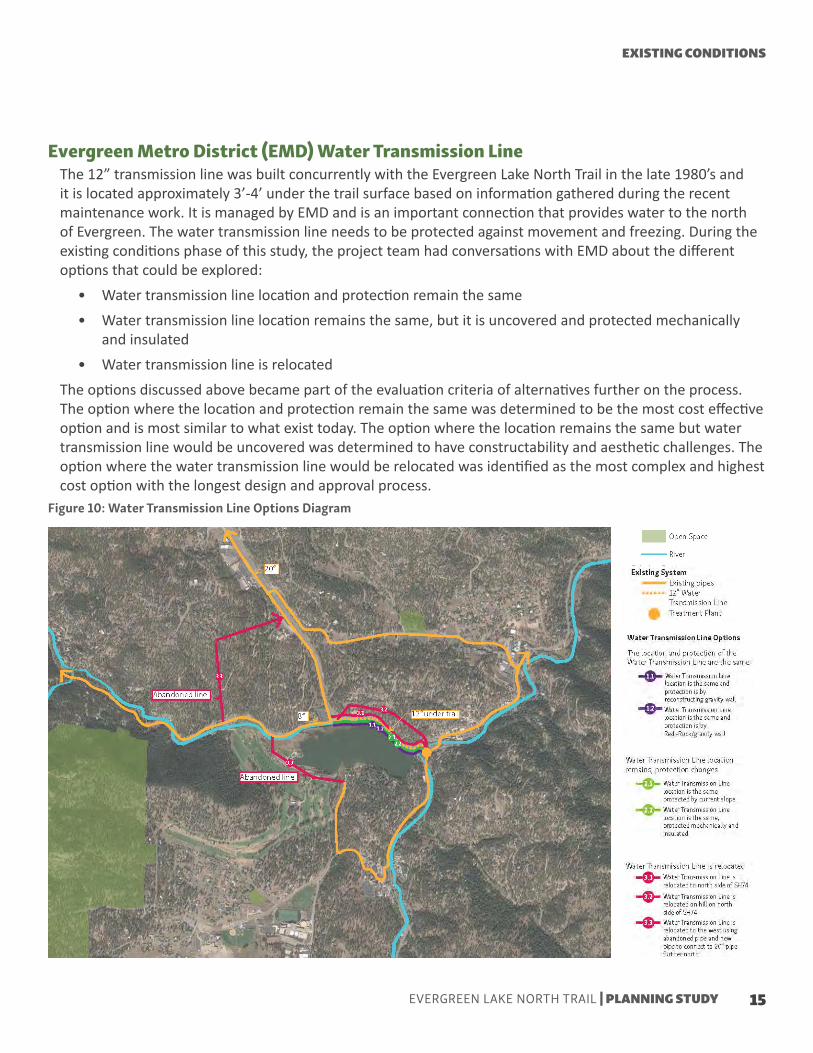
Evergreen Metro District (EMD) Water Transmission LineThe 12” transmission line was built concurrently with the Evergreen Lake North Trail in the late 1980’s and it is located approximately 3’-4’ under the trail surface based on information gathered during the recent maintenance work. It is managed by EMD and is an important connection that provides water to the north of Evergreen. The water transmission line needs to be protected against movement and freezing. During the existing conditions phase of this study, the project team had conversations with EMD about the different options that could be explored:
• Water transmission line location and protection remain the same• Water transmission line location remains the same, but it is uncovered and protected mechanically
and insulated• Water transmission line is relocated
The options discussed above became part of the evaluation criteria of alternatives further on the process. The option where the location and protection remain the same was determined to be the most cost effective option and is most similar to what exist today. The option where the location remains the same but water transmission line would be uncovered was determined to have constructability and aesthetic challenges. The option where the water transmission line would be relocated was identified as the most complex and highest cost option with the longest design and approval process.
Figure 10: Water Transmission Line Options Diagram
EXISTING CONDITIONS
15EVERGREEN LAKE NORTH TRAIL | PLANNING STUDY

Unstable Conditions and MaintenanceOverall Facts
In recent years failures in some sections of the trail have been increasing. Due to drainage, structural, and surface issues the galvanized steel bin gravity wall system installed in the late 1980’s that supports the Evergreen Lake North Trail has suffered failures. In late April 2016, after heavy spring snowfalls and runoff from the spring thaw, a significant failure of several sections of the trail occurred and posed safety issues to trail users.In response to those safety issues, the trail was closed in late April 2016. EPRD quickly amassed funding and created the Evergreen Lake North Trail Project to develop a long-term vision and solution. Concurrently, EPRD and EMD performed maintenance work that served as a short term solution to be able to reopen the trail back to the public in November 2017.
• Evergreen Lake Loop Trail is a 1.25 mile trail. The Evergreen Lake North Trail segment is 1,240 feet.
• Evergreen Lake North Trail was constructed on top of a gravity wall made of galvanized steel bin system filled with backfill.
• The trail protects a 12” water transmission line that provides water to the north of Evergreen.
• The transmission line is protected against movement and freezing.
• 12” water transmission line is located approximately 3’-4’ under the trail surface based on recent maintenance work.
• Trail width varies from 5’-8’ wide.
• Maintenance activities fixed damage to the trail and provided a short term fix. However, the trail is likely to be closed during certain times until long-term solution is implemented and the causes of the unstable conditions are addressed.
• EPRD strategically phased the project to investigate and implement a short-term solution and reopen the trail while a long-term vision and solution are developed with the community. Trail surface collapsed (Source: Preliminary Engineering Study)
16
EVERGREEN LAKE NORTH TRAIL | PLANNING STUDY

Bowing of wood panels (Source: Preliminary Engineering Study)
Maintenance work performed by EPRD and EMD(Source: EPRD)
Trail section after maintenance work(Source: project team)
Trail during summer 2018(Source: project team)
Short-term solution after maintenance work(Source: EPRD)
Erosion under trail(Source: Preliminary Engineering Study)
Trail surface collapse(Source: Preliminary Engineering Study)
EXISTING CONDITIONS
17EVERGREEN LAKE NORTH TRAIL | PLANNING STUDY

Phase I: Preliminary Engineering Study Overview
Recommended structural wall system
Alternative A
Alternative B
Figure 11: Structural Wall System Recommendation from Preliminary Engineering Study
Figure 12: Alternative A from Preliminary Eng. Study
Figure 13: Alternative B from Preliminary Eng. Study
The Preliminary Engineering Study by Muller Engineering was performed as part of Phase I of the Evergreen Lake North Trail Project. The purpose of the study was to develop baseline information and conduct Geo-technical, civil, geometric, drainage, and structural engineering analysis. The Preliminary Study was completed in June 2017. The existing data documented in the study included existing structural data, utilities, trail alignment and width, drainage, environmental constraints, a Geo-technical investigation and recognition of architectural requirements. The study does not recommend any temporary repairs. In addition to documenting existing data, the study provides recommendations for the retaining wall , trail and drainage.
Phase I : The Preliminary Engineering Study recommended two alternatives: A and B. Both alternatives include a combination of two different wall systems (gravity wall/Redi-Rock and a Soil Nail Sister Wall) as their structural wall type.
Alternative A consists of an 8’ dedicated bikeway adjacent to the roadway and an additional trail at lake level that transitions to a boardwalk where the lake frontage is minimal. Alternative A planning level cost estimate is $2,991,000.
Alternative B consists of a 10’ multiuse path adjacent to the roadway. Alternative B planning level cost estimate is $2,747,000
Gravity Wall (Redi-Rock)
8’ dedicated bikeway
Soil Nail Sister Wall
Natural surface pedestrian path
8’ boardwalk
10’ multiuse path
18
EVERGREEN LAKE NORTH TRAIL | PLANNING STUDY

Topographic Survey
Figure 14: Topographic Survey
As part of the Phase II: Planning Study a topographic survey was performed. The project team determined that it was pertinent to conduct the survey at this time in the process to better understand the existing space, distance and constraints along the Evergreen Lake North Trail. Because of the highly constrained environment along the trail, a better understanding of the relationship of the trail with SH 74 and the lake was desired. The project team wanted to better understand the following elements: trail width, space available between the trail and the road, and the horizontal and vertical distance between the trail and the water.The information provided by the topographic survey was helpful to create a better picture of the existing available space. The topographic survey complemented the existing conditions data from the Phase I: Preliminary Engineering Study with the following additional existing conditions data.
• Toe of slope (north of road)• Edge of road asphalt• Edge of road Striping (North side)• Edge of road Striping (South side)• Edge of road asphalt• Ground shots at back edge of Guard Rail• Gravel edge (Likely edge of the trail)• Handrail (Trail)• Top of Timber Wall
• Bottom of Timber Wall (Note that TOW and BOW are not immediately adjacent)
• The Grade Break between Wall and water surface
• The water surface• Utilities (sanitary manholes along Bear Creek
Road, water valves, power/telephone poles, and telephone manholes)
• Signage
EXISTING CONDITIONS
19EVERGREEN LAKE NORTH TRAIL | PLANNING STUDY

Regulatory Context
Previous Plans Common Themes
Evergreen Trails Master Plan (2015)
PLANNING AND REGULATORY CONTEXT
The regulatory context around the Evergreen Lake North Trail is complex:• The Evergreen Park and Recreation District (EPRD) maintains the Evergreen Lake North Trail which is
part of the Evergreen Lake Loop Trail. The property under the trail is owned by the City and County of Denver, and through Intergovernmental agreements, the EPRD manages the park and trails.
• Under the trail there is a 12” water transmission line owned and maintained by EMD.• The trail is located directly adjacent to SH 74 which is operated and maintained by CDOT. • The trail is located on the north shore of the Evergreen lake, which is a focal node between local and
regional connections.• Potential National Park Service (NPS) consultation requirements based on Land and Water
Conservation Funds (LWCF) used in the Evergreen Lake during a 1966 Project. Consult the LWCF 6(f)(3)Boundary Map for applicability. NEPA section 4(f) Park Lands consultation may also be required.
• Potential environmental and US Army Corps of Engineers consultation requirements (to be determined as the project moves into the design phase) including potential Section 404 permit requirements.
• Potential consultation with the Colorado State Historic Preservation Officer (SHPO) including the need for a Cultural Resource Survey.
The following local and regional plans highlight the Evergreen Lake North Trail in different ways. Some of the common themes between the different plans include the following:
• Evergreen Lake area and the trail around the lake are an important node within the local and regional trail network.
• Improvements to both ends of the North Trail
as well as to the trail itself are recommended in several plans.
• Recommended improvements to the network include: Recreational, mobility, connectivity, accessibility and safety recommendations.
• Maintain/Preserve Evergreen’s character• The North Trail represents an important link
to several existing proposed regional trails.
• Long-term improvement by widening trail to 14’ and paving it from Pioneer Trail to the Dam
• Improvements along Meadow Drive to serve as a regional connection bypassing Evergreen Lake and the Downtown area. Improvements to happen in different phases include: sharrows, 5’ wide paved shoulders, 10’ wide concrete trail, and improved Evergreen Parkway crossing.
• Meadow Drive is shown as an existing Jefferson County Open Space (JCOS)trail in the trail analysis made by JCOS.
• Proposed regional trail connections from different plans from Evergreen to the East, both along SH 74 and through the open space parks
20
EVERGREEN LAKE NORTH TRAIL | PLANNING STUDY

Evergreen Area Plan (2015)
Figure 15: Evergreen Trails Master Plan - Trail Overview Map
• Evergreen Lake should continue to be a focal point of the Evergreen area.• More non-motorized trails should be established to provide a trails network
that is accessible, varied on trail types and landscapes, connected, and visual boundaries between roadways or trails and the surrounding landscape.
• A proposed trail should connect the trail around Evergreen Lake with the Bear Creek Trail of Morrison, by going through Downtown Evergreen , Kittredge and Idledale. This trail would link Mt. Falcon Park, Bear Creek Canyon, Little Park and Lair o’ the Bear Park.
• A trail should connect Evergreen Lake to Conifer/Aspen Park.• Future uses of the Evergreen Lake should preserve and enhance the visual
quality, shoreline and wetlands and encourage conservation and restoration of the lake’s natural environmental features.
• Future uses of the lake should provide for appropriate passive recreation and limited active recreation.
Source: Evergreen Trails Master Plan
EXISTING CONDITIONS
21EVERGREEN LAKE NORTH TRAIL | PLANNING STUDY

Jefferson County Open Space Master Plan (2014-2019)
Figure 16: Jefferson County Open Space Master Plan - Trails Map
• Potential connection or gap in existing networks (generalized corridors) from Evergreen Lake area to Conifer and from Bell Park to Morrison going through Indian Hills
Source: Jefferson County Open Space Master Plan
22
EVERGREEN LAKE NORTH TRAIL | PLANNING STUDY

Jefferson County Bicycle (and pedestrian) Plan (2012)
Figure 17: Jefferson County Bicycle and Pedestrian Plan - Bicycle Plan
• Evergreen Lake North Trail shown as an existing loose surface trail that connects an existing shared use path from the north with proposed shared use paths and proposed paved shoulders that lead to Morrison, Conifer and West on South Buffalo Park Road.
• Pedestrian Plan configuration is the same as the Bicycle Plan
Source: Jefferson County Bicycle and Pedes
EXISTING CONDITIONS
23EVERGREEN LAKE NORTH TRAIL | PLANNING STUDY

Evergreen Park & Recreation District Master Plan (2011)
Figure 18: EPRD Master Plan - Trails Recommendations Map
• North Trail is described as an existing trail that provides a connection to a proposed regional trail to Morrison and to Conifer
• Both ends of the North Trail, the Pioneer Trail connection to the west, and the Dam to the east, are highlighted as desired improved trail connections
• Meadow Drive to Highway 74 (#14) is shown as an existing parallel trail connection
Source: Trails Recommendations Map Resource Map: C. Evergreen Park & Recreation District Master Plan
24
EVERGREEN LAKE NORTH TRAIL | PLANNING STUDY

• EPRD has indicated it does not have the resources to fund the project without additional funding from a bond, grant awards, and/or assistance from stakeholders.
• A good part of the potential grant funding sources involve federal grant dollars. Use of federal grant dollars generally increases the administrative complexity and construction cost of a project.
• There are several funding sources that could help implement this project. EPRD currently is considering asking voters to approve a bond that would include funding for this project in November 2018. Grant funding will be pursued regardless of the success of the bond effort.
• Due to the regulatory and physical complexities that surround the trail, the costs and constructability issues might increase. Therefore, a creative multi-part funding strategy will be required.
• Having a community supported long-term vision that aligns with the timeline of different funding sources is critical.
• Final chapter ‘Next Steps’ outlines a more detailed funding strategy and approach.
FUNDING CONTEXT
EXISTING CONDITIONS
25EVERGREEN LAKE NORTH TRAIL | PLANNING STUDY

26
EVERGREEN LAKE NORTH TRAIL | PLANNING STUDY

A main goal of the Phase II: Planning Study goals was to engage the community in a dialogue around a long-term vision and solutions to the Evergreen Lake North Trail. The Phase II: Planning Study included a robust stakeholder and community engagement component throughout the process.
The stakeholder group, composed of representatives from key municipalities and organizations, gathered in three different occasions. The community was able to engage with the process, learn about the study, and share their concerns in two different community meetings and anytime through the project website.
Both the stakeholder group and the community were part of the different stages of the planning process. From the early stages of idea development, through the alternatives development and evaluation stages, and during the recommended alternative stage.
This chapter documents the stages of the planning process and the different community engagement opportunities and input throughout the process.
Community Participation | Planning Process Overview | Concept Development | System Alternatives | Evaluation | Recommended Alternative Highlights
PLANNING PROCESS
27EVERGREEN LAKE NORTH TRAIL | PLANNING STUDY

Stakeholder Group
Community Meetings
Community Meeting #1
A group of stakeholders was setup for the Phase II: Planning Study. Throughout the planning process the stakeholder group was continuously involved. The group met on three different occasions. During the first meeting, the grouped discussed the overall range of ideas. The purpose of the second meeting was to share the system alternatives, evaluation process, recommended alternative, and implementation strategy. During the last meeting the final report was shared with the group, and next steps were discussed.The stakeholder group was composed of representatives from different organizations, municipalities and departments which provided critical input during the Phase II: Planning Study. The group was composed by the following representatives:
During each of the meetings the stakeholder group provided direction and feedback. Each organization provided input from their perspective. CDOT helped with the conversations related to roadway design issues. Denver Mountain Parks provided insight into the Denver approval process. EMD helped the group to understand the maintenance needs around the water transmission line. Jefferson County helped to better understand the role of this trail within the regional context.
The Phase II: Planning Study hosted two community meetings throughout the process, one at the beginning of the process on January 10, 2018 and one towards the end of the process on May 10, 2018. Both of the meetings took place at the Buchanan Park Recreation Center. The first meeting served as an introduction to the study and a listening session with the community. During the second meeting, the system alternatives, evaluation process, and recommended alternative were shared with the community.
The purpose of the first meeting was to introduce the Planning Study, provide background information, share the range of ideas, and listen to community concerns, comments and ideas. Around 50 community members gathered to learn more about the planning study and share their ideas and concerns.
Jana Spiker (CDOT)Robert Van Horn (CDOT)Stephen Harelson (CDOT)Bob Finch (Denver Mountain Parks)Brad Eckert (Denver Mountain Parks)
Dave Lighthart (EMD)Marc Rosenberg (EMD)Tom Hoby (Jefferson County Open Space)Yelena Onnen (Jefferson County Transportation)
COMMUNITY PARTICIPATION
Attendees listen to presentation during the first community meeting
28
EVERGREEN LAKE NORTH TRAIL | PLANNING STUDY

Community Meeting #1 - Input
The summary to the left shows what the community members told the project team during the first community meeting. Community members shared their ideas and concerns in different ways. Some community members shared their comments throughout the meeting during the presentations or in conversations, while others filled out a comment form. Additionally, some other community members shared their thoughts via email.
PLANNING PROCESS
29EVERGREEN LAKE NORTH TRAIL | PLANNING STUDY

The second community meeting took place the evening of Thursday, May 10, 2018. Around 25 community members gathered to hear about the alternatives for the Evergreen Lake North Trail and provide their input. The focus of the second community meeting was to share with community members the system alternatives evaluation process, and the recommended alternative. It was important to share with community members how their input from the first community meeting was incorporated into the evaluation process and criteria which consists of system criteria, public input criteria, and constraints.
Community Meeting #2
Attendees listening to the presentation during the second community meeting
Second community meeting
Attendees listening to the presentation during the second community meetingSecond community meeting presentation
30
EVERGREEN LAKE NORTH TRAIL | PLANNING STUDY
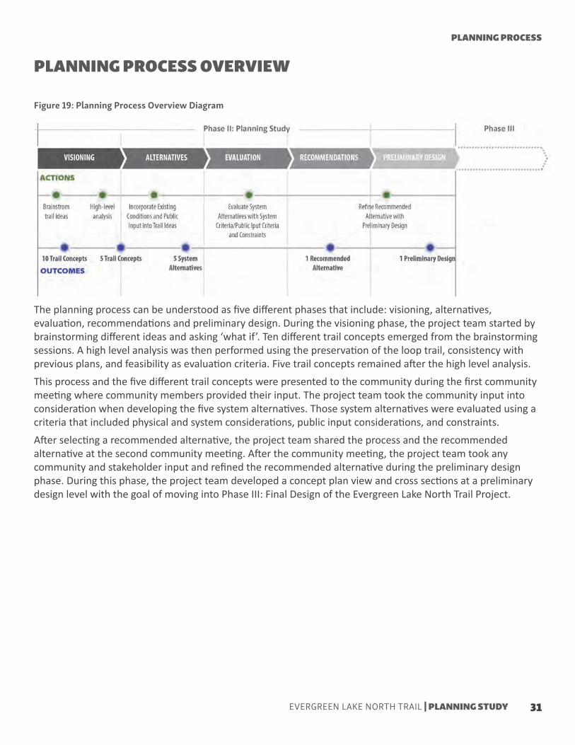
The planning process can be understood as five different phases that include: visioning, alternatives, evaluation, recommendations and preliminary design. During the visioning phase, the project team started by brainstorming different ideas and asking ‘what if’. Ten different trail concepts emerged from the brainstorming sessions. A high level analysis was then performed using the preservation of the loop trail, consistency with previous plans, and feasibility as evaluation criteria. Five trail concepts remained after the high level analysis.This process and the five different trail concepts were presented to the community during the first community meeting where community members provided their input. The project team took the community input into consideration when developing the five system alternatives. Those system alternatives were evaluated using a criteria that included physical and system considerations, public input considerations, and constraints.After selecting a recommended alternative, the project team shared the process and the recommended alternative at the second community meeting. After the community meeting, the project team took any community and stakeholder input and refined the recommended alternative during the preliminary design phase. During this phase, the project team developed a concept plan view and cross sections at a preliminary design level with the goal of moving into Phase III: Final Design of the Evergreen Lake North Trail Project.
PLANNING PROCESS OVERVIEW
Figure 19: Planning Process Overview Diagram
PLANNING PROCESS
31EVERGREEN LAKE NORTH TRAIL | PLANNING STUDY

With an understanding of the existing conditions from the Phase I: Preliminary Engineering Study, the project team brainstormed ideas. The first stage of this planning process was guided by the study goal of opening up the world of possibilities and challenging previous assumptions.The project team came up with ten possible trail concepts that could be part of the long-term vision and solutions. The ten trail concepts were grouped into three categories based on their primary purpose and goal: North Side, North-South Connection, and South Side Only. Figure 20 shows a conceptual plan view layout of the 10 trail concepts. Each trail concept is further explained in figure 21. Next, the project team refined the ten trail concepts through a high level evaluation using three primary considerations. The three primary considerations included consistency with previous plans and investment, feasibility, and the preservation of the Lake Loop Trail.After the high-level evaluation was performed, five trail concepts remained to be further investigated. The five trail concepts that remained (1A, 1B, 1C, 1D, and 1F) are highlighted on Figure 21. Trail concepts that did not performed well in the high-level evaluation are faded out on Figure 21.
CONCEPT DEVELOPMENT & HIGH-LEVEL ANALYSISFigure 20: Concept Development Plan View Diagram
32
EVERGREEN LAKE NORTH TRAIL | PLANNING STUDY

Figure 21: Trail Concept Descriptions and High Level AnalysisPLANNING PROCESS
33EVERGREEN LAKE NORTH TRAIL | PLANNING STUDY

Decoupled - Road System Alternatives
Five system alternatives were developed based on input from the first community meeting on the remaining trail concepts from the idea development stage. The five system alternatives are grouped into three categories: Decoupled - Road System Alternatives, Coupled - Trail System Alternatives, and Decoupled - Trail System Alternative.
This system alternative separates bicycles from pedestrians and provides a vertical separation between pedestrians and vehicles. Bicycles are intended to go on the road, either on SH 74 or an alternate route. Pedestrians are intented to go on a trail close to the water edge (natural trail/boardwalk).
This system alternative separates bicycles from pedestrians but does not provide a vertical separation between pedestrians and vehicles. Bicycles are intended to go on the road, either on SH 74 or an alternate route. Pedestrians are intended to go on a trail at road level. This is similar to the conditions that exist today.
BIKES (ROAD)PEDS (TRAIL LOW)
BIKES(ROAD)PEDS (TRAIL HIGH)
1
2
SYSTEM ALTERNATIVES
34
EVERGREEN LAKE NORTH TRAIL | PLANNING STUDY

Coupled - Trail System Alternatives
This system alternative combines pedestrian and bicycles in a multi-use trail, yet provides a vertical separation from vehicles. Bicycles and pedestrians are intended to go on a multi-use trail at a lower level than the road. Since this is the only connection, careful considerations should be given to ADA requirements and bicycle design standards.
This system alternative combines pedestrians and bicycles in a multi-use trail, and does not provide vertical separation from vehicles. Bicycles and pedestrians are intended to go on a multi-use trail at road level, that is designed to accommodate both pedestrians and bicycles.
BIKES/PEDS (TRAIL LOW)
BIKES/PEDS(TRAIL HIGH)
3
4
PLANNING PROCESS
35EVERGREEN LAKE NORTH TRAIL | PLANNING STUDY

Decoupled -Trail System Alternative (Hybrid)
This system alternative separates pedestrians and bicycles, as well as provides vertical separation between pedestrians and vehicles. Bicycles are intended to go on a multi-use trail at road level. Pedestrians are intended to go on a pedestrian recreational trail at a lower level than the road. The upper trail will serve as an ADA connection. The lower trail could have more recreational and natural elements.
5BIKES (TRAIL HIGH)PEDS (TRAIL LOW)
36
EVERGREEN LAKE NORTH TRAIL | PLANNING STUDY

Evaluation Criteria Overview
Figure 22: Evaluation Criteria
The evaluation matrix to analyze the five system alternatives is composed of three categories: System Criteria, Public Input Criteria, and Constraints. The three categories help evaluate the system alternatives from different perspectives, resulting in a more integral evaluation. Both the System Criteria and the Public Input Criteria are composed of desired elements. On the other hand, the Constraints category is composed of elements that are required to be addressed rather than just desired. Each category is described in more detail below.
System Criteria includes technical and system compatibility elements. This set of criteria helped evaluate the system alternatives from a technical, feasible, practical and systematic lens.
Public Input Criteria was created out of the input and comments expressed by community members at the first public meeting and via email. This set of criteria helped evaluate and guide the vision of the system alternatives from a community lens.
Constraints was set as a different category because the elements within this category were required to be addressed on top of desired elements from System Criteria and Public Input Criteria.
Funding Efficiency: This element refers to the ability of the system alternative to leverage different funding sources efficiently. Funding sources, timelines and requirements were consider as part of this element. The timeline for the CDOT TAP Grant, which EPRD already secured to implement final design, was crucial.
Transmission line protection: The protection of the water transmission line owned by EMD was a significant constraint element. Due to the requirement EPRD has to protect the water transmission line through an IGA with EMD. System alternatives were evaluated in terms their ability to protect the water transmission line. The three options, analyzed previously with EMD, that were considered include: location and protection remain the same, location remains the same but water transmission lines is uncovered and is protected mechanically, and water transmission line is relocated.
Approval process: This element evaluates the alternatives based on their ability to accommodate the different approval processes that might be required, therefore affecting the funding timeline. In other words, an alternative different than what exists today might require a different approval process, which might result in a greater challenge to meet certain funding opportunities.
EVALUATION
PLANNING PROCESS
37EVERGREEN LAKE NORTH TRAIL | PLANNING STUDY

A B
C
System Alternatives Evaluation Process
Figure 23: Decoupled - Road System Alternative 1 - Cross Sections
Figure 24: Decoupled - Road System Alternative 1 - Evaluation
A
B
C
This System Alternative separates bicycles from pedestrians and provides a vertical separation between pedestrians and vehicles. Bicycles are intended to go on the road, either on SH 74 or an alternate route. Pedestrians are intended to go on a trail close to the water edge (natural trail/boardwalk).Concept level cross sections show a lake level pedestrian trail along the north bank of the lake. This alternative performed poorly in the system criteria and constraint categories, yet it performed well in the public input criteria. Constructability, protection of transmission main, maintenance, and approval processes become more challenging with a lower level trail. Yet, the community-desired user experience is enhanced.
1BIKES (ROAD)
PEDS (TRAIL LOW)
DECOUPLED - ROAD SYSTEM ALTERNATIVES
38
EVERGREEN LAKE NORTH TRAIL | PLANNING STUDY

A B
C
Figure 25: Decoupled - Road System Alternative 2 - Cross Sections
Figure 26: Decoupled - Road System Alternative 2 - Evaluation
This System Alternative separates bicycles from pedestrians but does not provide a vertical separation between pedestrians and vehicles. Bicycles are intended to go on the road, either on SH 74 or an alternate route. Pedestrians are intended to go on a trail at road level. This is similar to the conditions that exist today.Concept level cross sections show a road level pedestrian trail in a similar location as the existing trail.This alternative did not perform well or poorly in any specific category. Constructing this alternative might be challenging, yet is not that different from the existing trail. In addition the water transmission line protection remains the same. However, as a long-term vision for the trail, this system alternative does not fulfill the community’s vision
2BIKES(ROAD)
PEDS (TRAIL HIGH)
A
B
C
DECOUPLED - ROAD SYSTEM ALTERNATIVES
PLANNING PROCESS
39EVERGREEN LAKE NORTH TRAIL | PLANNING STUDY

A B
C
Figure 27: Coupled - Trail System Alternative 3 - Cross Sections
Figure 28: Coupled - Trail System Alternative 3 - Evaluation
A
B
C
This System Alternative combines pedestrians and bicycles in a multi-use trail, yet provides a vertical separation from vehicles. Bicycles and pedestrians are intended to go on a multi-use trail at a lower level than the road. Careful considerations should be given to ADA requirements and bicycle design standards.Concept level cross sections show a lake level multi-use trail along the north bank of the lake. This alternative performed poorly in both the system criteria and constraints categories, yet well on the public input criteria category. A multi-use lower level trail provides some of the community desired user experience. However, this type of trail might be challenging in terms of constructability, maintenance, water transmission line protection and approval processes.
3BIKES/PEDS (TRAIL LOW)
COUPLED - TRAIL SYSTEM ALTERNATIVES
40
EVERGREEN LAKE NORTH TRAIL | PLANNING STUDY
A B
C
Figure 29: Coupled - Trail System Alternative 4 - Cross Sections
Figure 30: Coupled - Trail System Alternative 4 - Evaluation
A
B
C
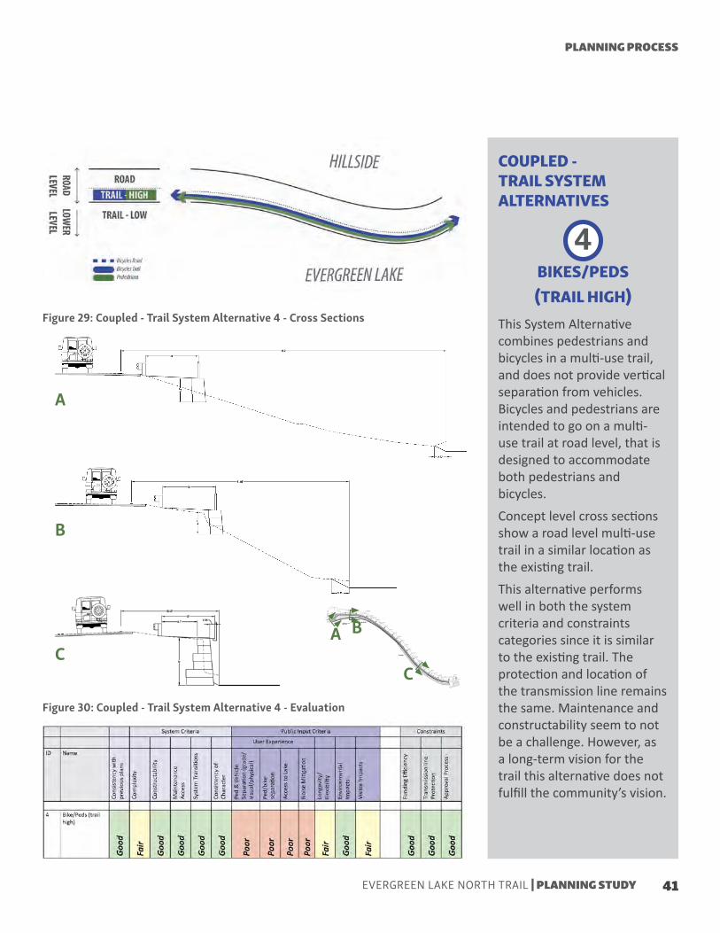
This System Alternative combines pedestrians and bicycles in a multi-use trail, and does not provide vertical separation from vehicles. Bicycles and pedestrians are intended to go on a multi-use trail at road level, that is designed to accommodate both pedestrians and bicycles.Concept level cross sections show a road level multi-use trail in a similar location as the existing trail.This alternative performs well in both the system criteria and constraints categories since it is similar to the existing trail. The protection and location of the transmission line remains the same. Maintenance and constructability seem to not be a challenge. However, as a long-term vision for the trail this alternative does not fulfill the community’s vision.
4BIKES/PEDS(TRAIL HIGH)
COUPLED - TRAIL SYSTEM ALTERNATIVES
PLANNING PROCESS
41EVERGREEN LAKE NORTH TRAIL | PLANNING STUDY

A B
C
Figure 31: Decoupled - Trail System Alternative 5 (hybrid) - Cross Sections
Figure 32: Decoupled - Trail System Alternative 5 (hybrid) - Evaluation
A
B
C
This System Alternative separates pedestrians and bicycles, as well as provides vertical separation between pedestrians and vehicles. Bicycles are intended to go on a multi-use trail at road level. Pedestrians are intended to go on a pedestrian recreational trail at a lake level. Concept level cross sections show a lake level pedestrian trail along the north bank of the lake and a road level multi-use trailThis alternative performed well in all of the three categories. As a long-term vision of the trail, this alternative fulfills the community’s vision while the protection for the transmission line remains the same. In addition, it is partially similar to the existing trail and allows for a segmented and phased approach.
5BIKES (TRAIL HIGH)PEDS (TRAIL LOW)
DECOUPLED - TRAIL SYSTEM ALTERNATIVE (HYBRID)
42
EVERGREEN LAKE NORTH TRAIL | PLANNING STUDY
Maintains the Lake Loop connectionComports with previous local and regional plansMaintains current maintenance access Minimizes system transitions while providing options for trail users (recreation activities/transportation)Supports the desired community long-term vision and user experienceProvides vertical separation between pedestrians and vehiclesSeparates pedestrians and bicyclesEncourages and increases opportunities for lake accessProvides noise mitigation from vehicles by having a lower level trail
Allows for a segmented and phased approach that provides flexibility for funding opportunitiesLocation and protection of the water transmission line remain the samePart of the trail is similar to what exists there today allowing for a phased approval process
Implementation complexityConstructability challenges with the lower trail
Lower trail is different than what exists today and might require additional approval processesPossibility of challenges with environmental impacts regarding the waterVisitor impacts might increase Funding efficiency challenges
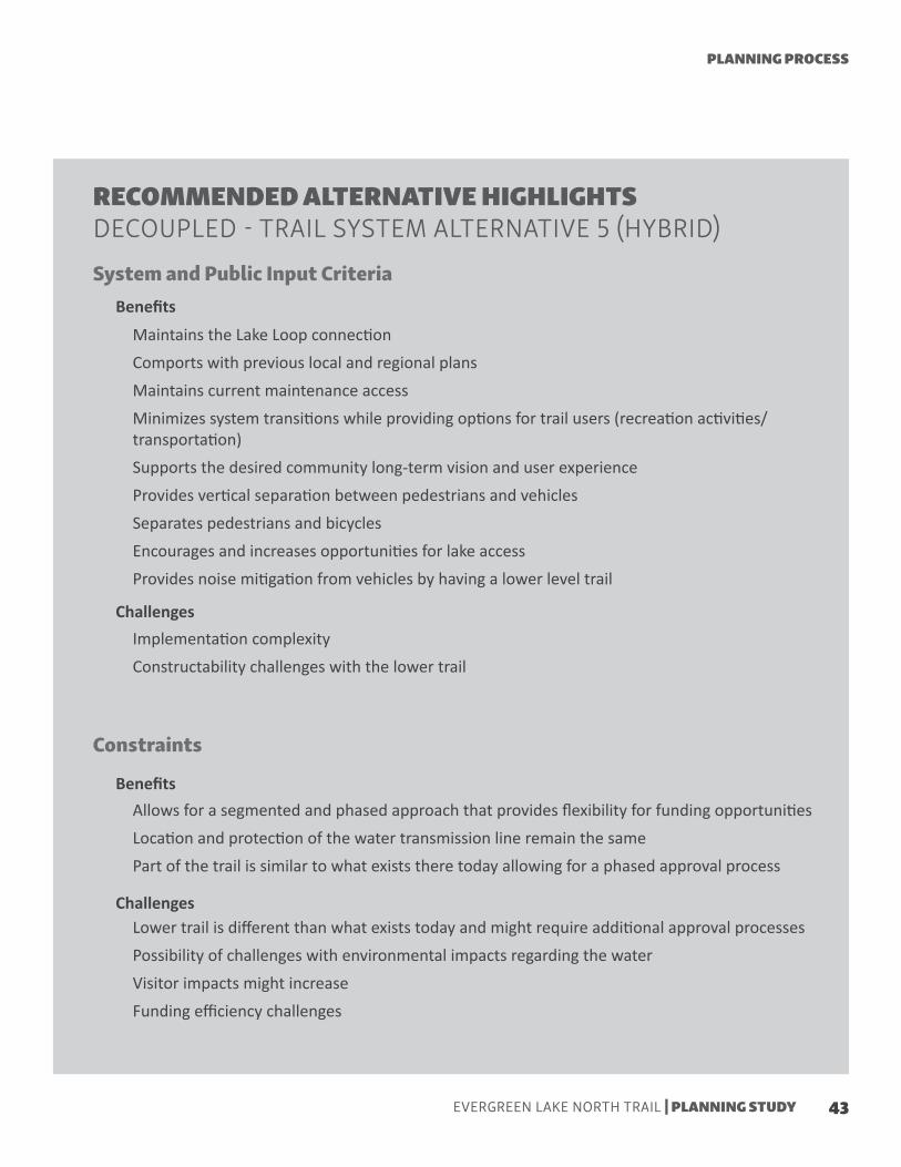
RECOMMENDED ALTERNATIVE HIGHLIGHTSDECOUPLED - TRAIL SYSTEM ALTERNATIVE 5 (HYBRID)System and Public Input Criteria
Constraints
Benefits
Challenges
Benefits
Challenges
PLANNING PROCESS
43EVERGREEN LAKE NORTH TRAIL | PLANNING STUDY

44
EVERGREEN LAKE NORTH TRAIL | PLANNING STUDY

The Decoupled - Trail System Alternative 5 (hybrid) was selected as the recommended alternative for the long-term vision of the Evergreen Lake North Trail. This alternative performed well in all of the three evaluation categories and allows for flexibility of approval, funding and implementation processes.
This chapter explores the Recommended Alternative components, options, and typical cross sections. It also provides preliminary design plan view and cross section conceptual drawings that incorporate the typical section elements into the existing conditions constraints. Perspective renderings are shown to help communicate the desired long-term vision. Additionally, this chapter includes a design and construction strategy that allows for schedule, approval process, and funding flexibility.
Components | Typical Cross Sections | Cross Sections and Barrier Options | Perspective Views| Feasibility Analysis |Cost Estimate | Summary of Options | Phasing
RECOMMENDED ALTERNATIVE: PRELIMINARY DESIGN
45EVERGREEN LAKE NORTH TRAIL | PLANNING STUDY

1 23
The main components of the recommended alternative include an upper (road level) hard surface trail that can operate as a bicycle facility, as a pedestrian facility, or a multi use path. The second component is a lower (lake level) pedestrian only trail. Due to the physical constraints and challenges, the lower trail is divided into a natural pedestrian trail and a boardwalk. The transition spot between these two is dictated by the terrain.
COMPONENTS
Figure 33: Recommended Alternative Plan View with Components
46
EVERGREEN LAKE NORTH TRAIL | PLANNING STUDY

123
8’-10’ UPPER HARD SURFACE TRAIL
5’ LOWER NATURAL PEDESTRIAN TRAIL
5’ LOWER PEDESTRIAN BOARDWALK
RECOMMENDED ALTERNATIVE
47EVERGREEN LAKE NORTH TRAIL | PLANNING STUDY

Preliminary Design incorporated the desired elements from the typical cross sections into the existing conditions and constraints provided by the topographical survey. The cross sections to the right and Figure 34 show how the 10’ and 8’ typical upper trail cross sections are applied in plan view. Towards the west/east ends the 10’ section is applied. In highly constrained areas, mostly in the middle section, a 8’ typical cross section is applied.The typical recommended vertical separation between the upper trail and SH 74 is a Two Rail Giant Tenon Buck Fence.
PRELIMINARY DESIGN - TYPICAL CROSS SECTIONSFigure 34: Recommended Alternative Typical Trail Types
Figure 35: Typical 10’ Upper Trail Cross Section
Figure 36: Typical 8’ Upper Trail Cross Section
Typical 10’ Upper Trail Cross Section
Typical 8’ Upper Trail Cross Section
Two Rail Giant Tenon Buck Fence(Source: United Wood Products Inc.)
48
EVERGREEN LAKE NORTH TRAIL | PLANNING STUDY

The lower natural trail and boardwalk both are 5’. The cross sections on the left show the three different typical sections for the lower trail On the west, there is a 5’ natural pedestrian trail. As we move east, the trail transitions to a 5’ boardwalk. In the middle section, the boardwalk only has railing on the lake side, since on the other side it is adjacent to the slope. On the eastern section, the boardwalk has two rails since it becomes separated from the slope. The boardwalk begins to ramp up as it progresses to the east.For a more detail look at the preliminary design see Appendix A.
Figure 37: Typical 5’ Lower Natural Pedestrian Trail Cross Section
Figure 38: Typical 5’ Lower Boardwalk with Rail on One Side Cross Section
Figure 39: Typical 5’ Lower Boardwalk with Rail on Two Sides Cross Section
Typical 5’ Lower Natural Pedestrian Trail
Typical 5’ Lower Boardwalk with Rail on One Side
Typical 5’ Lower Boardwalk with Rail on Two Sides
RECOMMENDED ALTERNATIVE
49EVERGREEN LAKE NORTH TRAIL | PLANNING STUDY

A
B
C
AB
For a full look at the preliminary plan view and cross sections design, please see Appendix A.
PRELIMINARY DESIGN - CROSS SECTIONS AND EDGE OPTIONS
Cross Sections
Figure 40: Recommended Alternative Plan View with Sections
Figure 41: Recommended Alternative Cross Sections
50
EVERGREEN LAKE NORTH TRAIL | PLANNING STUDY

C
PRELIMINARY DESIGN - CROSS SECTIONS AND EDGE OPTIONS
GUARDRAIL
The survey completed during the Phase II: Planning Study provided information that allowed for additional analysis to be made regarding the space between the trail and SH 74. The analysis showed there are locations along the trail where there is significant space between the road edge stripe and the guardrail that could be utilized for other purposes.Due to the speed limit, it was determined that a 6” barrier curb could replace the guardrail throughout this section. This would free up space for additional amenities and trail width as well as create better transitions to and from downtown Evergreen. CDOT standards, processes and approvals will need to be followed to make this change.As a result, additional options regarding the interface between the road and the trail such as curb and gutter were explored.
CURB AND GUTTER
SH 74 Edge Barrier Options Analysis
Figure 42: Cross Section with Guardrail Figure 43: Cross Section with Curb and Gutter
RECOMMENDED ALTERNATIVE
51EVERGREEN LAKE NORTH TRAIL | PLANNING STUDY

PERSPECTIVE VIEWS
This rendering shows the western edge of the Evergreen Lake North Trail Recommended Alternative. The image shows both the upper trail and the lower natural pedestrian only trailEvergreen Lake North Trail | West End | Looking East
52
EVERGREEN LAKE NORTH TRAIL | PLANNING STUDY

This rendering shows the western edge of the Evergreen Lake North Trail Recommended Alternative. The image shows both the upper trail and the lower natural pedestrian only trail
RECOMMENDED ALTERNATIVE
53EVERGREEN LAKE NORTH TRAIL | PLANNING STUDY

This rendering shows both the upper and lower boardwalk trail.
Rendering shows the relationship between SH 74, the upper trail and the lower boardwalk trail
Evergreen Lake North Trail | Middle Section | Looking East
Evergreen Lake North Trail | Middle Section | Looking West
54
EVERGREEN LAKE NORTH TRAIL | PLANNING STUDY

Connection of both the upper trail and lower boardwalk to the east end.
This render illustrates how the lower boardwalk has the opportunity to create bump-out spaces.
Evergreen Lake North Trail | East End | Looking West
Evergreen Lake North Trail | Middle Section| Looking East at a Bump-out
RECOMMENDED ALTERNATIVE
55EVERGREEN LAKE NORTH TRAIL | PLANNING STUDY

PRELIMINARY DESIGN - ENGINEERING FEASIBILITY ANALYSIS
Engineering Feasibility Analysis
Gravity Wall Type - Analysis and Design Considerations
Boardwalk - Analysis and Design Considerations
The Engineering Feasibility Analysis looked at the elevation change, pedestrian usage/volume, travel width, soil stability, road load and pressure, and safety. While most options presented multiple difficult and expensive challenges, a combination of roadside trail and lower boardwalk was identified as the best solution to address the goals of the study. Based on the topographic survey it was determined that a gravity wall may be practical throughout the length of the wall but its feasibility was dependent on a detailed evaluation of available space. Further analysis using the topographic survey showed that most of the trail had over 20’ of space between the road edge and lake edge. In addition, expanding the vision to include road modifications such as replacing the existing guardrail with curb and gutter allowed for a better use of that space. These design elements allowed for a more economical gravity wall utilizing no lateral bracing to be designed rather than a more expensive wall typeAnother component of the alternative is the boardwalk which allows for separation of pedestrians and a more desirable user experience. An analysis based on cost efficiency, environmental impacts, other design constraints and context design considerations informed the design of the lakeside boardwalk.For more details of the preliminary design feasibility analysis see Appendix A.
Through engineering analysis and a study of feasible and economical alternatives, we determined a gravity wall was feasible and the most economical for the entire duration of the wall. As mentioned above, the detailed topographic survey and an expanded vision to include road modifications made this feasible. Analysis based on the topographic survey showed that all but ~225’ (16%) of the trail had over 20’ of space between the road edge and lake edge. The portion of area under 20’ ranged between 16 and 18 feet in distance which left us a reasonable amount of space given the short section. Additional analysis found that the existing guardrail and shoulder distance uses significant space, at times greater than 5 feet which is 25% of the total possible construction area. In order to make use of the space in the most effective way,
it was determined that given the vehicle speed (30 mph) and the desire for traffic calming elements, that replacing the existing guardrail with curb and gutter is a more advantageous approach. This illustrated that a gravity wall utilizing no lateral bracing was feasible while providing additional benefits such as traffic safety, cost savings and stormwater runoff treatment and collection that minimizes sediment, erosion and debris.Additionally, as-built information on the EMD water transmission line provided during the study illustrates that a properly located gravity wall would not compromise the existing water transmission line. Figure 44 shows the recommended wall details.
A lakeside pedestrian trail was desired by the public to help separate pedestrians from the road while enhancing the lake experience. Three lower trail options that included a combination of lakeside trail,
gravity wall trail, and boardwalk were considered and analyzed. An analysis of lakeside available space, lower wall height cost and complexity, and boardwalk cost showed the boardwalk as the most economically
56
EVERGREEN LAKE NORTH TRAIL | PLANNING STUDY

Boardwalk East Ramp - Analysis and Design Considerations
As the boardwalk approaches the east side dam, a transition is needed to allow access to the top of the spillway and complete the trail connection to the downtown area. Both stairs and a ramp were considered given the space and constraints. It is an important consideration that we maintain ADA accessibility so a ramp is the preferred route. An analysis of elevation between the wood surface
and the existing dam surface showed four feet of elevation difference that could be bridged with a slope under 5% for comfortable accessibility for all pedestrians. This slope can be easily accommodated over a 100’ span to allow for a simple and comfortable transition. For a technical detailed figure of the boardwalk ramp please see Appendix A
feasible and least technical complex approach .An analysis of wall height cost to boardwalk cost made the boardwalk design more efficient as soon as we exceeded a wall height of 4’. In addition, a lakeside trail that relied on an extended wall height could not be constructed in a phased approach which was vital due to permitting, costs, and scheduling.Minimal environmental impacts were key for all of these designs; any impact to lakeshore, existing
vegetation, and construction impact were all factors to be considered. Review of vertical piers was also done to ensure that the application was feasible and low impact. In addition, a boardwalk with 5’-10’ width and fishing locations would also match the existing trail in various locationsSee Figure 44 for more boardwalk details.
studio
Figure 44: Wall and Boardwalk Details
Source: Project Team (EV Studio)
RECOMMENDED ALTERNATIVE
57EVERGREEN LAKE NORTH TRAIL | PLANNING STUDY

PRELIMINARY ENGINEERING - COST ESTIMATE
The Planning Level Opinion of Probable Cost presented on the following page is based on the planning process, the preliminary engineering design, the topographic survey, and the design assumptions that have been made. It is based on the best information available at this time and does not include the acquisition of right of way or additional extensive environmental or project clearance work, if necessary. At this stage of design, there is still some uncertainty related to final design elements, quantities, and constructability issues. In order to account for this, a contingency of 25% has been included in the cost estimate. The current Planning Level Opinion of Probable Cost is approximately $3.4 million dollars.The Recommended Alternative, at this point in time, is at the planning level stage. For this reason, the Opinion of Probable Cost on the following page includes, in addition to the 25% contingency mentioned above, other probable process and implementation costs. In addition to line items like mobilization, contingency, traffic control, and final design the cost estimate includes other items . Additional items include signing and striping, drainage and erosion, testing/quality control, bonding and insurance, landscaping, utility coordination and relocation, public art requirement, and project management fee.
58
EVERGREEN LAKE NORTH TRAIL | PLANNING STUDY

PRO
JECT N
AME: Evergreen Lake N
orth TrailPlanning Level O
pinion of Probable Cost
6/26/2018D
eveloped by EV Studio and OV C
onsulting
Unit
Unit C
ostQ
uantityExtended C
ostRem
oval of Existing Wall
LF8
$ 1240
9,920$
Removal of Guard Rail
LF7
$ 1240
8,680$
Removal of Asphalt and Concrete Surfacing
SY12
$ 7400
88,800$
Comm
on Excavation, Topsoil Strip (EV) (P)CY
8$
7225,776
$ Bitum
inous PatchSY
20$
3116,220
$ 6" Perforated PVC Subdrain w
/ Coarse Filter AggregateLF
9$
135011,475
$ 18" RCP Apron
EA900
$ 6
5,400$
18" RCP Culvert, CL IILF
20$
2104,200
$ Construct Lake O
utlet StructureEA
15,000$
115,000
$ CDO
T Type 13 Combination Inlet
EA1,500
$ 6
9,000$
Random Riprap Class III
CY90
$ 20
1,800$
PaversSF
20.00$
71514,300
$ W
ood Boardwalk
SF50.00
$ 5750
287,500$
Fishing Bumpout
SF50.00
$ 400
20,000$
Earth TrailSF
5.00$
10005,000
$ Concrete W
alkSY
60.00$
133379,980
$ Concrete Curb and Gutter
LF30.00
$ 1410
42,300$
Metal Handrail
LF175.00
$ 1240
217,000$
Boardwalk Handrail
LF35.00
$ 1750
61,250$
Two Rail Giant Tenon Buck Fence
LF25.00
$ 1240
31,000$
Large-Block Wall
Face Foot50.00
$ 10000
500,000$
Turf RestorationSY
4.00$
277811,112
$ $1,435,700.00
% U
sedC
ostA
N / A
$1,435,700B
Mobilization and C
onstruction Survey10%
of A10%
$143,600C
Signing and StripingLum
p SumN
/A$25,000
DD
rainage and Erosion Control
(4 - 10%) of A
6%$86,100
ETesting/Q
uality Control
Lump Sum
LS$25,000
FBonding and Insurance
8% of A
8%$114,900
G6.0%
$86,100H
6.0%$86,100
IC
ontingencies(10 - 30%
) of (A+B+C+D
+E+F+G+H
)25.0%
$500,600J
Construction Traffic C
ontrol(5 - 25%
) of (A+B+C+D
+E+F+G+H
+I) 15.0%
$375,500K
Final Design/Perm
itting15.0%
$431,800L
Public Art Requirem
ent(1%
) of (A+B+C+D
+E+F+G+H
+I+J+K)1.0%
$33,100M
Project Managem
ent (Agency)(2%
) of (A+B+C+D
+E+F+G+H
+I+J+k+L) 2.0%
$66,900$3,410,400.00
Notes:
Costs are in 2018 dollars and are not escalated for inflation for future years, cost estim
ate assumes no right of w
ay acquisition required, quantities are based on planning and preliminary level design inform
ation which m
ay change as the design progresses
09/20/18 12:15:09
Project Construction Bid Item
sProject D
ependent
Utility C
oordination and Relocation
(4 - 10%) of A
Total of Construction B
id Items
(A+B+C
+D+E+F+G
+H+I+J+K
+L)
(15%) of (A+B+C
+D+E+F+G
+H+I+J)
% R
ange
Landscaping(4 - 10%
) of A
Figure 45: Planning Level Opinion of Probable Cost (2018 dollars)
RECOMMENDED ALTERNATIVE
59EVERGREEN LAKE NORTH TRAIL | PLANNING STUDY

C
B
D
A
PHASING OPTIONSFigure 46: Recommended Alternative Phasing Diagram
Recommended Alternative Phasing Segments
Flexibility in construction is important to allow for multiple funding sources and timeframe for implementation. The Recommended Alternative has been divided into four segments for this phasing analysis. They are:
Upper segment. Segment includes the western side of the trail where no wall failures or unstable conditions have happened
Lower segment. Segment includes the western portion of the trail where an existing natural trail exists and physical constraints allow for a lower trail along the banks
Upper segment. Needs to occur during phase 1. Segment includes the areas where unstable conditions and failures have happened
Lower segment will happen during phase 2. Segment includes the eastern portion where a lower trail is not feasible on the banks and a boardwalk will be required
60
EVERGREEN LAKE NORTH TRAIL | PLANNING STUDY

BA C C
CB B
B
B
D D
D
A
AA
Three phasing options were developed utilizing the four segments. They include a minimum option, an upper/lower phasing option, and an all-at-once option. They all include constructing a portion, or all, of the upper trail first. This is primary due to the requirement (constraint) to protect the EMD water transmission line. The option selected will depend on funding sources, availability, and timing.
Recommended Alternative Phasing Options
OPTION 1 | MINIMUM COST OPTION 2 | HIGH/LOW SPLIT OPTION 3 | FULL BUILD
PHASE 1 PHASE 1 PHASE 1
Road Road
PHASE 2 PHASE 2
RECOMMENDED ALTERNATIVE
61EVERGREEN LAKE NORTH TRAIL | PLANNING STUDY

SUMMARY OF OPTIONS
ALTERNATIVES ANALYSISRecommended Alternative Vs Preliminary Engineering Alternatives
The Phase I: Preliminary Engineering Study and the Phase II: Planning Study provide similar recommendations with unique characteristics.The Phase I: Preliminary Engineering Study recommends two trail alternatives that both use a combination of gravity wall (Redi-Rock) and soil nail sister wall. Alternative A is a dual decoupled system that consists on an 8’ dedicated bikeway at road level and a lower trail at lake level (natural trail and 8’ boardwalk) with a cost estimate of $2,991,000. Alternative B is a 10’ shared-use path at road level with a cost estimate of $2,747,000. Both alternatives include the guardrail as the separation between SH 74 and the upper trail. Cost estimates for these alternatives are planning level estimates and do not
include many of the process, implementation and detailed project element costs.The Phase II: Planning Study recommends a dual decoupled system that consists on an 8’-10’ hard surface upper trail (bicycle facility or shared-use path) and a lower trail at lake level (natural trail and 5’ boardwalk) with a cost of $3,400,000. This study does not provide another alternative yet it describes potential segmenting and phasing scenarios. The cost estimates from this alternative is a planning level estimate, and does include many of the process, implementation and detailed project element costs. The main differences between the recommended alternatives in each study include the type of wall, the separation from SH74 and the cost estimate
The Phase II: Planning Study recommended alternative, described in this chapter, is based on the best available data, community input, technical system considerations and stakeholder guidance. In addition to the dual system recommended alternative developed through this study, other alternative options exist.In response to a request from EPRD Board of Directors, further analysis was conducted on all the different options, which include the Recommended Alternatives from this Planning Study and the Preliminary Engineering Study, segments of those recommended alternatives, and the consideration of a maintenance and replace as-is options. In response to the Board of Directors the following options where analyzed in terms of cost estimate, benefits, and challenges. For more details about the cost estimate, benefits and challenges of each of the options analyzed refer to Appendix D.• Recommended Alternative - Dual System - Upper and Lower Trail (Recommended Alternative from This
Planning Study and Alternative A from Preliminary Engineering Study)• Improved Upper Trail Only (Upper trail from this Planning Study Recommended Alternative and Alternative
B from Preliminary Engineering Study)• Lower Trail - Boardwalk Only and Provide Water Transmission Line Cover (Boardwalk from this Planning
Study Recommended Alternative)• Replace as-is Option (Not recommended in either study. Explored as request of EPRD Board of Directors.
For more details refer to Appendix C)• Maintenance Option (Not recommended in either study. Explored as request of EPRD Board of Directors.
For more details refer to Appendix C)
62
EVERGREEN LAKE NORTH TRAIL | PLANNING STUDY

Recommended Alternative Benefits Summary
Other Options Analysis
In addition to the recommended alternative options, and as requested by EPRD Board of Directors, other options were analyzed. Please refer to Appendix D for a complete list of the options. Both the Maintenance and Replace As-Is options are not options recommended by either the Phase I: Preliminary Engineering Study or the Phase II: Planning Study and have limited funding sources leaving most of the cost to be covered by EPRD. The maintenance option approach is reactive and has several safety, operational, procedural, and aesthetic challenges. The Replace As-Is option does not improve the trail width surface and does not meet the design criteria and standards for a shared use facility, requiring bicycles to operate on SH 74 and limiting the funding
sources opportunities. Its primary purpose is to provide protection for EMD’s 12” water transmission line while maintaining a minimum connection for pedestrians around the Evergreen Lake. For these reasons neither the maintenance option nor the replace as-is options are being recommended by this study.The option of constructing only a boardwalk and protecting the water transmission line separately has a lower cost estimate. However, it has high regulatory risk, fewer community benefits, technical challenges to protect the water transmission line, and limited funding opportunities.
The recommended alternative, even though it has the highest cost, when compared with the other options, is the alternative that provides better funding opportunities for EPRD while meeting the community needs and trail network needs. The recommended alternative option provides phasing possibilities that allow for funding flexibility and opportunities. In addition, it meets the community desires and improves the user experience. Finally, it helps build out the local and regional recreational and transportation networks.
elements. The Phase II: Planning Study recommended alternative recommends the use of a gravity wall along the whole extent of the trail and a combination of curb and gutter and Two Rail Giant Tenon Buck Fence as the separation from SH 74. During the planning process a topographic survey was conducted which provided more detailed information of the available space between the edge of the road and the edge of the trail that allowed for the options of gravity wall and curb and gutter to be further analyzed and recommended.Another difference between the recommended alternatives from the two studies is the cost estimate elements considered, which is reflected in the estimate total cost. Several reasons for the different cost estimates are:
• The Phase I: Preliminary Engineering cost estimate is in 2016 dollars and recommends a 3% increase per year.
• The cost estimate from the Phase II: Planning Study includes more detail than the cost estimate from the Phase I: Preliminary Engineering Study. Additional detail includes:
* Elements refined or discovered during this planning process.
* Process, implementation and detailed project element costs
It was important to include the potential regulatory, process, operational and implementation costs in the overall cost estimate to be conservative.
RECOMMENDED ALTERNATIVE
63EVERGREEN LAKE NORTH TRAIL | PLANNING STUDY

64
EVERGREEN LAKE NORTH TRAIL | PLANNING STUDY

65EVERGREEN LAKE NORTH TRAIL | PLANNING STUDY
This final chapter outlines a potential implementation and approval process and suggests possible funding opportunities and their timeline.
NEXT STEPS
Regulatory Approval Process | Funding Opportunities & Timeline

66
EVERGREEN LAKE NORTH TRAIL | PLANNING STUDY
REGULATORY APPROVAL PROCESS
As mentioned in the Existing Conditions chapter, the Evergreen Lake North Trail has a complex planning and regulatory context. Due to the complexity of the regulatory context, the approval process for any improvements might require the involvement of a variety of stakeholders. This planning study has started the conversation between the different stakeholders involved, including the different approval processes and requirements that pertain to each stakeholder involved. Based on conversations with The Parks and Recreation Department of the City and County of Denver some of the elements to be considered as the design and approval process moves forward are described below. For notes of the discussion with Denver Parks and Recreation see Appendix E. Since the land owner is the City and County of Denver (CCD), any improvements will need to go through a Denver approval process. Based on the conversations with CCD, EPRD will be required to follow Denver Parks and Recreation procurement rules and review requirements. There are two different approval processes: one for design and one for construction. For the design approval process, as discussed with the City and County of Denver Parks and Recreation Department (DPR), a good approach will be to move forward into final design with a package of the entire project (upper and lower trail). Then, different packages with conditional approvals, depending on funding or other regulatory approvals, can be specified. Once EPRD has construction plans approved, a different construction approval process will begin.Other elements that will impact the design standards and construction practices include the funding sources. Different funding sources might dictate and influence design standards and construction practices. Another aspect of the regulatory and approval process is in regard to environmental considerations. The recommended alternative was developed around avoiding any significant changes along the water. However, a more detailed environmental analysis should be developed in further phases of the project. Especially in regards to the possible impacts of the lower natural and boardwalk trail and the potential permitting and approval requirements it might trigger. In view of the potential complexity of environmental review, over one quarter of the funding for the Phase III: Final Design project is dedicated to the environmental regulatory process.As the project moves forwards towards the final design phase the details regarding the approval process will need to be further investigated.

NEXT STEPS
67EVERGREEN LAKE NORTH TRAIL | PLANNING STUDY
FUNDING OPPORTUNITIES
Design Funding (already secured)
• DOLA Preliminary Engineering Grant
• GOCO Planning Grant
• TAP Final Design Grant (Transportation Alternative Program admin by CDOT)
Construction Funding Opportunities
• DRCOG TIP Grant (Transportation Improvement Project)
• TAP Construction Grant (Trans Alt Program admin by CDOT)
• GOCO Connect Initiative Grant
• Colorado State Trails Grants
• Colorado Land & Water Conservation Fund Grant
• Jeffco Open Space Joint Venture and CTF Grants
• CPW Fishing is Fun Grants
• CDPHE Section 319 Grants
• Trust for Public Land Trail Projects
A segmented and phased approach for the Recommended Alternative allows for funding flexibility. EPRD has indicated it does not have funding resources to complete such a large-scale improvement project without additional funding sources, such as bond funding, grants, and stakeholder assistance. Additional funding sources are further described below.
Possible Bond FundingEPRD currently is considering whether to ask for voter approval for a bond that would include monies for trail improvements including construction of the Evergreen Lake North Trail project. If EPRD decides to move forward on the bond referendum, it will go before voters in November 2018. However, bond funds versus grant funds for this project are not an either/or proposition. If the bond referendum is successful, ideally bond monies raised for trail improvements would be used first as matches for grant opportunities, maximizing the leverage of bond funds raised.
Potential Grant FundingEPRD has developed the following list that indicates the wide range of potential funding opportunities that align to the Evergreen Lake North Trail project, In addition, EPRD develop the table on Appendix F to illustrate an example of how a potential grant strategy and stakeholder coordination effort could work. It is important to note EPRD’s example table is dependent on many factors that will be refined on Phase III: Final Design. As stated above, grant opportunities will be pursued on top of any bond funding approved by EPRD’s constituents. It is important to remember that all grant sources listed require the applicant and/or project stakeholders to contribute some level of cash or in-kind match to the project (typically 20-30% of the requested grant award). Therefore, in pursuing grant funds, strategic leveraging of funds will be critical. In addition, in applying for federal grants, it will be critical to take into account that federal funds are generally more encumbered than funds from state or nonprofit sources, and cannot be matched against each other.
Possible Stakeholder AssistanceThis project involves many stakeholders who have participated and provided input to this planning study. EPRD believes the project will require assistance from stakeholders to construct the recommended alternative. For example, related stakeholder projects might be coordinated with this project to maximize deliverables for each. And project stakeholders may have access to funding or in-kind resources otherwise unavailable to EPRD. The ability to obtain grants would be enhanced if stakeholders support the project with matching funds or in-kind contributions. Thus, EPRD plans to continue the dialogue with stakeholders to find opportunities for coordinating projects and leveraging investments for the Evergreen Lake North Project.

68
EVERGREEN LAKE NORTH TRAIL | PLANNING STUDY
MOVING FORWARD
As the Phase II: Planning Study concludes, the Recommended Alternative is ready to move into Phase III: Final Design and funding for the Phase III: Final Design has been secured. EPRD is currently under contract with CDOT for Phase III: Final Design Funding. As the process moves forward, the next step is for EPRD to develop the RFP for Phase III: Final Design to be released fall 2018 with the guidance of the stakeholders. As the RFP is developed the team will have to account for the following considerations and further investigate the applicability of certain requirements.• Incorporate procurement requirements from CDOT and the City and County of Denver into the Phase III:
Final Design procurement process.• Include design standards and requirements from CDOT and the City and County of Denver into the Phase
III: Final Design approval process and construction approval process.• Further investigate if any 6(f)/4(f) consultations are required based on previous use of Land and Water
Conservation Funds (LWCF) at Evergreen Lake and Section 4(f) of the Department of Transportation Act.• Section 6(f) refers to a section of the Land and Water Conservation Fund (LWCF) Act of 1965. The
program is intended to create and maintain a nationwide legacy of high quality recreation areas and facilities and to stimulate non-federal investments in the protection and maintenance of recreation resources across the United States.”
• Section 6(f)(3) of the LWCF Act prohibits the conversion of property acquired or developed with grants from this fund to a non-recreational purpose without the approval of the NPS. Importantly, Section 6(f) applies to all transportation projects (and others) involving possible conversions of the property whether or not federal funding is being utilized for the project.
• Section 4(f) of the U.S. Department of Transportation (USDOT) Act of 1966 prohibits the FTA and other USDOT agencies from using land from publicly owned parks, recreation areas (including recreational trails), wildlife and water fowl refuges, or public and private historic properties, unless there is no feasible and prudent alternative to that use and the action includes all possible planning to minimize harm to the property resulting from such a use.
• Investigate any environmental impacts and consultations that may be required, including Section 404 permit requirements.
• Investigate the possible consultation with the Colorado State Historic Preservation Officer (SHPO) including the need for a Cultural Resource Survey.

NEXT STEPS
69EVERGREEN LAKE NORTH TRAIL | PLANNING STUDY
This page is intentionally left blank

EVERGREEN LAKE NORTH TRAIL | PLANNING STUDY
This page is intentionally left blank

71EVERGREEN LAKE NORTH TRAIL | PLANNING STUDY
APPENDIX A: PRELIMINARY DESIGN

EVERGREEN LAKE LIMITSWSEL=7076.00
BEGIN 5FOOT WIDEBOARDWALK
5 FOOT WIDEBOARDWALK
LARGEBLOCK WALL
PROPOSED TRAIL
DAM PLAZA AREA
10+00
11+00 12+00 13+00
14+00
15+00
16+00
17+00
18+00
19+00
20+00
21+00
22+00
23+00
24+0024+
78.47
studio
N
S
W

15+00
16+00
17+00 18+00
19+00
20+008 FOOT WIDE TRAIL
SPLIT RAILFENCE COMBINATION
TYPE 13 INLET
6" VERTICALCURB & GUTTER
EVERGREEN LAKE EDGE OFWATER
5 FOOT WIDE BOARDWALK
SECTIONLINES
20+00
21+00
22+00 23+00
24+00
24+7
8.47
8 FOOT WIDE TRAIL10 FOOT WIDE TRAIL
PAVERS
CONCRETE WALK AREA5 FOOT WIDE BOARDWALK
EVERGREEN LAKEEDGE OF WATER
EXISTINGWALKWAY
EXISTINGWALKWAY
SECTIONLINES
10+00
11+00
12+00
13+00 14+00
15+00
10 FOOT WIDE TRAIL
8 FOOT WIDE TRAIL
EVERGREEN LAKEEDGE OF WATER
BEGIN BOARDWALKFROM LOWER TRAIL
5 FOOT WIDELOWER TRAIL
SPLIT RAILFENCE
6" VERTICALCURB & GUTTER
5 FOOT WIDEBOARDWALK
EXISTING CULVERT
LARGE BLOCKWALL
SECTIONLINES
studio
N
S
W
N
S
W
N
S
W

43.73'
1.5'
6'
10' 1'2'
0.5'
1.5'
3'
10' 1'2'
0.5'
1.5'
4.5'
10' 1'2'
0.5'
STA 10+50
STA 11+00
STA 11+57 studio
N
S
W
TRAIL SECTIONS - 06/15/2018SHEET 01 / 10

1.5'
4.5'
10' 31.78'1'2'
0.5'
1.5'
7.5'
10' 1'2'
0.5'
1.5'
7.5'
8' 1'2'
0.5'
19.72'
STA 12+00
STA 12+50
STA 13+00studio
N
S
W
TRAIL SECTIONS - 06/15/2018SHEET 02 / 10

1.5'
7.5'
8' 1'2'0.5'
1.5'
7.5'
8' 1'
0.5'
2'
1.5'
7.5'
8' 1'
0.5'
2'
STA 13+50
STA 14+00
STA 14+50 studio
N
S
W
TRAIL SECTIONS - 06/15/2018SHEET 03 / 10

1.5'
7.5'
8' 1'
0.5'
2'
1.5'
7.5'
8' 1'
0.5'
2'
1.5'
9'
8' 1'
0.5'
2'
STA 15+00
STA 15+50
STA 16+00 studio
N
S
W
TRAIL SECTIONS - 06/15/2018SHEET 04 / 10

1.5'
7.5'
8' 1'
0.5'
2'
1.5'
9'
8' 1'
0.5'
2'
1.5'
7.5'
8' 1'
0.5'
2'
STA 16+50
STA 17+00
STA 17+50 studio
N
S
W
TRAIL SECTIONS - 06/15/2018SHEET 05 / 10

1.5'
7.5'
8' 1'
0.5'
2'
1.5'
9'
8' 1'
0.5'
2'
1.5'
9'
8' 1'
0.5'
2'
STA 18+00
STA 18+50
STA 19+00 studio
N
S
W
TRAIL SECTIONS - 06/15/2018SHEET 06 / 10

1.5'
9'
8' 1'
0.5'
2'
1.5'
7.5'
8' 1'
0.5'
2'
1.5'
7.5'
8' 1'
0.5'
2'
STA 20+50
STA 20+00
STA 19+50
studio
N
S
W
TRAIL SECTIONS - 06/15/2018SHEET 07 / 10

1.5'
9'
8' 1'
0.5'
2'
1.5'
9'
8' 1'
0.5'
2'
1.5'9'
8' 1'
0.5'
2'
STA 22+00
STA 21+50
STA 21+00
studio
N
S
W
TRAIL SECTIONS - 06/15/2018SHEET 08 / 10
1.5'
7.5'
8' 1'
0.5'
2'
1.5'
6'
10' 1'2'
0.5'
1.5'
6'
10' 1'2'
0.5'
STA 22+50
STA 23+00
STA 23+50 studio
N
S
W
TRAIL SECTIONS - 06/15/2018SHEET 09 / 10

1.5'
6'
10' 1'2'
0.5'
STA 23+96
studio
N
S
W
TRAIL SECTIONS - 06/15/2018SHEET 10 / 10

1.5'
9'
8' 1'
0.5'
2'
2.0%
1
1
studio

studio

4602 Plettner Lane #4D 303.670.7242 ph [email protected] Evergreen, CO 80439 www.evstudio.com
This letter is for the feasibility analysis for the preferred north trail design.
• Engineering analysis: o Preliminary analysis looked at elevation change, pedestrian usage/volume, travel
width, soil stability, road load and pressure, and safety. While most options presented multiple difficult and expensive challenges, a combination of roadside trail and lower boardwalk was the most cost-effective solution to the problem.
o A topographic survey was completed after a visual inspection and walk through of the area was conducted. It was determined that a more economical gravity wall may be practical but feasibility was dependent on each available foot of area.
o Over the course of 1,400 feet there was a total elevation change of 11 vertical feet from 7092 to 7081, this presented an average slope of 0.8%. In addition, we noticed that all but ~225’ (16%) of the trail had over 20’ of space between the road edge and lake edge which is significant for cost efficiency and constructability. The portion of area under 20’ ranged between 16 and 18 feet in distance which left us a reasonable amount of space given the short section. This determined that a gravity wall utilizing no lateral bracing was feasible, the importance of this is described below.
o It was also mentioned previously that the guard-rail and shoulder distance at times is using significant space, at times greater than 5 feet which is 25% of our total allotted construction area. It was determined that given vehicle speed and desired calming that a curb and gutter approach may be a more advantageous approach for both traffic safety and cost savings.
o Using curb and gutter also allows for additional water treatment for the runoff from the existing road and trail. Minimizing sediment, erosion and debris through treatment and collection was a benefit to this approach.
o The last component was the boardwalk which would allow separation for walkers and a more desirable user experience. Cost efficiency, environmental impact, and other design constraints made the lakeside boardwalk more appealing as well as it incorporated design currently in place around the lake in various locations. An analysis of wall height and cost to boardwalk cost made the boardwalk design more efficient as soon as we exceeded a wall height of 4’. In addition, a lakeside trail that relied on an extended wall height could not be constructed in a phased approach which was vital due to permitting, costs, and scheduling.
• Wall Type and Design o Through engineering analysis and a study of feasible and economical
alternatives, we determined a gravity wall was feasible and the most economical for the entire duration of the wall. This is a change from Mueller Report Alternatives 1 & 2 which used a combination of Gravity wall and Soil Nail Sister Wall. As mentioned above, the detailed topographic survey and expanding the vision to include road modifications made this feasible. Additionally, as-built information on the EMD water main provided during the study illustrates that a properly located gravity wall would not compromise the existing water main.
o Eliminating horizontal features to the wall was crucial to help maintain access and maintenance to the existing 12” water line.
o The gravity wall detail is attached. For the design criteria, Redi-Rock was used but similar products may be considered. The block ranged from 60” in depth at the base to smaller blocks toward the top of the wall.
• Boardwalk Design o Boardwalk
A lakeside pedestrian trail was desired by the user groups to help separate pedestrians from the road while sharing the lake experience.

2/2
4602 Plettner Lane #4D 303.670.7242 ph [email protected] Evergreen, CO 80439 303.679.1862 fax www.evstudio.com
The desired approach is to use a gravel trail with no retaining wall for the feasible extent and then transition to a wall assisted trail or wooden boardwalk.
Three options were considered; the first was a gravel lakeside trail that transitioned up to the roadside trail after it became infeasible, the second included a gravel trail that transitioned to a gravity wall with gravel trail where this would at times have an independent wall but for the last 600’ would be included in the singular roadside wall, and lastly would be a gravel trail assisted by a lakeside wooden boardwalk.
The boardwalk became more economically feasible after a second wall reached 4’ as mentioned above which happened quickly with the steep slopes in the area. Adding a second wall doubled the amount of bury depth for the wall and handrail for the project while increasing the roadside wall increased the cost and complexity due to the increase in height approaching 10’.
Minimal environmental impacts were key for all of these designs; any impact to lakeshore, existing vegetation, and construction impact were all factors to be considered. Review of vertical piers was also done to ensure that the application was feasible and low impact.
A boardwalk with 5’-10' width and fishing locations would also match the existing trail in various locations.
o East Side Boardwalk Ramp As the boardwalk approaches the east side dam, a transition is needed
to allow access to the top of the spillway and complete the trail connection to the downtown area. Both stairs and a ramp were considered given the space and constraints. It is an important consideration that we maintain ADA accessibility so a ramp is the preferred route.
Ramp elevation at the lakeside is 7076.0 with the wood surface around 2’ above at elevation 7078.0; the existing dam surface is at 7082.0. The 4’ elevation difference would be bridged with a slope under 5% for comfortable accessibility for all pedestrians. This slope can be easily accommodated over a 100’ span to allow for a simple and comfortable transition.

EVERGREEN LAKE NORTH TRAIL | PLANNING STUDY
This page is intentionally left blank

89EVERGREEN LAKE NORTH TRAIL | PLANNING STUDY
APPENDIX B: PUBLIC COMMENTS


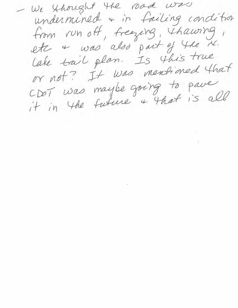


Evergreen Lake North Trail | Phase II: Planning Study
1
Community Input by Email
The following is a combination of the community input received by email regarding the Evergreen Lake North Trail Planning Study.
The following comments were received after the first community meeting on January 11, 2018.
From Lynn Nestingen (Fri, Jan 12, 2018)
Good morning Ellen – great meeting last night and I appreciated the Districts’ transparency and thoroughness through this important planning process. I had to leave early and didn’t get a chance to ask about the possibility of working with CDOT to also install “NO JAKE BRAKING” signs or other low noise ordinance for the stretch of highway 74 that descends from Christ the King to around the lake and add this in as part of the planning process. While creating a trail that is visually pleasing is the main goal, we also should consider the audible aspect for enjoying a walk around the lake. Trucks literally “roar” down the hill day and night, and one can definitely hear it whether paddling, ice skating, or hiking around the lake.
Is there someone on the planning committee I can bring this to and/or will you bring it to the planning committee for consideration and hopefully implementation at the same time.
Thanks Ellen and to your Board! Keep up the good work!
Lynn Nestingen 303-941-4948 [email protected] [email protected]
From Daniel Koller (Fri, Jan 12, 2018)
Good Morning Ellen,
I attended last nights meeting at Buchanan. I heard and saw a lot of great ideas, and I appreciate the opportunity for the public to get involved. I do have one major concern though and that is what I perceive as a somewhat aggressive timeline vs. a somewhat limited scope.
The timeline which was presented yesterday looks very ambitious, given the many pending decisions and considering that we don't even have pricing scenarios available for all options (for example the floating trail). The lifetime for the current fix is estimated at 5 years, so I don't see a reason to rush this project through. This is especially true since there are things un-addressed (even un-considered) which in my opinion absolutely belong into the scope of a vision and then a plan:

Evergreen Lake North Trail | Phase II: Planning Study
2
1) The lifetime of the targeted solution is expected to be 50 years+. It is very unlikely that the roads (74 and 73) will be the same in 50 years. While CDOT was asked and did not have any plans for changes, I do think that we need to anticipate possible changes (at least some scenarios) and consider impacts/benefits of such changes to the trail. While we can't plan for all impacts, we can weigh some of them into our considerations and protect against them by selecting a solution which is less dependent on the roads staying the same (maybe some advantage for a floating trail?).
2) Traffic and parking around the lake is an issue. The issue is very obvious today, has become much worse in recent years and has forced changes in traffic laws, parking requirements etc. We absolutely cannot build an attractive lake trail without thinking about and hopefully addressing this issue. A more attractive trail (I think all options presented last night qualify for that) will without question attract more people, not just from Evergreen, but from the Denver metro area. While that may be good news for local businesses, it quickly turns into a nightmare if swarms of cars are cycling around the narrow streets looking for parking, cars are parked along narrow streets, in residential neighborhoods, and in business and church parking lots. When I asked about parking considerations last night, the response was that this was not in the scope of the project. This is a big mistake and needs to be corrected.
Thanks and best regards,
Daniel Koller 2216 Afton Lane Evergreen, CO 80439 (303) 578 6929
From David Stannard (Thursday, January 18)
Greetings:
Just wanted to register my opinion on the various options for the eventual permanent trail along 74 and the lake, having just read the Canyon Courier article. I hike around the lake/golf course/DeDisse Park/Alderfer Park area a lot. While I love the trail on the south side, I’ve probably only walked the north trail once or twice, simply because of the traffic. (I will go ¾ of the way around, then backtrack, to avoid the north trail.) The noise and exhaust on the north trail are just overpowering, not what you want during outdoor exercise in an otherwise beautiful place. So, I value some separation between the road and the trail, but I also agree with the attractive nuisance school regarding option 1D. This lands me in favor of option 1C, the boardwalk near or at the shore.
David Stannard Evergreen
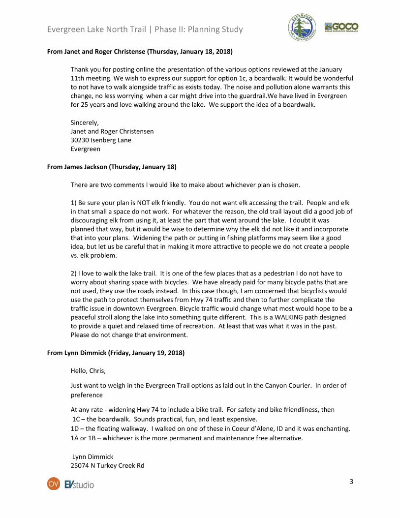
Evergreen Lake North Trail | Phase II: Planning Study
3
From Janet and Roger Christense (Thursday, January 18, 2018)
Thank you for posting online the presentation of the various options reviewed at the January 11th meeting. We wish to express our support for option 1c, a boardwalk. It would be wonderful to not have to walk alongside traffic as exists today. The noise and pollution alone warrants this change, no less worrying when a car might drive into the guardrail.We have lived in Evergreen for 25 years and love walking around the lake. We support the idea of a boardwalk.
Sincerely, Janet and Roger Christensen 30230 Isenberg Lane Evergreen
From James Jackson (Thursday, January 18)
There are two comments I would like to make about whichever plan is chosen.
1) Be sure your plan is NOT elk friendly. You do not want elk accessing the trail. People and elk in that small a space do not work. For whatever the reason, the old trail layout did a good job of discouraging elk from using it, at least the part that went around the lake. I doubt it was planned that way, but it would be wise to determine why the elk did not like it and incorporate that into your plans. Widening the path or putting in fishing platforms may seem like a good idea, but let us be careful that in making it more attractive to people we do not create a people vs. elk problem.
2) I love to walk the lake trail. It is one of the few places that as a pedestrian I do not have to worry about sharing space with bicycles. We have already paid for many bicycle paths that are not used, they use the roads instead. In this case though, I am concerned that bicyclists would use the path to protect themselves from Hwy 74 traffic and then to further complicate the traffic issue in downtown Evergreen. Bicycle traffic would change what most would hope to be a peaceful stroll along the lake into something quite different. This is a WALKING path designed to provide a quiet and relaxed time of recreation. At least that was what it was in the past. Please do not change that environment.
From Lynn Dimmick (Friday, January 19, 2018)
Hello, Chris,
Just want to weigh in the Evergreen Trail options as laid out in the Canyon Courier. In order of preference
At any rate - widening Hwy 74 to include a bike trail. For safety and bike friendliness, then 1C – the boardwalk. Sounds practical, fun, and least expensive. 1D – the floating walkway. I walked on one of these in Coeur d’Alene, ID and it was enchanting. 1A or 1B – whichever is the more permanent and maintenance free alternative.
Lynn Dimmick 25074 N Turkey Creek Rd
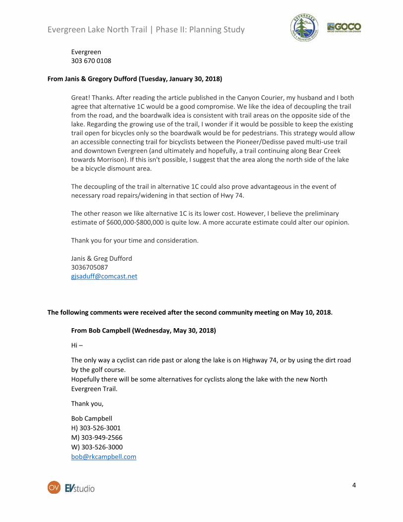
Evergreen Lake North Trail | Phase II: Planning Study
4
Evergreen 303 670 0108
From Janis & Gregory Dufford (Tuesday, January 30, 2018)
Great! Thanks. After reading the article published in the Canyon Courier, my husband and I both agree that alternative 1C would be a good compromise. We like the idea of decoupling the trail from the road, and the boardwalk idea is consistent with trail areas on the opposite side of the lake. Regarding the growing use of the trail, I wonder if it would be possible to keep the existing trail open for bicycles only so the boardwalk would be for pedestrians. This strategy would allow an accessible connecting trail for bicyclists between the Pioneer/Dedisse paved multi-use trail and downtown Evergreen (and ultimately and hopefully, a trail continuing along Bear Creek towards Morrison). If this isn't possible, I suggest that the area along the north side of the lake be a bicycle dismount area.
The decoupling of the trail in alternative 1C could also prove advantageous in the event of necessary road repairs/widening in that section of Hwy 74.
The other reason we like alternative 1C is its lower cost. However, I believe the preliminary estimate of $600,000-$800,000 is quite low. A more accurate estimate could alter our opinion.
Thank you for your time and consideration.
Janis & Greg Dufford 3036705087 [email protected]
The following comments were received after the second community meeting on May 10, 2018.
From Bob Campbell (Wednesday, May 30, 2018)
Hi –
The only way a cyclist can ride past or along the lake is on Highway 74, or by using the dirt road by the golf course. Hopefully there will be some alternatives for cyclists along the lake with the new North Evergreen Trail.
Thank you,
Bob Campbell H) 303-526-3001 M) 303-949-2566 W) 303-526-3000 [email protected]

EVERGREEN LAKE NORTH TRAIL | PLANNING STUDY
This page is intentionally left blank
109EVERGREEN LAKE NORTH TRAIL | PLANNING STUDY
APPENDIX C: MINIMAL COST MEMO

1
TECHNICAL MEMORANDUM
EVERGREEN LAKE NORTH TRAIL | MINIMAL COST OPTIONS | MAINTENANCE AND REPLACEMENT AS-IS
ANALYSIS
TO: Evergreen Park and Recreation District | Board of Directors
FROM: OV Consulting and EV Studio
DATE: July 23, 2018
RE: Evergreen Lake North Trail | Minimal Cost Options
The Evergreen Lake North Trail Phase II: Planning Study has set up a vision for the Evergreen Lake North
Trail based on community input and technical design criteria. The Planning Study recommends a
decoupled trail system consisting of an upper and lower trail. The study provides a preliminary
engineering concept design that includes a Planning Level Opinion of Probable Cost estimate of
approximately $3.1 million dollars. During the Evergreen Park and Recreation District (EPRD) Board of
Directors meeting of June 26, 2018, the project team was asked to provide more detail regarding a
maintenance option and a replacement as-is option.
Maintenance Option
The maintenance option consists of EPRD and EMD staff providing maintenance and replacing sections
of the trail as needed. The maintenance work is expected to be similar to the trail maintenance activities
performed by EPRD and Evergreen Metro District (EMD) during the Fall of 2017.
Important elements to consider regarding the maintenance option are the approach and process,
operational aspects, and the resulting aesthetic character. If this option is followed, the approach is

2
more reactive than proactive. The maintenance and replacement processes are dependent on the status
and risk of the different trail sections. The trail could still fail suddenly during heavy loadings of snow
and water similar to the process for the previous failure. The overall maintenance process would be
performed in a piecemeal manner resulting in a higher number of closures to the trail and SH 74 to
complete the maintenance work. Additionally, this option will not address the underlying drainage
issues that are contributing to the existing wall failure.
The maintenance approach will also result in a fragmented aesthetic character along Evergreen Lake.
The maintenance option will result in an inconsistent character with sections of the trail that look
different from each other before all sections are replaced. Aesthetics has been identified as an
important aspect of this trail for the community.
Lastly, if the maintenance option is chosen as the primary method for maintaining and updating the
wall, the existing handrail may need to be replaced in each section as it is completed to bring it up to
current safety standards. This will increase the cost of each maintenance replacement section as
compared to the maintenance work already completed by EPRD and EMD where the existing handrail
was left in place.
The cost estimate for this option is difficult to estimate accurately. The section that EPRD/EMD repaired
previously cost approximately $3-4,000 for materials and excavator rental. The blocks utilized were
obtained at a lower cost than normal because they were part of inventory a supplier had on hand at the
time. This cost did not include highway traffic control for SH 74, a new handrail, or drainage
improvements. The cost also did not include any outside contractor staff or support. It is my opinion
that the true cost of each section of repair is on the order of three to four times this amount or
approximately $9-16,000 per section. With this in mind, I estimate that the cost to replace the entire
wall one section at a time is on the order of $800,000 - $1,000,000 with significant variation possible
based on the section heights and condition as they are replaced.
Funding sources for this option are limited because it is considered maintenance work. Therefore,
funding for this option will most likely be from EPRD’s yearly budget. In addition, due to the uncertainty
of the repairs needed, planning, budgeting, and the allocation of funds for maintenance repairs could be
difficult. Because of the limited funding sources, EPRD’s contribution would not be leveraged with other
outside funding sources.
Overall this option could provide EPRD with a minimal cost maintenance option. However, this option
does not solve the underlying drainage issues and does not provide any additional improvements, nor
does it align with the long-term vision for trail.
Replace “as-is” with New Wall and Railing
The replacement as-is option consists of replacing the existing bin gravity wall with a large-block gravity
wall (Redi Rock). The replacement includes the removal of the existing gravity wall and replacing it with
a new Redi-Rock wall. This work is intented to occur all at once, resulting in a new trail once completed.
The trail width and section would remain the same as they are today.
This option will improve certain aspects of the trail such as the handrail and improve the drainage to
avoide any future unstable conditions due to drainage. However, this option will not improve the width
or surface of the trail and would not meet the desired design criteria and standards for a shared use

3
facility thus requiring bicycles to operate on SH 74 as they do today. This option doesn’t meet many of
the criteria established in the planning study. It’s primary purpose is to provide for protection for the
EMD 12” water transmission line while maintaining a minimum connection for pedestrians around
Evergreen Lake.
The Planning Level Opinion of Probable Cost estimate for this option is approximately $1.5 million
dollars. The cost estimate is based on the best information available at this time and does not include
the acquisition of right of way, if necessary. The estimate includes construction items by unit cost and
project elements as a percentage of the total construction items cost. The following table illustrates the
cost estimate details.
Funding sources for this option will be more limited since the new trail will not be improved to meet
shared use path design standards and criteria. Therefore, a higher portion of the funding for this option
will likely come from EPRD than the recommended alternative developed in the planning study.
The two minimal cost options explored could provide EPRD with a lower cost option to respond to the
unstable conditions of the Evergreen Lake North Trail. However, both of the options explored do not
align with the vision and criteria, informed by the community, set up during the Planning Study. In
addition, because of more limited availability of outside funding sources, a higher portion of the overall
cost for either the maintenance or replacement as-is work would be borne by EPRD.

This page is intentionally left blank

EVERGREEN LAKE NORTH TRAIL | PLANNING STUDY
This page is intentionally left blank

115EVERGREEN LAKE NORTH TRAIL | PLANNING STUDY
APPENDIX D: OPTIONS SUMMARY ANALYSIS

Maintenance Option (not recommended by Preliminary Eng. Study or Planning Study) • Cost Estimate: $800,000 - $1 million (Based on cost of previous repair project).• Pros: low cost, low regulatory risk.• Cons: reactive, poor aesthetics, unpredictable road closure, high impact on Staff, no funding opportunities
meaning all EPRD funds, low on addressing community goals, potential safety issues, lack of professional design services. Risk of unstable conditions, water transmission main break, highway washout, pedestrian safety, fisherman safety, water quality concerns with landslides, and need for emergency repair services.
• For a more detailed description of this option refer to Appendix C.
Build Boardwalk & Provide Pipe Cover Only • Cost Estimate: $800,000 - $1 million (based on Cost Estimates in Muller Report & this report). • Pros: low cost, addresses some community desires, separates EPRD facilities from highway.• Cons: high regulatory risk, few funding opportunities meaning mostly EPRD money required, bicycles
remain on SH 74 limiting the types of users to experienced riders, does not connect NEAT and connector, low on addressing community goals.
Replace Current Trail As-Is (not recommended by Preliminary Eng. Study or Planning Study) • Cost Estimate: $1.5 million (Based on Planning Study cost estimate and Minimal Cost Memo estimate)• Pros: reduced cost, reduced regulatory risk• Cons: low funding opportunities (repair & replace project) meaning relatively high EPRD money likely,
user conflicts remain, low on addressing community goals, missed opportunity to create long-lasting transportation & trail network improvement for community
• For a more detailed description of this option refer to Appendix C.
Improved Upper Trail of Recommended Alternative (no Boardwalk) • Cost Estimate: $2.2-$2.7 million (based on Cost Estimates in Muller Report & this report). • Pros: moderate funding opportunities, reduced regulatory risk • Cons: still significant investment, low on addressing community goals, user conflicts remain, missed
opportunity to create long-lasting transportation & trail network improvement for community
Recommended Alternative with Upper & Lower Trails• Cost Estimate: $3.4 million• Pros: best funding opportunities, best meets community goals, user separation, opportunity to create long-
lasting transportation & trail network improvement for community• Cons: highest cost, some regulatory risk

This page is intentionally left blank

EVERGREEN LAKE NORTH TRAIL | PLANNING STUDY
This page is intentionally left blank

119EVERGREEN LAKE NORTH TRAIL | PLANNING STUDY
APPENDIX E: DPR NOTES

MEETING NOTES
1
Project: Evergreen Lake North Trail – Phase 2 Planning Study
Date and Time: 06/22/2018
Subject: Evergreen Lake North Trail | Denver Parks and Recreation | Denver Mountain Parks
Meeting Place: CCD-Webb Building
Participants:
• Chris Vogelsang (OV) • Brad Eckert (DPR-DMP) • Kent Sondgerath (DPR-DMP) • Fernando Abbud (OV)
Introduction
The purpose of the meeting was to discuss how to move the Evergreen Lake North Trail into design and construction, what steps are next in the process, and what are the process/standards we will need to follow.
Summary
• Brad Eckert and Chris Vogelsang updated Kent Sondgerath with an overview on the overall project, the planning process, and DPR’s stakeholder involvement.
• Kent introduced himself as the contact person from DPR that will make sure the project is following the city standards during the plan review and construction permitting process.
• The group discussed four general topics during the meeting: o DPR feedback regarding the recommended alternative from the Phase II: Planning
Process o CCD and DPR standards, approval process, and submittal requirements o CCD considerations for procurement requirements o Other Considerations
DPR feedback regarding the recommended alternative from the Phase II: Planning Process
• DPR mentioned the recommended alternative and phased implementation approach seems to be the right approach for this project to move forward.
• At this point, the planning study has set up a good vision for the Evergreen Lake North Trail. In the next phases, the focus of the project should be on how to complete design and move into construction.
• It is a project worth pursuing, even though it still needs to go through DPR management approval.
• At this point, we have agreed to begin moving into the final design phase. EPRD will be required to follow DPR procurement rules and review requirements with the goal of delivering construction plans that are signed off on by DPR for both the upper and lower trail. EPRD will

MEETING NOTES
2
then work with DPR for approvals and permitting to move into the construction phase for the upper trail alone or both depending on funding, timing, etc..
CCD DPR standards, approval process, and submittal requirements
• DPR has a QA/QC process (checklist to be provided by DPR) • DPR construction specifications and standards are updated every year. We will follow the
standards and specifications that are current when the design process begins. • This project will be considered a partner project by DPR. This means that DPR is working
together with EPRD to review and approve plans and construction for facilities on its property but is not a financial contributor.
• If there are no City dollars involved in the project, there is no need for CCD Public Works approval. It will only require DPR reviews and approvals. The Engineering, Regulatory, Analytics (ERA) division of CCD will receive 60% and 90% review sets for a supplementary review. Although ERA comments are not binding for this project, they will be considered by DPR and included in DPR’s official comments as deemed necessary.
• DPR will be involved at the 30% design level with informal comments. Then there will be a 60% and 90% submittal process where DPR will submit formal comments. Brad will lead the 30% submittal, and Kent will manage the 60% and 90% submittals.
• There are two different approval processes: one for design and one for construction. All of the above items are regarding the design approval process.
• We discussed how to move into construction. At this point, we have agreed to move forward with final design, and when we follow the review process, we will end up with construction plans that are accepted and signed off on by DPR. When we move into construction that will be a separate approval process with specific contractor requirements and Denver permitting.
• A good approach for the final design phase is to design the entire package of what you would like to build (upper and lower trail) and then you can specify different packages with conditional approvals depending on funding or other regulatory approvals.
CCD considerations for procurement requirements
• Careful examination of final design consultant and construction team will be necessary. The right consultant should understand the timeframes and requirements of the Denver Process and have experience working with multiple agencies including DPR and CDOT.
• There will be involvement from CCD in setting our RFQ language and requirements for the final design RFQ that are likely very similar to CDOT’s. Some might include:
o RFQ will need to follow the City’s MWBE requirements and have a set MWBE participation goal. Even though the project is not using any money from the City, the project is to be constructed on the City’s property.
o A meeting between CCD and CDOT will be helpful to help understand any overlapping requirements and how to meet both the grantor and the land owner’s requirements.
Other considerations
• Will there be a need for 404 permits from the Army Corp of Engineers?

MEETING NOTES
3
• Because of the dollar amount, the project will need to include a 1% Public Art component. It is assumed that the 1% takes into account all phases of the project (planning, design, construction). Brad will confirm this with CCD Arts and Venues.
• Arts and Venues has its own process for the 1% Public Art component. It will be better to make them part of the process as early as possible, so the Art can be included into the design rather than an afterthought.
• Will there be any floodplain considerations since the boathouse had some floodplain considerations? Check with Jeffco.
• Is there any interest from the Urban Drainage and Flood Control District (UDFCD)? Double check if the project is within UDFCD boundary.
• Are there any 6F/4F consultations required? In the past, improvements to the Park were made using Land and Water Conservation Funds (LWCF) and a condition of accepting those funds is that it encumbers the property with a consultation requirement with the National Park Service on changes/improvements to the Park.
To-Do’s
• Set up a meeting between CCD/DPR and CDOT to go over RFQ requirements during the drafting of the RFQ for Final Design.
• DPR to send QA/QC checklist • DPR to send procurement requirements • DPR to send current standards and specifications • DPR to confirm that the 1% public art component considers all phases of the project • EPRD to check floodplain considerations with Jeffco • EPRD to determine if the project is within UDFCD boundary? • Include an agenda item for the final Phase 2 Planning Study Stakeholder Meeting to discuss the
Final Design procurement process as well as relevant information related to obtaining construction permitting

This page is intentionally left blank

EVERGREEN LAKE NORTH TRAIL | PLANNING STUDY
This page is intentionally left blank

125EVERGREEN LAKE NORTH TRAIL | PLANNING STUDY
APPENDIX F: EXAMPLE OF FUNDING OPPORTUNITIES TIMELINE

Evergreen Lake North Trail Grant Funding Opportunities Conceptual Timeline Calendar Year (quarters) 2018 2019 2020 2021 2022 2023 Grant Funding Opportunities 2 3 4 1 2 3 4 1 2 3 4 1 2 3 4 1 2 3 4 1 2 3 4 DESIGN FUNDING (already secured) DOLA Preliminary Engineering Grant $25K grant from DOLA; Preliminary Eng Study by Muller. COMPLETE
GOCO Planning Grant Ongoing $100K grant from GOCO; final report 7/19; closing 12/8/18
TAP Final Design Grant (Trans Alt Program admin by CDOT) $200 grant, $50K match. Est start Fall 2018; closing May 2023
CONSTRUCTION FUNDING OPPS (one time or long cycles) DRCOG TIP Grant (Transportation Improvement Project) Federal funds admin by DRCOG. Max rqst = Jeffco subregion pool = est $31 million. Required match = 20% cash or equiv. Focus on safety and access. Call for projects fall 2018, projects selected spring 2019; Funding period FY 2020-23 (10/19 – 9/22).
GOCO Connect Initiative Special round thru GOCO. Max rqst = $2mil of $8+ mil pool. Rqd match = 25% (10% cash). Call for concept papers 1/19; final apps due 8/19; award 10/19. 3 yrs to complete from award date (10/22). Primary funding leverage source for other grants, especially Federal.
TAP Construction Grant (Trans Alt Program admin by CDOT) Fed funds admin by CDOT. Max rqst = Region 1 pool = $5.5 mil last round. Rqd match = 20% cash or equiv. Call for Projects est 5/19; due 8/19; award 11/19. Funding period FY 2021-23 (10/20-9/22)
ONGOING FUNDING OPPS (annual cycles or w/o dates) Colorado State Trails Grants Annual Nov cycle for large construct or maint thru CPW. Max rqst =$250K, 30% match (10% cash). 2.5 yrs from award to complete.
Colorado Land & Water Conservation Fund Fed funds on annual Nov cycle hand in hand w CST. Max rqst = $400K (typ $200K); 100% match rqd. 3 years from agmt to complete.
Jeffco Open Space Joint Venture and CTF Grants Annual Nov cycle thru JCOS. Formerly up to $400K with 1-2 yr hiatus, last round $50K max w 65% match required. 2 years to complete.
CPW Fishing is Fun Grants Annual March cycle for fishing access/improvements. $400K pool, typical grant $85K, 25% match rqd. Cmplt 12/31 2 yrs after award.
CDPHE Section 319 Grants Fed funds administered by CDOT for nonpoint source pollution mgmt. Last round Feb 2018, typ grant = $200K of $1 mil pool. No current cycle .
Trust for Public Land Trail Projects TPL CO creating new trails initiative. Potential leveraging source.
Source: EPRDGrant Application
to Authorization to Proceed
Funding Period End

This page is intentionally left blank