Embed Size (px)
Citation preview
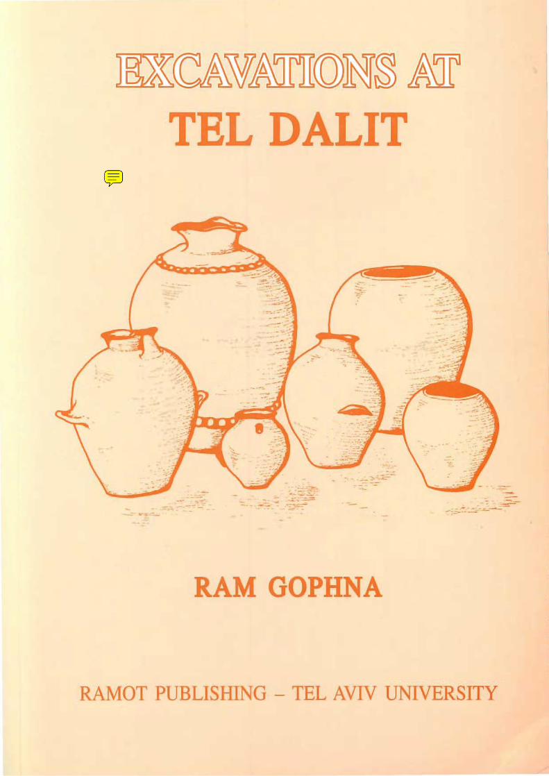
UCCAW&lTII(0)N~ M TEL DALIT
... ~ -.:..:;-._-~~~'.'-
- ;-- -... ~ ~ -: -: ~ ... -.~.?:~;':-
~ - ':::;=:::-.. - -'-. ---- "- - ::.. "":::.::::..~-
................. -- -- ~--..;,..,.
-- - ;=:::-: •• :~-~-~~ -"- . ~~::-~-- -.~ -.--.=- ~-;.---
RAM GOPHNA
RAMOT PUBLISHING - TEL AVIV UNIVERSITY
EXCAVATIONS AT TEL DALIT An Early Bronze Age Walled Town
in Central Israel
By RAM GOPHNA
With the participation of
BRUCE CRESSON
Contributions by
Erich Friedmann, Michal Iron-Lubin , Liora Kolska-Horwitz,
Shlomo Hellwing and Eitan Tchernov, Nili Liphshitz, Rachel Pelta,
Shelley Sadeh and Tsvika Tsuk
ISBN 965-274-225-2
©
All rights Reserved by the Institute of Archaeology
Tel Aviv University
Published by Ramot Publishing House, Tel Aviv University, 1996
CONTENTS
List of Figures (chapters 1-7)
List of Abbreviations
Preface
Chapter 1. Introduction
1.1. The Site and its Exploration
1.2. The Site and its Setting
Chapter 2. The Excavations
2.1. The Expedition
2.2. Aims and Methodology
Ram Gophna
Ram Gophna
Bruce C."esson
Chapter 3. Architecture and Stratigraphy Ram Gophna
Bruce Cresson
3.1. Area B
3.2. Area B3
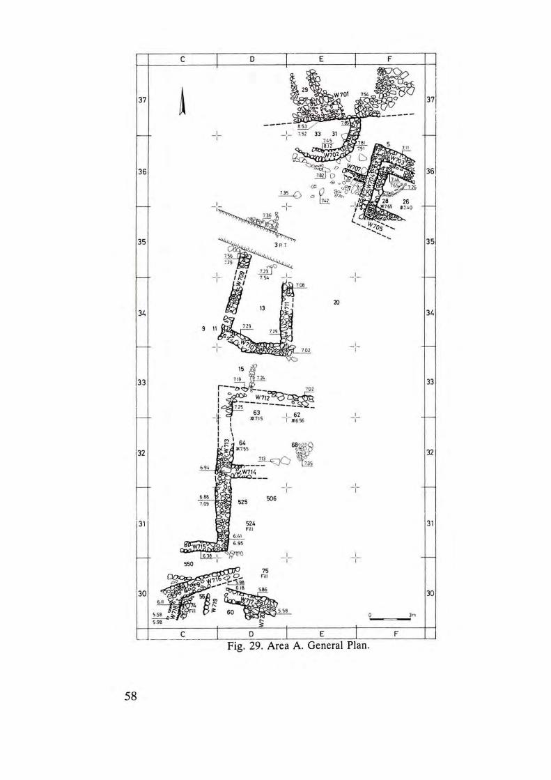
3.3. Area A
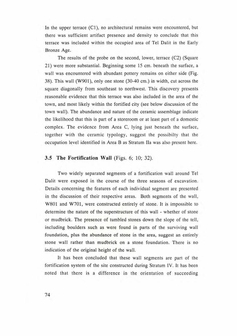
3.4. Area C
3.5. The Fortification Wall
3.6 . Discussion Ram Gophna
Chapter 4.
3.6.1. The Layout of the Fortified Site
3.6.2. The Fortification System
3.6.3. Domestic Architecture
3.6.4. The End of the EB 1I Walled Town
at Tel Dalit and the Final Desertion
of the EB Site
The Pottery Assemblages Ram Gophna
Michal Iron-Lubin
4.1. Pottery of Stratum V (EB Ib), Areas A, B
4.1.1 Conclusions - Pottery of Stratum V (EB Ib)
5
7
9
11
18
21
8 1
3
4.2. Pottery of Strata IV -II (EB II), Areas A, B, C
4.2.1 Pottery from Broadroom 115-152, Area B,
Stratum II: A Quantitative Analysis
4.2.2 Conclusions - Pottery of Strata IV -II (EB II)
4.3. Pottery of Stratum I, Area B3
4.4. Pottery Coated with Bitumen
Chapter 5. The Flint Assemblages Erich Friedmann 135
Chapter 6. Small Finds Shelley Sadeh 143
6.1. Cylinder Seals/Beads
6.2. Animal Figurines
6.3. A Bed-Model
6.4. A Macehead
6.5. Stone Rings
6.6. Copper Awls
Chapter 7. Summary and Conclusions Ram Gophna 153
References 163
Special Reports
Chapter 8. A Potter's Wheel Rachel Pelta 171
Chapter 9. Analysis of Botanical Remains Nili Liphschitz 186
Chapter 10. Pattems of Animal Exploitation Liora Kolska-Horwitz
Shlomo Hellwing
Eitan Tchernov 193
Chapter 11. A Note on the Water Supply Tsvika Tsuk 217
4
LIST OF FIGURES (Chapters 1-7)
1. Tel Dalit: General View. Looking South. 2. Tel Dalit: General View. Looking East. 3. Tel Dalil: General Plan: Contours and Excavation Areas. 4. Major EB Sites in Central Israel. 5 . Area B. Looking East (1980). 6. Wall, Postern and Tumulus 2, Looking North. 7. Area B. St. V: Fill on Bedrock. 8. Area B. St. IV, Plan. 9. Area B. End of Excavation, Looking East. 10. Area B. Fortification Wall, Looking Southeast. 11. Area B. Fortification Wall and Postern, Looking North. 12. Area B. Plan of St. III. 13. Area B. St. III, L. 309: "The Curvilinear Building". 14. Area B. St. III, L. 307: Floor. 15. Broadroom 115-152 (1978), Looking East. 16. Area B. Plan of St. lIb. 17. Area B. Plan of St. lIa. 18. Area B. St. lIb, L. 154: Floor, Looking South. 19. Area B. St. lib, L. 152: Floor (Antler of Fallow Deer). 20. Area B. St. I1a, L. 115: Floor. 21. Area B. St. IIa , L. 155: Silo. 22. Area B. Section 1-1. 23. Area B3. 24. Area B3. "Tumulus 2", St. I, Sq. TIl, L. 410, 411. 25. Area B3. "Tumulus 2", St. I, Sq. TIO, L. 412, 415. 26. Area B3. "Tumulus 2", St. I, Sq. TIO, Looking East. 27. Area B3. Sq. T9, St. I-V, Looking North. 28. Area B3. L. 418. 29. Area A. General Plan. 30. Area A. Looking North (1980). 31. Area A. St. V, L. 33: Curved Wall Under Fortification Wall ,
Looking Northeast. 32. Area A. Fortification Wall, Looking South. 33. Area A. L. 15: Entrance to Settlement ("The Gate Area"). 34. Area A. L. 28: Broadroom, Looking Southwest. 35. Area A. Sq. D-E32, L. 63, 68, 71: Pillar Base and Flagstone,
Looking North. 36. Area A. L. 55: W710, W716, W718, Looking North. 37. Area C2. General Plan. 38. Area C2. L. 602, 603. 39. Pottery of Stratum V, Area A.
5
40. Pottery of Stratum V, Area A. 41. Pottery of Stratum V, Area A. 42. Pottery of Stratum V, Area A. 43. Pottery of Stratum V, Area B. 44. Body Sherds of Jars Coated with Lime Wash and Decorated with
Red Stripes. SI. V. 45 . Pottery of Stratum V, Area B3, L. 42l. 46. Pottery of Stratum IV, Area B. 47. Pottery of Stratum III, Area B. 48. Pottery of Strata II, Area B. 49 . Pottery of Stratum II , Area B3. 50. Metallic Ware Platters. Areas A-B, SI. II. 51. Pottery of Area B. The Alleyway. 52 . Pottery of Stratum II. Area A. 53. Unstratified EB /l Pottery of Area A. 54 . Pottery of Stratum [I. Area C. 55. Pottery of Stratum II. Area C. 56 . Area B. Various Finds from Broadroom 115-152. 57 . Area C. Jars . 58. Area C. SI. II, Jar with Pillar Handle. 59. Area C. Holemouth Jar. 60 . Area C. Holemouth Jar. 6 1. Area B. SI. /l a, Chalice. 62. Area B. SI. II , Juglel. 63. Area C. Pithos. 64 . Area B. SI. II , the Broadroom 115-152 Assemblage 65. Pottery from Stratum I. Area B3. 66. Early Bronze III Pottery From Surv.ey (1975). 67. Flint Implements. 68. Flint Implements. 69 . Small Finds. Strata IV-II. 70 . Unstratified Objects. Area A. 71. Bone Cylinder Seals/Beads 72. Animal Figurine. 73. Bed-M odel. 74. Chalcol ithic and EB Sites in the Lower Yarkon-Ayalon Drainage
Ba in . 75 . Abandoned EB II Walled Towns
Tel Dalit. The ] 979 Expedition
Tel Dal il. Aerial photograph - to south (Back cover) (courtesy of Ofek Ltd. )
6
ADA]
BASOR
EI
IE]
LAM
NEAEHL
PEP QSI.
PEQ
RB
LIST OF ABBREVIATIONS
Annual of the Department of Antiquities of Jordan
Bulletin of the American Schools of Oriental Research
Eretz- Israel
Israel Exploration Journal
Liverpool Annals of Archaeology and Anthropology
The New Encyclopedia of Archaeological Excavations in
the Holy Land (1993)
Palestine Exploration Fund, Quarterly Statement
Palestine Exploration Quarterly; continuation of PEF QSt.
Revue Biblique
7

PREFACE
The excavations at Tel Dalit (1978-1 980) were only a brief
episode of research into a one-period site in central Israel. Unfortunately,
work at the site was terminated before many of the questions raised
during the process of excavation could be clarified, and before a
satisfactory understanding of the history of EB settlement there could be
formed . Most of the areas were barely touched. Nonetheless, as there is
little chance of a renewal of excavations at Tel Dalit in the foreseeable
future, we hope that this brief excavation report will contribute, however
modestly, to our knowledge of the settlement history of the Coastal Plain
of Israel during the Early Bronze Age.
I wish to extend my deepest gratitude to my colleague Prof.
Moshe Kochavi, for many years the director of the Institute of
Archaeology of Tel Aviv University, who, together with me, initiated the
excavation, then made ava ilable to us the facilities of the Aphek
Expedition camp, and even suggested the Hebrew name of the site. Many
thanks to Prof. Bruce Cresson, my co-director throughout our successful
cooperat ion, who provided the financial means through Baylor
University, Texas, without wh ich the excavations could not have taken
place. I also thank Prof. Pirhiya Beck for her kind permission to use the
unpubl ished report on the EB ceramics from Tel Aphek. Special thanks
to Dr. Shelley Sadeh for the English editing, and to Dr. Elliot Braun for
reading the manuscript and offering valuable comments and
observations. Further thanks to Michal Iron-Lubin and Michal Ron who
participated in the processing of the finds, and the technical staff of the
Inst itute of Archaeology: Noami Nadav, Yoseph Kapelyan, Rodicha
Pinchas, Judith Dekel , Ora Paran and Neta Halperin. Warm thanks to my
son Uri for his ass istance in preparing the manuscript fo r print. Aya Darel
of Ramot Publishing helped bring this book to print.
Ram Gophna, Tel Aviv University
August, 1996.
9

empty page
Chapter 1.
INTRODUCTION RAM GOPHNA
1.1 The Site and its Exploration
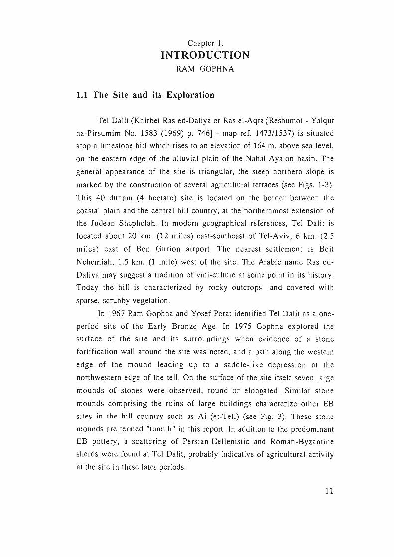
Tel Daiit (Khirbet Ras ed-Daliya or Ras el-Aqra [Reshumot - Yalqut
ha-Pirsumim No . 1583 (1969) p. 746] - map ref. 147311537) is s ituated
atop a limestone hill which rises to an elevation of 164 m. above sea level,
on the eastern edge of the all uvial plain of the Nahal Ayalon basin. The
general appearance of the site is tri angular, the steep northern slope is
marked by the construction of several agricultural terraces (see Figs . 1-3).
This 40 dunam (4 hectare) s ite is located on the border between the
coastaj plain and the central hill country, at the northernmost ex tension of
the Judean Shephelah. In modern geographical references, Tel Dalit is
located about 20 km. (12 mil es) east-southeast of Tel-Aviv, 6 km . (2.5
mil es) east of Ben Gurion airport. The neares t settlement is Beit
Nehemiah, 1.5 km. (1 mile) west of the si te . The Arabic name Ras ed
Daliya may suggest a tradition of vini -culture at some point in its history .
Today the hill is characterized by rocky outcrops and covered w ith
sparse, scrubby vegetat ion.
In 1967 Ram Gophna and Yosef Porat identified Tel Dalit as a one
period si te of the Early Bronze Age. In 1975 Gophna explored the
sur face of the s it e and its surroundings when ev iden ce of a s tone
fo rtifi cation wall around the s ite was noted, and a path along the western
edge of the mound leading up to a saddle-like depress ion at the
northwestern edge of the tell. On the surface of the site itself seven large
mounds of stones were observed, round or elongated . Similar sto ne
mounds comprising the ruins of large buildings characterize other EB
s ites in the hill country such as Ai (et-Tell) (see Fig. 3). These stone
mounds are termed "tumuli " in this report. In addition to the predominant
EB pottery, a scattering of Pers ian-He ll enis tic and Roman-Byzan tine
sherds were found at Tel Dalit, probably indicative of agricultural acti vity
at the site in these later periods.
11
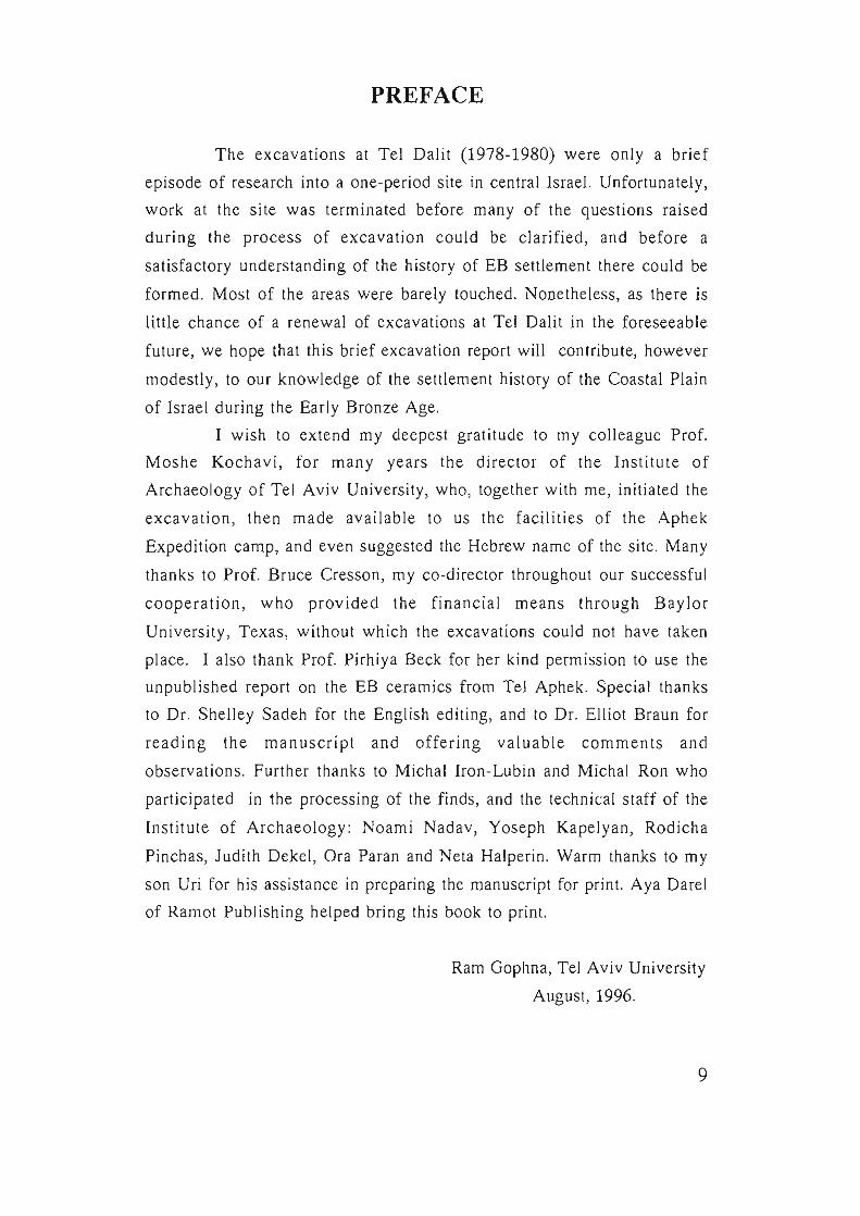
Fig. 1. Tel Dalit. General View, Looking South .
12
Fig. 2. Tel Dalit. General View, Looking East.
13
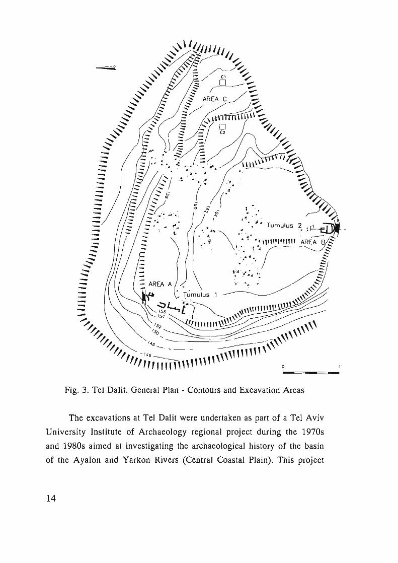
Fig. 3. Tel Datil. General Plan - Contours and Excavation Areas
The excavations at Tel Dalit were undertaken as part of a Tel Aviv
University Institute of Archaeology regional project during the 1970s
and 1980s aimed at investigating the archaeological history of the basin
of the Ayalon and Yarkon Rivers (Central Coastal Plain). This project
14
included excavati on of the si tes of Aphek (1972-1985) , Izbeth Sarta
(1976-1978), Tel Gerisa (1981-1995) and a survey (1972-1979) of the
"Rosh Ha-ayin" and "Lod" maps (1 :20,000; Maps 78, 80) (Kochavi and
Beit-Arieh 1994; Gophna and Beit-Arieh, forthcoming). Within the
framework of this regional project, the Tel Dalit excavations set out to
investigate one period of settlement in this region, i.e ., the Early Bronze
Age. Tel Dalit is one of a large number of fortified EB sites in Israel
which were not resettled in the following Middle Bronze Age. It is also
the most impress ive among a series of EB si tes known to date on or near
the edge of the central hill country, within the Ayalon-Yarkon drainage
system, which lie between the major EB-MB s ites of Aphek to the north
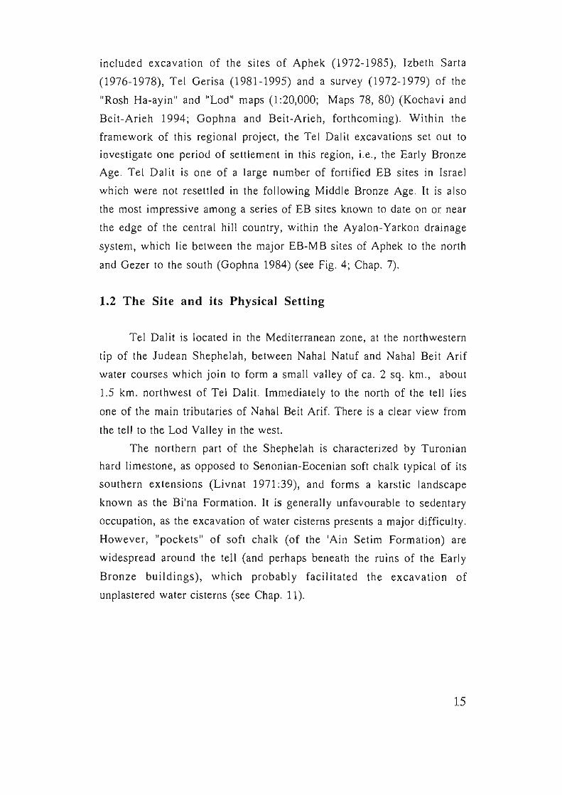
and Gezer to the south (Gophna 1984) (see Fig. 4; Chap. 7).
1.2 The Site and its Physical Setting
Tel Dalit is located in the Mediterranean zone, at the northwestern
tip of the Judean Shephelah, between Nahal Natuf and Nahal Beit Arif
water courses which join to form a small valley of ca. 2 sq. km ., about
1.5 km. northwest of Tel Dalit. Immediately to the north of the tell lies
one of the main tributaries of Nahal Beit Arif. There is a clear view from
the tell to the Lod Valley in the west.
The northern part of the Shephelah is characterized by Turonian
hard limestone, as opposed to Senonian-Eocenian soft chalk typical of its
southern extensions (Livnat 1971 :39), and forms a karstic landscape
known as the Bi'na Formation. It is generally unfavourable to sedentary
occupation, as the excavation of water cisterns presents a major difficulty.
However, "pockets" of soft chalk (of the 'Ain Setim Formation) are
widespread around the tell (and perhaps beneath the ruins of the Early
Bronze buildings), which probably facilitated the excavation of
unplastered water cisterns (see Chap. 11).
15
..... , . ' .
I "
16
o
. ,., ',
....
· .• f? N .. ~
:: . ,::. " ..
", '"
.. .... . ...
. .... . .
" , .
........•.. .. ; ..
. ," .......... . ,', :
',:
. ,, ',:., "
· . · ," . "
. ',-' .. "
. ',-.•. . ? .
';.'
': . : -: ..
.'.
Fig. 4. Major EB Sites in Central Israel.
;. : .....
. ...
:': .
' .. ',,', .
. ; . . . '.
The morphology of the northern part of the Shephelah consists of
elongated ridges oriented east-west that slope moderately westward
towards the coastal plain. The dry river beds (wadis) have steep slopes,
becoming narrower and more winding towards the east, forcing the roads
from the coastal plain to the hills to follow the ridges. Tel Dalit is situated
on one of these ridges on the road between Beit Nehemiah and the village
of Qibia.
This region receives a mean annual precipitation of 570 mm . The
mean minimal temperatures vary between 200C in August and 70C In
January, and the mean maximal temperatures vary between 31.90C in
August and l8.20C in January (Israel Meteorological Service).
The present day vegetation of the area is secondary, following the
prolonged impact of man on the environment. The region is
characterized by a Carob-Lentisk association , the trees widely dispersed
with large patches of batha and foxtail shrubs between, and by man-made
forests, mainly of Aleppo pine (Waisel 1984). Archaeobotanical research
indicates that the vegetation which dominated the Shephelah prior to
man's interference was a Kermes Oak-Terebinth association (Liphschitz
and Biger 1990) (see Chap. 9).
There is not a single natural perennial water source in the
immediate environs of the tell. The closest is the small seasonal spring of
En Natuf, situated about 4 km. southeast of Tel Dalit (see Finkelstein
[1993:19] concerning the average distance between a settlement and its
spring in the hill region: 3.3 kms., which he describes as a relatively long
distance) . Although the greater humidity in antiquity would have
produced a water table slightly higher than that of the present day at ca.
20 m. above sea level, it is doubtful if the EB inhabitants of the tell had
the means to reach it (but see Chap. 11).
Cisterns (both those so far identified within the confines of the site,
and others which must be assumed), could have served as intramural
reservoirs (see in detail: Chap. 11).
17
Chapter 2.
THE EXCAVATIONS RAM GOPHNA AND BRUCE CRESSON
2.1 The Expedition
Excavations took place during three four-week seasons: May-June
1978, 1979, 1980, sponsored by the Institute of Archaeology of Tel Aviv
University, and the Institute of Archaeology of Baylor University, Waco,
Texas, and financially supported by Baylor University. The total area
which was excavated reached ca. 725 sq. m. The directors were Ram
Gophna of Tel Aviv University (field director) and Bruce Cresson of
Baylor University. Area supervisors were Lynn Tatum (Area A), Jay
Below (Area B), and in the third season Naomi Toyster (Areas A and C).
The surveyor was Amir Toyster, while Bruce Cresson and Avraham Hal
photographed for the expedition. The administrator was Sh lomo Frank.
Pottery was drawn by Judith Arnold and Yoseph Kapelyan, and maps and
plans were prepared by Ora Paran and Judith DekeL Volunteers from the
US included Joanne Cresson and Bruce Cresson Jr., students of Baylor
University, and an additional 20-25 volunteers in each season. The first
drafts of Chapters 1-3 (Introduction, The Excavations, Architecture and
Stratigraphy) were written in July 1981 by Gophna Cresson, and
updated, revised and reassessed by Gophna prior to publication. All
material was processed during 1992-1995 with the assistance of Michal
Iron-Lubin, Shelley Sadeh and Michal Ron, funded by a grant from The
Israel Science Foundation, administered by The Israel Academy of
Sciences and Humanities (within the research project: "Processes of
Urbanization in Lod Valley during the Early Bronze Age").
18
2.2 Aims and Methodology
II was originally assumed that three brief seasons would provide
enough evidence to reconstruct the occupational history of the site during
the Early Bronze Age, The specific goals of the three-season excavation
were:
1) to establish the stratigraphy of the tell,
2) to investigate the fortification system, especially the segment where a
entryway was assumed to lie,
3) to study domestic architecture.
4) to investigate the composition of the stone mounds (tumuli) on the
summit of the tell and to assign them to their proper stratigraphic
context.
Difficulties in the excavation were obvious from the beginning. Tel
Dalit, immediately to the west of the "Green Line" (the Israeli-Jordanian
West Bank Armstice line from 1949-1967) had been subjected to
extensive military trenching, creating major disturbances to the
stratigraphic integrity of the tell. At the conclusion of the third season
certain stratigraphic problems remained unsolved (especially in Area A),
the lower terraces in the eastern par! of the lell (Area C) had only begun
to be explored, and the drawing of sections in various areas of the
excavations had nOl been completed, It was thought that these problems
would be rectified by a fourth small-scale season at the site,
Unfortunately, in 1980 the tell was included within a closed military area,
and access to the site for further excavation was not permitted,
Some areas of the site are bedrock outcrops (especially in the
centre of the site, eastwards towards the entrance in the northwest, and in
the southwest). Excavation areas were chosen according to two main
considerations: the hypothesized existence of ancient debris, and
proximity 10 the line of the fortification waJ I and the supposed main
entrance to the site,
The excavations were based on 5 m. grid squares, according to the
methodology and procedures of recording and registration used in the
excavations at Tel Aphek (Kochavi and Beck forthcoming). In addition,
19
at Datil all excavated fills were sieved through a 2 mm. mesh. An
attempt to isolate seeds by flotation yielded negligable results.
In general, a multi-disciplinary, environmental/archaeological
approach was applied at Tel Dali! so as to allow for reconstruction of the
geographical and cultural setting. In the first season Areas A1 and
A2 in the northwest part of the tell were opened, while excavation of Area
began in the south. In the second season Area B2 was opened, and in
the third season work commenced in Area B3 (with Tumulus 2). Toward
the end of the third season two small probes (25 sq. m. each) were
opened on two terraces in the eastern parI of the tell, designated Area C.
A survey of the entire surface of the tell area was conducted by the
directors in an attempt to locate cemeteries associated with the site.
Although the slopes of the tell could have been used for such a purpose,
no definite evidence was discerned.
20
Chapter 3.
ARCHITECTURE AND STRATIGRAPHY RAM GOPHNA AND BRUCE CRESSON
3.1 Area B
The excavation undertaken at the southern end of Tel Dalit (Area
B) (Figs. 3; 5-6; 22) proved to be the most fruitful, in both architectural
and ceramic remains, and presents the clearest picture of the stratigraphy
of the site. This part of the excavation was the scene of active excavation
during all three seasons, encompassing 11 squares totalling ca . 275 sq. m.
in area.
In the course of the three digging seasons, Area B was broadened,
and sub-divided into Areas Bl, B2 and B3. However, at the time of
processing the finds for the final report, the sub-areas Bl and B2 were
combined.
A summary of the stratigraphy of Area B may be presented as
follows:
Stratum I - Structural remains in Tumulus (2) (no surviving floors). EB III.
Stratum Ila - Later floor and associated features of Broadroom 115-152.
EBII.
Stratum llb - Early floor and associated features of Broadroom 115-152.
EBII.
Stratum III - Curvilinear building with floor and associated features. EB II.
Stratum IV - Sporadic and much disturbed architectural remains lying
above a fill which was laid to level the area prior to the erection of the
walled town . The architectural elements of this stratum are generally
parallel or perpendicular to the town wall. EB II.
Stralllm V alld "Pre-Stratum V" - Evidence of the earliest known
occupation of the site. In Area B this stratum is without architectural
features except for a levelled fill with architectural remains on bedrock in
Area B3. EB la-b.
21
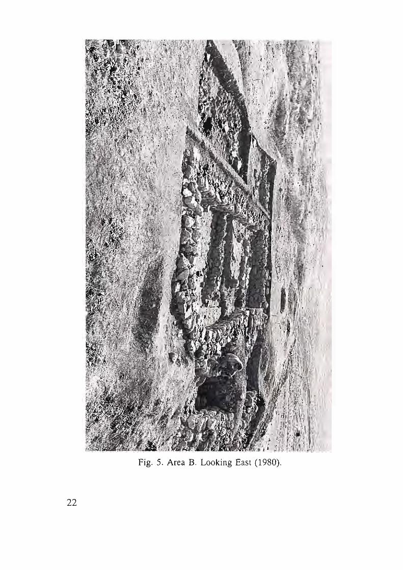
Fig. 5. Area B. Looking East (1980) .
22
Stratum V
Bedrock was reached In probes of lim ited size In Squares T-6
(4x2 .5 m. ), U-6 (lx2 m.), U-5 (4x2.5 m.), in a trench along the
founda tion of the town wall (W801) in Squares T-4 , U-4, and in Square
T-9 (lx1 m.) (P lan-grid lA) (Loci 350, 353, 360, 362, 367, 370, 372) .
The earliest evidence of human occupation at Tel Dalit in Area B
was recovered from artifact-bear ing debris lying on the uneven bedrock.
Wherever depressions in the bedrock were encountered (outside Tumulus
2 area) an exam ination of the material which filled these depressions led
to the conclusion that there was a deliberate levelling of the site prior to,
and probably in preparation fo r, the erection of the walled town above
this compacted debris. The fill nature of this material is evidenced by the
heavy encrustation on some of the pottery (Fig. 7).
The pottery sam pling here is sufficient to support the conclusion
that there was a se ttl ement which preceded the erection of the fo rti fied
town.
On ly in Area B3 were architectural remains uncovered that could
be ass igned to Stratum V, and even "Pre-Stratum V" (see below Area B3).
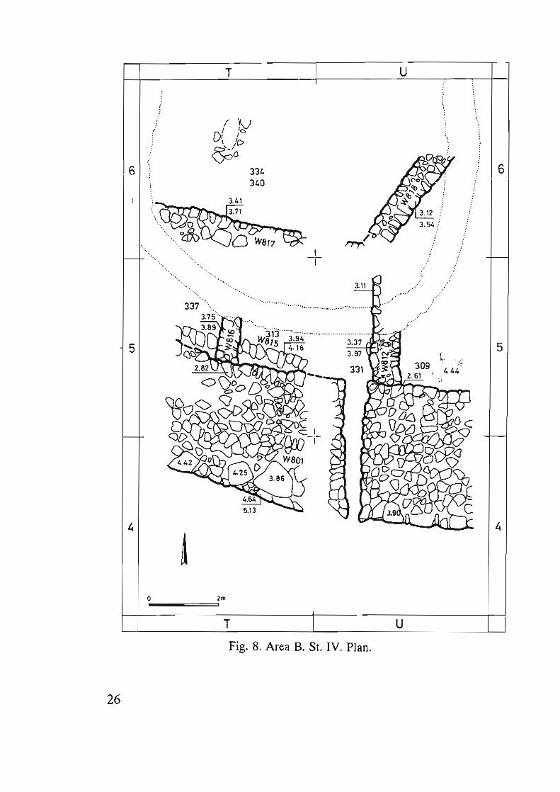
Stratum IV
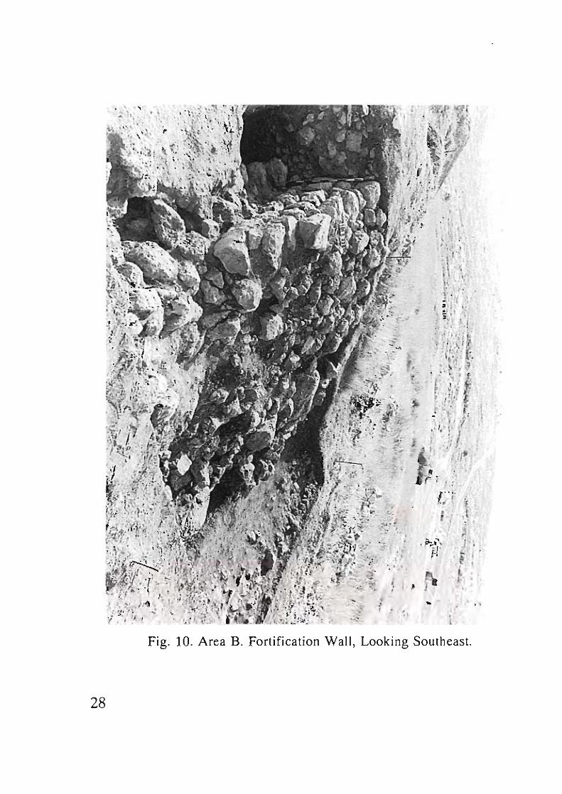
The earliest fortified town at Tel Dalit was erected on the debris of
the Stratum V occupation (Figs . 8-9). The f irst major fea ture of the
Stratum IV town to be noted was the substantial fortification wall. This
fort ificat ion wall (W801) (Figs. 10-11) was exposed in Area B on the
steep s lope just below the southern tip of the tell surface for a distance of
10m. (in Squares T4 , T5 , U4, US). It proceeds in an eas t-west directi on
with a slight northward curve to the west. Its foundation is at an elevation
of 4 .44 m. below point zero of the excavation, and it was preserved to
elevation 2.85 m. Its found ations rest on a thin layer of fill described
above (S tratum V). The foundations, ca . 4 m. wide, consist of "cyclopean"
stones laid directly upon the fill of Stratum V (see above) (Loc. 390).
23
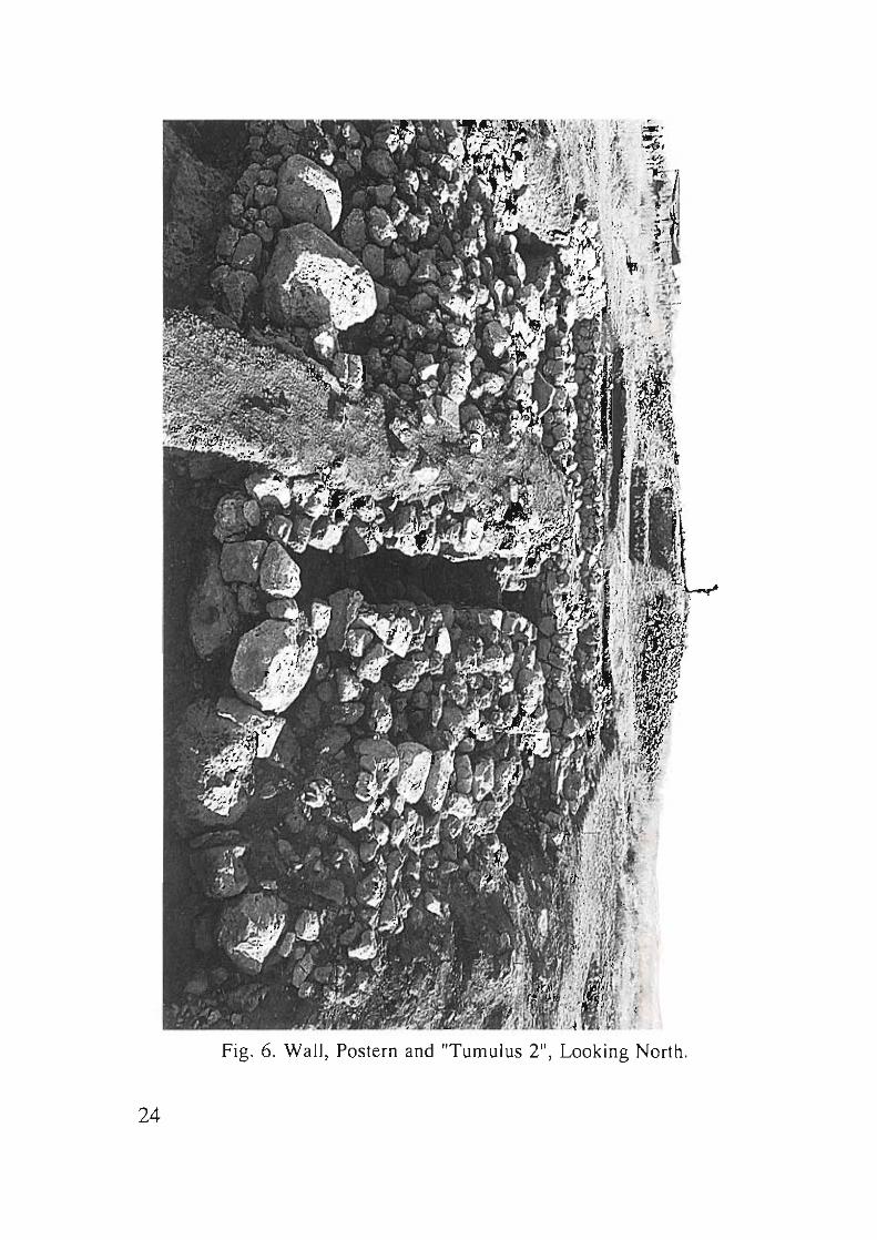
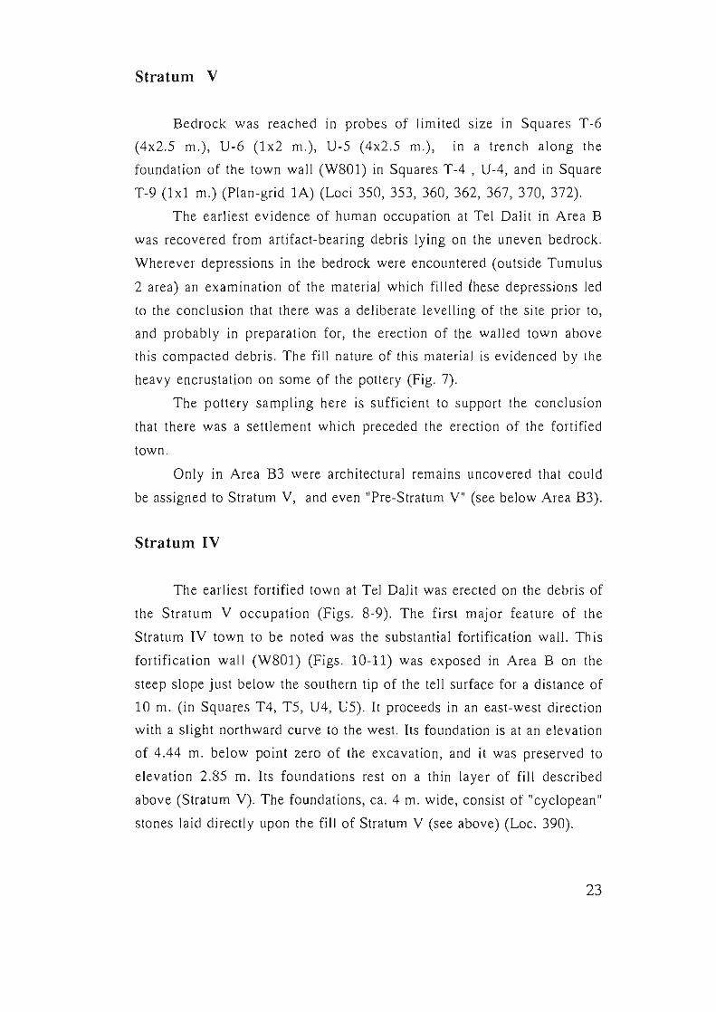
Fig. 6. Wall, Postern and "Tumulus 2", Looking North.
24
Fig. 7. Area B. SI. V: Fill on Bedrock.
25
6
5
26
.... . ...
o
-. .... ,
....
....
T
I '10 Df /0
\ '0
~o
. ... .....
. ....
2m
T
334 340
. ... .....
3.11
.... ..... . . ............. .
Fig, 8, Area B, St. IV, Plan,
u
6
.--
5
u
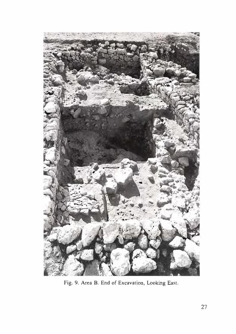
Fig. 9. Area B. End of Excavation, Looking East.
27
28
,~ .. ,. r .;"
• • 1 • . ,,~ , . " !
i. ! , ,
, .,
f\ .. ,
: ; 1 ,· t " . • ,. I
, I ,
,
, ', .' ; •
Fig, 10. Area B. Fortification Wall , Looking Southeast.
,
The inner face of the wall is built of what may be described as
semi-dressed stones, creating a relatively smooth face. The core of the
wall was constructed of fieldstones. A fill leveling the slope was laid
against the inner face of the town wall in preparation for construction of
the new town.
Near the western baulk of Squares U4 and U5 a postern gate was
uncovered (Fig. 11), blocked on its southern outer side by a single row of
stones ris ing two courses above the floor of the entrance. The earliest
floor level of the passageway through the postern gate lies at 3.94 m.
below zero point (Lac. 331).
Dressed blocks in the lower courses of the postern gate and semi
dressed stones in both faces of the postern walls provide evidence that it
was an integral part of the original construction of the wall. The width of
the entrance when excavated telescoped from 0.60 m. at the inner face of
the town wall to 0 .25 m. at its outer face, the result of erosion or even
earthquakes subsequent to the desertion of the EB town.
To the north of the town wall there are only sporadic architectural
remains founded on the fill leveling the undulating bedrock which rises
gradually towards the north (Loci 334, 340). The floor level associated
with this stratum lies between 3.75 and 3.50 In. below zero point , Sqs. T6-
U6.
The surviving walls of Stratum IV were generally built parallel or
perpendicular to the town wall. As with all building remains on the site,
only the stone foundations are preserved. It is most probable that above
the stone foundations the walls were constructed of sun-dried mudbrick,
as at most other EB sites in the hi ll country. However, no mudbrick walls
were found in the Tel Dalit excavations. The surviving Stratum IV walls
are as follows:
1. W815 - built against the town wall , perhaps a bench of a dwelling
rather than a wall of a building. It was found standing two courses high
(22 cm.) (Lac. 313, Sq. T5).
2. W816 - lying upon W815 and perpendicular to it. It consists of only
one course (Lac. 337, Sq. T5).
29
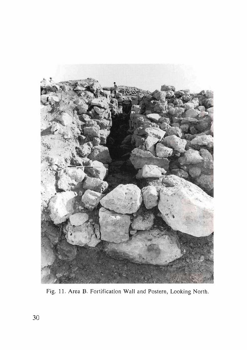
Fig. 11. Area B. Fortification Wall and Postern, Looking North.
30
3. W812 - parallel to W816 some 4.5 m. to the east. The western face of
W812 extends to the north in line with the eastern face of the postern
gate. This is a substantial wall 0.85 m. wide, faced with sem i-dressed
stones, with a core of small pebbles. It continued in use through Strata IV,
III , and lIb. It was found standing 50-60 cm. above the levelling fi ll on
which it was fou nded (Loc. 309, Sq. US).
4. W817 - parallel to the town wall and 3 m. north of it. Only its northern
face is partially preserved.
5. W818 - not clearly associated with any of the proposed strata of Area
B, and is, w ith some hesitation, ass igned to Stratum IV. It is a substantial
and well-built wa ll founded on the levelling f ill laid down prior to the
construction of the fortified settl emen t at Tel Dalil. It is of the same
construction as the other walls of Stratum IV - two rows of large, semi
dressed stones with a core of small pebbles, and it is to be noted that this
method of construction is different from that of the later strata. The
orientation of this wall is different from that of other walls in all strata in
Area B. It is clear that the floors of Stratum II cover the wall .
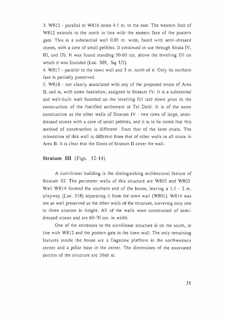
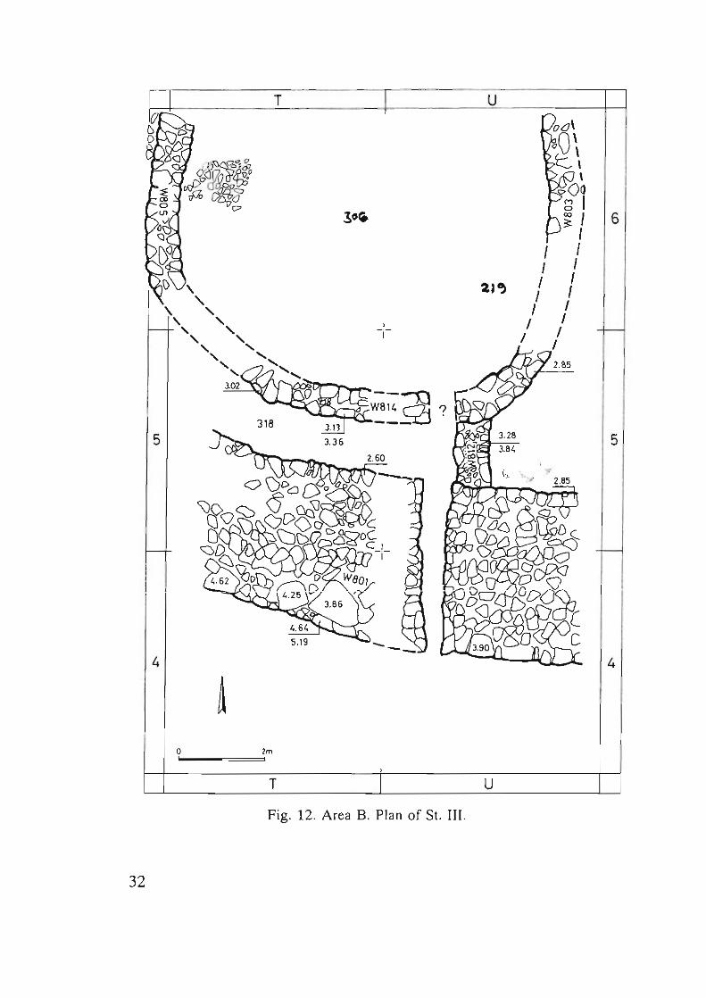
Stratum III (Figs. 12-14)
A curvilinear building is the distinguishing architectural feature of
Stratum III. The per imeter walls of this structure are W805 and W803.
Wall W814 formed the southern end of the house, leaving a 1.5 - 2 m.
all eyway (Loc. 318) separating it from the town wa ll (W801). W814 was
not as well preserved as the other walls of the structure, surviving only one
to three courses in height. All of the walls were constructed of sem i
dressed stones and are 60-70 cm. in width.
One of the entrances to the curvilinear structure is on the south , in
line with W812 and the postern gate in the town wall. The only remaining
features ins ide the ho use are a flagstone platform in the northwestern
corner and a pillar base in the center. The dimensions of the excavated
portion of the structure are lOx6 m.
31
T
-I-
5
4
o 2m
T
B Plan of St. III. Fig. 12. Area .
32
u
u
I I
I I I I I
6
5
4
Fig. 13. Area B. St. III, L. 309: "The Curvilinear Building".
33
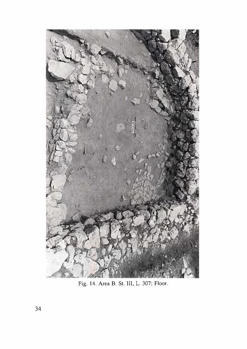
Fig. 14. Area B. St. III, L. 307: Floor.
34
The preserved floor level is at an eleva tion of 3.40-3.50 m. below zero
point. A limited area of the floor was excavated: 4x4 m. in Sq. T6 and a
small portion (2x1 .8 m.) in Sq. U6 (Loci 306, 307; Fig. 14), and thus the
artifacts from this stratum are meager. The possibility is recognized that
this curv ilinear structure ex tended to the north along the lines of W803
and W805, excavated in Sqs. T7 and U7 in a later stratum.
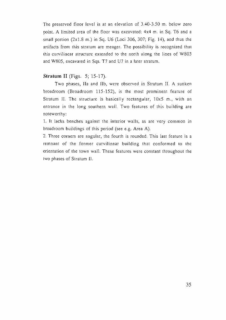
Stratum II (Figs. 5; 15-17).
Two phases, lIa and lIb , were observed in Stratum II. A sunken
broadroom (Broadroo m 115-152), is the most prominent feature of
Stratum II. The st ructure is basically rectangular, 10x5 m., with an
entrance in the long southern wall. Two features of this building are
noteworthy:
1. It lacks benches against the interior wa lls, as are very common in
broadroom buildings of this period (see e.g. Area A) .
2. Three corners are angular, the fourth is rounded . This last fea ture is a
remn ant of the former curvilinear building th at confo rmed to the
orientat ion of the town wall. These feat ures were constant throughout the
two phases of Stratum II.
35
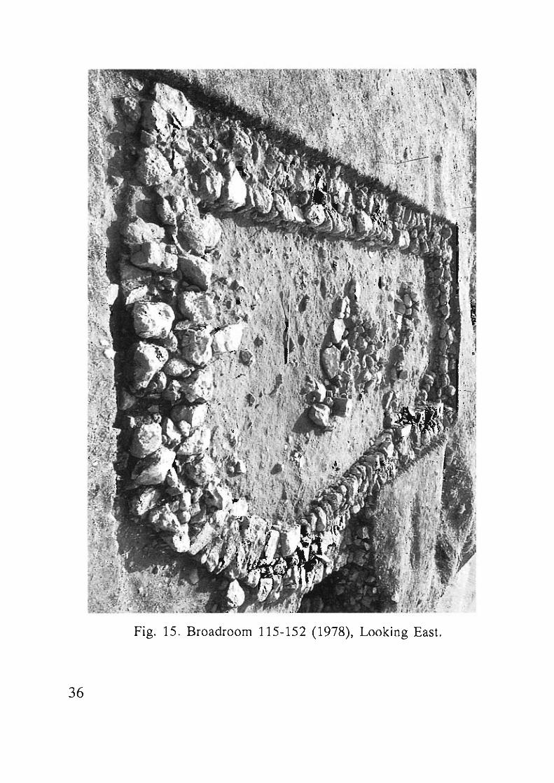
Fig. 15 . Broadroom 115-152 (1978), Looking East.
36
T U
155
152 ~ "I' 6
5
4
o 2m
T u ___ -----'-_ B Plan of St. lIb . Fig. 16. Area .
37
5 5
o 1m
T B Plan of SI. IIa. Fig. 17. Area . u
38
Stratum II, Phase b (Figs. 16; 18-19)
Stratum II, Phase b (lIb) is the stratigraphical enumeration assigned
to the earliest phase of the broadroom of Area B. The perimeter walls of
this structure were WS04 on the north, WS05 on the west , WS02 on the
south, WS03 on the east. WS03 and WS05 were reused from Stratum III,
and there is evidence of repair to WS03. WS02 was a completely new
construction and was provided with a deep, stable foundation. This wall,
cutting off the "apse" of the Stratum III building, transformed the
structure into a completely rectangular broadroom. In the western portion
of the structure (Sq. T6) , is a narrow but well -built partition wall (WSll).
It abuts WS04, and extends to the south, with a slight westward angle, to
within 50 cm. of WS02. Preserved to a height of 50 cm., the wall was
well-founded, having been cut into the earlier stratum (III) . The western
face of the wall exhibits a dressed surface while the eastern face is rather
crude and uneven. In the northwestern corner of the room is a semi
circular enclosure or "closet" formed by Wall WS13 (Fig. IS). This wall
consists of a double row of stones, two courses in heigh t. To the east of
WSll is a well-built entrance in the southern wall, with a well-demarcated
threshold. The elevated entrance required a step down to the floor some
30 cm . below. In the northeast corner, in the northern wall, there is a
second entrance to the structure. WS04 (the northern wall) is poorly
preserved at this point.
The floor of the broad room of Stratum lIb was excavated only in
Square T6 (4x4), and in a small probe in Sq . U6. It is, however, well
preserved and produced an interesting array of artifacts. Primarily
represented in Loci 152, 204, and 205 , this thick floor , perceptibly
sloping from north to south, suggests a long period of usage with
continual accumulation and compaction that gradually raised the earthen
floor level.
39
40
..: ,~ .,
\ ,\ .,' . ,'ttl;' "
,~ ,,' ( . " '
€ .,,' I" , . \ . : . .ii '
\ , ~
Fig. 18. Area B. St. lIb, L. 154: Floor, Looking South.
W812 is located in the 2 - 3 m. wide alleyway to the south of the
broad room which separated it from the town wall (W8DI). This wall is
parallel to the eastern edge of the entrance in W8D2. W812, originating in
StratalV -III, was partially reused in Stratum II, but was extended to abut
W8D2 . At its other end W812 abuts the town wall (W8DI) immediately
adjacent to the postern gate, which evidently continued in use in Stratum
lib.
The alleyway was apparently the recipient of debris from the
broadroom and adjacent structures. Much unstratified pottery with heavy
encrustation as well as a heavy accumulation of animal bones were found
here. No floors were uncovered.
The artifact assemblage from the western quadrant of the
broadroom floor suggests domestic use. A nearly-intact antler of a fallow
deer was found lying on the floor at the foot of W811 (Fig. 19). Nearby
were fragments of holemouth jars and a juglet, while to the south and at a
slightly lower elevation was a basalt disc or wheel with clearly-defined
wear patterns on its flattened surface, suggesting identification as a
potter's wheel (see Chap. 8). There were also several hammerstones
associated with this assemblage.
Stratum II Phase a (Figs. 17; 20-21)
The broadroom in its later phase contained a well-preserved floor
with associated installations. This, together with adjacent and related
features and buildings, has been designated Stratum IIa. This stratum was
very likely the last settlement at Tel Dalit utilizing the fortification
wall . The postern gate was apparently blocked up by this time. Evidence
for this includes:
1. The southern entrance to the broadroom was not in use at this time.
2. The alley separating the broadroom wall W8D2 from the town wall
W8DI was filled with debris to a level higher than the floor of the postern.
3. The relative levels of the postern floor and the living surfaces
throughout Stratum IIa in Area B mitigate against contemporary usage.
41
Fig. 19. Area B. St. lIb, L. 152: Floor (Antler of Fallow Deer).
42
Fig. 20. Area B. St. IIa , L. 115: Floor.
43
"
, ,
;
',"
.. '
.... , . ~
. ,
~ , '( . "
. ,
Fig, 21. Area B. SI. IIa, L. 155: Silo,
44
An open area or alleyway 2 - 3 m. wide separated the broadroom
from the town wall W801 on the south. The perimeter walls of this
building (on the south- W802, on the east- W803, on the north- W804,
and on the west- W805 - with a rounded corner to the south) are identical
with those of the broadroom of Stratum lib and are quite well-preserved
at the foundation level except for a 4 m. section at the eastern end of
W804.
No entrance to this house was found in Stratum lIa. It probably lay
at a higher elevation than that to which the walls are presently preserved.
The floor level of Stratum lIa (2.60-2.80 m.) is only slightly below the
top elevation of the remaining walls (2.40 - 2.83 m.).
The floor area of the broadroom (elev. 2.60-2.80 m.) was exposed
across Sqs. T6 and U6, although portions of the perimeter walls reach
into T5, US and S6. The floor was of beaten earth and fairly well
preserved. Associated with it was a significant ceramic assemblage,
including partially-restorable storage jars and holemouth jars, as well as
an intact chalice and an intact juglet. It should be noted that the floor
slopes slightly but perceptibly from north to south. The interior features
of the broadroom are:
1. A well-built silo in the northeastern corner of the room (Locus 155),
constructed of semi-dressed flagstones. Its base elevation is 3.47 m.; the
highest elevation of its circular perimeter is 2.97 m., its diameter is 0.9 m.
(Fig. 21)
2. An installation in the center of the broadroom of uncertain nature
(Fig. 15). Two parallel walls, W806 and W807 (which are built above and
follow the orientation of W8ll of Stratum lib) run from southwest to
northeast, as if forming the sides of a parallelogram-shaped structure. The
northern and southern ends of the installation are open, with neither wall
extending as far as W802 or W804. There are pillar bases at each end of
these walls. The area of the installation (Locus 115) produced abundant
pottery sherds as well as many large clumps of burnt mudbrick-like
material.
Excavation in Squares T7 and U7 disclosed a northern continuation
45
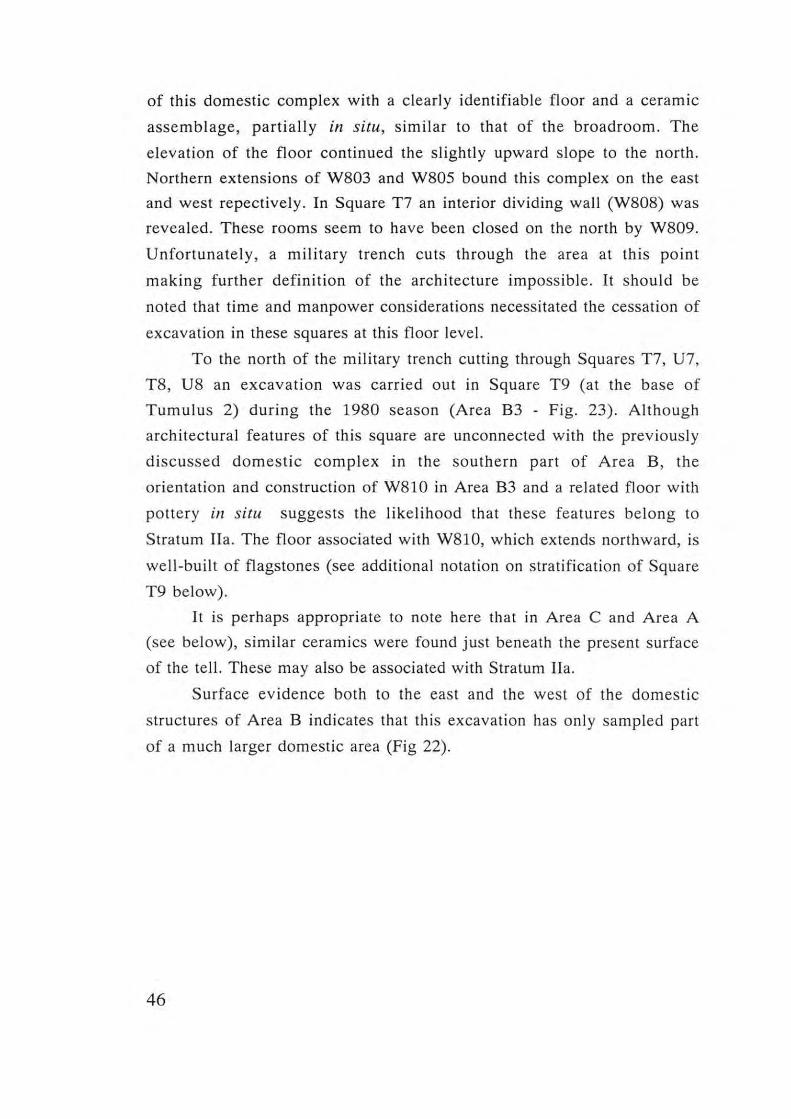
of this domestic complex with a clearly identifiable floor and a ceramic
assemblage, partially in situ, similar to that of the broadroom. The
elevation of the floor continued the slightl y upward slope to the north.
Northern extensions of W803 and W805 bound this complex on the east
and west repectively. In Square T7 an interior dividing wall (W808) was
revea led. These rooms seem to have been closed on the north by W809.
Unfortunately, a military trench cuts through the area at this point
making furt her definition of the architecture impossib le. It should be
noted that time and manpower considerations necessitated the cessation of
excavation in these squares at this floor level.
To the north of the military trench cutting through Squares T7, U7,
T8, U8 an excavation was carried out in Square T9 (at the base of
Tumulus 2) during the 1980 season (Area B3 - Fig. 23). Although
architectural features of this square are unconnected with the previously
discussed domestic complex in the southern part of Area B , the
orientation and construction of W810 in Area B3 and a related floor with
pottery in situ suggests the likelihood that these features belong to
Stratum lIa. The floor associated with W810, wh ich extends northward, is
well-built of flagstones (see additional notation on stratification of Square
T9 below).
It is perhaps appropriate to note here that in Area C and Area A
(see below), sim ilar ceramics were found just beneath the present surface
of the tell. These may also be associated with Stratum IIa.
Surface evidence both to the east and the west of the domestic
structures of Area B indicates that this excavation has only sampled part
of a much larger domestic area (Fig 22).
46
z
-I
(j1
Fig. 22. Area B. Section 1-1
47
.3.2 Area B3
Stratum I (Figs. 23-26)
The stone mounds on the surface of the tell (tumuli) were created
by the collapse of structures, whether by decay or willful destruction. It is
reasonable to assume that the mantle of stones covering these ruins
resulted from the clearing of stones from the surrounding level areas for
cultivation in later periods. Since these prominent mounds of debris were
not conducive to easy cultivation, they became the repository for stones
gathered from all over the cultivated area on the tell.
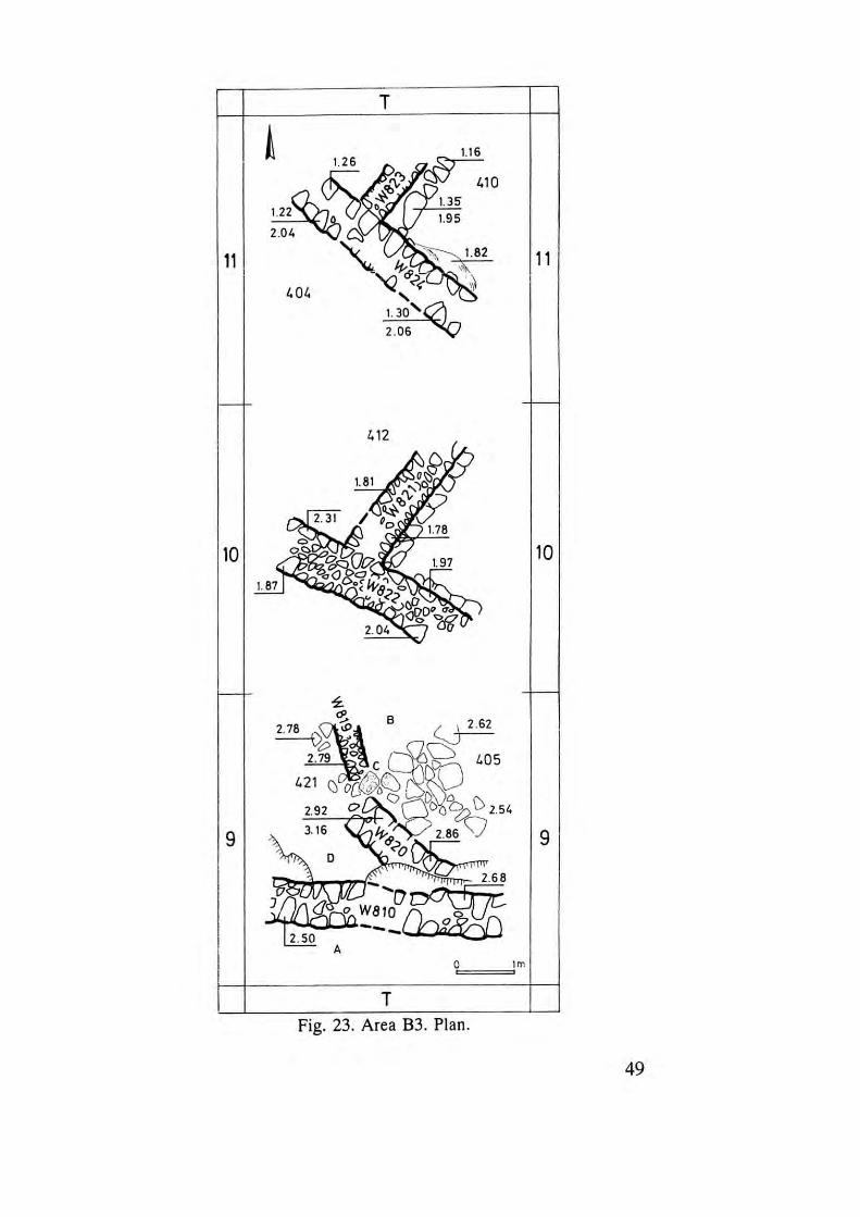
Stratum I, tentatively identified only in the southernmost stone
mound (Tumulus 2), which was partially excavated in the 19BO season,
was quite poorly preserved . Squares TIO, TIl provided the only
indications of this stratum.
There were substantial remains of well-built stone walls (WB2l and
WB22 in Square no, and WB23 and WB24 in Square TIl), but no
surviving floors in either of these squares. Approximate (but speculative)
floor levels may be proposed based on the well-preserved foundation of
WB22 in Square TIO. The Stratum I walls are neither parallel nor
perpendicular to the line of the town wall (WBOI). They were founded on
an undulating fill above bedrock, and survive to an impressive height of
1.25 m., considerably more than earlier architecture at Tel Dalit.
The other stone mounds on the surface of Tel Dalit remain
unexcavated except for the base of Tumulus 1 (see Area A). The
hypothesis is set forth that some of these may contain the rema ins of
similar massive structures, probably erected after the fortification wall
ceased to serve its defensive purpose, and that these may represent the
final occupat ion of Tel Dalit during the EB III (see below).
48
T
1.26
11 I
I. 01.
10
9
1.35 1.95
to 2.62
1.05
o<:}::a \) 2.54
2.86 V
2.68
~
--,-----,
- f-
11 I
-
10
-
9
0 --2 m
T 1 ~----;:::;-:-:nAr~B3 Plan. . 23 Area . FIg. .
49
Fig. 24. Area B3. "Tumulus 2". SI. I, Sq. TIl , L. 410,411.
50
Fig. 25. Area B3. "Tumulus 2". St. I, Sq. no, L 412,415.
51
Fig. 26. Area B3. "Tumulus 2". St. I, Sq. TlO, Looking East.
52
The claim that the building whose ruins were discerned within
Tumulus 2 is the latest architectural feature in Area B is supported by the
following evidence:
1. It stands at a higher elevation than any other structure in the area.
2. It has a different orientation from that of all other structures exposed
in Area B.
3. The walls of this structure were founded on a fill above bedrock which
contained EB II material, while the fill above bedrock beneath the
structures elsewhere in Area B contained only EB I material.
4. The sherds found in the debris of the building fall within the horizon
of EB III (Fig. 65).
The Stratigraphy of Square T9 (Figs. 23; 27-28)
This square, at the base of Tumulus 2, was excavated to bedrock. It
is physically separated from Area B and its stratigraphy of Strata II-V, by
a military trench. However, it is possible to suggest correlations with the
strata discussed in the preceding section.
Square T9 contains four occupation levels. For convenience they
are here designated from upper to lower levels as A,B,C,D. Due to the
small size of exposure, two alternative stratigraphical reconstructions can
be presented (Fig. 27).
Level A
It has already been suggested that WS10 with its similar orientation
to the broadroom complex of Area B and its appearance immediately
beneath the surface should be assigned to Stratum IIa. It is perhaps the
remnant of a third compartment of the Area B complex extending to the
north.
In the uppermost level and clearly associated with WS10 is a well
preserved flagstone floor at an average elevation of 2.60 m., also assigned
to this stratum (Loc. 405).
53
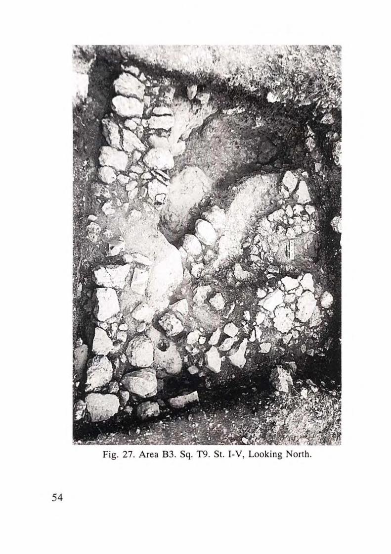
Fig. 27. Area B3. Sq. T9 . St. I-V, Looking North.
54
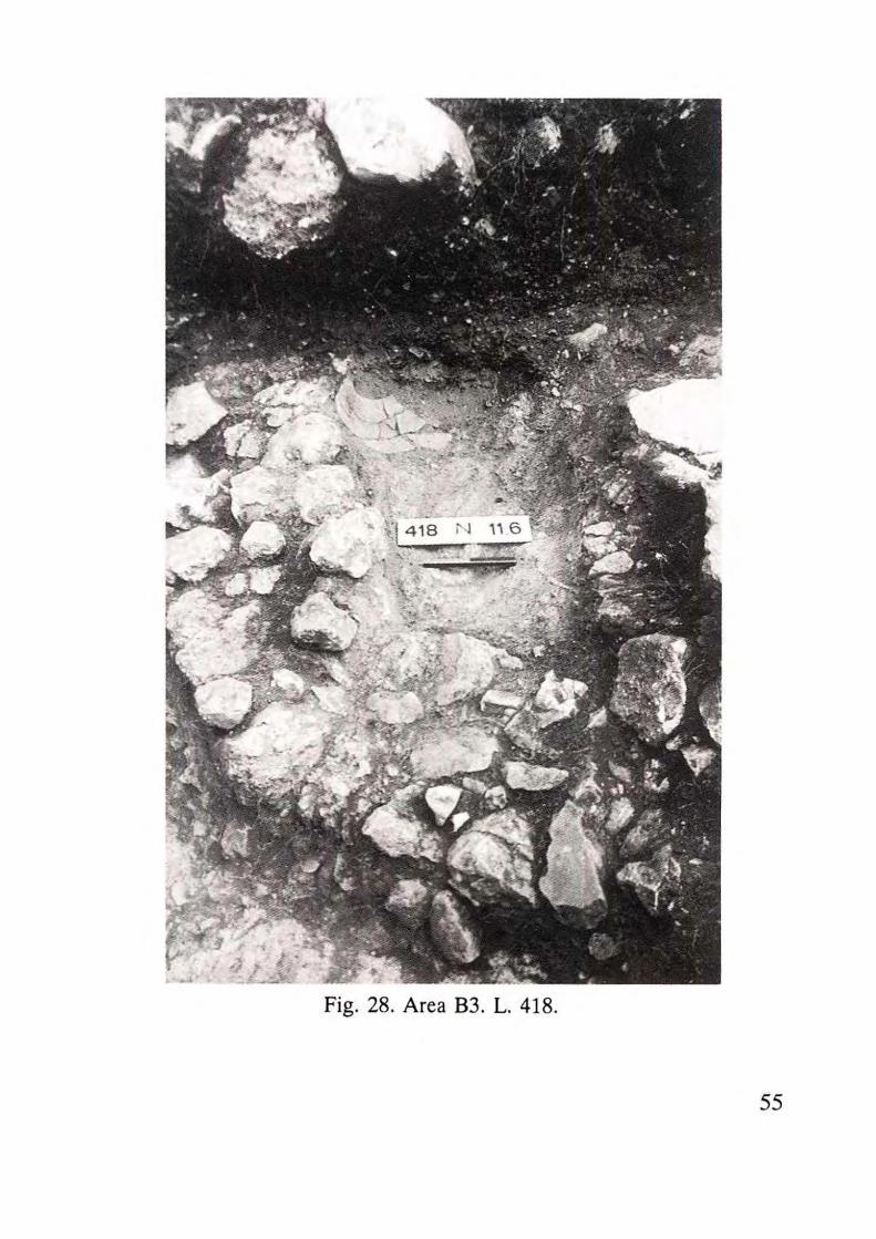
Fig. 28. Area B3. L. 418.
55
Level B
Beneath this floor in the northwestern part of the square lies a
fragment of a semi-circular wall , W819, reminiscent of W813 in Area B
Stratum lIb. Leaning against this wall on an adjacent floor surface was a
fragment of an holemouth jar.
Level C
Below W819, under 10 cm. of fill, lay a plaster floor which may be
associated with Stratum III or IV (Loc. 418; Fig. 28).
Level D
Beneath this floor and sealed by it, is another stratum represented
by Wall W820 (Loc. 421). At its southwestern extremity this wall seems to
utilize a protruding and deliberately cut segment of bedrock. Adjacent to
this wall and beneath it is a fill of greyish soil containing pottery sherds
representing a levelling of the irregular bedrock for construction. It is
suggested that these features may represent an architectural feature
belonging to Stratum V.
In summary, one suggestion for stratigraphical correlations of
Square T9 with Area B is as follows:
Level A (including W81O) - Stratum IJa.
Level B (including W819) - Stratum lIb or III
Level C (including lime floor) - Stratum III or IV.
Level D (including W820) - Stratum V.
Following re-examination of the pottery from this square, the
possibility arose that some of these features (except W81O) may be
remnants of "Pre-Stratum V" (i.e. EB Ia,), and that in this area (Square
T9) construction began again only in Stratum IJa, when the complex of
the broadrooms was extended (see below Ch . 7: Summary).
56
3.3 Area A ( Figs. 29-3 7)
Area A, s ituated on the north western part of the lower terrace of the
tell , was excavated in a ll three seasons, a lthough in 1979 onl y a sma ll
probe (i n Squares E36, E37 , F36, F37) was pursued (F ig. 30) . S ixteen
squares (on a S-m . grid), i.e. ca. 400 sq. m., were excava ted in Area A in
contrast to e leven squares in Area B. T he excavat ion in Area A ex tends
between C and F on the east- wes t lin e of the gr id and be tween 30 and 37
on the no rth-so uth li ne. S ince th e occupational debris is much shall ower
in this pa rt of the te ll, and th e s tra ti fica tion poorly -preserved, the work
produced few conc lus ive resu lts co ncerning the occupat ional hi s to ry o f
the northwestern part of the s ite .
The re la ti ve ly poor s tate of preservat ion of the rema ins in this area
may be a ttri bu ted in part to the con tou r of the te ll. This terrace was
subjec ted to erosion fro m wi nter rains much more than Area B in the
south . It is characte ri zed by protrusions of bedrock above the present so il
surface o f the te ll. Pl o ug hing and pl anting of the soi l-covered areas in
later pe r iods like ly di s turbed and des troyed some mate ri al. M il itary
trenching in modern times has further dis turbed the occupat iona l deb ri s,
cont r ibut ing an added d imension to the prob lem of locati ng c lear a nd
undi sturbed s tra ti fica ti on.
Pr ior to excava ti on the main fea tures of th e surface area of Area A
were:
1. The terrace, c irc ling from south to north , which curves sharply to the
east and dro ps dow n the s lope of the tell at a pronounced angle (ca. 40").
2. Thi s terrace li ne is interrupted by a cl ea rly-de fin ed sa ddl e at the
te rm inus of the path w hich c irc les up the sou thern and western s ides of
the hil l.
3. Some 1S-20 m. southwest of the saddle, Tumulus 1 is loca ted.
As the stra tig raph y of Area A is less clear than that of Area B, we
will att e mpt to d iscuss thi s occupational sequence in re lati on to th e
stratigraphica l profile of Area B.
57
: 2S
_1- '&' , 1/ 13
9 11
_L 61 I :«656
~ ~~
m
-'-, 525
506
58
20
-:-
-l-
-,-,
-;-
, -,-
:...... _ _ -"'m
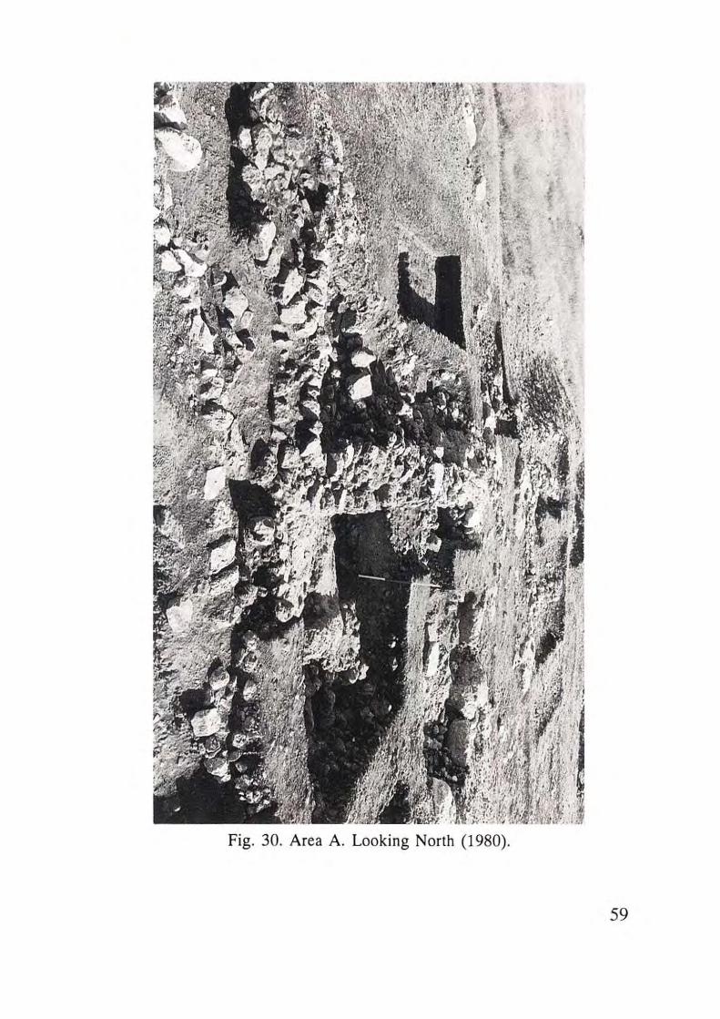
Fig. 30. Area A. Looking North (1980).
59
However, due to the eroded state of the area, the stratigraphical
sequence in the northwestern corner of the mound may not present a
complete history of settlement in the EB period.
Stratum V
In spite of the poor state of the architectural remnants of the
settlement, as noted above, the earliest stratum at Tel Dalit is slightly better
preserved in Area A than in Area B, as is the pottery (no encrustation).
Occupational debris lying just above and in pockets in the bedrock, and
containing sherds of the same early ceramic horizon as Area B Stratum V,
was uncovered at several points: beneath the floor of a later broadroom
(Sq. F36, Loc. 26), in pockets in bedrock in Sq. D32 (Loc. 64), and in
Sq . C30 (Loci 74, 75).
Two architectural features In Area A are to be att ributed to
StratumV:
1) In Sq. E32 at elevation 7.30-7.35 was found a small segment (ca. I x 1
m.) of stone pavement (Loc. 68) which, based on related ceramic
materials, is to be assigned to Stratum V.
2) The most significant architectural feature from Area A attributed to
Stratum V, exposed in Sq . E36 and extending into F37, is a 6 m. long
curved segment of a wall with no surviving floor related to it (W702)
(Loc. 33; Fig. 31). This wall rests upon a fill (Loc. 31) and was cut by the
construction of the fortification wall (W701) built on the slope of the
terrace. This building clearly pre-dates the construction of the town wall.
However, in light of the identification of EB la sherds in Area B, it is
possible that W702 dates to "Pre-Stratum V" , i.e. EB la.
60
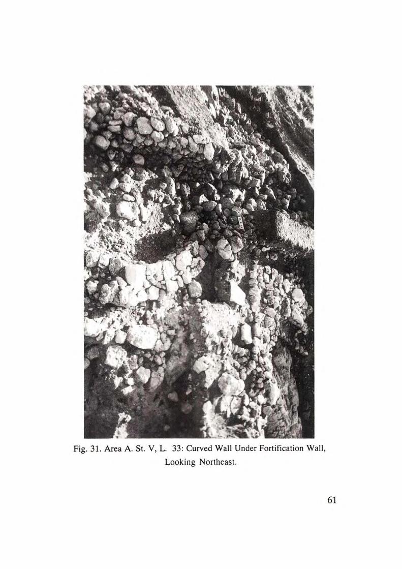
Fig. 31. Area A. St. V, L. 33: Curved Wall Under Fortification Wall,
Looking Northeast.
61
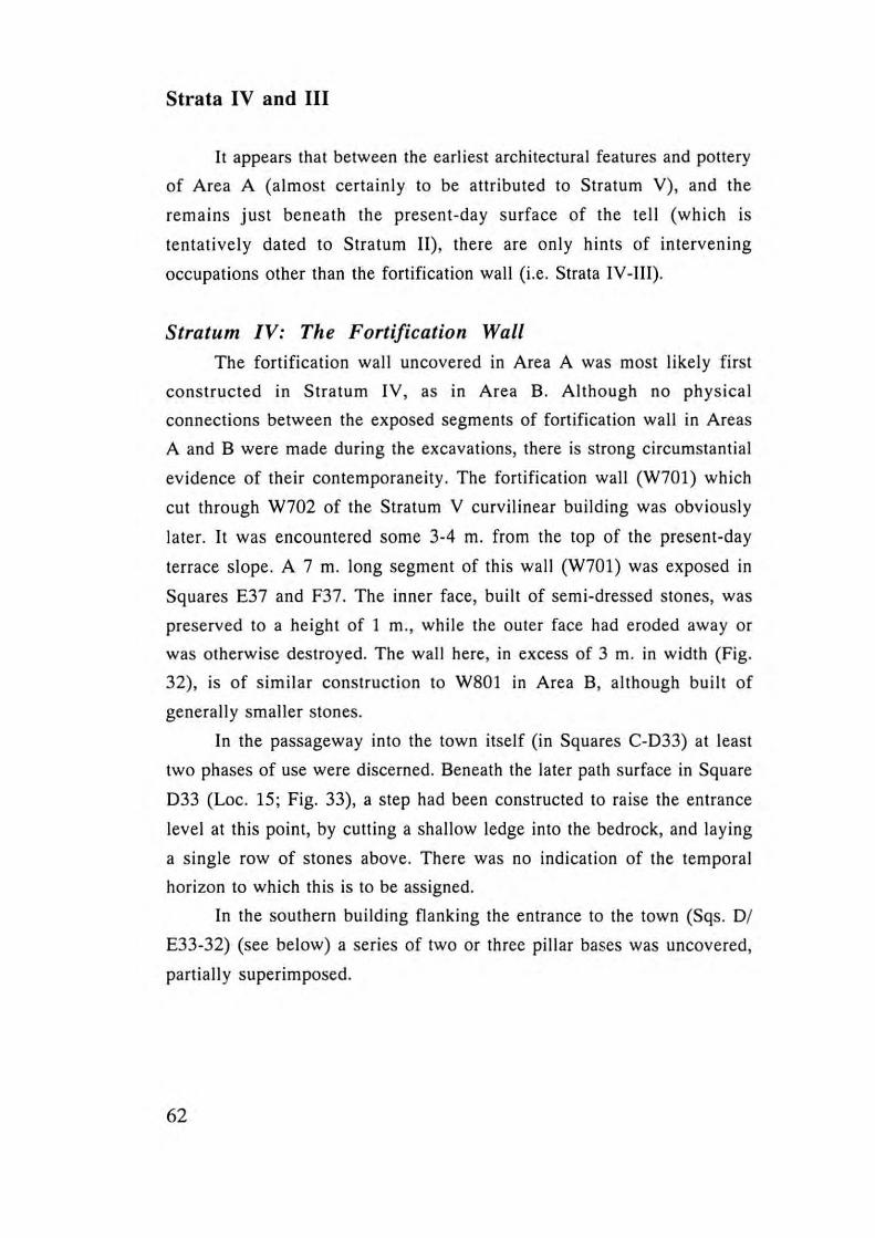
Strata IV and III
It appears that between the earliest architectural features and pottery
of Area A (almost certainly to be attributed to Stratum V), and the
remains just beneath the present-day surface of the tell (which is
tentatively dated to Stratum II) , there are only hints of intervening
occupations other than the fortification wall (i.e. Strata IV -Ill).
Stratum IV: The Fortification Wall
The fortification wall uncovered in Area A was most likely first
constructed in Stratum IV, as in Area B. Although no physical
connections between the exposed segments of fortification wall in Areas
A and B were made during the excavations, there is strong circumstantial
evidence of their contemporaneity. The fortification wall (W701) which
cut through W702 of the Stratum V curvilinear building was obviously
later. It was encountered some 3-4 m. from the top of the present-day
terrace slope. A 7 m. long segment of this wall (W701) was exposed in
Squares E37 and F37. The inner face, built of semi-dressed stones, was
preserved to a height of 1 m., while the outer face had eroded away or
was otherwise destroyed. The wall here, in excess of 3 m. in width (Fig.
32), is of similar construction to W80I in Area B, although built of
generally smaller stones.
In the passageway into the town itself (in Squares C-033) at least
two phases of use were discerned. Beneath the later path surface in Square
033 (Loc. 15; Fig. 33), a step had been constructed to raise the entrance
level at this point, by cutting a shallow ledge into the bedrock, and laying
a single row of stones above. There was no indication of the temporal
horizon to which this is to be assigned.
In the southern building flanking the entrance to the town (Sqs. Of
E33-32) (see below) a series of two or three pillar bases was uncovered,
partially superimposed.
62
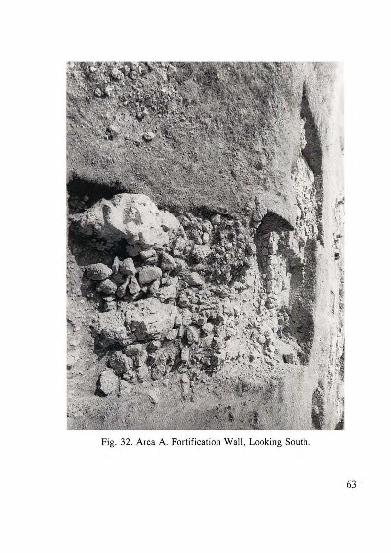
Fig. 32. Area A. Fortification Wall , Looking South.
63
Fig. 33. Area A. L. 15: Entrance to Settlement ("The Gate Area") .
64
These bases were found in Squares D32 and E32 at elevations 7.13
and 7.57. Patches of a very poorly-preserved plaster-like floor were
encountered at the 7.12-7.16 level , and excavation at this elevation
produced EB sherds mixed with Roman-Byzantine sherds. This floor
probably belongs to the latest (Stratum IIa) town occupation. Near the
lower pillar base there was EB II material above fill which contained EB I
sherds.
Except for the fortification wall (W701) (which in Area B existed
continuously throughout Strata IV-IIa), there is no solid evidence of
occupation in Area A during the intervening period between Stratum IV
and Stratum IIa.
Stratum II
There was considerable but often disturbed evidence of the last
town which existied on this lower western terrace of Tel Dalit during the
Early Bronze Age. It can be assigned with certainty to the horizon of
Stratum II from Area B. Over most of the area in those places where
bedrock does not reach or protrude above the surface , remains of EB
occupation were found - architecture and abundant broken pottery,
occasionally found in situ on floors.
Broadroom A2B
The best preserved remains from this stratum were found in Square
F36 (Loc. 28; Fig. 34), with a small extension into F35, comprising part
of a broadroom complex. Bounded by Walls W703, W704 and W705, all
75 cm . in thickness, this room contained a well-preserved floor just above
bedrock. The walls, themselves founded just above bedrock, survive to a
height of only one or two stone courses. No entrance to the broadroom
was discovered. The width of the room, including walls, was 6 m., the
length was indeterminable since the eastern portion had been destroyed
by military trenching. The perimeter walls had low benches built against
their inner faces.
65
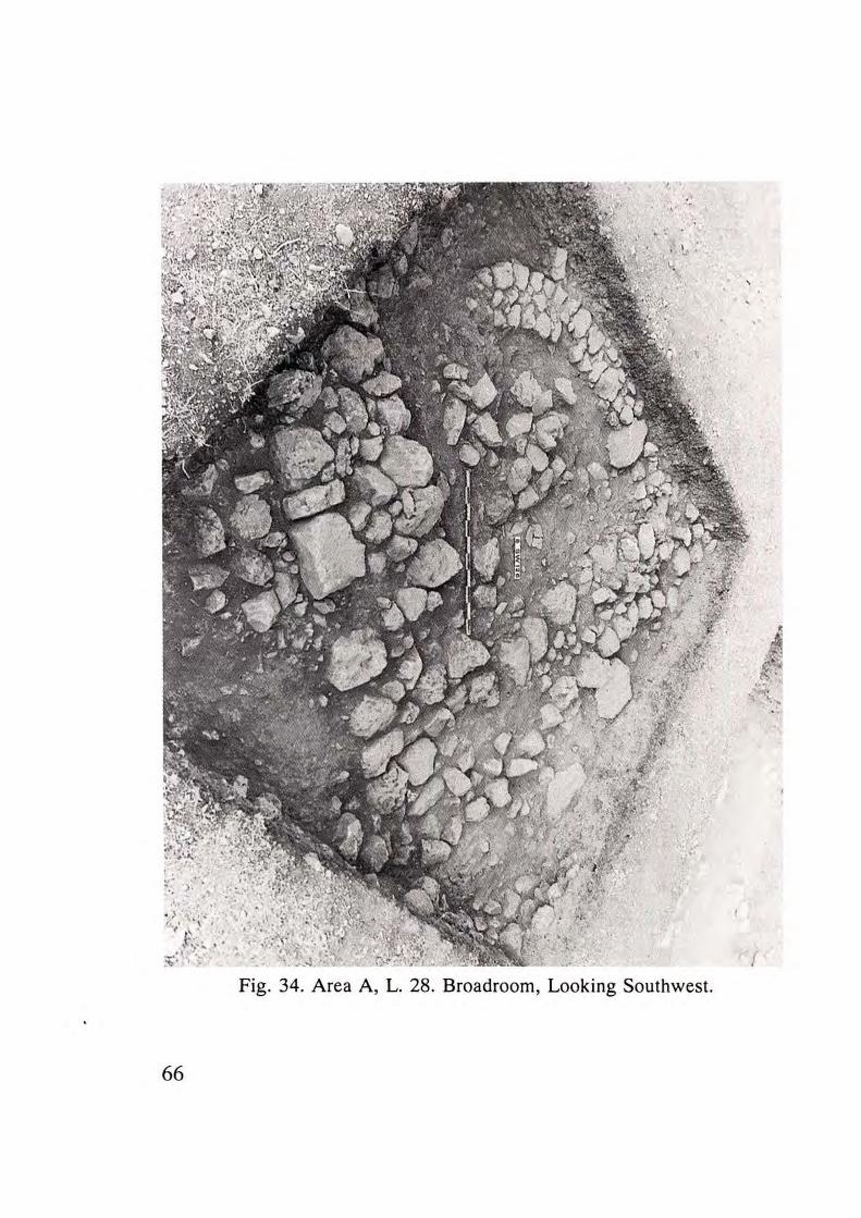
Fig. 34. Area A, L. 28. Broadroom, Looking Southwest.
66
Constructed of small stones one course high, the benches extended
50-70 cm. from the inner face of the walls . The floor of this house was
just below the level of the surface of these benches. In the northwest
corner of the house was a semi-circular wall (W706), creating a "closet"
area similar to those seen in Area B. This wall, which stood one course
high and was 30-35 cm. wide, was composed of a double row of small
stones. Fragmen ts of a holemouth jar were found in situ on the floor of
the room (Loc. 28) . A fragmentary wa ll (W707) extended south from
near the middle of the southern wall of the broadroom for a distance of
about 2 m., at which point it was destroyed. There was a small area (1 x 1
m.) paved with flagstones adjacent to and related to this wal l (Loc. 7) .
The orientation of this domestic complex in relation to the
fortification wall (only 1.8 m. north of the northwest corner of the house)
suggests that while these two features may have been in simul taneous
usage, they were constructed in different strata.
The Western Passageway (" Gate ")
Southwest of this broadroom lay the entrance to this area of Tel
Dalit, and probably the primary entrance to the entire site. The path
ascending the hill ends in a saddle-like depression through the lip of this
northwest terrace, providing the easiest point of access to the tell. The
entrance to the site was exposed in Squares D33 and E33 (Loc. 15; Fig.
32) . Although the excavation did not uncover the rela tionship between
the fortification wall of either Area A or Area B and this entrance - i.e. ,
no structures in the nature of a "gate" complex were exposed, it was
nevertheless concluded that this was indeed the entrance to the site . No
other location could be considered a reasonable candidate for a main
entrance or gate.
The entrance was flanked on the north and south by bui ldings of
parallel orientat ion, of the same general orientat ion as the broadroom of
Square F36 (see above). The bui lding on the south is bounded by Wall
W710 (a longside the entrance), W709 on the west, and W711 on the east.
67
The surviving fragment of W708 may be all that remains of the
northern wall of the building. These walls are about 75 cm. thick and
stand one to two courses high. The approximate size of the building is
therefore 2.5-3 m. wide, 7.5-8 m. long. The western extent rested upon a
bedrock outcrop. The building (Loc. 13), and especially its northern
extremity , were so badly disturbed by military trenching that
stratigraphical conclusions are impossible.
A 5 x 2.5 m. area was excavated immediately to the east of this
building in Square E34. Although no architectural remains were
uncovered, sherds of domestic-type pottery were found in situ on a
poorly-preserved floor surface (Loc. 20). This fact, as well as the nature
of the other pottery found in this near-surface level , suggest a domestic
nature for the complex extending north and south from the entrance.
Locus 20 presents datable evidence for the abandonment of the site at the
end of Stratum IIa.
A building complex, probably also domestic, was partially exposed
to the south of the entrance. Wall W712, which flanks the entrance on the
south , was similar in orientation, size, and construction to W710, though
not as well-preserved . The building was bounded on the west by W713
and on the south by W714. The east wall remains unknown. Wall W713 is
up to 90 cm. thick and extends to the south, continuing as part of an
adjacent room or building of the same complex . The room flanking the
entrance to the south is 5 m. wide from north to south. Its other
dimensions are unknown. The pottery from a fragmentary floor (Loc.
68; Fig. 35) with a pillar base can be related primarily to this structure,
although some intrusion of surface sherds was probably caused by later
agricultural activity at the site.
Wall W713 continued south approximately along the baulk line
between Squares 031 and C31. Two additional rooms of this domestic
complex lay to the east and west of this wall. Their dimensions are
unknown. Despite significant disturbance, there is sufficient evidence
from a floor with ceramic material (Loc. 506) to conclude that this room
reflects domestic occupation in Stratum lla.
68
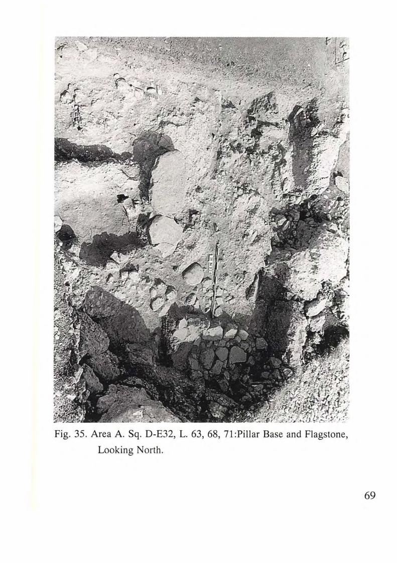
Fig . 35. Area A. Sq. D-E32, L. 63, 68, 71:Pillar Base and Flagstone,
Looking North.
69
An alley 2.5 m. wide separates this building complex from yet
another building (probably complex) to the south. From this alley were
recovered materials from the horizon of Stratum IIa. This alley is
bounded by Walls W714 on the north and W717 on the south. The room
or building uncovered in Squares C30 and D30 (Walls W718 on the west,
W717 on the north with possible dividing walls W719 and W720) has the
same orientation as other Stratum IIa architecture of Area A. It is
probably a broadroom, with a bench built against the inner face of W718.
The same picture of disturbed stratigraphy appearing in most of the area
was found here as well , but with sufficient architectural and ceramic
material (Loc. 60) to suggest assignment to Stratum IIa.
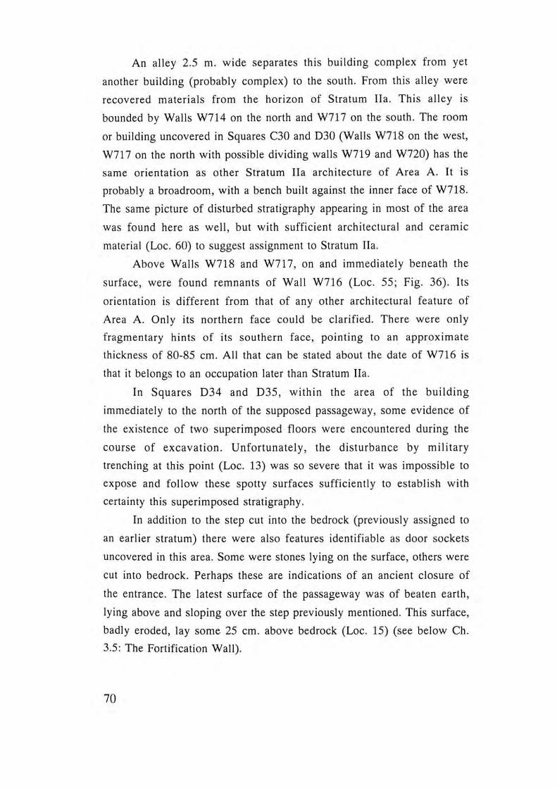
Above Walls W718 and W717 , on and immediately beneath the
surface, were found remnants of Wall W716 (Loc. 55 ; Fig. 36). Its
orientation is different from that of any other architectural feature of
Area A. Only its northern face could be clarified. There were only
fragmentary hints of its southern face, pointing to an approximate
thickness of 80-85 cm. All that can be stated about the date of W716 is
that it belongs to an occupation later than Stratum IIa.
In Squares D34 and D35 , within the area of the building
immediately to the north of the supposed passageway , some evidence of
the existence of two superimposed floors were encountered during the
course of excavation. Unfortunately, the disturbance by military
trenching at this point (Loc. 13) was so severe that it was impossible to
expose and follow these spotty surfaces sufficiently to establish with
certainty this superimposed stratigraphy.
In addition to the step cut into the bedrock (previously assigned to
an earlier stratum) there were also features identifiable as door sockets
uncovered in this area. Some were stones lying on the surface, others were
cut into bedrock. Perhaps these are indications of an ancient closure of
the entrance. The latest surface of the passageway was of beaten earth,
lying above and sloping over the step previously mentioned. This surface,
badly eroded, lay some 25 cm. above bedrock (Loc. 15) (see below Ch.
3.5: The Fortification Wall).
70
.- 1". • I
.j . ...::-~ . ,,, ." .~~. / ,
t ....
Fig, 36, Area A, L. 55, W710, W716, W718, Looking North,
.( . \ '.:: ,I
· ', " I,
"
.... ..... " , , , .
71
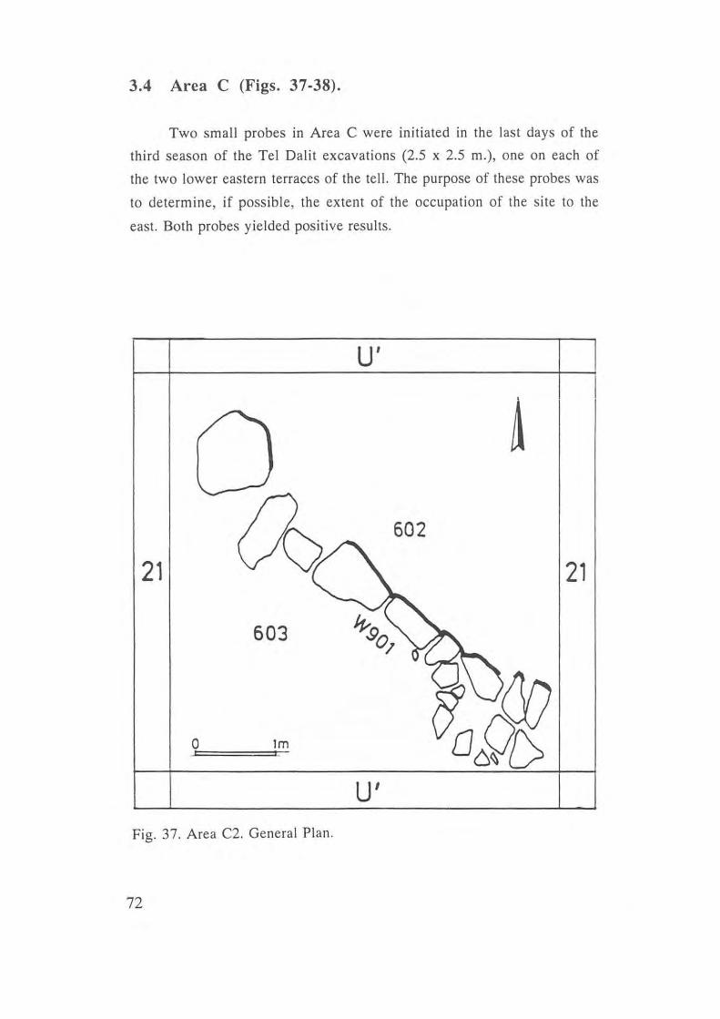
3.4 Area C (Figs. 37-38).
Two small probes in Area C were initiated in the last days of the
third season of the Tel Dalit excavations (2.5 x 2.5 m.), one on each of
the two lower eastern terraces of the tell. The purpose of these probes was
to determine, if possible, the extent of the occupation of the site to the
east. Both probes yielded positive results.
u'
602
21 21
603
o 1m
u' Fig. 37. Area C2. General Plan.
72
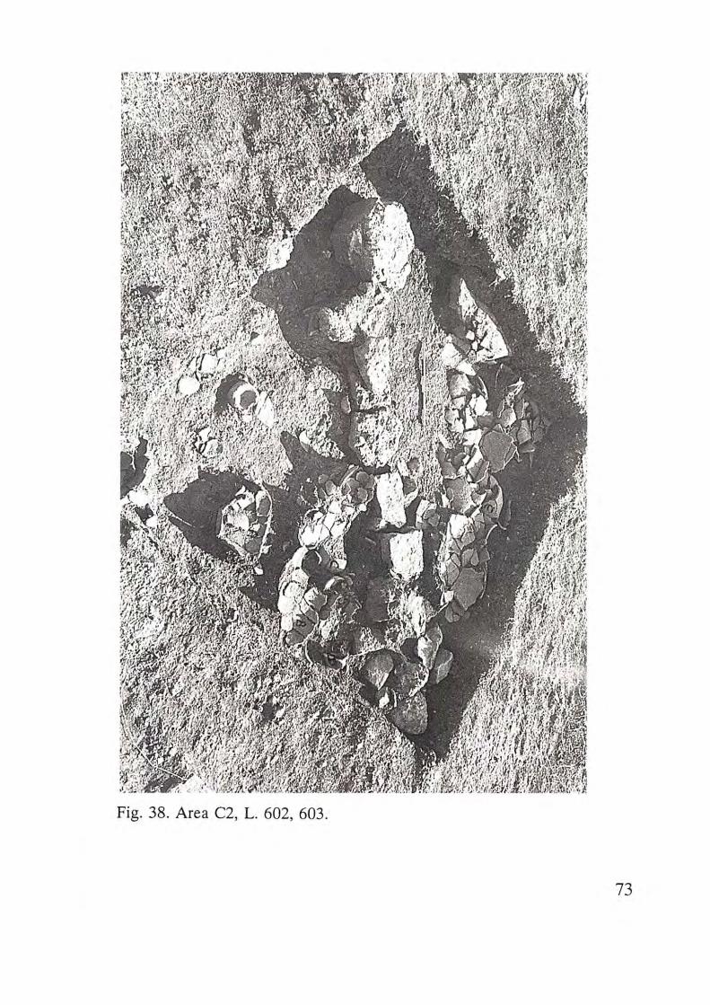
Fig. 38. Area C2, L. 602, 603.
73
In the upper terrace (Cl), no architectural remains were encountered, but
there was sufficient artifact presence and density to conclude that this
terrace was included within the occupied area of Tel Dalit in the Early
Bronze Age.
The results of the probe on the second, lower, terrace (C2) (Square
21) were more substantial. Beginning some 15 cm. beneath the surface, a
wall was encountered with abundant pottery remains on either side (Fig.
38). This wall (W901), only one stone (30-40 cm.) in width, cut across the
square diagonally from southeast to northwest. This discovery presents
reasonable evidence that this terrace was also included in the area of the
town, and most likely within the fortified city (see below discussion of the
town wall). The abundance and nature of the ceramic assemblage indicate
the likelihood that this is part of a storeroom or at least part of a domestic
complex. The evidence from Area C, lying just beneath the surface,
together with the ceramic typology, suggest the poss ibilty that the
occupation level identified in Area 8 as Stratum IIa was also present here.
3.5 The Fortification Wall (Figs. 6; 10; 32).
Two widely separated segments of a fortification wall around Tel
Dalit were exposed in the course of the three seasons of excavation.
Details concerning the features of each individual segment are presented
in the discussion of their respective areas. 80th segments of the wall ,
W801 and W701, were constructed entirely of stone. It is impossible to
determine the nature of the superstructure of this wall - whether of stone
or mudbrick. The presence of tumbled stones down the slope of the tell,
including boulders such as were found in parts of the surviving wall
foundation, plus the abundance of stone in the area, suggest an entirely
stone wall rather than mud brick on a stone foundation. There is no
indication of the original height of the wall.
It has been concluded that these wall segments are part of the
fortification system of the site constructed during Stratum IV. It has been
noted that there is a difference in the orientation of succeeding
74
architecture vis-a-vis the wall segments in Areas A and B. The hypothesis
that Area A and its terrace were outside the fortification wall at the time
the Area B segment was constructed was explored by careful surface
examination. However, no indication of the line of a wall with a smaller
circumference, enclosing only the topmost elevation of the tell, could be
found. In Area B, Stratum lIa appears to be more a remodelling of
Stratum lIb than a major rebuilding.
Two important problems concerning the fortification wall of Tel
Dalit remain unsolved: 1) where was the line of the fortification wall on
the east? 2) what was the nature of the fortifications at the northwestern
point of entry into the ancient fortified town?
Concerning the eastern line of fortification, it may be noted that
while excavation in Area C established that the two lower terraces to the
east were occupied, whether these were or were not within the line of the
fortification wall remains an open question. Only further excavation
could clarify these questions.
Concerning the question of a fortified entrance or gate on the
northwestern side of the site, it must be pointed out that the entrance
described in Area A is the only logical place to look for such an
installation.
In light of the two poorly-preserved buildings on either side of the
passageway, buildings that probably represent the last period of use of the
fortifications (Stratum lIa) , we may suggest that at the time the
fortifications were built (Stratum IV), the passageway was defended by
massive constructions, that were not preserved, [as observed at other EB
sites such as Kh. ez-Zeraqon (Mittmann & Moawiyah 1994), Mitham
Leviah (Kochavi 1994), or Tell el-Far'ah (N) (de Miroschedji 1993)] .
75
3.6 DISCUSSION Ram Gophna
3.6.1. The Layout of the Fortified Site
It is difficult to so more than speculate about the functional division
of the various areas within the fortified EB II site of Tel Dalit due to the
limited area exposed. One may say, however, that the southern area (B)
and the eastern terrace (Area C) were possibly devoted to domestic
functions. The large mounds of stones ("tumuli") may comprise the ruins
of public buildings (un less attributed to Stratum I).
While it seems likely that the main entrance to the town was located
in the northwestern part of the city, posterns like the one in Area B may
have existed at other points along the town wall's perimeter (Kempinski
1978:33).
Of the fortified EB II sites that have been excavated, only Arad
provides a c lear example of a pre-planned layout (although most of the
areas exposed are late EB II - [Stratum II]) (Amiran 1978). Another
example of a fortified EB II town is Tell el-Far'ah (North). Unlike at
Arad, only a small part of the town was exposed and we lack the overall
layout of the fortification system in the EB II (de Miroschedji 1993).
At other fortified EB towns such as 'Ai (Callaway
1980), Yarmuth (de Miroschedj i 1988), Bab edh-Dhrah (Rast & Schaub
1980; Schaub 1993) and Kh. Ez-Zeraqon (Moawiyah & Mittmann 1994)
(where substantial areas of the town were excavated), most of the remains
exposed are from the EB III. Thus, Arad, Tell el-Fara'h (North), to a
lesser degree Aphek and Me'ona (Kochavi 1989:29; Braun 1996), and
most recently Tell Abu Al-Kharaz (Fischer 1993; 1994), remain the only
EB II sites, other than Tel Dalit, relevant to our discuss ion .
76
3.6.2. The Fortification System
At Tel Dalit only two small areas along the line of the fo rtification
wall were exposed. We cannot reconstruct the full outline of the wall, nor
do we have any indication of towers, bastions etc.
The wall's construction. It was suggested above that the fortification
wall of Tel Dalit was built entirely of stone, and that no mudbrick
superstructure was used . If so, the wall of Tel Dalit belongs to the group
of EB II stone walls which includes those at 'A i (Callaway 1972; 1980),
Megiddo (Loud 1948), Arad (Amiran et al. 1978) and Me'ona (Braun
1996). It should be noted that there may have been a mudbrick
superstructure that was entirely eroded away .
Based on the two segments of the fortification wall exposed, no
evidence of any additions, repairs, or widening of the wall was found.
This state of affairs is similar to that at Arad, Aphek and Me'ona, and may
be characteristic of certain fortified EB II s ites where occupation didn't
continue into EB III, as most of the evidence of widen ing and add itions to
town walis comes from EB II-III sites like Jericho (Kenyon 1981),
Megiddo (Loud 1948) and Beth-Yerah (Meisler et al. 1952). It seems that
at sites like Tel Dalit and Tel Arad, towns that ceased to exist already by
the end of EB II, there was st ill no need to make any improvements to
the wall.
The postern. The postern gate excavated in Area B at Tel Dalit
indicates that the fortification wall was constructed in segments, with the
postern placed at the join between two such segments.
This type of construction, with intermi ttent ly-pl aced posterns, are a
fairly well known phenomenon at other fortified EB towns, such as Arad
(Amiran et al. 1978), Megiddo (Loud 1948), 'Ai (Callaway 1972; 1980)
and Kh. Ez-Zeraqon (Moawiyah & Mittmann 1994).
The width of the wall. The wall excavated at Tel Dalit is ca. 4 m.
wide in Area B. In Area A the width is unknown due to erosion (a lthough
it exceeds 3 m.). Compared to the width of town walls at other fortified
EB II sites (from 1.1 m. at Jericho to 5.6 m. at Yarmuth) (Kenyon 1981;
77
de Miroschedji 1988), EB II Tel Dalit seems to have had a
proportionately massive wall for a site of its size. EB II sites with
fortification walls of this proportion were usually larger sites, as at 'Ai
(Callaway 1972; 1980) where occupation continued into EB Ill .
Date of the wall's construction. The stratigraphic and ceramic
evidence from Area B suggests that the fortification system at Tel Dalit
was constructed some time at the beginning of EB II, above the
deliberately leveled ruins of an unwalled EB Ib settlement (Stratum V).
Thus, the erection of the fortified site of Tel Dalit in the EB II places it
within the group of sites including Megiddo, Arad, H. Mahruq and
probably Me'ona (Braun 1966), which were fortified in early EB II, rather
than as early as EB Ib, as at 'Ai (Callaway 1972; 1980), Tell el-Far'ah (N.)
(de Yaux and Steve 1947; 1948), Aphek (Kochavi & Beck, forthcoming),
and Beth-Yerah (Getsov, forthcoming) .
3.6.3. Domestic Architecture
In Stratum Y, Area A, Squares E 36-37, the southern part of a
curvilinear house was encountered - W702. This type of building was
common in early EB I throughout the country (Beth-Shean [Fitzgerald
1934], Megiddo [Engberg & Shipton 1934: Fig. 2], Meser [Dothan
1959], Yiftahel [Braun 1989], Assawir [Yanai 1995] , and continued into
late EB I in the north of the country (i.e. Kabri [Scheftelowitz and
Peilstocker 1990], Qiryat Ata [Golani 1993]), and perhaps also in the
central region (i.e. Lod, west of Tel Dalit [Kaplan 1977]). It is also
possible that this curvilinear house is a remnant of a building from an EB
la "Pre-Stratum Y" horizon, as was indicated in Area B3.
In Square F 35-36 the western part of Broadroom A28 of Stratum
II was unearthed, with stone benches on the three inner sides. This type of
broadroom is very typical among domestic buildings during EB II in
Israel (Ben-Tor 1992). This room and the structure in Area B (see below)
are a small contribution to the meagre evidence for EB II domestic
architecture unearthed so far in the central coastal plain (see also Kochavi
1975).
78
In Area B3 Stratum V (EB I), only a segment of a curvilinear wall
was distinguished (WS20, Square T9), which can be compared w ith the
curvilinear house in Area A (W702). Both instances of curvilinear
domestic architecture can be firmly dated to the EB I, perhaps indicating
the possibility of an early EB I (EB Ja) settlement at the site (see also
discussion of jars in Chapter 4).
The earliest EB II domestic architecture in Area B, in Stratum IV,
consists of small rectilinear wall segments datable to the first fortified
settlement. In Stratum III the remnants of what seems to be a large
curvilinear building, or perhaps the courtyard of an as-yet undefined
building complex (WS03, WS05, WS14) were uncovered.
The broadroom exposed in Area B (Broadroom 115-152), with its
two sub-phases, is a typical EB II dwelling, as indicated also by its
contents.
79
3.6.4. The End of the EB II Walled Town at Tel Datit and the Final Desertion of the EB Site.
The evidence from Tel Dalit indicates that the Stratum II fortified
town was peacefully abandoned sometime during EB II, as were other
contemporary sites such as Aphek, Tell el-Fara'h (N), Me'ona, and Tel
Kinrot (Fritz 1993).
In the excavation in Area B3 remains of a building were exposed
(in Tumulus 2), the orientation of which was not in line with the town
wall. Among the pottery sherds retrieved from the fill covering this
building were a number of EB III sherds. Therefore, it is suggested that
this building phase, designated Stratum I , may date to EB III.' This
latest occupation at Tel Dalit, which post-dates the EB II fortified town, is
also indicated by a few EB III sherds collected during our survey and
encountered during the excavation - mostly in Area A (see Fig. 66).
These were identified only during the processing of the material during
the 1990s. This pottery from Tumulus 2 in Area B3, and the scattered
sherds , indicate that sometime during EB III the s ite was reoccupied for a
short period as an open site.
• This suggestion follows a recent re-eva luation of the pottery finds, and is
opposed to the preliminary observations published in Gophna 1993.
80
Chapter 4.
THE POTTERY ASSEMBLAGES RAM GOPHNA AND MICHAL IRON-LUBIN
Introductory Remarks
None of the EB I pottery was found in direct connection with
architectural features stratigraphically assigned to Stratum V. Only a
small amount of vessels could be definitely assigned to either Stratum !II
or IV, the bulk of the material belonging to Stratum n. Therefore the
pottery of Strata IV -II, dated to EB II, is discussed as a single ceramic
assemblage. The small quantity of pottery from Stratum is assigned to
EB III.
The entire repertoire from Broadroom 115-152 in Area B, of
Stratum II, was quantitatively analysed. When absolute numbers are given,
they represent rim sherds only. Rim sherds with varying diameters were
considered as belonging to different vessels, while those with identical
diameters, which together equalled the circumference of one vessel, were
counted as one. Comparisons and descriptions of individual vessels
accompany the pottery figures.
References in Figures:
Ai 1949: Callaway 1972.
Ai 1980: Callaway 1980.
Arad: Amiran et al. 1978.
Azor: Perrot 1961.
Far'ah: de Vaux and Steve 1947, 1948, 1955, 1961.
Gezer 1l: Dever 1972.
Jericho I: Kenyon 1960.
Jericho Ill: Kenyon 1980.
Jericho IV: Kenyon and Holland 1982.
Jericho V: Kenyon and Holland 1983.
81
Yarmuth: de Miroschedji 1988.
In the summary of the pouery assemblages we did not distinguish
between the different excavation areas.
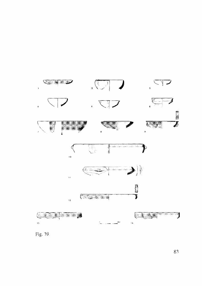
4.1 Pottery of Stratum V (EB I), Areas A, B (Figs. 39-45).
BOWLS
1) Small Bowls
Two types of small bowls were discerned:
a) small hemispherical bowls (Fig. 39:2. 4)
b) small shallow bowls (Fig. 39:1, 3)
Most of these small bowls served as lamps, as evidenced by a line of
soot on the rim. They were handmade, except for the rim where
indications of use of a lOurneHe can be discerned (see Arad: Amiran et a1.
1978:42ff).
2) Deep Bowls (Fig. 39;7-11)
These bowls have a profiled rim, with heavy, well-burnished slip
(Fig. 39:7-9, 12-14). The two bowls in Fig. 39:10-11 have knobs. No. 11
resembles vessels of the EB II carinated bowl family (see below), but is
handmade and has a thicker wall.
3) Carinated Bowls (Figs. 39:5, 6, 14; 43:1; 6:1)
Although the general shape is similar to the small metallic-ware
carinated bowls of EB II, these bowls were made by a different technique:
non-metallic ware containing grits, low-temperature firing, thick walls, a
smooth carination, and a tall rim above the carination. Fragments of nine
bowls were recovered.
However, three fragments of small metallic-ware bowl family
(Fig. 43:2, 3), were also found in Stratum V (Loc. 350: fill below floor).
82
,
'0
"
"
Fig. 39.
> ('I
,D,7
•
"
o
83
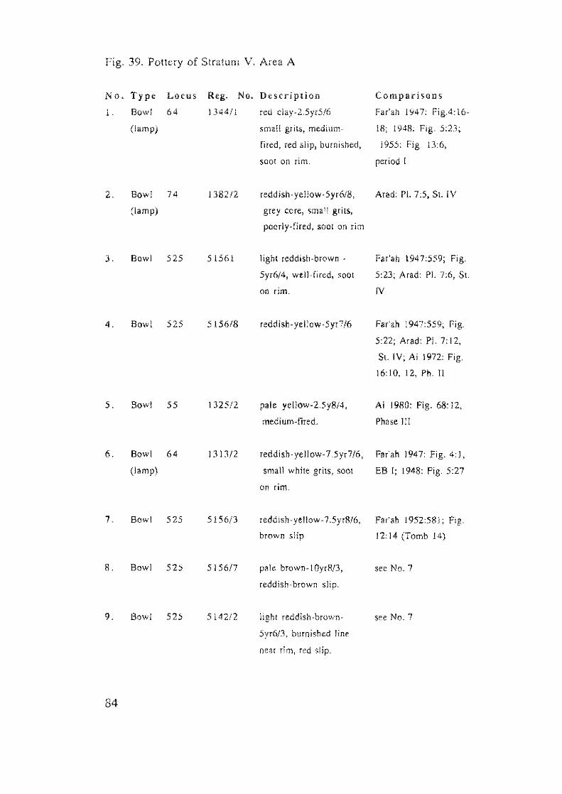
Fig_ 39. Pottery of Stratum V. Area A
No. Type Locus Reg. No. Description Comparisolls
1 Bowl 64 1344/1 red c1ay-25yr5/6 Far'ah 1947: \6-
(lamp) small grits. medium- H!; 1948: Fig. 5:23;
fired, red slip, burnished, 1955: Fig. I
soot on rim, period I
2. Bowl 74 138212 reddish -yellow -5 yr618, Arad: PI. SL IV
(lamp) grey core, small grits,
poorly-fired, soot on rim
3. Bowl 525 51561 light reddish-brown - Far'ah 1947:559; Fig.
5yr6/4, well, fired, soot 5:23; Arad: PI. 7:6, Sl-
on rim. IV
4. Bowl 525 5156/8 reddish- ye Ilow·5 yr 7/6 Far'ah 1947:559; Fig.
5:22; Arad: PI. 7: 12,
St. IV; Ai 1972: Fig_
16:10, 12, Ph. II
5_ Bowl 55 1325/2 pale yellow-2.5y8/4, Ai 1980: Fig. 68: 12.
medium-fired. Phase III
6_ Bowl 64 1313/2 reddiSh·yellow-7.5yr7/6. Far'ah 1947: Fig_ 4: 1,
(lamp) small white grits, soot EB I; 1948: Fig 5:27
on rim,
7. Bowl 525 5156/3 reddish- yellow -7 .5yr8/6, Far'ah 1952:581; Fig_
brown slip 12:14 (Tomb 14)
S. Bowl 525 515617 pale brown, J OyrR!3, see No.7
reddish·brown slip.
9. Bowl 525 5142/2 light reddish-brown- see No.7
5yr6/3, burnished line
near rim j red Slip.
84
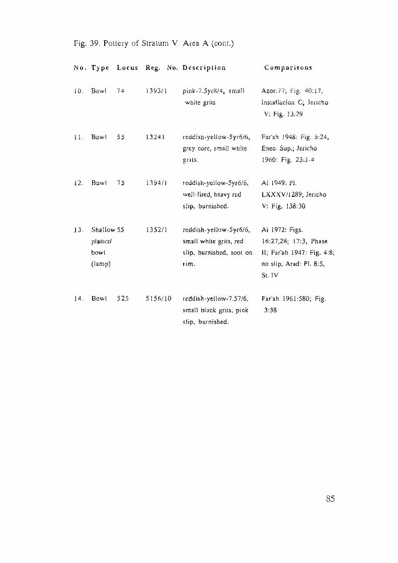
Fig. 39. Pottery of Stratum V. Area A (cant.)
No. Type Locus Reg. No. Description Comparisons
JI}. Bowl 74 139311 pink-7.5yr814, smail Azor:77; 40;17,
white grits lnstallacion C; Jericho
V: Fig. 13:29
11. Bowl 55 13241 reddish-yellow-5yr6/6. Far'ah 1948: Fig.
grey core, small while Eneo. Sup.; Jericho
grits. 1960: Fig. 23:1-4
12. Bowl 75 1394/1 reddish-yellow-5yr6/6. Ai 1949: PI.
well-fired, heavy red LXXXV/l289; Jericho
slip, burnished. V: Fig. 138:30
13. Shallow 55 1352/l rodd ish-yellow ·5yr6/6, Ai 1972: Figs.
pl."er/ small white grits, red 16:27,28; 17:3, Phase
bowl slip, burnished, soot on II; Far'all 1947: Fig. 4:8;
(lamp) rim. no slip; Arad: PI. 8:5,
SI. IV
14. Bowl 525 5156ilO reddish-yellow.7.57/6, Far'ah 1961 :580; Fig.
small black grils, pink 3:38
slip, burnished.
85
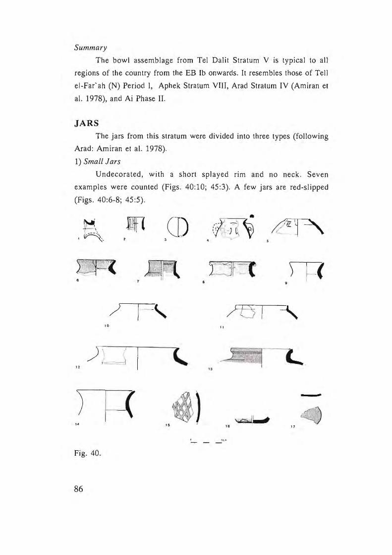
Summary
The bowl assemblage from Tel Dalit Stratum V is typical to all
regions of the country from the EB Ib onwards. It resembles those of Tell
el-Far'ah (N) Period I, Aphek Stratum VIII, Arad Stratum IV (Amiran et
al. 1978), and Ai Phase II.
JARS The jars from this stratum were divided into three types (following
Arad: Amiran et al. 1978).
1) Small Jars
Undecorated , with a short splayed rim and no neck . Seven
examples were counted (Figs. 40:10; 45:3). A few jars are red-slipped
(Figs. 40:6-8; 45 :5).
0)
•
/ 1--' "
) \ " ,- d '-.
" "
( ~) " , .
,.
Fig. 40.
86
, -:~~ VI, -J ~ Y' ,
)"t3 I "
r .. :~ -- :.!.
\~ I I "
~' '''
•
-,
.
f' y "
Fig. 40. Pottery of Stratum V. Area A
No. Type Locus Reg. No. Description Comparisons
1 Krater 74 1383{l reddlsh·yellow·5yr7/6. Ai 1980: PI. 91:15.
small grits, poorly· fired. Phase V
white lime wash,
2 Jugle( 68 1357/4 reddish·yellow·5yr716, AI 1972: Fig. ]7:21,
well-fired, vertical? Phase II
burnishing. heavy slip.
3. Amphor- 63 1309/1 reddish- yellow-5yr7/6 Ai J 949: PI. LX/765;
iskos Ai 1980: Fig. 92:28,
Phase V
4. Amphor· 524 51491l very pale brown·1OyrS/3. Jericho IV: Fig. 93:4,
iskos medjum~fired, painted. without painting
5. Tiny 524 5.14912 red-2.5yr416, many small Mad: PI. 45:29;
hole· black grils, medium·fired, Jericho V: Fig. 60:33
mouth incised mark before firing.
jar
6. Jar 68 135712 redd ish· ye !low·5 yr7 /6, Ai 1972: Fig. 17:20,
grey corc1 many medium, Phase II, white slip
while grits, poorly-fired,
red slip.
7. Jar 525 515619 red dish -ye Ilow-5 yr 7/6, Ai 1972: 17:21,
wel1~fired! red~brown Phase II; Mad: PI.
slip, powdery surface. 12:7. $1. IV, no slip
8. Jar 64 UOOIl red d ish-yellow -5 yr7 /6, Farah 1948 Fig.
poorly-fired, many big 6:1·2
grey grils. red
87
Fig, 40, Pottery of Stratum y, Area A (conI.)
No, Type Locus Reg. No. Description Comparisons
9, Jar 525 5156/ll pale brown-!Oyr8/4, Ai 1972: Fig, 17: 19,
white I ime wash, Phase 11; Far'ah 196]:
Fig,3:6
!O, Jar 68 1357/3 reddish-yellow-5yr7/6, Jericho IV:
little white grits, Fig, 37: 8, PU
11, Jar 525 5156/2 reddish-yellow-5yr7 /6,
well-fired, Arad: PI. 12:10, SL IV
12, Jar 535 5177/3 pink-5yr7/3, grits Arad: PI. 12: 11, SL IV
13. Jar 63 1314/1 pinkish-grey-5yr7/2,
many small white grits,
a few red grits, greyish
slip,
14 Jar 517712 reddish-yellow-5yr7 /6, Far'ah 1961: Fig,
many medium grits. 3:6-7, period J
white lime wash, sandy
clay,
15, Jar 1325/1 reddish-yellow-5yr7/6, '
(frag,) painted, basaltic sand
16, Jar 525 5156/4 very pale brown-l0yr8/4,
big grits, red slip,
17, Jug? 26 1 I reddish-yellow-5yr7/6,
(frag,) many grits, red slip,
soot on base,
88
2) Medium-sized Jars
Ledge handles, lime wash (Figs. 40:9, 14, 45:3), some with lattice
painted strips (Figs. 43:5; 44). Three examples were counted.
3) Necked Jars (Figs. 40:7-8; 43:4)
This type can be divided into two sub-types according to height: a)
up to 40 cm.; b) ca. 50 cm. Both have a thickened or ring-like rim with
plastic decoration and red slip. Some have ledge handles. The larger jars
(Sub-type b) have a lime wash. Nine jars were counted, six of which are
red-slipped.
A jar with a short inverted neck should be mentioned, which may
be of slightly earlier date (EB Ia) (Fig. 45:5) (cf. Afula: Sukenik et a!.
1948: Figs. 2:5 EB la; 2:4).
Summary
The jar assemblage of Stratum V includes a few types found in
Arad Stratum IV, Ai Phase II, Tel.1 el-Far'ah Period I, and Jericho Phase
PU/EB l. No evidence of pithoi from this period was recovered. Red slips
and lime washes were commonly used. A single example of a vessel,
probably a krater, is illustrated in Fig. 40: 1.
HOLEMOUTH JARS (Fig. 41)
The holemouth jars of Stratum V can be divided into two types:
1) Simple holemouth jars, usually slipped, with a thickened rim (Fig.
41 :5). Noteworthy are vessels decorated with grain-wash (Fig. 41 :4).
2) Holemouth jars with a slight ridge near the rim, slipped red to black,
are slightly more open than Type I (Figs. 41:1, 3, 8; 43:6). To these we
can add the example decorated with incision (Fig. 41:14), and another
with knobs which represent an EB Ia tradition (Fig. 45:6). The former
probably represents a "Pre-Stratum V" occupation at Tel Dalil (see Chap.
3.2-3).
89
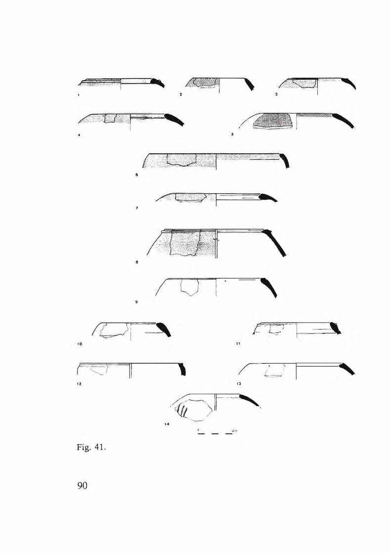
, /':., (;:;;:01'-"·' ....... /- ........ ~.. , ,
. ,
•
/ t -- >:' 1 - CO> R
•
I U , 9
'0 "
II \ / I '. , " "
•• . ~ 1..\..-- --
Fig. 41.
90
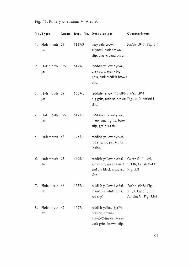
Fig. 41. Pottery of stratum V. Area A
No.Type Locus Reg. No. Description Comparisons
1. Holemouth 26 1127/3 very pale brown· Far'ah 1947: Fig. 3:5
Jar lOyr8!4. dark brown
slip, plastic band decor.
2. Holemouth 535 5177/1 reddish-yellow-5yr7/6,
jar grey core, many big
grits, dark reddish-brown
slip.
3. Holemouth 68 1 reddish·yellow-7.5yr8!6, Far'ah )961:
jar big grits, reddish-brown Fig. 3:10, period [
slip.
4. Holemouth 525 5142/1 reddish· yellow-5yr7/6,
pr many small grits, brown
slip, grain-wash.
5. Holemouth 125711 rcddish-yel low-5yr7 /6,
red slip, red painted band
inside.
6. Holemouth 75 1395/1 reddish-yellow-5yr7 16, Gezer !I: PI. 4:9,
Jar grey core, many small EB 1947:
and big black grits, red
slip.
7. Holemouth 66 1337/1 reddish-yellow·S yr7/6, Far'ah 1948: Fig.
Jar many big white grits, 5: 1 Eneo. Sup.;
red slip? Jericho V: Fig. 85:4
8. Holemouth 62 1327/1 reddish-yellow-5yr7/6-
Jar outside, brown-
7.5yr5/2-inside, Many
dark grits, brown slip.
91
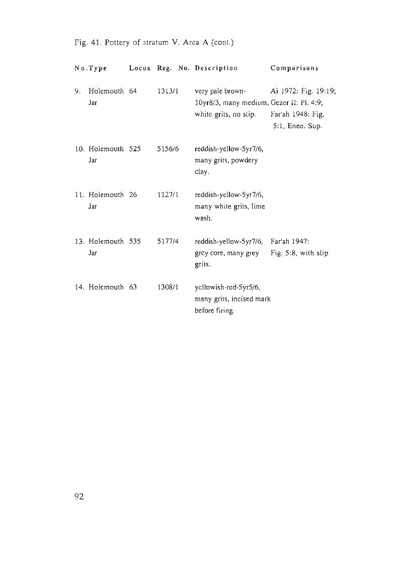
Fig. 41. Pottery of stratum V. Area A (cant.)
No.Type Locus Reg. No. Description Comparisons
9. Holemouth 64 131311 very pale brown- Ai 1972: Fig. 19:19;
Jar lOyr8!3, many medium, Gezer II: PI. 4:9;
white grits, no slip. Far'ah 1948: Fig.
5:1, Eneo. Sup.
10. Holemouth 525 5156/6 reddish-yellow-5yr7 /6,
Jar many grits, powdery
clay.
11. Holemouth 26 112711 reddish-yellow-5yr7 /6,
Jar many white grits, lime
wash.
13. Holemouth 535 5177/4 reddish-yellow-5 yr7/6, Far'ah 1947:
Jar grey core, many grey Fig. 5:8, with slip
grits.
14. Holemouth 63 130811 yellowish -red-5yr5/6,
many grits, incised mark
before firing.
92
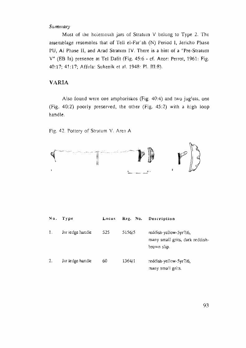
Summary
Most of the holemouth jars of Stratum V belong to Type 2, The
assemblage resembles that of Tell el-Far'ah (N) Period I, Jericho Phase
PU, Ai Phase II, and Arad Stratum IV, There is a hint of a "Pre-Stratum
V" (EB la) presence at Tel Datit (Fig. 45:6 - cf. Awr: Perrot, 1961: Fig.
40:17; 41:17; Affula: Sukenik et at. 1948: PI. 1II:8).
VARIA
Also found were one amphoriskos (Fig, 40:4) and two juglets, one
(Fig. 40:2) poorly preserved, the other (Fig, 45:2) with a high loop
handle.
Fig. 42, Pottery of Stratum V. Area A
No. Type Locus Reg, No. Description
1. Jar ledge handle 525 reddish- yellow-Syr7 /6,
many small grils, dark reddish-
brown slip,
2. Jar ledge handle 60 1364/1 reddish-yellow-Syr7/6,
many small grils,
93
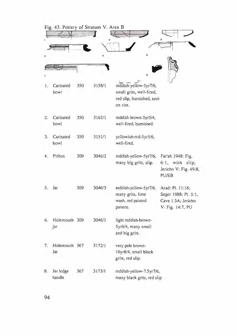
Fig. 43 . Pottery of Stratum V. Area B
t Or J ~cc~·- S~9~' =.y:;;J
v II
1. Carinated 350
bowl
2. Carinated 350
bowl
3. Carinated 350
bowl
4. Pithos 309
5. Jar 309
6. Holemouth 309
pr
7. Holemouth 367
Jar
8. Jar ledge
handle
94
367
,
'<:] .1 , ,
3158/1
3162/1
3151/1
3046/2
3046/3
3046/1
3172/ 1
3173/ 1
•
•
reddish-yellow-5yr7 /6,
small grits, well-fired,
red slip, burnished, soot
on rim.
reddish-brown-5yr5/4,
well-fired, burnished.
yellowish-red-5 yr5/6,
well-fired.
reddish-yellow-5yr7/6, Far'ah 1948: Fig.
many big grits, slip. 6:1, with slip;
Jericho V: Fig. 49:8,
PUIEB
reddish-yellow-5yr7/6, Arad: PI. 11:16;
many grits, lime
wash, red painted
pattern.
light reddish-brown-
5yr6/4, many small
and big grits.
very pale brown
JOyr8/4, small black
grits, red slip.
Seger 1988: PI. 5: I,
Cave J .3A; Jericho
V: Fig. 14:7, PU
reddish-yellow-7.5yr7/6,
many black grits, red slip
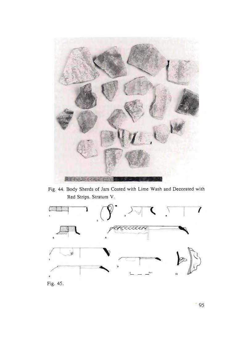
, I
\ -
Fig. 44. Body Sherds of Jars Coated with Lime Wash and Decorated with
Red Strips. Stratum v.
(. n (1. ,
/ • / """""--"F==
9
Fig. 45.
95
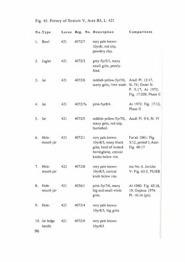
Fig. 45. Pottery of Stratum Y, Area B3, L. 421
No.Type Locus Reg. No. Description Comparisons
1. Bowl 421 4072/7 very pale brown-
10yr8/ , red slip, powdery clay.
2 . Juglet 421 4072/3 grey-5yrS/I, many
small grits, poorly-
fired.
3 . Jar 421 4072/6 reddish-yellow-5 yr7 /6, Arad: PI. 12:17, many grits, lime wash. SI. IV; Gezer ll:
P. 5:17; Ai 1972:
Fig. \7:209, Phase II
4 . Jar 421 4072/7a pink-5yrS/4. Ai 1972: Fig. 17:12,
Phase II
5. Jar 421 4072/5 reddish-yellow-5 yr7 /6, Arad: PI. 9:4, 51. IV many grits, red slip,
burnished.
6. Hole- 421 4072/1 very pale brown- Far'ah 1961: Fig.
mouth jar IOyrS/3, many black 3:12, period 1; Azor: grits, band of incised Fig. 40:17
herringbone, conical
knobs below rim.
7. Hole- 421 4072/8 very pale brown- see No.6. Jericho
mouth jar lOyr8/3, conical V: Fig. 63:3, PUlES
knob below rim.
8. Hole- 421 4036/1 pink-5yr7/6, many Ai 19S0: Fig. 65:18, mouth jar big and small white 19; Gophna 1974:
grits. PI. 10:14 (pit)
9 . Hole- 42] 4072/4 very pale brown-
IOyr8/3, big grits.
10. Jar ledge 421 4072/4 very pale brown-
handle IOyr8/3
96
4.1.1 Conclusions - Pottery of Stratum V (EB Ib)
The pottery of Stratum V can be considered typical of what is
commonly designated "late EB I", i.e. EB Ib, assemblages, mainly in
central Israel, exemplified by Tell el-Far'ah (N), Aphek, Gezer, Ai and
Jericho (see map Fig. 4). These assemblages contain what may be
considered both "northern" and, "southern" lale EB I ceramic features.
The characteristic vessels of EB 1 Tel Datil are the slipped, ridged
holemouth jar (Fig. 41 :3), and the grain-washed holemouth jar (Fig.
41:4). Both are indicative of a "northern EB I" pottery tradition. However,
jars with white lime wash and painted red stripes (Fig. 43:5), and the
lattice-painted amphoriskoi (Fig. 40:4), represent the "southern EB I"
pottery tradition,
The Stratum V assemblage also includes some indications of
intrusive, EB la pottery, which may imply that the site was already
inhabited at the very beginning of the Early Bronze Age ("Pre-Stratum
V" phase).
4.2 Pottery of Strata IV·II (EB II) • Areas A, B, C
The EB II pottery of Strata IV -II is discussed as a single
assemblage, although the pottery figures are arranged according to areas
of excavation. This was necessary since in Area B only a small amount of
pollery was retrieved from Strata III-IV (Figs. 46-47), while in Area A no
architectural remains were discerned in Strata III-IV. The bulk of the
pottery originates from Stratum II (Figs. 48-64). In Area B most of the
material comes from two floors of Broadroom 115-152, Stratum II (see
below The Quantitative Analysis, 4.2.1).
Immediately beneath the surface in Area C, a wall (W901) oriented
southeast to northwest was uncovered. At floor level on both sides of the
wall many vessels were found, of which some were restorable. This
assemblage matches the EB II repertoire of Areas B and A, including
bowls, lamps, jugs, amphoriskoi, jars, pithoi, and holemouth jars (Figs. 54-
55; 60-64).
97
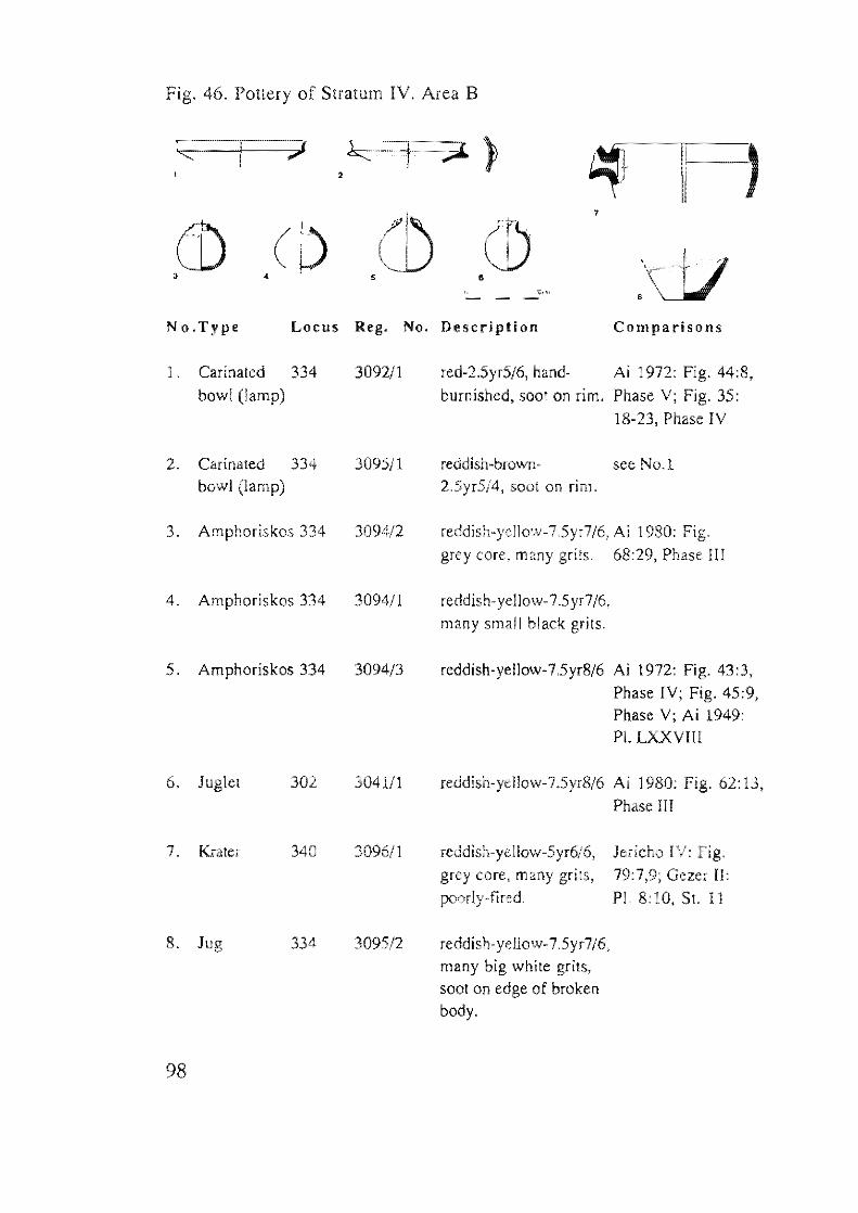
Fig. 46. Pottery of Stratum IV. Area B
, )
•
No.Type Locus Reg. No. Description Comparisons
1 . Carinated 334 3092/1
bowl (lamp)
2. Carinated 334 3095/1 bowl (lamp)
3. Amphoriskos 334 3094/2
4. Amphoriskos 334 309411
5. Amphoriskos 334 3094/3
6. Juglel 302 304111
7. Krater 340 309611
8. Jug 3095/2
98
red-2.5yr5/6, hand- Ai 1972: Fig. 44:8, burnished, soot on rim. Phase V; Fig. 35:
18-23, Phase IV
reddish-bro\VlJ- see No.1 2.5yr5/4, soot on rim.
reddish-yellow-7.5yr7/6, Ai 1980: Fig. grey core, many grits. 68:29, Phase III
reddish-yellow-7.5yr7/6, many small black grits.
reddish-yellow-7.5yr8/6 Ai 1972: Fig. 43:3, Phase IV; Fig. 45:9, Phase V; Ai 1949: PI. LXXVII!
reddish-yellow-7.5yr8/6 Ai 1980: Fig. 62: 13,
Phase !II
reddish-yellow-5yr6/6, grey core, many grits, poorly-fired.
reddish-yellow-7 .5yr7/6, many big white grits, soot on edge of broken body.
Jericho IV:
79:7,9; Gezer II: PI. 8:10, St. 11
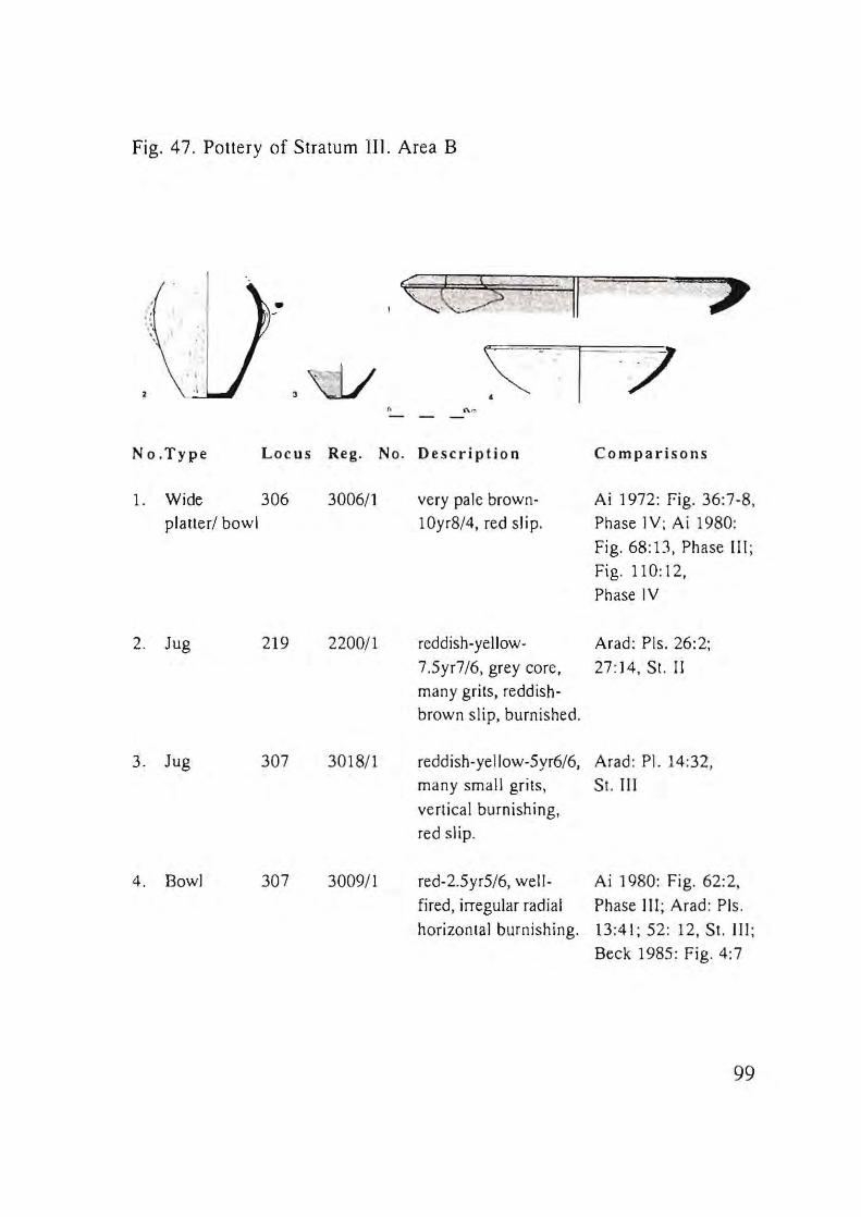
Fig. 47. Pottery of Stratum III. Area B
" <::C:S 1/
. ~ ~ ~
" ,w \:. -l .. 7 " " , -
No.Type Locus Reg. No. Description Comparisons
l. Wide 306 3006/1 very pale brown- Ai 1972: Fig. 36:7-8,
platter/ bowl 10yr8/4, red sl i p. Phase IV; Ai 1980:
Fig. 68:13. Phase III ;
Fig. 110: 12,
Phase IV
2. Jug 219 2200/1 reddish-yellow· Arad: Pis. 26:2;
7.5yr7/6, grey core, 27:14, St. II
many grits, reddish-
brown slip, burnished.
3. Jug 307 3018/1 reddish- ye Ilow-5yr6/6, Arad: PI. 14:32,
many small grits, St. III
vertical burnishing,
red slip.
4. Bowl 307 3009/1 red-2.5yr5/6, well- Ai 1980: Fig. 62:2,
fired, irregular radial Phase III ; Arad: Pis.
horizontal burnishing. 13:41; 52: 12, St. III;
Beck 1985: Fig. 4:7
99
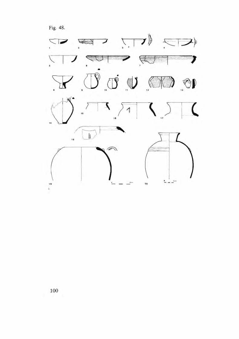
Fig. 48.
'C:::: i....., \Z2! -:;I ,
\: I 7 Q® -. j 5 •
'7 \R9-- 1 · 1 , •
~ ([J cd 0V (510) ~, B 9 10 11 12 13
" ,-
,.
100
" 1 - f11 \ 1& I '7
~ " '~ _ _ _ '20

Fig. 48. Pottery of Stratum I!. Area B
No.Type Locus Reg. No. Description Comparisons
1. Lamp 152 2054/1 grey-5yr5/1, many Arad: PI. 22: 17-21,
bowl grits, soot on rim. St. II
2. Carinated 106 31/1 yellowish -red-5 yr5/6, Ai 1972: Fig.
bowl wheel-burnished. 44:6,3, Phase V;
Fig. 35:19-22,
Phase IV
3. Bowl 109 48/1 reddish-brown-5yr5/4,
well-fired, Sool on rim.
4. Carinated 139 2033/1 Ai 1972: Fig. 44:6,3,
bowl Phase V; Fig. 35:18,
Phase IV
5. Bowl 152 2054/2 reddish-yellow-5yr7/8,
(lamp) soot on rim.
6. Bowl 106 34/1 red-2.5yr5/6, burnished.
7. Bowl 106 31/2 reddish-yeJlow-5yr6/S, Ai 1972: Fig. 36:7,
many grits, light Phase IV
red slip.
8. Bowl 105 36/1 reddish-yellow- Ai 1972: Fig. 56:21,
on foot 5yr7/6, lime wash. Phase V; Ai 1949:
Pl. LXXVII
9. lugle! 152 2080/1 reddish-yellow-5yr7/6, Ai 1972: Fig. 56:22,
lime wash. Phase V; Arad: PI.
26:23, St. II
10. lugle! lOS 44/1 a reddish- yellow-5yr7/3. Ai 1972: Fig. 56:22,
Phase V
11. Jugle! 102 - 4411 reddish-yellow-5yr7/6,
103 powdery surface, red
slip.
101
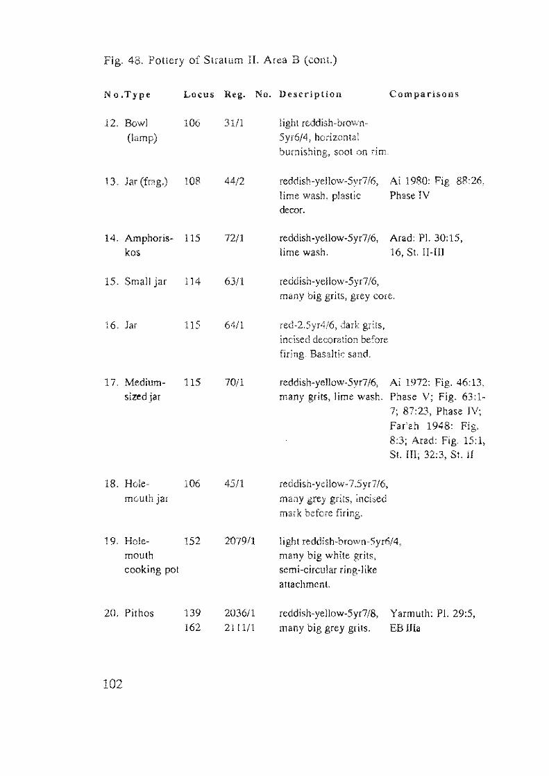
Fig. 48. Pottery of Stratum II. Area B (cont.)
No.Type Locus Reg. No. Description Comparisons
12. Bowl 106 31/1 I igh! reddish-brown-
(lamp) 5yr6/4, horizontal burnishing, sool on rim.
13. Jar (frag.) 108 44/2 reddish-yellow-5yr7/6, Ai 1980: Fig. 88:26,
lime wash, plastic Phase IV decm.
14. Amphoris- 115 72/1 reddish-yellow-5yr7/6, Arad: PI. 30:15, kos lime wash. 16, St. !I-lII
15. Small jar 114 6311 reddish-yellow-5yr7/6,
many big grits, grey core.
16. Jar 115 64/1 red-2.5yr4/6, dark grits, incised decoration before firing. Basaltic sand.
17. Medium- 115 70/1 reddish-yellow-5yr7/6, Ai 1972: Fig. 46:13, sized jar many grils, lime wash. Phase V; Fig. 63:1-
7; 87:23, Phase IV;
Far'ah 1948: Fig. 8:3; Arad: Fig. 15:1, SI. Ill; 32:3, St. II
18. Hole- 106 45/1 reddish-yellow-7.5yr7/6, mouth jar many grey grits, incised
mark before firing.
19. Hole- 152 2079/1 light reddish-brown-5yr6/4, mouth many big white grits, cooking pot semi-circular ring-like
attachment.
20. Pithos 139 2036/1 reddish-yellow-S yr7/8, Yarmuth: Pl. 29:5, 162 2111/1 many big grey grits. EB lila
102
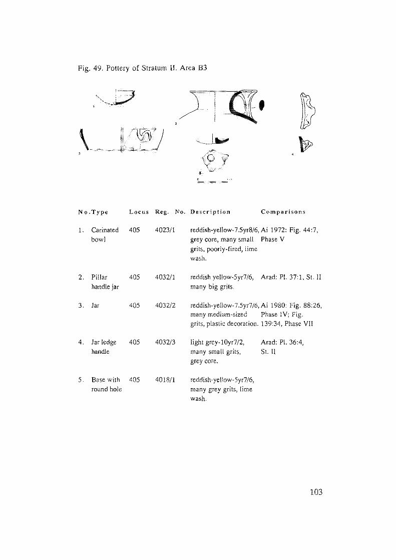
Fig. 49. Pottery of Stratum II. Area B3
No.Type Locus Reg. No. Description Comparisons
1. Carinated 405 4023/1 reddish-yellow-7.5yr8/6, Ai 1972: Fig. 44:7,
bowl grey core, many small Phase V
grits, poorly-fired, lime
wash.
2. Pillar 405 4032/1 reddish yellow-5yr7/6, Arad: PI. 37:1, St. II
handle jar many big grits.
3. Jar 405 4032i2 reddish-yellow-7.Syr7/6, Ai 1980 Fig. 88:26, many medium-sized Phase I V; Fig. grits, plastic decoration. 139:34, Phase VII
4. Jar ledge 405 4032/3 light grey-! Oyr7/2, Arad: PI. 36:4,
handle many small grits, Sl. II
grey core.
S. Base with 405 4018/1 reddish-yellow-Syr7i6,
round hole many grey grits, lime
wash.
103
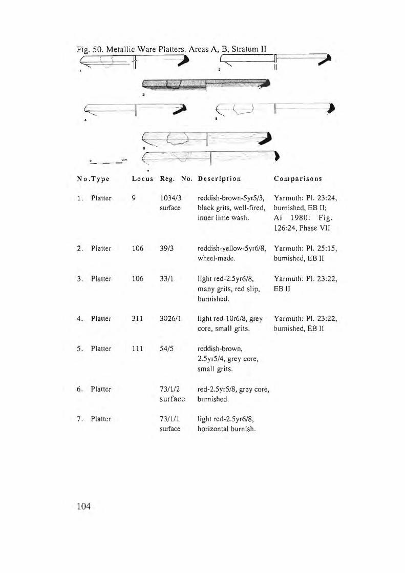
Fig. 50. Metallic Ware Platters. Areas A, .=.8"-., .::.s.;;.tr.::..at.;;.u_m ___ IIIl=====~
G ,,! ii- - ~ L,( "',,-------lIF E I "'
i :.- '''i/ . I ':':1 '~ 0_ .L, .•• •
~ ( U -n= -= .)
~ ... t~=-=11 •
" ~. ( C7 I )
No.Type Locus Reg. No. Description Comparisons
l. Platter 9 1034/3 reddish-brown-5yr5/3, Yarmuth: PI. 23:24 , surface black grits, well-fired, burnished, EB II;
inDer lime wash . Ai 1980: Fig.
126:24, Phase VII
2. Platter 106 39/3 reddish·yeUow-5yr6/8, Yarmuth: PI. 25:15, wheel-made. burnished, EB II
3. Platter 106 33/1 light red-2.5yr6/8, Yarmuth: PI. 23:22,
many grits, red slip, EB" burnished.
4. Platter 311 3026/1 light red-lOr6/8, grey Yarmuth: PI. 23:22,
core, small grits. burnished, EB II
5. Platter 111 54/5 reddish-brown,
2.5yr5/4, grey core,
small grits.
6. Platter 73/1/2 red-2.5yr5/8, grey core, surface burnished.
7 . Platter 73/1 / 1 light red-2.5yr6/8, surface horizontal burnish.
104
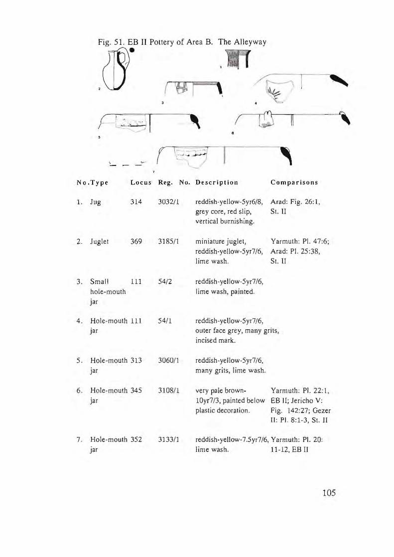
Fig. 51. EB II Pottery of Area B .
•
, ! II ,
•
" ~ .
- --No.Type Locus Reg. No. Description Comparisons
1. Jug 314 3032/1 reddish-yellow-5yr6/8, Arad: Fig. 26: 1,
grey core, red slip, St. 11
vertical burnishing.
2. Juglet 369 318511 miniature iuglet, Yarmuth: PI. 47:6;
reddish-yellow-5yr7/6, Arad: PI. 25:38 ,
lime wash. St. II
3. Small 111 54/2 reddish-yellow-5yr7/6,
hole-mouth lime wash , painted.
iar
4. Hole-mouth 111 54/1 reddish-yellow-5yr7/6,
iar outer face grey, many grits,
incised mark.
5. Hole-mouth 313 306011 reddish-yellow-5yr 7/6,
iar many grits, lime wash.
6 . Hole-mouth 345 3108/1 very pale brown- Yarmuth : PI. 22:1.
iar lOyr7/3, painted below EB II; Jericho V:
plastic decoration. Fig. 142:27; Gezer II : PI. 8:1-3, SI. II
7 . Hole-mouth 352 313311 reddish-yellow-7.5yr7/6, Yarmuth: PI. 20:
iar lime wash . 11-12, EB II
105
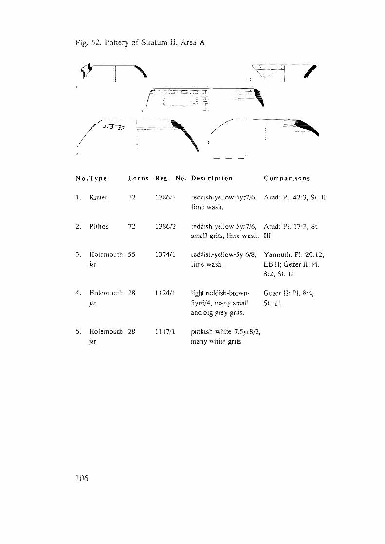
Fig. 52. Pottery of Stratum II. Area A
II
106
•
,
( I \ e r I' f ~~~iu'
" f""-'*"~-
. . ,
10
i " 1 2 G . .J,,... I J
- -
Fig. 53.
107
Fig. 53. Unstratified EB II Pottery. Area A
No.Type Locus Reg. No. Description
1. Carinated 5 1022/1 reddish-brown-SyrS/4, burnished, soot on rim. bowl (lamp)
2. Carinated 3 1009/3 reddish-yellow-5yr6/6, reddish-grey slip. bowl (lamp)
3. Platter 3 1005/1 very pale brown-IOyr7/4, many small black grits, red slip.
4. Bowl 51 1254/1 reddish-yellow-5yr7/6, grey core, many white grits, powdery clay.
5. Platter 14 1062/1 pale yellow-2.5y8/4, over-fired.
6. Bowl 10 108311 reddish-yellow-5yr6/6. many small grits.
7. Bowl 52 1255/1 reddish-yellow-7.5yr7/6, many white grits, red slip, powdery clay.
8. Jar 3 1009/1 very pale brown-l0yr8/3. grey core, many grits, lime wash.
9. Jar 3 100912 reddish-yellow-Syr716, pinkish grey-7.5yr6/2, many grits.
J O. Holemouth 10 1049/1 very pale brown-J Oy17 /4, many dark grits.
Jar
11. Jar 11 1043/1 reddish-yellow-Syr7/6, grey core, many small grits, plastic decoration.
12. Jug handle 3 102511 reddish-yellow-5yr7/6, many grits, red slip.
13. Jar handle 500 5000/1 reddish-yellow-5yr7/8, many grits. incision.
108
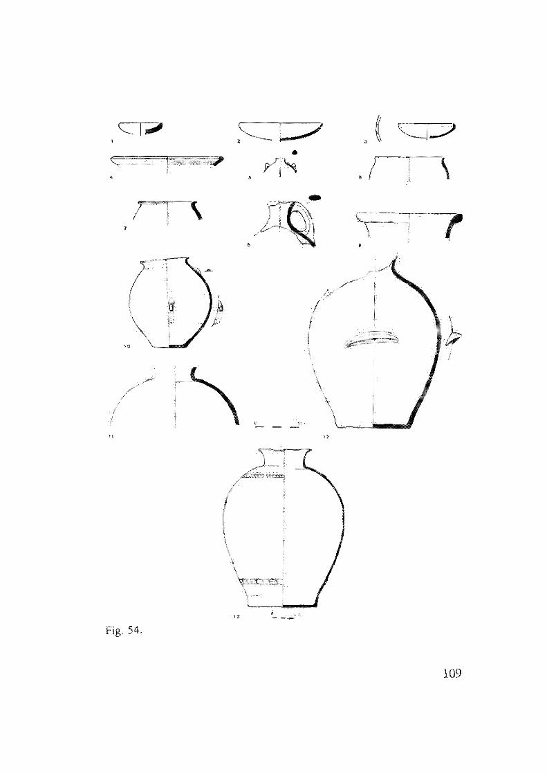
CI;IiiI'
T! \
'0
"
Fig. 54.
""'_ 7 ,
,
, - --
\
;
"
I i
-,
"
109
Fig. 54. Pottery of Stratum II. Area C
No.Type Locus Reg. No. Description Comparisons 1. Bowl (lamp) 600 6001/1 reddish-yellow-5yr7/6, Arad: PI. 22:19, S1.
grey core, many big Il; Yarmuth: PI. white grits, 5001 on 21 :2; 25: 1, EB II nm.
2. Bowl (lamp) 602 6013/1 yellowish-red-5yr5/6, Yarmuth: PI. 25:2 sao I on rim.
3. Lamp 603 6016/1 redd ish -brown -5 yr5/ 4, Arad: PI. 22:40, S1. well-fired, impressed Jl; Yarmuth: PI. area on rim, 23:1,EBII
4. Platter 600 6007/3 reddish-yellow-5yr7/6, Ai 1972: Fig. burnished, red slip. 36:1, Phase IV
5. Amphori- 603 600511 reddish-yellow-7yr7/8, Arad: PI. 30:17, skos small grits. SI. II
6. Cup (bowl) 600 6007/2 reddish-yellow-5yr6/6, Arad: PI. 24:22, well-fired. 24, SI II
7. Small 603 6010/1 reddish-yellow-5yr7 /6, Arad: PI. 24:35, vessel grey core) white grits, 51. II
poorly-fired.
8. Jug 603 6018/1 pinkish-grey-7.5yr6/2, Ai 1980: Fig. 87:18, many while grils. Phase IV; Ai 1949:
PI. LXXVIII
9. Jar 603 6015/1 reddish-yellow- Ai 1980: Fig. 111: 7.5yr7/6, 35, Phase VI many big grey grits.
10. Small jar 602 6013/5 reddish-yellow-5yr7/8, Arad: PI. 28:7-10; two handles - one 100:(" St. II decoralive, one loop handle on lower body.
11. Jar 603 6017/1 pinkish-grey-7.5)'r7/2, Arad: PI. 17:4, 51. many big white grits. IlI; 32:1, SI. 11; Ai
1980: Fig. 93:4, Phase V
12. Jar 602 6004/1 redd ish-yellow-5 yr7 /6, AraJ: PI. 16:2, 51. many brown grits. III; 15:15
13. Pithos 602 6013/4 reddish- yellow-5yr7/6, Ai 1972: Fig. 53:14, bands of rope Phase V; Arad: PI. decoration. 39:1-2; 40:2, 51. 11
110
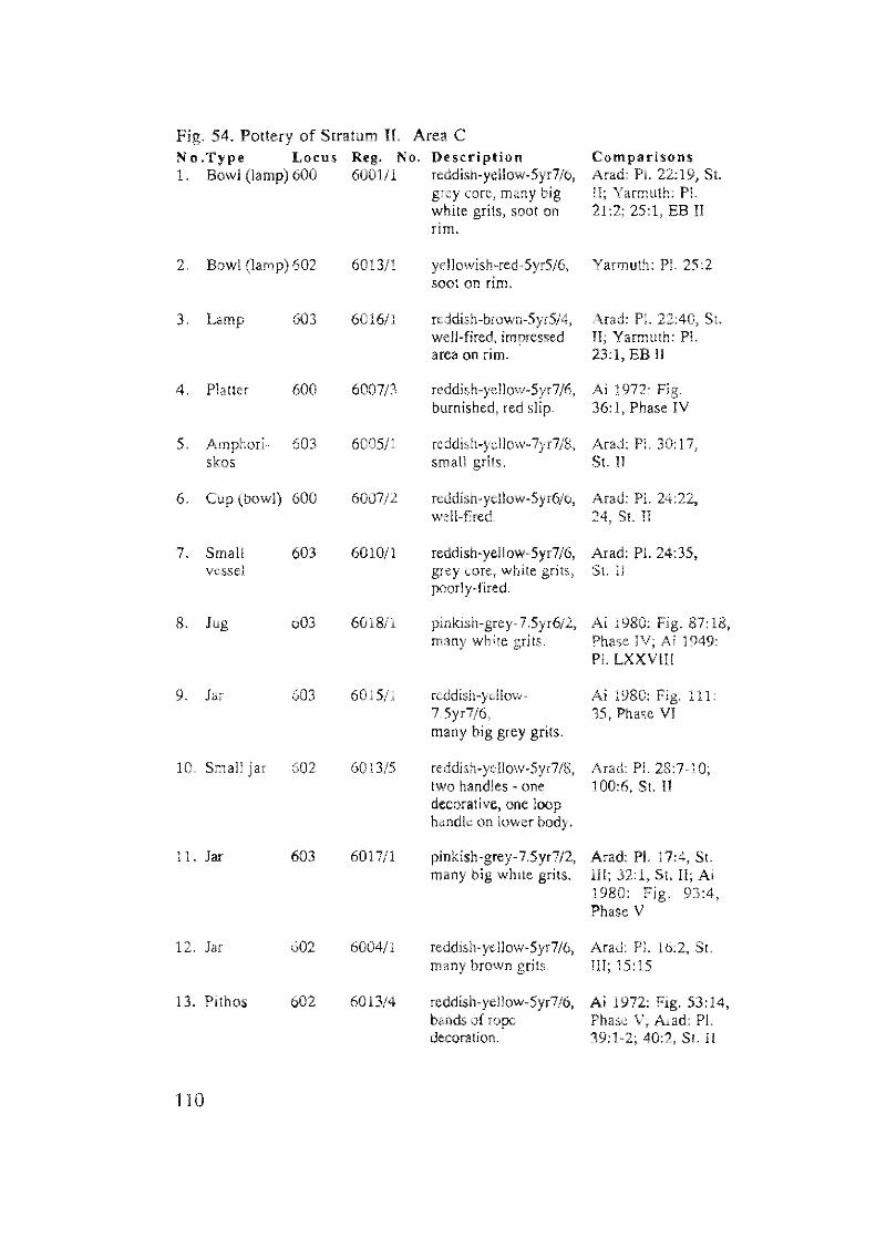
Fig. 54. Pottery of Stratum II. Area C No.Type Locus Reg. No. Description Comparisons L Bowl (lamp) 600 600111 reddish-yellow-5yr7/6, Arad; PI. 22; 19, SI.
grey core, many big II; Yarmuth: PI. white grits, soot on 21:2; 25;1, EB II nrn.
2. Bowl (lamp) 602 6013/1 yellowish-red-5yr5/6, Yarmuth: PI. 25;2 soot on rim.
3. Lamp 603 601611 reddish-brown-5yr5/4, Arad; PI. 22:40, St. well-fired, impressed II; Yarmuth; PI. area on rim. 23;1, EB II
4. Platter 600 6007/3 reddish-yellow-5yr7/6, Ai 1972; Fig. burnished, red slip. 36; I. Phase IV
5. Amphori- 603 6005/1 reddish-yellow-7yr7/8, Arad: Pl. 30:17, skos small grits. S1. II
6. Cup (bowl) 600 600712 reddish-yellow-5yr6/6, Arad: PI. 24:22, well-fired. 24, S1. II
7. Small 603 6010/1 reddish-yellow-5yr7/6, Arad: Pl. 24:35, vessel grey core, white grits, St. II
poorly-fired.
S. lug 603 6018/1 pinkish-grey-7.5yr6/2, Ai 1980: Fig. 87: 18, many white grits. Phase IV; Ai 1949:
PI. LXXVm
9. Jar 603 6015/1 reddish-yellow- Ai 1980: Fig. 111: 7.5yr7/6, 35, Phase VI many big grey grils.
10. Small jar 602 6013/5 reddish-yellow-5yr7/S, Arad: PI. 28:7-10; two handles one 100:6, St. !l decorative, one loop handle on lower body.
11. Jar 603 6017/l pinkish-grey-7.5yr7/2, Arad: PI. SI. many big white grits. Ill; 32: 1. St. ll; Ai
1980: Fig. 93:4, Phase V
12. Jar 602 6004/1 reddish-yellow-5yr7/6, Arau: PI. 16:2, St. many brown grits. Ill; 15
13. Pithos 602 6013/4 reddish-yellow-5yr7/6, Ai 1972: Fig. 53:14, bands of rope Phase V; Arad: PI. decoration. 40:2, St. II
110
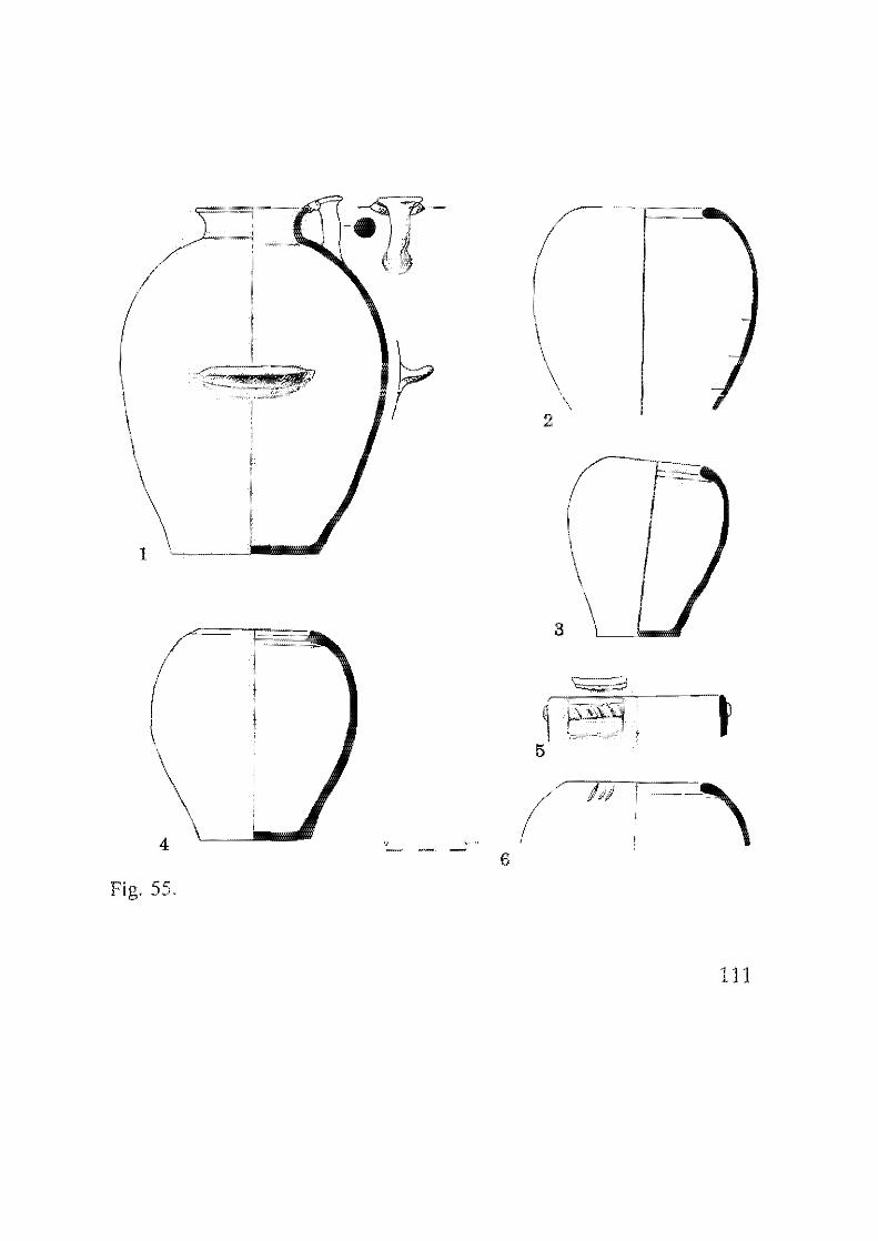
1
4
Fig. 55.
. ' " ., - - 6
( \
\ 2
\ 3
~:"""--, ' .
111
Fig. 55. Pottery of Stratum n. Area C
No.Type Locus Reg. No. Description Comparisons
1. Pillar 602 6014/1 reddish·yellow-5yr7/6, Ai 1972: Fig. 42:16,
handle jar grits, medium-fired, Phase IV; Ai 1980:
Fig. 63: 10, Phase
III; Arad: Pl. 37:1,
SI. II
2, Holemouth 601, 600211 reddish·yellow·5yr7/6.
Jar 602
603
3, Holemouth 602 601312 reddish-yellow·5yr7 /6. YarmUlh: PI. 22:8,
jar many black grits. EB 1I
4. Holemouth 602 6013/3 reddish·yellow-Syr7/6, Yarmllth: PI.
jar dark grits, 44;12, EB [[
S. Bowl krater 600 6007/1 reddish·yellow-Syr7/6, Arad: PI. 42;13,
rope decoration. 14, SI. II; 52:23,
SI. I; Ai 1980:
Fig. 91:16, Phase V
6. Holemouth 601 601311 reddish·yellow-Syr7/6.
jar
112
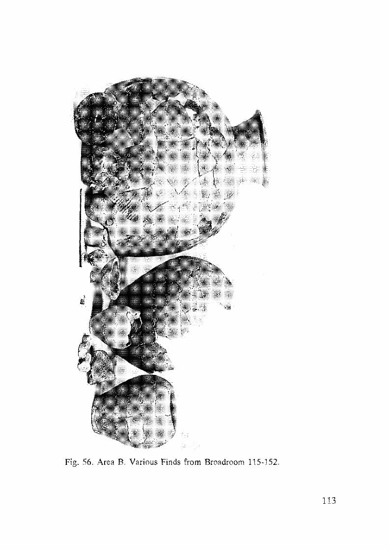
Fig. 56. Area B. Various Finds from Broadroom 115-152.
113
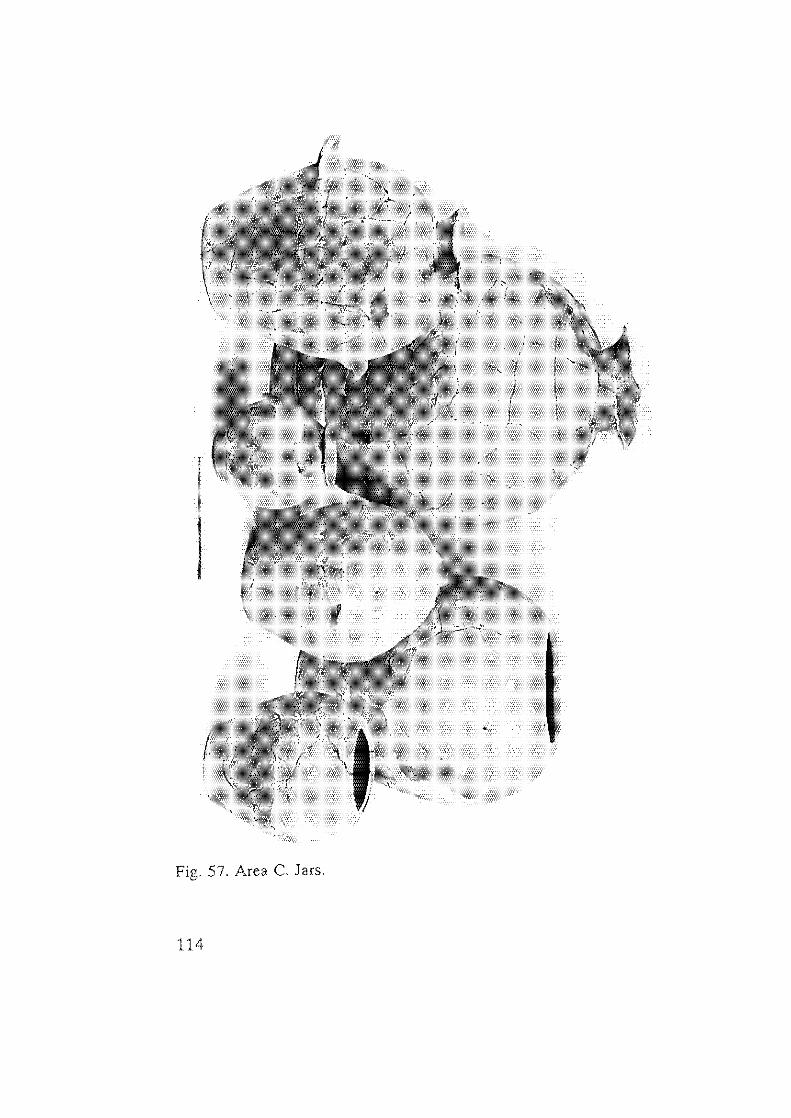
,
Fig. 57. Area C. Jars.
114
"
, [ I j.,
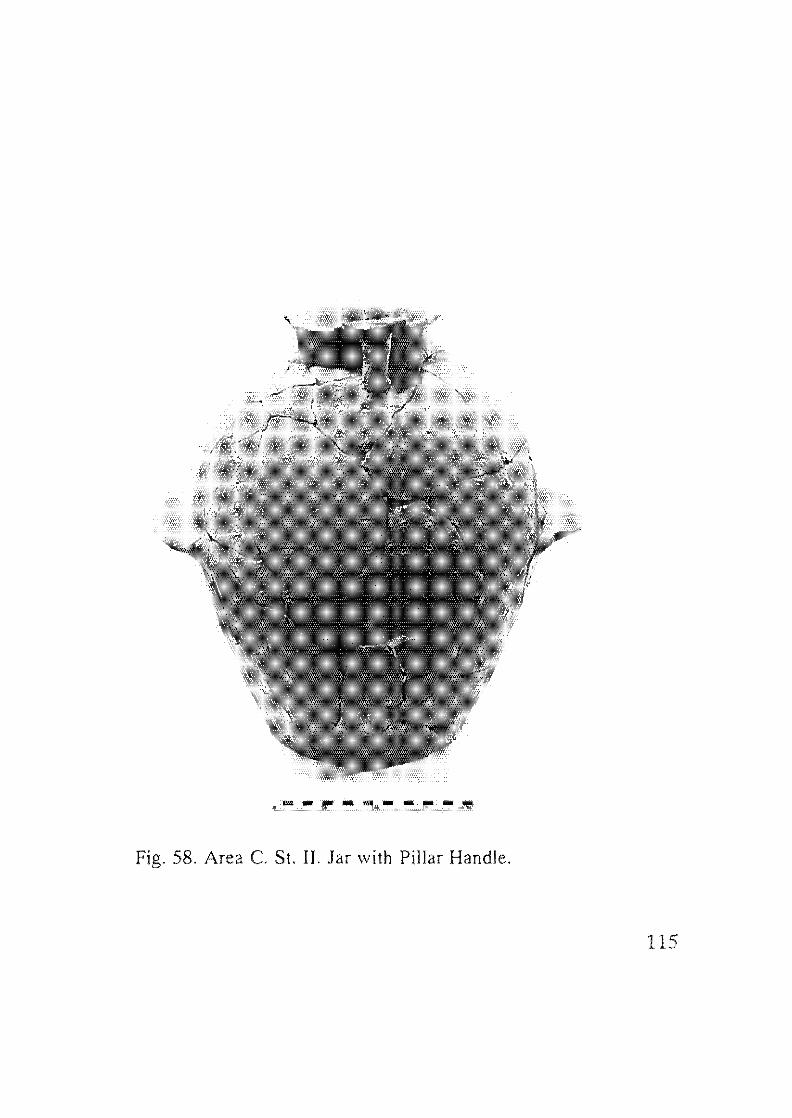
Fig. 58. Area C St. II. Jar with Pillar Handle.
115
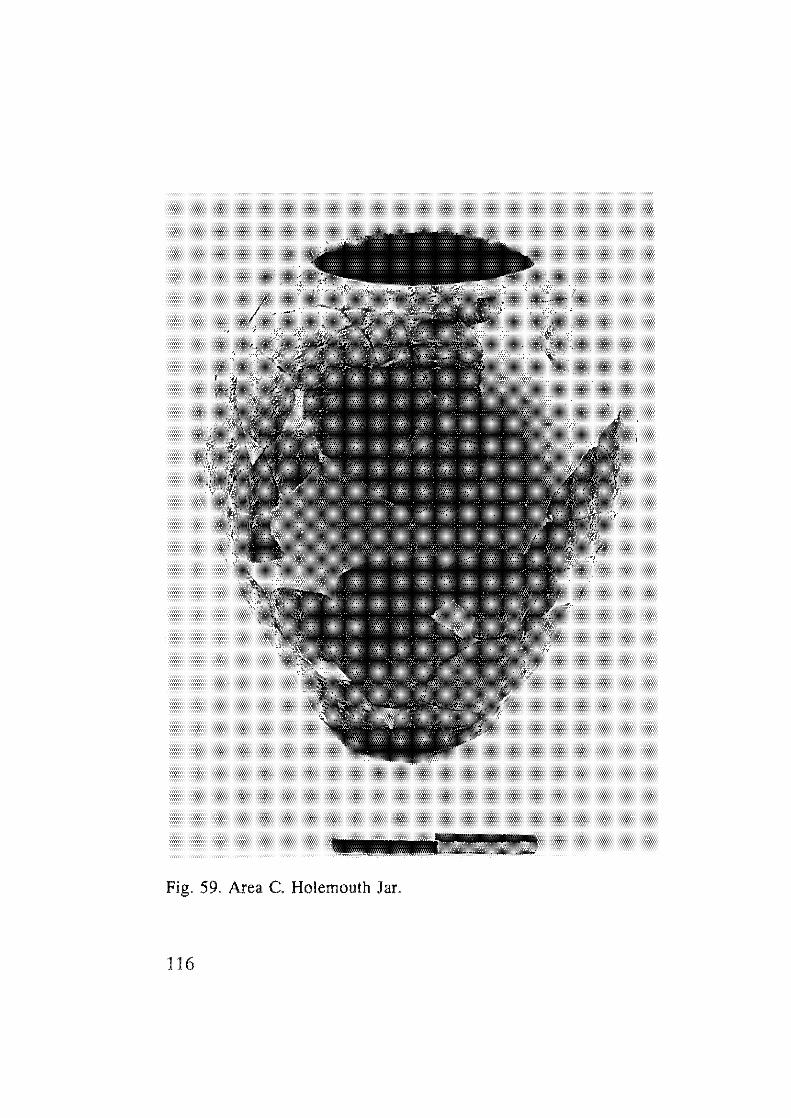
Fig, 59, Area C. Holemoulh Jar.
116
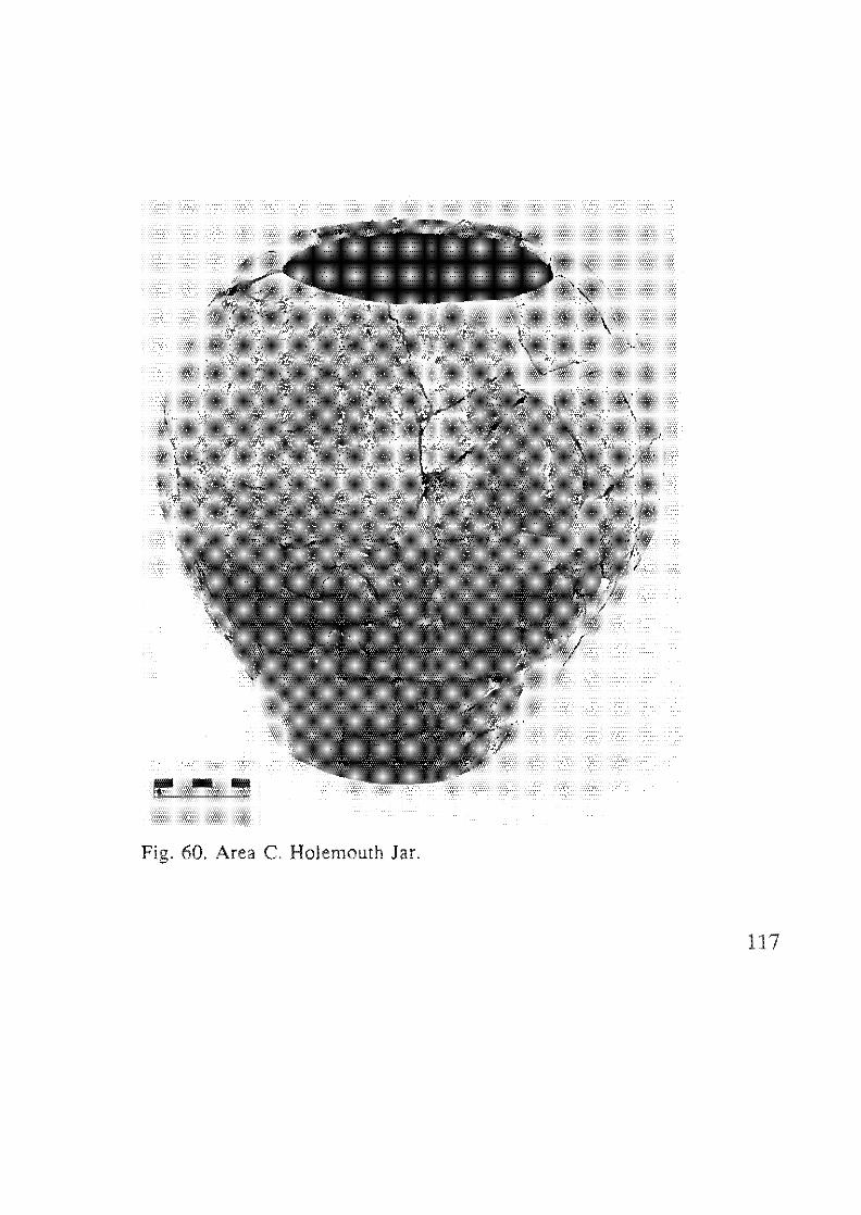
Fig. 60. Area C. HoJemouth Jar.
117
-115
Fig. 61. Area B. St. IIa. Chalice.
118
- cm~
Fig. 62. Area B. St. II. Juglet.
119
Fig. 63. Area C. Pithos.
120
o o
Fig. 64. Area B. SI. II. The Broadroom 115-152 Assemblage.
121
BOWLS
1. Small Bowls (Figs. 48:1,5, 12; 54:1-2).
A few small globular bowls were found at Tel Dalil, mosl of which
served as lamps. They were handmade, unslipped and unburnished.
2. EB II Small Metallic-ware Bowl Family (Beck 1985)
A tolal of 95 examples were recovered.
The vessels are of metallic ware - a very fine brownish red clay
("Terra-rosa" clay), containing a small amount of grits. The body of the
vessel was handmade, the rims were finished on a toumene. The body was
usually horizontally burnished, externally and internally, but sometimes
exhibits a criss-cross pattern.
All the types of the family noted by Beck were present (Beck
1985):
1. a) Carinated bowls (Figs. 46:1-2; 48:2, 4; 49:1). Seventy-five
examples.
b) Carinated bowls with lug handles (Figs. 46:2; 48:4). Six
examples.
It is possible that many, if not aU, of the carinated bowls
originally had lug handles.
2. Deep bowls or "goblets" (Reg. No. 404811). Four examples.
3. a) Shallow bowls with inverted rim. Three examples.
b) Bowls with flattened, in-turned or straight rim (Fig. 47:4).
Six examples.
4. Lamp-bowl (Fig. 54:3). One example.
Summary
It seems that while the beginnings of the EB II Small Metallic-ware
Bowl Family are in the regional ceramic tradition of the EB I, the main
characteristics were shaped during the EB II.
Towards the end of EB II a carinated bowl of non-metallic ware
appears in the Tel DaHt repertoire, but no typological distinctions could
be discerned due to the small number of vessels recovered (Fig. 10:1) (cf.
Arad: Amiran et aL 1978: PL52:13; Yarmulh: de Miroschedji 1988:
P1.41:1 ).
122
3. Platters (Figs. 50; 53:3; 54:4)
a) Twenty-three examples were found. Thick-rimmed profile, thick
overall red-brown slip, burnished inside and out (Fig. 53:3).
b) Metallic platters (Fig. 50). Eight examples were found. Well-fired.
The form was achieved by bending the open form so as to fashion a wall
at a right angle to the shallow concave vessel. Some examples are slipped
and burnished (Fig. 50:3). Marks of a tournette can be discerned on rims.
The metallic platters form an homogenous group that was not locally
produced. Petrographic analysis indicates that they were imported from
the north, from pottery production centres in southern Lebanon (Goren
1992). The metallic ware platters of Tel DaHt do not belong to the same
type identified at Arad.
There is no doubt that the metallic ware platters and other vessels of
this ware found at Tel Dalit all date to EB II. In light of the recent
excavations at Beth Yerah (N. Getzov: 1996), and research by R.
Greenberg, it appears that the distribution of the metallic ware from
Lebanon decreased sharply during EB III, with the exception of pithoi
which were still imported into northern Palestine (Greenberg: 1996).
4. Miscellaneous Bowls
Rim profiles are triangular, with upper surface horizontal (Figs.
47:1; 48:6, 7), or thickened inside and out (Fig. 53:4-6). Red slip is
common in this group, and some of the vessels show horizontal
burnishing.
JARS (Figs. 56-57)
Thirty-three jars were found representing five different types:
1) Small Jars
Seven examples were found. They have a short splayed rim with a
mouth diameter of between 6-14 cm. This group includes jars with no
neck or shorl neck.
123
2) Medium-sized Jars (Fig. 48:17)
Five examples were found. They have a splayed rim, and the
diameter of the mouth opening is 18 em. One exceptional example (Fig.
48:16) was made of clay containing basaltic sand.
3) Necked Jars (Fig. 54:11-13)
Thirteen examples were found. They have ledge handles, and heavy
lime wash. Knobs were also found. A number of rim variants occur:
a) Splayed rim (Fig. 54:13)
b). Splayed folded rim (Fig. 54:9)
(cf. Arad: Amiran et ai. 1978: Pis. 15:15; 16:1; 31; 32; 37)
c) A few pillar-handle jars are present in the assemblage (Figs. 49:2;
55:1; 58). In Jar Types 1, 2 and 3 lime wash was very common.
4) Pithoi (Figs. 48:20; 54: 13; 63)
Eight examples were found. They have a tall, splayed neck, and a
folded rim well-attached to vessel wall. The diameter of the mouth
opening is 22 cm. One or more bands of plastic (rope) decoration are
present (Fig. 48:20).
Summary
The jar assemblage of Strata IV-II includes types known from Ai
Phases IV-V, Tell el-Far'ah (N) Pedods 3-4, and Arad Strata Ill-I!. Pithoi,
absent in the assemblage of Stratum V (EB I), appear in Strata IV -II (EB
II).
HOLEMOUTH JARS
As we cannot separate, typologically, the holemouth jars of Strata
IIr-IV from those of Stratum II, we discuss holemomh jars from these
strata as a single assemblage in 4.2.1: Pottery from Broadroom 115-152,
Stratum II (see also Figs. 56-57; 59; 60).
A number of rims of holemouth jars and/or kraters with plastic
bands below the rim were found in both Areas A and B (Fig. 51 7;
52:3, 4; 53:10; 55:5). As only rims were found, their definite shape
cannot be determined. Unfortunately this type, so common in the survey
124
material at the site, was not found in any clearly stratified context (e.g.
floor), However, this characteristic EB II-III vessel is also very common at
other excavations in the centre of the country, e,g. Ai (Callaway 1980:
Fig. 91; 114; 137) and Jericho (Kenyon and Holland 1983: Fig. 141-
146), and even at Arad in the south, where its antecedents can be claearly
discerned in the EB I (Amiran et al. 1978: PIs. 8 [Stratum IV]; 20
[Stratum III-EB II]; 47; 51 [Stratum II]), At Ai and Jericho no intact
vessel was found, The excavators at Ai included this type with the
Holemouth Jars category, while at Jericho it was sometimes differentiated
as a "Holemoulh Bowl" (Kenyon and Holland 1983: Figs. 71-74). From
the above-mentioned excavation reports it is clear that this vessel type was
very common during EB II-III.
JUGS
A few jugs of the "Abydos family" appear in the assemblage in
Area B (Fig. 47:2-3) bearing thick, burnished red slip, two degenerate
handles and one strap handle. A jug from Area C was tempered with
many large grits, and was neither slipped nor burnished (Fig. 54:8).
JUGLETS
Handmade juglets with no slip or burnish appear in Stratum IV-II.
They have one loop handle and a round or flattened base (Fig. 48:9,10).
One jugJet is red- slipped and has a pointed base (Fig. 48: 11). One
miniature juglet was also found (Fig, 51:2).
AMPHORISKOI
A number of small and medium-sized amphoriskoi were found
(Figs. 46:4-5; 48: 14; 54:5). The small ones are globular, made of a gritty
fabric neither slipped nor burnished, The medium-sized amphoriskoi
have a flat base, a globular body, thin walls, and lack both slip and
burnish.
125
4.2.1 Pottery From Broadroom 115-152, Area B, Stratum II:
A Quantitative Analysis
During excavation of Broadroom 115-152 two floors were
discerned: Phases lIb and Ha, upon which were found intact vessels, as
well as shattered but complete vessels which were later restored, and many
sherds belonging to unrestorable vessels, The ceramic assemblages from
these two floors are identicaL
Quantitative Analysis
(including complete and incomplete vessels of Stratum II only)
BOWLS, Twenty-two examples were found.
1) EB II Small Metallic-ware Family. Twenty-one examples:
Carinated bowls (Type La), 10 examples,
Rounded and carinated with pierced lug handle (Type Lb). Two
examples (Fig. 48:3-4).
Subtle carination - Five examples,
Shallow with inverted rim (Type 3). Three examples (Fig. 47:4).
Lamp (Type 4), One example (Fig. 54:3).
2) Pedestal Bowl (Chalice) (Fig. 48:8; 61). One example.
JUGS. Five examples were found:
1) flat base, no slip or burnish. Four examples.
2) red-slipped and burnished. One example.
126
JUG LETS, Six examples were found:
1) pear-shaped, red-slipped, Four examples (Fig, 48:11),
2) rounded body, round base, loop handle attached to the rim, Two
examples (Figs, 48:9; 62).
AMPHORISKOS. (Fig, 48:14).
JARS. 14 examples were found:
1) Medium-sized (Type 2). Five examples.
2) Jars with everted rim, folded outwards, gritty ware (Type 3.b). Three
examples.
3) Pillar-handle jar (Type 3.c). One example (Fig. 49:2),
4) Pithoi (Type 4). Three examples (Fig, 48:20).
5) Spouted jars. Two examples.
HOLEMOUTH JARS
The holemouth jar assemblage, conslstmg of 31 rims and two
complete vessels, comprises 40% of the vessel assemblage from
Broadroom 115-152.
The holemouth jars were divided into three types (cf. Arad: Amiran
et al. 1978:48-49):
1) Holemouth cooking pots. Only a single example was identified as a
cooking pot (Fig. 48:19). it is notable for its thin, rounded walls,
thickened rim, and very gritty ware. Mouth diameter is 8 em.
2) Medium-sized holemouth jars. This jar has an elongated, egg-shaped
body, sometimes with rope decoration, wide flat base, rim thickened
and folded inwards with various profiles: round, square, folded
creating a gutter on the inside of the vessel. The ware is usually grey
and well-fired, containing small grits. Mouth diameter measures
127
between 16-18 cm. This type comprises the majority of the
holemouth jars.
3) Holemouth pilhoi . Height ca. 50 cm., mouth diameter 20-22 cm.
Summary - Holemoulh Jars from Broadroom 115-152 Stratum 11 (EB
/I)
The holemouth jar assemblage is homogenous, rims either rounded
or thickened forming a gutter at the juncture of rim and inner body wall.
Rope decoration is common near the rim, and examples with this
decoration are usually covered with lime wash.
Summary and Conclusions· Broadroom 115-152 (Fig. 64)
The rich ceramic assemblage from Broadroom 115-152 contains
various jars, holemouth jars, bowls, lamps, juglets and a pedestal bowl
(chalice). Also found in the house were a potter's wheel, a fallow deer
horn, a quem and pestles, and flint assemblages (Fig. 56).
The quantitative analysis of the ceramic assemblage indicates that
the holemouth jars comprise ca. 40% of the assemblage, followed by
bowls, then jars, juglets and jugs. The assemblage represents the domestic
utensils of a typical dwelling of the EB n, similar, for example, to those
known from Arad **. A similar assemblage was recovered from Area C,
although it displays less variety (Fig. 57).
**
128
It should be noted that the ceramic assemblage of Broadroom 115-
152 comprises only part of the pottery in use in the complex thaI
consisted of at least three rooms of sim Bar The broadroom was
close to the town wall, and it seems that it was used for a number of
different functions including various small industries (e.g. the
"butChery" where the failow deer horn was found) and a storage
facility (the silo).
4.2.2 Conclusions - Pottery of Strata IV-II (EB II)
The ceramic assemblages of Strata IV and III are limited, and thus
discussed together with that of Stratum II. However, a number of chrono
stratigraphic observations can be made. The EB II small metallic-ware
bowls definitely began to appear as early as Stratum IV and continued
inro Strata III-II. Also present in Stratum IV were jugs and amphoriskoi.
A bowl type with flattened, in-turned rim (Fig. 47:4) (Beck's Type 3)
originates in Stratum HI, as do two "Abydos-type" jugs (Fig. 47:2-3).
The ceramic assemblage of StralUm II is much more varied,
presenting a comprehensive picture of the final fortified phase of the EB
II settlement, as exemplified by the two assemblages recovered in Areas B
and C
As is the case with the EB I assemblage, the EB II assemblage of Tel
Dalit has strong connections with the EB ceramic traditions of central
Israel (where "northern" and "southern" traditions are intermingled), as
seen to the north of Tel Dali! al Aphek and Tell el-Far ah (N), at Ai to the
east, and al Gezer and Yarmuth to the south. This tradition seems to be a
direct continuation from the EB I as can be seen in the typology of jars
and pithoi, and the application of lime-wash.
Most of the ceramic comparisons were found at Ai, in particular Ai
Phases III-V, located 30 km. east of Tel Dalit (see map Fig. 4), .
Unfortunately, fewer comparisons are found at Gezer, located only ca. 13
km. to the south, due to the limited amount of EB material unearthed
during the American excavations (Phases 12-11 in Field I, Phase 4 in
Field V). Ceramic comparisons are also found at Tel Yarmuth, located
further south. Valuable comparisons were also found at more distant
Arad in the northern Negev, mainly with Tel Dali! Stratum II, which
enables us to date Stratum II to no later than EB 11
Stratum II lacks certain types characteristic of the EB III
assemblage such as the lattice-burnished metallic-ware platters, jugs with
elongated bases, and Khirbet Kerak ware.
129
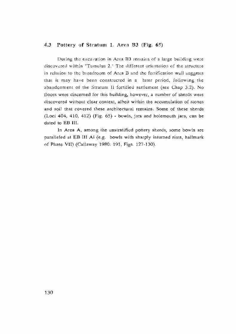
4.3 Pottery of Stratum 1. Area B3 (Fig. 65)
During the excavation in Area B3 remains of a large building were
discovered within "Tumulus 2." The different orientation of the structure
in relation to the broadroom of Area B and the fortification wall suggests
that it may have been constructed in a later period, following the
abandonment of the Stratum II fortified settlement (see Chap 3.2). No
floors were discerned for this building, however, a number of sherds were
discovered without clear context, albeit within the accumulation of stones
and soil that covered these architectural remains. Some of these sherds
(Loci 404, 410, 412) (Fig. 65) - bowls, jars and holemouth jars, can be
dated to EB Ill.
In Area A, among the unstratified pottery sherds, some bowls are
paralleled at EB III Ai (e.g. bowls with sharply inturned rims, hallmark
of Phase VII) (Callaway 1980: 191, 127-130).
130
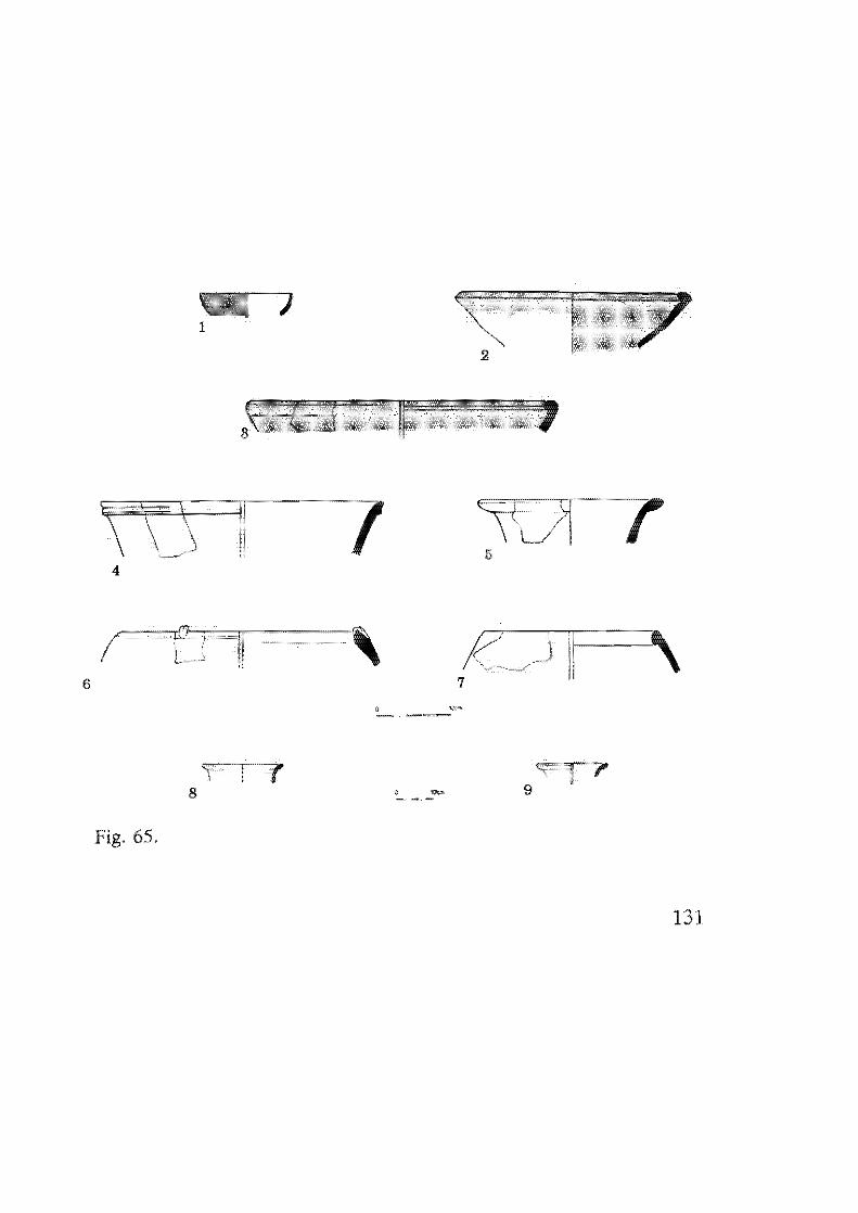
1
\U 7 7 4
6
9
Fig. 65.
131
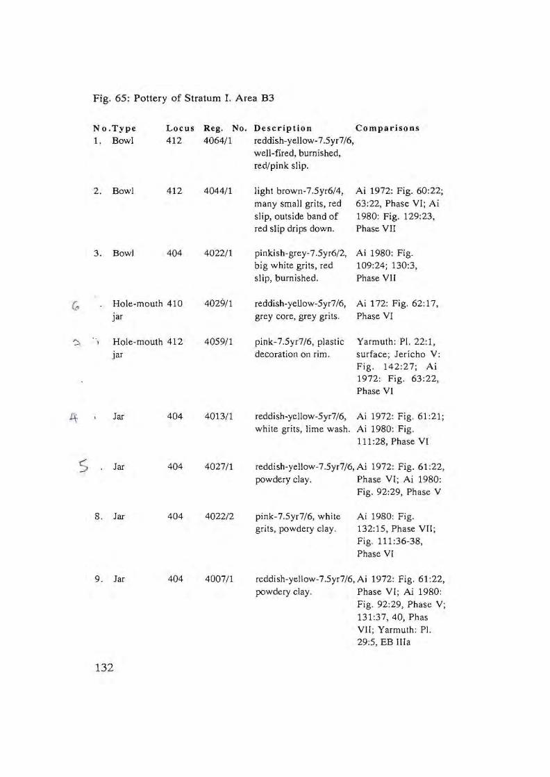
Fig. 65: Pottery of Stratum I. Area 83
No.Type Locus Reg. No. Description Comparisons 1. Bowl 412 4064/1 reddish-yellow-7.Syr7/6,
well-fired, burnished, red/pink slip.
2. Bowl 412 4044/1 light brown-7.5yr6/4, Ai 1972: Fig. 60:22; many small grits, red 63:22, Phase VI; Ai slip, outside band of 1980: Fig. 129:23, red slip drips down. Phase VII
3. Bowl 404 4022/1 pinkish-grey-7 .Syr6/2, Ai 1980: Fig. big white grits, red 109:24; 130:3, slip, burnished. Phase VII
(~ Hole-mouth 410 4029/ 1 reddish-yeUow-Syr7/6, Ai 172: Fig. 62:17,
jar grey core, grey grits. Phase VI
~ Hole-mouth 412 40S9/ 1 pink-7.5yr7/6, plastic Yarmuth: PI. 22:1,
iar decoration on rim. surface; Jericho V: Fig . 142:27; Ai 1972: Fig . 63:22, Phase VI
It Jar 404 4013/1 reddish-yellow-Syr7/6, Ai 1972: Fig . 61 :21; white grits, lime wash . Ai 1980: Fig.
111 :28, Phase VI
S Jar 404 4027/1 reddish-yellow-7.Syr7/6, Ai 1972: Fig. 61:22, powdery clay. Phase VI; Ai 1980:
Fig. 92:29, Phase V
8. Jar 404 4022/2 pink-7.Syr7/6, white Ai 1980: Fig. gri ts , powdery clay. 132:1S , Phase VII;
Fig. 111 :36-38, Phase VI
9. Jar 404 4007/1 reddish-yellow-7.5yr7/6, Ai 1972: Fig. 61 :22, powdery clay. Phase VI; Ai 1980:
Fig . 92:29, Phase V; 131:37, 40, Phas VII ; Yarmuth: PI. 29:S, EB lIla
132
Fig. 66. Early Bronze III Pottery from Survey (1975)
'\
\ ( ~ .. T J1 (
) , -- , !~ ,. -, '{ ,
" ---' • "--- _ ._~ _ _ O<"
No.Type Description Comparisons
1. Jar reddish-yelIow-5yr7/8. lime wash. Ai. 1980: Fig. 87:20. Phase
rv
2. Jar light grey-10yr7/2. small and big Ai 1972: 45:16. Phase V;
grits. Yarmuth: PI. 39:13; 45:20.
EB llJa-b
3. Jar light grey-l0yr7/2. big and small see Fig. 11 :5. SI. I
grits.
4. Jar reddish-yeliow-5yr7/8. many grits. see Fig. 11:4. SI. I
5. Bow l many grey grits. burnished inside
and on rim. slipped inside.
Ai 1980:191; Figs. 127-130.
Phase VII
6 . Holemoulh reddish-yeliow-5yr7/6. reddish-yeliow see Fig. 11 :6. SI. I
jar core. a few white grits. plastic
decoration on rim.
7. Plaller
(frag.)
yeliow-1 Oyr8/6. yeliow core. a
few grits. crisscross burnishing
pallern.
Yarmuth: Pis. 28; 30; 33; 42;
43. EB lIIa-b
133
4.4 Pottery Coated with Bitumen
About a dozen sherds of Jars and holemouth jars coated with
bitumen (some inside and some outside the vessel), were found in both
Areas A and B. The sherds were distributed throughout the various strata
(II-V).
The observation was corroborated by chemical analysis of two
coated sherds. Lumps of bitumen were also found, four of which were
analyzed. The chemical analyses, carried out by Mrs. Rosa Kopel at the
chemical laboratory of the Institute of Archaeology of Tel Aviv
University, indicate that the source of the bitumen was the Dead Sea,
based on the relatively high percentage of sulphur in the samples.
At Arad, from the EB J-ll strata (IV-I), both bitumen-coated
pOllery and lumps of bitumen from the Dead Sea have been uncovered
(Amiran et aJ. 1978:58; :Nissenbaum 1984).
134
Chapter 5.
THE FLINT ASSEMBLAGES ERICH FRIEDMANN
During the three seasons of excavation at Tel Dalit sieving was
carried out in all areas, and all flint pieces collected. Despite the modest
size of the excavated area, the flint assemblage represents a complete
Early Bronze flint tool kit from Israel, and is thus an important
contribution to lithic studies.
Table 1: The General Components of the Lithic Industry
Canaanean blades 4 1.0 %
Broken Canaanean blades 224 56.6 %
Canaanean sickle blades 46 11.5 %
Broken Canaanean sickle blades 21 5.2 %
Tabular flint scrapers 17 4.7 %
Drills, borers and awls 5 1.3%
Burins 9 2.3 %
Notched pieces 7 1.8 %
End scrapers 8 1.6 %
Retouched blades 10 2.5 %
Retouched flakes 44 11.0 %
395.0 99.5 %
Cores 771 9.2%
Debitage 5482 65.8 %
Debris 2085 25.0 %
8338 100.0 %
135
The flint tool assemblage of Tel Dalit can be grouped into three
main industries (after Rosen 1989): 1) Canaanean blade industry; 2)
Tabular flint scraper industry; 3) Various tools (ad hoc elements).
At the time of processing of the excavated material, special
attention was given to finds from Broadroom 115·152 in Area B in an
attempt to discern the function of areas based on tool types.
Table 2: The Relative Percentages of Tool Groups According to Areas
Tool Area A % Area % Are. B3 % Area C % Total %
Cannannean 150 62 61 54 13 40 2 50 228 57.S
blades
Canaanean 35 14 22 19 12 40 67 16.7
sickle
blades
Tabular flint 12 5 3 2 19 4.7
Various 45 188 28 25 6 18 2 50 81 20.6
242 114 33 4 395 99.5
Description of Tools
Canaanean Blades and Sickle Blades. These were found in all the
excavated areas, and comprise aimosl 75% of the 1001 assemblage; mas!
of Ihem were broken (see Table 1). They were not made on local flint,
and no Canaanean blade cores were found at the site. Two types of sickle
blades can be discerned: long blades (ca. 10 em. or longer) (Fig.1 :3),
probably best defined as reaping knives, and short sickle blade segments
which were inserted into a sickle haft. These were finely retouched on the
back and sometimes on the ventral face, and gloss is seen clearly on both
sides. (Fig.1 :4). The average dimensions of (complete) blade segments
from Tel Dalit are 4.84 em. length, 1.95 em. width, 0.55 thick. Most of
136
the Canaanean blades have a trapezoidal section (Neuville 1930) (Table
3).
It should be noted that a single crescent-shaped sickle blade was found in
Broadroom 115-152 (Fig.l:2).
Table 3: Canaanean Blades and Sickle Blades According to Sections
Trapezoidal
Triangular
251
44
295
Table 4: Sickle Gloss on Working Edges
Tool
Canaanean blade
Broken Canaanean blades
Canaanean sickle blades
Broken Canaanean sickle blades
Total
4
224
56
21
109
85.0 %
14.9 %
99.9 %
With Gloss
1
70
24
14
295
Canaanean sickle blades and fragments are identified as such
according to shape and retouch, when they can be identified with near
certainty as having belonged to a complete sickle that was hafted with a
handle. Other fragments J;II ust remain within the category of broken
Canaanean blades, even if they may possibly have been unretouched
sickle blades. This distinction has not been previously emphasized.
137
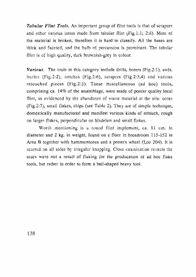
Tabular Flint Tools. An important group of flint tools is that of scrapers
and other various items made from tabular flint (Fig.l:l; 2:8). Most of
the material is broken, therefore it is hard to classify. All the bases are
thick and faceted, and the bulb of percussion is prominent. The tabular
flint is of high quality, dark brownish-grey in colour.
Various. The tools in this category include drills, borers (Fig.2:1), awls,
burins (Fig.2:2), notches (Fig.2:6), scrapers (Fig.2:3,4) and various
retouched pieces (Fig.2:5). These miscellaneous (ad hoc) tools,
comprising ca. 14% of the assemblage, were made of poorer quality local
flint, as evidenced by the abundance of waste material at the site: cores
(Fig.2:7), small flakes, chips (see Table 2). They are of simple technique,
domestically manufactured and manifest various kinds of retouch, rough
on larger flakes, perpendicular on blade lets and small flakes.
Worth mentioning is a round flint implement, ca. 11 cm. in
diameter and 2 kg. in weight, found on a floor in broad room 115-152 in
Area B together with hammerstones and a potter's wheel (Loc 204). It is
scarred on all sides by irregular knapping. Close examination reveals the
scars were not a result of flaking for the producation of ad hoc flake
tools, but rather in order to form a ball-shaped heavy tool.
138
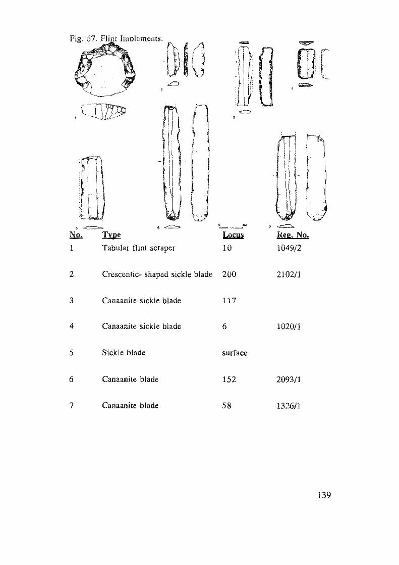
,cr~
err" n )1
ill) 5 ~ ____ :o=
\J'. ~.j , , ','
No. l:.ul! Locus
1 Tabular flint scraper 10
2 Crescentic- shaped sickle blade 200
3 Canaanite sickle blade 117
4 Canaani Ie sickl e blade 6
5 Sickle blade surface
6 Canaanite blade 152
7 Canaanite blade 58
me
Reg. No.
1049/2
2102/1
1020/1
2093/1
1326/1
139
Fig. 68. Flint Implements.
n.' u No.
1
2
3
4
5
6
7
8
140
VI , ,
=
7
Im!i
Borer
Burin
Scraper
Notch
Scraper
Scraper?
Tabular flint scraper
Core
,
•
Locus Reg. No.
1088/1
3 1005/2
10 1030/1
2 1007/1
7 1028/1
148 2047/2
51 1254/2
15 1057/1
Discussion
The raw material of the Canaanean blades, like that of the tabular
flint scrapers, is not of local origin, and some may have been made from
the same material as that of the tabular scrapers, apparently imported
from the south (Schick 1978:62; Rosen 1989:202). The rest of the tools
were manufactured locally, as evidenced by the abundance of waste
material (see Table 1). Most of the cores at Tel Dalit are small and of bad
quality.
The two types of Canaanean blades found at Tel Dalit are the long
reaping knife, and the blunted blade segments that were inserted into a
sickle haft. The Canaanean sickle blade is well known throughou t Israel
during the Early Bronze Age (Rosen 1983; 1989). The average
dimensions of EB Canaanean sickle blade segments are: width 1.5-3 cm.,
length 4-6 cm., and thickness .5 mm. (Rosen 1989:206). This fits well
with the average measurements of sickle blades from Tel Dalil.
The crescent-shaped sickle blade from Broadroom 115-152 is a
type recognized recently at sites in the arid zones - Negev and Sinai. Its
appearance here may indicate that this type was also used sporadically at
EB sites to the north of the arid regions (Haiman 1986; 1990:163; Fig.
18). Its existence is perhaps also indicated at EB Arad (Schick 1978:Fig.
85:2; 86:10).
The general components of the flint tool assemblage from Tel Dalit
are typical of other EB flint assemblages from sites north of the Beer
sheva Valley (e.g., Tel Yarmuth, Jericho, Arad), comprising Canaanean
blades, tabular flint scrapers and various "ad hoc" tools. However, the
relative quantities within the Tel DaHt assemblage, which is a sieved EB
flint assemblage, vary to certain degrees. At Tel Dalit Canaanean blades
make up ca. 75% of the assemblage, whereas this category is usually no
more than 25% (Rosen 1989:213), somewhat higher at Gamla (Olami
1989:115). On the other hand, ad hoc tools at Tel Dalit comprise ca.
14%, while at other sites they dominate the assemblages, ca. 70%
(ibid.:211). This discrepancy can not be explained merely as the result of
141
inadequate recovery techniques, which would be expected to produce
opposite results (Le., relatively more Canaanean blades). This relative
quantitative breakdown is consistent in both excavated areas of Tel Dalit,
A and B (see Table 2). It should be noted that within Broadroom 115-
152 in Area B, the quantity of complete sickle blades is remarkably high
(91 %), indicating that the sickles themselves were stored within the
domestic structure.
Another difference is the great abundance of raw material and
waste at Tel DaHt (see Table 1 - 8338 pieces), in contrast to the relatively
small amount of locally-produced tools (83). This discrepancy can
definitely be attributed to the recovery technique.
Tabular scrapers comprise 4.7% of the assemblage, corresponding
with a general trend of less than 7% of the assemblage (ibid:214) in EB
sites north of Arad. Tabular flint scrapers were imported from the south -
the arid zones of the Negev and Sinai, where they were much more
common within the flint assemblages (e.g., Beit-Arieh 1981; Rosen
1991). In the southern sites the Canaanean blade is almost unknown,
Arad being the southernmost extent of the Canaanean technology. This
radical difference is due to the lack of agricultural potential in the arid
zones, as well as cultural differences (Rosen 1989:214).
Acknowledgement
We thank llana Mosel who began the work of processing the lithic finds
from Tel Dalil.
142
Chapter 6.
SMALL FINDS SHELLEY SADEH
6.1 Cylinder Seals/Beads
Two bone cylindrical bead-like objects, possibly to be identified as
cylinder seals, were found at Tel Dalil. They are of squat shape. one from
Area B (Broadroom 115-152) lillie more than 1 em. high (Fig. 69:5), the
second, from Area A, less than 2 cm. high (Fig 70:2). The shorter one
bears an incised band of diagonal lines, the longer a band of herringbone
design.
A number of parallels to these objects can be found from sites in
Israel and Jordan. At Jericho a similar object - labelled "possibly a seal",
made of bone with an incised herringbone band, originated from an EB
II context (Kenyon 1960:Tomb A127, p. 91, Pl. 27:4), however it is
longer than our example (3.3 cm.). From Tel Dan cylinder seal
impressions dated to the EB II-Ill (Biran 1994: Fig. 19) include patterns
of lines and herringbones, alongside nets, waves and representational
(animal) designs. This lends weight to the suggestion that the objects
from Tel Dalit were indeed used as seals. From Megiddo also comes a
bone example bearing a herringbone design (Loud 1948: PI. 160:1);
from Bab edh-Dhra, Jordan a bone example with a net design (Schaub
and Rast 1989:465, 474; Fig. 270) and from Gezer a less similar example,
with a design of irregular lines (Maca lister 1912:PI. XXVlIl:21). Another
example, about 3 cm long, was found at Tell Abu al-Kharaz in Jordan, in
an EB II context (Fischer 1993: Fig. 12:11; PI. 111:59).
The cylinder seal from Tel Dalit fits into a general type of seals
known from the north to the south of the country in the EB Il-Ill. In
Ben-Tar's (1968) grouping of EB cylinder seal types, the herringbone
design is designated 5b, that with irregular lines as 5c. Such motifs, as well
as the "squat" shape, appear in the Jemdet Nasr period of Mesopotamia
(e.g. Buchanan 1966:4; No. 68).
143
( (] • , ,
-o,··-~ . ~. .
, ,
" 8· -'0 "
Fig. 69.
144
Fig. 69. Small Finds. Strata IV-II
No.Type Locus Reg. No. Description Comparisons 1. Ring 600 6006/1 chalk. Area C
2. Ring 601 6003/1 basal t. Area C
3. Ring'! 405 4018/2 chalk. Area B3
4. Figurine surface
5. Bead 107 40/2 bone, incised band of diagonal lines, Area B, S1. II
6, Bed model 306 3107/1 very pale brown-lOyr7/4, grey core, few grits, lime slip, Area B, SI. IlL
7. Grinding 305 3005/2 limestone, Area B, SI. III slone
8, Potter's 204 2182/1 basalt. Area B, SI. II wheel
9, Grinding 305 3005/1 limestone. Area B, SI. IV stone
10, Mortar 334 3079/1 limestone. Area B, SI. IV
11. Bead 202 2110/1 chalk. Area B, SI. II
12. Spindle 174 2271/1 reddish-yellow-5yr7/6. Arad; PI. 120;10-16, Whorl S1. IV-I
145
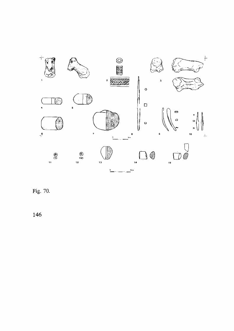
3
o
( 10 , 5
i 0
o
• , • • 10 o J~ .. -----.-
® @ CD 00
" U J:'.<~. -_._-- .. -
Fig. 70.
146
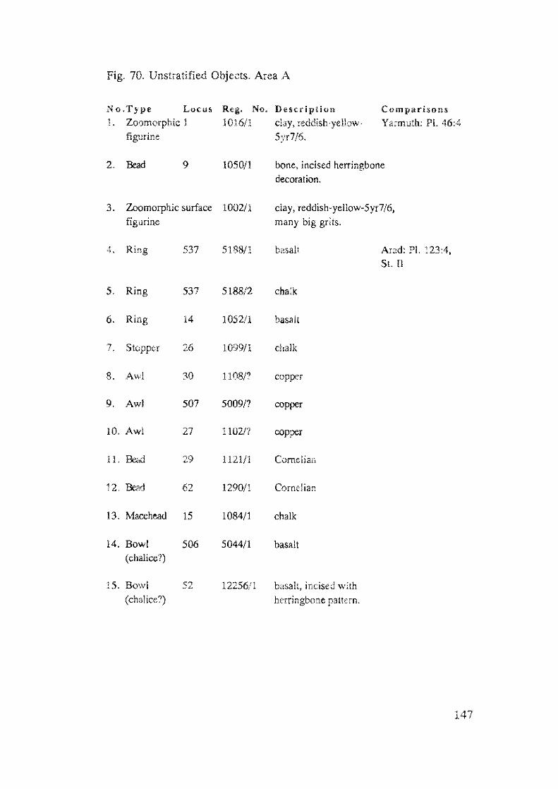
Fig. 70. Unstratified Objects. Area A
No.Type Locus Reg. No. Description Comparisons 1. Zoomorphic 1 1016/1 clay, reddish-yellow- Yarmuth: Pi. 46:4
figurine 5yr7/6.
2. Bead 9 1050/1 bone, incised herringbone decoration.
3. Zoomorphic surface 1002/1 clay, reddish-yellow-5yr7/6, figurine many big grits.
4. Ring 537 5188/1 basalt Arad: PI. 123:4, St. II
5. Ring 537 5188/2 chalk
6. Ring 14 1052/1 basalt
7. Stopper 26 1099/1 chalk
8. Awl 30 1108/? copper
9. Awl 507 50091: copper
10. Awl 27 110217 copper
11. 29 1121/1 Comelian
12. Bead 62 1290/1 Cornelian
13. Macehead 15 1084/1 chalk
14. Bowl 506 5044/1 basalt (chalice?)
15. Bowl 52 12256/1 basalt, incised with (chalice?) herringbone pattern.
147
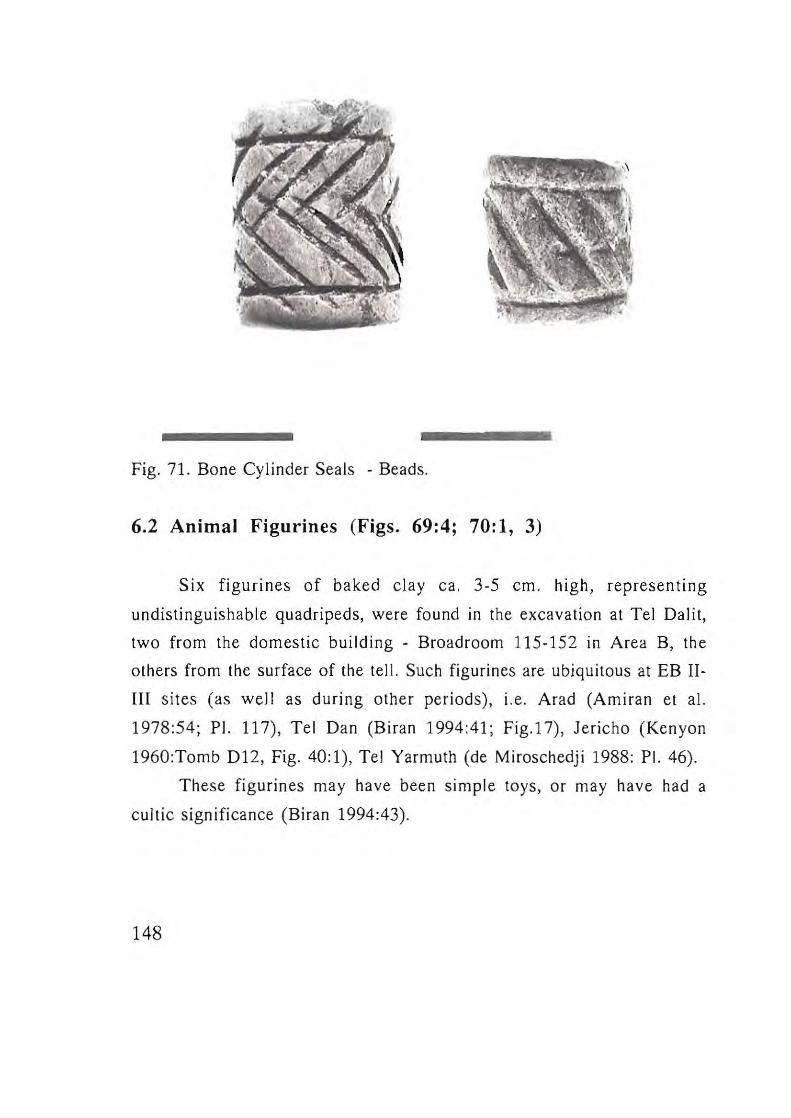
Fig. 71. Bone Cylinder Seals - Beads.
6.2 Animal Figurines (Figs. 69:4; 70:1, 3)
Six figurines of baked clay ca. 3-5 cm. high, representing
undistinguishable quadripeds, were found in the excavation at Tel Dalit,
two from the domestic building - Broadroom 115-152 in Area B, the
others from the surface of the tell. Such figurines are ubiquitous at EB II
m sites (as well as during other periods) , i.e. Arad (Amiran et aJ.
1978:54; PI. 117), Tel Dan (Biran 1994:41 ; Fig.17), Jericho (Ken yon
1960:Tomb D1 2, Fig. 40:1), Tel Yarmuth (de Miroschedji 1988: PI. 46).
These figurines ma y have been simple toys, or may have had a
cultic significance (Biran 1994:43).
148
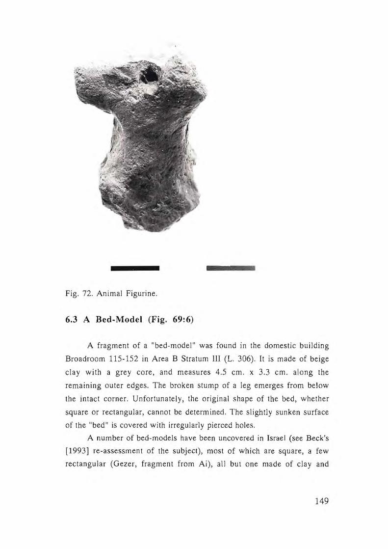
1 •
Fig. 72. Animal Figurine.
6.3 A Bed-Model (Fig. 69:6)
A fragment of a "bed-model" was found in the domestic building
Broadroom 115-152 in Area B Stratum 1lI (L. 306). It is made of beige
clay with a grey core, and measures 4.5 cm. x 3.3 cm. along the
remaining outer edges. The broken stump of a leg emerges from below
the intact corner. Unfortunately, the original shape of the bed, whether
square or rectangular, cannot be determined. The slightly sunken surface
of the "bed" is covered with irregularly pierced holes.
A number of bed-models have been uncovered in Israel (see Beck's
[1993] re-assessment of the subject), most of which are square, a few
rectangular (Gezer, fragment from Ai), all but one made of clay and
149
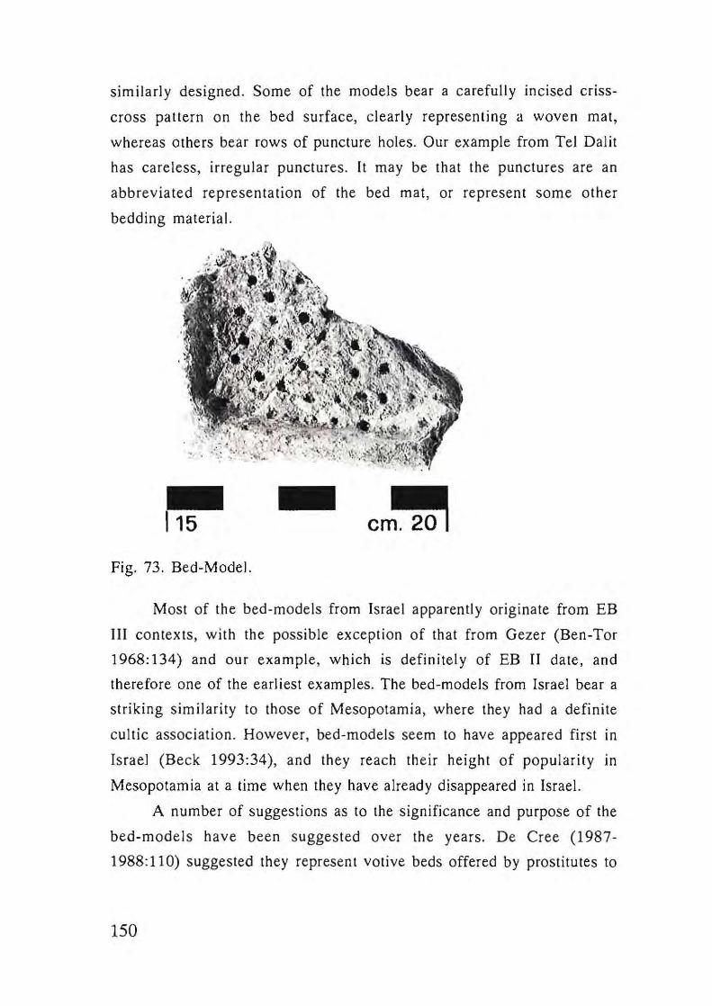
similarly designed. Some of the models bear a carefully incised criss
cross pattern on the bed surface, clearly representing a woven mat,
whereas others bear rows of puncture holes. Our example from Tel Dalit
has careless, irregular punctures. It may be that the punctures are an
abbreviated representation of the bed mat, or represent some other
bedding material.
Fig. 73. Bed-Model.
Most of the bed-models from Israel apparently originate from EB
III contexts, with the possible exception of that from Gezer (Ben-Tor
1968:134) and our example, which is definitely of EB II date, and
therefore one of the earliest examples. The bed-models from Israel bear a
striking similarity to those of Mesopotamia, where they had a definite
cultic association. However, bed-models seem to have appeared first In
Israel (Beck 1993:34), and they reach their height of popularity In
Mesopotamia at a time when they have already disappeared in Israel.
A number of suggestions as to the significance and purpose of the
bed-models have been suggested over the years. De Cree (1987-
1988: 11 0) suggested they represen t votive beds offered by prostitutes to
150
a temple goddess. However, as a number of the models in Israel have
been found in non-temple contexts, and at Tel Dalit and Leviah in
domestic buildings, Beck has suggested that the square beds are model
birth-stools, part of a woman's "kit" of amulets (Beck 1993:38).
6.4 Macehead (Fig. 70: 13)
A single piriform macehead of hard limestone measuring 6.3 cm.,
was found on the surface in Area A. The central hole was drilled from the
bottom. Piriform is the most common shape of maceheads from EB II-III
contexts, although spherical examples are also known (Ben-Tor 1968:53),
therefore shape is apparently not of chronological significance. However,
at Arad the two examples from Stratum IV (EB Ib) are piriform, one
made of soft chalk, the other of hard limestone, while those of Stratum II
are spherical. Unfortunately, none were found from Stratum III, therefore
it is unknown if at this stage the two types existed contemporaneously. A
piriform example from Jericho (Tomb F2) is made of alabaster.
6.5 Stone Rings (Figs. 69:1-2j 70:4-6)
Twelve stone rings (7 complete,S partial) were found at Tel Dalit in
Areas A, Band C, five of basalt, seven of limestone. They range in size
from ca. 3 1/2 to 5 cm. in diameter. Such rings have been found at many
EB sites (e.g. Jericho: Kenyon and Holland 1982: PI, 254, 256-7;
Megiddo: Guy 1938: PI, 76; Arad: Amiran et al. 1978: PI. 76; Ai:
Callaway 1972:157, Fig, 42:39; 1980:124, Fig. 84), and their function is
unclear - 100m weights or spindle whorls. Some of them are similar to the
later spherical type of macehead, such as the example in Fig. 69:3,
However, this chalk ring is unlikely to have been a macehead due to the
soft material, and may have been a drill grasp (Sebanne: pers. comm.),At
Arad a distinction between maceheads and rings is noted according 10 the
151
straightness of the piercing (Ami ran et al. 1978:52). At Arad they were
often found in pairs, and a pair, of unequal size, was also found at Tel
DaHt - Baskets 51881-51882, Loc. 537A, Area A (Fig. 70:4-5).
6.6 Copper Awls (Fig. 70:8)
One complete example was found, straight, measuring 10.5 cm.
long, 0.6 cm. at mid-point. It is unusual in that the upper, working part,
has a round section, while the lower part has a square section which
probably was inserted into a handle (Shalev 1992:116). Two partial awls,
one straight and one curved, have square sections. Similar copper awls
from EB contexts, both straight and curved with square sections, can be
seen, for example, from Tel Yarmuth (de Miroschedji 1988: PI. 48:15-
16), Jericho (Kenyon and Holland 1982: Fig. 229:2-3), EB II Arad Strata
II-III (Amiran et al. 1978:55; PI. 70-71; I1an and Sebbane 1989) and
Nabi Salah in the Sinai (Beit-Arieh 1974: PI. 29:2-3).
152

Chapter 7.
SUMMARY AND CONCLUSIONS: TEL DALIT AND ITS EARLY BRONZE AGE CULTURAL AND TERRITORIAL SETTING
RAM GOPHNA
Sixteen years have elapsed since the unexpected interruption of the
excavations at Tel Dali!. Meanwhile, some important reports of
excavations of Early Bronze Age sites conducted in the 19608, 19708 and
19805 have been published, including Jericho (Kenyon 1981 ; Kenyon
and Holland 1982; 1983), Gezer (Seger 1988), Bab edh-Dhra (Shaub and
Rast 1989), Tel Halif (Seger 1990), 'En Besor (Gophna 1995a).
Excavations have been renewed at other large sites, e.g. Yarmuth (de
Miroschcdji 1988), Tel Beth Shan (Mazar 1994), Tel Megiado (Ussishkin
1994) and most recently at Beth Yerah (Getzov 1996). Furthermore, new
excavations have taken place at smaller sites, many dating to I, e.g.
En Shadud (Braun 1985), Iphtahel (Braun 1994), Palmahim (Braun
1992) and Tel Esur (Yanai 1995). In the central coastal plain there have
been salvage excavations of EB I sites, e.g. Shoham (Nadelman 1995)
and Azor (Golani and van den Brink, forthcoming), which have direct
bearing on the history of settlement of Tel Dal it and its environment
during the Early Bronze Age I. In Jordan as well, excavations at
important EB sites have been carried out, and preliminary and ful!
excavation reports have been published, including Jawa (Betts 1991), Tell
Urn Hammad (BellS 1992), Tell esh-Shuna North (Baird and Philip
1994), Kh. ez-Zeraqon (Ibrahim and Mittmann 1994) and Tell es
Saidiyeh (Tubb and Dorrell 1994; 1996). In addition, a number of
comprehensive as well as partial syntheses of the Early Bronze Age have
been published by Richard (1987), Esse (1991), Stager (1992), Ben-Tor
(1992), Joffe (1993) and Gophna (1995a). This abundance of field work
and publications of the lasl 16 years must be taken into consideration
when we come to summarize the small-scale excavation at Tel Dalit and
153
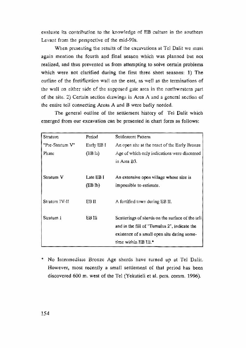
evaluate its contribution to the knowledge of EB culture in the southern
Levant from the perspective of the mid-90s.
When presenting the results of the excavations at Tel Datit we must
again mention the fourth and final season which was planned but not
realized, and thus prevented us from attempting to solve certain problems
which were not clarified during the first three short seasons: 1) The
outline of the fortification wa II on the east, as well as the terminations of
the wall on either side of the supposed gate area in the northwestern part
of the site. 2) Certain section drawings in Area A and a general section of
the entire tell connecting Areas A and B were badly needed.
The general outline of the settlement history of Tel DaHl which
emerged from our excavation can be presented in chart form as follows:
Stratum
"Pre-Stratum V"
Phase
Stratum V
Stratum IV-II
Stratum I
Period
Early EB I
(EB la)
Late EB I
(EB Ib)
EB II
EB III
Settlement Pattern
An open site at the onset of the Early Bronze
Age of which only indications were discerned
in Area B3.
An extensive open village whose size is
impossible to estimate.
A fortified town during EB II.
Scallerings of sherds on the surface of the tell
and in the fill of "Tumulus 2", indicate the
existence of a small open site dating some
time within EB III.'
• No Intermediate Bronze Age sherds have turned up at Tel Dali!.
However, most recently a small settlement of that period has been
discovered 600 m. west of the Tel (Yekutieli et al. pers. comm. 1996).
154
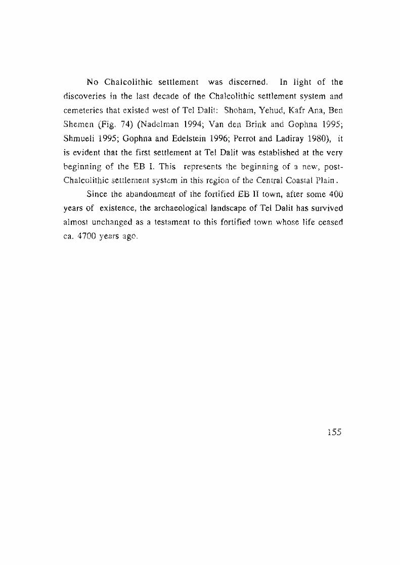
No Chalcolithic selliement was discerned. In light of the
discoveries in the last decade of the Chalcolithic settlement system and
cemeteries that existed west of Tel DaHl: Shoham, Yehud, Kafr Ana, Ben
Shemen (Fig. 74) (Nadelman 1994; Van den Brink and Gophna 1995;
Shmueli 1995; Gophna and Edelstein 1996; Perrot and Ladiray 1980), it
is evident that the first settlement at Tel DaHt was established at the very
beginning of the EB 1. This represents the beginning of a new, post
Chalcolithic settlement system in this region of the Central Coastal Plain.
Since the abandonment of the fortified EB II town, after some 400
years of existence, the archaeological landscape of Tel DaHt has survived
almost unchanged as a testament to Ihis fortified town whose life ceased
ca. 4700 years ago.
155
N. YOfkon
• T. Gerisa • 7·. Bnei Beraq Tel Aviv
•••• Givataim
• Khiriya
Azar •• 'I-
. -tvo/- Ona • . 0"
.Yehud
T. Lad.
. aT. Boreket . ... ..... •• IShohom
O~T. DAUT .. EI-Hubban
Ben She men •• ~ ..
Polmoh,m
;
Mizpeh Madiim
LB. I
LB. II
• LB. III o Sk m - -
.-0 T. Gimza
40T. Gezer
Fig. 74. Chalcolithic and EB Sites in the Lower Yarkon-Ayalon Drainage
Basin
156
Material Culture, Subsistence and Economy
The EB I-II ceramic repertoires from Tel DaHl present a picture of
an intermingling of both northern and southern ceramic elements, which
makes it difficult to attribute our site 10 either one of these traditions (see
Chap. 4). It seems appropriate at this stage of research \0 regard the Tel
Dalil assemblages, from a regional point of view, as representing a "grey"
area between the north and south, where sub-cultural spheres met and
intersected. This of course fits the geographical situation - and thus the
term we use here "Central Coastal Plain" has both a geographical as well
as a cultural meaning. This concept of a "central" region can also be
extended to include the major sites of Ai in the central highlands, and
Jericho, in the lower Jordan Valley. in other words, the Central Coastal
Plain is only part of a larger "intermediate" cultural region during the EB
I -II,
The finds from Tel DaHt reveal that the inhabitants of both the
open, EB I site and the fortified EB II town were engaged in mixed
farming in this heartland of the Mediterranean Zone. The high
percentage of Canaanite sickle blades (75%) in the lith assemblage
gathered in excavation Areas A and B (Chap. 5), and especially the
complete sickle blades found in Broadroom J 15-152 (91% of the
assemblage from this room), testify to the importance of cereals and
pulses in the economy of the inhabitants of Tel DaHt. The abundance of
charred olive stones and olive wood found in the excavations is evidence
of the cultivation of olive trees (see Chap, 9),
From the archae020010gical analysis (Chap. 10) it appears that the
inhabitants of Tel Dalit raised mainly sheep and goats, as well as cattle,
pigs, donkeys and dogs, and hunted a variety of wild game, e.g. gazelle
and fowl. The remains of fish bones (probably from dried fish), may
indicate inter-site trade connections with sites such as Aphek on the
Yarkon River, or siles further west. Such inter-regional trade connections
are also indicated by certain pottery vessels originating in the north, i.e,
the metallic platters (Fig. 50), and a number of vessels containing basaltic
sand (Figs, 40:15; 48:16) (Goren 1992), certain flint blades (Chap. 5),
157
bitumen (Chap. 4.4) and copper and basalt artifacts.
The population size of Tel DaHt can be estimated, based on the
coefficient of 20-25 persons per 1000 m2, as 800-1000 persons (see
Gophna and Portugali 1988). If we reduce the overall area of the tell by
the areas which are today barren of settlement debris (ca. 5000 m2), it is
possible to estimate the size of the EB Il population more exactly as
between 700-875 persons.
According to the model elaborated by Gophna and others (Gophna
et a1. 1986-1987: 80; Table 3), the estimated area of agricultural
exploitation is 0.75 hectare per capita, thus the population of Tel Dalit
needed at least 525 hectares of agricultural land. Past ural land is
estimated at 1.5 hectares per capita, therefore Tel Dalit utilized ca. 1050
hectares of pasturage. Thus ,Tel Dalit's total agricultural impact on its
surrounding environment covered some 1575 hectares (15.75 km.2).
Tel Dalit: A Model Of Settlement, Urbanization and Shifting Urban
Landscapes During the Early Bronze Age
The medium-sized, fortified EB II town of Tel Dalit (covering ca. 4
hectares), was situated between two contemporary larger towns (covering
ca. 10 hectares each), Aphek to the north and Gezer to the south, which,
like Tel Dalit, were deserted before the advent of EB Ill. However, unlike
Aphek and Gezer, Tel Dalit is also one of a large group of EB II towns
whose ruins are found in most regions of lsrael and Jordan, which were
not resettled in MB II, and some of which were never resettled. The
history of settlement at Tel Dalit seems to represent another countrywide
phenomenon, stretching from Meona in the Upper Galilee to Arad in the
northern Negev, of sites which flourished in the EB II, and were then
abandoned and not refortified or resettled during EB III (Fig. 75). This
phenomenon of relatively short-lived fortified towns, therefore, can well
be designated the first urban sub-phase in the long history of the
urbanization process during the Early Bronze Age of Palestine. However,
it should be noted that large, open, unfortified EB II sites also met a
similar fate, e.g. Qiryat Ala (Golani 1993).
158
.Meona
--> - _ . - - . -" .. . _-- - _. "
_ ... -_ . -c=.. _ _ ~ ____ _
-- .. ---~ - . _._-- -
-- - .---- -----------
Tel Kinrot
• Mizpeh Zevulun
Tell Abu el~araz
Tell el-Fara. Tell es-Saidiyeh
• Kh. el-Mokhruk •
• Tel Aphek
• Tel Boreqet • Tel Dolit
.Tel Gezer
Tel Arad.
'1..0 ___ ~_~30km.
Fig. 75. Abandoned EB II Walled Towns.
159
As mentioned above, Tel Dalit was one of a number of EB sites
which were situated within the ecological niche between Aphek and Gezer
(see Chap. 1.2), three of which were fortified, urban-like settlements
during EB II: Tel DaJiI, Tel Bareqet and probably also Tel Gimzo. It
appears that EB II Tel Dalit dominated a territory stretching between
Aphek and Gimzo, with a smaller fortified EB II satellite town, Tel
Bareqet, located 4 km. to the north (Gophna 1989). This type of political
entity with a hierarchical system of settlements is sometimes termed a
"peer polity" (see Finkelstein 1995:48; Renfrew 1986).
The history of settlement at Tel Dalit, as revealed in the excavations,
demonstrates the first severe settlement crisis already at the end of EB I, a
crisis also evident at other sites in the Central Coastal Plain, e.g. Shoham
(North), Lod and Azor (Gophna 1989; Portugali and Gophna 1993; but
see also Finkelstein 1995). However, the beginning of the urbanization
process at Tel Dalit seems very similar to that revealed at Arad: levelling
of the late EB I open settlement and the subsequent construction of a new,
planned fortified town on its debris. At EB Il Arad there was a substantial
reduction in the area of the fortified town compared to the area of the
earlier EB I open settlement (Portugali and Gophna 1993:181).
Unfortunately at Tel Da!it it is impossible to estimate the difference
between the extent of the EB I open site and that of the II fortified
town. According to data unearthed at Aphek to the north, it seems that
this site was already fortified at the end of EB I (Kochavi 1993). At
Gezer, on the other hand, until today no EB fortification wall has been
detected, and thus here also the extent of the site in the EB I as compared
to the EB II cannot be determined.
The final abandonment of these fortified towns in the EB ll, unlike
Ai to the east which was refortified in the EB Ill, exemplifies a model of
arrested development of tlourishing EB II fortified towns which is now
evident throughout Israel. As a result of the data from excavations at Tel
Dalit, Aphek and Gezer it is now apparent that there was a severe
settlement crisis during the EB Il, part of a more general phenomenon
already known from Tell el-Farah (N) in Samaria and Arad in the
160
northern Negev (Kempinski 1978), and observed more recently
throughout the Samarian hill country (Zertal 1993), in the northern
regions of the country (e.g. Meona in the Upper Galilee [Braun 1996]),
and also in the Middle Jordan Valley (e.g. Tell Abu al-Kharaz [Fischer
1993; 1994) (see map Fig. 75).
As at Tel Dalit, also at Aphek and Gezer, meagre pottery evidence
was found of a negligable occupation in EB III. It appears that during EB
III the centre of population and settlement in the Central Coastal Plain
may have shifted to Tel Gimzo (Gophna 1989).
As mentioned above, it is now clear that the crisis and desertion
which took place at Tel DaHt sometime during the EB II represents a
countrywide phenomenon of abandonment of walled towns as well as
open sites during this period, and thus the question must be posed: what
was the cause of this abandonment of flourishing EB II settlements over
vast areas of the country? Furthermore, what were the dynamics of the
process which resulted in certain sites surviving and continuing to flourish
into EB III, e.g. Hazar, Dan, Beth-Yerah, Ai, Jericho, Yarmuth, and Tel
Erani; and new fortified towns to spring up during the EB III, e.g. Leviah
(Kochavi 1994), Kh. ez-Zeraqon, Tel Hesi, Tel Halif and others? (Gophna
1995a: 275-276).
In the light of a recent meticulous analysis of the urbanization
process throughout the Early Bronze Age,· it is becoming more and
more apparent that the process of establishment of fortified towns, and
their temporary or complete abandonment, continued throughout this
long period. Furthermore, it appears that regional or countrywide
settlement crises such as those discerned at the end of EB ! and during EB
II (as described above), continued into the EB !II (e.g. Tel Halif and Tel
Hesi) (Seger 1989). Thus, we are still far from restoring the intricate
patterns of shifting EB urban landscapes, demographic fluctuations and
shifting population centers in any given phase, which would in turn aid us
in reconstructing the political-territorial divisions of the country.
161
Eventually, such reconstructions will enable a revision of the sub
phasing of the long EB urban period, and relieve us of the legacy of
Wright's traditional dual phasing (EB II-II) (Gophna 1995a:275-275). It
would appear that the combination of spatial and stratigraphical analyses
of the urban settlements of each phase, and their ceramic sequences, may
indeed lead us to the realization of this goal
("this analysis was carried out during an MA seminar held at Tel Aviv
University in 1996, directed by Ram Gophna)
162
REFERENCES
Amiran, R. and Han, 0. 1993. Arad. NEAEHL I: 75-82. Jerusalem.
Amiran, R. et al. 1978. Early Arad. I The Chalcolithic Settlement And
Early Bronze City: First-Fifth Seasons of Excavations 1962-1966.
Jerusalem.
Baird, D. and Philip, G. 1994. Preliminary Report on the Third (1993)
Season of Excavations at Tell esh-Shuna North. Levant XXVI: 111-
133.
Beck, P. 1985. An Early Bronze Age "Family" of Bowls From Tel Aphek.
Tel Aviv 12: 17-28.
Beck, P. 1993. Early Bronze Age "Bed-Models" Reconsidered. Tel Aviv
20: 33-40.
Beil-Arieh, 1. 1974. An Early Bronze Age II Site at Nabi Salah In
Southern Sinai. Tel Aviv 1: 144-156.
Beit-Arieh, L 1981. An Early Bronze II Site Near Sheikh Awad in
Southern Sinai. Tel Aviv 8: 95-122.
Beit-Arieh, I. 1991. An Early Bronze III Settlement al Tel 'Ira In the
Northern Negev. IE] 41: 1-18.
Ben-Tor, A. 1968. Problems In the Early Bronze Age lI-Illln Palestine.
(Ph.D. Thesis). Jerusalem. (Hebrew).
Ben-Tor, A. 1975. The First Season of Excavations at Tel Yarmouth,
1970. Qedem 1: 56-86.
Ben-Tor, A. 1992. Introduction: Early Bronze Age Dwellings and
Installations. In:Kempinski, A. and Reich, R. (eds). The Architecture
of Ancient Israel. Jerusalem.
Ben-Tor, A. 1992. The Early Bronze Age. In: Ben-Tor, A. (ed.). The
Archaeology of Ancient Israel. New Haven and London.
Ben-Tor, A. 1993. Jarmuth, Tel. NEAEHL II: 661-665.
Ben-Tor, A. 1993. Qashish, Tel. NEAEHL IV: 1200-1203.
Betts, A.V.G. (ed.). 1991. Excavations at ]awa 1972-1986. Edinburgh.
Betts, A.V.G. (ed.). 1992. Excavations at Tell Um Hammad: The EtNly
Assemblages (EB I-II). Edinburgh.
163
Biran, A. 1985. Tel Dan, 1984.IE1 186-189. (Notes and News).
Biran, A. 1994. Biblical Dan. Israel Exploration Society. Jerusalem
(Hebrew).
Braun, 1985. En Shadud: Salvage Excavations at a Farming
Community in the 1ezreel Valley, Israel. Oxford (BAR International
Series 249).
Braun, 1989. The Problem of the Apsidal House: New Aspects of
Early Bronze I Domestic Architecture In Israel, Jordan and
Lebanon. PEQ :1-43.
Braun, E. 1992. Palmahim Quarry. Excavations and Surveys in Israel
10: 21-23.
Braun, E. 1994. Yiftahel: Salvage and Rescue Excavations at a
Prehistoric Village in Lower Galilee, Israel. Jerusalem: Israel
Antiquities Authority (Internal Publications).
Braun, E. 1996. Salvage Excavations at the EB Site of Meona: Final
Excavation Report. Atiqot 28: 1-3 L
Broshi, M. and Gophna, R. 1984. The Settlements and Population of
Palestine During the Early Bronze Age II-JIl. BASOR 253: 41-53.
Buchanan, B. 1966. Catalogue of Ancient Near Eastern Seals in the
Ashmolean Museum. VoL L Cylinder Seals. Oxford.
Callaway, J.A. 1964. Pottery From the Tombs of 'Ai. London.
Callaway, 1.A. 1972. The Early Bronze Age Sanctuary at 'Ai (Et-Tell).
London.
Callaway, J.A. 1980. The Early Bronze Age Citadel and Lower City at 'Ai
(Et-Tell). Cambridge, USA
Crowfoot, I. 1935. Noles on the Flim Implements of Jericho, 1935. LAAA
22.
Crowfoot, J. 1937. Notes on the Flint Implements of Jericho, 1937. LAAA
22.
De Cree, F. 1987-1988. Votive Beds in the Rockefeller Museum,
Jerusalem. A Case of Mesopotamian Intluence In IIIrd Millennium
Palestine? Acta Archaeologica Lovaniensia 26-27:109-111.
Damati, E., Yeivin, and Eisenberg, E. 1993. Makhruq, Khirbet EI-.
164
NEAEHL III: 929-932.
Dan, Y., Yaa}on, D.H., Koyumjinsky, H. and Raz, Z. 1975. Soil Mops 0/ Israel. Israel Ministry of Agriculture.
Dever, W.G. et al. 1974. Gezer ll, Report of 1976-70 Seasons in Fields I
and ll. Jerusalem.
Dothan, M. 1959. Excavations at Meser, 1957. Preliminary Report On the
Second Season. IE] 7: 13-29.
Eitan, A., Beck, P. and Kochavi, M. 1993. Aphek (In Sharon). NEAEHL I:
62-72.
Engberg, R.H. and Shipton, G.M. 1934. Notes on the Chalcolithic and
Early Bronze Age Pottery of Megiddo. Chicago.
Esse, D.L. 1991. Subsistence, Trade and Social Change in Early Bronze
Age Palestine. (Studies in Ancient Oriental Civilization, No. 50).
Chicago.
Finkelstein, 1. 1993. Northern Part of the Maps of Beit Sira, RamaUah and
EI-Bireh (Sites 1-102). In: Finkelstein, 1. and Magen Y. (eds.).
Archaeological Survey of the Hill Country of Benjamin. Jerusalem.
Finkelstein, 1. 1995. Two Notes on EB Urbanization and Urbanism. Tel
Aviv 22: 47-{i9.
Fischer, P.M. 1993. Tell Abu AI-Kharaz. the Swedish Jordan Expedition
1991. Second Season Preliminary Excavation Report. ADA]
XXXVlI:279-305.
Fischer, P.M. 1994. Tell Abu AI-Kharaz. The Swedish Jordan Expedition
1992. Third Season Preliminary Excavation Report. ADA]
XXVIII : 127 -145.
Fitzgerald, G.M. 1934. Excavations at Beth-Shan in 1933. PEF Q St 67:
123-134.
Fritz, V. 1993. Kinneret: Excavations at Tell el-'Oreimeh (Tel Kinrot)
1982-1985 Seasons. Tel Aviv 20: 187-215.
Getzov, N . 1996. Beth Yerah 1994. Hadashot Archeologiot 105
(Hebrew).
Golani, A. 1993. Qiryat Ata. Excavations and Surveys in Israel 13:30-
31.
Gophna, R. 1974. The Settlement of the Coastal Plain of Eretz Israel
During the Early Bronze Age. (Unpublished Ph.D. Dissertation).
165
Tel Aviv University. (Hebrew).
Gophna, R. 1985. Excavations at 'En Besor, 1976. 'Atiqot XIV: 9-16.
Gophna, R. 1993. Tel Dalil. NEAEHL I: 318-320.
Gophna, R. 1995a. Early Bronze Age Canaan: Some Spatial and
Demographic Observations. In: Levy, T.E. (ed.). The Archaeology
and Society in the Holy Land. London: 269-280.
Gophna, R. 1995b. Excavations at 'En Besor. Tel Aviv.
Gophna, R., LiphschilZ, N. and Lev-Yadun, S. 1986-1987. Man's Impact
on the Natural Vegetation of the Central Coastal Plain of Israel
During the Chalcolithic Period and the Bronze Age. Tel Aviv 13-
14:71-84.
Gophna, R. and Feldstein, A. 1996. Kafr Ana. (n.d.).
Goren, Y. 1992. Petrographic Analysis of the Early Bronze Age 1-1I1
Ceramic Assemblages from Tel Dalil. (Unpublished Internal
Report).
Greenberg, R. 1996. A Third Millenium Levantine Pottery Production
Center: Typology, Petrography and Provenance of the Mettalic
Ware of Northern Israel and Adjacent Regions. BASOR 30l.
Guy, P.L.O. 1938. Megiddo Tombs. Chicago.
Haiman, M. 1986. Archaeological Survey of Israel. Map of Har Hamran
Southwest (198) 10-00. Jerusalem: 58-122. (Hebrew section).
Haiman, M. 1990. The Early Bronze Age in the Western Negev
Highlands. EI 21:152-166 (Hebrew).
Hennessy, J.B. 1967. The Foreign Relations of Palestine During the Early
Bronze Age. London.
Higgs, E.S. 1975. (ed.) Paleoeconomy. London.
Ibrahim, M. and Mittmann, S. 1994. Excavations at Khirbet ez-Zerqon,
1993. News Letter s of the The Institute of Archaeology and
Anthropology, Yarmouk University, Irbid, Jordan 16:11-15.
IIan, O. and Sebbane, M. 1989. Metallurgy and Urbanization in Southern
Canaan in the Early Bronze II. In: de Miroschedji, P. (ed.).
L'Urbanization de la Palestine a ['age du bronze Ancien (BAR
International Series 527 (1».
166
Oxford: 154-162
Joffe, A.H. 1993. Settlement and Society in the Early Bronze Age I and
II, Southern Levant. Sheffield.
Kaplan, J. 1977. Neolithic and Chalcolithic Remains at Lod. EI 13: 57-
75. (Hebrew).
Kempinski. A. 1978. The Rise of an Urban Culture. lerusalem.
Kempinski, A. and Niemeier, W.O. 1994. (eds). Excavations at Kabri,
Preliminary Report of 1992-1993 Seasons (7-8). Tel Aviv.
Kempinski, A. and Reich, R. (eds). 1992. The Architecture of Ancient
Israel. Jerusalem.
Kenyon, K.M. 1960. Excavations at Jericho I: The Tombs Excavated In
1952-1954. Jerusalem.
Kenyon, KM. 1981. Excavations at Jericho HI: the Architecture and
Stratigraphy of the Tell. London.
Kenyon, KM. and Holland, J.A. 1982. Excavations at Jericho IV: the
Pottery Type Series and Other Finds. Jerusalem.
Kenyon, KM. and Holland, J.A. 1983. Excavations at Jericho V: the
Pottery Phases of the Tell and Other Finds. Jerusalem.
Kochavi, M. 1975. The First Two Seasons of Excavation al Aphek-
Antipatris, Preliminary Report. Tel Aviv 17-44.
Kochavi, M. 1989. Aphek-Antipatris, Five Thousand Years of History. Tel
Aviv. (Hebrew).
Kochavi, M. 1994. Mitham Leviah. IEJ 44: 140-141; Fig. 4. (Notes and
News).
Kochavi, M. and BeCk, P. (Forthcoming). Excavations at Aphek -
Antipatris.
Kochavi, M. and Beit-Arieh, I. 1994. Map of Rosh Ha-'Ayin (78).
lerusalem 1994.
Liphschitz, N. and Biger, G. 1990. Ancient Dominance of the Quercus
Calliprinos - Pislacia Palestina Association in Mediterranean Israel.
J oumal of Vegetation Science 1: 67-70.
Livant, A. 1971. The Geology of the Northern Slopes of the Judean
Mountains. (Unpublished M.Sc. Thesis). Hebrew University of
167
Jerusalem. (Hebrew).
Loud, G. 1948. Megiddo ll. Seasolls of 1935-/939, Chicago,
Macalister, R.AS, 1912, The Excavation of Gezer III, London.
Marquet-Krause, J, 1949. Les Fouilles de 'Ay (Et-Tell) 1933-1935. Paris.
Mazar, A. 1994. Tel Beth Shean 1992-1993, H adashot Archeologiot
101-102: 49-52. (Hebrew).
Meisler, B., Stekelis, M. and Avi-Yonah, M. 1952. The Excavations at
Beth-Y erah 1944-1946. 1 El 2: 165-173, 218-229
de Miroschedji, 1988. Tel Yarmouth l. Rapport Sur Les Trois Premieres
Campagnes De Fouilles A Tel Yarmouth (Israel) (198U-1982),
Paris.
de Miroschedji, P. 1993. Far'ah, Tell el (North). NEAEHL Il: 433-438.
Moawiyah, I. and Mittmann, S. 1994. Excavations at Khirbet Ez-Zeraqon,
1993. News Leiters of the Institute of Archaeology and
Anthropology Yarmouk University, lrbid-lordan 16: 11-17.
Nadelman, J. 1994. Shoham. Excavations and Surveys in Israel 14:80-
81.
Nissenbaum, 0., Serban, A, Amiran, R. and lIan, O. 1984. Dead Sea
Asphalt From (he Excavations in Tel Arad and Small Tel Malhata.
Paleorient 10: 57-161.
Olami, Y. 1989, The Lithic Assemblages from the Early Bronze Age
Layer at Gamla. Mitekufat Haeven 22:115-128.
Perro!, J. 1961. Une Tombe A Ossuaires Du IV Millenaire A Azor Pres
De Tel Aviv. 'AliqOl III: 1-83.
Perrot, 1. and Ladiray, D. 1980. Tombes A Ossuaires De La Region
Cotiere Palestiniel1l1e Au Iv Millenaire Avant L'ere Chretiellile.
Paris.
Prag, K. 1990, Preliminary Report On the Excavations at Tell Iktanu,
Jordan, 1989. ADAJ 34: 119-130.
Rast,W.E. and Schaub, R.T. 1980. Preliminary Report of the 1979
Expedition to the Dead Sea Plain, Jordan. BASOR 240: 21-61.
Renfrew, C. 1986. Introduction: Peer Polity Interaction and Socio
Political Change. In: Renfrew, C. and Cherry, 1.F. eds. Peer Polity
168
Interaction and Socia-Political Change. Cambridge: 1-18.
Richard, S. 1987. The Early Bronze Age. The Rise and Collapse of
Urbanism, Biblical Archaeologist 50: 22-43.
Rosen, S.A. 1983a, The Canaanean Blade and the Early Bronze Age, IEJ
33: 15-29,
Rosen, S.A. 1983b. Tabular Scraper Trade: A Model of Material Cultural
Dispersion, BASOR 249:79-86.
Rosen, S.A, 1988, Notes on the Flint Implements from Tel Yarmuth,
1980-1982. In: de Miroschedji, P. Yarmouth I. Rapport sur les
trois premieres campagnes de fouilles a Tel Yarmouth (Israel)
(1980-1982). Paris.
Rosen, S.A. 1989. The Analysis of Early Bronze Age Chipped Stone
Industries: A Summary Statement. In: de Miroschedji, P. ed,
L'Urbanisation de la Palestine a l'Age du Bronze Ancien, Bilan et
Perspectives des Recherches Actuelles 11 (BAR International Series
527). Oxford: 199-222,
Rosen, S.A, 1991. The Lithic Assemblage from the EB Site at Bar
Horsha. Atiqot XX: 169-176.
Rosnan, N. 1978, A Note On the Water Storage and Size of Population.
In: Amiran, R. et al. Early Arad /. Jerusalem: 14.
Schaub, R.T. and Rast, W.E. 1989. Bab Edh-Dhra: Excavations in the
Cemeter Directed By Paul W Lapp (1965-1967). Winona Lake.
Schaub, R.T. 1993. Bab Edh-Dhra. NEAEHL I: 130·136.
Schefteiowitz, N. and Peilstocker, M. In: Kempinski, A and Niemeir,
W.D. (ed) 1990. Excavations at Kabri *4. Preliminary Report of
1989 Season. Tel Aviv: VIII-XII; Figs. 3-4.
Schick, T. 1978. Flint Implements Strata, V-I. In: Amiran, R. et a!. 1978.
Early Arad. Jerusalem: 58-63.
Seger, J.D. 1988. The Field 1 Caves. (Gezer V). Jerusalem.
Seger, J.D. et a!. 1990. The Bronze Age Settlements al Tel Halif: Phase II
Excavations, 1983-1987. BASOR Suppl. 26.
Shmueli, O. 1995. Yehud. Hadashot Archeologiot 103:57 (Hebrew).
Slager, L.E. 1992. The Periodization of Palestine from the Neolithic
169
Through Early Bronze Age Times. In: Ehrich, R.W. (ed.). Relative
Chronologies in Old World Archaeology (3rd. ed.). Chicago.
Sukenik, E.L. 1948. Archaeologicallnvestigalions at Affula. Jerusalem.
Tubb, J.N. and Dorreli, P.G. 1994. Tell Es-Saidiyeh 1993. Interim Report
on theSeventh Season of Excavations. PEQ 126:52-67.
Tubb, J.N., Dorrell, P.G. and Cobbing, F.G. 1996. Interim Report on the
Eighth (1995) Season of Excavations at Tell Es-Saidiyeh PEQ 128:
16-40.
Ussishkin, D. 1994. Tel Megiddo 1992-1993, Hadasho! Arche%gio!
101 02: 52-53. (Hebrew).
Van den Brink, E. and Gophna, R, 1995. Shoham (North), Hadasho!
Archeologio! 104:75-76.
de Vaux, R. and Steve, A.M. 1947, La Premiere Campagne de FouHles a
Tell el-Farah Pres Naplouse. Rapport preliminaire, RB 54: 394-
433, 573-589.
de Vaux, R. 1948. La Deuxieme Campagne de Fouilles a Tell el-Farah
Pres Naplouse. Rapport preliminaire (suite), RB 55: 544-580.
de Vaux, R. and Steve, A.M. 1952. La Quartieme Campagne de Fouilles a
Tell el-Farah Pres Naplouse. Rapport preliminaire. RB 59: 551-
583.
de Vaux, R. 1961-1962. Les fou ill es de Tell el-Farah. Rapport
preiiminaire sur les 7e, 8e, ge Campagnes. RB 68: 557-592.
Waisel, Y. 1984. Plants and Animals of the Land of Israel. Vol, 8.
Vegetation of Israel. Ramal Gan. (Hebrew)
Yanai, E. 1995. Tel ESUL Hadashot Archeologiol 104: 67-69, (Hebrew).
Zertal, A. 1993. Fortified Enclosures of the Early Bronze Age in the
Samaria Region and the Beginning of Urbanization. Levant
XXV:113-124.
170
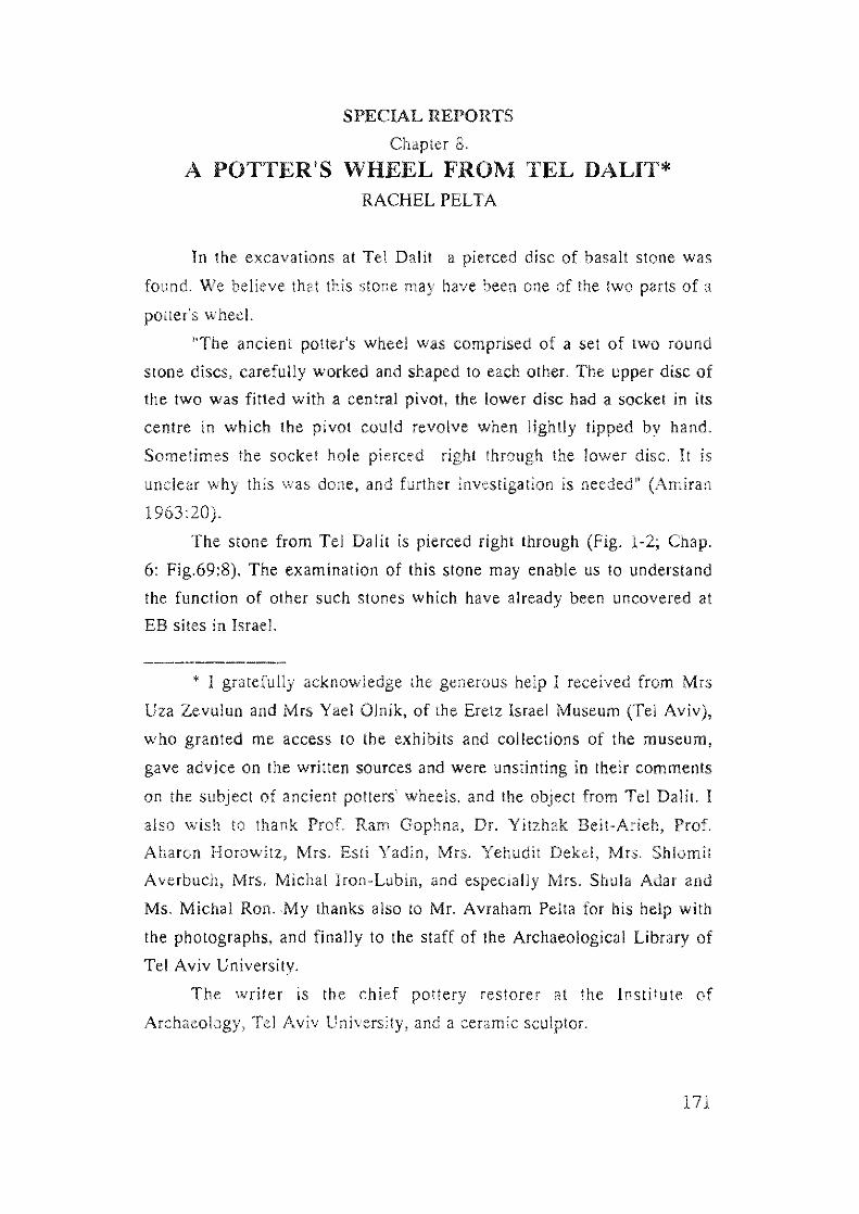
SPECIAL REPORTS
Chapter 8.
A POTTER'S WHEEL FROM TEL DALIT* RACHEL PELTA
In the excavations at Tel Dali! a pierced disc of basalt stone was
found. We believe that this stone may have been one of the two parts of a
potter's wheel.
''The ancient potter's wheel was comprised of a set of two round
stone discs, carefully worked and shaped to each otheL The upper disc of
the two was fitled with a central pivot, the lower disc had a socket in its
centre in which the pivot could revolve when lightly tipped by hand.
Sometimes the socket hole pierced right through the lower disc. It is
unclear why this was done, and further investigation is needed" (Amiran
1963:20).
The stone from Tel Dalit is pierced right through (Fig. 1-2; Chap.
6: Fig.69:8). The examination of this stone may enable us to understand
the function of other such stones which have already been uncovered at
EB sites in Israel.
• I gratefully acknowledge the generous help I received from Mrs
Uza Zevulun and Mrs Yael Olnik, of the Eretz Israel Museum (Tel Aviv),
who granted me access 10 the exhibits and collections of the museum,
gave advice on the written sources and were unstinting in their comments
on the subject of ancient pOllers' wheels, and the object from Tel Dalil. I
also wish to thank Prof. Ram Gophna, Dr. Yitzhak Beit-Arieh, Prof.
Aharon Horowitz, Mrs. Esti Yadin, Mrs. Yehudit Dekel, Mrs. Shlomit
Averbuch, Mrs. Michal Iron-Lubin, and especially Mrs. Shula Adar and
Ms. Michal Ron. My thanks also to Mr. Avraham Pelta for his help with
the photographs, and finally to the staff of the Archaeological Library of
Tel Aviv University.
The writer is the chief pottery restorer at the Institute of
Archaeology, Tel Aviv University, and a ceramic sculptor.
171
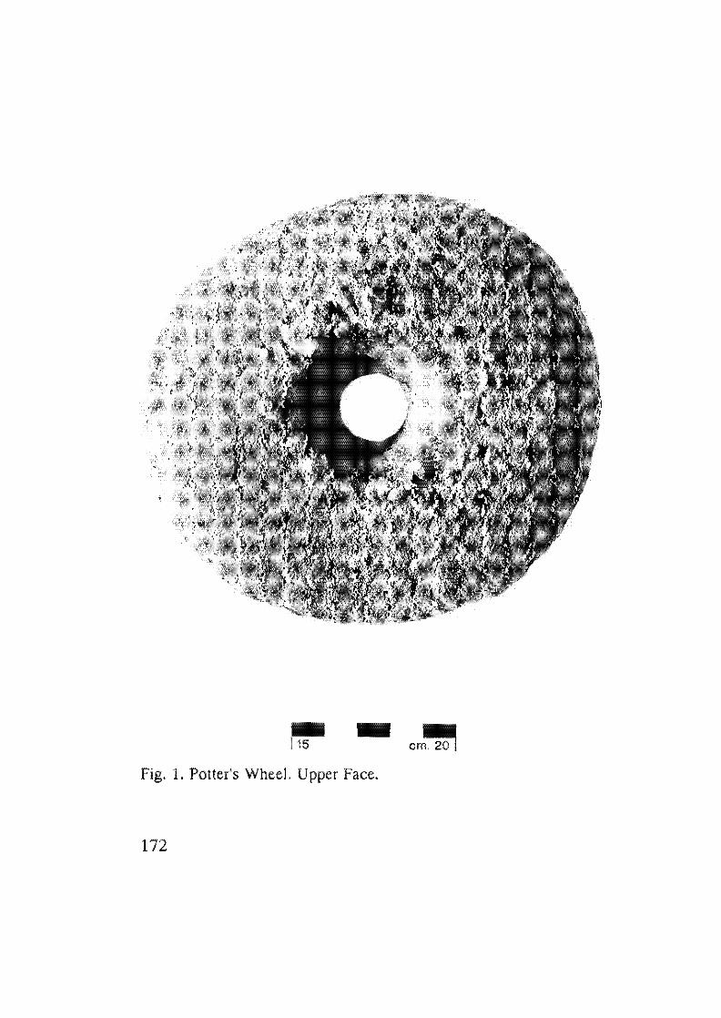
.. 115
.. Fig. 1. Potter's Wheel. Upper Face.
172
cm~
Fig. 2. Potter's WheeL Lower Face.
173
Potter's wheels of one type or another have been found in
excavations throughout the ancient Near East. However, the earliest
ceramics (Neolithic and Chalcolithic periods) were not thrown on the
wheel but were either built on mats (as proved by the mat impressions
found on their bases) or were formed with the aid of a tournelte, or slow
wheel (see Fig. 3:a below), which could be rotated but not spun (Amiran
1963: 15-30). The fast potter's wheel has been in use in this country since
the Middle Bronze Age, through the Iron Age, Persian and Hellenistic
periods, up to the present day. Archaeological evidence of potters' wheels
has been found in situ in the excavations of various local sites such as
Jericho, Megiddo, Gezer, Lachish and Hazor (Amiran 1963:21). This
common potter's wheel, with a small conical pivot, is known as the
"Canaanite-Israelite" type (Amiran 1971: Photos 9,10,12; Wood 1990:
Figs. 1,2; Rice 1984:107-111) (Fig. 3:c below).
Olher types of potters' wheels were used in different cultures and
periods. The early Egyptian wheel of the 3rd millennium B.C.E. was
distinguished mainly by a long cylindrical pivot or spindle (Fig. 3:b)
(Childe 1954: Fig. 132; Hodges 1970: Fig. 53). From the Minoan period
in Greece and from the Uruk period in Mesopotamia pOllers' wheels with
baked clay discs are known (Childe 1954: 199). Developed pivots are
found in Israel from the Byzantine period onwards, at sites such as
Mefalsim (Amiran 1963:21) (Fig. 3:d).
174
c
11
a
I I
d
b
I I
.
[WJ e
Fig. 3: Schematic vertical sections showing the principle of a) a
lournelle; b) Egyptian hand potter's wheel; c) Canaanite
Israelite bearing; d) Byzantine bearing; e) elemen!ric
combination of kick-wheel.
175
The Structure of the Potter's Wheel
The palter's wheel is basically composed of two distinct parts, and is
based on the principle of rotation.
Technological improvements, especially in the bearings (turning
mechanism) of these instruments, made it possible to advance from the
partial rotation of the tournette to the fuil and continous rotation of the
fast potter's wheel (Figs. 3a-e) (Leach 1940: 63-73; Rice 1987: 132-135;
Childe 1954; Sinopoli 1991 :21).
The lower part, or base, needs to be heavy and fixed (permanently
or temporarily) in one place, so that it will not move or vibrate excessively
when the device is operated. This lower part sometimes consists of several
elements which have been securely joined (by cementing, or by pressure
adhesion). The upper part is the actual rotating element. It can also
consist of several separate elements joined together. Some kind of surface
(usually a wooden board of ca. 60 ems. diameter) is affixed, on which is
placed the lump of clay to be worked into a vesseL
The upper and lower parts of the wheel are pivoted or socketed to
create rotation. It is reasonable to assume that the concave, or socketed,
part was on the bottom, and held liquid which facilitated acceleration, The
application of outside force to the upper part results either in partial
rotary motion (slow wheel or tournette) or in continuous rotary motion
(genuine potter's wheel or fast wheel).
The earliest type, without pivot, used the partial rotation of a
movable base (wooden board, stone slab, mat), and from this developed
the tournelte, and the pivoted turn-table, A further development is
represented by the kick-wheel (Leeuw 1984:21), which, by most accounts,
was introduced only in the Hellenistic period (Leeuw 1984:200; Hodges
1970: Fig. 175), although Childe argued that the Canaanite-Israelite type
could also have been adapted for kick operation (Childe 1954:202).
An important source for knowledge of the potter's wheel is
ethnographic studies of tribal societies. These have demonstrated that
quite primitive devices (wooden board, stone slab, etc.) can produce
176
symmetrically-shaped vessels (Leeuw 1984: 195-197). Examples of this
may be cited from India (Rice 1987: Fig. 5,3), Yemen (Posey 1994),
Denmark (Amiran 1963: Photo 8), Lake Victoria region (Hodges 1970:
Fig. 31), Northern Nigeria (ibid: Fig. 31) and Crete (Eshbal & Kimhi
1989). Moreover, if a vessel was not totally smoothed after its completion,
the marks on its surface can often indicate the nature of the device used
in its production.
The Object from Tel Dalit (Figs. 1-2; Chap. 6: Fig. 69:8)
The object from Tel Dalit bears evidence of having been carved on
all sides, and is roughly symmetrical. A hole was bored in its centre. The
object is round and narrow: weight: 1.1 kg., diameter: 13-14 cm.,
thickness: varying 2-4 cm. On one side the object is flat and smooth,
almost shiny. In one area is a circular, highly-polished band, 1 em. wide.
Evidently this band resulted from continual frictional contact with an
opposed unknown surface, presumably another stone object.
The reverse side of the object is dome-shaped. A large pari of the
surface of this side is covered by a chalk-like incrustration. The hole in
the centre of the object is not of equal diameter along all its length. It
descends funnel-like from the dome-shaped side (diameter 4-5 em.)
down two-thirds of the object's thickness (diameter 2 em.); from this
narrowest point the hole broadens again until it emerges on the flat side
of the object (diameter 3 em). Except for a faint mark at its narrowest
point (see below), there are no indications of rotational movement within
the hole.
A number of examples of early potters' wheels, usually termed
tournettes by the excavators, have been reported from EB strata: Meser
EB I (Dothan 1959:28), Arad (Amiran 1987: PI. 77), and Megiddo EB
II-III (Loud 1948: PI. 268:13). A number of similar objects have been
recorded but unfortunately not illustrated. The description of an object
from Megiddo Stage IV (EB I) is strikingly similar to our example: a
pierced disc measuring 19x5 em., biconically-pierced, with "glassy wear"
177
on one side (Engberg and Shipton 1934:40). Another such object is
mentioned from EB I Tell el-Far'ah (N) (de Vaux and Steve 1947:405),
and also from Beit Yerakh EB I (Maisler et a1. 1952: ). Another similar
object was found from the Chalcolithic Period at Tel Halif (Jacobs and
Borowski 1992:69), as well as from the Intermediate Bronze Age at Nahal
Alexander (Dar 1977:16; PI. 4). Compared to the Canaanite-Israelite
potter's wheel, these perforated disc-shaped objects are both smaller and
flatter.
The nature of the object (disc-shaped, domed, pierced) together
with the shiny band on its flat surface (testifying to a corresponding
missing element), inspired me to make some experimental negative
elements (from baked clay, fired to 9000) which I used in tests of a
theoretical and practical nature (see Figs. 4-7). The experiments were not
made on the original stone.
I rejected the possibility that the object could have been a
grindstone, as it does not correspond to the ancien t concept of such an
object, or to actual archaeological finds (Amiran 1956: 46-49). Neither
could it have been the socket stone of a door-hinge, since it would have
been a fully revolving door (Le., turning in a 3600 circle) or have been
positioned in the centre of a threshold. Thus, I at first concluded that the
object here discussed was the socket stone of a potter's wheeL The object
shows traces of rotational movement on its flat surface, however, there are
no traces of such within the socket hole itself. This would indicate that no
rotational movement occured within the socket hole; and, to my mind, the
faint signs of frictional contact discernable within the "socket" hole were
caused by pressure exerted when a pivot was fixed there.
In other words, this "socket" part, once it had a separate vertical
element implanted, was converted into the pivoted part of a potter's wheel,
of which the corresponding socket part was missing. The accompanying
photos present a reconstruction of the complete potter's wheel and the
principle of its operation, with the recovered object from Dalit
constituting a type of spindle (i.e., a wooden spindle implanted in the
tapered hole, which was then throughly doused with water so that it
178
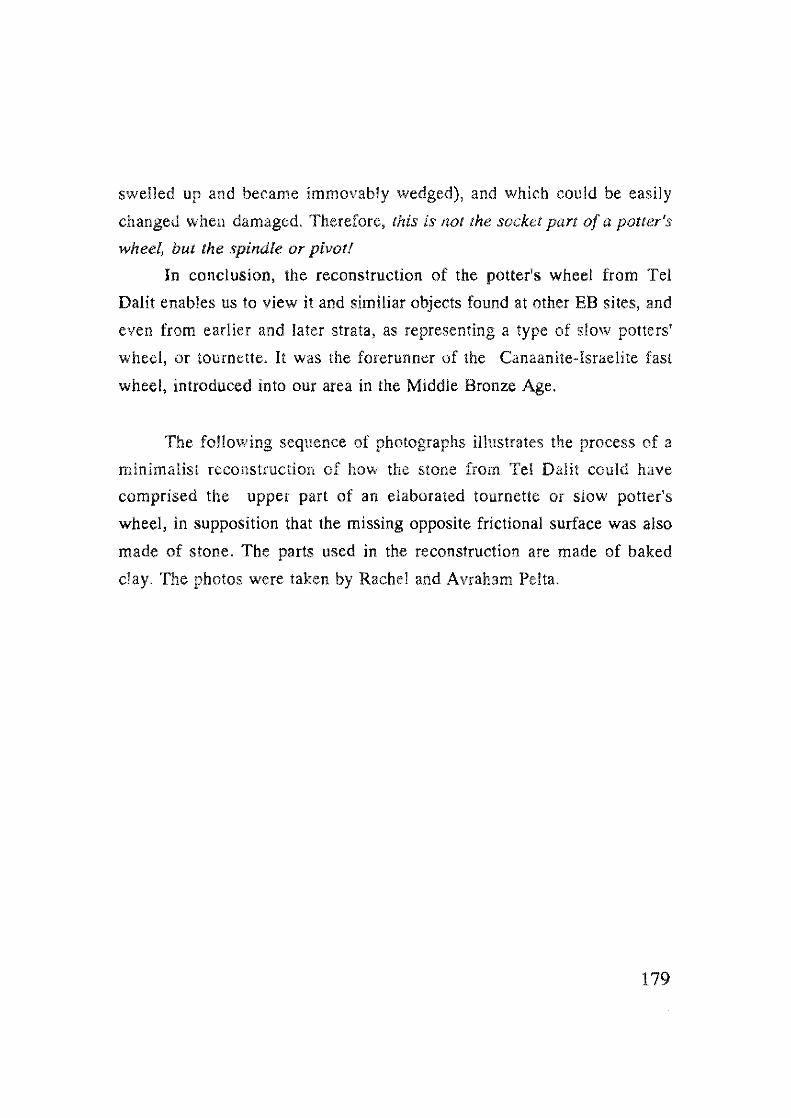
swelled up and became immovably wedged), and which could be easily
changed when damaged. Therefore, this is not the socket part of a potter's
wheel, but the spindle or pivot!
In conclusion, the reconstruction of the potter's wheel from Tel
Dalit enables us to view it and similiar objects found at other EB sites, and
even from earlier and later strata, as representing a type of slow potters'
wheel, or tournette. It was the forerunner of the Canaanite-Israelite fast
wheel, introduced into our area in the Middle Bronze Age.
The following sequence of photographs illustrates the process of a
minimalist reconstruction of how the stone from Tel Dalit could have
comprised the upper part of an elaborated tournette or slow potter's
wheel, in supposition that the missing opposite frictional surface was also
made of stone. The parts used in the reconstruction are made of baked
clay. The photos were taken by Rachel and Avraham Pelta.
179
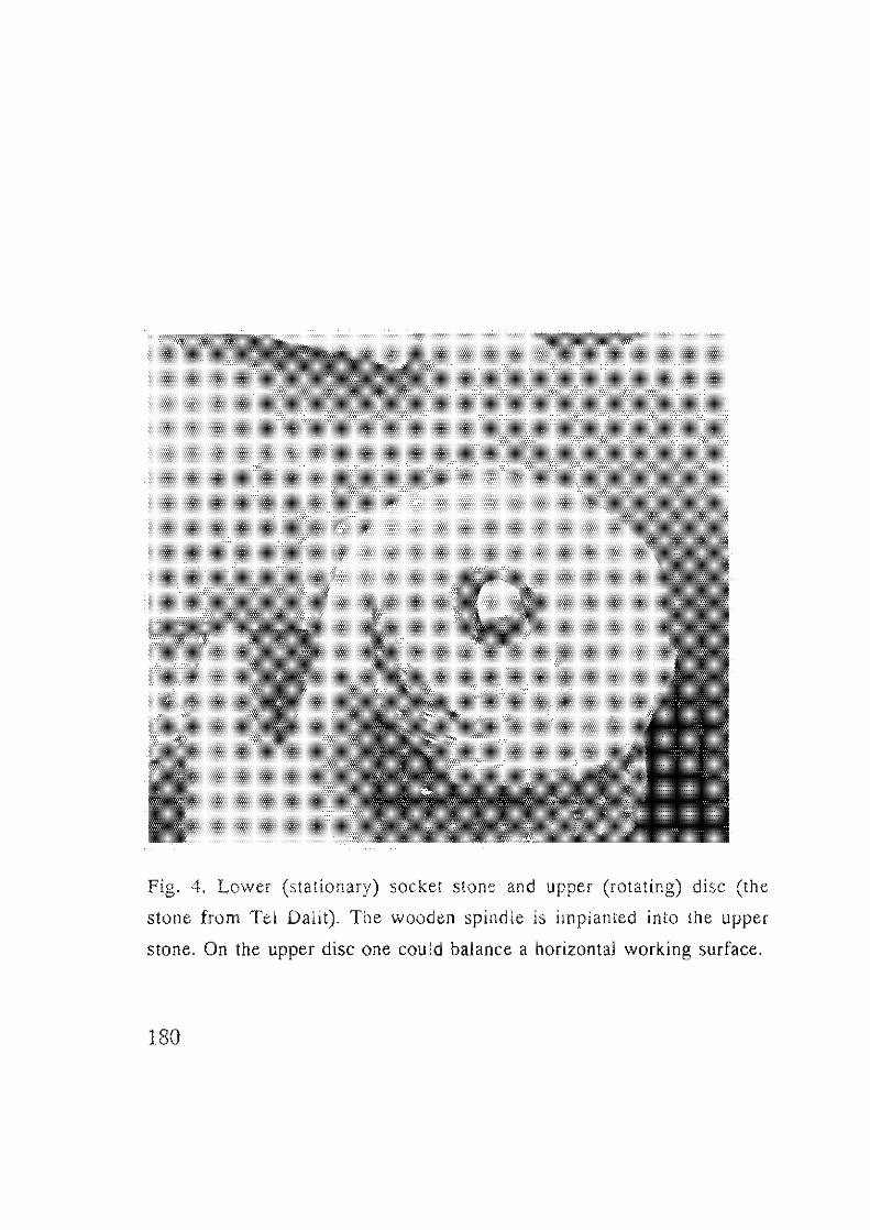
Fig. 4. Lower (stationary) socket stone and upper (rotating) disc (the
stone from Tel Datil). The wooden spindle is implanted into the upper
stone. On lhe upper disc one could balance a horizontal working surface.
180
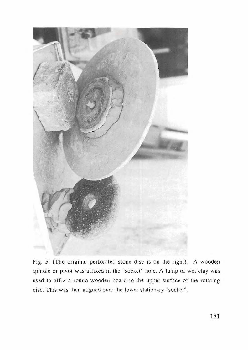
Fig. 5. (The original perforated stone disc is on the right). A wooden
spindle or pivot was affixed in the "socket" hole. A lump of wet clay was
used to affix a round wooden board to the upper surface of the rotating
disc. This was then aligned over the lower stationary "socket".
181
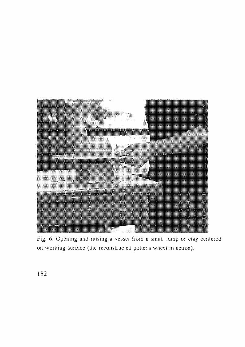
Fig. 6. Opening and raising a vessel from a small lump of clay centered
on working surface (the reconstructed polter's wheel in action).
182
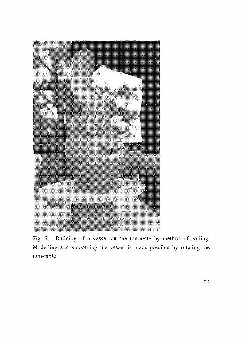
Fig. 7. Building of a vessel on the tournette by method of coiling.
Modelling and smoothing the vessel is made possible by rotating the
turn-table.
183
REFERENCES
Amiran, R. 1956. The Millstones and the Potter's Wheel. EI 4: 46-49.
(Hebrew).
Amiran, R. 1963. Ancient Pottery of the Holy Land. Jerusalem - Ramal
Gan (Hebrew),
Amiran, R, 1967, Quem and Potter Wheels. EI 4:46-49 (Hebrew).
Amiran, R. et al. 1978. Early Arad. I The Chalcolithic Settlement and
Early Bronze Age City. First-Fifth Seasons of Excavations 1962-
1966. Jerusalem.
Amiran, R And Shenhav, D, 1984. Experiments with an Ancient Potter's
WheeL In: Rice, M. Pots and Potters, Los Angeles: 107·111.
Childe, V.G, Holmyard, EJ. and Hall, A.R. 1954, Rotary Motion. In:
Singer. History of Technology, London: 187-215.
Dar, S. 1977, Ancient Settlements in 'Emeq Hepher. Ma'abarot. (Hebrew),
Dothan, M, 1959. Excavation at Meser. IE] 9: 13·29.
Engberg, RM, and Shipton, G.M, 1934. Notes on the ChalcoUthic and
Early Bronze Age Pottery of Megiddo, Chicago.
Eshbal, Land Kimhi R, 1989. A Visit to Terpessano (Crete) to the Potter's
Family Theodorakis. Pottery 9:4-8 (Hebrew),
Hodges, H. 1970. Technology in the Ancient World. England.
Jacobs, P.F. and Borowski, O. 1993. Tel Halif 1992, IEJ 43: 69 (Notes
and News). Krouse, RA. 1984, Modelling the Making of POlS: An
Ethnoarchaeological Approach. In: Van der Leeuw, S.E. (Ed,) The
Many Dimensions of Pottery. Amsterdam: 615-699.
Leach, B. 1940. A Potter's Book. London,
Leeuw, S,E, Van deL (Ed), 1984. The Many Dimensions of Pottery,
Amsterdam,
Loner!, H.W, 1984. Types of Potters' Wheels and the Spread of the
Spindle Wheel in Germany. In: Van der Leeuw. S.E, The Many
Dimensions of Pottery. Amsterdam: 205-230.
Loud, G. 1948. Megiddo I/. Chicago.
Maisler, B. Stekelis, M. and Avi-Yonah, M, 1952. The Excavations at Beth
184
Yerah (Khirbe el-Kerak) 1944-1946, IE] 2: 165-173.
Posey, S. 1994. Yemeni Pottery. London.
Reich, R. 1992, Building Materials and Architectural Elements in Ancient
Israel. In: Kempinski, A. and Reich, R. The Architecture of Ancient
Israel. Jerusalem,
Rice, M. 1987. Pottery Analysis. Chicago and London.
Sinopoli, C.M. 1991. Approaches to Archaeological Ceramics. New
York.
de Vaux, R. and Steve, a.p, 1947, La Premiere Campagne de Foui11es A
Tell el-Far'ah Pres Naplouse, Rapport preliminaire. RB 54: 394-
589.
Wood RG. 1990. The Sociology of Pottery in Ancient Palestine. England
185
Chapter 9
ANALYSIS OF BOTANICAL REMAINS FROM TEL DALIT NIL[ LIPHSCHITZ
Tel Dalit, dating to the Early Bronze Age, is located in the Judean
Sa marian foothills east of Beit Nehemia. The present vegetational
landscape at the area is secondary, the outcome of man's impact on the
natural vegetation and interference with the environment throughout the
ages. Reconstruction of the original, native vegetational landscape is
possible only via archaeobotanical analysis of wood remains collected
during the excavations.
During the three seasons of excavation botanical remains including
charred pieces of wood and carbonized seeds were collected. Samples of
1-1.5 cubic cm. each were taken from the charred wood for botanical
analysis. The samples were treated in absolute alcohol, celloidin solution
and 55 C parrafin. Blocks were made in paraffin, and 10-15 cm. thick
sections - cross, longitudinal, tangential and radial - were made in a
rotary microtome. The identification of the woody species was based on
the comparison of the three dimensional structure of the wood as revealed
in these sections, with reference sections prepared from live trees of
identified species. Identification of seeds was made morphologically by
comparison with modern-day fruits and seeds.
The botanical analysis of the charred pieces of wood (Table 1)
shows that eight samples (out of 12, 66.6%) were of Quercus calliprinos
(Kermes oak), three pieces (25%) were of Olea europaea (Olive), and a
single sample was of Pinus halepensis (Aleppo pine).
Forty-two of forty-three seed samples were charred olive stones
found in a domestic area, and one sample included Vetch seeds (Vicia
sp.) (Table 2).
Dendroarchaeological research carried out for the last twenty years
(Liphschitz, 1986, 1988, 1992) enables the comparison of findings from
Tel Dalit with those findings of other Early Bronze Age sites located in
186
the Mediterranean zone. Despite the small amount of archaeobotanical
findings from Tel Dalit, they can contribute to our knowledge of the
vegetaional landscape of the region during the Early Bronze Age.
Dendroarchaeological research at three Early Bronze Age sites in
the Central Coastal Plain, Shoham, Tel Aphek and Tel Gerisa, indicates
that the wood remains were mainly of Quercus calliprinos, Pistacia
palaestina (Terebinth) and Olea europa ea. Dendroarchaeological
investigatiqns carried out further south in the higher Judean Shephela , at
Tel Yarrnuth, and in the Southern Coastal Plain at Tel Erani , present the
same results. Even at a greater distance to the north, in Esdraelon Valley,
research at Tel Taanach and Tel Qashish has revealed the same arboreal
composition (Table 3).
The main fruit remains found at these sites were olive stones. A few
seeds of Vetch (Tel Dalit, Tel Erani, Tel Yarmuth, Tel Qashish), wheat
(Tel Erani, Tel Yarmuth), lentil (Tel Erani, Tel Yarrnuth) and grapes (Tel
Yarmuth) were also collected.
The findings show that the arboreal vegetation of these Early
Bronze Age sites was characterized by Quercus callipr/nos (Kerrnes oak),
Pistacia palaestina (Terebinth) and Olea europaea (Olive).
The dominance of the native Quercus callipr/nos - Pistacia
palaestina association in the Mediterranean territory during antiquity has
already been demonstrated in numerous dendroarcheological research
projects carried out for the last two decades (Liphschitz & Biger, 1990).
This association characterized the Mediterranean region until the
destruction of the arboreal cover of Israel during the Early Arab period.
On the other hand, intensive cultivation of Olea europaea, which is a
typical Mediterranean tree species, probably began in the Early Bronze
Age (Liphschitz et al. 1991). The olive remains from that time could,
therefore, have originated from either wild or cultivated specimens.
The Early Bronze Age vegetational landscape of Tel Dalil was
therefore composed of the primary arboreal association of Kermes oak
and Terebinth, mixed with wild and cultivated olive trees. The great
abundance of olive stones suggests that olives were part of the diet. A
187
single piece of Aleppo pine was also found at the site, but this species was
very rare during ancient times (Liphschitz et aL 1987-9).
TABLE 1: Location of wood remnants at Tel DaHl
Area Locus Basket Species
B 205 2122 Quercus calliprinos
B 205 2102 Quercus calliprino
B 404 4017 Quercus calliprino
A 26 1099 Olea europaea
A 24 1096 Olea europaea
A 515 5098 Olea europaea
A 503 5112 Olea europaea
B 339 3089 Olea europaea
B 403 4021 Olea europaea
B 410 4042 Olea europaea
B 415 4048 Olea europaea
A 515 5110 Pinus halepensis
188
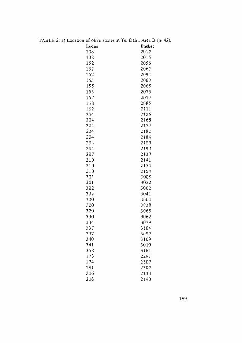
TABLE 2: a) Location of olive stones at Tel DaHL Area B (n=42). LoCIlS Basket 138 2012 138 2015 152 2056 152 2067 152 2094 155 2060 155 2065 155 2075 157 2017 158 2085 162 11 204 2126 204 2168 204 2177 204 2182 204 2184 204 2189 204 2190 207 2137 210 2141 210 2150 210 2154 301 3008 301 3022 302 3002 302 3041 300 3000 320 3038 320 3065 330 3062 334 3079 337 3104 337 3087 340 3109 341 3010 358 3161 173 2291 174 2307 ] 8] 2302 206 2133 208 2140
189
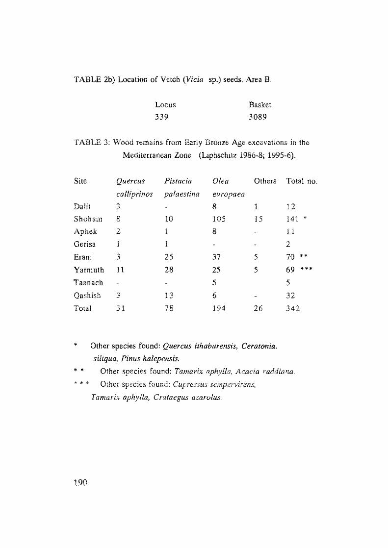
TABLE 2b) Location of Vetch (Vida sp.) seeds. Area B.
Locus Basket
339 3089
TABLE 3: Wood remains from Early Bronze Age excavations in the
Mediterranean Zone (Liphschitz 1986-8; 1995-6).
Site Quercus Pistacia Olea Others
calliprinos palaeslina europaea
DaHl 3 8 1
Shoham 8 10 105 15
Aphek 2 1 8
Gerisa 1 1
Erani 3 25 37 5
Yarmuth 11 28 5
Taanach 5
Qashish 3 13 6
TOlal 31 78 194 26
* Other species found: Quercus ithaburensis, CeralOnia.
siliqua, Pinus halepensis.
Total no.
12
141 *
11
2
70 •• 69 *** 5
32
342
* • Other species found: Tamarix aphylla, Acacia raddiana.
••• Other species found: Cupressus sempervirens,
Tamarix aphylla, Crataegus azarolus,
190
REFERENCES
Liphschitz, N., 1986. Overview on the dendrochronology and
dendroarchaeology in Israel. Dendrochronologia 4:37-58.
Liphschitz, N" 1986, 1987. Dendroarchaeological Investigations: Tel
Qashish, Mimeographed reports No, 144, 163, Institute of
Archaeology, Tel Aviv University. (Hebrew).
Liphschitz, N" 1987, 1990. Dendroarchaeological Investigations: Tel
Erani. Mimeographed reports No. ]56, 190. Institute of
Archaeology, Tel Aviv University, (Hebrew).
Liphschitz, N., 1988. DendroarchaeoJogical Investigations: Tel Yarmuth.
Mimeographed reports No. 159, Institute of Archaeology, Tel
Aviv University. (Hebrew).
Liphschitz, N., 1988. Dendroarchaeologicallnvestigations: Tel Gerisa.
Mimeographed reports No. 174. Institute of Archaeology, Tel
Aviv University, (Hebrew).
Liphschitz, N., 1988. Dendrochronological and dendroarchaeologicai
Investigations in Israel as a means
vegetation and climate. PACT
146.
for the reconstruction of past
(Wood and Archaeology):
Liphschitz, N., 1992. Levant trees and tree products. Bulletin of Sumerian
Agriculture 6:33-46.
Liphschitz, N., 1995-6. DendroarchaeoJogicallnvestigations: Shoham.
Mimeographed reports Nos. 262, 264, 274, 276, 280. Institute of
Archaeology, Tel Aviv University. (Hebrew).
Liphschitz, N. & G. Biger, 1990. Dominance of Quercus calliprinos
(Kermes oak) Pistacia palaestina (Terebinth) association in the
Mediterranean territory of Eretz Israel during antiquity. Journal of
Vegetation Science 1 :67 -70.
Liphschitz, N., Biger, G. & Z. Mendel, 1987-9. Did Aleppo pine (Pinus
halepensis) cover the mountains of Eretz Israel during antiquity,
Israel - People and Land 5-6: 141-150 (Hebrew),
Liphschitz, N., Gophna, R, Hartman, M. & G. Biger, 1991. Beginning of
191
192
Olive (Olea europaea) cultivation in the Old World. Journal of
Archaeological Science 18:441-453.
Chapter 10.
PATTERNS OF ANIMAL EXPLOITATION AT EARLY BRONZE AGE TEL DALIT
L10RA KOLSKA HORWITZ, SHLOMO HELLWING AND EITAN
TCHERNOV
INTRODUCTION
Tel DaHt is a small mound situated in the foothills of the Sa marian
hill country. The earliest occupation excavated at the site was that of an
unwalJed, terminal Early Bronze (EB lB) town (Stratum V). Subsequently,
at the onset of the Early Bronze Age II period, the earlier occupation was
leveled and a new, fortified town built on the same location (Strata IV -II).
The final settlement was an unwalled Early Bronze III village (Stratum I).
A general description of the Early Bronze Age fauna from both Tel
Datit and Tel Aphek has been published by Hellwing and Gophna
(1984). However, in that report no breakdown was made of the species
from the different Early Bronze Age strata at Tel Dalil. The purpose of
the current report is then threefold: to furnish detailed information
concerning animal husbandry and hunting practices during the different
Early Bronze Age strata; to investigate patterns of spatial distribution of
faunal remains at the site; and to assess the faunal assemblage from Tel
Dalit in the light of data available from other contemporaneous sites in
the southern Levant.
METHODOLOGY
This report is based on faunal identifications made by E. Tchernov
from the first season's material and those made by S. Hellwing from the
second and third seasons' material. Species representation was calculated
for each stratum separately, and then for each Early Bronze phase (Table
1, Fig. 1). The assemblage was analysed using both counts of the total
193
number of identifiable bones per species (N), as well as by estimates of
the minimum number of individuals per species (MNI). These estimates
were based on the highest number of a bone element present for anyone
side (right and left), where proximal and distal epiphyses were counted
separately, as were fused and unfused bones.
Sheep and goats were distinguished by calculating
the condylar index for metapodials and other morphological criteria
outlined by Boessneck (1969). Where the metrical or morphological
criteria did not permit separation, sheep and goats were placed in a
combined "ovicaprine" category. Aging of the ovicaprine remains was
carried out using dental attrition scores (Payne 1973) and bone fusion
rates (Silver 1969). For cattle, aging was based on bone fusion and tooth
eruption stages as given in Grigson (1982), while for gazelle, aging was
based on Davis (1980). The representation of the different anatomical
elements followed the division into five categories as given in Horwitz and
Tchernov (1989).
TABLE 1: Excavation Areas, Strata and Periods in Which Faunal Remains
Were Recovered
Strata Period
I EB III
HI
II EB II
III EB II
III-IV EB"
IV EB II
V EB Ib
194
A
X
B
X
X
X
X
X
Area
Tumulus
X
X
X
X
c
X
80
40
201UiI8i~~ 1-1 -27
N-816
o N-228 S /G COW PIG HIPPO AZ DEERDONK FOX DOG M.CE BIRD FISH
_ EB IB ~E8 1\ 0 EB III
ST ATA v IV-II
Fig. 1. Breakdown of Early Bronze Age Fauna by Period.
RESULTS
I SPATIAL ANALYSIS
Three areas were excavated at the site: Area A in the northwest part
of the mound, Area B in the southern part , and Area C in the eastern part
of the site. The vast majority of the animal remains are derived from Area
B. Bone preservation was poor throughout the site, and sieving was
carried out to maximize retrieval.
In order to assess whether the animal bones recovered from the
different excavated areas and strata at Tel Dalit reflect variations in
activities, architecture and period, a detailed breakdown of the faunal
remains was undertaken. All remains were noted by Area, stratum and
depositional context in order to examine this question.
195
AREA A In Area A material was recovered only from Strata 11Illl and V.
Stratum II
Stratum II comprised remains of houses, including part of a
broadroom with benches along one wall [L28J. The remains included 56
ovicaprine bones (MNI= 2 goats and 1 sheep/goat), 18 cattle bones
(MNI= 2), 1 donkey bone and 1 unidentifiable fragment.
Stratum V
Animal bones in Stratum V were recovered from a round structure
and pockets of deposit that lay on the bedrock [L26, 53, 55, 60, 63, 64,
67, 74, 75, 524, 525]. A total of 129 bones were derived from this stratum
of which 30 were unidentifiable fragments. Diagnostic bones included:
80 ovicaprine bones (MNI= 1 sheep and 2 sheep/goats), 9 cattle bones
(MNI= 1), 5 mountain gazelle bones (MNI= 1) and 1 bone each of roe
deer, pig, dog, bird and fish. Age breakdown for the 3 ovicaprines (based
on MNI counts) indicates that at least one of the ovicaprines was aged less
than 2 years old, while another was older than 2 years old. The gazelle
remains are those of an adult animal. Two of the ovicaprine hones exhibit
cut marks: a distal humerus and a distal tibia whose shaft had been
removed.
SUMMARY AREA A
Area A contained only a small assemblage of animal bones,
primarily derived from fills within the EB IB or II structures. Bones
from this area were very poorly preserved due to erosion (Gophna 1993).
Ovicaprines predominate in both strata, followed by cattle. For both
ovicaprines and cattle all bodyparts are represented, in almost equal
numbers. Despite the small size of the EB IB assemblage, a wide range of
species is represented, although in low frequencies. Both fish and pig are
only represented in Area A.
196
AREA B
With the exception of Stratum I, all strata are represented here.
Stratum II
Remains of a broadroom (115-152), lying adjacent to the city wall,
were found in this stratum. It included living floors, storage areas and
installations. Two occupation phases of the broadroom were identified
(lla and lib).
A) Stratum Ila - the later occupation phase:
A lolal of 473 bones were recovered here; unidentifiable bone
fragments and 178 identifiable ones. These faunal remains were
recovered from three different contexts:
(1) The broadroom [LI03, 107-109, 112, 114, 115, 131, 138]
contained the remains of 101 animal bones of which only 1 was
unidentifiable. The remaining bones represented the remains of
ovicaprines (N=80), cattle (N=12), mountain gazelle and hippopotamus
(N=2 respectively), dog (N=3) and pig (N=1). The MNI for ovicaprines
was 3 and for cattle 1. The hippopotamus bones recovered here (a
metacarpal and a 1st phalanx), are the only ones found at the sile.
(2) An alleyway situated to the south of the broad room separating
it from the city wall [LlOl, 106, 111, 117, 165, 167] yielded 61
identifiable bones and a single unidentifiable fragment. Species
represented included: ovicaprines (N=45), cattle (N",ll), mountain
gazelle (N=1), pig (N=2), donkey and fish (N=l respectively). The MNI
for ovicaprines was 2 and for all other species 1 each. One ovicaprine
meta podia I had been Cllt off midshaft.
(3) An area to the north of the broad room containing remnants of
walls of another structure [Ll35, 200, 201, 203, 206, 211, 212] was
relatively poor in bone remains and only 41 were recovered. Of these, 28
were unidentifiable fragments. The diagnostic material included
ovicaprines (N=lO), cattle (N=2) and mountain gazelle (N=1).
197
In addition, bones were recovered from general fills in Ihis stratum
[LIB, 130, 134, 207). They included 13 unidentifiable fragments as
well as 2 bones of ovicaprines and cattle respectively.
There is little difference in the quantity of bone, species or
anatomical elements represented in the alleyway assemblage as compared
to that from the fill inside the room (Fig. 2). It is, however ,interesting to
note that the majority of the bones from inside the room were derived
from wall deposits rather than from the floors. This suggests that they
may represent incidental inclusions in the wall fili rather than debris
clearance from within the house, If this is correct, then the adjacent
alleyway probably served as the main debris disposal area for the house.
80
6(;
!
20
ST R. 1 v STi" 1:1
_ ALLEy
Fig, 2, Relative Frequencies of Unidentified Bone Fragments from the
Alleyway and Adjacent Structures (Area B).
B) Stratum IIb - the earlier occupation phase
A total of 266 bones were recovered from this stratum of which
190 were unidentifiable fragments while the remaining 76 were
diagnostic to species. Animal bones from this phase were derived from
two contexts:
198
(1) A broadroom, which in turn may be sub-divided into three different
com partmen ts
(a) western: L143, 147, 152, 159
(b) middle: L139, 142, 145, 146, 156, 204, 210
(c) eastern: L153-155, 157, 160, 205, 213, 219
The broadroom yielded 182 unidentifiable fragments and 68
identifiable ones. The latter included ovicaprines (N= 52), cattle (N= 9),
mountain gazelle (N= 3) and fallow deer (N= 4). The bones were
recovered from all three compartments of the structure, with a slightly
higher density of bone in the middle one. The western compartment
contained 19 identifiable bones and 56 fragments; the eastern
compartment 17 identifiable bones and 50 unidentifiable fragments,
many of which were burnt; the middle compartment contained 76
unidentifiable fragments and 32 identifiable bones. MNI estimates for
the broad room as a whole are ovicaprines 3 that included 2 animals aged
less than 2 years old and 1 aged 3 1/2 years or older. Other species
included cattle (MNI=1) and gazelle (MNI = 2), of which one was an
adult male and the other a juvenile.
All three compartments contained the same range of species, and
these were represented in similar quantities. Consequently, the fauna do
not indicate the presence of spatial differentiation in activities between the
compartments. An interesting feature was the presence of a complete,
naturally shed antler of a fallow deer on the floor of the western
compartment [L152] and an additional fragment of the same antler in the
eastern one [L219]. Both the antler and the fragment were burnt, while
the fragment in L219 had also been cut.
(2) The general area outside the broad room [L148-150] produced
15 unidentifiable bone fragments and 8 identifiable bones; ovicaprines
(N=7) and roe deer (N=l).
Stratumlll
In Area B no marked differences in species representation were
observed between the two occupation phases of Stratum II (Fig. 3), or
199
between the alley and structure (Fig. 2). The majority of bones belonging
to this stratum were recovered from the alleyway rather than from within
the structure (271 bones from the alleyway as opposed to 68 from within
the structure). Moreover, the majority of these were unidentifiable
fragments (Fig. 3). This suggests that the alleyway may have served as the
main disposal area for the adjacent structures.
--~. • • •
CATTLE
PIC
.IPP ·
I I DEER
I OUID
DOG
'--_---'-__ -'-, _~__ _l _. ___ . _ _ 1 FISH
' 0 :·~n " _ [ 8 II '; G.~ r!3 III)
1\ )-'1 1:: :\ . -- ()
Fig. 3. Comparison of Species Represented in the Two Occupation Phases
of the Broadroom (SL II) (Area B).
The 360 animal bones (224 unidentified fragments and 136
diagnostic bones) recovered from this stratum are derived from three
different contexts:
(1) A large structure lU12, 315, 321, 303, 305, 308] th at
contained 28 identifiable bones. These included ovicaprines (N=24),
catlle (N=2) and mountain gazelle (N=2) as well as 7 unidentifiable
fragments. At least 2 ovicaprines were represented of which 1 was aged
less than 2 years old, and the other older than 3 1/2 years.
An additional 33 bones were recovered from an installation within
this structure [L320). These included 3 ovicaprine bones (MNI = 1 adult
sheep), and 5 catlle bones. The remaining 25 bones were unidentified
fragments.
200
(2) A narrow alleyway lying to the south of the structure, between
it and the city wall [L300-302, 314, 316, 318, 323, 325]. Here a large
number of bones were found that included 172 unidentifiable fragments
and 99 diagnostic bones. Species represented included 70 bones of
ovicaprines (MNI = 1 sheep; 1 goat; 3 sheep/goat). Of these 5
ovicaprines, at least 2 were aged less than 2 years old, and another 2 were
aged between 2-3 years old. Additional species included: 22 bones of
cattle (MNI := 2 of which 1 was aged older than 3 1/2 years), 4 bones of
fallow deer (MNI = 1), and I bone each of mountain gazelle ( MNI 1
immature animal aged less than l6 months), donkey and dog.
(3) General contexts from outside the structure [L326] produced
21 bones, of which only 1 was identifiable to species - an ovicaprine.
Strata Ill·IV
Bones in these strata are derived from three contexts:
(1) A small assemblage of bones derived from general fills [L357-359].
They included 10 unidentified fragments and 12 ovicaprine bones (MNI
= 1 sheep aged between 3-3 1/2 years old; 1 sheep/goat aged less than 2
years old), 2 cattle bones (MNI = 1) and 1 bone of mountain gazelle.
(2) Another 5 bones are derived from the postern in the fortification
wall [L343]. They include 2 ovicaprine bones, 1 cattle bone and 2
unidentifiable fragments.
(3) In addition, a small assemblage of 53 bones from within the
structure [L330] contains 8 ovicaprine bones (MNI = 1 sheep), 1 cattle
bone and 44 unidentifiable fragments.
Stratum IV
Stratum IV is represented by remains recovered from three
different contexts:
(1) The well-preserved stone fortification wall [L168, 177, 182,
331] produced 17 ovicaprine bones (MNI=1 sheep; 1 sheep/goat), cattle
(N=3) and one each of red deer and donkey . In addition, there are 25
unidentifiable fragments.
201
(2) Remains of a structure, probably a house [L334, 340], and the
storage installations found within this structure [L333, 339, 341, 353].
This assemblage contained 25 ovicaprine bones (MNI= 1 goat aged over
3 1/2 years old; 1 sheep/goat), cattle bones (N=5), 1 mountain gazelle
bone and 59 unidentifiable fragments. The only modified bone was a
cattle metatarsal which had cut marks on its proximal end.
The storage facility within the structure contained 34 ovicaprine
bones (MNI= 2 sheep, 1 aged 2-3, the other older than 3 1/2 years; 1
sheep/goat aged less than 2 years old), In addition there are bones of
cattle (N = 1) and an unidentified bird (N= 1) as well as 115
unidentifiable fragments.
(3) An alleyway situated between the structure and the city wall
contained a sizable bone assemblage with ovicaprines (N=63), cattle (N=
22), donkey (N=2), one each of red deer, fallow deer and gazelle, as well
as 108 unidentifiable fragments.
The MNI estimate for ovicaprines from the alleyway is 3, including
at least two sheep (metacarpal index 69.9; metatarsal index 65), The age
breakdown for these ovicaprines is: 1 animal aged less than 2 years old
and 2 animals aged 2-3 years. The MNI for cattle was 1, representing an
adult aged over 4 years.
Compared to the bone assemblage from the structure (N = 90),
those from the alleyway and the storage facility both contained sizable
amounts of bone (N = 198 and 151 respectively). The majority of the
bones found in the storage facility and structure were unidentifiable
fragments, while almost equal amounts of identifiable and non
identifiable material were found in the alleyway (Fig. 2). This pattern is
the opposite to that found for the same localities in Stratum III. It is
possible that the storage facility may have been used for rubbish disposal
within the structure.
Strata II·IV
A small assemblage of bones that may belong to either Stratum II
or IV, was found in the alleyway south of the structure. This collection
202
includes 100 ovicaprine bones (MNI '" 4). The age breakdown for these
4 ovicaprines is: one animal aged 3-4 years old, 2 aged less than 2 years
old and 1 aged between 1-2 years old. Other species represented included
16 cattle bones (MNI :: 1 aged at least 4 years old), 2 donkey bones
(MNI= 1) and one bone each of mountain gazelle, red deer and fox.
There are also 36 unidentified fragments. One ovicaprine metacarpal has
cut marks on its shaft.
Stratum V
Altogether 317 bones were recovered from this stratum; 122
identifiable bones and 195 non-identifiable fragments. These bones were
found in three contexts:
(1) A general fill above bedrock [U81, 183, 309, 360, 362, 367,
372] which contained bones of ovicaprines (N=21), cattle (N=6),
mountain gazelle (N=2), donkey (N=l) and 34 unidentified fragments.
(2) Fill from beneath the Stratum IV structure [L350] which
yielded 31 ovicaprine bones (MNI= 2 one aged less than 2 years old), 8
cattle bones (MNI= 2) and mountain gazelle bones (N=2). A total of
113 unidentifiable fragments were also found.
(3) Fill from the alleyway lying on the bedrock [LI80, 184, 187,
351, 361, 366, 370] contained 37 ovicaprine bones (MNI :: 3 including 1
embryo and 2 animals older than 3 years), 10 cattle bones (MNI:: 1
adult), mountain gazelle bones (N=3), 1 bird bone and 48 unidentifiable
fragments. Two modified bones, both of ovicaprines, were found here: a
distal scapula that was burnt and a metapodial fragment that exhibited cut
marks near the distal end.
The faunal remains from the three different contexts in this stratum
are very similar in density of bones, species and bodypart representation.
203
SUMMARY AREA B The majority of faunal remains at the site were recovered in this
area (ca. 90%), specifically from Stratum II. The faunal assemblage from
this area is derived from a large broadroom with at least two building
phases and storage facilities, an alleyway adjacent to this structure, a
section of the fortification wall and sundry fills outside the structure and
alleyway.
In all strata, ovicaprines were the most common species followed by
callIe. Three additional domestic species were represented in this area:
donkey, dog and pig, as well as a wide range of wild animals: mountain
gazelle, three species of deer (red, fallow and roe deer), hippopotamus,
red fox, fish and birds. Unfortunately, the remains of the latter two taxa
were not identifiable as to species. Remains of donkey and deer are only
represented in Area B.
Comparison between the material recovered from inside the
structure and that from the alleyway, revealed that there were no
consistent differences between them in the range of species represented or
their age and bodypart composition. There was a slight tendency for
more unidentified bone fragments to be found in the alleyway than on
the floors inside the structures suggesting that the former may have
served as a primary refuse disposal area for the broadroom. However, this
pattern was not consistent. Similarly, modifications to bones, such as
burning and/or cut marks, were rare in all contexts.
204
TABLE 2: Faunal Remains by Strata
Stratum Strattun I Stratum JIJJ Stratum II Stratum III
N % N % N % N %
Ovicaprines 3 75 17 74 211 76 98 72
Cattle I 25 5 22 41 15 29 21.25
Pig 3 I
Hippopotamus 2 0.75
Gazelle 10 3.5 3 2.25
Red Deer
Fallow Deer 4 1.5 4 3
Roe Deer 1 0.3
Donkey I 0.3 1 0.75
RedFox
Dog 3 1 I 0.75
Rodent 1 4 1 0.3
Bird 1 0.3
Fish
Total 4 23 278 136
StratLUl1 Stratum Stratum
IIIIII MV IIIJIV
N % N % N %
56 75 100 83 22 81
18 24 16 13 4 15
1 I I 4
I I
I I
2 2
I I
75 121 27
Stratum IV Stratum V
N % N %
139 78 176 77
31 17 33 14
I 0.5
I 0.5 12 5
2 I.l
I 0.6
1 0.5
4 2.2 I 0.5
1 0.5
1 0.6 2 1.5
1 0.5
179 228
l£)
o N
TABLE 3: Breakdown for the St. IIa-b Phases of Occupation in Area B
SI. na St. IIb
N % N %
Ovicaprines 137 77 59 78
Cattle 27 15 9 12
Pig 3 2
Hippopotamus 2 1
Gazelle 4 2 3 4
Fallow Deer 4 5
Roe Deer 1 1
Donkey 1 0.5
Red Fox
Dog 3 2
Rodent
Bird
Fish 1 0.5
Total 178 100 76 100
AREA B3 AND "TUMULUS 2" • to the north of Area B
Stratum I [L412] - was represented by remains of a stone wall. Only 4
bones were found here, of which 3 were identified as ovicaprine and 1 as
cattle.
Stratum I-II - was represented by 23 bones [L408, 416]. Species
identified included: 17 ovicaprine bones, 5 callie and 1 rodent bone. The
rodent may be a more recent intrusive element.
206
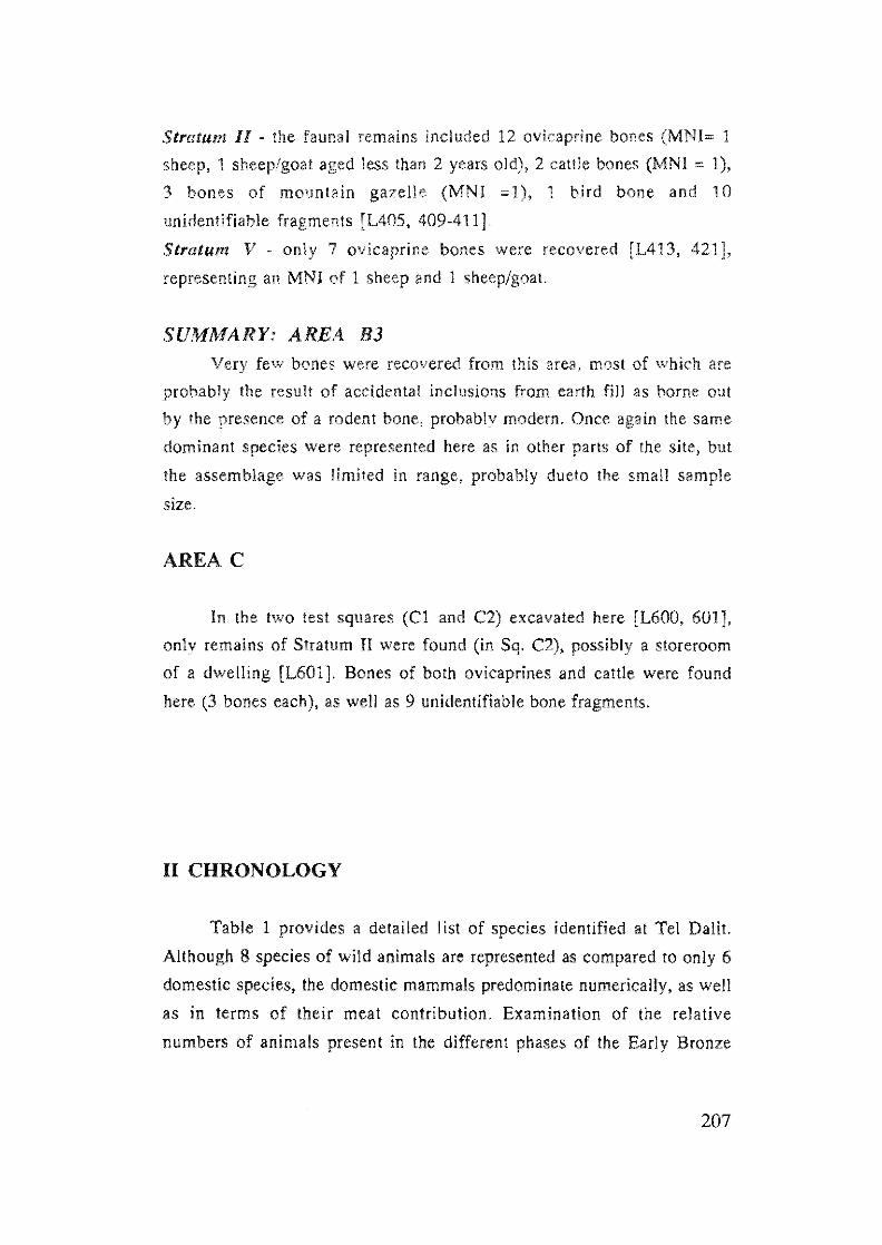
Stratum II - the faunal remains included 12 ovicaprine bones (MNI= 1
sheep, 1 sheep/goat aged less than 2 years old), 2 cattle bones (MNI '" 1),
3 bones of mountain gazelle (MNI =1), 1 bird bone and 10
unidentifiable fragments [L405, 409-411].
Stratum V - only 7 ovicaprine bones were recovered [L413, 421],
representing an MNI of 1 sheep and 1 sheep/goat.
SUMMARY: AREA B3 Very few bones were recovered from this area, most of which are
probably the result of accidental inclusions from earth fill as borne out
by the presence of a rodent bone, probably modern. Once again the same
dominant species were represented here as in other parts of the site, but
the assemblage was limited in range, probably dueto the small sample
size.
AREA C
In the two test squares (CI and C2) excavated here [L600, 601],
only remains of Stratum II were found (in Sq. C2), possibly a storeroom
of a dwelling [L601]. Bones of both ovicaprines and cattle were found
here (3 bones each), as well as 9 unidentifiable bone fragments.
II CHRONOLOGY
Table 1 provides a detailed list of species identified at Tel DaHl.
Although 8 species of wild animals are represented as compared to only 6
domestic species, the domestic mammals predominate numerically, as well
as in terms of their meat contribution. Examination of the relative
numbers of animals present in the different phases of the Early Bronze
207
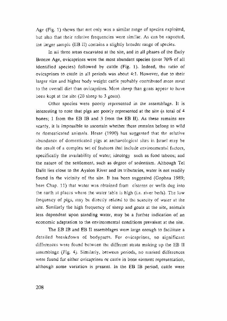
Age (Fig. 1) shows that not only was a similar range of species exploited,
but also that their relative frequencies were similar. As can be expected,
the larger sample (EB II) contains a slightly broader range of species.
In all three areas excavated at the site, and in all phases of the Early
Bronze Age, ovicaprines were the most abundant species (over 70% of all
identified species) followed by cattle (Fig. 1). Indeed, the ratio of
ovicaprines to cattle in all periods was about 4:1. However, due to their
larger size and higher body weight cattle probably contributed more meat
to the overall diet than ovicaprines. More sheep than goats appear to have
been kept at the site (20 sheep to 3 goats).
Other species were poorly represented in the assemblage. It is
interesting to note that pigs are poorly represented at the site (a total of 4
bones; 1 from the EB IB and 3 from the EB II). As these remains are
scanty, it is impossible to ascertain whether these remains belong to wild
or domesticated animals. Hesse (1990) has suggested that the relative
abundance of domesticated pigs at archaeological sites in Israel may be
the result of a complex set of features that include environmental factors,
specifically the availability of water; ideology such as food taboos; and
the nature of the settlement, such as degree of sedentism. Although Tel
Dalit lies close to the Ayalon River and its tributaries, water is not readily
found in the vicinity of the site, It has been suggested (Gophna 1989;
here Chap. 11) that water was obtained from cisterns or wells dug into
the earth at places where the water table is high (I.e. river beds). The low
frequency of pigs, may be directly related to the scarcity of water at the
site. Similarly the high frequency of sheep and goats at the site, animals
less dependent upon standing water, may be a fUrther indication of an
economic adaptation to the environmental conditions prevalent at the site.
The EB IB and EB II assemblages were large enough to facilitate a
detailed breakdown of bodyparts. For ovicaprines, no significant
differences were found between the different strata making up the EB II
assemblage (Fig. 4). Similarly, between periods, no marked differences
were found for either ovicaprines or callie in bone element representation,
although some variation is present. In the EB IB period, cattle were
208
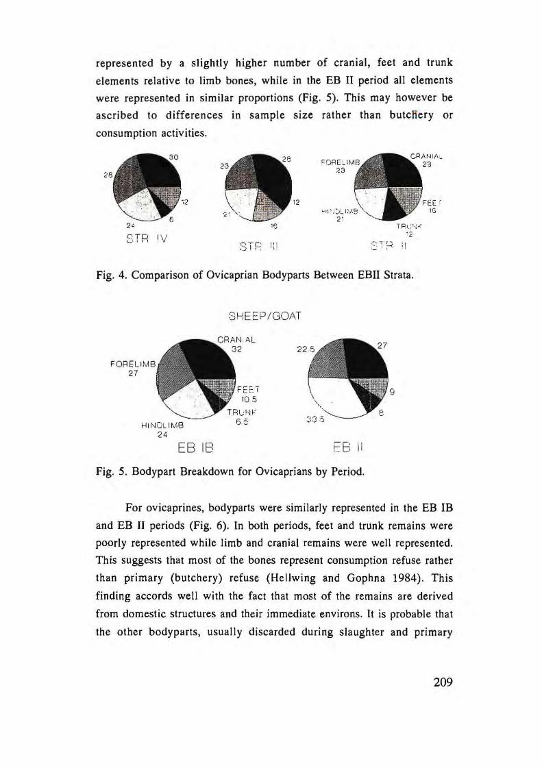
represented by a slightly higher number of cranial, feet and trunk
elements relative to limb bones, while in the EB II period all elements
were represented in similar proportions (Fig. 5). This may however be
ascribed to differences in sample size rather than butcHery or
consumption activities.
24 15
3 TR IV STP r~l
12
TPt; r,; .<
' 2
Fig. 4. Comparison of Ovicaprian Bodyparts Between EBII Strata .
FORELIMB 27
HI NDLIMB 24
EB IB
SHEEP/GOAT
FEET 10.5
E8 Ii
Fig. 5. Bodypart Breakdown for Ovicaprians by Period.
FEE ' lG
For ovicaprines, bodyparts were similarly represented in the EB IB
and EB II periods (Fig. 6). In both periods, feet and trunk remains were
poorly represented while limb and cranial remains were well represented.
This suggests that most of the bones represent consumption refuse rather
than primary (butchery) refuse (Hellwing and Gophna 1984). This
finding accords well with the fact that most of the remains are derived
from domestic structures and their immediate environs. It is probable that
the other body parts, usually discarded during slaughter and primary
209
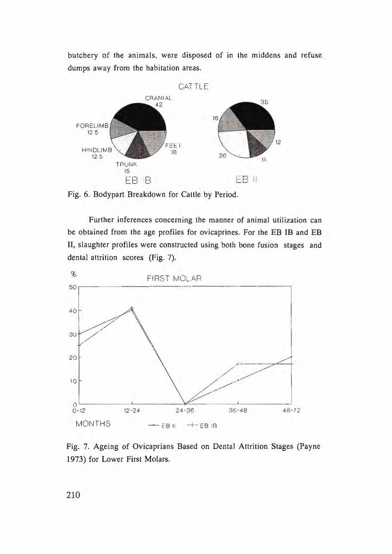
butchery of the animals , were disposed of in the middens and refuse
dumps away from the habitation areas.
FORELIMB 125
1 RUNI~ 15
EB IB
CATTLE
cB il
Fig. 6. Bodypart Breakdown for Cattle by Period.
Further inferences concerning the manner of animal utilization can
be obtained from the age profiles for ovicaprines. For the EB IB and EB
II, slaughter profiles were constructed using both bone fusion stages and
dental attrition scores (Fig. 7).
% FIRST MOLAR 50
40
? /'
30 / 20
10
\ .;---.~ o~----~--~.~~~_/'_~-~~_//_~~·~-~_/--0-12 12 -24 24 -36 35-48 48- 72
MOI\ITHS - EB II -+- EB 18
Fig. 7. Ageing of Ovicaprians Based on Dental Attrition Stages (Payne
1973) for Lower First Molars.
210
For both the EB IB and EB II periods, the age data indicates that
some 65% of the animals were slaughtered while less than 2 years old.
Only 35% of the animals were slaughtered aged more than 3 years old.
Based on the data presented in Payne (1973), the selective cull of animals
aged less than 2 years old, as found at Tel Datit, usually reflects the
slaughter of surplus, immature rams for mea! exploitation. Those in the
0-12 month range also include mortality from natural causes following
birth. In contrast, the majority of ewes are maintained into adulthood as
sources of milk, wool and for reproduction. The high frequency of
juvenile animals in the cull profile from Tel Datit, coupled with the
presence of some 35% adults, indicates an economy where ovicaprines
were bred and selectively slaughtered at the sile rather than supplied to
the site through a market system.
The sample of cattle bones that could be aged was too smaJJ to
facilitate the creation of a cull profile. However, the majority of all cattle
remains belongs to fully adult animals aged 4 years old or more. These
cull patterns indicate that both ovicaprines and cattle were primarily
exploited for their secondary products (milk, wool from ovicaprines), and
in the case of cattle as a source of labour and transport.
Based on the data presented here, it may be concluded that despite
changes in the size, nature and demography of the settlement during the
Early Bronze Age (Gophna 1989), the animal economy at Tel Dalit did
not undergo any marked change. It continued to be based on ovicaprine
herding, with animals, specially ewes, exploited for their milk, while
surplus males provided meat. Low numbers of cattle were kept and were
probably primarily exploited for transport and labour as indicated by the
facl that most were adults when slaughtered. The other pack animal, the
donkey, is represented, but in low numbers. The keeping of pigs, if those
at the site were indeed domesticated, may have been limited by the
availability of water at the site. Wild animals such as gazelle, deer and fox
served as supplementary sources of food as well as other products such as
skins. Aquatic resources - fish and hippopotamus· indicate exploitation
of riverine resources situated some distance from the site, either through
211
trade or expeditions from the site. Similarly, the pig and three deer
species, all of whom inhabit woods or thickets, may originate from areas
outside the immediate vicinity of the site (but see Chap. 9).
III) INTER-SITE COMPARISONS
In order to place the Tel Dalit assemblage in its larger Early Bronze
Age context, the data were compared to those derived from
contemporaneous sites in the southern Levant (see Horwitz and Tchernov
1989 for a detailed review of data published until then, plus subsequent
publications Hellwing 1988-89; Wapnish and Hesse 1991; Zeder 1990;
Grigson 1995)
Sheep and goats served as the mainstay of Early Bronze Age
economies throughout the southern Levant, with a preference for sheep
over goats in the Mediterranean zone. In the Jordan Valley and Negev
desert, sheep and goats were represented in almost equal amounts, while
in the Sinai Peninsula, goats predominated (Horwitz and Tchernov 1989,
Grigson 1995). The purpose of ovicaprine herding varied among sites,
with some sites concentrating on meat exploitation (Tel Halif I), and
others on milk and wool production (e.g. Arad, Tel Yarmuth, Tel Dallt).
At several sites, cattle were an equal if not major source of animal
protein (Grigson 1995). Furthermore, they appear to have served not
only as a source of food (meat, milk) and skins, but also as the primary
animal used in agriculture - for ploughing, carrying and pulling loads
(Grigson 1995). Donkeys, and possibly also horses (Grigson 1993), are
represented in almost all Early Bronze Age sites from this region. The
equids may have been used in agriculture, however based on the
numerous depictions of donkeys as beasts of burden (Ovadia 1992), and
the absence of camels in Ihis period, it has been assumed that this was
their main task. It has been suggested that they may have been used to
transport metals from Transjordan and Egypt to the southern Levant
(Grigson 1995).
212
The number of pigs appears to vary considerably between sites.
Horwitz and Tchernov (1989) suggested that a north-south gradient
existed in the southern Levant, with few pigs in the arid south, and more
in the north. Grigson (1995) has further qualified this pattern by
including all dry areas, such as the foothills and mountains of the
southern Levant. However, the Early Bronze Age level at Tel Halif, on the
desert margin, have produced a large quantity of pig remains, as has the
Early Bronze III levels at Numeira, on the southern Ghor of the Dead
Sea. These findings suggest that a more complex set of factors, other than
climatic ones, need to be considered. A possible explanation may be the
differences in the size and hence role of the sites (Hesse 1990).
Dogs are present at most sites, although in low numbers. Similarly,
wild species are poorly represented in most assemblages, usually
comprising less than 10% (Horwitz and Tchernov 1989). It is possible
that inadequate techniques of bone recovery during excavation coupled
with small sample sizes, have served to deflate their numbers. However,
this trend is so wide spread that it appears to reflect a genuine
phenomenon, namely, that wild animals played a minor role in the Early
Bronze Age economies.
In terms of species representation there are no indications of
chronological changes in the faunal record of the Early Bronze Age at
Tel Dalil. Similarly, at Tel Yarmuth the faunal assemblage (data based on
bone counts) shows little change over time (Davis 1988), although
estimates of meat weight indicate a shift from a cattle dominated
economy in the EB II to one dominated by ovicaprines in the EB III
(Grigson 1995). In contrast, the data from the Early Bronze Age
assemblage from Tel Halif (based on bone counts), clearly reflects
change over time. At Tel Halif, the Early Bronze Age levels differ
markedly from each other in terms of species diversity, the ratio of
ovicaprines to cattle, the ratio of sheep to goats and their cull profiles.
The contrast between these sites may be ascribed to the larger sample
sizes recovered at Tel Halif; the nature of the settlment at each site, or the
fact that Tel Halif, lying on the less stable desert margin, perhaps provides
213
a more subtle barometer of changing environmental and social climates
than Tel Dalit, situated as it is in the Mediterranean heartland.
Unfortunately, few sites have been analysed by period, thus these findings
await further investigation.
214
REFERENCES
Boessneck, J. (1969) Osteological differences between sheep (Ovis aries
Linne) and goats (Capra hircus Linne). In: D.Brothwell and E.S.
Higgs (eds.) Science in Archaeology. London: 331-358.
Davis, S.l. 1980. A Note on the Dental and Skeletal Ontogeny of Gazella.
Israel Journal oJ Zoology 20: 129-134.
Davis, S. J. 1988. The Mammal Bones. In: P. de Miroschedji (ed)
Yarmouth 1. Editions Recherche sur les civilisations. Paris: 143-
149.
Gophna, R. 1989. From Village to Town in the Lod Valley: A Case
Study. In: P. de Miroschedji (ed) L'Urbanisation de la Palestine a
I'age du Bronze ancien. (BAR International Series 527). Oxford:
97-107.
Gophna, R. 1993. Tel Dahl. NEAEHL I : 318-320.
Grigson, C. 1982. Sex and age determination of some bones and teeth of
domestic cattle: Review of the literature. In: B. Wilson, C. Grigson
and S. Payne (eds.). Ageing and Sexing Animal Bones Jrom
Archaeological Sites Oxford: 7- 25.
Grigson, C. 1993. The Earliest Domestic Horses in the Levant 'I - New
Finds from the Fourth Millennium of the Negev. Journal oJ
Archaeological Science 20: 645-655.
Grigson, C. 1995. Plough and Pasture in the Early Economy of the
Southern Levant In: Levy (ed) The Archaeology oJ Society in
the Holy Land. Leicester: -268.
Hellwing, S. 1988-1989. Faunal Remains from the Early Bronze and Late
Bronze Ages at Tel Kinrol. Tel-Aviv 15-16: 212-220.
Hellwing, S. and Gophna, R. 1984. The Animal Remains from the Early
and Middle Bronze Ages at Tel Aphek and Tel Daht: A
Comparative Study. Tel-Aviv 11: 48-59.
Hesse, B. 1990. Pig Lovers and Pig Haters: Patterns of Palestinian Pork
Production. Journal oJ Ethnobiology 10: 195 -225.
Horwitz, L.K and Tchernov, 1989. Animal Exploitation in the Early
215
Bronze Age of the Southern Levant - An Overview. In: P. de
Miroschedji (ed). L'Urbanisation de la Palestine a l'age du Bronze
ancien. Oxford: 279-296.
Ovadia, E. 1992. The Domestication of the Ass and Pack Transport by
Animals: A Case of Technological Change. In: O. Bar-Yosef and A.
Khazanov (eds). Pastoralism in the Levant. Monographs in World
Archaeology No. 10: 19-27.
Payne, S. 1973. Kill-off Patterns of Sheep and Goats: The Mandibles
from Asvan Kale. Anatolian Studies 23: 281-303.
Silver, I.A. 1969. The Ageing of Domestic Animals. In: D. BrothwelJ and
E.S. Higgs (eds.) Science ill Archaeology. London: 283-302.
Wapnish, P. and Hesse, B. 1991. Faunal Remains from Tel Dan:
Perspectives on Animal Production at a Village, Urban and Ritual
Center. Archaeozoologia 4: 9-86.
Zeder, M.A. 1990. Animal Exploitation at Tell Halif. In: J.D. Seger et al.
216
The Bronze Age Settlement at Tell HaUf' Phase II Excavations,
J 983·J 987. BASOR Supplement 26:24-32.
Chapter 11
A NOTE ON THE WATER SUPPLY OF TEL DALIT
TSVlKA TSUK
Tel DaHt is situated in an area characterized by Turonian hard
limestone of the B'ina Formation, with scatlered cavities or pockets of
"Nari" soft chalk from the Senonian Ain Setim Formation (Livnat
1971).The site itself was established on one of the few hills in this region
with a relatively large number of pockets of Nari chalk.
One km. west of the tell, where the hill country ends, stretches the
valley formed by the Natuf and Nevalath Streams, which is part of the
large flat Lod Valley. The elevation of the valley is 60-70 m. above sea
level, while the elevation of Tel Datit is ca. 165 m. a.bs.1.
The Water Supply
Cisterns
On the tell there are two discernable cisterns, one of which had been
blocked in the past with stones. The other was still open. Two other later
cisterns were discovered during the excavations and their contents were
not investigated at the time, and they are now indiscernable. The cistern
that was open was investigated by the author.· It was hewn into the soft
chalk, with an irregular opening 1 m. in diameter. The shaft slopes
steeply to the north and terminates at a depth of 2.2 m., opening onto the
hollow of the cistern. The cistern is rectangular with a barrel-shaped
ceiling. The dimensions of the cistern are 2.6x2.0 m.
(*The investigation was carried out on Feb. 23, 1996 with Ram Gophna
and Dwr Artzi.).
217
Chisel marks are discernable on walls and ceiling and in some
places it seems that small niches were hewn into the walls, mainly in the
southwest and northwest corners. In the southeast wall there is a ledge in
the rock below which is a hollow hewn downward in a southward
direction.
The soft white chalk into which the cistern was hewn is porous,
friable monomineralic (calcite) carbonate rock. In contrast to limestone,
the chalk is distinguished by its high porosity and low impermeability. It
is comprised of a profusion of tiny shells of two main types of micro
organisms: coccoliths and foraminifera. The coccoliths, the dominant
group in the chalk mass (70-75% by weight), are tiny calcareous plates
(1-2 microns in size), borne on the surfaces of marine algae. The
foraminifera (25-30%), are one-celled, calcareous micro-organisms
(average 100 microns in size).
The chalk is composed, mineralogically, of the stable low
magnesian calcite whereas the limestone consists of aragonite and high
magnesian calcite. The latter two minerals are both unstable and undergo
diagenetic processes (solution and recrystallization) which harden the
limestone and decrease its porosity.
Although the chalk is highly porous (ca. 40%), its small pores
prevent water flow and this explains its low permeability and its capability
to hold water in excavated cisterns (Flexer 1992).*
Thus the Nar! chalk has the perfect qualities for a water cistern: 1)
the quarrying is fast and easy; 2) the impermeability saves the to
plaster - a tiresome and time-consuming task.
The editor would like to thank Prof. Flexer for his kind assistance in
translating into scientific English the discussion on chalk taken from his
book in Hebrew (1992).
218
According to the properties of the chalk and the data from
Mareshah, it is probable that the installation found at Tel Dalit was used as
a water cistern. The other similar installalions identified at the site were
also probably water cisterns but this cannot be proven without further
excavation.
There is no doubt that the people of EB Tel Dalit made use of a
water source inside the settlement as well. Examples known to us of water
collection and storage systems from the Early Bronze Age from Meser
(Dothan 1957:127-128; 1959:13-29), Arad (Rosenan 1978), Ai
(Callaway 1993:39-45) and Jawa (Helms 1981: Ch, 9; 77) further support
this claim,
The location of the fortified EB town on a hill where chalk pockets
are found, would seem to indicate that the site was chosen for settlement
due also to the ease of quarrying cisterns,
Wells
At a distance of 1.5 km. to the southwest and northwest of Tel Dalit
lie the valleys of Natuf and Nevalath. We assume that in this area wells
were dug during the Early Bronze Age to serve as an additional water
supply, perhaps even the main source in time of peace. This hypothesis is
based on:
1) the hydrological and technological knowledge to utilize the high
water table by digging wells already existed, Examples of wells are known
from early sites such as Atlit Yam, where a well was uncovered which
dates to the 71h millennium B.CE. ( Galili et al. 1993:2; 133-157), and at
Kh, Abu Hof, where a well was exposed from the Chalcolithic Period (4th
millennium B.CE,) (Alan 1988:85-86). In his study of the Samarian hill
country, Zerlal found that the local inhabitants of today call a certain type
of spring "Nab'a" (1992:32; 46-49), This designation, in his opinion,
indicates an artificial water source that was formed by digging into a
water-bearing strata and thus releasing the water onto the surface, Such
springs are sometimes situated at the foot of a fortified EB site, and Zerta I
claims they were man-made water sources created in a similar way to
219
digging a welL Although real wells from the Early Bronze Age have not
yet been identified, according to the evidence mentioned above, there is
no doubt that they were used.
2) Even if the installations at Tel Dalit are proven to have been
cisterns, their capacity is still uncertain, and there still existed the need for
other water sources, such as wells, outside the site.
The Potential for Water Storage at Tel Dalit
According to the area of the site, the population of Tel Daht during
the Early Bronze Age is estimated between 700-875 inhabitants.
According to the data suggested by Brawer (1977:382, note 15), in his
research on the traditional Arab village, and by Dar in his research on
ancient settlements in the Samarian Hills (1986:98-99), it appears that the
required quantity of water per person averaged 3.5 cU.m. Therefore, the
annual water consumption of Tel Dalit was ca. 2,750 cU.m. (3.5x800)
(see eh. 7). The area of Tel DaHl is about 4 hectares, i.e 40,000 sq.m. The
collection of run water is ca. half Ihe area of the site, and half the annual
precipitation, which is ca. 532 mm., or 0.532 m. Therefore, it was
possible to collect from the Tel Dalit area 5320 cU.m. (0.532
m.xO.5x40,OOOxO.5). Thus, the water collection potential is greater than
the consumption requirements.
From the studies of Frumkin (1992:]64-169) and others, it seems
that throughout the Early Bronze Age a more humid climate prevailed in
Palestine. The level of the Dead was much higher than today, and the
water table in the coastal plain was higher, as was annual precipitation. It
is quite plausible that during that time there were also summer rains and
greater cloud cover. So, it is probable that the summers were milder and
the population did nOt need such a large amount of stored water.
220
Summary
The water sources of Tel Dalit may be reconstructed based on the
environmental conditions of the site, It seems that the location of the site
on a hill with chalk pockets enabled the quarrying of water cisterns within
the confines of the fortified site *. Making use of their first hand knowledge of the surrounding
landscape, and their hydrological and technological know-how, the
people of the Early Bronze were able to dig shallow wells at a
distance of ca, 1.5 km. from their settlement due to the higher water
table, It seems possible that the population of Tel Dalit used we.ll water for
domestic use in times of peace, and in times of danger and insecuri ty
relied on water stored in cisterns within the fortified walls,
This was first suggested by Mr. Amir Toyster.
221
References
Alon, D. 1988. The Spatial Distribution of Chalcolithic Settlements in the
Southern Shefela. In: E. Stern and D. Urman (eds.). Man and
Environment in the Southern Shefeta. Ramal-Gan: 84-88 (Hebrew).
Brawer, M. 1977. Village Sprawl and Village Pattern in Judea and
Samaria. In: A. Shmueli, D. Grossman and R. Zeevy. Judea and
Samaria, Studies in Settlement Geography, Part II. Tel Aviv
(Hebrew).
Callaway, J.A, 1993. Ai. NEAEHL I: 39-45.
Dar, S, 1986, Landscape and Pattern: An Archaeological Survey of
Samaria, 800 BCE - 636 BCE. 1-2 (BARIIS 308). Oxford,
Dothan, M. 1957. Excavations at Meser, 1956, Preliminary Report on the
First Season, IEJ 7:217-228.
Dothan, M. 1959. Excavations at Meser, 1957, Preliminary Report on the
Second Season. IEJ 9:13-29.
Flexer, A 1992. Geology Principles and Processes. Jerusalem: 153-154
(Hebrew).
Frumkin, A. 1992, The Karst System of the Mount Sedom Salt Diapir.
(Ph,D Thesis), The Hebrew University, Jerusalem, (Hebrew. English
summary).
Galili, E. et al. 1993. Atlit-Yam: A Prehistoric Site on Ihe Sea Floor off
the Israeli Coast. Journal of Field Archaeology 20:2, 133-157.
Helms, S.W. 1981. Jawa: Lost City of the Black Desert, London and New
York: 69-80.
Livnat, A, 1971. The Geology of the North-western Foothills of the
Judean Hill Country (the Area of Abud, Qibia and Rantis).
Geological Survey of Israel, Report No. 172 (Hebrew).
Rosenan, N, 1978, A Note on the Water Storage and Size of Population.
In: R. Amiran et a1. Early Arad I. Jerusalem: 14.
Rosenan, N, and Harkovitz, R. 1969, The Climate of the Basin. In: S,
Marton (ed), The Western Nahal Ayalon Basin. Tel Aviv: 49-55
(Hebrew).
222
Zenal, A. 1992. The lvfenasseh Hill Country - the Shechem Syncline.
Aviv (Hebrew).
223
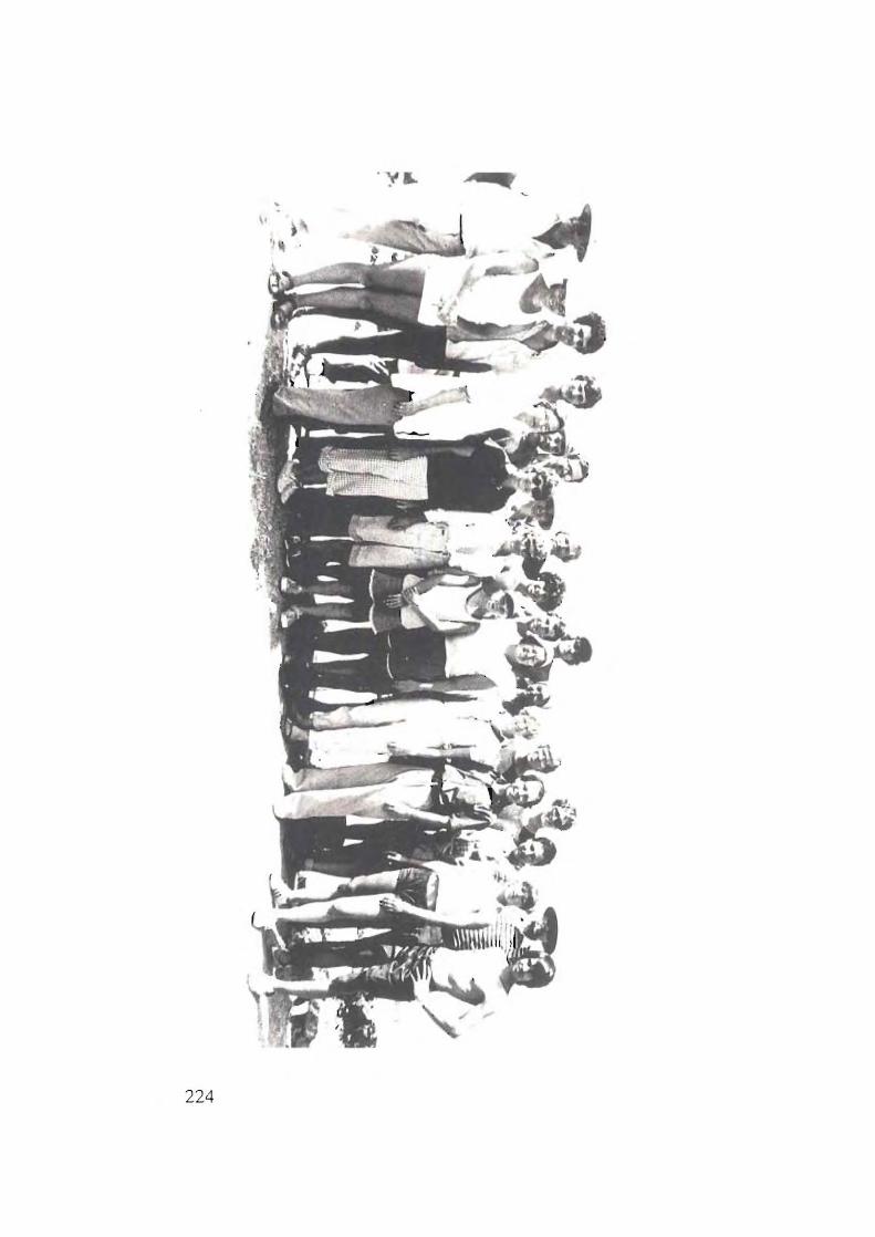
A Q
224


