Embed Size (px)
Citation preview
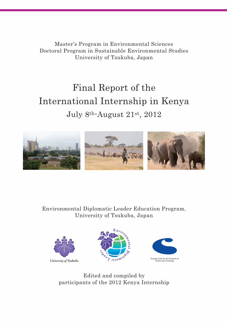
Final Report of the International Internship in Kenya July 8
th-August 21st, 2012
Edited and compiled by participants of the 2012 K
enya Internship
Master s Program in Environmental SciencesDoctoral Program in Sustainable Environmental Studies
University of Tsukuba, Japan
Final Report of theInternational Internship in Kenya
July 8th-August 21st, 2012
Environmental Diplomatic Leader Education Program,University of Tsukuba, Japan
Edited and compiled by participants of the 2012 Kenya Internship
i
Acknowledgement
The EDL Kenya Internship could not have been accomplished without the generous assistance and support from following institutions and individuals. Kenya Wildlife Service (NGO) Friends of Karura Forest Kenya Forest Service African Wildlife Foundation Maasai Wildlife Conservation Trust Japan Society for the Promotion of Science (JSPS) Nairobi Research Center Dr. Charles Musyoki Mutua (Kenya Wildlife Service), Mr. Lekishon Kenana (Kenya Wildlife Service), Mr. Stephen Ndambuki (Kenya Wildlife Service), Dr. Charies Mundia (Jomo Kenyatta University), Professor Moses Makonjio Okello (The School for Field Studies), Ms. Fiesta Warinwa (African Wildlife Foundation), Mr. Dirk van der Goes (Maasai Wildlife Conservation Trust), Dr. Francis Mwaura (University of Nairobi), Ms. Lucy Njoka (Friends of Karura Forest), Dr. Soichiro Shiraishi (JSPS Nairobi Research Center), Dr. Toshio Meguro (University of Tokyo), Ms. Michiyo Takeuchi and Ms. Rie Morikawa (EDL office) We would like to express our deep appreciation to all of the above.
Kenya Internship Participants Environmental Diplomatic Leader Education Program
Graduate School of Life and Environmental Sciences University of Tsukuba
December 2012
─ i ─
ii
Aim and Achievements of the Kenya Internship The EDL Kenya Internship was held between July 8th and 21st 2012. One EDL professor and 10 EDL candidates (two from Doctoral Program in Sustainable Environmental Studies and eight from Master’s Program in Environmental Sciences) participated the internship. This internship focused on two major environmental problems in Africa: environmental problems related to urbanization and nature conservation. During the internship, EDL students worked hard to examine the current situation in Kenya, understand the daily reality of life for local people, and learn directly from specialists who are dealing with these problems.
The first half of the internship was held in Nairobi, the capital city of Kenya. First we had a lecture on the slum and waste problems of Nairobi city given by a scientist from Jomo Kenyatta University. Students then visited Karula forest, which is the only remaining forested area in Nairobi city. We learnt not only how Nobel Peace Prize winner Dr. Wangari Maathai spent her lifetime to protect this forest from developers, but also other efforts made by international diplomacy and local NGOs towards forest conservation. Finally, we visited a local slum near the forest. Although living conditions are extremely difficult in the slum, our students were greatly impressed by the reciprocal relationships and efforts that local residents foster to improve their lives.
The second half of the internship was led by KWS (Kenya Wildlife Service) scientists
and held at Amboseli National Park. The Park is regarded as a biological hotspot of the Kilimanjaro ecosystem, and a key tourism income resource of Kenya. However, local residents suffer serious damage to their farms and livestock caused by wildlife. Here, the EDL students learnt both the difficulty of negotiation among different stakeholders, and the importance of community-based conservation.
Finally, before leaving for Japan, we held a workshop at the JSPS Research Centre in
Nairobi. Each EDL student gave a presentation on one specific topic he/she learnt from this internship. All presentations were highly regarded by the Kenyan and Japanese researchers.
SUN Xiaogang Associate Professor of EDL Program
University of Tsukuba
─ ii ─
iii
Contents Acknowledgement i
Aim and Achievements of the Kenya Internship
SUN Xiaogang……………………………………………………………………….....ii
Part I: Urbanization, Economic Development, and Environmental Problems in Nairobi Chapter 1: Economic Development and Energy Utilization ZHOU Qian…………………………………………………………………………………..2 Chapter 2: Advantage and Disadvantage of Urbanization of Nairobi LI Shuhong………………………………………………………………………………………..9 Chapter 3: Local Challenge to Environmental Problems in Nairobi
TIAN Xiaojie……………………………………………………………………………14 Part II: Nature Conservation in Kenya: A Case Study of Amboseli National Park Chapter 4: Wildlife Conservation Policy and Management in Kenya
and Amboseli National Park Yadmaa Tseveenkhand…………………………………………………………………23 Chapter 5: Challenges for Wildlife Conservation in Kenya and Amboseli National Park VU Van Minh…………………………………………………………………………...29 Chapter 6: Forest Management in Amboseli National Park: Status and Restoration
Efforts for the Wildlife Habitat NGUYEN Tu Anh………………………………………………………………………..36
Chapter 7: Water Resource in Amboseli National Park: An Ecosystem View HA Nam Thang…………………………………………………………………………39 Part III: Community Based Conservation and Environmental Education in Kenya Chapter 8: Karura Forest: Management and Conservation of Urban Forest NGUYEN Thi My Quynh……………………………………………………………….49 Chapter 9: Community Based Conservation and Environmental Education in the Surrounding Areas of Amboseli National Park Badamsed Delgermaa………………………………………………………………….56 Chapter 10: Environmental Movement and Environmental Education in Kenya Syeda Masuma Khanam………………………………………………………………..62 Part IV: Programs, Closing Remarks, and Photos 1. Internship Program……………………………………………………………………..69 2. Program of the Internship Workshop…………………...…………………..………….70 3. Closing Remarks SHIRAISHI Soichiro..........………………………………………………………..…72 4. Group Photos…………………………...………………………………………………73
─ iii ─
1
Part I
Urbanization, Economic Development, and Environmental
Problems in Nairobi
─ 1 ─
2
Chapter 1 Economic Development and Energy Utilization
ZHOU Qian
This chapter consists of four parts. The first part introduces the background for economic development. The second part is a descriptive analysis of the energy supply situation, the challenges presented by an unscientific energy structure and renewable energy storage capacity in Kenya. The third part gives a concise summary of the relationship between energy utilization and environment. The last part concludes the chapter by summarizing the close relationship of 3E (economic, energy, environment) and proposes a policy of renewable energy utilization for sustainable development in Kenya. 1. Economic Development
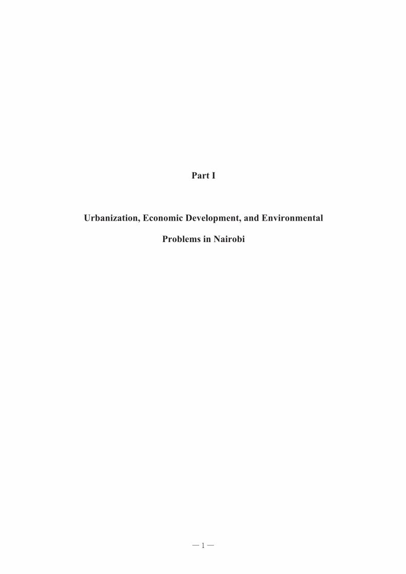
Kenya is a country in East Africa that lies on the equator. With the Indian Ocean to its south-east, it is bordered by Tanzania to the south, Uganda to the west, South Sudan to the north-west, Ethiopia to the north and Somalia to the north-east. Kenya has a land area of 580,000 km2 and a population of a little over 43 million residents. The population and economy in Kenya has a high growth rate as shown in Fig 1, 2, 3. As living conditions in the capital city Nairobi show in Fig 4, 5, population issues are challenges which Kenya must urgently address to balance population increase, economic and social development.
2527293133353739414345
Popu
latio
n (M
illio
n)
Time (Year)
0
10
20
30
40
50
60
70
80
GD
P (B
illio
n $)
Time (Year)
0
1
2
3
4
5
6
7
8
GDP
gro
wth
rate
(%)
Time (Year)
Fig.1 Population growth trend in Kenya
Fig. 2 GDP growth trend in Kenya
Fig.3 GDP growth rate
Data source (Fig. 1-3): International Monetary Fund - 2011 World Economic Outlook
─ 2 ─
3
The major growth sectors are agriculture and forestry; transport and communications; manufacturing; and wholesale and retail trade. Nairobi is a major contributor to Kenya’s economy: it generates over 45 per cent of GDP, employs 25 per cent of Kenyans and 43 per cent of the country’s urban workers.
1.1 Agriculture Agriculture represents about 24% of GDP. It is the backbone of Kenya’s economy, providing food for the citizens as well as for export. About one-third of agricultural produce is exported, accounting for 65% of Kenya's exports. Primary crops that are exported include tea, flowers and sugar. Over 5 million people are engaged in agriculture, mainly small landholders. Approximately 75 % of the country’s population is employed in agriculture. It creates jobs to help Kenyans get back on their feet. The agricultural sector accounts for about 18% of formal employment.
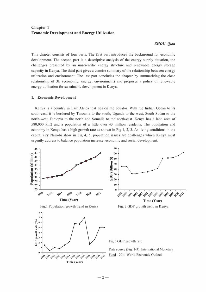
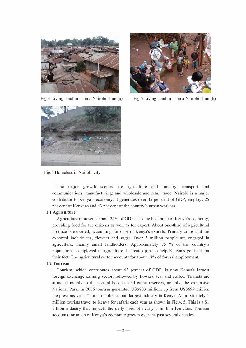
1.2 Tourism Tourism, which contributes about 63 percent of GDP, is now Kenya's largest foreign exchange earning sector, followed by flowers, tea, and coffee. Tourists are attracted mainly to the coastal beaches and game reserves, notably, the expansive National Park. In 2006 tourism generated US$803 million, up from US$699 million the previous year. Tourism is the second largest industry in Kenya. Approximately 1 million tourists travel to Kenya for safaris each year as shown in Fig.4, 5. This is a $1 billion industry that impacts the daily lives of nearly 5 million Kenyans. Tourism accounts for much of Kenya’s economic growth over the past several decades.
Fig.4 Living conditions in a Nairobi slum (a)
Fig.6 Homeless in Nairobi city
Fig.5 Living conditions in a Nairobi slum (b)
─ 3 ─
4
Therefore, government and tourist industry organizations have taken steps to address security problems and to reverse negative publicity. Such steps include establishing a tourist police and launching marketing campaigns in key tourist origin markets. Tourism has seen a substantial revival over the past several years and is the major contributor to improvement in the country’s economic growth.
1.3 Other Industries Kenya is the most developed industrial country in the East African region with a full range of industrial sectors. Total output value of other industries accounted for 16.2% of gross domestic product (GDP), particularly manufacturing output accounted for about 10% of the GDP. Larger enterprises such as refining, tires, cement, steel rolling, power generation, automotive assembly plants provide jobs for 230,000 persons. However, 85% of consumer goods are produced in China, including clothing, paper, food, drinks, and cigarettes. For example, when we went shopping in a supermarket in Nairobi city, we found that many goods were made in China.
2. Energy Utilization
The Kenya Vision 2030 has identified Energy as a key foundation and one of the infrastructural “enablers” upon which the economic, social and political pillars of this long-term development strategy will be built (Lofgren and Kumar 2007) . Energy is a very significant engine for sustainable development. Socio-economic development requires energy. The substantial dependence upon an ever-growing use of unclean energy for industrialization and urbanization leads to increasing costs of environmental pollution. Through the EDL Kenya Internship experience this summer, participants could see that air pollution caused by rapid motorization has the potential to become an increasingly serious problem. Inevitably, the city is confronted with the pressure of air pollutants and greenhouse gas reduction. Therefore, it is necessary to explore renewable energy sources in Kenya to reduce both air pollutants and greenhouse gas.
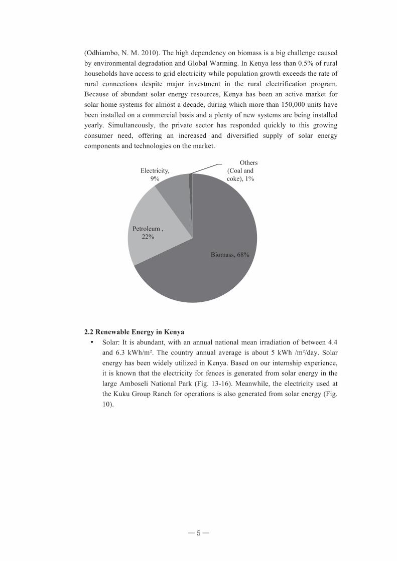
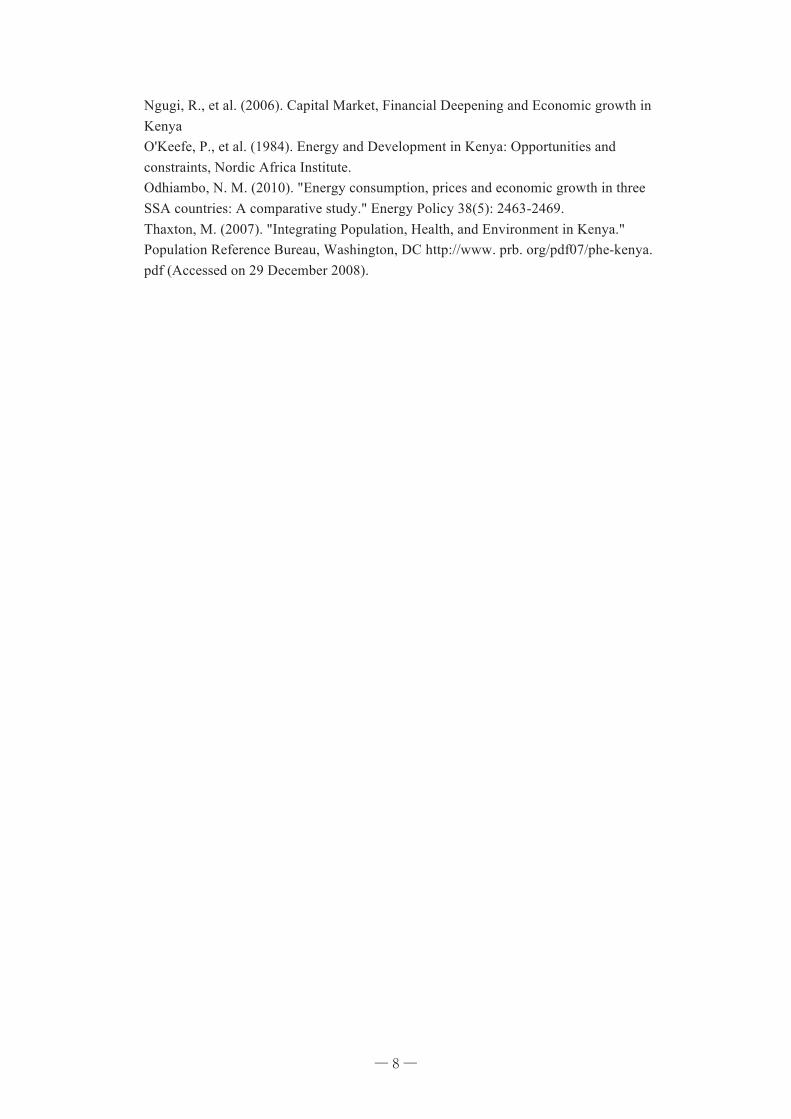
2.1 Energy Supply Structure, Influence on Economic and Environment Kenya is highly dependent on hydroelectricity, which accounts for over 75% of all electrical output. Currently, Kenya imports all of the oil it consumes. Therefore, economic development is badly impacted by international oil prices. Wood fuel (Fig. 17) and other non-sustainable sources are responsible for most energy consumption
Fig. 7-8 Safari in Amboseli National Park
─ 4 ─
5
(Odhiambo, N. M. 2010). The high dependency on biomass is a big challenge caused by environmental degradation and Global Warming. In Kenya less than 0.5% of rural households have access to grid electricity while population growth exceeds the rate of rural connections despite major investment in the rural electrification program. Because of abundant solar energy resources, Kenya has been an active market for solar home systems for almost a decade, during which more than 150,000 units have been installed on a commercial basis and a plenty of new systems are being installed yearly. Simultaneously, the private sector has responded quickly to this growing consumer need, offering an increased and diversified supply of solar energy components and technologies on the market.
2.2 Renewable Energy in Kenya ¥ Solar: It is abundant, with an annual national mean irradiation of between 4.4
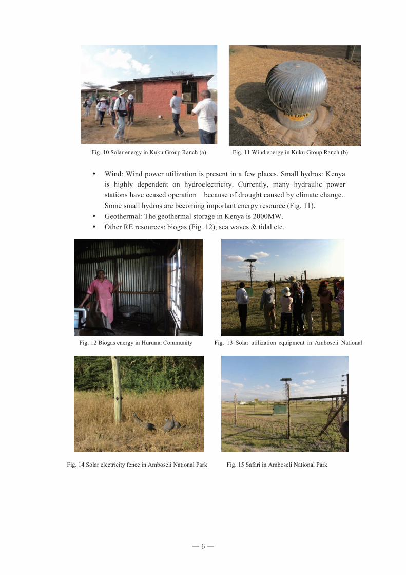
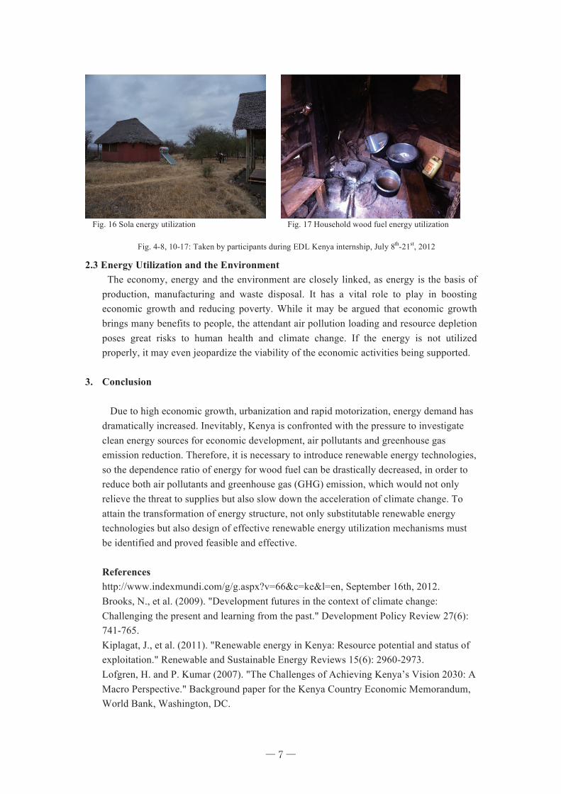
and 6.3 kWh/m². The country annual average is about 5 kWh /m²/day. Solar energy has been widely utilized in Kenya. Based on our internship experience, it is known that the electricity for fences is generated from solar energy in the large Amboseli National Park (Fig. 13-16). Meanwhile, the electricity used at the Kuku Group Ranch for operations is also generated from solar energy (Fig. 10).
Biomass, 68%
Petroleum ,
22%
Electricity,
9%
Others (Coal and coke), 1%
─ 5 ─
6
¥ Wind: Wind power utilization is present in a few places. Small hydros: Kenya is highly dependent on hydroelectricity. Currently, many hydraulic power stations have ceased operation because of drought caused by climate change.. Some small hydros are becoming important energy resource (Fig. 11).
¥ Geothermal: The geothermal storage in Kenya is 2000MW. ¥ Other RE resources: biogas (Fig. 12), sea waves & tidal etc.
Fig. 12 Biogas energy in Huruma Community Fig. 13 Solar utilization equipment in Amboseli National
Fig. 14 Solar electricity fence in Amboseli National Park Fig. 15 Safari in Amboseli National Park
Fig. 10 Solar energy in Kuku Group Ranch (a) Fig. 11 Wind energy in Kuku Group Ranch (b)
─ 6 ─
7
2.3 Energy Utilization and the Environment
The economy, energy and the environment are closely linked, as energy is the basis of production, manufacturing and waste disposal. It has a vital role to play in boosting economic growth and reducing poverty. While it may be argued that economic growth brings many benefits to people, the attendant air pollution loading and resource depletion poses great risks to human health and climate change. If the energy is not utilized properly, it may even jeopardize the viability of the economic activities being supported.
3. Conclusion Due to high economic growth, urbanization and rapid motorization, energy demand has dramatically increased. Inevitably, Kenya is confronted with the pressure to investigate clean energy sources for economic development, air pollutants and greenhouse gas emission reduction. Therefore, it is necessary to introduce renewable energy technologies, so the dependence ratio of energy for wood fuel can be drastically decreased, in order to reduce both air pollutants and greenhouse gas (GHG) emission, which would not only relieve the threat to supplies but also slow down the acceleration of climate change. To attain the transformation of energy structure, not only substitutable renewable energy technologies but also design of effective renewable energy utilization mechanisms must be identified and proved feasible and effective. References http://www.indexmundi.com/g/g.aspx?v=66&c=ke&l=en, September 16th, 2012. Brooks, N., et al. (2009). "Development futures in the context of climate change: Challenging the present and learning from the past." Development Policy Review 27(6): 741-765. Kiplagat, J., et al. (2011). "Renewable energy in Kenya: Resource potential and status of exploitation." Renewable and Sustainable Energy Reviews 15(6): 2960-2973. Lofgren, H. and P. Kumar (2007). "The Challenges of Achieving Kenya’s Vision 2030: A Macro Perspective." Background paper for the Kenya Country Economic Memorandum, World Bank, Washington, DC.
Fig. 17 Household wood fuel energy utilization
Fig. 4-8, 10-17: Taken by participants during EDL Kenya internship, July 8th-21st, 2012
Fig. 16 Sola energy utilization
─ 7 ─
8
Ngugi, R., et al. (2006). Capital Market, Financial Deepening and Economic growth in Kenya O'Keefe, P., et al. (1984). Energy and Development in Kenya: Opportunities and constraints, Nordic Africa Institute. Odhiambo, N. M. (2010). "Energy consumption, prices and economic growth in three SSA countries: A comparative study." Energy Policy 38(5): 2463-2469. Thaxton, M. (2007). "Integrating Population, Health, and Environment in Kenya." Population Reference Bureau, Washington, DC http://www. prb. org/pdf07/phe-kenya. pdf (Accessed on 29 December 2008).
─ 8 ─
9
Chapter 2
Advantage and Disadvantage of Urbanization of Nairobi
LI Shuhong
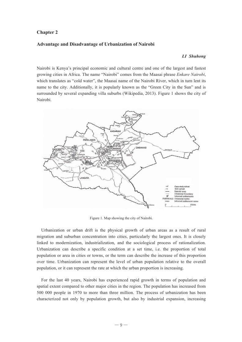
Nairobi is Kenya’s principal economic and cultural centre and one of the largest and fastest growing cities in Africa. The name “Nairobi” comes from the Maasai phrase Enkare Nairobi, which translates as “cold water”, the Maasai name of the Nairobi River, which in turn lent its name to the city. Additionally, it is popularly known as the “Green City in the Sun” and is surrounded by several expanding villa suburbs (Wikipedia, 2013). Figure 1 shows the city of Nairobi.
Figure 1. Map showing the city of Nairobi.
Urbanization or urban drift is the physical growth of urban areas as a result of rural migration and suburban concentration into cities, particularly the largest ones. It is closely linked to modernization, industrialization, and the sociological process of rationalization. Urbanization can describe a specific condition at a set time, i.e. the proportion of total population or area in cities or towns, or the term can describe the increase of this proportion over time. Urbanization can represent the level of urban population relative to the overall population, or it can represent the rate at which the urban proportion is increasing.
For the last 40 years, Nairobi has experienced rapid growth in terms of population and spatial extent compared to other major cities in the region. The population has increased from 500 000 people in 1970 to more than three million. The process of urbanization has been characterized not only by population growth, but also by industrial expansion, increasing
─ 9 ─
10
economic and social activities and intensified use of land resources. During the internship, Population and changes in land use were the focus of the internship.
In Nairobi city, the urban/built-up areas have increased from 14 km2 in 1976 to 62 km2 in 2000. Agricultural fields occupied 49 km2 in 1976 and have increased substantially to 88 km2 in 2000. Forested lands have, however, decreased substantially from 100 km2 in 1976 to a mere 23 km2 in 2000, a record loss of 77 km2. The rangelands, consisting of mixed rangeland and shrub/brush rangeland have decreased from 357 km2 in 1976 to 237 km2 in 2000 (Mundia and Aniya, 2006). The rangelands have given way mainly to expanding agriculture and urban sprawl. With the development of urbanization, more and more land for urban and agriculture areas from forest and mixed rangeland.
Table 1. Areas of land use/cover types for the Nairobi City extracted from Landsat images (Muriuki et al., 2011)
Year 1976 1988 2000
Land use Area(km2) % Area(km2) % Area(km2) %
Urban areas 13.99 1.90
41.18 5.77
61.23 8.58
Agriculture 49.83 6.98
57.83 8.10
87.78 12.30
Forests 100.15 14.04
29.09 4.08
23.56 3.30
Bush land 154.48 22.35
101.49 14.22
95.98 13.45
Mixed rangeland 357.32 50.08
340.62 47.74
237.63 33.31
Shrub/brush range 25.22 3.53
64.19 8.99
170.78 23.94
Open/transitional 6.92 0.96
77.96 10.92
32.72 4.58
Water 0.50 0.07
1.09 0.15
3.77 0.53
Total 713.41 100.00 713.44 100.00 713.45 100.00
Fig.2 shows the population in Kenya and Nairobi from 1960 to 2010.The 1969 population census put Nairobi’s population at slightly over half a million. The population rose to 1:35 million by 1989 against a national total population of 23 million. The current population is estimated at 3.5 million, a fivefold increase over the 1969 population. This rapid urban population growth reflects a natural population increase among the urban residents (52 %) as well as migration of people from rural areas to the city (48 per cent). The demand for food has led to the expansion of agriculture areas to feed the growing population. Nairobi’s economy, public services and infrastructure have not managed to keep up with the increasing population.
0.00
10.00
20.00
30.00
40.00
50.00
1960 1965 1970 1975 1980 1985 1990 1995 2000 2005 2010
Popu
latio
n (m
illio
n)
Year Figure 2. The population in Kenya and Nairobi
Nairobi Kenya
─ 10 ─
11
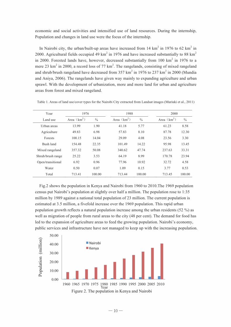
Urbanization has both advantages and disadvantages. Advantages of Urbanization in Nairobi: Firstly, growth in industrial production: the production in various industrial sectors like cement, iron and steel, textile, fertilizers etc., are helping in the economic growth of the country. There has been an increase in both Nairobi's exports and urban greening because of urbanization. Secondly, growth in trade and commerce: Urbanization helps the nation's business sector. Rural people bring their goods to urban places. Additionally, development of tourism industries: people from foreign countries are attracted to good cities and towns having better transport facilities. Tourism is a good source of foreign currency for a country. Last, improvement in science, culture etc.: urban places are the meeting point of all the good cultures of various localities. Education, science and technology developments takes place in urban areas improving the society as a whole.
Figure 3. The city of Nairobi
During the internship in Nairobi, it was noticeable to everyone that urbanization brings convenience. The supermarket is a convenience operation, mainly a 24-hour business. It is easy to buy all kinds of lifestyle products. After work, you can find a lot of people who come from the suburbs and later go back home. It is the city, which offers the working conditions to support their family. In addition, each year visitors from the States come to Kenya for tourism. The development of urbanization attracts talent, especially talent in science and technology and entrepreneurial talent to work in the city.
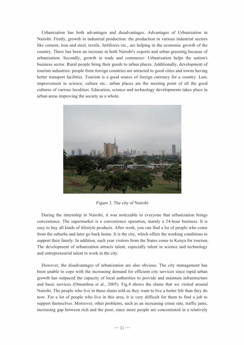
However, the disadvantages of urbanization are also obvious. The city management has been unable to cope with the increasing demand for efficient city services since rapid urban growth has outpaced the capacity of local authorities to provide and maintain infrastructure and basic services (Omumboa et al., 2005). Fig.4 shows the slums that we visited around Nairobi. The people who live in these slums told us they want to live a better life than they do now. For a lot of people who live in this area, it is very difficult for them to find a job to support themselves. Moreover, other problems, such as an increasing crime rate, traffic jams, increasing gap between rich and the poor; since more people are concentrated in a relatively
─ 11 ─
12
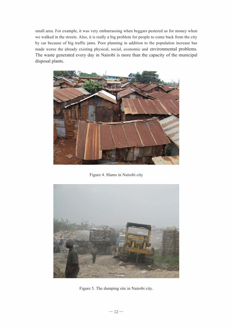
small area. For example, it was very embarrassing when beggars pestered us for money when we walked in the streets. Also, it is really a big problem for people to come back from the city by car because of big traffic jams. Poor planning in addition to the population increase has made worse the already existing physical, social, economic and environmental problems. The waste generated every day in Nairobi is more than the capacity of the municipal disposal plants.
Figure 4. Slums in Nairobi city
Figure 5. The dumping site in Nairobi city.
─ 12 ─
13
How to solve those problems? Firstly, considering transportation; it is better for the government to build an overpass or tunnel to reduce traffic jams. Another way is to encourage people to ride bicycles instead of taking the bus. Last but not least, it is time to put traffic laws into effect. Secondly, sustainable urbanization is very important for Nairobi. Reduce, reuse, recycle and refuse is necessary to decrease waste. The protection of the environment in Nairobi should be promoted without delay. Conservation and rationalization of resources is necessary. Last, with the continuous development of urbanization, commercializing technology seems the best way to providing cheap, nearly unlimited power with no harmful effects.
In order to balance economic, environmental, and social necessities, sustainable urbanization is needed. It is very important to select a coordinated way between economy and urbanization (Rasoolimanesh et al., 2012). Although economic development is necessary as is urbanization, more attention should be paid to the disadvantages brought by urbanization. Only through reformation at the municipal level and changing people’s life step by step, can the improvement in quality and reliability of urbanization become true.
References: Mundia CN, Aniya AM. Dynamics of landuse/cover changes and degradation of Nairobi city ,Kenya. Land Degradation & Development. 17 (2006): 97-108. Muriuki G, Seabrook L, McAlpine C, Jacobson C, Price B, Baxter G. Land cover change under unplanned human settlements: A study of the Chyulu Hills squatters, Kenya. Landscape and Urban Planning 99 (2011):154–165. Omumboa JA, Guerrab CA, Haya SI, Snow RW. The influence of urbanisation on measures of Plasmodium falciparum infection prevalence in East Africad. Acta Tropica 93 (2005):11-21. Rasoolimanesh SM, Badarulzaman N & Mastura Jaafar M. City Development Strategies (CDS) and Sustainable Urbanization in Developing World. Procedia - Social and Behavioral Sciences 36 (2012):623-631. Wikipedia. Available from: http://en.wikipedia.org/wiki/Nairobi. [cited 2013, Jan. 9]
─ 13 ─
14
Chapter 3 Local Challenges for Environmental Problems in Nairobi
TIAN Xiaojie
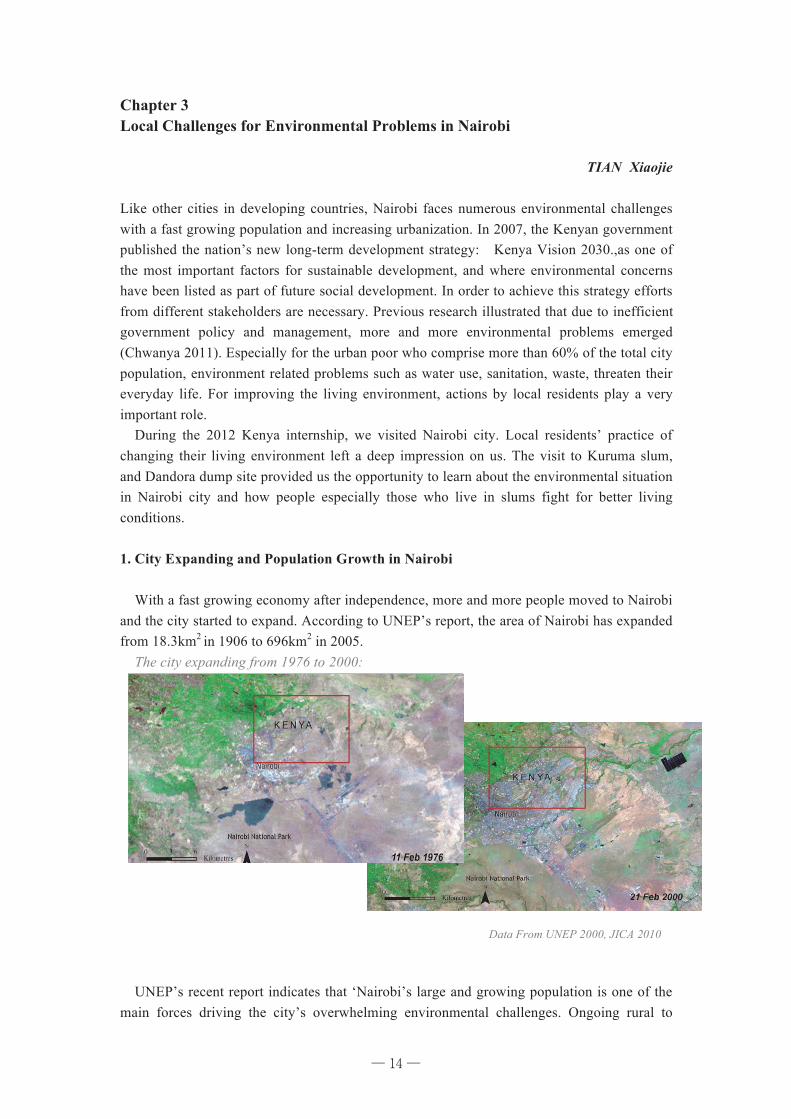
Like other cities in developing countries, Nairobi faces numerous environmental challenges with a fast growing population and increasing urbanization. In 2007, the Kenyan government published the nation’s new long-term development strategy: Kenya Vision 2030.,as one of the most important factors for sustainable development, and where environmental concerns have been listed as part of future social development. In order to achieve this strategy efforts from different stakeholders are necessary. Previous research illustrated that due to inefficient government policy and management, more and more environmental problems emerged (Chwanya 2011). Especially for the urban poor who comprise more than 60% of the total city population, environment related problems such as water use, sanitation, waste, threaten their everyday life. For improving the living environment, actions by local residents play a very important role. During the 2012 Kenya internship, we visited Nairobi city. Local residents’ practice of changing their living environment left a deep impression on us. The visit to Kuruma slum, and Dandora dump site provided us the opportunity to learn about the environmental situation in Nairobi city and how people especially those who live in slums fight for better living conditions. 1. City Expanding and Population Growth in Nairobi With a fast growing economy after independence, more and more people moved to Nairobi and the city started to expand. According to UNEP’s report, the area of Nairobi has expanded from 18.3km2 in 1906 to 696km2 in 2005. The city expanding from 1976 to 2000: UNEP’s recent report indicates that ‘Nairobi’s large and growing population is one of the main forces driving the city’s overwhelming environmental challenges. Ongoing rural to
DIVISION OF EARLY WARNING AND ASSESSMENT
GG RR II DDN A I R O B I
http: / /www.gridnairobi .unep.org
The boundaries and names shown and the designations used on these maps do not imply official endorsement or acceptance by the United Nations.Created at UNEP/DEWA~Europe/GRID-Europe; May 2005
For more information, please contact Officer in charge: UNEP/DEWA/GRID-NairobiUnited Nations Environment Programme, "X" block
P.O.Box 30552, Nairobi, Kenya.Tel +254 20 624214Fax +254 20 624315
E-mail johannes.akiwumi@unep,org
Nairobi: Impacts of Urban Growth
Million
0
3,000,000
6,000,000
9,000,000
12,000,000
15,000,000
18,000,000
21,000,000
24,000,000
27,000,000
30,000,000
Year
Population growth in Kenya's capital, Nairobi
Kenya
Nairobi
Source:KenyaBureauofStatistics
1969 1979 1989 1999
Kenyatta Avenue, downtown Nairobi
photo:PeterKariuki
Nairobi
Mt. KenyaAberdarerangesRift valley
Kenya's capital city, Nairobi, was established in 1899 as a railway supply depot, and by 1922,the number of settlers had rose to 9 000. About three decades later in the 1950s, thepopulation was about 80 000 settlers. In just 100 years, this small supply depot had beentransformed into a thriving capital of British East Africa. At independence in 1963, Nairobi hada population of 350 000 people. Its current population is estimated at more than 3.2 millionpeople spread over 685 square kilometres. Today, Nairobi is a cultural and architectural meltingpot, the largest city between Cairo and Johannesburg and the economic capital of much ofEastern and Central Africa.
The location of Nairobi and its relatively well-developed infrastructure, including a modernairport and commercial centres has led to a very rapid expansion of the city since 1979. Thecity's population growth has influenced environmental change overthe past century as more land was opened up for human settlement,industry, roads and other infrastructural development.
photo:PeterKariuki
photo:PeterKariuki
Red box shows area of expansion
Kimathi street, downtown Nairobi
Nairobi is now faced with serious urban planning and managementproblems, and thousands of its residents live in informal settlements. Agrowing number of urban residents are finding shelter in sub-standardhousing in informal settlements with severe sanitation problems. In oneof these settlements, there are only 10 toilets for a settlement of 332households. The burgeoning slums of Kibera and Mathare may well beAfrica's largest and are also probably the most dangerous. They havevery little or no basic services. Deterioration of the conditions is alsomanifested in decaying infrastructure, poor management of bothhousehold and industrial solid waste, lack of proper sanitation facilities,poor drainage systems; and unreliable energy and water supplies forhome consumption and industrial production. Individual families in thecity, through their own savings, are however playing a significant role infinancing their own housing improvement cost, contributing a largeproportion to the domestic resources going into the housing sector.
The current government, elected in December 2002, is trying toresuscitate the economy and decentralize development planning andimplementation to city authorities. It has already started to address thechallenges of security, rehabilitation of roads and streets, upgrading ofcity slums and provision of services - public lighting, enactment ofdriving standards, market cleanups, restoration of public sanitationinfrastructure, and solid waste management.
KENYA
Nairobi
Data From UNEP 2000, JICA 2010
─ 14 ─
15
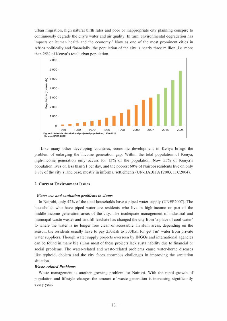
urban migration, high natural birth rates and poor or inappropriate city planning conspire to continuously degrade the city’s water and air quality. In turn, environmental degradation has impacts on human health and the economy.’ Now as one of the most prominent cities in Africa politically and financially, the population of the city is nearly three million, i.e. more than 25% of Kenya’s total urban population.
Like many other developing countries, economic development in Kenya brings the problem of enlarging the income generation gap. Within the total population of Kenya, high-income generation only occurs for 13% of the population. Now 55% of Kenya’s population lives on less than $1 per day, and the poorest 60% of Nairobi residents live on only 8.7% of the city’s land base, mostly in informal settlements (UN-HABITAT2003, ITC2004). 2. Current Environment Issues Water use and sanitation problems in slums In Nairobi, only 42% of the total households have a piped water supply (UNEP2007). The households who have piped water are residents who live in high-income or part of the middle-income generation areas of the city. The inadequate management of industrial and municipal waste waster and landfill leachate has changed the city from ‘a place of cool water’ to where the water is no longer free clean or accessible. In slum areas, depending on the season, the residents usually have to pay 250Ksh to 500Ksh for get 1m3 water from private water suppliers. Though water supply projects overseen by INGOs and international agencies can be found in many big slums most of these projects lack sustainability due to financial or social problems. The water-related and waste-related problems cause water-borne diseases like typhoid, cholera and the city faces enormous challenges in improving the sanitation situation. Waste-related Problems Waste management is another growing problem for Nairobi. With the rapid growth of population and lifestyle changes the amount of waste generation is increasing significantly every year.
148
Population growth: a major driver of environmental change
In 1901, there were only 8 000 people living in Nairobi. By 1948, the number had grown to 118 000 and
by 1962, the city had a population of 343 500 people. By the 2009 census, the city’s population will be
about 3.1 million and in 2015 it is projected to be 3.8 million (Rakodi 1997, CBS 2001). Nairobi’s early
growth was fuelled by rural migrants and an explosion of growth took place between 1979 and 1989 when
772 624 newcomers came to the city (NEMA 2003). The forces motivating rural-urban migration to Nairobi
include better economic prospects, opportunities for higher education and higher wage employment, and the
attraction of Nairobi as a market for goods and services.
Nairobi is currently home to nearly three million people and represents about a quarter of Kenya’s
urban population. A growing economy and swelling population numbers from both in-migration and
natural growth are continually increasing the city’s size. A signifi cant number of commuters from satellite
towns such as Thika, Naivasha, Ngong, and Machakos come into Nairobi daily to work or bring goods and
supplies. Daily commuters from such satellite towns contribute an estimated additional half-million people
to the city’s population.
Nairobi’s large and growing population is one of the main forces driving the city’s overwhelming
environmental challenges. Ongoing rural to urban migration, high natural birth rates, and poor or
inappropriate city planning conspire to continue degrading the city’s water and air quality. In turn,
environmental degradation has impacts on human health and the economy. For the country to achieve the
MDGs, progress must be made in Nairobi, as Kenya’s capital city and its largest urban centre. An important
target is stabilizing the fertility rate at 2.1 by 2010, as recommended by the Population Policy for Sustainable
Development (CBS 2004).
Figure 2: Nairobi’s historical and projected population , 1950-2025 (Source: KNBS 2008)
0
1 000
2 000
3 000
4 000
5 000
6 000
7 000
1950 1960 1970 1980 1990 2000 2007 2015 2025
Popu
latio
n (th
ousa
nds)
N. S
trupl
er/ F
lickr
.com
Typical street scene in Nairobi
─ 15 ─
16
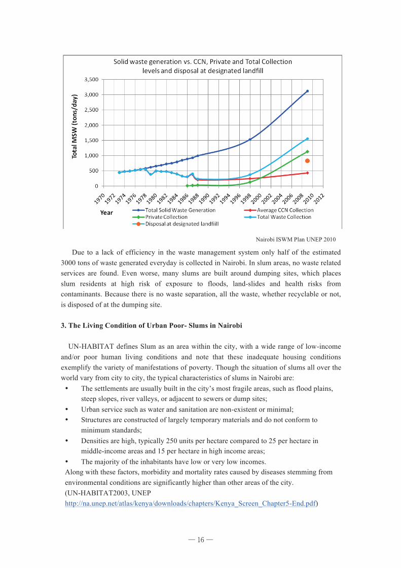
Due to a lack of efficiency in the waste management system only half of the estimated 3000 tons of waste generated everyday is collected in Nairobi. In slum areas, no waste related services are found. Even worse, many slums are built around dumping sites, which places slum residents at high risk of exposure to floods, land-slides and health risks from contaminants. Because there is no waste separation, all the waste, whether recyclable or not, is disposed of at the dumping site. 3. The Living Condition of Urban Poor- Slums in Nairobi UN-HABITAT defines Slum as an area within the city, with a wide range of low-income and/or poor human living conditions and note that these inadequate housing conditions exemplify the variety of manifestations of poverty. Though the situation of slums all over the world vary from city to city, the typical characteristics of slums in Nairobi are: ¥ The settlements are usually built in the city’s most fragile areas, such as flood plains,
steep slopes, river valleys, or adjacent to sewers or dump sites; ¥ Urban service such as water and sanitation are non-existent or minimal; ¥ Structures are constructed of largely temporary materials and do not conform to
minimum standards; ¥ Densities are high, typically 250 units per hectare compared to 25 per hectare in
middle-income areas and 15 per hectare in high income areas; ¥ The majority of the inhabitants have low or very low incomes. Along with these factors, morbidity and mortality rates caused by diseases stemming from environmental conditions are significantly higher than other areas of the city. (UN-HABITAT2003, UNEP http://na.unep.net/atlas/kenya/downloads/chapters/Kenya_Screen_Chapter5-End.pdf)
6"Integrated"Solid"Waste"Management"Plan"for"Nairobi" "1st"Draft"
4.3 Trends*in*solid*waste*management*Nairobi"has"been"experiencing"exponential"population"growth,"which"has"in"the"past"few"years"started"to"show"signs"of"leveling"off."Overall,"the"population"of"the"Nairobi"Metropolitan"region"is"expected"to"keep"growing,"though"at"slower"rates."Solid"waste"generation"is"however"also"a"function"of"growth"in"wealth,"and"in"this"respect,"Kenyans"have"experienced"an"average"3%"growth"in"GDP/capita"in"the"first"decade"of"the"new"millennium.""Growth"in"waste"is"often"the"sum"of"the"population"and"GDP/cap"growth"rates,"and"Nairobi"in"the"2000s"seems"to"have"experienced"this"too,"resulting"in"a"7%"p.a."growth"rate"in"solid"waste,"or"roughly"a"doubling"of"total"quantity"in"10"years."""
""Figure"1:"Solid"waste"trends"in"Nairobi"
4.4 Systems*analysis**Interestingly,"private"waste"collectors"appear"to"have"been"able"to"grow"their"operations"at"a"similar"rate"as"that"shown"by"overall"waste"quantities,"whilst"the"publically"operated"collection"system"falls"further"and"further"behind,"despite"some"small"growth."The"ability"to"collect"fees"and/or"access"public"budgets"is"key"to"these"growth"trends."
Nairobi ISWM Plan UNEP 2010
─ 16 ─
17
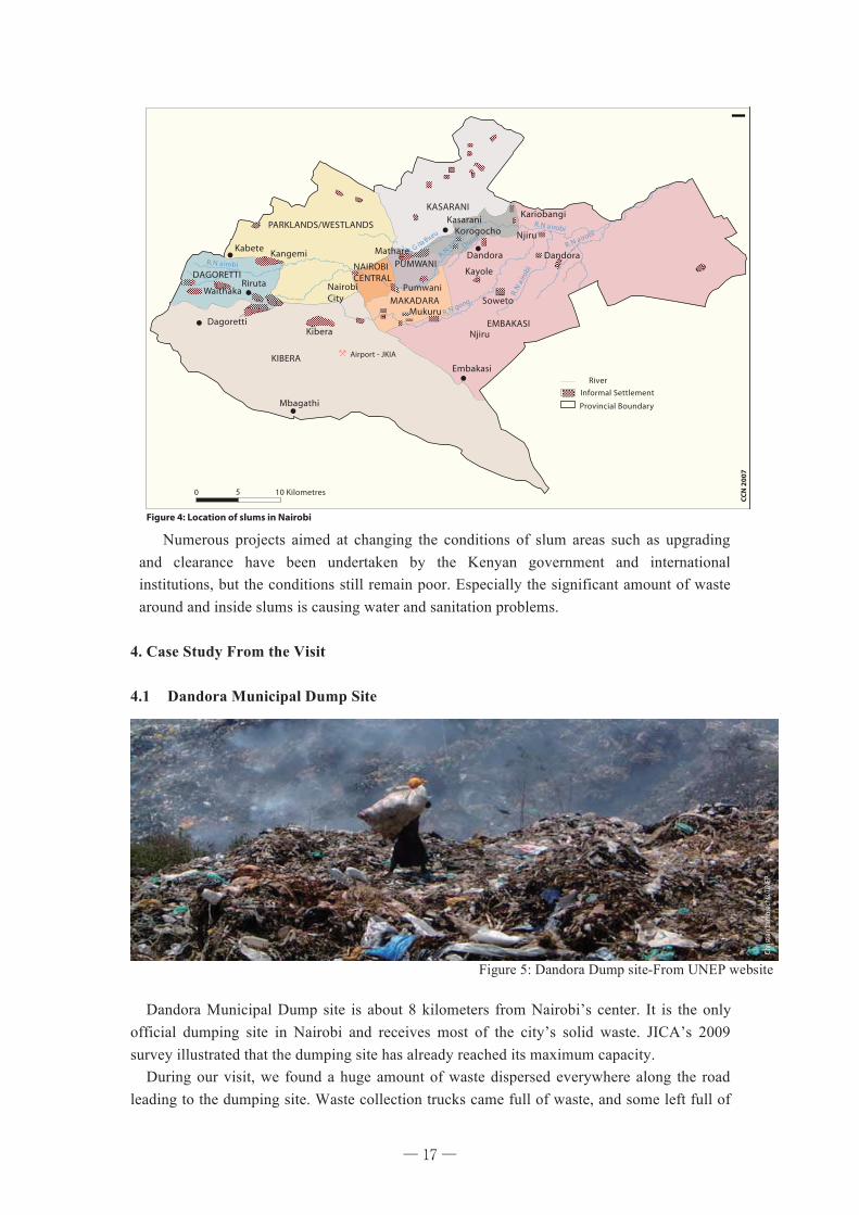
Numerous projects aimed at changing the conditions of slum areas such as upgrading and clearance have been undertaken by the Kenyan government and international institutions, but the conditions still remain poor. Especially the significant amount of waste around and inside slums is causing water and sanitation problems.
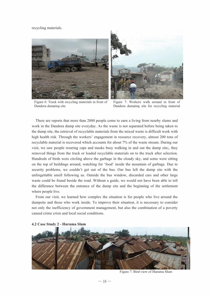
4. Case Study From the Visit 4.1 Dandora Municipal Dump Site
Dandora Municipal Dump site is about 8 kilometers from Nairobi’s center. It is the only official dumping site in Nairobi and receives most of the city’s solid waste. JICA’s 2009 survey illustrated that the dumping site has already reached its maximum capacity. During our visit, we found a huge amount of waste dispersed everywhere along the road leading to the dumping site. Waste collection trucks came full of waste, and some left full of
152
Informal settlements
Nairobi’s rapid growth increased the demand for
land and led to land speculation, forcing the poor
to settle in fragile and unsavoury areas where they
face hardships due to a lack of proper housing
and public services and where they are vulnerable
to environmental change. Urban poverty, lack of
employment opportunities, and inadequate urban
planning also conspired in the gradual growth of
informal settlements in Nairobi since the city’s
founding. By 1995, there were a total of 134
informal settlements with 77 589 structures. These settlements had a combined population of 1 886 166
(CCN 2007).
People living in Nairobi’s informal settlements, particularly the slums, usually fi nd themselves in the
city’s most fragile areas, such as fl ood plains, steep slopes, river valleys, or adjacent to sewers or dump
Figure 3: Nairobi's population density, 1906-2005(Source: CBS 2001)
0
500
1 000
1 500
2 000
2 500
1906
1928
1931
1936
1944
1962
1969
1979
1989
1999
2000
2001
2002
2003
2004
2005
Popu
latio
n de
nsity
¯
Figure 4: Location of slums in Nairobi
Flic
kr.c
omCC
N 2
007
Scene from a slum area in Nairobi
153
sites. The Dandora Municipal Dumping site, which receives most of the city’s solid waste, is only about
eight kilometres from Nairobi’s centre and is surrounded by a low-income residential area. This situation
exposes slum residents to fl oods, land-slides, and health risks from contaminants. In addition, they live in
overcrowded conditions with poor sanitation, inadequate and unsafe water, make-shift shelters, and unstable
social networks. They also face a high degree of tenure insecurity since most of these settlements are illegal,
exposing them to the constant threat of harassment and eviction.
In an attempt to reduce some of the problems of informal settlements, slum upgrading and site and
service schemes have been encouraged. The Government of Kenya has established the Slum Upgrading and
Low Cost Housing and Infrastructure Trust Fund to serve as a depository for funds mobilized for the Slum
Upgrading Programme.
Air pollution
The main sources of atmospheric pollution are vehicles, industries, emissions from the use of charcoal and
fi rewood, and other municipal sources such as the open burning of waste. The increasing number of cars in
the city intensifi es traffi c and pollution problems. Vehicles emit signifi cant levels of air pollutants, including
greenhouse gases and the precursors of smog. Charcoal burning, a very prevalent energy source in the city,
emits methane (CH4) and carbon monoxide (CO) and sends tiny particulates into the air.
Figure 5: Average total suspended particulates (TPS) over a section of Nairobi
¯
MA
Neek
s / Fl
ickr.c
om
Chris
tian
Lam
brec
hts/
UNEP
Mul
aku
and
Kariu
ki 2
001
Kilometres
The Dandora Dumping site
Heavy tra� c contributes to air pollution
Figure 5: Dandora Dump site-From UNEP website
─ 17 ─
18
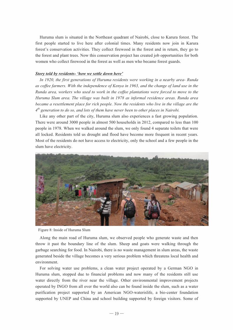
recycling materials. There are reports that more than 2000 people come to earn a living from nearby slums and work in the Dandora dump site everyday. As the waste is not separated before being taken to the dump site, the retrieval of recyclable materials from the mixed waste is difficult work with high health risk. Through the workers’ engagement in resource recovery, almost 200 tons of recyclable material is recovered which accounts for about 7% of the waste stream. During our visit, we saw people wearing caps and masks busy walking in and out the dump site;, they removed things from the truck or loaded recyclable materials on to the truck after selection. Hundreds of birds were circling above the garbage in the cloudy sky, and some were sitting on the top of buildings around, watching for ‘food’ inside the mountain of garbage. Due to security problems, we couldn’t get out of the bus. Our bus left the dump site with the unforgettable smell following us. Outside the bus window, discarded cars and other large waste could be found beside the road. Without a guide, we would not have been able to tell the difference between the entrance of the dump site and the beginning of the settlement where people live. From our visit, we learned how complex the situation is for people who live around the dumpsite and those who work inside. To improve their situation, it is necessary to consider not only the inefficiency of government management, but also the combination of a poverty caused crime crisis and local social conditions. 4.2 Case Study 2 - Huruma Slum
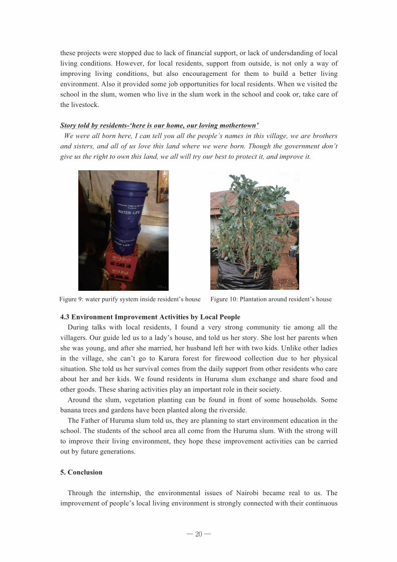
Figure 7: Bird-view of Huruma Slum
Figure 6: Truck with recycling materials in front of Dandora dumping site
Figure 7: Workers walk around in front of Dandora dumping site for recycling material collections
─ 18 ─
19
Huruma slum is situated in the Northeast quadrant of Nairobi, close to Karura forest. The first people started to live here after colonial times. Many residents now join in Karura forest’s conservation activities. They collect firewood in the forest and in return, they go to the forest and plant trees. Now this conservation project has created job opportunities for both women who collect firewood in the forest as well as men who became forest guards. Story told by residents- ‘how we settle down here’ In 1920, the first generations of Huruma residents were working in a nearby area- Runda as coffee farmers. With the independence of Kenya in 1963, and the change of land use in the Runda area, workers who used to work in the coffee plantations were forced to move to the Huruma Slum area. The village was built in 1978 as informal residence areas. Runda area became a resettlement place for rich people. Now the residents who live in the village are the 4th generation to do so, and lots of them have never been to other places in Nairobi. Like any other part of the city, Huruma slum also experiences a fast growing population. There were around 3000 people in almost 500 households in 2012, compared to less than 100 people in 1978. When we walked around the slum, we only found 4 separate toilets that were all locked. Residents told us drought and flood have become more frequent in recent years. Most of the residents do not have access to electricity, only the school and a few people in the slum have electricity.
Along the main road of Huruma slum, we observed people who generate waste and then throw it past the boundary line of the slum. Sheep and goats were walking through the garbage searching for food. In Nairobi, there is no waste management in slum areas, the waste generated beside the village becomes a very serious problem which threatens local health and environment. For solving water use problems, a clean water project operated by a German NGO in Huruma slum, stopped due to financial problems and now many of the residents still use water directly from the river near the village. Other environmental improvement projects operated by INGO from all over the world also can be found inside the slum, such as a water purification project supported by an American NGO-waterislife, a bio-center foundation supported by UNEP and China and school building supported by foreign visitors. Some of
Figure 8: Inside of Huruma Slum
─ 19 ─
20
these projects were stopped due to lack of financial support, or lack of undersdanding of local living conditions. However, for local residents, support from outside, is not only a way of improving living conditions, but also encouragement for them to build a better living environment. Also it provided some job opportunities for local residents. When we visited the school in the slum, women who live in the slum work in the school and cook or, take care of the livestock. Story told by residents-‘here is our home, our loving mothertown’ We were all born here, I can tell you all the people’s names in this village, we are brothers and sisters, and all of us love this land where we were born. Though the government don’t give us the right to own this land, we all will try our best to protect it, and improve it.
4.3 Environment Improvement Activities by Local People During talks with local residents, I found a very strong community tie among all the villagers. Our guide led us to a lady’s house, and told us her story. She lost her parents when she was young, and after she married, her husband left her with two kids. Unlike other ladies in the village, she can’t go to Karura forest for firewood collection due to her physical situation. She told us her survival comes from the daily support from other residents who care about her and her kids. We found residents in Huruma slum exchange and share food and other goods. These sharing activities play an important role in their society. Around the slum, vegetation planting can be found in front of some households. Some banana trees and gardens have been planted along the riverside. The Father of Huruma slum told us, they are planning to start environment education in the school. The students of the school area all come from the Huruma slum. With the strong will to improve their living environment, they hope these improvement activities can be carried out by future generations. 5. Conclusion Through the internship, the environmental issues of Nairobi became real to us. The improvement of people’s local living environment is strongly connected with their continuous
Figure 9: water purify system inside resident’s house Figure 10: Plantation around resident’s house
─ 20 ─
21
daily efforts. These efforts include social activities, such as sharing, exchanging, vegetation planting, and their willingness to change their own living condition. Combined effort in policy regulation and government management and incremental daily efforts from local people is a good way to promote the desired positive changes. Reference Government of the Republic of Kenya , 2009 Kenya Population & Housing Census Government of the Republic of Kenya, 2030 Kenya Vision UN-HABITAT, Slums of the world: The Face of Urban Poverty in the New Millennium? 2003 F.O.Chwanya,et.al., The Missing Link in SWM in Nairobi City, Kenya. 2011 UNEP, Integrated Solid Waste Management Plan for the City of Nairobi, Kenya, 2010 JICA, Preparatory Survey for Integrated Solid Waste Management in Nairobi City in the Republic of Kenya, 2010 ITC, Urban poverty and slums in Nairobi, International Institute for Geo-information science and Earth Observation, 2004
─ 21 ─
22
Part II
Nature Conservation in Kenya:
A Case Study of Amboseli National Park
─ 22 ─
23
Chapter 4 Wildlife Conservation Policy and Management in Kenya and Amboseli National Park
Yadmaa Tseveenkhand
1. Introduction This chapter describes the national wildlife conservation policy and management in Kenya and Amboseli national park. Among the alternative policy documents, Chapter 376 - Wildlife (Conservation and Management) Act is the major policy document in use and the main organization responsible for the management of wildlife is the Kenya Wildlife Service (KWS). Kenya’s wildlife is one of the most diversified in Africa due to its variability in climate, topography, diversity in ecosystems and habitat ranging from mountain ranges to semi-arid and arid areas to marine and freshwater. Wildlife resources contribute to the country economy. For example, according to 2006 statistics, wildlife accounted for 70% of gross tourism earnings, 25% of GDP and more than 10% of the total formal sector employment. Also, wildlife plays a critical ecological function and has important socio-cultural and aesthetic values. Consequently, Kenya’s wildlife is under threat. 2. Wildlife Conservation Policies in Kenya Policy history: People in Kenya used wildlife resources since ancient times without any formal policy and legislation. These people ensured conservation of wildlife through cultural and traditional practices. Wildlife conservation dates back to 1898 when laws controlling hunting were first enacted when Kenya became a British protectorate. In 1907, the British government established the Game Department to administer the Game reserves, manage the hunting regulations and protect settler farmer communities’ property and crops from wildlife. In 1945, the Royal National Parks of Kenya were promulgated to provide for the establishment of national parks. The first wildlife policy drawn up in Kenya was the Sessional Paper No 3 of 1975 entitled “A statement on future wildlife management policy in Kenya”. After that, in 1976, the Wildlife (Conservation and Management) Act mentioned previously was enacted to give effect to the policy. Wildlife (Conservation and Management) Act merged both the Game Department and Kenya National Parks into a single agency Wildlife Conservation and Management Department (WCMD) to manage wildlife. Subsequently, according to an amendment to the Act in 1989, the Kenya Wildlife Service (KWS) was established instead of WCMD. Threats and challenges: In Kenya, remarkable land use changes over the years have negatively affected wildlife across the landscape. Other threats and challenges to wildlife conservation and management are degradation of wildlife habitats, insecurity, insecure tenure, inadequate incentives, protected area management, lack of scientific data, human wildlife conflict (HWC) and compensation, pollution, bio piracy, climate change (CC), conservation of shared wildlife resources and invasive alien species. For example, during the dry season lack of pasture has severely affected wildlife, livestock and humans. Due to competition for
─ 23 ─
24
necessary resources there is increasing human wildlife conflict. The amount is small, however the government does pay compensation in case of human injury or death. The need for WL policy and law: The above mentioned threats and challenges raise the need for action which addresses the lack of comprehensive wildlife policy and laws, the rapid change of tenure in wildlife rangelands from communal to private ownership, perverse economic incentives, increased human and WL conflicts, the need to domesticate related international and regional wildlife conventions and treaties that Kenya is a signatory of, a decline in wildlife numbers and loss of biodiversity and the need to align policy with Vision 2030. The objectives of WL policy: The Ministry of Tourism and wildlife aimed to achieve the following objectives through policy: to define national WL conservation goals and aspirations, to collect and analyze information that can accurately inform decision makers, to place ownership of WL policy in the public domain, to negotiate with stakeholders, while establishing public confidence to improve chances of implementation and to identify and incorporate relevant regional and international wildlife policies and laws. Goal and framework of wildlife policy in Kenya: Recognizing that wildlife is national heritage, the tourism base, a main source of income and that the wildlife ecosystem is fundamental to the ecosystem service, the goal of this policy is “to provide a framework for conserving, in perpetuity, Kenya’s rich diversity of species, habitats and ecosystems for the well being of its people and the global community”. To support this goal, the Government adopted the ecosystem approach to wildlife conservation and management throughout the country. Also, government encourages partnerships between various stakeholders like government agencies, the private sector, NGOs and communities. As we know, KWS was established to be the implementation body wildlife policy in Kenya. CHAPTER 376 - Wildlife (Conservation and Management) Act consists of 5 parts, including Part1-Preliminary, Part 2 - Administration, Part 3- National parks, national reserves and local sanctuaries, Part 4 - Control of hunting and Part 5- Trophies and live animals. I would like to highlight some clauses in part 4 about hunting controls: “Unlicensed hunting of any protected animals and game animals shall be guilty of an offence” or “Game licenses shall authorize the hunting of such game animals or game birds, in such areas, for such periods and subject to such conditions as may be prescribed, and the prescribed fees shall be payable.” Also, there is a list of subsidiary legislations as follows:
¥ Declaration of Closed Seasons ¥ The WL (conservation and Management) Regulations ¥ The WL (conservation and Management) (Control of Raw Ivory) Regulations, 1976 ¥ The WL (conservation and Management) (recognized Airfields) Regulations, 1976 ¥ The WL (conservation and Management) (prohibition on Hunting of Game Animals)
Regulations ¥ Declaration of Natural Reserve, 2010 ¥ The WL (conservation and Management) ( aloe species) Regulations, 2007 ¥ The WL (conservation and Management) ( national Parks) Regulations, 2010
─ 24 ─
25
3. Kenya Wildlife Service (KWS) In 1989, the amendment of Wildlife (Conservation and Management) Act established the Kenya Wildlife Service, which has the legal mandate to conserve and manage wildlife in Kenya and enforce related laws and regulations. KWS adopted Community based conservation (CBC) as its conservation policy (KWS, 1990). KWS manages about 8% of the total landmass of the country. This land contains 22 National Parks, 28 National Reserves and 5 National Sanctuaries and 4 Marine National Parks and 6 Marine National Reserves at the Coast. In addition, KWS manages 125 field stations outside protected areas. Local participation is considered important because more than three-quarters of wildlife habitat in the country is outside protected areas, making conservation efforts on community lands essential (KWS, 1990). So, the functions of the KWS are as follows:
¥ Formulate policies for the conservation and management and utilization of all types of biodiversity;
¥ Advise the Government on establishment of PAs; ¥ Manage PAs; ¥ Prepare and implement management plans for PAs and the display of biodiversity in
their natural state for the protection of tourism and for the benefit and education of the inhabitants of Kenya;
¥ Provide WL conservation education to create public awareness and support for wildlife conservation;
¥ Conduct and co-ordinate research activities ¥ Identify main requirements ¥ Administer and co-ordinate international protocols, conventions and regulations; ¥ Build funds ¥ Share benefits
Then the KWS shall be managed by the Board of Trustees, consisting of not more than fourteen members, including a chairman appointed by the President, Permanent Secretaries in the Ministry, responsible for finance and for local government, the Commissioner of Police, the Director of Forests and not more than six other trustees appointed by the Minister. They shall determine the Trustees own procedures. The KWS Fund shall be operated and managed by the Board of Trustees for the purpose of the Service and this Act. This fund can collect from the all sums vested in the former WL Fund Trustees, donations, loans or other moneys received from any source for the purpose of wildlife conservation and management and any sums provided by Parliament. Therefore, this fund shall pay out for sums required to launch, operate or expand projects of WL conservation and management and any other payments either generally or specifically approved by the board of Trustees.
4. Amboseli National Park
When Kenya became a British protectorate in 1895, the colonial government introduced the modern western concept of wildlife conservation. The current Loitokitok district was included in the Southern Game Reserve established in 1899 (Western, 2002), aimed to protect both wildlife and the Maasai people, whose image was “noble savages” living in harmony with wildlife, after Amboseli was declared to be a national reserve in 1946, and local people were
─ 25 ─
26
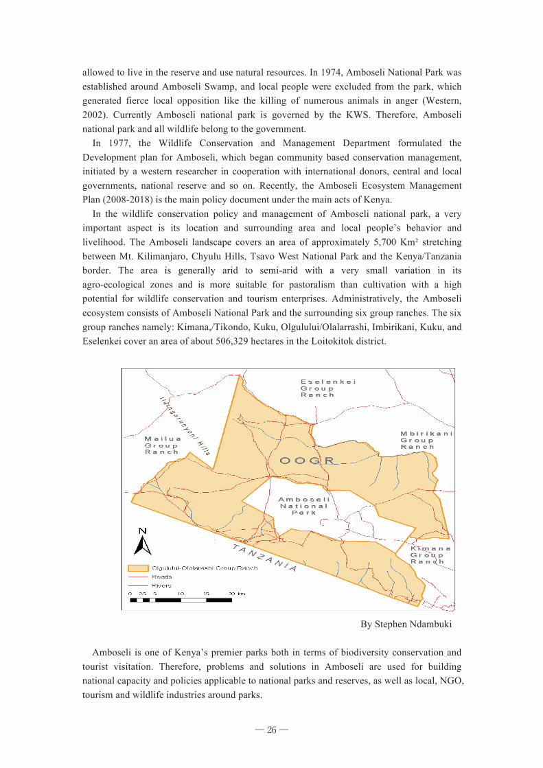
allowed to live in the reserve and use natural resources. In 1974, Amboseli National Park was established around Amboseli Swamp, and local people were excluded from the park, which generated fierce local opposition like the killing of numerous animals in anger (Western, 2002). Currently Amboseli national park is governed by the KWS. Therefore, Amboseli national park and all wildlife belong to the government. In 1977, the Wildlife Conservation and Management Department formulated the Development plan for Amboseli, which began community based conservation management, initiated by a western researcher in cooperation with international donors, central and local governments, national reserve and so on. Recently, the Amboseli Ecosystem Management Plan (2008-2018) is the main policy document under the main acts of Kenya. In the wildlife conservation policy and management of Amboseli national park, a very important aspect is its location and surrounding area and local people’s behavior and livelihood. The Amboseli landscape covers an area of approximately 5,700 Km² stretching between Mt. Kilimanjaro, Chyulu Hills, Tsavo West National Park and the Kenya/Tanzania border. The area is generally arid to semi-arid with a very small variation in its agro-ecological zones and is more suitable for pastoralism than cultivation with a high potential for wildlife conservation and tourism enterprises. Administratively, the Amboseli ecosystem consists of Amboseli National Park and the surrounding six group ranches. The six group ranches namely: Kimana,/Tikondo, Kuku, Olgulului/Olalarrashi, Imbirikani, Kuku, and Eselenkei cover an area of about 506,329 hectares in the Loitokitok district.
By Stephen Ndambuki Amboseli is one of Kenya’s premier parks both in terms of biodiversity conservation and
tourist visitation. Therefore, problems and solutions in Amboseli are used for building national capacity and policies applicable to national parks and reserves, as well as local, NGO, tourism and wildlife industries around parks.
─ 26 ─
27
The Amboseli Research and Conservation Programme (ARCP) established the African conservation center (ACC) and have worked continuously in the area since 1967. During that time, ARCP and ACC laid the foundation for Kenya’s integrated ecosystem approach to parks and community-based conservation. The many innovations that developed out of ARCP/ACC research and conservation programs included revenue sharing, wildlife associations, community wildlife sanctuaries, community scouts and ecotourism enterprises. Despite these positive developments, many new threats common to parks throughout East Africa face Amboseli. These include demographic and socio-economic transition, sedentarization and land fragmentation, human-wildlife conflict and inequitable distribution of wildlife income. These factors are at the root of intensifying drought, growing conflict between wildlife, livestock and agriculture, and a rapid decline in biodiversity in the park. ACC’s goal in Amboseli is to strengthen and support the practices, policies and institutions that maintain the productivity and ecological resilience of pastoral communities and savanna ecosystems while diversifying rangeland economies and providing new opportunities off the land. To achieve this, ACC and other stakeholders have developed the Amboseli Ecosystem Management Plan 2008-2018 to address these conservation and livelihood challenges through 5 regulatory programs: Ecological Management Program; Tourism Development and Management Program; Community Partnership and Education Program; Security Program and Ecosystem Operations Program. The management plans aim at maintaining ecosystem integrity and enhancing the ecosystem’s benefits to the local community in view of increasing environmental threats facing the local community, their livestock and wildlife. I was fascinated by the tourism activity and wildlife management, while traveling to
Amboseli National park. Then, I decided to learn about Mongolian wildlife policy and management to compare. 5. Briefly about Mongolian Wildlife Conservation Policy Hunting has been an important aspect of Mongolian life since ancient time. Mongolia has several laws dating back a thousand years designed to preserve game species and manage hunting. Typically, these laws were based on arbitrary quotas rather than sustainable harvests. As commercial exploitation of Mongolia’s wildlife increased between 17th and the 20th centuries. Currently, all wildlife is national property in Mongolia. Law on environmental protection and Law on hunting, both enforced in 1995 address protection of wildlife. The first law requires that very rare and endangered species be registered in the Red Book of Mongolia and be totally protected. 98 species of animals listed as very rare and endangered. The second of two laws requires “the protection and proper use of Mongolia‘s game animals.” Mongolians may hunt abundant animals for household purposes. Very rare and rare species may be taken only in special circumstances. In either case permits must be obtained. A license issued by the local government for the abundant species, a special permit from Ministry for very rare and rare species. In addition, Law on hunting resource use fees and hunting and trapping authorization fees 1995, Biodiversity conservation action plan for Mongolia 1996, Wildlife protection program, Conservation action plans on very rare and rare species such as snow leopard, saiga antelope, wild bactrian camel, red deer and so are subsidiary legislations. Among the NGOs, what work for the protection of wildlife in Mongolia main is Wildlife
─ 27 ─
28
protection society. Also, Mongolia has joined to international conventions like the Convention of biodiversity, convention of Migratory Species of Wild Animals. 6. Conclusion Kenya’s wildlife policy can be divided into two parts that of the colonial period and the independent period. Kenya has been developing its own policy, can solve or mitigate many problems with investment from international organizations and projects. Also, it seems wildlife policy in this country influenced by western people or outsiders. Even if, KWS adopted Community based conservation as its conservation policy, and shared the benefit from wildlife with the local community, some current problems like human wildlife conflict or complaints about benefit sharing indicate that local people not satisfied by the current wildlife policy. It is necessary to pay attention to local subsistence; to design CBC projects based more on human wildlife relations. It seems unfair that local people lose their customary land in the name of wildlife conservation. In my personal opinion, KWS acts solely as an enforcement and regulatory agency through use of electric fences and firearms rather than an enabling institution.. Due to the nomadic/pastoralist lifestyle of the population, arid and semi-arid conditions social condition in developing countries and global climate change both Kenya and Mongolia have some similarities in their wildlife policy such as the necessity to solve human wildlife conflict and consider community involvement. Reference: Batjargal, Z. (2006) “Environmental Policy in Mongolia”. Ulaanbaatar, Mongolia. “Final Draft of the Wildlife Policy” (2007). Kenya: Utalii house, Uhuru highway. Kenana, L. (2012). “Biodiversity Conservation At Kenya Wildlife Service: Working Between Science and wildlife administration”. Kenya Wildlife Service, Kenya. Law on environment of Mongolia (1995). Ulaanbaatar, Mongolia.
─ 28 ─
29
Chapter 5 Challenges for Wildlife Conservation in Kenya and Amboseli National Park
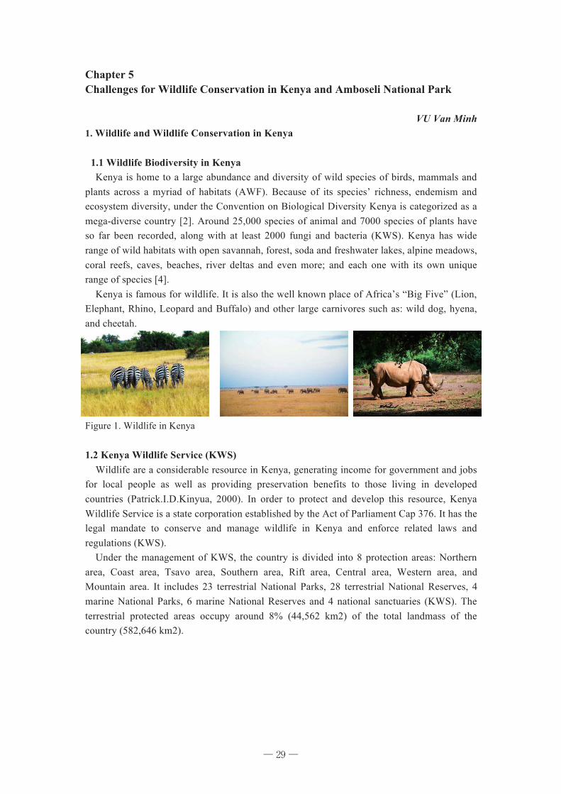
VU Van Minh 1. Wildlife and Wildlife Conservation in Kenya 1.1 Wildlife Biodiversity in Kenya Kenya is home to a large abundance and diversity of wild species of birds, mammals and plants across a myriad of habitats (AWF). Because of its species’ richness, endemism and ecosystem diversity, under the Convention on Biological Diversity Kenya is categorized as a mega-diverse country [2]. Around 25,000 species of animal and 7000 species of plants have so far been recorded, along with at least 2000 fungi and bacteria (KWS). Kenya has wide range of wild habitats with open savannah, forest, soda and freshwater lakes, alpine meadows, coral reefs, caves, beaches, river deltas and even more; and each one with its own unique range of species [4]. Kenya is famous for wildlife. It is also the well known place of Africa’s “Big Five” (Lion, Elephant, Rhino, Leopard and Buffalo) and other large carnivores such as: wild dog, hyena, and cheetah.
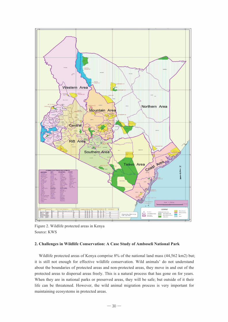
Figure 1. Wildlife in Kenya 1.2 Kenya Wildlife Service (KWS) Wildlife are a considerable resource in Kenya, generating income for government and jobs for local people as well as providing preservation benefits to those living in developed countries (Patrick.I.D.Kinyua, 2000). In order to protect and develop this resource, Kenya Wildlife Service is a state corporation established by the Act of Parliament Cap 376. It has the legal mandate to conserve and manage wildlife in Kenya and enforce related laws and regulations (KWS). Under the management of KWS, the country is divided into 8 protection areas: Northern area, Coast area, Tsavo area, Southern area, Rift area, Central area, Western area, and Mountain area. It includes 23 terrestrial National Parks, 28 terrestrial National Reserves, 4 marine National Parks, 6 marine National Reserves and 4 national sanctuaries (KWS). The terrestrial protected areas occupy around 8% (44,562 km2) of the total landmass of the country (582,646 km2).
─ 29 ─
30
Figure 2. Wildlife protected areas in Kenya Source: KWS 2. Challenges in Wildlife Conservation: A Case Study of Amboseli National Park Wildlife protected areas of Kenya comprise 8% of the national land mass (44,562 km2) but; it is still not enough for effective wildlife conservation. Wild animals’ do not understand about the boundaries of protected areas and non-protected areas, they move in and out of the protected areas to dispersal areas freely. This is a natural process that has gone on for years. When they are in national parks or preserved areas, they will be safe; but outside of it their life can be threatened. However, the wild animal migration process is very important for maintaining ecosystems in protected areas.
─ 30 ─
31
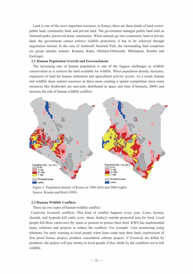
Land is one of the most important resources in Kenya; there are three kinds of land owner: public land, community land, and private land. The government manages public land such as National parks, preserved areas, sanctuaries. When animals go into community land or private land, the government cannot enforce wildlife protection; it has to be achieved through negotiation instead. In the case of Amboseli National Park, the surrounding land comprises six group ranches namely: Kimana, Kuku, Olulului-Ololorashi, Mbiriakani, Rombo and Eselengei. 2.1 Human Population Growth and Encroachment The increasing rate of human population is one of the biggest challenges to wildlife conservation as it restricts the land available for wildlife. When population density increases, expansion of land for human settlement and agricultural activity occurs. As a result, human and wildlife share natural resources in these areas creating a spatial competition since some resources like freshwater are unevenly distributed in space and time (Chiemelu, 2004) and increase the risk of human wildlife conflicts
Figure 3. Population density of Kenya in 1960 (left) and 2000 (right) Source: Kruska and Reid (1999) 2.2 Human Wildlife Conflicts There are two types of human-wildlife conflict: Carnivore livestock conflicts: This kind of conflict happens every year. Lions, hyenas, cheetah, and leopards kill cattle (cow, shoat, donkey) outside protected area for food. Local people kill these carnivores (by spear or poison) to protect their herd. KWS has implemented many solutions and projects to reduce the conflicts. For example: Lion monitoring using telemetry for early warning to local people when lions come near their land; construction of lion proof bomas project; predator consolation scheme project: if livestock are killed by predators, the project will pay money to local people if they abide by the condition not to kill wildlife.
─ 31 ─
32
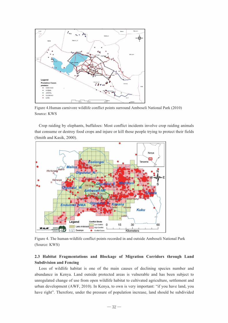
Figure 4.Human carnivore wildlife conflict points surround Amboseli National Park (2010) Source: KWS Crop raiding by elephants, buffaloes: Most conflict incidents involve crop raiding animals that consume or destroy food crops and injure or kill those people trying to protect their fields (Smith and Kasik, 2000).
Figure 4. The human-wildlife conflict points recorded in and outside Amboseli National Park (Source: KWS) 2.3 Habitat Fragmentations and Blockage of Migration Corridors through Land Subdivision and Fencing Loss of wildlife habitat is one of the main causes of declining species number and abundance in Kenya. Land outside protected areas is vulnerable and has been subject to unregulated change of use from open wildlife habitat to cultivated agriculture, settlement and urban development (AWF, 2010). In Kenya, to own is very important: “if you have land, you have right”. Therefore, under the pressure of population increase, land should be subdivided
─ 32 ─
33
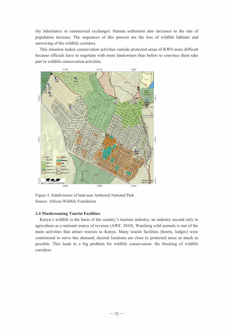
(by inheritance or commercial exchange). Human settlement also increases to the rate of population increase. The sequences of this process are the loss of wildlife habitats and narrowing of the wildlife corridors. This situation makes conservation activities outside protected areas of KWS more difficult because officials have to negotiate with more landowners than before to convince them take part in wildlife conservation activities.
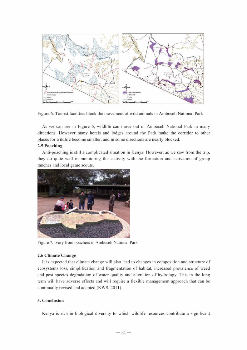
Figure 5. Subdivisions of land near Amboseli National Park Source: African Wildlife Foundation 2.4 Mushrooming Tourist Facilities Kenya’s wildlife is the basis of the country’s tourism industry; an industry second only to agriculture as a national source of revenue (AWF, 2010). Watching wild animals is one of the main activities that attract tourists to Kenya. Many tourist facilities (hotels, lodges) were constructed to serve this demand; desired locations are close to protected areas as much as possible. This leads to a big problem for wildlife conservation: the blocking of wildlife corridors.
─ 33 ─
34
Figure 6. Tourist facilities block the movement of wild animals in Amboseli National Park As we can see in Figure 6, wildlife can move out of Amboseli National Park in many directions. However many hotels and lodges around the Park make the corridor to other places for wildlife become smaller, and in some directions are nearly blocked. 2.5 Poaching Anti-poaching is still a complicated situation in Kenya. However, as we saw from the trip, they do quite well in monitoring this activity with the formation and activation of group ranches and local game scouts.
Figure 7. Ivory from poachers in Amboseli National Park 2.6 Climate Change It is expected that climate change will also lead to changes in composition and structure of ecosystems loss, simplification and fragmentation of habitat, increased prevalence of weed and pest species degradation of water quality and alteration of hydrology. This in the long term will have adverse effects and will require a flexible management approach that can be continually revised and adapted (KWS, 2011). 3. Conclusion Kenya is rich in biological diversity to which wildlife resources contribute a significant
─ 34 ─
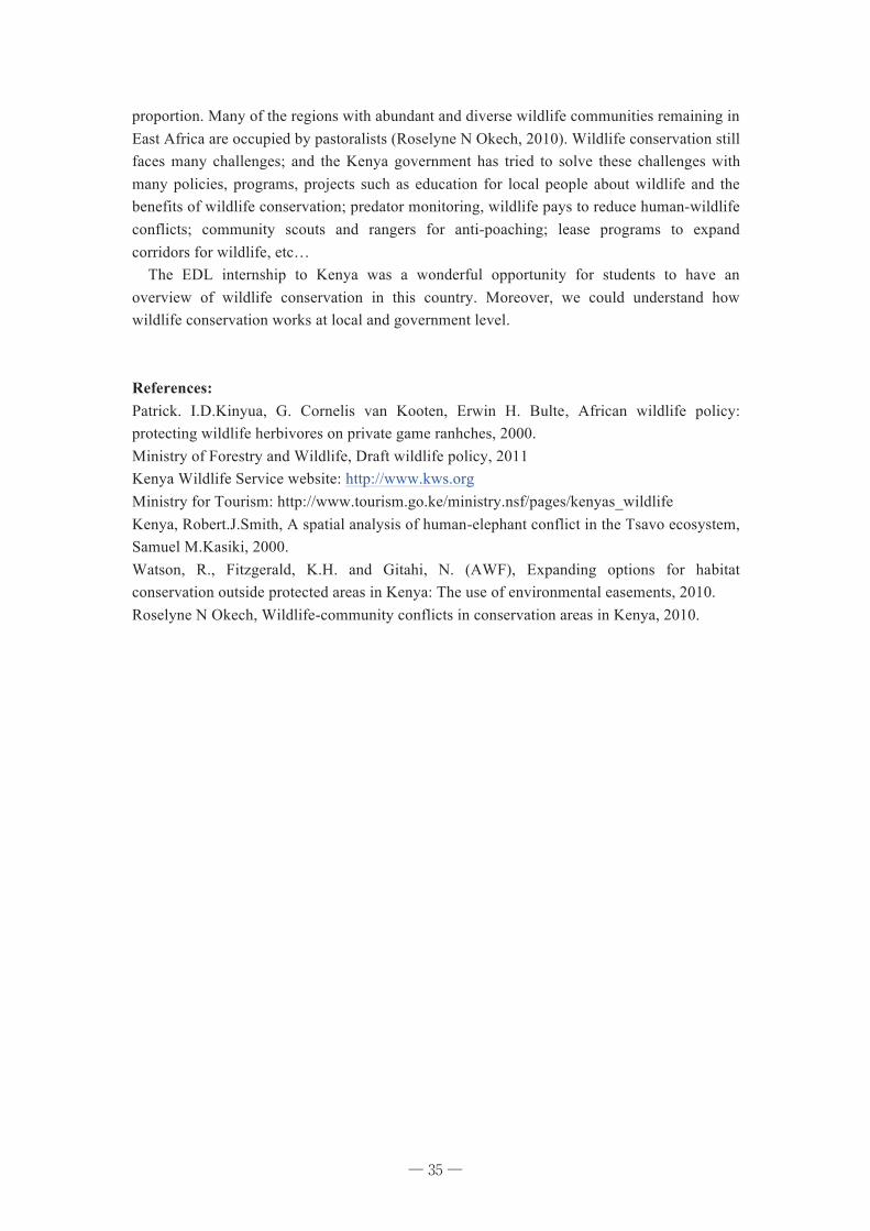
35
proportion. Many of the regions with abundant and diverse wildlife communities remaining in East Africa are occupied by pastoralists (Roselyne N Okech, 2010). Wildlife conservation still faces many challenges; and the Kenya government has tried to solve these challenges with many policies, programs, projects such as education for local people about wildlife and the benefits of wildlife conservation; predator monitoring, wildlife pays to reduce human-wildlife conflicts; community scouts and rangers for anti-poaching; lease programs to expand corridors for wildlife, etc… The EDL internship to Kenya was a wonderful opportunity for students to have an overview of wildlife conservation in this country. Moreover, we could understand how wildlife conservation works at local and government level. References: Patrick. I.D.Kinyua, G. Cornelis van Kooten, Erwin H. Bulte, African wildlife policy: protecting wildlife herbivores on private game ranhches, 2000. Ministry of Forestry and Wildlife, Draft wildlife policy, 2011 Kenya Wildlife Service website: http://www.kws.org Ministry for Tourism: http://www.tourism.go.ke/ministry.nsf/pages/kenyas_wildlife Kenya, Robert.J.Smith, A spatial analysis of human-elephant conflict in the Tsavo ecosystem, Samuel M.Kasiki, 2000. Watson, R., Fitzgerald, K.H. and Gitahi, N. (AWF), Expanding options for habitat conservation outside protected areas in Kenya: The use of environmental easements, 2010. Roselyne N Okech, Wildlife-community conflicts in conservation areas in Kenya, 2010.
─ 35 ─
36
Chapter 6 Forest Management in Amboseli National Park: Status and Restoration Efforts in the Wildlife Habitat
NGUYEN Tu Anh 1. General Information 1.1. Background Kenya is identified as one of the countries that have the highest wildlife biodiversity in Africa [Okech 2010]. According to Kenya Wildlife Service (KWS), this country has 35,000 species of flora and fauna. With wide range of ecosystems ranging from marine, mountain, forest, arid and semi-arid lands. Although forests only cover almost 2% of the total land area of Kenya, they play a crucial role in providing natural habitat and ecosystem for the survival and development of species. The forests in Kenya contain approximately 50% of the nation’s tree species, 40% of the larger mammals, and 30% of birds [One World Africa 2007]. Savanna grassland, woodland, and bush land in the arid and semi-arid lands, accounting for about 80% of total Kenya’s area, contain some rare and unique mega fauna [UNEP 2009]. Recognizing the importance of biodiversity, Kenya has established 63 National Parks and Reserve to protect high biodiversity areas. However, the country had lost about 44% of its wildlife over the last 17 years in the end of 20th century [Norton-Griffiths 1998] [GOK, National Rangelands Report: Sumrnary of Population Estimates for Wildlife and Livestock 1995b] [GOK, Data Summary Report for the Kenyan Rangelands 1977-1994 1995a]. One of mains drivers for this situation is laid on the interaction between wildlife and forest and vegetation. This paper aims to reveal the linkage between forest and vegetation management and wildlife habitat restoration. 1.2. Amboseli National Park Amboseli National Park is located in the arid and semi-arid land in the Southern part of Kenya. It was established in 1974 with a total area of 390 km2, and the surrounding ecosystem totals more than 5000 km2. According to KWS, Amboseli National Park has over 80 different animal species, about 400 species of birds, and over 300 species of plants. The main species are cheetahs, elephant, lion, and the rare and hardly seen wild-dog. The park was recognized as a biosphere reserve under UNSECO’s Man and Biosphere programme in 1991. Natural vegetation of the park include wood-bush-shrubs grassland that can support and ptrotect the high and diversity wildelife (Pratt 1977). There are seven main habitats including the 1) the seasonal lake, 2) alkaline plains, 3) Acacia xanthophloea woodlands, 4) Acacia tortilis woodlands, 5) swamp edge vegetation, 6) swamps, and 7) bushlands (Esikuri 1998). Some challenges the park has had to face include (1) habitat loss and fragementation, (2) Invasive species, and (3) over grazing. 2. Forest Cover and Land Cover Change (1976 - 2007) 2.1. Role of Forest and Vegetation in Wildlife and Conservation. Forests and other vegetation types are very important for economic development,
─ 36 ─
37
environment services, social and cultural values: � Important for conservation of biological diversity � Regulation of water supplies: watershed and catchment areas � A major and irreplaceable habitat for wildlife � Energy supply for domestic use: firewood for domestic use � Provision of timber for construction � Forest also provides a wide range of non-wood forest products such as resin, honey and medicine, enhancing landscape beauty � Protecting soil resources � Carbon dioxide sequestration � Mitigating climate change <Okello, 2011> 2.2. Land Cover Change The following figures show the proportion of land type and land cover change As show in the figures, there has been significant extension of land under irrigated agriculture, perennial swamps and riverside vegetation. Source: (Okello n.d.) 2.3. Drivers of Deforestation and Loss of Vegetation in Amboseli � Illegal logging: along the Kenya and Tanzania border, charcoal burning, timber exploitation for construction � Invasive and alien plant species: Threatening the ecological integrity of the park - one of the greatest threats to Amboseli National Park (ANP) � The density of Elephants inside the ANP: intensification of human activities outside � Land use/land cover conversion to agriculture/cultivation � Overgrazing � Population increase/settlements As a consequence, when forest is logged, it means a loss of biodiversity. 3. Efforts of KWS to Recover Forest in the ANP In order to recover and protect the landscape and soil, KWS has applied strategies such as: � Mapping and Control of invasive species � Removal of invasive plants � Control of logging through security road-blacks and patrols in logging hotspots � Indigenous species planting � Nursery implementation, regeneration � Electric fences However, due to the lack of forestry Scientists, in some cases, KWS efforts have worsened the situation. Therefore, in order to protect and management forest and wildlife , it is necessary to have: � Framework for biodiversity conservation: forest and wildlife aspects � Close cooperation between Kenya Wildlife Service and Kenya Forest Service � Forest cover change and mapping � Enhanced community-based management
─ 37 ─
38
References Esikuri, Enos E. Spatio-Temporal Effects of Land Use Changes in A Savanna Wildlife Area of Kenya. Virginia, 1998. GOK. Data Summary Report for the Kenyan Rangelands 1977-1994. Nairobi: Ministry of Planning and National Development (Dept. of Resource Surveys and Remote Sensing), 1995a. GOK. National Rangelands Report: Sumrnary of Population Estimates for Wildlife and Livestock. Nairobi: Ministry of Planning and National Development (Dept. of Resource Surveys and Remote Sensing), 1995b. Norton-Griffiths, M. "The economics of willdlife conservation policy." Conservation of Biological Resources, 1998. Okech, Roselyne N. "Wildelife-community conflicts in conservation areas in Kenya." AJRC Volumne 10, No.2, 2010: 65-80. Okello, J. K. M. M. "Land use cover and environmental changes in a semi-arids rangeland, Southern Kenya." Journal of Geography and Regioal Planning 322-326. One World Africa. "Forests in Kenya." Zambia, 2007, 11. Pratt, D.J. & M.D. Gwynne. Rangeland Management and Ecology in East Africa. London, 1977. UNEP. Kenya Atlats of our changing environment. Kenya: United Nation Environment Programme, 2009.
─ 38 ─
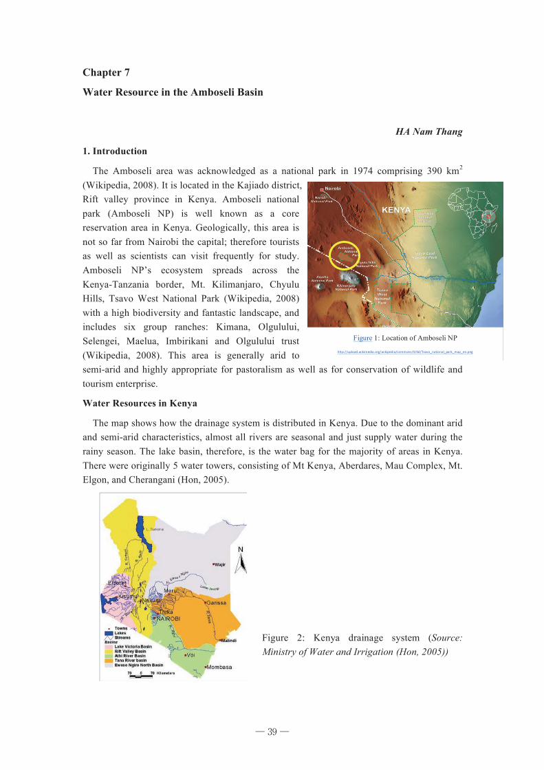
39
Chapter 7
Water Resource in the Amboseli Basin
HA Nam Thang
1. Introduction
The Amboseli area was acknowledged as a national park in 1974 comprising 390 km2
(Wikipedia, 2008). It is located in the Kajiado district, Rift valley province in Kenya. Amboseli national park (Amboseli NP) is well known as a core reservation area in Kenya. Geologically, this area is not so far from Nairobi the capital; therefore tourists as well as scientists can visit frequently for study. Amboseli NP’s ecosystem spreads across the Kenya-Tanzania border, Mt. Kilimanjaro, Chyulu Hills, Tsavo West National Park (Wikipedia, 2008) with a high biodiversity and fantastic landscape, and includes six group ranches: Kimana, Olgulului, Selengei, Maelua, Imbirikani and Olgulului trust (Wikipedia, 2008). This area is generally arid to semi-arid and highly appropriate for pastoralism as well as for conservation of wildlife and tourism enterprise.
Water Resources in Kenya
The map shows how the drainage system is distributed in Kenya. Due to the dominant arid and semi-arid characteristics, almost all rivers are seasonal and just supply water during the rainy season. The lake basin, therefore, is the water bag for the majority of areas in Kenya. There were originally 5 water towers, consisting of Mt Kenya, Aberdares, Mau Complex, Mt. Elgon, and Cherangani (Hon, 2005).
Figure 1: Location of Amboseli NP
http://upload.wikimedia.org/wikipedia/commons/4/4d/Tsavo_national_park_map_en.png
Figure 2: Kenya drainage system (Source: Ministry of Water and Irrigation (Hon, 2005))
─ 39 ─
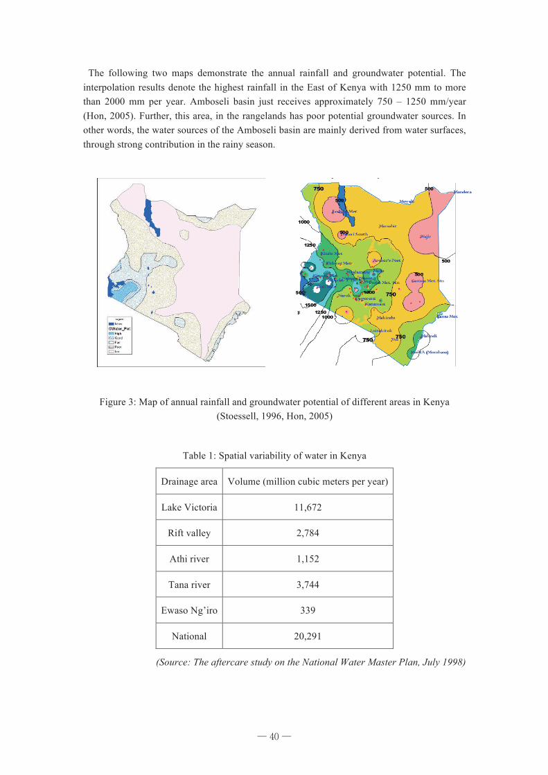
40
The following two maps demonstrate the annual rainfall and groundwater potential. The interpolation results denote the highest rainfall in the East of Kenya with 1250 mm to more than 2000 mm per year. Amboseli basin just receives approximately 750 – 1250 mm/year (Hon, 2005). Further, this area, in the rangelands has poor potential groundwater sources. In other words, the water sources of the Amboseli basin are mainly derived from water surfaces, through strong contribution in the rainy season.
Figure 3: Map of annual rainfall and groundwater potential of different areas in Kenya (Stoessell, 1996, Hon, 2005)
Table 1: Spatial variability of water in Kenya
Drainage area Volume (million cubic meters per year)
Lake Victoria 11,672
Rift valley 2,784
Athi river 1,152
Tana river 3,744
Ewaso Ng’iro 339
National 20,291
(Source: The aftercare study on the National Water Master Plan, July 1998)
─ 40 ─
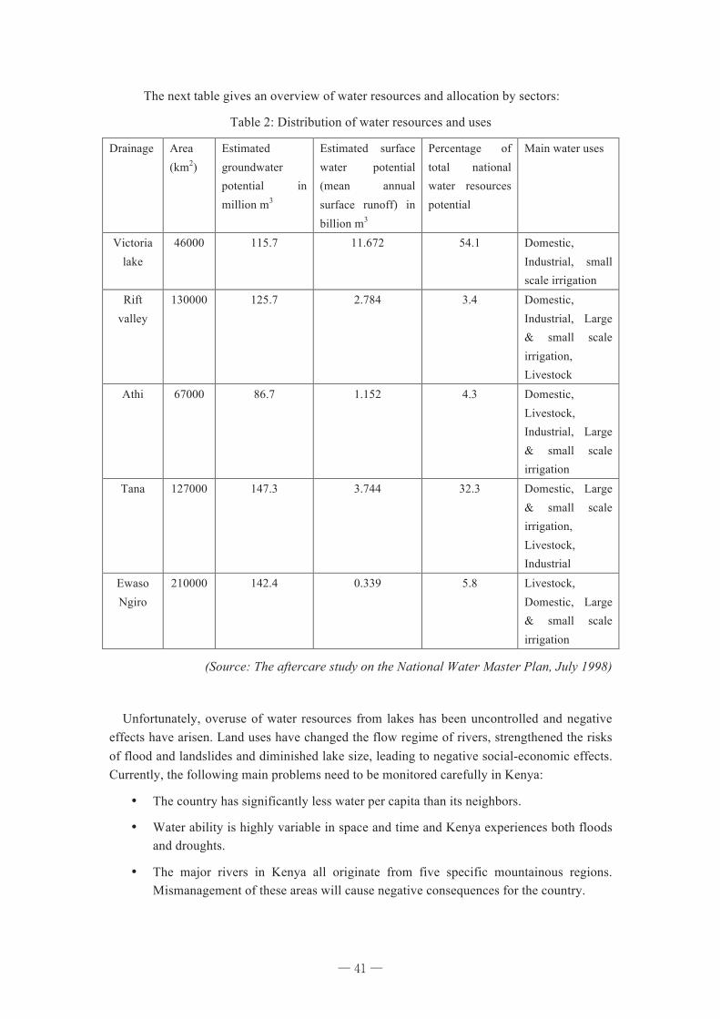
41
The next table gives an overview of water resources and allocation by sectors:
Table 2: Distribution of water resources and uses
Drainage Area (km2)
Estimated groundwater potential in million m3
Estimated surface water potential (mean annual surface runoff) in billion m3
Percentage of total national water resources potential
Main water uses
Victoria lake
46000 115.7 11.672 54.1 Domestic, Industrial, small scale irrigation
Rift valley
130000 125.7 2.784 3.4 Domestic, Industrial, Large & small scale irrigation, Livestock
Athi 67000 86.7 1.152 4.3 Domestic, Livestock, Industrial, Large & small scale irrigation
Tana 127000 147.3 3.744 32.3 Domestic, Large & small scale irrigation, Livestock, Industrial
Ewaso Ngiro
210000 142.4 0.339 5.8 Livestock, Domestic, Large & small scale irrigation
(Source: The aftercare study on the National Water Master Plan, July 1998)
Unfortunately, overuse of water resources from lakes has been uncontrolled and negative effects have arisen. Land uses have changed the flow regime of rivers, strengthened the risks of flood and landslides and diminished lake size, leading to negative social-economic effects. Currently, the following main problems need to be monitored carefully in Kenya:
¥ The country has significantly less water per capita than its neighbors.
¥ Water ability is highly variable in space and time and Kenya experiences both floods and droughts.
¥ The major rivers in Kenya all originate from five specific mountainous regions. Mismanagement of these areas will cause negative consequences for the country.
─ 41 ─
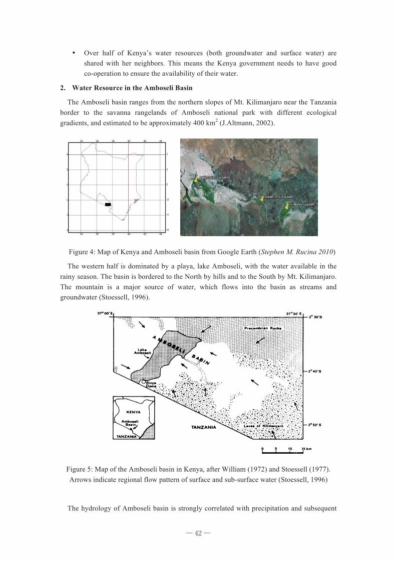
42
¥ Over half of Kenya’s water resources (both groundwater and surface water) are shared with her neighbors. This means the Kenya government needs to have good co-operation to ensure the availability of their water.
2. Water Resource in the Amboseli Basin
The Amboseli basin ranges from the northern slopes of Mt. Kilimanjaro near the Tanzania border to the savanna rangelands of Amboseli national park with different ecological gradients, and estimated to be approximately 400 km2 (J.Altmann, 2002).
Figure 4: Map of Kenya and Amboseli basin from Google Earth (Stephen M. Rucina 2010)
The western half is dominated by a playa, lake Amboseli, with the water available in the rainy season. The basin is bordered to the North by hills and to the South by Mt. Kilimanjaro. The mountain is a major source of water, which flows into the basin as streams and groundwater (Stoessell, 1996).
Figure 5: Map of the Amboseli basin in Kenya, after William (1972) and Stoessell (1977). Arrows indicate regional flow pattern of surface and sub-surface water (Stoessell, 1996)
The hydrology of Amboseli basin is strongly correlated with precipitation and subsequent
─ 42 ─
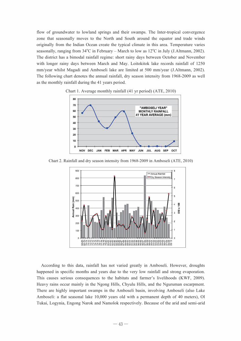
43
flow of groundwater to lowland springs and their swamps. The Inter-tropical convergence zone that seasonally moves to the North and South around the equator and trade winds originally from the Indian Ocean create the typical climate in this area. Temperature varies seasonally, ranging from 34oC in February – March to low as 12oC in July (J.Altmann, 2002). The district has a bimodal rainfall regime: short rainy days between October and November with longer rainy days between March and May. Loitokitok lake records rainfall of 1250 mm/year whilst Magadi and Amboseli lake are limited at 500 mm/year (J.Altmann, 2002). The following chart denotes the annual rainfall, dry season intensity from 1968-2009 as well as the monthly rainfall during the 41 years period.
Chart 1. Average monthly rainfall (41 yr period) (ATE, 2010)
Chart 2. Rainfall and dry season intensity from 1968-2009 in Amboseli (ATE, 2010)
According to this data, rainfall has not varied greatly in Amboseli. However, droughts happened in specific months and years due to the very low rainfall and strong evaporation. This causes serious consequences to the habitats and farmer’s livelihoods (KWF, 2009). Heavy rains occur mainly in the Ngong Hills, Chyulu Hills, and the Nguruman escarpment. There are highly important swamps in the Amboseli basin, involving Amboseli (also Lake Amboseli: a flat seasonal lake 10,000 years old with a permanent depth of 40 meters), Ol Tukai, Logynia, Engong Narok and Namolok respectively. Because of the arid and semi-arid
─ 43 ─
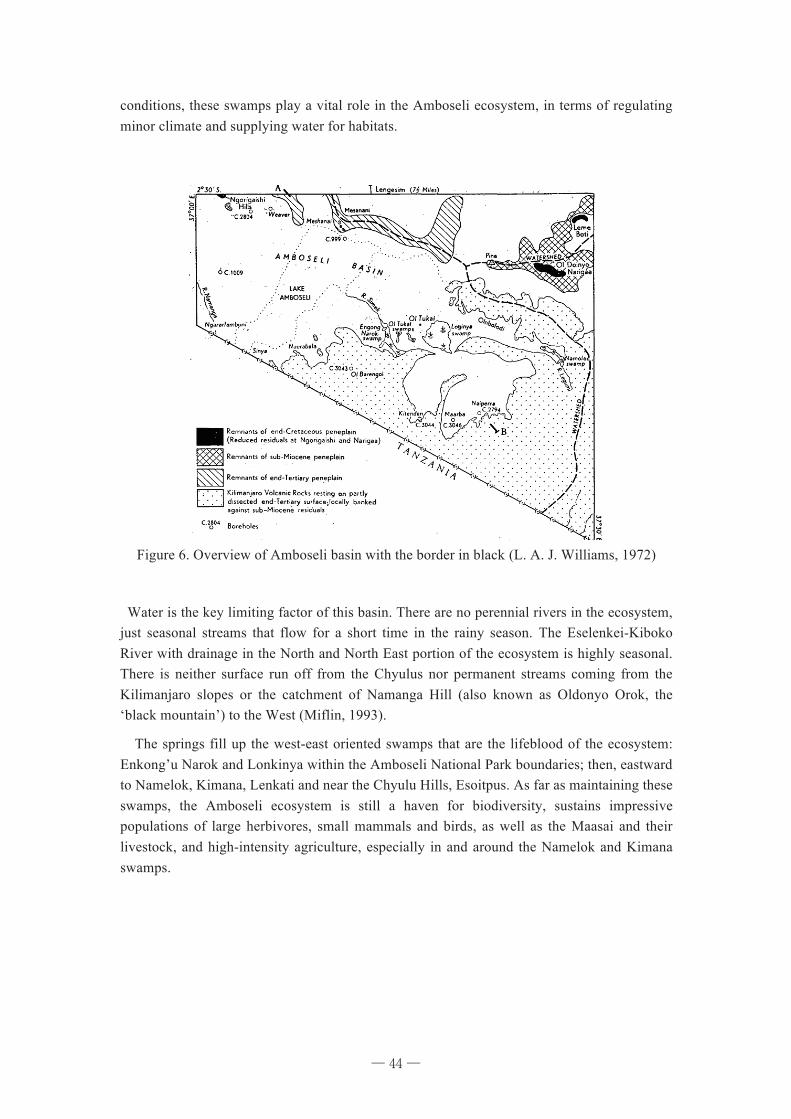
44
conditions, these swamps play a vital role in the Amboseli ecosystem, in terms of regulating minor climate and supplying water for habitats.
Figure 6. Overview of Amboseli basin with the border in black (L. A. J. Williams, 1972)
Water is the key limiting factor of this basin. There are no perennial rivers in the ecosystem, just seasonal streams that flow for a short time in the rainy season. The Eselenkei-Kiboko River with drainage in the North and North East portion of the ecosystem is highly seasonal. There is neither surface run off from the Chyulus nor permanent streams coming from the Kilimanjaro slopes or the catchment of Namanga Hill (also known as Oldonyo Orok, the ‘black mountain’) to the West (Miflin, 1993).
The springs fill up the west-east oriented swamps that are the lifeblood of the ecosystem: Enkong’u Narok and Lonkinya within the Amboseli National Park boundaries; then, eastward to Namelok, Kimana, Lenkati and near the Chyulu Hills, Esoitpus. As far as maintaining these swamps, the Amboseli ecosystem is still a haven for biodiversity, sustains impressive populations of large herbivores, small mammals and birds, as well as the Maasai and their livestock, and high-intensity agriculture, especially in and around the Namelok and Kimana swamps.
─ 44 ─
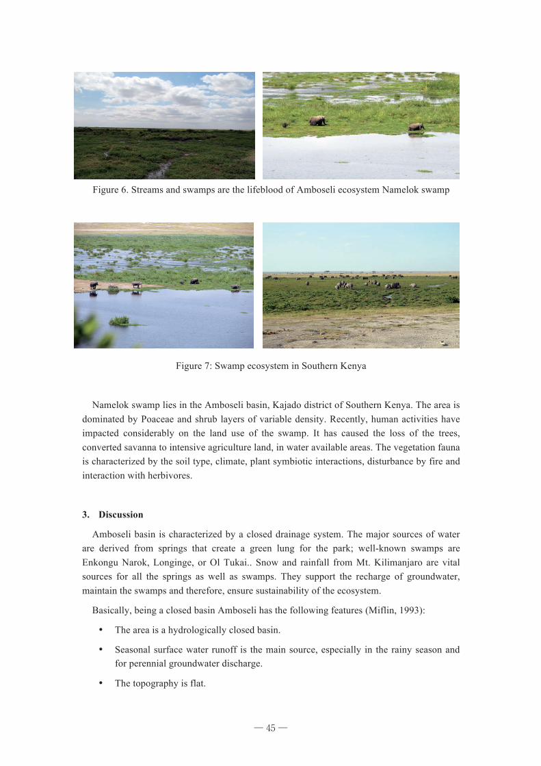
45
Figure 6. Streams and swamps are the lifeblood of Amboseli ecosystem Namelok swamp
Figure 7: Swamp ecosystem in Southern Kenya
Namelok swamp lies in the Amboseli basin, Kajado district of Southern Kenya. The area is dominated by Poaceae and shrub layers of variable density. Recently, human activities have impacted considerably on the land use of the swamp. It has caused the loss of the trees, converted savanna to intensive agriculture land, in water available areas. The vegetation fauna is characterized by the soil type, climate, plant symbiotic interactions, disturbance by fire and interaction with herbivores.
3. Discussion
Amboseli basin is characterized by a closed drainage system. The major sources of water are derived from springs that create a green lung for the park; well-known swamps are Enkongu Narok, Longinge, or Ol Tukai.. Snow and rainfall from Mt. Kilimanjaro are vital sources for all the springs as well as swamps. They support the recharge of groundwater, maintain the swamps and therefore, ensure sustainability of the ecosystem.
Basically, being a closed basin Amboseli has the following features (Miflin, 1993):
¥ The area is a hydrologically closed basin.
¥ Seasonal surface water runoff is the main source, especially in the rainy season and for perennial groundwater discharge.
¥ The topography is flat.
─ 45 ─
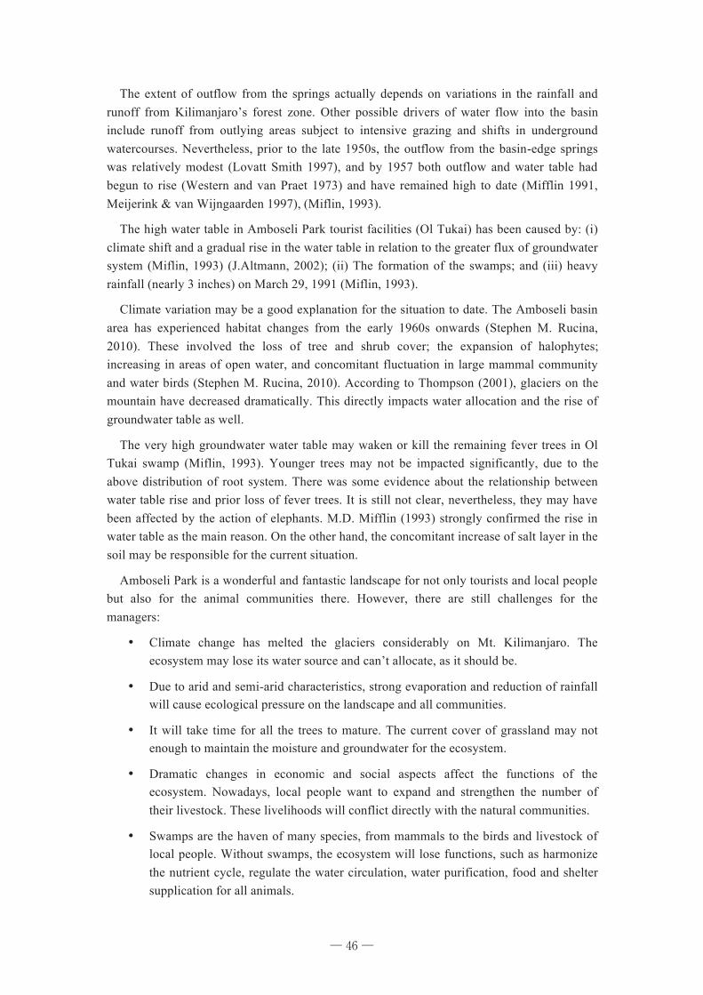
46
The extent of outflow from the springs actually depends on variations in the rainfall and runoff from Kilimanjaro’s forest zone. Other possible drivers of water flow into the basin include runoff from outlying areas subject to intensive grazing and shifts in underground watercourses. Nevertheless, prior to the late 1950s, the outflow from the basin-edge springs was relatively modest (Lovatt Smith 1997), and by 1957 both outflow and water table had begun to rise (Western and van Praet 1973) and have remained high to date (Mifflin 1991, Meijerink & van Wijngaarden 1997), (Miflin, 1993).
The high water table in Amboseli Park tourist facilities (Ol Tukai) has been caused by: (i) climate shift and a gradual rise in the water table in relation to the greater flux of groundwater system (Miflin, 1993) (J.Altmann, 2002); (ii) The formation of the swamps; and (iii) heavy rainfall (nearly 3 inches) on March 29, 1991 (Miflin, 1993).
Climate variation may be a good explanation for the situation to date. The Amboseli basin area has experienced habitat changes from the early 1960s onwards (Stephen M. Rucina, 2010). These involved the loss of tree and shrub cover; the expansion of halophytes; increasing in areas of open water, and concomitant fluctuation in large mammal community and water birds (Stephen M. Rucina, 2010). According to Thompson (2001), glaciers on the mountain have decreased dramatically. This directly impacts water allocation and the rise of groundwater table as well.
The very high groundwater water table may waken or kill the remaining fever trees in Ol Tukai swamp (Miflin, 1993). Younger trees may not be impacted significantly, due to the above distribution of root system. There was some evidence about the relationship between water table rise and prior loss of fever trees. It is still not clear, nevertheless, they may have been affected by the action of elephants. M.D. Mifflin (1993) strongly confirmed the rise in water table as the main reason. On the other hand, the concomitant increase of salt layer in the soil may be responsible for the current situation.
Amboseli Park is a wonderful and fantastic landscape for not only tourists and local people but also for the animal communities there. However, there are still challenges for the managers:
¥ Climate change has melted the glaciers considerably on Mt. Kilimanjaro. The ecosystem may lose its water source and can’t allocate, as it should be.
¥ Due to arid and semi-arid characteristics, strong evaporation and reduction of rainfall will cause ecological pressure on the landscape and all communities.
¥ It will take time for all the trees to mature. The current cover of grassland may not enough to maintain the moisture and groundwater for the ecosystem.
¥ Dramatic changes in economic and social aspects affect the functions of the ecosystem. Nowadays, local people want to expand and strengthen the number of their livestock. These livelihoods will conflict directly with the natural communities.
¥ Swamps are the haven of many species, from mammals to the birds and livestock of local people. Without swamps, the ecosystem will lose functions, such as harmonize the nutrient cycle, regulate the water circulation, water purification, food and shelter supplication for all animals.
─ 46 ─
47
¥ Water always will always be a vital factor in the Amboseli ecosystem. Therefore, local managers need to take into account all those problems explained by prior research as well as effective management policies.
References
ATE 2010. ATE Amboseli Rainfall data. Hon, M. K., M.P 2005. Kenya National Water Development Report. World water Assessment
programe, UN, 36-72. J.Altmann, S. C. A. 2002. Dramatic Change in Local Climate patterns in the Amboseli basin,
Kenya. African Journal Ecology, 40, 248-251. KWF, A. C. C. 2009. The Impact Of The 2009 Drought On Wildlife, Livestock And Tourism
In The Amboseli Ecosystem: Recommendations For Prompt Action And Ecosystem Restoration. Proceeding, 33.
L. A. J. Williams, B. S., PH.D., F.G.S., A.M.I.MJVI. 1972. Geology of the Amboseli area. Ministry of Natural Resources, 1-107.
Miflin, M. D. 1993. Amboseli Hydrology - Overview. S. M. Rucina, V. M. M., L. Downton & R. Marchant 2010. Late-Holocene savanna dynamics
in the Amboseli Basin, Kenya. The Holocene OnlineFirst. Stoessell, R. L. H. A. R. K. 1996. Sepiolite in the Amboseli basin of Kenya: A new
Interpretation. 1-12.
─ 47 ─
48
Part III
Community Based Conservation and Environmental
Education in Kenya
─ 48 ─
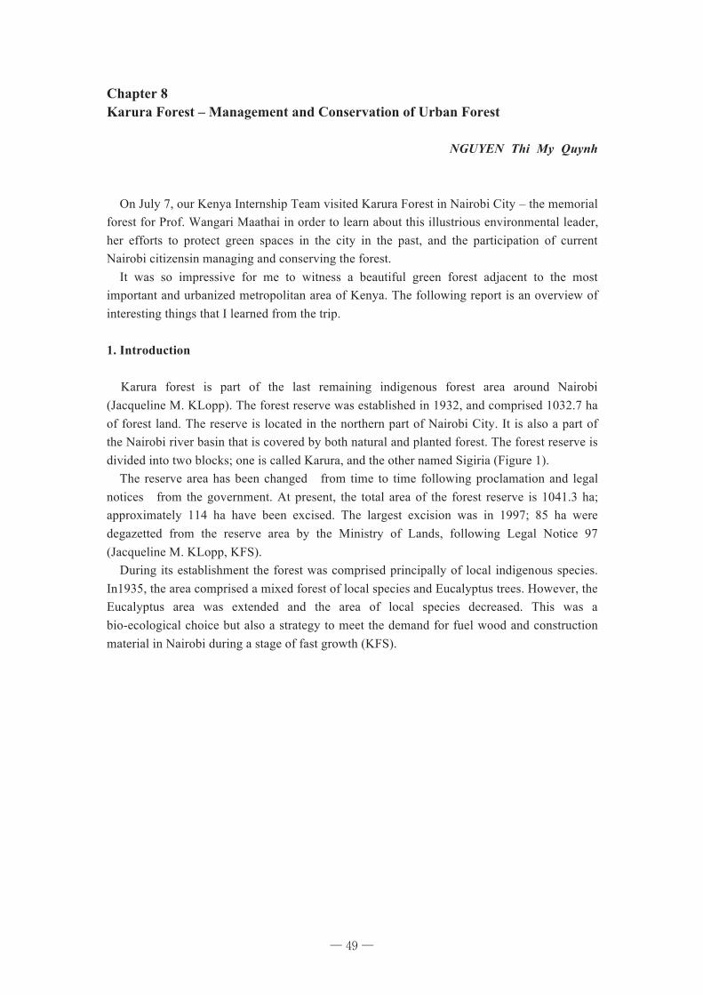
49
Chapter 8 Karura Forest – Management and Conservation of Urban Forest
NGUYEN Thi My Quynh
On July 7, our Kenya Internship Team visited Karura Forest in Nairobi City – the memorial forest for Prof. Wangari Maathai in order to learn about this illustrious environmental leader, her efforts to protect green spaces in the city in the past, and the participation of current Nairobi citizensin managing and conserving the forest. It was so impressive for me to witness a beautiful green forest adjacent to the most important and urbanized metropolitan area of Kenya. The following report is an overview of interesting things that I learned from the trip.
1. Introduction Karura forest is part of the last remaining indigenous forest area around Nairobi (Jacqueline M. KLopp). The forest reserve was established in 1932, and comprised 1032.7 ha of forest land. The reserve is located in the northern part of Nairobi City. It is also a part of the Nairobi river basin that is covered by both natural and planted forest. The forest reserve is divided into two blocks; one is called Karura, and the other named Sigiria (Figure 1). The reserve area has been changed from time to time following proclamation and legal notices from the government. At present, the total area of the forest reserve is 1041.3 ha; approximately 114 ha have been excised. The largest excision was in 1997; 85 ha were degazetted from the reserve area by the Ministry of Lands, following Legal Notice 97 (Jacqueline M. KLopp, KFS). During its establishment the forest was comprised principally of local indigenous species. In1935, the area comprised a mixed forest of local species and Eucalyptus trees. However, the Eucalyptus area was extended and the area of local species decreased. This was a bio-ecological choice but also a strategy to meet the demand for fuel wood and construction material in Nairobi during a stage of fast growth (KFS).
─ 49 ─
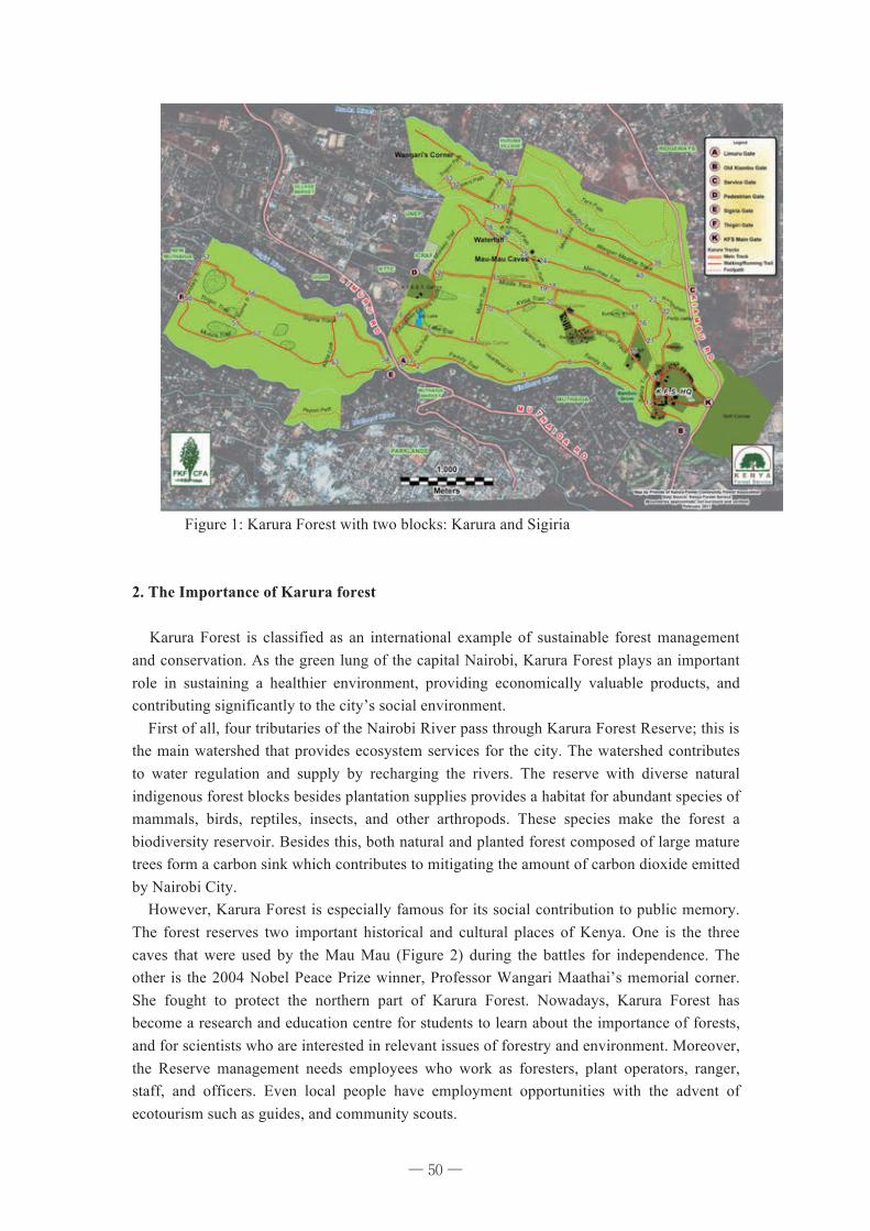
50
Figure 1: Karura Forest with two blocks: Karura and Sigiria
2. The Importance of Karura forest Karura Forest is classified as an international example of sustainable forest management and conservation. As the green lung of the capital Nairobi, Karura Forest plays an important role in sustaining a healthier environment, providing economically valuable products, and contributing significantly to the city’s social environment. First of all, four tributaries of the Nairobi River pass through Karura Forest Reserve; this is the main watershed that provides ecosystem services for the city. The watershed contributes to water regulation and supply by recharging the rivers. The reserve with diverse natural indigenous forest blocks besides plantation supplies provides a habitat for abundant species of mammals, birds, reptiles, insects, and other arthropods. These species make the forest a biodiversity reservoir. Besides this, both natural and planted forest composed of large mature trees form a carbon sink which contributes to mitigating the amount of carbon dioxide emitted by Nairobi City. However, Karura Forest is especially famous for its social contribution to public memory. The forest reserves two important historical and cultural places of Kenya. One is the three caves that were used by the Mau Mau (Figure 2) during the battles for independence. The other is the 2004 Nobel Peace Prize winner, Professor Wangari Maathai’s memorial corner. She fought to protect the northern part of Karura Forest. Nowadays, Karura Forest has become a research and education centre for students to learn about the importance of forests, and for scientists who are interested in relevant issues of forestry and environment. Moreover, the Reserve management needs employees who work as foresters, plant operators, ranger, staff, and officers. Even local people have employment opportunities with the advent of ecotourism such as guides, and community scouts.
─ 50 ─
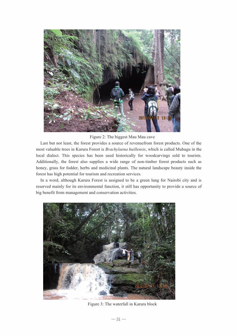
51
Figure 2: The biggest Mau Mau cave
Last but not least, the forest provides a source of revenuefrom forest products. One of the most valuable trees in Karura Forest is Brachylaena huillensis, which is called Muhugu in the local dialect. This species has been used historically for woodcarvings sold to tourists. Additionally, the forest also supplies a wide range of non-timber forest products such as honey, grass for fodder, herbs and medicinal plants. The natural landscape beauty inside the forest has high potential for tourism and recreation services. In a word, although Karura Forest is assigned to be a green lung for Nairobi city and is reserved mainly for its environmental function, it still has opportunity to provide a source of big benefit from management and conservation activities.
Figure 3: The waterfall in Karura block
─ 51 ─
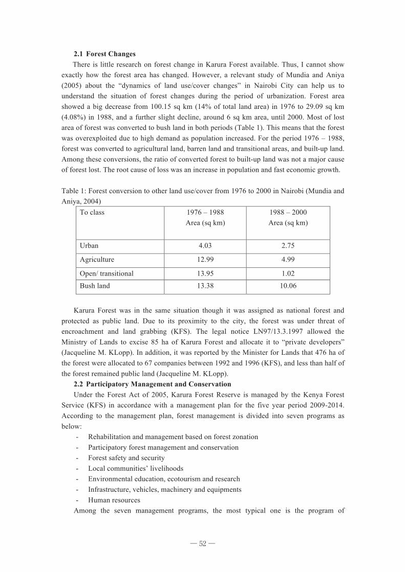
52
2.1 Forest Changes There is little research on forest change in Karura Forest available. Thus, I cannot show exactly how the forest area has changed. However, a relevant study of Mundia and Aniya (2005) about the “dynamics of land use/cover changes” in Nairobi City can help us to understand the situation of forest changes during the period of urbanization. Forest area showed a big decrease from 100.15 sq km (14% of total land area) in 1976 to 29.09 sq km (4.08%) in 1988, and a further slight decline, around 6 sq km area, until 2000. Most of lost area of forest was converted to bush land in both periods (Table 1). This means that the forest was overexploited due to high demand as population increased. For the period 1976 – 1988, forest was converted to agricultural land, barren land and transitional areas, and built-up land. Among these conversions, the ratio of converted forest to built-up land was not a major cause of forest lost. The root cause of loss was an increase in population and fast economic growth. Table 1: Forest conversion to other land use/cover from 1976 to 2000 in Nairobi (Mundia and Aniya, 2004)
To class 1976 – 1988 Area (sq km)
1988 – 2000 Area (sq km)
Urban 4.03 2.75
Agriculture 12.99 4.99
Open/ transitional 13.95 1.02
Bush land 13.38 10.06
Karura Forest was in the same situation though it was assigned as national forest and
protected as public land. Due to its proximity to the city, the forest was under threat of encroachment and land grabbing (KFS). The legal notice LN97/13.3.1997 allowed the Ministry of Lands to excise 85 ha of Karura Forest and allocate it to “private developers” (Jacqueline M. KLopp). In addition, it was reported by the Minister for Lands that 476 ha of the forest were allocated to 67 companies between 1992 and 1996 (KFS), and less than half of the forest remained public land (Jacqueline M. KLopp).
2.2 Participatory Management and Conservation Under the Forest Act of 2005, Karura Forest Reserve is managed by the Kenya Forest
Service (KFS) in accordance with a management plan for the five year period 2009-2014. According to the management plan, forest management is divided into seven programs as below:
- Rehabilitation and management based on forest zonation - Participatory forest management and conservation - Forest safety and security - Local communities’ livelihoods - Environmental education, ecotourism and research - Infrastructure, vehicles, machinery and equipments - Human resources
Among the seven management programs, the most typical one is the program of
─ 52 ─
53
participatory forest management and conservation. From what I have learnt before and during the trip as well as information from interviews, I made a Venn diagram of groups of stakeholders who are involved in management and conservation of Karura Forest (Figure 4) based on appendix III of the Karura Forest Strategic Management Plan (KFS)
Figure 4: Venn diagram of groups of stakeholders
There are five groups of stakeholders who participate in Karura Forest management
activities: 1) Government institutions, 2) Private sector, 3) Community based organizations (CBOs), 4) Nairobi council, and 5) Faith based organizations. The distance between each group to Karura Forest expresses the relevant association of that group to the forest. Because Karura is a national forest that is under management of a government authority, the most important stakeholder to the forest is the group of government institutions. The second one is private sector since this group manages and generates almost all financial sources for afforestation tasks. The third one is CBOs who contribute to forest management and gain benefit from harvesting some non-timber products. The role of this group in managing the forest is not so active. Most organizations in this group are slum communities that live next to the forest. Part of these communities makes their living from forest non-timber products such as honey, firewood, fodder, herb and medicine.
Table 2: Appendix III - Stakeholder roles and responsibilities Category Stakeholder Roles/ Responsibilities
Government Institutions
MOF&W Oversight responsibility over KFS KFS Forest owners
Provision of both Human and Financial resources
Police (CID) CID Hq
Karura Forest
Faith Based Org.
Nairobi Council
Private sector
Afforestation
Guidance (UNEP)
NGOs Afforestation (GBM)
CBOs
Joint management (CFA: FKF)
Harvest (slums)
Gov. institutions (MOFW, KFS, KWS, etc)
Forest owner
Oversight
Security
Research
─ 53 ─
54
KEFRI Research and wood workshop Tree Biotech Nursery Biotech seedlings nursery and sales Office of the President Administration and general security Metropolitan Ministry City Council oversight Infrasound Project Research by UON and OP
Category Stakeholder Roles/ Responsibilities Private Sector KPLC Power distribution lines maintenance and
extension afforestation Small business owners Cater for the needs for the Karura
community Resident Associations Partnering with KFS on Forestry American Embassy Afforestation KCB Afforestation UNEP Guidance on international forestry policy
and conservation
Nation Media Afforestation I&M Bank Afforestation DT Dobie Afforestation Eagle Africa Insurance B Afforestation City Bank Afforestation
Faith Based Org. Catholic church Church Anglican Church Church AIC Church EA Pentecostal Church Redeem Gospel Church
Nairobi City Council
Karura Primary School Primary school and staff houses Nairobi Water Co. Supply of water to Karura
NGOs Green Belt Movement Afforestation CBOs Friend of Karura Forest
CFA Joint management of the forest
Huruma slum Bee keeping, Tree planting and harvest firewood from the forest
Mathare slum Depends on Karura Forest for fuel wood energy
Githogoro slum Depends on Karura Forest for fuel wood energy
Deep Sea slum Fuel wood, depends on forest products The lesson learnt from the program of participatory management in Karura Forest is the
idea of multi-stakeholders cooperation and the distribution of responsibilities between stakeholders. Especially, the program encourages active involvement of the private sector. In
─ 54 ─
55
comparison to the urban forest management cases in my country, the similarity is that urban forest is also under management of government organization. But, the difference is that we cannot get the attention of other sectors and organizations to become involved in management and conservation plans.
3 Conclusion
Karura Forest is a typical example of a good managed and conserved forest in the large
and modernized Nairobi City. Success is shown by the improvement in safety and security of the forest, active participation of stakeholders from private sector groups, increasing revenue from ecotourism services, and involvement of communities whose lives partially depends on forest products.
References 1. Kenyan Forest Service (KFS). “Karura Forest Strategic Management Plan” 2010 –
2014. edited by Kenua Forest Service, 2009 2. Kenyan Parliament. “Forest Act.” edited by Kenyan Parliament, 2005 3. Jacqueline M. Klopp. Pilfering the Public: The problem of Land Grabbing in
Contemporary Kenya. Africa Today Vol.13 4. C. N. Mundia and M.Aniya. 2006. Dynamics of Landuse/cover Changes and
Degradation of Nairobi City, Kenya. Land Degrad. Develop. 17: 97-108
─ 55 ─
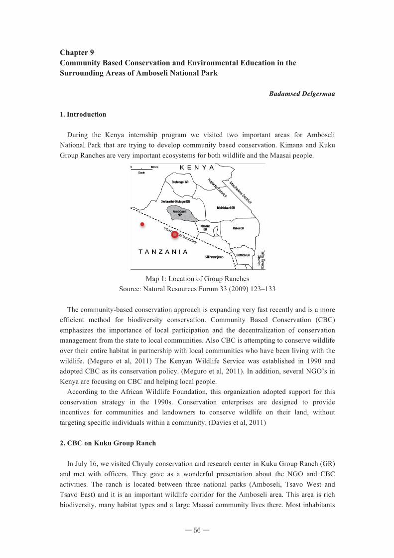
56
Chapter 9 Community Based Conservation and Environmental Education in the Surrounding Areas of Amboseli National Park
Badamsed Delgermaa
1. Introduction During the Kenya internship program we visited two important areas for Amboseli National Park that are trying to develop community based conservation. Kimana and Kuku Group Ranches are very important ecosystems for both wildlife and the Maasai people.
Map 1: Location of Group Ranches
Source: Natural Resources Forum 33 (2009) 123–133
The community-based conservation approach is expanding very fast recently and is a more efficient method for biodiversity conservation. Community Based Conservation (CBC) emphasizes the importance of local participation and the decentralization of conservation management from the state to local communities. Also CBC is attempting to conserve wildlife over their entire habitat in partnership with local communities who have been living with the wildlife. (Meguro et al, 2011) The Kenyan Wildlife Service was established in 1990 and adopted CBC as its conservation policy. (Meguro et al, 2011). In addition, several NGO’s in Kenya are focusing on CBC and helping local people. According to the African Wildlife Foundation, this organization adopted support for this conservation strategy in the 1990s. Conservation enterprises are designed to provide incentives for communities and landowners to conserve wildlife on their land, without targeting specific individuals within a community. (Davies et al, 2011) 2. CBC on Kuku Group Ranch In July 16, we visited Chyuly conservation and research center in Kuku Group Ranch (GR) and met with officers. They gave as a wonderful presentation about the NGO and CBC activities. The ranch is located between three national parks (Amboseli, Tsavo West and Tsavo East) and it is an important wildlife corridor for the Amboseli area. This area is rich biodiversity, many habitat types and a large Maasai community lives there. Most inhabitants
─ 56 ─
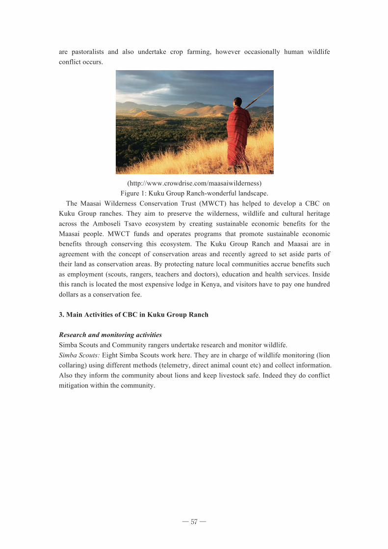
57
are pastoralists and also undertake crop farming, however occasionally human wildlife conflict occurs.
(http://www.crowdrise.com/maasaiwilderness) Figure 1: Kuku Group Ranch-wonderful landscape.
The Maasai Wilderness Conservation Trust (MWCT) has helped to develop a CBC on Kuku Group ranches. They aim to preserve the wilderness, wildlife and cultural heritage across the Amboseli Tsavo ecosystem by creating sustainable economic benefits for the Maasai people. MWCT funds and operates programs that promote sustainable economic benefits through conserving this ecosystem. The Kuku Group Ranch and Maasai are in agreement with the concept of conservation areas and recently agreed to set aside parts of their land as conservation areas. By protecting nature local communities accrue benefits such as employment (scouts, rangers, teachers and doctors), education and health services. Inside this ranch is located the most expensive lodge in Kenya, and visitors have to pay one hundred dollars as a conservation fee. 3. Main Activities of CBC in Kuku Group Ranch Research and monitoring activities Simba Scouts and Community rangers undertake research and monitor wildlife. Simba Scouts: Eight Simba Scouts work here. They are in charge of wildlife monitoring (lion collaring) using different methods (telemetry, direct animal count etc) and collect information. Also they inform the community about lions and keep livestock safe. Indeed they do conflict mitigation within the community.
─ 57 ─
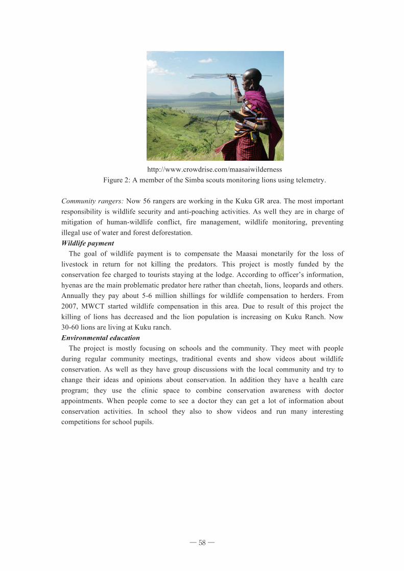
58
http://www.crowdrise.com/maasaiwilderness Figure 2: A member of the Simba scouts monitoring lions using telemetry.
Community rangers: Now 56 rangers are working in the Kuku GR area. The most important responsibility is wildlife security and anti-poaching activities. As well they are in charge of mitigation of human-wildlife conflict, fire management, wildlife monitoring, preventing illegal use of water and forest deforestation. Wildlife payment The goal of wildlife payment is to compensate the Maasai monetarily for the loss of livestock in return for not killing the predators. This project is mostly funded by the conservation fee charged to tourists staying at the lodge. According to officer’s information, hyenas are the main problematic predator here rather than cheetah, lions, leopards and others. Annually they pay about 5-6 million shillings for wildlife compensation to herders. From 2007, MWCT started wildlife compensation in this area. Due to result of this project the killing of lions has decreased and the lion population is increasing on Kuku Ranch. Now 30-60 lions are living at Kuku ranch. Environmental education The project is mostly focusing on schools and the community. They meet with people during regular community meetings, traditional events and show videos about wildlife conservation. As well as they have group discussions with the local community and try to change their ideas and opinions about conservation. In addition they have a health care program; they use the clinic space to combine conservation awareness with doctor appointments. When people come to see a doctor they can get a lot of information about conservation activities. In school they also to show videos and run many interesting competitions for school pupils.
─ 58 ─
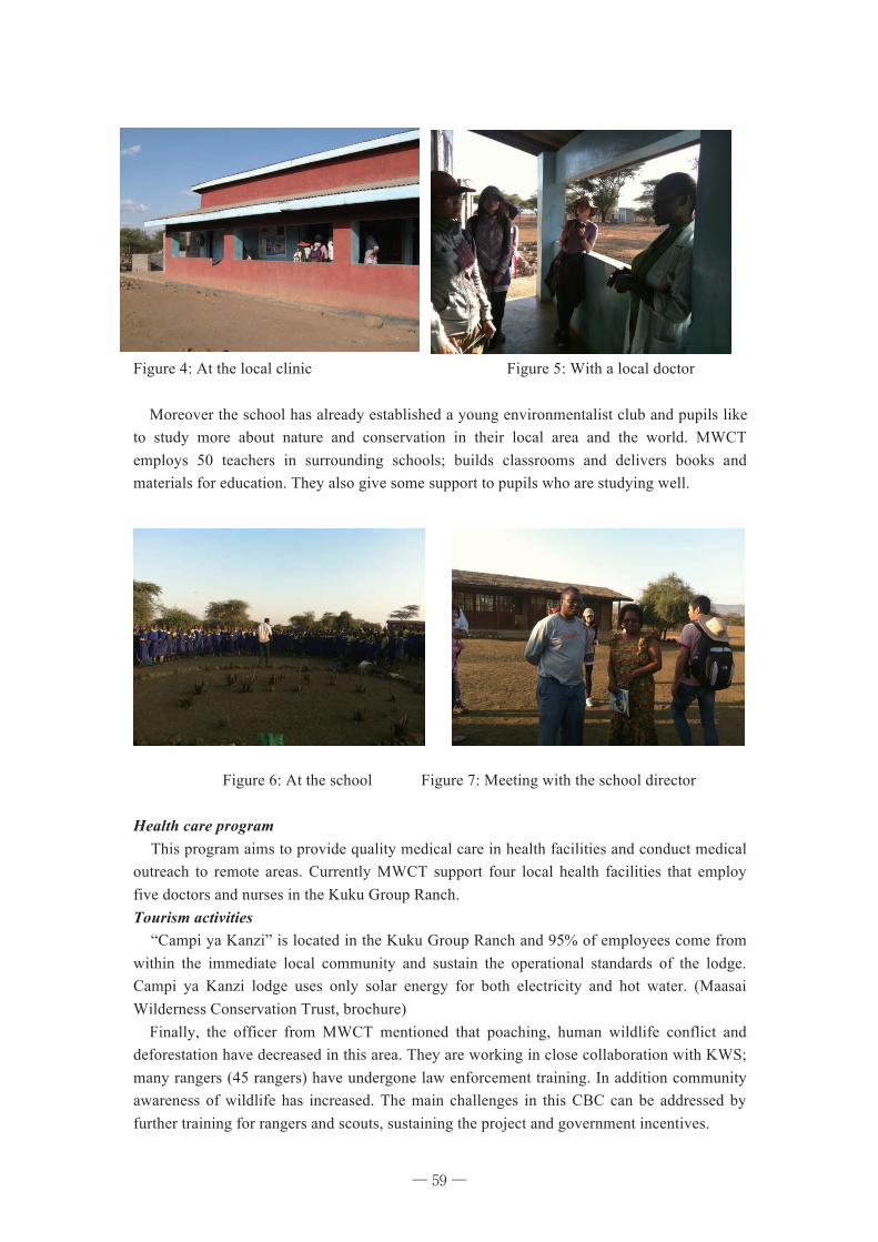
59
Figure 4: At the local clinic Figure 5: With a local doctor Moreover the school has already established a young environmentalist club and pupils like to study more about nature and conservation in their local area and the world. MWCT employs 50 teachers in surrounding schools; builds classrooms and delivers books and materials for education. They also give some support to pupils who are studying well.
Figure 6: At the school Figure 7: Meeting with the school director Health care program This program aims to provide quality medical care in health facilities and conduct medical outreach to remote areas. Currently MWCT support four local health facilities that employ five doctors and nurses in the Kuku Group Ranch. Tourism activities “Campi ya Kanzi” is located in the Kuku Group Ranch and 95% of employees come from within the immediate local community and sustain the operational standards of the lodge. Campi ya Kanzi lodge uses only solar energy for both electricity and hot water. (Maasai Wilderness Conservation Trust, brochure) Finally, the officer from MWCT mentioned that poaching, human wildlife conflict and deforestation have decreased in this area. They are working in close collaboration with KWS; many rangers (45 rangers) have undergone law enforcement training. In addition community awareness of wildlife has increased. The main challenges in this CBC can be addressed by further training for rangers and scouts, sustaining the project and government incentives.
─ 59 ─
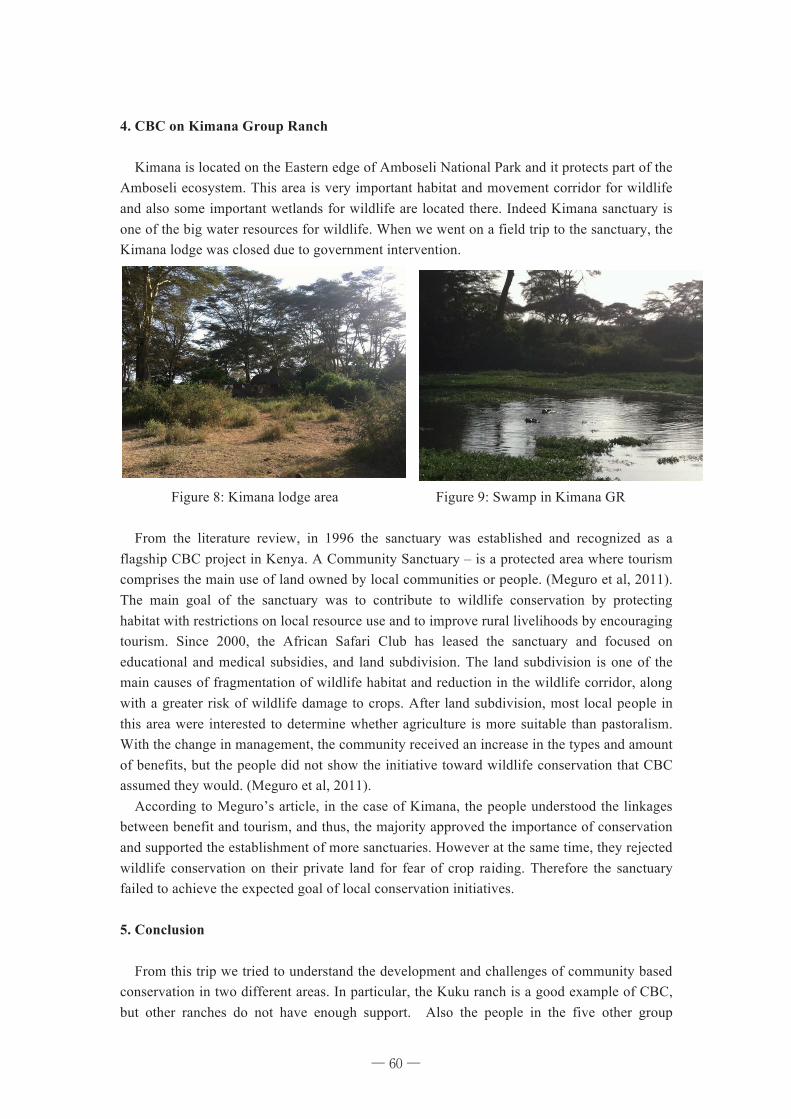
60
4. CBC on Kimana Group Ranch Kimana is located on the Eastern edge of Amboseli National Park and it protects part of the Amboseli ecosystem. This area is very important habitat and movement corridor for wildlife and also some important wetlands for wildlife are located there. Indeed Kimana sanctuary is one of the big water resources for wildlife. When we went on a field trip to the sanctuary, the Kimana lodge was closed due to government intervention.
Figure 8: Kimana lodge area Figure 9: Swamp in Kimana GR From the literature review, in 1996 the sanctuary was established and recognized as a flagship CBC project in Kenya. A Community Sanctuary – is a protected area where tourism comprises the main use of land owned by local communities or people. (Meguro et al, 2011). The main goal of the sanctuary was to contribute to wildlife conservation by protecting habitat with restrictions on local resource use and to improve rural livelihoods by encouraging tourism. Since 2000, the African Safari Club has leased the sanctuary and focused on educational and medical subsidies, and land subdivision. The land subdivision is one of the main causes of fragmentation of wildlife habitat and reduction in the wildlife corridor, along with a greater risk of wildlife damage to crops. After land subdivision, most local people in this area were interested to determine whether agriculture is more suitable than pastoralism. With the change in management, the community received an increase in the types and amount of benefits, but the people did not show the initiative toward wildlife conservation that CBC assumed they would. (Meguro et al, 2011). According to Meguro’s article, in the case of Kimana, the people understood the linkages between benefit and tourism, and thus, the majority approved the importance of conservation and supported the establishment of more sanctuaries. However at the same time, they rejected wildlife conservation on their private land for fear of crop raiding. Therefore the sanctuary failed to achieve the expected goal of local conservation initiatives. 5. Conclusion From this trip we tried to understand the development and challenges of community based conservation in two different areas. In particular, the Kuku ranch is a good example of CBC, but other ranches do not have enough support. Also the people in the five other group
─ 60 ─
61
ranches around Kuku Ranch demand compensation like Kuku GR and threat to kill wildlife. In addition sustainability of CBC is very important; public awareness and environmental education is still necessary for local people to change their mind about wildlife conservation. References Giles David et al. “Conservation Enterprise: A decision support toolkit” African Wildlife Foundation, 2011
Toshio Meguro et al “ Conservation Goal Betrayed by the Used of Wildlife Benefits in Community Based Conservation: The Case of Kimana Sanctuary in Southern Kenya”, 2011
Maasai Wilderness Conservation Trust: http://www.crowdrise.com/maasaiwilderness
─ 61 ─
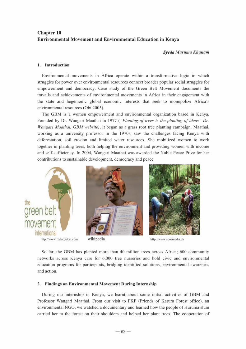
62
Chapter 10 Environmental Movement and Environmental Education in Kenya
Syeda Masuma Khanam
1. Introduction
Environmental movements in Africa operate within a transformative logic in which struggles for power over environmental resources connect broader popular social struggles for empowerment and democracy. Case study of the Green Belt Movement documents the travails and achievements of environmental movements in Africa in their engagement with the state and hegemonic global economic interests that seek to monopolize Africa’s environmental resources (Obi 2005).
The GBM is a women empowerment and environmental organization based in Kenya. Founded by Dr. Wangari Maathai in 1977 (“Planting of trees is the planting of ideas” Dr. Wangari Maathai, GBM website), it began as a grass root tree planting campaign. Maathai, working as a university professor in the 1970s, saw the challenges facing Kenya with deforestation, soil erosion and limited water resources. She mobilized women to work together in planting trees, both helping the environment and providing women with income and self-sufficiency. In 2004, Wangari Maathai was awarded the Noble Peace Prize for her contributions to sustainable development, democracy and peace
http://www.flyladydori.com wikipedia http://www.spormedia.dk
So far, the GBM has planted more than 40 million trees across Africa; 600 community networks across Kenya care for 6,000 tree nurseries and hold civic and environmental education programs for participants, bridging identified solutions, environmental awareness and action. 2. Findings on Environmental Movement During Internship
During our internship in Kenya, we learnt about some initial activities of GBM and Professor Wangari Maathai. From our visit to FKF (Friends of Karura Forest office), an environmental NGO, we watched a documentary and learned how the people of Huruma slum carried her to the forest on their shoulders and helped her plant trees. The cooperation of
─ 62 ─
63
relatively low income people was really amazing and unbelievable. It revealed the secret of Professor Maathai’s success in the GBM;--the local people participated in her activities because they trusted her. With effective local mobilization and sustained international support, environmental movements conducted by the GBM and other NGOs have been partially successful in using their blocking power to resist the further expropriation of their environmental space, while bringing their local causes into the center of the struggle for democracy (Obi 2005).
The movements still depend on foreign governments and donors to apply pressure on African governments, a trend that, however successful in the short run, constrains the effectiveness of these movements with-in their local/grassroots constituencies in the long run (Obi 2005 ). From our visit to Kuku Group Ranch, we learnt that the success of this GR is very much dependent on donors’ contribution and the other 5 GRs around Kuku GR are not as successful due to lack of donation and proper management.
3. Environmental Education in Kenya
Kenya’s wealth is endowed in its natural resources that are distributed throughout the nation. However, the natural resource base is shrinking rapidly, environmental problems are becoming increasingly severe, pushing the country into poverty and associated environmental problems. As a response to these challenges, Environmental Education (EE) is one of the strategies the Kenyan government adopted following the 1977 Tbilisi Conference, and the 1987 Moscow Conference. The Kenyan government is committed to Agenda 21, Chapter 36 on Education and Sustainable Development, and demonstrated this by the adoption of the National Environment Action Plan (NEAP). (https://www.ceeindia.org/esf/download/paper44.pc). Government initiatives:
The mainstreaming of environmental issues in the curriculum at primary and secondary schools in Kenya dates back to the colonial days (before 1963). The Kenyan government has, since the publication of the Report of the National Committee on Education Objectives and Policies (NCEOP) in 1977, made deliberate attempts to mainstream environmental issues in all curricula at all levels.
ü At early childhood education level, EE is integrated into the curriculum using a thematic approach. At the primary and secondary school level, environmental issues are mainstreamed in the existing subjects using a multidisciplinary approach.
ü All teacher-training colleges currently offer courses in EE. The same applies to university level education where faculties/departments of Environmental Studies exist. Some universities use an interdisciplinary approach. https://www.ceeindia.org/esf/download/paper44.pc (accessed on 2012/09/10).
ü MEMR (Ministry of Environment and Mineral Resources) is now implementing a National Environmental Education and Awareness Initiative (EEAI) to educate and raise awareness about environmental challenges to all Kenyans and to encourage the participation of all stakeholders in environmental conservation and management. Source: http://www.environment.go.ke/archives/91 accessed June 8, 2012.
─ 63 ─
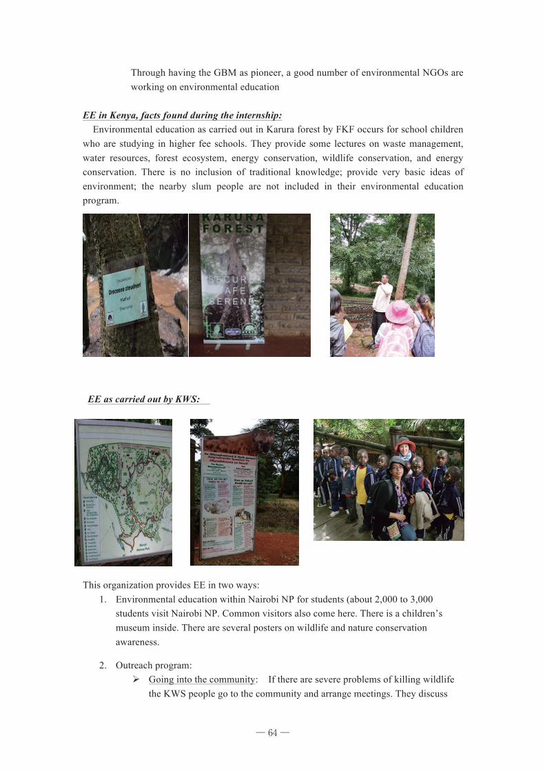
64
Through having the GBM as pioneer, a good number of environmental NGOs are working on environmental education
EE in Kenya, facts found during the internship: Environmental education as carried out in Karura forest by FKF occurs for school children who are studying in higher fee schools. They provide some lectures on waste management, water resources, forest ecosystem, energy conservation, wildlife conservation, and energy conservation. There is no inclusion of traditional knowledge; provide very basic ideas of environment; the nearby slum people are not included in their environmental education program.
EE as carried out by KWS:
This organization provides EE in two ways:
1. Environmental education within Nairobi NP for students (about 2,000 to 3,000 students visit Nairobi NP. Common visitors also come here. There is a children’s museum inside. There are several posters on wildlife and nature conservation awareness.
2. Outreach program: Ø Going into the community: If there are severe problems of killing wildlife
the KWS people go to the community and arrange meetings. They discuss
─ 64 ─
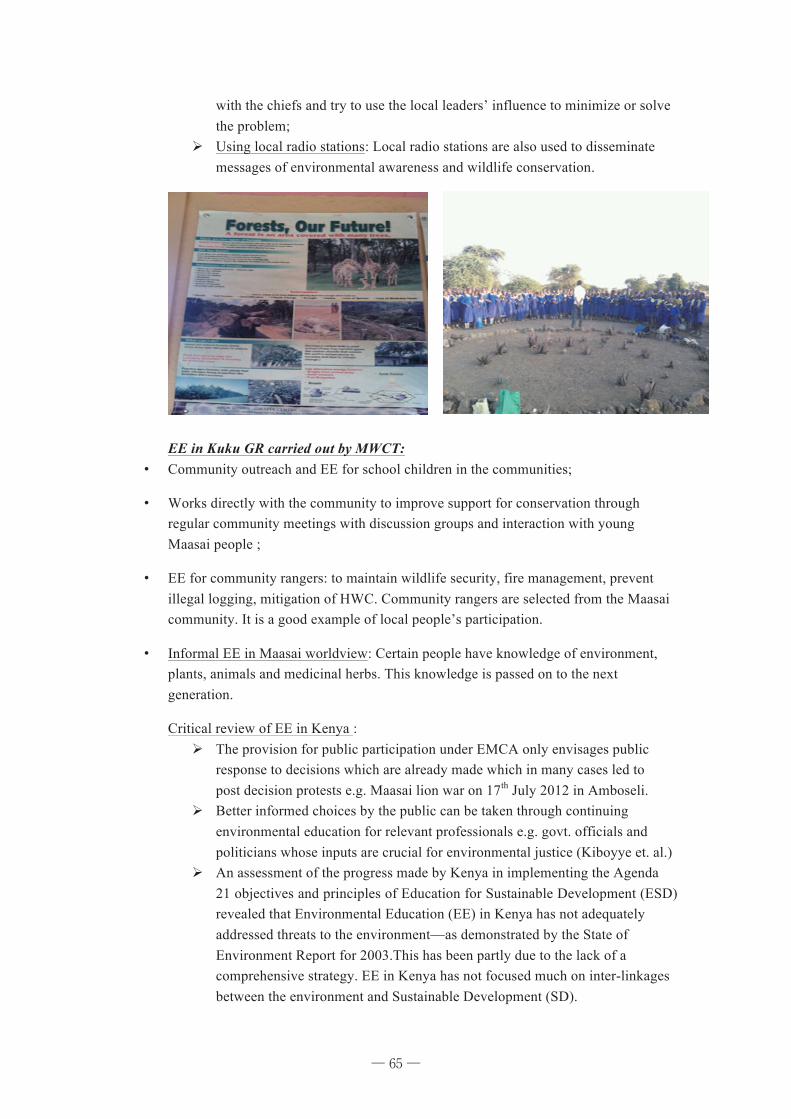
65
with the chiefs and try to use the local leaders’ influence to minimize or solve the problem;
Ø Using local radio stations: Local radio stations are also used to disseminate messages of environmental awareness and wildlife conservation.
EE in Kuku GR carried out by MWCT:
¥ Community outreach and EE for school children in the communities;
¥ Works directly with the community to improve support for conservation through regular community meetings with discussion groups and interaction with young Maasai people ;
¥ EE for community rangers: to maintain wildlife security, fire management, prevent illegal logging, mitigation of HWC. Community rangers are selected from the Maasai community. It is a good example of local people’s participation.
¥ Informal EE in Maasai worldview: Certain people have knowledge of environment, plants, animals and medicinal herbs. This knowledge is passed on to the next generation.
Critical review of EE in Kenya : Ø The provision for public participation under EMCA only envisages public
response to decisions which are already made which in many cases led to post decision protests e.g. Maasai lion war on 17th July 2012 in Amboseli.
Ø Better informed choices by the public can be taken through continuing environmental education for relevant professionals e.g. govt. officials and politicians whose inputs are crucial for environmental justice (Kiboyye et. al.)
Ø An assessment of the progress made by Kenya in implementing the Agenda 21 objectives and principles of Education for Sustainable Development (ESD) revealed that Environmental Education (EE) in Kenya has not adequately addressed threats to the environment—as demonstrated by the State of Environment Report for 2003.This has been partly due to the lack of a comprehensive strategy. EE in Kenya has not focused much on inter-linkages between the environment and Sustainable Development (SD).
─ 65 ─
66
Ø The environment has been looked at in great detail from a biophysical viewpoint, however, less emphasis has been placed on economic and social perspectives. There has been little emphasis on social critical, reflexive and participatory approaches to EE (Dorcas Otieno).
4. Comparative Analysis with Bangladesh and Some Recommendations
� In Bangladesh the Department of Environment has the mission to build
environmental awareness and people’s participation (www.doe-bd.org), but it has no specific strategy like Kenya. Environmental NGOs still do not have any specific strategy to involve people through environmental education. Both the GOs and NGOs emphasize pollution issues in their strategies without reaching the people.
In Kenya, the KWS has an environmental education program the National Park along with outreach program use of local radio station etc. Besides, NGOs are also actively involved in this kind of activity.
� In Bangladesh environmental education is included in some textbooks, it is not compulsory at all levels. Teachers’ training colleges have no curriculum for environmental education.
In Kenya, environmental education is regarded as compulsory from elementary levels.
� In Bangladesh, there is a government initiative for afforestation called “Social Forestry”. The government provides tree plants freely to a certain group of people in a certain area, people do the planting and take care of the afforestation, and when trees are mature, people get the share of the monetary benefits from that.
In Kenya, both the GOs and NGOs are mainly concerned with wildlife. To prevent deforestation, Kenya can follow this kind of program.
� In Bangladesh, women are involved in every kind of development program, in the National Women Development Policy 2011; article 36 provides women with empowerment for natural resource management.
During our internship, I learnt that although the Maasai tribe is rich with traditional knowledge about environment, women have no access to it. Women should be empowered in this sector too.
� Both in Bangladesh and Kenya, there are some common problems in the environmental agencies. Both the Department of Environment in Bangladesh and KWS in Kenya suffer from manpower, and logistic support. In the case of NGOs, in both countries, foreign donor countries patronize these kinds of organizations and local peoples need based strategies are missing. Inclusion of traditional knowledge and local people at the policy formulation level and teaching staff level is overlooked by both the GOs and NGOs in both countries.
� The Collaborative Partnership on Forests (CPF), an informal and voluntary arrangement among 14 international organizations and secretariats working for forest, has launched the first ever award to honor and commemorate the impact of this extraordinary woman who championed forest issues around the world http://www.thedailystar.net 2012/09/16. It is a matter of great joy and pride that a
─ 66 ─
67
Bangladeshi village woman, Khurshida Begum, a young widow from Teknaf in Cox's Bazar, has been selected for the Wangari Maathai Award 2012 for her co-management efforts and leadership in conservation of natural resources. She started her natural resource conservation activities in 2006, during the inception of Nishorgo Network (an NGO), through forming a female Community Patrol Group (CPG) with 28 women at Kerontali, said a press release. Along with the forest guards, she took upon the challenges of sharing the responsibilities of conserving the sanctuary against poaching and illegal logging. She made local people aware about biodiversity conservation for future generations.
5. Recommendations
� In Kenya, protection and conservation of wildlife is getting more priority by both the
GOs and NGOs. Local peoples subsistence, social, cultural and political factors should be considered to reduce or minimize Human Wildlife Conflict;
� In government schools and NGO schools, environmental education curriculum should target sustainable development;
� They should include Traditional Ecological Knowledge of the indigenous tribes in the EE curriculum and the knowledgeable person from the local tribes should be included to teach environmental education especially in NGO managed-schools.
Reference Cyril I. Obi Environmental Movement in Sub-Saharan Africa: A Political Ecology of Power and Conflict. UNRISD, 2005www.unrisd.org accessed 2012/06/10; Dorcas Otieno , “Towards Developing an Education for Sustainable Development Strategy for Kenya: Experiences and Perspectives” https://www.ceeindia.org/esf/download/paper44.pc (accessed on 2012/09/10). Duncan Kiboyye, et. al “Public participation and Environmental Jurisprudence in Kenya: Education for Sustainable Development Paradigm”., www.scribd.corn/doc/20955826.(Accessed on 18th July, 2012.) Martin Jodie, “Overview of GBM: The grassroots Environmental campaign Empowering Women in Kenya” http://suit101.com accessed 2012/09/11
─ 67 ─

68
Part IV
Programs, Closing Remarks, and Photos
─ 68 ─
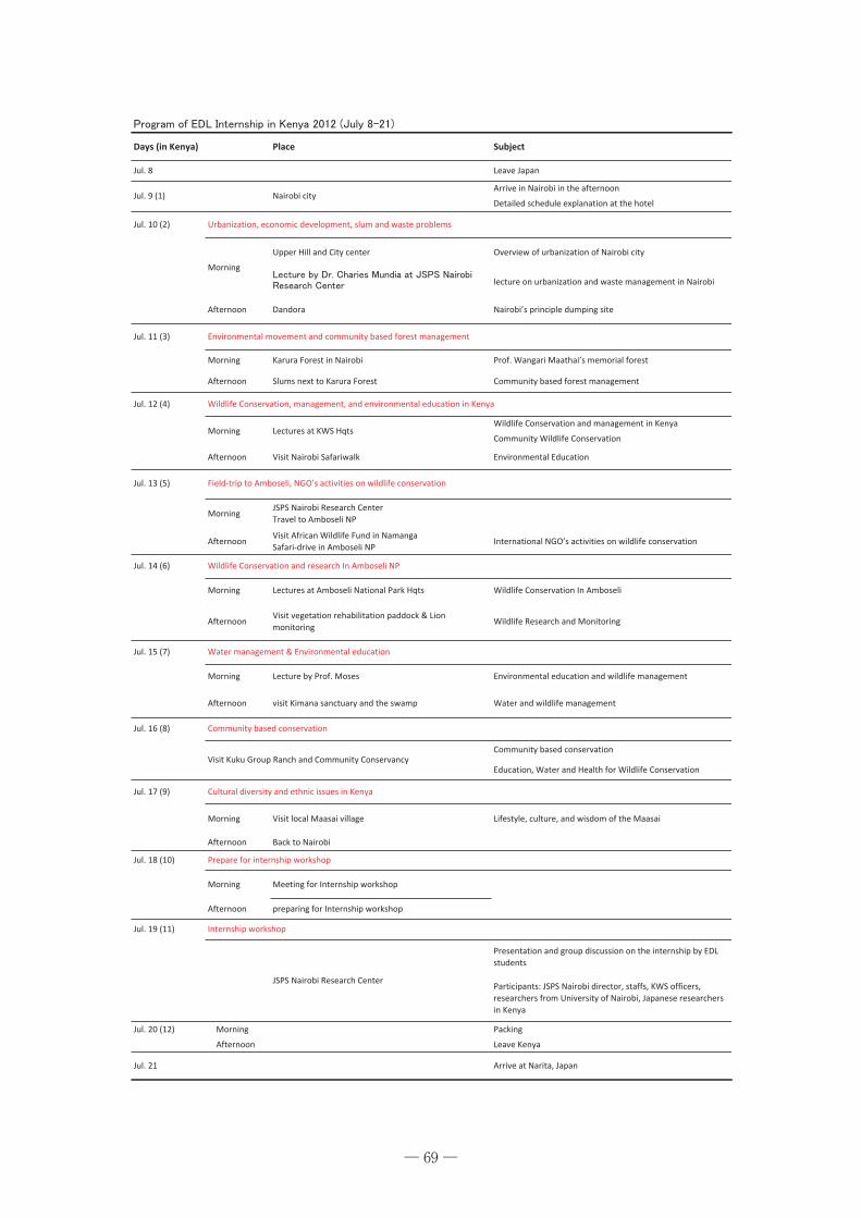
69
Days%(in%Kenya) Place Subject
Jul.%8 Leave%Japan
Arrive%in%Nairobi%in%the%afternoon
Detailed%schedule%explanation%at%the%hotel
Jul.%10%(2)
Upper%Hill%and%City%center Overview%of%urbanization%of%Nairobi%city
lecture%on%urbanization%and%waste%management%in%Nairobi
Jul.%11%(3)
Morning Karura%Forest%in%Nairobi Prof.%Wangari%Maathai’s%memorial%forest
Afternoon Slums%next%to%Karura%Forest Community%based%forest%management
Jul.%12%(4)
Wildlife%Conservation%and%management%in%Kenya
Community%Wildlife%Conservation
Afternoon Visit%Nairobi%Safariwalk Environmental%Education
Jul.%13%(5)
MorningJSPS%Nairobi%Research%Center
Travel%to%Amboseli%NP
AfternoonVisit%African%Wildlife%Fund%in%Namanga
SafariXdrive%in%Amboseli%NPInternational%NGO’s%activities%on%wildlife%conservation
Jul.%14%(6)
Morning Lectures%at%Amboseli%National%Park%Hqts Wildlife%Conservation%In%Amboseli
AfternoonVisit%vegetation%rehabilitation%paddock%&%Lion
monitoringWildlife%Research%and%Monitoring
Jul.%15%(7)
Morning Lecture%by%Prof.%Moses Environmental%education%and%wildlife%management
Afternoon visit%Kimana%sanctuary%and%the%swamp Water%and%wildlife%management
Jul.%16%(8)
Community%based%conservation
Education,%Water%and%Health%for%Wildlife%Conservation
Jul.%17%(9)
Afternoon Back%to%Nairobi
Jul.%18%(10)
Morning Meeting%for%Internship%workshop
Afternoon preparing%for%Internship%workshop
Jul.%19%(11)
Presentation%and%group%discussion%on%the%internship%by%EDL
students
Participants:%JSPS%Nairobi%director,%staffs,%KWS%officers,
researchers%from%University%of%Nairobi,%Japanese%researchers
in%Kenya
Jul.%20%(12) %%%%Morning Packing
%%%%Afternoon Leave%Kenya
Jul.%21 Arrive%at%Narita,%Japan
JSPS%Nairobi%Research%Center
Jul.%9%(1) Nairobi%city
Urbanization,%economic%development,%slum%and%waste%problems
Visit%Kuku%Group%Ranch%and%Community%Conservancy
Visit%local%Maasai%village
Lectures%at%KWS%Hqts
Cultural%diversity%and%ethnic%issues%in%Kenya
Prepare%for%internship%workshop
Internship%workshop
Water%management%&%Environmental%education
Morning
Morning
Lifestyle,%culture,%and%wisdom%of%the%Maasai
Environmental%movement%and%community%based%forest%management
Wildlife%Conservation,%management,%and%environmental%education%in%Kenya
FieldXtrip%to%Amboseli,%NGO’s%activities%on%wildlife%conservation
Community%based%conservation
Morning
Afternoon Dandora Nairobi’s%principle%dumping%site
Wildlife%Conservation%and%research%In%Amboseli%NP
─ 69 ─
70
MEXT Strategic Funds for the Promotion of Science and Technology Strategic Program for Fostering Environmental Leaders
Environmental Diplomatic Leader (EDL) Education Program at University of Tsukuba 文部科学省 科学技術戦略推進費 戦略的環境リーダー育成拠点形成事業
筑波大学「環境ディプロマティックリーダーの育成拠点」
Environmental Diplomatic Leader (EDL) Education Program
International Workshop in Kenya 2012
環境ディプロマティックリーダー育成拠点・国際ワークショップ
Aim: In order to promote and serve the development of environmental diplomacy professionals in regions of Asia and Africa, the Environmental Diplomatic Leader (EDL) Education Program was established in 2009 at the Graduate School of Life and Environmental Sciences, University of Tsukuba, Japan. As one of the main training courses, the EDL Program holds international internship in Asia and Africa every year. This year, the Kenya internship is held between July 8th and 21st. To make further progress, the international workshop will both review and evaluate our activities at the internship and request suggestions and comments from both Kenyan and Japnaese researchers. 目的:
「環境ディプロマティックリーダーの育成拠点」プログラムは、アジア・アフリカ地域におけ
る外交的な素養をもつ実践的な環境専門家を育成するために、2009年に筑波大学大学院生命環境科学研究科において設立されました。国際舞台で活躍するための主要なトレーニングコー
スのひとつとして、毎年海外インターンシップを開催しています。2012年度では、7月8日から 21日の間にケニアインターンシップが実施されます。本国際ワークショップの目的は、インターンシップの活動を総括し報告するとともに、ケニア人や日本人研究者による評価・コ
メントを行ない、今後のさらなる発展を期します。
Date: July 19, 2012 (Thursday) 10:00-17:30 日時: 2012年7月19日(木)10:00~17:30 Place: Japan Society for the Promotion of Science (JSPS), Nairobi Research Station 場所: 日本学術振興会ナイロビ研究連絡センター Contact: JSPS Nairobi Research Station (TEL: 254-20-4442424) 問い合わせ先:日本学術振興会ナイロビ研究連絡センター(TEL: 254-20-4442424)
─ 70 ─
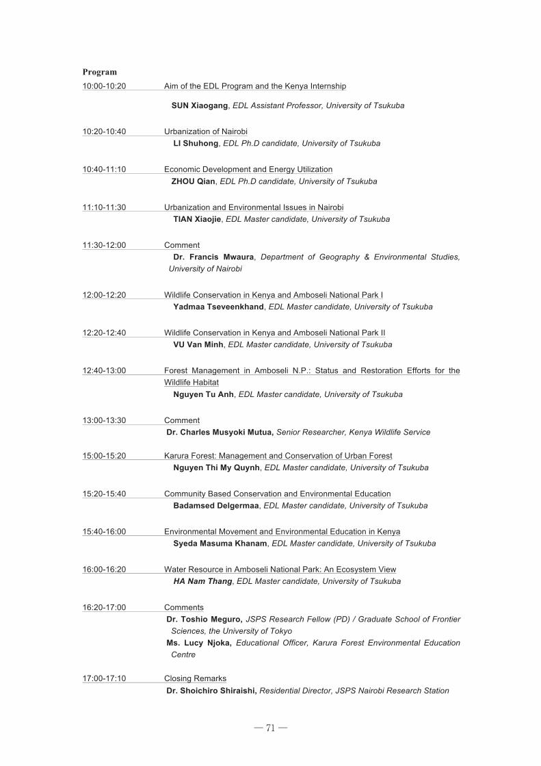
71
Program 10:00-10:20 Aim of the EDL Program and the Kenya Internship
SUN Xiaogang, EDL Assistant Professor, University of Tsukuba
10:20-10:40 Urbanization of Nairobi LI Shuhong, EDL Ph.D candidate, University of Tsukuba
10:40-11:10 Economic Development and Energy Utilization ZHOU Qian, EDL Ph.D candidate, University of Tsukuba
11:10-11:30 Urbanization and Environmental Issues in Nairobi TIAN Xiaojie, EDL Master candidate, University of Tsukuba
11:30-12:00 Comment Dr. Francis Mwaura, Department of Geography & Environmental Studies,
University of Nairobi
12:00-12:20 Wildlife Conservation in Kenya and Amboseli National Park I Yadmaa Tseveenkhand, EDL Master candidate, University of Tsukuba
12:20-12:40 Wildlife Conservation in Kenya and Amboseli National Park II VU Van Minh, EDL Master candidate, University of Tsukuba
12:40-13:00 Forest Management in Amboseli N.P.: Status and Restoration Efforts for the Wildlife Habitat
Nguyen Tu Anh, EDL Master candidate, University of Tsukuba
13:00-13:30 Comment Dr. Charles Musyoki Mutua, Senior Researcher, Kenya Wildlife Service 15:00-15:20 Karura Forest: Management and Conservation of Urban Forest
Nguyen Thi My Quynh, EDL Master candidate, University of Tsukuba
15:20-15:40 Community Based Conservation and Environmental Education Badamsed Delgermaa, EDL Master candidate, University of Tsukuba
15:40-16:00 Environmental Movement and Environmental Education in Kenya Syeda Masuma Khanam, EDL Master candidate, University of Tsukuba
16:00-16:20 Water Resource in Amboseli National Park: An Ecosystem View HA Nam Thang, EDL Master candidate, University of Tsukuba
16:20-17:00 Comments Dr. Toshio Meguro, JSPS Research Fellow (PD) / Graduate School of Frontier
Sciences, the University of Tokyo Ms. Lucy Njoka, Educational Officer, Karura Forest Environmental Education
Centre 17:00-17:10 Closing Remarks Dr. Shoichiro Shiraishi, Residential Director, JSPS Nairobi Research Station
─ 71 ─
72
Closing Remarks It was very grateful to share this seminar with you, I as a director of this JSPS Nairobi Research Station appreciate you all, your presentations are fine and stimulating.
I will mention a few things on research because I think you’ve already known much about human-environmental issues in Kenya. What you have done in Kenya is what we call “fieldwork”, and it is always difficult. We can access many source and can know current issues and agendas of human-environmental issues in Africa from books, papers and web sites. But once we stand on the ground of fieldwork, sometimes we will be confused because of the complexity of the phenomena of actual world.
For example, as you see, most of National Parks in Kenya are successful and earning good amount of their foreign currency revenue. But it is not simple for us to give ultimate answer to solve some conflicts or miscommunication between “stakeholders”; the organization, whether governmental or non-governmental, or private companies, who would like to enhance conservation of wildlife, who would like to represent the local people, who enhance income generation of the population around the National Park and the local people themselves who depends their livelihood on the environment and economic situation around the Park in many cases.
It is easier to be journalist if you were brave enough, but when we do research, we cannot and should not find simple answer, unless just try to discuss about optimum solution based on our case studies. That is one of the most thing I would like to tell you.
There is another thing I will tell you is about this situation itself here we are, sharing the experience of this study tour and discussing. I want to emphasize this is the great chance for you to have such colleagues and situation. I can give you an example. I spent some years with Dr. Sun and Dr.Charles Mushoki in the same post graduate course for African Studies in Japan. We were different in various aspects, in research interests, in research methods, in research sites, and more, possibly in future life planning also. But we have been fieldworkers of African Studies, which was enough for us to share our discussion, to exchange our ideas on researches. In other words, we shared the excitement and difficulty of doing fieldwork and that facilitate our further research and mutual understandings.
If you found some complexity of the phenomena and difficulties to set clear research questions and answers from the ground of this study tour, you have already learned what fieldwork is. And if you found any significant differences of view or interpretation what you have observed or heard among your colleagues in this tour but still you could discuss based on shared experience, you have already learned from your fieldwork.
Here I would like to thank Dr. Sun, the organizer of this study tour, Dr. Charles Mushoki and other contributors of this seminar. We’ll welcome you to back to the field anytime, we JSPS Nairobi Research Station will ready to support you.
Thank you.
Soichiro Shiraishi Ph.D. Resident Director, JSPS Nairobi Research Station
─ 72 ─
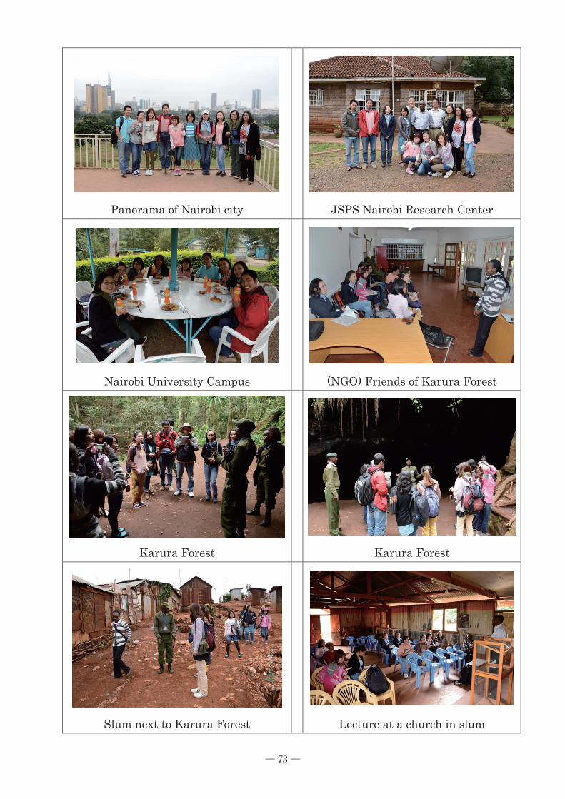
73
Panorama of Nairobi city
JSPS Nairobi Research Center
Nairobi University Campus
(NGO) Friends of Karura Forest
Karura Forest
Karura Forest
Slum next to Karura Forest
Lecture at a church in slum
─ 73 ─
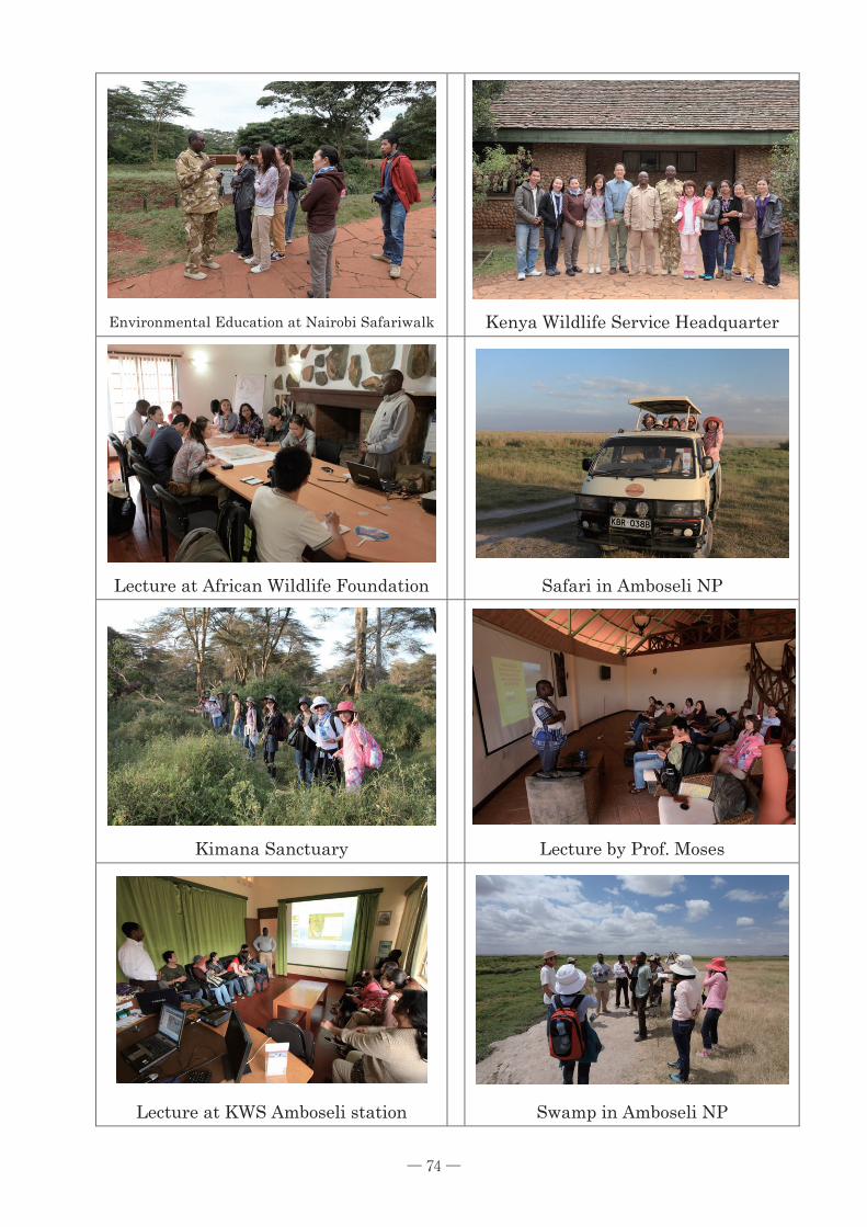
74
Environmental Education at Nairobi Safariwalk
Kenya Wildlife Service Headquarter
Lecture at African Wildlife Foundation
Safari in Amboseli NP
Kimana Sanctuary
Lecture by Prof. Moses
Lecture at KWS Amboseli station
Swamp in Amboseli NP
─ 74 ─
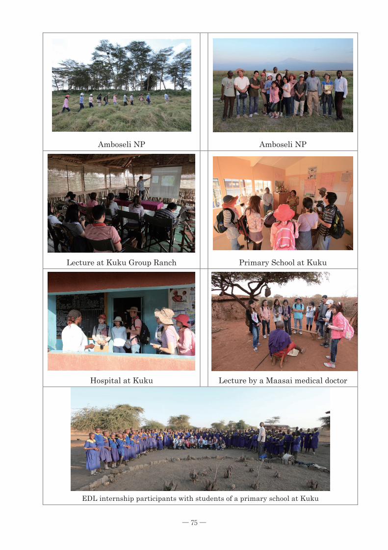
75
Amboseli NP
Amboseli NP
Lecture at Kuku Group Ranch
Primary School at Kuku
Hospital at Kuku
Lecture by a Maasai medical doctor
EDL internship participants with students of a primary school at Kuku
─ 75 ─


