Embed Size (px)
Citation preview

Seediscussions,stats,andauthorprofilesforthispublicationat:https://www.researchgate.net/publication/277917914
FluvialgeomorphologyonEarth-likeplanetarysurfaces:Areview
ARTICLEinGEOMORPHOLOGY·MAY2015
ImpactFactor:2.79·DOI:10.1016/j.geomorph.2015.05.002
CITATIONS
2
READS
222
8AUTHORS,INCLUDING:
ChristopherW.Hamilton
TheUniversityofArizona
32PUBLICATIONS237CITATIONS
SEEPROFILE
VirginiaGulick
SETIInstitute
182PUBLICATIONS2,900CITATIONS
SEEPROFILE
GoroKomatsu
UniversitàdegliStudiG.d'AnnunzioChieti…
278PUBLICATIONS2,654CITATIONS
SEEPROFILE
WeiLuo
NorthernIllinoisUniversity
55PUBLICATIONS935CITATIONS
SEEPROFILE
Availablefrom:JamesWilliamRice,Jr.
Retrievedon:03February2016
Geomorphology 245 (2015) 149–182
Contents lists available at ScienceDirect
Geomorphology
j ourna l homepage: www.e lsev ie r .com/ locate /geomorph
Review
Fluvial geomorphology on Earth-like planetary surfaces: A review
Victor R. Baker a,b,⁎, Christopher W. Hamilton b, Devon M. Burr c, Virginia C. Gulick d,e, Goro Komatsu f,Wei Luo g, James W. Rice Jr. h, J.A.P. Rodriguez h,e
a Department of Hydrology and Water Resources, University of Arizona, Tucson, AZ 85721, USAb Lunar and Planetary Laboratory, Department of Planetary Sciences, University of Arizona, Tucson, AZ 85721, USAc Earth and Planetary Sciences Department, University of Tennessee-Knoxville, Knoxville, TN 37996-1410, USAd SETI Institute, Mountain View, CA 94043, USAe NASA Ames Research Center, MS 239-20, Moffett Field, CA 94035, USAf International Research School of Planetary Sciences, Università d'Annunzio, Viale Pindaro 42, 65127 Pescara, Italyg Department of Geography, Northern Illinois University, DeKalb, IL 60115, USAh Planetary Science Institute, Tucson, AZ 85719, USA
⁎ Corresponding author at: Department of Hydrology aE-mail address: [email protected] (V.R. Baker)
http://dx.doi.org/10.1016/j.geomorph.2015.05.0020169-555X/© 2015 Elsevier B.V. All rights reserved.
a b s t r a c t
a r t i c l e i n f oArticle history:Received 18 August 2014Received in revised form 7 May 2015Accepted 8 May 2015Available online 16 May 2015
Keywords:Planetary geomorphologyFluvial channelsVolcanic channelsMarsVenusTitan
Morphological evidence for ancient channelized flows (fluvial and fluvial-like landforms) exists on the surfacesof all of the inner planets and on some of the satellites of the Solar System. In some cases, the relevant fluid flowsare related to a planetary evolution that involves the global cycling of a volatile component (water for Earth andMars; methane for Saturn's moon Titan). In other cases, as onMercury, Venus, Earth's moon, and Jupiter's moonIo, the flows were of highly fluid lava. The discovery, in 1972, of what are now known to be fluvial channels andvalleys onMars sparked amajor controversy over the role of water in shaping the surface of that planet. The rec-ognition of the fluvial character of these features has opened unresolved fundamental questions about the geo-logical history of water on Mars, including the presence of an ancient ocean and the operation of a hydrologicalcycle during the earliest phases of planetary history. Other fundamental questions posed by fluvial and fluvial-like features on planetary bodies include the possible erosive action of large-scale outpourings of very fluidlavas, such as those that may have produced the remarkable canali forms on Venus; the ability of exotic fluids,such as methane, to create fluvial-like landforms, as observed on Saturn's moon, Titan; and the nature of sedi-mentation and erosion under different conditions of planetary surface gravity. Planetary fluvial geomorphologyalso illustrates fundamental epistemological andmethodological issues, including the role of analogy in geomor-phological/geological inquiry.
© 2015 Elsevier B.V. All rights reserved.
Contents
1. Introduction . . . . . . . . . . . . . . . . . . . . . . . . . . . . . . . . . . . . . . . . . . . . . . . . . . . . . . . . . . . . . . 1502. Volcanic channels: moon, Mercury, and Io . . . . . . . . . . . . . . . . . . . . . . . . . . . . . . . . . . . . . . . . . . . . . . . . 151
2.1. Lunar sinuous rilles . . . . . . . . . . . . . . . . . . . . . . . . . . . . . . . . . . . . . . . . . . . . . . . . . . . . . . . 1512.2. Mercury . . . . . . . . . . . . . . . . . . . . . . . . . . . . . . . . . . . . . . . . . . . . . . . . . . . . . . . . . . . . 1522.3. Io . . . . . . . . . . . . . . . . . . . . . . . . . . . . . . . . . . . . . . . . . . . . . . . . . . . . . . . . . . . . . . . 152
3. Venusian channels . . . . . . . . . . . . . . . . . . . . . . . . . . . . . . . . . . . . . . . . . . . . . . . . . . . . . . . . . . . 1523.1. Simple channels . . . . . . . . . . . . . . . . . . . . . . . . . . . . . . . . . . . . . . . . . . . . . . . . . . . . . . . . . 1523.2. Complex and compound channels . . . . . . . . . . . . . . . . . . . . . . . . . . . . . . . . . . . . . . . . . . . . . . . . 153
4. The fluvial dissection of Titan . . . . . . . . . . . . . . . . . . . . . . . . . . . . . . . . . . . . . . . . . . . . . . . . . . . . . . 1544.1. Fluvial drainage distribution . . . . . . . . . . . . . . . . . . . . . . . . . . . . . . . . . . . . . . . . . . . . . . . . . . . 1544.2. Fluvial sediments observed on the surface . . . . . . . . . . . . . . . . . . . . . . . . . . . . . . . . . . . . . . . . . . . . . 1564.3. Drainage (or fluvial) network morphologies . . . . . . . . . . . . . . . . . . . . . . . . . . . . . . . . . . . . . . . . . . . . 156
5. The fluvial dissection of Mars . . . . . . . . . . . . . . . . . . . . . . . . . . . . . . . . . . . . . . . . . . . . . . . . . . . . . . 1565.1. Timing of fluvial activity . . . . . . . . . . . . . . . . . . . . . . . . . . . . . . . . . . . . . . . . . . . . . . . . . . . . . 1575.2. Valley networks . . . . . . . . . . . . . . . . . . . . . . . . . . . . . . . . . . . . . . . . . . . . . . . . . . . . . . . . . 157
nd Water Resources, University of Arizona, Tucson, AZ 85721, USA. Tel.: +1 520 621 7875; fax: +1 520 621 1422..

150 V.R. Baker et al. / Geomorphology 245 (2015) 149–182
5.3. Alluvial rivers, deltas, and sedimentary rocks . . . . . . . . . . . . . . . . . . . . . . . . . . . . . . . . . . . . . . . . . . . . 1595.4. The early Mars climate conundrum and a northern plains ocean . . . . . . . . . . . . . . . . . . . . . . . . . . . . . . . . . . . 1615.5. Gullies and other recent flow phenomena . . . . . . . . . . . . . . . . . . . . . . . . . . . . . . . . . . . . . . . . . . . . . 162
5.5.1. Gully distribution and types . . . . . . . . . . . . . . . . . . . . . . . . . . . . . . . . . . . . . . . . . . . . . . . 1625.5.2. Formation processes . . . . . . . . . . . . . . . . . . . . . . . . . . . . . . . . . . . . . . . . . . . . . . . . . . . 1635.5.3. Recurrent slope lineae (RSL) . . . . . . . . . . . . . . . . . . . . . . . . . . . . . . . . . . . . . . . . . . . . . . . 164
6. Lava flow channels on Mars . . . . . . . . . . . . . . . . . . . . . . . . . . . . . . . . . . . . . . . . . . . . . . . . . . . . . . . 1656.1. Channel structures within volcanic plains . . . . . . . . . . . . . . . . . . . . . . . . . . . . . . . . . . . . . . . . . . . . . 1656.2. Channel-fed flows . . . . . . . . . . . . . . . . . . . . . . . . . . . . . . . . . . . . . . . . . . . . . . . . . . . . . . . . 1666.3. Endogenous flows . . . . . . . . . . . . . . . . . . . . . . . . . . . . . . . . . . . . . . . . . . . . . . . . . . . . . . . . 1666.4. Facies changes . . . . . . . . . . . . . . . . . . . . . . . . . . . . . . . . . . . . . . . . . . . . . . . . . . . . . . . . . . 166
7. Martian cataclysmic flooding channels . . . . . . . . . . . . . . . . . . . . . . . . . . . . . . . . . . . . . . . . . . . . . . . . . . 1677.1. Cataclysmic megaflooding forms and processes on Earth and Mars . . . . . . . . . . . . . . . . . . . . . . . . . . . . . . . . . . 168
7.1.1. Hierarchy of morphological forms in cataclysmic flooding channels . . . . . . . . . . . . . . . . . . . . . . . . . . . . . . 1687.1.2. Differences in sediment transport and deposition on Mars and Earth . . . . . . . . . . . . . . . . . . . . . . . . . . . . . 169
7.2. The circum-Chryse outflow channels region . . . . . . . . . . . . . . . . . . . . . . . . . . . . . . . . . . . . . . . . . . . . 1707.3. Megaflood generation processes . . . . . . . . . . . . . . . . . . . . . . . . . . . . . . . . . . . . . . . . . . . . . . . . . . 172
7.3.1. Pressurized outbursts from confined aquifers . . . . . . . . . . . . . . . . . . . . . . . . . . . . . . . . . . . . . . . . 1727.3.2. Fissure eruption channels: water and lava . . . . . . . . . . . . . . . . . . . . . . . . . . . . . . . . . . . . . . . . . 1737.3.3. Spillway cataclysmic flooding channels . . . . . . . . . . . . . . . . . . . . . . . . . . . . . . . . . . . . . . . . . . 1737.3.4. The greatest fluvial system . . . . . . . . . . . . . . . . . . . . . . . . . . . . . . . . . . . . . . . . . . . . . . . . 173
8. Discussion . . . . . . . . . . . . . . . . . . . . . . . . . . . . . . . . . . . . . . . . . . . . . . . . . . . . . . . . . . . . . . . 1739. Conclusions . . . . . . . . . . . . . . . . . . . . . . . . . . . . . . . . . . . . . . . . . . . . . . . . . . . . . . . . . . . . . . 174Acknowledgments . . . . . . . . . . . . . . . . . . . . . . . . . . . . . . . . . . . . . . . . . . . . . . . . . . . . . . . . . . . . . . 175References . . . . . . . . . . . . . . . . . . . . . . . . . . . . . . . . . . . . . . . . . . . . . . . . . . . . . . . . . . . . . . . . . 175
1. Introduction
Geomorphology, as a science, has achieved its greatest advancesthrough discoveries, notably through encounters with new landscapes,such as those explored on Earth during the nineteenth century (Bakerand Twidale, 1991), andmost recently those imaged on other planetarysurfaces in the Solar System (Baker, 1984, 1985a, 1993, 2008a). Themodern era of planetary exploration has revealed fluvial, or fluvial-
Table 1Fluvial and fluvial-like features on planetary surfaces discussed in this article.
Surface Feature Example Geological c
Moon Sinuous rilles Rima Prinz, Schroter'sValley (Fig. 1)
Volcanic and(no water-re
Mercury Broad channels Anghor Vallis, TimgadVallis (Fig. 2)
Volcanic and(no water-re
Io Channels Tawhaki Vallis Volcanic(no water-re
Venus Simple channelsWith flow margins Fig. 3A "Sinuous rilles Fig. 3B "Canali Baltis Vallis (Fig. 3C) "
Complex channelsWith flow margins Fig. 4A "No flow margins Fig. 4B "
Compound channel Kallistos Vallis (Fig. 4C) Volcanic(no water-re
Titan Channels/valleys Fig. 5 N2, CH4 atmFluvial dissection Fig. 6 "Xanadu channels Fig. 7 "Fluvial sediments Fig. 8 Erosion of w
Mars Valley networks Figs. 9, 10 Numerous o
Fluvial sediments Fig. 11 "Alluvial fans Fig. 12 "Fluvial deltas Figs. 13, 14 "Gullies Figs. 15, 16, 17, 18 "Lava channels Fig. 21 Volcanic andCataclysmic flooding channels Figs. 22, 23, 26, 27, 28 "
Streamlined uplands Fig. 24 AqueousDepositional landforms Figs. 25, 30 "Spillway channels Figs. 29, 30 "
like, landforms (in this paper the term fluvial will be applied to both)on the extraterrestrial surfaces of planets and moons (Table 1). More-over, these discoveries pose interesting challenges for advancing ourfundamental understanding of fluvial processes and their associatedlandforms (Komatsu and Baker, 1996; Baker and Komatsu, 1999;Komatsu, 2007).
In the study of extraterrestrial planetary surfaces, one must con-tend with the directionality of space exploration. Extraterrestrial
ontext Origin References
impactlated context)
Lava Hurwitz et al. (2012)
impactlated context)
Lava Hurwitz et al. (2013b)
lated context)Lava Schenk and Williams (2004)
Lava Baker et al., 1992aLava "Exotic Lava? Komatsu et al., 1992
Lava Komatsu et al, 1993Lava "
lated context)Exotic Lava? Baker et al., 1997
osphere Runoff Burr et al. (2013b)" "" "
ater ice " "ther aqueous phenomena Runoff Luo and Stepinski (2009)
Hynek et al. (2010)Fluvial Palucis et al. (2014)" Moore and Howard (2005)" DiAchille and Hynek (2010)Hillslope Malin and Edgett (2000b)
Aqueous Volcanic Mouginis-Mark et al. (1992)Cataclysmic flooding Baker and Milton (1974),
Carr (1996)" Baker (1982)" Irwin and Grant (2009)" Irwin and Grant (2009)

Fig. 1.Apollo 15 image AS15-93-12628 showing Vallis Schröteri (Schröter's Valley) on theMoon. Typical for lunar sinuous rilles, the valley's maximum width (11 km) and depth(about 500 m) occur near its source. It narrows distally over about 160 km to less than akilometer wide near its terminus, where it grades into volcanic plains that resulted fromthe immense amounts of lava that coursed through the channel. This is one of the largestsinuous rilles on the Moon. The astronomer Johann Hieronymus Schröter first observed itwith a telescope in 1797. The sun direction for the image is from the upper left.
151V.R. Baker et al. / Geomorphology 245 (2015) 149–182
planetary surfaces are first encountered by remote sensing at lowresolution. Subsequent, high-resolution imagery then allows focus-ing on details, but there may be controversy concerning the genesisof various landforms. This controversy commonly arises becausemultiple processes can be envisioned that are physically capable ofproducing many aspects of the observed landforms, a problem thathas been termed convergence and equifinality. Schumm (1991) intro-duced the term “convergence” as applicable to actual landscapes,and the term equifinalitywas introduced by Chorley (1962) in regardto systems theory, which functions to explain landscapes. Thus, con-vergence is a strong version of the concept, holding that nature in re-ality does produce similar landforms by different combinations ofcausative processes. In contrast, equifinality is a weak version, hold-ing that diverse hypotheses or model formulations of a system, asenvisioned by scientists, can explain the same landforms. The strongversion is ontological, in that it makes a claim about nature, whereasthe weak version is epistemological, in that it deals with knowledgeor the ability of scientists to understand nature.
A challenge for science is to employ reasoning processes to get pastthe equifinality issues and to recognize the true cases of convergence.For some problems, the increases in resolution that accompany plane-tary exploration, both spatial and spectral, can lead to a resolution of for-mative processes (Zimbelman, 2001). More commonly these advancesin data quality must be combined with the study of terrestrial analoglandformswithwell-understood origins (Mutch, 1979).While explana-tions for these landforms in terms of physical principles are necessaryfor full understanding of their development, such explanations will al-ways suffer from the equifinality problem unless the full range ofnature's realities are explored, and analogs can aidwith that exploration(Baker, 2014a).
Analogy implies similarity among like features of otherwise dif-ferent things; and, as with all thinking (Hofstadter and Sander,2013), science relies upon analogy. Models and computer simula-tions are actually extremely strong analogies, in which attributespresumed to be fundamental to the two things being compared(attributes such as basic physical or mathematical structure) are in-corporated into a necessarily simplified system that can then becompared via testing to the real world. Particularly in the study of ex-traterrestrial planetary surfaces, the complexities of specific phe-nomena require investigation that begins with weaker forms ofanalogy, but which takes advantage of natural regularities thatallow direct comparisons between real world entities, such that anewly discovered feature can be compared to features that are al-ready known and understood. Insights gained from this comparisonthen lead to further investigation into the cause(s) of the unknownfeature. Geological analogies serve not so much to provide definitiveexplanations as they do to provide a source for fruitful working hy-potheses (Chamberlin, 1890) that move geological investigationinto productive lines of inquiry (Gilbert, 1886, 1896).
In contrast to newly discovered fluvial-like landforms on otherplanets, fluvial and fluvial-like landforms on Earth aremuchmore likelyto have their key features and their causative processes understood.Thus, the sharing of key features between terrestrial analogs and extra-terrestrial phenomena can suggest possible causes for the latter throughthe understanding of the terrestrial causes. These possible causes thenbecome hypotheses that require further testing. However, unlike classi-cal physics, geology cannot achieve such testing through controlledexperiments on its subject matter. An entire river, volcano, or glaciercannot be isolated from its environment and placed into a completelycontrolled laboratory setting. Instead, alternative means must befound to test or corroborate the hypotheses that are suggested throughanalogy. This testing or corroboration can be accomplished by exploringconsequences of the working hypotheses for consistency, coherence,and consilience (see Baker, 2014a, for an in-depth discussion of therole of terrestrial analogs in planetary geology and related aspects ofgeological reasoning).
2. Volcanic channels: moon, Mercury, and Io
2.1. Lunar sinuous rilles
Channels visible by telescopic study of Earth's moon (Fig. 1) initiallylooked promising as candidates for water flowing on that planetary sur-face (Pickering, 1904; Firsoff, 1960). The excellent, high-resolution im-ages returned in 1966–1967 from the Lunar Orbiter missions thatwere designed to prepare for manned landing, provided data for de-tailed comparisons between sinuous lunar channel ways and terrestrialrivers (Peale et al., 1968; Schubert et al., 1970). Moreover, before thereturn of rock samples from the Moon, the prevailing theories heldthat, like Earth itself, Earth's moon had a primordial, water-rich hydro-sphere (reviewed by Gilvarry, 1960). These theories even led thefamous Nobel laureate chemist, Harold Urey (1967) to conclude that,given the obvious fluvial-like morphology of the sinuous rilles(e.g., their sinuous planform), special processes must have occurredon the airless Moon to allow water to flow. He even suggested that alarge comet impactmight have produced a temporarywater-rich atmo-sphere. Lingenfelter et al. (1968) used theoretical modeling to showthat the lunar rivers could have been ice-covered and thereby able toflow. Following the consequences of this fluvial hypothesis, Gilvarry(1968) concluded that the lunarmaria, instead of being the result of im-mense outpourings of lava,were actually the surface expressions of sed-iments and sedimentary rocks.
Geochemical analyses of rock samples returned from the Apollolandingmissions showed clearly that the lunar primordial hydrospheremodel was wrong and that the maria were the surface expressions ofimmense outpourings of basaltic lava (Taylor, 1982). The Moon clearlyhas no water-related context in which to place the sinuous rilles. Inthe lead up to the Apollo missions, the equifinality problem was en-countered because a variety of nonaqueous processes were also hy-pothesized to be capable of producing sinuous rille morphologies. Thehypothesized genetic mechanisms included lava channeling and thecollapse of lava tubes (Baldwin, 1963; Oberbeck et al., 1969), pyroclasticflows (Cameron, 1965), and various combinations of structure and sub-sidence (Quaide, 1965; Schumm, 1970). In 1971, the Hadley Rille wasinspected in the field by the Apollo 15 astronauts, and their findings,combined with studies of the regional geology showed that the lavachannel and lava tube hypothesiswasmost consistentwith all the avail-able data (Greeley, 1971; Howard et al., 1972). Thus, in this case, thevarious advances in resolution and measurement during the intensivelunar exploration program of the 1960s eventually resolved the

152 V.R. Baker et al. / Geomorphology 245 (2015) 149–182
equifinality issue ofwater-versus-lava as the agent for forming the lunarsinuous rilles.
In retrospect, important morphological differences exist betweenfluvial channels or valleys and lunar sinuous rilles. Unlike fluvialforms, the latter most commonly have decreasing width and depthalong their flow paths (Fig. 1). In a recent study of more than 200lunar sinuous rilles, Hurwitz et al. (2013a) found that their lengthsrange from 2 to 566 km,with amedianwidth of about 500m and ame-dian depth of about 50 m. These authors attribute the pervasive down-stream decreases in width and depth to turbulent lava flow thatfacilitates thermal erosion in the proximal portions of the rille andthen transitions distally to laminar flow, leading to a progressive declinein thermal erosion efficiency in a down-channel direction.
Hurwitz et al. (2012) used an analytical model to estimate the vol-ume of lava needed to erode the Rima Prinz sinuous rill at ~50 km3 fora very low viscosity lava and about 250 km3 for an intermediate viscos-ity lava. From months to an Earth year would be required to form thisfeature by lava eroding at up to a meter per day, and the distal accumu-lation of solidified lava would extend over an area of about 2500 km2.Thus, what was a highly erosive fluid near its source transitions to amuch less erosive fluid, eventually leaving a huge solidified accumula-tion of all the channel-forming fluid. This is obviously very differentthan what would occur with water flows, which might leave some vol-ume of sediment related to the amount of material eroded from thechannel, but withmost of the eroding fluid eventually leaving the depo-sitional area by evaporation, infiltration, or other processes.
2.2. Mercury
The MErcury Surface Space ENvironment, GEochemistry, and Rang-ing (MESSENGER) mission that reached Mercury in 2008 revealed adozen or so flat-floored, shallow valleys associated with extensive vol-canic plains at high latitudes in Mercury's northern hemisphere (Headet al., 2011; Byrne et al., 2013). The feature shown in Fig. 2 is about20 km wide with a smooth, lightly cratered floor that contrasts withthe adjacent rough and highly cratered terrain intowhich it is shallowlyincised. It was probably formed by the thermal and mechanical erosiveaction of high-magnesian, mafic or ultramafic lavas (Hurwitz et al.,2013b). The irregular knobs in the center right portion of the imageare remnants of a rim material of the 140-km-diameter Kofi impactbasin that was eroded by lavas emanating from vents about 50 km tothe northwest of the image.
2.3. Io
Lava channels were observed on the surface of Jupiter's moon, Io, inthe course of the 1996–2003 imaging phase of the Galileo spacemission(Keszthelyi et al., 2001). Schenk and Williams (2004) documenteda particularly large channel, Tawhaki Vallis, that extends for about
Fig. 2. Portion of the Mercury lava channel Angkor Vallis at 57° N latThe image is from the Mercury Dual Imaging System (MDIS) of the M
200 km and is up to 6 km wide, representing either an ultramafic or asulfur lava flow. The channel is shallowly incised (about 50 m) intoplains that are probably primarily composed of sulfur (Schenk andWilliams, 2004). The whole surface of Io must be relatively young, asit lacks impact craters. The young surface age and the lava that generat-ed the channel derive from widespread volcanism that resurfaces Iothrough the intense tidal interaction of this relatively small moon withthe massive planet Jupiter (McEwen et al., 2004).
3. Venusian channels
Channel landforms on Venus were discovered in the early 1990sthrough studies of images generated by the Synthetic Aperture Radar(SAR) instrument onboard the Magellan spacecraft. More than 200channels have been identified on the Magellan images of Venus (Bakeret al., 1992a, 1997; Komatsu et al., 1993), and they exhibit awide varietyof morphological characteristics (Gulick et al, 1992a, 1992b).
3.1. Simple channels
Simple channels (Baker et al., 1992a; Komatsu et al., 1993) generallyconsist of a single, sinuous main channel that lacks the complexbranching and anastomosing reaches characteristic of other varietiesof Venusian channels (Gulick et al., 1992a). Simple channels can be fur-ther subdivided into simple channels with flow margins, sinuous rilles,and canali (Fig. 3). Some simple channels are located on well-definedflow deposits or flow fields (Fig. 3A) (Komatsu et al., 1993). These sim-ple channels with flow margins are similar in morphology to channelsthat form on terrestrial lava flows. Because these channels have formedon lava flows and do not seem to have incised surrounding terrain, theyappear to be similar to their terrestrial counterparts in being mostlyconstructional in origin. In general, these simple channels lack distinc-tive source regions.
Sinuous rilles emanate fromdistinct, circular, or elongated regions ofcollapse (generally several kilometers in diameter), and they formchannels up to several kilometers wide and tens to hundreds of kilome-ters long (Baker et al., 1992a; Komatsu et al., 1993). As in the case oflunar sinuous rilles, these Venus counterparts become narrower andshallower in a downstream direction (Fig. 3B). Most sinuous rilles onVenus are not associatedwith detectable lavaflowmargins. The similar-ities in morphology and size to lunar sinuous rilles may imply thatthermomechanical erosion by high-discharge, highly fluid lava wasalso an important channel-forming process on Venus (Komatsu et al.,1993; Komatsu and Baker, 1994a; Oshigami et al., 2009). Some of theVenusian sinuous rilles are associated with networks of valleys or de-pressions (Baker et al., 1992a; Gulick et al., 1992a,b; Komatsu et al.,1993, 2001; Oshigami et al., 2009).
Canali are features that are unique to Venus. Unlike other simplechannels they have generally constantwidth anddepth over their entire
itude, 115° E longitude.ESSENGER spacecraft and has a resolution of 250 m per pixel.

Fig. 3. Examples of simple channels on Venus (all examples are Magellan left-looking SAR images): (A) simple channel with flowmargin; (B) sinuous rille; and (C) a canali-type channel(Baltis Vallis). Arrows show the channel locations, and north is up in this figure.
153V.R. Baker et al. / Geomorphology 245 (2015) 149–182
flow path (Fig. 3C) (Baker et al., 1992a, 1997; Komatsu et al., 1992,1993). These channels generally have widths ranging up to 3 km andlengths exceeding 500 km. However, some canali may be up to 10 kmwide; and a few have enormous lengths, up to 6800 km in the case ofBaltis Vallis (Baker et al., 1992a; Komatsu et al., 1993). Canali may local-ly exhibit numerous abandoned channel segments, cutoff meanderbends, levees, and radar dark terminal deposits (Baker et al., 1992a,1997; Komatsu et al., 1993; Kargel et al., 1994). Sources and terminiare generally indistinct. Canali are generally located on topographicplains (Komatsu et al., 1993), considered to be volcanic in origin andmafic in composition (Kargel et al., 1993), and they are tectonically de-formed along their longitudinal profiles (Komatsu and Baker, 1994b;Langdon et al., 1996). The extraordinary length and a relatively shortformation time scale (i.e., geologically speaking) of Baltis Vallis allowedthis feature to be used to correlate distant geological units on Venusplains to understand their sequential relationships (Basilevsky andHead, 1996).
The morphology of these channels suggests that they probablyformed by continuously conveyed large discharges of low viscositylava to distant regions over prolonged periods (Baker et al., 1992a,1997; Komatsu et al., 1992, 1993; Bray et al., 2007). Both erosionaland constructional origins have been proposed (Komatsu et al., 1992;Gregg and Greeley, 1993; Bussey et al., 1995; Williams-Jones et al.,1998; Lang and Hansen, 2006; Oshigami and Namiki, 2007). The forma-tive fluids have been hypothesized to be awide range of silicate lava va-rieties, as well as low-viscosity flows of sulfur or carbonatite lava (Bakeret al., 1992a, 1997; Komatsu et al., 1992, 1993; Gregg andGreeley, 1993;Kargel et al., 1994).More speculative hypotheses invoke the role of non-volcanic fluids, including turbidity currents that would have had tooccur at a time when an ocean existed on the Venusian surface (Jonesand Pickering, 2003). Alternatively, Waltham et al. (2008) envisionedparticulate gravity currents resulting from the suspension of fine partic-ulatematter in the dense Venusian atmosphere andmoving downslopeto travel long distances. The origin of the Venusian canali remains poor-ly understood.
3.2. Complex and compound channels
Complex channels form anastomosing, braided, or distributarypatterns that are generally (but not always) on flow deposits (Gulicket al., 1992a; Komatsu et al., 1993). Individual channel widths rangefrom ~3 km down to the limit of resolution, while the total width ofthe channel system can range from 20 to 30 km, and up to hundredsof kilometers in length (Gulick et al., 1992a). Most complex channelsare located on flow deposits and are classified as complex channelswith flow margins (Fig. 4A) (Komatsu et al., 1993). Complex channelsare often located along with simple channels on flow deposits, indicat-ing a genetic connection to the lava flows. These channels are common-ly separated by radar-bright (or radar-dark in some cases) material
that is considered to be lava, and the channels probably formed by aconstructional process. Complex channels that are not located on flowdeposits appear to have eroded into surrounding terrain. This particularsubclass of complex channels is simply known as complex channelswithout flow margins (Fig. 4B) (Komatsu et al., 1993).
Compound channels contain simple and complex segments (Fig. 4C)(Komatsu et al., 1993). The channels vary greatly in size, with widthsranging between several tens of kilometers in complex regions downto the limit of resolution in simple reaches. Total lengths of compoundchannels can range from 75 km to thousands of kilometers (Gulicket al., 1992a).
Kallistos Vallis (Fig. 4C) is a particularly interesting compound chan-nel. It emanates from a distinct collapse region (Baker et al., 1992a,1997; Komatsu et al., 1993). However, instead of becoming distallynarrower and shallower like a sinuous rille, the channel displays agreat variety of morphologies as it extends about 1200 km. Some mor-phologic characteristics of Kallistos Vallis, in particular the collapsedsource region and anastomosing segment, bear a resemblance to someaspects ofwhat have been termedMartianoutflowchannels, and the in-formal name outflow channel was given to Kallistos Vallis (Baker et al.,1992a). Leverington (2011) has drawn particular attention to these fea-tures of Kallistos Vallis and applied the outflow designation much moregenerally to lunar and Venusian sinuous rills and various other volcanicchannel forms sourced at fissures, vents, collapse areas, and other typesof depressions, proposing further that these all share a common originwith the Martian channels (see Section 7).
Important differences can be documented between Kallistos Vallisand what are more properly termed cataclysmic flood channels onMars. Of course, the regional geological context is totally different.Venus is a planet dominated by themanifestation of volcanic processes,with the greatest variety of lava-related flow features to have yet beendiscovered. No regional or temporal context indicates a role of waterin forming any of the landscape features on the surface of Venus. Marsis a completely different planet in regard to the role of water, withrich manifestations of relict fluvial forms and other indicators of waterandwater–ice compositions and processes in shaping the planetary sur-face (see Sections 5 and 7). Ancient Mars was earthlike in that regard(Carr, 2012); Venus was not.
The main similarities of Kallistos Vallis to an outflow channel are itscollapsed source region (upper left of Fig. 4C) and the anastomosingsegment (lower center of Fig. 4C). However, the collapse region leadsnot to a fluvial channel but to a linear trough about 400 km long andabout 600 km deep. The collapse source pit is connected to the troughby an incised gorge, and a sinuous canali-type channel also emanatesfrom this gorge. The canali channel is about 1.5 km wide and 175 kmlong. Typical for Venusian canali, it maintains a relatively constantwidth over its entire length, implying genesis under very poorly under-stood conditions by a poorly understood fluid process. The linear troughof Kallistos Vallis eventually narrows to only 1.5 kmwide and shallows

Fig. 4. Examples of complex channels and compound channels on Venus (all are Magellan left-looking SAR images: A) complex channel with flow margin; B) complex channel withoutflow margin; C) compound channel (Kallistos Vallis). Arrows show the channel locations, and north is up in this figure.
154 V.R. Baker et al. / Geomorphology 245 (2015) 149–182
to less than 150m deep. Beyond this point the channeled fluid seems tohave spilled out to create the distinctive anastomosing subchannels thatare spread over a width of as much as 18 km (lower center part ofFig. 4C). Deflected eastward, the flows were impounded upstream of anorth–south ridge, eroding through that obstacle to create streamlinedhills in the divide crossing. Downstream of this divide the systemdisplays a distinctive distributary pattern of radar-bright channels(lower right of Fig. 4C) that feed into an immense area of lobate de-posits, the likely solidified flows that traversed the channel, and thesecover an area of about 100,000 km2. The distributary pattern of channelsand most of the lava plains are not shown in Leverington's (2014) mapof the system.
4. The fluvial dissection of Titan
Titan is the largest satellite of Saturn. Unusual for a moon, it has athick, N2-rich atmosphere with ~5% methane (CH4) (Niemann et al.,2005). The methane cycle on Titan generates clouds, fluvial features,and near-polar lakes (Lunine and Atreya, 2008). These atmosphericand surface features have been observed by instruments on board theCassini–Huygens mission to the Saturnian (or Kronian) system(Matson et al., 2003). Three instruments on the Cassini spacecraft—theCassini Titan Radar Mapper (Elachi et al., 2004), the Visual and InfraredMapping Spectrometer (Brown et al., 2004), and the Imaging ScienceSubsystem (Porco et al., 2004)—can sense the moon's surface. Of thesethree surface-imaging data sets, the synthetic aperture radar datafrom the Titan Radar Mapper instrument (Elachi et al., 2004) providesthe highest resolution surface images (~0.3 km/pixel to ~1.7 km/pixel).
In addition, a near-visible-wavelength camera, part of the Descent Im-ager/Spectral Radiometer (DISR) experiment on board the Huygensprobe (Tomasko et al., 2002), took images from beneath the obscuringhaze at a resolution of ~20–90 m/pixel as the probe fell to the surface(Lebreton et al., 2005; Tomasko et al., 2005).
In addition, a near-visible-wavelength camera, part of the DISRexperiment on board the Huygens probe (Tomasko et al., 2002), tookimages as the probe fell to the surface, with diminishing amounts of ob-scuring haze enabling higher resolutions (meters to tens of meters perpixel) than were achievable from the three Cassini instruments(Lebreton et al., 2005; Tomasko et al., 2005). The SAR and DISR datasets form the basis for interpreting the fluvial geomorphology of Titan(Burr et al., 2013b). Although very localized and limited in coverage,the DISR images with their higher resolution reveal drainage networkswith valleys on the scale of tens of meters in width (Fig. 5). Althoughmuch coarser in resolution, the SAR data provide more global coverage(~50% of the surface for recent analyses conducted to date), whichshows a broad distribution of drainage (or fluvial) networks (Fig. 6). As-pects of the drainage networks and the individual fluvial features can bediscerned in these complementary data sets.
4.1. Fluvial drainage distribution
Drainages mapped in SAR data (Lorenz et al., 2008; Langhans et al.,2012; Burr et al., 2013a) show a near-global distribution, althoughtheir density is not homogeneous. A parameter entitled delineated fluvi-al feature densitywas calculated for each band of 30° latitude as the totaldistance along delineated network links ratioed to the area of SAR

Fig. 5.Mosaic of images taken by the Descent Imager/Spectral Radiometer (DISR) on theHuygens probe during descent to the surface of Titan showing fluvial networks. Imagequality varies across the mosaic as a function of the amount of haze between the cameraand the surface. North is up, and themage is ~6 kmwide, so that themost prominent net-work in the center of the mosaic is ~4 km from west to east.Image courtesy of National Aeronautics and Space Administration (NASA)/Jet PropulsionLaboratory (JPL)/European Space Agency (ESA)/U. Arizona.
Fig. 7.Mosaic of synthetic aperture radar (SAR) images from the TitanRadarMapper of theCassini Mission, showing narrow, elongate fluvial valleys in the Xanadu region, approxi-mately 100° S, 1370°WonTitan. On this image,fluvial feature are bright, which is hypoth-esized for other radar-bright fluvial features to result from internal reflections fromcobble-sized debris. SAR image quality varies across the mosaic. North is up in this figure.Image courtesy of National Aeronautics and Space Administration (NASA)/Jet PropulsionLaboratory (JPL)/European Space Agency (ESA)/U. Arizona.
155V.R. Baker et al. / Geomorphology 245 (2015) 149–182
coverage. The parameter is similar to drainage density but, because theresolution and noise of the SAR data preclude delineation of the low-order links or small networks, it underestimates true drainage density.Comparison of values among latitudinal bands shows that fluvial fea-tures are denser, by an order of magnitude, at high northern latitudes(Burr et al., 2013a) where they drain radar-bright, rugged terrain andempty into the numerous north polar lakes (Stofan et al., 2007; Hayeset al., 2008; Cartwright et al., 2011). Like the lakes, the north polar net-works are commonly radar-dark, possibly as a result of a drape of fine-grained organic sediments deposited either during backflooding of theriver valleys during lake high-stand or during thewaning stage of fluvialflow (Lorenz et al., 2008; Burr et al., 2013b).
Fluvial features are also concentrated around the Xanadu province(Burr et al., 2013a), a photometrically and geographically distinct region
Fig. 6. (A) Colorizedmosaic of Titan RadarMapper synthetic aperture radar (SAR) images of theto be a shallow lake of liquid methane. An example of a narrow, elongate valley can be seen invisible along the lake margins to the west and east. Ligeia Mare is ~400 km inmaximum north–image quality varies across the mosaic. The inset (B) shows the location of the image on the rigdetail in the black-and-white SAR image.Images courtesy of National Aeronautics and Space Administration (NASA)/Jet Propulsion Labo
that stretched over ~100° along the equator (Radebaugh et al., 2011).Standing as high as 2000 m above the surrounding landscape, Xanadu(like the north polar regions) has radar-bright high-relief terrain withirregular or crenulated texture, inferred to be mountain ranges(Radebaugh et al., 2011). Radar-bright fluvial valleys with cobble-sized sediments are incised within the crenulated terrain (Fig. 7) (Burret al., 2013b). The fact that most of these networks within Xanadu arebelow the resolution of the SAR data suggests that other uplands onTitan that lack discernable networks may nonetheless be fluviallydissected (Burr et al., 2013b). The networks imaged by DISR, althoughnot discernable in overlying SAR data, are evidently heavily incised.Some higher-order links and trunk valleys are visible, as are wideradar-bright extensions that stretch from the Xanadu networks acrossthe surrounding plains (Le Gall et al., 2010). The radar-bright return
northern lakes region of Titan. The scene shows a large dark region, LigeiaMare, interpretedthe lower right of the image, feeding into a drowned network. Other drowned valleys aresouth extent (along longitude lines). The North Pole is off the image to the upper left. SARht. Right: Another drowned network near the lower center of the image is shown inmore
ratory (JPL)/European Space Agency (ESA)/U. Arizona.

156 V.R. Baker et al. / Geomorphology 245 (2015) 149–182
from these wide fluvial features is interpreted as a result of roundedcobbles greater than a few centimeters in diameter (Le Gall et al.,2010), and the features themselves are inferred to be the deposits ofgravel-bed, braided, ephemeral rivers (Burr et al., 2013b).
The remaining fluvial networks visible in SAR data are scatteredwithin the mid-latitudes (Burr et al., 2013a,b); the extensive tropicaldunes on Titan apparently either preclude the formation of fluvialflow because of aridity and/or cover over past fluvial flow features attropical latitudes (Lorenz et al., 2006; Radebaugh et al., 2008; Lorenzand Radebaugh, 2009). In contrast to the polar and Xanadu networks,these scattered mid-latitude networks occur in relatively low-relief set-tings (the undifferentiated plains of Lopes et al., 2010), where they com-monly form broad, shallow, radar-dark features, hypothesized to bebraided or anabranching channel patterns (Lorenz et al., 2008; Burret al., 2013b). Often radar-dark, they are interpreted to be braided oranabranching fluvial systems with possible terminal splays of fine-grained sediment (Lorenz et al., 2008; Burr et al., 2013b).
4.2. Fluvial sediments observed on the surface
Although the networks imaged by DISR are below the resolution ofthe SAR data (Soderblom et al., 2007), their appearance in the DISR im-ages provides some indication of sediment type and size. In thesevisible-wavelength images from altitude, the DISR networks appeardark and are interpreted as being mantled with fine-grained, likely or-ganic, sediment (Tomasko et al., 2005; Perron et al., 2006). TheHuygensprobe landed several kilometers from the outlet of the fluvial networkon a dark flat surface hypothesized to be a dry lakebed. At the surface,the DISR camera images show rounded cobbles (Fig. 8), inferred to be
Fig. 8. Rounded cobbles imaged by the Huygens probe at its landing site. The largest clastin the image is about 15 cm in diameter.
icy but with significant non-icy material. The relationship between thefluvial networks and the icy cobbles is not clear, but the presence ofthe cobbles provides plausibility for the interpretation of rounded icycobbles in the radar-bright fluvial features draining Xanadu (Le Gallet al., 2010).
4.3. Drainage (or fluvial) network morphologies
By virtue of their regional extent and responsiveness to formativeconditions, drainage or fluvial networks provide important evidencefor surface, and subsurface conditions. Terrestrial drainages have beenclassified into several basic and modified patterns (e.g., Howard, 1967;although see Drummond, 2012, for a discussion of the slight differencesamong drainage classification schemes). Each of these drainage patternscarries specific implications regarding landscape slope, substrate erod-ibility biases, and other conditions at the time of fluvial runoff. Basedon a quantitative algorithm for classifying drainages on Earth, an anal-ysis of drainage morphologies visible in SAR and DISR images classifiedone-half of all the mapped networks as rectangular (Burr et al., 2013a).These rectangular networks are globally distributed in the available SARdata (Burr et al., 2013a), although gaps in the SAR coverage preclude arigorous statistical analysis of geospatial distribution. As rectangularnetworks on Earth are commonly the result of control on overlandflow by subsurface structures or topography associated with structures,this finding for the Titan networks was interpreted as indicating wide-spread structural control on fluvial flow (Burr et al., 2013a).
5. The fluvial dissection of Mars
As recognized early in the era of spacecraft exploration, channels andvalleys extensively dissect the surface of Mars (Fig. 9). Valleys are low-lying, elongate troughs on planetary surfaces that are surrounded by el-evated topography. On Earth, fluvial valleys either contain or formerlycontained a stream or river with an outlet, but the river or its predeces-sor is/was confined to the valley floor or, commonly, to just a portion ofthe valley floor. The stream or river flows or flowed in a channel, whichis an elongate depression that conducts or conducted flows of waterthat wet the channel boundaries. Most commonly such river channelshave much smaller cross sections than do the valleys in which theyoccur.
About 200 years ago a major geomorphological controversy aroseconcerning the origins of valleys on Earth (Davies, 1969). One viewheld that valleys in areas such as Scotland were actually former chan-nels that had been filled by theflowingwater that had created them rel-atively rapidly as the result of cataclysmic events. The alternative viewheld that the prolonged and progressive action of small streams occupy-ing channels on the valley floors was responsible for the valley excava-tion. Although by the middle nineteenth century this debate wasgenerally resolved in favor of the noncataclysmic, uniformitarian hy-pothesis, later discoveries revealed that cataclysmic flooding did indeedexplain some terrestrial landscapes, notably the Channeled Scablandregion of the northwestern United States (Bretz, 1923)—though thatinsight was resisted by much of the scientific community until the1960s (Baker, 1981, 2008b). Interestingly the immense cataclysmicflooding channels discovered on Mars are much larger than the manyfluvial valleys that dissect portions of that planet (Baker, 1982; Bakeret al., 1992b); and unlike those valleys, the Mars channels displayclear evidence for large-scale fluid flow across their floors and on theirwalls or banks, thereby leading to a resurrection of similarmethodolog-ical issues that played out in regard to the origin of Earth's cataclysmicflooding channels (Baker, 1978a, 1981).
The Mariner 6 and 7 spacecraft first imaged the networks of smallvalleys dissecting the ancient, heavily cratered terrains of Mars in1969 (Schultz and Ingerson, 1973). However, these features were notrecognized as fluvial until the higher resolution Mariner 9 imageswere obtained in the early 1970s (McCauley et al., 1972; Masursky,

Fig. 9.MapofMars showing the distribution of small valleys in red and possible extents of ancient inundation to up to topographic level of−3780m(dark blue) and−1680m(light blue).The possible inundation levels correspond to theContact 2 (lower level) and Contact 1 (higher level) shorelines defined byParker et al. (1989, 1993),whichwere renamed respectively theDeuternolilus and Arabia Shorelines by Clifford and Parker (2001). Other features indicated by letters are volcanoes, B—Alba Patera, E—ElysiumMons, O—OlympusMons, TV—Tharsis vol-canoes, Y—Syrtis Major Planitia, and Z—Hecates Tholis; impact basins and craters, A—Argyre, C—Chryse, F—Jezero Crater, G—Gale Crater, H—Hellas; deltas-F—Jezero, U—Eberswalde; tec-tonic features, N—Noctis Labyrinthus, V—Valles Marineris; channels and valleys, D—Okavango Vallis, I—Athabasca Vallis, J—Maja Vallis, K—Kasei Vallis, L—Mangala Vallis, M—Ma'adimVallis, P—Marte Vallis, Q—Warrego Vallis, R—Hrad Vallis, S—Shalbatana Vallis, T—Tiu and Simud Valles, U—Uzboi Vallis, W—Mawth Vallis, X—Aram Chaos and channel. The valleyswere extracted fromMars Orbiter Laser Altimeter (MOLA) digital elevation model (DEM) data using a computer algorithm that recognizes valleys by their concave upward morphologicsignature, aided by visual inspection against Thermal Emission Imaging System (THEMIS) imagery to remove any false positive identifications by the algorithm (see Luo and Stepinski,2009).
157V.R. Baker et al. / Geomorphology 245 (2015) 149–182
1973; Milton, 1973). Some confusion was imparted to the early litera-ture by the designation of these small valleys as small and closely spacedchannels (Masursky, 1973). Because of their dendritic patterns, Sharpand Malin (1975) referred to the networks of small valleys as runoffchannels, leaving open the possibility that the runoff could have beengenerated by precipitation in a manner familiar for Earth. The originalchannel designation, as opposed to valley, can be attributed to thelower resolution of the available Mariner 9 imagery, which did notclearly show the morphology of the valley floors, which the newerhigh-resolution imagery has shown to be largely obscured by eolianand volcanic deposits.
As noted above, Mariner 9 also revealed other types of fluvial fea-tures on Mars. The most spectacular of these were the immense cata-clysmic flooding channels, initially termed broad channels (Masursky,1973) because of their size. These were subsequently named outflowchannels by Sharp and Malin (1975) because the examples first notedon the Mariner 9 images emerged from rubble-filled depressionstermed chaotic terrain (Sharp, 1973). It is now known that these verylarge channels have multiple modes of origin, but further discussion oftheir characteristics will be held until Section 7 below.
5.1. Timing of fluvial activity
The extensive dissection of the heavily cratered terrain on Mars byvalley networks (e.g., Fig. 10) was long used to argue that the networksthemselves dated to the Noachian epoch (e.g., Carr and Clow, 1981;Carr, 1996). As with other age categories for Mars, the Noachian epochis defined by the density of impact craters and by comparisons to radio-metric dates on lunar cratering (e.g., Hartmann and Neukum, 2001).This procedure defines the Noachian as the portion of Mars geologicalhistory prior to 3.7 Ga. Later Mars epochs are then divided into the
Hesperian, from about 3.7 to 3.0 Ga, and the Amazonian for surfacesyounger than 3.0 Ga.
Recent work has shown that the formation of the well-developedvalley networks on Mars is more concentrated in time, with much ofthe activity occurring close to the Noachian/Hesperian boundary(Howard et al., 2005; Irwin et al., 2005b). Moreover, as was apparentfrom some of the older Viking imagery of Mars (Baker and Partridge,1986), fluvial activity in the valley networks continued into the Hespe-rian (Mangold and Ansan, 2006; Bouley et al., 2009, 2010; Hynek et al.,2010). Also apparent from the earlier Viking images, dense networks offluvial valleys dissect Amazonian-aged surfaces on someMartian volca-noes, such as Alba Patera and Hecates Tholis (Gulick and Baker, 1989,1990).
5.2. Valley networks
As noted in Table 2, two major types of Martian valleys can be dis-tinguished. The longitudinal valleys (Baker, 1982) are relatively wideand elongate with few tributaries. They commonly dissect uplandplateaus, and their theater-like valley heads suggest an important roleof groundwater seepage undermining slopes (i.e., sapping, in their ori-gin; Goldspiel and Squyres, 2000; Harrison and Grimm, 2008). Exam-ples include Nirgal Vallis and Nanedi Vallis. Some of these valleys havesmall but relatively well-preserved deltas at their termini (Fassett andHead, 2005; Irwin et al., 2005a; Mangold and Ansan, 2006; Di Achilleet al., 2007; Mangold et al., 2007; Kraal et al., 2008; Hauber et al.,2009; Dehouck et al., 2010).
Topographic data provided by the Mars Orbiter Laser Altimeter(MOLA) instrument on the Mars Global Surveyor (MGS) orbiter(Smith et al., 1999) show that the orientations of the numerous multi-branched networks of valleys are consistent with gravitational controlof fluid flow on the Martian surface. The latter is locally warped by the

Fig. 10. Fluvial network dissection of the heavily cratered highlands ofMars. Elevation data from theMars Observer Laser Altimeterwas combinedwith imagery so that low-lying areas areindicated in darker shades of blue and higher areas in darker shades of brown. North is up in this figure.
158 V.R. Baker et al. / Geomorphology 245 (2015) 149–182
formation of a trough and bulge that formed around the immense load-ing of the crust by the Tharsis volcanics (locality TV, Fig. 9) in late Noa-chian time (Phillips et al., 2001).
Table 2Geomorphological aspects of the largest fluvial features on Mars.
Attribute Valley networks Longitudinal valleys C
General Dendritic and quasi-parallelpatterns of dissectionwith multiple low-ordertributaries. Locally highdensities (0.1 to 1 km−1). Valleyswiden anddeepen in a downstream direction.
Long, wide main valley withpoor tributarydevelopment. Sourced attheater-like valleyheads. Width relatively constantin downstreamdirection.
Hautr
Length b200–2000 km Hundreds of km FeWidth 1–4 km Several to 20 km 3Depth Tens to 300 m Hundreds to 500 m UAge Mid Noachian to Early Hesperian.
Reactivationoccurred locally in Late Hesperian.Early Amazonianvalleys dissect some volcanoes.
Late Noachian to Hesperian Mfr
Erosionalfeatures
Local inner channels, where notobscured byeolian deposition
Local inner channels, erosionalmeander bends
SloC
Depositionalfeatures
Some deltas and fans, but terminiobscured bylater lava flows or eolian deposition
Deltas at channel termini, whereflows enteredpaleolakes
Dex
Origin Mainly precipitation, rainfall for theolder networks,and probably snow for youngerones
Ground-water sapping Co
Discharges 300–5000 m3 s−1 104–105 m3 s−1 1Examples Warrego V. Nanedi Vallis, Nirgal Vallis,
Zarga VallisAMV
The network valleyswiden and deepen in the downstream direction(Craddock and Howard, 2002; Howard et al., 2005; Irwin et al., 2008;Hynek et al., 2010). Small channels that are relicts from the rivers that
ataclysmic flooding channels
uge troughs with low sinuosity, localnastomosing reaches, streamlinedplands (“islands”), generally lackingibutaries.
w hundred to 3000 km–400 kmp to 2.5 kmainly Late Hesperian, but extendom late Noachian to late Amazonian
uite of scabland erosional forms:ngitudinal grooves, inner channels,ataracts, scour marksepositional bars (pendant, eddy, andpansion); fans; northern plains deposits
ataclysmic flood generation by a varietyf processes (see Tables 3 and 4)
05–109 m3 s−1
res Vallis, Kasei Vallis, Ravi Vallis,arte Vallis , Nirgal Vallis, Zarga Vallis, Athabasca Vallis, Mangala Vallis, Ma'adimallis, Uzboi–Ladon–Morava Vallis, Okavango Vallis

Fig. 11. Fluvial conglomerate imaged by the Curiosity Lander of the Mars Science Labora-tory Mission.
159V.R. Baker et al. / Geomorphology 245 (2015) 149–182
formed the valleys are only rarely discernable because of the relativelyyoung eolian deposits that commonly mantle the valley floors (Irwinet al., 2005a; Jaumann et al., 2005; Kleinhans, 2005). Similarly, depositsat the valley termini, are commonly missing, either because of erosionor mantling by younger lava flows, mostly of Hesperian age (Irwinet al., 2005a; Ansan et al., 2008; Ansan and Mangold, 2013).
The image resolution issue, discussed in Section 1, played an im-portant role for valley network interpretation in that the relativelylow-resolution images from the Mariner 9 and Viking Orbiter missionsof the 1970s and 1980s seemed to indicate low drainage densities(length of valleys or channels per unit area) for the networks. Basedon a global analysis of the relatively low-resolution Viking orbitalimagery Carr (1996) and Carr and Chuang (1997) inferred that areasof highly dissected southern highlands on Mars had average drainagedensities of only ~0.005 km−1, which is much lower than typical valuesfor fluvial drainage on Earth. These low values suggested that regionalrainfall and runoff processes might not be the major cause for valleynetwork formation on Mars (e.g., Squyres and Kasting, 1994; Seguraet al., 2002).
The early summaries of drainage densities on Mars did not incor-porate some results, also from Viking data (Baker and Partridge,1986), that showed that local valley networks in the heavily crateredterrain consist of younger (pristine) elements that are portions ofmuch older, though degraded networks. By considering the latter,Baker and Partridge (1986) found that the degraded network densitieswere as high as 0.1 km−1,which is consistentwith some terrestrial data.Using higher-resolution Viking data, Gulick and Baker (1989, 1990) de-termined that drainage densities were actually an order of magnitudehigher for the fluvial valleys that formed on some younger Martianvolcanoes (most notably Alba and Hecates) than those in the heavilycratered Noachian terrains. These values were much more similar totheir terrestrial counterparts, with the Alba valleys (locality B, Fig. 9)having values between 0.3 and 1.5 km−1 compared to 0.2 and5.0 km−1 on the Hawaiian volcanoes (Gulick and Baker, 1989, 1990).These higher values imply at least localized atmospheric precipitation(Gulick et al., 1997), and overland flow developed on a volcanic ashmantle overlying the very porous volcanic lava flows (Gulick andBaker, 1990).
The subsequent recognition of higher drainage densities usingMOLAtopographic data and higher resolution imagery from the MGS mis-sion of the late 1990s (e.g., Hynek and Phillips, 2003) provided a con-firmation of what had been shown in the more localized study ofViking data, and it is now clear that drainage densities average 0.1 to0.2 km−1 over extensive areas of the Martian surface (Ansan andMangold, 2006, 2013; Luo and Stepinski, 2009; Hynek et al., 2010).The high values of drainage density strengthen the case that prolongedprecipitation and runoff processes were necessary for the origin of thevalley networks (Ansan and Mangold, 2006; Craddock and Howard,2002; Mangold et al., 2004; Quantin et al., 2005; Mangold and Ansan,2006; Ansan et al., 2008; Hynek et al., 2010).
Mangold et al. (2012) relate the evolution offluvial landscapes in theheavily cratered terrains of Mars to degradation of the highland craters.Craters older than about 3.9 Ga (Middle Noachian) date from the LateHeavy Bombardment, a pulse of very high impact fluxes that occurredthroughout the inner solar system for about 100 My around 3.9 Ga.These ancient craters typically have heavily degraded rims, and theolder ones are essentially rimless, with their ejecta having beencompletely eroded away, probably by fluvial processes. The erodedma-terials fill many of the crater floors and may represent a period ofprolonged and effective fluvial planation (Howard et al., 2005; Irwinet al., 2005b). In contrast, the valley networks developed near thetime of the Noachian/Hesperian transition (~3.7 Ga) on this planationsurface. They dissect areas around craters that are eroded, but muchless so than the more ancient rimless forms. In the Hesperian, fromabout 3.7 to 3.3 Ga, further degradation occurred within craters, leadingto alluvial fans on their floors (Moore and Howard, 2005) and local
dissection of rims but general preservation of the ejecta. Amazonian cra-ters (younger than ~3.3 Ga) lack fluvial landforms and are relativelyfresh in appearance with pristine-looking ejecta blankets and centralpeaks.
Detailed work in the Libya Montes area, just to the southeast of theSyrtis Major volcanic complex (locality Y, Fig. 9), shows the later evolu-tion of Martian valley networks in relation to standing bodies of wateron the planet's surface. The dendritic valley networks in the regionwere formed in the Noachian between about 4.1 and 3.8 Ga (Jaumannet al., 2010; Erkeling et al., 2012), with some activity continuing intothe Hesperian. The fluvial activity was associated with the ponding ofwater in craters with associated deltas, hydrated minerals, and alluvialfans. At the western end of the Libya Montes, near its margin with theSyrtis Major volcanic complex, a large valley system, Zarga Vallis, has(i) an older, eastern network of dendritic valleys that probably formedby precipitation runoff processes and (ii) a younger, western segmentthat is a longitudinal valley that probably developed by volcanicmeltingof ground ice (Jaumann et al., 2010). The transition from runoff valleydevelopment to sapping or ground-ice melting seems to have occurredin the middle Hesperian (~3.6 Ga).
5.3. Alluvial rivers, deltas, and sedimentary rocks
On 6 August 2012, the Curiosity Rover of theMars Science Laborato-ryMission successfully landed on thefloor of the 150-km-diameter GaleCrater (locality G, Fig. 9). The material on which it landed was a fluvialconglomerate (Fig. 11), deposited near the distal end of an alluvial fan(Fig. 12). As they were reported in the popular media, these featureshad the appearance of unique discoveries. However, the landing sitehad actually been carefully chosen to make such observations; thechoice was based on the developing understanding of Mars' wateryearly history. Combined with observations from the Mars ExplorationRover (MER) Opportunity landing site (the Burns Formation ofGrotzinger et al., 2005, 2006) and the related documentation of sedi-mentary rocks by various orbiters, the recent lander studies leave nodoubt that Mars had a watery ancient past, involving the extensive em-placement of sedimentary rocks (Grotzinger and Milliken, 2012).
Until the later 1990s, channels and valley networks cut into rock hadcomprised the main evidence that was cited in support of the view thatMars once had conditions that supported an earthlike hydrologicalcycle. The view of a water-rich planet sharply contrasted with currentconditions on the planet and with the then-prevailing views fromphysics and chemistry that Mars had always been cold and dry (Baker,2014c). However, starting in the late 1990s, a rapid succession of

Fig. 12. Peace alluvial fan, the site of the Curiosity landing in Gale Crater, Mars. The small cross shows that actual landing site, and the dark ellipse outlines the planned landing zone. Notethe red colors indicating high thermal inertiameasuredwith the Thermal Emission Imaging System (THEMIS) on theMars Odyssey spacecraft. These are areas of finer-grained sedimentsat the distal end of the alluvial fan.
160 V.R. Baker et al. / Geomorphology 245 (2015) 149–182
discoveries added to the list of evidence for more earthlike hydrologicalconditions on early Mars. Although possible delta and fan-like deposi-tional landforms had been tentatively recognized from the older low-resolution data (e.g., De Hon, 1992; Cabrol and Grin, 1999; Ori et al.,2000), the meter-scale images of the Mars Obiter Camera (MOC) ontheMGS spacecraft led to the key discovery of deltaic features very sim-ilar in general morphology to what occurs on Earth (Malin and Edgett,2003). The most impressive of these discoveries is a delta (Fig. 13) inEberswalde Crater (locality U, Fig. 9). Multiple studies have estimateda dominant, channel-forming discharge for the paleochannels on thisdelta at a few to several hundred cubic meters per second (Malin andEdgett, 2003; Moore et al., 2003; Jerolmack et al., 2004; Howard et al.,2007; Irwin et al., 2014).
Fig. 13. (A) Image of Eberswalde delta taken by the High-Resolution Stereo Camera (HRSC) of tinto a lake that occupied the Eberswalde crater. The inset (B) shows the location of thefigure onOrbiter Camera (MOC). The channel sediments, presumably sand and/or gravel, are etched intosilt and/or clay. Note the prominent scroll bar topography associated with the meander bend n
Related to the Eberswalde Delta discovery (Malin and Edgett, 2003)is the recognition of sinuous channels showing meander cutoffs, scrolltopography, and related features of alluvial rivers with floodplains.Unlike rivers that are cut into bedrock, alluvial rivers on Earth havechannel beds and boundaries composed of the same sediments thatthey transport. The Mars alluvial channels commonly display aninverted relief, probably because eolian deflation selectively removedthe fine-grained sediments of the adjacent floodplains relative to thecoarse-grained channel-filling sediments (Williams and Edgett, 2005;Pain et al., 2007). Particularly extensive alluvial river paleomeanderbelts occur in the Aeolis Dorsa region (Burr et al., 2009a, 2010;Williams et al., 2009a, 2013), which lies a few hundred kilometerseast of the Gale Crater region (locality G, Fig. 9). The meandering
heMars Express spacecraft. The delta surface is marked by alluvial paleochannels that fedthe right. Right: Detail of the distributary complex of alluvial channels imaged by theMarspositive relief because of the erosional removal of adjacentmaterials, presumably overbankear the center of the image. North is up in each figure.

Fig. 14. Composite imager generated fromdata from theMars ReconnaissanceOrbiter (MRO)Compact Reconnaissance Imaging Spectrometer forMars (CRISM) and Context (CTX) Imagerdata. The background is composed on a CTX imagewith a resolution of 6mper pixel resolution, and the spectrometer data are show for the followingwavelengths: 2.38 μm(red), 1.80 μm(green), and 1.15 μm (blue), which were acquired at 35 m/pixel resolution from CRISM image HRL000040FF. North is up in this figure.
161V.R. Baker et al. / Geomorphology 245 (2015) 149–182
patterns seem to have formed in alluvial rivers because of the deposi-tion of relatively fine sediments (clay/silt muds) that were flocculatedby dissolved salts (Matsubara et al., 2014).
Another interesting Mars delta (Fig. 14) occurs in Jezero Crater inthe Nili Fossae region of Mars (locality F, Fig. 9). Hyperspectral datafrom the Visible and Near Infrared Mineralogical Mapping Spectrom-eter (OMEGA—Observatoire pour la Minéralogie, l'Eau, les Glaces etl'Activité) instrument on Mars Express and the Compact Reconnais-sance Imaging Spectrometer (CRISM) instrument on the Mars Re-connaissance Orbiter (MRO) revealed that this region has a diverseassemblage of minerals, including phyllosilicates (e.g., clay minerals),consistent with widespread liquid water activity that range from sur-face weathering to hydrothermal processes (Mangold et al., 2007). Avalley network feeds from this altered source terrain to bedded sedi-ments on the floor of Jezero Crater (Fig. 14), and these were probablyemplaced in a crater lake near the time of the Noachian/Hesperianboundary (Fassett and Head, 2005). Some of these sediments are richin iron–magnesium smectite clay (indicated in green on the imageshown in Fig. 14) (Ehlmann et al., 2008), and the clay was probablytransported as suspended load by a river that drained source areas char-acterized by clay-rich rocks (Mangold et al., 2007; Ehlmann et al., 2008).
While most Mars delta landforms are younger than the main phaseof valley network development, a striking example of a late Noachian/early Hesperian delta occurs at Terby Crater, a 174-km-diameter featureon the northern edge of Hellas Planitia (locality H, Fig. 9) centered at28°S, 73°E. At that location a cumulative thickness of 2000 m of sedi-mentation is inferred (Ansan et al., 2011). Such great accumulations ofsediment show that the erosion by the valley networks probably wasan important contributor to the filling of craters in the ancient heavilycratered terrain of Mars.
5.4. The early Mars climate conundrum and a northern plains ocean
The spatial distribution of the valley networks is not uniformthroughout the heavily cratered terrain (Gulick, 2001), as might be ex-pected if impacts into the southern highlands were responsible for
episodic formation of the networks (e.g., Toon et al., 2010). Instead,the densest concentrations of valleys (Fig. 9) follow a swath that circlesthe planet, extending several hundred kilometers into cratered high-lands from the latter's boundary with the northern plains. Allowancemust be made for the great Tharsis volcanic province, which is youngerthan the valley networks and which imposed itself on this boundary.This pattern is consistent with what would be expected for a precipita-tion source associated with a hypothetical northern plains ocean (Luoand Stepinski, 2009; Stepinski and Luo, 2010). The relationship ofvalleys to the northern margins of the heavily cratered terrain ofthe southern highlands has been confirmed by an independent studythat quantified the spatial distribution of drainage densities (Hyneket al., 2010). The distribution also corresponds to the locations of deltasthat are graded to the base level of the northern plains ocean (Di Achilleand Hynek, 2010), to the concentrations of sedimentary rocks onMars (Malin and Edgett, 2000a; Delano and Hynek, 2011), and to thepresence of high-Al clay minerals in deep weathering profiles (Le Deitet al., 2012; Loizeau et al., 2012). The latter would require intenseleaching in a surficial environment for their formation. Moreover, sucha leaching episode would occur at the Hesperian/Noachian boundary(Loizeau et al., 2012), corresponding to the same episode of precipita-tion that is recognized in regard to the valley networks.
An ancient ocean-scale water body, about 3 × 10⁷ km2 in area, infor-mally named Oceanus Borealis (Baker et al., 1991), has long been hy-pothesized for the northern plains of Mars (Fig. 9). Although it wasinitially inferred from the mapping of sedimentary landforms (Jons,1985; Lucchitta et al., 1986), the ancient ocean hypothesis was morecontroversially tied to the identification of what were interpreted asshoreline landforms by Parker et al. (1989, 1993). However, failure toconfirm the latter (Malin and Edgett, 1999, 2001) and variations inthe hypothesized shoreline elevations of up to a couple of kilometers(Carr and Head, 2003) led some to reject the hypothesis. More recentstudies, including the explanation of shoreline deformation by truepolar wander generated by the formation of the immense Tharsis rise(Perron et al., 2007) and interpretations of compositional data (Dohmet al., 2009), have lent support to the ocean hypothesis. Moreover,

162 V.R. Baker et al. / Geomorphology 245 (2015) 149–182
recent studies have shown that, unlike Earth's oceans, Mars' OceanusBorealis formed episodically (Baker et al., 1991; Fairén et al., 2003). Atleast one earlier oceanic phase occurred at a time coincident with theformation valley networks in the Martian highlands (Clifford andParker, 2001), and later phases were associated with inflows from theimmense cataclysmic flood channels that are described in Section 7.
Multiple studies indicate that the formation of the valley networksrequired prolonged periods of rainfall in amounts comparable to whatoccurs for Earth's arid or semiarid regions (Howard, 2007; Barnhartet al., 2009; Luo and Stepinski, 2009; Hoke et al., 2011; Irwin et al.,2011; Matsubara et al., 2013). Associated lakes, deltas, and alluvialfans show complex histories of fluctuating water and sediment dis-charges (Malin and Edgett, 2003; Moore and Howard, 2005; Fassettand Head, 2005, 2008; Di Achille et al., 2006; Pondrelli et al., 2008; DiAchille and Hynek, 2010; Grant et al., 2011; Hoke et al., 2014), andthese also imply prolonged periods of precipitation and runoff (Mooreet al., 2003; Jerolmack et al., 2004; Matsubara et al., 2011).
This extensive evidence for warm, wet conditions on early Mars cli-mate poses a conundrum because of the inability of current theoreticalmodels to explain all this. In contrast to earlier theory (e.g., Pollack et al.,1987), if one assumes a CO2–H2O atmosphere, which involves the mostparsimonious extrapolation that can bemade from current Mars condi-tions to those of the ancient past, then brining the global mean surfacetemperature ofMars to near the freezingpoint ofwaterwould not phys-ically have been possible at or before about 3.8 Ga ago (Kasting, 1991).These same assumptions apply to more complex calculations (Forgetet al., 2013; Wordsworth et al., 2013), which also lead to a conclusionthat a CO2–H2O Martian atmosphere cannot generate the neededwarm temperatures.
Another view holds that it may not be necessary to bring globalmean temperatures above the freezing point. Gulick et al. (1997) ex-plored the potential climatic effects of instantaneous pulses of CO2,such as may have been released during outflow channel formationand subsequent ocean formation as hypothesized by Baker et al.(1991). They found that a one to two bar pulse is sufficient to raisemean global temperatures above 240 or 250 K for tens to hundreds ofmillions of years, even when accounting for CO2 condensation. Suchpulses can place the atmosphere into a stable, higher pressure, warmergreenhouse state, where substantial water volumes could be transport-ed from a frozen lake or ocean to higher elevations, despite global tem-peratures well below freezing. This water, precipitated as snow, couldmelt, infiltrate, and runoff, ultimately forming fluvial valleys in thesouthern highlands if associated with localized heat sources and hydro-thermal systems, such as magmatic intrusions, volcanoes, or coolingimpacts (Gulick, 1998). Thus, if outflow channel discharges were ac-companied by a significant release of CO2, a limited hydrological cyclecould result that would be capable of producing fluvial erosion and val-ley formation. Sources of atmospheric CO2 during this time could havebeen provided by venting from associated volcanism, release of gasesdissolved in groundwater, de-adsorption of gases from inundated rego-lith, and vaporization of clathrate in the regolith and ices resident in thepolar caps (Baker et al., 1991).
Mischna et al. (2013) recently proposed another scenario. They en-vision combinations of three driving factors for promoting transientwarm/wet conditions on early Mars: (i) an insolation effect, mainlydriven by changes in Mars' obliquity; (ii) a trigger effect, mainly as itwill subsequently promote a transient water-rich greenhouse effect;and (iii) an albedo effect involving relatively dark portions of theMartian surface. The insolation effect results in periods of increasedsolar heating at various latitudes. The albedo effect can arise either(i) fromdark, dust-free exposures of basalt bedrock or (ii) from the tem-porary presence of relatively low albedo, ponded water, notably thenorthern plains ocean inferred for early Mars, acting in the manner hy-pothesized by Baker et al. (1991) and Baker (2001, 2009a). Finally, atrigger effect can be provided by themassive, short-term volcanic injec-tion into the atmosphere of particularly potent greenhouse gases, such
as sulfur dioxide. Though such gases may be generally short-lived inthe atmosphere, their temporary warming effect can provide a triggerto get large quantities of water vapor into the atmosphere and thatwater will contribute to more prolonged greenhouse warming.
Halevy and Head (2014) also invoke the episodic volcanic release ofsulfur dioxide, but in combination with aerosols, as a means of short-term warming of a dusty Martian atmosphere. The combination ofmechanisms envisioned by Mischna et al. (2013) might then achievethe necessarywarming, especially adjacent to themargins of the north-ern plains ocean that would supply water vapor. The warming couldpersist long enough to generate the rainfall/runoff conditions neededto produce the valley networks, but ultimately Mars would return toice-house conditions as the obliquity changed on timescales of mil-lennia. These overall interactions are similar to what was hypothesizedby Baker (2009a).
5.5. Gullies and other recent flow phenomena
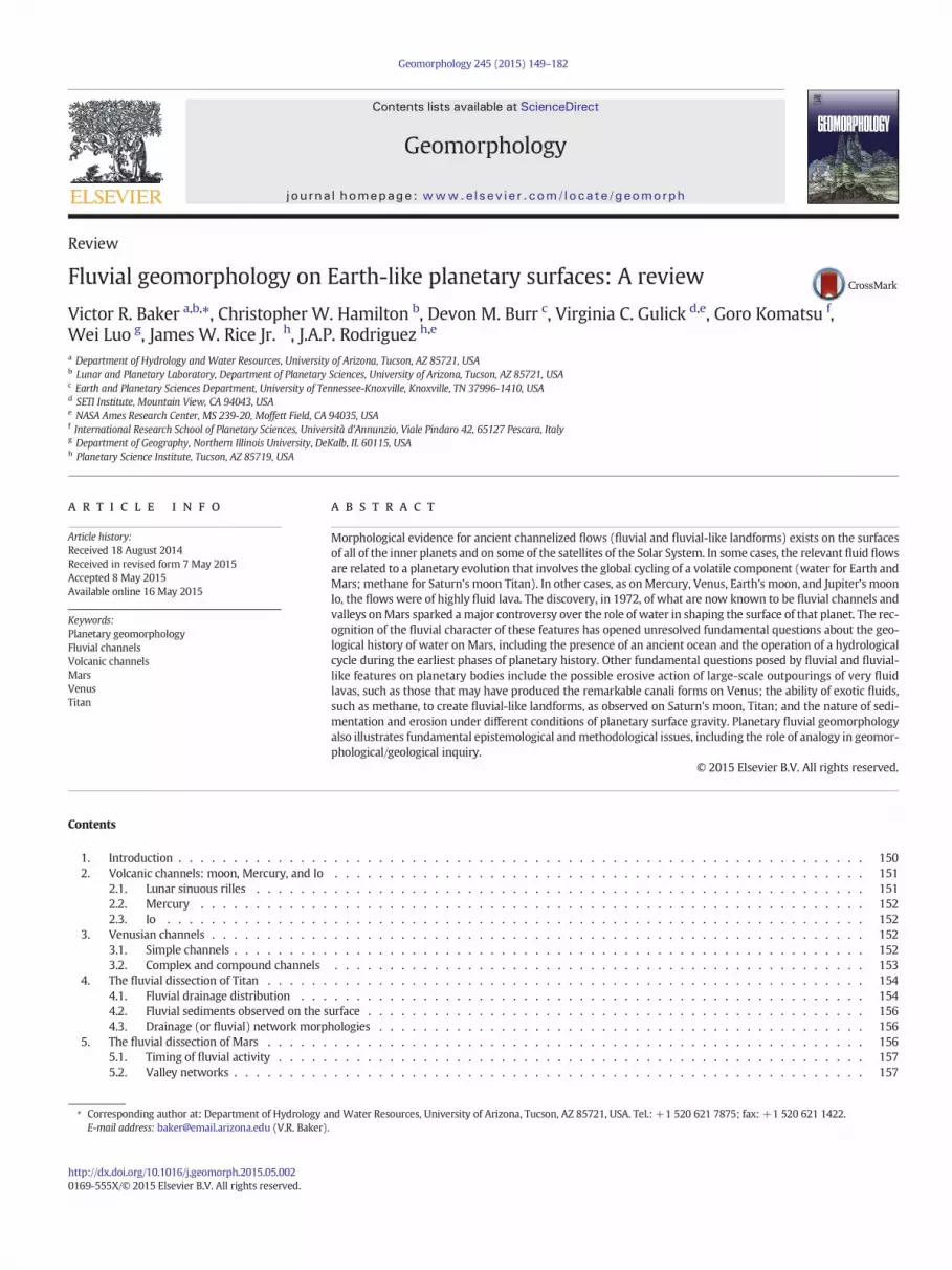
The discovery of gully forms (Malin and Edgett, 2000b) inMGSMOCimages sparked a spirited newdebate over the history ofwater onMars.Although current average temperatures are below 273 K and atmo-spheric pressures are at or below the triple-point vapor pressure ofwater at 6.1 mbar, many investigators concluded that the morphologyof at least some of the gullies implied a formation mechanism involvingthe flow ofwater. Additional studies imply that some gullymodificationprocesses may still be ongoing today, including the discovery of gullieson surfaces devoid of craters and gullies with deposits that overlapother modern, possibly active, landforms, such as dunes and polygons.
Although terrestrial gullies are commonly defined simply by thepresence of an incised channel segment, Malin and Edgett (2000b) de-fined the Martian gullies as having an alcove in the source region, a de-fined channel or system of channels in the mid-section and a debrisapron in the terminus. The formation andmodification of gully systemson Earth involve a variety of fluvial and hillslope processes. These in-clude fluvial (including overland, soil water, and groundwater flow),colluvial, and mass wasting (e.g., debris flows and avalanches) process-es. The challenge posed by the Martian gullies is to determine which ofthese, or other, mechanisms are primarily responsible for gully forma-tion and which are simply modification processes.
5.5.1. Gully distribution and typesGullies on Mars are concentrated in the mid-latitude regions,
primarily in the southern hemisphere, but they are also found in thenorthern hemisphere (Malin and Edgett, 2000b; Costard et al., 2002;Heldmann and Mellon, 2004; Balme et al., 2006; Dickson et al., 2007;Heldmann et al., 2007). Although the earlier studies concluded thatgullies are mostly located on pole-facing slopes in the southern hemi-sphere, later work points to prominent gully systems formed at variousslope orientations in the northern hemisphere and southern latitudes(e.g., Gulick, 2008; Gulick and Davatzes, 2009; Head et al., 2009; Hartet al., 2010). These systems are located on a variety of surfaces, includingcentral peaks and pits of craters, craters, channel and valley walls, polarpits, mounds, mesas, and mid-latitude dune fields.
Imagery from the High Resolution Imaging Science Experiment(HiRISE) camera of the current MRO mission affords a much closerlook (~0.3 m/pixel; meter-scale features resolvable) at the gullies thanwas available in the MOC discovery images (~1.5 to 12 m/pixel; tensofmeters-scale features resolvable), and at this higher resolution gulliesexhibit a great deal of morphological diversity. While some gullies ex-hibit the canonical single source alcove, incisedmiddle reach and termi-nal debris fan deposits, others form tributaries that coalesce intocomplex networks. Lengths range from several tens of meters to severalkilometers; widths range from several tens of meters down to HiRISE'sresolvable meter-scale. Some gully sources blend in gradually with thesurrounding uplands, while others start full-borne from blunt theaterheads. Gully systems displaying different morphologic patterns can be

Fig. 15. (A) Crater gullies southeast of GorgoniumChaos. Note the detail of gullies that have eroded into bedrock of theproximal source regions shown in (B) and into distal surfaces shownin (C) of drainages off the inner rim of an impact crater shown in (A). North is up in each figure.
163V.R. Baker et al. / Geomorphology 245 (2015) 149–182
located adjacent to each other, morphologically complex gully systemscommonly originate at rocky layers on a cliff face (Fig. 15). Such gulliesoften undercutwalls, erode into the underlying rock and sediment, formpoint bars and cut banks, exhibit braided and anastomosing reaches,erode multiple terraces along gully margins, and deposit rocks and sed-iments along the gully and superposed adjacent systems. The resultingcomplex suite of morphological features is consistent with a fluvial ori-gin (Gulick, 2008).
In contrast, gullies located on mid-latitude dune fields (Mangoldet al., 2003; Reiss and Jaumann, 2003) are sourced from alcoves locatedat dune crests, erode constant-width channels with levees, but general-ly lack the distal deposits common to the other gullies. Boulders arepresent at the termini of some dune gullies. Multitemporal imaging(repeat imaging of specific locations taken over multiple seasons and/or years) has documented seasonal changes in the dune gullies(Jouannic et al., 2012; Diniega et al., 2013). Sliding blocks of CO2 icedown dune slopes (Diniega et al., 2013) and seasonal melting of anupper H2O ice and brine layer are among several hypotheses that havebeen proposed for the formation of the linear dune gullies (Kereszturiet al., 2009; Reiss et al., 2010). Recently, long-term observations of cra-ter wall gullies employing HiRISE imagery has documented the role ofCO2 processes on present-day Mars as active processes related to gullymorphology (Dundas et al., 2014).
Still other gully types have distinct source regions and debris fans,but lack incised middle reaches. These particular gully forms are usuallylocated on steep slopes, such as the inner walls of several volcanocalderas, as well as on some crater, valley, and canyon walls; and theymay be more akin to debris chutes where material is transporteddown steep slopes mostly by gravity alone.
HiRISE imaging also shows that gullies in a single locale sometimesemerge atmultiple elevations and display a striking variety of morphol-ogies. For example, miniature gully systems, some less than a kilometer
long, are located along a crater wall in the Terra Sirenum region(Fig. 16A). These small gullies exhibit typical gully morphologic charac-teristics. However they emerge much farther downslope than do theirnearby full-scale counterparts (Gulick, 2008). Other intriguing gully sys-tems are located on some pristine, mid-sized impact craters (McEwenet al., 2007a; Tornabene et al., 2007). For example, well-developedand integrated gully systems heavily dissect the eastern rim region ofMojave Crater (Fig. 16B). In another example, pristine gullies have erod-ed both sides of the rim of Hale Crater (Figs. 17, 18), flowing in oppositedirections. In one location, only a narrow ridge separates eastward- andwestward-oriented gullies (Gulick, 2008). Although these gulliesdisplaymorphological characteristics consistentwith a fluvial origin, as-sociations such as thesemay challenge any single gully formationmech-anism applicable to geologically recent times.
5.5.2. Formation processesGiven such diversity in morphology, a continuum of processes is
likely involved in the formation and modification of various gully sys-tems. Formation mechanisms may include flows of hyperconcentratedfluids, debris flows, dry mass wasting flows and slides, and seasonallyactive processes involving CO2 and/or H2O ice. Proposed sources ofwater flows include melting snowpacks (Christensen, 2003); meltingground ice during periods of high obliquity (Costard et al., 2002;Dickson and Head, 2009); and melting ice-rich, debris-covered, glacialmaterial (Schon and Head, 2012). Other mechanisms involve liquidwater from groundwater flow in near-surface aquifers (Malin andEdgett, 2000b), from atmospheric sources (Costard et al., 2002; Hecht,2002; Christensen, 2003; Dickson et al., 2007; Williams et al., 2009b),or from wet debris flows (Costard et al., 2002; Dickson and Head,2009; Williams et al., 2009a; Heldmann et al., 2010; Mangold et al.,2010; Schon and Head, 2011). Still other proposed mechanisms includedry mass wasting; granular flows; (Shinbrot et al., 2004) exotic fluids

Fig. 16. (A) A portion ofMars Reconnaissance Orbiter (MRO)High Resolution Imaging Science Experiment (HiRISE) image PSP_1712_1405 (0.3m/pixel resolution) showing theater head-ed gully tributaries with inner channels (left). Sun direction is from the left, and north is up. (B) Portion of HiRISE image PSP_001415_1877 (0.3 m/pixel resolution). The image shows theeastern rim region of Mojave crater, which is extensively dissected by integrated gully systems. North is up in the figure, and the sun is illuminating from the left.
164 V.R. Baker et al. / Geomorphology 245 (2015) 149–182
(Musselwhite et al., 2001; Treiman, 2003; Hugenholtz, 2008); seasonalCO2 frost (Dundas et al., 2014); and, for the linear dune gullies in partic-ular, sliding and sublimation of CO2 blocks (Hansen et al., 2007; Diniegaet al., 2013).
HiRISE has taken several thousand images of gully forms since 2006,and many of these are repeat, stereo images. Such long-term repeatimaging of specific sites, taken over multiple seasons and years,
Fig. 17. Portion of High Resolution Imaging Science Experiment (HiRISE) imageESP_011753_1445 (0.3 m/pixel resolution), showing gullies along the eastern rim ofHale Crater. Gullies with different orientations are developed on both sides of the ridgerunning through the center of the image. Note bright deposits along some gullies. Northis up in the figure, and the sun is illuminating from the left.
provides information on seasonal morphologic changes or clues thatmay lead to detection of processes that are currently active in thegully systems. Additionally, HiRISE digital terrain models (DTMs) canbe produced frommanyof theseHiRISE stereo image pairs.Most imagesare generally ~0.25–0.50 m/pixel, which yields a post-spacing equal to~1–2 m with vertical precision in the tens of centimeters (McEwenet al., 2007b). In particular, HiRISE DTMs have enabled a new level ofgully studies for quantitative detailed longitudinal profile analysis andmore accurate volume calculations using slope, distance, and elevation.Several recent studies of Martian gully systems (e.g., Hart et al., 2010;Jouannic et al., 2012; Glines and Gulick, 2014; Hernandez et al, 2014;Hobbs et al., 2014; Narlesky and Gulick, 2014) have incorporated anal-ysis of HiRISE DTMs. These studies have led to estimates of erodedgully volumes and their associated deposits, thus providing a measureof the missing water or volatile volumes associated with gully forma-tion. For example, Gulick et al. (2014) determined that the volume ofthe resulting debris aprons within Kaiser and Corozal craters was~40% of the eroded gully volumes that resulted in a total water or vola-tile volume of ~60% of the total gully volume. Such studies provide abetter understanding of Mars recent hydrological history and detailedcomparisons with terrestrial gully systems.
5.5.3. Recurrent slope lineae (RSL)A relatively recent discovery onMars is the identification ofwhatmay
be the best candidate for modern-day liquid water flow on Mars. Theevidence for flow consists of linear patterns, probably of wetting and/orchemical precipitation, that extend and contract seasonally on steep,warm, rocky Martian slopes (McEwen et al., 2011). The phenomenonhas been documented on equator-facing slopes of the southern mid-latitudes of Mars, and the transient flow features occur in the local springand summer seasons (McEwen et al., 2011; Ojha et al., 2014). Termed re-curring slope lineae (RSL), these features also occur in the VallesMarineris(McEwen et al., 2014). While McEwen et al. (2011) originally proposedthat these present day flows would likely need to be briny because of
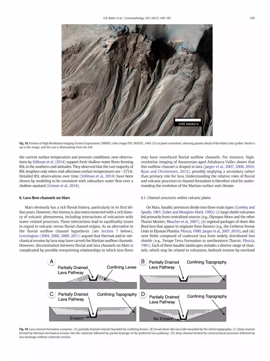
Fig. 18. Portion of High Resolution Imaging Science Experiment (HiRISE) color image PSP_002932_1445 (0.3 m/pixel resolution) showing greater detail of the Hale Crater gullies. North isup in the image, and the sun is illuminating from the left.
165V.R. Baker et al. / Geomorphology 245 (2015) 149–182
the current surface temperature and pressure conditions, new observa-tions by Stillman et al. (2014) support fresh shallowwater flows formingRSL in the southernmid-latitudes. They observed that the vastmajority ofRSL lengthen onlywhenmid-afternoon surface temperatures are N273 K.Detailed RSL observations over time (Stillman et al., 2014) have beenshown by modeling to be consistent with subsurface water flow over ashallow aquitard (Grimm et al., 2014).
6. Lava flow channels on Mars
Mars obviously has a rich fluvial history, particularly in its first bil-lion years. However, this history is also interconnectedwith a rich histo-ry of volcanic phenomena, including interactions of volcanism withwater-related processes. These interactions lead to equifinality issuesin regard to volcanic versus fluvial channel origins. As an alternative tothe fluvial outflow channel hypothesis (see Section 7 below),Leverington (2004, 2006, 2009, 2011) argued that thermal and/or me-chanical erosion by lavamay have carved theMartian outflow channels.However, discrimination between fluvial and lava channels on Mars iscomplicated by possible overprinting relationships in which lava flows
Fig. 19. Lava channel formation scenarios: (A) partially drained channel bounded by confiningformed by thermal‐mechanical erosion into the substrate followed by partial drainage of the plava drainage without substrate erosion.
may have resurfaced fluvial outflow channels. For instance, high-resolution imaging of Amazonian-aged Athabasca Valles shows thatthis outflow channel is draped in lava (Jaeger et al., 2007, 2008, 2010;Ryan and Christensen, 2012), possibly implying a secondary ratherthan primary role for lava. Understanding the relative roles of fluvialand volcanic processes in channel formation is therefore vital for under-standing the evolution of the Martian surface and climate.
6.1. Channel structures within volcanic plains
OnMars, basaltic provinces divide into threemain types (Greeley andSpudis, 1981; Zuber andMouginis-Mark, 1992): (i) large shield volcanoesfed primarily from centralized sources (e.g., OlympusMons and the otherTharsis Montes; Bleacher et al., 2007), (ii) regional packages of sheet-likeflood lava that appear to originate from fissures (e.g., the Cerberus FossaeUnits in Elysium Planitia; Plescia, 1990; Jaeger et al., 2007, 2010), and (iii)vent fields composed of coalesced lava from widely distributed lowshields (e.g., Tempe Terra Formation in northeastern Tharsis; Plescia,1981). Each of these basaltic landscapes includes a diverse range of chan-nels, which may be related to volcanism, bedrock erosion by overland
levees; (B) broad sheet‐like lava lobe bounded by the initial topography; (C) deep channelreferred lava pathway; (D) deep channel formed by constructional processes followed by

Fig. 20. Examples of terrestrial lava channels: (Left) example of an active lava channel forming on Kīlauea, Hawaii, during the 2007–2008 phase of the Pu'u 'Ō'ō eruption; (Right) exampleof a 5-m-deep channel formed within the 1783–1784 A.D. Laki eruption in Iceland.
166 V.R. Baker et al. / Geomorphology 245 (2015) 149–182
flows ofwater, or a combination of both processes. However, distinguish-ing among these hypotheses requires determining if the channels are pri-marily features associated with lava flow emplacement, or if they areproducts of subsequent erosional processes. This can be achieved byconsidering themorphological characteristics and facies relationships as-sociated with lava flows, which generally involve two end-member em-placement mechanisms: channel-fed growth (e.g., Booth and Self, 1973;Baloga et al., 1995; Kilburn, 1996; Harris and Rowland, 2001; Glazeet al., 2009; Harris et al., 2009) and endogenous growth (e.g., Walker,1991; Hon et al., 1994; Keszthelyi and Denlinger, 1996).
6.2. Channel-fed flows
Channel-fed lavas (Figs. 19, 20) can form within a range of lava flowtypes including 'a'ā, pāhoehoe, and transitional lavas (e.g., blocky, rubbly,slabby, and platy flows). Lava channels are commonly associated withhigh lava-discharge rates, which favor the transport of lava in open 'a'āchannels caused by shear-induced disruption of the lava surface(Macdonald, 1953; Pinkerton and Sparks, 1976; Rowland and Walker,1990). Viscous tearing of the lava surface also enhances the cooling ofthe underlying molten lava, thereby resulting in a thermally inefficientlava transport system, relative to endogenous flows. With distance fromthe vent 'a'ā channel geometries tend to evolve from being narrow andleveed in the proximal regions to wide and nonleveed near the flowfront (Lipman and Banks, 1987; Kilburn and Guest, 1993; Cashmanet al., 1999). However, as theflow front continues to advance, the stagnat-ed lateral margins of the 'a'ā can develop into stationary levees that helpto focus the continued through flux of lava. As the eruption progresses,the leveesmay continue to growas lava episodically overtops the channelbanks to form a combination of overbank flows and rubble avalanches.However, as lava-discharge rates wane, the 'a'ā channel may partiallydrain to produce a deep topographic depression bounded by levees oneither side.
Pāhoehoe flows tend to be associated with lower lava-dischargerates (Rowland and Walker, 1990), which favor the formation of lobesthat are bounded by a continuous surface crust (see the discussionof endogenous flows below for more detail). However, in the vent-proximal region, or along segments of a lava pathway where locallava-discharge rates are high (e.g., due to topographic constrictionsand/or breakouts of stored lava), lava flow velocitiesmay be sufficientlygreat that a continuous surface is unable to form. At these localities,pāhoehoe and transitional lavas may also form open channels that cansubsequently drain to produce topographic depressions.
Channels within 'a'ā and pāhoehoe lava flows can be expressedas distinctive landforms that are perched above their surroundingsby their high-standing margins. However, large eruptions can also
produce broad sheet-like flows that inundate the landscape such thatthey are confined by pre-eruption topography rather than auto-confining by lateral lava levees (Self et al., 1996, 1998; Thordarson andSelf, 1998). These flood lavas may include one or more preferredpathways that drain as lava-discharge rates wane to produce channel-like depressions that appear to incise into an existing plain. Insome cases, lava pathways may carve into the pre-eruption landscapethrough processes of thermal-mechanical erosion (Baloga et al., 1995;Williams et al., 2000, 2001a,b, 2005), but this process is exceedingly diffi-cult to discern from remote sensing data alone because the apparent ex-cess depth of the channel may simply reflect the fact that the preferredpathway formed above the lowest point in the initial landscape.
6.3. Endogenous flows
In contrast to channelized flows, endogenous (e.g., pāhoehoe) lavaflows tend to be composed of self-similar lobes (Bruno et al., 1994)that transport lava though thermally insulated internal pathways,whichmay range from to narrow lava tubes to broad sheet-like regions(Self et al., 1998). Endogenous flows grow as new lobes breakout alongexisting flow margins (Crown and Baloga, 1999). These breakouts ex-pose fluidal lava that quickly cools to develop a rheological gradientconsisting of a brittle outer crust, underlying viscoelastic layer, andinner molten core. Once lobes develop sufficient rigidity to retain in-coming lava, they can pressurize and inflate as a network of lobes or co-alesce to form a lava-rise plateau (Walker, 1991). Lava-rise plateausgenerally have a broad sheet-like geometry, but as they thicken by infla-tion, they can also generate lava-rise pits above topographic highs in thepre-eruption landscape (Walker, 1991). Lava-rise plateaus and lava-risepits are important diagnostics of inflation because they are large enoughto be observable on high-resolution remote sensing data (e.g., MROHiRISE and Context Camera (CTX) imagery).
6.4. Facies changes
Distinguishing between channelized and endogenous growthmech-anisms is vital for inferring lava emplacement dynamics, modeling flowbehavior, and understanding the origin of volcanic plain units on Earth,Mars, and other planetary bodies (Self et al., 1998). However, lava trans-port mechanisms evolve with distance from source and with time suchthat structures preserved at the surface of a flow may only representone part of a complex emplacement history. To address this issue, afacies-based approach can prove fruitful for advancing understandingthe formation and characteristics of lava channels.
A facies refers to the suite of characteristics (i.e., appearance, compo-sition, etc.) of a rock unit, or stratified, body that reflects its origin and

Fig. 21. Examples of partially drained lava channels onMars: (A) digital terrain model (DTM) (1m/pixel) derived from High Resolution Imaging Science Experiment (HiRISE) stereo-im-ages ESP 012444 2065 and ESP_014000_2065; and (B) DTM (1 m/pixel) derived from HiRISE stereo-images ESP_019235_2050 and ESP_018945_2050. North is up in each figure.
167V.R. Baker et al. / Geomorphology 245 (2015) 149–182
enables the unit to be distinguished from others around it. In the con-text of lava facies, Kilburn and Guest (1993) described how lava flowscan change continuously from the initial emplacement of isothermalsheets to flows with tubes and channels, which commonly evolvefrom pāhoehoe to 'a'ā flows. Kilburn and Guest (1993) also exploredhow combinations of poorly/well-crusted and sheet/channel zonescan be used to establish a continuum of facies. These facies reflect thebalance between dynamic processes of lava cooling, crustal growth,and surface stability relative to themode of lava transport in either ther-mally insulated internal pathways or open channels. Facies changewithdistance from the source and at any given location with time, whichmakes facies relationships a much stronger diagnostic of a unit's volca-nic origin than isolated observations.
In the context of Mars (Fig. 21), small sinuous channel systems in vol-canic terrains have been particularly contentious, with proposed originsranging from fluvial processes and mudflows (e.g., Murray et al., 2010;El Maarry et al., 2012) to lava flow emplacement (e.g., Hamilton et al.,2010, 2011). These channels are hundreds of meters wide, tens of metersdeep, and tens to hundreds of kilometers long. Such channels tend tohead from fissures, but they are much smaller than outflow channels.These smaller sinuous channel systems are typically located in the Tharsisand Elysium volcanic provinces (localities TV and E, Fig. 9), but they arealso distributed in the southern highlands. The channels can havesingle-stem or multichannel (anabranching) forms with streamlinedislands and terraced margins, which are often thought to be diagnosticof bedrock erosion by water. However, examples of similar landformsare also observedwithin lava flows on Earth (Soule et al., 2004). Unfortu-nately, in cases where volcanic eruptions have continued for long periodsof time, initial lava flow structures, such as anabranching channel mor-phologies, may be overprinted and erased by subsequent lava flows. Forexample, as lava-discharge rates wane, endogenous flow units emplacedunder lower lava-discharge conditions may overlie channel-fed flowsthat formed under peak lava-discharge conditions. The time-scales of em-placement for lava flows onMars are poorly constrained, but Jaeger et al.(2007, 2008, 2010) advocated that some Martian lava flows, such as theAthabasca Valles flood lava (locality I, Fig. 9), may have been emplacedover a relatively short duration, on the order of several weeks. If so,short-lived, but relatively high lava-discharge rate eruptions (e.g., the De-cember 1974 flow on Kīlauea, Hawai'i) may provide valuable insight intothe formation of sinuous lava channels on Mars.
7. Martian cataclysmic flooding channels
The largest fluvial channels of the solar system occur on Mars. Theirdiscovery on the Mariner 9 images revealed morphologies that, despitethe then-prevailing physical theory of a water-impoverished planet(e.g., Leighton and Murray, 1966), indicated formation by flowing
water to the geologists on the Mariner 9 team (McCauley et al., 1972;Masursky, 1973; Milton, 1973). The name outflow channel was applied(Sharp and Malin, 1975) because of the immense collapse areas ofblocky, fractured terrain at the heads of the largest channels, includingKasei, Maja, Shalbatana, Simud, Tiu, and Ares Valles (Fig. 22). The indi-cated immense flows of water were attributed to volcanic melting ofground ice (McCauley et al., 1972; Sharp, 1973; Masursky et al., 1977),and various formulations of this mechanism have been dominant in ex-planations ever since.
In published scientific papers over the seven or eight years followingtheir discovery in 1972, nearly every conceivable fluid was invoked toexplain the Martian outflow channels. These included flows of lava(Cutts et al., 1978; Schonfeld, 1979); wind (Whitney, 1979a,b; Cuttsand Blasius, 1981), CO2 (Lambert and Chamberlin, 1978),flows of debris(Thompson, 1979; Nummedal and Prior, 1981), glacial flow (Lucchittaet al., 1981; Lucchitta, 1982), tectonism (Schumm, 1974), and evenflows of liquid alkanes (Yung and Pinto, 1978). Motivation for thesehypotheses derived from the perceived inconsistency with physicalmodels of the Martian atmosphere (e.g., Leighton and Murray, 1966)and geochemical arguments that purported to indicate a very smallplanetary water inventory (Anders and Owen, 1977), as well as thelack of deltas at the mouths of various channels (Cutts et al., 1978).However, all the various nonaqueous fluid-flow candidates had conse-quences for morphology and planetary history that could be evaluatedagainst the facts that were known in regard to those consequences(e.g., Baker, 1982, 1985b). This testing of hypotheses led to a general in-vestigative community consensus in favor of the cataclysmic floodinghypothesis (Mars Channel Working Group, 1983; Baker et al., 1992b)that relied heavily on the analogy drawn to the megaflood landscapesof the Channeled Scabland and Iceland (Baker and Milton, 1974; Bakerand Nummedal, 1978; Baker, 1982, 2009b,c; Rice and Edgett, 1997).Relationships for cataclysmic flooding features in Martian channelshave since been reviewed in numerous publications (e.g., Nelson andGreeley, 1999; Baker, 2001; Coleman, 2005; Pacifici et al., 2009;Warner et al., 2010a).
After a hiatus of a couple of decades, a new generation of nonaque-ous models has been resurrected, including the decompression ofsolid CO2 (Hoffman, 2000) and massive eruptions of very fluid lava(Leovy, 2002; Leverington, 2004, 2011; Leone, 2014). The CO2 hypothe-sis of Hoffman (2000) predicted that Mars had always been so cold anddry that water never could have been liquid on its surface—a conse-quence clearly at odds with the immense number and variety ofnewly discovered features on Mars that are clearly associated with liq-uid water processes. Urquhart and Gulick (2001) reviewed the plausi-bility of the White Mars hypothesis and concluded that the subsurfaceof Mars is unlikely to have been as cold as this model suggested andthat liquid water would be present much closer to the surface than

Fig. 22.Mapof eastern Tharsis and circum-Chryse areas ofMars onMOLA topographic base (low areas in blue, high areas in red and brown). Features indicatedby letters include volcanoes,I—Alba Patera, P—Pavonis Mons, Q—Arsia Mons, Z—Ascraeus Mons; impact basins and craters, C—Chryse, H—Holden; delta—Eberswalde; tectonic features, N—Noctis Labyrinthus,VM—Valles Marineris; channels and valleys, A—Ares, B—Columbia and Daga Valles, D—Simud Vallis, F—Nanedi Vallis, G—Nirgal Vallis, J—Maja Vallis, K—Kasei Vallis, L—Ladon Vallis,M—Morava Vallis, O—Osuga Vallis, R—Ravi Vallis, S—Shalbatana Vallis, T—Tiu Vallis, U—Uzboi Vallis, W—Mawth Vallis, X—Aran Chaos and channel, Y—Iani Chaos.
168 V.R. Baker et al. / Geomorphology 245 (2015) 149–182
predicted by this hypothesis. The assumptions of the White Mars hy-pothesis regarding the globally averaged crustal heat flow are belowmost estimates for the current thermal state of the Martian crust andwell below probable values.
Recently the term outflow channel has been applied to many fea-tures with very different morphologies than those associated with theoriginal designation. In his model of massive outpourings of very fluidlava on the surface of Mars, Leverington (2011) applied the term notonly to features associated with the original definition but to a great va-riety of large channel forms of volcanic origin, including lunar sinuousrilles (see Section 2.1); channels of more uncertain origin, such asthose on Venus (see Section 3); and to Martian channels that do nothead at outflow regions, such as Ma'adim Vallis, which has a complexhistory associated with crater lake spillways (Irwin et al., 2002, 2004).Leone (2014) even applied the term outflow channel to the troughs ofthe VallesMarineris. Carr (2012, pp. 2204–2205) responded to themas-sive lava hypothesis in his review of the fluvial history of Mars by ob-serving, as follows: “…the consensus is that the channels were cut bywater, based on the strong resemblance to terrestrial flood features,on the availability of water as indicated by other indications of hydro-logical activity such as the valley networks, and on geophysical model-ing of channel formation…”. Nevertheless, as noted in Section 5,problems remain for relating the aqueous origins of fluvial features onMars to the general theory of environmental change on the planet, butthis poses a challenge to the theory—not to the realities of the fluvialfeatures.
7.1. Cataclysmic megaflooding forms and processes on Earth and Mars
7.1.1. Hierarchy of morphological forms in cataclysmic flooding channelsThe erosional and depositional bedforms of terrestrial catastrophic
floods can be described according to a hierarchical classification ofmacroforms and mesoforms, as originally recognized in the Channeled
Scabland (Baker, 1978b, 2009b,c). Macroscale forms (scale controlledby flowwidth in the channel) develop in cataclysmic flooding channelsthrough the erosion of rock and sediment and/or by deposition (gener-ally as in-channel bars). Some examples of erosional macro-scale formsare channel anastomosis, channels with low sinuosity and high channelwidth–depth ratios, large-scale streamlined residual hills, and scouredsurfaces. Examples of depositional macroscale forms include the largestpendant bars, expansion bars, eddy bars, and fan complexes.
Catastrophic floods also produce mesoscale forms, which have theirscale controlled by flow depth in the channel. Some examples of ero-sional mesoscale forms include longitudinal grooves, cataracts, andinner channels. Depositional mesoscale forms include large transversebedforms (fluvial dunes), smaller pendant bar forms, and slackwaterdepositional areas. Although the hierarchical arrangement of cataclys-mic flooding landformswas originally recognized onMars at scales con-siderably larger thanwhat occurs in the Channeled Scabland (e.g., Bakerand Milton, 1974; Baker and Kochel, 1979), more recent work withhigh-resolution imagery has revealed areas where the scales are morecomparable (Rodriguez et al., 2014).
In terrestrial catastrophic flooding examples the association ofmacroforms and superimposed mesoforms result from the nature ofthe flood hydrograph. For most continuously flowing rivers, floodhydrographs have a long recession phase. The depositional bedformsthat are stable at high flow stages (meso-scale forms) get washed outduring the prolonged recessional phase, and post-flood surfaces pre-serve only the more stable macroscale forms, such as alternate bars.However, some catastrophic floods, such as those responsible for theChanneled Scabland (Baker, 1973), undergo an abrupt cessation offlood discharge, and this results in the preservation of many of the me-soscale forms (e.g., fluvial dunes), especially those located on higher el-evation bar surfaces. In contrast, other terrestrial catastrophic floodlandscapes do not preservemesoforms because of theirmore prolongedflow. This was the case for the Bonneville megaflooding (Malde, 1968;

Fig. 23.Mouth of Kasei, the largest and longest (2400 km) “outflow channel” onMars. This oblique viewwas generated at 2× vertical exaggeration from the THEMIS data acquired by theMars Odyssey spacecraft. The view is upstream, and the large crater in the center is Sharonov, which is 100 km in diameter. Note the splitting and convergence of channels (anastomosis).
169V.R. Baker et al. / Geomorphology 245 (2015) 149–182
O'Connor, 1993), which has no known examples of large-scale trans-verse bedforms (fluvial dunes). The lack of fluvial dunes in many Marscatastrophic flooding channels may result from similarly prolongedflow phenomena.
Examples of cataclysmic megaflooding landforms on Mars includechannel anastomosis (Fig. 23), streamlined hills and longitudinalgrooves (Figs. 23 and 24), and expansion bars (Fig. 25). Detailed map-ping and analysis of Ares Vallis (locality A, Fig. 22), one of the largest cat-aclysmic flood channels that was a type example for the designationoutflow channel, revealed excellent examples of eddy and pendant
Fig. 24. Streamlined features in Ares Vallis (15.9° N, 330° E) imaged at visible wavelengthsby the Thermal Emission Imaging System (THEMIS) on NASA's Mars Odyssey orbiter. Thecataclysmic flooding came from the lower right. Lins is the post-flooding, fresh lookingcrater in the lower right. It is about 6 km in diameter, and the imaged scene is about40 × 50 km. The streamlined features probably developed by a combination of depositionand preservation of pre-flood bedrock downstream from obstructions to the cataclysmicflood flows. There are also smaller-scaled lineated forms that may have developed asgrooves or as depositional accumulations behind small obstructions. They are orientedlongitudinally relative to the cataclysmicfloodflows. Some intriguing transverse bedformsoccur in the upper left quadrant of the image. These have orientations similar to whatwould be expected for subfluvial dunes, but at a spacing of about 500m they are even larg-er that would occurs in terrestrial cataclysmic flooding channels. North is up in the figure.
bars (Pacifici, 2008; Pacifici et al., 2009). These features are characteris-tic of macroform deposits in the Missoula megaflooding landscapes ofthe Channeled Scabland (Baker, 1973, 2009b,c). Detailed mapping ofupper Ares Vallis usingMars Express HRSC data (Pacifici 2008) showedthe association of these depositional landforms with erosional land-forms that are also typical of the Channeled Scabland, including longitu-dinal grooves, streamlined uplands, and cataracts. A spectacularexample of the latter is about 500 m high and 15 km wide (Pacificiet al., 2009; Warner et al., 2010a).
The downstream reaches of Ares Vallis are dominated by ice-relatedlandforms that developed after the cataclysmic flooding phase (CostardandKargel, 1995; Costard andBaker, 2001). These include kame-like fea-tures and thermokarst depressions that occur in sediments overlying thecataclysmic flooding landforms (Costard and Baker, 2001; Pacifici et al.,2009; Warner et al., 2010b,c). It is also clear from recent work (Pacifici,2008; Warner et al., 2009, 2010a, 2013; Roda et al., 2014) that Areswas formed by multiple cataclysmic flooding events/episodes spanningfrom Early Hesperan (~3.7 Ga) to early Amazonian (~2.7 Ga) time.
7.1.2. Differences in sediment transport and deposition on Mars and EarthThe lack of extensive deposits within the Martian catastrophic flood
channels and at their mouths has been noted from the time of their ear-liest study in the 1970s. Recently resurrected by Leverington (2011),these observations include the supposed lack of fluvial bars withinthe channels and the lack of deltas at the mouths of many Martian“rivers”where they entered lakes or the ancient ocean that is hypothe-sized to have episodically occupied the planet's northern plains (seeSection 5.4 above). This is an example of a flawed analogy.
The largeMartian channelswere not formed by the long-term actionof Earth-like river flows (hence the need to refer to them as cataclysmicflooding channels). Their appropriate terrestrial analogs are not rivers atall, but rather the relatively rare cataclysmic food channels on Earth thatare mainly associated with past periods of glaciation in which large icesheets developed various instabilities because of subglacial volcanismand/or marginal or subglacial lakes. Since the early work in the 1970son the origin of the Mars cataclysmic flooding channels, many new dis-coveries have been made of cataclysmic flooding landscapes on Earth(Baker, 1997, 2002a,b, 2009d, 2013), and megaflood-generating pro-cesses (e.g., Table 3) are now recognized as being much more impor-tant, particularly for the glacial periods of Earth's Pleistocene epoch(e.g., Baker, 1997, 2014b).
High-energy cataclysmic flooding on Earth andMars occurred whenwatermany tens to hundreds ofmeters deepflowedwith very steep en-ergy slopes, thereby generating velocities of tens of meters per second,which were associated with values of bed shear stress and unit streampower that exceeded by many orders of magnitude those of rivers likethe Mississippi (Baker and Costa, 1987; Baker, 2002a). The latter has a

Fig. 25. Expansion bar complex in Osuga Vallis. This is an oblique view generated data provided by the High Resolution Stereo Camera (HRSC) on theMars Express spacecraft. The view isdownstream, and the channel width is about 20 km. The regional context for this image is shown in Fig. 29.
170 V.R. Baker et al. / Geomorphology 245 (2015) 149–182
very flat gradient, and its channels convey mainly mud and some sandat velocities of no more than about a meter per second and at verylow values of bed shear stress and unit stream power. The sand sepa-rates out as bedload that is locally deposited as channel or point bars,while the silt and clay move as suspended load that either is conveyedto the river's mouth and delta or is deposited as overbank mud on thefloodplains that border the river channel.
As pointed out by Komar (1979, 1980), the combination of extreme-ly high unit stream power and reduced gravity means that the particlesin the high-velocityMartian flood flows did not separate out as bedloadand suspended bed-material load in a manner typical for a low-energyEarth river like the Mississippi. In cataclysmic megaflooding on Mars,very coarse particles moved as washload, or auto-suspension load,that, instead of being deposited as bars, was mostly flushed throughthe whole channel system and only was subject to deposition wherethe high energy levels dropped, as occurred in the huge expanse of a ter-minal basin, which for Kasei Vallis was the northern plains of Mars(Fig. 26). Fig. 26 shows the immense amount of erosion that occurredalong Kasei Vallis and the lack of an obvious delta or fan where theKasei channels terminated in the northern plains lowlands (blue colorsin Fig. 26). The correct analogy here is not to a terrestrial river thatwould deposit its load at this point, but to terrestrial cataclysmic floodchannels entering Earth's oceans. The Columbia River, one of the largestin North America, also has no delta of sediment accumulation at itsmouth. Instead, the immense fluxes of sediment generated by themegafloods that occurred in the Columbia River basin are distributedover 2000 km of the abyssal plains of the Pacific Ocean (Normark andReid, 2003). The bulk of the sediments were carried far out into the ter-minal basin and spread thinly over immense areas (Baker, 2007). Simi-larly, sediments moved through theMartian cataclysmic flood channelsterminating at the northern plains would have entered the Oceanus
Table 3Megaflood generation processes for Earth.
Mechanism Example References
Subglacial volcanism Icelandic jokulhlaups Gudmundsson et al. (1997)Ice-dammed lakebursts
Missoula Pardee (1942)Altai Baker et al. (1993)
Lake spillways Bonneville Man Malde (1968), O'Connor (1993)Ocean, sea spillways English Channel
(La Manche)Smith (1985), Gupta et al. (2007)
Bosporus Ryan et al. (2003)Strait of Gilbraltar Baker (2001, 2002);
Garcia-Castellanos et al. (2009)Pressurized subglaciallake outbursts
Laurentide ice sheetAntarctic
Shaw (1996)
Missoula Shaw et al. (1999)
Borealis (see Section 5.4) as hyperpycnal flows, and the resulting sub-marine density flows would have been spread out over distances ofthousands of kilometers from the channelmouths, constituting depositsthat would mantle the entire northern plains of Mars.
While a complete discussion of the hydraulics of the ancientMartianfloods and their related erosional/depositional processes is beyond thescope of this review, useful summaries can be found in papers byBaker (1979, 1982), Komar (1979), Baker and Komar (1987), Komatsuand Baker (1997), Burr (2003), Kleinhans (2005), and Wilson et al.(2004, 2009). Advances in computational power now allow the applica-tion of two-dimensional hydraulic models to very complex channelizedregions like Athabasca Vallis (Keszthelyi et al., 2007; Kim et al., 2014),and it is clear that more work of this type will contribute greatly toour understanding of mechanics of both erosion and deposition forthe Martian cataclysmic flooding channels.
7.2. The circum-Chryse outflow channels region
The chaotic source areas and related outflow channels surroundingthe Chryse region of Mars (locality C, Figs. 9 and 22) have receivedextensive study for more than 40 years (Sharp, 1973; Baker andMilton, 1974; Carr, 1979; Baker et al., 1991; Clifford and Parker, 2001;Rodriguez et al., 2003, 2005a,b, 2006b, 2007, 2011; Bargery andWilson, 2011; McIntyre et al., 2012). The upper crustal stratigraphy inthis region is thought to consist of interbedded volcanic and sedimen-tary deposits that were mostly emplaced during the Noachian (Rottoand Tanaka, 1995; Scott and Tanaka, 1986; MacKinnon and Tanaka,1989). These deposits are hypothesized to contain large populations ofburied impact craters (Malin and Edgett, 2001; Frey, 2003; Rodriguezet al., 2005b). Regional investigations indicate that aquifers developedin association with buried craters (Malin and Edgett, 2001; Frey, 2003;Rodriguez et al., 2005b) and tectonic fabrics (Rodriguez et al., 2007).The instabilities within these aquifers probably led to the formationof chaotic terrains. Though not well understood, the instabilities havebeen linked to conditions such as intrusive magmatism into the hy-drosphere/cryosphere (e.g., Rodriguez et al., 2003, 2005b; Harrisonand Grimm, 2008), explosive dissociation of upper crustal clathratedeposits (e.g., Komatsu et al., 2000; Rodriguez et al., 2006b; Gaineyand Elwood Madden, 2012), and the thermally insolating effect of hy-drated salts (Kargel et al., 2007) and porous sediments (Rodriguezet al., 2011).
The regional mapping of Rotto and Tanaka (1995) portrays a gener-alized history of channel dissection and includes four outflow channelunits that distinguish older and younger, higher (shallow) and lower(deep) channel floors. Their mapping suggests that the chaotic terrainsand outflow channels mostly developed between the Late Hesperian

Fig. 26. Kasei Vallis (bottom right quadrant) entering the northern plains of Mars as shown on a topographic base provided by the MOLA instrument on Mars Global Surveyor. Note thetransitions from the cataclysmic flooding channels directly into the northern plains without extensive sediment accumulation. Themouth of Kasei in the lower center of the image is alsoshown in Fig. 23.
171V.R. Baker et al. / Geomorphology 245 (2015) 149–182
and the Early Amazonian. However, recent analysis of very high-resolution imagery shows that portions of Simud, Tiu, and Ares Vallesexperienced major outflow channel flows during the Early and MiddleAmazonian, extending to as recent as ~900 Ma (Rodriguez et al.,2015). Other regional hydrogeologic processes, including valley dissec-tion and groundwater upwelling,may have lasted from the Late Noachi-an until the Amazonian (Andrews-Hanna and Phillips, 2007; Glotch andRogers, 2007; Fassett and Head, 2008).
Higher levels within the circum-Chryse outflow channels consist of~20–50-km-wide canyons, the floors of which are marked by promi-nent ridges and grooves. Their formation has been attributed to cata-strophic floods generated by groundwater eruptions along the flanksof chaotic terrains and plateau zones of subsidence (Rodriguez et al.,2006a). Someof these chaotic terrains are enclosed,while others extendover highlands andmodify craters and intercrater plains alike. Associat-ed zones of subsidence consist of complex systems of warped andfaulted highlands (Rodriguez et al., 2003, 2005a,b). In addition, a fewof these outflow channels extend from structures produced by
Table 4Various megaflood generation processes hypothesized for Mars.
Mechanism Example
Pressurized flow through permeable media Circum-Chryse channels
Magmatic intrusion and melting of cryosphere Circum-Chryse channels
Lake formation by melting of buried ice sheet Aram Chaos and valleyLake Spillways Ma'adim Vallis
Uzboi–Ladon–MoreavaMangala VallisOkavango Vallis
Lake drainage Circum-Chryse channelsColumbia and Daga Valles
Geothermal heating of confined water GeneralFissure eruptions of water and lava Mangala Vallis
Anthabasca VallisMarte and Grjota Valles
Liquefaction of sensitive substrates Ravi VallisCatastrophic dissociation of gas hydrates General
Meteor impacts into ground ice GeneralCatastrophic dewatering of evaporite deposits Circum-ChryseCavern formation by hydrothermal processes Shalbatana Vallis
Xanthe Terra channels
dilational (Hanna and Phillips, 2006; Coleman et al., 2007) and contrac-tional (Rodriguez et al., 2007) tectonism.
Lower levels within the circum-Chryse outflow channels consist ofmuch broader troughs, generally a few hundred kilometers in width.Their floors are marked by faint ridges and include widespread knobs,which may consist of large blocks likely transported by debris flows(Tanaka, 1997, 1999; Rodriguez et al., 2006b). The debris flow hypoth-esis is consistent with the finding of rounded, submeter size clasts andimbricated boulders at the Mars Pathfinder landing site (Golombeket al., 1997; Tanaka, 1997, 1999). These debris flows might have beentriggered during episodes of large-scale collapse within the GangesChasma (Rodriguez et al., 2006a) or by discharges from vast paleolakeswithin Valles Marineris (locality VM, Fig. 22) (Rotto and Tanaka, 1995;Lucchitta et al., 1994; Warner et al., 2013). In addition, glaciers appearto have significantly contributed to the formational history of thecircum-Chryse outflow channels (Lucchitta, 1982, 2001), and immenseamounts of glacial ice may have occupied the Valles Marineris (Megeand Bourgeois, 2011; Gourronc et al., 2014).
References
Carr (1979, 2000), Clifford (1993), Andrews-Hanna andPhillips (2007), Harrison and Grimm (2008)McCauley et al. (1972), Sharp (1973), Masursky et al. (1977),Chapman and Tanaka (2002), Leask et al. (2006), Meresse et al. (2008)Zegers et al. (2010), Roda et al. (2014)Irwin et al. (2002, 2004), Irwin and Grant (2009)Parker (1985), Grant and Parker (2002)Zimbelman et al. (1992)Mangold and Howard (2013)Lucchitta and Ferguson (1983), Warner et al. (2013)Coleman and Baker (2009)Clark (1978)Tanaka and Chapman (1990)Burr et al. (2002)Burr et al. (2009a)Nummedal and Prior (1981)Milton (1974), Komatsu et al. (2000), Max and Clifford (2001),Kargel et al. (2007)Maxwell et al. (1973)Montgomery et al. (2009)Rodriguez et al. (2003, 2005b)Rodriguez et al. (2005a,b, 2007)
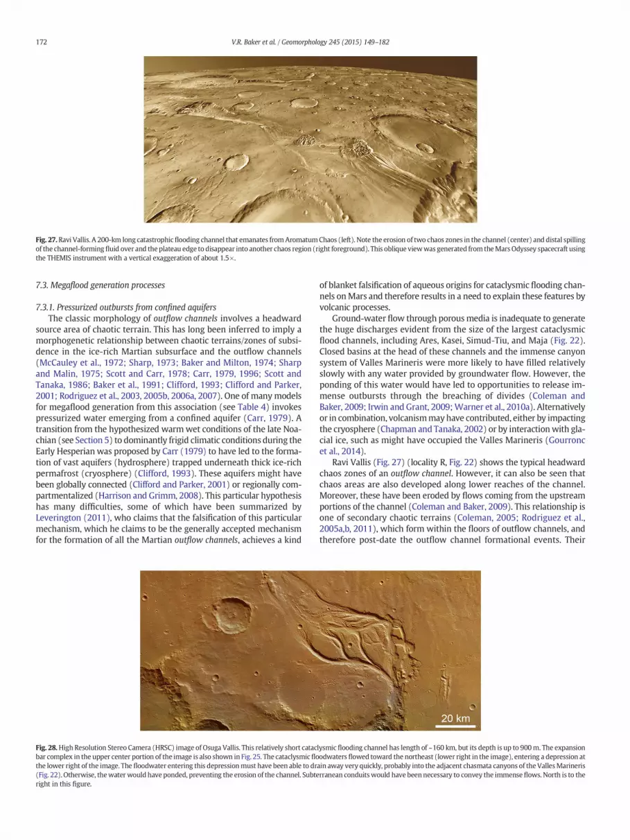
Fig. 27.Ravi Vallis. A 200-km long catastrophicflooding channel that emanates fromAromatumChaos (left). Note the erosion of two chaos zones in the channel (center) and distal spillingof the channel-formingfluid over and the plateau edge to disappear into another chaos region (right foreground). This oblique viewwas generated from theMarsOdyssey spacecraft usingthe THEMIS instrument with a vertical exaggeration of about 1.5×.
172 V.R. Baker et al. / Geomorphology 245 (2015) 149–182
7.3. Megaflood generation processes
7.3.1. Pressurized outbursts from confined aquifersThe classic morphology of outflow channels involves a headward
source area of chaotic terrain. This has long been inferred to imply amorphogenetic relationship between chaotic terrains/zones of subsi-dence in the ice-rich Martian subsurface and the outflow channels(McCauley et al., 1972; Sharp, 1973; Baker and Milton, 1974; Sharpand Malin, 1975; Scott and Carr, 1978; Carr, 1979, 1996; Scott andTanaka, 1986; Baker et al., 1991; Clifford, 1993; Clifford and Parker,2001; Rodriguez et al., 2003, 2005b, 2006a, 2007). One of manymodelsfor megaflood generation from this association (see Table 4) invokespressurized water emerging from a confined aquifer (Carr, 1979). Atransition from the hypothesized warmwet conditions of the late Noa-chian (see Section 5) to dominantly frigid climatic conditions during theEarly Hesperian was proposed by Carr (1979) to have led to the forma-tion of vast aquifers (hydrosphere) trapped underneath thick ice-richpermafrost (cryosphere) (Clifford, 1993). These aquifers might havebeen globally connected (Clifford and Parker, 2001) or regionally com-partmentalized (Harrison and Grimm, 2008). This particular hypothesishas many difficulties, some of which have been summarized byLeverington (2011), who claims that the falsification of this particularmechanism, which he claims to be the generally accepted mechanismfor the formation of all the Martian outflow channels, achieves a kind
Fig. 28.High Resolution Stereo Camera (HRSC) image of Osuga Vallis. This relatively short catacbar complex in the upper center portion of the image is also shown in Fig. 25. The cataclysmicflothe lower right of the image. The floodwater entering this depressionmust have been able to dr(Fig. 22). Otherwise, thewater would have ponded, preventing the erosion of the channel. Subteright in this figure.
of blanket falsification of aqueous origins for cataclysmic flooding chan-nels onMars and therefore results in a need to explain these features byvolcanic processes.
Ground-water flow through porousmedia is inadequate to generatethe huge discharges evident from the size of the largest cataclysmicflood channels, including Ares, Kasei, Simud-Tiu, and Maja (Fig. 22).Closed basins at the head of these channels and the immense canyonsystem of Valles Marineris were more likely to have filled relativelyslowly with any water provided by groundwater flow. However, theponding of this water would have led to opportunities to release im-mense outbursts through the breaching of divides (Coleman andBaker, 2009; Irwin and Grant, 2009;Warner et al., 2010a). Alternativelyor in combination, volcanismmayhave contributed, either by impactingthe cryosphere (Chapman and Tanaka, 2002) or by interactionwith gla-cial ice, such as might have occupied the Valles Marineris (Gourroncet al., 2014).
Ravi Vallis (Fig. 27) (locality R, Fig. 22) shows the typical headwardchaos zones of an outflow channel. However, it can also be seen thatchaos areas are also developed along lower reaches of the channel.Moreover, these have been eroded by flows coming from the upstreamportions of the channel (Coleman and Baker, 2009). This relationship isone of secondary chaotic terrains (Coleman, 2005; Rodriguez et al.,2005a,b, 2011), which form within the floors of outflow channels, andtherefore post-date the outflow channel formational events. Their
lysmic flooding channel has length of ~160 km, but its depth is up to 900m. The expansionodwaters flowed toward the northeast (lower right in the image), entering a depression atain away very quickly, probably into the adjacent chasmata canyons of the VallesMarinerisrranean conduitswould have beennecessary to convey the immenseflows. North is to the

Fig. 29. Sketch map of the western hemisphere of Mars, showing the 8000 km drainagesystem, including theUzboi–Ladon–Margaritifer (ULM) system, that extends to the north-ern plains (‘Oceanus Borealis’) from the layered deposits (LD) that underlie the SouthPolar Cap (SPC). Elements of the drainage include (from south to north): Dzigai Vallis(D), the Argyre impact basin, Uzboi Vallis (U), Holden Crater (H), Ladon Vallis (L), LadonBasin (LB), Margaritifer Vallis (M), and Ares Vallis (A). Other prominent cataclysmicflooding channels include Mangala Vallis (N), Kasei Vallis (K), Maja Valis (J), andShalbatana Vallis (S).
173V.R. Baker et al. / Geomorphology 245 (2015) 149–182
origin has been attributed to gradual volatile-driven resurfacing byintra-cryospheric fluid lenses exhumed by catastrophic flood erosion(Rodriguez et al., 2011), devolatilization of water-rich sediments(Rodriguez et al., 2005a,b), and exposure of the hydrosphere's upperboundary (Coleman, 2005). Whatever process was releasing fluidfrom the subsurface, it was clearly acting in a complex manner.
A number of cataclysmic flooding channels also terminate in siteswhere the fluid flows disappear into subsurface fractures of crevices,as in the case of Hrad Vallis (Rodriguez et al., 2012) and Osuga Vallis(Fig. 28) (locality O, Fig. 22). This suggests that huge subsurface cavitiesare present. Acting as conduits, such cavitieswould alsohave been capa-ble of conveying immense discharges of water to channel source areas,as has been argued for Shalbatana Vallis (Rodriguez et al., 2005b).Waterflow through large subsurface conduits, perhaps formed within buriedice zones, would have resulted in the capability to producemuch great-er subsurface flow than would be possible through the porous mediathat was envisioned by the confined aquifer hypothesis.
7.3.2. Fissure eruption channels: water and lavaSome cataclysmic flood channels are associated with fissures that
evidently erupted lava and pressurized water. The presence of a thick,ice-rich cryosphere seems to be an important factor for this mode ofsourcing cataclysmic flows. Magma rising along fractures (dikes) mayhave risen to just below this thick cryosphere, promoting itswidespreadmelting and emergence on the surface as erosive megafloods of water.The magma accumulations at depth would also have sourced effusivelavas, whichwould then run down the preexisting channelways createdby the flood erosion. This sequence of processes seems reasonable asan explanation for relationships observed at Mangala Vallis (localityL, Fig. 9) (Tanaka and Chapman, 1990; Wilson and Head, 2004;Basilevsky et al., 2009) and Athabasca Vallis (Burr et al., 2002, 2009b).The flooding episodes at Mangala Valles spanned much of Mars historywith phases dated to 3.5, 1, 0.5, and 0.2 Ga (Basilevsky et al., 2009). TheAthabasca flooding was much younger, perhaps as recent as 10 Ma(Berman and Hartmann, 2002).
7.3.3. Spillway cataclysmic flooding channelsMa'adim Vallis (locality M, Fig. 9) extends for about 900 km from
a large enclosed basin in the heavily cratered southern highlandsnorthward to Gusev Crater at the junction of the highlands with thenorthern plains (Irwin and Grant, 2009). The source basin is interpretedas filling and overflowing in Late Noachian time, releasing as much as250,000 km3 of water (Irwin et al., 2002, 2004). A series of breached ba-sins occur along its length, as well as local anastomosis, longitudinalgrooves, and at least one large sedimentary bar (Irwin and Grant,2009). Gusev Crater was the landing site for the Spirit Mars ExplorationRover, which found that floor of the crater was resurfaced by basalticlava flows of Early Hesperian age (Greeley et al., 2005). This precludedaccess by the lander to any direct evidence of the earlier breaching ofthe crater by the Late Noachian megaflooding that formed Ma'adimVallis.
Another example of a spillway system of cataclysmic flood channelsis Okavango Vallis (locality D, Fig. 9) (Mangold and Howard, 2013). Thissystem extends for about 400 km flowing northward toward the north-ern plains from the cratered southern highlands, at around Lat. 40° N,Long. 10° E. Okavango Vallis displays erosional scour/groove morphol-ogies, fluvial bars, and anastomosing channels, where cataclysmicfloods of water spilled through crater rims. Multiple delta fans are de-velopedwhere the floods entered pondedwater on the floors of the de-pressions. As noted byMangold andHoward (2013), these relationshipsare in conflict with the model of Leverington (2011), who considers alloutflow channels of planetary surfaces to be of volcanic origin.
7.3.4. The greatest fluvial systemAn especially remarkable fluvial phenomenon on Mars is the con-
nection of several of the cataclysmic flood channels and related
paleofluvial and paleolacustrine features into a great 8000-km-longchain (Fig. 29). As recognized by Parker (1985), this system of channelsfed through various breached impact basins to eventually connect up tochannels leading to the northern plains of Mars (Clifford and Parker,2001). As noted in Section 5.4, the latter region has been inferred tohave been periodically occupied by the temporary water informallynamed Oceanus Borealis by Baker et al. (1991).
What is now termed the Uzboi–Ladon–Morava (ULM) (near localityU, Fig. 9) channel system (Irwin and Grant, 2009) heads at the Argyreimpact basin (locality A, Fig. 9) and trends northward along a broad,elongate topographic depression, the Chryse Trough (Saunders, 1979;Baker, 1982). The Argyre Basin is connected to the south polar regionof Mars by longitudinal valleys that head in areas underlain by theDorsa Argentea Formation (Head and Pratt, 2001). Fastook et al.(2012) considered portions of the Dorsa Argentea Formation to be evi-dence of south polar ice sheet activity that extends back to the lateNoachian. This would have been the ultimate source of the great systemof channels that spilled into multiple impact basins (Fig. 30) beforereaching the northern plains.
Baker (2007) pointed out that the great Mars fluvial system wouldbe comparable in length to the interconnected paleolakes and spillwaysthat developed in Asia at the end of the last ice age. These two systemswould have temporarily constituted the largest river systems for theirrespective planets, and it is interesting that they shared many morpho-logical similarities, including spillways between basins, ice-rich sourceareas, termination in their respective world oceans, and perhaps eveninfluences on global climates (Baker, 2009a).
8. Discussion
In studying newly discovered fluvial phenomena on planetary sur-faces, one needs to rely upon analogy (Baker, 2014a). As pointed outby Gilbert (1886), analogical reasoning does not work by comparing aphenomenon that is not fully understood, like the Kallistos Vallis

Fig. 30.Oblique viewwith a 2× vertical exaggeration of a portion of theUzboi–Ladon–Margaritifer (ULM) systemgenerated fromvisible THEMISdata acquired by theMarsOdyssey space-craft. The view is toward the southwest, showing themouth of Uzboi Vallis (center) into Holden Crater through its southern rim. There is a fan-like accumulation of layered sediments atthis junction, and a possible landing site for the Mars Science Laboratory rover was proposed for the flat, smooth area at right center, close to where the channel cuts through the rim.
174 V.R. Baker et al. / Geomorphology 245 (2015) 149–182
compound channel (Section 3.2) on Venus, to a newly discovered phe-nomenon that one is trying to understand, like the cataclysmic floodchannels on Mars. In planetary science one employs terrestrial analogsprecisely because they are understood (Baker, 2014a), though onemust also make allowances for physical realities, as in the case of howthe relatively lowMartian gravity affects fluid flow and sediment trans-port. Analogical reasoning in geology cannot be verified by controlledexperimentation, but must rather rely upon consistency, coherence,and consilience (Baker, 2014a). The fluvial-like channels of Mercury,Venus, the Moon, and Io all occur in volcanic contexts and completelylack any aqueous context. The valley networks and cataclysmic floodchannels of Mars and Earth all have extensive aqueous contexts. Somevery interestingMars and Earth channels have contexts involving inter-actions among both volcanism and water.
In addition to the similarities of landform assemblages betweenthe Martian cataclysmic flood channels and the Channeled Scabland,interesting similarities can be found in the history of finding thesource for the megaflooding. In both cases it is the landforms indica-tive of aqueous flooding that were first discovered. Various per-ceived problems with the cataclysmic explanation were then noted,and this led to controversy concerning the mechanism for explainingthose landforms and identifying the source of the immense fluidflows. In the case of the Channeled Scabland controversy, glaciation,normal river flow, and collapsed lava tubes were all invoked to ex-plain the landforms (Baker, 1978a, 1981, 2008b). In the initial stagesof the debate, J Harlen Bretz, the advocate of the cataclysmic floodinghypothesis, posed a number of problematic source mechanisms.These included the rapid melting of ice sheets and the effects of sub-glacial volcanism. Neither of these hypotheses proved viable andthat recognition was used as an argument against Bretz's cataclysmicflooding hypothesis, with some claiming that failure of Bretz's gener-ative mechanisms made alternatives to cataclysmic flooding morelikely. The problemwith this type of argument is that rejection of im-perfect hypotheses for generating scabland flooding does not consti-tute a falsification of all the possible ways that nature could generatesuch flooding. It is nature that has the answer to this problem, not thescientists. Ultimately a very complete case was developed for a cata-clysmic flooding origin for the assemblages of Channeled Scablandlandforms and for their relationship to the geological context. Thatcontext included effects beyond the Channeled Scabland regionthat could clearly be related in time and genesis to the megaflooding.
The study of extraterrestrial fluvial and fluvial-like features raisesmany questions, and the foregoing review has introduced some ofthese. The surface of Venus (see Section 3 above) is particularly puzzlingin regard to the indicated scale and erosive capability of lava flows, es-pecially those that formed the canali. Moreover, this puzzle illustratesthe general need to advance understanding of the flow mechanics andphysical conditions that occur for various lava compositions, water–sediment mixtures, and more exotic fluids, such as liquid sulfurand methane (see Section 4 above). Much more can be gleaned fromterrestrial analogs (see Section 6 above), but a challenge remains forexplaining those phenomena that differ greatly in their causal associa-tions from what can be accessibly inferred from Earth analogs.
The surface of Mars is particularly interesting with regard to under-standing fluvial phenomena on Earth. The very early geological historyof Mars probably involved conditions that were able to generate theEarthlike valley networks (see Sections 5.2 and 5.3 above). Unresolved,however, is the role of the hypothesized northern plains ocean in facil-itating anEarthlike global hydrological cycle onMars.Moreover, there isa climate conundrum in that physical models do not seem to be able toproduce the climatic conditions that would be consistentwith the fluvi-al evidence (see Section 5.4 above). Equally puzzling is the intriguingevidence for very recent, even current, water-related activity on Mars(see Section 5.5 above).
Another first-order unresolved problem involves the cataclysmicflooding channels that formed on early Mars, with some activity evenextending to relatively recent geological history. Those channels ema-nating from subsurface sources are still not well understood. How canthe indicated immense flows be generated? How many flow eventsare required to produce the resulting channel morphologies? How dosome source areas, such as those for Athabasca and Mangala Valles, ap-parently produce alternating outbursts of both lava and water? Clearlythen, plenty of unanswered fluvial geomorphological questions remainfor future scientific inquiry.
9. Conclusions
This review has highlighted the very rapid progress in discovery andexplanation concerning the great variety of fluvial and fluvial-like land-forms on extraterrestrial planetary surfaces. Unlike Earth and Mars, theMoon, Io, and Mercury do not have geological contexts that includewater-related landforms and a history of water-related processes on

175V.R. Baker et al. / Geomorphology 245 (2015) 149–182
their surfaces. Earth and Mars have such a history, and their surfacesdisplay an immense abundance and variety of fluvial landforms, though,in the case of Mars, these are generally related to the planet's ancientgeological history and are not forming today.
After decades of arguingwhetherMars waswater-rich or not, dis-coveries of the last decade or so have completely eliminated the not(Baker, 2014c). It is no longer necessary or even reasonable to invokenonaqueous mechanisms for explaining fluvial features on Mars be-cause of physical and chemical models that purport to demonstratethe not (e.g., Hoffman, 2000). The inconsistency of the geomorpho-logical interpretations of water-related processes with physical andchemical arguments for Mars being water-poor, summarized byCarr (1996), has now been replaced by the conundrum of reconcilingthe geochemical and physical understanding of Mars with the fact ofits watery past. Moreover, no longer does the geomorphological in-terpretation of imagery provide the main evidence for that aqueoushistory. The abundance of Mars water, mostly ice today, but liquidin the ancient past, is now supported by the physical measurementsof gamma ray spectrometry (Boynton et al., 2002), neutronmeasure-ments (Feldman et al., 2002), and radar penetration of the subsur-face (Holt et al., 2008; Plaut et al., 2009), as well as by chemicalsignatures obtained from orbital spectrometers (Bibring et al.,2006) and in situ measurements made from multiple lander mis-sions (Grotzinger et al., 2006, 2014; Smith et al., 2009; Arvidsonet al., 2014). These new data confirm the geomorphological infer-ence (e.g., Baker, 1982) that Mars, like Earth, has a geological historyas a water planet. The problem today is reconciling this abundant ev-idence with a physical understanding of environmental change onthe planet.
Early in the modern era of exploring planetary surfaces withspacecraft observations, the geomophologist Robert Sharp (1980)recognized that planetary geomorphology is not confined to the un-derstanding of alien landscapes. What is learned from such study isthat other planetary surfaces can also be used to advance terrestrialgeomorphology (Baker, 1985a, 1993, 2008a). However, one mustexert care in that application. As noted in regard to cataclysmicflood sedimentation on Mars, the controls on processes can be differ-ent, and this will result in differences of response. Today with grow-ing prospects for exciting discoveries of extra-solar, water-richEarthlike planets (Heller, 2015), Sharp's broad vision can be seen toapply particularly well to fluvial geomorphology and that manynew discoveries from Earth-like planets will greatly enhance whathas already been learned from the familiar fluvial forms that havebeen studied on Earth.
Acknowledgments
We thank two anonymous reviewers for their comments on anearlier version of this paper and Richard Marston for his detailededits. VRB's recent Mars studies were partly supported by asubcontract from a NASA Mars Fundamental Research Programgrant (#NNH10ZDA001N) to Michael Mischna of the Jet PropulsionLaboratory. VCG was funded by as a MRO HiRISE Co-Investigator.CWH acknowledges funding from NASA Planetary Geology andGeophysics (Grant # NNX14AL54G) and Mars Data Analysis (Grant #NNX14ANK77G) Programs. VRB and JR received funding trough theNASA Mars Data Analysis Program. (grant # NNX13AR11G) WL wasfunded by NASA grants # NNX08AM98G and # NNX13AK65G.
References
Anders, E., Owen, T., 1977. Mars and Earth: origin and abundance of volatiles. Science 198,453–465.
Andrews-Hanna, J.C., Phillips, R.J., 2007. Hydrological modeling of outflow channels andchaos regions on Mars. J. Geophys. Res. 112, E08001. http://dx.doi.org/10.1029/2006JE00288.
Ansan, V., Mangold, N., 2006. New observations of Warrego Valles, Mars: evidence forprecipitation and surface runoff. Planet. Space Sci. 54, 219–242.
Ansan, V., Mangold, N., 2013. 3D morphometry of valley networks on Mars from HRSC/MEX DEMs: implications for climatic evolution through time. J. Geophys. Res. Planets118, 1873–1894.
Ansan, V., Mangold, N., Masson, P., Gailhardis, E., Neukum, G., 2008. Topography of valleynetworks on Mars from Mars Express High Resolution Stereo Camera digital eleva-tion models. J. Geophys. Res. Planets 113, E07006.
Ansan, V., Loizeau, D., Mangold, N., Le Mouélic, S., Carter, J., Poulet, F., Dromart, G., Lucas,A., Bibring, J.-P., Gendrin, A., Gondet, B., Langevin, Y., Masson, P., Murchie, S., Mustard,J.F., Neukum, G., 2011. Stratigraphy, mineralogy, and origin of layered deposits insideTerby Crater, Mars. Icarus 211, 273–304.
Arvidson, R.E., Squyres, S.W., Bell III, J.F., Catalano, J.G., Clark, B.C., Crumpler, L.S., deSouzaJr., P.A., Fairen, A.G., Farrand, W.H., Fox, V.K., Gellert, R., Ghosh, A., Golombek, M.P.,Grotzinger, J.P., Guinness, E.A., Herkenhoff, K.E., Joliff, B.L., Knoll, A.H., Li, R.,McLennan, S.M., Ming, D.W., Mittelfehldt, D.W., Moore, J.M., Morris, R.V., Muchie,S.L., Parker, T.J., Paulsen, G., Rice, J.W., Ruff, S.W., Smith, M.D., Wolff, M.J., 2014. An-cient aqueous environments at Endeavor Crater, Mars. Science 343. http://dx.doi.org/10.1126/science.1248097.
Baker, V.R., 1973. Paleohydrology and sedimentology of Lake Missoula flooding in easternWashington. Geol. Soc. Am. Spec. Pap. 144 (79 pp.).
Baker, V.R., 1978a. The Spokane Flood controversy and the Martian outflow channels. Sci-ence 202, 1249–1256.
Baker, V.R., 1978b. Large-scale erosional and depositional features of the ChanneledScabland. In: Baker, V.R., Nummedal, D. (Eds.), The Channeled Scabland. NationalAeronautics and Space Administration Planetary Geology Program, Washington,D.C., pp. 81–115.
Baker, V.R., 1979. Erosional processes in channelizedwater flows onMars. J. Geophys. Res.84, 7985–7993.
Baker, V.R. (Ed.), 1981. Catastrophic Flooding: The Origin of the Channeled Scabland.Hutchinson Ross, Stroudsburg, Penn (360 pp.).
Baker, V.R., 1982. The Channels of Mars. University of Texas Press, Austin, Texas (198 pp.).Baker, V.R., 1984. Planetary geomorphology. J. Geol. Educ. 32, 236–246.Baker, V.R., 1985a. Relief forms on planets. In: Pitty, A.F. (Ed.), Themes in Geomorphology.
Croom Helm, London, pp. 245–259.Baker, V.R., 1985b. Models of fluvial activity onMars. In: Woldenberg, M. (Ed.), Models in
Geomorphology. Allen and Unwin, London, pp. 287–312.Baker, V.R., 1993. Extraterrestrial geomorphology: science and philosophy of Earthlike
planetary landscapes. Geomorphology 7, 9–35.Baker, V.R., 1997. Megafloods and glaciation. In: Martini, I.P. (Ed.), Late Glacial and Post-
glacial Environmental Changes: Quaternary, Carboniferous–Permian and Proterozoic.Oxford University Press, Oxford, pp. 98–108.
Baker, V.R., 2001. Water and the Martian landscape. Nature 412, 228–236.Baker, V.R., 2002a. High-energy megafloods: planetary settings and sedimentary dynam-
ics. In: Martini, I.P., Baker, V.R., Garzon, G. (Eds.), Flood and Megaflood Deposits: Re-cent and Ancient Examples. International Association of Sedimentologists SpecialPublication Number 32, pp. 3–15.
Baker, V.R., 2002b. The study of superfloods. Science 295, 2379–2380.Baker, V.R., 2007. Chapter 5: greatest floods—largest rivers. In: Gupta, A. (Ed.), Large Riv-
ers: Geomorphology and Management. Wiley, N.Y., pp. 65–74.Baker, V.R., 2008a. Planetary landscape systems. Earth Surf. Process. Landf. 33,
1341–1353.Baker, V.R., 2008b. The Spokane Flood debates: historical background and philosophical
perspective. In: Grapes, R., Oldroyd, D., Grigelis, A. (Eds.), History of Geomorphologyand Quaternary Geology. Geological Society of London Special Publication 301,pp. 33–50.
Baker, V.R., 2009a. Megafloods and global paleoenvironmental change onMars and Earth.In: Chapman, M.G., Kesthelyi, L. (Eds.), Preservation of RandomMega-scale Events onMars and Earth: Influence on Geologic History. Geological Society of America SpecialPaper 453, pp. 23–36.
Baker, V.R., 2009b. The Channeled Scabland—a retrospective. Ann. Rev. Earth Planet. Sci.37, 6.1–6.19.
Baker, V.R., 2009c. Channeled Scabland morphology. In: Burr, D.M., Carling, P.A., Baker,V.R. (Eds.), Megaflooding on Earth andMars. Cambridge University Press, Cambridge,pp. 65–77.
Baker, V.R., 2009d. Overview of megaflooding: Earth andMars. In: Burr, D.M., Carling, P.A.,Baker, V.R. (Eds.), Megaflooding on Earth and Mars. Cambridge University Press,Cambridge, pp. 1–12.
Baker, V.R., 2013. Global late Quaternary fluvial paleohydrology with special emphasispaleofloods and megafloods. In: Shroder, J., Wohl, E.E. (Eds.), Treatise on Geomor-phology. Fluvial Geomorphology vol. 9. Academic Press, San Diego, pp. 511–527.
Baker, V.R., 2014a. Terrestrial analogs, planetary geology, and the nature of geological rea-soning. Planet. Space Sci. 95, 5–10.
Baker, V.R., 2014b. Paleohydrology. IAHS Benchmark Papers in Hydrology 9. InternationalAssociation of Hydrological Sciences Press, Wallingford, U.K. (494 pp.).
Baker, V.R., 2014c. Planetary geomorphology: some historical/analytical perspectives.Geomorphology http://dx.doi.org/10.1016/j.geomorph.2014.07.016.
Baker, V.R., Costa, J.E., 1987. Flood power. In: Mayer, L., Nash, D. (Eds.), CatastrophicFlooding. Allen and Unwin, London, pp. 1–24.
Baker, V.R., Kochel, R.C., 1979. Martian channel morphology: Maja and Kasei Valles.J. Geophys. Res. 84, 7961–7983.
Baker, V.R., Komar, P.D., 1987. In: Graf, W.L. (Ed.), Geomorphic systems of North America:Geological Society of America. The Geology of North America, Centennial Special vol.2, pp. 403–468.
Baker, V.R., Komatsu, G., 1999. Extraterrestrial fluvial forms. In: Miller, A. (Ed.), Varietiesof Fluvial Forms. John Wiley and Sons, N.Y., pp. 11–30.

176 V.R. Baker et al. / Geomorphology 245 (2015) 149–182
Baker, V.R., Milton, D.J., 1974. Erosion by catastrophic floods onMars and Earth. Icarus 23,27–41.
Baker, V.R., Nummedal, D. (Eds.), 1978. The Channeled Scabland: A Guide to the Geomor-phology of the Columbia Basin, Washington. NASA. Planetary Geology Program,Washington, D.C. (186 pp.).
Baker, V.R., Partridge, J.B., 1986. Small Martian valleys: pristine and degraded morpholo-gy. J. Geophys. Res. 91, 3561–3572.
Baker, V.R., Twidale, C.R., 1991. The reenchantment of geomorphology. Geomorphology 4,73–100.
Baker, V.R., Strom, R.G., Gulick, V.C., Kargel, J.S., Komatsu, G., 1991. Ancient oceans, icesheets and the hydrological cycle on Mars. Nature 352, 589–594.
Baker, V.R., Komatsu, G., Parker, T.J., Gulick, V.C., Kargel, J.S., Lewis, J.S., 1992a. Channelsand valleys on Venus: preliminary analysis of Magellan data. J. Geophys. Res. 97,13421–13444.
Baker, V.R., Carr, M.H., Gulick, V.C.,Williams, C.R., Marley,M.S., 1992b. Channels and valleynetworks. In: Kieffer, H.H., Jakosky, B.M., Snyder, C.W., Matthews, M.S. (Eds.), Mars.University of Arizona Press, Tuscon, pp. 49–522.
Baker, V.R., Benito, G., Rudoy, A.N., 1993. Paleohydrology of Late Pleistocenesuperflooding, Altay Mountains, Siberia. Science 259, 348–350.
Baker, V.R., Komatsu, G., Gulick, V.C., Parker, T.J., 1997. Channels andvalleys. In: Bougher, S.W.,Hunten, D.M., Phillips, R.J. (Eds.), Venus II. Univ. of Arizona Press, Tucson, pp. 757–793.
Baldwin, R., 1963. The Measure of the Moon. University of Chicago Press, Chicago(474 pp.).
Balme, M., Mangold, N., Baratoux, D., Costard, F., Gosselin, M., Masson, P., Pinet, P.,Neukum, G., 2006. Orientation and distribution of recent gullies in the southernhemisphere ofMars: observations from High Resolution Stereo Camera/Mars Express(HRSC/MEX) and Mars Orbiter Camera/Mars Global Surveyor (MOC/MGS) data.J. Geophys. Res. Planets 111, E05001. http://dx.doi.org/10.1029/2005JE002607.
Baloga, S., Spudis, P.D., Guest, J.E., 1995. The dynamics of rapidly emplaced terrestriallava flows and implications for planetary volcanism. J. Geophys. Res. 100,24509–24519.
Bargery, A.S., Wilson, L., 2011. Erosive flood events on the surface of Mars: application toMangala and Athabasca Valles. Icarus 212, 520–540.
Barnhart, C.J., Howard, A.D., Moore, J.M., 2009. Long-term precipitation and late-stage val-ley network formation: landform simulations of Parana Basin, Mars. J. Geophys. Res.114, E01003. http://dx.doi.org/10.1029/2008JE003122.
Basilevsky, A.T., Head, J.W., 1996. Evidence for rapid widespread emplacement of volcanicplains on Venus: stratigraphic studies in the Baltis Vallis region. Geophys. Res. Lett.23, 1497–1500.
Basilevsky, A.T., Neukum, G., Werner, S.C., Dumke, A., van Gasselt, S., Kneissl, T.,Zuschneid, W., Rommel, D., Wendt, L., Chapman, M., Head, J.W., Greeley, R., 2009. Ep-isodes of floods inMangala Valles, Mars, from the analysis of HRSC, MOC and THEMISimages. Planet. Space Sci. 57, 917–943.
Berman, D.C., Hartmann, W.K., 2002. Recent fluvial, volcanic, and tectonic activity on theCerberus Plains of Mars. Icarus 159, 1–17.
Bibring, J.-P., Langevin, Y., Mustard, J.F., Poulet, F., Arvidson, R., Gendrin, A., Gondet, B.,Mangold, N., Pinet, P., Forget, F., the OMEGA Team, 2006. Global mineralogical andaqueous Mars history derived from OMEGA/Mars Express data. Science 312,400–404.
Bleacher, J.E., Greeley, R., Williams, D.A., Cave, S.R., Neukum, G., 2007. Trends ineffusive style at the Tharsis Montes, Mars, and implications for the development ofthe Tharsis province. J. Geophys. Res. Planets 112, E09005. http://dx.doi.org/10.1029/2006JE002873.
Booth, B., Self, S., 1973. Rheological features of the 1971Mount Etna lavas. Philos. Trans. R.Soc. Lond. 274, 99–106.
Bouley, S., Ansan, V., Mangold, N., Masson, P., Neukum, G., 2009. Fluvial morphology ofNaktong Vallis, Mars: a late activity with multiple processes. Planet. Space Sci. 57,982–999.
Bouley, S., Craddock, R.A., Mangold, N., Ansan, V., 2010. Characterization of fluvial activityin Parana Valles using different age-dating techniques. Icarus 207, 686–698.
Boynton, W.V., Feldman, W.C., Squyres, S.W., Prettyman, T.H., Brückner, J., Evans, L.G.,Reedy, R.C., Starr, R., Arnold, J.R., Drake, D.M., Englert, P.A.J., Metzger, A.E.,Mitrofanov, I., Trombka, J.I., d'Uston, C., Wänke, H., Gasnault, O., Hamara, D.K., Janes,D.M., MArcialis, R.L., Maurice, S., Mikheeva, I., Taylor, G.J., Tokar, R., Shinohara, C.,2002. Distribution of hydrogen in the near surface of Mars: evidence for subsurfaceice deposits. Science 297, 81–85.
Bray, V.J., Bussey, D.B.J., Ghail, R.C., Jones, A.P., Pickering, K.T., 2007. Meander geometry ofVenusian canali: constraints on flow regime and formation time. J. Geophys. Res. 112,E04S05.
Bretz, J.H., 1923. The Channeled Scabland of the Columbia Plateau. J. Geol. 31, 617–649.Brown, R.H., Baines, K.H., Bellucci, G., Bibring, J.P., Buratti, B.J., Capaccioni, F., Cerroni, P.,
Clark, R.N., Coradini, A., Cruikshank, D.P., Drossart, P., Formisano, V., Jaumann, R.,Langevin, Y., Matson, D.L., McCord, T.B., Mennella, V., Miller, E., Nelson, R.M.,Nicholson, P.D., Sicardy, B., Sotin, C., 2004. The Cassini Visual and Infrared MappingSpectrometer (VIMS) investigation. Space Sci. Rev. 115, 111–168.
Bruno, B.C., Taylor, G.J., Rowland, S.K., Baloga, S.M., 1994. Quantifying the effect ofrheology of lava-flow margins using fractal geometry. Bull. Volcanol. 56,193–206.
Burr, D.M., 2003. Hydraulic modelling of Athabasca Vallis, Mars. Hydrol. Sci. J. 48,655–664.
Burr, D.M., Grier, J.A., McEwen, A.S., Keszthelyi, L.P., 2002. Repeated aqueous floodingfrom the Cerberus Fossae: evidence for very recently extant, deep ground water onMars. Icarus 159, 53–73.
Burr, D.M., Enga, M.-T., Williams, R.M.E., Zimbelman, J.R., Howard, A.D., Brennand, T.A.,2009a. Pervasive aqueous paleoflow features in the Aeolis/Zephyria Plana region,Mars. Icarus 200, 52–76.
Burr, D.M., Wilson, L., Bargery, A.S., 2009b. Floods from fossae: a review of Amazonian-aged extensional-tectonic megaflood channels on Mars. In: Burr, D.M., Carling, P.A.,Baker, V.R. (Eds.), Megaflooding on Earth and Mars. Cambridge Univ. Press, Cam-bridge, pp. 194–208.
Burr, D.M., Williams, R.M.E., Wendell, K.D., Chojnacki, M., Emery, J., 2010. Inverted fluvialfeatures in the Aeolis/Zephyria Plana region, Mars: formation mechanism and initialpaleodischarge estimates. J. Geophys. Res. Planets 115. http://dx.doi.org/10.1029/2009JE003496.
Burr, D.M., Drummond, S.A., Cartwright, R., Black, B.A., Perron, J.T., 2013a. Morphology offluvial networks on Titan: evidence for structural control. Icarus 226, 742–759.
Burr, D.M., Taylor Perron, J., Lamb, M.P., Irwin, R.P., Collins, G.C., Howard, A.D., Sklar, L.S.,Moore, J.M., Ádámkovics, M., Baker, V.R., Drummond, S.A., Black, B.A., 2013b. Fluvialfeatures on Titan: insights from morphology and modeling. Geol. Soc. Am. Bull. 125,299–321.
Bussey, D.B.J., Sorenson, S.A., Guest, J.E., 1995. Factors influencing the capability of lava toerode its substrate: application to Venus. J. Geophys. Res. 100 (16) (941–16,948).
Byrne, P.K., Klimczak, C., Williams, D.A., Hurwitz, D.M., Solomon, S.C., Head, J.W., Preusker,F., Oberst, J., 2013. An assemblage of lava flow features on Mercury. J. Geophys. Res.Planets 117. http://dx.doi.org/10.1002/jgre.20052.
Cabrol, N.A., Grin, E.A., 1999. Distribution, classification, and ages of Martian lakes. Icarus142, 160–172.
Cameron, W.S., 1965. An appeal for observations of the moon. J. R. Soc. Can. 59, 219–220.Carr, M.H., 1979. Formation of Martian flood features by release of water from confined
aquifers. J. Geophys. Res. 84, 2995–3007.Carr, M.H., 1996. Water on Mars. Oxford University Press, Oxford (229 pp.).Carr, M.H., 2000. Martian oceans, valleys and climate. Astron. Geophys. 41, 3.20–3.26.Carr, M.H., 2012. The fluvial history of Mars. Phil. Trans. R. Soc. A 370, 2193–2215.Carr, M.H., Chuang, F.C., 1997. Martian drainage densities. J. Geophys. Res. 102,
9145–9152.Carr, M.H., Clow, G.D., 1981. Martian channels and valleys: their characteristics, distribu-
tion and age. Icarus 48, 91–117.Carr, M.H., Head, J.W., 2003. Oceans onMars: an assessment of the observational evidence
andpossible fate. J. Geophys. Res. 108, 5042. http://dx.doi.org/10.1029/2002JE001963.Cartwright, R., Clayton, J.A., Kirk, R.L., 2011. Channel morphometry, sediment transport,
and implications for tectonic activity and surficial ages of Titan basins. Icarus 214,561–570.
Cashman, K.V., Thornber, C., Kauahikaua, J.P., 1999. Cooling and crystallization of lavain open channels, and the transition of pahoehoe lava to 'a'a. Bull. Volcanol. 61,306–323.
Chamberlin, T.C., 1890. The method of multiple working hypotheses. Science 15, 92–96.Chapman, M., Tanaka, K., 2002. Related magma–ice interactions: possible origins of
chasmata, chaos, and surface materials in Xanthe, Margaritifer, and Meridiani Terrae,Mars. Icarus 155, 324–339.
Chorley, R.J., 1962. Geomorphology and general systems theory. U. S. Geol. Surv. Prof. Pap.500-B (10 pp.).
Christensen, P.R., 2003. Formation of recent martian gullies through melting of extensivewater-rich snow deposits. Nature 422, 45–48.
Clark, B.C., 1978. Implications of abundant hygroscopic minerals in the Martian regolith.Icarus 34, 645–655.
Clifford, S.M., 1993. A model for the hydrologic and climatic behavior of water on Mars.J. Geophys. Res. 98, 10,973–11,016.
Clifford, S.M., Parker, T.J., 2001. The evolution of the Martian hydrosphere: implicationsfor the fate of a primordial ocean and the current state of the northern plains. Icarus154, 40–79.
Coleman, N.M., 2005. Martian megaflood-triggered chaos formation, revealing ground-water depth, cryosphere thickness, and crustal heat flux. J. Geophys. Res. Planets110. http://dx.doi.org/10.1029/2005JE002419.
Coleman, N.M., Baker, V.R., 2009. Surfacemorphology and origin of outflow channels in theVallesMarineris region. In: Burr, D.M., Carling, P.A., Baker, V.R. (Eds.),Megaflooding onEarth and Mars. Cambridge University Press, Cambridge, pp. 172–193.
Coleman, N.M., Dinwiddie, C.L., Casteel, K., 2007. High outflow channels on Mars indicateHesperian recharge at low latitudes and the presence of Canyon Lakes. Icarus 189,344–361.
Costard, F., Baker, V.R., 2001. Thermokarst landforms and processes in Ares Vallis, Mars.Geomorphology 37, 289–301.
Costard, F.M., Kargel, J.S., 1995. Outwash plains and thermokarst on Mars. Icarus 114,93–112.
Costard, F., Forget, F., Mangold, N., Peulvast, J.P., 2002. Formation of recent Martian debrisflows by melting of near-surface ground ice at high obliquity. Science 295, 110–113.
Craddock, R.A., Howard, A.D., 2002. The case for rainfall on a warm, wet early Mars.J. Geophys. Res. Planets 107, 5111. http://dx.doi.org/10.1029/2001JE001505.
Crown, D.A., Baloga, S.M., 1999. Pahoehoe toe dimensions morphology, and branching re-lationships at Mauna Ulu, Kilauea Volcano, Hawai'i. Bull. Volcanol. 61, 288–305.
Cutts, J.A., Blasius, K.R., 1981. Origin of Martian outflow channels: the eolian hypothesis.J. Geophys. Res. 86, 5075–5102.
Cutts, J.A., Roberts, W.J., Blasius, K.R., 1978. Martian channels formed by lava erosion.Lunar and Planet. Sci. Conf. 9th. Lunar and Planetary Institute, Houston, TX,p. 209.
Davies, G.L., 1969. The Earth in Decay: A History of British Geomorphology 1578–1878.MacDonald, London (390 pp.).
De Hon, R., 1992. Martian sedimentary deposits. NASA Report CR-193266 (5 pp.).Dehouck, E., Mangold, N., Le Mouélic, S., Ansan, V., Poulet, F., 2010. Ismenius Cavus, Mars:
a deep paleolake with phyllosilicate deposits. Planet. Space Sci. 58, 941–946.Delano, K., Hynek, B.M., 2011. Intracrater layered deposits support ancient ocean onMars.
Lunar and Planetary Science Conference 42nd. Lunar and Planetary Institute,Houston, TX (Abstact No. 1608).

177V.R. Baker et al. / Geomorphology 245 (2015) 149–182
Di Achille, G., Marinanageli, L., Ori, G.G., Hauber, E., Gwinner, K., Reiss, D., Neukum, G.,2006. Geological evolution of the Tyras Vallis paleolacustrine system, Mars.J. Geophys. Res. 111. http://dx.doi.org/10.1029/2005JE002561.
Di Achille, G., Ori, G.G., Reiss, D., 2007. Evidence for late Hesperian lacustrine activity inShalbatana Vallis, Mars. J. Geophys. Res. Planets 112, 07007.
DiAchille, G., Hynek, B.M., 2010. Ancient ocean on Mars supported by global distributionof deltas and valleys. Nat. Geosci. 3, 459–463.
Dickson, J.L., Head, J.W., 2009. The formation and evolution of youthful gullies onMars: gullies as the late-stage phase of Mars' most recent ice age. Icarus 204,63–86.
Dickson, J.L., Head, J.W., Kreslavsky, M., 2007. Martian gullies in the southern mid-latitudes of Mars: evidence for climate-controlled formation of young fluvial featuresbased upon local and global topography. Icarus 188, 315–323.
Diniega, S., Hansen, C.J., McElwaine, J.N., Hugenholtz, C.H., Dundas, C.M., McEwen, A.S.,2013. A new dry hypothesis for the formation of Martian linear gullies. Icarus 225,526–537.
Dohm, J.M., Baker, V.R., Boynton, W.V., Fairen, A.G., Ferris, J.C., Finch, M., Furfaro, R., Hare,T.M., Janes, D.M., Kargel, J.S., Karunatillake, J., Keller, J., Kerry, D., Kim, K., Komatsu, G.,Mahaney, W.C., Schulze-Makuch, D., Marinaneli, L., Ori, G.G., Ruiz, J., Wheelock, S.J.,2009. GRS evidence and the possibility of paleooceans on Mars. Planet. Space Sci.57, 664–684.
Drummond, S.A., 2012. Drainage Networks Indicate Tectonism, Likely Tensional (on TitanMaster's thesis). University of Tennessee-Knoxville.
Dundas, C.M., Diniega, S., McEwen, A.S., 2014. Long-term monitoring of martian gully for-mation and evolution with MRO/HiRISE. Icarus http://dx.doi.org/10.1016/j.icarus.2014.05.013.
Ehlmann, B.L., Mustard, J.F., Fassett, C.I., Schon, S.C., Head Iii, J.W., Des Marais, D.J., Grant,J.A., Murchie, S.L., 2008. Clay minerals in delta deposits and organic preservation po-tential on Mars. Nat. Geosci. 1, 355–358.
El Maarry, M.R., Dohm, J.M., Marzo, G.A., Fergason, R., Goetz, W., Heggy, E., Pack, A.,Markiewicz, W.J., 2012. Searching for evidence of hydrothermal activity at ApollinarisMons, Mars. Icarus 217, 297–314.
Elachi, C., Allison, M.D., Borgarelli, L., Encrenaz, P., Im, E., Janssen, M.A., Johnson, W.T.K.,Kirk, R.L., Lorenz, R.D., Lunine, J.I., Muhleman, D.O., Ostro, S.J., Picardi, G., Posa, F.,Rapley, C.G., Roth, L.E., Seu, R., Soderblom, L.A., Vetrella, S., Wall, S.D., Wood, C.A.,Zebker, H.A., 2004. Radar: the Cassini Titan Radar Mapper. Space Sci. Rev. 115,71–110.
Erkeling, G., Reiss, D., Hiesinger, H., Poulet, F., Carter, J., Ivanov, M.A., Hauber, E., Jaumann,R., 2012. Valleys, paleolakes and possible shorelines at the LibyaMontes/Isidis bound-ary: implications for the hydrologic evolution of Mars. Icarus 219, 393–413.
Fairén, A.G., Dohm, J.M., Baker, V.R., de Pablo, M.A., Ruiz, J., Ferris, J.C., Anderson, R.C., 2003.Episodic flood inundations of the northern plains of Mars. Icarus 165, 53–67.
Fassett, C.I., Head, J.W., 2005. Fluvial sedimentary deposits on Mars: ancient deltas in cra-ter lake in the Nili Fossae region. Geophys. Res. Lett. 32. http://dx.doi.org/10.1029/2005GL023456.
Fassett, C.I., Head III, J.W., 2008. Valley network-fed, open-basin lakes on Mars: distribu-tion and implications for Noachian surface and subsurface hydrology. Icarus 198,37–56.
Fastook, J.L., Head, J.W., Marchant, D.R., Forget, F., Madelaine, J.-B., 2012. Early Mars cli-mate near the Noachian–Hesperian boundary: independent evidence for cold condi-tions from basal melting of the south polar ice sheet (Dorsa Argentina Formation)and implications for valley network formation. Icarus 219, 25–40.
Feldman, W.C., Boynton, W.V., Tokar, R.L., Prettyman, T.H., Gasnoult, O., Squyres, S.W.,Elphic, R.C., Lawrence, D.J., Lawson, S.L., Maurice, S., McKinney, G.W., Moore, K.R.,Reedy, R.C., 2002. Global distribution of neutrons fromMars: results fromMars Odys-sey. Science 297, 75–78.
Firsoff, V.A., 1960. Strange World of the Moon. Basic Books, New York (189 pp.).Forget, F., Wordsworth, R., Millour, E., Madeleine, J.-B., Kerber, L., Leconte, J., Marcq, E.,
Haberle, R.M., 2013. 3Dmodelling of the earlyMartian climate under a denser CO2 at-mosphere: temperatures and CO2 ice clouds. Icarus 222, 81–99.
Frey, H.V., 2003. Buried Impact basins and the earliest history of Mars. Sixth Interna-tional Conference on Mars. Lunar and Planetary Institute, Houston (Abstract No.3104).
Gainey, S.R., ElwoodMadden,M.E., 2012. Kinetics ofmethane clathrate formation and dis-sociation under Mars relevant conditions. Icarus 218, 513–524.
Garcia-Castellanos, D., Estrada, F., Jimenez-Munt, I., Gorini, C., Fernandez, M., Verges, J., DeVicente, R., 2009. Catastrophic flood of Mediterranean after the Messinian salinity cri-sis. Nature 462, 778–781.
Gilbert, G.K., 1886. The inculcation of scientific method by example. Am. J. Sci. 31,284–299.
Gilbert, G.K., 1896. The origin of hypotheses illustrated by the discussion of a topographicproblem. Science 3, 1–13.
Gilvarry, J.J., 1960. Origin and nature of lunar features. Nature 188, 886–891.Gilvarry, J.J., 1968. Observational evidence for sedimentary rocks on the Moon. Nature
218, 336–341.Glaze, L.S., Baloga, S.M., Garry, W.B., Fagents, S.A., Parcheta, C., 2009. A hybrid model for
leveed lava flows: implications for eruption styles on Mars. J. Geophys. Res. 114,E07001. http://dx.doi.org/10.1029/2008JE003278.
Glines, N.A., Gulick, V.C., 2014. Comparative study of gullies in Kaiser Crater on Mars.Lunar and Planetary Science Conference 45th. Lunar and Planetary Institute, Houston,TX (Abstract No. 1777).
Glotch, T.D., Rogers, A.D., 2007. Evidence for aqueous deposition of hematite- and sulfate-rich light-toned layered deposits in Aureum and Iani Chaos, Mars. J. Geophys. Res.112. http://dx.doi.org/10.1029/2006JE002863.
Goldspiel, J.M., Squyres, S.W., 2000. Groundwater sapping and valley formation on Mars.Icarus 148, 176–192. http://dx.doi.org/10.1006/icar.2000.6465.
Golombek, M.P., Cook, R.A., Economou, T., Folkner, W.M., Haldemann, A.F.C., Kallemeyn,P.H., Knudsen, J.M., Manning, R.M., Moore, H.J., Parker, T.J., Rieder, R., Schofield, J.T.,Smith, P.H., Vaughan, R.M., 1997. Overview of the Mars Pathfinder mission and as-sessment of landing site predictions. Science 278, 1743–1748.
Gourronc, M., Bourgeois, O., Mege, D., Pochat, S., Bultel, B., Masse, M., Le Deit, L., LeMouelic, S., Mercier, D., 2014. One million cubic kilometers of fossil ice in VallesMarineris: relicts of a 3.5 Gy old glacial landsystem along the Martian equator. Geo-morphology 204, 235–255.
Grant, J.A., Parker, T.J., 2002. Drainage evolution in the Margaritifer Sinus region, Mars.J. Geophys. Res. 107, 5066. http://dx.doi.org/10.1029/2001JE001678.
Grant, J.A., Irwin III, R.P., Wilson, S.A., Buczkowski, D., Siebach, K., 2011. A lake in UzboiVallis and implications for Late Noachian–Early Hesperian climate on Mars. Icarus212, 110–122.
Greeley, R., 1971. Observtions of actively forming lava tubes and associated structures,Hawaii. Mod. Geol. 2, 207–223.
Greeley, R., Spudis, P.D., 1981. Volcanism on Mars. Rev. Geophys. Space Phys. 19, 13–41.Greeley, R., Foing, B.H., McSween Jr., H.Y., Neukum, G., Pinet, P., van Kan, M., Werner, S.C.,
Williams, D.A., Zegers, T.E., 2005. Fluid lava flows in Gusev crater, Mars. J. Geophys.Res. 1100, E05008. http://dx.doi.org/10.1029/2005JE002401.
Gregg, T.K.P., Greeley, R., 1993. Formation of Venusian canali: considerations of lava typesand their thermal behaviors. J. Geophys. Res. 98, 10,873–10,882.
Grimm, R.E., Harrison, K.P., Stillman, D.E., 2014. Water budgets of Martian recurring slopelineae. Icarus 233, 316–327.
Grotzinger, J.P., Milliken, R.E., 2012. The sedimentary rock record ofMars: distribution, or-igins, and global stratigraphy. Sedimentary Geology of Mars 102. SEPM (Society forSedimentary Geology), pp. 1–48.
Grotzinger, J.P., Arvidson, R.E., Bell III, J.F., Calvin, W., Clark, B.C., Fike, D.A., Golombek, M.,Greeley, R., Haldermann, A., Herkenhoff, K.E., Joliff, B.L., Knoll, A.H., McLennan, S.M.,Parker, T., Soderblom, L., Sohl-Dickstein, J.N., Squyres, S.W., Tosca, N.J., Waters, W.A.,2005. Stratigraphy and sedimentology of a dry to wet eolian depositional system,Burns Formation, Meridiani Planum, Mars. Earth Planet. Sci. Lett. 240, 11–72.
Grotzinger, J., Bell III, J.F., Herkenhoff, K.E., Johnson, J., Knoll, A., McCartney, D., McLennan,S.M., Metz, J., Moore, J., Squyres, S., Sullivan, R., Ahronson, O., Arvidson, R., Joliff, B.,Golombek, M., Lewis, K., Parker, T., Soderblom, J., 2006. Sedimentary textures formedby aqueous processes, Erebus crater,Meridiani Planum,Mars. Geology 34, 1085–1088.
Grotzinger, J.P., Summer, D.Y., Kah, L.C., Stack, K., Gupta, S., Edgar, L., Rubin, D., Lewis, K.,Scheiber, J., Mangold, N., Milliken, R., Conrad, P.G., DesMarais, D., Farmer, J., Siebach, K.,Califf III, F., Hurowitz, J., McLennan, S.M., Ming, D., Vaniman, D., Crisp, J., Vasavada, A.,Edgett, K.S., Malin, M., Blake, D., Gellert, R., Mahffy, P., Wiens, R.C., Maurice, S., Grant,J.A., Wilson, S., Anderson, R.C., Geegle, L., Arvidson, R., Hallet, B., Slettern, R.S., Rice, M.,Bell III, J., Griffes, J., Ehlmann, B., Anderson, R.B., Bristow, T.F., Dietrich, W.E., Dromart,G., Eigenbrode, J., Fraeman, A., Hardgrove, C., Herkenhoff, K., Jandura, L., Kocurek, G.,Lee, S., Leshin, L.A., Leveille, R., Limonadi, D., Maki, J., McCloskey, S., Meyer, M., Minittie,M., Newsom, H., Oehler, D., Okon, A., Palucis, M., Parker, T., Rowland, S., Schmidt, M.,Squyres, S., Steele, A., Stolper, E., Summons, R., Treiman, A., Williams, R., Yingst, A., MSLScience Team, 2014. A habitable fluvio-lacustrine environment at Yellowknife Bay,Gale Crater, Mars. Science 343. http://dx.doi.org/10.1126/science.1242777.
Gudmundsson, M., Sigmundsson, F., Bjornsson, H., 1997. Ice–volcano interaction of the1996 Gjalp subglacial eruption, Vanajokull, Iceland. Nature 389, 954–957.
Gulick, V.C., 1998. Magmatic intrusions and a hydrothermal origin for fluvial valleys onMars. J. Geophys. Res. 103, 19,365–19,388.
Gulick, V.C., 2001. Origin of the valley networks onMars: a hydrological perspective. Geo-morphology 37, 241–268.
Gulick, V.C., 2008. Morphologic diversity of gully systems on Mars: new insights intotheir formation from HiRISE. Workshop on Martian Gullies: Theories and Tests. #8041.
Gulick, V.C., Baker, V.R., 1989. Fluvial valleys and Martian palaeoclimates. Nature 341,514–516.
Gulick, V.C., Baker, V.R., 1990. Origin and evolution of valleys on Martian volcanoes.J. Geophys. Res. 95, 14,325–14,344.
Gulick, V.C., Davatzes, A.E.K., 2009. MRO9. HiRISE coverage of fluvial landforms on Marsduring its primary science phase. Lunar and Planetary Science Conference 40th.Lunar and Planetary Institute, Houston (Abstract No. 2562).
Gulick, V.C., Baker, V.R., Komatsu, G., 1992a. Channel and valleymorphology on Venus: anupdated classification. Lunar and Planetary Science Conference 23rd. Lunar and Plan-etary Institute, Houston (Abstract No.1231).
Gulick, V.C., Komatsu, G., Baker, V.R., 1992b. Integrated valley systems on Venus: a com-parative morphologic study. Lunar and Planetary Science Conference 23rd. Lunarand Planetary Institute, Houston (Abstract No.1232).
Gulick, V.C., Tyler, D., McKay, C.P., Haberle, R.M., 1997. Effects and lifetimes of ocean-induced CO2 pulses on Mars: implications for Fluvial valley formation. Icarus 130,68–86.
Gulick, V.C., Glines, N.H., Narlesky, C.A., Hernandez, D.J., Freeman, P.M., Rodriguez, J.A.P.,2014. New insights to gully formation using HiRISE digital terrainmodels. Eight Inter-national Mars Conference, Pasadena, CA (Abstract No. 1490).
Gupta, S., Collier, J.S., Palmer-Felgate, A., Potter, G., 2007. Catastrophic flooding origin ofshelf valley systems in the English Channel. Nature 448, 342–345.
Halevy, I., Head, J.W.I.I.I., 2014. Episodic warming of early Mars by punctuated volcanism.Nat. Geosci. 7, 865–868.
Hamilton, C.W., Fagents, S.A., Wilson, L., 2010. Explosive lava–water interactions inElysium Planitia, Mars: constraints on the formation of the Tartarus Colles conegroups. J. Geophys. Res. 115, E09006. http://dx.doi.org/10.1029/2009JE003546.
Hamilton, C.W., Fagents, S.A., Thordarson, T., 2011. Lava–ground ice interactions inElysium Planitia, Mars: geomorphological and geospatial analysis of the TartarusColles cone groups. J. Geophys. Res. 116, E03004. http://dx.doi.org/10.1029/2010JE003657.
178 V.R. Baker et al. / Geomorphology 245 (2015) 149–182
Hanna, J.C., Phillips, R.J., 2006. Tectonic pressurization of aquifers in the formation ofMangala and Athabasca Valles, Mars. J. Geophys. Res. 111, E03003. http://dx.doi.org/10.1029/2005JE002546.
Hansen, C.J., McEwen, Okubo, C., Bridges, N., Byrne, S., Gulick, V.C., Herkenhoff, K., Kolb, K.,Mellon, M., Russell, P., Team, HiRise, 2007. HiRISE observations of Mars Byrne,S.,Gulick, V.C.,t sublimation. Lunar and Planetary Science Conference 38th. Lunar andPlanetary Institute, Houston (Abstract No. 1906).
Harris, A.J.L., Rowland, S.K., 2001. FLOWGO: a kinematic thermo-rheological model forlava flowing in a channel. Bull. Volcanol. 63, 20–44.
Harris, A.J.L., Favalli, M., Mazzarini, F., Hamilton, C.W., 2009. Construction dynamics of alava channel. Bull. Volcanol. 71, 459–474.
Harrison, K.P., Grimm, R.E., 2008. Multiple flooding events in Martian outflow channels.J. Geophys. Res. Planets 113, E02002.
Hart, S.D., Gulick, V.C., Ishikawa, S.T., Barnhart, C.J., Parsons, R.A., 2010. Detailed topo-graphic and morphometric analysis of Lyot's central peak gullies. Lunar and PlanetaryScience Conference 41st. Lunar and Planetary Institute, p. 2662 (Abstract No. 1533).
Hartmann, W.K., Neukum, G., 2001. Crater chronology and the evolution of Mars. SpaceSci. Rev. 96, 165–194.
Hauber, E., Gwinner, K., Kleinhans, M., Reiss, D., di Achille, G., Ori, G.-G., Scholten, F.,Marinangeli, L., Jaumann, R., Neukum, G., 2009. Sedimentary deposits in XantheTerra: implications for the ancient climate on Mars. Planet. Space Sci. 57, 944–957.
Hayes, A., Aharonson, O., Callahan, P., Elachi, C., Gim, Y., Kirk, R., Lewis, K., Lopes, R.,Lorenz, R., Lunine, J., Mitchell, K., Mitri, G., Stofan, E., Wall, S., 2008. Hydrocarbonlakes on Titan: distribution and interaction with a porous regolith. Geophys. Res.Lett. 35, L09204. http://dx.doi.org/10.1029/02008GL033409.
Head III, J.W., Pratt, S., 2001. Extensive Hesperian-aged south polar ice sheet on Mars: ev-idence for massive melting and retreat, and lateral flow and ponding of melt-water.J. Geophys. Res. 106, 12,275–12,299.
Head, J.W., Marchant, D.R., Kreslavsky, M.A., 2009. Formation of gullies on Mars: link torecent climate history and insolation microenviromments implicate surface waterflow origin. Proc. Natl. Acad. Sci. 105, 13,258–13,263.
Head, J.W., Chapman, C.R., Strom, R.G., Fassett, C.I., Denevi, B.W., Blewett, D.T., Ernst, C.M.,Waters, T.R., Solomon, S.C., Murchie, S.L., Prockter, L.M., Chabot, N.L., Gillis-Davis, J.J.,Whitten, J.L., Goudge, T.A., Baker, D.M.H., Hurwitz, D.M., Ostrach, L.R., Xiao, Z.,Merline, W.J., Kerber, L., Dickson, J.L., Oberst, J., Byrne, P.K., Klimczak, C., Nittler, L.R.,2011. Flood volcanism in the northern high latitudes of Mercury revealed by MES-SENGER. Science 333, 1853–1856.
Hecht, M.H., 2002. Metastability of liquid water on Mars. Icarus 156, 373–386.Heldmann, J.L., Mellon, M.T., 2004. Observations of Martian gullies and constraints on po-
tential formation mechanisms. Icarus 168, 285–304.Heldmann, J.L., Carlsson, E., Johansson, H., Mellon, M.T., 2007. Observations of Martian
gullies and constraints on potential formation mechanisms: II. The northern hemi-sphere. Icarus 188, 324–344.
Heldmann, J.L., Conley, C.A., Brown, A.J., Fletcher, L., Bishop, J.L., McKay, C.P., 2010. Possibleliquid water origin for Atacama Desert mudflow and recent gully deposits on Mars.Icarus 206, 685–690.
Heller, R., 2015. Better than Earth. Sci. Am. 312, 32–39.Hernandez, D.J., Gulick, V.C., Narlesky, C.A., 2014. Gullies on Mars: fluvial geologic pro-
cesses as evidence for liquid water on Mars. Lunar and Planetary Science Conference45th, Lunar and Planetary Science Conference, Houston (Abstract No. 1198).
Hobbs, S.W., Paull, D.J., Clarke, J.D.A., 2014. A comparison of semiarid and subhumid ter-restrial gullies with gullies on Mars: implications for Martian gully erosion. Geomor-phology 204, 344–365.
Hoffman, N., 2000. White Mars: a new model for Mars' surface and atmosphere base onCO2. Icarus 146, 326–342.
Hofstadter, D., Sander, E., 2013. Surfaces and Essences: Analogy as the Fuel and Fire ofThinking. Basic Books, New York.
Hoke, M.R.T., Tucker, G., Hynek, B.M., 2011. Formation timescales of large Martian valleynetworks. Earth Planet. Sci. Lett. 312, 1–12.
Hoke, M.R.T., Hynek, B.M., Di Achille, G., Hutton, E.W.H., 2014. The effects of sedimentsupply and concentrations on the formation timescale of Martian deltas. Icarus 228,1–12.
Holt, J.W., Safaeinili, A., Plaut, J.J., Head, J.W., Phillips, R.J., Seu, R., Kempf, S.D., Choudhary,P., Young, D.A., Putzig, N.E., Biccari, D., Gim, Y., 2008. Radar sounding evidence forburied glaciers in the southern mid-latitudes of Mars. Science 322, 1235–1238.
Hon, K., Kauahikaua, J., Denlinger, R., MacKay, R., 1994. Emplacement and inflation ofpahehoe sheet flows: observations and measurements of active lava flows on KilaueaVolcano, Hawaii. Geol. Soc. Am. Bull. 106, 351–370.
Howard, A., 1967. Drainage analysis in geologic interpretation: a summation. Am. Assoc.Pet. Geol. Bull. 51, 2246–2259.
Howard, A.D., 2007. Simulating the development of Martian highland landscapes throughthe interaction of impact cratering, fluvial erosion, and variable hydrologic forcing.Geomorphology 9, 332–363.
Howard, K.A., Head, J.W., Swann, G.A., 1972. Geology of Hadley Rille, NASA-CR 126644.National Aeronautics and Space Administration, Washington, D.C., p. (63 pp.).
Howard, A.D., Moore, J.M., Irwin, R.P.I.I.I., 2005. An intense terminal epoch of widespreadfluvial activity on early Mars: 1. Valley network incision and associated deposits.J. Geophys. Res. 110, E12S14. http://dx.doi.org/10.1029/2005JE002459.
Howard, A.D., Moore, J.M., Dietrich, W.E., 2007. Boulder transport across the EberswaldeDelta. Lunar and Planetary Science Conference 38th. Lunar anf Planetary Institute,Houston (Abstract Number 1338).
Hugenholtz, C.H., 2008. Frosted granular flow: a new hypothesis for mass wasting inMartian gullies. Icarus 197, 65–72.
Hurwitz, D.M., Head, J.W., Wilson, L., Hiesinger, H., 2012. Origin of lunar sinuous rilles:modeling effects of gravity, surface slope, and lava composition on erosion rates dur-ing the formation of Rima Prinz. J. Geophys. Res. Planets 117, 1–15.
Hurwitz, D.M., Head, J.W., Hiesinger, H., 2013a. Lunar sinuous rilles: distribution, charac-teristics, and implications for their origin. Planet. Space Sci. 79–80, 1–38.
Hurwitz, D.M., Head, J.W., Byrne, P.K., Xiao, Z., Solomon, S.C., Zuber, M.T., Smith, D.E.,Neumann, G.A., 2013b. Investigating the origin of candidate lava channels on Mercu-ry observed in MESSENGER data: theory and observations. J. Geophys. Res. 117.http://dx.doi.org/10.1029/2012JE004103.
Hynek, B.M., Phillips, R.J., 2003. New data reveal mature, integrated drainage systems onMars indicative of past precipitation. Geology 31, 757–760.
Hynek, B.M., Beach, M., Hoke, M.R.T., 2010. Updated global map of Martian valley net-works and implications for climate and hydrologic processes. J. Geophys. Res. 115,E09008. http://dx.doi.org/10.1029/2009JE003548.
Irwin III, R.P., Grant, J.A., 2009. Large basin overflow floods onMars. In: Burr, D.M., Carling,P.A., Baker, V.R. (Eds.), Megaflooding on Earth and Mars. Cambridge Univ. Press,Cambridge, pp. 209–224.
Irwin III, R.P., Maxwell, T.A., Howard, A.D., Craddock, R.A., Leverington, D.W., 2002. A largepaleolake basin at the head of Ma'adim Vallis, Mars. Science 296, 2209–2212.
Irwin III, R.P., Howard, A.D., Maxwell, T.A., 2004. Geomorphology of Ma'adim Vallis, Mars,and associated paleolake basins. J. Geophys. Res. Planets 109. http://dx.doi.org/10.1029/2004JE002287.
Irwin III, R.P., Craddock, R.A., Howard, A.D., 2005a. Interior channels inMartian valley net-works: discharge and runoff production. Geology 33, 489–492.
Irwin III, R.P., Howard, A.D., Craddock, R.A., Moore, J.M., 2005b. An intense terminal epochof widespread fluvial activity on early Mars: 2. Increased runoff and paleolake devel-opment. J. Geophys. Res. 110, E12S15. http://dx.doi.org/10.1029/2005JE002460.
Irwin III, R.P., Howard, A.D., Craddock, R.A., 2008. Fluvial valley networks onMars. In: Rice,S., Roy, A., Rhoads, B. (Eds.), River Confluences, Tributaries, and the Fluvial Network.John Wiley, West Sussex, U.K., pp. 409–430.
Irwin III, R.P., Craddock, R.A., Howard, A.D., Flemming, H.L., 2011. Topographic influenceson development of Martian valley networks. J. Geophys. Res. 116, E02005. http://dx.doi.org/10.1029/2010JE003620.
Irwin III, R.P., Lewis, K.W., Howard, A.D., Grant, J.A., 2014. Paleohydrology of Eberswaldecrater, Mars. Geomorphology http://dx.doi.org/10.1016/j.geomorph.2014.10.012.
Jaeger, W.L., Keszthelyi, L.P., McEwen, A.S., Dundas, C.M., Russell, P.S., 2007. AthabascaValles, Mars: a lava-draped channel system. Science 317, 1709–1711.
Jaeger, W.L., Keszthelyi, L.P., McEwen, A.S., Dundas, C.M., Russell, P.S., 2008. Response tocomment on “Athabasca Valles, Mars: a lava-draped channel system”. Science 320,1588.
Jaeger, W.L., Keszthelyi, L.P., Skinner Jr., J.A., Milazzo, M.P., McEwen, A.S., Titus, T.N.,Rosiek, M.R., Galuszka, D.M., Howington-Kraus, E., Kirk, R.L., the HiRISE Team, 2010.Emplacement of the youngest flood lava on Mars: a short, turbulent story. Icarus205, 230–243.
Jaumann, R., Reiss, D., Frei, S., Neukum, G., Scholten, F., Gwinner, K., Roatsch, T., Matz, K.-D.,Mertens, V., Hauber, E., Hoffmann, H., Köhler, U., Head, J.W., Hiesinger, H., Carr, M.H.,2005. Interior channels in Martian valleys: constraints on fluvial erosion by measure-ments of the Mars Ex 1061 press High Resolution Stereo Camera. Geophys. Res. Lett.32, L16203. http://dx.doi.org/10.1029/2005GL023415.
Jaumann, R., Nass, A., Tirsch, D., Reiss, D., Neukum, G., 2010. The Western Libya MontesValley System on Mars: evidence for episodic and multi-genetic erosion events dur-ing the Martian history. Earth Planet. Sci. Lett. 294, 272–290.
Jerolmack, D.J., Mohrig, D., Zuber, M.T., Byrne, S., 2004. Aminimum time for the formationof Holden Northeast fan, Mars. Geophys. Res. Lett. 31, L21701. http://dx.doi.org/10.1029/2004GL021326.
Jones, A.P., Pickering, K.T., 2003. Evidence for aqueous fluid-sediment transport and ero-sional processes on Venus. J. Geol. Soc. Lond. 160, 319–327.
Jons, H.-P., 1985. Late sedimentation and late sediments in the northern lowlands ofMars.Lunar and Planetary Science XVI. Lunar and Planetary Institute, Houston, Texas,pp. 414–415.
Jouannic, G., Gargani, J., Costard, F., Ori, G.G., Marmo, C., Schmidt, F., Lucas, A., 2012. Mor-phological and mechanical characterization of gullies in a periglacial environment:the case of the Russell crater dune (Mars). Planet. Space Sci. 71, 38–54.
Kargel, J.S., Komatsu, G., Baker, V.R., Strom, R.G., 1993. The volcanology of Venera andVega landing sites and the geochemistry of Venus. Icarus 103, 253–275.
Kargel, J.S., Kirk, R.L., Fegly Jr., B., Treiman, A.H., 1994. Carbonatite–sulfate volcanism onVenus. Icarus 112, 219–252.
Kargel, J.S., Furfaro, R., Prieto-Ballesteros, O., Rodriguez, J.A., Montgomery, D.R., Gillespie,A.R., Marion, G.M.,Wood, S.E., 2007.Martian hydrogeology sustained by thermally in-sulating gas and salt hydrates. Geology 35, 975–978.
Kasting, J.F., 1991. CO2 condensation and the climate of early Mars. Icarus 62, 175–190.Kereszturi, A., Mohlmann, D., Berczi, Sz, Ganti, T., Kuti, A., Sik, A., Horvath, A., 2009. Recent
rheologic processes on dark polar dunes of Mars: driven by interfacial water? Icarus201, 492–503.
Keszthelyi, L., Denlinger, R., 1996. The initial cooling of pahoehoe flow lobes. Bull.Volcanol. 58, 5–18.
Keszthelyi, L., McEwen, A.S., Phillips, C.B., Milazzo, M., Geissler, P., Turtle, E.P., Radibaugh, J.,Williams, D.A., Simonelli, D.P., Breneman, H.H., Klaasen, K.P., Levanas, G., Denk, T.,2001. Imaging of volcanic activity on Jupiter's moon Io by Galileo during the GalileoEuropaMission and theGalileoMillenniumMission. J. Geophys. Res. 106, 33025–33052.
Keszthelyi, L., Denlinger, R.P., O'Connell, D.R.H., Burr, D.M., 2007. Initial insights from2.5D hydraulic modeling of floods in Athabasca Vallis, Mars. Geophys. Res. Lett. 34.http://dx.doi.org/10.1029/2007GL031776.
Kilburn, C.R.J., 1996. Patterns and unpredictability in the emplacement of subaerial lavaflows and flow fields. In: Scarpa, R., Tilling, R.I. (Eds.), Monitoring and Mitigation ofVolcanic Hazards. Springer, Berlin Heidelberg New York, pp. 491–537.
Kilburn, C.R.J., Guest, J.E., 1993. Lava crusts, aa flow lengthening, and the pahoehoe–a atransition. In: Kilburn, C.R.J., Giuseppe, L. (Eds.), Active Lavas; Monitoring and Model-ing. UCL Press, London, pp. 263–280.

179V.R. Baker et al. / Geomorphology 245 (2015) 149–182
Kim, J., Schumann, G., Neal, J., Lin, J.C., 2014. Megaflood analysis through channel net-works of the Athabasca Vallis, Mars based on multi-resolution stereo DTMs and 2Dhydrodynamic modeling. Planet. Space Sci. 99, 55–69.
Kleinhans, M.G., 2005. Flow discharge and sediment transport models for estimating aminimum timescale of hydrological activity and channel and delta formation onMars. J. Geophys. Res. Planets 110, 12003.
Komar, P.D., 1979. Comparison of the hydraulics of water flows in Martian outflow chan-nels with flows of similar scale on Earth. Icarus 37, 156–181.
Komar, P.D., 1980. Modes of sediment transport in channelized water flows with ramifi-cations to the erosion of the Martian outflow channels. Icarus 43, 317–329.
Komatsu, G., 2007. Rivers in the Solar System: water is not the only fluid flow on plane-tary bodies. Geogr. Compass 1 (3), 480–502.
Komatsu, G., Baker, V.R., 1994a. Meander properties of Venusian channels. Geology 22,67–70.
Komatsu, G., Baker, V.R., 1994b. Plains tectonism on Venus: inference from canali longitu-dinal profiles. Icarus 110, 275–286.
Komatsu, G., Baker, V.R., 1996. Channels in the solar system. Planet. Space Sci. 44,801–815.
Komatsu, G., Baker, V.R., 1997. Paleohydrology and flood geomorphology of Ares Vallis,Mars. J. Geophys. Res. 102, 4151–4160.
Komatsu, G., Kargel, J.S., Baker, V.R., 1992. Canali-type channels on Venus: some geneticconstrains. Geophys. Res. Lett. 19, 1415–1418.
Komatsu, G., Baker, V.R., Gulick, V.C., Parker, T.J., 1993. Venusian channels and valleys: dis-tribution and volcanological implications. Icarus 102, 1–25.
Komatsu, G., Kargel, J.S., Baker, V.R., Strom, R.G., Ori, G.G., Mosangini, G., Tanaka, K., 2000.A chaotic terrain formation hypothesis: explosive outgas and outflow by dissociationof gas hydrate onMars. Lunar and Planetary Science Conference 31st. Lunar and Plan-etary Institute, Houston (Abstract 1434).
Komatsu, G., Gulick, V.C., Baker, V.R., 2001. Valley networks on Venus. Geomorphology 37,225–240.
Kraal, E.R., van Dijk, M., Postma, G., Kleinhans, M.G., 2008. Martian stepped-delta forma-tion by rapid water release. Nature 451, 973–976.
Lambert, R.St.J., Chamberlin, V.E., 1978. CO2 permafrost and Martian topography. Icarus34, 568–580.
Lang, N.P., Hansen, V.L., 2006. Venusian channel formation as a subsurface process.J. Geophys. Res. 111 (E4), E04001.
Langdon, J.C., Komatsu, G., Baker, V.R., 1996. Tectonic deformation of sinuous rilles andcanali on Venus. Lunar and Planetarty Science Conference 27th. Lunar and PlanetaryInstitute, Houston, pp. 721–722.
Langhans, M.H., Jaumann, R., Stephan, K., Brown, R.H., Buratti, B.J., Clark, R.N., Baines, K.H.,Nicholson, P.D., Lorenz, R.D., Soderblom, L.A., Soderblom, J.M., Sotin, C., Barnes, J.W.,Nelson, R., 2012. Titan's fluvial valleys: morphology, distribution, and spectral proper-ties. Planet. Space Sci. 60, 34–51.
Le Deit, L., Flahaut, J., Quantin, C., Hauber, E., Mège, D., Bourgeois, O., Gurgurewicz, J.,Massé, M., Jaumann, R., 2012. Extensive surface pedogenic alteration of the MartianNoachian crust suggested by plateau phyllosilicates around Valles Marineris.J. Geophys. Res. 117, E00J05. http://dx.doi.org/10.1029/2011JE003983.
Le Gall, A., Janssen, M.A., Paillou, P., Lorenz, R.D., Wall, S.D., 2010. Radar-bright channelson Titan. Icarus 207 (2), 948–958.
Leask, H.J., Wilson, L., Wilson, K.L., 2006. Formation of Aromatum Chaos, Mars: morpho-logical development as a result of volcano–ice interactions. J. Geophys. Res. Planets111. http://dx.doi.org/10.1029/2005JE002550.
Lebreton, J.-P., Witasse, O., Sollazzo, C., Blancquaert, T., Couzin, P., Schipper, A.-M., Jones,J.B., Matson, D.L., Gurvits, L.I., Atkinson, D.H., Kazeminejad, B., Perez Ayucar, M.,2005. An overview of the descent and landing of the Huygens probe on Titan. Nature438, 758–764.
Leighton, R.B., Murray, B.C., 1966. Behavior of carbon dioxide and other volatiles on Mars.Science 153, 136–144.
Leone, G., 2014. A network of lava tubes as the origin of Labyrinthus Noctis and VallesMarineris on Mars. J. Volcanol. Geotherm. Res. 277, 1–8.
Leovy, C.B., 2002. Long-term evolution of the surface of a dry, windy planet. AmericanGeophysical Union, Fall Meeting (Abstract Number P51B-0351).
Leverington, D.W., 2004. Volcanic rilles, streamlined islands, and the origin ofoutflow channels on Mars. J. Geophys. Res. 109, E10011. http://dx.doi.org/10.1029/2004JE002311.
Leverington, D.W., 2006. Volcanic processes as alternative mechanisms of landform de-velopment at a candidate crater-lake site near Tyrrhena Patera, Mars. J. Geophys.Res. 111, E11002. http://dx.doi.org/10.1029/2004JE002382.
Leverington, D.W., 2009. Reconciling channel formation mechanisms with the nature ofelevated outflow systems at Ophir and Aurorae Plana, Mars. J. Geophys. Res. 114,E10005. http://dx.doi.org/10.1029/2009JE003398.
Leverington, D.W., 2011. A volcanic origin for the outflow channels of Mars: key evidenceand major implications. Geomorphology 132, 51–75.
Leverington, D.W., 2014. Did large channel systems develop on Earth during the Hadeanand Archean? Precambrian Res. 246, 226–239.
Lingenfelter, R.E., Peale, S.J., Schubert, G., 1968. Lunar rivers. Science 162, 266–269.Lipman, P.W., Banks, N.G., 1987. Aa flowdynamics, Mauna Loa, 1984. U. S. Geol. Surv. Prof.
Pap. 1350, 1527–1567.Loizeau, D., Werner, S.C., Mangold, N., Bibring, J.-P., Vago, J.L., 2012. Chronology of depo-
sition and alteration in the Mawrth Vallis region, Mars. Planet. Space Sci. http://dx.doi.org/10.1016/j.pss.2012.06.023.
Lopes, R.M.C., Stofan, E.R., Peckyno, R., Radebaugh, J., Mitchell, K.L., Mitri, G., Wood, C.A.,Kirk, R.L., Wall, S.D., Lunine, J.I., Hayes, A., Lorenz, R., Farr, T., Wye, L., Craig, J.,Ollerenshaw, R.J., Janssen, M., LeGall, A., Paganelli, F., West, R., Stiles, B., Callahan, P.,Anderson, Y., Valora, P., Soderblom, L., 2010. Distribution and interplay of geologicprocesses on Titan from Cassini radar data. Icarus 205, 540–558.
Lorenz, R.D., Radebaugh, J., 2009. Global pattern of Titan's dunes: radar survey from theCassini prime mission. Geophys. Res. Lett. 36, L03202. http://dx.doi.org/10.1029/2008gl036850.
Lorenz, R.D., Wall, S., Radebaugh, J., Boubin, G., Reffet, E., Janssen, M., Stofan, E., Lopes, R.,Kirk, R., Elachi, C., Lunine, J., Mitchell, K., Paganelli, F., Soderblom, L., Wood, C., Wye, L.,Zebker, H., Anderson, Y., Ostro, S., Allison, M., Boehmer, R., Callahan, P., Encrenaz, P.,Ori, G.G., Francescetti, G., Gim, Y., Hamilton, G., Hensley, S., Johnson, W., Kelleher,K., Muhleman, D., Picardi, G., Posa, F., Roth, L., Seu, R., Shaffer, S., Stiles, B., Vetrella,S., Flamini, E., West, R., 2006. The sand seas of Titan: Cassini RADAR observations oflongitudinal dunes. Science 312 (5774), 724–727.
Lorenz, R.D., Lopes, R.M., Paganelli, F., Lunine, J.I., Kirk, R.L., Mitchell, K.L., Soderblom, L.A.,Stofan, E.R., Ori, G., Myers, M., Miyamoto, H., Radebaugh, J., Stiles, B., Wall, S.D., Wood,C.A., 2008. Fluvial channels on Titan: initial Cassini RADAR observations. Planet. SpaceSci. 56, 1132–1144.
Lucchitta, B.K., 1982. Ice sculpture in the Martian outflow channels. J. Geophys. Res. 87,9951–9973.
Lucchitta, B.K., 2001. Antarctic ice streams and outflow channels on Mars. Geophys. Res.Lett. 28, 403–406.
Lucchitta, B.K., Ferguson, H.M., 1983. Chryse Basin channels: low gradients and pondedflows. J. Geophys. Res. 88, A553–A568.
Lucchitta, B.K., Anderson, D.M., Shoji, H., 1981. Did ice streams carve Martian outflowchannels? Nature 290, 759–763.
Lucchitta, B.K., Ferguson, H.M., Summers, C., 1986. Sedimentary deposits in the northernlowland plains, Mars. J. Geophys. Res. 91, E166–E174.
Lucchitta, B.K., Isbell, N.K., Howington-Kraus, A., 1994. Topography of VallesMarineris: im-plications for erosional and structural history. J. Geophys. Res. Planets 99, 3783–3798.
Lunine, J.I., Atreya, S.K., 2008. The methane cycle on Titan. Nat. Geosci. 1, 159–164.Luo, W., Stepinski, T.F., 2009. Computer-generated global map of valley networks on
Mars. J. Geophys. Res. 114, E11010. http://dx.doi.org/10.1029/2009JE003357.Macdonald, G.A., 1953. Pahoehoe, aa, and block lava. Am. J. Sci. 252, 168–191.MacKinnon, D.J., Tanaka, K.L., 1989. The impactedMartian crust: structure, hydrology, and
some geologic implications. J. Geophys. Res. 94, 17,359–17,370.Malde, H.E., 1968. The catastrophic late Pleistocene Bonneville flood in the Snake River
Plain. U. S. Geol. Surv. Prof. Pap. 596.Malin, M.C., Edgett, K.S., 1999. Oceans or seas in the Martina northern lowlands: high res-
olution imaging tests of proposed shorelines. Geophys. Res. Lett. 26, 3049–3052.Malin, M.C., Edgett, K.S., 2000a. Sedimentary rocks of early Mars. Science 290, 1927–1937.Malin, M.C., Edgett, K.S., 2000b. Evidence for recent groundwater seepage and surface
runoff on Mars. Science 288, 2330–2335.Malin, M.C., Edgett, K.S., 2001. Mars Global Surveyor Mars Orbiter Camera: interplanetary
cruise through primary mission. J. Geophys. Res. 106 (23) (429–23,570).Malin, M.C., Edgett, K.S., 2003. Evidence for persistent flow and aqueous sedimentation on
early Mars. Science 302, 1931–1934.Mangold, N., Ansan, V., 2006. Detailed study of an hydrological system of valleys, a delta
and lakes in the Southwest Thaumasia region, Mars. Icarus 180, 75–87.Mangold, N., Howard, A.D., 2013. Outflow channels with deltaic deposits in Ismenius
Lacus, Mars. Icarus 226, 385–401.Mangold, N., Costard, F., Forget, F., 2003. Debris flows over sand dunes on Mars: evidence
for liquid water. J. Geophys. Res. 108, 5027. http://dx.doi.org/10.1029/2002JE001958.Mangold, N., Quantin, C., Ansan, V., Delacourt, C., Allemand, P., 2004. Evidence for precip-
itation on Mars from dendritic valleys in the Valles Marineris area. Science 305,78–81.
Mangold, N., Poulet, F., Mustard, J.F., Bibring, J.P., Gondet, B., Langevin, Y., Ansan, V.,Masson, P., Fassett, C., Head, J.W., Hoffmann, H., Neukum, G., 2007. Mineralogy ofthe Nili Fossae region with OMEGA/Mars Express data: 2. Aqueous alteration of thecrust. J. Geophys. Res. Planets 112. http://dx.doi.org/10.1029/2006JE002835.
Mangold, N., Mangeney, A., Migeon, V., Ansan, V., Lucas, A., Baratoux, D., Bouchut, F., 2010.Sinuous gullies onMars: frequency, distribution, and implications for flow properties.J. Geophys. Res. 115, E11001. http://dx.doi.org/10.1029/2009JE003540.
Mangold, N., Adeli Conway, S., Ansan, V., Langlais, B., 2012. A chronology of early Marsclimatic evolution from impact crater degradation. J. Geophys. Res. 117, E04003.http://dx.doi.org/10.1029/2011JE004005.
Mars Channel Working Group, 1983. Channels and valleys on Mars. Geol. Soc. Am. Bull.94, 1035–1054.
Masursky, H., 1973. An overview of geological results fromMariner 9. J. Geophys. Res. 78,4009–4030.
Masursky, H., Boyce, J.M., Dial, A.L., Schaber, G.G., Strobell, M.E., 1977. Classification andtime of formation of Martian channels based on Viking data. J. Geophys. Res. 82,4016–4038.
Matson, D.L., Spilker, L.J., Lebreton, J.-P., 2003. The Cassini/Huygens Mission to the Satur-nian system. Space Sci. Rev. 104, 1–58.
Matsubara, Y., Howard, A.D., Drummond, S.A., 2011. Hydrology of early Mars: lake basins.J. Geophys. Res. 116, E04001. http://dx.doi.org/10.1029/2010JE003739.
Matsubara, Y., Howard, A.D., Gochenour, J.P., 2013. Hydrology of early Mars: valley net-work incision. J. Geophys. Res. 118, 1365–1387. http://dx.doi.org/10.1029/jgre20081.
Matsubara, Y., Howard, A.D., Burr, D.H., Williams, R.M.E., Dietrich, W.E., Moore, J.M., 2014.River meandering on Earth an Mars: a comparative study of Aolis Dorsa meanders,Mars and possible terrestrial analogs of the Usuktuk River, AK, and Quinn River,NV. Geomorphology http://dx.doi.org/10.1016/j.geomorph.2014.08.031.
Max, M.D., Clifford, S.M., 2001. Initiation of Martian outflow channels: related to the dis-sociation of gas hydrate? Geophys. Res. Lett. 28, 1787–1790.
Maxwell, T.A., Otto, E.P., Picard, M.D., Wilson, R.C., 1973. Meteorite impact: a suggestionfor the origin of some stream channels on Mars. Geology 1, 9–16.
McCauley, J.F., Carr, M.H., Cutts, J.A., Hartmann,W.K., Masursky, H., Milton, D.J., Sharp, R.P.,Wilhelms, D.E., 1972. Preliminary Mariner 9 report on the geology of Mars. Icarus 17,289–327.

180 V.R. Baker et al. / Geomorphology 245 (2015) 149–182
McEwen, A.S., Keszthelyi, L.P., Lopes, R., Schenk, P.M., Spencer, J.R., 2004. The lithosphereand surface of Io. In: Bagenal, F., Dowling, T.E., McKinnon, W.B. (Eds.), Jupiter: ThePlanet, Satellites, and Magnetosphere. University of Arizona Press, Tucson,pp. 307–328.
McEwen, A.S., Hansen, C.J., Delamere, W.A., Eliason, E.M., Herkenhoff, K.E., Keszthelyi, L.,Gulick, V.C., Kirk, R.L., Mellon, M.T., Grant, J.A., Thomas, N., Weitz, C.M., Squyres,S.W., Bridges, N.T., Murchie, S.L., Seelos, F., Seelos, K., Okubo, C.H., Milazzo, M.P.,Tornabee, L.L., Jaeger, W.L., Byrne, S., Russell, P.S., Griffes, J.L., Martinez-Alonso, S.,Davatzes, A., Chuang, F.C., Thomson, B.J., Fishbaugh, K.E., Dundas, C.M., Kolb, K.J.,Banks, M.E., Wray, J.J., 2007a. A closer look at fluvial activity on Mars. Science 317,1706–1709.
McEwen, A.S., Eliason, E.M., Bergstrom, J.W., Bridges, N.T., Hansen, C.J., Delamere, W.A.,Grant, J.A., Gulick, V.C., Herkenhoff, K.E., Keszthelyi, L., Kirk, R.L., Mellon, M.T.,Squyres, S.W., Thomas, N., Weitz, C.M., 2007b. Mars reconnaissance orbiter's HighResolution Imaging Science Experiment (HiRISE). J. Geophys. Res. Planets 112, E5.http://dx.doi.org/10.1029/2005JE002605.
McEwen, A.S., Ojha, L., Dundas, C.M., Mattson, S.S., Byrne, S., Wray, J.J., Cull, S.C., Murchie,S.L., Thomas, N., Gulick, V.C., 2011. Seasonal flows on warm Martian slopes. Science333, 740–743.
McEwen, A.S., Dundas, C.M., Mattson, S.S., Toigo, A.D., Ojha, L., Wray, J.J., Chojnacki, M.,Bryne, S., Murchie, S.L., Thomas, N., 2014. Recurring slope lineae in equatorial regionsof Mars. Nat. Geosci. 7, 53–58.
McIntyre, N., Warner, N.H., Gupta, S., Kim, J.R., Muller, J.P., 2012. Hydraulic modeling of adistributary channel of Athabasca Valles, Mars, using a high resolution digital terrainmodel. J. Geophys. Res. 117, E03009. http://dx.doi.org/10.1029/2011JE003939.
Mege, D., Bourgeois, O., 2011. Equatorial glaciations onMars revealed by gravitational col-lapse of Valles Marineris wallslopes. Earth Planet. Sci. Lett. 310, 182–191.
Meresse, S., Costard, F., Mangold, N., Masson, P., Neukum, G., HRSC Team, 2008. Formationand evolution of the chaotic terrains by subsidence andmagnetism: Hydraotes Chaos,Mars. Icarus 194, 487–500.
Milton, D.J., 1973. Water and processes of degradation in the Martian landscape.J. Geophys. Res. 78, 4037–4047.
Milton, D.J., 1974. Carbon dioxide hydrate and floods on Mars. Science 183, 654–656.Mischna, M.A., Baker, V., Milliken, R., Richardson, M., Lee, C., 2013. Effects of obliquity and
water vapor/trace gas greenhouses in the early Martian climate. J. Geophys. Res.Planets 118, 560–576.
Montgomery, D.R., Som, S.M., Jackson, M.P.A., Schreiber, B.C., Gillespie, A.R., Adams, J.B.,2009. Continental-scale salt tectonics on Mars and the origin of Valles Marinerisand associated outflow channels. Geol. Soc. Am. Bull. 121, 117–133.
Moore, J.M., Howard, A.D., 2005. Large alluvial fans on Mars. J. Geophys. Res. 110, E04005.http://dx.doi.org/10.1029/2004JE002352.
Moore, J.M., Howard, A.D., Dietrich, W.E., Schenk, P.M., 2003. Martian layered fluvialdeposits: implications for Noachian climate scenarios. Geophys. Res. Lett. 30.http://dx.doi.org/10.1029/2003GL019002.
Mouginis-Mark, P.J., Wilson, L., Zuber, M.T., 1992. The Physical Volcanology of Mars. In:Kieffer, H., Jakosky, B., Snyder, C., Matthews, M. (Eds.), Mars. Univ. of Arizona Press,Tucson, pp. 424–452.
Murray, J.N., van Wyk de Vries, B., Marquez, A., Williams, D.A., Byrne, P., Muller, J.-P., Kim,J.-R., 2010. Late-stage water eruptions from Ascraeus Mons volcano, Mars: implica-tions for its structure and history. Earth Planet. Sci. Lett. 294, 479–491.
Musselwhite, D.S., Swindle, T.D., Lunine, J.I., 2001. Liquid CO2 breakout and the formationof recent small gullies on Mars. Geophys. Res. Lett. 28, 1283–1285.
Mutch, T.A., 1979. Planetary surfaces. Rev. Geophys. Space Phys. 17, 1694–1722.Narlesky, C.A., Gulick, V.C., 2014. Geomorphic and flow analysis for gullies in Palikir
Crater. Lunar and Planetary Science Conference 45th. Lunar and Planetary Institute,Houston (Abstract No. 1777).
Nelson, D.M., Greeley, R., 1999. Geology of Xanthe Terra outflow channels and the MarsPathfinder landing site. J. Geophys. Res. 104, 8653–8670.
Niemann, H.B., Atreya, S.K., Bauer, S.J., Carignan, G.R., Demick, J.E., Frost, R.L., Gautier, D.,Haberman, J.A., Harpold, D.N., Hunten, D.M., Israel, G., Lunine, J.I., Kasprzak, W.T.,Owen, T.C., Paulkovich, M., Raulin, F., Raaen, E., Way, S.H., 2005. The abundances ofconstituents of Titan's atmosphere from the GCMS instrument on the Huygensprobe. Nature 438, 779–784.
Normark, W.R., Reid, J.A., 2003. Extensive deposits on the Pacific Plate from Late Pleisto-cene North-American glacial lake bursts. J. Geol. 111, 617–637.
Nummedal, D., Prior, D.B., 1981. Generation of Martian chaos and channels by debrisflows. Icarus 45, 77–86.
O'Connor, J.E., 1993. Hydrology, hydraulics, and geomorphology of the Bonneville flood.Geol. Soc. Am. Spec. Pap. 274.
Oberbeck, V.R., Quaide, W.L., Greeley, R., 1969. On the origin of lunar sinuour rilles. Mod.Geol. 1, 75–80.
Ojha, L., McEwen, A.S., Dundas, C., Byrne, S., Mattson, S., Wray, J., Masse, M., Schaefer, E.,2014. HiRISE observations of recurring slope lineae (RSL) during the southern sum-mer on Mars. Icarus 231, 365–376.
Ori, G.G., Marinangeli, L., Baliva, A., 2000. Terraces and Gilbert-type deltas in craterlakes in Ismenius Lacus and Memnonia (Mars). J. Geophys. Res. 105,17,629–17,641.
Oshigami, S., Namiki, N., 2007. Cross-sectional profiles of Baltis Vallis channel on Venus:reconstruction from Magellan SAR brightness data. Icarus 190, 1–14.
Oshigami, S., Namiki, N., Komatsu, G., 2009. Depth and longitudinal profiles of Venusiansinuous rilles and valley networks. Icarus 199, 250–263.
Pacifici, A., 2008. Geomorphological map of Ares Vallis, ASI Planetary Map Series—MapNo. 1. Boll. Soc. Geol. Ital. (Ital. J. Geosci.) 127, 75–92.
Pacifici, A., Komatsu, G., Pondrelli, M., 2009. Geological evolution of Ares Vallis on Mars:formation by multiple events of catastrophic flooding, glacial and periglacial process-es. Icarus 202, 60–77.
Pain, C.F., Clarke, J.D.A., Thomas, M., 2007. Inversion of relief onMars. Icarus 190, 478–491.Palucis, M., Dietrich, W.E., Hayes, A.G., Williams, R.M.E., Gupta, S., Mangold, N., Newsom,
H., Hardgrove, C., Calef III, F., Sumner, D., 2014. The origin and evolution of thePeace Vallis fan system that drains to the Curiosity landing area, Gale Crater, Mars.J. Geophys. Res. Planets 119, 705–728.
Pardee, J.T., 1942. Unusual currents and glacial Lake Missoula. Bull. Geol. Soc. Am. 53,1569–1600.
Parker, T.J., 1985. Geomorphology and Geology of the Southwestern Margaritifer Sinus–Northern Argyre Region of Mars (M.S. Thesis). California State Unviersity, LosAngeles.
Parker, T.J., Saunders, R.S., Schneeberger, D.M., 1989. Transitional morphology in the westDeuteronilus Mensae region of Mars: implications for modification of the lowland/upland boundary. Icarus 82, 111–145.
Parker, T.J., Gorsline, D.S., Saunders, R.S., Pieri, D.C., Schneeberger, D.M., 1993. Coastal geo-morphology of the Martian northern plains. J. Geophys. Res. 98, 11061–11078.
Peale, S.J., Schubert, G., Lingenfelter, R.E., 1968. Distribution of sinuous rilles and water onthe Moon. Nature 220, 1222.
Perron, J.T., Lamb, M.P., Koven, C.D., Fung, I.Y., Yager, E., Adamkovics, M., 2006. Valleyformation and methane precipitation rates on Titan. J. Geophys. Res. Planets 111.http://dx.doi.org/10.1029/2005je002602.
Perron, J.T., Mitrovica, J.X., Manga, M., Matsuyama, I., Richards, M.A., 2007. Evidence for anancient Martian ocean in the topography of deformed shorelines. Nature 447,840–843.
Phillips, R.J., Zuber, M.T., Solomon, S.C., Golombek, M.P., Jakosky, B.M., Banerdt, W.B.,Smith, D.E., Williams, R.E., Hynek, B.M., Aharonson, O., Hauck II, S.A., 2001. Ancientgeodynamics and global-scale hydrology on Mars. Science 291, 2587–2591.
Pickering, W.H., 1904. The Moon. Doubleday, Page, New York (103 pp.).Pinkerton, H., Sparks, R.S.J., 1976. The 1975 sub-terminal lavas, Mount Etna: a case history
of the formation of a compound lava field. J. Volcanol. Geotherm. Res. 1, 167–182.Plaut, J.J., Safaeinili, A., Holt, J.W., Phillips, R.J., Head, J.W., Seu, R., Putzig, E., Frigeri, A., 2009.
Radar evidence for ice in lobate debris aprons in the mid-northern latitudes of Mars.Geophys. Res. Lett. 36, L02203. http://dx.doi.org/10.1029/2008GL036379.
Plescia, J.B., 1981. The Tempe Volcanic Province, of Mars and comparisons with the SnakeRiver Plains of Idaho. Icarus 45, 586–601.
Plescia, J.B., 1990. Recent flood lavas in the Elysium region of Mars. Icarus 88, 465–490.Pollack, J.B., Kasting, J.F., Richardson, S.M., Poliakoff, K., 1987. The case for a warm wet cli-
mate on early Mars. Icarus 71, 203–224.Pondrelli, M., Rossi, A.P., Marinangeli, L., Hauber, E., Gwinner, K., Baliva, A., DiLornzo, S.,
2008. Evolution and depositional environments of the Eberswalde fan delta, Mars.Icarus 197, 429–451.
Porco, C.C., West, R.A., Squyres, S., McEwen, A., Thomas, P., Murray, C.D., Delgenio, A.,Ingersoll, A.P., Johnson, T.V., Neukum, G., Veverka, J., Dones, L., Brahic, A., Burns, J.A.,Haemmerle, V., Knowles, B., Dawson, D., Roatsch, T., Beurle, K., Owen, W., 2004.Cassini imaging science: instrument characteristics and anticipated scientific investi-gations at Saturn. Space Sci. Rev. 115, 363–497.
Quaide, W.L., 1965. Rilles, ridges and domes — clues to maria history. Icarus 4, 374–389.Quantin, C., Allemand, P., Mangold, N., Dromart, G., Delacourt, C., 2005. Fluvial and lacus-
trine activity on layered deposits inMelas Chasma, VallesMarineris, Mars. J. Geophys.Res. 110, E12S19. http://dx.doi.org/10.1029/2005JE002440.
Radebaugh, J., Lorenz, R.D., Lunine, J.I., Wall, S.D., Boubin, G., Reffet, E., Kirk, R.L., Lopes,R.M., Stofan, E.R., Soderblom, L., Allison, M., Janssen, M., Paillou, P., Callahan, P.,Spencer, C., the Cassini Radar Team, 2008. Dunes on Titan observed by CassiniRadar. Icarus 194, 690–703.
Radebaugh, J., Lorenz, R.D., Wall, S.D., Kirk, R.L., Wood, C.A., Lunine, J.I., Stofan, E.R., Lopes,R.M.C., Valora, P., Farr, T.G., Hayes, A., Stiles, B., Mitri, G., Zebker, H., Janssen, M., Wye,L., LeGall, A., Mitchell, K.L., Paganelli, F., West, R.D., Schaller, E.L., 2011. Regional geo-morphology and history of Titan's Xanadu province. Icarus 211, 672–685.
Reiss, D., Jaumann, R., 2003. Recent debris flows on Mars: seasonal observations ofthe Russell crater dune field. Geophys. Res. Lett. 30. http://dx.doi.org/10.1029/2002GL016704.
Reiss, D., Erkeling, G., Bauch, K.E., Hiesinger, H., 2010. Evidence for present day gully activ-ity on the Russell crater dune field, Mars. Geophys. Res. Lett. 37. http://dx.doi.org/10.1029/2009GL042192.
Rice, J.W., Edgett, K.S., 1997. Catastrophic flood sediments in Chryse Basin, Mars, andQuincy Basin, Washington: applications of sandar facies model. J. Geophys. Res.Planets 102, 4185–4200.
Roda, M., Kleinhans, M.G., Zegers, T.E., Oosthoeck, J.H.P., 2014. Catastrophic ice lake col-lapse in Aram Chaos, Mars. Icarus 236, 104–121.
Rodriguez, J.A.P., Sasaki, S., Miyamoto, H., 2003. Nature and hydrological relevance of theShalbatana complex underground cavernous system. Geophys. Res. Lett. 30, 1304.http://dx.doi.org/10.1029/2002GL016547.
Rodriguez, J.A.P., Sasaki, S., Dohm, J.M., Tanaka, K.L., Strom, R., Kargel, J., Kuzmin, R.,Miyamoto, H., Spray, J.G., Farien, A.G., Komatsu, G., Kurita, K., Baker, V.R., 2005a.Control of impact crater fracture systems onsubsurface hydrology, ground subsi-dence, and collapse, Mars. J. Geophys. Res. 110, E06003. http://dx.doi.org/10.1029/2004JE002365.
Rodriguez, J.A.P., Sasaki, S., Kuzmin, R., Dohm, J.M., Tanaka, K.L., Miyamoto, H., Kurita, K.,Komatsu, G., Fairen, A.G., Ferris, J.C., 2005b. Outflow channel sources, reactivation,and chaos formation, Xanthe Terra, Mars. Icarus 175, 36–57.
Rodriguez, J.A.P., Kargel, J., Crown, D.A., Bleamaster III, L.F., Tanaka, K., Baker, L., Miyamoto,V., Dohm, H., Sasaki, J.M., Komatsu, S.G., 2006a. Headward growth of chasmata by vol-atile outbursts, collapse, and drainage: evidence from Ganges chaos, Mars. Geophys.Res. Lett. 33. http://dx.doi.org/10.1029/2006GL026275.
Rodriguez, J.A.P., Tanaka, K.L., Miyamoto, H., Sasaki, S., 2006b. Nature and characteristicsof the flows that carved the Simud and Tiu outflow channels, Mars. Geophys. Res.Lett. 33. http://dx.doi.org/10.1029/2005GL024320.

181V.R. Baker et al. / Geomorphology 245 (2015) 149–182
Rodriguez, J.A.P., Tanaka, K.L., Kargel, J.S., Dohm, J.M., Kuzmin, R., Fairen, A.G., Sasaki, S.,Komatsu, G., Schulze-Makuch, D., Jianguo, Y., 2007. Formation and disruption of aqui-fers in southwestern Chryse Planitia, Mars. Icarus 191, 545–567.
Rodriguez, J.A.P., Kargel, J.S., Tanaka, K.L., Crown, D.A., Berman, D.C., Fairen, A.G., Baker,V.R., Furfaro, R., Candelaria, P., Sasaki, S., 2011. Secondary chaotic terrain formationin the higher outflow channels of southern circum-Chryse, Mars. Icarus 213,150–194.
Rodriguez, J.A.P., Bourke, M., Tanaka, K., Miyamoto, H., Kargel, J., Baker, V.R., Fairen, A.G.,Davies, R.J., Bridget, L., Santiago, R.L., Hernandez, M.Z., Berman, D.C., 2012. Infiltrationof Martian outflow channel floodwaters into lowland cavernous systems. Geophys.Res. Lett. 39. http://dx.doi.org/10.1029/2012GL053225.
Rodriguez, J.A.P., Gulick, V.C., Baker, V.R., Platz, T., Farien, A.G., Miyamoto, H., Kargel, J.,Rice, J.W., Glines, N., 2014. Evidence for Middle Amazonian catastrophic floodingand glaciation on Mars. Icarus 242, 202–210.
Rodriguez, J.A.P., Thomas, P., Gulick, V., Baker, V., Fairén, A.G., Kargel, J., Jianguo, Y.,Miyamoto, H., Glines, N., 2015. Did the Martian outflow channels mostly form duringthe Amazonian Period? Icarus http://dx.doi.org/10.1016/j.icarus.2015.04.024.
Rotto, S., Tanaka, K.L., 1995. Geologic/geomorphic map of the Chryse Planitia region ofMars. U.S. Geol. Survey Misc. Inv. Ser. MAP I-2441.
Rowland, S.K., Walker, P.L., 1990. Pahoehoe and aa in Hawaii: volumetric flow rate con-trols the lava structure. Bull. Volcanol. 52, 615–628.
Ryan, A.J., Christensen, P.R., 2012. Coils and polygonal crust in the Athabasca Valles Re-gion, Mars, as evidence for a volcanic history. Science 27, 449–452.
Ryan, W.B.F., Major, C.O., Lericolais, G., Goldstein, S.L., 2003. Catastrophic flooding of theBlack Sea. Ann. Rev. Earth Planet. Sci. 31, 525–554.
Saunders, R.S., 1979. Geologic map of the Margaritifer Sinus quadrangle of Mars. USGSmap I-1144.
Schenk, P.M., Williams, D.A., 2004. A potential thermal erosion channel on Io. Geophys.Res. Lett. 31, L23702. http://dx.doi.org/10.1029/2004GL021378.
Schon, S.C., Head, J.W., 2011. Keys to gully formation processes on Mars: relation to cli-mate cycles and sources of meltwater. Icarus 213, 428–432.
Schon, S.C., Head, J.W., 2012. Gasa impact crater, Mars: very young gullies formed fromimpact into latitude-dependent mantle and debris-covered glacier deposits? Icarus218, 459–477.
Schonfeld, E., 1979. Origin of Valles Marineris. Lunar and Planetary Science Conference10th. Lunar and Planetary Institute, Houston, pp. 3031–3038.
Schubert, G., Lingenfelter, R.E., Peale, S.J., 1970. The morphology, distribution, and originof lunar sinuous rilles. Rev. Geophys. Space Phys. 8, 199–224.
Schultz, P.H., Ingerson, F.E., 1973. Martian lineaments from Mariner 6 and 7 images.J. Geophys. Res. 78, 8415–8427.
Schumm, S.A., 1970. Experimental studies on the formation of lunar surface features byfluidization. Geol. Soc. Am. Bull. 81, 2539–2552.
Schumm, S.A., 1974. Structural origin of large Martian channels. Icarus 22, 371–374.Schumm, S.A., 1991. To Interpret the Earth, TenWays to beWrong. Cambridge University
Press, Cambridge (133 pp.).Scott, D.H., Carr, M.H., 1978. Geologic map of Mars. USGS Map I-1083.Scott, D.H., Tanaka, K.L., 1986. Geology map of the western equatorial region of Mars,
USGS Miscellaneous Investigations Series Map I-1802-A, 1:15,000,000.Segura, T.L., Toon, O.B., Colaprete, A., Zahnle, K., 2002. Environmental effects of large im-
pacts on Mars. Science 298, 1977–1980.Self, S., Thordarsom, T., Keszthelyi, L., Walker, G.P.L., Hon, K., Murphy, M.T., Long, P.,
Finnemore, S., 1996. A new model for the emplacement of Columbia River basaltsas large, inflated pahoehoe lava flow fields. Geophys. Res. Lett. 23, 2689–2692.
Self, S., Keszthely, i L., Thordarson, T., 1998. The importance of pahoehoe. Annu. Rev. EarthPlanet. Sci. 26, 81–110.
Sharp, R.P., 1973. Mars: fretted and chaotic terrains. J. Geophys. Res. 78, 4073–4083.Sharp, R.P., 1980. Geomorphological processes on terrestrial planetary surfaces. Ann. Rev.
Earth Planet. Sci. 8, 231–261.Sharp, R.P., Malin, M.C., 1975. Channels on Mars. Geol. Soc. Am. Bull. 86, 593–609.Shaw, J., 1996. A meltwater model for Laurentide subglacial landscapes. In: McCann, S.B.,
DeFord, D.C. (Eds.), Geomorphology sans Frontieres. Wiley, N.Y., pp. 182–226.Shaw, J., Munro-Stasiuk, M., Sawyer, B., Beaney, C., Lesemann, J.-E., Musacchio, A.,
Rains, B., Young, R.R., 1999. The Channeled Scabland: back to Bretz? Geology27, 605–608.
Shinbrot, T., Duong, N.-H., Kwan, L., Alvarez, M.M., 2004. Dry granular flows can generatesurface features resembling those seen in martian gullies. Proc. Natl. Acad. Sci. 101,8542–8546.
Smith, A.J., 1985. A catastrophic origin for the palaeovalley system of the eastern EnglishChannel. Mar. Geol. 64, 65–75.
Smith, D.E., Zuber, M.T., Solomon, S.C., Phillips, R.J., Head, J.W., Garvin, J.B., Banerdt, W.B.,Muhleman, D.O., Pettengill, G.H., Neumann, G.A., Lemoine, F.G., Abshire, J.B.,Aharonson, O., Brown, C.D., Hauck, S.A., Ivanov, A.B., McGovern, P.J., Zwally, H.J.,Duxbury, T.C., 1999. The global topography of Mars and implications for surface evo-lution. Science 285, 1495–1503.
Smith, P.H., Tamppari, L.K., Arvidson, R.E., Ball, D., Blaney, D., Boynton, W.V.,Carswell, A., Catling, D.C., Clark, B.C., Duck, T., De Jong, E., Fisher, D., Goetz, W.,Gunnlaugsson, H.P., Hecht, M.H., Hipkin, V., Hoffman, J., Hviid, S.F., Keller, H.U.,Kaunaves, S.P., Lange, C.F., Lemmon, M.T., Madsen, M.B., Markiewicz, W.J.,Marshall, J., McKay, C.P., Mellon, M.T., Ming, D.W., Morris, R.V., Pike, W.T.,Renno, N., Staufer, U., Stoker, C., Taylor, P., Whiteway, J.A., Zent, A.P., 2009. H2Oat the Phoenix landing site. Science 325, 58–61.
Soderblom, L.A., Tomasko, M.G., Archinal, B.A., Becker, T.L., Bushroe, M.W., Cook, D.A.,Doose, L.R., Galuszka, D.M., Hare, T.M., Howington-Kraus, E., Karkoschka, E., Kirk,R.L., Lunine, J.I., McFarlane, E.A., Redding, B.L., Rizk, B., Rosiek, M.R., See, C., Smith,P.H., 2007. Topography and geomorphology of the Huygens landing site on Titan.Planet. Space Sci. 55, 2015–2024.
Soule, S.A., Cashman, K.V., Kauahikaua, J.P., 2004. Examining flow emplacement throughthe surface morphology of three rapidly emplaced, solidified lava flows, Kilauea Vol-cano, Hawaii. Bull. Volcanol. 66, 1–14.
Squyres, S.W., Kasting, J.F., 1994. Early Mars: how warm and how wet? Science 265,744–749.
Stepinski, T.F., Luo, W., 2010. Global pattern of dissection on Mars and the northern oceanhypothesis. Lunar and Planetary Science Conference 41st. Lunar and Planetary Insti-tute, Houston, p. 1350 (Abstract No. 1533).
Stillman, D.E., Michaels, T.K., Grimm, R.E., Harrison, K.P., 2014. New observations of mar-tian southernmid-latitude Recurring Slope Lineae (RSL) imply formation by freshwa-ter subsurface flows. Icarus 233, 328–341.
Stofan, E.R., Elachi, C., Lunine, J.I., Lorenz, R.D., Stiles, B., Mitchell, K.L., Ostro, S., Soderblom,L., Wood, C., Zebker, H., Wall, S., Janssen, M., Kirk, R., Lopes, R., Paganelli, F.,Radebaugh, J., Wye, L., Anderson, Y., Allison, M., Boehmer, R., Callahan, P., Encrenaz,P., Flamini, E., Francescetti, G., Gim, Y., Hamilton, G., Hensley, S., Johnson, T.K.,Kelleher, K., Muhleman, D., Paillou, P., Picardi, G., Posa, F., Roth, L., Seu, R., Shaffer,S., Vetrella, S., West, R., 2007. The lakes of Titan. Nature 445, 61–64.
Tanaka, K.L., 1997. Sedimentary history and mass flow structures of Chryse and AcidaliaPlanitiae, Mars. J. Geophys. Res. 102, 4131–4149.
Tanaka, K.L., 1999. Debris flow orign for the Simud/Tiu deposit on Mars. J. Geophys. Res.104, 8637–8652.
Tanaka, K.L., Chapman, M.G., 1990. The relation of catastrophic flooding of Mangala Valles,Mars, to faulting of Memnonia Fossae and Tharsis volcanism. J. Geophys. Res. 95,14,315–14,323.
Taylor, S.R., 1982. Planetary Science: A Lunar Perspective. Lunar and Planetary Institute,Houston, Texas (175 pp.).
Thompson, D.E., 1979. Origin of longitudinal grooving in Tiu Vallis, Mars: isolation of re-sponsible fluid-types. Geophys. Res. Lett. 6, 735–738.
Thordarson, T., Self, S., 1998. The Roza Member, Columbia River Basalt Group: giganticpahoehoe lava flow field formed by endogenous processes? J. Geophys. Res. SolidEarth http://dx.doi.org/10.1029/98JB01355.
Tomasko, M., Buchhauser, D., Bushroe, M., Dafoe, L., Doose, L., Eibl, A., Fellows, C., Farlane,E., Prout, G., Pringle, M., 2002. The descent imager/spectral radiometer (DISR) exper-iment on the Huygens entry probe of Titan. Space Sci. Rev. 104, 469–551.
Tomasko, M.G., Archinal, B., Becker, T., Bézard, B., Bushroe, M., Combes, M., Cook, D.,Coustenis, A., de Bergh, C., Dafoe, L.E., Doose, L., Douté, S., Eibl, A., Engel, S., Gliem,F., Grieger, B., Holso, K., Howington-Kraus, A., Karkoschka, E., Keller, H.U., Kirk, R.,Kramm, R., Kuppers, M., Lellouch, E., Lemmon, M., Lunine, J., McFarlane, E., Moores,J., Prout, M., Rizk, B., Rosiek, M., Ruffer, P., Schroeder, S., Schmitt, B., See, C., Smith,P., Soderblom, L., Thomas, N.,West, R., 2005. Rain, wind, and haze during the HuygensProbe's descent to Titan's surface. Nature 438, 765–778.
Toon, O.B., Segura, T., Zahnle, K., 2010. The formation of Martian river valleys by impacts.Annu. Rev. Earth Planet. Sci. 38, 303–322.
Tornabene, L.L., McEwen, A.S., Grant, J.A., Mouginis-Mark, P.J., Sqyres, S.W., Wray, J.J.,2007. Evidence for the role of volatiles on Martian impact craters as revealed byHiRISE. Lunar and Planetary Science Conf. 38th. Lunar and Planetary Institute, Hous-ton (Abstract No. 2215).
Treiman, A.H., 2003. Geologic settings of martian gullies: implications for their origins.J. Geophys. Res. 108, 8031–8042.
Urey, H.C., 1967. Water on the Moon. Nature 216, 1094–1095.Urquhart, M.L., Gulick, V.C., 2001. Plausibility of the “White Mars” hypothesis based
upon the thermal nature of the Martian subsurface. Geophys. Res. Lett. 30,1622–1626.
Walker, G.P.L., 1991. Structure, and origin by injection of lava under surface crust, of tu-muli, ‘lava rises’, ‘lava-rise pits’, and ‘lava-inflation clefts’ in Hawaii. Bull. Volcanol.53, 546–558.
Waltham, D., Pickering, K.T., Bray, V.J., 2008. Particulate gravity currents on Venus.J. Geophys. Res. 113, E02012.
Warner, N., Gupta, S., Muller, J.-P., Kim, J.-R., Lin, S.-Y., 2009. A refined chronology ofcatastrophic outflow events in Ares Vallis, Mars. Earth Planet. Sci. Lett. 288,58–69.
Warner, N.H., Gupta, S., Kim, J.-R., Lin, S.-Y., Muller, J.-P., 2010a. Retreat of a giant cataractin a long-lived (3.7–2.6 Ga) Martian outflow channel. Geology 38, 791–794.
Warner, N.H., Gupta, S., Kim, J.-R., Lin, S.-Y., Muller, J.-P., 2010b. Hesperian equatorialthermokarst lakes in Ares Vallis as evidence for transient warm conditions on Mars.Geology 38, 71–74.
Warner, N.H., Gupta, S., Lin, S.-Y., Kim, J.-R., Muller, J.-P., Morley, J., 2010c. Late Noachian toHesperian climate change onMars: evidence of episodic warming from transient cra-ter lakes near Ares Vallis. J. Geophys. Res. Planets 115, E06013. http://dx.doi.org/10.1029/2009JE003522.
Warner, N.H., Sowe, M., Gupta, S., Dumke, A., Goddard, K., 2013. Fill and spill of giant lakesin the eastern Valles Marineris region of Mars. Geology 41, 675–678.
Whitney, M.I., 1979a. Aerodyanamic and vorticity erosion of Mars: part I. The formation ofchannels. Geol. Soc. Am. Bull. 90, 111–127.
Whitney, M.I., 1979b. Aerodyanamic and vorticity erosion of Mars: part II, vortex features,related systems, and some possible global patterns of erosion. Geol. Soc. Am. Bull. 90,111–127.
Williams, R.M.E., Edgett, K.S., 2005. Valleys in the Martian rock record. Lunar and Plane-tary Science Conference 36th. Lunar and Planetary Institute, Houston (Abstract No.1099).
Williams, D.A., Fagents, S.A., Greeley, R., 2000. A reevaluation of the emplacement anderosional potential of turbulent, low-viscosity lavas on the Moon. J. Geophys. Res.105, 20,189–20,206.
Williams, D.A., Davies, A.G., Keszthelyi, L.P., Greeley, R., 2001a. The July 1997 eruption atPillan Patera on Io: implications for ultrabasic lava flow emplacement. J. Geophys.Res. 106 (33), 105–133 (119).

182 V.R. Baker et al. / Geomorphology 245 (2015) 149–182
Williams, D.A., Greeley, R., Lopes, R.M.C., Davies, A., 2001b. Evaluation of sulfur flow em-placement on Io from Galileo data and numerical modeling. J. Geophys. Res. 106,33,161–33,174.
Williams, D.A., Greeley, R., Hauber, E., Gwinner, K., Neukum, G., 2005. Erosion by flowingMartian lava: new insights for Hecates Tholus from Mars express and MER data.J. Geophys. Res. 110, E05006. http://dx.doi.org/10.1029/2004JE002377.
Williams, K.E., Toon, O.B., Heldmann, J.L., Mellon, M.T., 2009a. Ancient melting of mid lat-itude snowpacks on Mars as a water source for gullies. Icarus 200, 418–425.
Williams, R.M.E., Irwin III, R.P., Zimbelman, J.R., 2009b. Evaluation of paleohydrologicmodels for terrestrial inverted channels: implications for application to martian sin-uous ridges. Geomorphology 107, 300–315.
Williams, R.M.E., Irwin III, R.P., Burr, D.M., Harrison, T., McClelland, P., 2013. Variability inMartian sinuous ridge form: case study of Aeolis Serpens in the Aeolis Dorsa, Mars,and insight from the Mirackina paleoriver, South Australia. Icarus 225, 308–324.
Williams-Jones, G., Williams-Jones, A.E., Stix, J., 1998. The nature and origin of Venusiancanali. J. Geophys. Res. 103, 8545–8555.
Wilson, L., Head, J.W., 2004. Evidence for a massive phreatomagmatic eruption in the ini-tial stages of formation of the Mangala Valles outflow channel onMars. Geophys. Res.Lett. 31, L15701. http://dx.doi.org/10.1029/GL020322.
Wilson, L., Ghatan, G.J., Head III, J.W., Mitchell, K.L., 2004. Mars outflow channels: a reap-praisal of the estimation of water flow velocities from water depths, regional slopes,
and channel floor properties. J. Geophys. Res. 109, E09003. http://dx.doi.org/10.1029/2004JE002281.
Wilson, L., Bargery, A.S., Burr, D.M., 2009. Dynamics of fluid flow inMartian outflow chan-nels. In: Burr, D.M., Carling, P.A., Baker, V.R. (Eds.), Megaflooding on Earth and Mars.Cambridge Univ. Press, Cambridge, pp. 290–311.
Wordsworth, R., Forget, F., Millour, E., Head, J.W., Madeleine, J.B., Charnay, B., 2013. Globalmodelling of the early martian climate under a denser CO2 atmosphere: water cycleand ice evolution. Icarus 222, 1–19.
Yung, Y.L., Pinto, J.P., 1978. Primitive atmosphere and implications for the formation ofchannels on Mars. Nature 273, 730–732.
Zegers, T.E., Oosthoek, J.H.P., Rossic, A.P., Blomd, J.K., Schumachere, S., 2010.Earthalternative hypothesis for the formation of chaotic terrains on Mars. 297,496–504.
Zimbelman, J.R., 2001. Image resolution and evaluation of genetic hypotheses for plane-tary landscapes. Geomorphology 37, 179–199.
Zimbelman, J.R., Craddock, R.A., Greeley, R., Kuzmin, R.O., 1992. Volatile history ofMangala Valles, Mars. J. Geophys. Res. 97, 18,309–18,317.
Zuber, M.T., Mouginis-Mark, P.J., 1992. Caldera subsidence and magma chamber depth ofthe Olympus Mons volcano, Mars. J. Geophys. Res. 97, 18,295–18,307.


