Embed Size (px)
Citation preview
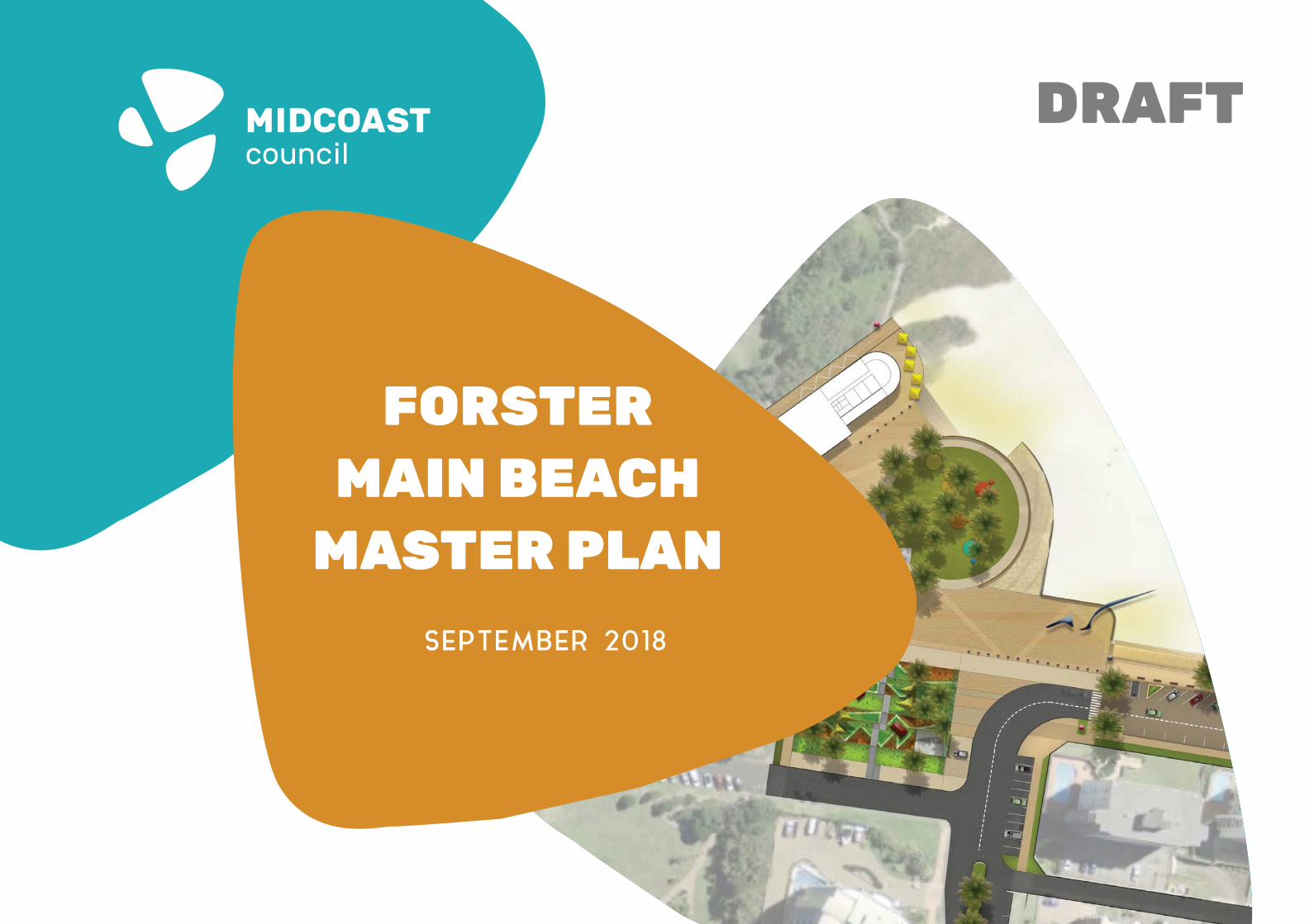
FORSTERMAIN BEACH
MASTER PLANSEPTEMBER 2018
DRAFT
FORSTER MAIN BEACH : MASTERPLAN 2
Report prepared by:
THE DESIGN PARTNERSHIPTDP2 Pty Ltd ATF The Design Unit Trust T/A The Design Partnership Central Coast – PO Box 6110 Long Jetty NSW 2261T 02 4324 8554E [email protected] www.thedesignpartnership.com.au
in collaboration with
ARTSCAPE PO Box 3459 Tuggerah NSW 2259T 02 4388 3409E [email protected] www.artscapeconsulting.com.au
FORSTER MAIN BEACH : MASTERPLAN 3
EXECUTIVE SUMMARY........................................................5
1.0 Introduction..........................................................................7
2.0 A Brief History......................................................................9
3.0 A Brief Analysis...................................................................13 4.0 An Engaging Process..........................................................21
5.0 Master Plan: A Framework for Main Beach...........................25
6.0 Master Plan: Implementation...............................................33
C O N T E N T S
FORSTER MAIN BEACH : MASTER PLAN 4
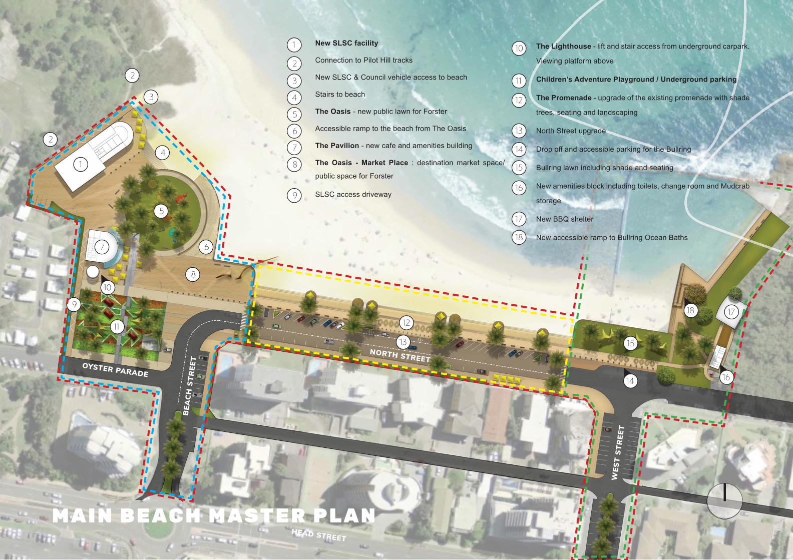
NORTH STREETOYSTER PARADE
BEA
CH
STR
EET
WES
T ST
REE
T
HEAD STREET
1
2
3
4
5
67
8
9
12
13 15
17
11
M A I N B E AC H M AST E R P L A N
10
11
12
13
14
15
16
17
18
2
10
14
18
1
2
3
4
5
6
7
8
9
The Lighthouse - lift and stair access from underground carpark.
Viewing platform above
Children’s Adventure Playground / Underground parking
The Promenade - upgrade of the existing promenade with shade
trees, seating and landscaping
North Street upgrade
Drop off and accessible parking for the Bullring
Bullring lawn including shade and seating
New amenities block including toilets, change room and Mudcrab
storage
New BBQ shelter
New accessible ramp to Bullring Ocean Baths
New SLSC facility
Connection to Pilot Hill tracks
New SLSC & Council vehicle access to beach
Stairs to beach
The Oasis - new public lawn for Forster
Accessible ramp to the beach from The Oasis
The Pavilion - new cafe and amenities building
The Oasis - Market Place : destination market space/
public space for Forster
SLSC access driveway
anananaananaannaaandd ssssssseses atatattatt nnnngggggggdddddddddeeeeehhhhh
eee
eee
ooo
ddd
16
FORSTER MAIN BEACH : MASTER PLAN 5
M AS T E R P L A N E X E C U T I V E S U M M A RY
Forster is located on NSW’s Mid North Coast. The town is home to approximately 13,740 residents (2016 Census) and is located between popular beaches and the Coolongolook River. Connected by an iconic bridge, is Forster’s twin town, Tuncurry. North of Forster’s town centre is the study area - its destination beach known as Main Beach. The study area (the Precinct) encompasses the existing Surf Life Saving Club (SLSC), the Bullring Ocean Baths, a promenade and parking areas. Although still popular, this precinct is ready for revitalisation.
THE FORSTER MAIN BEACH MASTER PLAN
The Forster Main Beach Precinct Master Plan proposes to revitalise the area for the benefi t of the community and its visitors. The revitalisation of Main Beach seeks to meet the needs of the existing community but also consider the needs of the future community.This Master Plan is a 30 year strategy and provides a starting point in the Precinct’s revitalisation. A Master Plan provides the framework to guide future planning, research and design - an essential tool in the funding process, as it articulates a shared community vision. The Precinct (red dashed line) is broken into three sub precincts:1. The SLSC Precinct which forms the western anchor (blue dashed
line)2. The Bullring Ocean Baths which forms the eastern anchor (green
dashed line)and3. North Street which links the western and eastern anchor by a
promenade (yellow dashed line). The Master Plan allows for joint venture proposals in conjunction with the SLSC redevelopment which could include licensed premises. The footprints of the SLSC, The Pavilion and similar structures are indicative and could increase or decrease in size subject to:• Final area requirements and • Coastal hazards and sea level rise studies .
VISION FOR MAIN BEACH PRECINCT
The Main Beach Precinct will provide people of all ages and abilities the opportunity to appreciate and
enjoy the beach.
This precinct will showcase its natural assets and secure them for future generations in a sustainable
manner. The Precinct will be safe and accessible.
1 KEY PRINCIPLE 1 Be Innovative - Modernise Main Beach with 21st century facilities and amenities
2 KEY PRINCIPLE 2Improve Public Space and create more green space within Main Beach Precinct
3 KEY PRINCIPLE 3Enhance beach accessibility for the whole community
4 KEY PRINCIPLE 4Strengthen the local community and its involvement in the Precinct
5 KEY PRINCIPLE 5A rich history and a strong future - create strong foundations for the evolution of the Precinct
URBAN DESIGN PRINCIPLES
THE COMMUNITY’S WISH LIST
Exensive community engagement was undertaken by Council over the course of a year. A summary of the community’s comments include: • A modernised precinct• More shade in the form of trees and shelters• Upgraded amenities including accessible toilets/showers and
solar hot showers• More green space for people - don’t give the cars the best location• Upgraded or New SLSC• Similar carparking numbers where practicalOpen space and parking were the most popular requests for inclusion in the Master Plan. Below summaries the proposed open space and parking provision:
Approximate No. Parking SpacesPrecinct Existing/
Stage 1Stage 2 Stage 3
1-3 years 5-10 years 15 + yearsSLSC Precinct 87 74 160-220*Bullring Precinct 36 43 43North Street Precinct 112 36 36Oyster Parade Precinct 95 95 95Total 330 248 334-394
PROPOSED PARKING SUMMARY
PROPOSED OPEN SPACE SUMMARY
Precinct Approximate Area m2 (Stage 3)SLSC Precinct 7000m2
Bullring Precinct 2800m2
North Street Precinct 1850m2
Total 11,650m2
FORSTER MAIN BEACH : MASTER PLAN 6
FORSTER MAIN BEACH : MASTER PLAN 7
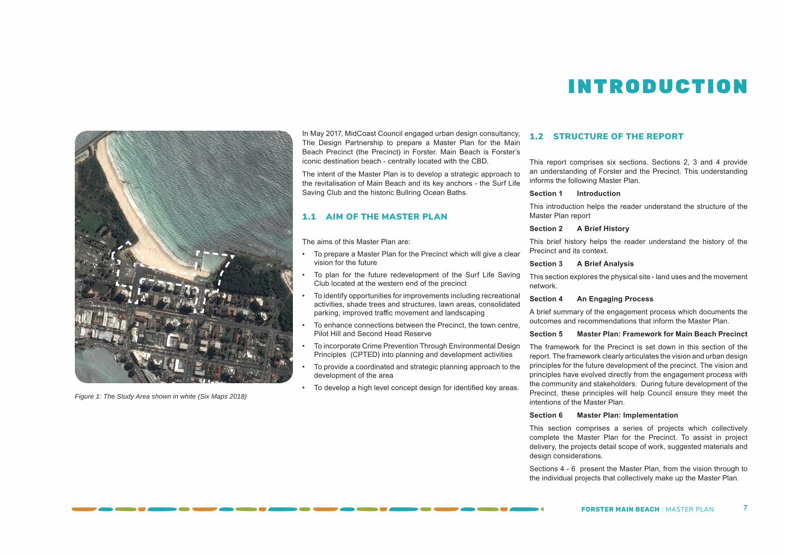
In May 2017, MidCoast Council engaged urban design consultancy, The Design Partnership to prepare a Master Plan for the Main Beach Precinct (the Precinct) in Forster. Main Beach is Forster’s iconic destination beach - centrally located with the CBD.
The intent of the Master Plan is to develop a strategic approach to the revitalisation of Main Beach and its key anchors - the Surf Life Saving Club and the historic Bullring Ocean Baths.
1.1 AIM OF THE MASTER PLAN The aims of this Master Plan are:• To prepare a Master Plan for the Precinct which will give a clear
vision for the future• To plan for the future redevelopment of the Surf Life Saving
Club located at the western end of the precinct• To identify opportunities for improvements including recreational
activities, shade trees and structures, lawn areas, consolidated parking, improved traffi c movement and landscaping
• To enhance connections between the Precinct, the town centre, Pilot Hill and Second Head Reserve
• To incorporate Crime Prevention Through Environmental Design Principles (CPTED) into planning and development activities
• To provide a coordinated and strategic planning approach to the development of the area
• To develop a high level concept design for identifi ed key areas.
1.2 STRUCTURE OF THE REPORT
This report comprises six sections. Sections 2, 3 and 4 provide an understanding of Forster and the Precinct. This understanding informs the following Master Plan.
Section 1 IntroductionThis introduction helps the reader understand the structure of the Master Plan report
Section 2 A Brief HistoryThis brief history helps the reader understand the history of the Precinct and its context.
Section 3 A Brief AnalysisThis section explores the physical site - land uses and the movement network.
Section 4 An Engaging ProcessA brief summary of the engagement process which documents the outcomes and recommendations that inform the Master Plan.
Section 5 Master Plan: Framework for Main Beach PrecinctThe framework for the Precinct is set down in this section of the report. The framework clearly articulates the vision and urban design principles for the future development of the precinct. The vision and principles have evolved directly from the engagement process with the community and stakeholders. During future development of the Precinct, these principles will help Council ensure they meet the intentions of the Master Plan.
Section 6 Master Plan: ImplementationThis section comprises a series of projects which collectively complete the Master Plan for the Precinct. To assist in project delivery, the projects detail scope of work, suggested materials and design considerations.
Sections 4 - 6 present the Master Plan, from the vision through to the individual projects that collectively make up the Master Plan.
I N T R O D U C T I O N
Figure 1: The Study Area shown in white (Six Maps 2018)
FORSTER MAIN BEACH : MASTER PLAN 8
“For tens of thousands of years, the Forster/Tuncurry
area was home to the Worimi and Biripi people. They were hunters and
gatherers who made good use of the abundant food sources found within the
rivers, lakes and coastline of the area. ”
FORSTER MAIN BEACH : MASTER PLAN 9
2.1 BRIEF HISTORY OF FORSTER
A brief history of Forster has been provided to present the context of the Main Beach Precinct. The history is a brief snapshot and does not provide an exhaustive analysis.
2.1.1 BEFORE PEOPLE
For countless millennia, sand and sediments eroding from east coast hinterlands have been gathered up by rivers to wash down to the Tasman Sea. Here, steady winds, waves, tides and currents push them steadily north along the coast.
Coastal headlands and islands are the spoilers. They press into this northern drift, and like mountains forcing clouds to spill their rain, they squeeze out their ration of sand to form the magnifi cent beaches for which New South Wales is so rightly famed.
But this beach forming process is fi nite. It ends at the northern end of Fraser Island where this sandy conveyor belt is at last swallowed by the coastal abyss.
At Forster, Cape Hawke was once a large off shore island. Over the last few million years (the Quaternary period for the purists) and with the help of headlands at Boomerang Point, Seagull Point and Booti Booti, it collected enough sand to close off Wallis Lake and establish the beautiful, braided clear water channels at the mouth of the lake.
With the help of the Coolongolook and Wallamba rivers, this sedimentary process continues to this day.
2.1.2 THE FIRST PEOPLE
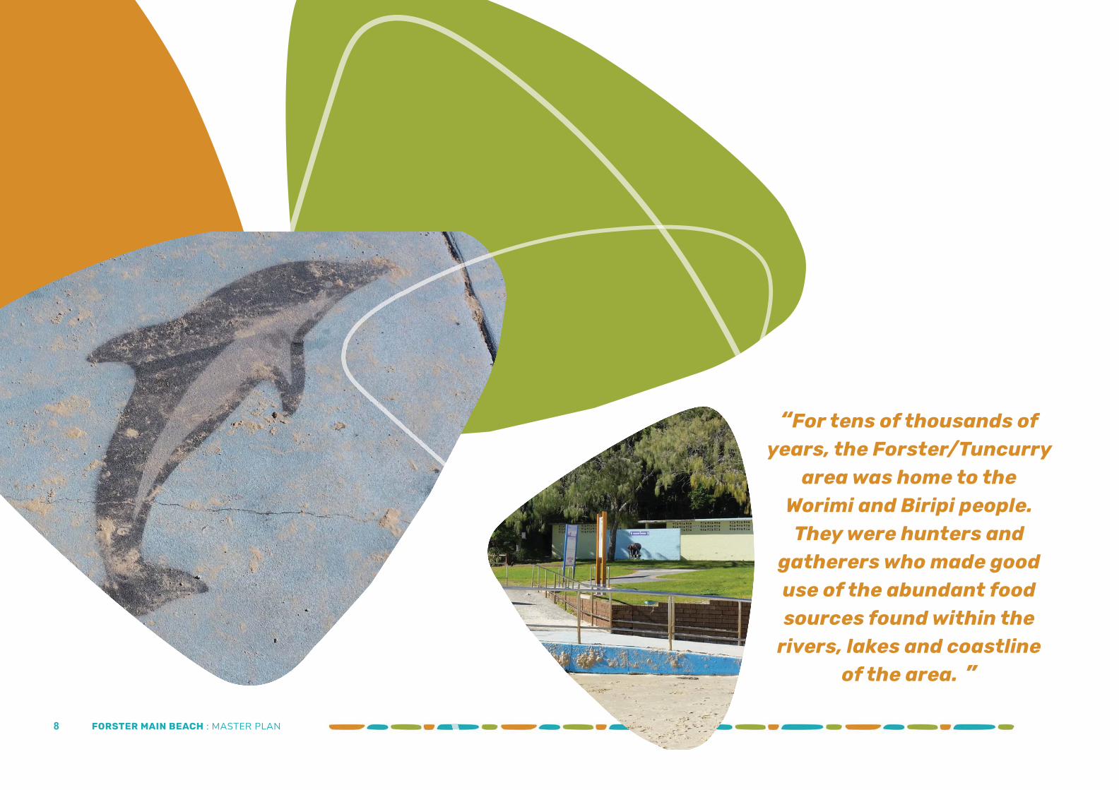
For tens of thousands of years, the Forster/Tuncurry area was home to the Worimi and Biripi people. They were hunters and gatherers who made good use of the abundant food sources found within the rivers, lakes and coastline of the area.
Their fi rst contact with Europeans came in 1790 when fi ve convicts escaped from the Second Fleet. They were ‘adopted’ by the Worimi and lived with them until they were recaptured in 1795.
Although the Worimi and Biripi people were seen as a friendly, peaceful people, contact with the early European settlers was not a high note in their story. Disease, confl ict and land competition had tragic results for them – yet some 700 Worimi people still live in the Forster area.
2.1.3 THE EXPLORER
Explorer John Oxley came through the area on October 26th 1818. In his journal he wrote:
“The Lagoon itself is at low water nothing but a sand shoal, with narrow and shallow channels.
The surf beats right across the entrance and though at high water a small vessel might beat over the bar it would be mere chance if she escaped being lost upon the sand rollers inside, the surf breaking with fl ood tide and easterly wind a full half mile within the outer bar..”
To him it seemed uninhabitable. Thankfully he had little imagination. However, he did bestow one permanent reminder of his travels – the name Wallis Lake: which he named after the commandant of the Newcastle penal colony.
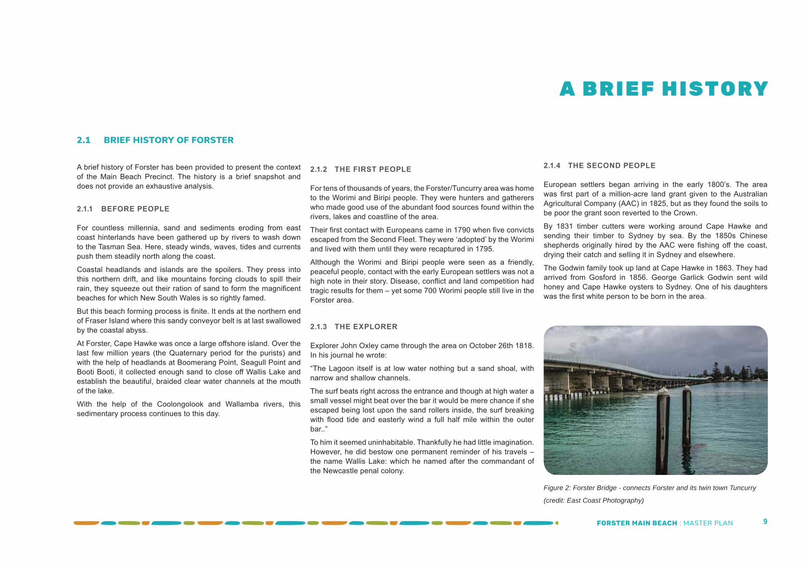
Figure 2: Forster Bridge - connects Forster and its twin town Tuncurry
(credit: East Coast Photography)
2.1.4 THE SECOND PEOPLE
European settlers began arriving in the early 1800’s. The area was fi rst part of a million-acre land grant given to the Australian Agricultural Company (AAC) in 1825, but as they found the soils to be poor the grant soon reverted to the Crown.
By 1831 timber cutters were working around Cape Hawke and sending their timber to Sydney by sea. By the 1850s Chinese shepherds originally hired by the AAC were fi shing off the coast, drying their catch and selling it in Sydney and elsewhere.
The Godwin family took up land at Cape Hawke in 1863. They had arrived from Gosford in 1856. George Garlick Godwin sent wild honey and Cape Hawke oysters to Sydney. One of his daughters was the fi rst white person to be born in the area.
A B R I E F H I STO RY
FORSTER MAIN BEACH : MASTER PLAN 10
2.1.5 BUILDING A TOWN
The town was fi rst known as “Minimbah” until it was surveyed in 1869 when it was renamed after William Forster, the then Secretary of Lands. Tuncurry was known as North Forster until 1875 when John Wright set up camp there. He adopted the local Worimi place name “Tuncurry” which probably meant “plenty fi sh”.
The pace picked up in the 1870’s with the opening of a school, pilot station, saw mill, ship building, post offi ce, hotel, church, police station, school of arts, and various stores.
In the 1890’s a row boat ferry service began to operate between the twin towns. Tuncurry was proclaimed a village, and a hotel, hall and ice works were built. At the turn of the century work on the southern break wall began – and fi nished in 1903. By 1922 a regular vehicular ferry began operating between Forster and Tuncurry – a trip that would often take up to 30 minutes.
Linking Forster and Tuncurry by a permanent bridge had been a dream since the early days (Figure 1). And in 1959 it became a reality. The structure, at well over 600 metres in length, it is one of the longest pre-stressed concrete bridges in the southern hemisphere and an easily recognised icon of the mid north coast. It was an instant catalyst to the growth of both towns
2.1.6 THE MAIN BEACH PRECINCT
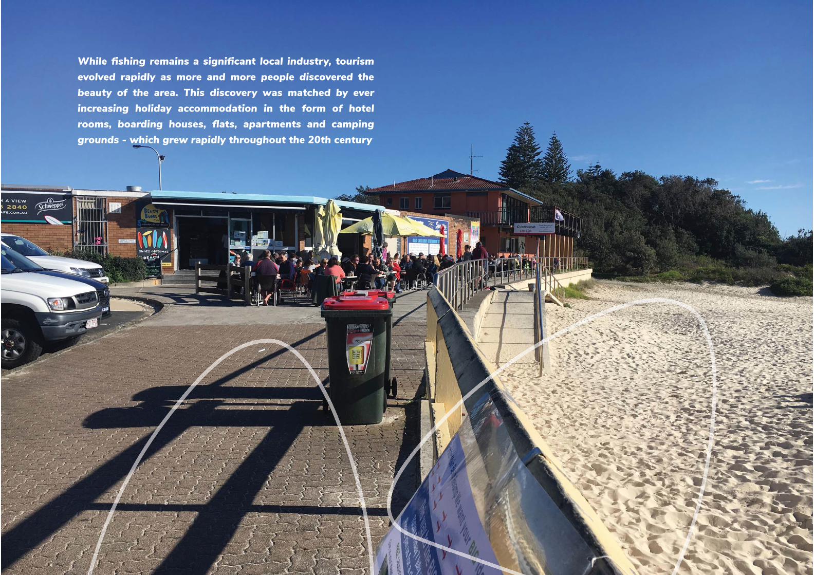
While fi shing remains a signifi cant local industry, tourism evolved rapidly as more and more people discovered the beauty of the area. This discovery was matched by ever increasing holiday accommodation in the form of hotel rooms, boarding houses, fl ats, apartments and camping grounds - which grew rapidly throughout the 20th century.
During this time hire boats and lake cruises proliferated. By the 1980’s high rise holiday units were becoming more and more
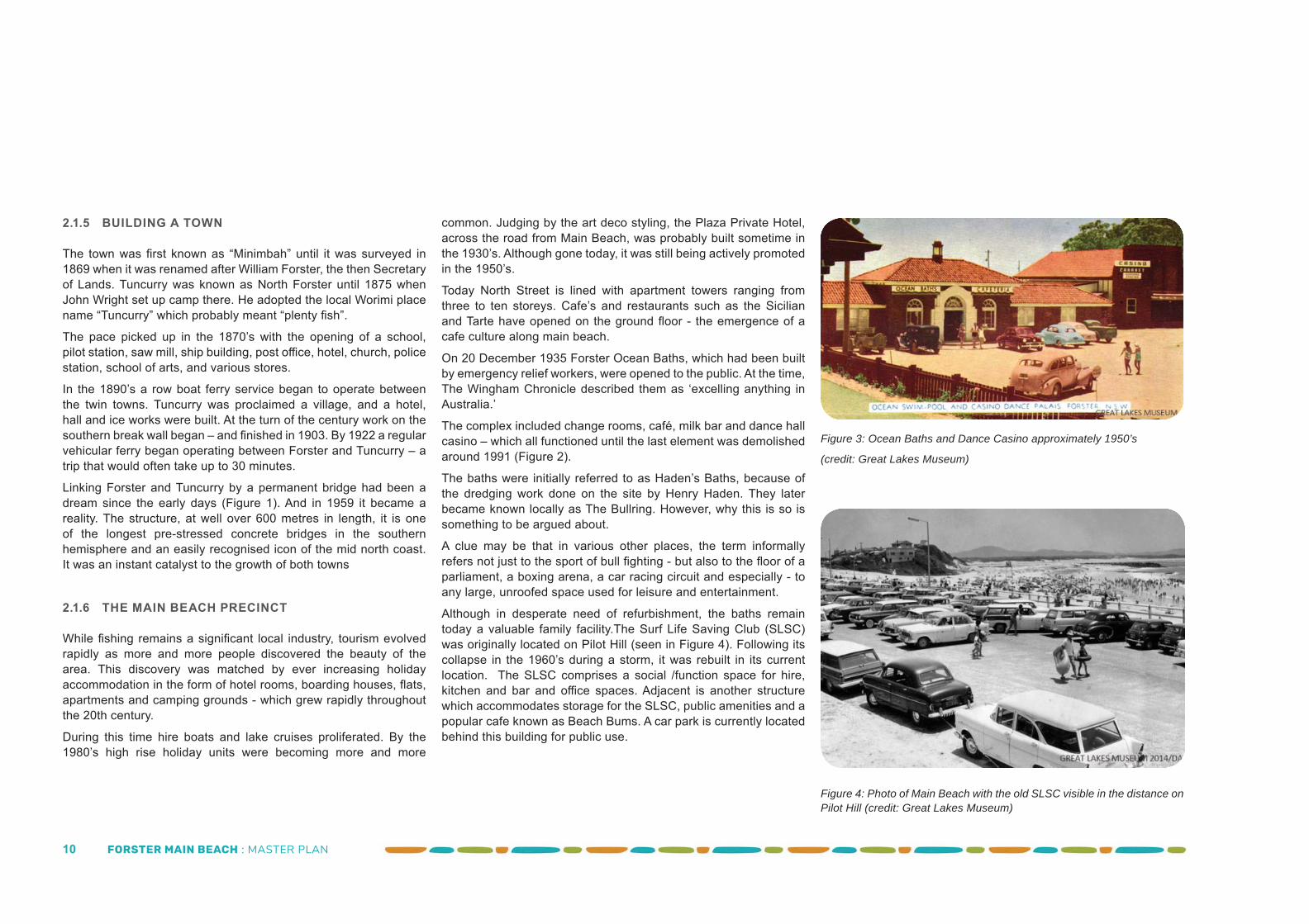
Figure 4: Photo of Main Beach with the old SLSC visible in the distance on Pilot Hill (credit: Great Lakes Museum)
Figure 3: Ocean Baths and Dance Casino approximately 1950’s
(credit: Great Lakes Museum)
common. Judging by the art deco styling, the Plaza Private Hotel, across the road from Main Beach, was probably built sometime in the 1930’s. Although gone today, it was still being actively promoted in the 1950’s.
Today North Street is lined with apartment towers ranging from three to ten storeys. Cafe’s and restaurants such as the Sicilian and Tarte have opened on the ground fl oor - the emergence of a cafe culture along main beach.
On 20 December 1935 Forster Ocean Baths, which had been built by emergency relief workers, were opened to the public. At the time, The Wingham Chronicle described them as ‘excelling anything in Australia.’
The complex included change rooms, café, milk bar and dance hall casino – which all functioned until the last element was demolished around 1991 (Figure 2).
The baths were initially referred to as Haden’s Baths, because of the dredging work done on the site by Henry Haden. They later became known locally as The Bullring. However, why this is so is something to be argued about.
A clue may be that in various other places, the term informally refers not just to the sport of bull fi ghting - but also to the fl oor of a parliament, a boxing arena, a car racing circuit and especially - to any large, unroofed space used for leisure and entertainment.
Although in desperate need of refurbishment, the baths remain today a valuable family facility.The Surf Life Saving Club (SLSC) was originally located on Pilot Hill (seen in Figure 4). Following its collapse in the 1960’s during a storm, it was rebuilt in its current location. The SLSC comprises a social /function space for hire, kitchen and bar and offi ce spaces. Adjacent is another structure which accommodates storage for the SLSC, public amenities and a popular cafe known as Beach Bums. A car park is currently located behind this building for public use.
FORSTER MAIN BEACH : MASTER PLAN 11
While fi shing remains a signifi cant local industry, tourism evolved rapidly as more and more people discovered the beauty of the area. This discovery was matched by ever increasing holiday accommodation in the form of hotel rooms, boarding houses, fl ats, apartments and camping grounds - which grew rapidly throughout the 20th century
FORSTER MAIN BEACH : MASTER PLAN 12
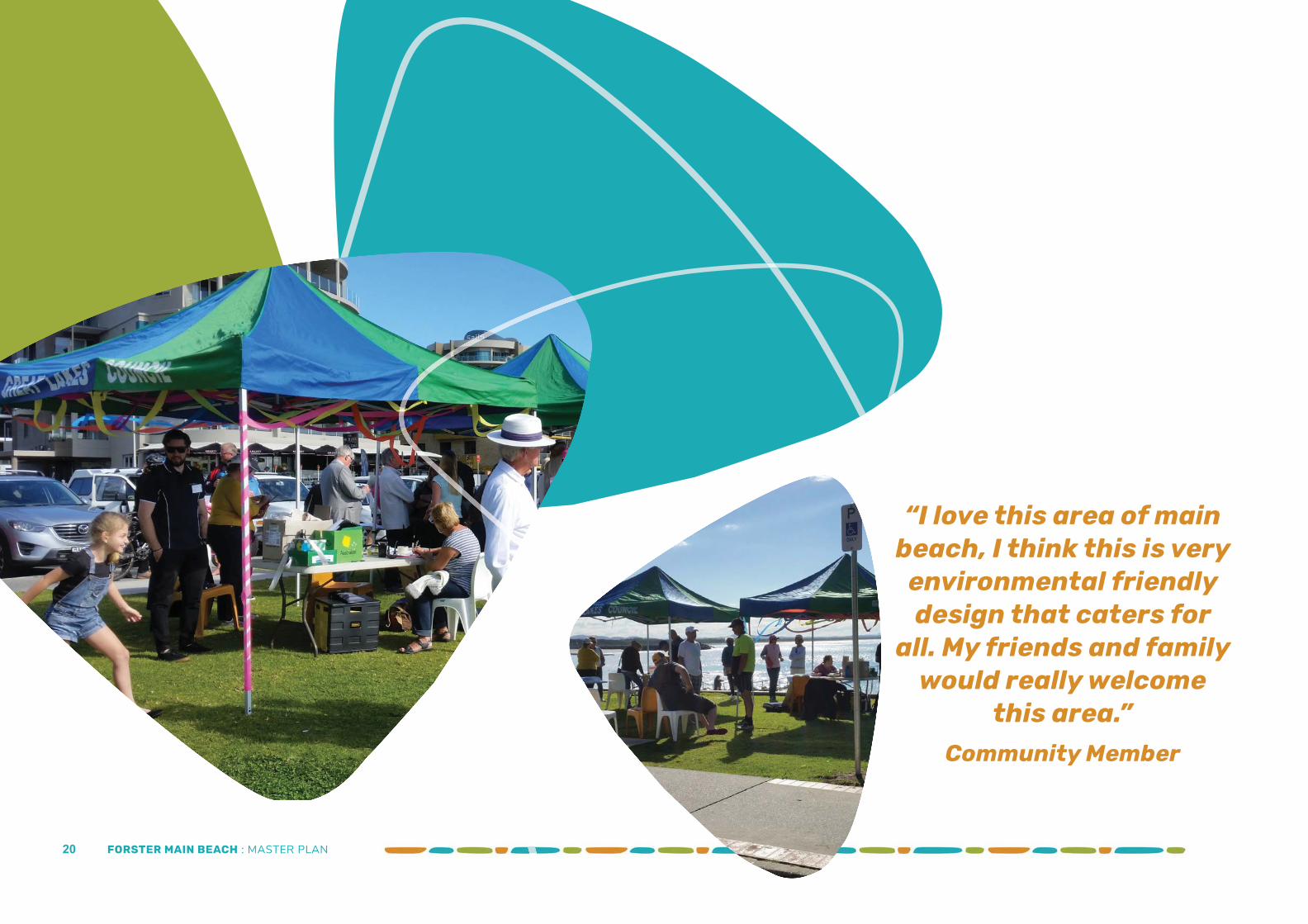
“I love this area of main beach, I think this is very
environmental friendly design that caters for
all. My friends and family would really welcome
this area.”Community Member
FORSTER MAIN BEACH : MASTER PLAN 13
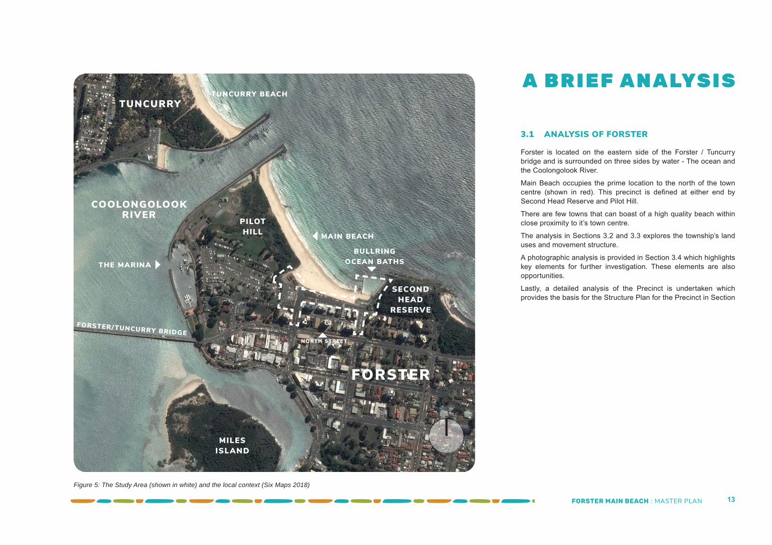
3.1 ANALYSIS OF FORSTER
Forster is located on the eastern side of the Forster / Tuncurry bridge and is surrounded on three sides by water - The ocean and the Coolongolook River.
Main Beach occupies the prime location to the north of the town centre (shown in red). This precinct is defi ned at either end by Second Head Reserve and Pilot Hill.
There are few towns that can boast of a high quality beach within close proximity to it’s town centre.
The analysis in Sections 3.2 and 3.3 explores the township’s land uses and movement structure.
A photographic analysis is provided in Section 3.4 which highlights key elements for further investigation. These elements are also opportunities.
Lastly, a detailed analysis of the Precinct is undertaken which provides the basis for the Structure Plan for the Precinct in Section
COOLONGOLOOKRIVER
FORSTER
TUNCURRY
PILOT HILL
SECONDHEAD
RESERVE
A B R I E F A N A LYS I STUNCURRY BEACH
MILESISLAND
FORSTER/TUNCURRY BRIDGE
MAIN BEACH
NORTH STREET
BULLRING OCEAN BATHSTHE MARINA
Figure 5: The Study Area (shown in white) and the local context (Six Maps 2018)
FORSTER MAIN BEACH : MASTER PLAN 14
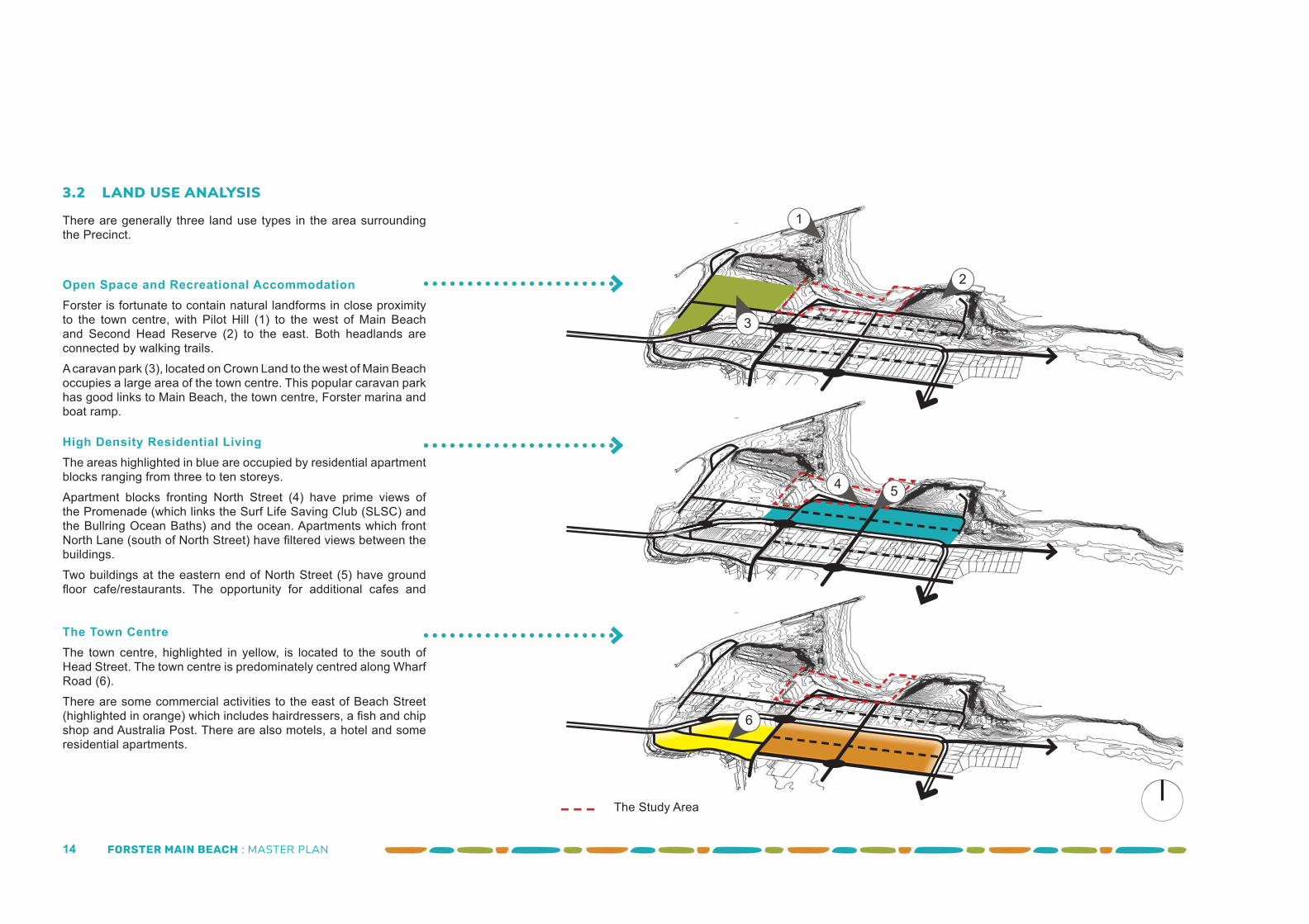
Open Space and Recreational AccommodationForster is fortunate to contain natural landforms in close proximity to the town centre, with Pilot Hill (1) to the west of Main Beach and Second Head Reserve (2) to the east. Both headlands are connected by walking trails. A caravan park (3), located on Crown Land to the west of Main Beach occupies a large area of the town centre. This popular caravan park has good links to Main Beach, the town centre, Forster marina and boat ramp.
High Density Residential LivingThe areas highlighted in blue are occupied by residential apartment blocks ranging from three to ten storeys. Apartment blocks fronting North Street (4) have prime views of the Promenade (which links the Surf Life Saving Club (SLSC) and the Bullring Ocean Baths) and the ocean. Apartments which front North Lane (south of North Street) have fi ltered views between the buildings.Two buildings at the eastern end of North Street (5) have ground fl oor cafe/restaurants. The opportunity for additional cafes and
The Town CentreThe town centre, highlighted in yellow, is located to the south of Head Street. The town centre is predominately centred along Wharf Road (6). There are some commercial activities to the east of Beach Street (highlighted in orange) which includes hairdressers, a fi sh and chip shop and Australia Post. There are also motels, a hotel and some residential apartments.
3.2 LAND USE ANALYSIS
There are generally three land use types in the area surrounding the Precinct.
2
1
3
4 5
6
The Study Area
FORSTER MAIN BEACH : MASTER PLAN 15
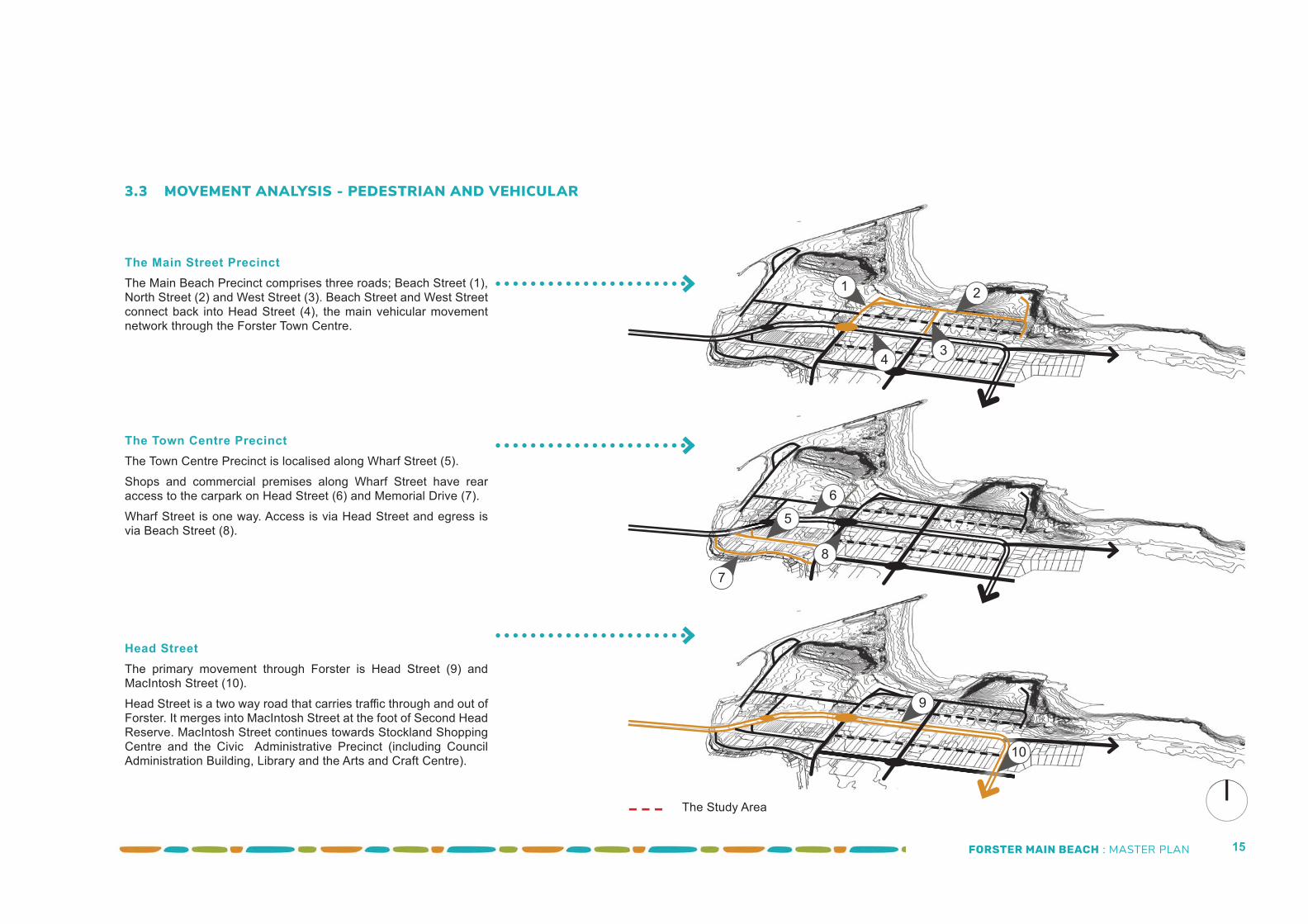
The Main Street PrecinctThe Main Beach Precinct comprises three roads; Beach Street (1), North Street (2) and West Street (3). Beach Street and West Street connect back into Head Street (4), the main vehicular movement network through the Forster Town Centre.
The Town Centre PrecinctThe Town Centre Precinct is localised along Wharf Street (5). Shops and commercial premises along Wharf Street have rear access to the carpark on Head Street (6) and Memorial Drive (7). Wharf Street is one way. Access is via Head Street and egress is via Beach Street (8).
Head Street The primary movement through Forster is Head Street (9) and MacIntosh Street (10). Head Street is a two way road that carries traffi c through and out of Forster. It merges into MacIntosh Street at the foot of Second Head Reserve. MacIntosh Street continues towards Stockland Shopping Centre and the Civic Administrative Precinct (including Council Administration Building, Library and the Arts and Craft Centre).
5
7
6
8
21
3
9
3.3 MOVEMENT ANALYSIS - PEDESTRIAN AND VEHICULAR
4
10
The Study Area
FORSTER MAIN BEACH : MASTER PLAN 16
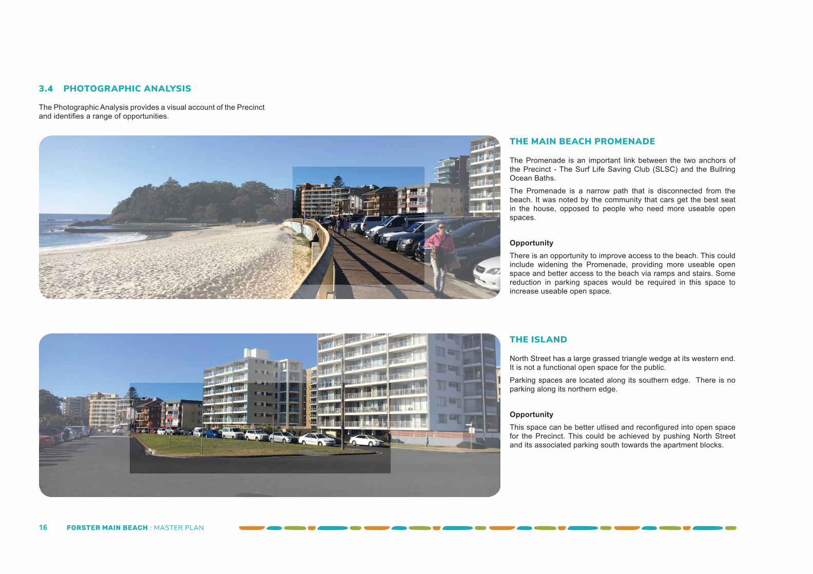
THE MAIN BEACH PROMENADE
The Promenade is an important link between the two anchors of the Precinct - The Surf Life Saving Club (SLSC) and the Bullring Ocean Baths. The Promenade is a narrow path that is disconnected from the beach. It was noted by the community that cars get the best seat in the house, opposed to people who need more useable open spaces.
OpportunityThere is an opportunity to improve access to the beach. This could include widening the Promenade, providing more useable open space and better access to the beach via ramps and stairs. Some reduction in parking spaces would be required in this space to increase useable open space.
THE ISLAND
North Street has a large grassed triangle wedge at its western end. It is not a functional open space for the public. Parking spaces are located along its southern edge. There is no parking along its northern edge.
OpportunityThis space can be better utlised and reconfi gured into open space for the Precinct. This could be achieved by pushing North Street and its associated parking south towards the apartment blocks.
3.4 PHOTOGRAPHIC ANALYSIS
The Photographic Analysis provides a visual account of the Precinct and identifi es a range of opportunities.
FORSTER MAIN BEACH : MASTER PLAN 17
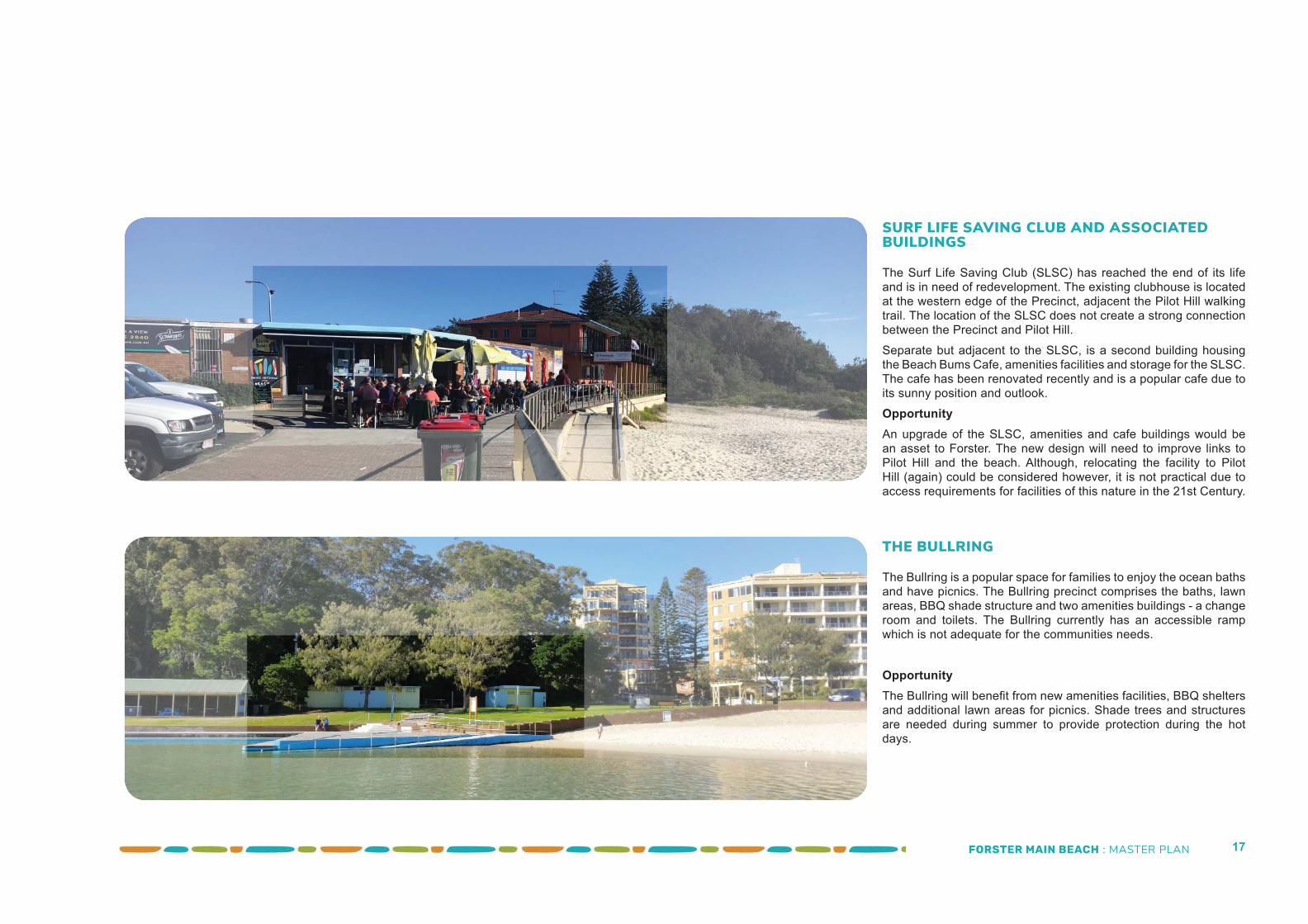
SURF LIFE SAVING CLUB AND ASSOCIATED BUILDINGS
The Surf Life Saving Club (SLSC) has reached the end of its life and is in need of redevelopment. The existing clubhouse is located at the western edge of the Precinct, adjacent the Pilot Hill walking trail. The location of the SLSC does not create a strong connection between the Precinct and Pilot Hill. Separate but adjacent to the SLSC, is a second building housing the Beach Bums Cafe, amenities facilities and storage for the SLSC. The cafe has been renovated recently and is a popular cafe due to its sunny position and outlook. OpportunityAn upgrade of the SLSC, amenities and cafe buildings would be an asset to Forster. The new design will need to improve links to Pilot Hill and the beach. Although, relocating the facility to Pilot Hill (again) could be considered however, it is not practical due to access requirements for facilities of this nature in the 21st Century.
THE BULLRING
The Bullring is a popular space for families to enjoy the ocean baths and have picnics. The Bullring precinct comprises the baths, lawn areas, BBQ shade structure and two amenities buildings - a change room and toilets. The Bullring currently has an accessible ramp which is not adequate for the communities needs.
OpportunityThe Bullring will benefi t from new amenities facilities, BBQ shelters and additional lawn areas for picnics. Shade trees and structures are needed during summer to provide protection during the hot days.
FORSTER MAIN BEACH : MASTER PLAN 18
A7
8
6
1
2
4
3
9
1615
17
5
18
14 10
11
12
B13
FORSTER MAIN BEACH : MASTER PLAN 19
Parking Location No. of spacesSLSC Precinct 87 (80 SLSC Carpark)Bullring Precinct 36 (11 Bullring & 25 West Street)North Street Precinct 112Oyster Parade Precinct 95 (30 on street & 65 in the Oyster
Street carpark)Total 330 spaces
EXISTING PARKING SUMMARY
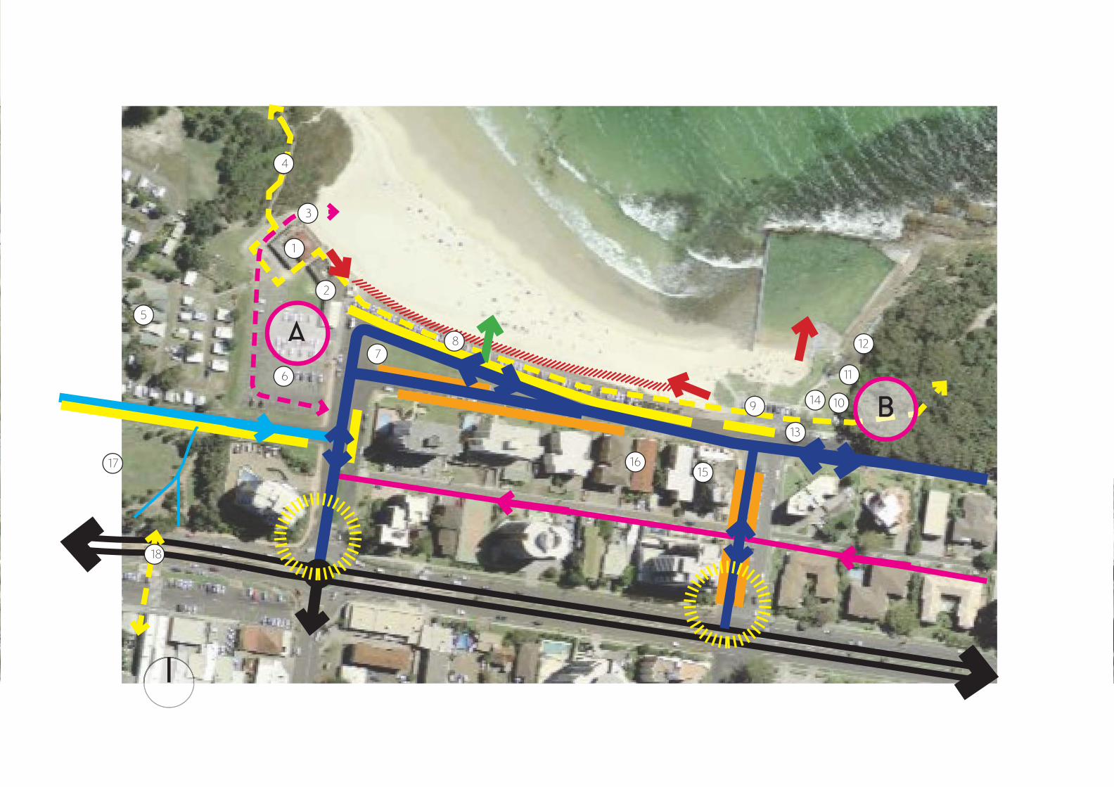
Head Street
Two Way Road
One Way Laneway
LEGENDGeneral Precinct Comments• The existing Promenade is a narrow path that connects the
anchors of the Precinct - The SLSC and The Bullring. The Promenade also connects with the headlands that book end the Precinct - Pilot Hill to the west and Second Head Reserve to the east. The links with Pilot Hill are not strong as the SLSC blocks the two paths. Improved connections to Pilot Hill and Second Head Reserve are required
• North Street has excessive bitumen and is dominated by cars. There are limited opportunities for the active use of the space between the two anchors. There is also an opportunity to improve the effi ciency of parking in Beach and West Street
• There is no landscaping between the two anchors. There is also no shade from shelters or trees. This makes this space undesirable during summer
• There are no drop off areas in the Precinct - to allow for people to drop off people or equipment during the peak season when it is diffi cult to get a parking space
• There is an overwhelming sense of car dominance in this Precinct, which could lead to pedestrian and vehicle confl ict.
Anchor 1 - Existing Surf Life Saving Club (SLSC) Precinct• Existing SLSC is at the end of its life. The previous SLSC
was located on Pilot Hill • The amenities and cafe building is separate to the SLSC.
It is located to the east of the SLSC and is at the end of its life. It is also used to store SLSC equipment. The cafe ‘Beach Bums’ has recently constructed an awning to provide all weather protection for its diners
• Access to the beach is limited via a narrow pedestrian ramp and the SLSC vehicle ramp
Anchor 2 - Existing Bullring Ocean Baths• The existing amenities, change room and shade structure are
at the end of their life. These structures need to be replaced• The lawn areas in this area are limited and the area would
benefi t from more lawn area for picnics • Shade in the form of trees and structures is limited in this
area and is valuable during the hot summer months.
One Way Road - Oyster Parade
90 Degree Parking
Parallel Parking
Accessible Access To Beach/Baths
Stairs To The Beach
Existing Promenade Links Pilot Hill And Second Head Researve
Vehicle Access To SLSC From Oyster Parade
AAnchor 1 - SLSC Precinct
BAnchor 2 - Bullring Ocean Baths Precinct
Existing SLSC Club1
2
3
4
5
6
7
8
9
10
11
Ancillary Building - Cafe, Amenities and Storage
Vehicle Access to the Beach
Pilot Hill Track
3.5 EXISTING PRECINCT ANALYSIS DIAGRAM
Gateways To The Precinct
Caravan Park
SLSC Public Carpark
Triangle Island
The existing Promenade
The Bullring lawn area
PublicToilets
Change rooms
12 BBQ Shelter
13 BBQ shelter
14 The Bullring lawn areas
15 Restaurant - day and evening
16 Cafe - day only
17 Town Park
18 Pedestrian crossing to town centre
EXISTING PRECINCT SUMMARY
An analysis summary of the Precinct is provided below and in the diagram opposite. This analysis guides the Master Plan in Section 5 and 6.
FORSTER MAIN BEACH : MASTER PLAN 20
“I love this area of main beach, I think this is very
environmental friendly design that caters for
all. My friends and family would really welcome
this area.”Community Member
FORSTER MAIN BEACH : MASTER PLAN 21
4.1 INTRODUCTION TO THE ENGAGEMENT PROCESS
A range of engagement methods have been undertaken for the Forster Main Beach Master Plan.
Each engagement method is described below:
1. A drop in session for the business community was held on Wednesday 28 June 2017 at 10am in the Forster Surf Life Saving Club function room. Approximately 40 attended the drop in session
2. Ongoing consultation on a regular basis with the president of the SLSC and club representatives
3. A “Big Ideas BBQ” community drop in session was held on Friday 7 July 2017 between 11 – 2pm on the lawn of the Bullring Ocean Baths in Forster. Approximately 500 attended the drop in session. Details of the BBQ were provided on Council’s website and advertised on local radio
4. Council’s website also provided an opportunity to comment
5. Council’s Facebook page notifi ed the community of the engagement process and encouraged comments.
6. Three workshops were held 13 October 2017 with the over 40 members of the community, business community and the surf life saving members.
7. A “Big Plans BBQ” community drop in session was held on Friday 15 June 2018 between 11 – 1pm on the lawn of the Bullring Ocean Baths in Forster. Approximately 250 attended the drop in session. Details of the BBQ were provided on Council’s website and advertised on local radio and on posters around town
8. Council’s website also provided an opportunity to comment
9. Council’s Facebook page notifi ed the community of the engagement process and encouraged comments.
4.2 THE BIG IDEAS BBQ - JULY 2017
The community were asked answer fi ve core questions:1. What do you love about Main Beach?
2. What one thing would you like to change?
3. Imagine Main Beach in ten years time. What are three words to describe it?
4. What is your ONE idea to make Main Beach special?
5. What can we do to ensure Main Beach projects connects and supports local business?
We also asked:Is there anything else about Main Beach you would like to add?
110 written responses were received via the survey, as formal letter or online.
4.2.1 The message from the communityThe message from the community was generally consistent and is summarised below:• Modernise the precinct• More shade in the form of trees and shelters• Upgrade the amenities including providing accessible toilets/
showers and provide solar hot showers• Create more green space for people. Don’t give the cars the
best location • Upgrade the Bullring• Upgrade or replace the SLSC• Maintain the carparking numbers• There were a number of comments suggesting that Council
should do nothing however, this seems to suggest a general upgrade rather than allowing the precinct to become derelict
• Make the area more accessible – to people in general and for people with special needs.
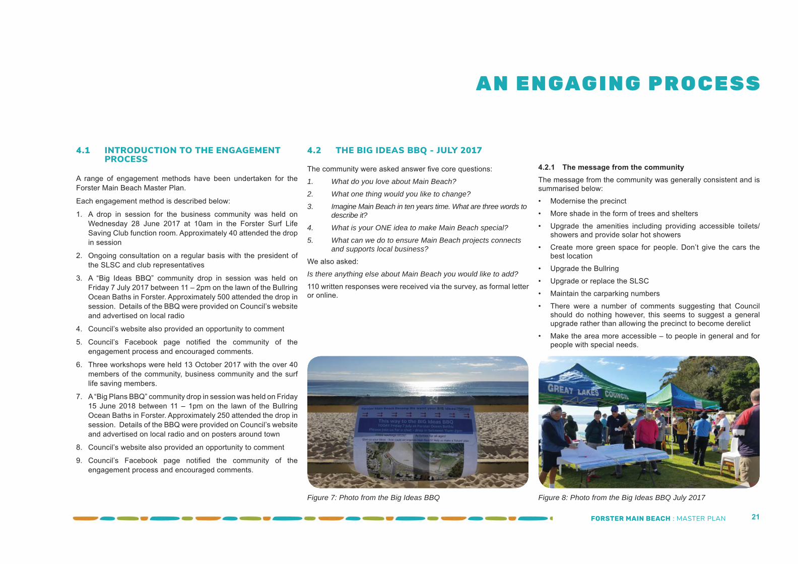
Figure 7: Photo from the Big Ideas BBQ Figure 8: Photo from the Big Ideas BBQ July 2017
A N E N GAG I N G P R O C E S S
FORSTER MAIN BEACH : MASTER PLAN 22
4.3 THE COMMUNITY WORKSHOPS - OCTOBER 2017
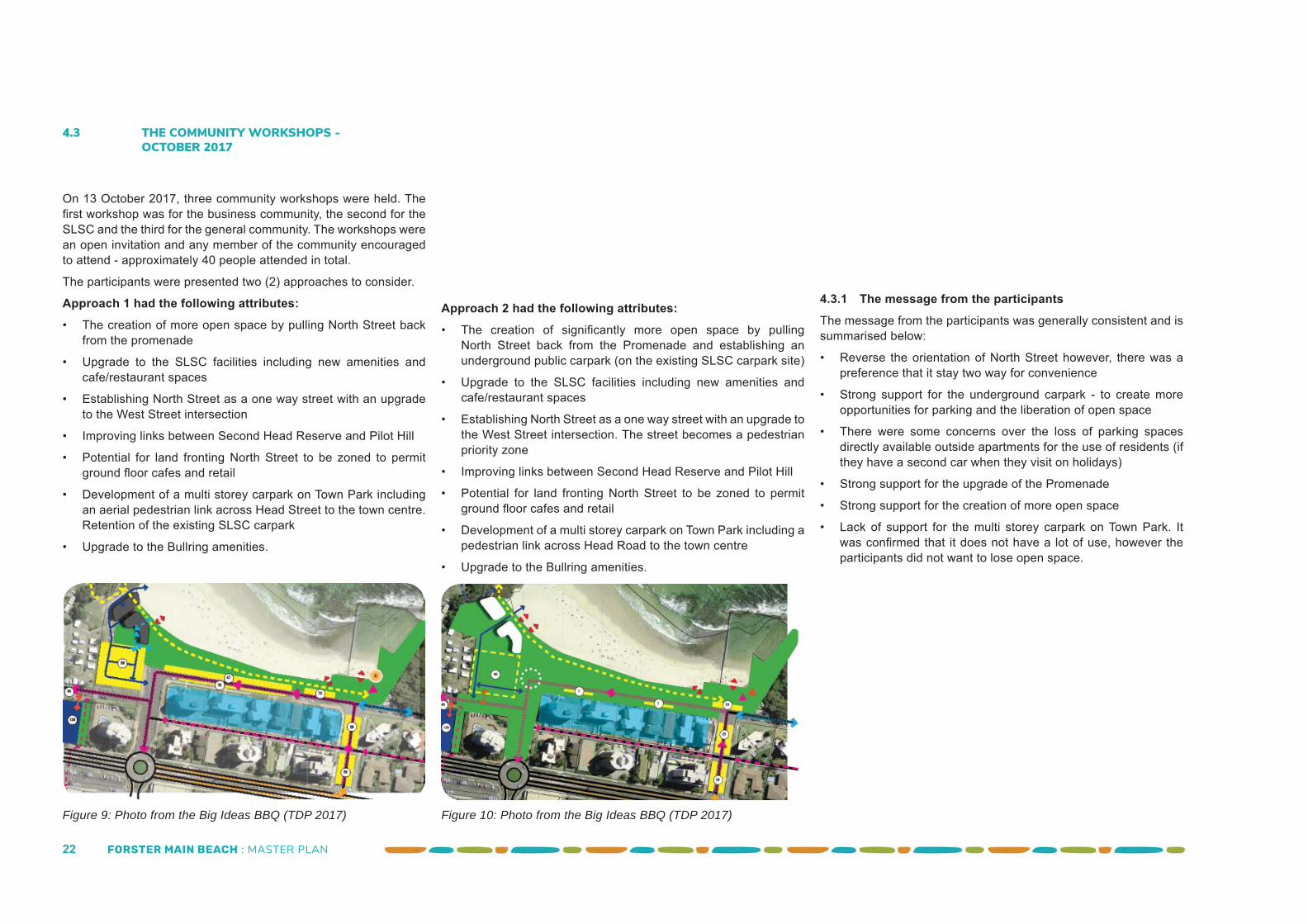
On 13 October 2017, three community workshops were held. The fi rst workshop was for the business community, the second for the SLSC and the third for the general community. The workshops were an open invitation and any member of the community encouraged to attend - approximately 40 people attended in total.
The participants were presented two (2) approaches to consider.
Approach 1 had the following attributes:• The creation of more open space by pulling North Street back
from the promenade
• Upgrade to the SLSC facilities including new amenities and cafe/restaurant spaces
• Establishing North Street as a one way street with an upgrade to the West Street intersection
• Improving links between Second Head Reserve and Pilot Hill
• Potential for land fronting North Street to be zoned to permit ground fl oor cafes and retail
• Development of a multi storey carpark on Town Park including an aerial pedestrian link across Head Street to the town centre. Retention of the existing SLSC carpark
• Upgrade to the Bullring amenities.
Figure 9: Photo from the Big Ideas BBQ (TDP 2017)
Approach 2 had the following attributes:• The creation of signifi cantly more open space by pulling
North Street back from the Promenade and establishing an underground public carpark (on the existing SLSC carpark site)
• Upgrade to the SLSC facilities including new amenities and cafe/restaurant spaces
• Establishing North Street as a one way street with an upgrade to the West Street intersection. The street becomes a pedestrian priority zone
• Improving links between Second Head Reserve and Pilot Hill
• Potential for land fronting North Street to be zoned to permit ground fl oor cafes and retail
• Development of a multi storey carpark on Town Park including a pedestrian link across Head Road to the town centre
• Upgrade to the Bullring amenities.
4.3.1 The message from the participantsThe message from the participants was generally consistent and is summarised below:
• Reverse the orientation of North Street however, there was a preference that it stay two way for convenience
• Strong support for the underground carpark - to create more opportunities for parking and the liberation of open space
• There were some concerns over the loss of parking spaces directly available outside apartments for the use of residents (if they have a second car when they visit on holidays)
• Strong support for the upgrade of the Promenade
• Strong support for the creation of more open space
• Lack of support for the multi storey carpark on Town Park. It was confi rmed that it does not have a lot of use, however the participants did not want to lose open space.
Figure 10: Photo from the Big Ideas BBQ (TDP 2017)
FORSTER MAIN BEACH : MASTER PLAN 23
4.4.1 The message from the communitySupport was predominately for Approach 1 however, with some increase in the parking provisions. The general comments are summarised below:
• Support for the underground parking station however, the Master Plan should clearly explain that it is a long term project
• Concerns over unisex facilties and how these spaces would be used and managed
• Support for the proposed accessible measures for the Precinct
• The increase in open space and green spaces was widely accepted and perceived as a great asset for the community
• The existing cafe was recognised as a great asset. The community requests that staging considerations are required to ensure it remains throughout any redevelopment
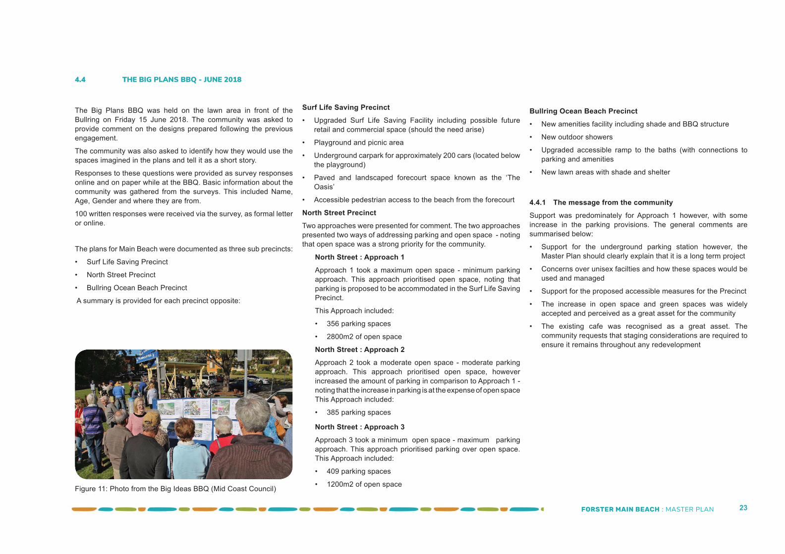
4.4 THE BIG PLANS BBQ - JUNE 2018
The Big Plans BBQ was held on the lawn area in front of the Bullring on Friday 15 June 2018. The community was asked to provide comment on the designs prepared following the previous engagement.
The community was also asked to identify how they would use the spaces imagined in the plans and tell it as a short story.
Responses to these questions were provided as survey responses online and on paper while at the BBQ. Basic information about the community was gathered from the surveys. This included Name, Age, Gender and where they are from.
100 written responses were received via the survey, as formal letter or online.
The plans for Main Beach were documented as three sub precincts:
• Surf Life Saving Precinct
• North Street Precinct
• Bullring Ocean Beach Precinct
A summary is provided for each precinct opposite:
Surf Life Saving Precinct• Upgraded Surf Life Saving Facility including possible future
retail and commercial space (should the need arise)
• Playground and picnic area
• Underground carpark for approximately 200 cars (located below the playground)
• Paved and landscaped forecourt space known as the ‘The Oasis’
• Accessible pedestrian access to the beach from the forecourt
North Street PrecinctTwo approaches were presented for comment. The two approaches presented two ways of addressing parking and open space - noting that open space was a strong priority for the community.
Figure 11: Photo from the Big Ideas BBQ (Mid Coast Council)
North Street : Approach 1Approach 1 took a maximum open space - minimum parking approach. This approach prioritised open space, noting that parking is proposed to be accommodated in the Surf Life Saving Precinct.
This Approach included:
• 356 parking spaces
• 2800m2 of open space
North Street : Approach 2Approach 2 took a moderate open space - moderate parking approach. This approach prioritised open space, however increased the amount of parking in comparison to Approach 1 - noting that the increase in parking is at the expense of open spaceThis Approach included:
• 385 parking spaces
Bullring Ocean Beach Precinct • New amenities facility including shade and BBQ structure
• New outdoor showers
• Upgraded accessible ramp to the baths (with connections to parking and amenities
• New lawn areas with shade and shelter
North Street : Approach 3Approach 3 took a minimum open space - maximum parking approach. This approach prioritised parking over open space. This Approach included:
• 409 parking spaces
• 1200m2 of open space
FORSTER MAIN BEACH : MASTER PLAN 24
“These layers present the intent without the distraction of stylistic approaches which may change over time. This
framework is the product of the research, analysis, and the extensive engagement
process undertaken for this project”
FORSTER MAIN BEACH : MASTER PLAN 25
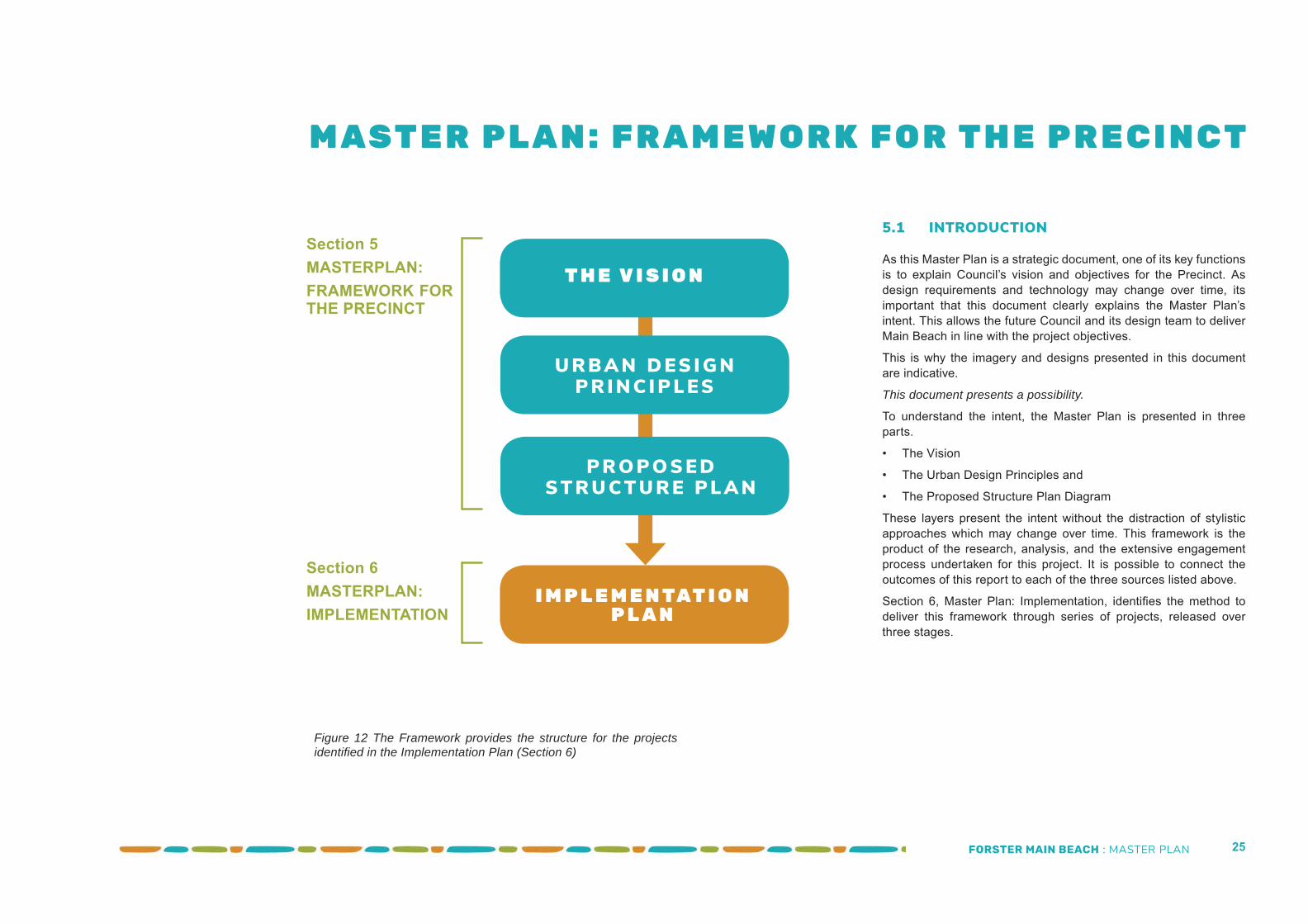
5.1 INTRODUCTION
As this Master Plan is a strategic document, one of its key functions is to explain Council’s vision and objectives for the Precinct. As design requirements and technology may change over time, its important that this document clearly explains the Master Plan’s intent. This allows the future Council and its design team to deliver Main Beach in line with the project objectives.
This is why the imagery and designs presented in this document are indicative.
This document presents a possibility.
To understand the intent, the Master Plan is presented in three parts.
• The Vision
• The Urban Design Principles and
• The Proposed Structure Plan Diagram
These layers present the intent without the distraction of stylistic approaches which may change over time. This framework is the product of the research, analysis, and the extensive engagement process undertaken for this project. It is possible to connect the outcomes of this report to each of the three sources listed above.
Section 6, Master Plan: Implementation, identifi es the method to deliver this framework through series of projects, released over three stages.
M AST E R P L A N : F R A M E W O R K F O R T H E P R E C I N C T
T H E V I S I O N
U R B A N D ES I G NP R I N C I P L ES
P R O P O S E DST R U CT U R E P L A N
I M P L E M E N TAT I O N P L A N
Figure 12 The Framework provides the structure for the projects identifi ed in the Implementation Plan (Section 6)
Section 5MASTERPLAN: FRAMEWORK FOR THE PRECINCT
Section 6MASTERPLAN: IMPLEMENTATION
FORSTER MAIN BEACH : MASTER PLAN 26
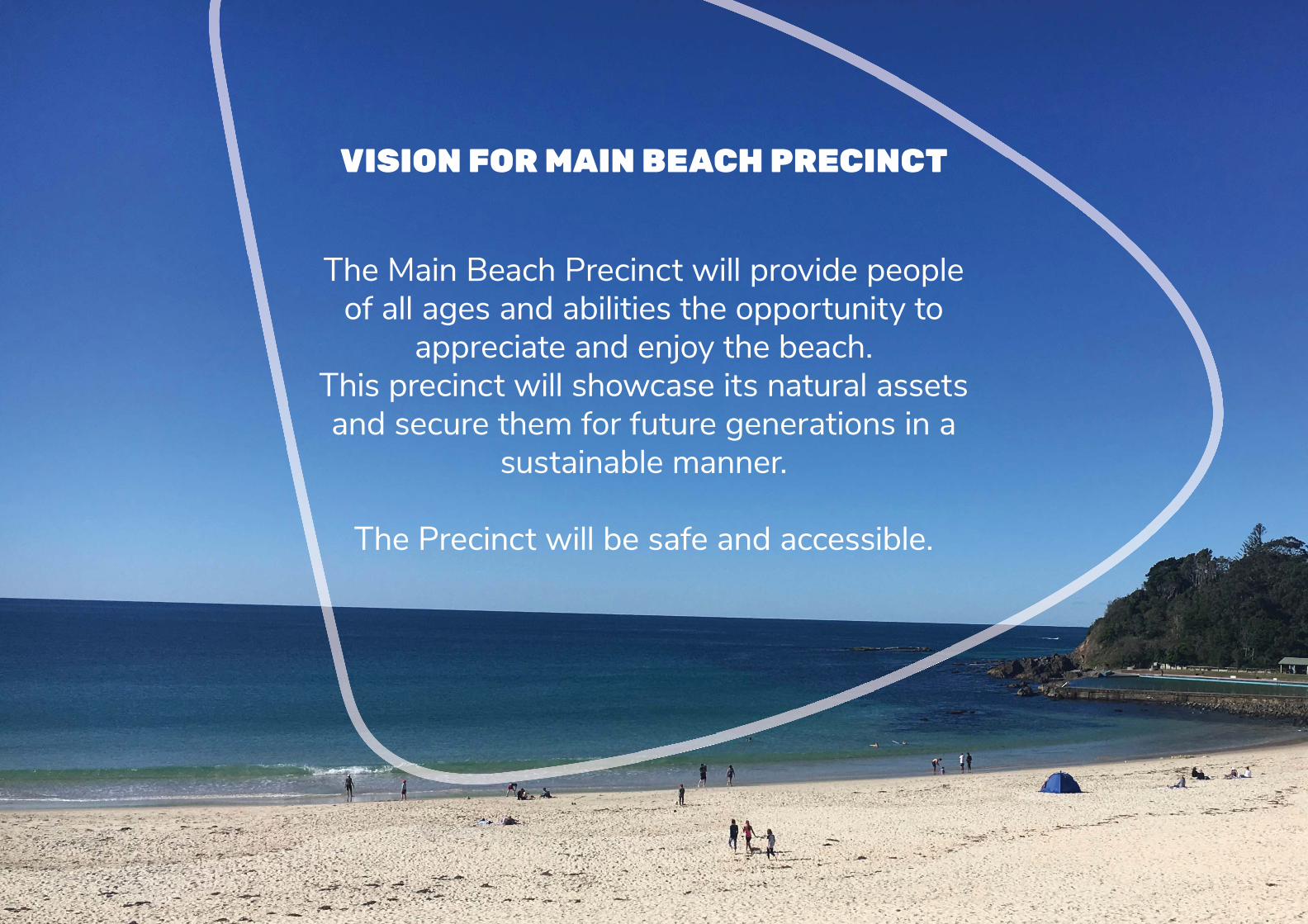
VISION FOR MAIN BEACH PRECINCT
The Main Beach Precinct will provide people of all ages and abilities the opportunity to
appreciate and enjoy the beach. This precinct will showcase its natural assets and secure them for future generations in a
sustainable manner.
The Precinct will be safe and accessible.
FORSTER MAIN BEACH : MASTER PLAN 27
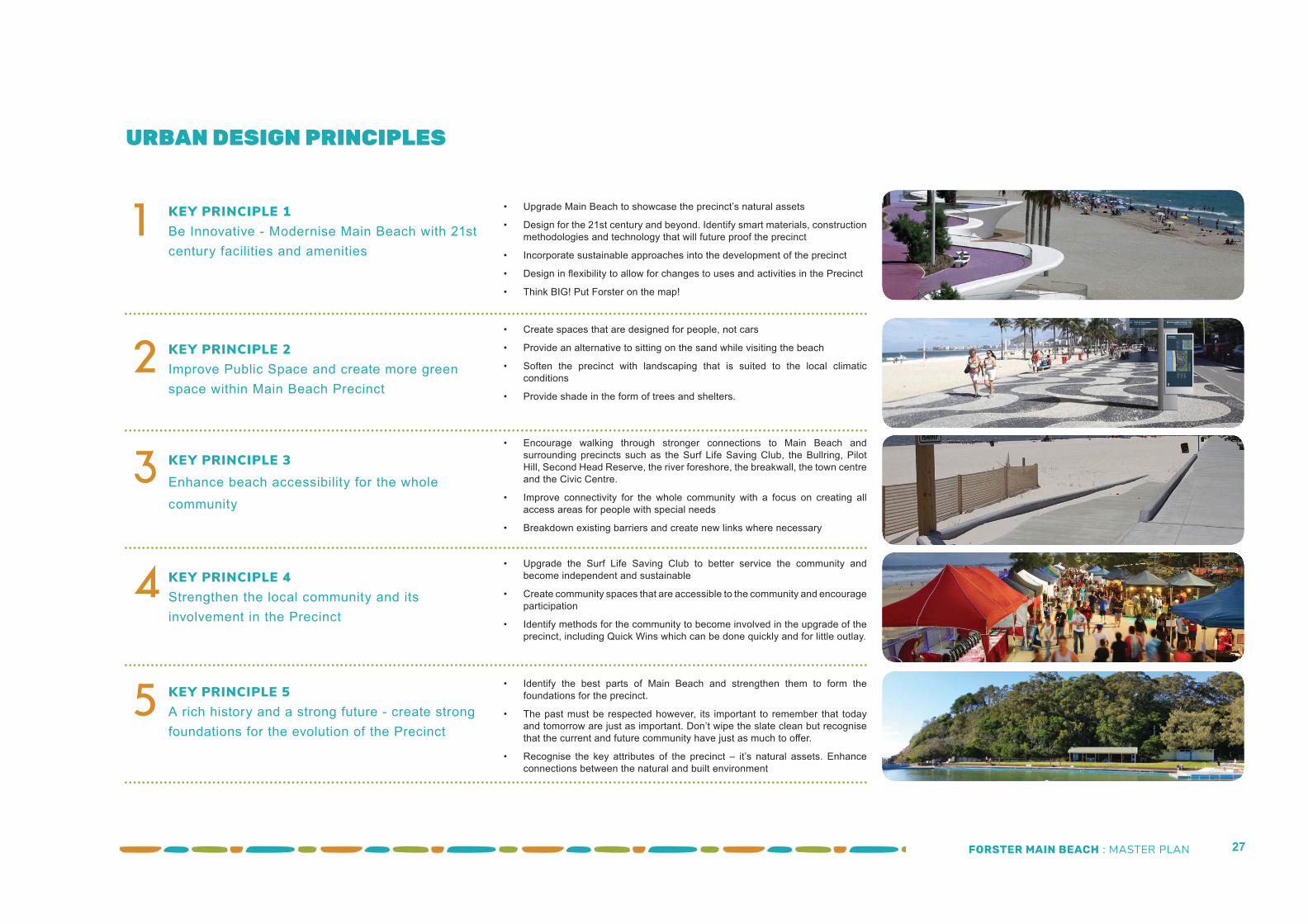
URBAN DESIGN PRINCIPLES
1 KEY PRINCIPLE 1 Be Innovative - Modernise Main Beach with 21st century facilities and amenities
2 KEY PRINCIPLE 2Improve Public Space and create more green space within Main Beach Precinct
3 KEY PRINCIPLE 3Enhance beach accessibility for the whole community
4 KEY PRINCIPLE 4Strengthen the local community and its involvement in the Precinct
5 KEY PRINCIPLE 5A rich history and a strong future - create strong foundations for the evolution of the Precinct
• Upgrade Main Beach to showcase the precinct’s natural assets
• Design for the 21st century and beyond. Identify smart materials, construction methodologies and technology that will future proof the precinct
• Incorporate sustainable approaches into the development of the precinct
• Design in fl exibility to allow for changes to uses and activities in the Precinct
• Think BIG! Put Forster on the map!
• Create spaces that are designed for people, not cars
• Provide an alternative to sitting on the sand while visiting the beach
• Soften the precinct with landscaping that is suited to the local climatic conditions
• Provide shade in the form of trees and shelters.
• Encourage walking through stronger connections to Main Beach and surrounding precincts such as the Surf Life Saving Club, the Bullring, Pilot Hill, Second Head Reserve, the river foreshore, the breakwall, the town centre and the Civic Centre.
• Improve connectivity for the whole community with a focus on creating all access areas for people with special needs
• Breakdown existing barriers and create new links where necessary
• Upgrade the Surf Life Saving Club to better service the community and become independent and sustainable
• Create community spaces that are accessible to the community and encourage participation
• Identify methods for the community to become involved in the upgrade of the precinct, including Quick Wins which can be done quickly and for little outlay.
• Identify the best parts of Main Beach and strengthen them to form the foundations for the precinct.
• The past must be respected however, its important to remember that today and tomorrow are just as important. Don’t wipe the slate clean but recognise that the current and future community have just as much to off er.
• Recognise the key attributes of the precinct – it’s natural assets. Enhance connections between the natural and built environment
FORSTER MAIN BEACH : MASTER PLAN 28
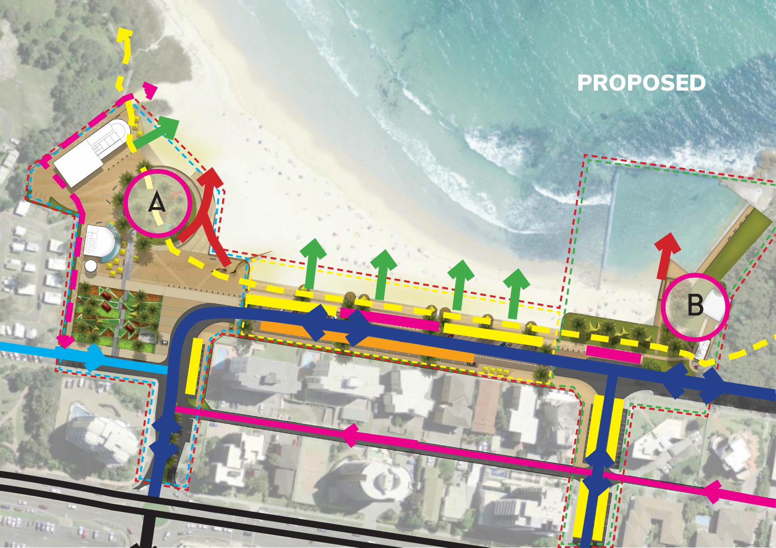
A
B
PROPOSED
FORSTER MAIN BEACH : MASTER PLAN 29
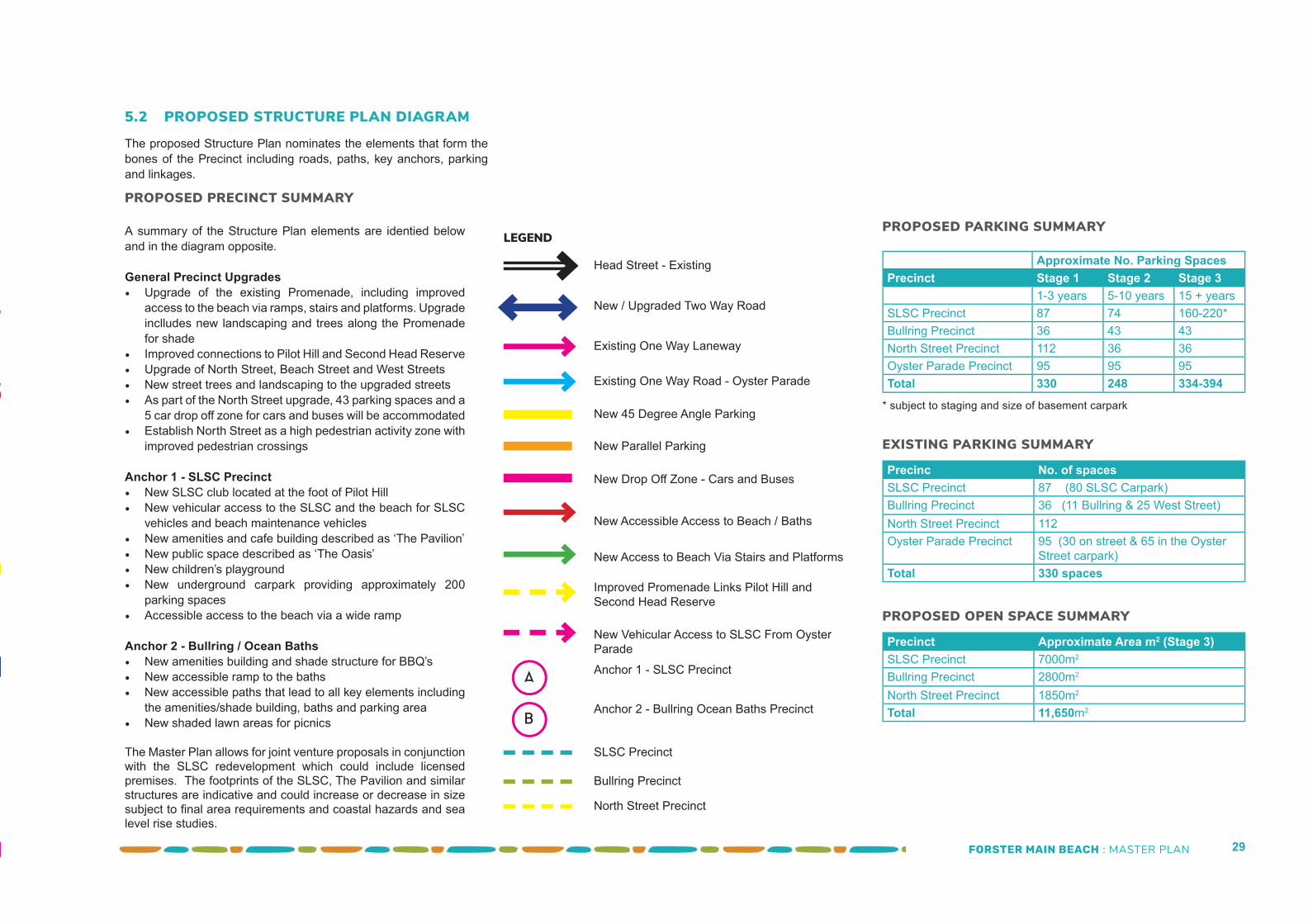
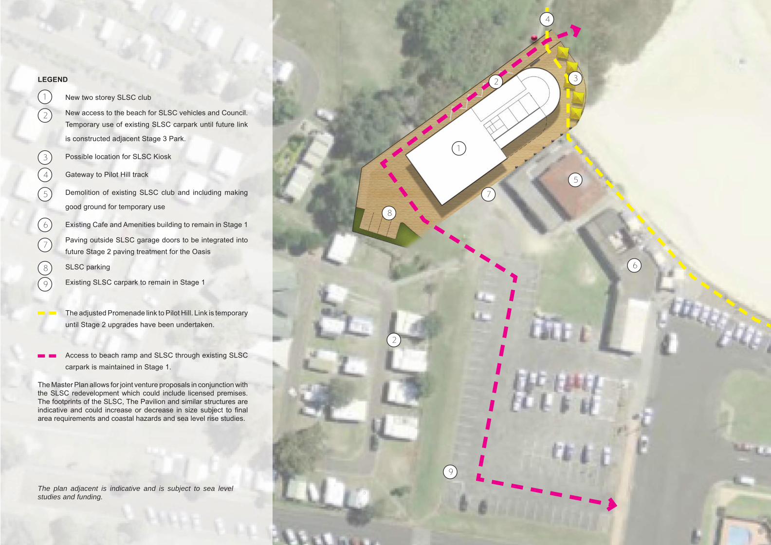
LEGENDA summary of the Structure Plan elements are identied below and in the diagram opposite.
General Precinct Upgrades• Upgrade of the existing Promenade, including improved
access to the beach via ramps, stairs and platforms. Upgrade inclludes new landscaping and trees along the Promenade for shade
• Improved connections to Pilot Hill and Second Head Reserve• Upgrade of North Street, Beach Street and West Streets• New street trees and landscaping to the upgraded streets• As part of the North Street upgrade, 43 parking spaces and a
5 car drop off zone for cars and buses will be accommodated• Establish North Street as a high pedestrian activity zone with
improved pedestrian crossings
Anchor 1 - SLSC Precinct• New SLSC club located at the foot of Pilot Hill• New vehicular access to the SLSC and the beach for SLSC
vehicles and beach maintenance vehicles• New amenities and cafe building described as ‘The Pavilion’• New public space described as ‘The Oasis’• New children’s playground • New underground carpark providing approximately 200
parking spaces• Accessible access to the beach via a wide ramp
Anchor 2 - Bullring / Ocean Baths• New amenities building and shade structure for BBQ’s• New accessible ramp to the baths• New accessible paths that lead to all key elements including
the amenities/shade building, baths and parking area• New shaded lawn areas for picnics
A
B
Approximate No. Parking SpacesPrecinct Stage 1 Stage 2 Stage 3
1-3 years 5-10 years 15 + yearsSLSC Precinct 87 74 160-220*Bullring Precinct 36 43 43North Street Precinct 112 36 36Oyster Parade Precinct 95 95 95Total 330 248 334-394
PROPOSED PARKING SUMMARY
EXISTING PARKING SUMMARY
5.2 PROPOSED STRUCTURE PLAN DIAGRAM
PROPOSED PRECINCT SUMMARY
The proposed Structure Plan nominates the elements that form the bones of the Precinct including roads, paths, key anchors, parking and linkages.
Head Street - Existing
New / Upgraded Two Way Road
Existing One Way Laneway
Existing One Way Road - Oyster Parade
New 45 Degree Angle Parking
New Parallel Parking
New Drop Off Zone - Cars and Buses
New Accessible Access to Beach / Baths
New Access to Beach Via Stairs and Platforms
Improved Promenade Links Pilot Hill and Second Head Reserve
Anchor 1 - SLSC Precinct
Anchor 2 - Bullring Ocean Baths Precinct
New Vehicular Access to SLSC From Oyster Parade
Precinc No. of spacesSLSC Precinct 87 (80 SLSC Carpark)Bullring Precinct 36 (11 Bullring & 25 West Street)North Street Precinct 112Oyster Parade Precinct 95 (30 on street & 65 in the Oyster
Street carpark)Total 330 spaces
PROPOSED OPEN SPACE SUMMARY
Precinct Approximate Area m2 (Stage 3)SLSC Precinct 7000m2
Bullring Precinct 2800m2
North Street Precinct 1850m2
Total 11,650m2
* subject to staging and size of basement carpark
SLSC Precinct
Bullring Precinct
North Street Precinct
The Master Plan allows for joint venture proposals in conjunction with the SLSC redevelopment which could include licensed premises. The footprints of the SLSC, The Pavilion and similar structures are indicative and could increase or decrease in size subject to fi nal area requirements and coastal hazards and sea level rise studies.
FORSTER MAIN BEACH : MASTER PLAN 30
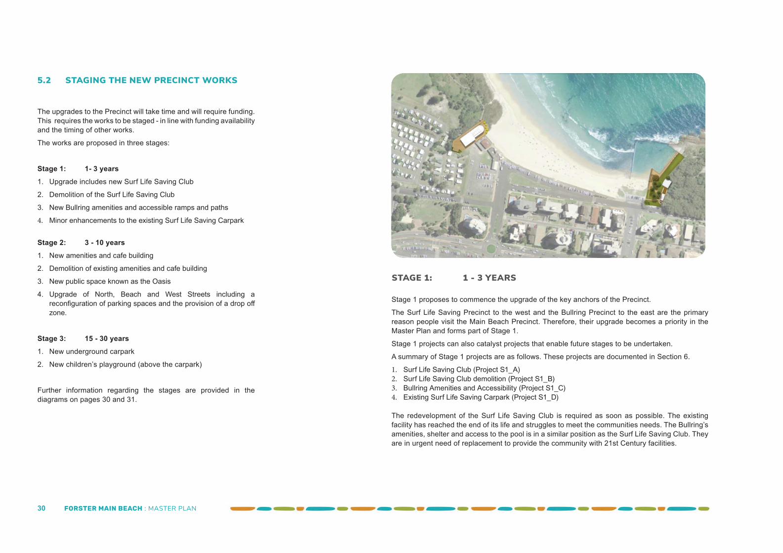
STAGE 1: 1 - 3 YEARS
5.2 STAGING THE NEW PRECINCT WORKS
The upgrades to the Precinct will take time and will require funding. This requires the works to be staged - in line with funding availability and the timing of other works.
The works are proposed in three stages:
Stage 1: 1- 3 years1. Upgrade includes new Surf Life Saving Club
2. Demolition of the Surf Life Saving Club
3. New Bullring amenities and accessible ramps and paths
4. Minor enhancements to the existing Surf Life Saving Carpark
Stage 2: 3 - 10 years1. New amenities and cafe building
2. Demolition of existing amenities and cafe building
3. New public space known as the Oasis
4. Upgrade of North, Beach and West Streets including a reconfi guration of parking spaces and the provision of a drop off zone.
Stage 3: 15 - 30 years1. New underground carpark
2. New children’s playground (above the carpark)
Further information regarding the stages are provided in the diagrams on pages 30 and 31.
Stage 1 proposes to commence the upgrade of the key anchors of the Precinct.
The Surf Life Saving Precinct to the west and the Bullring Precinct to the east are the primary reason people visit the Main Beach Precinct. Therefore, their upgrade becomes a priority in the Master Plan and forms part of Stage 1.
Stage 1 projects can also catalyst projects that enable future stages to be undertaken.
A summary of Stage 1 projects are as follows. These projects are documented in Section 6.
1. Surf Life Saving Club (Project S1_A)2. Surf Life Saving Club demolition (Project S1_B)3. Bullring Amenities and Accessibility (Project S1_C)4. Existing Surf Life Saving Carpark (Project S1_D)
The redevelopment of the Surf Life Saving Club is required as soon as possible. The existing facility has reached the end of its life and struggles to meet the communities needs. The Bullring’s amenities, shelter and access to the pool is in a similar position as the Surf Life Saving Club. They are in urgent need of replacement to provide the community with 21st Century facilities.
FORSTER MAIN BEACH : MASTER PLAN 31
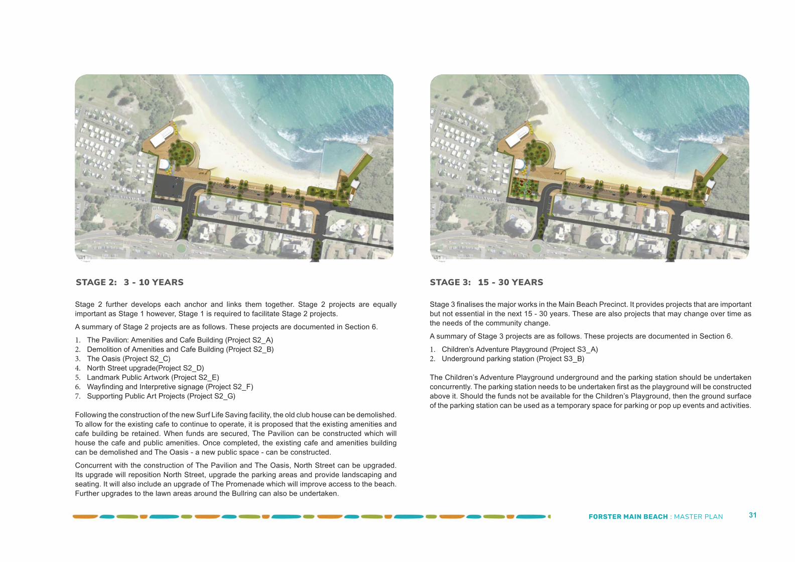
STAGE 3: 15 - 30 YEARSSTAGE 2: 3 - 10 YEARS
Stage 2 further develops each anchor and links them together. Stage 2 projects are equally important as Stage 1 however, Stage 1 is required to facilitate Stage 2 projects.
A summary of Stage 2 projects are as follows. These projects are documented in Section 6.
1. The Pavilion: Amenities and Cafe Building (Project S2_A)2. Demolition of Amenities and Cafe Building (Project S2_B)3. The Oasis (Project S2_C)4. North Street upgrade(Project S2_D)5. Landmark Public Artwork (Project S2_E)6. Wayfi nding and Interpretive signage (Project S2_F)7. Supporting Public Art Projects (Project S2_G)
Following the construction of the new Surf Life Saving facility, the old club house can be demolished. To allow for the existing cafe to continue to operate, it is proposed that the existing amenities and cafe building be retained. When funds are secured, The Pavilion can be constructed which will house the cafe and public amenities. Once completed, the existing cafe and amenities building can be demolished and The Oasis - a new public space - can be constructed.
Concurrent with the construction of The Pavilion and The Oasis, North Street can be upgraded. Its upgrade will reposition North Street, upgrade the parking areas and provide landscaping and seating. It will also include an upgrade of The Promenade which will improve access to the beach. Further upgrades to the lawn areas around the Bullring can also be undertaken.
Stage 3 fi nalises the major works in the Main Beach Precinct. It provides projects that are important but not essential in the next 15 - 30 years. These are also projects that may change over time as the needs of the community change.
A summary of Stage 3 projects are as follows. These projects are documented in Section 6.
1. Children’s Adventure Playground (Project S3_A)2. Underground parking station (Project S3_B)
The Children’s Adventure Playground underground and the parking station should be undertaken concurrently. The parking station needs to be undertaken fi rst as the playground will be constructed above it. Should the funds not be available for the Children’s Playground, then the ground surface of the parking station can be used as a temporary space for parking or pop up events and activities.
FORSTER MAIN BEACH : MASTER PLAN 32
“The revitalisation of Main Beach is a
signifi cant project and will require careful
planning, design and management in its
delivery. Funding and grants form an important
part of that process”
FORSTER MAIN BEACH : MASTER PLAN 33
6.1 INTRODUCTION
The revitalisation of Main Beach is a signifi cant project and will require careful planning, design and management in its delivery. Funding and grants form an important part of that process. This Master Plan provides the basis for the delivery of projects within the precinct and provides information for grant applications.The Implementation Plan assists Council, stakeholders and the community to deliver the Structure Plan proposed in Section 5. This plan is a guide and the staging of each project can be varied to suit as funding and opportunities arise.
6.2 INDICATIVE STAGING
6.2.1 Indicative Staging
As identifi ed in Section 5, the Master Plan is presented in three stages. Within each stage are a series of projects. Breaking the Master Plan into smaller projects will assist with the delivery of the Master Plan. Staging will be subject to future investigations, funding and priorities.
The Staging is defi ned as follows:
Stage 1Stage 1 projects are generally catalyst projects which enables Stage 2 and 3 projects to be undertaken.
Stage 1 includes important infrastructure items such as the new Surf Life Saving Club (SLSC), the upgrade of the Bullring Ocean Baths facilities and the demolition of the existing SLSC. This infrastructure will reinforce the key anchors of the Precinct.
Timeframe: 1 - 3 years.
Stage 2Stage 2 comprises medium term projects. These projects require Stage 1 projects to be undertaken fi rst.
A Stage 2 project may be brought forward to Stage 1 if the
circumstances and funding allow. Stage 2 projects include the new amenities and cafe within the SLSC Precinct, public plaza upgrade, upgrade of North Street and the Promenade and the drop area and landscaping associated with the Bullring.
Timeframe: 3 - 10 years
Stage 3Stage 3 comprises long term projects. These projects require Stage 1 and 2 projects to be undertaken fi rst.
A Stage 3 project may be brought forward to Stage 1 or Stage 2 if the circumstances allow. Stage 3 projects include the new public underground carpark and playground.
Timeframe: 15 - 30 years
6.2.2 PrioritiesWithin each stage, priorities have been identifi ed. Three priority levels have been nominated.
The priorities are defi ned as follows:
Priority 1• A project that is required to be completed prior to a Priority 2 or
3 project and/or• A project that is necessary to the proper functioning of the
Precinct and/or• A project that is needed immediately by stakeholders or the
community.
Priority 2 • A project that supports a Priority 1 project and assists in its
function and /or• A project that is not essential to the Precinct but is desirable.
Priority 3• A project that is not necessary for the proper function of the
Precinct and/or• A project that may be diffi cult to fund and/or• A project that is reliant on infrastructure that is not currently
available.
6.3 PROJECT DATA SHEETS
As Forster Main Beach is developed, it is proposed that Council will call on these data sheets. The data sheets will assist Council in the development of consultant briefs, the allocation of suitable funds and engaging consultants. The data sheets will also inform the detailed design of its public spaces.
It will be critical for Council to brief architects, landscape architects, engineers and artists who have the ability and the creativity to design the next evolution of Forster Main Beach.
The data sheets include the following information about each project within Forster Main Beach:
• Project Intent• Location• Project Stage• Considerations
Refer to the Stage 1 Master Plan (page 34 & 35), Stage 2 Master Plan (page 44 & 45) and Stage 3 (page 52 & 53) for the location of each of the projects identifi ed on the following pages.
M AST E R P L A N : I M P L E M E N TAT I O N
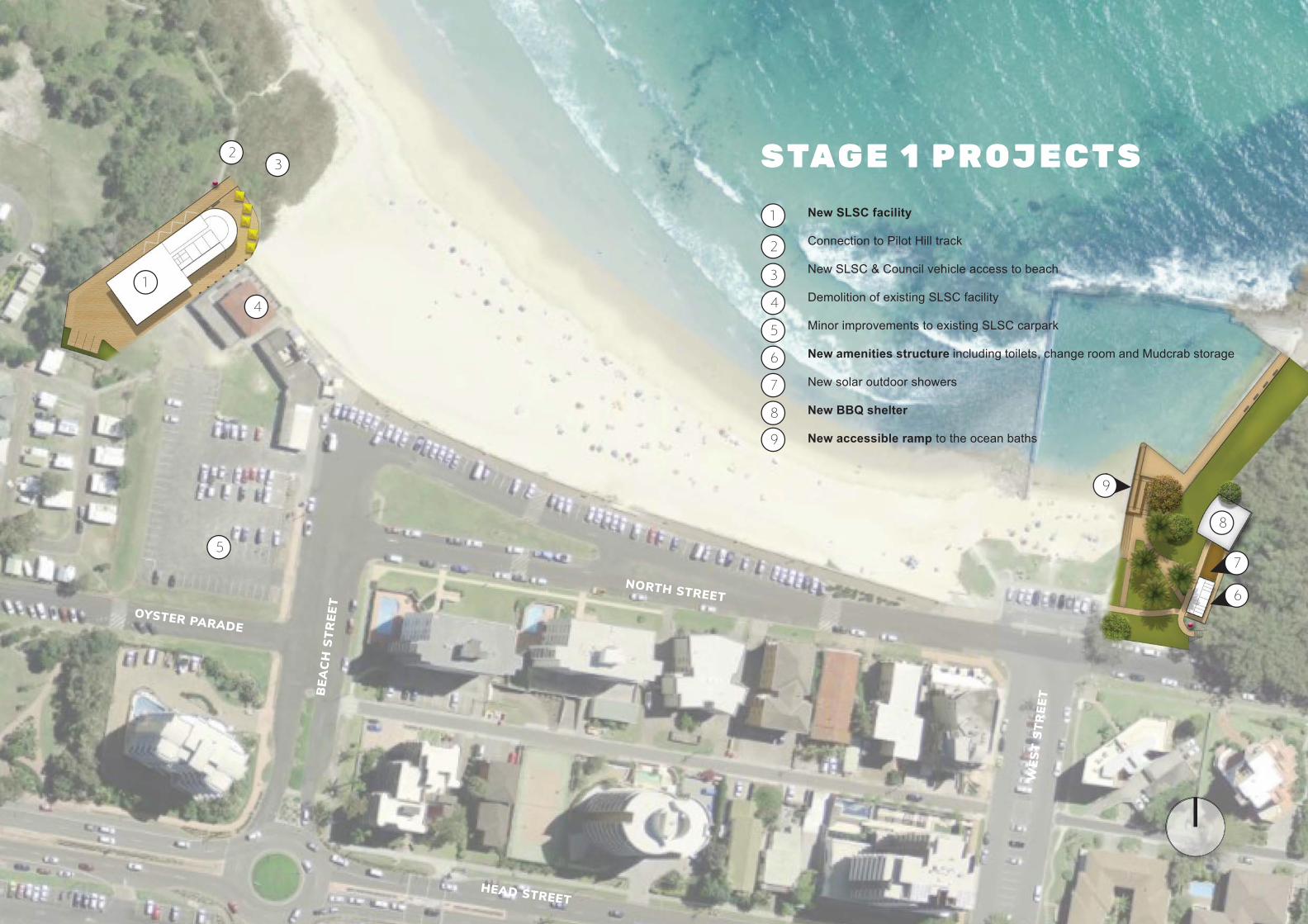
FORSTER MAIN BEACH : MASTER PLAN 34
NORTH STREETOYSTER PARADE
BEA
CH
STR
EET
WES
T ST
REE
T
HEAD STREET
1
32
8
4
5
New SLSC facility
Connection to Pilot Hill track
New SLSC & Council vehicle access to beach
Demolition of existing SLSC facility
Minor improvements to existing SLSC carpark
New amenities structure including toilets, change room and Mudcrab storage
New solar outdoor showers
New BBQ shelter
New accessible ramp to the ocean baths
1
2
3
4
5
6
7
8
S TAG E 1 P R O J E C T S
9
7
6
9
FORSTER MAIN BEACH : MASTER PLAN 35
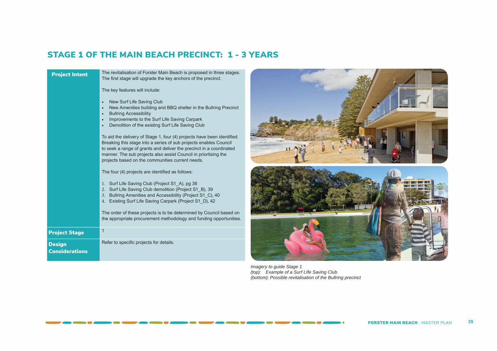
Project Intent The revitalisation of Forster Main Beach is proposed in three stages. The fi rst stage will upgrade the key anchors of the precinct.
The key features will include:
• New Surf Life Saving Club• New Amenities building and BBQ shelter in the Bullring Precinct• Bullring Accessibility• Improvements to the Surf Life Saving Carpark• Demolition of the existing Surf Life Saving Club
To aid the delivery of Stage 1, four (4) projects have been identifi ed. Breaking this stage into a series of sub projects enables Council to seek a range of grants and deliver the precinct in a coordinated manner. The sub projects also assist Council in priortising the projects based on the communities current needs.
The four (4) projects are identifi ed as follows:
1. Surf Life Saving Club (Project S1_A), pg 362. Surf Life Saving Club demolition (Project S1_B), 393. Bullring Amenities and Accessibility (Project S1_C), 404. Existing Surf Life Saving Carpark (Project S1_D), 42
The order of these projects is to be determined by Council based on the appropriate procurement methodology and funding opportunities.
Project Stage 1
Design Considerations
Refer to specifi c projects for details.
STAGE 1 OF THE MAIN BEACH PRECINCT: 1 - 3 YEARS
Imagery to guide Stage 1(top): Example of a Surf LIfe Saving Club(bottom): Possible revitalisation of the Bullring precinct
FORSTER MAIN BEACH : MASTER PLAN 36
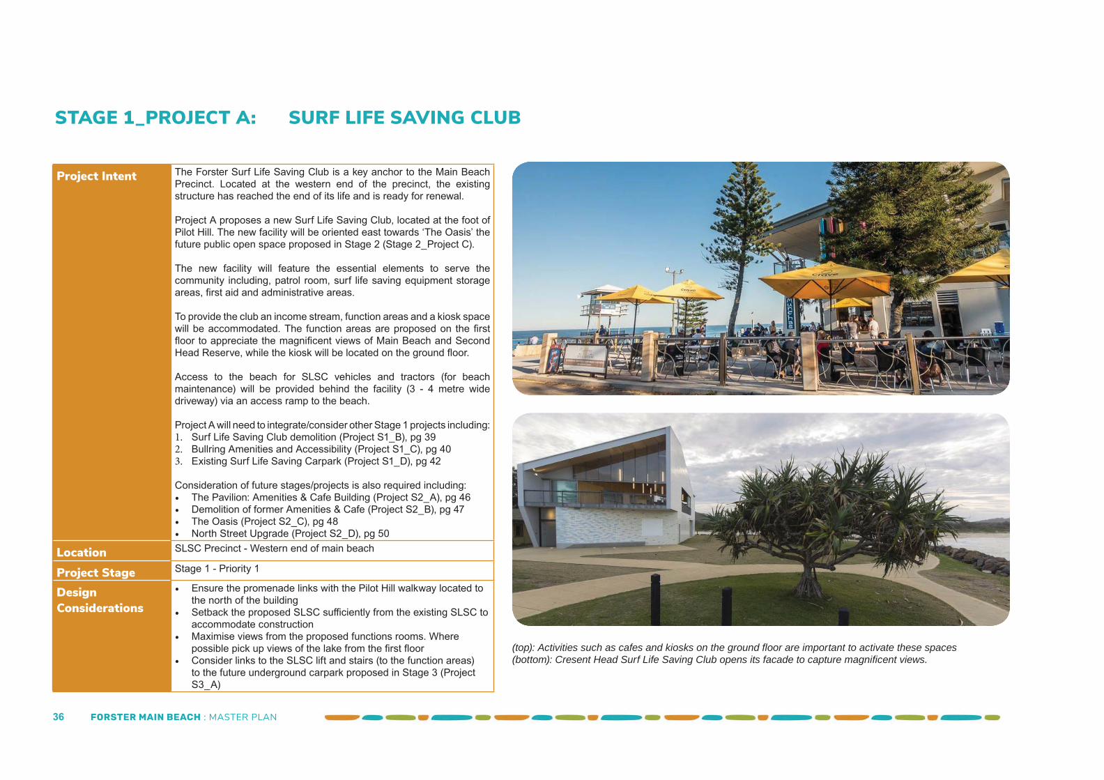
STAGE 1_PROJECT A: SURF LIFE SAVING CLUB
Project Intent The Forster Surf Life Saving Club is a key anchor to the Main Beach Precinct. Located at the western end of the precinct, the existing structure has reached the end of its life and is ready for renewal.
Project A proposes a new Surf Life Saving Club, located at the foot of Pilot Hill. The new facility will be oriented east towards ‘The Oasis’ the future public open space proposed in Stage 2 (Stage 2_Project C).
The new facility will feature the essential elements to serve the community including, patrol room, surf life saving equipment storage areas, fi rst aid and administrative areas.
To provide the club an income stream, function areas and a kiosk space will be accommodated. The function areas are proposed on the fi rst fl oor to appreciate the magnifi cent views of Main Beach and Second Head Reserve, while the kiosk will be located on the ground fl oor.
Access to the beach for SLSC vehicles and tractors (for beach maintenance) will be provided behind the facility (3 - 4 metre wide driveway) via an access ramp to the beach.
Project A will need to integrate/consider other Stage 1 projects including:1. Surf Life Saving Club demolition (Project S1_B), pg 392. Bullring Amenities and Accessibility (Project S1_C), pg 403. Existing Surf Life Saving Carpark (Project S1_D), pg 42
Consideration of future stages/projects is also required including:• The Pavilion: Amenities & Cafe Building (Project S2_A), pg 46• Demolition of former Amenities & Cafe (Project S2_B), pg 47• The Oasis (Project S2_C), pg 48• North Street Upgrade (Project S2_D), pg 50
Location SLSC Precinct - Western end of main beach
Project Stage Stage 1 - Priority 1
Design Considerations
• Ensure the promenade links with the Pilot Hill walkway located to the north of the building
• Setback the proposed SLSC suffi ciently from the existing SLSC to accommodate construction
• Maximise views from the proposed functions rooms. Where possible pick up views of the lake from the fi rst fl oor
• Consider links to the SLSC lift and stairs (to the function areas) to the future underground carpark proposed in Stage 3 (Project S3_A)
(top): Activities such as cafes and kiosks on the ground fl oor are important to activate these spaces(bottom): Cresent Head Surf Life Saving Club opens its facade to capture magnifi cent views.
FORSTER MAIN BEACH : MASTER PLAN 37
1
3
4
5
2
2
6
7
8
New two storey SLSC club
New access to the beach for SLSC vehicles and Council. Temporary use of existing SLSC carpark until future link
is constructed adjacent Stage 3 Park.
Possible location for SLSC Kiosk
Gateway to Pilot Hill track
Demolition of existing SLSC club and including making
good ground for temporary use
Existing Cafe and Amenities building to remain in Stage 1
Paving outside SLSC garage doors to be integrated into future Stage 2 paving treatment for the Oasis
SLSC parking
Existing SLSC carpark to remain in Stage 1
The adjusted Promenade link to Pilot Hill. Link is temporary until Stage 2 upgrades have been undertaken.
Access to beach ramp and SLSC through existing SLSC carpark is maintained in Stage 1.
1
2
3
4
5
6
7
8
LEGEND
9
9
The plan adjacent is indicative and is subject to sea level studies and funding.
The Master Plan allows for joint venture proposals in conjunction with the SLSC redevelopment which could include licensed premises. The footprints of the SLSC, The Pavilion and similar structures are indicative and could increase or decrease in size subject to fi nal area requirements and coastal hazards and sea level rise studies.
FORSTER MAIN BEACH : MASTER PLAN 38
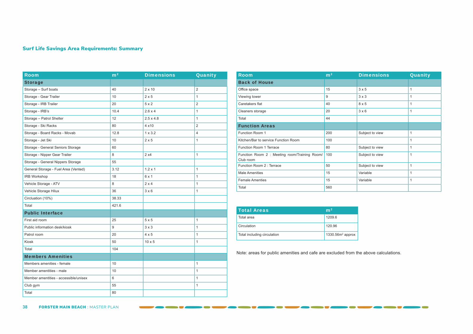
Room m2 Dimensions QuanityStorageStorage – Surf boats 40 2 x 10 2
Storage - Gear Trailer 10 2 x 5 1
Storage - IRB Trailer 20 5 x 2 2
Storage - IRB’s 10.4 2.6 x 4 1
Storage – Patrol Shelter 12 2.5 x 4.8 1
Storage - Ski Racks 80 4 x10 2
Storage - Board Racks - Movab 12.8 1 x 3.2 4
Storage - Jet Ski 10 2 x 5 1
Storage - General Seniors Storage 60
Storage - Nipper Gear Trailer 8 2 x4 1
Storage - General Nippers Storage 55
General Storage - Fuel Area (Vented) 3.12 1.2 x 1 1
IRB Workshop 18 6 x 1 1
Vehicle Storage - ATV 8 2 x 4 1
Vehicle Storage Hilux 36 3 x 6 1
Circluation (10%) 38.33
Total 421.6
Public InterfaceFirst aid room 25 5 x 5 1
Public information desk/kiosk 9 3 x 3 1
Patrol room 20 4 x 5 1
Kiosk 50 10 x 5 1
Total 104
Members AmenitiesMembers amenities - female 10 1
Member amentities - male 10 1
Member amentities - accessible/unisex 6 1
Club gym 55 1
Total 80
Room m2 Dimensions QuanityBack of HouseOffi ce space 15 3 x 5 1
Viewing tower 9 3 x 3 1
Caretakers fl at 40 8 x 5 1
Cleaners storage 20 3 x 6 1
Total 44
Function AreasFunction Room 1 200 Subject to view 1
Kitchen/Bar to service Function Room 100 1
Function Room 1 Terrace 80 Subject to view 1
Function Room 2 : Meeting room/Training Room/Club room
100 Subject to view 1
Function Room 2 : Terrace 50 Subject to view 1
Male Amenities 15 Variable 1
Female Amenties 15 Variable 1
Total 560
Total Areas m2
Total area 1209.6
Circulation 120.96
Total including circulation 1330.56m2 approx
Surf Life Savings Area Requirements: Summary
Note: areas for public amenities and cafe are excluded from the above calculations.
FORSTER MAIN BEACH : MASTER PLAN 39
STAGE 1_PROJECT B: DEMOLITION OF EXISTING SURF LIFE SAVING CLUB
Project Intent Following the construction of the new Surf Life Saving Club, the former facility can be demolished. Its demolition will open up access and views for the new surf club.
Until Stage 2 works can be undertaken, the footprint of the former club will need to be ‘made good’ to create a safe but temporary public space. This space can be used to ‘warm up’ the site and prepare the community for the future activities coming to this space.
The space could be converted into a pop up public space by:• installing a deck or astro turf over the former footprint • using potted trees and plants to soften the space• place deck chairs, tables and umbrellas for pop up events• power and water for food trucks.
Project B will need to integrate with other Stage 1 projects including:• Surf Life Saving Club (Project S1_A), pg 36• Bullring Amenities and Accessibility (Project S1_C), pg 40
Consideration of future stages/projects is also required including:• The Pavilion: Amenities & Cafe Building (Project S2_A) pg 46• Demolition of existing Amenities & Cafe (Project S2_B) pg 47• The Oasis: Public Open Space (Project S2_C) pg 48• North Street Precinct (Project S2_D) pg 50
Location SLSC Precinct - Western end of main beach
Project Stage Stage 1 - Priority 2
Design Considerations
• Ensure The Promenade temporarily links with the Pilot Hill walkway located to the north of the building
• Provide power and water for food trucks• Ensure the area is made safe following the buildings demolition -
until the Oasis is constructed (Project S2_C)
Imagery to guide Stage 1(top): The Surf Life Saving building behind the cafe/amenities building to be demolished.(bottom): Example of a pop bar/cafe and beach which could be created on the former SLSC site. Example shown is the Lizzmonade Brooklyn Pop-Up Pool located in Brooklyn Bridge Park.
FORSTER MAIN BEACH : MASTER PLAN 40
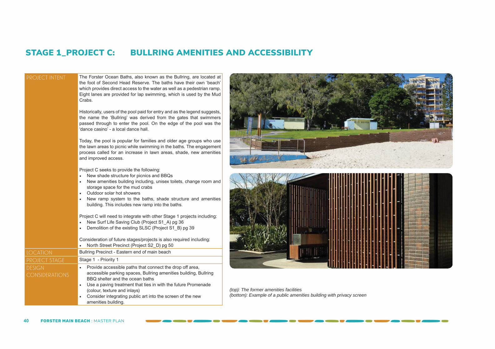
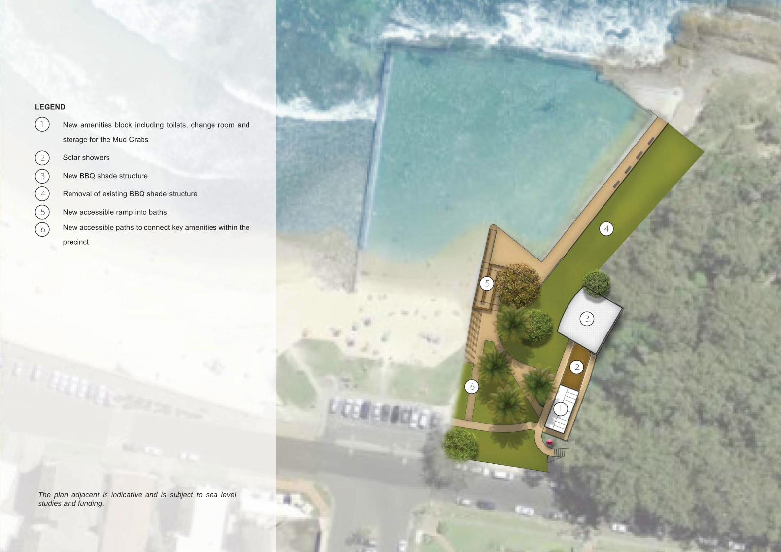
STAGE 1_PROJECT C: BULLRING AMENITIES AND ACCESSIBILITY
Project Intent The Forster Ocean Baths, also known as the Bullring, are located at the foot of Second Head Reserve. The baths have their own ‘beach’ which provides direct access to the water as well as a pedestrian ramp. Eight lanes are provided for lap swimming, which is used by the Mud Crabs.
Historically, users of the pool paid for entry and as the legend suggests, the name the ‘Bullring’ was derived from the gates that swimmers passed through to enter the pool. On the edge of the pool was the ‘dance casino’ - a local dance hall.
Today, the pool is popular for families and older age groups who use the lawn areas to picnic while swimming in the baths. The engagement process called for an increase in lawn areas, shade, new amenities and improved access.
Project C seeks to provide the following:• New shade structure for picnics and BBQs• New amenities building including, unisex toilets, change room and
storage space for the mud crabs• Outdoor solar hot showers• New ramp system to the baths, shade structure and amenities
building. This includes new ramp into the baths.
Project C will need to integrate with other Stage 1 projects including:• New Surf Life Saving Club (Project S1_A) pg 36• Demolition of the existing SLSC (Project S1_B) pg 39
Consideration of future stages/projects is also required including:• North Street Precinct (Project S2_D) pg 50
Location Bullring Precinct - Eastern end of main beach
Project Stage Stage 1 - Priority 1
Design Considerations
• Provide accessible paths that connect the drop off area, accessible parking spaces, Bullring amenities building, Bullring BBQ shelter and the ocean baths
• Use a paving treatment that ties in with the future Promenade (colour, texture and inlays)
• Consider integrating public art into the screen of the new amenities building.
(top): The former amenities facilities (bottom): Example of a public amenities building with privacy screen
FORSTER MAIN BEACH : MASTER PLAN 41
1
2
3
4
5
New amenities block including toilets, change room and
storage for the Mud Crabs
Solar showers
New BBQ shade structure
Removal of existing BBQ shade structure
New accessible ramp into baths
New accessible paths to connect key amenities within the
precinct
1
2
3
4
5
6
LEGEND
6
The plan adjacent is indicative and is subject to sea level studies and funding.
FORSTER MAIN BEACH : MASTER PLAN 42
STAGE 1_PROJECT D: EXISTING SLSC CARPARK
Project Intent The existing SLSC carpark is located to the south of the existing SLSC and amenities cafe building. The carpark currently accommodates approximately 80 parking spaces.
The carpark is identifi ed as the site of a future underground carpark. Therefore, a major upgrade of this carpark is not proposed. Opportunities to soften the carpark are proposed as temporary measures. These measures could include:• Potted planters • Garden beds to the edges• New signage to direct people to the diff erent activities within the
precinct
Project D will need to integrate with other Stage 1 projects including:• Surf Life Saving Club (Project S1_A) pg 36• Demolition of the existing SLSC (Project S1_B) pg 39
Consideration of future stages/projects is also required including:• The Pavilion: Amenities & Cafe Building (Project S2_A) pg 46• Demolition of former Amenities & Cafe (Project S2_B) pg 47• The Oasis (Project S2_C) pg 48• North Street Precinct (Project S2_D) pg 50
Location SLSC Precinct - Western end of main beach
Project Stage Stage 1 - Priority 3
Design Considerations
• Maintain carparking numbers where practical . • Ensure clear access is provided for the SLSC vehicles and
equipment
(top): Existing SLSC carpark (credit: TDP 2017)(bottom): Example of temporarily greening a carpark
FORSTER MAIN BEACH : MASTER PLAN 43
FORSTER MAIN BEACH : MASTER PLAN 44
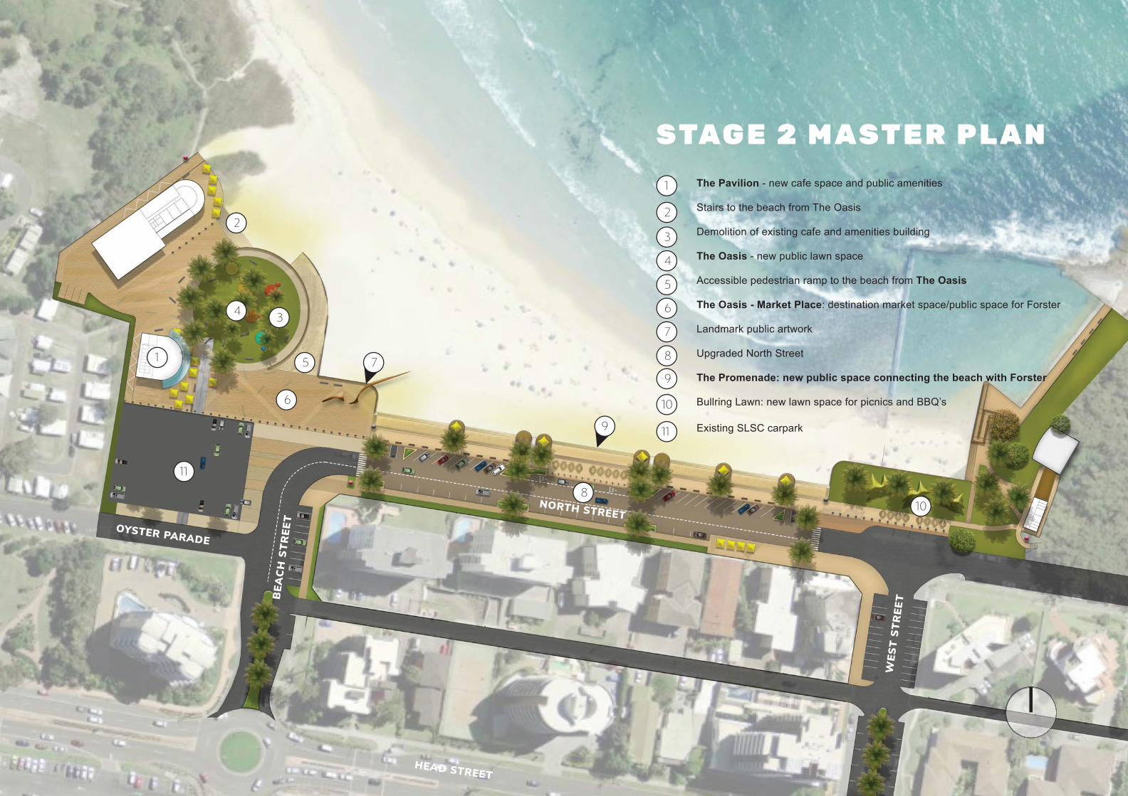
NORTH STREETOYSTER PARADE
BEA
CH
STR
EET
WES
T ST
REE
T
HEAD STREET
1
2
3
8
7
The Pavilion - new cafe space and public amenities
Stairs to the beach from The Oasis
Demolition of existing cafe and amenities building
The Oasis - new public lawn space
Accessible pedestrian ramp to the beach from The Oasis
The Oasis - Market Place: destination market space/public space for Forster
Landmark public artwork
Upgraded North Street
The Promenade: new public space connecting the beach with Forster
Bullring Lawn: new lawn space for picnics and BBQ’s
Existing SLSC carpark
1
2
3
4
5
6
7
8
STAG E 2 M AST E R P L A N
9
4
5
6
9
10
10
11
11
FORSTER MAIN BEACH : MASTER PLAN 45
Project Intent The revitalisation of Forster Main Beach is proposed in three stages. The second stage will tie the precinct together with key public domain works.
The key features will include:
• A new amenities and cafe building• The demolition of the existing amenities, cafe (Beach Bums) and
storage building• The Oasis - a new public space• New Promenade which connects the new SLSC precinct and the
Bullring• Improved access to the beach from the Promenade• North Street upgrade which integrates with The Oasis.
To aid the delivery of Stage 2, seven (7) projects have been identifi ed. Breaking this stage into a series of sub projects enables Council to seek a range of grants and deliver the precinct in a coordinated manner. The sub projects also assist Council in prioritising the projects based on the communities current needs.
The seven (7) projects are identifi ed as follows:
1. The Pavilion: Amenities and Cafe Building (Project S2_A)2. Demolition of Amenities and Cafe Building (Project S2_B)3. The Oasis (Project S2_C)4. North Street upgrade(Project S2_D)5. Landmark Public Artwork (Project S2_E)6. Wayfi nding and Interpretive signage (Project S2_F)7. Supporting Public Art Projects (Project S2_G)
The order of these projects to be determined by Council based on the appropriate procurement methodology and funding opportunities.
Project Stage 2
Design Considerations
Refer to specifi c projects for details.
STAGE 2 OF THE MAIN BEACH PRECINCT: 3 - 10 YEARS
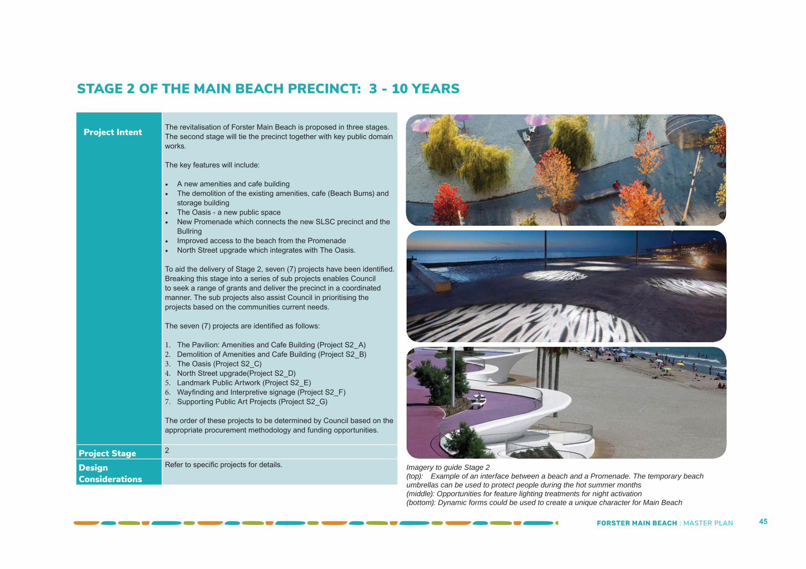
Imagery to guide Stage 2(top): Example of an interface between a beach and a Promenade. The temporary beach umbrellas can be used to protect people during the hot summer months(middle): Opportunities for feature lighting treatments for night activation(bottom): Dynamic forms could be used to create a unique character for Main Beach
FORSTER MAIN BEACH : MASTER PLAN 46
STAGE 2_PROJECT A: THE PAVILION: AMENITIES AND CAFE BUILDING
Project Intent The completion of the Surf Life Saving Club will be important milestone for this precinct. The next step will be the development of the amenities and cafe building to the south-east of the new club.
The Pavilion, will provide new amenities and change rooms for the western end of the beach. Space for a new cafe is to be incorporated into the building. Seating for cafe will wrap around the building - fronting the beach, the proposed public open space (The Oasis - Stage 2) and the proposed children’s playground (Stage 3).
Project A will need to integrate with other Stage 2 projects including:• Demolition of the existing amenities/cafe building (Project S2_B)
pg 47• The Oasis (Project S2_C) pg 48• North Street Upgrade (Project S2_D) pg 50
Consideration of current and future stages/projects is also required including:• Children’s Adventure Playground (Project S3_B) pg 60• Underground Public Carpark (Project S3_A) pg 62
Location SLSC Precinct - Western end of main beach
Project Stage Stage 2 - Priority 1
Design Considerations
• The architectural character of the Pavilion should be sympathetic to the new Surf Life Saving Club developed in Stage 1
• The design of the Pavilion should be undertaken concurrently with the design of The Oasis to ensure an integrated and seamless public domain
• The design should incorporate shade in summer and protection from the winds in winter (while allowing people to sit in the sun).
• Clear signage for the amenities block is required. Visitors should be able to identify the amenities building from the stairs
• The Master Plan allows for joint venture proposals in conjunction with the SLSC redevelopment which could include licensed premises. The footprints of the SLSC, The Pavilion and similar structures are indicative and could increase or decrease in size subject to fi nal area requirements and coastal hazards and sea level rise studies.
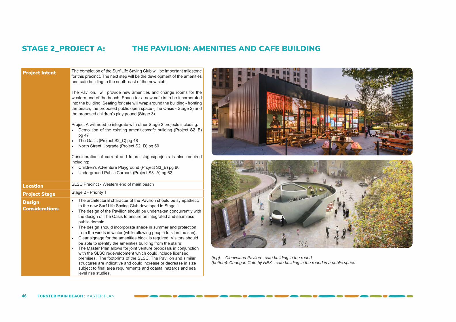
(top): Cleaveland Pavlion - cafe building in the round.(bottom): Cadogan Cafe by NEX - cafe building in the round in a public space
FORSTER MAIN BEACH : MASTER PLAN 47
STAGE 2_PROJECT B: DEMOLITION OF EXISTING AMENITIES AND CAFE BUILDING
Project Intent Once ‘The Pavilion’ is completed, the existing amenities, storage and cafe building can be demolished. All uses of the existing structure will have been successfully accommodated in the new SLSC and The Pavilion.
The demolition of this building will open up The Pavilion to views over the water.
If the Oasis (public open space - Project S2_C) is not to be constructed immediately, the site will need to be made good. It could form part of the extension of the pop up proposed for site of the former SLSC (Project S1_B).
Project B will need to integrate with other Stage 2 projects including:• The Oasis (Project S2_C) pg 48• North Street Precinct (Project S2_D) pg 50
Consideration of future stages/projects is also required including:• Children’s Adventure Playground (Project S3_B) pg 60• Underground Public Carpark (Project S3_A) pf 62
Location SLSC Precinct - Western end of main beach
Project Stage Stage 1 - Priority 1
Design Considerations
• Ensure the promenade links with the Pilot Hill walkway located to the north of the SLSC if the site is ‘made good’
• Provide power and water for food trucks
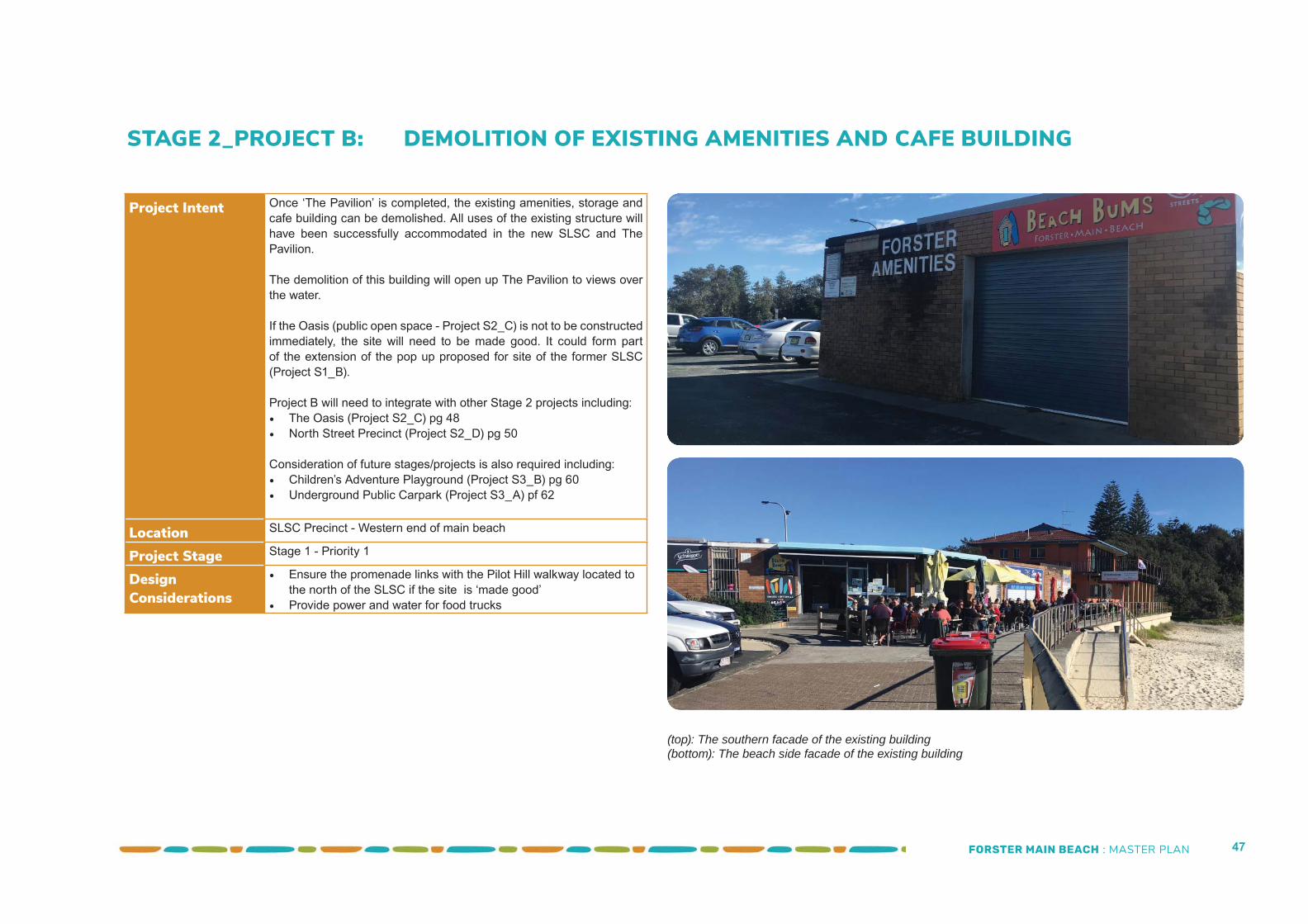
(top): The southern facade of the existing building(bottom): The beach side facade of the existing building
FORSTER MAIN BEACH : MASTER PLAN 48
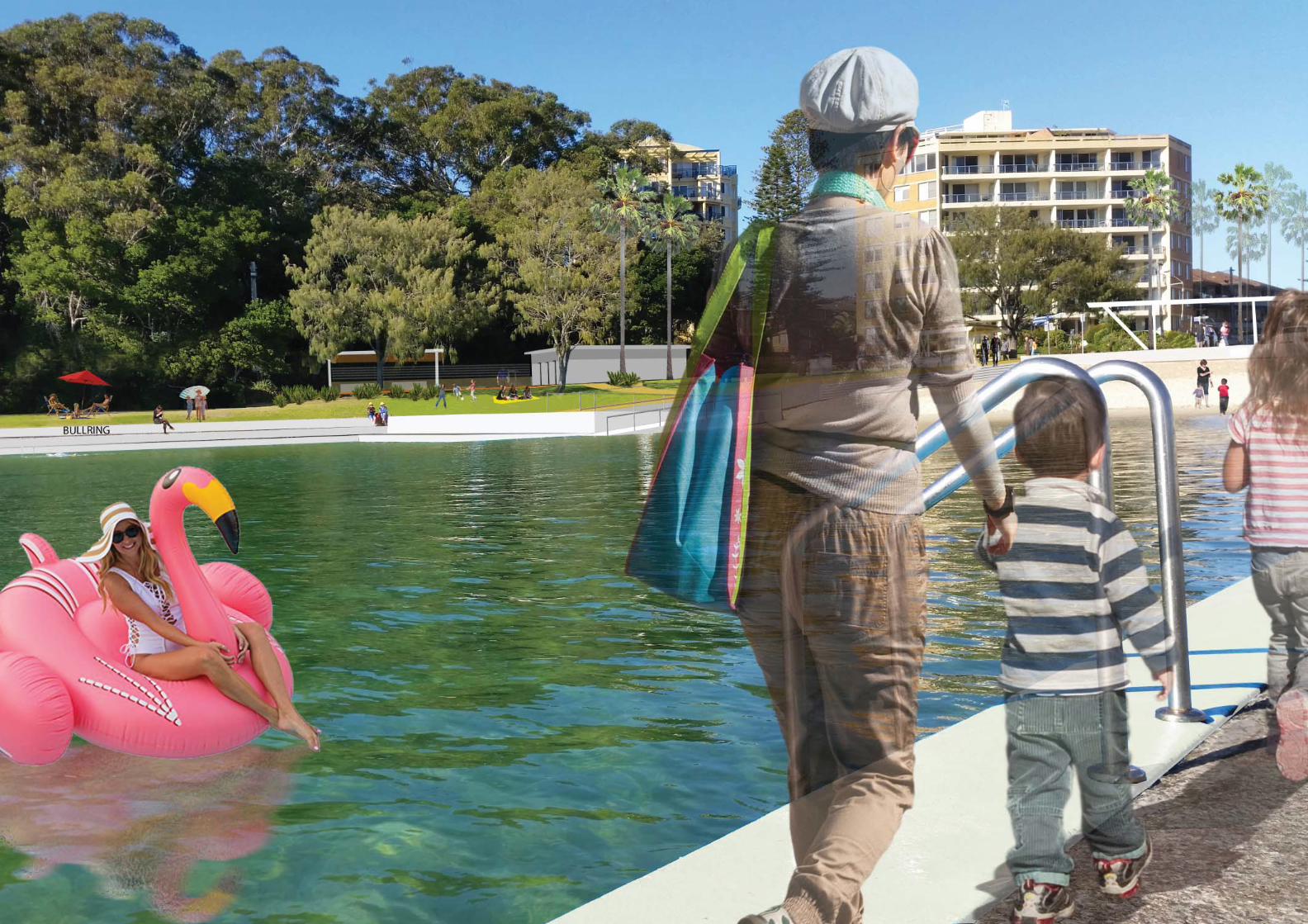
STAGE 2_PROJECT C: THE OASIS - PUBLIC SPACE
Project Intent The Oasis will become the heart of the precinct - a shaded space to relax and enjoy the views of the water. Proposed at the heart of the precinct is a large lawn area, studded with tall palms which provide shade over the space.
SLSC facility and The Pavilion sit at the edges of the Oasis. Tables and chairs from the cafes, spill into the space.
Access to the beach is provided from the space, in the form of a wide accessible ramp for pedestrians and stairs. Vehicular access to the beach, in addition to the driveway/ramp associated with the surf club is also via this ramp.
The Oasis will also provide the township an event and social space. Markets, music events and outdoor cinema can be held here.
Project C will need to integrate with other Stage 2 projects including:• The Pavilion (Project S2_A) pg 46• Demolition of the existing amenities/cafe building (Project S2_B) pg 47• North Street Upgrade (Project S2_D) pg 50• Landmark Public Artwork (Project S2_E) pg 52• Wayfi nding and Interpretive Signage (Project S2_F) pg 54• Supporting Public Art Projects (Project S2_G) pg 56
Consideration of future stages/projects is also required including:• Childrens Adventure Playground (Project S3_A) pg 60• Underground Public Carpark (Project S3_B) pg 62
Location SLSC Precinct - Western end of main beach
Project Stage Stage 2 - Priority 1
Design Considerations
• Ensure the promenade links with the Pilot Hill walkway located to the north of the building
• The future seawall may impact upon the indicative design shown in the masterplan. Seawall requirements will dictate the scale and nature of this space
• Endevour to achieve a 1:20 ramp to the beach from the Oasis to eliminate the requirements for handrails and kick rail associated with an accessible ramp
• Incorporate theming patterns in the pavement that is represent-ative of Forster. Iconic pavement treatments can become ‘post card’ images that assist with marketing Forster
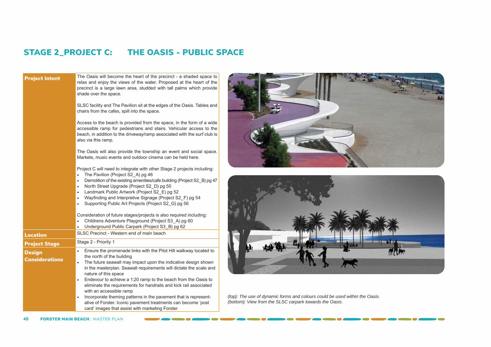
(top): The use of dynamic forms and colours could be used within the Oasis.(bottom): View from the SLSC carpark towards the Oasis.
FORSTER MAIN BEACH : MASTER PLAN 49
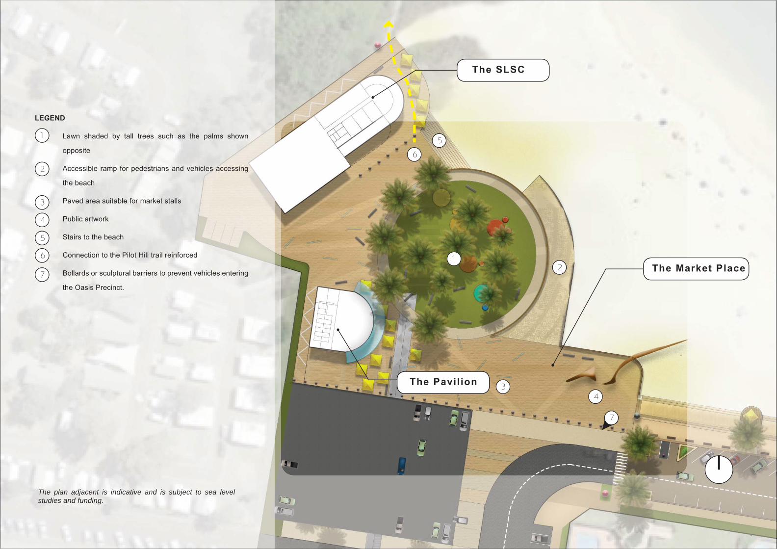
Lawn shaded by tall trees such as the palms shown
opposite
Accessible ramp for pedestrians and vehicles accessing
the beach
Paved area suitable for market stalls
Public artwork
Stairs to the beach
Connection to the Pilot Hill trail reinforced
Bollards or sculptural barriers to prevent vehicles entering
the Oasis Precinct.
1
2
3
4
5
LEGEND
12
3
6
4
5
6
7
The SLSC
The Pavilion
The Market Place
The plan adjacent is indicative and is subject to sea level studies and funding.
7
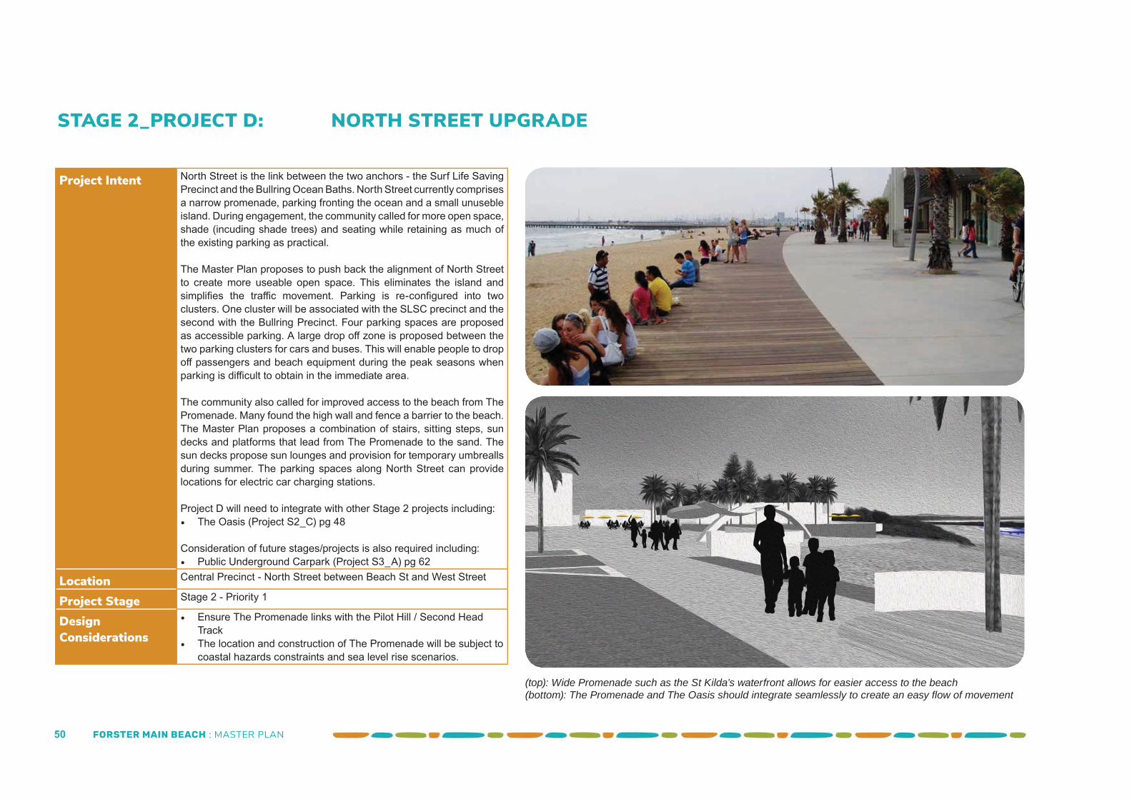
FORSTER MAIN BEACH : MASTER PLAN 50
STAGE 2_PROJECT D: NORTH STREET UPGRADE
Project Intent North Street is the link between the two anchors - the Surf Life Saving Precinct and the Bullring Ocean Baths. North Street currently comprises a narrow promenade, parking fronting the ocean and a small unuseble island. During engagement, the community called for more open space, shade (incuding shade trees) and seating while retaining as much of the existing parking as practical.
The Master Plan proposes to push back the alignment of North Street to create more useable open space. This eliminates the island and simplifi es the traffi c movement. Parking is re-confi gured into two clusters. One cluster will be associated with the SLSC precinct and the second with the Bullring Precinct. Four parking spaces are proposed as accessible parking. A large drop off zone is proposed between the two parking clusters for cars and buses. This will enable people to drop off passengers and beach equipment during the peak seasons when parking is diffi cult to obtain in the immediate area.
The community also called for improved access to the beach from The Promenade. Many found the high wall and fence a barrier to the beach. The Master Plan proposes a combination of stairs, sitting steps, sun decks and platforms that lead from The Promenade to the sand. The sun decks propose sun lounges and provision for temporary umbrealls during summer. The parking spaces along North Street can provide locations for electric car charging stations.
Project D will need to integrate with other Stage 2 projects including:• The Oasis (Project S2_C) pg 48
Consideration of future stages/projects is also required including:• Public Underground Carpark (Project S3_A) pg 62
Location Central Precinct - North Street between Beach St and West Street
Project Stage Stage 2 - Priority 1
Design Considerations
• Ensure The Promenade links with the Pilot Hill / Second Head Track
• The location and construction of The Promenade will be subject to coastal hazards constraints and sea level rise scenarios.
(top): Wide Promenade such as the St Kilda’s waterfront allows for easier access to the beach(bottom): The Promenade and The Oasis should integrate seamlessly to create an easy fl ow of movement
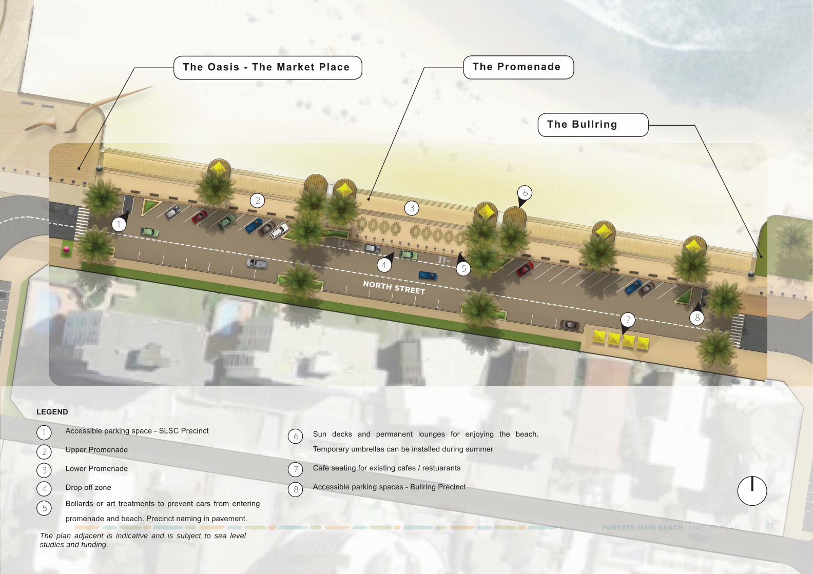
FORSTER MAIN BEACH : MASTER PLAN 51FOFORSRSTETERR MAMAININ BBEAEACHCH :: MAMASTSTSTERERERERERER PPPPPPPPPPLALALLALALALALALANNNNN 51
The Promenade
NORTH STREET
23
6
4
1
87
5
LEGEND
The Oasis - The Market Place
Accessible parking space - SLSC Precinct
Upper Promenade
Lower Promenade
Drop off zone
Bollards or art treatments to prevent cars from entering
promenade and beach. Precinct naming in pavement.
1
2
3
4
5
6
7
8
Sun decks and permanent lounges for enjoying the beach.
Temporary umbrellas can be installed during summer
Cafe seating for existing cafes / restuarants
Accessible parking spaces - Bullring Precinct
The Bullring
The plan adjacent is indicative and is subject to sea level studies and funding.
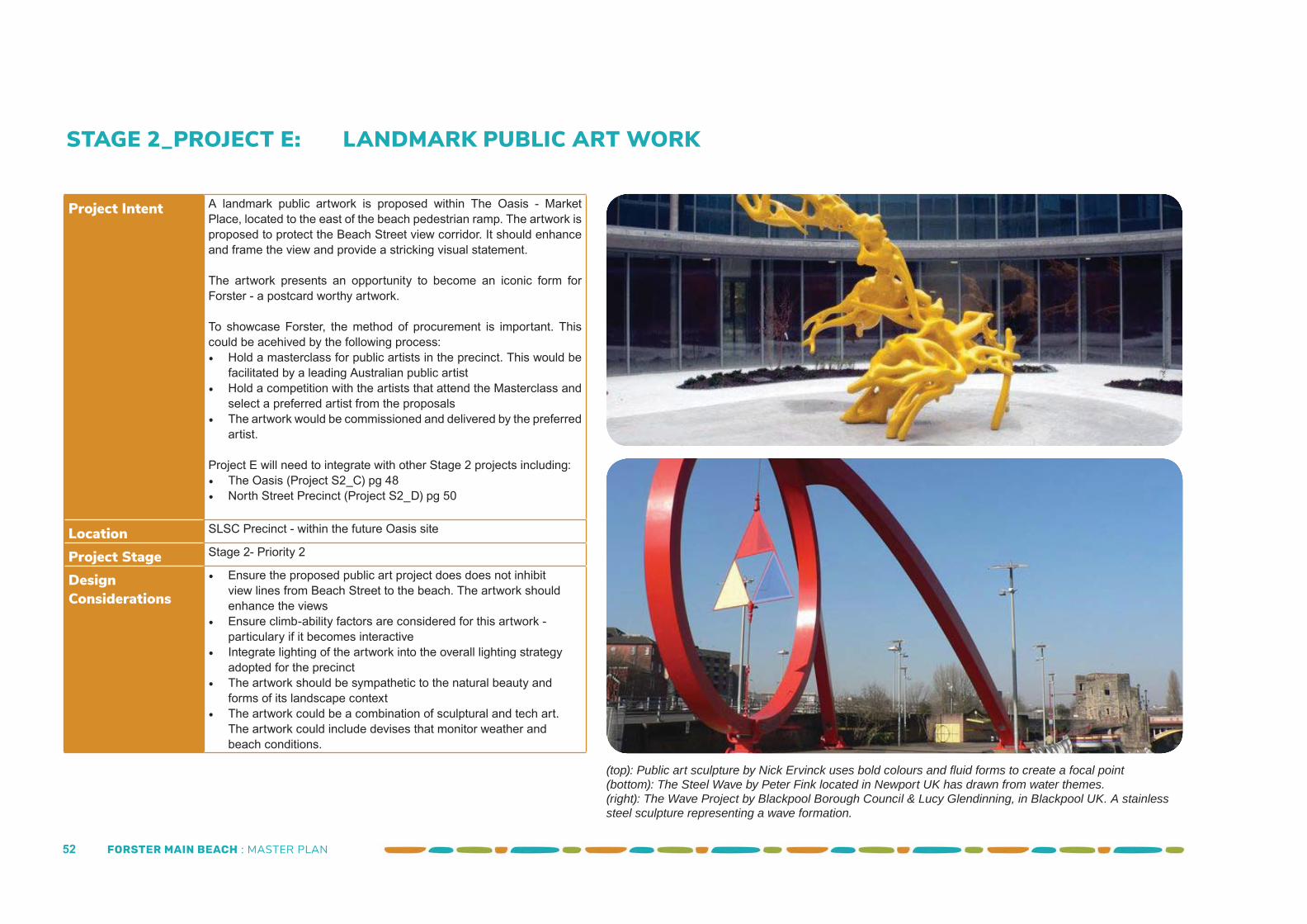
FORSTER MAIN BEACH : MASTER PLAN 52
STAGE 2_PROJECT E: LANDMARK PUBLIC ART WORK
Project Intent A landmark public artwork is proposed within The Oasis - Market Place, located to the east of the beach pedestrian ramp. The artwork is proposed to protect the Beach Street view corridor. It should enhance and frame the view and provide a stricking visual statement.
The artwork presents an opportunity to become an iconic form for Forster - a postcard worthy artwork.
To showcase Forster, the method of procurement is important. This could be acehived by the following process:• Hold a masterclass for public artists in the precinct. This would be
facilitated by a leading Australian public artist• Hold a competition with the artists that attend the Masterclass and
select a preferred artist from the proposals• The artwork would be commissioned and delivered by the preferred
artist.
Project E will need to integrate with other Stage 2 projects including:• The Oasis (Project S2_C) pg 48• North Street Precinct (Project S2_D) pg 50
Location SLSC Precinct - within the future Oasis site
Project Stage Stage 2- Priority 2
Design Considerations
• Ensure the proposed public art project does does not inhibit view lines from Beach Street to the beach. The artwork should enhance the views
• Ensure climb-ability factors are considered for this artwork - particulary if it becomes interactive
• Integrate lighting of the artwork into the overall lighting strategy adopted for the precinct
• The artwork should be sympathetic to the natural beauty and forms of its landscape context
• The artwork could be a combination of sculptural and tech art. The artwork could include devises that monitor weather and beach conditions.
(top): Public art sculpture by Nick Ervinck uses bold colours and fl uid forms to create a focal point(bottom): The Steel Wave by Peter Fink located in Newport UK has drawn from water themes. (right): The Wave Project by Blackpool Borough Council & Lucy Glendinning, in Blackpool UK. A stainless steel sculpture representing a wave formation.
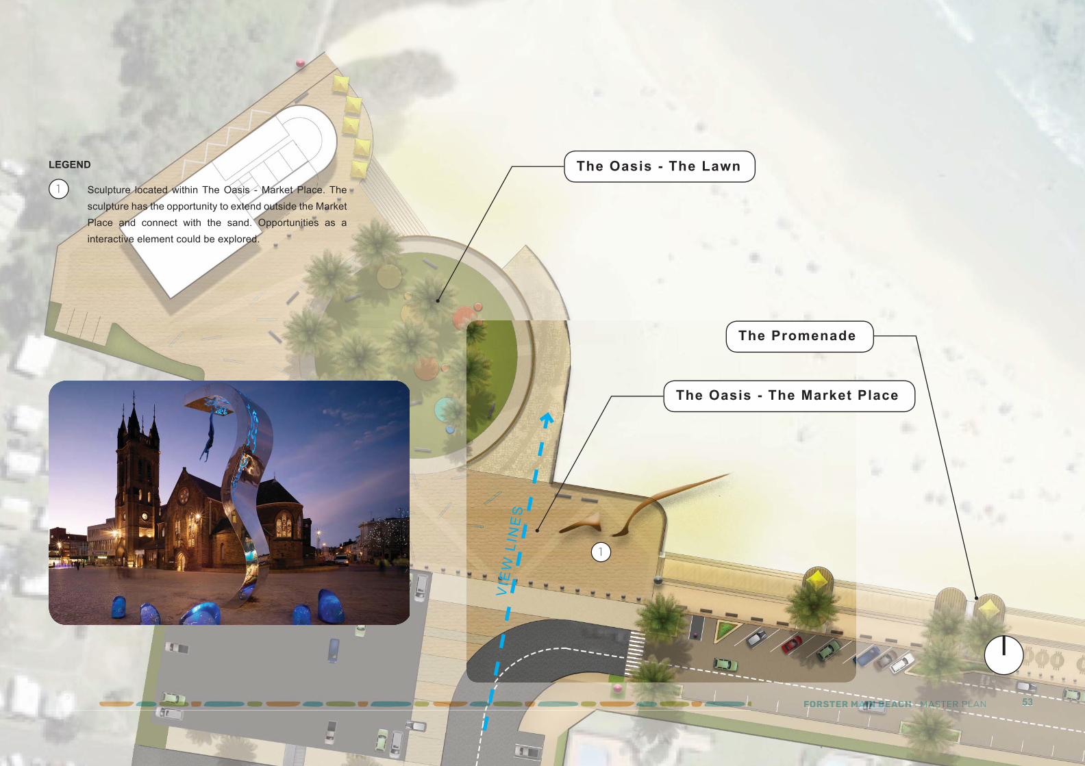
FORSTER MAIN BEACH : MASTER PLAN 53FOFOFOFOFFFFFFF RSRSRSRSTETETETERRRR MAMMAAAAAAAAAAAAAMAAAAAAAAAAAAAAAAAAAAAAAINININNNNNNIININININNININININININININNINNINNNIIN BBBBBBBBBBBBBBBBBBBBBBBBBBBBEAEAEAEAEAAAEAEAEAEAEAEAEAEAEAEAEAEEEEEEEEEE CHCHCHCHCHCHCHCHCCHCHCHCHCHCHHH ::::::::::::::::::: MAMAMAMAMAMAMAMAMAMAMAMMAAMAMMAMMAMMMAMAMAMAMMMMAMAMAMMMMAMMAAAAMMAAAM STSTSTSTSTSTSTSSTSTSTSTSSSSSS ERERERR PPPPPPPPPPLLLALALALALANNNN 53535353
The Promenade
The Oasis - The Market Place
The Oasis - The LawnSculpture located within The Oasis - Market Place. The sculpture has the opportunity to extend outside the Market Place and connect with the sand. Opportunities as a interactive element could be explored.
1
LEGEND
1
VIE
W L
INE
S
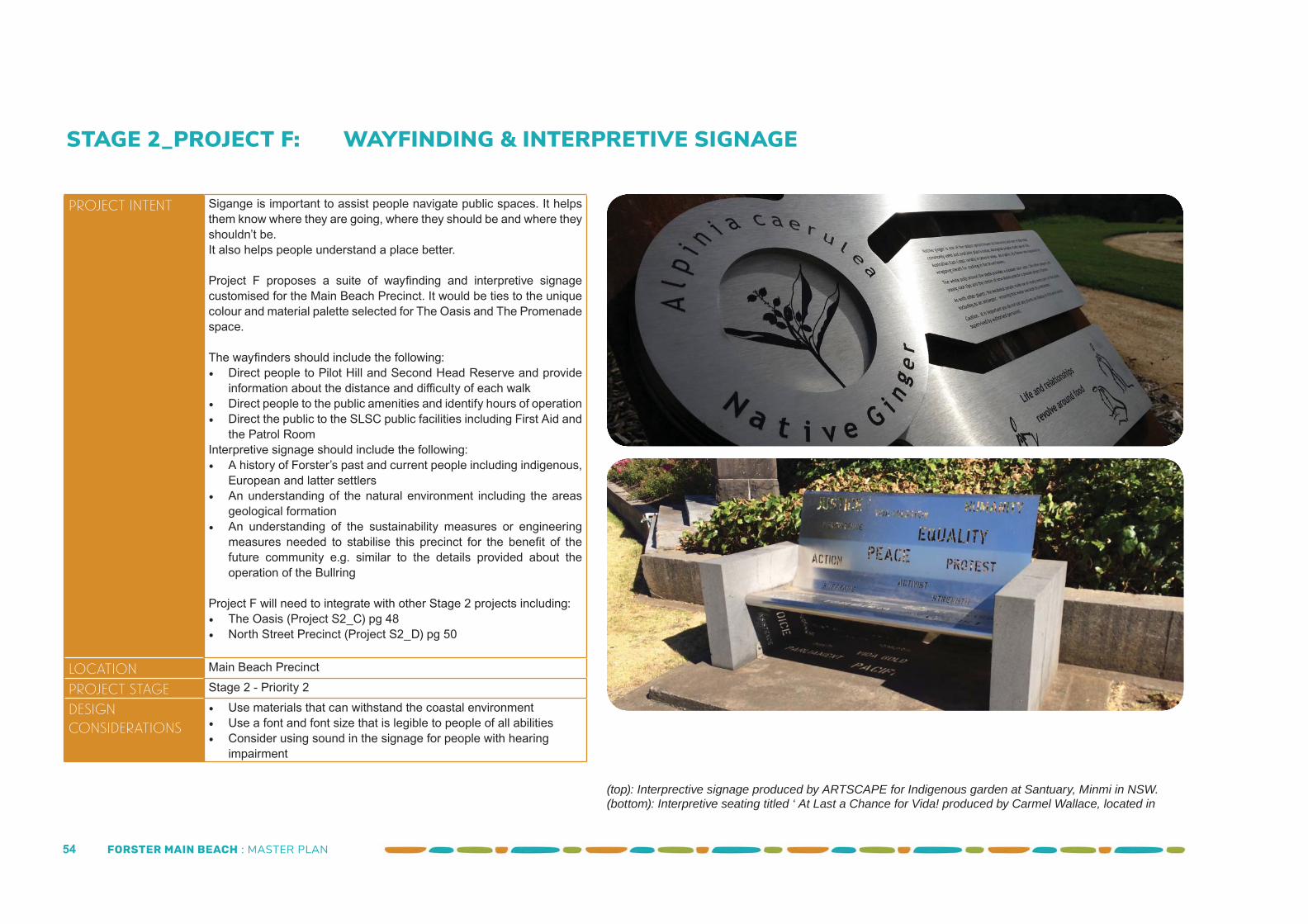
FORSTER MAIN BEACH : MASTER PLAN 54
STAGE 2_PROJECT F: WAYFINDING & INTERPRETIVE SIGNAGE
Project Intent Sigange is important to assist people navigate public spaces. It helps them know where they are going, where they should be and where they shouldn’t be.It also helps people understand a place better.
Project F proposes a suite of wayfi nding and interpretive signage customised for the Main Beach Precinct. It would be ties to the unique colour and material palette selected for The Oasis and The Promenade space.
The wayfi nders should include the following:• Direct people to Pilot Hill and Second Head Reserve and provide
information about the distance and diffi culty of each walk• Direct people to the public amenities and identify hours of operation• Direct the public to the SLSC public facilities including First Aid and
the Patrol RoomInterpretive signage should include the following:• A history of Forster’s past and current people including indigenous,
European and latter settlers• An understanding of the natural environment including the areas
geological formation• An understanding of the sustainability measures or engineering
measures needed to stabilise this precinct for the benefi t of the future community e.g. similar to the details provided about the operation of the Bullring
Project F will need to integrate with other Stage 2 projects including:• The Oasis (Project S2_C) pg 48• North Street Precinct (Project S2_D) pg 50
Location Main Beach Precinct
Project Stage Stage 2 - Priority 2
Design Considerations
• Use materials that can withstand the coastal environment • Use a font and font size that is legible to people of all abilities• Consider using sound in the signage for people with hearing
impairment
(top): Interprective signage produced by ARTSCAPE for Indigenous garden at Santuary, Minmi in NSW.(bottom): Interpretive seating titled ‘ At Last a Chance for Vida! produced by Carmel Wallace, located in
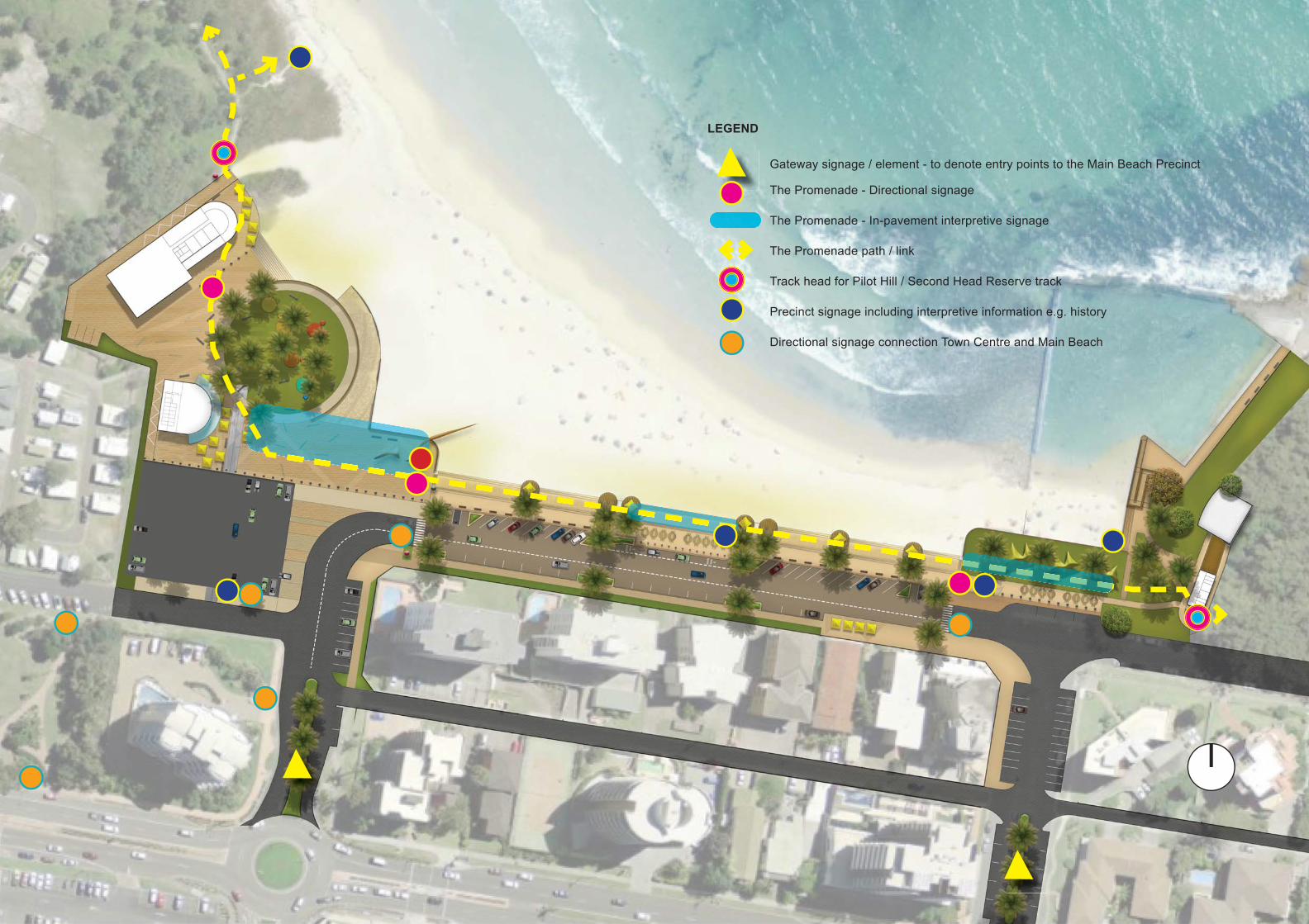
FORSTER MAIN BEACH : MASTER PLAN 55
Gateway signage / element - to denote entry points to the Main Beach Precinct
The Promenade - Directional signage
The Promenade - In-pavement interpretive signage
The Promenade path / link
Track head for Pilot Hill / Second Head Reserve track
Precinct signage including interpretive information e.g. history
Directional signage connection Town Centre and Main Beach
LEGEND
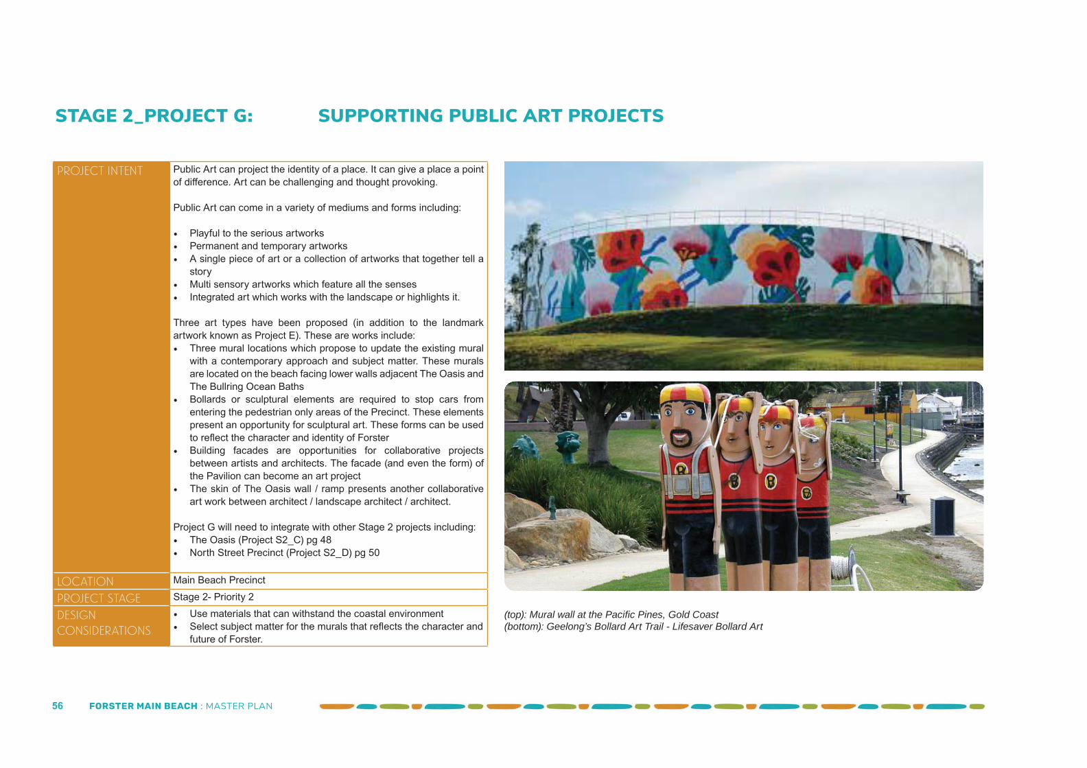
FORSTER MAIN BEACH : MASTER PLAN 56
STAGE 2_PROJECT G: SUPPORTING PUBLIC ART PROJECTS
Project Intent Public Art can project the identity of a place. It can give a place a point of diff erence. Art can be challenging and thought provoking.
Public Art can come in a variety of mediums and forms including:
• Playful to the serious artworks• Permanent and temporary artworks• A single piece of art or a collection of artworks that together tell a
story• Multi sensory artworks which feature all the senses• Integrated art which works with the landscape or highlights it.
Three art types have been proposed (in addition to the landmark artwork known as Project E). These are works include:• Three mural locations which propose to update the existing mural
with a contemporary approach and subject matter. These murals are located on the beach facing lower walls adjacent The Oasis and The Bullring Ocean Baths
• Bollards or sculptural elements are required to stop cars from entering the pedestrian only areas of the Precinct. These elements present an opportunity for sculptural art. These forms can be used to refl ect the character and identity of Forster
• Building facades are opportunities for collaborative projects between artists and architects. The facade (and even the form) of the Pavilion can become an art project
• The skin of The Oasis wall / ramp presents another collaborative art work between architect / landscape architect / architect.
Project G will need to integrate with other Stage 2 projects including:• The Oasis (Project S2_C) pg 48• North Street Precinct (Project S2_D) pg 50
Location Main Beach Precinct
Project Stage Stage 2- Priority 2
Design Considerations
• Use materials that can withstand the coastal environment • Select subject matter for the murals that refl ects the character and
future of Forster.
(top): Mural wall at the Pacifi c Pines, Gold Coast(bottom): Geelong’s Bollard Art Trail - Lifesaver Bollard Art
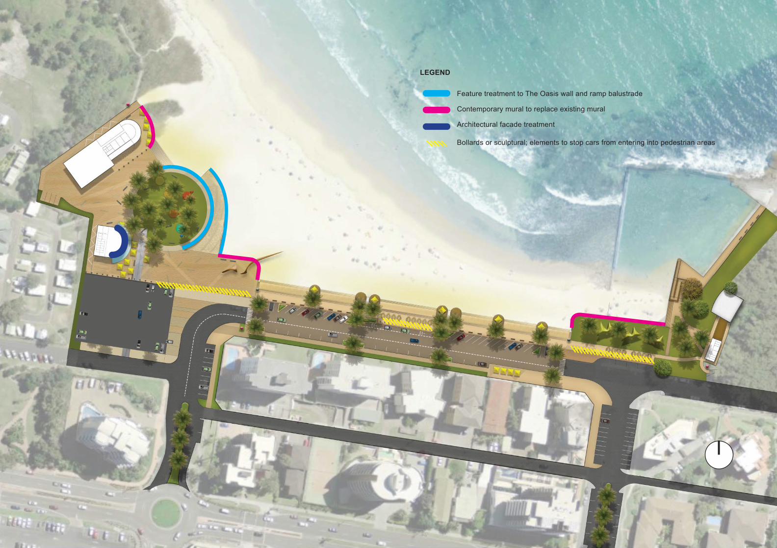
FORSTER MAIN BEACH : MASTER PLAN 57
LEGEND
Feature treatment to The Oasis wall and ramp balustrade
Contemporary mural to replace existing mural
Architectural facade treatment
Bollards or sculptural; elements to stop cars from entering into pedestrian areas
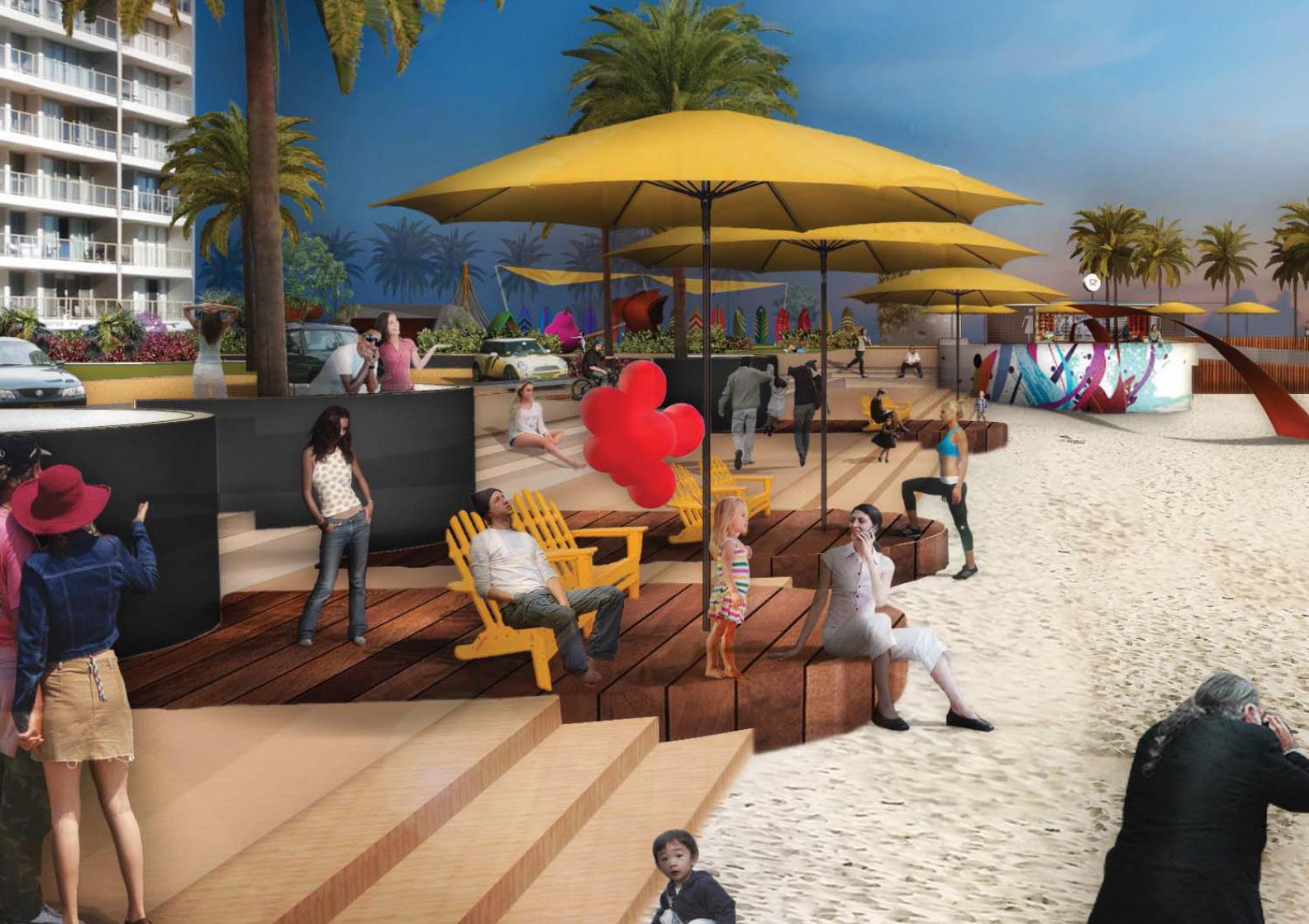
FORSTER MAIN BEACH : MASTER PLAN 58
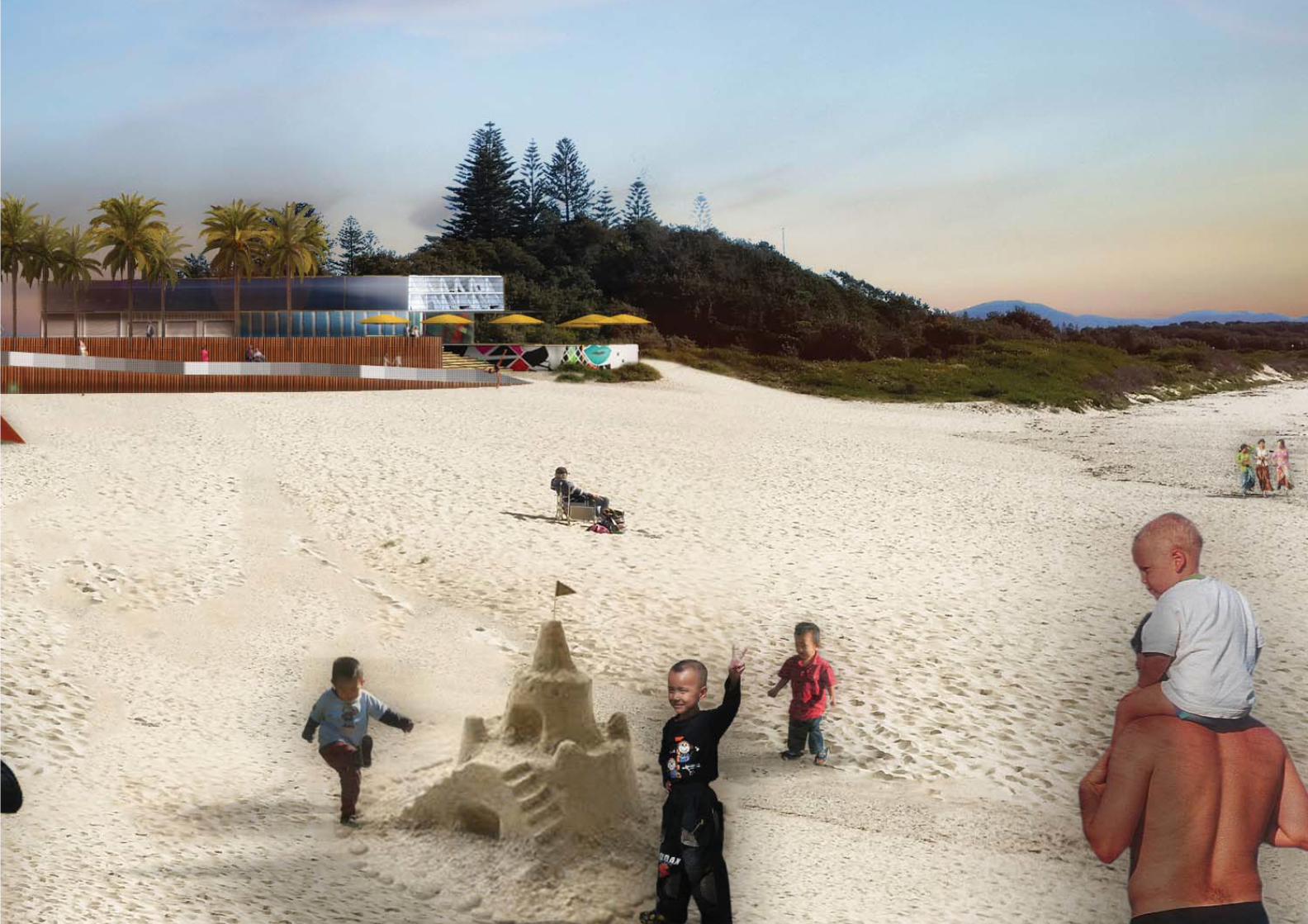
FORSTER MAIN BEACH : MASTER PLAN 59
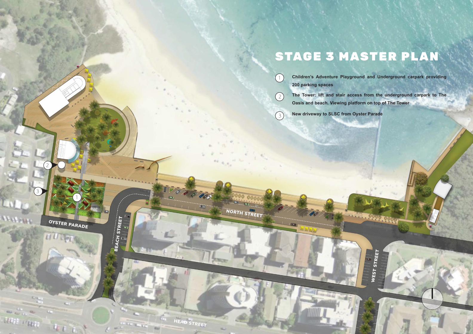
FORSTER MAIN BEACH : MASTER PLAN 60
NORTH STREETOYSTER PARADE
BEA
CH
STR
EET
WES
T ST
REE
T
HEAD STREET
Children’s Adventure Playground and Underground carpark providing
200 parking spaces
The Tower: lift and stair access from the underground carpark to The
Oasis and beach. Viewing platform on top of The Tower
New driveway to SLSC from Oyster Parade
1
2
3
STAG E 3 M AST E R P L A N
2
13
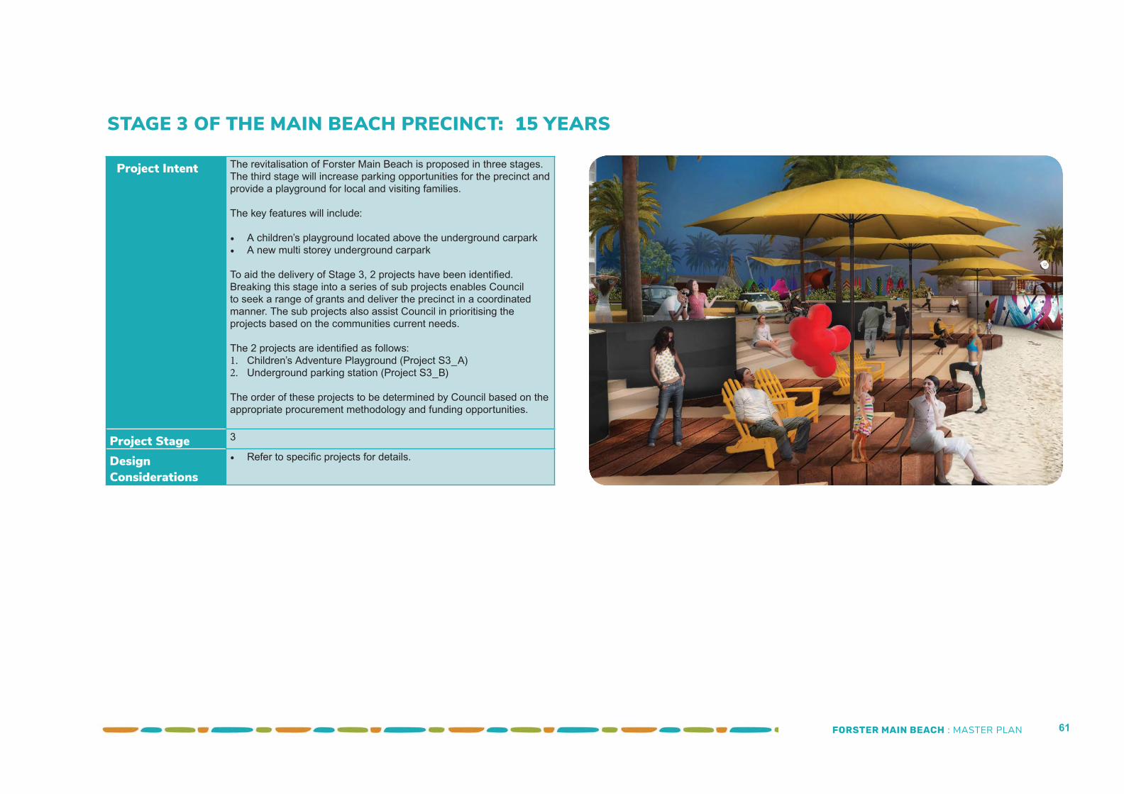
FORSTER MAIN BEACH : MASTER PLAN 61
Project Intent The revitalisation of Forster Main Beach is proposed in three stages. The third stage will increase parking opportunities for the precinct and provide a playground for local and visiting families.
The key features will include:
• A children’s playground located above the underground carpark• A new multi storey underground carpark
To aid the delivery of Stage 3, 2 projects have been identifi ed. Breaking this stage into a series of sub projects enables Council to seek a range of grants and deliver the precinct in a coordinated manner. The sub projects also assist Council in prioritising the projects based on the communities current needs.
The 2 projects are identifi ed as follows:1. Children’s Adventure Playground (Project S3_A)2. Underground parking station (Project S3_B)
The order of these projects to be determined by Council based on the appropriate procurement methodology and funding opportunities.
Project Stage 3
Design Considerations
• Refer to specifi c projects for details.
STAGE 3 OF THE MAIN BEACH PRECINCT: 15 YEARS
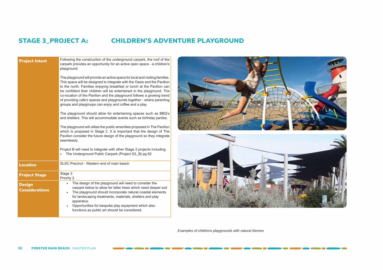
FORSTER MAIN BEACH : MASTER PLAN 62
STAGE 3_PROJECT A: CHILDREN’S ADVENTURE PLAYGROUND
Project Intent Following the construction of the underground carpark, the roof of the carpark provides an opportunity for an active open space - a children’s playground.
The playground will provide an active space for local and visiting families. This space will be designed to integrate with the Oasis and the Pavilion to the north. Families enjoying breakfast or lunch at the Pavilion can be confi dent their children will be entertained in the playground. The co-location of the Pavilion and the playground follows a growing trend of providing cafe’s spaces and playgrounds together - where parenting groups and playgroups can enjoy and coff ee and a play.
The playground should allow for entertaining spaces such as BBQ’s and shelters. This will accommodate events such as birthday parties.
The playground will utilise the public amenities proposed in The Pavilion which is proposed in Stage 2. It is important that the design of The Pavilion consider the future design of the playground so they integrate seamlessly.
Project B will need to integrate with other Stage 3 projects including:• The Underground Public Carpark (Project S3_B) pg 62
Location SLSC Precinct - Western end of main beach
Project Stage Stage 3 Priority 2
Design Considerations
• The design of the playground will need to consider the carpark below to allow for taller trees which need deeper soil
• The playground should incorporate natural coastal elements for landscaping treatments, materials, shelters and play apparatus.
• Opportunities for bespoke play equipment which also functions as public art should be considered.
Examples of childrens playgrounds with natural themes
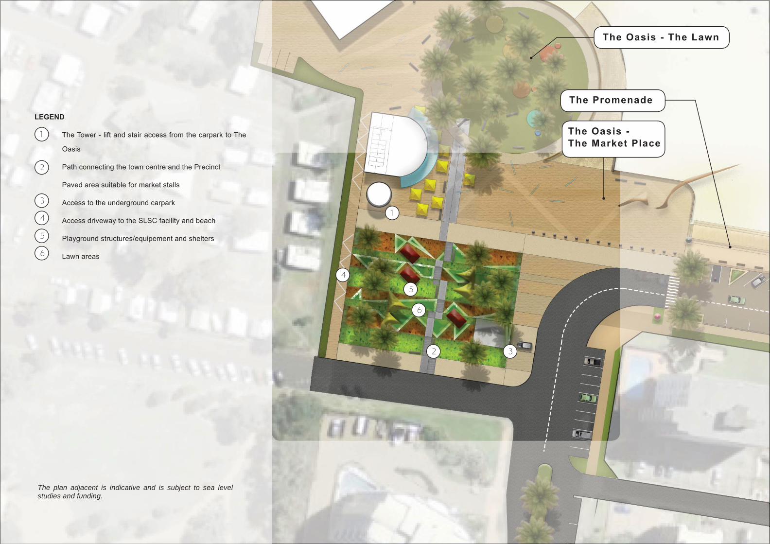
FORSTER MAIN BEACH : MASTER PLAN 63
The Tower - lift and stair access from the carpark to The
Oasis
Path connecting the town centre and the Precinct
Paved area suitable for market stalls
Access to the underground carpark
Access driveway to the SLSC facility and beach
Playground structures/equipement and shelters
Lawn areas
1
2
3
4
5
LEGEND
6
1
2 3
4
5
6
The plan adjacent is indicative and is subject to sea level studies and funding.
The Promenade
The Oasis - The Market Place
The Oasis - The Lawn
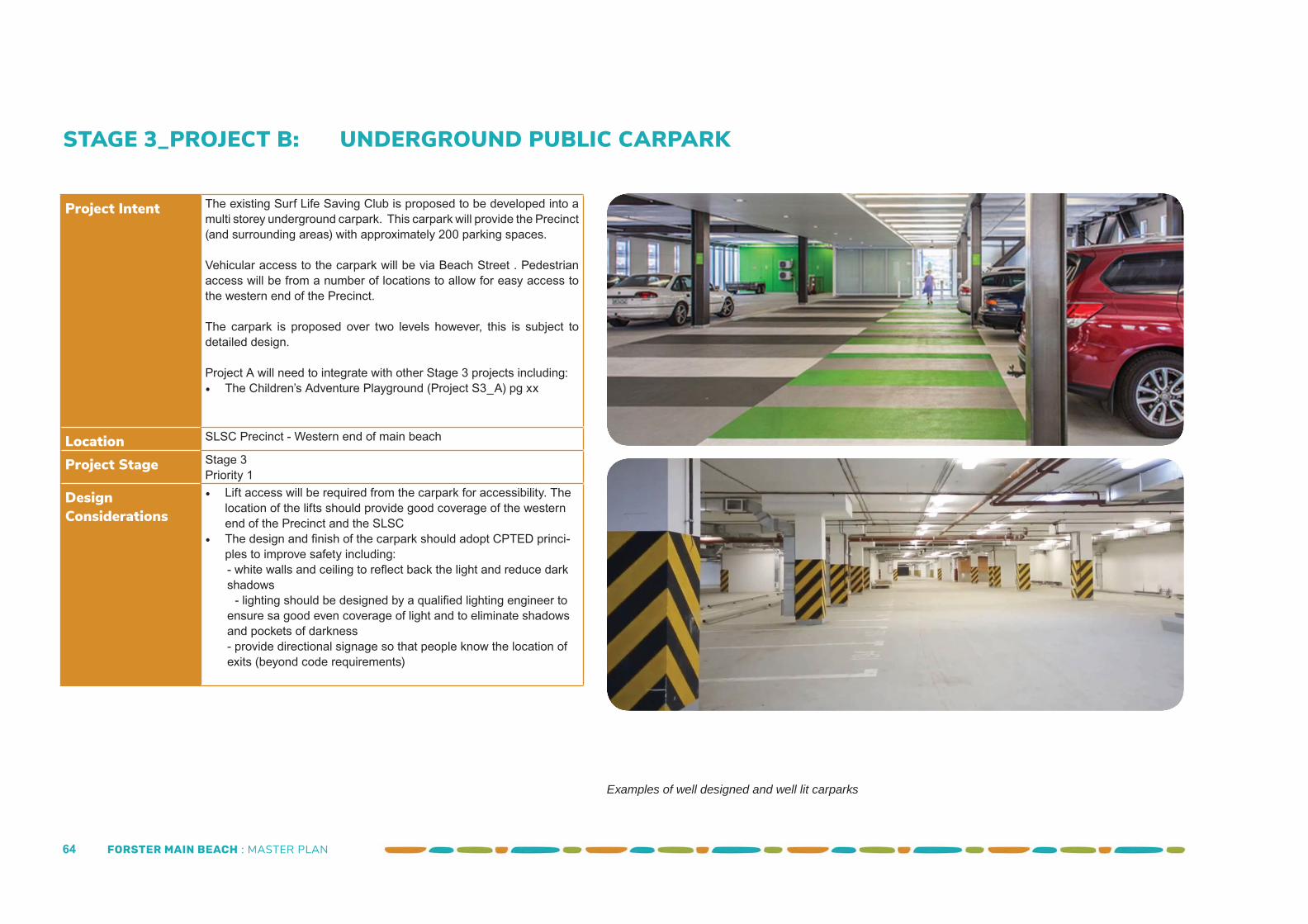
FORSTER MAIN BEACH : MASTER PLAN 64
STAGE 3_PROJECT B: UNDERGROUND PUBLIC CARPARK
Project Intent The existing Surf Life Saving Club is proposed to be developed into a multi storey underground carpark. This carpark will provide the Precinct (and surrounding areas) with approximately 200 parking spaces.
Vehicular access to the carpark will be via Beach Street . Pedestrian access will be from a number of locations to allow for easy access to the western end of the Precinct.
The carpark is proposed over two levels however, this is subject to detailed design.
Project A will need to integrate with other Stage 3 projects including:• The Children’s Adventure Playground (Project S3_A) pg xx
Location SLSC Precinct - Western end of main beach
Project Stage Stage 3 Priority 1
Design Considerations
• Lift access will be required from the carpark for accessibility. The location of the lifts should provide good coverage of the western end of the Precinct and the SLSC
• The design and fi nish of the carpark should adopt CPTED princi-ples to improve safety including:- white walls and ceiling to refl ect back the light and reduce dark shadows
- lighting should be designed by a qualifi ed lighting engineer to ensure sa good even coverage of light and to eliminate shadows and pockets of darkness- provide directional signage so that people know the location of exits (beyond code requirements)
Examples of well designed and well lit carparks
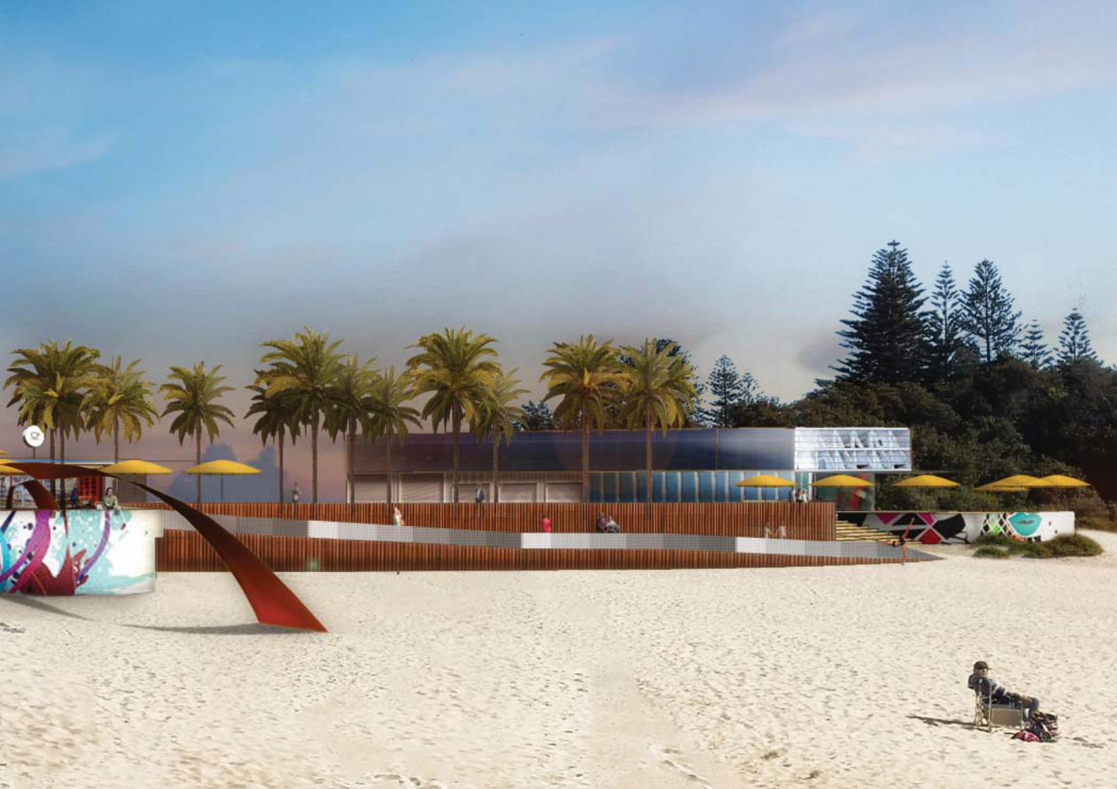
FORSTER MAIN BEACH : MASTER PLAN 65


