Embed Size (px)
Citation preview

85Geo-Eco-Marina 16/2010
1. IntroductIonMore than half of the world’s population lives in the vicin-
ity of oceanic or marine coastal areas occupying, on a narrow strip of 200 km in width, only 10 % of Earth’s surface. For the majority of the population living in coastal areas, the main potable water resource is represented by the fresh under-ground water, which is usually in a hydrodynamic equilibrium with the salty sea water. Between the fresh and salt waters there is a transition zone, whose geometry depends on lo-cal hydrogeological conditions. Changes in the hydrostatic level generated by natural or anthropic phenomena, such as the uncontrolled exploitation of fresh water, may lead to an invasion of the salt water towards the dry land (a so-called „marine intrusion“). These marine intrusions are one of the major sources of contamination for the aquifers located in coastal areas.
The contamination of fresh water with marine salt water produces significant changes in the aquifers resistivity, thus allowing the application of geoelectrical methods for the detection and monitoring of marine intrusions. In this man-ner, an electrical resistivity model can always be associated
with a hydrogeological model, being determined by means of suitable geoelectrical investigations (Kirsch, 2006). Based on this framework and using specific geophysical interpreta-tion methods, one may achieve the hydrogeophysical model of the studied area.
One of the most widely used and effective geoelectrical survey techniques is represented by the Vertical Electrical Sounding (VES), performed with various electrode configu-rations. Successfully applied in Romania for the detection and monitoring of underground pollution with hydrocarbon contaminants (e.g., Ioane et al., 2008, 2009), VES method was employed in this study for the investigation of aquifers con-tamination by electrically conductive marine water.
Although an important progress was made in what con-cerns the modeling/simulation techniques for the resistivity anomalies associated with marine intrusions, some physical-mathematical aspects related to the existence of transition zones, the sensitivity characteristic of the geoelectrical in-vestigations devices and the evaluation of local perturbing conditions influence („site effects“) upon the measurements, still are insufficiently studied.
Geoelectrical investiGations of marine intrusions on the romanian Black sea shore
Paul GEORGESCu, DumitRu iOaNE, BOGDaN mihai NiCulESCu, FlORiNa ChitEa
University of Bucharest, Department of Geophysics, 6 Traian Vuia Street, 020956 Bucharest, Romania ([email protected]; [email protected]; [email protected]; [email protected])
Abstract. For the majority of the communities living in coastal areas, the main potable water resource is represented by the fresh underground water, which is in a hydrodynamic equilibrium with the salty sea water. The natural or anthropic contamination of fresh water with marine salt water produces significant changes in the aquifers resistivity, thus allowing the application of geoelectrical methods for the detection and monitoring of marine intrusions. We present two case studies from Romania (Costineşti and Vama Veche areas) which are relevant for the application of Vertical Electrical Sounding (VES) method for mapping and monitoring marine intrusions. The results of these investigations are represented by means of apparent resistivity cross sections, which clearly evidence the spatial and temporal evolution of such intrusions. The processing and interpretation of VES curves were carried out using a set of newly developed computer programs for the evaluation of site effects and forward modeling of the media characterized by a continuous resistivity variation.
Key words: vertical electrical sounding, marine intrusion, site effects

86 Geo-Eco-Marina 16/2010
Paul Georgescu, Dumitru Ioane, Bogdan Mihai Niculescu, Florina Chitea – Geoelectrical investigations of marine intrusions on the Romanian Black Sea shore
2. SIte effectS
the escarpment effect
For the processing and interpretation of VES curves re-corded in the vicinity of coastal areas, one has to take into consideration the influence of the coastal escarpments / steep cliffs upon the recorded apparent resistivity values, measured using current lines whose length exceeds several times the escarpment’s height.
For obvious reasons, nearby the shoreline the VES current lines are, usually, oriented parallel to the escarpment (Fig. 1-a). In these conditions, the apparent resistivity correspond-ing to a certain AB spacing (distance between the current electrodes A and B) will be influenced by the height h of the escarpment and the distance d between the observation pro-file and the escarpment’s edge.
Although this phenomenon was observed since 1934, the effect produced by the steep coastal cliffs upon the recorded VES curves (the „escarpment effect“) has been neglected or, sometimes, estimated in the framework of a geoelectrical model corresponding to a vertical fault, model which have a simple mathematical formulation but poorly describes the reality.
Due to the fact that the escarpment effect is obvious in the VES measurements carried out in Vama Veche area, we considered necessary to evaluate it using a two-layer model (Fig. 1-b), in which the first layer of thickness h is divided in two parts: a) one part corresponding to the dry land, with resistivity r1 and b) one part corresponding to the air, with
resistivity r2, behaving like an insulating medium.
Under these conditions, using the electrical images method, it can be demonstrated that the apparent resistivity may be computed using the equation:
where:
Taking into consideration this equation, VES curves were computed for various values of the d/h ratio, in two distinct cases: a) basement more resistive than the first layer (Fig. 2-a); b) basement more conductive than the first layer (Fig. 2-b).
It can be noticed that for large values of the r/h ratio there is a strong difference between the reference VES curve (2S) corresponding to a simple, two-layer model and the other VES curves computed for different values of the d/h ratio. This difference, which we have called „escarpment effect“, in-creases along with the increase of AB spacing, no matter if the basement is more conductive or more resistive. By ana-lyzing the presented curves, it results that for an escarpment
height of 5 m, the escarpment effect corresponding to a half-spacing (AB/2) of 100 m could be ignored only if the distance between the current line and the escarpment‘s edge is larger than 200 m.
the conductive layer effect
Due to the actual conditions in the coastal areas, VES measurements are oriented along the shoreline. In this case, the electrical effect of the sea is similar to that of a highly conductive layer. The computation model is identical to the one used to study the escarpment effect, the insulating layer being replaced with a perfectly conductive one. The numeri-cal simulation was performed for a basement layer more re-sistive than the upper layer and, also, for a more conductive basement. The modeling results are presented in Fig. 3-a and Fig. 3-b and one may observe that the conductive layer pres-ence in the neighborhood of a VES location leads to consid-erably lower apparent resistivity values with respect to the ones obtained for the two-layers reference model (2S). This difference between the values corresponding to an arbitrary VES and the ones corresponding to the two-layer reference model will be called „conductive layer effect“.
In this case, the conductive layer effect corresponding to a half-spacing of 100 m could be ignored only if the distance between the profile and the escarpment‘s edge is larger than 200 m.
3. 1-d modelIng of the freSh water / Salt water tranSItIon zoneThe interpretation of apparent resistivity measurements
carried out using the VES method can be achieved using ei-ther forward modeling or data inversion techniques. Com-mercial 1-D modeling programs (RES1D™ - Geotomo Software, IPI2WIN™ - Geoscan-M Ltd.) take into consideration a succes-sion of horizontal layers with well-defined resistivities and thicknesses. This is why they are less useful for analyzing and quantifying the effect of the transition zone, where the resis-tivity is continuously variable with respect to depth.
In order to set up and analyze geoelectrical models cor-responding to the marine intrusions, we have elaborated a 1-D forward modeling software and computed theoretical VES curves for structures which include layers with quasi-continuously varying resistivity. The programs are coded in MATLAB™ (MathWorks Inc.) programming environment, tak-ing advantage of the advanced set of mathematical, logical, indexing / addressing and graphical functions / instructions which are included in this high-level environment. The mod-eling is performed via discrete convolution using a numerical filter (Guptasarma, 1982), the number of layers and the num-ber of AB spacings being virtually unlimited. This type of filter has no restrictions regarding the current electrodes spacings (i.e., arbitrary AB/2 values are allowed), unlike the commercial 1-D modeling programs which use predetermined and fixed AB/2 values.

87Geo-Eco-Marina 16/2010
Paul Georgescu, Dumitru Ioane, Bogdan Mihai Niculescu, Florina Chitea – Geoelectrical investigations of marine intrusions on the Romanian Black Sea shore
Fig. 3 The conductive layer effect (2S - reference curve; 10, 50, 100 - d/h ratio values). Horizontal axis: r/h ratio; vertical axis: apparent resistivity [Ωm]
Fig. 2 Influence of the escarpment on VES measurements (2S - reference curve; 10, 50, 100 - d/h ratio values). Horizontal axis: r / h ratio; vertical axis: apparent resistivity [Ωm]
Fig. 1 The escarpment effect

88 Geo-Eco-Marina 16/2010
Paul Georgescu, Dumitru Ioane, Bogdan Mihai Niculescu, Florina Chitea – Geoelectrical investigations of marine intrusions on the Romanian Black Sea shore
For the simulation of a transition zone, a particular layer of the model is automatically divided into a user-imposed num-ber of sub-layers with equal thicknesses. By assuming a linear or nonlinear resistivity - depth variation, the sub-layers resis-tivities are computed through interpolation; if the sub-layers number is sufficiently large, a quasi-continuous resistivity vari-ation is obtained for the layer taken into consideration.
Figure 4 presents a modeling example for a three-layer model and a Schlumberger electrode configuration (to simu-late a transition zone, the second layer of the model was au-tomatically divided into 1000 sub-layers). One may notice a clear difference between the VES curves corresponding to the analyzed situations: the apparent resistivities computed for the model with transition zone are generally higher and the minimum corresponding to the conductive second layer is shifted towards larger half-spacings. If such transition zones are approximated using a single, average resistivity value, sig-nificant errors may arise in the interpretation of VES data.
4. caSe StudIeS: Southern dobrogea As a result of a study carried out on shallow-depth wells
drilled for the exploitation of fresh water from Sarmatian limestones in Southern Dobrogea, a marine intrusion was detected. The dynamics of this intrusion depends on natural conditions (fault systems, pluvial regime) as well as on the management of local pumping stations.
The main objective of the geoelectrical measurements was to establish the suitable data acquisition and interpreta-tion techniques, in order to identify the dynamics of shallow marine intrusions under the specific tectonic conditions of Southern Dobrogea. In this area, a fault system with NNW-SSE
orientation separates into compartments / tectonic blocks the Jurassic-Cretaceous sedimentary complex, which is cov-ered by quasi-horizontal Sarmatian limestones and Pliocene deposits (Georgescu et al., 1993).
the marine intrusion in costineşti area
The marine intrusion in Costineşti area has been geo-physically investigated during a long time span (1991 - 2009), by means of vertical electrical soundings carried out at vari-ous intervals, between 4 and 7 years (Georgescu et al., 2009).
The geophysical researches started in September 1991, when it was observed that in the apparent resistivity cross sec-tions, constructed along several observation profiles, resistivity lows occurred. These conductive anomalies were associated with the contamination of fresh water aquifers by marine salt water. The most interesting results were obtained on a VES pro-file located on the lineament of water exploitation wells and pumping stations (Fig. 5), the resistivity low in the vicinity of P2 well displaying a classical cone of depression shape.
Based also on the geoelectrical measurements carried out in November 1997, September 2005 and June 2009, the appar-ent resistivity cross sections presented in Fig. 6 were construct-ed. The spatial and temporal evolution of the marine intrusion associated with the resistivity low can be easily noticed.
The dynamics of the above mentioned resistivity anoma-ly during the time interval 1991-2009, starting with the cone of depression shape and until its total disappearance, sug-gests that due to a diminishing level of fresh water exploita-tion, the marine salt water contamination has continuously decreased, presently reaching the acceptable salinity allowed for the water in order to be considered potable.
Fig. 4 1-D VES modeling of the transition zone for a three-layer model and a Schlumberger electrode configuration

89Geo-Eco-Marina 16/2010
Paul Georgescu, Dumitru Ioane, Bogdan Mihai Niculescu, Florina Chitea – Geoelectrical investigations of marine intrusions on the Romanian Black Sea shore
Fig. 5 Location of the main geoelectrical profile in Costineşti area, on the lineament of water wells and pumping stations P1 to P7
Fig. 6 Apparent resistivity cross sections in Costineşti area. Horizontal axis: distance along main geoelectrical profile [m]; vertical axis: depth [m]

90 Geo-Eco-Marina 16/2010
Paul Georgescu, Dumitru Ioane, Bogdan Mihai Niculescu, Florina Chitea – Geoelectrical investigations of marine intrusions on the Romanian Black Sea shore
the marine intrusion in vama veche area
The geoelectrical researches in Vama Veche area took into account the information received from the Autono-mous County Waters Enterprise (R.A.J.A. - „ Regia Autonomă Judeţeană a Apelor“) Constanţa, that a water well drilled at about 500 m distance from the shoreline, in the neighbor-hood of Vama Veche town, encountered a saline aquifer at a depth of 60 m, in Sarmatian limestones. As a result, a second well was drilled at 1400 m North with respect to the location of the first one and at a distance of about 1000 m from the shoreline. In this well, at the same depth, an exploitable aqui-fer was intercepted, the salinity conforming to normal drink-ing water quality.
The results of these drillings lead to the hypothesis that a marine intrusion has occurred and its spatial distribution could be determined via adequate geophysical measure-ments. For this purpose, two vertical electrical sounding pro-files have been performed, their orientation being approxi-mately orthogonal to the shoreline.
The VES stations location (Fig. 7) was chosen in order to achieve the investigation goals, but also taking into consid-eration the specific field conditions, such as the presence of buildings and agricultural works. It should be mentioned that in the vicinity of the escarpment or the beach, due to the field circumstances, the soundings had to be oriented parallel to the shoreline, even if in such situations the escarpment or conductive layer effects are maximal.
A preliminary analysis of the recorded VES curves evi-denced an obvious selective distribution of two main curve types. In the eastern part KHK curves were obtained, while in the western part the curves are of K type. By simply group-ing the two VES curve patterns, an approximate zonation into compartments of the studied area became possible, pointing out the presence of a fault or fault zone which separates the eastern and western domains.
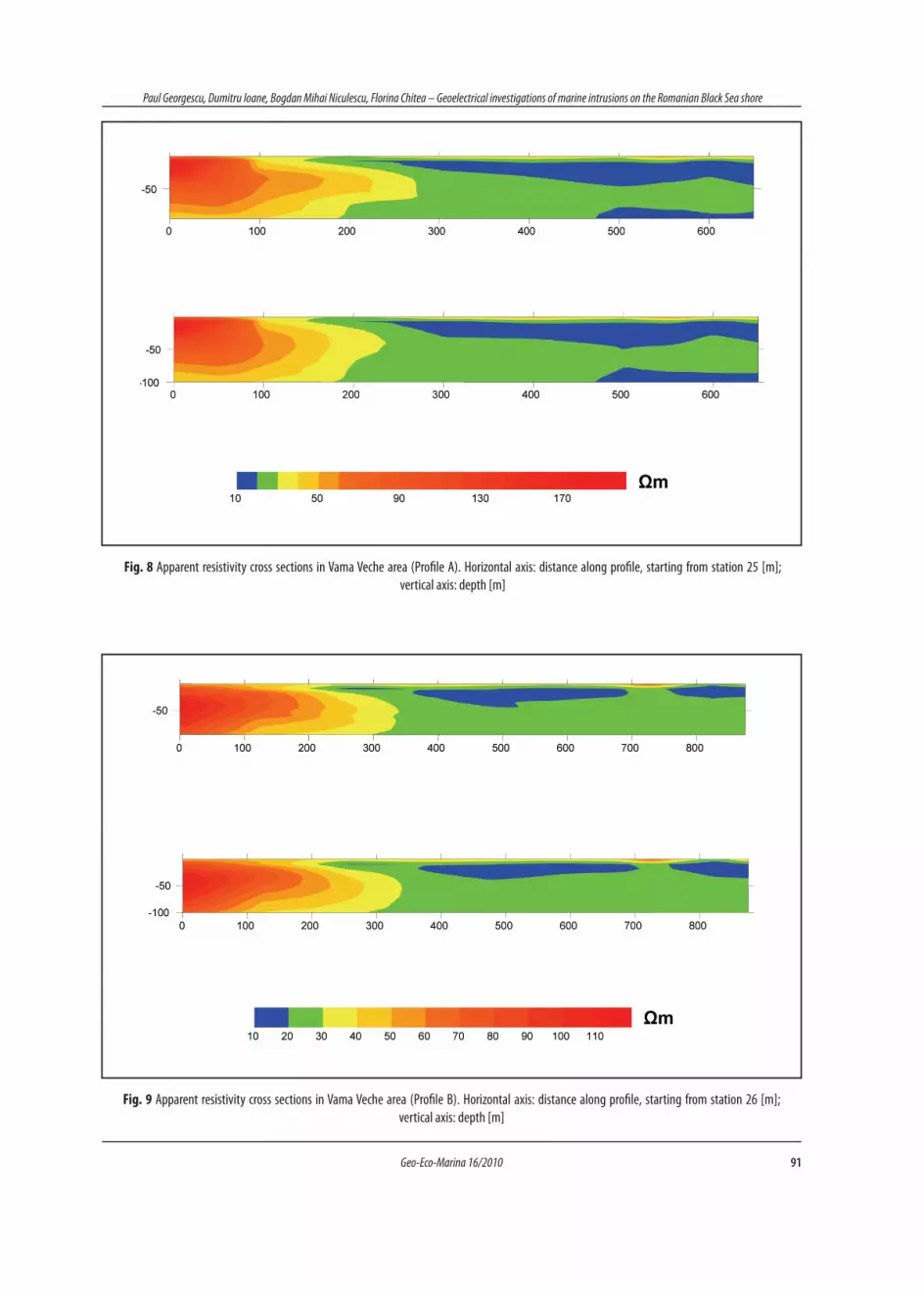
The existence of a fault zone is emphasized by two ap-parent resistivity cross sections corresponding to the profiles A (Fig. 8) and, respectively, B (Fig. 9). The cross sections were initially constructed on the basis of raw apparent resistivity data (top profiles in Fig. 8 and Fig. 9), without an adequate processing / analysis. Subsequently, an original leveling-correction processing technique was applied, in order to eliminate or reduce the possible errors associated with local measurement conditions (site effects). It was observed that the raw and processed cross sections did not present major differences, but the existence of the fault zone and, especial-ly, its position were better indicated in the processed cross sections (bottom profiles in Fig. 8 and Fig. 9).
In the first apparent resistivity cross section, represent-ed along profile A, the resistivity low (ρA < 20 Ωm) from the eastern part, corresponding to large current line spacings (AB/2 > 60 m) can be associated with a marine intrusion located deeper than 50 - 60 m. This deep resistivity anom-aly does not appear in the cross sections corresponding to profile B. It is possible that the lack of this resistivity low is partially due to the escarpment effect, which was observed at VES stations 11 and 12. The extended resis-tivity low located at shallow depths, in the upper part of the cross sections, is generated by the presence of a con-ductive shale layer which was noticed at the Vama Veche shoreline escarpment.
In this phase of the researches we may conclude that the marine intrusion develops mainly along a fault zone, with a maximum lateral extension in the southern compartment and a minor one in the northern compartment. The origin of this intrusion is entirely natural, because in this area the ex-ploitation of fresh water through deep wells has ceased, due to the diminishing agricultural and cattle raising activities of the farms for which the Vama Veche water supply was initially created.
Fig. 7 Location of the VES profiles and stations in Vama Veche area (F - interpreted fault or fault zone)
91Geo-Eco-Marina 16/2010
Paul Georgescu, Dumitru Ioane, Bogdan Mihai Niculescu, Florina Chitea – Geoelectrical investigations of marine intrusions on the Romanian Black Sea shore
Fig. 8 Apparent resistivity cross sections in Vama Veche area (Profile A). Horizontal axis: distance along profile, starting from station 25 [m]; vertical axis: depth [m]
Fig. 9 Apparent resistivity cross sections in Vama Veche area (Profile B). Horizontal axis: distance along profile, starting from station 26 [m]; vertical axis: depth [m]

92 Geo-Eco-Marina 16/2010
Paul Georgescu, Dumitru Ioane, Bogdan Mihai Niculescu, Florina Chitea – Geoelectrical investigations of marine intrusions on the Romanian Black Sea shore
5. concluSIonS
The presented case studies demonstrate that in complex
conditions the DC geoelectrical surveys can be successfully
used to study the hydrodynamic state of underground water
contamination by marine intrusions.
The natural contamination monitoring may be
achieved using exclusively the direct results of VES geo-
physical measurements (apparent resistivity cross sections
and maps), in addition to supplementary hydrogeological
information obtained via direct measurements in bore-
holes.
Simulating the apparent resistivity anomalies by using
novel computer programs for the modeling of media charac-
terized by a continuous variation of the resistivity represents
a valuable tool for geoelectrical data interpretation.
Acknowledgements. This work was supported by CNC-
SIS - UEFISCSU, project numbers PNII - IDEI 992/2009 and
998/2009.
referenceS GeorGescu P., Dinu c., niculescu V., ion D., 1993. Some applications of
VES to groundwater exploration in the vicinity of the Romanian coast of the Black Sea. Revue Roumaine de Géophysique, vol. 37, p. 113-121.
GeorGescu P., ioane D., niculescu B.M., chitea F., 2009. Long-time geoelec-trical monitoring of groundwater contamination. Case studies from Romania. EAGE 15th European Meeting of Environmental and Engineering Geophysics „Near Surface 2009“, Dublin, Ireland, Abstracts Volume, paper P10.
GuPtasarMa, D., 1982. Optimization of short digital linear filters for in-creased accuracy. Geophys. Prosp., v. 30, p. 501-514.
ioane D., GeorGescu P., chitea F., Diaconu a., niculescu B.M., Mezincescu M., 2008. Geophysical detection and monitoring of underground pollution with hydrocarbon contaminants. „GEO-2008“ National Geological and Geophysical Symposium, Bucharest, Romania, Ab-stracts Volume, p. 184-190. (ISBN: 978-973-7600-49-3)
ioane D., GeorGescu P., chitea F., 2009. Geophysical monitoring of contaminated shallow structures at Petrobrazi refinery area (Ploieşti, Romania). 71st EAGE Conference & Exhibition incorpora-ting SPE EUROPEC 2009, Amsterdam, The Netherlands, Abstracts Volume.
Kirsch r., 2006. Groundwater Geophysics: A Tool for Hydrogeology. Springer (ISBN-10: 3540293833, ISBN-13: 978-3540293835), p. 493.