Embed Size (px)
Citation preview
Journal of African Earth Sciences, Vol. 9, No. 1, pp. 59-67, 1989 0899-5362/89 $3.00 + 0.00 Printed in Great Britain. Pergamon Press plc
Geology and Stratigraphy of Gebel Qabeliat Area, Southwestern Sinai, Egypt
A. ALLAM and H.
Geology Department, Faculty of Science, Tanta University, Tanta, Egypt.
Abstract - The present study is based on 1: 40 000 scale mapping of the area between Wadi Feiran and EI-Tor, Sinai. The photo-geological map is more detailed than the previous ones. The study include details on the litho-and bioslratigraphy, especially of the Late Cretaceous-Tertiary sequence, and on the facies changes within the outcropping rock-units.
INTRODUCTION
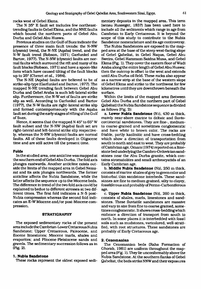
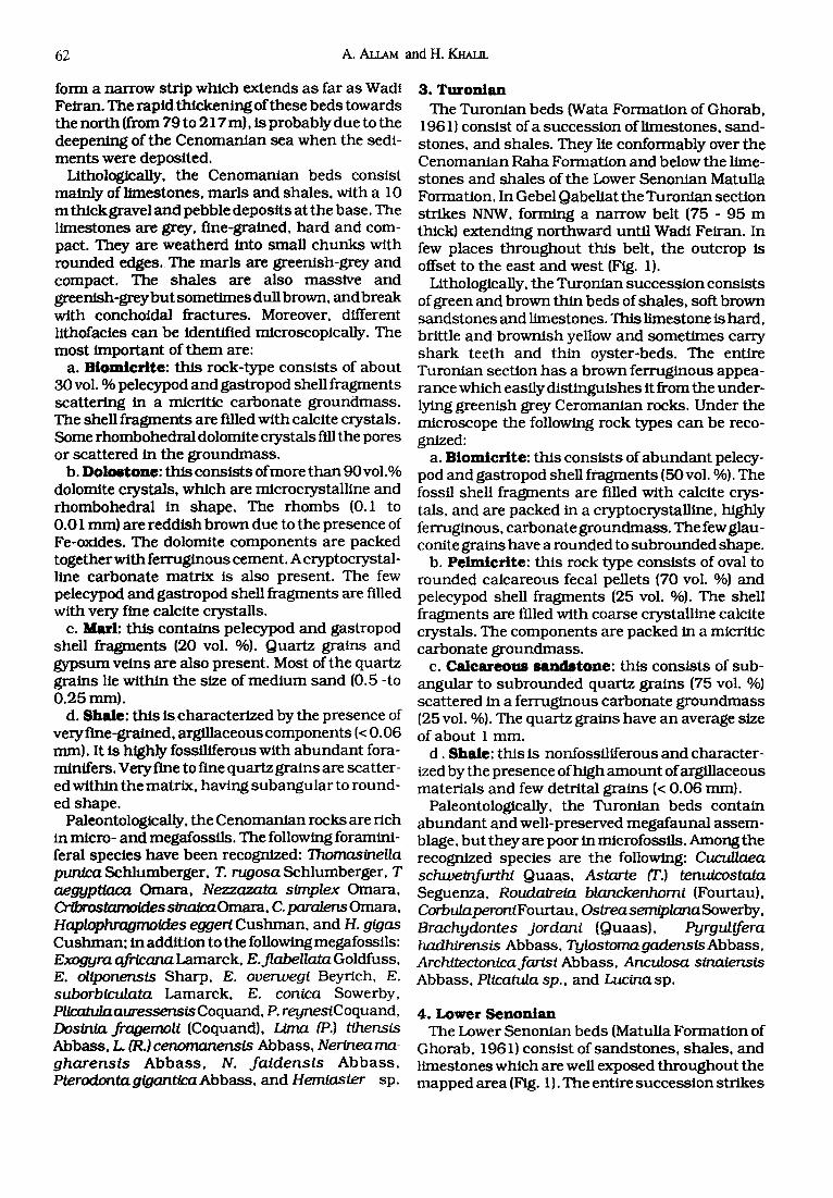
Gebel Qabel ia t lies on the ea s t e rn b a n k of the Gulf of Suez, b e t w e e n Wadi Fe i ran and EI-Tor in the s o u t h w e s t e r n pa r t of Sinai (Fig. 1). It is b o u n d - ed w e s t w a r d b y Wadi Araba, and ea s tward b y EI-Qaa plain. Gebel Qabe l ia t s h o w s a sou thwes t - facing s teep s lope t h r o u g h o u t i ts extension, an d all s e d i m e n t a r y rocks , and t hose to the west , re ta in a lmos t comple te uni formi ty of dip and strike. The depos i t s range in age f rom C a m b r i a n to Recen t (Fig. 2).
The few pub l i ca t ions f o u n d on the geology of the a rea b e t w e e n Wadi Fe i ran and EI-Tor include the s t u d i e s of B a r t o n (1907), Moon and S a d e k (1921), B o w m a n (1925) and Perez (1938). Recently, the a rea h a s a t t r ac ted an in tense s t u d y due to the dis- covery of pe t ro leum. Unfor tuna te ly , m o s t of the da ta ob ta ined are u n p u b l i s h e d , except for some EGPC and EPEX seminars , and the s tud ies carr ied ou t b y Garfunkel and Bartov ( 1977), B u n t e r (1982), H a m z a and Abdal la (1984), Mous t a f a and Khalfl (1985) a n d Al lam e t al. (1986).
The m a i n object ive of the p r e s e n t s t u d y is to have a be t t e r u n d e r s t a n d i n g of the geology a n d strat i- g r a p h y of Gebel Qabel ia t area. This h a s b e e n accompl i shed by:
a) p repa ra t ion o f a photogeological m a p (scale 1: 40 000) and record ing b o t h the s t ra t igraphic and s t ruc tu ra l field data;
b) identifying the macro - and mic ro fauna l and ca l ca reous nannof lora l a s semblages ; and
c) microfacial ana lys i s of e ach l i thost ra t igraphic un i t and in te rpre ta t ion of i ts pa leoenvi ronment .
The field w o r k h a s d o c u m e n t e d the similari ty b e t w e e n Gebel Qabe l ia t sec t ion and the cu r r en t s t ra t igraphic n o m e n c l a t u r e of the Gulf of Suez region. Accordingly, the s e d i m e n t a r y s e q u e n c e in the m a p p e d a rea m a y be s u m m a r i z e d as follows:
Pliocene-Plelstocene Tor Group
Miocene Ras Malaab Group Gharandal Group
Eocene
Khaboba Formation Darat Formation Thebes Formation Upper Esna Shale
Paleocene Lower Esna Shale
Late Cretaceous
Cambrian-Early Cretaceous
Sudr (Chalk) Formation Matulla Formation Wata Formation Raha Formation
"Nubia Sandstone"
STRUCTURE
The m a p p e d a rea (Fig. 1) r e p r e s e n t s a s e g m e n t of the eas tern , onshore , pa r t of t he Gulf of Suez rift. It h a s the form of a long nor the rn -o r i en ted homo- cline t ha t ex tends from Gebel Nezzazat (outs ide the p r e sen t area) to EI-Tor. This homocl ine d ips nor th- ea s tward wi th an average angle of dip of 25 ° . It is b o u n d e d on its w e s t e r n s ide b y d o w n to the sou th - wes t no rma l fau l t s t ha t t r end nor th -nor thwes t . It is d i s sec ted b y the following faul t b locks , f rom no r th to s o u t h : Gebel Nezzazat, Gebel Ekma , Gebel A b u H u s w a , and Gebel Araba.
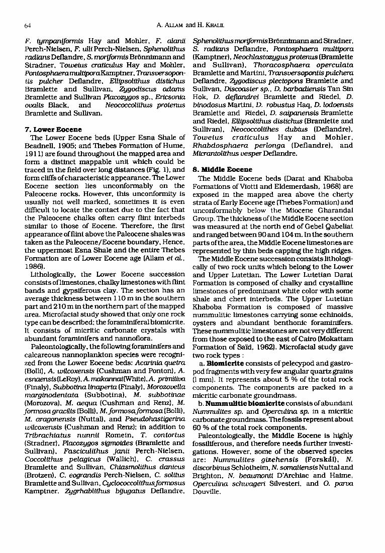
F a u l t s The rose d iagram of the or ien ta t ion of the fau l t s
recognized in the m a p p e d a rea (Fig. 3), indica tes the p re sence of five se t s of fau l t s w h i c h t r end as follows: II N 35 ° W to N 65 ° W wi th m a x i m u m at N 45 ° W; 2) E-W; 3) N 15 ° W; 4) N 5 ° E; and 5) N 35 ° E. One of t he se maJ or faul t s e t s (the E-W faul t
59
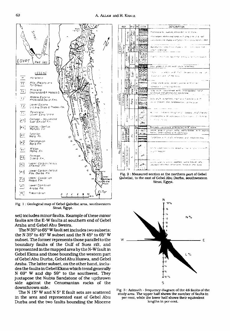
60 A. Au~M and H. KHALm
/
LEGENC' ~ ~
Hotocene ~c
Ptio-Ple~sto ore "/'or Grou~
~ I Miocene Ghorondo(~ ~ M a l o o b G.
LL1 Middte Eocene Khabobad Do:at Fins.
] Lower E o c e n e O ~-Sno Shale & Thebes Fro.
Paieocene J Lower Esno ~oze
Campan - Moustr~cht Sudr (Chalk) Fm
Motulla Fm
Turonl'an K~ Wata Fro.
~ , . Cenomanian Roho Fm
Albion Malho Frr, Permtar) 3,'se~b Fro.
ip~] L, pper Carbo,~:ferous _ _ Ahelmer Frn
L ~ Lower Carboniferous ,abu Durba Fm
F~2 ] Upper Cambrian L_ Noqus Fm
~p~ Lower Cambr,an - - ' Arabo Fm ~C-~ Precambrzan
¢.
Gebe l A bu 5wemo
o 2 , : ~ a t e I I I I -I I ~¢m
El-Tar
Fig. l : Geological m a p of Gebe l Qabe l la t a rea , s o u t h w e s t e r n Sinai , Egypt.
set) includes minor faults. Example of these minor faults are the E-W faults at s o u t h e m end of Gebel Araba and Gebel Abu Sweira.
The N 35 ° to 65 ° W fault set includes two subsets: the N 35 ° to 45 ° W subse t and the N 45 ° to 65 ° W subset . The former represents those parallel to the boundary faults of the Gulf of Suez rift. and represented in the mapped area by the N-W fault in Gebel Ekrna and those bounding the western part o fGebeIAbu Durba, GebelAbu Huswa, and Gebel Araba. The latter subset , on the other hand, inclu- des the faults in Gebel Ekma which trend generally N 69 ° W and dip 59 ° to the southwest . They juxtapose the Nubia Sandstone of the upthrown side against the Cenomanian rocks of the downthrown side.
The N 15 ° W and N 5 ° E fault sets are scattered in the area and represented east of Gebel Abu Durba and the two faults bounding the Miocene
-U II'H L/fh DESCRIPFION
t tp i : ) ed~e~ ~b( { / / ~ =J/)d S: j f IOS ¢ , , r t . < ] n h y : l r t e o , , ] solf
, , , r e , to :as <~ha ~htJtes u .e : t y ,~q ,~ i n , , , : o ' , :? : , , r , e ,~ f l c Dec]
Nu ,Y :n , , t t /c : , : r)E,£~;: ,e < ru , k~ ,. t , , , : ' , , : ' , ~ , . ,~:,~1
cbe~* ~ ~ef~m#5
"f i~'*:F "7~e:: ,,e 70, 'of t , t~, t : t ' k v ~ , f , " : , r t I c ye t5
T_
-='x-7. ~
5 ~" ".'EP~F
- 5 -2-~i~i
( ; fay gceen , ! ; h St~ules w~fb cha f~ :n te~bec ,~
: , : ; . ~ . . , ~ , *~,:) ~l the. bOSE,
J,rr, eSf~:: ~ ¢ f "j; ~,[9 /OS51(S
~ , :~ ~t:ule v~ :~co lo red w~ lh , : , t e rbec l ded : ee / c~ tz ,q~3 lo~e end g l ouco /~ , t : c sohds ton@
51/~y ShUt'e, S a h d £ t O h e r o O F / OCt , / , r f ]p~ ; tC ,~e ~ , ' ~
' / , , k ! l l o vP I5 ~( i conq lome , ote! ; ~r t t e D~)~e
~fu , ve J . t fo , ,e trouq~; c : ;. he .de " r~ ,~ fu r r , o ro t c
Red b e d s / sonds tohe e l t e rno ted w i t h ! ; ho l e
5ho lP . g rey t eg reen , s i l t y , b , o t u rbe ted w, th ma r i ne focsnc~ s / ) f e t ca l o red ~ , t h s a n , f s t o ~ e
' ;oz)ds l3z, e ~, t t~ ",t:c},'e , :He f beds Gqc~ , Oh~:u n P t c ) t e s
,~ • ',. , ~> , , /~ t : ,z ,e , - , ;s Z,~d,1, J , . ; : , t - , ; , J , - : ~ , ' f '
v, : ' r " : ,pbC:e.,
{~,,;itz ~,e:r,:e c ro s beddec t ~ome ~ob~,~l~ ~ets
i ]bL,r/ ,~Ont SCO,' , thus s t r u c f u r e s 'O~o rL i s the bose
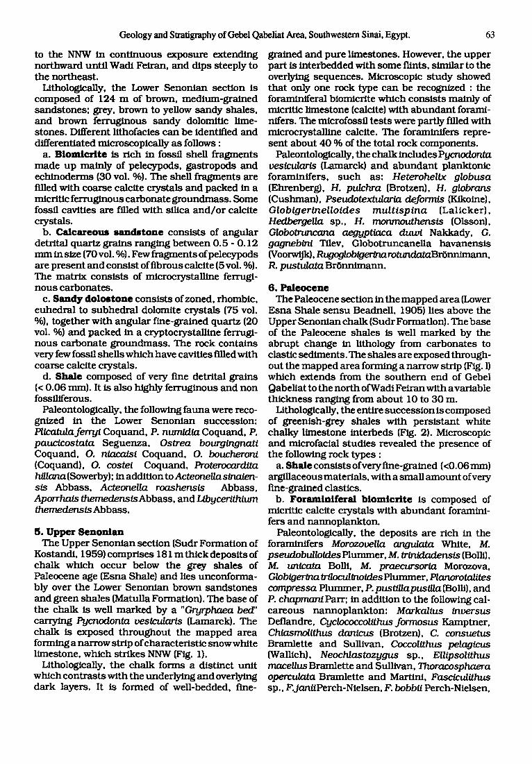
Fig. 2 : M e a s u r e d sec t ion a t the n o r t h e r n p a r t of Gebel Qabel ia t , to the e a s t of Gebe l A b u D u r b a , s o u t h w e s t e r n
Sinai , Egypt.
W _ _
N 18"/.
16
12
8
N */.
E
L */,
!6
1B°/o
S
Fig. 3 : Az imu th - f r equency d i a g r a m of t h e 4 6 f au l t s of t he s t u d y area , T h e u p p e r ha l f s h o w s t he n u m b e r of fau l t s In
pe r cent . whi le the lower h a l f s h o w s the i r equ iva len t l eng th s in pe r cent .
Geology and Stratigraphy of Gel)el Qabcliat Area, Southwestern Sinai, Egypt. 61
rocks west of Gebel E kma. The N 35* E fault set includes few northeast-
t rending faults in Gebel Ekma, and the NNE faults which bound the nor thern parts of Gebel Abu Durba and Gebel Abu Huswa.
Previous studies on the Gulf of Suez indicate the presence of three main fault trends: the N-NW (clysmic) trend, the N-NE (Aqaba) trend, and the N-W fault t rend (Robson, 1971; Garfunkel and Bartov, 1977). The N-NW (clysmic) faults are nor- mal faults which su r round the rift and many of its fault blocks (Robson, 1971) and have a spoon-like form which have caused tilting of the fault blocks up to 25* (Chenet et al., 1984).
The N-NE (Aqaba) faults are believed to be of strike-slip type (Garfunkel and Bartov, 1977). The mapped N-NE trending fault between Gebel Abu Durba and Gebel Araba is such leR-lateral strike slip. Furthermore, the N-W set of faults are strike slip as well. According to Garfunkel and Bartov (1977), the N-W faults are right-lateral strike slip and formed con tempomeous ly with the Aqaba fault set during the early stages of riRing of the Gulf of Suez.
Hence, it seems tha t the mapped N 45 ° to 65 ° W fault subse t and the N-NW (Aqaba) fault set are right-lateral and leR-lateral strike slip respective- ly. whereas the N-NW (clysmic) faults are normal faults. All of these faults developed in Oligocene time and are still active till the present time.
F o l d s In the studied area, one anticline was mapped at
the sou thern end ofGebelAbu Durba. The fold axis plunges eastwards. Another anticline exists out- side the limits of the mapped area in Gebel Nezza- zat and its axis plunges northwards. The former anticline affects the Nubia Sandstone, while the latter affects the sequence up to the Miocene beds. The difference in t rend of the two fold axis could be explained to bedue to different s tresses at two dif- ferent times. The first fold indicates a N-S post- Nubia compression whereas the second fold indi- cates an E-W Miocene a n d / o r post-Miocene com- pression.
STRATIGRAPHY
The exposed sedimentary rocks of the present area include the Cambrian-Lower Cretaceous Nubia Sandstone; Upper Cretaceous, Paleocene, and Eocene limestones; Miocene marls, shales and evaporites; and Pliocene-Pleistocene sands and gravels. The sedimentary succession follows as in {Fig. 2).
1. Nubia S a n d s t o n e These rocks represent the oldest exposed sedi-
men ta ry deposits in the mapped area. This term (sensu Russeger, 1837) has been used here to include all the sediments which range in age from Cambrian to Early Cretaceous. It is beyond the scope of this s tudy to contribute to the Nubia Sandstone nomencla ture and its age controversy.
The Nubia Sands tones are exposed in the map- ped area at the base of the steep west-facing slope of Gebel Qabeliat, in Gebel Naqus, Gebel Abu Sweira, Gebel H a m m a m Saidna Musa, and Gebel Ekma (Fig. 1). They cover the eastern floor of Wadi Araba along the entire length ofGebel Abu Huswa; then the outcrop is offset to the west and extends until Abu Durba oil field. These rocks also appear as a narrow strip at the base of the w e s t e m slope of Gebel Ekma and strike to the nor thwest for few kilometres until they are downthrown beneath the surface.
Within the limits of the mapped area (between Gebel Abu Durba and the nor thern part of Gebel Qabeliat) the Nubia Sandstone sequence is divided as follows (Fig. 2):
a. Lower N u b i a S a n d s t o n e (N1), 430 m thick, mainly near-shore marine to deltaic and fluvio- continental sandstones. They are fine-, medium- to coarse-grained and sometimes conglomeratic and have white to brown color. The rocks are friable, partly kaolinitic and have cross-bedding which show a direction of t ransporta t ion from south to nor th and east to west. They are probably of Cambrian age. Omara (1974) reported on a lime- stone bed underlying the Cambro-Ordovician sand- stones near the Abu Durba granite, which con- tains stromatolites and small archeocyatids of an Early Cambrian age.
b. Midd le Nubia S a n d s t o n e (N2), 2 5 0 m thick, consists of marine shales of grey to green color and bioturbat thin sandstone interbeds. These sand- stones are fine to medium grained, silty to clayey, fossiliferous and probably of Permo-Carboniferous age.
c. Upper Nubia S a n d s t o n e (N3), 2 6 0 m thick, consists of shales, marls, l imestones and sand- stones. These fluviatile sands tones are massive and vary in size from fine to coarse grained, some- times conglomeratic. It shows cross-bedding which embrace a direction of t ranspor t from south to north. In some places it is interbedded with fossil soils such as mudstones , varicolored, well-strati- fied, with root s tructures. These sands tones are probably of Early Cretaceous age.
2. C e n o m a n i a n The Cenomanian beds (Raha Formation of
Ghorab, 1961) are uniform throughout the map- ped area (Fig. I). They lie unconformably above the Nubia Sandstone. At the sou thern flanks of Gebel Qabeliat, the beds strike NNW and their exposures
62 A. ALl.AM and H. KHAUL
form a narrow strip which extends as far as Wadi Felran. The rapid th ickening of these beds towards the nor th (from 79 to 217 m), is probably due to the deepening of the Cenoman ian sea when the sedi- m e n t s were deposited.
Lithologically, the Cenoman ian beds consis t mainly of l imestones, mar ls and shales, with a 10 m th ick gravel and pebble deposi ts at the base. The l imestones are grey, fine-grained, hard and com- pact. They are weatherd into small c h u n k s with rounded edges. The mar l s are greenish-grey and compact . The sha les are also massive and greenish-greybut somet imes dull brown, and break with conchoidal fractures. Moreover, different lithofacies can be identified microscopically. The mos t impor tan t of t h e m are:
a. B i o m i c r i t e : th is rock-type consis ts of about 30 vol. % pelecypod and gas t ropod shell f ragments scat ter ing in a micritic carbonate g roundmass . The shell f ragments are filled with calcite crystals. Some rhombohedra l dolomite crystals fill the pores or scat tered in the g roundmass .
b. D o l o s t o n e : th is consis ts of more t h a n 90voi.% dolomite crystals, which are microcrystall ine and rhombohedra l in shape. The rhombs (0.1 to 0.01 mm) are redd ish brown due to the presence of Fe-oxides. The dolomite componen t s are packed together with fer ruginous cement. A cryptocrystal- line carbonate matr ix is also present . The few pelecypod and gas t ropod shell f ragments are filled with very fine calcite crystans.
c. Marl: th is conta ins pelecypod and gastropod shell f ragments (20 vol. %). Quartz grains and gypsum veins are also present . Most of the quartz grains lie within the size of m e d i u m sand (0.5 -to 0.25 mm).
d. Sha le : th is is character ized by the presence of very flne-gralned, argillaceous componen t s (< 0.06 ram). It is highly fossflfferous with a b u n d a n t fora- minifers. Very fine to fine quartz grains are scatter- ed within the matrix, having subangu la r to round- ed shape.
Paleontologically, the Cenomanian rocks are rich in micro- and megafossfls. The following foramini- feral species have been recognized: Thomaslnella pun/ca Schlumberger , T. rugosa Schlumberger , T aegyptlaca Omara, Nezzazata simplex Omara, C r / t r o s t amo /des s /na~O mara , C.para/ensOmara, Haplophragmoldes eggeri C u s h m a n , and H. g/gas C u s h m a n ; in addi t ion to the followingmegafossils: Exogyra afrlcana Lamarck, E. flabeUata Goldfuss, E. o//ponensts Sharp, E. overwegi Beyrich, E. suborbiculata Lamarck, E. conica Sowerby, Plicabda auressensls Coquand, P. reynesiCoquand, Dosinla fragemoli (Coquand), L/ma (P.) t/hens/s Abbass, L. (R.)cenomanensis Abbass, Nerlnea ma- gharensis A b b a s s , N. fa idens i s A b b a s s , Pterodonta g/gantlca Abbass, and Hemiaster sp.
3. T u r o x f l ~ The Turon ian beds (Wata Format ion of Ghorab,
196 i) consis t of a success ion of l imestones, sand- stones, and shales. They lie conformably over the Cenoman ian Raha Format ion and below the lime- s tones and shales of the Lower Senon ian Matulla Formation. In Gebel Qabeliat the Turon ian section str ikes NNW, forming a narrow belt (75 - 95 m thick) extending nor thward unti l Wadi Feiran. In few places t h r o u g h o u t this belt, the outcrop is offset to the east and west (Fig. 1).
Lithologically, the Turon ian success ion consis ts of green and brown th in beds of shales, soft brown sands tones and limestones. This l imestone is hard, brittle and brownish yellow and somet imes carry sha rk teeth and th in oyster-beds. The entire Turordan sect ion has a brown fer ruginous appea- rance which easily d is t inguishes it from the under- lying greenish grey Ceromanian rocks. Under the microscope the following rock types can be reco- gnized:
a. B i o m i c r l t e : th is cons is ts of a b u n d a n t pelecy- pod and gas t ropod shell f ragments (50 vol. %). The fossil shell f ragments are fined with calcite crys- tals, and are packed in a cryptocrystalline, highly ferruginous, carbonate g roundmass . The few glau- conite grains have a rounded to sub rounded shape.
b. P e h n i c r l t e : th is rock type consis ts of oval to rounded calcareous fecal pellets (70 vol. %) and pelecypod shell f ragments (25 vol. %). The shell f ragments are filled with coarse crystalline calcite crystals. The componen t s are packed in a micritic carbonate g roundmass .
c. C a l c a r e o u s s a n d s t o n e : th is cons is ts of sub- angular to s u b r o u n d e d quartz gra ins (75 vol. %) scat tered in a fer ruginous carbonate g r o u n d m a s s (25 vol. %). The quartz grains have an average size of about 1 mm.
d . Shale: this is nonfossfl iferous and character- ized by the presence of high a m o u n t ofargiUaceous mater ia ls and few detrital gra ins (< 0.06 mm).
Paleontologically, the Turon ian beds conta in a b u n d a n t and well-preserved megafauna l assem- blage, bu t they are poor in microfossfls. Among the recognized species are the following: Cucullaea schweinfurthi Quaas , Astarte fl'.) tenuicostata Seguenza, Roudaireia blanckenhorni (Fourtau), CorbulaperoniFourtau, OstreasemiplanaSowerby, Brachydontes jordani (Quaas), Pyrgulifera hadh/rens/s Abbass, TylostomagadensisAbbass, Architectonica farisi Abbass, Anculosa sinaiensis Abbass, Plicatula sp., and Luc/na sp.
4. Lower S e n o n i a n The Lower Senonian beds (Matulla Format ion of
Ghorab, 1961) consis t of sands tones , shales, and l imestones which are well exposed t h r o u g h o u t the m a p p e d area (Pig. 1). The entire success ion str ikes
Geology and Stratigraphy of Gebel Qabeliat Area, Southwestern Sinai, Egypt. 63
to the NNW in c o n t i n u o u s exposure extendhn~ nor thward unt i l Wadi Feiran, and dips steeply to the nor theas t .
Lithologically, the Lower Senon ian sect ion is composed of 124 m of brown, med ium-gra ined sands tones ; grey, b rown to yellow sandy shales, and b rown fer ruginous sandy dolomitic lime- s tones. Different lithofacies can be identified and differentiated microscopical ly as follows :
a. B i o m l e f l t e is r ich in fossil shen f ragments m a d e u p main ly of pelecypods, gas t ropods and echinoderrns (30 vol. %). The shell f ragments are filled wi th coarse calcite crystals and packed in a micritic fe r ruginous carbonate g roundmass . Some fossil cavities are filled wi th silica a n d / o r calcite crystals. b. Calcareous s a n d s t o n e consists of angular
detrital quar tz gra ins ranging be tween 0.5 - 0.12 m m in size (70 vol. %). Few f ragments ofpelecypods are p resen t and cons is t of f ibrous calcite (5 vol. %). The mat r ix cons is t s of microcrystal l ine ferrugi- n o u s carbonates .
c. Sandy d o l o s t o n e cons is t s of zoned, rhombic, euhedra l to subhedra l dolomite crystals (75 vol. %), together wi th angula r f ine-grained quartz (20 vol. %) and packed in a cryptocrystal l ine ferrugi- n o u s ca rbona te g r o u n d m a s s . The rock conta ins very few fossil shells which have cavities fined wi th coarse calcite crystals.
d. Sha le composed of very fine detrital grains (< 0.06 mm). It is also highly fer ruginous and non fosslliferous.
Paleontologically, the following fauna were reco- gnized in the Lower S e n o n i a n success ion: Pllcatulaferryi Coquand, P. num/d ta Coquand, P. paucicostata Seguenza , Ostrea bourglngnati Coquand, O. nlacaisi Coquand, O. boucheroni (Coquand), O. costei Coquand, Proterocardita hlUana (Sowerby); in addi t ion to Acteonella si~nlpn- sis Abbass , Acteonella roashensis Abbass, Aporrhais themedens t sAbbass , and Libycerithium themedens / s Abbass.
5. Upper Senon ian The Upper Senon ian sect ion (Sudr Format ion of
Kostandi, 1959) compr ises 181 m th ick deposi ts of cha lk which occur below the grey shales of Paleocene age (Esna Shale) and lies unconforma- bly over the Lower Senon ian brown s a n d s t o n e s and green shales (Matulla Formation). The base of the cha lk is well m a r k e d by a "Gryrphaea bed' carrying Pycnodonta veslcularls (Lamarck). The cha lk is exposed t h r o u g h o u t the m a p p e d area forming a nar row strip of characteris t ic snowwhi te l imestone, which s t r ikes NNW (Fig. 1).
Lithologically, the cha lk forms a dis t inct un i t which con t ra s t s with the under ly ing and overlying da rk layers. It is formed of well-bedded, fine-
grained and pure l imestones. However, the uppe r par t is in te rbedded wi th some flints, s imilar to the overlying sequences . Microscopic s tudy showed tha t only one rock type can be recognized : the foraminlferal biomicrite which cons is t s main ly of micritic l imestone (calcite) with a b u n d a n t forami- nifers. The microfossfl t es t s were part ly filled with microcrystal l ine calcite. The foraminifers repre- sen t about 40 % of the total rock components .
Paleontologically, the cha lk inc ludes Pycnodonta ves/cu/ar/s (Lamarck) and a b u n d a n t p lanktonic foraminifers , s u c h as: Heterohellx globusa (Ehrenberg), H. pulchra (Brotzen), H. globrans (Cushman), Psev_~dotex~n!arta deformts (Klkoine), Globigerinelloides multispina (Lal icker ) , Hedberge/ /a sp., H. monmouthens t s (Olsson), Globotruncana aegyptlaca duwi Nakkady, G. gagnebini Tflev, Globotruncanel la havanens i s (VoorwiJk), Rugogloblg~'Inarotund_n_t_aBr6nnimann, R. pus tu / a t a Br6nn imann .
6. Pa leocene The Paleocene sect ion in the m a p p e d area (Lower
Esna Shale s e n s u Beadnell, 1905) lies above the Upper Senon ian cha lk (Sudr Formation). The base of the Paleocene shales is well m a r k e d by the abrup t change in lithology from carbona tes to clastic sediments . The shales are exposed through- out the m a p p e d area forming a narrow strip (Fig. I) which extends from the s o u t h e m end of Gebel Qabeliat to the no r th ofWadi Feiran with a variable th ickness ranging from abou t 10 to 30 m.
Lithologically, the entire success ion is composed of greenish-grey shales with pers i s tan t white chalky l imestone in terbeds (Fig. 2). Microscopic and microfacial s tud ies revealed the presence of the following rock types :
a. Sha le consis ts of very fine-grained (<0.06 ram) argillaceous materials , wi th a small a m o u n t of very fine-grained clastics.
b. Foraminiferal b iomicr i te is composed of micrltic calcite crystals with a b u n d a n t foramini- fers and nannop lank ton .
Paleontologically, the deposi ts are r ich in the foraminifers Morozovella ang1~Inta White, M. pse~_n_dobulloides Plummer , M. trin~_d~densts (Bolli). M. untco_ta Boni, M. praecursoria Morozova, Globiger~na trilocul#wides Plummer , Planorotalites compressa Plummer , P. pustilla pusiUa (Bolli), and P. chapmanl Parr; in addi t ion to the following cal- ca reous n a n n o p l a n k t o n : Markalius inversus Deflandre, Cyclococcolithusformosus Kamptner , Chlasmollthus danlcus (Brotzen), C. consuetus Bramlet te and Sullivan, Coccolithus pelagicus (Wallich), Neochlastozygus sp., Ellipsolithus macellus Bramlet te and Sullivan, Thoracosphaera opero_dnta Bramlet te and Martini, Fasciculithus sp., F.janiiPerch-Nielsen, F. bobbii Perch-Nielsen,
64 A. ALLAM and H. K~uI.
F. tym/x~/form/s Hay and Mohler, F. a/an// Perch-Nielsen, F, ulli Perch-Nielsen, Sphenolithus rad/ans Deflandre, S. mor/form/s BrOnnimann and Stradner, Towelus crat/cu/us Hay and Mohler, Pontosphaeramult/poraKamptner, Transversopon- tis pulcher Deflandre, EUipsolithus distichus Bramlette and Sullivan, Zygodiscus adams Bramlette and Sullivan Placozygos sp., Ericsonia ova//s Black, and Neococcolithus protenus Bramlette and Sullivan.
7. Lower E o c e n e The Lower Eocene beds (Upper Esna Shale of
BeadneU, 1905; and Thebes Formation of Hume, 1911) are found throughout the mapped area and form a distinct mappable unit which could be traced in the field over long distances (Fig. 1), and form cliffs of characterist ic appearance. The Lower Eocene section lies unconformably on the Paleocene rocks. However, this unconformity is usually not well marked, sometimes it is even difficult to locate the contact due to the fact that the Paleocene chalks often carry flint interbeds similar to those of Eocene. Therefore, the first appearance of flint above the Paleocene shales was taken as the Paleocene/Eocene boundary, Hence, the uppermost Esna Shale and the entire Thebes Formation are of Lower Eocene age (Allam et al., 1986).
Lithologically, the Lower Eocene succession consists of limestones, chalky limestones with flint bands and gypsiferous clay. The section has an average thickness between 110 m in the southern part and 210 m in the n o r t h e m part of the mapped area. Microfacial s tudy showed that only one rock type can be described; the foraminiferal biomicrite. It consists of micritic carbonate crystals with abundan t foraminlfers and nannoflora.
Paleontologically, the following foraminifers and calcareous nannoplankton species were recogni- zed from the Lower Eocene beds: Acarinia quetra (Bolli), A. wilcoxensls (Cushman and Ponton), A. esnaens/s(LeRoy), A. makanna/(White),A, p ~ (Finaly), Subbot/na I/naperta (Finaly), Morozovella marginodentata (Subbotina), M. subbotinae (Morozova), M. aequa (Cushman and Renz), M. formosa gracilis (Bolli), M. formosa formosa (Bolli), M. aragonensis (Nuttal), and Pseudohastigerlna wilcoxensis (Cushman and Renz); in addition to Tribrachiatus nunnii Romein, T. contortus (Stradner), Placozygos sigmoldes (Bramlette and Sullivan), Fasciculithus Janii Perch-Nielsen, Coccollthus pelagicus {WaUich), C. crassus Bramlette and Sullivan, Chi_~smolithus danicus {Brotzen), C. eograndis Perch-Nielsen, C. solitus Bramlette and Sullivan, Cyclococcolithusformosus Kamptner. Zygrhablithus bi]ugah~s Deflandre,
Sphenolithus mor/form/s BrOnnlmann and Stradner, S. rad/ans Deflandre, Pontosphaera multipora (Kamptner), Neochlastozygus protenus (Bramlette and Sull ivan), Thoracosphaera operculata Bramlette and Martini, Transversopont/s pulchera Deflandre, Zygod/scus plectopons Bramlette and Sullivan, Discoaster sp., D. barbadiensis Tan Sin Hok, D. deflandrei Bramlette and Riedel, D. binodosus Martini, D. robustus Haq, D. Iodoensis Bramlette and Ricdel, D. saipanensis Bramlette and Riedel, EUipsolithus distichus (Bramlette and Sullivan), Neococcolithes dubius (Deflandre), Toweius craticulus Hay a n d Mohler , Rhabdosphaera perlonga (Deflandre), and Micrantolithus vesper Deflandre.
8. Middle E o c e n e The Middle Eocene beds (Darat and Khaboba
Formations of Viotti and Eldemerdash, 1968) are exposed in the mapped area above the cherty strata of Early Eocene age (Thebes Formation) and unconformably below the Miocene Gharandal Group. The thickness of the Middle Eocene section was measured at the north end of Gebel Qabeliat and ranged between 90 and 104 m. In the southern parts of the area, the Middle Eocene limestones are represented by thin beds capping the high ridges.
The Middle Eocene succession consists lithologi- cally of two rock units which belong to the Lower and Upper Lutetian. The Lower Lutetian Darat Formation is composed of chalky and crystalline limestones of predominant white color with some shale and chert interbeds. The Upper Lutetian Khaboba Formation is composed of massive nummuli t ic l imestones carrying some echinoids, oysters and abundan t benthonic foramintfers. These nummulit ic l imestones are not very different from those exposed to the east of Cairo (Mokattam Formation of Said, 1962}. Microfacial s tudy gave two rock types :
a. B i o m i e d t e consists of pelecypod and gastro- pod fragments with very few angular quartz grains (l mm). It represents about 5 % of the total rock components. The components are packed in a micritic carbonate groundmass .
b. Nummul i t i c b iomic r i t e consists of abundan t Nummulites sp. and Operculina sp. in a micriUc carbonate groundmass. The fossils represent about 60 % of the total rock components.
Paleontologically, the Middle Eocene is highly fossfliferous, and therefore needs fur ther investi- gations. However, some of the observed species are: Nummulites gizehensis (Forsk~l), N. discorbinus Schlotheim, N. somaliensis Nuttal and Brighton, N. beaumont/ D'Archiac and Haime, Operculina schwageri Sflvesteri, and O. parva Douville.
Geology and Stratigraphy of Gebel Qabeliat Area, Southwestern Sinai, Egypt. 65
9. M i o c e n e The Miocene success ion (Gharandal and Ras
Malaab Groups of the EGPC, 1964) cons is t s of 240 m th i ckness of l imestones, chalky l imestones, marls , shales , g y p s u m and conglomerates. The Miocene rocks unconformably overly the Eocene a n d / o r older beds. In the area be tween Gebel H a m m a m Sa idna Musa to Gebel Abu Sweira, the Miocene beds are found capping the hills and unconformably overlie the Nubia Sands tone and Cre taceous beds. Along Gebel Qabeliat, in the area between Gebel E k m a and Gebel Abu Huswa, the Miocene ha s been affected by faulting. The beds, which lie unconformably over the Eocene section, form a smal l syncl inal fold and two dist inct ridges due to faulting. Near Wadi Feiran, Miocene gyp- s u m is found overlying the Eocene beds; whereas to the west of Gebel Ekma, the g y p s u m is found in faul ted contac t aga ins t the Nubia Sands tones . The sed imenta ry sect ion can be divided into two m a i n rock uni ts , the Lower Miocene clastics (Gharandal Group) and the Middle-Upper Miocene evaporites (Ras Malaab Group).
The Gharanda l Group compr ises : a) the basal rock un i t (Nukhul Formation), which is composed main ly of l imestones and shales overlying a th in conglomerat ic bed; b) the middle rock un i t (Rudeis Formation} which is composed main ly of shales and sands tones ; c) the uppe r rock un i t (Kareem Formation) which is composed mainly of sand- s tones and shales wi th th in evaporitic beds at the base.
The Ras Malaab Group cons is t s main ly of: a) in te rbedded shales a n d s a n d s t o n e s with anhy- drite and salt in the lower par t (Belayim Formation); b} th ick salt deposi ts in the middle par t (South Gharib Formation); and c) in te rbedded shales and anhydr i te in the upper par t (Zeit Formation).
Under the microscope, the following lithofacies can be differentiated :
a. S a n d y s ha l e m a d e up of very fine gra ins (<0.06 mm) with rounded quar tz grains (I mm) which form abou t 20 % of the total components . G y p s u m veins are also present .
b. S a n d s t o n e m a d e up of angular to s u b r o u n d e d quar tz gra ins form abou t 90 % of the total rock components . It ranges in size be tween 0.25 - i ram, and embeded in fine gra ined detri tal matrix.
c. S a n d y b i o m i c r l t e conta ins shell f ragments of pelecypods, gas t ropods and corals (40 vol. %) scat- tered in micritic carbonate g roundmass . Angular quar tz gra ins range in size be tween 0.5 to 1 m m and represen t abou t 20 vol. % of the rock.
d. Gyps,~m with f ibrous crystals and a small a m o u n t of argi l laceous ma t t e r and carbonates .
The identified f auna from the Miocene rocks are
as follows: Sphenolithus morlformis (Brfinnimann a n d Mar t in i ) , Thoracosphaera operculata Bramlet te and Martini, Coccolithus eopelaglcus (Bramlette and Riedel), Prediscosphaera grandts Perch-Nielsen, Micrantholithus vesper Deflandre, W~t~nauer/a ba rnesae (Black), Micula murus (Martini), Q u a d r u m n/ t /dwn (Stradner), Hellcopon- tosphaera carteri (Wallich), Cyclicargollthus florldanus (Roth and Hay), Sphenollthus conlcus Bukry, Helicopontosphaera kamptnerl Hay and Mohler, Pontosphaera multispora Roth, and Coccolithus pelagicus (Wallich).
10. M i o c e n e - P l e i s t o c e n e The Pliocene-Pleistocene (Tor Group of Webster
and Ritson, 1982) is composed of a th ick s and dominan t s t ra t igraphic un i t above the Miocene Ras Malaab Group. The s and deposi ts are arkosic and appear to be drived predominant ly from the Precambr ian b a s e m e n t and younger rocks. Beds of coralline l imestones occur nea r the top of the uni t and somet imes wi th anhydri te . A deposit ional envi ronment s imilar to t ha t prevailing at p resen t is expected wi th coalescing subaer ia l coastal fans with occasional aeolian, s a b k h a and reef deposi ts (Allam, 1986).
The Pliocene-Pleistocene deposits , in the map- ped area, have no t been subdivided. They are widely scat tered t h r o u g h o u t the area especially along the wadis and plains. In EI-Qaa plain, where several wadis empty into the plain, extensive depo- sits of s ands and gravels are somet imes found s tand ing as steep to vertical walls (15 - 20 m) and form the b a n k s of the m a i n drainage lines. These b a n k s are usual ly composed of cross-bedded, cemented s ands in te rbedded with conglomerates. To the east of EI-Tor, there are several low hills which are covered by gravels b u t show small boulders of calcareous s a n d s t o n e s along their wes te rn slopes. Along the w e s t e m slopes of Gebel Abu Huswa and GebelAbu Durba, scat tered depo- sits of 40 - 50 m th ick cemen ted s ands and gravels are found fringed agains t the hill front. The plain ofWadi Feiran is well filled by s a n d s and gravels of the ma in drainage lines. Generally, the surface of the Pliocene-Pleistocene clastic deposi ts is covered by poorly sor ted boulders and pebbles, which have been derived from the s u r r o u n d i n g older rocks.
DEPOSITIONAL HISTORY
It is well known tha t a granitic Precambr ian shield forms the h ighland of Sinai. The Cambr ian and younger subaer ia l erosion of th is Precambr ian shield ha s led to the deposi t ion of th ick and widespread Nubia Sands tone . The absence of any basal conglomerates in the lower Nubia Sands tone in the m a p p e d area and the presence ofbioturba-
AES g:l-E
66 A. ALLAM and H. KnALtL
tions in the lower sands suggest that the lower Nubia Sandstone was deposited in a shallow marine platform with low relief. A hinterland to the south and a basin to the nor th is also inferred. The widespread and uniform na ture of the lower Nubia Sandstone implies a Paleozoic epicontinental to shallow marine shelf of large dimensions. It is suggested tha t this shelf may have extended far northward in Sinai throughout the Paleozoic Era.
During the Permo-Carboniferous t imes there is a nor th to south widespread marine transgression in the mapped area. The geologic record of this t rans- gression is represented by clastic sediments with dateable fossils. The depositional environment in that time implies a submarine relief of some ma- gnitude. It ranges from inner sublittoral, outer sublittoral to bathyal marine conditions. Earth- movements during the Permo-Carboniferous time are suspected. At the end of the Paleozoic Era the sea withdrew from the mapped area.
The characterist ics of the Early Mesozoic Nubia Sands toneswhich are interbedded with fossil soils with root s t ructures and fossil trees, indicate a fluviatile to deltaic depositional environment. The sandstones were probably eroded from the sur- rounding igneous and metamorphic rocks, so that it would be possible that the depositional environ- ment ranged from braided fluviatfle systems to marginal or shallow marine settings in a high energy low braided streams.
The Cenomanian begins with the first appea- rance of marine beds above the Nubia Sandstone. The transit ion from clastic to an entirely marine section occurs over few metres. The facies charac- ters of the Cenomanian rocks indicate a fairly shallow transgressing sea. The upper part of the succession shows alternating shallow and compa- ratively deep marine facies. This phenomenon would suggests an oscillating shallow sea, espe- cially during the Late Cenomanian when this sea became gradually deeper at the beginning of the Turonian.
The Late Cretaceous sea continued its trans- gression during the Turonian, where compratively deeper mar ine conditions prevailed. This was evi- denced by predominance of l imestones and dolo- stones and low clastic ratio. The presence of dolo- mite indicates a stable sea-margin-envlronment. However, this Turonian sea was receiving, at inter- vals, subordinate amounts ofterrigenous material from a neighbouring southern landmass (Lewy, 1975 and Ismail and Dakkak, 1976).
The abundance of detrital grains and the pelletal nature of the Lower Senonian rocks indicate a predominant sballow marine condition of the neritic zone. This shallowing of the Late Cretaceous sea would suggest a crustal uplift of the sea floor about the end of Turonian time (Ismail and Dakkak,
1976}. The clastic sediments of Lower Senonian age is
followed by a chalky sequence of Upper Senonian age, which indicate deposition under deeper ma- rine conditions far from any terrigenous material. It means, the shallowing of the Lower Senonian sea was followed by a reversal in the secular oscillation of the sea floor Waft e t al., 1977). However, the orogenic movements which affected the nor thern parts of Egypt along the NW-SE Syrian arcs (Shukri, 1954), were not active at the mapped area because the Paleocene deposits conformably follow the topmost Upper Senonian beds. The Paleocene sediments show open marine outer neritic facies environment. It seems that the marine conditions during the Paleocene time were, more or less, similar to tha t obtained dur ing the Late Senonian.
The beginning of Early Eocene was the time when the transgression of the sea was either halted or had a slight regression. The crustal stability has produced a deposition of uniform open-sea facies of the limestone with flint. By upper Lower Eocene time a regression of the sea started, and the reefal alveolinid limestone facies was formed under shallow marine conditions. According to Said {1962) the Late Eocene regression of the sea m u s t have continued probably to the end of Oligocene time. Therefore. the Middle Eocene sea was gradually regressing, due to the appearance of larger forami- nffers above the Lower Eocene beds.
The Ollgocene in Sinai was marked by general uplift accompanied by igneous activity. The ig- neous activity was represented by the Early Tertiary basalt flows which was generally interpre- ted as related to initial faulting in the Suez rift (Garfunkel and Bartov, 1977; and Webster and Ritson, 1982). The onset of rifting is defined in the present map by an unconformity. The erosion which occurred appears to be restricted to the Upper Eocene limestone. A shallow proto-rift depocentre was first formed in which the lower part of the Gharandal Group was deposited. As the sea- level rose through the Aquitanian and Early Burdigalian Wail e t al., 1977}, successive forma- tions onlapped the margins of the developing depo- centre. The subsequent deposition of the upper part of the Gharandel Group, comprise lagoonal and subsequent marginal and shallow marine se- quence, and reflects major sea-level changes. The Lower Miocene deposits were succeeded during Middle Eocene (Serravallian) time by prolonged se- dimentation of reef building carbonates in the mapped area. These reefs, which consti tute the Belayim Formation marks the last occurence of marine fauna in the Miocene. The reefal conditions were gradually changed to progressive aridity, leading to the prolonged formation of evaporites of
Geology and Stratigraphy of Gebel Qabeliat Area, Southwestern Sinai, Egypt. 67
Ras Malaab Group d u r i n g T u r t o n i a n a n d Mess in ian t imes, The evaporitic deposi ts were ac- c u m u l a t e d u n d e r very shal low epicont inenta l sea.
Finally, a t the close of Miocene t ime, ar idi ty ceased a n d gave way, du r ing Pliocene-Pleistocene t imes , to the s ed imen ta t i on of clastic ma te r i a l s in s o u t h w e s t e r n Sinai. The Pliocene-Pleistocene de- posi ts , in the m a p p e d area, have ma in ly terres t r ia l facies. They are mos t ly composed of gravels a n d conglomerates wi th some anhydr i te interbeds. This seems to indicate t h a t occasional ma r ine t r ans - g ress ions covered the area.
R E F E R E N C E S
Allam, A., 1986. Geological and Environmental Study on Miocene Clastlc Sediments at Wadi Tayiba, Gulf of Suez, Sinai, EgypL Delta J. ScL, Tanta Univ. I0 (2).
Anam, A., Faris, M. and Khalil, H. 1986. Planktonic Foraminifera and Calcareous Nannofossil Biostrati- graphy of the Lower Eocene Rocks ofGebel Qabeliat, Sinai, Egypt. Isr. J. Earth ScL
Barron, T., 1907. The topography and geology of the Peninsula of Sinai (Westem Portion), Egypt. Egypt. Surv. Dept.
BeadneU, H.J.L., 1905. The relations of the Eocene and Cretaceous systems in the Esna-Aswan reach of the Nile Valley. Quart. J. Geo/. Soc. London, 81,667-678.
Bowman, T.S., 1925. Report on Boring for Oil in Egypt, Gov. Petrol. Res. Operat., Min. & Quar. Dept., Cairo.
Bunter, M.A.G., 1982. Surface and Subsurface Geology of the Qaa Basin, Southwest Sinai, Egypt. 6th E. G. P.C. Expl. Sem., Cairo.
Chenet, P., Letouzey, J. and Zaghloul, E., 1984. Some observations on the rift tectonics in the eastem part of Suez rift. 7th E.G.P.C. Expl. Sem., Cairo.
E.G.P.C. (Egyptian General Petroleum Corporation), Stratigraphic Committee 1964. Oligocene and Miocene rock stratigraphy of the Gulf of Suez region. Report no. E.R. 575.
Garfunkel, Z. and Bartov, Y., 1977. The Tectonic of the Gulf of Suez Rift. Bull. GeoL Surv. Isr. 71.
Ghorab, M.A. 1961. Abnormal stratigraphic features in
Ras Gharib off fields. 3rd Arab Petrol. Congr., Alexandria.
Hamza, F. and Abdalla, M., 1984. Depositlonal Model for the Miocene Sequence at Gebel Sayidna Musa, Southwest Sinai, Egypt. Scfent. Bu/L, Ain Shams Univ. 24, 53-63.
Ismail, M.M. and Dakkak, M., 1976. Microfacies Study of the Gebel Nezzazat Upper Cretaceous Surface Section. BulL Fac. ScL, Alex. Univ. I I , 231-265.
Khalil, H. 1986. Geology of the area between Wadi Feiran and EI-Tor, Southwest Sinai, Egypt. UnpubL M. Sc. Thesis, Fac. Sc., Tanta Univ.
Kostandi, A.B., 1959. Facies maps for the study of the Paleozoic and Mesozoic sedimentary basins of Egyptian region. 1st Arab Petrol. Congr., Cairo.
Lewy, Z., 1975. The Geological History of Southern Israel and Sinai during the Coniacian. Isr. J. EarthScL 24, 19-43.
Moon, F.W. and Sadek, H., 1921. Topography and Geology of Northern Sinai. Petr. Res. BulL I0.
Moustapha, A. and Khalfl, M. 1985. The Durba-Araba fault, southwest Sinai. 23rd Ann. Meet. Geol. SOc. Egypt, Cairo.
Omara, S., 1972. An Early Cambrian Outcrop in South- western Sinai, Egypt. N. Jb. Paleont. Mh., 306-314.
Perez, R.F. 1938. Geological Report on EI-Qaa plain and adjacent areas, Southwestern Sinai. Internal Rept. Standard Oil of Egypt, 24.
Robson, D.A., 1971. The Structure of the Gull of Suez (Clysmic) Rift; with special reference to the eastern side. J. Geo/. Soc. London 115, 247-276.
Russegger, J.R., 1837. Kreide und Sandstein; Einfluss von Granit auf letzteren. NeuesJahrb . Mfn., 665-669.
Said, R., 1962. The Geology of Egypt. Elsevier, Amsterdam.
Shukri, N.M., 1954. Some remarks on the structure of Egypt. BulL Soc. Geogr. d'Egypte 27, 65-82.
Vail, P.R., Mitchum, l~M.Jr., Todd, R.G., Widmler, J.M., Thompson III, S., Sangree, J.B., Bubb, J.N. and Hatelid, W.G., 1977. Seismic stratigraphy and global change of sea-level. Bul l Am. Ass . Petrol. GeoL 26, 49-205.
Webster, D.J. and Ritson, N., 1982. Post-Eocene Stra- tigraphy of the Suez Rift in SW-Sinai, Egypt. 6th E.G.P.C. Expl. Sem., Cairo.