Embed Size (px)
Citation preview

Open Forecast – Geoserver & INSPIRE conformity
© The Open Forecast Project
www.open-forecast.eu @OpenForecastEU
Co-financed by the Connecting Europe Facility of the European Union

Open Forecast Use Cases – Definition and Requirements 1
Project Open Forecast Action number 2017-DE-IA-0170 Report title Open Forecast Geoserver and INSPIRE conformity Report number OF_R7.4 Date of publication 31.05.2021 Revision Rev_02 Lead Partner LGL Authors D. Schilder, C. Bauer, S. Bingert, M. Weis Dissemination level <PU1>
1 PU = Public PP = Restricted to other programme participants (including the Commission Services). RE = Restricted to a group specified by the consortium (including the Commission Services). CO = Confidential, only for members of the consortium (including the Commission Services)

Open Forecast Use Cases – Definition and Requirements 2
Executive Summary The report presents the activities undertaken to publish the Open Forecast INPSIRE-conform. The Action decided to use the open-source software Geoserver as interface to retrieve the processed data. The configuration and further steps to be taken to publish the data on national and international geo-data platforms are described in the following.
Open Forecast Use Cases – Definition and Requirements 3
1 Table of Contents Executive Summary ...................................................................................................................... 2 List of Figures ............................................................................................................................... 4 List of Tables ................................................................................................................................ 5 2 Introduction ............................................................................................................................ 6 3 Geoserver Web Services ...................................................................................................... 6
3.1 General functioning of a web service ............................................................................ 6 3.2 Principles of WMS and WCS ........................................................................................ 8
4 Geoserver Data Modelling ................................................................................................... 10
4.1 General data concept Geoserver ................................................................................ 11 4.2 Data concept Open Forecast ...................................................................................... 11
5 INSPIRE metadata modelling and validation ...................................................................... 18
5.1 Conclusion .................................................................................................................. 23
6 Acknowledgements ............................................................................................................. 23 Appendix A: Place the title of appendix here .............................................................................. 24
Open Forecast Service Metadata ........................................................................................... 24 Open Forecast WMS Metadata Test ...................................................................................... 26 Metadata information system .................................................................................................. 28 Open Forecast WCS Metadata Test ....................................................................................... 28

Open Forecast Use Cases – Definition and Requirements 4
List of Figures Figure 1: Request - Response communication of web services ................................................... 7 Figure 2: Geoserver WMS/WCS workflow ................................................................................. 11 Figure 3: Geoserver Open Forecast data model ........................................................................ 12 Figure 4: Open Forecast data provision using WMS and WCS ................................................. 17 Figure 5: Example Open Forecast data visualization using QGIS ............................................. 19 Figure 6: Inspire Validator Direct Meta Data Test ...................................................................... 23 Figure 7: Inspire Validator Test Screenshot 1 ............................................................................ 24 Figure 8: Inspire Validator Test Screenshot 2 ............................................................................ 24 Figure 9: Inspire Validator Test Screenshot 3 ............................................................................ 26 Figure 10: Inspire Validator Test Screenshot 4 .......................................................................... 26 Figure 11: Inspire Validator Test Screenshot 5 .......................................................................... 27 Figure 12: Inspire Validator WCS Test Result 1 ......................................................................... 28 Figure 13: Inspire Validator WCS Test Result 2 ......................................................................... 28
Open Forecast Use Cases – Definition and Requirements 5
List of Tables Table 1: HTTP GET request example .......................................................................................... 8 Table 2: General WMS request layout ......................................................................................... 8 Table 3: WMS GetMap request example ..................................................................................... 9 Table 4: List of Open Forecast properties .................................................................................. 13 Table 5: Example PostgreSQL data for Open Forecast ............................................................. 14 Table 6: Example data for the timeregex.properties for Open Forecast ..................................... 15 Table 7: Geoserver Settings for Open Forecast ......................................................................... 18 Table 8: INSPIRE test criteria for the Open Forecast data services .......................................... 20 Table 9: INSPIRE test results for the Open Forecast data services ........................................... 20 Table 10: Extended metadata for the INSPIRE conformity ........................................................ 21
Open Forecast Use Cases – Definition and Requirements 6
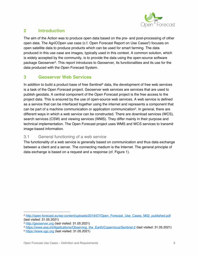
2 Introduction The aim of the Action was to produce open data based on the pre- and post-processing of other open data. The AgriCOpen use case (c.f. Open Forecast Report on Use Cases2) focuses on open satellite data to produce products which can be used for smart farming. The data produced in this use case are images, typically used in this context. A common solution, which is widely accepted by the community, is to provide the data using the open-source software package Geoserver3. This report introduces to Geoserver, its functionalities and its use for the data produced with the Open Forecast System.
3 Geoserver Web Services In addition to build a product base of free Sentinel4 data, the development of free web services is a task of the Open Forecast project. Geoserver web services are services that are used to publish geodata. A central component of the Open Forecast project is the free access to the project data. This is ensured by the use of open-source web services. A web service is defined as a service that can be interfaced together using the internet and represents a component that can be part of a machine communication or application communication5. In general, there are different ways in which a web service can be constructed. There are download services (WCS), search services (CSW) and viewing services (WMS). They differ mainly in their purpose and technical implementation. The Open Forecast project uses WMS and WCS services to transmit image-based information.
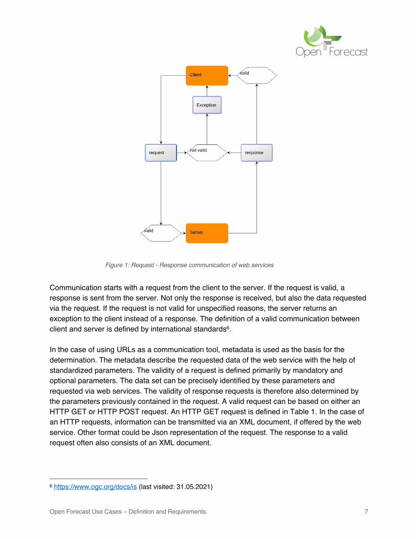
3.1 General functioning of a web service The functionality of a web service is generally based on communication and thus data exchange between a client and a server. The connecting medium is the Internet. The general principle of data exchange is based on a request and a response (cf. Figure 1).
2 http://open-forecast.eu/wp-content/uploads/2019/07/Open_Forecast_Use_Cases_M02_published.pdf (last visited: 31.05.2021) 3 http://geoserver.org (last visited: 31.05.2021) 4 https://www.esa.int/Applications/Observing_the_Earth/Copernicus/Sentinel-2 (last visited: 31.05.2021) 5 https://www.ogc.org (last visited: 31.05.2021)
Open Forecast Use Cases – Definition and Requirements 7
Communication starts with a request from the client to the server. If the request is valid, a response is sent from the server. Not only the response is received, but also the data requested via the request. If the request is not valid for unspecified reasons, the server returns an exception to the client instead of a response. The definition of a valid communication between client and server is defined by international standards6. In the case of using URLs as a communication tool, metadata is used as the basis for the determination. The metadata describe the requested data of the web service with the help of standardized parameters. The validity of a request is defined primarily by mandatory and optional parameters. The data set can be precisely identified by these parameters and requested via web services. The validity of response requests is therefore also determined by the parameters previously contained in the request. A valid request can be based on either an HTTP GET or HTTP POST request. An HTTP GET request is defined in Table 1. In the case of an HTTP requests, information can be transmitted via an XML document, if offered by the web service. Other format could be Json representation of the request. The response to a valid request often also consists of an XML document.
6 https://www.ogc.org/docs/is (last visited: 31.05.2021)
Figure 1: Request - Response communication of web services
Open Forecast Use Cases – Definition and Requirements 8
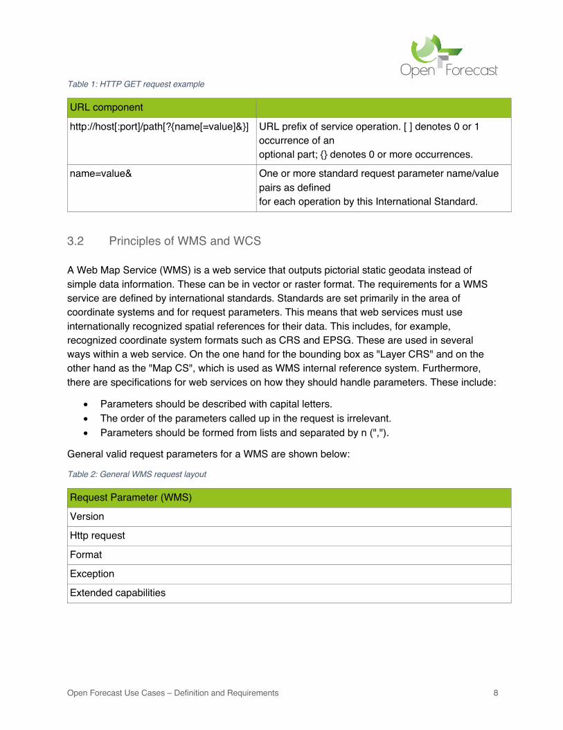
Table 1: HTTP GET request example
URL component
http://host[:port]/path[?{name[=value]&}] URL prefix of service operation. [ ] denotes 0 or 1 occurrence of an optional part; {} denotes 0 or more occurrences.
name=value& One or more standard request parameter name/value pairs as defined for each operation by this International Standard.
3.2 Principles of WMS and WCS A Web Map Service (WMS) is a web service that outputs pictorial static geodata instead of simple data information. These can be in vector or raster format. The requirements for a WMS service are defined by international standards. Standards are set primarily in the area of coordinate systems and for request parameters. This means that web services must use internationally recognized spatial references for their data. This includes, for example, recognized coordinate system formats such as CRS and EPSG. These are used in several ways within a web service. On the one hand for the bounding box as "Layer CRS" and on the other hand as the "Map CS", which is used as WMS internal reference system. Furthermore, there are specifications for web services on how they should handle parameters. These include:
• Parameters should be described with capital letters. • The order of the parameters called up in the request is irrelevant. • Parameters should be formed from lists and separated by n (",").
General valid request parameters for a WMS are shown below:
Table 2: General WMS request layout
Request Parameter (WMS)
Version
Http request
Format
Exception
Extended capabilities
Open Forecast Use Cases – Definition and Requirements 9
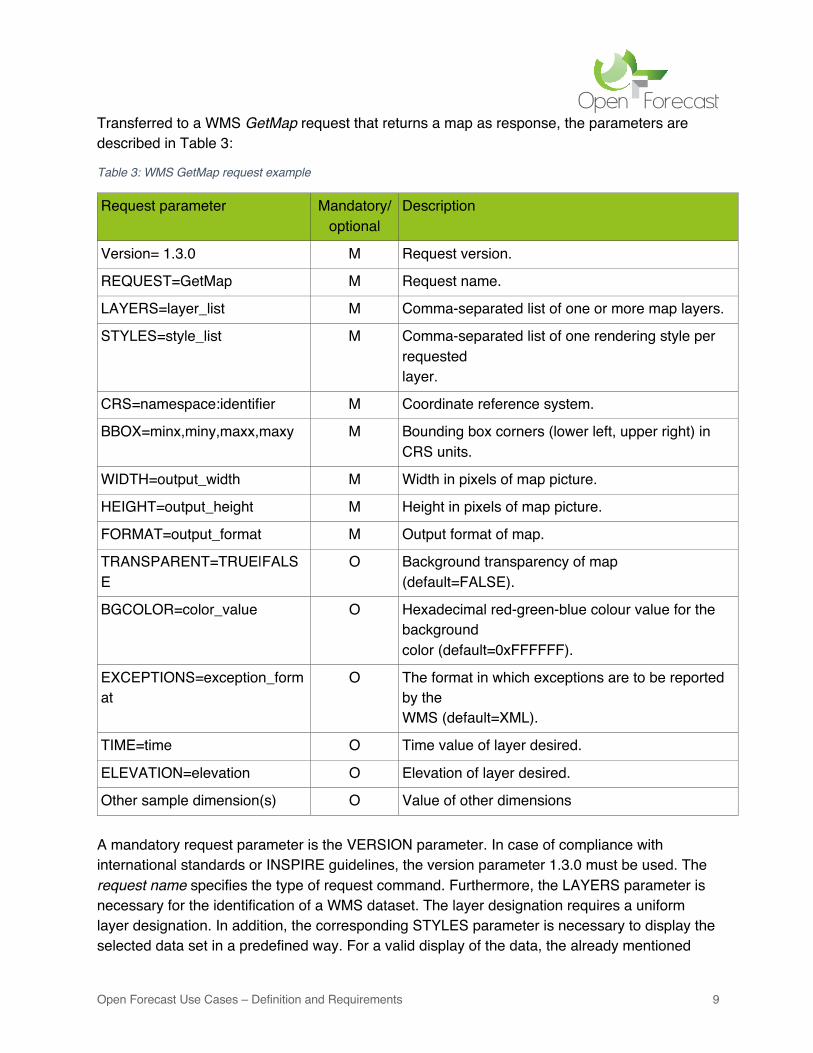
Transferred to a WMS GetMap request that returns a map as response, the parameters are described in Table 3:
Table 3: WMS GetMap request example
Request parameter Mandatory/optional
Description
Version= 1.3.0 M Request version.
REQUEST=GetMap M Request name.
LAYERS=layer_list M Comma-separated list of one or more map layers.
STYLES=style_list M Comma-separated list of one rendering style per requested layer.
CRS=namespace:identifier M Coordinate reference system.
BBOX=minx,miny,maxx,maxy M Bounding box corners (lower left, upper right) in CRS units.
WIDTH=output_width M Width in pixels of map picture.
HEIGHT=output_height M Height in pixels of map picture.
FORMAT=output_format M Output format of map.
TRANSPARENT=TRUE|FALSE
O Background transparency of map (default=FALSE).
BGCOLOR=color_value O Hexadecimal red-green-blue colour value for the background color (default=0xFFFFFF).
EXCEPTIONS=exception_format
O The format in which exceptions are to be reported by the WMS (default=XML).
TIME=time O Time value of layer desired.
ELEVATION=elevation O Elevation of layer desired.
Other sample dimension(s) O Value of other dimensions A mandatory request parameter is the VERSION parameter. In case of compliance with international standards or INSPIRE guidelines, the version parameter 1.3.0 must be used. The request name specifies the type of request command. Furthermore, the LAYERS parameter is necessary for the identification of a WMS dataset. The layer designation requires a uniform layer designation. In addition, the corresponding STYLES parameter is necessary to display the selected data set in a predefined way. For a valid display of the data, the already mentioned

Open Forecast Use Cases – Definition and Requirements 10
CRS and BBOX parameters are necessary. These define the bounding box with the help of corner coordinates as well as the underlying reference coordinate system of the web service. The map window to be expected is determined by a pixel specification with the parameters WIDTH and HEIGHT. The data format of the output is determined with FORMAT. In addition, further optional parameters can be used in the request command. Important optional parameters that are often used in web services are TIME, DIMENSION and ELEVATION. The TIME parameter is useful for the use and differentiation of multi-temporal data. The DIMENSION parameter can be used to create additional filters for WMS/WCS data. The ELEVATION parameter can be used for filtering and displaying heights. The content/result of a valid GetMap response is a spatially referenced map layer. This should be constructed according to the parameters occurring in the request. In the case of a non-valid request or invalid parameter specifications, at least one exception or error message is to be expected. The Web Coverage Service (WCS) is like a WMS service capable of providing geoinformation over the internet from a server to clients. The difference of a WCS service compared to a WMS service, where data can be viewed one-dimensionally, is that with the WCS a multidimensional view is possible. It is not a viewer service like the WMS service, but a download service that can output original data. These can be used for further scientific calculations and are particularly suitable for science. The results and data of the Open Forecast project are offered via a WMS as well as WCS service.
4 Geoserver Data Modelling The web services of the Open Forecast project should fulfil certain requirements. They should be license-free web services and comply with the open-source guidelines. The open-source web services used in the Open Forecast project are based on the open-source platform Geoserver (http://geoserver.org/). This software offers free web services for geodata. The web service can be used without a license. The web services in Geoserver are pre-programmed and only need to be adapted to individual needs through their own database and parameters. The Open Forecast project uses the web services Web Map Service (WMS) and Web Coverage Service (WCS). The focus of the Geoserver is mainly on the provision and presentation of vector data. However, due to numerous developments in the past years, Geoserver offers a variety of raster data formats. Among them is for example the simple TIFF format. The disadvantage of this format is that it is only designed for single files and thus mono-temporal data. Another raster format is Image Mosaic. It is based on the extension Image Mosaic in Geoserver7. It is designed for multiple data and multitemporal raster data. Furthermore, this format is optimized for web services in the Geoserver.
7 https://docs.geoserver.org/stable/en/user/data/raster/imagemosaic/tutorial.html (last visited: 31.05.2021)
Open Forecast Use Cases – Definition and Requirements 11
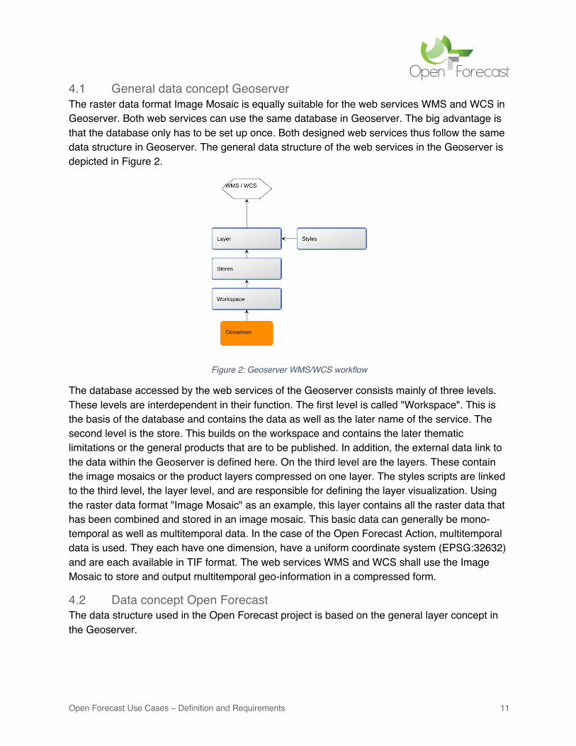
4.1 General data concept Geoserver The raster data format Image Mosaic is equally suitable for the web services WMS and WCS in Geoserver. Both web services can use the same database in Geoserver. The big advantage is that the database only has to be set up once. Both designed web services thus follow the same data structure in Geoserver. The general data structure of the web services in the Geoserver is depicted in Figure 2.
Figure 2: Geoserver WMS/WCS workflow
The database accessed by the web services of the Geoserver consists mainly of three levels. These levels are interdependent in their function. The first level is called "Workspace". This is the basis of the database and contains the data as well as the later name of the service. The second level is the store. This builds on the workspace and contains the later thematic limitations or the general products that are to be published. In addition, the external data link to the data within the Geoserver is defined here. On the third level are the layers. These contain the image mosaics or the product layers compressed on one layer. The styles scripts are linked to the third level, the layer level, and are responsible for defining the layer visualization. Using the raster data format "Image Mosaic" as an example, this layer contains all the raster data that has been combined and stored in an image mosaic. This basic data can generally be mono-temporal as well as multitemporal data. In the case of the Open Forecast Action, multitemporal data is used. They each have one dimension, have a uniform coordinate system (EPSG:32632) and are each available in TIF format. The web services WMS and WCS shall use the Image Mosaic to store and output multitemporal geo-information in a compressed form.
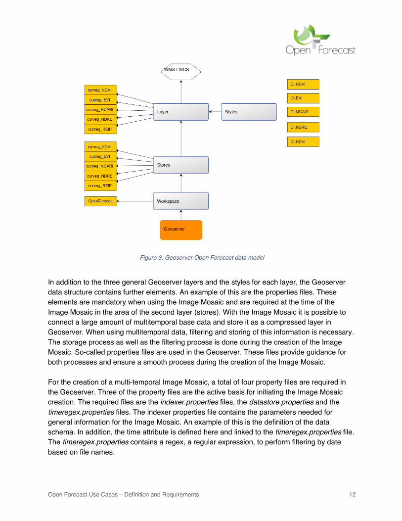
4.2 Data concept Open Forecast The data structure used in the Open Forecast project is based on the general layer concept in the Geoserver.
Open Forecast Use Cases – Definition and Requirements 12
Figure 3: Geoserver Open Forecast data model
In addition to the three general Geoserver layers and the styles for each layer, the Geoserver data structure contains further elements. An example of this are the properties files. These elements are mandatory when using the Image Mosaic and are required at the time of the Image Mosaic in the area of the second layer (stores). With the Image Mosaic it is possible to connect a large amount of multitemporal base data and store it as a compressed layer in Geoserver. When using multitemporal data, filtering and storing of this information is necessary. The storage process as well as the filtering process is done during the creation of the Image Mosaic. So-called properties files are used in the Geoserver. These files provide guidance for both processes and ensure a smooth process during the creation of the Image Mosaic. For the creation of a multi-temporal Image Mosaic, a total of four property files are required in the Geoserver. Three of the property files are the active basis for initiating the Image Mosaic creation. The required files are the indexer.properties files, the datastore.properties and the timeregex.properties files. The indexer properties file contains the parameters needed for general information for the Image Mosaic. An example of this is the definition of the data schema. In addition, the time attribute is defined here and linked to the timeregex.properties file. The timeregex.properties contains a regex, a regular expression, to perform filtering by date based on file names.
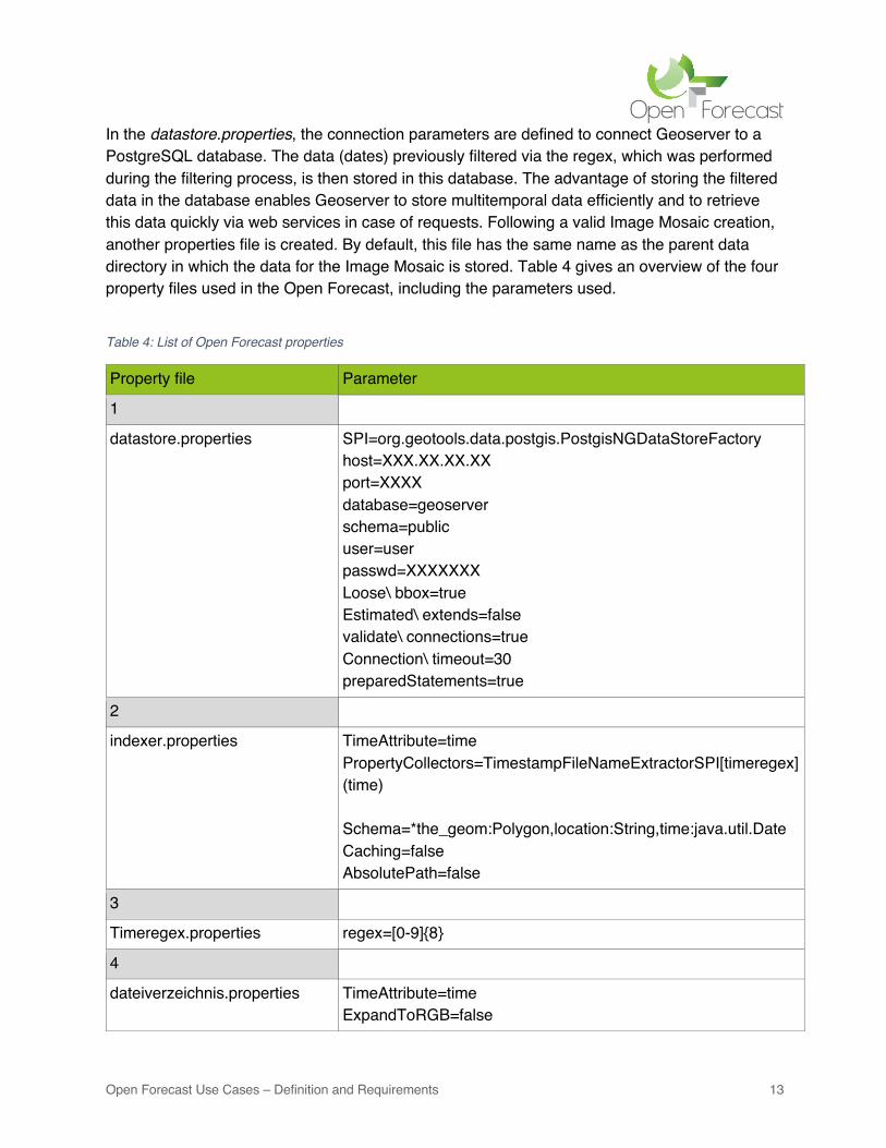
Open Forecast Use Cases – Definition and Requirements 13
In the datastore.properties, the connection parameters are defined to connect Geoserver to a PostgreSQL database. The data (dates) previously filtered via the regex, which was performed during the filtering process, is then stored in this database. The advantage of storing the filtered data in the database enables Geoserver to store multitemporal data efficiently and to retrieve this data quickly via web services in case of requests. Following a valid Image Mosaic creation, another properties file is created. By default, this file has the same name as the parent data directory in which the data for the Image Mosaic is stored. Table 4 gives an overview of the four property files used in the Open Forecast, including the parameters used.
Table 4: List of Open Forecast properties
Property file Parameter
1
datastore.properties SPI=org.geotools.data.postgis.PostgisNGDataStoreFactory host=XXX.XX.XX.XX port=XXXX database=geoserver schema=public user=user passwd=XXXXXXX Loose\ bbox=true Estimated\ extends=false validate\ connections=true Connection\ timeout=30 preparedStatements=true
2
indexer.properties TimeAttribute=time PropertyCollectors=TimestampFileNameExtractorSPI[timeregex](time) Schema=*the_geom:Polygon,location:String,time:java.util.Date Caching=false AbsolutePath=false
3
Timeregex.properties regex=[0-9]{8}
4
dateiverzeichnis.properties TimeAttribute=time ExpandToRGB=false
Open Forecast Use Cases – Definition and Requirements 14
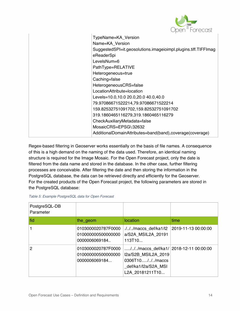
TypeName=KA_Version Name=KA_Version SuggestedSPI=it.geosolutions.imageioimpl.plugins.tiff.TIFFImageReaderSpi LevelsNum=6 PathType=RELATIVE Heterogeneous=true Caching=false HeterogeneousCRS=false LocationAttribute=location Levels=10.0,10.0 20.0,20.0 40.0,40.0 79.97086671522214,79.97086671522214 159.82532751091702,159.82532751091702 319.1860465116279,319.1860465116279 CheckAuxiliaryMetadata=false MosaicCRS=EPSG\:32632 AdditionalDomainAttributes=band(band),coverage(coverage)
Regex-based filtering in Geoserver works essentially on the basis of file names. A consequence of this is a high demand on the naming of the data used. Therefore, an identical naming structure is required for the Image Mosaic. For the Open Forecast project, only the date is filtered from the data name and stored in the database. In the other case, further filtering processes are conceivable. After filtering the date and then storing the information in the PostgreSQL database, the data can be retrieved directly and efficiently for the Geoserver. For the created products of the Open Forecast project, the following parameters are stored in the PostgreSQL database:
Table 5: Example PostgreSQL data for Open Forecast
PostgreSQL-DB Parameter
fid the_geom location time
1
0103000020787F00000100000005000000000000006069184..
./../../maccs_def/ka1/l2a/S2A_MSIL2A_20191113T10...
2019-11-13 00:00:00
2 0103000020787F00000100000005000000000000006069184...
...../../../maccs_def/ka1/l2a/S2B_MSIL2A_20190306T10...../../../maccs_def/ka1/l2a/S2A_MSIL2A_20181211T10...
2018-12-11 00:00:00
Open Forecast Use Cases – Definition and Requirements 15
3 0103000020787F00000100000005000000000000006069184..
...../../../maccs_def/ka1/l2a/S2B_MSIL2A_20190306T10...
2019-03-06 00:00:00
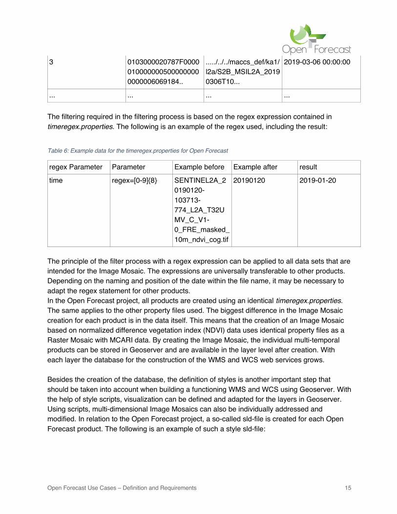
... ... ... ... The filtering required in the filtering process is based on the regex expression contained in timeregex.properties. The following is an example of the regex used, including the result:
Table 6: Example data for the timeregex.properties for Open Forecast
regex Parameter Parameter Example before Example after result
time regex=[0-9]{8} SENTINEL2A_20190120-103713-774_L2A_T32UMV_C_V1-0_FRE_masked_10m_ndvi_cog.tif
20190120 2019-01-20
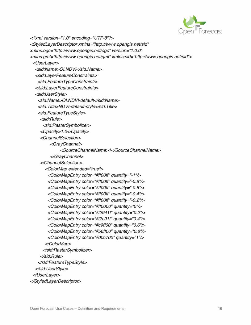
The principle of the filter process with a regex expression can be applied to all data sets that are intended for the Image Mosaic. The expressions are universally transferable to other products. Depending on the naming and position of the date within the file name, it may be necessary to adapt the regex statement for other products. In the Open Forecast project, all products are created using an identical timeregex.properties. The same applies to the other property files used. The biggest difference in the Image Mosaic creation for each product is in the data itself. This means that the creation of an Image Mosaic based on normalized difference vegetation index (NDVI) data uses identical property files as a Raster Mosaic with MCARI data. By creating the Image Mosaic, the individual multi-temporal products can be stored in Geoserver and are available in the layer level after creation. With each layer the database for the construction of the WMS and WCS web services grows. Besides the creation of the database, the definition of styles is another important step that should be taken into account when building a functioning WMS and WCS using Geoserver. With the help of style scripts, visualization can be defined and adapted for the layers in Geoserver. Using scripts, multi-dimensional Image Mosaics can also be individually addressed and modified. In relation to the Open Forecast project, a so-called sld-file is created for each Open Forecast product. The following is an example of such a style sld-file:
Open Forecast Use Cases – Definition and Requirements 16
<?xml version="1.0" encoding="UTF-8"?> <StyledLayerDescriptor xmlns="http://www.opengis.net/sld" xmlns:ogc="http://www.opengis.net/ogc" version="1.0.0" xmlns:gml="http://www.opengis.net/gml" xmlns:sld="http://www.opengis.net/sld"> <UserLayer> <sld:Name>OI.NDVI</sld:Name> <sld:LayerFeatureConstraints> <sld:FeatureTypeConstraint/> </sld:LayerFeatureConstraints> <sld:UserStyle> <sld:Name>OI.NDVI-default</sld:Name> <sld:Title>NDVI-default-style</sld:Title> <sld:FeatureTypeStyle> <sld:Rule> <sld:RasterSymbolizer> <Opacity>1.0</Opacity> <ChannelSelection> <GrayChannel> <SourceChannelName>1</SourceChannelName> </GrayChannel> </ChannelSelection> <ColorMap extended="true"> <ColorMapEntry color="#ff00ff" quantity="-1"/> <ColorMapEntry color="#ff00ff" quantity="-0.8"/> <ColorMapEntry color="#ff00ff" quantity="-0.6"/> <ColorMapEntry color="#ff00ff" quantity="-0.4"/> <ColorMapEntry color="#ff00ff" quantity="-0.2"/> <ColorMapEntry color="#ff0000" quantity="0"/> <ColorMapEntry color="#f2941f" quantity="0.2"/> <ColorMapEntry color="#f2c91f" quantity="0.4"/> <ColorMapEntry color="#c9ff00" quantity="0.6"/> <ColorMapEntry color="#56ff00" quantity="0.8"/> <ColorMapEntry color="#00c700" quantity="1"/> </ColorMap> </sld:RasterSymbolizer> </sld:Rule> </sld:FeatureTypeStyle> </sld:UserStyle> </UserLayer> </StyledLayerDescriptor>
Open Forecast Use Cases – Definition and Requirements 17
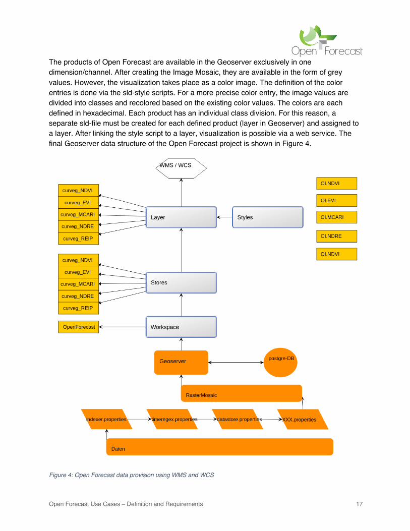
The products of Open Forecast are available in the Geoserver exclusively in one dimension/channel. After creating the Image Mosaic, they are available in the form of grey values. However, the visualization takes place as a color image. The definition of the color entries is done via the sld-style scripts. For a more precise color entry, the image values are divided into classes and recolored based on the existing color values. The colors are each defined in hexadecimal. Each product has an individual class division. For this reason, a separate sld-file must be created for each defined product (layer in Geoserver) and assigned to a layer. After linking the style script to a layer, visualization is possible via a web service. The final Geoserver data structure of the Open Forecast project is shown in Figure 4.
Figure 4: Open Forecast data provision using WMS and WCS
Open Forecast Use Cases – Definition and Requirements 18
In addition to setting up the database, further settings are necessary to finally complete web services on the Geoserver platform. Further settings in various areas are necessary via the WMS and WCS tabs on the Geoserver interface. Important areas are listed below:
Table 7: Geoserver Settings for Open Forecast
Areas Example
WMS
Service Metadata Root Layer Info Projections Rendering Options Format Options Inspire
Title Abstract Keywords Title Abstract SRS Interpolation JPEG PNG SVG
WCS Service Metadata Coverage processing Projections Inspire
Title Abstract Keywords subsampling SRS INSPIRE Extended Capabilities element
These areas cover a broad spectrum. It ranges from the specification of certain projections to the type of rendering (interpolations) to metadata and the topic of INSPIRE. In the cases of the Open Forecast project, the values already entered by default in the Geoserver are often sufficient and have been adopted in many cases. In case of special requirements due to special formats or necessities of special projections, individual settings are possible here. An important area that also plays a major role in Open Forecast is the area of INSPIRE. This can be activated by the INSPIRE extension8 and enables the use of an INSPIRE Extended Capabilities Element. This element enables the Geoserver to provide INSPIRE metadata from existing data and information. Metadata can be attached individually via links.
5 INSPIRE metadata modelling and validation Metadata are defined as descriptive geodata9. They serve an important purpose, especially for web services. Standardization is very important in this case, as interoperability and acceptance for all types of geodata by web services is desired. For this reason, the product data of the Open Forecast project require a unique identification and description before publication. International regulations in this respect are supported in Germany by the Metadata Working Group (AK) and enforced by the GDI-DE. Metadata are defined and entered in the Geoserver via input fields on the Geoserver interface under the configuration tabs WMS and WCS or on the third Geoserver level, at the layer level.
8 https://docs.geoserver.org/stable/en/user/extensions/inspire/index.html (last visited: 31.05.2021) 9 https://www.gdi-de.org/INSPIRE/technische%20Umsetzung/Metadaten (last visited: 31.05.2021)
Open Forecast Use Cases – Definition and Requirements 19
After entering the metadata for the layers and web services, the web services are finally prepared for publication in the Geoserver. The requests to be called up are made via the following links:
• WMS (Web Map Service): https://geoserver.gwdg.de/geoserver/ows?service=wms&version=1.3.0&request=GetCapabilities
• WCS (Web Coverage Service) https://geoserver.gwdg.de/geoserver/ows?service=WCS&version=2.0.1&request=GetCapabilities
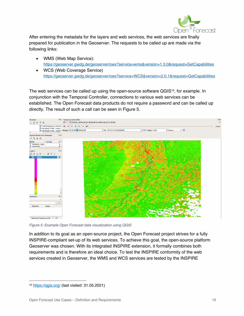
The web services can be called up using the open-source software QGIS10, for example. In conjunction with the Temporal Controller, connections to various web services can be established. The Open Forecast data products do not require a password and can be called up directly. The result of such a call can be seen in Figure 5.
Figure 5: Example Open Forecast data visualization using QGIS
In addition to its goal as an open-source project, the Open Forecast project strives for a fully INSPIRE-compliant set-up of its web services. To achieve this goal, the open-source platform Geoserver was chosen. With its integrated INSPIRE extension, it formally combines both requirements and is therefore an ideal choice. To test the INSPIRE conformity of the web services created in Geoserver, the WMS and WCS services are tested by the INSPIRE
10 https://qgis.org/ (last visited: 31.05.2021)
Open Forecast Use Cases – Definition and Requirements 20
Validator of the European Union11. The requirements of the validator differ depending on the web service. Enclosed are the test criteria for the WMS and WCS web service (c.f. Table 8).
Table 8: INSPIRE test criteria for the Open Forecast data services
WMS – INSPIRE – test criteria WCS-INSPIRE – test criteria
Get getcapabilites_operations Initialize
Get map_operation Service Metadata The validation of the created WMS and WCS services via the Geoserver for INSPIRE conformity yielded a surprising result. INSPIRE conformity is not given after the tests. Of the two services, the WMS service has a total of 5 errors. These errors are mainly due to faulty capability layers. The 3 errors of the WCS service are due to errors caused by wrong xml-schemas and missing language fields. These are not recognized in the present XML Extended Capabilities document.
Table 9: INSPIRE test results for the Open Forecast data services
WMS – INSPIRE – test results WCS-INSPIRE – test results
Errors: - getcapabilities-view-service-metadata-in-discovery-service - getcapabilites-layer-crs - getcapabilities-layer-simple-style - getcapabilities-layer-use-default-style - getcapabilities.layer-style-legend-url
Errors: - initial testcase - natural language fields - xml schema validation - mandatory metadata elements - language request empty unsupported - list supported languages - response language
The results of the EU validator show a clear result. Even though the Open Forecast services fulfil many conditions for INSPIRE-compliant services, not all currently required conditions are fulfilled. It is possible that the INSPIRE implementation of the Geoserver platform is currently only a partial implementation. Thus, the Open Forecast services currently do not fulfil all current requirements for INSPIRE conformity. Attempts to eliminate the existing errors failed, as the existing possibilities within the Geoserver platform were already exhausted. To fix the errors in the area of extended capabilities, a direct modification of the source code of the Geoserver platform would be necessary. However, within the framework of the Open Forecast project, personnel and time constraints do not allow for this possibility.
11 https://inspire.ec.europa.eu/validator/about/ (last visited 31.05.2021)
Open Forecast Use Cases – Definition and Requirements 21
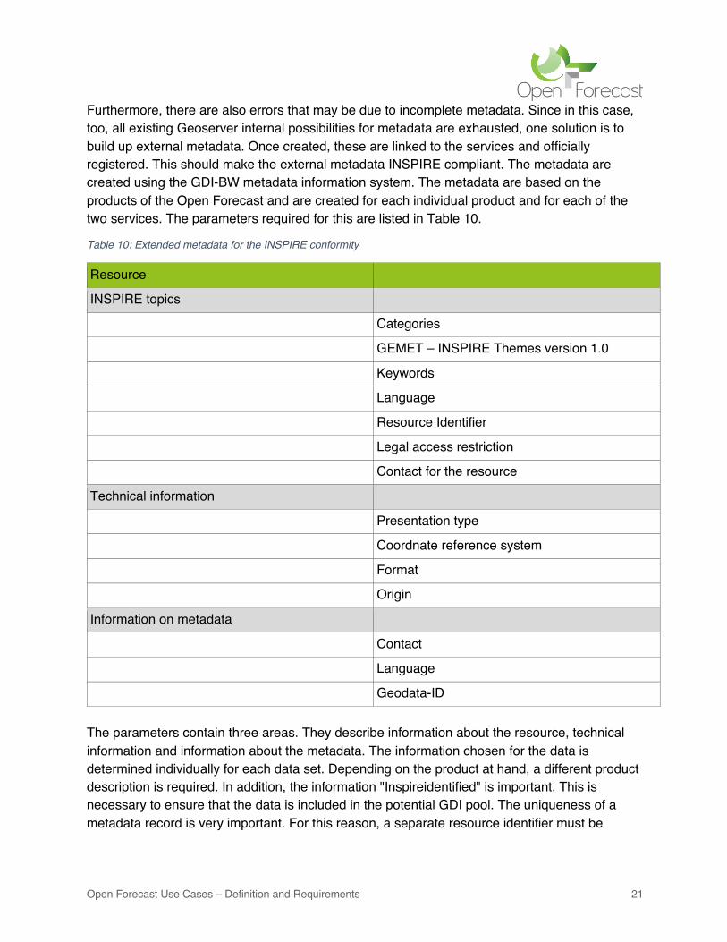
Furthermore, there are also errors that may be due to incomplete metadata. Since in this case, too, all existing Geoserver internal possibilities for metadata are exhausted, one solution is to build up external metadata. Once created, these are linked to the services and officially registered. This should make the external metadata INSPIRE compliant. The metadata are created using the GDI-BW metadata information system. The metadata are based on the products of the Open Forecast and are created for each individual product and for each of the two services. The parameters required for this are listed in Table 10.
Table 10: Extended metadata for the INSPIRE conformity
Resource
INSPIRE topics
Categories
GEMET – INSPIRE Themes version 1.0
Keywords
Language
Resource Identifier
Legal access restriction
Contact for the resource
Technical information
Presentation type
Coordnate reference system
Format
Origin
Information on metadata
Contact
Language
Geodata-ID The parameters contain three areas. They describe information about the resource, technical information and information about the metadata. The information chosen for the data is determined individually for each data set. Depending on the product at hand, a different product description is required. In addition, the information "Inspireidentified" is important. This is necessary to ensure that the data is included in the potential GDI pool. The uniqueness of a metadata record is very important. For this reason, a separate resource identifier must be
Open Forecast Use Cases – Definition and Requirements 22
generated for each metadata record, e.g. using UUIDs12. This identifier is generated from random numbers and stored in the metadata record. An example of an identifier is shown below:
• 293c2cb1-f27f-4a34-ae47-59bad5bd8d95
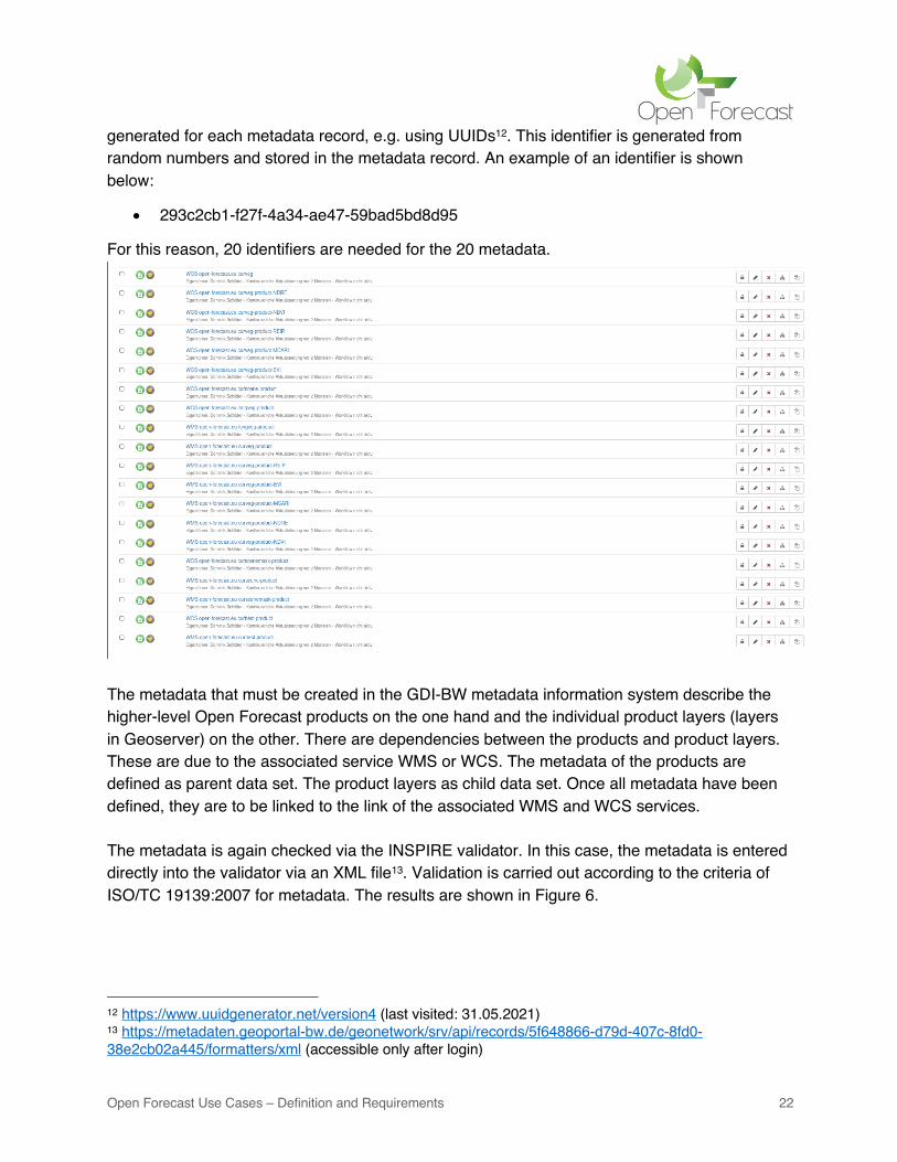
For this reason, 20 identifiers are needed for the 20 metadata.
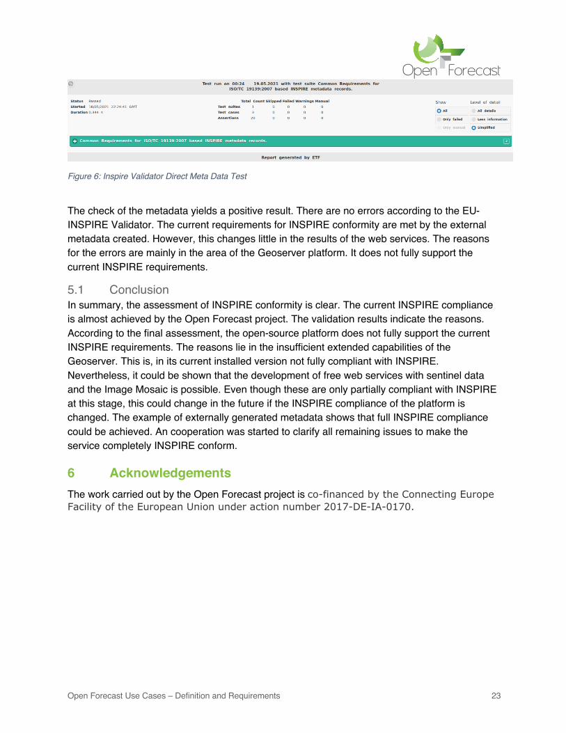
The metadata that must be created in the GDI-BW metadata information system describe the higher-level Open Forecast products on the one hand and the individual product layers (layers in Geoserver) on the other. There are dependencies between the products and product layers. These are due to the associated service WMS or WCS. The metadata of the products are defined as parent data set. The product layers as child data set. Once all metadata have been defined, they are to be linked to the link of the associated WMS and WCS services. The metadata is again checked via the INSPIRE validator. In this case, the metadata is entered directly into the validator via an XML file13. Validation is carried out according to the criteria of ISO/TC 19139:2007 for metadata. The results are shown in Figure 6.
12 https://www.uuidgenerator.net/version4 (last visited: 31.05.2021) 13 https://metadaten.geoportal-bw.de/geonetwork/srv/api/records/5f648866-d79d-407c-8fd0-38e2cb02a445/formatters/xml (accessible only after login)
Open Forecast Use Cases – Definition and Requirements 23
Figure 6: Inspire Validator Direct Meta Data Test
The check of the metadata yields a positive result. There are no errors according to the EU-INSPIRE Validator. The current requirements for INSPIRE conformity are met by the external metadata created. However, this changes little in the results of the web services. The reasons for the errors are mainly in the area of the Geoserver platform. It does not fully support the current INSPIRE requirements.
5.1 Conclusion In summary, the assessment of INSPIRE conformity is clear. The current INSPIRE compliance is almost achieved by the Open Forecast project. The validation results indicate the reasons. According to the final assessment, the open-source platform does not fully support the current INSPIRE requirements. The reasons lie in the insufficient extended capabilities of the Geoserver. This is, in its current installed version not fully compliant with INSPIRE. Nevertheless, it could be shown that the development of free web services with sentinel data and the Image Mosaic is possible. Even though these are only partially compliant with INSPIRE at this stage, this could change in the future if the INSPIRE compliance of the platform is changed. The example of externally generated metadata shows that full INSPIRE compliance could be achieved. An cooperation was started to clarify all remaining issues to make the service completely INSPIRE conform.
6 Acknowledgements The work carried out by the Open Forecast project is co-financed by the Connecting Europe Facility of the European Union under action number 2017-DE-IA-0170.
Open Forecast Use Cases – Definition and Requirements 24
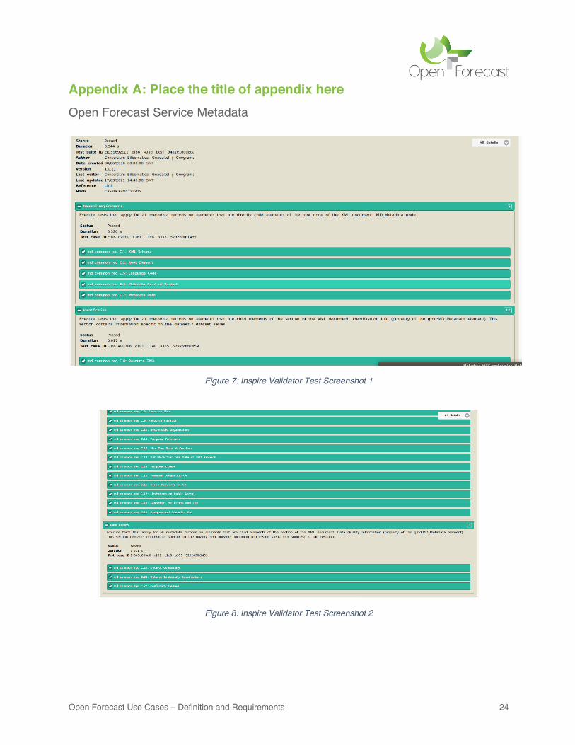
Appendix A: Place the title of appendix here Open Forecast Service Metadata
Figure 7: Inspire Validator Test Screenshot 1
Figure 8: Inspire Validator Test Screenshot 2
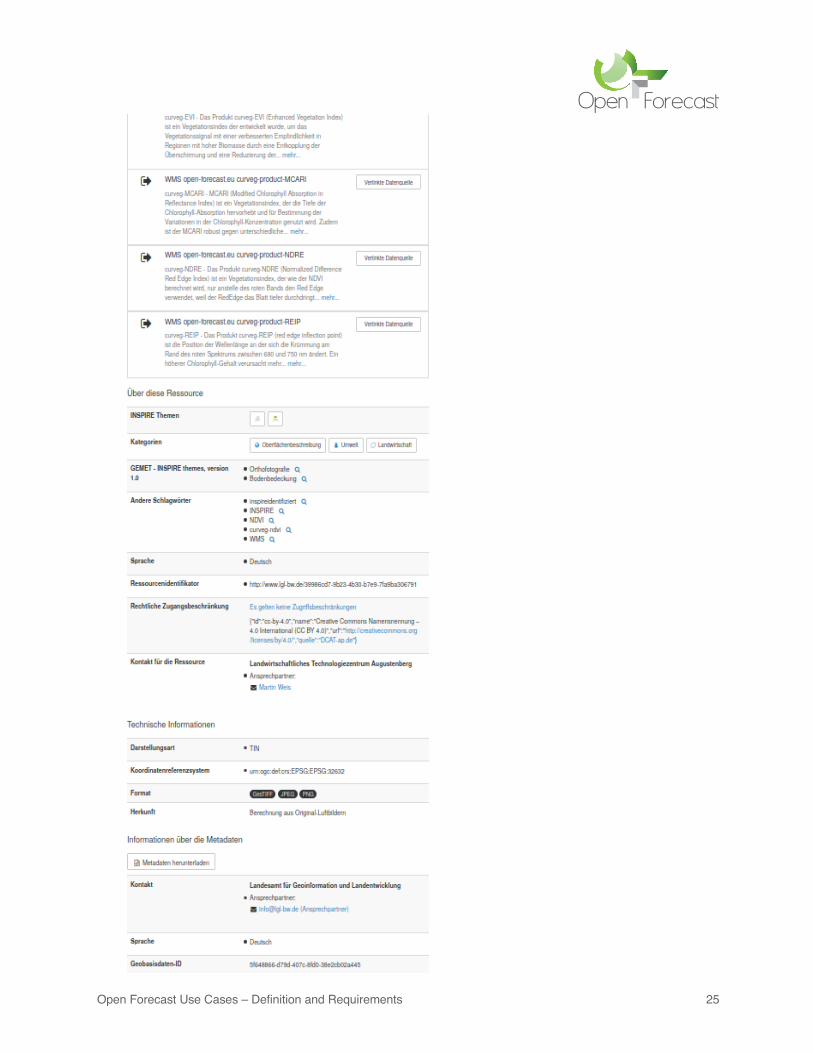
Open Forecast Use Cases – Definition and Requirements 25
Open Forecast Use Cases – Definition and Requirements 26
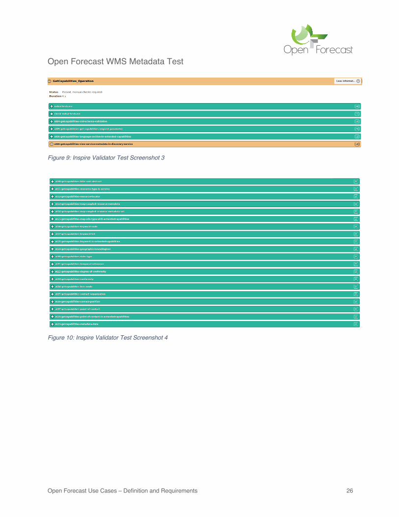
Open Forecast WMS Metadata Test
Figure 9: Inspire Validator Test Screenshot 3
Figure 10: Inspire Validator Test Screenshot 4
Open Forecast Use Cases – Definition and Requirements 27
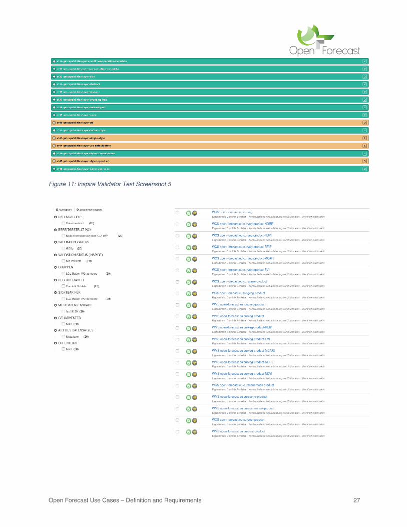
Figure 11: Inspire Validator Test Screenshot 5
Open Forecast Use Cases – Definition and Requirements 28
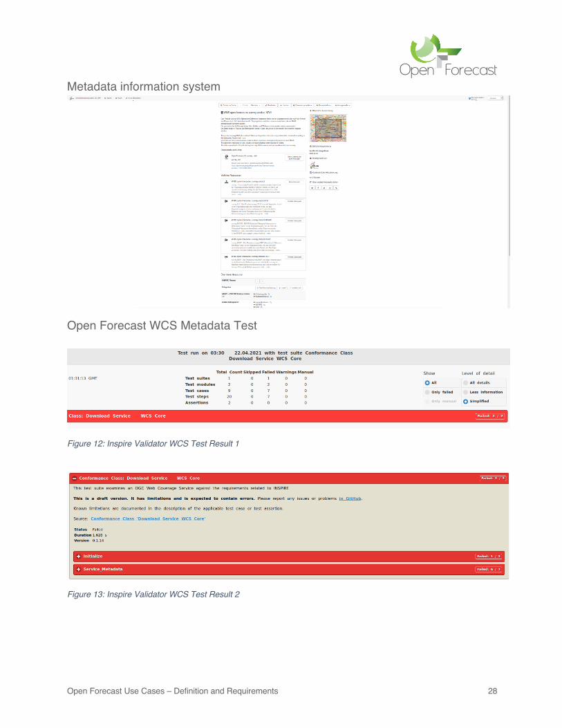
Metadata information system
Open Forecast WCS Metadata Test
Figure 12: Inspire Validator WCS Test Result 1
Figure 13: Inspire Validator WCS Test Result 2


