Embed Size (px)
Citation preview
AMOR LAARIBI • LINDA PETERS

2020CensusRSZadj2.indb 4 4/22/19 2:54 PM
Cover credits: Income variable data provided by Michael Bauer Research GmbH.
Esri Press, 380 New York Street, Redlands, California 92373-8100 Copyright 2019 Esri All rights reserved. 23 22 21 20 19 1 2 3 4 5 6 7 8 9 10 Printed in the United States of America Library of Congress Cataloging-in-Publication Data
Library of Congress Cataloging‐in‐Publication Data Names: Laaribi, Amor, author. | Peters, Linda. Title: GIS and the 2020 census : modernizing offcial statistics / Amor Laaribi, Linda Peters. Description: Redlands, California : Esri Press, 2019. Identifers: LCCN 2018060051 (print) | LCCN 2019007152 (ebook) | ISBN 9781589485051 (electronic) | ISBN 9781589485044 (pbk. : alk. paper) Subjects: LCSH: Census‐‐Methodology. | Census‐‐Geographic information systems. Classifcation: LCC HA179 (ebook) | LCC HA179 .L33 2019 (print) | DDC 352.7/50285‐‐dc23 LC record available at https://urldefense.proofpoint.com/v2/url?u=https‐3A__lccn.loc.gov_2018060051&d=DwIFAg&c=n6‐cguzQvX_tUIrZOS_4Og&r=qNU49__SCQN30XC‐f38qj8bYYMTIH4VCOt2 Jb8fvjUA&m=N9LDm816lpUOSrnLbGNLKNGC9sSQOOxCGez3LIoTHM& s=IU2vJ0BdojtLU_0AhLGaxkrJaFhjH2348dHKCFbJlUA&e=
The information contained in this document is subject to change without notice.
US Government Restricted/Limited Rights: Any software, documentation, and/or data delivered hereunder is subject to the terms of the License Agreement. The commercial license rights in the License Agreement strictly govern Licensee’s use, reproduction, or disclosure of the software, data, and documentation. In no event shall the US Government acquire greater than RESTRICTED/LIMITED RIGHTS. At a minimum, use, duplication, or disclosure by the US Government is subject to restrictions as set forth in FAR §52.227-14 Alternates I, II, and III (DEC 2007); FAR §52.227-19(b) (DEC 2007) and/or FAR §12.211/12.212 (Commercial Technical Data/Computer Software); and DFARS §252.227-7015 (DEC 2011) (Technical Data – Commercial Items) and/or DFARS §227.7202 (Commercial Computer Software and Commercial Computer Software Documentation), as applicable. Contractor/Manufacturer is Esri, 380 New York Street, Redlands, CA 92373-8100, USA.
@esri.com, 3D Analyst, ACORN, Address Coder, ADF, AML, ArcAtlas, ArcCAD, ArcCatalog, ArcCOGO, ArcData, ArcDoc, ArcEdit, ArcEditor, ArcEurope, ArcExplorer, ArcExpress, ArcGIS, arcgis.com, ArcGlobe, ArcGrid, ArcIMS, ARC/INFO, ArcInfo, ArcInfo Librarian, ArcLessons, ArcLocation, ArcLogistics, ArcMap, ArcNetwork, ArcNews, ArcObjects, ArcOpen, ArcPad, ArcPlot, ArcPress, ArcPy, ArcReader, ArcScan, ArcScene, ArcSchool, ArcScripts, ArcSDE, ArcSdl, ArcSketch, ArcStorm, ArcSurvey, ArcTIN, ArcToolbox, ArcTools, ArcUSA, ArcUser, ArcView, ArcVoyager, ArcWatch, ArcWeb, ArcWorld, ArcXML, Atlas GIS, AtlasWare, Avenue, BAO, Business Analyst, Business Analyst Online, BusinessMAP, CityEngine, CommunityInfo, Database Integrator, DBI Kit, EDN, Esri, esri.com, Esri—Team GIS, Esri—The GIS Company, Esri—The GIS People, Esri—The GIS Software Leader, FormEdit, GeoCollector, Geographic Design System, Geography Matters, Geography Network, geographynetwork.com, Geoloqi, Geotrigger, GIS by Esri, gis.com, GISData Server, GIS Day, gisday.com, GIS for Everyone, JTX, MapIt, Maplex, MapObjects, MapStudio, ModelBuilder, MOLE, MPS—Atlas, PLTS, Rent-a-Tech, SDE, SML, Sourcebook•America, SpatiaLABS, Spatial Database Engine, StreetMap, Tapestry, the ARC/INFO logo, the ArcGIS Explorer logo, the ArcGIS logo, the ArcPad logo, the Esri globe logo, the Esri Press logo, The Geographic Advantage, The Geographic Approach, the GIS Day logo, the MapIt logo, The World’s Leading Desktop GIS, Water Writes, and Your Personal Geographic Information System are trademarks, service marks, or registered marks of Esri in the United States, the European Community, or certain other jurisdictions. CityEngine is a registered trademark of Procedural AG and is distributed under license by Esri. Other companies and products or services mentioned herein may be trademarks, service marks, or registered marks of their respective mark owners.
Ask for Esri Press titles at your local bookstore or order by calling 1-800-447-9778. You can also shop online at www.esri.com/esripress. Outside the United States, contact your local Esri distributor or shop online at eurospanbookstore.com/esri. Esri Press titles are distributed to the trade by the following:
In North America: Ingram Publisher Services Toll-free telephone: 800-648-3104 Toll-free fax: 800-838-1149 E-mail: [email protected]
In the United Kingdom, Europe, the Middle East and Africa, Asia, and Australia: Eurospan Group 3 Henrietta Street London WC2E 8LU United Kingdom Telephone 44(0) 1767 604972 Fax: 44(0) 1767 6016-40 E-mail:[email protected]
2020CensusRSZadj2.indb 5 4/22/19 2:54 PM
Contents
Foreword vii
Preface xi
Contributions and acknowledgments xiii
Chapter 1: Introduction 1
Rationale, scope, and purpose 2
Importance of the integration of statistical and
geospatial data 5
Chapter 2: The role of GIS in census 9
Planning the census process with GIS 10
Needs assessment 16
Success factors 22
What is the GSGF? 25
The GSGF principles—goals and objectives 25
Considerations for rapid changes in technology 30
Esri World Population Estimate 32
Chapter 3: Changing technology 37
Five key trends in GIS 38
Other key trends 43
Chapter 4: Establishing the foundation—
the geodatabase 51
What is a geodatabase? 52
Spatial data structures 53
Spatial data models 56
Geospatial database design 59
Database modeling 59
Defning census geography 65
Enumeration areas 70
Geographic coding 72
Case study: Albania 76
Chapter 5: Imagery 85
Introduction 86
Key imagery use cases for national census programs
87
Support for key enumeration business
processes 88
Image-processing techniques that support the
enumeration process 88
Imagery characteristics important for NSOs 91
Sources of imagery content for national imagery
programs 94
Implementation 97
Case study: Portugal 99
Chapter 6: Planning your work with GIS 103
EA delineation process 104
Maps and sources required 106
Conversion of existing data (analog/digital) 108
Use of imagery in updating EAs 109
Data quality and metadata 119
Creating map services and mobile map packages in
support of census operations 127
Use of GIS for optimizing the site placement of feld
offces 129
Use of GIS for optimizing capital and asset
distribution 130
EA optimization 132
Case study: Republic of the Philippines 134
AUS21
2020CensusRSZadj2.indb 6 4/22/19 2:54 PM
Chapter 7: Use of geospatial tools
during enumeration 141
Fieldwork benefts of using GIS/GPS and
imagery 142
Field data collection 145
Case study: Jordan 150
Field operations management 152
Optimizing workloads 153
Optimizing routes 154
Monitoring the progress of census operations 156
Project management oversight and identifying
trouble spots 157
US Census: Mobilizing feld operations 158
Case study: Arab Republic of Egypt 159
Chapter 8: Post-enumeration—processing 165
Updating and verifying changes to the
database 166
Aggregation 168
Database archiving and maintenance 170
Open platform and system interoperability 171
Case study: Ireland 173
Chapter 9: Post-enumeration—
dissemination and analysis 179
Dissemination strategies 180
Level of data release (geographic) 182
GIS role in creating products for dissemination 194
Case study: Nepal 205
Case study: Canada 209
Chapter 10: Marketing geographic products
and data 217
Marketing communication plans 218
2020 US Census—future data dissemination and
integrated communication plan 219
Chapter 11: Contemporary ideas 225
ArcGIS® Hub 226
Smarter maps 228
Spatial analysis 229
GeoAI 231
Geoblockchain 232
Appendix: Acronyms 237
Index 241
vi GIS and the 2020 Census: Modernizing Offcial Statistics

2020CensusRSZadj2.indb 14 4/22/19 2:54 PM

2020CensusRSZadj2.indb 1 4/22/19 2:54 PM
Chapter 1
Introduction
Chapter 1: Introduction 1
2020CensusRSZadj2.indb 2 4/22/19 2:54 PM
Rationale, scope, and purpose
GIS and the 2020 Census: Modernizing Offcial Statistics supports the transformation of countries’
censuses with the use of geographic information systems (GIS) and related geospatial technologies to
improve data collection, analysis, and dissemination and to enable agencies to build accurate, authori-
tative, actionable data. The book is specifcally intended to provide an up-to-date reference and guide
for using geospatial methodologies and techniques to support census and statistical operations.1 A
comprehensive user-oriented guide, the book addresses the needs of census geographers, planners,
and managers at all the stages of a census and caters to the needs of the various users of statistical and
geospatial products and services.
The increasing use and application of modern geospatial technologies2 worldwide, particularly during
the upcoming round of censuses, have opened a new chapter in all phases of population and housing
censuses, improving the effciency in pre-enumeration, enumeration, and post-enumeration phases. This
statement can be attested by Esri through its involvement in many census mapping projects and con-
frmed by the United Nations (UN) Principles and Recommendations for Population and Housing Cen-
suses, the outcomes of a global consultation for the 2020 Round of Census. Rapid changes in technology
have brought about improvements in many areas such as computing power, storage, speed, and analyt-
ics. Recently, a paradigm shift in the acquisition, resolution, storage, analysis, and distribution of imagery
has brought raster analytics to the forefront of projects, offering exponential advances in speed, accura-
cy, and cost reductions. Digital transformations such as these will have a huge impact on the work of the
National Statistical Offce (NSO).
A new pattern emerged in conducting censuses during the last decade—a pattern that has ushered
in the recognition of the central role of geography to census operations.3 Geography is increasingly ac-
knowledged as key to virtually all national statistics systems, providing a structure for collecting, process-
ing, aggregating, managing, analyzing, sharing, and disseminating data. In its digital form, geospatial
information is exchanged more rapidly, used and reused at will, duplicated without alteration, and easily
disseminated to end users. In addition, this geospatial data needs to adhere to the wide variety of securi-
ty and privacy concerns that are also at the heart of most censuses.
The UN recommended the necessity for countries to keep abreast of technological advances made
since the previous round, especially in GIS and Global Positioning Systems (GPS). The UN also recom-
mended that, for the 2020 Round of Censuses, the adoption of GIS should be a major strategic deci-
sion.4 The UN Statistical Commission (UNSC) and the UN Committee of Experts on Global Geospatial
Information Management (UN-GGIM) recognized the crucial importance of the integration of statistical
and geospatial information for decision-making and have recently recommended the development of a
Global Statistical Geospatial Framework (GSGF).5
2 GIS and the 2020 Census: Modernizing Offcial Statistics
AUS21
2020CensusRSZadj2.indb 3 4/22/19 2:54 PM
In recognition of this important recommendation, the UNSC and the UN-GGIM began to address
the challenges of managing and effectively integrating geospatial and statistical information nationally
and globally. They established in 2013 the Expert Group on the Integration of Statistical and Geospatial
Information (EG-ISGI). The Expert Group was tasked with developing and advancing the implementa-
tion of a GSGF as a basis for the integration of statistical and geospatial information and supporting the
building of a statistical-geospatial infrastructure, especially in the context of the 2030 Agenda for Sustain-
able Development. This importance was also recognized by UN-GGIM regional committees, where it is
considered a key priority.6
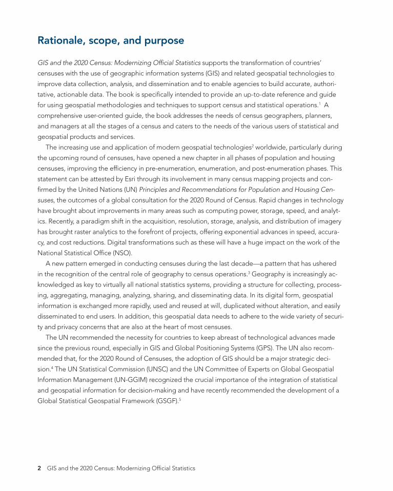
Global Statistical Geospatial Framework
Usable and accessible
Statistical and geospatial interoperability
Common geographies for dissemination of statistics
Geocoded unit record data in a data management environment
Use of fundamental geospatial infrastructure and geocoding
Figure 1.1. The Global Statistical Geospatial Framework (GSGF).
Chapter 1: Introduction 3
2020CensusRSZadj2.indb 4 4/22/19 2:54 PM
These recent technological developments have already been adopted by many NSOs, including some
developing countries. The wealth of national experiences demonstrates that the use and application of
GIS is without exception benefcial to the effciency and quality of the population and housing census. It
is understood, however, that a single solution will not ft all national circumstances; hence, there is a need
to present various options with guidance to NSOs, allowing them to choose the appropriate solution for
their national and local conditions or policies. This book provides guidelines for NSOs to make informed
decisions on appropriate GIS technology and how to effciently use GIS in statistical business processes,
taking into consideration different procedures, workfows, organization capabilities, budgets, census
timelines, security and application needs, and best practices.
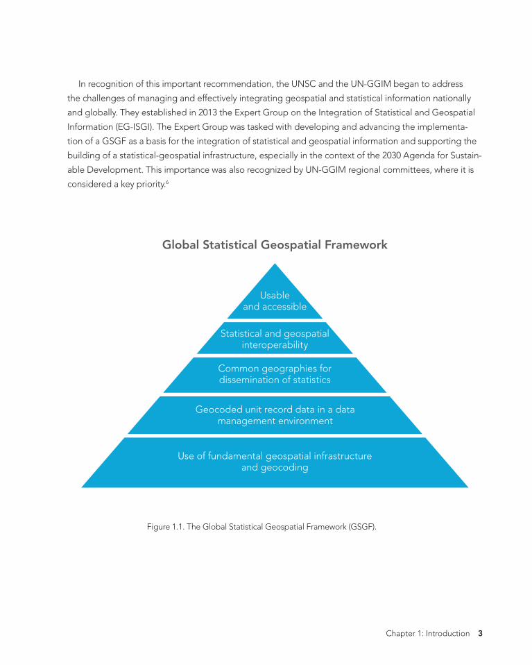
Desktop Web Device
Server
Online Content and Services
Figure 1.2. Example of a GIS with various types of connections (web, desktop, and mobile).
4 GIS and the 2020 Census: Modernizing Offcial Statistics
Ofÿcial Statistics Sample GIS System
Conÿguration
2020CensusRSZadj2.indb 5 4/22/19 2:54 PM
Importance of the integration of statistical and geospatial data
The rapid development of modern geospatial technologies has created unprecedented opportunities
for geospatial data, and GIS has drastically increased the quantity and quality of geospatial data being
collected from a variety of sources. For example, users have access today to imagery that would have
been expensive and limited in the past.7 Geospatial information is becoming a major economic activity
with applications across many sectors, bringing increased utility to these sectors and impacting business
decisions (Foresman and Luscombe 2017).
With the increasing complexity of national and global challenges, the need to understand interre-
lationships across the economic, social, and environmental dimensions is crucial for sustainable devel-
opment at all levels, and the integration of information by geography is critical to designing holistic
solutions for any locale. The demand is growing for information on small geographic areas to monitor
the development goals and indicators at local and community scales. The integration of statistical and
geospatial information has become a signifcant way to unlock new insights that would otherwise not
have been possible by looking at socioeconomic or geospatial data in isolation. It is now understood
that the integration of geospatial data with statistics provides signifcant benefts for nations, as opposed
to one-dimensional traditional approaches.
For example, such integration has proved to be critical in achieving improved operational readiness
and responsiveness to disasters. By using satellite imagery, scientists and demographers can compare
images and statistics taken before and after earthquakes or fooding to estimate the amount of aid to
be allocated to populated areas or select safe places in which to temporarily settle the affected popula-
tion. Using statistical analysis and statistical mapping to study the patterns of urban or rural poverty is a
well-established way to provide useful, policy-relevant insights into the patterns of social exclusion and
deprivation for local governance policymakers (Baud et al. 2009). Many such examples are related to the
increased use of geospatial data in socioeconomic, demographic, and environmental analysis.
Knowing where people and things are and their relationship to one another provides context and
improves understanding, aiding in evidence-based decision-making. The geocode is considered one of
the basic uniting elements in statistics to which characteristics of persons, households, and enterprises
can be attributed.
In this digital-economic age, geospatial technologies are ex- The First Law of Geographypanding the power of geography and location, from the limited states that “everything isgeographical proximity object of Tobler’s First Law of Geography
related to everything else, to a richer research frontier, enabling us to explore the economic
but near things are more and social impacts of location and spatial relationships. This power
related than distant things.” is leading geographers to cogitate about a Second Law of Geog-
raphy for a spatially enabled economy, allowing us to understand Waldo Tobler
why spatial enablement increases functional utility across sectors
(Foresman and Luscombe 2017).
Chapter 1: Introduction 5
2020CensusRSZadj2.indb 6 4/22/19 2:54 PM
It is worth noting that the integration of statistical and geospatial information should be seen in the
context of a wider integration of data from a variety of sources. This integration refects the trends of
today’s data-driven society through the big data revolution, characterized by satellite imagery, unmanned
aerial vehicle (UAV) data, GPS, mobile technology and GIS surveying, volunteered geographic informa-
tion (VGI) and crowd-sourced data, real-time data streams, cloud-based computing, open data, the Inter-
net of Things (IoT), and geoblockchain. Most studies have stated that spatially enabled data represents
at least eighty percent of all data generated within the big data revolution (Foresman and Luscombe
2017).
In today’s global community, there is a clear recognition of the need to integrate geospatial and
statistical information;8 the challenge being faced is how best to achieve this integration in an effective
and consistent way. It was noted that many NSOs are already transforming, or are planning to transform,
their statistical infrastructure, offering an opportunity to embed geography into their national systems
and processes. NSOs have been moving from the census mapping approach, limited to the use of GIS
for some mapping and dissemination operations, to a GIS-based approach where geography is the foun-
dation of the census, with the use of GIS and other core geospatial technologies at all stages. There is an
increasing recognition that the adoption of a geographic-based approach with full integration of statisti-
cal and geospatial information has an important role in the modernization of statistics.9
GIS can help NSOs realize benefts in terms of reduction of cost and time required, accuracy and
quality improvements, and effciencies in collecting, processing, and communicating information, which
all greatly increase the return on investment.10
The initial chapters of this book consider the role of GIS in the census, including planning and estab-
lishing a full digital GIS-based census program, as well as the importance of geodatabase development.
GIS topics relevant to pre-enumeration and enumeration, including the benefts of a digital approach
in using GIS throughout statistical business processes, are also addressed. More specifcally, for data
collection purposes, the book addresses how in a census NSOs need to look at the fnest level of geog-
raphy possible (dwelling and unit level) and capture information at that level. Other chapters focus on
post-enumeration GIS tasks and the use of digital mapping in presenting, analyzing, and disseminating
census data and marketing geographic products and data. A fnal chapter presents next-generation
trends, focusing on big data and geoanalytics.
The book provides statistical organizations with the contemporary methodologies to address user
needs at all stages of a census during the 2020 round. Readers will learn how to plan and carry out work
using GIS in all phases of a census.
References
• Baud et al. 2009. “Matching Deprivation Mapping to Urban Governance in Three Indian Mega-
cities.” Habitat International.
• GI for Census by the Program Review of the 2010 Round of Censuses carried out by the US Census
Bureau for the UNSC in 2015.
6 GIS and the 2020 Census: Modernizing Offcial Statistics
2020CensusRSZadj2.indb 7 4/22/19 2:54 PM
• Report on National Statistical and Geographical Institute of Brazil: Global Geographic Information
Management, presented at the forty-frst session of the UN Statistical Commission. 2010.
E/CN.3/2010/13. Available at https://unstats.un.org/unsd/statcom/doc10/2010-13-Brazil-GGIM-E.pdf.
• Tim Foresman and Ruth Luscombe. 2017. “The Second Law of Geography for a Spatially Enabled
Economy.” International Journal of Digital Earth.
• UN Economic Commission for Africa/African Centre for Statistics (ACS). 2010. The 2010 Round of
Population and Housing Censuses: A Guide on Census Planning and Enumeration for African Coun-
tries.
• UN Expert Group on the Integration of Statistical and Geospatial Information. 2016. Background
Document on Proposal for a Global Statistical Geospatial Framework. Available at http://ggim.
un.org/docs/meetings/Global%20Forum/Summary‐report%20of%20the%20Global%20Forum.pdf.
• United Nations Statistics Division. 2017. Principles and Recommendations for Population and Hous-
ing Censuses, rev. 3. New York: United Nations Publication. Available at https://unstats.un.org/unsd/
publication/seriesM/Series_M67Rev3en.pdf.
• US Census Bureau. 2015. New Technologies in Census Geographic Listing: Select Topics in Inter-
national Censuses. Available at https://www.census.gov/content/dam/Census/library/working-pa-
pers/2015/demo/new-tech-census-geo.pdf.
Notes
1. While the main focus of the book is on feld-based census approaches and operations, similar GIS
techniques can be applied in register-based censuses as well.
2. Geospatial technologies refer to all the means used for the measurement, analysis, and visualization of fea-
tures or phenomena that occur on earth. They include three core technologies that are all related to map-
ping features on the surface of the earth: remote sensing (RS), Global Positioning System (GPS), and GIS.
3. The objective of a census is to “count everyone, count them once only, and count them in the right
place,” according to Preston Jay Waite (US Census Bureau), former associate director for decennial
census, US Department of Commerce.
4. See Principles and Recommendations.
5. See details on the GSGF in chapter 2.
6. See details at http://ggim.un.org/regional-entities/.
7. See National Statistical and Geographical Institute of Brazil: Global Geographic Information Manage-
ment, a report presented at the forty-frst session of the UNSC (E/CN.3/2010/13) in February 2010.
Available at https://unstats.un.org/unsd/statcom/doc10/2010-13-Brazil-GGIM-E.pdf.
8. See Principles and Recommendations, para. 3.49: “To ensure complete integration of statistical and
geospatial information.”
9. See the UN Economic and Social Council’s In-Depth Review of Developing Geospatial Information
Services Based on Offcial Statistics: Note by the United Kingdom Offce for National Statistics. CES.
ECE/CES/2016/7.
10. See UNECA/ACS’ The 2010 Round of Population and Housing Censuses: A Guide on Census Plan-
ning and Enumeration for African Countries.
Chapter 1: Introduction 7
2020CensusRSZadj2.indb 8 4/22/19 2:54 PM
8 GIS and the 2020 Census: Modernizing Offcial Statistics
2020CensusRSZadj2.indb 9 4/22/19 2:54 PM
Chapter 2
The role of GIS in census
Chapter 2: The role of GIS in census 9
2020CensusRSZadj2.indb 10 4/22/19 2:54 PM
Planning the census process with GIS
Census geography program
In most countries in the world, a population and housing census is conducted periodically, at least once
every ten years in accordance with the UN Principles and Recommendations.1 A population and housing
census is considered the greatest democratic operation because it is conducted at the individual or house-
hold level, providing information on the main characteristics of a country’s entire population in terms of
size, geographic distribution, and demographic, social, economic, housing, and living conditions.2
Mapping is generally recognized as one of the most crucial activities of a census, playing a critical role
in providing the geographic basis used during the actual process of enumeration. Owing to recent tech-
nological developments in GIS and other geospatial technologies, the scope of census mapping has been
extended to census data analysis and dissemination, with greater effciency in data collection and enumer-
ation. However, there are some challenges in opting for a full digital census-mapping approach; the use
of these technologies has crucial impacts during mapping activities, data collection, processing, analysis,
dissemination, evaluation, and archiving, and should therefore be taken into account at an early stage of
census planning. Embarking on a GIS-based census should be planned and implemented in a consistent
and timely manner.
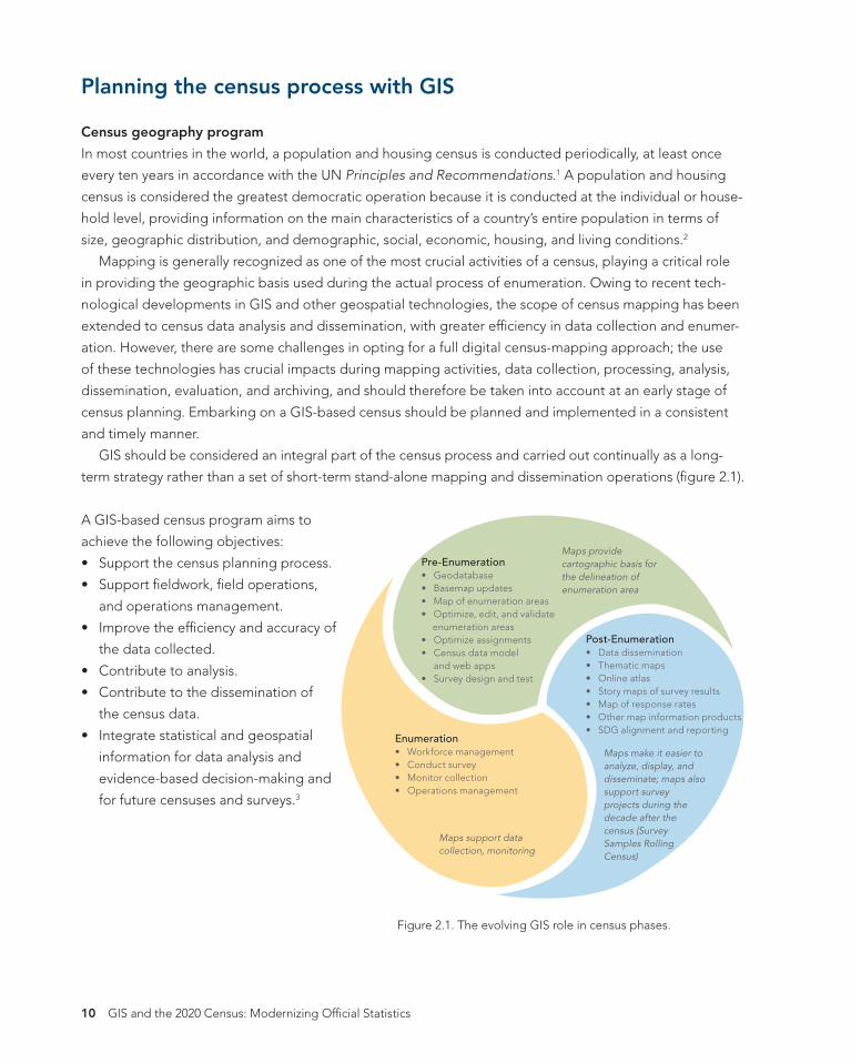
GIS should be considered an integral part of the census process and carried out continually as a long-
term strategy rather than a set of short-term stand-alone mapping and dissemination operations (fgure 2.1).
A GIS-based census program aims to
achieve the following objectives:
• Support the census planning process.
• Support feldwork, feld operations,
and operations management.
• Improve the effciency and accuracy of
the data collected.
• Contribute to analysis.
• Contribute to the dissemination of
the census data.
• Integrate statistical and geospatial
information for data analysis and
evidence-based decision-making and
for future censuses and surveys.3
Pre-Enumeration • Geodatabase • Basemap updates • Map of enumeration areas • Optimize, edit, and validate
enumeration areas • Optimize assignments • Census data model
and web apps • Survey design and test
Enumeration • Workforce management • Conduct survey • Monitor collection • Operations management
Post-Enumeration • Data dissemination • Thematic maps • Online atlas • Story maps of survey results • Map of response rates • Other map information products • SDG alignment and reporting
Maps provide cartographic basis for the delineation of enumeration area
Maps support data collection, monitoring
Maps make it easier to analyze, display, and disseminate; maps also support survey projects during the decade after the census (Survey Samples Rolling Census)
Figure 2.1. The evolving GIS role in census phases.
10 GIS and the 2020 Census: Modernizing Offcial Statistics
AUS21
2020CensusRSZadj2.indb 11 4/22/19 2:54 PM
Quality Management / Metadata Management
Specify Needs Design Build Collect Process Analyse Disseminate Evaluate
1.1 Identify needs
2.1 Design outputs
3.1 Build
collection instrument
4.1 Create frame
& select sample
5.1 Integrate
data
6.1 Prepare
draft outputs
7.1 Update output systems
8.1 Gather
evaluation inputs
1.2 Consult
& conÿrm needs
2.2 Design variable
descriptions
3.2 Build or enhance process
components
4.2 Set up
collection
5.2 Classify & code
6.2 Validate outputs
7.2 Produce
dissemination products
8.2 Conduct
evaluation
1.3 Establish output
objectives
2.3 Design
collection
3.3 Build or enhance
dissemination components
4.3 Run
collection
5.3 Review
& validate
6.3 Interpret &
explain outputs
7.3 Manage
release or dissemination
products
8.3 Agree on
action plan
1.4 Identify
concepts
2.4 Design frame & sample
3.4 Conÿgure work°ows
4.4 Finalise
collection
5.4 Edit & impute
6.4 Apply
disclosure control
7.4 Promote
dissemination products
1.5 Check data availability
2.5 Design
processing & analysis
3.5 Test
production system
5.5 Derive new variables &
units
6.5 Finalise outputs
7.5 Manage
user support
1.6 Prepare business
case
2.6 Design
production systems & work°ow
3.6 Test
statistical business process
5.6 Calculate weights
3.7 Finalise
production system
5.7 Calculate
aggregates
5.8 Finalise
data ÿles
Figure 2.2. GSBPM, version 5.0, with a description of phases and subprocesses.4
Chapter 2: The role of GIS in census 11
2020CensusRSZadj2.indb 12 4/22/19 2:54 PM
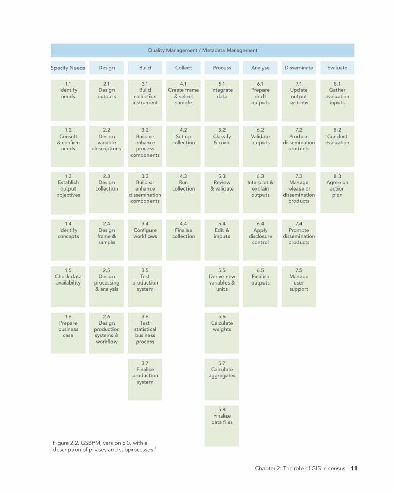
Supporting the census planning process
GIS can be applied across the Generic Statistical
Business Process Model (GSBPM), shown in fgure
2.2. One of the primary objectives of a GIS-based
census program is to support the census planning
process.
The support includes maximizing coverage
while avoiding coverage errors such as noninclu-
sion or double inclusion of units that may result in
undercounting or overcounting, respectively. It is
important to defne explicitly the census geography
in terms of hierarchical subdivision of the whole
territory into administrative, geographic, and statis-
tical areas, including enumeration areas (EAs) and
groups of EAs under the responsibility of supervi-
sors. These geographies are used to estimate the
staffng and materials needs and logistics require-
ments and defne the operational zones (or census
management areas) for the data collection.
As recommended by Principles and Recommen-
dations, the GIS-based census program should be
developed at an early stage of census planning
to allow suffcient time to produce full national
coverage maps (including map services and mobile
map packages, which are covered in chapter 6) well
before the census date and before the initiation of
feld-training exercises. Developing a timetable for
the GIS and mapping activities is of paramount im-
portance; it’s a time-bound operation with the criti-
cal date being the date that all enumeration-related
maps and map services must be made available
to the census feld enumeration. This requires the
identifcation of the technical, operational, and insti-
tutional tasks to be carried out through the plan-
ning process. These tasks include the evaluation of
available geographic and technological resources
and the critical design issues that determine the
nature of the census GIS, with a focus on its core
geospatial database and the range of applications
that it will support. Of importance is the inventory
of existing data, maps, and other geographic data
sources such as imagery. Data conversion and inte-
gration processes should also be understood—all
of these depend on a well-designed environment
and a well-planned operational strategy.5
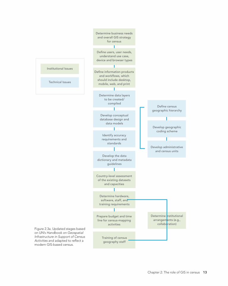
The stages for planning geographic work for the
census are shown in detail in fgures 2.3a and 2.3b.
The planning stages are divided here into
institutional issues, such as the user needs assess-
ment, the determination of the GIS strategy, and
the scope of census-mapping activities. The stages
also include technical issues such as the explicit
defnition of census geography, the design of the
geospatial database, and the development of clear
protocols for data collection. These stages can be
carried out more or less simultaneously using orga-
nizationally approved methodologies, and many of
the choices depend also on the chosen data-inte-
gration strategy.6
These planning steps may seem diffcult to
follow or be considered costly by some NSOs.
However, once a fundamental geospatial infrastruc-
ture is established and GIS is integrated into the
statistical business process, the effciencies gained
and benefts realized far outweigh any initial costs.
Each country needs to have guiding policies in
place to tailor the technological options accord-
ing to its needs and availability of resources. To
justify the investments involved, the strategies of
the pre-enumeration mapping program by many
NSOs are designed to produce the geographical
outputs suitable not only for the census enumer-
ation but also for the operational requirements of
data collection activities, dissemination activities,
and other user applications such as demarcation of
electoral boundaries, defning catchment areas of
various public services, monitoring and reporting
12 GIS and the 2020 Census: Modernizing Offcial Statistics
2020CensusRSZadj2.indb 13 4/22/19 2:54 PM
Institutional Issues
Technical Issues
Determine business needs and overall GIS strategy
for census
Deÿne users, user needs, understand use case,
device and browser types
Deÿne information products and work°ows, which
should include desktop, mobile, web, and print
Determine data layers to be created/
compiled
Develop conceptual database design and
data models
Identify accuracy requirements and
standards
Develop the data dictionary and metadata
guidelines
Country-level assessment of the existing datasets
and capacities
Determine hardware, software, staff, and
training requirements
Determine institutional arrangements (e.g.,
collaboration)
Prepare budget and time line for census-mapping
activities
Training of census geography staff
Figure 2.3a. Updated stages based on UN’s Handbook on Geospatial Infrastructure in Support of Census Activities and adapted to refect a modern GIS-based census.
Deÿne census geographic hierarchy
Develop geographic coding scheme
Develop administrative and census units
Chapter 2: The role of GIS in census 13
2020CensusRSZadj2.indb 14 4/22/19 2:54 PM
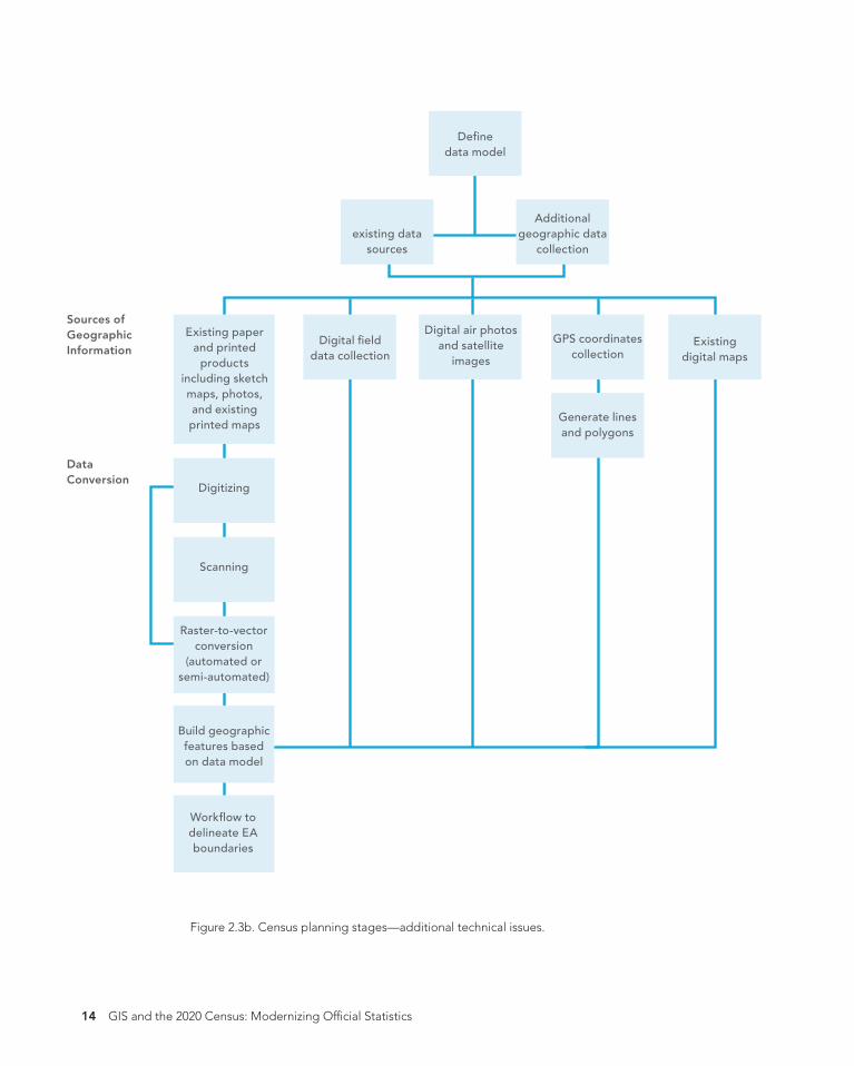
Existing
Deÿne data model
Identify
Additional existing data geographic data
sources collection
Sources of Geographic Digital air photos Existing paper GPS coordinates Digital ÿeld and satellite and printed Information collection data collection digital maps images
including sketch maps, photos, and existing
products
Generate lines printed maps
and polygons
Data Conversion
Digitizing
Scanning
conversion Raster-to-vector
(automated or semi-automated)
Build geographic features based on data model
Work˜ow to delineate EA boundaries
Figure 2.3b. Census planning stages—additional technical issues.
14 GIS and the 2020 Census: Modernizing Offcial Statistics
2020CensusRSZadj2.indb 15 4/22/19 2:54 PM
on the Sustainable Development Goals (SDGs), and
more. To maximize return on investment in GIS,
NSOs should actively participate with other national
authorities, including the National Mapping Agen-
cies (NMAs), in establishing a National Spatial Data
Infrastructure (NSDI).
GIS planning considerations
The shift from limited census-mapping operations
to an entirely GIS-based digital approach that spans
across all stages of the census requires the imple-
mentation of an enterprise GIS. The planning and
implementation of an enterprise GIS for the census
should include a cost-beneft analysis to justify
the long-term investment in building a GIS infra-
structure. It should also require a comprehensive
user-needs assessment; lessons learned from many
GIS projects show that a GIS is successful when
it provides outputs that meet well-defned user
needs. The user-needs analysis should also assess
the available technology in the market and allow
the evaluation of different GIS software options to
defne the most suitable GIS capabilities for census
purposes. More specifcally, understanding the
user needs requires understanding the appropriate
hardware, software, and related integrated systems
that will provide the specifc digital products and
services needed. Those products and services can
range from interactive ad web-based mapping
applications, map services, map packages, cloud
computing, and mobile apps to spatial analysis and
advanced analytics.
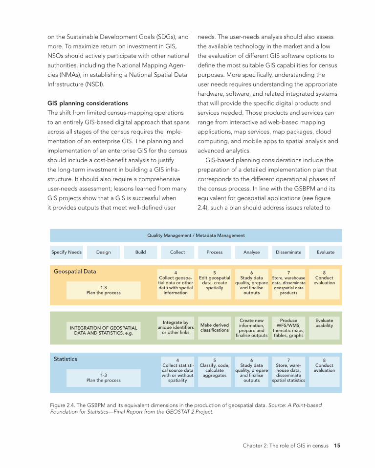
GIS-based planning considerations include the
preparation of a detailed implementation plan that
corresponds to the different operational phases of
the census process. In line with the GSBPM and its
equivalent for geospatial applications (see fgure
2.4), such a plan should address issues related to
Quality Management / Metadata Management
Specify Needs Design Build
Geospatial Data
1-3 Plan the process
INTEGRATION OF GEOSPATIAL DATA AND STATISTICS, e.g.
Statistics
1-3 Plan the process
Collect
4 Collect geospa-tial data or other data with spatial
information
Integrate by unique identiÿers
or other links
4 Collect statisti-cal source data with or without
spatiality
Process
5 Edit geospatial
data, create spatially
Make derived classiÿcations
5 Classify, code,
calculate aggregates
Analyse
6 Study data
quality, prepare and ÿnalise
outputs
Create new information, prepare and
ÿnalise outputs
6 Study data
quality, prepare and ÿnalise
outputs
Disseminate
7 Store, warehouse data, disseminate geospatial data
products
Produce WFS/WMS,
thematic maps, tables, graphs
7 Store, ware-house data, disseminate
spatial statistics
Evaluate
8 Conduct
evaluation
Evaluate usability
8 Conduct
evaluation
Figure 2.4. The GSBPM and its equivalent dimensions in the production of geospatial data. Source: A Point-based Foundation for Statistics—Final Report from the GEOSTAT 2 Project.
Chapter 2: The role of GIS in census 15
2020CensusRSZadj2.indb 16 4/22/19 2:54 PM
the design of the geospatial database, data con-
version and integration, and all the other phases of
geospatial data production.
Because GIS was not traditionally considered
part of the core business of the NSO, awareness
workshops about the benefts of GIS should be or-
ganized to win executive support for the program.
Technical trainings and workshops about the use of
GIS should be provided to the staff involved in the
census and supporting functions. In addition, the
plan should also involve workshops for the major
data users about the potential of GIS and draw on
institutional mechanisms to mobilize cooperation
among all stakeholders to establish a GIS infrastruc-
ture at a national level.
GIS can be leveraged to support a wide vari-
ety of activities across the entire census process.
Following are some examples of how GIS is being
applied today in census preparation. These activi-
ties will create the foundation for all census work to
follow:
• Creation or updates to geodatabase and
basemaps.
• Creation or updates and validation of EAs.
- Production of digital EA maps for feldwork
and operations.
- Use of remote-sensed data in EA creation or
update.
- In-offce address canvassing can be done using
imagery where applicable and where quality data
is available.
- Where in-offce validation is not possible,
maps can be used in feld verifcation or in situ
validation.
- Integrating feldwork using remote-sensed
data.
• Conducting GIS analysis to ensure complete and
balanced coverage. Overlaying EA maps on a
scaled national basemap to ensure the absence
of omissions or duplications.
• Applying GIS analysis to facilitate effcient census
operations.
- Using GIS analysis to determine the most
effcient placement of feld offces.
- GIS-based analysis to optimize allocation of
feld-workers to EAs based on various criteria
such as language, distance, hours of work, and
more.
• Creation of map services (the way maps are
made available to the web).
• Creation of mobile map packages (the way maps
are made available on a mobile device in an off-
line mode).
More details are provided in the following sections
and subsequent chapters.
Needs assessment
It is generally recognized that a well-defned plan
that involves various users with different data needs
should be prepared at an early stage. Using geo-
spatial information technology in all the stages of
a census requires even more focus and the need to
identify, understand, and plan how to address the
specifc GIS and mapping needs and expectations
of the main user groups, as well as the census geo-
graphic products required.
The needs assessment plan should include
strategies on the content to be discussed during
the consultations with users, questions on the ways
census products will be accessed (device type) and
used as well as their presentation, and the kind of
training that needs to be provided to users.
Conducting a comprehensive needs assessment
with a business need–driven approach rather than
a technology-driven approach helps to defne
16 GIS and the 2020 Census: Modernizing Offcial Statistics
2020CensusRSZadj2.indb 17 4/22/19 2:54 PM
user needs. The assessment should also identify
any available resources within the NSO (and in
the country), such as maps suitable for the census
operations, existing software packages and relat-
ed equipment, qualifed staff in GIS, and fnancial
resources for the GIS-based census program. This
identifcation will assist in reconciling user expecta-
tions with what is feasible given available resources,
working backward from fnal products and services
to requirements.7
The next section will elaborate on the needs
assessment of the main user groups: (a) major users
of census data, (b) persons and institutions partici-
pating in the census operations, and (c) the general
public and civil society.
Major users of census data
A user-oriented census provides major data users—
governmental departments, local administrations,
the academic and research sector, and the private
sector—with easy access and clear understanding
of the statistics available, enabling them to beneft
from census results. One of the major impacts of a
GIS-based census is the extension of the communi-
ty of users, interested in statistics with a geographic
dimension. The assessment of needs in this case
includes consultation on demographic and geo-
graphic content desired, geographic structures such
as administrative hierarchies or geographic units
needed for data collection or data aggregation,
and geographic base products (maps, imagery, and
other remotely sensed data) that support analysis
and dissemination of census data. A consultation of
the needs of these major users is necessary to de-
termine the form and scope of data to be dissem-
inated and to ultimately understand their expecta-
tions in terms of census geographic data products.
Persons and institutions participating in the
census operations
Evaluating the needs for census-mapping activities
is equally important for the persons (employees
and contractors) and institutions participating in the
census operations. To obtain an understanding of
existing resources and requirement gaps, the NSO
must carry out a survey of available human resourc-
es, hardware, and software, and must conduct an
inventory of existing data (in digital format and on
paper) and any requirements for data conversion.
The NSO should also understand any ongoing or
planned relevant GIS-oriented activities by other
public and private entities. The purpose of this as-
sessment is to avoid duplicating efforts, which is key
to reducing the cost of census geographic opera-
tions and delivering census products on time.8
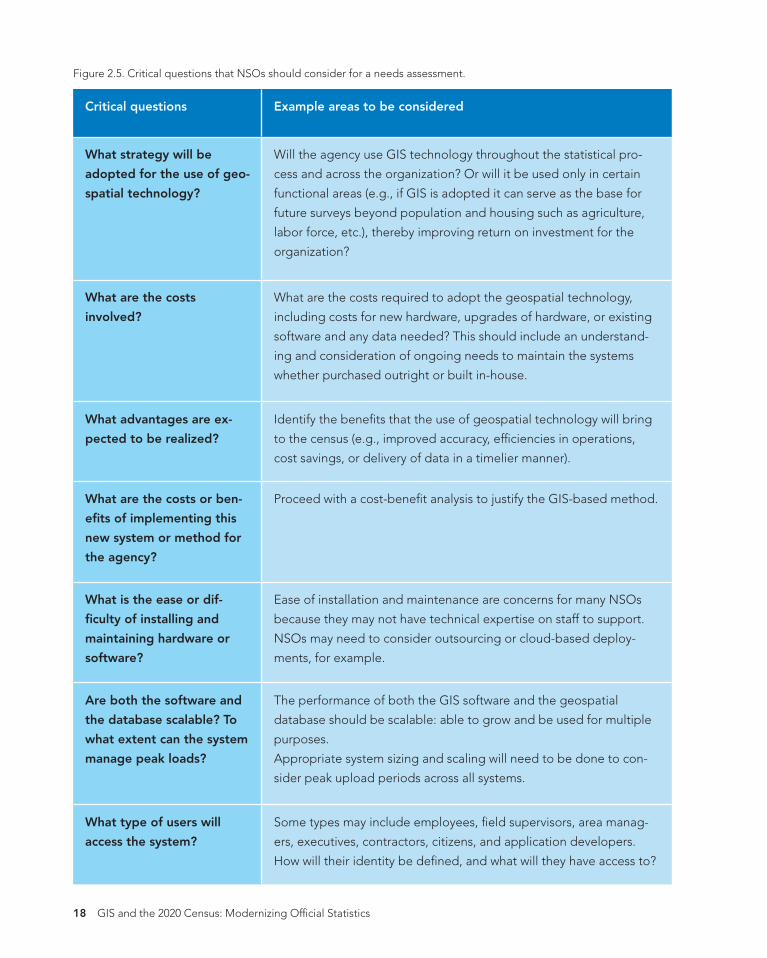
Conducting a comprehensive needs assessment
to answer some of the critical questions shown
in the following table will help the NSO consider
which new technologies to adopt to modernize the
census process.
Chapter 2: The role of GIS in census 17
2020CensusRSZadj2.indb 18 4/22/19 2:54 PM
Figure 2.5. Critical questions that NSOs should consider for a needs assessment.
Critical questions Example areas to be considered
What strategy will be
adopted for the use of geo-
spatial technology?
Will the agency use GIS technology throughout the statistical pro-
cess and across the organization? Or will it be used only in certain
functional areas (e.g., if GIS is adopted it can serve as the base for
future surveys beyond population and housing such as agriculture,
labor force, etc.), thereby improving return on investment for the
organization?
What are the costs required to adopt the geospatial technology,
including costs for new hardware, upgrades of hardware, or existing
software and any data needed? This should include an understand-
ing and consideration of ongoing needs to maintain the systems
whether purchased outright or built in-house.
Identify the benefts that the use of geospatial technology will bring
to the census (e.g., improved accuracy, effciencies in operations,
cost savings, or delivery of data in a timelier manner).
Proceed with a cost-beneft analysis to justify the GIS-based method.
Ease of installation and maintenance are concerns for many NSOs
What are the costs
involved?
What advantages are ex-
pected to be realized?
What are the costs or ben-
efts of implementing this
new system or method for
the agency?
What is the ease or dif-
fculty of installing and because they may not have technical expertise on staff to support.
maintaining hardware or NSOs may need to consider outsourcing or cloud-based deploy-
software? ments, for example.
The performance of both the GIS software and the geospatial Are both the software and
the database scalable? To database should be scalable: able to grow and be used for multiple
what extent can the system purposes.
manage peak loads? Appropriate system sizing and scaling will need to be done to con-
sider peak upload periods across all systems.
Some types may include employees, feld supervisors, area manag-
ers, executives, contractors, citizens, and application developers.
How will their identity be defned, and what will they have access to?
What type of users will
access the system?
18 GIS and the 2020 Census: Modernizing Offcial Statistics
2020CensusRSZadj2.indb 19 4/22/19 2:54 PM
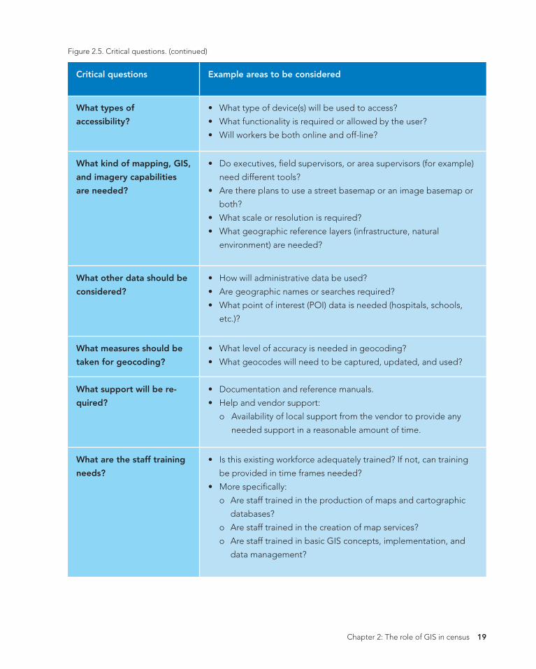
Figure 2.5. Critical questions. (continued)
Critical questions Example areas to be considered
What types of
accessibility?
• What type of device(s) will be used to access?
• What functionality is required or allowed by the user?
• Will workers be both online and off-line?
• Do executives, feld supervisors, or area supervisors (for example)
need different tools?
• Are there plans to use a street basemap or an image basemap or
both?
• What scale or resolution is required?
• What geographic reference layers (infrastructure, natural
environment) are needed?
• How will administrative data be used?
What kind of mapping, GIS,
and imagery capabilities
are needed?
What other data should be
considered? • Are geographic names or searches required?
• What point of interest (POI) data is needed (hospitals, schools,
etc.)?
• What level of accuracy is needed in geocoding?
• What geocodes will need to be captured, updated, and used?
• Documentation and reference manuals.
What measures should be
taken for geocoding?
What support will be re-
quired? • Help and vendor support:
o Availability of local support from the vendor to provide any
needed support in a reasonable amount of time.
• Is this existing workforce adequately trained? If not, can training
be provided in time frames needed?
• More specifcally:
o Are staff trained in the production of maps and cartographic
databases?
o Are staff trained in the creation of map services?
o Are staff trained in basic GIS concepts, implementation, and
data management?
What are the staff training
needs?
Chapter 2: The role of GIS in census 19
2020CensusRSZadj2.indb 20 4/22/19 2:54 PM
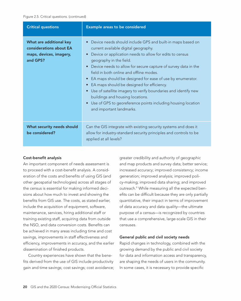
Figure 2.5. Critical questions. (continued)
Critical questions Example areas to be considered
What are additional key
considerations about EA
maps, devices, imagery,
and GPS?
• Device needs should include GPS and built-in maps based on
current available digital geography.
• Device or application needs to allow for edits to census
geography in the feld.
• Device needs to allow for secure capture of survey data in the
feld in both online and offine modes.
• EA maps should be designed for ease of use by enumerator.
• EA maps should be designed for effciency.
• Use of satellite imagery to verify boundaries and identify new
buildings and housing locations.
• Use of GPS to georeference points including housing location
and important landmarks.
Can the GIS integrate with existing security systems and does it
allow for industry-standard security principles and controls to be
applied at all levels?
What security needs should
be considered?
Cost-beneft analysis
An important component of needs assessment is
to proceed with a cost-beneft analysis. A consid-
eration of the costs and benefts of using GIS (and
other geospatial technologies) across all stages of
the census is essential for making informed deci-
sions about how much to invest and showing the
benefts from GIS use. The costs, as stated earlier,
include the acquisition of equipment, software,
maintenance, services, hiring additional staff or
training existing staff, acquiring data from outside
the NSO, and data conversion costs. Benefts can
be achieved in many areas including time and cost
savings, improvements in staff effectiveness and
effciency, improvements in accuracy, and the earlier
dissemination of fnished products.
Country experiences have shown that the bene-
fts derived from the use of GIS include productivity
gain and time savings; cost savings; cost avoidance;
greater credibility and authority of geographic
and map products and survey data; better service;
increased accuracy; improved consistency; income
generation; improved analysis; improved poli-
cy-making; improved data sharing; and improved
outreach.9 While measuring all the expected ben-
efts can be diffcult because they are only partially
quantitative, their impact in terms of improvement
of data accuracy and data quality—the ultimate
purpose of a census—is recognized by countries
that use a comprehensive, large-scale GIS in their
censuses.
General public and civil society needs
Rapid changes in technology, combined with the
growing demand by the public and civil society
for data and information access and transparency,
are shaping the needs of users in the community.
In some cases, it is necessary to provide specifc
20 GIS and the 2020 Census: Modernizing Offcial Statistics
2020CensusRSZadj2.indb 21 4/22/19 2:54 PM
data or access to meet the needs of these users, as
individuals or communities. Community engage-
ment is key for organizations as producers of offcial
statistics. Citizens and civil society alike need to
fundamentally understand the issues of the day and
where change is needed, which comes from NSO
authoritative data.
Modern geospatial platforms provide easy-
to-use tools (e.g., apps) for data sharing and
collaboration, which allow for even more citizen
engagement. NSOs may need to educate the
general public about the power of geospatial tools
in conveying census information to users, and how
spatial analysis related to GIS capabilities allows us-
ers to analyze and visualize data, leading to a more
meaningful interpretation of results. For example,
census data is essential and most relevant in public
safety efforts. NSOs must also keep abreast of and
anticipate the general public demand for their data,
including the need for data to support the under-
standing and reporting on the UN SDGs (see the
case study on Ireland and SDGs in chapter 8).
Information product needs
The ultimate purpose of conducting a comprehen-
sive needs assessment of the three user groups is to
determine the range of output or information prod-
ucts that need to be completed both throughout
and at the end of the GIS-based census program.
This determination allows the NSO to rethink the
geographic products from the users’ perspective,
and how to make them available in a form suited
to their needs supplemented by proper and useful
documentation, including metadata.
Generally, the geographic information products
include digital EA maps for the creation of aggre-
gate dissemination areas; geographic boundary
fles in digital format that provide statistical report-
ing units used for census dissemination and spatial
analysis; a road network fle in digital form repre-
senting the country’s national road network and
containing information on street names and types
for all major urban areas;10 and correspondence
fles that indicate how current reporting units relate
to those used in previous censuses and facilitate a
comparison between sequential censuses (see the
online ancillaries at esri.com/Census2020).
Other information products may include the list
of changes to municipal boundaries showing the
Volunteered geographic information Public demand for information is expanding
rapidly, as is “citizen science”—the scientifc
research conducted, in whole or in part, by
amateur scientists. A widespread community
engagement called volunteered geographic
information (VGI) is popularizing the creation,
sharing, and use of geospatial data, often
through smart phones, social media, and online
mapping tools, and acting as a valuable mech-
anism to encourage public participation and
citizen engagement in geospatial information.
VGI, crowdsourced data, and social media may
provide essential information to citizens and
local knowledge to communities on their neigh-
borhoods, health facilities, zoning conditions,
or even the damage from fooding or some
other local disaster. Citizens and particularly
some focus groups may need statistical data to
combine with feld data to create community
mapping. Even though the quality or accuracy
of such mapping may not be high, the speed
of collection and mapping of the data can be
performed easily, making it useful for an early
response.
Chapter 2: The role of GIS in census 21
2020CensusRSZadj2.indb 22 4/22/19 2:54 PM
changes brought to municipal boundaries, status,
and names that occurred between the current and
previous census; a set of vector layers containing
feature data, such as landmarks, roads, schools,
health facilities, etc., which can be used for pop-
ulation-based spatial analysis; centroids/point-
based fles (point data based on GPS coordinates
or individual addresses) that provide respectively
geographic point reference for each reporting unit
and other geographic features (such as dwellings,
places, etc.); and gazetteers that provide geograph-
ic coordinates and naming for all population set-
tlements and other important geographic entities
in the country (such as administrative units, places,
and census units).11 Modern systems also allow
for the creation of operational dashboards which
can be useful during the full census cycle, giving
transparency and increasing communication and
collaboration across teams. Finally, in dissemination,
many different types of information products may
be required, including maps, story maps, atlases,
online web applications, and more (more details are
provided in chapter 9).
Success factors
Besides conducting a comprehensive needs
assessment that helps adequately defne the user
needs and identify the available resources within
the NSO and in the country, particularly the funding
requirements, we need to consider critical factors to
succeed in a full digital GIS-based census program.
Chief among these factors are: (1) ensuring com-
mitment from senior management for building a
long-term digital program; (2) building technical
and human capacities required for sustaining the
GIS-based systems and databases and setting up
an independent unit for cartography/GIS activities
within the NSO; (3) using technical standards; (4)
developing a partnership for cooperation with the
NMA and other organizations involved in geo-
spatial information activities; and (5) choosing the
appropriate methodology of integration of the new
geospatial technologies with the census-mapping
operations (compatibility). These factors are fnd-
ings revealed by survey-based studies and lessons
learned from country experiences during the last
2010 Round of Censuses.12 We will elaborate on
them in the following sections.
Human factors
While a GIS-based census project may be perceived
as technical in nature, what ultimately drives its
success often hinges on human factors, particularly
in terms of ensuring commitment from senior man-
agement for building a long-term program and the
true integration of geospatial and statistical data.
It is critical, as stated earlier, to consider the GIS-
based census program as a long-term program that
benefts not only the national census offce but also
other government agencies and ministries as well as
census data users. Approaching GIS as an integral
part of the process and knowing that it requires
an important initial investment can help achieve a
return on investment in the long term.
With any new methodology with little critical
mass of experiences known by policy makers and
good practices confned to specialists, a promoter
and a champion are needed. These people will
not only steer the GIS-based census process but
will also reach out to the decision makers, advo-
cating for the benefts of using this new approach.
A champion can communicate and demonstrate
the power of GIS to visualize, explore, and analyze
data related to development, ensuring appropriate
and timely government support for all aspects of
the program.
22 GIS and the 2020 Census: Modernizing Offcial Statistics
2020CensusRSZadj2.indb 23 4/22/19 2:54 PM
IT and human capacity building
A GIS-based census program carried out as a
continuous process requires an independent
geographic information unit to be set up within
the NSO, with a permanent staff that can carry
out the geospatial analysis and census-mapping
tasks spanned over all census stages and between
censuses. A permanent unit that can develop
partnerships, understand and adhere to data
standards and interoperability requirements, forge
agreements and contracts for data collection and
sharing, and cooperate with the other major actors
in building the NSDI of the country is a valuable
asset for success. In the absence of in-house GIS
capabilities, it becomes diffcult for the census of-
fce to make qualitative checks on the data created
and delivered by the contracted companies. This
diffculty may result in the delivery of inaccurate
and defcient data, which in turn affects the quality
of the geospatial data and map products used for
the census.
Building technical and human capacities
required for sustaining the GIS-based census
program is a recurrent issue to be addressed.
Building this capacity requires training personnel
with appropriate skills in GIS to serve all census
geography needs. A well-trained staff is a key fac-
tor for the success of GIS-based census-mapping
projects. Country experiences have shown that
retaining skilled GIS staff within NSOs is a major
issue, particularly with the proliferation of numer-
ous GIS applications unrelated to the census and
often commercially more attractive and lucrative.
To retain trained qualifed staff, NSOs need to
provide signifcant incentives and ensure continual
training to keep employees abreast of advances in
technology.
Use of standards
Standards are important to every industry and GIS is
no exception. The benefts of developing, adopting,
and implementing technical standards and common
metadata have been recognized by both statistical
and geospatial communities. Those benefts enable
interoperability and facilitate the integration and
use of diverse sources of statistical and geospatial
data and services in all sectors of a global economy.
It is recognized that the development of common
standards and metadata would specifcally make
statistical and geospatial information more usable
and relevant to a wider range of users.
Implementing geospatial databases for the
census and related geographic products requires
the creation and maintenance of metadata guide-
lines and a data dictionary. The metadata standard
and its use beyond the census would increase the
usability and relevance of this data and enhance
the ability to compare data both within and across
geographies. NSOs should adhere to applicable
standards established for the country because they
are necessary to ease the effort of sharing census
data and understanding between organizations and
between applications. Many applications extend
beyond national borders, including those related to
disaster management, spread of infectious diseases,
humanitarian assistance, migration, and cross-bor-
der displaced population, for which it is necessary
to integrate datasets across national borders.
Geospatial standards and metadata are not
always available in countries. When they are unavail-
able, it is recommended that NSOs follow published
basic standards and defnitions, especially about the
geospatial features used in statistical operations,
such as boundaries of statistical units, buildings,
private dwellings, and collective living quarters.
Chapter 2: The role of GIS in census 23
2020CensusRSZadj2.indb 24 4/22/19 2:54 PM
As stated previously, work led by the UN has resulted in the development of a Global Statistical Geo-
spatial Framework (GSGF) used as a guideline for integrating statistical and geospatial information. An
overview of this framework is presented in the box.13 The development of an overarching statistical-geo-
spatial framework, as part of an overall information architecture at both the national and global levels, is
needed for enhancing the common understanding of concepts such as geocoding, georeferencing, and
other terminology; sharing common standards; and fostering collaboration between both statistical and
geospatial communities. This recognizes that when statistical and geospatial information is integrated
within a statistical-geospatial framework, the geostatistical results can signifcantly improve the quality of
offcial statistics and population and housing censuses and support the measuring and monitoring of the
SDGs. This also explains and justifes the shift from census mapping to GIS-based approaches, with full use
of GIS and geospatial technologies across all stages of the census and beyond.
24 GIS and the 2020 Census: Modernizing Offcial Statistics
2020CensusRSZadj2.indb 25 4/22/19 2:54 PM
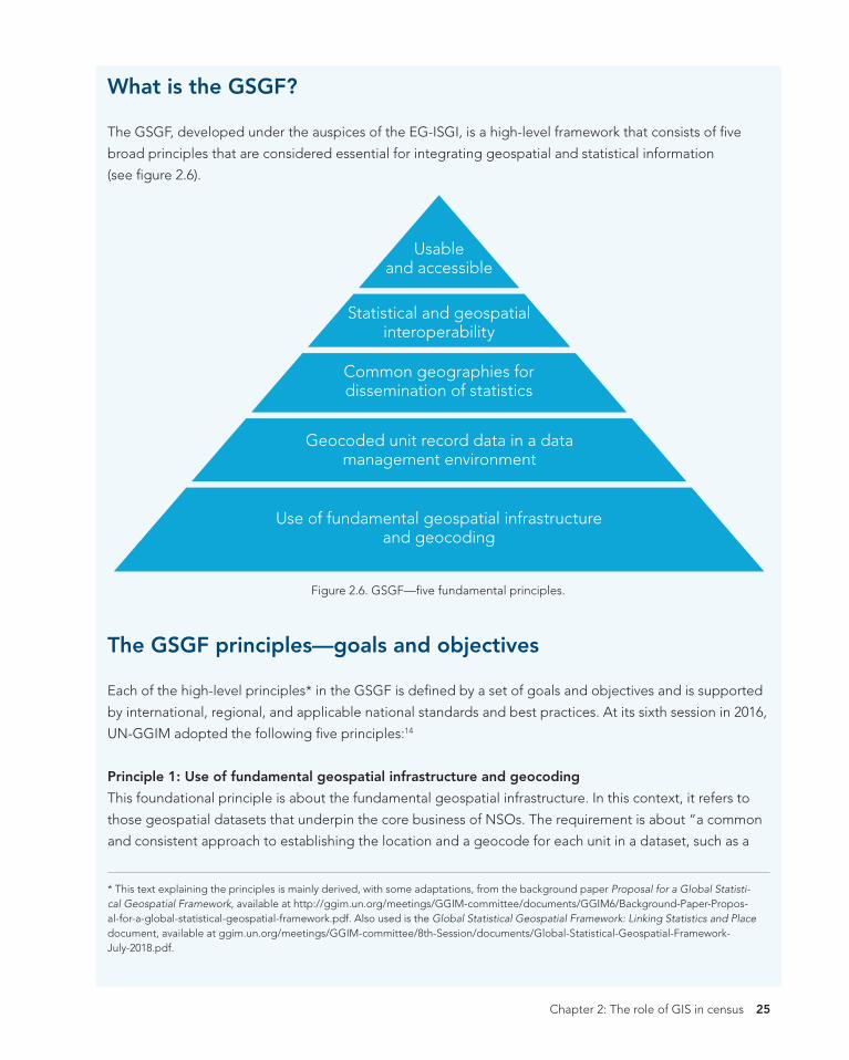
What is the GSGF?
The GSGF, developed under the auspices of the EG-ISGI, is a high‐level framework that consists of fve
broad principles that are considered essential for integrating geospatial and statistical information
(see fgure 2.6).
Usable and accessible
Statistical and geospatial interoperability
Common geographies for dissemination of statistics
Geocoded unit record data in a data management environment
Use of fundamental geospatial infrastructure and geocoding
Figure 2.6. GSGF—fve fundamental principles.
The GSGF principles—goals and objectives
Each of the high-level principles* in the GSGF is defned by a set of goals and objectives and is supported
by international, regional, and applicable national standards and best practices. At its sixth session in 2016,
UN-GGIM adopted the following fve principles:14
Principle 1: Use of fundamental geospatial infrastructure and geocoding
This foundational principle is about the fundamental geospatial infrastructure. In this context, it refers to
those geospatial datasets that underpin the core business of NSOs. The requirement is about “a common
and consistent approach to establishing the location and a geocode for each unit in a dataset, such as a
* This text explaining the principles is mainly derived, with some adaptations, from the background paper Proposal for a Global Statisti-cal Geospatial Framework, available at http://ggim.un.org/meetings/GGIM-committee/documents/GGIM6/Background-Paper-Propos-al-for-a-global-statistical-geospatial-framework.pdf. Also used is the Global Statistical Geospatial Framework: Linking Statistics and Place document, available at ggim.un.org/meetings/GGIM-committee/8th-Session/documents/Global-Statistical-Geospatial-Framework-July-2018.pdf.
Chapter 2: The role of GIS in census 25
2020CensusRSZadj2.indb 26 4/22/19 2:54 PM
person, household, business, building or parcel/unit of land. . . . The goal of this principle is to obtain a
high quality, standardized physical address, property, building identifer, or other location description in
order to assign accurate coordinates and/or a small geographic area or standard grid reference to each
statistical unit (i.e., at the microdata level).” The fundamental geospatial infrastructure will differ between
countries, but “the process of obtaining locations and geocodes should use relevant, fundamental geo-
spatial data . . . from the National Spatial Data Infrastructures or other nationally agreed sources.” In some
nations, it is likely to include national address lists, land parcel databases, road networks, business regis-
ters, and building footprints. In other nations, it is likely to include national and regional boundaries, town
and locality locations, etc. However, the EG-ISGI recognizes that geocoding of statistical units using point
referencing is highly preferable when compared with merely associating statistical units with a geographic
region (i.e., a polygon).
Principle 2: Geocoded unit record data in a data management environment
This principle focuses on the requirement that the linkage for each statistical unit record should occur
within a data management environment to allow all statistical data to be applied to any geographic con-
text (i.e., in aggregating data into a variety of larger geographic units), including future changes to geog-
raphies over time, and enable data-linking processes that aim to integrate information of varying nature
and sources by so-called linked data techniques. This principle is underpinned by two combined factors:
(1) key to geospatial enablement and fexibility, the fner the better; and (2) statistical data management en-
sures confdentiality. While principle 1 is about geocoding infrastructure, principle 2 is about applying this
geocoding infrastructure to unit records and ensuring that the statistical infrastructure can use geospatial
infrastructure and standards for geocoding.
Principle 3: Common geographies for dissemination of statistics
This principle is about the enablement of comparisons across datasets from different sources, which re-
quires using a common set of geographies for the display, reporting, and analysis of social, economic, and
environmental information. The goal of this principle is to provide the tools for integration of aggregate
data on common geography and for the dissemination of data. In addition to the recognized importance
of traditional statistical and administrative geographies, NSOs should consider the benefts of grid-based
statistical systems because gridded data can be both a rich source of information and a consistent geogra-
phy for disseminating and comparing information.
Principle 4: Interoperable data and metadata standards
This principle aims at greater effciency and simplifcation of the creation, discovery, integration, and use of
geospatially enabled statistics and geospatial data; increasing the potential application of a larger range
of data and technologies; and a wider range of data available and accessible for use in comparisons and
analysis in decision-making: “Both the statistical and the geospatial data communities operate their own
general data models and metadata capabilities; however, these models are often not universally applied.
26 GIS and the 2020 Census: Modernizing Offcial Statistics
2020CensusRSZadj2.indb 27 4/22/19 2:54 PM
The statistical community uses the Generic Statistical Information Model (GSIM), the Statistical Data and
Metadata eXchange (SDMX), and the Data Documentation Initiative (DDI) mechanisms. The geospatial
community uses the General Feature Model (GFM) and the ISO19115 metadata standard, plus a number
of application-specifc standards.” Within the statistical community, there is a need to build geospatial
processes and standards into statistical business processes in a more consistent manner. In consequence,
the EG‐ISGI has recognised that a top-down approach is required, incorporating geospatial frameworks,
standards, and processes more explicitly into the Common Statistical Production Architecture and its com-
ponents. Work has started internationally on how to better enhance interoperability between statistical and
geospatial metadata standards.
Principle 5: Accessible and usable geospatially enabled statistics
This principle is about the ultimate purpose of developing this GSGF: Informing decision-making in a more
fexible, agile approach using new and existing data and reassuring custodians of safe release (i.e., release
of their data with confdence, privacy, and confdentiality protected) while enabling users with discovery
and access of geospatially enabled statistics. More specifcally, this will consist of identifying or, where
required, developing policies, standards, and guidelines that support the release, access, analysis, and
visualization of geospatially enabled information. In addition, data users can undertake analysis and evalua-
tion. Web services enable machine-to-machine access and dynamic linkages of information. As stated in
principle 4, this will allow data to be accessed and used effciently and ultimately support the moderniza-
tion agenda of many NSOs and NMAs.
The UNSC adopted the framework at its forty-eighth session in March 2017, and subsequently the Com-
mittee of Experts endorsed it at its seventh session in August 2017.
The standards and best practices that will form the detailed guidance for countries implementing the
framework are still under consideration by the EG-ISGI and will be brought to the UNSC and UN‐GGIM for
consideration when fnalized.
Where standards, policies, or datasets required to support the framework do not currently exist, the
framework provides a clear mandate for their establishment. Collaboration between countries and within
the EG-ISGI provides a mechanism to assist with the formation and establishment of these standards, pol-
icies, or fundamental datasets both within member states and internationally. A number of areas of further
work have been identifed and are under consideration by EG-ISGI.
The framework is driven by strong principles but remains broad enough that countries can adapt it to
their local conditions and needs. Many members agreed to prepare country-level examples detailing their
application of the GSGF principles to their national conditions in preparation for broader global communi-
ty input. In this regard, a template for country examples for each of the fve principles has been prepared
by the Australian Bureau of Statistics and available for use by countries.
Other countries such as Sweden are now beginning to share their interpretations on how they will imple-
ment the GSGF within their organization.
Chapter 2: The role of GIS in census 27
2020CensusRSZadj2.indb 28 4/22/19 2:54 PM
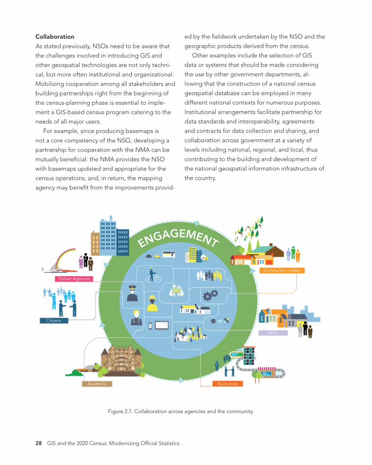
Collaboration
As stated previously, NSOs need to be aware that
the challenges involved in introducing GIS and
other geospatial technologies are not only techni-
cal, but more often institutional and organizational.
Mobilizing cooperation among all stakeholders and
building partnerships right from the beginning of
the census-planning phase is essential to imple-
ment a GIS-based census program catering to the
needs of all major users.
For example, since producing basemaps is
not a core competency of the NSO, developing a
partnership for cooperation with the NMA can be
mutually benefcial: the NMA provides the NSO
with basemaps updated and appropriate for the
census operations, and, in return, the mapping
agency may beneft from the improvements provid-
ed by the feldwork undertaken by the NSO and the
geographic products derived from the census.
Other examples include the selection of GIS
data or systems that should be made considering
the use by other government departments, al-
lowing that the construction of a national census
geospatial database can be employed in many
different national contexts for numerous purposes.
Institutional arrangements facilitate partnership for
data standards and interoperability, agreements
and contracts for data collection and sharing, and
collaboration across government at a variety of
levels including national, regional, and local, thus
contributing to the building and development of
the national geospatial information infrastructure of
the country.
ENGAGEMENT
Partner Agencies
Citizens
Academia Businesses
NSOs
Community Leaders
Figure 2.7. Collaboration across agencies and the community.
28 GIS and the 2020 Census: Modernizing Offcial Statistics
2020CensusRSZadj2.indb 29 4/22/19 2:54 PM
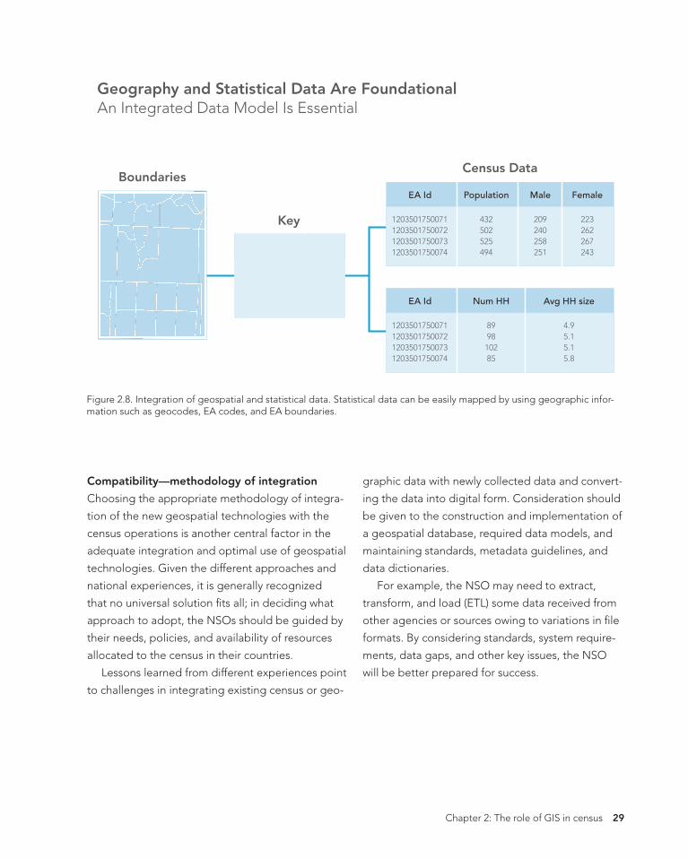
Geography and Statistical Data Are Foundational An Integrated Data Model Is Essential
1203501750071 1203501750072 1203501750073 1203501750074
EA Id
42.3 34.8 26.9 51.2
Area
Census Data Boundaries
Key 1203501750071 1203501750072 1203501750073 1203501750074
EA Id
432 502 525 494
209 240 258 251
223 262 267 243
Population Male Female
1203501750071 1203501750072 1203501750073 1203501750074
EA Id
89 98 102 85
4.9 5.1 5.1 5.8
Num HH Avg HH size
Figure 2.8. Integration of geospatial and statistical data. Statistical data can be easily mapped by using geographic infor-mation such as geocodes, EA codes, and EA boundaries.
Compatibility—methodology of integration
Choosing the appropriate methodology of integra-
tion of the new geospatial technologies with the
census operations is another central factor in the
adequate integration and optimal use of geospatial
technologies. Given the different approaches and
national experiences, it is generally recognized
that no universal solution fts all; in deciding what
approach to adopt, the NSOs should be guided by
their needs, policies, and availability of resources
allocated to the census in their countries.
Lessons learned from different experiences point
to challenges in integrating existing census or geo-
graphic data with newly collected data and convert-
ing the data into digital form. Consideration should
be given to the construction and implementation of
a geospatial database, required data models, and
maintaining standards, metadata guidelines, and
data dictionaries.
For example, the NSO may need to extract,
transform, and load (ETL) some data received from
other agencies or sources owing to variations in fle
formats. By considering standards, system require-
ments, data gaps, and other key issues, the NSO
will be better prepared for success.
Chapter 2: The role of GIS in census 29

2020CensusRSZadj2.indb 30 4/22/19 2:54 PM
Considerations for rapid changes in technology
How do NSOs keep abreast of technology changes and understand what and when to implement?
Artifcial intelligence (AI), machine learning (ML), IoT, and smart devices hold the promise for an intelli-
gent future. The challenge will be understanding and leveraging these new technologies in both a timely
and cost-effcient manner and mapping the NSO’s business needs and workfows to these potential new
technologies.
Understanding new ideas such as this, in addition to continuous adaptive security or microservices, will
be critical to future success. Intelligent applications (apps) and analytics are another key trend we must be
prepared for. Intelligent apps have the potential to transform the nature of work and the structure of the
workplace. While NSOs are conducting their work today, they must at the same time plan for the future.
The GIS industry is no stranger to this transformation, according to Jack Dangermond, president and
founder of Esri: “The geospatial industry is quickly evolving because the capabilities of digital connected-
ness and collaboration are moving ahead exponentially. In fact, the fve biggest trends in the area of geo-
graphic information system (GIS) technology are centered on making data more accessible and creating
context to visualize this data in an age when fast, easy access to information is taken for granted.”
Figure 2.9. Jack Dangermond, president of Esri, addresses a conference audience.
30 GIS and the 2020 Census: Modernizing Offcial Statistics
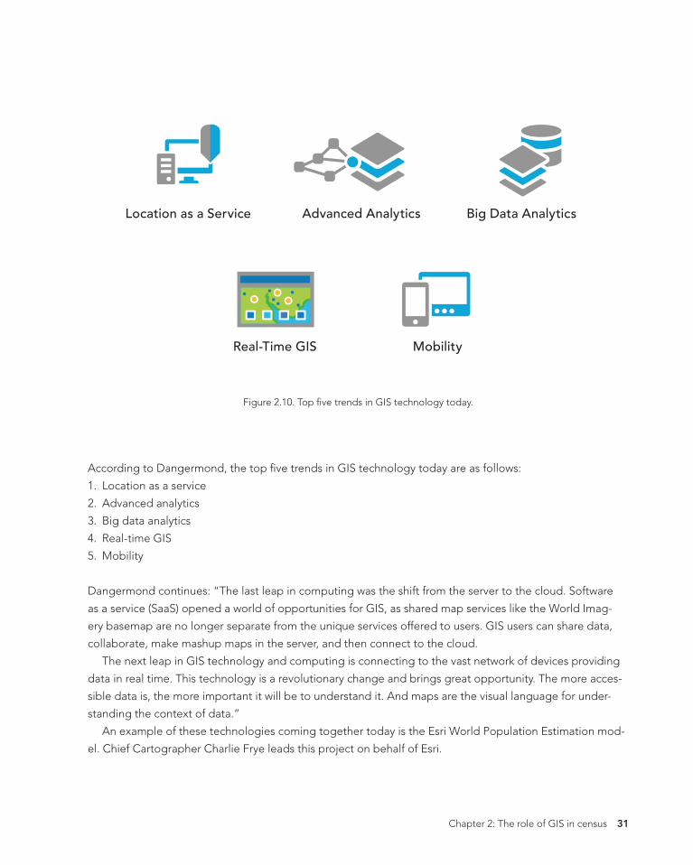
2020CensusRSZadj2.indb 31 4/22/19 2:54 PM
Location as a Service Advanced Analytics Big Data Analytics
Real-Time GIS Mobility
Figure 2.10. Top fve trends in GIS technology today.
According to Dangermond, the top fve trends in GIS technology today are as follows:
1. Location as a service
2. Advanced analytics
3. Big data analytics
4. Real-time GIS
5. Mobility
Dangermond continues: “The last leap in computing was the shift from the server to the cloud. Software
as a service (SaaS) opened a world of opportunities for GIS, as shared map services like the World Imag-
ery basemap are no longer separate from the unique services offered to users. GIS users can share data,
collaborate, make mashup maps in the server, and then connect to the cloud.
The next leap in GIS technology and computing is connecting to the vast network of devices providing
data in real time. This technology is a revolutionary change and brings great opportunity. The more acces-
sible data is, the more important it will be to understand it. And maps are the visual language for under-
standing the context of data.”
An example of these technologies coming together today is the Esri World Population Estimation mod-
el. Chief Cartographer Charlie Frye leads this project on behalf of Esri.
Chapter 2: The role of GIS in census 31
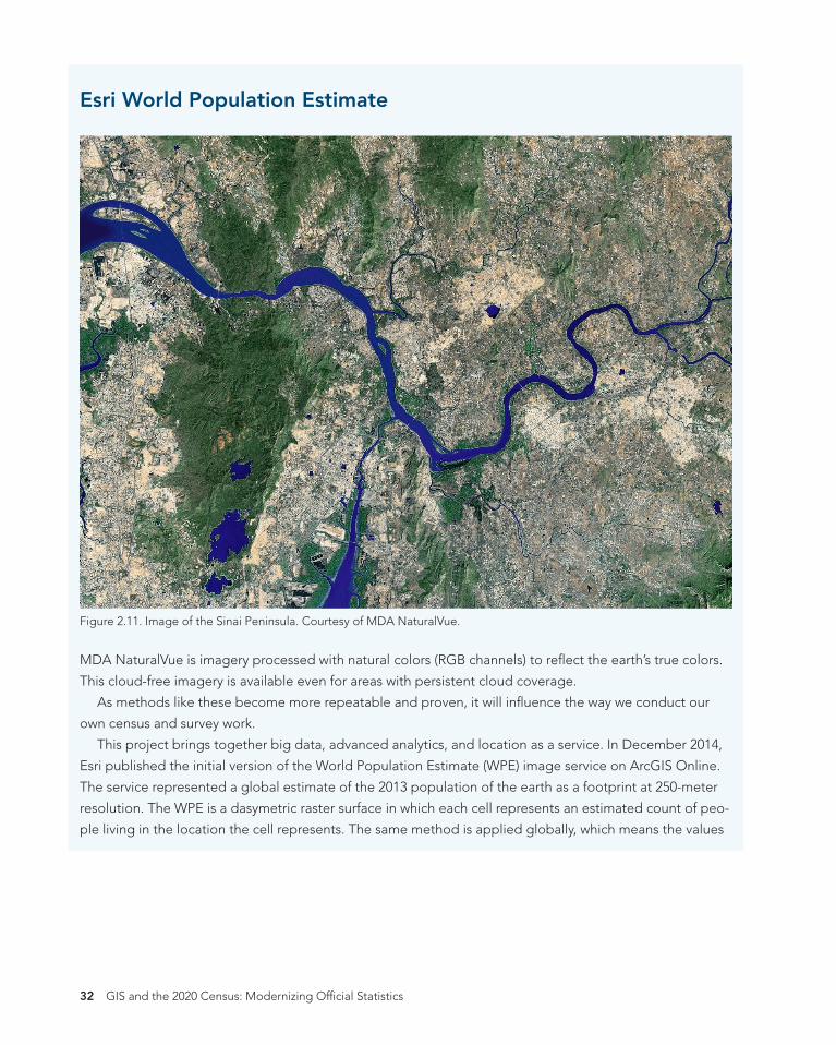
2020CensusRSZadj2.indb 32 4/22/19 2:54 PM
Esri World Population Estimate
Figure 2.11. Image of the Sinai Peninsula. Courtesy of MDA NaturalVue.
MDA NaturalVue is imagery processed with natural colors (RGB channels) to refect the earth’s true colors.
This cloud-free imagery is available even for areas with persistent cloud coverage.
As methods like these become more repeatable and proven, it will infuence the way we conduct our
own census and survey work.
This project brings together big data, advanced analytics, and location as a service. In December 2014,
Esri published the initial version of the World Population Estimate (WPE) image service on ArcGIS Online.
The service represented a global estimate of the 2013 population of the earth as a footprint at 250-meter
resolution. The WPE is a dasymetric raster surface in which each cell represents an estimated count of peo-
ple living in the location the cell represents. The same method is applied globally, which means the values
32 GIS and the 2020 Census: Modernizing Offcial Statistics
2020CensusRSZadj2.indb 33 4/22/19 2:54 PM
in each of the cells are intended to be comparable. Data used includes Landsat8 panchromatic imagery,
classifed land cover from MDA Information System’s BaseVue® 2013, and a global dataset of road inter-
sections. A texture-detecting model is used to locate settlement in the rural areas beyond where the urban
classes from BaseVue 2013 exist. Because land cover data inherently includes information about surface
water, agriculture, and permanent ice, some of these factors can be eliminated because there is a high
level of certainty that people as a rule do not live in these locations.
Esri’s purpose in creating the WPE is to facilitate population-based spatial analysis—specifcally, providing
a footprint for ArcGIS tools to perform the following:
• Provide a basis for estimating redistributions of other population characteristics with higher geographic
fdelity than traditional choropleth mapping techniques. These characteristics include demographic
variation, economic behaviors, political attitudes, and cultural characteristics.
• Support cross-boundary estimation of populations that:
o Are affected by natural disasters and complex humanitarian emergencies (for mitigation, response,
and recovery).
o Live within high-risk environments, such as areas prone to fooding or forest fres.
o Are exposed to disease (to prevent transmission).
o Are affected by disease outbreak (to direct resources to support effective treatment efforts).
• Estimate human impact on the environment for purposes of sustainability, resilience, and planning along
the lines of green infrastructure.
In summer 2016, Esri published an update representing the estimated footprint and population for 2015.
The 2015 estimate included additional image services for population density and confdence. The 2015
services were all based on 150-meter resolution.15
In early 2018, Esri published a population 2016 estimate that included an improved confdence score.
This work continues, and Esri is now collaborating to further this research in a consortium called POPGRID
(https://www.popgrid.org). Hosted by the Center for International Earth Science Information Network
(CIESIN) at Columbia University, this group works on a voluntary basis to share and document techniques
for producing global gridded dasymetric redistributions of population, to foster greater awareness of
gridded population estimates, and to produce comparisons of the global gridded products. The POPGRID
participants include Oakridge National Laboratory, Esri, CIESEN, the Joint Research Centre (JRC), the Eu-
ropean Commission, WorldPop (University of Southampton), the German Aerospace Center (DLR), Image-
Cat, Inc., the US Census Bureau, the World Bank, Facebook®, and Google®.
Using imagery and other data sources and analyzing them using machine learning and AI, each of these
organizations is working to innovate and create a global mosaic of high-resolution settlement layers that
will provide an increasingly higher quality estimate of human population distribution.
Chapter 2: The role of GIS in census 33
2020CensusRSZadj2.indb 34 4/22/19 2:54 PM
References
• Andrea Gros and Tobias Tiecke. 2016. Connecting the World with Better Maps. Available at https://
code.facebook.com/posts/1676452492623525/connecting-the-world-with-better-maps/.
• Charlie Frye. 2015. Map Gives New Insights into Global Population. Available at https://medium.com/
esri-insider/map-gives-new-insights-into-global-population-d7b1902f7c15.
• Charlie Frye. 2016. Updated Population Dataset Sharpens Focus on the Human Footprint. Available
at https://blogs.esri.com/esri/esri-insider/2016/03/30/updated-population-dataset-sharpens-fo-
cus-on-the-human-footprint/#more-6823.
• Jack Dangermond. 2017. Five GIS Trends Changing the World According to Jack Dangermond, Presi-
dent of Esri. Available at http://geoawesomeness.com/fve-gis-trends-changing-world-according-jack-
dangermond-president-esri/.
Notes
1. Since its inception, the UN recommends that each country conduct a population and housing census at
least once every ten years, usually within the so‐called census round. The 2020 census round covers the
ten-year period 2015–2024.
2. The UN Principles and Recommendations defnes the population census as “the total process of
collecting, compiling, evaluating, analyzing and publishing or otherwise disseminating demographic,
economic and social data at the smallest geographical level appropriate pertaining, at a specifed time,
to all persons in a country or in a well-delimited part of a country.” In the case of a housing census, this
same process focuses on “statistical data relating to the number and condition of housing units and
facilities as available to the households pertaining, at a specifed time, to all living quarters . . . and
occupants thereof in a country or in a well-delimited part of a country.”
3. These objectives sum up the fndings of the UN regional workshops held worldwide during the 2010
Round of Censuses and presented at the 2015 International GIS Workshop in China.
4. See https://statswiki.unece.org/display/GSBPM/GSBPM+v5.0.
5. See details in the UN Department of Economic and Social Affairs Statistics Division’s Handbook on
Geospatial Infrastructure in Support of Census Activities, 2009. Available at https://unstats.un.org/
unsd/demographic/standmeth/handbooks/series_f103en.pdf.
6. See Handbook on Geospatial Infrastructure.
7. See Handbook on Geospatial Infrastructure.
8. See Handbook on Geospatial Infrastructure.
9. See Handbook on Geospatial Infrastructure.
10. For example, Statistics Canada has its boundary fles and the road network fles available in three for-
mats: ArcGIS® shapefle (.shp), Geography Markup Language (.gml), and MapInfo® (.tab).
11. See Handbook on Geospatial Infrastructure.
34 GIS and the 2020 Census: Modernizing Offcial Statistics
2020CensusRSZadj2.indb 35 4/22/19 2:54 PM
12. See details in Australia Programme Review and the related background paper on Developing a Statis-
tical Geospatial Framework in National Statistical Systems: Survey of Linking Geospatial Information
to Statistics—Analysis of Questionnaire Responses (2013), available at https://unstats.un.org/unsd/
statcom/44th-session/documents, and the UNSD report on the Results of a Survey on Census Methods
Used by Countries in the 2010 Census Round, available at https://unstats.un.org/unsd/censuskb20/
KnowledgebaseArticle10696.aspx.
13. For details, see the report of the UN Expert Group on the Integration of Statistical and Geospatial
Information, 2015, E/CN.3/2015/37, at https://unstats.un.org/unsd/statcom/46th-session/documents.
14. See UN Expert Group on the Integration of Statistical and Geospatial Information Background Doc-
ument on Proposal for a Global Statistical Geospatial Framework. Available at http://ggim.un.org/
meetings/GGIM-committee/documents/GGIM6/Background-Paper-Proposal-for-a-global-
statistical-geospatial-framework.pdf.
15. See the Esri story map “We Are Everywhere” available at https://landscapeteam.maps.arcgis.com/
apps/MapJournal/index.html?appid=23d43b031a4d47629c511909188cfefd.
Chapter 2: The role of GIS in census 35

GIS AND 2020THE
CENSUS Modernizing Offcial Statistics
Census workers need to capture and analyze information at the fnest geographic level with mobile and geospatial-based technology.
GIS and the 2020 Census: Modernizing Offcial Statistics provides statistical organizations
with the most recent GIS methodologies and technological tools to support census
workers’ needs at all the stages of a census. Learn how to plan and carry out census work
with GIS using new technologies for feld data collection and operations management.
After planning and collecting data, apply innovative solutions for performing statistical
analysis, data integration, and dissemination. Additional topics cover cloud computing,
big data, location as a service (LaaS), and emerging data sources.
While GIS and the 2020 Census focuses on using GIS and other geospatial technology
in support of census planning and operations, it also offers guidelines for building
a statistical-geospatial information infrastructure in support of the 2020 Round of
Censuses, evidence-based decision-making, and sustainable development. Case studies
illustrate concepts in practice.
Amor Laaribi has a PhD in geomatics sciences and over 30 years of experience in
geospatial information for decision-making and development. He joined the United
Nations Statistics Division (UNSD) in 2000 to defne and plan the priorities of the division
in geospatial information and to promote its use with census mapping in developing
countries.
Linda Peters has a bachelor’s degree in geography and over 20 years of experience
in the geospatial industry. In her 14 years at Esri, she has consulted with companies
across many industries, helping them achieve greater effciencies through spatial and
location analysis. She works with National Statistical Offces (NSOs) across the globe,
helping them understand how to apply geographic methods and analysis to census and
statistical activities.


