Embed Size (px)
Citation preview
Glaciomarine sedimentation in a modern fjord environment, Spitsbergen ANDERS ELVERHDI, 0IVIND L0NNE AND REINERT SELAND
Elverhoi, A, , Lmne, 0. & Seland. R. 1983: Glaciomarine sedimentation in a modern fjord environment, Spitsbergen. Polar Research 1 n.s., 127-149.
By means of high resolution acoustic profiling and correlation of echo character and sediment lithology, fjords in western and northern Spitsbergen are shown to be blanketed by a 5-20 m layer of acoustically transparent sediments consisting mainly of soft homogeneous mud with ice rafted clasts. Acoustically semi-transparent material is found on slopes and sills reflecting their coarser composition. The areal average depositional rate in the outer fjord is in the range of from 0.1 to l.Omm/year, increasing towards the glaciers. In Kongsfjorden, 5&100mm/year of muddy sediments is deposited at a distance of lOkm from the calving Kongsvegen glacier. Close to the ice front ( 4 . 5 km) coarser grained, interbedded (sanqmud) sediments are deposited. The main sediment sources are from settlement out of the turbid surface sediment plume, combined with various types of gravity flow (sediment creep, minor slides, and slumping). Material deposited from turbidity current is probably of minor importance. On shallow sills the sediments are remobilized by icebergs. The sediment adjacent to the ice front is reworked and compacted during surges, a common form of glacial advance for Spitsbergen glaciers. During the surge considerable amounts of coarse-grained sediment are deposited by meltwater in front of the ice margin.
Anders Eluerhbi, Norwegian Polar Research Institute, P . 0. Box 158, 1330 Oslo Lufthaun, Norway; 0ivind Lbnne, Norwegian Petroleum Directorate, P . 0. Box 600, N-4001 Stavanger. Norway; Reinert Seland. Elf Aquitaine Norge AlS, P . O . Box 168. N-4001 Stavanger, Norway; April 1983 (revised July 1983).
Introduction In partly glaciated regions such as Svalbard, Alaska and Arctic Canada, sediment laden (1- 5 $) meltwater streams result in high depo- sitional rates in the fjords, 0.1-3 m/year (Hoskin & Burrell 1972; Repp 1979; Elverhei et al. 1980; Molnia & Hein 1982; Gilbert 1982).
Additionally, sediment is supplied by iceberg calving from tidewater glaciers. These depo- sitional rates, based mainly on bottom sediment samples, only relate to the areas adjacent to melt- water outlets. Knowledge of how a glacially fed fjord acts as a sediment trap is limited, however. From the few investigations available, the depo- sitional rate seems to decrease exponentially away from the source (Hoskin et al. 1978; Syvitski & Murray 1981; Gilbert 1982; Farrow et al. 1983).
This study, in which Kongsfjorden has received most attention, high resolution acoustic profiling and sediment sampling were undertaken to inves- tigate the thickness and distribution of sedimen- tary facies in fjords of Spitsbergen (Figs. 1 and 2). The objectives of the study were to identify: (1) sediment composition and depositional rates throughout the fjords, and (2) factors con- trolling the sedimentation.
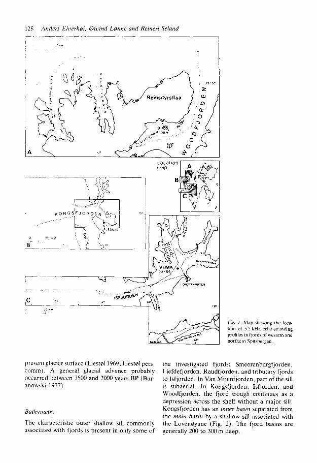
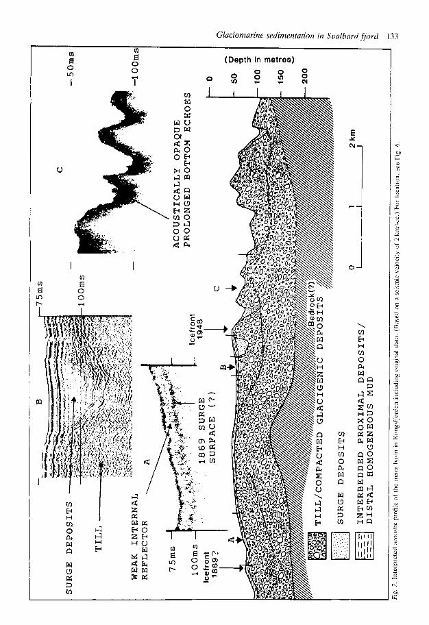
Surging is a common mode of advance for glaciers on Svalbard (Liest01 1969; Schytt 1969). Kongsvegen is the main glacier calving into Kongsfjorden, and attained surge maxima in c. 1869 and in 1948 (Fig. 3). A surge is also reported from one of the other investigated fjords, Pau- labreen, at the head of Van Mijenfjorden (Rowan et al. 1982). This paper also comments on the sedimentary pattern from these surging tidewater glaciers.
Background Glaciology
At present about 60% of Svalbard is covered by ice and a number of the glaciers terminate in the sea. Generally, the glaciers on Spitsbergen are retreating (Liestd 1975), but most of them surge periodically, advancing between a few hundred metres and more than 10 km during a couple of months or years (Liest01 1969). Both polar and subpolar glaciers are present.
Most glaciers probably had their largest Holo- cene extent during the previous century, corre- sponding to the uppermost trimline above the
128 Anders EIiwrhoi, 0ivind LQnne and Reinert Seland
A
Location nldp
B
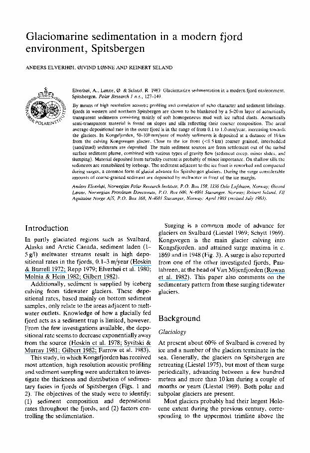
Fig. I . Map showing the loca- tion of 3.5 kHz echo-sounding profiles in fjords of western and northern Spitsbergen.
present glacier surface (Liestsl 1969: Liestsl pers. the investigated fjords: Smeerenburgfjorden, comm ). A genera! glacial advance probably Liefdefjorden, Raudfjorden. and tributary fjords occurred between 3500 and 2000 years BP (Bar- to Isfjorden. In Van Mijenfjorden, part of the sill anowlii 1977). is subaerial. In Kongsfjorden, Isfjorden, and
Woodfjorden. the fjord trough continues as a depression across the shelf without a major sill. Kongsfjorden has an inner basin separated from the main basin by a shallow sill associated with the Lovensyane (Fig. 2). The fjord basins are generally 200 to 300 m deep.
Bnthjmetr\.
The characteristic outer shallow sill commonly associated with fjords is present in only some of
Glaciomarine sedimentation in Svalbard fiord 129
Fig. 2. Bathymetric map of Kongsfjorden showing boomer and 3.5 kHz echo-sounding profiles and-localities for sedimcnt and water samples and light scatteringitransmission measurements.
Fig. 3. Positions of the Kongsvegen ice front since 1869 (based on data from Olav Liestel). I I
130 Anders Elverhai, Biuind Lame and Reinert Seland
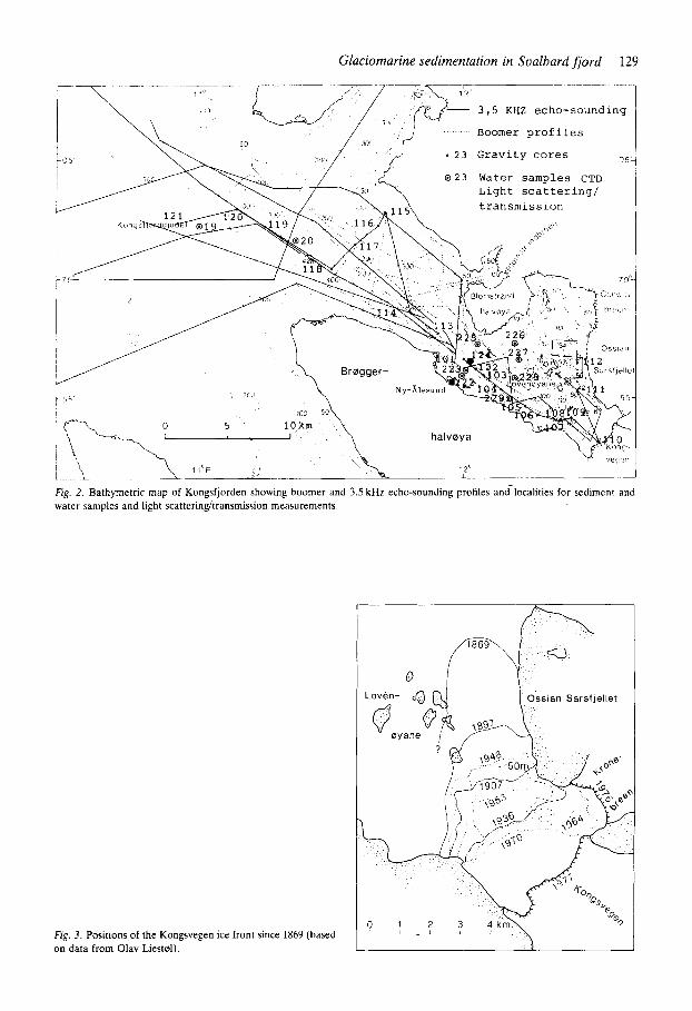
x Fig. 4. Salinity and temperature ~ section across Kongsfjorden. w For location, see Fig. 2 . Atlan-
tic water is seen to flow into the fjord at a water depth of about 75 m. Measurements: 1/9.1981.
14 lillrl
N
0
-\ '1 --yl
TEMPERATURE OC SALIXITY "/oo
Physical oceanography
The hydrographical conditions in the fjords have not been studied in detail. and knowledge of the winter conditions is particularly limited. Long- term measurements in the mouth of Kongsfjorden reveal homogeneous cold, saline water through- out the water column in late winter/early spring. This homogeneity is probably formed in response to cooling and convection during winter (Blind- heim & Ljaen 1972). During spring and summer. Atlantic water penetrates into Kongsfjorden on the southern side at intermediate water depths (75-loom, Fig. 3 ) . The mechanism driving this
current is probably the outflow of meltwater which as a brackish surface plume is forced along the northern side of the fjord. But the current is also influenced by the Coriolis force (Gam- melsrad pers. comm.). The influx of Atlantic water into Kongsfjorden is probably facilitated by the lack of an outer shallow sill.
In Kongsfjorden the 5-10 m thick summer sur- face layer has a salinity of 31-32%0 and a tem- perature of 2 to 4°C. Investigations in fjords with sills (e.g. Van Mijenfjorden (Schei et al. 1979), Smeerenburgfjorden, and Raudfjorden (Gam- m e l s r ~ d & Rudels 1983)) show a better defined halocline near the surface. In Van Mijenfjorden
S T A T I O N N R
I .
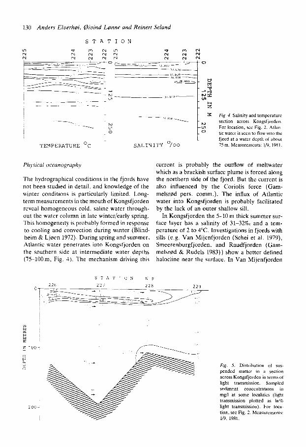
Fig. 5. Distribution of sus- pended matter in a section across Kongsfjorden in terms of light transmission. Sampled sediment concentrations in mgh at some localities (light transmission plotted as In% light transmission). For loca- tion, see Fig. 2 . Measurements: 1/9, 1981.
Glaciornarine sedimentation in Svalbard fiord 13 1
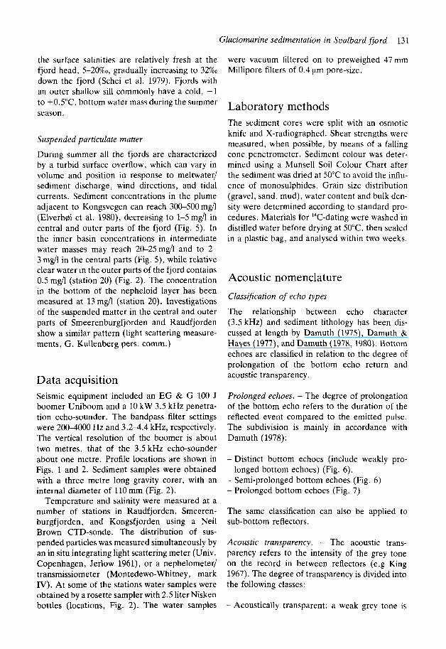
the surface salinities are relatively fresh at the fjord head, 5-20%0, gradually increasing to 32% down the fjord (Schei et al. 1979). Fjords with an outer shallow sill commonly have a cold, -1 to +0.5"C, bottom water mass during the summer season.
Suspended particulate matter
During summer all the fjords are characterized by a turbid surface overflow, which can vary in volume and position in response to meltwater/ sediment discharge, wind directions, and tidal currents. Sediment concentrations in the plume adjacent to Kongsvegen can reach 300-500 mg/l (Elverhoi e t al. 1980), decreasing to 1-5mg/l in central and outer parts of the fjord (Fig. 5). In the inner basin concentrations in intermediate water masses may reach 20-25mdl and to 2- 3 m d l in the central parts (Fig. 5), while relative clear water in the outer parts of the fjord contains 0.5 mgh (station 20) (Fig. 2). The concentration in the bottom of the nepheloid layer has been measured at 13 mgh (station 20). Investigations of the suspended matter in the central and outer parts of Smeerenburgfjorden and Raudfjorden show a similar pattern (light scattering measure- ments, G. Kullenberg pers. comm.)
Data acquisition Seismic equipment included an EG & G 100 J boomer Uniboom and a 10 kW 3.5 kHz penetra- tion echo-sounder. The bandpass filter settings were 200-4000 Hz and 3 . 2 4 . 4 kHz, respectively. The vertical resolution of the boomer is about two metres. that of the 3.5 kHz echo-sounder about one metre. Profile locations are shown in Figs. 1 and 2. Sediment samples were obtained with a three metre long gravity corer, with an internal diameter of 110 mm (Fig. 2).
Temperature and salinity were measured at a number of stations in Raudfjorden, Smeeren- burgfjorden, and Kongsfjorden using a Neil Brown CTD-sonde. The distribution of sus- pended particles was measured simultaneously by an in situ integrating light scattering meter (Univ. Copenhagen, Jerlow 1961), o r a nephelometer/ transrnissiometer (Montedewo-Whitney, mark IV). At some of the stations water samples were obtained by a rosette sampler with 2.5 liter Nisken bottles (locations, Fig. 2). The water samples
were vacuum filtered on to preweighed 47mm Millipore filters of 0.4 pm pore-size.
Laboratory methods The sediment cores were split with an osmotic knife and X-radiographed. Shear strengths were measured, when possible, by means of a falling cone penetrometer. Sediment colour was deter- mined using a Munsell Soil Colour Chart after the sediment was dried at 50°C to avoid the influ- ence of monosulphides. Grain size distribution (gravel, sand, mud), water content and bulk den- sity were determined according to standard pro- cedures. Materials for I4C-dating were washed in distilled water before drying at 50°C. then sealed in a plastic bag, and analysed within two weeks.
Acoustic nomenclature Classification of echo types
The relationship between echo character (3.5 kHz) and sediment lithology has been dis- cussed at length by Damuth (1975). Damuth & Hayes (1977), and Damuth (1978,1980). Bottom echoes are classified in relation to the degree of prolongation of the bottom echo return and acoustic transparency.
Prolonged echoes. - The degree of prolongation of the bottom echo refers to the duration of the reflected event compared to the emitted pulse. The subdivision is mainly in accordance with Damuth (1978):
- Distinct bottom echoes (include weakly pro- longed bottom echoes) (Fig. 6).
- Semi-prolonged bottom echoes (Fig. 6) - Prolonged bottom echoes (Fig. 7)
The same classification can also be applied to sub-bottom reflectors.
Acoustic transparency. - The acoustic trans- parency refers to the intensity of the grey tone on the record in between reflectors (e.g King 1967). The degree of transparency is divided into the following classes:
- Acoustically transparent: a weak grey tone is
SEMI-PROLONGED
ACOUSTICALLY
BOTTOM ECHOES
ISEMI-TRANSPARENT
DISTINCT
-200
~ -400ms
~ -
__
__
0 2
-
I I
I L
kin
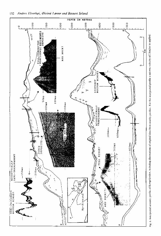
Fig. 6.
Int
erpr
eted
aco
ustic
pro
file
of K
ongs
fjor
den.
incl
udin
g ill
ustr
atio
ns o
f ori
gina
l dat
a fr
om n
earb
y pr
ofile
s. F
or t
he in
terp
rete
d pr
ofile
a s
eism
ic v
eloc
ity o
f 2
km/se
c is
app
lied.
C -
lOOms
. _
..
0
1 2
km
IN
TE
RB
ED
DE
D
PR
OX
IMA
L
DE
PO
SIT
S/
I I
I D
IST
AL
H
OM
OG
EN
EO
US
M
UD
-50m
s
-100
m
0
50
2 -2
100
Y 3
%
15
0 ;
20
0 CI
5
0
v
I Fig. 7
. Int
erpr
eted
aco
ustic
pro
file
of t
he i
nner
bas
in i
n K
ong5
fjor
dcn
incl
udin
g or
igin
al d
ata.
(B
ased
on
a se
lsm
ic v
cloc
ity u
f 2
krn'
.wc.
) For
loc
atio
n. s
ee F
ig
6.
134 Anders ElverhGi, Biuind L ~ n n e and Reinert Seland
present on the record (Fig. 6). Sub-bottom reflectors may be clearly identified.
- Acoustically semi-transparent: a heavier grey tone is observed but sub-bottom reflectors may still be clearly identified (Fig. 6).
-Acoustically opaque: a dark grey tone is
probably represents bedrock because this reflec- tor can be followed to the shore where bedrock is exposed. Reliable data on Unit I are confined to the inner basin. In the main basin the identi- fication of this unit is more uncertain.
observed and sub-bottom reflectors become diffuse or almost completely masked.
The echo character is mapped in areas where the penetration exceeds three ms (two-way travel time). The degree of transparency where it is affected by prolonged bottom echoes is not mapped.
Acoustic and sediment stratigraphy in Kongsfjorden Four acoustic units are identified. The lower units, I, 11. and 111. are mainly identified from the boomer records. The uppermost one, unit lV, was mapped by 3.5 kHz penetration echo- sounder.
Unit 1 - bedrock(?)
The upper surface of Unit I is marked by a high amplitude seismic reflector (Fig. 6). The unit
Unit I I - compacted glacigenic deposits
Unit I1 is characterized by a paucity of distinct internal reflectors except for a few hyperbolae (Figs. 6 and 7). In the inner basin, however, the unit can be subdivided into two units separated by a continuous reflector. In the main basin Unit I1 is often seen to form topographic highs. Max- imum thickness (170 ms two-way travel time) is observed in the central part of the inner basin.
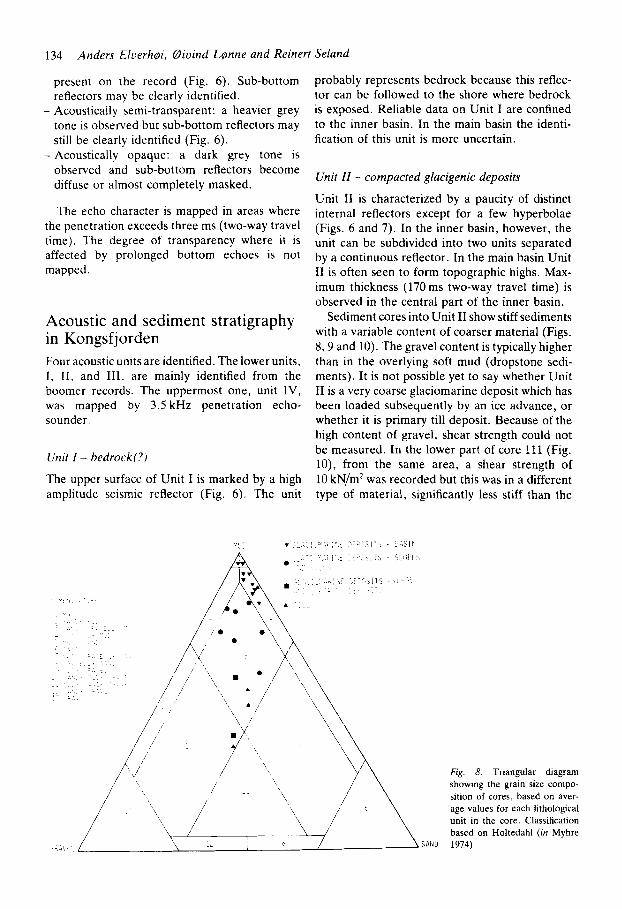
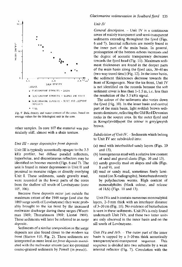
Sediment cores into Unit I1 show stiff sediments with a variable content of coarser material (Figs. 8.9 and 10). The gravel content is typically higher than in the overlying soft mud (dropstone sedi- ments). It is not possible yet to say whether Unit I1 is a very coarse glaciomarine deposit which has been loaded subsequently by an ice advance, or whether it is primary till deposit. Because of the high content of gravel, shear strength could not be measured. In the lower part of core 111 (Fig. lo), from the same area, a shear strength of 10 kN/m' was recorded but this was in a different type of material, significantly less stiff than the
Fig. 8. Triangular diagram showing the grain size compo- sition of cores, based on aver- age values for each lithological unit in the core. Classification based on Holtedahl (in Myhre 1974).
Glaciomarine sedimentation in Svalbard fiord 135
Unit IV
1 - A A
n I , , , , , I . , , I I I 1 . 5 2 . 0 2.5
BULK DENSITY LEGEND: v GLACIOMARINE DEPOSITS - BASIN
0 GLACIOMARINE DEPOSITS - SLOPES AND SILLS
GLACIOMARINE DEPOSITS -SURGE AND ICEFRONT DEPOSITS
A TILL
Fig. 9. Bulk density and water content of the cores, based on average values for the lithological unit in the core.
other samples. In core 107 the material was par- ticularly stiff, almost with a shale texture.
Unit III - surge depositslice front deposits
Unit I11 is typically acoustically opaque to the 3.5 kHz profiler, but diffuse parallel reflectors, hyperbolae, and discontinuous reflectors may be identified on boomer records (Figs. 6 and 7). The unit is found in minor depressions in Unit I1 and proximal to moraine ridges or directly overlying Unit I. These sediments, sandy gravelly mud, were recorded in the lower parts of the cores from the shallow sill south of LovCn0yane (core 105, 106).
Because these deposits occur just outside the maximum extent of the 1948 surge (and also the 1869 surge south of Lovenoyane) they were prob- ably brought to the ice front by the increased meltwater discharge during these surges (Weert- man 1969; Thorarinsson 1969; Liest01 1969). These sediments will later be referred to as surge deposits.
Sediments of a similar composition as the surge deposits are also found closer to the modern ice front (Station 110, Fig. 2 ) . These sediments are interpreted as more local ice front deposits associ- ated with the meltwater stream (see ice-proximal coarse-grained sediments by Powell (in press)).
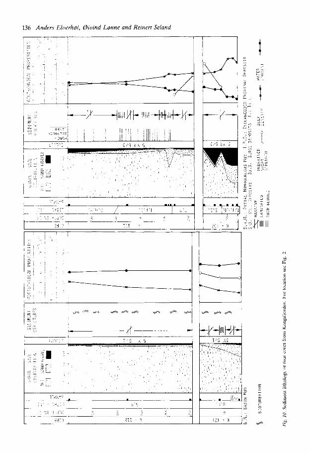
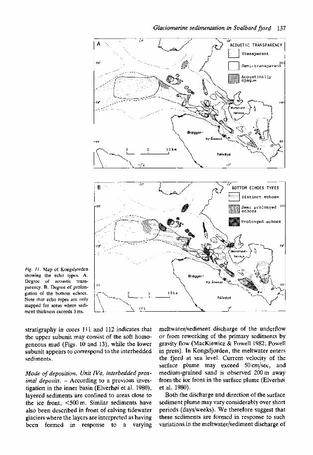
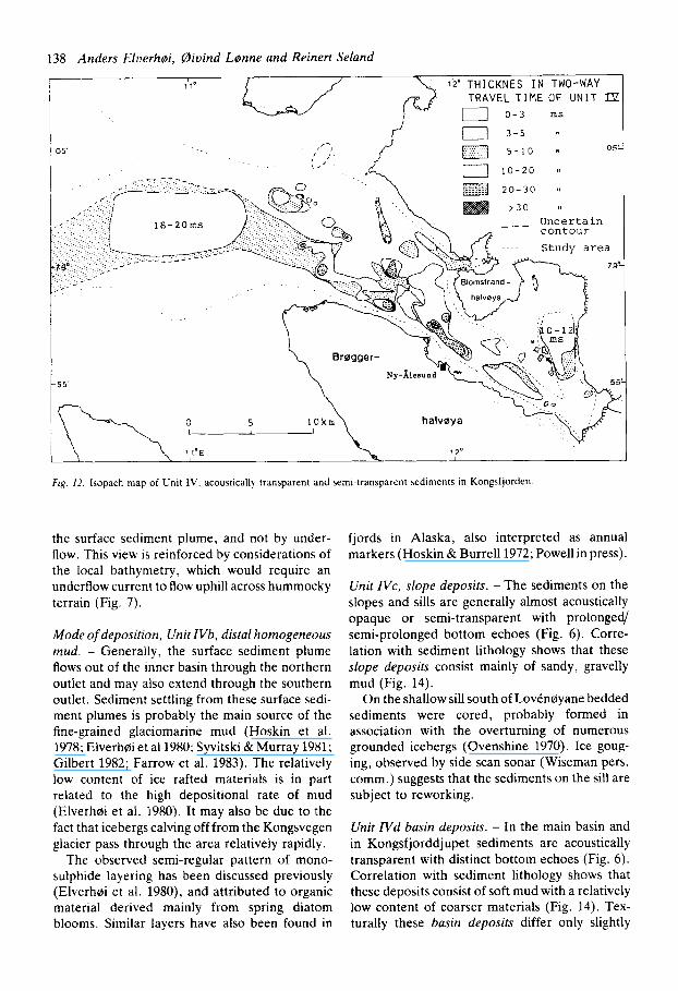
General description. - Unit IV is a continuous cover of mainly transparent and semi-transparent sediments extending throughout the fjord (Figs. 6 and 7 ) . Internal reflectors are mostly found in the inner part of the main basin. In general, prolongation of the bottom echoes increases and the degree of acoustic transparency decreases towards the fjord head (Fig. 11). Maximum sedi- ment thicknesses are found in the deeper parts of the main basin along the fjord axis, 30-40 ms (two-way travel time) (Fig. 12). In the inner basin, the sediment thicknesses decrease towards the front of Kongsvegen. Near the ice front, Unit IV is not identified on the records because the soft sediment cover is less than 1-1.5 m. i.e. less than the resolution of the 3.5 kHz signal.
The colour of the sediments also varies down the fjord (Fig. 10). In the inner basin and central part of the main basin, light reddish brown sedi- ments dominate, reflecting the Old Red Devonian rocks in the source area. In the outer fjord and in Kongsfjorddjupet the colour is greylgreyish brown.
Subdivision of Unit IV. - Sediments which belong to Unit IV are subdivided into:
(a) mud with interbedded sandy layers (Figs. 10 and 13),
(b) homogeneous mud with a relative low content of sand and gravel clasts (Figs. 10 and 13),
(c) sandy gravelly mud on slopes and sills (Figs. 8 and 9), and
(d) mud or sandy mud, sometimes finely lami- nated (on X-radiographs), bioturbated mostly by polychaetous worms. High content of monosulphides (black colour, and release of H2S) (Figs. 10 and 13).
Unit IVa and b contain numerous monosulphid layers, 2-3 mm thick with an interlayer distance of >lo cm (Fig. 10). No evidence of bioturbation is seen in these sediments. Unit IVa is only found underneath Unit IVb, and these two latter units are only observed in the inner basin and on the sill south of Lovenoyane.
Unit IVa and IVb. - The outer part of the inner basin is capped by a 5-10 ms thick acoustically transparenqsemi-transparent sequence. This sequence is divided into two subunits by a weak internal reflector (Fig. 7 ) . Correlation with the
136 Anders Elrierh@i, Qiuind L o m e and Reinert Seland
; 827 T'S h 5 - h.. . . . : , , , . , . , . , . . . . , , , . . . , , , . , . . .
, , ', , I , , ' . I
y:
El
Glaciomarine sedimentation in Sualbard fiord 137
Fig. 11. Map of Kongsfjorden showing the echo types. A. Degree of acoustic trans- parency. B. Degree of prolon- gation of the bottom echoes. Note that echo types are only mapped for areas where sedi- ment thickness exceeds 3 ms.
ACOUST 1 C TRANSPARENCY
-09
-55
S e m i prolonged O5
1'10 B
-05
stratigraphy in cores 111 and 112 indicates that the upper subunit may consist of the soft homo- geneous mud (Figs. 10 and 13), while the lower subunit appears to correspond to the interbedded sediments.
Mode of deposition, Unit IVa, interbedded prox- imal deposits. - According to a previous inves- tigation in the inner basin (Elverh0i et al. 1980), layered sediments are confined to areas close to the ice front, <500m. Similar sediments have also been described in front of calving tidewater glaciers where the layers are interpreted as having been formed in response to a varying
meltwater/sediment discharge of the underflow or from reworking of the primary sediments by gravity flow (MacKiewicz & Powell 1982; Powell in press). In Kongsfjorden, the meltwater enters the fjord at sea level. Current velocity of the surface plume may exceed 50cm/sec, and medium-grained sand is observed 200m away from the ice front in the surface plume (Elverhd et al. 1980).
Both the discharge and direction of the surface sediment plume may vary considerably over short periods (days/weeks). We therefore suggest that these sediments are formed in response to such variations in the meltwater/sediment discharge of
138 Anders Elverhoi, @bind LInne and Reinert Seland
1'10 19 THICKNES I N TWO-WAY TRAVEL T I M E OF UNIT a a 0 - 3 ms
3-5 '1
5 - 1 0 8 - 0:
1 0 - 2 0
2 0 - 3 0 01
> 3 0 18
U n c e r t a i n c o n t o u r S tudy a r e a
---
Fig. 12. Isopach map of Unit IV. acousticall) transparent and semi-transparent sediments in Kongsfjorden
the surface sediment plume, and not by under- flow. This view is reinforced by considerations of the local bathymetry, which would require an underflow current to flow uphill across hummocky terrain (Fig. 7).
Mode of deposition, Unit IVb, distal homogeneous mud. - Generally, the surface sediment plume flows out of the inner basin through the northern outlet and may also extend through the southern outlet. Sediment settling from these surface sedi- ment plumes is probably the main source of the fine-grained glaciomarine mud (Hoskin et al. 1978; Elverhcbi et all980; Syvitski &Murray 1981; Gilbert 1982; Farrow et al. 1983). The relatively low content of ice rafted materials is in part related to the high depositional rate of mud (Elverhfli et al. 1980). It may also be due to the fact that icebergs calving off from the Kongsvegen glacier pass through the area relatively rapidly.
The observed semi-regular pattern of mono- sulphide layering has been discussed previously (Elverh~i et al. 1980), and attributed to organic material derived mainly from spring diatom blooms. Similar layers have also been found in
fjords in Alaska, also interpreted as annual markers (Hoskin & Burrell 1972; Powellin press).
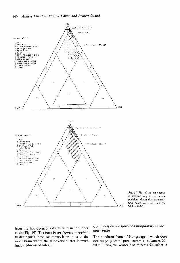
Unit IVc, slope deposits. - The sediments on the slopes and sills are generally almost acoustically opaque or semi-transparent with prolonged/ semi-prolonged bottom echoes (Fig. 6). Corre- lation with sediment lithology shows that these slope deposits consist mainly of sandy, gravelly mud (Fig. 14).
On the shallow sill south of Lovencbyane bedded sediments were cored, probably formed in association with the overturning of numerous grounded icebergs (Ovenshine 1970). Ice goug- ing, observed by side scan sonar (Wiseman pers. comm.) suggests that the sediments on the sill are subject to reworking.
Unit IVd basin deposits. - In the main basin and in Kongsfjorddjupet sediments are acoustically transparent with distinct bottom echoes (Fig. 6). Correlation with sediment lithology shows that these deposits consist of soft mud with a relatively low content of coarser materials (Fig. 14). Tex- turally these basin deposits differ only slightly
Glaciomarine sedimentation in Sualbard fiord 139
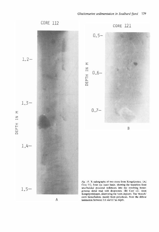
Fig. 13. X-radiographs of two cores from Kongsfjorden. (A) Core 112, from the inner basin. showing the transition from interbedded proximal sediments into the overlying homo- geneous distal mud with dropstones. (B) Core 121. from Kongsfjorddjupet, illustrating the basin deposits. The 'threads' show bioturbation, mainly from polycheats. Note the diffuse lamination between 0.6 and 0.7 m depth.
140 Anders E l u e r h ~ i , 0 iv ind L0nne and Reinert Seland
Fig. 14. Plot of the echo types in relation to grain size com- position. Grain size classitica- tion based on Holtedahl (in
SAND Myhre 1974).
Comments on the fjord-bed morphology in the inner basin
The northern front of Kongsvegen, which does not surge (Liestd pers. comm.), advances 30- 50 m during the winter and retreats 50-100 m in
from the homogeneous distal mud in the inner basin (Fig. 10). The term basin deposits is applied to distinguish these sediments from those in the inner basin where the depositional rate is much higher (discussed later).
Glaciomarine sedimentation in Svalbard fiord 141
‘ 3 0 0 1 0 km
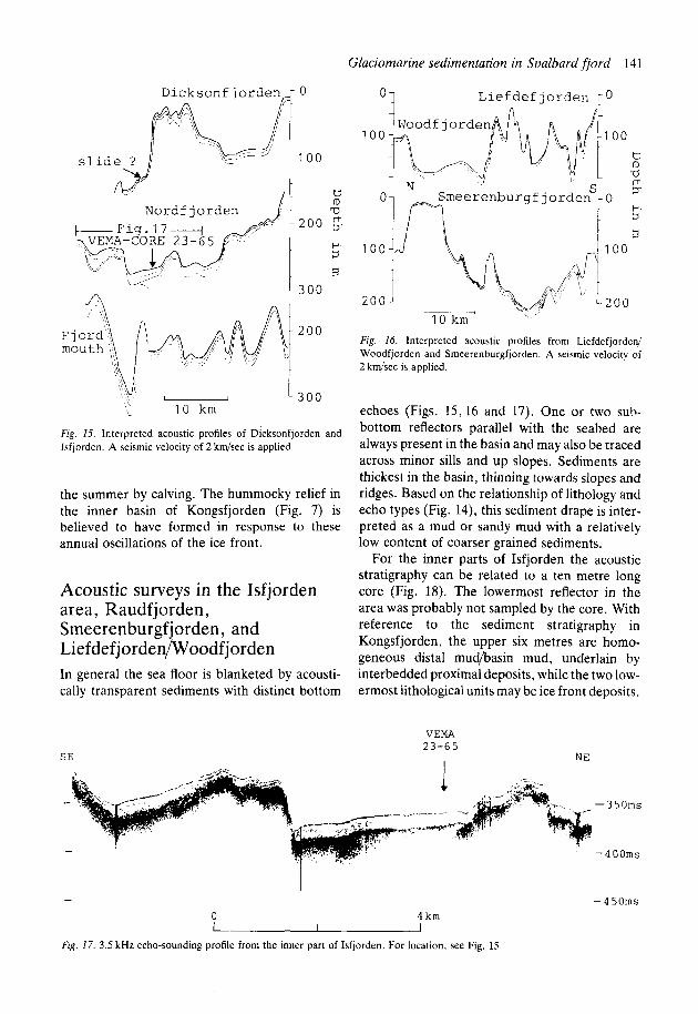
Fig. 15. Interpreted acoustic profiles of Dicksonfjorden and Isfjorden. A seismic velocity of 2 km/zec is applied.
the summer by calving. The hummocky relief in the inner basin of Kongsfjorden (Fig. 7) is believed to have formed in response to these annual oscillations of the ice front.
Acoustic surveys in the Isfjorden area, Raudfjorden, Smeerenburgfjorden, and Liefdefjorden/Woodfjorden In general the sea floor is blanketed by acousti- cally transparent sediments with distinct bottom
SE
L i e f d e f jorden r 0 01
Fig. 16. Interpreted acoustic profiles from Liefdefjorded Woodfjorden and Smeerenburgfjorden. A seismic velocity of 2 kwsec is applied.
echoes (Figs. 15,16 and 17). One or two sub- bottom reflectors parallel with the seabed are always present in the basin and may also be traced across minor sills and up slopes. Sediments are thickest in the basin, thinning towards slopes and ridges. Based on the relationship of lithology and echo types (Fig. 14), this sediment drape is inter- preted as a mud or sandy mud with a relatively low content of coarser grained sediments.
For the inner parts of Isfjorden the acoustic stratigraphy can be related to a ten metre long core (Fig. 18). The lowermost reflector in the area was probably not sampled by the core. With reference to the sediment stratigraphy in Kongsfjorden, the upper six metres are homo- geneous distal mud/basin mud, underlain by interbedded proximal deposits, while the two low- ermost lithological units may be ice front deposits.
VEMA 2 3 - 6 5
NE
-350ms
-400ms
- 4 50ms - 1 0 4 km I I I
Fig. 17. 3.5 kHz echo-sounding profile from the inner part of Isfjorden. For location. see Fig, 15.
142 Anders Eluerhsi. Oivind Lonne and Reinert Seland
. . .
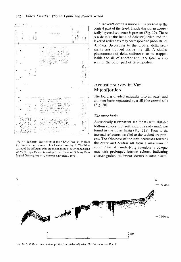
Fix. I 8 Sedimeni drscripiion of the L'ESIA-core %hi from the inner part of laflorden For location. see Fig. 1. The Ittho- facies of the different units are also indicated (description ha$ed on Megascopic Description of split core. Lamont-Doherr! Geo- logical Obsenator! of Colurnbla L'niverait) , 1976).
W -
In Adventfjorden a minor sill is present in the central part of the fjord. Inside this sill an acoust- ically layered sequence is present (Fig. 19). There is a delta at the head of Adventfjorden and the layered sediments may correspond to prodelta ice deposits. According to the profile. delta sedi- ments are trapped inside the sill. A similar phenomenon of delta sediments to be trapped inside the sill of another tributary fjord is also seen in the outer part of G r ~ n f j o r d e n .
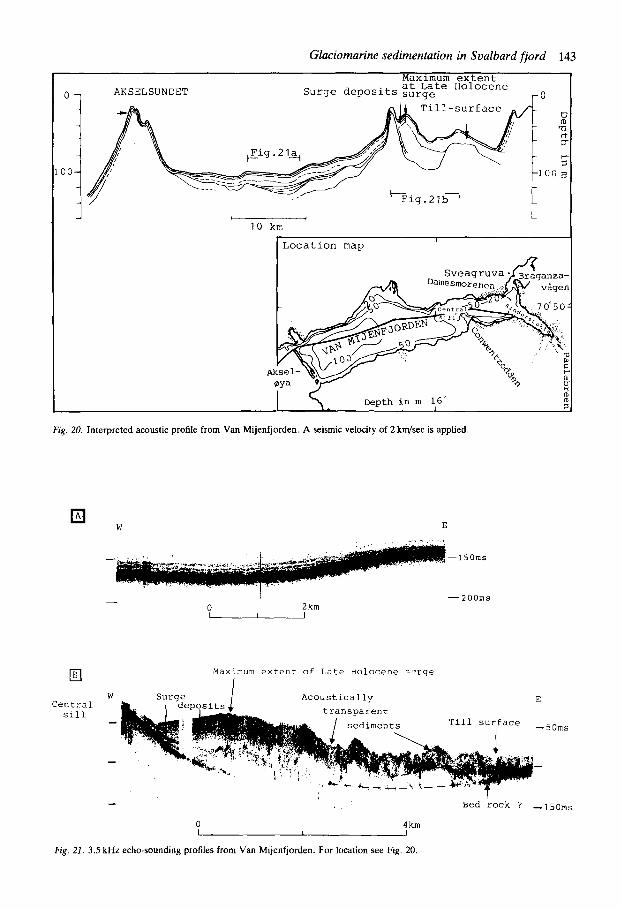
Acoustic survey in Van Mijenfjorden The fjord is divided naturally into an outer and an inner basin separated by a sill (the central sill) (Fig. 20).
The outer basin
Acoustically transparent sediments with distinct bottom echoes, i.e. soft mud or sandy mud, are found in the outer basin (Fig. 21a). Four to six internal reflectors parallel to the seabed are pres- ent. The thickness of the unit decreases towards the outer and central sill from a maximum of about 20 m. An underlying acoustically opaque unit with prolonged bottom echoes, indicating coarser-grained sediment, occurs in some places.
E
- 1 O O m s
0 Zkm
-200ms
~~~
F I R 1') 3 5 k l l z echo-sounding profile from Ad\enlflordcn. For location. see Fip 1
0 -
00- -
- I I
1 0 km
0 AKSELSUNDET
Till-surf a c e 0
TI rt 3
5. 1 0 0 3
I I I Locat ion map
- D e p t h i n m 16' I ID 3
Fig. 20. Interpreted acoustic profile from Van Mijenfjorden. A seismic velocity of 2 km/sec is applied
W E
- -150ms
I - 200ms - 0 2km
C e n t r a l Slll
Maximum e x t e n t of L a t e Holocene c ' i r g e
W A c o u s t i c a l l y E
s e d i m e n t s T l l l s u r f a c e --50ms -
-
- B e d r o c k ? -150ms
0 4 km
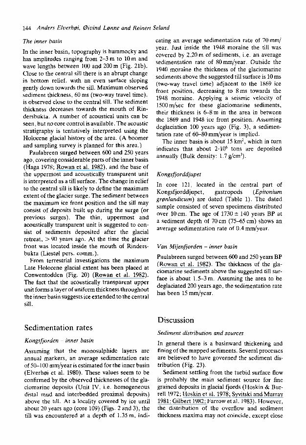
Fig. 21. 3.5 kHz echo-sounding profiles from Van Mijenfjorden. For location see Fig. 20
144 Anders Elverhli, Oiuind Llnne and Reinert Seland
The inner basin
In the inner basin, topography is hummocky and has amplitudes ranging from 2-3 m to 10 m and wave lengths between 100 and 200m (Fig. 21b). Close to the central sill there is an abrupt change in bottom relief, with an even surface sloping gently down towards the sill. Maximum observed sediment thickness, 60 ms (two-way travel time), is observed close to the central sill. The sediment thickness decreases towards the mouth of Rin- dersbukta. A number of acoustical units can be seen. but no core control is available. The acoustic stratigraphy is tentatively interpreted using the Holocene glacial history of the area. (A boomer and sampling survey is planned for this area.)
Paulabreen surged between 600 and 250 years ago, covering considerable parts of the inner basin (Haga 1978; Rowan et al. 1982), and the base of the uppermost and acoustically transparent unit is interpreted as a till surface. The change in relief to the central sill is likely to define the maximum extent of the glacier surge. The sediment between the maximum ice front position and the sill may consist of deposits built up during the surge (or previous surges). The thin, uppermost and acoustically transparent unit is suggested to con- sist of sediments deposited after the glacial retreat, >90 years ago. At the time the glacier front was located inside the mouth of Rinders- bukta (Liest01 pers. comm.).
From terrestrial investigations the maximum Late Holocene glacial extent has been placed at Conwentodden (Fig. 20) (Rowan et al. 1982). The fact that the acoustically transparent upper unit forms a layer of uniform thickness throughout theinner basin suggests ice extended to the central sill.
Sedimentation rates Kongsfjorden - inner basin
Assuming that the monosulphide layers are annual markers, an average sedimentation rate of 50-100 mm/year is estimated for the inner basin (Elverh~i et al. 1980). These values seem to be confirmed by the observed thicknesses of the gla- ciomarine deposits (Unit IV, i.e. homogeneous distal mud and interbedded proximal deposits) above the till. At a locality covered by ice until about 20 years ago (core 109) (Figs. 2 and 3), the till was encountered at a depth of 1.35m, indi-
cating an average sedimentation rate of 70mm/ year. Just inside the 1948 moraine the till was covered by 2.20 m of sediments, i.e. an average sedimentation rate of 80 mm/year. Outside the 1940 moraine the thickness of the glaciomarine sediments above the suggested till surface is 10 ms (two-way travel time) adjacent to the 1869 ice front position, decreasing to 8ms towards the 1948 moraine. Applying a seismic velocity of 1500 m/sec for these glaciomarine sediments, their thickness is 6-8m in the area in between the 1869 and 1948 ice front position. Assuming deglaciation 100 years ago (Fig. 3), a sedimen- tation rate of 60-80 mm/year is implied.
The inner basin is about 15 km2, which in turn indicates that about 2.106 tons are deposited annually (Bulk density: 1.7 g/cm3).
Kongsfjorddjupet
In core 121, located in the central part of Kongsfjorddjupet, gastropods (Epitonium grsnlandicum) are dated (Table 1). The dated sample consisted of seven specimens distributed over 10cm. The age of 1730 & 140 years BP at a sediment depth of 70 cm (75-65 cm) shows an average sedimentation rate of 0.4 mm/year.
Van Mijenfjorden - inner basin
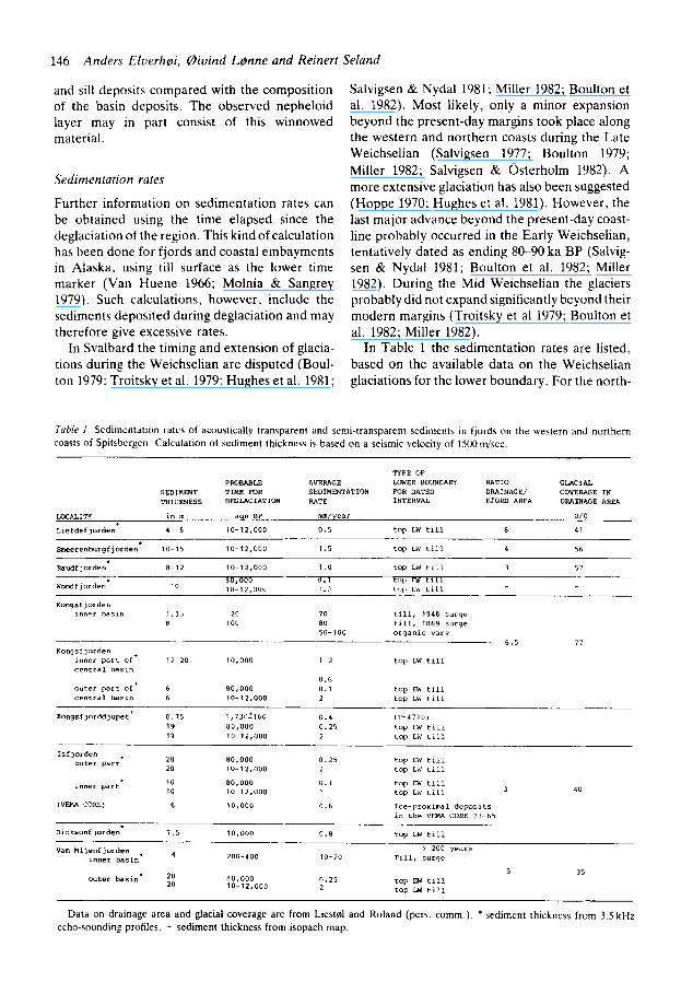
Paulabreen surged between 600 and 250 years BP (Rowan et al. 1982). The thickness of the gla- ciomarine sediments above the suggested till sur- face is about 1.5-3m. Assuming the area to be deglaciated 200 years ago, the sedimentation rate has been 15 mm/year.
Discussion Sediment distribution and sources
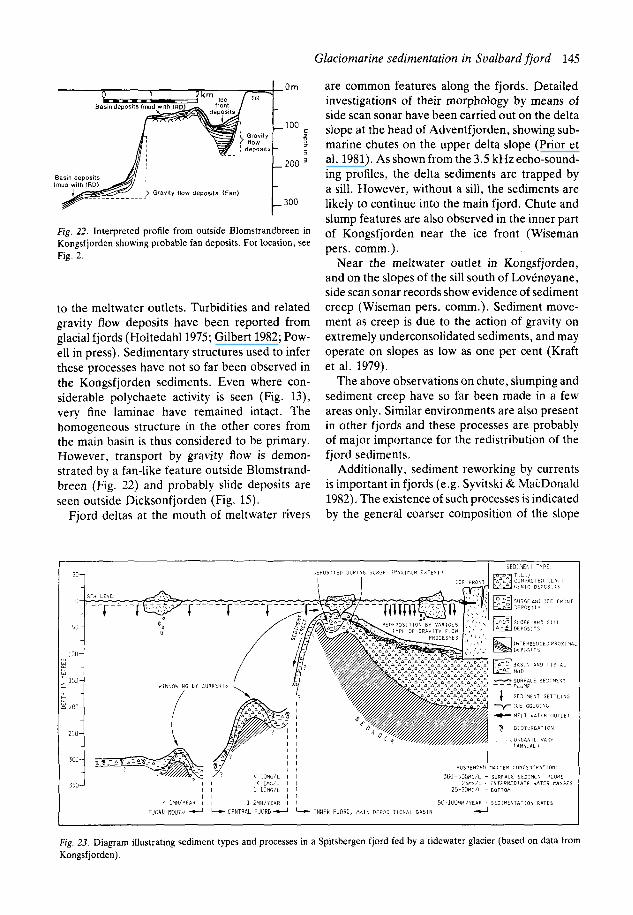
In general there is a basinward thickening and fining of the mapped sediments. Several processes are believed to have governed the sediment dis- tribution (Fig. 23).
Sediment settling from the turbid surface flow is probably the main sediment source for fine grained deposits in glacial fjords (Hoskin & Bur- re11 1972; Hoskin et al. 1978; Syvitski and Murray 1981; Gilbert 1982; Farrow et al. 1983). However, the distribution of the overflow and sediment thickness maxima may not coincide, except close
Glaciomarine sedimentation in Svalbard fjord 145
Om
100
P
l i l : L 2 0 0
Fig. 22. Interpreted profile from outside Blomstrandbreen in Kongsfjorden showing probable fan deposits. For location, see Fig. 2.
to the meltwater outlets. Turbidities and related gravity flow deposits have been reported from glacial fjords (Holtedahll975; Gilbert 1982; Pow- ell in press). Sedimentary structures used to infer these processes have not so far been observed in the Kongsfjorden sediments. Even where con- siderable polychaete activity is seen (Fig. 13), very fine laminae have remained intact. The homogeneous structure in the other cores from the main basin is thus considered to be primary. However, transport by gravity flow is demon- strated by a fan-like feature outside Blomstrand- breen (Fig. 22) and probably slide deposits are seen outside Dicksonfjorden (Fig. 15).
Fjord deltas at the mouth of meltwater rivers
are common features along the fjords. Detailed investigations of their morphology by means of side scan sonar have been carried out on the delta slope at the head of Adventfjorden, showing sub- marine chutes on the upper delta slope (Prior et al. 1981). As shown from the 3.5 kHz echo-sound- ing profiles, the delta sediments are trapped by a sill. However, without a sill, the sediments are likely to continue into the main fjord. Chute and slump features are also observed in the inner part of Kongsfjorden near the ice front (Wiseman pers. comm.).
Near the meltwater outlet in Kongsfjorden, and on the slopes of the sill south of Loveneyane, side scan sonar records show evidence of sediment creep (Wiseman pers. comm.). Sediment move- ment as creep is due to the action of gravity on extremely underconsolidated sediments, and may operate on slopes as low as one per cent (Kraft et al. 1979).
The above observations on chute, slumping and sediment creep have so far been made in a few areas only. Similar environments are also present in other fjords and these processes are probably of major importance for the redistribution of the fjord sediments.
Additionally, sediment reworking by currents is important in fjords (e.g. Syvitski & MacDonald 1982). The existence of such processes is indicated by the general coarser composition of the slope
W I N N O Y l N G 8 1 C U R R l l l l S
350 j
Fig. 23. Diagram illustrating sediment types and processes in a Spitsbergen fjord fed by a tidewater glacier (based on data from Kongsfjorden).
146 Anders Elverhoi, (aiuind Lenne and Reinert Seland
and sill deposits compared with the composition of the basin deposits. The observed nepheloid layer may in part consist of this winnowed material.
Sedimentation rates
Further information on sedimentation rates can be obtained using the time elapsed since the deglaciation of the region. This kind of calculation has been done for fjords and coastal embayments in Alaska, using till surface as the lower time marker (Van Huene 1966; Molnia & Sangrey 1979). Such calculations, however, include the sediments deposited during deglaciation and may therefore give excessive rates.
In Svalbard the timing and extension of glacia- tions during the Weichselian are disputed (Boul- ton 1979: Troitsky et al. 1979: Hughes et al. 1981;
Salvigsen & Nydal 1981; Miller 1982; Boulton et al. 1982). Most likely, only a minor expansion beyond the present-day margins took place along the western and northern coasts during the Late Weichselian (Salvigsen 1977; Boulton 1979; Miller 1982; Salvigsen & Osterholm 1982). A more extensive glaciation has also been suggested (Hoppe 1970; Hughes et al. 1981). However, the last major advance beyond the present-day coast- line probably occurred in the Early Weichselian, tentatively dated as ending 80-90 ka BP (Salvig- sen & Nydal 1981; Boulton et al. 1982; Miller 1982). During the Mid Weichselian the glaciers probably did not expand significantly beyond their modern margins (Troitsky et al 1979; Boulton et al. 1982; Miller 1982).
In Table 1 the sedimentation rates are listed, based on the available data on the Weichselian glaciations for the lower boundary. For the north-
Tubk 1 Sedimentation rates of acoustically transparent and semi-transparent sediments in fjords on the western and northern coam of Spitsbcrgen. Calculation of sediment thlckness i, based on a seismic velocity of 1500m/scc.
TYPE OF P R o B m u AYEFACE LOWER BOUNDARY RATIO GLACIAL
SEDIMXT TIMF. mR SEDIMENTATION mR DATED DRAINAGE/ COVERAGE I N THICKNESS DffiLACIATION RATE INTERVAL FJORD AREA DRAINAGE AREA
IJXALITY I" m aqe BP mm/year o / o Liefdeflorden 4- 6 10-12.000 0 . 5 top LW till 6 41
veerenburgfjorden 10-15 10-12.000 1.5 top LW till 4 56
Faudfjorden 8-12 10-1 2,000 1 .o top LW tlll 3 57
Woodfiorden 10 80.000 0.1 toil W till ID-12.000 1.0 I C ~ LW till
~ __ Xonqsfjorden
1""-r b s l n 1 . 3 , 20 1 0 till, 1948 surge n 100 8 0 tlii, 1 8 6 9 surqe
50-100 organic varv 6 . 5
Kongsf~orden inner part Of+ 12-20 10.000 1-2 top LW till central basin
1 7
0 .6 0 . 1 top Ew till
top LW tlll 6 outer part Of no.ooo
central bas," 6 10- 12,000 2 ~~ ~~
Kongsf]ordd]upet 0 . 7 5 1,73U!l60 0.4 i 'r-4 7 x 1 ) 80,000 0.25 top Ed till 10-12,000 top LW till 2
1 9 19
0.25 top EW till
10 80,000 0 . 1 top EW till 10 10-1 2 . 0 0 0 top LW till
20 80,000 20 10-1 2 , 0 0 0 2 top LW till
Isfiorden , outer part
Inner part 1 3 4 0
ivFMA CORE) 6 1 0 . 0 0 0 0 . 6 Ice-proximal dews1 ts in the VEMA CORE 23-65
top LW tlll
200-400 10-20 Till. surge
D~ck~on f i o r d e n 7 . 5 1 0 . 0 0 0 0 . 8
> 200 years Van Hiienfprden . inner basin
5 35 outer basin* $ 80,000 0 . 2 5 top EW till
top LW till 2 10- 1 2 , 0 0 0
-~
Data on drainage arca and glacial coverage are from Liestdl and Roland (per,. comm.). bediment thickness from 3 .5 k H z echo-sounding profiles. + sediment thickness from rsopach map.
Glaciomarine sedimentation in Soalbard fjord 147
ern fjords (except Woodfjorden), Dicksonfjor- den, and the inner part of the main basin in Kongsfjorden, the lower boundary has been dated to the Late Weichselian. In Isfjorden and the outer parts of Woodfjorden, Kongsfjorden, and Van Mijenfjorden both a Late and Early Weich- selian age are indicated for the lower boundary.
Kongsfjorden. - In the central and outer parts of Kongsfjorden sedimentation rate differs by an order of magnitude, depending on whether a Late or Early Weichselian age is assigned to the lower boundary (Table 1). The outer part of Kongsfjor- den is close to Kongsfjorddjupet, and based on the similarities in (1) bathymetry and hydrogra- phy, (2) acoustical signature, and (3) sediment lithology and thickness, the sedimentation rates are suggested to be approximately uniform for the two areas. Application of the depositional rate from core 121 in Kongsfjorddjupet for the acoustically transparent unit in the whole region, gives an age for the lower boundary of 60,000 years BP, which corresponds to Mid/Early Weichselian, implying that the outer part of Kongsfjorden has not been covered by grounded ice during the Mid and Late Weichselian.
In Kongsfjorden the sedimentation rate decreases two orders of magnitude away from the main sediment source. The lower input to the central and outer parts of the fjord is also partly due to the frequent confinement of the surface plume to the inner basin. Field observations in 1979,1980, and 1981 indicated, however, that the plume extends to a position where the katabatic winds blowing down the glacier, counterbalance the more general wind direction in the region. Additionally, tidal currents flowing in on the southern side forced the surface water to flow out through the northern outlet, which was frequently filled by icebergs.
The fact that most of the sediment yield from Kongsvegen (the main glacier in the Kongsfjor- den area) is trapped in the inner part of the fjord, is also seen from the sediment colour. The red coloured sediments derived from the Old Red Beds of the eastern part of Kongsfjorden’s drain- age area are confined to the region inside station 114 (Fig. 2), an area of about 100 km’.
The lowering of the sedimentation rate down the fjord is also due to the ‘carrying potential’ of the surface sediment plume, i.e. a considerable part of the finer material in the surface plume
may be carried out of the fjord without settling (Syvitski & Murray 1981).
The other fiords. - The ratio of drainage (fluvial and glacial) area to depositional area (or the area of the fjord) is relatively uniform (Table l), which, combined with a relatively similar glacial coverage and bedrock geology (un/low meta- morphic clastic rocks (Flood et al. 1971; Hjelle & Lauritzen 1982) in the drainage areas, indicates the depositional rates to be comparable. Addi- tionally, all larger fjords are characterized by tributary fjords and inner basins which function as sediment traps for the main fjord.
For the northern fjords (except Woodfjorden) the depositional rates of 0.5-1.5 mm/years are comparable with those of Kongsfjorden. The thicker sediment sequence in the central and outer parts of Woodfjorden is similar to the outer part of Kongsfjorden explained in terms of no glacia- tion in the Mid and Late Weichselian rather than a higher sediment input.
Concerning the inner part of Isfjorden the VEMA core indicates a sedimentological change from ice proximal to basin deposits at a sediment depth of six metres. An Early Weichselian age for this boundary would give a markedly low sedimentation rate of 0.1 mm/year. Alternatively, a Late Weichselian age for the lower boundary shows a rate of 0.6 mm/year which is more com- parable with the values from Kongsfjorden. According to this, Late Weichselian grounded ice may have extended into the main fjord rather than have remained in the tributary fjords as proposed by Boulton (1979).
In Van Mijenfjorden the Late Weichselian ice may have extended to Akseloya or further, or has been confined to the central sill. In the latter case, part of the acoustically transparent unit in the outer basin in Van Mijenfjorden is lacustrine.
The sedimentation rate in Van Mijenfjorden (based on a Late Weichselian ice extending to Akseloya) is higher than for other fjords (Table 1). This is attributed to the Akseloya threshold which makes the fjord almost a closed basin.
Surge deposits
In Kongsfjorden minor basins with infill of coarser grained sediments are observed just outside the 1948 moraine in the inner basin. A similar infill is also found on the western slope of the sill south of LovCnoyane, outside the end-moraines of the
148 Anders EluerhBi, Biuind Llnne and Reinerr Seland
1869 and 1948 surges. In Van Mijenfjorden a basin infill of coarser materials is located outside the position of maximum ice extent. The sedi- mentation of thick meltwater deposits outside the ice front during a surge may be related to such factors as: (1) increased meltwater discharge due to fric-
tional heating during a surge (e.g. Weertman 1969),
( 2 ) radical change of the subglacial meltwater channels, or
(3) erosion of glaciomarine sediments reworked by the surging glacier.
So far no marginal feature, end-moraine or surge deposit corresponding to the 1869 moraine on land has been observed in the fjord. From the distribution of its moraine on the adjacent shore, the 1869 surge in this area was characterized by thin ice. The lack of surge deposits may be attri- buted to the ice almost Boating in its outer parts.
Conclusion Investigations of glacial fjords in western and northern Spitsbergen by means of high resolution acoustic profiling and sediment sampling show 5 to 20 m thick acoustically transparent sediments with distinct bottom echoes in the fjord basin. These muddy to sandy muddy sediments with a relatively low content of clasts (<5%,) are formed mainly from materials settled from the turbid surface overflow, and deposited at rates between 0.5 and 1 mrq'year. The ice-rafted component is of volumetrically minor importance. On slopes and sills, semi-transparent or acoustically opaque sediments with prolonged bottom echoes are found, reflecting their coarser composition rela- tive to the basin deposits. The slope and sill deposits are subject to reworking by currents and gravity flow processes as slide. slumping and sedi- ment creep, while turbidity current deposits seem to be of minor importance.
Sedimentation rate increase up fjords towards glaciers. In Kongsfjorden, the main study area, the rate is 50-100 mm/year at a distance of 10 km from the front of Kongsvegen (a 1000 km2 gla- cier). This rate is characteristic of a fjord bed area of 15 km2, which is 1/6 of the area dominated by Kongsvegen sediments. This in turn shows that about 90% of the sediment imput from Kongs- vegen is deposited relatively adjacent to the ice
The glaciers at Svalbard advance periodically by a surge, reworking and compacting glacio- marine sediments. During a surge considerable amounts of subaqueous outwash sediments may be deposited in front of the glacier.
Acknowledgements. - Financial support for this study was pro- vided by Elf Aquitaine Norge A/S and the Norwegian Polar Research Institute, which also provided the logistical platform. We are grateful to James Syvitski. John Milliman. William Wiseman Jr.. Ross Powell, and colleagues at the Norwegian Polar Research Institute for their constructive comments and critical reviews. Adrian Read corrected the English text and is thanked for his critical comments. Bengt Christensen kindly determined the type of gastropode. The Geological Institute, University of Bergen, provided seismic (boome) equipment and technical support during the field work in 1980.
References Baranowski. S . 1977: The Subpolar glaciers of Spitsbergen seen
against the climate of this region. Wroclaw, Wydawnictwa Universytetu Wrochawskeiyo. Resulrs of investigation of the Polish scientific Spitsbergen E.rpedition 3 . 93.
Blindheim. J. & LjQen. R . 1972: On the hydrographic con- ditions in the West Spitsbergen Current in relation to ice distnbution during the years 19561963. Pp. 3 3 4 1 in Karls- son. T. (ed.): Sea Ice. Conference Proceedings, Reykjavik.
Boulton. G. S . 1979: Glacial history of the Spitsbzrgen archi- pelago and the problem of a Barents shelf ice sheet. Boreas 8. 31-57.
Boulton. G. S . . Baldwin, C . T.. Peacock, J. D., McCabe, A. M.. Miller. G . , Jarvis, J . , Horsefield, B. , Worsley, P. , Eyles, N. , Croston, P. N.. Day, T. E., Gibbard, P.. Hare, P. E. & von Brunn. V . 1982: A glacio-isostatic facies model and amino acid stratigraphy for late Quaternary events in Spits- bergen and the Arctic. Nature 2Y8, 437-441.
Damuth. J. E . 1975: Echo character of the western equatorial A t l a d c floor and its relationship to the dispersal and distri- bution of terrigenous sediments. Marine Geology 18, 17-45.
Damuth. J. E . 1978: Echo character of the Norwegian-Green- land Sea: Relationship to Quaternary sedimentation. Marine Geology 28. 1-36.
Damuth. J . E. 1980: Use of high-frequency (3.5-12 kHz) echo- grams in the study of near-bottom sedimentation processes in the deep sea: a review. Marine Geology 38. 51-75.
Damuth. J . E. & Hayes, D. E. 1977: Echo character of the East Brazilian continental margin and its relationship to sedi- mentary processes. Marine Geology 24, M73-M95.
Elverhei. A . . Liestel. 0. & Nagy. J . 1980: Glacial erosion, sedimentation and microfauna in the inner part of Kongsfjor- den. Spitsbergen. Norsk Polarinrtitutt Skrifter No. 172. 33- 58.
Farrow, G. E.. Syvitski, J . P. M. & Tunnicliffe, V. 1983: Suspended particulate loading on the macrobenthos in a highly turbid fjord: Knight Inlet. British Columbia. Can. J . Fish. Aquat. Sci. 40, 273-288.
Flood. B.. Nagy, J . & Winsnes. T. S . 1971: Geological map, Svalbard 1:500.000. Sheet IG Spitsbergen, southern part. Norsk Polarrnstitutt Skrifrer N o . 154A.
Gammelsr~d. T. & Rudels, T . 1983: Hydrographic and current measurements in the Fram Strait, August 1981. Polar
front. Reseorch 1 n.s. (2 ) , (this volume).
Glaciomarine sedimentation in Svalbard fiord 149
Gilbert, R . 1982: Contemporary sedimentary environments of Baffin Island, N.W.T., Canada: Glaciomarine processes in fjords of eastern Cumberland Peninsula. Arctic and Alpine Research 14 , 1-12.
Haga, 0. 1978: Morenemasser i dddis etter et breframstdr I Van Mijenfjorden, Spitsbergen. Unpub. Cand. real. thesis, Univ. of Oslo. 88 pp,
Hjelle, A. & Lauritzen, 0. 1982: Geological map, Svalbard 1:500.000. Sheet 3G Spitsbergen, northern part. Norsk Polarinstitutt Skrifter No. 154C.
Holtedahl, H . 1975: The geology of the Hardangerfjord. West Norway. Nor. Geol. Unders. 323, 1-87.
Hoppe. G. 1970: The Wurm ice sheets of northern and arctic Europe. Acta Geographica Lodziensia 24, 105-115.
Hoskin. C. M. & Burrell. D . C. 1972: Sediment transport and accumulation in a fjord basin, Glacier Bay, Alaska. J. Geol, 80, 359-551.
Hoskin, C. M., Burrell. D . C. & Freitag, G. R. 1978: Suspended sediment dynamics in Blue Fjord, western Prince William Sound, Alaska. Estuarine and Coastal Marine Science 7 , 1- 16.
Hughes. T. J., Denton. G. H. , Andersen, B. G . , Schilling, D. H., Fastook, J. L. & Lingle, C. S. 1981: The last great ice sheets: A global view. Pp. 263-317 in Denton. G. H. & Hughes T. J . (eds.): The Last Great Ice Sheets, John Wiley & Sons.
King, L. H. 1967: Use of a conventional echo-sounder and textual analyses in delineating sedimentary facies: Scotian shelf. Can. 1. Earth Sci. 4 , 691-708.
Kraft, L. M. Jr., Campbell, K. J. & Ploessel, R. M. 1979: Some geotechnical engineering problems of upper slope sites in the northern Gulf of Mexico. Pp. 25-42 in Doyle, L. J . & Pilkey. 0. H. Jr . . (eds.): Geology of continental slopes. Soc. Econ. Palent. Min. Spec. Publ. 27, Tulsa, Oklahoma.
Liestdl. 0. 1969: Glacial surges in West Spitsbergen. Can. J. Earth Sci. 6 , 895-897.
Liestel. 0. 1975: Glaciological work in 1975. Norsk Polar- institutt Arbok 1975. 147-158.
MacKiewicz, N. E. & Powell, R. D. 1982: Laminated ice- proximal glaciomarine sediments. Eleventh International Congress on Sedimentology, Hamilton, Canada, Abstracts, 74.
Miller, G . H . 1982: Quaternary depositional episodes, western Spitsbergen, Norway: Aminostratigraphy and glacial history. Arctic Research and Alpine Research 14, 321-340.
Molnia, B. F. & Sangrey, D . A . 1979: Glacially derived sedi- ments in the northern Gulf of Alaska - geology and engi- neering characteristics. Proc. 1979 Offshore Technology Con- ference, OTC-3433, 2 , 647-655.
Molnia, B. F. & Hein, J. G. 1982: Clay mineralogy of a glacially
dominated, subarctic continental shelf: northeastern Gulf of Alaska. J. Sed. Pet. 52, 515-527.
Myhre, L. 1974: A computer program for grainsize distribution analyses. Publ. 44, NTNFs Continental Shelf Project, 1-22.
Ovenshine, T, A, 1970: Observations of iceberg rafting in Glacier Bay, Alaska. and the identification of ancient ice- rafted deposits. Geol. SOC. A m . Bull. 81, 891-894.
Powell, R. D. in press: Glaciomarine sedimentation processes in Glacier Bay, Alaska. In Molina, B. F. (ed.): Glacial- Marine Sedimentation, Plenum.
Prior, D. B.. Wiseman, W. J . Jr. & Bryant, W R. 1981: Submarine chutes on the slopes of fjord deltas. Nature 290, 326-328.
Repp, K. 1979: Breerosjon, glasio-hydrologi og materialtrans- port i et hmyarktisk miljg, Brdggerbreene, Vest-Spitsbergen. Unpub. Cand. Real. thesis, University of Oslo. 136 pp.
Rowan. D . E., PewC, T. L., PCwe. R. H. & Stuckenrath, R. 1982: Holocene glacial geology of the Svea lowland, Spits- bergen, Svalbard. Geogr. Ann. 64 A , 35-51.
Salvigsen, 0. 1977: Radiocarbon datings and the extension of the Weichselian ice-sheet in Svalbard. Norsk Polarinstitutt Arbok 1976, 209-224.
Salvigsen, 0. & Nydal, R. 1981: The Weichselian glaciation in Svalbard before 15.000 BP. Boreas 10, 43S446.
Salvigsen, 0. & Osterholm. H . 1982: Radiocarbon dated raised beaches and glacial history of the northern coast of Spits- bergen. Svalbard. Polar Research 1 . 97-115.
Schei, B., Eilertsen, H. G . , Falk-Larsen, S . , Gulliksen, B. & Taasen, J . P. 1979: Marinbiologiske undersdkelser i Van Mijenfjorden (Vest-Spitsbergen) etter oljes0llekasje ved Sveagruva 1978. Tromsd Mlcreums rapportserie, Naturuiten- Skap. Nr. 2. Universitetet i Troms0, 50 pp.
Schytt, V. 1969: Some comments on glacier surges in eastern Svalbard. Can. J. Earth Sci. 6 , 867-873.
Syvitski, J . P. M. & Murray. J . W. 1981: Particle interaction in fjord suspended sediment. Marine Geology 39, 215-242.
Syvitski, J. P. M. & MacDonald. R. D. 1982: Sediment char- acter and provenance in a complex fjord: Howe Sound, British Columbia. Can. J. Earth Sci. 19. 1025-1044.
Thorarinsson, S . 1969: Glacier surges in Iceland, with special references to surges of Bruarjokull. Can. J . Earth Sci. 6 , 875-882.
Troitsky, L.. Punning, J . M.. Hiitt, G. & Rajamae, R. 1979: Pleistocene glaciation chronology of Spitsbergen. Boreas 8, 401-407.
Van Huene, R. 1966: Glacial-marine geology of Nuka Bay, Alaska, and the adjacent continental shelf. Marine Geology 4 , 291-304.
Weertman, J . 1969: Water lubrication mechanism of glacier surges. Can. J. Earth Sci. 6 , 929-939.


