Embed Size (px)
Citation preview
1
Glossary ● Deltaic Environment - gradational to both fluvial and coastal environments ● Delta Plain - A deltaic plain consists of active or abandoned deltas, which are either overlapping or contiguous to one
another ● Delta - A delta is a relatively flat area at the mouth of a river or a river system in which sediment load is deposited and
distributed ● Foreset Beds -the inclined part of a delta that is found at the end of the stream ● Delta Front - The sloping portion of a delta, developed offshore from the bar at the mouth and passing at its toe into the
pro-delta ● Bottomset Beds - layers of sedimentary material lying along the bottom of a body of water near the point of entry of a
stream, the material having been carried to the area by the entering stream and being subsequently covered by foreset beds and topset beds in the formation of a delta
● Permeability - the state or quality of a material or membrane that causes it to allow liquids or gases to pass through it. ● Paleomagnetism - the branch of geophysics concerned with the magnetism in rocks that was induced by the earth's
magnetic field at the time of their formation ● Mantle Plume - a localized column of hot magma rising by convection in the mantle, believed to cause volcanic activity
in hot spots, such as the Hawaiian Islands, away from plate margins. ● Hot Spot - an area of volcanic activity, especially where this is isolated. ● Volcanic Island Arc - long chains of active volcanoes with intense seismic activity found along convergent tectonic plate
boundaries ● Subduction Zone - a region of the Earth's crust where tectonic plates meet ● Suture Zone - a joining together along a major fault zone, of separate terranes, tectonic units that have different plate
tectonic, metamorphic and paleogeographic histories ● Spreading Center - where two plates are moving away from each other, and deep cracks are opened through the crust ● Crater - a circular depression in the surface of a planetary body ● Constant Elevation - a contour line is a line of constant elevation ● Cinder-Cone Volcano - the simplest type of volcano. They are built from particles and blobs of congealed lava ejected
from a single vent ● Shield Volcano - a broad domed volcano with gently sloping sides, characteristic of the eruption of fluid, basaltic lava. ● Lava Dome Volcano - a mound of viscous lava that has been extruded from a volcanic vent. ● Stratovolcanoes - a volcano built up of alternate layers of lava and ash ● Fissure Vents - a linear volcanic vent through which lava erupts, usually without any explosive activity ● Spatter Cones - They are made from lava that was ejected from a vent ● Rift - form fissures, cracks, or breaks, especially through large-scale faulting ● Mohorovicic (Moho) Discontinuity - the boundary between the crust and the mantle ● Gutenberg- Weichert discontinuity - the boundary between the Earth's mantle and core ● Trench - very deep, elongated cavity bordering a continent or an island arc ● Forearc - The area between the trench and the arc ● Pluton - a body of intrusive igneous rock (called a plutonic rock) that is crystallized from magma slowly cooling below the
surface of the Earth ● Accretionary Wedge - a mass of sedimentary material scraped off a region of oceanic crust during subduction and piled
up at the edge of the overriding plate ● Tectonic Plate - pieces of Earth's crust and uppermost mantle, together referred to as the lithosphere ● Banded Iron Formations - chemically precipitated sediment, typically thin-bedded or laminated, consisting of 15 percent
or more iron of sedimentary origin and layers of chert, chalcedony, jasper, or quartz ● Ductile Deformation - When rocks bend or flow, like clay ● Mafic - usually dark in color and have relatively high specific gravities (greater than 3.0) ● Felsic - usually light in color and have specific gravities less than 3.0 ● Finely Grained - generally indicate magmas that rapidly cooled at or near the Earth's surface. Fast cooling prevents
crystals from growing very large ● Coarsely Grained - generally indicate magmas that slowly cooled deep underground. Slow cooling gives crystals enough
time to grow to easily visible sizes
2
● Longitude - the distance on the earth's surface, east or west of a defined meridian, usually the meridian of Greenwich, England
● Latitude - a geographic coordinate that specifies the north-south position of a point on the Earth's surface ● The Principle of Uniformitarianism - a geological doctrine. It states that current geologic processes, occurring at the
same rates observed today, in the same manner, account for all of Earth's geological features. ● Principle of Inclusions - with sedimentary rocks, if inclusions (or clasts) are found in a formation, then the inclusions must
be older than the formation that contains them. ● Principle of Baked Contacts - an igneous intrusion “bakes” (metamorphoses) surrounding rocks, so the rock that has
been baked must be older than the intrusion ● Relative Dating - used to arrange geological events, and the rocks they leave behind, in a sequence ● Principle of Superposition - in a sequence of strata, as originally laid down, any stratum is younger than the one on
which it rests and older than the one that rests upon it (old stuff on the bottom, young stuff on top) ● Principle of Original Horizontality - layers of sediment are originally deposited horizontally under the action of gravity ● Disconformity - an unconformity between parallel layers of sedimentary rocks which represents a period of erosion or
nondeposition ● Nonconformity - a specific type of unconformity characterized by much older igneous or metamorphic rocks below,
overlain by younger sedimentary rocks above an unconformity surface. The older igneous or metamorphic rocks indicate active igneous and/or tectonic period, followed by uplift and erosion
● Angular Unconformity - the older rock layers are deformed, tilted and usually slightly eroded before the deposition of a new rock layer
● Absolute Dating - the process of determining an age on a specified chronology in archaeology and geology ● Radiometric Dating - a technique which is used to date materials such as rocks or carbon, in which trace radioactive
impurities were selectively incorporated when they were formed ● Geological Time Scale - any division of geological time into chronological units, whether relative (with units in the correct
temporal sequence) or absolute (with numerical ages attached) ● Lahar - A lahar is a violent type of mudflow or debris flow composed of a slurry of pyroclastic material, rocky debris, and
water. The material flows down from a volcano, typically along a river valley ● Slumps - a form of mass wasting that occurs when a coherent mass of loosely consolidated materials or a rock layer
moves a short distance down a slope ● Pyroclastic Flow - a fast-moving current of hot gas and volcanic matter (collectively known as tephra) that moves away
from a volcano about 100 km/h (62 mph) on average but is capable of reaching speeds up to 700 km/h (430 mph) ● Lava Bomb - a mass of molten rock larger than 64 mm in diameter, formed when a volcano ejects viscous fragments of
lava during an eruption. They cool into solid fragments before they reach the ground. ● Dome Collapse - a dramatic and highly dangerous volcanic process involving the destabilization of large volume of hot
material rushing as turbulent and destructive flows for kilometers down the flanks of the volcano ● Lopolith - a large igneous intrusion which is lenticular in shape with a depressed central region ● Laccolith - a sheet-like intrusion (or concordant pluton) that has been injected within or between layers of sedimentary
rock ● Batholith - a large mass of intrusive igneous rock (also called plutonic rock), larger than 100 square kilometers (40 sq
mi) in area, that forms from cooled magma deep in the Earth's crust ● Pore Pressure - The pressure of fluids within the pores of a reservoir, usually hydrostatic pressure, or the pressure
exerted by a column of water from the formation's depth to sea level ● Devonian - a geologic period and system of the Paleozoic, spanning 60 million years from the end of the Silurian, 419.2
million years ago (Mya), to the beginning of the Carboniferous, 358.9 Mya ● Crinoid Age - an ancient fossil group that first appeared in the seas of the Middle Cambrian, about 300 million years
before dinosaurs. They flourished in the Palaeozoic and Mesozoic, and some survive to the present day ○ Crinoids are common fossils from Paleozoic-age marine rocks, although none have been
found in Cambrian rocks (505—5 70 million years ago). Crinoids were sometimes so diverse and abundant that beds of limestone hundreds of feet thick were formed.
● ● Stromatolite Age - Stromatolites were common in Precambrian time (i.e., more than 542 million years ago). Some of the
first forms of life on Earth are recorded in stromatolites present in rocks 3.5 billion years old.
3
● Graptolite Age - Graptolites lived from the Cambrian Period, about 510 million years ago, disappearing in the Carboniferous Period, around 320 million years ago. Graptolites that lived on the ocean floor appear in the fossil record first and became extinct later than floating graptolites
● Trilobite Age - Trilobites first appeared during the Cambrian Period (about 520 million years ago) and disappeared at a major extinction event at end of the Permian Period (about 250 million years ago)
● Accretionary Prism - intensely deformed producing melange, which is a mappable body of rock characterized by the lack of continuous bedding and the inclusion of fragments of rocks of all sizes (up to more than a kilometer across) contained in a fine-grained, deformed matrix
● Continental Crust - the relatively thick part of the earth's crust that forms the large landmasses. It is generally older and more complex than the oceanic crust
● Oceanic Crust - the relatively thin part of the earth's crust which underlies the ocean basins. It is geologically young compared with the continental crust and consists of basaltic rock overlain by sediments
● Divergent Plate Boundaries - A tectonic boundary where two plates are moving away from each other and new crust is forming from magma that rises to the Earth's surface between the two plates.
● Convergent Plate Boundaries - A convergent boundary is an area on Earth where two or more lithospheric plates collide. One plate eventually slides beneath the other causing a process known as subduction
● Foliations - the process of splitting into thin sheets or laminae ● Folds - a bend in the rock strata. Folding: Is a type of earth movement resulting from the horizontal compression of rock
layers by internal forces of the earth along plate boundaries. Upfold is termed as anticlines. The downfolds are termed synclines
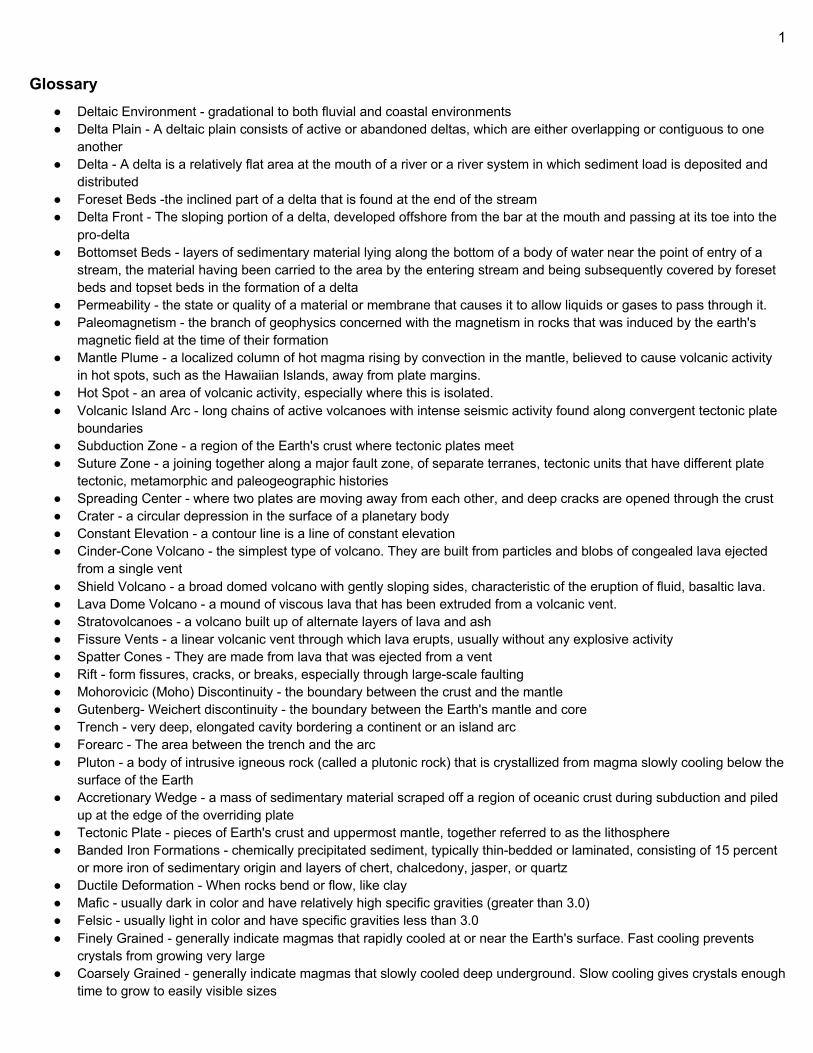
PLATE TECTONICS
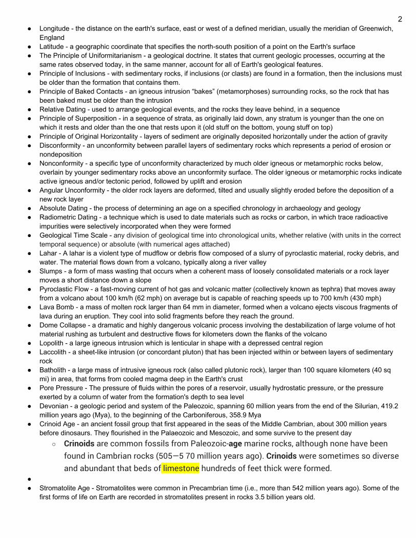
Transform boundaries (Conservative) occur where two lithospheric plates slide, or perhaps more accurately, grind past each other along transform faults, where plates are neither created nor destroyed. The relative motion of the two plates is either sinistral (left side toward the observer) or dextral (right side toward the observer). Transform faults occur across a spreading center. Strong earthquakes can occur along a fault. The San Andreas Fault in California is an example of a transform boundary exhibiting dextral motion.
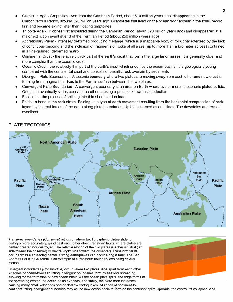
Divergent boundaries (Constructive) occur where two plates slide apart from each other. At zones of ocean-to-ocean rifting, divergent boundaries form by seafloor spreading, allowing for the formation of new ocean basin. As the ocean plate splits, the ridge forms at the spreading center, the ocean basin expands, and finally, the plate area increases causing many small volcanoes and/or shallow earthquakes. At zones of continent-to-continent rifting, divergent boundaries may cause new ocean basin to form as the continent splits, spreads, the central rift collapses, and
4
ocean fills the basin. Active zones of mid-ocean ridges (e.g., the Mid-Atlantic Ridge and East Pacific Rise), and continent-to-continent rifting (such as Africa's East African Rift and Valley and the Red Sea), are examples of divergent boundaries.
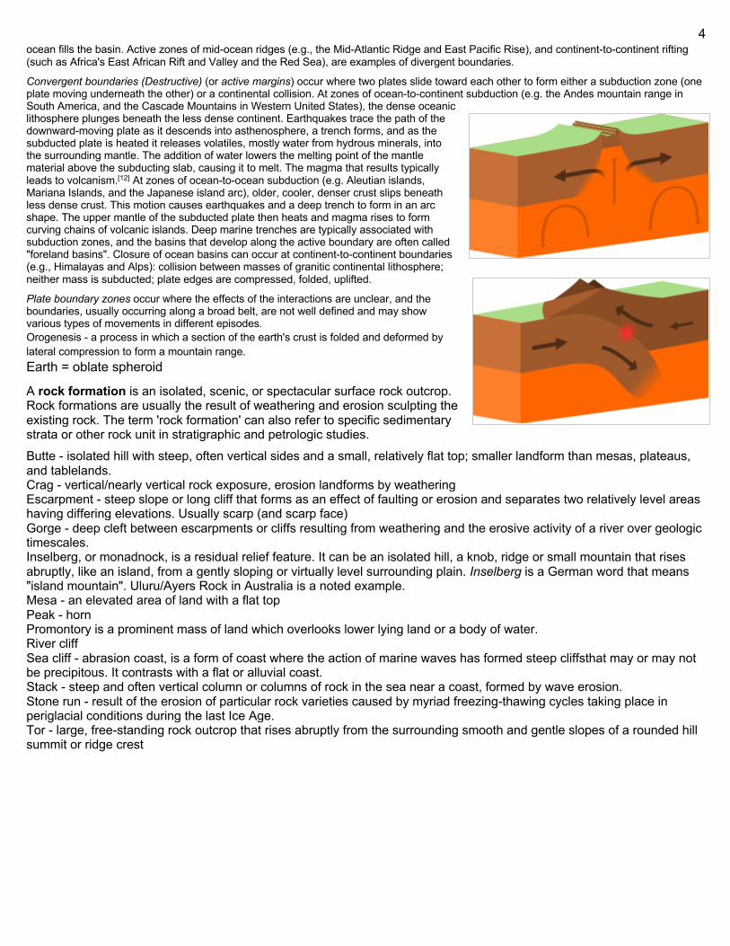
Convergent boundaries (Destructive) (or active margins) occur where two plates slide toward each other to form either a subduction zone (one plate moving underneath the other) or a continental collision. At zones of ocean-to-continent subduction (e.g. the Andes mountain range in South America, and the Cascade Mountains in Western United States), the dense oceanic lithosphere plunges beneath the less dense continent. Earthquakes trace the path of the downward-moving plate as it descends into asthenosphere, a trench forms, and as the subducted plate is heated it releases volatiles, mostly water from hydrous minerals, into the surrounding mantle. The addition of water lowers the melting point of the mantle material above the subducting slab, causing it to melt. The magma that results typically leads to volcanism.[12] At zones of ocean-to-ocean subduction (e.g. Aleutian islands, Mariana Islands, and the Japanese island arc), older, cooler, denser crust slips beneath less dense crust. This motion causes earthquakes and a deep trench to form in an arc shape. The upper mantle of the subducted plate then heats and magma rises to form curving chains of volcanic islands. Deep marine trenches are typically associated with subduction zones, and the basins that develop along the active boundary are often called "foreland basins". Closure of ocean basins can occur at continent-to-continent boundaries (e.g., Himalayas and Alps): collision between masses of granitic continental lithosphere; neither mass is subducted; plate edges are compressed, folded, uplifted.
Plate boundary zones occur where the effects of the interactions are unclear, and the boundaries, usually occurring along a broad belt, are not well defined and may show various types of movements in different episodes. Orogenesis - a process in which a section of the earth's crust is folded and deformed by lateral compression to form a mountain range. Earth = oblate spheroid
A rock formation is an isolated, scenic, or spectacular surface rock outcrop. Rock formations are usually the result of weathering and erosion sculpting the existing rock. The term 'rock formation' can also refer to specific sedimentary strata or other rock unit in stratigraphic and petrologic studies. Butte - isolated hill with steep, often vertical sides and a small, relatively flat top; smaller landform than mesas, plateaus, and tablelands. Crag - vertical/nearly vertical rock exposure, erosion landforms by weathering Escarpment - steep slope or long cliff that forms as an effect of faulting or erosion and separates two relatively level areas having differing elevations. Usually scarp (and scarp face) Gorge - deep cleft between escarpments or cliffs resulting from weathering and the erosive activity of a river over geologic timescales. Inselberg, or monadnock, is a residual relief feature. It can be an isolated hill, a knob, ridge or small mountain that rises abruptly, like an island, from a gently sloping or virtually level surrounding plain. Inselberg is a German word that means "island mountain". Uluru/Ayers Rock in Australia is a noted example. Mesa - an elevated area of land with a flat top Peak - horn Promontory is a prominent mass of land which overlooks lower lying land or a body of water. River cliff Sea cliff - abrasion coast, is a form of coast where the action of marine waves has formed steep cliffsthat may or may not be precipitous. It contrasts with a flat or alluvial coast. Stack - steep and often vertical column or columns of rock in the sea near a coast, formed by wave erosion. Stone run - result of the erosion of particular rock varieties caused by myriad freezing-thawing cycles taking place in periglacial conditions during the last Ice Age. Tor - large, free-standing rock outcrop that rises abruptly from the surrounding smooth and gentle slopes of a rounded hill summit or ridge crest
5
Plate Forces
Driving Forces Slab Pull: Summary 2.0:
- Force that pulls lithosphere into a convergent margin - Exists b/c old, cold ocean lithosphere is negatively buoyant relative to the underlying astenosphere, so the
oceanic lithosphere will sink downwards - Once subducting slab descends into mantle, basalt transforms to a denser eclogite, so a subducted plate is
denser than a plate at Earth’s surface - Subducted plate thus pulls rest of plate down with it
Summary: part of the motion of a tectonic plate that is caused by its subduction. Plate motion is partly driven by the weight of cold, dense plates sinking into the mantle at oceanic trenches. This force and slab suction account for almost all of the force driving plate tectonics. The ridge push at rifts contributes only 5 to 10%. This force occurs as a subducting plate sinks into the hot mantle beneath it. The subducting plate, usually basalt, is denser than the material it is subducting into, purely due to its difference in temperature. As the plate sinks into the mantle, it acts to pull the rest of the plate behind it. This force is considered by some to be the primary force driving plate motion at collisional zones . However, there are some plates where there is little or no subduction occurring such as the Antarctic Plate. This plate motion needs to be explained by a different mechanism. The slab pull force only works when the subducting slab is well attached to the plate it is pulling behind it. When the slab is not well attached it may set up additional circulation patterns in the mantle that serve to suck the plate downwards. It is also interesting to note that plates with a slab subducting into the mantle move faster towards the subduction zone than do plates without a slab. This is thought to be primarily due to the slab pull acting on the plate. This fact tends to support the idea that slab pull is indeed a dominant force in plate motion. Ridge Push: Summary 2.0:
- Outward directed force that pushes plates away from the axis of a mid-ocean ridge - Exists b/c oceanic lithosphere is higher along ocean ridges than it is in the abyssal plain - Diff. in elevation means that lithosphere along ridge has more gravitational potential energy than that of the
abyssal plain, and this energy provides an outward push perpendicular to ridge axis Summary: Ridge push or sliding plate force is a proposed driving force for plate motion in plate tectonics that occurs at mid-ocean ridges as the result of the rigid lithosphere sliding down the hot, raised asthenosphere below mid-ocean ridges. Although it is called ridge push, the term is somewhat misleading; it is actually a body force that acts throughout an ocean plate, not just at the ridge, as a result of gravitational pull. The name comes from earlier models of plate tectonics in which ridge push was primarily ascribed to upwelling magma at mid-ocean ridges pushing or wedging the plates apart. (not found near subduc.) Ridge push is the result of gravitational forces acting on the young, raised oceanic lithosphere around mid-ocean ridges, causing it to slide down the similarly raised but weaker asthenosphere and push on lithospheric material farther from the ridges. Mid-ocean ridges are long underwater mountain chains that occur at divergent plate boundaries in the ocean, where new oceanic crust is formed by upwelling mantle material as a result of tectonic plate spreading and relatively shallow (above ~60 km) decompression melting. The upwelling mantle and fresh crust are hotter and less dense than the surrounding crust and mantle, but cool and contract with age until reaching equilibrium with older crust at around 90 Ma. This produces an isostatic response that causes the young regions nearest the plate boundary to rise above older regions and gradually sink with age, producing the mid-ocean ridge morphology. The greater heat at the ridge also weakens rock closer to the surface, raising the boundary between the brittle lithosphere and the weaker, ductile asthenosphere to create a similar elevated and sloped feature underneath the ridge. These raised features produce ridge push; gravity pulling down on the lithosphere at the mid-ocean ridge is mostly opposed by the normal force from the underlying rock, but the remainder acts to push the lithosphere down the sloping asthenosphere and away from the ridge. Because the asthenosphere is weak, ridge push and other driving forces are enough to deform it and allow the lithosphere to slide over it, opposed by drag at the Lithosphere-Asthenosphere boundary and resistance to subduction at
6
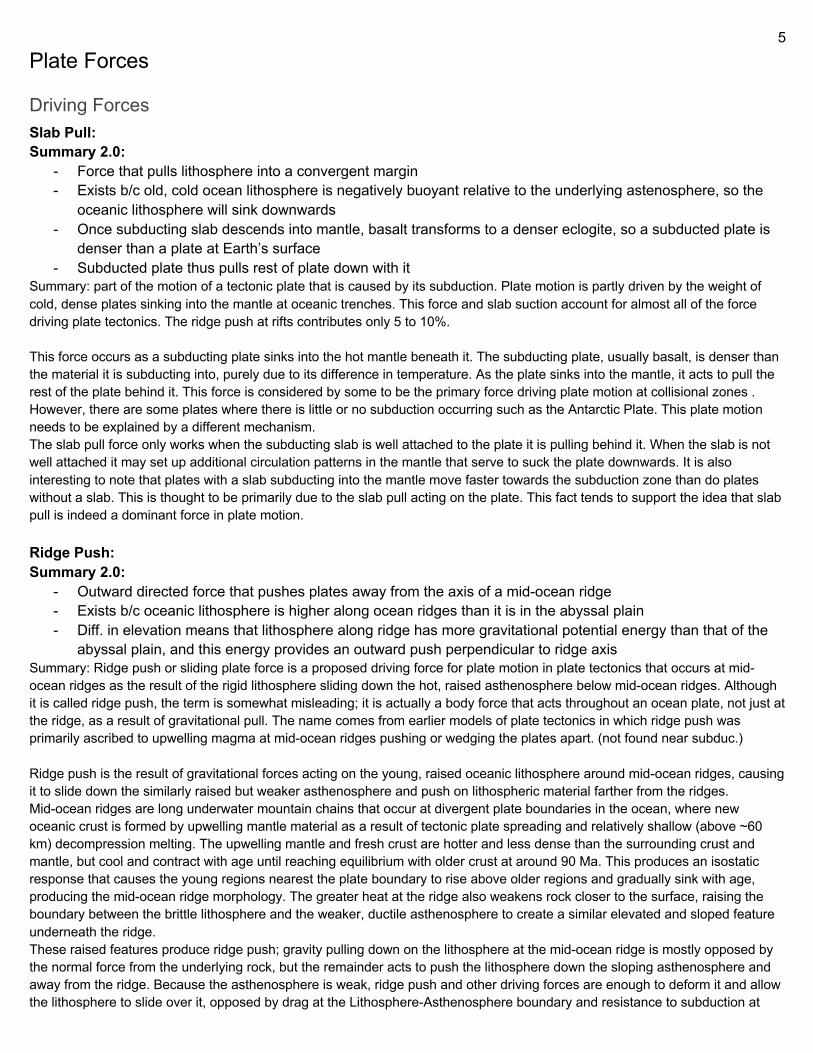
convergent plate boundaries. Ridge push is mostly active in lithosphere younger than 90 Ma, after which it has cooled enough to reach thermal equilibrium with older material and the slope of the Lithosphere-Asthenosphere boundary becomes effectively zero. Early models of plate tectonics, such as Harry Hess's seafloor spreading model, assumed that the motions of plates and the activity of mid-ocean ridges and subduction zones were primarily the result of convection currents in the mantle dragging on the crust and supplying fresh, hot magma at mid-ocean ridges. Further developments of the theory suggested that some form of ridge push helped supplement convection in order to keep the plates moving, but in the 1990s, calculations indicated that slab pull, the force that a subducted section of plate exerts on the attached crust on the surface, was an order of magnitude stronger than ridge push. As of 1996, slab pull was generally considered the dominant mechanism driving plate tectonics. Modern research, however, indicates that the effects of slab pull are mostly negated by resisting forces in the mantle, limiting it to only 2-3 times the effective strength of ridge push forces in most plates, and that mantle convection is probably much too slow for drag between the lithosphere and the asthenosphere to account for the observed motion of the plates. This restores ridge push as one of the dominant factors in plate motion. Slab Suction (trench suction): Summary: occurs when a subducting slab drives flow in the nearby mantle. This flow then exerts shear tractions on nearby plates. This driving force is important when the slabs (or portions thereof) are not strongly attached to the rest of their respective tectonic plate. They cause both the subducting and overriding plate to move in the direction of the subduction zone. Slab suction is the weakest of the three major forces involved in plate motion, the others being slab pull, the strongest, and ridge push. This force occurs between two colliding plates where one is subducting beneath the other. As one plate subducts, it sets up convection currents in the upper mantle that 'exert a net trenchward pull' ie, acts to suck both the plates together. Associated with the slab suction force is the idea of trench roll-back. As a slab of oceanic crust subducts into the mantle, the hinge of the plate (the point where the plate begins to subduct) tends to regress away from the trench. This occurs because there is effectively no force to hold the hinge in one location.
Trench Rollback: Trenches seem positionally stable over time, but scientists believe that some trenches—particularly those associated with subduction zones where two oceanic plates converge—move backward into the subducting plate. This is called trench rollback or hinge retreat (also hinge rollback) and is one explanation for the existence of back-arc basins. (look at trenches section) Slab Rollback: Slab rollback refers to the process that involves an older oceanic crust, which is colder and more dense than other slabs, subducting at a steep angle. As the older slab collapses into the asthenosphere, it can “roll back” through the mantle. Slab rollback can pull the upper plate with it, causing an extension in the overlying plate, and possibly resulting in backarc spreading. Backarc spreading is a process caused by the sinking of a subducting plate. If this plate sinks and slides under the overriding plate faster than the overriding plate moves forward, rifting can occur. Slab rollback can cause the overriding plate in the subduction zone to become stretched until it rifts. Rifting results in extensional tectonics or a process where the lithosphere and the Earth’s crust pull apart. This stretching enables magma to rise into the gap created by the rift.
Resisting Forces: Collisional Resistance:
7
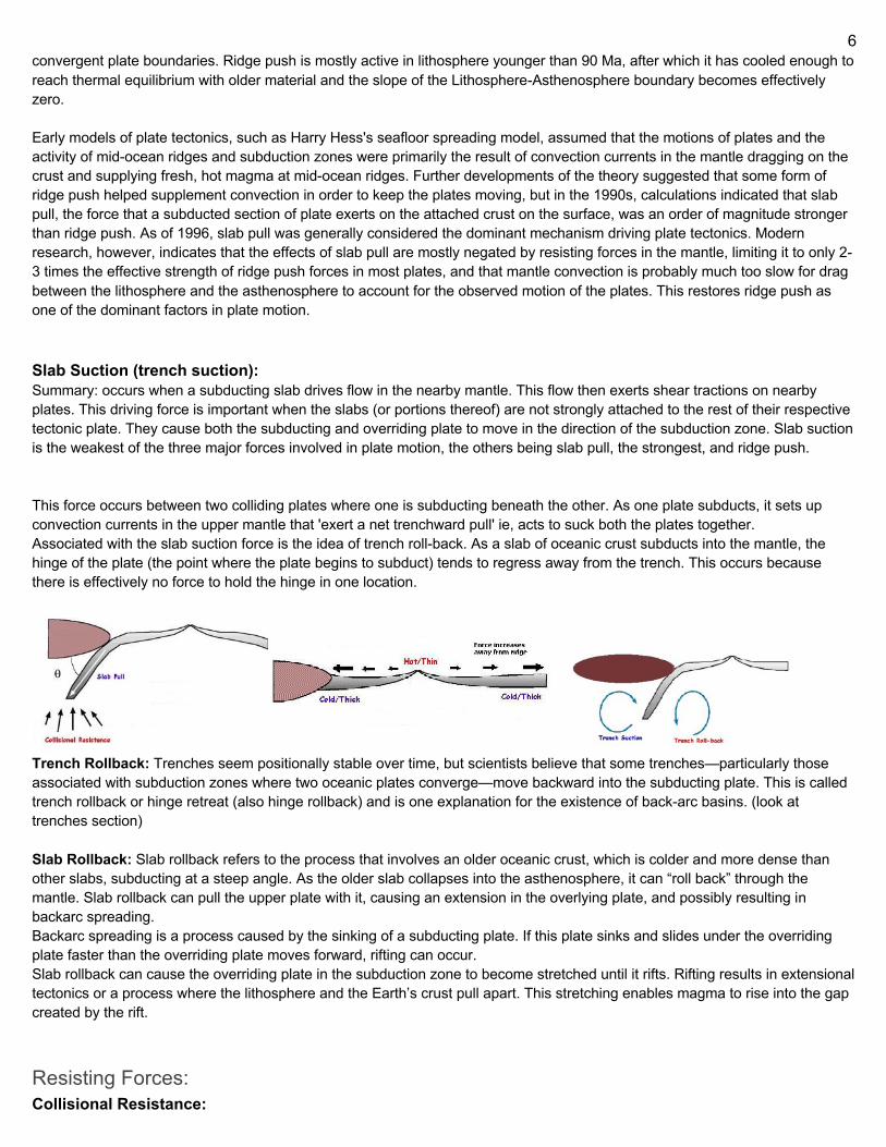
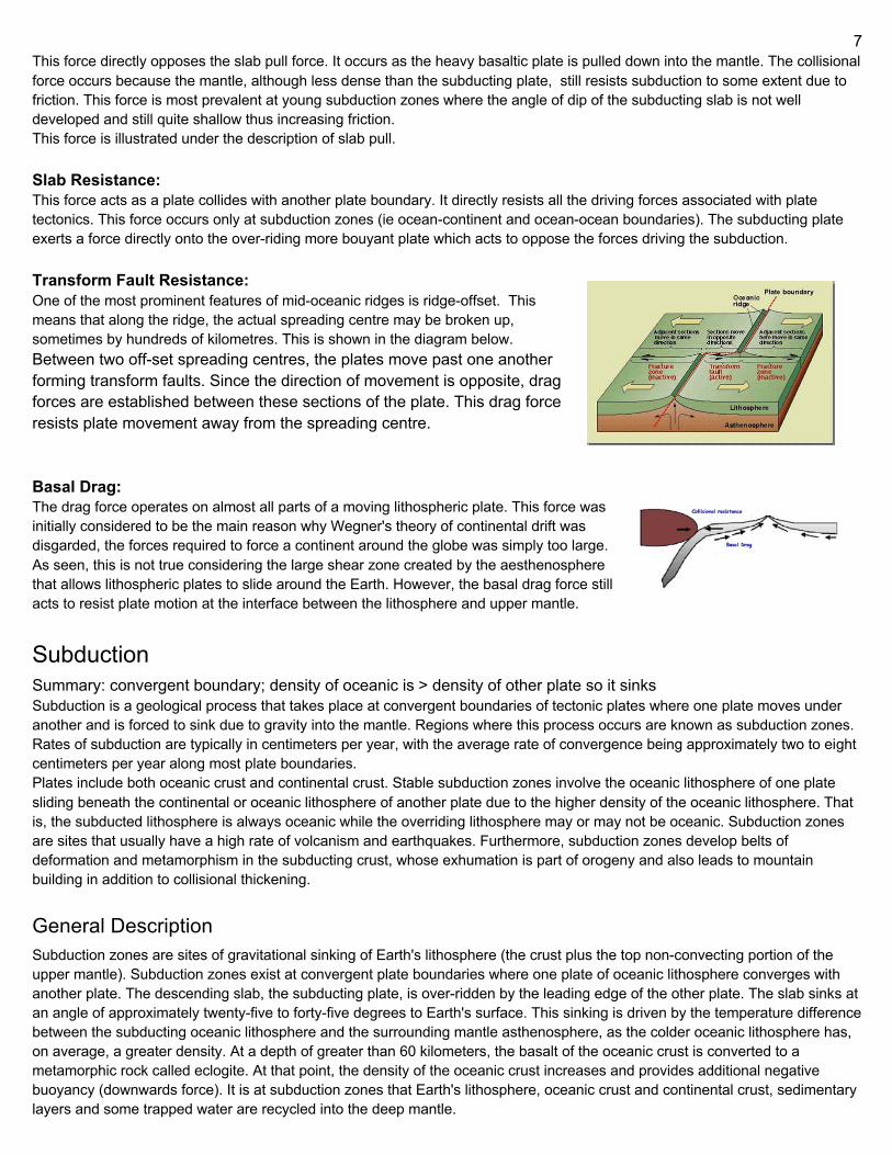
This force directly opposes the slab pull force. It occurs as the heavy basaltic plate is pulled down into the mantle. The collisional force occurs because the mantle, although less dense than the subducting plate, still resists subduction to some extent due to friction. This force is most prevalent at young subduction zones where the angle of dip of the subducting slab is not well developed and still quite shallow thus increasing friction. This force is illustrated under the description of slab pull. Slab Resistance: This force acts as a plate collides with another plate boundary. It directly resists all the driving forces associated with plate tectonics. This force occurs only at subduction zones (ie ocean-continent and ocean-ocean boundaries). The subducting plate exerts a force directly onto the over-riding more bouyant plate which acts to oppose the forces driving the subduction. Transform Fault Resistance: One of the most prominent features of mid-oceanic ridges is ridge-offset. This means that along the ridge, the actual spreading centre may be broken up, sometimes by hundreds of kilometres. This is shown in the diagram below. Between two off-set spreading centres, the plates move past one another forming transform faults. Since the direction of movement is opposite, drag forces are established between these sections of the plate. This drag force resists plate movement away from the spreading centre. Basal Drag: The drag force operates on almost all parts of a moving lithospheric plate. This force was initially considered to be the main reason why Wegner's theory of continental drift was disgarded, the forces required to force a continent around the globe was simply too large. As seen, this is not true considering the large shear zone created by the aesthenosphere that allows lithospheric plates to slide around the Earth. However, the basal drag force still acts to resist plate motion at the interface between the lithosphere and upper mantle.
Subduction Summary: convergent boundary; density of oceanic is > density of other plate so it sinks Subduction is a geological process that takes place at convergent boundaries of tectonic plates where one plate moves under another and is forced to sink due to gravity into the mantle. Regions where this process occurs are known as subduction zones. Rates of subduction are typically in centimeters per year, with the average rate of convergence being approximately two to eight centimeters per year along most plate boundaries. Plates include both oceanic crust and continental crust. Stable subduction zones involve the oceanic lithosphere of one plate sliding beneath the continental or oceanic lithosphere of another plate due to the higher density of the oceanic lithosphere. That is, the subducted lithosphere is always oceanic while the overriding lithosphere may or may not be oceanic. Subduction zones are sites that usually have a high rate of volcanism and earthquakes. Furthermore, subduction zones develop belts of deformation and metamorphism in the subducting crust, whose exhumation is part of orogeny and also leads to mountain building in addition to collisional thickening.
General Description Subduction zones are sites of gravitational sinking of Earth's lithosphere (the crust plus the top non-convecting portion of the upper mantle). Subduction zones exist at convergent plate boundaries where one plate of oceanic lithosphere converges with another plate. The descending slab, the subducting plate, is over-ridden by the leading edge of the other plate. The slab sinks at an angle of approximately twenty-five to forty-five degrees to Earth's surface. This sinking is driven by the temperature difference between the subducting oceanic lithosphere and the surrounding mantle asthenosphere, as the colder oceanic lithosphere has, on average, a greater density. At a depth of greater than 60 kilometers, the basalt of the oceanic crust is converted to a metamorphic rock called eclogite. At that point, the density of the oceanic crust increases and provides additional negative buoyancy (downwards force). It is at subduction zones that Earth's lithosphere, oceanic crust and continental crust, sedimentary layers and some trapped water are recycled into the deep mantle.
8
Earth is so far the only planet where subduction is known to occur. Subduction is the driving force behind plate tectonics, and without it, plate tectonics could not occur.
Initiation Although the process of subduction as it occurs today is fairly well understood, its origin remains a matter of discussion and continuing study. Subduction initiation can occur spontaneously if denser oceanic lithosphere is able to founder and sink beneath adjacent oceanic or continental lithosphere; alternatively, existing plate motions can induce new subduction zones by forcing oceanic lithosphere to rupture and sink into the asthenosphere. Both models can eventually yield self-sustaining subduction zones, as oceanic crust is metamorphosed at great depth and becomes denser than the surrounding mantle rocks. Results from numerical models generally favor induced subduction initiation for most modern subduction zones, which is supported by geologic studies, but other analogue modeling shows the possibility of spontaneous subduction from inherent density differences between two plates at passive margins, and observations from the Izu-Bonin-Mariana subduction system are compatible with spontaneous subduction nucleation. Furthermore, subduction is likely to have spontaneously initiated at some point in Earth's history, as induced subduction nucleation requires existing plate motions, though an unorthodox proposal by A. Yin suggests that meteorite impacts may have contributed to subduction initiation on early Earth. Geophysicist Don L. Anderson has hypothesized that plate tectonics could not happen without the calcium carbonate laid down by bioforms at the edges of subduction zones. The massive weight of these sediments could be softening the underlying rocks, making them pliable enough to plunge.
Modern - Style Subduction Modern-style subduction is characterized by low geothermal gradients and the associated formation of high-pressure low temperature rocks such as eclogite and blueschist. Likewise, rock assemblages called ophiolites, associated to modern-style subduction, also indicate such conditions. Eclogite xenoliths found in the North China Craton provide evidence that modern-style subduction occurred at least as early as 1.8 Ga ago in the Paleoproterozoic Era. Nevertheless, the eclogite itself was produced by oceanic subduction during the assembly of supercontinents at about 1.9-2.0 Ga. Blueschist is a rock typical for present-day subduction settings. Absence of blueschist older than Neoproterozoic reflect more magnesium-rich compositions of Earth's oceanic crust during that period. These more magnesium-rich rocks metamorphose into greenschist at conditions when modern oceanic crust rocks metamorphose into blueschist. The ancient magnesium-rich rocks means that Earth's mantle was once hotter, but not that subduction conditions were hotter. Previously, lack of pre-Neoproterozoic blueschist was thought to indicate a different type of subduction. Both lines of evidence refutes previous conceptions of modern-style subduction having been initiated in the Neoproterozoic Era 1.0 Ga ago.
Subduction Zone Metamorphism kinda useless
The metamorphic conditions the slab passes through in this process creates and destroys water bearing (hydrous) mineral phases, releasing water into the mantle. This water lowers the melting point of mantle rock, initiating melting. Understanding the timing and conditions in which these dehydration reactions occur, is key to interpreting mantle melting, volcanic arc magmatism, and the formation of continental crust. A metamorphic facies is characterized by a stable mineral assemblage specific to a pressure-temperature range and specific starting material. Subduction zone metamorphism is characterized by a low temperature, high-ultrahigh pressure metamorphic path through the zeolite, prehnite-pumpellyite, blueschist, and eclogite facies stability zones of subducted oceanic crust. Zeolite and prehnite-pumpellyite facies assemblages may or may not be present, thus the onset of metamorphism may only be marked by blueschist facies conditions. Subducting slabs are composed of basaltic crust topped with pelagic sediments; however, the pelagic sediments may be accreted onto the forearc-hanging wall and not subducted. Most metamorphic phase transitions that occur within the subducting slab are prompted by the dehydration of hydrous mineral phases. The breakdown of hydrous mineral phases typically occurs at depths greater than 10 km. Each of these metamorphic facies is marked by the presence of a specific stable mineral assemblage, recording the metamorphic conditions undergone but the subducting slab. Transitions between facies causes hydrous minerals to dehydrate at certain pressure-temperature conditions and can therefore be tracked to melting events in the mantle beneath a volcanic arc.
9
Hydrous Materials of a Subducting Slab Every year, 1–2 x 10 trillion kilograms of water descend into subduction zones. Approximately 90–95% of that water is contained in hydrous minerals, including mica, phengite, amphibole, lawsonite, chlorite, talc, zoisite, and serpentine. The most significant hydrous minerals are lawsonite (11 wt% H2O), phlogopite (2 wt% H2O) and amphibole (2 wt% H2O). Phlogopite does not release water until approximately 200 km depth whereas amphibole releases water at approximately 75 km depth. Serpentine is also an important hydrous phase (13 wt% H2O) that is only present in oceanic crust created at a slow spreading ridge where ultramafic rocks are emplaced at shallow levels. Lawsonite does not release water until approximately 300 km depth and is the last hydrous mineral to do so. Metamorphic dehydration reactions are prominent within the subducting slab during subduction, giving rise to liquid phases that contain of fluid-mobile trace elements due to the breakdown of hydrous minerals such as phengite, lawsonite and zoisite. This creates a unique type of trace element distribution pattern for arc magma. Arc magmas and the continental crust formed from arc magmas are enriched in boron, lead, arsenic, and antimony derived from the dehydration within the subducting slab. Hydrothermal fluids released from the slab mobilize these elements and allow them to be incorporated into arc magmas, distinguishing arc magmas from those produced at mid-ocean ridges and hotspots.
Facies transitions and dehydration reactions of a subducting slab
Zeolite Facies Basalts may first metamorphose under zeolite facies conditions (50–150 °C and 1–5 km depth) during subduction. Zeolites are microporous silicate minerals that can be produced by the reaction of pore fluids with basalt and pelagic sediments. The zeolite facies conditions typically only affect pelitic sediments undergoing burial, but is commonly displayed by the production of zeolite minerals within the vesicles of vesicular basalt. The glassy rinds on pillow basalts are also susceptible to metamorphism under zeolite facies conditions, which produces the zeolites heulandite or stilbite and hydrous phyllosilicates such as celadonite, smectite, kaolinite, or montmorillonite plus secondary quartz. Crystalline igneous rocks of the subducting slab, such as gabbro and basaltic sheeted dikes, remain stable until greater depth, when the sodium endmember of plagioclase feldspar, albite, replaces detrital igneous plagioclase feldspar. Also at greater depth in the zeolite facies, the zeolite laumontite replaces the zeolite heulandite and the phyllosilicate chlorite is common.
Prehnite-pumpellyite facies At paths up to 220–320 °C and below 4.5 kbars, subducting slabs may encounter the prehnite-pumpellyite facies, characterized by the presence of the hydrous chlorite, prehnite, albite, pumpellyite, tremolite, and epidote and the loss of the zeolites heulandite and laumonite. Actinolite may occur at higher grade. Aside from albite, these characteristic minerals are water bearing, and may contribute to mantle melting. These minerals are also vital in the formation of glaucophane, which is associated with blueschist facies. The onset of a low-pressure phase of lawsonite is the most significant marker of prehnite-pumpellyite facies metamorphism. The occurrence of lawsonite is significant because lawsonite contains 11 wt.% H2O which is released at higher grade and can initiate significant melting. Laumontite = Lawsonite + Quartz + H2O
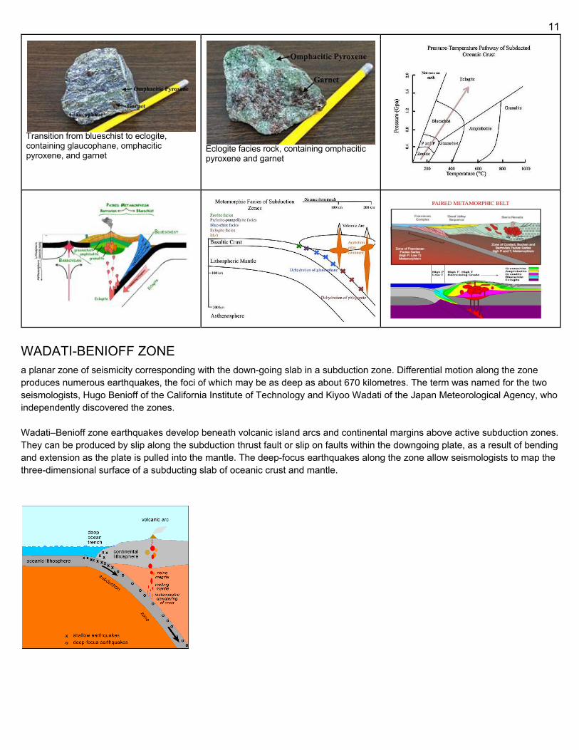
Blueschist facies Blueschist facies is characterized by the formation of a sodic, blue amphibole, namely, glaucophane, for which the blueschist facies is named. Lawsonite is also diagnostic of blueschist facies and occurs in association with glaucophane.[20] Glaucophane forming reactions are listed below. Glaucophane producing reactions are significant because they can either release water or produce the hydrous phase, lawsonite through the breakdown of hydrous phyllosilicates. At high blueschist facies pressures, albite may break down to form jadeite and quartz. Calcite will commonly pseudomorphose into aragonite under blueschist conditions. Other common minerals of blueschist facies metabasites are paragonite, chlorite, titanite, stilpnomelane, quartz, albite, sericite, and pumpellyite. Tremolite + Chlorite + Albite = Glaucophane + Epidote + H2O Tremolite + Chlorite + Albite = Glaucophane + Lawsonite Pumpellyite + Chlorite + Albite = Glaucophane + Epidote + H2O
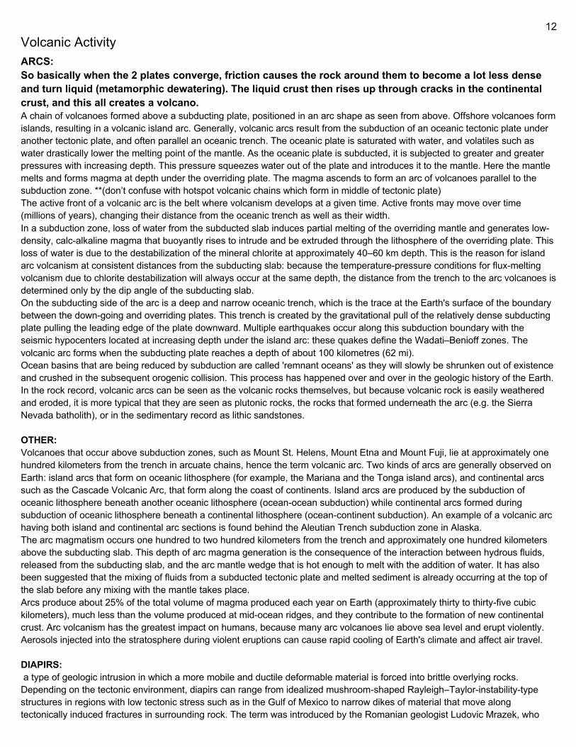
Eclogite facies Eclogite facies is typically encountered around 80–100 km depth and is characterized by the presence of green omphacitic pyroxene and red pyrope garnet. Omphacitic pyroxene is an augite-jadeite solution. At Eclogite facies conditions, plagioclase is
10
no longer stable. The albite component breaks down during glaucophane producing reactions and its sodium becomes incorporated into glaucophane and pyroxene. This reaction is written below. The break down of glaucophane is an important water producing reaction at about 600 °C, and over 1 GPa that can trigger significant mantle melting and volcanism. Glaucophane + Paragonite = Pyrope + Jadeite + Quartz + H2O Another important water producing reaction that occurs during the eclogite facies is the dehydration of the hydrous phyllosilicate phlogopite by the reaction below. This reaction can also trigger significant mantle melting and volcanism. Aside from triggering mantle melt, this reaction may also trigger partial melting of the subducting slab itself. Phlogopite + Diopside + Orthopyroxene = H2O + Melt Lawsonite remains stable up to 1080 °C and 9.4 GPa. the breakdown of lawsonite releases massive amounts of H2O into the mantle that can trigger partial melting of the slab and of the overlying mantle. The breakdown reaction of lawsonite is listed below. Lawsonite = Grossular + Topaz + Stishovite + H2O Antigorite Serpentine is another important water bearing phase that breaks down at eclogite facies conditions. Antigorite breaks down at 600–700 °C and between 2–5 GPa. Antigorite contains 13 wt.% water and therefore causes substantial mantle melting. The reaction is listed below. Antigorite = Forsterite + Enstatite + H2O Transition into the eclogite facies is proposed to be the source of earthquakes at depths greater than 70 km. These earthquakes are caused by the contraction of the slab as minerals transition into more compact crystal structures. The depth of these earthquakes on the subducting slab is known as the Wadati–Benioff zone.
Paired Metamorphic Belts Paired metamorphic belts were envisaged as a set of parallel metamorphic rock units parallel to a subduction zone displaying two contrasting metamorphic conditions and thus two distinctive mineral assemblages. Nearest the trench is a zone of low temperature, high pressure metamorphic conditions characterized by blueschist to eclogite facies assemblages. This assemblage is associated with subduction along the trench and low heat flow. Nearest the arc is a zone of high temperature-low pressure metamorphic conditions characterized by amphibolite to granulite facies mineral assemblages such as aluminosilicates, cordierite, and orthopyroxenes. This assemblage is associated with high heat flow generated by melting beneath the volcanic arc. However, further studies show the common occurrence of paired metamorphic belts in continental interiors, resulting in controversy on their origin. Based on inspection of extreme metamorphism and post-subduction magmatism at convergent plate margins, paired metamorphic belts are further extended to two contrasting metamorphic facies series: one is blueschist to eclogite facies series that was produced by subducting metamorphism at low thermal gradients of <10oC/km, and the other is amphibolite to granulite facies series that was produced by rifting metamorphism at high thermal gradients of >30oC/km.
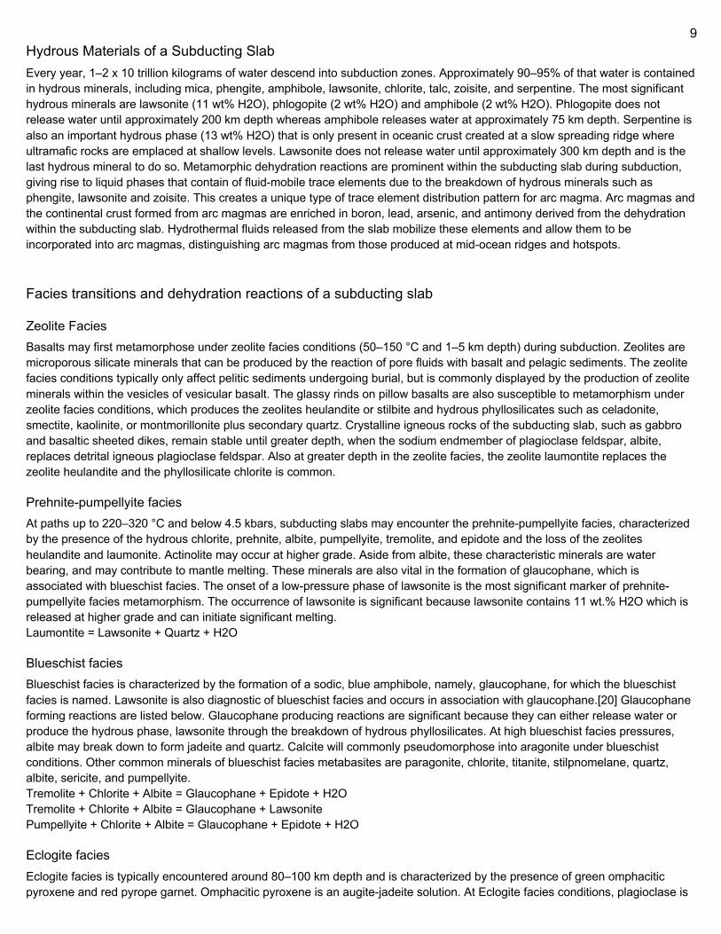
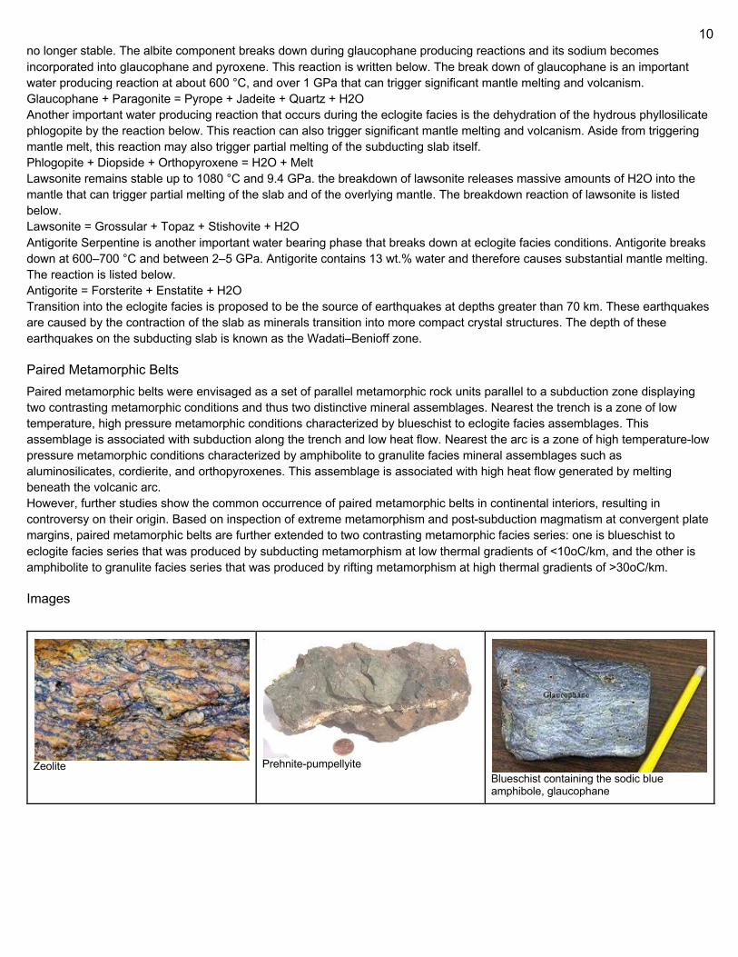
Images
Zeolite Prehnite-pumpellyite
Blueschist containing the sodic blue amphibole, glaucophane
11
Transition from blueschist to eclogite, containing glaucophane, omphacitic pyroxene, and garnet Eclogite facies rock, containing omphacitic
pyroxene and garnet
WADATI-BENIOFF ZONE a planar zone of seismicity corresponding with the down-going slab in a subduction zone. Differential motion along the zone produces numerous earthquakes, the foci of which may be as deep as about 670 kilometres. The term was named for the two seismologists, Hugo Benioff of the California Institute of Technology and Kiyoo Wadati of the Japan Meteorological Agency, who independently discovered the zones. Wadati–Benioff zone earthquakes develop beneath volcanic island arcs and continental margins above active subduction zones. They can be produced by slip along the subduction thrust fault or slip on faults within the downgoing plate, as a result of bending and extension as the plate is pulled into the mantle. The deep-focus earthquakes along the zone allow seismologists to map the three-dimensional surface of a subducting slab of oceanic crust and mantle.
12
Volcanic Activity ARCS: So basically when the 2 plates converge, friction causes the rock around them to become a lot less dense and turn liquid (metamorphic dewatering). The liquid crust then rises up through cracks in the continental crust, and this all creates a volcano. A chain of volcanoes formed above a subducting plate, positioned in an arc shape as seen from above. Offshore volcanoes form islands, resulting in a volcanic island arc. Generally, volcanic arcs result from the subduction of an oceanic tectonic plate under another tectonic plate, and often parallel an oceanic trench. The oceanic plate is saturated with water, and volatiles such as water drastically lower the melting point of the mantle. As the oceanic plate is subducted, it is subjected to greater and greater pressures with increasing depth. This pressure squeezes water out of the plate and introduces it to the mantle. Here the mantle melts and forms magma at depth under the overriding plate. The magma ascends to form an arc of volcanoes parallel to the subduction zone. **(don’t confuse with hotspot volcanic chains which form in middle of tectonic plate) The active front of a volcanic arc is the belt where volcanism develops at a given time. Active fronts may move over time (millions of years), changing their distance from the oceanic trench as well as their width. In a subduction zone, loss of water from the subducted slab induces partial melting of the overriding mantle and generates low-density, calc-alkaline magma that buoyantly rises to intrude and be extruded through the lithosphere of the overriding plate. This loss of water is due to the destabilization of the mineral chlorite at approximately 40–60 km depth. This is the reason for island arc volcanism at consistent distances from the subducting slab: because the temperature-pressure conditions for flux-melting volcanism due to chlorite destabilization will always occur at the same depth, the distance from the trench to the arc volcanoes is determined only by the dip angle of the subducting slab. On the subducting side of the arc is a deep and narrow oceanic trench, which is the trace at the Earth's surface of the boundary between the down-going and overriding plates. This trench is created by the gravitational pull of the relatively dense subducting plate pulling the leading edge of the plate downward. Multiple earthquakes occur along this subduction boundary with the seismic hypocenters located at increasing depth under the island arc: these quakes define the Wadati–Benioff zones. The volcanic arc forms when the subducting plate reaches a depth of about 100 kilometres (62 mi). Ocean basins that are being reduced by subduction are called 'remnant oceans' as they will slowly be shrunken out of existence and crushed in the subsequent orogenic collision. This process has happened over and over in the geologic history of the Earth. In the rock record, volcanic arcs can be seen as the volcanic rocks themselves, but because volcanic rock is easily weathered and eroded, it is more typical that they are seen as plutonic rocks, the rocks that formed underneath the arc (e.g. the Sierra Nevada batholith), or in the sedimentary record as lithic sandstones. OTHER: Volcanoes that occur above subduction zones, such as Mount St. Helens, Mount Etna and Mount Fuji, lie at approximately one hundred kilometers from the trench in arcuate chains, hence the term volcanic arc. Two kinds of arcs are generally observed on Earth: island arcs that form on oceanic lithosphere (for example, the Mariana and the Tonga island arcs), and continental arcs such as the Cascade Volcanic Arc, that form along the coast of continents. Island arcs are produced by the subduction of oceanic lithosphere beneath another oceanic lithosphere (ocean-ocean subduction) while continental arcs formed during subduction of oceanic lithosphere beneath a continental lithosphere (ocean-continent subduction). An example of a volcanic arc having both island and continental arc sections is found behind the Aleutian Trench subduction zone in Alaska. The arc magmatism occurs one hundred to two hundred kilometers from the trench and approximately one hundred kilometers above the subducting slab. This depth of arc magma generation is the consequence of the interaction between hydrous fluids, released from the subducting slab, and the arc mantle wedge that is hot enough to melt with the addition of water. It has also been suggested that the mixing of fluids from a subducted tectonic plate and melted sediment is already occurring at the top of the slab before any mixing with the mantle takes place. Arcs produce about 25% of the total volume of magma produced each year on Earth (approximately thirty to thirty-five cubic kilometers), much less than the volume produced at mid-ocean ridges, and they contribute to the formation of new continental crust. Arc volcanism has the greatest impact on humans, because many arc volcanoes lie above sea level and erupt violently. Aerosols injected into the stratosphere during violent eruptions can cause rapid cooling of Earth's climate and affect air travel. DIAPIRS: a type of geologic intrusion in which a more mobile and ductile deformable material is forced into brittle overlying rocks. Depending on the tectonic environment, diapirs can range from idealized mushroom-shaped Rayleigh–Taylor-instability-type structures in regions with low tectonic stress such as in the Gulf of Mexico to narrow dikes of material that move along tectonically induced fractures in surrounding rock. The term was introduced by the Romanian geologist Ludovic Mrazek, who
13
was the first to understand the principle of salt tectonics and plasticity. The term "diapir" may be applied to igneous structures, but it is more commonly applied to non-igneous, relatively cold materials, such as salt domes and mud diapirs. Diapirs commonly intrude vertically upward along fractures or zones of structural weakness through denser overlying rocks because of density contrast between a less dense, lower rock mass and overlying denser rocks.The density contrast manifests as a force of buoyancy. The process is known as diapirism. The resulting structures are also referred to as piercement structures. In the process, segments of the existing strata can be disconnected and pushed upwards. While moving higher, they retain much of their original properties such as pressure, which can be significantly different from that of the shallower strata they get pushed into. Such overpressured Floaters pose a significant risk when trying to drill through them. There is an analogy to a Galilean thermometer. Rock types such as evaporitic salt deposits, and gas charged muds are potential sources of diapirs. Diapirs also form in the earth's mantle when a sufficient mass of hot, less dense magma assembles. Diapirism in the mantle is thought to be associated with the development of large igneous provinces and some mantle plumes. Explosive, hot volatile rich magma or volcanic eruptions are referred to generally as diatremes. Diatremes are not usually associated with diapirs, as they are small-volume magmas which ascend by volatile plumes, not by density contrast with the surrounding mantle.
Orogeny Orogeny is the process of mountain building. Subducting plates can lead to orogeny by bringing oceanic islands, oceanic plateaus, and sediments to convergent margins. The material often does not subduct with the rest of the plate but instead is accreted (scraped off) to the continent resulting in exotic terranes. The collision of this oceanic material causes crustal thickening and mountain-building. The accreted material is often referred to as an accretionary wedge, or prism. These accretionary wedges can be identified by ophiolites (uplifted ocean crust consisting of sediments, pillow basalts, sheeted dykes, gabbro, and peridotite). Subduction may also cause orogeny without bringing in oceanic material that collides with the overriding continent. When the subducting plate subducts at a shallow angle underneath a continent (something called "flat-slab subduction"), the subducting plate may have enough traction on the bottom of the continental plate to cause the upper plate to contract leading to folding, faulting, crustal thickening and mountain building. This flat-slab subduction process is thought to be one of the main causes of mountain building and deformation in South America. The processes described above allow subduction to continue while mountain building happens progressively, which is in contrast to continent-continent collision orogeny, which often leads to the termination of subduction.
Subduction Angle Subduction typically occurs at a moderately steep angle right at the point of the convergent plate boundary. However, anomalous shallower angles of subduction are known to exist as well some that are extremely steep. Flat-slab subduction (subducting angle less than 30°) occurs when subducting lithosphere, called a slab, subducts nearly horizontally. The relatively flat slab can extend for hundreds of kilometers. That is abnormal, as the dense slab typically sinks at a much steeper angle directly at the subduction zone. Because subduction of slabs to depth is necessary to drive subduction zone volcanism (through the destabilization and dewatering of minerals and the resultant flux melting of the mantle wedge), flat-slab subduction can be invoked to explain volcanic gaps. Flat-slab subduction is ongoing beneath part of the Andes causing segmentation of the Andean Volcanic Belt into four zones. The flat-slab subduction in northern Peru and Norte Chico region of Chile is believed to be the result of the subduction of two buoyant aseismic ridges, the Nazca Ridge and the Juan Fernández Ridge respectively. Around Taitao Peninsula flat-slab subduction is attributed to the subduction of the Chile Rise, a spreading ridge. The Laramide Orogeny in the Rocky Mountains of United States is attributed to flat-slab subduction. Then, a broad volcanic gap appeared at the southwestern margin of North America, and deformation occurred much farther inland; it was during this time that the basement-cored mountain ranges of Colorado, Utah, Wyoming, South Dakota, and New Mexico came into being. The most massive subduction zone earthquakes, so-called "megaquakes", have been found to occur in flat-slab subduction zones.
14
Steep-angle subduction (subducting angle greater than 70°) occurs in subduction zones where Earth's oceanic crust and lithosphere are old and thick and have, therefore, lost buoyancy. The steepest dipping subduction zone lies in the Mariana Trench, which is also where the oceanic crust, of Jurassic age, is the oldest on Earth exempting ophiolites. Steep-angle subduction is, in contrast to flat-slab subduction, associated with back-arc extension of crust making volcanic arcs and fragments of continental crust wander away from continents over geological times leaving behind a marginal sea.
Importance Subduction zones are important for several reasons: 1. Subduction Zone Physics: Sinking of the oceanic lithosphere (sediments, crust, mantle), by contrast of density between the cold and old lithosphere and the hot asthenospheric mantle wedge, is the strongest force (but not the only one) needed to drive plate motion and is the dominant mode of mantle convection. 2. Subduction Zone Chemistry: The subducted sediments and crust dehydrate and release water-rich (aqueous) fluids into the overlying mantle, causing mantle melting and fractionation of elements between surface and deep mantle reservoirs, producing island arcs and continental crust. 3. Subduction zones drag down subducted oceanic sediments, oceanic crust, and mantle lithosphere that interact with the hot asthenospheric mantle from the over-riding plate to produce calc-alkaline series melts, ore deposits, and continental crust. 4. Subduction zones pose significant threats to lives, property, economic vitality, cultural and natural resources, as well as quality of life. The tremendous magnitudes of earthquakes or volcanic eruptions can also have knock-on effects with global impact. Subduction zones have also been considered as possible disposal sites for nuclear waste in which the action of subduction itself would carry the material into the planetary mantle, safely away from any possible influence on humanity or the surface environment. However, that method of disposal is currently banned by international agreement. Furthermore, plate subduction zones are associated with very large megathrust earthquakes, making the effects on using any specific site for disposal unpredictable and possibly adverse to the safety of longterm disposal.
Divergent Double Subduction Zones (abbreviated to DDS, also called as outward dipping double-sided subduction) is a special type of subduction system where two parallel subduction zones with different directions are developed on the same oceanic plate. In conventional plate tectonics theory, an oceanic plate subducts under another plate and new oceanic crust is generated somewhere else, commonly along the other side of the same plates However, in divergent double subduction, the oceanic plate subducts on two sides. This results in the closure of ocean and arc-arc collision. This concept was first proposed and applied to the Lachlan fold belt in southern Australia. Since then, geologists have applied this model to other regions such as the Solonker Suture Zone of the Central Asian Orogenic belt, the Jiangnan Orogen, the Lhasa–Qiangtang collision zone and the Baker terrane boundary. Active examples of this system are 1) the Molucca Sea Collision Zone in Indonesia, in which the Molucca Sea plate subducts below the Eurasian plate and the Philippine Sea plate on two sides, and 2) the Adria microplate in the Central Mediterranean, subducting both on its western side (beneath the Apennines and Calabria) and on its eastern side (beneath the Dinarides). Note that the term "divergent" is used to describe one oceanic plate subducting in different directions on two opposite sides. It should not be confused with use of the same term in 'divergent plate boundary' which refers to a spreading center that separates two plates moving away from each other.
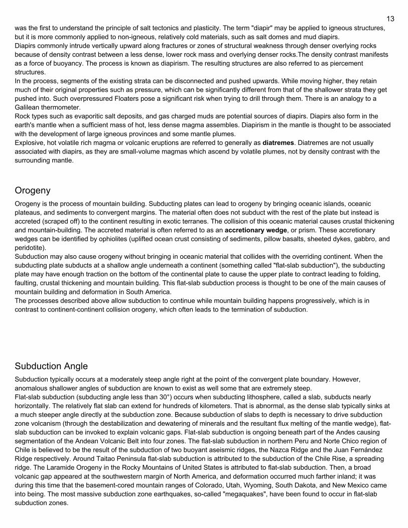
Stages (4) 1. As the central oceanic plate subducts on both sides into the two overriding plates, the subducting oceanic slab brings fluids down and the fluids are released in the mantle wedge. This initiates the partial melting of the mantle wedge and the magma eventually rise into the overriding plates, resulting in the formation of two volcanic arcs on the two overriding plates. At the same time, sediment deposits on the two margins of the overriding plates, forming two accretionary wedges. As the plate subducts and rollback occurs, the ocean becomes narrower and the subduction rate reduces as the oceanic plate becomes closer to an inverted "U" shape. 2. The ocean is closed eventually as subduction continues. The two overriding plates meet, collide, and weld together by a "soft" collision. The inverted "U" shape of the oceanic plate inhibits the continued subduction of the plate because the mantle material below the plate is trapped.
15
3. The dense oceanic plate has a high tendency to sink. As it sinks, it breaks along the oceanic plate and the welded crust above and a gap is created. The extra space created leads to the decompression melting of mantle wedge materials. The melts flow upward and fill the gap and intrude the oceanic plate and welded crust as mafic dykes intrusion. Eventually, the oceanic plate completely breaks apart from the welded crust as it continues to sink. 4. When the oceanic plate breaks apart from the crust and sinks into the mantle, underplating continues to occur. At the same time, the sinking oceanic plate starts to dewater and release the fluids upward to aid the partial melting of mantle and the crust above. It results in extensive magmatism and bimodal volcanism.
Obduction Obduction was originally defined by Coleman to mean the overthrusting of oceanic lithosphere onto continental lithosphere at a convergent plate boundary where continental lithosphere is being subducted beneath oceanic lithosphere. Subsequently, this definition has been broadened to mean the emplacement of continental lithosphere by oceanic lithosphere at a convergent plate boundary, such as closing of an ocean or a mountain building episode. This process is uncommon because the denser oceanic lithosphere usually subducts underneath the less dense continental plate. Obduction occurs where a fragment of continental crust is caught in a subduction zone with resulting overthrusting of oceanic mafic and ultramafic rocks from the mantle onto the continental crust. Obduction may occur where a small tectonic plate is caught between two larger plates, with the lithosphere (both island arc and oceanic) welding onto an adjacent continent as a new terrane. When two continental plates collide, obduction of the oceanic lithosphere between them is often a part of the resulting orogeny. Most obductions appear to have initiated at back-arc basins above the subduction zones during the closing of an ocean or an orogeny.
Characteristic Rocks The characteristic rocks of obducted oceanic lithosphere are the ophiolites. Ophiolites are an assemblage of oceanic lithosphere rocks that have been emplaced onto a continent. This assemblage consists of deep-marine sedimentary rock (chert, limestone, clastic sediments), volcanic rocks (pillow lavas, glass, ash, sheeted dykes and gabbros) and peridotite (mantle rock).
Examples There are many examples of oceanic crustal rocks and deeper mantle rocks that have been obducted and exposed at the surface worldwide. New Caledonia is one example of recent obduction. The Klamath Mountains of northern California contain
16
several obducted oceanic slabs. Obducted fragments also are found in Oman, the Troodos Mountains of Cyprus, Newfoundland, New Zealand, the Alps of Europe, the Shetland islands of Unst and Fetlar, and the Appalachians of eastern North America.
Back-Arc Basins Geologic basins, submarine features associated with island arcs and subduction zones. They are found at some convergent plate boundaries, presently concentrated in the western Pacific Ocean. Most of them result from tensional forces caused by oceanic trench rollback (the oceanic trench is wandering in the seafloor direction) and the collapse of the edge of the continent. The arc crust is under extension or rifting as a result of the sinking of the subducting slab. Back-arc basins were initially a surprising result for plate tectonics theorists, who expected convergent boundaries to be zones of compression, rather than major extension. However, they are now recognized as consistent with this model in explaining how the interior of Earth loses heat.
Slab Windows a gap that forms in a subducted oceanic plate when a mid-ocean ridge meets with a subduction zone and plate divergence at the ridge and convergence at the subduction zone continue, causing the ridge to be subducted. Formation of a slab window produces an area where the crust of the over-riding plate is lacking a rigid lithospheric mantle component and thus is exposed to hot asthenospheric mantle (for a diagram of this, see the link below). This produces anomalous thermal, chemical and physical effects in the mantle that can dramatically change the over-riding plate by interrupting the established tectonic and magmatic regimes. In general, the data used to identify possible slab windows comes from seismic tomography and heat flow studies.
Oceanic Crust - SIMA The uppermost layer of the oceanic portion of a tectonic plate. It is composed of the upper oceanic crust, with pillow lavas and a dike complex, and the lower oceanic crust, composed of troctolite, gabbro and ultramafic cumulates. The crust overlies the solidified and uppermost layer of the mantle. The crust and the solid mantle layer together constitute oceanic lithosphere. Oceanic crust is primarily composed of mafic rocks, or sima, which is rich in iron and magnesium. It is thinner than continental crust, or sial, generally less than 10 kilometers thick; however it is denser, having a mean density of about 3.0 grams per cubic centimeter as opposed to continental crust which has a density of about 2.7 grams per cubic centimeter. The crust uppermost is the result of the cooling of magma derived from mantle material below the plate. The magma is injected into the spreading center, which consists mainly of a partly solidified crystal mush derived from earlier injections, forming magma lenses that are the source of the sheeted dikes that feed the overlying pillow lavas. As the lavas cool they are, in most instances, modified chemically by seawater. These eruptions occur mostly at mid-ocean ridges, but also at scattered hotspots, and also in rare but powerful occurrences known as flood basalt eruptions. But most magma crystallises at depth, within the lower oceanic crust. There, newly intruded magma can mix and react with pre-existing crystal mush and rocks.
Composition Although a complete section of oceanic crust has not yet been drilled, geologists have several pieces of evidence that help them understand the ocean floor. Estimations of composition are based on analyses of ophiolites (sections of oceanic crust that are thrust onto and preserved on the continents), comparisons of the seismic structure of the oceanic crust with laboratory determinations of seismic velocities in known rock types, and samples recovered from the ocean floor by submersibles, dredging (especially from ridge crests and fracture zones) and drilling. Oceanic crust is significantly simpler than continental crust and generally can be divided in three layers. According to mineral physics experiments, at lower mantle pressures, oceanic crust becomes denser than the surrounding mantle. Layer 1 is on an average 0.4 km thick. It consists of unconsolidated or semiconsolidated sediments, usually thin or even not present near the mid-ocean ridges but thickens farther away from the ridge. Near the continental margins sediment is terrigenous, meaning derived from the land, unlike deep sea sediments which are made of tiny shells of marine organisms, usually calcareous and siliceous, or it can be made of volcanic ash and terrigenous sediments transported by turbidity currents. Layer 2 could be divided into two parts: layer 2A – 0.5 km thick uppermost volcanic layer of glassy to finely crystalline basalt usually in the form of pillow basalt, and layer 2B – 1.5 km thick layer composed of diabase dikes. Layer 3 is formed by slow cooling of magma beneath the surface and consists of coarse grained gabbros and cumulate ultramafic rocks. It constitutes over two-thirds of oceanic crust volume with almost 5 km thickness.
17
Geochemistry The most voluminous volcanic rocks of the ocean floor are the mid-oceanic ridge basalts, which are derived from low-potassium tholeiitic magmas. These rocks have low concentrations of large ion lithophile elements (LILE), light rare earth elements (LREE), volatile elements and other highly incompatible elements. There can be found basalts enriched with incompatible elements, but they are rare and associated with mid-ocean ridge hot spots such as surroundings of Galapagos Islands, the Azores and Iceland. Prior to the Neoproterozoic Era 1000 Ma ago as world's oceanic crust was more mafic than present-days. The more mafic nature of the crust meant that higher amounts of water molecules (OH) could be stored the altered parts of the crust. At subduction zones this mafic crust was prone to metamorphose into greenschist instead of blueschist at ordinary blueschist facies.
Life Cycle Oceanic crust is continuously being created at mid-ocean ridges. As plates diverge at these ridges, magma rises into the upper mantle and crust. As it moves away from the ridge, the lithosphere becomes cooler and denser, and sediment gradually builds on top of it. The youngest oceanic lithosphere is at the oceanic ridges, and it gets progressively older away from the ridges. As the mantle rises it cools and melts, as the pressure decreases and it crosses the solidus. The amount of melt produced
depends only on the temperature of the mantle as it rises. Hence most oceanic crust is the same thickness (7±1 km). Very slow
spreading ridges (<1 cm·yr−1 half-rate) produce thinner crust (4–5 km thick) as the mantle has a chance to cool on upwelling
and so it crosses the solidus and melts at lesser depth, thereby producing less melt and thinner crust. An example of this is the
Gakkel Ridge under the Arctic Ocean. Thicker than average crust is found above plumes as the mantle is hotter and hence it
crosses the solidus and melts at a greater depth, creating more melt and a thicker crust. An example of this is Iceland which has
crust of thickness ~20 km. The age of the oceanic crust can be used to estimate the (thermal) thickness of the lithosphere, where young oceanic crust has not had enough time to cool the mantle beneath it, while older oceanic crust has thicker mantle lithosphere beneath it. The oceanic lithosphere subducts at what are known as convergent boundaries. These boundaries can exist between oceanic lithosphere on one plate and oceanic lithosphere on another, or between oceanic lithosphere on one plate and continental lithosphere on another. In the second situation, the oceanic lithosphere always subducts because the continental lithosphere is less dense. The subduction process consumes older oceanic lithosphere, so oceanic crust is seldom more than 200 million years old. The process of supercontinent formation and destruction via repeated cycles of creation and destruction of oceanic crust is known as the Wilson cycle. The oldest large scale oceanic crust is in the west Pacific and north-west Atlantic - both are about up to 180-200 million years old. However, parts of the eastern Mediterranean Sea are remnants of the much older Tethys ocean, at about 270 and up to 340 million years old.
Magnetic Anomalies The oceanic crust displays a pattern of magnetic lines, parallel to the ocean ridges, frozen in the basalt. A symmetrical pattern of positive and negative magnetic lines emanates from the mid-ocean ridge. New rock is formed by magma at the mid-ocean ridges, and the ocean floor spreads out from this point. When the magma cools to form rock, its magnetic polarity is aligned with the then-current positions of the magnetic poles of the Earth. New magma then forces the older cooled magma away from the ridge. This process results in parallel sections of oceanic crust of alternating magnetic polarity.
Continental Crust the layer of igneous, sedimentary, and metamorphic rocks that forms the continents and the areas of shallow seabed close to their shores, known as continental shelves. This layer is sometimes called sial because its bulk composition is richer in silicates and aluminium minerals and has a lower density compared to the oceanic crust, called sima which is richer in magnesium silicate minerals and is denser. Changes in seismic wave velocities have shown that at a certain depth (the Conrad discontinuity), there is a reasonably sharp contrast between the more felsic upper continental crust and the lower continental crust, which is more mafic in character.
18
The continental crust consists of various layers, with a bulk composition that is intermediate (SiO2 wt% = 60.6[1]). The average density of continental crust is about 2.83 g/cm3, less dense than the ultramafic material that makes up the mantle, which has a density of around 3.3 g/cm3. Continental crust is also less dense than oceanic crust, whose density is about 2.9 g/cm3. At 25 to 70 km, continental crust is considerably thicker than oceanic crust, which has an average thickness of around 7–10 km. About 40% of Earth's surface is currently occupied by continental crust. It makes up about 70% of the volume of Earth's crust.
Importance Because the surface of continental crust mainly lies above sea level, its existence allowed land life to evolve from marine life. Its existence also provides broad expanses of shallow water known as epeiric seas and continental shelves where complex metazoan life could become established during early Paleozoic time, in what is now called the Cambrian explosion.
Origin All continental crust is ultimately derived from mantle-derived melts (mainly basalt) through fractional differentiation of basaltic melt and the assimilation (remelting) of pre-existing continental crust. The relative contributions of these two processes in creating continental crust are debated, but fractional differentiation is thought to play the dominant role. These processes occur primarily at magmatic arcs associated with subduction. There is little evidence of continental crust prior to 3.5 Ga. About 20% of the continental crust's current volume was formed by 3.0 Ga. There was relatively rapid development on shield areas consisting of continental crust between 3.0 and 2.5 Ga. During this time interval, about 60% of the continental crust's current volume was formed. The remaining 20% has formed during the last 2.5 Ga.
Forces at Work In contrast to the persistence of continental crust, the size, shape, and number of continents are constantly changing through geologic time. Different tracts rift apart, collide and recoalesce as part of a grand supercontinent cycle. There are currently about 7 billion cubic kilometers of continental crust, but this quantity varies because of the nature of the forces involved. The relative permanence of continental crust contrasts with the short life of oceanic crust. Because continental crust is less dense than oceanic crust, when active margins of the two meet in subduction zones, the oceanic crust is typically subducted back into the mantle. Continental crust is rarely subducted (this may occur where continental crustal blocks collide and overthicken, causing deep melting under mountain belts such as the Himalayas or the Alps). For this reason the oldest rocks on Earth are within the cratons or cores of the continents, rather than in repeatedly recycled oceanic crust; the oldest intact crustal fragment is the Acasta Gneiss at 4.01 Ga, whereas the oldest oceanic crust (located on the Pacific Plate offshore of Kamchatka) is from the Jurassic (~180 Ma). Continental crust and the rock layers that lie on and within it are thus the best archive of Earth's history. The height of mountain ranges is usually related to the thickness of crust. This results from the isostasy associated with orogeny (mountain formation). The crust is thickened by the compressive forces related to subduction or continental collision. The buoyancy of the crust forces it upwards, the forces of the collisional stress balanced by gravity and erosion. This forms a keel or mountain root beneath the mountain range, which is where the thickest crust is found. The thinnest continental crust is found in rift zones, where the crust is thinned by detachment faulting and eventually severed, replaced by oceanic crust. The edges of continental fragments formed this way (both sides of the Atlantic Ocean, for example) are termed passive margins. The high temperatures and pressures at depth, often combined with a long history of complex distortion, cause much of the lower continental crust to be metamorphic - the main exception to this being recent igneous intrusions. Igneous rock may also be "underplated" to the underside of the crust, i.e. adding to the crust by forming a layer immediately beneath it. Continental crust is produced and (far less often) destroyed mostly by plate tectonic processes, especially at convergent plate boundaries. Additionally, continental crustal material is transferred to oceanic crust by sedimentation. New material can be added to the continents by the partial melting of oceanic crust at subduction zones, causing the lighter material to rise as magma, forming volcanoes. Also, material can be accreted horizontally when volcanic island arcs, seamounts or similar structures collide with the side of the continent as a result of plate tectonic movements. Continental crust is also lost through erosion and sediment subduction, tectonic erosion of forearcs, delamination, and deep subduction of continental crust in collision zones. Many theories of crustal growth are controversial, including rates of crustal growth and recycling, whether the lower crust
19
is recycled differently from the upper crust, and over how much of Earth history plate tectonics has operated and so could be the dominant mode of continental crust formation and destruction. It is a matter of debate whether the amount of continental crust has been increasing, decreasing, or remaining constant over geological time. One model indicates that at prior to 3.7 Ga ago continental crust constituted less than 10% of the present amount. By 3.0 Ga ago the amount was about 25%, and following a period of rapid crustal evolution it was about 60% of the current amount by 2.6 Ga ago. The growth of continental crust appears to have occurred in spurts of increased activity corresponding to five episodes of increased production through geologic time.
Margins The continental margins are one of the three major zones of the ocean floor, the other two being deep-ocean basins and mid-ocean ridges. The continental margins are the shallow water areas found in proximity to continents. The continental margins are the zone of the ocean floor that separate the thin oceanic crust from thick continental crust. Together, the continental shelf, continental slope, and continental rise are called the continental margin. Continental margins constitute about 28% of the oceanic area.
Passive Margins Big thing: Passive margins are areas where continents have rifted apart to become separated by an ocean. They tend to be prolific sources of oil and gas and are the focus of much of today's geological research. (592? Oil fields? 30% of oil giants?) Transition between oceanic and continental lithosphere that is not an active plate margin. A passive margin forms by sedimentation above an ancient rift, now marked by transitional lithosphere. Continental rifting creates new ocean basins. Eventually the continental rift forms a mid-ocean ridge and the locus of extension moves away from the continent-ocean boundary. The transition between the continental and oceanic lithosphere that was originally created by rifting is known as a passive margin. Location: Passive margins are found at every ocean and continent boundary that is not marked by a strike-slip fault or a subduction zone. Passive margins define the region around the Atlantic Ocean, Arctic Ocean, and western Indian Ocean, and define the entire coasts of Africa, Greenland, India and Australia. They are also found on the east coast of North America and South America, in western Europe and most of Antarctica. East Asia also contains some passive margins. Subsidence Mechanisms: Passive margins are characterized by thick accumulations of sediments. Space for these sediments is called accommodation and is due to subsidence of especially the transitional crust. Subsidence is ultimately caused by gravitational equilibrium that is established between the crustal tracts, known as isostasy. Isostasy controls the uplift of the rift flank and the subsequent subsidence of the evolving passive margin and is mostly reflected by changes in heat flow. Heat flow at passive margins changes significantly over its lifespan, high at the beginning and decreasing with age. In the initial stage, the continental crust and lithosphere is stretched and thinned due to plate movement (plate tectonics) and associated igneous activity. The very thin lithosphere beneath the rift allows the upwelling mantle to melt by decompression. Lithospheric thinning also allows the asthenosphere to rise closer to the surface, heating the overlying lithosphere by conduction and advection of heat by intrusive dykes. Heating reduces the density of the lithosphere and elevates the lower crust and lithosphere. In addition, mantle plumes may heat the lithosphere and cause prodigious igneous activity. Once a mid-oceanic ridge forms and seafoor spreading begins, the original site of rifting is separated into conjugate passive margins (for example, the eastern US and NW African margins were parts of the same rift in early Mesozoic time and are now conjugate margins) and migrates away from the zone of mantle upwelling and heating and cooling begins. The mantle lithosphere below the thinned and faulted continental oceanic transition cools, thickens, increases in density and thus begins to subside. The accumulation of sediments above the subsiding transitional crust and lithosphere further depresses the transitional crust. Classification: based on:
1. map-view formation geometry (rifted, sheared, and transtensional), 2. nature of transitional crust (volcanic and non-volcanic), 3. whether the transitional crust represents a continuous change from normal continental to normal oceanic crust or this
includes isolated rifts and stranded continental blocks (simple and complex), and 4. sedimentation (carbonate-dominated, clastic-dominated, or sediment starved).
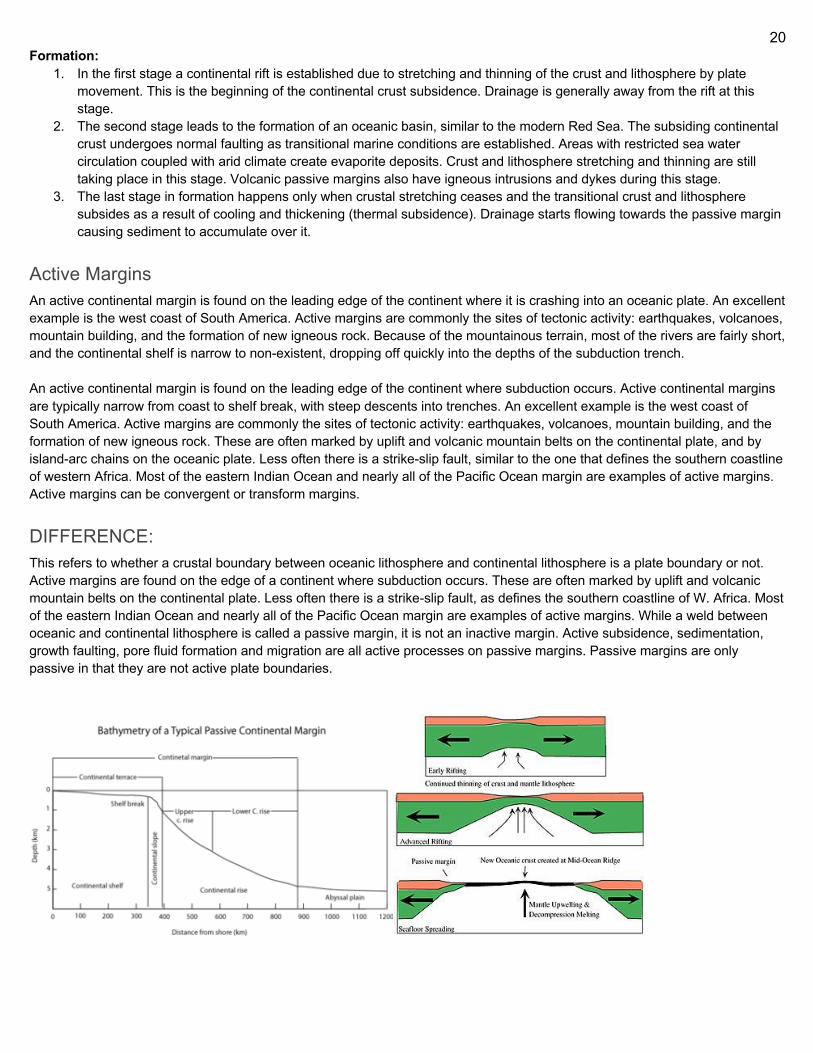
20
Formation: 1. In the first stage a continental rift is established due to stretching and thinning of the crust and lithosphere by plate
movement. This is the beginning of the continental crust subsidence. Drainage is generally away from the rift at this stage.
2. The second stage leads to the formation of an oceanic basin, similar to the modern Red Sea. The subsiding continental crust undergoes normal faulting as transitional marine conditions are established. Areas with restricted sea water circulation coupled with arid climate create evaporite deposits. Crust and lithosphere stretching and thinning are still taking place in this stage. Volcanic passive margins also have igneous intrusions and dykes during this stage.
3. The last stage in formation happens only when crustal stretching ceases and the transitional crust and lithosphere subsides as a result of cooling and thickening (thermal subsidence). Drainage starts flowing towards the passive margin causing sediment to accumulate over it.
Active Margins An active continental margin is found on the leading edge of the continent where it is crashing into an oceanic plate. An excellent example is the west coast of South America. Active margins are commonly the sites of tectonic activity: earthquakes, volcanoes, mountain building, and the formation of new igneous rock. Because of the mountainous terrain, most of the rivers are fairly short, and the continental shelf is narrow to non-existent, dropping off quickly into the depths of the subduction trench. An active continental margin is found on the leading edge of the continent where subduction occurs. Active continental margins are typically narrow from coast to shelf break, with steep descents into trenches. An excellent example is the west coast of South America. Active margins are commonly the sites of tectonic activity: earthquakes, volcanoes, mountain building, and the formation of new igneous rock. These are often marked by uplift and volcanic mountain belts on the continental plate, and by island-arc chains on the oceanic plate. Less often there is a strike-slip fault, similar to the one that defines the southern coastline of western Africa. Most of the eastern Indian Ocean and nearly all of the Pacific Ocean margin are examples of active margins. Active margins can be convergent or transform margins.
DIFFERENCE: This refers to whether a crustal boundary between oceanic lithosphere and continental lithosphere is a plate boundary or not. Active margins are found on the edge of a continent where subduction occurs. These are often marked by uplift and volcanic mountain belts on the continental plate. Less often there is a strike-slip fault, as defines the southern coastline of W. Africa. Most of the eastern Indian Ocean and nearly all of the Pacific Ocean margin are examples of active margins. While a weld between oceanic and continental lithosphere is called a passive margin, it is not an inactive margin. Active subsidence, sedimentation, growth faulting, pore fluid formation and migration are all active processes on passive margins. Passive margins are only passive in that they are not active plate boundaries.
21
OBDUCTION overthrusting of oceanic lithosphere onto continental lithosphere at a convergent plate boundary where continental lithosphere is being subducted beneath oceanic lithosphere. Subsequently, this definition has been broadened to mean the emplacement of continental lithosphere by oceanic lithosphere at a convergent plate boundary, such as closing of an ocean or a mountain building episode. This process is uncommon because the denser oceanic lithosphere usually subducts underneath the less dense continental plate. Obduction occurs where a fragment of continental crust is caught in a subduction zone with resulting overthrusting of oceanic mafic and ultramafic rocks from the mantle onto the continental crust. Obduction may occur where a small tectonic plate is caught between two larger plates, with the lithosphere (both island arc and oceanic) welding onto an adjacent continent as a new terrane. When two continental plates collide, obduction of the oceanic lithosphere between them is often a part of the resulting orogeny. Most obductions appear to have initiated at back-arc basins above the subduction zones during the closing of an ocean or an orogeny. TYPES: Upwedging in subduction zones This process is operative beneath and behind the inner walls of oceanic trenches (subduction zone) where slices of oceanic crust and mantle are ripped from the upper part of the descending plate and wedged and packed in high pressure assemblages against the leading edge of the other plate. Weakening and cracking of oceanic crust and upper mantle is likely to occur in the tensional regime. This results in the incorporation of ophiolite slabs into the overriding plate. progressive packing of ophiolite slices and arc fragments against the leading edge of a continent may continue over a long period of time and lead to a form of continental accretion. Compressional telescoping onto Atlantic-type continental margins The simplest form of this type of obduction may follow from the development of a subduction zone near the continental margin. Above and behind the subduction zone, a welt of oceanic crust and mantle rides up over the descending plate. The ocean, intervening between the continental margin and the subduction zone is progressively swallowed until the continental margin arrives at the subduction zone and a giant wedge or slice (nappe) of oceanic crust and mantle is pushed across the continental margin.Because the buoyancy of the relatively light continental crust is likely to prohibit its extensive subduction, a flip in subduction polarity will occur yielding an ophiolite sheet lying above a descending plate. If however, a large tract of ocean intervenes between the continental margin the subduction zone, a fully developed arc and back arc basin may eventually arrive and collide with the continental margin. Further convergence may lead to overthrusting of the volcanic arc assemblage and may be followed by flipping the subduction polarity. According to the rock assemblage as well as the complexly deformed ophiolite basement and arc intrusions, the Coastal Complex of western Newfoundland may well have been formed by this mechanism. Gravity sliding onto Atlantic-type continental margins This concept involves the progressive uplift of an actively spreading oceanic ridge, the detachment of slices from the upper part of the lithosphere and the subsequent gravity sliding of these slices onto the continental margin as ophiolites. This concept was advocated by Reinhardt for the emplacement of the Semail Ophiolite complex in Oman and argued by Church and Church and Stevens for the emplacement of the Bay of Islands sheet in western Newfoundland. This concept has subsequently been replaced by hypotheses that advocate subduction of the continental margin beneath oceanic lithosphere. Transformation of a spreading ridge to a subduction zone Many ophiolite complexes were emplaced as thin hot obducted sheets of oceanic lithosphere shortly after their generation by plate accretion. The change from a spreading plate boundary to a subduction plate boundary may result from rapid rearrangement of relative plate motion. A transform fault may also become a subduction zone, with the side with the higher, hotter, thinner lithosphere riding over the lower, colder lithosphere. This mechanism would lead to obduction of ophiolite complex if it occurred near a continental margin.
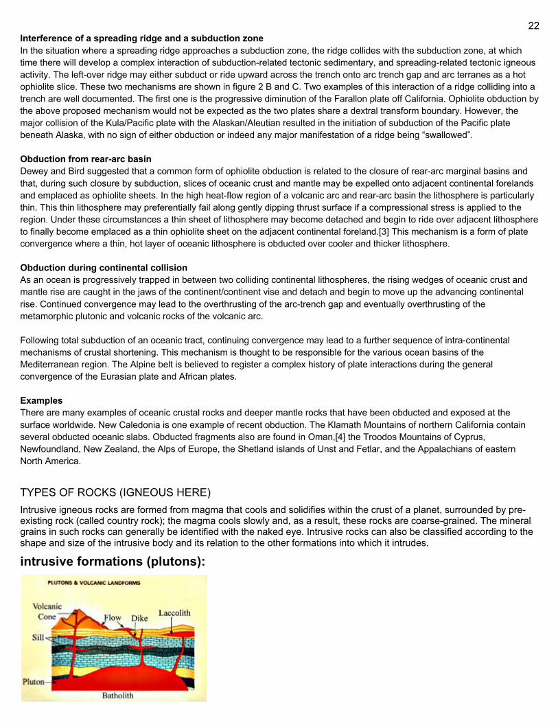
22
Interference of a spreading ridge and a subduction zone In the situation where a spreading ridge approaches a subduction zone, the ridge collides with the subduction zone, at which time there will develop a complex interaction of subduction-related tectonic sedimentary, and spreading-related tectonic igneous activity. The left-over ridge may either subduct or ride upward across the trench onto arc trench gap and arc terranes as a hot ophiolite slice. These two mechanisms are shown in figure 2 B and C. Two examples of this interaction of a ridge colliding into a trench are well documented. The first one is the progressive diminution of the Farallon plate off California. Ophiolite obduction by the above proposed mechanism would not be expected as the two plates share a dextral transform boundary. However, the major collision of the Kula/Pacific plate with the Alaskan/Aleutian resulted in the initiation of subduction of the Pacific plate beneath Alaska, with no sign of either obduction or indeed any major manifestation of a ridge being “swallowed”. Obduction from rear-arc basin Dewey and Bird suggested that a common form of ophiolite obduction is related to the closure of rear-arc marginal basins and that, during such closure by subduction, slices of oceanic crust and mantle may be expelled onto adjacent continental forelands and emplaced as ophiolite sheets. In the high heat-flow region of a volcanic arc and rear-arc basin the lithosphere is particularly thin. This thin lithosphere may preferentially fail along gently dipping thrust surface if a compressional stress is applied to the region. Under these circumstances a thin sheet of lithosphere may become detached and begin to ride over adjacent lithosphere to finally become emplaced as a thin ophiolite sheet on the adjacent continental foreland.[3] This mechanism is a form of plate convergence where a thin, hot layer of oceanic lithosphere is obducted over cooler and thicker lithosphere. Obduction during continental collision As an ocean is progressively trapped in between two colliding continental lithospheres, the rising wedges of oceanic crust and mantle rise are caught in the jaws of the continent/continent vise and detach and begin to move up the advancing continental rise. Continued convergence may lead to the overthrusting of the arc-trench gap and eventually overthrusting of the metamorphic plutonic and volcanic rocks of the volcanic arc. Following total subduction of an oceanic tract, continuing convergence may lead to a further sequence of intra-continental mechanisms of crustal shortening. This mechanism is thought to be responsible for the various ocean basins of the Mediterranean region. The Alpine belt is believed to register a complex history of plate interactions during the general convergence of the Eurasian plate and African plates. Examples There are many examples of oceanic crustal rocks and deeper mantle rocks that have been obducted and exposed at the surface worldwide. New Caledonia is one example of recent obduction. The Klamath Mountains of northern California contain several obducted oceanic slabs. Obducted fragments also are found in Oman,[4] the Troodos Mountains of Cyprus, Newfoundland, New Zealand, the Alps of Europe, the Shetland islands of Unst and Fetlar, and the Appalachians of eastern North America.
TYPES OF ROCKS (IGNEOUS HERE) Intrusive igneous rocks are formed from magma that cools and solidifies within the crust of a planet, surrounded by pre-existing rock (called country rock); the magma cools slowly and, as a result, these rocks are coarse-grained. The mineral grains in such rocks can generally be identified with the naked eye. Intrusive rocks can also be classified according to the shape and size of the intrusive body and its relation to the other formations into which it intrudes.
intrusive formations (plutons):
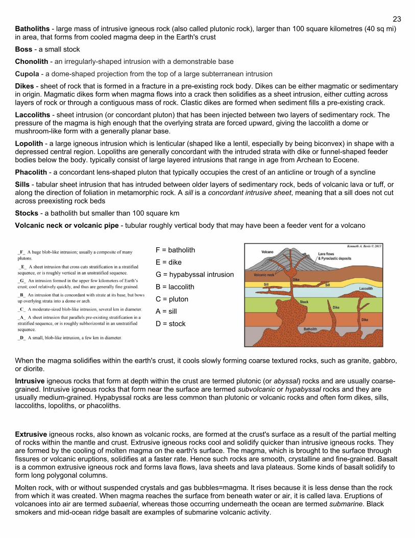
23
Batholiths - large mass of intrusive igneous rock (also called plutonic rock), larger than 100 square kilometres (40 sq mi) in area, that forms from cooled magma deep in the Earth's crust Boss - a small stock Chonolith - an irregularly-shaped intrusion with a demonstrable base
Cupola - a dome-shaped projection from the top of a large subterranean intrusion Dikes - sheet of rock that is formed in a fracture in a pre-existing rock body. Dikes can be either magmatic or sedimentary in origin. Magmatic dikes form when magma flows into a crack then solidifies as a sheet intrusion, either cutting across layers of rock or through a contiguous mass of rock. Clastic dikes are formed when sediment fills a pre-existing crack. Laccoliths - sheet intrusion (or concordant pluton) that has been injected between two layers of sedimentary rock. The pressure of the magma is high enough that the overlying strata are forced upward, giving the laccolith a dome or mushroom-like form with a generally planar base.
Lopolith - a large igneous intrusion which is lenticular (shaped like a lentil, especially by being biconvex) in shape with a depressed central region. Lopoliths are generally concordant with the intruded strata with dike or funnel-shaped feeder bodies below the body. typically consist of large layered intrusions that range in age from Archean to Eocene.
Phacolith - a concordant lens-shaped pluton that typically occupies the crest of an anticline or trough of a syncline Sills - tabular sheet intrusion that has intruded between older layers of sedimentary rock, beds of volcanic lava or tuff, or along the direction of foliation in metamorphic rock. A sill is a concordant intrusive sheet, meaning that a sill does not cut across preexisting rock beds Stocks - a batholith but smaller than 100 square km Volcanic neck or volcanic pipe - tubular roughly vertical body that may have been a feeder vent for a volcano
F = batholith E = dike G = hypabyssal intrusion
B = laccolith C = pluton A = sill
D = stock
When the magma solidifies within the earth's crust, it cools slowly forming coarse textured rocks, such as granite, gabbro, or diorite. Intrusive igneous rocks that form at depth within the crust are termed plutonic (or abyssal) rocks and are usually coarse-grained. Intrusive igneous rocks that form near the surface are termed subvolcanic or hypabyssal rocks and they are usually medium-grained. Hypabyssal rocks are less common than plutonic or volcanic rocks and often form dikes, sills, laccoliths, lopoliths, or phacoliths.
Extrusive igneous rocks, also known as volcanic rocks, are formed at the crust's surface as a result of the partial melting of rocks within the mantle and crust. Extrusive igneous rocks cool and solidify quicker than intrusive igneous rocks. They are formed by the cooling of molten magma on the earth's surface. The magma, which is brought to the surface through fissures or volcanic eruptions, solidifies at a faster rate. Hence such rocks are smooth, crystalline and fine-grained. Basalt is a common extrusive igneous rock and forms lava flows, lava sheets and lava plateaus. Some kinds of basalt solidify to form long polygonal columns.
Molten rock, with or without suspended crystals and gas bubbles=magma. It rises because it is less dense than the rock from which it was created. When magma reaches the surface from beneath water or air, it is called lava. Eruptions of volcanoes into air are termed subaerial, whereas those occurring underneath the ocean are termed submarine. Black smokers and mid-ocean ridge basalt are examples of submarine volcanic activity.
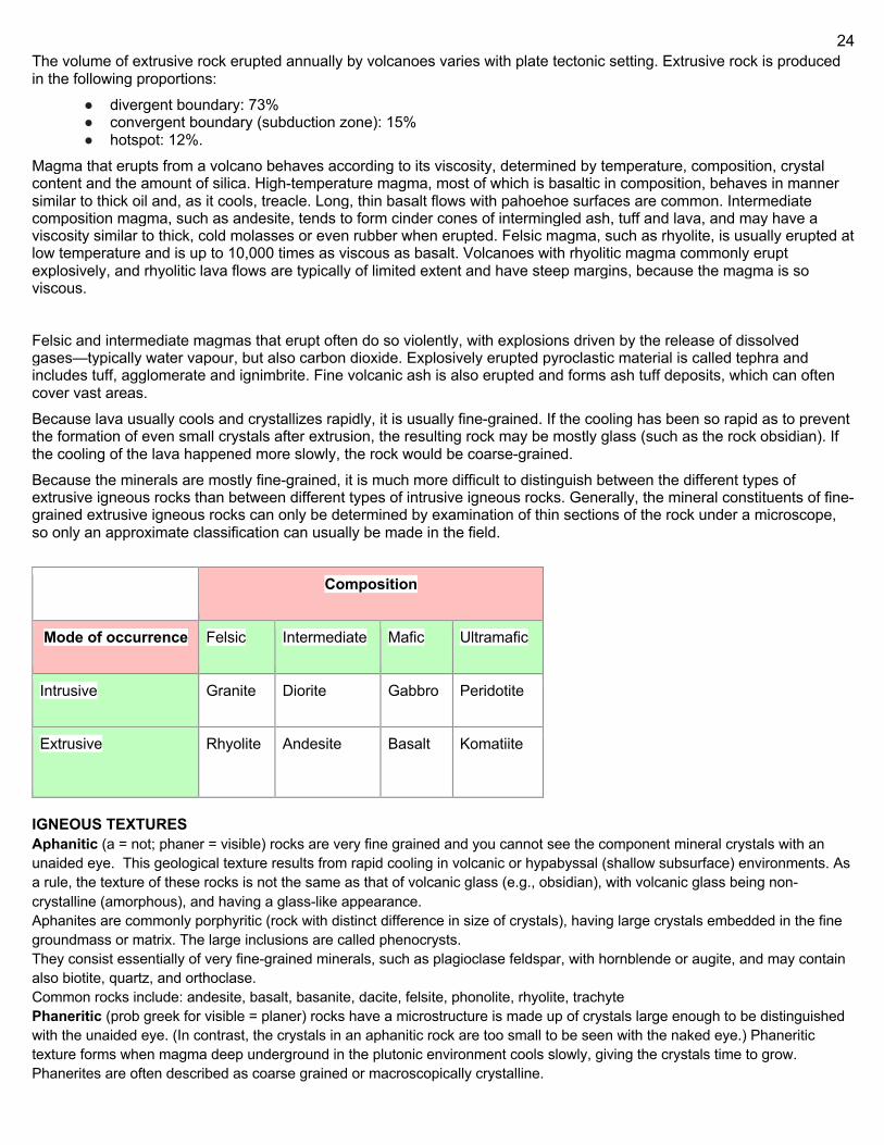
24
The volume of extrusive rock erupted annually by volcanoes varies with plate tectonic setting. Extrusive rock is produced in the following proportions:
● divergent boundary: 73% ● convergent boundary (subduction zone): 15% ● hotspot: 12%.
Magma that erupts from a volcano behaves according to its viscosity, determined by temperature, composition, crystal content and the amount of silica. High-temperature magma, most of which is basaltic in composition, behaves in manner similar to thick oil and, as it cools, treacle. Long, thin basalt flows with pahoehoe surfaces are common. Intermediate composition magma, such as andesite, tends to form cinder cones of intermingled ash, tuff and lava, and may have a viscosity similar to thick, cold molasses or even rubber when erupted. Felsic magma, such as rhyolite, is usually erupted at low temperature and is up to 10,000 times as viscous as basalt. Volcanoes with rhyolitic magma commonly erupt explosively, and rhyolitic lava flows are typically of limited extent and have steep margins, because the magma is so viscous.
Felsic and intermediate magmas that erupt often do so violently, with explosions driven by the release of dissolved gases—typically water vapour, but also carbon dioxide. Explosively erupted pyroclastic material is called tephra and includes tuff, agglomerate and ignimbrite. Fine volcanic ash is also erupted and forms ash tuff deposits, which can often cover vast areas. Because lava usually cools and crystallizes rapidly, it is usually fine-grained. If the cooling has been so rapid as to prevent the formation of even small crystals after extrusion, the resulting rock may be mostly glass (such as the rock obsidian). If the cooling of the lava happened more slowly, the rock would be coarse-grained. Because the minerals are mostly fine-grained, it is much more difficult to distinguish between the different types of extrusive igneous rocks than between different types of intrusive igneous rocks. Generally, the mineral constituents of fine-grained extrusive igneous rocks can only be determined by examination of thin sections of the rock under a microscope, so only an approximate classification can usually be made in the field. Composition
Mode of occurrence Felsic Intermediate Mafic Ultramafic
Intrusive Granite Diorite Gabbro Peridotite
Extrusive Rhyolite Andesite Basalt Komatiite
IGNEOUS TEXTURES Aphanitic (a = not; phaner = visible) rocks are very fine grained and you cannot see the component mineral crystals with an unaided eye. This geological texture results from rapid cooling in volcanic or hypabyssal (shallow subsurface) environments. As a rule, the texture of these rocks is not the same as that of volcanic glass (e.g., obsidian), with volcanic glass being non-crystalline (amorphous), and having a glass-like appearance. Aphanites are commonly porphyritic (rock with distinct difference in size of crystals), having large crystals embedded in the fine groundmass or matrix. The large inclusions are called phenocrysts. They consist essentially of very fine-grained minerals, such as plagioclase feldspar, with hornblende or augite, and may contain also biotite, quartz, and orthoclase. Common rocks include: andesite, basalt, basanite, dacite, felsite, phonolite, rhyolite, trachyte Phaneritic (prob greek for visible = planer) rocks have a microstructure is made up of crystals large enough to be distinguished with the unaided eye. (In contrast, the crystals in an aphanitic rock are too small to be seen with the naked eye.) Phaneritic texture forms when magma deep underground in the plutonic environment cools slowly, giving the crystals time to grow. Phanerites are often described as coarse grained or macroscopically crystalline.
25
Glassy or vitreous textures occur during some volcanic eruptions when the lava is quenched so rapidly that crystallization cannot occur. The result is a natural amorphous glass with few or no crystals. Examples include obsidian and pumice. Pegmatitic texture occurs during magma cooling when some minerals may grow so large that they become massive (the size ranges from a few centimetres to several metres). This is typical of pegmatites. Porphyritic textures develop when conditions during cooling of a magma change relatively quickly. The earlier formed minerals will have formed slowly and remain as large crystals, whereas, sudden cooling causes the rapid crystallization of the remainder of the melt into a fine grained (aphanitic) matrix. The result is an aphanitic rock with some larger crystals (phenocrysts) imbedded within its matrix. Porphyritic texture also occurs when magma crystallizes below a volcano but is erupted before completing crystallization thus forcing the remaining lava to crystallize more rapidly with much smaller crystals. Pyroclastic (pyro = igneous, clastic = fragment) textures occur when explosive eruptions blast the lava into the air resulting in fragmental, typically glassy material which fall as volcanic ash, lapilli and volcanic bombs.
Metamorphic rocks arise from the transformation of existing rock types, in a process called metamorphism, which means "change in form".The original rock (protolith) is subjected to heat (temperatures greater than 150 to 200 °C) and pressure (100 megapascals (1,000 bar) or more), causing profound physical or chemical change. The protolith may be a sedimentary, igneous, or existing metamorphic rock.
Metamorphic rocks make up a large part of the Earth's crust and form 12% of the Earth's land surface.They are classified by texture and by chemical and mineral assemblage (metamorphic facies). They may be formed simply by being deep beneath the Earth's surface, subjected to high temperatures and the great pressure of the rock layers above it. They can form from tectonic processes such as continental collisions, which cause horizontal pressure, friction and distortion. They are also formed when rock is heated by the intrusion of hot molten rock called magma from the Earth's interior. The study of metamorphic rocks (now exposed at the Earth's surface following erosion and uplift) provides information about the temperatures and pressures that occur at great depths within the Earth's crust. Some examples of metamorphic rocks are gneiss, slate, marble, schist, and quartzite.
Metamorphic minerals are those that form only at the high temperatures and pressures associated with the process of metamorphism. These minerals, known as index minerals, include sillimanite, kyanite, staurolite, andalusite, and some garnet.
Other minerals, such as olivines, pyroxenes, amphiboles, micas, feldspars, and quartz, may be found in metamorphic rocks, but are not necessarily the result of the process of metamorphism. These minerals formed during the crystallization of igneous rocks. They are stable at high temperatures and pressures and may remain chemically unchanged during the metamorphic process. However, all minerals are stable only within certain limits, and the presence of some minerals in metamorphic rocks indicates the approximate temperatures and pressures at which they formed.
The change in the particle size of the rock during the process of metamorphism is called recrystallization. For instance, the small calcite crystals in the sedimentary rock limestone and chalk change into larger crystals in the metamorphic rock marble; in metamorphosed sandstone, recrystallization of the original quartz sand grains results in very compact quartzite, also known as metaquartzite, in which the often larger quartz crystals are interlocked. Both high temperatures and pressures contribute to recrystallization. High temperatures allow the atoms and ions in solid crystals to migrate, thus reorganizing the crystals, while high pressures cause solution of the crystals within the rock at their point of contact.
The layering within metamorphic rocks is called foliation (derived from the Latin word folia, meaning "leaves"), and it occurs when a rock is being shortened along one axis during recrystallization. This causes the platy or elongated crystals of minerals, such as mica and chlorite, to become rotated such that their long axes are perpendicular to the orientation of shortening. This results in a banded, or foliated rock, with the bands showing the colors of the minerals that formed them.
The five basic metamorphic textures with typical rock types are slaty (includes slate and phyllite; the foliation is called "slaty cleavage"), schistose (includes schist; the foliation is called "schistosity"), gneissose (gneiss; the foliation is called "gneissosity"), granoblastic (includes granulite, some marbles and quartzite), and hornfelsic (includes hornfels and skarn).
26
Metamorphism Metamorphism is the change of minerals or geologic texture (distinct arrangement of minerals) in pre-existing rocks (protoliths), without the protolith melting into liquid magma (a solid-state change). The change occurs primarily due to heat, pressure, and the introduction of chemically active fluids. The chemical components and crystal structures of the minerals making up the rock may change even though the rock remains a solid. Changes at or just beneath Earth's surface due to weathering or diagenesis are not classified as metamorphism. Metamorphism typically occurs between **diagenesis (maximum 200°C), and melting (~850°C).
**diagenesis is like u change sediments into the sedimentary rock The geologists who study metamorphism are known as "metamorphic petrologists." To determine the processes underlying metamorphism, they rely heavily on statistical mechanics and experimental petrology. Three types of metamorphism exist: contact, dynamic, and regional. Metamorphism produced with increasing pressure and temperature conditions is known as prograde metamorphism. Conversely, decreasing temperatures and pressure characterize retrograde metamorphism. Metamorphic rocks can change without melting. Heat causes atomic bonds to break, and the atoms move and form new bonds with other atoms, creating new minerals with different chemical components or crystalline structures (neocrystallization), or enabling recrystallization. When pressure is applied, somewhat flattened grains that orient in the same direction have a more stable configuration. Limits: minimum to be considered a metamorphic process is 100 -200 degrees; excludes diagenetic changes due to compaction & formation of sedimentary rocks. Max is usually 700-900 degrees, and rocks formed at this extreme are migmatites. Pressure usually at least 100 mega pascals but below 300. TYPES Regional: Regional or Barrovian metamorphism covers large areas of continental crust typically associated with mountain ranges, particularly those associated with convergent tectonic plates or the roots of previously eroded mountains. Conditions producing widespread regionally metamorphosed rocks occur during an orogenic event. The collision of two continental plates or island arcs with continental plates produce the extreme compressional forces required for the metamorphic changes typical of regional metamorphism. These orogenic mountains are later eroded, exposing the intensely deformed rocks typical of their cores. The conditions within the subducting slab as it plunges toward the mantle in a subduction zone also produce regional metamorphic effects, characterized by paired metamorphic belts. The techniques of structural geology are used to unravel the collisional history and determine the forces involved. Regional metamorphism can be described and classified into metamorphic facies or metamorphic zones of temperature/pressure conditions throughout the orogenic terrane. Orogeny Contact (thermal): Contact metamorphism occurs typically around intrusive igneous rocks as a result of the temperature increase caused by the intrusion of magma into cooler country rock. The area surrounding the intrusion where the contact metamorphism effects are present is called the metamorphic aureole. Contact metamorphic rocks are usually known as hornfels. Rocks formed by contact metamorphism may not present signs of strong deformation and are often fine-grained. Contact metamorphism is greater adjacent to the intrusion and dissipates with distance from the contact. The size of the aureole depends on the heat of the intrusion, its size, and the temperature difference with the wall rocks. Dikes generally have small aureoles with minimal metamorphism whereas large ultramafic intrusions can have significantly thick and well-developed contact metamorphism. The metamorphic grade of an aureole is measured by the peak metamorphic mineral which forms in the aureole. This is usually related to the metamorphic temperatures of pelitic or aluminosilicate rocks and the minerals they form.The metamorphic grades of aureoles are andalusite hornfels, sillimanite hornfels, pyroxene hornfels. Magmatic fluids coming from the intrusive rock may also take part in the metamorphic reactions. An extensive addition of magmatic fluids can significantly modify the chemistry of the affected rocks. In this case the metamorphism grades into metasomatism. If the intruded rock is rich in carbonate the result is a skarn. Fluorine-rich magmatic waters which leave a cooling granite may often form greisens within and adjacent to the contact of the granite. Metasomatic altered aureoles can localize the deposition of metallic ore minerals and thus are of economic interest. A special type of contact metamorphism, associated with fossil fuel fires, is known as pyrometamorphism. Hydrothermal: Hydrothermal metamorphism is the result of the interaction of a rock with a high-temperature fluid of variable composition. The difference in composition between an existing rock and the invading fluid triggers a set of metamorphic and metasomatic reactions. The hydrothermal fluid may be magmatic (originate in an intruding magma), circulating groundwater, or ocean water. Convective circulation of hydrothermal fluids in the ocean floor basalts produces extensive hydrothermal metamorphism adjacent to spreading centers and other submarine volcanic areas. The fluids eventually escape through vents on the ocean

27
floor known as black smokers. The patterns of this hydrothermal alteration are used as a guide in the search for deposits of valuable metal ores. Shock: Occurs when either an extraterrestrial object (a meteorite for instance) collides with the Earth's surface or during an extremely violent volcanic eruption. Impact metamorphism is, therefore, characterized by ultrahigh pressure conditions and low temperature. The resulting minerals (such as SiO2 polymorphs coesite and stishovite) and textures are characteristic of these conditions. Dynamic: Dynamic metamorphism is associated with zones of high to moderate strain such as fault zones. Cataclasis, crushing and grinding of rocks into angular fragments, occurs in dynamic metamorphic zones, giving cataclastic texture. The textures of dynamic metamorphic zones are dependent on the depth at which they were formed, as the temperature and confining pressure determine the deformation mechanisms which predominate. Within depths less than 5 km, dynamic metamorphism is not often produced because the confining pressure is too low to produce frictional heat. Instead, a zone of breccia or cataclasite is formed, with the rock milled and broken into random fragments. This generally forms a mélange. At depth, the angular breccias transit into a ductile shear texture and into mylonite zones. Within the depth range of 5–10 km pseudotachylite is formed, as the confining pressure is enough to prevent brecciation and milling and thus energy is focused on discrete fault planes. Frictional heating, in this case, may melt the rock to form pseudotachylite glass. Within the depth range of 10–20 km, deformation is governed by ductile deformation conditions and hence frictional heating is dispersed throughout shear zones, resulting in a weaker thermal imprint and distributed deformation. Here, deformation forms mylonite, with dynamothermal metamorphism observed rarely as the growth of porphyroblasts in mylonite zones. Overthrusting may juxtapose hot lower crustal rocks against cooler mid and upper crust blocks, resulting in conductive heat transfer and localised contact metamorphism of the cooler blocks adjacent to the hotter blocks, and often retrograde metamorphism in the hotter blocks. The metamorphic assemblages in this case are diagnostic of the depth and temperature and the throw of the fault and can also be dated to give an age of the thrusting. Metamorphic Processes RECRYSTALLIZATION: During recrystallization, the grains making up the protolith change shape and size. The identity of the mineral does not change during this process, only the texture. Recrystallization occurs due to heating of the protolith. The temperature at which this occurs can vary depending on the minerals present. Recrystallization generally begins when temperatures reach above half the melting point of the mineral on the Kelvin scale PHASE CHANGE: Phase change metamorphism is the creating of new minerals with the same chemical formula as the protolith. This involves a rearrangement of the atoms in the crystals. NEOCRYSTALLIZATION: Neocrystallization involves the creation of new mineral crystals different from the protolith. Chemical reactions digest the minerals of the protolith which yields new minerals. This is a very slow process as it can also involve the diffusion of atoms through solid crystals. PRESSURE SOLUTION: Pressure solution is a metamorphic process that requires a rock to be under strong pressure from one direction and in the presence of hot water. During this process mineral of the protolith partially dissolve, diffuse through the water and precipitate elsewhere. PLASTIC DEFORMATION: In plastic deformation pressure is applied to the protolith, which causes it to shear or bend, but not break. In order for this to happen temperatures must be high enough that brittle fractures do not occur, but not so high that diffusion of crystals takes place Other PROGRADE AND RETROGRADE: Metamorphism is further divided into prograde and retrograde metamorphism. Prograde metamorphism involves the change of mineral assemblages (paragenesis) with increasing temperature and (usually) pressure conditions. These are solid state dehydration reactions, and involve the loss of volatiles such as water or carbon dioxide. Prograde metamorphism results in rock
28
characteristic of the maximum pressure and temperature experienced. Metamorphic rocks usually do not undergo further change when they are brought back to the surface. Retrograde metamorphism involves the reconstitution of a rock via revolatisation under decreasing temperatures (and usually pressures), allowing the mineral assemblages formed in prograde metamorphism to revert to those more stable at less extreme conditions. This is a relatively uncommon process, because volatiles must be present.
Sedimentary rocks
are types of rock that are formed by the deposition and subsequent cementation of mineral or organic particles on the floor of oceans or other bodies of water at the Earth's surface. Sedimentation is the collective name for processes that cause these particles to settle in place. The particles that form a sedimentary rock are called sediment, and may be composed of geological detritus (minerals) or biological detritus (organic matter). Before being deposited, the geological detritus was formed by weathering and erosion from the source area, and then transported to the place of deposition by water, wind, ice, mass movement or glaciers, which are called agents of denudation. Biological detritus was formed by bodies and parts (mainly shells) of dead aquatic organisms, as well as their fecal mass, suspended in water and slowly piling up on the floor of water bodies (marine snow). Sedimentation may also occur as dissolved minerals precipitate from water solution. The sedimentary rock cover of the continents of the Earth's crust is extensive (73% of the Earth's current land surface), but the total contribution of sedimentary rocks is estimated to be only 8% of the total volume of the crust. Sedimentary rocks are only a thin veneer over a crust consisting mainly of igneous and metamorphic rocks. Sedimentary rocks are deposited in layers as strata, forming a structure called bedding. The study of sedimentary rocks and rock strata provides information about the subsurface that is useful for civil engineering, for example in the construction of roads, houses, tunnels, canals or other structures. Sedimentary rocks are also important sources of natural resources like coal, fossil fuels, drinking water or ores.
Clastic sedimentary rocks are composed of other rock fragments that were cemented by silicate minerals. Clastic rocks are composed largely of quartz, feldspar, rock (lithic) fragments, clay minerals, and mica; any type of mineral may be present, but they in general represent the minerals that exist locally.
Clastic sedimentary rocks, are subdivided according to the dominant particle size. Most geologists use the Udden-Wentworth grain size scale and divide unconsolidated sediment into three fractions: gravel (>2 mm diameter), sand (1/16 to 2 mm diameter), and mud (clay is <1/256 mm and silt is between 1/16 and 1/256 mm). The classification of clastic sedimentary rocks parallels this scheme; conglomerates and breccias are made mostly of gravel, sandstones are made mostly of sand, and mudrocks are made mostly of the finest material. This tripartite subdivision is mirrored by the broad categories of rudites, arenites, and lutites, respectively, in older literature.
The subdivision of these three broad categories is based on differences in clast shape (conglomerates and breccias), composition (sandstones), grain size or texture (mudrocks).
Sandstone classification schemes vary widely, but most geologists have adopted the Dott scheme,[3] which uses the relative abundance of quartz, feldspar, and lithic framework grains and the abundance of a muddy matrix between the larger grains.
Composition of framework grains
The relative abundance of sand-sized framework grains determines the first word in a sandstone name. Naming depends on the dominance of the three most abundant components quartz, feldspar, or the lithic fragments that originated from other rocks. All other minerals are considered accessories and not used in the naming of the rock, regardless of abundance.
● Quartz sandstones have >90% quartz grains ● Feldspathic sandstones have <90% quartz grains and more feldspar grains than lithic grains ● Lithic sandstones have <90% quartz grains and more lithic grains than feldspar grains
Abundance of muddy matrix material between sand grains
When sand-sized particles are deposited, the space between the grains either remains open or is filled with mud (silt and/or clay sized particle).
● "Clean" sandstones with open pore space (that may later be filled with matrix material) are called arenites.
● Muddy sandstones with abundant (>10%) muddy matrix are called wackes.
29
Mudrocks are sedimentary rocks composed of at least 50% silt- and clay-sized particles. These relatively fine-grained particles are commonly transported by turbulent flow in water or air, and deposited as the flow calms and the particles settle out of suspension.
Most authors presently use the term "mudrock" to refer to all rocks composed dominantly of mud.[4][5][6][7] Mudrocks can be divided into siltstones, composed dominantly of silt-sized particles; mudstones with subequal mixture of silt- and clay-sized particles; and claystones, composed mostly of clay-sized particles.[4][5] Most authors use "shale" as a term for a fissile mudrock (regardless of grain size) although some older literature uses the term "shale" as a synonym for mudrock. The term diagenesis is used to describe all the chemical, physical, and biological changes, exclusive of surface weathering, undergone by a sediment after its initial deposition. Some of those processes cause the sediment to consolidate into a compact, solid substance from the originally loose material. Young sedimentary rocks, especially those of Quaternary age (the most recent period of the geologic time scale) are often still unconsolidated. As sediment deposition builds up, the overburden (lithostatic) pressure rises, and a process known as lithification takes place.
Sedimentary rocks are often saturated with seawater or groundwater, in which minerals can dissolve, or from which minerals can precipitate. Precipitating minerals reduce the pore space in a rock, a process called cementation. Due to the decrease in pore space, the original connate fluids are expelled. The precipitated minerals form a cement and make the rock more compact and competent. In this way, loose clasts in a sedimentary rock can become "glued" together. When sedimentation continues, an older rock layer becomes buried deeper as a result. The lithostatic pressure in the rock increases due to the weight of the overlying sediment. This causes compaction, a process in which grains mechanically reorganize. Compaction is, for example, an important diagenetic process in clay, which can initially consist of 60% water. During compaction, this interstitial water is pressed out of pore spaces. Compaction can also be the result of dissolution of grains by pressure solution. The dissolved material precipitates again in open pore spaces, which means there is a net flow of material into the pores. However, in some cases, a certain mineral dissolves and does not precipitate again. This process, called leaching, increases pore space in the rock. Some biochemical processes, like the activity of bacteria, can affect minerals in a rock and are therefore seen as part of diagenesis. Fungi And plants (by their roots) and various other organisms that live beneath the surface can also influence diagenesis. Burial of rocks due to ongoing sedimentation leads to increased pressure and temperature, which stimulates certain chemical reactions. An example is the reactions by which organic material becomes lignite or coal. When temperature and pressure increase still further, the realm of diagenesis makes way for metamorphism, the process that forms metamorphic rock. That new rock layers are above older rock layers is stated in the principle of superposition. There are usually some gaps in the sequence called unconformities. These represent periods where no new sediments were laid down, or when earlier sedimentary layers were raised above sea level and eroded away. Sedimentary rocks contain important information about the history of the Earth. They contain fossils, the preserved remains of ancient plants and animals. Coal is considered a type of sedimentary rock. The composition of sediments provides us with clues as to the original rock. Differences between successive layers indicate changes to the environment over time. Sedimentary rocks can contain fossils because, unlike most igneous and metamorphic rocks, they form at temperatures and pressures that do not destroy fossil remains.
Most elastic modulus (smallest ratio of force to resultant deformation), most porous
NICOLAS STENO Steno, in his Dissertationis prodromus of 1669 is credited with four of the defining principles of the science of stratigraphy. His words were:
1. the law of superposition: At the time when a given stratum was being formed, there was beneath it another substance which prevented the further descent of the comminuted matter and so at the time when the lowest stratum was being formed either another solid substance was beneath it, or if some fluid existed there, then it was not only of a different character from the upper fluid, but also heavier than the solid sediment of the upper fluid." (faunal succession is this for fossils) in undeformed stratigraphic sequences, the oldest strata will be at the bottom of the sequence.
2. the principle of original horizontality: "At the time when one of the upper strata was being formed, the lower stratum had already gained the consistency of a solid.", proves earth is not static, layers of sediment are originally deposited horizontally under the action of gravity.
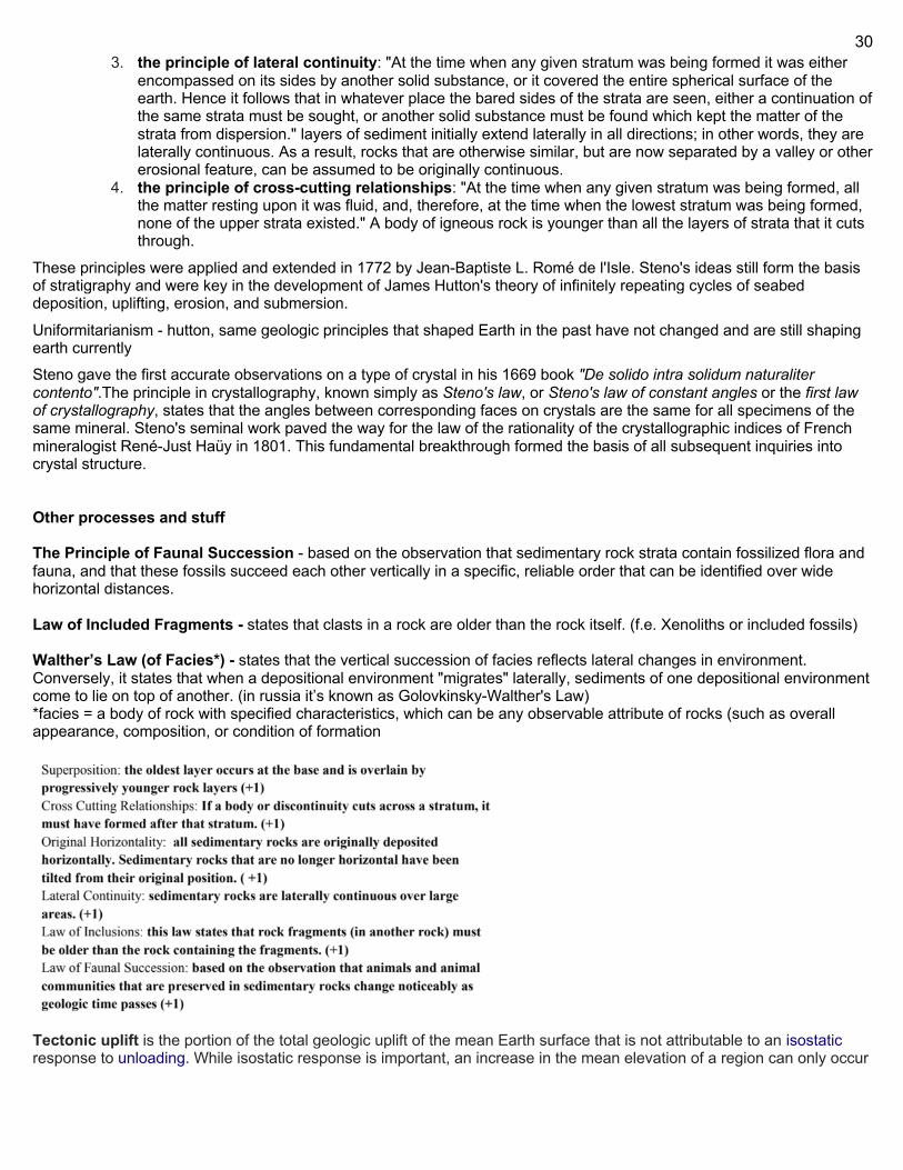
30
3. the principle of lateral continuity: "At the time when any given stratum was being formed it was either encompassed on its sides by another solid substance, or it covered the entire spherical surface of the earth. Hence it follows that in whatever place the bared sides of the strata are seen, either a continuation of the same strata must be sought, or another solid substance must be found which kept the matter of the strata from dispersion." layers of sediment initially extend laterally in all directions; in other words, they are laterally continuous. As a result, rocks that are otherwise similar, but are now separated by a valley or other erosional feature, can be assumed to be originally continuous.
4. the principle of cross-cutting relationships: "At the time when any given stratum was being formed, all the matter resting upon it was fluid, and, therefore, at the time when the lowest stratum was being formed, none of the upper strata existed." A body of igneous rock is younger than all the layers of strata that it cuts through.
These principles were applied and extended in 1772 by Jean-Baptiste L. Romé de l'Isle. Steno's ideas still form the basis of stratigraphy and were key in the development of James Hutton's theory of infinitely repeating cycles of seabed deposition, uplifting, erosion, and submersion.
Uniformitarianism - hutton, same geologic principles that shaped Earth in the past have not changed and are still shaping earth currently Steno gave the first accurate observations on a type of crystal in his 1669 book "De solido intra solidum naturaliter contento".The principle in crystallography, known simply as Steno's law, or Steno's law of constant angles or the first law of crystallography, states that the angles between corresponding faces on crystals are the same for all specimens of the same mineral. Steno's seminal work paved the way for the law of the rationality of the crystallographic indices of French mineralogist René-Just Haüy in 1801. This fundamental breakthrough formed the basis of all subsequent inquiries into crystal structure. Other processes and stuff The Principle of Faunal Succession - based on the observation that sedimentary rock strata contain fossilized flora and fauna, and that these fossils succeed each other vertically in a specific, reliable order that can be identified over wide horizontal distances. Law of Included Fragments - states that clasts in a rock are older than the rock itself. (f.e. Xenoliths or included fossils) Walther’s Law (of Facies*) - states that the vertical succession of facies reflects lateral changes in environment. Conversely, it states that when a depositional environment "migrates" laterally, sediments of one depositional environment come to lie on top of another. (in russia it’s known as Golovkinsky-Walther's Law) *facies = a body of rock with specified characteristics, which can be any observable attribute of rocks (such as overall appearance, composition, or condition of formation
Tectonic uplift is the portion of the total geologic uplift of the mean Earth surface that is not attributable to an isostatic response to unloading. While isostatic response is important, an increase in the mean elevation of a region can only occur
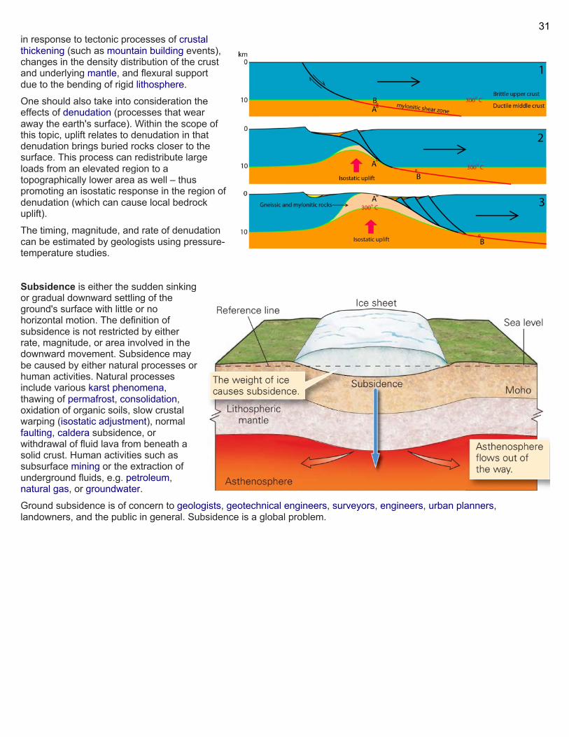
31
in response to tectonic processes of crustal thickening (such as mountain building events), changes in the density distribution of the crust and underlying mantle, and flexural support due to the bending of rigid lithosphere. One should also take into consideration the effects of denudation (processes that wear away the earth's surface). Within the scope of this topic, uplift relates to denudation in that denudation brings buried rocks closer to the surface. This process can redistribute large loads from an elevated region to a topographically lower area as well – thus promoting an isostatic response in the region of denudation (which can cause local bedrock uplift). The timing, magnitude, and rate of denudation can be estimated by geologists using pressure-temperature studies.
Subsidence is either the sudden sinking or gradual downward settling of the ground's surface with little or no horizontal motion. The definition of subsidence is not restricted by either rate, magnitude, or area involved in the downward movement. Subsidence may be caused by either natural processes or human activities. Natural processes include various karst phenomena, thawing of permafrost, consolidation, oxidation of organic soils, slow crustal warping (isostatic adjustment), normal faulting, caldera subsidence, or withdrawal of fluid lava from beneath a solid crust. Human activities such as subsurface mining or the extraction of underground fluids, e.g. petroleum, natural gas, or groundwater. Ground subsidence is of concern to geologists, geotechnical engineers, surveyors, engineers, urban planners, landowners, and the public in general. Subsidence is a global problem.
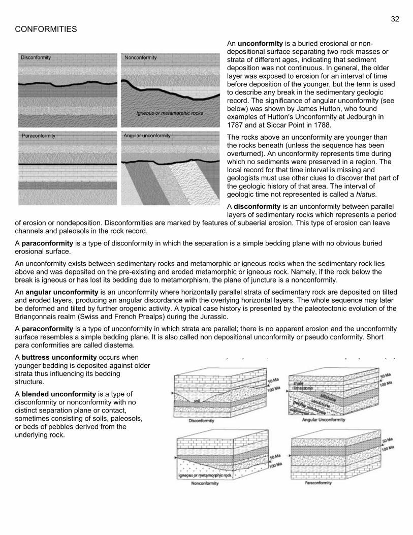
32
CONFORMITIES
An unconformity is a buried erosional or non-depositional surface separating two rock masses or strata of different ages, indicating that sediment deposition was not continuous. In general, the older layer was exposed to erosion for an interval of time before deposition of the younger, but the term is used to describe any break in the sedimentary geologic record. The significance of angular unconformity (see below) was shown by James Hutton, who found examples of Hutton's Unconformity at Jedburgh in 1787 and at Siccar Point in 1788.
The rocks above an unconformity are younger than the rocks beneath (unless the sequence has been overturned). An unconformity represents time during which no sediments were preserved in a region. The local record for that time interval is missing and geologists must use other clues to discover that part of the geologic history of that area. The interval of geologic time not represented is called a hiatus. A disconformity is an unconformity between parallel layers of sedimentary rocks which represents a period
of erosion or nondeposition. Disconformities are marked by features of subaerial erosion. This type of erosion can leave channels and paleosols in the rock record.
A paraconformity is a type of disconformity in which the separation is a simple bedding plane with no obvious buried erosional surface. An unconformity exists between sedimentary rocks and metamorphic or igneous rocks when the sedimentary rock lies above and was deposited on the pre-existing and eroded metamorphic or igneous rock. Namely, if the rock below the break is igneous or has lost its bedding due to metamorphism, the plane of juncture is a nonconformity. An angular unconformity is an unconformity where horizontally parallel strata of sedimentary rock are deposited on tilted and eroded layers, producing an angular discordance with the overlying horizontal layers. The whole sequence may later be deformed and tilted by further orogenic activity. A typical case history is presented by the paleotectonic evolution of the Briançonnais realm (Swiss and French Prealps) during the Jurassic. A paraconformity is a type of unconformity in which strata are parallel; there is no apparent erosion and the unconformity surface resembles a simple bedding plane. It is also called non depositional unconformity or pseudo conformity. Short para conformities are called diastema. A buttress unconformity occurs when younger bedding is deposited against older strata thus influencing its bedding structure. A blended unconformity is a type of disconformity or nonconformity with no distinct separation plane or contact, sometimes consisting of soils, paleosols, or beds of pebbles derived from the underlying rock.
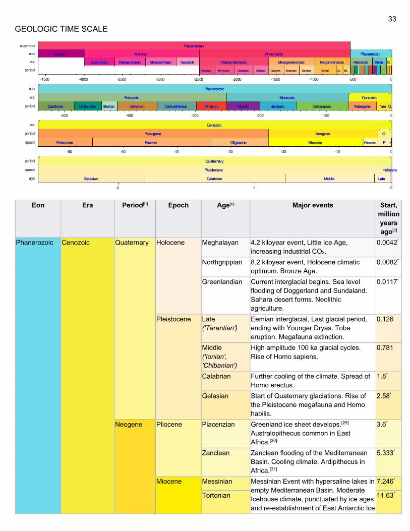
33
GEOLOGIC TIME SCALE
Eon Era Period[b] Epoch Age[c] Major events Start, million years ago[c]
Phanerozoic Cenozoic Quaternary Holocene Meghalayan 4.2 kiloyear event, Little Ice Age, increasing industrial CO2.
0.0042*
Northgrippian 8.2 kiloyear event, Holocene climatic optimum. Bronze Age.
0.0082*
Greenlandian Current interglacial begins. Sea level flooding of Doggerland and Sundaland. Sahara desert forms. Neolithic agriculture.
0.0117*
Pleistocene Late ('Tarantian')
Eemian interglacial, Last glacial period, ending with Younger Dryas. Toba eruption. Megafauna extinction.
0.126
Middle ('Ionian', 'Chibanian')
High amplitude 100 ka glacial cycles. Rise of Homo sapiens.
0.781
Calabrian Further cooling of the climate. Spread of Homo erectus.
1.8*
Gelasian Start of Quaternary glaciations. Rise of the Pleistocene megafauna and Homo habilis.
2.58*
Neogene Pliocene Piacenzian Greenland ice sheet develops.[29] Australopithecus common in East Africa.[30]
3.6*
Zanclean Zanclean flooding of the Mediterranean Basin. Cooling climate. Ardipithecus in Africa.[31]
5.333*
Miocene Messinian Messinian Event with hypersaline lakes in empty Mediterranean Basin. Moderate Icehouse climate, punctuated by ice ages and re-establishment of East Antarctic Ice
7.246*
Tortonian 11.63*
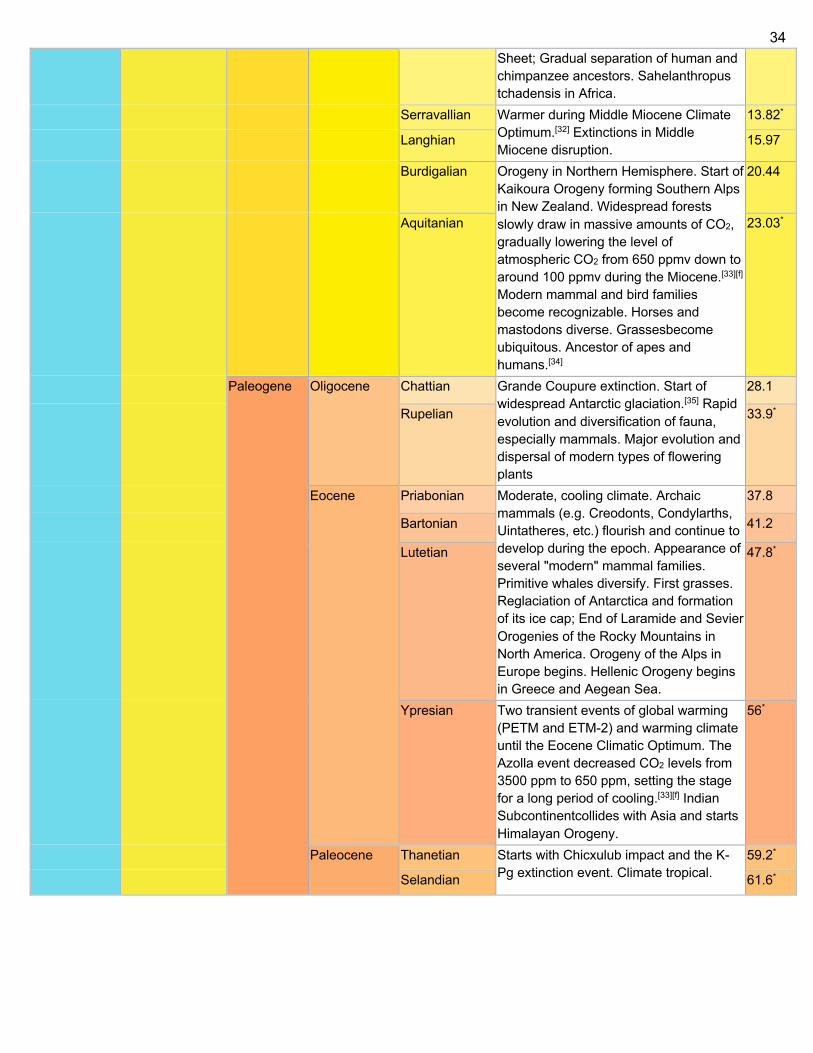
34
Sheet; Gradual separation of human and chimpanzee ancestors. Sahelanthropus tchadensis in Africa.
Serravallian Warmer during Middle Miocene Climate Optimum.[32] Extinctions in Middle Miocene disruption.
13.82*
Langhian 15.97
Burdigalian Orogeny in Northern Hemisphere. Start of Kaikoura Orogeny forming Southern Alps in New Zealand. Widespread forests slowly draw in massive amounts of CO2, gradually lowering the level of atmospheric CO2 from 650 ppmv down to around 100 ppmv during the Miocene.[33][f] Modern mammal and bird families become recognizable. Horses and mastodons diverse. Grassesbecome ubiquitous. Ancestor of apes and humans.[34]
20.44
Aquitanian 23.03*
Paleogene Oligocene Chattian Grande Coupure extinction. Start of widespread Antarctic glaciation.[35] Rapid evolution and diversification of fauna, especially mammals. Major evolution and dispersal of modern types of flowering plants
28.1
Rupelian 33.9*
Eocene Priabonian Moderate, cooling climate. Archaic mammals (e.g. Creodonts, Condylarths, Uintatheres, etc.) flourish and continue to develop during the epoch. Appearance of several "modern" mammal families. Primitive whales diversify. First grasses. Reglaciation of Antarctica and formation of its ice cap; End of Laramide and Sevier Orogenies of the Rocky Mountains in North America. Orogeny of the Alps in Europe begins. Hellenic Orogeny begins in Greece and Aegean Sea.
37.8
Bartonian 41.2
Lutetian 47.8*
Ypresian Two transient events of global warming (PETM and ETM-2) and warming climate until the Eocene Climatic Optimum. The Azolla event decreased CO2 levels from 3500 ppm to 650 ppm, setting the stage for a long period of cooling.[33][f] Indian Subcontinentcollides with Asia and starts Himalayan Orogeny.
56*
Paleocene Thanetian Starts with Chicxulub impact and the K-Pg extinction event. Climate tropical.
59.2*
Selandian 61.6*
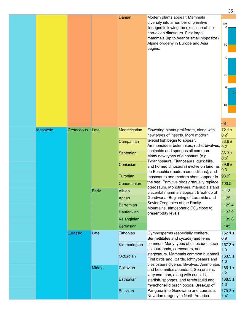
35
Danian Modern plants appear; Mammals diversify into a number of primitive lineages following the extinction of the non-avian dinosaurs. First large mammals (up to bear or small hipposize). Alpine orogeny in Europe and Asia begins.
66* Mesozoic Cretaceous Late Maastrichtian Flowering plants proliferate, along with
new types of insects. More modern teleost fish begin to appear. Ammonoidea, belemnites, rudist bivalves, echinoids and sponges all common. Many new types of dinosaurs (e.g. Tyrannosaurs, Titanosaurs, duck bills, and horned dinosaurs) evolve on land, as do Eusuchia (modern crocodilians); and mosasaurs and modern sharksappear in the sea. Primitive birds gradually replace pterosaurs. Monotremes, marsupials and placental mammals appear. Break up of Gondwana. Beginning of Laramide and Sevier Orogenies of the Rocky Mountains. atmospheric CO2 close to present-day levels.
72.1 ± 0.2*
Campanian 83.6 ± 0.2
Santonian 86.3 ± 0.5*
Coniacian 89.8 ± 0.3
Turonian 93.9*
Cenomanian 100.5*
Early Albian ~113
Aptian ~125
Barremian ~129.4
Hauterivian ~132.9
Valanginian ~139.8
Berriasian ~145
Jurassic Late Tithonian Gymnosperms (especially conifers, Bennettitales and cycads) and ferns common. Many types of dinosaurs, such as sauropods, carnosaurs, and stegosaurs. Mammals common but small. First birds and lizards. Ichthyosaurs and plesiosaurs diverse. Bivalves, Ammonites and belemnites abundant. Sea urchins very common, along with crinoids, starfish, sponges, and terebratulid and rhynchonellid brachiopods. Breakup of Pangaea into Gondwana and Laurasia. Nevadan orogeny in North America.
152.1 ± 0.9
Kimmeridgian 157.3 ± 1.0
Oxfordian 163.5 ± 1.0
Middle Callovian 166.1 ± 1.2
Bathonian 168.3 ± 1.3*
Bajocian 170.3 ± 1.4*
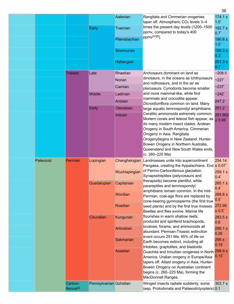
36
Aalenian Rangitata and Cimmerian orogenies taper off. Atmospheric CO2 levels 3–4 times the present day levels (1200–1500 ppmv, compared to today's 400 ppmv[33][f]).
174.1 ± 1.0*
Early Toarcian 182.7 ± 0.7*
Pliensbachian 190.8 ± 1.0*
Sinemurian 199.3 ± 0.3*
Hettangian 201.3 ± 0.2*
Triassic Late Rhaetian Archosaurs dominant on land as dinosaurs, in the oceans as Ichthyosaurs and nothosaurs, and in the air as pterosaurs. Cynodonts become smaller and more mammal-like, while first mammals and crocodilia appear. Dicroidiumflora common on land. Many large aquatic temnospondyl amphibians. Ceratitic ammonoids extremely common. Modern corals and teleost fish appear, as do many modern insect clades. Andean Orogeny in South America. Cimmerian Orogeny in Asia. Rangitata Orogenybegins in New Zealand. Hunter-Bowen Orogeny in Northern Australia, Queensland and New South Wales ends, (c. 260–225 Ma)
~208.5
Norian ~227
Carnian ~237*
Middle Ladinian ~242*
Anisian 247.2
Early Olenekian 251.2
Induan 251.902 ± 0.06*
Paleozoic Permian Lopingian Changhsingian Landmasses unite into supercontinent Pangaea, creating the Appalachians. End of Permo-Carboniferous glaciation. Synapsidreptiles (pelycosaurs and therapsids) become plentiful, while parareptiles and temnospondyl amphibians remain common. In the mid-Permian, coal-age flora are replaced by cone-bearing gymnosperms (the first true seed plants) and by the first true mosses. Beetles and flies evolve. Marine life flourishes in warm shallow reefs; productid and spiriferid brachiopods, bivalves, forams, and ammonoids all abundant. Permian-Triassic extinction event occurs 251 Ma: 95% of life on Earth becomes extinct, including all trilobites, graptolites, and blastoids. Ouachita and Innuitian orogenies in North America. Uralian orogeny in Europe/Asia tapers off. Altaid orogeny in Asia. Hunter-Bowen Orogeny on Australian continent begins (c. 260–225 Ma), forming the MacDonnell Ranges.
254.14 ± 0.07*
Wuchiapingian 259.1 ± 0.4*
Guadalupian Capitanian 265.1 ± 0.4*
Wordian 268.8 ± 0.5*
Roadian 272.95 ± 0.5*
Cisuralian Kungurian 283.5 ± 0.6
Artinskian 290.1 ± 0.26
Sakmarian 295 ± 0.18
Asselian 298.9 ± 0.15*
Carbon- iferous[g]
Pennsylvanian Gzhelian Winged insects radiate suddenly; some (esp. Protodonata and Palaeodictyoptera)
303.7 ± 0.1
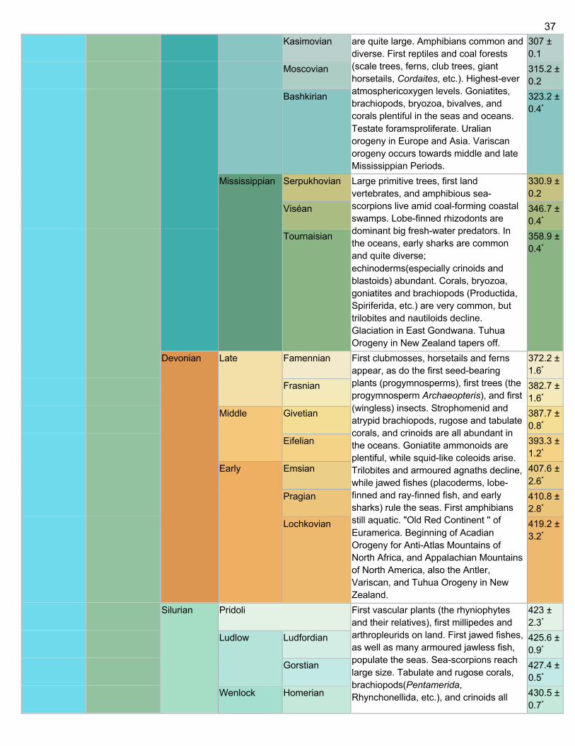
37
Kasimovian are quite large. Amphibians common and diverse. First reptiles and coal forests (scale trees, ferns, club trees, giant horsetails, Cordaites, etc.). Highest-ever atmosphericoxygen levels. Goniatites, brachiopods, bryozoa, bivalves, and corals plentiful in the seas and oceans. Testate foramsproliferate. Uralian orogeny in Europe and Asia. Variscan orogeny occurs towards middle and late Mississippian Periods.
307 ± 0.1
Moscovian 315.2 ± 0.2
Bashkirian 323.2 ± 0.4*
Mississippian Serpukhovian Large primitive trees, first land vertebrates, and amphibious sea-scorpions live amid coal-forming coastal swamps. Lobe-finned rhizodonts are dominant big fresh-water predators. In the oceans, early sharks are common and quite diverse; echinoderms(especially crinoids and blastoids) abundant. Corals, bryozoa, goniatites and brachiopods (Productida, Spiriferida, etc.) are very common, but trilobites and nautiloids decline. Glaciation in East Gondwana. Tuhua Orogeny in New Zealand tapers off.
330.9 ± 0.2
Viséan 346.7 ± 0.4*
Tournaisian 358.9 ± 0.4*
Devonian Late Famennian First clubmosses, horsetails and ferns appear, as do the first seed-bearing plants (progymnosperms), first trees (the progymnosperm Archaeopteris), and first (wingless) insects. Strophomenid and atrypid brachiopods, rugose and tabulate corals, and crinoids are all abundant in the oceans. Goniatite ammonoids are plentiful, while squid-like coleoids arise. Trilobites and armoured agnaths decline, while jawed fishes (placoderms, lobe-finned and ray-finned fish, and early sharks) rule the seas. First amphibians still aquatic. "Old Red Continent '' of Euramerica. Beginning of Acadian Orogeny for Anti-Atlas Mountains of North Africa, and Appalachian Mountains of North America, also the Antler, Variscan, and Tuhua Orogeny in New Zealand.
372.2 ± 1.6*
Frasnian 382.7 ± 1.6*
Middle Givetian 387.7 ± 0.8*
Eifelian 393.3 ± 1.2*
Early Emsian 407.6 ± 2.6*
Pragian 410.8 ± 2.8*
Lochkovian 419.2 ± 3.2*
Silurian Pridoli First vascular plants (the rhyniophytes and their relatives), first millipedes and arthropleurids on land. First jawed fishes, as well as many armoured jawless fish, populate the seas. Sea-scorpions reach large size. Tabulate and rugose corals, brachiopods(Pentamerida, Rhynchonellida, etc.), and crinoids all
423 ± 2.3*
Ludlow Ludfordian 425.6 ± 0.9*
Gorstian 427.4 ± 0.5*
Wenlock Homerian 430.5 ± 0.7*
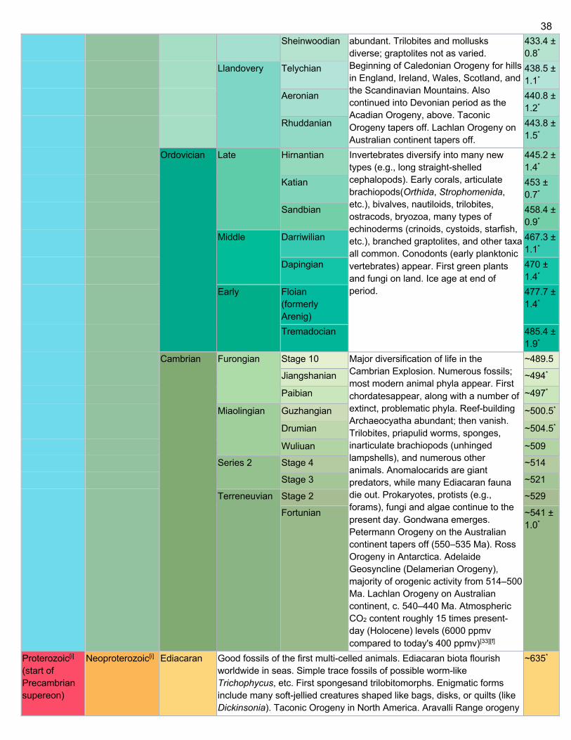
38
Sheinwoodian abundant. Trilobites and mollusks diverse; graptolites not as varied. Beginning of Caledonian Orogeny for hills in England, Ireland, Wales, Scotland, and the Scandinavian Mountains. Also continued into Devonian period as the Acadian Orogeny, above. Taconic Orogeny tapers off. Lachlan Orogeny on Australian continent tapers off.
433.4 ± 0.8*
Llandovery Telychian 438.5 ± 1.1*
Aeronian 440.8 ± 1.2*
Rhuddanian 443.8 ± 1.5*
Ordovician Late Hirnantian Invertebrates diversify into many new types (e.g., long straight-shelled cephalopods). Early corals, articulate brachiopods(Orthida, Strophomenida, etc.), bivalves, nautiloids, trilobites, ostracods, bryozoa, many types of echinoderms (crinoids, cystoids, starfish, etc.), branched graptolites, and other taxa all common. Conodonts (early planktonic vertebrates) appear. First green plants and fungi on land. Ice age at end of period.
445.2 ± 1.4*
Katian 453 ± 0.7*
Sandbian 458.4 ± 0.9*
Middle Darriwilian 467.3 ± 1.1*
Dapingian 470 ± 1.4*
Early Floian (formerly Arenig)
477.7 ± 1.4*
Tremadocian 485.4 ± 1.9*
Cambrian Furongian Stage 10 Major diversification of life in the Cambrian Explosion. Numerous fossils; most modern animal phyla appear. First chordatesappear, along with a number of extinct, problematic phyla. Reef-building Archaeocyatha abundant; then vanish. Trilobites, priapulid worms, sponges, inarticulate brachiopods (unhinged lampshells), and numerous other animals. Anomalocarids are giant predators, while many Ediacaran fauna die out. Prokaryotes, protists (e.g., forams), fungi and algae continue to the present day. Gondwana emerges. Petermann Orogeny on the Australian continent tapers off (550–535 Ma). Ross Orogeny in Antarctica. Adelaide Geosyncline (Delamerian Orogeny), majority of orogenic activity from 514–500 Ma. Lachlan Orogeny on Australian continent, c. 540–440 Ma. Atmospheric CO2 content roughly 15 times present-day (Holocene) levels (6000 ppmv compared to today's 400 ppmv)[33][f]
~489.5
Jiangshanian ~494*
Paibian ~497*
Miaolingian Guzhangian ~500.5*
Drumian ~504.5*
Wuliuan ~509
Series 2 Stage 4 ~514
Stage 3 ~521
Terreneuvian Stage 2 ~529
Fortunian ~541 ± 1.0*
Proterozoic[i] (start of Precambrian supereon)
Neoproterozoic[i] Ediacaran Good fossils of the first multi-celled animals. Ediacaran biota flourish worldwide in seas. Simple trace fossils of possible worm-like Trichophycus, etc. First spongesand trilobitomorphs. Enigmatic forms include many soft-jellied creatures shaped like bags, disks, or quilts (like Dickinsonia). Taconic Orogeny in North America. Aravalli Range orogeny
~635*
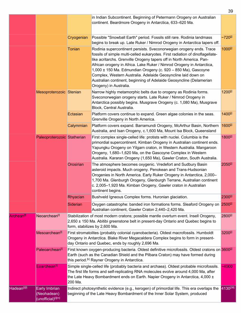
39
in Indian Subcontinent. Beginning of Petermann Orogeny on Australian continent. Beardmore Orogeny in Antarctica, 633–620 Ma.
Cryogenian Possible "Snowball Earth" period. Fossils still rare. Rodinia landmass begins to break up. Late Ruker / Nimrod Orogeny in Antarctica tapers off.
~720[j]
Tonian Rodinia supercontinent persists. Sveconorwegian orogeny ends. Trace fossils of simple multi-celled eukaryotes. First radiation of dinoflagellate-like acritarchs. Grenville Orogeny tapers off in North America. Pan-African orogeny in Africa. Lake Ruker / Nimrod Orogeny in Antarctica, 1,000 ± 150 Ma. Edmundian Orogeny (c. 920 – 850 Ma), Gascoyne Complex, Western Australia. Adelaide Geosyncline laid down on Australian continent, beginning of Adelaide Geosyncline (Delamerian Orogeny) in Australia.
1000[j]
Mesoproterozoic Stenian Narrow highly metamorphic belts due to orogeny as Rodinia forms. Sveconorwegian orogeny starts. Late Ruker / Nimrod Orogeny in Antarctica possibly begins. Musgrave Orogeny (c. 1,080 Ma), Musgrave Block, Central Australia.
1200[j]
Ectasian Platform covers continue to expand. Green algae colonies in the seas. Grenville Orogeny in North America.
1400[j]
Calymmian Platform covers expand. Barramundi Orogeny, McArthur Basin, Northern Australia, and Isan Orogeny, c.1,600 Ma, Mount Isa Block, Queensland
1600[j]
Paleoproterozoic Statherian First complex single-celled life: protists with nuclei. Columbia is the primordial supercontinent. Kimban Orogeny in Australian continent ends. Yapungku Orogeny on Yilgarn craton, in Western Australia. Mangaroon Orogeny, 1,680–1,620 Ma, on the Gascoyne Complex in Western Australia. Kararan Orogeny (1,650 Ma), Gawler Craton, South Australia.
1800[j]
Orosirian The atmosphere becomes oxygenic. Vredefort and Sudbury Basin asteroid impacts. Much orogeny. Penokean and Trans-Hudsonian Orogenies in North America. Early Ruker Orogeny in Antarctica, 2,000–1,700 Ma. Glenburgh Orogeny, Glenburgh Terrane, Australian continent c. 2,005–1,920 Ma. Kimban Orogeny, Gawler craton in Australian continent begins.
2050[j]
Rhyacian Bushveld Igneous Complex forms. Huronian glaciation. 2300[j]
Siderian Oxygen catastrophe: banded iron formations forms. Sleaford Orogeny on Australian continent, Gawler Craton 2,440–2,420 Ma.
2500[j]
Archean[i] Neoarchean[i] Stabilization of most modern cratons; possible mantle overturn event. Insell Orogeny, 2,650 ± 150 Ma. Abitibi greenstone belt in present-day Ontario and Quebec begins to form, stabilizes by 2,600 Ma.
2800[j]
Mesoarchean[i] First stromatolites (probably colonial cyanobacteria). Oldest macrofossils. Humboldt Orogeny in Antarctica. Blake River Megacaldera Complex begins to form in present-day Ontario and Quebec, ends by roughly 2,696 Ma.
3200[j]
Paleoarchean[i] First known oxygen-producing bacteria. Oldest definitive microfossils. Oldest cratons on Earth (such as the Canadian Shield and the Pilbara Craton) may have formed during this period.[k] Rayner Orogeny in Antarctica.
3600[j]
Eoarchean[i] Simple single-celled life (probably bacteria and archaea). Oldest probable microfossils. The first life forms and self-replicating RNA molecules evolve around 4,000 Ma, after the Late Heavy Bombardment ends on Earth. Napier Orogeny in Antarctica, 4,000 ± 200 Ma.
~4000
Hadean[i][l] Early Imbrian (Neohadean) (unofficial)[i][m]
Indirect photosynthetic evidence (e.g., kerogen) of primordial life. This era overlaps the beginning of the Late Heavy Bombardment of the Inner Solar System, produced
4130[38]
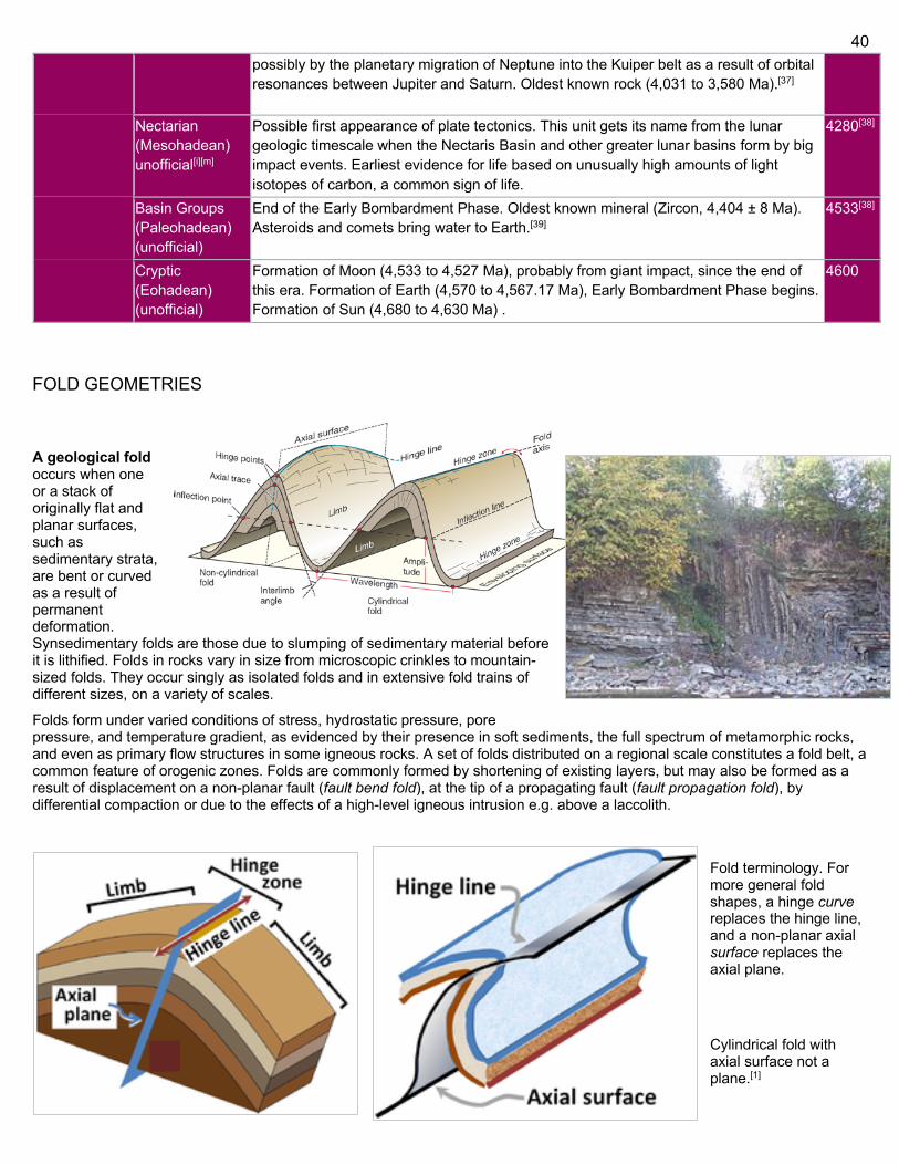
40
possibly by the planetary migration of Neptune into the Kuiper belt as a result of orbital resonances between Jupiter and Saturn. Oldest known rock (4,031 to 3,580 Ma).[37]
Nectarian (Mesohadean) unofficial[i][m]
Possible first appearance of plate tectonics. This unit gets its name from the lunar geologic timescale when the Nectaris Basin and other greater lunar basins form by big impact events. Earliest evidence for life based on unusually high amounts of light isotopes of carbon, a common sign of life.
4280[38]
Basin Groups (Paleohadean) (unofficial)
End of the Early Bombardment Phase. Oldest known mineral (Zircon, 4,404 ± 8 Ma). Asteroids and comets bring water to Earth.[39]
4533[38]
Cryptic (Eohadean) (unofficial)
Formation of Moon (4,533 to 4,527 Ma), probably from giant impact, since the end of this era. Formation of Earth (4,570 to 4,567.17 Ma), Early Bombardment Phase begins. Formation of Sun (4,680 to 4,630 Ma) .
4600
FOLD GEOMETRIES
A geological fold occurs when one or a stack of originally flat and planar surfaces, such as sedimentary strata, are bent or curved as a result of permanent deformation. Synsedimentary folds are those due to slumping of sedimentary material before it is lithified. Folds in rocks vary in size from microscopic crinkles to mountain-sized folds. They occur singly as isolated folds and in extensive fold trains of different sizes, on a variety of scales.
Folds form under varied conditions of stress, hydrostatic pressure, pore pressure, and temperature gradient, as evidenced by their presence in soft sediments, the full spectrum of metamorphic rocks, and even as primary flow structures in some igneous rocks. A set of folds distributed on a regional scale constitutes a fold belt, a common feature of orogenic zones. Folds are commonly formed by shortening of existing layers, but may also be formed as a result of displacement on a non-planar fault (fault bend fold), at the tip of a propagating fault (fault propagation fold), by differential compaction or due to the effects of a high-level igneous intrusion e.g. above a laccolith.
Fold terminology. For more general fold shapes, a hinge curve replaces the hinge line, and a non-planar axial surface replaces the axial plane.
Cylindrical fold with axial surface not a plane.[1]
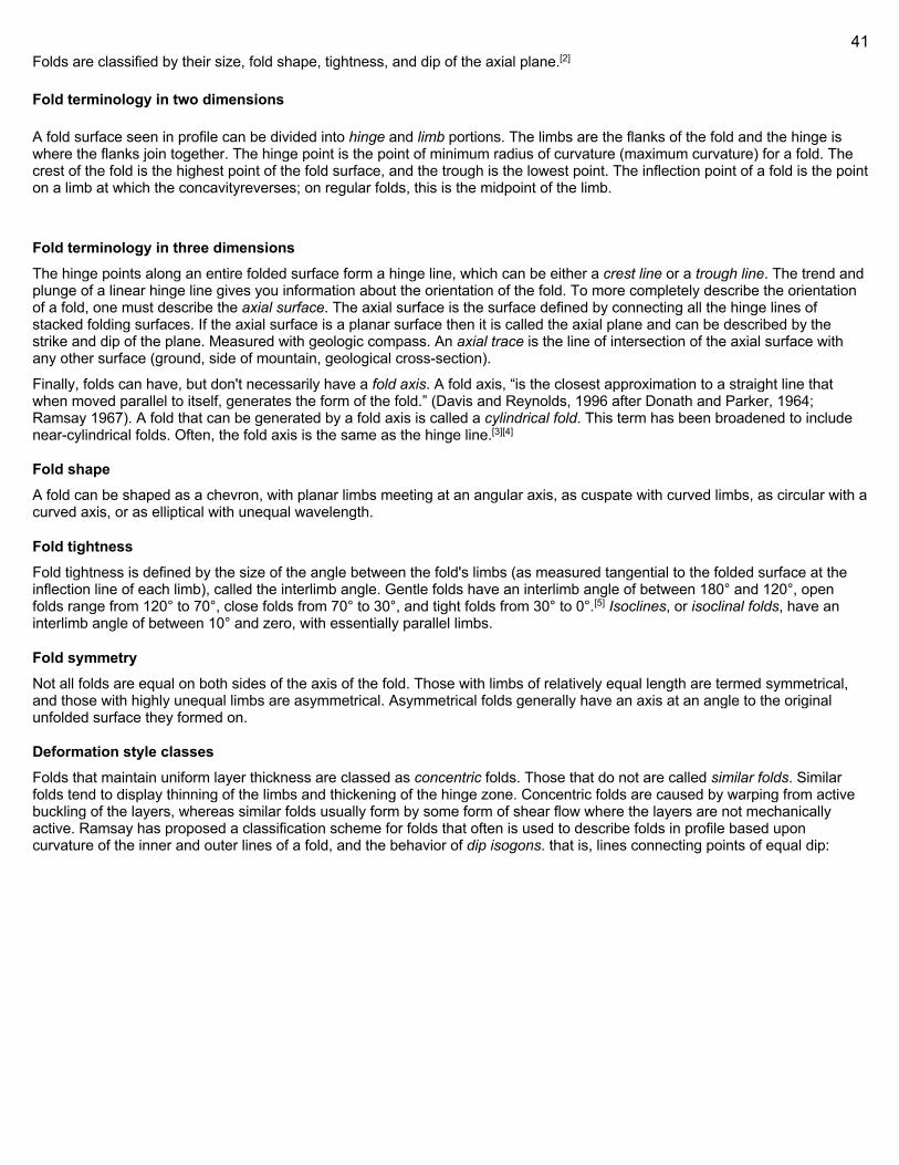
41
Folds are classified by their size, fold shape, tightness, and dip of the axial plane.[2]
Fold terminology in two dimensions
A fold surface seen in profile can be divided into hinge and limb portions. The limbs are the flanks of the fold and the hinge is where the flanks join together. The hinge point is the point of minimum radius of curvature (maximum curvature) for a fold. The crest of the fold is the highest point of the fold surface, and the trough is the lowest point. The inflection point of a fold is the point on a limb at which the concavityreverses; on regular folds, this is the midpoint of the limb.
Fold terminology in three dimensions The hinge points along an entire folded surface form a hinge line, which can be either a crest line or a trough line. The trend and plunge of a linear hinge line gives you information about the orientation of the fold. To more completely describe the orientation of a fold, one must describe the axial surface. The axial surface is the surface defined by connecting all the hinge lines of stacked folding surfaces. If the axial surface is a planar surface then it is called the axial plane and can be described by the strike and dip of the plane. Measured with geologic compass. An axial trace is the line of intersection of the axial surface with any other surface (ground, side of mountain, geological cross-section).
Finally, folds can have, but don't necessarily have a fold axis. A fold axis, “is the closest approximation to a straight line that when moved parallel to itself, generates the form of the fold.” (Davis and Reynolds, 1996 after Donath and Parker, 1964; Ramsay 1967). A fold that can be generated by a fold axis is called a cylindrical fold. This term has been broadened to include near-cylindrical folds. Often, the fold axis is the same as the hinge line.[3][4]
Fold shape A fold can be shaped as a chevron, with planar limbs meeting at an angular axis, as cuspate with curved limbs, as circular with a curved axis, or as elliptical with unequal wavelength.
Fold tightness Fold tightness is defined by the size of the angle between the fold's limbs (as measured tangential to the folded surface at the inflection line of each limb), called the interlimb angle. Gentle folds have an interlimb angle of between 180° and 120°, open folds range from 120° to 70°, close folds from 70° to 30°, and tight folds from 30° to 0°.[5] Isoclines, or isoclinal folds, have an interlimb angle of between 10° and zero, with essentially parallel limbs.
Fold symmetry Not all folds are equal on both sides of the axis of the fold. Those with limbs of relatively equal length are termed symmetrical, and those with highly unequal limbs are asymmetrical. Asymmetrical folds generally have an axis at an angle to the original unfolded surface they formed on.
Deformation style classes Folds that maintain uniform layer thickness are classed as concentric folds. Those that do not are called similar folds. Similar folds tend to display thinning of the limbs and thickening of the hinge zone. Concentric folds are caused by warping from active buckling of the layers, whereas similar folds usually form by some form of shear flow where the layers are not mechanically active. Ramsay has proposed a classification scheme for folds that often is used to describe folds in profile based upon curvature of the inner and outer lines of a fold, and the behavior of dip isogons. that is, lines connecting points of equal dip:
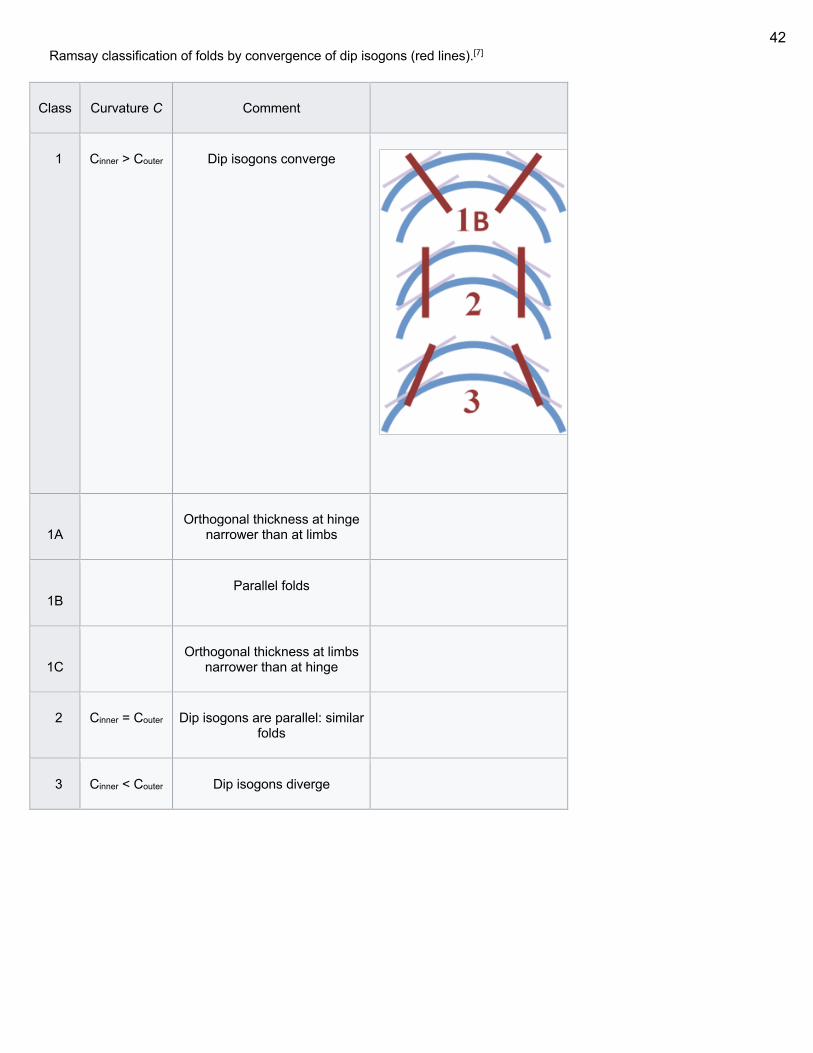
42
Ramsay classification of folds by convergence of dip isogons (red lines).[7]
Class Curvature C Comment
1 Cinner > Couter Dip isogons converge
1A
Orthogonal thickness at hinge narrower than at limbs
1B
Parallel folds
1C
Orthogonal thickness at limbs narrower than at hinge
2 Cinner = Couter Dip isogons are parallel: similar folds
3 Cinner < Couter Dip isogons diverge
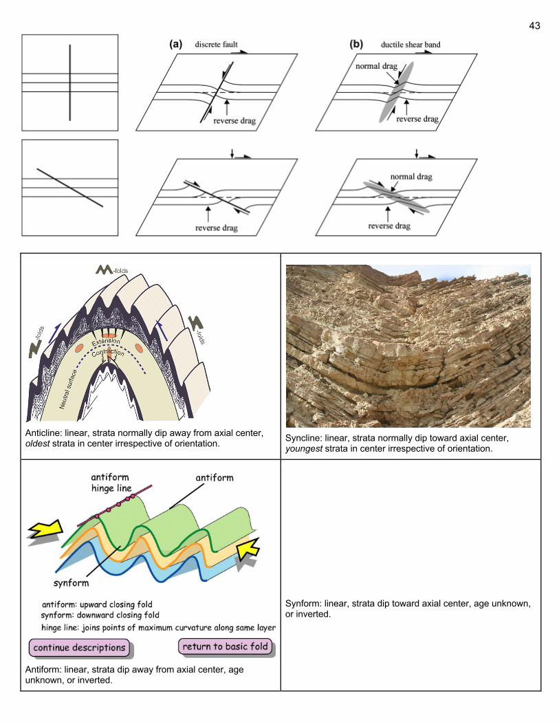
43
Anticline: linear, strata normally dip away from axial center, oldest strata in center irrespective of orientation.
Syncline: linear, strata normally dip toward axial center, youngest strata in center irrespective of orientation.
Antiform: linear, strata dip away from axial center, age unknown, or inverted.
Synform: linear, strata dip toward axial center, age unknown, or inverted.
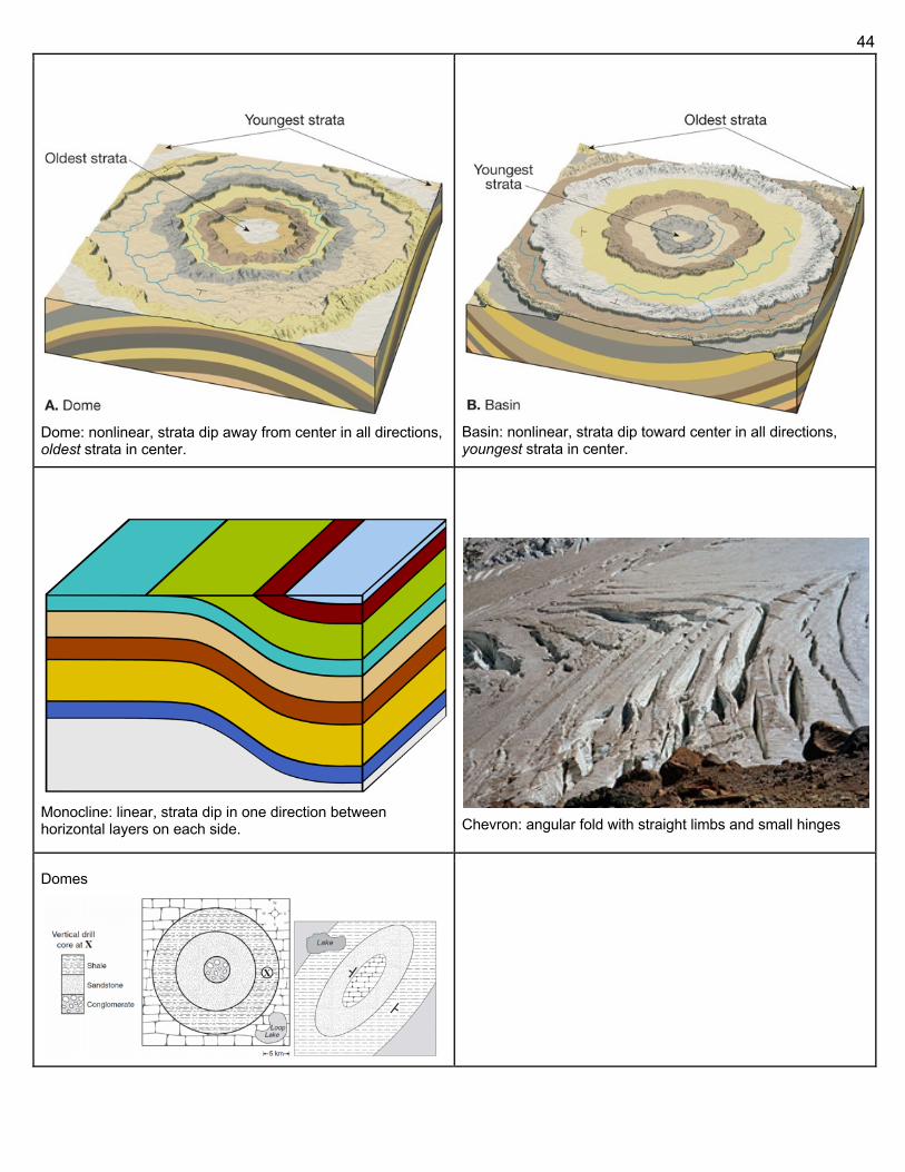
44
Dome: nonlinear, strata dip away from center in all directions, oldest strata in center.
Basin: nonlinear, strata dip toward center in all directions, youngest strata in center.
Monocline: linear, strata dip in one direction between horizontal layers on each side.
Chevron: angular fold with straight limbs and small hinges
Domes
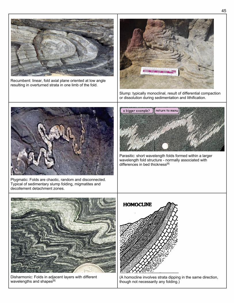
45
Recumbent: linear, fold axial plane oriented at low angle resulting in overturned strata in one limb of the fold.
Slump: typically monoclinal, result of differential compaction or dissolution during sedimentation and lithification.
Ptygmatic: Folds are chaotic, random and disconnected. Typical of sedimentary slump folding, migmatites and decollement detachment zones.
Parasitic: short wavelength folds formed within a larger wavelength fold structure - normally associated with differences in bed thickness[8]
Disharmonic: Folds in adjacent layers with different wavelengths and shapes[8]
(A homocline involves strata dipping in the same direction, though not necessarily any folding.)
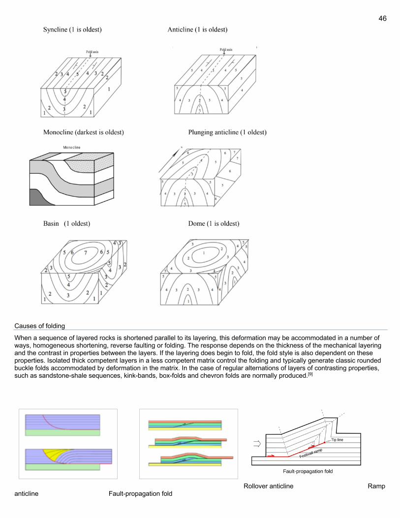
46
Causes of folding
When a sequence of layered rocks is shortened parallel to its layering, this deformation may be accommodated in a number of ways, homogeneous shortening, reverse faulting or folding. The response depends on the thickness of the mechanical layering and the contrast in properties between the layers. If the layering does begin to fold, the fold style is also dependent on these properties. Isolated thick competent layers in a less competent matrix control the folding and typically generate classic rounded buckle folds accommodated by deformation in the matrix. In the case of regular alternations of layers of contrasting properties, such as sandstone-shale sequences, kink-bands, box-folds and chevron folds are normally produced.[9]
Rollover anticline Ramp anticline Fault-propagation fold
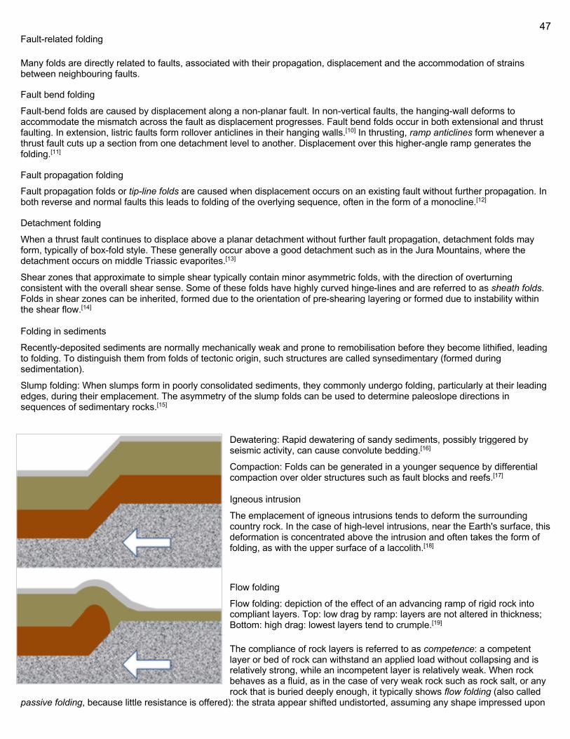
47
Fault-related folding
Many folds are directly related to faults, associated with their propagation, displacement and the accommodation of strains between neighbouring faults.
Fault bend folding
Fault-bend folds are caused by displacement along a non-planar fault. In non-vertical faults, the hanging-wall deforms to accommodate the mismatch across the fault as displacement progresses. Fault bend folds occur in both extensional and thrust faulting. In extension, listric faults form rollover anticlines in their hanging walls.[10] In thrusting, ramp anticlines form whenever a thrust fault cuts up a section from one detachment level to another. Displacement over this higher-angle ramp generates the folding.[11]
Fault propagation folding
Fault propagation folds or tip-line folds are caused when displacement occurs on an existing fault without further propagation. In both reverse and normal faults this leads to folding of the overlying sequence, often in the form of a monocline.[12]
Detachment folding
When a thrust fault continues to displace above a planar detachment without further fault propagation, detachment folds may form, typically of box-fold style. These generally occur above a good detachment such as in the Jura Mountains, where the detachment occurs on middle Triassic evaporites.[13]
Shear zones that approximate to simple shear typically contain minor asymmetric folds, with the direction of overturning consistent with the overall shear sense. Some of these folds have highly curved hinge-lines and are referred to as sheath folds. Folds in shear zones can be inherited, formed due to the orientation of pre-shearing layering or formed due to instability within the shear flow.[14]
Folding in sediments
Recently-deposited sediments are normally mechanically weak and prone to remobilisation before they become lithified, leading to folding. To distinguish them from folds of tectonic origin, such structures are called synsedimentary (formed during sedimentation).
Slump folding: When slumps form in poorly consolidated sediments, they commonly undergo folding, particularly at their leading edges, during their emplacement. The asymmetry of the slump folds can be used to determine paleoslope directions in sequences of sedimentary rocks.[15]
Dewatering: Rapid dewatering of sandy sediments, possibly triggered by seismic activity, can cause convolute bedding.[16]
Compaction: Folds can be generated in a younger sequence by differential compaction over older structures such as fault blocks and reefs.[17]
Igneous intrusion
The emplacement of igneous intrusions tends to deform the surrounding country rock. In the case of high-level intrusions, near the Earth's surface, this deformation is concentrated above the intrusion and often takes the form of folding, as with the upper surface of a laccolith.[18]
Flow folding
Flow folding: depiction of the effect of an advancing ramp of rigid rock into compliant layers. Top: low drag by ramp: layers are not altered in thickness; Bottom: high drag: lowest layers tend to crumple.[19]
The compliance of rock layers is referred to as competence: a competent layer or bed of rock can withstand an applied load without collapsing and is relatively strong, while an incompetent layer is relatively weak. When rock behaves as a fluid, as in the case of very weak rock such as rock salt, or any rock that is buried deeply enough, it typically shows flow folding (also called
passive folding, because little resistance is offered): the strata appear shifted undistorted, assuming any shape impressed upon
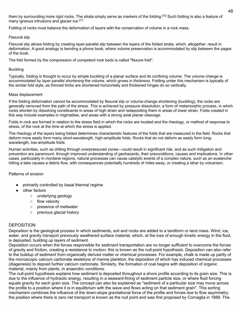
48
them by surrounding more rigid rocks. The strata simply serve as markers of the folding.[20] Such folding is also a feature of many igneous intrusions and glacier ice.[21]
Folding of rocks must balance the deformation of layers with the conservation of volume in a rock mass.
Flexural slip
Flexural slip allows folding by creating layer-parallel slip between the layers of the folded strata, which, altogether, result in deformation. A good analogy is bending a phone book, where volume preservation is accommodated by slip between the pages of the book.
The fold formed by the compression of competent rock beds is called "flexure fold".
Buckling
Typically, folding is thought to occur by simple buckling of a planar surface and its confining volume. The volume change is accommodated by layer parallel shortening the volume, which grows in thickness. Folding under this mechanism is typically of the similar fold style, as thinned limbs are shortened horizontally and thickened hinges do so vertically.
Mass displacement
If the folding deformation cannot be accommodated by flexural slip or volume-change shortening (buckling), the rocks are generally removed from the path of the stress. This is achieved by pressure dissolution, a form of metamorphic process, in which rocks shorten by dissolving constituents in areas of high strain and redepositing them in areas of lower strain. Folds created in this way include examples in migmatites, and areas with a strong axial planar cleavage.
Folds in rock are formed in relation to the stress field in which the rocks are located and the rheology, or method of response to stress, of the rock at the time at which the stress is applied.
The rheology of the layers being folded determines characteristic features of the folds that are measured in the field. Rocks that deform more easily form many short-wavelength, high-amplitude folds. Rocks that do not deform as easily form long-wavelength, low-amplitude folds.
Human activities, such as drilling through overpressured zones—could result in significant risk, and as such mitigation and prevention are paramount, through improved understanding of geohazards, their preconditions, causes and implications. In other cases, particularly in montane regions, natural processes can cause catalytic events of a complex nature, such as an avalanche hitting a lake causes a debris flow, with consequences potentially hundreds of miles away, or creating a lahar by volcanism.
Patterns of erosion
● primarily controlled by basal thermal regime ● other factors
○ underlying geology ○ flow velocity ○ presence of meltwater ○ previous glacial history
DEPOSITION Deposition is the geological process in which sediments, soil and rocks are added to a landform or land mass. Wind, ice, water, and gravity transport previously weathered surface material, which, at the loss of enough kinetic energy in the fluid, is deposited, building up layers of sediment. Deposition occurs when the forces responsible for sediment transportation are no longer sufficient to overcome the forces of gravity and friction, creating a resistance to motion; this is known as the null-point hypothesis. Deposition can also refer to the buildup of sediment from organically derived matter or chemical processes. For example, chalk is made up partly of the microscopic calcium carbonate skeletons of marine plankton, the deposition of which has induced chemical processes (diagenesis) to deposit further calcium carbonate. Similarly, the formation of coal begins with deposition of organic material, mainly from plants, in anaerobic conditions. The null-point hypothesis explains how sediment is deposited throughout a shore profile according to its grain size. This is due to the influence of hydraulic energy, resulting in a seaward-fining of sediment particle size, or where fluid forcing equals gravity for each grain size. The concept can also be explained as "sediment of a particular size may move across the profile to a position where it is in equilibrium with the wave and flows acting on that sediment grain". This sorting mechanism combines the influence of the down-slope gravitational force of the profile and forces due to flow asymmetry; the position where there is zero net transport is known as the null point and was first proposed by Cornaglia in 1889. The
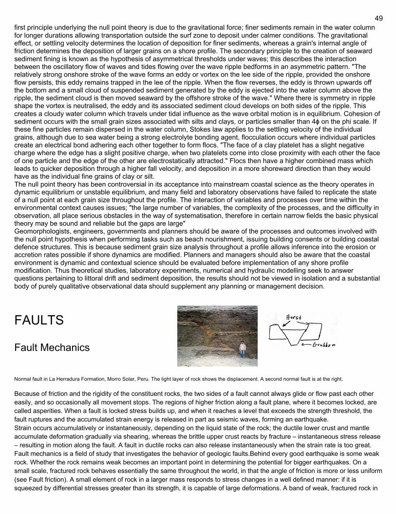
49
first principle underlying the null point theory is due to the gravitational force; finer sediments remain in the water column for longer durations allowing transportation outside the surf zone to deposit under calmer conditions. The gravitational effect, or settling velocity determines the location of deposition for finer sediments, whereas a grain's internal angle of friction determines the deposition of larger grains on a shore profile. The secondary principle to the creation of seaward sediment fining is known as the hypothesis of asymmetrical thresholds under waves; this describes the interaction between the oscillatory flow of waves and tides flowing over the wave ripple bedforms in an asymmetric pattern. "The relatively strong onshore stroke of the wave forms an eddy or vortex on the lee side of the ripple, provided the onshore flow persists, this eddy remains trapped in the lee of the ripple. When the flow reverses, the eddy is thrown upwards off the bottom and a small cloud of suspended sediment generated by the eddy is ejected into the water column above the ripple, the sediment cloud is then moved seaward by the offshore stroke of the wave." Where there is symmetry in ripple shape the vortex is neutralised, the eddy and its associated sediment cloud develops on both sides of the ripple. This creates a cloudy water column which travels under tidal influence as the wave orbital motion is in equilibrium. Cohesion of sediment occurs with the small grain sizes associated with silts and clays, or particles smaller than 4ϕ on the phi scale. If these fine particles remain dispersed in the water column, Stokes law applies to the settling velocity of the individual grains, although due to sea water being a strong electrolyte bonding agent, flocculation occurs where individual particles create an electrical bond adhering each other together to form flocs. "The face of a clay platelet has a slight negative charge where the edge has a slight positive charge, when two platelets come into close proximity with each other the face of one particle and the edge of the other are electrostatically attracted." Flocs then have a higher combined mass which leads to quicker deposition through a higher fall velocity, and deposition in a more shoreward direction than they would have as the individual fine grains of clay or silt. The null point theory has been controversial in its acceptance into mainstream coastal science as the theory operates in dynamic equilibrium or unstable equilibrium, and many field and laboratory observations have failed to replicate the state of a null point at each grain size throughout the profile. The interaction of variables and processes over time within the environmental context causes issues; "the large number of variables, the complexity of the processes, and the difficulty in observation, all place serious obstacles in the way of systematisation, therefore in certain narrow fields the basic physical theory may be sound and reliable but the gaps are large" Geomorphologists, engineers, governments and planners should be aware of the processes and outcomes involved with the null point hypothesis when performing tasks such as beach nourishment, issuing building consents or building coastal defence structures. This is because sediment grain size analysis throughout a profile allows inference into the erosion or accretion rates possible if shore dynamics are modified. Planners and managers should also be aware that the coastal environment is dynamic and contextual science should be evaluated before implementation of any shore profile modification. Thus theoretical studies, laboratory experiments, numerical and hydraulic modelling seek to answer questions pertaining to littoral drift and sediment deposition, the results should not be viewed in isolation and a substantial body of purely qualitative observational data should supplement any planning or management decision.
FAULTS
Fault Mechanics Normal fault in La Herradura Formation, Morro Solar, Peru. The light layer of rock shows the displacement. A second normal fault is at the right. Because of friction and the rigidity of the constituent rocks, the two sides of a fault cannot always glide or flow past each other easily, and so occasionally all movement stops. The regions of higher friction along a fault plane, where it becomes locked, are called asperities. When a fault is locked stress builds up, and when it reaches a level that exceeds the strength threshold, the fault ruptures and the accumulated strain energy is released in part as seismic waves, forming an earthquake. Strain occurs accumulatively or instantaneously, depending on the liquid state of the rock; the ductile lower crust and mantle accumulate deformation gradually via shearing, whereas the brittle upper crust reacts by fracture – instantaneous stress release – resulting in motion along the fault. A fault in ductile rocks can also release instantaneously when the strain rate is too great. Fault mechanics is a field of study that investigates the behavior of geologic faults.Behind every good earthquake is some weak rock. Whether the rock remains weak becomes an important point in determining the potential for bigger earthquakes. On a small scale, fractured rock behaves essentially the same throughout the world, in that the angle of friction is more or less uniform (see Fault friction). A small element of rock in a larger mass responds to stress changes in a well defined manner: if it is squeezed by differential stresses greater than its strength, it is capable of large deformations. A band of weak, fractured rock in
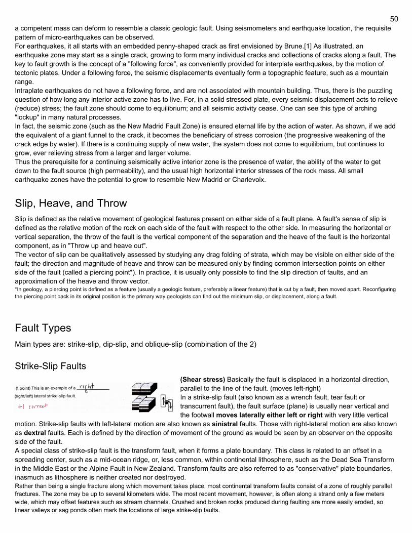
50
a competent mass can deform to resemble a classic geologic fault. Using seismometers and earthquake location, the requisite pattern of micro-earthquakes can be observed. For earthquakes, it all starts with an embedded penny-shaped crack as first envisioned by Brune.[1] As illustrated, an earthquake zone may start as a single crack, growing to form many individual cracks and collections of cracks along a fault. The key to fault growth is the concept of a "following force", as conveniently provided for interplate earthquakes, by the motion of tectonic plates. Under a following force, the seismic displacements eventually form a topographic feature, such as a mountain range. Intraplate earthquakes do not have a following force, and are not associated with mountain building. Thus, there is the puzzling question of how long any interior active zone has to live. For, in a solid stressed plate, every seismic displacement acts to relieve (reduce) stress; the fault zone should come to equilibrium; and all seismic activity cease. One can see this type of arching "lockup" in many natural processes. In fact, the seismic zone (such as the New Madrid Fault Zone) is ensured eternal life by the action of water. As shown, if we add the equivalent of a giant funnel to the crack, it becomes the beneficiary of stress corrosion (the progressive weakening of the crack edge by water). If there is a continuing supply of new water, the system does not come to equilibrium, but continues to grow, ever relieving stress from a larger and larger volume. Thus the prerequisite for a continuing seismically active interior zone is the presence of water, the ability of the water to get down to the fault source (high permeability), and the usual high horizontal interior stresses of the rock mass. All small earthquake zones have the potential to grow to resemble New Madrid or Charlevoix.
Slip, Heave, and Throw Slip is defined as the relative movement of geological features present on either side of a fault plane. A fault's sense of slip is defined as the relative motion of the rock on each side of the fault with respect to the other side. In measuring the horizontal or vertical separation, the throw of the fault is the vertical component of the separation and the heave of the fault is the horizontal component, as in "Throw up and heave out". The vector of slip can be qualitatively assessed by studying any drag folding of strata, which may be visible on either side of the fault; the direction and magnitude of heave and throw can be measured only by finding common intersection points on either side of the fault (called a piercing point*). In practice, it is usually only possible to find the slip direction of faults, and an approximation of the heave and throw vector. *In geology, a piercing point is defined as a feature (usually a geologic feature, preferably a linear feature) that is cut by a fault, then moved apart. Reconfiguring the piercing point back in its original position is the primary way geologists can find out the minimum slip, or displacement, along a fault.
Fault Types Main types are: strike-slip, dip-slip, and oblique-slip (combination of the 2)
Strike-Slip Faults (Shear stress) Basically the fault is displaced in a horizontal direction, parallel to the line of the fault. (moves left-right) In a strike-slip fault (also known as a wrench fault, tear fault or transcurrent fault), the fault surface (plane) is usually near vertical and the footwall moves laterally either left or right with very little vertical
motion. Strike-slip faults with left-lateral motion are also known as sinistral faults. Those with right-lateral motion are also known as dextral faults. Each is defined by the direction of movement of the ground as would be seen by an observer on the opposite side of the fault. A special class of strike-slip fault is the transform fault, when it forms a plate boundary. This class is related to an offset in a spreading center, such as a mid-ocean ridge, or, less common, within continental lithosphere, such as the Dead Sea Transform in the Middle East or the Alpine Fault in New Zealand. Transform faults are also referred to as "conservative" plate boundaries, inasmuch as lithosphere is neither created nor destroyed. Rather than being a single fracture along which movement takes place, most continental transform faults consist of a zone of roughly parallel fractures. The zone may be up to several kilometers wide. The most recent movement, however, is often along a strand only a few meters wide, which may offset features such as stream channels. Crushed and broken rocks produced during faulting are more easily eroded, so linear valleys or sag ponds often mark the locations of large strike-slip faults.
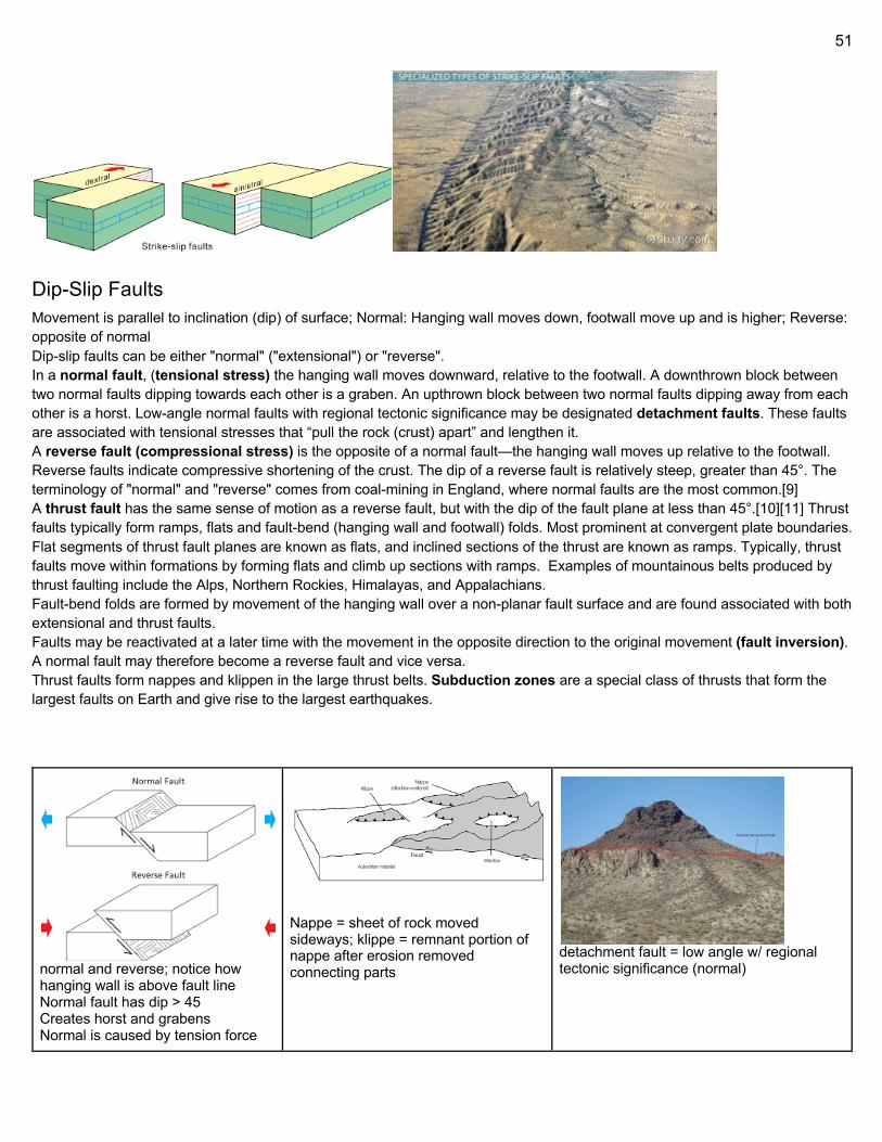
51
Dip-Slip Faults Movement is parallel to inclination (dip) of surface; Normal: Hanging wall moves down, footwall move up and is higher; Reverse: opposite of normal Dip-slip faults can be either "normal" ("extensional") or "reverse". In a normal fault, (tensional stress) the hanging wall moves downward, relative to the footwall. A downthrown block between two normal faults dipping towards each other is a graben. An upthrown block between two normal faults dipping away from each other is a horst. Low-angle normal faults with regional tectonic significance may be designated detachment faults. These faults are associated with tensional stresses that “pull the rock (crust) apart” and lengthen it. A reverse fault (compressional stress) is the opposite of a normal fault—the hanging wall moves up relative to the footwall. Reverse faults indicate compressive shortening of the crust. The dip of a reverse fault is relatively steep, greater than 45°. The terminology of "normal" and "reverse" comes from coal-mining in England, where normal faults are the most common.[9] A thrust fault has the same sense of motion as a reverse fault, but with the dip of the fault plane at less than 45°.[10][11] Thrust faults typically form ramps, flats and fault-bend (hanging wall and footwall) folds. Most prominent at convergent plate boundaries. Flat segments of thrust fault planes are known as flats, and inclined sections of the thrust are known as ramps. Typically, thrust faults move within formations by forming flats and climb up sections with ramps. Examples of mountainous belts produced by thrust faulting include the Alps, Northern Rockies, Himalayas, and Appalachians. Fault-bend folds are formed by movement of the hanging wall over a non-planar fault surface and are found associated with both extensional and thrust faults. Faults may be reactivated at a later time with the movement in the opposite direction to the original movement (fault inversion). A normal fault may therefore become a reverse fault and vice versa. Thrust faults form nappes and klippen in the large thrust belts. Subduction zones are a special class of thrusts that form the largest faults on Earth and give rise to the largest earthquakes.
normal and reverse; notice how hanging wall is above fault line Normal fault has dip > 45 Creates horst and grabens Normal is caused by tension force
Nappe = sheet of rock moved sideways; klippe = remnant portion of nappe after erosion removed connecting parts
detachment fault = low angle w/ regional tectonic significance (normal)
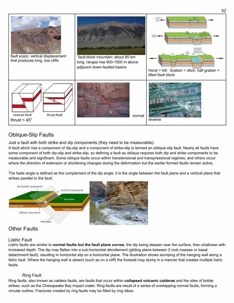
52
fault scarp: vertical displacement that produces long, low cliffs
fault-block mountain: about 80 km long, ranges rise 900-1500 m above adjacent down-faulted basins Horst = hill; Graben = ditch; half graben =
tilted fault block
thrust < 45° normal
reverse
Oblique-Slip Faults Just a fault with both strike and dip components (they need to be measurable). A fault which has a component of dip-slip and a component of strike-slip is termed an oblique-slip fault. Nearly all faults have some component of both dip-slip and strike-slip, so defining a fault as oblique requires both dip and strike components to be measurable and significant. Some oblique faults occur within transtensional and transpressional regimes, and others occur where the direction of extension or shortening changes during the deformation but the earlier formed faults remain active. The hade angle is defined as the complement of the dip angle; it is the angle between the fault plane and a vertical plane that strikes parallel to the fault.
Other Faults Listric Fault Listric faults are similar to normal faults but the fault plane curves, the dip being steeper near the surface, then shallower with increased depth. The dip may flatten into a sub-horizontal décollement (gliding plane between 2 rock masses or basal detachment fault), resulting in horizontal slip on a horizontal plane. The illustration shows slumping of the hanging wall along a listric fault. Where the hanging wall is absent (such as on a cliff) the footwall may slump in a manner that creates multiple listric faults.
Ring Fault Ring faults, also known as caldera faults, are faults that occur within collapsed volcanic calderas and the sites of bolide strikes, such as the Chesapeake Bay impact crater. Ring faults are result of a series of overlapping normal faults, forming a circular outline. Fractures created by ring faults may be filled by ring dikes.
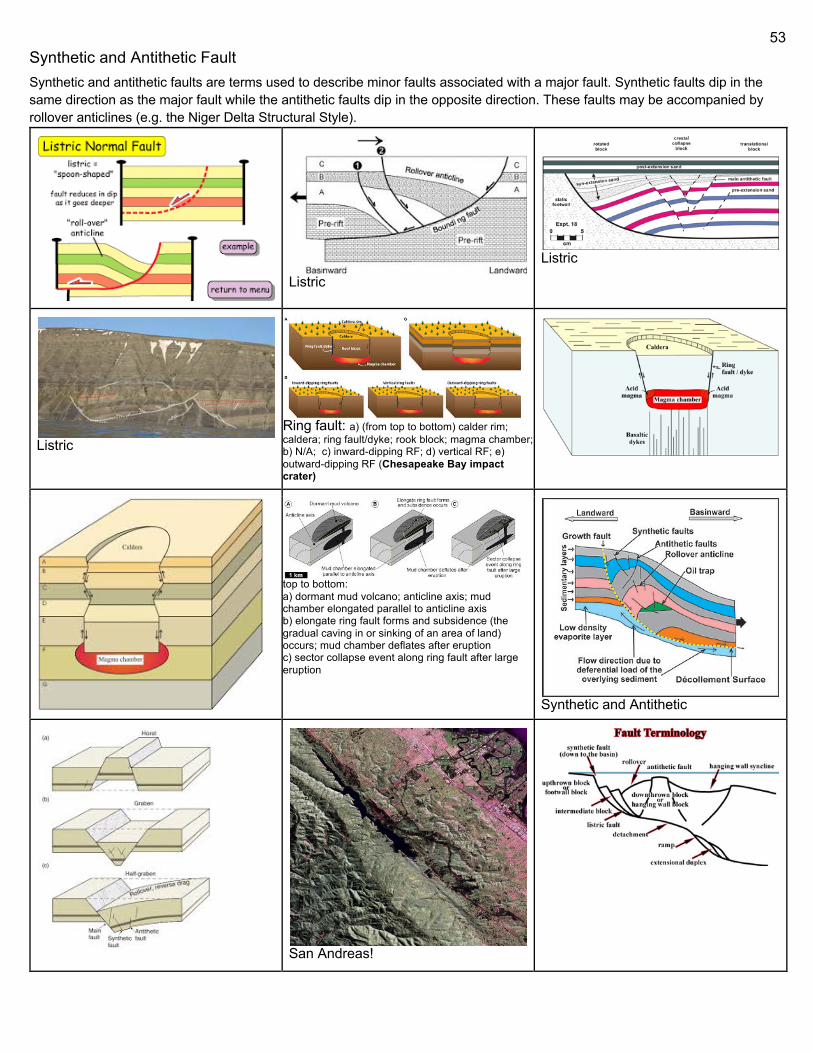
53
Synthetic and Antithetic Fault Synthetic and antithetic faults are terms used to describe minor faults associated with a major fault. Synthetic faults dip in the same direction as the major fault while the antithetic faults dip in the opposite direction. These faults may be accompanied by rollover anticlines (e.g. the Niger Delta Structural Style).
Listric
Listric
Listric Ring fault: a) (from top to bottom) calder rim; caldera; ring fault/dyke; rook block; magma chamber; b) N/A; c) inward-dipping RF; d) vertical RF; e) outward-dipping RF (Chesapeake Bay impact crater)
top to bottom: a) dormant mud volcano; anticline axis; mud chamber elongated parallel to anticline axis b) elongate ring fault forms and subsidence (the gradual caving in or sinking of an area of land) occurs; mud chamber deflates after eruption c) sector collapse event along ring fault after large eruption
Synthetic and Antithetic
San Andreas!
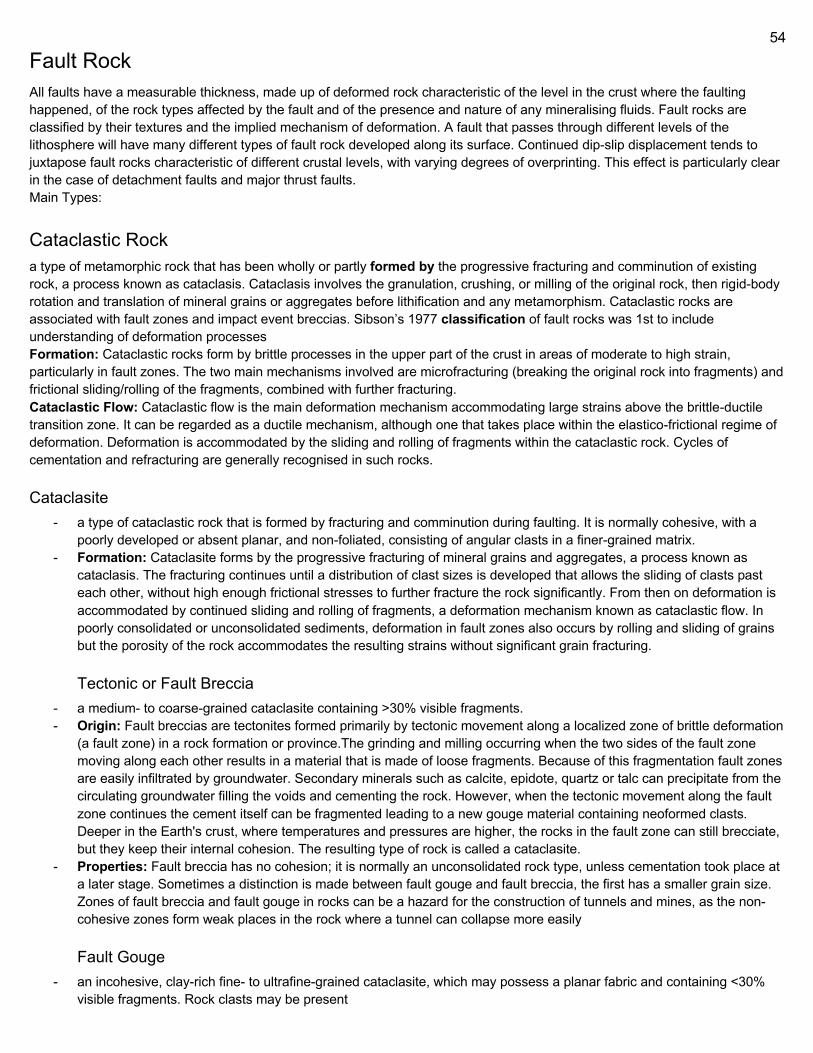
54
Fault Rock All faults have a measurable thickness, made up of deformed rock characteristic of the level in the crust where the faulting happened, of the rock types affected by the fault and of the presence and nature of any mineralising fluids. Fault rocks are classified by their textures and the implied mechanism of deformation. A fault that passes through different levels of the lithosphere will have many different types of fault rock developed along its surface. Continued dip-slip displacement tends to juxtapose fault rocks characteristic of different crustal levels, with varying degrees of overprinting. This effect is particularly clear in the case of detachment faults and major thrust faults. Main Types:
Cataclastic Rock a type of metamorphic rock that has been wholly or partly formed by the progressive fracturing and comminution of existing rock, a process known as cataclasis. Cataclasis involves the granulation, crushing, or milling of the original rock, then rigid-body rotation and translation of mineral grains or aggregates before lithification and any metamorphism. Cataclastic rocks are associated with fault zones and impact event breccias. Sibson’s 1977 classification of fault rocks was 1st to include understanding of deformation processes Formation: Cataclastic rocks form by brittle processes in the upper part of the crust in areas of moderate to high strain, particularly in fault zones. The two main mechanisms involved are microfracturing (breaking the original rock into fragments) and frictional sliding/rolling of the fragments, combined with further fracturing. Cataclastic Flow: Cataclastic flow is the main deformation mechanism accommodating large strains above the brittle-ductile transition zone. It can be regarded as a ductile mechanism, although one that takes place within the elastico-frictional regime of deformation. Deformation is accommodated by the sliding and rolling of fragments within the cataclastic rock. Cycles of cementation and refracturing are generally recognised in such rocks.
Cataclasite - a type of cataclastic rock that is formed by fracturing and comminution during faulting. It is normally cohesive, with a
poorly developed or absent planar, and non-foliated, consisting of angular clasts in a finer-grained matrix. - Formation: Cataclasite forms by the progressive fracturing of mineral grains and aggregates, a process known as
cataclasis. The fracturing continues until a distribution of clast sizes is developed that allows the sliding of clasts past each other, without high enough frictional stresses to further fracture the rock significantly. From then on deformation is accommodated by continued sliding and rolling of fragments, a deformation mechanism known as cataclastic flow. In poorly consolidated or unconsolidated sediments, deformation in fault zones also occurs by rolling and sliding of grains but the porosity of the rock accommodates the resulting strains without significant grain fracturing.
Tectonic or Fault Breccia - a medium- to coarse-grained cataclasite containing >30% visible fragments. - Origin: Fault breccias are tectonites formed primarily by tectonic movement along a localized zone of brittle deformation
(a fault zone) in a rock formation or province.The grinding and milling occurring when the two sides of the fault zone moving along each other results in a material that is made of loose fragments. Because of this fragmentation fault zones are easily infiltrated by groundwater. Secondary minerals such as calcite, epidote, quartz or talc can precipitate from the circulating groundwater filling the voids and cementing the rock. However, when the tectonic movement along the fault zone continues the cement itself can be fragmented leading to a new gouge material containing neoformed clasts. Deeper in the Earth's crust, where temperatures and pressures are higher, the rocks in the fault zone can still brecciate, but they keep their internal cohesion. The resulting type of rock is called a cataclasite.
- Properties: Fault breccia has no cohesion; it is normally an unconsolidated rock type, unless cementation took place at a later stage. Sometimes a distinction is made between fault gouge and fault breccia, the first has a smaller grain size. Zones of fault breccia and fault gouge in rocks can be a hazard for the construction of tunnels and mines, as the non-cohesive zones form weak places in the rock where a tunnel can collapse more easily
Fault Gouge - an incohesive, clay-rich fine- to ultrafine-grained cataclasite, which may possess a planar fabric and containing <30%
visible fragments. Rock clasts may be present
55
- Fault gouge is a tectonite (a rock formed by tectonic forces) with a very small grain size. Fault gouge has no cohesion and it is normally an unconsolidated rock type, unless cementation took place at a later stage. A fault gouge forms in the same way as fault breccia, the latter also having larger clasts. In comparison to fault breccia, which is another incohesive fault rock, fault gouge has less visible fragments (less than 30% visible fragments regarding fault gouges, and more than 30% regarding fault breccia).Gouge-filled faults can be weak planes in rock masses. If compressive stresses are enough these can cause compressive yielding or eventually rock fracture.
- Origin: Fault gouge forms by tectonic movement along a localized zone of brittle deformation (a fault zone) in a rock. The grinding and milling that results when the two sides of the fault zone move along each other results in a material that is made of loose fragments. First a fault breccia will form, but if the grinding continues the rock becomes fault gouge.
Clay Smear clay-rich fault gouge formed in sedimentary sequences containing clay-rich layers which are strongly deformed and sheared into the fault gouge.
Mylonite - Mylonite is a fine-grained, compact metamorphic rock produced by dynamic recrystallization of the constituent minerals
resulting in a reduction of the grain size of the rock. Mylonites can have many different mineralogical compositions; it is a classification based on the textural appearance of the rock.
- Formation: Mylonites are ductilely deformed rocks formed by the accumulation of large shear strain, in ductile fault zones. There are many different views on the formation of mylonites, but it is generally agreed that crystal-plastic deformation must have occurred, and that fracturing and cataclastic flow are secondary processes in the formation of mylonites. Mechanical abrasion of grains by milling does not occur, although this was originally thought to be the process that formed mylonites, which were named from the Greek μύλος mylos, meaning mill. Mylonites form at depths of no less than 4 km. There are many different mechanisms that accommodate crystal-plastic deformation. In crustal rocks the most important processes are dislocation creep and diffusion creep. Dislocation generation acts to increase the internal energy of crystals. This effect is compensated through grain-boundary-migration recrystallization which reduces the internal energy by increasing the grain boundary area and reducing the grain volume, storing energy at the mineral grain surface. This process tends to organize dislocations into subgrain boundaries. As more dislocations are added to subgrain boundaries, the misorientation across that subgrain boundary will increase until the boundary becomes a high-angle boundary and the subgrain effectively becomes a new grain. This process, sometimes referred to as subgrain rotation recrystallization, acts to reduce the mean grain size. Volume and grain-boundary diffusion, the critical mechanisms in diffusion creep, become important at high temperatures and small grain sizes. Thus some researchers have argued that as mylonites are formed by dislocation creep and dynamic recrystallization, a transition to diffusion creep can occur once the grain size is reduced sufficiently. Mylonites generally develop in ductile shear zones where high rates of strain are focused. They are the deep crustal counterparts to cataclastic brittle faults that create fault breccias.
- Interpretation: Determining the displacements that occur in mylonite zones depends on correctly determining the orientations of the finite strain axis and inferring how those orientations change with respect to the incremental strain axis. This is referred to as determining the shear sense. It is common practice to assume that the deformation is plane strain simple shear deformation. This type of strain field assumes that deformation occurs in a tabular zone where displacement is parallel to the shear zone boundary. Furthermore, during deformation the incremental strain axis maintains a 45 degree angle to the shear zone boundary. The finite strain axes are initially parallel to the incremental axis, but rotate away during progressive deformation. Kinematic indicators are structures in mylonites that allow the sense of shear to be determined. Most kinematic indicators are based on deformation in simple shear and infer sense of rotation of the finite strain axes with respect to the incremental strain axes. Because of the constraints imposed by simple shear, displacement is assumed to occur in the foliation plane in a direction parallel to the mineral stretching lineation. Therefore, a plane parallel to the lineation and perpendicular to the foliation is viewed to determine the shear sense. The most common shear sense indicators are C/S fabrics, asymmetric porphyroclasts, vein and dike arrays, mantled porphyroclasts and mineral fibers. All of these indicators have a monoclinic symmetry which is directly related to the orientations of the finite strain axes. Although structures like asymmetric folds and boudinages are also related to the
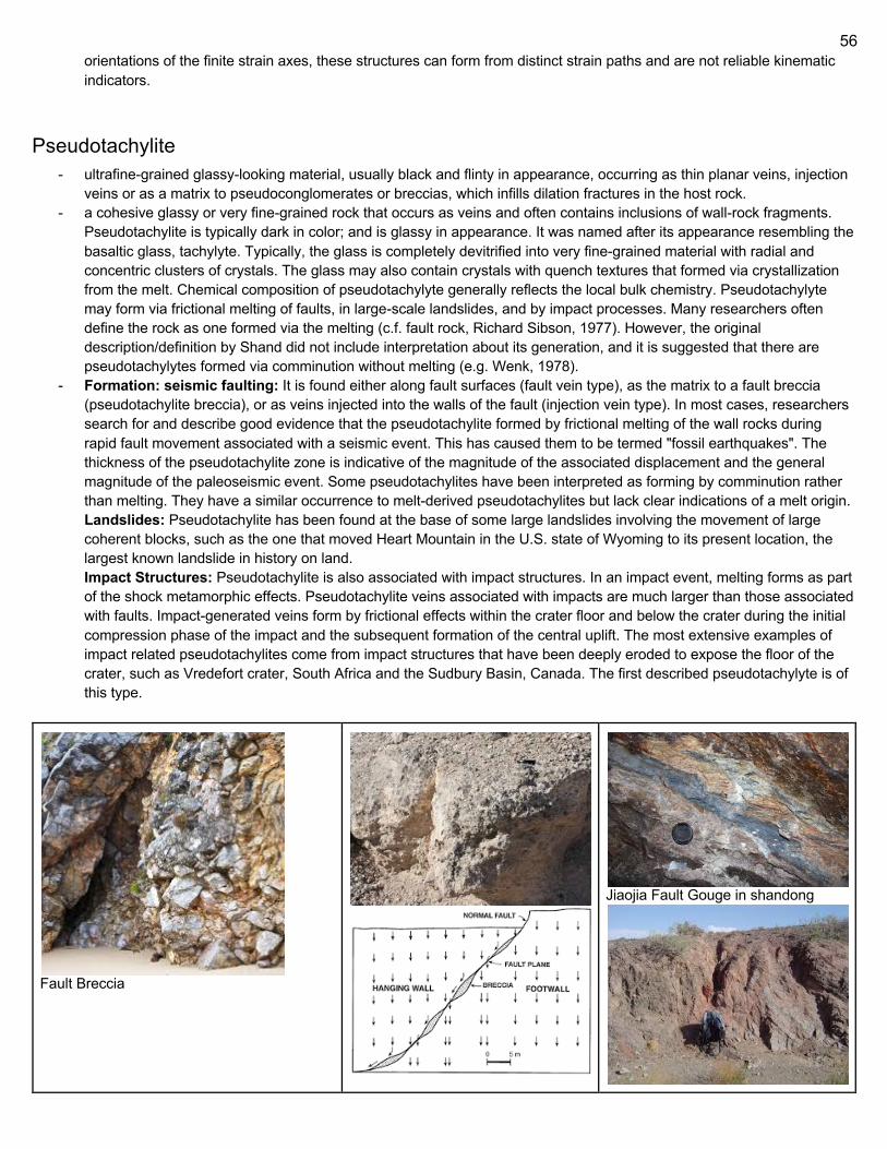
56
orientations of the finite strain axes, these structures can form from distinct strain paths and are not reliable kinematic indicators.
Pseudotachylite - ultrafine-grained glassy-looking material, usually black and flinty in appearance, occurring as thin planar veins, injection
veins or as a matrix to pseudoconglomerates or breccias, which infills dilation fractures in the host rock. - a cohesive glassy or very fine-grained rock that occurs as veins and often contains inclusions of wall-rock fragments.
Pseudotachylite is typically dark in color; and is glassy in appearance. It was named after its appearance resembling the basaltic glass, tachylyte. Typically, the glass is completely devitrified into very fine-grained material with radial and concentric clusters of crystals. The glass may also contain crystals with quench textures that formed via crystallization from the melt. Chemical composition of pseudotachylyte generally reflects the local bulk chemistry. Pseudotachylyte may form via frictional melting of faults, in large-scale landslides, and by impact processes. Many researchers often define the rock as one formed via the melting (c.f. fault rock, Richard Sibson, 1977). However, the original description/definition by Shand did not include interpretation about its generation, and it is suggested that there are pseudotachylytes formed via comminution without melting (e.g. Wenk, 1978).
- Formation: seismic faulting: It is found either along fault surfaces (fault vein type), as the matrix to a fault breccia (pseudotachylite breccia), or as veins injected into the walls of the fault (injection vein type). In most cases, researchers search for and describe good evidence that the pseudotachylite formed by frictional melting of the wall rocks during rapid fault movement associated with a seismic event. This has caused them to be termed "fossil earthquakes". The thickness of the pseudotachylite zone is indicative of the magnitude of the associated displacement and the general magnitude of the paleoseismic event. Some pseudotachylites have been interpreted as forming by comminution rather than melting. They have a similar occurrence to melt-derived pseudotachylites but lack clear indications of a melt origin. Landslides: Pseudotachylite has been found at the base of some large landslides involving the movement of large coherent blocks, such as the one that moved Heart Mountain in the U.S. state of Wyoming to its present location, the largest known landslide in history on land. Impact Structures: Pseudotachylite is also associated with impact structures. In an impact event, melting forms as part of the shock metamorphic effects. Pseudotachylite veins associated with impacts are much larger than those associated with faults. Impact-generated veins form by frictional effects within the crater floor and below the crater during the initial compression phase of the impact and the subsequent formation of the central uplift. The most extensive examples of impact related pseudotachylites come from impact structures that have been deeply eroded to expose the floor of the crater, such as Vredefort crater, South Africa and the Sudbury Basin, Canada. The first described pseudotachylyte is of this type.
Fault Breccia
Jiaojia Fault Gouge in shandong
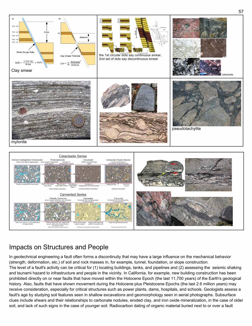
57
Clay smear
the 1st circular dots say continuous smear, 2nd set of dots say discontinuous smear
Cataclasite
mylonite
pseudotachylite
Impacts on Structures and People In geotechnical engineering a fault often forms a discontinuity that may have a large influence on the mechanical behavior (strength, deformation, etc.) of soil and rock masses in, for example, tunnel, foundation, or slope construction. The level of a fault's activity can be critical for (1) locating buildings, tanks, and pipelines and (2) assessing the seismic shaking and tsunami hazard to infrastructure and people in the vicinity. In California, for example, new building construction has been prohibited directly on or near faults that have moved within the Holocene Epoch (the last 11,700 years) of the Earth's geological history. Also, faults that have shown movement during the Holocene plus Pleistocene Epochs (the last 2.6 million years) may receive consideration, especially for critical structures such as power plants, dams, hospitals, and schools. Geologists assess a fault's age by studying soil features seen in shallow excavations and geomorphology seen in aerial photographs. Subsurface clues include shears and their relationships to carbonate nodules, eroded clay, and iron oxide mineralization, in the case of older soil, and lack of such signs in the case of younger soil. Radiocarbon dating of organic material buried next to or over a fault
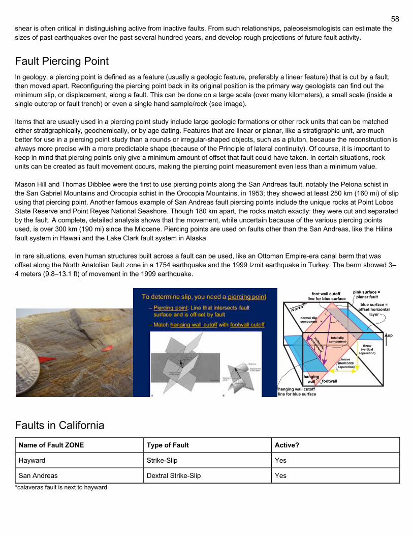
58
shear is often critical in distinguishing active from inactive faults. From such relationships, paleoseismologists can estimate the sizes of past earthquakes over the past several hundred years, and develop rough projections of future fault activity.
Fault Piercing Point In geology, a piercing point is defined as a feature (usually a geologic feature, preferably a linear feature) that is cut by a fault, then moved apart. Reconfiguring the piercing point back in its original position is the primary way geologists can find out the minimum slip, or displacement, along a fault. This can be done on a large scale (over many kilometers), a small scale (inside a single outcrop or fault trench) or even a single hand sample/rock (see image). Items that are usually used in a piercing point study include large geologic formations or other rock units that can be matched either stratigraphically, geochemically, or by age dating. Features that are linear or planar, like a stratigraphic unit, are much better for use in a piercing point study than a rounds or irregular-shaped objects, such as a pluton, because the reconstruction is always more precise with a more predictable shape (because of the Principle of lateral continuity). Of course, it is important to keep in mind that piercing points only give a minimum amount of offset that fault could have taken. In certain situations, rock units can be created as fault movement occurs, making the piercing point measurement even less than a minimum value. Mason Hill and Thomas Dibblee were the first to use piercing points along the San Andreas fault, notably the Pelona schist in the San Gabriel Mountains and Orocopia schist in the Orocopia Mountains, in 1953; they showed at least 250 km (160 mi) of slip using that piercing point. Another famous example of San Andreas fault piercing points include the unique rocks at Point Lobos State Reserve and Point Reyes National Seashore. Though 180 km apart, the rocks match exactly: they were cut and separated by the fault. A complete, detailed analysis shows that the movement, while uncertain because of the various piercing points used, is over 300 km (190 mi) since the Miocene. Piercing points are used on faults other than the San Andreas, like the Hilina fault system in Hawaii and the Lake Clark fault system in Alaska. In rare situations, even human structures built across a fault can be used, like an Ottoman Empire-era canal berm that was offset along the North Anatolian fault zone in a 1754 earthquake and the 1999 Izmit earthquake in Turkey. The berm showed 3–4 meters (9.8–13.1 ft) of movement in the 1999 earthquake.
Faults in California Name of Fault ZONE Type of Fault Active?
Hayward Strike-Slip Yes
San Andreas Dextral Strike-Slip Yes *calaveras fault is next to hayward
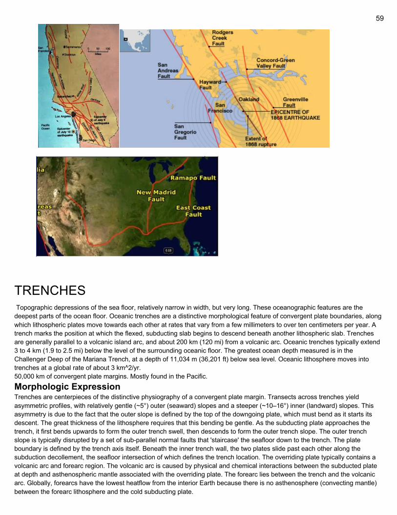
59
TRENCHES Topographic depressions of the sea floor, relatively narrow in width, but very long. These oceanographic features are the deepest parts of the ocean floor. Oceanic trenches are a distinctive morphological feature of convergent plate boundaries, along which lithospheric plates move towards each other at rates that vary from a few millimeters to over ten centimeters per year. A trench marks the position at which the flexed, subducting slab begins to descend beneath another lithospheric slab. Trenches are generally parallel to a volcanic island arc, and about 200 km (120 mi) from a volcanic arc. Oceanic trenches typically extend 3 to 4 km (1.9 to 2.5 mi) below the level of the surrounding oceanic floor. The greatest ocean depth measured is in the Challenger Deep of the Mariana Trench, at a depth of 11,034 m (36,201 ft) below sea level. Oceanic lithosphere moves into trenches at a global rate of about 3 km^2/yr. 50,000 km of convergent plate margins. Mostly found in the Pacific. Morphologic Expression Trenches are centerpieces of the distinctive physiography of a convergent plate margin. Transects across trenches yield asymmetric profiles, with relatively gentle (~5°) outer (seaward) slopes and a steeper (~10–16°) inner (landward) slopes. This asymmetry is due to the fact that the outer slope is defined by the top of the downgoing plate, which must bend as it starts its descent. The great thickness of the lithosphere requires that this bending be gentle. As the subducting plate approaches the trench, it first bends upwards to form the outer trench swell, then descends to form the outer trench slope. The outer trench slope is typically disrupted by a set of sub-parallel normal faults that 'staircase' the seafloor down to the trench. The plate boundary is defined by the trench axis itself. Beneath the inner trench wall, the two plates slide past each other along the subduction decollement, the seafloor intersection of which defines the trench location. The overriding plate typically contains a volcanic arc and forearc region. The volcanic arc is caused by physical and chemical interactions between the subducted plate at depth and asthenospheric mantle associated with the overriding plate. The forearc lies between the trench and the volcanic arc. Globally, forearcs have the lowest heatflow from the interior Earth because there is no asthenosphere (convecting mantle) between the forearc lithosphere and the cold subducting plate.
60
The inner trench wall marks the edge of the overriding plate and the outermost forearc. The forearc consists of igneous and metamorphic crust, and this crust may act as buttress to a growing accretionary wedge (formed from sediments scraped off the top of the downgoing plate). If the flux of sediments is high, material transfers from the subducting plate to the overriding plate. In this case an accretionary prism grows and the location of the trench migrates progressively away from the volcanic arc over the life of the convergent margin. Convergent margins with growing accretionary prisms are called accretionary margins and make up nearly half of all convergent margins. If the incoming sediment flux is low, material is scraped from the overriding plate by the subducting plate in a process called subduction erosion. This material is then carried down into the subduction zone. In this case, the location of the trench migrates towards the magmatic arc over the life of the convergent margin. Convergent margins experiencing subduction erosion are called non-accretionary or erosive margins and comprise more than half of convergent plate boundaries. This is an oversimplification, because the same section of margin may experience both sediment accretion and subduction erosion throughout its active time span. The asymmetric profile across a trench reflects fundamental differences in materials and tectonic evolution. The outer trench wall and outer swell comprise seafloor that takes several million years to move from where subduction-related deformation begins to sinking beneath the overriding plate. In contrast, the inner trench wall is deformed by plate interactions for the entire life of the convergent margin. The forearc is continuously subjected to subduction-related deformation and earthquakes. This protracted deformation and shaking ensures that the inner trench slope is controlled by the angle of repose (steepest angle where sloping surface formed of loose material is stable (funnel it for experiment)) of whatever material comprises it. Because the inner slope of non-accretionary trenches are composed of igneous and metamorphic rocks instead of deformed sediments, these trenches have steeper inner walls than accretionary trenches.
Filled Trenches The composition of the inner trench slope and a first-order control on trench morphology is determined by sediment supply. Active accretionary prisms are common in trenches near continents where rivers or glaciers supply great volumes of sediment to the trench. These filled trenches may lack the bathymetric expression of a trench. The Cascadia margin of the northwest USA is a filled trench, the result of sedimentation by the rivers of the western United States and Canada. The Lesser Antilles convergent margin demonstrates the importance of proximity to sediment sources for trench morphology. In the south, near the mouth of the Orinoco River, there is no morphological trench and the forearc (including the accretionary prism) is almost 500 km (310 mi) wide. The large accretionary prism reaches above sea level to form the islands of Barbados and Trinidad. Northward, the forearc narrows, the accretionary prism disappears, and, north of ~17°N, the morphology of a trench dominates. Further north, far from major sediment sources, the Puerto Rico Trench is over 8,600 m (28,200 ft) deep and there is no active accretionary prism. A similar relationship between proximity to rivers, forearc width, and trench morphology can be observed from east to west along the Alaskan-Aleutian convergent margin. The convergent plate boundary offshore Alaska changes along its strike from a filled trench with broad forearc in the east (near the coastal rivers of Alaska) to a deep trench with narrow forearc in the west (offshore the Aleutian islands). Another example is the Makran convergent margin offshore Pakistan and Iran, which is a trench filled by sediments from the Tigris-Euphrates and Indus rivers. Thick accumulations of turbidites along a trench can be supplied by down-axis transport of sediments that enter the trench 1,000–2,000 km (620–1,240 mi) away, as is found for the Peru–Chile Trench south of Valparaíso and for the Aleutian Trench. Convergence rate can also be important for controlling trench depth—especially for trenches near continents—because slow convergence makes the convergent margin capacity insufficient to dispose of sediment. An evolution in trench morphology can be expected, as oceans close and continents converge. While the ocean is wide, the trench may be far from continental sources of sediment and so may be deep. As continents approach each other, the trench can fill with continental sediments and become shallower. A simple way to approximate when the transition from subduction to collision has occurred is when the plate boundary previously marked by a trench is filled enough to rise above sea level
61
Accretionary Prisms & Sediment Transport An accretionary wedge or accretionary prism forms from sediments accreted onto the non-subducting tectonic plate at a convergent plate boundary. Most of the material in the accretionary wedge consists of marine sediments scraped off from the downgoing slab of oceanic crust, but in some cases the wedge includes the erosional products of volcanic island arcs formed on the overriding plate. Accretionary prisms grow in two ways: by frontal accretion, whereby sediments are scraped off the downgoing plate, bulldozer-fashion, near the trench, and by underplating of subducted sediments (and sometimes oceanic crust) along the shallow parts of the subduction decollement. Frontal accretion over the life of a convergent margin results in younger sediments defining the outermost part of the accretionary prism and the oldest sediments defining the innermost portion. Older (inner) parts of the accretionary prism are more lithified and have steeper structures than the younger (outer) parts.[clarification needed] Underplating is difficult to detect in modern subduction zones but may be recorded in ancient accretionary prisms such as the Franciscan Group of California in the form of tectonic mélanges and duplex structures. Different modes of accretion are reflected in the morphology of the inner slope of the trench, which generally shows three morphological provinces. The lower slope comprises imbricate thrust slices that form ridges. The mid slope may comprise a bench or terraces. The upper slope is smoother but may be cut by submarine canyons. Because accretionary convergent margins have high relief, are continuously deforming, and accommodate a large flux of sediments, they are vigorous systems of sediment dispersal and accumulation. Sediment transport is controlled by submarine landslides, debris flows, turbidity currents, and contourites. Submarine canyons transport sediment from beaches and rivers down the upper slope. These canyons form by channelized turbidites and generally lose definition with depth because continuous faulting disrupts the submarine channels.[citation needed] Sediments move down the inner trench wall via channels and a series of fault-controlled basins. The trench itself serves as an axis of sediment transport. If enough sediment moves to the trench, it may be completely filled so that turbidity currents are able to carry sediments well beyond the trench and may even surmount the outer swell, as in the eastern Gulf of Alaska. Sediments from the rivers of North America spill over the filled Cascadia trench and cross the Juan de Fuca plate to reach the spreading ridge several hundred kilometres to the west. The slope of the inner trench slope of an accretionary convergent margin reflects continuous adjustments to the thickness and width of the accretionary prism. The prism maintains a ‘critical taper’, established in conformance with Mohr–Coulomb theory, with slope determined by the material properties of the sediments. A package of sediments scraped off the downgoing lithospheric plate deforms until it and the accretionary prism that it has been added to attain the maximum slope supported by the sediments. Once this critical taper is attained, the wedge slides stably along its basal décollement. Strain rate and hydrologic properties also influence the strength of the accretionary prism and the angle of critical taper. Fluid pore pressures modify rock strength. Low permeability and rapid convergence may result in pore pressures that exceed lithostatic pressure and thus a relatively weak accretionary prism with a shallowly tapered geometry, whereas high permeability and slow convergence result in lower pore pressure, stronger prisms, and steeper geometry. The Hellenic Trench of the Hellenic arc system is unusual because this convergent margin subducts evaporites. The slope of the surface of the southern flank of the Mediterranean Ridge (its accretionary prism) is low, about 1°, indicating very low shear stress on the decollement at the base of the wedge. Evaporites control the shallow taper of the accretionary complex both because their mechanical properties differ from those of siliciclastic sediments, and because of their effect on fluid flow and fluid pressure, which in turn control effective stress. In the 1970s, the linear deeps of the Hellenic trench south of Crete were thought to be similar to trenches at other subduction zones. However, with the realization that the Mediterranean Ridge is an accretionary complex, it became apparent that the Hellenic trench is actually a starved forearc basin, and that the plate boundary lies south of the Mediterranean Ridge.
Empty Trenches and Subduction Erosion Trenches distant from an influx of continental sediments lack an accretionary prism, and the inner slope of such trenches is commonly composed of igneous or metamorphic rocks. Non-accretionary convergent margins are characteristic of (but not limited to) primitive arc systems. Primitive arc systems are those built on oceanic lithosphere, such as the Izu-Bonin-Mariana, Tonga-Kermadec, and Scotia (South Sandwich) arc systems. The inner trench slope of these convergent margins exposes the crust of the forearc, including basalt, gabbro, and serpentinized mantle peridotite. These exposures allow easy access to study the lower oceanic crust and upper mantle in place and provide a unique opportunity to study the magmatic products associated with the initiation of subduction zones. Most ophiolites probably originate in a forearc environment during the initiation of subduction, and this setting favors ophiolite emplacement during collision with blocks of thickened crust. Not all non-accretionary convergent margins are associated with primitive arcs. Trenches adjacent to continents where there is little influx of sediments carried by rivers, such as the central part of the Peru–Chile Trench, may also lack an accretionary prism.
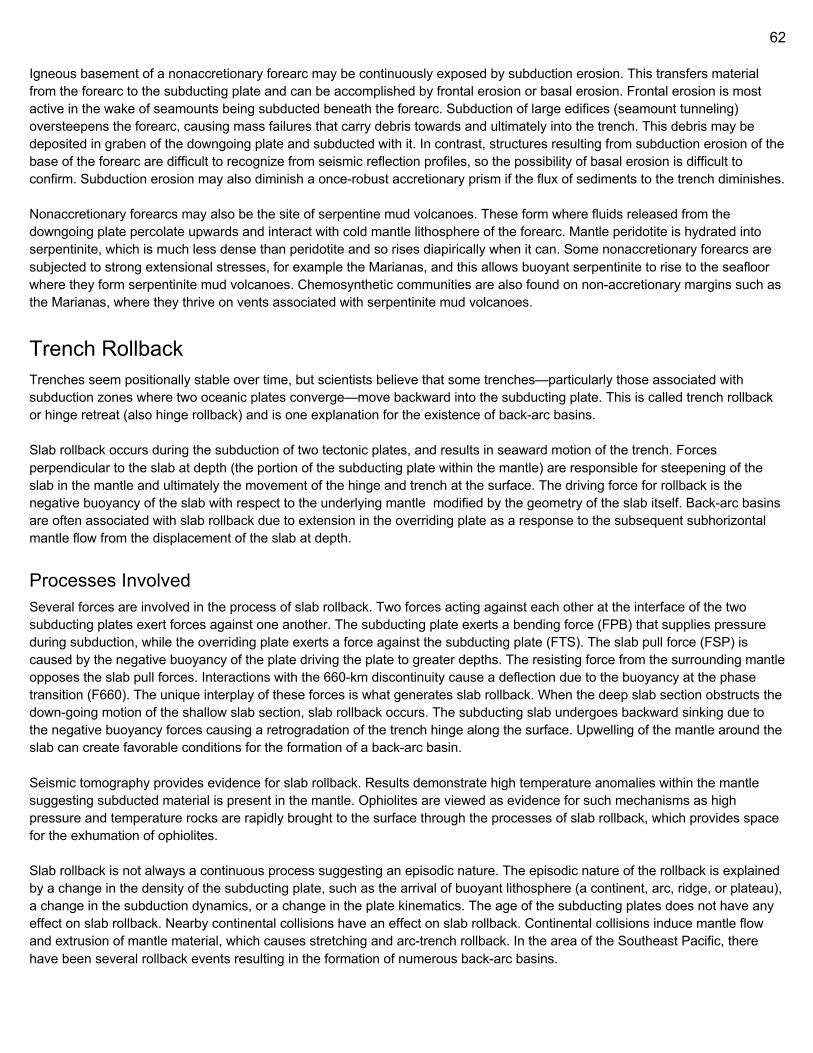
62
Igneous basement of a nonaccretionary forearc may be continuously exposed by subduction erosion. This transfers material from the forearc to the subducting plate and can be accomplished by frontal erosion or basal erosion. Frontal erosion is most active in the wake of seamounts being subducted beneath the forearc. Subduction of large edifices (seamount tunneling) oversteepens the forearc, causing mass failures that carry debris towards and ultimately into the trench. This debris may be deposited in graben of the downgoing plate and subducted with it. In contrast, structures resulting from subduction erosion of the base of the forearc are difficult to recognize from seismic reflection profiles, so the possibility of basal erosion is difficult to confirm. Subduction erosion may also diminish a once-robust accretionary prism if the flux of sediments to the trench diminishes. Nonaccretionary forearcs may also be the site of serpentine mud volcanoes. These form where fluids released from the downgoing plate percolate upwards and interact with cold mantle lithosphere of the forearc. Mantle peridotite is hydrated into serpentinite, which is much less dense than peridotite and so rises diapirically when it can. Some nonaccretionary forearcs are subjected to strong extensional stresses, for example the Marianas, and this allows buoyant serpentinite to rise to the seafloor where they form serpentinite mud volcanoes. Chemosynthetic communities are also found on non-accretionary margins such as the Marianas, where they thrive on vents associated with serpentinite mud volcanoes.
Trench Rollback Trenches seem positionally stable over time, but scientists believe that some trenches—particularly those associated with subduction zones where two oceanic plates converge—move backward into the subducting plate. This is called trench rollback or hinge retreat (also hinge rollback) and is one explanation for the existence of back-arc basins. Slab rollback occurs during the subduction of two tectonic plates, and results in seaward motion of the trench. Forces perpendicular to the slab at depth (the portion of the subducting plate within the mantle) are responsible for steepening of the slab in the mantle and ultimately the movement of the hinge and trench at the surface. The driving force for rollback is the negative buoyancy of the slab with respect to the underlying mantle modified by the geometry of the slab itself. Back-arc basins are often associated with slab rollback due to extension in the overriding plate as a response to the subsequent subhorizontal mantle flow from the displacement of the slab at depth.
Processes Involved Several forces are involved in the process of slab rollback. Two forces acting against each other at the interface of the two subducting plates exert forces against one another. The subducting plate exerts a bending force (FPB) that supplies pressure during subduction, while the overriding plate exerts a force against the subducting plate (FTS). The slab pull force (FSP) is caused by the negative buoyancy of the plate driving the plate to greater depths. The resisting force from the surrounding mantle opposes the slab pull forces. Interactions with the 660-km discontinuity cause a deflection due to the buoyancy at the phase transition (F660). The unique interplay of these forces is what generates slab rollback. When the deep slab section obstructs the down-going motion of the shallow slab section, slab rollback occurs. The subducting slab undergoes backward sinking due to the negative buoyancy forces causing a retrogradation of the trench hinge along the surface. Upwelling of the mantle around the slab can create favorable conditions for the formation of a back-arc basin. Seismic tomography provides evidence for slab rollback. Results demonstrate high temperature anomalies within the mantle suggesting subducted material is present in the mantle. Ophiolites are viewed as evidence for such mechanisms as high pressure and temperature rocks are rapidly brought to the surface through the processes of slab rollback, which provides space for the exhumation of ophiolites. Slab rollback is not always a continuous process suggesting an episodic nature. The episodic nature of the rollback is explained by a change in the density of the subducting plate, such as the arrival of buoyant lithosphere (a continent, arc, ridge, or plateau), a change in the subduction dynamics, or a change in the plate kinematics. The age of the subducting plates does not have any effect on slab rollback. Nearby continental collisions have an effect on slab rollback. Continental collisions induce mantle flow and extrusion of mantle material, which causes stretching and arc-trench rollback. In the area of the Southeast Pacific, there have been several rollback events resulting in the formation of numerous back-arc basins.
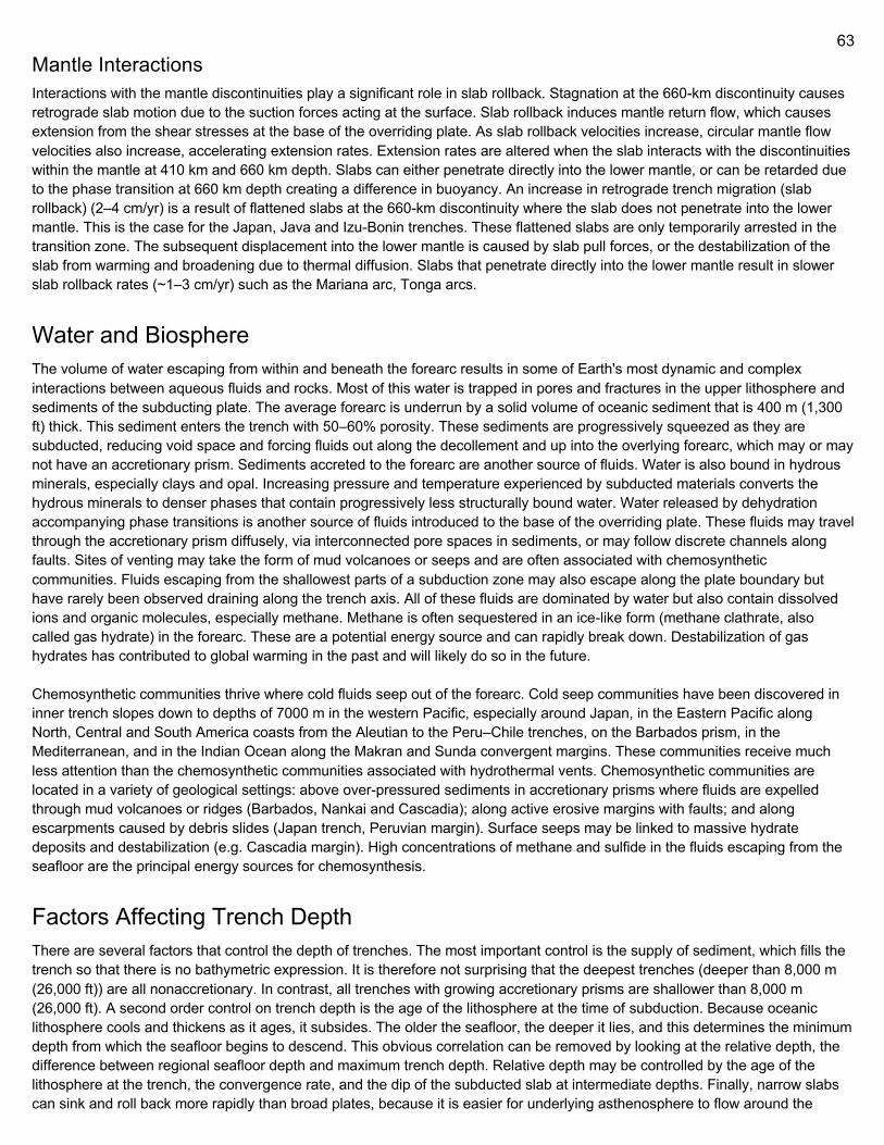
63
Mantle Interactions Interactions with the mantle discontinuities play a significant role in slab rollback. Stagnation at the 660-km discontinuity causes retrograde slab motion due to the suction forces acting at the surface. Slab rollback induces mantle return flow, which causes extension from the shear stresses at the base of the overriding plate. As slab rollback velocities increase, circular mantle flow velocities also increase, accelerating extension rates. Extension rates are altered when the slab interacts with the discontinuities within the mantle at 410 km and 660 km depth. Slabs can either penetrate directly into the lower mantle, or can be retarded due to the phase transition at 660 km depth creating a difference in buoyancy. An increase in retrograde trench migration (slab rollback) (2–4 cm/yr) is a result of flattened slabs at the 660-km discontinuity where the slab does not penetrate into the lower mantle. This is the case for the Japan, Java and Izu-Bonin trenches. These flattened slabs are only temporarily arrested in the transition zone. The subsequent displacement into the lower mantle is caused by slab pull forces, or the destabilization of the slab from warming and broadening due to thermal diffusion. Slabs that penetrate directly into the lower mantle result in slower slab rollback rates (~1–3 cm/yr) such as the Mariana arc, Tonga arcs.
Water and Biosphere The volume of water escaping from within and beneath the forearc results in some of Earth's most dynamic and complex interactions between aqueous fluids and rocks. Most of this water is trapped in pores and fractures in the upper lithosphere and sediments of the subducting plate. The average forearc is underrun by a solid volume of oceanic sediment that is 400 m (1,300 ft) thick. This sediment enters the trench with 50–60% porosity. These sediments are progressively squeezed as they are subducted, reducing void space and forcing fluids out along the decollement and up into the overlying forearc, which may or may not have an accretionary prism. Sediments accreted to the forearc are another source of fluids. Water is also bound in hydrous minerals, especially clays and opal. Increasing pressure and temperature experienced by subducted materials converts the hydrous minerals to denser phases that contain progressively less structurally bound water. Water released by dehydration accompanying phase transitions is another source of fluids introduced to the base of the overriding plate. These fluids may travel through the accretionary prism diffusely, via interconnected pore spaces in sediments, or may follow discrete channels along faults. Sites of venting may take the form of mud volcanoes or seeps and are often associated with chemosynthetic communities. Fluids escaping from the shallowest parts of a subduction zone may also escape along the plate boundary but have rarely been observed draining along the trench axis. All of these fluids are dominated by water but also contain dissolved ions and organic molecules, especially methane. Methane is often sequestered in an ice-like form (methane clathrate, also called gas hydrate) in the forearc. These are a potential energy source and can rapidly break down. Destabilization of gas hydrates has contributed to global warming in the past and will likely do so in the future. Chemosynthetic communities thrive where cold fluids seep out of the forearc. Cold seep communities have been discovered in inner trench slopes down to depths of 7000 m in the western Pacific, especially around Japan, in the Eastern Pacific along North, Central and South America coasts from the Aleutian to the Peru–Chile trenches, on the Barbados prism, in the Mediterranean, and in the Indian Ocean along the Makran and Sunda convergent margins. These communities receive much less attention than the chemosynthetic communities associated with hydrothermal vents. Chemosynthetic communities are located in a variety of geological settings: above over-pressured sediments in accretionary prisms where fluids are expelled through mud volcanoes or ridges (Barbados, Nankai and Cascadia); along active erosive margins with faults; and along escarpments caused by debris slides (Japan trench, Peruvian margin). Surface seeps may be linked to massive hydrate deposits and destabilization (e.g. Cascadia margin). High concentrations of methane and sulfide in the fluids escaping from the seafloor are the principal energy sources for chemosynthesis.
Factors Affecting Trench Depth There are several factors that control the depth of trenches. The most important control is the supply of sediment, which fills the trench so that there is no bathymetric expression. It is therefore not surprising that the deepest trenches (deeper than 8,000 m (26,000 ft)) are all nonaccretionary. In contrast, all trenches with growing accretionary prisms are shallower than 8,000 m (26,000 ft). A second order control on trench depth is the age of the lithosphere at the time of subduction. Because oceanic lithosphere cools and thickens as it ages, it subsides. The older the seafloor, the deeper it lies, and this determines the minimum depth from which the seafloor begins to descend. This obvious correlation can be removed by looking at the relative depth, the difference between regional seafloor depth and maximum trench depth. Relative depth may be controlled by the age of the lithosphere at the trench, the convergence rate, and the dip of the subducted slab at intermediate depths. Finally, narrow slabs can sink and roll back more rapidly than broad plates, because it is easier for underlying asthenosphere to flow around the
64
edges of the sinking plate. Such slabs may have steep dips at relatively shallow depths and so may be associated with unusually deep trenches, such as the Challenger Deep.
Trench Pics
65
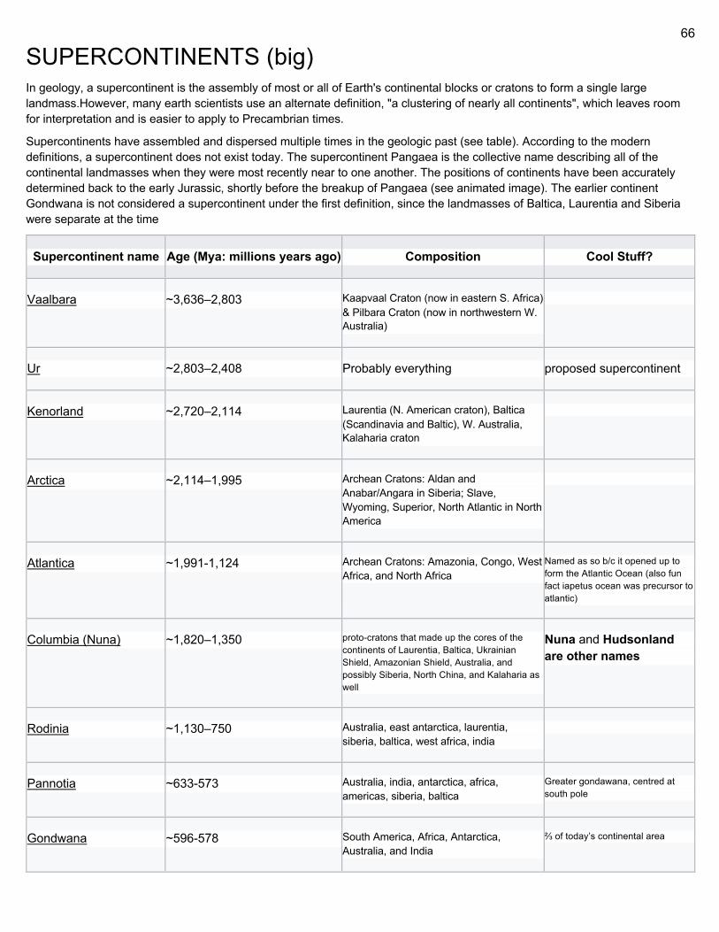
66
SUPERCONTINENTS (big) In geology, a supercontinent is the assembly of most or all of Earth's continental blocks or cratons to form a single large landmass.However, many earth scientists use an alternate definition, "a clustering of nearly all continents", which leaves room for interpretation and is easier to apply to Precambrian times.
Supercontinents have assembled and dispersed multiple times in the geologic past (see table). According to the modern definitions, a supercontinent does not exist today. The supercontinent Pangaea is the collective name describing all of the continental landmasses when they were most recently near to one another. The positions of continents have been accurately determined back to the early Jurassic, shortly before the breakup of Pangaea (see animated image). The earlier continent Gondwana is not considered a supercontinent under the first definition, since the landmasses of Baltica, Laurentia and Siberia were separate at the time
Supercontinent name Age (Mya: millions years ago) Composition Cool Stuff?
Vaalbara ~3,636–2,803 Kaapvaal Craton (now in eastern S. Africa) & Pilbara Craton (now in northwestern W. Australia)
Ur ~2,803–2,408 Probably everything proposed supercontinent
Kenorland ~2,720–2,114 Laurentia (N. American craton), Baltica (Scandinavia and Baltic), W. Australia, Kalaharia craton
Arctica ~2,114–1,995 Archean Cratons: Aldan and Anabar/Angara in Siberia; Slave, Wyoming, Superior, North Atlantic in North America
Atlantica ~1,991-1,124 Archean Cratons: Amazonia, Congo, West Africa, and North Africa
Named as so b/c it opened up to form the Atlantic Ocean (also fun fact iapetus ocean was precursor to atlantic)
Columbia (Nuna) ~1,820–1,350 proto-cratons that made up the cores of the continents of Laurentia, Baltica, Ukrainian Shield, Amazonian Shield, Australia, and possibly Siberia, North China, and Kalaharia as well
Nuna and Hudsonland are other names
Rodinia ~1,130–750 Australia, east antarctica, laurentia, siberia, baltica, west africa, india
Pannotia ~633-573 Australia, india, antarctica, africa, americas, siberia, baltica
Greater gondawana, centred at south pole
Gondwana ~596-578 South America, Africa, Antarctica, Australia, and India
⅔ of today’s continental area
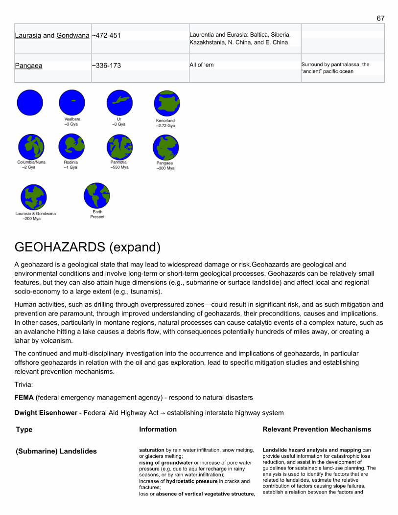
67
Laurasia and Gondwana ~472-451 Laurentia and Eurasia: Baltica, Siberia, Kazakhstania, N. China, and E. China
Pangaea ~336-173 All of ‘em Surround by panthalassa, the “ancient” pacific ocean
GEOHAZARDS (expand) A geohazard is a geological state that may lead to widespread damage or risk.Geohazards are geological and environmental conditions and involve long-term or short-term geological processes. Geohazards can be relatively small features, but they can also attain huge dimensions (e.g., submarine or surface landslide) and affect local and regional socio-economy to a large extent (e.g., tsunamis).
Human activities, such as drilling through overpressured zones—could result in significant risk, and as such mitigation and prevention are paramount, through improved understanding of geohazards, their preconditions, causes and implications. In other cases, particularly in montane regions, natural processes can cause catalytic events of a complex nature, such as an avalanche hitting a lake causes a debris flow, with consequences potentially hundreds of miles away, or creating a lahar by volcanism.
The continued and multi-disciplinary investigation into the occurrence and implications of geohazards, in particular offshore geohazards in relation with the oil and gas exploration, lead to specific mitigation studies and establishing relevant prevention mechanisms.
Trivia:
FEMA (federal emergency management agency) - respond to natural disasters
Dwight Eisenhower - Federal Aid Highway Act → establishing interstate highway system
Type
Information Relevant Prevention Mechanisms
(Submarine) Landslides saturation by rain water infiltration, snow melting, or glaciers melting; rising of groundwater or increase of pore water pressure (e.g. due to aquifer recharge in rainy seasons, or by rain water infiltration); increase of hydrostatic pressure in cracks and fractures; loss or absence of vertical vegetative structure,
Landslide hazard analysis and mapping can provide useful information for catastrophic loss reduction, and assist in the development of guidelines for sustainable land-use planning. The analysis is used to identify the factors that are related to landslides, estimate the relative contribution of factors causing slope failures, establish a relation between the factors and
68
soil nutrients, and soil structure (e.g. after a wildfire – a fire in forests lasting for 3–4 days); erosion of the toe of a slope by rivers or ocean waves; physical and chemical weathering (e.g. by repeated freezing and thawing, heating and cooling, salt leaking in the groundwater or mineral dissolution); ground shaking caused by earthquakes, which can destabilize the slope directly (e.g. by inducing soil liquefaction), or weaken the material and cause cracks that will eventually produce a landslide; volcanic eruptions; deforestation, cultivation and construction; vibrations from machinery or traffic; blasting and mining; earthwork (e.g. by altering the shape of a slope, or imposing new loads); in shallow soils, the removal of deep-rooted vegetation that binds colluvium to bedrock; agricultural or forestry activities (logging), and urbanization, which change the amount of water infiltrating the soil.
landslides, and to predict the landslide hazard in the future based on such a relationship. The factors that have been used for landslide hazard analysis can usually be grouped into geomorphology, geology, land use/land cover, and hydrogeology. Landslide mitigation refers to several man-made activities on slopes with the goal of lessening the effect of landslides, classified by the sort of slope stabilization method used:
Geometric methods, in which the geometry of the hillside is changed (in general the slope); Hydrogeological methods, in which an attempt is made to lower the groundwater level or to reduce the water content of the material Chemical and mechanical methods, in which attempts are made to increase the shear strength of the unstable mass or to introduce active external forces (e.g. anchors, rock or ground nailing) or passive (e.g. structural wells, piles or reinforced ground) to counteract the destabilizing forces.
Debris flows water-laden masses of soil and fragmented rock, rush down mountainsides, funnel into stream channels, entrain objects in their paths, form thick, muddy deposits on valley floors. Bulk densities comparable to those of rock avalanches, other types of landslides (~2000 kilograms per m^3), but due to widespread sediment liquefaction by high pore-fluid pressures, water-like flow. Debris flow descending steep channels attain speeds that surpass 10 m/s (36 km/h), can be much greater. Debris flows with volumes ranging up to about 100,000 cubic meters occur frequently in mountainous regions worldwide. The largest prehistoric flows have had volumes exceeding 1 billion cubic meters (i.e., 1 cubic kilometer). Lahar, jokulhaup
In order to prevent debris flows reaching property and people, a debris basin may be constructed. Debris basins are designed to protect soil and water resources or to prevent downstream damage. Such constructions are considered to be a last resort because they are expensive to construct and require commitment to annual maintenance.
Shallow gas accumulation natural gas which has accumulated at a very shallow depth from the earth's surface, cannot be controlled while drilling, can only be diverted from wellbore; drillers cautious not to encounter a shallow gas accumulation area. Time of reaction to act is very low due to its shallow depth, before diversion equipment is activated, gas can flow to the surface
it is advisable to first identify and avoid the shallow gas bearing zones as they can be risky to the drilling team and rig infrastructure.
Volcanic gas Magma is molten rock containing dissolved gases that are released to the atmosphere during an eruption and while the magma lies close to the surface from hydrothermal systems. The most abundant volcanic gas is water vapor; other important gases are carbon dioxide, carbon monoxide, sulfur oxides, hydrogen sulfide, chlorine, and fluorine. The gases are transported away from vents as acid aerosols, as compounds adsorbed on tephra and as microscopic salt particles. Sulfur compounds, chlorine and fluorine react with water to form poisonous acids damaging to the eyes, skin and repiratory systems of animals even in very small concentrations. The acids can destroy vegetation, fabrics and metals. Atmospheric veils of dust or acid aerosols caused by large-volume explosive eruptions can effect regional or global climate. Most volcanic gases are noxious and smell bad, but they can cause mass fatalities. An rare case of mass deaths by volcanic gases in 1986 at Lake Nyos, in Cameroon, West Africa. Tons of carbon dioxide spilled out of Lake Nyos, and flowed silently down a canyon and through 3 village occupied by 1700 people. They and 3000 cattle died instantly from lack of oxygen.
fumarole A fumarole is an opening in a planet's crust, often in areas surrounding volcanoes, which emits steam
Gas sensor
69
and gases such as carbon dioxide, sulfur dioxide, hydrogen chloride, and hydrogen sulfide. The steam forms when superheated water condenses as its pressure drops when it emerges from the ground. Wikipedia
Overpressured zones (including gas and shallow water flows)
Geologic overpressure - inability of connate pore fluids (liquids trapped in pores of sedimentary rocks as they’re deposited, largely water, contain many mineral components as ions in solution) to escape as surrounding mineral matrix compacts under lithostatic pressure caused by overlying layers. Fluid escape impeded by sealing of compacting rock by surrounding impermeable layers (ex. evaporites, chalk and cemented sandstones). Rate of burial of the stratigraphic layer may be so great that efflux of fluid not sufficiently rapid to maintain hydrostatic pressure.
Examples: -a buried river channel filled with coarse sand, sealed on all sides by impermeable shales -an explosion within a confined space.
diagnose overpressured units when drilling through them, as the drilling mud weight (density) must be adjusted to compensate. If it is not, there is a risk that the pressure difference down-well will cause a dramatic decompression of the overpressured layer and result in a blowout at the well-head with possibly disastrous consequences.
Because overpressured sediments tend to exhibit better porosity than would be predicted from their depth, they often make attractive hydrocarbon reservoirs and are therefore of important economic interest.
Naturally occurring gas hydrates and their climate-controlled meta-stability
Clathrate hydrates, or gas clathrates, gas hydrates, clathrates, hydrates, etc., - crystalline water-based solids resembling ice, where small non-polar molecules (typically gases) or polar molecules with large hydrophobic moieties trapped inside "cages" of hydrogen bonded, frozen water molecules; clathrate compounds where host molecule = water, guest molecule = gas or liquid. Without support of trapped molecules, lattice structure of hydrate clathrates would collapse into conventional ice crystal structure/liquid water. Strong tendency to agglomerate/adhere to pipewall, plug pipeline, can be decomposed by increasing the temperature and/or decreasing the pressure, clathrate dissociation is a slow process.
Avoid operational conditions that might cause formation of hydrates by depressing the hydrate formation temperature using glycol dehydration;
Temporarily change operating conditions in order to avoid hydrate formation;
Prevent formation of hydrates by addition of chemicals that (a) shift the hydrate equilibrium conditions towards lower temperatures and higher pressures or (b) increase hydrate formation time (inhibitors)
Mud flows, diapirism and volcanism/volcanoes
They blow up and shit Vooom pooof rock fire
Identify potentially active volcanoes • Directly observing, measuring, and analyzing volcanic unrest • Studying and monitoring volcanic and hydrologic processes • Reconstructing eruptive and erosional history of volcanoes • Studying effects of volcanic emissions • Preparing hazard maps • Coordinate with local officials • Communicate information about potential volcanic hazards Eruption rates can be determined by using Digital Elevation Models (DEM’s) • In this study three DEM’s from 1954, 2001, and 2005 were compared and analyzed for volume changes. • By studying volume changes within the volcanic environment we can see where the activity has taken place on the volcano as well as areas that are affected downstream (ex. lahars)
Flood basalt A flood basalt is the result of a giant volcanic eruption or series of eruptions that covers large stretches of land or the ocean floor with basalt lava. Flood basalt provinces such as the Deccan Traps of India are often called traps, after the Swedish word trappa (meaning "stairs"), due to the characteristic stairstep geomorphology of many associated landscapes. Michael R. Rampino and Richard Stothers (1988) cited eleven distinct flood basalt episodes occurring in the past 250 million years, creating large volcanic provinces, plateaus, and mountain ranges.[1] However, more have been recognized such as the large Ontong Java Plateau,[2] and the Chilcotin Group, though the latter may be linked to the Columbia River Basalt Group. Large igneous provinces have been connected to five mass extinction events, and may be associated with bolide impacts.
Earthquakes and seismicity Tectonic earthquakes occur anywhere in the earth where there is sufficient stored elastic strain energy to drive fracture propagation along a fault plane. The sides of a fault move past each other smoothly
Short term hard, long term also hard Prediction hard, forecasting possible
The objective of earthquake engineering is to
70
and aseismically only if there are no irregularities or asperities along the fault surface that increase the frictional resistance. Most fault surfaces do have such asperities and this leads to a form of stick-slip behavior. Once the fault has locked, continued relative motion between the plates leads to increasing stress and therefore, stored strain energy in the volume around the fault surface. This continues until the stress has risen sufficiently to break through the asperity, suddenly allowing sliding over the locked portion of the fault, releasing the stored energy.[1] This energy is released as a combination of radiated elastic strain seismic waves, frictional heating of the fault surface, and cracking of the rock, thus causing an earthquake. This process of gradual build-up of strain and stress punctuated by occasional sudden earthquake failure is referred to as the elastic-rebound theory. It is estimated that only 10 percent or less of an earthquake's total energy is radiated as seismic energy. Most of the earthquake's energy is used to power the earthquake fracture growth or is converted into heat generated by friction. Therefore, earthquakes lower the Earth's available elastic potential energy and raise its temperature, though these changes are negligible compared to the conductive and convective flow of heat out from the Earth's deep interior.
foresee the impact of earthquakes on buildings and other structures and to design such structures to minimize the risk of damage. Existing structures can be modified by seismic retrofitting to improve their resistance to earthquakes. Earthquake insurance can provide building owners with financial protection against losses resulting from earthquakes Emergency management strategies can be employed by a government or organization to mitigate risks and prepare for consequences.
Individuals can also take preparedness steps like securing water heaters and heavy items that could injure someone, locating shutoffs for utilities, and being educated about what to do when shaking starts. For areas near large bodies of water, earthquake preparedness encompasses the possibility of a tsunami caused by a large quake.
To protect buildings, use active mass damping, (a very heavy object on top of it); as building moves with the earthquake, the heavy mass moves the other way, helping to stabilize it.
71
Tsunamis from tectonics and landslides
A tsunami (from Japanese: 津波, "harbour wave";[1] English pronunciation: /suːˈnɑːmi/ soo-NAH-mee[2] or /tsuːˈnɑːmi/[3]) or tidal wave,[4], also known as a seismic sea wave, is a series of waves in a water body caused by the displacement of a large volume of water, generally in an ocean or a large lake. Earthquakes, volcanic eruptions and other underwater explosions (including detonations, landslides, glacier calvings, meteorite impacts and other disturbances above or below water all have the potential to generate a tsunami.[5] Unlike normal ocean waves, which are generated by wind, or tides, which are generated by the gravitational pull of the Moon and the Sun, a tsunami is generated by the displacement of water.
Drawbacks = warning A tsunami cannot be precisely predicted, even if the magnitude and location of an earthquake is known. Geologists, oceanographers, and seismologists analyse each earthquake and based on many factors may or may not issue a tsunami warning. However, there are some warning signs of an impending tsunami, and automated systems can provide warnings immediately after an earthquake in time to save lives. One of the most successful systems uses bottom pressure sensors, attached to buoys, which constantly monitor the pressure of the overlying water column. Regions with a high tsunami risk typically use tsunami warning systems to warn the population before the wave reaches land. On the west coast of the United States, which is prone to Pacific Ocean tsunami, warning signs indicate evacuation routes. In Japan, the community is well-educated about earthquakes and tsunamis, and along the Japanese shorelines the tsunami warning signs are reminders of the natural hazards together with a network of warning sirens, typically at the top of the cliff of surroundings hills.[51]
The Pacific Tsunami Warning System is based in Honolulu, Hawaiʻi. It monitors Pacific Ocean seismic activity. A sufficiently large earthquake magnitude and other information triggers a tsunami warning. While the subduction zones around the Pacific are seismically active, not all earthquakes generate a tsunami. Computers assist in analysing the tsunami risk of every earthquake that occurs in the Pacific Ocean and the adjoining land masses. In some tsunami-prone countries, earthquake engineering measures have been taken to reduce the damage caused onshore. Japan, where tsunami science and response measures first began following a disaster in 1896, has produced ever-more elaborate countermeasures and response plans.[54] The country has built many tsunami walls of up to 12 metres (39 ft) high to protect populated coastal areas. Other localities have built floodgates of up to 15.5 metres (51 ft) high and channels to redirect the water from an incoming tsunami. However, their effectiveness has been questioned, as tsunami often overtop the barriers. The Fukushima Daiichi nuclear disaster was directly triggered by the 2011 Tōhoku earthquake and tsunami, when waves exceeded the height of the plant's sea wall.[55] Iwate Prefecture, which is an area at high risk from tsunami, had tsunami barriers walls (Taro sea wall) totalling 25 kilometres (16 mi) long at coastal towns. The 2011 tsunami toppled more than 50% of the walls and caused catastrophic damage.[56]
The Okushiri, Hokkaidō tsunami which struck Okushiri Island of Hokkaidō within two to five minutes of the earthquake on July 12, 1993, created waves as much as 30 metres (100 ft) tall—as high as a 10-storey building. The port town of Aonae was completely surrounded by a tsunami wall, but the waves washed right over the wall and destroyed all the wood-framed structures in the area. The wall may have succeeded in slowing down and moderating the height of the tsunami, but it did not prevent major destruction and loss of life.
72
Rock falls and landslides
A rockfall or rock-fall[1] refers to quantities of rock falling freely from a cliff face. The term is also used for collapse of rock from roof or walls of mine or quarry workings. A rockfall is a fragment of rock (a block) detached by sliding, toppling, or falling, that falls along a vertical or sub-vertical cliff, proceeds down slope by bouncing and flying along ballistic trajectories or by rolling on talus or debris slopes,” (Varnes, 1978). Alternatively, a "rockfall is the natural downward motion of a detached block or series of blocks with a small volume involving free falling, bouncing, rolling, and sliding". The mode of failure differs from that of a rockslide. The term landslide or, less frequently, landslip,[1] refers to several forms of mass wasting that include a wide range of ground movements, such as rockfalls, deep-seated slopefailures, mudflows and debris flows. Landslides occur in a variety of environments, characterized by either steep or gentle slope gradients: from mountain ranges to coastal cliffs or even underwater, in which case they are called submarine landslides. Gravity is the primary driving force for a landslide to occur, but there are other factors affecting slope stabilitywhich produce specific conditions that make a slope prone to failure. In many cases, the landslide is triggered by a specific event (such as a heavy rainfall, an earthquake, a slope cut to build a road, and many others), although this is not always identifiable.
Typically, rockfall events are mitigated in one of two ways: either by passive mitigation or active mitigation. Passive mitigation is where only the effects of the rockfall event are mitigated and are generally employed in the deposition or run-out zones, such as through the use of drape nets, rockfall catchment fences, diversion dams, etc. The rockfall still takes place but an attempt is made to control the outcome. In contrast, active mitigation is carried out in the initiation zone and prevents the rockfall event from ever occurring. Some examples of these measures are rock bolting, slope retention systems, shotcrete, etc. Other active measures might be by changing the geographic or climatic characteristics in the initiation zone, e.g. altering slope geometry, dewatering the slope, revegetation, etc.
Landslide mitigation refers to several man-made activities on slopes with the goal of lessening the effect of landslides. Landslides can be triggered by many, sometimes concomitant causes. In addition to shallow erosion or reduction of shear strength caused by seasonal rainfall, landslides may be triggered by anthropic activities, such as adding excessive weight above the slope, digging at mid-slope or at the foot of the slope. Often, individual phenomenon join together to generate instability over time, which often does not allow a reconstruction of the evolution of a particular landslide. Therefore, landslide hazard mitigation measures are not generally classified according to the phenomenon that might cause a landslide. Instead, they are classified by the sort of slope stabilization method used:
Geometric methods, in which the geometry of the hillside is changed (in general the slope);
Hydrogeological methods, in which an attempt is made to lower the groundwater level or to reduce the water content of the material
Chemical and mechanical methods, in which attempts are made to increase the shear strength of the unstable mass or to introduce active external forces (e.g. anchors, rock or ground nailing) or passive (e.g. structural wells, piles or reinforced ground) to counteract the destabilizing forces.
Each of these methods varies somewhat with the type of material that makes up the slope.
Pyroclastic flow Pyroclastic density currents are are gravity-driven,
rapidly moving, ground-hugging mixtures of rock fragments and hot gases. This mixture forms a dense fluid that moves along the ground with an upper part that is less dense as particles fall toward the ground. The behavior of the fluid depends upon the solids concentration relative to the amount of hot gases (i.e., solids-gas ratio). High concentration density flows are called "pyroclastic flows" and are essentially nonturbulent and confined to valleys. Low concentration density flows are called "pyroclastic surges" which can expand over hill and valley like hurricanes. Temperatures may be as hot as 900 degrees Celsius, or as cold as steam ( see "base surges" in section on Hydroclastic Processes). Pyroclastic flows and surges are potentially highly destructive owing to their mass, high temperature, high velocity and great mobility. Deadly effects include asphyxiation, burial, incineration and crushing from impacts. Many people and the cities of Pompeii and Herculaneum were destroyed in 79 AD from an erupion of Mount Vesuvius; 29,000 people were destroyed by pyroclastic surges at St. Pierre, Martinique in 1902; >2000 died at Chichónal
73
Volcano in southern Mexico in 1982 from pyroclastic surges. The only effective method of risk mitigation is evacuation prior to such eruptions from areas likely to be affected by pyroclastic density currents.
Pyroclastic surge A pyroclastic surge, also referred as a dilute pyroclastic density current, is a flowing mixture of gas and rock fragments ejected during some volcanic eruptions. Pyroclastic surge refers to a specific type of pyroclastic current which moves on the ground as a turbulent flow with low particle concentration (high ratio of gas to rock [1]) with support mainly from the gas phase. Pyroclastic surges are thus more mobile and less confined compared to dense pyroclastic flows, which allows them to override ridges and hills rather than always travel downhill.
The velocity of the head of pyroclastic density currents has been measured directly via e.g. photography as for the case of Mount St. Helens, reaching 90–130 m/s (200–290 mph). Estimates for other recent eruptions range from less than 10 m/s up to 100 m/s.[2] Pyroclastic flows may generate surges. For example, the city of Saint-Pierre in Martinique was overcome by a pyroclastic surge in 1902. Pyroclastic surges can be subdivided into three types: base surge, ash-cloud surge, and ground surge.
First recognized after the Taal Volcano eruption of 1965 in the Philippines, where a visiting volcanologist from USGS recognized the phenomenon as comparable to base surge in nuclear explosions.[3] Very similar to the ground-hugging blasts associated with nuclear explosions, these surges are expanding rings of turbulent mixture of fragments and gas that surge outward at the base of explosion columns. Base surges are more likely generated by the interaction of magma and water or phreatomagmatic eruptions.[4] They develop from the interaction of magma (often basaltic) and water to form thin wedge-shaped deposits characteristic of maars.[5] Ash-cloud surges are considered the most devastating. They form thin deposits, but travel at great speed (10–100 m/s) carrying abundant debris such as trees, rocks, bricks, tiles etc. They are so powerful that they often blast and erode material (like sandblasting). They are possibly produced when conditions in an eruption column are close to the boundary conditions separating convection from collapse, that is, switching rapidly from one condition to the other.[5]
These deposits are often found at the base of pyroclastic flows. They are thinly bedded, laminated and often cross-bedded.[6] Typically they are about 1 m thick and consist mostly of lithic and crystal fragments (fine ash elutriatedaway). They appear to form from the flow itself, but the mechanism is not clear. One possibility is that the head of the flow expands through entrainment of air (which is then heated). This then results in the flow front surging forward, which is then over-run by the rest of the flow.[5]
Pyroclastic fall
A pyroclastic fall is a uniform deposit of material which has been ejected from a volcanic eruption or plume such as an ash fall or tuff. Pyroclastic air fall deposits are a result of: Ballistic transport of ejecta such as volcanic blocks, volcanic bombs and lapilli
74
from volcanic explosions.
Lava flow Lava flows rarely threaten human life because lava usually moves slowly -- a few centimeters per hour for silicic flows to several km/hour for basaltic flows. An exceptionally fast flow (extremely rare) at Mt. Nyiragongo, Zaire (30-100 km/hour), overwhelmed about 300 people. Major hazards of lava flows -- burying, crushing, covering, burning everything in their path. Sometimes lava melts ice and snow to cause floods and lahars. Lava flows can dam rivers to form lakes that might overflow and break their dams causing floods. Methods for controlling paths of lava flows: (1) construct barriers and diversion channels, (2) cool advancing front with water, (3) disruption of source or advancing front of lava flow by explosives.
Tephra fall Tephra consists of pyroclastic fragments of any size and origin. It is a synonym for "pyroclastic material." Tephra ranges in size from ash (<2 mm) to lapilli (2-64 mm) to blocks and bombs (>64 mm). Densities vary greatly, from that of pumice (<0.5)) to solid pieces of lava with density about 3.0. Blocks from basement material may exceed 3.0. Material may be juvenile (formed of magma involved in the eruption ) or accidental (derived from pre-existing rock). Tephra fall and ballistic projectiles endanger life and property by (1) the force of impact of falling fragments, but this occurs only close to an eruption, (2) loss of agricultural lands if burial is greater than 10 cm depth, (3) producing suspensions of fine-grained particles in air and water which clogs filters and vents of motors, human lungs, industrial machines, and nuclear power plants, and (4) carrying of noxious gases, acids, salts, and, close to the vent, heat. Burial by tephra can collapse roofs of buildings, break power and communication lines and damage or kill vegetation. Even thin (<2 cm) falls of ash can damage such critical facilities as hospitals, electic-generating plants, pumping stations, storm sewers and surface-drainage systems and sewage treatment plants, and short circuit electric-transmission facilities, telephone lines, radio and television transmitters. When dispersed widely over a drainage basin, tephra can change rainfall/runoff relationships. Low permeability of fine ash deposits leads to increased runoff, accelerated erosion, stream-channel changes and hazardous floods. In contrast, thick, coarse-grained deposits closed to the source can increase infiltration capacity and essentially eliminate surface runoff. Many of the hazards of tephra falls can be mitigated with proper planning and preparation. This includes clearing tephra from roofs as it accumulates, designing roofs with steep slopes, strengthening roofs and walls, designing filters for machinery, wearing respirators or wet clothes over the mouth and nose because tephra can contain harmful gases adsorbed on the particles as acid aerosols and salt particles.
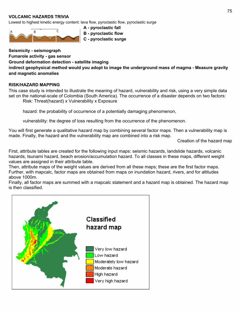
75
VOLCANIC HAZARDS TRIVIA Lowest to highest kinetic energy content: lava flow, pyroclastic flow, pyroclastic surge
A - pyroclastic fall B - pyroclastic flow C - pyroclastic surge
Seismicity - seismograph Fumarole activity - gas sensor Ground deformation detection - satellite imaging indirect geophysical method would you adopt to image the underground mass of magma - Measure gravity and magnetic anomalies RISK/HAZARD MAPPING This case study is intended to illustrate the meaning of hazard, vulnerability and risk, using a very simple data set on the national-scale of Colombia (South America). The occurrence of a disaster depends on two factors:
Risk: Threat(hazard) x Vulnerability x Exposure
hazard: the probability of occurrence of a potentially damaging phenomenon,
vulnerability: the degree of loss resulting from the occurrence of the phenomenon.
You will first generate a qualitative hazard map by combining several factor maps. Then a vulnerability map is made. Finally, the hazard and the vulnerability map are combined into a risk map.
Creation of the hazard map
First, attribute tables are created for the following input maps: seismic hazards, landslide hazards, volcanic hazards, tsunami hazard, beach erosion/accumulation hazard. To all classes in these maps, different weight values are assigned in their attribute table. Then, attribute maps of the weight values are derived from all these maps; these are the first factor maps. Further, with mapcalc, factor maps are obtained from maps on inundation hazard, rivers, and for altitudes above 1000m. Finally, all factor maps are summed with a mapcalc statement and a hazard map is obtained. The hazard map is then classified.
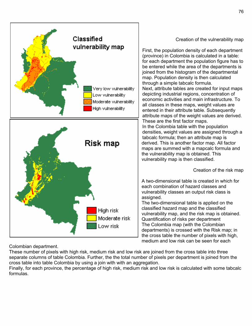
76
Creation of the vulnerability map
First, the population density of each department (province) in Colombia is calculated in a table: for each department the population figure has to be entered while the area of the departments is joined from the histogram of the departmental map. Population density is then calculated through a simple tabcalc formula. Next, attribute tables are created for input maps depicting industrial regions, concentration of economic activities and main infrastructure. To all classes in these maps, weight values are entered in their attribute table. Subsequently attribute maps of the weight values are derived. These are the first factor maps. In the Colombia table with the population densities, weight values are assigned through a tabcalc formula; then an attribute map is derived. This is another factor map. All factor maps are summed with a mapcalc formula and the vulnerability map is obtained. This vulnerability map is then classified.
Creation of the risk map
A two-dimensional table is created in which for each combination of hazard classes and vulnerability classes an output risk class is assigned. The two-dimensional table is applied on the classified hazard map and the classified vulnerability map, and the risk map is obtained. Quantification of risks per department The Colombia map (with the Colombian departments) is crossed with the Risk map; in the cross table the number of pixels with high, medium and low risk can be seen for each
Colombian department. These number of pixels with high risk, medium risk and low risk are joined from the cross table into three separate columns of table Colombia. Further, the the total number of pixels per department is joined from the cross table into table Colombia by using a join with with an aggregation. Finally, for each province, the percentage of high risk, medium risk and low risk is calculated with some tabcalc formulas.
77
Mass-Wasting Occurs when the slope is too steep to remain stable with existing materials and conditions. is the geomorphic process by which soil, sand, regolith, and rock move downslope typically as a solid, continuous or discontinuous mass, largely under the force of gravity, but frequently with characteristics of a flow as in debris flows and mudflows. Contains: creep, slides, flows, topples, and falls Role of Water: Water can increase or decrease the stability of a slope depending on the amount present. Small amounts of water can strengthen soils because the surface tension of water increases soil cohesion. This allows the soil to resist erosion better than if it were dry. If too much water is present the water may act to increase the pore pressure, reducing friction, and accelerating the erosion process and resulting in different types of mass wasting (i.e. mudflows, landslides, etc.). A good example of this is to think of a sand castle. Water must be mixed with sand in order for the castle to keep its shape. If too much water is added the sand washes away, if not enough water is added the sand falls and cannot keep its shape. Water also increases the mass of the soil, this is important because an increase in mass means that there will be an increase in velocity if mass wasting is triggered. Saturated water, however, eases the process of mass wasting in that the rock and soil debris are easily washed down-slope. CAN be divided into 2 broad categories: based on how the soil, regolith or rock moves downslope as a whole, mass movements can be broadly classified as creeps and landslides Creep: Soil creep is a slow and long term mass movement. The combination of small movements of soil or rock in different directions over time are directed by gravity gradually downslope. The steeper the slope, the faster the creep. The creep makes trees and shrubs curve to maintain their perpendicularity, and they can trigger landslides if they lose their root footing. The surface soil can migrate under the influence of cycles of freezing and thawing, or hot and cold temperatures, inching its way towards the bottom of the slope forming terracettes. Landslides are often preceded by soil creep accompanied with soil sloughing — loose soil that falls and accumulates at the base of the steepest creep sections.
How creep works: When sediment expands, individual particles are lifted up at right angles to the slope. Sediments can expand when they freeze, get wet or are heated up in the sun. When the sediments shrink, the particles fall straight back down. Creep takes a long time because each particle might only move a millimetre to a few centimetres at a time.
Landslide: A landslide, also called a landslip, is a slow or rapid movement of a large mass of earth and rocks down a hill or a mountainside. Little or no flowage of the materials occurs on a given slope until heavy rain and resultant lubrication by the same rainwater facilitate the movement of the materials, causing a landslide to occur. In particular, if the main feature of the movement is a slide along a planar or curved surface, the landslide is termed slump, earth slide, debris slide or rock slide, depending on the prevailing material. Movement of soil and regolith that more resembles fluid behavior is called a flow. These include avalanches, mudflows, debris flows, earth flow, lahars and sturzstroms. Water, air and ice are often involved in enabling fluid-like motion of the material. A fall, including rockfall and debris fall, occurs where regolith cascades down a slope, but is not of sufficient volume or viscosity to behave as a flow. Falls are promoted in rocks which are characterized by the presence of vertical cracks. Falls can also result from undercutting by running water as well as by waves. They usually occur at very steep slopes such as a cliff face. The rock material may be loosened by earthquakes, rain, plant-root wedging, and expanding ice, among other things. The accumulation of rock material that has fallen and resides at the base of the structure is known as talus.
Rotational slides show movement along a curved rupture surface with a commonly slow movement rate. Translational slides are movements along a plane of distinct weakness between the overlying slide material and more stable underlying material, and are often rapid. Sturzstroms: largest and fastest slides; aka long-run-out landslides; poorly understood
Triggers: Earthquakes, increased overburden from structures, increased soil moisture, reduction of roots holding the soil to bedrock, undercutting of the slope by excavation or erosion, weathering by frost heave or chemical dissolution, bioturbation
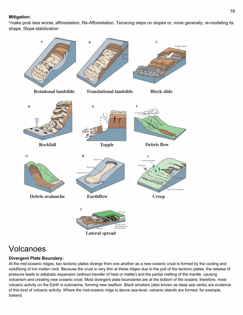
78
Mitigation: *make prob less worse; afforestation, Re-Afforestation, Terracing steps on slopes or, more generally, re-modeling its shape, Slope stabilization
Volcanoes Divergent Plate Boundary: At the mid-oceanic ridges, two tectonic plates diverge from one another as a new oceanic crust is formed by the cooling and solidifying of hot molten rock. Because the crust is very thin at these ridges due to the pull of the tectonic plates, the release of pressure leads to adiabatic expansion (without transfer of heat or matter) and the partial melting of the mantle, causing volcanism and creating new oceanic crust. Most divergent plate boundaries are at the bottom of the oceans; therefore, most volcanic activity on the Earth is submarine, forming new seafloor. Black smokers (also known as deep sea vents) are evidence of this kind of volcanic activity. Where the mid-oceanic ridge is above sea-level, volcanic islands are formed; for example, Iceland.
79
Convergent Plate Boundary: Subduction zones are places where two plates, usually an oceanic plate and a continental plate, collide. In this case, the oceanic plate subducts, or submerges, under the continental plate, forming a deep ocean trench just offshore. In a process called flux melting, water released from the subducting plate lowers the melting temperature of the overlying mantle wedge, thus creating magma. This magma tends to be extremely viscous because of its high silica content, so it often does not attain the surface but cools and solidifies at depth. When it does reach the surface, however, a volcano is formed. Typical examples are Mount Etna and the volcanoes in the Pacific Ring of Fire. Hotspots: Hotspots are volcanic areas believed to be formed by mantle plumes, which are hypothesized to be columns of hot material rising from the core-mantle boundary in a fixed space that causes large-volume melting. Because tectonic plates move across them, each volcano becomes dormant and is eventually re-formed as the plate advances over the postulated plume. The Hawaiian Islands are said to have been formed in such a manner; so has the Snake River Plain, with the Yellowstone Caldera being the part of the North American plate above the hot spot. This theory, however, has been doubted.
Types of volcanoes Other types of volcano include cryovolcanoes (or ice volcanoes), particularly on some moons of Jupiter, Saturn, and Neptune; and mud volcanoes, which are formations often not associated with known magmatic activity. Active mud volcanoes tend to involve temperatures much lower than those of igneous volcanoes except when the mud volcano is actually a vent of an igneous volcano. Fissure vents: Volcanic fissure vents are flat, linear fractures through which lava emerges, usually not explosive. Shield volcanoes: Shield volcanoes, so named for their broad, shield-like profiles, are formed by the eruption of highly fluid, low-viscosity lava that can flow a great distance from a vent. They generally do not explode catastrophically. Since low-viscosity magma is typically low in silica, shield volcanoes are more common in oceanic than continental settings. The Hawaiian volcanic chain is a series of shield cones, and they are common in Iceland, as well. Lava domes: Lava domes are built by slow eruptions of highly viscous lava. They are sometimes formed within the crater of a previous volcanic eruption, as in the case of Mount Saint Helens, but can also form independently, as in the case of Lassen Peak. Like stratovolcanoes, they can produce violent, explosive eruptions, but their lava generally does not flow far from the originating vent. Cryptodomes: Cryptodomes are formed when viscous lava is forced upward causing the surface to bulge. The 1980 eruption of Mount St. Helens was an example; lava beneath the surface of the mountain created an upward bulge which slid down the north side of the mountain. Volcanic cones (cinder cones): Volcanic cones or cinder cones result from eruptions of mostly small pieces of scoria and pyroclastics (both resemble cinders, hence the name of this volcano type) that build up around the vent. These can be relatively short-lived eruptions that produce a cone-shaped hill perhaps 30 to 400 meters high. Most cinder cones erupt only once. Cinder cones may form as flank vents on larger volcanoes, or occur on their own. Parícutin in Mexico and Sunset Crater in Arizona are examples of cinder cones. In New Mexico, Caja del Rio is a volcanic field of over 60 cinder cones. Based on satellite images it was suggested that cinder cones might occur on other terrestrial bodies in the Solar system too; on the surface of Mars and the Moon. Stratovolcanoes (composite volcanoes): Stratovolcanoes or composite volcanoes are tall conical mountains composed of lava flows and other ejecta in alternate layers, the strata that gives rise to the name. Stratovolcanoes are also known as composite volcanoes because they are created from multiple structures during different kinds of eruptions. Strato/composite volcanoes are made of cinders, ash, and lava. Cinders and ash pile on top of each other, lava flows on top of the ash, where it cools and hardens, and then the process repeats. Classic examples include Mount Fuji in Japan, Mayon Volcano in the Philippines, and Mount Vesuvius and Stromboli in Italy. Common at subduction zones. Throughout recorded history, ash produced by the explosive eruption of stratovolcanoes has posed the greatest volcanic hazard to civilizations. Not only do stratovolcanoes have greater pressure buildup from the underlying lava flow than shield volcanoes,
80
but their fissure vents and monogenetic volcanic fields (volcanic cones) also have more powerful eruptions because they are often under extension. They are also steeper than shield volcanoes, with slopes of 30–35° compared to slopes of generally 5–10°, and their loose tephra are material for dangerous lahars. Large pieces of tephra are called volcanic bombs. Big bombs can measure more than 4 feet(1.2 meters) across and weigh several tons. Supervolcanoes: Has had an eruption of magnitude 8, which is the largest value on the Volcanic Explosivity Index (VEI). This means the volume of deposits for that eruption is greater than 1,000 cubic kilometers (240 cubic miles). Supervolcanoes occur when magma in the mantle rises into the crust but is unable to break through it and pressure builds in a large and growing magma pool until the crust is unable to contain the pressure. A supervolcano usually has a large caldera and can produce devastation on an enormous, sometimes continental, scale. Such volcanoes are able to severely cool global temperatures for many years after the eruption due to the huge volumes of sulfur and ash released into the atmosphere. They are the most dangerous type of volcano. Examples include Yellowstone Caldera in Yellowstone National Park and Valles Caldera in New Mexico (both western United States); Lake Taupo in New Zealand; Lake Toba in Sumatra, Indonesia; and Ngorongoro Crater in Tanzania. Because of the enormous area they may cover, supervolcanoes are hard to identify centuries after an eruption. Similarly, large igneous provinces are also considered supervolcanoes because of the vast amount of basalt lava erupted (even though the lava flow is non-explosive). Underwater volcanoes: Submarine volcanoes are common features of the ocean floor. In shallow water, active volcanoes disclose their presence by blasting steam and rocky debris high above the ocean's surface. In the ocean's deep, the tremendous weight of the water above prevents the explosive release of steam and gases; however, they can be detected by hydrophones and discoloration of water because of volcanic gases. Pillow lava is a common eruptive product of submarine volcanoes and is characterized by thick sequences of discontinuous pillow-shaped masses which form under water. Even large submarine eruptions may not disturb the ocean surface due to the rapid cooling effect and increased buoyancy of water (as compared to air) which often causes volcanic vents to form steep pillars on the ocean floor. Hydrothermal vents are common near these volcanoes, and some support peculiar ecosystems based on dissolved minerals. Over time, the formations created by submarine volcanoes may become so large that they break the ocean surface as new islands or floating pumice rafts. Subglacial volcanoes: Subglacial volcanoes develop underneath icecaps. They are made up of flat lava which flows at the top of extensive pillow lavas and palagonite. When the icecap melts, the lava on top collapses, leaving a flat-topped mountain. These volcanoes are also called table mountains, tuyas, or (uncommonly) mobergs. Very good examples of this type of volcano can be seen in Iceland, however, there are also tuyas in British Columbia. The origin of the term comes from Tuya Butte, which is one of the several tuyas in the area of the Tuya River and Tuya Range in northern British Columbia. Tuya Butte was the first such landform analyzed and so its name has entered the geological literature for this kind of volcanic formation. The Tuya Mountains Provincial Park was recently established to protect this unusual landscape, which lies north of Tuya Lake and south of the Jennings River near the boundary with the Yukon Territory. Mud volcanoes: Mud volcanoes or mud domes are formations created by geo-excreted liquids and gases, although there are several processes which may cause such activity. The largest structures are 10 kilometers in diameter and reach 700 meters high. Pics:
Fissure vent
Lava dome
81
shield volcano
Cryptodome
Cinder cone
1. Large magma chamber 2. Bedrock 3. Conduit (pipe) 4.Base 5. Sill 6. Dike 7. Layers of ash emitted by the volcano 8. Flank 9. Layers of lava emitted by the
volcano 10. Throat 11. Parasitic cone
12. Lava flow 13. Vent 14. Crater
Stratovolcano 15. Ash cloud
Supervolcano - red is VEI 8, orange is VEI 7
1. Water vapor cloud 2. Water 3. Stratum 4. Lava flow 5. Magma Conduit 6. Magma Chamber 7. Dike 8. Pillow lava
Subglacial & Mud
Lava Composition Another way of classifying volcanoes is by the composition of material erupted (lava), since this affects the shape of the volcano. Lava can be broadly classified into four different compositions:[10]
● If the erupted magma contains a high percentage (>63%) of silica, the lava is called felsic. ● Felsic lavas (dacites or rhyolites) tend to be highly viscous (not very fluid) and are erupted as domes or
short, stubby flows. Viscous lavas tend to form stratovolcanoes or lava domes. Lassen Peak in California is an example of a volcano formed from felsic lava and is actually a large lava dome.
● Because siliceous magmas are so viscous, they tend to trap volatiles (gases) that are present, which cause the magma to erupt catastrophically, eventually forming stratovolcanoes. Pyroclastic flows (ignimbrites) are highly hazardous products of such volcanoes, since they are composed of molten volcanic ash too heavy to go up into the atmosphere, so they hug the volcano's slopes and travel far from their vents during large eruptions. Temperatures as high as 1,200 °C are known to occur in pyroclastic flows, which will incinerate everything flammable in their path and thick layers of hot pyroclastic flow deposits can be laid down, often up to many meters thick. Alaska's Valley of Ten Thousand Smokes, formed by the eruption of Novaruptanear Katmai in 1912, is an example of a thick pyroclastic flow or ignimbrite deposit. Volcanic ash that is light enough to be erupted high into the Earth's atmosphere may travel many kilometres before it falls back to ground as a tuff.
● If the erupted magma contains 52–63% silica, the lava is of intermediate composition.
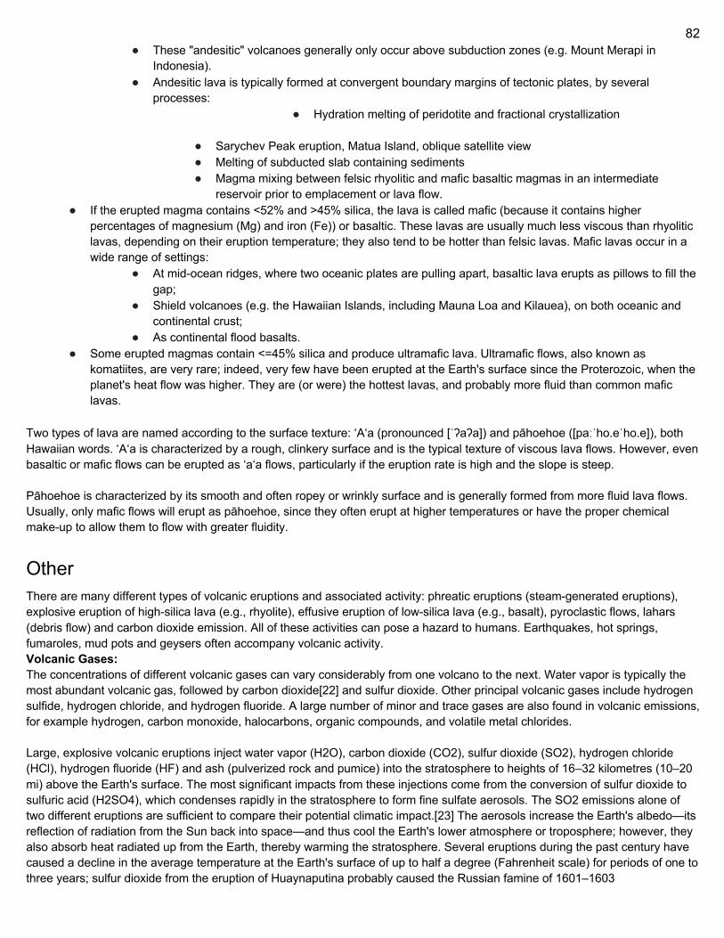
82
● These "andesitic" volcanoes generally only occur above subduction zones (e.g. Mount Merapi in Indonesia).
● Andesitic lava is typically formed at convergent boundary margins of tectonic plates, by several processes:
● Hydration melting of peridotite and fractional crystallization
● Sarychev Peak eruption, Matua Island, oblique satellite view ● Melting of subducted slab containing sediments ● Magma mixing between felsic rhyolitic and mafic basaltic magmas in an intermediate
reservoir prior to emplacement or lava flow. ● If the erupted magma contains <52% and >45% silica, the lava is called mafic (because it contains higher
percentages of magnesium (Mg) and iron (Fe)) or basaltic. These lavas are usually much less viscous than rhyolitic lavas, depending on their eruption temperature; they also tend to be hotter than felsic lavas. Mafic lavas occur in a wide range of settings:
● At mid-ocean ridges, where two oceanic plates are pulling apart, basaltic lava erupts as pillows to fill the gap;
● Shield volcanoes (e.g. the Hawaiian Islands, including Mauna Loa and Kilauea), on both oceanic and continental crust;
● As continental flood basalts. ● Some erupted magmas contain <=45% silica and produce ultramafic lava. Ultramafic flows, also known as
komatiites, are very rare; indeed, very few have been erupted at the Earth's surface since the Proterozoic, when the planet's heat flow was higher. They are (or were) the hottest lavas, and probably more fluid than common mafic lavas.
Two types of lava are named according to the surface texture: ʻAʻa (pronounced [ˈʔaʔa]) and pāhoehoe ([paːˈho.eˈho.e]), both Hawaiian words. ʻAʻa is characterized by a rough, clinkery surface and is the typical texture of viscous lava flows. However, even basaltic or mafic flows can be erupted as ʻaʻa flows, particularly if the eruption rate is high and the slope is steep. Pāhoehoe is characterized by its smooth and often ropey or wrinkly surface and is generally formed from more fluid lava flows. Usually, only mafic flows will erupt as pāhoehoe, since they often erupt at higher temperatures or have the proper chemical make-up to allow them to flow with greater fluidity.
Other There are many different types of volcanic eruptions and associated activity: phreatic eruptions (steam-generated eruptions), explosive eruption of high-silica lava (e.g., rhyolite), effusive eruption of low-silica lava (e.g., basalt), pyroclastic flows, lahars (debris flow) and carbon dioxide emission. All of these activities can pose a hazard to humans. Earthquakes, hot springs, fumaroles, mud pots and geysers often accompany volcanic activity. Volcanic Gases: The concentrations of different volcanic gases can vary considerably from one volcano to the next. Water vapor is typically the most abundant volcanic gas, followed by carbon dioxide[22] and sulfur dioxide. Other principal volcanic gases include hydrogen sulfide, hydrogen chloride, and hydrogen fluoride. A large number of minor and trace gases are also found in volcanic emissions, for example hydrogen, carbon monoxide, halocarbons, organic compounds, and volatile metal chlorides. Large, explosive volcanic eruptions inject water vapor (H2O), carbon dioxide (CO2), sulfur dioxide (SO2), hydrogen chloride (HCl), hydrogen fluoride (HF) and ash (pulverized rock and pumice) into the stratosphere to heights of 16–32 kilometres (10–20 mi) above the Earth's surface. The most significant impacts from these injections come from the conversion of sulfur dioxide to sulfuric acid (H2SO4), which condenses rapidly in the stratosphere to form fine sulfate aerosols. The SO2 emissions alone of two different eruptions are sufficient to compare their potential climatic impact.[23] The aerosols increase the Earth's albedo—its reflection of radiation from the Sun back into space—and thus cool the Earth's lower atmosphere or troposphere; however, they also absorb heat radiated up from the Earth, thereby warming the stratosphere. Several eruptions during the past century have caused a decline in the average temperature at the Earth's surface of up to half a degree (Fahrenheit scale) for periods of one to three years; sulfur dioxide from the eruption of Huaynaputina probably caused the Russian famine of 1601–1603
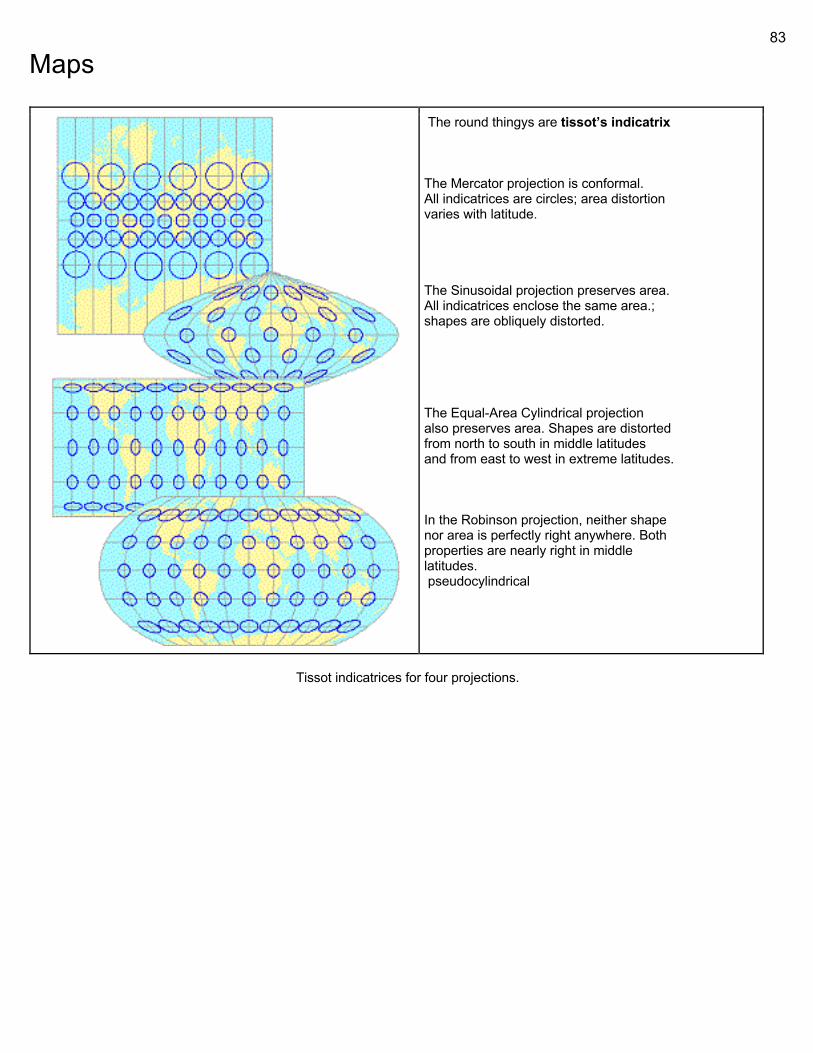
83
Maps
The round thingys are tissot’s indicatrix The Mercator projection is conformal. All indicatrices are circles; area distortion varies with latitude. The Sinusoidal projection preserves area. All indicatrices enclose the same area.; shapes are obliquely distorted. The Equal-Area Cylindrical projection also preserves area. Shapes are distorted from north to south in middle latitudes and from east to west in extreme latitudes. In the Robinson projection, neither shape nor area is perfectly right anywhere. Both properties are nearly right in middle latitudes. pseudocylindrical
Tissot indicatrices for four projections.
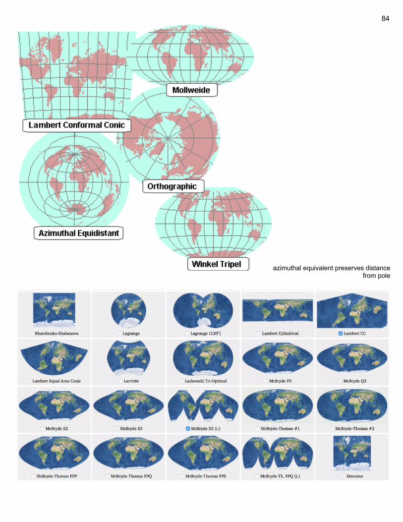
84
azimuthal equivalent preserves distance from pole
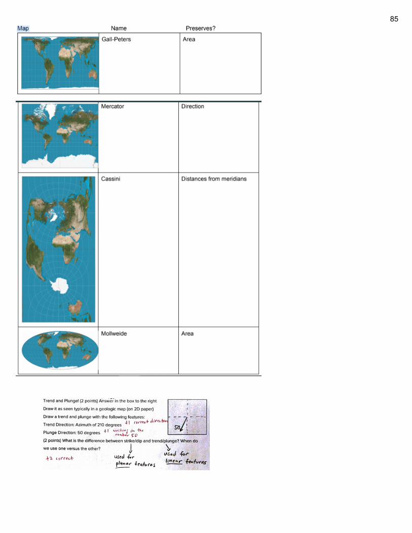
85
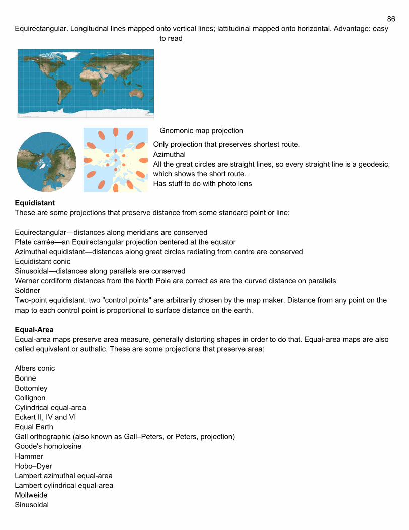
86
Equirectangular. Longitudnal lines mapped onto vertical lines; lattitudinal mapped onto horizontal. Advantage: easy to read
Gnomonic map projection
Only projection that preserves shortest route. Azimuthal All the great circles are straight lines, so every straight line is a geodesic, which shows the short route. Has stuff to do with photo lens
Equidistant These are some projections that preserve distance from some standard point or line: Equirectangular—distances along meridians are conserved Plate carrée—an Equirectangular projection centered at the equator Azimuthal equidistant—distances along great circles radiating from centre are conserved Equidistant conic Sinusoidal—distances along parallels are conserved Werner cordiform distances from the North Pole are correct as are the curved distance on parallels Soldner Two-point equidistant: two "control points" are arbitrarily chosen by the map maker. Distance from any point on the map to each control point is proportional to surface distance on the earth. Equal-Area Equal-area maps preserve area measure, generally distorting shapes in order to do that. Equal-area maps are also called equivalent or authalic. These are some projections that preserve area: Albers conic Bonne Bottomley Collignon Cylindrical equal-area Eckert II, IV and VI Equal Earth Gall orthographic (also known as Gall–Peters, or Peters, projection) Goode's homolosine Hammer Hobo–Dyer Lambert azimuthal equal-area Lambert cylindrical equal-area Mollweide Sinusoidal
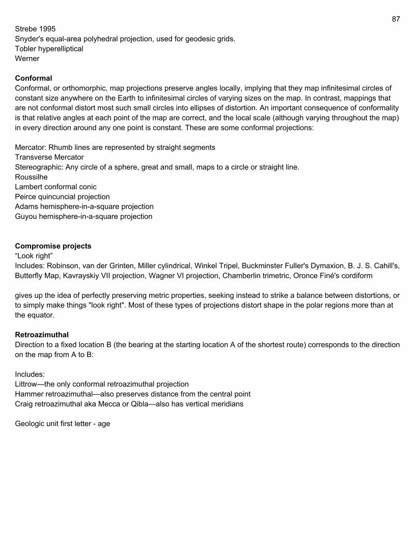
87
Strebe 1995 Snyder's equal-area polyhedral projection, used for geodesic grids. Tobler hyperelliptical Werner Conformal Conformal, or orthomorphic, map projections preserve angles locally, implying that they map infinitesimal circles of constant size anywhere on the Earth to infinitesimal circles of varying sizes on the map. In contrast, mappings that are not conformal distort most such small circles into ellipses of distortion. An important consequence of conformality is that relative angles at each point of the map are correct, and the local scale (although varying throughout the map) in every direction around any one point is constant. These are some conformal projections: Mercator: Rhumb lines are represented by straight segments Transverse Mercator Stereographic: Any circle of a sphere, great and small, maps to a circle or straight line. Roussilhe Lambert conformal conic Peirce quincuncial projection Adams hemisphere-in-a-square projection Guyou hemisphere-in-a-square projection Compromise projects “Look right” Includes: Robinson, van der Grinten, Miller cylindrical, Winkel Tripel, Buckminster Fuller's Dymaxion, B. J. S. Cahill's, Butterfly Map, Kavrayskiy VII projection, Wagner VI projection, Chamberlin trimetric, Oronce Finé's cordiform gives up the idea of perfectly preserving metric properties, seeking instead to strike a balance between distortions, or to simply make things "look right". Most of these types of projections distort shape in the polar regions more than at the equator. Retroazimuthal Direction to a fixed location B (the bearing at the starting location A of the shortest route) corresponds to the direction on the map from A to B: Includes: Littrow—the only conformal retroazimuthal projection Hammer retroazimuthal—also preserves distance from the central point Craig retroazimuthal aka Mecca or Qibla—also has vertical meridians Geologic unit first letter - age
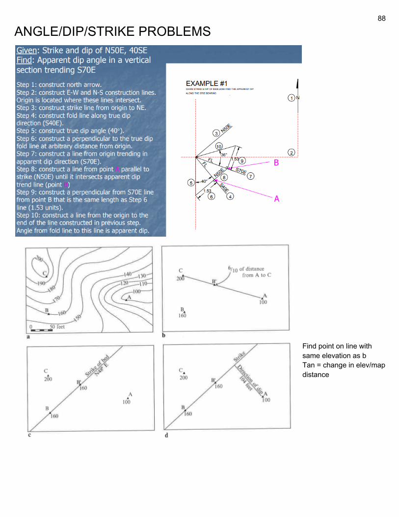
88
ANGLE/DIP/STRIKE PROBLEMS
Find point on line with same elevation as b Tan = change in elev/map distance
89
39. a. Strike: Answers between N10°W and N45°W or S10°E and S45°E are acceptable. 1 point for the format N__W or S__E and 1 point for the appropriate numerical angle. b. Thickness: The change in elevation across the dyke is 20 meters. (1 pt) The angle of the dyke to the horizontal is given by the dip: it is 30°. (1 pt) The width of the dyke is given on the map: it is 150 meters. (1 pt) The true thickness of the dyke is width(sin(dip))+height(cos(dip)) (1 pt for writing this out or explaining why it is true) Thickness = 150(sin(30))+20(cos(30)) = 92 meters (1 pt for answers between 91m and 94m) On a geologic map, you notice a Limestone strata with a strike of 000. At the outcrop furthest to the west, the elevation is 277m. This is marked as M1. A measurement taken 400m due east of M1 measures 281m. This is marked as M2. A final measurement taken at the furthest east outcrop of the Limestone strata measures 285m, marked M3. M3, is 400m due east of M2. The Limestone strata has a dip of 6°. What is the True Thickness of the Limestone strata? 800*sin(6) + 10*cos(6) ~= 92 c. Strike: N10(+/- 3)°E or S10(+/- 3)°W. (1 pt) It is the direction of the line between A and D, since A and D are at the same elevation. (1 pt) Dip: It is orthogonal to the strike. (1 pt) The angle is arctan((change in elevation between line AD and C)/(distance between line AD and C)). (1 pt) Change in elevation is (410-340) = 70 m. Change in distance is 1.4(+/- 0.1) km. (1 pt for stating both) Thus dip is tan^(-1)(70/1400) = about 3° (answers between 2.8 and 3 acceptable) (1 pt) -1 degree = 60 minutes = 3600 seconds -dip = incline of bedding plane, perpendicular to strike (angle the fault runs) [report strike/dip] -apparent dip is less than true dip 50.Given strike and true dip of N50E, 40SE, find the apparent dip in vertical section trending S70E. (2 points) δ = 36 Orthographically determine the true dip and strike given two apparent dips Two apparent dips (a) of a plane (e.g., dike, vein) are measured in the field on two surfaces (e.g., joints). Determine the true dip (d) and strike of the plane. Example: A dike has an apparent dip of a1 = 20 along the 296 direction and a2 = 30 along the 046 directions. What is the attitude of the dike? Procedure: 1. Pick a point, O, at the center of your graph paper. 2. Draw the direction of the apparent dips (i.e., 296 and 046) from point O. 3. Call these FL1 and FL2, respectively. 4. Subtend the angle a1 from FL1, and angle a2 from FL2. 5. Use a straight edge and choose an arbitrary depth d perpendicular to FL1. 6. Find point A where d intersects the trend of the apparent dip (i.e., the 296 line) 7. Use the same d for FL2, and repeat steps 5 and 6 for the second apparent dip, except that the intersection point is marked as B. 8. Connect A to B. This is the strike of the dike.
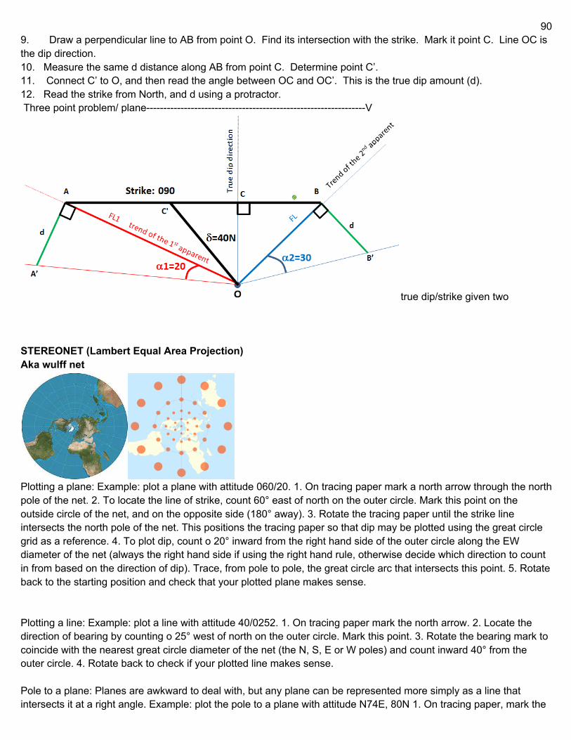
90
9. Draw a perpendicular line to AB from point O. Find its intersection with the strike. Mark it point C. Line OC is the dip direction. 10. Measure the same d distance along AB from point C. Determine point C’. 11. Connect C’ to O, and then read the angle between OC and OC’. This is the true dip amount (d). 12. Read the strike from North, and d using a protractor. Three point problem/ plane----------------------------------------------------------------V
true dip/strike given two STEREONET (Lambert Equal Area Projection) Aka wulff net
Plotting a plane: Example: plot a plane with attitude 060/20. 1. On tracing paper mark a north arrow through the north pole of the net. 2. To locate the line of strike, count 60° east of north on the outer circle. Mark this point on the outside circle of the net, and on the opposite side (180° away). 3. Rotate the tracing paper until the strike line intersects the north pole of the net. This positions the tracing paper so that dip may be plotted using the great circle grid as a reference. 4. To plot dip, count o 20° inward from the right hand side of the outer circle along the EW diameter of the net (always the right hand side if using the right hand rule, otherwise decide which direction to count in from based on the direction of dip). Trace, from pole to pole, the great circle arc that intersects this point. 5. Rotate back to the starting position and check that your plotted plane makes sense. Plotting a line: Example: plot a line with attitude 40/0252. 1. On tracing paper mark the north arrow. 2. Locate the direction of bearing by counting o 25° west of north on the outer circle. Mark this point. 3. Rotate the bearing mark to coincide with the nearest great circle diameter of the net (the N, S, E or W poles) and count inward 40° from the outer circle. 4. Rotate back to check if your plotted line makes sense. Pole to a plane: Planes are awkward to deal with, but any plane can be represented more simply as a line that intersects it at a right angle. Example: plot the pole to a plane with attitude N74E, 80N 1. On tracing paper, mark the
91
north arrow. 2. Mark the strike N74E on the stereonet and rotate it to north as if plotting the plane. 3. Count 80 in from the edge as you would for nding the dip of the plane. Now count an additional 90°. Alternatively, count 80 from the center of the stereonet rather than the outer edge. Mark this point, its is the pole to the plane. 4. Check to make sure your pole makes sense Line of intersection of two planes: 1. Draw the great circle for each plane. 2. Rotate the tracing paper so that the point of intersection lies on the N-S or E-W line of the net. Mark the outer circle at the closest end of the N-S or E-W line. 3. Before rotating the paper back, count the number of degrees on the N-S or E-W line from the outer edge to the point of intersection. This is the plunge. 4. Rotate back. Find the bearing of the mark made on the outer edge of the circle. This is the trend. Angles within planes: Angles within planes are measured along the great circle of the plane. The most common need is to plot the pitch or rake of a line within a plane. Example: a fault surface of N52W/20NE contains a slickenside lineation with a pitch of 43° to the east (Figure 1a). Figure 1b shows the lineation plotted on the stereonet. True dip from strike and apparent dip: 1. Draw a line representing the strike line of the plane. This will be a straight line across the center of the stereonet intersecting the outer circle at the strike bearing. 2. Plot the apparent dip as a pole. 3. We now have two points on the outer circle (the two ends of the strike line) and one point within (the apparent dip point), all three of which must lie on the same plane. Turn the strike line to lie on the NS line of the net and draw the great circle that passes through these points. 4. Measure true dip of plane along EW line of net. Strike and dip from two apparent dips: 1. Plot both points representing the apparent dips lines. 2. Rotate the tracing paper until both points lie on the same great circle. This plane is the true strike and dip of the bed. Vertical axis rotations: 1. Rotations about a vertical axis aect only the strike of the plane, while dip remains unchanged. Rotations are measured along the outer circle. Example: What is the new attitude of a plane oriented N60W/45NE after a rotation of 30° clockwise about R (vertical axis)? Answer: N30W/45NE Rotations about a horizontal axis parallel to the strike Rotation about the strike line aecst only the dip of the plane while the strike remains unchanged. In this case the overlay is rotated such that the strike of the plane (which is the rotation axis) coincides with the NS line, and the rotation is measured along the great circle grid. Example: What is the attitude of a plane oriented N20E/80SE after a rotation of 50° counterclockwise about R? Answer: N20E/30SE Note that during rotation all points on the original great circle projection of the plane move along small circles to points on the rotated arc of the plane. In this way, arc lengths of the initial projection of the plane are preserved during rotation. The rake of a linear element in the plane is thus constant regardless of the orientation of the plane. General rotations Rotations about any other axis (the usual case in geology) are trickier and are most easily done with poles to the planes rather than the planes themselves. We simplify the problem by rst rotating the rotation axis to be horizontal, performing the required rotation, and nally returning the rotation axis to its original orientation. Example: Find the new attitude of a plane oriented N30E/30SE after a rotation of 60° counterclockwise about a rotation axis (R) EW/30E 1. Plot R, plane and pole to plane (Figure 4a) 2. Rotate R to horizontal position (R'). To maintain constant angular relationship between P and R, P must be rotated by the same amount along small circle. (Figure 4b) 3. Position R' parallel to the NS axis of the net and perform 60° counterclockwise rotation by moving P' to P (60° measured on small circle). (Figure 4c) 4. Restore R' to true orientation. Simultaneous rotation of P gives true attitude of pole to rotated plane (P'). Plane itself is then reconstructed from the pole. (Figure 4d) Cones: Because a drill core rotates as it is extracted, the orientation of a bedding plane cannot be determined, but a range of possible orientations can be dened. Lines perpendicular to the sides of the cone, representing poles to
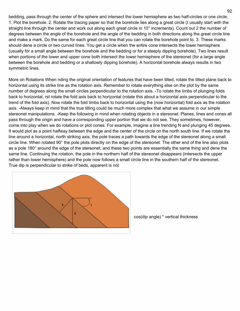
92
bedding, pass through the center of the sphere and intersect the lower hemisphere as two half-circles or one circle. 1. Plot the borehole. 2. Rotate the tracing paper so that the borehole lies along a great circle (I usually start with the straight line through the center and work out along each great circle in 10° increments). Count out 2 the number of degrees between the angle of the borehole and the angle of the bedding in both directions along the great circle line and make a mark. Do the same for each great circle line that you can rotate the borehole point to. 3. These marks should dene a circle or two curved lines. You get a circle when the entire cone intersects the lower hemisphere (usually for a small angle between the borehole and the bedding or for a steeply dipping borehole). Two lines result when portions of the lower and upper cone both intersect the lower hemisphere of the stereonet (for a large angle between the borehole and bedding or a shallowly dipping borehole). A horizontal borehole always results in two symmetric lines. More on Rotations When nding the original orientation of features that have been tilted, rotate the tilted plane back to horizontal using its strike line as the rotation axis. Remember to rotate everything else on the plot by the same number of degrees along the small circles perpendicular to the rotation axis. -To rotate the limbs of plunging folds back to horizontal, rst rotate the fold axis back to horizontal (rotate this about a horizontal axis perpendicular to the trend of the fold axis). Now rotate the fold limbs back to horizontal using the (now horizontal) fold axis as the rotation axis. -Always keep in mind that the true tilting could be much more complex that what we assume in our simple stereonet manipulations. -Keep the following in mind when rotating objects in a stereonet. Planes, lines and cones all pass through the origin and have a corresponding upper portion that we do not see. They sometimes, however, come into play when we do rotations or plot cones. For example, imagine a line trending N and plunging 45 degrees. It would plot as a point halfway between the edge and the center of the circle on the north south line. If we rotate the line around a horizontal, north striking axis, the pole traces a path towards the edge of the stereonet along a small circle line. When rotated 90° the pole plots directly on the edge of the stereonet. The other end of the line also plots as a pole 180° around the edge of the stereonet, and these two points are essentially the same thing and dene the same line. Continuing the rotation, the pole in the northern half of the stereonet disappears (intersects the upper rather than lower hemisphere) and the pole now follows a small circle line in the southern half of the stereonet. True dip is perpendicular to strike of beds, apparent is not
cos(dip angle) * vertical thickness
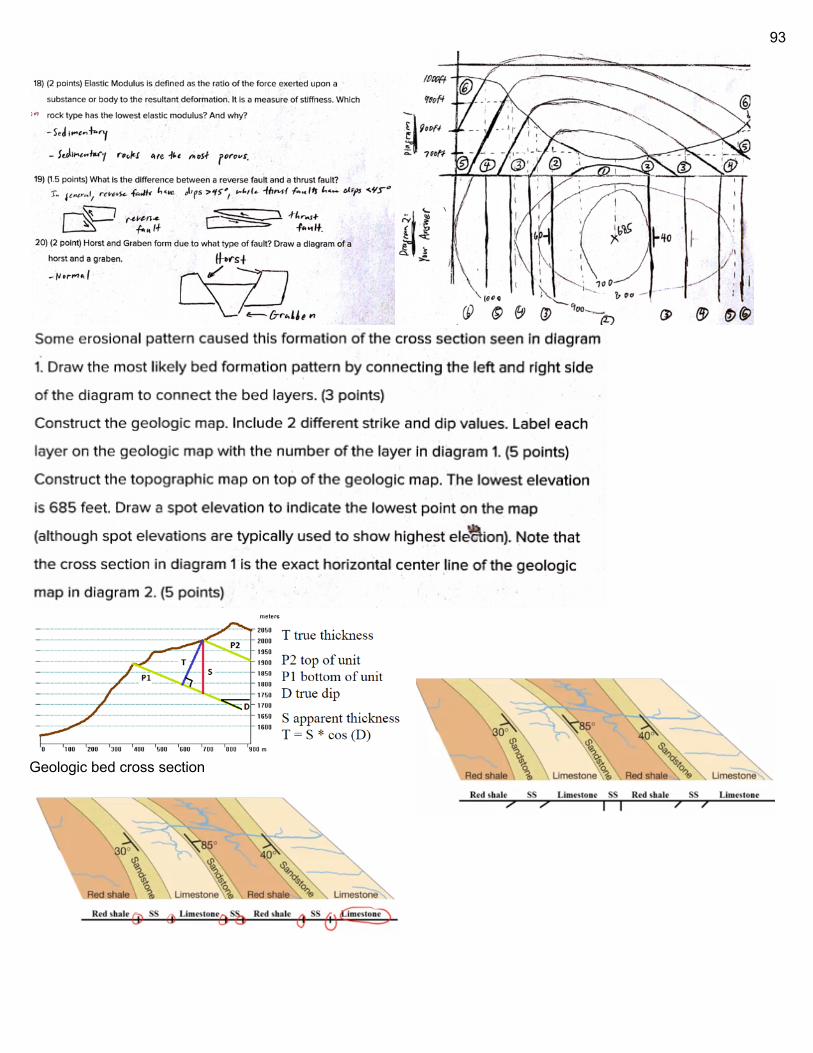
93
Geologic bed cross section
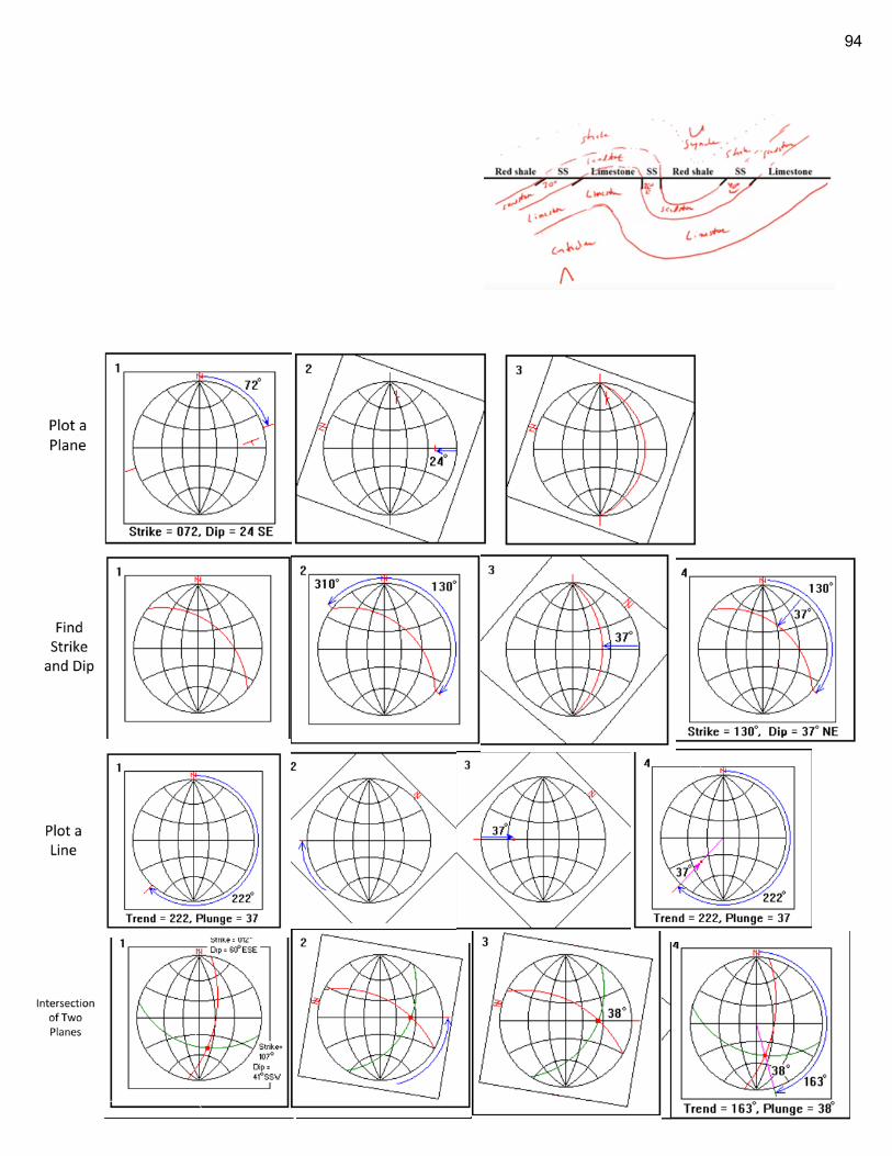
94
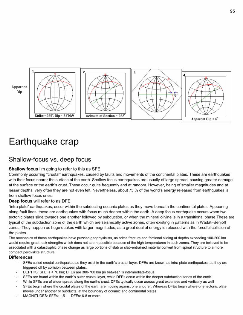
95
Earthquake crap
Shallow-focus vs. deep focus Shallow focus i’m going to refer to this as SFE Commonly occurring “crustal” earthquakes, caused by faults and movements of the continental plates. These are earthquakes with their focus nearer the surface of the earth. Shallow focus earthquakes are usually of large spread, causing greater damage at the surface or the earth’s crust. These occur quite frequently and at random. However, being of smaller magnitudes and at lesser depths, very often they are not even felt. Nevertheless, about 75 % of the world’s energy released from earthquakes is from shallow-focus ones. Deep focus will refer to as DFE “intra plate” earthquakes, occur within the subducting oceanic plates as they move beneath the continental plates. Appearing along fault lines, these are earthquakes with focus much deeper within the earth. A deep focus earthquake occurs when two tectonic plates slide towards one another followed by subduction, or when the mineral olivine is in a transitional phase.These are typical of the subduction zone of the earth which are seismically active zones, often existing in patterns as in Wadati-Benioff zones. They happen as huge quakes with larger magnitudes, as a great deal of energy is released with the forceful collision of the plates. The mechanics of these earthquakes have puzzled geophysicists, as brittle fracture and frictional sliding at depths exceeding 100-200 km would require great rock strengths which does not seem possible because of the high temperatures in such zones. They are believed to be associated with a catastrophic phase change as large portions of slab or slab-entrained material convert from spinal structure to a more compact perovskite structure. Differences
- SFEs called crustal earthquakes as they exist in the earth’s crustal layer. DFEs are known as intra plate earthquakes, as they are triggered off by collision between plates.
- DEPTHS: SFE is < 70 km; DFEs are 300-700 km (in between is intermediate-focus - SFEs are found within the earth’s outer crustal layer, while DFEs occur within the deeper subduction zones of the earth - While SFEs are of wider spread along the earths crust, DFEs typically occur across great expanses and vertically as well - SFEs begin where the crustal plates of the earth are moving against one another. Whereas DFEs begin where one tectonic plate
moves under another or subducts, at the boundary of oceanic and continental plates - MAGNITUDES: SFEs: 1-5 DFEs: 6-8 or more
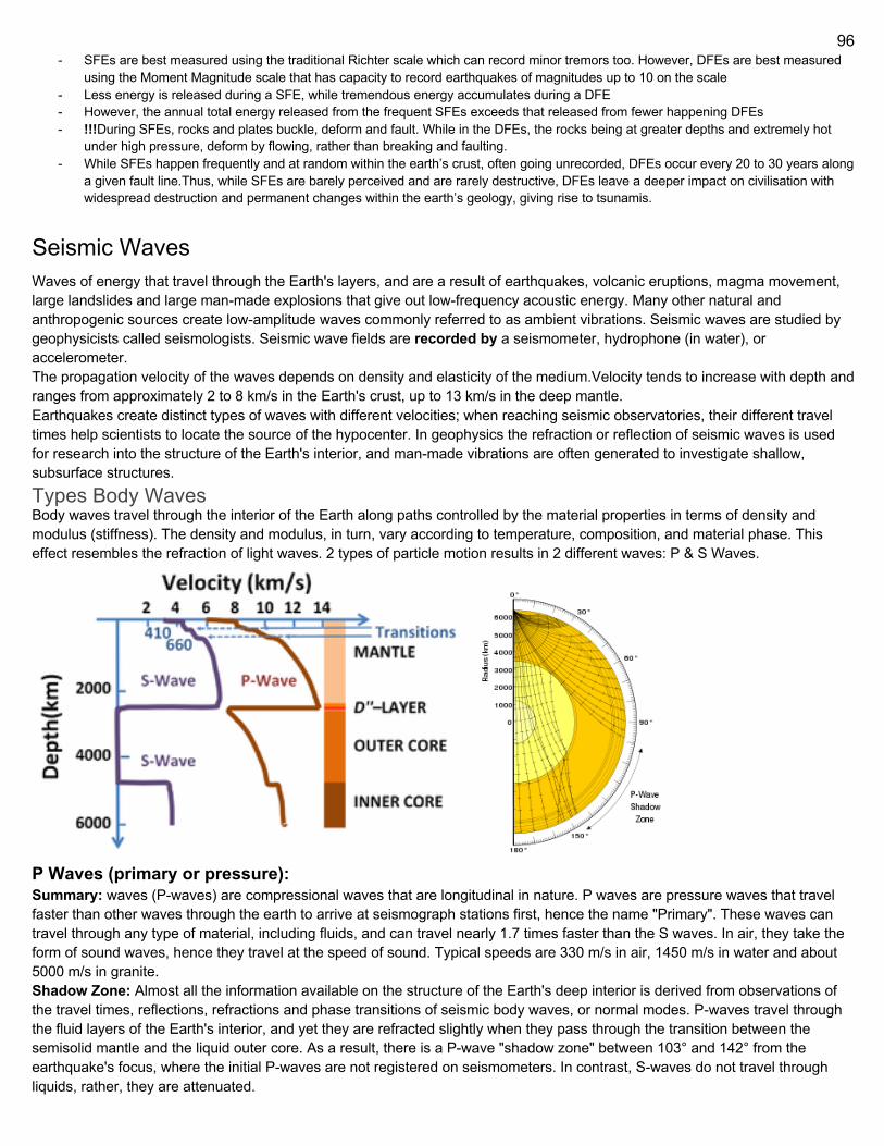
96
- SFEs are best measured using the traditional Richter scale which can record minor tremors too. However, DFEs are best measured using the Moment Magnitude scale that has capacity to record earthquakes of magnitudes up to 10 on the scale
- Less energy is released during a SFE, while tremendous energy accumulates during a DFE - However, the annual total energy released from the frequent SFEs exceeds that released from fewer happening DFEs - !!!During SFEs, rocks and plates buckle, deform and fault. While in the DFEs, the rocks being at greater depths and extremely hot
under high pressure, deform by flowing, rather than breaking and faulting. - While SFEs happen frequently and at random within the earth’s crust, often going unrecorded, DFEs occur every 20 to 30 years along
a given fault line.Thus, while SFEs are barely perceived and are rarely destructive, DFEs leave a deeper impact on civilisation with widespread destruction and permanent changes within the earth’s geology, giving rise to tsunamis.
Seismic Waves Waves of energy that travel through the Earth's layers, and are a result of earthquakes, volcanic eruptions, magma movement, large landslides and large man-made explosions that give out low-frequency acoustic energy. Many other natural and anthropogenic sources create low-amplitude waves commonly referred to as ambient vibrations. Seismic waves are studied by geophysicists called seismologists. Seismic wave fields are recorded by a seismometer, hydrophone (in water), or accelerometer. The propagation velocity of the waves depends on density and elasticity of the medium.Velocity tends to increase with depth and ranges from approximately 2 to 8 km/s in the Earth's crust, up to 13 km/s in the deep mantle. Earthquakes create distinct types of waves with different velocities; when reaching seismic observatories, their different travel times help scientists to locate the source of the hypocenter. In geophysics the refraction or reflection of seismic waves is used for research into the structure of the Earth's interior, and man-made vibrations are often generated to investigate shallow, subsurface structures. Types Body Waves Body waves travel through the interior of the Earth along paths controlled by the material properties in terms of density and modulus (stiffness). The density and modulus, in turn, vary according to temperature, composition, and material phase. This effect resembles the refraction of light waves. 2 types of particle motion results in 2 different waves: P & S Waves.
P Waves (primary or pressure): Summary: waves (P-waves) are compressional waves that are longitudinal in nature. P waves are pressure waves that travel faster than other waves through the earth to arrive at seismograph stations first, hence the name "Primary". These waves can travel through any type of material, including fluids, and can travel nearly 1.7 times faster than the S waves. In air, they take the form of sound waves, hence they travel at the speed of sound. Typical speeds are 330 m/s in air, 1450 m/s in water and about 5000 m/s in granite. Shadow Zone: Almost all the information available on the structure of the Earth's deep interior is derived from observations of the travel times, reflections, refractions and phase transitions of seismic body waves, or normal modes. P-waves travel through the fluid layers of the Earth's interior, and yet they are refracted slightly when they pass through the transition between the semisolid mantle and the liquid outer core. As a result, there is a P-wave "shadow zone" between 103° and 142° from the earthquake's focus, where the initial P-waves are not registered on seismometers. In contrast, S-waves do not travel through liquids, rather, they are attenuated.
97
Earthquake Warning: Advance earthquake warning is possible by detecting the nondestructive primary waves that travel more quickly through the Earth's crust than do the destructive secondary and Rayleigh waves. The amount of advance warning depends on the delay between the arrival of the P-wave and other destructive waves, generally on the order of seconds up to about 60 to 90 seconds for deep, distant, large quakes such as the 2011 Tohoku earthquake. The effectiveness of advance warning depends on accurate detection of the P-waves and rejection of ground vibrations caused by local activity (such as trucks or construction). Earthquake early warning systems can be automated to allow for immediate safety actions, such as issuing alerts, stopping elevators at the nearest floors and switching off utilities. S Waves (secondary or shear): Summary: ELASTIC Secondary waves (S-waves) are shear waves that are transverse in nature. Following an earthquake event, S-waves arrive at seismograph stations after the faster-moving P-waves and displace the ground perpendicular to the direction of propagation. Depending on the propagational direction, the wave can take on different surface characteristics; for example, in the case of horizontally polarized S waves, the ground moves alternately to one side and then the other. S-waves can travel only through solids, as fluids (liquids and gases) do not support shear stresses. S-waves are slower than P-waves, and speeds are typically around 60% of that of P-waves in any given material. Its name, S for secondary, comes from the fact that it is the second direct arrival on an earthquake seismogram, after the compressional primary wave, or P-wave, because S-waves travel slower in rock. Unlike the P-wave, the S-wave cannot travel through the molten outer core of the Earth, and this causes a shadow zone for S-waves opposite to where they originate. They can still appear in the solid inner core: when a P-wave strikes the boundary of molten and solid cores, S-waves will then propagate in the solid medium. And when the S-waves hit the boundary again they will in turn create P-waves. This property allows seismologists to determine the nature of the inner core. Shear Wave Splitting: Also called seismic birefringence, is the phenomenon that occurs when a polarized shear wave enters an anisotropic** medium (direction dependent; opposite of isotropic). The incident shear wave splits into two polarized shear waves. Shear wave splitting is typically used as a tool for testing the anisotropy of an area of interest. These measurements reflect the degree of anisotropy and lead to a better understanding of the area’s crack density and orientation or crystal alignment. We can think of the anisotropy of a particular area as a black box and the shear wave splitting measurements as a way of looking at what is in the box D Waves: Other waves Surface Waves: Seismic surface waves travel along the Earth's surface. They can be classified as a form of mechanical surface waves. * (a 90 degree wave that propagates along the interface between differing media e.g. gravity waves/ ocean waves) They are called surface waves, as they diminish as they get further from the surface. They travel more slowly than seismic body waves (P and S). In large earthquakes, surface waves can have an amplitude of several centimeters. Rayleigh Waves: Summary: Rayleigh waves, also called ground roll, are surface waves that travel as ripples with motions that are similar to those of waves on the surface of water (note, however, that the associated particle motion at shallow depths is retrograde, and that the restoring force in Rayleigh and in other seismic waves is elastic, not gravitational as for water waves). The existence of these waves was predicted by John William Strutt, Lord Rayleigh, in 1885. They are slower than body waves, roughly 90% of the velocity of S waves for typical homogeneous elastic media. In a layered medium (like the crust and upper mantle) the velocity of the Rayleigh waves depends on their frequency and wavelength. More Info: Because Rayleigh waves are surface waves, the amplitude of such waves generated by an earthquake generally decreases exponentially with the depth of the hypocenter (focus). However, large earthquakes may generate Rayleigh waves that travel around the Earth several times before dissipating. Rayleigh waves are generated by the interaction of P- and S- waves at the surface of the earth, and travel with a velocity that is lower than the P-, S-, and Love wave velocities. Rayleigh waves emanating outward from the epicenter of an earthquake travel along the surface of the earth at about 10 times the speed of sound in air (0.340 km/s), that is ~3 km/s. Due to their higher speed, the P- and S-waves generated by an earthquake arrive before the surface waves. However, the particle motion of surface waves is larger than that of body waves, so the surface waves tend to cause more damage. In the case of Rayleigh waves, the motion is of a rolling nature, similar to an ocean surface wave. The intensity of Rayleigh wave shaking at a particular location is dependent on several factors: geologic structures in crust; size, intensity, depth, focal mechanism, and rupture directivity of the earthquake. Seismology: Low frequency Rayleigh waves generated during earthquakes are used in seismology to characterise the Earth's interior. In intermediate ranges, Rayleigh waves are used in geophysics and geotechnical engineering for the characterisation of oil deposits. These applications are based on the geometric dispersion of Rayleigh waves and on the solution of an inverse
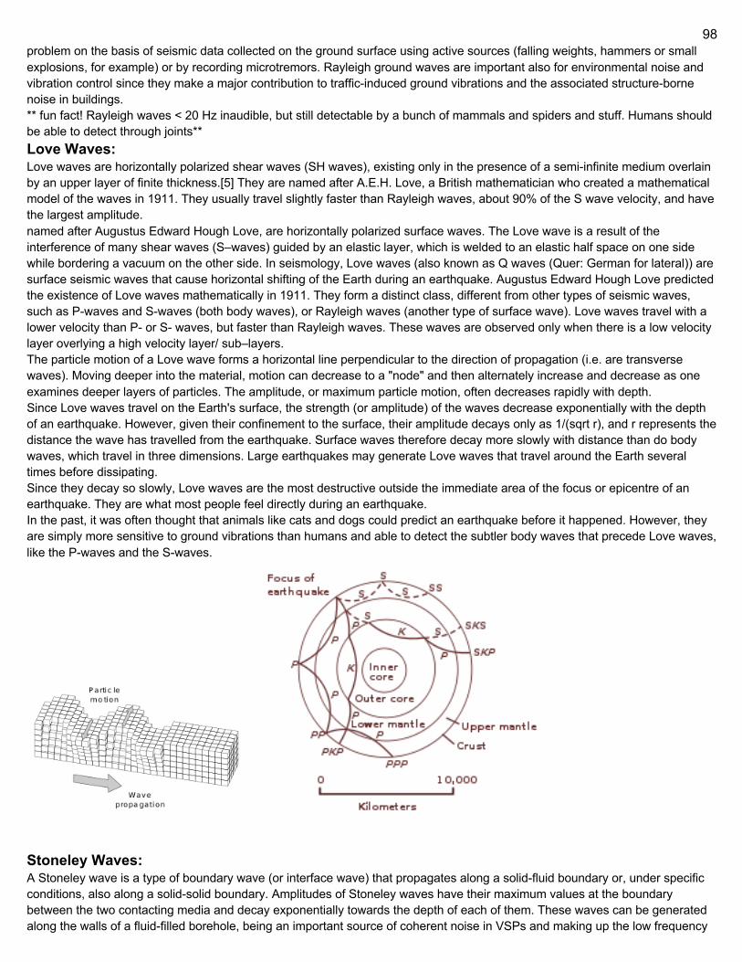
98
problem on the basis of seismic data collected on the ground surface using active sources (falling weights, hammers or small explosions, for example) or by recording microtremors. Rayleigh ground waves are important also for environmental noise and vibration control since they make a major contribution to traffic-induced ground vibrations and the associated structure-borne noise in buildings. ** fun fact! Rayleigh waves < 20 Hz inaudible, but still detectable by a bunch of mammals and spiders and stuff. Humans should be able to detect through joints** Love Waves: Love waves are horizontally polarized shear waves (SH waves), existing only in the presence of a semi-infinite medium overlain by an upper layer of finite thickness.[5] They are named after A.E.H. Love, a British mathematician who created a mathematical model of the waves in 1911. They usually travel slightly faster than Rayleigh waves, about 90% of the S wave velocity, and have the largest amplitude. named after Augustus Edward Hough Love, are horizontally polarized surface waves. The Love wave is a result of the interference of many shear waves (S–waves) guided by an elastic layer, which is welded to an elastic half space on one side while bordering a vacuum on the other side. In seismology, Love waves (also known as Q waves (Quer: German for lateral)) are surface seismic waves that cause horizontal shifting of the Earth during an earthquake. Augustus Edward Hough Love predicted the existence of Love waves mathematically in 1911. They form a distinct class, different from other types of seismic waves, such as P-waves and S-waves (both body waves), or Rayleigh waves (another type of surface wave). Love waves travel with a lower velocity than P- or S- waves, but faster than Rayleigh waves. These waves are observed only when there is a low velocity layer overlying a high velocity layer/ sub–layers. The particle motion of a Love wave forms a horizontal line perpendicular to the direction of propagation (i.e. are transverse waves). Moving deeper into the material, motion can decrease to a "node" and then alternately increase and decrease as one examines deeper layers of particles. The amplitude, or maximum particle motion, often decreases rapidly with depth. Since Love waves travel on the Earth's surface, the strength (or amplitude) of the waves decrease exponentially with the depth of an earthquake. However, given their confinement to the surface, their amplitude decays only as 1/(sqrt r), and r represents the distance the wave has travelled from the earthquake. Surface waves therefore decay more slowly with distance than do body waves, which travel in three dimensions. Large earthquakes may generate Love waves that travel around the Earth several times before dissipating. Since they decay so slowly, Love waves are the most destructive outside the immediate area of the focus or epicentre of an earthquake. They are what most people feel directly during an earthquake. In the past, it was often thought that animals like cats and dogs could predict an earthquake before it happened. However, they are simply more sensitive to ground vibrations than humans and able to detect the subtler body waves that precede Love waves, like the P-waves and the S-waves.
Stoneley Waves: A Stoneley wave is a type of boundary wave (or interface wave) that propagates along a solid-fluid boundary or, under specific conditions, also along a solid-solid boundary. Amplitudes of Stoneley waves have their maximum values at the boundary between the two contacting media and decay exponentially towards the depth of each of them. These waves can be generated along the walls of a fluid-filled borehole, being an important source of coherent noise in VSPs and making up the low frequency
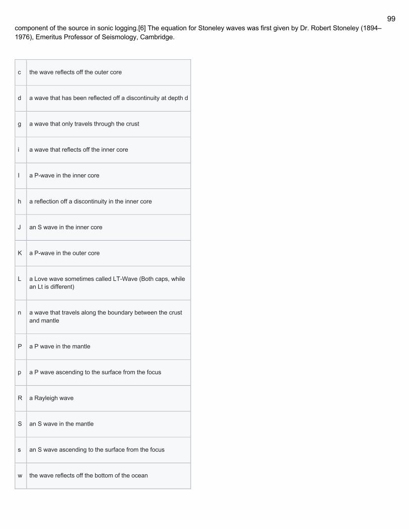
99
component of the source in sonic logging.[6] The equation for Stoneley waves was first given by Dr. Robert Stoneley (1894–1976), Emeritus Professor of Seismology, Cambridge.
c the wave reflects off the outer core
d a wave that has been reflected off a discontinuity at depth d
g a wave that only travels through the crust
i a wave that reflects off the inner core
I a P-wave in the inner core
h a reflection off a discontinuity in the inner core
J an S wave in the inner core
K a P-wave in the outer core
L a Love wave sometimes called LT-Wave (Both caps, while an Lt is different)
n a wave that travels along the boundary between the crust and mantle
P a P wave in the mantle
p a P wave ascending to the surface from the focus
R a Rayleigh wave
S an S wave in the mantle
s an S wave ascending to the surface from the focus
w the wave reflects off the bottom of the ocean
100
No letter is used when the wave reflects off of the surfaces
Low Velocity Zone The low-velocity zone (LVZ) occurs close to the boundary between the lithosphere and the asthenosphere in the upper mantle. It
is characterized by unusually low seismic shear wave velocity compared to the surrounding depth intervals. This range of depths
also corresponds to anomalously high electrical conductivity. It is present between about 80 and 300 km depth. This appears to
be universally present for S waves, but may be absent in certain regions for P waves. A second low-velocity zone (not generally
referred to as the LVZ, but as ULVZ) has been detected in a thin ≈50 km layer at the core-mantle boundary. These LVZs may
have important implications for plate tectonics and the origin of the Earth's crust. The LVZ has been interpreted to indicate the presence of a significant degree of partial melting, and alternatively as a natural consequence of a thermal boundary layer and the effects of pressure and temperature on the elastic wave velocity of mantle components in the solid state. In any event, a very limited amount of melt (about 1%) is needed to produce these effects. Water in this layer can lower the melting point, and may play an important part in its composition The existence of the low-velocity zone was first proposed from the observation of slower than expected seismic wave arrivals from earthquakes in 1959 by Beno Gutenberg. He noted that between 1° to 15° from the epicenter the longitudinal arrivals showed an exponential decrease in amplitude after which they showed a sudden large increase. The presence of a low-velocity layer that defocussed the seismic energy, followed by a high velocity gradient that concentrated it, provided an explanation for these observations. The LVZ shows a reduction in velocity of about 3–6% with the effect being more pronounced with S-waves compared to P-waves. As is evident from the figure, the reduction and depth over which reduction occurs varies with the choice of tectonic province, that is, regions differ in their seismic characteristics. Following the drop, the base of the zone is marked by an increase in velocity, but it has not been possible to decide whether this transition is sharp or gradual. This lower boundary, found beneath the continental lithosphere and oceanic lithosphere away from mid-ocean ridges, is sometimes referred to as the Lehmann discontinuity and occurs at about 220±30 km depth. The interval also shows a reduction in Q, the seismic quality factor (representing a relatively high degree of seismic attenuation), and a relatively high electrical conductivity. The LVZ is present at the base of the lithosphere except in areas of thick continental shield where no velocity anomaly is apparent. The interpretation of these observations is complicated by the effects of seismic anisotropy, which may greatly reduce the actual scale of the velocity anomaly. However, because of the reductions in Q and electrical resistivity in the LVZ, it is generally interpreted as a zone in which there is a small degree of partial melting. For this to occur at the depths where the LVZ is observed, small amounts of water and/or carbon dioxide must be present to depress the melting point of the silicate minerals. Only 0.05–0.1 % water would be sufficient to cause the 1% of melting necessary to produce the observed changes in physical properties. The lack of LVZ beneath continental shields is explained by the much lower geothermal gradient, preventing any degree of partial melting
Earthquake math
Determining earthquake distance Let tE = time that earthquake occurs (unknown) tP = time that P wave arrives at station
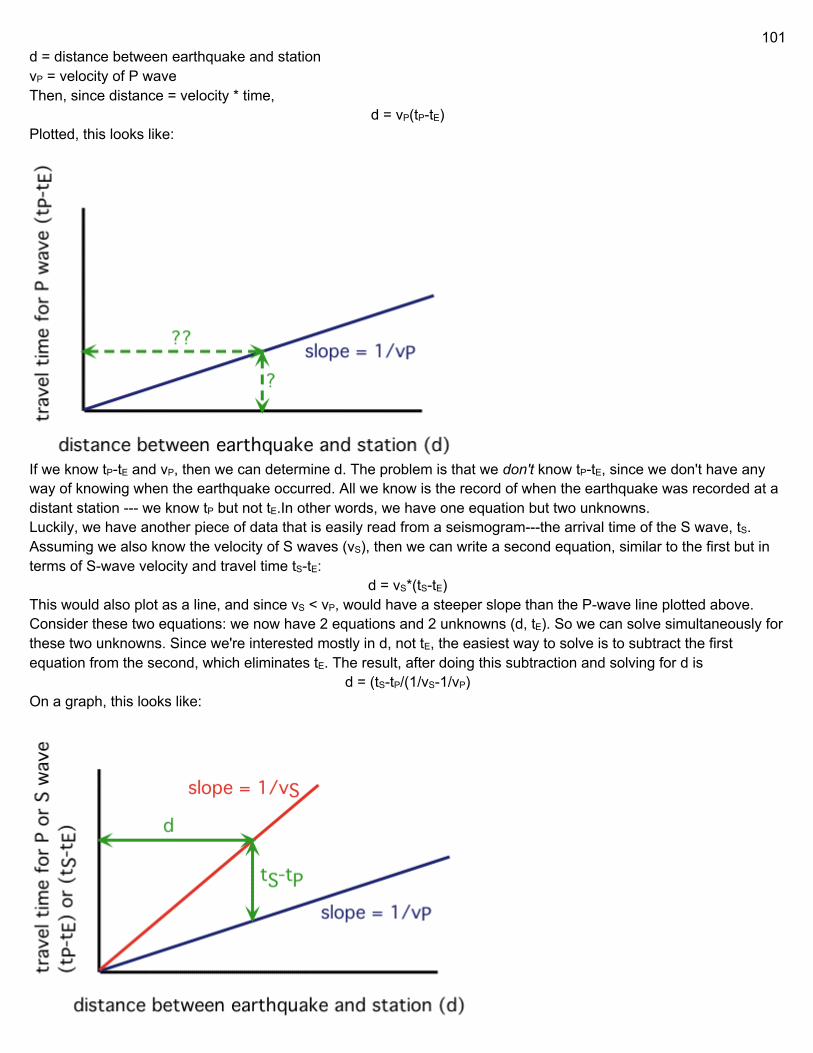
101
d = distance between earthquake and station vP = velocity of P wave Then, since distance = velocity * time,
d = vP(tP-tE) Plotted, this looks like:
If we know tP-tE and vP, then we can determine d. The problem is that we don't know tP-tE, since we don't have any way of knowing when the earthquake occurred. All we know is the record of when the earthquake was recorded at a distant station --- we know tP but not tE.In other words, we have one equation but two unknowns. Luckily, we have another piece of data that is easily read from a seismogram---the arrival time of the S wave, tS. Assuming we also know the velocity of S waves (vS), then we can write a second equation, similar to the first but in terms of S-wave velocity and travel time tS-tE:
d = vS*(tS-tE) This would also plot as a line, and since vS < vP, would have a steeper slope than the P-wave line plotted above. Consider these two equations: we now have 2 equations and 2 unknowns (d, tE). So we can solve simultaneously for these two unknowns. Since we're interested mostly in d, not tE, the easiest way to solve is to subtract the first equation from the second, which eliminates tE. The result, after doing this subtraction and solving for d is
d = (tS-tP/(1/vS-1/vP) On a graph, this looks like:
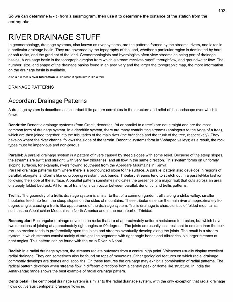
102
So we can determine tS - tP from a seismogram, then use it to determine the distance of the station from the earthquake.
RIVER DRAINAGE STUFF In geomorphology, drainage systems, also known as river systems, are the patterns formed by the streams, rivers, and lakes in a particular drainage basin. They are governed by the topography of the land, whether a particular region is dominated by hard or soft rocks, and the gradient of the land. Geomorphologists and hydrologists often view streams as being part of drainage basins. A drainage basin is the topographic region from which a stream receives runoff, throughflow, and groundwater flow. The number, size, and shape of the drainage basins found in an area vary and the larger the topographic map, the more information on the drainage basin is available.
Also a fun fact is river bifurcation is like when it splits into 2 like a fork DRAINAGE PATTERNS
Accordant Drainage Patterns A drainage system is described as accordant if its pattern correlates to the structure and relief of the landscape over which it flows. Dendritic: Dendritic drainage systems (from Greek, dendrites, "of or parallel to a tree") are not straight and are the most common form of drainage system. In a dendritic system, there are many contributing streams (analogous to the twigs of a tree), which are then joined together into the tributaries of the main river (the branches and the trunk of the tree, respectively). They develop where the river channel follows the slope of the terrain. Dendritic systems form in V-shaped valleys; as a result, the rock types must be impervious and non-porous. Parallel: A parallel drainage system is a pattern of rivers caused by steep slopes with some relief. Because of the steep slopes, the streams are swift and straight, with very few tributaries, and all flow in the same direction. This system forms on uniformly sloping surfaces, for example, rivers flowing southeast from the Aberdare Mountains in Kenya. Parallel drainage patterns form where there is a pronounced slope to the surface. A parallel pattern also develops in regions of parallel, elongate landforms like outcropping resistant rock bands. Tributary streams tend to stretch out in a parallel-like fashion following the slope of the surface. A parallel pattern sometimes indicates the presence of a major fault that cuts across an area of steeply folded bedrock. All forms of transitions can occur between parallel, dendritic, and trellis patterns. Trellis: The geometry of a trellis drainage system is similar to that of a common garden trellis along a strike valley, smaller tributaries feed into from the steep slopes on the sides of mountains. These tributaries enter the main river at approximately 90 degree angle, causing a trellis-like appearance of the drainage system. Trellis drainage is characteristic of folded mountains, such as the Appalachian Mountains in North America and in the north part of Trinidad. Rectangular: Rectangular drainage develops on rocks that are of approximately uniform resistance to erosion, but which have two directions of joining at approximately right angles or 90 degrees. The joints are usually less resistant to erosion than the bulk rock so erosion tends to preferentially open the joints and streams eventually develop along the joints. The result is a stream system in which streams consist mainly of straight line segments with right angle bends and tributaries join larger streams at right angles. This pattern can be found with the Arun River in Nepal. Radial: In a radial drainage system, the streams radiate outwards from a central high point. Volcanoes usually display excellent radial drainage. They can sometimes also be found on tops of mountains. Other geological features on which radial drainage commonly develops are domes and laccoliths. On these features the drainage may exhibit a combination of radial patterns. The radical pattern develops when streams flow in different directions from a central peak or dome like structure. In India the Amarkantak range shows the best example of radial drainage pattern. Centripetal: The centripetal drainage system is similar to the radial drainage system, with the only exception that radial drainage flows out versus centripetal drainage flows in.
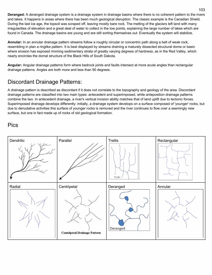
103
Deranged: A deranged drainage system is a drainage system in drainage basins where there is no coherent pattern to the rivers and lakes. It happens in areas where there has been much geological disruption. The classic example is the Canadian Shield. During the last ice age, the topsoil was scraped off, leaving mostly bare rock. The melting of the glaciers left land with many irregularities of elevation and a great deal of water to collect in the low points, explaining the large number of lakes which are found in Canada. The drainage basins are young and are still sorting themselves out. Eventually the system will stabilize. Annular: In an annular drainage pattern streams follow a roughly circular or concentric path along a belt of weak rock, resembling in plan a ringlike pattern. It is best displayed by streams draining a maturely dissected structural dome or basin where erosion has exposed rimming sedimentary strata of greatly varying degrees of hardness, as in the Red Valley, which nearly encircles the domal structure of the Black Hills of South Dakota. Angular: Angular drainage patterns form where bedrock joints and faults intersect at more acute angles than rectangular drainage patterns. Angles are both more and less than 90 degrees.
Discordant Drainage Patterns: A drainage pattern is described as discordant if it does not correlate to the topography and geology of the area. Discordant drainage patterns are classified into two main types: antecedent and superimposed, while anteposition drainage patterns combine the two. In antecedent drainage, a river's vertical incision ability matches that of land uplift due to tectonic forces. Superimposed drainage develops differently: initially, a drainage system develops on a surface composed of 'younger' rocks, but due to denudative activities this surface of younger rocks is removed and the river continues to flow over a seemingly new surface, but one in fact made up of rocks of old geological formation.
Pics
Dendritic
Parallel
Trellis
Rectangular
Radial
Centripetal
Deranged
Annular
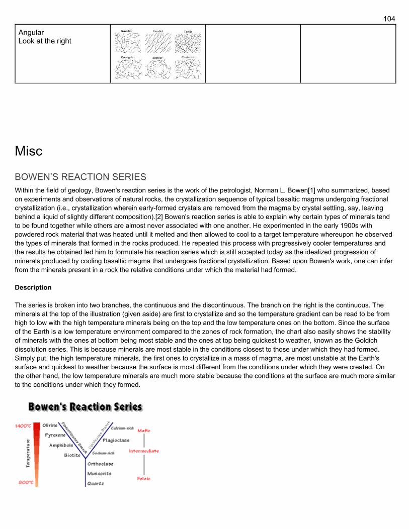
104
Angular Look at the right
Misc
BOWEN’S REACTION SERIES Within the field of geology, Bowen's reaction series is the work of the petrologist, Norman L. Bowen[1] who summarized, based on experiments and observations of natural rocks, the crystallization sequence of typical basaltic magma undergoing fractional crystallization (i.e., crystallization wherein early-formed crystals are removed from the magma by crystal settling, say, leaving behind a liquid of slightly different composition).[2] Bowen's reaction series is able to explain why certain types of minerals tend to be found together while others are almost never associated with one another. He experimented in the early 1900s with powdered rock material that was heated until it melted and then allowed to cool to a target temperature whereupon he observed the types of minerals that formed in the rocks produced. He repeated this process with progressively cooler temperatures and the results he obtained led him to formulate his reaction series which is still accepted today as the idealized progression of minerals produced by cooling basaltic magma that undergoes fractional crystallization. Based upon Bowen's work, one can infer from the minerals present in a rock the relative conditions under which the material had formed. Description The series is broken into two branches, the continuous and the discontinuous. The branch on the right is the continuous. The minerals at the top of the illustration (given aside) are first to crystallize and so the temperature gradient can be read to be from high to low with the high temperature minerals being on the top and the low temperature ones on the bottom. Since the surface of the Earth is a low temperature environment compared to the zones of rock formation, the chart also easily shows the stability of minerals with the ones at bottom being most stable and the ones at top being quickest to weather, known as the Goldich dissolution series. This is because minerals are most stable in the conditions closest to those under which they had formed. Simply put, the high temperature minerals, the first ones to crystallize in a mass of magma, are most unstable at the Earth's surface and quickest to weather because the surface is most different from the conditions under which they were created. On the other hand, the low temperature minerals are much more stable because the conditions at the surface are much more similar to the conditions under which they formed.
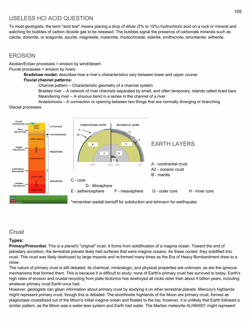
105
USELESS HCl ACID QUESTION To most geologists, the term "acid test" means placing a drop of dilute (5% to 10%) hydrochloric acid on a rock or mineral and watching for bubbles of carbon dioxide gas to be released. The bubbles signal the presence of carbonate minerals such as calcite, dolomite, or aragonite, azurite, magnesite, malachite, rhodochrosite, siderite, smithsonite, strontianite, witherite.
EROSION Aeolian/Eolian processes = erosion by wind/desert. Fluvial processes = erosion by rivers Bradshaw model: describes how a river’s characteristics vary between lower and upper course Fluvial channel patterns: Channel pattern – Characteristic geometry of a channel system
Braided river – A network of river channels separated by small, and often temporary, islands called braid bars Meandering river – A sinuous bend in a series in the channel of a river Anastomosis – A connection or opening between two things that are normally diverging or branching
Glacial processes
EARTH LAYERS A - continental crust A2 - oceanic crust B - mantle
C - core D - lithosphere
E - asthenosphere F - mesosphere G - outer core H - inner core *remember wadati-benioff for subduction and lehmann for earthquake
Crust Types: Primary/Primordial: This is a planet's "original" crust. It forms from solidification of a magma ocean. Toward the end of planetary accretion, the terrestrial planets likely had surfaces that were magma oceans. As these cooled, they solidified into crust. This crust was likely destroyed by large impacts and re-formed many times as the Era of Heavy Bombardment drew to a close. The nature of primary crust is still debated: its chemical, mineralogic, and physical properties are unknown, as are the igneous mechanisms that formed them. This is because it is difficult to study: none of Earth's primary crust has survived to today. Earth's high rates of erosion and crustal recycling from plate tectonics has destroyed all rocks older than about 4 billion years, including whatever primary crust Earth once had. However, geologists can glean information about primary crust by studying it on other terrestrial planets. Mercury's highlands might represent primary crust, though this is debated. The anorthosite highlands of the Moon are primary crust, formed as plagioclase crystallized out of the Moon's initial magma ocean and floated to the top; however, it is unlikely that Earth followed a similar pattern, as the Moon was a water-less system and Earth had water. The Martian meteorite ALH84001 might represent
106
primary crust of Mars; however, again, this is debated. Like Earth, Venus lacks primary crust, as the entire planet has been repeatedly resurfaced and modified Secondary: Secondary crust is formed by partial melting of silicate materials in the mantle, and so is usually basaltic in composition. This is the most common type of crust in the Solar System. Most of the surfaces of Mercury, Venus, Earth, and Mars comprise secondary crust, as do the lunar maria. On Earth, we see secondary crust forming primarily at mid-ocean spreading centers, where the adiabatic rise of mantle causes partial melting. Tertiary: Tertiary crust is more chemically-modified than either primary or secondary. It can form in several ways:
- Igneous processes: partial-melting of secondary crust, coupled with differentiation or dehydration - Erosion and sedimentation: sediments derived from primary, secondary, or tertiary crust
The only known example of tertiary crust is the continental crust of the Earth. It is unknown whether other terrestrial planets can be said to have tertiary crust, though the evidence so far suggests that they do not. This is likely because plate tectonics is needed to create tertiary crust, and Earth is the only planet in our Solar System with plate tectonics. Structure: The crust is a thin shell on the outside of the Earth, accounting for less than 1% of Earth's volume. It is the top component of lithosphere: a division of Earth's layers that includes the crust and the upper part of the mantle. The lithosphere is broken into tectonic plates that move, allowing heat to escape from the interior of the Earth into space. The crust lies on top of the mantle, a configuration that is stable because the upper mantle is made of peridotite and so is significantly denser than the crust. The boundary between the crust and mantle is conventionally placed at the Mohorovičić discontinuity, a boundary defined by a contrast in seismic velocity. The crust of the Earth is of two distinctive types:
- Oceanic: 5 km (3 mi) to 10 km (6 mi) thick and composed primarily of denser, more mafic rocks, such as basalt, diabase, and gabbro.
- Continental: 30 km (20 mi) to 50 km (30 mi) thick and mostly composed of less dense, more felsic rocks, such as granite.
Because both continental and oceanic crust are less dense than the mantle below, both types of crust "float" on the mantle. This is isostasy, and it's also one of the reasons continental crust is higher than oceanic: continental is less dense and so "floats" higher. As a result, water pools in above the oceanic crust, forming the oceans. The temperature of the crust increases with depth, reaching values typically in the range from about 200 °C (392 °F) to 400 °C (752 °F) at the boundary with the underlying mantle. The temperature increases by as much as 30 °C (54 °F) for every kilometer locally in the upper part of the crust, but the geothermal gradient is smaller in deeper crust. Composition: The continental crust has an average composition similar to that of andesite. The most abundant minerals in Earth's continental crust are feldspars, which make up about 41% of the crust by weight, followed by quartz at 12%, and pyroxenes at 11%. Continental crust is enriched in incompatible elements compared to the basaltic ocean crust and much enriched compared to the underlying mantle. Although the continental crust comprises only about 0.6 weight percent of the silicate on Earth, it contains 20% to 70% of the incompatible elements.
107
Mantle
The Earth's mantle is a layer of silicate rock between the crust and the outer core. Its mass of 4.01 × 1024 kg is 67% the mass of the Earth. It has a thickness of 2,900 kilometres (1,800 mi) making up about 84% of Earth's volume. It is predominantly solid but in geological time it behaves as a viscous fluid. Partial melting of the mantle at mid-ocean ridges produces oceanic crust, and partial melting of the mantle at subduction zones produces continental crust. Structure Rheological structure The Earth's mantle is divided into two major rheological layers: the rigid lithosphere comprising the uppermost mantle, and the more viscous asthenosphere, separated by the lithosphere-asthenosphere boundary. Lithosphere underlying ocean crust has a thickness of around 100 km, whereas lithosphere underlying continental crust generally has a thickness of 150-200 km. The lithosphere and overlying crust make up tectonic plates, which move over the asthenosphere. Seismic structure The Earth's mantle is divided into three major layers defined by sudden changes in seismic velocity: the upper mantle (starting at the Moho, or base of the crust around 7 to 35 km (4.3 to 21.7 mi) downward to 410 km (250 mi)) the transition zone (approximately 410–660 km or 250–410 mi) the lower mantle (approximately 660–2,891 km or 410–1,796 mi) The lower ~200 km of the lower mantle constitutes the D" (D-double-prime) layer, a region with anomalous seismic properties. This region also contains LLSVPs and ULVZs. (aka large low-shear-velocity provinces, LLVPs or superplumes; ulvz = ultra low velocity zones)
LLSVP = characteristic structures of parts of the lowermost mantle (the region surrounding the outer core) of the Earth. These provinces are characterized by slow shear wave velocities and were discovered by seismic tomography of the deep Earth. There are two main provinces: the African LLSVP and the Pacific LLSVP. Both extend laterally for thousands of kilometers and possibly up to 1000 km vertically from the core-mantle boundary. The Pacific LLSVP has specific dimensions of 3000 km across and 300 m higher than the
108
surrounding ocean-floor, and is situated over four hotspots that suggest multiple mantle plumes underneath. These zones represent around 8% of the volume of the mantle (6% of the Earth).[1] Other names for LLSVPs include superwells, thermo-chemical piles, or hidden reservoirs. Some of these names, however, are more interpretive of their geodynamical or geochemical effects, while many questions remain about their nature ULVZ = patches on the core-mantle boundary that have extremely low seismic velocities. The zones are mapped to be hundreds of kilometers in diameter and tens of kilometers thick. Their shear wave velocities can be up to 30% lower than surrounding material. The composition and origin of the zones remain uncertain. The zones appear to correlate with edges of the African and Pacific Large low-shear-velocity provinces (LLSVPs) as well as the location of hotspots
Mineralogical structure The top of the mantle is defined by a sudden increase in seismic velocity, which was first noted by Andrija Mohorovičić in 1909; this boundary is now referred to as the Mohorovičić discontinuity or "Moho". The upper mantle is dominantly peridotite, composed primarily of variable proportions of the minerals olivine, clinopyroxene, orthopyroxene, and an aluminous phase. The aluminous phase is plagioclase in the uppermost mantle, then spinel, and then garnet below ~100 km. Gradually through the upper mantle, pyroxenes become less stable and transform into majoritic garnet. At the top of the transition zone, olivine undergoes isochemical phase transitions to wadsleyite and ringwoodite. Unlike nominally anhydrous olivine, these high-pressure olivine polymorphs have a large capacity to store water in their crystal structure. This has led to the hypothesis that the transition zone may host a large quantity of water. At the base of the transition zone, ringwoodite decomposes into bridgmanite (formerly called magnesium silicate perovskite), and ferropericlase. Garnet also becomes unstable at or slightly below the base of the transition zone. The lower mantle is composed primarily of bridgmanite and ferropericlase, with minor amounts of calcium perovskite, calcium-ferrite structured oxide, and stishovite. In the lowermost ~200 km of the mantle, bridgmanite isochemically transforms into post-perovskite. Composition The chemical composition of the mantle is difficult to determine with a high degree of certainty because it is largely inaccessible. Rare exposures of mantle rocks occur in ophiolites, where sections of oceanic lithosphere have been abducted onto a continent. Mantle rocks are also sampled as xenoliths within basalts or kimberlites. Composition of the Earth's upper mantle (depleted MORB) (mid-ocean-ridge boundary)
Most estimates of the mantle composition are based on rocks that sample only the uppermost mantle. There is debate as to whether the rest of the mantle, especially the lower mantle, has the same bulk composition.[10] The
109
mantle's composition has changed through the Earth's history due to the extraction of magma that solidified to form oceanic crust and continental crust. Temperature and pressure In the mantle, temperatures range from approximately 200 °C (392 °F) at the upper boundary with the crust to approximately 4,000 °C (7,230 °F) at the core-mantle boundary. The geothermal gradient of the mantle increases rapidly in the thermal boundary layers at the top and bottom of the mantle, and increases gradually through the interior of the mantle. Although the higher temperatures far exceed the melting points of the mantle rocks at the surface (about 1200 °C for representative peridotite), the mantle is almost exclusively solid. The enormous lithostatic pressure exerted on the mantle prevents melting, because the temperature at which melting begins (the solidus) increases with pressure. The pressure in the mantle increases from a few kbar at the Moho to 1390 kbar (139 GPa) at the core-mantle boundary.
Core The average density of Earth is 5.515 g/cm3. Because the average density of surface material is only around 3.0 g/cm3, we
must conclude that denser materials exist within Earth's core. This result has been known since the Schiehallion experiment,
performed in the 1770s. Charles Hutton in his 1778 report concluded that the mean density of the Earth must be about 9/5 that
of surface rock, concluding that the interior of the Earth must be metallic. Hutton estimated this metallic portion to occupy some
65% of the diameter of the Earth. Hutton's estimate on the mean density of the Earth was still about 20% too low, at 4.5 g/cm3
Henry Cavendish in his torsion balance experiment of 1798 found a value of 5.45 g/cm3, within 1% of the modern value. Seismic
measurements show that the core is divided into two parts, a "solid" inner core with a radius of ≈1,220 km and a liquid outer core
extending beyond it to a radius of ≈3,400 km. The densities are between 9,900 and 12,200 kg/m3 in the outer core and 12,600–
13,000 kg/m3 in the inner core. The inner core was discovered in 1936 by Inge Lehmann and is generally believed to be composed primarily of iron and some nickel. Since this layer is able to transmit shear waves (transverse seismic waves), it must be solid. Experimental evidence has at times been critical of crystal models of the core. Other experimental studies show a discrepancy under high pressure: diamond anvil (static) studies at core pressures yield melting temperatures that are approximately 2000 K below those from shock laser (dynamic) studies. The laser studies create plasma, and the results are suggestive that constraining inner core conditions will depend on whether the inner core is a solid or is a plasma with the density of a solid. This is an area of active research. Formation: In early stages of Earth's formation about 4.6 billion years ago, melting would have caused denser substances to sink toward the center in a process called planetary differentiation (see also the iron catastrophe), while less-dense materials would have migrated to the crust. The core is thus believed to largely be composed of iron (80%), along with nickel and one or more light elements, whereas other dense elements, such as lead and uranium, either are too rare to be significant or tend to bind to lighter elements and thus remain in the crust (see felsic materials). Some have argued that the inner core may be in the form of a single iron crystal. Under laboratory conditions a sample of iron–nickel alloy was subjected to the corelike pressures by gripping it in a vise between 2 diamond tips (diamond anvil cell), and then heating to approximately 4000 K. The sample was observed with x-rays, and strongly supported the theory that Earth's inner core was made of giant crystals running north to south. The liquid outer core surrounds the inner core and is believed to be composed of iron mixed with nickel and trace amounts of lighter elements.
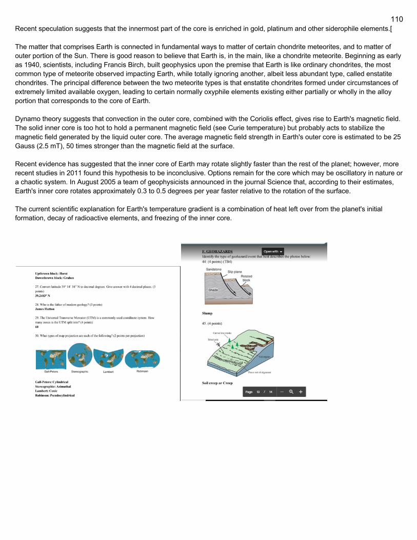
110
Recent speculation suggests that the innermost part of the core is enriched in gold, platinum and other siderophile elements.[ The matter that comprises Earth is connected in fundamental ways to matter of certain chondrite meteorites, and to matter of outer portion of the Sun. There is good reason to believe that Earth is, in the main, like a chondrite meteorite. Beginning as early as 1940, scientists, including Francis Birch, built geophysics upon the premise that Earth is like ordinary chondrites, the most common type of meteorite observed impacting Earth, while totally ignoring another, albeit less abundant type, called enstatite chondrites. The principal difference between the two meteorite types is that enstatite chondrites formed under circumstances of extremely limited available oxygen, leading to certain normally oxyphile elements existing either partially or wholly in the alloy portion that corresponds to the core of Earth. Dynamo theory suggests that convection in the outer core, combined with the Coriolis effect, gives rise to Earth's magnetic field. The solid inner core is too hot to hold a permanent magnetic field (see Curie temperature) but probably acts to stabilize the magnetic field generated by the liquid outer core. The average magnetic field strength in Earth's outer core is estimated to be 25 Gauss (2.5 mT), 50 times stronger than the magnetic field at the surface. Recent evidence has suggested that the inner core of Earth may rotate slightly faster than the rest of the planet; however, more recent studies in 2011 found this hypothesis to be inconclusive. Options remain for the core which may be oscillatory in nature or a chaotic system. In August 2005 a team of geophysicists announced in the journal Science that, according to their estimates, Earth's inner core rotates approximately 0.3 to 0.5 degrees per year faster relative to the rotation of the surface. The current scientific explanation for Earth's temperature gradient is a combination of heat left over from the planet's initial formation, decay of radioactive elements, and freezing of the inner core.
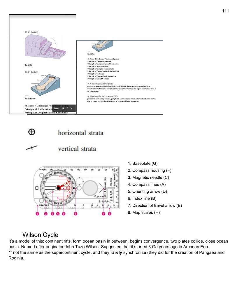
111
1. Baseplate (G) 2. Compass housing (F)
3. Magnetic needle (C) 4. Compass lines (A) 5. Orienting arrow (D) 6. Index line (B)
7. Direction of travel arrow (E) 8. Map scales (H)
Wilson Cycle It’s a model of this: continent rifts, form ocean basin in between, begins convergence, two plates collide, close ocean basin. Named after originator John Tuzo Wilson. Suggested that it started 3 Ga years ago in Archean Eon. ** not the same as the supercontinent cycle, and they rarely synchronize (they did for the creation of Pangaea and Rodinia.
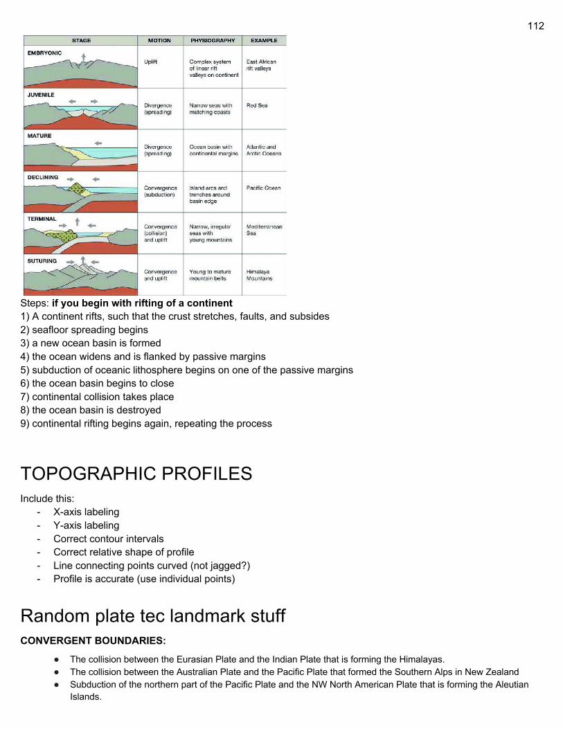
112
Steps: if you begin with rifting of a continent 1) A continent rifts, such that the crust stretches, faults, and subsides 2) seafloor spreading begins 3) a new ocean basin is formed 4) the ocean widens and is flanked by passive margins 5) subduction of oceanic lithosphere begins on one of the passive margins 6) the ocean basin begins to close 7) continental collision takes place 8) the ocean basin is destroyed 9) continental rifting begins again, repeating the process
TOPOGRAPHIC PROFILES Include this:
- X-axis labeling - Y-axis labeling - Correct contour intervals - Correct relative shape of profile - Line connecting points curved (not jagged?) - Profile is accurate (use individual points)
Random plate tec landmark stuff CONVERGENT BOUNDARIES:
● The collision between the Eurasian Plate and the Indian Plate that is forming the Himalayas. ● The collision between the Australian Plate and the Pacific Plate that formed the Southern Alps in New Zealand ● Subduction of the northern part of the Pacific Plate and the NW North American Plate that is forming the Aleutian
Islands.
113
● Subduction of the Nazca Plate beneath the South American Plate to form the Andes. ● Subduction of the Pacific Plate beneath the Australian Plate and Tonga Plate, forming the complex New Zealand to
New Guinea subduction/transform boundaries. ● Collision of the Eurasian Plate and the African Plate formed the Pontic Mountains in Turkey. ● Subduction of the Pacific Plate beneath the Mariana Plate formed the Mariana Trench. ● Subduction of the Juan de Fuca Plate beneath the North American Plate to form the Cascade Range.
DIVERGENT BOUNDARIES:
- The East African Rift (Great Rift Valley) in eastern Africa - The Mid-Atlantic Ridge system separates the North American Plate and South American Plate in the west from the
Eurasian Plate and African Plate in the east - The Gakkel Ridge is a slow spreading ridge located in the Arctic Ocean - The East Pacific Rise, extending from the South Pacific to the Gulf of California - The Baikal Rift Zone in eastern Russia - The Red Sea Rift - The Aden Ridge along the southern shore of the Arabian Peninsula - The Carlsberg Ridge in the eastern Indian Ocean - The Gorda Ridge off the northwest coast of North America - The Explorer Ridge off the northwest coast of North America - The Juan de Fuca Ridge off the northwest coast of North America - The Chile Rise off the southeast Pacific
TRANSFORM:
- The San Andreas Fault in California is an active transform boundary. The Pacific Plate (carrying the city of Los Angeles) is moving northwards with respect to the North American Plate.
- The Queen Charlotte Fault on the Pacific Northwest coast of North America - The Motagua Fault, which crosses through Guatemala, is a transform boundary between the southern edge of the North
American Plate and the northern edge of the Caribbean Plate. - New Zealand's Alpine Fault is another active transform boundary. - The Dead Sea Transform (DST) fault which runs through the Jordan River Valley in the Middle East. - The Owen Fracture Zone along the southeastern boundary of the Arabian Plate.
*triple junction (where the 3 plates meet) Possible to make fault, trench, or ridge
Stress stuff NORMAL AND SHEAR STRESS
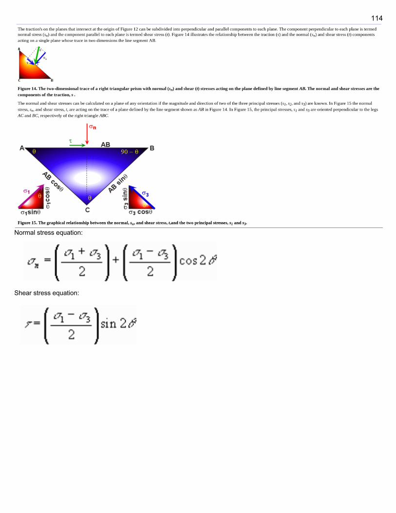
114
Normal stress equation:
Shear stress equation:

115
FRACTURES
Joints A joint is a break (fracture) of natural origin in the continuity of either a layer or body of rock that lacks any visible or measurable movement parallel to the surface (plane) of the fracture. Although they can occur singly, they most frequently occur as joint sets and systems. A joint set is a family of parallel, evenly spaced joints that can be identified through mapping and analysis of the orientations, spacing, and physical properties. A joint system consists of two or more intersecting joint sets. The distinction between joints and faults hinges on the terms visible or measurable, a difference that depends on the scale of observation. Faults differ from joints in that they exhibit visible or measurable lateral movement between the opposite surfaces of the fracture. As a result, a joint may have been created by either strict movement of a rock layer or body perpendicular to the fracture or by varying degrees of lateral displacement parallel to the surface (plane) of the fracture that remains “invisible” at the scale of observation. Joints are among the most universal geologic structures as they are found in most every exposure of rock. They vary greatly in appearance, dimensions, and arrangement, and occur in quite different tectonic environments. Often, the specific origin of the stresses that created certain joints and associated joint sets can be quite ambiguous, unclear, and sometimes controversial. The most prominent joints occur in the most well-consolidated, lithified, and highly competent rocks, such as sandstone, limestone, quartzite, and granite. Joints may be open fractures or filled by various materials. Joints infilled by precipitated minerals are called veins and joints filled by solidified magma are called dikes.
FORMATION: Joints result from brittle fracture of a rock body or layer as the result of tensile stresses. These tensile stresses either were induced or imposed from outside, e.g. by the stretching of layers; the rise of pore fluid pressure as the result of either external compression or fluid injection; or the result of internal stresses induced by the shrinkage caused by the cooling or desiccation of a rock body or layer whose outside boundaries remained fixed. When tensional stresses stretch a body or layer of rock such that its tensile strength is exceeded, it breaks. When this happens the rock fractures in a plane parallel to the maximum principal stress and perpendicular to the minimum principal stress (the direction in which the rock is being stretched). This leads to the development of a single sub-parallel joint set. Continued deformation may lead to development of one or more additional joint sets. The presence of the first set strongly affects the stress orientation in the rock layer, often causing subsequent sets to form at a high angle, often 90°, to the first set.
116
TYPES OF JOINTS Joints are classified either by the processes responsible for their formation or their geometry. Classification of joints by geometry The geometry of joints refers to the orientation of joints as either plotted on stereonets and rose-diagrams or observed in rock exposures. In terms of geometry, three major types of joints, nonsystematic joints, systematic joints, and columnar jointing are recognized. Nonsystematic joints Nonsystematic joints are joints that are so irregular in form, spacing, and orientation that they cannot be readily grouped into distinctive, through-going joint sets. Systematic joints Systematic joints are planar, parallel, joints that can be traced for some distance, and occur at regularly, evenly spaced distances on the order centimeters, meters, tens of meters, or even hundreds of meters. As a result, they occur as families of joints that form recognizable joint sets. Typically, exposures or outcrops within a given area or region of study contains two or more sets of systematic joints, each with its own distinctive properties such as orientation and spacing, that intersect to form well-defined joint systems. Based upon the angle at which joint sets of systematic joints intersect to form a joint system, systematic joints can be subdivided into conjugate and orthogonal joint sets. The angles at which joint sets within a joint system commonly intersect is called by structural geologists as the dihedral angles. When the dihedral angles are nearly 90° within a joint system, the joint sets are known as orthogonal joint sets. When the dihedral angles are from 30 to 60° within a joint system, the joint sets are known as conjugate joint sets. Within regions that have experienced tectonic deformation, systematic joints are typically associated with either layered or bedded strata that has been folded into anticlines and synclines. Such joints can be classified according to their orientation in respect to the axial planes of the folds as they often commonly form in a predictable pattern with respect to the hinge trends of folded strata. Based upon their orientation to the axial planes and axes of folds, the types of systematic joints are:
More systematic joints Longitudinal joints – Joints which are roughly parallel to fold axes and often fan around the fold. Cross-joints – Joints which are approximately perpendicular to fold axes. Diagonal joints – Joints which typically occur as conjugate joint sets that trend oblique to the fold axes. Strike joints – Joints which trend parallel to the strike of the axial plane of a fold. Cross-strike joints – Joints which cut across the axial plane of a fold. Columnar jointing Columnar jointing is a distinctive type of joints that join together at triple junctions either at or about 120° angles. These joints split a rock body into long, prisms or columns. Typically, such columns are hexagonal, although 3-, 4-, 5- and 7-sided columns are relatively common. The diameter of these prismatic columns range from a few centimeters to several metres. They are often oriented perpendicular to either the upper surface and base of lava flows and the contact of the tabular igneous bodies with the surrounding rock. This type of jointing is typical of thick lava flows and shallow dikes and sills. Columnar jointing is also known as either columnar structure, prismatic joints, or prismatic jointing. Rare cases of columnar jointing have also been reported from sedimentary strata. Types of joints with respect to formation Joints can also be classified according to their origin. On the basis of their origin, joints have been divided into a number of different types that include tectonic, hydraulic, exfoliation, unloading (release), and cooling joints depending on the specific author and publication. Also, the origin of many joint sets often can be unclear and quite ambiguous. Often, different authors have proposed multiple and contradictory hypotheses for specific joint sets and types. Finally, it should be kept in mind that different joints in the same outcrop may have formed at different times and for different reasons.
117
Tectonic joints Tectonic joints are joints that formed when the relative displacement of the joint walls is normal to its plane as the result of brittle deformation of bedrock in response to regional or local tectonic deformation of bedrock. Such joints form when directed tectonic stress causes the tensile strength of bedrock to be exceeded as the result of the stretching of rock layers under conditions of elevated pore fluid pressure and directed tectonic stress. Tectonic joints often reflect local tectonic stresses associated with local folding and faulting. Tectonic joints occur as both nonsystematic and systematic joints, including orthogonal and conjugate joint sets. Hydraulic joints Hydraulic joints are joints thought to have formed when pore fluid pressure became elevated as a result of vertical gravitational loading. In simple terms, the accumulation of either sediments, volcanic, or other material causes an increase in the pore pressure of groundwater and other fluids in the underlying rock when they cannot move either laterally of vertically in response to this pressure. This also causes an increase in pore pressure in preexisting cracks that increases the tensile stress on them perpendicular to the minimum principal stress (the direction in which the rock is being stretched). If the tensile stress exceeds the magnitude of the least principal compressive stress the rock will fail in a brittle manner and these cracks propagate in a process called hydraulic fracturing. Hydraulic joints occur as both nonsystematic and systematic joints, including orthogonal and conjugate joint sets. In some cases, joint sets can be a tectonic - hydraulic hybrid. Exfoliation joints Exfoliation joints are sets of flat-lying, curved, and large joints that are restricted to massively exposed rock faces in an deeply eroded landscape. Exfoliation jointing consists of fan-shaped fractures varying from a few meters to tens of meters in size that lie sub-parallel to the topography. The vertical, gravitational load of the mass of a mountain-size bedrock mass drives longitudinal splitting and causes outward buckling toward the free air. In addition, paleostress sealed in the granite before the granite was exhumed by erosion and released by exhumation and canyon cutting is also a driving force for the actual spalling. Unloading joints Unloading joints or release joints are joints formed near the surface during uplift and erosion. As bedded sedimentary rocks are brought closer to the surface during uplift and erosion, they cool, contract and become relaxed elastically. This causes stress buildup that eventually exceeds the tensile strength of the bedrock and results in the formation of jointing. In the case of unloading joints, compressive stress is released either along preexisting structural elements (such as cleavage) or perpendicular to the former direction of tectonic compression. Cooling joints Cooling joints are columnar joints that result from the cooling of either lava from the exposed surface of a lava lake or flood basalt flow or the sides of a tabular igneous, typically basaltic, intrusion. They exhibit a pattern of joints that join together at triple junctions either at or about 120° angles. They split a rock body into long, prisms or columns that are typically hexagonal, although 3-, 4-, 5- and 7-sided columns are relatively common. They form as a result of a cooling front that moves from some surface, either the exposed surface of a lava lake or flood basalt flow or the sides of a tabular igneous intrusion into either lava of the lake or lava flow or magma of a dike or sill.
Shear Fractures vs. Joints Some fractures that look like joints are actually shear fractures, which in effect are microfaults, instead of joints. Shear fractures do not form as the result of the perpendicular opening of a fracture due to tensile stress, but through the shearing of fractures that causes lateral movement of its faces. Shear fractures can be confused with joints, because the lateral offset of the fracture faces is not visible at the scale of outcrop or hand specimen. Because of the absence of diagnostic ornamentation or the lack of any discernible movement or offset, they can be indistinguishable from joints. Shear fractures occur in sets of planar parallel fractures at an angle of 60 degrees and can be of the same size and scale as joints. As a result, some conjugate joint sets may actually be shear fractures. In case of such joint sets, it might be possible to distinguish joints from shear fractures by looking for the presence of slickensides, which are products of shearing movement parallel to the fracture surface. The slickensides are fine-scale, delicate ridge-in-groove lineations that are found on the surface of fracture surfaces
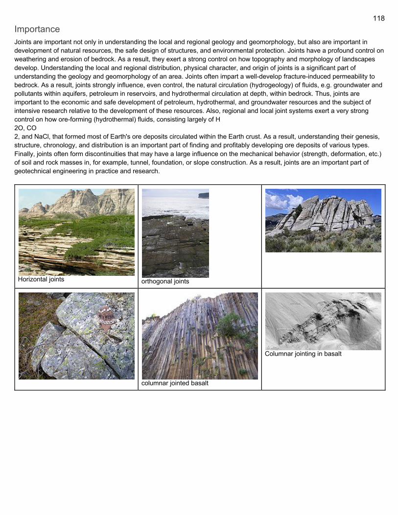
118
Importance Joints are important not only in understanding the local and regional geology and geomorphology, but also are important in development of natural resources, the safe design of structures, and environmental protection. Joints have a profound control on weathering and erosion of bedrock. As a result, they exert a strong control on how topography and morphology of landscapes develop. Understanding the local and regional distribution, physical character, and origin of joints is a significant part of understanding the geology and geomorphology of an area. Joints often impart a well-develop fracture-induced permeability to bedrock. As a result, joints strongly influence, even control, the natural circulation (hydrogeology) of fluids, e.g. groundwater and pollutants within aquifers, petroleum in reservoirs, and hydrothermal circulation at depth, within bedrock. Thus, joints are important to the economic and safe development of petroleum, hydrothermal, and groundwater resources and the subject of intensive research relative to the development of these resources. Also, regional and local joint systems exert a very strong control on how ore-forming (hydrothermal) fluids, consisting largely of H 2O, CO 2, and NaCl, that formed most of Earth's ore deposits circulated within the Earth crust. As a result, understanding their genesis, structure, chronology, and distribution is an important part of finding and profitably developing ore deposits of various types. Finally, joints often form discontinuities that may have a large influence on the mechanical behavior (strength, deformation, etc.) of soil and rock masses in, for example, tunnel, foundation, or slope construction. As a result, joints are an important part of geotechnical engineering in practice and research.
Horizontal joints
orthogonal joints
columnar jointed basalt
Columnar jointing in basalt
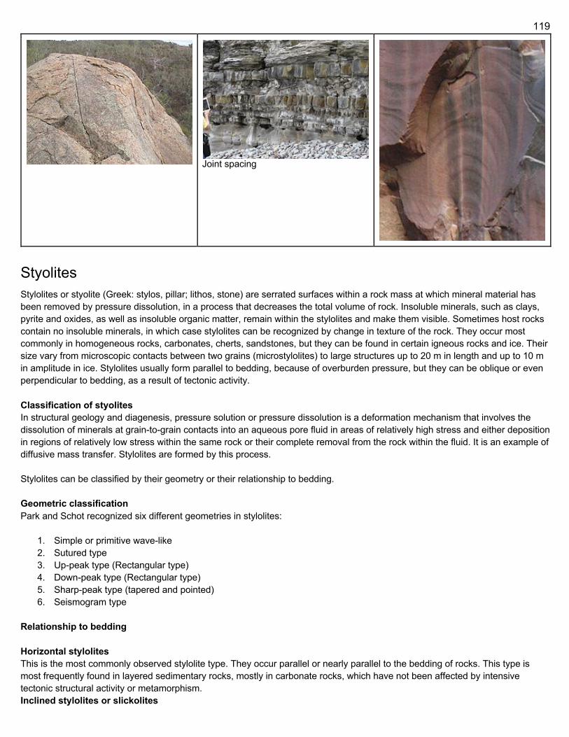
119
Joint spacing
Styolites Stylolites or styolite (Greek: stylos, pillar; lithos, stone) are serrated surfaces within a rock mass at which mineral material has been removed by pressure dissolution, in a process that decreases the total volume of rock. Insoluble minerals, such as clays, pyrite and oxides, as well as insoluble organic matter, remain within the stylolites and make them visible. Sometimes host rocks contain no insoluble minerals, in which case stylolites can be recognized by change in texture of the rock. They occur most commonly in homogeneous rocks, carbonates, cherts, sandstones, but they can be found in certain igneous rocks and ice. Their size vary from microscopic contacts between two grains (microstylolites) to large structures up to 20 m in length and up to 10 m in amplitude in ice. Stylolites usually form parallel to bedding, because of overburden pressure, but they can be oblique or even perpendicular to bedding, as a result of tectonic activity. Classification of styolites In structural geology and diagenesis, pressure solution or pressure dissolution is a deformation mechanism that involves the dissolution of minerals at grain-to-grain contacts into an aqueous pore fluid in areas of relatively high stress and either deposition in regions of relatively low stress within the same rock or their complete removal from the rock within the fluid. It is an example of diffusive mass transfer. Stylolites are formed by this process. Stylolites can be classified by their geometry or their relationship to bedding. Geometric classification Park and Schot recognized six different geometries in stylolites:
1. Simple or primitive wave-like 2. Sutured type 3. Up-peak type (Rectangular type) 4. Down-peak type (Rectangular type) 5. Sharp-peak type (tapered and pointed) 6. Seismogram type
Relationship to bedding Horizontal stylolites This is the most commonly observed stylolite type. They occur parallel or nearly parallel to the bedding of rocks. This type is most frequently found in layered sedimentary rocks, mostly in carbonate rocks, which have not been affected by intensive tectonic structural activity or metamorphism. Inclined stylolites or slickolites
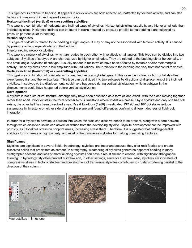
120
This type occurs oblique to bedding. It appears in rocks which are both affected or unaffected by tectonic activity, and can also be found in metamorphic and layered igneous rocks. Horizontal-inclined (vertical) or crosscutting stylolites This type is a combination of horizontal and inclined types of stylolites. Horizontal stylolites usually have a higher amplitude than inclined stylolites. Horizontal-inclined can be found in rocks affected by pressure parallel to the bedding plane followed by pressure perpendicular to bedding. Vertical stylolites This type of stylolite is related to the bedding at right angles. It may or may not be associated with tectonic activity. It is caused by pressure acting perpendicularly to the bedding. Interconnecting network stylolites This type is a network of stylolites, which are related to each other with relatively small angles. This type can be divided into two subtypes. Stylolites of subtype A are characterized by higher amplitudes. They are related to the bedding either horizontally, or at a small angle. Stylolites of subtype B usually appear in rocks which have been affected by tectonic and/or metamorphic activity. These stylolites have a low amplitude with undulations. Their relation to the bedding can vary from horizontal to vertical. Vertical-inclined (horizontal) or crosscutting stylolites This type is a combination of horizontal or inclined and vertical stylolite types. In this case the inclined or horizontal stylolites were formed first and the vertical later. This type can be divided into two subtypes by directions of displacement of the inclined stylolites. In subtype A, the displacements could have happened during vertical stylolization, while in subtype B, the displacements could have happened before vertical stylolization. Development A stylolite is not a structural fracture, although they have been described as a form of 'anti-crack', with the sides moving together rather than apart. Proof exists in the form of fossiliferous limestone where fossils are crosscut by a stylolite and only one half still exists; the other half has been dissolved away. Rye & Bradbury (1988) investigated 13/12C and 18/16O stable isotope systematics in limestone on either side of a stylolite plane and found differences confirming different degrees of fluid-rock interaction. In order for a stylolite to develop, a solution into which minerals can dissolve needs to be present, along with a pore network through which dissolved solids can advect or diffuse from the developing stylolite. Stylolite development can be improved with porosity, as it localizes stress on nonpore areas, increasing stress there. Therefore, it is suggested that bedding-parallel stylolites form in areas of high porosity, and most of the transverse stylolites form along preexisting fractures. Significance Stylolites are significant in several fields. In petrology, stylolites are important because they alter rock fabrics and create dissolved solids that precipitate as cement. In stratigraphy, weathering of stylolites generates apparent bedding in many stratigraphic sections and loss of material along stylolites can have a result similar to erosion, with significant stratigraphic thinning. In hydrology, stylolites prevent fluid flow and, in other settings, serve for fluid flow. Also, stylolites are indicators of compressive stress in tectonic studies, and development of transverse stylolites contributes to crustal shortening parallel to the direction of their column.
Macrostylites in limestone
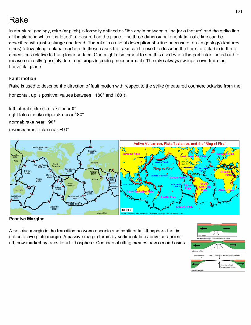
121
Rake In structural geology, rake (or pitch) is formally defined as "the angle between a line [or a feature] and the strike line of the plane in which it is found", measured on the plane. The three-dimensional orientation of a line can be described with just a plunge and trend. The rake is a useful description of a line because often (in geology) features (lines) follow along a planar surface. In these cases the rake can be used to describe the line's orientation in three dimensions relative to that planar surface. One might also expect to see this used when the particular line is hard to measure directly (possibly due to outcrops impeding measurement). The rake always sweeps down from the horizontal plane. Fault motion Rake is used to describe the direction of fault motion with respect to the strike (measured counterclockwise from the
horizontal, up is positive; values between −180° and 180°): left-lateral strike slip: rake near 0° right-lateral strike slip: rake near 180° normal: rake near −90° reverse/thrust: rake near +90°
Passive Margins A passive margin is the transition between oceanic and continental lithosphere that is not an active plate margin. A passive margin forms by sedimentation above an ancient rift, now marked by transitional lithosphere. Continental rifting creates new ocean basins.
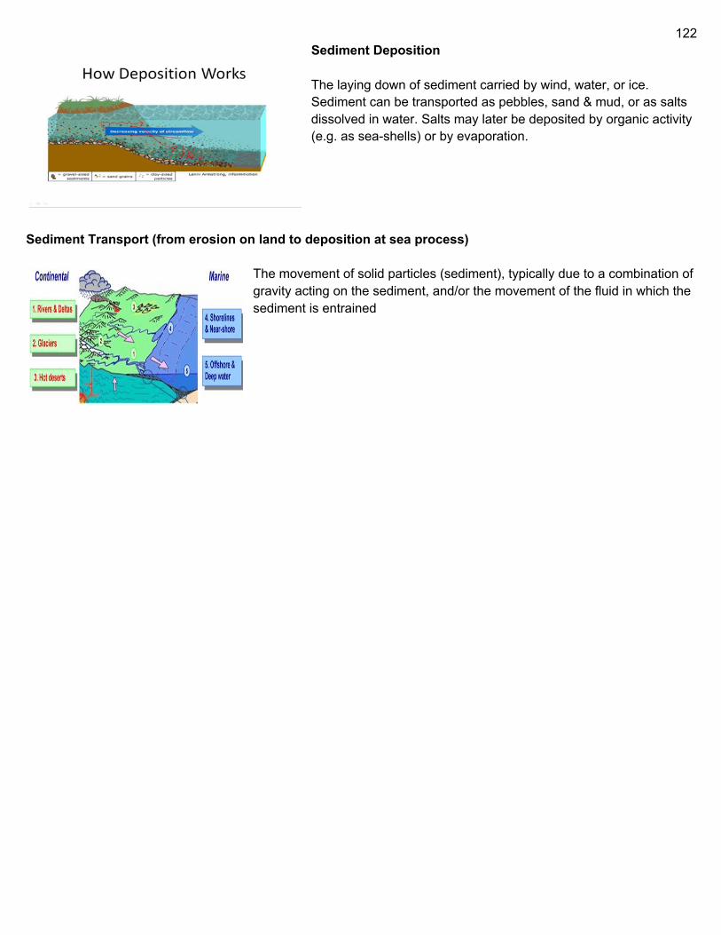
122
Sediment Deposition The laying down of sediment carried by wind, water, or ice. Sediment can be transported as pebbles, sand & mud, or as salts dissolved in water. Salts may later be deposited by organic activity (e.g. as sea-shells) or by evaporation.
Sediment Transport (from erosion on land to deposition at sea process) The movement of solid particles (sediment), typically due to a combination of gravity acting on the sediment, and/or the movement of the fluid in which the sediment is entrained


