Embed Size (px)
Citation preview

Libyan Studies 40 (2009)
25
1 Rome2 CNRS-ENS (Paris)
he Mausoleum of Gasr Doga
By Francesca Bigi,1 Ginette Di Vita-Evrard,2 Sergio Fontana1 and Gianluca Schingo1
Abstracthe mausoleum of Gasr Doga in the Tarhuna area was a grand funerary monument erected, by a member of the local Libico-Punic élite, in a strategic position on the limits of the provincial territory. Its architectural articulation recalls the dynastic Numidian monuments, while its decoration shows elements of the local tradition combined with motifs imported from Italy. In Late Antiquity and the Islamic period the mausoleum was surrounded by a fortified village, almost entirely built of spolia coming from the mausoleum itself. In an attempted reconstruction, the elevation of the third storey is discussed alongside other problems concerning the original layout of the structure.
his paper examines one of the most imposing funerary monuments of ancient Tripolitania: the mausoleum of Gasr Doga in the Tarhuna Gebel, a hilly fertile area located some 60 km south-west of Lepcis Magna. he work we present here is the result of several study seasons carried out in 1999–2001 as part of the research projects that the Archaeological Mission of the ‘Università Roma Tre’, directed by Prof. Luisa Musso, conducts in Lepcis Magna and its territory.
he authors wish to thank sincerely the Department of Antiquities of Libya, in the person of its President Giuma Anag and, for their helpful support in the fieldwork, the Controller of Lepcis Magna Mehemed Massaud, his predecessor Shtiwi Mohamed Mustafa and the head of the Tarhuna office, Musbah Ali Asmia. We are also grateful to Mme Ginette Di Vita-Evrard for discussing with us the reconstruction hypothesis and the positioning of the inscription.
he data collected in the field, combined with a re-examination of the sources, allow us to present a new reconstruction hypothesis as well as a revised, well-grounded chronological attribution. he new dating to the first decades of the first century AD is put forward following analysis of the architectural decoration and the discovery of parts of the dedicatory inscription written in Neo-Punic characters. he dating to the second–third century AD initially proposed by Aurigemma (1954, 30) and to the third century suggested by Romanelli (1970, 272), thus appear now to be erroneous and derived from the tendency to assign the most imposing monuments of the region to its period of maximum prosperity.
Topographical historyBy Sergio Fontana
he dating to the beginning of the first century and the inscription mentioning Libyco-Punic honorands forces a reconsideration and a reinterpretation of the monument that cannot be dissociated from its topographical setting. he mausoleum stands on a small limestone terrace, dominating the upper part of the Wadi Doga, and is located about 900 m north-west of the ancient remains of Medina Doga (Fig. 2).
Medina Doga can be clearly identified with Mesphe, the ancient site recorded in the Itinerarium Antonini (77.1, Iter quod limitem Tripolitanum per Turrem Tamalleni a Tacapis Lepti Magna ducit) some 40 Roman miles from Lepcis Magna. his identification is supported by the discovery of milestones of the XXXIX (IRT 938), XLI and XLII miles of the same road (Di Vita-Evrard 1979). he ancient site of Medina Doga has never been investigated, although there are several clearly visible remains (Aurigemma 1954, 13–5; Goodchild 1951, 74–9; Mattingly 1995, 102, 133). In the immediate surroundings, the Department of Antiquities discovered some underground tombs in 1978, indicating

F. BIGI ET AL.
26
occupation in the area as early as the first century BC (Fontana 1997, 283–7).
An inscription found at Leptis Magna, at the intersection of the cardo and decumanus maximus, mentions the construction of a road in AD 15–16, in the proconsulate of Aelius Lamia (IRT 930). his stone stood as the caput viae of the road later recorded by the Itinerarium Antonini, along which Mesphe was located. The new route went in mediterraneum for 44 Roman miles. It was an internal itinerary towards western Tripolitania and, possibly, it
also represented the limits of the area controlled militarily by the Romans (Mattingly 1995, 66). Two boundary-stones, one found 6 km north-west of Gasr Doga (Ras el-Halga) and the other
along the Wadi Doga some 13 km further north (Gasr Massaud), tell us that the valley overlooked by our mausoleum served as a frontier between the territories of Lepcis and Oea (Di Vita-Evrard 1979). his was not merely an administrative partition; in AD 73–74 it became a necessity, after the
Figure 1. Gasr Doga, view from south-east (photo: F. Felici).
Figure 2. Map of the Tarhuna region (drawing: F. Bigi after Di Vita-Evrard 1979).
THE MAUSOLEUM OF GASR DOGA
27
dispute between the two cities had some years previously culminated in a raid on Lepcis, carried out by the Garamantes at Oea’s instigation.
hus, Medina Doga and Gasr Doga appear to have been situated in a sensitive area. In particular, the mausoleum was located a short distance north of the southern boundary of the province under Tiberius and, at the same time, at the south-western limit of Lepcis territory. Such a strategic position must have played a role in increasing the power and the wealth of the family owning the mausoleum. With its massive structure the mausoleum remained a prominent landmark in the region, and in time it became the focus of a Late Antique and Islamic village.
Gasr Doga came to the attention of European scholars in the 19th century, when it was visited by several travellers. First William H. Smyth in 1817 (Aurigemma 1954, 31; Smyth 1854), then Heinrich Barth, who visited in 1849 (1857, 70–71), Gerhard Rohlfs (1887, 70), Henry S. Cowper (1897, 53–5) and Federico Minutilli (1912, 201) recorded the monument. hese travel records offer brief descriptions of the mausoleum itself and of the later structures surrounding it, which, at the time, obviously stood in better condition than today. Particularly detailed are Barth’s descriptions, in whose work we also find the first image of Gasr Doga ever published (Fig. 25).
At the beginning of the 20th century, the mausoleum was documented by Salvatore Aurigemma with the help of Luigi Turba, whose drawings formed the basis of Aurigemma’s 1954 article (Fig. 17).
he mausoleumBy Francesca Bigi
Apart from its pre-eminent location, the mausoleum of Gasr Doga towers over the surroundings because of its imposing dimensions: it is 16 m long, 11 m wide and it is preserved to a height of 9 m (Fig. 1). he structure is entirely made of two kinds of local stone, both quarried along the wadi banks situated just down the hill. he first is a greyish limestone, with a fine-grained compact texture which lends itself well to detailed carving and has proved to be quite resistant to erosion by atmospheric agents. It is the building material most widely employed throughout the structure, being used for the whole of the podium’s first storey, for the exterior parts of the second storey, and also for the free-standing architectural elements of the third-storey portico. he other building material is a yellowish limestone, much lighter in weight and with a less compact texture, which, by contrast, suffers badly from erosion and does not allow particularly detailed carving. he yellow limestone is employed in the core of the podium and in the central parts of the facing of the second storey. he diversity in weight must have played a role in the use of the two types of stone, but we may also imagine that the juxtaposition of stones with different hues of colour was utilised to provide an intentional chromatic effect.
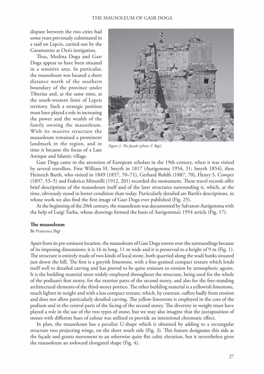
In plan, the mausoleum has a peculiar U-shape which is obtained by adding to a rectangular structure two projecting wings, on the short south side (Fig. 3). his feature designates this side as the façade and grants movement to an otherwise quite flat cubic elevation, but it nevertheless gives the mausoleum an awkward elongated shape (Fig. 4).
Figure 3. he façade (photo: F. Bigi).

F. BIGI ET AL.
28
he podium, which rests on a platform of four steps, is made of two superimposed storeys built in ashlar masonry, of which the lower one measures 3.45 m in height and the upper 2.9 m (Figs 5 and 6). he two storeys are both framed at the bottom by a socle, at the top by a cornice and at the corners by a shallow angle pilaster, crowned, only on the first storey, by a plain rectangular capital.
Above the cornice of the second storey there is a single course of blocks serving as a stereobate for the colonnaded portico that originally crowned the podium. he blocks of this latter course are
Figure 4. Plan of Gasr Doga (drawing: G. Schingo).
Figure 5. Gasr Doga, elevation of east side (drawing: G. Schingo).Figure 6. Gasr Doga, elevation of west side (drawing: G. Schingo).

THE MAUSOLEUM OF GASR DOGA
29
alternately projecting, so as to create a protruding pedestal for the column bases which were placed directly on top of them. Traces of the positioning of the bases are still clearly visible on the upper faces of the preserved blocks (Fig. 19) and, until recently, one column base survived in situ (Aurigemma 1954, fig. 8).
he mausoleum has a fourth level, represented by the underground funerary chambers built into the core of the structure (Fig. 7). hese are accessible from the façade, where an opening between the two projecting wings leads to a short flight of steps serving as a shaft. After a first short corridor, originally blocked with a transversal slab to prevent access, there is a second even shorter corridor which leads to a barrel-vaulted chamber, connected, by means of a third corridor, to the second chamber. he two chambers are identical in both shape and size, with a rectangular plan measuring 3.35 m by 1.70 m, constructed in ashlar masonry and covered with a barrel vault.
he architectural decoration of the podiumhe two storeys of the podium are characterized by a limited and very sober architectural decoration that consisted of plain moulded socles and cornices, devoid of carved ornaments.
At its base, the first storey has a moulded socle formed by a rather thick plinth, a torus and a cyma recta framed by fillets and followed by two other thin fillets and a cavetto (Fig. 8a). he corresponding upper cornice is carved with a cavetto, an ovolo and a cyma recta supporting the short, slightly diagonal soffit of the corona (Fig. 8b). he latter is very shallow and divided by an ovolo and a fillet from the sima, which is carved with a cyma recta crowned by a fillet.
he second-storey socle shows a similar but simplified profile and is formed by a plinth, a torus and a cyma recta surmounted by a sort of cyma reversa (Fig. 8c). he cornice consists of a cyma reversa supporting the semicircular soffit of the corona (Fig. 8d). his is rather high and divided by means of another cyma reversa from the sima, which is carved with a tall cavetto and crowned by a rather thick fascia.
Figure 7. Gasr Doga, plan of the funerary chambers (drawing: G. Schingo).

F. BIGI ET AL.
30
With the exception of the second-storey cornice, all the elements show common sequences of mouldings that can be frequently found in both funerary and public monuments throughout the African provinces. On the contrary, the cornice of the second storey stands out on account of the semicircular soffit instead of the canonical straight one. This peculiar detail cannot be paralleled outside Tripolitania, as it seems to be exclusively found at Lepcis Magna, where it also appears to be a rare motif (Fig. 9).
he architectural decoration of the third storeyNone of the architectural elements belonging to either the colonnaded portico or the inner cella survives in their original position, but lie scattered in the immediate surroundings of the mausoleum.
he column bases of the portico are formed by a lower torus, a small semicircular scotia framed by fillets and an upper smaller torus crowned by a thin fillet (Fig. 10a). An important feature of these bases is the absence of the plinth, an element that clearly indicates an early date, because the plinth commonly appears in western architecture in Augustan times. An early date is also suggested by comparison with the column bases of the Macellum at Lepcis Magna, dedicated in 8 BC. he profiles are very similar: both bases are characterized by a protruding lower torus and a thin scotia.
he shafts of the columns are plain and were composed of three superimposed drums, of which the lower and the upper one are without astragal, as the latter is carved together with the base and the capital, according to a practice typical of local stone masons. he drums were fastened to each other, to the base and to the capital, by means of metal dowels.
The capitals are composed of a cylindrical kalathos dressed with a double crown of eight acanthus leaves; these have seven lobes, which consist of two points and which are separated by small round voids, formed by a single drill-hole (Figs 11–12). he face of the leaf is covered by a series of fleshy ribs, which are placed, with a slightly curvilinear arrangement, at either side of the central spine. he latter is large, flat and decorated by a thin
line bifurcating at the lower end. he summit of the leaf curls outward with a thick, flat turnover, again carved with a series of thick ribs.
On either side of the central folia spring the almost vertical cauliculi, consisting of a ridged shaft rimmed by a thin fascia. he calyx leaves have an almost horizontal arrangement and are treated in
Figure 8. In situ mouldings, a-b: socle and cornice of the first storey; c-d: socle and cornice of the second storey (drawing: F. Bigi).
Figure 9. Left: Gasr Doga, cornice of the second storey. Right: cornice from Lepcis Magna (photo: F. Bigi).

THE MAUSOLEUM OF GASR DOGA
31
Figure 12. Capitals from the third-storey portico (photo: F. Bigi).
Figure 10. Column bases, a: third-storey portico; b: cella (drawing: F. Bigi).
Figure 11. hird-storey portico, capital (drawing: F. Bigi).

F. BIGI ET AL.
32
a quite abstract manner, with the surface once again decorated by a dense series of ribs and with the upper crest ridged and pierced by small round voids.
he frontal helices are formed by a thin flat strip curling into a tight coil. By contrast, the shaft of the volute is large, round and covered by a vegetal element similar to that of the shaft of the cauliculi, from whose margin springs a small leaf originally protecting the corner of the abacus. he thick abacus has curved sides, whose central part is decorated by a fleshy flower with seven petals, surrounded by four large leaves with a roughly rectangular design.
Even though the treatment of the foliage and the overall handling of the carving may vary from piece to piece, according to the different workmanship (Fig. 12), one must note that the capitals are all sculpted in an awkward, rather clumsy manner. Some elements, like the voids separating the lobes or the latter’s articulation at only two points, are treated simply as a decorative motif, in a way that seems to lack any organic relationship with the structure of the leaf itself. his rendering betrays a misunderstanding of the concept, and reveals a lack of familiarity with Corinthian design, and especially with its correct decorative details. his can be explained by the fact that in the first half of the first century AD the Tripolitanian decorative tradition was still dominated by the local forms of the Ionic capital, while the Corinthian only appears sporadically in selected contexts: only during the Flavian period does it supersede the older Ionic models (see Bigi 2006, 2366–73).
Consequently, the few first-century Corinthian examples that can be found in the region all equally show awkward characteristics that testify to the same lack of confidence we can see in Gasr Doga’s capitals. he stiff arrangement of the compositional elements, as well as the shape and treatment of the calyx leaves, find close comparison with the early first-century capitals from the Temple of Isis in Sabratha (Pesce 1953, 28–29, fig. 14), as well as with a group of capitals from Lepcis Magna, probably belonging to the Julio-Claudian portico of the Forum (Fig. 13). From the same site also comes a figured capital of Augustan date, with a form of acanthus similar to that of our capitals, with small round voids and a flat, schematic carving of the leaf (von Mercklin 1962, n. 323, fig. 570).
Although the capitals of Gasr Doga share the same artistic language with the other examples of the region, the model underlying their design does not seem to be at all local, but rather an imported one. In structure, and to a certain extent also in stylistic handling, the capitals produced in the late
Figure 15. Capital of the cella (drawing: F. Bigi after Aurigemma 1954).
Figure 13. Lepcis Magna, Old Forum, Julio-Claudian capital (photo: F. Bigi).
Figure 14. Pompeii, Porta Nocera Necropolis, late Republican capital (photo: F. Bigi).

THE MAUSOLEUM OF GASR DOGA
33
Republican and early Augustan age in southern Italy offer a series of extremely close parallels, so much so that it seems probable that the original model for our capitals came from that area.
he vertical ridged cauliculi, the almost horizontal calyx leaves, the arrangement of volutes and helices, as well as the shape of the crown leaves and the detail of the central rib with the lower bifurcation (Fig. 14), are all elements that can be found in the capitals produced in South Italy during the later Republic (von Hesberg 1981, 21 ff.). In particular, in Pompeii there are a few examples that also offer a parallel for the peculiar two-point lobe design. As at Gasr Doga, so too at Pompeii this very awkward detail is the result of a limited familiarity with the acanthus of the ‘normal’ Corinthian, as this group of capitals was carved in a transitional phase following the abandonment of the old ‘Italic’ Corinthian type (Lauter Bufe 1972, 325–8).
Alongside the formal aspects, the Corinthian columns of Gasr Doga retain another very significant element that also points to an Italian origin for the model. All the individual parts of the column (base, shaft and capital) are not carved according to the local unit of measure, the Punic cubit, used throughout the rest of the mausoleum, but are instead designed according to the Roman foot. he diameter of these elements, 60 cm, equals two Roman feet. he use of the Roman foot at Gasr Doga is an exception to the general rule, for the Punic cubit of 51 cm remained in use until well into the second century as the traditional unit of measure for both private and public architecture.
he inner cella of the mausoleum had, on the main south elevation, a pair of Corinthian columns in antis. Of these, we were able to find one base and several fragments of column drums (of which one was fully preserved), but not the Corinthian capital seen by Aurigemma at the time of his survey of the mausoleum (1954, figs 21–22).
he base has a profile nearly identical to that of the base of the portico, from which it differs only in the fact that it is carved with quite a large portion of the imoscapus of the column (Fig. 10b). Neither the photograph nor the drawing of the capital produced by Aurigemma supply a detailed image, nevertheless some of its features are sufficiently clear to deserve a brief description (Fig. 15). he capital is composed of a single crown of leaves, which seem to have the same kind of ribbed acanthus as the portico capitals. he volutes are thick and covered by a densely ribbed leaf, while the helices are much thinner and characterized by a ‘double s’, overlapping arrangement. his last feature, although typical of the Hellenistic Corinthian capitals produced in Egypt, more closely recalls the early first-century AD examples produced in Lepcis Magna, where the Egyptian model is translated into the local decorative language (see Bigi 2006, 2364–6, figs 10, 13; Caputo 1968, 72, pl. 48b).
Apart from the architectural elements just discussed, amongst those lying at the foot of the mausoleum are several other blocks carrying moulded decorations (Fig. 16). hese can be grouped into six different types, of which only the first three seem to have originally belonged to the monument.
Type A is a cornice carved with a cyma reversa divided, by means of a very thin cyma recta, from a large sima with cavetto and fascia profile (Fig. 16a). Such articulation resembles, though with a
Figure 16. Other mouldings, a: entablature of the third storey portico; b-c: socle and cornice of the podium of the cella; d-e-f: intrusive elements (drawing F. Bigi).

F. BIGI ET AL.
34
simplified sequence, that of the second storey’s cornice and appears therefore to be an appropriate crowning for the entablature of the third-storey portico.
Types B and C, though not fully preserved, show a very similar sequence: a fillet, a small ovolo, another fillet and a cavetto, the latter substituted, in the crowning blocks, with a second, slightly larger ovolo (Fig. 16b–c). Considering the shallow height of the moulded element, these blocks may have belonged to the podium of the inner cella.
he remaining three types, each attested by only one specimen, are characterized by sequences hardly comparable to those proper to the mausoleum and fail to fit anywhere in the hypothetical reconstruction of the original structure (Fig. 16d–f). We must assume, therefore, that at the time of the Late Antique occupation of the site, some architectural elements belonging to other edifices were brought here to be used as building material for the defensive structures that surrounded the mausoleum. This hypothesis seems to be supported also by the find of a small bracket, of a fragment of a spiral-fluted column and of a Tuscan capital, all elements that would hardly fit into our structure.
In conclusion, the elements discussed show how, in the decoration of Gasr Doga, local tradition, represented by subsidiary elements and the manner of carving, is found combined with foreign models, which filled a particular gap in the formal repertory. he presence of an imported model for the capital, though not rare at such an early date (Ferchiou 1987, 435), clearly stands as a demonstration not only of the wealth of the patron but also of his desire to display in his mausoleum the most
Figure 18. Reconstruction of the access to the funerary chambers (drawing: G. Schingo).
Figure 17. Reconstruction hypothesis of G. Rivani (after Aurigemma 1954).

THE MAUSOLEUM OF GASR DOGA
35
up-to-date form of decoration. Ultimately, the choice of a Roman Corinthian capital may also represent a way of expressing the owner’s political commitment.
Reconstruction By Gianluca Schingo
he main issues in the hypothesis for the mausoleum’s original elevation regard the access to the underground funerary chambers and the elevation of the third storey, the latter today completely destroyed.
he funerary chambers were at first thought by Aurigemma to be accessible through a sort of dromos protruding from the body of the monument (Fig. 17), but, in an appendix to the same paper, the author discards this hypothesis after learning of a later clearing of the area conducted by G. Caputo (though it still appears in G. Rivani’s reconstruction drawing: Aurigemma 1954, 22, fig. 13). he analysis of the remains shows that the lower step of the podium was not interrupted by an opening and thus access to the chambers was through a shaft leading to a flight of stairs. After the burial, the opening was covered with blocks identical to those of the outer facing, so that from the outside no feature distinguished where the entrance lay (Fig. 18).
As for the third storey, the graphic reconstruction proposed here may seem at first sight not very dissimilar to that published in Aurigemma’s paper (Fig. 17). However, our hypothesis differs substantially in the height of the columns, that now results in a much less slender proportion, giving the whole monument a more harmonious elevation.
Clearing of debris from the upper surface revealed that the floor is marked by a series of rectilinear marks, often accompanied by traces left by the lever used to place the blocks in position (Fig. 19). hese rectilinear marks trace the perimeter of the inner cella’s rectangular podium. his was 4.80 m wide and 6.80 m long, and was decorated with a shallow moulded socle and cornice (Fig. 16b–c). Above the podium rested a pair of Corinthian columns in antis described above (Figs 15 and 21).
Since no column-shaft of the portico or of the cella survives in its entirety, their height had to be worked out in theory, assuming that their proportions had to be related to each other and to the dimensions of the podium. he lower diameter of the portico shaft stands in a relation of 1:1.42 to the one of the cella shaft (respectively 60 cm and 42 cm). his figure served to establish the total height of the two different shafts. he column of the portico thus reached 4.30 m in height, while the one of the cellae 3.00 m (Figs 20, 21 and 22).
Assuming that the tops of the two columns were at the same level, the cella column had necessarily to rest on a podium, which must thus have been 1.3 m high. Consequently we propose an articulation in three courses, with the blocks carrying the moulded parts separated by a single course (Fig. 21).
he entablature was composed of an inscribed architrave supporting a single block carved with a plain frieze and a moulded crowning cornice (Figs 16a and 23). he surviving architrave elements have different thicknesses, showing that in the central parts this member was composed of a single 58 cm-thick block, while at the corners it was made up of two adjoining blocks fastened with dovetail clamps (Fig. 24). hat one of the architrave fragments belonged to the right-hand corner, is proved by the upper fascia carved on both adjacent faces.
If the colonnaded portico had its elements carved according to the Roman foot, in contrast its overall proportions do not appear at all comparable to the slenderness proper to the Roman Corinthian order. Such a discrepancy may imply that the architect of Gasr Doga had sent for a foreign model, but when it came to applying it he needed to adjust it to the size of the monument, especially to its height. As recently shown by Wilson Jones, similar adjustments are frequently found in those monuments characterized by an ‘unorthodox’ planning (Wilson Jones 1989). With its odd shape, miscellaneous decoration and heterogeneous models, Gasr Doga can certainly be considered a very unorthodox funerary monument: moreover its early date implies a limited knowledge of the Roman canonical orders by its architect. All this considered, it is not surprising to find our mausoleum characterized by such a squat elevation.

F. BIGI ET AL.
36
Figure 19. Plan of the third storey (drawing: G. Schingo).
Figure 20. Frontal elevation, reconstruction (drawing: G. Schingo).
Figure 21. Transversal section, reconstruction (drawing: G. Schingo).

THE MAUSOLEUM OF GASR DOGA
37
he Neo-Punic inscription By Ginette Di Vita-Evrard*
Among hundreds of blocks lying around the monument, two inscribed blocks were found in 1995 and 1999 which undoubtedly belonged to a single structure: the character of the grey limestone, coloured with a lovely pink patina on the once unprotected surface, the front profile, with the inscription occupying a projecting rectilinear bandeau at the top, the matching dimensions of the sockets for clamps cut on the upper face, the commonality of significant dimensions (bandeau, letters, interspaces) and the beautiful Neo-Punic script are all incontrovertibly convergent elements.
Block 1 (Fig. 23, left) is the right angle-block since the projecting bandeau originally continued on the right-hand lateral face, where it was roughly levelled off for reuse. he only complete
measurement seems to be its height, 48 cm; the maximum surviving width across the face is 35 cm; the surviving depth, from front to back, varies from 25 cm at the right-hand end to 21 cm at the left-hand one. he inscribed bandeau is 23 cm high and projects 4 cm. he socket is perpendicular to the front face: surviving length 9 cm by 5 cm by a depth of more than 6 cm.
he inscription consists of two lines: the second one, obviously shorter (it is missing on the second block), begins some letters further on and shows only one character before the broken edge.
Block 2 (Fig. 23, right), much more damaged, has a big splinter sliced off its front face, but fortuitously preserves an equally long segment of line 1, probably located at a considerable distance from the first. he approximate dimensions are: maximum surviving height on the front 37 cm, width
Figure 22. Longitudinal section, reconstruction (drawing: G. Schingo).
Figure 23. Fragments of the Neo-Punic inscription on the architrave. Left: Block 1, Right: Block 2 (photo: F. Felici).

F. BIGI ET AL.
38
43 cm, depth 38 cm at the top. Unless it is incomplete, the inscribed bandeau is slightly narrower (22 cm) and projects less (3.2 instead of 4 cm), an insignificant variation. he socket is complete, and parallel to the front face: 10 cm by 4.5 cm by a depth of more than 6.5 cm.
he single inscribed line is positioned exactly like the first line of block 1. Even if the first two and last two letters are only partly preserved, they are unquestionably recognizable, thanks to the magnificent regularity of the script. Preceding the first letter a circular punctuation mark situated in the lower half of the line may be visible, which would not be surprising since punctuation according to the Latin epigraphic tradition is occasionally present in some Neo-Punic inscriptions, including the dedicatory inscription (IPT 76) of the Ras el-Haddagia Ammonium, built in AD 15–17 and located 7 km south-east of Gasr Doga. In the present context, it would make sense, coming just before the dating phrase (see below).
he exceptionally regular lettering is 7.5 cm high, cut with a deep, unerring incision, achieving a monumental character very rare in Neo-Punic epigraphy. It is (especially as far as some letters are concerned, lamed, kaph, heth) very similar – but even better – than that of the Ras el-Haddagia Ammonium inscription. A technical procedure, borrowed from the carving of Latin inscriptions and very well executed, but not visible at first glance, accounts for the remarkable perfection of the lettering: by enlarging the photographs, one can make out very faint horizontal guidelines.
Reading the text, as noted above, is very easy. Without spacing between words, and bearing in mind that N and T are graphically undifferentiated in Tripolitanian inscriptions, we have:
Block 1 : LHRBN/TKR[---] B[---]Block 2 : BŠTRBT )H․[---]
he interpretation is more problematic; let us begin with the second block. he same sequence of seven signs is to be found in the Ammonium text: it corresponds to the beginning of its dating formula mentioning the name of the Roman proconsul of Africa with an awkward attempt to translate pro consul into Punic. he whole phrase would be BŠT RB T )H․T RB MH․NT BŠD LWBYM, ‘in the year of the chief acting as the military chief (= consul) in the territory of the Libyans’, followed by the name of the Roman official, who for the Ammonium was L. Aelius Lamia (AD 15–16 or 16–17). It seems quite safe to propose the same Roman chronological mention here, a fact which of course, as far as the mausoleum’s builder is concerned, gives an official or deliberately Roman character to the inscribed text.
As for the beginning of the inscription, on Block 1, several solutions may be suggested. If we assume that the inscription pertains to the mausoleum, the preposition L-, (indicating the recipient, in this case the deceased, the owner of the mausoleum), should be followed by a personal name in
the formula used by the peregrine population (not the tria nomina of a Roman citizen as would be expected in that time and place), i.e. a proper name with the addition of a patronymic. In fact, the linking word, BN (‘son’), occurs soon after:
L HR BN KR[---], to Hr, son of Kr[---]. Although on the inscription it is clear enough,
we have only one other attestation of a personal name HR, in a genealogy on a Punic stele from Carthage (CIS 2511), which has been linked with a Semitic root (Benz 1972, 108, 303) or deemed erroneous for H․R with heth, more commonly attested, a hypocoristic name deriving from the Egyptian god’s name Horus (Halff 1963/4, 69, 82, 108, 113). It could also be Libyan, perhaps in
Figure 24. Reconstruction of the entablature (drawing: G. Schingo).

THE MAUSOLEUM OF GASR DOGA
39
an abbreviated form, and although not recorded till now in Libyan or Neo-Punic inscriptions, it is worth mentioning that a Libyan feminine name HRT is recorded in Egyptian hieroglyphic sources (Colin 1996/8, 16. Doc.1), of which HR could be the masculine parallel. Note also the proper Libyan name Erancun attested in Corippus’ poem (Iohannidos 8. 605), and the tribal names Erebridae and Eropaei in Ptolemy 4.3.6 (Mattingly 1995, 26). he incomplete patronymic is likely to be Libyan too: in the same way, the name and genealogy of the Ammonium’s donor are both exclusively Libyan. So as not to neglect the remotest possibility, one could speculate that HRBNKR[---] is an unknown, exceptionally long personal Libyan name.
Another division between the words and identifying H- as the definite article, may produce:L HRB N/TKR[---], ‘to the chief of the N/TKR[---]’, better than L HRBN KR[---], ‘to our chief,
KR[---]’, the building of a princely mausoleum by a community being hardly credible. But there is a strong objection to this theory: the proper name is expected to come before rank or function.
Considering that a few architectural elements may have been brought from other monuments to build the Late Antique and Islamic village (see above) and that no other block of this long entablature, presenting the same profile, has been found (though almost nothing is left from the third storey), one cannot ignore the possibility that the two inscribed blocks belong to the entablature of another monument altogether. In that case, the inscription should be interpreted as the votive dedicatory inscription of a temple consecrated to a female deity with a quite normal formula:
L HRBT KR[---], to the Lady KR[---], RBT being the feminine honorific addressed to a goddess (for instance Tinnit, or the goddess at Sulci on Sardinia) corresponding to )DN, to the Lord, for a god; and the preposition L- is either repeated or not before the deity’s name. he goddess’ name might be expanded in KRW), Greek Korè (Roman Persephone) as suggested for a priestess of KRW) attested on a Punic funerary stele from Carthage (CIS 5987), which of course would be a momentous novelty in the religious field. he official Roman dating formula, parallel to that of the Ammonium, would be perhaps more appropriate for a sanctuary than for a private funerary monument, however imposing it may be. As things stand, however, there is no reason to multiply speculations.
Some words are required on the length of the inscription, regardless of what building it comes from. Taking into account the loose spacing of the characters, and that the inscription is set out in only one line and part of a second, and that, to the complete name of the addressee are to be added the mention, albeit brief, of the building, the builder’s full name and the continuation of the dating formula including the proconsul’s name, a length of at least 4 m would be required.
Returning to the mausoleum, if the two blocks are fragments of its inscription (which remains the most probable hypothesis), the quality of it, certainly cut by an excellent craftsman from the coast, as well as the clever innovative solution of placing it divided on the entablature of the two wings (Fig. 24), the exceptional use of dating by the Roman proconsul, are all perfectly in keeping with the importance of the architectural project, and of the man for whom it was built, and perfectly in keeping too with the proposed early date.*I wish to thank François Bron (Paris) and Robert Kerr (Leiden) who kindly discussed the matter with me.
he Late Antique and Islamic occupationBy Sergio Fontana
Because of its imposing dimensions, Gasr Doga not only remained a distinctive landmark of the area, but also became a fortified structure. he word gasr – frequently used in northern Africa to indicate mausolea – means in Arabic a castle or a fortified structure, and here the word is particularly appropriate.
he mausoleum became in fact a kind of fortified watch-tower surrounded by a village and a defensive ditch (Fig. 26). he structures are enclosed within an earthen bank, still well preserved on the south-western side. hough in decay, the defensive circuit is still traceable on the north-western and south-eastern sides, while the analysis of aerial photographs seems to suggest that it had a roughly pentagonal shape.

F. BIGI ET AL.
40
he remains of the surrounding structures cover an area of c. 3,800 m2. he construction of the village went hand-in-hand with the demolition of the mausoleum, since the building material used for both the houses and the defensive circuit is represented mainly by blocks and architectural elements originally belonging to the monument. hese spolia, often reshaped and reduced in size, were used in dry stone walls or placed against the mud walls.
There are very few diagnostic elements that may help to establish the date and relative chronology of the settlement. The pottery
recovered spans from the fourth–fifth to the eleventh–twelfth centuries AD. Among this a sherd of late Tripolitanian Red Slip Ware found on the summit of the structure, may indicate that the development of the settlement and the parallel demolition of Gasr Doga started in the fourth–fifth centuries. A very important find was the discovery of a small fifth-century bronze coin in the south wall of a two-aisled structure (Fig. 26 C). A small sondage dug in the south-eastern defensive wall yielded material dating to the eleventh–twelfth centuries.
Apart from these few data, there is no other significant evidence for different chronological phases within the remains. hus, in describing them we will follow a topographical clockwise order and not a chronological one, starting from the structures close to the mausoleum and then passing onto the outlying ones. he description is based on the drawings last updated in 2001.
he summit of the podium (Fig. 26 A), dominating the area from a height of almost 10 m, was obviously the most defensible part and thus the ideal focus of the fortified village. On the summit there is a structure whose lower course of blocks is still preserved on three sides (Fig. 27). he heterogeneous building materials as well as the orientation off-axis from the mausoleum, eliminate the possibility that this structure originally belonged to the mausoleum itself. In his visit of 1849, Barth described some remains that he believed to be part of the original cella (1857, 71). We do not know whether these remains are the ones still visible today, in which case the traveller was mistaken in his interpretation, or whether in his time there were original parts still in situ, later demolished and substituted with the ones presently visible. he summit was in fact used, probably until modern times, as a granary: on its surface remains a great quantity of burned wheat together with some pieces of rough cloth. Probably these remains date back to a period not earlier than the second half of the nineteenth century, but it may also be that the presence of a granary derives from the time of the early Islamic occupation of the site, reproducing the organization of the Berber village with the barn placed in a central and dominating position.
he summit was probably accessible through a tower, provided with a window, added to the eastern projecting wing of the façade. Drawn in its entirety by Barth (Fig. 25), some remains of the tower were still visible in 1913 (Aurigemma 1954, 29).
In the village, one of the best preserved structures is that located on the north-east corner (C). his consists of a room divided into two aisles, oriented north/south and measuring in total 10 m by 4.8 m. he walls are made of a clay core faced by blocks or by reshaped column drums cut in half. In the core of the eastern wall was found the fifth-century coin mentioned above.
East of this structure, there is a heap of blocks (D) with an elongated shape that could be interpreted as part of the defensive circuit; not far to the north are three smaller heaps of blocks (E, F, G).
To the south, there are two more heaps of spolia (H, L), of which the first has several blocks in situ
Figure 25. he late tower, built against the façade (after Barth 1857).

THE MAUSOLEUM OF GASR DOGA
41
forming a square shape and probably belonging to a small watch-tower. Considering the presence of a slab reused as a threshold and the very short distance between these blocks and those of the defensive circuit (I), it seems reasonable to suppose that a gate once stood here. hrough this one could gain access to a trapezoidal court (K), an area that may have served as a connection between the two branches of the defensive circuit, that is the wall constructed of blocks (D, I) and the earth bank protecting the south-eastern margin (M, P, Q). he latter, though damaged by erosion, still retains its curvilinear arrangement. Next to earth wall P, a line of blocks is clearly visible, possibly the foundations of a small house (O).
Figure 26. Gasr Doga, plan of the later structures surrounding the mausoleum. he earth bank and the blocks still in position are highlighted in grey (drawing: S. Fontana and G. Schingo).

F. BIGI ET AL.
42
In the area in front of the façade is a large number of scattered blocks (N), of which none seems to be in its original position. his is the part of the village that suffered the most disturbance, especially at the time of G. Caputo’s clearing of the façade (conducted in 1941: Caputo 1942, 152).
In the south-western sector, the clay wall is quite well preserved (S), with a straight stretch of c. 35 m that runs parallel to the western long side of the mausoleum, at a distance of about 12 m from it. Here the wall, that becomes almost 2 m thick and reaches, in some points, to a height of 1 m, has an outer facing made of spolia and an inner core of silty clay mixed with stone chips. he two heaps of blocks placed between this section of the wall and the mausoleum, seem to retain no elements in situ (T, U). he rectilinear clay wall meets another section of the defensive circuit (V), at a distance of about 18 m from the mausoleum, and remains visible on the ground for a length of 12 m.
In front of the mausoleum’s short north side are two groups of blocks (X), but no structure belonging to the village is visible. his area is in fact filled with earth to a considerable height, in contrast to the rest of the settlement which is highly eroded. Twelve metres north-west of the mausoleum, however, one can see the base of a large square structure (Y), measuring 6 m in width and once again made of clay and stone fragments.
he development of the village must have coincided with the demolition of the mausoleum, since the majority of the building materials employed in the later features come from the monument. Apart from the exceptional presence of the central funerary monument, the village shows strong similarities with the plans of the Late Antique and Islamic abandoned villages found in the pre-desert area, such as those of the Wadi N’fed and Gasr el-Aswad (Sjöström 1993, n. 547, 558, 566).
Figure 27. Plan of third storey with the later structures (drawing: G. Schingo).

THE MAUSOLEUM OF GASR DOGA
43
he graffiti In time, the surface of the podium became covered with numerous graffiti, a further evidence of the uninterrupted occupation of the area throughout the Late Antique, Islamic and Modern periods.
Alongside contemporary Arab writings, we find the names of Italian soldiers accompanied by dates nearly always from the early colonial period. hese twentieth-century inscriptions overlap a great quantity of older figurative graffiti, found especially on the long sides of the podium (Fig. 28). hese graffiti portray hunting scenes where both men and animals are depicted in a simple, naïve but coherent style. he technique is extremely simplified, as the figures are rendered solely by percussion with a sharp instrument.
One of the few elements that may help to date these graffiti is their patina. Unlike the modern inscriptions, these figures have a surface patina which is quite similar to that visible on the original facing of the blocks. his fact, far from being an exact dating criterion, nevertheless excludes a modern date and allows us to suppose that the scenes may have been carved at the time of the occupation of the village (fifth to twelfth century).
Regarding the composition, the scenes are arranged in various ways: in some cases the action is developed along several blocks with dozens of moving animals, in other cases we find small groups of figures or isolated animals (Fig. 29). he anthropomorphic images depict hunters riding horses, often carrying long spears, while the animals portrayed are obviously those of the local fauna: gazelles and other herbivores, birds, ostriches and possibly also lions and elephants as well as imaginary animals.
he hunting theme of Gasr Doga’s graffiti appears to be the figurative expression of the Libyco-Berber culture, a culture which has otherwise left very few figurative traces. here are few comparisons for either the style or the iconography. A strong similarity can be seen with the paintings in the cella
Figure 28. Graffiti on the west side (drawing: G. Morena and G. Schingo).
Figure 29. Details of graffiti depicting hunters, herbivores and ostriches (drawing: G. Morena).

F. BIGI ET AL.
44
of the temple at Ghirza, even if such depictions are thought to be of a much later date (Brogan and Smith 1984, 91). Again, at Ghirza, a hunting theme can be found in the friezes of tombs North B, South D and South E, all dated to the fourth century. Here, as in Gasr Doga, men and animals are portrayed in a style that has nothing in common with the Graeco-Roman iconographic tradition.
Conclusionshe affluence manifested in the grandeur of Gasr Doga was obviously intended as a display of the wealth of an owner who must necessarily have belonged to the local Libyco-Punic élite. Besides being landowners, these local leading élites may have received great economic benefits also from the process of Romanization. Living in the area on the borders of Lepcis’ territory, and thus of the province, surely increased their political importance.
In the same years that saw the erection of Gasr Doga, the Gebel Tarhuna was linked to Lepcis by the road opened by Aelius Lamia. Under the same proconsulate, a donor with a Libyan name and genealogy dedicated at Ras el-Haddagia a temple to Ammon, the inscription of which shows a ductus very similar to that of Gasr Doga’s epigraph (Goodchild 1951; Mattingly 1995, 71; IPT 76). he flourishing of the Tarhuna area in the early first century seems thus closely related to the increasing connections with the coast, which also brought the possibility of alliances and economic exchange with the Roman state.
If it appears almost certain that the owner of Gasr Doga took part in these exchanges with the Romans, we do not know in what way and to what extent he was involved in civic life on the coast. What does seem clear, however, is that while the members of the Lepcis elite employed their wealth in the erection of public buildings, the owner of Gasr Doga used his funerary monument as the sole display of his means, and had it built on a scale that is in no way comparable to that of the coastal mausolea. Connections with the coast are suggested by the architectural decoration and the quality of the dedicatory inscription, yet we do not know whether these elements simply testify to the owner’s ability to afford trained craftsmen from Lepcis Magna.
On the other hand, the architectural forms of Gasr Doga exemplify the cultural environment of a local chief who intended to give his burial the same princely appearance that characterized Hellenistic monuments. he architectural decoration derives from Italic models, but the overall articulation of the structure appears to be wholly alien to the repertory of Roman funerary monuments. he podium with projecting wings clearly refers to votive Hellenistic monuments, though, differently from the Pergamene prototype, in Gasr Doga the façade is represented by a short side and the wings are thus extremely close to each other.
he eclectic forms of Gasr Doga, as well as its grand dimensions, recall the privileged burial models of the Numidian culture, drawn in turn, again from the Hellenistic tradition. he votive Hellenistic type underlies the construction of the second-century BC monument of Chemtou (either a temple or a funerary monument: Rakob 1994), as well as that of Kbor Klib (Ferchiou 1991). In both these buildings the similarity with the votive model is emphasized by the presence of a weapon’s frieze. In Africa, foreign architectural forms seem to have been adopted for their royal character and for their implicit reference to both the deceased’s heroization and the dynastic cult (Coarelli and hébert 1988). hus Gasr Doga stands as the expression of a local power that is still strongly rooted in the same forms of self-representation typical of the privileged Hellenistic burials.
In Tripolitania three funerary monuments of the Hellenistic period survive: Mausolea A and B at Sabratha (Di Vita 1976) and that of Bourgou on Jerba (Akkari 1985; Ferchiou 2009). From an architectural point of view, these monuments have nothing in common with Gasr Doga, but they may serve as an indication of how mausolea of Hellenistic heritage, initially attested only along the coast, appear later in the hinterland, with much grander forms.
In the course of time, the mausoleum of Gasr Doga became an inspiration for Tripolitanian funerary architecture of the following centuries. Gasr Doga may represent the prototype of a series of temple tombs built in the Tripolitanian pre-desert: Gasr el-Banat and Ghirza tomb North A, though much smaller in size, all have a similar shape of podium and an inner cella surrounded by a portico (Brogan and Smith 1984).

THE MAUSOLEUM OF GASR DOGA
45
ReferencesAkkari, W. 1985. Un témoignage spectaculaire sur la présence libyco-punique dans l’ile de Jerba. Le mausolée de Henchir
Bourgou. Reppal 1: 189–196.Aurigemma, S. 1954. Il mausoleo di Gasr Doga in territorio di Tarhuna. Quaderni di Archeologia della Libia 3: 13–31.Barth, H. 1857. Travels and Discoveries in North and Central Africa I. Second ed., Longman, Brown, Green, Longmans
and Roberts, London. Bauer, G. 1935. Le due necropoli di Ghirza. L’Africa Italiana 6: 61–78.Benz, F. 1972. Personal Names in the Phoenician and Punic Inscriptions. Studia Pohl 8, Rome. Bigi, F. 2006. I capitelli di Leptis Magna fra modelli italici e influenze alessandrine. L’Africa romana 16: 2351–2376.Brogan, O. and Smith, D.J. 1984. Ghirza: a Libyan Settlement in the Roman Period. Libyan Antiquities Series 1, Tripoli.Caputo, G. 1942. Esplorazioni nel Tarhunese nel 1941. Bulletino del Museo dell’Impero Romano 12: 152.Caputo, G. 1968. Spigolature architettoniche leptitane III. Libya Antiqua 5: 69–77.CIS. Corpus Inscriptionum Semiticarum. Pars Prima. Paris. 1880Colin, F. 1996/8. Le « vieux libyque » dans les sources égyptiennes (du Nouvel Empire à l’époque romaine) et l’histoire
des peuples libycophones dans le nord de l’Afrique. Bulletin du Comité des Travaux Historiques et Scientifiques, Afrique du Nord, n. s. 25: 13–18.
Coarelli, F. and hébert, Y. 1988. Architecture funéraire et pouvoir: réflexions sur l’hellénisme numide. Mélanges de l’Ecole Française de Rome, Antiquité 100: 761–818.
Cowper, H.S. 1897. he Hill of the Graces. Methuen, London.Di Vita, A. 1964. Il limes romano di Tripolitania nella sua concretezza archeologica e nella sua realtà storica. Libya Antiqua
1: 65–98.Di Vita, A. 1976. Il mausoleo punico-ellenistico B di Sabratha. Mitteilungen des Deutschen Archäologischen Instituts,
Römische Abteilung 83: 273–85.Di Vita-Evrard, G. 1979. Quatre inscriptions du Djebel Tarhuna: le territoire de Lepcis Magna. Quaderni di Archeologia
della Libia 10: 67–98.Ferchiou, N. 1987. Le mausolée de C. Iulius Felix à Henchir Messaouer. Mitteilungen des Deutschen Archäologischen
Instituts, Römische Abteilung 94: 413–63.Ferchiou, N. 1991. Le Kbor Klib (Tunisie). Quaderni di Archeologia della Libia 14: 45–110.Ferchiou, N. 2009. Recherches sur le mausolée hellénistique d’Hinshir Burgù. In E. Fentress, R. Holod and A. Drine
(eds), An Island hrough Time: Jerba Studies I. he Punic and Roman Periods. Journal of Roman Archaeology suppl. 70: 108–29.
Fontana, S. 1997. Le necropoli di Leptis Magna: sepolture e società nella Tripolitania romana. PhD hesis, Università degli Studi di Pisa.
Goodchild, R.G. 1951. Roman Sites on the Tarhuna Plateau of Tripolitania. Papers of the British School at Rome 19: 43–77.
Halff, G. 1963/4. L’onomastique punique de Carthage. Karthago 12 : 61–146.von Hesberg, H. 1981. Lo sviluppo dell’ordine corinzio in età tardo-repubblicana. L’art décoratif à Rome à la fin de la
République et au début du Principat. Ecole Française de Rome, Roma: 19–60.IPT. Levi della Vida, G. and Amadasi Guzzo, M. (eds). Iscrizioni Puniche della Tripolitania (1927–1967). L’Erma di
Bretschneider, Roma 1987.IRT. Reynolds, J.M. and Ward-Perkins, J.B. (eds). 1952. he Inscriptions of Roman Tripolitania. British School at Rome,
Rome/London. Lauter-Bufe, H. 1972. Zur Kapitellfabrikation in spätrepublikanischer Zeit. Mitteilungen des Deutschen Archäologischen
Instituts, Römische Abteilung 79: 323–9.Mattingly, D.J. 1995. Tripolitania. Batsford, London. von Mercklin, E. 1962. Antike Figuralkapitelle. De Gruyter, Berlin.Minutilli, F. 1912. La Tripolitania. Fratelli Bocca, Torino.Pesce, G. 1953. Il Tempio d’Iside in Sabratha. L’Erma di Bretschneider, Roma.Rakob, F. (ed.) 1994. Simitthus II. Zabern, Mainz am Rhein.Rohlfs, G. 1887. Tripolitania. Leipzig.

F. BIGI ET AL.
46
Romanelli, P. 1970. Topografia ed Archeologia dell’Africa Romana. (Enciclopedia Classica III. X. 7) Società Editrice Internazionale, Roma.
Sjöström, I. 1993. Tripolitania in Transition: Late Roman to Islamic Settlement with a Catalogue of Sites. Avebury, Aldershot 1993.
Smyth, W.H. 1854. he Mediterranean, A Memoir Physical Historical and Nautical by Rear-Admiral W.H. Smyth. London.
Wilson Jones, M. 1989. Designing the Roman Corinthian Order. Journal of Roman Archaeology 2: 35–69.


