Embed Size (px)
Citation preview
THE HEART OF NEOLITHIC ORKNEY WORLD HERITAGE SITESETTING PROJECTHISTORIC SCOTLANDAugust 2008
The Heart of Neolithic Orkney World Heritage Site
Setting Project
Final August 2008
JOB NUMBER: DOCUMENT REF:
6 Final Report (3rd Revision) AC AC AC AC 12/8/08
5 Final Report (2nd Revision) AC RW / AC AC AC 14/7/08
4 Final Report (revised) RW / KR / GT / AC /
RS
RW / AC AC AC 22/04/08
3 Final Report RW / KR / GT / AC /
RS
RW / AC AC AC 07/04/08
2 Final Draft for review RW / KR / GT / AC /
RS
RW / AC AC AC 04/04/08
1 Draft Report for discussion RW / KR / GT / AC /
RS
RW / AC AC AC 12/03/08
Originated Checked Reviewed Authorised Date
Revision Purpose
Description
Heart of Neolithic Orkney WHS Setting Project
CONTENTS
1 INTRODUCTION 1
2 THE HEART OF NEOLITHIC ORKNEY WORLD HERITAGE SITE 2
3 THE WHS AND ITS SURROUNDING LANDSCAPE 4
4 THE CONCEPT OF SETTING 12
5 THE SETTING OF THE RING OF BRODGAR, STONES OF STENNESS & MAESHOWE 18
6 THE SETTING OF SKARA BRAE 28
7 THE BUFFER ZONE 33
8 RECOMMENDED FURTHER WORK 44
BIBLIOGRAPHY 46
PLATES 49
FIGURES 50
ANNEX A – VIEWSHED ANALYSIS ANNEX B – LANDSCAPE CHARACTER DESCRIPTIONS ANNEX C – STRUCTURE PLAN AND LOCAL PLAN POLICY
Heart of Neolithic Orkney WHS Setting Project
FIGURES Figure 1 Heart of Neolithic Orkney World Heritage Site: General Location Figure 2 Monuments on the Brodgar and Stenness Peninsulas Figure 3 Skara Brae Figure 4 Topographic map of Western Orkney Mainland Figure 5 Location of Chambered Tombs in relation to the WHS Figure 6 Known and potential barrow sites Figure 7 General views in and around the WHS Figure 8 Visual links between monuments Figure 9 Distant Ridgelines Figure 10 WHS ZVI as set out in Local Plan Figure 11 Theoretical height that development would need to reach to be visible
from the Ring of Brodgar Figure 12 Recommended Buffer Zone Figure 13 Recommended Sensitive Area for Onshore Wind Energy Developments PLATES Plate 1 Examples of Panoramic views from the Ring of Brodgar and Stones of
Stenness Plate 2 View from Ring of Brodgar towards Bookan Plate 3 View from Peerie Hill Plate 4 Views from A965 towards Ring of Brodgar Plate 5 View towards Ring of Brodgar Plate 6 View from picnic site towards Ring of Brodgar Plate 7 View of Maeshowe from south Plate 8 Odin House from the Stones of Stenness VIEWSHEDS - (see Annex A) Viewshed A View from Skara Brae Viewshed B View to Skara Brae Viewshed C View from the centre of Ring of Brodgar Viewshed D View to the centre of Ring of Brodgar Viewshed E View from the edge of the Ring of Brodgar Viewshed F View to the edge of the Ring of Brodgar Viewshed G View from the Stones of Stenness Viewshed H View to the Stones of Stenness Viewshed I View from the Watch Stone Viewshed J View to the Watch Stone Viewshed K View from top of Maeshowe Viewshed L View to top of Maeshowe Viewshed M View from point adjacent to Maeshowe Viewshed N Combined Viewsheds Out Viewshed O Combined Viewsheds In Viewshed P Skara Brae and other Viewsheds Out Viewshed Q Skara Brae and other Viewsheds In
Heart of Neolithic Orkney WHS Setting Project
Views Marked on Figure 7 A Broad view from entrance / exit to Maeshowe looking roughly southwest B 360 degree panoramic view from centre of the Stones of Stenness C1 360 degree panoramic view from centre of the Ring of Brodgar C2 360 degree panoramic view from southwestern edge of the Ring of Brodgar D View facing southeast from B9055 near to the Bookan complex E Broad view from entrance / exit to Unstan Chambered cairn looking roughly
north through to east F Narrow long distance view looking roughly southwest from a publicly
accessible track near to a barrow group G View from lakeside road below barrow group looking southeast towards
peninsulas H View from road adjacent to former Neolithic tomb at Howe I Broad view from A965 looking roughly northeast and below standing stone J Broad view from A965 looking roughly due west K View from B9056 looking roughly south-southwest towards Skara Brae L Broad view from road taking in Maeshowe and the peninsula M Broad view from road passing near Staney Hill and standing stone looking
southwest over peninsula N View from head of pass looking northwest over peninsula O Broad view from picnic site looking from roughly due south to due west P Long distance view from Merkister Hotel catching Ring of Brodgar stones on
the horizon Q Broad view looking roughly due east from road leading to Peerie Hill R Broad view from B89065 adjacent to barrow group and looking roughly
northwest over Bay of Skaill S View from B9056 looking south-southwest towards Skara Brae T View from path leading from visitor centre towards Skara Brae U 360 degree panorama from top of Skara Brae V View from road to Bigswell looking northwest and standing adjacent to barrow W Roughly 180 degree view from road to north of Maeshowe at point where
Maeshowe is revealed
Heart of Neolithic Orkney WHS Setting Project
1
1 INTRODUCTION
1.1 Background
1.1.1 This report has been commissioned by Historic Scotland (HS) to provide an objective description of the setting of the Heart of Neolithic Orkney World Heritage Site (WHS) and to provide recommendations on approaches to defining any future Buffer Zone and the nature of policies that may apply to that Buffer Zone.
1.1.2 The report will support the forthcoming WHS Management Plan and the emerging Orkney Local Development Plan.
1.1.3 The report has been prepared by Atkins Heritage with significant input from ADAS Consulting.
1.2 Structure of the report
1.2.1 The following briefly outlines the structure of the report:
• Section 2 provides brief information regarding the inscription and nature of the WHS
• Section 3 places the WHS in its archaeological, historic and landscape context
• Section 4 examines the concept of setting and briefly identifies the critical factors that structure the setting of the WHS
• Section 5 describes the setting of that part of the WHS which is situated on the Brodgar and Stenness peninsulas
• Section 6 describes the setting of Skara Brae • Section 7 provides recommendations in relation to the Buffer Zone • Section 8 provides recommendations for further work • Annex A contains the Viewshed Analysis for the WHS • Annex B contains further landscape character descriptions • Annex C contains relevant Structure and Local Plan Policy
Heart of Neolithic Orkney WHS Setting Project
2
2 THE HEART OF NEOLITHIC ORKNEY WORLD HERITAGE SITE
2.1 Overview
2.1.1 The Heart of Neolithic Orkney was nominated by the UK Government for inclusion on the World Heritage List in 1998 and was inscribed onto the World Heritage List by UNESCO in 1999. All elements of the WHS are Scheduled Monuments and are in the care of Scottish Ministers and managed by Historic Scotland.
2.1.2 The WHS was inscribed under the following 4 criteria:
Criterion (i): represent a masterpiece of human creative genius
Criterion (ii): exhibit an important interchange of human values, over a span of time or within a cultural area of the world, on developments in architecture Criterion (iii): bear a unique or at least exceptional testimony to a cultural tradition or to a civilization which is living or which has disappeared
Criterion (iv): be an outstanding example of a type of building or architectural or technological ensemble or landscape which illustrates (a) significant stage(s) in human history
2.1.3 The WHS’s Outstanding Universal Value is set out in the WHS Management Plan.
2.1.4 The WHS includes a large chambered tomb (Maeshowe), two ceremonial stone circles (the Stones of Stenness and the Ring of Brodgar), a settlement (Skara Brae), and the standing stones of Barnhouse and the Watch Stone, together with a number of burial mounds and a stone setting around the Ring of Brodgar (see Figures 1, 2 & 3).
2.1.5 Further details on all these monuments can be found in the Site Description section of the WHS Management Plan, the following provides a brief summary:
• Maeshowe Chambered Cairn: This is undoubtedly one of the finest surviving examples of Neolithic architecture in Northwest Europe. The large c. 7m high mound contains a drystone masonry tomb, the central chamber of which is exceptional in terms of the quality of its masonry. The chamber is accessed through an entrance passage aligned with the midwinter sunset.
Heart of Neolithic Orkney WHS Setting Project
3
• Stones of Stenness: The stone circle consists of four tall surviving stones which originally formed part of a circle of 11 or 12. The stones are situated within and form part of a henge monument with a single causeway on the north side leading to the settlement at Barnhouse.
• Watch Stone: This lies c. 200m to the northwest of the Stones of Stenness and was formerly one of a pair marking the approach to the Stenness-Brodgar isthmus.
• Ring of Brodgar: This is one of the best-preserved and largest known henges in the British Isles. It is almost a perfect circle and 36 out of c. 60 original stones survive. The stone circle is surrounded by a substantial rock-cut ditch with two opposing causeways. The monument is surrounded by other standing stones and at least 13 Neolithic and Bronze Age burial mounds.
• Skara Brae: This rare survival of a domestic Neolithic site is set apart from other known examples by its extremely high state of preservation. It lies on the edge of the Bay of Skaill and although the visible buildings give an impression of its former extent it is certain that other structures had already been lost to sea erosion before the site's discovery. Other unexcavated remains are also known to exist on the landward side of the site.
• Other associated monuments: Other significant monuments lying outside but closely associated the WHS include the Barnhouse Neolithic Settlement, the Ring of Bookan and the Knowe of Unstan Chambered Tomb.
Heart of Neolithic Orkney WHS Setting Project
4
3 THE WHS AND ITS SURROUNDING LANDSCAPE
3.1 The relationship between the WHS and its landscape
3.1.1 The Heart of Neolithic Orkney WHS is the smallest and most closely defined WHS in the UK. It does not, however, exist in isolation, and one of the defining aspects of the WHS is its topographical, archaeological, perceptual and experiential relationships with the surrounding physical and archaeological landscapes. Maeshowe, the Stones of Stenness, the Ring of Brodgar and the other associated monuments within the Stenness-Harray basin are inseparable from the wide expanse of the ring of hills which, when viewed from within the WHS, form a vast natural amphitheatre that defines both their setting and context (see Plate 1, Figures 4 & 9 and Views B & C on Figure 7).
3.1.2 The setting of the monuments within the WHS is not considered by the majority of academic archaeologists working in this field of study to have been accidental or incidental; although it should be noted that this is considered to be less of a factor for Skara Brae. The horizon line around the topographic bowl that encircles the central monuments was, based on current academic understandings, probably a key factor in the location of these monuments. Complexes of henge monuments in the British Isles, where they occur in groups, are often located in large natural ‘bowls’ and are almost always close to rivers, lakes or lochs. In this respect, this is the prime physical place in Orkney in which these monuments could have been located. Without the basin-like location formed by the ring of visually distinct hills and the lochs1, there may well have been no monuments here in the first place.
3.2 The meaning of landscape
3.2.1 What meaning did the landscape have for the Neolithic and Early Bronze Age inhabitants of Orkney? Clearly we can never know exactly what they thought and how they felt about their world, but the surviving archaeological evidence does provide some insight into the relationship between the monuments and
1 Ongoing research in the lochs seems to be indicating that the lochs may not have been water-filled at the time the monuments were constructed (see “Submerged Landscape of Orkney” Interim Report 2008). It is likely, however, that the area would have still been saturated and hence relatively impassable. The completion and publication of this research has the potential to significantly enhance current understandings of the environment in which these monuments were built; its does not, however, affect the fact that the water-filled lochs are a key aspect of the modern and historic setting of the monuments.
Heart of Neolithic Orkney WHS Setting Project
5
their surrounding landscape. Well established landscape archaeology theory, such as that espoused by Mark Edmonds in Ancestral Geographies of the Neolithic (1999); Chris Tilley (1994) A Phenomenology of Landscape, Richard Bradley The Significance of Monuments (1998) and, importantly for Orkney, Colin Richards in Monuments as Landscape: Creating the Centre of the World in Late Neolithic Orkney (1996), indicates that it is no longer satisfactory to interpret Neolithic monuments simply in a descriptive manner that is focussed on their physical form. Rather a more wide-ranging approach to interpretation is required that embraces the landscape context of the monument(s) in question.
3.2.2 This approach is based on the premise that the physical topographic landscape and cultural landscape were closely interlinked, with less distinction than applied today. The physical and cultural landscape should be considered a social resource that was drawn upon in the past to help people to retain and define their identity, to draw on the past (from ancestors to creation myths), and to add meaning to a range of social experiences, from everyday actions to staged ritual performance and ceremonies. These relationships played themselves out through all of the senses and physical movement, with ideas of the control of movement and sensory experience within the landscape regarded as important. Direct and indirect associations were made between human creations and the natural landscape. Indeed, it is considered that culture and nature were not mutually exclusive concepts in prehistoric societies, so that, for instance, topographic features were routinely regarded as socialised places, referred to by monuments, and even regarded as monuments (or parts of monuments) in their own right (see Bradley, 1999 for further discussion).
3.2.3 The Orkney landscape in the Neolithic was inhabited by communities who moved between and within monumental and domestic spaces2 (see Richards, 1996: 190). Human habitation of this landscape drew heavily on the network of physical landscape, earthworks, standing stones, tombs, houses, stone tools and pottery. In other words, people gathered various resources from within the landscape, including stone and clay, and transformed them into monuments, houses and material culture. Having been drawn to this place to build monuments, people in the Neolithic reflected the wider landscape in the architecture of each major site. Richards (ibid.: 199) believes that the henges acted as ‘microcosms’ of the wider landscape, with waterlogged ditches representing the lochs, and outwith that, a low bank or
2 The distinction between “domestic and monumental” or “domestic and ritual” spaces is one that is subject to regular debate in archaeological literature; evidence from sites such Gardom’s Edge, Derbyshire and many others would seemingly indicate that this separation may no longer always be valid. This is also apparent at Orkney with the Barnhouse settlement and emerging evidence for further activity at the Ness of Brodgar (Card, Downes and Gibson pers. comm.).
Heart of Neolithic Orkney WHS Setting Project
6
wall, representing the hills on the horizon. The monuments would have simultaneously appeared to be part of the landscape, but also a representation of the landscape. Excavation evidence is ambiguous as to whether a bank sat outwith the ditch at Brodgar, and so we could see the horizon as augmenting a bank, or appearing to serve as a bank. From some locations within the Ring of Brodgar, the western horizon appears as a bank, with standing stones splitting the horizon, a dramatic effect where the monument and landscape seamlessly merge together. Maeshowe is also a reflection of local topography; the round mound form is reminiscent of various natural knolls nearby.
3.2.4 It seems reasonable to surmise that whatever events or ceremonies3 took place within the henge monuments they are likely to have made some reference to the wider landscape. Richard’s (1996: 199) states that the monuments were seemingly a celebration of the concentric, island environment that the Neolithic people inhabited; their construction and use of the monuments could have celebrated this identity. Monument forms are seemingly inspired by local topography, and the regular flooding of the ditches added power to the experience of the henges. Furthermore, the use of the henge would have helped maintain and strengthen social coherence and identity, in the same way as communal labour would have been utilised to bind people together. Richards (ibid.: 194) has also argued that, from ethnographic examples, it may well be that the powerful relationship between these monuments and the wider world would have allowed the ‘magnification of ritual acts’. In other words, the monuments did not exist in isolation, and the ceremonies that took place within them made explicit reference to the landscape.
3.2.5 The monuments of the WHS cannot, therefore, merely be assessed as technical achievements to be protected only for their worked stones, mounds, banks and ditches. They encapsulate far more and especially the ability of the visual attributes of the landscapes to have ‘profound effects on psyche and disposition’ (Richards, 2005: 255). When they were created (seemingly over a period of c. 1,000 years), it appears that the siting of the three main ceremonial monuments was very carefully chosen in relation to their local topography and each other and the form of the constructions in turn drew on the ”…visual imagery of the natural world.” (Richards, 1996: 190). They seem to embody a concept of ‘order’ (although perhaps not an order that we in the
3 The functions of henges at different times in their history are the subject of considerable debate in archaeology. It is however likely that they served some form of ceremonial function and that the physical nature of the spaces they create was used to separate / segregate different people and possible functions. It should also be borne in mind that the building and use of these monuments spanned at least a single millennium and they have a vast geographical spread; consequently functions, roles and motivations for their construction are likely to be highly varied across space and time.
Heart of Neolithic Orkney WHS Setting Project
7
modern western world can truly comprehend) and the idea of the creation of a ‘spatial landscape’ imbued with meaning.
3.3 The genius of design
3.3.1 It appears that these monuments were not only intended to ascribe concepts and values associated with wider landscape, but also integrated important elements of design at a much more local scale. The association of Maeshowe and the midwinter solstice is well established and recorded, and demonstrates an intimate knowledge of solar alignments. The reason why Maeshowe is where it is relates to the apparent symbolism of its alignment with the point where the midwinter sun sets in the gap between the Hills of Hoy. This alignment seems to have been well observed before the building of Maeshowe. There is some evidence to suggest that four massive upright stones were originally open to the air, and once possibly formed part of a stone circle (Wickham-Jones, 2007: 58). This is further supported by the discovery of evidence for a standing stone located to the rear of the monument (Richards, 2005: 258). This early activity would seem to suggest that the symbolism of the midwinter alignment and relationship with the distant landscape was a key factor in the evolution of this area of land as a centrepoint for spiritual or ritual activity.
3.3.2 Other notable design elements include the midsummer solstice alignment of the outer door of the larger house within the Barnstone settlement and the standing stone on the hill above also underlines the importance the inhabitants may have held to solar alignments and all they entail for the changes in the seasons and the relationship to a wider universe.
3.3.3 The Ring of Brodgar itself is a masterpiece of landscape design. It is the approach from the west along the isthmus from the Ness of Brodgar where the genius of the design is most apparent, and hints at this being an intended processional route to the henge4. From a point by the Comet Stone, the topography rises gradually. The hills to the southwest are not visible, and the silhouetted stones stand proud, ‘toothing’ the sky. The ridge to the south is lined with Bronze Age barrows, behind which the Hills of Hoy appear to rise as the visitor approaches the henge. It is only when the centre of the henge is reached that the full extent of the landscape – the surrounding bowl of hills
4 Ongoing archaeological excavations at the Ness are revealing a dense concentration of archaeological remains including structures and deep stratified deposits. These excavations have also revealed a large “monumental wall” that seems to divide the peninsula (at least in part). The publication of the results of these excavations will enhance knowledge of the area and help us develop a clearer picture of the complexity and importance of the peninsula in the Neolithic and Bronze Age (Card, Downes and Gibson pers comm.).
Heart of Neolithic Orkney WHS Setting Project
8
– is revealed. The way in which the landscape is revealed, may explain why the henge lies on a slope, rather than on readily available level ground5.
3.4 Links within the landscape
3.4.1 The views into the Ring of Brodgar and Stones of Stenness are undoubtedly as important as those looking out (e.g. Views D, E, H, I, O and L on Figure 7). The Brodgar peninsula is a geologically unusual feature, a narrow isthmus between two lochs, one saltwater (Loch of Stenness), one freshwater (Loch of Harray). From many angles the peninsula looks like it is an island6, or appears as a layer within a sequence of land, water and sky (see Plate 3 and View Q on Figure 7). The location of Neolithic chambered tombs at the Knowe of Unstan (set on a small peninsula that runs into the Loch of Stenness to the southwest of the Ring of Brodgar), Bookan Chambered Cairn (lying close to the Ring of Bookan) and the Knowe of Howe (on raised ground above the loch shore south of Unstan) does suggest an inter-relationship between them and the monuments on the Brodgar peninsula (see Figures 5 & 8). They themselves cannot be easily seen from within this part of the WHS (although their appearance may have been more distinct in the Neolithic), but to be able to look in may have had powerful associative meaning.
3.4.2 Evidence that the Neolithic monuments within this part of the WHS continued to be venerated by later generations well into the Bronze Age is clearly apparent. A total of nine burial mounds were recorded around Maeshowe in 1934, although only one survives today, and similarly six mounds were recorded around the Stones of Stenness in the 19th century. Around the Ring of Brodgar, however, four impressive mounds survive (see WHS Management Plan for further descriptions) as well as a cluster of smaller barrows and geophysical evidence for more. The barrows continue from the Ring of Brodgar as far as Bookan, and others are located at key points on the spur where views back to the Ring have been confirmed (see View D on Figure 7).
3.4.3 But what is often not considered is the relationship between the monuments on the Brodgar peninsula and those further afield, which demonstrate the importance of views into this part of the WHS from the wider landscape (e.g. see Views F, N and V on Figure 7). On the higher ground to the northeast and northwest of the Loch of Harray, on or around the 50m contour line, clusters of barrows have been recorded (see Figure 6). These are likely to be
5 The location may also be the result of other monuments already being in place by the time the Ring was built. However, at this time, no accurate dating for the Ring and surrounding monuments exists. The excavations at the Ring over the summer of 2008 are targeted at providing dating evidence. As discussed in Section 5.4 its location may also reflect the builders’ desire to get some shelter from the prevailing winds. 6 Indeed, without the causeway at the eastern end and given a rise in water levels to the west the peninsula would very easily become an island.
Heart of Neolithic Orkney WHS Setting Project
9
Bronze Age in date7 and, typically of this type of monument in upland areas, they are often found on the break of slope rather than necessarily the crest of the hill. The 50m contour line seems to be significant8 as this appears to be the point where the ground rises high enough above the low-lying land alongside the loch to allow views back to the peninsulas on which a major part of the WHS sits.
3.4.4 This arrangement of barrows has been recorded up to 10-15km from the peninsula. From this distance the individual monuments are not clearly identifiable, however, the peninsula can be glimpsed, and so it seems possible that the land itself held significance to the barrow builders as some form of sacred or ceremonial place.
3.4.5 The extensive barrow cemetery at the Knowes of Trotty, which included some of the most significant Bronze Age finds on Orkney, is different in that it does not have a direct visual relationship back to the peninsula and WHS. The views are shadowed by the low-lying plateau to the southwest of the barrows. Excavations, both ongoing and published, at the Knowes of Trotty have revealed Neolithic structural remains which were seemingly reused by the later builders of the barrow (Card, Downes and Gibson pers. comm.). The choice of this location may therefore be related to a cultural / ancestral connection rather than a connection to the monuments with the WHS. As discussed below the barrows do, however, reflect the potential relationship between movement and location.
3.4.6 Also significant appears to be the location of barrows and standing stones located on the approaches to the central topographic bowl over a series of passes (see Figure 6). Map evidence indicates that the modern-day network of wide, straight roads is a product of 19th- and 20th-century engineering. Movement across the landscape in the Neolithic and Bronze Age would probably have required more circuitous routes generally utilising higher, drier ground, rather than through wetter, boggier ground9. This would have involved people “contouring” as they crossed the pass and gradually descending along the slopes to either side of the pass. It is readily apparent from the distribution map (see Figure 6) that locations near to the heads of passes10 and on possible contouring routes were utilised by barrow builders and in the case of the Knowes and Trotty, earlier communities.
7 They are probably Early Bronze Age in date but may, in some circumstances, date from the Late Neolithic or later in the Bronze Age. 8 The 50m contour line is not by any means a strict rule; it is just an observable relationship in a significant number of situations. 9 Although the use of constructed trackways across boggy ground is well attested in other locations in the UK (e.g. Somerset Levels and Cambridgeshire Fens) little evidence for such trackways have been found to date in Orkney with one known example on Hoy (Card pers. comm.). This may, however, reflect poor survival rates. 10 The heads of passes were also used e.g. at the head of Kirbister / Stenness pass.
Heart of Neolithic Orkney WHS Setting Project
10
3.4.7 A good example of the above pattern can be found at the pass between Stenness / Nisthouse and Kirbister. This, along with the other passes, is likely to have been an important route across Mainland Orkney. The head of the pass is marked by a cluster of five barrows on the eastward side of the hill with a clear view down to the peninsula and WHS (e.g. see View N on Figure 7). Pre-road travellers would have had a choice here of taking a gently descending route on the north side of the valley e.g. along the route of the modern road, joining the route of the current A965 to the north of Maeshowe or contouring round to the Finstown pass and the barrow group to its west. The south side of the valley appears steeper (and is today no longer publicly accessible from the pass), but evidence to suggest that a route existed along this side of the valley in the Bronze Age (or earlier) may be confirmed by small clusters of barrows close to the line of the modern road near Bigswell (again at around the 50m contour line) (see View V on Figure 7). These are situated above the probably wet valley bottom but below the steep hill slopes to the southwest; making this an ideal location for movement. They are also orientated directly on the Brodgar Peninsula.
3.4.8 The route from Bimbister along Stoneyhill Road over Staney Hill also seems to be significant due to the presence of numerous barrows, a standing stone and other remains at or around the point where the landscape opens up to allow views to Maeshowe, the Stones of Stenness and the Ring of Brodgar (see View M on Figure 7). Similarly, southwest of this part of the WHS, a standing stone can be found just above the A965 (see View I on Figure 7). This also appears to mark the point where the peninsula first comes into view when approaching from Stromness.
3.4.9 The point where the A965 passes through the gap between the hills at Finstown is also marked by clusters of barrows on the higher ground to either side. Interestingly, this arrangement of barrows is not recorded along the southwest side of the Loch of Stenness, suggesting this area of higher ground was less occupied or that the preferred route followed the line of the Brodgar peninsula.
3.4.10 This later Bronze Age funerary landscape does seem to refer back to the Brodgar peninsula and Stones of Stenness. To be buried close to the earlier Neolithic monuments may well have been the privilege of those with status, but the location of barrows on higher ground may suggest that to be able to at least look into the heart of this sacred landscape was also highly desired. Even if the monuments themselves may not have been easy or possible to see, it may have been enough to know that they were there.
Heart of Neolithic Orkney WHS Setting Project
11
3.5 Conclusion
3.5.1 The preceding exploration of the relationship between the monuments that make up the WHS and the surrounding landscape draws on well established and now standard approaches to landscape archaeology and archaeological interpretation. The aim of this chapter has been to establish a broad understanding of the archaeological relationships between the monuments and the wider landscape to inform the analysis of their setting. These relationships do not themselves however form the entirety of the monuments’ setting. As discussed in the forthcoming chapters, past relationships form only one aspect of a place’s setting and other elements, such as our modern experiences of these places, are also critical.
3.5.2 The following chapters define the general concept of setting and then describe the setting of the monuments in the WHS based on both modern experience and past relationships.
Heart of Neolithic Orkney WHS Setting Project
12
4 THE CONCEPT OF SETTING
4.1 Defining the word: “Setting”
4.1.1 Existing planning policy and legislation (see Bibliography) indicates that the setting of a cultural heritage feature is a material consideration in the planning process. However, there is no agreed definition of what constitutes the setting of a cultural heritage feature or what the word “setting” actually means. Numerous planning inquires and legal cases in the UK have addressed the issue of setting and consequently there is considerable material (some of which is contradictory) available on this issue. An often used starting point is a paper published in 1999 (see Colcutt, 1999) which presented a particular overview of selected cases up to that date.
4.1.2 That paper placed considerable emphasis on the dictionary definitions of “setting” and “set”. It stated that the Oxford English Dictionary defines setting as “…the environment or surroundings in which a thing is set.”. From an analysis of the verb form of the word “set” it was argued that “…the term “setting” strongly implies intent, whether on the part of the original “setter” or on that of the “setter” of some later feature impinging upon the setting of the original feature.” (Colcutt, 1999: 498). This is important as without intent it was argued that a feature / relationship should not constitute part of the setting of a cultural heritage asset.
4.1.3 However, this is a narrow definition of “setting” focusing on an active rather than the passive (descriptive) definition of the word “set”. For example, “set” can be used descriptively such as in “The house is set against a background of tall trees”. This usage does not imply intent on either the builders of the house or the planters (whether human or natural) of the trees. The trees in this instance form part of the “setting” / “environment” in which the house is situated and could post- or pre-date the building of the house.
4.1.4 Both intentional (active) relationships (e.g. the placement of features to create a garden around a house or the siting of monuments in relation to other monuments) and non-intentional (passive) relationships (e.g. the general nature of the environment in which a feature is situated; such as urban or rural) fall within the remit of the definition of “setting”. These different elements are especially important when considering the relative importance of contemporary and non-contemporary features and the contribution of modern landscapes / townscapes to the setting of a place.
Heart of Neolithic Orkney WHS Setting Project
13
4.1.5 This approach to setting is supported by a number of cases. For example the following definition of setting was set out as far back as 1996 “The setting of a building has been defined as the environs of a building or other feature which directly contribute to the atmosphere or ambience of that building or feature” (Inspector's definition in a Listed Building Appeal - Leeds City Council, 8 February 1996 in Faulkner, 1999: np). In 2006 the Reporter at the Public Local Inquiry for the Proposed Wind farm at Abercairny, Crieff stated that “In the absence of any statutory definition, what comprises “setting” is a matter of fact and degree and ultimately judgement, although a visual and contextual relationship between the feature and its surroundings is clearly implied”. Both of these approaches support passive (e.g. visual) and intentional relationships. This broader approach to setting is also supported by the Memorandum of Guidance on Listed Buildings and Conservation Areas 1998.
4.1.6 Further to this, English Heritage in its Conservation Principles Policies and Guidance for the Sustainable Management of the Historic Environment (April 2008: 72) defines setting as:
Setting: The surroundings in which a place is experienced, its local context, embracing present and past relationships to the adjacent landscape
4.1.7 The useful definition readily encompasses intentional (active) and non-intentional (passive) relationships. It also highlights the role that both past relationships e.g. those identified through historical analysis or archaeological interpretation and modern experience e.g. sight and sound, play in the definition of setting.
4.2 Factors that should to be considered when defining the setting of place
4.2.1 Without an agreed definition of the word “setting” it is unsurprising that no agreed methodology or set of criteria have been established for defining the setting of a cultural heritage feature. Instead a case-by-case approach has developed with individuals developing different approaches for different sites in different circumstances. The majority of work on setting has occurred in relation to assessing the impact of proposals on the setting of features as part of the planning process.
4.2.2 Two recent guidance documents have sought to bring this material together and hence are particularly relevant in this regard. Firstly, there is the “Scoping of Wind Farm Proposals, Assessment of Impact on the Setting of the Historic Environment Resource Some General Considerations” produced
Heart of Neolithic Orkney WHS Setting Project
14
by Historic Scotland in 2007; secondly there is the English Heritage publication “Wind Energy and the Historic Environment” (2005)11.
4.2.3 These, although predominately concerned with assessing the impact of proposals on the setting of a site, do provide some useful guidance on what aspects should be considered in terms of defining the setting of a site.
4.2.4 The Historic Scotland publication provides a list that “…suggests a number of factors which might be helpful in approaching an understanding of what characterises the particular setting of any historic environment asset; the relative significance of that setting to the preservation of its character and value; and whether the affect of the development on that setting is likely to be significant.” Elements of that list relevant to defining the setting of a site (rather than assessing impact) are highlighted below:
• “importance of topographic location for understanding the function of the site and the choice of its location;
• relevance of current or past land use; • group setting and relationship to, and intervisibility with, other sites in the
landscape; • visual prominence of the site, but bearing in mind that sites need not
necessarily be visually prominent to have a significant setting;12 • views both to and from the site…; • presence, extent and scale of existing development within the
surroundings of the site and how that currently affects / defines the site’s setting;
• relatively unaltered settings or those little changed from the period when the site was constructed;
• nature and scale of the landscape which comprises the setting of the site…;
• recreational / leisure value of the site within its surroundings either formally or informally13;
• less tangible experiential qualities e.g. sense of remoteness / evocation of historic past/sense of place/cultural identity/ spiritual responses;
• contribution of the site within its setting to local diversity and distinctiveness…”
11 It is interesting to note that both of these publications relate to onshore wind energy developments. This reflects the growth of these forms of developments over the last decade and the fact that they are generally situated in rural areas away from major centres of urban population. These types of rural areas have in the past tended not to be the subject of major development proposals so frequently and hence the majority (but not all) of setting case law prior to the mid-1990s relates to urban or urban fringe locations and the setting of listed buildings and conservation areas. 12 For some sites an indelible link to other landscape or topographical features will continue to bear witness to their presence. A clear example of this is the importance of its topographical setting to the meaningful preservation of the Antonine Wall, a monument which is not itself visually prominent over much of its length.13 Numbers of visitors to sites or visitor perceptions should not in themselves be interpreted as indicators of the relative importance of the asset, its public value or the significance of the impact (Historic Scotland, 2007).
Heart of Neolithic Orkney WHS Setting Project
15
4.2.5 The English Heritage publication is more explicitly focussed on assessing impact. The following factors which it identifies as requiring consideration when assessing the impact of development on the setting of a site is therefore accompanied by a short commentary to highlight factors relevant to defining setting:
• “Visual dominance: Wind turbines are far greater in vertical scale than most historic features. Where an historic feature (such as a hilltop monument or fortification, a church spire, or a plantation belonging to a designed landscape) is the most visually dominant feature in the surrounding landscape, adjacent construction of turbines may be inappropriate.” – This clearly indicates that the visual prominence and visibility of a historic environment feature is a feature of its setting.
• “Scale: The extent of a wind farm and the number, density and disposition of its turbines will also contribute to its visual impact.” – N/A.
• “Intervisibility: Certain archaeological or historic landscape features were intended to be seen from other historic sites. Construction of wind turbines should respect this intervisibility”. – Intervisibility and the visual relationships between historic environment features are an aspect of their setting.
• “Vistas and sight-lines: Designed landscapes invariably involve key vistas, prospects, panoramas and sight-lines, or the use of topography to add drama. Location of turbines within key views, which may often extend beyond any designated area, should be avoided”. – Intentional visual relationships to other aspects of the physical and cultural environment around a site are clearly part of its setting.
• “Movement, sound or light effects: The movement associated with wind turbines as well as their scale may be a significant issue in certain historic settings. Adequate distance should always be provided between important historic sites and wind turbine developments to avoid the site being overshadowed or affected by noise and shadow flicker effects”. – This would indicate that the modern sensory experience of a site should be considered as part of its setting.
• “Unaltered settings: The setting of some historic sites may be little changed from the period when the site was first constructed, used or abandoned. Largely unaltered settings for certain types of sites, particularly more ancient sites, may be rare survivals and especially vulnerable to modern intrusions such as wind turbines. This may be a particular issue in certain upland areas” – This indicates that the character, historical relationship and authenticity of the landscape around the site is a factor in its setting.
4.2.6 From the above and from a multitude of planning inquiry case studies across the UK it is clear that a number of factors need to be considered when defining the setting of a site (whilst accepting that not all factors are relevant at all sites). These factors include:
Heart of Neolithic Orkney WHS Setting Project
16
• General views from a feature that contribute to a person’s experience of the site (non-intentional / passive feature)
• General views to a feature that contribute to the experience of that feature and understanding its role in the wider landscape / townscape (non-intentional / passive feature)
• Designed views to and from a feature that reflect the intent of the designers of either the feature or another feature that relates to it (intentional / active feature)
• Views to and from a feature that relate to other features or places which by virtue of function, date or inferred intent (both intentional / active and non-intentional / passive)
• The topographic situation of the feature and the relationships between the feature and the wider physical landscape; particularly where there is an intentional connection between wider physical landscape and the feature (both intentional / active and non-intentional / passive)
• The visual prominence and role of the feature in the landscape (can be both intentional / active or non-intentional / passive)
• General nature and character of the landscape / townscape around the feature (generally within view of the feature) and the contribution that this makes to people’s experience of the feature and our understanding of it (non-intentional / passive)
• The authenticity of the landscape surrounding the feature in terms of its historic character and nature of land-uses when compared to the age and life history of the feature (non-intentional / passive but may include intentional aspects)
• People’s physical sensory experience of the feature e.g. smell, sound, sight (taste and touch being less relevant) (non-intentional / passive)
• The intangible experiential qualities of a feature and the contribution that the environs around the feature make to this e.g. sense of remoteness / evocation of historic past etc (non-intentional / passive)
4.2.7 Obviously, not all of these factors will apply at all sites and the relative importance of the factors will vary from site-to-site. Central to defining setting must therefore be a robust understanding of the site, its history and significances (to help identify and assess the intentional / active aspects of its setting) as well as a detailed on–the-ground assessment of the visual and sensory elements of its setting (to address the unintentional / passive factors).
4.3 Factors for consideration at the Heart of Neolithic Orkney WHS
4.3.1 Based on the above factors and taking into account the overview of the WHS presented in the WHS Management Plan, Sections 2 and 3, and fieldwork undertaken by the authors, the following have been identified as the factors that will need to be addressed to define and describe the setting of the WHS:
Heart of Neolithic Orkney WHS Setting Project
17
• The topographic situation of the feature and the relationships between the feature and the wider physical landscape; particularly where there is an intentional connection between wider physical landscape and the feature (both intentional / active and non-intentional / passive)
• General views from all major components of the WHS that contribute to a person’s experience of the WHS
• The visual prominence and role of the feature in the landscape (can be both intentional / active or non-intentional / passive)
• General views to the major components of the WHS that have a significant visually expression (i.e. Stones of Stenness, Ring of Brodgar and associated mounds, Maeshowe and other standing stones around this group)
• Seemingly intentional views to and from the key monuments in the WHS that seem to reflect the intent of the designers / builders of either the WHS or other monuments (e.g. Bronze Age barrows) that relate back to the WHS14
• General nature and character of the landscape / townscape around the feature (generally within view of the feature) and the contribution that this makes to people’s experience of the feature and our understanding of it (non-intentional / passive)
• The authenticity of the landscape surrounding the feature in terms of its historic character and nature of land-uses when compared to the age and life history of the feature (non-intentional / passive but may include intentional aspects)
• People’s physical sensory experience of the feature e.g. smell, sound, sight (taste and touch being less relevant) (non-intentional / passive)
• The intangible experiential qualities of a feature and the contribution that the environs around the feature make to this e.g. sense of remoteness / evocation of historic past etc (non-intentional / passive)
4.3.2 These elements are considered and described for the two distinct parts of the WHS in Sections 5 and 6 below.
14 These relationships are inferred. There is obviously no way in which we can ever truly know the full nature of the intentions of the people that built these monuments but based on analysis of these and other sites it is clear that they probably did intentionally create visual relationships between monuments and other features.
Heart of Neolithic Orkney WHS Setting Project
18
5 THE SETTING OF THE RING OF BRODGAR, STONES OF STENNESS & MAESHOWE
5.1 “Location, Location, Location”
5.1.1 Central to the setting of this part of the WHS is its location – both in terms of its situation on the peninsulas and its location at the centre of a large topographic “bowl”15.
5.1.2 The peninsulas on which the Ring of Brodgar and the Stones of Stenness sit define their location in the landscape and create a unique sense of place. The visibility of the monuments from distant locations is heightened by, and essentially entirely due to, their location on the peninsula. It is this physical landscape feature standing isolated in the expanse of water that catches the eye and eventually draws the sharp-sighted observer onto the distant monuments. The finest example of this can be seen in the view from Peerie Hill (see Figure 7 - View Q and Plate 3). Here the peninsulas define the view and draw attention down onto the monuments.
5.1.3 As you move around the lochs, particularly along the southern and western shores of the Loch of Stenness and along the eastern shore of the Loch of Harray, the peninsulas form a constant defining focal point in views across the lochs towards the hills16 (see Figure 7 and Plate 4).
5.1.4 Emerging archaeological evidence at Bookan and the Ness of Brodgar is beginning to reveal a wider archaeological ensemble on the peninsulas, including extensive structural remains and stratified deposits (Card, Downes and Gibson pers. comm.). This would indicate that the peninsula has long been recognised as a highly significant location and that the archaeological importance extends beyond the WHS and potentially occupies the entirety of the peninsulas from Bookan to Maeshowe. This importance probably also reflects the fact that the peninsulas would have provided a convenient crossing point (whether surrounded by water, bog or marsh) throughout prehistory and history. Therefore control (whether physical or cultural in form) of this area would potentially have been important to people through time.
5.1.5 On a micro-level the location of individual monuments within these peninsulas is also important. The Ring of Brodgar for example has
15 See Annex B for brief description of topography and detail on Landscape Character. 16 Good examples of these can be seen from Views E, I and O on Figure 7.
Heart of Neolithic Orkney WHS Setting Project
19
seemingly been deliberately sited so that it crests the ridgeline of the peninsula and its stones create a saw-tooth effect on the horizon (e.g. see Plates 5 and 6 and Views E, O and I on Figure 7). Additionally, the mounds (cairns) around the Ring puncture the ridgeline of the peninsula and create a highly visible focal point that can be seen in views from around the area and even as far north as the Merkister Hotel (View P on Figure 7).
5.1.6 The micro-topographic location of the Ring of Brodgar is especially significant in terms of the approach from the Ness of Brodgar to the west17. Here, as a person moves through the landscape starting from near to the Comet Stone, the topography rises gradually towards the henge. The hills beyond the peninsula to the southwest are not visible and from this lower area the stones stand prominent back-dropped against the sky. The ridgeline is lined with mounds, behind which the Hills of Hoy appear as the viewer moves upslope towards the henge. It is when the centre of the henge18 is reached that the extent of the surrounding bowl of hills is revealed.
5.1.7 The prominent position of this group, which almost seems to be designed to attract attention, somewhat contrasts with the visibility of Maeshowe. Here, this massive earthwork monument is largely invisible from views to the east and north due to its location in front of rising ground (see Plate 7 and Viewsheds L and M in Annex A). It does however feature prominently in local views once the rising ground to the north is crested (e.g. Views B, L & V on Figure 7). The Stones of Stenness are also less visually prominent in the landscape compared with the Ring of Brodgar (e.g. see View W on Figure 7). This reflects their position on flat, low-lying land. For example, in views from the Knowe of Unstan the Ring of Brodgar and associated mounds are strikingly visible, whilst the Stones of Stenness have to be visually sought out.
5.1.8 It is clear that in terms of the role and impact of the monuments in the wider landscape their position on the peninsulas and their relationships to local topography is an important aspect of their setting. Their location is also critical in terms of the views out from the monuments in the wider landscape.
5.1.9 As often mentioned, this group of monuments sits at the centre of a wide topographic bowl (see Figures 4 and 9). This 360 degree encirclement seems to be an important aspect of the reasoning behind locating the monuments in this area. It is clear from looking at the 360 degree visual
17 As discussed in Section 3 this approach may have had particular significance e.g. as a processional / ceremonial route to the henge. 18 Although access to the centre of henge is currently restricted for conservation purposes this location is still important in terms of understanding the monument. Equally dramatic views may also be gained from the southern edge of the henge on the high ground.
Heart of Neolithic Orkney WHS Setting Project
20
panoramas gained from the Stones of Stenness19 and the Ring of Brodgar20 (see Plate 1) that the entire skyline is defined by a series of visually interlocking ridgelines that create an unbroken interface between land and sky. These ridgelines stretch across the West Mainland and Orkney and down to the hills on Hoy. These ridgelines are currently almost entirely devoid of modern features and, as such, they potentially directly reflect the visual experience that past generations would have had standing in these locations.
5.1.10 As discussed in Section 3, current archaeological interpretations place considerable weight on the relationship between the monuments and this ridgeline. Regardless of the robustness of this theory21 this visual encirclement and the relationship between land and sky is clearly an important aspect of the modern experience of these monuments.
5.2 The Modern Landscape
5.2.1 The broad topographic bowl within which the monuments are situated effectively defines the “extent of place” that visitors to the monuments experience. A key element of that experience is the landscape which they see from and between the monuments and travel through to get to the monuments. Changes to the character and nature of this landscape would potentially change the experience of the monuments.
5.2.2 The following general description of the landscape character of the area around the Ring of Brodgar, Stones of Stenness and Maeshowe was generated through field survey undertaken in January 200822 (also see Annex B).
Visible and spatial characteristics
5.2.3 This is a large-scale exposed and open rural landscape. It is generally pastoral in nature with worked fields on the low slopes of the hills and unimproved moorland and pasture on the upper slopes and ridge tops. Its colours and textures are varied but generally muted. On the whole it is a simple landscape in terms of features and elements that can be described e.g. hill, water, farmsteads, permanent pasture, minor roads, post-and-wire fencing, and very few trees. The land cover is defined by enclosed fields under permanent pasture for intensive livestock rearing. The predominant livestock is cattle and these are overwintered in barns, although there are
19 Also see Viewshed G in Annex A.20 Also see Viewshed E in Annex A.21 See Thomas, 1993 for a discussion on the issues surrounding the emphasis that archaeologists place on visual relationships. 22 It confirms the findings of the SNH Landscape Character Assessment (LUC, 1998) and in particular matches the description of the landscape character of the dominant character type around this part of the WHS, the Loch Basin type (See Annex B for more detail).
Heart of Neolithic Orkney WHS Setting Project
21
also significant numbers of sheep. Fields are of medium size with a mix of traditional stone walls and post-and-wire fencing. Most gates within field boundaries are metal. The area is definitively rural and agricultural in nature.
5.2.4 The form of the landscape is one of rolling hills and so curved lines predominate. Although, straight lines exist in the form of field boundaries and roads the overall pattern of the landscape’s structure is irregular. The scene could be described as harmonious, quiet and calm and is tended23 rather than manicured. Smells vary from fresh coastal air to agricultural depending on wind strength and direction.
5.2.5 The highly variable and often dramatic weather is a feature of the landscape and brings a constant change in light conditions and visibility.
Settlement, buildings and key features
5.2.6 Settlement is scattered across the area, with a mix of modern and traditional buildings a frequent element of views. The buildings are situated in an irregular pattern, predominantly small (although some overwintering cattle barns are large) and most have been modified over time. The majority of buildings are coated in pebbledash, are grey in colour and have grey slate roofs. One exception is the red roofing of Odin House which is close to the Watch Stone and the Stones of Stenness (see Plate 8).
5.2.7 Although the area has a large number of minor roads, they are nearly all surfaced with tarmac. The dominant single point features in this landscape are the farmsteads, dotted across the views. In general, the roads are fenced off from the fields by post-and-wire fencing. There is a distinct lack of people (this no doubt changes in the high season due to the presence and movement of visitors), animals, and vegetation (above shrub height) in the view. The two lochs dominate views from the monuments and form a key element of the wider area’s character.
5.3 The Archaeological Landscape
5.3.1 The modern landscape overlies and incorporates a dense multi-period historic / archaeological landscape that includes elements from the Neolithic through to the 20th century. The visual relationships between the monuments of the WHS and surviving archaeological monuments in the wider landscape form a key part of the setting of the WHS and, in turn, the setting of those monuments (see Views E, H and I on Figure 7 and see Figure 8).
5.3.2 These visual relationships fall into a number of very general categories. Firstly, there are visual links from the WHS monuments to other monuments
23 “Tended” could be replaced easily with the word “worked”. This is undoubtedly a hard-working rural landscape focussed on production.
Heart of Neolithic Orkney WHS Setting Project
22
that are broadly contemporary with or predate them (in terms of building or use). There are also the visual links from these other monuments that pre-date or post-date the building / major use of the WHS monuments back to the WHS. Finally, the visual links from the WHS to these later monuments also form part of the setting as they help structure people’s understanding of the development of the landscape and may reflect aspects of the life history of the monument in terms of the development of its use and meaning.
5.3.3 Figure 8 maps a number of these key visual relationships24. Particularly significant visual connections include:
• Direct visual links between the Ring of Brodgar, the Stones of Stenness and Maeshowe (and the backdrops to these views)
• Landscape-scale view from the entrance of Unstan Chambered Cairn towards the Ring of Brodgar and the Stones of Stenness
• Visual link from the Barnhouse Stone to Maeshowe and vice-versa • Visual links from Barnhouse Settlement towards the Stones of Stenness
and Maeshowe • View northwest from the Ring of Brodgar towards the Bookan complex of
monuments (including the mounds running up the ridge) • Views from the standing stone and burial mounds on Staney Hill down to
the Ring of Brodgar and the Stones of Stenness. 5.3.4 Other important visual links include the distant views from the outlying burial
mounds towards the peninsula (see Figures 6 & 7).
5.4 Sensory Experience
5.4.1 Visiting this part of the WHS is not a passive experience. The visitor now – as in the Neolithic and later – is exposed to a range of experiential factors that are constantly changing not only seasonally but at times throughout the course of a single day. Visitor study and research undertaken by Angela McClanahan at the monuments comprising the WHS revealed from face-to-face interviews that, for Ring of Brodgar, “…people’s experiences of the site seemed to be as much about its setting and landscape as the stones themselves. The views, water and wildlife, as well as the weather and light, informed people’s overall experience, and visitors often came back to the Ring of Brodgar several times to experience the monument at different times of the day or evening” (McClanahan, 2004: 50). Different experiential factors therefore shape a person’s perception of the WHS and its landscape, and an emotional response to which should be considered as equally valid as an intellectual one.
24 These were identified during fieldwork in January and February 2008. Some relationships could not be accurately determined due to either access restrictions or poor weather conditions.
Heart of Neolithic Orkney WHS Setting Project
23
5.4.2 These experiential factors include: weather conditions (wind, rain and cloud cover), light, water, sound and visibility within the landscape.
Weather conditions
5.4.3 Weather conditions have a considerable influence on the experience of the WHS. Orkney's temperate, but wet, climate is heavily influenced by the sea, in particular the Gulf Stream, which flows northeast across the Atlantic Ocean and brings with it the humid air that makes Orkney's climate much milder than other areas on the same latitude25.
5.4.4 The wind is perhaps the most commented aspect of the islands' climate. Even in the summer there is an almost constant breeze (usually a Force 3 or 4 on average) and this can give a biting edge to the warmest of days. Strong winds are common, carrying with them salt from the sea, which in turn affects vegetation. In winter, gales are common with an average of 52 hours of gales recorded annually. In winter, the average wind speed increases to around Force 6, often Force 7 or 8. More extreme gales, where the windspeeds are over 90 mph, occur relatively frequently, although usually only in short bursts. This windiness is particularly apparent when standing on the exposed flanks of the Ring of Brodgar; indeed the building of the henge on the lee slope may well reflect a response by the builders to this particular characteristic.
5.4.5 Fog and sea-haar are perhaps the most frustrating aspect of Orkney's weather. Haar – a damp fog from the sea – is common all year round, but generally more so in the warmer summer months when there is a lack of wind to clear the air. Snow is less common, although can arrive swiftly on the wind.
5.4.6 The WHS is fully exposed to these changing weather conditions. The experience of standing within the Ring of Brodgar or the Stones of Stenness can change within the hour as bands of rain pass through interspersed with shards of bright sunshine. Low cloud, mist and snowfall can also briefly obscure views to the Hills of Hoy, and the wind can be deafening. Visiting the monuments in poor conditions, huddled up under waterproofs and hats, squinting through drizzle, the stones feel more immediate and become the focus of attention, whilst awareness and perception of the wider landscape may be temporary lost; however this can change rapidly as the weather swings through on the strong winds and the clouds clear and views open up again.
25 There is less than 10 degrees Celsius difference between the average summer and winter temperatures.
Heart of Neolithic Orkney WHS Setting Project
24
5.4.7 On a fine summer’s evening26, in only a light breeze and with time to linger on site, the wider landscape is more apparent and comprehensible but perhaps less dramatic in its visual influence.
Light
5.4.8 Orkney summers are long with almost continual daylight – in June the sun is above the horizon for over 18 hours. This contrasts with the long dark winter months when the sun rises after 9am and begins to climb beneath the horizon again around 3.30pm. At the midsummer solstice the sun rises in the northeast around 4am, before setting again in the northwest at around 10.30pm. As such the sun shines for six hours on north-facing surfaces and is in the sky for some 18 hours. When the summer sun finally sets, it remains just below the horizon so there is no true darkness – simply a period of extended twilight known in the local dialect as the "simmer dim".
5.4.9 By the time of the winter solstice in December, the sun is rising in the southeast after 9am, setting around six hours later in the southwest. During this "day" of weak, grey light, the sun barely reaches a midday altitude of 10 degrees. Sunshine is usually dependent on the cloud cover at the time, which can often make for days of mild gloominess interspersed by bright cloudless conditions.
5.4.10 The effect of light on this part of the WHS is particularly significant. Not least is the alignment of Maeshowe to the setting sun at the midwinter solstice, the effect of which was heightened by the inclusion of a ‘light box’ (or narrowed opening within the door to the tomb) that focuses the light onto the rear wall of the interior of the tomb; an effect also experienced in the chambered tomb at Newgrange, Ireland. The experience of entering a dark tomb and returning again into the daylight can be dazzling and was no doubt intentional on the part of the builders.
Sound
5.4.11 Sound is an important experiential factor and is largely dependent on weather conditions; not least wind strength and direction. Sound can have a very real contribution to a person’s experience of the WHS.
5.4.12 Wind – as discussed above – is almost inescapable on Orkney. The sound of a strong wind in the ears adds to the sense of isolation and wildness. Depending on wind direction, the experience of standing within the Ring of Brodgar adds to the visitors’ perception of being in a tranquil and isolated spot in the wider landscape. Contrasting to this is a sense of stillness: out of the wind on the loch side, the cry of wintering geese echoes across the
26 It should be noted that the authors are relying on second-hand observations for summer conditions; they do, however, have a considerable understanding of winter conditions.
Heart of Neolithic Orkney WHS Setting Project
25
water, and on a freezing cold day in winter, it is possible to hear the sound of ice cracking as it melts on the surface of the loch. However, when the wind blows in from the east it can carry with it intrusive noise – cars passing on the A965; the rumble of the ferry calling into Stromness – and the sense of isolation within the landscape can be degraded as the modern world aurally imposes itself on the monument.
5.4.13 Closer to the A965 at the Stones of Stenness and Maeshowe, the road noise can be more intrusive still and more constant in its intrusion. However, within Maeshowe itself the intrusion is lost and the stillness of the interior of the tomb holds sway. Leaving Maeshowe, the illusion of antiquity can easily be shattered by the speed of passing traffic on the A396 in front of Tormiston Mill.
Water
5.4.14 Water is a powerful experiential factor within and beyond this part of the WHS. The meeting point of the freshwater Loch of Harray and saltwater Loch of Stenness at the Brodgar isthmus is an unusual landscape feature that almost certainly would have been considered significant or symbolic in the Neolithic27. The effect of standing today within the Stones of Stenness or the Ring of Brodgar is a sense of being surrounded by water, almost like an island. This lends a sense of detachment / isolation and a feeling of ‘otherness’ often experienced on small islands. The experience of passing the Watch Stone and crossing the causeway to the Ness of Brodgar does feel as if one is entering somewhere separate and different. This experience also occurs to a lesser degree as one descends the road down from Bookan and across the low-lying land west of the Ring of Brodgar.
5.4.15 Water also dominates views into the WHS. Viewed from the north side of the Loch of Harray, the landscape appears in a series of layers of land, water and sky. From here, the WHS appears sandwiched between two layers of water, which extenuates the effect of the silhouette of the stones at the Ring of Brodgar and the Stones of Stenness. The water in the bay beyond can also be glimpsed, with Hoy appearing to float above. Similarly, looking back at the Ring of Brodgar from the top of Salt Knowe, the effect of the water makes it appear as if the stones are supporting or propping up the land beyond. Whether this was intended or is simply a modern observation is not known, but it strongly emphasises the sense of separation felt within the WHS.
27 See previous comments about presence or otherwise of water in the Neolithic.
Heart of Neolithic Orkney WHS Setting Project
26
Visibility within the landscape
5.4.16 Looking out from the three main monuments within this part of the WHS, the strongest element of the landscape is the amphitheatre of hills that surrounds the site. The prominence of the skyline – possibly considered in the Neolithic as a symbolic division between land and sky – lends a strong sense of this being a natural, undeveloped landscape (although actually shaped by five millennia of human activity). The sense of standing in an undeveloped landscape is most appreciable from the Ring of Brodgar which is distant enough from houses and roads around the lochs to not feel too impinged upon by the modern world; it is still however part of a wider working rural landscape. The impact of the close proximity of houses to the Stones of Stenness and the Watch Stone is lessened by their scale within the landscape.
5.4.17 One intrusion on the setting of the WHS is experienced on dark nights. Bright orange street lighting along the A396 at Stenness and to the northwest at Dounby intrudes on an otherwise dark landscape punctuated by only the lights of distant farms and houses.
5.5 Conclusions
5.5.1 This part of the WHS has a highly distinctive and important setting that directly relates to the significance and Outstanding Universal Value of the WHS. Fundamental to this part of the WHS’s setting is its geographic location and its relationship with the wider topographic landscape. These features help define the modern experience of the site and were seemingly fundamental to the reasons for its development and use in prehistory.
5.5.2 In terms of the modern experience of place the strongly rural character of the landscape around the monuments is important to their setting as is the changing and often dramatic weather. The Ring of Brodgar feels far more isolated and separate than Maeshowe or the Stones of Stenness and this sense of isolation is vital to that monument.
5.5.3 Relationships with the wider archaeological landscape are also important both for modern visitors and in terms of understand the function and significance of the WHS. Key relationships include the views to and from monuments around the shores of the lochs e.g. Unstan Chambered Cairn (View E on Figure 7); the visual relationships between the monuments in and around WHS and the backdrops to those views; and wider views from the distant barrow groups (see Figures 7 and 8).
5.5.4 Finally, the alignment of the midwinter sunset at Maeshowe is a fundamental part of the WHS and its setting.
Heart of Neolithic Orkney WHS Setting Project
27
5.5.5 The following lists the critical elements of the setting of this part of the WHS:
• The location of the monuments on the highly distinctive peninsulas and the surrounding water, which draws people’s attention from the surrounding areas to the monuments
• The broad topographic bowl which encircles the monuments and defines their area of experience
• The essentially undeveloped ridgeline around the bowl which provides a direct visual link back to the landscape that the builders of the monuments probably experienced
• The strong rural but working character of the landscape in which the monuments are situated and the relatively low levels of development away from the farmsteads in that landscape
• The powerful emotional / sensory experience of the monuments (in particular the Ring of Brodgar) and the sense of otherness / isolation that can be felt in parts of the WHS
• The view from the entrance to Maeshowe and the alignment with the midwinter solstice sunset
• The visual linkages, including backdrops and edges of view, between the monument within the WHS and those around it, in particular:
Direct visual links between the Ring of Brodgar, Stones of Stenness and Maeshowe (see Figure 8)
Landscape-scale view from the entrance of Unstan Chambered Cairn towards the Ring of Brodgar and Stone of Stenness (View E on Figure 7)
Visual link from the Barnhouse Stone to Maeshowe and vice-versa Visual links from Barnhouse Settlement towards the Stones of
Stenness and Maeshowe View northwest from Ring of Brodgar towards the Bookan complex of
monuments (including the mounds running up the ridge) (see View C on Figure 7 and return view from View D)
Views from the standing stone and burial mounds on Staney Hill down to the Ring of Brodgar and Stones of Stenness (see View M on Figure 7)
• The views from later barrow groups back towards the peninsulas (e.g. Views F and N on Figure 7)
• Modern views from roads, paths and settlements around the WHS that structure people’s experience of the WHS and often parallel the visual archaeological links (e.g. views from the A695 marked on Figure 7)
Heart of Neolithic Orkney WHS Setting Project
28
6 THE SETTING OF SKARA BRAE
6.1 Compare and Contrast
6.1.1 There are significant differences and similarities between the setting of Skara Brae and the setting of the Ring of Brodgar / Stones of Stenness / Maeshowe area.
6.1.2 In terms of similarities:
• In both cases the physical topography sets the extent of visual setting • In both cases the character of the land around the monuments is
important to their setting • The weather, light and wind etc is fundamental to the experience of place • Both have a strong relationship with water
6.1.3 The setting of Skara Brae differs in a number of significant areas, including:
• There is less emphasis on the relationship between local topography and the reasons for establishment in this location
• The relationships between Skara Brae and other archaeological remains seem less critical
• Skara Brae has virtually no visual prominence and plays no role in the character of the area
• The modern physical situation of Skara Brae is fundamentally different to what existed at the time of its construction
6.1.4 Essentially, the setting of Skara Brae is more focussed on the modern experience of place and less on archaeological relationships. However, recent archaeological work is beginning to reveal a more complex archaeological landscape around Skara Brae and this, coupled with evidence relating to a possible Bronze Age date for the “workshop” building at Skara Brae, may lead to a reinterpretation of this in future years (Card, Downes and Gibson pers. comm.).
6.1.5 The following describes the setting of Skara Bare based on current knowledge and interpretations.
Heart of Neolithic Orkney WHS Setting Project
29
6.2 General situation & landscape setting
6.2.1 Today Skara Brae is perched on the very edge of the Bay of Skaill, protected by modern coastal defences that, for now, hold the advancing ocean at bay. When it was built in the Neolithic, the village was situated over 1km from the sea’s edge. Through the lifetime of the settlement the sea advanced towards the village and this coupled with other environmental, economic and social factors seems to have led to its eventually abandonment. The remains themselves are not visually prominent and during opening hours the many visitors and guides are the most visible feature of Skara Brae.
6.2.2 There is a fine sandy beach below the site, and its immediate hinterland is pasture on top of the old sand links, at the eastern edge of which is Skaill House. The house and farm complex is a prominent feature in views out from Skara Brae and it also has historical associations with the site as it was William Watt, the Laird of Breckness whose was living at Skaill, who recognised the importance of what emerged at Skara Brae after a storm cleared part of the site in 1850.
6.2.3 The Bay is tightly enclosed by surrounding low hills, the ridgelines of which are almost continuous around the bay. These ridgelines encircle the site and create an enclosed visual envelope (see Viewshed A in Annex A). Despite being relatively low there are very few views, from within the bay, over these ridges, to more distant hills.
6.2.4 Views to and from Skara Brae are restricted to its immediate environs, with the horseshoe of hills surrounding the Bay closing off the majority of views into and out of the monument. Likewise, views to the monument (or more accurately the piece of land in which the moment is situated given the fact that the monument has virtually no visual prominence when viewed from a distance) in the modern landscape are restricted from the east, however, views can be gained from the south and north shores of the Bay of Skaill.
6.2.5 The landscape around the site28 and enclosed by the ridgelines is typical of Orkney coasts where softer rocks have created sandy bays. Small in scale, and closely confined, the Bay of Skaill is defined at its outer limit by high cliffs and within the bay by ridges and hills. It is rounded and smooth in a regular horseshoe-shape – the classic sandy bay with white shell sand, some shingle and rock platforms running out to skerries. The sheltered, enclosed, quite intimate, small-scale, low-lying landscape cradled by low green slopes and overlooked by steadings and cottages on the higher ground above, is
28 The general description of the landscape character of the area around Skara Brae was generated through field survey (January 2008), and it confirms the findings of the SNH Landscape Character Assessment (LUC, 1998) and, in particular, matches the description of the landscape character of the dominant character type within the area, the Enclosed Bay Landscape type.
Heart of Neolithic Orkney WHS Setting Project
30
dominated by Skaill House and the farm buildings. However, closer to the shore, the character is more maritime and provides the unique and distinctive setting of Skara Brae, with its calm stillness and deep sense of history and place in juxtaposition with the activities on the sea and the beach and the ceaseless lapping of waves in the bay (see LUC, 1998 for further descriptions).
6.2.6 This rural scene with its blend of working farms, coastal drama and upland areas is fundamental to the modern experience of Skara Brae but is far removed from that which existed in the distant past.
6.3 Relationships with other Monuments
6.3.1 Skara Brae is located some 6.5km north of the other main elements of the WHS, within the enclosed area of the Bay of Skaill, and consequently there is no intervisibility between Skara Brae and the other principal monuments of the WHS.
6.3.2 There are however visual links between Skara Brae and other known visible monuments in the area around the site. One of the most immediately apparent is the view towards the direct and obvious cairn on the ridge to the south of the monument (see Figure 8). This visual relationship, as with links to other monuments locally, may not, however, be contemporary with the occupation of Skara Brae. It is likely that Skara Brae was not intensively occupied when the barrow was built and hence the relationship may in fact be coincidental rather that deliberate. This possibility is supported by the fact that the placement of Bronze Age barrows on ridgelines and in relation to water is a common feature. Emerging evidence that the “workshop” building at Skara Brae may be Bronze Age in date does, however, raise the possibility that there is a contemporary relationship.
6.3.3 The views to the north up to Vestra Fold may also be of archaeological interest. This area contains a number of significant archaeological remains including a Neolithic cairn and a quarry which has been described as being the source of stones for the Ring of Brodger and the Stones of Stenness29 (Card, Downes and Gibson pers. comm.). It is possibly, but not proven, that the occupants of Skara Brae could have seen some of the monuments located here but absolute dating evidence is required to establish this relationship.
6.3.4 Regardless of the relative dating of views to and from features around Skara Brae, what is clear is that these visual links enable people to understand the wider archaeological landscape and the role of Skara Brae in that landscape.
29 The provenance of the stones remains to be absolutely determined and it is not proven that the quarry is the source of the stones.
Heart of Neolithic Orkney WHS Setting Project
31
As such, they form a component of the site’s setting. However, the views back from these monuments towards Skara Brae are considered to be less significant given the site’s lack of visual prominence and as a date relationship between the monuments may not exist.
6.4 Modern experience of place
6.4.1 Although the archaeological context and setting of Skara Brae differs from that of the Ring of Brodgar, the Stones of Stenness and Maeshowe area, external experiential factors still have a significant bearing on the experience and perceptions of visitors; it could be argued that these factors are in fact more important at Skara Brae compared with the other parts of the WHS. Experiential factors include: weather conditions (wind, rain, cloud cover), light, water, sound and visibility within the landscape.
Weather conditions
6.4.2 Weather conditions have a powerful influence on visitor perceptions. Located on the west coast of Orkney, Skara Brae is exposed to the full force of the North Atlantic and experiences sudden and dramatic changes in weather with all extremes from total calm to raging storm being available to the intrepid visitor.
6.4.3 The nature of the weather at the time of a person’s visit will strongly influence their experience of the site and its wider setting. Standing at the site in the wind and rain, it is easy to imagine and understand why the houses were built so strongly and connected through a series of passageways to limit the need to venture outside. But this may skew perceptions that Neolithic life was lived huddled away from the elements; the climate at this time was slightly milder than it is today, and archaeological evidence shows that the surrounding environment was utilised for over 600 years. This latter perception being far more easily appreciated on a more gentle summer’s day.
Sound
6.4.4 The predominant sound at the site is that of the waves lapping or crashing on the beach and sea defences below the site. The wind is also a major factor as is the noise of visitors and seabirds. The soundscape very much reflects the weather at the time and the proximity of the sea tends to drown out other modern invasive noise.
6.4.5 This aural experience is fundamentally different to that that would have been experienced in prehistory (unlike, perhaps, the Ring of Brodgar) but it still forms an important part of the modern experience of the site.
Heart of Neolithic Orkney WHS Setting Project
32
Water
6.4.6 Water dominates the visual context of Skara Brae, far more today than it would have done in the Neolithic. The view out from the site takes in the horseshoe curve of the bay and the distant seaward horizon. In a heavy sea, the spray from the waves crashing on the cliffs that surround the bay can be seen as far from the B9055 road at Hurkisgarth on the approach to the Bay of Skaill. The effect is all the more dramatic at the site itself.
6.5 Conclusions
6.5.1 Skara Brae is a fundamentally different monument to the other parts of the WHS. As outlined above its setting is far more about the modern experience of place rather than the physical manifestation of past relationships. Key elements of the monuments setting include:
• The well defined ridgelines and higher ground that defines the edges of the visual envelope around the site
• The working pastoral of the landscape around the site • The sensory experience of the site and in particular its relationship with
sea • The small number of visual links to other archaeological monuments in
the wider landscape
Heart of Neolithic Orkney WHS Setting Project
33
7 THE BUFFER ZONE
7.1 Operational Guidelines
7.1.1 The Operational Guidelines for the Implementation of the World Heritage Convention (UNESCO 2008, paras 103-107) provides the following guidance in relation to buffer zones for WHSs:
Buffer zones
103. Wherever necessary for the proper conservation of the property, an adequate buffer zone should be provided.
104. For the purposes of effective protection of the nominated property, a buffer zone is an area surrounding the nominated property which has complementary legal and/or customary restrictions placed on its use and development to give an added layer of protection to the property. This should include the immediate setting of the nominated property, important views and other areas or attributes that are functionally important as a support to the property and its protection. The area constituting the buffer zone should be determined in each case through appropriate mechanisms. Details on the size, characteristics and authorized uses of a buffer zone, as well as a map indicating the precise boundaries of the property and its buffer zone, should be provided in the nomination.
105. A clear explanation of how the buffer zone protects the property should also be provided.
106. Where no buffer zone is proposed, the nomination should include a statement as to why a buffer zone is not required.
107. Although buffer zones are not normally part of the nominated property, any modifications to the buffer zone subsequent to inscription of a property on the World Heritage List should be approved by the World Heritage Committee.
Heart of Neolithic Orkney WHS Setting Project
34
7.2 Defining a Buffer Zone
7.2.1 It is clear from the above that a buffer zone comprises two elements:
• A defined geographical area • Policy and / or guidance relating to that area that enhances the protection
of the WHS and its Outstanding Universal Value 7.2.2 In terms of defining the above elements a number of factors need to be taken
into account:
1. The nature, characteristics and Outstanding Universal Value of the WHS in question
2. The characteristics and form of its setting 3. The state party’s and local area’s planning and management
arrangements 4. The types of change that may affect the WHS
7.2.3 These are briefly discussed below in relation to the Heart of Neolithic Orkney WHS:
1) The nature, characteristics and Outstanding Universal Value of the WHS in question
7.2.4 The WHS and its relationships with the wider archaeological and physical landscape are described in the WHS Management Plan and in Section 3 of this report. It is clear from this that the relationships between the various components of the WHS and the wider landscape are an element of its Outstanding Universal Value and that they directly contribute to our understanding and appreciation of the Site. As such any buffer zone will need to encapsulate key aspects of these relationships and support their management and protection.
2) The characteristics and form of its setting
7.2.5 Sections 3, 5 and 6 provide considerable detail on the characteristics, nature and form of the setting of the WHS and its individual components. The conservation of these elements will need to be addressed by policy associated with any buffer zone.
3) The state party’s and local area’s planning and management arrangements
7.2.6 Relevant national policy includes NPPG 5 and NPPG 18. The current statutory development plan for Orkney comprises the Orkney Structure Plan (2001) and the Orkney Local Plan (2004).
7.2.7 This situation is however changing. In the future the instrument for the management of development in any buffer zone will be the new Local Development Plan for Orkney, associated Supplementary Guidance (SG) (for
Heart of Neolithic Orkney WHS Setting Project
35
Onshore Wind Energy Development and for the World Heritage Site / Historic Environment) and emerging national planning policy. The new Local Development Plan and various SG documents are currently being prepared by Orkney Islands Council (OIC) and new national planning policy which combines NPPG 5 and NPPG 18 is in preparation (SPP 23 consultation draft, February 2008).
7.2.8 It is clear from discussions with local and national parties that a defined “line on a map” with supporting evidence and policy is the preferred approach to managing change in and around the WHS through the planning system. This view has been taken into account when discussing possible approaches to the buffer zone (see below).
7.2.9 The Management Plan for the WHS is also currently being revised. This is a non-statutory document and carries less weight in planning terms than existing national and local planning policy (it will also carry less weight in the future than any new national and local planning policy). Although this document is important to the future management of the Site, it cannot form the sole basis (within the context of current planning policy) for the management of any buffer zone around the WHS.
4) The types of change that may affect the WHS in the future
7.2.10 Based on current understandings, three broad types of change have been identified that may affect the setting of the WHS in the future:
• Major land management change – As described in Sections 5 and 6 the setting of the WHS is currently dominated by a working pastoral landscape. Future changes in farm management and crop production could substantially change this e.g. biomass crops, short rotation coppice etc. However, so long as the landscape remains rural in nature and generally open in character then any such changes should not have a significant detrimental effect on the setting of the WHS. Additionally, change in land management regimes of this type lies outside the scope of the planning system which is the primary mechanism for managing change in and around the WHS. Therefore, this type of change does not need to be considered in the context of the buffer zone.
• Small-scale developments – Development in the form of additional houses, alterations to existing building, new barns, silos, micro-power generation units etc are certain to occur in the landscape around the WHS. For the most part these should not have an impact on the WHS and its setting. There may, however, be some locations where small-scale developments may impact on the setting of the WHS. These include areas that lie in close proximity to the WHS; areas that lie on or in the backdrop of key views to, from and around the WHS; and along and adjacent to the line of the midwinter sunset alignment to Maeshowe. These forms of development are therefore a consideration in terms of defining the buffer zone for the site. Additionally, future development to
Heart of Neolithic Orkney WHS Setting Project
36
manage visitors and improve facilities may be required in the proximity of the WHS. These have the potential to alter the setting of the WHS and are therefore also a consideration in terms of defining a buffer zone.
• Large-scale physical developments – Future large-scale development in the form of wind energy developments (e.g. onshore or offshore turbines); major industrial developments (e.g. factories, harbours etc) or major housing development has the potential to significantly affect the setting of the WHS and therefore are a consideration in terms of defining the buffer zone. Tall structures, including onshore wind energy developments, are a particular issue in this regard.
7.3 Current Situation
7.3.1 The current situation in relation to buffer zones and planning guidance is somewhat complicated.
7.3.2 The Nomination Document for the WHS (Historic Scotland 1998: 3) identified two Inner Buffer Zones; namely the extent of the Rural Conservation Area around the Ring of Brodgar / Stones of Stenness area and the extent of the Scheduled Monument at Skara Brae; and two Outer Buffer Zones – one “…provided by the Hoy and West Mainland National Scenic Area extends to the horizons as seen from Stenness and Brodgar30”, the other around Skara Brae relating to “…its propinquity to a Category A listed building, Skaill House”, but an actual area was not defined.
7.3.3 Following concerns about the “mapability” and robustness of these areas (see discussion in Foster & Linge 2002) a report was commissioned in 2000 (Tyldesley and Associates 2001) to define the setting of the WHS in terms of its sensitivity to development, predominately taking a land-use / landscape character approach. The findings of this report informed the development of the policies in the current Local Plan (2004) (see Annex C).
7.3.4 The Local Plan and Structure Plan contain policies relating to the WHS and a Zone of Visual Influence (ZVI) (see Annex C and see Figure 10 for extent of ZVI) which broadly relates to the ‘Intermediate Setting’ as defined in the Tyldesley report. This ZVI does not cover the entirety of the setting of the WHS however the policies do make allowances for the consideration of development outside of the ZVI that could affect the setting of the WHS31.
7.3.5 It is clear that the buffer zones presented to UNESCO at nomination differ to the arrangements currently set out the Local Plan. In effect, the ZVI delineated on the 2004 Local Plan Proposals Map is the “actual” buffer zone
30 This is not strictly correct as the boundaries of the National Scenic Area do not fully encompass the visible ridgelines.31 See paragraph 7.1.8 of the Local Plan (2004) which states “Larger scale developments such as massive, high or conspicuous structures outwith the ZVI may also impact on the World Heritage Site and the intrinsic quality of the ZVI, and these will be considered accordingly.”
Heart of Neolithic Orkney WHS Setting Project
37
as this is the area “…which has complementary legal and/or customary restrictions placed on its use and development to give an added layer of protection to the property”.
7.3.6 A simplification and clarification is therefore required. The following section outlines the recommended way forward for achieving this.
7.4 Recommended Way Forward
Introduction
7.4.1 The consultation draft of this report (April 2008) contained a series of options relating to the buffer zone. In light of comments received and as a result of further discussions with Historic Scotland and OIC, the following outlines the recommended approach to the buffer zone and the management of change in the setting of the WHS; details of the original options can be found in the earlier published draft.
7.4.2 The approach set out below reflects the fact that the primary mechanism for the future management of change in the setting of the WHS will be the new Orkney Local Development Plan (with any SG) which will replace the existing Structure Plan and Local Plan and that the current Structure Plan and Local Plan will remain the statutory planning documents until the Local Development Plan is adopted.
7.4.3 This transitional situation coupled with the nature of the site and the particular development pressures facing its setting have led to the recommendation for a multi-part approach to addressing potential impacts on the setting of the WHS.
7.4.4 This approach focuses on four interrelated elements:
• Establishment of a new buffer zone: this broadly follow the current ZVI in the Local Plan;
• Inclusion of WHS-specific policy in the new Orkney Local Development Plan;
• Development of a new WHS-focussed SG document to help manage change in and around the WHS; and
• Preparation of Onshore Wind Energy SG – one part of which will guide the development of onshore turbines in the setting the WHS.
7.4.5 Each of these four elements are discussed below:
Heart of Neolithic Orkney WHS Setting Project
38
New buffer zone
7.4.6 The recommended approach would see the definition of a buffer zone around the two areas of the WHS (draft extents can be found on Figure 12). This buffer zone is similar in extent to the ZVI contained within the current Local Plan (see Figure 10 and Annex C).
7.4.7 This buffer zone does not encompass the entirety of the setting of the WHS but it does encompass the immediate setting of the WHS and defines an area where development, of all types, has a higher potential to adversely alter the setting of the WHS. As such this buffer zone is considered to be sensitive to change, particularly in terms of large or tall developments which would almost certainly have a significant adverse impact on the setting of the WHS if they were located within the buffer zone. Outside of the buffer zone larger and tall developments could still impact on the setting of the WHS; however it is unlikely that smaller development would have an adverse impact. All developments outside of the buffer zone would be managed through the existing Local Plan, the proposed WHS SG and, where relevant, the emerging Onshore Wind Energy SG. In the future, the new Local Development Plan would replace the current Local Plan.
7.4.8 The purpose of the buffer zone is to help manage development in the immediate areas around the two parts of the WHS. The buffer zone would be used to manage large-scale change e.g. major housing schemes, large onshore wind energy developments (through the Onshore Wind Energy Development SG) or other tall structures, and small-scale development. The definition of small-scale development would need to be clearly set out in either the WHS SG or Local Development Plan policy. It is recommended that any such definition relates predominately to single dwellings, farm developments, alterations to existing buildings, visitor management infrastructure and facilities, micro-power generation units etc.
7.4.9 The management of change in the buffer zone would be guided, for the foreseeable future, by policy contained in the current Local Plan and Structure Plan. At some point in the future the Local Development Plan and the proposed WHS SG would become key guidance and policy documents.
7.4.10 The policy for the buffer zone does not need to be overly prohibitive and should support the continued economic use of the land. However, when required it should enable the Planning Authority to have considerable input into development proposals that by virtue of their location could have a significant adverse impact on the setting of the WHS.
7.4.11 This approach should provide the required level of guidance for householders, farmers and developers in the local area around the two parts
Heart of Neolithic Orkney WHS Setting Project
39
of the WHS without creating an impression that all forms of development on the whole of Orkney are constrained by the WHS.
WHS-specific policy in the new Orkney Local Development Plan
7.4.12 The new Orkney Local Development Plan will be a vital document in terms of managing change in the setting of the WHS; both within and outside of the buffer zone. The following provides initial thoughts on two different approaches on how the policy in the Local Development Plan could possibly be worded. It is expected that this wording will evolve as the Plan is developed:
Policy wording version 1: Setting of the World Heritage Site Proposals for development within the buffer zone around the WHS need to take into account the setting of the WHS. Permission will not usually be granted for development in the buffer zone that would have a significant adverse impact on the setting of the WHS. Tall structures, major developments or onshore wind energy turbines outside of the buffer zone have the potential to impact on the setting of the WHS. Therefore proposals for such developments will need to be accompanied by a statement assessing their impact on the setting of the WHS. This would usually be contained in an Environmental Statement. Permission will not usually be granted for developments that would have a significant adverse impact on the setting of the WHS. Further guidance can be found in the Onshore Wind Energy SG and World Heritage Site SG. Developments that may affect key features of the setting of the WHS such as the open and undeveloped ridgelines around the WHS, the sightline and its backdrop from the entrance to Maeshowe and other key views to and from the monuments would not normally be permitted regardless of whether they are situated within or outside the buffer zone. Policy wording version 2: Setting of the World Heritage Site The Heart of Neolithic Orkney World Heritage Site SG defines the setting of the World Heritage Site and provides detailed guidance on the management of change in the Site’s setting. The planning authority will have particular regard to:
• All developments within the buffer zone (as defined on the proposals map);
• Proposals for Onshore Wind Energy Developments within the sensitive area defined in the Onshore Wind Energy Development SG;
Heart of Neolithic Orkney WHS Setting Project
40
• Proposals for tall structures or major developments on the West Mainland or the northern hills of Hoy; and
• Developments that may impact on key features of the WHS’s setting such as the undeveloped ridgelines, the sightline and its backdrop from the entrance to Maeshowe and other key views to and from the monuments.
Permission will not usually be granted for development that would have a significant adverse impact on the setting of the WHS
7.4.13 The above would need to be accompanied by supporting text that provides more detail on the nature of the setting of the WHS, the potential issues associated with different forms of development, what is meant by significant adverse impact and the need for pre-application discussions. The text would also provide links to the proposed WHS SG and the Onshore Wind Energy Development SG.
WHS Supplementary Guidance
7.4.14 Given the need to develop streamlined and concise development plans and given the need to provide developers and householders with robust and detailed guidance it is recommended that a separate SG document focussed on the WHS is developed in the near future.
7.4.15 This WHS SG should provide a detailed evidence base and be supported by policy guidance contained in the current Local Plan and the future Local Development Plan. This document would help reduce ambiguity and would enable OIC and its partners to robustly assess applications and defend their decisions.
7.4.16 The exact scope of an additional WHS / Historic Environment SG remains to be determined. It may be appropriate to develop a broad-ranging SG to cover all aspects of the Historic Environment in the Plan Area or an approach focussed on the WHS may be preferred. The following assumes the latter, although the contents and structure could be transferred to form part of a wider-ranging SG if required.
Proposed structure of a WHS-focussed SG
7.4.17 The following outlines the proposed structure and content of the WHS SG:
1.0 Introduction – Covers scope, content and relationship to existing planning policy and the WHS Management Plan 2.0 The WHS – Short description of the WHS and its Outstanding Universal Value. This would be based on material in the WHS Management Plan 3.0 Setting of the WHS – Description of the setting of the WHS derived from Sections 5 and 6 of this report. This would include a detailed description of the views mapped on Figures 7 and 8 of this report. These descriptions
Heart of Neolithic Orkney WHS Setting Project
41
would be accompanied by high-quality photographs and accurate mapped positions for each photograph (see below for further discussion). 4.0 Development in the Buffer Zone – Detailed guidance relating to development within the Buffer Zone. This would cover a range of issues including building heights, colour schemes, scale of development, location of development etc. 5.0 Development outside of the Buffer Zone – General guidance relating to developments outside of the Buffer Zone including proposals for tall structures32, major developments e.g. large scale urban extensions, industrial, or port developments, and other developments (regardless of scale) situated in particularly sensitive locations such as the undeveloped ridgelines, the sightline and its backdrop from the entrance to Maeshowe and other key views to and from the monuments. 6.0 Implementation and Monitoring – Short section outlining the planning authority’s requirements in terms of developments that could affect the setting of the WHS and the steps that the planning authority would take to monitor the effectiveness of the SG.
7.4.18 The above would need to be in place at the same time as the Local Development Plan is adopted. It should also be noted that as the existing Local Plan and Structure Plan contain policies relating to the WHS and its setting the preparation of this proposed SG does not necessarily have to wait until the adoption of the new Local Development Plan. It should be noted that there may be a minor technical issue in respect of the differences between the extents of the proposed Buffer Zone and the existing ZVI in the Local Plan.
Photographing and mapping views for inclusion in the SG
7.4.19 It will be important to ensure that the WHS SG includes high quality baseline photographs and descriptions of the views shown on Figures 7 and 8. These can then form part of the evidence base for assessing the potential impact of applications on the visual setting of the WHS. To ensure the acceptability of this material in future planning applications and potentially at appeal it is recommended that the photographs are taken in accordance with the technical guidance provided in the Visual Representation of Windfarms Good Practice Guidance published by Scottish Natural Heritage (SNH 2006)33. This publication contains very detailed technical advice relating to capturing photographic images.
7.4.20 Additionally, it is recommended that accurate geo-referenced viewpoints are established for these photographs using high accuracy GPS equipment. This will enable applicants and others to return to the same spots and take the
32 Where relevant this would be related to the Onshore Wind Energy Development SG 33 The Landscape Institute Advice Note 01/04: Use of Photography and Photomontage in Landscape and Visual Assessment (2004) also provides useful guidance on approaches to preparing photographs to ensure that they approximate to human vision.
Heart of Neolithic Orkney WHS Setting Project
42
same photographs. These grid points can then be physical marked on the ground (e.g. through survey nails) and / or described through a combination of text, measurements and photographs. A good example of an approach to this can be found in the London View Management Framework: SPG (Mayor of London 2007).
Onshore Wind Energy Supplementary Guidance
7.4.21 One of the most important and pressing issues in terms of adverse impacts on the setting of the WHS is onshore wind energy development. It is therefore critical that the Onshore Wind Energy Development SG, currently being developed by OIC, provides clear and robust guidance in relation to the WHS and its setting.
7.4.22 Based on the analysis contained in this report we would recommend the following in relation to the emerging Onshore Wind Energy Development SG:
7.4.23 Firstly, that OIC use the existing ZVI boundaries contained in the Local Plan (see Figure 10 and Policy LP/B1 in Annex C) to define two areas where non-domestic scale wind energy development would not normally be permitted due to the sensitivity of the ZVI and where domestic scale wind energy development would be subject to scrutiny in terms of its impact on the setting of the WHS. The use of the ZVI is recommended to ensure compliance with the existing Local Plan.
7.4.24 Secondly, that OIC replace the ZVI boundaries with the new Buffer Zone boundaries once the new Buffer Zone are defined in the adopted WHS SG or Local Development Plan.
7.4.25 Finally, that OIC use the boundary shown on Figure 13 of this report to define a sensitive area within which non-domestic scale wind energy development would only be permitted where it can be robustly and clearly demonstrated that the development would not have a significant impact on the setting of the WHS. This would significantly reduce the risk that onshore wind energy developments would have a significant adverse impact on the setting of the WHS whilst also enabling new wind energy developments in some locations. This approach would provide guidance in support of existing Local Plan policy LP/B1 (see Para 7.1.8 in Annex C).
7.4.26 The extent of the boundary on Figure 13 has been developed from an analysis of the views and relationships mapped on Figures 7 and 8 and from an analysis of the viewshed presented on Figure 11. Figure 11 maps the theoretical height a development would need to reach for it to be visible from a point in the Ring of Brodgar (part of the WHS). Figure 11 is based on Ordnance Survey contour data and does not take into account existing vegetation and buildings nor does it map development below 5m in height.
Heart of Neolithic Orkney WHS Setting Project
43
Consequently, Figure 11 is theoretical and broad in nature and should not be seen as being precise in terms of its extents. It does however give a broad indication of the areas where future onshore wind energy developments (or other tall developments) may give rise to adverse impacts on the setting of the WHS.
7.4.27 The boundary on Figure 13 broadly encompasses the 150m height line marked on Figure 11 with some additional allowance to enable the line to follow easily definable boundaries34. The line plotted on Figure 13 represents a precautionary approach in terms of its definition. It is clear from a comparison between Figures 11 and 13 that there are locations within the boundary line on Figure 13 where onshore wind energy developments would not be visible from the WHS. In these locations development would be unlikely to adversely impact on the setting of the WHS, however these developments may be visible in views from a third point towards the WHS and hence could alter its setting.
7.4.28 This approach would clearly indicate to applicants who wish to bring forward onshore wind energy development within the boundary marked on Figure 13 that they need to engage with the Planning Authority at the pre-application stage to determine whether they, as applicants, need to consider the potential impact of their development on the setting of the WHS. The proposed supporting WHS SG and the guidance contained in the Onshore Wind Energy SG would provide them with the tools to assess this impact should the need for such an assessment be identified at the pre-application stage.
7.5 Conclusion
7.5.1 The recommended approach represents a balanced response to the complex local factors surrounding the management of change in the setting of the WHS. The implementation of the proposed approach should ensure the continued economic development of mainland Orkney whilst ensuring that the setting of the WHS is safeguarded in accordance with international obligations and national planning policy.
34 It excludes a small part of Shapinsay that is covered by a “beam” on Figure 11. This reflects the fact that it is very unlikely that a development in this location would have an impact on the setting of the WHS
Heart of Neolithic Orkney WHS Setting Project
44
8 RECOMMENDED FURTHER WORK
8.1 Supplementary Guidance
8.1.1 As set out in Section 7 it is strongly recommended that the findings of this report in terms of defining the setting of the WHS, establishing a new buffer zone and managing change in the setting of the Site be taken forward and incorporated into statutory Supplementary Guidance (SG).
8.1.2 As there is clear policy relating to the WHS and its setting in the existing Local Plan and Structure Plan the preparation of this SG does not necessarily have to wait until the adoption of the new Local Development Plan35. It will also be important to ensure that policy in the new Local Development Plan reflects the need to manage change in the setting of the WHS.
8.1.3 The preparation of the SG will provide certainty for developers, householders and farmers in terms of their development proposals and should also help reduce public anxiety regarding the perceived impact of the WHS on the economic and social well-being of the area.
8.1.4 The following documents may provide useful material to guide the development of the SG:
• Visual Representation of Windfarms Good Practice Guidance (SNH 2006) – as discussed above this provides detailed relevant technical advice for photographic work
• Seeing the History in the View: A Method for Assessing Heritage Significance within View: Consultation Draft (English Heritage 2008) – This provides a novel approach for describing views to and from historical / archaeologically important places and then assessing impacts on the views. However, it should be noted that the document is currently at the consultation stage and may be subject to considerable revision
• London View Management Framework: SPG (Mayor of London 2007) – this highly detailed document sets out clear guidance on managing change in a number of views and on approaches to accurate visual representation of change to defined views.
35 Although as discussed in Section 7 there may be a minor technical issue in respect of the differences between the proposed buffer zone and the existing ZVI in the Local Plan
Heart of Neolithic Orkney WHS Setting Project
45
8.2 High Quality Photographs
8.2.1 The views mapped on Figures 7 and 8 were photographed as part of the project however the highly variable weather conditions experienced during the fieldwork in January and February 2008 meant that the photographs were not of suitable quality for publication or as the basis for future accurate visual representations of development proposals. It is therefore recommended that over the course of the next year, preferably in summer, that a series of photographs are taken from these viewpoints to establish the baseline situation. As discussed in Section 7.5 these photographs should be taken in line with guidance set out in the Visual Representation of Windfarms Good Practice Guidance (SNH 2006) document.
8.2.2 These photographs can then be used within the proposed SG. This approach will help in determining the impact of future development proposals on the setting of the site.
8.3 Monitoring changes in the setting of the WHS
8.3.1 The network of viewpoints set out on Figures 7 and 8 provide a useful tool for monitoring long-term change in the setting of the WHS. The retaking of high quality photographs from the viewpoints every 5 to 6 years (to tie in with UNESCO periodic reporting timetables and future revisions of the Management Plan) should enable the partners to monitor and catalogue long-term changes around the WHS and to identify trends (e.g. increased urbanisation, changes in land-use etc) that may be affecting the setting of the WHS. This can then be reported in the Management Plan and be used to inform local and national policy.
Heart of Neolithic Orkney WHS Setting Project
46
BIBLIOGRAPHY
Bradley, R 1998 The Significance of Monuments Richards, C 1996 Monuments as Landscape: Creating the Centre of the World in Late Neolithic Orkney Card, N, Downes, J, Gibson, J, & Ovenden, S 2008 Bringing a landscape to life? Researching and managing the “Heart of Neolithic Orkney” World Heritage Site. in World Archaeology Vol. 39(3): 417–435 Colcutt, S 1999 The Setting of Cultural Heritage Features Journal of Planning and Environment Law June 1999 pp 498–513 David Tyldesley and Associates 2001 Landscape Studies of the Heart of Neolithic Orkney World Heritage Site Downes, J, Foster, S & Wickham-Jones, C (eds) 2005 The Heart of Neolithic Orkney World Heritage Site Research Agenda Edmonds, M 1999 Ancestral Geographies of the Neolithic (1999) English Heritage 2008 Conservation Principles: Policies and Guidance for the Sustainable Management of the Historic Environment English Heritage 2008 Seeing the History in the View: A Method for Assessing Heritage Significance within Views Consultation Draft http://www.english-heritage.org.uk/historyinviews Environment & Heritage Service 2003. Causeway Coast Area of Outstanding Natural Beauty Summary Management Plan. Volumes 1–3 Environment & Heritage Service 2005 Giant’s Causeway and Causeway Coast WHS Management Plan. Faulkner, A 1999 Ministerial decision update 1995–1999: listed building appeals Part 2 Context 63 September 1999 http://www.wonfordweb.co.uk/ContextOnlineArchive/page35/page44/page44.html Feilden, B and Jokilehto, J 1998. Management Guidelines for World Cultural Heritage Foster, S and Linge, L 2002 WHS buffer zones: statements of fact or aspiration? Conservation and Management of Archaeological Sites, 5: 141–150 Historic Royal Palaces & Land Use Consultants 2004 Towards a Strategy for Protecting the Setting of the Tower of London World Heritage Site Report for Consultation Historic Royal Palaces 2003 Tower of London World Heritage Site Management Plan Final Draft for Consultation Historic Scotland 1998 Nomination of the Heart of Neolithic Orkney for inclusion in the World Heritage List Historic Scotland 2001 The Heart of Neolithic Orkney World Heritage Site Management Plan Historic Scotland 2007 Scoping of Wind Farm Proposals: Assessment of impact on the setting of the historic environment resource, some general considerations Land Use Consultants 1998 Orkney Landscape Character Assessment
Heart of Neolithic Orkney WHS Setting Project
47
Land Use Consultants 2004 Towards a Strategy for Protecting the Setting of the Tower of London World Heritage Site Supporting Technical Report Landscape Institute 2004 Advice Note 01/04: Use of Photography and Photomontage in Landscape and Visual Assessment McClanahan, A 2004 The Heart of Neolithic Orkney in its contemporary contexts: a case study in heritage management and community values Mayor of London 2007 London View Management Framework SPG http://www.london.gov.uk/mayor/strategies/sds/spg-views.jsp Morton, D 1997 The Setting of a Conservation Area Context 54 June 1997 http://www.ihbc.org.uk/context_archive/54 Richards, C (ed) 2005 Dwelling among the Monuments: excavations at Barnhouse and Maeshowe, Orkney Richards, C 1996 Monuments as landscape: creating the centre of the world in late Neolithic Orkney, World Archaeology, Vol. 28, No. 2, Sacred Geography pp 190–208 Ritchie, A (ed) 2000 Neolithic Orkney in its European Context Royal Botanic Gardens, Kew & Chris Blandford Associates 2003 Royal Botanic Gardens, Kew WHS Management Plan Scottish Natural Heritage 2006 Visual Representation of Windfarms Good Practice Guidance http://www.snh.org.uk/pdfs/publications/heritagemanagement/Visual%20Representation%20of%20windfarms%20-%20excerpt.pdfThomas, J 1993 The Politics of Vision and the Archaeologies of Landscape, in Bender, B (ed) Landscape: politics and perspectives, 19–48 Tilley, C 1994 A Phenomenology of Landscape UNESCO 1972 Convention concerning the protection of the World Cultural and Natural Heritage UNESCO 2008 Operational Guidelines for the Implementation of the World Heritage Convention February 2008 Wickham-Jones, C 2007 Between the Wind and the Water – World Heritage Orkney Wickham-Jones, C Dawson, S 2008 Submerged Landscape of Orkney Project Interim Report June 2008 Legislation, Planning Policy, other Policy Documents and Guidance Ancient Monuments and Archaeological Areas Act 1979 Historic Scotland Memorandum of Guidance on Listed Buildings and Conservation Areas 1998 National Planning Policy Guideline 1: The Planning System 2000 National Planning Policy Guideline 18: Planning and the Historic Environment 1999 National Planning Policy Guideline 5: Archaeology and Planning 1998 Orkney Local Plan 2004 - www.orkney.gov.uk/nqcontent.cfm?a_id=9931 Orkney Structure Plan 2001 - www.orkney.gov.uk/nqcontent.cfm?a_id=9917 Planning (Listed Buildings and Conservation Areas) (Scotland) Act 1997 Planning Advice Note 42: Archaeology - the Planning Process and Scheduled Monument Procedures 1994 Planning Advice Note 58: Environmental Impact Assessment 1999 Planning Advice Note 71: Conservation Area Management 2004
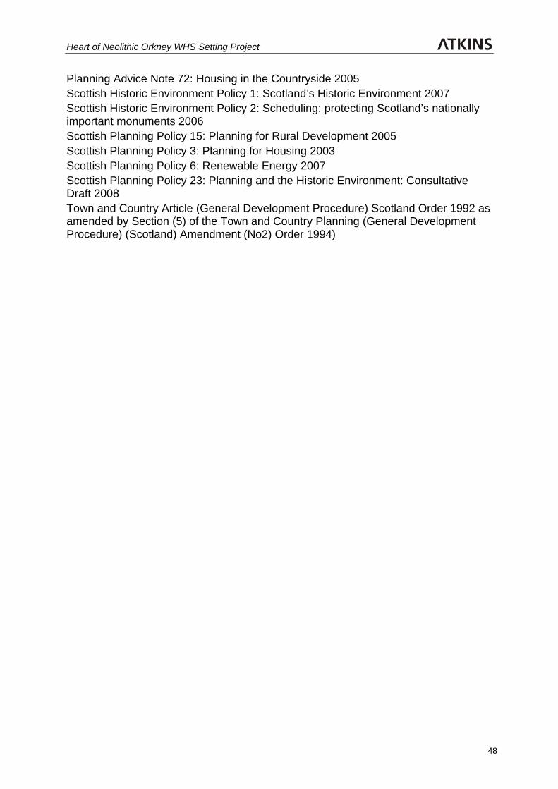
Heart of Neolithic Orkney WHS Setting Project
48
Planning Advice Note 72: Housing in the Countryside 2005 Scottish Historic Environment Policy 1: Scotland’s Historic Environment 2007 Scottish Historic Environment Policy 2: Scheduling: protecting Scotland’s nationally important monuments 2006 Scottish Planning Policy 15: Planning for Rural Development 2005 Scottish Planning Policy 3: Planning for Housing 2003 Scottish Planning Policy 6: Renewable Energy 2007 Scottish Planning Policy 23: Planning and the Historic Environment: Consultative Draft 2008 Town and Country Article (General Development Procedure) Scotland Order 1992 as amended by Section (5) of the Town and Country Planning (General Development Procedure) (Scotland) Amendment (No2) Order 1994)

Heart of Neolithic Orkney WHS Setting Project
49
PLATES
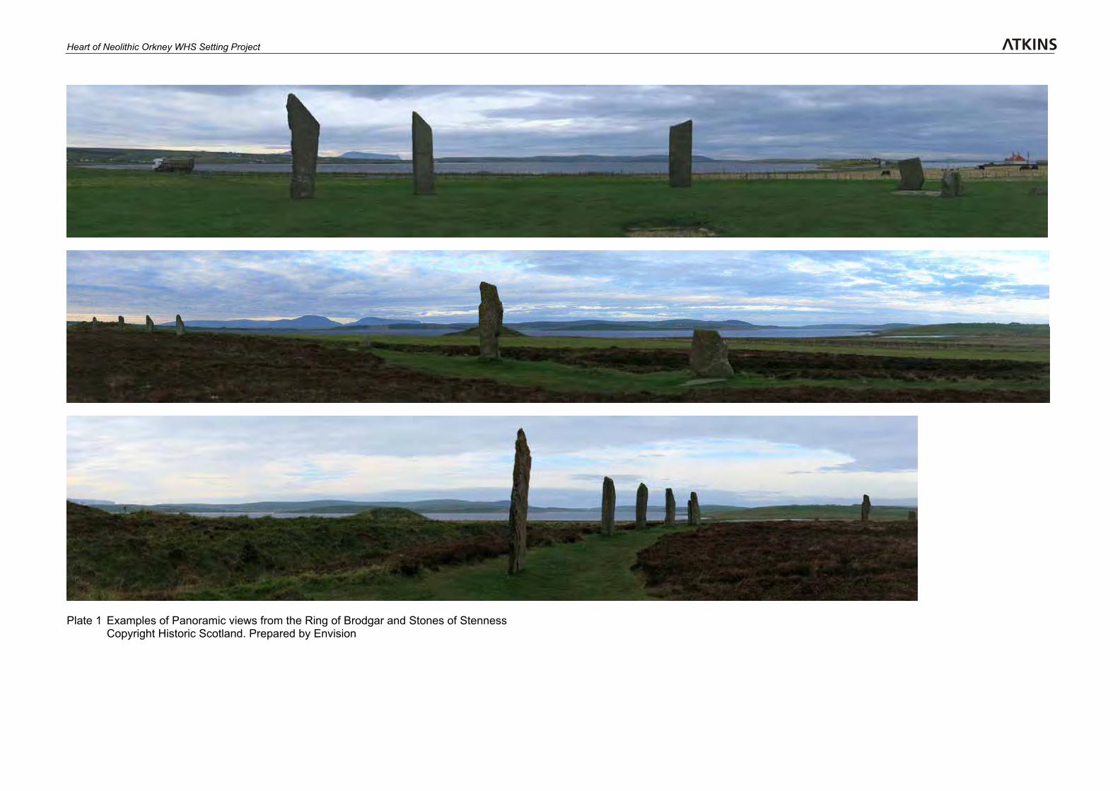
Heart of Neolithic Orkney WHS Setting Project
Plate 1 Examples of Panoramic views from the Ring of Brodgar and Stones of Stenness Copyright Historic Scotland. Prepared by Envision
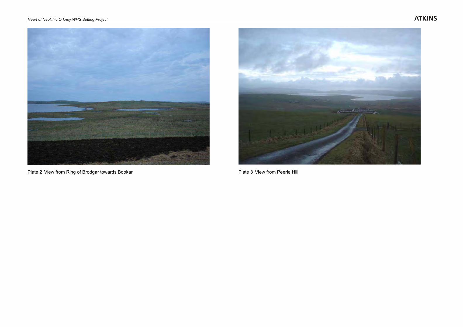
Heart of Neolithic Orkney WHS Setting Project
Plate 2 View from Ring of Brodgar towards Bookan Plate 3 View from Peerie Hill
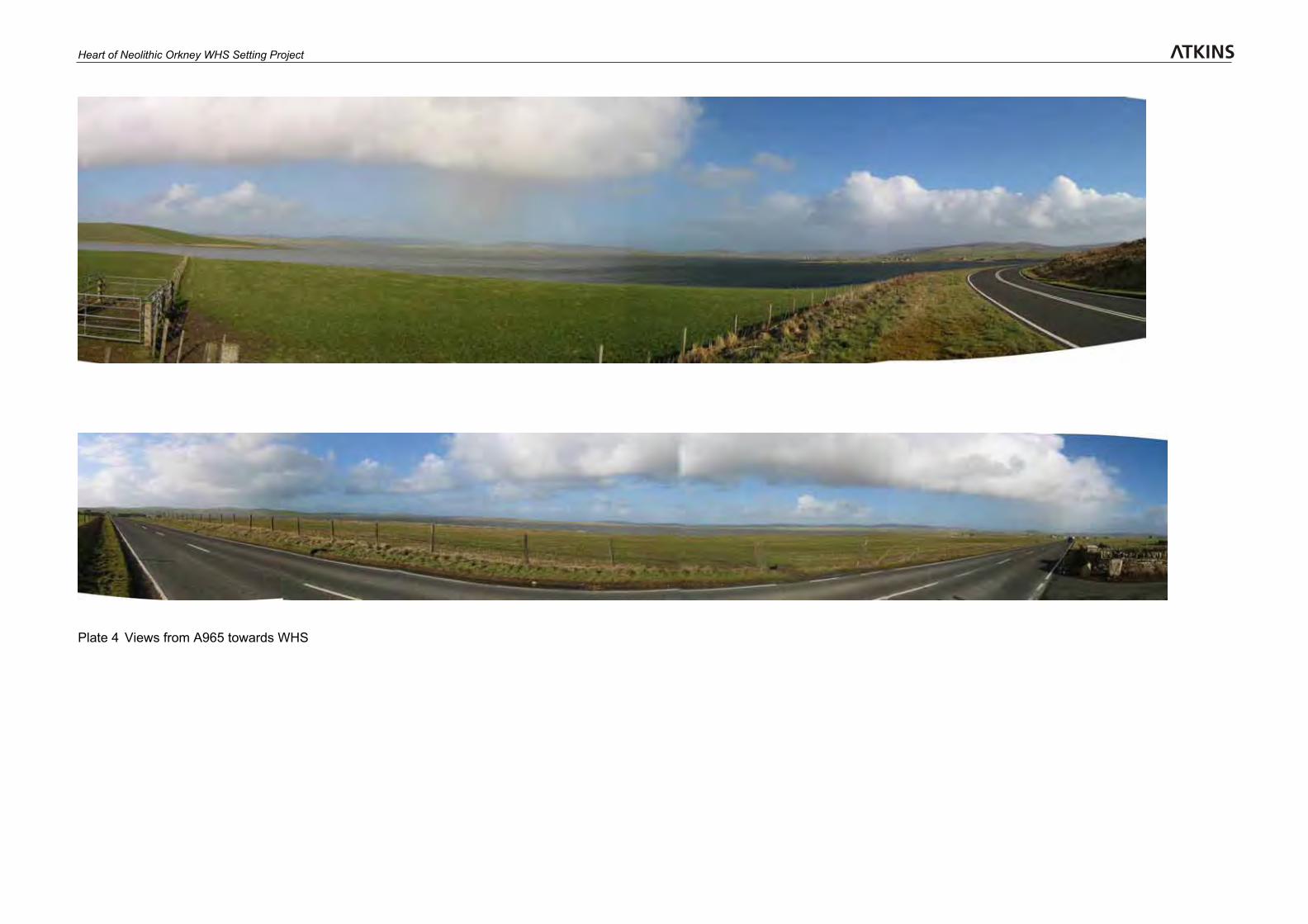
Heart of Neolithic Orkney WHS Setting Project
Plate 4 Views from A965 towards WHS
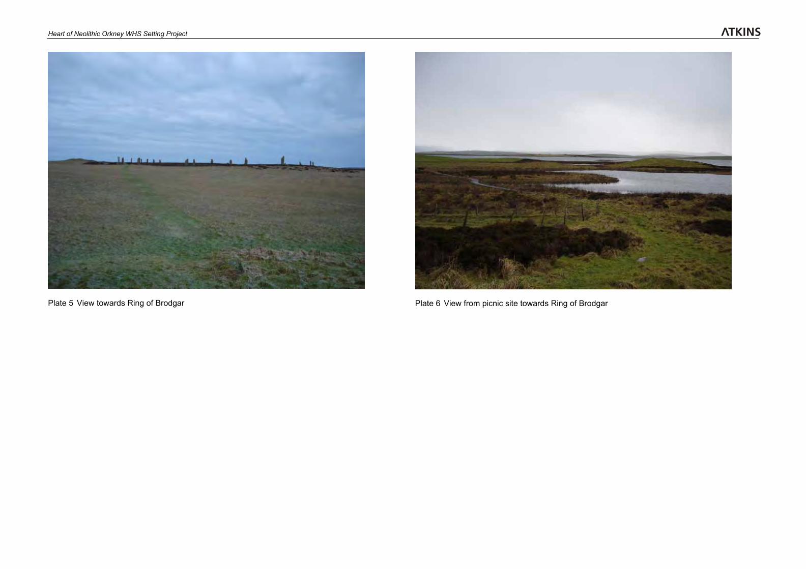
Heart of Neolithic Orkney WHS Setting Project
Plate 5 View towards Ring of Brodgar Plate 6 View from picnic site towards Ring of Brodgar
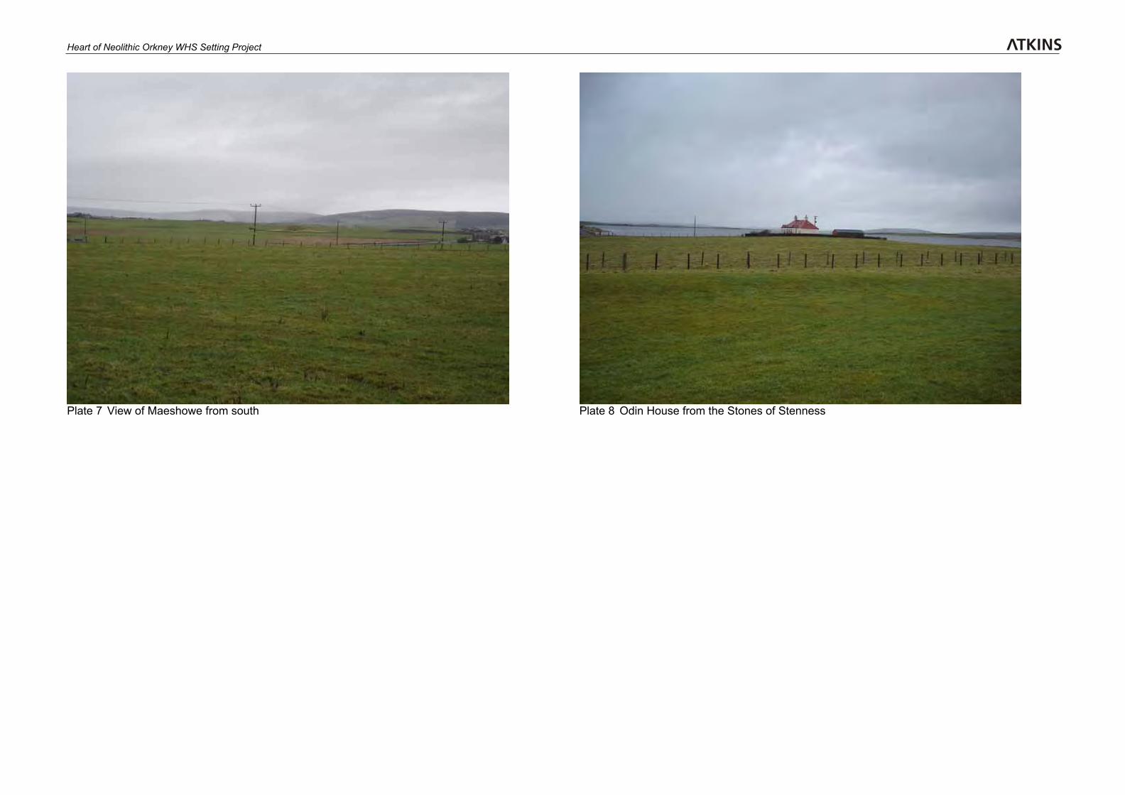
Heart of Neolithic Orkney WHS Setting Project
Plate 7 View of Maeshowe from south Plate 8 Odin House from the Stones of Stenness

Heart of Neolithic Orkney WHS Setting Project
48
FIGURES
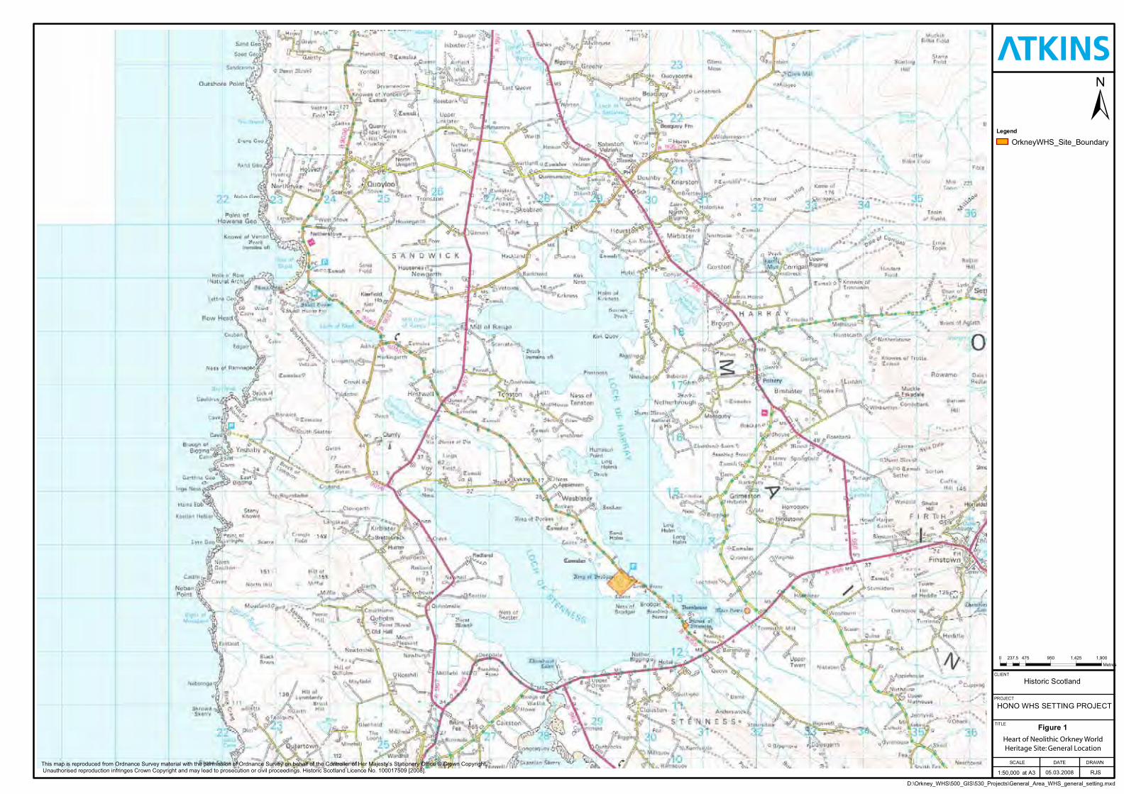
Legend
OrkneyWHS_Site_Boundary
PROJECT
SCALE
HONO WHS SETTING PROJECT
at A3
DRAWN
RJS
CLIENT
Historic Scotland
Heart of Orkney WorldHeritage Site: General Location
1:50,000
DATE
05.03.2008
TITLE
0 475 950 1,425 1,900237.5Metres
Figure 1
D:\Orkney_WHS\500_GIS\530_Projects\General_Area_WHS_general_setting.mxd
This map is reproduced from Ordnance Survey material with the permission of Ordnance Survey on behalf of the Controller of Her Majesty’s Stationery Office © Crown Copyright.Unauthorised reproduction infringes Crown Copyright and may lead to prosecution or civil proceedings. Historic Scotland Licence No. 100017509 [2008].
Heart of Neolithic Orkney World Heritage Site: General Location
Legend
Figure 2
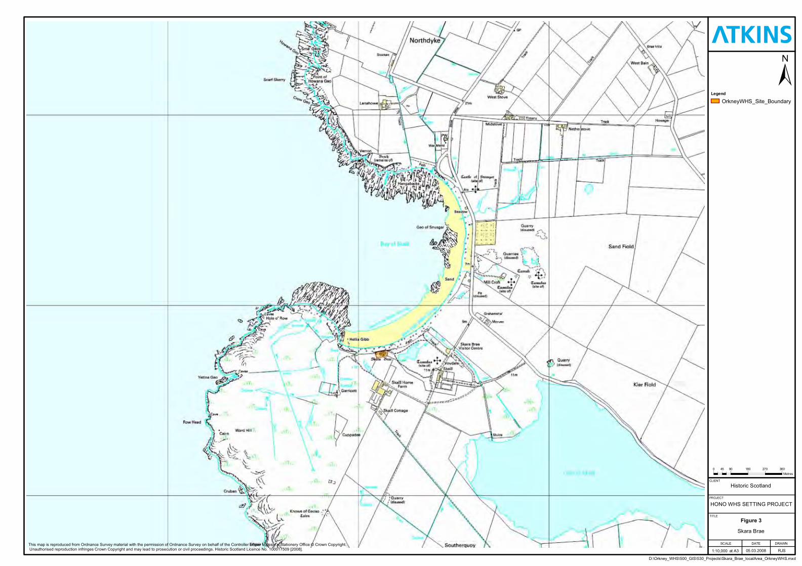
Legend
Figure 3

Figu
re4
Lege
nd
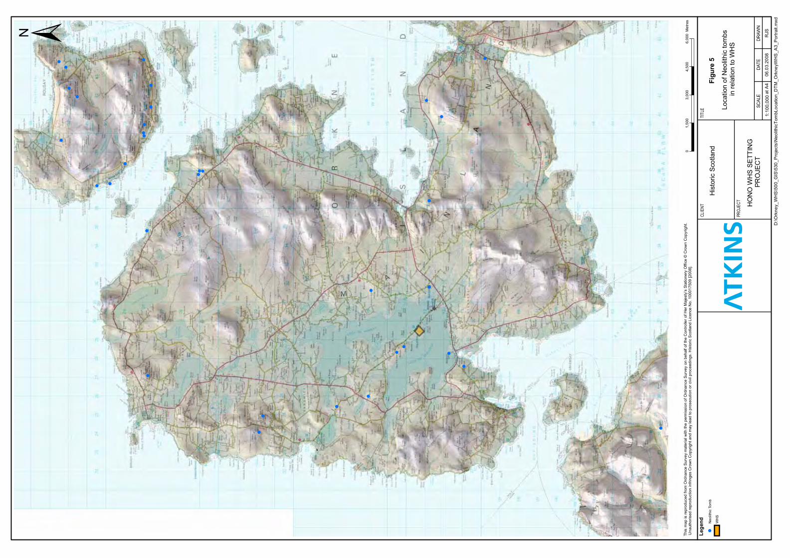
Figu
re5
Lege
nd
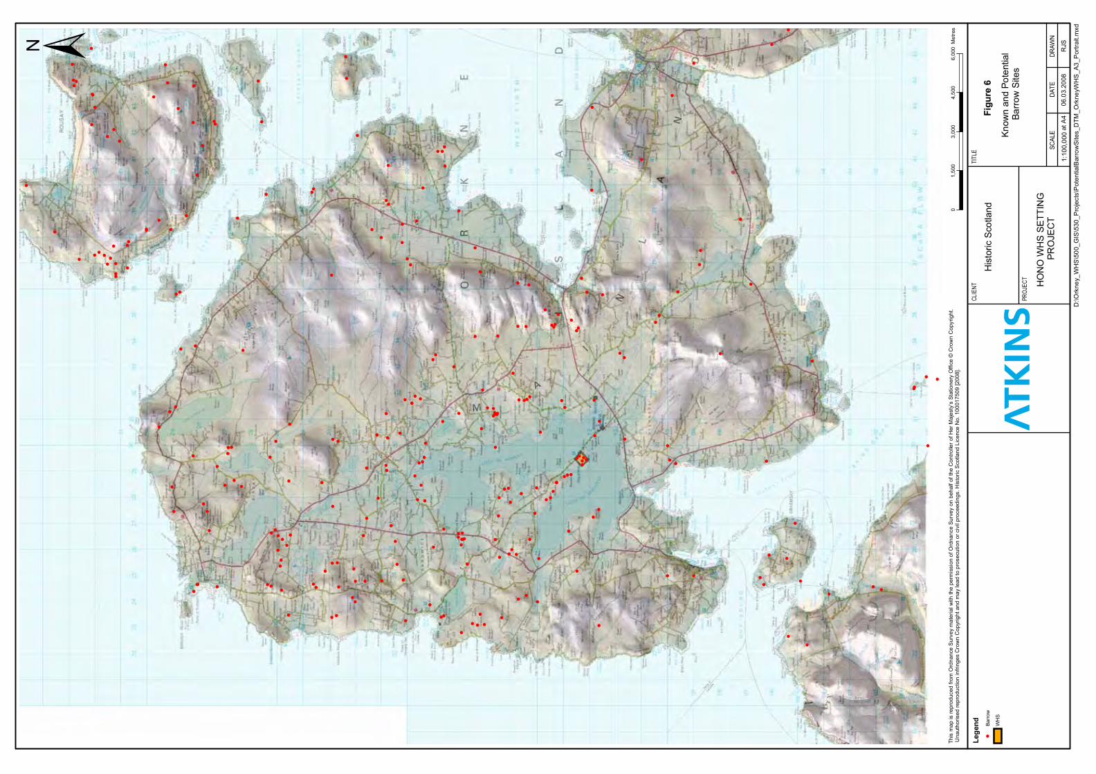
Figu
re6
Lege
nd
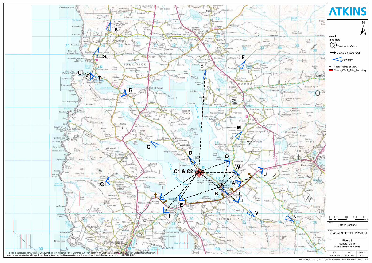
R
R
R
â
â â
â
â
â
*
Ø
*
Ø
,
Ø
+Ø
*
Ø
* Ø
,Ø
,Ø,Ø ,Ø*
Ø
+Ø
,Ø
*Ø *Ø
,
Ø
|
Ø
,
Ø
*Ø
,
Ø
,
ØA
T
M
O
WJ
NV
LB
D
E
I
H
Q
G
F
P
R
S
U
K
C1 & C2
PROJECT
SCALE
HONO WHS SETTING PROJECT
at A3
DRAWN
RJS
CLIENT
Historic Scotland
General Viewsin and around the WHS
1:50,000
DATE
12.08.2008
TITLE
0 480 960 1,440 1,920240Metres
Figure 7
D:\Orkney_WHS\500_GIS\530_Projects\GeneralViewsInAndAroundTheWHS.mxd
±
This map is reproduced from Ordnance Survey material with the permission of Ordnance Survey on behalf of the Controller of Her Majesty’s Stationery Office © Crown Copyright. Unauthorised reproduction infringes Crown Copyright and may lead to prosecution or civil proceedings. Historic Scotland Licence No. 100017509 [2008].
Legend
SiteView
RPanoramic Views
âViews out from road*Ø
Viewpoint
Focal Points of ViewOrkneyWHS_Site_Boundary
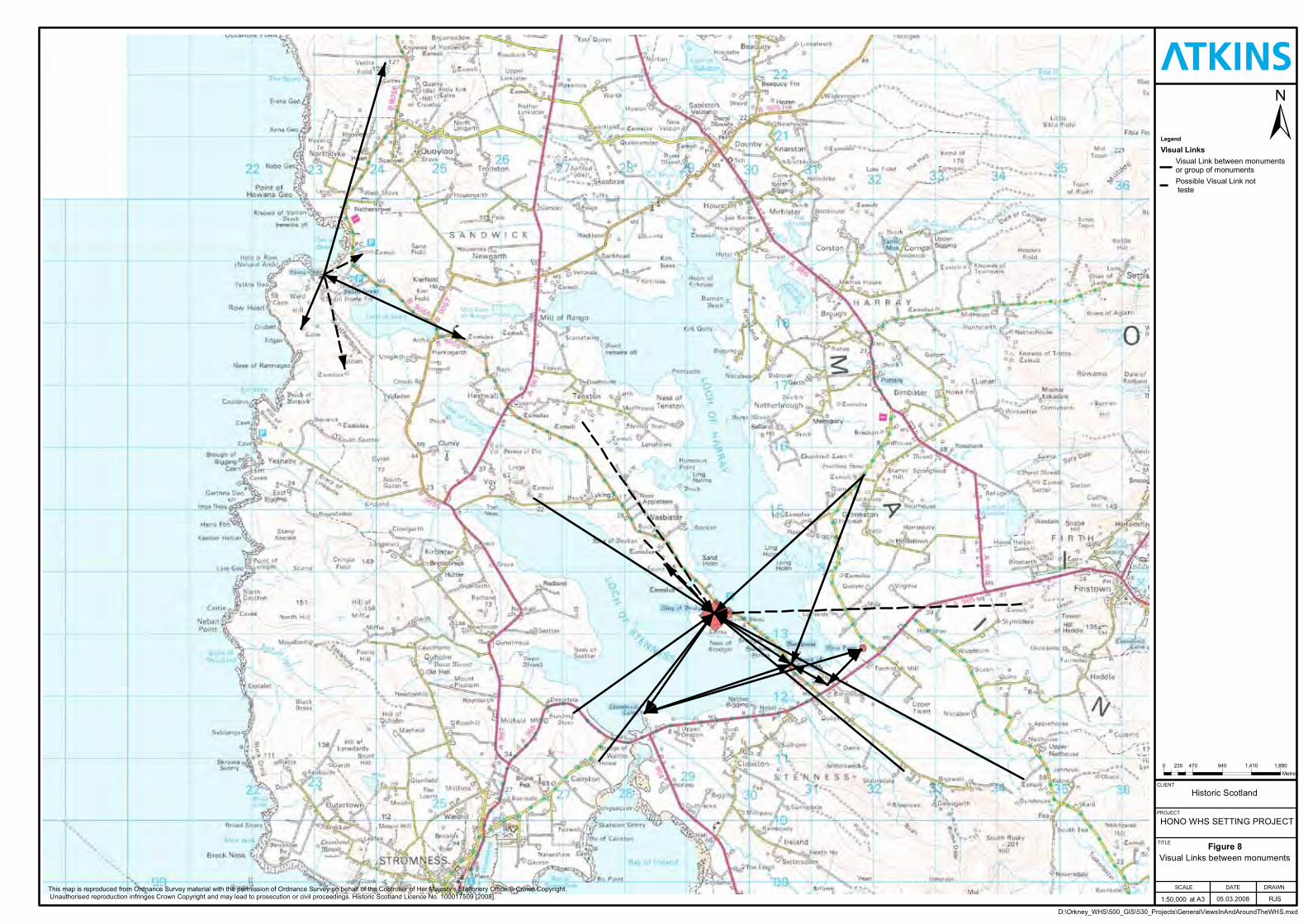
Figure 8
Legend
Visual Links
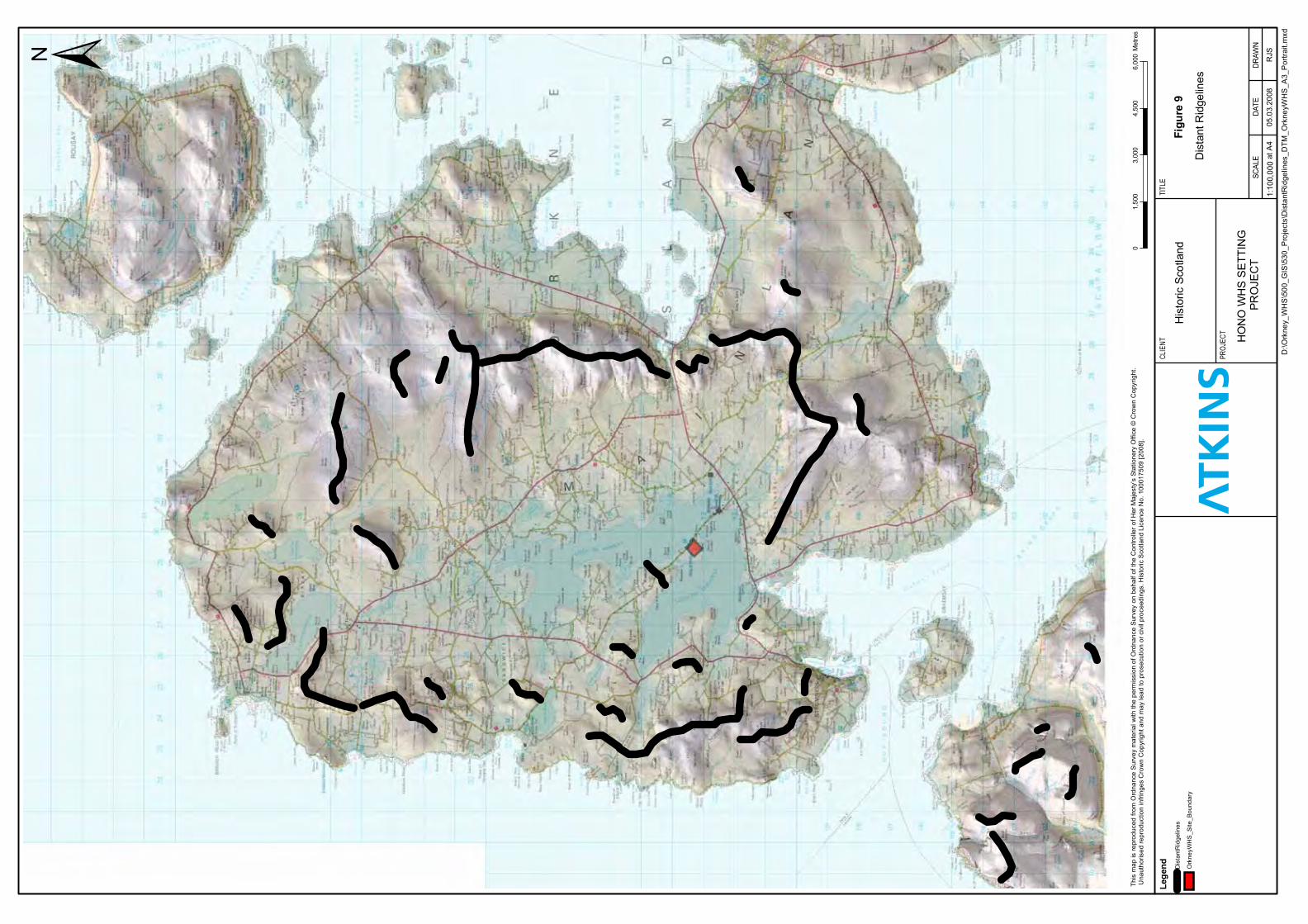
Figu
re9
Lege
nd
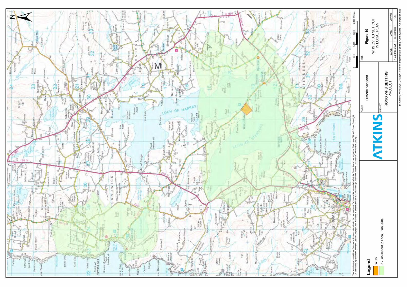
Figu
re10
Lege
nd
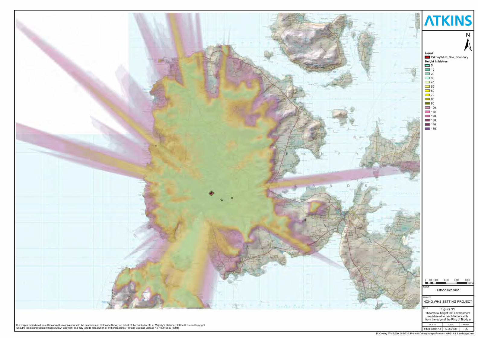
Legend
Height in Metres
Figure 11
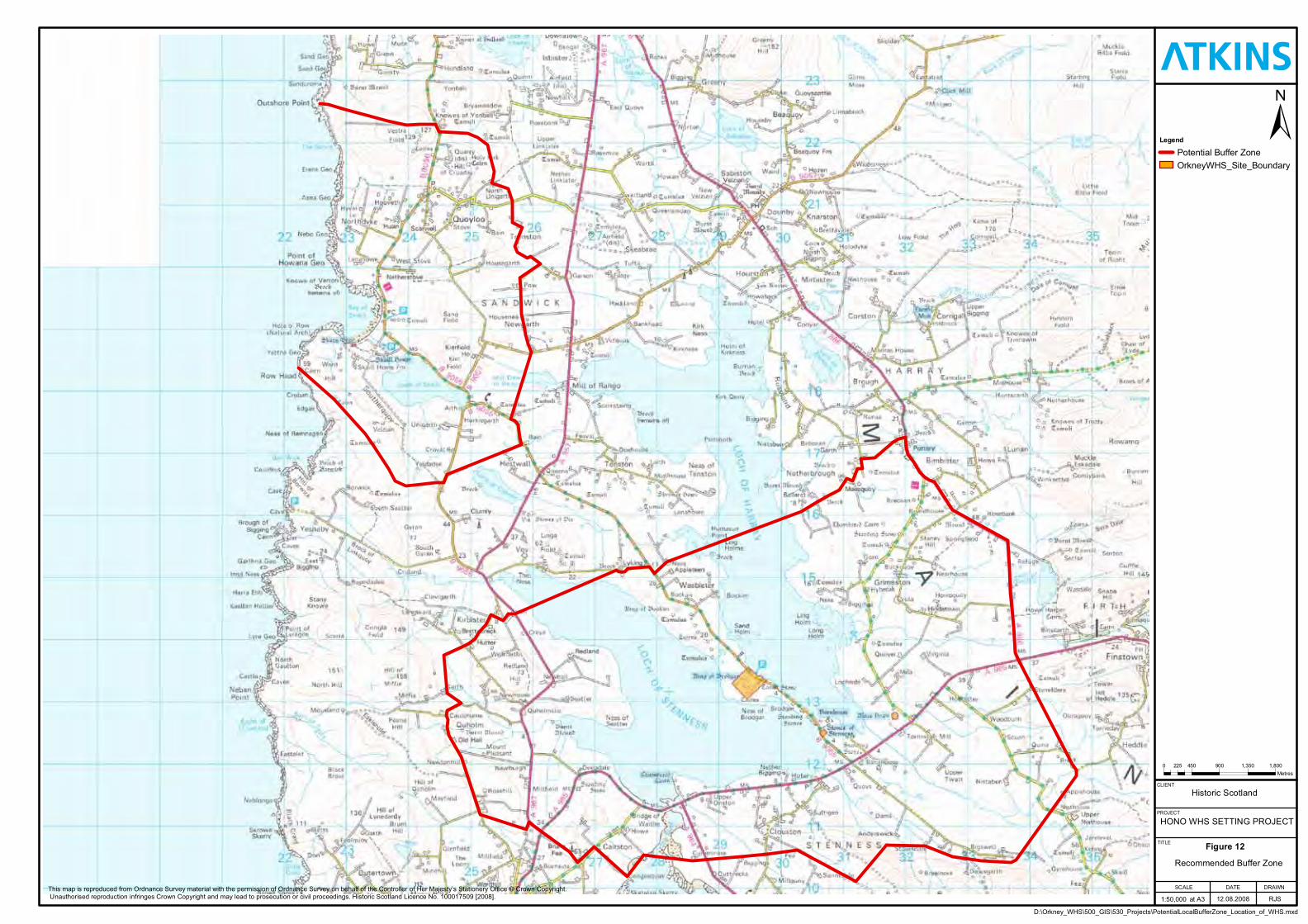
Legend
Figure 12
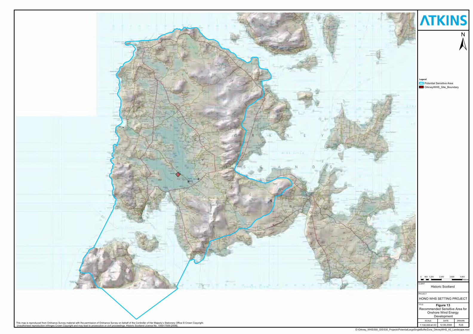
Legend
Figure 13

Heart of Neolithic Orkney WHS Setting Project
ANNEX A – VIEWSHED ANALYSIS
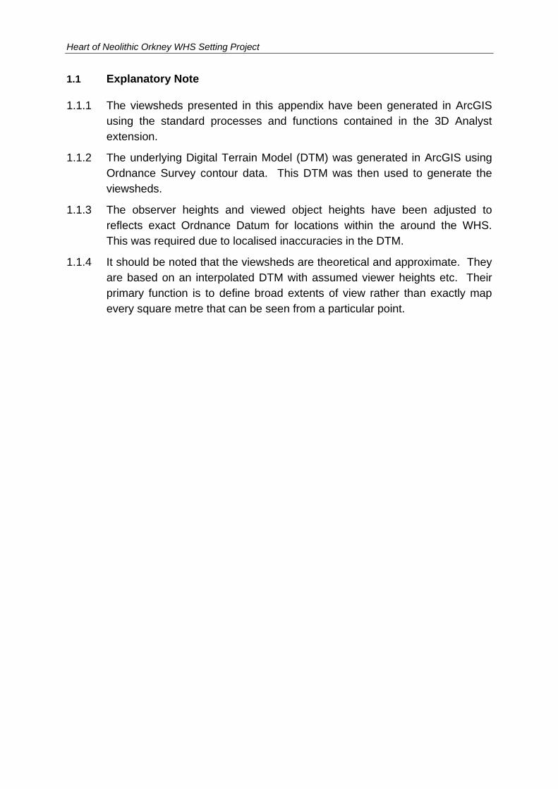
Heart of Neolithic Orkney WHS Setting Project
1.1 Explanatory Note
1.1.1 The viewsheds presented in this appendix have been generated in ArcGIS using the standard processes and functions contained in the 3D Analyst extension.
1.1.2 The underlying Digital Terrain Model (DTM) was generated in ArcGIS using Ordnance Survey contour data. This DTM was then used to generate the viewsheds.
1.1.3 The observer heights and viewed object heights have been adjusted to reflects exact Ordnance Datum for locations within the around the WHS. This was required due to localised inaccuracies in the DTM.
1.1.4 It should be noted that the viewsheds are theoretical and approximate. They are based on an interpolated DTM with assumed viewer heights etc. Their primary function is to define broad extents of view rather than exactly map every square metre that can be seen from a particular point.
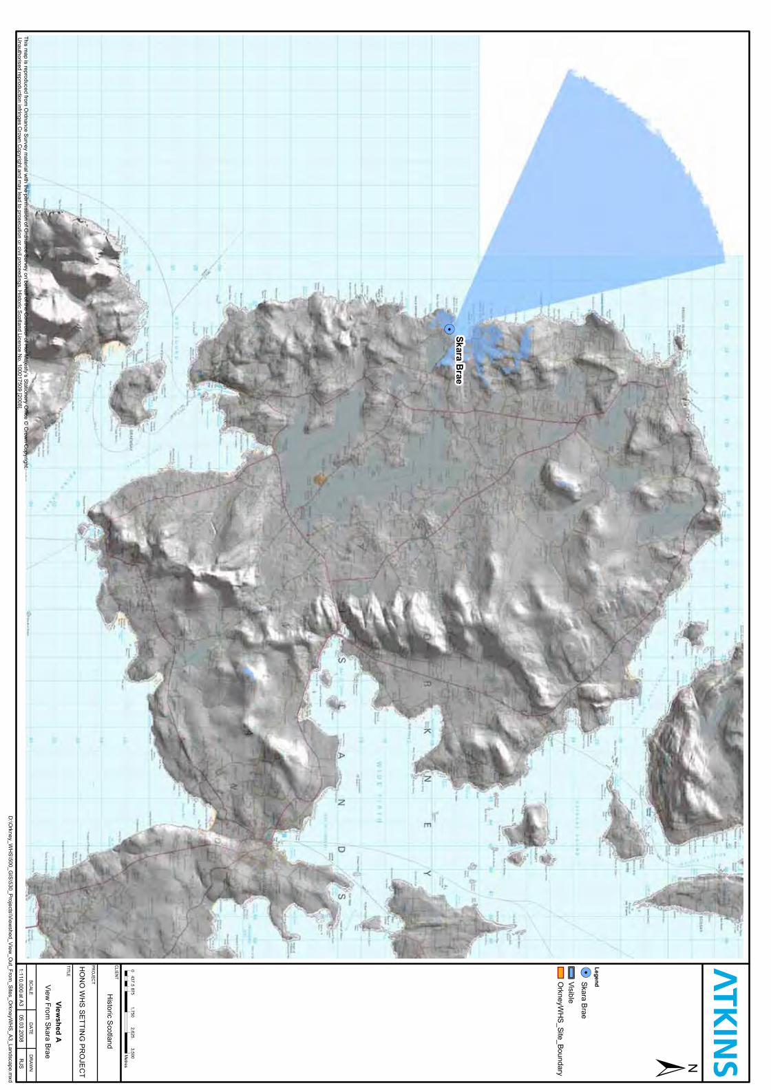
SkaraB
rae
Legend
Viewshed
A
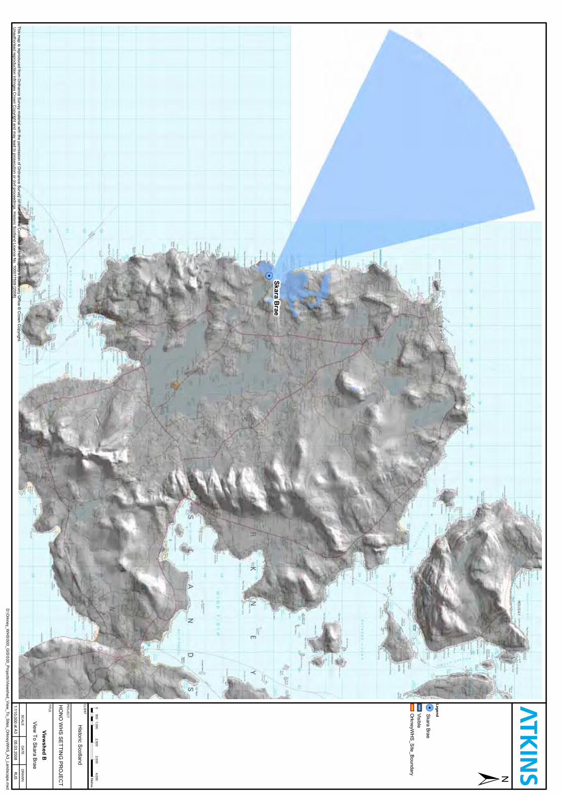
SkaraB
rae
Legend
Viewshed
B
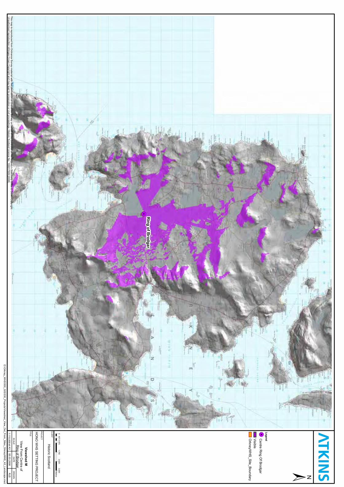
Ring
ofBrodgar
Legend
Viewshed
M
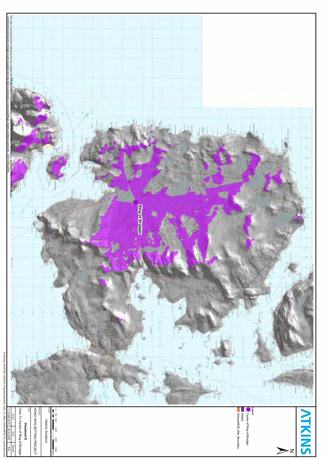
Ring
ofBrodgar
Legend
Viewshed
D
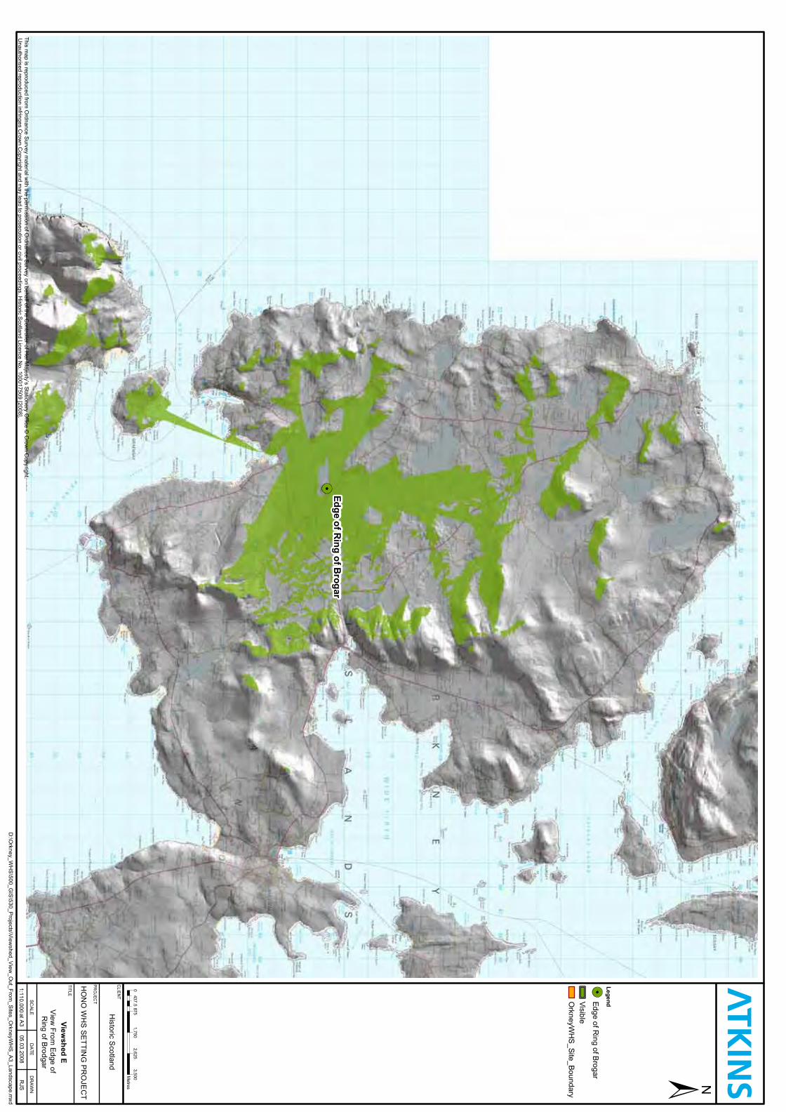
EdgeofR
ingofB
rogar
Legend
Viewshed
E
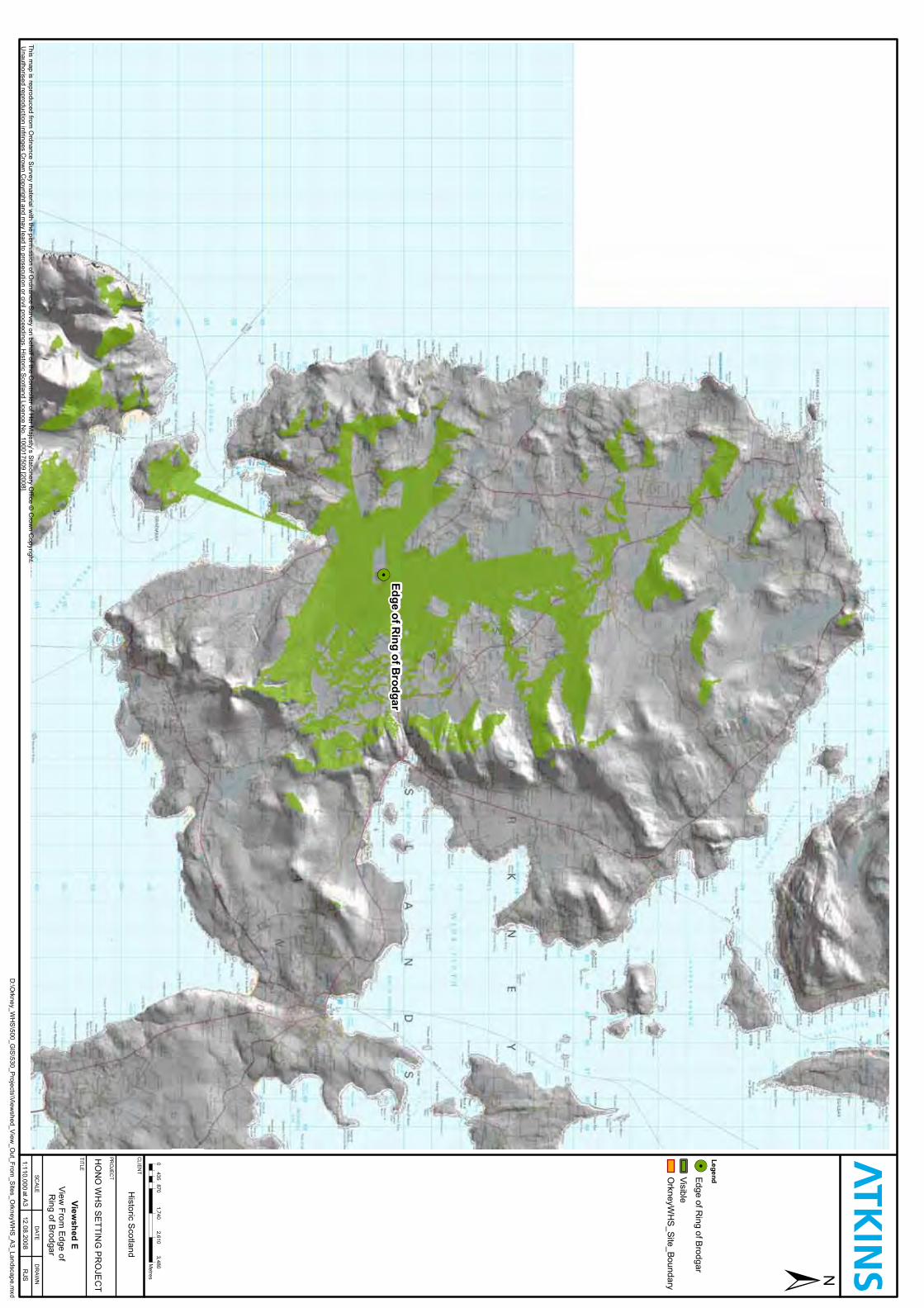
EdgeofR
ingofB
rodgar
Legend
Viewshed
E
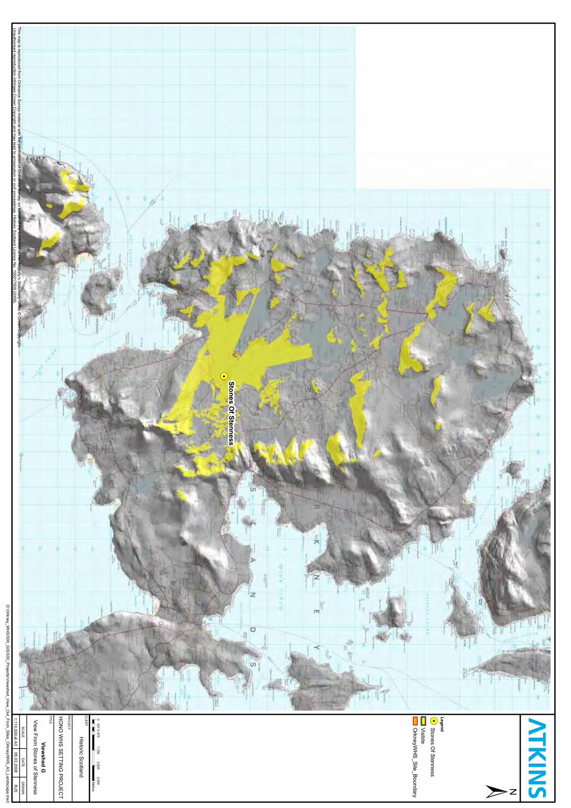
StonesO
fStenness
Legend
Viewshed
G
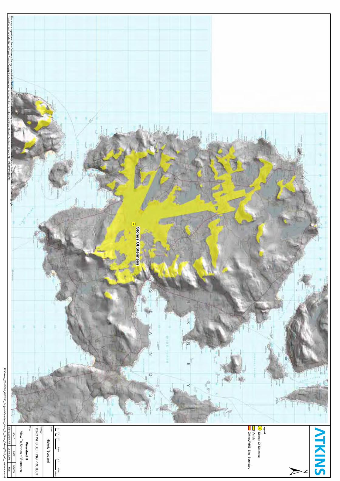
StonesO
fStenness
Legend
Viewshed
H
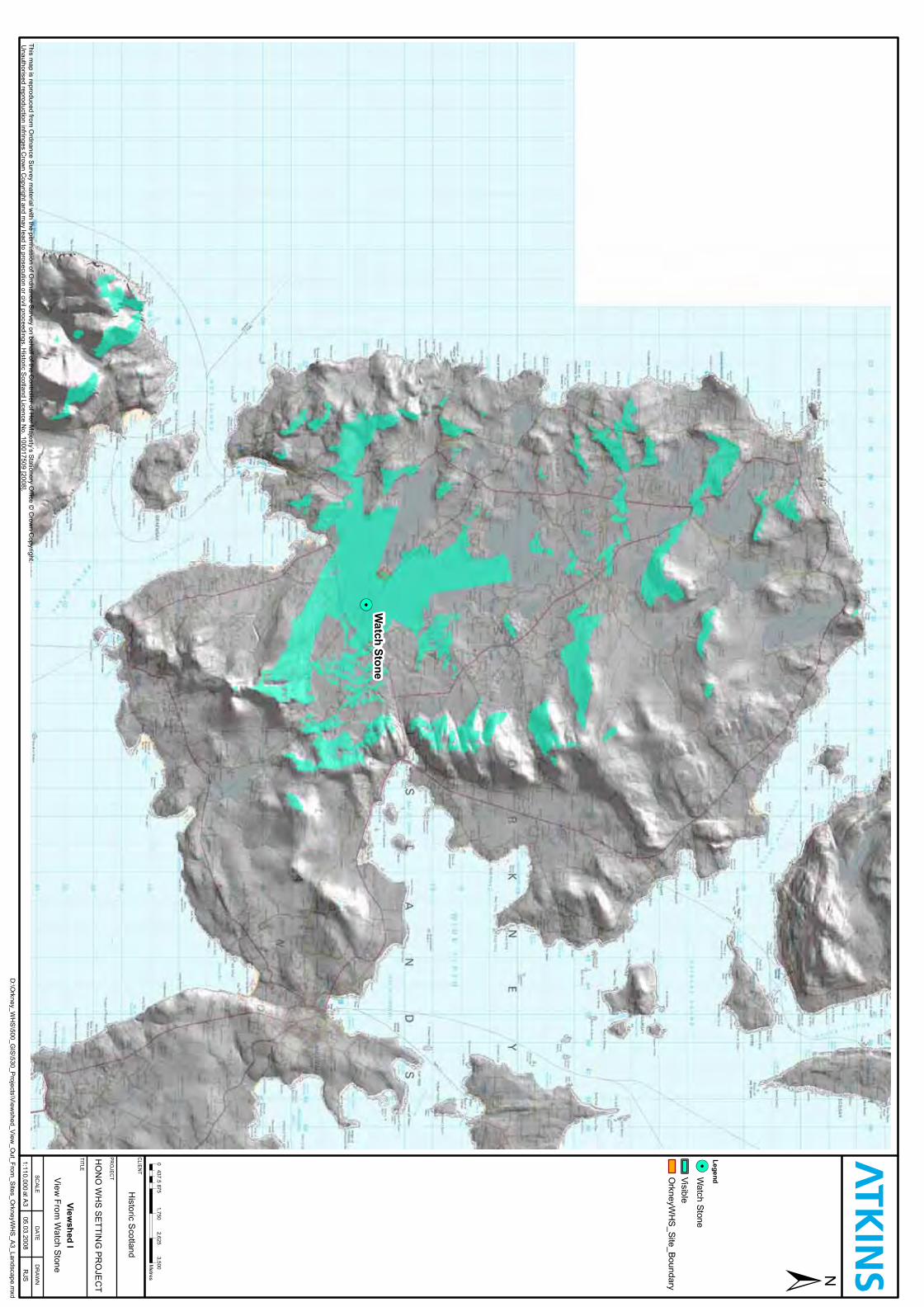
Watch
Stone
Legend
Viewshed
I
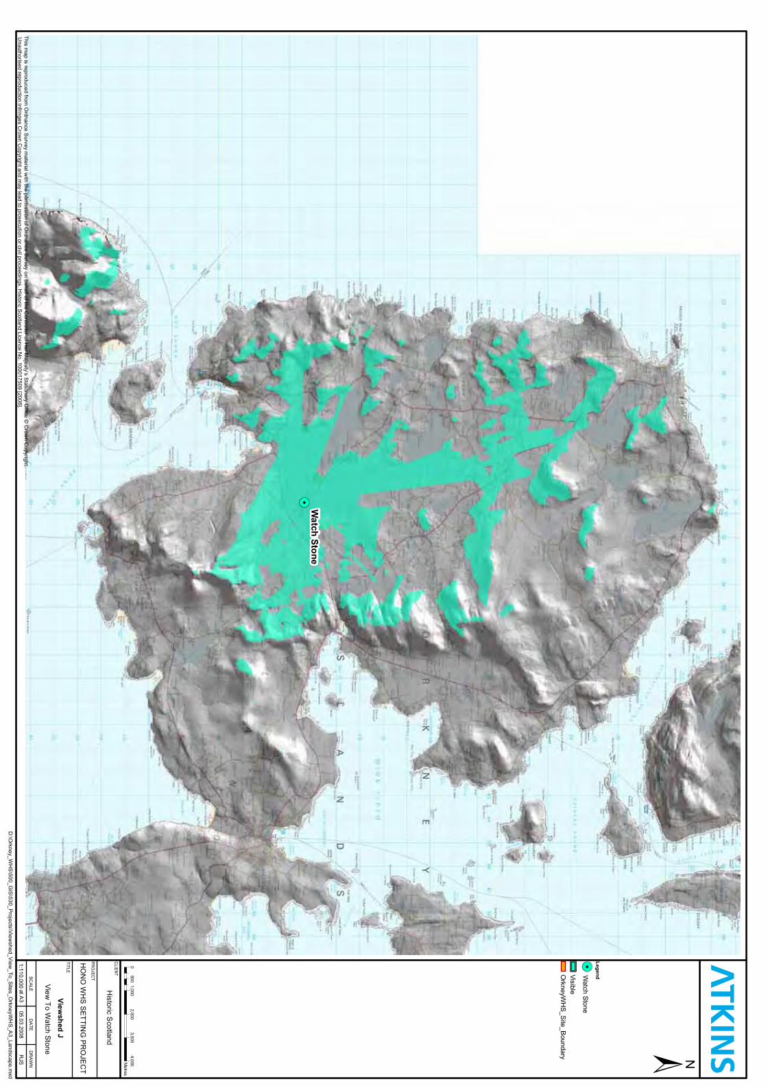
Watch
Stone
Legend
Viewshed
J
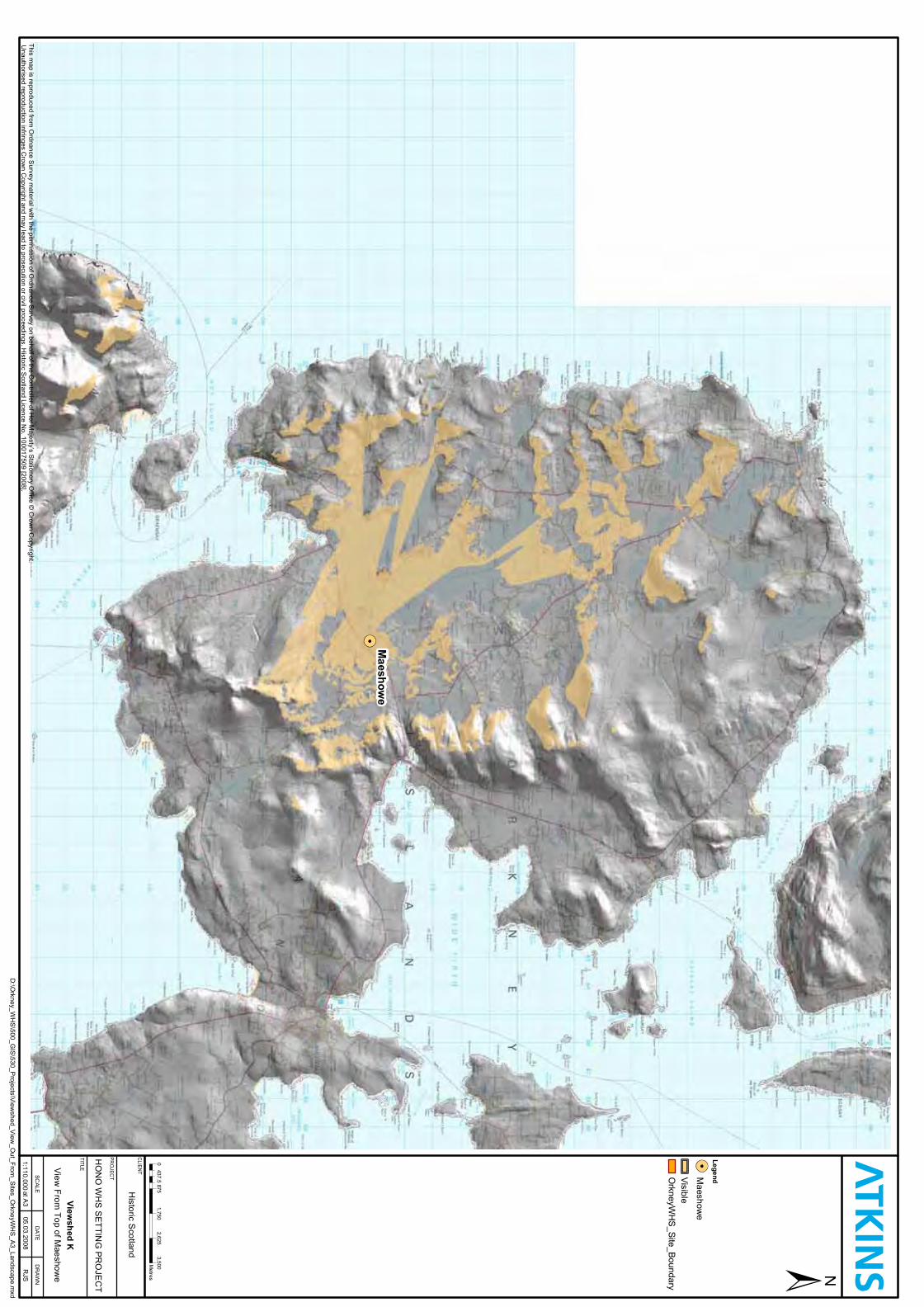
Maeshow
e
Legend
Viewshed
K
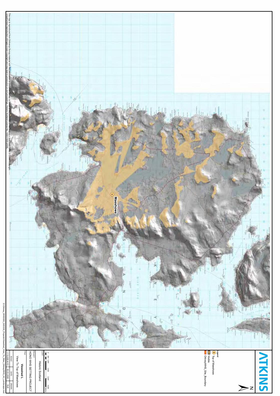
Maeshow
e
Legend
Viewshed
L
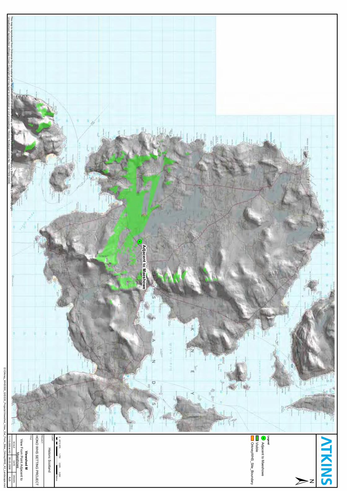
Adjacentto
Maeshow
e
Legend
Viewshed
M
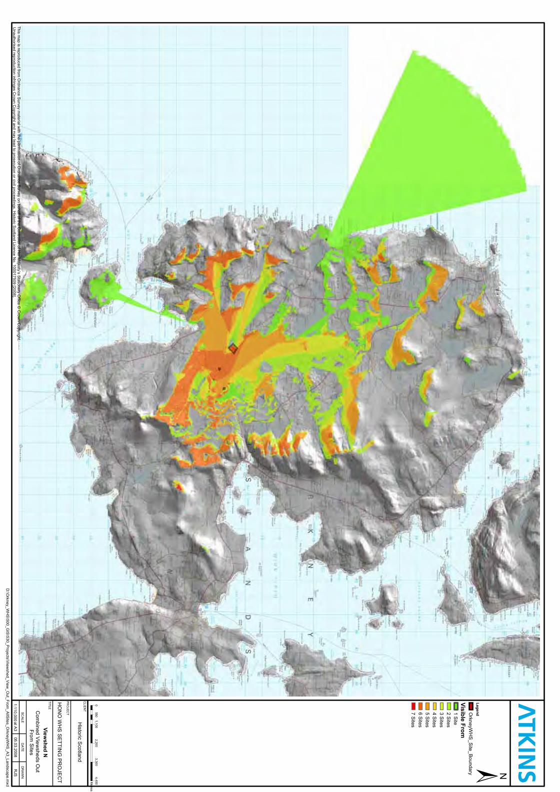
Legend
VisibleFrom
Viewshed
N
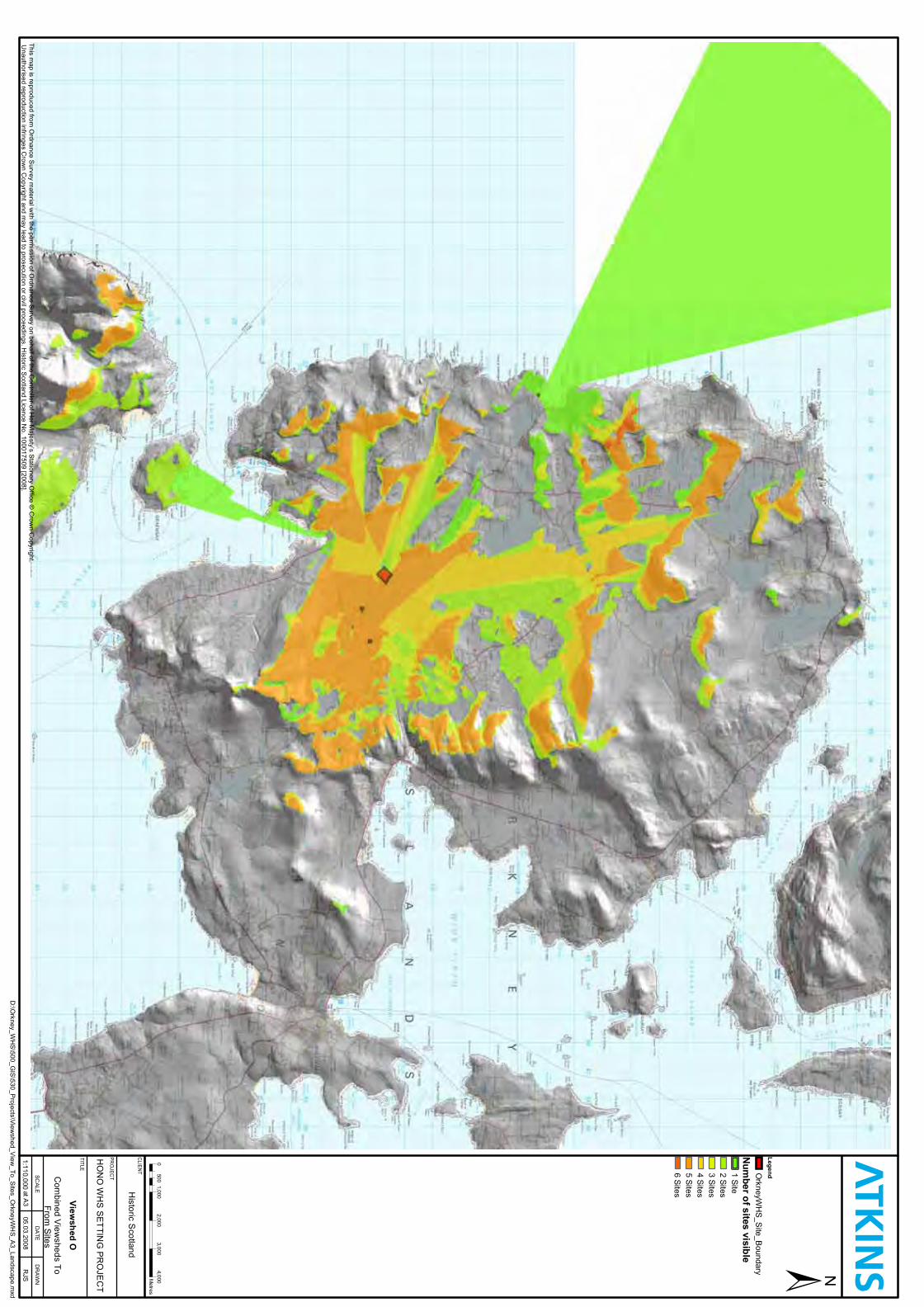
Legend
Num
berofsitesvisible
Viewshed
O
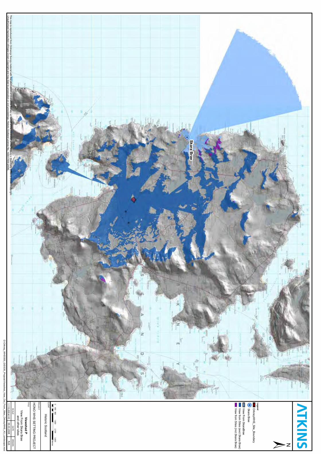
SkaraB
rae
Legend
Viewshed
P
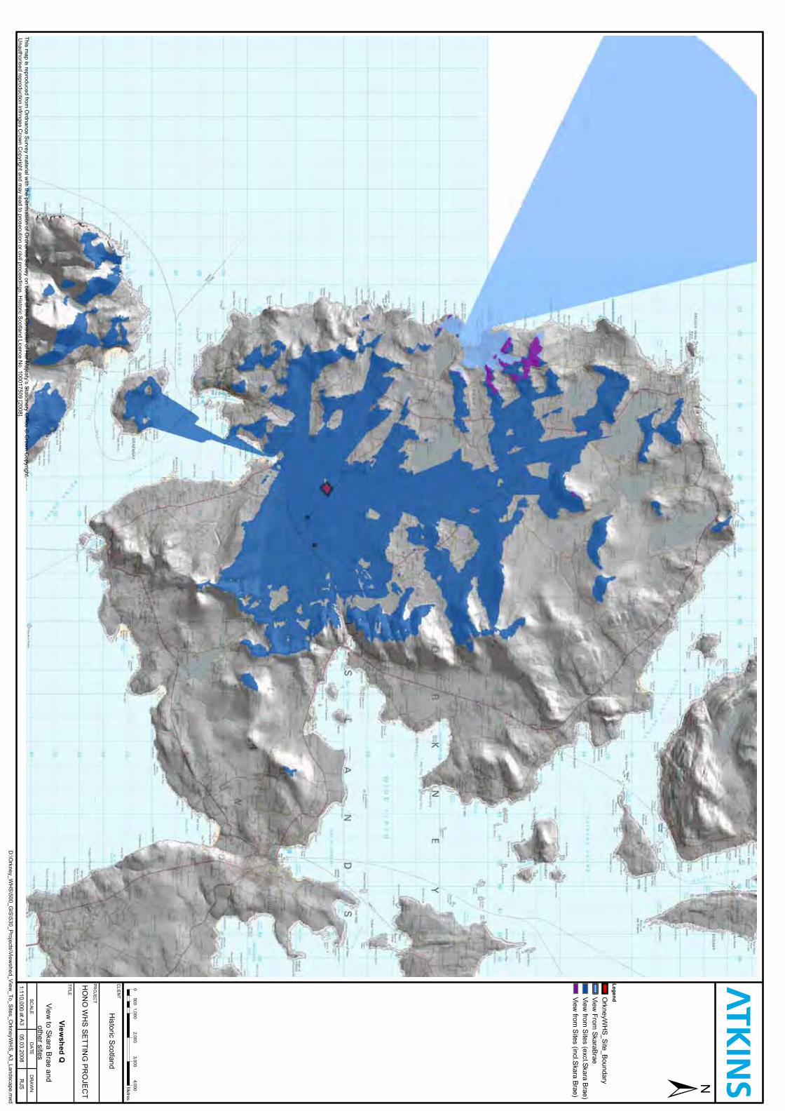
Legend
Viewshed
Q

Heart of Neolithic Orkney WHS Setting Project
ANNEX B – LANDSCAPE CHARACTER
Heart of Neolithic Orkney WHS Setting Project
1.1 The topography of West Mainland Orkney & Hoy
1.1.1 In general, the topography of West Mainland Orkney is low-lying. Although some of the highest areas reach over 200m, most are below 100m and in some places this drops to 30m. The relief is smooth and is made of up successive ridgelines that overlap and create a basin with the lochs of Harray and Stenness at the centre. The highest parts of the basin are in the north and east. There is steeper relief associated with some of the larger hills, e.g. Wideford Hill, Costa Hill, and the ridges around Settiscarth and Stenness. Together, these individual hills create the visual effect of a large amphitheatre or bowl. Gently sloping hill land runs into the flatter land associated with the lochs however, much of this ‘flatter’ land is gently undulating and originates from glacial morraines.
1.1.2 The island of Hoy is more dramatic and has much higher hills, which are over 300 or 400m in some instances (Ward Hill, reaches 479m). Central and southern Hoy is lower (200m) and the topography is more undulating than the north. The west coast cliffs of Hoy, some of which can be seen from Mainland reach over 300m high and are dramatic. The effect is emphasised through a series of terraces on the slopes.
1.2 Landscape character areas
1.2.1 The Scottish Natural Heritage Landscape Character Descriptions and Map of Orkney (LUC 1998) identifies a series of individual island characters and on Mainland Orkney there are two distinct areas: West Mainland and East Mainland. The WHS lies wholly within West Mainland.
1.2.2 Twelve landscape types occur within West Mainland; Coastal Basins; Inclined Coastal Pastures; Coastal Granite Pastures; Isolated Coastal Knolls; Enclosed Bay Landscape; Coastal Hills and Heath; Cliff Landscapes; Peatland Basins; Loch Basins; Loch Islands; Rolling Hill Fringe; and Moorland Hills. Of direct relevance to the Brodgar – Stenness – Maeshowe element of the WHS are:
• Loch Basins; • Rolling Hill Fringe; • Coastal Hills & Heaths; • Moorland Hills; and to a lesser extent • Inclined Coastal Pastures. Loch Basins
1.2.3 Key characteristics:
• Prehistoric ritual landscapes and monuments;
Heart of Neolithic Orkney WHS Setting Project
• ‘Drowned’ landscape dominated by bodies of water; • Open landscapes with long views; • Wetlands, mires, marshes and areas of low peatland; • Settled landscape with scattered houses and farmsteads; • Relatively extensive road network; • Current land use is generally improved pastures creating a tapestry of
greens; • Residential development pressures; • Agricultural development pressures; • Loss of small wetlands and unimproved pastures;
1.2.4 This landscape type contains significant prehistoric monuments which demonstrate the relationships between ancient ritual and dwelling activities. The relocation of fenced field boundaries that dissect groups or parts of the same monument should be promoted as a means of enhancing the setting of monuments in the landscape.
1.2.5 Particular consideration should be given in this landscape type to controlling development in proximity to monuments in order that important axial views, silhouettes and ancient access routes remain uninterrupted. The open and relatively flat and large scale of this landscape type determines that new developments would be highly visible and potentially obtrusive. The siting and scale of buildings should be carefully considered in relation to their effects on long views over loch basins and on the context of prehistoric monuments.
Rolling Hill Fringe
1.2.6 Key characteristics
• Rolling border between low-lying and upland landscapes; • Improved pasture on lower slopes, enclosed in fenced fields; • Rougher grassland, enclosed by stone walls on high ground gives way to
unenclosed moorland hills; • Roads and scattered settlement; • Archaeological interest.
1.2.7 This transitional landscape forms the rolling lower fringe of hill areas and the upper border to low-lying loch landscapes or coastal pastures. It is this relationship to both low-lying and hill land which gives the rolling hill fringe much of its character. There are extensive deposits of boulder clay and the resulting topography is predominately rolling (20m to 150m).
1.2.8 The vegetation in lower areas is predominately rich improved pastures, enclosed by fences and some stone walls. Fields vary in size and orientation
Heart of Neolithic Orkney WHS Setting Project
but are generally small to medium, and cattle and sheep are a common sight. On higher ground, the green improved pastures give way to unenclosed brown moorland. This can create an interesting contrast in colours highlighting moorland areas which have been improved by pasture.
1.2.9 On lower lying areas the land has a settled agricultural appearance with good access via the road network. Settlement becomes more sparse in higher parts, and is generally of scattered farmsteads. A network of minor roads and tracks often traverse the higher parts of this hill fringe.
1.2.10 Archaeological interest is found in the barrows, burnt mounds and brochs located in this zone, the most significant areas being those associated most closely with the loch basin landscapes. Groups of barrows on elevated hillsides are also of significance as they predominantly occur at/ near the 50m contour mark. It is at this height that the main archaeological complex at the heart of the WHS is visible.
Moorland Hills
1.2.11 Key characteristics
• Undulating hill land; • Peat and heather moorland mostly unenclosed; • Few and isolated farmsteads and tracks; • Active and redundant peat cutting sites; • Occasional hill dykes and signs of sub-peat archaeological farmsteads
and field systems; • Bronze Age barrows on skyline recognisable by significant topographic
variations. 1.2.12 This landscape is found on the hilliest parts of the Mainland and the
vegetation is largely peat and heather moorland with montane species at higher altitude. The land is completely unenclosed, although some small fenced grazings may be found on the periphery of the hill land.
1.2.13 The relatively recent development of peat over the past millennia has occurred since initial human habitation of the islands and it is likely that significant sub-peat archaeological features are present. Earlier boundaries of hill grazing – ‘hill dykes’ – are still visible on some of the lower slopes, although moorland occasionally extends below these former boundaries.
1.2.14 These moorland landscapes harbour a diversity of wildlife interest and offer significant vantage points for views onto lower lying land. They are good reflectors of prevailing weather: in drizzle they appear bleak and less colourful; in sunshine their colours are vibrant and contrast with blue skies and distant views of the water. There are very few settlements and roads and

Heart of Neolithic Orkney WHS Setting Project
consequently the area feels isolated. The main development pressure arises from the potential impact of vertical structures (wind towers, telecommunication masts and hydro poles) within an otherwise undeveloped landscape.
Coastal Hills and Heath
1.2.15 Key characteristics:
• Hills with strong relief reaching along the coast; • Rough, improved grassland; • Subtle topographic features visible on hillsides, e.g. terraces and low
crags; • Sheep and cattle grazing; • Scattered farms and some ruined/abandoned farmsteads; and • Hilltop cairns.
1.2.16 The Coastal Hills and Heaths landscape create an irregular rim to the islands, reaching heights of up to 150m. The height of the hills makes them important visual barriers controlling views out to sea. Under low sun or in silhouette, topographic features are highlighted. Hilltop cairns from the Bronze Age are particularly noticeable in these conditions.
1.2.17 The land cover is predominately improved or rough grassland with maritime heath in the areas most exposed to the sea. Much of this landscape was originally common rough grazing and as such, lacked extensive field boundaries. The grass cover allows the outline of underlying strata to be seen in certain areas and small rock outcrops (sometimes called ‘hamars’) are noticeable features in the generally smooth but strong relief.
1.2.18 On the lower slopes, the remnants of old hill dykes are discernible as small linear ridges. The landscape is scarcely populated, with a few farmsteads prominent on lower slopes. The occasional ruined croft are features of the higher areas. The absence or scarcity of development in this landscape is on of its key characteristics which should be ideally preserved.

Heart of Neolithic Orkney WHS Setting Project
ANNEX C – STRUCTURE AND LOCAL PLAN POLICY
THE ORKNEY STRUCTURE PLAN WRITTEN STATEMENT
DECEMBER 2001
Department of Development and Protective Services, Orkney Islands Council Director of Development and Protective Services - Jeremy Baster
Council Offices School Place KIRKWALL KW15 1PY
ORKNEY DEVELOPMENT PLAN The Orkney Structure Plan - Written Statement
2
CONTENTS
FOREWORD
1. INTRODUCTION Page 4
2. THE DEVELOPMENT STRATEGY Page 5
THE POLICIES
3. Housing Page 12
4. Business & Industry Page 16
5. Natural Heritage Page 21
6. The Coast Page 25
7. Historic Environment Page 28
8. Sport, Recreation & Community Facilities Page 31
9. Transport Page 35
10. Utilities Page 40
11. Kirkwall & Stromness Page 45
12. The Isles Page 48
13. IMPLEMENTATION, MONITORING & REVIEW Page 50
APPENDICES
14. Policy Index Page 52
15. Glossary of Terms Page 54
16. Scottish Ministers Decision Letter Page 57
KEY DIAGRAM
ORKNEY DEVELOPMENT PLAN The Orkney Structure Plan - Written Statement
28
7. HISTORIC ENVIRONMENT Key Objective ♦ To protect and where possible enhance areas of built and cultural heritage interest,
together with their settings, and encourage their maintenance. Background 7.1 One of Orkney’s principal assets is the exceptionally high quality of its historic environment which comprises: archaeological sites and landscapes, ancient monuments, historic buildings and townscapes and historic gardens. The County contains archaeological sites of world-class quality, and listed buildings and conservation areas of outstanding national significance. These qualities have been recognised in the designation of many sites in the County for their national and international importance. The importance of this heritage is difficult to quantify but it brings obvious benefits to the local economy in terms of attracting visitors to the area. In addition, archaeological and historical sites and features are cultural resources for research, education and local identity and as such are key elements of the Plan’s approach to sustainable development. 7.2 Further economic opportunities for enhancing this resource can and should be realised in the next 10 years. However, this should not be at the expense of the resource itself. Opportunities may include: financially targeting buildings at risk; townscape initiatives involving shopfront design, street furniture and landscaping; development of Orkney’s Norse heritage; development on the theme of “Scapa Flow in the defence of Britain” and the development of an archaeological resource centre.
POLICY SP/B1
HISTORIC ENVIRONMENT, TOURISM AND EDUCATION
The Council will seek to protect Orkney’s historic environment by supporting sympathetically developed and well-managed proposals which develop the tourism potential of heritage sites and increase public understanding and awareness of the resource.
7.3 The global significance of the County’s cultural heritage is recognised in the inscription on 2nd December 1999 of “The Heart of Neolithic Orkney” (comprising Maes Howe, the Stones of Stenness and adjacent stones, the Ring of Brodgar and the ritual and funerary complex around it, and Skara Brae) on the World Heritage List because of its cultural values. World Heritage Sites are listed by the United Nations as areas of cultural or natural value considered to be of outstanding universal value. World Heritage status does not add any controls to those which already exist but it is a material consideration which must be taken into account in making planning decisions.
POLICY SP/B2
WORLD HERITAGE SITE
The Council will ensure that any development likely to have any adverse impact on the World Heritage Site, or its zone of visual influence as identified in the Local Plan will not be permitted.
ORKNEY DEVELOPMENT PLAN The Orkney Structure Plan - Written Statement
29
7.4 Many of the areas which are important for their historic interest have been designated under national legislation. These areas identify those parts of Orkney where the best heritage has been recognised and which are important in terms of conservation and enhancement. Designation does not necessarily imply a prohibition on development. Sites are designated for a variety of different purposes, and development proposals require to be assessed for their effects on the built heritage interest which the designation is intended to protect. There are nearly 3,500 recorded sites of archaeological, architectural or historical interest in Orkney, including Scheduled Ancient Monuments and Listed Buildings. Archaeology 7.5 In terms of its archaeological heritage, Orkney has an abundance of sites, some of which are of international significance. Historic Scotland is responsible for compiling and maintaining a Schedule of nationally important monuments which are afforded legal protection under the 1979 Ancient Monuments and Archaeological Areas Act. Under this Act the prior written consent of the Scottish Minister is required for any works affecting scheduled monuments. This is in addition to planning control. There are at present 340 Scheduled Ancient Monuments in Orkney, ranging in period from prehistoric through pictish and Norse times up to the 20th century. 36 monuments are under the direct care of Scottish Ministers, managed and presented to the public on their behalf by Historic Scotland. Such sites have formal public access and interpretative provision. In addition, in excess of 2,500 sites have been recorded on the Sites and Monument Record held by the County Archaeologist. It is anticipated that this number will grow significantly over the next 10 years. Wherever possible, archaeological sites and their settings, particularly the most important and valuable ones, should be preserved.
POLICY SP/B3
ARCHAEOLOGICAL SITES
Development proposals which would destroy or adversely affect the appearance, fabric or setting of:
a) Scheduled Ancient Monuments or nationally important sites will only be permitted in the most exceptional circumstances;
b) sites of County, local or other significant archaeological interest will be considered against the following criteria:
i) the preservation in situ of important archaeological remains within an appropriate setting as the preferred course of action;
ii) where this is not possible or appropriate, provision for the recording of any part of a site affected, before any potentially damaging development takes place; and,
iii) the requirement for potential developers to support archaeological recording work in advance of development, where preservation has proved impossible.
Listed Buildings and Conservation Areas 7.6 Buildings may also be “listed” for their special architectural and/or historic interest. The “listing” of buildings is carried out by Historic Scotland on behalf of the Scottish Minister. They are assigned to one of three categories (A, B or C(S)) according to their relative importance. Conservation areas are “areas of special architectural or historical interest, the character or appearance of which it is desirable to preserve or enhance”, for the enjoyment and benefit of future generations. Councils are required to determine which parts of their area are of special architectural and historic interest and therefore merit designation. Designation as a conservation area does not prohibit development within it but places upon Councils a duty to ensure that such development will preserve or enhance the character or appearance of the area. Within Orkney there are four town/village conservation areas: Balfour Village; St Margaret’s Hope; Kirkwall and Stromness, the latter two being regarded as
ORKNEY DEVELOPMENT PLAN The Orkney Structure Plan - Written Statement
30
“outstanding” which means they are of national importance. In addition two Rural Conservation Areas have been designated in the County, with the one at Brodgar being designated because of its archaeological interest.
POLICY SP/B4
LISTED BUILDINGS AND CONSERVATION AREAS
The Council will seek to preserve the character and setting of Orkney’s best historic buildings and groups of buildings through:
a) supporting the retention and preservation of Listed Buildings and their setting, together with any related features of special architectural or historic interest;
b) encouraging the most appropriate re-use and/or renovation of vacant or derelict historic buildings where possible;
c) supporting development within Conservation Areas that is of a quality and design which will conserve and enhance the special character and appearance of these areas; and,
d) periodically reviewing the boundaries of the Conservation Areas to ensure that they remain relevant and appropriate.
7.7 Historic Gardens and Designed Landscapes are part of Orkney’s heritage. An Inventory of Scotland’s Gardens and Designed Landscapes is compiled and maintained by Historic Scotland and Scottish Natural Heritage. Melsetter House is currently included in the Inventory and two further sites, Balfour Castle and Skaill House are proposed. 7.8 These areas are part of the historic environment and worthy of special attention. The effect of proposed development on an historic garden or designed landscape is a material consideration in the determination of a planning application and the Council has to consult Historic Scotland and Scottish Natural Heritage on any proposed development that may affect such sites.
POLICY SP/B5
HISTORIC GARDENS AND DESIGNED LANDSCAPES
The Council will seek to preserve historic gardens and designed landscapes identified in the published Inventory and in any additions to it. The Local Plan will indicate the nature and extent of these areas and contain policies for their protection.
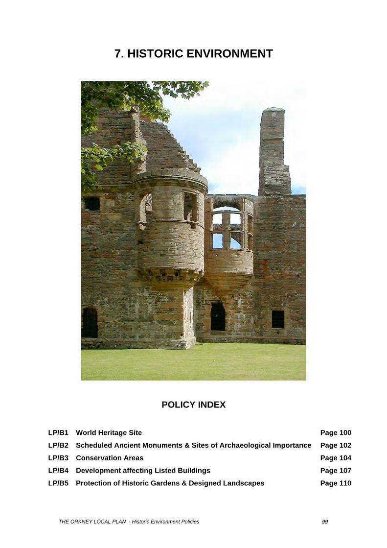
7. HISTORIC ENVIRONMENT
POLICY INDEX
LP/B1 World Heritage Site Page 100
LP/B2 Scheduled Ancient Monuments & Sites of Archaeological Importance Page 102
LP/B3 Conservation Areas Page 104
LP/B4 Development affecting Listed Buildings Page 107
LP/B5 Protection of Historic Gardens & Designed Landscapes Page 110
THE ORKNEY LOCAL PLAN - Historic Environment Policies 99
7.1 WORLD HERITAGE SITE
Structure Plan Context
Key Objective Relevant Policy or Proposal To protect and where possible enhance areas of built and cultural heritage interest, together with their settings, and encourage their maintenance.
Policy SP/B2 - World Heritage Site
Local Plan Policy
POLICY LP/B1
WORLD HERITAGE SITE
The World Heritage Site and its zone of visual influence, as identified on the Local Plan Proposals Map, will normally be preserved. Development that would adversely affect this area will normally be refused. Any significant development proposals affecting the site or its zone of visual influence will require formal environmental assessment to ensure their impacts and implications for the longer term are fully evaluated.
Background and Issues
7.1.1 National planning guidance requires the establishment of a clear policy framework together with a comprehensive management plan in order to assist in maintaining and enhancing the quality of World Heritage sites. 7.1.2 The “Heart of Neolithic Orkney” is a World Heritage Site inscribed by the United Nations Educational, Scientific and Cultural Organisation (UNESCO) on the World Heritage List in 1999. Located on the West Mainland, it includes Skara Brae, Maes Howe, the Stones of Stenness and adjacent standing stones and the Ring of Brodgar together with adjacent standing stones and burial mounds. 7.1.3 The areas defined by the Brodgar Rural Conservation Area, the Lochs of Harray and Stenness SSSI, and Loch of Stenness cSAC and the scheduled area at Skara Brae define the inner buffer zone for the World Heritage Site. None of these designated areas were selected to provide a policy framework for the protection and management of the World Heritage Site. As a result, Scottish Natural Heritage and Historic Scotland commissioned a study in 2000. Amongst the outputs of the ‘Landscape Studies of the Heart of Neolithic Orkney World Heritage Sites’ are an identification of the area within which any development is likely to have an impact on the World Heritage Site (the intermediate zone); the definition of a wider setting in which large scale developments would be a consideration; and a context for the capacity assessment of changes associated with the site. The intermediate zone of visual influence as identified within the study is detailed on the Proposals Map. 7.1.4 The purpose of this policy is to protect the designated site and recognise its outstanding international value to both this and future generations. It is also to ensure that the designation of the World Heritage Site is backed up by an appropriate management response, and that development that would have a detrimental effect on the character and setting of the site will not be permitted. The World Heritage Site suffers from a number of problems that affect its intrinsic value, not least amongst these are the conflicts between increasing numbers of visitors to the area together with associated road traffic and the very fabric of the ancient monuments themselves, plus the potential intrusion of new development on the setting of the site.
Implementation and Monitoring
7.1.5 A Management Plan for The Heart of Neolithic Orkney has been developed by Historic Scotland with input from a local Steering Group (which includes Orkney Islands
THE ORKNEY LOCAL PLAN - Historic Environment Policies 100
Council) and in consultation with the local community, landowners, representatives of the tourist industry and cultural and nature conservation bodies. 7.1.6 The aims of this Management Plan are: i. to safeguard the important cultural (and natural) heritage elements of the site by
identifying conservation and enhancement works and projects within a sustainable and beneficial approach;
ii. to inform people about the cultural and educational value of the site; iii. to increase their enjoyment of the site; and iv. to identify how the economic and cultural benefits of inscription of the site can be used
to the advantage of the Orkney community and businesses. 7.1.7 The aims of the management plan require that policies for the positive management of the World Heritage Site and its buffer zones be developed and that appropriate and sympathetic land uses are encouraged within the buffer zones. 7.1.8 The outer buffer zone is not ideally placed to safeguard the setting of the World Heritage Site from unsympathetic development. A revised boundary, the zone of visual influence, is used to demarcate the area of potential impact of individual buildings of any size, structures, roads or other features or any alterations to them. Larger scale developments such as massive, high or conspicuous structures outwith the ZVI may also impact on the World Heritage Site and the intrinsic quality of the ZVI, and these will be considered accordingly. 7.1.9 The policy will be monitored through a periodic visual impact analysis to assess the impact of new development on the World Heritage Site.
THE ORKNEY LOCAL PLAN - Historic Environment Policies 101
7.2 ARCHAEOLOGICAL SITES
Structure Plan Context
Key Objective Relevant Policy or Proposal To protect and where possible enhance areas of built and cultural heritage interest, together with their settings, and encourage their maintenance.
Policy SP/B3 - Archaeological Sites
Local Plan Policy
POLICY LP/B2
SCHEDULED MONUMENTS AND SITES OF ARCHAEOLOGICAL IMPORTANCE
a) Sites of Archaeological Importance
There is a presumption in favour of the physical preservation of all scheduled ancient monuments and archaeological sites. Developments that would adversely affect such remains or their settings will only be permitted in exceptional circumstances, where there is no practical alternative site and where there are imperative reasons of over-riding public need. Development which would affect other sites of archaeological interest not yet included on the Sites and Monuments Record may be permitted after the Islands’ Archaeologist confirms that the significance of the remains are not such as to justify their physical preservation when judged against other material considerations and the possible benefits of the development.
b) Archaeological Investigation and Recording
Where development is permitted in areas known or suspected to contain significant archaeological deposits the following conditions will be placed on the developer:
i. prior to the commencement of any development, the developer shall put in place suitable arrangements for appropriate expert assessment, excavation, analysis, archiving and publication of any archaeological remains, to the satisfaction of the Islands' Archaeologist;
ii. any recommendations made as a result of these investigations will be acted on by the developer in a manner accepted by the Islands’ Archaeologist;
iii. any results of findings must be publicised within five years of the development commencing; and,
iv. where archaeological remains are to stay in situ developers will be encouraged to agree to provide for long term management, public access and interpretation of the site.
Background and Issues
7.2.1 National planning guidance requires Local Plans to include policies for the protection, preservation and enhancement of all nationally important sites of archaeological interest and their settings, together with policies requiring the excavation and recording of sites where the primary aim of preservation has not been achieved. 7.2.2 There are a great number of Scheduled Ancient Monuments in Orkney, with a total of 339 sites (Sept. 2000), ranging from prehistoric times to the 20th Century. Of the Scheduled Ancient Monuments, 36 are in the care of the Scottish Ministers, including the components of the World Heritage Site (Maeshowe, Stones of Stenness and adjacent stones, Ring of Brodgar and the ritual and funerary complex around it, and Skara Brae). There are also more than 2000 sites which are listed on the Sites and Monuments Record. It is very important to Orkney that these sites are offered as much protection as possible. In cases where new
THE ORKNEY LOCAL PLAN - Historic Environment Policies 102
development is being carried out, it is essential that any archaeological sites which are discovered are catalogued and recorded correctly. The rich archaeological history, which Orkney possesses, must be preserved. 7.2.3 Areas known to contain significant archaeological deposits include the inner buffer zone of the World Heritage Site, much of the oldest parts of Kirkwall and such sites as may be identified by the Islands’ Archaeologist. 7.2.4 The purpose of this policy is to provide protection to the Scheduled Monuments and archaeological sites of Orkney. All applications, which affect the setting, character or amenity of a Scheduled Ancient Monument, are also subject to approval by Historic Scotland. 7.2.5 It should be noted that under the law of bona vacantia, all finds from archaeological excavations remain the property of the Crown, until the Queen's and Lord Treasurer's Remembrance or the Chief Inspector of Ancient Monuments within Historic Scotland, as appropriate, has allocated them to the registered museums service deemed appropriate. 7.2.6 For clarification, examples of when over-riding public need would be a factor in determining whether development may take place on a site of archaeological importance are given by the following: • the benefits of the proposed development in economic and other terms must demonstrably
outweigh the importance which attaches to the preservation of the archaeological site in question, taking into account such issues as its statutory or other significance and its potential importance for amenity, tourism and education;
• works required for public safety, or for the safety of aircraft, road traffic or shipping; or, • works necessary in the interests of national security.
Implementation and Monitoring
7.2.7 The policies will be implemented through the development control process. Planning applications will be assessed as to whether they are in an archaeological rich area by consultation with the Islands’ Archaeologist. The use of Section 75 agreements and planning conditions designed to preserve, protect or record the archaeology will be applied, if appropriate. 7.2.8 Any major new developments, which are proposed, especially in archaeological rich areas, will be subject to scrutiny. The number of sites enhanced, protected or with adequate mitigation strategies for discovery and recording set in place, will be an indicator of the success of this policy.
THE ORKNEY LOCAL PLAN - Historic Environment Policies 103
7.3 CONSERVATION AREAS
Structure Plan Context
Key Objective Relevant Policy or Proposal To protect and where possible enhance areas of built and cultural heritage interest, together with their settings, and encourage their maintenance.
Policy SP/B4 – Listed Buildings and Conservation Areas
Local Plan Policy
POLICY LP/B3
CONSERVATION AREAS
Conservation Areas will be preserved and enhanced by the following means:
a) Demolition
Development involving demolition will only be permitted if the structure to be demolished makes no material contribution to the character or appearance of the area and detailed proposals for the reuse of the site, including any replacement buildings or other structures, have been approved by the Council. A contract of works to implement the approved redevelopment shall be let prior to commencement of demolition.
b) Alterations
Proposals to alter an unlisted building within a Conservation Area will only be permitted where the alteration preserves or enhances the character or appearance of the Conservation Area and keeps the building in use. Planning permission will be permitted only where alterations are sympathetic in design, scale, materials, colour and landscaping to the rest of the building.
c) Change of Use
Changes of use will generally be permitted if they secure the retention of buildings contributing to the character or appearance of the area. New uses should not require any changes in the appearance or setting of the building other than those which will preserve or contribute to the character and appearance of the area and should have no adverse impact on the surrounding area caused through traffic generation, vehicle parking, servicing or noise.
d) New Development
New development will only be permitted if the scale, form, materials and detailing respect the characteristics of buildings in the area; the plot coverage characteristics; historically significant boundaries; or other elements contributing to the established pattern of development in the area. Open spaces important to the character or historic value of the area and important views within, into and out of the area should be protected and trees and other landscape features contributing to the character or appearance of the area should be retained.
e) Shopfront Signs and Advertisements
Developments for the alteration or erection of shopfront signs and advertisements will only be permitted if they preserve or enhance the character or appearance of the Conservation Area and are sympathetic in design, scale, materials and colour, to the rest of the building. There will be a preference for the enhancement of original painted lettering and enamelled advertisement signs. Illuminated signs will only be permitted in exceptional circumstances and the preference will be for external illumination.
THE ORKNEY LOCAL PLAN - Historic Environment Policies 104
Internally illuminated or neon signs are unlikely to meet the requirements of this policy and will be actively discouraged.
f) Grants
Town scheme grants may be made available to assist owners in the maintenance of heritage features of their property within the Kirkwall and Stromness Outstanding Conservation Areas. Such grants will be additional to other grants and will reflect the higher cost attributable to maintaining features that contribute to the character of the area. Heritage grants may be made available to owners of listed buildings within the Balfour, St Margaret’s Hope, Brodgar and Eynhallow Conservation Areas. Town Scheme and Heritage grants will only be awarded for proposed work that is historically and architecturally correct.
g) Conservation Area Appraisals
The Council will carry out appraisals/audits to provide a full and detailed analysis and understanding of the heritage resource contained within Conservation Areas. Where necessary, additional design guidance will be produced.
Background and Issues
7.3.1 National planning guidance requires Local Plans to outline criteria to be applied to development proposals within Conservation Areas, including those affecting unlisted buildings. 7.3.2 There are four Urban Conservation Areas in Orkney - in Kirkwall, Stromness, St Margaret’s Hope and Balfour, Shapinsay. The island of Eynhallow and the inner buffer zone of the World Heritage area (Brodgar Rural Conservation Area) are Rural Conservation Areas. Kirkwall Conservation Area is an "Outstanding" example of a Norse derived medieval street layout. Contemporary buildings have been erected on the Norse village that developed in the 11th and 12th Century around St Magnus Cathedral. Many of these contemporary buildings, which date from the 17th Century to the present day, have sufficient architectural merit to warrant listing and of the 231 properties within the Conservation Area 77 are listed. 7.3.3 Stromness Conservation Area, also an Outstanding Conservation Area, owes much of its character to the expansion of the whaling port in the 17th and 18th centuries, and use of the area as a port of call for east coast shipping traffic. 92 of the 217 properties in the Stromness Conservation Area are listed. 7.3.4 St Margaret’s Hope Conservation Area like Stromness owes its form to the boom days of the 17th and 18th Century. Of the 68 properties within the Conservation Area only 4 are listed individually. 7.3.5 Balfour Village Conservation Area is a planned settlement built by the Balfour estate in the 18th Century to house estate workers. As such it has a different character from the other Conservation Areas, comprising single terrace of cottages terminated at either end by two storey houses. It contains two notable structures, Balfour Lodge and a folly of uncertain use at the east end of the Conservation Area. All 24 properties within the designated area are listed. 7.3.6 Brodgar Rural Conservation area was designated to preserve the amenity and setting of the Brodgar and Maeshowe monuments and has subsequently been used to define the inner buffer zone of the World Heritage Site. Eynhallow Rural Conservation Area, likewise, was designated to ensure control over a heritage landscape. While development pressures may be different in these rural conservation areas, control over design afforded by the policy is similar, particularly in the preservation of the setting of the World Heritage Site. 7.3.7 The purpose of this policy is to preserve and enhance the character and appearance of the existing Conservation Areas while at the same time taking account of the need for these areas to function successfully as places for social and economic activity. The policy provides a framework for the regulation of development within the County’s Conservation
THE ORKNEY LOCAL PLAN - Historic Environment Policies 105
Areas. While greatly increased demands are placed on developers to accord with the design style prevalent within the area, grants are made available to offset the financial cost. 7.3.8 The materials used in the best buildings throughout the Conservation Area are similar. Walls are commonly exposed picked and pointed stonework, wet harled or, less commonly, harled with a lime based mortar. Roofs are generally of Caithness slate, grey or Welsh slate, with stone skews and cast iron rainwater goods. Windows are predominantly painted wooden sliding sash and case. 7.3.9 Modern materials such as UPVC windows, asbestos slate roofs, and dry dash rendering are sometimes found in the designated areas. An Article 4 direction was approved in 1989 to control the indiscriminate use of modern materials by removing from permitted development rights regarding enlargement and external alteration. The intrusion of shop signs in inappropriate materials has been identified as erosive to the character of the Conservation Areas, and as a result an ‘Area of Special Advertisement Control’ designation was imposed on all four Conservation Areas, restricting the size of adverts on business and shop premises and prohibiting their illumination. Material change to shopfronts requires planning permission, while the erection of advertisements requires consent under the Advertisement Regulations and, if on a listed building, Listed Building Consent. 7.3.10 A design guide has been produced by the Department of Development and Protective Services to assist owners of properties in Conservation Areas. Since their inception in 1986 a total of £238,000 has been awarded by grant through the ‘Town Scheme’. A further £83,000 has been granted to listed buildings in Conservation Areas since 1979 through the Heritage Grant Scheme. Stromness has been the main recipient of grant, receiving £156,000 with Kirkwall receiving £145,000 and St Margaret’s Hope £18,000.
Implementation and Monitoring
7.3.11 In any pre-planning application discussions, developers who wish to develop within Conservation Areas will be made aware of the restrictions imposed by the above policy and the opportunities afforded by the Town Scheme and Heritage Grant schemes. All applications for development within conservation areas will be subjected to rigorous appraisal to ensure the proposal accords with the aims and objectives of the conservation area designation. Developers may be asked to provide additional information in the form of a visual impact assessment to support their proposal. 7.3.12 Monitoring of the efficiency of this policy will be through periodic qualitative assessment of the townscape within conservation areas.
THE ORKNEY LOCAL PLAN - Historic Environment Policies 106

Atkins Heritage200 BroomielawGlasgowG1 4RU
Tel : 0141 220 2000


![The Neolithic revolution as a symbolic transition. Karski K. 2013. The Neolithic revolution as a symbolic transition [ENG]](https://img.pdfslide.net/doc/110x75/63621759a514f501cd0d1475/the-neolithic-revolution-as-a-symbolic-transition-karski-k-2013-the-neolithic.jpg)


