Embed Size (px)
Citation preview
141Heptaskalon and Other Selected Moorings on the Golden Horn | Johannes Preiser-Kapeller
The »Heptaskalon«, a construction mentioned in Byzantine sources, can be translated as »Seven Skalai« 1. The term σκάλα / skala, σκαλίον (from lat. scala) denotes a ladder, stairs, a step or a terrace, but also a landing stage. Descriptions of skalai all-around on the shores of Constantinople are given by Michael Attaleiates in the eleventh century (see also be-low) 2. In contrast, it is more difficult to reconstruct the exact location, structure and function of the Heptaskalon, as will be explained in three parts: the first is devoted to its locali-sation based on written sources from the Byzantine period; the second considers the importance of the Golden Horn region, where the Heptaskalon can be presumed to have been located, as a harbour in Byzantine and Ottoman times (considering other moorings); and the third and final part deals with the Heptaskalon harbour in the fourteenth-cen-tury history of John VI Kantakouzenos (for this chapter, see map 2 on p. 237).
The Church of St Akakios en tō Heptaskalon and Its Localisation
The first mention of the toponym can be found in connec-tion with the renovation of the Church of St Akakios under Emperor Basil I (reg. 867-886). In the so-called Vita Basilii it says: »Moreover, since the holy church of the martyr Akakios, located at Heptaskalon, was on the verge of collapse and was falling into ruin, he had it restored and secured with all kinds of reinforcements« 3. This church thus becomes the first link in locating the Heptaskalon. St Akakios was a »native« martyr who was executed in Byzantium in the period of Diocletian´s persecution of Christians in c. 303/304. The construction of a church above his grave is attributed to Emperor Constantine I
the Great (323-337) or his successor Constantius (337-361). In 359, the corpse of Constantine I the Great was temporarily buried here. Emperor Arkadios (395-408) also paid a visit to the church 4. The church was first renovated in the reign of Justinian I (527-565) 5, before being renovated again under Basil I.
Where was this church? According to the Life of St Akakios, he was martyred at the Staurion and was buried there. Albrecht Berger convincingly equated the Staurion with the better-known Zeugma, which he argues served as »nodal point for traffic to and from Sykai [over the Golden Horn]«. He further argues that »it was at the bottom of the street from ta Olybriou past the Konstantianai [a palace dat-ing from the time of Constantius with a bath complex] to the Golden Horn« 6. The localisation at the Golden Horn is also documented in the Notitia Urbis Constantinopolitanae (fifth century), which locates the Church of St Akakios in the city’s area of Regio X 7. The most accurate location of the Church of St Akakios in the modern urban area of Istanbul (based on information in the Typikon of the Bebaia Elpis Monastery, see below) comes from Arne Effenberger, who assumes that it was »in the area of Küçük Pazar – approximately in the area between Üç Mihrâplı Mescid [...] and Kepenekçi Sinan Paşa Mescidi«, thus about 200 m away as the crow flies from the (present) shore of the Golden Horn 8 (again, see map 2 on p. 237).
A further clue for the localisation comes from the place of another martyrdom, namely that of St Theodosia, who at the time of Iconoclasm under Leon III (717-741) was said to have been brutally put to death by the emperor in 726 or 730 after resisting the replacement of holy images. According to an anonymous encomium from the period around 1300, she »died at the aforementioned location of
Johannes Preiser-Kapeller
Heptaskalon and Other Selected Moorings on the Golden Horn
1 Another interpretation, according to which the name derives from the neigh-bouring seventh region of the capital, was brought up by Berger, Regionen und Straße, for discussion. Effenberger, Klöster 264-265 in turn agrees with the opinion already expressed by Prinzing / Speck, Fünf Lokalitäten, whereby the Heptaskalon was a »stairway« and not a landing stage. – See also Magdalino, Pantokrator 34-35 (with n. 5).
2 LBG vol. 7, 1558-1559. – See also Makris, Studien 180-182. – Michael Attaleiates, Historia 213, 31-214, 13 (Tsolakis); English translation: Kaldellis / Krallis, Michael Attaleiates 507.
3 Theophanes Continuatus, Chronographia (Vita Basilii) V 82, 13-17 (translation 270-272 Ševčenko). – For this localisation, see Synaxarium ecclesiae Constanti-nopolitanae 661, ll. 25-26, 664, ll. 45-46, 730, l. 3, 834, l. 25, 868, ll. 29 und 57. 933, l. 54 (Delehaye).
4 Janin, Siège de Constantinople 13-15. – Stauridou-Zaphraka, Mosele 85. – Ber-ger, Untersuchungen 452. 464-468 (with sources). – Berger, Konstantinopel 84. – Schreiner, Konstantinopel 102. – Pfeilschifter, Der Kaiser und Konstantinopel 97 (on the visit of Arkadios, with sources).
5 Prokopios, De aedificiis I, 4, 25-26 (26, 7-15 Haury / Wirth). – Berger, Untersu-chungen 452. 464-468.
6 Vita Acacii Cappadocis 240 B. – Berger, Untersuchungen 487. – Berger, Kon-stan tinopel 84. 86. – See also the sketch based on Berger’s reconstruction in Magdalino, Oikoi 55. – On Sykai, see also Sağlam, Urban Palimpsest 8-9.
7 Notitia urbis Constantinopolitanae 237. – Berger, Untersuchungen 452. 464-468. – Magdalino, Studies I, 2 (map). – Berger, Konstantinopel 128 (German translation).
8 Effenberger, Klöster 264-265.
In: Falko Daim · Ewald Kislinger (eds), The Byzantine Harbours of Constantinople. Byzanz zwischen Orient und Okzident 24 (Mainz 2021). DOI: https://doi.org/10.11588/propylaeum.911.c12070
142 Heptaskalon and Other Selected Moorings on the Golden Horn | Johannes Preiser-Kapeller
578-582]« 14. Yet this church also seems to be located in the area of the older Church of St Akakios, as Albrecht Berger deduced on the basis of a note in a manuscript, according to which the Church tes Kareas was at a basilikē porta 15. He associates the latter again with a basilikē market mentioned in an anonymous Late Byzantine Russian pilgrimage account (Magdalino proposes equating the market with the previously mentioned Leomakellon, which is doubted by Kislinger). In the English translation by George P. Majeska, the text reads: »You go east from there [meaning the Palace of Blachernai or the Monastery of Kosmas and Damian 16] to St Theodosia. There is a Monastery of St Theodosia; the body of St Theo-dosia reposes there. [...] From there you go east to Basilike; there is a Frankish church [at] the end of the large Basilike Market« 17. With the Church or the Monastery of St Theo-dosia we are again in the (wider) environment of the (older) Akakios Church on the Golden Horn, where the Church of St Akakios tes Kareas is to be found 18.
The Patria lists another noteworthy site near the (older) Church of St Akakios: »In the Christokamaron [Arch of Christ] Christ was depicted near [the Church of] Saint Akakios, where the house of Mosele is, and this is why it received its name« 19. The original owner of the »House of Mosele« was identified by Janin, Stauridou-Zaphraka and Berger as Alexios Mosele, the Droungarios of the Fleet, who was of Armenian origin. In 922, after losing a battle with the Bulgarians at Pegai (on the opposite side of the Golden Horn), he drowned while trying to reach the Byzantine fleet anchored in the Golden Horn. Romanos Mosele (presumably his son) then converted the house into a monastery; in the tenth century a school may have been housed here 20. As late as 1330, an abbot of the Monastery tou Mosele was mentioned in April of that year as a witness in a document of the Register of the Patriarchate of Constantinople 21. Based on the information given in the Typikon of the Bebaia Elpis Monastery (see below), Arne Ef-fenberger locates the Mosele-Monastery on the »main road that runs southwest through the valley, now dominated by the Atatürk Bulvarı«, and from ta Olybriou between the third
the Leomakellon, near the well-known church of the most blessed Akakios, and the Heptaskalon« 9. The Leomakellon, a food market, could thus provide another clue; unfortunately, the information on its location is far from clear. Albrecht Berger suggested equating the Leomakellon with another market place mentioned in the »Patria of Constantinople«, the Dimakellin, which is said to be »called by that name because Emperor Leon the Great (457-474) sold meat and his wife twisted gut strings« there 10. Ewald Kislinger, on the other hand, was able to show that the Dimakellin, north or north-west of the Forum Tauri, was located much further south near the main street (Mese). Therefore, it cannot be identical with the Leomakellon located »near« the Church of St Akakios according to the Encomium on Theodosia (as Magdalino would like to equate this market with an agora mentioned by the historian Prokopios near the Church of St Akakios) 11.
Certainly located in the region around the Heptaskalon is the legend of the arrival of the relics of the martyr Steph-anos in Constantinople, which were brought ashore at the Zeugma. The route by which the bones of Stephanos were taken from there to his church in the area of Konstantianai, was also followed by an annual procession on his feast day. At least this story proves the use of a landing stage at Zeu-gma 12. Thus, we can conclude from the information that the Heptaskalon was located in an area relevant for traffic (pass-ing over the Golden Horn), of religious significance (Church of St Akakios, procession in memory of Stephanos) and of economic importance (market of Leomakellon). Magdalino, for example, elaborates: »the stretch of coast near St Akakios was known, from at least the tenth century, as the Heptaska-lon, meaning »seven skalai«, which suggests that this was a particularly active port area« 13.
The question of its localisation becomes even more com-plex because another Church of St Akakios is mentioned in the »Patria of Constantinople«. Here it says: »The brother of the Patrician Narses built Saint Akakios tes Kareas [of the walnut tree] in the time of Justin [II, 565-578] and Tiberios [I,
9 Kotzabassi, Dossier 273 (c. 19). – PmbZ no. 7788. – According to the earlier sources, however, Theodosia suffered her martyrdom at the Forum Bovis and was buried in the τὰ Δεξιοκράτους quarter, where she was also commemorated on 18 July, see Kotzabassi, Dossier 5-6, 27 (l. 40) and 28. – Janin, Siège de Constantinople 143-145. See also the explanations on the Christos Euergetes Monastery and the Church of St Theodosia below.
10 Patria Konstantinupoleos III, 104 (250, 16-18 Preger); for the English text, see Berger, Patria 186 and 316 (n. 115). – See also Berger, Ufergegend. – Magda-lino, Maritime Neighborhoods 221. – Mundell Mango, Commercial Map.
11 Prokopios, De aedificiis I, 4, 26 (26, 14 Haury / Wirth). – Kislinger, Lebensmittel 316. – Magdalino, Maritime Neighborhoods 221. – See also Berger, Ufergeg-end 153. – Asutay-Effenberger / Effenberger, Eski İmaret Camii 23-24.
12 Berger, Processions 76. – See also the sketch in Magdalino, Oikoi 55 and 61-66 (with the sources).
13 Magdalino, Maritime Neighborhoods 221 (with map at the end). – Magdalino, Studies I, 99.
14 Patria Konstantinupoleos III, 116 (253, 19-254, 2 Preger); for the English text, see Berger, Patria 190. – Berger, Untersuchungen 468. – Janin, Siège de Con-stantinople 13-14. – Berger, Konstantinopel 169-170.
15 Berger, Ufergegend 154-155. – See also Effenberger, Klöster 265. – Asutay-Effenberger / Effenberger, Eski İmaret Camii 14. 33.
16 In the area of Kosmidion north-west of the Blachernai outside the city walls, see Özaslan, Cosmidion, Külzer, Ostthrakien 471, and Simeonov, Kosmidion, in this volume.
17 Majeska, Russian Travelers 151-153. – Berger, Untersuchungen 468. – Müller-Wiener, Häfen 32. – Magdalino, Maritime Neighborhoods 221. – Kis-linger, Lebensmittel 316-317. – See also Kafescioğlu, Imperial Legacy 41 and Mineva, Pantokrator.
18 See n. 9 for the localisation of the Church of St Theodosia.19 Patria Konstantinupoleos III, 112a (253, 4-6 Preger); Berger, Patria 188-190. –
See also Asutay-Effenberger / Effenberger, Eski İmaret Camii 27-28.20 Stauridou-Zaphraka, Mosele (with sources). – Berger, Untersuchungen 516-
517. – PmbZ no. 20241 (where the location of Mosele’s house near the Myrelaion is taken from Janin without comment), 26844 and 30295 (also with information on school operations). – Janin, Siège de Constantinople 359. – Also wrong about the house of Mosele is Magdalino, Maritime Neighborhoods 214, stating that between the 8th c. and 11th c. there was only one aristocratic resi-dence (Antonios’s house near the Neorion under Emperor Michael III) near the harbour facilities on the Golden Horn. – On this, see also Kislinger, Neorion, in this volume.
21 Patriarchatsregister I no. 103, Z. 57. – Stauridou-Zaphraka, Mosele 92. – Mit-siou, Historisch-Geographisches 152-153.
143Heptaskalon and Other Selected Moorings on the Golden Horn | Johannes Preiser-Kapeller
extended by a daughter of Theodora Komnene Palaiologina 31, Euphrosyne Komnene Doukaina Palaiologina 32.
The boundaries of the monastery complex are presented as follows (based on the German translation of A. Effenberger, which is the most accurate one): »The enclosure begins at the large gate facing east, which is opposite the large houses of my dearly beloved sons, and passes the bakery and the whole estate of the Eunuch Panaretos 33. Then it turns west and follows the property line between the two gardens, the one of my dearly beloved son Kyr John, the Megas Konostaulos 34, and that of the monastery, and it continues to the public road that separates the monastery of Mosele 35 on the right. From here it continues to the enclosure wall [of the convent] of my Most Holy Mother Gorgoepekoos 36, following the same public road, goes along the garden called Gymnos 37, leaving the perimeter wall of the convent of Gorgoepekoos on the right. And it reaches the property boundary that separates our monastery from the convent of our mistress and beloved sister, the Protostratorissa Glabaina 38. And it then goes to our Kellia, which my dearly beloved son, the Protostrator 39, has built. Then it goes past our garden, leaving on the right the vineyard of my mistress and sister, the Protostratorissa, and reaches the public street in front of the monastery called Kyriotissa 40. Then it turns east along the same public road and gets to the other road near [the church] of St Onouphrios 41, where again there is a vineyard, which we once acquired as common farmland from the above mentioned Kaligas 42 for 400 Hyperpyra; and then it was planted by us and became the vineyard that you see now. From here, it goes north and passes the tenement houses on the boundary of the prop-erty, where the sieve makers [Greek koskinades] live, to the Church of St Akakios, and also includes this church without the Katechoumena. And it goes all the way to the big gate of this church. Then it ends at the great gate of our monas-tery, leaving on its right side the house of Aborate 43 and the tailor Andreas 44 and leading [from the house] of Solatos 45 to the large cloister gate where it began« 46 (see also map 2 on p. 237).
and fourth hill led to Zeugma or the basilikē pyle in the sea wall 22.
We cannot say anything more about the character of the Christokamaron. However, the passage in the Patria equated the Christokamaron with a similar-sounding monument, which served as an initial point for searching for the Heptaska-lon along the Sea of Marmara and not on the Golden Horn. Because immediately before this passage, the Patria stated: »The Chrysokamaron – Behind the Myrelaion stood a golden statue, for which reason it was called the golden arch. It was stolen by thieves in the time of kaisar Bardas [d. 866]« 23. The famous Myrelaion complex was built under Emperor Ro-manos I Lakapenos (reg. 920-944) in Regio IX of the city not far from the coast of the Sea of Marmara. The church (and later mosque Bodrum Camii) is still preserved today 24.
This passage, or the equation of Chrysokamaron and Christokamaron (as Janin did), together with the confusing information of John VI Kantakouzenos in the fourteenth cen-tury (see below), motivated Müller-Wiener to postulate that »one must summarise the available information concerning the Heptaskalon harbour with that of the older Kaisarios har-bour« – and, accordingly, locate it on the Sea of Marmara 25. Until today, therefore, various maps of Byzantine Constantino-ple show a Heptaskalon on the Sea of Marmara, or even two such localities, one on the Sea of Marmara and one on the Golden Horn. Müller-Wiener himself later revised his view and localised the Heptaskalon »at the Zeugma« on the Golden Horn in his book about the harbours of Constantinople 26.
The older localisation, however, was still used in 2001 by the English translators of the Typikon of the Bebaia Elpis Mon-astery from the fourteenth century, which provides the most extensive description of building conditions near the Church of St Akakios and the Heptaskalon. The monastery was rebuilt by the Megas Stratopedarches John Komnenos Doukas Syn-adenos 27 and his wife Theodora Komnene Palaiologina 28, or by their son, the Protostrator Theodoros Komnenos Doukas Synadenos 29 and his wife Eudokia Doukaina Komnene Palaiol-ogina Synadene 30, probably between 1290 and 1300, and
22 Effenberger, Klöster 266 and plan on p. 288. – See also Stauridou-Zaphraka, Mosele 80-82.
23 Patria Konstantinupoleos III, 112 (252, 17-253, 3 Preger); English translation in Berger, Patria 188.
24 Striker, Myrelaion. – Restle, Konstantinopel 491-507. 513-515. – For the structural situation before the measures of Romanos Lakapenos, see Restle, Konstan tinopel 417-418. – Niewöhner, Myrelaion.
25 Müller-Wiener, Bildlexikon 61-62. – Janin, Constantinople 229-230. 331.26 Müller-Wiener, Häfen 11.27 PLP no. 27125.28 PLP no. 21381. – Effenberger, Klöster 260 (n. 21).29 PLP no. 27120.30 PLP no. 27096.31 PLP no. 21373.32 Effenberger, Klöster. – Kidonopoulos, Bauten 69-74. – For the older history
of the monastery, see also Janin, Siège de Constantinople 158-160 (but with localisation at the Sea of Marmara).
33 By Effenberger, Klöster 263 (n. 28) with Berger, Roman, Byzantine, and Latin Period 14, interpreted as a proper name.
34 PLP no. 21486.35 On the Monastery of Mosele, see above.
36 Kidonopoulos, Bauten 70 and 74-76 on the Monastery of Theotokos Gorgoe-pekoos and its presumed location (see also map II, 289). – Effenberger, Klöster 267. – Mitsiou, Historisch-Geographisches 148-149.
37 Effenberger, Klöster 267, on the location of this garden.38 PLP no. 4202. – Kidonopoulos, Bauten 41-42, on this monastery and to the iden-
tification of this Glabaina with the Protostratorissa Maria / Martha Komnene Bra-naina Palaiologina Doukaina Tarchaneiotissa Glabaina. – See also PLP no. 27511.
39 Theodoros Komnenos Doukas Synadenos, see above.40 Kidonopoulos, Bauten 79-80, on the Theotokos Kyriotissa Monastery (probably
the Kalenderhane Camii) and its location (see also map II, 289). – Effenberger, Klöster 268.
41 Kidonopoulos, Bauten 71 and 115, on the Church of Hagios Onuphrios and its location (see also map III, 291). – Effenberger, Klöster 269.
42 PLP no. 10329.43 PLP no. 40.44 PLP no. 927.45 PLP no. 26285.46 Effenberger, Klöster 262-264, translated after the Greek text in Delehaye,
Deux typica 95,1-96,3. – A somewhat different English translation is given by Thomas / Hero, Byzantine Monastic Foundation Documents 1563-1564 (no. 57, translated by Alice-Mary Talbot). – A partial German translation can also be found in Kidonopoulos, Bauten 70-71.
144 Heptaskalon and Other Selected Moorings on the Golden Horn | Johannes Preiser-Kapeller
marily, however, their owners tended to be the poorhouses, hospitals, other charitable institutions, and monasteries, not only in Reigning City [Constantinople] but also in some of its neighbouring port towns. The entire coast was generally owned by those on the land according to our ancestral laws and the imperial decrees, which grant to gateways to the sea to those who own the land neighbouring the shore« 51.
According to the information of Attaleiates, Emperor Mi-chael VII Doukas (1071-1078) dispossessed the owners of these installations; however, Nikephoros III Botaneiates restored the previous ownership shortly after his proclamation as Emperor in March 1078 52. According to the description of Attaleiates, some of the churches and monasteries in the area of the Heptaskalon may also have held ownership rights for skalai.
Emperor Alexios I Komnenos’ (1081-1118) transfer of the imperial residence to the Palace of Blachernai also contrib-uted to a shift in the main routes of communication (and imperial ceremony) towards the Golden Horn. Even before the time of the Komnenos dynasty, the emperor and other faithful had chosen the sea route over the Golden Horn from the centre of the city to the Church of Blachernai (or also to the sanctuary of Kosmas and Damian in Kosmidion). Now the emperors used a ship to get from the Palace of Blachernai to one of the landing sites on the eastern Golden Horn and from there to the Hagia Sophia, for instance 53. For this purpose, the Palace of Blachernai had at least a landing stage or even a developed harbour, but its exact location and therefore its shape and scope remain unclear. Müller-Wiener refers to the description of Peter Gyllius from the period around 1544/1550, who mentions »150 steps west of the Kynegion Gate (Balat Kapı) three openings in the sea wall«. These were still visible in the nineteenth century and could have belonged to the Harbour of Blachernai. Perhaps, according to Müller-Wiener, there was also a relation to the building, which likewise was »no longer existing, sometimes referred to as Porticus Carienne in Ayvansaray […], which in terms of type and size can be considered to be a boatshed and could have been used during trips of the emperor to the local church as a landing place«.
Most recently, A. Effenberger convincingly equated the Church of the Bebaia Elpis Monastery with the Vefa Kilise Camii (converted into a mosque after 1453), which gives us, for the first time, an architectural benchmark for the localisation of the Heptaskalon. In his study, Effenberger also attempts to locate as accurately as possible all the other buildings mentioned in the Typikon, which yields the best reconstruction of this urban area so far 47. The multitude of aristocratic possessions of relatives of the founder, as well as other monasteries listed in the Typikon, but also the mention of the koskinades, which according to the Lexikon zur Byz-antinischen Gräzität could be translated as »winnower« or »sieve maker«. In any case, as a professional group related to the cereals trade, (which also fits later Ottoman information on the function of the area, see below), they indicate the heightened importance of the areas on the Golden Horn for the life and economy of Constantinople 48.
The Golden Horn and Its Moorings in (Late) Byzantine and Ottoman Times
The Golden Horn has served the city since its founding as a »natural« harbour: 600 to 700 m wide and up to 45 m deep in the middle, it offered sufficient space and depth for medieval and early modern shipping 49. After the harbours facing the Sea of Marmara had formed the focus of shipping between the sixth and tenth centuries, the Golden Horn returned to a position of dominance from the eleventh to twelfth cen-turies 50. For the later part of the eleventh century, Michael Attaleiates describes the ownership of the landing stages (skalai) along the coasts of the capital: »Along the shores that gird the Queen of Cities [Constantinople], wooden docks constructed in years long past appear to entangle themselves in the sea that comes right up to them, or to enfold it, or push back against its waves. These enabled the merchant ships sailing in and those trading in the produce of the land to moor and conduct their transactions, and they are known in common parlance as skalai and had different owners. Pri-
47 Effenberger, Klöster, particularly the plan on p. 288. – See also Berger, Unter-suchungen 516-517. – Kidonopoulos, Bauten 72-73 and 288-289 (map 2).
48 LBG vol. 4, 866. – See also Matschke, Urban Economy 471 (translated as »sieve maker«) and Effenberger, Klöster 276 (also »sieve maker«).
49 Meriç / Görmüş / Avşar, Golden Horn. – Müller-Wiener, Häfen 37. – Kafescioğlu, Constantinopolis / Istanbul 30-31. – Magdalino, Maritime Neighborhoods 211. – Mundell Mango, Commercial Map 205. – Schreiner, Konstantinopel 90. – Berger, Häfen 77-79. – Russel, Byzantium and the Bosporus 23-29. – See also Kislinger, Better and Worse Sites, and Kislinger, Golden Horn, in this vol-ume.
50 Magdalino, Maritime Neighborhoods. See also Heher, Harbour of Julian; Kis-linger, Better and Worse Sites; Kislinger, Golden Horn, and Külzer, Harbour of Theodosius, in this volume.
51 Michael Attaleiates, Historia 213, 31-214, 13 (Tsolakis); for the English transla-tion, see Kaldellis / Krallis, Michael Attaleiates 507-509. – Dagron, Urban Econ-omy 429. 451. 458. – Magdalino, Medieval Constantinople 532.
52 Dölger / Wirth, Regesten no. 1010 and no. 1027. – Michael Attaleiates, Historia 214, 13-215,17 (Tsolakis); English version in Kaldellis / Krallis, Michael Attalei-ates 507-509.
53 Makris, Studien 180-181. – Restle, Konstantinopel 565-568. – Müller-Wiener, Häfen 11-12. – Magdalino, Maritime Neighborhoods 212. 219-220. – Kidonop-oulos, Bauten 150-153. – Berger, Processions 81-85 (with sources for shipping traffic between Blachernai and the areas on the southeastern Golden Horn). – Asutay-Effenberger, Landmauer 118-127 (for construction activity in the area of the Blachernai in the Komnenian period). – Matschke, Das spätbyzantinische Konstan tinopel 32-42. – Asutay-Effenberger, Blachernai. – Stanković / Berger, The Komnenoi and Constantinople 19-20. – Dark / Özgümüş, Constantino-ple 31. 67-68. 71-73 (also on the harbour of the Palace of Blachernai and its possible location). – Macrides, Citadel 289-290 and Macrides / Munitiz / Ange-lov, Pseudo-Kodinos 267-269. 436-437 (on places of imperial ceremonies on the Golden Horn in the Late Byzantine period) and 367-377 (on the Palace of Blachernai). – See also Kislinger, Neorion, in this volume, on the possible landing stages of the emperor and his entourage in the eastern part of the Golden Horn and Heher, Harbour of the Bukoleon, also in this volume, on the Bukoleon Harbour in general and the »Imperial Private Flotilla«. Later the Ottoman sultans also used the sea route over the Golden Horn to visit the tomb of Eyüb el Ensari in the former Kosmidion district, see Boyar / Fleet, Ottoman Istanbul 53. – Kafescioğlu, Constantinopolis / Istanbul 45-51 (with details from the view of Melchior Lorichs).
145Heptaskalon and Other Selected Moorings on the Golden Horn | Johannes Preiser-Kapeller
walls of Constantinople, which were named after a neigh-bouring church. Behind [the gate] is the Ayakapı ruin, which for good reasons is associated with the Christos Evergetis Monastery or Theodosia Church« 60. As Ahrweiler pointed out, the »neorion« »near the Euergetes-Christos Monastery« can also be connected with an exartysis (in the sense of an installation for the construction or equipping of ships) »near Saint Theodosia«, which is already mentioned in the Synaxar of Constantinople in connection with the cult of St Sozon 61. Müller-Wiener notes that after the Ottoman conquest in 1453, the church of the Christos Euergetes Monastery (or the underlying vault, as the conjecture of Müller-Wiener) was used as a »ship’s arsenal« before being converted into a mosque in 1490 62. In particular, based on Effenberger’s re-cent attempts at localising the Christos-Euergetes / Theodosia complex, further considerations on the location and extent of these facilities could provide new insights in the context of the existing remains.
More information exists on the landing stages at the eastern exit of the Golden Horn. Since the eleventh / twelfth centuries, the quarters and piers of the representatives of the Italian maritime cities, which became increasingly impor-tant for commerce in Constantinople, were located there. In various imperial privilege charters, Venetians (1082), Pisans (1111) and Genoese (1155, or actually 1169/1170) were granted landing facilities and houses for use in the north-eastern area of Constantinople at the Golden Horn 63. In this context, Müller-Wiener vividly describes the conditions at the Golden Horn:
»Finally, landing stages (scalae) necessary for harbour op-erations belonged to each quarter – ultimately, Venice had four, Pisa three and Genoa two – which were precisely de-fined in the respective charters in terms of their dimensions and their location, but today can no longer be represented in plans since the fixed points at that time (wall towers and gates, churches and monasteries) are unknown; in view of the lengths of individual scalae given as 31-60 cubits (cubiti), it would be possible to calculate such a landing stage to be about 15-30 m long. They were more or less well-fortified
Dark and Özgümüş in their archaeological study of 2013 do not establish more than a hypothetical location of the harbour in the north of the Blachernai area on the Golden Horn 54. Georgios Pachymeres even reports a »neorion« found »in the Blachernai«, a shipyard whose position Emperor Mi-chael VIII Palaiologos considered to be strategically unfavour-able after the reconquest of Constantinople in 1261. The remains of such a facility remain as unidentified as those of a harbour. However, Hélène Ahrweiler wanted to equate this neorion with the shipbuilding facilities in the area of Kosmid-ion near Blachernai, but located outside the city walls, which Emperor John VI Kantakouzenos used (again) in the 1340s (see below). The Greek preposition en used by Pachymeres would therefore have to be translated as »by« and not »in« the Blachernai 55.
Pachymeres further reports that Michael VIII not only deemed this neorion unfit, »but he was equally dissatisfied with the old neorion – I do not call old neorion that which the Latins used very recently, [that] near the Euergetes Christos Monastery, but that near the Gate of the Neorion from which the gate´s name derives« 56. At the time of the Byzantine re-conquest, there were three neoria on the Golden Horn: the one at Blachernai; the »old« neorion near the eastern end of the Golden Horn 57; and one »near the Euergetes-Christos Monastery«, which, before 1261, had been used by the Lat-ins (probably the Venetians who controlled this area of Con-stantinople in accordance with the partition treaty of 1204 58).
The Christos Euergetes Monastery can be found in the ta Dexiokratous district on the Golden Horn, about halfway be-tween the Blachernai and the Zeugma, in the area of the Ay-akapı Gate 59. As Arne Effenberger most convincingly stated, this (male) monastery became the centre of the cult of St The-odosia before a separate Church of St Theodosia was built close-by in the twelfth century, presumably with a convent belonging to it. The two monasteries, however, remained closely connected and probably formed a structural unit. Fur-thermore, Effenberger states: »the Ayakapı (»Holy Gate«) […] was called the Gate of St Theodosia in Late Byzantine times. It was one of the few gates and posterns of the city
54 Byrd, Gilles 194-195. – Müller-Wiener, Häfen 7-8 n. 12 (with source quotes). – Schneider, Mauern und Tore 67-69 (who also assumes the existence of an older harbour near the Kynegion Gate, which was already silted up in Byzantine times). – Kidonopoulos, Bauten 152. – Dark / Özgümüş, Constantinople 69-71 (with fig. 61 giving a hypothetical localisation of the harbour area in the north in the area of Ayvansaraykapı). – Asutay-Effenberger, Blachernai, does not com-ment on the location of the harbour. But see Asutay-Effenberger, Kynegion District, in this volume for considerations on the moorings in the Kynegion district.
55 Georgios Pachymeres, Relationes historicae V, 10 (469, 17-20 Failler). – Ahr-weiler, Byzance et la mer 431-433. – Makris, Studien 288 (German transla-tion). – For the shipbuilding facilities in Kosmidion, see Simeonov, Kosmidion, in this volume. – On this passage, see also Heher, Harbour of Julian, in this volume.
56 Georgios Pachymeres, Relationes historicae V, 10 (469, 17-20 Failler). – Ahr-weiler, Byzance et la mer 431-433. – Makris, Studien 288 (German translation, with modifications by the author of this article). – Müller-Wiener, Häfen 33. 39 (on the »old Arsenal« west of Galata-Pera). – See also Heher, Harbour of Julian, in this volume.
57 See Kislinger, Neorion, in this volume.58 See Jacoby, Urban Evolution, and Jacoby, Venetian Government, on the expan-
sion of Venetian possessions between 1204 and 1261.
59 Janin, Constantinople 340-341 and map no. 1. – Schneider, Mauern und Tore 73-74. – Restle, Istanbul 134-137. – Kidonopoulos, Bauten 26-28. – Asutay, Christos-Evergetis-Kloster. – Magdalino, Studies I, 2 (map). – Asutay-Effen-berger / Effenberger, Eski İmaret Camii 13-14.
60 Effenberger, Theodosia 125. 127-134. – See also Kidonopoulos, Bauten 26-28. – Asutay-Effenberger / Effenberger, Eski İmaret Camii 37-38. – Asutay-Ef-fenberger, Porta veteris rectoris 7.
61 Synaxarium ecclesiae Constantinopolitanae 21, Z. 54-55 (Delehaye): Τελεῖται δὲ ἡ μνήμη αὐτοῦ ἐν τῷ ναῷ αὐτοῦ τῷ ὄντι πέραν ἔνδον τῆς Ἐξαρτήσεως καὶ πλησίον τῆς ἁγίας Θεοδοσίας. – Ahrweiler, Byzance et la mer 431-433.
62 Janin, Siège de Constantinople 510. – Müller-Wiener, Bildlexikon 140-141 (with sources). – Schneider, Mauern und Tore 76. – Kidonopoulos, Bauten 25-28 esp. 27.
63 Oikonomidès, Hommes d’affaires, esp. 105 (map). – Schneider, Mauern und Tore 80-82. 91-94. – Lilie, Handel und Politik, esp. 222-242. – Magdalino, Grain Supply 45-47. – Magdalino, Maritime Neighborhoods 219-223. – Külzer, Ost-thrakien 129-138. 228. – Jacoby, Houses and Urban Layout 271-272. – Jacoby, Venetian Commercial Expansion. – Asutay-Effenberger, Porta veteris rectoris. – Schreiner, Konstantinopel 94-97. – Berger, Häfen 83-84. – Sağlam, Urban Palimpsest 11-12. – In particular, see also Kislinger, Neorion, and Schreiner, Western Landing Stages, in this volume.
146 Heptaskalon and Other Selected Moorings on the Golden Horn | Johannes Preiser-Kapeller
keeper known for his Cretan wine by the name Goudeles is mentioned, whose tavern was located on the Golden Horn near the Plateia gate, i. e., in the area around the Heptaskalon. Oikonomides even spoke of a »concentration of taverns« in this area 69.
We have specific indications of the importance of this region at the Golden Horn (Turkish: Haliç) from the Ottoman period, when the area at the Zeugma was called in Turkish Unkapanı (and the gate in the sea wall Unkapanıkapı) 70. Kaf-escioğlu, for example, states: »The part of the Golden Horn between the Ottoman Unkapanı and the Orya Kapı (Neorion Gate) along the sea walls, was the city’s densest commer-cial area« 71. Additionally, Müller-Wiener explains in his de-scription of the landing stages at the Haliç: »From the next landing stage Unkapanı Iskelesi, formerly often referred to as Kapan-ı Dakik Iskelesi (»Wharf of the Flour Scales«), an area was developed in which for a long time the most important granaries of the city were located – in a large lead-covered warehouse in the seventeenth century – a few mills and the city scales for the wholesale trade of flour, hence the name Unkapanı (flour scale); in view of the large quantities of grain required to supply the city, there was always an extremely lively traffic of ships, which often had to wait in three or four rows behind each other for unloading« 72. The koskinades mentioned in the Typikon of the Bebaia Elpis Monastery al-ready indicate a connection with grain trading and grain processing (see above). A continuity from the (Late) Byzantine to the Ottoman period is also suggested by the name Porta de la farina (»Gate of Flour«) used for the gate in ques-tion at Zeugma by Giovanni Andrea Vavassore in his view of Byzantium sive Constantineopolis, which dates from around 1479-1481 (printed in Venice c. 1520-1530) 73. In a Venetian document dated 26 October 1369, which was drawn up as part of a dispute with the Byzantine emperor about the places of (duty-free) grain trade by the Venetians, there is not direct reference to this area, but it does at least refer to its surround-ings 74. The majority of the grain supply for Constantinople in
sections of the shoreline lying in front of the walls with wooden bridges occasionally leading out into the water; here the ships docked so that they were moored to the shore with bow or stern (not the broadside). [...] As the shores of the Golden Horn drop quite steeply in most places, even large ships, which at that time had barely more than 2 m draught, could dock directly on these simple quay structures; anyway, there were no difficulties for the small ships of local and regional traffic« 64.
Paul Magdalino also elaborates: »A skala comprised not only a quayside, formed of an earth embankment fronted by a wall of wooden piles, but also a fenced rectangular terrain built over with houses, workshops, and the booths of money-changers« 65. Magdalino also points out that when negotiating with Emperor Manuel I Komnenos in 1155, the Genoese originally requested (but did not receive) moorings in the area west of the Venetians, probably in the vicinity of the Heptaskalon 66. This could be an indication of the economic attractiveness of this area. However, we have little concrete information on the overall economic activity in the area of the Heptaskalon in the Byzantine period 67.
The prominence of the area on the Zeugma was further enhanced by the foundation of the Pantokrator Monastery (today Zeyrek Camii) on a hill above the site towards the banks of the Golden Horn by Emperor John II Komnenos (1118-1143) and his wife Eirene. Between 1204 and 1261, the Pantokrator complex even served as the headquarters of the Venetian administration in Constantinople, to which were subordinate these areas of the capital according to the partition treaty with the Crusaders. After 1261, it again be-came a monastery 68. As mentioned above, the ecclesiastical institutions, aristocratic properties, private houses and work-shops mentioned in the Typikon of the Bebaia Elpis Monastery also offer some clues for the social and economic relevance of the area. About a century later, in the invective written by Johannes Argyropoulos against the civil servant and scholar Demetrios Katablatas Katadokeinos in the 1430s, an inn-
64 Müller-Wiener, Häfen 21-22. – See also Maltézou, Quartiere veneziano 32-37 (on the individual skalai of the Venetians). – Makris, Studien 181-182. – Mag-dalino, Maritime Neighborhoods 224. – Jacoby, Houses and Urban Layout. – Kafescioğlu, Constantinopolis / Istanbul 30-31. – Schreiner, Western Landing Stages, in this volume.
65 Magdalino, Maritime Neighborhoods 224. – See also Jacoby, Houses and Urban Layout 272.
66 Sanguineti / Bertolotto, Documenti 346. – Magdalino, Maritime Neighborhoods 221-222. – Magdalino, Studies I, 99-100. – Lilie, Handel und Politik 84-85. – Schreiner, Konstantinopel 94. – See Effenberger, Klöster 270, and Asutay-Ef-fenberger, Porta veteris rectoris, on the location of the Venetian quarter.
67 On urban development at this time, see Kidonopoulos, Bauten. – Jacoby, Urban Evolution. – Matschke, Das spätbyzantinische Konstantinopel.
68 Restle, Istanbul 283-291. – Magdalino, Pantokrator. – Kotzabassi, Pantokrator. – Jacoby, Urban Evolution 290-292. – Jacoby, Venetian Government 36-38. 43 (on the extent of Venetian possessions at that time).
69 Canivet / Oikonomidès, Katablattas 66-69. – PLP no. 1267 (Ioannes Argyropu-los). 91695 (Gudeles). 92341 (Demetrios Katablatas Katadokeinos). – Oikono-midès, Hommes d’affaires 95 (n. 170) and 105 (map). – Necipoğlu, Byzantium 210. – On the identification of the Plateia Gate, see also Asutay-Effenberger / Ef-fenberger, Eski İmaret Camii 33-34.
70 See also Schneider, Mauern und Tore 77. – Berger, Ufergegend 154-155. – Ef-fenberger, Klöster 265. – Asutay-Effenberger, Porta veteris rectoris.
71 Kafescioğlu, Ottoman Capital 50, see also 57-61 on the landing stages on the Golden Horn, and 310 on the population distribution within the city during the time of Sultan Mehmed II.
72 Müller-Wiener, Häfen 127 (map) and 132. – See also Kafescioğlu, Constanti-nopolis / Istanbul 31. 184-186.
73 Bamberg, Staatsbibliothek, shelfmark IV C44. – See Berger, Vavassore. – Kaf-escioğlu, Constantinopolis / Istanbul xxvi-xxvii (map 5). – Asutay-Effenberger, Porta veteris rectoris 7. – Necipoğlu, Visual Cosmopolitanism 13. – Berger, Häfen 85. – Effenberger, Pictorial Sources, in this volume. – In the veduta of Buondelmonti, the gate is listed as porta del mezzo, see Effenberger, Illus-trationen 38 [19], pl. III (no. 8). – Asutay-Effenberger / Effenberger, Eski İmaret Camii 33. – Drakoulis, Buondelmonti.
74 Chrysostomides, Venetian Commercial Privileges 322-324 (with n. 130 on as-sumptions about the location of the places mentioned) and 342-343 (docu-ment no. 11: edition of the text): according to this, there were two traditional places of grain trading in Constantinople, one in the area of Porta Parva usque ad Portam Sancti Petri and one locus secundus […] ad Portam del Piges. – Janin, Constantinople 97, would like to identify one of the grain markets mentioned in the negotiations between Byzantines and Venetians with the area »à Un-kapan«, but gives no further evidence for this. The Portam del Piges could be identified with the gate eis Pegas (Ispigas, Cibalikapı) in the sea wall to the Golden Horn between the Ayakapı and the Unkapanı Gate. The Porta Sancti Petri could be connected with the Petrion Castle (Phanarion) north-west of
147Heptaskalon and Other Selected Moorings on the Golden Horn | Johannes Preiser-Kapeller
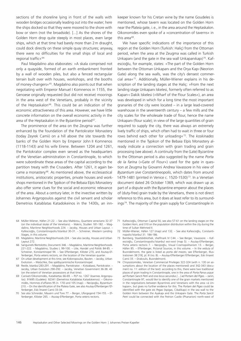
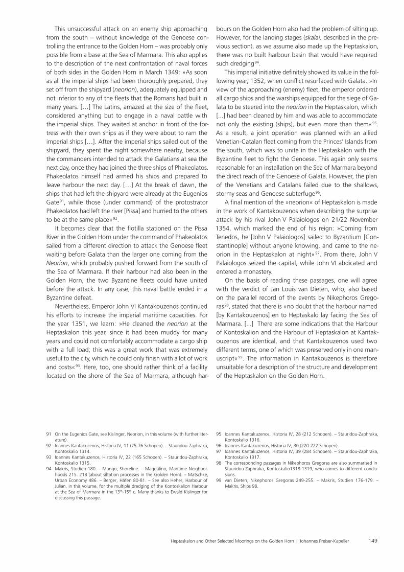
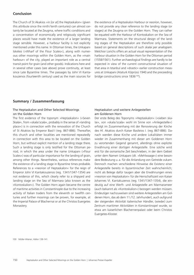
for the skalai in the quarters of the Pisans, Genoese and Venetians on the southeastern bank of the Golden Horn, but also for the facilities at the Zeugma (Heptaskalon), at the Christos Euergetes Monastery and in the Blachernai. The intensive ferry traffic from Constantinople to Pera (Galata), described by travellers such as Ibn Battuta and others for the Late Byzantine period, or fisheries probably used the banks of the Golden Horn in many places in a comparable way. The aforementioned city view by Giovanni Andrea Vavassore (c. 1479-1481), which shows the Golden Horn full of rowing boats, also offers clues 79. The importance of the Byzantine Zeugma for the crossing over the Golden Horn continued into modern times. In a map of the water supply system of the Ottoman capital from 1812/1813, the jetties and scales for the flour on or near the bank as well as the »flour gate« in the sea wall are clearly shown (fig. 2). In addition, »Unkapanı [...] played an important role as the bridgehead of the first pontoon bridge spanning the Haliç, since 1836, in addition to its importance as a grain staple place« 80.
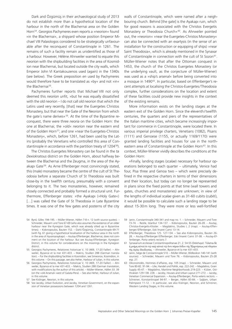
the Late Byzantine and Ottoman period came from locations around the Black Sea, meaning that sites along the Golden Horn coast would naturally provide the first harbours 75. The landing stages at Unkapanı also served as an important transit point for the transport of building materials, especially stones, for the Süleymaniye Mosque, built under Sultan Süleyman the Magnificent (1520-1566) 76. The view from Galata by Melchior Lorichs (fig. 1) from around 1558 to 1561 offers a clear picture, not only of the Unkapanı area (on pp. 11-12, here also with the designation porta de la farina or mul Thor), but also of the entire shipping traffic and the moorings on the Golden Horn 77. It illustrates the use of the Golden Horn as a harbour in its entirety. Müller-Wiener also lists no fewer than 21 landing stages (Turkish iskele) from the Ottoman era on the Golden Horn along the sea walls from the entrance of the Golden Horn to the Blachernai (Ayvansaray) and another 26 to the west outside of the city walls or on the opposite banks to the west, in and east of Galata 78. We may presume multiple continuities from the Byzantine period, not only
the Ayakapı, see Chrysostomides, Venetian Commercial Privileges 323 (n. 130) and Asutay-Effenberger / Effenberger, Eski İmaret Camii 15 (with fig. 7). Both fourteenth-century grain markets would be located at the Golden Horn, one of them at least near the later Unkapanı.
75 Chrysostomides, Venetian Commercial Privileges 312-327 (esp. on the role of the Venetians in the grain trade of Late Byzantine Constantinople). – Magda-lino, Grain Supply. – Jacoby, Mediterranean Food and Wine. – İnalcik, Otto-man Empire 179-187. – Faroqhi / McGowan / Quataert / Pamuk, Ottoman Em-pire 447-448. 493-499. 719-721. – Boyar / Fleet, Ottoman Istanbul 160-163. – White, Climate of Rebellion 28-39.
76 Kolay / Çelik, Ottoman Stone Acquisition, particularly also the map (256) for the places of origin of building materials distributed over the entire Ottoman Empire.
77 Fischer, Lorck. – Westbrook / Dark / van Meeuwen, Lorichs. – Müller-Wiener, Häfen 38. – Kafescioğlu, Constantinopolis / Istanbul 199 (fig. 127). – Asutay-Effenberger, Porta veteris rectoris 7.
78 Müller-Wiener, Häfen 125-137 with map on pp. 126-127. – See also Kafescio-ğlu, Constantinopolis / Istanbul 30-35.
79 Ibn Battuta 345. – Makris, Studien 99. 255 n. 39. – Majeska, Russian Travelers 140. 353-354. – Müller-Wiener, Häfen 60. – Mundell Mango, Commercial Map 205-206. – On Vavassore, see Bamberg, Staatsbibliothek, shelfmark IV C44. – See Necipoğlu, Visual Cosmopolitanism 13. – Effenberger, Pictorial Sources, in this volume.
80 Kafescioğlu, Constantinopolis / Istanbul 33 (fig. 17). – Müller-Wiener, Häfen 132. – A »space syntax« analysis of the axes of accessibility and mobility in the area of the southern Golden Horn, which also includes Unkapanı, is offered by Önder / Gigi, Urban Spaces, based on the current course of the road.
Fig. 1 View of the Unkapanı area (at the right side in the picture) on the Golden Horn from Galata, by Melchior Lorck, 1558/1561. – (Universitaire Bib-liotheken Leiden 1758, BPL 1758 / 11).
148 Heptaskalon and Other Selected Moorings on the Golden Horn | Johannes Preiser-Kapeller
The variations in the manuscripts recorded by the editor (»in the Heptaskalon«, »in the so-called Kontoskalion«) al-ready indicate that an identification of the »neorion« named by Kantakouzenos with the Heptaskalon in the Golden Horn is not possible offhand 88. Further references to this site make it rather more likely that it would have been located at the Sea of Marmara (beyond the immediate access of the Ge-noese in Galata at the Golden Horn) and that it should be identified with the Kontoskalion already mentioned in part of the manuscript tradition 89. As we read: »The day before the warships were to be brought out of the neorion [arsenal, shipyard], a cargo ship was sighted that came from Genoa and was said to carry great wealth. When the winds stopped and conditions prevented the ship from sailing, it anchored near the Princes’ Island. At night, two imperial warships set sail with the same number of ships with one row of oars. […] They boarded the cargo ship and killed not a few of the defenders and were soon masters of the situation. But when the unclear rumour reached the ships that the Latin warships were sailing from Galata, they turned to flee, leaving a little less than 50 of their men on the cargo ship. This rumour was completely wrong. When the Romans, who had been left on the ship, discovered that their warships had sailed away and that they were without help, they came to an agreement with the Latins, whom they had already overpowered [...]« 90.
The Neorion of Heptaskalon in the Reign of John VI Kantakouzenos
Despite all the references to the significance of the Heptaska-lon’s maritime traffic in Byzantine and post-Byzantine times, an explicit mention of a harbour facility of this name could not be found. A harbour of this name appears only in the his-torical work of Emperor John VI Kantakouzenos (1341/1347-1354) 81. After his victory in the civil war against the party for the regency of John V Palaiologos and his entry into Constantinople, John VI Kantakouzenos came into conflict with the Genoese in Galata in 1348/1349. In the face of the maritime superiority of the enemy, he tried to (re-)build a Byzantine war fleet. As he explained: »But since the sea was ruled by the Galatians and it was impossible to bring the timber for shipbuilding to water, he [Emperor John VI Kantakouzenos] ordered to bring it with carriages and mules from the mountains of Sergentzion 82. And it was very labo-rious and arduous, and triremes were built in the shipyard (neorion) in the Heptaskalon [or the so-called Kontoskalion]. […] He made the protostrator Phakeolatos [Phakiolatos, also Facciolati Andreas] 83 commander of the three warships on the [River] Pissa [near Kosmidion on the Golden Horn] 84, and Tzamplakon [Tzamplakon Asomatianos] 85, the megas doux 86, of those built in the Heptaskalon [or Kontoskalion]« 87.
81 On this see Fatouros / Krischer, Johannes Cantacuzenus I-III (with introduc-tions). – The published volumes of the German translation by Georgios Fatouros and Tilman Krischer so far only cover the events up to 1347. The translations of the passages discussed in this section are from the author.
82 See Külzer, Ostthrakien 644-645.83 PLP no. 29559.84 Külzer, Ostthrakien 595.85 PLP no. 27753. – See also Estangüi Gómez, Tzamplakônes 293-295.86 The commander in chief of the Byzantine navy, see Macrides / Munitiz / Angelov,
Pseudo-Kodinos 71-73.
87 Ioannes Kantakuzenos, Historia IV, 11 (72 and 74 Schopen). – Stauri-dou-Zaphraka, Kontoskalio 1313. – Makris, Studien 163-164. – See also Heher, Harbour of Julian, in this volume.
88 A modern critical edition of Johannes Kantakouzenos’ historical work could provide further information here, see www.cct.uni-bonn.de/aktivitaeten-pro-jekte/kantakuzenos.
89 Heher, Harbour of Julian, in this volume, as well as Brzozowska, Itinerarium Stefana.
90 Ioannes Kantakuzenos, Historia IV, 11 (74-75 Schopen).
Fig. 2 Detail from the map of the water supply system of Istan-bul, 1812-1813, with the area around Unkapanı on the right in the picture (11 landing stages, 12 weighing system, 13 Unkapanı gate). – (After Kafescioğlu, Con-stantinopolis / Istanbul 33 fig. 17).
149Heptaskalon and Other Selected Moorings on the Golden Horn | Johannes Preiser-Kapeller
bours on the Golden Horn also had the problem of silting up. However, for the landing stages (skalai, described in the pre-vious section), as we assume also made up the Heptaskalon, there was no built harbour basin that would have required such dredging 94.
This imperial initiative definitely showed its value in the fol-lowing year, 1352, when conflict resurfaced with Galata: »In view of the approaching (enemy) fleet, the emperor ordered all cargo ships and the warships equipped for the siege of Ga-lata to be steered into the neorion in the Heptaskalon, which [...] had been cleaned by him and was able to accommodate not only the existing (ships), but even more than them« 95. As a result, a joint operation was planned with an allied Venetian-Catalan fleet coming from the Princes’ Islands from the south, which was to unite in the Heptaskalon with the Byzantine fleet to fight the Genoese. This again only seems reasonable for an installation on the Sea of Marmara beyond the direct reach of the Genoese of Galata. However, the plan of the Venetians and Catalans failed due to the shallows, stormy seas and Genoese subterfuge 96.
A final mention of the »neorion« of Heptaskalon is made in the work of Kantakouzenos when describing the surprise attack by his rival John V Palaiologos on 21/22 November 1354, which marked the end of his reign: »Coming from Tenedos, he [John V Palaiologos] sailed to Byzantium [Con-stantinople] without anyone knowing, and came to the ne-orion in the Heptaskalon at night« 97. From there, John V Palaiologos seized the capital, while John VI abdicated and entered a monastery.
On the basis of reading these passages, one will agree with the verdict of Jan Louis van Dieten, who, also based on the parallel record of the events by Nikephoros Grego-ras 98, stated that there is »no doubt that the harbour named [by Kantakouzenos] en to Heptaskalo lay facing the Sea of Marmara. [...] There are some indications that the Harbour of Kontoskalion and the Harbour of Heptaskalon at Kantak-ouzenos are identical, and that Kantakouzenos used two different terms, one of which was preserved only in one man-uscript« 99. The information in Kantakouzenos is therefore unsuitable for a description of the structure and development of the Heptaskalon on the Golden Horn.
This unsuccessful attack on an enemy ship approaching from the south – without knowledge of the Genoese con-trolling the entrance to the Golden Horn – was probably only possible from a base at the Sea of Marmara. This also applies to the description of the next confrontation of naval forces of both sides in the Golden Horn in March 1349: »As soon as all the imperial ships had been thoroughly prepared, they set off from the shipyard (neorion), adequately equipped and not inferior to any of the fleets that the Romans had built in many years. […] The Latins, amazed at the size of the fleet, considered anything but to engage in a naval battle with the imperial ships. They waited at anchor in front of the for-tress with their own ships as if they were about to ram the imperial ships […]. After the imperial ships sailed out of the shipyard, they spent the night somewhere nearby, because the commanders intended to attack the Galatians at sea the next day, once they had joined the three ships of Phakeolatos. Phakeolatos himself had armed his ships and prepared to leave harbour the next day. […] At the break of dawn, the ships that had left the shipyard were already at the Eugenios Gate 91, while those (under command) of the protostrator Phakeolatos had left the river [Pissa] and hurried to the others to be at the same place« 92.
It becomes clear that the flotilla stationed on the Pissa River in the Golden Horn under the command of Phakeolatos sailed from a different direction to attack the Genoese fleet waiting before Galata than the larger one coming from the Neorion, which probably pushed forward from the south of the Sea of Marmara. If their harbour had also been in the Golden Horn, the two Byzantine fleets could have united before the attack. In any case, this naval battle ended in a Byzantine defeat.
Nevertheless, Emperor John VI Kantakouzenos continued his efforts to increase the imperial maritime capacities. For the year 1351, we learn: »He cleaned the neorion at the Heptaskalon this year, since it had been muddy for many years and could not comfortably accommodate a cargo ship with a full load; this was a great work that was extremely useful to the city, which he could only finish with a lot of work and costs« 93. Here, too, one should rather think of a facility located on the shore of the Sea of Marmara, although har-
91 On the Eugenios Gate, see Kislinger, Neorion, in this volume (with further liter-ature).
92 Ioannes Kantakuzenos, Historia IV, 11 (75-76 Schopen). – Stauridou-Zaphraka, Kontoskalio 1314.
93 Ioannes Kantakuzenos, Historia IV, 22 (165 Schopen). – Stauridou-Zaphraka, Kontoskalio 1315.
94 Makris, Studien 180. – Mango, Shoreline. – Magdalino, Maritime Neighbor-hoods 215. 218 (about siltation processes in the Golden Horn). – Matschke, Urban Economy 486. – Berger, Häfen 80-81. – See also Heher, Harbour of Julian, in this volume, for the multiple dredging of the Kontoskalion Harbour at the Sea of Marmara in the 13th-15th c. Many thanks to Ewald Kislinger for discussing this passage.
95 Ioannes Kantakuzenos, Historia IV, 28 (212 Schopen). – Stauridou-Zaphraka, Kontoskalio 1316.
96 Ioannes Kantakuzenos, Historia IV, 30 (220-222 Schopen).97 Ioannes Kantakuzenos, Historia IV, 39 (284 Schopen). – Stauridou-Zaphraka,
Kontoskalio 1317.98 The corresponding passages in Nikephoros Gregoras are also summarised in
Stauridou-Zaphraka, Kontoskalio1318-1319, who comes to different conclu-sions.
99 van Dieten, Nikephoros Gregoras 249-255. – Makris, Studien 176-179. – Makris, Ships 98.
150 Heptaskalon and Other Selected Moorings on the Golden Horn | Johannes Preiser-Kapeller
Heptaskalon und weitere Anlegestellen am Goldenen HornDer erste Beleg des Toponyms »Heptaskalon« (»sieben ska-lai«, von »skala / scala« wohl im Sinne von »Anlegestelle«) erfolgt im Zusammenhang mit der Renovierung der Kirche des Hl. Akakios durch Kaiser Basileios I. (reg. 867-886). Da-nach werden diese Kirche und andere Lokalitäten immer wieder im Zusammenhang mit dieser am Goldenen Horn zu verortenden Gegend genannt, allerdings ohne explizite Erwähnung einer dortigen Anlegestelle. Eine solche wird erst für die osmanische Zeit beschrieben, in der dem Gebiet unter dem Namen Unkapanı (dt. »Mehlwaage«) eine beson-dere Bedeutung u. a. für die Anlandung von Getreide zukam. Dennoch machen verschiedene Hinweise die Existenz einer Anlegestelle bereits in byzantinischer Zeit wahrscheinlich; nicht als Belege dafür taugen aber die Erwähnungen eines »neorion von Heptaskalon« für die Herrschaftszeit von Kaiser Johannes VI. Kantakuzenos (reg. 1341/1347-1354), die ein-deutig auf eine Werft- und Anlagestelle am Marmarameer (auch bekannt als »Kontoskalion«) bezogen werden müssen. Eindeutiger nachzuweisen sind weitere Anlegestellen am Gol-denen Horn, das ab dem 11./12. Jahrhundert, auch aufgrund der steigenden Aktivität italienischer Händler, (wieder) zum Zentrum maritimer Aktivitäten in Kon stan tinopel wurde, so etwa am kaiserlichen Blachernenpalast oder beim Christos Euergetes-Kloster.
Summary / Zusammenfassung
The Heptaskalon and Other Selected Moorings on the Golden HornThe first evidence of the toponym »Heptaskalon« (»Seven Skalai«, from »skala / scala«, probably in the sense of »landing place«) is in connection with the renovation of the Church of St Akakios by Emperor Basil I (reg. 867-886). Thereafter, this church and other localities are mentioned repeatedly in connection with this area to be located on the Golden Horn, but without explicit mention of a landing stage there. Such a landing stage is only testified for the Ottoman pe-riod, in which the area under the name Unkapanı (»Flour Scales«) was of particular importance for the landing of grain, among other things. Nevertheless, various references make the existence of a landing stage in Byzantine times probable. References to a »neorion of Heptaskalon« for the reign of Emperor John VI Kantakouzenos (reg. 1341/1347-1354) are not evidence of this, which clearly refer to a shipyard and landing stage on the Sea of Marmara (also known as the »Kontoskalion«). The Golden Horn again became the centre of maritime activities in Constantinople due to the increasing activity of Italian traders from the eleventh or twelfth cen-turies and further moorings can be proven, for example, at the Imperial Palace of Blachernai or at the Christos Euergetes Monastery.
the existence of a Heptaskalon Harbour or neorion, however, do not provide any clear reference to the landing stage (or stages) at the Zeugma on the Golden Horn. They can rather be equated with the Harbour of Kontoskalion on the Sea of Marmara. Statements on the structural design of the land-ing stages of the Heptaskalon are therefore only possible based on general descriptions of such skalai per analogiam. Melchior Lorichs offers an actual visual representation of the harbour situation in the Golden Horn for the Ottoman period (1558/1561). Further archaeological findings are hardly to be expected in view of the current constructional situation of that area in Istanbul and »drastic« earlier construction meas-ures at Unkapanı (Ataturk Köprüsü 1940 and the preceeding bridge constructions since 1836 100).
Conclusion
The Church of St Akakios »in [or at] the Heptaskalon« (given this attribute since the ninth / tenth centuries) can almost cer-tainly be located at the Zeugma, where traffic conditions and a concentration of economically and religiously significant places would have made the existence of a larger landing stage sensible. However, a harbour facility is not explicitly mentioned under this name. In Ottoman times, the Unkapanı Iskelesi (»Wharf of the Flour Scales«), along with numer-ous other moorings within the Golden Horn, as the »main harbour« of the city, played an important role as a central transit point for grain (and other goods). Indications here and in several other cases (see above) prove continuity, at least since Late Byzantine times. The passages by John VI Kanta-kou zenos (fourteenth century) used as the main sources for
100 Müller-Wiener, Häfen 138-141.


