Embed Size (px)
Citation preview
I-81 Viaduct ProjectPhase 1A Archaeological Sensitivity Assessment
Redacted Version - November 2016
Prepared for:
City of Syracuse and Towns of Salina, Cicero, and Dewitt, Onondaga County, New YorkNYSDOT PIN 3501.60
Prepared by:Environmental Design & Research, Landscape Architecture, Engineering & Environmental Services, D.P.C. 217 Montgomery Street, Suite 1000 Syracuse, New York 13202 P: 315.471.0688 F: 315.471.1061
www.edrdpc.com
Phase 1A Archaeological Sensitivity Assessment (redacted version)
I-81 Viaduct Project City of Syracuse and Towns of Salina, Cicero, and Dewitt, Onondaga County, New York
NYSDOT PIN 3501.60 Prepared for:
And
Prepared by:
Environmental Design & Research, Landscape Architecture, Engineering, & Environmental Services, D.P.C. 217 Montgomery Street, Suite 1000 Syracuse, New York 13202
P: 315.471.0688 F: 315.471.1061 www.edrdpc.com
November 2016
Phase 1A Archaeological Sensitivity Assessment (redacted)
I-81 Viaduct Project (NYSDOT PIN 3501.60) ii
MANAGEMENT SUMMARY
PIN: 3501.60
NYSORHP Project Review: 16PR06314
DOT Project Type: Highway demolition, reconstruction, and/or replacement
Cultural Resources Survey Type: Phase 1A Archaeological Sensitivity Assessment
Location Information: City of Syracuse and Towns of Salina, Cicero, and Dewitt
Onondaga County
Survey Area:
Project Description: Reconstruction of I-81 and adjacent roadways in Syracuse, N. The Project is
considering 2 alternatives – a Viaduct Alternative and Community Grid
Alternative, described herein.
Project Area: Area of Potential Effect (APE) for Direct Effects totals 458.9 acres
USGS 7.5-Minute Quadrangle Map: Syracuse East, Syracuse West, Jamesville, Cicero and South Onondaga
Results of Archaeological Survey:
Native American Archaeological Sensitivity: 19.1 acres of APE for Direct Effects is undisturbed (or disturbance
cannot be determined) and therefore potentially sensitive for Native
American archaeological resources
Historic Period Archaeological Sensitivity: Potential for historic-period archaeological resources to be located
throughout portions of the APE for Direct Effects; however, the APE
for Direct Effects is for the most part within a heavily disturbed highway
corridor
Authors/Institution: Patrick J. Heaton, RPA; Grant Johnson; Nicholas Freeland, RPA; Susan
Lawson; Daniel Barbato; Lisa Young; Sarah Bock, RPA; Kyle Somerville, Ph.D.;
Jordon Loucks, RPA; Andrew Roblee
Environmental Design & Research, Landscape Architecture, Engineering, &
Environmental Services, D.P.C. (EDR), Syracuse, New York
Date: November 2016
Sponsor: New York State Department of Transportation
Federal Highway Administration
Phase 1A Archaeological Sensitivity Assessment (redacted)
I-81 Viaduct Project (NYSDOT PIN 3501.60) iii
TABLE OF CONTENTS
1.0 INTRODUCTION .............................................................................................................................................. 1
1.1 Purpose of the Investigation ......................................................................................................................... 1
1.2 Project Description ....................................................................................................................................... 1
1.2.1 Purpose of the Proposed Action ............................................................................................................... 3
1.2.2 Need for the Proposed Action .................................................................................................................. 3
1.2.3 Description of Alternatives ........................................................................................................................ 5
1.3 Project’s Area of Potential Effect ................................................................................................................ 11
2.0 BACKGROUND RESEARCH ......................................................................................................................... 13
2.1 Environmental Setting, Geology, and Soils ................................................................................................ 13
2.1.1 Geographic Setting ................................................................................................................................ 13
2.1.2 Glacial Geology and Paleo-Environmental Setting................................................................................. 15
2.1.3 Soils within APE for Direct Effects .......................................................................................................... 18
2.2 Previously Identified Archaeological Sites .................................................................................................. 26
2.3 Previous Archaeological Investigations ...................................................................................................... 31
2.4 Historic Context for the APE and Vicinity .................................................................................................... 56
2.4.1 Pre-Contact Native American Period (ca. 14,000 BP to 1654 AD) ......................................................... 56
2.4.2 Euro-American and Native American Contact during the Colonial Era (ca. A.D. 1534 to 1786) ............ 66
2.4.3 Salt and the Early Settlement of Onondaga County (ca. 1750 to 1825) ................................................. 71
2.4.4 The Erie Canal and the Birth of the City of Syracuse (ca.1825-1918) .................................................... 80
2.4.5 Growth in the Post-Canal Era (ca. 1918-1938) ...................................................................................... 91
2.4.6 Slum Clearance, Post-War Planning and Urban Renewal (ca. 1938-1974) ......................................... 102
2.4.7 Suburban Expansion in Onondaga County (ca. 1965-2016) ................................................................ 124
2.5 Existing Conditions ................................................................................................................................... 135
2.6 Previous Ground Disturbance within the APE for Direct Effects ............................................................... 138
2.6.1 Nineteenth and Twentieth-Century Landfilling and Urban Development .............................................. 139
2.6.2 Mid-Twentieth-Century Highway Construction ..................................................................................... 143
2.6.3 Prior Ground Disturbance Analysis ...................................................................................................... 146
3.0 ARCHAEOLOGICAL SENSITIVITY ASSESSMENT .................................................................................... 151
3.1 Pre-Contact Native-American Archaeological Sensitivity Assessment ..................................................... 152
3.2 Historic Period Archaeological Sensitivity Assessment ............................................................................ 156
3.2.1 Contact and Colonial Period Native American Archaeological Sensitivity ............................................ 157
Phase 1A Archaeological Sensitivity Assessment (redacted)
I-81 Viaduct Project (NYSDOT PIN 3501.60) iv
3.2.2 Erie and Oswego Canal-Related Archaeological Sensitivity ................................................................ 162
3.2.3 Potential for Large-Scale Commercial, Industrial, and Institutional Archaeological Sites ..................... 179
3.2.4 Potential for Residential and Small-Scale Commercial Archaeological Sites ....................................... 194
3.2.5 Military Sites Archaeological Sensitivity ............................................................................................... 206
3.3 Potential for Human Remains and Cemeteries ........................................................................................ 211
3.3.1 Potential for Native American Human Remains within the APE for Direct Effects ............................... 213
3.3.2 Cemeteries ........................................................................................................................................... 214
4.0 SUMMARY AND CONCLUSIONS ................................................................................................................ 222
4.1 Summary Results of the Phase 1A Archaeological Assessment .............................................................. 222
4.2 Conclusions and Recommendations ........................................................................................................ 225
5.0 REFERENCES CITED .................................................................................................................................. 235
LIST OF FIGURES
Figure 1.2-1. Regional Project Location. ........................................................................................................................ 2
Figure 2.1.1-1. Oblique View of the Land Surface in and around the Onondaga Trough ............................................ 13
Figure 2.2-1. Archaeological Sites in the Vicinity of Syracuse and Onondaga Lake (from Parker, 1922). ................... 27
Figure 2.4.3-1. 1779 Sauthier Chorographical Map of the Province of New York (left). ............................................... 74
Figure 2.4.3-2. 1793 1st Sheet of Dewitt’s State Map of New York (right). ................................................................... 74
Figure 2.4.3-3. 1797 Map of Onondaga Salt Lake. ...................................................................................................... 76
Figure 2.4.3-4. 1827 Map of Part of the Onondaga Salt Springs Reservation. ............................................................ 80
Figure 2.4.4-1. 1869 Map of Walton Tract boundaries c. 1819. ................................................................................... 82
Figure 2.4.4-2. 1834 Map of the Village of Syracuse. .................................................................................................. 84
Figure 2.4.4-3. 1852 Map of the City of Syracuse. ....................................................................................................... 86
Figure 2.4.4-4. ca. 1900 view of the New York Central Railroad Depot. ...................................................................... 87
Figure 2.4.4-5. ca. 1912 postcard depicting salt sheds north of the Enlarged Erie Canal ............................................ 88
Figure 2.4.4-6. ca. 1919 view of street-level railroad crossing at Canal and Beech Streets. ....................................... 91
Figure 2.4.5-1. Public Market Built Atop the Oswego Canal, ca. 1920......................................................................... 92
Figure 2.4.5-2. ca. 1890 view of Greenway Brewery and Washington Street Rail Station. .......................................... 94
Figure 2.4.5-3. View of the Erie Canal west of Clinton Square ca. 1901. .................................................................... 94
Figure 2.4.5-4. Map of Jewish-owned Establishments ca. 1900. ................................................................................. 98
Figure 2.4.5-5. The Dunbar Center ca. 1930s.............................................................................................................. 99
Phase 1A Archaeological Sensitivity Assessment (redacted)
I-81 Viaduct Project (NYSDOT PIN 3501.60) v
Figure 2.4.5-5. Parade along Almond Street in the Fifteenth Ward of Syracuse ca. 1960s. ...................................... 100
Figure 2.4.6-1. 1937 HOLC “Redlining” Map of the City of Syracuse. ....................................................................... 104
Figure 2.4.6-2. 1910 Sanborn Map Plate Depicting Early-Twentieth Century Housing Density. ................................ 105
Figure 2.4.6-3. ca. 1935 View of Construction of Elevated Railroad Right-of-Way. ................................................... 105
Figure 2.4.6-4. 1938 Aerial Photograph Showing the Location of Pioneer Homes Prior to Construction (left). ......... 106
Figure 2.4.6-5. 1940 Sanborn Map Plate Depicting a Portion of Pioneer Homes (right). ........................................... 106
Figure 2.4.6-6. 1951 Photograph Showing Pioneer Homes before Construction of I-81. .......................................... 107
Figure 2.4.6-7. 1951 Aerial Photograph showing Pioneer Homes Fully Constructed (left). ....................................... 108
Figure 2.4.6-8. 1966 Aerial Photograph showing Pioneer Homes Following Construction of I-81 (right). .................. 108
Figure 2.4.6-9. 1965 Photograph of the Demolition of a Portion of Pioneer Homes during I-81 Construction. .......... 108
Figure 2.4.6-10. 1930s Photograph of the Fifteenth Ward, Prior to Urban Renewal. ................................................. 110
Figure 2.4.6-11. 1951 Aerial Photograph showing the Alignment of Oswego Boulevard (left). .................................. 114
Figure 2.4.6-12. 1958 Aerial Photograph showing the Construction of the Oswego Boulevard Expressway (right). . 114
Figure 2.4.6-13. 1958 Aerial Photograph during Construction of the Oswego Boulevard Expressway...................... 115
Figure 2.4.6-14. 1962 Map of Proposed Near East Side Urban Renewal Area (NESURA) Redevelopment (left). .... 116
Figure 2.4.6-15. 1965 Syracuse Urban Renewal Agency Map of Proposed NESURA Redevelopment (right). ......... 116
Figure 2.4.6-16. 1965 Photograph of I-81 Construction. ............................................................................................ 118
Figure 2.4.6-17. 1964 Photograph during Construction of I-81 at East Castle Street. ............................................... 118
Figure 2.4.6-18. 1963 Map of Proposed Urban Renewal Projects in Downtown Syracuse. ...................................... 120
Figure 2.4.6-19. 1859 Clarke Map of Syracuse Showing Synagogues in the Fifteenth Ward. ................................... 121
Figure 2.4.6-20. 1961 NYSDOT Demolition Plan of a Portion of Almond Street. ....................................................... 122
Figure 2.4.7-1 1985 Photograph of the Reconstruction of I-81 at the Liverpool Interchange. .................................... 126
Figure 2.4.7-2. 1968 Photograph of the Proposed Site for a New Post Office near I-81. ........................................... 128
Figure 2.4.7-3. 1972 Photograph Showing Clearing of the Kennedy Square Site near I-81. ..................................... 129
Figure 2.4.7-4. 2016 Photograph of former Kennedy Square Apartments Site. ......................................................... 130
Figure 2.4.7-5. 1999 Photograph Showing the Demolition of Midtown Plaza (left). ................................................... 131
Figure 2.4.7-6. 2016 Photograph of the Center of Excellence at the former Midtown Plaza site (right). .................... 131
Figure 2.4.7-7. 1987 Photograph of Oil City and Industrial Area west of I-81. ........................................................... 133
Figure 2.4.7-8. ca. 2010 Photograph of Carousel Center, the Inner Harbor, and former location of Oil City. ............ 134
Figure 2.6.1-1. Early-Nineteenth Century Maps Showing the Pre-Development Landscape of Syracuse. ................ 140
Figure 2.6.1-2. The History of Onondaga Creek Channelization. .............................................................................. 142
Figure 2.6.2-1. Detail from NYSDOT Construction Plans C56-01 (Oswego Boulevard Expressway). ....................... 144
Figure 2.6.2-2. Detail from NYSDOT Construction Plans C64-07 (I-81, Syracuse City Line to Sizer Street). ............ 144

Phase 1A Archaeological Sensitivity Assessment (redacted)
I-81 Viaduct Project (NYSDOT PIN 3501.60) vi
Figure 2.6.2-3. Detail from NYSDOT Construction Plans C65-28 (I-690/I-81 Interchanges). .................................... 145
Figure 2.6.2-4. Detail from NYSDOT Construction Plans C65-28 (I-690/I-81 Interchanges). .................................... 145
Figure 2.6.3-1. Representative Photographs of Cut-and-Fill Highway and Embankment Areas. ............................... 149
Figure 3.2.2-1. 1817 Section Drawings of the Original Erie Canal. ............................................................................ 164
Figure 3.2.2-2. 1862 Section Drawings of the Enlarged Erie Canal. .......................................................................... 165
Figure 3.2.2-3. Undated Photograph of the Junction of the Erie and Oswego Canals, downtown Syracuse. ............ 166
Figure 3.2.2-4. 1922 Tracing of the Original Plan for the Weigh Lock Culvert at Syracuse, NY. ............................... 167
Figure 3.2.2-5. ca. 1920s Photograph of the Filling of the Erie Canal in Downtown Syracuse. ................................. 168
Figure 3.2.2-6. ca. 1925 Photograph of the infilled Erie Canal at Clinton Square. ..................................................... 169
Figure 3.2.2-7. “Junking of Salina Street Bridge Over Erie Ditch Goes Rapidly Forward Without Apparent Hitch.” .. 170
Figure 3.2.2-9. Photographs of the Erie Canal Aqueduct over Onondaga Creek. ..................................................... 172
Figure 3.2.2-8. Erie Canal Aqueduct Over Onondaga Creek ..................................................................................... 173
Figure 3.2.2-10. Erie Canal-Related Archaeological Features. .................................................................................. 176
Figure 3.2.2-11. Archaeological Remains of Enlarged Erie Canal Prism in Clinton Square. ..................................... 177
Figure 3.2.3-1. Detail of the 1797 Dewitt Map of Onondaga Salt Lake. ..................................................................... 181
Figure 3.2.3-2. Detail of the 1827 Kellogg Map of a Part of the Onondaga Salt Springs Reservation. ...................... 182
Figure 3.2.3-3. ca. 1897 Photograph of Solar Salt Works south of Onondaga Lake. ................................................. 183
Figure 3.2.3-3. 1911 Sanborn Map (Plates 319 and 327) depicting Salt Works and the former Oswego Canal. ....... 184
Figure 3.2.3-4. ca. 1918 Photograph of the Empire Solar Salt Company. ................................................................. 185
Figure 3.2.3-5. 1930 Sanborn Map (Plate 319) Depicting former Salt Works and the Oswego Canal. ...................... 185
Figure 3.2.4-1. Example of Building Demolition List from NYSDOT Record Plans. ................................................... 197
Figure 3.2.4-2. Example of Building Demolition Plan Map from NYSDOT record plans. ........................................... 198
Figure 3.2.5-1. The Onondaga Arsenal Site............................................................................................................... 207
Figure 3.2.5-2. ca. 1880 (left) and 1900 (right) Photographs of the Onondaga Arsenal Site. .................................... 208
Figure 3.2.5-3. ca. 1920 Photograph (Postcard) of the Onondaga Arsenal Site. ....................................................... 209
Figure 3.2.5-4. Schematic Map of the Onondaga Arsenal Site and Vicinity. .............................................................. 210
Figure 3.3-1. Cemeteries and Potential Human Remains .......................................................................................... 212
Figure 3.3.2-1. Detail of the 1874 Sweet Atlas of Onondaga County, N.Y. ................................................................ 215
Figure 3.3.2-2. The Main Gate at Oakwood Cemetery. ............................................................................................. 216
Figure 3.3.2-3. Detail of the 1938 Hopkins Atlas of the City of Syracuse, N.Y. .......................................................... 217
Figure 3.3.2-4. Aerial Photographs of the Old Saint Mary’s Cemetery Site. .............................................................. 219
Figure 3.3.2-5. Photographs of the Old Saint Mary’s Cemetery Site. ........................................................................ 219
Phase 1A Archaeological Sensitivity Assessment (redacted)
I-81 Viaduct Project (NYSDOT PIN 3501.60) vii
LIST OF TABLES
Table 2.1.3-1. Soils within the APE for Direct Effects (Esri and NRCS, 2016; NRCS, 2016). ...................................... 19
Table 2.2-1. Archaeological Sites within or Adjacent (<500 feet) of the APE for Direct Effects. .................................. 28
Table 2.2-2. Archaeological Sites in the Vicinity (between 500 feet and 0.5-mile) of the APE for Direct Effects. ........ 29
Table 2.3-1. Previous Archaeological Projects within or Adjacent (<500 feet) to the APE for Direct Effects. .............. 32
Table 2.3-2. Previous Archaeological Projects located between 500 feet and 0.5-mile of the APE for Direct Effects. 53
Table 2.4.1-1. Summary of Prehistoric Native American Cultural Periods for Central New York. ................................ 57
Table 3.2.2-1. Potential Canal-Related Archaeological Features within the APE for Direct Effects ........................... 171
Table 3.2.2-2. Previously Archaeological Studies of Canal-Related Features within the APE for Direct Effects. ...... 174
Table 3.2.3-1. Mapped Industrial, Commercial, and Institutional Structures within the APE for Direct Effects. ......... 187
LIST OF APPENDICES
Appendix A. Maps
Map 1: Area of Potential Effect (APE) for Direct Effects Map 2: Soils Map 3: Previous Archaeological Surveys Map 4: 1892 Sanborn Atlas Map 5: 1898-1900 USGS Maps Map 6: 1938 Hopkins Atlas of the City of Syracuse Map 7: 1938-1943 USGS Maps Map 8: 1955-1958 USGS Maps Map 9: 1973-1977 USGS Maps Map 10: Previous Soil Disturbance Map 11: Archaeological Sensitivity Assessment
Appendix B. NYSDOT Demolition Plans
Appendix C. Photolog
Phase 1A Archaeological Sensitivity Assessment (redacted)
I-81 Viaduct Project (NYSDOT PIN 3501.60) 1
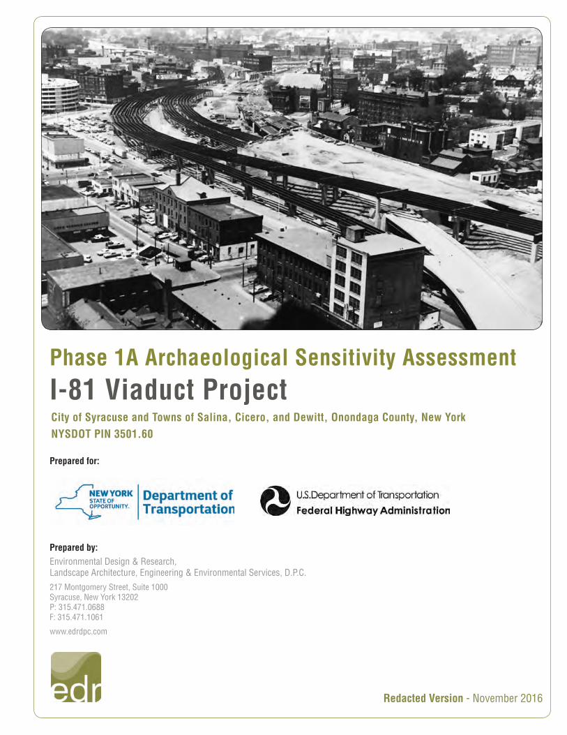
1.0 INTRODUCTION
1.1 Purpose of the Investigation
Environmental Design & Research, Landscape Architecture, Engineering, & Environmental Services, D.P.C. (EDR)
prepared a Phase 1A Archaeological Sensitivity Assessment for the I-81 Viaduct Project, which is located in the City
of Syracuse and Towns of Salina, Cicero, and Dewitt, in Onondaga County, New York. The purpose of the Phase 1A
Archaeological Sensitivity Assessment is to determine whether previously identified archaeological resources are
located in the Project’s Area of Potential Effect (APE), and to evaluate the potential for previously unidentified
archaeological resources to be located within the APE. The report has been prepared in accordance with Section 106
of the National Historic Preservation Act, the National Environmental Policy Act (NEPA), and/or Section 14.09 of the
New York State Parks, Recreation, and Historic Preservation Law, as applicable.
The Phase 1A Archaeological Sensitivity Assessment was prepared by professionals who satisfy the qualifications
criteria per the Secretary of the Interior’s Standards for Historic Preservation (36 CFR 61) in Archaeology and Historic
Preservation and under the supervision of a Registered Professional Archaeologist (RPA). The research methods and
report preparation were conducted in accordance with the New York Archaeological Council’s (NYAC’s) Standards for
Cultural Resources Investigations and the Curation of Archaeological Collections in New York State (NYAC, 1994).
This report includes the required information and sections for a Phase 1A archaeological assessment as specified in
the New York State Education Department’s (NYSED’s) Cultural Resources Survey Program Work Scope
Specifications for Cultural Resources Investigations on New York State Department of Transportation Projects
(NYSED, 2004). However, the organization of the report has been modified to better account for the complexity and
scale of the Project, and is organized in a manner consistent with the New York State Office of Parks, Recreation, and
Historic Preservation’s (NYSOPRHP’s) Phase 1 Archaeological Report Format Requirements (NYSOPRHP, 2005).
This Phase 1A Archaeological Sensitivity Assessment was previously submitted to NYSOPRHP and the Onondaga
Nation on September 19, 2016. This redacted version of the report is included in the DEIS for the I-81 Viaduct Project
and was revised to remove information about archaeological site locations.
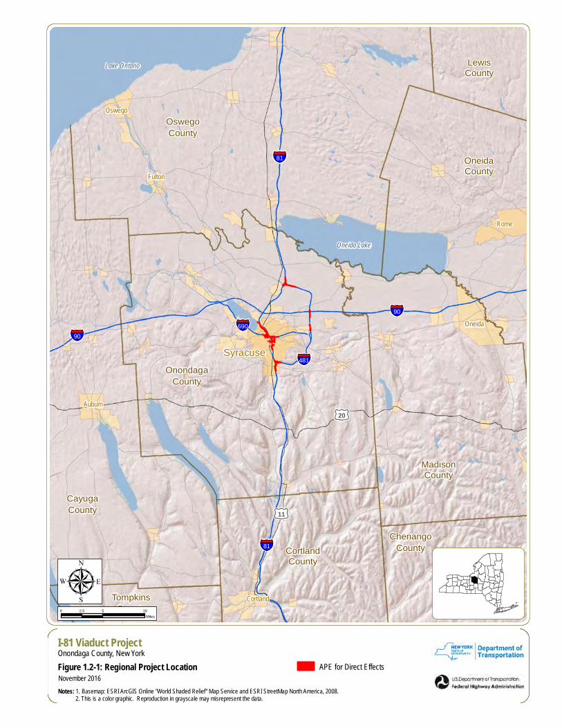
1.2 Project Description
The I-81 Viaduct Project includes the proposed reconstruction or replacement of the elevated portions of Interstate 81
(the I-81 viaduct) through the City of Syracuse, in Onondaga County, New York (see Figure 1.2.1-1 and Appendix A:
Map 1). This section of the report describes the purpose of the Proposed Action (the Project); the need for the Project;
describes the proposed alternatives for the Project; and defines the APE and other terms that will be used throughout
this report to describe the Project.
§̈¦81
§̈¦90§̈¦690
§̈¦481
§̈¦81
§̈¦90
£¤20
£¤11
Syracuse
Oneida
Rome
Fulton
Oswego
Auburn
Cortland
CayugaCounty
ChenangoCountyCortland
County
LewisCounty
MadisonCounty
OneidaCounty
OnondagaCounty
OswegoCounty
TompkinsCounty
Oneida Lake
Lake Ontario
µI-81 Viaduct ProjectOnondaga County, New York
Figure 1.2-1: Regional Project Location
Notes: 1. Basemap: ESRI ArcGIS Online "World Shaded Relief" Map Service and ESRI StreetMap North America, 2008. 2. This is a color graphic. Reproduction in grayscale may misrepresent the data.
0 5 102.5Miles
November 2016
APE for Direct Effects
Phase 1A Archaeological Sensitivity Assessment (redacted)
I-81 Viaduct Project (NYSDOT PIN 3501.60) 3
1.2.1 Purpose of the Proposed Action
The purpose of the I-81 Viaduct Project is to address the structural deficiencies and non-standard highway features in
the I-81 corridor while creating an improved corridor through the City of Syracuse that meets transportation needs and
provides the transportation infrastructure to support long-range planning efforts.
The future of the I-81 corridor is important to the efficient movement of people and goods in and around greater
Syracuse and to the integrity of the national transportation network. Within the greater Syracuse metropolitan area, I-
81 is a principal north-south transportation route for commuters, travelers, and commercial vehicles and provides direct
access to Downtown. Nationally, I-81 is a major north-south transportation corridor that extends from Tennessee to
Canada, providing links to major cities, such as Washington, D.C., Philadelphia, and New York City, via east-west
connections. I-690 is a principal east-west arterial in Syracuse that also provides direct access to Downtown. The I-
81/I-690 interchange is located in the northern portion of Downtown Syracuse.
As described in the I-81 Corridor Study (New York State Department of Transportation [NYSDOT], 2013), the I-81
viaduct and I-81/I-690 interchange have been the subject of community and agency concern because of ongoing
congestion and safety issues, as well as its aging infrastructure. The I-81 Corridor Study identified a section of I-81 and
I-690 in and near Downtown Syracuse as a priority area for improvements due to a concentration of structural and
geometric deficiencies, as well as frequent congestion and high accident rates, and defined this area as the “I-81
Viaduct Priority Area.” In many instances, existing highway design features (such as shoulder widths, median widths,
interchange spacing, etc.) pre-date current design standards and, coupled with heavy traffic volumes, have led to
recurring congestion and high accident rates. In addition, the highway infrastructure is nearing the end of its intended
design life, and the viaduct and other highway bridges have deteriorated due to age, wear, and harsh winter weather
conditions.
1.2.2 Need for the Proposed Action
The I-81 Viaduct Priority Area exhibits a high concentration of traffic incidents and nonstandard features. Although
highway infrastructure is maintained in a state-of-good repair to ensure its structural integrity and to remain safe for the
traveling public, continued deterioration could lead to increased maintenance costs, weight and speed restrictions on
bridges, and potentially, eventual closure of bridges. Preliminary planning has identified the following with respect to
the need for the Project:
The need to improve traffic flow and safety
The need to correct nonstandard and nonconforming design features
Phase 1A Archaeological Sensitivity Assessment (redacted)
I-81 Viaduct Project (NYSDOT PIN 3501.60) 4
The need to improve highway bridge infrastructure
The need for transportation infrastructure to support long-range planning efforts
Important indicators of the functionality of a highway network are levels of congestion and accidents rates. Level of
service (LOS) is a measurement of congestion and travel delays, based on a scale from LOS A (free flowing) to LOS
F (highly congested). The I-81 Viaduct Priority Area is prone to congestion and high accident rates, largely due to high
traffic volumes combined with nonstandard and nonconforming design features.
According to the NYSDOT Highway Design Manual (HDM) design criteria, interstate highways should function at LOS
C or better. During peak periods (i.e., AM and PM rush hours), traffic congestion is a frequent occurrence in certain
sections of the I-81 viaduct priority area where traffic conditions typically operate below LOS C. Many roadway and
ramp segments in these areas often approach capacity (LOS D to E) or are over capacity (LOS F). This often results
in reduced travel speeds that average about 20 mph (well below the posted 45 mph speed limit), indicating notable
travel delays. Frequent peak hour congestion is a result of heavy traffic volumes combined with numerous highway
design features that do not meet current standards, largely due to the viaduct’s age and physical constraints. The I-81
and I-690 corridors accommodate nearly 100,000 vehicles per day in some downtown sections near the I-81/I-690
interchange.
To ensure safety and conformity throughout the national highway system, the American Association of State Highway
and Transportation Officials (AASHTO) has established interstate highway design standards, which are implemented
by the FHWA and NYSDOT. In New York State, AASHTO standards are supplemented by NYSDOT’s HDM. These
standards vary based on design speed and include criteria for grades and roadway curvatures, lane widths, shoulder
dimensions, median design, and interchange spacing, among many others. Design standards have evolved over time
as engineering and safety practices have improved. As such, highway infrastructure that was constructed in the 1950s
and 1960s, including portions of the I-81 corridor, does not always meet current standards.
Infrastructure that pre-dates current design standards is considered “nonstandard” or “nonconforming.” Nonstandard
design features include geometrical aspects that are considered critical design elements, such as lane and shoulder
widths, sight-line distances, grades (i.e., slopes or steepness), etc. Nonconforming design features include design
elements that do not conform to accepted engineering practice but are not considered critical design elements, such
as the spacing between interchanges and the lengths of acceleration and deceleration lanes.
I-81 and I-690 are elevated through Downtown Syracuse. The I-81/I-690 interchange and viaduct comprise 33 highway
bridges, with 17 additional bridges along the I-81/I-690 interchange approaches. These bridge structures were
Phase 1A Archaeological Sensitivity Assessment (redacted)
I-81 Viaduct Project (NYSDOT PIN 3501.60) 5
constructed primarily in the 1960s and many of their components are nearing the end of their design service life. Over
time, these structures have experienced varying levels of deterioration from exposure to weather, de-icing salts, and
heavy vehicle use. Bridges are particularly susceptible to wear and tear because many of the structural elements are
directly exposed to weather conditions (i.e., ice in winter and heat in summer).
Several local and regional long-range plans have established goals for the regional transportation network, and/or have
identified I-81, particularly the I-81 viaduct, as an influential feature within Downtown Syracuse and adjacent
neighborhoods. The I-81 viaduct and I-690 interchange are visually prominent elevated features in Downtown Syracuse
that can affect adjacent land uses and connectivity between land uses, thereby influencing the livability, sustainability,
and economic vitality of the City. As such, in addition to the structural and design needs previously described, project
development has and will continue to be mindful of regional and community planning initiatives.
1.2.3 Description of Alternatives
The following summarizes the reasonable alternatives that are evaluated in the Interstate 81 (I-81) Viaduct Project
Draft Environmental Impact Statement (Draft EIS). The Preferred Alternative will be identified in the Final Environmental
Impact Statement (Final EIS).
No Build Alternative
NEPA requires examination of a No Build Alternative. The No Build Alternative serves as the baseline against which
the other alternatives can be compared. The No Build Alternative would maintain the highway in its existing
configuration, although ongoing maintenance and repairs to ensure the safety of the traveling public will continue. In
addition, NYSDOT would implement safety measures to the extent feasible and financially practicable.
Structural deficiencies and safety considerations would be addressed as part of NYSDOT’s ongoing maintenance
program. In addition to routine maintenance efforts (such as filling pavement cracks, patching holes in bridge decks,
cleaning drainage systems, and operational considerations (e.g., signage and other low-cost improvements), the facility
has required an increasing number of emergency repairs of greater magnitude to keep it serviceable. Over time, these
repairs would become increasingly costly as the highway continues to deteriorate. At the time when NYSDOT
determines that a maintenance and repair program is too costly or that conditions result in an increased safety risk to
the public, the facility would be closed to traffic.
Under the No Build Alternative, large-scale replacement and rehabilitation efforts would not be undertaken,
nonstandard highway features would not be corrected, and existing interchanges would not be modified.
Phase 1A Archaeological Sensitivity Assessment (redacted)
I-81 Viaduct Project (NYSDOT PIN 3501.60) 6
The No Build Alternative would not involve changes in right-of-way (property line). Any maintenance or safety repairs
would include upgrades to the existing highway or operational modifications, such as changes in the posted speed
limit, safety signage, restrictions on vehicle weights, or adjustments to traffic signals at intersections leading to and
from the highway.
There would be costs associated with the No Build Alternative in each year that repairs are undertaken. As the facility
continues to deteriorate, the level of effort and associated costs would increase. Over time, the maintenance may be
costlier than NYSDOT’s budgets can tolerate, making continued operation unreasonable.
Viaduct Alternative
The Viaduct Alternative (formerly known as Option V-4) would involve a full reconstruction of I-81 between
approximately Colvin Street and Spencer Street, as well as modifications to highway features north of Spencer Street
to Hiawatha Boulevard and along I-690. The new viaduct would provide four 12-foot travel lanes (a minimum of two in
each direction), as well as inside shoulders (a minimum of four feet in each direction) and outside shoulders (a minimum
of 10 feet in each direction).
From the south, the Viaduct Alternative alignment would begin as I-81 approaches the city in the vicinity of Colvin
Street. Near Van Buren Street, the interstate would go over the bridge carrying the New York, Susquehanna and
Western Railway, at approximately the same elevation as the existing I-81 viaduct, and begin to climb until nearby
Adams Street, where it would be approximately 10 to 15 feet higher than the existing viaduct, which is approximately
20 feet tall. This increased height generally would be maintained throughout the length of the viaduct. South of Harrison
Street, the new viaduct generally would be approximately 10 to 20 feet wider, depending on the section, than the 66-
foot-wide existing viaduct. Between Harrison and Genesee Streets, the viaduct would begin to split into two separate
bridges, with the bridge on the west carrying two southbound I-81 through lanes, as well as additional lanes for ramp
connections, and the bridge on the east carrying a similar number of lanes for northbound I-81. As a result of these
connections, the separate bridges, wider shoulders, and other improvements, the footprint of the new viaduct would
be substantially wider than the existing viaduct footprint, ranging from approximately 95 feet at Harrison Street (30 feet
wider than existing) to 280 feet at Genesee Street (150 feet wider than the existing). From Genesee Street to the I-690
interchange, I-81 would continue on separate bridges, which would join and end around Salina Street (for comparison,
the existing I-81 viaduct rejoins at approximately State Street). From Salina Street northward, the interstate would be
carried on an embankment. Elevations would match those of the existing interstate near existing Butternut Street.
Phase 1A Archaeological Sensitivity Assessment (redacted)
I-81 Viaduct Project (NYSDOT PIN 3501.60) 7
The Viaduct Alternative would correct most non-standard and non-conforming highway features within the I-81 priority
area. It would meet 60 mph design standards except for horizontal stopping sight distance1 at five curves. Three curves
would meet 55 mph design standards and two curves would meet 50 mph design standards. The sight distance
restriction would apply to only the inside lane of the five curves. The posted speed limit on the viaduct would be 55
mph, but warning signs to encourage motorists to reduce speed would be installed at the five curves.
Based on the current design, it is estimated that approximately 23 buildings would need to be acquired for the
construction of the Viaduct Alternative; in addition, there would be one partial impact to a building, involving the removal
of its smokestack.
Major elements of the Viaduct Alternative, including interchange modifications, bridge replacements, and other
features, include the following:
New partial interchange on I-81 at Dr. Martin Luther King, Jr. East (MLK, Jr. East, formerly East Castle Street)
I-81 Interchange 18 (Harrison/Adams Streets) improvements
Reconstruction of I-690 and existing i-81/i-690 interchange and provision of missing I-81/I-690 connections
(between eastbound I-690 and northbound I-81 and between southbound I-81 and westbound I-690)
Consolidation of I-81 Interchange 19 (Clinton Street/Salina Street) and Interchange 20 (Franklin Street/West
Street)
Rebuilding of Butternut Street overpass in a new location (over existing Genant Drive to connect to Clinton
and Franklin Streets in the Franklin Square neighborhood)
Addition of one lane in each direction on I-81 from I-690 to Hiawatha Boulevard and replacement of existing
Bear Street, Court Street, and Spencer Street bridges with new structures
I-690 Interchange 11 (West Street) improvements and removal of the West Street overpass of West Street
Onondaga Creekwalk Improvements including the creation of a new path along the west bank of Onondaga
Creek between Erie Boulevard and Evans Street
I-690 Interchange 13 (Townsend Street/Downtown Syracuse) improvements.
In addition, the Viaduct Alternative would include bicycle and pedestrian facilities to improve connectivity between
existing multi-use paths within the project limits. Streets would be designed to incorporate ADA needs and requirements
and to be in compliance with New York State complete streets requirements. Efforts would be made to create a
1 As defined by FHWA, “stopping sight distance is the distance needed for drivers to see an object on the roadway ahead and bring
their vehicles to a safe stop before colliding with the object.” “Horizontal stopping sight distance” refers to the distance that a motorist needs to see around horizontal curves at a given speed.
Phase 1A Archaeological Sensitivity Assessment (redacted)
I-81 Viaduct Project (NYSDOT PIN 3501.60) 8
distinctive identity through the use of an aesthetically unified design and measures to improve safety. Special
pavements, planting areas, medians, pedestrian refuge areas, site furnishings, and green infrastructure would be
considered. Local street improvements would include pedestrian and bicycle safety and connectivity enhancements in
the priority area, such as:
Distinctive pavement markings, materials, and/or color to define space for bicyclists and pedestrians and
promote driver awareness;
Signals to facilitate pedestrian crossings while encouraging bicycle use;
Bollards and traffic islands to provide safe refuge for pedestrians; and
“Bump-outs,” or extensions, of the sidewalk corners, to narrow roadway crossing distance for pedestrians.
Newly created bicycle facilities along Almond Street would connect to existing bicycle facilities at Water Street and
East Genesee Street (Connective Corridor) and allow for future connections to bicycle facilities identified in the
Syracuse Bicycle Plan: A Component of the Syracuse Comprehensive Plan at Burnet Avenue, Burt Street, and MLK,
Jr. East.
Community Grid Alternative
The Community Grid Alternative would involve demolition of the existing viaduct between the New York, Susquehanna
and Western Railway bridge and the I-81/I-690 interchange. The section of I-81 between the southern I-81/I-481
interchange and the I-81/I-690 interchange in Downtown Syracuse would be de-designated as an interstate, and
existing I-481 would be re-designated as the new I-81. The section of I-81 between the I-81/I-690 interchange and the
northern I-81/I-481 interchange would remain an interstate but would be re-designated with a different interstate route
number. The remaining portion of former I-81 south of MLK, Jr. East to the former I-481 interchange would be
reclassified from an interstate to a state route. North of MLK, Jr. East the state route would transition to a two-way
street with signalized intersections (“urban arterial”) to become integrated into the city street system.
The Community Grid Alternative would disperse traffic throughout the city grid by promoting broader use of the existing
street network. Vehicular traffic would be channeled through Almond Street and along parallel corridors such as Crouse
Avenue, Irving Avenue, State Street, and Townsend Street, as well as other local streets that would have the capacity
to accommodate this traffic. By dispersing traffic to these other streets, the reconstructed Almond Street would maintain
a narrow vehicular transportation footprint (with generally two lanes, as well as turn bays when needed, in each
direction). Streets incorporated into the Community Grid Alternative would be designed to meet FHWA, NYSDOT, and
local design standards consistent with their anticipated function.

Phase 1A Archaeological Sensitivity Assessment (redacted)
I-81 Viaduct Project (NYSDOT PIN 3501.60) 9
For purposes of the discussion that follows, the section of the existing I-81 between its southern interchange with I-481
(Exit 16A) and MLK, Jr. East, which would be renamed as a New York State Route, is referred to as the “State route.”
The section of I-81 between Butternut Street and its northern interchange with I-481 (Exit 29), which would be
renumbered as another interstate (e.g., I-581, I-781, etc.), is referred to as the “former I-81 northern segment.”
Between East Kennedy Street and MLK, Jr. East, the former I-81 south segment, or State route, would transition from
a highway to a boulevard, reaching the same level as the street at its first intersection at MLK, Jr. East. It would then
descend to go underneath the New York, Susquehanna and Western Railway and return to street level at Van Buren
Street. Almond Street would provide two 11-foot travel lanes in each direction; turning lanes at intersections (where
needed); cycle track(s), which are physically separated from both vehicular lanes and the sidewalk; widened sidewalks;
and a landscaped median. Curbside parking lanes would be provided, except in the portion between East Adams Street
and MLK, Jr.
The new Almond Street would provide vehicular access to all existing intersections. However, only right turns would
be possible to and from Madison and Monroe Streets because of the presence of a continuous median on this portion
of Almond Street. Only access to and from northbound Almond Street would be available at these two intersections;
access to and from southbound Almond Streets would not be possible.
Once designated as the new I-81, I-481 would carry a minimum of four lanes (two in each direction) of through traffic.
Interstate re-designation and associated numbering must meet American Association of State Highway Transportation
Officials (AASHTO) protocols and receive approval from FHWA. The change in highway designation and associated
changes in traffic volumes would require modifications to the new I-81. These modifications would include:
I-81/I-481 South Interchange (Interchange 16A): Reconstruction of this interchange would involve re-routing
existing I-81 to connect with existing I-481, which would serve as the new I-81. The new I-81 would meet 70
MPH design standards, with the State route. The existing ramps that connect northbound I-81 to northbound
I-481 and southbound I-481 to southbound I-81 would be demolished, and these movements would be made
on the main line of re-designated I-81. The East Brighton Avenue bridge over the interchange would be
reconstructed. The intersection of East Brighton Avenue and Rock Cut Road would be maintained.
Motorists traveling north on I-81 south of Interchange 16A who are headed to Downtown Syracuse would exit
the interstate to the State route, while through travelers would continue onto the re-designated I-81. Travelers
on the southbound State route headed to the re-designated northbound I-81 would turn left at a new signalized
intersection with a new road, which would connect to Brighton Avenue.
Phase 1A Archaeological Sensitivity Assessment (redacted)
I-81 Viaduct Project (NYSDOT PIN 3501.60) 10
Major elements of the Community Grid Alternative, including interchange modifications, bridge replacements, and other
features, are described below:
Construction of a new intersection at MLK, Jr. East
Construction of a new I-690 Interchange at North Crouse and Irving Avenues
Improvements to the I-690 Interchange 13 (Townsend Street/Downtown Syracuse)
Reconstruction of I-690 and former I-81/I-690 Interchange and provision of missing I-81/I-690 connections
(between eastbound I-690 and northbound I-81 and between southbound I-81 and westbound I-690)
I-690 Interchange 11 (West Street) improvements and removal of the West Street overpass of West Street
Rebuilding of Butternut Street overpass in a new location (over existing Genant Drive to connect to Clinton
and Franklin Streets in the Franklin Square neighborhood),
Onondaga Creekwalk improvements including the creation of a new path along the west bank of Onondaga
Creek between Erie Boulevard and Evans Street
Improvements to the former I-81 Interchange 19 (Clinton Street/Salina Street) and Interchange 20 (Franklin
Street/West Street); and
Addition of one lane in each direction on I-81 from I-690 to Hiawatha Boulevard and replacement of existing
Bear Street, Court Street, and Spencer Street bridges with new structures.
The Community Grid Alternative would include bicycle and pedestrian facilities to improve connectivity between existing
multi-use paths within the project limits. Streets would be designed in compliance with New York State complete streets
requirements through the use of an aesthetically unified design and measures to improve safety. Special pavements,
planting areas, medians, pedestrian refuge areas, site furnishings, and green infrastructure would be considered. Local
street improvements would include pedestrian and bicycle safety and connectivity enhancements in the priority area,
such as:
Distinctive pavement markings, materials, and/or color to define space for bicyclists and pedestrians and
promote driver awareness;
Synchronized signals to facilitate pedestrian crossings while encouraging bicycle use;
Bollards and traffic islands to provide safe refuge for pedestrians; and
“Bump-outs,” or extensions, of the sidewalk corners, to narrow roadway crossing distance for pedestrians.
Newly created bicycle facilities along Almond Street would connect to existing bicycle facilities at Water Street and
East Genesee Street (Connective Corridor) and allow for future connections to bicycle facilities identified in the
Syracuse Bicycle Plan: A Component of the Syracuse Comprehensive Plan at Burnet Avenue; Burt Street; MLK, Jr.
Phase 1A Archaeological Sensitivity Assessment (redacted)
I-81 Viaduct Project (NYSDOT PIN 3501.60) 11
East; Lodi Street; Crouse Avenue; and North Salina Street. The Fineview Place bridge, which would be removed as
described above to allow for the eastward realignment of southern Almond Street, is currently used for bicycle access
to University Hill due to its low grade relative to alternative nearby routes; in its place, a new bicycle/pedestrian path
would connect the Almond Street/Van Buren Street intersection with the Fineview Place/East Raynor Street
intersection.
1.3 Project’s Area of Potential Effect
FHWA and NYSDOT provided documentation describing the Project’s APE to the NYSOPRHP on September 20, 2016
(NYSDOT, 2016). As defined in 36 CFR Part 800.16(d), the APE represents the geographical area within which the
Project “may directly or indirectly cause alterations in the character or use of historic properties, if any such properties
exist,” and defines the area in which identification efforts will occur for architectural and archaeological properties.
In accordance with 36 CFR Part 800.4(a)(1), an area of potential effects (APE) has been defined for the I-81 Viaduct
Project based upon a combined scope of work for both alternatives under consideration and will establish the
geographical scope of efforts for the identification of historic properties:
archaeological resources within APE associated with direct physical effects, and
architectural resources within the Project APE, including both direct and indirect effects.
The entire Project APE incorporates potential direct and indirect (visual and auditory) effects associated with the two
build alternatives under consideration. Within the APE, a smaller area representing potential direct effects from
physical alterations or ground disturbance associated with the project has been identified. This area, defined herein as
the APE for Direct Effects, represents the combined limits of disturbance (LOD) of the two build alternatives and
includes the area in which the proposed build alternatives have the potential to result in direct effects to cultural
resources. The APE for Direct Effects includes all areas where there is a potential for physical alterations or ground
disturbance during Project construction and includes approximately 459 acres of land. The APE for Direct Effects is
shown in Figure 1.2-1 and Appendix A: Map 1.
The APE also includes those areas where there is a potential indirect (visual and/or auditory) effect on historic-
architectural resources. Information concerning the Project’s potential effect on historic-architectural resources is being
addressed in a separate report for the Project.
Phase 1A Archaeological Sensitivity Assessment (redacted)
I-81 Viaduct Project (NYSDOT PIN 3501.60) 12
The Project (and APE for Direct Effects) includes four areas, including the Viaduct Priority Area (the largest portion of
the Project site in downtown Syracuse) and three outlying areas: the I-81/I-481 Southern Interchange, the I-81/I-481
Northern Interchange, and the I-481 Eastern Improvements (see Appendix A: Map 1). These areas include all of the
areas where potential ground disturbance is anticipated for the Project and are referred to throughout this report and
on maps included in this report, where applicable.
Phase 1A Archaeological Sensitivity Assessment (redacted)
I-81 Viaduct Project (NYSDOT PIN 3501.60) 13
2.0 BACKGROUND RESEARCH
2.1 Environmental Setting, Geology, and Soils
This section describes the environmental setting for the Project vicinity relevant to evaluating the potential for
archaeological resources to be present. This includes descriptions of the geographic setting, paleo-environmental
context, and soils within the APE for Direct Effects.
2.1.1 Geographic Setting
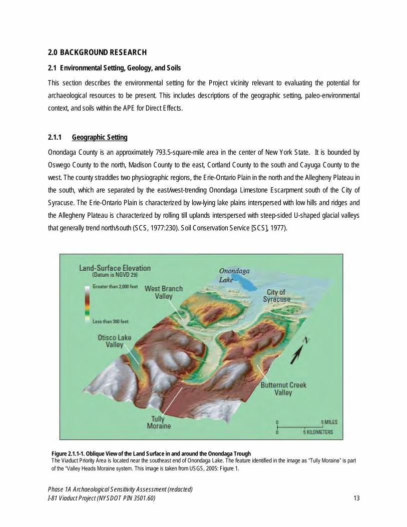
Onondaga County is an approximately 793.5-square-mile area in the center of New York State. It is bounded by
Oswego County to the north, Madison County to the east, Cortland County to the south and Cayuga County to the
west. The county straddles two physiographic regions, the Erie-Ontario Plain in the north and the Allegheny Plateau in
the south, which are separated by the east/west-trending Onondaga Limestone Escarpment south of the City of
Syracuse. The Erie-Ontario Plain is characterized by low-lying lake plains interspersed with low hills and ridges and
the Allegheny Plateau is characterized by rolling till uplands interspersed with steep-sided U-shaped glacial valleys
that generally trend north/south (SCS, 1977:230). Soil Conservation Service [SCS], 1977).
Figure 2.1.1-1. Oblique View of the Land Surface in and around the Onondaga Trough The Viaduct Priority Area is located near the southeast end of Onondaga Lake. The feature identified in the image as “Tully Moraine” is part
of the “Valley Heads Moraine system. This image is taken from USGS, 2005: Figure 1.
Phase 1A Archaeological Sensitivity Assessment (redacted)
I-81 Viaduct Project (NYSDOT PIN 3501.60) 14
The APE for Direct Effects is located within a physiographic feature known as the Onondaga Trough which occurs on
the boundary between the Erie-Ontario Plain and the Allegheny Plateau physiographic provinces. The Onondaga
Trough is a low-lying valley system containing Onondaga Lake and Onondaga Creek within the Onondaga, Tully, and
West Branch valleys (see Figure 2.1.1-1). The valleys that make up the Onondaga Trough are partially filled with fluvial
sediment that was deposited as glacial outwash at the end of the Pleistocene (ca. 12,000 to 14,000 years ago) (USGS,
2007).
Elevations in the Project vicinity range from approximately 390 feet (119 meters) above sea level on the shore of
Onondaga Lake to approximately 485 feet (148 meters) above sea level at the southern end of the Viaduct Priority
Area, near Oakwood Cemetery. West of Syracuse elevation ranges from 380-600 feet (116-183 meters) above sea
level and topography is characterized by till plains, drumlins, outwash plains, and lacustrine deposits. East of Syracuse
elevation ranges from 370-450 feet (113-137 meters) and the landscape consists of lake-plain topography, low hills of
sandy and gravelly glacial till punctuating shallow basins and lowlands with muck accumulations and lacustrine silts
and clays (SCS, 1977; USGS, 2007).
Bedrock in the vicinity of Onondaga Lake consists of Salina Group calcareous shales, including Vernon Shale which
underlies the City of Syracuse (SCS, 1977). Relevant to regional archaeology, the Onondaga Limestone Escarpment,
which forms the boundary between the Erie-Ontario Plain and the Allegheny Plateau in the area, contains large beds
of high quality Onondaga chert, especially in its Edgecliff Member, which was utilized extensively by prehistoric Native
American populations (Jarvis, 1988).
The APE for Direct Effects occurs within the Onondaga Lake Watershed, part of the larger Oswego River Basin which
drains all but the westernmost portion of the Finger Lakes Region. Onondaga Lake is fed by several streams including
Onondaga Creek, Geddes Brook, and Nine Mile Creek. The lake outlets into the Seneca River which flows north and
west, and joins with the Oneida River to form the Oswego River which flows into Lake Ontario, which in turn drains into
the St. Lawrence River. There is an east/west-trending drainage divide in southern Onondaga County, south of the
Onondaga Limestone Escarpment. This divide occurs at the Valley Heads Moraine system which was formed during
late Pleistocene glaciation of the area (Yang, 1992) (Figure 2.1.1-1) and essentially represents the northernmost extent
Allegheny Plateau in the region. Areas south of the divide are part of the Susquehanna watershed whereas areas north
of the divide are part of the Lake Ontario watershed (SCS, 1977).
A unique feature of the Onondaga Trough is a brine-filled aquifer which is the source of the salt springs for which
Syracuse is named “the Salt City” (see Section 2.4.3 of this report for the history of the salt industry in the vicinity of
Phase 1A Archaeological Sensitivity Assessment (redacted)
I-81 Viaduct Project (NYSDOT PIN 3501.60) 15
the Project). The brine is contained within a valley-fill aquifer within the Onondaga Trough and is up to six times as
salty as sea water (USGS, 2005). The United States Geological Survey (USGS) has recently demonstrated that the
brine found within the aquifer derives from local halite (i.e., rock salt) beds located within the Syracuse Shale Formation
south of the City of Syracuse (USGS, 2005). Salt concentrations are highest in the brine-aquifer immediately
surrounding Onondaga Lake; however, in their study, the USGS (2005: Figure 12) collected brine samples as far south
as the Tully Valley (approximately 15 miles [24 km] south of Onondaga Lake) that contained salt concentrations
equivalent to sea water.
2.1.2 Glacial Geology and Paleo-Environmental Setting
A temporal framework of late Pleistocene (ca. 12,000 to 30,000 years ago) deglaciation for the Onondaga Trough is
presented by Ridge (2003). There were three primary periods in the local chronology of deglaciation:
The Last Glacial Maximum occurred between approximately 28,200 and 27,200 years ago. During this period
the Laurentide Ice Sheet reached is furthest southern extent. Syracuse was underneath an ice sheet that was
up to 1 mile (1.6 km) thick and extended south beyond the modern day New York/Pennsylvania state line.
The Advanced Valley Heads Ice Positions occurred between approximately 17,200 and 16,200 years ago. At
this time, the Laurentide Ice Sheet had receded to the Valley Heads Moraine (discussed above), although the
moraine itself had not formed yet (it would form during this period and final glacial recession ca. 14,000 years
ago). The Advanced Valley Heads Ice Position formed and scoured the modern Finger Lakes valleys south
and west of Syracuse.
The Glacial Recession from the Northeastern United States occurred by approximately 13,400 years ago. At
this point, the Laurentide Ice Sheet had receded north of the modern Canadian border leaving a scoured
periglacial landscape in its wake. Immediately following the recession of the ice sheets, Proglacial Lake
Iroquois occupied the modern Lake Ontario basin and a portion of the modern Erie-Ontario Plain, including
Oneida Lake and the Onondaga Trough. The proglacial like rapidly drained through the Mohawk River Valley
and the St. Lawrence River Valley following glacial recession.
Immediately following the glacial recession (ca. 13,000 to 14,000 years ago), soil development and vegetation growth
within the Onondaga Trough was relatively minimal. Algal growth was relatively low within Onondaga Lake, indicating
low levels of organic input from the surrounding landscape (USGS, 2007). Due to the lack of developed soils and
vegetation, runoff appears to have been high in the Onondaga Trough and a series of proglacial lake basins occupying
what would become the Onondaga Creek watershed discharged significant amounts of sediment into Onondaga Lake
(USGS, 2007). During this time, cool periods associated with the expansion of proglacial Lake Iroquois (ca. 14,000
Phase 1A Archaeological Sensitivity Assessment (redacted)
I-81 Viaduct Project (NYSDOT PIN 3501.60) 16
years ago) as well as the Younger Dryas climatic period (a return to cold and arid near-glacial conditions ca. 12,900 to
11,600 years ago) limited growth and establishment of vegetation in the region. Established vegetation communities
developed first in the uplands surrounding the Onondaga Trough and then spread into the lowlands (USGS, 2007).
The vegetation probably resembled modern day subalpine vegetation present in northern Canada, with open sedge-
dominated tundra alternating with spruce-dominated parkland and closed boreal forest (Lothrop et al., 2011).
By approximately 10,000 to 12,000 years ago2, climate in the region had stabilized and the subalpine vegetation belt
was shifting north to be replaced by pine- and oak-dominated forests (Lothrop et al., 2011). Between approximately
10,000 and 4,000 years ago, Onondaga Lake received significantly increased input of organic matter relative to earlier
periods, likely resulting from the establishment of stable vegetation communities more similar to those seen in modern
and historic times (USGS, 2007). Curtin et al. (2006) have suggested that an increased rate of wildfire may have
characterized the Finger Lakes Region between approximately 10,000 and 5,500 years ago. Between approximately
4,000 and 2,000 years ago, algal production in Onondaga Lake decreased significantly relative to the period between
approximately 10,000 and 4,000 years ago. The decrease in algal production is most likely attributable to decreased
regional temperatures during this period (USGS, 2007). The region cooled somewhat after approximately 4,000 years
ago (consistent with global trends) with a brief return to the warm and wet conditions experienced during the middle
Holocene (ca. 8,000 to 4,000 years ago) during the Medieval Climatic Anomaly ca. 1,000 years ago (Mullins, 1998). In
the western Finger Lakes, Curtin et al. (2006) note evidence for increased deposition of granular materials after
approximately 5,500 years ago which they interpret to indicate either increased major flood events or significant drops
in lake levels.
During the early historic period, prior to significant Euro-American settlement, Onondaga County was forested with
mixed hardwoods and conifers, including beech, red and white oak, sugar maple, and chestnut on the well-drained
soils and willow, elm, black ash, and soft maples on poorly drained soils. An early account describes “…the valley in
which Syracuse is now situated was originally covered with heavy timber and thick underbrush, the prevailing kinds
being hemlock, birch and soft maple in the western part, and in the eastern portion, cedar and pine” (Clayton,
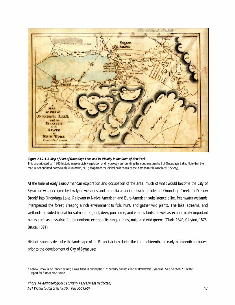
1878:137). A ca. 1800 map of the Syracuse vicinity (see Figure 2.1.2-1) substantiates this description of the vegetation
surrounding Onondaga Lake, showing uplands with oak, beech and chestnut southwest of the lake, and wetlands/salt
springs and varying combinations of black ash, soft maple, sedge, tamarack, hemlock, and cedar. The area of the APE
for Direct Effects is described as consisting of “soft maple, ash, and cedar swamp…hemlock swamp…cedar swamp…
(and) black ash, some tamarack, and much cedar”. This map also depicts uplands labeled as “beech & chestnut…oak”
in the areas surrounding Onondaga Lake and the Onondaga Creek Valley.
2 Note: the review of terminal Pleistocene/early Holocene climatic conditions presented herein focuses on broad, millennial-scale
trends at the rather than finer-grained decadal- and century-scale variations.
Phase 1A Archaeological Sensitivity Assessment (redacted)
I-81 Viaduct Project (NYSDOT PIN 3501.60) 17
Figure 2.1.2-1. A Map of Part of Onondaga Lake and its Vicinity in the State of New York.
This unattributed ca. 1800 historic map depicts vegetation and hydrology surrounding the southeastern half of Onondaga Lake. Note that the
map is not oriented north/south. (Unknown, N.D.; map from the digital collections of the American Philosophical Society).
At the time of early Euro-American exploration and occupation of the area, much of what would become the City of
Syracuse was occupied by low-lying wetlands and the delta associated with the inlets of Onondaga Creek and Yellow
Brook3 into Onondaga Lake. Relevant to Native American and Euro-American subsistence alike, freshwater wetlands
interspersed the forest, creating a rich environment to fish, hunt, and gather wild plants. The lake, streams, and
wetlands provided habitat for salmon trout, eel, deer, porcupine, and various birds, as well as economically important
plants such as sassafras (at the northern extent of its range), fruits, nuts, and wild greens (Clark, 1849; Clayton, 1878;
Bruce, 1891).
Historic sources describe the landscape of the Project vicinity during the late-eighteenth and early-nineteenth centuries,
prior to the development of City of Syracuse:
3 Yellow Brook is no longer extant; it was filled in during the 19th century construction of downtown Syracuse. See Section 2.6 of this
report for further discussion.
Phase 1A Archaeological Sensitivity Assessment (redacted)
I-81 Viaduct Project (NYSDOT PIN 3501.60) 18
“The dark, gloomy and almost impenetrable swamp, now occupied by the city [Syracuse] was then [1793] a
favorite resort for wolves, bears, wild-cats, mud-turtles, and swamp rattlesnakes. The western portion of the
valley about Syracuse, was originally timbered with hemlock, birch and soft maple; the eastern portion with
cedar and pine.” (Clark, 1849 Vol. 2:83)
“Even the great turnpike from east to west, finished in 1812, was thus constructed [i.e., in the “corduroy” style,
with logs laid in the mud perpendicular to the direction of the road] across the swampy jungle on which now
stands the business center of the city. And the Indian’s shunned it also, for their trails passed over the high
grounds on either side. Quite extensive tracts of this territory would not produce even forest trees of any
considerable size, and were overgrown by the rank shrubbery and large and small saplings that constitute the
ordinary cedar swamp. The Onondaga creek, then much greater in volume than now, wound its wonderfully
devious way from south to north across the tract, and the Yellow brook flowed into it from the northeastward,
trailing its sluggish current among the logs and sink-holes…” (Bruce, 1891:94)
“That portion of the city through which extends Onondaga street was in 1824 a cedar swamp with its many old
logs, stumps and trunks of fallen trees slowly going to decay and filling the air with noxious vapors. Wherever
the land was sufficiently firm and dry to afford a suitable soil, a very luxuriant growth of blackberry bushes had
sprung up.” (Bruce, 1891:122)
This landscape was radically transformed by urban development during the nineteenth and twentieth centuries. Section
2.6 of this report describes the history of landscape engineering and landfilling that set the stage for the development
of the City of Syracuse.
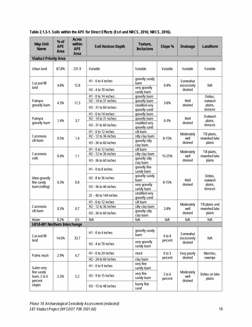
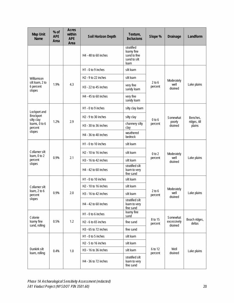
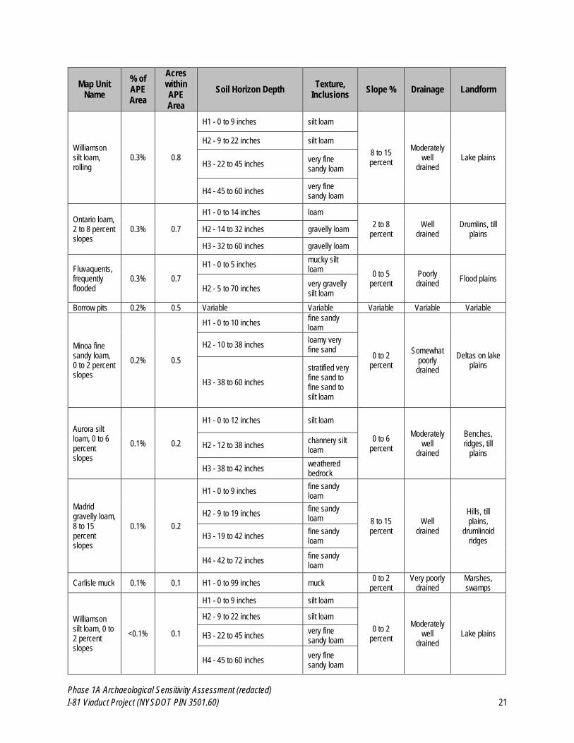
2.1.3 Soils within APE for Direct Effects
Dominant soils within Onondaga County are derived from parent limestone, shale, and siltstone. With the exception
of postglacial alluvium found on the flood plains, all other soils are glacially deposited. Given that the Syracuse area
was glaciated approximately 13,000 years ago4 (Yang, 1992; USGS, 2007), the soils in the vicinity are all relatively
young and closely related to their parent materials. Lairdsville, Lockport and Brockport soils formed from the clayey
Vernon Shale are the most common around Onondaga Lake (SCS, 1977). However, the APE for Direct Effects is
dominated by Urban Land, Cut and Fill Land, and Made Land, as well as several other mapped soil units present in
significantly smaller percentages (see Table 2.1.3-1 and Appendix A: Map 2; Esri and Natural Resources Conservation
Service [NRCS], 2016; NRCS, 2016).
4 All prehistoric dates are provided in calibrated radiocarbon years (i.e., calendar years) before present unless otherwise noted.
Phase 1A Archaeological Sensitivity Assessment (redacted)
I-81 Viaduct Project (NYSDOT PIN 3501.60) 19
Table 2.1.3-1. Soils within the APE for Direct Effects (Esri and NRCS, 2016; NRCS, 2016).
Map Unit Name
% of APE Area
Acres within APE Area
Soil Horizon Depth Texture,
Inclusions Slope % Drainage Landform
Viaduct Priority Area
Urban land 87.8% 231.9 Variable Variable Variable Variable Variable
Cut and fill land
4.8% 12.8
H1 - 0 to 4 inches gravelly sandy loam
0-8% Somewhat excessively
drained N/A
H2 - 4 to 70 inches very gravelly sandy loam
Palmyra gravelly loam
4.3% 11.3
H1 - 0 to 14 inches: gravelly loam
3-8% Well
drained
Deltas, outwash plains,
terraces
H2 - 14 to 31 inches: gravelly loam
H3 - 31 to 60 inches: stratified very gravelly sand
Palmyra gravelly loam
1.4% 3.7
H1 - 0 to 14 inches: gravelly loam
0-3% Well
drained
Outwash plains,
terraces
H2 - 14 to 31 inches: gravelly loam
H3 - 31 to 60 inches: stratified very gravelly sand
Cazenovia silt loam
0.5% 1.4
H1 - 0 to 12 inches silt loam
8-15% Moderately
well drained
Till plains, reworked lake
plains
H2 - 12 to 36 inches silty clay loam
H3 - 36 to 60 inches gravelly silty clay loam
Cazenovia soils
0.4% 1.1
H1 - 0 to 12 inches silt loam
15-25% Moderately
well drained
Till plains, reworked lake
plains
H2 - 12 to 36 inches silty clay loam
H3 - 36 to 60 inches gravelly silty clay loam
Alton gravelly fine sandy loam (rolling)
0.3% 0.8
H1 - 0 to 8 inches gravelly fine sandy loam
8-15% Well
drained
Deltas, outwash plains,
terraces
H2 - 8 to 36 inches gravelly sandy loam
H3 - 36 to 46 inches very gravelly sandy loam
2C - 46 to 144 inches stratified very gravelly sand
Cazenovia silt loam
0.3% 0.7
H1 - 0 to 12 inches silt loam
2-8% Moderately
well drained
Till plains and reworked lake
plains
H2 - 12 to 36 inches silty clay loam
H3 - 36 to 60 inches gravelly silty clay loam
Water 0.2% 0.5 N/A N/A N/A N/A N/A
I-81/I-481 Northern Interchange
Cut and fill land
14.6% 33.7
H1 - 0 to 4 inches gravelly sandy loam 0 to 8
percent
Somewhat excessively
drained N/A
H2 - 4 to 70 inches very gravelly sandy loam
Palms muck 2.9% 6.7 H1 - 0 to 24 inches muck 0 to 3
percent Very poorly
drained Marshes, swamps H2 - 24 to 60 inches clay loam
Galen very fine sandy loam, 2 to 6 percent slopes
2.2% 5.2
H1 - 0 to 9 inches very fine sandy loam
2 to 6 percent
Moderately well
drained
Deltas on lake plains
H2 - 9 to 15 inches very fine sandy loam
H3 - 15 to 48 inches loamy fine sand
Phase 1A Archaeological Sensitivity Assessment (redacted)
I-81 Viaduct Project (NYSDOT PIN 3501.60) 20
Map Unit Name
% of APE Area
Acres within APE Area
Soil Horizon Depth Texture,
Inclusions Slope % Drainage Landform
H4 - 48 to 60 inches
stratified loamy fine sand to fine sand to silt loam
Williamson silt loam, 2 to 6 percent slopes
1.9% 4.3
H1 - 0 to 9 inches silt loam
2 to 6 percent
Moderately well
drained Lake plains
H2 - 9 to 22 inches silt loam
H3 - 22 to 45 inches very fine sandy loam
H4 - 45 to 60 inches
very fine sandy loam
Lockport and Brockport silty clay loams, 0 to 6 percent slopes
1.2% 2.9
H1 - 0 to 9 inches silty clay loam
0 to 6 percent
Somewhat poorly
drained
Benches, ridges, till
plains
H2 - 9 to 30 inches silty clay
H3 - 30 to 36 inches channery silty clay
H4 - 36 to 40 inches weathered bedrock
Collamer silt loam, 0 to 2 percent slopes
0.9% 2.1
H1 - 0 to 10 inches silt loam
0 to 2 percent
Moderately well
drained Lake plains
H2 - 10 to 16 inches silt loam
H3 - 16 to 42 inches silt loam
H4 - 42 to 60 inches stratified silt loam to very fine sand
Collamer silt loam, 2 to 6 percent slopes
0.9% 2.0
H1 - 0 to 10 inches silt loam
2 to 6 percent
Moderately well
drained Lake plains
H2 - 10 to 16 inches silt loam
H3 - 16 to 42 inches silt loam
H4 - 42 to 60 inches stratified silt loam to very fine sand
Colonie loamy fine sand, rolling
0.5% 1.2
H1 - 0 to 6 inches loamy fine sand
8 to 15 percent
Somewhat excessively
drained
Beach ridges, deltas H2 - 6 to 65 inches fine sand
H3 - 65 to 72 inches fine sand
Dunkirk silt loam, rolling
0.4% 1.0
H1 - 0 to 5 inches silt loam
6 to 12 percent
Well drained
Lake plains
H2 - 5 to 16 inches silt loam
H3 - 16 to 36 inches silt loam
H4 - 36 to 72 inches stratified silt loam to very fine sand
Phase 1A Archaeological Sensitivity Assessment (redacted)
I-81 Viaduct Project (NYSDOT PIN 3501.60) 21
Map Unit Name
% of APE Area
Acres within APE Area
Soil Horizon Depth Texture,
Inclusions Slope % Drainage Landform
Williamson silt loam, rolling
0.3% 0.8
H1 - 0 to 9 inches silt loam
8 to 15 percent
Moderately well
drained Lake plains
H2 - 9 to 22 inches silt loam
H3 - 22 to 45 inches very fine sandy loam
H4 - 45 to 60 inches very fine sandy loam
Ontario loam, 2 to 8 percent slopes
0.3% 0.7
H1 - 0 to 14 inches loam
2 to 8 percent
Well drained
Drumlins, till plains
H2 - 14 to 32 inches gravelly loam
H3 - 32 to 60 inches gravelly loam
Fluvaquents, frequently flooded
0.3% 0.7
H1 - 0 to 5 inches mucky silt loam
0 to 5 percent
Poorly drained
Flood plains
H2 - 5 to 70 inches very gravelly silt loam
Borrow pits 0.2% 0.5 Variable Variable Variable Variable Variable
Minoa fine sandy loam, 0 to 2 percent slopes
0.2% 0.5
H1 - 0 to 10 inches fine sandy loam
0 to 2 percent
Somewhat poorly
drained
Deltas on lake plains
H2 - 10 to 38 inches loamy very fine sand
H3 - 38 to 60 inches
stratified very fine sand to fine sand to silt loam
Aurora silt loam, 0 to 6 percent slopes
0.1% 0.2
H1 - 0 to 12 inches silt loam
0 to 6 percent
Moderately well
drained
Benches, ridges, till
plains H2 - 12 to 38 inches
channery silt loam
H3 - 38 to 42 inches weathered bedrock
Madrid gravelly loam, 8 to 15 percent slopes
0.1% 0.2
H1 - 0 to 9 inches fine sandy loam
8 to 15 percent
Well drained
Hills, till plains,
drumlinoid ridges
H2 - 9 to 19 inches fine sandy loam
H3 - 19 to 42 inches fine sandy loam
H4 - 42 to 72 inches fine sandy loam
Carlisle muck 0.1% 0.1 H1 - 0 to 99 inches muck 0 to 2
percent Very poorly
drained Marshes, swamps
Williamson silt loam, 0 to 2 percent slopes
<0.1% 0.1
H1 - 0 to 9 inches silt loam
0 to 2 percent
Moderately well
drained Lake plains
H2 - 9 to 22 inches silt loam
H3 - 22 to 45 inches very fine sandy loam
H4 - 45 to 60 inches very fine sandy loam
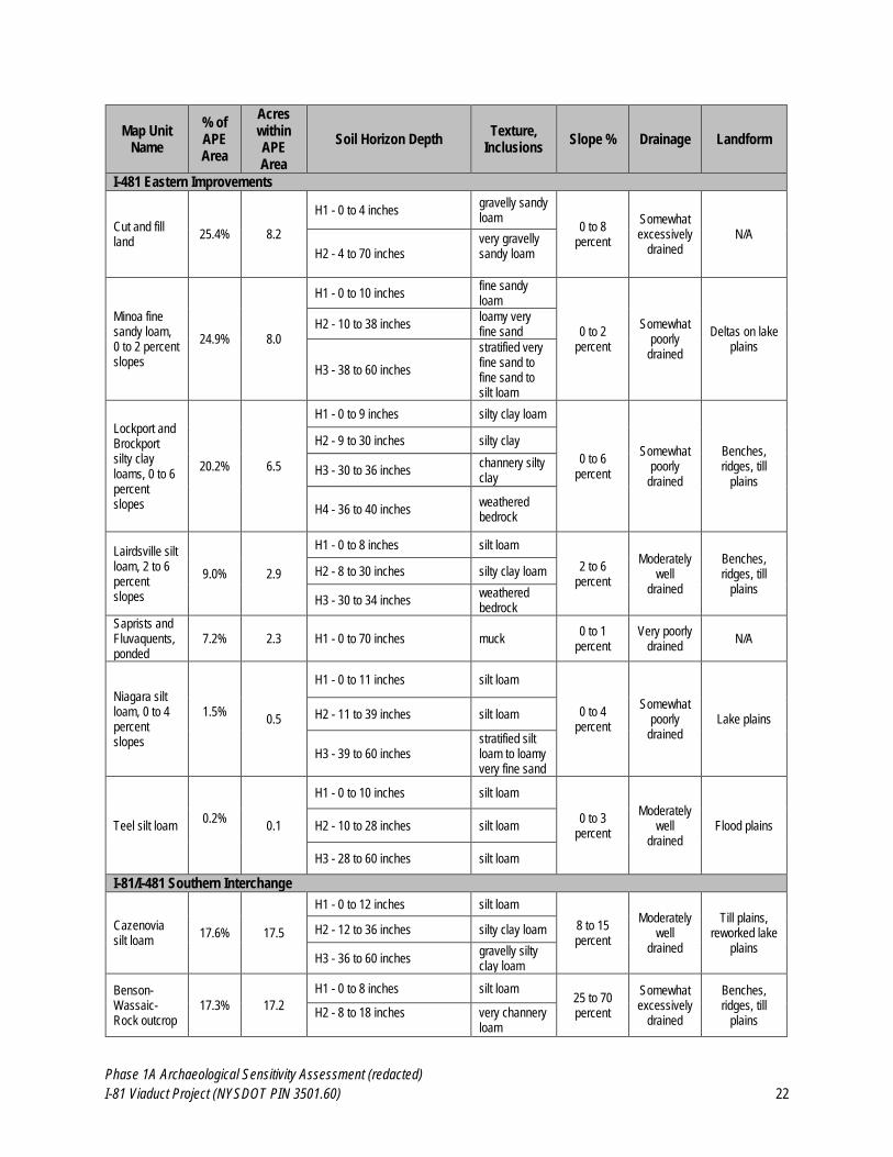
Phase 1A Archaeological Sensitivity Assessment (redacted)
I-81 Viaduct Project (NYSDOT PIN 3501.60) 22
Map Unit Name
% of APE Area
Acres within APE Area
Soil Horizon Depth Texture,
Inclusions Slope % Drainage Landform
I-481 Eastern Improvements
Cut and fill land
25.4% 8.2
H1 - 0 to 4 inches gravelly sandy loam
0 to 8 percent
Somewhat excessively
drained N/A
H2 - 4 to 70 inches very gravelly sandy loam
Minoa fine sandy loam, 0 to 2 percent slopes
24.9% 8.0
H1 - 0 to 10 inches fine sandy loam
0 to 2 percent
Somewhat poorly
drained
Deltas on lake plains
H2 - 10 to 38 inches loamy very fine sand
H3 - 38 to 60 inches
stratified very fine sand to fine sand to silt loam
Lockport and Brockport silty clay loams, 0 to 6 percent slopes
20.2% 6.5
H1 - 0 to 9 inches silty clay loam
0 to 6 percent
Somewhat poorly
drained
Benches, ridges, till
plains
H2 - 9 to 30 inches silty clay
H3 - 30 to 36 inches channery silty clay
H4 - 36 to 40 inches weathered bedrock
Lairdsville silt loam, 2 to 6 percent slopes
9.0% 2.9
H1 - 0 to 8 inches silt loam
2 to 6 percent
Moderately well
drained
Benches, ridges, till
plains
H2 - 8 to 30 inches silty clay loam
H3 - 30 to 34 inches weathered bedrock
Saprists and Fluvaquents, ponded
7.2% 2.3 H1 - 0 to 70 inches muck 0 to 1
percent Very poorly
drained N/A
Niagara silt loam, 0 to 4 percent slopes
1.5%
0.5
H1 - 0 to 11 inches silt loam
0 to 4 percent
Somewhat poorly
drained Lake plains H2 - 11 to 39 inches silt loam
H3 - 39 to 60 inches stratified silt loam to loamy very fine sand
Teel silt loam 0.2%
0.1
H1 - 0 to 10 inches silt loam
0 to 3 percent
Moderately well
drained Flood plains H2 - 10 to 28 inches silt loam
H3 - 28 to 60 inches silt loam
I-81/I-481 Southern Interchange
Cazenovia silt loam
17.6% 17.5
H1 - 0 to 12 inches silt loam
8 to 15 percent
Moderately well
drained
Till plains, reworked lake
plains
H2 - 12 to 36 inches silty clay loam
H3 - 36 to 60 inches gravelly silty clay loam
Benson-Wassaic-Rock outcrop
17.3% 17.2
H1 - 0 to 8 inches silt loam 25 to 70 percent
Somewhat excessively
drained
Benches, ridges, till
plains H2 - 8 to 18 inches
very channery loam
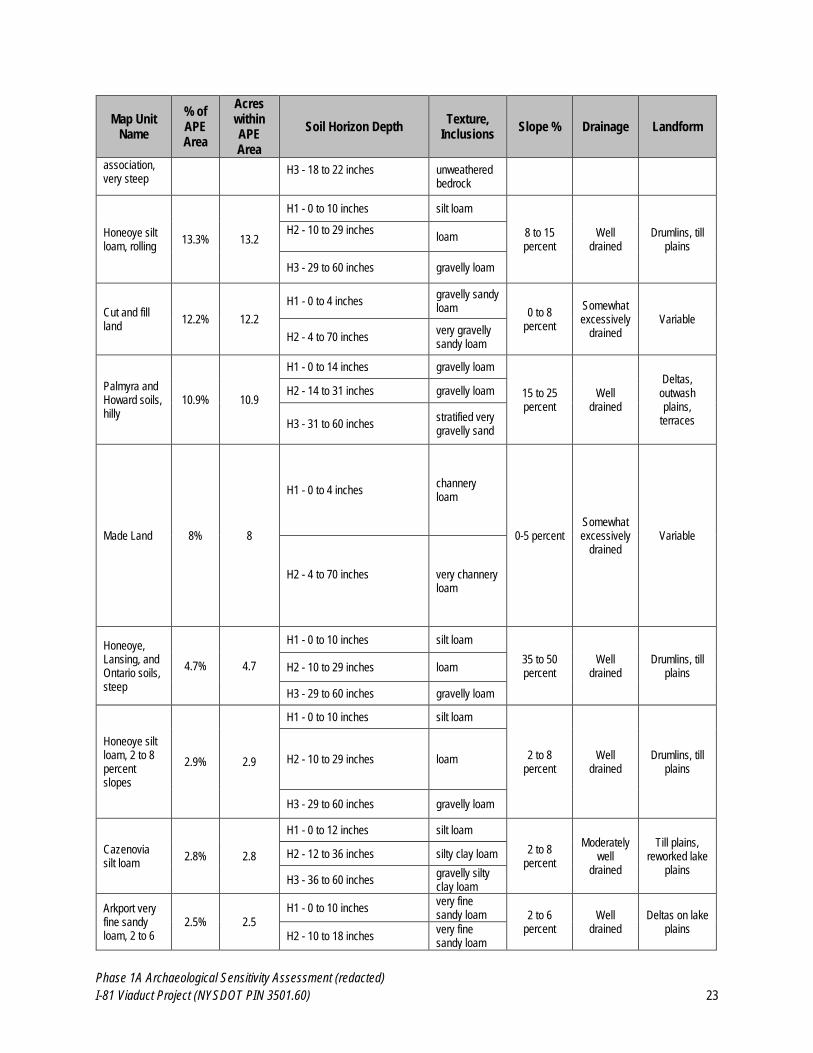
Phase 1A Archaeological Sensitivity Assessment (redacted)
I-81 Viaduct Project (NYSDOT PIN 3501.60) 23
Map Unit Name
% of APE Area
Acres within APE Area
Soil Horizon Depth Texture,
Inclusions Slope % Drainage Landform
association, very steep
H3 - 18 to 22 inches
unweathered bedrock
Honeoye silt loam, rolling
13.3% 13.2
H1 - 0 to 10 inches silt loam
8 to 15 percent
Well drained
Drumlins, till plains
H2 - 10 to 29 inches
loam
H3 - 29 to 60 inches gravelly loam
Cut and fill land
12.2% 12.2
H1 - 0 to 4 inches gravelly sandy loam 0 to 8
percent
Somewhat excessively
drained Variable
H2 - 4 to 70 inches very gravelly sandy loam
Palmyra and Howard soils, hilly
10.9% 10.9
H1 - 0 to 14 inches gravelly loam
15 to 25 percent
Well drained
Deltas, outwash plains,
terraces
H2 - 14 to 31 inches gravelly loam
H3 - 31 to 60 inches stratified very gravelly sand
Made Land 8% 8
H1 - 0 to 4 inches channery loam
0-5 percent Somewhat excessively
drained Variable
H2 - 4 to 70 inches
very channery loam
Honeoye, Lansing, and Ontario soils, steep
4.7% 4.7
H1 - 0 to 10 inches silt loam
35 to 50 percent
Well drained
Drumlins, till plains
H2 - 10 to 29 inches loam
H3 - 29 to 60 inches gravelly loam
Honeoye silt loam, 2 to 8 percent slopes
2.9% 2.9
H1 - 0 to 10 inches silt loam
2 to 8 percent
Well drained
Drumlins, till plains
H2 - 10 to 29 inches loam
H3 - 29 to 60 inches gravelly loam
Cazenovia silt loam
2.8% 2.8
H1 - 0 to 12 inches silt loam
2 to 8 percent
Moderately well
drained
Till plains, reworked lake
plains
H2 - 12 to 36 inches silty clay loam
H3 - 36 to 60 inches gravelly silty clay loam
Arkport very fine sandy loam, 2 to 6
2.5% 2.5
H1 - 0 to 10 inches very fine sandy loam 2 to 6
percent Well
drained Deltas on lake
plains H2 - 10 to 18 inches
very fine sandy loam
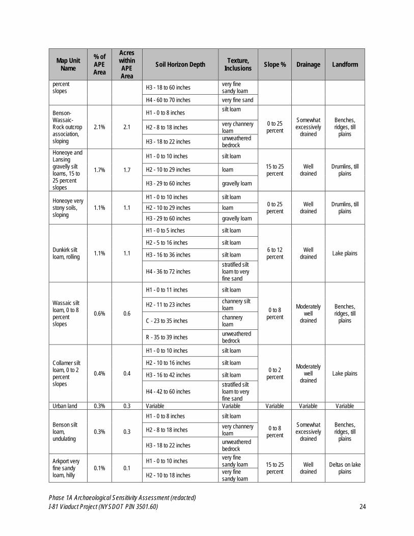
Phase 1A Archaeological Sensitivity Assessment (redacted)
I-81 Viaduct Project (NYSDOT PIN 3501.60) 24
Map Unit Name
% of APE Area
Acres within APE Area
Soil Horizon Depth Texture,
Inclusions Slope % Drainage Landform
percent slopes
H3 - 18 to 60 inches very fine sandy loam
H4 - 60 to 70 inches very fine sand
Benson-Wassaic-Rock outcrop association, sloping
2.1% 2.1
H1 - 0 to 8 inches silt loam
0 to 25 percent
Somewhat excessively
drained
Benches, ridges, till
plains H2 - 8 to 18 inches
very channery loam
H3 - 18 to 22 inches unweathered bedrock
Honeoye and Lansing gravelly silt loams, 15 to 25 percent slopes
1.7% 1.7
H1 - 0 to 10 inches silt loam
15 to 25 percent
Well drained
Drumlins, till plains
H2 - 10 to 29 inches loam
H3 - 29 to 60 inches gravelly loam
Honeoye very stony soils, sloping
1.1% 1.1
H1 - 0 to 10 inches silt loam
0 to 25 percent
Well drained
Drumlins, till plains
H2 - 10 to 29 inches loam
H3 - 29 to 60 inches gravelly loam
Dunkirk silt loam, rolling
1.1% 1.1
H1 - 0 to 5 inches silt loam
6 to 12 percent
Well drained
Lake plains
H2 - 5 to 16 inches silt loam
H3 - 16 to 36 inches silt loam
H4 - 36 to 72 inches stratified silt loam to very fine sand
Wassaic silt loam, 0 to 8 percent slopes
0.6% 0.6
H1 - 0 to 11 inches silt loam
0 to 8 percent
Moderately well
drained
Benches, ridges, till
plains
H2 - 11 to 23 inches channery silt loam
C - 23 to 35 inches channery loam
R - 35 to 39 inches unweathered bedrock
Collamer silt loam, 0 to 2 percent slopes
0.4% 0.4
H1 - 0 to 10 inches silt loam
0 to 2 percent
Moderately well
drained Lake plains
H2 - 10 to 16 inches silt loam
H3 - 16 to 42 inches silt loam
H4 - 42 to 60 inches stratified silt loam to very fine sand
Urban land 0.3% 0.3 Variable Variable Variable Variable Variable
Benson silt loam, undulating
0.3% 0.3
H1 - 0 to 8 inches silt loam
0 to 8 percent
Somewhat excessively
drained
Benches, ridges, till
plains
H2 - 8 to 18 inches very channery loam
H3 - 18 to 22 inches unweathered bedrock
Arkport very fine sandy loam, hilly
0.1% 0.1
H1 - 0 to 10 inches very fine sandy loam 15 to 25
percent Well
drained Deltas on lake
plains H2 - 10 to 18 inches
very fine sandy loam
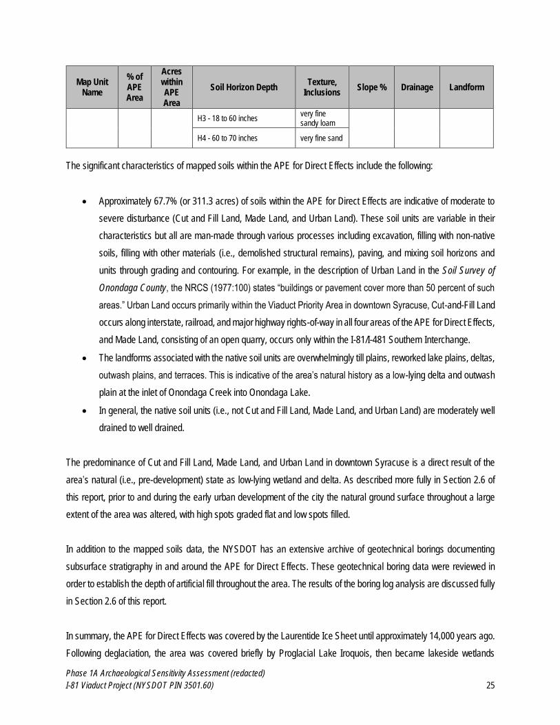
Phase 1A Archaeological Sensitivity Assessment (redacted)
I-81 Viaduct Project (NYSDOT PIN 3501.60) 25
Map Unit Name
% of APE Area
Acres within APE Area
Soil Horizon Depth Texture,
Inclusions Slope % Drainage Landform
H3 - 18 to 60 inches very fine sandy loam
H4 - 60 to 70 inches very fine sand
The significant characteristics of mapped soils within the APE for Direct Effects include the following:
Approximately 67.7% (or 311.3 acres) of soils within the APE for Direct Effects are indicative of moderate to
severe disturbance (Cut and Fill Land, Made Land, and Urban Land). These soil units are variable in their
characteristics but all are man-made through various processes including excavation, filling with non-native
soils, filling with other materials (i.e., demolished structural remains), paving, and mixing soil horizons and
units through grading and contouring. For example, in the description of Urban Land in the Soil Survey of
Onondaga County, the NRCS (1977:100) states “buildings or pavement cover more than 50 percent of such
areas.” Urban Land occurs primarily within the Viaduct Priority Area in downtown Syracuse, Cut-and-Fill Land
occurs along interstate, railroad, and major highway rights-of-way in all four areas of the APE for Direct Effects,
and Made Land, consisting of an open quarry, occurs only within the I-81/I-481 Southern Interchange.
The landforms associated with the native soil units are overwhelmingly till plains, reworked lake plains, deltas,
outwash plains, and terraces. This is indicative of the area’s natural history as a low-lying delta and outwash
plain at the inlet of Onondaga Creek into Onondaga Lake.
In general, the native soil units (i.e., not Cut and Fill Land, Made Land, and Urban Land) are moderately well
drained to well drained.
The predominance of Cut and Fill Land, Made Land, and Urban Land in downtown Syracuse is a direct result of the
area’s natural (i.e., pre-development) state as low-lying wetland and delta. As described more fully in Section 2.6 of
this report, prior to and during the early urban development of the city the natural ground surface throughout a large
extent of the area was altered, with high spots graded flat and low spots filled.
In addition to the mapped soils data, the NYSDOT has an extensive archive of geotechnical borings documenting
subsurface stratigraphy in and around the APE for Direct Effects. These geotechnical boring data were reviewed in
order to establish the depth of artificial fill throughout the area. The results of the boring log analysis are discussed fully
in Section 2.6 of this report.
In summary, the APE for Direct Effects was covered by the Laurentide Ice Sheet until approximately 14,000 years ago.
Following deglaciation, the area was covered briefly by Proglacial Lake Iroquois, then became lakeside wetlands
Phase 1A Archaeological Sensitivity Assessment (redacted)
I-81 Viaduct Project (NYSDOT PIN 3501.60) 26
around the deltas of Onondaga Creek and Yellow Brook where they fed into Onondaga Lake. In the historic period, the
area has experienced significant earth disturbance, consisting of leveling high spots and filling wetlands, associated
with the development of the City of Syracuse. Mapped soils within the APE for Direct Effects are for the most part Cut
and Fill Land, Made Land, and Urban Land, which indicates that portions of the APE for Direct Effects have been
experienced significant prior ground disturbance.
2.2 Previously Identified Archaeological Sites
In the Archaeological History of New York State, Parker (1922:636) notes that “Onondaga County contains perhaps
more abundant traces of aboriginal occupation than any other [county] in the state.” This statement in part reflects
Parker’s (1922) focus on Late Prehistoric and Protohistoric period Haudenosaunee villages, many of which were
located in Onondaga County. It also reflects the extent to which the early-twentieth-century understanding of Native
American Archaeology in New York was shaped by William M. Beauchamp and his seminal work Aboriginal Occupation
of New York (Beauchamp, 1900). Beauchamp based his work largely on previously published accounts; however, as
a longtime resident of Syracuse and Baldwinsville, his personal knowledge of New York State archaeology may have
been disproportionately greater for the area surrounding Onondaga Lake.
Nonetheless, Onondaga County contains a substantial number of Pre-Contact Native American archaeological sites
and finds, spanning the entire prehistory of human occupation in the area (Figure 2.2-1). Ritchie (1957; 1980) and
Lothrop et al. (2014) have noted moderate to high densities of Paleoindian archaeological sites within the footprint of
Proglacial Lake Iroquois, several of which occur in northern Onondaga County. The Archaic and Early Woodland
Brewerton Sites occur partially within the county (Ritchie, 1946; 1971) as does the Late Archaic and Middle Woodland
Robert Simonds Site (New York State Museum [NYSM], 2012) and the Middle Woodland Kipp Island Site (Ritchie,
1980). These last two sites both occur on the Seneca River in Onondaga County. The Late Woodland and Contact
eras are the best represented archaeological periods in Onondaga County. Terminal Late Woodland/Contact Period
villages and settlements associated with the Onondaga Nation of the Haudenosaunee are known from the Limestone
Creek and Onondaga Creek Valleys (Jones, 2006; 2010; Tuck, 1971), as well as from the shores of Onondaga Lake
(Fischer, 2008; Parker, 1922). Prehistoric and contact era cultural contexts are presented in Section 2.4.1 and 2.4.2 of
this report, respectively.
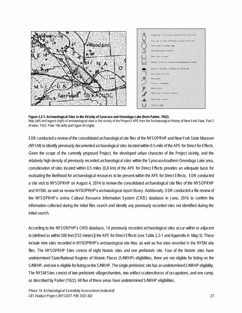
Phase 1A Archaeological Sensitivity Assessment (redacted)
I-81 Viaduct Project (NYSDOT PIN 3501.60) 27
Figure 2.2-1. Archaeological Sites in the Vicinity of Syracuse and Onondaga Lake (from Parker, 1922). Map (left) and legend (right) of archaeological sites in the vicinity of the Project’s APE from the Archaeological History of New York State, Part 2
(Parker, 1922: Plate 196 (left) and Figure 69 (right).
EDR conducted a review of the consolidated archaeological site files of the NYSOPRHP and New York State Museum
(NYSM) to identify previously documented archaeological sites located within 0.5-mile of the APE for Direct for Effects.
Given the scope of the currently proposed Project, the developed urban character of the Project vicinity, and the
relatively high density of previously recorded archaeological sites within the Syracuse/southern Onondaga Lake area,
consideration of sites located within 0.5 miles (0.8 km) of the APE for Direct Effects provides an adequate basis for
evaluating the likelihood for archaeological resources to be present within the APE for Direct Effects. EDR conducted
a site visit to NYSOPRHP on August 4, 2014 to review the consolidated archaeological site files of the NYSOPRHP
and NYSM, as well as review NYSOPRHP’s archaeological report library. Additionally, EDR conducted a file review of
the NYSOPRHP’s online Cultural Resource Information System (CRIS) database in June, 2016 to confirm the
information collected during the initial files search and identify any previously recorded sites not identified during the
initial search.
According to the NYSORPHP’s CRIS database, 14 previously recorded archaeological sites occur within or adjacent
to (defined as within 500 feet [152 meters]) the APE for Direct Effects (see Table 2.2-1 and Appendix A: Map 3). These
include nine sites recorded in NYSOPRHP’s archaeological site files, as well as five sites recorded in the NYSM site
files. The NYSOPRHP Sites consist of eight historic sites and one prehistoric site. Four of the historic sites have
undetermined State/National Register of Historic Places (S/NRHP) eligibilities, three are not eligible for listing on the
S/NRHP, and one is eligible for listing on the S/NRHP. The single prehistoric site has an undetermined S/NRHP eligibility.
The NYSM Sites consist of two prehistoric villages/hamlets, two artifact scatters/traces of occupations, and one camp,
as described by Parker (1922). All five of these areas have undetermined S/NRHP eligibilities.
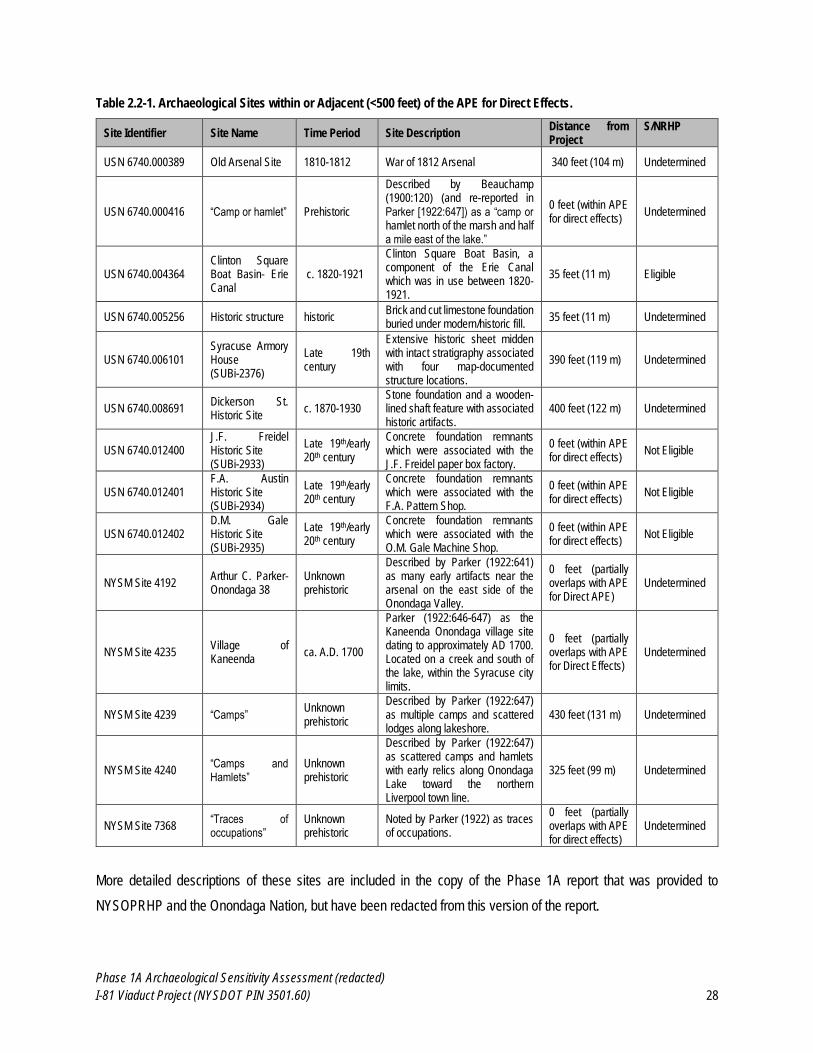
Phase 1A Archaeological Sensitivity Assessment (redacted)
I-81 Viaduct Project (NYSDOT PIN 3501.60) 28
Table 2.2-1. Archaeological Sites within or Adjacent (<500 feet) of the APE for Direct Effects.
Site Identifier Site Name Time Period Site Description Distance from Project
S/NRHP
USN 6740.000389 Old Arsenal Site 1810-1812 War of 1812 Arsenal 340 feet (104 m) Undetermined
USN 6740.000416 “Camp or hamlet” Prehistoric
Described by Beauchamp (1900:120) (and re-reported in Parker [1922:647]) as a “camp or hamlet north of the marsh and half a mile east of the lake.”
0 feet (within APE for direct effects)
Undetermined
USN 6740.004364 Clinton Square Boat Basin- Erie Canal
c. 1820-1921
Clinton Square Boat Basin, a component of the Erie Canal which was in use between 1820-1921.
35 feet (11 m) Eligible
USN 6740.005256 Historic structure historic Brick and cut limestone foundation buried under modern/historic fill.
35 feet (11 m) Undetermined
USN 6740.006101 Syracuse Armory House (SUBi-2376)
Late 19th century
Extensive historic sheet midden with intact stratigraphy associated with four map-documented structure locations.
390 feet (119 m) Undetermined
USN 6740.008691 Dickerson St. Historic Site
c. 1870-1930 Stone foundation and a wooden-lined shaft feature with associated historic artifacts.
400 feet (122 m) Undetermined
USN 6740.012400 J.F. Freidel Historic Site (SUBi-2933)
Late 19th/early 20th century
Concrete foundation remnants which were associated with the J.F. Freidel paper box factory.
0 feet (within APE for direct effects)
Not Eligible
USN 6740.012401 F.A. Austin Historic Site (SUBi-2934)
Late 19th/early 20th century
Concrete foundation remnants which were associated with the F.A. Pattern Shop.
0 feet (within APE for direct effects)
Not Eligible
USN 6740.012402 D.M. Gale Historic Site (SUBi-2935)
Late 19th/early 20th century
Concrete foundation remnants which were associated with the O.M. Gale Machine Shop.
0 feet (within APE for direct effects)
Not Eligible
NYSM Site 4192 Arthur C. Parker- Onondaga 38
Unknown prehistoric
Described by Parker (1922:641) as many early artifacts near the arsenal on the east side of the Onondaga Valley.
0 feet (partially overlaps with APE for Direct APE)
Undetermined
NYSM Site 4235 Village of Kaneenda
ca. A.D. 1700
Parker (1922:646-647) as the Kaneenda Onondaga village site dating to approximately AD 1700. Located on a creek and south of the lake, within the Syracuse city limits.
0 feet (partially overlaps with APE for Direct Effects)
Undetermined
NYSM Site 4239 “Camps” Unknown prehistoric
Described by Parker (1922:647) as multiple camps and scattered lodges along lakeshore.
430 feet (131 m) Undetermined
NYSM Site 4240 “Camps and Hamlets”
Unknown prehistoric
Described by Parker (1922:647) as scattered camps and hamlets with early relics along Onondaga Lake toward the northern Liverpool town line.
325 feet (99 m) Undetermined
NYSM Site 7368 “Traces of occupations”
Unknown prehistoric
Noted by Parker (1922) as traces of occupations.
0 feet (partially overlaps with APE for direct effects)
Undetermined
More detailed descriptions of these sites are included in the copy of the Phase 1A report that was provided to
NYSOPRHP and the Onondaga Nation, but have been redacted from this version of the report.
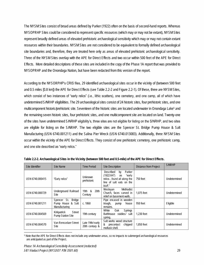
Phase 1A Archaeological Sensitivity Assessment (redacted)
I-81 Viaduct Project (NYSDOT PIN 3501.60) 29
The NYSM Sites consist of broad areas defined by Parker (1922) often on the basis of second-hand reports. Whereas
NYSOPRHP Sites could be considered to represent specific resources (which may or may not be extant), NYSM Sites
represent broadly defined areas of elevated prehistoric archaeological sensitivity which may or may not contain extant
resources within their boundaries. NYSM Sites are not considered to be equivalent to formally defined archaeological
site boundaries and, therefore, they are treated here only as areas of elevated prehistoric archaeological sensitivity.
Three of the NYSM Sites overlap with the APE for Direct Effects and two occur within 500 feet of the APE for Direct
Effects. More detailed descriptions of these sites are included in the copy of the Phase 1A report that was provided to
NYSOPRHP and the Onondaga Nation, but have been redacted from this version of the report.
According to the NYSORPHP’s CRIS files, 29 identified archaeological sites occur in the vicinity of (between 500 feet
and 0.5 miles [0.8 km]) the APE for Direct Effects (see Table 2.2-2 and Figure 2.2-1). Of these, three are NYSM Sites,
which consist of two instances of “early relics” (i.e., lithic scatters), one cemetery, and one camp, all of which have
undetermined S/NRHP eligibilities. The 29 archaeological sites consist of 24 historic sites, four prehistoric sites, and one
multicomponent historic/prehistoric site. Seventeen of the historic sites are located underwater in Onondaga Lake5 and
the remaining seven historic sites, four prehistoric sites, and one multicomponent site are located on land. Twenty-one
of the sites have undetermined S/NRHP eligibility’s, three sites are not eligible for listing on the S/NRHP, and two sites
are eligible for listing on the S/NRHP. The two eligible sites are the Spencer St. Bridge Pump House & Salt
Manufacturing (USN 6740.001211) and the Salina Pier Wreck (USN 6740.013083). Additionally, three NYSM Sites
occur within the vicinity of the APE for Direct Effects. They consist of one prehistoric cemetery, one prehistoric camp,
and one site described as “early relics.”
Table 2.2-2. Archaeological Sites in the Vicinity (between 500 feet and 0.5-mile) of the APE for Direct Effects.
Site Identifier Site Name Time Period Site Description Distance from Project S/NRHP
USN 6740.000415 “Early relics” Unknown prehistoric
Described by Parker (1922:647) as “early relics…found all along the line of salt vats on the bluff.”
750 feet Undetermined
USN 6740.000729 Underground Railroad Site
19th & 20th Century
Wesleyan Methodist Church, faces carved in relief on basement walls.
1,075 feet Undetermined
USN 6740.001211 Spencer St. Bridge Pump House & Salt Manufacturing
c. 1860 Pipe encased in wooden trough, pump house remains.
950 feet Eligible
USN 6740.004569 Kirkpatrick Street Pump Station Site
19th century White Oak Springs Bathhouse stables/ salt spring.
1,230 feet Undetermined
USN 6740.004570 Van Rensselaer Street Site
Late 19th/ early 20th century &
Salt works wood structure & precontact chipped mollusk shell.
1,850 feet Undetermined
5 Note that the APE for Direct Effects does not include any underwater areas, so no impacts to submerged archaeological resources
are anticipated as part of the Project.
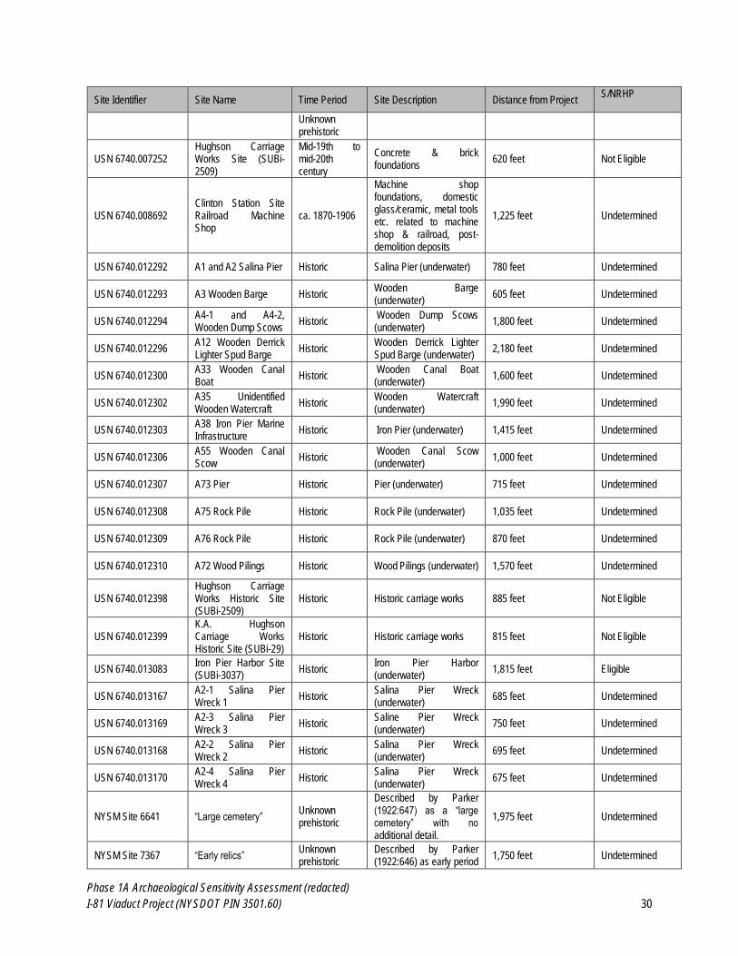
Phase 1A Archaeological Sensitivity Assessment (redacted)
I-81 Viaduct Project (NYSDOT PIN 3501.60) 30
Site Identifier Site Name Time Period Site Description Distance from Project S/NRHP
Unknown prehistoric
USN 6740.007252 Hughson Carriage Works Site (SUBi-2509)
Mid-19th to mid-20th century
Concrete & brick foundations
620 feet Not Eligible
USN 6740.008692 Clinton Station Site Railroad Machine Shop
ca. 1870-1906
Machine shop foundations, domestic glass/ceramic, metal tools etc. related to machine shop & railroad, post-demolition deposits
1,225 feet Undetermined
USN 6740.012292 A1 and A2 Salina Pier Historic Salina Pier (underwater) 780 feet Undetermined
USN 6740.012293 A3 Wooden Barge Historic Wooden Barge (underwater)
605 feet Undetermined
USN 6740.012294 A4-1 and A4-2, Wooden Dump Scows
Historic Wooden Dump Scows (underwater)
1,800 feet Undetermined
USN 6740.012296 A12 Wooden Derrick Lighter Spud Barge
Historic Wooden Derrick Lighter Spud Barge (underwater)
2,180 feet Undetermined
USN 6740.012300 A33 Wooden Canal Boat
Historic Wooden Canal Boat (underwater)
1,600 feet Undetermined
USN 6740.012302 A35 Unidentified Wooden Watercraft
Historic Wooden Watercraft (underwater)
1,990 feet Undetermined
USN 6740.012303 A38 Iron Pier Marine Infrastructure
Historic Iron Pier (underwater) 1,415 feet Undetermined
USN 6740.012306 A55 Wooden Canal Scow
Historic Wooden Canal Scow (underwater)
1,000 feet Undetermined
USN 6740.012307 A73 Pier Historic Pier (underwater) 715 feet Undetermined
USN 6740.012308 A75 Rock Pile Historic Rock Pile (underwater) 1,035 feet Undetermined
USN 6740.012309 A76 Rock Pile Historic Rock Pile (underwater) 870 feet Undetermined
USN 6740.012310 A72 Wood Pilings Historic Wood Pilings (underwater) 1,570 feet Undetermined
USN 6740.012398 Hughson Carriage Works Historic Site (SUBi-2509)
Historic Historic carriage works 885 feet Not Eligible
USN 6740.012399 K.A. Hughson Carriage Works Historic Site (SUBi-29)
Historic Historic carriage works 815 feet Not Eligible
USN 6740.013083 Iron Pier Harbor Site (SUBi-3037)
Historic Iron Pier Harbor (underwater)
1,815 feet Eligible
USN 6740.013167 A2-1 Salina Pier Wreck 1
Historic Salina Pier Wreck (underwater)
685 feet Undetermined
USN 6740.013169 A2-3 Salina Pier Wreck 3
Historic Saline Pier Wreck (underwater)
750 feet Undetermined
USN 6740.013168 A2-2 Salina Pier Wreck 2
Historic Salina Pier Wreck (underwater)
695 feet Undetermined
USN 6740.013170 A2-4 Salina Pier Wreck 4
Historic Salina Pier Wreck (underwater)
675 feet Undetermined
NYSM Site 6641 “Large cemetery” Unknown prehistoric
Described by Parker (1922:647) as a “large cemetery” with no additional detail.
1,975 feet Undetermined
NYSM Site 7367 “Early relics” Unknown prehistoric
Described by Parker (1922:646) as early period
1,750 feet Undetermined
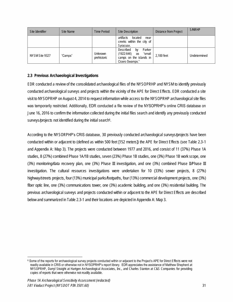
Phase 1A Archaeological Sensitivity Assessment (redacted)
I-81 Viaduct Project (NYSDOT PIN 3501.60) 31
Site Identifier Site Name Time Period Site Description Distance from Project S/NRHP
artifacts located near creeks within the city of Syracuse.
NYSM Site 9327 “Camps” Unknown prehistoric
Described by Parker (1922:646) as “small camps on the islands in Cicero Swamps.”
2,100 feet Undetermined
2.3 Previous Archaeological Investigations
EDR conducted a review of the consolidated archaeological files of the NYSOPRHP and NYSM to identify previously
conducted archaeological surveys and projects within the vicinity of the APE for Direct Effects. EDR conducted a site
visit to NYSOPRHP on August 4, 2014 to request information while access to the NYSOPRHP archaeological site files
was temporarily restricted. Additionally, EDR conducted a file review of the NYSOPRHP’s online CRIS database on
June 16, 2016 to confirm the information collected during the initial files search and identify any previously conducted
surveys/projects not identified during the initial search6.
According to the NYSORPHP’s CRIS database, 30 previously conducted archaeological surveys/projects have been
conducted within or adjacent to (defined as within 500 feet [152 meters]) the APE for Direct Effects (see Table 2.3-1
and Appendix A: Map 3). The projects were conducted between 1977 and 2016, and consist of 11 (37%) Phase 1A
studies, 8 (27%) combined Phase 1A/1B studies, seven (23%) Phase 1B studies, one (3%) Phase 1B work scope, one
(3%) monitoring/data recovery plan, one (3%) Phase III investigation, and one (3%) combined Phase II/Phase III
investigation. The cultural resources investigations were undertaken for 10 (33%) sewer projects, 8 (27%)
highway/streets projects, four (13%) municipal parks/footpaths, four (13%) commercial development projects, one (3%)
fiber optic line, one (3%) communications tower, one (3%) academic building, and one (3%) residential building. The
previous archaeological surveys and projects conducted within or adjacent to the APE for Direct Effects are described
below and summarized in Table 2.3-1 and their locations are depicted in Appendix A: Map 3.
6 Some of the reports for archaeological survey projects conducted within or adjacent to the Project’s APE for Direct Effects were not
readily available in CRIS or otherwise not in NYSOPRHP’s report library. EDR appreciates the assistance of Matthew Shepherd at NYSOPRHP, Darryl Straight at Hartgen Archaeological Associates, Inc., and Charles Stanton at C&S Companies for providing copies of reports that were otherwise not readily available.
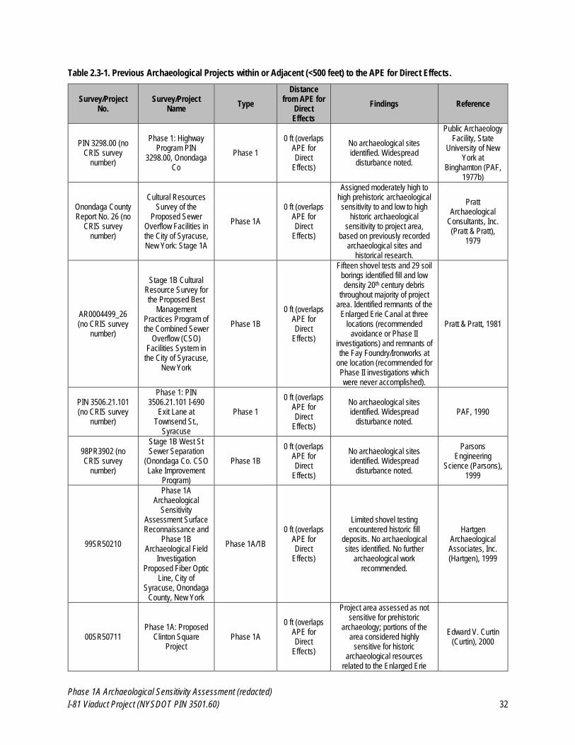
Phase 1A Archaeological Sensitivity Assessment (redacted)
I-81 Viaduct Project (NYSDOT PIN 3501.60) 32
Table 2.3-1. Previous Archaeological Projects within or Adjacent (<500 feet) to the APE for Direct Effects.
Survey/Project No.
Survey/Project Name
Type
Distance from APE for
Direct Effects
Findings Reference
PIN 3298.00 (no CRIS survey
number)
Phase 1: Highway Program PIN
3298.00, Onondaga Co
Phase 1
0 ft (overlaps APE for Direct
Effects)
No archaeological sites identified. Widespread
disturbance noted.
Public Archaeology Facility, State
University of New York at
Binghamton (PAF, 1977b)
Onondaga County Report No. 26 (no
CRIS survey number)
Cultural Resources Survey of the
Proposed Sewer Overflow Facilities in the City of Syracuse, New York: Stage 1A
Phase 1A
0 ft (overlaps APE for Direct
Effects)
Assigned moderately high to high prehistoric archaeological sensitivity to and low to high
historic archaeological sensitivity to project area,
based on previously recorded archaeological sites and
historical research.
Pratt Archaeological
Consultants, Inc. (Pratt & Pratt),
1979
AR0004499_26 (no CRIS survey
number)
Stage 1B Cultural Resource Survey for the Proposed Best
Management Practices Program of the Combined Sewer
Overflow (CSO) Facilities System in
the City of Syracuse, New York
Phase 1B
0 ft (overlaps APE for Direct
Effects)
Fifteen shovel tests and 29 soil borings identified fill and low density 20th century debris
throughout majority of project area. Identified remnants of the
Enlarged Erie Canal at three locations (recommended
avoidance or Phase II investigations) and remnants of the Fay Foundry/Ironworks at
one location (recommended for Phase II investigations which were never accomplished).
Pratt & Pratt, 1981
PIN 3506.21.101 (no CRIS survey
number)
Phase 1: PIN 3506.21.101 I-690
Exit Lane at Townsend St.,
Syracuse
Phase 1
0 ft (overlaps APE for Direct
Effects)
No archaeological sites identified. Widespread
disturbance noted. PAF, 1990
98PR3902 (no CRIS survey
number)
Stage 1B West St Sewer Separation
(Onondaga Co. CSO Lake Improvement
Program)
Phase 1B
0 ft (overlaps APE for Direct
Effects)
No archaeological sites identified. Widespread
disturbance noted.
Parsons Engineering
Science (Parsons), 1999
99SR50210
Phase 1A Archaeological
Sensitivity Assessment Surface Reconnaissance and
Phase 1B Archaeological Field
Investigation Proposed Fiber Optic
Line, City of Syracuse, Onondaga
County, New York
Phase 1A/1B
0 ft (overlaps APE for Direct
Effects)
Limited shovel testing encountered historic fill
deposits. No archaeological sites identified. No further
archaeological work recommended.
Hartgen Archaeological Associates, Inc. (Hartgen), 1999
00SR50711 Phase 1A: Proposed
Clinton Square Project
Phase 1A
0 ft (overlaps APE for Direct
Effects)
Project area assessed as not sensitive for prehistoric
archaeology; portions of the area considered highly
sensitive for historic archaeological resources
related to the Enlarged Erie
Edward V. Curtin (Curtin), 2000
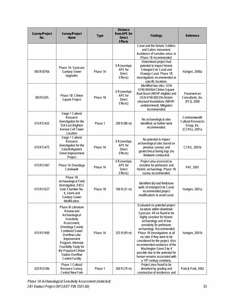
Phase 1A Archaeological Sensitivity Assessment (redacted)
I-81 Viaduct Project (NYSDOT PIN 3501.60) 33
Survey/Project No.
Survey/Project Name
Type
Distance from APE for
Direct Effects
Findings Reference
Canal and the historic Soldiers and Sailors monument.
Avoidance of sensitive areas or Phase 1B recommended.
00SR50766 Phase 1A: Syracuse
Sanitary Sewer Upgrades
Phase 1A
0 ft (overlaps APE for Direct
Effects)
Determined project had potential to impact historic Enlarged Erie Canal and Oswego Canal. Phase 1B
investigations recommended at specific locations.
Hartgen, 2000a
00SR5205 Phase 1B: Clinton
Square Project Phase 1B
0 ft (overlaps APE for Direct
Effects)
Identified two sites: USN 6740.004364-Clinton Square
Boat Basin (NRHP-eligible) and USN 6740.005256-historic
structural foundations (NRHP-undetermined). Mitigation
recommended.
Panamerican Consultants, Inc.
(PCI), 2000
01SR51425
Stage 1 Cultural Resource
Investigation for the 554 East Brighton Avenue Cell Tower
Location
Phase 1 290 ft (88 m) No archaeological sites
identified; no further work recommended.
Commonwealth Cultural Resources
Group, Inc. (CCRG), 2001a
01SR51475
Stage 1 Cultural Resource
Investigation for the Solar/Kirkpatrick
Street Improvement Project
Phase 1A
0 ft (overlaps APE for Direct
Effects)
No potential to impact archaeological sites based on
previous surveys and geotechnical boring logs (no
fieldwork conducted)
CCRG, 2001b
01SR51587
Phase 1A Onondaga Creekwalk
Phase 1A
0 ft (overlaps APE for Direct
Effects)
Project area assessed as sensitive for prehistoric and
historic archaeology. Phase 1B survey recommended.
PAF, 2001
01SR51627
Phase 1B Archaeological Field Investigation, EBSS Gate Chamber No.
4, Storm and Sanitary Sewer
Modification.
Phase 1B 100 ft (31 m)
Identified dry-laid fieldstone walls of enlarged Erie Canal;
recommended project modifications to avoid canal.
Hartgen, 2001a
01SR51900
Phase IA Literature Review and
Archaeological Sensitivity
Assessment, Onondaga County Combined Sewer
Overflow Lake Improvement
Program: Alternate Feasibility Study for
the Proposed Clinton Station Overflow Control Facility
Phase 1A 325 ft (99 m)
Evaluated six potential project locations within downtown
Syracuse. All six found to be highly sensitive for historic
archaeology and of low sensitivity for prehistoric
archaeology. Recommended Phase 1B investigations at all
six sites if they were to be considered for the project. Also recommended avoidance of the
Washington Street Site if possible due to the potential for human remains associated with
a 19th century cemetery.
Hartgen, 2001b
02SR53186 Phase 1 Cultural Resource Survey, Central New York
Phase 1 260 ft (79 m) Project area found to be disturbed by grading and
construction of residences and Pratt & Pratt, 2002
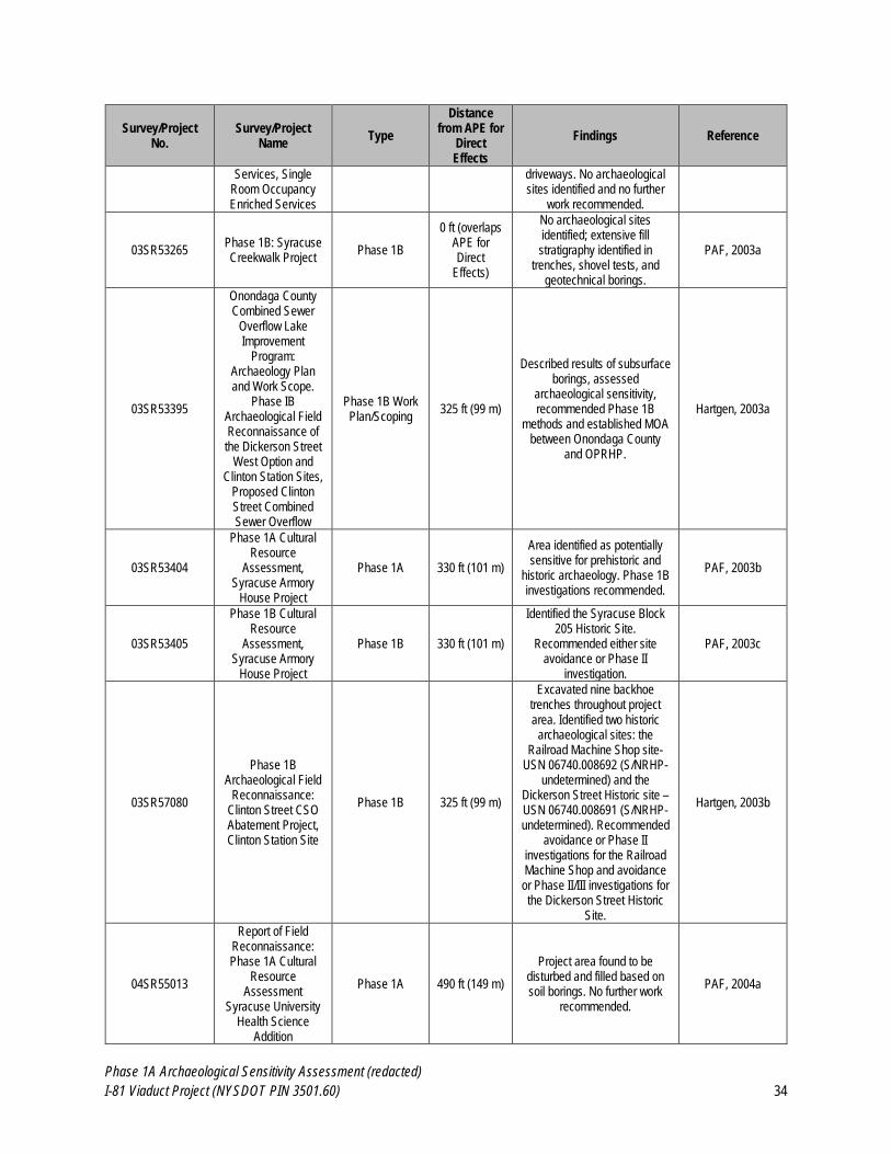
Phase 1A Archaeological Sensitivity Assessment (redacted)
I-81 Viaduct Project (NYSDOT PIN 3501.60) 34
Survey/Project No.
Survey/Project Name
Type
Distance from APE for
Direct Effects
Findings Reference
Services, Single Room Occupancy Enriched Services
driveways. No archaeological sites identified and no further
work recommended.
03SR53265 Phase 1B: Syracuse Creekwalk Project
Phase 1B
0 ft (overlaps APE for Direct
Effects)
No archaeological sites identified; extensive fill stratigraphy identified in
trenches, shovel tests, and geotechnical borings.
PAF, 2003a
03SR53395
Onondaga County Combined Sewer
Overflow Lake Improvement
Program: Archaeology Plan and Work Scope.
Phase IB Archaeological Field Reconnaissance of the Dickerson Street
West Option and Clinton Station Sites,
Proposed Clinton Street Combined Sewer Overflow
Phase 1B Work Plan/Scoping
325 ft (99 m)
Described results of subsurface borings, assessed
archaeological sensitivity, recommended Phase 1B
methods and established MOA between Onondaga County
and OPRHP.
Hartgen, 2003a
03SR53404
Phase 1A Cultural Resource
Assessment, Syracuse Armory
House Project
Phase 1A 330 ft (101 m)
Area identified as potentially sensitive for prehistoric and
historic archaeology. Phase 1B investigations recommended.
PAF, 2003b
03SR53405
Phase 1B Cultural Resource
Assessment, Syracuse Armory
House Project
Phase 1B 330 ft (101 m)
Identified the Syracuse Block 205 Historic Site.
Recommended either site avoidance or Phase II
investigation.
PAF, 2003c
03SR57080
Phase 1B Archaeological Field
Reconnaissance: Clinton Street CSO Abatement Project, Clinton Station Site
Phase 1B 325 ft (99 m)
Excavated nine backhoe trenches throughout project area. Identified two historic
archaeological sites: the Railroad Machine Shop site-
USN 06740.008692 (S/NRHP-undetermined) and the
Dickerson Street Historic site – USN 06740.008691 (S/NRHP-undetermined). Recommended
avoidance or Phase II investigations for the Railroad Machine Shop and avoidance or Phase II/III investigations for the Dickerson Street Historic
Site.
Hartgen, 2003b
04SR55013
Report of Field Reconnaissance: Phase 1A Cultural
Resource Assessment
Syracuse University Health Science
Addition
Phase 1A 490 ft (149 m)
Project area found to be disturbed and filled based on soil borings. No further work
recommended.
PAF, 2004a
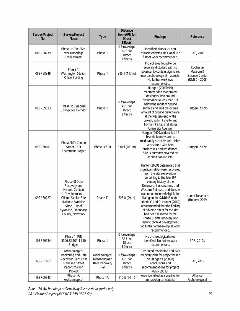
Phase 1A Archaeological Sensitivity Assessment (redacted)
I-81 Viaduct Project (NYSDOT PIN 3501.60) 35
Survey/Project No.
Survey/Project Name
Type
Distance from APE for
Direct Effects
Findings Reference
08SR58239 Phase 1: Erie Blvd.
over Onondaga Creek Project
Phase 1
0 ft (overlaps APE for Direct
Effects)
Identified historic culvert associated with Erie Canal. No
further work recommended. PAF, 2008
08SR58349 Phase 1:
Washington Station Office Building
Phase 1 385 ft (117 m)
Project area found to be severely disturbed with no
potential to contain significant intact archaeological materials.
No further work was recommended.
Rochester Museum &
Science Center (RMSC), 2008
09SR59513 Phase 1: Syracuse Connective Corridor
Phase 1
0 ft (overlaps APE for Direct
Effects)
Hartgen (2009b:19) recommended that project
designers limit ground disturbance to less than 1 ft below the modern ground
surface and limit the overall amount of ground disturbance
at the western end of the project, within Fayette and Forman Parks, and along
University Avenue.
Hartgen, 2009b
09SR60101 Phase II/III: Clinton
Street CSO Abatement Project
Phase II & III 330 ft (101 m)
Hartgen (2009a) identified 12 historic features and a
moderately sized historic debris associated with both
businesses and residences. Site is currently covered by
asphalt parking lots.
Hartgen, 2009a
09SR60227
Phase III Data Recovery and
Historic Context Development:
Clinton Station Site Railroad Machine
Shop, City of Syracuse, Onondaga
County, New York
Phase III 325 ft (99 m)
Hunter (2009) determined that significant data were recovered
from the site excavations pertaining to the late 19th
century history of the Delaware, Lackawanna, and
Western Railroad, and the site was recommended eligible for listing on the S/NRHP under
criteria C and D. Hunter (2009) recommended that the finding of adverse effect for the site had been resolved by the
Phase III data recovery and historic context development. no further archaeological work
recommended.
Hunter Research (Hunter), 2009
10SR60134 Phase 1: PIN
3506.32.101 I-690 Bridges
Phase 1
0 ft (overlaps APE for Direct
Effects)
No archaeological sites identified. No further work
recommended. PAF, 2010b
12SR61167
Archaeological Monitoring and Data Recovery Plan: East
Genesee Street Reconstruction
Project
Archaeological Monitoring and Data Recovery
Plan
0 ft (overlaps APE for Direct
Effects)
Presented monitoring and data recovery plan for project based
on Hartgen’s (2009b) conclusions and
recommendations for project 09SR59513.
PAF, 2012
16SR00343 Phase 1A
Archaeological Phase 1A 210 ft (64 m)
Area identified as sensitive for archaeological material
Alliance Archaeological
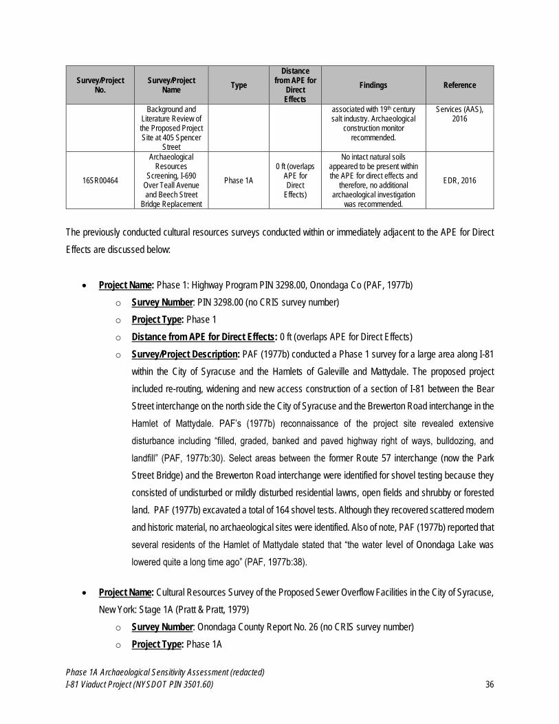
Phase 1A Archaeological Sensitivity Assessment (redacted)
I-81 Viaduct Project (NYSDOT PIN 3501.60) 36
Survey/Project No.
Survey/Project Name
Type
Distance from APE for
Direct Effects
Findings Reference
Background and Literature Review of the Proposed Project Site at 405 Spencer
Street
associated with 19th century salt industry. Archaeological
construction monitor recommended.
Services (AAS), 2016
16SR00464
Archaeological Resources
Screening, I-690 Over Teall Avenue and Beech Street
Bridge Replacement
Phase 1A
0 ft (overlaps APE for Direct
Effects)
No intact natural soils appeared to be present within the APE for direct effects and
therefore, no additional archaeological investigation
was recommended.
EDR, 2016
The previously conducted cultural resources surveys conducted within or immediately adjacent to the APE for Direct
Effects are discussed below:
Project Name: Phase 1: Highway Program PIN 3298.00, Onondaga Co (PAF, 1977b)
o Survey Number: PIN 3298.00 (no CRIS survey number)
o Project Type: Phase 1
o Distance from APE for Direct Effects: 0 ft (overlaps APE for Direct Effects)
o Survey/Project Description: PAF (1977b) conducted a Phase 1 survey for a large area along I-81
within the City of Syracuse and the Hamlets of Galeville and Mattydale. The proposed project
included re-routing, widening and new access construction of a section of I-81 between the Bear
Street interchange on the north side the City of Syracuse and the Brewerton Road interchange in the
Hamlet of Mattydale. PAF’s (1977b) reconnaissance of the project site revealed extensive
disturbance including “filled, graded, banked and paved highway right of ways, bulldozing, and
landfill” (PAF, 1977b:30). Select areas between the former Route 57 interchange (now the Park
Street Bridge) and the Brewerton Road interchange were identified for shovel testing because they
consisted of undisturbed or mildly disturbed residential lawns, open fields and shrubby or forested
land. PAF (1977b) excavated a total of 164 shovel tests. Although they recovered scattered modern
and historic material, no archaeological sites were identified. Also of note, PAF (1977b) reported that
several residents of the Hamlet of Mattydale stated that “the water level of Onondaga Lake was
lowered quite a long time ago” (PAF, 1977b:38).
Project Name: Cultural Resources Survey of the Proposed Sewer Overflow Facilities in the City of Syracuse,
New York: Stage 1A (Pratt & Pratt, 1979)
o Survey Number: Onondaga County Report No. 26 (no CRIS survey number)
o Project Type: Phase 1A
Phase 1A Archaeological Sensitivity Assessment (redacted)
I-81 Viaduct Project (NYSDOT PIN 3501.60) 37
o Distance from APE for Direct Effects: 0 ft (overlaps APE for Direct Effects)
o Survey/Project Description: Pratt & Pratt (1979) conducted a Phase 1A literature review and limited
field reconnaissance for the proposed project which occurs within downtown Syracuse and extends
into the south side of the City of Syracuse. The report investigated the archaeological sensitivity of
seven proposed sewage treatment facility sites and associated infrastructure. Based on the locations
of previously recorded prehistoric archaeological sites, Pratt & Pratt (1979) determined two proposed
treatment facility sites (the Maltbie Street and Franklin Street sites) to have high sensitivity for
prehistoric archaeology, two treatment facility sites and one proposed sewer line (the Emerson and
State Fair Sites and the State Fair Sewer line) to have moderately high sensitivity for prehistoric
archaeology, and the remaining portions of the project area to have moderate sensitivity for
prehistoric archaeology. Pratt & Pratt (1979:45) state that “aboriginal occupation cannot be ruled out
at any of these areas.”
Based on the historical development of the City of Syracuse, Pratt & Pratt (1979) identify four
treatment facilities and one sewer line (the Maltbie, Franklin Street, State Fair, and Clinton Street
sites, and the Clinton Street Sewer Line) as having high sensitivity for historic archaeology, three
treatment facilities and two sewer lines (the Emerson Street, Midland Avenue, Newell Street sites,
and the Midland Avenue and State Fair sewer lines) as having moderately high sensitivity for historic
archaeology, one treatment facility and two sewer lines (the Delaware Street Facility site and the
Delaware Street and Erie Boulevard sewer lines) as having low sensitivity for historic archaeology.
Pratt & Pratt’s (1979) assessment of low sensitivity for historic archaeology for these latter three
locations was based on the Delaware Street Facility and Line’s location within an area of historic
low-lying wetland that experienced little historic development. The Erie Boulevard Sewer Line was
considered to be of low sensitivity for historic archaeology because the proposed improvements to
the line were minimal and had a low potential to impact historic resources.
Pratt & Pratt (1979) conclude by recommending Phase 1B field investigations at eight of the
proposed treatment facilities and sewer lines. They note that:
“some of the proposed project areas may have been disturbed in the past. In some
areas buildings have been removed, areas filled or otherwise modified. In many
cases, however, this type of disturbance may be quite superficial, and only extent
a short distance into the cultural deposit” (Pratt & Pratt, 1979).
Phase 1A Archaeological Sensitivity Assessment (redacted)
I-81 Viaduct Project (NYSDOT PIN 3501.60) 38
Project Name: Stage 1B Cultural Resource Survey for the Proposed Best Management Practices Program
of the Combined Sewer Overflow (CSO) Facilities System in the City of Syracuse, New York (Pratt & Pratt,
1981)
o Survey Number: AR0004499_26 (no CRIS survey number)
o Project Type: Phase 1B
o Distance from APE for Direct Effects: 0 ft (overlaps APE for Direct Effects)
o Survey/Project Description: Pratt & Pratt (1981) excavated 15 shovel tests and oversaw the
excavation of 29 soil borings for the project throughout the City of Syracuse. Subsurface testing
identified no prehistoric cultural material but historic material was identified throughout much of the
project area. However, Pratt & Pratt (1981) note that much of the material represents low density
20th century refuse that is not considered indicative of S/NRHP-eligible archaeological resources.
Testing also encountered structural remnants of the historic Enlarged Erie Canal (at three locations)
and the historic Fay’s ironworks. In the case of the Enlarged Erie Canal, Pratt & Pratt (1981)
recommended the site either be avoided by project impacts or Phase II investigations be conducted
if avoidance was not possible. In the case or Fay Ironworks, they recommended Phase II
investigations and additional documentary research, as the site would be impacted under the current
project design. The ironworks are recorded in the CRIS database as the Fay Foundry (USN
06740.000487), and it does not appear that Phase II investigations were conducted at the site. The
site occurs more than 0.5 miles away from the APE for Direct Effects for the current Project and is
not discussed further in this report.
Project Name: Phase 1: PIN 3506.21.101 I-690 Exit Lane at Townsend St., Syracuse (PAF, 1990)
o Survey Number: PIN 3506.21.101 (no CRIS survey number)
o Project Type: Phase 1
o Distance from APE for Direct Effects: 0 ft (overlaps APE for Direct Effects)
Survey/Project Description: PAF (1990) conducted a pedestrian reconnaissance of the project
area at the Townsend Street exit off I-690 in downtown Syracuse and found the area not suitable for
a conventional Phase 1B archaeological survey. Instead, they conducted interviews with local
landowners and focused on documentary research. PAF (1990) found the project area to have been
highly disturbed by historic and modern development and concluded that the area unlikely to contain
significant intact buried prehistoric archaeological materials. They also noted that the majority of the
area was unlikely to contain significant intact buried historic archaeological materials, with the
exception of a small area underneath Brown Street between Burnet Avenue and North Townsend
Street.
Phase 1A Archaeological Sensitivity Assessment (redacted)
I-81 Viaduct Project (NYSDOT PIN 3501.60) 39
Due to the heavily disturbed nature of the project area, PAF (1990) focused on the identification of
historic bridges and architectural resources within the project area. Three bridges within the project
area were found to post-date 1945. A freight and mail terminal complex built in the early 1930s was
fully recorded by PAF (1990). An associated passenger station south of I-690 had already been
determined NRHP-eligible by Heritage Coalition, Inc.
Project Name: Stage 1B West St Sewer Separation (Onondaga Co. CSO Lake Improvement Program)
(Parsons, 1999)
o Survey Number: 98PR3902 (no CRIS survey number)
o Project Type: Phase 1B
o Distance from APE for Direct Effects: 0 ft (overlaps APE for Direct Effects)
o Survey/Project Description: Parsons (1999) completed a Phase 1B survey of the project area on
West and Plum streets between West Genesee and Tracy streets in downtown Syracuse which
consisted of mechanized test excavations (backhoe trenches) at eight locations throughout the
project area where archaeological resources were predicted to be present. Parsons (1999) found
that all eight locations had been significantly disturbed by previous construction activities. They did
not encounter any intact archaeological artifacts in their test excavations. Based on the results of the
test excavations, Parsons (1999) recommended no further archaeological work.
Project Name: Phase 1A Archaeological Sensitivity Assessment Surface Reconnaissance and Phase 1B
Archaeological Field Investigation Proposed Fiber Optic Line, City of Syracuse, Onondaga County, New York
(Hartgen, 1999).
o Survey Number: 99SR50210
o Project Type: Phase 1
o Distance from APE for Direct Effects: 0 ft (overlaps APE for Direct Effects)
o Survey/Project Description: Hartgen (1999) conducted a Phase 1A and limited Phase 1B survey
for the project within downtown Syracuse and along the east and west shores of Onondaga Lake.
Hartgen (1999) conducted Phase 1 archaeological investigation for a 14.5 mile (23.3 km) proposed
fiber optic line corridor. Dominant soils within the project corridor included made land, cut and fill
land, borrow pit land, or urban land disturbed by railroad and highway construction. Hartgen (1999)
excavated 32 shovel tests along the green space within Lake County Park along the eastern shore
of Onondaga Lake. The shovel tests identified historic 19th and 20th century fill including coal ash and
Phase 1A Archaeological Sensitivity Assessment (redacted)
I-81 Viaduct Project (NYSDOT PIN 3501.60) 40
fragmented historic debris but no intact soils. No archaeological sites were identified and no further
archaeological work was recommended.
Project Name: Phase 1A: Proposed Clinton Square Project (Curtin, 2000)
o Survey Number: 00SR50711
o Project Type: Phase 1A
o Distance from APE for Direct Effects: 0 ft (overlaps APE for Direct Effects)
o Survey/Project Description: Curtin (2000) found the Project location, at the site of the current
Clinton Square Park at the corner of North Salina and Water streets in downtown Syracuse, to be
sensitive for historic archaeological resources related to the Enlarged Erie Canal, including the canal
prism itself as well as the Clinton Square Boat Basin which was estimated to be between 4 and 7 ft
(1.2 and 2.1 m) deep based on historic documents. The location was not found to be sensitive for
prehistoric archaeological materials or historic archaeological materials pre-dating the Enlarged Erie
Canal because the area had been significantly disturbed by the construction of the canal. Curtin
(2000) recommended that ground disturbance associated with the proposed project be restricted to
certain areas identified as non-sensitive. If these recommendations could not be accommodated by
project design, Curtin (2000) recommended that a plan to identify archaeological resources within
the project area (potentially including a Phase 1B survey utilizing mechanized excavation) be
developed in consultation with the NYSOPRHP.
Project Name: Phase 1A: Syracuse Sanitary Sewer Upgrades (Hartgen, 2000a)
o Survey Number: 00SR50766
o Project Type: Phase 1A
o Distance from APE for Direct Effects: 0 ft (overlaps APE for Direct Effects)
o Survey/Project Description: Hartgen (2000a) completed a Phase 1A archaeological literature
review and sensitivity assessment for the project area which is located at 15 discrete locations spread
along Erie Boulevard between Onondaga Creek and Teall Avenue (storm sewer) and along Burnet
Avenue between James Street and Teall Avenue (sanitary sewer) within the City of Syracuse. Due
to the potential for intact portions of the Enlarged Erie Canal beneath Erie Boulevard and intact
portions of the Oswego Canal beneath the intersection of Oswego and Erie Boulevards. Phase 1B
testing was recommended in certain locations where the potential for the project to impact historic
canal remnants was judged to be greatest.
Phase 1A Archaeological Sensitivity Assessment (redacted)
I-81 Viaduct Project (NYSDOT PIN 3501.60) 41
Project Name: Phase 1B: Clinton Square Project (PCI, 2000)
o Survey Number: 00SR5205
o Project Type: Phase 1B
o Distance from APE for Direct Effects: 0 ft (overlaps APE for Direct Effects)
o Survey/Project Description: Based on Curtin’s (2000) recommendations, PCI conducted a Phase
1B archaeological investigation at the project location, at the site of the current Clinton Square Park
at the corner of North Salina and Water streets in downtown Syracuse. The Phase 1B investigations
consisted of a combination of mechanized backhoe and hand excavations at five locations identified
as having a high potential to contain intact components of the Enlarged Erie Canal. As discussed in
Section 2.2 of this report, PCI (2000) identified two sites: USN 6740.004364, Clinton Square Boat
Basin, which was determined eligible for listing on the NRHP; and USN 6740.005256, historic
structural foundations, which currently has an undetermined NRHP eligibility. PCI (2000)
recommended a mitigation plan be developed to address the intact Erie Canal components identified
during the survey.
Project Name: Stage 1 Cultural Resource Investigation for the 554 East Brighton Avenue Cell Tower Location
(CCRG, 2001a)
o Survey Number: 01SR51425
o Project Type: Phase 1
o Distance from APE for Direct Effects: 290 ft (88 m)
o Survey/Project Description: CCRG (2001a) conducted a Phase 1 archaeological survey of the
project location on the west side of Brighton Avenue on the south side of the City of Syracuse. No
archaeological sites were identified during the survey and no further work was recommended.
Project Name: Stage 1 Cultural Resource Investigation for the Solar/Kirkpatrick Street Improvement Project
(CCRG, 2001b)
o Survey Number: 01SR51475
o Project Type: Phase 1A
o Distance from APE for Direct Effects: 0 ft (overlaps APE for Direct Effects)
o Survey/Project Description: CCRG conducted a Phase 1 cultural resources survey for the project
location along Solar Street between Bear Street and Plum Street on the west side of downtown
Syracuse. CCRG (2001b) noted that the project location would have been highly sensitive for
prehistoric archaeological material due to its proximity to Onondaga Lake and the inlet of Onondaga
Creek. However, CCRG (2001b) reviewed the history of development in the area as well as
Phase 1A Archaeological Sensitivity Assessment (redacted)
I-81 Viaduct Project (NYSDOT PIN 3501.60) 42
geotechnical boring logs from the vicinity and concluded that the area was heavily disturbed by
historic and modern development. The geotechnical boring logs indicated that the modern ground
surface is approximately 12 feet (4 meters) above the historic ground surface in this portion of
downtown Syracuse. The area had contained salt sheds during the 19th century and CCRG (2001b)
noted that recent surveys by Hartgen (2000b; 2001a) had identified structural remains associated
with the historic salt industry in the area. However, the proposed Solar/Kirkpatrick Street
Improvement Project would not impact these remains which were buried at least 4 feet below the
modern ground surface. It should also be noted that Hartgen conducted Phase 1B reconnaissance
(Hartgen, 2001a), Phase 1B monitoring (Hartgen, 2003b), and Phase 2 investigations (Hartgen,
2001d) for the project (see additional discussion of these projects below). In their Phase 1, CCRG
recommended no additional archaeological work at the site because the proposed project would only
impact fill.
Project Name: Report of Field Assessment Stage 1A Cultural Resources Survey, Onondaga Creekwalk, City
of Syracuse, Onondaga County, New York (PAF, 2001)
o Survey Number: 01SR51587
o Project Type: Phase 1A
o Distance from APE for Direct Effects: 0 ft (overlaps APE for Direct Effects)
o Survey/Project Description: PAF (2001) conducted a Phase 1A cultural resources assessment for
the project area between the Armory Square neighborhood and the southwestern shore of Onondaga
Lake on the west side of downtown Syracuse. The Phase 1A survey included documentary research
and a pedestrian walkover reconnaissance of the project area. PAF (2001) found the project area to
be sensitive for prehistoric and historic archaeological materials and recommended a Phase 1B
survey be conducted consisting of a combination of backhoe trenching and shovel testing, depending
on the depth of proposed disturbance.
Project Name: Phase 1B Archaeological Field Investigation, EBSS Gate Chamber No. 4, Storm and Sanitary
Sewer Modification (Hartgen, 2001a)
o Survey Number: 01SR51627
o Project Type: Phase 1B
o Distance from APE for Direct Effects: 100 ft (31 m)
o Survey/Project Description: Hartgen conducted phase 1B investigations at the project location in
the northeastern portion of downtown Syracuse based on the potential for the project to impact the
Enlarged Erie Canal at this location. The Phase 1B survey involved a single backhoe trench in
addition to hand excavation in certain sensitive areas. Hartgen (2001a) identified the intact canal
Phase 1A Archaeological Sensitivity Assessment (redacted)
I-81 Viaduct Project (NYSDOT PIN 3501.60) 43
prism, including the stone canal wall, in the backhoe trench. The prism was documented and Hartgen
(2001a) recommended the project be redesigned to avoid damaging the intact portions of the canal
prism.
Project Name: Phase IA Literature Review and Archaeological Sensitivity Assessment, Onondaga County
Combined Sewer Overflow Lake Improvement Program: Alternatives Feasibility Study for the Proposed
Clinton Station Overflow Control Facility (Hartgen, 2001b)
o Survey Number: 01SR51900
o Project Type: Phase 1A
o Distance from APE for Direct Effects: 325 ft (99 m)
o Survey/Project Description: Hartgen (2001b) evaluated the archaeological sensitivity at six
alternative sites within the Armory Square neighborhood of downtown Syracuse being considered
for the proposed project. All six project alternatives were found to have a low sensitivity for prehistoric
archaeology and a high sensitivity for historic archaeology. Hartgen (2001a) recommended a Phase
1B survey be conducted regardless of which alternative site was selected for development.
Furthermore, they noted that portions of the West Washington Street Site had been used as a
cemetery between ca. 1830 and 1860 and that buried human remains might still be present at that
location.
Project Name: Phase 1 Cultural Resource Survey, Central New York Services, Single Room Occupancy
Enriched Services (Pratt & Pratt, 2002)
o Survey Number: 02SR53186
o Project Type: Phase 1
o Distance from APE for Direct Effects: 260 ft (79 m)
o Survey/Project Description: Pratt & Pratt conducted Phase 1 archaeological survey for the
proposed project on the east side of downtown Syracuse at the corner of East Fayette Street and
University Avenue. Pratt & Pratt (2002) conducted historic documentary research and a field
reconnaissance/site visit to assess the archaeological sensitivity of the project area. Pratt & and Pratt
(2002) found the project area to be disturbed by grading and construction of residences and
driveways. No archaeological sites were identified and no further work was recommended.
Project Name: Phase 1B: Syracuse Creekwalk Project (PAF, 2003a)
o Survey Number: 03SR53265
o Project Type: Phase 1B
Phase 1A Archaeological Sensitivity Assessment (redacted)
I-81 Viaduct Project (NYSDOT PIN 3501.60) 44
o Distance from APE for Direct Effects: 0 ft (overlaps APE for Direct Effects)
o Survey/Project Description: PAF (2003a) completed the Phase 1B survey of the project location
along Onondaga Creek in the western portion of downtown Syracuse. The Phase 1B survey
consisted of eight shovel tests and 17 backhoe trenches excavated in areas of high archaeological
sensitivity. Soil stratigraphy identified during the Phase 1B survey consisted of the following:
Trenching between Walton and West Fayette Streets identified fill depths of between 3.7
and 5.1 ft (1.1 and 1.6 m) below the modern ground surface.
Two trenches between West Fayette Street and the former railroad track retaining wall
contained ash and coal between 5-6.7 ft (1.5-2.0 m) below the modern ground surface,
underlain by a 4.5-4.8-ft (1.4-1.5 m) thick layer of red brown sandy loam containing brick
fragments.
One trench was excavated at West Washington Street, which contained 1 ft (0.3 m) of
asphalt and gravel underlain by possible historic/modern fill.
Two trenches and two shovel tests were excavated between West Washington Street and
Water Street, which identified 1.9 ft (0.6 m) of historic debris underlain by possible intact
soils.
A trench was excavated north of West Genesee Street. It encountered historic/modern fill
to a depth of 6.7 ft (2.0 m) below the modern ground surface.
Six trenches were placed near Hiawatha Boulevard. They encountered soda ash deposits
to a depth of 5-8.7 ft (1.5-2.7 m) below the modern ground surface. The fill was underlain
by intact wetland soils.
Borings were excavated between Spencer and Kirkpatrick Streets. They encountered
between 13-19 ft (4.0-5.8 m) of fill, underlain by intact wetland soils.
Soil borings excavated south of Walton Street identified fill to a depth of 8 -12 ft (2.4-3.7 m)
below the modern ground surface.
No intact prehistoric or historic archaeological sites were identified and no additional work was
recommended.
Project Name: Phase 1A Cultural Resource Assessment, Syracuse Armory House Project (PAF, 2003b)
o Survey Number: 03SR53404
o Project Type: Phase 1A
o Distance from APE for Direct Effects: 330 feet (101 m)
o Survey/Project Description: PAF (2003b) conducted a Phase 1A survey of the project area west
of downtown Syracuse at the corner of Water Street and University Avenue. Due to its proximity to
an intact glacial drumlin and the high density of map-documented structures in the vicinity, the project
Phase 1A Archaeological Sensitivity Assessment (redacted)
I-81 Viaduct Project (NYSDOT PIN 3501.60) 45
area was identified as potentially sensitive for prehistoric and historic archaeology. Phase 1B
investigations were recommended.
Project Name: Phase 1B Cultural Resource Assessment, Syracuse Armory House Project (PAF, 2003c)
o Survey Number: 03SR53405
o Project Type: Phase 1B
o Distance from APE for Direct Effects: 330 ft (101 m)
o Survey/Project Description: During the Phase 1B survey, PAF (2003c) excavated eight shovel
tests and 12 backhoe trenches. The subsurface testing identified the Syracuse Block 205 Historic
Site (A06740.006101) which consists of four loci of foundations and artifacts, representing three
map-documented residences and one map-documented commercial shop. The site contained intact
stratigraphy underneath approximately 14 to 54 inches (37 to 137 cm) of clay fill. The S/NRHP
eligibility of the site is currently undetermined. PAF (2003c) recommended either site avoidance or
Phase II investigation if the site could not be avoided. Currently, the site is located underneath a
sports field and, to date, no Phase II investigations have occurred at the site.
Project Name: Onondaga County Combined Sewer Overflow Lake Improvement Program: Archaeology Plan
and Work Scope. Phase IB Archaeological Field Reconnaissance of the Dickerson Street West Option and
Clinton Station Sites, Proposed Clinton Street Combined Sewer Overflow (Hartgen, 2003a).
o Survey Number: 03SR53395
o Project Type: Phase 1B Work Plan/Scoping
o Distance from APE for Direct Effects: 325 feet (99 m)
o Survey/Project Description: Following the Phase 1A for this project (Hartgen, 2001b), Hartgen
(2003a) drafted a Phase 1B work plan to test archaeologically sensitive areas within the project area
located in the on the south side of downtown Syracuse. The work plan summarized the results of 17
soil borings conducted within the project area in 2002. The borings generally identified a sequence
of historic/modern fill to depths of between 4 and 16 feet below the modern ground surface, underlain
by (from shallowest to deepest) alluvium, lacustrine deposits, and glacial-fluvial soils. Groundwater
was encountered at an average depth of 14 feet.
Hartgen (2003a) proposed Phase 1B methodology aimed at identifying pre-contact Native American
materials and historic 19th century materials within the project area. Due to the complex nature of the
project, Hartgen (2003a) also included a memorandum of agreement (MOA) between NYSOPRHP
and Onondaga County to guide consultation between the two parties as the project developed.
Phase 1A Archaeological Sensitivity Assessment (redacted)
I-81 Viaduct Project (NYSDOT PIN 3501.60) 46
Project Name: Phase 1B Archaeological Field Reconnaissance: Clinton Street CSO Abatement Project,
Clinton Station Site (Hartgen, 2003b)
o Survey Number: 03SR57080
o Project Type: Phase 1B Survey
o Distance from APE for Direct Effects: 325 feet (99 m)
o Survey/Project Description: Hartgen (2003b) excavated nine backhoe trenches throughout project
area on the west side of downtown Syracuse. The backhoe trenches identified two historic
archaeological sites: the Railroad Machine Shop site (USN 06740.008692) and the Dickerson Street
Historic site (USN 06740.008691). The S/NRHP eligibilities of both sites were left undetermined at
conclusion of the Phase 1B survey. Hartgen (2003b) recommended avoidance or Phase II
investigations for the Railroad Machine Shop and avoidance or Phase II/III investigations for the
Dickerson Street Historic Site.
Project Name: Report of Field Reconnaissance: Phase 1A Cultural Resource Assessment Syracuse
University Health Science Addition (PAF, 2004a)
o Survey Number: 04SR55013
o Project Type: Phase 1A
o Distance from APE for Direct Effects: 490 feet (149 m)
o Survey/Project Description: PAF (2004a) conducted a Phase 1A cultural resources survey for the
proposed project on the Syracuse University campus near the southeast periphery of downtown
Syracuse. As part of the Phase 1A survey, soil borings were conducted which encountered fill to
depths of approximately 10 to 15 ft (3.1 to 4.6 m) below the modern ground surface. Based on the
results of documentary research and the soil borings, PAF (2004a) found the project area to have
low sensitivity for prehistoric and historic archaeological material and no further work was
recommended.
Project Name: Phase 1: Erie Blvd. over Onondaga Creek Project (PAF, 2008)
o Survey Number: 08SR58239
o Project Type: Phase 1
o Distance from APE for Direct Effects: 0 feet (overlaps APE for Direct Effects)
o Survey/Project Description: PAF (2008) conducted archaeological monitoring and a historic
architectural resources survey for the proposed rehabilitation of the bridge conveying Erie Boulevard
over Onondaga Creek on the western side of downtown Syracuse.
Phase 1A Archaeological Sensitivity Assessment (redacted)
I-81 Viaduct Project (NYSDOT PIN 3501.60) 47
As discussed in Section 2.1, PAF (2008) monitored a series of seven auger probes conducted by
C&S Engineers (C&S) which identified the subsurface stratigraphy at the point where the modern
alignment of Erie Boulevard crosses the modern alignment of Onondaga Creek (PAF, 2008). These
auger probes were conducted on top of an existing limestone culvert that was constructed in 1838
(at the location of an earlier culvert) to convey Onondaga Creek under the Erie Canal. Three of the
auger probes encountered the historic culvert at depths between 12.8 and 16.1 feet below the
modern ground surface, two of the auger probes did not encounter the culvert at all, and two of the
auger probes encountered concrete at an unspecified depth. PAF (2008) recommended no further
archaeological work for the proposed project.
Project Name: Phase 1: Washington Station Office Building (RMSC, 2008)
o Survey Number: 08SR58349
o Project Type: Phase 1
o Distance from APE for Direct Effects: 385 feet (117 m)
o Survey/Project Description: RMSC (2008) completed a Phase 1A survey for the Washington
Station Office Building project area at the corner of West Washington Street and South Franklin
Street on the west side of downtown Syracuse. RMSC (2008) found the project area occurred
completely on soil units mapped as Urban Land. Additionally, the project area was severely disturbed
by historic development including railroads, roads, and heavily industry. RMSC (2008) found the
project area to be severely disturbed with no potential to contain significant intact archaeological
materials. No further archaeological work was recommended.
Project Name: Phase II/III: Clinton Street CSO Abatement Project (Hartgen, 2009a)
o Survey Number: 09SR60101
o Project Type: Phase II & III
o Distance from APE for Direct Effects: 330 feet (101 m)
o Survey/Project Description: In association with the Onondaga County Combined Sewer Overflow
Lake Improvement Project, Hartgen (2009a) conducted Phase II and III investigations at the
Dickerson Street Historic Site (USN 06740.008691) in on the southwest side of downtown Syracuse.
As noted in Section 2.2 of this report, the Dickerson Street Historic Site dates to between
approximately 1870-1930. The site was identified and investigated by Hartgen during Phase 1B
(Hartgen, 2003b) and Phase II/III (Hartgen, 2009) investigations. Hartgen (2003b) identified the site
through the excavation of backhoe trenches in the vicinity of the Dickerson Street Bridge over
Onondaga Creek. One of the trenches exposed the corner of a stone foundation and a wooden-lined
Phase 1A Archaeological Sensitivity Assessment (redacted)
I-81 Viaduct Project (NYSDOT PIN 3501.60) 48
shaft feature which was interpreted at the time to represent a privy. Hartgen (2003b) estimated that
both features dated to ca. 1900. They recommended Phase II/III investigation occur at the site if it
could not be avoided by the proposed project (Hartgen, 2003b).
Phase II/III data recovery was conducted at the site in 2007. The site was mechanically stripped of
overburden to expose features and foundations associated with historical structures. Seven
excavation units were placed across the site to explore potential features and foundation walls.
Hartgen (2009a) identified foundations and fill deposits dating to between ca. 1870 and 1930. The
site consists of primarily commercial structures associated with the railyard, with a minor residential
component which included the childhood home of noted children’s author Howard Garis. Hartgen
(2009a) identified 12 historic features and a moderately sized historic debris associated with both
businesses and residences. Hartgen (2009a) excavated much of the site in 2007 and presumably
the remainder was destroyed by the construction of the Combined Sewer Lake Overflow Program.
Currently, the vicinity of the site is covered by asphalt parking lots.
Hartgen (2009a) found that overburden extended to a minimum depth of 2.2 feet (0.7 m) below the
modern ground surface, and in some places as deep as 6.6 feet (2.0m). Soil in the vicinity was
assumed to contain lead so only 25% of recovered soils were screened.
Project Name: Phase 1: Syracuse Connective Corridor (Hartgen, 2009b)
o Survey Number: 09SR59513
o Project Type: Phase 1
o Distance from APE for Direct Effects: 0 feet (overlaps APE for Direct Effects)
o Survey/Project Description: Hartgen (2009b) conducted a Phase 1A cultural resources survey for
the proposed project which consists of improvements to transportation, architecture, lighting,
telecommunications, public art displays, and other features along a corridor connecting downtown
Syracuse with Syracuse University via Fayette Street, East Genesee Street, and University Avenue.
Hartgen (2009b) found mapped soils within the project area to consist largely of Urban Land, the
exception being the portion of the proposed project along University Avenue which is mapped as
native soil.
Hartgen (2009b) noted that while much of the project route had been heavily disturbed by 20th century
improvements to streets and sidewalks, Fayette Park and Forman Park, as well as some residential
lawns along East Genesee Street and University Avenue potentially remained undisturbed.
Phase 1A Archaeological Sensitivity Assessment (redacted)
I-81 Viaduct Project (NYSDOT PIN 3501.60) 49
Regarding prehistoric archaeological sensitivity, Hartgen (2009b:18) concluded: “Fayette Street west
of Franklin Street, the eastern half of Forman Park, and University Avenue have a moderate
sensitivity for precontact sites. The rest of the project corridor has a low sensitivity for precontact
sites.”
Regarding historic archaeological sensitivity, Hartgen (2009b) concluded that the entire area was
highly sensitive, but that “the depth of potential archaeological significance begins at a depth of
approximately one foot (0.3 m) below sidewalks, at 2.5 feet (0.8 m) below curbs, and at 1.5 feet (0.5
m) below road surfaces” (Hartgen, 2009b:18).
Hartgen (2009b:19) concluded by recommending that project designers limit ground disturbance to
less than 1 ft below the modern ground surface and limit the overall amount of ground disturbance
at the western end of the project, within Fayette and Forman Parks, and along University Avenue.
Hartgen (2009b:19) further recommended that, as the project design was finalized, the specific
impacts associated with the proposed project be reviewed by an archaeologist.
Project Name: Phase III Data Recovery and Historic Context Development: Clinton Station Site Railroad
Machine Shop, City of Syracuse, Onondaga County, New York.
o Survey Number: 09SR60227
o Project Type: Phase III
o Distance from APE for Direct Effects: 325 feet (99 m)
o Survey/Project Description: Hunter (2009) completed the Phase III data recovery investigations at
the project site on the west side of downtown Syracuse. An approximately 7,000-square-foot area
was mechanically stripped of overburden to expose features and foundations of the railroad machine
shop. Nine 5 x 5 ft (1.5 x 1.5 m) and 2.5 x 10 ft (0.8 x 3.0 m) excavation units were placed throughout
the remains of the machine shop. The excavations exposed extensive post-demolition fill deposits
throughout the site. No remains of the original machine shop, which was destroyed during an 1869
fire, were identified due to the extensive disturbance by fill and foundation construction for the second
machine shop (which was constructed following the 1869 fire). However, Hunter (2009) determined
that significant data were recovered from the site excavations pertaining to the late 19th century
history of the Delaware, Lackawanna, and Western Railroad, and the site was recommended eligible
for listing on the S/NRHP under criteria C and D. Hunter (2009) recommended that the finding of
adverse effect for the site had been resolved by the Phase III data recovery and historic context
development and recommended no further archaeological work for the site.
Phase 1A Archaeological Sensitivity Assessment (redacted)
I-81 Viaduct Project (NYSDOT PIN 3501.60) 50
Project Name: Phase 1: PIN 3506.32.101 I-690 Bridges (PAF, 2010b)
o Survey Number: 10SR60134
o Project Type: Phase 1
o Distance from APE for Direct Effects: 0 feet (overlaps APE for Direct Effects)
o Survey/Project Description: PAF (2010b) conducted archaeological and architectural
reconnaissance surveys for the project in the vicinity of the West Street Interchange on I-690 on the
northwest side of downtown Syracuse. The most significant proposed disturbance associated with
the project consisted of the construction of an access road along the banks of Onondaga Creek
where it is crossed by I-690. As noted in Section 2.1 of this report (Inset 2.1.2-2), this section of
Onondaga Creek near its inlet into Onondaga Lake was heavily rerouted and channelized between
1904 and 1916 (Onondaga Environmental Institute, 2008). Furthermore, PAF (2010b) noted that the
entire project area is mapped as Urban Land, although they also noted that small pockets of intact
soils might remain in the area. The vicinity has been heavily disturbed by the construction of I-690
and associated interchanges and bridges (PAF, 2010b). However, this area in the vicinity of
Onondaga Creek on the southwest shore of Onondaga Lake contains several documented
prehistoric and protohistoric archaeological sites, including the Late Prehistoric Onondaga Village of
Kaneenda (Beauchamp, 1900; Parker, 1922). PAF (2010b) also described extensive historic
development within the project area but noted that any historic archaeological materials in the vicinity
were likely destroyed by the construction of I-690 and associated bridges and interchanges.
PAF (2010b) conducted a pedestrian reconnaissance walkover of the project area to assess the
extent of previous disturbance and the potentially to encounter intact soils. Based on the results of
the walkover, PAF (2010b) archaeologists excavated seven shovel tests in alluvial deposits along
the banks of Onondaga Creek. All seven shovel tests encountered limestone paving stones between
27 and 50 cm below the modern ground surface. No artifacts were recovered from the shovel tests.
PAF (2010b) recommended no further archaeological work for the project.
Project Name: Archaeological Monitoring and Data Recovery Plan, PIN 3754.46 East Genesee Street
Reconstruction Project, City of Syracuse (6740), Onondaga County, New York (PAF, 2012)
o Survey Number: 12SR61167
o Project Type: Monitoring and Data Recovery Plan
o Distance from APE for Direct Effects: 0 feet (overlaps APE for Direct Effects)
Phase 1A Archaeological Sensitivity Assessment (redacted)
I-81 Viaduct Project (NYSDOT PIN 3501.60) 51
o Survey/Project Description: PAF’s (2012) monitoring and data recovery plan covers the portion of
East Genesee Street between Forman Street and University Avenue, including Forman Park, east
of downtown Syracuse. PAF (2012) summarized the conclusions of the Phase 1A report for the
project (Hartgen, 2009b), which had recommended limiting project disturbance in archaeologically
sensitive areas as well as final review of the project design by an archaeologist prior to construction.
PAF (2012) outlined a protocol for archaeological construction monitoring and data recovery if
significant archaeological resources were identified during monitoring. No final monitoring/data
recover report has been submitted to NYSOPRHP as of this writing.
Project Name: Phase1A Archaeological Background and Literature Review of the Proposed Project Site at
405 Spencer Street (AAS, 2016)
o Survey Number: 16SR00343
o Project Type: Phase 1A
o Distance from APE for Direct Effects: 210 feet (64 m)
o Survey/Project Description: AAS (2016) conducted a Phase 1A archaeological study of the project
area at the corner of Spencer Street and Maltbie Street on the northwest side of downtown Syracuse.
As part of the Phase 1A study, AAS (2016) excavated one test hole which encountered historic
limestone foundations at a depth of 5 ft below the modern ground surface. This foundation is likely
associated with 19th century salt works at the location. AAS excavated 18 shovel tests within the
project area as part of the Phase 1A survey. Sixteen of the shovel tests encountered filled
modern/historic fill deposits and two encountered potentially intact soils. No artifacts or features were
identified within any of the excavated shovel tests.
AAS (2016) also noted the presence of somewhat intact limestone foundations on the ground surface
associated with the previously recorded Pump House and Salt Manufacturing Site (USN
06740.001211). The site is eligible for listing on the S/NRHP.
Because the proposed project was only anticipated to cause ground disturbance to a depth of 2 ft
below the modern ground surface, AAS (2016) did not recommend additional testing or data recovery
at the location but did recommend an archaeological monitor be present during project construction,
due to the high sensitivity of the area for historic archaeology associated with 19th century salt works.
Additionally, AAS (2016) noted that the aboveground foundation remnants associated with Site
A06740.001211 would not be impacted by the proposed project.
Phase 1A Archaeological Sensitivity Assessment (redacted)
I-81 Viaduct Project (NYSDOT PIN 3501.60) 52
Project Name: Archaeological Resources Screening, I-690 Over Teall Avenue and Beech Street Bridge
Replacement (EDR, 2016)
o Survey Number: 16SR00464
o Project Type: Phase 1A
o Distance from APE for Direct Effects: 0 feet (overlaps APE for Direct Effects)
o Survey/Project Description: EDR (2016) conducted a Phase 1A cultural resources screening for
the project area at the I-690 viaduct over Beech Street and Teall Avenue on the east side of the City
of Syracuse. The Phase 1A report considered the impacts to cultural resources of four project
alternatives for the viaduct rehabilitation and two alternatives for improving the I-690/Teall Avenue
Interchange.
Based on a review of historic maps and photographs, EDR found the project area to have been
significantly disturbed by historic and modern development, and therefore, of low sensitivity for
prehistoric archaeology. Regarding the sensitivity for historic archaeology, EDR (2016:13) stated:
“Due to previous ground disturbance from road widening, construction of road ramps and
associated grading, and prior demolition and construction on adjacent parcels, there is
minimal likelihood of intact historic sites to be present in the areas immediately adjacent to
the existing highway.”
EDR (2016) concluded that no intact natural soils appeared to be present within the APE for direct
effects and therefore, no additional archaeological investigation was recommended.
In addition, 19 cultural resources projects have been conducted between 500 feet and 0.5 miles from the APE for Direct
Effects (see Table 2.3-2 and Appendix A: Map 3). These consist of eight (42%) combination Phase 1A/Phase 1B
surveys, five (26%) Phase 1A surveys, two (11%) construction monitors, one (5%) Phase 1B survey, one (5%) Phase
1B scope, one (5%) academic research project, and one (5%) Phase II investigation. The cultural resources
surveys/projects were conducted for six (32%) sewer projects, three (16%) highway/streets projects, three (16%)
municipal parks/footpaths, three (16%) residential development projects, two (10%) commercial development projects,
one (5%) religious building project, and one (5%) academic research project. Previously conducted surveys and
projects located within the vicinity of the APE for Direct Effects but not within or immediately adjacent (i.e., those surveys
and projects between 500 feet and 0.5 miles from the APE for Direct Effects) are summarized in Table 2.3-2.
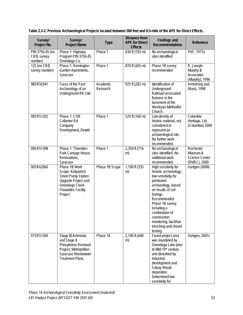
Phase 1A Archaeological Sensitivity Assessment (redacted)
I-81 Viaduct Project (NYSDOT PIN 3501.60) 53
Table 2.3-2. Previous Archaeological Projects located between 500 feet and 0.5-mile of the APE for Direct Effects.
Survey/ Project No.
Survey/ Project Name
Type Distance from APE for Direct
Effects
Findings and Recommendations
Reference
PIN 3750.45 (no CRIS survey number)
Phase 1: Highway Program PIN 3750.45, Onondaga Co.
Phase 1 630 ft (192 m) No archaeological sites identified
PAF, 1977a
125 (no CRIS survey number)
Phase 1: Remington Garden Apartments, Syracuse
Phase 1 870 ft (265 m) Phase 1B survey recommended
R. Joseph Murphy & Associates (Murphy), 1996
98SR50341 Faces of the Past: Archaeology of an Underground RR Site
Academic Research
925 ft (282 m) Identification of Underground Railroad-associated features in the basement of the Wesleyan Methodist Church.
Armstrong and Wurst, 1998
00SR51202 Phase 1: COR Collamer Rd. Company Development, Dewitt
Phase 1 525 ft (160 m) Low density of historic material, not considered to represent an archaeological site. No further work recommended.
Columbia Heritage, Ltd. (Columbia) 2000
00SR51398 Phase 1: Thornden Park Carriage House Renovations, Syracuse
Phase 1 2,350 ft (716 m)
No archaeological sites identified. No additional work recommended.
Rochester Museum & Science Center (RMSC), 2000
00SR62060 Phase 1B Work Scope: Kirkpatrick Street Pump Station Upgrade Project and Onondaga Creek Floatables Facility Project
Phase 1B Scope
1,100 ft (335 m)
High sensitivity for historic archaeology; low sensitivity for prehistoric archaeology, based on results of soil borings. Recommended Phase 1B survey including a combination of construction monitoring, backhoe trenching and shovel testing.
Hartgen 2000b
01SR51366 Stage III Ammonia and Stage II Phosphorus Removal Project, Metropolitan Syracuse Wastewater Treatment Plant,
Phase 1A 2,100 ft (640 m)
Found project area was inundated by Onondaga Lake prior to Mid-19th century and disturbed by industrial development and Solvay Waste deposition. Determined low sensitivity for
Hartgen, 2001c
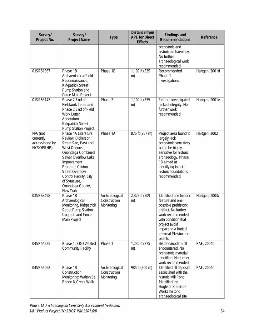
Phase 1A Archaeological Sensitivity Assessment (redacted)
I-81 Viaduct Project (NYSDOT PIN 3501.60) 54
Survey/ Project No.
Survey/ Project Name
Type Distance from APE for Direct
Effects
Findings and Recommendations
Reference
prehistoric and historic archaeology. No further archaeological work recommended.
01SR51367 Phase 1B Archaeological Field Reconnaissance, Kirkpatrick Street Pump Station and Force Main Project
Phase 1B
1,100 ft (335 m)
Recommended Phase II investigations.
Hartgen, 2001d
01SR53147
Phase 2 End of Fieldwork Letter and Phase 2 End of Field Work Letter Addendum: Kirkpatrick Street Pump Station Project
Phase 2
1,100 ft (335 m)
Feature investigated lacked integrity. No further work recommended.
Hartgen, 2001e
N/A (not currently accessioned by NYSOPRHP)
Phase 1A Literature Review, Dickerson Street Site, East and West Options, Onondaga Combined Sewer Overflow Lake Improvement Program: Clinton Street Overflow Control Facility, City of Syracuse, Onondaga County, New York
Phase 1A 875 ft (267 m) Project area found to largely lack prehistoric sensitivity but to be highly sensitive for historic archaeology. Phase 1B aimed at identifying intact historic foundations recommended.
Hartgen, 2002
03SR53498 Phase 1B Archaeological Monitoring, Kirkpatrick Street Pump Station Upgrade and Force Main Project
Archaeological Construction Monitoring
2,325 ft (709 m)
Identified one historic feature and one possible prehistoric artifact. No further work recommended with condition that project avoid impacting a buried terminal Pleistocene beach.
Hartgen, 2003c
04SR54225
Phase 1: SRO 24 Bed Community Facility
Phase 1 1,230 ft (375 m)
Historic/modern fill encountered. No prehistoric material identified. No further work recommended.
PAF, 2004b
04SR55062 Phase 1B Construction Monitoring: Walton St. Bridge & Creek Walk
Archaeological Construction Monitoring
985 ft (300 m) Identified fill deposits associated with the historic Mill Pond. Identified the Hughson Carriage Works historic archaeological site
PAF, 2004c
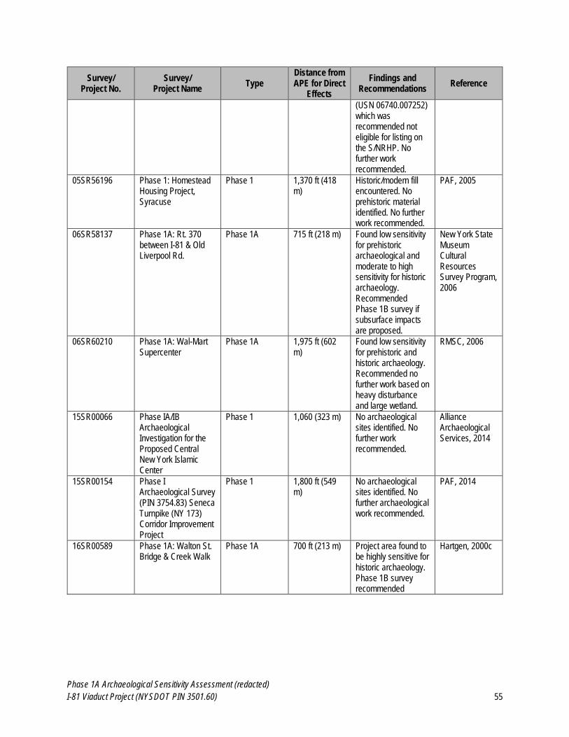
Phase 1A Archaeological Sensitivity Assessment (redacted)
I-81 Viaduct Project (NYSDOT PIN 3501.60) 55
Survey/ Project No.
Survey/ Project Name
Type Distance from APE for Direct
Effects
Findings and Recommendations
Reference
(USN 06740.007252) which was recommended not eligible for listing on the S/NRHP. No further work recommended.
05SR56196 Phase 1: Homestead Housing Project, Syracuse
Phase 1 1,370 ft (418 m)
Historic/modern fill encountered. No prehistoric material identified. No further work recommended.
PAF, 2005
06SR58137 Phase 1A: Rt. 370 between I-81 & Old Liverpool Rd.
Phase 1A 715 ft (218 m) Found low sensitivity for prehistoric archaeological and moderate to high sensitivity for historic archaeology. Recommended Phase 1B survey if subsurface impacts are proposed.
New York State Museum Cultural Resources Survey Program, 2006
06SR60210 Phase 1A: Wal-Mart Supercenter
Phase 1A 1,975 ft (602 m)
Found low sensitivity for prehistoric and historic archaeology. Recommended no further work based on heavy disturbance and large wetland.
RMSC, 2006
15SR00066 Phase IA/IB Archaeological Investigation for the Proposed Central New York Islamic Center
Phase 1 1,060 (323 m) No archaeological sites identified. No further work recommended.
Alliance Archaeological Services, 2014
15SR00154 Phase I Archaeological Survey (PIN 3754.83) Seneca Turnpike (NY 173) Corridor Improvement Project
Phase 1 1,800 ft (549 m)
No archaeological sites identified. No further archaeological work recommended.
PAF, 2014
16SR00589 Phase 1A: Walton St. Bridge & Creek Walk
Phase 1A 700 ft (213 m) Project area found to be highly sensitive for historic archaeology. Phase 1B survey recommended
Hartgen, 2000c
Phase 1A Archaeological Sensitivity Assessment (redacted)
I-81 Viaduct Project (NYSDOT PIN 3501.60) 56
2.4 Historic Context for the APE and Vicinity
EDR conducted historical research at local and on-line archives and repositories to document the historical
development of the Project’s APE and vicinity. Archives consulted during EDR’s research for the Project included:
the collections of the Onondaga Historical Association in Syracuse,
the Local History collection of the Central Branch of the Onondaga County Public Library,
the collections of the Erie Canal Museum in Syracuse,
the Digital Collections of the Library of Congress,
the Digital Collections of the New York State Archives,
NYSDOT’s archives and record plans,
NYSOPRHP’s on-line CRIS inventory of previous cultural resources survey reports,
Ancestry.com, the David Rumsey Historical Map Collection, and other on-line history resources, and
EDR’s in-house collection of reference materials.
Historical sources reviewed for the Project are cited throughout the following historic context sections and are listed in
Section 5.0 References Cited of this report. An important focus of EDR’s research was the review and analysis of
historical map sources. Details from selected historical maps and other historical imagery are included as inset figures
throughout the following historic context narrative. Selected historical maps were geo-referenced and overlain on
contemporary plans and aerial photos to help identify historic map-documented structures and other potential
archaeological features that were formerly located within the APE for Direct Effects. In addition, representative geo-
referenced historical maps are included in Appendix A: Maps 4-9.
2.4.1 Pre-Contact Native American Period (ca. 14,000 BP to 1654 AD)
A discussed in Section 2.1 of this report, the APE for Direct Effects is located within the Onondaga Trough in Central
New York. More specifically, it is located along the southeast shore of Onondaga Lake and encompasses and area
that would have historically included lakeside wetlands surrounding the Onondaga Creek inlet into Onondaga Lake, as
well as smaller portions of the surrounding uplands. Since the last glacial recession around 14,000 years ago, humans
have utilized the area both for short term resource acquisition and longer term residential habitation. Onondaga Lake
(and the APE for Direct Effects) is located at the border between the Erie/Ontario Lake Plain physiographic province
to the north and the Allegheny Plateau physiographic province to the south. This location provided access to a variety
of lowland and upland resources to groups based in the area. Furthermore, the Seneca/Oswego River system (of which
Onondaga Lake and Onondaga Creek are a part) provided water-borne access to Montezuma Swamp and the Finger
Lakes to the west and south, Oneida Lake to the northeast, and Lake Ontario to the north. A short overland route also
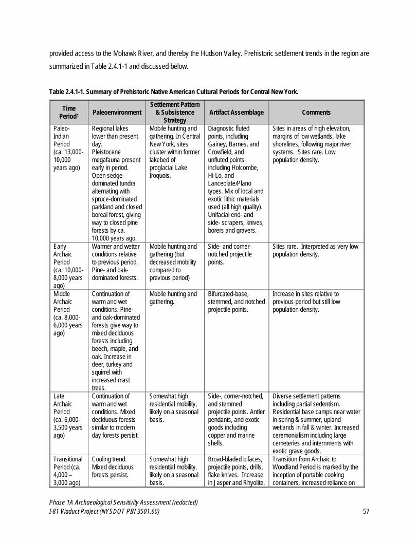
Phase 1A Archaeological Sensitivity Assessment (redacted)
I-81 Viaduct Project (NYSDOT PIN 3501.60) 57
provided access to the Mohawk River, and thereby the Hudson Valley. Prehistoric settlement trends in the region are
summarized in Table 2.4.1-1 and discussed below.
Table 2.4.1-1. Summary of Prehistoric Native American Cultural Periods for Central New York.
Time Period1
Paleoenvironment Settlement Pattern
& Subsistence Strategy
Artifact Assemblage Comments
Paleo-Indian Period (ca. 13,000-10,000 years ago)
Regional lakes lower than present day. Pleistocene megafauna present early in period. Open sedge-dominated tundra alternating with spruce-dominated parkland and closed boreal forest, giving way to closed pine forests by ca. 10,000 years ago.
Mobile hunting and gathering. In Central New York, sites cluster within former lakebed of proglacial Lake Iroquois.
Diagnostic fluted points, including Gainey, Barnes, and Crowfield, and unfluted points including Holcombe, Hi-Lo, and Lanceolate/Plano types. Mix of local and exotic lithic materials used (all high quality). Unifacial end- and side- scrapers, knives, borers and gravers.
Sites in areas of high elevation, margins of low wetlands, lake shorelines, following major river systems. Sites rare. Low population density.
Early Archaic Period (ca. 10,000-8,000 years ago)
Warmer and wetter conditions relative to previous period. Pine- and oak-dominated forests.
Mobile hunting and gathering (but decreased mobility compared to previous period)
Side- and corner-notched projectile points.
Sites rare. Interpreted as very low population density.
Middle Archaic Period (ca. 8,000-6,000 years ago)
Continuation of warm and wet conditions. Pine- and oak-dominated forests give way to mixed deciduous forests including beech, maple, and oak. Increase in deer, turkey and squirrel with increased mast trees.
Mobile hunting and gathering.
Bifurcated-base, stemmed, and notched projectile points.
Increase in sites relative to previous period but still low population density.
Late Archaic Period (ca. 6,000-3,500 years ago)
Continuation of warm and wet conditions. Mixed deciduous forests similar to modern day forests persist.
Somewhat high residential mobility, likely on a seasonal basis.
Side-, corner-notched, and stemmed projectile points. Antler pendants, and exotic goods including copper and marine shells.
Diverse settlement patterns including partial sedentism. Residential base camps near water in spring & summer, upland wetlands in fall & winter. Increased ceremonialism including large cemeteries and internments with exotic grave goods.
Transitional Period (ca. 4,000 – 3,000 ago)
Cooling trend. Mixed deciduous forests persist.
Somewhat high residential mobility, likely on a seasonal basis.
Broad-bladed bifaces, projectile points, drills, flake knives. Increase in Jasper and Rhyolite.
Transition from Archaic to Woodland Period is marked by the inception of portable cooking containers, increased reliance on
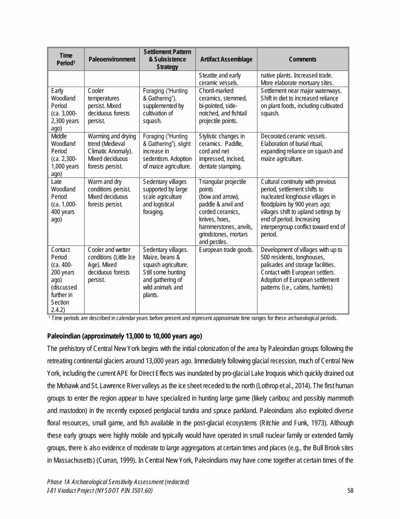
Phase 1A Archaeological Sensitivity Assessment (redacted)
I-81 Viaduct Project (NYSDOT PIN 3501.60) 58
Time Period1
Paleoenvironment Settlement Pattern
& Subsistence Strategy
Artifact Assemblage Comments
Steatite and early ceramic vessels.
native plants. Increased trade. More elaborate mortuary sites.
Early Woodland Period (ca. 3,000-2,300 years ago)
Cooler temperatures persist. Mixed deciduous forests persist.
Foraging (“Hunting & Gathering”), supplemented by cultivation of squash.
Chord-marked ceramics, stemmed, bi-pointed, side-notched, and fishtail projectile points.
Settlement near major waterways. Shift in diet to increased reliance on plant foods, including cultivated squash.
Middle Woodland Period (ca. 2,300-1,000 years ago)
Warming and drying trend (Medieval Climatic Anomaly). Mixed deciduous forests persist.
Foraging (“Hunting & Gathering”), slight increase in sedentism. Adoption of maize agriculture.
Stylistic changes in ceramics. Paddle, cord and net impressed, incised, dentate stamping.
Decorated ceramic vessels. Elaboration of burial ritual, expanding reliance on squash and maize agriculture.
Late Woodland Period (ca. 1,000-400 years ago)
Warm and dry conditions persist. Mixed deciduous forests persist.
Sedentary villages supported by large scale agriculture and logistical foraging.
Triangular projectile points (bow and arrow), paddle & anvil and corded ceramics, knives, hoes, hammerstones, anvils, grindstones, mortars and pestles.
Cultural continuity with previous period, settlement shifts to nucleated longhouse villages in floodplains by 900 years ago; villages shift to upland settings by end of period. Increasing interpergroup conflict toward end of period.
Contact Period (ca. 400-200 years ago) (discussed further in Section 2.4.2)
Cooler and wetter conditions (Little Ice Age). Mixed deciduous forests persist.
Sedentary villages. Maize, beans & squash agriculture. Still some hunting and gathering of wild animals and plants.
European trade goods. Development of villages with up to 500 residents, longhouses, palisades and storage facilities. Contact with European settlers. Adoption of European settlement patterns (i.e., cabins, hamlets)
1 Time periods are described in calendar years before present and represent approximate time ranges for these archaeological periods.
Paleoindian (approximately 13,000 to 10,000 years ago)
The prehistory of Central New York begins with the initial colonization of the area by Paleoindian groups following the
retreating continental glaciers around 13,000 years ago. Immediately following glacial recession, much of Central New
York, including the current APE for Direct Effects was inundated by pro-glacial Lake Iroquois which quickly drained out
the Mohawk and St. Lawrence River valleys as the ice sheet receded to the north (Lothrop et al., 2014). The first human
groups to enter the region appear to have specialized in hunting large game (likely caribou; and possibly mammoth
and mastodon) in the recently exposed periglacial tundra and spruce parkland. Paleoindians also exploited diverse
floral resources, small game, and fish available in the post-glacial ecosystems (Ritchie and Funk, 1973). Although
these early groups were highly mobile and typically would have operated in small nuclear family or extended family
groups, there is also evidence of moderate to large aggregations at certain times and places (e.g., the Bull Brook sites
in Massachusetts) (Curran, 1999). In Central New York, Paleoindians may have come together at certain times of the
Phase 1A Archaeological Sensitivity Assessment (redacted)
I-81 Viaduct Project (NYSDOT PIN 3501.60) 59
year to take advantage of seasonal caribou aggregations or seasonal fish runs. These earliest inhabitants of Central
New York utilized the high quality chert found within the Onondaga Escarpment, but also utilized nonlocal lithic (i.e.,
stone tool) materials from the Hudson Valley to the east, the Delaware Valley to the south, and as far west east-central
Ohio (Lothrop et al., 2014).
The climate in Central New York was dry throughout the entire Paleoindian period and lake levels were significantly
lower than they are in the present day. For instance, during its early Holocene low stand (ca. 12,300-8,300 years ago)
the southern shoreline of Lake Ontario was between 5 and 10 km north of the modern shoreline and the lake had no
outlet because its level was below the sill of the St. Lawrence River Valley (Lothrop et al. 2014). This is significant
because Paleoindian groups would have occupied the exposed portions of the Ontario Basin. Any sites left in these
areas are now under tens or hundreds of feet of water and therefore, precluded from current analyses of Paleoindian
settlement and subsistence in Central New York (Lothrop et al., 2014). Even given this incomplete record, Central New
York was densely settled by Paleoindians relative to the surrounding area, prompting Ritchie (1980) to state that the
area contained the highest density of fluted points in the state of New York.
More recently, Lothrop et al. (2014) have analyzed the distribution of Paleoindian archaeological sites and projectile
point finds in Central New York. They found that Paleoindian materials are most densely clustered along the shore of
Oneida Lake and the Seneca and Oneida Rivers, some distance north of the current APE for Direct Effects. No
Paleoindian projectile points have been found in the City of Syracuse or the Towns of Geddes and Salina to date.
Notable regional Paleoindian sites include the Toad Harbor Site on the north shore of Oneida Lake, the Oberlander
No. 1 and Robinson Sites (both of which were occupied during the Archaic Period as well) on the Oneida River near
the outlet of Oneida Lake, and the Glass Factory Site in Madison County.
Early and Middle Archaic (approximately 10,000 to 6,000 years ago)
As occurred in many areas in North America, indigenous populations settled into the landscape during the Archaic
Period in Central New York. Post-Glacial conditions had stabilized by approximately 10,000 years ago, and small
groups of hunter-gatherers reduced their mobility and exploited the diverse resources available to them in the newly
emerging mixed deciduous/coniferous forests. This process of settling in began during the late Paleoindian Period
around 10,000 years ago as groups adapted to the changing climate and a shift from open spruce/fir parkland to closed
pine and oak forest. Mammoth and mastodon were extinct in the area by approximately 10,000 years ago (Lothrop et
al. 2014), but big game such as deer, elk, moose, and perhaps woodland caribou remained available, as well as small
game, fish, and wild plants. Archaic sites are often larger and denser than Paleoindian sites (Funk, 1978); however, in
Central New York, this is true primarily of Late Archaic sites. Early and Middle Archaic sites are rare in the area and
often exhibit a continuation of the low population densities mobile lifeways characteristic of the late Paleoindian Period.
Phase 1A Archaeological Sensitivity Assessment (redacted)
I-81 Viaduct Project (NYSDOT PIN 3501.60) 60
In New York, the Archaic period is broken into the Early (approximately 10,000 to 8,000 years ago), Middle
(approximately 8,000 to 6,000 years ago) and Late (approximately 6,000 to 3,500 years ago) subperiods with the
Transitional Period as a brief interval between the Late Archaic and the subsequent Early Woodland. Early and Middle
Archaic sites are more common in southern and coastal New England and New York than in the northern portion of
this region, where they are quite rare. Bifurcate-base points are the most common Early Archaic time markers in
Upstate New York and the Middle Archaic is characterized by stemmed and corner-notched projectile points as well
as the first appearance of notched stone net-sinkers (Funk, 1978).
Early and Middle Archaic components in Central New York have often been overlooked in favor of the more mysterious
Paleoindian sites or the more spectacular Late Archaic and Woodland sites. As a result, the Early and Middle Archaic
occupation of Central New York is not particularly well understood. Furthermore, sites dating to the Early and Middle
Archaic are relatively rare in the region, and those known are often small relative to Late Archaic sites. In fact, some of
the best researched Early and Middle Archaic site components in Central New York occur underneath substantial Late
Archaic campsites, such as the Brewerton sites on the Oneida River in Onondaga and Oswego Counties and the
Frontenac Island Site in Cayuga Lake in Cayuga County (Ritchie, 1980). Additionally, Parker’s (1922) descriptions of
“early relics” and “traces of occupation” around Onondaga Lake and Onondaga Creek (NYSM Areas 4192, 4240, and
7368) may refer to Early or Middle Archaic sites; however, no archaeological sites have been formally documented in
these areas.
Late Archaic (approximately 6,000 to 3,500 years ago)
Far more Late Archaic sites are documented in New York than Early or Middle Archaic sites. This has led many
archaeologists to argue for population increase, likely driven by changing environmental conditions, during the Late
Archaic. Sassaman (2010:24-25) has noted that Late Archaic sites in the eastern woodlands tend to be located on
more stable landforms than sites dating to preceding periods. This is in large part due to a climatic trend during the
Late Archaic toward more stable conditions similar to the those of the present day. Sassaman (2010:24-25) notes that
many drainages became more aggradational and less erosional during this period and that this may have led to a
higher frequency of preserved archaeological sites from the Late Archaic and Woodland periods than from the
preceding Early and Middle Archaic and Paleoindian periods.
Diagnostic artifacts from the Late Archaic include broad side-notched projectile points as well as gouges (broad-bladed
chisel-like wood working tools), grooved net sinkers, and ground slate artifacts (Funk, 1978). Groundstone plant
processing technology, including nutting stones which indicate the first systematic exploitation of mast resources such
as acorns, hickory nuts, and chestnuts, first appear during the Late Archaic (Funk, 1978; Ritchie and Funk, 1973:7). In
Phase 1A Archaeological Sensitivity Assessment (redacted)
I-81 Viaduct Project (NYSDOT PIN 3501.60) 61
Central New York, two separate cultural traditions characterize the Late Archaic period: the Laurentian and the Lamoka
cultures (Ritchie, 1980). As currently understood, the Laurentian culture originated in situ in northern and Central New
York and New England, whereas the Lamoka culture immigrated to the area from southern Appalachia (Ritchie, 1971;
1980; Sassaman, 2010). The Lamoka culture was named for the type site on Lamoka Lake in Schuyler County, New
York whereas the Laurentian culture was defined on the basis of several sites, including a cluster known as the
Brewerton Sites located at the outlet of Oneida Lake on both sides of the Oneida River in Onondaga and Oswego
Counties (Ritchie, 1946; 1980).
The Brewerton sites represent the most significant Late Archaic sites in close proximity to the current Project. The Late
Archaic components at the Brewerton sites are most significant at two sites (the Robinson and Oberlander 1 sites)
located on opposite sides of the Oneida River from each other, but potentially occupied at the same time (Ritchie,
1946). The density and diversity of artifacts at these sites led Ritchie (1946) to describe them as villages. They contain
exotic materials such as copper from the western Great Lakes and marine shells from Maine or the Mid-Atlantic coast.
The sites appear to represent seasonal population aggregations, likely to take advantage of seasonal fish and eel runs
into and out of Oneida Lake via the Oneida River. If this is the case, the two separate sites may represent different
social groups who cooperated to an unknown extent to procure fish and eels during these times (Curtin, 2015; Ritchie,
1946). Other Late Archaic sites such as the Lamoka Lake Site in Schuyler County also focus on fishing and aquatic
resource procurement, although not to the exclusion of terrestrial floral and faunal resources such as deer, passenger
pigeon, and tree nuts. The Late Archaic component at the Frontenac Island Site in Cayuga Lake in Cayuga County
consists primarily of a cemetery with little evidence of a residential village or camp (Ritchie, 1980). The Robert Simonds
Site (USN 06709.000224) is a recently discovered Late Archaic campsite on the Seneca River immediately north of
Onondaga Lake in Onondaga County. Although not yet fully investigated, it appears to contain a substantial Late
Archaic/Transitional component (based on five Lamoka projectile points and one Brewerton Corner-notched projectile
point) and its location on a major river is consistent with other large Late Archaic Campsites (NYSM, 2012).
Recently, several archaeologists (Curtin, 1998; Levine, 2004; Madrigal, 1999; Versaggi et al. 2001) have argued that
these large Late Archaic campsites should be considered the exception and not the norm for the period. Recent
research at upland Late Archaic sites has revealed that the higher elevations in Central New York and the northern
Allegheny Plateau were significant in Late Archaic settlement and subsistence, although the sites in these areas do
not approach the size of their better known lakeside and riverside counterparts. These upland sites were typically
utilized by small task-oriented groups to obtain specific resources or suites of resources available at certain times of
the year. While groups were primarily based in large residential camps located to take advantage of major resource
patches, small foraging or hunting groups would travel throughout the surrounding landscape to exploit specific more
ephemeral resource patches (Levine, 2004). Levine (2004:176-177) argues additional study of these small upland sites
Phase 1A Archaeological Sensitivity Assessment (redacted)
I-81 Viaduct Project (NYSDOT PIN 3501.60) 62
may provide a valuable opportunity to better understand the roles of women in Late Archaic society as some of these
sites may have been all female plant procurement and processing locales.
Overall, the Late Archaic Period in Central New York can be characterized as a period of population growth and cultural
diversification, likely due to both in situ cultural change and the immigration to the area of groups from southern
Appalachia and possibly elsewhere.
Transitional (approximately 4,000 to 3,000 years ago)
The Transitional Period is not a well-defined cultural period or complex unto itself but rather, as the name implies, a
period of transition between the technological complexes identified with the Late Archaic and the Early Woodland
Periods (Ritchie and Funk, 1973). Whitthoft (1949) defined the Transitional Cultural Complexes of the northeast by
their manufacture and use of steatite bowls, early ceramic vessels, heavy soapstone gorgets, and broad-stemmed
projectile points and drills as well as the appearance of burial ceremonialism (Ritchie and Funk, 1973). The latter portion
of the Transitional Period is also characterized by fishtail style points in much of the northeast (Tuck, 1978). Tuck
(1978:38) argues that, despite the distinctive technology of Transitional peoples, their subsistence and mobility patterns
did not differ significantly from the preceding Late Archaic or subsequent Early Woodland. For this reason, Transitional
sites lacking clearly diagnostic artifacts such as fishtail points or steatite vessels are difficult to differentiate from the
preceding or following periods. No significant Transitional Period sites are known from Onondaga County.
Early Woodland (approximately 3,000 to 2,300 years ago)
The Early Woodland Period in the northeast is broadly characterized by the earliest beginnings of agriculture (although
no agricultural sites are known from Central or Western New York for this period), widespread use of ceramics, stylized
ornamental luxury goods such as tobacco pipes and worked copper, and an elaborate ritual system involving complex
burial traditions (Tuck, 1978). All of these cultural traits appear to have spread north and east from the Mississippi River
Valley (Tuck, 1978); however, many of them are present in Central New York to some extent during the Late Archaic
(Ritchie, 1947; 1980). Ritchie and Funk (1973:96) and Tuck (1978:41) have argued that the overall subsistence pattern
in the region does not change drastically from the Late Archaic to the Early Woodland, aside from a possible increased
influence on fishing in Central and Western New York. However, based on lithic analysis of upland sits in Western New
York, Cowan (1999) demonstrates a shift from a system of high residential mobility (i.e., moving the entire group to
resources) during the Late Archaic to a system of reduced residential mobility and increased logistical mobility (i.e.,
task-specific groups operating out of base camps to procure resources). Significantly, Hart et al. (2007) have recently
identified domesticated squash (Curcubita sp.) phytoliths in cooking residue adhering to ceramic sherds radiocarbon
dated to the beginning of the Early Woodland Period in Central New York. The sherds with the earliest dates (ca. 3,000
years ago) are from the Scaccia Site in Livingston County and Hart et al.’s (2007) results indicate that squash was
Phase 1A Archaeological Sensitivity Assessment (redacted)
I-81 Viaduct Project (NYSDOT PIN 3501.60) 63
being cultivated in Central and Western New York at this time, although macrobotanical evidence is still lacking. The
presence of domesticated squash during the Early Woodland Period helps to explain the shift to reduced residential
mobility. Cultivating crops such as squash requires occupation of the same location by at least part of the social group
throughout the growing season as well as reduced mobility throughout the winter months to take advantage of stored
surpluses.
Fiedel (2001) argues that, for a number of reasons, the widespread advent of ceramic technology during the Early
Woodland Period could have both allowed for and encouraged population growth throughout the northeast. However,
he (Fiedel, 2001) also notes that some archaeologists have argued for a regional population decline or even a crash
in the Early Woodland based on a perceived paucity of sites and radiocarbon dates attributable to this period. This
appears to be borne out by Fiedel’s (2001) analysis of diagnostic projectile point type frequencies across the Late
Archaic and Early, Middle, and Late Woodland Periods for coastal New York and the Hudson Valley (corrected for the
variable lengths of the temporal periods examined) which indicates a disproportionately low frequency of Early
Woodland diagnostic points known from the region. Fiedel (2001) argues that the apparent increase in ceremony and
ritual observed during the Late Archaic and Transitional Periods could have been in response to economic hardship
caused by adverse climatic conditions which finally led to a population crash during the Early Woodland Period.
The pattern of low site density during the Early Woodland Period holds for other parts of New York State as well. In a
study of rockshelters from eastern New York, Funk (1989) noted an almost complete lack of Early Woodland
components in rockshelters containing Late Archaic components. Furthermore, in their study of the upper Hudson
River Valley, Bender and Curtin (1990:83) noted a dramatic rise in Late Archaic site frequency (relative to the Middle
Archaic Period) followed by a decrease in sites during the Early Woodland.
In Central New York, Meadowood type projectile points and Vinette Type I ceramics are the most commonly identified
artifacts diagnostic of the Early Woodland Period. Many major Early Archaic sites in the region (e.g., the Brewerton
sites) were reoccupied during the Early Woodland, but much less intensively (Ritchie, 1980). In Central New York
Orient and Meadowood are contemporaneous (Fiedel, 2001:108), whereas elsewhere Orient predates Meadowwood.
Middle Woodland (approximately 2,300 to 1,000 years ago)
The first substantial and widespread development of agriculture in northeastern North America occurred during the
Middle Woodland Period, possibly in response to favorable climatic conditions during the Medieval Climatic Anomaly
(Fitting, 1978:44). Following the initial appearance of cultigens in Central New York during the Early Woodland period,
the role of agriculture in regional subsistence strategies appears to have gradually increased throughout the Middle
Woodland Period. Hart et al. (2007) have documented cooked maize (Zea mays) phytoliths adhering to ceramic sherds
Phase 1A Archaeological Sensitivity Assessment (redacted)
I-81 Viaduct Project (NYSDOT PIN 3501.60) 64
from the Vinette Site in Oswego County radiocarbon dated to the early to mid-Middle Woodland Period. Although
macrobotanical evidence for maize cultivation is not known from Central New York this early, it would appear, based
on Hart et al.’s (2007) study that it was being grown on a somewhat widespread basis in this area by approximately
1,600 year ago, and appears to have been present in the area as early 2,300 years ago. As previously noted, Hart et
al. (2007) also demonstrated the presence of domesticated squash use in Central New York by the beginning of the
preceding Early Woodland Period.
Aside from squash and maize agriculture, Hopewellian influence in Central and Western New York was characterized
by mound burials and other earthworks, dentate-stamped and rocker-stamped ceramic vessels, elaborate tobacco
pipes, and stemmed, side-notched, and triangular unnotched Levanna projectile points (Engelbrecht, 2014; Ritchie and
Funk, 1973). In her analysis of collared ceramic vessels from the Finger Lakes region, Brumbach (2011) notes simple
decorative bands on the mouths of ceramic vessels become more common over the course of the Middle Woodland
Period, eventually progressing into the truly collared vessels of the late Middle Woodland and Late Woodland which
are considered ethnic markers of the groups known in historic times as the Haudenosaunee.
People in the northeast during this period also maintained extensive trade networks, evidenced by the presence of
exotic goods at sites in the region (Fitting, 1978; Ritchie 1980; Ritchie and Funk, 1973). Ritchie and Funk (1973:118)
note the emphasis on fishing apparent at many Early Woodland sites in New York appears to continue throughout the
Middle Woodland, and settlement occurs in small villages or residential camps during this period (Ritchie and Funk,
1973). Although no major Middle Woodland sites occur in the Syracuse vicinity, the Felix Site on the Seneca River in
the town of Elbridge, Onondaga County is a significant residential site representing Ritchie’s (1980) Kipp Island Phase
of the Middle Woodland Period. Additionally, the Robert Simonds, site also on the Seneca River in Onondaga County
(previously discussed for its Late Archaic component), contains a small early Middle Woodland component based on
one Levanna projectile point and one radiocarbon date calibrated to approximately 2,225 years ago (NYSM, 2012).
Late Woodland (approximately 1,000 to 400 years ago)
Ritchie and others (Ritchie, 1980; Ritchie and Funk, 1973) have argued that the Middle Woodland/Late Woodland
boundary around 1,000 years ago marked the arrival of proto-Iroquoian7 groups (the Owasco culture) in Central and
Western New York. They argued for cultural discontinuity around 1,000 years ago hinging on dramatic changes in
ceramic styles and technology, the arrival of full-fledged maize/squash/bean agriculture, and the development of
7 The terms Iroquois and Iroquoian are used here to describe indigenous groups with a suite of cultural traits (e.g., ceramic styles and
settlement patterns) and linguistic traits. The term Haudenosaunee is used specifically to denote the five (and later) six nation confederacy in place during the contact and early historic era. Although the roots of the Haudenosaunee likely extend beyond the contact era, this is difficult to document archaeologically, and therefore, the terms Iroquois and Iroquoian will be applied to all cultural manifestations for which only archaeological data are available.
Phase 1A Archaeological Sensitivity Assessment (redacted)
I-81 Viaduct Project (NYSDOT PIN 3501.60) 65
nucleated longhouse villages. However, MacNeish (1952) and Tuck (1971) argued for an in situ development of
Iroquois culture dating as early as 750 years ago. More recently, Hart and Brumbach (2003; 2005; 2009; Brumbach,
2011; Hart, 2011), among others, have presented evidence which suggests cultural continuity between the Middle and
Late Woodland Periods. This indicates a deeper in situ development of the Iroquois cultural complex than previously
suggested, reaching back at least 1,000 years into prehistory. It is interesting to note that this model, with its deeper
local origins for the Iroquois (and potentially Haudenosaunee), accords better with the Onondaga Nation’s own
understanding of its origins (e.g., Onondaga Nation, 2016). Hart (2011) summarizes the data pointing toward longer
term cultural continuity in Central New York which consist overlap between Middle Woodland and Late Woodland
ceramic styles and technology as well as recently identified evidence for squash and maize agriculture during the Early
and Middle Woodland periods, respectively (discussed in more detail above). Furthermore, Hart (2011) points out large
nucleated longhouse villages do not appear in the archaeological record until approximately 700-900 years ago (under
the previously held model, this type of village appeared abruptly in the area around 1,000 years ago). To summarize
Hart’s (2011) argument, no dramatic cultural change indicative of migration or displacement is visible in the
archaeological record of Central and Western New York at 1,000 years ago.
The Late Woodland period marks the first time Native American groups in Central New York were fully sedentary in
agricultural villages, although an extensive system of logistical resource procurement would have still been necessary
to supply villages with non-agricultural resources (Cowan, 1999). Late Woodland sites also include small nuclear family
summer residences or “cabins” where single families would tend isolated garden plots away from the main village
(Cowan, 1999). The typical Late Woodland village housed approximately 200 people and was occupied for a period of
20 to 30 years before being abandoned in favor of a new location (Snow, 1994). Tuck (1971) describes several
residential sides dating from possibly as early as 700 years ago and later in the towns of Baldwinsville, Elbridge, Fabius,
Jamesville, Manlius Onondaga, Pompey, Syracuse (the far south side) in Onondaga County, as well as Cazenovia in
Madison County. Tuck’s (1971) study identified evidence of a palisaded village as early as 700 years ago at the Furnace
Brook Site in the town of Onondaga.
Around approximately 500 years ago, village size increased to as much as 500 residents and most villages were sited
on low hills or hillside terraces throughout Central New York. This appears to have been partially in response to
increased intergroup conflict during this period as the upland locations provided increased intervisibility with nearby
villages as well as presenting a longer frost-free growing season than valley bottom locations (Jones, 2006; 2010;
Snow, 1994; Tuck, 1971).
Building on this trend, during the sixteenth and seventeenth centuries (the early Contact Era – see Section 2.4.2), the
Onondaga in Central New York continued to shift their villages to higher elevation, more defensible locations and
Phase 1A Archaeological Sensitivity Assessment (redacted)
I-81 Viaduct Project (NYSDOT PIN 3501.60) 66
aggregated their population in a smaller number of large fortified villages with populations of up to 2,500 people (Birch,
2012; Jones, 2006; 2010). Some of the growth in village size may also have been due to emigration of St. Lawrence
Iroquois populations into the area (Jones, 2010). The St. Lawrence Iroquois were a group of Iroquoian people who
lived in villages on both sides of the St. Lawrence River in northern New York and Southern Canada during the terminal
Late Woodland through early Contact Era (i.e., the fourteenth through sixteenth centuries). The St. Lawrence Iroquois
exhibited a suite of cultural traits including settlement patterns which are consistent with Haudenosaunee groups to the
south (Abel, 2001).
Around A.D. 1600, many of the St. Lawrence Iroquois living on the south (U.S.) side of the St. Lawrence River relocated
across the river into modern-day Ontario to either form new villages or join existing villages (Abel, 2001:172-173).
However, the occupants of two late-sixteenth-century village clusters in the vicinity of modern-day Watertown, New
York, defy explanation under Abel’s (2001) model. He allows that the people occupying these sites may have moved
south to join the Onondaga, per Bradley (1987), or southeast to join the Mohawk, per Engelbrecht (2003) (Abel, 2001);
however, firm evidence has yet to be produced demonstrating the Watertown groups’ fusion with either the Onondaga
or the Mohawk (Abel, 2001). In the case of the Onondaga, however, the period around A.D. 1600 saw unprecedented
population growth (Jones, 2010) and some settlement reorganization with groups coming together in larger villages in
the Limestone Creek and West Branch, Limestone Creek valleys (Bradley, 1987; Jones, 2006; Tuck, 1971).
Furthermore, St. Lawrence Iroquois ceramic styles have been in Onondaga, Oneida, and Mohawk village sites dating
to this period (Bradley, 1987; Jones, 2006, 2010; Snow 1995; 2001; Tuck, 1971). Jones (2010:399) posits a large scale
migration of St. Lawrence Iroquois as refuges or captives to their southern Haudenosaunee neighbors during this
period.
Much of the current APE for Direct Effects occurs within what would have been low-lying wetlands around the south
end of Onondaga Lake. This area would have been rich in resources and an attractive area for Haudenosaunee
settlement. However, no Late Woodland Period archaeological sites are known from the vicinity of the APE for Direct
Effects for the Current Project. Two Contact Era Onondaga sites have been reported to occur within the City of
Syracuse, and may have partially overlapped with the APE for Direct Effects prior to their destruction during the
twentieth century. One, the Village of Kaneenda as reported by Parker (1922) has already been discussed in Section
2.2 of this report. Both sites will be discussed further in the following Section (2.4.2).
2.4.2 Euro-American and Native American Contact during the Colonial Era (ca. A.D. 1534 to 1786)
Initial European Contact in the Eastern Great Lakes Region occurred in 1534 on the St. Lawrence River (Eccles, 1972),
1609 on Lake Champlain (Fischer, 2008), and 1614 on the Hudson River at the future site of the City of Albany (Richter,
2005). In 1610, Henry Hudson was hired by the Dutch to find a northerly passage to east Asia. He explored the Hudson
Phase 1A Archaeological Sensitivity Assessment (redacted)
I-81 Viaduct Project (NYSDOT PIN 3501.60) 67
River, traveling approximately half the distance from the Atlantic to the site of present day Albany. Although Hudson
did conduct some trade with the Native Americans he encountered along his route, much of his interactions were hostile
(Morgan, 1993). Following Hudson’s initial explorations, the Dutch established a fort and trading post called Ft. Orange
at the future site of Albany, New York in 1624 (Huey, 1991). The Dutch Trading Post at Fort Orange at the future site
of Albany was the first direct access the Haudenosaunee groups had to European trade goods. Due to their geographic
location as the easternmost of the (then) five nations8, the Mohawk had the most direct and unencumbered access to
the Dutch traders (Richter, 2005). Sustained contact with Europeans occurred by 1624 at Ft. Orange (Huey, 1991;
Snow and Lanphear, 1988), and Eccles estimates sustained contact by 1615 for the Georgian Bay/Lake Ontario region.
The first smallpox epidemic is noted in the Mohawk Valley in 1633 (Bradford, 1952; Jones, 2014), with unspecified
epidemics among the Seneca in 1634, the Oneida in 1635, and the Onondaga in 1645 (Jones, 2014). Jones (2010)
estimates that the Onondaga population was at its largest between 1645 and 1650, followed by a precipitous decline
(the estimated population fell from approximately 2,600 to approximately 1,000, a loss of 62%). Jones (2010; 2014)
interprets the population decline between 1645 and 1650 as evidence of a European-introduced epidemic disease.
In 1603, Samuel de Champlain sailed up the the Saint Lawrence River on a mission of trade and exploration from the
French monarch, Henry IV (Fischer, 2008). Additional expeditions followed in 1604 and 1608, and soon Champlain
was the preeminent explorer and geographer of New France (modern day Canada). Crucial to his success was his
establishment of respectful and mutually beneficial relationships with the Native groups along the St. Lawrence,
especially the Algonquin and the Wendat-Huron. In 1609 and 1610, Champlain participated in two punitive raids against
the Mohawk in the vicinity of modern day Lake Champlain in order to further his relationship with his Wendat-Huron
and Algonquin allies (Fischer, 2008). Several years later, in October of 1615, Champlain and several of his soldiers,
armed with muskets, again joined their Wendat and Algonquin allies in a raid deep into Onondaga territory. The group
left their canoes near the mouth of the Salmon River on the shore of Lake Ontario and traveled overland past the west
end of Oneida Lake (modern day Brewerton) until they arrived at a large fortified Onondaga Town on the shore of a
lake (Fischer, 2008). Although there is some debate as to the precise location of the town, most scholars agree that it
was on the southeast shore of Onondaga Lake in the area currently occupied by the DestiNY USA shopping mall and
its parking lots (Engelbrecht, 2003; Fischer, 2008; Pratt, 1976). This is also the location ascribed to the Kaneenda
Village archaeological site by Parker (1922). Along with the Huron and Algonquin, Champlain and his men laid siege
to the Onondaga Village, eventually constructing a siege tower which allowed them to fire their muskets into the interior
of the palisaded village (Fischer, 2008). Although Champlain and his allies never broke through the fortifications, the
surprise attack appears to have discouraged the Onondaga from further entanglements with the French along the St.
Lawrence for the next 25 years (Fischer, 2008; Trigger, 1985).
8 The nations of the Haudenosaunee were (from east to west) the Mohawk, the Oneida, the Onondaga, the Cayuga, and the Seneca.
In A.D. 1722, the Tuscarora joined the Confederacy as the sixth nation.
Phase 1A Archaeological Sensitivity Assessment (redacted)
I-81 Viaduct Project (NYSDOT PIN 3501.60) 68
During the early- to mid-sixteenth century, the Haudenosaunee first gained access to European trade goods. Through
their relationship with Dutch traders at Ft. Orange, the Mohawk became some of the first Native Americans in the region
with widespread access to firearms. European guns soon spread throughout the five nations of the Confederacy,
allowing the Haudenosaunee to aggressively raid their European and Native rivals throughout the region. Conflicts
throughout the second half of the seventeenth century were often with the French and their Wendat-Huron allies
throughout the eastern Great Lakes and along the St. Lawrence River (Richter, 2005; Viola, 1990). The Seneca,
Cayuga, Onondaga, and Oneida made peace with the French in 1665. The British, however, had gained control of
New Netherlands, including Ft. Orange, in 1664 (Richter, 2005). Wielding their newfound economic influence on the
Haudenosaunee, the British pushed the Confederacy into renewed conflicts with the French and Wendat throughout
the final quarter of the seventeenth century (Richter, 2005).
Clark (1849:139) states that in 1646, Jesuit Father Isaac Iogues visited the Onondaga as an envoy for France. This
visit would have been during the immediate aftermath of the 1645 epidemic and ensuing population crash (Jones,
2010; 2014). In July and August, 1654, Father Simon Le Moyne traveled from Montreal to Onondaga Lake to meet
with the Haudenosaunee and discuss initiating a mission among them (Clark, 1849; Hewett, 1909). In July, 1656, a
group of French Jesuits and soldiers arrived with their Native guides on the eastern shore of Onondaga Lake with the
intent of establishing a mission (Bruce, 1896). Their assignment was to build the Jesuit mission, Sainte Marie du lac
Gannentaha, the first permanent European settlement in Haudenosaunee territory. Their position at Onondaga Lake
placed them centrally among the five nations of the Haudenosaunee Confederacy and made their settlement accessibly
by river from Quebec (via the Seneca River which, through the Oswego River, provides access to Lake Ontario the St.
Lawrence River). The mission was built in a cleared portion of the forest with abundant natural resources, near both a
freshwater spring and a salt spring (Clark, 1849; Clayton, 1878; Hewitt, 1909). Old growth forests of chestnut and
walnut trees surrounded the site. The location was well-sited for the placement of agricultural fields as well as access
to fresh water, salt springs, fish, wild game, and wild plant foods (Clayton, 1878).
Regarding the original appearance and layout of St. Marie de Gannentaha, Metz (1995:9-10) states:
No definitive details on the appearance of Ste. Marie were found in a literature search. However, the province of Ontario conducted extensive archaeological investigation of the site of the Ste. Marie Among the Hurons occupied from 1639 to 1649. Their reconstruction of the mission depicts a complex of several specialized buildings including residence, barn, animal yards, a chapel, work shops [sic], and elements of basic military fortification, located on high ground with nearby fields.
Archaeological investigations at the probable site of the St. Marie de Gannentaha on Old Liverpool Road in Salina were
conducted in 1974 and 1979 by the New York State Archaeological Association. These excavations identified a small
Phase 1A Archaeological Sensitivity Assessment (redacted)
I-81 Viaduct Project (NYSDOT PIN 3501.60) 69
assemblage of European artifacts dating to the mid-sixteenth century as well as a portion of a palisade wall and possible
remnants of a bastion or collapsed chimney (Connors et al., 1980; Metz, 1995). Therefore, although the specifics of
the mission’s layout remain unknown, it can be said with relative certainty that it contained a palisade wall surrounding
a chapel, residence, and other specialized buildings.
Despite a promising start to the mission, the French at St. Marie de Gannentaha soon became distrustful of their
Onondaga allies and abandoned the mission in the middle of the night in March, 1658 (Bruce, 1896). The former site
of the mission is approximately 1.5 miles (2.4 km) northwest of the APE for Direct Effects for the current Project. As
related by Clark (1849:186-196), the Jesuit Relations of 1667 and 1668 make reference to a second attempt at
establishing a mission among the Onondaga. It appears that this renewed mission was located nearby the modern-
day village of Jamesville, close to a contemporary Onondaga Village on the West Branch of Limestone Creek. This
small mission lasted for three years before its residents were driven out and possibly killed by the Onondaga according
to a lecture given by Governor Dewitt Clinton and reproduced by Clark (1849:194-196).
A dramatic recurring theme of the Jesuit Relations from the 1660s, reproduced in Clark (1849), is the high mortality
rate of the Onondaga and other nations of the Haudenosaunee with which the Jesuits came into contact. For instance,
one passage from the Relation of 1667 states: “thirty-nine persons had received the grace of holy baptism, twenty of
whom, a short time after, entered into full possession of their glory” (reproduced in Clark, 1849:202). Although such a
high mortality rate (over 50% in this example) seems possible given the recent introduction of European diseases,
those individuals baptized by the Jesuits should not be considered a representative sample of the Onondaga
population. It is possible that the Jesuits preferentially baptized individuals who were near in an attempt to save their
souls. The Jesuits typically required a certain amount of instruction in the faith and commitment by the individual before
they would consent to perform a baptism; however, there is some indication in Clark’s (1849) own writing and in the
Jesuit Relations which he reproduces that those nearing death would be baptized regardless of these factors.
King William’s War between France and Great Britain began in 1689 and lasted until 1696. The war pitted colonial
British forces and their native allies (primarily the Haudenosaunee) against French colonial forces and their native allies
(primarily the Wendat-Huron and Algonquian) in northeastern North America. In 1696, the colonial French governor
Louis de Baude de Frontenac led a large force through Central New York, driving many Onondagas and Oneidas out
of their villages (Grumet, 1995). In Onondaga territory, Frontenac built a small log outpost at the southern end of
Onondaga Lake to serve as a base for further campaigns (Clayton, 1878). Clayton (1878:22) states that this outpost
was likely either at a spot on the east shore of the Lake called “Green Point” or at the former location of St. Marie du
lac Gannentaha, both in present day Salina. The Onondaga, at this time living in a single village within the Limestone
Creek Valley (probably the Jamesville Pen Site; Tuck, 1971:188), burned their village and escaped ahead of the French
Phase 1A Archaeological Sensitivity Assessment (redacted)
I-81 Viaduct Project (NYSDOT PIN 3501.60) 70
army (Clayton, 1878). Although, some Onondagas returned to briefly occupy their villages within the Limestone Creek
Valley following the Frontenac Raid, it appears that this event precipitated the shift to villages along Onondaga Creek
and around Onondaga Lake during the eighteenth century (Connor, 2005; Grumet, 1995).
Following an increasingly violent and disruptive cycle of raiding and conflict between the Haudenosaunee and their
neighbors, the Haudenosaunee signed joint treaties of neutrality with the French and the British in 1701 (Viola, 1990).
If the Haudenosaunee spent much of the seventeenth century engaging in regional conflicts and raiding with their
Native neighbors, and fighting for their sovereignty amongst the new colonial interlopers of France, Great Britain, and
the Netherlands, they would spend the eighteenth century embroiled in global and regional wars between the European
powers and, at the end of the century, the newly formed United States of America. Viola (1990:91) notes “between
1689 and 1763, four great wars of empire – King William’s, Queen Anne’s, King George’s, and the French and Indian
War” involved the European colonial powers and their North American colonies. Although they attempted to pursue a
policy of neutrality, the Haudenosaunee inevitably ended up supporting various factions throughout these wars, which
in turn drew retribution from other factions (Viola 1990). In the midst of this century of turmoil, the Tuscarora Nation
joined the Haudenosaunee confederacy in 1722 (Richter, 2005).
Little is written about life among the Onondaga in the eighteenth century, prior to the American Revolutionary War
(Tuck, 1971), although a historical account of a visit to the Onondaga in 1752, describes a somewhat metropolitan
village with Europeans and members of the other Haudenosaunee nations coming and going frequently (Mack and
Jordan, 1905). Tuck (1971:193) notes that during the seventeenth century, two villages – Upper and Lower Onondaga
– were located along Onondaga Creek in the neighborhood currently referred to as the Valley, located on the south
side of the City of Syracuse. He describes these sites as “practically unknown archaeologically” (Tuck, 1971:193), but
notes that mid-eighteenth century artifacts had been occasionally recovered during construction in that area during the
early to mid-twentieth century. Upper and Lower Onondaga were not fortified, nucleated longhouse villages in the
traditional Haudenosaunee sense, but rather approximately 40 cabins scattered along the Creek for approximately 2
to 3 miles (Tuck, 1971). A mission was undertaken by members of the Moravian Church among the Onondaga in 1750
and lasted intermittently into the 1760s, although it does not appear that a church or any other religious edifice was
ever constructed (Clayton, 1878:26). More often the Moravian Church presence consisted of a small number of
missionaries staying with the Onondagas in order to better learn their language and instruct them (Mack and Jordon,
1905).
The Onondaga supported the British during the French and Indian War (1754-1763) along with the majority of the
Haudenosaunee, and fought in engagements at the fort at Oswego, as well as along the St. Lawrence River in Canada
(Clayton, 1878). However, just five years after the end of the French and Indian War, the British colonists were on the
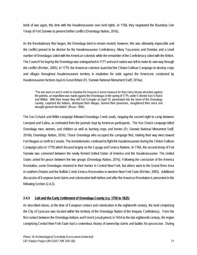
Phase 1A Archaeological Sensitivity Assessment (redacted)
I-81 Viaduct Project (NYSDOT PIN 3501.60) 71
brink of war again, this time with the Haudenosaunee over land rights. In 1768, they negotiated the Boundary Line
Treaty of Fort Stanwix to prevent further conflict (Onondaga Nation, 2016).
As the Revolutionary War began, the Onondaga tried to remain neutral; however, this was ultimately impossible and
the conflict proved to be divisive for the Haudenosaunee Confederacy. Many Tuscaroras and Oneidas and a small
number of Onondagas sided with the American colonists while the remainder of the Confederacy sided with the British.
The Council Fire kept by the Onondaga was extinguished in 1777 and each nation was left to make its own way through
the conflict (Richter, 2005). In 1779, the American colonists launched the Clinton-Sullivan Campaign to destroy crops
and villages throughout Haudenosaunee territory in retaliation for raids against the Americans conducted by
Haudenosaunee factions loyal to Great Britain (Ft. Stanwix National Monument Staff, 2016a).
“The war went on and in order to chastise the Iroquois in some measure for their many bloody atrocities against the patriots, an expedition was made against the Onondagas in the spring of 1779, under Colonels Van Schaick and Willett. With their troops they left Fort Schuyler on April 19, penetrated into the heart of the Onondaga country, surprised the Indians, destroyed their villages, burned their provisions, slaughtered their stock and wrought general desolation” (Bruce, 1896).
The Van Schaick and Willet campaign followed Onondaga Creek south, stopping the second night to camp between
Liverpool and Salina, as estimated from the journals kept by American participants. The Van Shaick campaign killed
Onondaga men, women, and children as well as burning crops and homes (Ft. Stanwix National Monument Staff,
2016b; Onondaga Nation, 2016). Those Onondaga who escaped the campaign fled, making their way west toward
Fort Niagara or north to Canada. The revolutionaries continued to fight the Haudenosaunee during the Clinton-Sullivan
Campaign (also in 1779) which focused largely on the Cayuga and Seneca Nations. In 1784, the second treaty of Fort
Stanwix was convened between the newly formed United States of America and the Haudenosaunee. The United
States asked for peace between the two groups (Onondaga Nation, 2016). Following the conclusion of the America
Revolution, some Onondagas returned to their homes in Central New York, but others went to the Grand River Area
in southern Ontario and the Buffalo Creek Seneca Reservation in western New York State (Richter, 2005). Additional
discussion of European land claims and colonization both before and after the American Revolution is presented in the
following Section (2.4.3).
2.4.3 Salt and the Early Settlement of Onondaga County (ca. 1750 to 1825)
As described above, at the time of European contact and colonization in the eighteenth century, the land comprising
the City of Syracuse was located within the territory of the Onondaga Nation of the Iroquois Confederacy. From the
first contact between the Onondaga Indians and French Jesuit priests in 1654 to the late eighteenth century, the region
comprising Central New York State had a contentious history of ownership claims and battles for possession. During
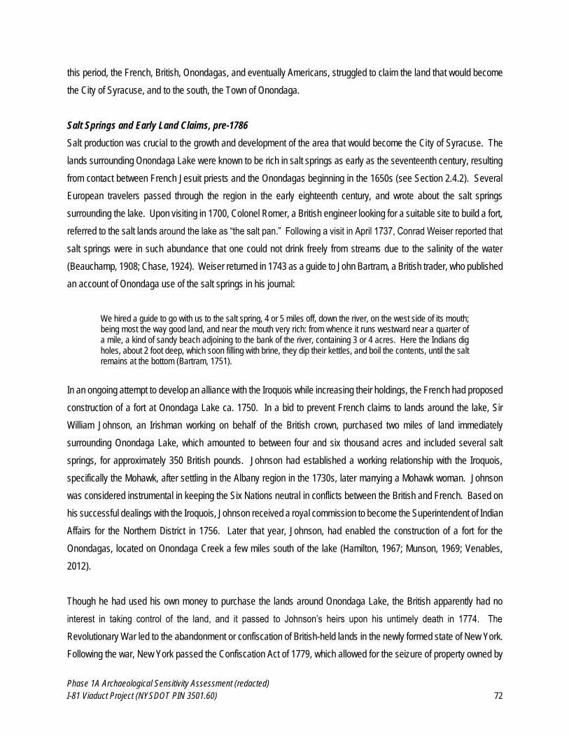
Phase 1A Archaeological Sensitivity Assessment (redacted)
I-81 Viaduct Project (NYSDOT PIN 3501.60) 72
this period, the French, British, Onondagas, and eventually Americans, struggled to claim the land that would become
the City of Syracuse, and to the south, the Town of Onondaga.
Salt Springs and Early Land Claims, pre-1786
Salt production was crucial to the growth and development of the area that would become the City of Syracuse. The
lands surrounding Onondaga Lake were known to be rich in salt springs as early as the seventeenth century, resulting
from contact between French Jesuit priests and the Onondagas beginning in the 1650s (see Section 2.4.2). Several
European travelers passed through the region in the early eighteenth century, and wrote about the salt springs
surrounding the lake. Upon visiting in 1700, Colonel Romer, a British engineer looking for a suitable site to build a fort,
referred to the salt lands around the lake as “the salt pan.” Following a visit in April 1737, Conrad Weiser reported that
salt springs were in such abundance that one could not drink freely from streams due to the salinity of the water
(Beauchamp, 1908; Chase, 1924). Weiser returned in 1743 as a guide to John Bartram, a British trader, who published
an account of Onondaga use of the salt springs in his journal:
We hired a guide to go with us to the salt spring, 4 or 5 miles off, down the river, on the west side of its mouth; being most the way good land, and near the mouth very rich: from whence it runs westward near a quarter of a mile, a kind of sandy beach adjoining to the bank of the river, containing 3 or 4 acres. Here the Indians dig holes, about 2 foot deep, which soon filling with brine, they dip their kettles, and boil the contents, until the salt remains at the bottom (Bartram, 1751).
In an ongoing attempt to develop an alliance with the Iroquois while increasing their holdings, the French had proposed
construction of a fort at Onondaga Lake ca. 1750. In a bid to prevent French claims to lands around the lake, Sir
William Johnson, an Irishman working on behalf of the British crown, purchased two miles of land immediately
surrounding Onondaga Lake, which amounted to between four and six thousand acres and included several salt
springs, for approximately 350 British pounds. Johnson had established a working relationship with the Iroquois,
specifically the Mohawk, after settling in the Albany region in the 1730s, later marrying a Mohawk woman. Johnson
was considered instrumental in keeping the Six Nations neutral in conflicts between the British and French. Based on
his successful dealings with the Iroquois, Johnson received a royal commission to become the Superintendent of Indian
Affairs for the Northern District in 1756. Later that year, Johnson, had enabled the construction of a fort for the
Onondagas, located on Onondaga Creek a few miles south of the lake (Hamilton, 1967; Munson, 1969; Venables,
2012).
Though he had used his own money to purchase the lands around Onondaga Lake, the British apparently had no
interest in taking control of the land, and it passed to Johnson’s heirs upon his untimely death in 1774. The
Revolutionary War led to the abandonment or confiscation of British-held lands in the newly formed state of New York.
Following the war, New York passed the Confiscation Act of 1779, which allowed for the seizure of property owned by
Phase 1A Archaeological Sensitivity Assessment (redacted)
I-81 Viaduct Project (NYSDOT PIN 3501.60) 73
British loyalists. This included the lands previously purchased by Johnson, which were still within the territory of the
Onondagas. During the Revolutionary War, the Onondagas were initially neutral, but ultimately fought with the British
against the American colonists, hoping to prevent their land from being taken. This led to unfavorable treatment in
subsequent treaty negotiations, as they were treated as a vanquished foe with minimal bargaining rights to the land
they had occupied for centuries (Venables, 2012; LPL, 2014).
The First Permanent Euro-American Settlers
Following the Revolutionary War, many veterans and settlers relocated to the Six Nations Reserve in Canada, passing
through upstate New York, including the area that would become Syracuse, lured by fur trading, as well as the wealth
of salt springs, for which the region was already well known. On a visit to the region in 1774, New York State Senator
Silas Bowker witnessed two African-American men (believed to be escaped slaves, though the provenance of this fact
is unknown) boiling salt in brass kettles, presumably for sale or trade with the Onondagas. An attempt was made by a
man named Peter Sim to “experiment” on the salt springs at what was referred to as “Salt Lake” in 1778, though he
was reportedly chased away by the Onondagas (Werner, 1917; Chase, 1924; Sernett, 1995). A 1779 map (Figure
2.4.3-1) identifies the lake as the Salt Lake, and notes the presence of an Onondaga village (or “castle”) to the south
along Onondaga Creek, though no salt springs are depicted. The lake is also noted to be within “Six Nations Indians
Country” as it was still part of the Iroquois Nation.
The earliest permanent white settler in the area surrounding Syracuse was Ephraim Webster, a hunter, trapper, scout
and interpreter from Vermont. Webster served in the Revolutionary War prior to becoming a trader among the Iroquois,
and developed a strong relationship with the Onondagas in the years following the war. He arrived in 1786 with
Benjamin Neukirk (a fellow trader who died soon after), and established a camp on the east side of Onondaga Creek
that became known as Webster’s Landing, where he constructed a cabin. On a hunting trip in February 1788, Webster
encouraged Comfort Tyler and General Asa Danforth to settle in Onondaga Hollow, a small settlement in what later
became the Town of Onondaga. General Danforth came from the town of Mayfield in Montgomery County, inspired
after a visit by Ephraim Webster and two Onondaga Indian guides, who stopped to rest at the Danforth farm. Danforth
offered the travelers lodging in his home, where Webster described the beautiful wilderness from which they had
traveled. Webster requested and received the consent of the Onondagas for Danforth and his family to relocate to
their lands, and in May 1788 they relocated to the Onondaga country, with Comfort Tyler and Asa Danforth’s son driving
the stock ahead of the family wagon.
Phase 1A Archaeological Sensitivity Assessment (redacted)
I-81 Viaduct Project (NYSDOT PIN 3501.60) 74
Figure 2.4.3-1. 1779 Sauthier Chorographical Map of the Province of New York (left).
Figure 2.4.3-2. 1793 1st Sheet of Dewitt’s State Map of New York (right).
The 1779 Sauthier map (left) is significant for its detailed depiction of New York State as it is existed immediately following the Revolutionary
War. Much of the land west of the Catskills and Adirondacks is shown as blank space, save for Indian villages (or “castles”) and trails, and water
features. This was due to the border established by the first Treaty of Fort Stanwix (1768), which preserved colonial land holdings in the east
but had not affected much of the Iroquois Confederacy land, including the “Salt Lake” at Onondaga, depicted here. (Sauthier, 1779; collections
of David Rumsey) The 1793 Dewitt map (right) was the first to depict the recently laid out New Military Tract, and also show the Indian
Reservations created through the second Treaty of Fort Stanwix (1784) and Treaty of Fort Schuyler (1788). The public salt reservation
surrounding the “Salt Lake” is also shown for the first time, as well as the location of the salt spring near Salt Point. This was the first sheet of a
map of New York State that Dewitt would finally finish in 1802, which created a cartographic style that informed subsequent maps and atlases of
the state and region (Dewitt, 1793; collections of David Rumsey).
Upon their arrival in Onondaga territory, the Danforths set up a camp and built a crude bark dwelling along Onondaga
Creek, south of the lake, at a settlement that would become known as Onondaga Hollow. After being shown the salt
springs around Onondaga Lake, Tyler and Danforth first boiled salt using a simple assembly comprised of forked sticks
that suspended a kettle above a fire. The bushels of salt they boiled would be hauled back to Onondaga Hollow for
personal use. Danforth and Tyler continued with the small-scale production of salt as they both worked toward
developing the settlement at Onondaga Hollow: Danforth erected a saw mill and a gristmill, while Tyler built the first
roads and bridges in the nascent village (Bruce, 1896; Beauchamp, 1908; Munson, 1969). While Danforth, Tyler and
Webster worked toward establishing a viable community south of the lake, developments at the state level would soon
lead to rapid settlement and production activity in the territory immediately surrounding Onondaga Lake.
Through the 1788 Treaty of Fort Schuyler, New York State acquired title to a vast swath of land held by the Onondaga
Nation, including portions of what today comprises Cayuga, Cortland, Onondaga, and Seneca counties. The lands
located at the southern end of Onondaga Lake that were known to be rich in salt springs were established for joint use
of the state and the Onondagas in the production of salt, increasing the allure of the area immediately surrounding of
the lake as a place for settlers (see Figure 2.4.3-2). In the fall of 1789, Nathaniel Loomis arrived at Onondaga Lake
and began production of salt for resale. The following year, Colonel Jeremiah Gould, Hezekiah and Thomas Olcott,
and Deacon Loomis arrived at the lake to engage in salt production. As a result of the increased activity and migration
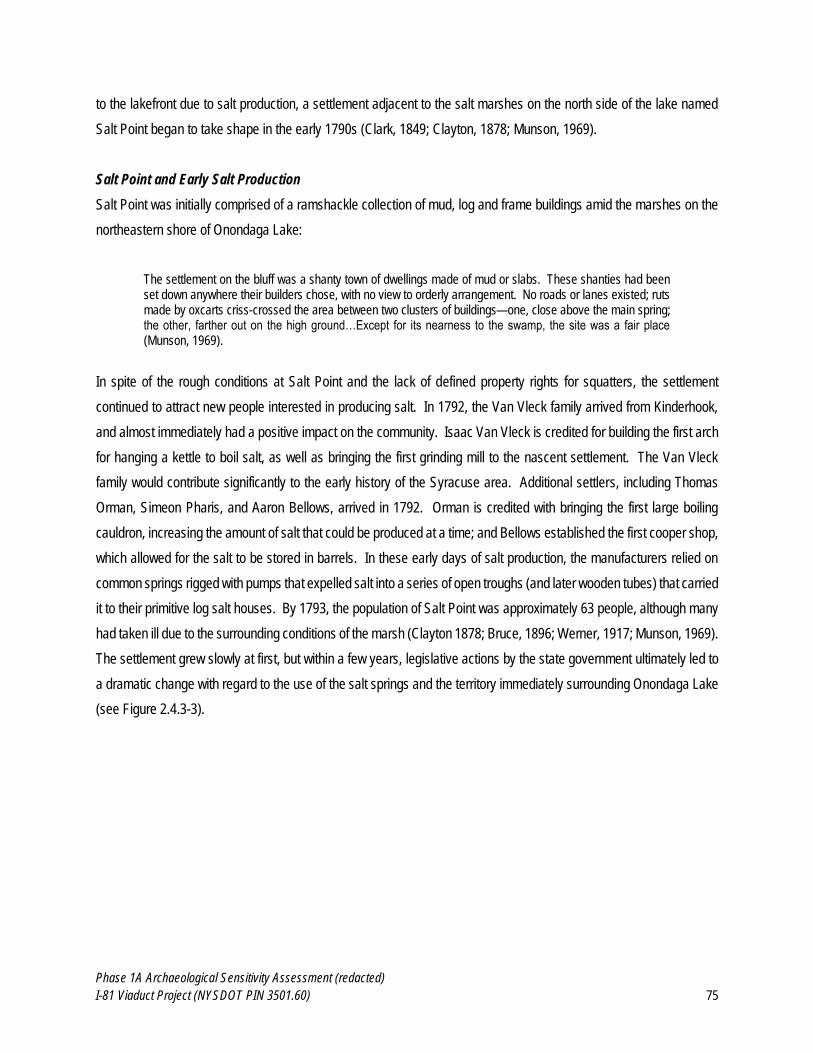
Phase 1A Archaeological Sensitivity Assessment (redacted)
I-81 Viaduct Project (NYSDOT PIN 3501.60) 75
to the lakefront due to salt production, a settlement adjacent to the salt marshes on the north side of the lake named
Salt Point began to take shape in the early 1790s (Clark, 1849; Clayton, 1878; Munson, 1969).
Salt Point and Early Salt Production
Salt Point was initially comprised of a ramshackle collection of mud, log and frame buildings amid the marshes on the
northeastern shore of Onondaga Lake:
The settlement on the bluff was a shanty town of dwellings made of mud or slabs. These shanties had been set down anywhere their builders chose, with no view to orderly arrangement. No roads or lanes existed; ruts made by oxcarts criss-crossed the area between two clusters of buildings—one, close above the main spring; the other, farther out on the high ground…Except for its nearness to the swamp, the site was a fair place (Munson, 1969).
In spite of the rough conditions at Salt Point and the lack of defined property rights for squatters, the settlement
continued to attract new people interested in producing salt. In 1792, the Van Vleck family arrived from Kinderhook,
and almost immediately had a positive impact on the community. Isaac Van Vleck is credited for building the first arch
for hanging a kettle to boil salt, as well as bringing the first grinding mill to the nascent settlement. The Van Vleck
family would contribute significantly to the early history of the Syracuse area. Additional settlers, including Thomas
Orman, Simeon Pharis, and Aaron Bellows, arrived in 1792. Orman is credited with bringing the first large boiling
cauldron, increasing the amount of salt that could be produced at a time; and Bellows established the first cooper shop,
which allowed for the salt to be stored in barrels. In these early days of salt production, the manufacturers relied on
common springs rigged with pumps that expelled salt into a series of open troughs (and later wooden tubes) that carried
it to their primitive log salt houses. By 1793, the population of Salt Point was approximately 63 people, although many
had taken ill due to the surrounding conditions of the marsh (Clayton 1878; Bruce, 1896; Werner, 1917; Munson, 1969).
The settlement grew slowly at first, but within a few years, legislative actions by the state government ultimately led to
a dramatic change with regard to the use of the salt springs and the territory immediately surrounding Onondaga Lake
(see Figure 2.4.3-3).
Phase 1A Archaeological Sensitivity Assessment (redacted)
I-81 Viaduct Project (NYSDOT PIN 3501.60) 76
Figure 2.4.3-3. 1797 Map of Onondaga Salt Lake. The 1797 Simeon Dewitt Map of Onondaga Salt Lake shows the lake and surrounding area prior to the establishment of the Onondaga Salt
Springs Reservation, including the nascent settlement of Salina, as well as the relatively undeveloped condition of the land surrounding Onondaga
Lake just prior to the establishment of the Onondaga Salt Springs Reservation in 1797. The location of salt springs, salt blocks, as well as
meadows, and the original, meandering courses of Onondaga Creek and Harbor Brook that would soon be diverted with the construction of
hundreds of salt sheds in the coming decades. (Dewitt, 1797; Image from the Digital Collections of the New York State Archives).
The New Military Tract and Onondaga Salt Springs Reservation
Concurrent with the early settlement of Salt Point was the establishment in 1790 of the New Military Tract, a 1.5 million-
acre tract initially set aside by the state in 1782 for soldiers of the Revolutionary War, but not opened to settlers for
almost a decade due to conflicts with the Iroquois. The New Military Tract encouraged surveying and subsequent
migration by war veterans as well as Euro-American settlers in the land recently opened to white settlement by the
Treaty of Fort Schuyler. The land was divided into 28 townships, each containing 100 lots of 600 acres arranged in a
uniform grid pattern. Although the land was set aside for veterans, many of them either neglected to claim their land
or sold their land to speculators and the area was settled primarily by migrants from New England, New Jersey,
Pennsylvania and the Hudson Valley (Dieckmann, 1986; Schein, 1993, 2005).
Onondaga County was formed in 1794 from Herkimer and Tioga Counties, and named after the Onondaga Indians
whose former territory comprised the lands of the newly-formed county. By 1795, the Onondagas had relinquished all
title to the lands in return for an annuity and a yearly allowance of salt, and relocated to a reservation to the south.
Though salt production had increased significantly in the preceding years, there was little formal regulation and
considerable land squatting, leading the New York State Legislature to establish the Onondaga Salt Springs
Reservation (OSSR) in 1797. The OSSR encompassed a 15,000-acre reservation subdivided into manufacturing lots
Early settlement of
Salina
Salt springs
Salt boiling blocks
Phase 1A Archaeological Sensitivity Assessment (redacted)
I-81 Viaduct Project (NYSDOT PIN 3501.60) 77
adjacent to the most productive salt springs, as well as pasture lots, and a large portion reserved for the massive
amount of firewood using in the early boiling block process of salt-making. The reservation included portions of what
would soon become the Village of Syracuse, Town of Salina, and Town of Geddes (Clayton, 1878; Rivette, 2005;
Darlington, 2005). The Onondaga Salt Springs Reservation was the first government-regulated effort to harvest salt
on a larger scale, and would lead to profound changes in the nearby environment and local economy in a matter of a
few years.
The first superintendent of salt was William Stevens, who assumed the post in 1797. Through Stevens, the state would
collect duties for use of the land and water (four cents per every bushel of salt produced), and also regulated the
amount of salt to be produced per kettle (ten bushels per kettle used), as well as how it was sold. Salt was not to be
sold directly after production, but needed to be weighed first, barreled, and kept at a public storehouse until time of
sale. A military block house built of oak timbers built near Salt Point in 1794 was converted into a salt storehouse.
Subsequent regulations were soon passed, dictating the dimensions, weight and type of wood to be used for salt
barrels, and that salt was only to be shipped from the public wharf (Clark, 1849; Clayton, 1878; Bruce, 1896).
The increased regulation of the OSSR essentially brought an end to small-scale production by squatters and shifted
salt manufacturing to commercial interests and legitimate leaseholders. The Federal Company was the first commercial
organization dedicated to salt production on a larger scale in Onondaga County, established in 1798 by a group of
seven Salt Point settlers (including Asa Danforth and Elisha Alvord). The company constructed a large building, or
salt block, capable of holding thirty-two kettles in groups of four, for the purposes of boiling salt. Within two years,
Elisha and Thomas Alvord had bought out the other partners in the company, and along with their brother Dioclesian
would go on to great prosperity as salt manufacturers and merchants, later constructing the first brick building in the
area in 1808 (Clayton, 1878; Bruce, 1896).
Within a few years, salt production had increased significantly to the point that the state relaxed or removed many of
its restrictions in order to expedite the shipping of salt, but also due to difficulty of enforcement. The rapid growth of
the salt industry at Onondaga Lake attracted the attention of outsiders, some of whom reported their findings. An 1801
publication of the Society for the Promotion of Agriculture, Arts and Manufactures Instituted in the State of New York
included a speech entitled “A Memoir on the Onondaga Salt Springs and Salt Manufactories in the State of New York,”
delivered to the society by Dr. Benjamin Dewitt. Dewitt had visited the salt springs and conducted experiments related
to temperature and salt content, remarked on a number of features of the salt springs, speculated on their origin, as
well as describing the production of salt at Salt Point (known by then as Salina):
The marsh from which the principal springs proceed is bounded…by a steep bank of clayey ground, about thirty or forty feet above the level of the lake, forming the upland on which the village of Salina
Phase 1A Archaeological Sensitivity Assessment (redacted)
I-81 Viaduct Project (NYSDOT PIN 3501.60) 78
stands…Immediately below the declivity, on the border of the marsh, and as near the springs as the ground will admit, are situated the buildings which are destined for the manufacturing of salt. They are constructed of wood, generally about twenty feet wide, and of various lengths, according to the number of furnaces they are intended to contain; in one of them there are forty evaporating pots. The furnaces are placed along one side of the building, with their mouths opening into it. The other side is generally made use of to deposit the salt for the purpose of draining off the brine, and allowing it to dry, immediately after it is emptied out of the evaporating vessels. The furnaces are built of stone, and two or three pots or kettles…containing each about eighty gallons, are usually placed, from which the water is drawn into the boilers as often as it is required. These troughs are kept continually filled with water by means of gutters, into which it is pumped out of the springs. The furnaces being supplied with fuel, and the pots filled with water, they are allowed to boil briskly, and after a little while the powder scratch (as it is called) consisting of calcareous earth, begins to precipitate to the bottom; this is taken out as fast as it is formed, by means of large iron ladles. By the time this has all fallen down, the salt begins to chrystalize (sic); the pots are then suffered to boil gently, till nearly all the water is dissipated. The salt is afterwards taken out and deposited in proper places to drain off the brine and suffer it to dry. Nothing now remains in the pot but a small quantity of bittern, which is thrown away, and the same process is repeated (Dewitt, 1801).
This was the earliest detailed description of the boiling method of salt production, which Dewitt also provided
recommendations for improving, including the use of iron pans instead of kettles, and building partition walls to prevent
ash from mixing with salt water (Dewitt, 1801; Clayton, 1878).
Boiling continued as the dominant method for several years, and as production increased, buildings grew larger to
accommodate increasing numbers of kettles and furnaces. In 1797, the first year of the OSSR, 25,474 bushels of salt
were made and inspected. By 1798 this number had more than doubled to 59,928 bushels, and by 1804 over 100,000
bushels were being produced at the salt springs near Onondaga Lake. Though the amount of salt produced did not
always increase from year-to-year, production increased dramatically to 452,050 bushels in 1810 before leveling off
again. In 1812, a law was passed that required the superintendent to assign two acres of land for the purpose of
experimenting with manufacturing salt via solar evaporation. Although making salt through solar evaporation had been
recorded in New York State as early as 1661, this was the first noted implementation for commercial production, and
it would eventually prove so successful as to become the only method of manufacturing salt at Onondaga Lake (Beck,
1826; Clayton, 1878; Werner, 1917).
Solar salt evaporation differed significantly in production and infrastructure from boiling, as noted in an 1826 publication
entitled “An Account of the Salt Springs at Salina”:
The vats constructed for this manufacture are eighteen and a half feet square, and about a foot deep. Of these, there are two parallel rows, which communicate with each other; the one being on a level about a foot lower than the other…The brine is conducted by wooden pipes into the upper tier of vats, where it remains exposed to the sun until crystals of salt begin to shoot out onto the surface. By this time nearly all the lime and other impurities have subsided, and are to be found at the bottom of the vats in beautiful crystals, which are somewhat deliquescent. The brine, thus reduced to saturation, is drawn off into the lower tier of vats, where the formation of salt goes on. It is then taken out and dried, as before, by the heat of the sun; when it consists of large crystals, hard and dry, and of a beautiful white colour. It may be remarked that the evaporation of the water depends greatly upon the state of the atmosphere, and that the process is of course retarded when there
Phase 1A Archaeological Sensitivity Assessment (redacted)
I-81 Viaduct Project (NYSDOT PIN 3501.60) 79
is much humidity. But to prevent the embarrassment which would ensue from the access of rains, by the dilution of the brine, covers are constructed for the vats, which run upon rollers, and may be easily moved whenever occasion requires (Beck, 1826).
The salt produced by solar evaporation was coarse in nature, whereas salt produced by boiling was of a finer crystal.
In 1821 lands were laid out specifically for the manufacture of coarse salt by solar evaporation. This was unpopular
with the manufacturers who relied on boiling, and likely perceived a threat in the new method of production. Several
hundred acres of OSSR lands had already been sold beginning in 1820, with proceeds going to the commissioners of
the Erie Canal building fund. This money was in addition to a new tax of 12.5 cents per bushel enacted in 1816 for the
purpose of increased the building fund for the Erie Canal, plans for which had been in motion for a number of years,
spearheaded by local Judge Joshua Forman and aided by James Geddes, an early Salt Point settler who had surveyed
the area that would become the Villages of Salina, Syracuse and Geddes (see Section 2.4.4 of this report) (Clark,
1849; Werner, 1917; Munson, 1969).
By 1825, the number of salt bushels produced had increased to 768,188. The OSSR contained a total of 150 salt
manufactories with 2,275 kettles total between the villages of Salina, Syracuse, Liverpool and Geddes. Solar vats
covered an enormous amount of the land, measuring a total of approximately 74,700 feet in length by eighteen feet
wide, spread throughout the reservation (see Figure 2.4.3-4) (Clark, 1849; Werner, 1917). The rapid growth of the salt
industry in the preceding decades had helped the once rough and dismal settlements around Onondaga Lake to thrive
and become part of an economic center positioned at the middle of the state, whose continued success was facilitated
for almost a century by the construction of the Erie and Oswego Canals.
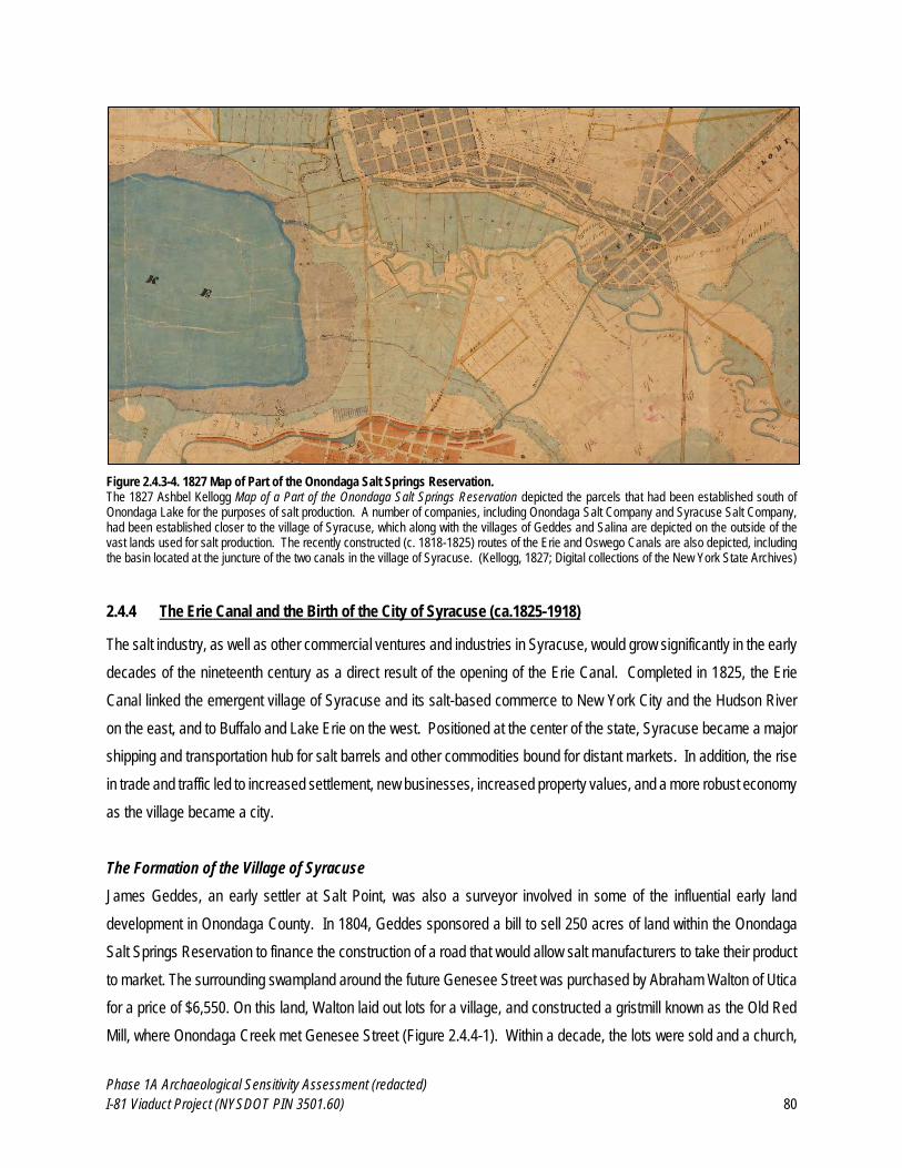
Phase 1A Archaeological Sensitivity Assessment (redacted)
I-81 Viaduct Project (NYSDOT PIN 3501.60) 80
Figure 2.4.3-4. 1827 Map of Part of the Onondaga Salt Springs Reservation. The 1827 Ashbel Kellogg Map of a Part of the Onondaga Salt Springs Reservation depicted the parcels that had been established south of Onondaga Lake for the purposes of salt production. A number of companies, including Onondaga Salt Company and Syracuse Salt Company, had been established closer to the village of Syracuse, which along with the villages of Geddes and Salina are depicted on the outside of the vast lands used for salt production. The recently constructed (c. 1818-1825) routes of the Erie and Oswego Canals are also depicted, including the basin located at the juncture of the two canals in the village of Syracuse. (Kellogg, 1827; Digital collections of the New York State Archives)
2.4.4 The Erie Canal and the Birth of the City of Syracuse (ca.1825-1918)
The salt industry, as well as other commercial ventures and industries in Syracuse, would grow significantly in the early
decades of the nineteenth century as a direct result of the opening of the Erie Canal. Completed in 1825, the Erie
Canal linked the emergent village of Syracuse and its salt-based commerce to New York City and the Hudson River
on the east, and to Buffalo and Lake Erie on the west. Positioned at the center of the state, Syracuse became a major
shipping and transportation hub for salt barrels and other commodities bound for distant markets. In addition, the rise
in trade and traffic led to increased settlement, new businesses, increased property values, and a more robust economy
as the village became a city.
The Formation of the Village of Syracuse
James Geddes, an early settler at Salt Point, was also a surveyor involved in some of the influential early land
development in Onondaga County. In 1804, Geddes sponsored a bill to sell 250 acres of land within the Onondaga
Salt Springs Reservation to finance the construction of a road that would allow salt manufacturers to take their product
to market. The surrounding swampland around the future Genesee Street was purchased by Abraham Walton of Utica
for a price of $6,550. On this land, Walton laid out lots for a village, and constructed a gristmill known as the Old Red
Mill, where Onondaga Creek met Genesee Street (Figure 2.4.4-1). Within a decade, the lots were sold and a church,
Phase 1A Archaeological Sensitivity Assessment (redacted)
I-81 Viaduct Project (NYSDOT PIN 3501.60) 81
school, tavern and additional mills were constructed around the developing settlement alternately known as Bogardus
Corners, Milan, Corinth, and finally Syracuse. The Walton tract was improved upon in the 1820s by Joshua Forman
(often referred to as the “Father of Syracuse”), along with the Syracuse Company, owned by James McBride, Isaiah
and John Townsend, and Moses DeWitt Burnet whose names were given to the village streets (Clark, 1849;
Beauchamp, 1908; Hardin, 1993).
Burnet soon became the agent for the Syracuse Company, selling lots, also building stores and dwellings. The village
of Syracuse was incorporated on April 13, 1825 and quickly established its dominance over the neighboring village of
Salina, which was still heavily focused on salt production. By that time Syracuse boasted fifteen mercantile
establishments, many of which operated in buildings owned by Burnet. Forman was also crucial in bringing the solar
evaporation method of salt manufacture to Syracuse when Salt Point failed to take advantage of legislation that would
transition it from the more expensive, inefficient boiling method which was also detrimental to the region’s wood supply.
The legislation provided not only twenty year leases on the land for the solar salt fields, but also the ability to carry
surplus brine from Salina to supply solar works, and the use of surplus canal water to work the pumps. Forman
established the Syracuse Coarse Salt Company (later to be taken over by the Syracuse Company who continued to
develop the Walton Tract), the Syracuse Solar Salt Company, and the Onondaga Solar Coarse Salt Company (Cheney,
1857; Beauchamp, 1908; Munson, 1969).
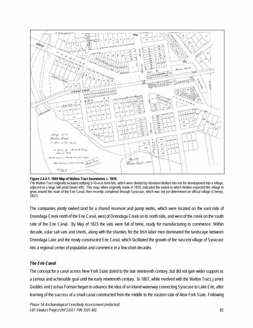
Phase 1A Archaeological Sensitivity Assessment (redacted)
I-81 Viaduct Project (NYSDOT PIN 3501.60) 82
Figure 2.4.4-1. 1869 Map of Walton Tract boundaries c. 1819. The Walton Tract originally included outlying 5-10-acre farm lots, which were divided by Abraham Walton into lots for development into a village, adjacent to a large mill pond (lower left). This map, when originally made in 1819, indicated the extent to which Walton expected the village to grow around the route of the Erie Canal, then recently completed through Syracuse, which was not yet determined an official village (Cheney, 1857).
The companies jointly owned land for a shared reservoir and pump works, which were located on the east side of
Onondaga Creek north of the Erie Canal, west of Onondaga Creek on its north side, and west of the creek on the south
side of the Erie Canal. By May of 1823 the vats were full of brine, ready for manufacturing to commence. Within
decade, solar salt vats and sheds, along with the shanties for the Irish labor men dominated the landscape between
Onondaga Lake and the newly constructed Erie Canal, which facilitated the growth of the nascent village of Syracuse
into a regional center of population and commerce in a few short decades.
The Erie Canal
The concept for a canal across New York State dated to the late nineteenth century, but did not gain wider support as
a serious and achievable goal until the early nineteenth century. In 1807, while involved with the Walton Tract, James
Geddes and Joshua Forman began to advance the idea of an inland waterway connecting Syracuse to Lake Erie, after
learning of the success of a small canal constructed from the middle to the eastern side of New York State. Following
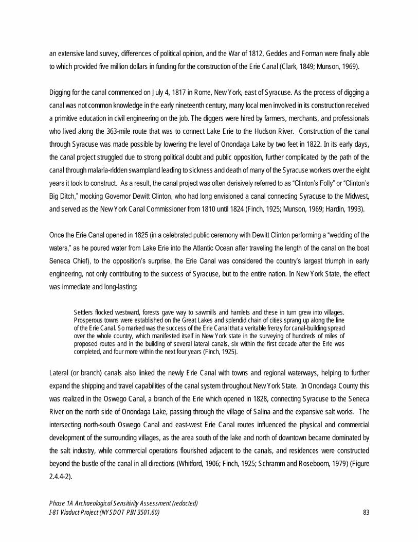
Phase 1A Archaeological Sensitivity Assessment (redacted)
I-81 Viaduct Project (NYSDOT PIN 3501.60) 83
an extensive land survey, differences of political opinion, and the War of 1812, Geddes and Forman were finally able
to which provided five million dollars in funding for the construction of the Erie Canal (Clark, 1849; Munson, 1969).
Digging for the canal commenced on July 4, 1817 in Rome, New York, east of Syracuse. As the process of digging a
canal was not common knowledge in the early nineteenth century, many local men involved in its construction received
a primitive education in civil engineering on the job. The diggers were hired by farmers, merchants, and professionals
who lived along the 363-mile route that was to connect Lake Erie to the Hudson River. Construction of the canal
through Syracuse was made possible by lowering the level of Onondaga Lake by two feet in 1822. In its early days,
the canal project struggled due to strong political doubt and public opposition, further complicated by the path of the
canal through malaria-ridden swampland leading to sickness and death of many of the Syracuse workers over the eight
years it took to construct. As a result, the canal project was often derisively referred to as “Clinton’s Folly” or “Clinton’s
Big Ditch,” mocking Governor Dewitt Clinton, who had long envisioned a canal connecting Syracuse to the Midwest,
and served as the New York Canal Commissioner from 1810 until 1824 (Finch, 1925; Munson, 1969; Hardin, 1993).
Once the Erie Canal opened in 1825 (in a celebrated public ceremony with Dewitt Clinton performing a “wedding of the
waters,” as he poured water from Lake Erie into the Atlantic Ocean after traveling the length of the canal on the boat
Seneca Chief), to the opposition’s surprise, the Erie Canal was considered the country’s largest triumph in early
engineering, not only contributing to the success of Syracuse, but to the entire nation. In New York State, the effect
was immediate and long-lasting:
Settlers flocked westward, forests gave way to sawmills and hamlets and these in turn grew into villages. Prosperous towns were established on the Great Lakes and splendid chain of cities sprang up along the line of the Erie Canal. So marked was the success of the Erie Canal that a veritable frenzy for canal-building spread over the whole country, which manifested itself in New York state in the surveying of hundreds of miles of proposed routes and in the building of several lateral canals, six within the first decade after the Erie was completed, and four more within the next four years (Finch, 1925).
Lateral (or branch) canals also linked the newly Erie Canal with towns and regional waterways, helping to further
expand the shipping and travel capabilities of the canal system throughout New York State. In Onondaga County this
was realized in the Oswego Canal, a branch of the Erie which opened in 1828, connecting Syracuse to the Seneca
River on the north side of Onondaga Lake, passing through the village of Salina and the expansive salt works. The
intersecting north-south Oswego Canal and east-west Erie Canal routes influenced the physical and commercial
development of the surrounding villages, as the area south of the lake and north of downtown became dominated by
the salt industry, while commercial operations flourished adjacent to the canals, and residences were constructed
beyond the bustle of the canal in all directions (Whitford, 1906; Finch, 1925; Schramm and Roseboom, 1979) (Figure
2.4.4-2).
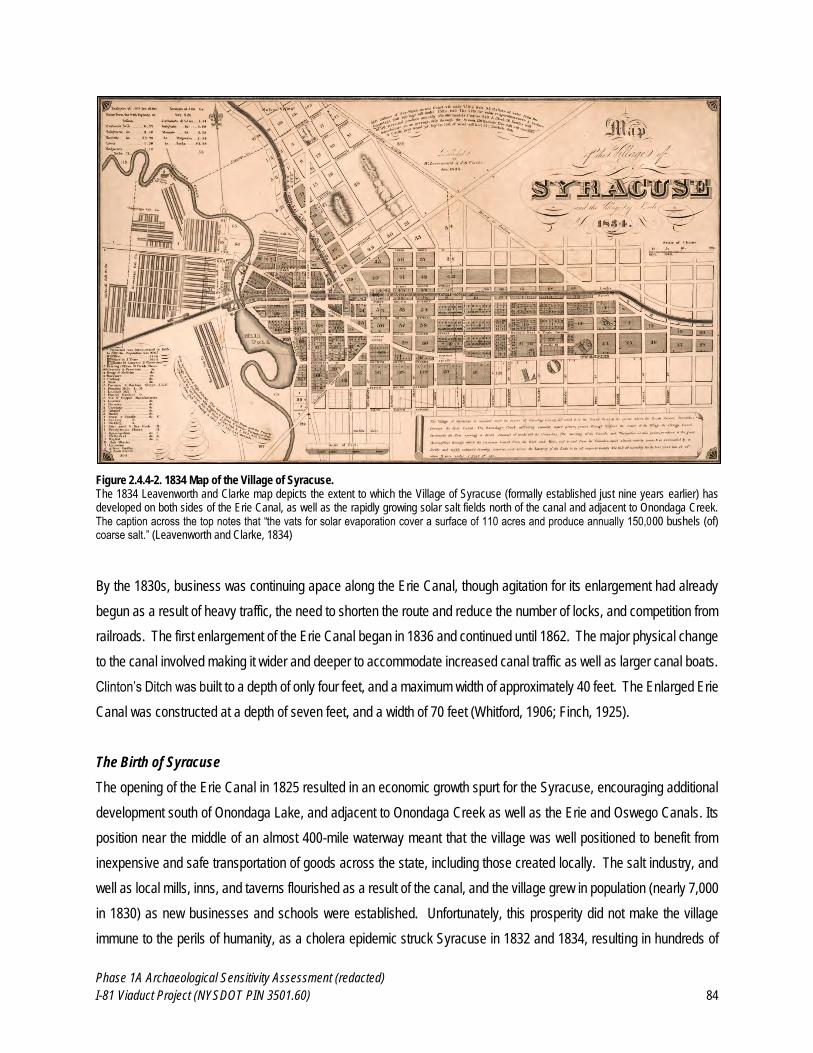
Phase 1A Archaeological Sensitivity Assessment (redacted)
I-81 Viaduct Project (NYSDOT PIN 3501.60) 84
Figure 2.4.4-2. 1834 Map of the Village of Syracuse. The 1834 Leavenworth and Clarke map depicts the extent to which the Village of Syracuse (formally established just nine years earlier) has developed on both sides of the Erie Canal, as well as the rapidly growing solar salt fields north of the canal and adjacent to Onondaga Creek. The caption across the top notes that “the vats for solar evaporation cover a surface of 110 acres and produce annually 150,000 bushels (of) coarse salt.” (Leavenworth and Clarke, 1834)
By the 1830s, business was continuing apace along the Erie Canal, though agitation for its enlargement had already
begun as a result of heavy traffic, the need to shorten the route and reduce the number of locks, and competition from
railroads. The first enlargement of the Erie Canal began in 1836 and continued until 1862. The major physical change
to the canal involved making it wider and deeper to accommodate increased canal traffic as well as larger canal boats.
Clinton’s Ditch was built to a depth of only four feet, and a maximum width of approximately 40 feet. The Enlarged Erie
Canal was constructed at a depth of seven feet, and a width of 70 feet (Whitford, 1906; Finch, 1925).
The Birth of Syracuse
The opening of the Erie Canal in 1825 resulted in an economic growth spurt for the Syracuse, encouraging additional
development south of Onondaga Lake, and adjacent to Onondaga Creek as well as the Erie and Oswego Canals. Its
position near the middle of an almost 400-mile waterway meant that the village was well positioned to benefit from
inexpensive and safe transportation of goods across the state, including those created locally. The salt industry, and
well as local mills, inns, and taverns flourished as a result of the canal, and the village grew in population (nearly 7,000
in 1830) as new businesses and schools were established. Unfortunately, this prosperity did not make the village
immune to the perils of humanity, as a cholera epidemic struck Syracuse in 1832 and 1834, resulting in hundreds of
Phase 1A Archaeological Sensitivity Assessment (redacted)
I-81 Viaduct Project (NYSDOT PIN 3501.60) 85
deaths, and significant fires in 1834 and 1841 (the latter caused by a gunpowder explosion) leveled several blocks of
wood-framed buildings adjacent to the Erie Canal in downtown Syracuse (Munson, 1969; Schramm and Roseboom,
1979).
After decades of commercial, industrial and political competition (and occasional physical altercations between loyal
residents), the overwhelming benefits provided by the Erie Canal prompted the villages of Salina and Syracuse to
merge and become the City of Syracuse in 1848. By the following year, it was reported that 250 Syracuse homes were
under construction, with another 500 to be constructed by 1850. The population of Syracuse increased significantly,
from 600 in 1820 to 2,565 by 1830, 11,014 in 1840, and 22,127 by 1850 (Cheney, 1857; Hand, 1894; Hardin, 1993).
The linkage of the Erie and Oswego Canals to distant waterways such as the Hudson River and Lake Erie was to thank
for the continued success of the salt industry in Syracuse. In a symbiotic relationship, the canals allowed for inexpensive
shipping while the duty collected on the salt funded the mid-century enlargement of the canals, allowing additional
commerce on the connected waterways. The subsequent wealth brought into the city was used to establish banks,
whose capital financed new industry. Syracuse’s early arrangement as an upstart village tract was quickly transformed
into that of a formidable city, replete with homes alongside hotels and taverns, and once-small commercial enterprises
growing into large-scale manufacturing concerns, thereby enhancing the reputation of the city (see Figure 2.4.4-3).
Phase 1A Archaeological Sensitivity Assessment (redacted)
I-81 Viaduct Project (NYSDOT PIN 3501.60) 86
Figure 2.4.4-3. 1852 Map of the City of Syracuse. The establishment of the City of Syracuse in 1848 subsumed the adjacent villages of Salina and Geddes, growing the boundaries of the cityt as well as its neighborhoods, commerce and industry (Fagan, 1852)
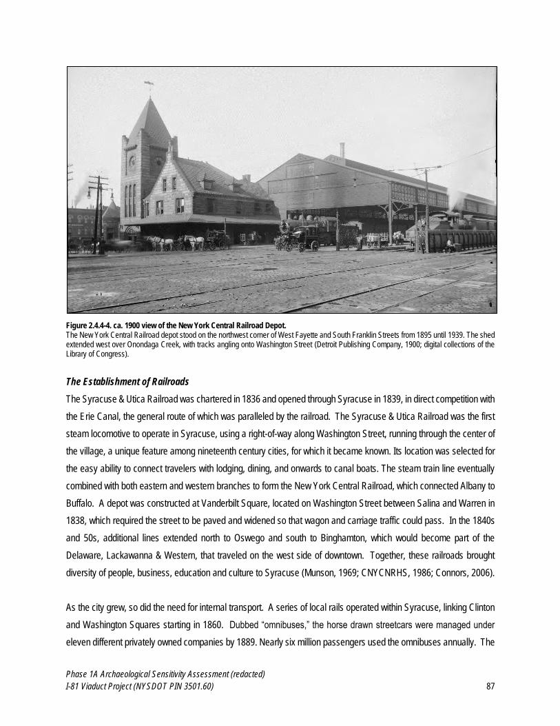
Phase 1A Archaeological Sensitivity Assessment (redacted)
I-81 Viaduct Project (NYSDOT PIN 3501.60) 87
Figure 2.4.4-4. ca. 1900 view of the New York Central Railroad Depot. The New York Central Railroad depot stood on the northwest corner of West Fayette and South Franklin Streets from 1895 until 1939. The shed extended west over Onondaga Creek, with tracks angling onto Washington Street (Detroit Publishing Company, 1900; digital collections of the Library of Congress).
The Establishment of Railroads
The Syracuse & Utica Railroad was chartered in 1836 and opened through Syracuse in 1839, in direct competition with
the Erie Canal, the general route of which was paralleled by the railroad. The Syracuse & Utica Railroad was the first
steam locomotive to operate in Syracuse, using a right-of-way along Washington Street, running through the center of
the village, a unique feature among nineteenth century cities, for which it became known. Its location was selected for
the easy ability to connect travelers with lodging, dining, and onwards to canal boats. The steam train line eventually
combined with both eastern and western branches to form the New York Central Railroad, which connected Albany to
Buffalo. A depot was constructed at Vanderbilt Square, located on Washington Street between Salina and Warren in
1838, which required the street to be paved and widened so that wagon and carriage traffic could pass. In the 1840s
and 50s, additional lines extended north to Oswego and south to Binghamton, which would become part of the
Delaware, Lackawanna & Western, that traveled on the west side of downtown. Together, these railroads brought
diversity of people, business, education and culture to Syracuse (Munson, 1969; CNYCNRHS, 1986; Connors, 2006).
As the city grew, so did the need for internal transport. A series of local rails operated within Syracuse, linking Clinton
and Washington Squares starting in 1860. Dubbed “omnibuses,” the horse drawn streetcars were managed under
eleven different privately owned companies by 1889. Nearly six million passengers used the omnibuses annually. The
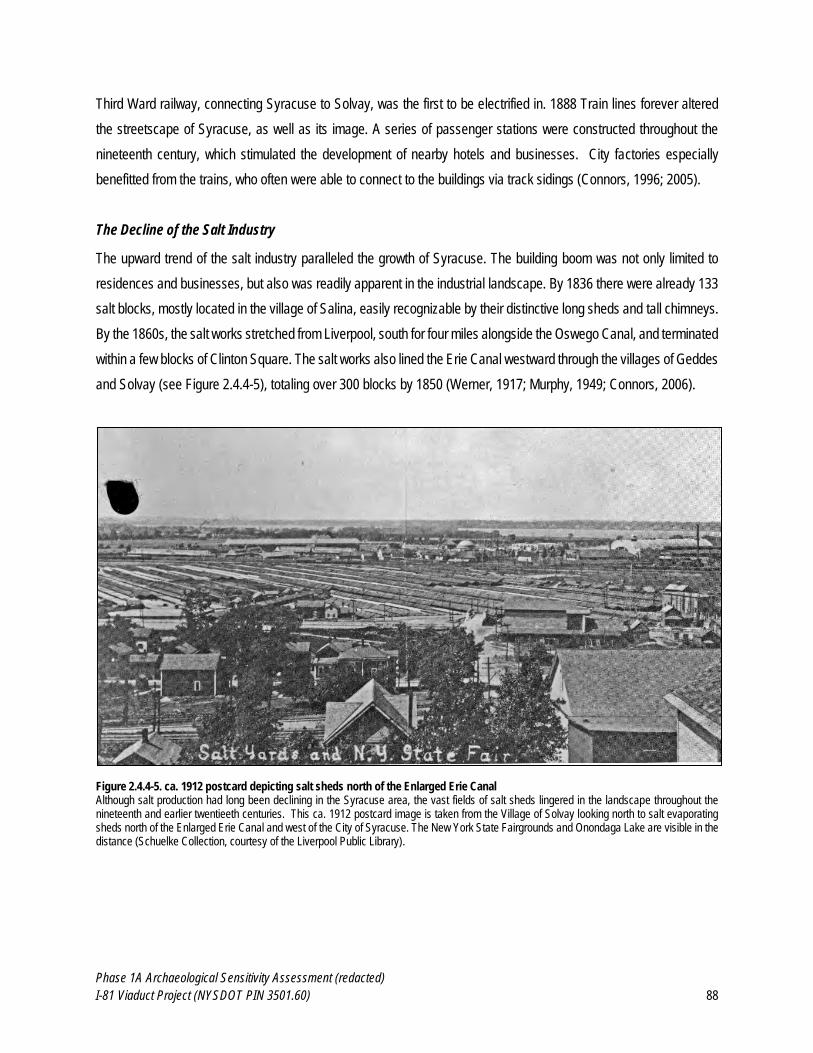
Phase 1A Archaeological Sensitivity Assessment (redacted)
I-81 Viaduct Project (NYSDOT PIN 3501.60) 88
Third Ward railway, connecting Syracuse to Solvay, was the first to be electrified in. 1888 Train lines forever altered
the streetscape of Syracuse, as well as its image. A series of passenger stations were constructed throughout the
nineteenth century, which stimulated the development of nearby hotels and businesses. City factories especially
benefitted from the trains, who often were able to connect to the buildings via track sidings (Connors, 1996; 2005).
The Decline of the Salt Industry
The upward trend of the salt industry paralleled the growth of Syracuse. The building boom was not only limited to
residences and businesses, but also was readily apparent in the industrial landscape. By 1836 there were already 133
salt blocks, mostly located in the village of Salina, easily recognizable by their distinctive long sheds and tall chimneys.
By the 1860s, the salt works stretched from Liverpool, south for four miles alongside the Oswego Canal, and terminated
within a few blocks of Clinton Square. The salt works also lined the Erie Canal westward through the villages of Geddes
and Solvay (see Figure 2.4.4-5), totaling over 300 blocks by 1850 (Werner, 1917; Murphy, 1949; Connors, 2006).
Figure 2.4.4-5. ca. 1912 postcard depicting salt sheds north of the Enlarged Erie Canal Although salt production had long been declining in the Syracuse area, the vast fields of salt sheds lingered in the landscape throughout the nineteenth and earlier twentieeth centuries. This ca. 1912 postcard image is taken from the Village of Solvay looking north to salt evaporating sheds north of the Enlarged Erie Canal and west of the City of Syracuse. The New York State Fairgrounds and Onondaga Lake are visible in the distance (Schuelke Collection, courtesy of the Liverpool Public Library).
Phase 1A Archaeological Sensitivity Assessment (redacted)
I-81 Viaduct Project (NYSDOT PIN 3501.60) 89
Following the 1861-1862 Civil War, salt production returned to previously high levels. An increasing number of
companies organized in order to expedite production while minimizing overall cost of equipment and the production
process. While companies like the Onondaga Salt Company and the Salina Coarse Salt Company had been in
operation for a few decades, a number of additional companies were established in the second half of the nineteenth
century, including the Onondaga Coarse Salt Association (1872), the American Dairy Salt Company (1876), and the
New York Salt Company (1881). In the 1880s, perhaps the height of salt production in Syracuse, the salt vats and
covers occupied an area of approximately 709 acres south of Onondaga Lake, and produced between seven and eight
million bushels of salt annually (EPC, 1883; Werner, 1917).
Extensive boring efforts began in the late nineteenth century to attempt to discover deeper and stronger sources of
brine. New wells ranging in depth from 600 to almost 2000 feet were dug near Salina and Liverpool, but failed to
discover satisfactory new sources for salt. Within a few decades, all of the aforementioned salt works companies would
go out of business or expand into other areas of commerce, as salt production declined significantly with the discovery
of superior sources of salt in more hospitable climates with cheaper fuel (primarily Saginaw, Michigan). Salt production
in Syracuse continued to decrease, and in 1897, the State legislature declared all leases of salt lands voided by March
1, 1898, and also voted to cease production of salt brine at any expense to the state (although salt production by the
state would continue for almost a decade). In 1908, pipelines, wells and reservoirs previously owned by the state as
part of salt-making operations were sold to the Onondaga Pipeline Company, which operated until 1926, when the last
of the salt-making concerns ceased production, and the salt industry in the Syracuse area same to an end (EPC, 1883;
Bruce, 1891; Werner, 1917; Murphy, 1949).
Closure of the Enlarged Erie Canal
In an attempt to accommodate larger canal boats and further compete with railroads, additional enlargement of the
Erie Canal in New York State occurred in the late 1890s. These enlargements, which did not affect the route of the
canal through Syracuse, were ultimately not successful in ensuring the long-term viability of the Enlarged Erie Canal
as a shipping or transportation route. A second enlargement of the Enlarged Erie Canal in the late-nineteenth century
did not ensure the long-term longevity of the canal, and agitation for a new barge canal route including rivers and lakes
began in 1903. After careful study, it was determined by the State of New York that a barge canal system was
preferable to a ship canal system, due to the economic efficiencies in the transfer of cargo at the end of the canal,
compared to the challenges of navigating ocean going vessels through a narrow channel of such great length, such as
the Enlarged Erie Canal. With the opening of the New York State Barge Canal in 1918, many sections of the Erie Canal
that were not included in the route of the Barge Canal were closed. Much of the Enlarged Erie Canal was filled in over
the following decades, though some portions (none within the City of Syracuse) remained flooded (Whitford, 1906;
Finch, 1925; Schramm and Roseboom, 1979)
Phase 1A Archaeological Sensitivity Assessment (redacted)
I-81 Viaduct Project (NYSDOT PIN 3501.60) 90
The New York State Barge Canal in Syracuse opened in 1918 with a depth of nine feet. The Barge Canal in Syracuse
utilized Onondaga Lake as well as the Seneca River portion of the Oswego Canal, which connected the city to Lake
Ontario. Twenty-four miles of the Seneca and Oswego Rivers were canalized, using the lowest watercourses in the
valley, rather than creating an artificial channel along higher ground. This was achieved by building dams, locks and
dredging channels to provide uniformity in width and depth. It opened 1918 with a 9-foot depth, greatly improving inland
waterway navigation. Efficient terminals for the barges were key to the success of the system, as they gave access to
supply sources and connecting transportation routes such as highways. The Inner Harbor was constructed as a
terminal for the New York State Barge Canal in Syracuse, receiving its first shipment in 1921, and offering a new life
to the area adjacent to Onondaga Lake once dominated by the salt industry (Finch, 1925; Hay, 2014),
Rise of the Automobile
The Enlarged Erie and Oswego Canals were filled during the 1920s, with new roadways constructed atop the former
waterways, and the automobile supplanting the canal boat and eventually the railcar as the dominant mode of
transportation on Syracuse’s streets. By 1926, the City was served by the New York Central, the Delaware, the
Lackawanna and Western, and the West Shore Railroads. Branches of the Pennsylvania, Lehigh Valley and Ontario
& Western connected within 50 miles to the lines running to Syracuse. The increased street traffic led to inevitable
conflict, with dangerous and often fatal consequences. With stage coaches, horse-drawn carriages, trolleys,
pedestrians, and later automobiles competing with steam trains for control of the streets, accidents became
commonplace. Organized discussion of the solution to perilous grade crossings began in 1873 and continued for
decades with no resolution. A Syracuse Grade Crossing Commission was formed in 1912, and grade crossing
elimination was identified as a priority in the 1919 comprehensive plan, which noted that the solutions to several
problems within the city were directly related to the issue of the dangerous circumstances caused by grade crossing
(see Figure 2.4.4-6). One solution proposed running tracks atop the bed of the recently abandoned route of the
Enlarged Erie Canal, while another suggested depressing the tracks or building a tunnel beneath downtown. However,
a 1927 public referendum determined the appropriate course of action was to elevate the railroad, and construct a new
passenger station, which was later decided to be moved to Burnet Avenue and the newly opened Erie Boulevard,
constructed, atop the old route of the Erie Canal, while preserving its name as an ironic homage to the evolution of
transportation in the City of Syracuse throughout the early twentieth century (CSCPC, 1919; Unknown, 1926;
CNYCNRHS, 1986).
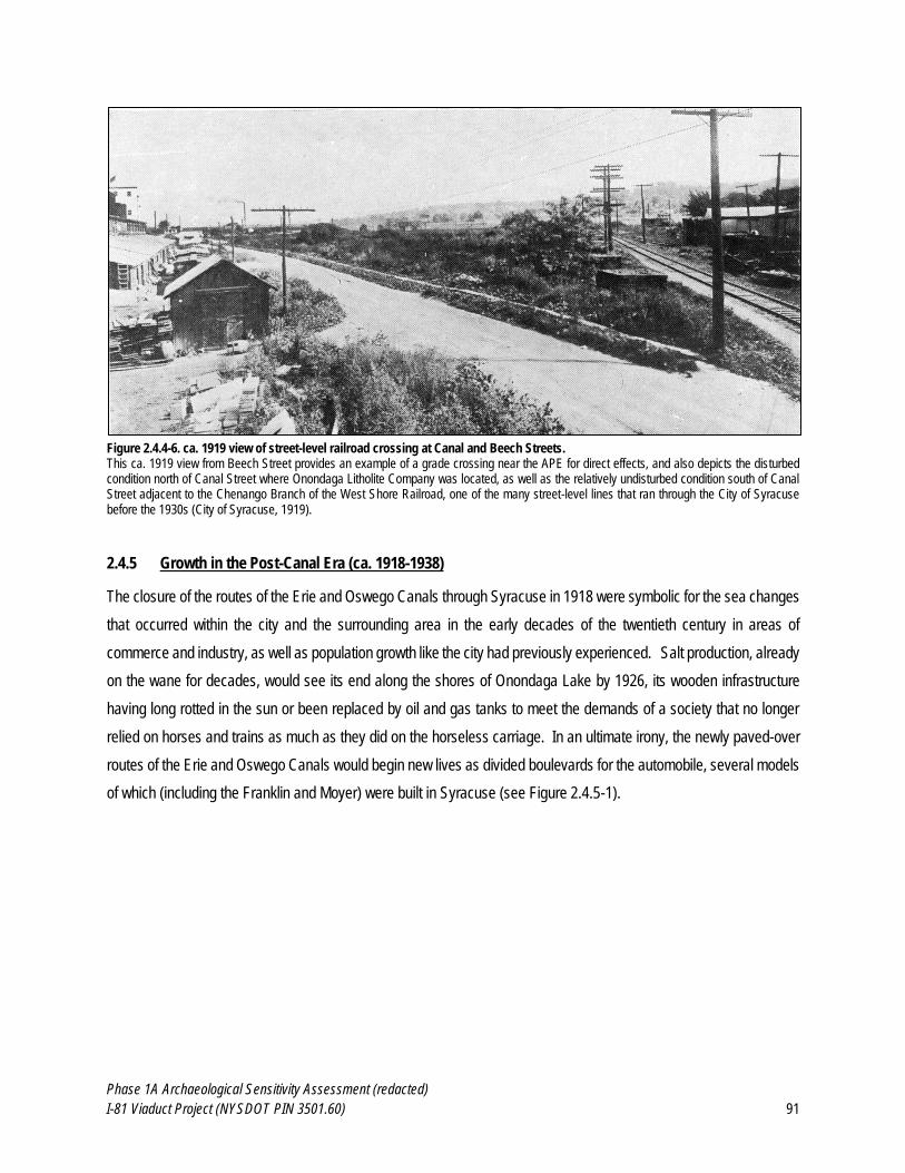
Phase 1A Archaeological Sensitivity Assessment (redacted)
I-81 Viaduct Project (NYSDOT PIN 3501.60) 91
Figure 2.4.4-6. ca. 1919 view of street-level railroad crossing at Canal and Beech Streets. This ca. 1919 view from Beech Street provides an example of a grade crossing near the APE for direct effects, and also depicts the disturbed condition north of Canal Street where Onondaga Litholite Company was located, as well as the relatively undisturbed condition south of Canal Street adjacent to the Chenango Branch of the West Shore Railroad, one of the many street-level lines that ran through the City of Syracuse before the 1930s (City of Syracuse, 1919).
2.4.5 Growth in the Post-Canal Era (ca. 1918-1938)
The closure of the routes of the Erie and Oswego Canals through Syracuse in 1918 were symbolic for the sea changes
that occurred within the city and the surrounding area in the early decades of the twentieth century in areas of
commerce and industry, as well as population growth like the city had previously experienced. Salt production, already
on the wane for decades, would see its end along the shores of Onondaga Lake by 1926, its wooden infrastructure
having long rotted in the sun or been replaced by oil and gas tanks to meet the demands of a society that no longer
relied on horses and trains as much as they did on the horseless carriage. In an ultimate irony, the newly paved-over
routes of the Erie and Oswego Canals would begin new lives as divided boulevards for the automobile, several models
of which (including the Franklin and Moyer) were built in Syracuse (see Figure 2.4.5-1).
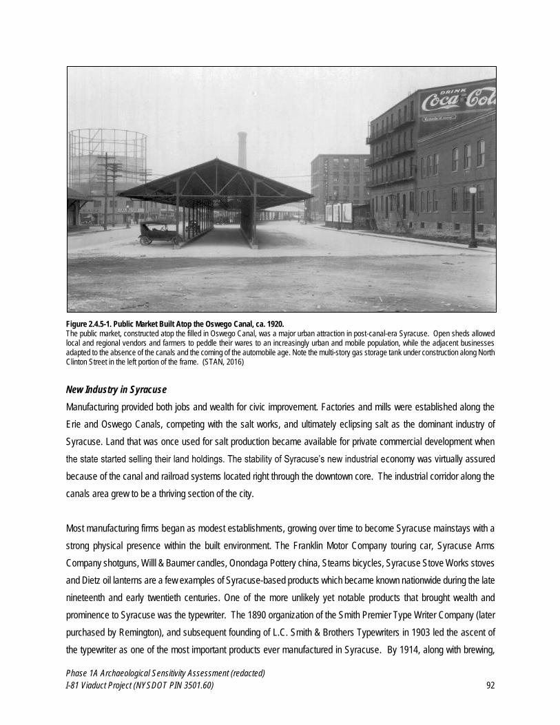
Phase 1A Archaeological Sensitivity Assessment (redacted)
I-81 Viaduct Project (NYSDOT PIN 3501.60) 92
Figure 2.4.5-1. Public Market Built Atop the Oswego Canal, ca. 1920. The public market, constructed atop the filled in Oswego Canal, was a major urban attraction in post-canal-era Syracuse. Open sheds allowed local and regional vendors and farmers to peddle their wares to an increasingly urban and mobile population, while the adjacent businesses adapted to the absence of the canals and the coming of the automobile age. Note the multi-story gas storage tank under construction along North Clinton Street in the left portion of the frame. (STAN, 2016)
New Industry in Syracuse
Manufacturing provided both jobs and wealth for civic improvement. Factories and mills were established along the
Erie and Oswego Canals, competing with the salt works, and ultimately eclipsing salt as the dominant industry of
Syracuse. Land that was once used for salt production became available for private commercial development when
the state started selling their land holdings. The stability of Syracuse’s new industrial economy was virtually assured
because of the canal and railroad systems located right through the downtown core. The industrial corridor along the
canals area grew to be a thriving section of the city.
Most manufacturing firms began as modest establishments, growing over time to become Syracuse mainstays with a
strong physical presence within the built environment. The Franklin Motor Company touring car, Syracuse Arms
Company shotguns, Willl & Baumer candles, Onondaga Pottery china, Stearns bicycles, Syracuse Stove Works stoves
and Dietz oil lanterns are a few examples of Syracuse-based products which became known nationwide during the late
nineteenth and early twentieth centuries. One of the more unlikely yet notable products that brought wealth and
prominence to Syracuse was the typewriter. The 1890 organization of the Smith Premier Type Writer Company (later
purchased by Remington), and subsequent founding of L.C. Smith & Brothers Typewriters in 1903 led the ascent of
the typewriter as one of the most important products ever manufactured in Syracuse. By 1914, along with brewing,

Phase 1A Archaeological Sensitivity Assessment (redacted)
I-81 Viaduct Project (NYSDOT PIN 3501.60) 93
typewriter manufacturing was considered to be the city’s most valuable industry (Schramm and Roseboom, 1979;
Connors, 2005; 2006).
Though small-scale breweries existed in Syracuse as early as 1804, the number of breweries increased significantly
after the completion of the Erie Canal enabled the easier import of beer-making resources and the rapid export of
finished product.
Kellog and Morey operated next to the Erie Canal from 1824 until 1827. In 1845, there were seven breweries in the City of Syracuse. Haberle Brewery began production in 1855. Greenway Brewery, which was established in 1858, was the largest brewery in the city and was located adjacent to the Erie Canal on the site now occupied by the Niagara Mohawk Building. Their brewery, which was six stories in height and occupied an entire city block, was so successful that it exported its products to Europe, Asia and Australia, and became the largest brewery outside New York City by 1890. Brewing in Syracuse became a major industry by 1870, second only to the salt industry. (Carter, 2008)
Breweries in Syracuse flourished in part due to the abundance of hops grown in Central New York, which was the
leading hops producing region in the nation in the early-to-mid nineteenth century, but also the ease of transport of the
finished product through the city, state and region due to the proximity of breweries to the Erie and Oswego Canals,
but also the numerous railroads located immediately adjacent to large brewing concerns such as Greenway’s (see
Figure 2.4.5-2 and Figure 2.4.5-3). However, by the 1920s, the vast and profitable brewing industry of Syracuse was
all but eliminated when the passage of the eighteenth amendment and the resulting era of Prohibition made alcohol
illegal, forcing most breweries to close. Those companies who survived Prohibition produced soft drinks until the law
was repealed in 1933. With over a decade of potential production lost, the brewing industry in Syracuse never
recovered, due in no small part to the onset of the Great Depression, which hobbled the economy of the city, state and
nation (Connors, 2005; Carter, 2008; OHA, 2016).
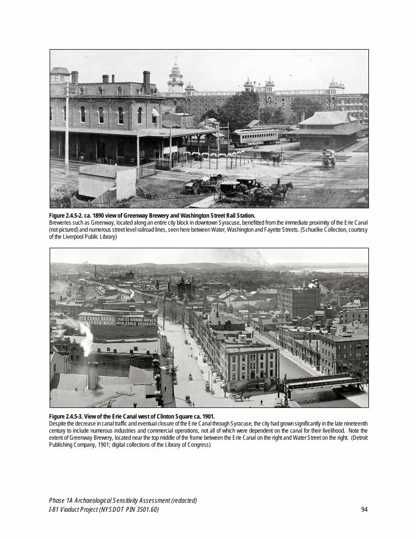
Phase 1A Archaeological Sensitivity Assessment (redacted)
I-81 Viaduct Project (NYSDOT PIN 3501.60) 94
Figure 2.4.5-2. ca. 1890 view of Greenway Brewery and Washington Street Rail Station. Breweries such as Greenway, located along an entire city block in downtown Syracuse, benefitted from the immediate proximity of the Erie Canal (not pictured) and numerous street level railroad lines, seen here between Water, Washington and Fayette Streets. (Schuelke Collection, courtesy of the Liverpool Public Library)
Figure 2.4.5-3. View of the Erie Canal west of Clinton Square ca. 1901. Despite the decrease in canal traffic and eventual closure of the Erie Canal through Syracuse, the city had grown significantly in the late nineteenth century to include numerous industries and commercial operations, not all of which were dependent on the canal for their livelihood. Note the extent of Greenway Brewery, located near the top middle of the frame between the Erie Canal on the right and Water Street on the right. (Detroit Publishing Company, 1901; digital collections of the Library of Congress)
Phase 1A Archaeological Sensitivity Assessment (redacted)
I-81 Viaduct Project (NYSDOT PIN 3501.60) 95
With the salt and brewing industry in decline, Syracusans turned their attention to the expansion of commerce in other
areas, including new enterprises such as department stores and typewriter manufacturing. These advances had a
direct effect on downtown which grew not only outwards from the former Erie Canal, but also upwards towards the sky,
when high rises began to replace the two-to-four story buildings of the nineteenth century. Simultaneously, the
consumer goods market skyrocketed, with 150,000 typewriters manufactured in Syracuse annually through the 1920s,
and 150,000 Franklin Automobiles produced between 1902 and 1934. The local workforce was well-supported during
the 1920s; fifty-eight percent of all factory jobs were involved with metals such as building materials and transportation
equipment (SOPWPC, 1945; Stein, 2005; Connors, 2006).
A 1926 brochure promoting the city as a convention destination, boasting Syracuse as home of over 750 diversified
manufacturing establishments with a total of over 42,500 employees,” and a leader in the manufacturing of “tool steel,
automobile gears, differentials and transmissions, soda ash and its by-products, fine wax candles, agricultural
implements, high-class china ware, mincemeat and powdered milk, high-class shoes, typewriters, the automobile and
its allied industries, electrical hardware, electrical washing machines, steam clothes pressing machines, cash-carrying
and conveying equipment, foundry and machine shop products, boilers and radiators” (Unknown, 1926). With steady
work came corresponding and steady residential growth. The city’s population increased from 171,717 in 1920 (up
over 25 percent from 1910), to over 209,000 by 1930, which brought about the benefit of improved new parks, an
expanding public school system and more effective police and fire protection. The increase in automobile traffic and
ownership necessitated even more change, with over 18,000 vehicles registered in Onondaga County by 1920, once
the car become affordable to the masses. Syracuse catered to the growing legions of motorists via the proliferation of
gas stations, service shops, auto dealerships, parking garages, and electric traffic signals (Connors, 2006; Carter,
2008).
The Great Depression and World War II
The city’s growth temporarily halted during the Great Depression of the 1930s. It is estimated that the 1929 stock
market crash resulted in the loss of fifty percent of Syracuse’s industrial jobs, impacting near 13,000 workers. Large
employers such as Franklin Manufacturing, Remington Rand, and Onondaga Pottery were forced to close their doors.
Housing starts declined along with unemployment, and a housing shortage developed. Many large houses were
converted into apartments, and congestion grew, which worsened when rural workers came to downtown to find jobs.
Industry eventually returned to the city, at the site of the former salt yards south of Onondaga Lake. In the late 1930s,
the first of what was to become a dense field of metal oil storage tanks was constructed. Given the nickname “Oil City,”
the sea of containers occupied much of the lakefront and land between downtown and the lake, trading in leisure parks
and natural assets of the late nineteenth century lakefront for economic progress. As the country emerged from the
Great Depression, its entrance into World War II provided a boost to the local economy, while drawing many of its
Phase 1A Archaeological Sensitivity Assessment (redacted)
I-81 Viaduct Project (NYSDOT PIN 3501.60) 96
young men to the frontlines in Europe and Asia. Whereas Syracuse had struggled during the Great Depression due
to too few jobs, with the onset of World War II, there were now too few workers. An estimated 40,000 Onondaga county
men volunteered or were drafted into service at the same time that factories expanded to meet wartime needs for
military products. Women left the home to join the workforce, and have been a large contributor to the Syracuse
economy ever since. Onondaga Pottery developed a ceramic landmine, invisible to metal detectors; Remington Rand
reopened its closed typewriter factory and produced pistols. The children of Syracuse were encouraged to aid the war
effort by collecting metal and rubber for scrap drives. Rationing of food and staples of daily life as well as air raid drills
altered the daily way of life in Syracuse during the war. When the servicemen returned to in 1944, they found a city
quite different than when they left it (Schramm and Roseboom, 1979; Connors, 2005; 2006; Carter, 2008).
Ethnic Diversity in the Late-Nineteenth and Early-Twentieth Centuries
Although the 1918-1919 influenza pandemic that killed tens of thousands of Americans also claimed 3,243 Syracuse
residents (and debilitated between five- and six- thousand more), the population of the city continued to grow and thrive
tremendously in the early decades of the twentieth century owing to immigration (Lehr, 2005; University of Michigan,
2016). The 1840s brought a tremendous influx of Irish and German immigrants to the United States, the former
escaping the potato famine and the latter fleeing political unrest. These were the largest group of foreign-born residents
who had ever come to the city to date, totaling 8,000 by the Civil War. While Germans settled primarily north of
downtown along North Salina Street, recently arrived Irish located westward in Liverpool and Geddes. In addition to
working as laborers in the salt fields, many Germans earned a living using their carpentry skills working as coopers,
supplying barrels and vats to the salt industry, while the Irish worked on the expansions of the Erie Canal, as well as
various categories of hard labor. While many of Syracuse’s well-known breweries, for example, were established by
German immigrants, German craftsmen also redirected their skills into the production of domestic goods such as clocks
and furniture. In 1875, Syracuse elected its first German-born Mayor, George Heir. Many of the modest brick buildings
along North Salina Street and its side streets were constructed by German immigrants, where they would have had
businesses on the first floor, and lived above. City directories indicate Germans also held jobs as tailors, shoemakers,
cigar manufacturers, hardware shop owners and milliners. By 1891, there were nine German churches that served as
both religious and social centers (Harwood, 1985; Connors, 2006).
In addition, many of the German immigrants of the 1840s were Jewish, and settled south of the Erie Canal in an area
historically referred to as “Jew Town” for the high concentration of Jewish immigrants who began to settle in the area
roughly bounded by State, Taylor, Almond and Jefferson Streets beginning in the mid-nineteenth century. Unlike their
Christian counterparts, making a living proved more difficult for the German Jews. They initially worked as peddlers,
and were unable to earn enough money to purchase real estate. Over time, persistence and led the Jewish Germans
become merchants, grocers, and jewelers. In the 1850s, English, Polish and Dutch Jews emigrated into Syracuse and
Phase 1A Archaeological Sensitivity Assessment (redacted)
I-81 Viaduct Project (NYSDOT PIN 3501.60) 97
due to the increase in Jewish residents, a second Synagogue was constructed. A second wave of Jewish immigrants
between 1881 and 1914, arrived in Syracuse having left eastern Europe due to persecution. Following in their
predecessors’ footsteps, the new residents also entered the work force as street corner peddlers. Most spoke very little
English and as a rule, the second-generation was stricter in terms of their religious beliefs and customs. This group
established the first orthodox synagogue in the community, often running services in their home-country’s language,
often Polish or Russian. The Jewish community of Syracuse was dynamic, with six synagogues holding Sabbath
services in “Jewtown” by 1899, and seldom did one congregation associate with the other, due to differences in
languages and beliefs (Rudolph, 1970; Davis, 1986).
By the turn of the century, the commercial ventures of the Jewish population turned into proprietorship. Over two
hundred Jewish-owned stores opened between 1850-1880. Well known, long-standing stores located within the
boundaries of “Jewtown” included Thalheimers Grocery, Stein’s Jewelers, Meyer’s meat market, Lazarus & Company
clothiers, Bronner Brothers’ dry goods, and Israel Harrison’s grocery store (see Figure 2.4.5-4). In addition, Syracuse’s
Jewish community began to operate in larger civic and governmental roles than ever before. The Young Mens Hebrew
Association building and the Jewish Home for the Aged were opened in “Jewtown” in 1910, and 1912 respectively.
During World War I, the Syracuse Jewish Welfare Federation supported the war efforts, having received over 2000
donations from the local population. The second and third generation of Syracuse’s Jewish immigrants were more
readily integrated into mainstream culture as compared to their parents. The children of the 1920s attended public
school, and then private Hebrew schools afterwards. They went to college in the 1930s and became the city’s
professionals of the 1940s, bringing pride to the entire neighborhood. Unfortunately, this did not mean that the Jewish
community of Syracuse was immune to the societal ills that had plagued its many families for a century, as poverty,
illness and discrimination were still serious problems. The community banded together by establishing a local Jewish
Welfare Fund to help European Jews during the Holocaust, helping to meet the needs of survivors and refugees by
helping them to settle into their new lives in Syracuse (Rudolph, 1970; Davis, 1986).

Phase 1A Archaeological Sensitivity Assessment (redacted)
I-81 Viaduct Project (NYSDOT PIN 3501.60) 98
Figure 2.4.5-4. Map of Jewish-owned Establishments ca. 1900. By the turn of the nineteenth into the twentieth century, the area of Syracuse known as “Jewtown” The numbers indicate community centers such as Jewish temples, social halls, and businesses. (Rudolph, 1970)
The influx of African-Americans into Syracuse also played a major in the growing ethnic diversity of the city. Two men,
believed to be escaped slaves were witnessed making salt near Onondaga Lake (and therefore were among the first
non-Native Americans to do so in what would become Onondaga County) as early as 1779. Accurate counts of the
African-American population were not taken until 1810, by which time only seven African-Americans (gender unknown)
were recorded. By the time Syracuse was incorporated as a village in 1825, one of its first laws was the abolition of
slavery thanks to its large anti-abolitionist movement, and by 1827, all slaves in Syracuse had been freed as part of
the decree to abolish slavery in New York State. Syracuse played a very important role in the Underground Railroad,
assisting fugitive slaves travel in secret from slave-owning states into Canada, or helping them settle within the village.
Recognized as a national center for abolition of slavery, this had a significant impact on the African-American population
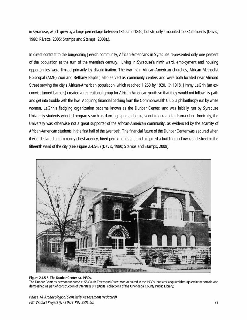
Phase 1A Archaeological Sensitivity Assessment (redacted)
I-81 Viaduct Project (NYSDOT PIN 3501.60) 99
in Syracuse, which grew by a large percentage between 1810 and 1840, but still only amounted to 234 residents (Davis,
1980; Rivette, 2005; Stamps and Stamps, 2008).).
In direct contrast to the burgeoning Jewish community, African-Americans in Syracuse represented only one percent
of the population at the turn of the twentieth century. Living in Syracuse’s ninth ward, employment and housing
opportunities were limited primarily by discrimination. The two main African-American churches, African Methodist
Episcopal (AME) Zion and Bethany Baptist, also served as community centers and were both located near Almond
Street serving the city’s African-American population, which reached 1,260 by 1920. In 1918, Jimmy LaGrin (an ex-
convict-turned-barber,) created a recreational group for African-American youth so that they would not follow his path
and get into trouble with the law. Acquiring financial backing from the Commonwealth Club, a philanthropy run by white
women, LaGrin’s fledgling organization became known as the Dunbar Center, and was initially run by Syracuse
University students who led programs such as dancing, sports, chorus, scout troops and a drama club. Ironically, the
University was otherwise not a great supporter of the African-American community, as evidenced by the scarcity of
African-American students in the first half of the twentieth. The financial future of the Dunbar Center was secured when
it was declared a community chest agency, hired permanent staff, and acquired a building on Townsend Street in the
fifteenth ward of the city (see Figure 2.4.5-5) (Davis, 1980; Stamps and Stamps, 2008).
Figure 2.4.5-5. The Dunbar Center ca. 1930s. The Dunbar Center’s permanent home at 55 South Townsend Street was acquired in the 1930s, but later acquired through eminent domain and demolished as part of construction of Interstate 8.1 (Digital collections of the Onondaga County Public Library)
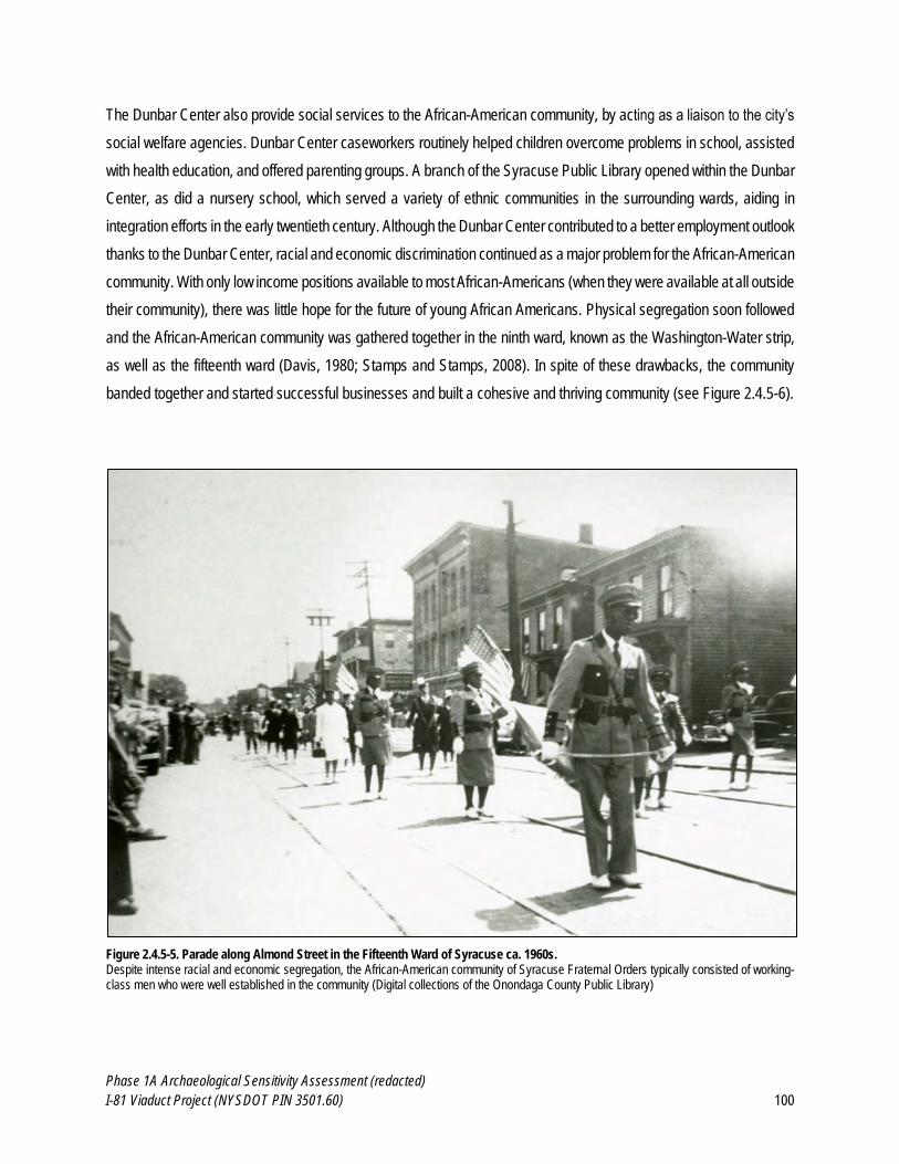
Phase 1A Archaeological Sensitivity Assessment (redacted)
I-81 Viaduct Project (NYSDOT PIN 3501.60) 100
The Dunbar Center also provide social services to the African-American community, by acting as a liaison to the city’s
social welfare agencies. Dunbar Center caseworkers routinely helped children overcome problems in school, assisted
with health education, and offered parenting groups. A branch of the Syracuse Public Library opened within the Dunbar
Center, as did a nursery school, which served a variety of ethnic communities in the surrounding wards, aiding in
integration efforts in the early twentieth century. Although the Dunbar Center contributed to a better employment outlook
thanks to the Dunbar Center, racial and economic discrimination continued as a major problem for the African-American
community. With only low income positions available to most African-Americans (when they were available at all outside
their community), there was little hope for the future of young African Americans. Physical segregation soon followed
and the African-American community was gathered together in the ninth ward, known as the Washington-Water strip,
as well as the fifteenth ward (Davis, 1980; Stamps and Stamps, 2008). In spite of these drawbacks, the community
banded together and started successful businesses and built a cohesive and thriving community (see Figure 2.4.5-6).
Figure 2.4.5-5. Parade along Almond Street in the Fifteenth Ward of Syracuse ca. 1960s. Despite intense racial and economic segregation, the African-American community of Syracuse Fraternal Orders typically consisted of working-class men who were well established in the community (Digital collections of the Onondaga County Public Library)
Phase 1A Archaeological Sensitivity Assessment (redacted)
I-81 Viaduct Project (NYSDOT PIN 3501.60) 101
The Progressive Herald, a weekly newspaper for African Americans, became the voice of the black community, and
highlighted resident achievements, remaining in circulation for 30 years. In the 1930s and 40s, the Dunbar Center
added to its recreational and social purposes the advocacy for progress in employment and housing for African
Americans. It was the primary force behind improvements such as job training and job placement, particularly in terms
of discrimination intervention. With their help, African Americans began working for the postal service, attending
universities and starting small businesses (Davis, 1980; Stamps and Stamps, 2008).
The Jewish and African-American communities were far from the only minority communities in early twentieth century
Syracuse. Most of Syracuse’s ethnic neighborhoods were intentionally insulated, giving residents the ability to live
their own way of life, perhaps as a facsimile of life in their respective countries of origin. Immigrant populations brought
with them architectural detailing from the “old country,” which evolved into distinctive neighborhoods throughout the
city (often centered around their churches). Adjacent to the fifteenth ward and north of the elevated railroad right-of-
way, was the Italian-American neighborhood of the Near Northside, with their homes and businesses that radiated
north from Salina and State Streets. Many Italian immigrants came to Syracuse to work on the construction of the new
West Shore railroad in the 1880s. Once settled, they constructed two churches (in 1895 and 1924) and grew to a size
of 30,000 by the time Italian immigration had all but ended in the 1930s. The Italians were not the first to occupy these
neighborhoods, having dislocated their German and Irish predecessors, who moved east. Many immigrants became
United States citizens with the help of the Syracuse Americanization League (Schramm and Roseboom, 1979; SUNY
Faculty of Landscape Architecture, 2003; Connors, 2006).
Post-War Planning and Change
Despite the growth and increased opportunities for the burgeoning immigrant and ethnic communities of the early
twentieth century, national postwar planning and transportation policy would soon lead to significant changes through
Syracuse and New York State. Planning for what is now known as the Dwight D. Eisenhower National System of
Interstate and Defense Highways, commonly called "The Interstate System," began as early as the late 1930s. The
Federal-Aid Highway Act of 1938 called on the Bureau of Public Roads (BPR), the predecessor of the Federal Highway
Administration (FHWA), to study the feasibility of a toll-financed system of three east-west and three north-south
superhighways. The BPR's report, Toll Roads and Free Roads, demonstrated that a toll network would not be self-
supporting. Instead, the BPR's report advocated a 26,700-mile interregional highway network. In 1941, President
Franklin D. Roosevelt appointed a National Interregional Highway Committee, headed by Commissioner of Public
Roads Thomas H. MacDonald, to evaluate the need for a national expressway system. Following a pause for World
War II, the committee's January 1944 report, Interregional Highways, supported a system of 33,900 miles, plus an
additional 5,000 miles of auxiliary urban routes. In the Federal-Aid Highway Act of 1944, the Congress approved the
committee’s recommendations. However, funding, and therefore construction, did not happen until the 1950s, which
Phase 1A Archaeological Sensitivity Assessment (redacted)
I-81 Viaduct Project (NYSDOT PIN 3501.60) 102
would radically and profoundly alter the built environment and social fabric of Syracuse for the next five decades
(Weingroff, 1993; FHWA, 2016).
2.4.6 Slum Clearance, Post-War Planning and Urban Renewal (ca. 1938-1974)
After tremendous growth in industry and population throughout the nineteenth century, the closure of the Enlarged Erie
Canal through the City of Syracuse removed a once-vital commercial and transportation artery through downtown,
while the presence of grade-level railroad crossings created a public hazard to the densely populated city, resulting in
the eventual elevation of the railroad above the city streets. The former route of the canal had been filled to provide a
major route for automobile traffic through downtown, virtually all of the surrounding land had been built up, leaving little
room for additional commercial, industrial or residential development within the core of the city. The increase in
automobile ownership led city residents to seek housing in newly constructed subdivisions on the fringes of the city,
and in neighboring towns more accessible by car. As a result, while the edges of the city began to grow and thrive
amidst this expansion, the inner core of the city experienced disinvestment and creeping decay, exacerbated by the
onset of the Great Depression. The policies of the New Deal enacted by President (and former New York Governor)
Franklin Delano Roosevelt combined with America’s involvement in World War II provided some economic relief for
cities like Syracuse, but did not stop the flow of industry and residents out of the city. The challenge of thousands of
soldiers returning from the war introduced added pressure to provide adequate housing within the city. The responses
to these problems by city officials were common to the era, but also unique to Syracuse, and would radically alter the
built environment and social fabric of the city for the next several decades.
The Roots of “Slum Clearance” in New York State
Dilapidated and overcrowded housing stock was a common problem in the majority of American cities in the early
twentieth century, with no broadly applicable solution. The 1930 federal census revealed that 11 million homes
comprising 36 percent of the total housing stock in the country was considered to be “substandard.” Although select
clearance of blocks of decaying tenements and other buildings for parks and playgrounds had been common around
the turn of the century in larger cities such as New York and Chicago, an organized program related to slum clearance
or the creation of more suitable housing had yet to be enacted. In the midst of the Great Depression, the Emergency
Relief and Construction Act was passed at the federal level in July 1932, a portion of which allowed for the
Reconstruction Finance Corporation (created under President Herbert Hoover) to make loans to private corporations
for “reconstruction of slum areas” as well as providing housing for low-income families. Although intended as a work
relief measure, concentrating the responsibility for slum clearance in the hands of private corporations was not as
successful as intended. The National Industrial Recovery Act of 1933 attempted to shift some control to work relief
agencies by including a provision for the Public Works Administration (PWA) to oversee slum clearance and low income
Phase 1A Archaeological Sensitivity Assessment (redacted)
I-81 Viaduct Project (NYSDOT PIN 3501.60) 103
housing construction projects. However, construction was still left in the hands of private, limited-dividend corporations
that were driven by generating profit as opposed to maximizing public benefit (CQ, 1932; Boyer, 1983; Vale, 2000).
The National Housing Act of 1934 was enacted on June 28, 1934 as part of New Deal legislation created in response
to a lack of affordable housing during the Great Depression. This act was important for the creation of the Federal
Housing Administration (FHA) as well as the United States Housing Authority, which provided low-interest long-term
loans to cities and municipal agencies for purposes of slum clearance and erection of affordable housing. In addition,
the Home Owners Loan Corporation (HOLC) had previously been established to protect lenders from a decrease in
the values of mortgages. The Housing Act of 1937 helped codify the link between slum clearance and the subsequent
creation of public housing in cities throughout the country. Building off of the 1934 act, the 1937 act directed federal
loans and annual contributions to be paid to local public housing agencies to encourage improved living conditions for
impoverished and low-income families through slum clearance (Plunz, 1990; Vale, 2000; Smith, 2008).
Although their missions were to advocate for improved housing conditions for lower income populations, the FHA and
HOLC worked in tandem to reinforce racial and class divisions that had arisen as wealthier families had fled the inner
cities in the early twentieth century. Through a series of onerous regulations including deed restrictions and restrictive
covenants, the FHA sought to discourage neighborhood diversity through the “prevention of infiltration of inharmonious
racial or nationality groups,” noting in its underwriting manuals that properties within stable neighborhoods “shall
continue to be occupied by the same social and racial classes” (Vale, 2000). The HOLC undertook comprehensive
mapping of American cities with the help of local planning departments, dividing housing into classifications based on
their condition and assumed viability for redevelopment. These areas coincided with not only areas where the most
distressed building stock was found, but also where many of the African-American and non-white populations resided
(Boyer, 1983; Hoffman, 2000).
Beginning in 1937, the HOLC created a series of residential security maps that rated neighborhoods within cities based
on their perceived level of financial risk. The HOLC map was created for Syracuse by city engineer Sergei Grimm, and
coded the most distressed (or “fourth grade”) housing in red (see Figure 2.4.6-1), which was common to HOLC maps,
and helped give birth to the concept of “redlining,” where loans and mortgages were not issued within the areas colored
red on residential security maps. In Syracuse, the red-lined areas fell immediately along the route of the railroads on
either side of downtown Syracuse, as well as a large swath of the Fifteenth Ward immediately east of downtown, where
many African-Americans and Jews resided. As described in Section 2.3.5, the area had long been nicknamed
“Jewtown” for the abundance of Jewish residents, businesses, and high concentration of synagogues (Davis, 1980;
Stamps and Stamps, 2008). This area of the City of Syracuse would be among those most profoundly affected by
federal, state and local planning policy for the next several decades.
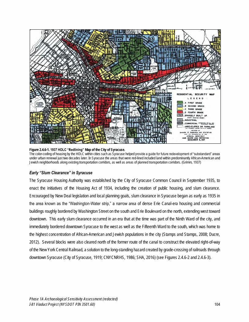
Phase 1A Archaeological Sensitivity Assessment (redacted)
I-81 Viaduct Project (NYSDOT PIN 3501.60) 104
Figure 2.4.6-1. 1937 HOLC “Redlining” Map of the City of Syracuse. The color-coding of housing by the HOLC within cities such as Syracuse helped provide a guide for future redevelopment of “substandard” areas under urban renewal just two decades later. In Syracuse the areas that were red-lined included land within predominantly African-American and Jewish neighborhoods along existing transportation corridors, as well as areas of planned transportation corridors. (Grimm, 1937)
Early “Slum Clearance” in Syracuse
The Syracuse Housing Authority was established by the City of Syracuse Common Council in September 1935, to
enact the initiatives of the Housing Act of 1934, including the creation of public housing, and slum clearance.
Encouraged by New Deal legislation and local planning goals, slum clearance in Syracuse began as early as 1935 in
the area known as the “Washington-Water strip,” a narrow area of dense Erie Canal-era housing and commercial
buildings roughly bordered by Washington Street on the south and Erie Boulevard on the north, extending west toward
downtown. This early slum clearance occurred in an era that at the time was part of the Ninth Ward of the city, and
immediately bordered downtown Syracuse to the west as well as the Fifteenth Ward to the south, which was home to
the highest concentration of African-American and Jewish populations in the city (Stamps and Stamps, 2008; Ducre,
2012). Several blocks were also cleared north of the former route of the canal to construct the elevated right-of-way
of the New York Central Railroad, a solution to the long-standing hazard created by grade-crossing of railroads through
downtown Syracuse (City of Syracuse, 1919; CNYCNRHS, 1986; SHA, 2016) (see Figures 2.4.6-2 and 2.4.6-3).
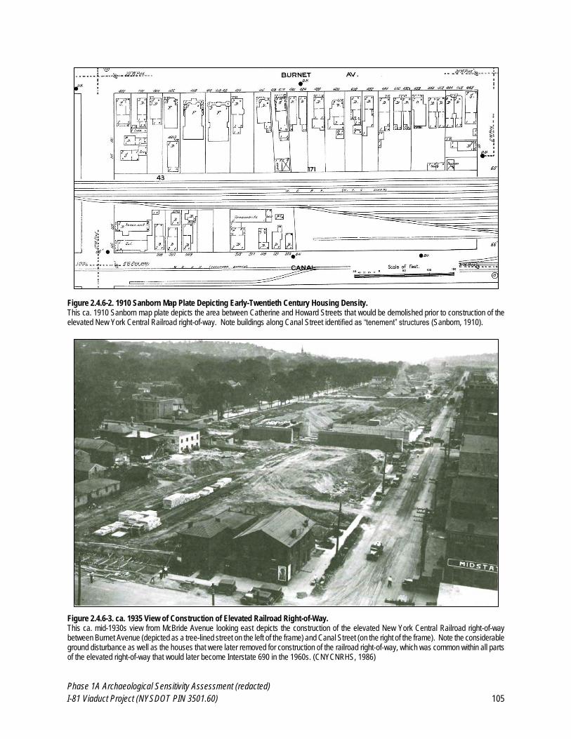
Phase 1A Archaeological Sensitivity Assessment (redacted)
I-81 Viaduct Project (NYSDOT PIN 3501.60) 105
Figure 2.4.6-2. 1910 Sanborn Map Plate Depicting Early-Twentieth Century Housing Density. This ca. 1910 Sanborn map plate depicts the area between Catherine and Howard Streets that would be demolished prior to construction of the elevated New York Central Railroad right-of-way. Note buildings along Canal Street identified as “tenement” structures (Sanborn, 1910).
Figure 2.4.6-3. ca. 1935 View of Construction of Elevated Railroad Right-of-Way. This ca. mid-1930s view from McBride Avenue looking east depicts the construction of the elevated New York Central Railroad right-of-way between Burnet Avenue (depicted as a tree-lined street on the left of the frame) and Canal Street (on the right of the frame). Note the considerable ground disturbance as well as the houses that were later removed for construction of the railroad right-of-way, which was common within all parts of the elevated right-of-way that would later become Interstate 690 in the 1960s. (CNYCNRHS, 1986)
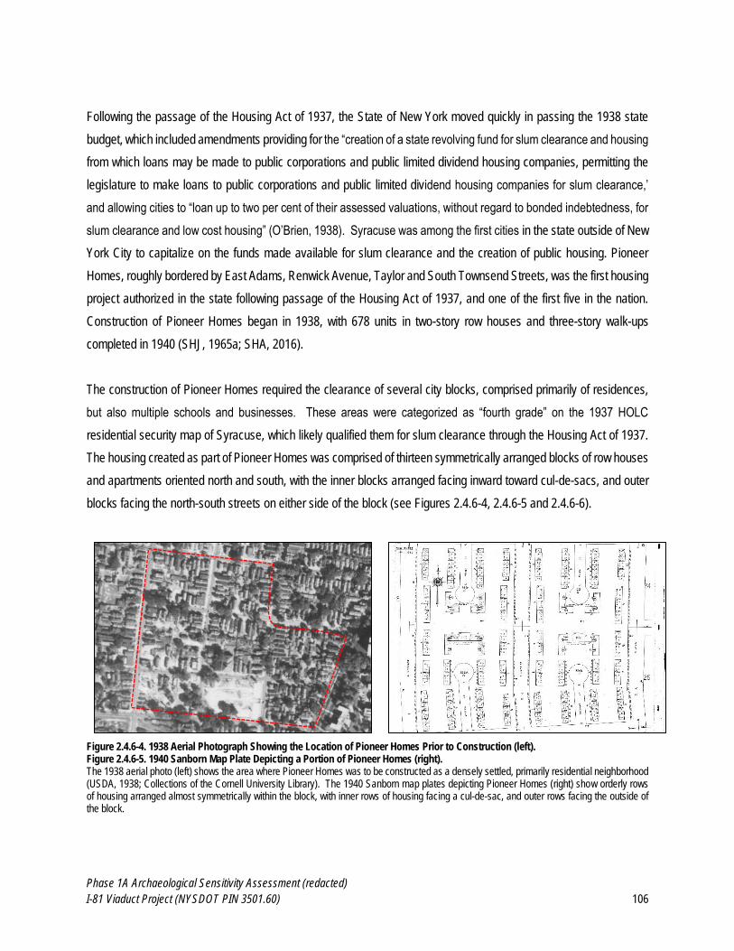
Phase 1A Archaeological Sensitivity Assessment (redacted)
I-81 Viaduct Project (NYSDOT PIN 3501.60) 106
Following the passage of the Housing Act of 1937, the State of New York moved quickly in passing the 1938 state
budget, which included amendments providing for the “creation of a state revolving fund for slum clearance and housing
from which loans may be made to public corporations and public limited dividend housing companies, permitting the
legislature to make loans to public corporations and public limited dividend housing companies for slum clearance,’
and allowing cities to “loan up to two per cent of their assessed valuations, without regard to bonded indebtedness, for
slum clearance and low cost housing” (O’Brien, 1938). Syracuse was among the first cities in the state outside of New
York City to capitalize on the funds made available for slum clearance and the creation of public housing. Pioneer
Homes, roughly bordered by East Adams, Renwick Avenue, Taylor and South Townsend Streets, was the first housing
project authorized in the state following passage of the Housing Act of 1937, and one of the first five in the nation.
Construction of Pioneer Homes began in 1938, with 678 units in two-story row houses and three-story walk-ups
completed in 1940 (SHJ, 1965a; SHA, 2016).
The construction of Pioneer Homes required the clearance of several city blocks, comprised primarily of residences,
but also multiple schools and businesses. These areas were categorized as “fourth grade” on the 1937 HOLC
residential security map of Syracuse, which likely qualified them for slum clearance through the Housing Act of 1937.
The housing created as part of Pioneer Homes was comprised of thirteen symmetrically arranged blocks of row houses
and apartments oriented north and south, with the inner blocks arranged facing inward toward cul-de-sacs, and outer
blocks facing the north-south streets on either side of the block (see Figures 2.4.6-4, 2.4.6-5 and 2.4.6-6).
Figure 2.4.6-4. 1938 Aerial Photograph Showing the Location of Pioneer Homes Prior to Construction (left). Figure 2.4.6-5. 1940 Sanborn Map Plate Depicting a Portion of Pioneer Homes (right). The 1938 aerial photo (left) shows the area where Pioneer Homes was to be constructed as a densely settled, primarily residential neighborhood (USDA, 1938; Collections of the Cornell University Library). The 1940 Sanborn map plates depicting Pioneer Homes (right) show orderly rows of housing arranged almost symmetrically within the block, with inner rows of housing facing a cul-de-sac, and outer rows facing the outside of the block.
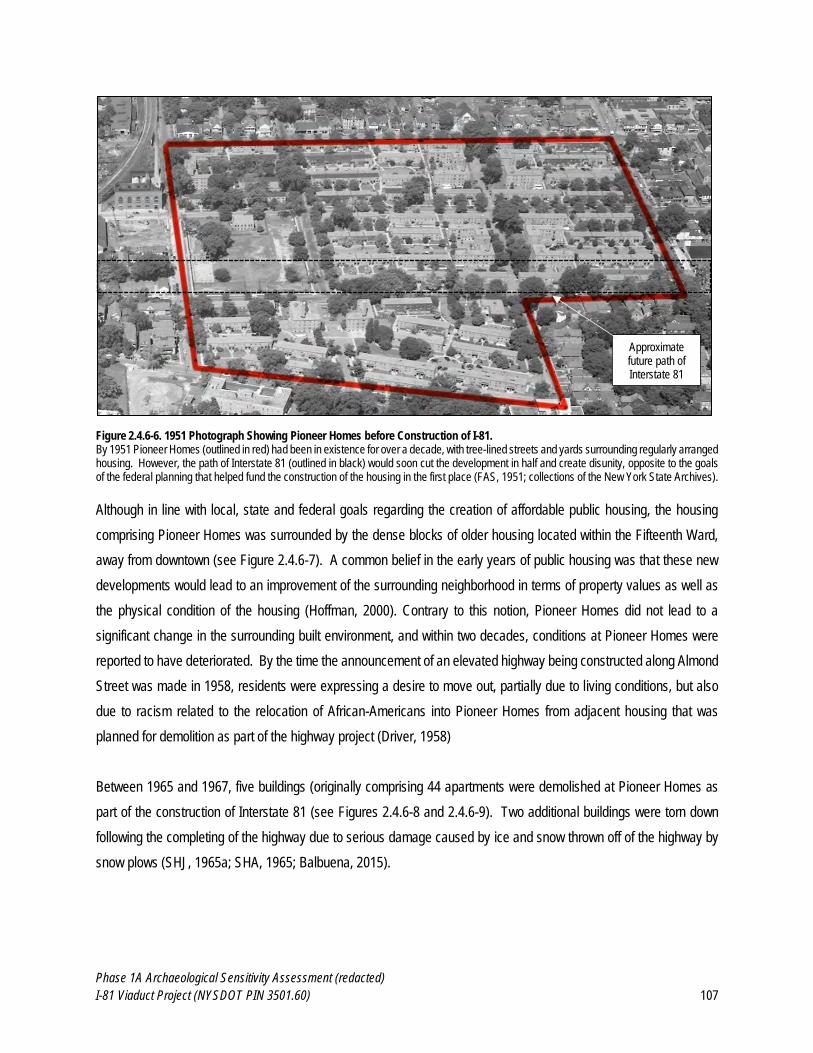
Phase 1A Archaeological Sensitivity Assessment (redacted)
I-81 Viaduct Project (NYSDOT PIN 3501.60) 107
Figure 2.4.6-6. 1951 Photograph Showing Pioneer Homes before Construction of I-81. By 1951 Pioneer Homes (outlined in red) had been in existence for over a decade, with tree-lined streets and yards surrounding regularly arranged housing. However, the path of Interstate 81 (outlined in black) would soon cut the development in half and create disunity, opposite to the goals of the federal planning that helped fund the construction of the housing in the first place (FAS, 1951; collections of the New York State Archives). Although in line with local, state and federal goals regarding the creation of affordable public housing, the housing
comprising Pioneer Homes was surrounded by the dense blocks of older housing located within the Fifteenth Ward,
away from downtown (see Figure 2.4.6-7). A common belief in the early years of public housing was that these new
developments would lead to an improvement of the surrounding neighborhood in terms of property values as well as
the physical condition of the housing (Hoffman, 2000). Contrary to this notion, Pioneer Homes did not lead to a
significant change in the surrounding built environment, and within two decades, conditions at Pioneer Homes were
reported to have deteriorated. By the time the announcement of an elevated highway being constructed along Almond
Street was made in 1958, residents were expressing a desire to move out, partially due to living conditions, but also
due to racism related to the relocation of African-Americans into Pioneer Homes from adjacent housing that was
planned for demolition as part of the highway project (Driver, 1958)
Between 1965 and 1967, five buildings (originally comprising 44 apartments were demolished at Pioneer Homes as
part of the construction of Interstate 81 (see Figures 2.4.6-8 and 2.4.6-9). Two additional buildings were torn down
following the completing of the highway due to serious damage caused by ice and snow thrown off of the highway by
snow plows (SHJ, 1965a; SHA, 1965; Balbuena, 2015).
Approximate future path of Interstate 81
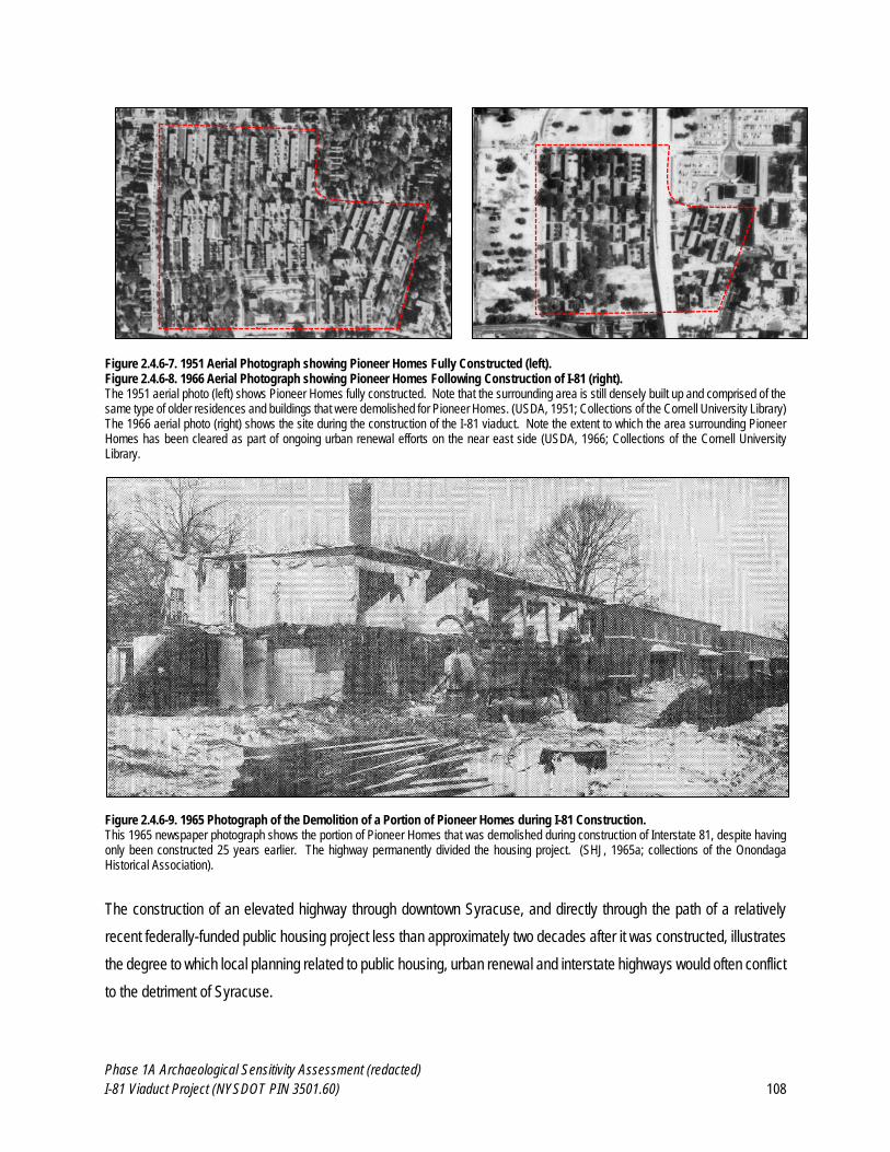
Phase 1A Archaeological Sensitivity Assessment (redacted)
I-81 Viaduct Project (NYSDOT PIN 3501.60) 108
Figure 2.4.6-7. 1951 Aerial Photograph showing Pioneer Homes Fully Constructed (left). Figure 2.4.6-8. 1966 Aerial Photograph showing Pioneer Homes Following Construction of I-81 (right). The 1951 aerial photo (left) shows Pioneer Homes fully constructed. Note that the surrounding area is still densely built up and comprised of the same type of older residences and buildings that were demolished for Pioneer Homes. (USDA, 1951; Collections of the Cornell University Library) The 1966 aerial photo (right) shows the site during the construction of the I-81 viaduct. Note the extent to which the area surrounding Pioneer Homes has been cleared as part of ongoing urban renewal efforts on the near east side (USDA, 1966; Collections of the Cornell University Library.
Figure 2.4.6-9. 1965 Photograph of the Demolition of a Portion of Pioneer Homes during I-81 Construction. This 1965 newspaper photograph shows the portion of Pioneer Homes that was demolished during construction of Interstate 81, despite having only been constructed 25 years earlier. The highway permanently divided the housing project. (SHJ, 1965a; collections of the Onondaga Historical Association).
The construction of an elevated highway through downtown Syracuse, and directly through the path of a relatively
recent federally-funded public housing project less than approximately two decades after it was constructed, illustrates
the degree to which local planning related to public housing, urban renewal and interstate highways would often conflict
to the detriment of Syracuse.
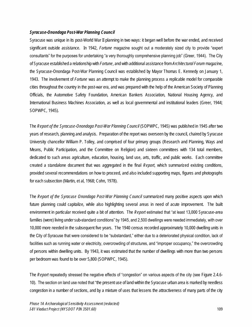
Phase 1A Archaeological Sensitivity Assessment (redacted)
I-81 Viaduct Project (NYSDOT PIN 3501.60) 109
Syracuse-Onondaga Post-War Planning Council
Syracuse was unique in its post-World War II planning in two ways: it began well before the war ended, and received
significant outside assistance. In 1942, Fortune magazine sought out a moderately sized city to provide “expert
consultants” for the purposes for undertaking “a very thoroughly comprehensive planning job” (Greer, 1944). The City
of Syracuse established a relationship with Fortune, and with additional assistance from Architectural Forum magazine,
the Syracuse-Onondaga Post-War Planning Council was established by Mayor Thomas E. Kennedy on January 1,
1943. The involvement of Fortune was an attempt to make the planning process a replicable model for comparable
cities throughout the country in the post-war era, and was prepared with the help of the American Society of Planning
Officials, the Automotive Safety Foundation, American Bankers Association, National Housing Agency, and
International Business Machines Association, as well as local governmental and institutional leaders (Greer, 1944;
SOPWPC, 1945).
The Report of the Syracuse-Onondaga Post-War Planning Council (SOPWPC, 1945) was published in 1945 after two
years of research, planning and analysis. Preparation of the report was overseen by the council, chaired by Syracuse
University chancellor William P. Tolley, and comprised of four primary groups (Research and Planning, Ways and
Means, Public Participation, and the Committee on Religion) and sixteen committees with 134 total members,
dedicated to such areas agriculture, education, housing, land use, arts, traffic, and public works. Each committee
created a standalone document that was aggregated in the final Report, which summarized existing conditions,
provided several recommendations on how to proceed, and also included supporting maps, figures and photographs
for each subsection (Martin, et al, 1968; Cohn, 1978).
The Report of the Syracuse Onondaga Post-War Planning Council summarized many positive aspects upon which
future planning could capitalize, while also highlighting several areas in need of acute improvement. The built
environment in particular received quite a bit of attention. The Report estimated that “at least 13,000 Syracuse-area
families (were) living under sub-standard conditions” by 1945, and 2,500 dwellings were needed immediately, with over
10,000 more needed in the subsequent five years. The 1940 census recorded approximately 10,000 dwelling units in
the City of Syracuse that were considered to be “substandard,” either due to a deteriorated physical condition, lack of
facilities such as running water or electricity, overcrowding of structures, and “improper occupancy,” the overcrowding
of persons within dwelling units. By 1943, it was estimated that the number of dwellings with more than two persons
per bedroom was found to be over 5,800 (SOPWPC, 1945).
The Report repeatedly stressed the negative effects of “congestion” on various aspects of the city (see Figure 2.4.6-
10). The section on land use noted that “the present use of land within the Syracuse urban area is marked by needless
congestion in a number of sections, and by a mixture of uses that lessens the attractiveness of many parts of the city
Phase 1A Archaeological Sensitivity Assessment (redacted)
I-81 Viaduct Project (NYSDOT PIN 3501.60) 110
as places in which to live, while lowering the value of other parts as suitable locations for business and industry,” while
the Central District section stressed that “no community problem is more urgently in need of solution that that of
adequate parking in the Central District, taking cars off the streets so as to provide relief for traffic congestion.” The
sections of the report dealing with urban land use, housing, the “Central District” (i.e. downtown), and traffic, transit and
transportation specifically recommended several measures calling for the demolition of blighted properties within and
immediately surrounding downtown Syracuse for a variety of purposes including parking, open space, new dwelling
units, and a series of newly constructed “thruways” for automobile traffic (SOPWPC, 1945).
Figure 2.4.6-10. 1930s Photograph of the Fifteenth Ward, Prior to Urban Renewal. This photograph, captioned “Congestion,” was included in the 1945 SOPWPC report to illustrate the “lack of adequate open space” present in
downtown Syracuse, with the report concluding that “people live so close to each other that quiet environment for peaceful living is destroyed.”
(SOPWPC, 1945)
The Housing section contained the most emphatic statements advocating for demolition of blighted housing, noting
that “some existing housing is so poor as to menace the safety and health of the occupants, not to mention the people
as a whole,” and also identified potential mechanisms through which demolition might occur:
Approximate future path of Interstate 81
Phase 1A Archaeological Sensitivity Assessment (redacted)
I-81 Viaduct Project (NYSDOT PIN 3501.60) 111
The blighted areas, hardly worth renovation, should not be allowed to exist more than say, 15 years. Much of the land now occupied by poor housing is likely to be absorbed by general open spaces, modern traffic and parking facilities, etc. That portion which can be used for housing again should be cleared when feasible, thru use of police powers. The balance could be acquired thru use of Housing Authority powers, or whenever feasible, by private Urban Re-development Corporations. (SOPWPC, 1945: 88).
In addition to advocating for the conversion of several city streets into a network of linked parkways, the Report also
provided recommendations for the construction of a traffic loop around the city:
An alternate plan for future consideration for a traffic improvement in the Central District is the proposal for a gradual development of a complete loop around the Central District. This would carry the traffic on the fringe of the district and would connect it with the primary traffic arteries serving various sections of the city. Grade separations would be built at important intersections and eventually, if traffic should require, the entire length of the loop would be on a separate grade. Entrance to, and exit from, the loop would be limited to a relatively few points. (SOPWPC, 1945: 67).
Although an elevated highway was not depicted in the report, discussion of the loop being constructed “on a separated
grade” allowed for the possibility of above and below grade roadways. The construction of an elevated right-of-way for
the New York Central railroad throughout downtown Syracuse in 1935 had created a precedent for above-grade
transportation routes, making the possibility of an elevated highway potentially more acceptable as an element of the
built environment.
Despite the thorough planning and robust recommendations of the post-war plan, within two years none of the
approximately $35 million worth of public projects had begun, and no successor organization dedicated to follow
through with the recommendations of the plan had been created within the city, due in part to fiscal conservatism by
successive Syracuse mayors. Meanwhile, suburban commercial, residential and industrial expansion continued, with
General Electric establishing its electronics manufacturing headquarters just beyond the city borders beginning in 1945,
and numerous shopping centers drawing commercial traffic away from the downtown shopping district and other
smaller business districts (McGuinness, 1947; Cohn, 1978).
Although slum clearance and new construction of federally funded public housing essentially ceased with U.S.
involvement in World War II, 25 state legislatures passed “urban redevelopment” acts between 1941 and 1948, though
only two explicitly included subsidies for slum clearance. The combination of a lack of new urban housing and
thousands of returning soldiers resulted in a housing shortage by 1945. A series of short-term and controversial
housing acts were passed between 1945 and 1948, it was not until the Housing Act of 1949 that a wide-ranging federal
strategy to combat the housing shortage was enacted. Although the goal of the Housing Act of 1949 was to create
810,000 units of public housing by 1954, a variety of factors including resistance from the real estate industry,
Presidential administration changes and the onset of the Korean War meant that this goal was not met for almost two
Phase 1A Archaeological Sensitivity Assessment (redacted)
I-81 Viaduct Project (NYSDOT PIN 3501.60) 112
decades. In the meantime, slum clearance continued in cities throughout the 1950s, encouraged by Title I of the
Housing Act of 1949, which authorized $1 billion in loans to assist cities in acquiring properties determined to be
blighted for the purposes of urban redevelopment (Cohn, 1978; Hoffman, 2000). This ongoing slum clearance was
further enabled by concurrent developments in state and federal transportation policy, which combined with the effects
of slum clearance would have a significant and lasting effect on the City of Syracuse.
Interstate 505 and the Oswego Boulevard Expressway
The state of New York began the planning process for what would become the New York State Thruway in 1942. As
originally envisioned, the Thruway was not routed through any major cities, nor was it planned to be an interstate.
However, the acceleration of highway planning following the end of World War II helped redefine the nature of the
Thruway, as well as planning for an increasing number of connecting highways that would link the Thruway to major
cities such as Syracuse.
Initial plans for what would become Interstate 81 were not controversial, as its design was not yet decided (so the
extent of potential dislocation of residents and destruction of buildings was unclear), and it had the support of a
dominant number of politicians, numerous city businesses, large institutions like Syracuse University, as well as the
New York Central Railroad and New York State Department of Public Works (NYSDPW). Working with the city planning
commission, the NYSDPW began working on a plan for a “modern arterial route system” that would link north-south
and east-west expressways with the planned Ontario-Mohawk Thruway (what would become the New York State
Thruway) and a series of arterial roads surrounding the central business district of Syracuse. In 1947, the state
advanced a proposed highway plan for Syracuse, which, although it was approved by the city and county that year,
was not acted upon for several years, even though highway construction was believed by many to be “the greatest
single element in the cure of city ills” (Cohn, 1978; DiMento and Ellis, 2013).
By the early 1950s, the national movement in both highway construction and urban renewal dovetailed in Syracuse
with the proposed north-south and east-west highways routed through neighborhoods that were perceived to be
“blighted,” the majority of which were located in the Fifteenth Ward adjacent to the downtown area. Based on proposals
from state officials as well as a consortium of local builders, the city of Syracuse began to seek funding for combined
slum clearance and highway development efforts. The proposed highway program was seen as having the added
benefits allowing the city to acquire additional property for purposes of redevelopment while simultaneously raising the
values of adjacent property, which would discourage the placement of public housing adjacent to the highway and
redeveloped areas (Cohn, 1978; DiMento and Ellis, 2013).
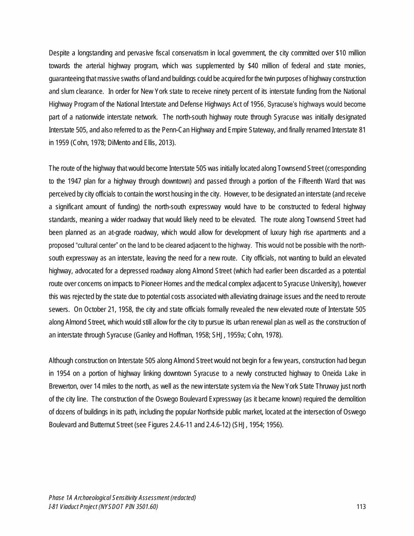
Phase 1A Archaeological Sensitivity Assessment (redacted)
I-81 Viaduct Project (NYSDOT PIN 3501.60) 113
Despite a longstanding and pervasive fiscal conservatism in local government, the city committed over $10 million
towards the arterial highway program, which was supplemented by $40 million of federal and state monies,
guaranteeing that massive swaths of land and buildings could be acquired for the twin purposes of highway construction
and slum clearance. In order for New York state to receive ninety percent of its interstate funding from the National
Highway Program of the National Interstate and Defense Highways Act of 1956, Syracuse’s highways would become
part of a nationwide interstate network. The north-south highway route through Syracuse was initially designated
Interstate 505, and also referred to as the Penn-Can Highway and Empire Stateway, and finally renamed Interstate 81
in 1959 (Cohn, 1978; DiMento and Ellis, 2013).
The route of the highway that would become Interstate 505 was initially located along Townsend Street (corresponding
to the 1947 plan for a highway through downtown) and passed through a portion of the Fifteenth Ward that was
perceived by city officials to contain the worst housing in the city. However, to be designated an interstate (and receive
a significant amount of funding) the north-south expressway would have to be constructed to federal highway
standards, meaning a wider roadway that would likely need to be elevated. The route along Townsend Street had
been planned as an at-grade roadway, which would allow for development of luxury high rise apartments and a
proposed “cultural center” on the land to be cleared adjacent to the highway. This would not be possible with the north-
south expressway as an interstate, leaving the need for a new route. City officials, not wanting to build an elevated
highway, advocated for a depressed roadway along Almond Street (which had earlier been discarded as a potential
route over concerns on impacts to Pioneer Homes and the medical complex adjacent to Syracuse University), however
this was rejected by the state due to potential costs associated with alleviating drainage issues and the need to reroute
sewers. On October 21, 1958, the city and state officials formally revealed the new elevated route of Interstate 505
along Almond Street, which would still allow for the city to pursue its urban renewal plan as well as the construction of
an interstate through Syracuse (Ganley and Hoffman, 1958; SHJ, 1959a; Cohn, 1978).
Although construction on Interstate 505 along Almond Street would not begin for a few years, construction had begun
in 1954 on a portion of highway linking downtown Syracuse to a newly constructed highway to Oneida Lake in
Brewerton, over 14 miles to the north, as well as the new interstate system via the New York State Thruway just north
of the city line. The construction of the Oswego Boulevard Expressway (as it became known) required the demolition
of dozens of buildings in its path, including the popular Northside public market, located at the intersection of Oswego
Boulevard and Butternut Street (see Figures 2.4.6-11 and 2.4.6-12) (SHJ, 1954; 1956).

Phase 1A Archaeological Sensitivity Assessment (redacted)
I-81 Viaduct Project (NYSDOT PIN 3501.60) 114
Figure 2.4.6-11. 1951 Aerial Photograph showing the Alignment of Oswego Boulevard (left). Figure 2.4.6-12. 1958 Aerial Photograph showing the Construction of the Oswego Boulevard Expressway (right). The 1951 aerial photo (left) shows Oswego Boulevard and the adjacent buildings prior to construction of the Oswego Boulevard Expressway, which began in 1954. Note that the surrounding area is still densely built up and predominantly commercial, though some surface parking is evident (FAS, 1951; Collections of the New York State Archives) The June, 13 1958 aerial photo (right) shows the expanded right-of-way during the construction of Oswego Boulevard Expressway. Note the extent to which the area surrounding the expressway has been disturbed, with numerous buildings demolished. (Hoffman, 1958a; Collections of the Onondaga Historical Association)
Although the Oswego Boulevard had originally been constructed atop the filled in Oswego Canal beginning in 1923,
considerable earthen embankments had to be constructed north of the city to carry the new expressway (see Figure
2.4.6-13). The expressway opened on October 27, 1959 with ceremonies heralding a “new era” for the city of Syracuse
led by a 150-car motorcade (SHJ, 1959a). The construction of the Oswego Boulevard Expressway was the first step
in linking downtown Syracuse to the nascent interstate network in the United States, and also a harbinger of the greater
destruction that would occur with the construction of the elevated viaduct portion of Interstate 81.
Approximate path of Oswego
Boulevard
(c. 1951)
Approximate path of Oswego
Boulevard Expressway
(c. 1958)
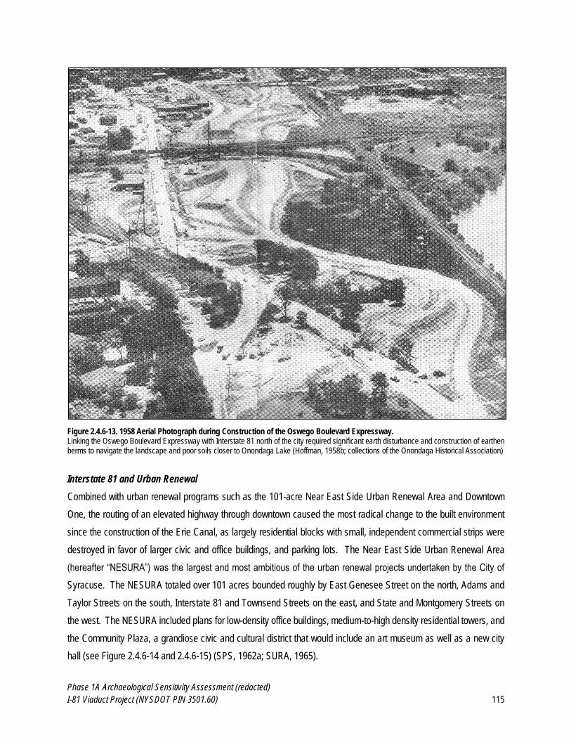
Phase 1A Archaeological Sensitivity Assessment (redacted)
I-81 Viaduct Project (NYSDOT PIN 3501.60) 115
Figure 2.4.6-13. 1958 Aerial Photograph during Construction of the Oswego Boulevard Expressway. Linking the Oswego Boulevard Expressway with Interstate 81 north of the city required significant earth disturbance and construction of earthen berms to navigate the landscape and poor soils closer to Onondaga Lake (Hoffman, 1958b; collections of the Onondaga Historical Association)
Interstate 81 and Urban Renewal
Combined with urban renewal programs such as the 101-acre Near East Side Urban Renewal Area and Downtown
One, the routing of an elevated highway through downtown caused the most radical change to the built environment
since the construction of the Erie Canal, as largely residential blocks with small, independent commercial strips were
destroyed in favor of larger civic and office buildings, and parking lots. The Near East Side Urban Renewal Area
(hereafter “NESURA”) was the largest and most ambitious of the urban renewal projects undertaken by the City of
Syracuse. The NESURA totaled over 101 acres bounded roughly by East Genesee Street on the north, Adams and
Taylor Streets on the south, Interstate 81 and Townsend Streets on the east, and State and Montgomery Streets on
the west. The NESURA included plans for low-density office buildings, medium-to-high density residential towers, and
the Community Plaza, a grandiose civic and cultural district that would include an art museum as well as a new city
hall (see Figure 2.4.6-14 and 2.4.6-15) (SPS, 1962a; SURA, 1965).
Phase 1A Archaeological Sensitivity Assessment (redacted)
I-81 Viaduct Project (NYSDOT PIN 3501.60) 116
Figure 2.4.6-14. 1962 Map of Proposed Near East Side Urban Renewal Area (NESURA) Redevelopment (left). Figure 2.4.6-15. 1965 Syracuse Urban Renewal Agency Map of Proposed NESURA Redevelopment (right). The NESURA, as envisioned in 1962 (left) was to involve a variety of uses including residential, civic and offices within a 101-acre area. (SPS, 1962a, Collections of the Onondaga Historical Association) The 1965 “Central Syracuse 1980 Illustrative Plan” (right) depicted the anticipated outcomes of various urban renewal projects, including the NESURA, by 1980. Formerly dense blocks of residences would be replaced by sprawling plazas with high-rise residential towers and city government offices (SURA, 1965; Collections of the Onondaga Historical Association)
A fifteen-month planning process for the NESURA began in 1958, when neighborhood residents were surveyed by the
City of Syracuse Office of Urban Renewal regarding housing needs. Housing in general in the Urban Renewal Area
was found to be substandard and overcrowded, with one phase of the survey finding 550 families living in 160 dwellings.
Following the survey process, in 1960 the Office of Urban Renewal, issued letters to property owners and tenants in
the Near East Side Urban Renewal Area indicating that property acquisition would be occurring over the next two years,
no families would have to relocate until “decent, safe and sanitary quarters elsewhere” had been found for them, and
that some families and businesses would be able to remain in their buildings even after acquisition, depending on
where they were located (SHA, 1958; CSOUR, 1960).
Initial property acquisition in the Near East Side Urban Renewal Area began in 1961 with the purchase of 25 properties
at cost of almost one million dollars. Most of the properties were acquired at three times their appraised value. Early
estimates of costs for building acquisition significantly exceeded the appraised value of buildings, sometimes by as
much as 500 percent, leading to public criticism of the costs of urban renewal projects (Hancock, 1958; Ganley, 1961).
Demolition of buildings within the NESURA, as well as the proposed path of Interstate 81 began in 1962, and continued
until 1966. Buildings were demolished in eight groups based on locations specified in contracts labeled D-1 through
Phase 1A Archaeological Sensitivity Assessment (redacted)
I-81 Viaduct Project (NYSDOT PIN 3501.60) 117
D-8 (the “D” indicating “demolition”). The demolition contracts required that basements and cellars would be filled, and
the property cleared and graded. Where demolition contracts for Interstate 81 and the NESURA involved the removal
of streets such as Cedar Street and Jackson Street, manholes and catch basins were also filled in, and curbing was
removed (SPS, 1964a; Lee, 1965). Appendix B of this report includes geo-referenced copies of the NYSDOT
demolition plans overlain on current aerial photographs, which illustrates the scale of the transformation to this
neighborhood that resulted from the widespread demolition of structures within the NESURA.
Demolition for the NESURA alone included 633 structures on 450 parcels. One newspaper article regarding the
demolition contracts noted that the NESURA would be made a “vast desert”. A total of 838 families and 304 businesses
were displaced within the NESURA. A total of fifty-seven businesses went out of business rather than relocate (Lee,
1963; SPS, 1963a). By spring 1964, 565 buildings had been demolished under seven contracts within the NESURA;
by August 1965, only one building remained to be demolished (SPS, 1964b and 1965a). Demolition of buildings within
the path of Interstate 81 had already progressed considerably along its right-of-way through the city, with foundations
and pilings portending the highway to come (see Figure 2.4.6-16), while on the south side of the city the interstate was
beginning to take shape in the form of bridge footings and earthen embankments (see Figure 2.4.6-17) (SHJ, 1964
and 1965b).
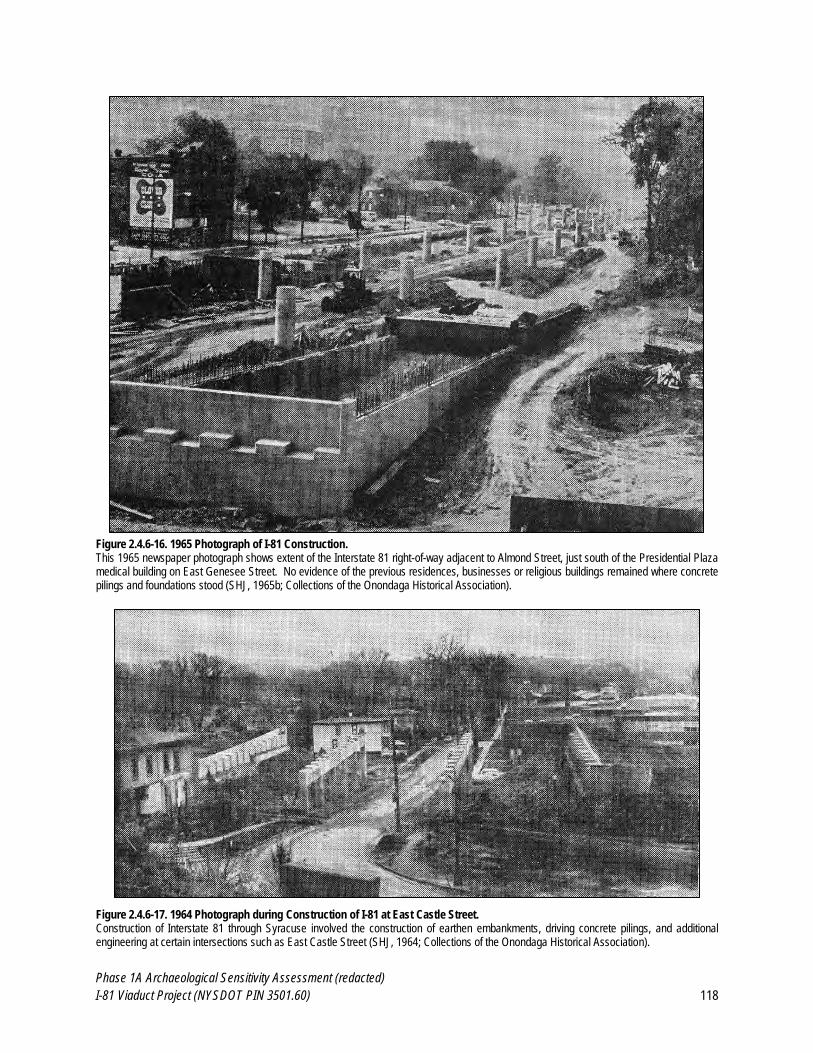
Phase 1A Archaeological Sensitivity Assessment (redacted)
I-81 Viaduct Project (NYSDOT PIN 3501.60) 118
Figure 2.4.6-16. 1965 Photograph of I-81 Construction. This 1965 newspaper photograph shows extent of the Interstate 81 right-of-way adjacent to Almond Street, just south of the Presidential Plaza medical building on East Genesee Street. No evidence of the previous residences, businesses or religious buildings remained where concrete pilings and foundations stood (SHJ, 1965b; Collections of the Onondaga Historical Association).
Figure 2.4.6-17. 1964 Photograph during Construction of I-81 at East Castle Street. Construction of Interstate 81 through Syracuse involved the construction of earthen embankments, driving concrete pilings, and additional engineering at certain intersections such as East Castle Street (SHJ, 1964; Collections of the Onondaga Historical Association).
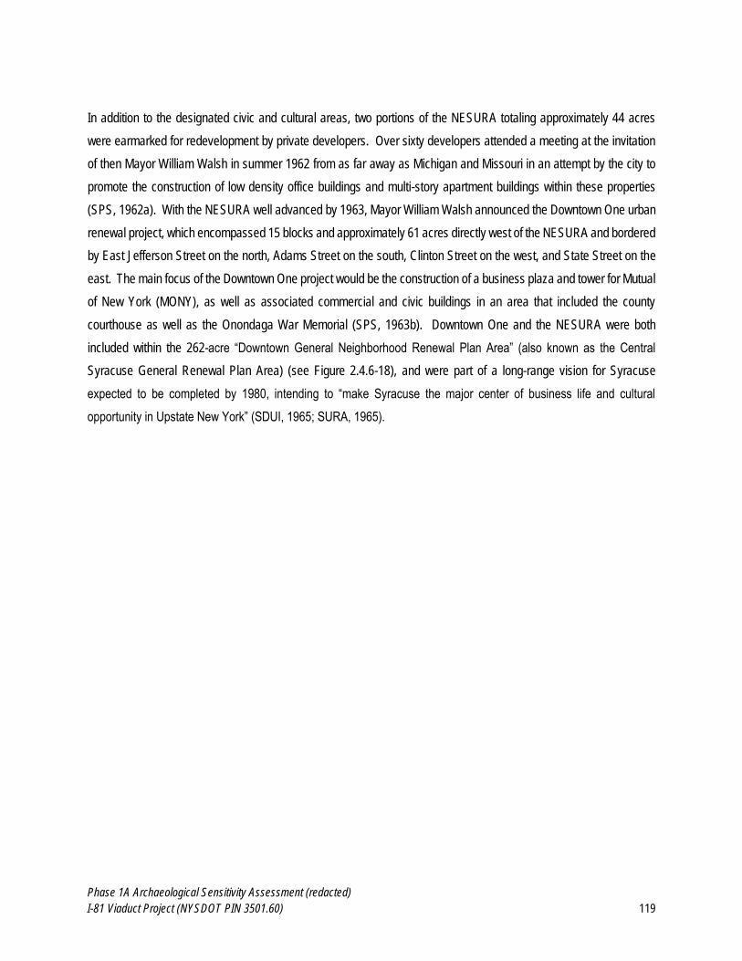
Phase 1A Archaeological Sensitivity Assessment (redacted)
I-81 Viaduct Project (NYSDOT PIN 3501.60) 119
In addition to the designated civic and cultural areas, two portions of the NESURA totaling approximately 44 acres
were earmarked for redevelopment by private developers. Over sixty developers attended a meeting at the invitation
of then Mayor William Walsh in summer 1962 from as far away as Michigan and Missouri in an attempt by the city to
promote the construction of low density office buildings and multi-story apartment buildings within these properties
(SPS, 1962a). With the NESURA well advanced by 1963, Mayor William Walsh announced the Downtown One urban
renewal project, which encompassed 15 blocks and approximately 61 acres directly west of the NESURA and bordered
by East Jefferson Street on the north, Adams Street on the south, Clinton Street on the west, and State Street on the
east. The main focus of the Downtown One project would be the construction of a business plaza and tower for Mutual
of New York (MONY), as well as associated commercial and civic buildings in an area that included the county
courthouse as well as the Onondaga War Memorial (SPS, 1963b). Downtown One and the NESURA were both
included within the 262-acre “Downtown General Neighborhood Renewal Plan Area” (also known as the Central
Syracuse General Renewal Plan Area) (see Figure 2.4.6-18), and were part of a long-range vision for Syracuse
expected to be completed by 1980, intending to “make Syracuse the major center of business life and cultural
opportunity in Upstate New York” (SDUI, 1965; SURA, 1965).
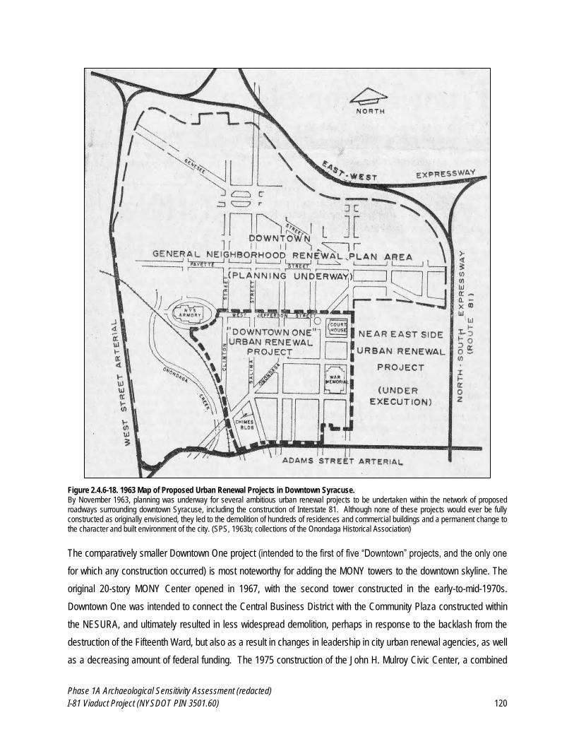
Phase 1A Archaeological Sensitivity Assessment (redacted)
I-81 Viaduct Project (NYSDOT PIN 3501.60) 120
Figure 2.4.6-18. 1963 Map of Proposed Urban Renewal Projects in Downtown Syracuse. By November 1963, planning was underway for several ambitious urban renewal projects to be undertaken within the network of proposed roadways surrounding downtown Syracuse, including the construction of Interstate 81. Although none of these projects would ever be fully constructed as originally envisioned, they led to the demolition of hundreds of residences and commercial buildings and a permanent change to the character and built environment of the city. (SPS, 1963b; collections of the Onondaga Historical Association)
The comparatively smaller Downtown One project (intended to the first of five “Downtown” projects, and the only one
for which any construction occurred) is most noteworthy for adding the MONY towers to the downtown skyline. The
original 20-story MONY Center opened in 1967, with the second tower constructed in the early-to-mid-1970s.
Downtown One was intended to connect the Central Business District with the Community Plaza constructed within
the NESURA, and ultimately resulted in less widespread demolition, perhaps in response to the backlash from the
destruction of the Fifteenth Ward, but also as a result in changes in leadership in city urban renewal agencies, as well
as a decreasing amount of federal funding. The 1975 construction of the John H. Mulroy Civic Center, a combined
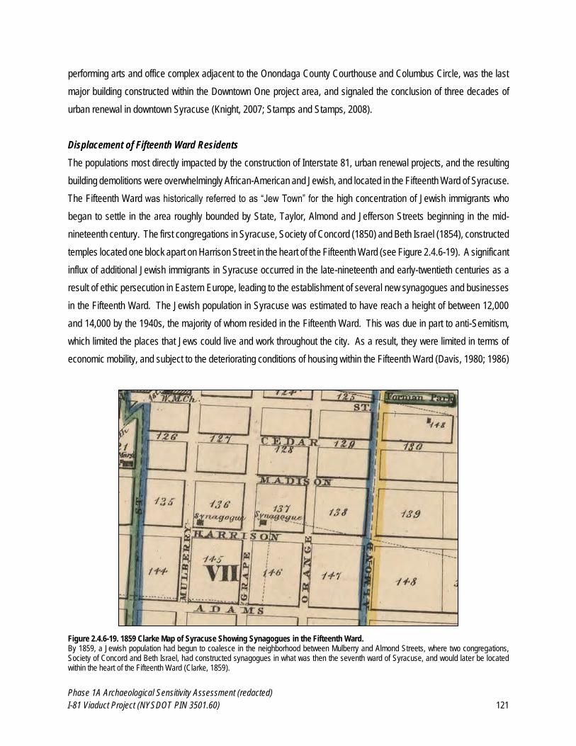
Phase 1A Archaeological Sensitivity Assessment (redacted)
I-81 Viaduct Project (NYSDOT PIN 3501.60) 121
performing arts and office complex adjacent to the Onondaga County Courthouse and Columbus Circle, was the last
major building constructed within the Downtown One project area, and signaled the conclusion of three decades of
urban renewal in downtown Syracuse (Knight, 2007; Stamps and Stamps, 2008).
Displacement of Fifteenth Ward Residents
The populations most directly impacted by the construction of Interstate 81, urban renewal projects, and the resulting
building demolitions were overwhelmingly African-American and Jewish, and located in the Fifteenth Ward of Syracuse.
The Fifteenth Ward was historically referred to as “Jew Town” for the high concentration of Jewish immigrants who
began to settle in the area roughly bounded by State, Taylor, Almond and Jefferson Streets beginning in the mid-
nineteenth century. The first congregations in Syracuse, Society of Concord (1850) and Beth Israel (1854), constructed
temples located one block apart on Harrison Street in the heart of the Fifteenth Ward (see Figure 2.4.6-19). A significant
influx of additional Jewish immigrants in Syracuse occurred in the late-nineteenth and early-twentieth centuries as a
result of ethic persecution in Eastern Europe, leading to the establishment of several new synagogues and businesses
in the Fifteenth Ward. The Jewish population in Syracuse was estimated to have reach a height of between 12,000
and 14,000 by the 1940s, the majority of whom resided in the Fifteenth Ward. This was due in part to anti-Semitism,
which limited the places that Jews could live and work throughout the city. As a result, they were limited in terms of
economic mobility, and subject to the deteriorating conditions of housing within the Fifteenth Ward (Davis, 1980; 1986)
Figure 2.4.6-19. 1859 Clarke Map of Syracuse Showing Synagogues in the Fifteenth Ward. By 1859, a Jewish population had begun to coalesce in the neighborhood between Mulberry and Almond Streets, where two congregations, Society of Concord and Beth Israel, had constructed synagogues in what was then the seventh ward of Syracuse, and would later be located within the heart of the Fifteenth Ward (Clarke, 1859).

Phase 1A Archaeological Sensitivity Assessment (redacted)
I-81 Viaduct Project (NYSDOT PIN 3501.60) 122
The Jewish enclave in downtown Syracuse was essentially obliterated by the construction of Interstate 81 and the
corresponding demolition of the Fifteenth Ward. Many families chose move outside the city or to leave Syracuse
entirely, drawn by new congregations in eastern suburbs such as Dewitt. The Jewish community in Syracuse had
shrank to approximately 9,000 by the early 1980s (Davis, 1986; Davis and Rabin, 2011). Although a few congregations
were still located within the city limits, the critical mass of synagogues and businesses that existed in the Fifteenth
Ward for a century did not coalesce elsewhere following forced relocation under urban renewal policies, leaving minimal
trace of the once flourishing “Jewtown” in the shadow of Interstate 81 (see Figure 2.4.6-20 and Appendix B), or its
flourishing Jewish and African-American communities and businesses, the latter of which had grown significantly in the
decades just prior to the construction of the highway.
Figure 2.4.6-20. 1961 NYSDOT Demolition Plan of a Portion of Almond Street. The demolition plans prepared by NYSDOT for the Interstate 81 (originally named Interstate 505) project identified the owners of structures within the path of the highway as well number of stories and building materials. This particular sheet (64-13, Sheet 6 of 8) depicts the block between Adams and Harrison Streets slated for demolition, as well as noting adjacent structures on the east side of Almond Street, most notably two synagogues (Congregation Pioley Tzedeck and Congregation Ahauth Achim) and a Jewish Community Center, that would be demolished as part of the NESURA project (NYSDOT, 1961).
Phase 1A Archaeological Sensitivity Assessment (redacted)
I-81 Viaduct Project (NYSDOT PIN 3501.60) 123
Although Syracuse had a significant African-American population at the time of the construction of Interstate 81, this
was not historically the case. In 1810, only 7 African-Americans were recorded as living in Syracuse (two of which
were counted as slaves); however, by the time all slaves were freed in New York in 1827, the number of African-
Americans had grown to 176. Following the Civil War, the African-American population in Syracuse grew slowly, but
stayed relatively static in terms of proportion to the overall population. Between 1870 and 1940, African-Americans
comprised approximately one percent of the entire population of the City of Syracuse, although the total number grew
by almost 400 percent (from 435 in 1870 to 2,082 by 1940). Between 1940 and 1960, the African-American population
grew over 100 percent each decade, from 5,058 by 1950, to 11,210 by 1960. Throughout this period of growth and
despite significant increases in population, African-Americans were geographically limited to older and often
deteriorated housing south of the Erie Canal in the sixth, seventh, eighth and ninth wards of Syracuse, eventually
expanding south into the Fifteenth Ward by the 1920s (Davis, 1980; Stamps and Stamps, 2008).
By 1957, it was estimated that a total of 3,337 families would be displaced by urban renewal and highway construction
in Syracuse by 1960, though only 718 units of potential state and federally-funded housing were available to
accommodate these families, many of whom were African-American (SPS, 1957). Variations in relocation policies and
compensation of displaced tenants caused some controversy, leading to accusations of discrimination and segregation
in the relocation of African-Americans from the Fifteenth Ward into inferior housing. Families located within the
NESURA received moving expenses, while businesses were also reimbursed property losses up to $3,000. By
contrast, families displaced by Interstate 81 were not given any money (Carroll, 1961). Homeowners in one area at
the southern end of the proposed Interstate 81 right-of-way formed the South Side Property Owners Association
claimed that appraisals on their homes were “ridiculously low,” and even sought to have emergency legislation passed
by the state that would provide reimbursement for moving costs and legal expenses associated with property
acquisitions, though they were not successful. Attempts to meet with Governor Nelson Rockefeller to discuss the issue
were also stymied (SHJ, 1962; SPS, 1962b; Stevens, 1962).
The Syracuse Committee on Racial Equality (CORE) were among the vocal protestors of what they deemed to be the
“segregated relocation of families due to urban renewal,” and advocated for “direct intervention…into the urban renewal
area to halt the urban renewal program.” The city government, led by Mayor William Walsh, warned the protestors that
their ultimatum was a “threat to the processes of city government.” A September 1963 protest resulted in the arrest of
twelve CORE members by city police. Numerous demonstrations followed as demolitions progressed for the NESURA
and Interstate 81 (SPS, 1963c and 1963d). Anti-demolition protests even resulted in one wrecking company hired by
the city filing a claim against the city due to delays caused by CORE demonstrations (SPS, 1964c).

Phase 1A Archaeological Sensitivity Assessment (redacted)
I-81 Viaduct Project (NYSDOT PIN 3501.60) 124
It is estimated 800-900 families were displaced by multiple urban renewal programs as well as the construction of
highways in the Fifteenth Ward, with a total of 2,200 families displaced by urban renewal and highway construction.
By 1968, 103 acres of land in four contiguous census tracts that were predominantly African-American and poor, had
been demolished, with hundreds of residences, dozens of Jewish and African-American-owned businesses, and nearly
all of the African-American churches in the city had been permanently destroyed (Knight, 2007; Stamps and Stamps,
2008; DiMento and Ellis, 2013).
End of Urban Renewal
Despite the wide application of urban renewal programs in American cities throughout the 1950s and 1960s, the
programs were often criticized for taking over a decade to complete, or projects never coming to fruition after extensive
demolition had occurred, sometimes leaving massive vacant lots and dozens if not hundreds of displaced residents. A
1966 survey of projects found that of almost 1,200 urban renewal projects completed nationwide, approximately 67
percent were residential in nature before urban renewal, and only 43 percent were residential when completed. In
addition, when new housing was built to replace older housing, the new residences were often too expensive for the
former residents, leading to subsequent displacement, as well as overcrowding and creation of slum-like conditions
elsewhere in cities. Throughout the 1960s and 1970s, subsequent urban renewal projects in several American cities
were embroiled in scandals involving corruption, crime, foreclosures and other financial problems, and earlier urban
renewal public housing projects were already beginning to be demolished (Cohn, 1978; Hoffman, 2000).
As early as 1958, Syracuse officials, including then-mayor Anthony Henninger, acknowledged the potential drawbacks
of constructing an elevated highway through downtown Syracuse, noting similar highway projects had already done
more harm than good in other cities (SPS, 1958a). However, by the time the full-length of Interstate 81 opened through
Syracuse just a decade later, a suite of urban renewal initiatives had done just as much, if not more significant damage
to the built environment of the City of Syracuse than a single highway project, which often shoulders the blame for
decades of urban planning missteps that are to blame for the irreversible destruction of hundreds of buildings,
concurrent dislocation of thousands of residents and eradication of communities, and the flight of business and
economic downturn of downtown Syracuse in the mid-to-late twentieth century (Cohn, 1978; DiMento and Ellis, 2008).
2.4.7 Suburban Expansion in Onondaga County (ca. 1965-2016)
In addition to the forced relocation of several hundreds of residents and the destruction of numerous buildings
throughout downtown Syracuse, the urban renewal era had the unintended consequence of reducing the vitality of the
central business district and city as a whole. Newly constructed elevated freeways carried traffic to growing suburbs,
encouraging more rapid development and relocation of commercial and industrial opportunities outside the city center,
drawing jobs as well as consumers away from the once vibrant downtown area. Although it continued to attract workers
Phase 1A Archaeological Sensitivity Assessment (redacted)
I-81 Viaduct Project (NYSDOT PIN 3501.60) 125
from the suburbs in the burgeoning fields of education and health care throughout the late twentieth century, the City
of Syracuse continued to shrink in population as well as prominence as a center of industry, a role it had occupied for
150 years.
Construction of I-481 and Changes to Interstate 81
The plans for Interstate 81 also included the construction of a belt-loop expressway that would connect Interstate 81
at North Syracuse on the north and Brighton Avenue on the south to the New York State Thruway, originally designated
Interstate 281. The proposed route of this expressway passed through predominantly undeveloped land adjacent to
fairly recent suburban development; although property would need to be acquired as part of the highway construction,
the number of buildings that needed to be demolished would be far less than the number demolished as part of the
construction of Interstate 81. Initial construction on the first portion of the outer loop expressway between Jamesville
Road and Route 5 in the Town of Dewitt began in 1962 and opened by 1965. Interstate 281 was officially renumbered
as Interstate 481 in 1970, with subsequent portions between Route 5, Interstate 690 and the New York State Thruway
opened by the mid-1970s (SHJ, 1962b; NYSDOT, 1970; USGS, 1973a). While construction of the southern portion of
Interstate 481 connecting Brighton Avenue to the existing route of Interstate 481 at Jamesville Road was completed
by 1979, construction of the final, five-mile portion of Interstate 481 between the New York State Thruway in the Town
of Dewitt to Interstate 81 in the Town of Cicero did not begin until 1982 (SHA, 1978; Faber, 1982). The complete route
of Interstate 481 opened in 1990, almost 50 years after initial proposal for a network of highways was proposed within
Syracuse and the surrounding area.
However, after less than a decade, numerous problems had arisen with Interstate 81, owing to a higher number of cars
causing unanticipated congestion, which was exacerbated by design deficiencies, that also led to a number of serious
accidents. The increase in use of the highway also necessitated frequent repairs, as well as closures of some on and
off-ramps. The entrance from Hiawatha Boulevard to Interstate 81 north was closed in the early 1970s due to safety
concerns, prompting a significant redesign of the highway and that included additional lanes between Hiawatha
Boulevard and Mattydale, and reconstruction of four interchanges. Work was initially proposed in 1977, and but stalled
for several years as alternatives were studied by the New York State Department of Transportation (NYSDOT) (SPS,
1977a and 1977b; Cohn, 1978).
By 1980, designs were in place for a $70 million project that included widening of the highway along four miles,
construction of a “super viaduct” at the Liverpool interchange, as well as realignment of a portion of the highway at
Park Street, which would include the acquisition and demolition of 13 residences as well as several businesses. Work
began in late 1981, with the construction of a temporary roadway and embankment to handle traffic flow during the
construction of the new road alignment and interchange (Padovano, 1980 and 1982a). The increase in traffic through
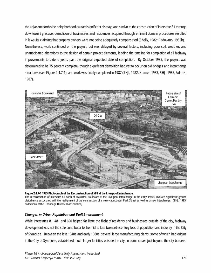
Phase 1A Archaeological Sensitivity Assessment (redacted)
I-81 Viaduct Project (NYSDOT PIN 3501.60) 126
the adjacent north side neighborhood caused significant dismay, and similar to the construction of Interstate 81 through
downtown Syracuse, demolition of businesses and residences acquired through eminent domain procedures resulted
in lawsuits claiming that property owners were not being adequately compensated (Shelly, 1982; Padovano, 1982b).
Nonetheless, work continued on the project, but was delayed by several factors, including poor soil, weather, and
unanticipated alterations to the design of certain project elements, leading the timeline for completion of all highway
improvements to extend years past the original expected date of completion. By October 1985, the project was
determined to be 75 percent complete, though significant demolition had yet to occur on old bridges and interchange
structures (see Figure 2.4.7-1), and work was finally completed in 1987 (SHJ, 1982; Kramer, 1983; SHJ, 1985; Adams,
1987).
Figure 2.4.7-1 1985 Photograph of the Reconstruction of I-81 at the Liverpool Interchange. The reconstruction of Interstate 81 north of Hiawatha Boulevard at the Liverpool Interchange in the early 1980s involved significant ground disturbance associated with the realignment of the construction of a new viaduct over Park Street as well as a new interchange. (SHJ, 1985; collections of the Onondaga Historical Association)
Changes in Urban Population and Built Environment
While Interstates 81, 481 and 690 helped facilitate the flight of residents and businesses outside of the city, highway
development was not the sole contributor to the mid-to-late twentieth century loss of population and industry in the City
of Syracuse. Between the late 1940s and early 1980s, several large manufacturing plants, some of which had origins
in the City of Syracuse, established much larger facilities outside the city, in some cases just beyond the city borders.
Future site of Carousel
Center/Destiny USA
Hiawatha Boulevard
Oil City
Park Street
Liverpool Interchange
Phase 1A Archaeological Sensitivity Assessment (redacted)
I-81 Viaduct Project (NYSDOT PIN 3501.60) 127
The neighboring Towns of Salina, Camillus and Onondaga experienced population growth between 100 and 400
percent between 1950 and 1970. A number of large, centralized shopping malls were constructed to service these
growing populations with a concentration of shops and restaurants in one place, further diminishing the need to travel
into the city for commerce. In addition, the establishment of a county executive in 1962 and a county legislature in
1968 centralized control of many functions that were formerly the responsibility of a Board of Supervisors that
represented the nineteen towns of Onondaga County and the nineteen wards of the City of Syracuse, and gave more
power to the outlying towns within the county to develop independently of the city (Cohn, 1978; Schramm and
Roseboom, 1979; Connors, 2005; Rivette, 2005). The flight of commerce and industry from downtown Syracuse left
several empty buildings that would ultimately collapse or be demolished in subsequent decades.
After peaking at approximately 221,000 residents in 1950, the population of the City of Syracuse experienced a steady
decline throughout the 1960s and 1970s. While the city accounted for approximately 72 percent of the population of
the county in 1930, by 1980 that number had dropped to just 37 percent. In addition, employment within the city
suffered, with the loss of over 8,000 jobs throughout the 1960s, and approximately 8,300 jobs in the 1970s. The
majority of job losses occurred outside the central business district, which had experienced more significant loss of
industry beginning in the 1940s, though it recovered somewhat in the late twentieth century. In contrast to these overall
losses, the African-American population of Syracuse grew steadily and significantly during this same period, from
approximately 2082 people in 1930 to 30,117 people in 1980. This included tremendous growth in the era of urban
renewal, when the African-American population grew more than 120 percent from 1940 to 1950, and more than 144
percent from 1950 to 1960. Conversely, by 1960, under 33 percent of the African-American population of Syracuse
reported that they were living in the same residence as just five years earlier, indicating a high degree of geographical
instability. This instability was also illustrated by the degree to which the African-American population of Syracuse was
predominantly located within the poorest census tracts in the city, which increased in number significantly following the
forced relocation of many African-Americans during the urban renewal era (Sacks and Sacks, 1987; Stamps and
Stamps, 2008).
In the early 1970s, it had become apparent that many of the goals of urban renewal to prevent further urban blight as
well as job and population loss had ultimately failed. The character of many U.S. cities had been drastically altered
through demolition of housing and commercial buildings for surface parking and diminished residential use, as well as
the construction of large, often elevated highways and arterials that divided neighborhoods and added a perilous
condition for pedestrians attempting to navigate an automobile-dominated landscape. Urban renewal was officially
terminated at the federal level in 1973. The Housing and Community Development Act of 1974 included some of the
functions of urban renewal in the Community Development Block Grant (CDBG), but focused on housing rehabilitation
rather than outright demolition and clearances, and also advocated for historic preservation (Hoffman, 2000). Although
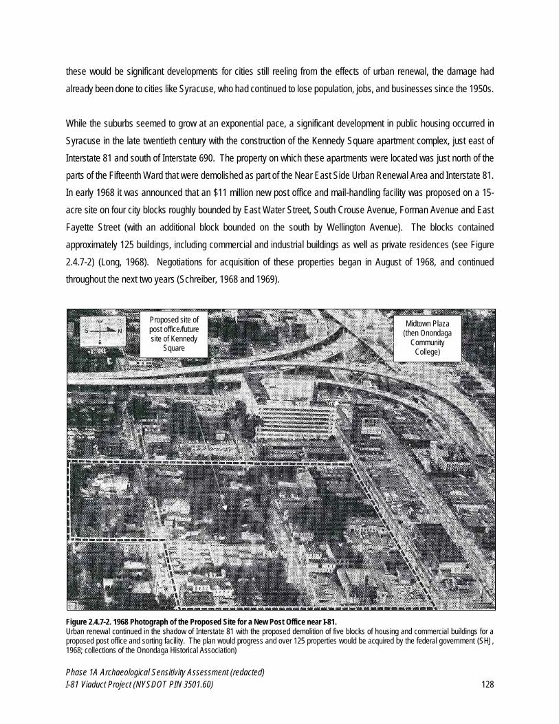
Phase 1A Archaeological Sensitivity Assessment (redacted)
I-81 Viaduct Project (NYSDOT PIN 3501.60) 128
these would be significant developments for cities still reeling from the effects of urban renewal, the damage had
already been done to cities like Syracuse, who had continued to lose population, jobs, and businesses since the 1950s.
While the suburbs seemed to grow at an exponential pace, a significant development in public housing occurred in
Syracuse in the late twentieth century with the construction of the Kennedy Square apartment complex, just east of
Interstate 81 and south of Interstate 690. The property on which these apartments were located was just north of the
parts of the Fifteenth Ward that were demolished as part of the Near East Side Urban Renewal Area and Interstate 81.
In early 1968 it was announced that an $11 million new post office and mail-handling facility was proposed on a 15-
acre site on four city blocks roughly bounded by East Water Street, South Crouse Avenue, Forman Avenue and East
Fayette Street (with an additional block bounded on the south by Wellington Avenue). The blocks contained
approximately 125 buildings, including commercial and industrial buildings as well as private residences (see Figure
2.4.7-2) (Long, 1968). Negotiations for acquisition of these properties began in August of 1968, and continued
throughout the next two years (Schreiber, 1968 and 1969).
Figure 2.4.7-2. 1968 Photograph of the Proposed Site for a New Post Office near I-81. Urban renewal continued in the shadow of Interstate 81 with the proposed demolition of five blocks of housing and commercial buildings for a proposed post office and sorting facility. The plan would progress and over 125 properties would be acquired by the federal government (SHJ, 1968; collections of the Onondaga Historical Association)
Midtown Plaza (then Onondaga
Community College)
Proposed site of post office/future site of Kennedy
Square
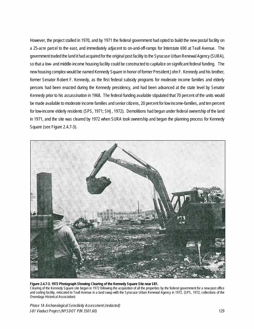
Phase 1A Archaeological Sensitivity Assessment (redacted)
I-81 Viaduct Project (NYSDOT PIN 3501.60) 129
However, the project stalled in 1970, and by 1971 the federal government had opted to build the new postal facility on
a 25-acre parcel to the east, and immediately adjacent to on-and-off-ramps for Interstate 690 at Teall Avenue. The
government traded the land it had acquired for the original post facility to the Syracuse Urban Renewal Agency (SURA),
so that a low- and middle-income housing facility could be constructed to capitalize on significant federal funding. The
new housing complex would be named Kennedy Square in honor of former President John F. Kennedy and his brother,
former Senator Robert F. Kennedy, as the first federal subsidy programs for moderate income families and elderly
persons had been enacted during the Kennedy presidency, and had been advanced at the state level by Senator
Kennedy prior to his assassination in 1968. The federal funding available stipulated that 70 percent of the units would
be made available to moderate income families and senior citizens, 20 percent for low income-families, and ten percent
for low-income elderly residents (SPS, 1971; SHJ, 1972). Demolitions had begun under federal ownership of the land
in 1971, and the site was cleared by 1972 when SURA took ownership and began the planning process for Kennedy
Square (see Figure 2.4.7-3).
Figure 2.4.7-3. 1972 Photograph Showing Clearing of the Kennedy Square Site near I-81. Clearing of the Kennedy Square site began in 1972 following the acquisition of all the properties by the federal government for a new post office and sorting facility, relocated to Teall Avenue in a land swap with the Syracuse Urban Renewal Agency in 1972. (SPS, 1972; collections of the Onondaga Historical Association)
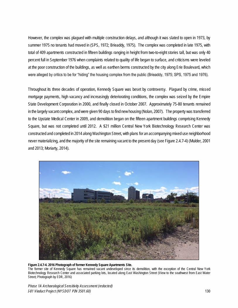
Phase 1A Archaeological Sensitivity Assessment (redacted)
I-81 Viaduct Project (NYSDOT PIN 3501.60) 130
However, the complex was plagued with multiple construction delays, and although it was slated to open in 1973, by
summer 1975 no tenants had moved in (SPS, 1972; Brieaddy, 1975). The complex was completed in late 1975, with
total of 409 apartments constructed in fifteen buildings ranging in height from two-to-eight stories tall, but was only 40
percent full in September 1976 when complaints related to quality of life began to surface, and criticisms were leveled
at the poor construction of the buildings, as well as earthen berms constructed by the city along Erie Boulevard, which
were alleged by critics to be for “hiding” the housing complex from the public (Brieaddy, 1975; SPS, 1975 and 1976).
Throughout its three decades of operation, Kennedy Square was beset by controversy. Plagued by crime, missed
mortgage payments, high vacancy and increasingly deteriorating conditions, the complex was seized by the Empire
State Development Corporation in 2000, and finally closed in October 2007. Approximately 75-80 tenants remained
in the largely vacant complex, and were given 90 days to find new housing (Nolan, 2007). The property was transferred
to the Upstate Medical Center in 2009, and demolition began on the fifteen apartment buildings comprising Kennedy
Square, but was not completed until 2012. A $21 million Central New York Biotechnology Research Center was
constructed and completed in 2014 along Washington Street, with plans for an accompanying mixed use neighborhood
never materializing, and the majority of the site remaining vacant to the present day (see Figure 2.4.7-4) (Mulder, 2001
and 2013; Moriarty, 2014).
Figure 2.4.7-4. 2016 Photograph of former Kennedy Square Apartments Site. The former site of Kennedy Square has remained vacant undeveloped since its demolition, with the exception of the Central New York Biotechnology Research Center and associated parking lots, located along East Washington Street (View to the southwest from East Water Street; Photograph by EDR, 2016)

Phase 1A Archaeological Sensitivity Assessment (redacted)
I-81 Viaduct Project (NYSDOT PIN 3501.60) 131
Located just west of the Kennedy Square site and immediately adjacent to Interstates 81 and 690 is another block that
underwent significant changes in the late twentieth century. The corner of East Washington and Almond Streets was
originally the home of the L.C. Smith & Brothers Typewriter Company, one of the most important area manufactories
of the early twentieth century. The company merged with Corona Typewriter Company of Groton, New York in 1926
to form Smith-Corona, which was among the leading manufacturers of typewriters in the United States throughout the
subsequent decades. As the company grew, the building expanded to an imposing, eight-story, horseshoe-shaped
complex facing Erie Boulevard (visible in Figure 2.4.7-2). Although the company vacated the complex in 1960 to move
its operations south to Cortland County, the building did not stay vacant for long. The Onondaga Community College
(OCC) opened its doors to 500 students in 1962 in the former Smith-Corona complex. After over a decade of continual
growth, OCC relocated to a 280-acre site south of the city, once again leaving Midtown Plaza vacant (Knauss, 2000;
OCC, 2016).
Following the departure of OCC, the building housed a variety of businesses, but fell into disrepair and was vacant by
the late 1980s. Perceived as an eyesore and a barrier to development of the property, Midtown Plaza was demolished
in 1999 (see Figure 2.4.7-5). The Midtown Plaza site lay dormant for several years, until former Governor George
Pataki proposed the construction of the Syracuse Center of Excellence in Environmental and Energy Systems, which
was decided to be located at the corner of East Washington and Almond Streets in 2002. The designation of the land
as a brownfield resulted in significant clean-up and abatement of the site, leading to a lengthy construction process.
Ground was broken in 2004, and the building was completed in 2010 (see Figure 2.4.7-6) (Kim and Wright, 1999;
Knauss, 2000; Morelli, 2010).
Figure 2.4.7-5. 1999 Photograph Showing the Demolition of Midtown Plaza (left). Figure 2.4.7-6. 2016 Photograph of the Center of Excellence at the former Midtown Plaza site (right). By 1999, Midtown Plaza had been vacant for over a decade, and was demolished in a highly-publicized ceremony (The Post-Standard, 1999) By 2016, the area to the south of the Center of Excellence (opened in 2010) had undergone significant environmental remediation and under development for onsite parking and other amenities. (Photograph by EDR, 2016)
Phase 1A Archaeological Sensitivity Assessment (redacted)
I-81 Viaduct Project (NYSDOT PIN 3501.60) 132
Perhaps the most significant development in the City of Syracuse in the late twentieth century was the construction of
the Carousel Center (later renamed Destiny USA) between Onondaga Lake and the property known as Oil City, north
of downtown Syracuse and immediately west of Interstate 81. The property had long served as a scrapyard and like
much of the surrounding lakefront, was significantly polluted by years of industrial use (see Figure 2.4.7-7). In 1987,
Pyramid Companies announced its intention to build a shopping mall over one-and-a-half million square feet in size,
originally scheduled to open in 1989. However, the proximity to the lake and previous industrial uses of the property
led to very poor soil conditions that delayed the project as a solution was developed to allow the project to move
forward. Carousel Center finally opened on October 15, 1990, and soon became one of the biggest draws to the
Syracuse area (DUSA, 2010; Tampone, 2015).
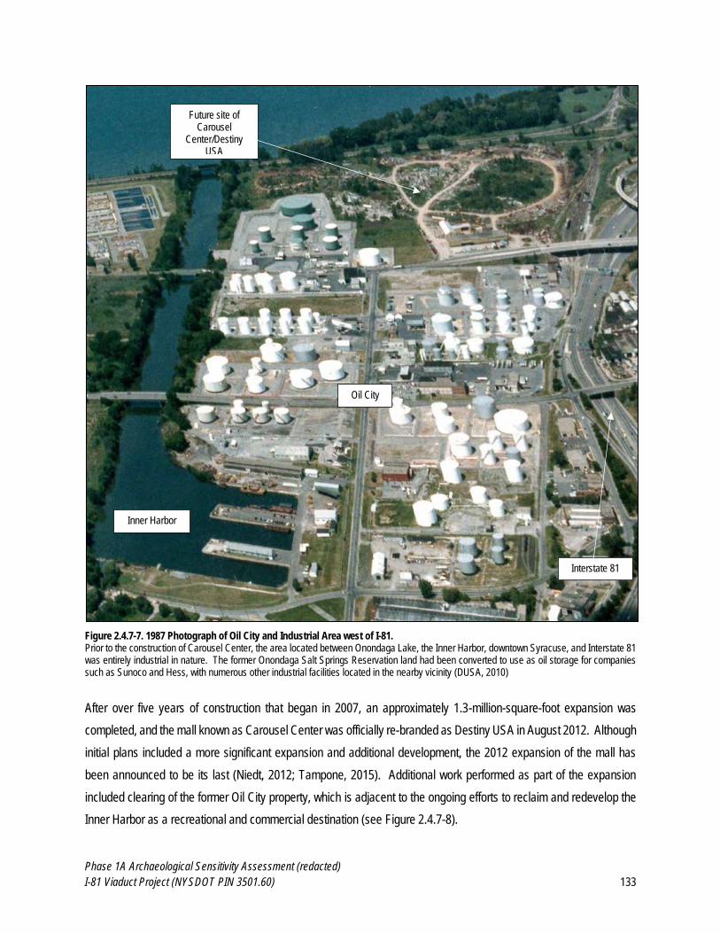
Phase 1A Archaeological Sensitivity Assessment (redacted)
I-81 Viaduct Project (NYSDOT PIN 3501.60) 133
Figure 2.4.7-7. 1987 Photograph of Oil City and Industrial Area west of I-81. Prior to the construction of Carousel Center, the area located between Onondaga Lake, the Inner Harbor, downtown Syracuse, and Interstate 81 was entirely industrial in nature. The former Onondaga Salt Springs Reservation land had been converted to use as oil storage for companies such as Sunoco and Hess, with numerous other industrial facilities located in the nearby vicinity (DUSA, 2010)
After over five years of construction that began in 2007, an approximately 1.3-million-square-foot expansion was
completed, and the mall known as Carousel Center was officially re-branded as Destiny USA in August 2012. Although
initial plans included a more significant expansion and additional development, the 2012 expansion of the mall has
been announced to be its last (Niedt, 2012; Tampone, 2015). Additional work performed as part of the expansion
included clearing of the former Oil City property, which is adjacent to the ongoing efforts to reclaim and redevelop the
Inner Harbor as a recreational and commercial destination (see Figure 2.4.7-8).
Future site of Carousel
Center/Destiny USA
Interstate 81
Inner Harbor
Oil City
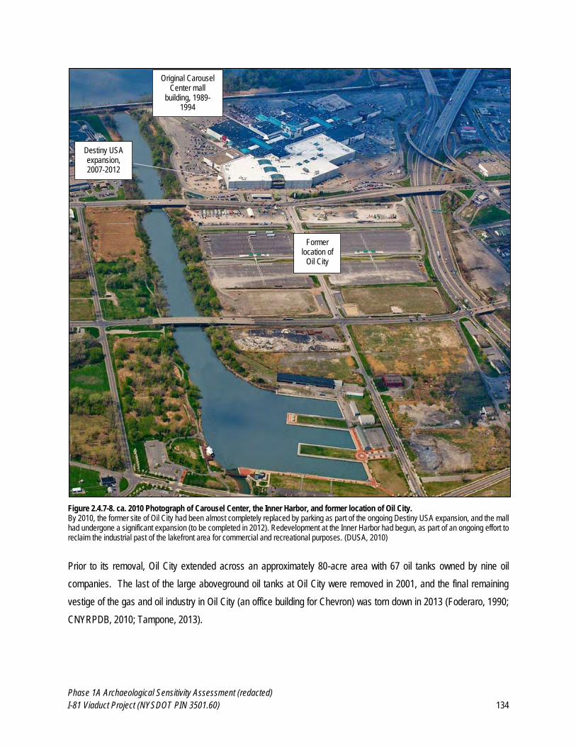
Phase 1A Archaeological Sensitivity Assessment (redacted)
I-81 Viaduct Project (NYSDOT PIN 3501.60) 134
Figure 2.4.7-8. ca. 2010 Photograph of Carousel Center, the Inner Harbor, and former location of Oil City. By 2010, the former site of Oil City had been almost completely replaced by parking as part of the ongoing Destiny USA expansion, and the mall had undergone a significant expansion (to be completed in 2012). Redevelopment at the Inner Harbor had begun, as part of an ongoing effort to reclaim the industrial past of the lakefront area for commercial and recreational purposes. (DUSA, 2010)
Prior to its removal, Oil City extended across an approximately 80-acre area with 67 oil tanks owned by nine oil
companies. The last of the large aboveground oil tanks at Oil City were removed in 2001, and the final remaining
vestige of the gas and oil industry in Oil City (an office building for Chevron) was torn down in 2013 (Foderaro, 1990;
CNYRPDB, 2010; Tampone, 2013).
Original Carousel Center mall
building, 1989-1994
Destiny USA expansion, 2007-2012
Former location of
Oil City
Phase 1A Archaeological Sensitivity Assessment (redacted)
I-81 Viaduct Project (NYSDOT PIN 3501.60) 135
Syracuse in the 21st Century
A late 1970s history of the City of Syracuse dispassionately encapsulated the effects of the urban renewal era on the
downtown area in language that was common to the era, avoiding nostalgia and relegating the widespread destruction
to just part of the life cycle of the city:
A block of uninteresting buildings was cleared to make way for MONY Center. The old Cedar Street jail and morgue went down as plans progressed for the County Office Building. On the west side of Salina Street, the old City Bank structure, the E.W. Edwards store and its annex on South Clinton Street, the Wieting garage, and the Lincoln Bank building succumbed to the wreckers’ ball. Theaters—the Strand, the Empire, Keith’s, and the Paramount—were demolished further south on Salina Street. Sibley’s department store was built on the site. On Clinton Square the Jerry Rescue building came down, as did the 110-year-old County Courthouse at North Clinton and West Genesee streets… The eleven-story Onondaga Hotel, the Marine Midland Building on South Warren Street, and the old French Church at Townsend and East Genesee streets were removed from the scene (Schramm and Roseboom, 1979).
Despite such significant changes to the built environment, the City of Syracuse in the twenty-first century has been
experiencing a resurgence of commercial and residential development and activity not uncommon to mid-sized cities.
Numerous outdoor festivals and an increase in businesses in formerly vacant buildings has restored street life that had
been absent for some time. Also suburban housing and commercial growth has continued residential occupancy in
downtown Syracuse hovers consistently around 99 percent, with new housing units being added on a regular basis,
drawing a largely young and professional population to downtown living (Tampone, 2014; DCOS, 2013).
Conversely, Syracuse also holds the distinction of the highest concentrated poverty among African-American and
Hispanic populations in the nation. Between 2000 and 2010, the number of neighborhoods categorized as having
“extreme poverty” (where 40 percent of residents live in poverty) increased from nine to nineteen, and the number of
high-poverty census tracts increased from twelve to 30. Approximately 65 percent of African-Americans and 62 percent
of Hispanics in Syracuse live in high-poverty neighborhoods. Although the city government and numerous health and
educational institutions continue to combat these issues, much of the blame for the poverty is often heaped upon the
dislocation, segregation and discrimination that occurred during the construction of Interstate 81 and the urban renewal
era, and a lack of infrastructure to deal with a burgeoning population of new immigrants that is forced to settle in
historically poor neighborhoods already ill-equipped to handle the needs of their residents (Semuels, 2015; Weiner,
2015).
2.5 Existing Conditions
Existing conditions within the APE for Direct Effects were observed and photographed during multiple site visits
conducted by EDR cultural resources staff between 2014 and 2016. Existing conditions within the APE for Direct
Effects are depicted in Appendix A: Maps 1 and 10, as well as in photographs included in Appendix C.
Phase 1A Archaeological Sensitivity Assessment (redacted)
I-81 Viaduct Project (NYSDOT PIN 3501.60) 136
In general, existing conditions within the APE for Direct Effects represent the extent to which the Viaduct Priority Area,
the I-81/I-481 Southern Interchange, the I-81/I-481 Northern Interchange, and the I-481 Eastern Improvements have
been significantly shaped by ground disturbance associated with the construction of Interstates 81 and 481, as well as
historic ground disturbance associated with commercial, industrial and residential development throughout the
eighteenth, nineteenth and twentieth centuries. Observations of existing conditions within the four priority areas of the
APE for Direct Effects include the following:
Viaduct Priority Area
The Viaduct Priority Area is comprised of the elevated portion of Interstate 81 located between Oakwood
Cemetery on the south, and extending to the NYS Route 370/Liverpool Interchange on the northwest, and
including portions of Interstate 690 between and Beech Streets on the east, as well as portions of West,
Genesee, Adams, Harrison Streets, Erie Boulevard, and other connected surface streets throughout
downtown Syracuse.
In general, the Viaduct Priority Area is characterized by fairly dense urban development within and
immediately adjacent to the APE for Direct Effects, with several buildings from the nineteenth and twentieth
centuries located in close proximity to the Interstate 81 and Interstate 690 viaducts, interspersed with young
street trees, large surface parking lots and multi-story parking garages (Appendix C, Photographs 1-2).
The portion of the Viaduct Priority Area northwest of downtown Syracuse includes six lanes of divided highway
constructed at or below grade, with cut-and-fill embankments and concrete walls, surrounded by urban
development (Appendix C, Photographs 3-4). Any soils present have been highly disturbed due to highway
construction and repair over the past several decades.
The portion of the APE for Direct Effects through downtown Syracuse passes through highly urban corridors
bordered by numerous single and multi-story buildings, four-lane local streets, paved sidewalks, and various
above- and below-ground utilities (Appendix C, Photographs 5-6).
The western portion of the APE for Direct Effects within the Viaduct Priority Area includes a portion of West
Street, which begins below Erie Boulevard West (within the APE) and rises as it continues north where it is
carried over West Genesee Street by a man-made concrete wall, surrounded by surface streets, commercial
development and numerous utilities (Appendix C, Photograph 7).
The eastern portion of the APE for Direct Effects within the Viaduct Priority Area extends along Interstate 690,
which is built above grade, and characterized by man-made earthen embankments and concrete wall
segments (Appendix C, Photograph 8).
Portions of the APE for Direct Effects within the Viaduct Priority Area radiate outward along surface streets
such as Adams Street, which includes a mix of land use including commercial, multi-family residential, and
surface and above-ground parking, as well as numerous utilities (Appendix C, Photograph 9).
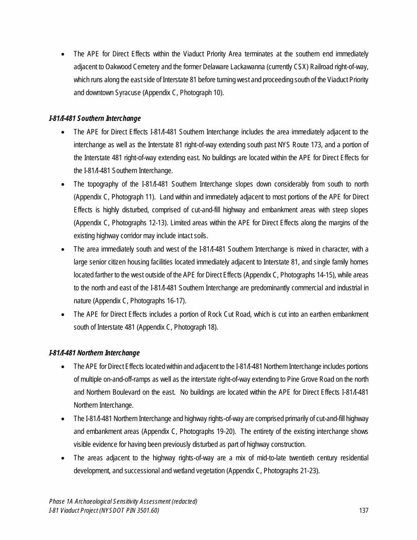
Phase 1A Archaeological Sensitivity Assessment (redacted)
I-81 Viaduct Project (NYSDOT PIN 3501.60) 137
The APE for Direct Effects within the Viaduct Priority Area terminates at the southern end immediately
adjacent to Oakwood Cemetery and the former Delaware Lackawanna (currently CSX) Railroad right-of-way,
which runs along the east side of Interstate 81 before turning west and proceeding south of the Viaduct Priority
and downtown Syracuse (Appendix C, Photograph 10).
I-81/I-481 Southern Interchange
The APE for Direct Effects I-81/I-481 Southern Interchange includes the area immediately adjacent to the
interchange as well as the Interstate 81 right-of-way extending south past NYS Route 173, and a portion of
the Interstate 481 right-of-way extending east. No buildings are located within the APE for Direct Effects for
the I-81/I-481 Southern Interchange.
The topography of the I-81/I-481 Southern Interchange slopes down considerably from south to north
(Appendix C, Photograph 11). Land within and immediately adjacent to most portions of the APE for Direct
Effects is highly disturbed, comprised of cut-and-fill highway and embankment areas with steep slopes
(Appendix C, Photographs 12-13). Limited areas within the APE for Direct Effects along the margins of the
existing highway corridor may include intact soils.
The area immediately south and west of the I-81/I-481 Southern Interchange is mixed in character, with a
large senior citizen housing facilities located immediately adjacent to Interstate 81, and single family homes
located farther to the west outside of the APE for Direct Effects (Appendix C, Photographs 14-15), while areas
to the north and east of the I-81/I-481 Southern Interchange are predominantly commercial and industrial in
nature (Appendix C, Photographs 16-17).
The APE for Direct Effects includes a portion of Rock Cut Road, which is cut into an earthen embankment
south of Interstate 481 (Appendix C, Photograph 18).
I-81/I-481 Northern Interchange
The APE for Direct Effects located within and adjacent to the I-81/I-481 Northern Interchange includes portions
of multiple on-and-off-ramps as well as the interstate right-of-way extending to Pine Grove Road on the north
and Northern Boulevard on the east. No buildings are located within the APE for Direct Effects I-81/I-481
Northern Interchange.
The I-81/I-481 Northern Interchange and highway rights-of-way are comprised primarily of cut-and-fill highway
and embankment areas (Appendix C, Photographs 19-20). The entirety of the existing interchange shows
visible evidence for having been previously disturbed as part of highway construction.
The areas adjacent to the highway rights-of-way are a mix of mid-to-late twentieth century residential
development, and successional and wetland vegetation (Appendix C, Photographs 21-23).
Phase 1A Archaeological Sensitivity Assessment (redacted)
I-81 Viaduct Project (NYSDOT PIN 3501.60) 138
A large, commercial development currently used as an automobile dealership is located on the northwest side
of the APE for Direct Effects (Appendix C, Photograph 24).
I-481 Eastern Improvements
The I-481 Eastern Improvements are comprised of two discontinuous sections located within and immediately
adjacent to the Interstate 481 right-of-way, on the north and south sides of the Kirkville Road interchange,
extending roughly to the New York State Thruway on the north and NYS Route 290 on the south. No buildings
are located within the APE for Direct Effects for the I-481 Eastern Improvements.
The northern and southern sections of the APE for Direct Effects are comprised of primarily cut-and-fill
highway and embankment areas (Appendix C, Photographs 25-26).
Much of the area immediately adjacent to the APE for Direct Effects is comprised of successional and wetland
vegetation (Appendix C, Photograph 27).
A large commercial office park is located west of the northern portion of the APE for Direct Effects for the I-
481 Eastern Improvements (Appendix C, Photograph 28).
The southern portion of the APE for Direct Effects for the I-481 Eastern Improvements is comprised of an
elevated viaduct over a large railroad yard and wetland, and crosses NYS Route 290 at its southern extent
(Appendix C, Photograph 29). Land use in the vicinity of NYS Route 290 and the APE for Direct Effects is
largely commercial in nature (Appendix C, Photograph 30).
2.6 Previous Ground Disturbance within the APE for Direct Effects
In general, areas characterized by significant previous ground disturbance can be excluded from further consideration
regarding potential impacts to archeological resources. The APE for Direct Effects is (for the most part) within a very
developed urban area with a complicated history of prior ground disturbance. In some instances, previous
excavation/construction episodes and landfilling will likely have resulted in disturbance or destruction of archaeological
resources. However, in other instances, landfilling can serve to bury and preserve archaeological resources from
earlier periods:
One of the most important lessons that excavations in [filled/disturbed urban contexts] have taught
archaeologists is that the landfill can serve as a blanket, protecting and preserving an older ground surface
buried beneath it from the ravages of later development. Thus, by examining the ground under the landfill, we
can... retrieve artifacts that had been dropped (either accidentally or intentionally) … and even discover earlier
archaeological sites located beneath the old ground surface (Canwell & Wall, 2001: 239).
Phase 1A Archaeological Sensitivity Assessment (redacted)
I-81 Viaduct Project (NYSDOT PIN 3501.60) 139
Significant sources of previous ground disturbance within the APE for Direct Effects include: landfilling activities
associated with nineteenth-century urban development in the City of Syracuse; demolition and construction associated
with mid-twentieth century highway construction; disturbance associated with construction, expansion, and/or
modification of buildings; areas of cut and fill associated with other road and highway construction; and the installation
of underground utilities. This section of the report provides a review of available data regarding previous disturbance
within the APE for Direct Effects.
2.6.1 Nineteenth and Twentieth-Century Landfilling and Urban Development
As described in Section 2.1.2 of this report, the first Euro-American settlers in the area encountered a vast wetland
broken only by steeply sloped dikes of the many creeks that radiated from Onondaga Lake, and by forested hills at the
south end of present-day Syracuse, the southwestern corner of Onondaga Lake, and northeast of present-day Salina.
In the early 1800s, the landscape of present-day Syracuse was changed drastically. Swamps were drained, waterways
were filled or made into sewers, and hills were razed to build roads and provide fill for poorly drained residential and
commercial lots. Secondary sources provide general descriptions of early cutting and filling activities that shaped the
landscape around the early settlements of Salina and Bogardus Corners:
Midway [between the Walton Tract and Salina], in an eastward direction, rose a great ridge known today as
Prospect Hill (not now so high as then, its crown having been shorn to fill low spots in the village). South of the
[Boagrdus] tavern site [i.e., northwest of the present intersection of Salina and West Genesee Streets], the
ground rose sharply in the knoll through which Yellow Brook flowed. (In the early years of the village, this knoll
was leveled as much as twelve feet from Jefferson Street northward, and the low ground in the vicinity of
today’s Onondaga County Savings Bank [i.e., 101 South Salina Street] was filled as much as three feet to
make the present level street (Munson, 1969: 105).
There was quite a deep ravine in Salina street where Yellow brook crossed it, and there were other
considerable depressions. Mr. Cheney says that in 1824, “Salina street was fully six feet higher than at the
present day, and very irregular, passing over a series of mounds or hillocks the whole distance, making a bad
road to travel with a loaded team.” These were all leveled when the street was subsequently graded by Moses
D. Burnet (Bruce, 1891:121).
A knoll called “Prospect Hill” is shown on early maps (see Figure 2.6.1-1) at the south end of the western edge of
Onondaga Lake, part of a complex of forested uplands extending southwest from the Lake. A second knoll, also called
“Prospect Hill” or “Foot Street Hill” is shown at the northeast corner of the present day intersection of Townsend and
James Streets (see Figure 2.6.1-1) and was removed as residential lot fill by the public in 1828 (Bruce, 1891: 130).
Uplands are also shown east of Onondaga Creek, at the south end of present-day Syracuse. Though some of these
rolling hills at the south end of Syracuse are preserved today, many of them were graded in the creation of roads,
including the South end of Salina Street and Onondaga Street in the southwest portion of the city (Bruce 1891).
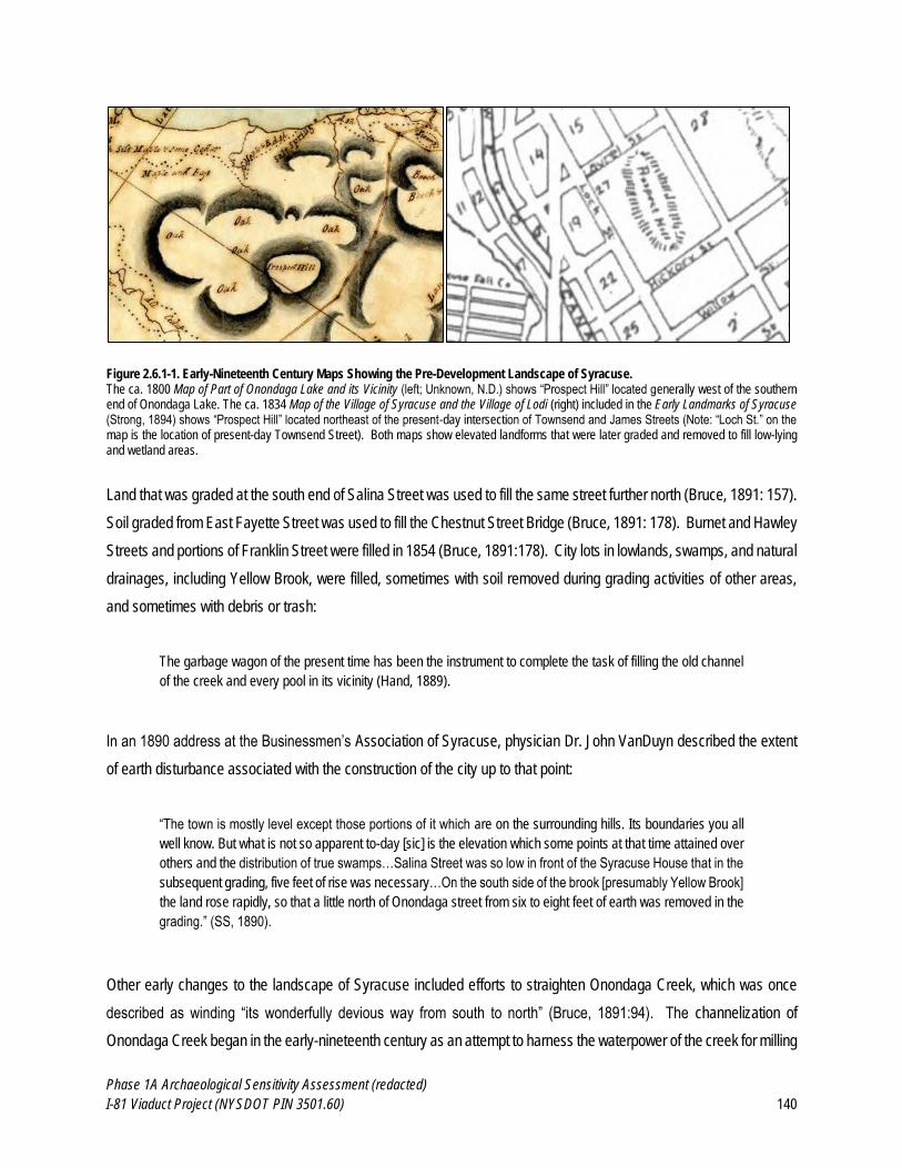
Phase 1A Archaeological Sensitivity Assessment (redacted)
I-81 Viaduct Project (NYSDOT PIN 3501.60) 140
Figure 2.6.1-1. Early-Nineteenth Century Maps Showing the Pre-Development Landscape of Syracuse. The ca. 1800 Map of Part of Onondaga Lake and its Vicinity (left; Unknown, N.D.) shows “Prospect Hill” located generally west of the southern end of Onondaga Lake. The ca. 1834 Map of the Village of Syracuse and the Village of Lodi (right) included in the Early Landmarks of Syracuse (Strong, 1894) shows “Prospect Hill” located northeast of the present-day intersection of Townsend and James Streets (Note: “Loch St.” on the map is the location of present-day Townsend Street). Both maps show elevated landforms that were later graded and removed to fill low-lying and wetland areas.
Land that was graded at the south end of Salina Street was used to fill the same street further north (Bruce, 1891: 157).
Soil graded from East Fayette Street was used to fill the Chestnut Street Bridge (Bruce, 1891: 178). Burnet and Hawley
Streets and portions of Franklin Street were filled in 1854 (Bruce, 1891:178). City lots in lowlands, swamps, and natural
drainages, including Yellow Brook, were filled, sometimes with soil removed during grading activities of other areas,
and sometimes with debris or trash:
The garbage wagon of the present time has been the instrument to complete the task of filling the old channel
of the creek and every pool in its vicinity (Hand, 1889).
In an 1890 address at the Businessmen’s Association of Syracuse, physician Dr. John VanDuyn described the extent
of earth disturbance associated with the construction of the city up to that point:
“The town is mostly level except those portions of it which are on the surrounding hills. Its boundaries you all
well know. But what is not so apparent to-day [sic] is the elevation which some points at that time attained over
others and the distribution of true swamps…Salina Street was so low in front of the Syracuse House that in the
subsequent grading, five feet of rise was necessary…On the south side of the brook [presumably Yellow Brook]
the land rose rapidly, so that a little north of Onondaga street from six to eight feet of earth was removed in the
grading.” (SS, 1890).
Other early changes to the landscape of Syracuse included efforts to straighten Onondaga Creek, which was once
described as winding “its wonderfully devious way from south to north” (Bruce, 1891:94). The channelization of
Onondaga Creek began in the early-nineteenth century as an attempt to harness the waterpower of the creek for milling
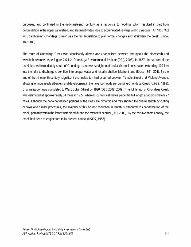
Phase 1A Archaeological Sensitivity Assessment (redacted)
I-81 Viaduct Project (NYSDOT PIN 3501.60) 141
purposes, and continued in the mid-nineteenth century as a response to flooding, which resulted in part from
deforestation in the upper watershed, and stagnant waters due to accumulated sewage within Syracuse. An 1856 “Act
for Straightening Onondaga Creek” was the first legislation to plan formal changes and straighten the creek (Bruce,
1891:180).
The route of Onondaga Creek was significantly altered and channelized between throughout the nineteenth and
twentieth centuries (see Figure 2.6.1-2; Onondaga Environmental Institute [OEI], 2008). In 1867, the section of the
creek located immediately south of Onondaga Lake was straightened and a channel constructed extending 100 feet
into the lake to discharge creek flow into deeper water and reclaim shallow lakefront land (Bruce 1891: 204). By the
end of the nineteenth century, significant channelization had occurred between Temple Street and Midland Avenue,
allowing for increased settlement and development in the neighborhoods surrounding Onondaga Creek (USGS, 1898).
Channelization was completed to West Colvin Street by 1920 (OEI, 2008; 2009). The full length of Onondaga Creek
was estimated at approximately 34 miles in 1927, whereas current estimates place the full length at approximately 27
miles. Although the non-channelized portions of the creek are dynamic and may shorten the overall length by cutting
oxbows and similar processes, the majority of this historic reduction in length is attributed to channelization of the
creek, primarily within the lower watershed during the twentieth century (OEI, 2009). By the mid-twentieth century, the
creek had been re-engineered to its present course (USGS, 1958).
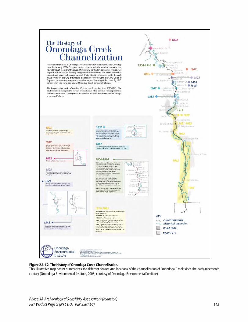
Phase 1A Archaeological Sensitivity Assessment (redacted)
I-81 Viaduct Project (NYSDOT PIN 3501.60) 142
Figure 2.6.1-2. The History of Onondaga Creek Channelization. This illustrative map poster summarizes the different phases and locations of the channelization of Onondaga Creek since the early-nineteenth
century (Onondaga Environmental Institute, 2008; courtesy of Onondaga Environmental Institute).
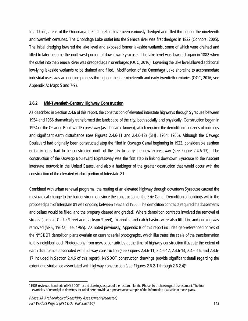
Phase 1A Archaeological Sensitivity Assessment (redacted)
I-81 Viaduct Project (NYSDOT PIN 3501.60) 143
In addition, areas of the Onondaga Lake shoreline have been variously dredged and filled throughout the nineteenth
and twentieth centuries. The Onondaga Lake outlet into the Seneca river was first dredged in 1822 (Connors, 2005).
The initial dredging lowered the lake level and exposed former lakeside wetlands, some of which were drained and
filled to later become the northwest portion of downtown Syracuse. The lake level was lowered again in 1882 when
the outlet into the Seneca River was dredged again or enlarged (OCC, 2016). Lowering the lake level allowed additional
low-lying lakeside wetlands to be drained and filled. Modification of the Onondaga Lake shoreline to accommodate
industrial uses was an ongoing process throughout the late-nineteenth and early-twentieth centuries (OCC, 2016; see
Appendix A: Maps 5 and 7-9).
2.6.2 Mid-Twentieth-Century Highway Construction
As described in Section 2.4.6 of this report, the construction of elevated interstate highways through Syracuse between
1954 and 1966 dramatically transformed the landscape of the city, both socially and physically. Construction began in
1954 on the Oswego Boulevard Expressway (as it became known), which required the demolition of dozens of buildings
and significant earth disturbance (see Figures 2.4.6-11 and 2.4.6-12) (SHJ, 1954; 1956). Although the Oswego
Boulevard had originally been constructed atop the filled in Oswego Canal beginning in 1923, considerable earthen
embankments had to be constructed north of the city to carry the new expressway (see Figure 2.4.6-13). The
construction of the Oswego Boulevard Expressway was the first step in linking downtown Syracuse to the nascent
interstate network in the United States, and also a harbinger of the greater destruction that would occur with the
construction of the elevated viaduct portion of Interstate 81.
Combined with urban renewal programs, the routing of an elevated highway through downtown Syracuse caused the
most radical change to the built environment since the construction of the Erie Canal. Demolition of buildings within the
proposed path of Interstate 81 was ongoing between 1962 and 1966. The demolition contracts required that basements
and cellars would be filled, and the property cleared and graded. Where demolition contracts involved the removal of
streets (such as Cedar Street and Jackson Street), manholes and catch basins were also filled in, and curbing was
removed (SPS, 1964a; Lee, 1965). As noted previously, Appendix B of this report includes geo-referenced copies of
the NYSDOT demolition plans overlain on current aerial photographs, which illustrates the scale of the transformation
to this neighborhood. Photographs from newspaper articles at the time of highway construction illustrate the extent of
earth disturbance associated with highway construction (see Figures 2.4.6-11, 2.4.6-12, 2.4.6-14, 2.4.6-16, and 2.4.6-
17 included in Section 2.4.6 of this report). NYSDOT construction drawings provide significant detail regarding the
extent of disturbance associated with highway construction (see Figures 2.6.2-1 through 2.6.2.4)9:
9 EDR reviewed hundreds of NYSDOT record drawings as part of the research for the Phase 1A archaeological assessment. The four
examples of record plan drawings included here provide a representative sample of the information available in those plans.
Phase 1A Archaeological Sensitivity Assessment (redacted)
I-81 Viaduct Project (NYSDOT PIN 3501.60) 144
Figure 2.6.2-1. Detail from NYSDOT Construction Plans C56-01 (Oswego Boulevard Expressway). Construction drawing illustrating typical depth of excavation for the depressed portions of the Oswego Boulevard Expressway (NYSDOT, 1956).
Figure 2.6.2-2. Detail from NYSDOT Construction Plans C64-07 (I-81, Syracuse City Line to Sizer Street). Construction drawing illustrating extent of cut and fill and building removals for I-81 in the City of Syracuse (NYSDOT, 1964).
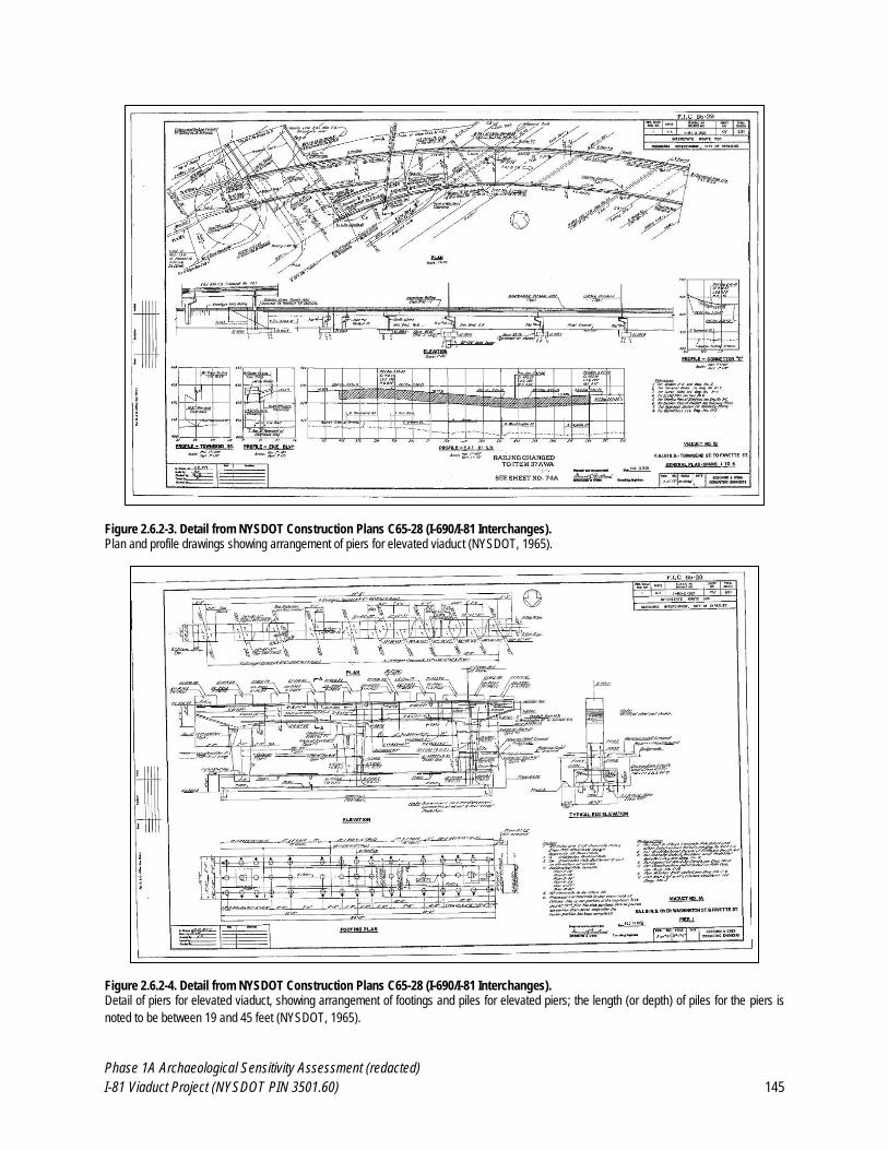
Phase 1A Archaeological Sensitivity Assessment (redacted)
I-81 Viaduct Project (NYSDOT PIN 3501.60) 145
Figure 2.6.2-3. Detail from NYSDOT Construction Plans C65-28 (I-690/I-81 Interchanges). Plan and profile drawings showing arrangement of piers for elevated viaduct (NYSDOT, 1965).
Figure 2.6.2-4. Detail from NYSDOT Construction Plans C65-28 (I-690/I-81 Interchanges). Detail of piers for elevated viaduct, showing arrangement of footings and piles for elevated piers; the length (or depth) of piles for the piers is
noted to be between 19 and 45 feet (NYSDOT, 1965).
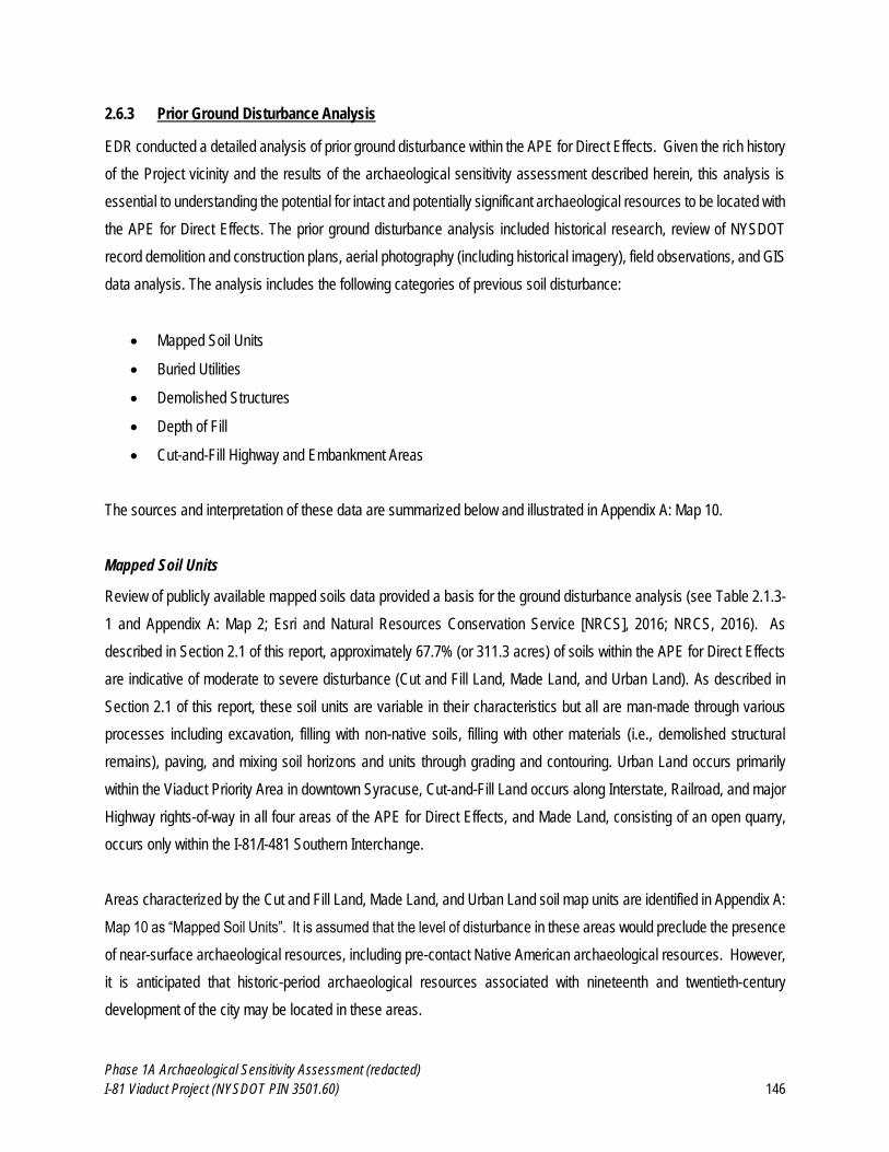
Phase 1A Archaeological Sensitivity Assessment (redacted)
I-81 Viaduct Project (NYSDOT PIN 3501.60) 146
2.6.3 Prior Ground Disturbance Analysis
EDR conducted a detailed analysis of prior ground disturbance within the APE for Direct Effects. Given the rich history
of the Project vicinity and the results of the archaeological sensitivity assessment described herein, this analysis is
essential to understanding the potential for intact and potentially significant archaeological resources to be located with
the APE for Direct Effects. The prior ground disturbance analysis included historical research, review of NYSDOT
record demolition and construction plans, aerial photography (including historical imagery), field observations, and GIS
data analysis. The analysis includes the following categories of previous soil disturbance:
Mapped Soil Units
Buried Utilities
Demolished Structures
Depth of Fill
Cut-and-Fill Highway and Embankment Areas
The sources and interpretation of these data are summarized below and illustrated in Appendix A: Map 10.
Mapped Soil Units
Review of publicly available mapped soils data provided a basis for the ground disturbance analysis (see Table 2.1.3-
1 and Appendix A: Map 2; Esri and Natural Resources Conservation Service [NRCS], 2016; NRCS, 2016). As
described in Section 2.1 of this report, approximately 67.7% (or 311.3 acres) of soils within the APE for Direct Effects
are indicative of moderate to severe disturbance (Cut and Fill Land, Made Land, and Urban Land). As described in
Section 2.1 of this report, these soil units are variable in their characteristics but all are man-made through various
processes including excavation, filling with non-native soils, filling with other materials (i.e., demolished structural
remains), paving, and mixing soil horizons and units through grading and contouring. Urban Land occurs primarily
within the Viaduct Priority Area in downtown Syracuse, Cut-and-Fill Land occurs along Interstate, Railroad, and major
Highway rights-of-way in all four areas of the APE for Direct Effects, and Made Land, consisting of an open quarry,
occurs only within the I-81/I-481 Southern Interchange.
Areas characterized by the Cut and Fill Land, Made Land, and Urban Land soil map units are identified in Appendix A:
Map 10 as “Mapped Soil Units”. It is assumed that the level of disturbance in these areas would preclude the presence
of near-surface archaeological resources, including pre-contact Native American archaeological resources. However,
it is anticipated that historic-period archaeological resources associated with nineteenth and twentieth-century
development of the city may be located in these areas.
Phase 1A Archaeological Sensitivity Assessment (redacted)
I-81 Viaduct Project (NYSDOT PIN 3501.60) 147
Buried Utilities
Buried utilities are located throughout the APE for Direct Effects, primarily within public roadways and/or adjacent
rights-of-way. Mapping of buried utilities was provided by Popli Design Group, who collected this data as part of existing
site condition surveys for the I-81 Viaduct Project. The mapping includes the observed and assumed locations of all
utility poles and underground lines associated with electric, fiber optic, water, sewer, telephone, steam, cable television,
oil, and unidentified infrastructure. For the most part, buried utilities included in this mapping are located in existing
roadways. All buried utilities shown in Appendix A: Map 10 have an assumed width of disturbance of four feet, which
is a conservative assumption. It is worth noting that the mapping of buried utilities within the APE for Direct Effects
was based on review of available record plans and field observations, and therefore represents an interpretation of the
available data. It is assumed that additional buried utilities that were not identified in the existing site conditions surveys
are located within the APE for Direct Effects (Phillips, 2016).
In addition, the locations of existing elevated highway piers and bridge support structures are included in this mapping
– although these are not utilities, they were included as part of the same digital mapping provided by Popli so are
shown together on the map. As depicted in Figure 2.6.2-4, the depth of disturbance for piles driven beneath footings
of these support structures extended in some locations up to between 19 and 45 feet.
Demolished Structures
As described above in Section 3.2.3, the locations of 952 demolished structures (see Appendix A: Map 10) were
digitized from the ca. 1953-1966 NYSDOT record plans for the I-81/Interstate 505 construction, Oswego Boulevard
Arterial Project, and the I-690 Viaduct Project (see also Appendix B). This construction involved the demolition of a
large number of residential and commercial buildings as well as a small number of other structures such as above-
ground oil tanks. During demolition, structures were demolished, basements and cellars were filled, and the properties
were cleared and graded (NYSDOT, 1963; SPS, 1964). The depth of disturbance associated with the original
construction of residential and commercial buildings would have extended 8-10 ft (2.5 to 3.1 m) below the ground
surface for a typical foundation/basement. Following demolition, the open foundations were filled with on-site material
such as the demolished foundation and other portions of the demolished structure.
As described in Section 3.2.4 of this report, the foundations of these demolished structures are unlikely to be considered
archaeologically or historically significant, in large part because the location, dimensions, and arrangement of those
buildings can be well understood based on review of historic cartographic sources and archaeological data is unlikely
to contribute significant new information. In addition, the extent of prior disturbance associated with the construction
and demolition of these structures is assumed to preclude the possibility that other (earlier) archaeological resources
are present in these locations. However, potential artifact deposits and shaft features, which include privies, wells, and
Phase 1A Archaeological Sensitivity Assessment (redacted)
I-81 Viaduct Project (NYSDOT PIN 3501.60) 148
cisterns, are found on many domestic and commercial properties in urban contexts and are potentially located in former
yard areas adjacent to the former locations of map-documented structures.
Depth of Fill
As described in Section 2.1 of this report, the NYSDOT has an extensive archive of geotechnical borings documenting
subsurface stratigraphy in and around the APE for Direct Effects. EDR interpreted and summarized depth of fill based
on review of NYSDOT’s large dataset of boring logs, which covers much of the City of Syracuse and the surrounding
vicinity. The geotechnical borings included in the NYSDOT dataset date to between 1945 and 2005. For the current
analysis, EDR clipped the soil boring data to a 500-ft (152-m) buffer around the APE for Direct Effects which resulted
in a dataset of 995 individual borings. The location of each geotechnical bore hole was digitized as a point. Based on
review of the corresponding boring log, a depth of fill was assigned (or attributed) to each point.
Depth of fill is measured in feet and tenths of feet (not inches) in the NYSDOT boring logs. Fill was defined as any
stratum explicitly defined in the boring log as “fill” or any stratum containing any of the following materials which were
interpreted to be indicative of disturbed soils and historic and/or modern fill: “brick,” “canal bottom,” “cinder,” “coal,”
“concrete,” “debris,” “morter” [mortar], “pavement,” “rubble,” “solvay sludge,” “sludge,” “waste,” or “wood chips.” In
instances where sediment was described as “Fill?” or similar ambiguity and/or uncertainty was indicated, the stratum
in question was not considered to be fill. Wood, wood fiber, and traces of wood were not considered to be indicative of
artificial fill due to the fact that the APE for Direct Effects was historically forest and forested wetland. Therefore, wood
derived from tree roots and stumps would not necessarily be indicative of previous disturbance.
In four instances, asphalt was encountered on the ground surface, underlain by a 3-ft (0.9-m) deep void, in two
instances asphalt was underlain by a 4-ft (1.2-m) deep void, and in two instances asphalt was underlain by a 5-ft (1.5-
m) deep void. In all these cases, depth of fill was considered to be the depth of the void. Although these voids are not
technically fill, for the purposes of this analysis it can be stated with confidence that they do not contain buried
archaeological resources.
The depths of fill documented by the boring logs is presented as an interpolated surface in Appendix A: Map 10. Of the
995 boring logs reviewed for the Project, 478 boring logs document depths of fill between 0.5 and 36.5 feet throughout
various portions of the APE for Direct Effects. The artificial fill documented by these boring logs is deepest in the vicinity
of Hiawatha Boulevard and the DestiNY USA shopping mall in the northwestern portion of the Viaduct Priority Area
and the I-81/I-690 Interchange, near the center of the Viaduct Priority Area (see Appendix A: Map 10). These findings
are consistent with NYSDOT record plans and historical accounts (and images) regarding the extent of ground
disturbance associated the construction of the interstate system (see Sections 2.4.6 and 2.6.2 of this report). Deep
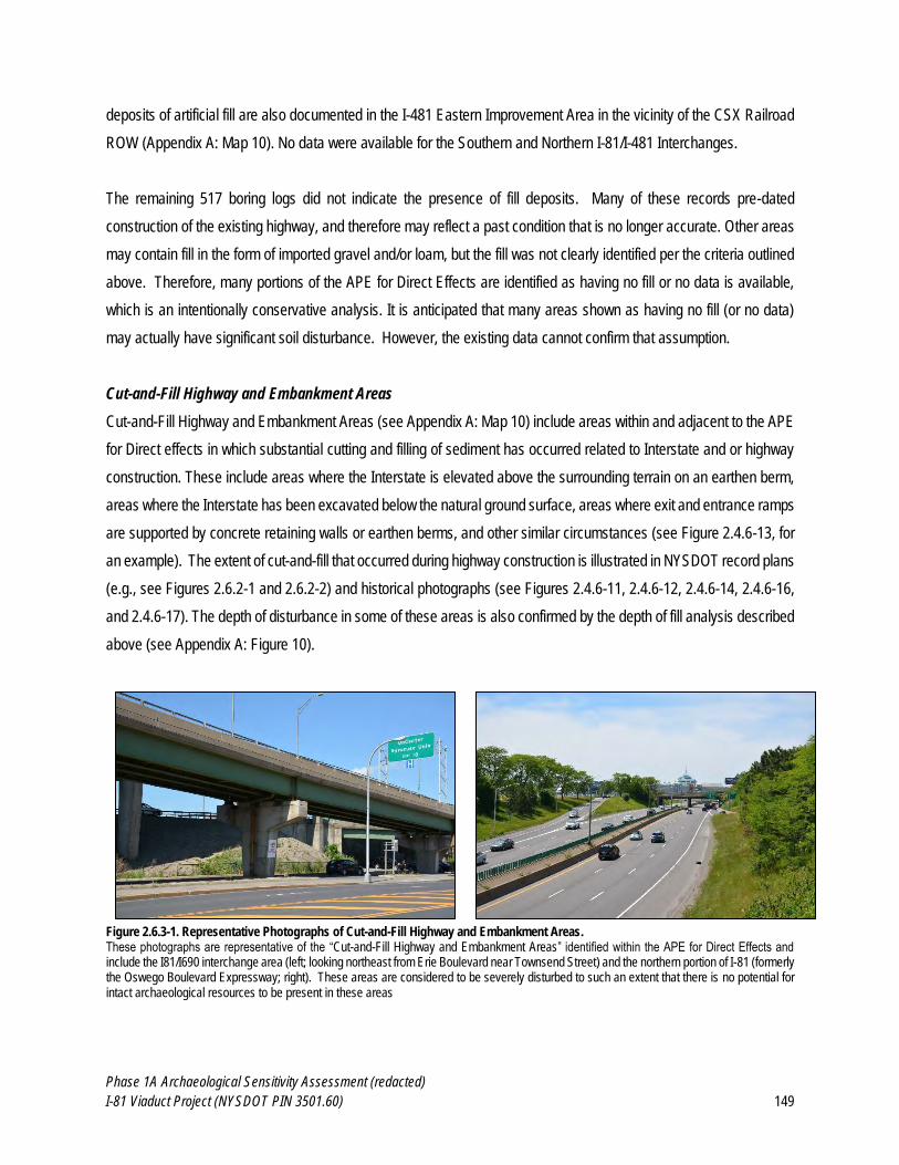
Phase 1A Archaeological Sensitivity Assessment (redacted)
I-81 Viaduct Project (NYSDOT PIN 3501.60) 149
deposits of artificial fill are also documented in the I-481 Eastern Improvement Area in the vicinity of the CSX Railroad
ROW (Appendix A: Map 10). No data were available for the Southern and Northern I-81/I-481 Interchanges.
The remaining 517 boring logs did not indicate the presence of fill deposits. Many of these records pre-dated
construction of the existing highway, and therefore may reflect a past condition that is no longer accurate. Other areas
may contain fill in the form of imported gravel and/or loam, but the fill was not clearly identified per the criteria outlined
above. Therefore, many portions of the APE for Direct Effects are identified as having no fill or no data is available,
which is an intentionally conservative analysis. It is anticipated that many areas shown as having no fill (or no data)
may actually have significant soil disturbance. However, the existing data cannot confirm that assumption.
Cut-and-Fill Highway and Embankment Areas
Cut-and-Fill Highway and Embankment Areas (see Appendix A: Map 10) include areas within and adjacent to the APE
for Direct effects in which substantial cutting and filling of sediment has occurred related to Interstate and or highway
construction. These include areas where the Interstate is elevated above the surrounding terrain on an earthen berm,
areas where the Interstate has been excavated below the natural ground surface, areas where exit and entrance ramps
are supported by concrete retaining walls or earthen berms, and other similar circumstances (see Figure 2.4.6-13, for
an example). The extent of cut-and-fill that occurred during highway construction is illustrated in NYSDOT record plans
(e.g., see Figures 2.6.2-1 and 2.6.2-2) and historical photographs (see Figures 2.4.6-11, 2.4.6-12, 2.4.6-14, 2.4.6-16,
and 2.4.6-17). The depth of disturbance in some of these areas is also confirmed by the depth of fill analysis described
above (see Appendix A: Figure 10).
Figure 2.6.3-1. Representative Photographs of Cut-and-Fill Highway and Embankment Areas. These photographs are representative of the “Cut-and-Fill Highway and Embankment Areas” identified within the APE for Direct Effects and include the I81/I690 interchange area (left; looking northeast from Erie Boulevard near Townsend Street) and the northern portion of I-81 (formerly the Oswego Boulevard Expressway; right). These areas are considered to be severely disturbed to such an extent that there is no potential for intact archaeological resources to be present in these areas
Phase 1A Archaeological Sensitivity Assessment (redacted)
I-81 Viaduct Project (NYSDOT PIN 3501.60) 150
EDR identified Cut-and-Fill Highway and Embankment Areas based on multiple sources, including NYSDOT demolition
and construction plans, aerial imagery (including oblique views and historical imagery), and field
reconnaissance/confirmation (see Section 2.5 of this report and Figure 2.6.3-1). Areas of cut-and-fill were defined
conservatively. If there was any question as to whether or not an area had been disturbed by highway ROW
construction, EDR assumed to be intact and it was not mapped as “Cut-and-Fill Highway and Embankment Areas” for
the purpose of this analysis.
The areas identified as “Cut-and-Fill Highway and Embankment Areas” in Appendix A: Maps 10 and 11 are considered
to be severely disturbed to such an extent that there is no potential for intact archaeological resources to be present in
these areas.
Phase 1A Archaeological Sensitivity Assessment (redacted)
I-81 Viaduct Project (NYSDOT PIN 3501.60) 151
3.0 ARCHAEOLOGICAL SENSITIVITY ASSESSMENT
The potential for archaeological sites to be located within the APE for Direct Effects is based on analysis of the
background data presented in Chapter 2 of this report, including the environmental setting and geology of the area
(Section 2.1), the locations of previously reported archaeological sites (Section 2.2), results of previous archaeological
surveys (Section 2.3), the history of human settlement and historical development in the Project vicinity (Section 2.4),
assessment of existing land use (Section 2.5), and analysis of previous ground disturbance with in the APE for Direct
Effects (Section 2.6). The potential for different types of archaeological resources to be located within the APE for
Direct Effects is presented in this section as follows:
Pre-Contact Native American Archaeological Sensitivity (Section 3.1)
Historic Period Archaeological Sensitivity (Section 3.2)
Potential for Human Remains and Cemeteries (Section 3.3)
As described in detail Section 2.6 of this report and illustrated in Appendix A: Map 10, the APE for Direct Effects is (for
the most part) within a very developed urban area with a complicated history of prior ground disturbance. In areas
where there is a potential for archaeological resources to be present, the extent of previous ground disturbance is an
important factor that will affect the integrity of potential archaeological deposits, which is a critical factor in evaluating
the potential significance of archaeological sites. The locations of areas where there is a potential for the various types
of archaeological resources described in Sections 3.1 through 3.3 are illustrated in Appendix A: Map 11.
Potential NRHP-Eligibility of Archaeological Resources
Archaeological resources are determined to be historically significant (i.e., eligible for listing on the National Register
of Historic Places [NRHP]) if they meet one of the following criteria (National Park Service [NPS], 2002 [non-
paginated]):
A. That are associated with events that have made a significant contribution to the broad patterns of our history; or
B. That are associated with the lives of significant persons in our past; or
C. That embody the distinctive characteristics of a type, period, or method of construction, or that represent the work of
a master, or that possess high artistic values, or that represent a significant and distinguishable entity whose components
may lack individual distinction; or
D. That have yielded or may be likely to yield, information important in history or prehistory.
In general, an archaeological site potentially eligible under Criterion A will be evaluated in terms of the strength of the
site’s association with significant events. This will rely on the physical integrity of the site and its ability to convey th is
Phase 1A Archaeological Sensitivity Assessment (redacted)
I-81 Viaduct Project (NYSDOT PIN 3501.60) 152
association. A site potentially eligible under Criterion B would be evaluated in terms of the strength of the site’s
association with the significant individual. A site potentially eligible under Criterion C will be evaluated in terms of the
site’s ability to convey the “distinctive characteristics of a type, period, or method of construction” (NPS, 2002). This
will depend on the physical integrity of the site and the presence of certain distinctive archaeological features (e.g.,
post molds indicative of structures or formal human burials). Sites containing archaeological features or other materials
that provide exceptional examples of significant architectural or design elements could be eligible for listing on the
NRHP under Criterion C. By far, the majority of archaeological sites found to be eligible for listing on the NRHP are
found to be eligible under Criterion D. A site potentially eligible under Criterion D will be evaluated in terms of the site’s
ability to provide significant data pertinent to answering research questions related to local, regional, or national
prehistory or history. This will be contingent on the physical integrity of the site, but also the density and diversity of
archaeological artifacts and features it contains.
These criteria provide a basis for evaluating the significance of potential archaeological resources that could be located
within the APE for Direct Effects.
3.1 Pre-Contact Native-American Archaeological Sensitivity Assessment
As described in Section 2.2 of this report, most major prehistoric Native American settlements occurred on major rivers
and lake outlets. Settlement during the Paleoindian and Early and Middle Archaic Periods consisted of small short-
term campsites consisting primarily of stone tools and lithic debitage. These sites are relatively rare in Onondaga
County, and none are known from within the APE for Direct Effects or the immediate vicinity. During the Late Archaic,
Early Woodland, and Middle Woodland Periods, Native Americans settled in larger, longer-term residential campsites
or villages. These large sites were typically located along major rivers, often near the outlets of Lakes, such as Oneida
Lake and Onondaga Lake in Onondaga County. In addition to the large lowland camps or villages, small logistical
resource acquisition sites were typically located in the uplands surrounding major valley systems. Late Archaic and
Woodland Period sites are far more common than Paleoindian or Early and Middle Archaic sites. However, no Late
Archaic, Early or Middle Woodland Sites are known from the APE for Direct Effects or the immediate vicinity. During
the Late Woodland Period, Native American settlement further consolidated into large, often palisaded, longhouse
villages of up to 2,500 residents. These villages were located along major alluvial valleys and sometimes in close
proximity to lakes such as Onondaga Lake and Cazenovia Lake. These village sites are large and highly visible in the
archaeological record. Small logistical campsites and outlying single-family farms were also located in the uplands and
floodplains surrounding the major villages during the Late Woodland.
One Late Woodland Village (“Kaneenda”; NYSM 4235) is reported to have been located within the APE for Direct
Effects on the southeast shore of Onondaga Lake (Parker, 1922:646). Additionally, Parker (1922:646-647; Plate 196)
Phase 1A Archaeological Sensitivity Assessment (redacted)
I-81 Viaduct Project (NYSDOT PIN 3501.60) 153
identifies four additional archaeological site areas in close proximity to the current APE for Direct Effects: NYSM 4239,
described as “relics of an early character”; NYSM 4240, described as a “camp or hamlet”; NYSM 7367, described as
“a small early site”; and NYSM 7368, described as “traces of occupation.” NYSM Sites 4235 and 7368 overlap with the
APE for Direct Effects and these areas are considered to be of elevated archaeological sensitivity for prehistoric Native
American archaeological resources.
The Onondaga Nation states that all areas of the lake and shoreline were used by pre-contact and historic-period
Native American populations and the areas adjacent to the lake should be considered highly sensitive for
archaeological resources (Onondaga Nation, 2011). As previously discussed, Parker (1922) also describes several
areas of elevated archaeological sensitivity around Onondaga Lake; however, very little of the APE for Direct Effects
occupies the lakeshore itself. The majority of the APE for Direct Effects occurs in wetland or upland areas between
approximately 0.5 and 6.0 miles (0.8 and 9.7 km) from the modern shoreline of Onondaga Lake. Therefore, the high
archaeological sensitivity of the lakeshore does not apply to the APE for Direct Effects for the current Project, with the
exception of a small area at the northwest end of the Viaduct Priority Area where improvements are proposed to the
Park Street/Old Liverpool Road/Onondaga Lake Parkway Interchange.
Potential for Native American Archaeological Sites within the APE for Direct Effects
Based on the known prehistoric archaeology of the vicinity and an analysis of landscape features (e.g., elevation and
proximity to water), and not considering previous disturbance or modern development, the Viaduct Priority Area and I-
81/I-481 Southern Interchange are considered to be of moderate to high sensitivity for prehistoric archaeological
resources. This is based on the proximity of these areas to Onondaga Lake and Onondaga Creek. However, that
assertion should be tempered with the consideration that, as discussed in Section 2.1 of this report, much of the Viaduct
Priority Area would have been low-lying wetland during the prehistoric period and therefore not suitable for long-term
habitation. Additionally, very little of the Viaduct Priority Area occurs along the actual shore of Onondaga Lake, where
major settlement might be expected to have occurred (e.g., Onondaga Nation, 2011; Parker, 1922). Furthermore,
although the I-81/I-481 Southern Interchange is in close proximity to Onondaga Creek, it is approximately 4 miles (6.4
km) southeast of the outlet of the creek into Onondaga Lake.
As previously noted, major prehistoric settlements tend to occur along large rivers (such as the Seneca and Oneida
Rivers in Onondaga County) as well as lake inlets and outlets. Therefore, the I-81/I-481 Southern Interchange is
unlikely to contain major sites of prehistoric habitation. However, the area may contain smaller resource acquisition
sites, as the north/south-trending Onondaga Trough would have provided access to diverse upland and lowland
resources as well as presenting a logical transportation corridor between the Erie/Ontario Lake Plain to the north and
the Allegheny Plateau to the south. Historically documented Contact-era settlement along Onondaga Creek and its
Phase 1A Archaeological Sensitivity Assessment (redacted)
I-81 Viaduct Project (NYSDOT PIN 3501.60) 154
relevance to the archaeological sensitivity of the I-81/I-481 Southern Interchange (as well as the rest of the APE for
Direct Effects) will be discussed in the following Section 3.2.1 of this report.
The remaining portions of the Project APE (the I-81/I-481 Northern Interchange and the I-481 Eastern Improvements)
are considered to be of moderate prehistoric archaeological sensitivity. The I-81/I-481 Northern Interchange is located
on uplands overlooking Cicero Swamp to the east, a known area of prehistoric habitation and resource acquisition
(e.g., Parker, 1922). The I-481 Eastern Improvements span both banks of Butternut Creek and are somewhat proximate
to the confluence of Butternut Creek and Limestone Creek which is approximately 3 miles (4.8 km) to the northeast.
Like Onondaga Creek, Limestone and Butternut Creeks would have been attractive areas for prehistoric resource
acquisition and short term camps. The Onondaga occupied the Limestone and Butternut Creek drainages during the
Late Woodland and Contact Periods and would have used the surrounding areas for resource acquisition (Tuck, 1971;
Jones, 2006; 2010).
Therefore, prehistoric Native American site types that could be expected to occur within the APE for Direct Effects
include:
Small campsites dating to the Paleoindian, Early Archaic, and/or Middle Archaic Periods. These sites could
be expected to contain primarily chipped stone tools and debitage with potentially some bone or ivory tools.
Features could include hearths and post-molds.
Large residential campsites dating to the Late Archaic, Early Woodland, and/or Middle Woodland Periods.
These sites could be expected to include large quantities of chipped stone tools and debitage, ground stone
tools and net weights, bone tools, ceramic vessels and vessel fragments, steatite vessels and vessel
fragments, ceramic and bone decorative items, and exotic goods such as marine shells and copper. Features
could include hearths, post-molds, middens, and human burials.
Large nucleated villages dating to the Late Woodland Period. These sites could be expected to include large
quantities of chipped stone tools and debitage, ground stone tools, bone tools, ceramic vessels and vessel
fragments, ceramic and bone decorative items, and exotic goods such as marine shells and copper. Features
could include hearths, storage pits, post molds associated with both longhouses and palisade walls, extensive
middens, and human burials.
Small resource acquisition campsites dating to the Late Archaic, Early Woodland, Middle Woodland, and/or
Late Woodland Periods. These sites could be expected to include small quantities of chipped stone tools,
ground stone tools and net weights, bone tools, ceramic vessels and vessel fragments, and/or steatite vessels
and vessel fragments. Features would likely be restricted to small hearths at these locations.
Phase 1A Archaeological Sensitivity Assessment (redacted)
I-81 Viaduct Project (NYSDOT PIN 3501.60) 155
Isolated artifacts such as projectile points, other tools, ceramic fragments, or lithic debitage with no associated
features.
Burial sites – the potential for Pre-Contact Native American human remains and/or burial sites to be located
within the APE for Direct Effects is discussed in Section 3.31 of this report.
Potential Significance of Pre-Contact Native American Archaeological Resources
Given their nature, Pre-Contact Native American archaeological sites are most often found to be eligible under Criterion
D; however, they may be determined eligible under other Criteria in certain circumstances. For instance, Late Woodland
sites associated with the formation of the classic Haudenosaunee settlement pattern and lifeway might be considered
eligible under Criterion A. Furthermore, a Late Woodland village site which exhibited a particularly good example of
palisade and/or longhouse construction or layout might be considered eligible under Criterion C. A site from any period
containing formal human burials might be considered eligible under Criterion A due to its association with prehistoric
Native American funerary practices and religion. It is typically not possible to identify specific individuals in prehistory
and, therefore, it is not anticipated that any prehistoric archaeological sites identified within the current APE for Direct
Effects could be found eligible under Criterion B.
A site potentially eligible under Criterion A will be evaluated in terms of the strength of the site’s association with
significant events. This will rely on the physical integrity of the site and its ability to convey this association. Strong
physical integrity could mean intact features capable of producing radiocarbon dates that could associate the site with
a specific time period, diagnostic artifacts indicative of cultural or temporal affiliation, or intact features or artifacts clearly
indicative of a specific activity or suite of activities that occurred at the site. Native American archaeological sites eligible
under Criterion A may also be evaluated as Traditional Cultural Properties, which are properties significant for their
“association with cultural practices or beliefs of a living community that (a) are rooted in that community's history, and
(b) are important in maintaining the continuing cultural identity of the community” (NPS, 1998).
A site potentially eligible under Criterion B would be evaluated in terms of the strength of the site’s association with the
significant individual. As previously noted, it is extremely difficult to associate prehistoric archaeological sites with
specific individuals. It is not anticipated that any prehistoric Native American archaeological sites eligible for listing on
the NRHP under Criterion B will be identified within the APE for Direct Effects.
A site potentially eligible under Criterion C will be evaluated in terms of the site’s ability to convey the “distinctive
characteristics of a type, period, or method of construction” (NPS, 2002). This will depend on the physical integrity of
the site and the presence of certain distinctive archaeological features (e.g., post molds indicative of structures or
formal human burials). Sites containing archaeological features or other materials that provide exceptional examples
Phase 1A Archaeological Sensitivity Assessment (redacted)
I-81 Viaduct Project (NYSDOT PIN 3501.60) 156
of significant architectural or design elements such as the longhouse would be eligible for listing on the NRHP under
Criterion C.
By far, the majority of archaeological sites found to be eligible for listing on the NRHP are found to be eligible under
Criterion D. A site potentially eligible under Criterion D will be evaluated in terms of the site’s ability to provide significant
data pertinent to answering research questions related to local, regional, or national prehistory. This will be contingent
on the physical integrity of the site, but also the density and diversity of archaeological artifacts and features it contains.
In order to be considered eligible under Criterion D, the site will typically contain a large number of archaeological
features and/or artifacts within undisturbed stratified deposits that can be dated through radiocarbon dating or
thermoluminescence dating.
Summary: As described in Section 2.6 of this report, much the APE for Direct Effects has been previously disturbed by
historic and modern development. In the absence of documented earth disturbance, the Viaduct Priority Area and the
I-81/I-481 Southern Interchange are considered to be of moderate to high sensitivity for prehistoric archaeology and
the I-81/I-481 Northern Interchange and the I-481 Eastern Improvements are considered to be of moderate sensitivity
for prehistoric archaeology. Sites from this period would necessarily pre-date the significant filling and engineering of
the landscape that took place as part of the development of the City of Syracuse throughout the nineteenth century
(see Section 2.6 of this report). Therefore, potential Native American archaeological sites are only anticipated to be
located in areas with undisturbed soils. Based on the analysis presented in Section 2.6, of the approximately 459 acres
included within the APE for Direct Effects, only approximately 19 acres appear to be characterized by (potentially)
undisturbed soils. The locations of portions of the APE for Direct Effects where the extent of previous ground
disturbance is not documented or cannot be determined, and where there is therefore a potential for Pre-Contact Native
American archaeological resources to be present, are depicted in Appendix A: Map 11.
3.2 Historic Period Archaeological Sensitivity Assessment
As described in Section 2.4 of this report, the Project’s APE for Direct Effects has undergone multiple episodes of
historical development, including the demolition of large areas of urban residential and commercial structures. This
section synthesizes data relevant to evaluating the likelihood that potentially significant historic-period archaeological
sites are located in the APE for Direct Effects. Because the Project is located in a heavily developed urban area, there
is a very high likelihood that foundations, structural remains, and other historic-period archaeological features are
located within the APE for Direct Effects. Therefore, this section will propose and define specific historic-period
archaeological resource types that warrant further archaeological investigation and specify the criteria that would be
used to evaluate NRHP eligibility (see Section 3.0 of this report). The goal is to identify areas where there is a potential
for significant archaeological resources to be located, and exclude other areas from further consideration.
Phase 1A Archaeological Sensitivity Assessment (redacted)
I-81 Viaduct Project (NYSDOT PIN 3501.60) 157
3.2.1 Contact and Colonial Period Native American Archaeological Sensitivity
Onondaga Settlement Patterns during the Contact and Colonial Periods
Regarding the locations of Contact era Onondaga villages, Connors (2005:1517) notes: “during the seventeenth-
century Contact period, Onondaga villages were generally located on hills 10-12 miles (16-19 km) southeast
[overlooking the Limestone Creek Valley], but in the eighteenth century they were concentrated in the Onondaga Creek
valley immediately south of the present city.” The eighteenth-century settlements along Onondaga Creek were in the
form of scattered cabins rather than longhouse villages (Tuck, 1971:182). In his analysis of Onondaga population
trends between A.D. 1500 and 1700, Jones (2010) documents rising population from approximately 500 individuals in
1500 to approximately 2,700 individuals in 1650, then falling to approximately 1,000 individuals in 1655, but rising again
to approximately 2,000 individuals in 1700. Jones’s (2006: Figure 2) summary of sixteenth- and seventeenth-century
Onondaga Villages places all known villages except for one (the McNab site on Cazenovia Lake) within or adjacent to
the Limestone Creek and West Branch, Limestone Creek valleys southeast of Syracuse (see also Bradley, 1987).
Limestone Creek flows roughly north from its source in the uplands on the fringe of the northern Allegheny Plateau for
approximately 25 miles (40 km) to its confluence with Chittenango Creek which in turn flows north into Oneida Lake.
A village on Onondaga Lake attacked by Champlain in 1615 (see discussion in Section 2.4.2) is not included in Jones’s
(2006) analysis, likely because the site was never archaeologically excavated and has been completely destroyed by
modern development. This village corresponds to that described by Parker (1922:646-647) as Kaneenda (i.e., NYSM
Site 4235; see Section 2.2 of this report); however, Clayton (1878:29) notes:
“Robert Livingston and others, as commissioners, in their report in April, 1700, ‘recommend the building of a
fort at Kaneenda, a fishing place of the Onondagas eight miles from their Castle [probably the Jamesville Pen
site on the West Branch of Limestone Creek, per Tuck, 1971], their landing place when they came from hunting
from Lake Ontario’” (emphasis added).
This suggests, at least at this time (A.D. 1700), Kaneenda was not in fact a village but some sort of outpost or hunting
and fishing camp. However, Champlain’s 1615 attack was unambiguously on a fortified village (see full discussion in
Section 2.4.2). This makes sense, given Onondaga villages were typically occupied for a generation (20-30 years).
Therefore, the Kaneenda Village attacked by Champlain in 1615 would have been long abandoned by 1700, but the
inlet of Onondaga Creek into Onondaga Lake presents a logical place for a fishing camp accessible to villages to the
southeast. The location of Kaneenda is currently believed to occur under the modern-day site of the DestiNY USA
shopping mall.
Phase 1A Archaeological Sensitivity Assessment (redacted)
I-81 Viaduct Project (NYSDOT PIN 3501.60) 158
With its presence documented by Champlain in 1615, the village at Kaneenda may be the earliest Onondaga Village
located so far north and west, as the shift in settlement to the Onondaga Creek Valley that Connors (2005:1517) and
Jones (2006; 2010) describe does not occur until the eighteenth century. The overall trend of Contact-era Onondaga
settlement therefore appears to be villages in the Limestone Creek Valley during the sixteenth and seventeenth
centuries and cabins in the Onondaga Creek Valley and on Onondaga Lake during the eighteenth century, with a few
outliers (Bradley, 1987; Connors, 2005; Jones, 2006; 2010; Tuck, 1971). As discussed in more detail in Section 2.4.2,
following the virtual destruction of the Haudenosaunee homeland by American troops in 1779, some Onondaga
returned to Central New York but they typically lived in Euroamerican style cabins or houses rather than the traditional
longhouse villages of the past.
Permanent European settlement prior to the American Revolutionary War was rare, although French Jesuits
established the mission St. Marie du lac Gannentaha on the shores of Onondaga Lake in 1656 (abandoned in 1658),
and a second Jesuit mission was established near the modern day village of Jamesville in 1667 (closing ca. 1670).
Additionally, the colonial governor of New France, Louis de Baude de Frontenac, established a temporary war-time fort
on Onondaga Lake in 1696. In 1751, William Johnson, a British agent, purchased several thousand acres of land along
the shore of Onondaga Lake, but he and his heirs never settled on the parcel and it was confiscated by the State of
New York following the American Revolutionary War. The American military raided in the area in 1779 during the
vicious Van Schaick and Willet campaign, although they established no permanent outposts. Other European traders
and missionaries passed through the area during the seventeenth and eighteenth centuries, but no permanent
European settlements were established in the vicinity of the APE for Direct Effects prior to the American Revolutionary
War.
Contact/Colonial Era Archaeological Sensitivity Assessment
The Onondaga Nation states that all areas of the lake and shoreline were used by pre-contact and historic-period
Native American populations and the areas adjacent to the lake should be considered highly sensitive for
archaeological resources (Onondaga Nation, 2011). During the Contact and Colonial Periods, Native American
settlement in the vicinity of the Project occurred along Limestone and Butternut Creeks south and southeast of the APE
for Direct Effects, on the shore of Onondaga Lake potentially within or adjacent to the APE for Direct Effects, and along
Onondaga Creek south of the lake, also potentially within or adjacent to the APE for Direct Effects. Therefore, the
Viaduct Priority Area and the I-81/I-481 Southern Interchange are considered to be of moderate to high sensitivity for
Contact/Colonial Era archaeological materials. However, as discussed in the previous section (Section 3.1), it should
be kept in mind that much of the Viaduct Priority Area would have been uninhabitable wetlands during this period.
Furthermore, very little of the Viaduct Priority Area occurs along the actual shore of Onondaga Lake where Native
Phase 1A Archaeological Sensitivity Assessment (redacted)
I-81 Viaduct Project (NYSDOT PIN 3501.60) 159
American and European settlements are documented during this period. The remaining portions of the APE for Direct
Effects (the I-81/I-481 Northern Interchange and the I-481 Eastern Improvements) are considered to be of low
sensitivity for Contact/Colonial Era archaeological resources.
The types of archaeological sites which could potentially be encountered within the APE for Direct Effects include:
Contact Era Onondaga sites, French Jesuit sites, French military sites, and American Military sites. Each site type is
discussed in more detail below:
Contact Era Onondaga sites might consist of palisaded villages dating to the sixteenth or seventeenth
centuries, cabins and houses dating to the eighteenth century, resource acquisition sites from the entire
period, and funerary sites from the entire period.
o Palisaded villages dating to the sixteenth and seventeenth centuries are known to have occurred
along Limestone and Butternut Creeks, well outside the APE for Direct Effects and on the southeast
shore of Onondaga Lake (the Kaneenda Site), possibly within or adjacent to the APE for Direct
Effects (Viaduct Priority Area). This type of site could be expected to contain a large assemblage of
trade goods such as metal tools and pots, firearms, gun flints, and glass beads, as well as possibly
stone and bone tools, stone debitage, ceramic vessels and vessel fragments, and bone and ceramic
decorative items. Features could include hearths, storage pits, post molds associated with both
longhouses and palisade walls, extensive middens, and human burials.
o Onondaga Cabins dating to the eighteenth century are known to have occurred along Onondaga
Creek in the area that would become the south side of the City of Syracuse, in the general vicinity of
the APE for Direct Effects. These sites could be expected to contain European trade goods such as
metal tools and pots, firearms, gun flints, and glass beads, as well as features such as post molds,
cabin living floors, large middens, and human burials. A small portion of the APE for Direct Effects
(along Genesee Street) crosses Onondaga Creek within the Viaduct Priority Area.
o Onondaga resource acquisition sites could occur anywhere within the APE for Direct Effects. These
sites could be expected to contain some European trade goods such as metal tools, firearms, and
gun flints, as well as possibly stone and bone tools, as well as ceramic vessels and vessel fragments.
Features would consist primarily of hearths.
o Onondaga funerary sites would likely be in somewhat close proximity to large residential sites (i.e.,
palisaded villages or cabins) and, therefore, are most likely to occur within the Viaduct Priority Area
and the I-81/I-481 Southern Interchange portions of the APE for Direct Effects. As described in more
detail in Section 3.3.1 of this report, Native American skeletal remains believed to date to the
Contact/Colonial Era have been identified historically along Onondaga Creek within or adjacent to
Phase 1A Archaeological Sensitivity Assessment (redacted)
I-81 Viaduct Project (NYSDOT PIN 3501.60) 160
the APE for Direct Effects. These sites could be expected to consist of multiple formal burials, likely
containing grave goods such as metal tools, firearms, glass beads, and possibly stone and bone
tools. The potential for Native American human remains and/or burial sites to be located within the
APE for Direct Effects is discussed in Section 3.3.1 of this report.
French Jesuit sites are not expected to be encountered within the APE for Direct Effects. The two known
seventeenth-century Jesuit missions among the Onondaga were located on Onondaga Lake at St. Marie du
lac Gannentaha and at the Jamesville Pen Site on Butternut Creek, both well outside the APE for Direct
Effects. However, these sites might be expected to contain a high density of European goods, including Jesuit
Rings, metal pots, and firearms (a small group of French soldiers accompanied the Jesuit missionaries).
Features might include post molds indicative of rectilinear structures.
French Military sites could be related to either Samuel de Champlain’s 1615 attack on the Onondaga or
Frontenac’s 1696 raid on the Onondaga during which he constructed a fort on Onondaga Lake. Champlain’s
raid is believed to have been on the village of Kaneenda which was located adjacent to the APE for Direct
Effects (Viaduct Priority Area). Evidence of this raid, if it still exists, is expected to be sparse and could include
musket balls, cannon balls, gun flints, and possibly brass buttons. Frontenac’s 1696 fort is believed to have
been located on the shore of Onondaga Lake, possibly at the location of St. Marie du lac Gannentaha, well
outside the APE. However, if encountered, a site related to Frontenac’s raid could be expected to contain
entirely European goods, including firearms, gunflints, and brass buttons.
American Military sites related to the Van Schaick and Willet campaign of 1779 could potentially be
encountered within the APE for Direct Effects. If present, this type of site would likely occur within the I-81/I-
481 Southern Interchange because this area was closest to the Onondaga Settlements that were burned
during the campaign. Similar to French Military sites, American Military sites could be expected to contain
entirely American/European goods, including firearms, gunflints, and brass buttons.
Potential Significance of Contact Period Native American Archaeological Resources
As previously discussed in Section 3.0 of this report, archaeological properties are found to be eligible for listing on the
NRHP if they meet one of four criteria: A, B, C, or D (NPS, 2002). Given their nature, archaeological sites are most
often found to be eligible under Criterion D but they may be found to be eligible under other Criteria in certain
circumstances. For instance, sites associated with Jesuit Missionaries, French colonial military raids, or American
Revolutionary military raids would all be potentially eligible for listing on the NRHP based on their association with
significant historic events (Criterion A). Likewise, Contact/Colonial Era Onondaga sites containing evidence of trade
with Europeans or adoption of European practices and/or technology would also be potentially eligible for listing on the
NRHP under Criterion A due to their association with the colonization and enculturation process among the
Haudenosaunee.
Phase 1A Archaeological Sensitivity Assessment (redacted)
I-81 Viaduct Project (NYSDOT PIN 3501.60) 161
A site potentially eligible under Criterion A will be evaluated in terms of the strength of the site’s association with
significant events. This will rely on the physical integrity of the site and its ability to convey this association. Strong
physical integrity could mean intact features capable of producing radiocarbon dates that could associate the site with
a specific time period, diagnostic artifacts indicative of cultural or temporal affiliation, or intact features or artifacts clearly
indicative of a specific activity or suite of activities that occurred at the site. Native American archaeological sites eligible
under Criterion A may also be considered for designation as Traditional Cultural Properties, which are properties
significant for their “association with cultural practices or beliefs of a living community that (a) are rooted in that
community's history, and (b) are important in maintaining the continuing cultural identity of the community” (NPS, 1998).
A site potentially eligible under Criterion B will be evaluated in terms of the strength of the site’s association with the
significant individual. In the case of the Contact/Colonial Era, significant individuals could include Samuel de
Champlain, Father Simon Lemoyne, Louis de Baude de Frontenac, or William Johnson. In this case, eligibility under
Criterion B would rely on establishing a strong connection between the archaeological site and the prominent individual.
This would likely be achieved through a combination of archaeological data and historic accounts/documentation tied
together by logical inference.
A site potentially eligible under Criterion C will be evaluated in terms of the site’s ability to convey the “distinctive
characteristics of a type, period, or method of construction” (NPS, 2002). This will depend on the physical integrity of
the site and the presence of certain distinctive archaeological features (e.g., post molds indicative of domestic
structures or formal human burials). Sites containing archaeological features or other materials that provide exceptional
examples of significant architectural or design elements would be eligible for listing on the NRHP under Criterion C.
By far, the majority of archaeological sites found to be eligible for listing on the NRHP are found to be eligible under
Criterion D. A site potentially eligible under Criterion D will evaluated in terms of the site’s ability to provide significant
data pertinent to answering research questions related to local, regional, or national history. This will be contingent on
the physical integrity of the site, but also the density and diversity of archaeological artifacts and features it contains.
In order to be considered eligible under Criterion D, the site will typically contain a large number of archaeological
features and/or artifacts within undisturbed stratified deposits that can be dated through diagnostic artifacts,
superposition, or other means.
Summary: In the absence of documented earth disturbance, the Viaduct Priority Area and the I-81/I-481 Southern
Interchange are considered to be of moderate to high sensitivity for Contact/Colonial Era archaeology and the I-81/I-
481 Northern Interchange and the I-481 Eastern Improvements are considered to be of low sensitivity for
Phase 1A Archaeological Sensitivity Assessment (redacted)
I-81 Viaduct Project (NYSDOT PIN 3501.60) 162
Contact/Colonial Era archaeology. Sites from this period pre-date the significant filling and engineering of the
landscape that took place as part of the development of the City of Syracuse throughout the nineteenth century (see
Section 2.6 of this report). Therefore, potential Contact/Colonial-Period sites are only anticipated to be located in areas
with undisturbed soils. The locations of portions of the APE for Direct Effects where the extent of previous ground
disturbance is not documented or cannot be determined, and where there is therefore a potential for Native American
archaeological resources to be present, are depicted in Appendix A: Map 11.
3.2.2 Erie and Oswego Canal-Related Archaeological Sensitivity
As described in Section 2.4.4 of this report, portions of the Erie and Oswego Canals were formerly located within the
APE for Direct Effects. The history of construction and demolition/filling of these features is well documented in
historical sources and the former locations of canal-related features within the APE are shown on historical maps and
photographs of Syracuse (e.g., see Appendix A; Map 4). In addition, a previous assessment of the potential for intact
archaeological remains associated with the Erie Canal entitled Rediscovering the Venice of Central New York:
Preliminary Survey of Archaeological Sites Along the Erie Canal Corridor in Syracuse, New York (Cochran, 2004)
provides a comprehensive inventory of potential Erie Canal-related archaeological resources in the City of Syracuse,
and evaluates the likelihood for intact (undisturbed) archaeological remains of these resources to be present. These
sources are reviewed and summarized below to evaluate the likelihood that intact archaeological remains associated
with the Erie and/or Oswego Canals are located within the APE for Direct Effects.
The “Original” Erie Canal, or Clinton’s Big Ditch (c. 1817-1836)
As described in Section 2.4.4 of this report, Governor Dewitt Clinton’s dream of building a canal that would connect
across New York State was ridiculed by his political opponents. Despite the derision, legislation was eventually passed
which funded a survey of possible canal routes. Construction of a short middle section of the Erie Canal was approved
in 1808, connecting the Seneca and Mohawk Rivers. Construction of the shallow waterway, sarcastically nicknamed
“Clintons Big Ditch,” began on July 4, 1817, delayed due to the War of 1812 (Finch, 1925).
As a result of technological improvements in demolition and construction that were developed during Canal
construction, the entire route from Rome to Salina was completed by 1820, and deemed a success. An additional boost
to efficiency was engineer Canvass White’s discovery of local rock deposits along the Erie Canal route, from which
hydraulic cement could be made in large amounts (Hardin, 1993; Cement Association of Canada, 2016). The ease
with which the cement could set underneath water allowed for expansion towards the east and west sides of the state
to proceed without delay. Eight years in the making, the full route of the Erie Canal opened on October 26, 1825. The
trapezoidal canal prism was 40 feet wide, tapering to 28 feet at the bottom of the channel, and carried four feet of water
(see Figure 3.2.2-1). The Erie Canal cut through fields, forests, rocky cliffs, swamps and crossed rivers on aqueducts.
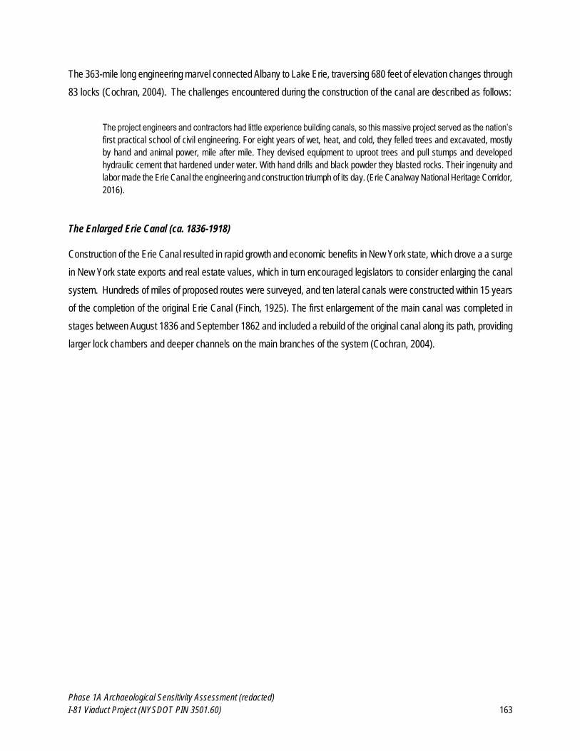
Phase 1A Archaeological Sensitivity Assessment (redacted)
I-81 Viaduct Project (NYSDOT PIN 3501.60) 163
The 363-mile long engineering marvel connected Albany to Lake Erie, traversing 680 feet of elevation changes through
83 locks (Cochran, 2004). The challenges encountered during the construction of the canal are described as follows:
The project engineers and contractors had little experience building canals, so this massive project served as the nation’s
first practical school of civil engineering. For eight years of wet, heat, and cold, they felled trees and excavated, mostly
by hand and animal power, mile after mile. They devised equipment to uproot trees and pull stumps and developed
hydraulic cement that hardened under water. With hand drills and black powder they blasted rocks. Their ingenuity and
labor made the Erie Canal the engineering and construction triumph of its day. (Erie Canalway National Heritage Corridor,
2016).
The Enlarged Erie Canal (ca. 1836-1918)
Construction of the Erie Canal resulted in rapid growth and economic benefits in New York state, which drove a a surge
in New York state exports and real estate values, which in turn encouraged legislators to consider enlarging the canal
system. Hundreds of miles of proposed routes were surveyed, and ten lateral canals were constructed within 15 years
of the completion of the original Erie Canal (Finch, 1925). The first enlargement of the main canal was completed in
stages between August 1836 and September 1862 and included a rebuild of the original canal along its path, providing
larger lock chambers and deeper channels on the main branches of the system (Cochran, 2004).
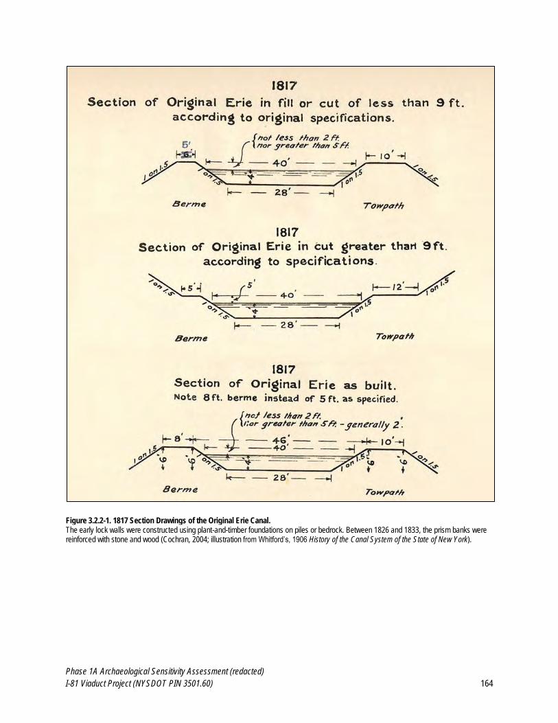
Phase 1A Archaeological Sensitivity Assessment (redacted)
I-81 Viaduct Project (NYSDOT PIN 3501.60) 164
Figure 3.2.2-1. 1817 Section Drawings of the Original Erie Canal. The early lock walls were constructed using plant-and-timber foundations on piles or bedrock. Between 1826 and 1833, the prism banks were reinforced with stone and wood (Cochran, 2004; illustration from Whitford’s, 1906 History of the Canal System of the State of New York).
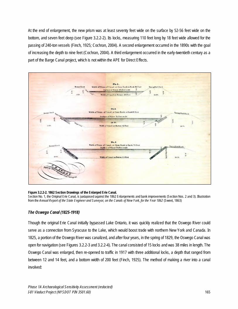
Phase 1A Archaeological Sensitivity Assessment (redacted)
I-81 Viaduct Project (NYSDOT PIN 3501.60) 165
At the end of enlargement, the new prism was at least seventy feet wide on the surface by 52-56 feet wide on the
bottom, and seven feet deep (see Figure 3.2.2-2). Its locks, measuring 110 feet long by 18 feet wide allowed for the
passing of 240-ton vessels (Finch, 1925; Cochran, 2004). A second enlargement occurred in the 1890s with the goal
of increasing the depth to nine feet (Cochran, 2004). A third enlargement occurred in the early-twentieth century as a
part of the Barge Canal project, which is not within the APE for Direct Effects.
Figure 3.2.2-2. 1862 Section Drawings of the Enlarged Erie Canal. Section No. 1, the Original Erie Canal, is juxtaposed against the 1862 Enlargements and bank improvements (Section Nos. 2 and 3). Illustration from the Annual Report of the State Engineer and Surveyor, on the Canals of New York, for the Year 1862 (Sweet, 1863)
The Oswego Canal (1825-1918)
Though the original Erie Canal initially bypassed Lake Ontario, it was quickly realized that the Oswego River could
serve as a connection from Syracuse to the Lake, which would boost trade with northern New York and Canada. In
1825, a portion of the Oswego River was canalized, and after four years, in the spring of 1829, the Oswego Canal was
open for navigation (see Figures 3.2.2-3 and 3.2.2-4). The canal consisted of 15 locks and was 38 miles in length. The
Oswego Canal was enlarged, then re-opened to traffic in 1917 with three additional locks, a depth that ranged from
between 12 and 14 feet, and a bottom width of 200 feet (Finch, 1925). The method of making a river into a canal
involved:
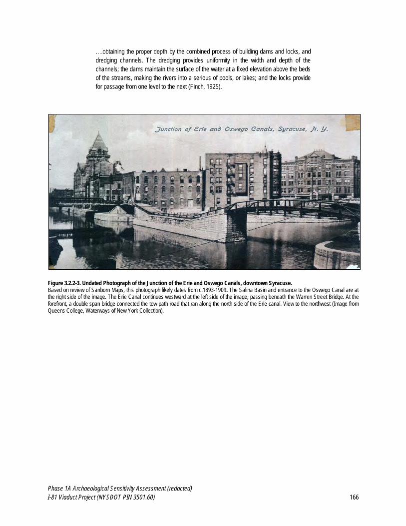
Phase 1A Archaeological Sensitivity Assessment (redacted)
I-81 Viaduct Project (NYSDOT PIN 3501.60) 166
….obtaining the proper depth by the combined process of building dams and locks, and
dredging channels. The dredging provides uniformity in the width and depth of the
channels; the dams maintain the surface of the water at a fixed elevation above the beds
of the streams, making the rivers into a serious of pools, or lakes; and the locks provide
for passage from one level to the next (Finch, 1925).
Figure 3.2.2-3. Undated Photograph of the Junction of the Erie and Oswego Canals, downtown Syracuse. Based on review of Sanborn Maps, this photograph likely dates from c.1893-1909. The Salina Basin and entrance to the Oswego Canal are at the right side of the image. The Erie Canal continues westward at the left side of the image, passing beneath the Warren Street Bridge. At the forefront, a double span bridge connected the tow path road that ran along the north side of the Erie canal. View to the northwest (Image from Queens College, Waterways of New York Collection).
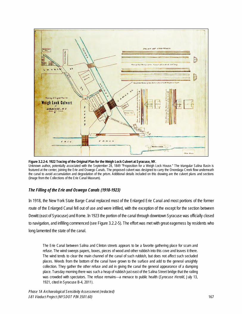
Phase 1A Archaeological Sensitivity Assessment (redacted)
I-81 Viaduct Project (NYSDOT PIN 3501.60) 167
Figure 3.2.2-4. 1922 Tracing of the Original Plan for the Weigh Lock Culvert at Syracuse, NY. Unknown author, potentially associated with the September 28, 1849 "Proposition for a Weigh Lock House." The triangular Salina Basin is featured at the center, joining the Erie and Oswego Canals. The proposed culvert was designed to carry the Onondaga Creek flow underneath the canal to avoid accumulation and degradation of the prism. Additional details included on this drawing are the culvert plans and sections (Image from the Collections of the Erie Canal Museum).
The Filling of the Erie and Oswego Canals (1918-1923)
In 1918, the New York State Barge Canal replaced most of the Enlarged Erie Canal and most portions of the former
route of the Enlarged Canal fell out of use and were infilled, with the exception of the except for the section between
Dewitt (east of Syracuse) and Rome. In 1923 the portion of the canal through downtown Syracuse was officially closed
to navigation, and infilling commenced (see Figure 3.2.2-5). The effort was met with great eagerness by residents who
long lamented the state of the canal.
The Erie Canal between Salina and Clinton streets appears to be a favorite gathering place for scum and
refuse. The wind sweeps papers, boxes, pieces of wood and other rubbish into this cove and leaves it there.
The wind tends to clear the main channel of the canal of such rubbish, but does not affect such secluded
places. Weeds from the bottom of the canal have grown to the surface and add to the general unsightly
collection. They gather the other refuse and aid in giving the canal the general appearance of a dumping
place. Tuesday morning there was such a heap of rubbish just east of the Salina Street bridge that the railing
was crowded with spectators. The refuse remains—a menace to public health (Syracuse Herald, July 13,
1921, cited in Syracuse B-4, 2011).
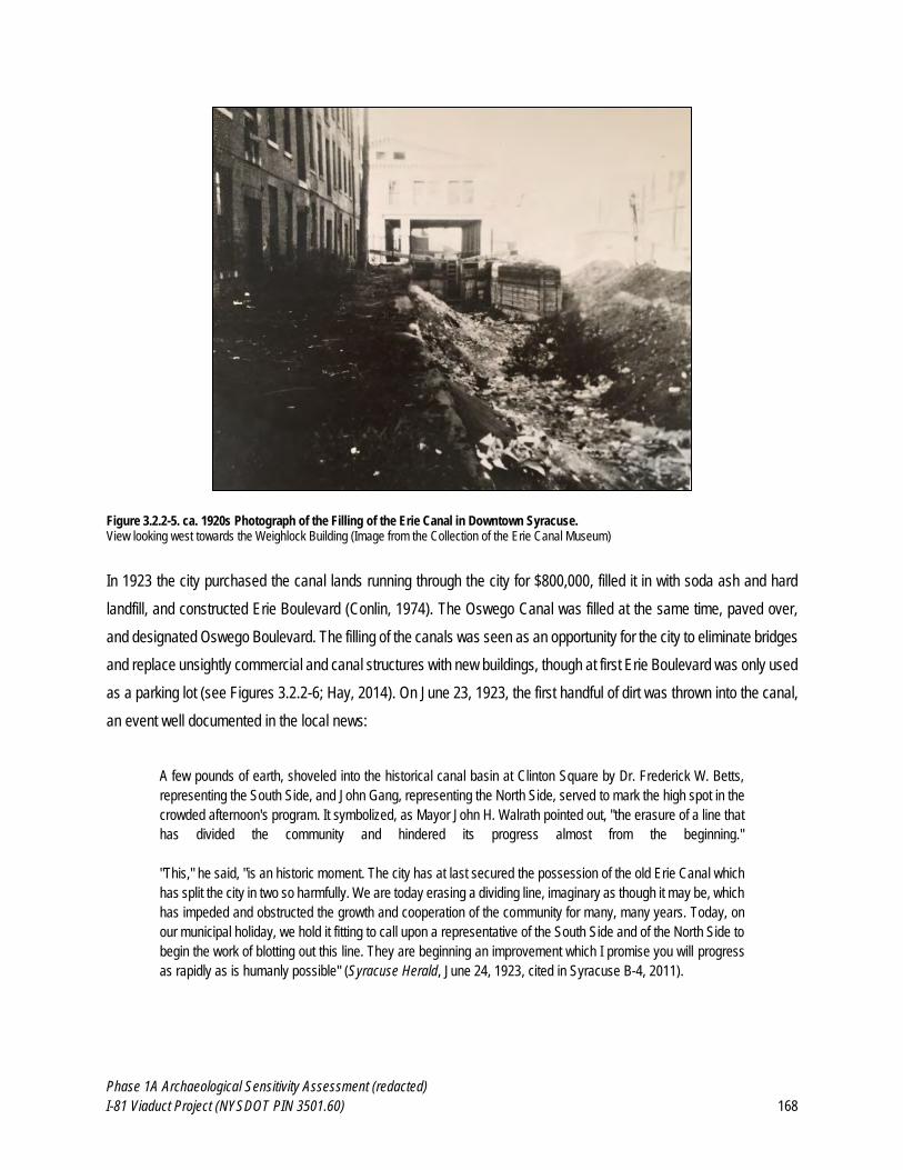
Phase 1A Archaeological Sensitivity Assessment (redacted)
I-81 Viaduct Project (NYSDOT PIN 3501.60) 168
Figure 3.2.2-5. ca. 1920s Photograph of the Filling of the Erie Canal in Downtown Syracuse. View looking west towards the Weighlock Building (Image from the Collection of the Erie Canal Museum)
In 1923 the city purchased the canal lands running through the city for $800,000, filled it in with soda ash and hard
landfill, and constructed Erie Boulevard (Conlin, 1974). The Oswego Canal was filled at the same time, paved over,
and designated Oswego Boulevard. The filling of the canals was seen as an opportunity for the city to eliminate bridges
and replace unsightly commercial and canal structures with new buildings, though at first Erie Boulevard was only used
as a parking lot (see Figures 3.2.2-6; Hay, 2014). On June 23, 1923, the first handful of dirt was thrown into the canal,
an event well documented in the local news:
A few pounds of earth, shoveled into the historical canal basin at Clinton Square by Dr. Frederick W. Betts,
representing the South Side, and John Gang, representing the North Side, served to mark the high spot in the
crowded afternoon's program. It symbolized, as Mayor John H. Walrath pointed out, "the erasure of a line that
has divided the community and hindered its progress almost from the beginning."
"This," he said, "is an historic moment. The city has at last secured the possession of the old Erie Canal which
has split the city in two so harmfully. We are today erasing a dividing line, imaginary as though it may be, which
has impeded and obstructed the growth and cooperation of the community for many, many years. Today, on
our municipal holiday, we hold it fitting to call upon a representative of the South Side and of the North Side to
begin the work of blotting out this line. They are beginning an improvement which I promise you will progress
as rapidly as is humanly possible" (Syracuse Herald, June 24, 1923, cited in Syracuse B-4, 2011).
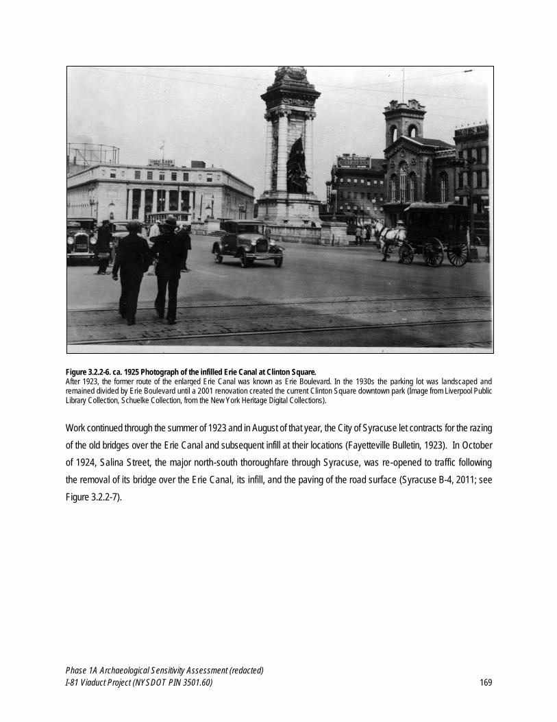
Phase 1A Archaeological Sensitivity Assessment (redacted)
I-81 Viaduct Project (NYSDOT PIN 3501.60) 169
Figure 3.2.2-6. ca. 1925 Photograph of the infilled Erie Canal at Clinton Square. After 1923, the former route of the enlarged Erie Canal was known as Erie Boulevard. In the 1930s the parking lot was landscaped and remained divided by Erie Boulevard until a 2001 renovation created the current Clinton Square downtown park (Image from Liverpool Public Library Collection, Schuelke Collection, from the New York Heritage Digital Collections).
Work continued through the summer of 1923 and in August of that year, the City of Syracuse let contracts for the razing
of the old bridges over the Erie Canal and subsequent infill at their locations (Fayetteville Bulletin, 1923). In October
of 1924, Salina Street, the major north-south thoroughfare through Syracuse, was re-opened to traffic following
the removal of its bridge over the Erie Canal, its infill, and the paving of the road surface (Syracuse B-4, 2011; see
Figure 3.2.2-7).
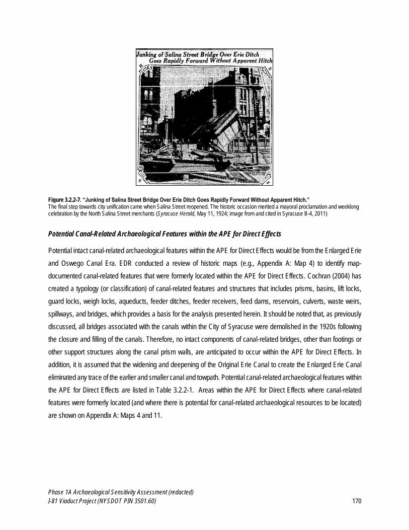
Phase 1A Archaeological Sensitivity Assessment (redacted)
I-81 Viaduct Project (NYSDOT PIN 3501.60) 170
Figure 3.2.2-7. “Junking of Salina Street Bridge Over Erie Ditch Goes Rapidly Forward Without Apparent Hitch.” The final step towards city unification came when Salina Street reopened. The historic occasion merited a mayoral proclamation and weeklong celebration by the North Salina Street merchants (Syracuse Herald, May 11, 1924; image from and cited in Syracuse B-4, 2011)
Potential Canal-Related Archaeological Features within the APE for Direct Effects
Potential intact canal-related archaeological features within the APE for Direct Effects would be from the Enlarged Erie
and Oswego Canal Era. EDR conducted a review of historic maps (e.g., Appendix A: Map 4) to identify map-
documented canal-related features that were formerly located within the APE for Direct Effects. Cochran (2004) has
created a typology (or classification) of canal-related features and structures that includes prisms, basins, lift locks,
guard locks, weigh locks, aqueducts, feeder ditches, feeder receivers, feed dams, reservoirs, culverts, waste weirs,
spillways, and bridges, which provides a basis for the analysis presented herein. It should be noted that, as previously
discussed, all bridges associated with the canals within the City of Syracuse were demolished in the 1920s following
the closure and filling of the canals. Therefore, no intact components of canal-related bridges, other than footings or
other support structures along the canal prism walls, are anticipated to occur within the APE for Direct Effects. In
addition, it is assumed that the widening and deepening of the Original Erie Canal to create the Enlarged Erie Canal
eliminated any trace of the earlier and smaller canal and towpath. Potential canal-related archaeological features within
the APE for Direct Effects are listed in Table 3.2.2-1. Areas within the APE for Direct Effects where canal-related
features were formerly located (and where there is potential for canal-related archaeological resources to be located)
are shown on Appendix A: Maps 4 and 11.
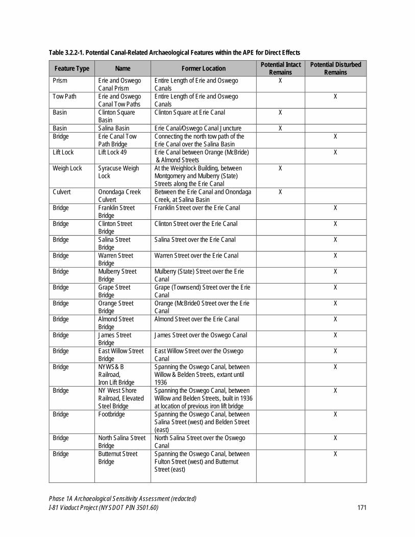
Phase 1A Archaeological Sensitivity Assessment (redacted)
I-81 Viaduct Project (NYSDOT PIN 3501.60) 171
Table 3.2.2-1. Potential Canal-Related Archaeological Features within the APE for Direct Effects
Feature Type Name Former Location Potential Intact
Remains Potential Disturbed
Remains
Prism Erie and Oswego Canal Prism
Entire Length of Erie and Oswego Canals
X
Tow Path Erie and Oswego Canal Tow Paths
Entire Length of Erie and Oswego Canals
X
Basin Clinton Square Basin
Clinton Square at Erie Canal X
Basin Salina Basin Erie Canal/Oswego Canal Juncture X
Bridge Erie Canal Tow Path Bridge
Connecting the north tow path of the Erie Canal over the Salina Basin
X
Lift Lock Lift Lock 49 Erie Canal between Orange (McBride) & Almond Streets
X
Weigh Lock Syracuse Weigh Lock
At the Weighlock Building, between Montgomery and Mulberry (State) Streets along the Erie Canal
X
Culvert Onondaga Creek Culvert
Between the Erie Canal and Onondaga Creek, at Salina Basin
X
Bridge Franklin Street Bridge
Franklin Street over the Erie Canal X
Bridge Clinton Street Bridge
Clinton Street over the Erie Canal X
Bridge Salina Street Bridge
Salina Street over the Erie Canal X
Bridge Warren Street Bridge
Warren Street over the Erie Canal X
Bridge Mulberry Street Bridge
Mulberry (State) Street over the Erie Canal
X
Bridge Grape Street Bridge
Grape (Townsend) Street over the Erie Canal
X
Bridge Orange Street Bridge
Orange (McBride0 Street over the Erie Canal
X
Bridge Almond Street Bridge
Almond Street over the Erie Canal X
Bridge James Street Bridge
James Street over the Oswego Canal X
Bridge East Willow Street Bridge
East Willow Street over the Oswego Canal
X
Bridge NYWS& B Railroad, Iron Lift Bridge
Spanning the Oswego Canal, between Willow & Belden Streets, extant until 1936
X
Bridge NY West Shore Railroad, Elevated Steel Bridge
Spanning the Oswego Canal, between Willow and Belden Streets, built in 1936 at location of previous iron lift bridge
X
Bridge Footbridge Spanning the Oswego Canal, between Salina Street (west) and Belden Street (east)
X
Bridge North Salina Street Bridge
North Salina Street over the Oswego Canal
X
Bridge Butternut Street Bridge
Spanning the Oswego Canal, between Fulton Street (west) and Butternut Street (east)
X
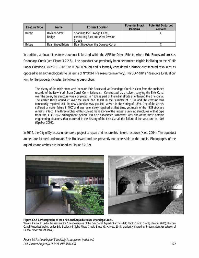
Phase 1A Archaeological Sensitivity Assessment (redacted)
I-81 Viaduct Project (NYSDOT PIN 3501.60) 172
Feature Type Name Former Location Potential Intact
Remains Potential Disturbed
Remains
Bridge Division Street Bridge
Spanning the Oswego Canal, connecting East and West Division Streets
X
Bridge Bear Street Bridge Bear Street over the Oswego Canal X
In addition, an intact limestone aqueduct is located within the APE for Direct Effects, where Erie Boulevard crosses
Onondaga Creek (see Figure 3.2.2-8). The aqueduct has previously been determined eligible for listing on the NRHP
under Criterion C (NYSOPRHP Site 06740.009729) and is formally considered a historic-architectural resources as
opposed to an archaeological site (in terms of NYSORHP’s resource inventory). NYSOPRHP’s “Resource Evaluation”
form for the property includes the following description:
The history of the triple stone arch beneath Erie Boulevard at Onondaga Creek is clear from the published records of the New York State Canal Commissioners. Constructed as a culvert carrying the Erie Canal over the creek, the structure was completed in 1838 as part of the initial efforts at enlarging the Erie Canal. The earlier 1820's aqueduct over the creek had failed in the summer of 1834 and the crossing was temporarily repaired until the new aqueduct was put into service in the spring of 1839. One of the arches suffered a major failure in 1907 and was extensively repaired at that time, yet much of the 1838 structure remains intact. The three arches of this culvert make it one of the largest surviving structures of that type from the 1835-1862 enlargement period. It is also associated with what was one of the most notable engineering disasters that occurred in the hi story of the Erie Canal, the failure of the structure in 1907 (Opalka, 2008).
In 2014, the City of Syracuse undertook a project to repair and restore this historic resource (Kirst, 2004). The aqueduct
arches are located underneath Erie Boulevard and are presently not accessible to the public. Photographs of the
aqueduct and arches are included as Figure 3.2.2-9.
Figure 3.2.2-9. Photographs of the Erie Canal Aqueduct over Onondaga Creek. View to the south under the Washington Street overpass of the Erie Canal Aqueduct arches (left; Photo Credit: Grant Johnson, 2016); the Erie Canal Aqueduct arches under Erie Boulevard (right; Photo Credit: Bruce G. Harvey, 2014, previously shared on Preservation Association of Central New York list-serve).
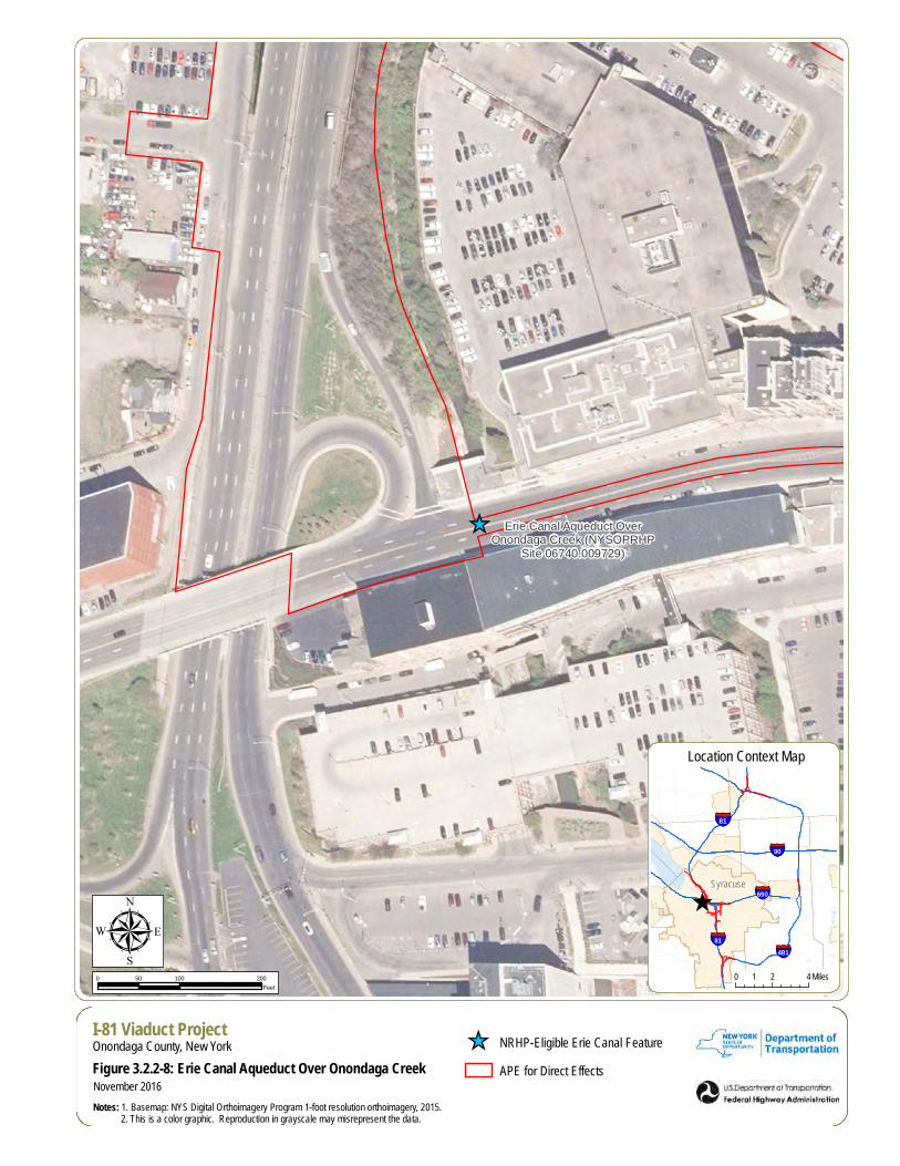
_̂ Erie Canal Aqueduct OverOnondaga Creek (NYSOPRHP
Site 06740.009729)
µI-81 Viaduct ProjectOnondaga County, New York
Figure 3.2.2-8: Erie Canal Aqueduct Over Onondaga Creek
Notes: 1. Basemap: NYS Digital Orthoimagery Program 1-foot resolution orthoimagery, 2015. 2. This is a color graphic. Reproduction in grayscale may misrepresent the data.
0 100 20050Feet
November 2016
_̂ NRHP-Eligible Erie Canal Feature
APE for Direct Effects
^
§̈¦81
Syracuse
§̈¦690
§̈¦81
§̈¦90
§̈¦481
0 2 41 Miles
Location Context Map
Phase 1A Archaeological Sensitivity Assessment (redacted)
I-81 Viaduct Project (NYSDOT PIN 3501.60) 174
Previous Archaeological Investigations of Canal-Related Features and Sites
Four previously conducted archaeological studies within or immediately adjacent to the APE for Direct Effects have
identified archaeological features associated with the Enlarged Erie Canal. No archaeological studies have been
conducted involving the Oswego Canal within or near the APE for Direct Effects. The projects are summarized in Table
3.2.2-2 and have been discussed in detail in Section 2.3 of this report. The previous projects identified intact portions
of the canal prism (Hartgen, 2001a; Pratt & Pratt, 1981), the Clinton Square Boat Basin (PCI, 2001), and the Onondaga
Creek Culvert (PAF, 2008).
Table 3.2.2-2. Previously Archaeological Studies of Canal-Related Features within the APE for Direct Effects.
Survey/Project No.
Survey/Project Name
Type
Distance from APE for Direct
Effects
Findings Reference
AR0004499_26 (no CRIS survey number)
Stage 1B Cultural Resource Survey for the Proposed Best Management Practices Program of the Combined Sewer Overflow (CSO) Facilities System in the City of Syracuse, New York
Phase 1B 0 ft (overlaps APE for Direct
Effects)
Fifteen shovel tests and 29 soil borings identified fill and low density 20th century debris throughout majority of project area. Identified remnants of the Enlarged Erie Canal at three locations (recommended avoidance or Phase II investigations) and remnants of the Fay Foundry/Ironworks at one location (recommended for Phase II investigations which were never accomplished).
Pratt & Pratt, 1981
00SR5205 Phase 1B: Clinton Square Project
Phase 1B 0 ft (overlaps APE for Direct
Effects)
Identified two sites: USN 6740.004364-Clinton Square Boat Basin (NRHP-eligible) and USN 6740.005256-historic structural foundations (NRHP-undetermined). Mitigation recommended.
PCI, 2000
01SR51627 Phase 1B Archaeological Field Investigation, EBSS Gate Chamber No. 4, Storm and Sanitary Sewer Modification.
Phase 1B 100 ft (31 m) Identified dry-laid fieldstone walls of enlarged Erie Canal; recommended project modifications to avoid canal.
Hartgen, 2001a
08SR58239 Phase 1: Erie Blvd. over Onondaga Creek Project
Phase 1 0 ft (overlaps APE for Direct
Effects)
Identified historic culvert associated with Erie Canal. No further work recommended.
PAF, 2008
Phase 1A Archaeological Sensitivity Assessment (redacted)
I-81 Viaduct Project (NYSDOT PIN 3501.60) 175
Archaeologists have documented disturbance to portions of the canal prism walls underneath associated with the
installation of the Erie Boulevard Storm Sewer, which is located within the former prism of the enlarged canal:
The Erie Boulevard Storm Sewer is laid within the enlarged Erie Canal. Therefore, the installation of lateral
sewers necessitated the breeching of the canal walls. In addition, other utilities such as water, gas and electric
have crossed the canal at depths varying from 2 to 7 feet [0.6 to 2.1 m] below the surface. In instances where
the cap and wall stones of the canal were in situ, most, if not all of these utilities disturbed the original canal
structure (Pratt and Pratt, 1981:3).
Therefore, although extended portions of the Erie Canal prism may remain somewhat intact where it crosses the APE
for Direct Effects in downtown Syracuse, the canal prism walls have been damaged to an unknown extent by the
installation of buried utilities throughout the twentieth and early-twenty-first centuries. Pratt and Pratt (1981) also noted
that the Erie Boulevard Sanitary Sewer cut through the northern wall of canal in two locations between Beech and
Cherry Streets; however, these locations are outside the APE for Direct Effects.
Hartgen 2001a encountered a portion of the canal wall near the corner of University Avenue and Erie Boulevard (see
Figure 3.2.2-10). The prism at this location was partially intact but had been damaged by the installation of a subsurface
storm sewer gate chamber (Gate Chamber 4). Hartgen (2001a) encountered the remains of the canal wall
approximately 2 ft (0.6 m) below the modern ground surface.
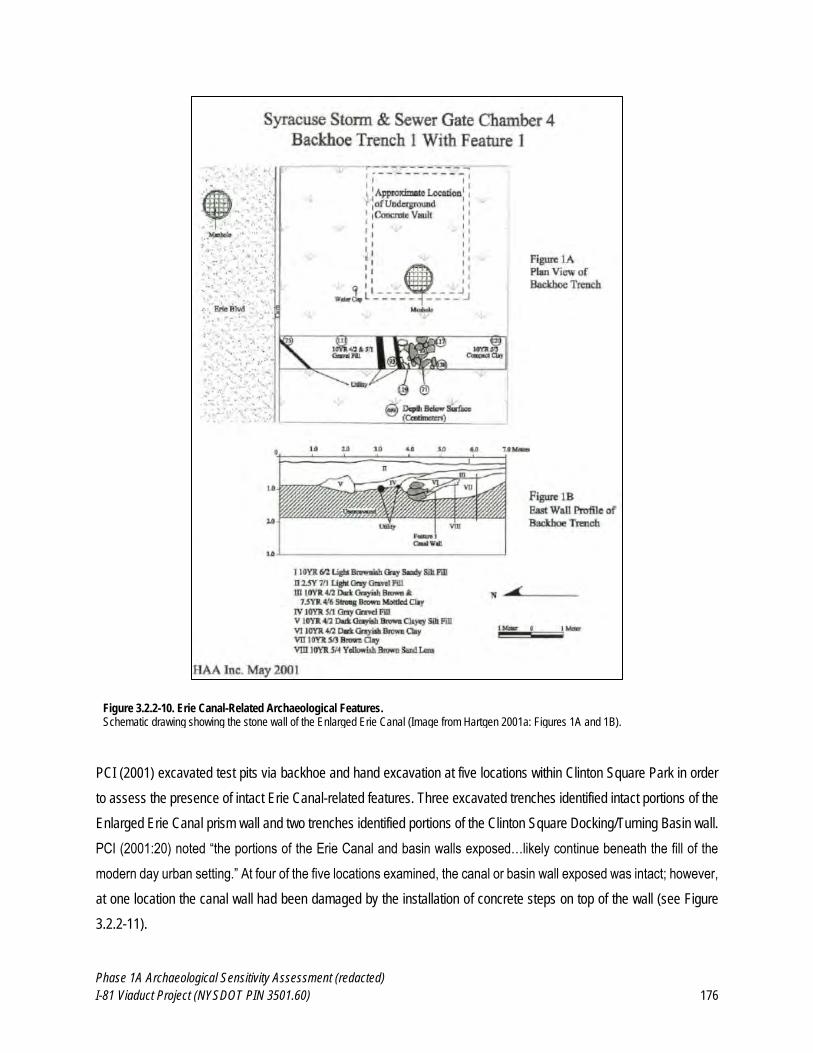
Phase 1A Archaeological Sensitivity Assessment (redacted)
I-81 Viaduct Project (NYSDOT PIN 3501.60) 176
Figure 3.2.2-10. Erie Canal-Related Archaeological Features. Schematic drawing showing the stone wall of the Enlarged Erie Canal (Image from Hartgen 2001a: Figures 1A and 1B).
PCI (2001) excavated test pits via backhoe and hand excavation at five locations within Clinton Square Park in order
to assess the presence of intact Erie Canal-related features. Three excavated trenches identified intact portions of the
Enlarged Erie Canal prism wall and two trenches identified portions of the Clinton Square Docking/Turning Basin wall.
PCI (2001:20) noted “the portions of the Erie Canal and basin walls exposed…likely continue beneath the fill of the
modern day urban setting.” At four of the five locations examined, the canal or basin wall exposed was intact; however,
at one location the canal wall had been damaged by the installation of concrete steps on top of the wall (see Figure
3.2.2-11).
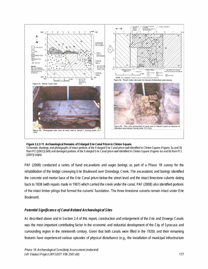
Phase 1A Archaeological Sensitivity Assessment (redacted)
I-81 Viaduct Project (NYSDOT PIN 3501.60) 177
Figure 3.2.2-11. Archaeological Remains of Enlarged Erie Canal Prism in Clinton Square. Schematic drawings and photographs of intact portions of the Enlarged Erie Canal prism wall identified in Clinton Square (Figures 3a and 3b from PCI [2001]) (left) and damaged portions of the Enlarged Erie Canal prism wall identified in Clinton Square (Figures 6a and 6b from PCI [2001]) (right).
PAF (2008) conducted a series of hand excavations and auger borings as part of a Phase 1B survey for the
rehabilitation of the bridge conveying Erie Boulevard over Onondaga Creek. The excavations and borings identified
the concrete and mortar base of the Erie Canal prism below the street level and the intact limestone culverts dating
back to 1838 (with repairs made in 1907) which carried the creek under the canal. PAF (2008) also identified portions
of the intact timber pilings that formed the culverts’ foundation. The three limestone culverts remain intact under Erie
Boulevard.
Potential Significance of Canal-Related Archaeological Sites
As described above and in Section 2.4 of this report, construction and enlargement of the Erie and Oswego Canals
was the most important contributing factor in the economic and industrial development of the City of Syracuse and
surrounding region in the nineteenth century. Given that both canals were filled in the 1920s and their remaining
features have experienced various episodes of physical disturbance (e.g., the installation of municipal infrastructure
Phase 1A Archaeological Sensitivity Assessment (redacted)
I-81 Viaduct Project (NYSDOT PIN 3501.60) 178
utilities), the physical integrity of canal-related archaeological features within the APE for Direct Effect is anticipated to
be variable. Intact archaeological features associated with either canal, depending on their physical integrity, could
potentially be eligible for listing on the NRHP under Criterion A, C, or D. Canal-related features could be eligible under
Criterion A for their association with the significant role that the canals played in the historical development of Syracuse
and New York State. Depending on their function and integrity, canal-related features could also be eligible under
Criterion C as examples of historically significant engineering structures. Similarly, canal-related features could be
eligible under Criterion D in terms of their ability to provide significant data pertinent to answering research questions
related to local, regional, or national history. In the case of canal-related features, these sites would need to contribute
significant information to our understanding of the construction or operation of the canals sufficient to broaden our
understanding of this important aspect of local and regional history.
Summary: Portions of the Erie and Oswego Canals were formerly located within the APE for Direct Effects. Potential
intact canal-related archaeological features within the APE for Direct Effects would be from the Enlarged Erie and
Oswego Canal Era. It is assumed that the widening and deepening of the Original Erie Canal to create the Enlarged
Erie Canal eliminated any trace of the earlier and smaller canal and towpath. The following is a summary of potential
for canal-related archaeological resources within the APE for Direct Effects:
Prism: Based on the results of previous investigations (Hartgen, 2001a; PAF, 2008; PCI, 2001; Pratt & Pratt,
1981), there is a moderate likelihood that intact portions of the Erie and Oswego Canal prisms remain intact
under modern streets and sidewalks within the APE for Direct Effects. The Enlarged Erie Canal prism may
remain largely intact under the entire portion of Erie Boulevard that passes through the APE for Direct Effects
and the Oswego Canal prism may remain largely intact under the entire portion of Oswego Boulevard that
passes through the APE for Direct Effects. However, the majority of the historic route of the Oswego Canal
within the APE for Direct Effects occurs under the current route of I-81 in an area identified entirely as Cut-
and-Fill Highway Area. Given the extent of previous disturbance associated with the construction of Oswego
Boulevard in the 1920s and the Oswego Boulevard Expressway (later, I-81) in the 1950s there is a very low
likelihood of intact portions of the Oswego Canal remaining in the portion of the APE for Direct Effects located
within the current route of I-81.
Towpath: The canal towpaths may remain intact in places; however, in many places they have likely been
disturbed by the installation of buried utilities as well as the construction of streets and sidewalks. Whereas
the canal prism existed below-grade, allowing it to be filled and therefore preserved, the towpaths typically
existed at- or above-grade and thus would have been more easily damaged or destroyed following the closure
of the canals. The likelihood of encountering intact portions of the original towpath from either canal within the
APE for Direct Effects is considered to be low.
Phase 1A Archaeological Sensitivity Assessment (redacted)
I-81 Viaduct Project (NYSDOT PIN 3501.60) 179
Bridges: Although several former bridges over the canals occurred within the APE for Direct Effects, they
were demolished shortly after the canals were filled in. There is some chance that subsurface bridge
abutments could remain intact but the overall likelihood of encountering intact canal-related bridge features
within the APE for Direct Effects is considered to be low.
Basins: The APE for Direct Effects overlaps with the Clinton and Salina Basins, both of which may retain
intact walls beneath modern day streets and parks (Hartgen, 2001a). The likelihood for encountering these
features is considered to be high.
Locks: Lift Lock 49 historically occurred within the APE for Direct Effects between Orange (now McBride) and
Almond Streets. The cut stone from abandoned locks was often scavenged for other purposes prior to the
canal being filled. There is a moderate to high potential that portions of Lift Lock 49 remain intact under Erie
Boulevard within the APE for Direct Effects. The Syracuse Weigh Lock remains largely intact and occurs
immediately adjacent to the APE for Direct Effects. The feature is currently preserved as part of the Erie Canal
Museum.
Culverts: The Onondaga Creek Culvert is intact approximately 4-5 meters (13-16 ft) below the modern street
surface. The likelihood for encountering this feature is high if Project-related disturbance extends this deep in
this area.
Aqueduct: An intact limestone aqueduct is located within the APE for Direct Effects, where Erie Boulevard
crosses Onondaga Creek (see Figure 3.2.2-8). The aqueduct has previously been determined eligible for
listing on the NRHP under Criterion C (NYSOPRHP Site 06740.009729) and is formally considered a historic-
architectural resources as opposed to an archaeological site (in terms of NYSORHP’s resource inventory).
In summary, there is a high potential for archaeological resources related to the Erie and Oswego canals to be present
within the APE for Direct Effects. Recommendations regarding these potential resources are provided in Section 4.2
of this report.
3.2.3 Potential for Large-Scale Commercial, Industrial, and Institutional Archaeological Sites
As described in Section 2.4 of this report, downtown Syracuse was the hub of industrial, commercial and institutional
activity for central New York in the ninetieth and twentieth centuries. Infrastructure associated with the once burgeoning
salt industry (which gave Syracuse its nickname of “the salt city”), as well as numerous other commercial enterprises,
was formerly located within the APE for Direct Effects. The history of construction and replacement of these features
is well documented in historical sources and the former locations of industrial, commercial, and institutional-related
features within the APE are shown on historical maps and photographs of Syracuse. In addition, several previous
cultural resources surveys conducted within one mile of the Project (see Section 2.3) note the potential for intact
Phase 1A Archaeological Sensitivity Assessment (redacted)
I-81 Viaduct Project (NYSDOT PIN 3501.60) 180
archaeological remains associated with the salt industry and other industries, and evaluated the likelihood for intact
(undisturbed) archaeological remains of these resources to be present (e.g., AAS, 2016; CCRG, 2001b). These
sources are reviewed and summarized below to identify potential industrial, commercial and institutional sites within
the APE for Direct Effects.
The Salt Industry Prior to the Erie and Oswego Canals (c. 1790-1825)
Salt production was crucial to the growth and development of the area that would become the City of Syracuse. The
lands surrounding Onondaga Lake were known to be rich in salt springs as early as the seventeenth century, resulting
from contact between French Jesuit priests and the Onondagas beginning in the 1650s. Several European travelers
passed through the region in the early-eighteenth century, and wrote about the salt springs surrounding the lake.
Following the Revolutionary War, many veterans and settlers relocated to the Six Nations Reserve in Canada, passing
through upstate New York, including the area that would become Syracuse, lured by fur trading, as well as the wealth
of salt springs, for which the region was already well known (Werner, 1917; Chase, 1924; Sernett, 1995).
Through the 1788 Treaty of Fort Schuyler, New York State acquired title to a vast swath of land held by the Onondaga
Nation, including portions of what today comprises Cayuga, Cortland, Onondaga, and Seneca counties. The lands
located at the southern end of Onondaga Lake that were known to be rich in salt springs were established for joint use
of the state and the Onondagas in the production of salt, increasing the allure of the area immediately surrounding of
the lake as a place for settlers. In the fall of 1789, Nathaniel Loomis arrived at Onondaga Lake and began production
of salt for resale. The following year, Colonel Jeremiah Gould, Hezekiah and Thomas Olcott, and Deacon Loomis
arrived at the lake to engage in salt production. As a result of the increased activity and migration to the lakefront due
to salt production, a settlement adjacent to the salt marshes on the north side of the lake named Salt Point began to
take shape in the early 1790s (Clark, 1849; Clayton, 1878; Munson, 1969).
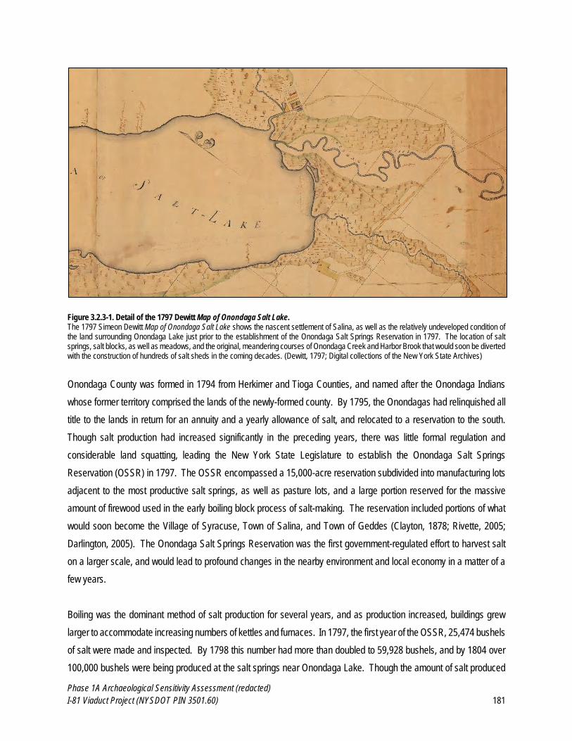
Phase 1A Archaeological Sensitivity Assessment (redacted)
I-81 Viaduct Project (NYSDOT PIN 3501.60) 181
Figure 3.2.3-1. Detail of the 1797 Dewitt Map of Onondaga Salt Lake. The 1797 Simeon Dewitt Map of Onondaga Salt Lake shows the nascent settlement of Salina, as well as the relatively undeveloped condition of the land surrounding Onondaga Lake just prior to the establishment of the Onondaga Salt Springs Reservation in 1797. The location of salt springs, salt blocks, as well as meadows, and the original, meandering courses of Onondaga Creek and Harbor Brook that would soon be diverted with the construction of hundreds of salt sheds in the coming decades. (Dewitt, 1797; Digital collections of the New York State Archives)
Onondaga County was formed in 1794 from Herkimer and Tioga Counties, and named after the Onondaga Indians
whose former territory comprised the lands of the newly-formed county. By 1795, the Onondagas had relinquished all
title to the lands in return for an annuity and a yearly allowance of salt, and relocated to a reservation to the south.
Though salt production had increased significantly in the preceding years, there was little formal regulation and
considerable land squatting, leading the New York State Legislature to establish the Onondaga Salt Springs
Reservation (OSSR) in 1797. The OSSR encompassed a 15,000-acre reservation subdivided into manufacturing lots
adjacent to the most productive salt springs, as well as pasture lots, and a large portion reserved for the massive
amount of firewood used in the early boiling block process of salt-making. The reservation included portions of what
would soon become the Village of Syracuse, Town of Salina, and Town of Geddes (Clayton, 1878; Rivette, 2005;
Darlington, 2005). The Onondaga Salt Springs Reservation was the first government-regulated effort to harvest salt
on a larger scale, and would lead to profound changes in the nearby environment and local economy in a matter of a
few years.
Boiling was the dominant method of salt production for several years, and as production increased, buildings grew
larger to accommodate increasing numbers of kettles and furnaces. In 1797, the first year of the OSSR, 25,474 bushels
of salt were made and inspected. By 1798 this number had more than doubled to 59,928 bushels, and by 1804 over
100,000 bushels were being produced at the salt springs near Onondaga Lake. Though the amount of salt produced
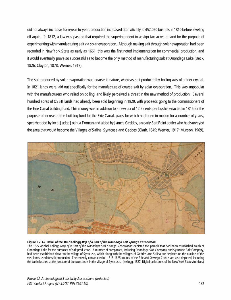
Phase 1A Archaeological Sensitivity Assessment (redacted)
I-81 Viaduct Project (NYSDOT PIN 3501.60) 182
did not always increase from year-to-year, production increased dramatically to 452,050 bushels in 1810 before leveling
off again. In 1812, a law was passed that required the superintendent to assign two acres of land for the purpose of
experimenting with manufacturing salt via solar evaporation. Although making salt through solar evaporation had been
recorded in New York State as early as 1661, this was the first noted implementation for commercial production, and
it would eventually prove so successful as to become the only method of manufacturing salt at Onondaga Lake (Beck,
1826; Clayton, 1878; Werner, 1917).
The salt produced by solar evaporation was coarse in nature, whereas salt produced by boiling was of a finer crystal.
In 1821 lands were laid out specifically for the manufacture of coarse salt by solar evaporation. This was unpopular
with the manufacturers who relied on boiling, and likely perceived a threat in the new method of production. Several
hundred acres of OSSR lands had already been sold beginning in 1820, with proceeds going to the commissioners of
the Erie Canal building fund. This money was in addition to a new tax of 12.5 cents per bushel enacted in 1816 for the
purpose of increased the building fund for the Erie Canal, plans for which had been in motion for a number of years,
spearheaded by local Judge Joshua Forman and aided by James Geddes, an early Salt Point settler who had surveyed
the area that would become the Villages of Salina, Syracuse and Geddes (Clark, 1849; Werner, 1917; Munson, 1969).
Figure 3.2.3-2. Detail of the 1827 Kellogg Map of a Part of the Onondaga Salt Springs Reservation. The 1827 Ashbel Kellogg Map of a Part of the Onondaga Salt Springs Reservation depicted the parcels that had been established south of Onondaga Lake for the purposes of salt production. A number of companies, including Onondaga Salt Company and Syracuse Salt Company, had been established closer to the village of Syracuse, which along with the villages of Geddes and Salina are depicted on the outside of the vast lands used for salt production. The recently constructed (c. 1818-1825) routes of the Erie and Oswego Canals are also depicted, including the basin located at the juncture of the two canals in the village of Syracuse. (Kellogg, 1827; Digital collections of the New York State Archives)
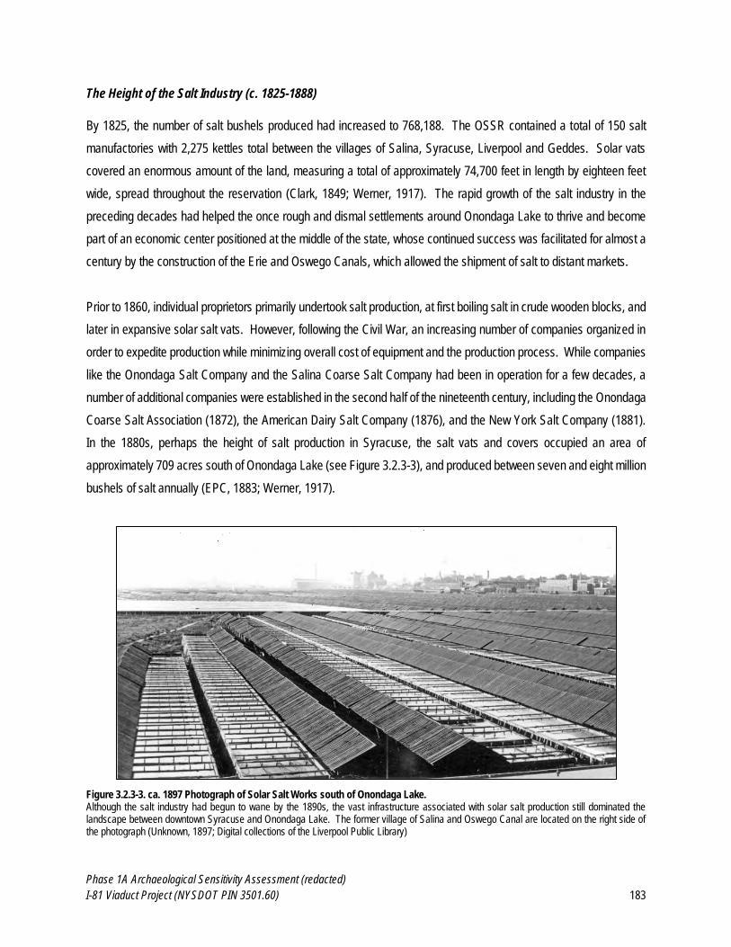
Phase 1A Archaeological Sensitivity Assessment (redacted)
I-81 Viaduct Project (NYSDOT PIN 3501.60) 183
The Height of the Salt Industry (c. 1825-1888)
By 1825, the number of salt bushels produced had increased to 768,188. The OSSR contained a total of 150 salt
manufactories with 2,275 kettles total between the villages of Salina, Syracuse, Liverpool and Geddes. Solar vats
covered an enormous amount of the land, measuring a total of approximately 74,700 feet in length by eighteen feet
wide, spread throughout the reservation (Clark, 1849; Werner, 1917). The rapid growth of the salt industry in the
preceding decades had helped the once rough and dismal settlements around Onondaga Lake to thrive and become
part of an economic center positioned at the middle of the state, whose continued success was facilitated for almost a
century by the construction of the Erie and Oswego Canals, which allowed the shipment of salt to distant markets.
Prior to 1860, individual proprietors primarily undertook salt production, at first boiling salt in crude wooden blocks, and
later in expansive solar salt vats. However, following the Civil War, an increasing number of companies organized in
order to expedite production while minimizing overall cost of equipment and the production process. While companies
like the Onondaga Salt Company and the Salina Coarse Salt Company had been in operation for a few decades, a
number of additional companies were established in the second half of the nineteenth century, including the Onondaga
Coarse Salt Association (1872), the American Dairy Salt Company (1876), and the New York Salt Company (1881).
In the 1880s, perhaps the height of salt production in Syracuse, the salt vats and covers occupied an area of
approximately 709 acres south of Onondaga Lake (see Figure 3.2.3-3), and produced between seven and eight million
bushels of salt annually (EPC, 1883; Werner, 1917).
Figure 3.2.3-3. ca. 1897 Photograph of Solar Salt Works south of Onondaga Lake. Although the salt industry had begun to wane by the 1890s, the vast infrastructure associated with solar salt production still dominated the landscape between downtown Syracuse and Onondaga Lake. The former village of Salina and Oswego Canal are located on the right side of the photograph (Unknown, 1897; Digital collections of the Liverpool Public Library)
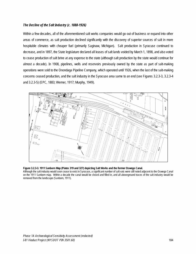
Phase 1A Archaeological Sensitivity Assessment (redacted)
I-81 Viaduct Project (NYSDOT PIN 3501.60) 184
The Decline of the Salt Industry (c. 1888-1926)
Within a few decades, all of the aforementioned salt works companies would go out of business or expand into other
areas of commerce, as salt production declined significantly with the discovery of superior sources of salt in more
hospitable climates with cheaper fuel (primarily Saginaw, Michigan). Salt production in Syracuse continued to
decrease, and in 1897, the State legislature declared all leases of salt lands voided by March 1, 1898, and also voted
to cease production of salt brine at any expense to the state (although salt production by the state would continue for
almost a decade). In 1908, pipelines, wells and reservoirs previously owned by the state as part of salt-making
operations were sold to the Onondaga Pipeline Company, which operated until 1926, when the last of the salt-making
concerns ceased production, and the salt industry in the Syracuse area same to an end (see Figures 3.2.3-3, 3.2.3-4
and 3.2.3-5) (EPC, 1883; Werner, 1917; Murphy, 1949).
Figure 3.2.3-3. 1911 Sanborn Map (Plates 319 and 327) depicting Salt Works and the former Oswego Canal. Although the salt industry would soon cease to exist in Syracuse, a significant number of salt vats were still noted adjacent to the Oswego Canal on the 1911 Sanborn map. Within a decade the canal would be closed and filled in, and all aboveground traces of the salt industry would be removed from the landscape (Sanborn, 1911).
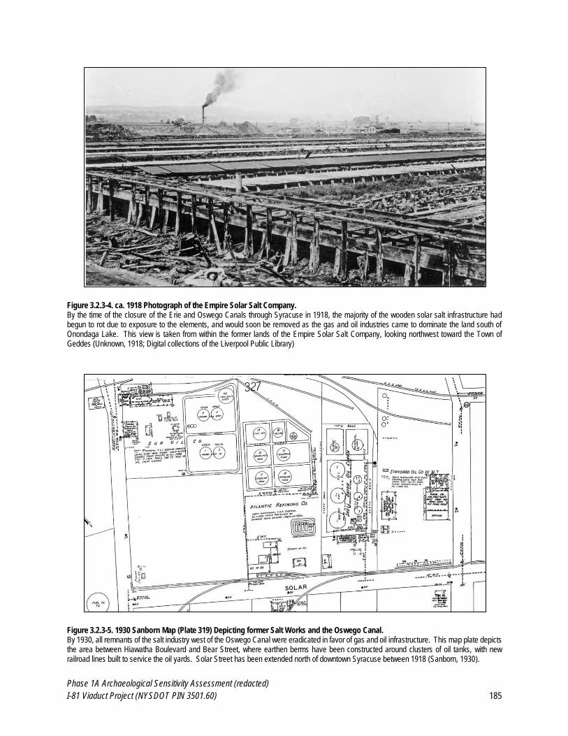
Phase 1A Archaeological Sensitivity Assessment (redacted)
I-81 Viaduct Project (NYSDOT PIN 3501.60) 185
Figure 3.2.3-4. ca. 1918 Photograph of the Empire Solar Salt Company. By the time of the closure of the Erie and Oswego Canals through Syracuse in 1918, the majority of the wooden solar salt infrastructure had begun to rot due to exposure to the elements, and would soon be removed as the gas and oil industries came to dominate the land south of Onondaga Lake. This view is taken from within the former lands of the Empire Solar Salt Company, looking northwest toward the Town of Geddes (Unknown, 1918; Digital collections of the Liverpool Public Library)
Figure 3.2.3-5. 1930 Sanborn Map (Plate 319) Depicting former Salt Works and the Oswego Canal. By 1930, all remnants of the salt industry west of the Oswego Canal were eradicated in favor of gas and oil infrastructure. This map plate depicts the area between Hiawatha Boulevard and Bear Street, where earthen berms have been constructed around clusters of oil tanks, with new railroad lines built to service the oil yards. Solar Street has been extended north of downtown Syracuse between 1918 (Sanborn, 1930).
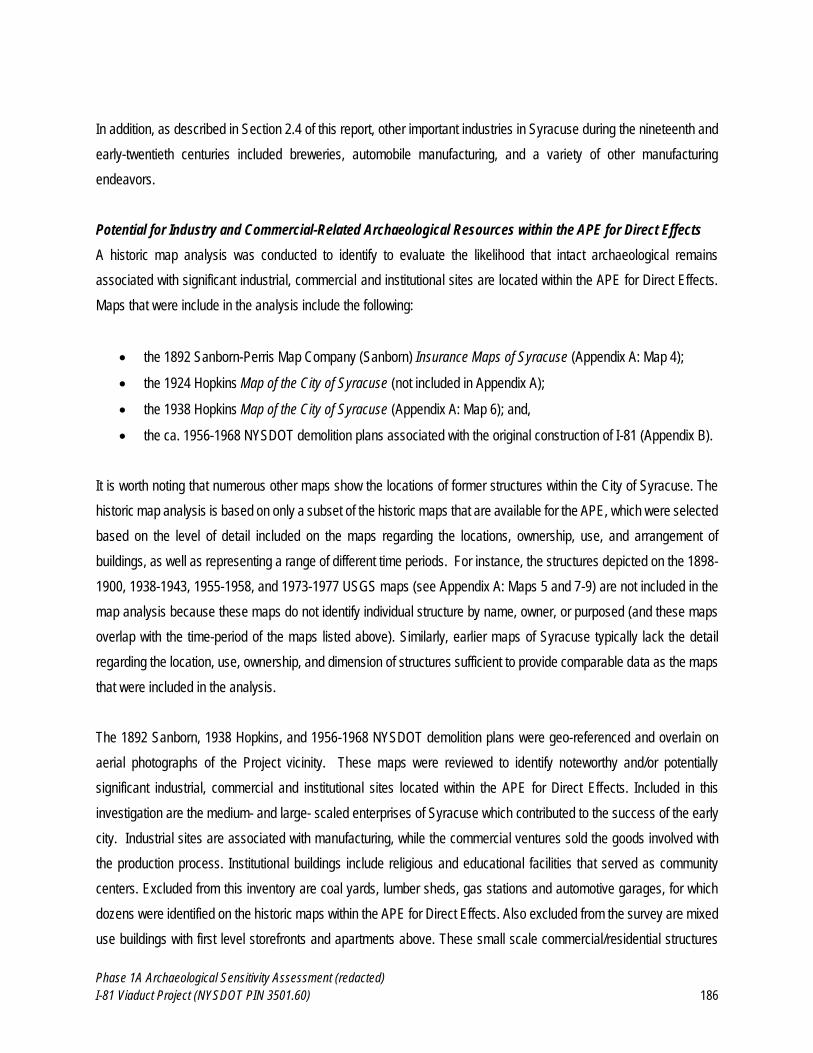
Phase 1A Archaeological Sensitivity Assessment (redacted)
I-81 Viaduct Project (NYSDOT PIN 3501.60) 186
In addition, as described in Section 2.4 of this report, other important industries in Syracuse during the nineteenth and
early-twentieth centuries included breweries, automobile manufacturing, and a variety of other manufacturing
endeavors.
Potential for Industry and Commercial-Related Archaeological Resources within the APE for Direct Effects
A historic map analysis was conducted to identify to evaluate the likelihood that intact archaeological remains
associated with significant industrial, commercial and institutional sites are located within the APE for Direct Effects.
Maps that were include in the analysis include the following:
the 1892 Sanborn-Perris Map Company (Sanborn) Insurance Maps of Syracuse (Appendix A: Map 4);
the 1924 Hopkins Map of the City of Syracuse (not included in Appendix A);
the 1938 Hopkins Map of the City of Syracuse (Appendix A: Map 6); and,
the ca. 1956-1968 NYSDOT demolition plans associated with the original construction of I-81 (Appendix B).
It is worth noting that numerous other maps show the locations of former structures within the City of Syracuse. The
historic map analysis is based on only a subset of the historic maps that are available for the APE, which were selected
based on the level of detail included on the maps regarding the locations, ownership, use, and arrangement of
buildings, as well as representing a range of different time periods. For instance, the structures depicted on the 1898-
1900, 1938-1943, 1955-1958, and 1973-1977 USGS maps (see Appendix A: Maps 5 and 7-9) are not included in the
map analysis because these maps do not identify individual structure by name, owner, or purposed (and these maps
overlap with the time-period of the maps listed above). Similarly, earlier maps of Syracuse typically lack the detail
regarding the location, use, ownership, and dimension of structures sufficient to provide comparable data as the maps
that were included in the analysis.
The 1892 Sanborn, 1938 Hopkins, and 1956-1968 NYSDOT demolition plans were geo-referenced and overlain on
aerial photographs of the Project vicinity. These maps were reviewed to identify noteworthy and/or potentially
significant industrial, commercial and institutional sites located within the APE for Direct Effects. Included in this
investigation are the medium- and large- scaled enterprises of Syracuse which contributed to the success of the early
city. Industrial sites are associated with manufacturing, while the commercial ventures sold the goods involved with
the production process. Institutional buildings include religious and educational facilities that served as community
centers. Excluded from this inventory are coal yards, lumber sheds, gas stations and automotive garages, for which
dozens were identified on the historic maps within the APE for Direct Effects. Also excluded from the survey are mixed
use buildings with first level storefronts and apartments above. These small scale commercial/residential structures
Phase 1A Archaeological Sensitivity Assessment (redacted)
I-81 Viaduct Project (NYSDOT PIN 3501.60) 187
proliferated throughout historic Syracuse, with many still standing today. Blocks of these small-scale mixed-use
buildings were located on North Salina Street, which was the main commercial center in Syracuse. For example, in
1892 on North Salina, between East Willow and the Oswego Canal, businesses included a grocery,
furniture/upholstery, laundry and tailor. Near the intersection of North Salina and Noxon Streets were other commercial
enterprises such as hotels and banks. As shown in the 1956-1968 NYSDOT demolition plans (see Appendix B), the
areas along Almond Street, south of Erie Boulevard, was primarily residential, with mixed-use commercial enterprises
on the first-floor of many buildings. These local businesses included restaurants, laundromats, bars, dry cleaning
shops, bakeries, liquor stores, and gift shops, and were omitted from the analysis presented below due to their scale
and frequency; however, the archaeological potential associated with these sites is addressed in Section 3.2.4 of this
report. In addition, the analysis includes only larger industrial, commercial and institutional sites located within Viaduct
Priority Area. The locations of MDS within Northern and Southern Interchanges at I-81/I-481 and the I-481 Eastern
Improvements areas of the APE for Direct Effects are depicted on the USGS maps from 1898, 1938 and 1955 (see
Appendix A: Maps 5 and 7-9). However, these areas are not included in the analysis presented herein.
The sites identified as potentially significant were assigned a Map Documented Structure (MDS) identifier (number),
which are listed in Table 3.3.2-1. The locations of these larger industrial, commercial, and institutional sites are
depicted in Appendix A: Maps 4, 6, and 11 and Appendix B.
Table 3.2.3-1. Mapped Industrial, Commercial, and Institutional Structures within the APE for Direct Effects.
MDS # 10
1892 Sanborn (Appendix A, Map 4)
1924 Hopkins (not included in Appendix)
1938 Hopkins (Appendix A, Map 6)
1955-56 NYSDOT Demolition Plans
(Appendix B)
1 Salina Salt District - - -
2 Eureka Chemical Company - - -
3 Excelsior Mill of the American Dairy Salt Co.
- - -
3a Syracuse Surplus Co. - -
4 Syracuse Lumber Co. - - -
4a Syracuse Wall Plaster Co. - -
5 W.H. Lynn Planing Mill & Heading Factory
- - -
5a Smith-Cafferty & Co. - -
6 Salina Course Salt Co. -
7 Salina Salt District - - -
7a - Homac Corp. -
7b - Burlingame Manufacturing Co. - -
10 The map studies revealed that some industrial and commercial buildings remained extant on their site for many decades, but in other cases,
buildings were constructed and demolished within a short period of time. To discern between these conditions, the MDS numbers were given a suffix for the latter scenario. For example, MDS 101 identifies the original building on the site as located on the 1892 Sanborn Map, while MDS 101a would represent a replacement building on the same site on a later map.
Phase 1A Archaeological Sensitivity Assessment (redacted)
I-81 Viaduct Project (NYSDOT PIN 3501.60) 188
MDS # 10
1892 Sanborn (Appendix A, Map 4)
1924 Hopkins (not included in Appendix)
1938 Hopkins (Appendix A, Map 6)
1955-56 NYSDOT Demolition Plans
(Appendix B)
8 Star Mill of New York Salt Co.
- - -
8a - Geo. Zett’s Brewery - -
9 Salt Springs Course Salt Co. - - -
10 Louis Burkhard Cooper Shop - - -
10a - Sheet Lathing Co. - -
11 Chas. Schug & Sons Cooper Shop
- - -
12 The Eureka Company Wall Plaster Works
- - -
12a Dickson Asphalt Plant - -
13 Empire Course Salt Company
- - -
13a - Hews & Co. Pottery Warehouse
- -
14 Lime and Plaster Mill - - -
15 Solar Salt Vats - - -
15a - Oak Knitting Co. - -
16 C. Listman Ice House - - -
16a - People’s Ice Co. - -
17 National Brewing Company Hester & Co. Warehouse - -
18 Syracuse Solar Salt Co. - - -
18a - C.C. Bradley & Sons Machine Works
- -
19 Thompson-Houston Electric Light Co.
- - -
19a Syracuse Lighting Co.
20 Syracuse Packing and Provision Co.
Kingan Provision Co. - -
21 Hoffman Bros. & Drescher Pork Packers
- - -
22 Rome, Watertown & Ogdensburg RR Freight
House
Freight Station - -
23 RR Passenger Station - - -
24 West Shore RR Gas House - - -
To Western End of APE - - -
25 Syracuse Dash Works - - -
26 Unnamed High School - - -
26a - Engine Company No. 12 - -
27 Germania Brewing Co. Bartels Brewery - -
28 Alhambra Skating Rink and Hall
- Alhambra Hall -
29 Geo H. McChesney Lumber Yard
- -
29a - - Pierce and Butler Radiator Corps.
-
30 Syracuse Heat and Power Co
- - -
31 Mowry & Barnes Meat Packing
- - -
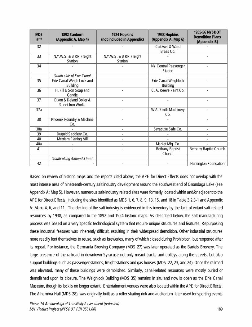
Phase 1A Archaeological Sensitivity Assessment (redacted)
I-81 Viaduct Project (NYSDOT PIN 3501.60) 189
MDS # 10
1892 Sanborn (Appendix A, Map 4)
1924 Hopkins (not included in Appendix)
1938 Hopkins (Appendix A, Map 6)
1955-56 NYSDOT Demolition Plans
(Appendix B)
32 - - Caldwell & Ward Brass Co.
-
33 N.Y.W.S. & B RR Freight Station
N.Y.W.S. & B RR Freight Station
- -
34 - - NY Central Passenger Station
-
South side of Erie Canal
35 Erie Canal Weigh Lock and Building
- Erie Canal Weighlock Building
-
36 H. Fill & Son Soap and Candle
- C. A. Reeve Paint Co. -
37 Dixon & Deland Boiler & Sheet Iron Works
- - -
37a - - W.A. Smith Machinery Co.
-
38 Phoenix Foundry & Machine Co.
- - -
38a - - Syracuse Safe Co. -
39 Duguid Saddlery Co. - - -
40 Merriam Planing Mill - - -
40a - - Market Mfg. Co. -
41 - - Bethany Baptist Church
Bethany Baptist Church
South along Almond Street
42 - - - Huntington Foundation
Based on review of historic maps and the reports cited above, the APE for Direct Effects does not overlap with the
most intense area of nineteenth-century salt industry development around the southwest end of Onondaga Lake (see
Appendix A: Map 5). However, numerous salt-industry related sites were formerly located within and/or adjacent to the
APE for Direct Effects, including the sites identified as MDS 1, 6, 7, 8, 9, 13, 15, and 18 in Table 3.2.3-1 and Appendix
A: Maps 4, 6, and 11. The decline of the salt industry is evidenced in this inventory by the lack of extant salt-related
resources by 1938, as compared to the 1892 and 1924 historic maps. As described below, the salt manufacturing
process was based on a very specific technological system that require unique structures and features. Repurposing
these industrial features was inherently difficult, resulting in their widespread demolition. Other industrial structures
more readily lent themselves to reuse, such as breweries, many of which closed during Prohibition, but reopened after
its repeal. For instance, the Germania Brewing Company (MDS 27) was later operated as the Bartels Brewery. The
large presence of the railroad in downtown Syracuse not only meant tracks and trolleys along the streets, but also
support buildings such as passenger stations, freight stations and gas houses (MDS 22, 23, and 24). Once the railroad
was elevated, many of these buildings were demolished. Similarly, canal-related resources were mostly buried or
demolished upon its closure. The Weighlock Building (MDS 35) remains in situ and now is open as the Erie Canal
Museum, though its lock is no longer extant. Entertainment venues were also located within the APE for Direct Effects.
The Alhambra Hall (MDS 28), was originally built as a roller skating rink and auditorium, later used for sporting events
Phase 1A Archaeological Sensitivity Assessment (redacted)
I-81 Viaduct Project (NYSDOT PIN 3501.60) 190
as well. The Huntington Foundation (MDS 42) owned one of the few institutional buildings along Almond Street, and
provided family leisure activities to the disadvantaged Ninth Ward neighborhood that would eventually be demolished
for Interstate 81.
Potential for Salt-Industry Related Archaeological Resources within the APE for Direct Effects
The salt industry occupies an elevated level of importance in the history of Syracuse. Salt production included a variety
of wood and metal structures and systems. Salt wells were comprised of iron tubes sunk to depths of 250 to 300 feet,
connected to lift pumps that poured salt water into a cistern beneath a pump house, then to a distributing reservoir via
steam pumps. The salt water was then fed by gravity through wooden logs and flumes to salt blocks and vats. While
solar salt was manufactured using primarily wooden equipment, salt produced in boiling blocks required iron kettles
and cylinders (EPC, 1883; Werner, 1917; Murphy, 1949).
One description of solar salt vats noted that “the structures for the manufacture of solar salt consisted of long parallel
rows of shallow wooden vats, sixteen or eighteen feet wide and from eight to twelve inches deep, supported on wooden
posts and provided with hip-roof covers on rollers, which are drawn over them in bad weather” (EPC, 1883). The
locations of solar vats are depicted on late-nineteenth-century historic maps (see Appendix A: Maps 4 and 5) within
and the areas adjacent to the APE for Direct Effects.
Previous cultural resources investigations (Hartgen, 2000b; CCRG, 2001b; Hartgen, 2001a; AAS, 2016; see Appendix
A: Map 3) conducted within the area west of Interstate 81 have identified structural remains (including wooden pipes
and troughs, and foundations of pump houses) associated with the salt industry between 4 and 8 feet beneath the
surface. Geotechnical boring logs associated with one previous survey (CCRG, 2001b) indicated that the modern
ground surface is approximately 12 feet (4 meters) above the historic ground surface in the vicinity of the former salt
works along Solar Street. The area had contained salt sheds during the nineteenth century and CCRG (2001b) noted
that recent surveys by Hartgen (2000b; 2001a) had identified structural remains associated with the historic salt industry
in the area. In addition, a 2016 cultural resources survey (AAS, 2016) noted the presence of somewhat intact limestone
foundations on the ground surface associated with the previously recorded Pump House and Salt Manufacturing Site
(USN 06740.001211) eligible for listing on the S/NRHP.11
As previously noted, four previous archaeological surveys have addressed the potential for archaeological remains
related to the salt industry, and nineteenth-century industrial development more generally, to occur within the Project
11 This site is located approximately 1,700 feet southwest of the APE for Direct Effects.
Phase 1A Archaeological Sensitivity Assessment (redacted)
I-81 Viaduct Project (NYSDOT PIN 3501.60) 191
APE (the locations of these surveys are shown in Appendix A: Map 3). The relevant findings of the surveys are
discussed below:
Hartgen (2000b) reports the identification of buried wood (potentially the remains of salt works-related
structures) in one bore hole on the west side of the existing Kirkpatrick Street Pump Station (at 12.5 ft below
surface), in two bore holes on the West side Van Rensselaer St. south of the intersection with Geddes St (at
10.3 ft and 15.5 ft below surface), and in one bore hole immediately north of Bear St. on the east side of Van
Rensselaer St. (at 12.5 ft below surface). Four bore holes on Van Rensselaer St. between Hiawatha Blvd and
Bear St. identified find sandy silt containing shells which was interpreted by Hartgen (2000b) as representing
undisturbed soil. Therefore, the area bounded by Kirkpatrick St., Geddes Street, Bear St. and the Syracuse
Inner Harbor is considered to be highly sensitive to contain intact archaeological materials related to the
historic salt industry. This sensitivity also extends along Van Rensselaer St. to approximately mid-way
between Bear St. and Hiawatha Boulevard. Hartgen’s (2000b) project area is in close proximity to but does
not overlap with the current APE for Direct Effects.
CCRG (2001b) examined a project area on Solar Street between Bear and Plum and extending approximately
1 block east and west from Solar Street along the cross streets (Bear, Kirkpatrick, Court [actually extending
two blocks east along Court], Spencer, Division, and Plum). They noted that remains of archaeological
features related to the historic salt industry had been identified at depths of approximately 4 ft (1.2 m) below
the modern ground surface and lower. Therefore, this entire area is considered to be highly sensitive to contain
archaeological features related to the historic salt industry, except where significant previous ground
disturbance can be documented. CCRG’s (2001b) project area partially overlaps with the current APE for
Direct Effects.
Hartgen (2001a) examined six discrete project areas in the vicinity of Jefferson Street and Onondaga Creek
southwest of the current APE for Direct Effects. They found all of the areas examined to be highly sensitive
for archaeological materials related to the nineteenth-century industrial development of the City of Syracuse.
AAS (2016), examined a project area on the northwestern half of the oblong block formed by Spencer Street
to the north, Maltbie Street to the east, Evans Street to the south, and Leavenworth Ave. to the west. They
assigned the area a high level of sensitivity to contain archaeological remains related to the nineteenth-century
salt industry. This area is immediately adjacent to the current APE for Direct Effects.
In addition to these archaeological investigations that focused on the salt industry, three previous cultural resources
investigations (Hartgen, 2003a; Hartgen, 2009b; Hunter, 2009) conducted adjacent to the APE for Direct Effects have
identified below-ground structural remains of other industrial and commercial buildings dating to the late 19th century.
All three projects were located at the Clinton Station Site which was part of the Clinton Street CSO Abatement Project
Phase 1A Archaeological Sensitivity Assessment (redacted)
I-81 Viaduct Project (NYSDOT PIN 3501.60) 192
between Onondaga Creek to the west and the New York, Susquehanna, and Western Railroad right-of-way to the east,
north of Dickerson Street and south of Walton Street. This area is approximately 350 feet (107 m) west of the APE for
Direct Effects for the current Project. The methods and findings of the studies are summarized below:
Hartgen (2003b) excavated nine backhoe trenches throughout the project area for the Clinton Street CSO
Abatement Project at the Clinton Station Site. The backhoe trenches identified two historic archaeological
sites: the Railroad Machine Shop Site (USN 06740.008692) and the Dickerson Street Historic Site (USN
06740.008691). The S/NRHP eligibilities of both sites were left undetermined at the conclusion of the Phase
1B survey. Hartgen (2003b) recommended avoidance or Phase II investigations for the Railroad Machine
Shop and avoidance or Phase II/III investigations for the Dickerson Street Historic Site.
In 2007, Hartgen (2009a) conducted Phase II and III investigations at the Dickerson Street Historic Site (USN
06740.008691). The site was mechanically stripped of between 2.2 and 6.6 feet of fill to expose features and
foundations associated with historic structures. Seven excavation units were then placed across the site to
explore potential features and foundation walls. Hartgen (2009a) identified foundations and fill deposits dating
to between ca. 1870 and 1930. The site consists of primarily commercial structures associated with the historic
railyard adjacent to the site; however, a minor residential component which included the childhood home of
noted children’s author Howard Garis was also present. Hartgen (2009a) identified 12 historic features and a
moderately sized historic debris deposit at the site. Much of the site was excavated during the Phase II/III
investigations in 2007 and the remainder of the site may have been destroyed by the construction of the CSO
facility. Currently, the vicinity of the site is covered by asphalt parking lots and one building.
Hunter (2009) completed Phase III data recovery investigations for the Railroad Machine Shop Site (USN
06740.008692). An approximately 7,000-square-foot area was mechanically stripped of between 2 and 6 feet
of fill to expose features and foundations of the machine shop. Nine 5 x 5 ft (1.5 x 1.5 m) and 2.5 x 10 ft (0.8
x 3.0 m) excavation units were placed throughout the remains of the shop and the excavations exposed
extensive post-demolition fill deposits throughout the site. No remains of the original machine shop, which
was destroyed during an 1869 fire, were identified due to the extensive disturbance by fill and foundation
construction for the second machine shop (which was constructed at the location following the 1869 fire).
However, Hunter (2009) determined that significant data were recovered from the site excavations pertaining
to the late 19th century history of the Delaware, Lackawanna, and Western Railroad, and the site was
recommended eligible for listing on the S/NRHP under criteria C and D. Hunter (2009) recommended that the
finding of adverse effect for the site had been resolved by the Phase III data recovery and historic context
development and recommended no further archaeological work for the site.
Phase 1A Archaeological Sensitivity Assessment (redacted)
I-81 Viaduct Project (NYSDOT PIN 3501.60) 193
As described in Section 2.6 of this report and shown in Appendix A: Map 10, most of the APE for Direct Effects includes
significant fill deposits. As described above, previous archaeological investigations have identified or determined the
potential for archaeological resources associated with industry-related structures and features to be located beneath
fill deposits in areas adjacent to the APE for Direct Effects. The locations of the map-documented industrial structures
within the APE for Direct Effects, where there is a high potential for industry related archaeological resources to be
present, are illustrated in Appendix A: Map 11.
Potential Significance of Salt Industry and other Commercial-Industrial Archaeological Sites
As described above and in Section 2.4 of this report, industry, commerce and institutions (including the salt industry)
played a critical role in the historical development and economy of the City of Syracuse and surrounding region.
Archaeological sites associated with the salt industry (or other industries) located within the APE for Direct Effects
could potentially be eligible for listing on the NRHP under Criterion D. A site potentially eligible under Criterion D will
evaluated in terms of the site’s ability to provide significant data pertinent to answering research questions related to
local, regional, or national history. This will be contingent on the physical integrity of the site, but also the density and
diversity of archaeological artifacts and features it contains. In order to be considered eligible under Criterion D, the
site will typically contain a large number of archaeological features and/or artifacts within undisturbed stratified deposits
that can be dated through diagnostic artifacts, superposition, or other means In the case of
industry/commerce/institution-related features, these sites would need to contribute significant information to our
understanding of historic manufacturing and production technology and/or economic practices, sufficient to broaden
our understanding of this important aspect of local and regional history.
However, the locations, ownership, use, and physical arrangement of the various industrial and commercial sites
throughout the APE for Direct Effects are very well documented on historic maps of Syracuse (e.g., Appendix A: Maps
4 and 6 and Appendix B). In addition, historical sources provide considerable detail regarding the history of many of
the larger industries and commercial enterprises in Syracuse (e.g., see Carter, 2008). It is assumed that foundations
and other structural remains associated with many of these larger commercial buildings are located throughout the
APE for Direct Effects. In most cases, the foundations or structural remains unto themselves are unlikely to be
considered archaeologically or historically significant, in large part because the location, dimensions, and arrangement
of those buildings can be well understood based on review of historic cartographic sources and archaeological data is
unlikely to contribute significant new information. Therefore, although these sites are potentially ubiquitous throughout
the APE for Direct Effects, archaeological investigation would only be warranted in those instances where
archaeological data has the potential to contribute significant, meaningful new information.
Phase 1A Archaeological Sensitivity Assessment (redacted)
I-81 Viaduct Project (NYSDOT PIN 3501.60) 194
Summary: Based on review of historic maps (e.g., Appendix A: Maps 4 and 6 and Appendix B), structures associated
with the early salt industry, as well as numerous other industrial, commercial, and institutional sites, were located within
and adjacent to the APE for Direct Effects (see Table 3.2.3-1). The history of construction and replacement of these
buildings are well documented on historical maps and in photographs of Syracuse. As described in Section 2.6 of this
report and shown in Appendix A: Map 10, most portions of the APE include significant fill deposits. Previous
archaeological investigations have identified or determined the potential for archaeological resources associated with
industry-related structures and features to be located beneath fill deposits in areas adjacent to the APE for Direct
Effects. The locations of the map-documented industrial structures within the APE for Direct Effects, where there is a
high potential for industry related archaeological resources to be present, are illustrated in Appendix A: Maps 4, 6, and
11. Archaeological sites associated with the salt industry (or other industries) located within the APE for Direct Effects
could potentially be eligible for listing on the NRHP under Criterion D if these sites contribute significant information to
our understanding of historic manufacturing and production technology and/or economic practices, sufficient to broaden
our understanding of this important aspect of local and regional history. It is assumed that foundations and other
structural remains associated with many of these larger commercial buildings are located throughout the APE for Direct
Effects. In most cases, the foundations or structural remains unto themselves are unlikely to be considered
archaeologically or historically significant, in large part because the location, dimensions, and arrangement of those
buildings can be well understood based on review of historic cartographic sources and archaeological data is unlikely
to contribute significant new information. Therefore, although these sites are potentially ubiquitous throughout the APE
for Direct Effects, archaeological investigation would only be warranted in those instances where archaeological data
has the potential to contribute significant, meaningful new information.
3.2.4 Potential for Residential and Small-Scale Commercial Archaeological Sites
As described in Section 2.4.6 of this report, the construction of Interstates 81 and 690 through Syracuse required
demolition of large portions of city neighborhoods including much of the Fifteenth Ward, which was home to the highest
concentration of African-American and Jewish populations in the city (Stamps and Stamps, 2008; Ducre, 2012). It is
estimated 800-900 families were displaced by the construction of highways in the Fifteenth Ward (Knight, 2007). Areas
that were demolished included 103 acres of land in four contiguous census tracts that were predominately African-
American and poor. Many residences, dozens of African-American-owned businesses, and nearly all of the African-
American churches in the city were destroyed (Stamps and Stamps, 2008). Combined with the Near East Side Urban
Renewal Area, the routing of an elevated highway through downtown caused the most radical change to the built
environment since the construction of the Erie Canal. It is anticipated that archaeological features and deposits
associated with these residential and commercial properties, as well as archaeological features and artifacts associated
with earlier nineteenth and twentieth-century occupants, are located throughout the APE for Direct Effects.
Phase 1A Archaeological Sensitivity Assessment (redacted)
I-81 Viaduct Project (NYSDOT PIN 3501.60) 195
Historic Map Analysis
Hundreds of former residential and small-scale commercial structures are depicted on historic maps within the APE for
Direct Effects (see Appendix A: Maps 4-9 and Appendix B). When reviewing these maps, the scale of the
transformation of the City of Syracuse wrought by urban renewal and the construction of highways is profound (see
Section 2.4.6 of this report). The 1892 Sanborn atlas, 1938 Hopkins Map, and 1955-1966 NYSDOT demolition plans
(Appendix A; Maps 4 and 6 and Appendix B, respectively) provide significant detail regarding the location, dimensions,
and in some instances ownership or use of buildings that were formerly located within the APE for Direct Effects.
As illustrated in Appendix B, NYSDOT record plans provide considerable detail regarding the extent and nature of
disturbance associated with demolition and construction contracts for I-81 and I-690 (NYSDOT, 1955-1983). Section
2.4.6 of this report discusses the demolition of buildings under the Near East Side Urban Renewal Area (NESURA)
plan (including the proposed path of Interstate 81), which began in 1962 and continued until 1966. Under the NESURA
plan, 633 structures were demolished on 450 parcels, which resulted in the displacement of a total of 838 families and
304 businesses. Buildings were demolished in eight groups based on locations specified in contracts labeled D-1
through D-8 (the “D” indicating “demolition”). Appendix B of this report includes a sample of geo-referenced copies of
the NYSDOT demolition plans overlain on current aerial photographs (along Almond Street).
EDR digitized the locations of structures shown on the ca.1955-1966 NYSDOT demolition plans within the APE for
Direct Effects, which resulted in the mapping of 952 former (demolished) structure locations (see Appendix A: Maps
10 and 11). These data include only those structures that were standing at the time that the NESURA demolition
activities were undertaken (and include those areas where demolition plans were available). Therefore, the locations
of earlier structures which may have been located within the APE for Direct Effects, but had been demolished prior to
the 1950s, are not included in this analysis. However, most of the structures included in the demolition plans are
depicted on the earlier maps (e.g., the 1892 Sanborn atlas) for which comparable data is available and can be assumed
to represent structures that were built throughout the nineteenth as well as early-twentieth centuries. The digitized
locations of the structures demolished during NESURA are indicative of the density of development (and demolition)
that occurred within these portions of the city and provide a robust data set for assessing the potential for historic period
archaeological sites to be present within the APE for Direct Effects.
Each set of record plans is identified by a contract number, most of which consist of a letter (or combination of letters)
followed by a two-digit numeral, a hyphen, and another two-digit numeral (e.g., C54-16). In this naming system, the
first two-digit numeral refers to the fiscal year that the contract was let and the second numeral specifies the sequence
of contracts within that year (i.e., C54-16 is the sixteenth contract in the year 1954). The record plans for each
demolition contract typically include a schedule (or list) of the buildings to be demolished. These are presented in a
Phase 1A Archaeological Sensitivity Assessment (redacted)
I-81 Viaduct Project (NYSDOT PIN 3501.60) 196
table that lists: ”Item No.”, “Location” (street address), “Reputed Owner”, “Map No.”, “Parcel No.”, and “Structure” (a
description of the primary structure or structures on the site to be demolished). An example of one of these demolition
lists is included as Figure 3.2.4-1. In addition, each record plan includes detailed mapping that identifies the buildings
to be demolished under that contract (see Figure 3.2.4-2 and Appendix B for examples).
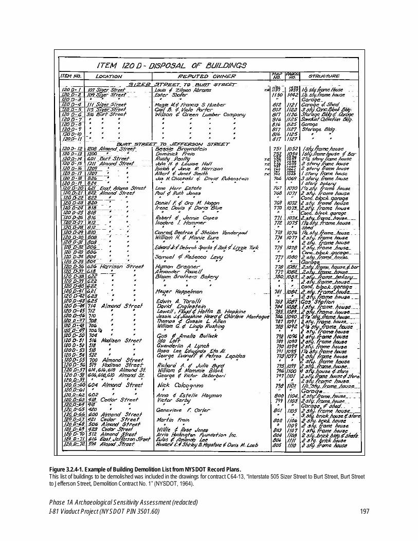
Phase 1A Archaeological Sensitivity Assessment (redacted)
I-81 Viaduct Project (NYSDOT PIN 3501.60) 197
Figure 3.2.4-1. Example of Building Demolition List from NYSDOT Record Plans. This list of buildings to be demolished was included in the drawings for contract C64-13, “Interstate 505 Sizer Street to Burt Street, Burt Street to Jefferson Street, Demolition Contract No. 1” (NYSDOT, 1964).
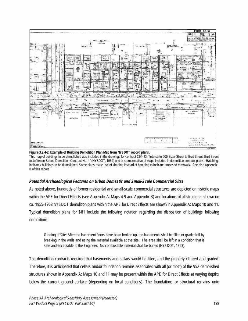
Phase 1A Archaeological Sensitivity Assessment (redacted)
I-81 Viaduct Project (NYSDOT PIN 3501.60) 198
Figure 3.2.4-2. Example of Building Demolition Plan Map from NYSDOT record plans. This map of buildings to be demolished was included in the drawings for contract C64-13, “Interstate 505 Sizer Street to Burt Street, Burt Street to Jefferson Street, Demolition Contract No. 1” (NYSDOT, 1964) and is representative of maps included in demolition contract plans. Hatching indicates buildings to be demolished. Some plans make use of shading instead of hatching to indicate proposed removals. See also Appendix B of this report.
Potential Archaeological Features on Urban Domestic and Small-Scale Commercial Sites
As noted above, hundreds of former residential and small-scale commercial structures are depicted on historic maps
within the APE for Direct Effects (see Appendix A: Maps 4-9 and Appendix B) and locations of all structures shown on
ca. 1955-1968 NYSDOT demolition plans within the APE for Direct Effects are shown in Appendix A: Maps 10 and 11.
Typical demolition plans for I-81 include the following notation regarding the disposition of buildings following
demolition:
Grading of Site: After the basement floors have been broken up, the basements shall be filled or graded off by
breaking in the walls and using the material available at the site. The area shall be left in a condition that is
safe and acceptable to the Engineer. No combustible material shall be buried (NYSDOT, 1963).
The demolition contracts required that basements and cellars would be filled, and the property cleared and graded.
Therefore, it is anticipated that cellars and/or foundation remains associated with all (or most) of the 952 demolished
structures shown in Appendix A: Maps 10 and 11 may be present within the APE for Direct Effects at varying depths
below the current ground surface (depending on local conditions). The foundations or structural remains unto
Phase 1A Archaeological Sensitivity Assessment (redacted)
I-81 Viaduct Project (NYSDOT PIN 3501.60) 199
themselves are unlikely to be considered archaeologically or historically significant, in large part because the location,
dimensions, and arrangement of those buildings can be well understood based on review of historic cartographic
sources and archaeological data is unlikely to contribute significant new information. Therefore, although these
structural (foundation) remains are potentially ubiquitous throughout the APE for Direct Effects, it is assumed that
archaeological investigation of these features is unlikely to contribute significant, meaningful new information.
However, potential artifact deposits and shaft features, which include privies, wells, and cisterns, are found on many
domestic and commercial properties in urban contexts and are potentially located in former yard areas adjacent to the
former locations of map-documented structures. In addition to their primary functions, these features were used as
disposal pits for household refuse both during and at the end of their use life (Wheeler, 2000b). These features are in
general robustly constructed with wood, brick, and stone, and because they are underground they are likely to remain
behind when the domestic or commercial structure they served is demolished or otherwise destroyed (Roberts and
Barrett, 1984; Heck and Balicki, 1998; Stottman, 2000). Unlike open trash heaps which are subject to disturbance from
plowing, demolition, and other actions, shaft features were sealed at the end of the feature’s useful life, preventing later
disturbances to the artifacts dumped inside. This enables tighter dating of sites through the glass and ceramics that
are frequently recovered from them.
From an archaeological perspective, privies are perhaps the best studied shaft features. Privy pits were used before
the adoption of centralized sewer and water systems, and supported allied economies through the removal of “night
soil” and its subsequent processing and sale for fertilizer (Geismar, 1993). More generally, privy studies reveal how
changes in sanitation laws were manifested in privy construction, the adoption of indoor toilets, and the installation of
sewers, practices which may be site-specific (Geismar, 1993; Wheeler, 2000a,b). Indeed, the very location of the privy
in relation to property lines, prevailing winds, lines-of-sight, etc., as well as the architecture of the vault itself, reflect
practical and cultural considerations of waste management practices through time (Carnes-McNaughton and Harper,
2000; McCarthy and Ward, 2000; Stottman, 2000; Wheeler, 2000b).
The current site of the City of Syracuse was a vast system of wetlands and natural drainage systems surrounding
Onondaga Lake. In 1821, the first law was passed to authorize planned drainage of these wetlands to alleviate the
threat of malaria, improve sanitation, and reclaim wetlands as usable land (SS, 1890). Despite this concern for
sanitation, the dumping of sewage and waste in natural waterways, including Yellow Brook, Harbor Brook, North Side
Brook, and Onondaga Creek, as well as the Erie and Oswego Canals, was a common practice and public health
concern during the nineteenth-century (Smith, 1904; Hardin, 1993). An 1890 address by Dr. John VanDuyn illustrated
the link between healthfulness and sanitation sewers with the Erie Canal:
Phase 1A Archaeological Sensitivity Assessment (redacted)
I-81 Viaduct Project (NYSDOT PIN 3501.60) 200
Later where the City Hall now stands there was a basin designed for anchoring boats by the Erie canal. Around
this were many houses of low character, and on the east side Howlett’s slaughterhouse from which was thrown
all its offal into the basin. This was a very sickly quarter for a long time (SS, 1890).
Mortality rates soared throughout the nineteenth century, a variety of fevers gripping the inhabitants of the region, who
attributed their poor health to a variety of causes, including their affinity for whiskey, the damp conditions of their food
storage cellars, and the proximity of stagnant wetlands (SS, 1890). In 1831, a cholera epidemic swept through
Syracuse, causing the loss of approximately 100 lives and spurring the creation of the first Board of Health (Hand,
1889). By 1834, the first sewer was built, connecting Mill Pond (the current site of Clinton Square) to Yellow Brook (at
Harrison Street between Salina and Warren Streets). A second, longer sewer, was installed only four years later, from
Lemon Street to Onondaga Creek along Washington Street (STD, 1890). On April 9, 1839, public ordinances were
created to prevent depositing of trash in the streets, prevent cattle from roaming in the city, and create a defined
streetscape with poured gravel, street signs, and limits on placement of buildings near the street (Bruce, 1891:144).
In 1847, South Salina Street inhabitants destroyed the dam that had created Mill Pond, attributing its high water to a
rash of fevers. The destruction of this dam allowed drainage of not only the site of Mill Pond, but of the surrounding
region, assisted by the construction of several additional sanitary sewers. The large swamp that had spanned from
Burnet Street at the north edge to Montgomery Street at the west edge and southeast past the limits of residential
development was drained into Onondaga Creek via a sewer that ran along Jefferson Street between Yellow Brook and
Onondaga Creek. A sewer was also installed north of the Erie Canal, along Canal Street between the weigh lock and
Catherine Street, with a north branch along McBride Street to Hawley Avenue (SS, 1890).
According to historical sources, most households and businesses that were located along a waterway (i.e., the Erie
Canal, Harbor Creek, Onondaga Creek, and Yellow Brook) were using the waterway as their primary disposal area for
waste. The first sewers were built to alleviate sanitation problems caused by the overuse of waterways for biological
waste. Improvements to the sewer and drainage systems of the older section of the city continued throughout the
nineteenth century, but residential expansion occurred faster than sewer systems could be designed and implemented,
and the canals and natural waterways continued to be used for refuse disposal. Newspaper reporters described the
Erie Canal in Syracuse as containing “quantities of drift wood, dead dogs, hogs, chickens”, and human bodies
(Williams, 1983):
As there was no current in the water that was in the [Erie Canal] basin, the place became a miserable, nasty
hole; and it was the dread of all inhabitants, because it tainted and infected the whole atmosphere with disease
(Strong, 1894, cited by Williams, 1983).
This leads me to the much hackneyed question of the open sewers- Onondaga creek and Harbor brook… Into
these the filth of the city in ever increasing quantities pours itself. Elsewhere confined and concealed, here it
Phase 1A Archaeological Sensitivity Assessment (redacted)
I-81 Viaduct Project (NYSDOT PIN 3501.60) 201
comes to light in the midst of thronging people, attaches itself to the bank and obstructions of its shallow carrier,
ferments and renders the neighborhood offensive by its unsavory odors (SS, 1890).
During early settlement of the region that would become the City of Syracuse, people obtained drinking water at first
from upland natural springs, then later from dug private property wells. The first public water well was located at the
intersection of Washington, Warren and East Genesee Streets. It was not until 1843 that the first formal water system
was implemented. The first reservoir in Onondaga County, Lodi Springs, was located at James Street hill, bounded
by Hawley Avenue, Fountain Street and Henderson Street. It was a stone-lined, six-by-eight feet wide well reinforced
by cement and water lime, with a system of pump logs that extended along Fayette and Almond Streets and associated
underground cisterns.
In 1849, two years after Syracuse was incorporated into a city, the Syracuse City Water Works Company was formed.
A Mayor-appointed Board of Water Commissioners engineered the 1894 water system that is still in use today, a water
pipeline from Skaneateles Lake to the City of Syracuse (Unknown, c. 1929). The first conduit laid was 30-inch diameter
cast iron, with a 1908 expansion to include both 30-inch and 42-inch diameter pipe. By 1922, approximately 240 miles
of cast iron pipes ranging from 4-36 inches in diameter were used to provide water to the City of Syracuse (Starbird,
1922).
It is likely that the sanitation and waste disposal practices were highly variable at domestic and commercial sites in
Syracuse, and that these practices changed both over time and were likely dependent on the wealth, social class,
and/or ethnicity of a given site’s occupants. Therefore, the presence and contents of privies and other shaft features
on various sites is also anticipated to be variable. In addition to assemblages of broken or disposed domestic goods
such as household ceramics and glass vessels, shaft features often include botanical and faunal remains that provide
information about what people in different social classes and ethnic groups ate, and how these may have changed
over time (Brown and Bowen, 1998; Cummings, 1994). More in-depth studies have examined parasite eggs and cysts
associated with whipworms and tapeworms to determine general health as well as variation in incidences of these
infections across social and economic lines (Faulkner et al., 2000; Fisher et al., 2007). Archaeological evidence
recovered from privies may also serve as reminders of the harsh realities faced by people in the past, offering glimpses
into private behaviors that were considered illegal, if not immoral (Mann, et al. 2000; Crist, 2005; Warner and
Genheimer, 2008).
The analysis of artifacts recovered from shaft features can provide much information on activities in the past, highlight
social dynamics and cultural attitudes towards sanitation, health, and the quality of daily life that cannot be gained from
historical documents alone (Peña and Denmon, 2000).
Phase 1A Archaeological Sensitivity Assessment (redacted)
I-81 Viaduct Project (NYSDOT PIN 3501.60) 202
Potential Significance of Residential and Small-Scale Historic-Period Archaeological Sites
Archaeological features, such as privies, cisterns, and wells, associated with former residential and small-scale
commercial properties, depending on their physical integrity, could potentially be eligible for listing on the NRHP under
Criterion D. Archaeological studies of urban life in the nineteenth and twentieth centuries include investigations of
individual urban sites as well as scholarly examinations of cities themselves (Staski, 2008). Archaeological research in
large urban areas such as New York City, Washington, D.C., and elsewhere have produced significant research that
has transformed current understandings of urban life in the past (e.g., Wall, 2005; Yamin, 2005). For instance, many
archaeological studies of urban sites have focused on the formation and maintenance of social identity by examining
how material artifacts were used to delineate class, ethnic, and gender boundaries (identities which influence and are
influenced by each other). Research focusing on ethnic identity in urban areas has primarily focused on the experiences
of Irish immigrants and African American individuals, and several important studies from tenements in New York City’s
Five Points neighborhood have demonstrated the importance of archaeology in understanding urban and ethnic
community history (Griggs, 1999; Brighton, 2008; Wall et al., 2008). Examinations of social class look at patterns of
household selection of consumer goods and other forms of acquisition to understand how low-, middle- and upper-
class individuals used their purchases to present themselves to others (Wall, 1999; Yamin, 2001). Examinations of
gender and gendered roles have demonstrated, for example, how urban housewives used teawares to project notions
of gentility and respectability, while excavations at former brothels reveal how some female prostitutes used their labor
to maintain their economic freedom (Seifert, 2005; Yamin, 2005). Numerous researchers have focused on the
relationship between urban cores and rural hinterlands. Cities are reliant on the labor and goods from the farms and
neighborhoods that surrounded them, which in turn are reliant on the goods and services found in cities. Transportation
networks enabled urban and rural people to interact in areas and ways they may not have otherwise, as well as enabling
the circulation of agricultural produce and finished goods from farm to city and back again (Somerville and Barton,
2012).
Archaeological studies of American cities are rich and complex, and have demonstrated that the rapid growth of
American cities in the nineteenth and twentieth centuries have their own histories that shaped them, underscoring the
importance of understanding local contexts and how the experiences of disparate groups of people have helped create
the nation (Mrozowski, 2008; Mullins and Warner, 2008). Small-scale, urban, domestic and commercial sites located
within the APE for Direct Effects could be eligible under Criterion D in terms of their ability to provide significant data
pertinent to answering research questions related to local, regional, or national history In the case of archaeological
features associated with domestic and small-scale commercial sites, these features would need to contribute significant
information to our understanding of important aspects of local and/or regional history.
Phase 1A Archaeological Sensitivity Assessment (redacted)
I-81 Viaduct Project (NYSDOT PIN 3501.60) 203
Potential for Residential Archaeological Resources within the APE for Direct Effects
Six previous cultural resources investigations (Hartgen, 2003b; 2009a; 2009b; PAF, 2003c; 2012; PCI, 2000; see
Appendix A: Map 3) conducted within and adjacent to the APE for Direct Effects (specifically within the Viaduct Priority
Area) have either identified residential archaeological sites or assessed the likelihood of identifying such sites.
Residential archaeological materials have been identified or anticipated both within downtown Syracuse (e.g., Clinton
Square) as well as in more peripheral settings (e.g., University Avenue). Based on the previous archaeological studies,
these types of sites can be expected to occur under 1 to 6 feet of fill and to date to the mid-19th through mid-20th
centuries. When encountered, residential archaeological sites have consisted primarily of stone foundations and debris
scatters/sheet middens. To date, no intact shaft features have been identified within or adjacent to the APE for Direct
Effects. The previously conducted archaeological studies that identified or otherwise discussed historic residential
archaeological sites are summarized below:
PCI (2000) conducted a Phase 1B archaeological investigation at the Clinton Square project location, at the
site of the current Clinton Square Park at the corner of North Salina and Water streets in downtown Syracuse.
The Phase 1B investigation consisted of combination of mechanized backhoe and hand excavations at five
locations identified as having a high potential to contain intact components of the Enlarged Erie Canal. As
discussed in Section 2.2 of this report, PCI (2000) identified two sites: USN 6740.004364, Clinton Square
Boat Basin, which was determined eligible for listing on the NRHP; and USN 6740.005256, historic residential
or commercial structural foundations, the NRHP eligibility of which is currently undetermined. The Clinton
Square project area overlaps with the current APE for Direct Effects.
During the Phase 1B survey for the Syracuse Armory House Project, PAF (2003c) excavated eight shovel
tests and 12 backhoe trenches. The subsurface testing identified the Syracuse Block 205 Historic Site (USN
06740.006101) which consists of four loci of foundations and artifacts, corresponding to three map-
documented residences and one map-documented commercial shop. The site contained intact stratigraphy
underneath approximately 14 to 54 inches (37 to 137 cm) of clay fill. The S/NRHP eligibility of the site is
currently undetermined. PAF (2003c) recommended either site avoidance or Phase II investigation if the site
could not be avoided. Currently, the site is located underneath a sports field and, to date, no Phase II
investigations have occurred at the site. The Syracuse Armory House project area occurs approximately 330
feet (101 meters) south of the APE for Direct Effects.
As previously discussed in Section 3.2.3, Hartgen (2003b) excavated nine backhoe trenches throughout
Clinton Street CSO Abatement Project area on the west side of downtown Syracuse. The backhoe trenches
identified two historic archaeological sites: the Railroad Machine Shop Site (USN 06740.008692), an industrial
Phase 1A Archaeological Sensitivity Assessment (redacted)
I-81 Viaduct Project (NYSDOT PIN 3501.60) 204
site, and the Dickerson Street Historic Site (USN 06740.008691), a combined commercial/residential site. The
S/NRHP eligibilities of both sites were left undetermined at the conclusion of the Phase 1B survey. Hartgen
(2003b) recommended avoidance or Phase II investigations for the Railroad Machine Shop Site and
avoidance or Phase II/III investigations for the Dickerson Street Historic Site. The Clinton Station CSO project
area occurs approximately 350 feet (107 meters) west of the current APE for Direct Effects.
In association with the Onondaga County CSO Lake Improvement Project, Hartgen (2009a) conducted Phase
II and III investigations at the Dickerson Street Historic Site (USN 06740.008691) on the southwest side of
downtown Syracuse. As noted in Sections 2.2 and 3.2.3 of this report, the Dickerson Street Historic Site dates
to between approximately 1870-1930. Hartgen (2003b) initially identified the site through the excavation of
backhoe trenches in the vicinity of the Dickerson Street Bridge over Onondaga Creek. One of the trenches
exposed the corner of a stone foundation and a wooden-lined shaft feature which was interpreted at the time
to represent a privy. Hartgen (2003b) estimated that both features dated to ca. 1900. They recommended
Phase II/III investigation occur at the site if it could not be avoided by the proposed project (Hartgen, 2003b).
Phase II/III data recovery was conducted at the site in 2007. The site was mechanically stripped of between
2.2 and 6.6 feet of fill to expose features and foundations associated with historical structures. Seven
excavation units were placed across the site to explore potential features and foundation walls. Hartgen
(2009a) identified foundations and fill deposits dating to between ca. 1870 and 1930. The site consists of
primarily commercial structures associated with the railyard, with a minor residential component which
included the childhood home of noted children’s author Howard Garis. Hartgen (2009a) identified 12 historic
features (including a sealed, stratified basement fill deposit) and a moderately sized historic debris scatter
associated with both businesses and residences. The possible shaft feature identified during the Phase 1B
survey was determined to be an ash deposit used to build up a retaining wall, rather than a privy or well.
Hartgen (2009a) excavated much of the site in 2007. Currently, the vicinity of the site is covered by an asphalt
parking lot. The Dickerson Street Historic Site occurs approximately 350 feet (107 m) west of the current APE
for Direct Effects.
Hartgen (2009b) conducted a Phase 1A cultural resources survey for the proposed Syracuse Connective
Corridor Project along Fayette Street, East Genesee Street, and University Avenue. Hartgen (2009b) found
mapped soils within the project area to consist largely of Urban Land, the exception being the portion of the
proposed project along University Avenue which is mapped as native soil. Hartgen (2009b) noted that while
much of the project route had been heavily disturbed by twentieth-century improvements to streets and
sidewalks, Fayette Park and Forman Park, as well as some residential lawns along East Genesee Street and
Phase 1A Archaeological Sensitivity Assessment (redacted)
I-81 Viaduct Project (NYSDOT PIN 3501.60) 205
University Avenue potentially remained undisturbed. Regarding historic archaeological sensitivity, Hartgen
(2009b) concluded that the entire area was highly sensitive for residential sites, but that “potential
archaeological significance begins at a depth of approximately one foot (0.3 m) below sidewalks, at 2.5 feet
(0.8 m) below curbs, and at 1.5 feet (0.5 m) below road surfaces” (Hartgen, 2009b:18). The Connective
Corridor project area overlaps with the current APE for Direct Effects.
PAF’s (2012) monitoring and data recovery plan for the East Genesee Street Reconstruction Project covers
the portion of East Genesee Street between Forman Street and University Avenue, including Forman Park,
east of downtown Syracuse. PAF (2012) summarized the conclusions of Hartgen’s (2009b) Phase 1A report
for the project, which had recommended limiting project disturbance in archaeologically sensitive areas as
well as final review of the project design by an archaeologist prior to construction, based on the moderate
sensitivity to encounter nineteenth- and twentieth-century historic archaeological remains (which would be
primarily residential in this area). The East Genesee Street Reconstruction Project overlaps with the current
APE for Direct Effects.
Summary: Hundreds of former residential and small-scale commercial structures are depicted on historic maps within
the APE for Direct Effects. EDR digitized the locations of structures shown on the ca.1955-1966 NYSDOT demolition
plans within the APE for Direct Effects, which resulted in the mapping of 952 former (demolished) structure locations
(see Appendix A: Maps 10 and 11). The digitized locations of the demolished structures are indicative of the density
of development (and demolition) that occurred within these portions of the city and provide a robust data set for
assessing the potential for historic period archaeological sites to be present within the APE for Direct Effects. The
foundations of these demolished structures unto themselves are unlikely to be considered archaeologically or
historically significant, in large part because the location, dimensions, and arrangement of those buildings can be well
understood based on review of historic cartographic sources and archaeological data is unlikely to contribute significant
new information. However, potential artifact deposits and shaft features, which include privies, wells, and cisterns, are
found on many domestic and commercial properties in urban contexts and are potentially located in former yard areas
adjacent to the former locations of map-documented structures. Archaeological features, such as privies, cisterns, and
wells, associated with former residential and small-scale commercial properties, depending on their physical integrity,
could potentially be eligible for listing on the NRHP under Criterion D. Archaeological studies of American cities are
rich and complex, and have demonstrated that the rapid growth of American cities in the nineteenth and twentieth
centuries have their own histories that shaped them, underscoring the importance of understanding local contexts and
how the experiences of disparate groups of people have helped create the nation. Numerous small-scale, urban,
domestic and commercial sites are anticipated to be located within the APE for Direct Effects and these sites could be
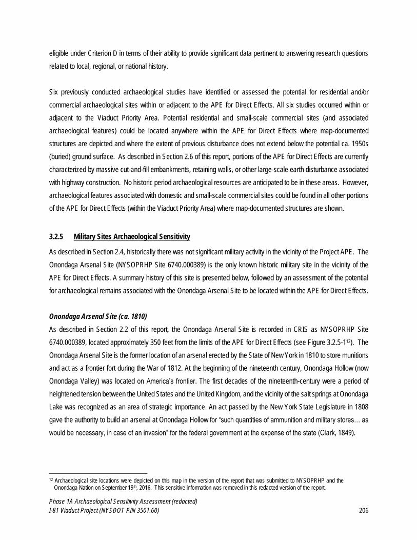
Phase 1A Archaeological Sensitivity Assessment (redacted)
I-81 Viaduct Project (NYSDOT PIN 3501.60) 206
eligible under Criterion D in terms of their ability to provide significant data pertinent to answering research questions
related to local, regional, or national history.
Six previously conducted archaeological studies have identified or assessed the potential for residential and/or
commercial archaeological sites within or adjacent to the APE for Direct Effects. All six studies occurred within or
adjacent to the Viaduct Priority Area. Potential residential and small-scale commercial sites (and associated
archaeological features) could be located anywhere within the APE for Direct Effects where map-documented
structures are depicted and where the extent of previous disturbance does not extend below the potential ca. 1950s
(buried) ground surface. As described in Section 2.6 of this report, portions of the APE for Direct Effects are currently
characterized by massive cut-and-fill embankments, retaining walls, or other large-scale earth disturbance associated
with highway construction. No historic period archaeological resources are anticipated to be in these areas. However,
archaeological features associated with domestic and small-scale commercial sites could be found in all other portions
of the APE for Direct Effects (within the Viaduct Priority Area) where map-documented structures are shown.
3.2.5 Military Sites Archaeological Sensitivity
As described in Section 2.4, historically there was not significant military activity in the vicinity of the Project APE. The
Onondaga Arsenal Site (NYSOPRHP Site 6740.000389) is the only known historic military site in the vicinity of the
APE for Direct Effects. A summary history of this site is presented below, followed by an assessment of the potential
for archaeological remains associated with the Onondaga Arsenal Site to be located within the APE for Direct Effects.
Onondaga Arsenal Site (ca. 1810)
As described in Section 2.2 of this report, the Onondaga Arsenal Site is recorded in CRIS as NYSOPRHP Site
6740.000389, located approximately 350 feet from the limits of the APE for Direct Effects (see Figure 3.2.5-112). The
Onondaga Arsenal Site is the former location of an arsenal erected by the State of New York in 1810 to store munitions
and act as a frontier fort during the War of 1812. At the beginning of the nineteenth century, Onondaga Hollow (now
Onondaga Valley) was located on America’s frontier. The first decades of the nineteenth-century were a period of
heightened tension between the United States and the United Kingdom, and the vicinity of the salt springs at Onondaga
Lake was recognized as an area of strategic importance. An act passed by the New York State Legislature in 1808
gave the authority to build an arsenal at Onondaga Hollow for “such quantities of ammunition and military stores… as
would be necessary, in case of an invasion” for the federal government at the expense of the state (Clark, 1849).
12 Archaeological site locations were depicted on this map in the version of the report that was submitted to NYSOPRHP and the
Onondaga Nation on September 19th, 2016. This sensitive information was removed in this redacted version of the report.
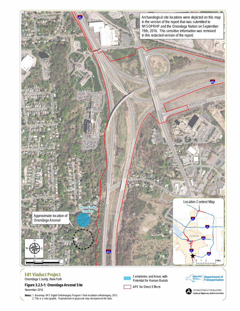
§̈¦81
§̈¦481
§̈¦81
UV173
Rock Cut Rd
E Brighton Ave
Lafay
ette R
d
Snell
Ter
Phelps Pl
Otto
St
Arsenal Dr
Menlo
Dr
Cordova St
E Florence Ave
Stevens Ave
Orlando Ave
Clarence Ave
Monti
cello
Dr S
Muns
on D
rCh
urchil
l Ave
Intrepid Ln
Sprin
gbroo
k Ave
Walrath Rd
E Glen Ave
Mayw
ood D
r
Fillmore AveSe
neca
Dr
Monti
cello
Dr N
House FamilyCemetery
µI-81 Viaduct ProjectOnondaga County, New York
Figure 3.2.5-1: Onondaga Arsenal Site
Notes: 1. Basemap: NYS Digital Orthoimagery Program 1-foot resolution orthoimagery, 2015. 2. This is a color graphic. Reproduction in grayscale may misrepresent the data.
0 300 600150Feet
November 2016
Cemeteries and Areas withPotential for Human Burials
APE for Direct Effects
^
§̈¦81
Syracuse
§̈¦690
§̈¦81
§̈¦90
§̈¦481
0 2 41 Miles
Location Context Map
Archaeological site locations were depicted on this map in the version of the report that was submitted to NYSOPRHP and the Onondaga Nation on September 19th, 2016. This sensitive information was removed in this redacted version of the report.
Approximate location ofOnondaga Arsenal
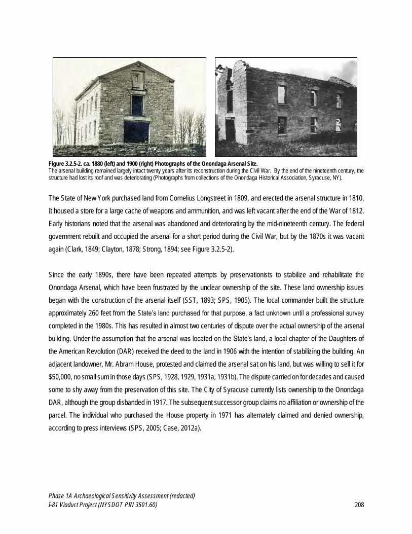
Phase 1A Archaeological Sensitivity Assessment (redacted)
I-81 Viaduct Project (NYSDOT PIN 3501.60) 208
Figure 3.2.5-2. ca. 1880 (left) and 1900 (right) Photographs of the Onondaga Arsenal Site. The arsenal building remained largely intact twenty years after its reconstruction during the Civil War. By the end of the nineteenth century, the structure had lost its roof and was deteriorating (Photographs from collections of the Onondaga Historical Association, Syracuse, NY).
The State of New York purchased land from Cornelius Longstreet in 1809, and erected the arsenal structure in 1810.
It housed a store for a large cache of weapons and ammunition, and was left vacant after the end of the War of 1812.
Early historians noted that the arsenal was abandoned and deteriorating by the mid-nineteenth century. The federal
government rebuilt and occupied the arsenal for a short period during the Civil War, but by the 1870s it was vacant
again (Clark, 1849; Clayton, 1878; Strong, 1894; see Figure 3.2.5-2).
Since the early 1890s, there have been repeated attempts by preservationists to stabilize and rehabilitate the
Onondaga Arsenal, which have been frustrated by the unclear ownership of the site. These land ownership issues
began with the construction of the arsenal itself (SST, 1893; SPS, 1905). The local commander built the structure
approximately 260 feet from the State’s land purchased for that purpose, a fact unknown until a professional survey
completed in the 1980s. This has resulted in almost two centuries of dispute over the actual ownership of the arsenal
building. Under the assumption that the arsenal was located on the State’s land, a local chapter of the Daughters of
the American Revolution (DAR) received the deed to the land in 1906 with the intention of stabilizing the building. An
adjacent landowner, Mr. Abram House, protested and claimed the arsenal sat on his land, but was willing to sell it for
$50,000, no small sum in those days (SPS, 1928, 1929, 1931a, 1931b). The dispute carried on for decades and caused
some to shy away from the preservation of this site. The City of Syracuse currently lists ownership to the Onondaga
DAR, although the group disbanded in 1917. The subsequent successor group claims no affiliation or ownership of the
parcel. The individual who purchased the House property in 1971 has alternately claimed and denied ownership,
according to press interviews (SPS, 2005; Case, 2012a).
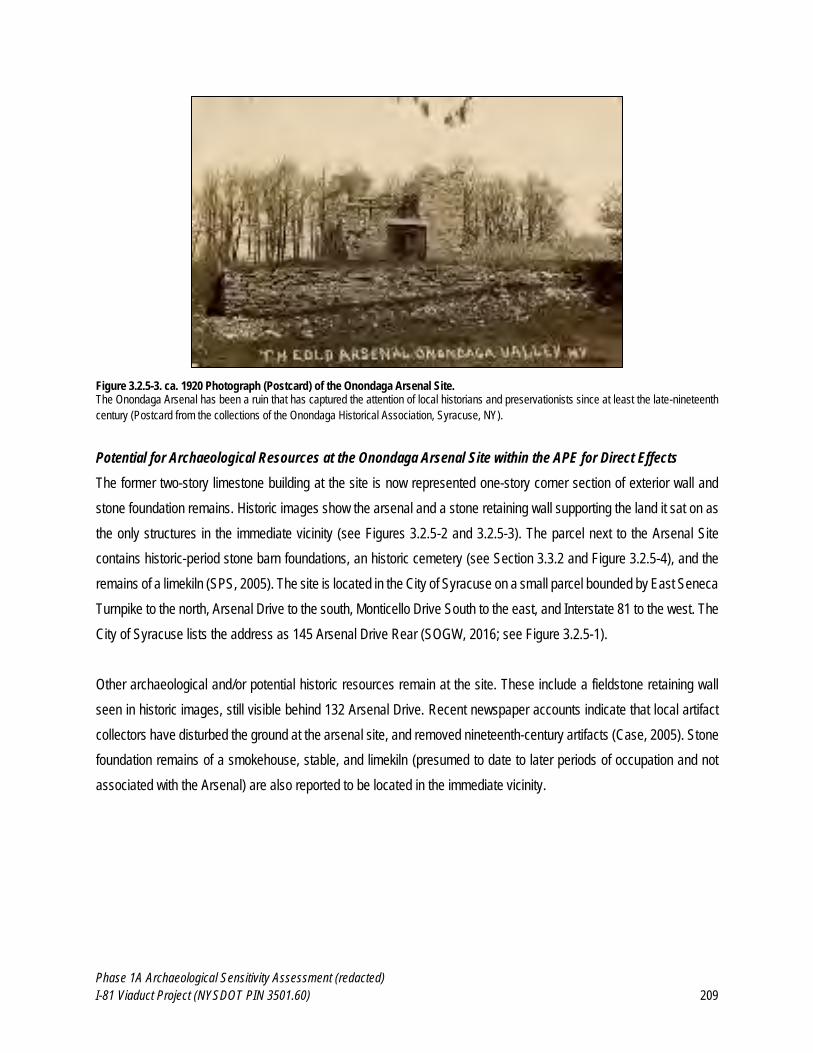
Phase 1A Archaeological Sensitivity Assessment (redacted)
I-81 Viaduct Project (NYSDOT PIN 3501.60) 209
Figure 3.2.5-3. ca. 1920 Photograph (Postcard) of the Onondaga Arsenal Site. The Onondaga Arsenal has been a ruin that has captured the attention of local historians and preservationists since at least the late-nineteenth
century (Postcard from the collections of the Onondaga Historical Association, Syracuse, NY).
Potential for Archaeological Resources at the Onondaga Arsenal Site within the APE for Direct Effects
The former two-story limestone building at the site is now represented one-story corner section of exterior wall and
stone foundation remains. Historic images show the arsenal and a stone retaining wall supporting the land it sat on as
the only structures in the immediate vicinity (see Figures 3.2.5-2 and 3.2.5-3). The parcel next to the Arsenal Site
contains historic-period stone barn foundations, an historic cemetery (see Section 3.3.2 and Figure 3.2.5-4), and the
remains of a limekiln (SPS, 2005). The site is located in the City of Syracuse on a small parcel bounded by East Seneca
Turnpike to the north, Arsenal Drive to the south, Monticello Drive South to the east, and Interstate 81 to the west. The
City of Syracuse lists the address as 145 Arsenal Drive Rear (SOGW, 2016; see Figure 3.2.5-1).
Other archaeological and/or potential historic resources remain at the site. These include a fieldstone retaining wall
seen in historic images, still visible behind 132 Arsenal Drive. Recent newspaper accounts indicate that local artifact
collectors have disturbed the ground at the arsenal site, and removed nineteenth-century artifacts (Case, 2005). Stone
foundation remains of a smokehouse, stable, and limekiln (presumed to date to later periods of occupation and not
associated with the Arsenal) are also reported to be located in the immediate vicinity.
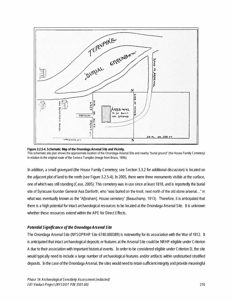
Phase 1A Archaeological Sensitivity Assessment (redacted)
I-81 Viaduct Project (NYSDOT PIN 3501.60) 210
Figure 3.2.5-4. Schematic Map of the Onondaga Arsenal Site and Vicinity. This schematic site plan shows the approximate location of the Onondaga Arsenal Site and nearby “burial ground” (the House Family Cemetery)
in relation to the original route of the Seneca Turnpike (image from Bruce, 1896).
In addition, a small graveyard (the House Family Cemetery; see Section 3.3.2 for additional discussion) is located on
the adjacent plot of land to the north (see Figure 3.2.5-4). In 2005, there were three monuments visible at the surface,
one of which was still standing (Case, 2005). This cemetery was in use since at least 1818, and is reportedly the burial
site of Syracuse founder General Asa Danforth, who “was buried on the knoll, next north of the old stone arsenal…” in
what was eventually known as the “A[braham]. House cemetery” (Beauchamp, 1913). Therefore, it is anticipated that
there is a high potential for intact archaeological resources to be located at the Onondaga Arsenal Site. It is unknown
whether these resources extend within the APE for Direct Effects.
Potential Significance of the Onondaga Arsenal Site
The Onondaga Arsenal Site (NYSOPRHP Site 6740.000389) is noteworthy for its association with the War of 1812. It
is anticipated that intact archaeological deposits or features at the Arsenal Site could be NRHP-eligible under Criterion
A due to their association with important historical events. In order to be considered eligible under Criterion D, the site
would typically need to include a large number of archaeological features and/or artifacts within undisturbed stratified
deposits. In the case of the Onondaga Arsenal, the sites would need to retain sufficient integrity and provide meaningful
Phase 1A Archaeological Sensitivity Assessment (redacted)
I-81 Viaduct Project (NYSDOT PIN 3501.60) 211
data sufficient to contribute significant information to our understanding of early-nineteenth-century military practices
or other aspects of local and regional history.
Summary: The Onondaga Arsenal Site is recorded in CRIS as NYSOPRHP Site 6740.000389, located approximately
350 feet from the limits of the APE for Direct Effects (see Figure 3.2.5-113). However, no formal archaeological
excavations have been conducted at the site to identify a comprehensive list of features or determine the precise
boundaries of the site. At minimum, the site is known to include stone structural remains and nineteenth-century
artifacts, and a cemetery that is reported to include burials associated with early-nineteenth-century settlers in
Onondaga County is located in the immediate vicinity. it is anticipated that there is a high potential for intact
archaeological resources to be located at the Onondaga Arsenal Site. However, it is unknown whether these
archaeological resources extend within the APE for Direct Effects.
3.3 Potential for Human Remains and Cemeteries
The potential for human remains to be located within the APE for Direct Effects needs to be considered due to religious,
cultural, and legal considerations associated with the potential disturbance or exhumation of human burials, as well as
archaeological considerations, which may consider human burials as potentially significant archaeological resources.
It is anticipated that future archaeological and/or construction monitoring activities that may occur in association with
the Project would need to be conducted in accordance and consideration of NYSOPRHP’s Human Remains Discovery
Protocol (NYSOPRHP, 2015) the Haudenosaunee Policy and Protocol on Human Remains (Haudenosaunee
Confederacy, 2009), and the Native American Graves Protection and Repatriation Act (NAGPRA) (Public Law 101-
601; 25 U.S.C. 3001-3013). Historical reports of the potential locations of Native American human remains, as well as
modern (existing) and historically documented cemeteries, are described below. The locations of potential and/or
historically reported human remains within or adjacent to the APE for Direct Effects are shown on Figure 3.3-1 and
Appendix A: Map 11.
13 Archaeological site locations were depicted on this map in the version of the report that was submitted to NYSOPRHP and the
Onondaga Nation on September 19th, 2016. This sensitive information was removed in this redacted version of the report.
Phase 1A Archaeological Sensitivity Assessment (redacted)
I-81 Viaduct Project (NYSDOT PIN 3501.60) 213
3.3.1 Potential for Native American Human Remains within the APE for Direct Effects
As described in Sections 3.1 and 3.2.1 of this report, there are numerous Native American archaeological sites and
settlements described by historians located throughout Onondaga County, including the vicinity of the Project.
Historical sources and newspaper accounts describe locations where Native American skeletal remains have been
disturbed in the past in areas located within or adjacent to the APE for Direct Effects – these areas are shown on Figure
3.3-1 and Appendix A: Map 11:
An unattributed 1882 newspaper clipping on file at the Onondaga Historical Society describes the discovery
of a skeleton associated with a small number of Native American artifacts adjacent to Oneida Street in
downtown Syracuse. Antiquarian William Beauchamp is quoted in the article as saying the skeleton appeared
to be on its own (i.e., not part of a larger cemetery) and approximately 150 years old. The article describes
the location in which the skeleton was discovered as a small knoll in an otherwise swampy area near
Onondaga Creek. Although nearby, Oneida Street is not within the APE for Direct Effects for the current
Project.
Numerous historical accounts describe Native American burials found in the vicinity of Onondaga Creek. A
1925 article in the Syracuse Post Standard (SPS) described historic accounts of multiple Native American
grave sites “near where Geddes crosses West Genesee” and “near the old Red Mill on the east bank of the
Creek near Genesee Street” (SPS, 1925). In addition, when the “Old Red Mill” on Genesee Street was torn
down in 1844, “literally hundreds” of Native American skeletons were encountered (Bruce, 1896; SHJ, 1939).
Benjamin Newkirk’s (or Nukerk’s) gravesite, believed to be the first European-American settler buried within
the Syracuse city limits, was located on a rise of land near the intersection of Geddes and West Genesee,
near the site of the Syracuse Pump House. In 1845, the landowner of Newkirk’s grave discovered a “line of
graves extending some 20 to 30 feet, in which there was nothing much left but the skulls and some bullets”
(PS, 1925). The looting of these graves is described as follows:
Besides the Kaneenda site, there were many Indian cabins along the west bank of Onondaga Creek, in Syracuse, in 1793, and also a modern Indian cemetery. When the west locks were constructed, over a hundred skeletons were taken up, and some were found in digging a canal for the red mill, on the east side. Newkirk's grave was near the site of the Syracuse Pump House, and Timothy C. Cheney relates that a little east of this grave, he “and other boys used to dig up the remains of Indians, for the purpose of getting possession of the beads, kettles, knives and other implements of warfare, or an ornamental dress that had been buried with t hem" (Bruce, 1896:33).
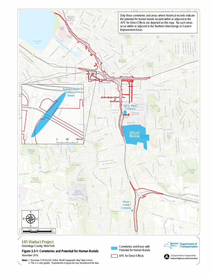
OakwoodCemetery
Old St. Mary'sCemetery
HouseFamily
Cemetery
µI-81 Viaduct ProjectOnondaga County, New York
Figure 3.3-1: Cemeteries and Potential for Human Burials
Notes: 1. Basemap: ESRI ArcGIS Online "World Topographic Map" Map Service. 2. This is a color graphic. Reproduction in grayscale may misrepresent the data.
0 2,000 4,0001,000Feet
November 2016
Cemeteries and Areas withPotential for Human Burials
APE for Direct Effects
Only those cemeteries and areas where historical records indicate the potential for human burials located within or adjacent to the APE for Direct Effects are depicted on this map. No such areas occur within or adjacent to the Northern Interchange or Eastern Improvement Areas.
Reported NativeAmerican
Burials
0 200 400Feet
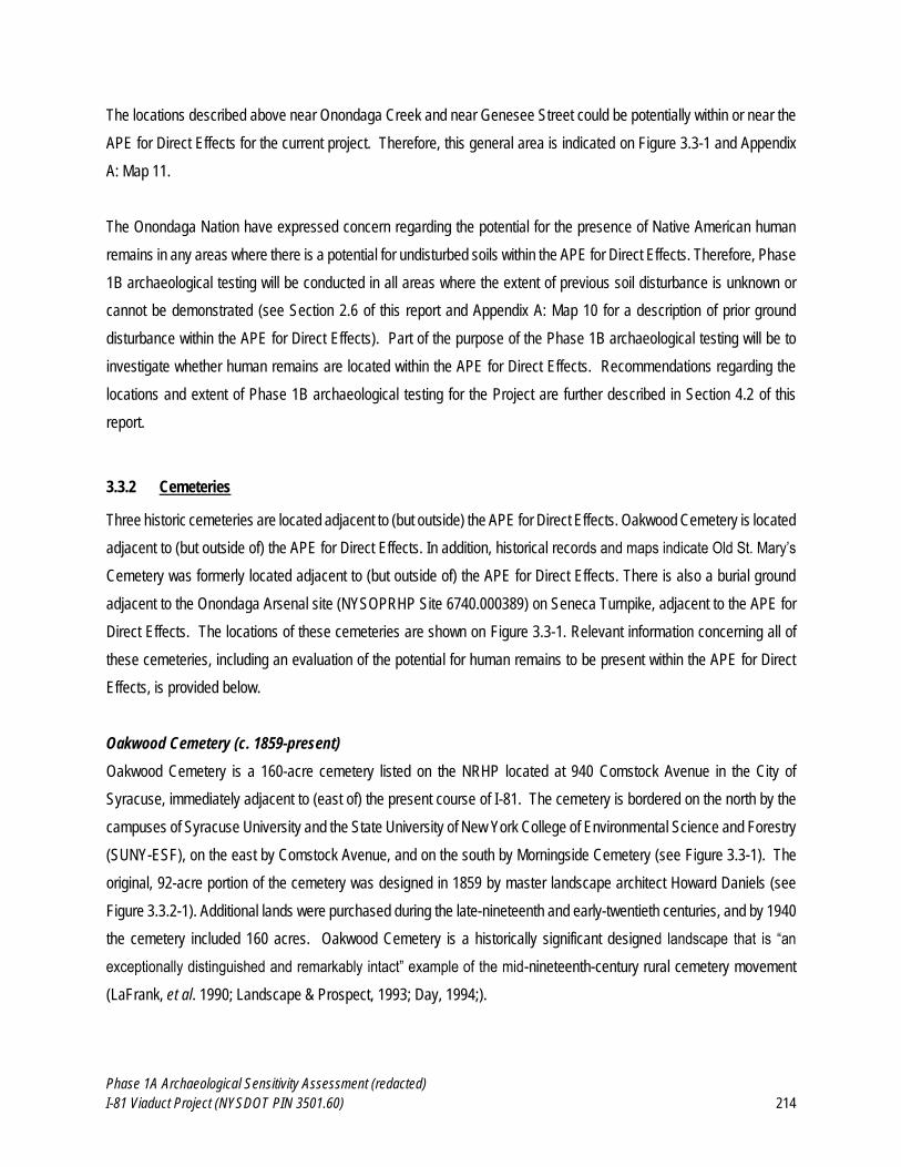
Phase 1A Archaeological Sensitivity Assessment (redacted)
I-81 Viaduct Project (NYSDOT PIN 3501.60) 214
The locations described above near Onondaga Creek and near Genesee Street could be potentially within or near the
APE for Direct Effects for the current project. Therefore, this general area is indicated on Figure 3.3-1 and Appendix
A: Map 11.
The Onondaga Nation have expressed concern regarding the potential for the presence of Native American human
remains in any areas where there is a potential for undisturbed soils within the APE for Direct Effects. Therefore, Phase
1B archaeological testing will be conducted in all areas where the extent of previous soil disturbance is unknown or
cannot be demonstrated (see Section 2.6 of this report and Appendix A: Map 10 for a description of prior ground
disturbance within the APE for Direct Effects). Part of the purpose of the Phase 1B archaeological testing will be to
investigate whether human remains are located within the APE for Direct Effects. Recommendations regarding the
locations and extent of Phase 1B archaeological testing for the Project are further described in Section 4.2 of this
report.
3.3.2 Cemeteries
Three historic cemeteries are located adjacent to (but outside) the APE for Direct Effects. Oakwood Cemetery is located
adjacent to (but outside of) the APE for Direct Effects. In addition, historical records and maps indicate Old St. Mary’s
Cemetery was formerly located adjacent to (but outside of) the APE for Direct Effects. There is also a burial ground
adjacent to the Onondaga Arsenal site (NYSOPRHP Site 6740.000389) on Seneca Turnpike, adjacent to the APE for
Direct Effects. The locations of these cemeteries are shown on Figure 3.3-1. Relevant information concerning all of
these cemeteries, including an evaluation of the potential for human remains to be present within the APE for Direct
Effects, is provided below.
Oakwood Cemetery (c. 1859-present)
Oakwood Cemetery is a 160-acre cemetery listed on the NRHP located at 940 Comstock Avenue in the City of
Syracuse, immediately adjacent to (east of) the present course of I-81. The cemetery is bordered on the north by the
campuses of Syracuse University and the State University of New York College of Environmental Science and Forestry
(SUNY-ESF), on the east by Comstock Avenue, and on the south by Morningside Cemetery (see Figure 3.3-1). The
original, 92-acre portion of the cemetery was designed in 1859 by master landscape architect Howard Daniels (see
Figure 3.3.2-1). Additional lands were purchased during the late-nineteenth and early-twentieth centuries, and by 1940
the cemetery included 160 acres. Oakwood Cemetery is a historically significant designed landscape that is “an
exceptionally distinguished and remarkably intact” example of the mid-nineteenth-century rural cemetery movement
(LaFrank, et al. 1990; Landscape & Prospect, 1993; Day, 1994;).
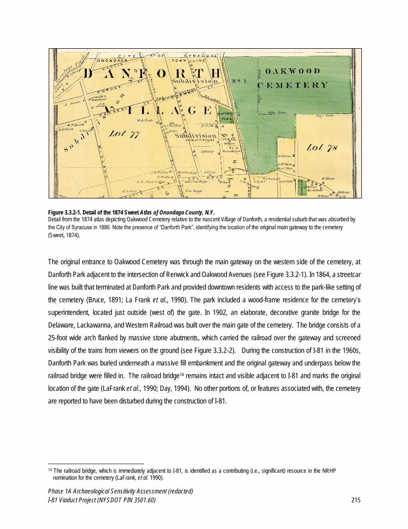
Phase 1A Archaeological Sensitivity Assessment (redacted)
I-81 Viaduct Project (NYSDOT PIN 3501.60) 215
Figure 3.3.2-1. Detail of the 1874 Sweet Atlas of Onondaga County, N.Y. Detail from the 1874 atlas depicting Oakwood Cemetery relative to the nascent Village of Danforth, a residential suburb that was absorbed by
the City of Syracuse in 1886. Note the presence of “Danforth Park”, identifying the location of the original main gateway to the cemetery
(Sweet, 1874).
The original entrance to Oakwood Cemetery was through the main gateway on the western side of the cemetery, at
Danforth Park adjacent to the intersection of Renwick and Oakwood Avenues (see Figure 3.3.2-1). In 1864, a streetcar
line was built that terminated at Danforth Park and provided downtown residents with access to the park-like setting of
the cemetery (Bruce, 1891; La Frank et al., 1990). The park included a wood-frame residence for the cemetery’s
superintendent, located just outside (west of) the gate. In 1902, an elaborate, decorative granite bridge for the
Delaware, Lackawanna, and Western Railroad was built over the main gate of the cemetery. The bridge consists of a
25-foot wide arch flanked by massive stone abutments, which carried the railroad over the gateway and screened
visibility of the trains from viewers on the ground (see Figure 3.3.2-2). During the construction of I-81 in the 1960s,
Danforth Park was buried underneath a massive fill embankment and the original gateway and underpass below the
railroad bridge were filled in. The railroad bridge14 remains intact and visible adjacent to I-81 and marks the original
location of the gate (LaFrank et al., 1990; Day, 1994). No other portions of, or features associated with, the cemetery
are reported to have been disturbed during the construction of I-81.
14 The railroad bridge, which is immediately adjacent to I-81, is identified as a contributing (i.e., significant) resource in the NRHP
nomination for the cemetery (LaFrank, et al. 1990).
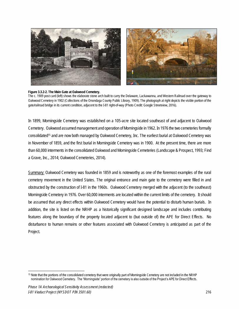
Phase 1A Archaeological Sensitivity Assessment (redacted)
I-81 Viaduct Project (NYSDOT PIN 3501.60) 216
Figure 3.3.2-2. The Main Gate at Oakwood Cemetery. The c. 1909 post card (left) shows the elaborate stone arch built to carry the Delaware, Lackawanna, and Western Railroad over the gateway to
Oakwood Cemetery in 1902 (Collections of the Onondaga County Public Library, 1909). The photograph at right depicts the visible portion of the
gate/railroad bridge in its current condition, adjacent to the I-81 right-of-way (Photo Credit: Google Streetview, 2016).
In 1899, Morningside Cemetery was established on a 105-acre site located southeast of and adjacent to Oakwood
Cemetery. Oakwood assumed management and operation of Morningside in 1962. In 1976 the two cemeteries formally
consolidated15 and are now both managed by Oakwood Cemetery, Inc. The earliest burial at Oakwood Cemetery was
in November of 1859, and the first burial in Morningside Cemetery was in 1900. At the present time, there are more
than 60,000 interments in the consolidated Oakwood and Morningside Cemeteries (Landscape & Prospect, 1993; Find
a Grave, Inc., 2014; Oakwood Cemeteries, 2014).
Summary: Oakwood Cemetery was founded in 1859 and is noteworthy as one of the foremost examples of the rural
cemetery movement in the United States. The original entrance and main gate to the cemetery were filled in and
obstructed by the construction of I-81 in the 1960s. Oakwood Cemetery merged with the adjacent (to the southeast)
Morningside Cemetery in 1976. Over 60,000 interments are located within the current limits of the cemetery. It should
be assumed that any direct effects within Oakwood Cemetery would have the potential to disturb human burials. In
addition, the site is listed on the NRHP as a historically significant designed landscape and includes contributing
features along the boundary of the property located adjacent to (but outside of) the APE for Direct Effects. No
disturbance to human remains or other features associated with Oakwood Cemetery is anticipated as part of the
Project.
15 Note that the portions of the consolidated cemetery that were originally part of Morningside Cemetery are not included in the NRHP
nomination for Oakwood Cemetery. The “Morningside” portion of the cemetery is also outside of the Project’s APE for Direct Effects.
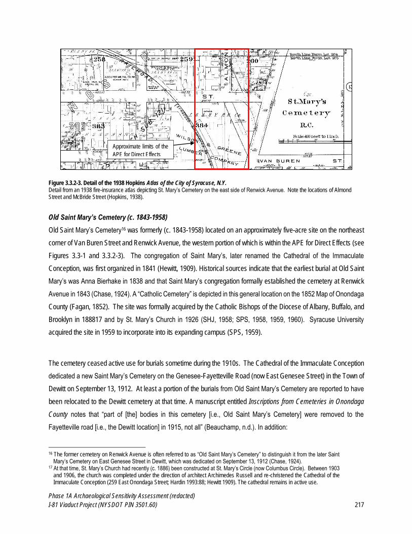
Phase 1A Archaeological Sensitivity Assessment (redacted)
I-81 Viaduct Project (NYSDOT PIN 3501.60) 217
Figure 3.3.2-3. Detail of the 1938 Hopkins Atlas of the City of Syracuse, N.Y. Detail from an 1938 fire-insurance atlas depicting St. Mary’s Cemetery on the east side of Renwick Avenue. Note the locations of Almond Street and McBride Street (Hopkins, 1938).
Old Saint Mary’s Cemetery (c. 1843-1958)
Old Saint Mary’s Cemetery16 was formerly (c. 1843-1958) located on an approximately five-acre site on the northeast
corner of Van Buren Street and Renwick Avenue, the western portion of which is within the APE for Direct Effects (see
Figures 3.3-1 and 3.3.2-3). The congregation of Saint Mary’s, later renamed the Cathedral of the Immaculate
Conception, was first organized in 1841 (Hewitt, 1909). Historical sources indicate that the earliest burial at Old Saint
Mary’s was Anna Bierhake in 1838 and that Saint Mary’s congregation formally established the cemetery at Renwick
Avenue in 1843 (Chase, 1924). A “Catholic Cemetery” is depicted in this general location on the 1852 Map of Onondaga
County (Fagan, 1852). The site was formally acquired by the Catholic Bishops of the Diocese of Albany, Buffalo, and
Brooklyn in 188817 and by St. Mary’s Church in 1926 (SHJ, 1958; SPS, 1958, 1959, 1960). Syracuse University
acquired the site in 1959 to incorporate into its expanding campus (SPS, 1959).
The cemetery ceased active use for burials sometime during the 1910s. The Cathedral of the Immaculate Conception
dedicated a new Saint Mary’s Cemetery on the Genesee-Fayetteville Road (now East Genesee Street) in the Town of
Dewitt on September 13, 1912. At least a portion of the burials from Old Saint Mary’s Cemetery are reported to have
been relocated to the Dewitt cemetery at that time. A manuscript entitled Inscriptions from Cemeteries in Onondaga
County notes that “part of [the] bodies in this cemetery [i.e., Old Saint Mary’s Cemetery] were removed to the
Fayetteville road [i.e., the Dewitt location] in 1915, not all” (Beauchamp, n.d.). In addition:
16 The former cemetery on Renwick Avenue is often referred to as “Old Saint Mary’s Cemetery” to distinguish it from the later Saint
Mary’s Cemetery on East Genesee Street in Dewitt, which was dedicated on September 13, 1912 (Chase, 1924). 17 At that time, St. Mary’s Church had recently (c. 1886) been constructed at St. Mary’s Circle (now Columbus Circle). Between 1903
and 1906, the church was completed under the direction of architect Archimedes Russell and re-christened the Cathedral of the Immaculate Conception (259 East Onondaga Street; Hardin 1993:88; Hewitt 1909). The cathedral remains in active use.
Approximate limits of the
APE for Direct Effects

Phase 1A Archaeological Sensitivity Assessment (redacted)
I-81 Viaduct Project (NYSDOT PIN 3501.60) 218
St. Mary's Cemetery Association Syracuse NY has opened an office in the rectory of the Cathedral of the
Immaculate Conception for business in relation to the removal of bodies from the old St Mary's Cemetery to
the new one near Orville. The work of removal has begun and there are more than 5,000 bodies to be removed
(Haight, 1911).
And:
In 1911 and 1912 the work was taken up of the transfer to the cemetery [i.e., the new Saint Mary’s Cemetery
in Dewitt] of the bodies in the old St. Mary’s Cemetery on Renwick Avenue. That belonged to village days,
although the major part of the burials were made in the ‘fifties and ‘sixties [i.e., the 1850s and 1860s]. No deeds
for lots were ever given in the old cemetery, but the transfers were all made and accurate records kept of
locations (Chase, 1924:301).
Later (c. 1958-1960) newspaper articles indicate that the cemetery was used until 1919, after which no additional
interments were reported to have been made at this site (SHJ, 1958; SPS, 1958, 1959, 1960). By the mid-twentieth
century, the cemetery was no longer in use, in a state of neglect, and had become overgrown. In 1958, the New York
State Supreme Court granted permission to the Roman Catholic Diocese of Syracuse to remove all human remains
from the cemetery on Renwick Avenue and relocate their remains to Saint Mary’s Cemetery on East Genesee Street
in Dewitt (SHJ, 1958; SPS, 1958). An article from the Syracuse Post-Standard provides the following detail:
The petitioner stated that there has been no interment in the cemetery since 1919, that the character of the
neighborhood has undergone substantial changes, [and] there is no existing fund for perpetual care and
maintenance… The number of bodies to be transferred if and when the proposed removal is carried out is
estimated at “more than 1,000.” According to an unauthentic report 4,000 burials were made there before it
ceased to be used 39 years ago (SPS, 1958).
The discrepancy regarding the number of burials at the cemetery (1,000 or 4,000) likely reflects that the authors of
these later accounts were unaware of the previous removal of human remains from the Renwick Avenue site to the
new cemetery in Dewitt in the 1910s (per Chase, 1924; Beauchamp, n.d.). Regardless, the remaining human burials
from Old Saint Mary’s Cemetery are reported to have been removed to the new cemetery in Dewitt by August 1959
when Syracuse University purchased the lot for the purpose of constructing a parking lot (SPS, 1959, 1960). The
remains that were removed from the Renwick Avenue site in 1959 were re-buried in a large, group burial, which is
marked with a large monument, near the Kinne Road entrance to the new St. Mary’s Cemetery in Dewitt (Connors,
2009).
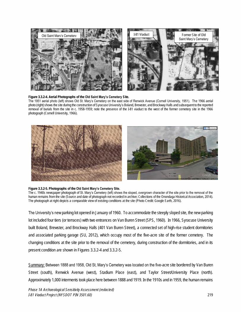
Phase 1A Archaeological Sensitivity Assessment (redacted)
I-81 Viaduct Project (NYSDOT PIN 3501.60) 219
Figure 3.3.2-4. Aerial Photographs of the Old Saint Mary’s Cemetery Site. The 1951 aerial photo (left) shows Old St. Mary’s Cemetery on the east side of Renwick Avenue (Cornell University, 1951). The 1966 aerial photo (right) shows the site during the construction of Syracuse University’s Boland, Brewster, and Brockway Halls and subsequent to the reported removal of burials from the site in c. 1958-1959; note the presence of the I-81 viaduct to the west of the former cemetery site in the 1966 photograph (Cornell University, 1966).
Figure 3.3.2-5. Photographs of the Old Saint Mary’s Cemetery Site. The c. 1940s newspaper photograph of St. Mary’s Cemetery (left) shows the sloped, overgrown character of the site prior to the removal of the human remains from the site (Source and date of photograph not recorded in archive; Collections of the Onondaga Historical Association, 2014). The photograph at right depicts a comparable view of existing conditions at the site (Photo Credit: Google Earth, 2016).
The University’s new parking lot opened in January of 1960. To accommodate the steeply sloped site, the new parking
lot included four tiers (or terraces) with two entrances on Van Buren Street (SPS, 1960). In 1966, Syracuse University
built Boland, Brewster, and Brockway Halls (401 Van Buren Street), a connected set of high-rise student dormitories
and associated parking garage (SU, 2012), which occupy most of the five-acre site of the former cemetery. The
changing conditions at the site prior to the removal of the cemetery, during construction of the dormitories, and in its
present condition are shown in Figures 3.3.2-4 and 3.3.2-5.
Summary: Between 1888 and 1958, Old St, Mary’s Cemetery was located on the five-acre site bordered by Van Buren
Street (south), Renwick Avenue (west), Stadium Place (east), and Taylor Street/University Place (north).
Approximately 1,000 interments took place here between 1888 and 1919. In the 1910s and in 1959, the human remains
I-81 Viaduct Old Saint Mary’s Cemetery Former Site of Old Saint Mary’s Cemetery
Phase 1A Archaeological Sensitivity Assessment (redacted)
I-81 Viaduct Project (NYSDOT PIN 3501.60) 220
were removed and reburied in (the new) St. Mary’s Cemetery on East Genesee Street in the Town of Dewitt. In 1960,
Syracuse University constructed a parking lot on the site, which was constructed in four tiers (or terraces) to
accommodate the slope of the site. In 1966, the parking lot was replaced by a high-rise dormitory and parking garage
complex, which still occupies a significant portion of the former cemetery. Because the human remains from the
cemetery were reported to have been removed, as well as the significant ground disturbance associated with
construction of the terraced parking lot and subsequent dormitory complex on the site, it is assumed that there is little
to no likelihood that undisturbed human burials remain on the site. The former site of the cemetery is located outside
of (but adjacent to) the APE for Direct Effects. No impacts to potential human remains are anticipated in this area.
The House Family Cemetery at the Onondaga Arsenal Site (c.1810s)
The House Family Cemetery is a small graveyard located on private property adjacent to the Onondaga Arsenal Site
(Beauchamp, 1913; Case, 2005; Landscape and Prospect, 1975; see Sections 2.2 and 3.2.6 and Figures 3.2.5-4 and
3.3-1). This cemetery18 was established in the early-nineteenth century and may pre-date the adjacent Onondaga
Arsenal by several years. The Arsenal itself was constructed in 1812 following a land agreement that was made
between Cornelius and Deborah Longstreet and the State of New York (Bruce, 1896). The House family owned the
property between ca. 1854 and 1971. Their name has been commonly attached to the cemetery, although it is unclear
if the cemetery was established prior to their ownership of the land (Case, 2005). It appears that it may have originally
served as a town burial ground, and “practically all graves in the little burial ground are those of early settlers of
Onondaga Hollow” with gravestones dating between 1812 and 1822 (Syracuse Herald, 1930). The House family did
have a presence in the area as early as 1804, when Jonathan House moved to the area from Vermont and engaged
in a limestone quarrying business and the family may have also used the burial ground (Syracuse Herald, 1930; Case,
2012). A map of the burial ground and arsenal property included in Bruce’s 1896 history of Onondaga County suggests
that the cemetery was an irregular shape (see Figure 3.2.5-4).
One of the only extant stones within the small cemetery bears the following inscription:
In Memory of
EUNIS wife of
James Gage who died
Sept 17, 1812. Aged 46 years.
18 The description of the House Family Cemetery was prepared by Molly McDonald of AKRF, Inc, as part of the historic-architectural
resources survey for the I-81 Viaduct Project.
Phase 1A Archaeological Sensitivity Assessment (redacted)
I-81 Viaduct Project (NYSDOT PIN 3501.60) 221
The stone features and urn and willow motif common of gravestones carved in the first decades of the 19th century
(Deetz and Dethlefsen, 1966). The stone is atypical of urn and willow slate-style stones, however, as it features circular
scrolls at its shoulders as opposed to squared shoulders (Deetz and Dethlefsen, 1966). A partially legible epitaph is
carved at the base of the stone. Born Eunice Watkins on August 13, 1768, Eunice married James Adams Gage (born
May 31, 1766) and had ten children between 1788 and 1809 (Lewis Publishing, 1904). James A. Gage had been born
in Pittstown, Rensselaer County, New York (Daughters of the American Revolution, 1922). In 1793, Gage and his
brother, Moses, purchased a 100-acre farm in Norway, Herkimer County, New York, and after traveling there on foot
and building log cabins, the two became the first settlers of that part of New York State. Their wives joined them the
following year and James and Eunice Gage lived there until 1810, when they moved to Syracuse. James Gage later
moved to Painesville, Ohio, possibly after Eunice’s 1812 death, and the location of his grave is unknown, but may be
in Ohio.
A second monument with a barely legible inscription stands in memory of Joseph and Hannah Clark. Case (2005)
reports Joseph’s date of death as 1807. The large marker is in the form of an obelisk on a two-tiered square base. A
third marker is extant in the cemetery: a fallen red sandstone slab that is barely legible and is overgrown. This may be
the House family monument described by reporter Dick Case after a visit to the cemetery in 2005 (Case 2005). Case
references a list of at least eight gravestones that was prepared by William Beauchamp, a local historian, though those
gravestones are no longer extant.
Summary: The House Family Cemetery is a small early-nineteenth-century graveyard located on private property
adjacent to the Onondaga Arsenal Site, outside of (but adjacent to) the APE for Direct Effects. It should be assumed
that any direct effects within the cemetery would have the potential to disturb human burials.
No disturbance to any of these three cemeteries is anticipated as part of the Project. However, the subsequent Phase
1B survey for the Project should include archaeological testing within the portions of the APE for Direct Effects located
adjacent to the House Family Cemetery (and Onondaga Arsenal Site) to confirm that no burials will be impacted, and
determine whether any archaeological deposits associated with the Arsenal, are located within the APE for Direct
Effects.
Phase 1A Archaeological Sensitivity Assessment (redacted)
I-81 Viaduct Project (NYSDOT PIN 3501.60) 222
4.0 SUMMARY AND CONCLUSIONS
4.1 Summary Results of the Phase 1A Archaeological Assessment
The I-81 Viaduct Project includes the proposed reconstruction or replacement of the elevated portions of Interstate 81
(the I-81 viaduct) through the City of Syracuse, in Onondaga County, New York. The purpose of the Phase 1A
Archaeological Sensitivity Assessment is to determine whether previously identified archaeological resources are
located in the Project’s Area of Potential Effect (APE), and to evaluate the potential for previously unidentified
archaeological resources to be located within the APE.
As defined in 36 CFR Part 800.16(d), the APE represents the geographical area within which the Project “may directly
or indirectly cause alterations in the character or use of historic properties, if any such properties exist,” and defines
the area in which identification efforts will occur for architectural and archaeological properties. In accordance with 36
CFR Part 800.4(a)(1), an APE has been defined for the I-81 Viaduct Project based upon a combined scope of work for
both build alternatives under consideration. The APE for Direct Effects, represents the combined limits of disturbance
(LOD) of the two build alternatives and includes the area in which the proposed build alternatives have the potential to
result in direct effects to cultural resources. The APE for Direct Effects includes all areas where there is a potential for
physical alterations or ground disturbance during Project construction and includes approximately 459 acres of land in
four discrete areas: the Viaduct Priority area, the I-81/I-481 Northern Interchange, the I-81/I-481 Southern Interchange,
and the I-481 Eastern Improvements.
The results of background research for the Phase 1A Archaeological Sensitivity Assessment are summarized (in brief)
as follows:
Approximately 67.7 percent (or 311.3 acres) of soils within the APE for Direct Effects are indicative of
moderate to severe disturbance. These include the Cut and Fill Land, Made Land, and Urban Land mapped
soil units. These soil units are variable in their characteristics but all are man-made through various processes
including excavation, filling with non-native soils, filling with other materials (i.e., demolished structural
remains), paving, and mixing soil horizons and units through grading and contouring. Urban Land occurs
primarily within the Viaduct Priority Area in downtown Syracuse, Cut-and-Fill Land occurs along interstate,
railroad, and major highway rights-of-way in all four areas of the APE for Direct Effects, and Made Land,
consisting of an open quarry, occurs only within the I-81/I-481 Southern Interchange.
EDR reviewed NYSOPRHP’s CRIS inventory to identified previously reported archaeological sites within the
APE for Direct Effects. According to the NYSORPHP’s CRIS database, 14 previously recorded archaeological
Phase 1A Archaeological Sensitivity Assessment (redacted)
I-81 Viaduct Project (NYSDOT PIN 3501.60) 223
sites occur within or adjacent to the APE for Direct Effects (see Table 2.2-1 and Appendix A: Map 3). These
include eight historic-period sites documented by NYSOPRHP, one pre-contact Native American site
documented by NYSOPRHP, and five pre-contact areas documented by the New York State Museum (NYSM).
Four of the historic sites have undetermined State/National Register of Historic Places (S/NRHP) eligibilities,
three are not eligible for listing on the S/NRHP, and one is eligible for listing on the S/NRHP. The single
NYSOPRHP pre-contact site has an undetermined S/NRHP eligibility. The NYSM Sites consist of two
prehistoric villages/hamlets, two artifact scatters/traces of occupations, and one camp, as described by Parker
(1922). All five of these NYSM areas have undetermined S/NRHP eligibilities.
Thirty previous archaeological surveys/projects have been conducted within or adjacent to the APE for Direct
Effects (see Table 2.3-1 and Appendix A: Map 3). The results of these surveys are summarized and referenced
throughout this report, where applicable.
EDR conducted historical research at local and on-line archives and repositories to document the historical
development of the Project’s APE and vicinity. An important focus of EDR’s research was the review and
analysis of historical map sources. Selected historical maps were geo-referenced and overlain on
contemporary plans and aerial photos to help identify historic map-documented structures and other potential
archaeological features that were formerly located within the APE for Direct Effects.
The Project vicinity has a rich and complicated history, which is summarized in an overview fashion herein
according to the following periods:
o Pre-Contact Native American Period (ca. 14,000 BP to 1654 AD)
o Euro-American and Native American Contact during the Colonial Era (ca. A.D. 1534 to 1786)
o Salt and the Early Settlement of Onondaga County (ca. 1750 to 1825)
o The Erie Canal and the Birth of the City of Syracuse (ca.1825-1918)
o Growth in the Post-Canal Era (ca. 1918-1938)
o Slum Clearance, Post-War Planning and Urban Renewal (ca. 1938-1974)
o Suburban Expansion in Onondaga County (ca. 1965-2016)
Existing conditions within the APE for Direct Effects were observed and photographed during multiple site
visits conducted by EDR cultural resources staff between 2014 and 2016. In general, existing conditions within
the APE for Direct Effects represent the extent to which the Viaduct Priority Area, the I-81/I-481 Southern
Interchange, the I-81/I-481 Northern Interchange, and the I-481 Eastern Improvements have been significantly
shaped by ground disturbance associated with the construction of Interstates 81 and 481, as well as historic
ground disturbance associated with commercial, industrial and residential development throughout the
eighteenth, nineteenth and twentieth centuries.
Phase 1A Archaeological Sensitivity Assessment (redacted)
I-81 Viaduct Project (NYSDOT PIN 3501.60) 224
An important focus of the Phase 1A archaeological assessment is describing and interpreting evidence for prior ground
disturbance in the APE for Direct Effects. Historical sources described how the landscape of Syracuse was changed
drastically during the nineteenth century. Swamps were drained, waterways were filled or made into sewers, and hills
were razed to build roads and provide fill for poorly drained residential and commercial lots. In the mid-twentieth
century, the construction of elevated interstate highways through Syracuse dramatically transformed the landscape of
the city, both socially and physically. Significant sources of previous ground disturbance within the APE for Direct
Effects include: landfilling activities associated with nineteenth-century urban development in the City of Syracuse;
demolition and construction associated with mid-twentieth century highway construction; disturbance associated with
construction, expansion, and/or modification of buildings; areas of cut and fill associated with other road and highway
construction; and the installation of underground utilities. EDR conducted a detailed analysis of prior ground
disturbance within the APE for Direct Effects, which included historical research, review of NYSDOT record demolition
and construction plans, aerial photography (including historical imagery), field observations, and GIS data analysis.
Review of publicly available mapped soils data provided a basis for the ground disturbance analysis. Areas
characterized by the Cut and Fill Land, Made Land, and Urban Land soil map units are identified in Appendix A: Map
10 as “Mapped Soil Units”. It is assumed that the level of disturbance in these areas would preclude the presence of
near-surface archaeological resources, including pre-contact Native American archaeological resources. However, it
is anticipated that historic-period archaeological resources associated with nineteenth and twentieth-century
development of the city may be located in these areas.
Buried utilities are located throughout the APE for Direct Effects, primarily within public roadways and/or adjacent
rights-of-way. Mapped buried utilities include the observed and assumed locations of all utility poles and underground
lines associated with electric, fiber optic, water, sewer, telephone, steam, cable television, oil, and unidentified
infrastructure. No archaeological resources are anticipated in areas where there are buried utilities.
EDR digitized the locations of 952 former (demolished) structures shown on the ca.1955-1966 NYSDOT demolition
plans within the APE for Direct Effects (see Appendix A: Maps 10 and 11; Appendix B). During demolition, structures
were demolished, basements and cellars were filled, and the properties were cleared and graded (NYSDOT, 1963;
SPS, 1964). The foundations of these demolished structures are unlikely to be considered archaeologically or
historically significant, in large part because the location, dimensions, and arrangement of those buildings can be well
understood based on review of historic cartographic sources and archaeological data is unlikely to contribute significant
new information. In addition, the extent of prior disturbance associated with the construction and demolition of these
structures is assumed to preclude the possibility that other (earlier) archaeological resources are present in these
locations. However, potential artifact deposits and shaft features, which include privies, wells, and cisterns, are found
Phase 1A Archaeological Sensitivity Assessment (redacted)
I-81 Viaduct Project (NYSDOT PIN 3501.60) 225
on many domestic and commercial properties in urban contexts and are potentially located in former yard areas
adjacent to the former locations of map-documented structures.
An analysis of geo-technical boring logs was undertaken to document and interpolate the depth of fill within various
portions of the APE for Direct Effects. NYSDOT has an extensive archive of geotechnical borings documenting
subsurface stratigraphy in the City of Syracuse and the surrounding vicinity. The analysis included review and
interpretation of 995 boring logs from the period between 1945 and 2005 that were located within 500-ft (152-m) of the
APE for Direct Effects. The depth of fill documented by the boring logs is presented as an interpolated surface in
Appendix A: Map 10. Of the 995 boring logs reviewed for the Project, 478 boring logs document depths of fill between
0.5 and 36.5 feet throughout various portions of the APE for Direct Effects. The artificial fill documented by these boring
logs is deepest in the vicinity of Hiawatha Boulevard and the DestiNY USA shopping mall in the northwestern portion
of the Viaduct Priority Area and the I-81/I-690 Interchange, near the center of the Viaduct Priority Area (see Appendix
A: Map 10). These findings are consistent with NYSDOT record plans and historical accounts (and images) regarding
the extent of ground disturbance associated with the construction of the interstate system (see Sections 2.4.6 and 2.6.2
of this report). Deep deposits of artificial fill are also documented in the I-481 Eastern Improvement Area in the vicinity
of the CSX Railroad ROW (Appendix A: Map 10). No data were available for the Southern and Northern I-81/I-481
Interchanges.
Cut-and-fill Highway and Embankment Areas (see Appendix A: Map 10) include areas within and adjacent to the APE
for Direct Effects in which substantial cutting and filling of sediment has occurred related to Interstate and/or highway
construction. These include areas where the Interstate is elevated above the surrounding terrain on an earthen berm,
areas where the Interstate has been excavated below the natural ground surface, areas where exit and entrance ramps
are supported by concrete retaining walls or earthen berms, and other similar circumstances. EDR identified cut-and-
fill highway areas based on multiple sources, including NYSDOT demolition and construction plans, aerial imagery
(including oblique views and historical imagery), and field reconnaissance/confirmation. The areas identified as “Cut-
and-Fill Highway and Embankment Areas” in Appendix A: Maps 10 and 11 are considered to be severely disturbed to
such an extent that there is no potential for intact archaeological resources to be present in these areas.
4.2 Conclusions and Recommendations
The Project vicinity has a rich and complicated history and includes numerous significant cultural resources. However,
due to the extent of prior ground disturbance, the potential for archeological sites to be present within the APE for Direct
Effects is highly variable. Both the Viaduct and Community Grid Alternatives will include significant ground disturbance
during Project construction. These activities have the potential to impact archaeological resources that may be located
Phase 1A Archaeological Sensitivity Assessment (redacted)
I-81 Viaduct Project (NYSDOT PIN 3501.60) 226
within the Project’s APE for Direct Effects. To determine if intact and potentially significant archaeological resources
are located within the APE for Direct Effects, a Phase 1B archaeological survey will be necessary.
The Phase1B archaeological survey will include different field methodologies depending on the existing conditions
present within various portions of the APE for Direct Effects. These are anticipated to include shovel testing in un-
paved and apparently undisturbed areas, as well as machine-aided investigations in paved areas and/or areas where
there is a potential for archaeological resources to be buried beneath fill deposits. In addition, archaeological
monitoring during construction would be appropriate in some areas (described in greater detail, below).
Due to the size of the APE for Direct Effects (approximately 459 acres) and the scale of the proposed Project,
conducting Phase 1B archaeological survey within all portions of the APE for Direct Effects is not practical nor
economically feasible. Therefore, subsequent Phase 1B archaeological investigations should prioritize those portions
of the APE for Direct Effects where there is the greatest likelihood for significant archaeological resources to be present,
or provide a representative evaluation of that likelihood based on a sampling strategy. The need, and appropriate
methodology, for archaeological investigations for various portions of the APE for Direct Effects will be determined
based on three factors:
The potential for significant archaeological resources and/or human remains to be located within the various
portions of the APE for Direct Effects (described in this report).
The extent and depth of previous ground disturbance within the various portions of the APE for Direct Effects
(described in this report).
The proposed depth of soil disturbance and extent of construction-related disturbance for the various portions
of the APE for Direct Effects (i.e., the “Vertical APE for Direct Effects”). This information is not yet available
and is dependent on more detailed design/engineering for the Project.
When available, the Project design information will be reviewed to identify the extent of proposed construction-related
disturbance within archaeologically sensitive areas. This review will provide the basis for the development of a Phase
1B Archaeological Survey Work Plan for the Project. The Work Plan will identify the locations and field methodologies
that will be included in the Phase 1B archaeological survey, and is anticipated to include and further refine the following
general recommendations for various portions of the APE for Direct Effects:
Areas identified as “Cut-and-Fill Highway and Embankment Areas” in Appendix A: Maps 10 and 11 are
considered to be severely disturbed to such an extent that there is no potential for intact archaeological
Phase 1A Archaeological Sensitivity Assessment (redacted)
I-81 Viaduct Project (NYSDOT PIN 3501.60) 227
resources to be present in these areas. No Phase 1B archaeological investigations or further consideration
of these areas (relative to archaeological resources) is recommended.
In those areas that are un-paved and/or where significant fill deposits are not documented or anticipated, the
Phase 1B survey will include a systematic program of shovel testing conducted in accordance with applicable
guidelines. Based on the GIS analyses presented herein, these areas are anticipated to include less than 20
acres within the APE for Direct Effects.
In paved and/or previously disturbed areas where the proposed depth of construction activities is anticipated
to be relatively minimal (i.e., within 2 feet of the existing ground surface), no Phase 1B archaeological
investigations are recommended. This is anticipated to include areas where construction activities are limited
to road re-surfacing or minor widening, curb replacements, streetscape improvements, and similar small-scale
activities.
In paved and/or previously disturbed areas where the proposed depth of construction activities is anticipated
to be significant (i.e., greater than 2 feet below existing grade or otherwise involve large amounts of ground
disturbance), the Phase 1B archaeological survey will include machine-aided archaeological investigations to
determine if potentially significant archaeological deposits are present beneath fill deposits. A sampling
strategy that identifies specific locations for proposed archaeological investigations, based on the factors
noted above, will be included in the Phase 1B Archaeological Survey Work Plan. It is anticipated that this
sampling strategy will prioritize areas where there is a potential for human remains to be present and provide
for a representative assessment of the potential for the various types of historic-period archaeological
resources to be located within the APE for Direct Effects.
Within existing public roadways where the proposed depth of construction activities is anticipated to be
significant (i.e., greater than 2 feet below existing grade or otherwise involve large amounts of ground
disturbance) and where there is a potential for significant archaeological resources to be located (i.e., Erie
and Oswego-Canal related resources), on-site archaeological monitoring during construction is recommended
to document the presence or absence of potentially significant features. The Phase 1B Archaeological Survey
Work Plan will include a monitoring protocol that is anticipated to include the following components:
o A typology of anticipated potentially significant archaeological resources that may be encountered
(per the information presented in this Phase 1A report).
o A protocol for the identification and documentation of potential archaeological resources, including
a protocol for the temporary cessation of construction and/or excavation activities to allow for
archaeological investigation.
o A methodology for on-site recording and documentation of cultural materials identified in fill,
disturbed contexts, or contexts otherwise determined to represent non-significant deposits (note: it
Phase 1A Archaeological Sensitivity Assessment (redacted)
I-81 Viaduct Project (NYSDOT PIN 3501.60) 228
is anticipated that these materials will not be collected and/or retained for further analysis), as well
as criteria for the collection and recording artifacts from potentially significant contexts;
o Identification of contact personnel for involved agencies and/or consulting parties.
o Propose standards for the preliminary determination of significance (or non-significance) of
potential archaeological finds (per the information presented in this Phase 1A report).
o Establish a protocol for determining the need for additional archaeological testing/documentation of
potentially significant archaeological resources.
o The monitoring plan will include NYSHOPRHP’s Human Remains Discovery Protocol, the
Haudenosaunee Policy and Protocol on Human Remains (Haudenosaunee Confederacy, 2009), and
the Native American Graves Protection and Repatriation Act (NAGPRA) (Public Law 101-601; 25
U.S.C. 3001-3013) and provide a site-specific protocol and contact information for relevant agency
and law enforcement personnel in the event that any human remains are encountered during
construction.
The Phase 1B Archaeological Survey Work Plan will include a narrative and appropriate maps that illustrate
and provide further rationale for the proposed archaeological testing strategy.
The Phase 1B Archaeological Survey Work Plan will build on the information and analyses presented in this Phase 1A
report to propose a comprehensive and feasible approach for archaeological testing. As described in Section 3.0 of
this report, the goal is to identify areas where there is a potential for significant archaeological resources to be located,
and exclude other areas from further consideration. The results of the archaeological sensitivity assessment included
in Sections 3.1, 3.2, and 3.3 of this report are summarized below, along with recommendations concerning appropriate
avoidance or field investigation measures. These recommendations provide the basis for a more detailed
archaeological testing strategy to be defined in a subsequent Phase 1B Archaeological Survey Work Plan for the
Project.
Native American Archaeological Resources
Regarding the potential for pre-contact and Contact Period Native American archaeological resources to be present
within the APE for Direct Effects, the following summary and recommendations are provided:
In the absence of documented earth disturbance, the Viaduct Priority Area and the I-81/I-481 Southern
Interchange are considered to be of moderate to high sensitivity for Native American archaeological sites and
the I-81/I-481 Northern Interchange and the I-481 Eastern Improvements are considered to be of moderate
sensitivity for Native American archaeological sites. Sites from these periods would necessarily pre-date the
Phase 1A Archaeological Sensitivity Assessment (redacted)
I-81 Viaduct Project (NYSDOT PIN 3501.60) 229
significant filling and engineering of the landscape that took place as part of the development of the City of
Syracuse throughout the nineteenth and twentieth centuries. Therefore, potential Native American
archaeological sites are only anticipated to be located in areas with undisturbed soils.
As described herein, much of the APE for Direct Effects has been previously disturbed by historic and modern
development. Based on the analysis presented in Section 2.6 of this report, of the approximately 459 acres
included within the APE for Direct Effects, only approximately 19 acres appear to be characterized by
(potentially) undisturbed soils. The locations of portions of the APE for Direct Effects where the extent of
previous ground disturbance is not documented or cannot be determined, and where there is, therefore, the
potential for Pre-Contact Native American archaeological resources to be present, are depicted in Appendix
A: Map 11.
Phase 1B archaeological survey in these areas will include a systematic program of shovel testing conducted
in accordance with applicable guidelines.
Canal-Related Archaeological Resources
Regarding the potential for canal-related archaeological features to be present within the APE for Direct Effects, the
following summary and recommendations are provided:
Portions of the former Erie and Oswego Canals are located within the APE for Direct Effects (see Appendix
A: Map 11). Both canals were filled and paved over in the 1920s. Previous archaeological investigations in
Syracuse have identified intact archaeological features associated with canal infrastructure. However, given
that both canals were filled in the 1920s and their remaining features have experienced various episodes of
physical disturbance (e.g., the installation of municipal infrastructure utilities), the physical integrity of canal-
related archaeological features within the APE for Direct Effect is anticipated to be variable. Intact
archaeological features associated with either canal, depending on their physical integrity, could potentially
be eligible for listing on the NRHP under Criterion A, C, or D.
An intact limestone aqueduct is located within the APE for Direct Effects, where Erie Boulevard crosses
Onondaga Creek. The aqueduct has previously been determined eligible for listing on the NRHP under
Criterion C (NYSOPRHP Site 06740.009729). It is anticipated that Project design will avoid impacts to this
historic resource.
For construction activities within the roadways of Erie or Oswego Boulevards where the proposed depth of
construction disturbance is anticipated to be significant (i.e., greater than 2 feet below existing grade or
otherwise involve large amounts of ground disturbance) and where there is a potential for significant
archaeological resources to be located (i.e., Erie and Oswego-Canal related resources), on-site
archaeological monitoring during construction is recommended to document the presence or absence of
Phase 1A Archaeological Sensitivity Assessment (redacted)
I-81 Viaduct Project (NYSDOT PIN 3501.60) 230
potentially significant features. The Phase 1B Archaeological Survey Work Plan will include a monitoring
protocol, as described above.
A portion of the historic Oswego Canal alignment underlies the northerly portions of I-81 within the Viaduct
Priority Area, which is identified in Appendix A: Map 11 as “Cut-and-Fill Highway and Embankment Areas”.
This area is considered to be disturbed to such an extent that there is no potential for intact archaeological
resources to be present. No archaeological monitoring is warranted or recommended in this area.
Large-Scale Commercial, Industrial, and Institutional Historic-Period Archaeological Resources
Regarding the potential for large-scale commercial, industrial, and institutional archaeological sites to be present within
the APE for Direct Effects, the following summary and recommendations are provided:
Downtown Syracuse was the hub of industrial, commercial and institutional activity for Central New York in
the ninetieth and twentieth centuries. Infrastructure associated with the once burgeoning salt industry, as well
as numerous other commercial enterprises, was formerly located within the APE for Direct Effects. The former
locations of industrial, commercial, and institutional-related features within the APE are shown on historical
maps and photographs of Syracuse (see Appendix A: Maps 4 and 6 and Appendix B).
Previous archaeological investigations have identified or determined the potential for archaeological
resources associated with industry-related structures and features to be located beneath fill deposits in areas
adjacent to the APE for Direct Effects. The locations of the map-documented industrial structures within the
APE for Direct Effects, where there is a high potential for industry related archaeological resources to be
present, are illustrated in Appendix A: Maps 4, 6, and 11. Archaeological sites associated with the salt industry
(or other industries) located within the APE for Direct Effects could potentially be eligible for listing on the
NRHP under Criterion D if these sites contribute significant information to our understanding of historic
manufacturing and production technology and/or economic practices, sufficient to broaden our understanding
of this important aspect of local and regional history.
It is assumed that foundations and other structural remains associated with many of these larger commercial
buildings are located throughout the APE for Direct Effects. In most cases, the foundations or structural
remains unto themselves are unlikely to be considered archaeologically or historically significant, in large part
because the location, dimensions, and arrangement of those buildings can be well understood based on
review of historic cartographic sources and archaeological data is unlikely to contribute significant new
information. Therefore, although these sites are potentially ubiquitous throughout the APE for Direct Effects,
archaeological investigation would only be warranted in those instances where archaeological data has the
potential to contribute significant, meaningful new information.
Phase 1A Archaeological Sensitivity Assessment (redacted)
I-81 Viaduct Project (NYSDOT PIN 3501.60) 231
The sampling strategy for machine-aided archaeological investigations included in the Phase 1B
Archaeological Survey Work Plan will recommend specific sites for archaeological field investigations based
on the proposed depth of soil disturbance and extent of construction-related disturbance in specific areas (per
more detailed Project design information), the potential for significant archaeological features associated with
large-scale commercial, industrial, and institutional archaeological sites to be present, and the extent of
existing disturbance in those areas.
No archaeological investigations or further consideration (relative to archaeological resources) are
recommended for those large-scale commercial, industrial, and institutional map-documented structures
located within areas identified as “Cut-and-Fill Highway and Embankment Areas” (see Appendix A: Map 11).
These areas are considered to be disturbed to such an extent that there is no potential for intact archaeological
resources to be present.
Residential and Small-Scale Commercial Historic-Period Archaeological Resources
Regarding the potential for residential and small-scale commercial archaeological sites to be present within the APE
for Direct Effects, the following summary and recommendations are provided:
Urban renewal efforts during the mid-twentieth century, including the routing of an elevated highway through
downtown, caused the most radical change to the built environment of Syracuse since the construction of the
Erie Canal. The construction of Interstates 81 and 690 through Syracuse required demolition of large portions
of city neighborhoods including much of the Fifteenth Ward, which was home to the highest concentration of
African-American and Jewish populations in the city. It is estimated 800-900 families were displaced by the
construction of highways in the Fifteenth Ward.
Hundreds of former residential and small-scale commercial structures are depicted on historic maps within
the APE for Direct Effects. The 1892 Sanborn atlas, 1938 Hopkins Map, and 1955-1966 NYSDOT demolition
plans (Appendix A; Maps 4 and 6 and Appendix B, respectively) provide significant detail regarding the
location, dimensions, and in some instances ownership or use of buildings that were formerly located within
the APE for Direct Effects. EDR digitized the locations of structures shown on the ca.1955-1966 NYSDOT
demolition plans within the APE for Direct Effects, which resulted in the mapping of 952 former (demolished)
structure locations (see Appendix A: Maps 10 and 11).
The digitized locations of the demolished structures are indicative of the density of development (and
demolition) that occurred within these portions of the city and provide a robust data set for assessing the
potential for historic period archaeological sites to be present within the APE for Direct Effects. The
foundations of these demolished structures unto themselves are unlikely to be considered archaeologically or
historically significant, in large part because the location, dimensions, and arrangement of those buildings can
Phase 1A Archaeological Sensitivity Assessment (redacted)
I-81 Viaduct Project (NYSDOT PIN 3501.60) 232
be well understood based on review of historic cartographic sources and archaeological data is unlikely to
contribute significant new information. However, potential artifact deposits and shaft features, which include
privies, wells, and cisterns, are found on many domestic and commercial properties in urban contexts and are
potentially located in former yard areas adjacent to the former locations of map-documented structures.
Archaeological features, such as privies, cisterns, and wells, associated with former residential and small-
scale commercial properties, depending on their physical integrity, could potentially be eligible for listing on
the NRHP under Criterion D.
The sampling strategy for machine-aided archaeological investigations included in the Phase 1B
Archaeological Survey Work Plan will recommend specific sites for archaeological field investigations based
on the proposed depth of soil disturbance and extent of construction-related disturbance in specific areas (per
more detailed Project design information), the potential for significant archaeological features associated with
residential and small-scale commercial, industrial, and institutional archaeological sites to be present, and the
extent of existing disturbance in those areas. Given the large number of potential residential and small-scale
commercial sites within the APE for Direct Effects, the Work Plan will identify a limited number of proposed
archaeological testing locations that will be selected based on their potential to encounter sites that can be
considered representative of the broader Project area based on the identities of their former (historical)
occupants and locations within the APE for Direct Effects. The rationale for the selection of archeological
testing locations will be described in the Work Plan.
No archaeological investigations or further considerations (relative to archaeological resources) are
recommended for potential residential and small-scale commercial sites located within areas identified as
“Cut-and-Fill Highway and Embankment Areas” (see Appendix A: Map 11). These areas are considered to
be disturbed to such an extent that there is no potential for intact archaeological resources to be present.
Military Archaeological Resources
Regarding the potential for military archaeological sites to be present within the APE for Direct Effects, the following
summary and recommendations are provided:
The Onondaga Arsenal Site (NYSOPRHP Site 6740.000389) is the only known historic military site in the
vicinity of the APE for Direct Effects, located approximately 350 feet outside of the limits of disturbance for the
Project.
No previous archaeological excavations have been conducted at the Arsenal Site to identify a comprehensive
list of features or determine the precise boundaries of the site. At minimum, the site is known to include stone
structural remains and nineteenth-century artifacts, and a cemetery that is reported to include burials
associated with early-nineteenth-century settlers in Onondaga County is located in the immediate vicinity (i.e.,
Phase 1A Archaeological Sensitivity Assessment (redacted)
I-81 Viaduct Project (NYSDOT PIN 3501.60) 233
the House Family Cemetery, see below). It is anticipated that there is a high potential for intact archaeological
resources to be located at the Onondaga Arsenal Site. However, it is unknown whether these archaeological
resources extend within the APE for Direct Effects.
The portion of the APE for Direct Effects located adjacent to the Onondaga Arsenal Site is located in an
(apparently) undisturbed area identified as being potentially sensitive for Native American archaeological
resources. A Phase 1B archaeological survey will be conducted in this area, which will include a systematic
program of shovel testing conducted in accordance with applicable guidelines.
Cemeteries and Potential for Human Burials
Regarding the potential for cemeteries and/or human burials to be present within the APE for Direct Effects, the
following summary and recommendations are provided:
The potential for human remains to be located within the APE for Direct Effects needs to be considered due
to religious, cultural, and legal considerations associated with the potential disturbance or exhumation of
human burials, as well as archaeological considerations, which may consider human burials as potentially
significant archaeological resources. It is anticipated that future archaeological and/or construction monitoring
activities that may occur in association with the Project would need to be conducted in accordance and
consideration of NYSOPRHP’s Human Remains Discovery Protocol (NYSOPRHP, 2015) the
Haudenosaunee Policy and Protocol on Human Remains (Haudenosaunee Confederacy, 2009), and the
Native American Graves Protection and Repatriation Act (NAGPRA) (Public Law 101-601; 25 U.S.C. 3001-
3013).
The Onondaga Nation have expressed concern regarding the potential for the presence of Native American
human remains in any areas where there is a potential for undisturbed soils within the APE for Direct Effects.
Therefore, Phase 1B archaeological testing will be conducted in all areas where the extent of previous soil
disturbance is unknown or cannot be demonstrated. Part of the purpose of the Phase 1B archaeological
testing will be to investigate whether human remains are located within the APE for Direct Effects.
Historical accounts described Native American human remains that were disturbed during nineteenth-century
construction activities near the crossing of Genesee Street over Onondaga Creek (this area is indicated in
Appendix A: Map 11).
Following receipt of more detailed Project design information, the location of these reported burials (at
Genesee Street and Onondaga Creek) will be evaluated relative to the proposed depth and extent of soil
disturbance in this area. If appropriate, then this area will be identified in the Phase 1B Archaeological Work
Plan as an area where machine-aided Phase 1B archaeological testing will be necessary.
Phase 1A Archaeological Sensitivity Assessment (redacted)
I-81 Viaduct Project (NYSDOT PIN 3501.60) 234
In addition, three historic cemeteries (one of these is the former site of a relocated cemetery) are located
adjacent to (but outside) the APE for Direct Effects. These include the NRHP-listed Oakwood Cemetery, the
former site of Old St. Mary’s Cemetery, and the House Family Cemetery (see Appendix A: Map 11). No
disturbance to any of these three cemeteries is anticipated as part of the Project. However, the subsequent
Phase 1B survey for the Project will include archaeological testing within the portions of the APE for Direct
Effects located adjacent to the House Family Cemetery (and Onondaga Arsenal Site) to confirm that no burials
will be impacted.
The information and recommendations included in this Phase 1A Archaeological Sensitivity Assessment provide a
foundation for evaluating the I-81 Viaduct Project’s potential effect on archaeological resources. As noted above, more
detailed Project design information will be reviewed to identify the extent of proposed construction-related disturbance
within archaeologically sensitive areas. This review will provide the basis for the development of a Phase 1B
Archaeological Survey Work Plan for the Project. The Work Plan will identify the locations and field methodologies
that will be included in the Phase 1B archaeological survey, and is anticipated to include and further refine the
archaeological sensitivity assessment and recommendations included herein.
Phase 1A Archaeological Sensitivity Assessment (redacted)
I-81 Viaduct Project (NYSDOT PIN 3501.60) 235
5.0 REFERENCES CITED
Abel, Timothy J. 2001. The Clayton Cluster: Cultural Dynamics of a Late Prehistoric Village Sequence in the Upper St. Lawrence Valley. PhD Dissertation, Department of Anthropology, State University of New York at Albany. Adams, Debra. “I-81 Construction Project Won’t Meet 1986 Deadline.” Syracuse Herald-Journal. September, 24, 1986. Collections of the Onondaga Historical Association, Syracuse, New York. Alliance Archaeological Services (AAS). 2014. Phase 1A Archaeological Background and Literature Review and Phase 1B Archaeological Field Reconnaissance of the Proposed Central New York Islamic Center at 5775 East Seneca Turnpike in Syracuse, Onondaga County, New York. Report submitted to Islamic Society of CNY by Alliance Archaeological Services, Manlius, NY. AAS. 2016. Phase 1A Archaeological Background and Literature Review of the Proposed Project Site at 405 Spencer Street in Syracuse, NY. Report prepared for Salt City Enterprises, LLC by Alliance Archaeological Services, Manlius, NY. Armstrong, Douglas V. and Louann Wurst. 1998. Faces of the Past: Archaeology of an Underground Railroad Site in Syracuse, New York. Syracuse University Archaeology Research Center, Report Vol. 10, No. 1, Syracuse, NY. Armstrong, Douglas V., Elizabeth J. Kellar and LouAnn Wurst. 2000. Archaeological Sites and Preservation Planning in Central New York: A Unified Site File and GIS Database for NYSDOT Region 3. Vol. 1. New York State Historic Preservation Office. Albany, NY. Arcadis. 2008. National Grid Erie Boulevard Former MGP Site, Syracuse, NY: Final Remediation Investigation Report. Prepared for National Grid by Arcadis, Syracuse, NY. Bailey, H.H. 1874. Bird’s Eye View of Syracuse, New York. American Oleograph Co., Milwaukee, WI. Library of Congress Panoramic Maps Collection, available at http://memory.loc.gov/ammem/pmhtml/panhome.html. Balbuena, Miguel. 2015. “Uncertainty Still Surrounds I-81 Plans.” The Stand. February 3, 2015. Available at: http://mysouthsidestand.com/more-news/uncertainty-still-surrounds-i-81-plans/. Bartram, John. 1751. Observations on the Inhabitants, Climate, Soil, Rivers, Productions, Animals and Other Matters Worthy of Notice Made by Mr. John Bartram in His Travels from Pensilvania to Onondago, Oswego and the Lake Ontario in Canada. Whiston and White, London, United Kingdom. Beauchamp, William M. 1900. Aboriginal Occupation of New York. Bulletin of the New York State Museum No. 32 Vol. 7. The University of the State of New York, Albany. Beauchamp, William M. 1908. Past and Present of Syracuse and Onondaga County New York. S.J. Clarke Publishing Co., New York, NY. Beauchamp, Reverend William M. 1913. Revolutionary Soldiers Resident or Dying in Onondaga County, New York. McDonnell Company, Syracuse, NY. Beauchamp, William M. No date [n.d.]. Inscriptions from Cemeteries in Onondaga County taken from Notes by William Martin Beauchamp. Manuscript, Collections of the New York Genealogical and Biographical Society, New York, NY. Portions transcribed at: http://www.rootsweb.ancestry.com/~nyononda/CEMETERY/STMARYRE.HTM.
Phase 1A Archaeological Sensitivity Assessment (redacted)
I-81 Viaduct Project (NYSDOT PIN 3501.60) 236
Beaudry, Mary C. 1989. The Lowell Boott Mills Complex and Its Housing: Material Expressions of Corporate Ideology. Historical Archaeology 23(1), p. 19-32. Beaudry, Mary C. 1993. Public Aesthetics versus Personal Experience: Worker Health and Well-Being in 19th-Century Lowell, Massachusetts. Historical Archaeology 27(2), p. 90-105. Beck, Lewis C. 1826. An Account of the Salt Springs at Salina, in Onondaga County, State of New York. J. Seymour, New York, NY. Bell, Valerie Jackson. 1998. “The Onondaga New York Salt Works (1654-1926).” Science Tribune. 1998. Available at http://www.tribunes.com/tribune/sel/bell.htm. Bender, Susan J and Edward V. Curtin. 1990. A Prehistoric Context for the Upper Hudson Valley. Report of the survey and planning project, prepared for the New York State Office of Parks Recreation and Historic Preservation, Albany. Biggest U.S. Cities. 2016. “Syracuse, New York Population History: 1850-2015.” Available at: http://www.biggestuscities.com/city/syracuse-new-york. Birch, Jennifer. 2012. Coalescent Communities: Settlement Aggregation and Social Integration in Iroquois Ontario. American Antiquity 77:646-670. Blasland, Bouck & Lee, Inc. (BB&L). 2000. Geotechnical Soil Boring Logs for the Solar and Kirkpatrick Streets Improvement Project. Prepared by Lyon Drilling Company on behalf of BB&L, Syracuse, NY. Bradford, William. 1952. Of Plymouth Plantation, 1620-1647. Samuel Eliot Morrison, editor. Alfred A. Knopf, New York. Bradley, James W. 1987. Evolution of the Onondaga Iroquois: Accommodating Change, 1500-1655. Syracuse University Press. Syracuse, NY. Brieaddy, Frank. 1975. “Now You See It, Now…” Syracuse Post-Standard, June 19, 1975. Collections of the Onondaga Historical Association, Syracuse, NY. Brighton, Stephen A. 2008. Degrees of Alienation: The Material Evidence of the Irish and Irish American Experience,1850-1910. Historical Archaeology 42(4), p. 132-153. Brooke, Nina. 1975. Correspondence to Lenore Rennenkampf RE: “Early Nineteenth Century Arsenal, East Seneca Turnpike, Onondaga Valley, Syracuse.” Dated January 16, 1975. Electronic version on file in the online CRIS database. Brown, Gregory J. and Joanne Bowen. 1998. Animal Bones from the Cross Street Back Lot Privy. Historical Archaeology 32(3), p. 72-80. Bruce, Dwight H. 1891. Memorial History of Syracuse, NY. H.P. Smith and Co. Publishers, Syracuse, NY. Bruce, Dwight H., Ed. 1891. Syracuse, N.Y. from its Settlement to the Present Time. H.P. Smith & Co., Syracuse, NY. Bruce, Dwight H., Ed. 1896. Onondaga's Centennial: Gleanings of a Century. Boston History Co., Boston, MA. Brumbach, Hetty Jo. 2011. The History of the Collared Rim in the Finger Lakes. In Current Research in New York Archaeology: A.D. 700-1300 edited by Christina Christina B. Reith and John P. Hart, pp. 83-94. New York State Museum, Albany.
Phase 1A Archaeological Sensitivity Assessment (redacted)
I-81 Viaduct Project (NYSDOT PIN 3501.60) 237
Cadwell, Donald H., Ernest H. Muller, and P. Jay Fleisher. 2003. “Geomorphic History of New York State.” Geoarchaeology of Landscapes in the Glaciated Northeast: Proceedings of a Symposium Held at the New York Natural History Conference VI. Edited by David L. Cremeens and J.P. Hart. New York State Museum Bulletin 497. The University of the State of New York State Education Department, Albany, NY. Cantwell, Anne-Marie and Diana diZerega Wall. 2001. Unearthing Gotham: The Archaeology of New York City. Yale University Press, New Haven, CT. Carnes-McNaughton, Linda F. and Terry M. Harper. 2000. The Parity of Privies: Summary Research on Privies in North Carolina. Historical Archaeology 34(1), p. 97-110. Carter, Cynthia Carrington. 2008. Industrial Resources in the City of Syracuse. National Register of Historic Places Multiple Property Documentation Form. National Park Service, U.S. Department of the Interior, Washington, D.C. On file, New York State Office of Parks, Recreation, and Historic Preservation, Waterford, NY Carroll, Walter. 1961. “Renewal Dept. Stymied By Lack of Funds, Staff.” Syracuse Post-Standard. September 13, 1961. Collections of the Onondaga Historical Association, Syracuse, New York. Case, Dick. 2005. “Grove In Valley Shelters 200-Year-Old Legacy.” Syracuse Post-Standard, July 3, 2005. Collections of the Onondaga Historical Association, Syracuse, NY.
Case, Dick. 2012a. “Future uncertain for ruins of stone arsenal built in Syracuse for War of 1812.” Syracuse Post-Standard, May 6, 2012.
Case, Dick. 2012b. “Onondaga Arsenal, Potentially the Last Best Local Remnant of War of 1812, Remains Greatly Overlooked.” Syracuse Post-Standard, October 30, 2012. Cement Association of Canada. 2016. History of Cement. Available at: http://www.cement.ca/en/Manufacturing/History-of-Cement.html. Central New York Chapter of the National Railway Historical Society (CNYCNRHS). 1986. Railroads in the Streets of Syracuse. Central New York Chapter of the National Railway Historical Society, Marcellus, NY. Central New York Regional Planning & Development Board (CNYRPDB). 2010. Onondaga Lake Watershed Progress Assessment and Action Strategies. Central New York Regional Planning & Development Board, Syracuse, NY. April 2010. Chase, Franklin H. 1908. Last Twenty Years of Onondaga County. In Past and Present of Syracuse and Onondaga County New York, edited by Rev. William M. Beauchamp, p. 473. S.J. Clarke Publishing Co., New York, NY. Chase, Franklin H. 1924. Syracuse and Its Environs: A History. Lewis Historical Publishing Company, Inc., New York, NY. Cheney, Timothy. 1857. Reminiscences of Syracuse. Syracuse: Compiled by Parish B. Johnson, Published in The Syracuse Daily Standard. City of Syracuse City Planning Commission (CSCPC). 1919. City Planning for Syracuse. John Single Paper Company, Syracuse, New York.
Phase 1A Archaeological Sensitivity Assessment (redacted)
I-81 Viaduct Project (NYSDOT PIN 3501.60) 238
City of Syracuse Office of Urban Renewal (CSOUR). 1960. Property Owners and Tenants In the Near East Side Urban Renewal Area. Correspondence dated April 28, 1960. Collections of the Onondaga Historical Association, Syracuse, New York. City Planning Commission. No date [n.d.]. Original Boundaries of the Walton Tract, 1804. Collections of the Onondaga Historical Association, Syracuse, NY. Clark, Joshua V. H. 1849. Onondaga; or Reminiscences of Earlier and Later Times. Stoddard and Babcock, Syracuse, NY. Clayton, W. Woodford. 1878. History of Onondaga County, New York. D. Mason & Co., Syracuse, NY. CME Associates, Inc. 2003. Subsurface Exploration – Test Boring Log: New Academic Building, Upstate Medical University, Syracuse, NY. Report prepared for Holt Architects, P.C. by CME Associates, Inc., East Syracuse, NY. Cochran, Ian Thomas. 2004. Rediscovering the Venice of Central New York: Preliminary Survey of Archaeological Sites Along the Erie Canal Corridor in Syracuse, New York. Honors Thesis, Department of Public Policy, Syracuse University. Collections of the Onondaga Historical Association, Syracuse, NY. Cohn, Jerome Allan. 1978. Urban Background to the Interstate Highway Program: The Planning and Politics of Highways in Syracuse, 1944-1960. Doctorate of Philosophy dissertation, Department of History, Syracuse University, Syracuse, NY. Columbia Heritage, Ltd. (Columbia). 2000. Phase 1 Cultural Resources Survey, Site Assessment, and Site Identification Phases Proposed COR Collamer Road Company Development, Town of Dewitt, Onondaga County, NY. Report prepared for COR Development Company, LLC by Columbia Heritage, Ltd., Old Chatham, NY. Commonwealth Cultural Resources Group, Inc. (CCRG). 2001a. Stage 1 Cultural Resource Investigation for the 554 East Brighton Avenue Cell Tower Location, City of Syracuse, Onondaga County, New York. Report prepared for the Federal Communications Commission by Commonwealth Cultural Resources Group, Buffalo, NY. Commonwealth Cultural Resources Group, Inc. (CCRG). 2001b. Stage 1 Cultural Resources Investigation for the Solar/Kirkpatrick Street Improvement Project, City of Syracuse. Report prepared for Blasland, Bouck, and Lee, Inc. by Commonwealth Cultural Resources Group, Inc., Buffalo, NY. Congressional Quarterly (CQ). 1952. "Slum Clearance: 1932–1952." CQ Press. In Editorial Research Reports 1952, vol. II, 801-20. Available at: http://library.cqpress.com/cqresearcher/cqresrre1952112200. Connors, Dennis. 1976. Hanover Square Historic District. National Register of Historic Places Registration Form. On file, New York State Office of Parks, Recreation, and Historic Preservation, Waterford, NY. Connors, Dennis. 1997. Images of America: Syracuse. Onondaga Historical Association, Syracuse, NY. Connors, Dennis J. 2005. Syracuse. In The Encyclopedia of New York State, edited by P. Eisenstadt, p. 1517. Syracuse University Press, Syracuse, NY. Connors, Dennis J. 2006. Crossroads in Time. Syracuse University Press, Syracuse, NY. Connors, Dennis J. 2008. Historic Photos of Syracuse. Turner Publishing Company, Nashville, TN.
Phase 1A Archaeological Sensitivity Assessment (redacted)
I-81 Viaduct Project (NYSDOT PIN 3501.60) 239
Connors, Dennis J. 2009. Cemetery Stones at Jamesville. Email correspondence, Dennis Connors to Melanie Littlejohn, December 3, 2009. Collections of the Onondaga Historical Association, Syracuse, NY. Connors, Dennis J., Gordon C. DeAngelo and Peter P. Pratt. 1980. The Search for the Jesuit Mission of Ste. Marie de Gannentaha. Office of Museums and Historical Sites, County of Onondaga Department of Parks and Recreation. Liverpool, NY. Report on File, Onondaga Historical Association, Syracuse, NY. Connors, Dennis J., Gordon C. DeAngelo, and Peter P. Pratt. 1980. The Search for the Jesuit Mission of Saint Marie de Gannentaha. Onondaga County Office of Museums and Historical Sites, Syracuse, NY. Cornell University. 1938, 1951 and 1966. Historic Aerial Photographs of New York. Available at http://aerial-ny.library.cornell.edu. Cowan, Frank L. 1999. Making Sense of Flake Scatters: Lithic technology Strategies and Mobility. American Antiquity 64(4):593-608. Crist, Thomas A. 2005. Babies in the Privy: Prostitution, Infanticide, and Abortion in New York City's Five Points District. Historical Archaeology 39(1), p. 19-46. Cummings, Linda Scott. 1994. Diet and Prehistoric Landscape during the Nineteenth and Early Twentieth Centuries at Harpers Ferry, West Virginia: A View from the Old Master Armorer's Complex. Historical Archaeology 28(4), p. 94-105. Curran, Mary Lou. 1999. Exploration, Colonization, and Settling in: The Bull Brook Phase, Antecedents, and Descendants. In The Archaeological Northeast, Mary Ann Levine, Kenneth E. Sassaman, and Michael S. Nassaney eds. Pp. 3-24. Bergin and Garvey, Westport, Connecticut. Curtin, Edward V. 1998. The Archaeology of the New York Archaic: A Reconsideration with Implications for Studies of Hunter- Gatherer Land Use. Ph.D. dissertation, State University of New York at Binghamton. Curtin, Edward V. (Curtin). 2000. Phase 1A Survey: Proposed Clinton Square Project, City of Syracuse, Onondaga County, NY. Report prepared for Clough, Harbour, and Associates, LLP by Edward V. Curtin, Saratoga Springs, NY. Curtin, Edward V. 2015. The Archaic Period Archaeological Sites at Brewerton, New York. Available online at: http://www.curtinarch.com/blog/2015/4/27/the-archaic-period-archaeological-sites-at-brewerton-new-york. Curtin Archaeological Consulting, Inc., Ballston Spa, NY. Curtin, Tara, John Halfman, and Robert Gaines. 2006. Holocene and “Anthropocene” Climate and Environmental Change in the Finger Lakes, NY. Proceedings of the 19th annual Keck Symposium. Available online at: http://keckgeology.org/files/pdf/symvol/19th/fingerlakes/fingerlakesoverview.pdf Darlington, J.W. 2005. Salt Industry. In The Encyclopedia of New York State, edited by P. Eisenstadt, p. 1348. Syracuse University Press, Syracuse, NY. Daughters of the American Revolution. 1922. “8843. Gage.” Daughters of the Revolution Magazine 56(1): pp. 223. Davis, Barbara Sheklin. 1980. A History of the Black Community of Syracuse. Onondaga Community College, Syracuse NY. Davis, Barbara Sheklin. 1986. A History of the Jewish Community of Syracuse. Onondaga Community College, Syracuse NY.
Phase 1A Archaeological Sensitivity Assessment (redacted)
I-81 Viaduct Project (NYSDOT PIN 3501.60) 240
Davis, Barbara Sheklin and Susan Rabin. 2011. A History of the Jewish Community of Syracuse. Arcadia Publishing, Charleston SC. Day, Karen E. 1994. Cultural Landscape Report: Oakwood Cemetery, Syracuse, New York. State University College of Environmental Science and Forestry, Syracuse, NY. Deetz, James and Edwin S. Dethlefsen. 1967. “Death’s Heads, Cherubs, and Willow Trees: Experimental Archaeology in Colonial Cemeteries.” American Antiquity 31(4): pp. 502-510. Destiny USA (DUSA). 2010. Carousel Center’s 20th Anniversary, 1990-2010. Destiny USA website. Available at: http://www.destinyusa.com/uploads/docs/Carousel%20Anniversary%20Book.pdf. Detroit Photographic Company. 1901. Syracuse, N.Y (photograph). Digital collections of the Library of Congress. Available at: https://www.loc.gov/item/2015649144/. Detroit Publishing Company. 1915. New York Central Railroad Depot, Syracuse, N.Y. (photograph). Digital collections of the Library of Congress. Available at: https://www.loc.gov/item/det1994016915/PP/. Dewitt, Benjamin. 1801. “A Memoir on the Onondaga Salt Springs and Salt Manufactories in the State of New York.” In Transactions of the Society for the Promotion of Agriculture, Arts and Manufactures, Instituted in the State of New York, Vol. I. pp. 268-86. Charles R. and George Webster, Albany, NY. Dewitt, Simeon. 1793. Dewitt’s State Map of New York (1st sheet). Simeon Dewitt, Albany, NY. Dewitt, Simeon. 1797. A Map of the ground about the Salt Springs, Near the Salt Lake in the County of Onondaga, Pursuant to an Act Concerning the Salt Springs, April 1, 1797, Simeon Dewitt. Simeon Dewitt, Albany, NY. Dieckmann, Jane Marsh. 1986. A Short History of Tompkins County. DeWitt Historical Society of Tompkins County, Ithaca, NY. DiMento, Joseph F.C. 2009a. “Artere Ubrane: Tre Diversi Esperimenti nelle Città Americane.” Storia Urbana: Rivista di Studi Sulle Trasformazioni della Città e del Territorio in età Moderna, Vol. 31 No. 122, pp. 69-92. DiMento, Joseph F.C. 2009b. “Stent (or Dagger?) in the Heart of Town: Urban Freeways in Syracuse, 1944-1967.” Journal of Planning History, Vol. 8 No. 2, pp. 133-161. DiMento, Joseph F.C. and Cliff Ellis. 2009. Changing Lanes: Visions and Histories of Urban Freeways. MIT Press, Cambridge, MA. Downtown Committee of Syracuse, Inc. (DCOS). 2013. Downtown Syracuse Development Overview. Downtown Committee of Syracuse, Inc., Syracuse, NY. Available at: http://downtownsyracuse.com/assets/Downtown-Syracuse-Development-Overview.pdf. Driver, Bob. 1958. “Stateway Fails to Stir Almond St. Folk.” Syracuse Herald-Journal. October 22, 1958. Collections of the Onondaga Historical Association, Syracuse, New York. Dulberger, Terry. 1991. Pump House & Salt Manufacturing. New York State Historic Archaeological Site Form. On file, New York State Office of Parks, Recreation & Historic Preservation, Waterford, NY. Eccles, W.J. 1972. France in America. Harper & Row, New York.
Phase 1A Archaeological Sensitivity Assessment (redacted)
I-81 Viaduct Project (NYSDOT PIN 3501.60) 241
Empire Publishing Company (EPC). 1883. Resources of Onondaga County. Masters & Stone, Syracuse, NY. Engelbrecht, William. 2003. Iroquoia: The Development of a Native World. Syracuse University Press. Syracuse, NY. Engelbrecht, William. 2014. Unnotched Triangular Points on Village Sites. American Antiquity 79(2):353-367. Ensminger, Peter A. 1996. Brewing in Syracuse. In Great Lakes Brewing News, October-November1996, vol 1(5): p. 3, 24. Environmental Design and Research Landscape Architecture, Engineering, and Environmental Services, D.P.C. (EDR). 2016. Archaeological Resources Screening: I-690 Over Teall Avenue and Beech Street Bridge Replacement Project, City of Syracuse, Onondaga County, NY. Report prepared for the New York State Department of Transportation by Environmental Design and Research, Landscape Architecture, Engineering, and Environmental Services, D.P.C., Syracuse, NY. Erie Canalway National Heritage Corridor. 2016. History and Culture. Available at: http://www.eriecanalway.org/learn/history-culture.
Faber, Harold. 1982. “I-88 Linked to the Thruway at Exit South of Schenectady.” The New York Times. May 30, 1982. Fagan, L. 1852. Map of Onondaga County, New York, from Actual Surveys. E.H. Babcock & Co., Syracuse, NY and George C. Brown, Providence, RI. Faulkner, Charles T., Sarah E. Cowie, Patrick E. Martin, Susan R. Martin, C. Shane Mayes and Sharon Patton. 2000. Archeological Evidence of Parasitic Infection from the 19th Century Company Town of Fayette, Michigan. The Journal of Parasitology 86(4), p. 846-849.
The Fayetteville Bulletin. 1923. City News of the Week in Brief. August 31, 1923. Fiedel, Stuart J. 2001. What Happened in the Early Woodland. Archaeology of Eastern North America Vol. 29:101-142. Finch, Roy G. 1925. The Story of the New York State Canals: Historical and Commercial Information. 1998 Reprint. New York State Canal Corporation, Albany, NY. Find a Grave, Inc. 2014. Oakwood Cemetery, Also Known as Morningside Cemetery. Find A Grave, Inc., Provo, UT. Available at: http://www.findagrave.com/cgi-bin/fg.cgi?page=cr&CRid=65510. First People of America. 2014. “”The Peacemaker and the Tree of Peace: An Iroquois Legend.” First People of America and Canada: Turtle Island. Available at: www.firstpeople.us Fischer, David Hackett. 2008. Champlain’s Dream: The European Founding of North America. Simon and Schuster, New York, NY. Fisher, Charles L., Karl J. Reinhard, Matthew Kirk and Justin DiVirgilio. 2007. Privies and Parasites: The Archaeology of Health Conditions in Albany, New York. Historical Archaeology 41(4), p. 172-197. Fitting, James E. 1978. Regional Cultural Development: 300 B.C. to A.D. 1000. In Handbook of North American Indians, Vol. 15: Northeast. Bruce G. Trigger, ed. Pp. 44-57. Smithsonian Institution Press, Washington D.C.
Phase 1A Archaeological Sensitivity Assessment (redacted)
I-81 Viaduct Project (NYSDOT PIN 3501.60) 242
Foderaro, Lisa W. 1990. “Can A Mall At A Toxic Dump Revive an Ailing Syracuse?” The New York Times, October 17, 1990. Available at: http://www.nytimes.com/1990/10/17/nyregion/can-a-mall-at-a-toxic-dump-revive-an-ailing-syracuse.html. Fort Stanwix National Monument Staff. 2016a. The Clinton-Sullivan Campaign of 1779. National Park Service, U.S. Department of the Interior. Washington, D.C. Available online at: https://www.nps.gov/fost/learn/historyculture/the-western-expedition-against-the-six-nations-1779.htm Fort Stanwix National Monument Staff. 2016b. The Van Schaick Expedition-April 1779. National Park Service, U.S. Department of the Interior. Washington, D.C. Available online at: http://www.nps.gov/fost/historyculture/stories.htm. Frisbie, Richard. 1996. Early Onondaga History. Hope Farms Press, Saugerties, NY. Funk, Robert E. 1978. Post-Pleistocene Adaptations. In Handbook of North American Indians, Vol. 15: Northeast. Bruce G. Trigger, ed. Pp. 16-27. Smithsonian Institution Press, Washington D.C. Funk, Robert E. 1989. Some Contributions of Archaeology to the Study of Cave and Rockshelter Sediments: Examples from Eastern New York. Man in the Northeast Vol. 37:35-112. George’s Mills, NH. Funk, Robert E. 1993. Archaeological Investigations in the Upper Susquehanna Valley, New York State. Volume I. Persimmon Press, Buffalo, NY. Ganley, Joseph V. 1961. “City to Buy 25 Parcels of Land for Renewal.” Syracuse Herald-American. March 26, 1961. Collections of the Onondaga Historical Association, Syracuse, New York. Ganley, Joseph V. and Richard Hoffman. 1958. “Elevated Route Mapped.” Syracuse Herald-Journal. October 21, 1958. Collections of the Onondaga Historical Association, Syracuse, New York. Geismar, Joan H. 1993. Where Is Night Soil? Thoughts on an Urban Privy. Historical Archaeology 27(2), p. 57-70. Gordon, Thomas F. 1836. Gazetteer of the State of New York. T.K. and P.G. Collin, Philadelphia, PA. Griggs, Heather J. 1999. Go gCuire Dia Rath Agus Blath Ort (God Grant That You Prosper and Flourish): Social and Economic Mobility among the Irish in Nineteenth-Century New York City. Historical Archaeology 33(1), p. 87-101. Grumet, Robert S. 2005. Historic Contact: Indian People and Colonists in Today’s Northeastern United States in the Sixteenth Through Eighteenth Centuries. University of Oklahoma Press, Norman. Haight, R.J. 1911. Cemetery Notes. Park and Cemetery and Landscape Gardening XXI (8): 709. Haley & Aldrich. 2002. Test Boring Report: Onondaga County Lake Improvement Project, Clinton Street CSO RTF. Report prepared for Environmental Engineering Associates, LLP by Haley & Aldrich, Rochester, NY. Hancock, Stewart F. 1958. “Time to Debate Urban Renewal For East Side.” Syracuse Post-Standard. August 8, 1958. Collections of the Onondaga Historical Association, Syracuse, New York. Hand, Marcus Christian. 1889. From a Forest to a City: Personal Reminiscences of Syracuse, N.Y. Masters & Stone, Syracuse, NY.
Phase 1A Archaeological Sensitivity Assessment (redacted)
I-81 Viaduct Project (NYSDOT PIN 3501.60) 243
Hardin, Evamaria. 1979. Montgomery Street-Columbus Circle Historic District. National Register of Historic Places Registration Form. National Park Service, U.S. Department of the Interior, Washington, D.C. On file, New York State Office of Parks, Recreation, and Historic Preservation, Waterford, NY. Hardin, Evamaria. 1993. Syracuse Landmarks: An AIA Guide to Downtown and Historic Neighborhoods. Syracuse University Press, Syracuse, NY. Hart, John P. Death of Owasco Redux. 2011. In Current Research in New York Archaeology: A.D. 700-1300 edited by Christina Christina B. Reith and John P. Hart, pp. 95-107. New York State Museum, Albany. Hart, John P. and Hetty Jo Brumbach. 2003. The Death of Owasco. American Antiquity 68:737-752. Hart, John P. and Hetty Jo Brumbach. 2005. Cooking Residues, AMS Dates, and the Middle-to-Late-Woodland Transition in Central New York. Northeast Anthropology 69:1-34. Hart, John P. and Hetty Jo Brumbach. 2009. On Pottery Change and Northern Iroquoian Origins: An Assessment from the Finger Lakes Region of New York. Journal of Anthropological Archaeology 28:367-381. Hart, John P., Hetty Jo Brumbach, and Robert Lusteck. 2007. Extending the Phytolith Evidence for Early Maize (Zea mays spp. mays) and Squash (Cucurbita sp.) in Central New York. American Antiquity Vol. 72:563-583. Hartgen Archaeological Associates, Inc. (Hartgen). 1999. Phase 1A Archeological Sensitivity Assessment Surface Reconnaissance and Phase 1B Archeological Field Investigation Proposed Fiber Optic Line, City of Syracuse, Onondaga County, New York. Report prepared for Williams Communications by Hartgen Archaeological Associates, Rensselaer, NY. Hartgen. 2000a. Phase 1A Literature Review and Archaeological Sensitivity Assessment: Storm and Sanitary Sewer Modifications, City of Syracuse, Onondaga County. Report prepared for Barton & Loguidice, P.C. Consulting Engineers by Hartgen Archaeological Associates, Rensselaer, NY. Hartgen 2000b. Phase 1B Work Scope: Kirkpatrick Street Pump Station Upgrade Project and Onondaga Creek Floatables Control Facility, Onondaga County, New York. Report prepared for Environmental Engineering Associates, Inc. by Hartgen Archaeological Associates, Rensselaer, NY. Hartgen. 2000c. Phase 1A Archaeological Resources Assessment, Walton Street Bridge Reconstruction and Creek Walk, Walton Street, City of Syracuse, Onondaga County, New York. Prepared for C&S Engineers by Hartgen Archaeological Associates, Rensselaer, NY. Hartgen. 2001a. Phase 1A Literature Review and Archaeological Sensitivity Assessment, Onondaga County Combined Sewer Overflow (CSO) Lake Improvement Program: Alternate Feasibility Study for the Proposed Clinton Station Overflow Control Facility, City of Syracuse, Onondaga County, NY. Report prepared for the United States Environmental Protection Agency by Hartgen Archaeological Associates, Rensselaer, NY. Hartgen. 2001b. Phase 1B Archaeological Field Investigation: EBSS Gate Chamber No. 4, Storm and Sanitary Sewer Modifications, City of Syracuse, Onondaga County, New York. Report prepared for Barton & Loguidice, P.C. Consulting Engineers by Hartgen Archaeological Associates, Rensselaer, NY. Hartgen, 2001c. Archaeological Letter Report: Stage III Ammonia and Stage II Phosphorus Removal Project, Metropolitan Syracuse Wastewater Treatment Plant, City of Syracuse, Onondaga County, NY. Report prepared for Environmental Engineering Associates, Inc. by Hartgen Archaeological Associates, Rensselaer, NY.
Phase 1A Archaeological Sensitivity Assessment (redacted)
I-81 Viaduct Project (NYSDOT PIN 3501.60) 244
Hartgen, 2001d. Phase 1B Archaeological Field Reconnaissance: Kirkpatrick Street Pump Station and Force Main Project and Onondaga Creek Floatables Control Facility Project, Onondaga County, New York. Report prepared for Environmental Engineering Associates, Inc. by Hartgen Archaeological Associates, Rensselaer, NY. Hartgen. 2001e. Phase II End of Field Work Letter and Phase II End of Field Work Letter Addendum: Kirkpatrick Street Pump Station Project. Report prepared for Environmental Engineering Associates, Inc. by Hartgen Archaeological Associates, Rensselaer, NY. Hartgen. 2002. Phase 1A Literature Review, Dickerson Street Site, East and West Options, Onondaga Combined Sewer Overflow Lake Improvement Program: Clinton Street Overflow Control Facility, City of Syracuse, Onondaga County, New York. Report prepared for Environmental Engineering Associates, LLP by Hartgen Archaeological Associates, Rensselaer, NY. Hartgen. 2003a. Onondaga County Combined Sewer Overflow Lake Improvement Program: Archaeology Plan and Work Scope, Phase 1B Archaeological Field Reconnaissance of the Dickerson Street West Option and Clinton Station Sites. Proposed Clinton Street Combined Sewer Overflow (CSO) Project, City of Syracuse, Onondaga County, New York. Report prepared for Environmental Engineering Associates, LLP by Hartgen Archaeological Associates, Rensselaer, NY. Hartgen. 2003b. Onondaga County Combined Sewer Overflow Lake Improvement Program: Phase 1B Archaeological Reconnaissance, Clinton Street CSO Abatement Project, Clinton Station Site, City of Syracuse, Onondaga County, New York. Report prepared for Environmental Engineering Consultants, LLP by Hartgen Archaeological Associates, Rensselaer, NY. Hartgen. 2003c. Phase 1B Archaeological Monitoring, Kirkpatrick Street Pump Station Upgrade and Force Main Project. Report prepared for Environmental Engineering Associates, Inc. by Hartgen Archaeological Associates, Rensselaer, NY. Hartgen. 2009a. Phase II/III Archaeological Data Recovery: Clinton Street CSO Abatement Project, Dickerson Street Historical Site, City of Syracuse, Onondaga County, NY. Report prepared for Environmental Engineering Associates, LLP by Hartgen Archaeological Associates, Inc., Albany, NY. Hartgen, 2009b. Phase 1A Literature Review and Archaeological Sensitivity Assessment: Syracuse Connective Corridor, City of Syracuse, Onondaga County, NY. Report prepared for Barton & Loguidice by Hartgen Archaeological Associates, Inc., Rensselaer, NY. Harvey, Bruce G. and Samuel D. Gruber. 2013. City of Syracuse Historic Resources Survey: Washington Square Neighborhood. Harvey Research and Consulting and Gruber Heritage Global, Syracuse, New York. Harwood, John F. 1984. Armory Square Historic District. National Register of Historic Places Registration Form. National Park Service, U.S. Department of the Interior, Washington, D.C. On file, New York State Office of Parks, Recreation, and Historic Preservation, Waterford, NY. Harwood, John. 1985. North Salina Street Historic District. National Register of Historic Places Registration Form. National Park Service, U.S. Department of the Interior, Washington, D.C. On file, New York State Office of Parks, Recreation, and Historic Preservation, Waterford, NY. Haudenosaunee Confederacy. 2009. Haudenosaunee Policy and Protocol on Human Remains. Grand Council of Haudenosaunee. Available on-line at: http://www.indiantime.net/story/2009/06/25/cultural-corner/haudenosaunee-policy-on-human-remains/2613.html.
Phase 1A Archaeological Sensitivity Assessment (redacted)
I-81 Viaduct Project (NYSDOT PIN 3501.60) 245
Hay, Duncan. 2014. New York Barge Canal Historic District. National Register of Historic Places Registration Form. On file, New York State Office of Parks, Recreation, and Historic Preservation, Waterford, NY. Heck, Dana B. and Joseph F. Balicki. 1998. Katherine Naylor's "House of Office": A Seventeenth-Century Privy. Historical Archaeology 32(3), p. 24-37. Hewitt, William P.H. History of the Diocese of Syracuse: Story of the Parishes 1615-1909. Catholic Sun Press, Syracuse, NY. Hoffman, Richard. 1958a. “Great Aerial Photographs Show Progress on Oswego Blvd. Expressway.” Syracuse
Herald-Journal. June 13, 1958. Collections of the Onondaga Historical Association, Syracuse, New York.
Hoffman, Richard. 1958b. “Roads North of Cityway and Neighboring Highway Snakes to and From State.” Syracuse Herald-Journal. June 15, 1958. Collections of the Onondaga Historical Association, Syracuse, New York. Hopkins, G.M. & Co. 1938. Atlas of the City of Syracuse, N.Y. and Suburbs. G.M. Hopkins & Co., Philadelphia, PA. Huey, Paul. 1991. The Archaeology of Fort Orange and Beverwijk. In A Beautiful and Fruitful Place: Selected Rensselaerswijck Seminar Papers, Edited by Nancy Anne McMlure Zeller, pp. 327-349. New Netherlands Project, Albany, NY. Huey, Paul. 2000. New York State Historic Archaeological Site Inventory Form for Site A06740.000389. Electronic version on file in the online CRIS database. Hunter Research (Hunter). 2009. Archaeological Evaluation of Significance, Data Recovery, and Historic Context Development: Clinton Station Site Railroad Machine Shop [07PR1330]. Clinton Street CSA Abatement Project, City of Syracuse, Onondaga County, New York. Report prepared for Environmental Engineering Associates, LLP by Hunter Research, Trenton, NJ. Jarvis, Hugh W. 1988. INAA Characterization of Onondaga Chert: A Preliminary Study in Western New York. MA thesis, Department of Anthropology, State University of New York at Buffalo. Jones, Eric E. 2006. Using Viewshed Analysis to Explore Settlement Choice: A Case Study of the Onondaga Iroquois. American Antiquity 71:523-538. Jones, Eric E. 2010. Population History of the Onondaga and Oneida Iroquois, A.D. 1500-1700. American Antiquity 75:387-407. Jones, Eric E. 2014. Spatiotemporal Analysis of Old World Diseases in North America, A.D. 1519-1807. American Antiquity 79:587-506. King, Spurgeon C. 1992. City of Syracuse, NY: Reconnaissance Level Survey of Historic Resources 1992. City of Syracuse Department of Community Development, Syracuse, NY. Kirst, Sean. 2014. ‘Hidden treasure’ restored in downtown Syracuse: The 19th century Erie Canal bridge few ever see. Syracuse.com, October 30, 2014. Available at: http://www.syracuse.com/kirst/index.ssf/2014/10/in_syracuse_the_most_beautiful_erie_canal_bridge_no_one_ever_sees.html.
Phase 1A Archaeological Sensitivity Assessment (redacted)
I-81 Viaduct Project (NYSDOT PIN 3501.60) 246
Knauss, Tim. 2012. Industrial Age Fed Syracuse Boom. Syracuse Then and Now. Available at http://syracusethenandnow.org/History/IndustrialAgeFedSyracuseBoom.htm Knight, Aaron C. 2007. Urban Renewal, the 15th Ward, the Empire Stateway and the City of Syracuse, New York. Honor’s thesis, Department of History Syracuse University. Available at http://acknight.com/15thWardThesis.pdf. Kramer, Lindsay. 1983. “Weather Furthers I-81 Construction.” Syracuse Post-Standard. February 16, 1983. Collections of the Onondaga Historical Association, Syracuse, New York. LaFrank, Kathleen, Barbara Ebert, Christine Capella-Peters, and Christine B. Lozner. 1990. Oakwood Cemetery. National Register of Historic Places Registration Form. National Park Service, U.S. Department of the Interior, Washington, D.C. On file, New York State Office of Parks, Recreation, and Historic Preservation, Waterford, NY. Landscape & Prospect. 1992. City of Syracuse Intensive-Level Survey. Landscape & Prospect, Syracuse, NY. Landscape & Prospect. 1993. The Historic Designed Landscapes of Syracuse, New York. Landscape & Prospect, Syracuse, NY. Lay, Amos. 1812. Map of the Northern Part of the State of New York. Compiled From Actual Survey. Amos Lay, New York, NY. Lay, Amos. 1817. Map of the State of New York with part of the States of Pennsylvania, New Jersey, &c. Amos Lay, New York, NY. Leavenworth, W. and J.B. Clarke. 1834. Map of the Village of Syracuse and the Village of Lodi. W. Leavenworth and J.B. Clarke, Syracuse, NY. Lee, Maurice. 1963. “New Contract to Make UR Area Vast Desert.” Syracuse Post-Standard. July 5, 1963. Collections of the Onondaga Historical Association, Syracuse, New York. Lee, Maurice D. 1965. “UR Site Streets to Disappear.” Syracuse Post-Standard. August 19, 1965. Collections of the Onondaga Historical Association, Syracuse, New York. Lehr, Theresa. 2005. Influenza Pandemic. In The Encyclopedia of New York State, edited by P. Eisenstadt, p. 1773. Syracuse University Press, Syracuse, NY. Levine, Mary Ann. 2004. The Clauson Site: Late Archaic Settlement and Subsistence in the Uplands of Central New York. Archaeology of Eastern North America. 32:161-181. Lewis Publishing. 1904. A Biographical and Genealogical History of Southeastern Nebraska. Volume 2. Chicago and New York: Lewis Publishing. Liverpool Public Library. 2014. “Liverpool, NY History Timeline.” Available at http://www.lpl.org/local-history/liverpool-ny-timeline. Long, Richard F. 1968. “Post Office to Rise on East Side.” Syracuse Herald-Journal, August 12, 1968. Collections of the Onondaga Historical Association, Syracuse, NY. Lothrop, John C., Paige E. Newby, Arthur E. Speiss, and James W. Bradley. 2011. Paleoindians and the Younger Dryas in the New England-Maritimes Region. Quaternary International 242:546-569.
Phase 1A Archaeological Sensitivity Assessment (redacted)
I-81 Viaduct Project (NYSDOT PIN 3501.60) 247
Lothrop, Jonathan C., James W. Bradley, Susan Winchell-Sweeney, and Meredith W. Younge. Paleoindian Occupations in Central New York. In: Glacial Geology of Cayuga County of the Eastern Finger Lakes: Lakes, Lore and Landforms, edited and compiled by Andrew Kozlowski and Brandon Graham. Guidebook for 77th Annual Reunion of the Northeastern Friends of the Pleistocene Field Conference, June 7-8, 2014, Auburn, New York, pp. 90-101. The New York State Geological Survey, New York State Museum and New York State Education Department, Albany. Mack, John Martin and John W. Jordan. 1905. Reverend John Martin Mack’s Narrative of a Visit to Onondaga in 1752. The Pennsylvania Magazine of History and Biography. 29:343-358. MacNeish, Richard S. 1952. Iroquois Pottery Types: A Technique for the Study of Iroquois Prehistory. National Museum of Canada, Bulletin 124, Ottawa. Madrigal, T. Cregg. 1999. Zooarchaeology and Taphonomy of Late Archaic Hunter-Gatherer Complexity in Central New York. Ph.D. dissertation, Rutgers University, New Brunswick, NJ. Mann, Robert W., Douglas W. Owsley and Paul A. Shackel. 1991. A Reconstruction of 19th-Century Surgical Techniques: Bones in Dr. Thompson's Privy. Historical Archaeology 25(1), p. 106-112. Mano, Jo Margaret. “Annotated Bibliography of Selected New York State Maps: 1793-1900.” New York State Library. Available at http://www.nysl.nysed.gov/msscfa/mapsbibl.htm. Martin, Roscoe, Frank J. Munger, Jesse Burkhead, Guthrie S. Birkhead, et al. 1968. Decisions in Syracuse. Greenwood Press, New York. McCarthy, John P. and Jeanne A. Ward. 2000. Sanitation Practices, Depositional Processes, and Interpretive Contexts of Minneapolis Privies. Historical Archaeology 34(1), p. 111-129. Metz, Elizabeth. 1995. Sainte Marie among the Iroquois: A Living History Museum of the French and the Iroquois at Onondaga in the 17th Century. Quartier Printing Co., Inc. Syracuse, NY. Meyer, William B. 2005. “Why Did Syracuse Manufacture Solar Salt?” New York History, Vol. 86, No. 2. PP. 195-209. Meyer, William B. 2012. “Hills as Resources and Resistances in Syracuse, New York.” The Geographical Review, Vol. 102, No. 1. PP. 1-16. Morgan, Ted. 1993. Wilderness at Dawn: The Settling of the North American Continent. Simon and Schuster, New York, NY. Moriarty, Rick. 2014. “State Awards $3.6 Million for Loguen Crossing.” Syracuse Post-Standard, October 21, 2014. Collections of the Onondaga Historical Association, Syracuse, NY. Mrozowski, Stephen A. 2008. Epilogue: An Historical Anthropology of American Cities. Historical Archaeology 42(1), p. 133-137. Mulder, James T. 2011. “Biotech Center Back On Track.” Syracuse Post-Standard, October 8, 2011. Collections of the Onondaga Historical Association, Syracuse, NY. Mulder, James T. 2013. “Kennedy Square Buildings Come Down to Make Way for More Redevelopment.” Collections of the Onondaga Historical Association, Syracuse, NY. Syracuse Post-Standard, January 7, 2013.
Phase 1A Archaeological Sensitivity Assessment (redacted)
I-81 Viaduct Project (NYSDOT PIN 3501.60) 248
Mullins, Henry T. 1998. Holocene Lake Level and Climate Change Inferred from Marl Stratigraphy of the Cayuga Lake Basin, New York. Journal of Sedimentary Research No. 4. Mullins, Paul R. and Mark S. Warner. 2008. Introduction: Revisiting Living in Cities. Historical Archaeology 42(1), p. 1-4. Munson, Lilian Steele. 1969. Syracuse: The City That Salt Built. Pageant Press International, New York. Murphy, Joseph Hawley. 1949. “The Salt Industry of Syracuse: A Brief Review.” New York History, Vol. 30, No. 3. PP. 304-315. Murphy, R. Joseph & Associates (Murphy). 1996. Cultural Resource Survey Stage 1A & Stage 1B: Remington Garden Apartments, Syracuse, Onondaga County, NY. Report prepared for Cosimo Zavagila and Continental Securities Corp. by R. Joseph Murphy & Associates, Syracuse, NY. National Park Service (NPS). 1998. Guidelines for Evaluating and Documenting Traditional Cultural Properties. National Park Service, Washington, D.C. Available online at: https://www.nps.gov/nr/publications/bulletins/nrb38/index.htm. NPS. 2002. How to Apply the National Register Criteria for Evaluation bulletin. National Park Service, Washington, D.C. Available online at: https://www.nps.gov/nr/publications/bulletins/nrb15/ Natural Resources Conservation Service (NRCS). 2016. Seneca Subbasin. U.S. Department of Agriculture, Washington, D.C. Available online at: http://landscapeteam.maps.arcgis.com/apps/SimpleViewer/index.html?appid=4dbfecc52f1442eeb368c435251591ec. NRCS. 2016. Web Soil Survey. U.S. Department of Agriculture, Washington, D.C. http://websoilsurvey.nrcs.usda.gov/. New York State Canals. 2013. The Erie Canal: A Brief History. Available at http://www.canals.ny.gov/history/history.html New York Archaeological Council (NYAC). 1994. Standards for Cultural Resources Investigations and the Curation of Archaeological Collections in New York State. New York State Office of Parks, Recreation, and Historic Preservation, Waterford, NY. New York State Department of Environmental Conservation (NYSDEC). 2011. Proposed Decision Document: Oil City/Carousel Center – Phase I Site, Brownfield Cleanup Program, Syracuse, Onondaga County, Site No. C734104. New York State Department of Environmental Conservation, Division of Environmental Remediation, Albany, NY. July 2011. New York State Department of Transportation (NYSDOT). 1955. Plans for Constructing with Federal Aid a Portion of the City of Syracuse: Oswego Boulevard (Park Street to North Salina Street). NYSDOT Record Plan C55-02, NYSDOT Region 3, Syracuse, NY. NYSDOT. 1956. Plans for Constructing with Federal Aid a Portion of the City of Syracuse: Oswego Boulevard. NYSDOT Record Plan C56-01, NYSDOT Region 3, Syracuse, NY. NYSDOT. 1956. Plans for Constructing with Federal Aid a Portion of the City of Syracuse: Oswego Boulevard; Syracuse-Mattydale, S.H. No. 54-3; Phoenix-Syracuse S.H. No. 5274. NYSDOT Record Plan C56-11, NYSDOT Region 3, Syracuse, NY.
Phase 1A Archaeological Sensitivity Assessment (redacted)
I-81 Viaduct Project (NYSDOT PIN 3501.60) 249
NYSDOT. 1957. Plans for Constructing with Federal Aid a Portion of the City of Syracuse: Oswego Boulevard; Syracuse-Mattydale, S.H. No. 54-3; Phoenix-Syracuse S.H. No. 5274. NYSDOT Record Plan C57-11, NYSDOT Region 3, Syracuse, NY. NYSDOT. 1959. Interstate Route 505, Burt Street to Jefferson Street, City of Syracuse, Demolition. NYSDOT Record Plan FID 59-108, NYSDOT Region 3, Syracuse, NY. NYSDOT. 1963. Plans for Constructing with Federal Aid the Interstate Route 505 (Syracuse City Line-Sizer Street; Burt Street-Jefferson Street), Demolition Contract No. 3. NYSDOT Record Plan C63-19, NYSDOT Region 3, Syracuse, NY. NYSDOT. 1963. Plans for Constructing with Federal Aid the Interstate Route 505 (Syracuse City Line-Sizer Street), Demolition Contract No. 4. NYSDOT Record Plan FID 63-28, NYSDOT Region 3, Syracuse, NY. NYSDOT. 1964. Plans for Constructing with Federal Aid the Interstate Route 505 (Syracuse City Line to Sizer Street). NYSDOT Record Plan C64-07, NYSDOT Region 3, Syracuse, NY. NYSDOT. 1964. Plans for Constructing with Federal Aid the Interstate Route 505 (Sizer Street to East Jefferson Street), Demolition Contract No. 1. NYSDOT Record Plan C64-13, NYSDOT Region 3, Syracuse, NY. NYSDOT. 1964. Plans for Constructing with Federal Aid the Interstate Route 505 (Sizer Street to Burt Street to Jefferson Street). NYSDOT Record Plan C64-22, NYSDOT Region 3, Syracuse, NY. NYSDOT. 1965. Plans for Constructing with Federal Aid the Interstate Route 505, Onondaga Interchange (Jefferson Street to North Salina Street), Demolition Contract No. 1. NYSDOT Record Plan C65-02, NYSDOT Region 3, Syracuse, NY. NYSDOT. 1965. Plans for Constructing with Federal Aid the Interstate Route 505, Onondaga Interchange (Jefferson Street to North Salina Street), Demolition Contract No. 2. NYSDOT Record Plan C65-16, NYSDOT Region 3, Syracuse, NY. NYSDOT. 1965. Plans for Constructing with Federal Aid the Interstate Route 505, Onondaga Interchange (Jefferson Street to North Salina Street), Demolition Contract No. 3. NYSDOT Record Plan C65-22, NYSDOT Region 3, Syracuse, NY. NYSDOT. 1965. Plans for Constructing with Federal Aid the Interstate Route 505, Onondaga Interchange (Jefferson Street to North Salina Street), Demolition Contract No. 4. NYSDOT Record Plan C65-25, NYSDOT Region 3, Syracuse, NY. NYSDOT. 1965. Plans for Constructing with Federal Aid the Interstate Route 505, Onondaga Interchange (Jefferson Street to North Salina Street). NYSDOT Record Plan C65-28, NYSDOT Region 3, Syracuse, NY. NYSDOT. 1966. Plans for Constructing with Federal Aid the Interstate Route 570 Connection (Forman Avenue to Erickson Street), Demolition Contract No.1. NYSDOT Record Plan C66-01, NYSDOT Region 3, Syracuse, NY. NYSDOT. 1966. Plans for Constructing with Federal Aid the Interstate Route Connection 570 (Bear Street to Clinton Street). NYSDOT Record Plan C66-05, NYSDOT Region 3, Syracuse, NY. NYSDOT. 1966. Plans for Constructing with Federal Aid the Interstate Route Connection 570 (Foreman Avenue to Erickson Street). NYSDOT Record Plan C66-15, NYSDOT Region 3, Syracuse, NY.
Phase 1A Archaeological Sensitivity Assessment (redacted)
I-81 Viaduct Project (NYSDOT PIN 3501.60) 250
NYSDOT. 1969. Plans for Constructing the Euclid-North Syracuse Highway; Phoenix-Syracuse State Highway No. 5274; Baldwinsville-Cicero State Highway No. 1039; Syracuse-Cicero State Highway N0. 5470. NYSDOT Record Plan C69-05, NYSDOT Region 3, Syracuse, NY. NYSDOT. 1970. Official Description of Touring Routes in New York State. New York State Department of Transportation. January 1, 1970. Available at: http://www.greaternyroads.info/pdfs/state70.pdf. NYSDOT. 1983. Plans for Constructing a Portion of Interstate Route Connection 570 (Northern Boulevard to Bear Road Interchange). NYSDOT Record Plan D250416, NYSDOT Region 3, Syracuse, NY. NYSDOT. 2016. Interstate 81 (I-81) Viaduct Project (PIN 3501.60), City of Syracuse, Onondaga County, Section 106 Review Process – Area of Potential Effects. Letter sent to John Bonafide, Director, Technical Preservation Services Bureau, New York State Office of Parks, Recreation, and Historic Preservation, from Daniel Hitt, RLA, Director of the Environment, NYSDOT. New York State Education Department (NYSED). 2004. Cultural Resources Survey Program Work Scope Specifications for Cultural Resources Investigations on New York State Department of Transportation Projects. New York State Museum, Albany. New York State Museum Cultural Resources Survey Program (NYSM). 2006. Cultural Resource Phase 1A Reconnaissance Survey Report: PIN 3287.17.121 Rt. 370 Between I-81 and Old Liverpool Road, Town of Salina, Onondaga County, NY. Prepared for New York State Department of Transportation and the Federal Highway Administration by the New York State Museum Cultural Resources Survey Program, Albany, NY. NYSM. 2012. Phase 1B Cultural Resource Reconnaissance Survey Report, PIN 3287.20.101, BIN 4046860: Rte 370 over the Seneca River, Towns of Lysander and Salina, Onondaga County, NY. Report prepared for the New York State Department of Transportation and the Federal Highway Administration by the Cultural Resources Survey Program, New York State Museum, Albany. New York State Office of Parks, Recreation, and Historic Preservation (NYSOPRHP). 2005. New York State Historic Preservation Office (SHPO) Phase 1 Archaeological Report Format Requirements. New York State Office of Parks, Recreation, and Historic Preservation, Waterford, NY. NYSOPRHP. 2015. State Historic Preservation Office/ New York State Office of Parks, Recreation and Historic Preservation Human Remains Discovery Protocol. New York State Office of Parks, Recreation, and Historic Preservation, Waterford, NY. Niedt, Bob. 2012. “The Carousel Center Mall Name Rides Into the Sunset as Syracuse’s Super-Regional Mall Officially Becomes Destiny USA.” The Post-Standard. August 2, 2012. Available at: http://www.syracuse.com/news/index.ssf/2012/08/the_carousel_center_mall_name.html. Nolan, Maureen. 2007. “Kennedy Square Tenants Told to Go.” Syracuse Post-Standard, October 25, 2007. Collections of the Onondaga Historical Association, Syracuse, NY. Oakwood Cemeteries. 2014. Historical Cemetery in Syracuse, New York. Oakwood Cemetery, Inc., Syracuse, NY. Available at: http://www.oakwoodofsyracuse.com/. O’Brien, Leo W. 1938. “State Budget Faces Quick Passage.” Syracuse Standard. February 8, 1938.
Phase 1A Archaeological Sensitivity Assessment (redacted)
I-81 Viaduct Project (NYSDOT PIN 3501.60) 251
Obomsawin, Elizabeth A. 2005. Iroquois Government and Religion. In The Encyclopedia of New York State, edited by P. Eisenstadt, p. 794-797. Syracuse University Press, Syracuse, NY. Onondaga County Community College (OCC). 2016. History of Onondaga Lake. Department of Chemistry and Physical Sciences. Available online at: http://students.sunyocc.edu/index.aspx?menu=542&id=13388. Onondaga Environmental Institute (OEI). 2008. “The History of Onondaga Creek Channelization.” Available at: http://www.oei2.org/OEIResources_OnondagaCreek_HistoryofChannelization_Poster.html. OEI. 2009. Onondaga Creek Conceptual Revitalization Plan. OEI, Syracuse, NY. Onondaga Historical Association (OHA). 2016. “The History of Beer Brewing in Syracuse, N.Y.” Virtual Exhibit. http://www.cnyhistory.org/programs/brewing-history/. Onondaga Nation. 2011. Onondaga Nation’s Spiritual and Cultural History of Onondaga Lake. Included in Hohman, C.D. and Parsons, Cultural Resource Management Report, Phase 1B Reconnaissance Survey, Onondaga Lake Project, Upland and Shoreline Area, Wastebeds 1-8 Shoreline and Wastebeds 1-8 Supplement Work, Towns of Camillus and Geddes, Onondaga County, New York. Public Archaeology Facility, Binghamton University, Binghamton, New York. Onondaga Nation. 2016. Timeline. Onondaga Nation: People of the Hills. Available online at: http://www.onondaganation.org/history/timeline/ Opalka, Anthony. 2008. Resource Evaluation [Determination of Eligibility]. Onondaga Creek Bridges: West Genesee Street, Erie Boulevard, Washington Street. On file, New York State Office of Parks, Recreation, and Historic Preservation, Waterford, NY. Opalka, Anthony and Cynthia Carrington Carter. 2009. South Salina Street Downtown Historic District. National Register of Historic Places Registration Form. National Park Service, U.S. Department of the Interior, Washington, D.C. On file, New York State Office of Parks, Recreation, and Historic Preservation, Waterford, NY. Padovano, Dan. 1980. “$70M Plan to Ease I-81 Congestion.” Syracuse Herald-American. June 22, 1980. Collections of the Onondaga Historical Association, Syracuse, New York.
Padovano, Dan. 1982a. “Work on Rt. 81 Begun to Ease Bottleneck.” Syracuse Herald-Journal. January 11, 1982. Collections of the Onondaga Historical Association, Syracuse, New York. Padovano, Dan. 1982b. “Owners Seek Better Property Deal.” Syracuse Herald-American. January 31, 1982. Collections of the Onondaga Historical Association, Syracuse, New York. Panamerican Consultants, Inc. (PCI). 2000. Phase 1B Cultural Resources Investigation, Clinton Square, City of Syracuse, Onondaga County, New York. Report prepared for Edward V. Curtin and Clough, Harbour & Associates, LLP by Panamerican Consultants, Inc., Buffalo, NY. Parker, A.C. 1922. The Archaeological History of New York State, Part 2. New York State Museum Bulletin Nos. 237 and 238. The University of the State of New York, Albany. Parratt Wolff, Inc. 2000. Test Boring Log: Walton Street Bridge over Onondaga Creek. Report prepared for the Public Archaeology Facility, State University of New York at Binghamton by Parratt Wolf, Inc., East Syracuse, NY.
Phase 1A Archaeological Sensitivity Assessment (redacted)
I-81 Viaduct Project (NYSDOT PIN 3501.60) 252
Parsons Engineering Science (Parsons). 1999. Onondaga County Combined Sewer Overflow Lake Improvement Program: West Street Sewer Separation: Stage 1B Survey. Report prepared for Onondaga County Department of Drainage and Sanitation, Lake Improvement Office by Parsons Engineering Science, Liverpool, NY. Peña, Elizabeth S. and Jacqueline Denmon. 2000. The Social Organization of a Boardinghouse: Archaeological Evidence from the Buffalo Waterfront. Historical Archaeology 34(1), p. 79-96. Perreault, Tom, Sarah Wraight, and Meredith Perreault. 2012. Environmental Injustice in the Onondaga Lake Waterscape, New York State, USA. Water Alternatives Vol. 5, Issue 2: 485-506. Phillips, Jeff, PLS. 2016. Personal Communication with EDR Staff. Manager, Survey Services, Popli Design Group, Penfield, New York. August 11, 2016. Pratt, Peter. 1976. Archaeology of the Oneida Indians. Occasional Publications in Northeastern Anthropology No. 1, Rindge, NH. Pratt and Pratt Archaeological Consultants (Pratt and Pratt). 1976. Archaeological Site Inventory Form for Site A06740.000389. Electronic version on file in the online CRIS database. Pratt & Pratt. 1979. Cultural Resources Survey of the Proposed Combined Sewer Overflow Facilities in the City of Syracuse, New York: Stage 1A. Report prepared for O’Brien and Gere Engineers, Inc. by Pratt and Pratt Archaeological Consultants, Syracuse, NY. Pratt & Pratt. 1981. Stage 1B Cultural Resource Survey for the Proposed Best Management Practices Program of the Combined Sewer Overflow (CSO) Facilities System in the City of Syracuse, New York. Report prepared for O’Brien and Gere Engineers, Inc. by Pratt and Pratt Archaeological Consultants, Syracuse, NY. Pratt & Pratt. 2002. Phase 1 Cultural Resource Survey, Central New York Services, Single Room Occupancy Enriched Services Phase 3, City of Syracuse, Onondaga County, New York. Report prepared for the New York State Department of Housing and Community Development by Pratt & Pratt Archaeological Consultants, Cazenovia, NY. Public Archaeology Facility, State University of New York at Binghamton (PAF). 1977a. 1977 Highway Program: PIN 3298.00, Onondaga County. Report prepared for the New York State Museum and Science Center, State Edication Department by the Public Archaeology Facility, State University of New York at Binghamton, Binghamton, NY. PAF. 1977b. 1977 Highway Program: PIN 3750.45, Onondaga County. Report prepared for the New York State Museum and Science Center, State Edication Department by the Public Archaeology Facility, State University of New York at Binghamton, Binghamton, NY. PAF. 1990. Cultural Resources Management Survey, 1989 Highway Program: PIN 3506.21.101 I-690 Exit Lane at Townsend St., Onondaga County. Report prepared for the New York State Museum, State Education Department by the Public Archaeology Facility, State University of New York, Binghamton, NY. PAF. 2001. Stage 1A Cultural Resources Survey: Syracuse Creekwalk, City of Syracuse, Onondaga County, New York. Report prepared for C&S Engineers by the Public Archaeology Facility, State University of New York, Binghamton, NY. PAF. 2003a. Phase 1B Archaeological Survey: Syracuse Creekwalk Project, City of Syracuse. Report prepared for C&S Engineers, Inc. by Public Archaeology Facility, State University of New York, Binghamton, NY.
Phase 1A Archaeological Sensitivity Assessment (redacted)
I-81 Viaduct Project (NYSDOT PIN 3501.60) 253
PAF. 2003b. Report of Field Reconnaissance Cultural Resource Assessment: Syracuse Armory House Project, City of Syracuse, Onondaga County, New York. Report prepared for Central New York Services by the Public Archaeology Facility, State University of New York at Binghamton, Binghamton, NY. PAF. 2003c. Report of Field Reconnaissance Phase 1B Cultural Resource Assessment, Syracuse Armory House Project, City of Syracuse, Onondaga County, NY. Report prepared for Central New York Services by Public Archaeological Facility, State University of New York, Binghamton, NY. PAF. 2004a. Report of Field Reconnaissance: Phase 1A Cultural Resource Assessment, Syracuse University Health Science Addition, City of Syracuse, Onondaga County, New York. Report prepared for the State University Construction Fund by Public Archaeology Facility, State University of New York, Binghamton, NY. PAF. 2004b. Phase 1 Archaeological Survey: SRO 24 Bed Community Facility, Montgomery and Burt Streets, City of Syracuse, Onondaga County, New York. Report prepared for Central New York Services by Public Archaeology Facility, State University of New York, Binghamton, NY. PAF. 2004c. Phase 1B Archaeological Monitoring: Syracuse Creekwalk Project, City of Syracuse, Onondaga County, New York. Report prepared for C&S Engineers by Public Archaeology Facility, State University of New York, Binghamton, NY. PAF. 2005. Phase 1A/1B Archaeological Reconnaissance: the Homestead Housing Project, Otisco & Wyoming Streets in Syracuse, NY. Report prepared for Central New York Services by Public Archaeology Facility, State University of New York, Binghamton, NY. PAF. 2008. Report of Field Reconnaissance, Phase 1 Cultural Resource Survey: PIN 3034.84 Erie Boulevard Over Onondaga Creek Project, City of Syracuse (06740), Onondaga County, NY. Prepared for C&S Engineers by PAF, Binghamton, NY. PAF. 2010a. Phase 1B Archaeological Monitoring: Syracuse Creekwalk Project, City of Syracuse, Onondaga County, NY. Report prepared for C&S Engineers by Public Archaeology Facility, State University of New York at Binghamton, Binghamton, NY. PAF. 2010b. Cultural Resource Reconnaissance Survey: PIN 3506.32.101 Maintenance Work on Access Road and Staging Area for Ten I-690 Bridges, City of Syracuse, Onondaga County, NY. Report prepared for the New York State Museum, State Education Department by the Public Archaeology Facility, State University of New York, Binghamton, NY. PAF. 2012. Archaeological Monitoring and Data Recovery Plan: PIN 3754.46, East Genesee Street Reconstruction Project, City of Syracuse (MCD 06740), Onondaga County, New York. Report prepared for C&S Engineers, Inc. by the Public Archaeology Facility, State University of New York, Binghamton, NY. PAF. 2014. Phase 1 Archaeological Survey: PIN 3754.83, Seneca Turnpike (NY 173) Corridor Improvement Project, City of Syracuse, Onondaga County, NY. Report prepared for the City of Syracuse, C&S Companies, and New York State Department of Transportation by Public Archaeology Facility, State University of New York, Binghamton, NY. Reith, Christina B. 2008. Early Woodland Settlement and Land Use in Eastern New York. Journal of Middle Atlantic Archaeology, Volume 24:153-166. Richter, Daniel K. 2005. Iroquois Confederacy. In The Encyclopedia of New York State, edited by P. Eisenstadt, p. 791-794. Syracuse University Press, Syracuse, NY.
Phase 1A Archaeological Sensitivity Assessment (redacted)
I-81 Viaduct Project (NYSDOT PIN 3501.60) 254
Ritchie, William A. 1946.A Stratified Prehistoric Site at Brewerton, New York. Research Records of the Rochester Museum of Arts and Sciences, No. 8, Rochester, NY. Ritchie, William A. 1957. Traces of Early Man in the Northeast. New York State Museum and Science Service Bulletin No. 358. Albany. Ritchie, William A. 1965. The Archaeology of New York State. American Museum of Natural History Press, New York, NY. Ritchie, William A. 1971. The Archaic in New York. The New York State Archaeological Association Bulletin No. 52. Ritchie, William A. 1980. The Archaeology of New York, State Revised Edition. Purple Mountain Press, Fleischmann’s, New York, New York. Ritchie, William A. 1994. The Archaeology of New York State. Revised ed. Purple Mountain Press, Fleischmanns, NY. Ritchie, William A. and Robert E. Funk. 1973. Aboriginal Settlement Patterns in the Northeast. New York State Museum & Science Service Memoir 20. The University of the State of New York, Albany, NY. Ridge, J.C. 2003. The Last Deglaciation of the Northeastern United States-A Combined Varve, Paleomagnetic, and Calibrated 14C Chronology. In Cremeens, D.L. and Hart, J.P. eds. Geoarchaeology of Landscapes in the Glaciated Northeast—Proceedings of a Symposium Held at the New York Natural History Conference VI, Albany, NY. New York State Museum Bulletin 497, Albany, NY. Rivette, Barbara S. 2005. Onondaga County. In The Encyclopedia of New York State, edited by P. Eisenstadt, p. 1145. Syracuse University Press, Syracuse, NY. Roberts, Daniel G and David Barrett. 1984. Nightsoil Disposal Practices of the 19th Century and the Origin of Artifacts in Plowzone Proveniences. Historical Archaeology 18(1), p. 108-115. Rochester Museum & Science Center (RMSC). 2000. Phase 1 Cultural Resource Investigations for Proposed Renovations and Additions to Thornden Park Carriage House, City of Syracuse, Onondaga County, New York. Report prepared for Holmes, King, Kallquist & Associates by Rochester Museum & Science Center, Rochester, NY. RMSC. 2006. Phase 1A Cultural Resource Management Report: Phase 1A Cultural Resource Reconnaissance Survey, For a Proposed Wal-Mart Supercenter Village of East Syracuse, NY. Report prepared for Bergmann Associates by Rochester Museum & Science Center, Rochester, NY. RMSC. 2008. Phase 1A Cultural Resource Reconnaissance Survey for the Proposed Washington Station Building. Report prepared for Washington/Walton LLC by Rochester Museum & Science Center, Rochester, NY. Ross, Joel and Christina B. Rieth. 2006. Cultural Resource Phase 1A Reconnaissance Survey Report of PIN 3787.17.121 Rt. 370 Between I-81 and Old Liverpool Road, Town of Salina, Onondaga County, New York (MCD #06715). New York State Museum, Division of Research and Collections, Albany, NY. Report on file, New York State Office of Parks, Recreation, and Historic Preservation, Waterford, NY. Rudolph, B.G., 1970. From a Minyan to a Community: A History of the Jews of Syracuse. Syracuse University, Syracuse, NY.
Phase 1A Archaeological Sensitivity Assessment (redacted)
I-81 Viaduct Project (NYSDOT PIN 3501.60) 255
S&W Redevelopment. 1999. Soil Boring Log: American Bag & Metal East Project. Report prepared by S&W Redevelopment, Syracuse, NY. Sacks, Seymour and Robert Sacks. 1987. The Syracuse Black Community: 1980. Maxwell School of Citizenship and Public Affairs, Syracuse University, Syracuse, NY. Sanborn Map Company (Sanborn). 1892. Insurance Maps of Syracuse, New York. Available online at http://sanborn.umi.com/. Sanborn. 1910. Insurance Maps of Syracuse, New York. Available online at http://sanborn.umi.com/. Sanborn. 1951. Insurance Maps of Syracuse, New York. Available online at http://sanborn.umi.com/. Sanborn. 1953. Insurance Maps of Syracuse, New York. Available online at http://sanborn.umi.com/. Sassaman, Kenneth E. 2010. The Eastern Archaic, Historicized. Alta Mira Press, Lanham, MD. Sauthier, Claude Joseph. 1779. A Chorographical Map of the Province of New York in North America. William Faden, London, United Kingdom. Schein, R.H. 1993. Framing the Frontier: The New Military Tract Survey in Central New York. New York History 74:5-28. Schein, R. 2005. New Military Tract. In The Encyclopedia of New York State, edited by P. Eisenstadt, p.1048. Syracuse University Press, Syracuse, NY. Schramm, Henry W. and William F. Roseboom. 1979. Syracuse: From Salt to Satellite, A Pictorial History. Windsor Publications, Inc., Woodland Hills, CA. Schreiber, Connie. 1968. “P.O. Appraisals OK.” Syracuse Herald-Journal, August 13, 1968. Collections of the Onondaga Historical Association, Syracuse, NY. Schreiber, Connie. 1969. “P.O. Buys 9 More Properties.” Syracuse Herald-Journal, February 3, 1969. Collections of the Onondaga Historical Association, Syracuse, NY. Seifert, Donna J. 2005. Introduction Archaeology in Sin City. Historical Archaeology 39(1), p. 1-3. Semuels, Alana. 2015. “How to Decimate A City.” The Atlantic. November 20, 2015. Available at: http://www.theatlantic.com/business/archive/2015/11/syracuse-slums/416892/. Shelly, Barbara. 1982. “’81’ Project to Disrupt North Side Neighborhood.” Syracuse Post-Standard. January 14, 1982. Collections of the Onondaga Historical Association, Syracuse, New York. Smith, Carroll E. 1904. Pioneer Times in the Onondaga Country. C.W. Bardeen, Syracuse, NY.
Smith, David. 2008. “History of U.S. Public Housing: Part 3, the Slum-Clearance Era.” Affordable Housing Institute. October 2, 2008. Available at: http://affordablehousinginstitute.org/blogs/us/2008/10/history-of-us-public-housing-part-3-the-slum-clearance-era.html.
Snow, Dean R. 1994. The Iroquois. Wiley-Blackwell, London, UK. Snow, Dean R. 1995. Mohawk Valley Archaeology: The Sites. State University of New York at Albany.
Phase 1A Archaeological Sensitivity Assessment (redacted)
I-81 Viaduct Project (NYSDOT PIN 3501.60) 256
Snow, Dean R. 2001. The Evolution of the Mohawk Iroquois. In Societies in Eclipse: Archaeology of the Eastern Woodlands Indigenous, A.D. 1400-1700. Edited by David S. Browse, C. Wesley Cowan, and Robert J. Mainfort, Jr. pp. 19-25. Smithsonian Institution, Washington D.C. Snow, Dean R. and Kim M. Lanphear. 1988. European Contact and Indian Depopulation: A View from the Mohawk Valley. American Anthropologist 91:142-149. Soil Conservation Service (SCS). 1977. Soil Survey of Onondaga County, New York. United States Department of Agriculture, Washington, D.C. Somerville, Kyle and Christopher P. Barton. 2012. “A steppingstone of civilization”: The Hojack Swing Bridge and the Negotiation of Social Power in Monroe County, Western New York State. Industrial Archaeology Review 34(2), p. 103-114. Stamps, S. David and Miriam Barney Stamps. 2008. Salt City and Its Black Community. Syracuse University Press, Syracuse, NY. Starbird, H.R. 1922. Measurement of Water Supply by the Pitot Tube in Syracuse, New York. Journal- American Water Works Association, 9(3): 403-407. American Water Works Association. Available at http://www.jstor.org/stable/4s1224874. Staski, Edward. 2008. Living in Cities Today. Historical Archaeology 42(1), p. 5-10. State University of New York (SUNY) Faculty of Landscape Architecture. 2003. The Preservation Component of the City of Syracuse Comprehensive Plan. College of Environmental Science and Forestry, Urban Design Studio 2003. Stein, Geoffrey. Franklin Automobile Company. In The Encyclopedia of New York State, edited by P. Eisenstadt, p. 597. Syracuse University Press, Syracuse, NY. Stevens, William S. 1962. “Property Owners Balk.” Syracuse Herald-Journal. February 6, 1962. Collections of the Onondaga Historical Association, Syracuse, New York. Stottman, M. Jay. 2000. Out of Sight, out of Mind: Privy Architecture and the Perception of Sanitation. Historical Archaeology 34(1), p. 39-61. Strong, Gurney, S. 1894. Early Landmarks of Syracuse. The Times Publishing Company, Syracuse, NY. Sweet, Homer D.L. 1860. Map of Onondaga County, NY. A.R.Z. Dawson, Philadelphia, PA. Cayuga County New York GenWeb Project. Available at http://www.rootsweb.ancestry.com/~nycayuga/maps.htm. Sweet, Homer D.L. 1874. Sweet’s New Atlas of Onondaga County, New York. Walker Brothers & Co., New York, NY. Cayuga County New York GenWeb Project. Available at http://www.rootsweb.ancestry.com/~nycayuga/maps.htm. Sweet, S. H. 1863. Annual Report of the State Engineer and Surveyor, on the Canals of New York, for the Year 1862. Deputy State Engineer and Surveyor’s Office. Comstock & Cassidy, printers, Albany, NY Syracuse B-4. 2011. “January 16,1922.” Available at http://syracuseb4.blogspot.com/2011/01/january-16-1922.html
Phase 1A Archaeological Sensitivity Assessment (redacted)
I-81 Viaduct Project (NYSDOT PIN 3501.60) 257
Syracuse Department of Urban Improvement (SDUI). 1965. Progress Toward a Better Syracuse (pamphlet). City of Syracuse Department of Urban Improvement. Collections of the Onondaga Historical Association, Syracuse, New York. Syracuse Herald. 1930. “Graveyard, Arsenal Ruins Tell of Pioneer Days.” Syracuse Herald February 9, 1930: page 4. Syracuse, NY. Syracuse Herald American (SHA). 1958. “Relocation Survey Set for East Side Renewal.” Syracuse Herald-American. June 8, 1958. Collections of the Onondaga Historical Association, Syracuse, New York. SHA. 1965. “Route 81 Construction Blazing A New Path On City’s South Side.” Syracuse Herald-American. June 27, 1965. Collections of the Onondaga Historical Association, Syracuse, New York. SHA. 1978. “Interchange Takes Shape.” Syracuse Herald-American. May 7, 1978. . Collections of the Onondaga Historical Association, Syracuse, New York. Syracuse Herald Journal (SHJ). 1939. Engine House Burial Site. The Syracuse Herald Journal. March 20, 1939. Collections of the Onondaga Historical Association, Syracuse, NY. SHJ. 1954. “State Outlines $50,000,000 Arterial Route Plan Through City; Construction Will Take 10 Years.” Syracuse Herald-Journal. May 25, 1954. Collections of the Onondaga Historical Association, Syracuse, New York. SHJ. 1956. “Demolition Due for 24 Buildings.” Syracuse Herald-Journal. December 10, 1956. Collections of the Onondaga Historical Association, Syracuse, New York. SHJ. 1958. “Cemetery Transfers Approved.” Syracuse Herald Journal. June 25, 1958. Collections of the Onondaga Historical Association, Syracuse, NY. SHJ. 1959. “Driving Time Cut In Half.” Syracuse Herald-Journal. October 27, 1959. Collections of the Onondaga Historical Association, Syracuse, New York. SHJ. 1962a. “Governor Won’t Meet With South Siders.” Syracuse-Herald Journal. May 10, 1962. Collections of the Onondaga Historical Association, Syracuse, New York. SHJ. 1962b. “Outer-Loop Expressway.” Syracuse Herald-Journal. July 26, 1962. Collections of the Onondaga Historical Association, Syracuse, New York. SHJ. 1964. “Route 81 Work Proceeds.” Syracuse Herald-Journal. November 9, 1964. Collections of the Onondaga Historical Association, Syracuse, New York. SHJ. 1965a. “Highway Bowls Over Homes.” Syracuse Herald-Journal. January 28, 1965. Collections of the Onondaga Historical Association, Syracuse, New York. SHJ. 1965b. “Highway.” Syracuse Herald-Journal. July 22, 1965. Collections of the Onondaga Historical Association, Syracuse, New York. SHJ. 1972. “Memorial to Kennedy Brothers.” Syracuse Herald-Journal, May 5, 1972. Collections of the Onondaga Historical Association, Syracuse, NY. SHJ. 1982. “Sinking Feeling on Rt. 81 Project.” Syracuse Herald-Journal. August 23, 1982. Collections of the Onondaga Historical Association, Syracuse, New York.
Phase 1A Archaeological Sensitivity Assessment (redacted)
I-81 Viaduct Project (NYSDOT PIN 3501.60) 258
SHJ. 1985. “I-81 Projects Finally Nearing Completion.” Syracuse Herald-Journal. October 17, 1985. Syracuse Herald-Journal. Collections of the Onondaga Historical Association, Syracuse, New York. Syracuse Intercepting Sewer Board. no date [n.d.]. Map of Onondaga Lake Sanitary District. Collections of the Onondaga Historical Association, Syracuse, NY. Syracuse Post-Standard (SPS). 1905. “Who Owns Arsenal?” Syracuse Post-Standard, 1905 (no date). Collections of the Onondaga Historical Association, Syracuse, NY.
SPS. 1925. “Indian Burial Sites Numerous Near City.” The Syracuse Post-Standard, June 3, 1925. Collections of the Onondaga Historical Association, Syracuse, NY. SPS. 1928. “House Family Owns Old Arsenal Tract.” Syracuse Post-Standard, May 13, 1928. Collections of the Onondaga Historical Association, Syracuse, NY.
SPS. 1929. “Arsenal Site Still at Issue.” Syracuse Post-Standard, November 18, 1929. Collections of the Onondaga Historical Association, Syracuse, NY.
SPS. 1931a. “Copy of Arsenal Site Deed and Map May Solve Historic Puzzle.” Syracuse Post-Standard, March 22, 1931. Collections of the Onondaga Historical Association, Syracuse, NY.
SPS. 1931b. “House Says He Owns Arsenal Ruins On Hill.” Syracuse Post-Standard, March 29, 1931. Collections of the Onondaga Historical Association, Syracuse, NY. SPS. 1937. “Stone Dug up Indian Relic.” The Syracuse Post-Standard, August 1, 1937. Collections of the Onondaga Historical Association, Syracuse, NY. SPS. 1957. “Only 718 Units In Housing For Uprooted.” Syracuse Post-Standard. May 5, 1957. Collections of the Onondaga Historical Association, Syracuse, New York. SPS. 1958a. “Mayor Backs P-S Stand Against ‘El’ Highway.” Syracuse Post-Standard. April 13, 1958. Collections of the Onondaga Historical Association, Syracuse, New York. SPS. 1958b. Bodies in Old St. Mary’s Cemetery May Be Transferred, Judge Rules. The Syracuse Post-Standard, June 25, 1958. Collections of the Onondaga Historical Association, Syracuse, NY. SPS. 1959. SU Acquires Former Site of Cemetery. The Syracuse Post-Standard, August 12, 1959. Collections of the Onondaga Historical Association, Syracuse, NY. SPS. 1960. SU to Open New Parking Lot Jan. 4. The Syracuse Post-Standard, December 19, 1960. Collections of the Onondaga Historical Association, Syracuse, NY. SPS. 1962a. “Redevelopers to Meet In Renewal Speedup.” Syracuse Post-Standard. July 22, 1962. Collections of the Onondaga Historical Association, Syracuse, New York. SPS. 1962b. “Home Owners Join Forces.” Syracuse Post-Standard. March 28, 1962. Collections of the Onondaga Historical Association, Syracuse, New York. SPS. 1963a. “Urban Renewal Families Move.” Syracuse Post-Standard. September 11, 1963. Collections of the Onondaga Historical Association, Syracuse, New York.
Phase 1A Archaeological Sensitivity Assessment (redacted)
I-81 Viaduct Project (NYSDOT PIN 3501.60) 259
SPS. 1963b. “Downtown UR Project Affects Heart of City.” Syracuse Post-Standard. November 10, 1963. Collections of the Onondaga Historical Association, Syracuse, New York. SPS. 1963c. “Mayor Rejects ‘Threat’.” Syracuse Post-Standard. September 13, 1963. Collections of the Onondaga Historical Association, Syracuse, New York. SPS. 1963d. “Threaten More Protests.” Syracuse Herald-Journal. September 14, 1963. Collections of the Onondaga Historical Association, Syracuse, New York. SPS. 1964a. “’D-7 Demolition Work Under Way in UR Area.” Syracuse Post-Standard. July 12, 1964. Collections of the Onondaga Historical Association, Syracuse, New York. SPS. 1964b. “165 Buildings Set to Be Razed In Next Renewal Contract.” Syracuse Post-Standard. April 12, 1964. Collections of the Onondaga Historical Association, Syracuse, New York. SPS. 1964c. “Wreckers File Claim For Delay.” Syracuse Post-Standard. January 1, 1964. Collections of the Onondaga Historical Association, Syracuse, New York. SPS. 1965. “1 Building Stands for Demolition.” Syracuse Post-Standard. August 19, 1965. Collections of the Onondaga Historical Association, Syracuse, New York. SPS. 1971. “Syracuse Facility in ’72 P.O. Budget.” Syracuse Post-Standard, March 12, 1971. Collections of the Onondaga Historical Association, Syracuse, NY. SPS. 1972. “Making Room for New City Housing.” Syracuse Post-Standard, July 12, 1972. Collections of the Onondaga Historical Association, Syracuse, NY. SPS. 1975. “Kennedy Square.” Syracuse Post-Standard, June 19, 1975. Collections of the Onondaga Historical Association, Syracuse, NY. SPS. 1976. “Urge Kennedy Square Housing Probe.” Syracuse Post-Standard, September 6, 1976. Collections of the Onondaga Historical Association, Syracuse, NY. SPS. 1977a. “I-81 Redesign Plans Unveiled.” Syracuse Post-Standard. July 9, 1977. Collections of the Onondaga Historical Association, Syracuse, New York.
SPS. 1977b. “Planned by DOT.” Syracuse Post-Standard. October 7, 1977. Collections of the Onondaga Historical Association, Syracuse, New York. SPS. 1999. “This Just In: A Century of Local News.” The Syracuse Post-Standard, Friday, August 20, 1999. Available at: http://syracusethenandnow.org/History/CenturyLocalNews.htm. Syracuse-Onondaga County GIS on the Web (SOGW). Available at: http://www.fsihost.com/onondaga/Default.aspx. Syracuse Onondaga Post-War Planning Council (SOPWPC). 1945. The Report of the Syracuse Onondaga Post-War Planning Council to the Citizens of the City of Syracuse and Onondaga County. Syracuse Onondaga Post-War Planning Council, Syracuse, NY. Syracuse Standard (SS). 1890. Sewers of Syracuse. The Syracuse Standard. October 10, 1890. Collections of the Onondaga Historical Association, Syracuse, NY.
Phase 1A Archaeological Sensitivity Assessment (redacted)
I-81 Viaduct Project (NYSDOT PIN 3501.60) 260
Syracuse Sunday Times (SST). 1893. “The Old State Arsenal.” Syracuse Sunday Times, July 16, 1893. Syracuse Then and Now (STN). 2016. Interstate 81. Available at: http://syracusethenandnow.org/Dwntwn/I-81/I-81.htm. Syracuse University (SU). 2012. Brewster, Boland, and Brockway Halls. Syracuse University, Office of Residential Life, Syracuse, NY. Available at: http://orl.syr.edu/our-halls/brewster_boland_brockway.html. Syracuse Urban Renewal Agency. 1965. Central Syracuse: A General Neighborhood Renewal Plan. Syracuse Urban Renewal Agency, October 1965. Tampone, Kevin. 2013. “A Ghost of Syracuse’s Oil City Is Meeting Its End.” The Post-Standard, November 13, 2013. Available at: http://www.syracuse.com/news/index.ssf/2013/11/a_ghost_of_syracuses_oil_city_is_meeting_its_end.html. Tampone, Kevin. 2014. “How Long Can Downtown Syracuse’s Residential Building Boom Last?” The Post-Standard. October 21, 2014. Available at: http://www.syracuse.com/news/index.ssf/2014/10/downtown_syracuse_residential_building.html. Tampone, Kevin. 2015. “25 Years In: Did Destiny USA Kill the Rest of CNY’s Malls?” The Post-Standard. October 15, 2015. Available at: http://www.syracuse.com/storefront/index.ssf/2015/10/destiny_usa_anniversary.html. “The Home Owner’s Loan Corporation.” 2016. Syracuse Then and Now. Available at http://syracusethenandnow.org/Redlining/HOLC_Maps.htm. Tracy, James. 1819. Map No. 1 Walton Tract. Syracuse Company. Collections of the Onondaga Historical Association, Syracuse, NY. Trigger, Bruce G. 1985. Natives and Newcomers: Canada’s “Heroic Age” Reconsidered. McGill-Queen’s University Press, Montreal, QC, CA. Tuck, James A. 1971. Onondaga Iroquois Prehistory: A Study in Settlement Archaeology. Syracuse University Press. Syracuse, NY. Tuck, James A. 1978. Regional Cultural Development: 3000 to 300 B.C. In Handbook of North American Indians, Vol. 15: Northeast. Bruce G. Trigger, ed. Pp. 28-43. Smithsonian Institution Press, Washington D.C. Witthoft, John. 1949. An Outline of Pennsylvania Indian History. Pennsylvania History 16(3):3-15. Tyrrell, William G. 1959. Champlain and the French in New York. University of the State of New York: The State Education Department. Division of Archives and History. Albany, NY. United States Department of Transportation, Federal Highway Administration. 2016. “Interstate System: Dwight D. Eisenhower National System of Interstate and Defense Highways.” Available at https://www.fhwa.dot.gov/programadmin/interstate.cfm. United States Geological Survey (USGS). 1898. Syracuse, NY. 15-minute Topographic Quadrangle. U.S. Geological Survey, Washington, D.C. Available at http://ngmdb.usgs.gov/maps/topoview/viewer/. USGS. 1900. Tully, NY. 15-minute Topographic Quadrangle. U.S. Geological Survey, Washington, D.C. Available at http://ngmdb.usgs.gov/maps/topoview/viewer/.
Phase 1A Archaeological Sensitivity Assessment (redacted)
I-81 Viaduct Project (NYSDOT PIN 3501.60) 261
USGS. 1938. Syracuse East, NY. 7.5-minute Topographic Quadrangle. U.S. Geological Survey, Washington, D.C. Available at http://ngmdb.usgs.gov/maps/topoview/viewer/. USGS. 1939. Syracuse West, NY. 7.5-minute Topographic Quadrangle. U.S. Geological Survey, Washington, D.C. Available at http://ngmdb.usgs.gov/maps/topoview/viewer/. USGS. 1940. Cicero, NY. 7.5-minute Topographic Quadrangle. U.S. Geological Survey, Washington, D.C. Available at http://ngmdb.usgs.gov/maps/topoview/viewer/. USGS. 1943a. Jamesville, NY. 7.5-minute Topographic Quadrangle. U.S. Geological Survey, Washington, D.C. Available at http://ngmdb.usgs.gov/maps/topoview/viewer/. USGS. 1943b. South Onondaga, NY. 7.5-minute Topographic Quadrangle. U.S. Geological Survey, Washington, D.C. Available at http://ngmdb.usgs.gov/maps/topoview/viewer/. USGS. 1955a. Jamesville, NY. 7.5-minute Topographic Quadrangle. U.S. Geological Survey, Washington, D.C. Available at http://ngmdb.usgs.gov/maps/topoview/viewer/. USGS. 1955b. South Onondaga, NY. 7.5-minute Topographic Quadrangle. U.S. Geological Survey, Washington, D.C. Available at http://ngmdb.usgs.gov/maps/topoview/viewer/. USGS. 1957a. Cicero, NY. 7.5-minute Topographic Quadrangle. U.S. Geological Survey, Washington, D.C. Available at http://ngmdb.usgs.gov/maps/topoview/viewer/. USGS. 1957b. Syracuse East, NY. 7.5-minute Topographic Quadrangle. U.S. Geological Survey, Washington, D.C. Available at http://ngmdb.usgs.gov/maps/topoview/viewer/. USGS. 1958. Syracuse West, NY. 7.5-minute Topographic Quadrangle. U.S. Geological Survey, Washington, D.C. Available at http://ngmdb.usgs.gov/maps/topoview/viewer/. USGS. 1973a. Syracuse West, NY. 7.5-minute Topographic Quadrangle. U.S. Geological Survey, Washington, D.C. Available at http://ngmdb.usgs.gov/maps/topoview/viewer/. USGS. 1973b. Cicero, NY. 7.5-minute Topographic Quadrangle. U.S. Geological Survey, Washington, D.C. Available at http://ngmdb.usgs.gov/maps/topoview/viewer/. USGS. 1973c. Jamesville, NY. 7.5-minute Topographic Quadrangle. U.S. Geological Survey, Washington, D.C. Available at http://ngmdb.usgs.gov/maps/topoview/viewer/. USGS. 1973d. South Onondaga, NY. 7.5-minute Topographic Quadrangle. U.S. Geological Survey, Washington, D.C. Available at http://ngmdb.usgs.gov/maps/topoview/viewer/. USGS. 1977. Syracuse East, NY. 7.5-minute Topographic Quadrangle. U.S. Geological Survey, Washington, D.C. Available at http://ngmdb.usgs.gov/maps/topoview/viewer/. USGS. 2005. Hydrogeology of the Valley Fill Aquifer in the Onondaga Trough, Onondaga County, New York. USGS, Washington, D.C. USGS. 2007. Paleoenvironmental Assessment and Deglacial Chronology of the Onondaga Trough, Onondaga County, New York. Report prepared in cooperation with the Onondaga Lake Partnership and the Onondaga Environmental Institute. USGS, Washington, D.C.
Phase 1A Archaeological Sensitivity Assessment (redacted)
I-81 Viaduct Project (NYSDOT PIN 3501.60) 262
University of Michigan Center for the History of Medicine. “Syracuse, New York.” American Influenza Epidemic of 1918 - 1919: A Digital Encyclopedia. Available at: http://www.influenzaarchive.org. Unknown. c. 1800. A Map of Onondaga Lake, and its Vicinity, in the State of New York; From Actual Survey. Collections of the American Philosophical Society, Philadelphia, PA. Unknown. 1926. Syracuse- Convention City. Brochure. Printed by Hyde-Baumler. Engravings by Onondaga Photo Engravers. Available at: http://syracusethenandnow.org/History/SyrConventionCity1926.pdf. Unknown, c. 1929. Water System of Syracuse, New York from 1821 to 1929. Collections of the Onondaga Historical Association, Syracuse, NY. Vale, Lawrence J. 2000. From the Puritans to the Projects: Public Housing and Public Neighbors. Harvard University Press, Boston, MA. Veit, Richard F. and Paul W. Schopp. 1999. Who's Been Drinking on the Railroad? Archaeological Excavations at the Central Railroad of New Jersey's Lakehurst Shops. Northeast Historical Archaeology 28(1), p. 21-40. Venables, Robert. 2012. “William Johnson’s Claim to Lands Around Onondaga Lake.” Onondaga Nation: People of the Hills. Available at http://www.onondaganation.org/history/2012/william-johnsons-claim-to-lands-around-onondaga-lake/. Versaggi, Nina M., LouAnn Wurst, T. Cregg Madrigal, and Andrea Lain. 2001. Adding Complexity to Late Archaic Research in the Northeast Appalachians. In Archaeology of the Appalachian Highlands, edited by Lynne P. Sullivan and Susan C. Prezzano, pp. 121-133. University of Tennessee Press, Nashville. Viola, Herman J. 1990. After Columbus: The Smithsonian Chronicle of the North American Indians. Smithsonian Institution Press, Washington, D.C. Von Hoffman, Alexander. 2000. “A Study in Contradictions: The Origins and Legacy of the Housing Act of 1949.” Housing Policy Debate, Volume 11, Issue 2, pp.299-326. Wall, Diana Dizerega. 1999. Examining Gender, Class, and Ethnicity in Nineteenth-Century New York City. Historical Archaeology 33(1), p. 102-117. Wall, Diana Dizerega. 2005. Comments on "Sin City." Historical Archaeology 39(1), p. 126-132. Wall, Diana Dizerega, Nan A. Rothschild and Cynthia Copeland. 2008. Seneca Village and Little Africa: Two African American Communities in Antebellum New York City. Historical Archaeology 42(1), p. 97-107. Warner, Mark S. and Robert A. Genheimer. 2008. "Cats Here, Cats There, Cats and Kittens Everywhere": An Urban Extermination of Cats in Nineteenth-Century Cincinnati. Historical Archaeology 42(1), p. 11-25. Weiner, Mark. 2015. “Syracuse Has Nation’s Highest Poverty Concentrated Among Blacks, Hispanics.” The Post-Standard. September 6, 2015. Available at: http://www.syracuse.com/news/index.ssf/2015/09/syracuse_has_nations_highest_poverty_concentrated_among_blacks_hispanics.html/.
Phase 1A Archaeological Sensitivity Assessment (redacted)
I-81 Viaduct Project (NYSDOT PIN 3501.60) 263
Weingroff, Richard. 1993. “A Peaceful Campaign Of Progress And Reform: The Federal Highway Administration at 100.” Public Roads Magazine. Vol 57, No. 2, Autumn 1993. Available at https://www.fhwa.dot.gov/publications/publicroads/93fall/p93au1.cfm. Werner, Charles J. 1917. A History and Description of the Manufacture and Mining of Salt in New York State. Charles J. Werner, Huntington, NY. Wheeler, Kathleen. 2000a. Introduction. Historical Archaeology 34(1), p. 1-2. Wheeler, Kathleen. 2000b. Theoretical and Methodological Considerations for Excavating Privies. Historical Archaeology 34(1), p. 3-19. Whitford, Noble E. 1906. History of the Canal System of the State of New York, Volume 2. Brandow Printing Company, Albany, NY. Works Projects Administration (WPA). 1940. New York: A Guide to the Empire State. Oxford University Press, New York, NY. Yamin, Rebecca. 2001. From Tanning to Tea: The Evolution of a Neighborhood. Historical Archaeology 35(3), p. 6-15. Yamin, Rebecca. 2005. Wealthy, Free, and Female: Prostitution in Nineteenth-Century New York. Historical Archaeology 39(1), p. 4-18. Yang, Ming Qin. 1992. Origin and Formation of the Valley Heads Moraine System, Central New York. Ph.D. Dissertation, University of Nebraska, Lincoln.


