Embed Size (px)
Citation preview
i
SUNRIVER HFRA ENVIRONMENTAL ASSESSMENT
BEND/FORT ROCK RANGER DISTRICT
DESCHUTES NATIONAL FOREST
ii
Document Format
The Forest Service has prepared this Environmental Assessment (EA) in compliance with the National Environmental Policy Act (NEPA) and other relevant federal and state laws and regulations. The document is organized into four chapters, and appendix data as described: Chapter 1. Purpose and Need for Action: This chapter includes information on the history of the project proposal, issues, and the purpose of and need for the project, and the agency’s proposed action for achieving that purpose and need. It includes a discussion on the relation of this NEPA document to other broader NEPA documents and specific land management allocations important to understanding the need for the proposed action. Chapter 2. Alternatives Considered: This chapter provides a more detailed description of the proposed action. It identifies mitigation measures that were developed based on the issues and designed to achieve the stated purpose. Chapter 3. Environmental Effects: This chapter discusses the relevant natural and social environment, the affected environment, and the environmental effects of implementing the proposed action and no action alternative. This chapter is organized by resources. Chapter 4. Consultation with Others: This chapter provides a listing of the people, agencies and organizations contacted with a short summary of those responding and how their collaborative input was used or addressed in the proposed action.
Appendices: The appendices provide more detailed information to support the analyses and summary presented in the EA. Reference the Table of Contents for location and subject of specific appendix files.
CONTENTS I. PURPOSE AND NEED FOR ACTION page Introduction, Location, Management Direction.................................. 1-2 Purpose and Need .........................................................................….. 2-3
iii
Proposed Action.....................................................…...............…..… 3-4 Decision to be Made………........................................................…… 4 Scoping, Collaboration and Public Involvement................................. 4-5 Issues...........................................................................................….… 5-7 Current Condition………………………………………………….... 7 Desired Condition………………………………………………….... 7 Vicinity, Management Area Map…………........................................ 8 II. ALTERNATIVES CONSIDERED Introduction…………………………………………………………... 9 Alternatives/Areas Dropped from Further Consideration.................... 9 Alternatives Considered in Detail.................................................…... 9-12 Mitigation and Management Requirements………………………..... 12-19 Comparison of Alternatives Summary Table 2-1……..…………….. 19 Monitoring, Sale Area Improvement Projects..................................... 20 Alternative 2 AND Sunriver CWPP Map.............................................. 21 III. AFFECTED ENVIRONMENT & ENVIRONMENTAL EFFECTS Introduction………………………………………………………….. 22 Fuels and Fire Hazard Reduction......................................................... 22-45 Ecosystem and Forest Health………………………………………..... 45-70 Soil Productivity……………………………….................................. 71-93 Wildlife Habitat Management.............................................................. 93-141 Recreation Management...........................…....................................... 141-144 Wild and Scenic River Values............................................................. 144-152 Scenic Quality...................................................................................... 152-156 Transportation System Access (Roads map page 158)........................ 156-158 Water Quality/Fisheries Management……......................................... 159-177 Heritage and Cultural Resources Ceded Lands................................... 177-179 Commercial Timber Harvest, Economic and Social Analysis…........ 179-184 Civil Rights, Environmental Justice…………………….................... 184-186 Other Effects and Findings.................................................................. 186 Vegetation Management Analysis/Noxious Weeds............................ 186-190 IV. CONSULTATION WITH OTHERS Collaboration, Public Meetings, Scoping, Contacts.......................... 191-194 APPENDICES References/Literature Cited…………………………………………... A Interdisciplinary Members…………………………………………….. B Plant Biological Evaluation/Noxious Weed Report………………….. C Wildlife Species/Habitat Not Analyzed In-Depth in Chapter 3……….. D Flammap Model………………………………………………………... E Economic Analysis…………………………………………………… F Internal Scoping Summary……………………………………………. G Roads Analysis/Tumalo Cooperative Winter Range Closure Map..… H Silvicultural Report…………………………………………..………. I Correspondence…………………………………………………….… J Heritage Resources Section 106 Docume…..…………………………. K
1
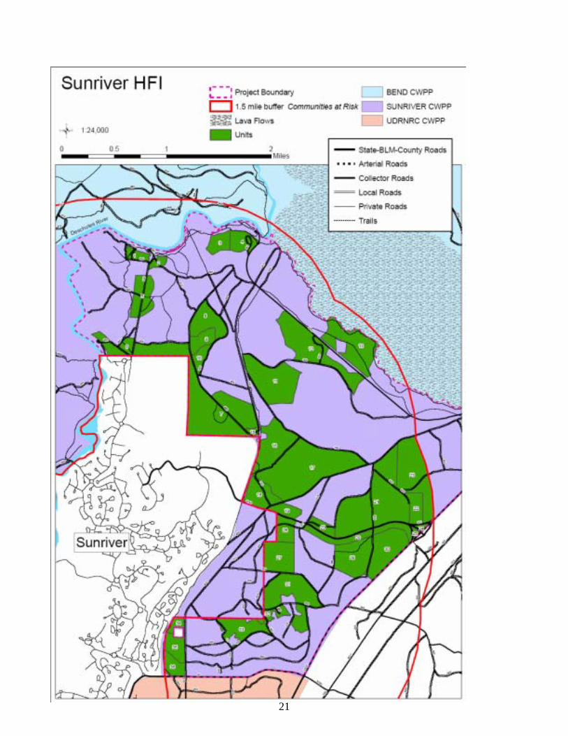
Sunriver HFRA Environmental Assessment Bend/Fort Rock Ranger District, Deschutes National Forest
CHAPTER 1 PURPOSE AND NEED FOR ACTION Introduction The Sunriver HFRA Project is proposed to reduce hazardous fuels in the Wildland-Urban Interface (WUI) adjacent to Sunriver, on the Bend/Fort Rock Ranger District of the Deschutes National Forest. During the 1920s, the Shevlin-Hixon company clear-cut harvested the large diameter ponderosa pine stands within the project area. These lands were subsequently purchased by the federal government for inclusion into the Deschutes National Forest. Since almost all the area was clear-cut harvested in the past, the vegetation conditions and attributes have been significantly altered from their historical range with almost a complete absence of large, old trees and open, fire-maintained ponderosa pine stands. Fire suppression during the preceding 80 years, vegetation growth and high stand densities have created a continuous vertical fuel ladder from the ground to the crowns of the trees and a horizontal layer of fuels such as shrubs, needles, limbs, and concentrations of beetle killed pine trees resulting in an unacceptable risk of stand replacement wildfire. Location and Setting The Sunriver HFRA project area is located on the eastside of the Sunriver community. It includes a portion of the Deschutes Wild and Scenic River corridor, Benham Falls day use site, trails, Sunriver’s major evacuation route (Cottonwood Road), municipal water storage tanks and electric utility corridors. The project area, which is located outside of the range of the northern spotted owl, consists of 5,352 acres within the 147,978 acre Pilot Butte watershed. A total of 47 acres are privately owned. The legal description is as follows: T 19 S, R 11 E, Sections 16-18, 20-23, 26-28, 33-35; T 20 S, R 11 E, Sections 3, 4, 5; Willamette Meridian, Deschutes County, Oregon (page 8). All lands are within the WUI as defined by the Sunriver Community Wildfire Protection Plan of 2005 (CWPP) and located within 1.5 miles of Sunriver. Management Direction and Guidance On August 8, 2000, President Clinton asked the Secretaries of Agriculture and Interior to prepare a report recommending how best to respond to the severe fires of 2000, reduce the impacts of those fires on rural communities, and ensure sufficient firefighting resources in the future. On September 8, 2000, the President accepted their report, Managing Impacts of Wildfires on Communities and the Environment-A Report to the President. This report provided the initial framework for implementing fire management and forest health programs known as the National Fire Plan. Protecting People and Sustaining Resources in Fire-Adapted Ecosystems, A Cohesive Strategy (2000) is a report providing the strategic framework for reducing hazardous fuels buildup within WUI communities, municipal watersheds, threatened and endangered species habitat, and other important local features. The objective of this strategy is to describe actions that could restore healthy, diverse, and resilient ecosystems to conditions that minimize the potential for uncharacteristically intense fires. Methods recommended include removal of excessive vegetation and dead fuels through thinning, prescribed fire, and other treatments. A Cohesive Strategy responds to Congressional direction to provide guidance on reducing wildfire hazard and restoring ecosystem health as part of the National Fire Plan. Companion publications to the Cohesive Strategy include A Collaborative Approach for Reducing Wildland Fire Risks to Communities and the Environment – 10-Year Comprehensive Strategy (2001) and A Collaborative Approach for Reducing Wildland Fire Risks to Communities and the Environment – 10-Year Comprehensive Strategy Implementation Plan (2002). The Healthy Forests Restoration Act of 2003 Public Law 108-148 (HFRA) was signed into law on December 3, 2003 by President George W. Bush and based on strategies and direction contained in the above mentioned reports. The HFRA is designed to improve the capacity of the Departments of Interior and Agriculture to
2
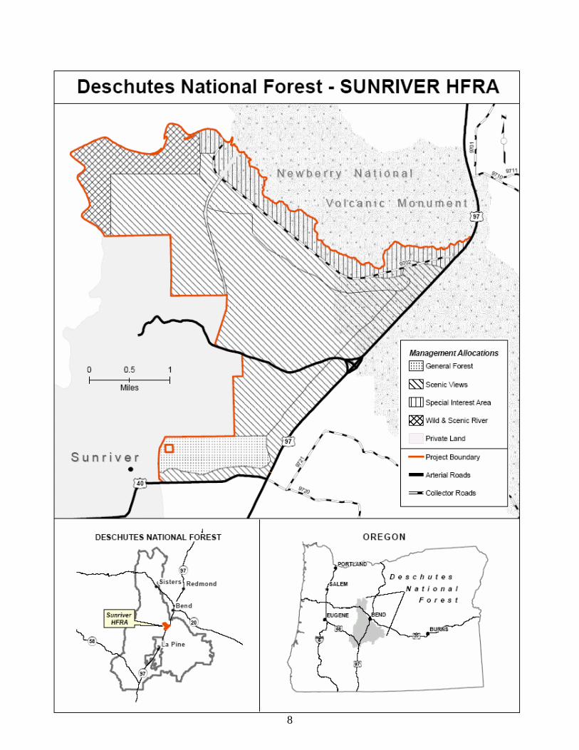
conduct hazardous fuels reduction projects to protect communities, watersheds, and other at-risk lands from catastrophic wildfire, enhance watershed protection and address threats to forest health. Sunriver qualifies as an “at-risk community” under the HFRA because it was included in the notice entitled “Wildland Urban Interface Communities Within the Vicinity of Federal Lands That Are at High Risk From Wildfire” that was published in the Federal Register and it is within and contiguous to Federal lands that have conditions that are conducive to large-scale wildland fire disturbance events which pose a threat to human life and property (HFRA, section 101). Sunriver subsequently developed a CWPP in compliance with the HFRA and in collaboration with federal, state, and local governments as well as private entities that was signed March 25, 2005. This EA is tiered to the FEIS for the Deschutes National Forest Land and Resource Management Plan (Deschutes LRMP, 1990). The LRMP guides all natural resource management activities and provides standards and guidelines for the Deschutes National Forest. The Management Areas (MA) for the Sunriver HFRA Project Area from the LRMP are shown on page 8. A brief summary of the direction for MAs where treatment is proposed, total acres within the project area in the MA and acres of proposed treatment follows:
• General Forest (80 of 343 acres, LRMP pages 4-117 to 4-120) - MA-8 emphasizes timber production while providing visual quality, wildlife habitat, and recreational opportunities for public use and enjoyment.
• Scenic Views (1,335 of 3,309 acres, LRMP pages 4-121 to 4-131) - The goal of MA-9 (Scenic Views) is to provide high quality scenery that represents the natural character of Central Oregon. Landscapes seen from selected travel routes and use areas will be managed to maintain or enhance their appearance and forest health.
• Newberry National Volcanic Monument (212 of 1,135 acres) – The Newberry Monument Plan (1994) specifies standards and guidelines for vegetation management to maintain forest health and to restore and reestablish old growth ponderosa pine ecosystems.
• Wild and Scenic Rivers (46 of 518 acres) - The primary objectives of MA-17 for managing waterways that are components of the National Wild and Scenic Rivers System is to protect the outstandingly remarkable values identified for each river segment in the Upper Deschutes River Management Plan. The Upper Deschutes River Plan of 1996 identified actions needed to restore, maintain and enhance the vegetation values within the ponderosa pine plant association group while also reducing fuels within the urban interface area. These actions include reducing the lodgepole component within historic ponderosa pine forests, density reduction to lower competition and fuels treatments to lower wildfire risk.
• Key Elk Area (LRMP 4-56 to 4-58) - Elk are found in certain key habitat areas, within which land management is designed to provide conditions needed to support summering and wintering elk. A 4,604 acre portion of the 21,462 acre Ryan Ranch Key Elk Habitat (KEHA, LRMP Appendix 16-2) overlays the majority of the project area.
In addition, management direction for the area is provided in four major LRMP amendments. Amended LRMP direction pertinent to the project area includes the Record of Decision for the Upper Deschutes River Management Plan (Upper Deschutes River Plan); the Record of Decision for Newberry National Volcanic Monument (NNVM Management Plan); the Decision Notice for the Revised Continuation of Interim Management Direction Establishing Riparian, Ecosystem, and Wildlife Standards for Timber Sales, (Eastside Screens, 1995), and the Decision Notice for Inland Native Fish Strategy (INFISH, 1995). This EA relies upon the analysis described in these documents and focuses upon implementing the management direction of the Deschutes LRMP, as amended. Purpose and Need The desired condition for the Sunriver HFRA project area is based on the HFRA, the amended Deschutes LRMP, the National Fire Plan (2000), Protecting People and Sustaining Resources in Fire-Adapted Ecosystems, A Cohesive Strategy (2000), and the Sunriver CWPP.
3
The purpose and need for the Sunriver HFRA project is to reduce hazardous fuels to:
1) Reduce wildland fire risk to communities and present forest values. The purpose of the proposed action is to reduce the percentage of the project area that has a moderate to extreme fire hazard from 69 percent to 50 percent or less by reducing horizontal and ladder fuels within the WUI and along identified evacuation routes. 2) Provide obvious, defensible space access and escape routes. The purpose of the proposed action is to provide obvious evacuation routes from Sunriver and developed recreation sites, and to develop defensible space along these roads which would provide improved conditions for egress and ingress and from which to engage in fire suppression action in the event of a wildfire (Cottonwood Road, Roads 40, 9702, 9702600 and Highway 97). 3) Reduce wildland fire risk to future forest values. The purpose of the proposed action is to reduce the future landscape risk for uncharacteristic wildfire by strategically decreasing stand densities and susceptibility to insects and disease, improve the sustainability of frequent fire in the future, and eliminate unnecessary roads that contribute to elevated wildland fire risk from human-caused fires and reduce wildlife habitat effectiveness. Proposed Action The following table provides a summary of the Purpose and Need and how the proposed actions respond to those underlying needs.
Table 1-1 Purpose and Need Summary of Proposed Action EA Unit Reduce wildland fire risk to communities, present and forest values
Approximately 1,673 acres would either be thinned, prescribe burned or mowed to reduce the percent of the project area rated as moderate to extreme for fire behavior from 69 percent to 37 percent. The strategic juxtaposition of EA units and crown density reduction is designed to reduce the risk of a large crown fire and beetle epidemic occurring within the project area for the next 10 to 20 years while also providing for the restoration of ponderosa pine old growth stands and the return of fire as an agent of fuels reduction
1-13, 15-36
Provide obvious, safe access and evacuation routes
Five miles of roadside thinning, mowing and underburning within 500 feet to reduce flame heights to less than four feet. Approximately 16.1 miles of undesignated evacuation routes would be closed to public use and decommissioned.
1, 2, 4, 5, 6, 12, 13, 18-26, 30, 36
The Sunriver HFRA project is an Authorized Hazardous Fuels Reduction Project under HFRA Section 102 because: (1) the site-specific, ecologically appropriate, and cost effective measures and methods used to implement this project include prescribed fire, and various mechanical methods, such as mowing, tractor and hand piling, thinning, and pruning; (2) the project is on Federal lands in WUI areas; and (3) the project is being conducted under sections 103 and 104 (d)(2) of the HFRA that only requires one action alternative if within 1.5 miles of an at-risk community with a signed CWPP. The proposed action integrates fuels reduction and forest health treatments to improve the short and long-term efficacy of proposed treatments for an area. All EA units include integrated fuels reduction treatments of the shrub layer, understory and, if appropriate, thinning from below to reduce crown density while generally retaining the tallest and largest diameter trees. For example, thinning would include whole tree yarding or hand piling to dispose of any activity generated fuels. This would be followed by prescribed burning or mowing of the shrub layer within the stand to reduce accumulated fuels and to negate any increase in short term risk of higher intensity surface fires. Timber harvest is included on 685 acres of the 1,673 acres proposed for fuels reduction treatments. Ponderosa pine would be retained over lodgepole pine in all areas because it attains a greater age and diameter and is more resistant to fire, insects and disease than thin barked lodgepole pine. No trees of any species over 21 inches in diameter (dbh) or any dead standing or down trees would be removed. An estimated 70 percent of the fiber
4
volume removed would be small diameter (11 inch average dbh) ponderosa pine. The remaining fiber removed would be small diameter lodgepole pine with an average diameter of 8 inches dbh. As an outcome of the vegetation management, an estimated 5,200 hundred cubic feet (CCF) of commercial wood (2.6 million board feet) would be available for sale with an overall average diameter of 10 inches, dbh. Project implementation would begin in 2007 and be completed within 5 to 10 years. Many EA units, as discussed above, would receive more than one type of treatment, such as thinning followed by prescribed burning or mowing of the understory. Fuels reduction activities are planned to occur for up to ten years to allow adequate time for contract work to be performed, and to maximize the potential to have ideal atmospheric conditions for conducting prescribed burning operations. The project would be implemented through a combination of timber sale and service contracts, Forest Service work crews, and partnerships. Decision to be Made Based on the analyses documented by this EA, the District Ranger of the Bend/Fort Rock Ranger District, Deschutes National Forest would determine which alternative would be implemented and if so, under what conditions. In doing this, the Deciding Officer will consider the following: Scoping, Collaboration and Public Involvement Scoping and public involvement are ongoing processes used to invite public participation and to obtain input on a particular proposed action. Since information received during these processes is used to help determine the extent of the analysis needed to reach an informed decision, public scoping is begun early in the planning process in order to integrate issues, comments and concerns into the design of the proposed action. The initial notification process for this project began in 1999. This was followed by the development of the proposed action in collaboration with the Oregon Department of Fish and Wildlife (ODFW), interested individuals, and the at-risk community of Sunriver. The proposed action was further modified after an office meeting on February 9, 2007 and field trip on April 12, 2007 with representatives of Blue Mountain Biodiversity and the Sierra Club. The Sunriver HFRA project area is within the areas of interest to the Klamath Tribes, the Confederated Tribes of the Warm Springs Reservation and the Burns Paiute Tribe. All three tribes were consulted with on both a government-to-government and staff-to-staff basis prior to and during project scoping. None of the governments raised any issues with the proposed project. A total of 72 scoping letters, containing the detailed, collaboratively developed proposed action, were sent on February 20, 2007 to adjacent landowners, businesses, media, other agencies, organizations, and members of the public who had previously expressed interest in vegetation management projects. The text of this letter, maps and all subsequent public correspondence was posted on the Deschutes National Forest website. This letter informed the public that the Sunriver HFRA project would be analyzed and reviewed under the HFRA and included an invitation to a public meeting on February 28 2007. Written comments were invited on the proposed action until March 20, 2007 The Bulletin and local radio stations ran and broadcast articles on the Sunriver HFRA project the week before the meeting and included contact information and the date and time of the February 28 public meeting. This was followed by a KVTZ lead story on the project, on the evening of February 28, which included contact information and the March 20 time period for submitting written comments. A summary of the people and organizations contacted during collaboration and scoping with input of those who participated or responded may be seen in Chapter 4.
5
Issues Normally, issues identified during scoping are used to generate alternatives to the proposed action; however, no alternatives are required for this HFRA project (see Chapter 2, Alternatives Considered). Instead, the interdisciplinary team (ID team) considered all the comments received during collaboration and scoping and refined the proposal presented in Chapter 2 to address the following types of issues: (1) Design Issues - Issues used to develop specific project design criteria for the proposed action; (2) Analysis Issues – Specific resources addressed in the effects analysis and frequently used to compare differences between alternatives. They are described in detail and analyzed in Chapter 3. The effects analysis in Chapter 3 uses measures or indicators, where appropriate, to evaluate how each of the alternatives addresses the design and analysis issues. Measures were used to clarify and compare the differences between the two alternatives and generally are not a strict quantitative measure of environmental effects. Design Issues The following issues reflect potential effects of the proposed action that have been addressed with specific project design criteria to eliminate or mitigate effects. Threatened, Endangered, and Sensitive (TES) species, other wildlife. The activities proposed in the Sunriver HFRA project area could have an effect on both plant and animal TES species and other wildlife species such as Management Indicator Species; Ecological Indicator Species; Species of Concern; and Resident and Migratory Landbirds. Project design elements to minimize or eliminate effects to species are included in the description of Alternative 2. Effects to population trends and habitat such as change in existing structure, restoration of open ponderosa pine habitat, and seasonal operating restrictions is discussed in the effects section. Noxious Weeds/Invasive Species. Vegetation management, fuels treatment and access may introduce or spread noxious weeds. An integrated weed management plan was prepared for the project and design elements aimed at preventing the introduction and spread of noxious weeds are incorporated into the proposed action (see Chapter 2, description of Alternative 2) The effects of the two alternatives on noxious weeds are described in Chapter 3. Hydrology (Water Quality)/Fisheries. The segment of the Deschutes River that flows through the project area is 303(d) listed under the Clean Water Act. The Deschutes River does not meet water quality standards in the Sunriver HFRA project area for the parameters of dissolved oxygen all year, turbidity spring and summer, Chlorophyll a summer season, high water temperatures year around, and sedimentation, undefined season. Fisheries habitat is largely dependent on water quality. The Upper Deschutes River Plan identified and discussed at length solutions to these water quality problems which are largely related to the regulated irrigation flows controlled by Crane Prairie and Wickiup Dams. Design elements aimed at ensuring that resource management activities are consistent with and supportive of water quality recovery are incorporated into the proposed action (See Chapter 2, description of Alternative 2, and Chapter 3). Soil Productivity. The proposed use of ground-based equipment can potentially increase the amount and distribution of detrimental soil conditions within the individual activity areas proposed for mechanical treatments. The removal of trees from activity areas can potentially cause adverse changes in organic matter levels. Design elements aimed at ensuring that resource management activities are consistent with and supportive of soil productivity standards are incorporated into the proposed action (See Chapters 2 and 3). Scenic Quality. Vegetation management activities may negatively affect short-term visual quality. Design elements aimed at maintaining the “sense of place” by reducing stand replacement wildland fire risk and enhancing scenic quality has been incorporated into the proposed action. Design elements aimed at ensuring that resource management activities are consistent with and supportive of scenic quality objectives are incorporated into the proposed action (See Chapter 2). The effects of the two alternatives on scenic quality are
6
described in Chapter 3. Cultural Resources. Design elements to avoid project related impacts to cultural resources have been incorporated into the proposed action. This has resulted in a finding by the Forest Specialist of No Effect under Section 106 of the National Historic Preservation Act (NHPA) and concurred with by Oregon State Historic Preservation Office (SHPO) staff. Air Quality/Smoke Management. Smoke from prescribed fires and pile burning may intrude into the communities of Bend and Sunriver or the Three Sisters Wilderness area, potentially causing impaired visibility, discomfort, and possible health hazards. Bend is a Designated Area with a high population density and closely monitored for smoke intrusion from prescribed fire. All prescribed burning would comply with the Clean Air Act and would be coordinated with the Oregon State Department of Environmental Quality and Oregon State Department of Forestry. All prescribed burning would be in compliance with state smoke management plans and ignition would occur only under prescribed conditions. Project design elements to minimize or eliminate effects to air quality are included in Chapter 2, description of Alternative 2. Analysis Issues The following potentially affected resoures are also evaluated in the analysis: Ecosystem and Forest Health. Currently there is essentially no open, large, single-stratum ponderosa pine within the project area and 69 percent of the acres are at risk from stand replacement fire and beetle attack. The effects of the two alternatives on short and long-term ecosystem health are described in Chapter 3. Recreation (trails/roads/developed sites). Road management proposed actions have been identified as a connected action as a result of an ID team roads analysis and big game cover reduction caused by vegetation management activities as it affects wildlife habitat effectiveness with maintenance of the current road density. Road closures were also identified as a potential resource enhancement project (see Sale Area Improvement Plan, Chapter 2). The area contains points of interest and hiking, horse back riding and biking trails that could possibly be affected by the proposed treatments. At the same time the roads and trails provide a risk of human-caused fires. The effect of the two alternatives on recreation both developed and dispersed and associated wildland fire risk is described in Chapter 3. Commercial Timber Harvest, Economic and Social analysis There are costs and benefits associated with implementing the action alternative. The economic and social analysis focuses on the financial efficiency and the effects of the two alternatives on the communities of Central Oregon and their ties to forest management through employment, income, recreation, and commercial timber harvest. Roads Consistent with the 2001 National Forest System Road Policy, a roads analysis was conducted on a 46,175 acre area that includes the Sunriver HFRA project area. Some of the conclusions and recommendations of this analysis (District Files) were that approximately 25 percent of the existing secondary roads should be closed and in lieu of any additional permanent roads short term temporary roads would be used to support vegetation management activities. Temporary road effects, that could potentially lead to a short-term increase in road density and effects on other resources, are included in Chapter 3. Issues Not Addressed in Detail Concerns about resources not affected by the proposed action, or beyond the scope of this project. Refer also to Chapter 4, Consultation with Others, Appendix G and Appendix J.
7
Wilderness/Roadless Characteristics There are no designated Wilderness areas within or adjacent to the project area. The nearest wilderness is the Three Sisters Wilderness, approximately 14 miles northwest of the project area, There are no Inventoried Roadless Areas or areas with unroaded characteristics within or adjacent to the project area. During scoping unroaded characteristics was not raised as an issue. The nearest Inventoried Roadless Area is the Bend Watershed Roadless area, 10.0 miles to the northwest. As previously identified, the project area was clear-cut harvested in the 1920s and current open road density is 7.3 miles per square mile. Current Condition Wildland Fire Risk for Communities and Present and Future Forest Values There is an almost complete absence of large, old trees across the project area, and there are no examples of historic, open, fire-maintained ponderosa pine stands remaining. The stands have had their fire regimes significantly altered from historic fire return intervals by clearcut logging in the 1920s and 30s. Fire size, intensity, severity, and landscape patterns have been dramatically changed as a result. The risk of losing key ecosystem components is moderate to high. The young ponderosa pine dominated forestlands which developed within the project area after clear-cut harvesting would best be characterized by Fire Regime Group I, Condition Classes 2 and 3. Fire Regime Group I lands evolved with frequent, low-intensity ground fires with average historic fire return intervals from 0 to 35 years. Condition Class 2 and 3 characterizes those lands that have had their fire regimes moderately to significantly altered from their historical range. Fire hazard and fuel levels in these areas are a mosaic of low to high levels. There is increased potential for higher severity fires because of encroachment of lodgepole pine, high stand densities, vertical fuel ladders from the ground to the crowns of trees, a continuous, horizontal layer of fuels such as shrubs, needles, limbs, and concentrations of beetle killed pines. Young ponderosa pine stands cause the adjacent communities to be at high risk for stand-replacing wildfires.
High stand densities lower the growth rate of trees because of competition for water, nutrients, and growing space. The low level of tree and stand vigor because of this competition makes trees more susceptible to insect and disease mortality. Insect and disease attack in turn create more fuels, exacerbating the existing condition. Values at risk include the upland and riparian vegetation associated with the Upper Deschutes Wild and Scenic River, scenic views, water quality, key elk and deer habitat, and the Bend municipal water supply infrastructure. Access and Emergency Escape Routes There are various human uses in the project area, including seasonal and full-time residents, businesses, recreation sites, trails, and resorts. High fuels and wildland fire risk occur along roads throughout the project area and along roads that provide access in and out of private property and developed recreation. Escape routes are not clearly designated, and numerous unneeded roads add confusion and potential hazards to evacuees and firefighters in the case of a wildfire in these heavily populated and used areas. These conditions could make using the roads dangerous in the event of a wildfire, and could leave forest visitors and residents trapped or make it more difficult and dangerous to fight a wildfire. In addition, an estimated 60 percent of the fire starts within the project area are associated with roads and human use. Desired Condition Wildland Fire Risk for Communities and Present and Future Forest Values The long term (80 to 100 years) target condition for the project area would be to have at least 60 percent of the ponderosa pine in late and old structural stages versus the current less than 1 percent. The short term desired condition is to have less than 50 percent of the area in the moderate to extreme fire behavior category for the next two decades. Access & Emergency Escape Route Defensible space should be at least 500 feet wide on either side of roads, with potential flame heights less than four feet. Escape routes should be clearly designated and distinguishable during a wildfire event. Fire regime condition classes adjacent to roads would be at a condition class 1.
8
9
CHAPTER 2 ALTERNATIVES CONSIDERED Introduction The purpose of this chapter is to describe how alternatives were generated and either eliminated from detailed study or considered in detail. Normally, issues identified during scoping are used to generate alternatives. However, because this project is being prepared under the HFRA and all EA units are within 1.5 miles of an at-risk-community on lands designated as WUI by the approved Sunriver, Oregon CWPP, no alternatives to the proposed action are required (HFRA Section 104 (d)(2)). The project design of the proposed action alternative, that meets the purpose and need outlined in Chapter 1, was therefore an iterative process that considered scientific literature, modeling, scoping comments, mitigation, collaboration and LRMP direction. As a result of this iterative process, the ID team developed one action alternative. Although the HFRA does not require development of a no action alternative (Alternative 1), Alternative 1 is analyzed and contrasted with Alternative 2 to give readers and the deciding officer enough information to understand the need for the project. Alternatives/Areas Dropped from Further Consideration A total of 5,352 acres were investigated in the field. The ID team narrowed this total acreage as it developed the proposed action and the no action alternative. The alternatives and/or acres that were considered during the environmental analysis but eliminated from vegetation management consideration are described below: 1) The project area includes 142 acres within 300 feet of the Deschutes River (3.9 river miles). Areas within
300 feet of a fish bearing river or stream are (INFISH, 1995) considered a Riparian Habitat Conservation Area (RHCA). All areas within RHCAs were eliminated from vegetation management treatment during collaboration to narrow the purpose and need and to eliminate the potential for effects to water quality.
2) An alternative that reduced ladder and crown fuels by pruning with a 12” dbh cap on tree removal was
eliminated from consideration because it did not meet the purpose and need. The analysis in the Ecosystem and Forest Health section of Chapter 3 shows that some trees larger than this need to be thinned to be effective at reducing beetle risk and stand replacing fire behavior. Assuming that half of the trees less than 12” dbh would be cut in a thin from below prescription, over ¾ of the thinning EA units would still have stand density indexes, basal areas and crown bulk densities (Appendix A-14) above or near the upper end of desired levels. When combined with the collaboratively derived retention of 30 percent hiding cover for each EA unit, capping tree removal at 12” dbh would reduce the effectiveness of the thin < 21” dbh EA units to below 50 percent while overall leaving more than 50 percent of the project area at high risk to a stand replacing wildfire. A 12” dbh cap also does not address the need to restore the structure and composition of old growth ponderosa pine stands (HFRA Section 102 (E) (2). Unlike a thinning from below prescription that leaves the larger, healthier trees; bark beetles tend to “thin from above” by killing the larger trees. This can be an extremely negative effect in a project area where thousands of acres of contiguous ponderosa pine were clear-cut harvested and regenerated to form a landscape that is not resilient to natural disturbances. As noted in Chapter 3, in the Ecosystem and Forest Health resource section, thinning would increase diameter growth by an average of 176 percent and accelerate the restoration of old growth ponderosa pine characteristics. In summary, tree removal is currently capped at 21” dbh. Reducing the cap to 12” dbh would have further negative effects on some ecosystem components. As noted in the Mason et all study (page 58), the best results were achieved with no diameter caps and caps in general are a one-size-fits-all policy that is at odds with management objectives and site diversity (Abella, Fule, Covington 2006).
Alternatives Considered in Detail
ALTERNATIVE 1
10
Alternative 1 is the No-Action alternative. This alternative assumes that none of the activities associated with the project, such as thinning, mowing of shrubs and underburning would occur. In the analysis of effects in Chapter 3 of this document, the Alternative 1 discussion provides baseline information on the affected resources, including expected trends. For example, fire suppression activities would continue as directed under the LRMP, Fire Management Action Plan and other pertinent direction. The overall upward trend in the percentage of the project area classified as high and extreme for fire behavior potential would continue. The popularity of the developed recreation sites, bike trails, horse trails and hiking trails would also grow due to population growth and the proximity to Sunriver and Bend. Along with increased vehicular use, user-created roads would also likely increase. Current and expected future use of the project area by motorized recreationists would continue to exacerbate effects on both wildlife and vegetation while increasing the risk of human-caused ignition and complicating the safe evacuation of people during a wildfire event. ALTERNATIVE 2 (Proposed Action) Introduction: Alternative 2 is the proposed action (page 21) that was collaboratively developed by the ID Team. In addition to describing the action alternative considered and analyzed in Chapter 3 of this document; this section provides a summary of the activities and practices that would be carried out in the specific EA units as detailed under the following Mitigation and Management Requirements section of the EA.
Strategic Objectives: Alternative 2 would reduce wildland fire risk to communities and present forest values (Fuels/Fire Hazard Reduction, Chapter 3) by closing roads and proposing fuels reduction treatments adjacent to private property and along identified evacuation and access routes within the WUI. The EA units are strategically located immediately adjacent to private property, infrastructure, recreations sites, and evacuation routes. Whenever possible, the EA units tie into natural fuel breaks such as lava flows, rock outcrops, and prior treatment areas to leverage the effective treatment size and break up areas of high accumulated natural fuels. The EA units were concentrated adjacent to Sunriver to maximize protection of private lands. Although not part of this alternative, fuels reduction has also been ongoing within Sunriver. Reduction of wildland fire risk to future forest values would be accomplished by removing most of the lodgepole pine from historic ponderosa pine stands and reducing tree density and accumulated fuels to accelerate the development of later structural stage ponderosa pine that is less susceptible to insects and diseases and more resilient to stand replacement wildfire. Diversity would also be addressed by retaining wildlife travel corridors, screening cover, and untreated patches within and adjacent to the EA units to maintain and or improve big game, raptor and landbird habitat. In general, wildlife cover areas and corridors would not be retained within 300 feet of houses and other structures within the EA units to ensure the treatment objective of wildland fire risk reduction is not compromised. Reduced fire hazard and tree mortality is accomplished by lowering fuel loads, removing ladder fuels and decreasing the potential for crown fires by thinning to increase the distance between tree crowns. Accumulated natural fuel loads would be treated by mowing of the shrub layer and through the use of prescribed fire. Roads analysis recommendations (page 6) would be implemented by closing unneeded and confusing roads adjacent to high use recreation areas in order to clearly identify evacuation and access roads. Scope of Work: Alternative 2 has a total of 36 EA units that cover 1,673 acres. Each EA unit would typically have two or more fuel reduction activities to reduce fuel loadings on 31 percent of the total project area. A total of 21 of the 36 EA units (Table 2-1, Thin < 21” dbh) covering 685 acres would include some level of thinning and hand-piling as one in a series of integrated treatments needed to restore sustainable conditions. An estimated 5,200 hundred cubic feet (CCF) (2.6 MMBF) of fiber less than 21 inches in diameter (dbh) would be
11
removed with commercial thinning timber sales on these 21 EA units. The remaining 15 EA units covering approximately 988 acres would be prescribed burned and/or mowed to reduce fuel loads without thinning. Alternative 2 Proposed Treatments Table 2-1 summarizes the proposed treatments by EA unit for Alternative 2. Treatments are designed to move the EA units toward the more open, later structural stage ponderosa pine conditions that once dominated the project area. The EA units would be treated by a combination of thinning, brush mowing, hand-piling, and underburning to reduce and modify the fuel loadings and fuel profiles. Thinning: Thinning would include whole tree yarding of trees between 4 and 21 inches dbh to ensure that the activity does not exacerbate existing natural fuel loads followed by hand thinning and hand-piling of the small diameter trees less than 4 inches dbh. On average, a range of 40-60 square feet of basal area per acre and a minimum of 40-55 trees/acre would be retained in the ponderosa and mixed stands of lodgepole pine and ponderosa pine. In general, under the variable density thinning prescriptions included with this alternative, the largest and healthiest trees in the stand would be retained in addition to all the live trees larger than 21 inches dbh. Ponderosa pine would be favored for retention over lodgepole pine because they live longer, grow to larger diameters and are more resistant and resilient to insects, disease and fire. Boom mounted shears utilizing designated skid trails or logging over snow and/or frozen ground would be done in all thinning EA units. Existing landings and skid trails would be used where feasible. Temporary roads would be established to access some units and to locate landings off of main roads. The proposed temporary roads are shown in Appendix H. All temporary roads and some of the primary skid trails and landings would be obliterated by subsoiling following vegetation management activities within specific EA units. Thinning in combination with the other integrated treatments described below would help reduce ladder fuels and stand replacement fire potential while improving forest health. Where feasible, piles that are to be burned would be located on existing disturbed areas such as old roads, skid trails and landings within all EA units. Pruning of individual trees would occur within EA unit 32 to further reduce ladder fuels.
Mowing: Brush mowing or shredding consists of mowing understory shrubs, small trees, and other vegetation to alter the fuel profile by eliminating ladder fuels and reducing flame heights and rate of spread. A mowing attachment is towed behind a tractor, or is attached to the head of an excavator or harvester (slashbuster) and the vegetation is mulched and chopped into small pieces and left on the surface. This method can often be used to complete thinning of the understory at the same time the shrub layer is treated. An average of 30 percent of each EA unit would be retained to maintain shrubs for deer forage and wildlife habitat for other species such as landbirds and rodents. A total of approximately 558 acres would be mowed to alter the fuel profile. This total includes an estimated 120 acres of mowing in the 1,204 acres planned for prescribed burning to reduce flame heights adjacent to private property, roads and firelines. Prescribed burning: Prescribed burning, also called underburning and used interchangeably throughout this document, consists of burning the surface fuels to consume dead and unwanted woody material such as needle litter, limbs, shrubs and small trees. The underburning is carried out by Forest Service hand crews, supported by engines and support vehicles in the spring and fall under prescribed fuel moisture and atmospheric conditions to minimize consumption of large down logs (CWM) and to meet Clean Air Standards.
An average of 30 percent of the prescribed burning EA units would not be treated to provide wildlife habitat. A total of 1,204 acres would be prescribed burned under Alternative 2 within the next 7 to 10 years. Further details about the proposed treatments may be found in the appendices and the project record.
12
Forest Roads: A total of 5 miles of the 10 miles of evacuation and access roads would be treated within the EA units discussed above to provide defensible space. Access to designated EA units for harvest and hauling of commercial wood products would predominately be on existing forest roads. An estimated 0.7 miles (total) of temporary roads would be established to access portions of EA units that are not readily accessible from existing forest roads. For example, locating the landing off a major road to provide for public safety and a safe place for limbing and loading logs would require a 100 foot temporary road to access the landing. When feasible, existing logging facilities used during the previous harvesting entries would be reused. Temporary roads would be closed and subsoiled after use in addition to 16.1 miles of road decommissioning (Appendix H). There would be no decommissioning (subsoiling) of roads or dispersed sites within the RHCA. Closures of access roads to the RHCAs would be done outside of the RHCA. These unneeded roads were identified during a roads analysis and they are redundant for evacuation and firefighter access routes and serve as a vector for human caused ignitions. Closing the roads would also increase habitat effectiveness in the Ryan Ranch KEHA. Prior to subsoiling, roads would be surveyed for noxious weeds and, if found, hand pulled. Wildlife habitat: All dead standing trees (snags) and down trees (CWM) within the project area would be left to provide wildlife habitat. Due to the extensive clear-cut harvesting in the 1920s, the existing young stands of ponderosa pine are generally lacking adequate levels of snags in the larger size classes over 20 inches dbh. As the stands continue to grow larger in diameter over the next two to three decades, this unbalanced snag distribution would gradually disappear. Existing CWM combined with current levels of standing dead trees would be managed at levels based on the ponderosa pine, dry Plant Association groups (PAG). Consistent with Eastside screens, wildlife connectivity corridors were designated to connect stands within and adjacent to the project area including an important east-west elk movement corridor north of Sunriver. On average, 30 percent of the EA thinning units would be left in wildlife cover patches of from 2 to 30 acres in size. Where feasible they would be located around rock outcrops and other sensitive areas.
To further improve habitat effectiveness in the Ryan Ranch KEHA the Tumalo Winter Range Cooperative Closure Area (Appendix H-1) would be expanded to include the project area (Appendix H-2). Mitigation and Management Requirements These mitigation and management requirements are an integral part of the action alternative. Mitigation measures are specific actions that could be taken to minimize, avoid or eliminate impacts on the resources that would be affected by the action alternative or rectify the impact by restoring the affected environment. Management requirements are mitigation measures typically derived from LRMP standards and guidelines, but other sources can also be existing laws and regulations, or guidelines for practices required by site-specific conditions. In general, management requirements represent standard operating procedure for the protection of forest resources and they are generally addressed in timber sale and service contract provisions or EA unit layout. These standard operating procedures that are incorporated into project design are also called project design criteria or resource protection measures. Effectiveness Ratings provide a qualitative assessment of expected effectiveness that the implemented practice will have on preventing or reducing impacts on resources. The effectiveness of each measure is rated at high, moderate, or low. These mitigation measures and management requirements are considered in the effects discussions of Chapter 3. Effectiveness ratings of High, Moderate or Low are based on the following criteria: (1) Literature and Research; (2) Administrative Studies (local or within similar ecosystem); (3) Experience (judgment of qualified personnel by education and/or experience); (4) Fact (obvious by reasoned, logical response)
13
HIGH: Practice is highly effective (greater than 90 percent), meets one or more of the rating criteria, and documentation is available. MODERATE: Documentation shows that practice is 75 to 90 percent effective; or Logic indicates that practice is highly effective, but there is no documentation. Implementation and effectiveness of this practice needs to be monitored and the practice will be modified if necessary to achieve the mitigation objective. LOW: Effectiveness is unknown or unverified, and there is little or no documentation; or applied logic is uncertain and practice is estimated to be less than 60 percent effective. This practice is speculative and needs both effectiveness and validation monitoring. Soils Mitigation and Management Requirements: The following mitigation measures are designed to avoid or minimize negative effects to soils by restricting equipment operations to locations and conditions that are less susceptible to resource damage. This type of mitigation has been built into Alternative 2 as part of the project design. The management requirements listed for the soil resource are to be implemented during or after the project in order to meet the stated objectives for protecting and maintaining soil productivity. Soils Management Requirements: Apply appropriate Best Management Practices (BMPs) to all ground-disturbing management activities, as described in General Water Quality Best Management Practices (Pacific Northwest Region, 1988). The Deschutes LRMP states that BMPs will be selected and incorporated into project plans in accordance with the Clean Water Act for protection of waters of the State of Oregon LRMP 4-69). Specific BMPs commonly used to minimize the effects of road systems, fuels and timber management activities on the soil resource are briefly described for this project proposal.
• Use old landings and skidding networks whenever possible. Assure that water control structures are installed and maintained on skid trails that have gradients of 10 percent or more. Ensure erosion control structures are stabilized and working effectively (LRMP SL-1; Timber Management BMP T-16, T-18). High effectiveness.
• In all proposed activity areas, locations for new yarding and transportation systems would be designated prior to the logging operations. This includes temporary roads, spur roads, log landings, and primary (main) skid trail networks. (LRMP SL-1 & SL-3; Timber Management BMP T-11, T-14 & T-16). Moderate effectiveness.
• Surface Drainage on Temporary Roads – minimize the erosive effects of concentrated water and degradation of water quality through the proper design and construction of temporary roads (Road BMP R-7). Moderate effectiveness
• Road Maintenance – conduct regular preventive maintenance to avoid deterioration of the road surface and minimize the effects of erosion and sedimentation (Road BMP R-18, R-19). Moderate to High effectiveness.
• Protect Soils and Water during prescribed burn operations – A burn plan addressing compliance with all applicable LRMP standards and guidelines and Best Management Practices will be completed before the initiation of prescribed fire treatments in planned activity areas. Prescribed burn plans need to include soil moisture guidelines to minimize the risk of intense fire and adverse impacts to soil and water resources (LRMP SL-1 & SL-3; Timber BMP T-2, T-3 & T-13; Fuels Management BMP F-2, F-3). Moderate to High effectiveness.
• Coarse Woody Debris/Down Wood - Retain adequate supplies of coarse woody debris (greater than 3-inches in diameter) to provide organic matter reservoirs for nutrient cycling following the completion of all project activities (LRMP SL-1). It is recommended that a minimum of 5 to 10 tons per acre of CWM be retained on Ponderosa Pine sites to help maintain long-term site productivity. These amounts are less than the recommended levels for wildlife habitat objectives (Eastside Screen Direction) Moderate effectiveness.
14
• Maintain duff layer – Strive to maintain fine organic matter (organic materials less than 3-inches in diameter) over at least 65 percent of an activity area (pertains to both harvesting and post-harvest operations). If the potential natural plant community (i.e., site) is not capable of producing fine organic matter over 65 percent of the area, adjust minimum amounts to reflect potential vegetation site capabilities (LRMP SL-6; Fuels Management BMP F-2; Timber Management BMP T-13). Moderate effectiveness.
• Use sale area maps for designating soil and water protection needs (Timber Management BMP T-4). Moderate effectiveness.
Minimize the extent of new soil disturbance from mechanical treatments by implementing appropriate design elements for avoiding or reducing detrimental soil impacts from project activities such as:
1) Use existing log landings and skid trail networks (whenever possible) or designate locations for new skid trails and landings.
2) Maintain spacings of 100 to 150 feet for all primary (main) skid trail routes, except where converging at landings. Closer spacings due to complex terrain must be approved in advance by the Timber Sale Administrator. Main skid trails spaced 100 feet apart limit soil impacts to 11 % of the unit area. For the larger activity areas (greater than 40 acres) that can accommodate wider spacing distances, it is recommended that distance between main skid trials be increased to 150 feet to reduce the amount of detrimentally disturbed soil to 7 percent of the unit area (Froehlich, 1981, Garland, 1983). This would reduce the amount of surface area where restoration treatments, such as subsoiling, would be required to mitigate impacts to achieve soil management objectives.
3) Restrict grapple skidders to designated areas (i.e., roads, landings, designated skid trails) at all times, and limit the amount of traffic from other specialized equipment off designated areas. The use of harvester machines will be authorized to make no more than two equipment passes on any site-specific area to accumulate materials.
4) Avoid equipment operations during times of the year when soils are extremely dry and subject to excessive soil displacement.
5) Avoid equipment operations during periods of high soil moisture, as evidenced by equipment tracks that sink deeper than during dry or frozen conditions.
6) Operate equipment over frozen ground or a sufficient amount of compacted snow to protect mineral soil. Equipment operations should be discontinued when frozen ground begins to thaw or when there is too little compacted snow and equipment begins to cause soil puddling damage (rutting).
7) Prevent additional soil impacts in random locations of activity areas, between skid trails and away from landings, by machine piling and burning logging slash on existing log landings and skid trails that already have detrimental soil conditions.
Objective: Reduce displacement and compaction damage to soils by limiting the amount of surface area covered by logging facilities and limiting equipment operation to specified areas and ground conditions. Effectiveness: High Basis: LRMP Standards and Guidelines (SL-1 and SL-3); Timber Management BMPs T-2, T-4, T-9, T-11 and T-12; Forest Service Soil and Water Conservation Practices Handbook (FSH 2509.22); Froehlich et al 1981; Clayton, 1990; Garland, 1983; Fact; Experience
Soils Mitigation Measure: Reclaim specific segments of local system roads, all temporary roads, and some log landings and primary (main) skid trails by applying appropriate rehabilitation treatments in activity areas where detrimental soil conditions are expected to exceed the Regional Policy guidelines. Decommission (obliterate) logging facilities that will not be needed for future management. Options for mitigating the effects of project
15
activities include the use of subsoiling equipment to loosen compacted soils on temporary roads and logging facilities, redistributing humus-enriched topsoil in areas of soil displacement damage, and pulling available slash and woody materials over the treated surface to establish effective ground cover protection. Reclaim all temporary roads and some of the logging facilities in portions of the following activity areas, ranging in size from 3 to 139 acres, which are expected to exceed allowable limits of detrimental soil conditions following the mechanical harvest treatments proposed with this project. EA Units: 2, 6, 15, 20, 21, 24, 25, 31, and 33. Road Decommissioning (subsoiling): Units 6 (0.1 miles), 17 (0.3 miles), 18 (0.3 miles), 21 (0.5 miles), 26 (0.2 miles), 28 (0.1 miles), 30 (0.2 miles), 31 (0.5 miles), and 33 (0.1 miles). Objectives: Reduce the extent of detrimentally disturbed soil to meet management objectives. Restore and stabilize detrimentally disturbed soils prior to seasonal runoff events. Effectiveness: HIGH Basis: Forest Plan Standards and Guidelines for Soil, Water and Riparian Resources (SL-1 and SL-4); Watershed Management BMP W-1; Cafferata, 1983; Garland, 1983; Experience, Logic. Hydrology/Fisheries Mitigation and Management Requirements: The following mitigation measures are designed to avoid the potential for negative effects to water quality and fisheries. The management requirements listed are to be implemented during or after the project in order to meet the stated objectives for protecting and maintaining water quality. Hydrology/Fisheries Management Requirements: Apply appropriate BMPs to all ground-disturbing management activities, as described in General Water Quality Best Management Practices (Pacific Northwest Region, 1988). These BMPs are tiered to the Soil and Water Conservation Practices (SWCP) Handbook (FSH 2509.22), which contains conservation practices that have proven effective in protecting and maintaining soil and water resource values. The Deschutes LRMP states that BMPs will be selected and incorporated into project plans in accordance with the Clean Water Act for protection of waters of the State of Oregon LRMP 4-69). Specific BMPs commonly used to minimize the effects of road systems, fuels and timber management activities on water quality in addition to those described above for soils follows:
! Landings and Equipment Staging Areas-All log landings, servicing and refueling of equipment shall be located outside the RHCAs to prevent the potential for sedimentation and pollutants from entering the water (LRMP RP-1, WT-2; Timber Management BMP T-10, T-11, INFISH TM-1, RA-4). High effectiveness.
! Timing of Road Decommissioning- Decommissioning of 16.1 miles of system road and 0.7 miles of temporary road to occur during periods of dry weather to prevent overland flow of water. Termini of road decommissioning would be located outside of RHCAs on gentle slopes by the district fisheries biologist where the potential for overland flow to affect water quality is nonexistent. (Road BMP R-3, R-23, INFISH RM-2). High effectiveness
Hydrology/Fisheries Project Design Criteria: Exclude all perennial, intermittent, ephemeral streams, and water bodies RHCAs from EA units and activity areas. Objective: Eliminate the potential for negative effects to water quality and fisheries habitat. Effectiveness: High Basis: LRMP Standards and Guidelines (RP-1, WT-1), Experience, logic
16
Cultural Resources Management Requirements: Known heritage resource sites would be avoided by all proposed activities or completed by hand. Heritage resource sites discovered during harvest and vegetation management activities operations would be avoided from any further disturbance. Objectives: Maintain and protect identified and unidentified sites until sites can be researched. Effectiveness: High Basis: LRMP Standards and Guidelines for Cultural Resources (LE-7); Experience, Logic, Fact. Scenic and Recreation Management Requirements: These recommendations are designed to help maintain or enhance short-term and long-term scenic views, meet or exceed LRMP standards and guidelines for scenic views, and meet the LRMP Desire Future Scenic Condition through the perpetuation of scenic components and landscape elements. Scenic and Recreation Project Design Criteria The following management requirements are designed to eliminate or reduce effects brought on by the proposed management activities, while meeting the LRMP standard and guideline directions for Scenic Views.
• Minimize the use of paint where feasible, especially within the immediate Foreground landscape. Where paint is needed along scenic routes, utilize backside tree marking to minimize visibility. Flush cut stump (8 inches or less) within immediate Foreground landscape (0 to 100 feet). Where possible, design and locate skid trails and landings at least 100 feet away from Forest Roads 40 and 9702, Cottonwood Road and Highway 97.
• Slash treatment within scenic corridor to be completed within one and two year’s period, respectively, for SV-1 and SV-2 scenic views allocation area.
• Keep the scorching of tree crowns during prescribed burning to approximately 1/3 of live crown ratio.
• Removal of all boundary flagging as part of the post treatment activities along scenic corridors. • To eliminate recreational conflicts, vegetation management activities involving mechanized tree
removal within EA units 1, 2, 3, 4, 5 and 6 would occur outside of the normal recreation season of May 20 to September 1.
Objectives: Maintain and move towards management objectives for Scenic Views. Effectiveness: Moderate to High Basis: LRMP Standards and Guidelines for Scenic Views (M9-4 to M9-19); Experience, Fact. Noxious Weeds Management Requirements: Machinery involved in vegetation management and fuels reduction activities, road building, and road closures must be washed prior to entry into the project area. Use the timber sale contract equipment washing clause and service contract provisions to reduce the possibility of importing noxious weeds to the area. Machinery involved in project activities must be washed prior to going to the next work site. A map of all known weed sites would be provided to project implementers during standard pre-work meetings in order to avoid spreading weeds and avoid staging equipment on known spotted knapweed, dalmation toadflax and cheatgrass. Objectives: Reduce or eliminate the introduction or spread of noxious weeds. Effectiveness: Moderate to High Basis: Forest Service Manual (FSM) 2081.03, 29); October 2005 ROD for the Pacific Northwest Region Final Environmental Impact Statement for the Invasive Plant Program, 2005, Experience, Fact Noxious Weed Project Design Criteria To avoid weed spread, equipment used to do vegetation management
17
activities would not be allowed to move or track within 30 feet of the white shoulder line on Forest Roads 40 and 9705, Cottonwood road and Highway 97. The district botanist or her representative will flag out the known weed populations (in or adjacent to EA units 4, 18, and 30), and they will be posted out of the units
Objectives: Reduce or eliminate the introduction or spread of noxious weeds. Effectiveness: High Basis: Forest Service Manual (FSM) 2081.03, 29); Pacific Northwest Region Final Environmental Impact Statement for the Invasive Plant Program, 2005, Experience, Logic Fuels Treatment and Air Quality Management Requirements: Whole-Tree-Yard (WTY) or Leave-Tops-Attached (LTA) to the last log would be used on all fiber removal acres to eliminate activity fuels. Approximately 46 landing piles with an estimated 1,400 tons of limbs, needles, and tops would be used for biomass or burned and approximately 1,204 acres of accumulated natural fuels would be underburned. Utilization of fuel in landings piles would be an option for disposal depending on markets and economics. Brush disposal or appropriated funds would be collected from the sale to dispose of the landings. All slash pile and prescribed burning would be in accordance with Oregon State Smoke Management Guidelines. Objectives: Maintain and move towards resource objectives for the management areas. Eliminate disturbance to riparian areas. Effectiveness: High Basis: LRMP Standards and Guidelines, Fire and Fuels Management (FF-1 to FF-11, INFISH FM-1); Experience, Fact. Vegetation Management Project Design Criteria: To assure stocking levels remain above minimum levels (40 stand density index) in EA unit 17, minimize burning through lodgepole pine dominated areas in the western portion of the unit. Measures will include: 1) designating wildlife retention areas where lodgepole pine dominates, 2) constructing fire line around areas dominated by lodgepole pine prior to burn, and 3) utilizing lighting techniques that would minimize amount of fire in lodgepole pine clumps. Objectives: Maintain stocking levels in Unit 17 Effectiveness: Moderate Basis: LRMP Standards and Guideline TM-36, Experience, Logic
To reduce potential for long-term growth loss and bark beetle induced mortality of ponderosa pine following proposed underburns, conduct burns in a manner that will result in retention of at least 40 percent live crown ratio on dominant and codominant trees. This should generally result in crown scorch less than 50 percent. Measures will include: 1) initiating burns outside the time of ponderosa pine bud elongation (between mid-May to early June depending on weather conditions), 2) initiating burns when weather and fuel moisture conditions are favorable for meeting fuel reduction objectives and minimizing damage, and 3) utilizing lighting techniques expected to meet fuel reduction objectives while minimizing damage to residual trees. Objectives: Minimize damage to residual trees Effectiveness: Moderate Basis: LRMP Standards and Guideline TM-36, Experience, Logic Wildlife Mitigation and Management Requirements: The following mitigation measures are designed to avoid or minimize negative effects to wildlife and to meet LRMP direction.
Wildlife Project Design Criteria: Within thinning EA units, 30 percent would be retained in screening clumps
18
that have not been thinned for at least 20 years. Prescribed burning and mowing units would retain 30 percent. Motorized and OHV recreation would not be allowed within the Ryan Ranch KEHA from December 1 to March 31 under the expanded Tumalo Cooperative Winter Range Closure Area (Appendix H-1 to H-2). Harvest and other activities may be waived at the discretion of the District Ranger in order to mitigate the effects on other resources (e.g. logging on snow/frozen ground to reduce soil compaction).
A total of 16.1 miles of road would be decommissioned to meet target open road densities in all management areas, in addition to expanding the Tumalo Cooperative Winter Range Closure Area. Motorized travel would only be on routes (Appendix H-2) needed for public access during the closure period. Objectives: Maintain and move towards forest-wide resource objectives and wildlife objectives for MA 8, 9, 17, and the Ryan Ranch KEHA. Effectiveness: High Basis: LRMP Standards and Guidelines, (MA 7-10, 14, 22; WL-3, 46, 51); Experience, Fact. Eastside Screens specify that 100 percent of cavity nesting potential will be provided with snags and green tree retention. Fallen trees and other woody debris will be retained in sufficient quantity, distribution, and physical characteristics to provide habitat for viable populations of dependent wildlife species over time. The Eastside Screens require incorporation of the latest scientific findings, which suggest retaining 1.4 percent of CWM coverage per acre and 2.7 snags per acre. Where logs of the recommended size and density are not available, an average of 1 slash pile or concentration per acre will be retained. Wildlife Project Design Criteria No standing dead or down trees of any species would be removed. To protect snags and CWM larger than 20 inches dbh, that are currently below desired levels in the project area, fuels would be removed from around them before burning or protected by hose lays or other means. Objectives: Maintain wildlife species associated with dead and down trees. Effectiveness: Moderate to High Basis: LRMP Standards and Guidelines WL-72, 73, Eastside Screens; Experience, Logic. Wildlife Project Design Criteria Silvicultural prescriptions are designed to accelerate the development of LOS stage ponderosa pine. Connectivity corridors were mapped (page 70) and overlap portions of EA units 1, 2, 9, 17, 19, 26. A minimum 400 foot wide corridor would be excluded from treatment within these EA units and included in wildlife cover areas. Objectives: Maintain corridors for wildlife travel, dispersion and security Effectiveness: Moderate to High Basis: LRMP Standards and Guidelines WL-48, 46, Eastside Screens; Experience, Logic
Wildlife Project Design Criteria To minimize effects on nesting landbirds, osprey and air quality in Sunriver there would be no prescribed burning during the spring from May 20 to July 5. Thinning and other vegetation management activities within EA unit 4 would not occur during the April 1 to August 31 active nesting season. Objectives: Minimize smoke intrusions for tourists and inadvertent destruction of nests. Effectiveness: Moderate to High Basis: LRMP Standards and Guidelines FF-9, WL-3, Eastside Screens; Experience, Logic
Comparison of Alternatives Summary Table 2-1
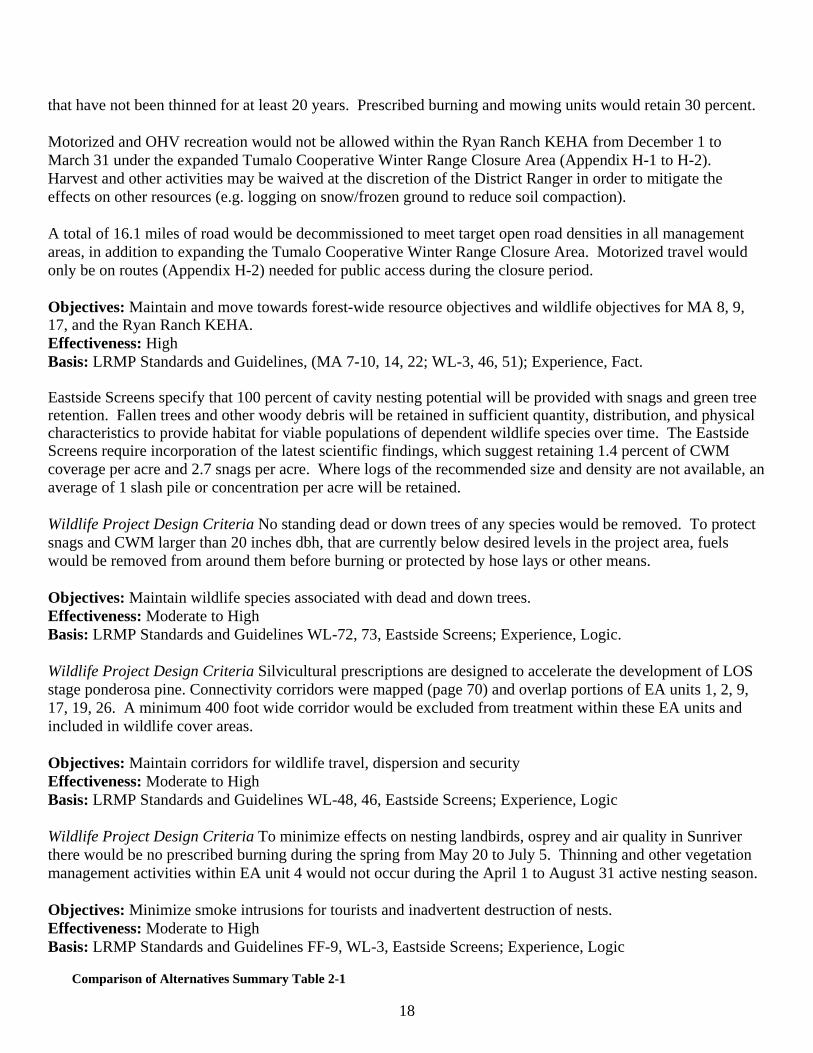
19
EA UNIT MANAGEMENT AREA 1/ NET ACRES Alternative 1 Alternative 2 Vegetation Management Activities 5 9 46 No action Underburn 8 9 49 No action Underburn
10 9 17 No action Underburn 11 9 102 No action Underburn 12 9 110 No action Underburn 13 NNVM 86 No action Underburn 22 9 26 No action Underburn 23 NNVM 106 No action Underburn 27 9 53 No action Underburn 29 9 69 No action Underburn
7 9 215 No action Mow
16 9 75 No action Mow 32 8,9 8 No action Mow/Prune 35 8,9 26 No action Mow
1 17 15 No action Thin <21” dbh/Handpile 2 17 9 No action Thin <21” dbh/Handpile 3 17 15 No action Thin <21” dbh//Underburn 4 NNVM 20 No action Thin <21” dbh/Underburn 6 9 20 No action Thin <21” dbh/Handpile/Mow 9 9 16 No action Thin <21” dbh/Underburn
15 9 5 No action Thin <21” dbh/Handpile/Mow 17 9 139 No action Thin <21” dbh/Underburn 18 9 30 No action Thin <21” dbh/Handpile/Mow 19 9 13 No action Thin <21” dbh/Handpile/Underburn 20 9 11 No action Thin <21” dbh/Handpile/Underburn 21 9 139 No action Thin <21” dbhUnderburn 24 9 4 No action Thin <21” dbh/Handpile 25 9 3 No action Thin <21” dbh/Handpile 26 9 18 No action Thin <21” dbh/Handpile/Underburn 28 9 43 No action Thin <21” dbh/Underburn 30 9 50 No action Thin <21” dbh/Underburn 31 8,9 76 No action Thin <21” dbh/Underburn 33 8 34 No action Thin <21” dbh/Mow 34 8 10 No action Thin <21” dbh/Handpile/Mow 36 8,9 15 No action Thin <21” dbh/Handpile/Mow
Total acres of treatment (no overlap of treatments) 0 1,673 Underburn acres without thinning 0 664 Acres of underburning following thinning 0 540 Total acres of underburning (thinning and no thinning) 0 1,204 Acres of mowing without thinning 0 324 Acres of mowing following thinning 0 114 Total mowing acres (includes 10% of underburn acres) 0 558 Acres of thinning < 21 inches dbh (diameter at 4.5 feet) 0 685 Acres of Handpiling 0 153 Hundred cubic feet (CCF)/million board feet (MMBF) harvest 0/0 5200 CCF/2.6 MMBF 1/ 8-General Forest; 9-Scenic Views; 17-Deschutes Wild & Scenic River; NNVM-Newberry National Volcanic Monument LZ1
20
Monitoring Project monitoring focuses primarily on “implementation monitoring” to assure the selected alternative and mitigation measures are implemented on the ground as designed and achieve the desired results. Wildlife Objective: To increase wildlife habitat effectiveness. Monitor Elements: Determine if road closures and decommissioning were completed and effective. Area of Consideration: Roads identified for closure and decommissioning Suggested Methodology: Annual field review for 2 years. Soil Quality Objective: To determine if post-project subsoiling mitigation was effectively accomplished and reduced the extent of detrimentally compacted soil in specified in EA units. Monitoring Elements: Surface area treated on specific roads and primary logging facilities. Area of Consideration: EA units. Suggested Methodology: Shovel probe, visual survey Noxious Weeds Objective: To determine the introduction of new infestations or expansion of existing infestations of invasive plant species. Monitoring Elements: Area covered by infestations and their locations. Area of Consideration: EA units. Suggested Methodology: Inspect travel routes annually during field season. Vegetation Management Objective: Monitor effectiveness of project design criteria in maintaining 40 percent live crown ratio on dominant and codominant trees and minimizing scorch to < 50 percent of the live crown. Monitoring Elements: Identification of areas where live crowns have either been reduced below 40 percent or have been reduced by 50 percent from pre-burn conditions, and 2) Monitoring survival of trees with greater than 50 percent crown scorch or less than 40 percent live crown for two years after burn. Area of Consideration: Underburned EA units. Suggested Methodology: Annually for two years after bud burst beginning the spring after underburning Sale Area Improvement Projects The following mitigation, resource enhancement and restoration projects are actions connected with Alternative 2. Mitigation projects (M) must be completed followed by, if funding is available, resource enhancement (E) activities. 1) Subsoil skidroads, temporary roads and landings in EA units 2, 6, 15, 20, 21, 24, 25, 31, and 33.(M); 2) Noxious weed control monitoring; (M) 3) Decommission 16.1 miles of identified system roads (M/E); 4) Remove timber sale flagging and tags along Road 40, Highway 97 and Cottonwood Road,(E); 5) Prune unit 32 (E). 6) Precommercial thin/whipfall EA units 1-4, 6, 9, 15, 17-21, 24-26, 28, 30, 31, 33, 34, 3 (E); 7) Replace signing on roads and trails to make roads and evacuation roads easier to follow (E).
21
22
CHAPTER 3 ENVIRONMENTAL EFFECTS
Introduction For ease in presentation and comparison, the discussions are separated into individual resource areas, such as fuels and fire hazard reduction, soil productivity and wildlife habitat management. Although the anticipated environmental effects of the two alternatives were analyzed for each resource, the analysis emphasizes those decisions that relate to the issues identified in Chapter 1, Purpose and Need for Action. Estimated effects of the alternatives are discussed in terms of environmental changes from the current situation and include qualitative as well as quantitative assessments of direct, indirect and cumulative effects. Each resource section includes a brief discussion of pertinent management direction that is intended to give the reader an overview of information important to the design of Alternative 2. It is not intended as an all-inclusive list of all standards and guidelines that need to be evaluated to determine consistency with LRMP and other management direction. It frequently includes a description of the LRMP desired condition that is also sometimes called the target landscape condition and used interchangeably throughout this document. Environmental analysis in this document is consistent with the June 24, 2005 memorandum (Appendix G) regarding Guidance on the Consideration of Past Actions in Cumulative Effects Analysis. Scoping and analysis was used to confirm that the environmental effects of Alternative 2 when combined with past, ongoing and other reasonably foreseeable actions, do not reach a point of significant environmental effects. Fuels and Fire Hazard Reduction Introduction Fuels and fire hazard reduction was one of the issues used to design the specific activities of Alternative 2. The following measures were used in the analysis to display the difference between the alternatives: Measure #1 Acres of prescribed burning and/or mowing; Measure #2 Percentage of project area rated as low for fire behavior potential; Measure #3- Roadside evacuation/access miles treated; Measure #4 Production of Particulate Matter. Scope of the Analysis The scope of the analysis is focused on that portion of the Sunriver WUI that is overlain by the Sunriver HFRA project area (pages 8, 21). Only fire and fuels reduction activities that occurred within the project area during the proceeding 15 years were considered in the analysis of cumulative effects for fuels and fire hazard reduction because district experience and field reviews have shown that vegetation management activities such as thinning followed by mowing and prescribed fire have the beneficial effect of reducing fire intensity and fire behavior for an average of 15 years. Decomposition of small forest residues is also a 15 year process within the project area. All vegetation management activities that have occurred during the previous 15 years included removal of activity generated fuels and disposal of these activity generated fuels has been completed. Site visits of pre-1992 activities have verified that activity generated fuels have decomposed or were disposed of at the time of the activity. Therefore, activities that occurred before 1992 are not relevant to the discussion of cumulative effects. Affected Environment-Existing Stand and Fire Suppression History The dominant plant association group within the project area is ponderosa pine (Pinus ponderosa) with pockets of lodgepole pine (Pinus contorta). The understory plant association consists of greenleaf manzanita (Acrtostaphylos pataula), snowbrush (Ceanothus Velutinus) and antelope bitterbrush (Purshia tridentata). Fire was the major disturbance mechanism in shaping the historic ponderosa pine forest of Central Oregon and it was one of the primary forces that sustained vast, contiguous stands of old growth ponderosa pine. It was an important determinant of stand structure, size, density arrangement, patch size, coarse woody debris (CWM) and other organic matter (Weave 1994). According to Weave, wildfire was one of the primary forces that
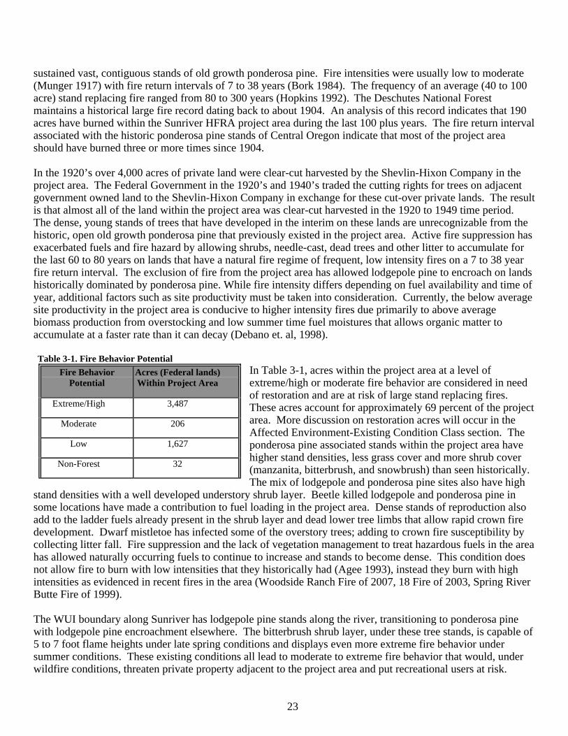
23
sustained vast, contiguous stands of old growth ponderosa pine. Fire intensities were usually low to moderate (Munger 1917) with fire return intervals of 7 to 38 years (Bork 1984). The frequency of an average (40 to 100 acre) stand replacing fire ranged from 80 to 300 years (Hopkins 1992). The Deschutes National Forest maintains a historical large fire record dating back to about 1904. An analysis of this record indicates that 190 acres have burned within the Sunriver HFRA project area during the last 100 plus years. The fire return interval associated with the historic ponderosa pine stands of Central Oregon indicate that most of the project area should have burned three or more times since 1904.
In the 1920’s over 4,000 acres of private land were clear-cut harvested by the Shevlin-Hixon Company in the project area. The Federal Government in the 1920’s and 1940’s traded the cutting rights for trees on adjacent government owned land to the Shevlin-Hixon Company in exchange for these cut-over private lands. The result is that almost all of the land within the project area was clear-cut harvested in the 1920 to 1949 time period. The dense, young stands of trees that have developed in the interim on these lands are unrecognizable from the historic, open old growth ponderosa pine that previously existed in the project area. Active fire suppression has exacerbated fuels and fire hazard by allowing shrubs, needle-cast, dead trees and other litter to accumulate for the last 60 to 80 years on lands that have a natural fire regime of frequent, low intensity fires on a 7 to 38 year fire return interval. The exclusion of fire from the project area has allowed lodgepole pine to encroach on lands historically dominated by ponderosa pine. While fire intensity differs depending on fuel availability and time of year, additional factors such as site productivity must be taken into consideration. Currently, the below average site productivity in the project area is conducive to higher intensity fires due primarily to above average biomass production from overstocking and low summer time fuel moistures that allows organic matter to accumulate at a faster rate than it can decay (Debano et. al, 1998).
Table 3-1. Fire Behavior Potential
In Table 3-1, acres within the project area at a level of extreme/high or moderate fire behavior are considered in need of restoration and are at risk of large stand replacing fires. These acres account for approximately 69 percent of the project area. More discussion on restoration acres will occur in the Affected Environment-Existing Condition Class section. The ponderosa pine associated stands within the project area have higher stand densities, less grass cover and more shrub cover (manzanita, bitterbrush, and snowbrush) than seen historically. The mix of lodgepole and ponderosa pine sites also have high
stand densities with a well developed understory shrub layer. Beetle killed lodgepole and ponderosa pine in some locations have made a contribution to fuel loading in the project area. Dense stands of reproduction also add to the ladder fuels already present in the shrub layer and dead lower tree limbs that allow rapid crown fire development. Dwarf mistletoe has infected some of the overstory trees; adding to crown fire susceptibility by collecting litter fall. Fire suppression and the lack of vegetation management to treat hazardous fuels in the area has allowed naturally occurring fuels to continue to increase and stands to become dense. This condition does not allow fire to burn with low intensities that they historically had (Agee 1993), instead they burn with high intensities as evidenced in recent fires in the area (Woodside Ranch Fire of 2007, 18 Fire of 2003, Spring River Butte Fire of 1999). The WUI boundary along Sunriver has lodgepole pine stands along the river, transitioning to ponderosa pine with lodgepole pine encroachment elsewhere. The bitterbrush shrub layer, under these tree stands, is capable of 5 to 7 foot flame heights under late spring conditions and displays even more extreme fire behavior under summer conditions. These existing conditions all lead to moderate to extreme fire behavior that would, under wildfire conditions, threaten private property adjacent to the project area and put recreational users at risk.
Fire Behavior Potential
Acres (Federal lands) Within Project Area
Extreme/High 3,487
Moderate 206
Low 1,627
Non-Forest 32
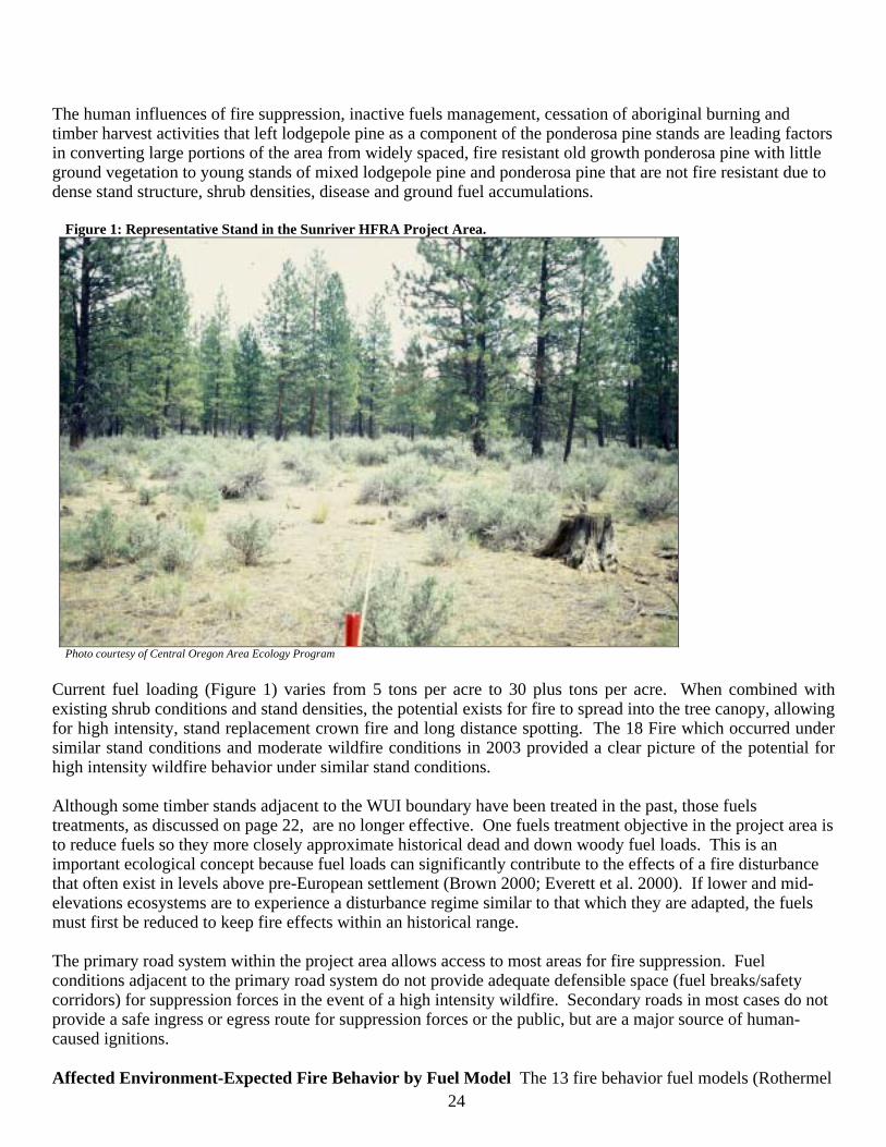
24
The human influences of fire suppression, inactive fuels management, cessation of aboriginal burning and timber harvest activities that left lodgepole pine as a component of the ponderosa pine stands are leading factors in converting large portions of the area from widely spaced, fire resistant old growth ponderosa pine with little ground vegetation to young stands of mixed lodgepole pine and ponderosa pine that are not fire resistant due to dense stand structure, shrub densities, disease and ground fuel accumulations.
Figure 1: Representative Stand in the Sunriver HFRA Project Area.
Photo courtesy of Central Oregon Area Ecology Program
Current fuel loading (Figure 1) varies from 5 tons per acre to 30 plus tons per acre. When combined with existing shrub conditions and stand densities, the potential exists for fire to spread into the tree canopy, allowing for high intensity, stand replacement crown fire and long distance spotting. The 18 Fire which occurred under similar stand conditions and moderate wildfire conditions in 2003 provided a clear picture of the potential for high intensity wildfire behavior under similar stand conditions. Although some timber stands adjacent to the WUI boundary have been treated in the past, those fuels treatments, as discussed on page 22, are no longer effective. One fuels treatment objective in the project area is to reduce fuels so they more closely approximate historical dead and down woody fuel loads. This is an important ecological concept because fuel loads can significantly contribute to the effects of a fire disturbance that often exist in levels above pre-European settlement (Brown 2000; Everett et al. 2000). If lower and mid-elevations ecosystems are to experience a disturbance regime similar to that which they are adapted, the fuels must first be reduced to keep fire effects within an historical range. The primary road system within the project area allows access to most areas for fire suppression. Fuel conditions adjacent to the primary road system do not provide adequate defensible space (fuel breaks/safety corridors) for suppression forces in the event of a high intensity wildfire. Secondary roads in most cases do not provide a safe ingress or egress route for suppression forces or the public, but are a major source of human-caused ignitions. Affected Environment-Expected Fire Behavior by Fuel Model The 13 fire behavior fuel models (Rothermel
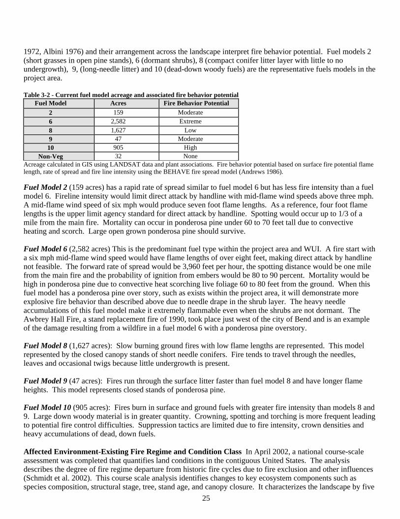
25
1972, Albini 1976) and their arrangement across the landscape interpret fire behavior potential. Fuel models 2 (short grasses in open pine stands), 6 (dormant shrubs), 8 (compact conifer litter layer with little to no undergrowth), 9, (long-needle litter) and 10 (dead-down woody fuels) are the representative fuels models in the project area. Table 3-2 - Current fuel model acreage and associated fire behavior potential
Fuel Model Acres Fire Behavior Potential
2 159 Moderate
6 2,582 Extreme
8 1,627 Low 9 47 Moderate
10 905 High Non-Veg 32 None
Acreage calculated in GIS using LANDSAT data and plant associations. Fire behavior potential based on surface fire potential flame length, rate of spread and fire line intensity using the BEHAVE fire spread model (Andrews 1986).
Fuel Model 2 (159 acres) has a rapid rate of spread similar to fuel model 6 but has less fire intensity than a fuel model 6. Fireline intensity would limit direct attack by handline with mid-flame wind speeds above three mph. A mid-flame wind speed of six mph would produce seven foot flame lengths. As a reference, four foot flame lengths is the upper limit agency standard for direct attack by handline. Spotting would occur up to 1/3 of a mile from the main fire. Mortality can occur in ponderosa pine under 60 to 70 feet tall due to convective heating and scorch. Large open grown ponderosa pine should survive. Fuel Model 6 (2,582 acres) This is the predominant fuel type within the project area and WUI. A fire start with a six mph mid-flame wind speed would have flame lengths of over eight feet, making direct attack by handline not feasible. The forward rate of spread would be 3,960 feet per hour, the spotting distance would be one mile from the main fire and the probability of ignition from embers would be 80 to 90 percent. Mortality would be high in ponderosa pine due to convective heat scorching live foliage 60 to 80 feet from the ground. When this fuel model has a ponderosa pine over story, such as exists within the project area, it will demonstrate more explosive fire behavior than described above due to needle drape in the shrub layer. The heavy needle accumulations of this fuel model make it extremely flammable even when the shrubs are not dormant. The Awbrey Hall Fire, a stand replacement fire of 1990, took place just west of the city of Bend and is an example of the damage resulting from a wildfire in a fuel model 6 with a ponderosa pine overstory. Fuel Model 8 (1,627 acres): Slow burning ground fires with low flame lengths are represented. This model represented by the closed canopy stands of short needle conifers. Fire tends to travel through the needles, leaves and occasional twigs because little undergrowth is present. Fuel Model 9 (47 acres): Fires run through the surface litter faster than fuel model 8 and have longer flame heights. This model represents closed stands of ponderosa pine.
Fuel Model 10 (905 acres): Fires burn in surface and ground fuels with greater fire intensity than models 8 and 9. Large down woody material is in greater quantity. Crowning, spotting and torching is more frequent leading to potential fire control difficulties. Suppression tactics are limited due to fire intensity, crown densities and heavy accumulations of dead, down fuels. Affected Environment-Existing Fire Regime and Condition Class In April 2002, a national course-scale assessment was completed that quantifies land conditions in the contiguous United States. The analysis describes the degree of fire regime departure from historic fire cycles due to fire exclusion and other influences (Schmidt et al. 2002). This course scale analysis identifies changes to key ecosystem components such as species composition, structural stage, tree, stand age, and canopy closure. It characterizes the landscape by five
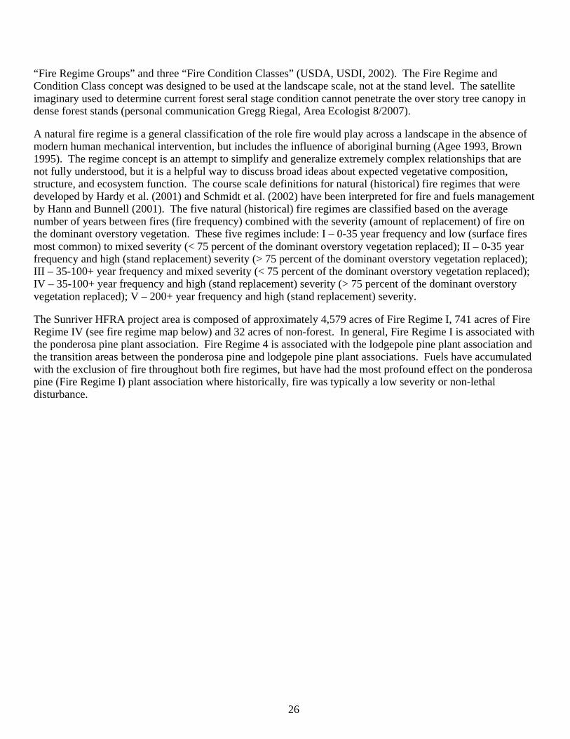
26
“Fire Regime Groups” and three “Fire Condition Classes” (USDA, USDI, 2002). The Fire Regime and Condition Class concept was designed to be used at the landscape scale, not at the stand level. The satellite imaginary used to determine current forest seral stage condition cannot penetrate the over story tree canopy in dense forest stands (personal communication Gregg Riegal, Area Ecologist 8/2007). A natural fire regime is a general classification of the role fire would play across a landscape in the absence of modern human mechanical intervention, but includes the influence of aboriginal burning (Agee 1993, Brown 1995). The regime concept is an attempt to simplify and generalize extremely complex relationships that are not fully understood, but it is a helpful way to discuss broad ideas about expected vegetative composition, structure, and ecosystem function. The course scale definitions for natural (historical) fire regimes that were developed by Hardy et al. (2001) and Schmidt et al. (2002) have been interpreted for fire and fuels management by Hann and Bunnell (2001). The five natural (historical) fire regimes are classified based on the average number of years between fires (fire frequency) combined with the severity (amount of replacement) of fire on the dominant overstory vegetation. These five regimes include: I – 0-35 year frequency and low (surface fires most common) to mixed severity (< 75 percent of the dominant overstory vegetation replaced); II – 0-35 year frequency and high (stand replacement) severity (> 75 percent of the dominant overstory vegetation replaced); III – 35-100+ year frequency and mixed severity (< 75 percent of the dominant overstory vegetation replaced); IV – 35-100+ year frequency and high (stand replacement) severity (> 75 percent of the dominant overstory vegetation replaced); V – 200+ year frequency and high (stand replacement) severity. The Sunriver HFRA project area is composed of approximately 4,579 acres of Fire Regime I, 741 acres of Fire Regime IV (see fire regime map below) and 32 acres of non-forest. In general, Fire Regime I is associated with the ponderosa pine plant association. Fire Regime 4 is associated with the lodgepole pine plant association and the transition areas between the ponderosa pine and lodgepole pine plant associations. Fuels have accumulated with the exclusion of fire throughout both fire regimes, but have had the most profound effect on the ponderosa pine (Fire Regime I) plant association where historically, fire was typically a low severity or non-lethal disturbance.
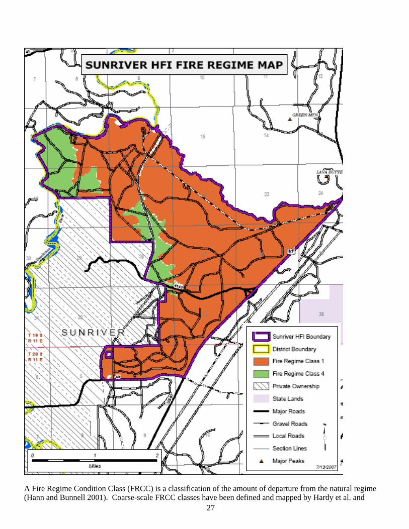
27
A Fire Regime Condition Class (FRCC) is a classification of the amount of departure from the natural regime (Hann and Bunnell 2001). Coarse-scale FRCC classes have been defined and mapped by Hardy et al. and
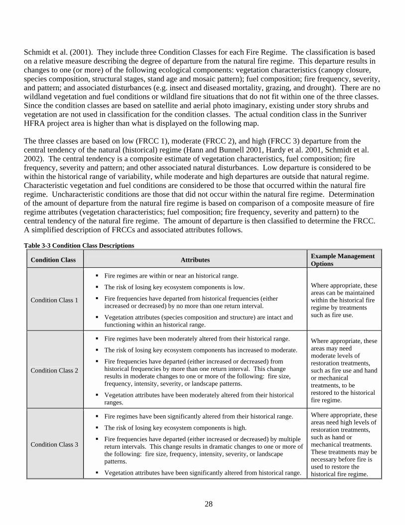
28
Schmidt et al. (2001). They include three Condition Classes for each Fire Regime. The classification is based on a relative measure describing the degree of departure from the natural fire regime. This departure results in changes to one (or more) of the following ecological components: vegetation characteristics (canopy closure, species composition, structural stages, stand age and mosaic pattern); fuel composition; fire frequency, severity, and pattern; and associated disturbances (e.g. insect and diseased mortality, grazing, and drought). There are no wildland vegetation and fuel conditions or wildland fire situations that do not fit within one of the three classes. Since the condition classes are based on satellite and aerial photo imaginary, existing under story shrubs and vegetation are not used in classification for the condition classes. The actual condition class in the Sunriver HFRA project area is higher than what is displayed on the following map. The three classes are based on low (FRCC 1), moderate (FRCC 2), and high (FRCC 3) departure from the central tendency of the natural (historical) regime (Hann and Bunnell 2001, Hardy et al. 2001, Schmidt et al. 2002). The central tendency is a composite estimate of vegetation characteristics, fuel composition; fire frequency, severity and pattern; and other associated natural disturbances. Low departure is considered to be within the historical range of variability, while moderate and high departures are outside that natural regime. Characteristic vegetation and fuel conditions are considered to be those that occurred within the natural fire regime. Uncharacteristic conditions are those that did not occur within the natural fire regime. Determination of the amount of departure from the natural fire regime is based on comparison of a composite measure of fire regime attributes (vegetation characteristics; fuel composition; fire frequency, severity and pattern) to the central tendency of the natural fire regime. The amount of departure is then classified to determine the FRCC. A simplified description of FRCCs and associated attributes follows. Table 3-3 Condition Class Descriptions
Condition Class Attributes Example Management Options
Condition Class 1
! Fire regimes are within or near an historical range.
! The risk of losing key ecosystem components is low.
! Fire frequencies have departed from historical frequencies (either increased or decreased) by no more than one return interval.
! Vegetation attributes (species composition and structure) are intact and functioning within an historical range.
Where appropriate, these areas can be maintained within the historical fire regime by treatments such as fire use.
Condition Class 2
! Fire regimes have been moderately altered from their historical range.
! The risk of losing key ecosystem components has increased to moderate.
! Fire frequencies have departed (either increased or decreased) from historical frequencies by more than one return interval. This change results in moderate changes to one or more of the following: fire size, frequency, intensity, severity, or landscape patterns.
! Vegetation attributes have been moderately altered from their historical ranges.
Where appropriate, these areas may need moderate levels of restoration treatments, such as fire use and hand or mechanical treatments, to be restored to the historical fire regime.
Condition Class 3
! Fire regimes have been significantly altered from their historical range.
! The risk of losing key ecosystem components is high.
! Fire frequencies have departed (either increased or decreased) by multiple return intervals. This change results in dramatic changes to one or more of the following: fire size, frequency, intensity, severity, or landscape patterns.
! Vegetation attributes have been significantly altered from historical range.
Where appropriate, these areas need high levels of restoration treatments, such as hand or mechanical treatments. These treatments may be necessary before fire is used to restore the historical fire regime.
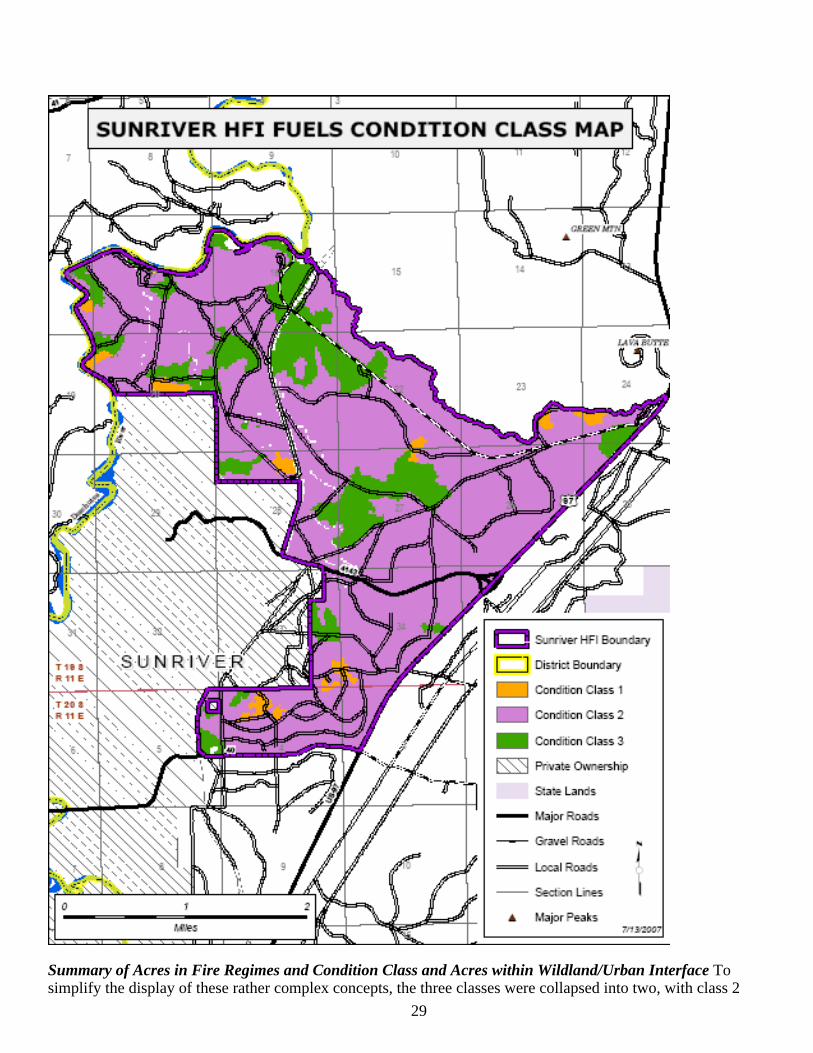
29
Summary of Acres in Fire Regimes and Condition Class and Acres within Wildland/Urban Interface To simplify the display of these rather complex concepts, the three classes were collapsed into two, with class 2
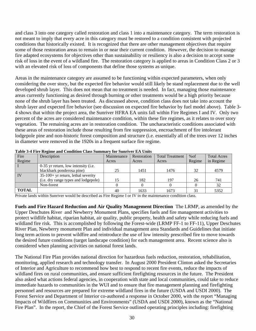
30
and class 3 into one category called restoration and class 1 into a maintenance category. The term restoration is not meant to imply that every acre in this category must be restored to a condition consistent with projected conditions that historically existed. It is recognized that there are other management objectives that require some of those restoration areas to remain in or near their current condition. However, the decision to manage fire adapted ecosystems for objectives other than sustainability or resiliency is also a decision to accept some risk of loss in the event of a wildland fire. The restoration category is applied to areas in Condition Class 2 or 3 with an elevated risk of loss of components that define those systems as unique.
Areas in the maintenance category are assumed to be functioning within expected parameters, when only considering the over story, but the expected fire behavior would still likely be stand replacement due to the well developed shrub layer. This does not mean that no treatment is needed. In fact, managing those maintenance areas currently functioning as desired through burning or other treatments would be a high priority because none of the shrub layer has been treated. As discussed above, condition class does not take into account the shrub layer and expected fire behavior (see discussion on expected fire behavior by fuel model above). Table 3-4 shows that within the project area, the Sunriver HFRA EA units fall within Fire Regimes I and IV. Only two percent of the acres are considered maintenance condition, within these fire regimes, as it relates to over story vegetation. The remaining acres are in restoration condition. The uncharacteristic conditions associated with these areas of restoration include those resulting from fire suppression, encroachment of fire intolerant lodgepole pine and non-historic forest composition and structure (i.e. essentially all of the trees over 12 inches in diameter were removed in the 1920s in a frequent surface fire regime. Table 3-4 Fire Regime and Condition Class Summary for Sunriver EA Units
Fire Regime
Description Maintenance Acres
RestorationAcres
Total Treatment Acres
%of Regime
Total Acres in Regime
I 0-35 yr return, low intensity (i.e. blackbark ponderosa pine) 25 1451 1476 32 4579
IV 35-100+ yr return, lethal severity (i.e. dry range types and lodgepole) 15 182 197 26 741
Non-forest 0 0 0 0 32 TOTAL 40 1633 1673 31 5352
Private lands within Sunriver would be described as Fire Regime I or IV in the maintenance condition class. Fuels and Fire Hazard Reduction and Air Quality Management Direction The LRMP, as amended by the Upper Deschutes River and Newberry Monument Plans, specifies fuels and fire management activities to protect wildlife habitat, riparian habitat, air quality, public property, health and safety while reducing fuels and wildland fire risk. This is accomplished by following the Forest-wide (LRMP FF-1 to FF-11), Upper Deschutes River Plan, Newberry monument Plan and individual management area Standards and Guidelines that initiate long term actions to prevent wildfire and reintroduce the use of low intensity prescribed fire to move towards the desired future conditions (target landscape condition) for each management area. Recent science also is considered when planning activities on national forest lands. The National Fire Plan provides national direction for hazardous fuels reduction, restoration, rehabilitation, monitoring, applied research and technology transfer. In August 2000 President Clinton asked the Secretaries of Interior and Agriculture to recommend how best to respond to recent fire events, reduce the impacts of wildland fires on rural communities, and ensure sufficient firefighting resources in the future. The President also asked what actions federal agencies, in cooperation with state and local communities, could take to reduce immediate hazards to communities in the WUI and to ensure that fire management planning and firefighting personnel and resources are prepared for extreme wildland fires in the future (USDA and USDI 2000). The Forest Service and Department of Interior co-authored a response in October 2000, with the report “Managing Impacts of Wildfires on Communities and Environments” (USDA and USDI 2000), known as the “National Fire Plan”. In the report, the Chief of the Forest Service outlined operating principles including: firefighting
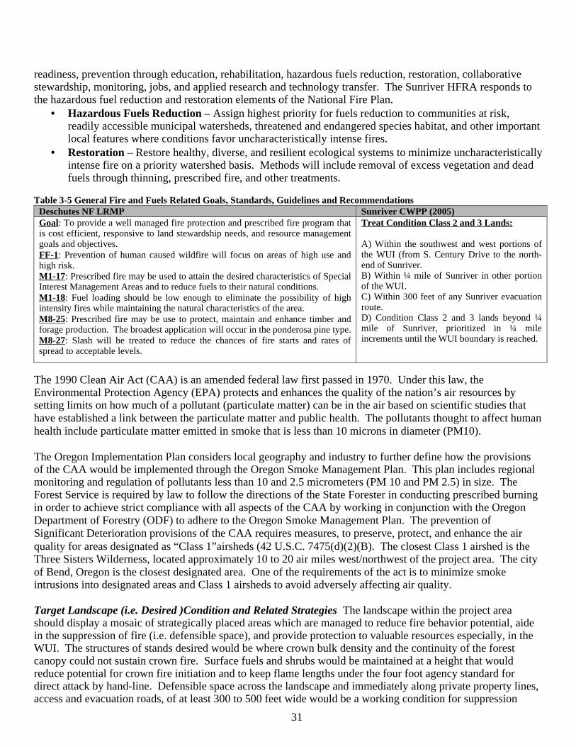
31
readiness, prevention through education, rehabilitation, hazardous fuels reduction, restoration, collaborative stewardship, monitoring, jobs, and applied research and technology transfer. The Sunriver HFRA responds to the hazardous fuel reduction and restoration elements of the National Fire Plan.
• Hazardous Fuels Reduction – Assign highest priority for fuels reduction to communities at risk, readily accessible municipal watersheds, threatened and endangered species habitat, and other important local features where conditions favor uncharacteristically intense fires.
• Restoration – Restore healthy, diverse, and resilient ecological systems to minimize uncharacteristically intense fire on a priority watershed basis. Methods will include removal of excess vegetation and dead fuels through thinning, prescribed fire, and other treatments.
Table 3-5 General Fire and Fuels Related Goals, Standards, Guidelines and Recommendations
Deschutes NF LRMP Sunriver CWPP (2005) Goal: To provide a well managed fire protection and prescribed fire program that is cost efficient, responsive to land stewardship needs, and resource management goals and objectives. FF-1: Prevention of human caused wildfire will focus on areas of high use and high risk. M1-17: Prescribed fire may be used to attain the desired characteristics of Special Interest Management Areas and to reduce fuels to their natural conditions. M1-18: Fuel loading should be low enough to eliminate the possibility of high intensity fires while maintaining the natural characteristics of the area. M8-25: Prescribed fire may be use to protect, maintain and enhance timber and forage production. The broadest application will occur in the ponderosa pine type. M8-27: Slash will be treated to reduce the chances of fire starts and rates of spread to acceptable levels.
Treat Condition Class 2 and 3 Lands: A) Within the southwest and west portions of the WUI (from S. Century Drive to the north-end of Sunriver. B) Within ¼ mile of Sunriver in other portion of the WUI. C) Within 300 feet of any Sunriver evacuation route. D) Condition Class 2 and 3 lands beyond ¼ mile of Sunriver, prioritized in ¼ mile increments until the WUI boundary is reached.
The 1990 Clean Air Act (CAA) is an amended federal law first passed in 1970. Under this law, the Environmental Protection Agency (EPA) protects and enhances the quality of the nation’s air resources by setting limits on how much of a pollutant (particulate matter) can be in the air based on scientific studies that have established a link between the particulate matter and public health. The pollutants thought to affect human health include particulate matter emitted in smoke that is less than 10 microns in diameter (PM10). The Oregon Implementation Plan considers local geography and industry to further define how the provisions of the CAA would be implemented through the Oregon Smoke Management Plan. This plan includes regional monitoring and regulation of pollutants less than 10 and 2.5 micrometers (PM 10 and PM 2.5) in size. The Forest Service is required by law to follow the directions of the State Forester in conducting prescribed burning in order to achieve strict compliance with all aspects of the CAA by working in conjunction with the Oregon Department of Forestry (ODF) to adhere to the Oregon Smoke Management Plan. The prevention of Significant Deterioration provisions of the CAA requires measures, to preserve, protect, and enhance the air quality for areas designated as “Class 1”airsheds (42 U.S.C. 7475(d)(2)(B). The closest Class 1 airshed is the Three Sisters Wilderness, located approximately 10 to 20 air miles west/northwest of the project area. The city of Bend, Oregon is the closest designated area. One of the requirements of the act is to minimize smoke intrusions into designated areas and Class 1 airsheds to avoid adversely affecting air quality. Target Landscape (i.e. Desired )Condition and Related Strategies The landscape within the project area should display a mosaic of strategically placed areas which are managed to reduce fire behavior potential, aide in the suppression of fire (i.e. defensible space), and provide protection to valuable resources especially, in the WUI. The structures of stands desired would be where crown bulk density and the continuity of the forest canopy could not sustain crown fire. Surface fuels and shrubs would be maintained at a height that would reduce potential for crown fire initiation and to keep flame lengths under the four foot agency standard for direct attack by hand-line. Defensible space across the landscape and immediately along private property lines, access and evacuation roads, of at least 300 to 500 feet wide would be a working condition for suppression

32
forces, and also serve as fuel breaks. Fuel models eight and nine are the timbered fuel models that exemplify fuel characteristics conducive to low fire behavior and suppression by direct attack of hand crews. These two fuel models are the desired condition of the project area. It is also a desired condition for these areas that the Fire Regime Condition Class is returned to a Condition Class 1, where there is a return to a natural, or HRV of vegetation characteristics.
Figure 2: An example of a stand condition that would not support a high intensity wildfire.
Taken in the early spring after a fall prescribed burn on the southern end of the Bend-Ft. Rock Ranger District. The photo illustrates an example of a stand condition that would not support a high intensity wildfire. Ponderosa pine forests have undergone substantial structural changes since earlier this century due to fire exclusion and logging. Heavy fuel loads and ladder fuels make these stands more susceptible to crown fires. This may result in an increased risk of fire intensity and severity that could exceed the lethal limits of thick barked species (USDA 2000a; USDA 2000b). “Certain forest types (low elevation ponderosa pine, for example) may be susceptible to burning in ways that have not been seen in centuries” (Beschta et al. 1995). The type of fire behavior that can be exhibited by these changes can make conditions less safe for firefighting operations. It has taken several decades of fire exclusion to create the conditions that currently exist in the project area, and one treatment is not going to immediately return this forest to a condition to which it would function under the historical low-severity fire regime (Brown 2000). The goal, then, is not to completely return these forests to a historical range of variability with one treatment, but to prescribe treatments that would start to move them toward that range, which would allow a more natural fire regime to function. There are three types of fuels that affect fire behavior; fine fuels such as grass or forbs, small woody fuels less than three inches in diameter and large woody fuels greater than three inches in diameter. Fine fuels and small woody fuels are the major contributors to fire spread, carrying the ignition and flaming front of a fire (Rothermel 1983). Small woody fuels influence a fire’s rate of spread and fire intensity, and lose their moisture faster, start easier and burn more readily (Agee 1993). Large fuels do not contribute greatly to fire spread,
33
though they do remain burning after the fire front has passed (Andrews, 1986) and contribute to fire severity.
To move forests towards a more natural fuel condition, the various types of fuels would be reduced through the use of prescribed fire and mechanical treatments. Reduced fuel loads would increase the variance of weather and fuel conditions under which prescribed fire could be applied. The amount of Coarse Woody Debris (CWM) that provides desirable biological benefits, without creating an unacceptable fire hazard, is an optimum quantity that can be useful for guiding management actions. The optimum range of CWM for warm dry forest types is described as 5 to 20 tons per acre (Brown 2003). Hall (2003) suggests that the historical condition contained very little woody fuel averaging about 3 to 6 tons/acre. Deschutes LRMP Standards and Guidelines prevent treating all of the project area for fire and fuels hazard reduction at one time. Defining a percentage of the project area that should be treated to reduce fire and fuels is problematic due to the shortcomings and variables involved with weather, stand condition, location of EA units, modeling and research. Taking expected fire behavior into account and the strategic placement of EA units, the ID team determined that the percentage of the project area in the low fire behavior category (FRCC 1) should be at least 50 percent over both the short (5 to 10 years) and long term (10 to 20 years) timeframes. Fifty percent in the low behavior category is certainly below historic conditions but with the shortcomings described above it can provide a gauge for measuring progress towards reduced fire and fuel hazard within the project area.
Fuels and Large Fire Reduction Strategies: Given the existing condition, and desired future condition contained in the management direction mentioned previously, the following strategies were developed to move toward the desired future condition and to help direct treatment types and locations: 1.) Defensible Space (fuel break/safety corridor) Road systems allow ground suppression forces (engines, crews and equipment) to access wildfires. When fuel conditions allow surface fires to get into the canopies of the trees contributing to extreme fire behavior (torching, crowning and long range spotting), direct attack by ground forces becomes impossible. Wildland fires under these conditions will cross any system road with such intensity that suppression forces have little chance of containing the fire at the road. Retardant alone will only slow a wildfire for a short period of time. Suppression forces need to quickly utilize the effects of the retardant to contain a wildfire. Roads provide a good area for retardant to be utilized by suppression forces. During recent wildfires on the forest, rural fire engines have responded to aid in the suppression effort. These large, low-ground clearance engines cannot operate on most local forest roads due to narrow road widths and uneven road surface conditions. Use of major roads in a defensible space (fuel break/safety corridor) strategy is recommended, especially in the WUI where public safety and evacuations is of high concern. Roads that provide defensible space also provide safe escape routes from for fire fighters and the public. The WUI is also an area in need of defensible space. Defensible space does not only provides a better chance of stopping intense wildfires from entering private lands, it also aids in the suppression of fires that start on private and move toward federal ownership. By reducing crown densities through thinning and reduction of ground fuels and ladder fuels through either mechanical shrub treatment (mowing), pruning, underburning, piling slash and burning the piles, fire behavior would be reduced to primarily a surface fire that suppression forces would be better able to control. Thinning of dense canopies allows retardant to be more effective by getting to ground fuels, not being caught in the canopy. In order to be effective, these treatments in general, need to be at least 500 feet wide in some cases. In the WUI, the distance of treatment will vary depending on prevailing winds, resources at risk, fuel type, access and other resources objectives, but should be no less than those described above. Snags should not be retained near the roads (within one tree length) that remain open to the public and down wood or slash piles should not be retained within 200 feet of roads or boundaries with private ownership to limit ember production and spotting.
34
2.) Restoration of historical fire regimes in ponderosa pine ecosystems The absence of fire over the last 60-80 years combined with the development of shrubs and dense thickets of regeneration in the understory have placed the ponderosa pine stands at high risk of stand replacing wildfire Although some of the timber stands in the WUI have been thinned in the past, the shrub layer within the stands remain capable of producing extreme fire behavior. Reintroduction of fire in these ponderosa pine type stands would be used as needed to achieve the desired conditions. Prescriptions would be developed for low intensity prescribed fire to start a return to historic conditions, subsequent prescribed fire entries would be conducted through time to create a fire resistant stand condition that would help preserve the ponderosa pine. When prescribed fire is used every 8 to 15 years, depending on fuel accumulations, these areas should regenerate ponderosa pine slowly through time as they did historically (Agee 1993). Related prescribed burning should keep naturally regenerated lodgepole pine in low numbers through time. Mechanical shrub treatments may be used to or in lieu of burning if the shrub size and densities could cause severe scorch or mortality of residual stands. 3.) Fuel reduction and discontinuous ground fuels Areas with either, existing dead and down material, dense stands of trees, and shrubs, needle-cast, and activity created slash from illegal woodcutting can create extremely hazardous conditions. When these conditions exist over large areas a wildfire can be extremely difficult to control. Under unfavorable weather conditions, the fire would burn until it reached an area where fuels were lighter and control tactics are more likely to be achieved. In 2001, Dr. Mark Finney published the paper Design of Regular Landscapes Fuel Treatment Patterns for Modifying Fire Growth and Behavior in Forest Science magazine. The paper presents the theory that strategically-placed fuel treatments could achieve much greater results at minimizing large fire growth than randomly placed fuel treatments, especially when only a percentage of the area could be treated. Fire spread modeling theoretically shows that strategic placement could significantly reduce large fire growth while the same percentage of randomly placed treatments would have little or no effect. It suggest that when treating just a percentage of the landscape, the juxtaposition of fuels treatment areas in relation to one another was more important than the total amount of area treated. At this time, there is no scientific evidence supporting a conjecture that treating a smaller amount of acres within a landscape, even when the treatments are strategically placed, would provide the same level of protection or restoration effects as treating a majority of the landscape. According to Finney, treating in a spatially strategic pattern would increase effectiveness in minimizing large fire spread and buy time to complete treatments on additional areas before they burn. 4.) Thinning to reduce crown fire susceptibility and long range spotting Crowning fires are some of the most intense wildfires and usually produce long range spotting that hampers the control efforts. Dense stands of timber support independent crown fires allowing fire to burn through the canopy of the trees independent of the ground fire. Torching and crowning in conjunction with the ground fire is also a common problem during wildfires in dense stands of timber. Breaking up timber canopy connectivity through thinning greatly decreases the chance of an independent crown fire; thinning also reduces the amount of torching and crowning that occurs with ground fire and thus reduces long range spotting potential.
Fire and Fuel Hazard Reduction Environmental Effects Important Interactions The following concepts and factors were used to help clarify the fire and fuel hazard reduction environmental effects discussion. Fire Behavior is the manner in which fire reacts to topography, weather, and fuels (DeBano et al. 1998; NWCG1998). These three elements comprise the fire environment, the surrounding conditions, influences, and modifying forces that determine fire behavior (NWCG 1994). Modifying any one of these elements has a direct result on fire behavior, which is basically described by flame length and rate of spread. Favorable conditions for crown fires include heavy accumulations of dead and downed litter, conifer reproduction and other ladder fuels, and continuous conifer tree forest (Rothermel 1991).
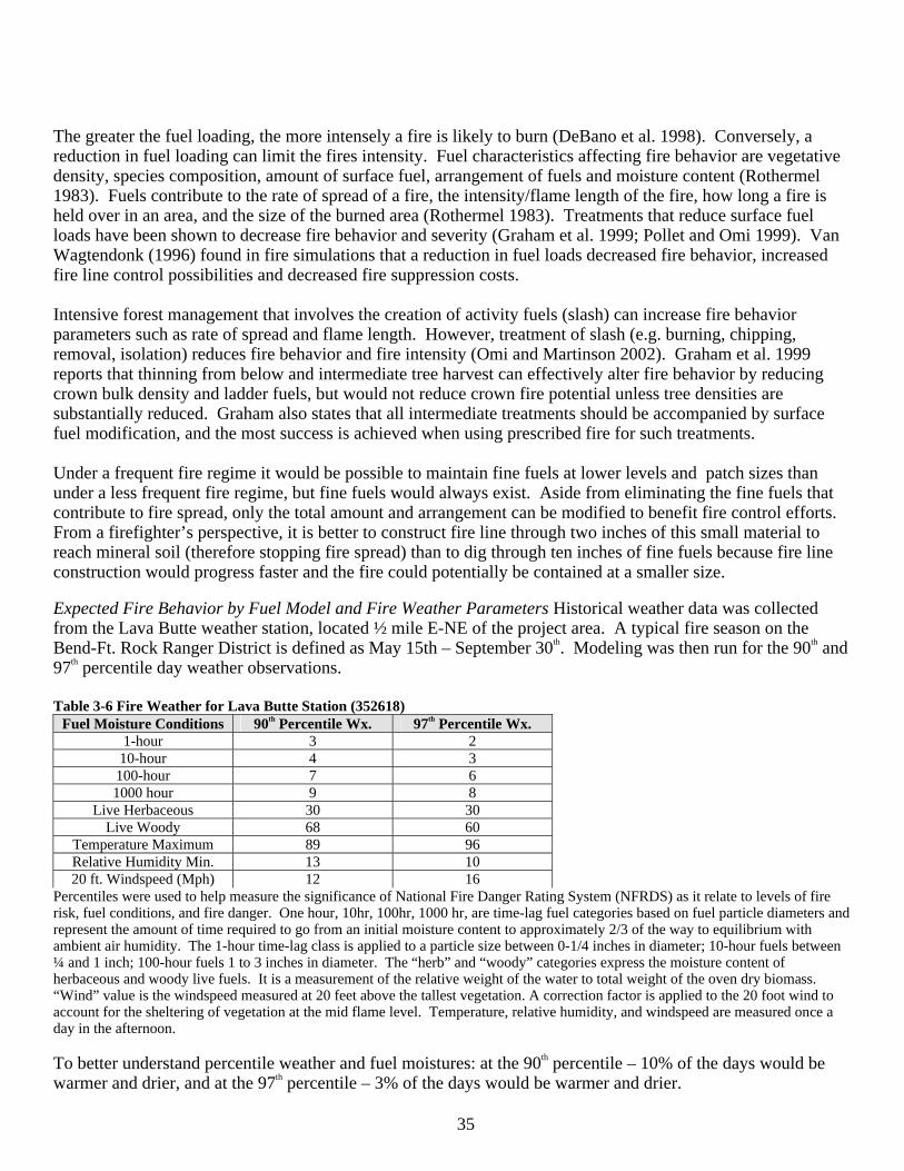
35
The greater the fuel loading, the more intensely a fire is likely to burn (DeBano et al. 1998). Conversely, a reduction in fuel loading can limit the fires intensity. Fuel characteristics affecting fire behavior are vegetative density, species composition, amount of surface fuel, arrangement of fuels and moisture content (Rothermel 1983). Fuels contribute to the rate of spread of a fire, the intensity/flame length of the fire, how long a fire is held over in an area, and the size of the burned area (Rothermel 1983). Treatments that reduce surface fuel loads have been shown to decrease fire behavior and severity (Graham et al. 1999; Pollet and Omi 1999). Van Wagtendonk (1996) found in fire simulations that a reduction in fuel loads decreased fire behavior, increased fire line control possibilities and decreased fire suppression costs. Intensive forest management that involves the creation of activity fuels (slash) can increase fire behavior parameters such as rate of spread and flame length. However, treatment of slash (e.g. burning, chipping, removal, isolation) reduces fire behavior and fire intensity (Omi and Martinson 2002). Graham et al. 1999 reports that thinning from below and intermediate tree harvest can effectively alter fire behavior by reducing crown bulk density and ladder fuels, but would not reduce crown fire potential unless tree densities are substantially reduced. Graham also states that all intermediate treatments should be accompanied by surface fuel modification, and the most success is achieved when using prescribed fire for such treatments.
Under a frequent fire regime it would be possible to maintain fine fuels at lower levels and patch sizes than under a less frequent fire regime, but fine fuels would always exist. Aside from eliminating the fine fuels that contribute to fire spread, only the total amount and arrangement can be modified to benefit fire control efforts. From a firefighter’s perspective, it is better to construct fire line through two inches of this small material to reach mineral soil (therefore stopping fire spread) than to dig through ten inches of fine fuels because fire line construction would progress faster and the fire could potentially be contained at a smaller size.
Expected Fire Behavior by Fuel Model and Fire Weather Parameters Historical weather data was collected from the Lava Butte weather station, located ½ mile E-NE of the project area. A typical fire season on the Bend-Ft. Rock Ranger District is defined as May 15th – September 30th. Modeling was then run for the 90th and 97th percentile day weather observations. Table 3-6 Fire Weather for Lava Butte Station (352618)
Fuel Moisture Conditions 90th Percentile Wx. 97th Percentile Wx. 1-hour 3 2
10-hour 4 3 100-hour 7 6 1000 hour 9 8
Live Herbaceous 30 30 Live Woody 68 60
Temperature Maximum 89 96 Relative Humidity Min. 13 10 20 ft. Windspeed (Mph) 12 16
Percentiles were used to help measure the significance of National Fire Danger Rating System (NFRDS) as it relate to levels of fire risk, fuel conditions, and fire danger. One hour, 10hr, 100hr, 1000 hr, are time-lag fuel categories based on fuel particle diameters and represent the amount of time required to go from an initial moisture content to approximately 2/3 of the way to equilibrium with ambient air humidity. The 1-hour time-lag class is applied to a particle size between 0-1/4 inches in diameter; 10-hour fuels between ¼ and 1 inch; 100-hour fuels 1 to 3 inches in diameter. The “herb” and “woody” categories express the moisture content of herbaceous and woody live fuels. It is a measurement of the relative weight of the water to total weight of the oven dry biomass. “Wind” value is the windspeed measured at 20 feet above the tallest vegetation. A correction factor is applied to the 20 foot wind to account for the sheltering of vegetation at the mid flame level. Temperature, relative humidity, and windspeed are measured once a day in the afternoon. To better understand percentile weather and fuel moistures: at the 90th percentile – 10% of the days would be warmer and drier, and at the 97th percentile – 3% of the days would be warmer and drier.
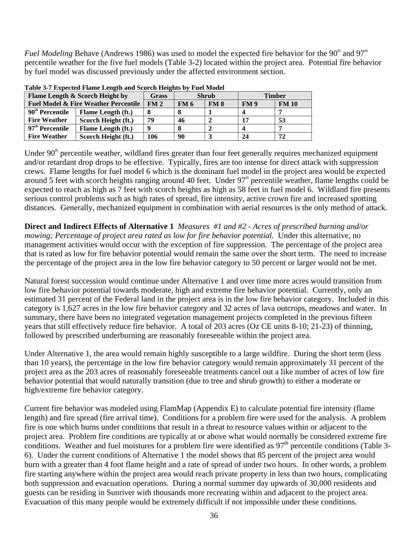
36
Fuel Modeling Behave (Andrews 1986) was used to model the expected fire behavior for the 90th and 97th percentile weather for the five fuel models (Table 3-2) located within the project area. Potential fire behavior by fuel model was discussed previously under the affected environment section. Table 3-7 Expected Flame Length and Scorch Heights by Fuel Model
Grass Shrub Timber Flame Length & Scorch Height by Fuel Model & Fire Weather Percentile FM 2 FM 6 FM 8 FM 9 FM 10
Flame Length (ft.) 8 8 1 4 7 90th Percentile Fire Weather Scorch Height (ft.) 79 46 2 17 53
Flame Length (ft.) 9 8 2 4 7 97th Percentile Fire Weather Scorch Height (ft.) 106 90 3 24 72
Under 90th percentile weather, wildland fires greater than four feet generally requires mechanized equipment and/or retardant drop drops to be effective. Typically, fires are too intense for direct attack with suppression crews. Flame lengths for fuel model 6 which is the dominant fuel model in the project area would be expected around 5 feet with scorch heights ranging around 40 feet. Under 97th percentile weather, flame lengths could be expected to reach as high as 7 feet with scorch heights as high as 58 feet in fuel model 6. Wildland fire presents serious control problems such as high rates of spread, fire intensity, active crown fire and increased spotting distances. Generally, mechanized equipment in combination with aerial resources is the only method of attack. Direct and Indirect Effects of Alternative 1 Measures #1 and #2 - Acres of prescribed burning and/or mowing; Percentage of project area rated as low for fire behavior potential. Under this alternative, no management activities would occur with the exception of fire suppression. The percentage of the project area that is rated as low for fire behavior potential would remain the same over the short term. The need to increase the percentage of the project area in the low fire behavior category to 50 percent or larger would not be met. Natural forest succession would continue under Alternative 1 and over time more acres would transition from low fire behavior potential towards moderate, high and extreme fire behavior potential. Currently, only an estimated 31 percent of the Federal land in the project area is in the low fire behavior category. Included in this category is 1,627 acres in the low fire behavior category and 32 acres of lava outcrops, meadows and water. In summary, there have been no integrated vegetation management projects completed in the previous fifteen years that still effectively reduce fire behavior. A total of 203 acres (Oz CE units 8-10; 21-23) of thinning, followed by prescribed underburning are reasonably foreseeable within the project area.
Under Alternative 1, the area would remain highly susceptible to a large wildfire. During the short term (less than 10 years), the percentage in the low fire behavior category would remain approximately 31 percent of the project area as the 203 acres of reasonably foreseeable treatments cancel out a like number of acres of low fire behavior potential that would naturally transition (due to tree and shrub growth) to either a moderate or high/extreme fire behavior category. Current fire behavior was modeled using FlamMap (Appendix E) to calculate potential fire intensity (flame length) and fire spread (fire arrival time). Conditions for a problem fire were used for the analysis. A problem fire is one which burns under conditions that result in a threat to resource values within or adjacent to the project area. Problem fire conditions are typically at or above what would normally be considered extreme fire conditions. Weather and fuel moistures for a problem fire were identified as 97th percentile conditions (Table 3-6). Under the current conditions of Alternative 1 the model shows that 85 percent of the project area would burn with a greater than 4 foot flame height and a rate of spread of under two hours. In other words, a problem fire starting anywhere within the project area would reach private property in less than two hours, complicating both suppression and evacuation operations. During a normal summer day upwards of 30,000 residents and guests can be residing in Sunriver with thousands more recreating within and adjacent to the project area. Evacuation of this many people would be extremely difficult if not impossible under these conditions.
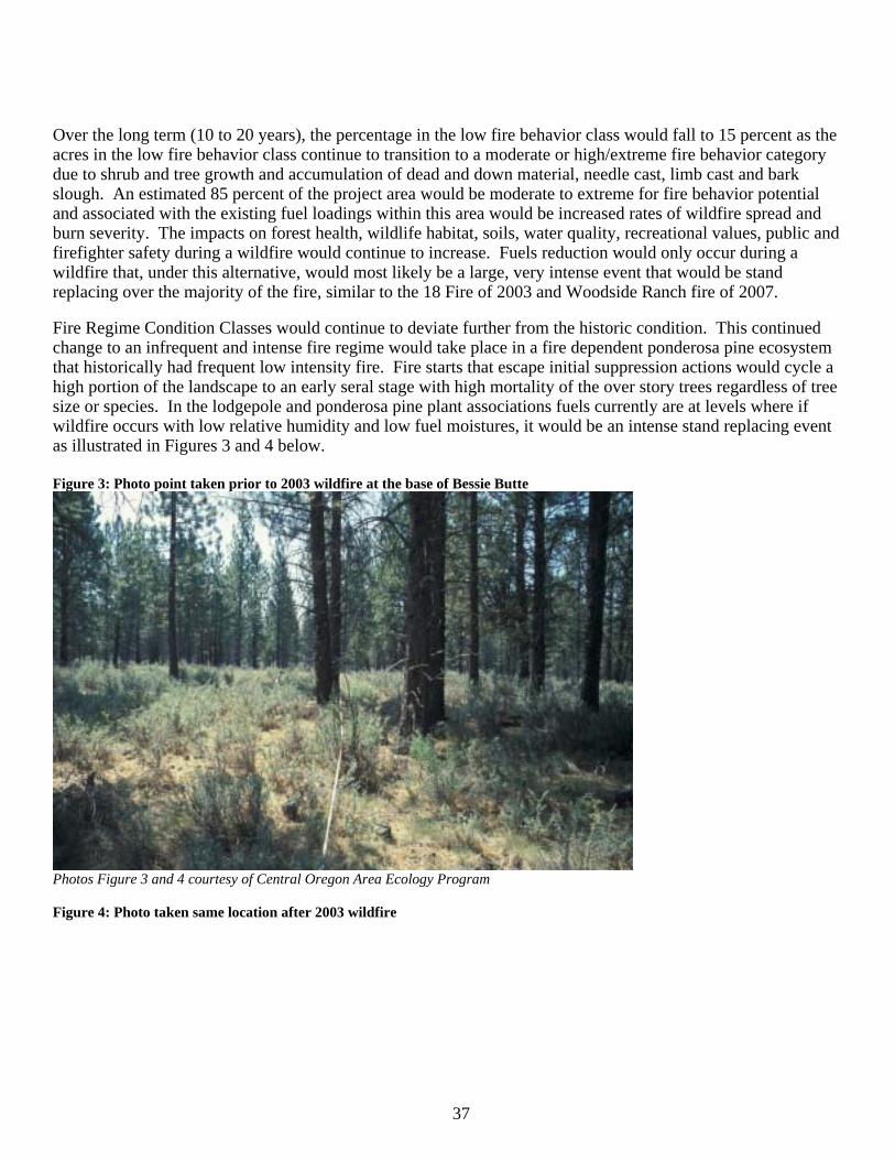
37
Over the long term (10 to 20 years), the percentage in the low fire behavior class would fall to 15 percent as the acres in the low fire behavior class continue to transition to a moderate or high/extreme fire behavior category due to shrub and tree growth and accumulation of dead and down material, needle cast, limb cast and bark slough. An estimated 85 percent of the project area would be moderate to extreme for fire behavior potential and associated with the existing fuel loadings within this area would be increased rates of wildfire spread and burn severity. The impacts on forest health, wildlife habitat, soils, water quality, recreational values, public and firefighter safety during a wildfire would continue to increase. Fuels reduction would only occur during a wildfire that, under this alternative, would most likely be a large, very intense event that would be stand replacing over the majority of the fire, similar to the 18 Fire of 2003 and Woodside Ranch fire of 2007.
Fire Regime Condition Classes would continue to deviate further from the historic condition. This continued change to an infrequent and intense fire regime would take place in a fire dependent ponderosa pine ecosystem that historically had frequent low intensity fire. Fire starts that escape initial suppression actions would cycle a high portion of the landscape to an early seral stage with high mortality of the over story trees regardless of tree size or species. In the lodgepole and ponderosa pine plant associations fuels currently are at levels where if wildfire occurs with low relative humidity and low fuel moistures, it would be an intense stand replacing event as illustrated in Figures 3 and 4 below.
Figure 3: Photo point taken prior to 2003 wildfire at the base of Bessie Butte
Photos Figure 3 and 4 courtesy of Central Oregon Area Ecology Program Figure 4: Photo taken same location after 2003 wildfire
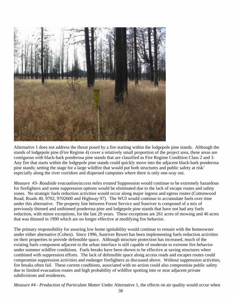
38
Alternative 1 does not address the threat posed by a fire starting within the lodgepole pine stands. Although the stands of lodgepole pine (Fire Regime 4) cover a relatively small proportion of the project area, these areas are contiguous with black-bark ponderosa pine stands that are classified as Fire Regime Condition Class 2 and 3. Any fire that starts within the lodgepole pine stands could quickly move into the adjacent black-bark ponderosa pine stands; setting the stage for a large wildfire that would put both structures and public safety at risk’ especially along the river corridors and dispersed campsites where there is only one-way out. Measure #3- Roadside evacuation/access miles treated Suppression would continue to be extremely hazardous for firefighters and some suppression options would be eliminated due to the lack of escape routes and safety zones. No strategic fuels reduction activities would occur along major ingress and egress routes (Cottonwood Road, Roads 40, 9702, 9702600 and Highway 97). The WUI would continue to accumulate fuels over time under this alternative. The property line between Forest Service and Sunriver is composed of a mix of previously thinned and unthinned ponderosa pine and lodgepole pine stands that have not had any fuels reduction, with minor exceptions, for the last 20 years. These exceptions are 261 acres of mowing and 46 acres that was thinned in 1990 which are no longer effective at modifying fire behavior. The primary responsibility for assuring low home ignitability would continue to remain with the homeowner under either alternative (Cohen). Since 1996, Sunriver Resort has been implementing fuels reduction activities on their properties to provide defensible space. Although structure protection has increased, much of the existing fuels component adjacent to the urban interface is still capable of moderate to extreme fire behavior under summer wildfire conditions. Fuels breaks have been shown to be effective at saving structures when combined with suppression efforts. The lack of defensible space along access roads and escapes routes could compromise suppression activities and endanger firefighters as discussed above. Without suppression activities, fire breaks often fail. These current conditions, associated with no action could also compromise public safety due to limited evacuation routes and high probability of wildfire spotting into or near adjacent private subdivisions and residences. Measure #4 - Production of Particulate Matter Under Alternative 1, the effects on air quality would occur when
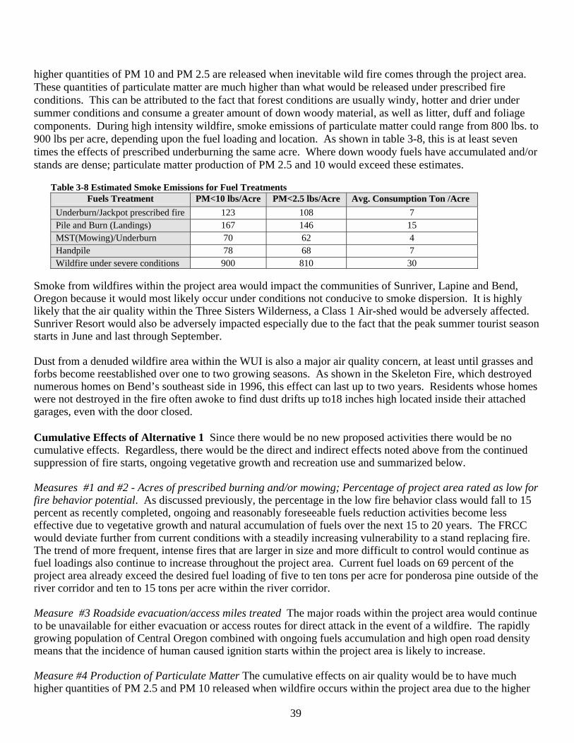
39
higher quantities of PM 10 and PM 2.5 are released when inevitable wild fire comes through the project area. These quantities of particulate matter are much higher than what would be released under prescribed fire conditions. This can be attributed to the fact that forest conditions are usually windy, hotter and drier under summer conditions and consume a greater amount of down woody material, as well as litter, duff and foliage components. During high intensity wildfire, smoke emissions of particulate matter could range from 800 lbs. to 900 lbs per acre, depending upon the fuel loading and location. As shown in table 3-8, this is at least seven times the effects of prescribed underburning the same acre. Where down woody fuels have accumulated and/or stands are dense; particulate matter production of PM 2.5 and 10 would exceed these estimates.
Table 3-8 Estimated Smoke Emissions for Fuel Treatments
Fuels Treatment PM<10 lbs/Acre PM<2.5 lbs/Acre Avg. Consumption Ton /Acre Underburn/Jackpot prescribed fire 123 108 7 Pile and Burn (Landings) 167 146 15 MST(Mowing)/Underburn 70 62 4 Handpile 78 68 7 Wildfire under severe conditions 900 810 30
Smoke from wildfires within the project area would impact the communities of Sunriver, Lapine and Bend, Oregon because it would most likely occur under conditions not conducive to smoke dispersion. It is highly likely that the air quality within the Three Sisters Wilderness, a Class 1 Air-shed would be adversely affected. Sunriver Resort would also be adversely impacted especially due to the fact that the peak summer tourist season starts in June and last through September. Dust from a denuded wildfire area within the WUI is also a major air quality concern, at least until grasses and forbs become reestablished over one to two growing seasons. As shown in the Skeleton Fire, which destroyed numerous homes on Bend’s southeast side in 1996, this effect can last up to two years. Residents whose homes were not destroyed in the fire often awoke to find dust drifts up to18 inches high located inside their attached garages, even with the door closed. Cumulative Effects of Alternative 1 Since there would be no new proposed activities there would be no cumulative effects. Regardless, there would be the direct and indirect effects noted above from the continued suppression of fire starts, ongoing vegetative growth and recreation use and summarized below. Measures #1 and #2 - Acres of prescribed burning and/or mowing; Percentage of project area rated as low for fire behavior potential. As discussed previously, the percentage in the low fire behavior class would fall to 15 percent as recently completed, ongoing and reasonably foreseeable fuels reduction activities become less effective due to vegetative growth and natural accumulation of fuels over the next 15 to 20 years. The FRCC would deviate further from current conditions with a steadily increasing vulnerability to a stand replacing fire. The trend of more frequent, intense fires that are larger in size and more difficult to control would continue as fuel loadings also continue to increase throughout the project area. Current fuel loads on 69 percent of the project area already exceed the desired fuel loading of five to ten tons per acre for ponderosa pine outside of the river corridor and ten to 15 tons per acre within the river corridor. Measure #3 Roadside evacuation/access miles treated The major roads within the project area would continue to be unavailable for either evacuation or access routes for direct attack in the event of a wildfire. The rapidly growing population of Central Oregon combined with ongoing fuels accumulation and high open road density means that the incidence of human caused ignition starts within the project area is likely to increase. Measure #4 Production of Particulate Matter The cumulative effects on air quality would be to have much higher quantities of PM 2.5 and PM 10 released when wildfire occurs within the project area due to the higher
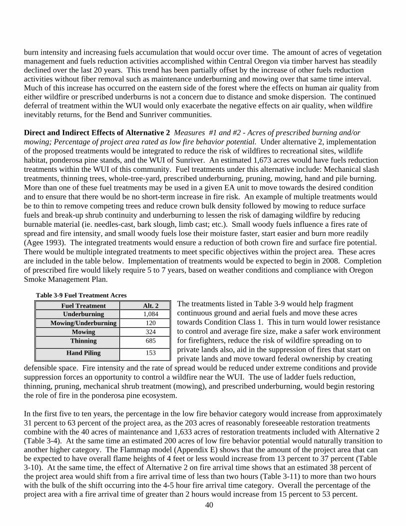
40
burn intensity and increasing fuels accumulation that would occur over time. The amount of acres of vegetation management and fuels reduction activities accomplished within Central Oregon via timber harvest has steadily declined over the last 20 years. This trend has been partially offset by the increase of other fuels reduction activities without fiber removal such as maintenance underburning and mowing over that same time interval. Much of this increase has occurred on the eastern side of the forest where the effects on human air quality from either wildfire or prescribed underburns is not a concern due to distance and smoke dispersion. The continued deferral of treatment within the WUI would only exacerbate the negative effects on air quality, when wildfire inevitably returns, for the Bend and Sunriver communities. Direct and Indirect Effects of Alternative 2 Measures #1 and #2 - Acres of prescribed burning and/or mowing; Percentage of project area rated as low fire behavior potential. Under alternative 2, implementation of the proposed treatments would be integrated to reduce the risk of wildfires to recreational sites, wildlife habitat, ponderosa pine stands, and the WUI of Sunriver. An estimated 1,673 acres would have fuels reduction treatments within the WUI of this community. Fuel treatments under this alternative include: Mechanical slash treatments, thinning trees, whole-tree-yard, prescribed underburning, pruning, mowing, hand and pile burning. More than one of these fuel treatments may be used in a given EA unit to move towards the desired condition and to ensure that there would be no short-term increase in fire risk. An example of multiple treatments would be to thin to remove competing trees and reduce crown bulk density followed by mowing to reduce surface fuels and break-up shrub continuity and underburning to lessen the risk of damaging wildfire by reducing burnable material (ie. needles-cast, bark slough, limb cast; etc.). Small woody fuels influence a fires rate of spread and fire intensity, and small woody fuels lose their moisture faster, start easier and burn more readily (Agee 1993). The integrated treatments would ensure a reduction of both crown fire and surface fire potential. There would be multiple integrated treatments to meet specific objectives within the project area. These acres are included in the table below. Implementation of treatments would be expected to begin in 2008. Completion of prescribed fire would likely require 5 to 7 years, based on weather conditions and compliance with Oregon Smoke Management Plan.
Table 3-9 Fuel Treatment Acres The treatments listed in Table 3-9 would help fragment continuous ground and aerial fuels and move these acres towards Condition Class 1. This in turn would lower resistance to control and average fire size, make a safer work environment for firefighters, reduce the risk of wildfire spreading on to private lands also, aid in the suppression of fires that start on private lands and move toward federal ownership by creating
defensible space. Fire intensity and the rate of spread would be reduced under extreme conditions and provide suppression forces an opportunity to control a wildfire near the WUI. The use of ladder fuels reduction, thinning, pruning, mechanical shrub treatment (mowing), and prescribed underburning, would begin restoring the role of fire in the ponderosa pine ecosystem. In the first five to ten years, the percentage in the low fire behavior category would increase from approximately 31 percent to 63 percent of the project area, as the 203 acres of reasonably foreseeable restoration treatments combine with the 40 acres of maintenance and 1,633 acres of restoration treatments included with Alternative 2 (Table 3-4). At the same time an estimated 200 acres of low fire behavior potential would naturally transition to another higher category. The Flammap model (Appendix E) shows that the amount of the project area that can be expected to have overall flame heights of 4 feet or less would increase from 13 percent to 37 percent (Table 3-10). At the same time, the effect of Alternative 2 on fire arrival time shows that an estimated 38 percent of the project area would shift from a fire arrival time of less than two hours (Table 3-11) to more than two hours with the bulk of the shift occurring into the 4-5 hour fire arrival time category. Overall the percentage of the project area with a fire arrival time of greater than 2 hours would increase from 15 percent to 53 percent.
Fuel Treatment Alt. 2 Underburning 1,084
Mowing/Underburning 120 Mowing 324 Thinning 685
Hand Piling 153
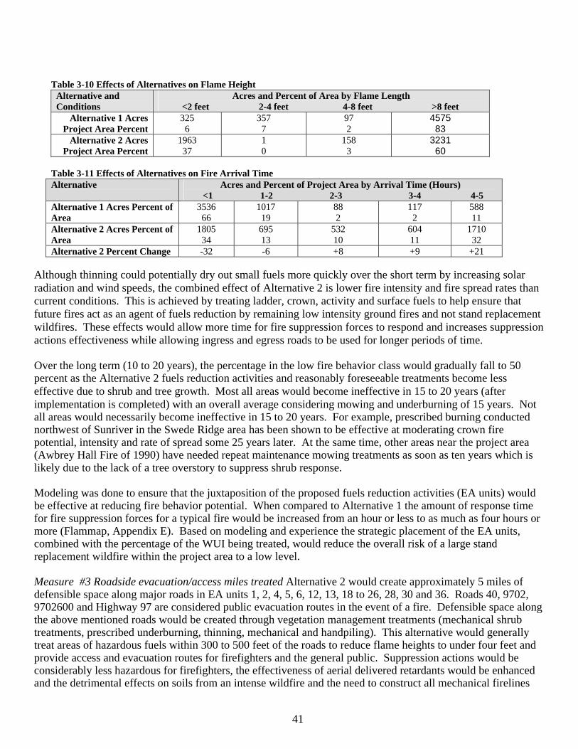
41
Table 3-10 Effects of Alternatives on Flame Height
Alternative and Conditions
Acres and Percent of Area by Flame Length <2 feet 2-4 feet 4-8 feet >8 feet
Alternative 1 Acres Project Area Percent
325 6
357 7
97 2
4575 83
Alternative 2 Acres Project Area Percent
1963 37
1 0
158 3
3231 60
Table 3-11 Effects of Alternatives on Fire Arrival Time Alternative Acres and Percent of Project Area by Arrival Time (Hours)
<1 1-2 2-3 3-4 4-5 Alternative 1 Acres Percent of Area
3536 66
1017 19
88 2
117 2
588 11
Alternative 2 Acres Percent of Area
1805 34
695 13
532 10
604 11
1710 32
Alternative 2 Percent Change -32 -6 +8 +9 +21
Although thinning could potentially dry out small fuels more quickly over the short term by increasing solar radiation and wind speeds, the combined effect of Alternative 2 is lower fire intensity and fire spread rates than current conditions. This is achieved by treating ladder, crown, activity and surface fuels to help ensure that future fires act as an agent of fuels reduction by remaining low intensity ground fires and not stand replacement wildfires. These effects would allow more time for fire suppression forces to respond and increases suppression actions effectiveness while allowing ingress and egress roads to be used for longer periods of time. Over the long term (10 to 20 years), the percentage in the low fire behavior class would gradually fall to 50 percent as the Alternative 2 fuels reduction activities and reasonably foreseeable treatments become less effective due to shrub and tree growth. Most all areas would become ineffective in 15 to 20 years (after implementation is completed) with an overall average considering mowing and underburning of 15 years. Not all areas would necessarily become ineffective in 15 to 20 years. For example, prescribed burning conducted northwest of Sunriver in the Swede Ridge area has been shown to be effective at moderating crown fire potential, intensity and rate of spread some 25 years later. At the same time, other areas near the project area (Awbrey Hall Fire of 1990) have needed repeat maintenance mowing treatments as soon as ten years which is likely due to the lack of a tree overstory to suppress shrub response. Modeling was done to ensure that the juxtaposition of the proposed fuels reduction activities (EA units) would be effective at reducing fire behavior potential. When compared to Alternative 1 the amount of response time for fire suppression forces for a typical fire would be increased from an hour or less to as much as four hours or more (Flammap, Appendix E). Based on modeling and experience the strategic placement of the EA units, combined with the percentage of the WUI being treated, would reduce the overall risk of a large stand replacement wildfire within the project area to a low level. Measure #3 Roadside evacuation/access miles treated Alternative 2 would create approximately 5 miles of defensible space along major roads in EA units 1, 2, 4, 5, 6, 12, 13, 18 to 26, 28, 30 and 36. Roads 40, 9702, 9702600 and Highway 97 are considered public evacuation routes in the event of a fire. Defensible space along the above mentioned roads would be created through vegetation management treatments (mechanical shrub treatments, prescribed underburning, thinning, mechanical and handpiling). This alternative would generally treat areas of hazardous fuels within 300 to 500 feet of the roads to reduce flame heights to under four feet and provide access and evacuation routes for firefighters and the general public. Suppression actions would be considerably less hazardous for firefighters, the effectiveness of aerial delivered retardants would be enhanced and the detrimental effects on soils from an intense wildfire and the need to construct all mechanical firelines
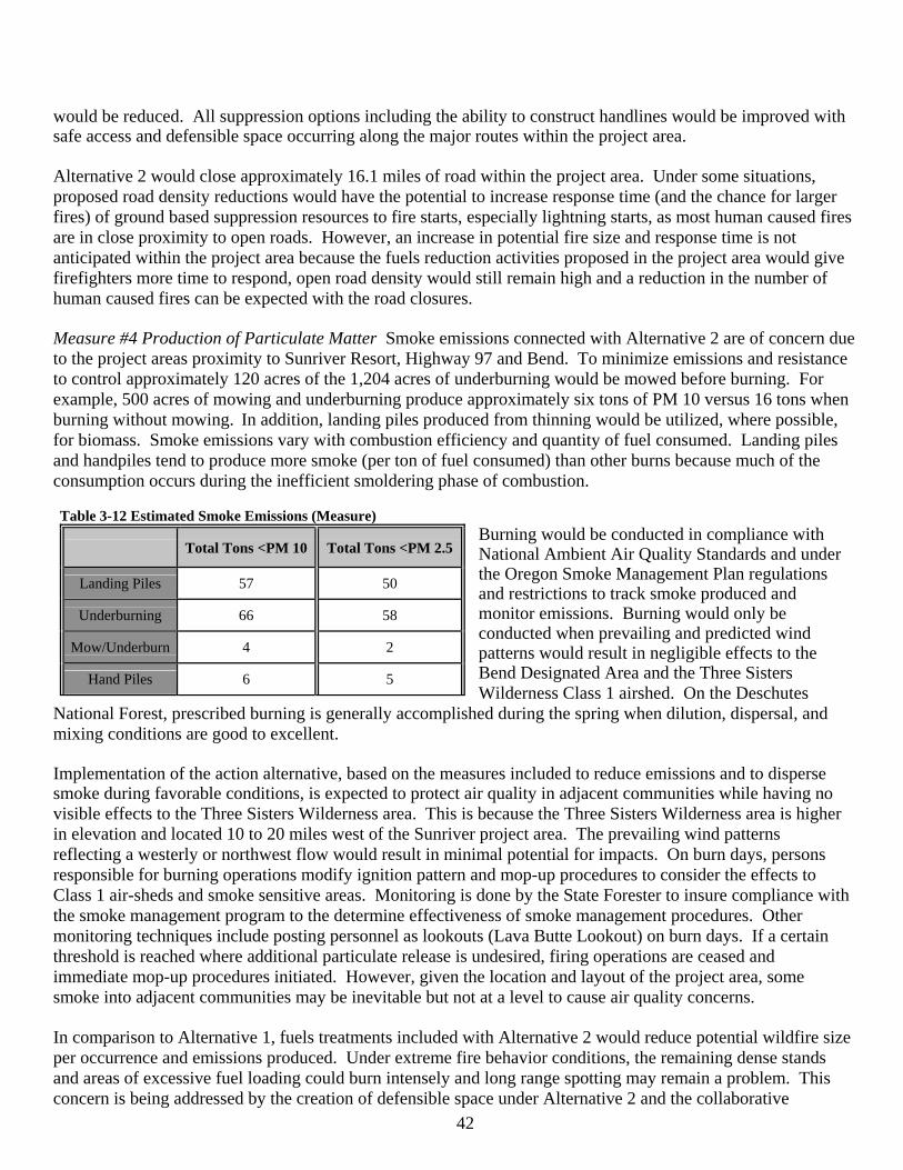
42
would be reduced. All suppression options including the ability to construct handlines would be improved with safe access and defensible space occurring along the major routes within the project area. Alternative 2 would close approximately 16.1 miles of road within the project area. Under some situations, proposed road density reductions would have the potential to increase response time (and the chance for larger fires) of ground based suppression resources to fire starts, especially lightning starts, as most human caused fires are in close proximity to open roads. However, an increase in potential fire size and response time is not anticipated within the project area because the fuels reduction activities proposed in the project area would give firefighters more time to respond, open road density would still remain high and a reduction in the number of human caused fires can be expected with the road closures.
Measure #4 Production of Particulate Matter Smoke emissions connected with Alternative 2 are of concern due to the project areas proximity to Sunriver Resort, Highway 97 and Bend. To minimize emissions and resistance to control approximately 120 acres of the 1,204 acres of underburning would be mowed before burning. For example, 500 acres of mowing and underburning produce approximately six tons of PM 10 versus 16 tons when burning without mowing. In addition, landing piles produced from thinning would be utilized, where possible, for biomass. Smoke emissions vary with combustion efficiency and quantity of fuel consumed. Landing piles and handpiles tend to produce more smoke (per ton of fuel consumed) than other burns because much of the consumption occurs during the inefficient smoldering phase of combustion. Table 3-12 Estimated Smoke Emissions (Measure)
Burning would be conducted in compliance with National Ambient Air Quality Standards and under the Oregon Smoke Management Plan regulations and restrictions to track smoke produced and monitor emissions. Burning would only be conducted when prevailing and predicted wind patterns would result in negligible effects to the Bend Designated Area and the Three Sisters Wilderness Class 1 airshed. On the Deschutes
National Forest, prescribed burning is generally accomplished during the spring when dilution, dispersal, and mixing conditions are good to excellent. Implementation of the action alternative, based on the measures included to reduce emissions and to disperse smoke during favorable conditions, is expected to protect air quality in adjacent communities while having no visible effects to the Three Sisters Wilderness area. This is because the Three Sisters Wilderness area is higher in elevation and located 10 to 20 miles west of the Sunriver project area. The prevailing wind patterns reflecting a westerly or northwest flow would result in minimal potential for impacts. On burn days, persons responsible for burning operations modify ignition pattern and mop-up procedures to consider the effects to Class 1 air-sheds and smoke sensitive areas. Monitoring is done by the State Forester to insure compliance with the smoke management program to the determine effectiveness of smoke management procedures. Other monitoring techniques include posting personnel as lookouts (Lava Butte Lookout) on burn days. If a certain threshold is reached where additional particulate release is undesired, firing operations are ceased and immediate mop-up procedures initiated. However, given the location and layout of the project area, some smoke into adjacent communities may be inevitable but not at a level to cause air quality concerns.
In comparison to Alternative 1, fuels treatments included with Alternative 2 would reduce potential wildfire size per occurrence and emissions produced. Under extreme fire behavior conditions, the remaining dense stands and areas of excessive fuel loading could burn intensely and long range spotting may remain a problem. This concern is being addressed by the creation of defensible space under Alternative 2 and the collaborative
Total Tons <PM 10 Total Tons <PM 2.5
Landing Piles 57 50
Underburning 66 58
Mow/Underburn 4 2
Hand Piles 6 5
43
ongoing fuels treatments on private lands that would allow staging of suppression forces to protect private property and structures during a wildfire.
There would be some dust created from the proposed mechanical operations in Alternative 2 mainly from log haul and the operation of machinery within the EA units. The amount of dust actually created would be near zero since the major log haul roads have paved or dust abated gravel surfacing and secondary native surface haul roads include watering for dust abatement. None of the vegetation management activities would create any cleared areas larger than 1/5 acre in size and dust created during actual operations would be short term and confined to the rare times when machinery was actually moving over bare native surface soils. Provisions that require mechanical operations to occur outside the dry June 1 to September 30 time period means that operations would be less likely to create any measurable dust from snow covered, frozen, or moist soils. Dust from prescribed underburns would not occur because burn prescriptions are designed to retain the duff layer.
Cumulative Effects of Alternative 2 Measures #1 and #2 Acres of prescribed burning and/or mowing; Percentage of project area rated as low for fire behavior potential All mechanical fuels reduction activities create measurable amounts of dead and down woody residue. Alternative 2 includes integrated fuel treatments which disposes of the residue created by vegetation management as well as natural accumulation of fuels. There would be no negative short term or long term cumulative effects on fuels loading within the project area from the combination of Alternative 2 and the 203 acres of reasonably foreseeable activity associated with the OZ CE because all mechanical removal requires whole tree removal. Hand thinning and piling would be done concurrently. Mowing in itself does not reduce fuels. Its value is in rearranging fuels to make ground fuels less flammable while lowering flame heights and expediting decomposition of forest residues. Overall, there would be a substantial cumulative downward trend in the amount of fuel loading and wildland fire risk if Alternative 2 was implemented. Sunriver Owners Association (SORA) has implemented ongoing cooperative fuels reduction activities on 1,002 acres contiguous with the project area since 2000. SORA maintains a six-year fuels reduction cycle on common grounds within Sunriver, as well as a private residential fuels reduction program, prioritized in order of need. Sunriver has completed the second cycle of fuels reduction and began the third cycle in the summer of 2006.
The Sunriver Ladder Fuels Reduction Plan which address hazardous fuels reduction on private and commonly owned property in the community has been revised to meet or exceed the intent of Oregon Forestland-Urban Interface Fire Protection Act of 1997, and the International Fire Code (IFC). With requirements for fuels reduction on undeveloped lots and common ground, the Sunriver plan exceeds Oregon Protection Acts standards for an “Extreme” classification area. The plan has been reviewed and approved by the Oregon Department of Forestry (ODF) and the Sunriver Fire Department. Vegetative material is recycled by composting to improve both air and soil quality. Maintenance of private lands in the low fire behavior category would reduce the risk of a wildfire ignition occurring and moving onto federal lands and is also the main factor in helping to ensure home and structure protection during a wildfire event. As discussed under the direct and indirect effects of Alternative 2; the percentage in the low fire behavior category (FRCC 1) on Federal lands would increase from 31 percent to approximately 63 percent and gradually fall to 50 percent over the next 15 to 20 years. Modeling of fire behavior by Finney has shown that with strategically designed fuels treatments that the greatest reduction in expected spread rate of a fire occurs with the first 20 percent of a landscape treated followed by the next quartile. Alternative 2 when combined with existing and planned treatments on both federal and private lands would meet or exceed 50 percent of the project area in the low fire behavior class for the next two decades; providing a high level of protection for private lands, present and future forest values. During that time the 3,374 acres of private land within the Sunriver community would be maintained in the low fire behavior category to continue providing the defensible
44
space that is the primary responsibility of private landowners. Measure #3 Roadside evacuation/access miles treated Alternative 2 would create approximately 5 miles of defensible space along roads within the project area and when combined with reasonably foreseeable fuels reduction activities adjacent to road 40 (OZ CE) a total of 6 miles of defensible roads would be created. Cumulatively, suppression, evacuation and access for both firefighters and the public would be less hazardous. Measure #4 Production of Particulate Matter The cumulative effects on air quality from prescribed burning included in Alternative 2 would be zero. A study of cumulative effects of emissions in the Central Oregon areas shows that slash burning contributes less than half of a percent (.34 percent) of Particulate Matter (PM). The same study found that slash burning also produces less than 1 percent (.64 percent) of the carbon monoxide in Central Oregon (CAC, 1997). As mentioned previously, burning would be conducted in compliance with National Ambient Air Quality Standards and Oregon Department of Environmental Quality regulations and restrictions to ensure that there would be no cumulative effects on air quality. In areas where restoration of historic fire regimes is planned, prescribed fire would likely need to occur every 8 to 15 years although the actual frequency is speculative and not foreseeable. The additional 203 acres of prescribed underburning within the project area included in the OZ CE is also subject to the same restrictions, requirements and regulations and would not have an additive negative effect to air quality within Central Oregon communities. LRMP/Other Management Direction Consistency LRMP Forest-wide (FF-1 to FF-11) standards and guidelines give direction on wildfire prevention and suppression. Alternative 2 focuses on the prevention of human caused wildfires in and near high use and high risk (FF-1) recreation areas, roads, and beetle killed stands adjacent to private lands by closing roads and strategic placement of EA units to reduce wildland fire risk. Consistent with LRMP FF-9 and Upper Deschutes River Plan V-11, burn plans and silvicultural prescriptions are prepared in advance for all prescribed burning in order to ensure compliance with the Oregon Smoke Management Plan and LRMP. In addition to air quality monitoring of prescribed burns by the Oregon Department of Environmental Quality, Forest Service personnel are routinely posted as lookouts on burn days to track smoke plumes and suspend burning operations to ensure strict compliance with the CAA and to minimize smoke intrusions into designated areas and Class 1 Airsheds. The Vegetation Standards and Guidelines of the Upper Deschutes River Plan includes a target level (LRMP, Amendment #12, V-15) of 10 to 15 tons per acre of standing dead trees, down logs and associated fuel loading for the ponderosa pine PAG (EA units 1, 2, 3) and 8 to 12 tons per acre for the lodgepole pine (EA unit 6) PAG. A total of 46 acres within the river corridor (MA-17) would have fuels treatments. All EA unit prescriptions are designed to achieve the desirable range of fuel loading. For example, no dead standing or down trees would be removed in order to meet the target levels. EA units1, 2 and 6 would be hand piled and not underburned to retain desired levels of fuel loading. Vegetation management within MA-17 focuses on thinning the overstory to reduce crown density and ladder fuels while lowering natural fuels in the understory by mowing and hand piling in EA unit 6, hand piling in EA units 1 and 2 and prescribed burning in EA unit 3. Consistency with other applicable Upper Deschutes River Plan standards and guidelines is discussed under the Forest Management and Health and Wild and Scenic River Values sections.
Prescribed fuels reduction activities in the EA units in the other management areas (MA 8, MA 9) are designed to: retain 5 to 10 tons per acre of coarse woody debris for wildlife habitat and soils enhancement, reduce the risk of stand replacement wildfire, provide defensible space, prevent lodgepole pine encroachment, increase palatability and promote the desired visual condition in ponderosa pine stands (M 8-25, M 9-90, M 9-91). A total of 121 acres (EA units 21, 22, 24, 25, 28, 29, 30, 31, 35, 36) is in foreground visual areas. Prescribed fire treatments in EA units 22, 28, 29 and 30 would be designed to appear as natural occurrences and burned in a mosaic pattern (jackpot burning), interspersed with the 30 percent retention areas, to be, generally, less than 5 acres in size and appearance. Other fuels management treatments such as mowing and/or hand piling would be
45
used in the other foreground visual areas to meet visual quality objectives (M9-90). Ecosystem and Forest Health Introduction (analysis issue) The terms “Healthy Forests,” “Ecosystem Health,” and “Forest Health” are often used interchangeably. Ecosystem Health for the Sunriver HFRA project area is defined as a condition where size, structure and species composition are represented in a balanced distribution across the project area and adjacent landscape so that insect, disease and fire are operating within or close to historic conditions while meeting the current and future needs of people for desired levels of uses, values and products as determined by the Deschutes LRMP. The following five attributes of forest vegetation were measured to analyze effects of treatments: Measure #1) stand density; 2) diameter distribution; 3) species composition; 4) canopy structure; and 5) stand structure. Canopy structure describes canopy components such as crown base height and canopy continuity. Stand structure describes stage of stand development, considering such components as tree size and number of age classes. Two additional measures of forest health were also analyzed: 1) stand susceptibility to bark beetle; and 2) level of dwarf mistletoe infection. Scope of the Analysis For all but stand structure, the scale of analysis is the area proposed for treatment. Treatments would have no effect on stand density, diameter distribution, species composition, and canopy structure outside of the treatment area. Stand structure is analyzed on a broader landscape scale. A description of that scale and associated rational is documented in Appendix I. Where the analysis describes a sample size, it refers to the number of treatment units (EA units) sampled. Affected Environment- As discussed previously, most of the Sunriver HFRA project area was previously clear-cut logged beginning in the 1920s, with scattered ponderosa pine trees (Pinus ponderosa) being retained for seed trees. Stands that established following the historic logging are a mix of ponderosa and lodgepole pine (Pinus contorta) in the northwest portion of the project and primarily ponderosa pine in the southeast portion. Mortality from mountain pine beetle is occurring within and adjacent to the project area. Areas proposed for treatment are on generally level to rolling ground. Treatments are proposed in the ponderosa pine dry plant association group and to a lesser extent in the lodgepole pine dry plant association group. Treatments are proposed in stands that vary from predominantly single-story ponderosa pine stands that were thinned in the 1980’s and 1990’s to dense, multi-story ponderosa and lodgepole pine stands that have received no management treatments since the historic logging (Appendix I). Average stand age is approximately 80 years. Unique among the areas proposed for treatment is an eight acre ponderosa pine plantation established following a clearcut harvest in 1972 (EA unit 32). In all units an understory of antelope bitterbrush (Purshia tridentata) and greenleaf manzanita (Arctostaphylos patula) is present. In describing the existing fuel hazards within the Sunriver Wildland Urban Interface, the Sunriver CWPP (CWPP, page 6) identifies that “decades of fire suppression, and the after effects of logging have altered the presettlement forest of widely spaced mature predominantly ponderosa pine and bunchgrass communities. Today, we see dense thickets of smaller diameter lodgepole and ponderosa pine, accumulations of bitterbrush (Purshia tridentata) and dead and down beetle killed trees.” Ecosystem and Forest Health Management Direction The LRMP, as amended by the Upper Deschutes River Plan, Eastside Screens and NNVM Management Plan, specifies vegetation management activities to minimize fire, insect and disease mortality while providing for ecosystem health and diversity (LRMP FH-1 to FH-5, TM-1 to TM-7, TM-10, TM-55 to 57, 67, MA 7, MA 8, MA 9). The Upper Deschutes River Plan explicitly states that “any silvicultural practices which provide long-term benefits to Outstandingly Remarkable Values (ORVs) may be allowed” (Upper Deschutes River Plan V-16).
46
Prescribed fire may be used at locations, scale, intensity, and frequency which will mimic pre-suppression historical averages for the watershed, where such fires would not have long-term adverse effects on other river values or cause undue risk to public health and safety or private property. Mechanical pre-treatment of fuels may be required to safely utilize underburning (Upper Deschutes River Plan V-9). The Eastside Screens amended the LRMP in 1995 to provide additional guidance on commercial timber sales to ensure the conservation of open, park-like stands of ponderosa pine while specifying that thinning should be used to maintain or accelerate the development of these types of conditions (Eastside Screen EA, page 8). The Eastside Screens further prohibits the cutting of live trees greater than or equal to 21 inches in diameter (dbh).
Standards and Guides M-8 and M-15 of the NNVM Management Plan provides for reestablishment of historic old growth ponderosa pine stands using vegetation management projects that 1) Protect existing large, old trees and provide for the perpetuation of the genetic heritage they represent; 2) Reestablish conditions that allow natural ecological succession of vegetation to the maximum extent practical; 3) Protect public health and safety; 4) Enhance wildlife or sensitive plant habitat, scenic quality, or recreational values, and 5) Reduce serious threats from insects, fire, or disease to resources outside the Monument. The HFRA contains a variety of provisions to expedite hazardous fuel reduction and forest restoration projects on Federal land at risk of wildland fire or insect and disease epidemics. Appropriate tools for the Sunriver HFRA project include the use of prescribed fire and various mechanical methods such as hand piling, thinning (to produce commercial products), and pruning (HFRA, Sections 101(2), 102(a)). Section 102(b) provides that an authorized hazardous fuel reduction project be consistent with the Deschutes LRMP and other relevant administrative polices or decisions. Section 102(e)(2) provides when carrying out covered projects, the Forest Service is to “fully maintain, or contribute toward the restoration of, the structure and composition of old-growth stands according to the pre-fire suppression old-growth conditions characteristic of the forest type, taking into account the contribution of the stand to landscape fire adaptation and watershed health, and retaining the large trees contributing to old-growth structure.” Target Landscape Condition The long term (50 to 100 years) target condition is move towards the conditions shown in Table 3-24. It was defined by the ID team as having 50 percent of the project area in the low fire behavior category for the coming two decades and 60 percent (based on Table 3-24 LOS additive mid-point averages) or more long term. Thinning, prescribed fire and mowing would be used to maintain and restore ecosystem health where insect and disease mortality would remain at endemic levels while accelerating the development of open, large, single-stratum ponderosa pine that currently does not exist in a project area where it was historically the dominant stand condition. Ecosystem Health Environmental Effects Introduction The discussion of effects on wildlife, ORVs and other resources are included in the appropriate individual resource area. Best available science was considered and used in analyzing the effects of proposed treatments. Scientific information relied on is incorporated and cited in the discussion of effects. Pertinent opposing views are briefly referenced and the rational for not relying on them in the analysis are documented in Appendix I, Sunriver HFRA Silviculture Report-Appendix D. Reference Condition Based on three study areas, Youngblood et al. (2004) describe the historic (pre-1900) stand structure present in pumice-dominated eastside old-growth ponderosa pine forests (Table 3-13). The Sunriver HFRA project is within the range of ponderosa pine sampled by Youngblood. The Eastside old-growth ponderosa pine reference condition of upper canopy live trees (Table 3-13) described by Youngblood is used in this analysis as a reference condition for evaluating effects of the proposed treatments. Table 3-13 Pumice-dominated eastside ponderosa pine size structure old-growth reference condition (Youngblood et al. 2004)
Location Upper Canopy Live Tree Density Upper Canopy Live Tree Size
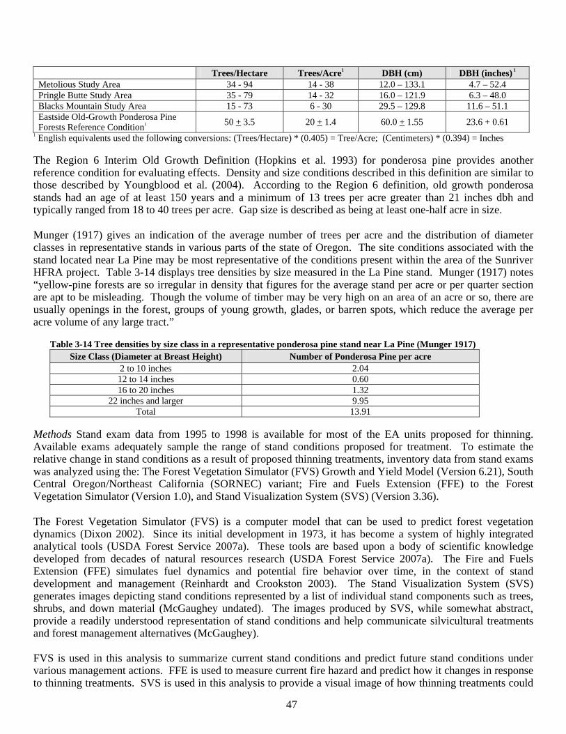
47
Trees/Hectare Trees/Acre1 DBH (cm) DBH (inches) 1 Metolious Study Area 34 - 94 14 - 38 12.0 – 133.1 4.7 – 52.4 Pringle Butte Study Area 35 - 79 14 - 32 16.0 – 121.9 6.3 – 48.0 Blacks Mountain Study Area 15 - 73 6 - 30 29.5 – 129.8 11.6 – 51.1 Eastside Old-Growth Ponderosa Pine Forests Reference Condition1 50 + 3.5 20 + 1.4 60.0 + 1.55 23.6 + 0.61
1 English equivalents used the following conversions: (Trees/Hectare) * (0.405) = Tree/Acre; (Centimeters) * (0.394) = Inches
The Region 6 Interim Old Growth Definition (Hopkins et al. 1993) for ponderosa pine provides another reference condition for evaluating effects. Density and size conditions described in this definition are similar to those described by Youngblood et al. (2004). According to the Region 6 definition, old growth ponderosa stands had an age of at least 150 years and a minimum of 13 trees per acre greater than 21 inches dbh and typically ranged from 18 to 40 trees per acre. Gap size is described as being at least one-half acre in size.
Munger (1917) gives an indication of the average number of trees per acre and the distribution of diameter classes in representative stands in various parts of the state of Oregon. The site conditions associated with the stand located near La Pine may be most representative of the conditions present within the area of the Sunriver HFRA project. Table 3-14 displays tree densities by size measured in the La Pine stand. Munger (1917) notes “yellow-pine forests are so irregular in density that figures for the average stand per acre or per quarter section are apt to be misleading. Though the volume of timber may be very high on an area of an acre or so, there are usually openings in the forest, groups of young growth, glades, or barren spots, which reduce the average per acre volume of any large tract.”
Table 3-14 Tree densities by size class in a representative ponderosa pine stand near La Pine (Munger 1917) Size Class (Diameter at Breast Height) Number of Ponderosa Pine per acre
2 to 10 inches 2.04 12 to 14 inches 0.60 16 to 20 inches 1.32
22 inches and larger 9.95 Total 13.91
Methods Stand exam data from 1995 to 1998 is available for most of the EA units proposed for thinning. Available exams adequately sample the range of stand conditions proposed for treatment. To estimate the relative change in stand conditions as a result of proposed thinning treatments, inventory data from stand exams was analyzed using the: The Forest Vegetation Simulator (FVS) Growth and Yield Model (Version 6.21), South Central Oregon/Northeast California (SORNEC) variant; Fire and Fuels Extension (FFE) to the Forest Vegetation Simulator (Version 1.0), and Stand Visualization System (SVS) (Version 3.36).
The Forest Vegetation Simulator (FVS) is a computer model that can be used to predict forest vegetation dynamics (Dixon 2002). Since its initial development in 1973, it has become a system of highly integrated analytical tools (USDA Forest Service 2007a). These tools are based upon a body of scientific knowledge developed from decades of natural resources research (USDA Forest Service 2007a). The Fire and Fuels Extension (FFE) simulates fuel dynamics and potential fire behavior over time, in the context of stand development and management (Reinhardt and Crookston 2003). The Stand Visualization System (SVS) generates images depicting stand conditions represented by a list of individual stand components such as trees, shrubs, and down material (McGaughey undated). The images produced by SVS, while somewhat abstract, provide a readily understood representation of stand conditions and help communicate silvicultural treatments and forest management alternatives (McGaughey). FVS is used in this analysis to summarize current stand conditions and predict future stand conditions under various management actions. FFE is used to measure current fire hazard and predict how it changes in response to thinning treatments. SVS is used in this analysis to provide a visual image of how thinning treatments could
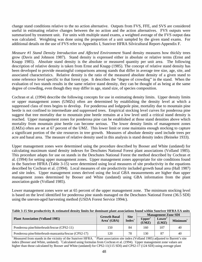
48
change stand conditions relative to the no action alternative. Outputs from FVS, FFE, and SVS are considered useful in estimating relative changes between the no action and the action alternatives. FVS outputs were summarized by treatment unit. For units with multiple stand exams, a weighted average of the FVS output data was calculated. Weighting was done using the proportion of a unit sampled by the given stand exams. For additional details on the use of FVS refer to Appendix I, Sunriver HFRA Silvicultural Report-Appendix F. Measure #1 Stand Density Introduction and Affected Environment Stand density measures how thickly trees grow (Davis and Johnson 1987). Stand density is expressed either in absolute or relative terms (Ernst and Knapp 1985). Absolute stand density is the absolute or measured quantity per unit area. The following description of relative density is taken from Ernst and Knapp (1985). The concept of relative stand density has been developed to provide meaningful comparisons among stands that differ in average tree size, age, site, and associated characteristics. Relative density is the ratio of the measured absolute density of a given stand to some reference level specific to that forest type. It describes the “degree of crowding” in the stand. When the evaluation of two stands results in the same relative stand density, they can be thought of as being at the same degree of crowding, even though they may differ in age, stand size, of species composition. Cochran et al. (1994) describe the following concepts for use in estimating density limits. Upper density limits or upper management zones (UMZs) often are determined by establishing the density level at which a suppressed class of trees begins to develop. For ponderosa and lodgepole pine, mortality due to mountain pine beetle is not confined to intermediate and suppressed trees. Empirical stocking level curves for ponderosa pine suggest that tree mortality due to mountain pine beetle remains at a low level until a critical stand density is reached. Upper management zones for ponderosa pine can be established at those stand densities above which mortality from mountain pine beetle can become serious. The lower density limits of management zones (LMZs) often are set at 67 percent of the UMZ. This lower limit or zone maintains enough stocking to capture a significant portion of the site resources in tree growth. Measures of absolute density used include trees per acre and basal area. The measure of relative density used in this analysis is stand density index (Reineke 1933). Upper management zones were determined using the procedure described by Booser and White (undated) for calculating maximum stand density indexes for Deschutes National Forest plant associations (Volland 1985). This procedure adapts for use on stands in the Deschutes National Forest the method described by Cochran et al. (1994) for setting upper management zones. Upper management zones appropriate for site conditions found in the Sunriver HFRA (Table 3-15) were determined using local measures of site productivity in the equations described by Cochran et al. (1994). Local measures of site productivity included growth basal area (Hall 1987) and site index. Upper management zones derived using the local GBA measurements are higher than upper management zones determined by Booser and White (undated) using GBA information from the plant association guide (Volland 1985). Lower management zones were set at 65 percent of the upper management zone. The minimum stocking level is based on the level identified for ponderosa pine stands managed on the Deschutes National Forest (36.5 SDI) using the uneven-aged harvesting method (USDA Forest Service 1994c). Table 3-15 Site productivity & estimated density limits for dominant plant associations found within Sunriver HFRA EA units
Management Zone SDI Plant Association (Volland 1985) Growth Basal
Area1 (GBA) Site
Index2 Upper3 (UMZ)
Lower4 (LMZ) Minimum5
Ponderosa pine/bitterbrush/fescue (CPS2-11) 150 84 160 107 40
Ponderosa pine/bitterbrush-manzanita/fescue (CPS2-17) 120 78 130 87 40 1 Measured from stands in the vicinity of the Sunriver HFRA. 2 Plant association site index (Volland 1985) adjusted to Barrett’s site index (Booser and White, undated). 3Calculated using formulas from Cochran et al. (1994). Upper management zone values are higher than those calculated by Booser and White (undated) for CPS2-11(115 SDI) and CPS2-17 (124 SDI) using average plant
49
association conditions reported by Volland (1985) for the central Oregon pumice zone. 4 (Upper management zone) * (.65) = LMZ 5 Derived from minimum stocking guidelines for uneven-aged management on the Deschutes (USDA Forest Service 1994c). On the average, stand densities are highest in those areas that have had no recent management treatments (Appendix I and Table 3-16). All areas with no prior management treatments exceed the upper management zone. Stand densities for areas with prior management are more variable, with some stands above and other stands below the upper management zone. Existing stand stocking (basal area) averages 77 percent of growth basal area (GBA) and ranges from 34 to 128 percent of GBA. Lower stocking levels are associated with those areas where prior treatments have occurred.
Table 3-16 Existing stand density within areas proposed for treatment.
Trees per Acre (>4.5 feet tall)
Basal Area per Acre (Square Feet) Stand Density Index Management History
Avg Min Max Avg Min Max Avg Min Max No recent management
(Sample size = 10) 433 142 1035 102 61 138 229 143 325
Recent management (Sample size = 14)
121 86 265 72 38 91 129 76 163
Direct and Indirect Effects of Alternative 1 There would be little reduction in stand density levels in the absence of thinning treatments, fire, bark beetle attacks or other disturbances that would kill trees. Self-thinning generally does not occur on the dry sites associated with the project. Emmingham et al. (2005) describe on very dry sites, dense sapling and pole-size stands tend to stagnate and on dry, climax ponderosa pine sites, the dominant and co-dominant trees within dense, even-aged groups of trees tend to stagnate and grow very slowly, if at all. Cumulative Effects of Alternative 1 Since there would be no new proposed activities under this alternative there would be no cumulative effects. Effects of the reasonably foreseeable activities of thinning 203 acres under the Oz CE would be beneficial within the project area. Direct and Indirect Effects of Alternative 2 Proposed thinning treatments would reduce relative stand densities (Table 3-16, average stand density index) by approximately 35 to 60 percent. Greatest percent reduction in relative stand density would occur within those stands that have had no recent management treatments. Basal areas would be reduced by approximately 20 to 50 percent. Figures 5 and 7 provide a visual image of two representative ponderosa pine stands prior to thinning. Figure 5 depicts a stand with no recent management activity. Figure 7 depicts a stand previously thinned. Figures 6 and 8 depict how thinning could change the density and structure these two stands.
Relative densities would be retained above minimum stocking levels. In many cases, density would be reduced below the lower management zone (Table 3-17). Densities would be lowest within the following allocations where timber production is not a management objective: Scenic Views, Wild and Scenic River, and Newberry National Volcanic Monument. Growth loss associated with these lower stocking levels would be minimal. Modeling with FVS shows that within 10 years, density in many of these treatment areas would exceed the lower management zone. In discussing stand response to new growing space, Cochran et al. (1994) indicates once stands adjust to additional growing space, total cubic volume growth is fairly similar over a fairly wide range of densities. For this reason, Cochran et al. (1994) conclude it may be better to err by retaining leave-tree densities that are too low, relative to the management zones, rather than too high. In terms of trees per acre, thinning would retain densities at levels higher than the 20 trees per acre present in the Eastside Old-Growth reference condition (Table 3-13).
Table 3-17 Stand density before and after thinning within treatment areas proposed for thinning.

50
Trees per Acre Basal Area per Acre (Square Feet) Stand Density Index Management History
Avg Min Max Avg Min Max Avg Min Max No recent management (Sample size = 10)
• Existing Condition 433 142 1035 102 61 138 229 143 325
• Post Thin Condition 84 33 232 53 25 68 88 64 100
• Change from Existing -81% -77% -78% -48% -59% -51% -61% -26% -69%
Recent management (Sample size = 5)
• Existing Condition 132 90 265 78 67 91 139 116 163
• Post Thin Condition 46 39 55 60 53 69 92 85 102
• Change from Existing -65% -57% -79% -23% -21% -24% -34% -27% -37%
Figure 5. SVS representation of ponderosa pine dominated stand with no prior management treatment.
Pre-thin EA unit 9 stand attributes: 80% of basal area is ponderosa pine; 6” quadratic mean diameter; 673 trees per acre; 138 square feet basal area per acre; 53% canopy cover; 0.090 kg/m3 crown bulk density; and 10 foot crown base height. Figure 6. SVS representation of ponderosa pine dominated stand following proposed thinning treatment.
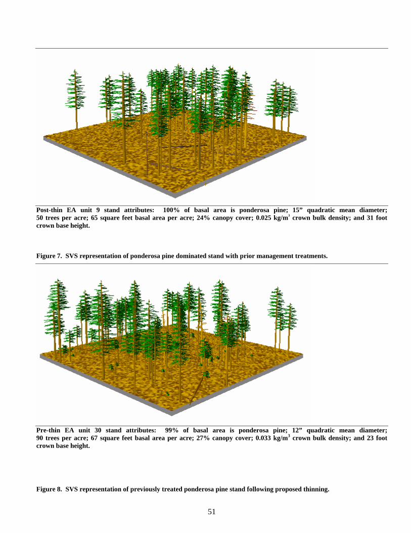
51
Post-thin EA unit 9 stand attributes: 100% of basal area is ponderosa pine; 15” quadratic mean diameter; 50 trees per acre; 65 square feet basal area per acre; 24% canopy cover; 0.025 kg/m3 crown bulk density; and 31 foot crown base height. Figure 7. SVS representation of ponderosa pine dominated stand with prior management treatments.
Pre-thin EA unit 30 stand attributes: 99% of basal area is ponderosa pine; 12” quadratic mean diameter; 90 trees per acre; 67 square feet basal area per acre; 27% canopy cover; 0.033 kg/m3 crown bulk density; and 23 foot crown base height.
Figure 8. SVS representation of previously treated ponderosa pine stand following proposed thinning.
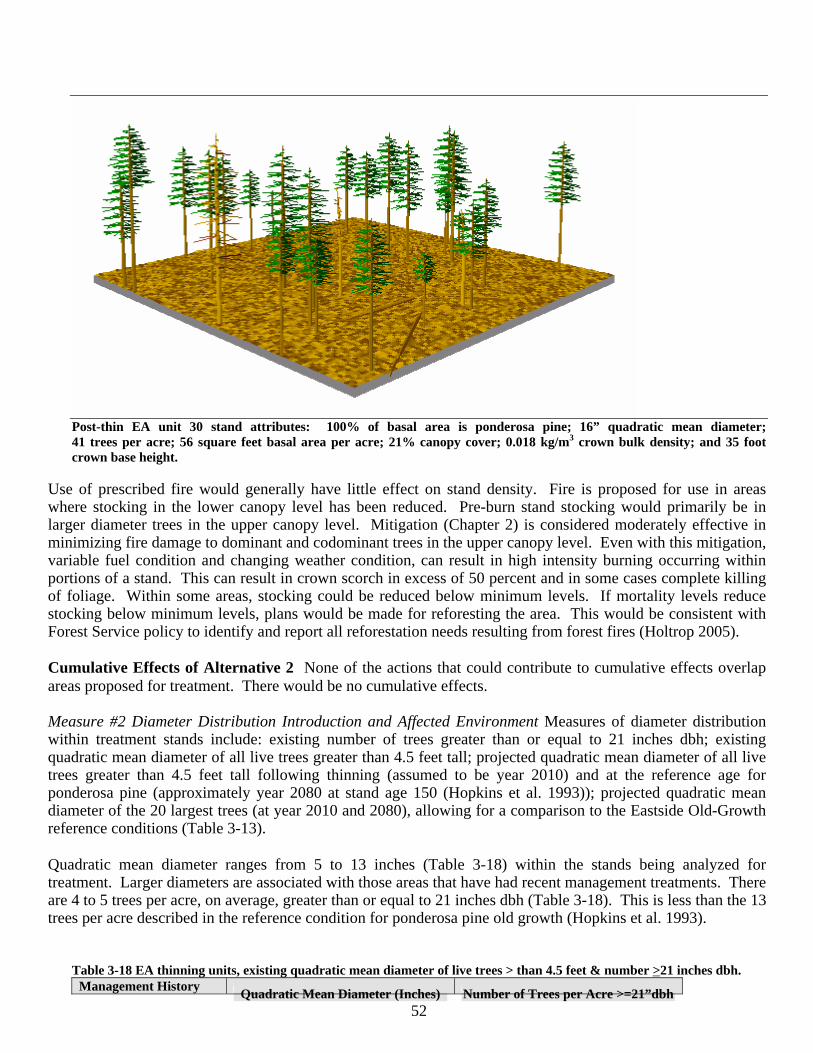
52
Post-thin EA unit 30 stand attributes: 100% of basal area is ponderosa pine; 16” quadratic mean diameter; 41 trees per acre; 56 square feet basal area per acre; 21% canopy cover; 0.018 kg/m3 crown bulk density; and 35 foot crown base height.
Use of prescribed fire would generally have little effect on stand density. Fire is proposed for use in areas where stocking in the lower canopy level has been reduced. Pre-burn stand stocking would primarily be in larger diameter trees in the upper canopy level. Mitigation (Chapter 2) is considered moderately effective in minimizing fire damage to dominant and codominant trees in the upper canopy level. Even with this mitigation, variable fuel condition and changing weather condition, can result in high intensity burning occurring within portions of a stand. This can result in crown scorch in excess of 50 percent and in some cases complete killing of foliage. Within some areas, stocking could be reduced below minimum levels. If mortality levels reduce stocking below minimum levels, plans would be made for reforesting the area. This would be consistent with Forest Service policy to identify and report all reforestation needs resulting from forest fires (Holtrop 2005). Cumulative Effects of Alternative 2 None of the actions that could contribute to cumulative effects overlap areas proposed for treatment. There would be no cumulative effects. Measure #2 Diameter Distribution Introduction and Affected Environment Measures of diameter distribution within treatment stands include: existing number of trees greater than or equal to 21 inches dbh; existing quadratic mean diameter of all live trees greater than 4.5 feet tall; projected quadratic mean diameter of all live trees greater than 4.5 feet tall following thinning (assumed to be year 2010) and at the reference age for ponderosa pine (approximately year 2080 at stand age 150 (Hopkins et al. 1993)); projected quadratic mean diameter of the 20 largest trees (at year 2010 and 2080), allowing for a comparison to the Eastside Old-Growth reference conditions (Table 3-13). Quadratic mean diameter ranges from 5 to 13 inches (Table 3-18) within the stands being analyzed for treatment. Larger diameters are associated with those areas that have had recent management treatments. There are 4 to 5 trees per acre, on average, greater than or equal to 21 inches dbh (Table 3-18). This is less than the 13 trees per acre described in the reference condition for ponderosa pine old growth (Hopkins et al. 1993).
Table 3-18 EA thinning units, existing quadratic mean diameter of live trees > than 4.5 feet & number >21 inches dbh. Management History
Quadratic Mean Diameter (Inches) Number of Trees per Acre >=21”dbh
53
of all trees greater than 4.5 feet tall Average Minimum Maximum Average Minimum Maximum
No recent management (Sample size = 10) 7 5 13 5 1 12
Recent management (Sample size = 14) 11 9 13 4 0 9
Direct and Indirect Effects of Alternative 1 Using the relationship between diameter growth and percent GBA described by Hall (1987), diameter growth of dominant trees for the next decade would be projected to average 1.3 inches and range from 0.7 to 2.5 inches. More rapid growth rates would be associated with areas having lower stocking levels, which primarily would be those areas that have been recently managed. Growth would slow in the coming decades as stand stocking increases. Using FVS, future stand growth was modeled for seven decades to a stand age of approximately 150 years (reference age for ponderosa pine old growth (Hopkins et al. 1993)). Projections suggest the quadratic mean diameter of the 20 largest trees could range from 17 to 28 inches (Table 3-19), with smaller diameters associated with areas having no recent management treatments. Projections suggest without stand disturbing events, such as stand replacing fires or bark beetle outbreaks, there is potential to develop the number and size of upper canopy level trees associated with old-growth reference conditions (Table 3-13, 23.6 inches dbh). This potential would be most variable within stands not recently managed, as indicated by minimum diameters approximately 30 percent less than reference conditions (Table 3-19, 17 inches dbh).
Table 3-19 Thinning EA units, quadratic mean diameter in 2080 (Stand age 150) of all trees taller than 4.5 feet and the 20 largest ponderosa pine per acre as projected by FVS.
Quadratic Mean Diameter in 2080 (inches) of: All trees taller than 4.5 feet 20 largest ponderosa pine per acre Management History Avg Min Max Avg Min Max
No recent management (Sample size = 10)
• Alternative 1 (No Action) 14 12 19 24 17 28
• Alternative 2 24 19 29 28 22 31
• Change from Alternative 1 +71% +58% +53% +17% +29% +11% Recent management (Sample size = 5)
• Alternative 1 (No Action) 19 16 21 25 23 26
• Alternative 2 25 24 26 26 25 27
• Change from Alternative 1 +32% +50% +24% +4% +9% +4%
Potential for developing old-growth reference conditions would be lowest in densely stocked stands. Given the crown-fire (Forest Vegetation Measure #4 below) and bark beetle hazard (Forest Health Measure #1 section of this report) associated with the more densely stocked stands, there would be a high likelihood of a stand disturbing event occurring within the next 70 years. In discussing the results of a 35-year study on ponderosa pine response to thinning and understory removal, Cochran and Barrett (1999b) state “the reduction of growth rates of even the largest trees with increasing stand densities indicates that unmanaged stands that escape thinning through fire or other disturbances will progress very slowly toward mid- or late-seral conditions.” Cumulative Effects of Alternative 1 Since there would be no new proposed activities under this alternative there would be no cumulative effects. Other than the 203 acres of thinning and underburning reasonably foreseeable in the project area it is likely that a combination of beetle mortality and stand replacement wildfire would prevent or severely retard the development of larger diameter trees. Direct and Indirect Effects of Alternative 2 Thinning from below, which generally removes trees from the lower canopy levels, would increase the average quadratic mean diameter of the stands by approximately 45 to 85 percent as compared to the no action alternative (Table 3-20). Greatest gains in quadratic mean diameter
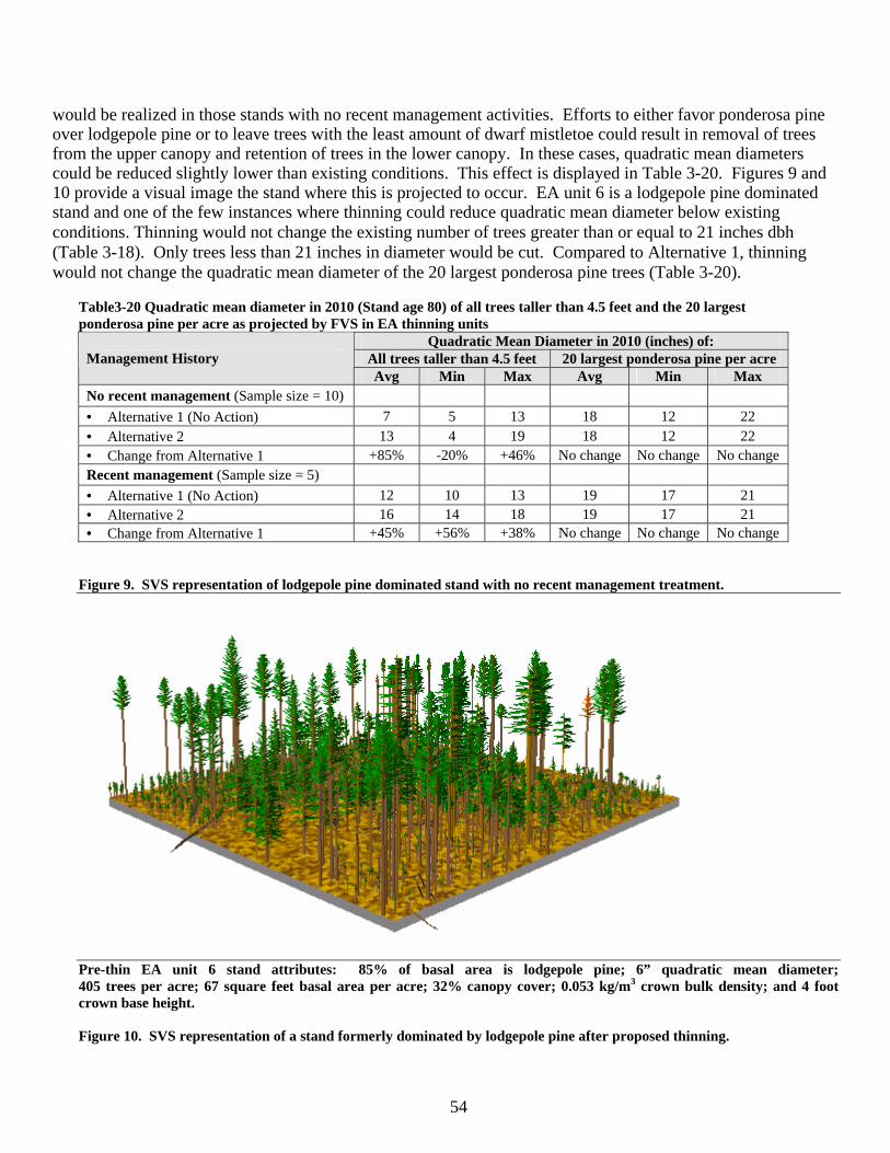
54
would be realized in those stands with no recent management activities. Efforts to either favor ponderosa pine over lodgepole pine or to leave trees with the least amount of dwarf mistletoe could result in removal of trees from the upper canopy and retention of trees in the lower canopy. In these cases, quadratic mean diameters could be reduced slightly lower than existing conditions. This effect is displayed in Table 3-20. Figures 9 and 10 provide a visual image the stand where this is projected to occur. EA unit 6 is a lodgepole pine dominated stand and one of the few instances where thinning could reduce quadratic mean diameter below existing conditions. Thinning would not change the existing number of trees greater than or equal to 21 inches dbh (Table 3-18). Only trees less than 21 inches in diameter would be cut. Compared to Alternative 1, thinning would not change the quadratic mean diameter of the 20 largest ponderosa pine trees (Table 3-20).
Table3-20 Quadratic mean diameter in 2010 (Stand age 80) of all trees taller than 4.5 feet and the 20 largest ponderosa pine per acre as projected by FVS in EA thinning units
Quadratic Mean Diameter in 2010 (inches) of: All trees taller than 4.5 feet 20 largest ponderosa pine per acre Management History Avg Min Max Avg Min Max
No recent management (Sample size = 10) • Alternative 1 (No Action) 7 5 13 18 12 22 • Alternative 2 13 4 19 18 12 22 • Change from Alternative 1 +85% -20% +46% No change No change No change Recent management (Sample size = 5) • Alternative 1 (No Action) 12 10 13 19 17 21 • Alternative 2 16 14 18 19 17 21 • Change from Alternative 1 +45% +56% +38% No change No change No change
Figure 9. SVS representation of lodgepole pine dominated stand with no recent management treatment.
Pre-thin EA unit 6 stand attributes: 85% of basal area is lodgepole pine; 6” quadratic mean diameter; 405 trees per acre; 67 square feet basal area per acre; 32% canopy cover; 0.053 kg/m3 crown bulk density; and 4 foot crown base height. Figure 10. SVS representation of a stand formerly dominated by lodgepole pine after proposed thinning.
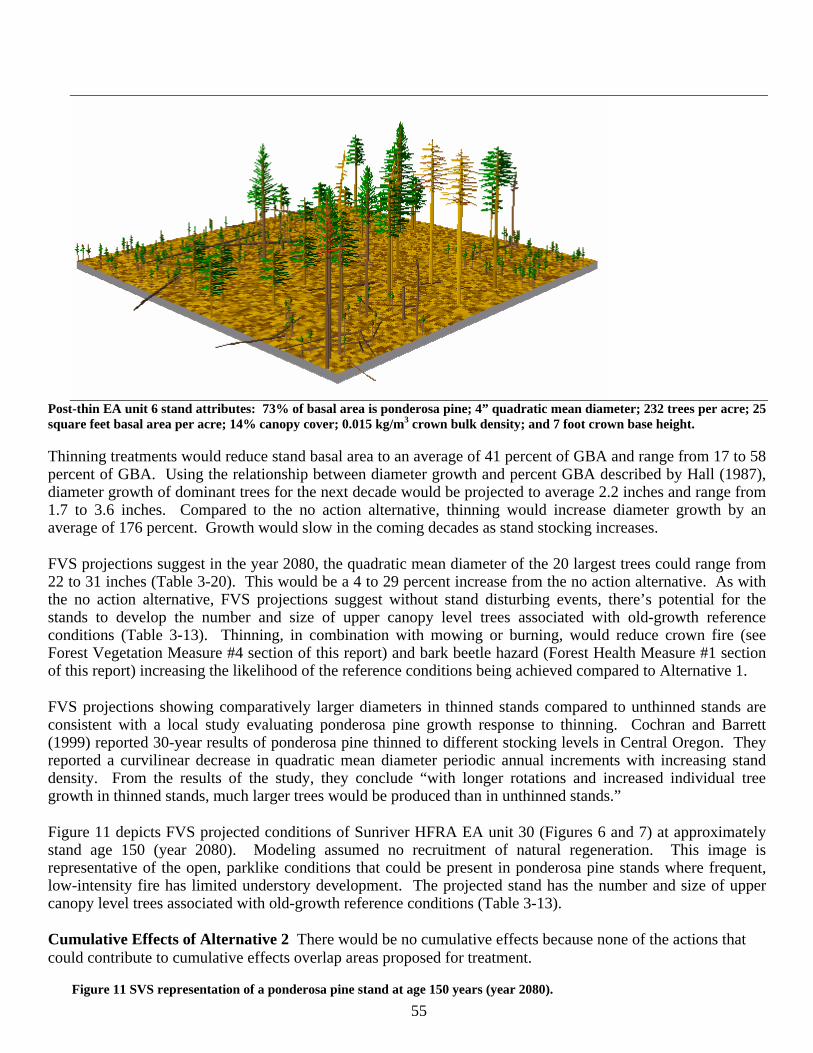
55
Post-thin EA unit 6 stand attributes: 73% of basal area is ponderosa pine; 4” quadratic mean diameter; 232 trees per acre; 25 square feet basal area per acre; 14% canopy cover; 0.015 kg/m3 crown bulk density; and 7 foot crown base height.
Thinning treatments would reduce stand basal area to an average of 41 percent of GBA and range from 17 to 58 percent of GBA. Using the relationship between diameter growth and percent GBA described by Hall (1987), diameter growth of dominant trees for the next decade would be projected to average 2.2 inches and range from 1.7 to 3.6 inches. Compared to the no action alternative, thinning would increase diameter growth by an average of 176 percent. Growth would slow in the coming decades as stand stocking increases. FVS projections suggest in the year 2080, the quadratic mean diameter of the 20 largest trees could range from 22 to 31 inches (Table 3-20). This would be a 4 to 29 percent increase from the no action alternative. As with the no action alternative, FVS projections suggest without stand disturbing events, there’s potential for the stands to develop the number and size of upper canopy level trees associated with old-growth reference conditions (Table 3-13). Thinning, in combination with mowing or burning, would reduce crown fire (see Forest Vegetation Measure #4 section of this report) and bark beetle hazard (Forest Health Measure #1 section of this report) increasing the likelihood of the reference conditions being achieved compared to Alternative 1. FVS projections showing comparatively larger diameters in thinned stands compared to unthinned stands are consistent with a local study evaluating ponderosa pine growth response to thinning. Cochran and Barrett (1999) reported 30-year results of ponderosa pine thinned to different stocking levels in Central Oregon. They reported a curvilinear decrease in quadratic mean diameter periodic annual increments with increasing stand density. From the results of the study, they conclude “with longer rotations and increased individual tree growth in thinned stands, much larger trees would be produced than in unthinned stands.” Figure 11 depicts FVS projected conditions of Sunriver HFRA EA unit 30 (Figures 6 and 7) at approximately stand age 150 (year 2080). Modeling assumed no recruitment of natural regeneration. This image is representative of the open, parklike conditions that could be present in ponderosa pine stands where frequent, low-intensity fire has limited understory development. The projected stand has the number and size of upper canopy level trees associated with old-growth reference conditions (Table 3-13). Cumulative Effects of Alternative 2 There would be no cumulative effects because none of the actions that could contribute to cumulative effects overlap areas proposed for treatment.
Figure 11 SVS representation of a ponderosa pine stand at age 150 years (year 2080).
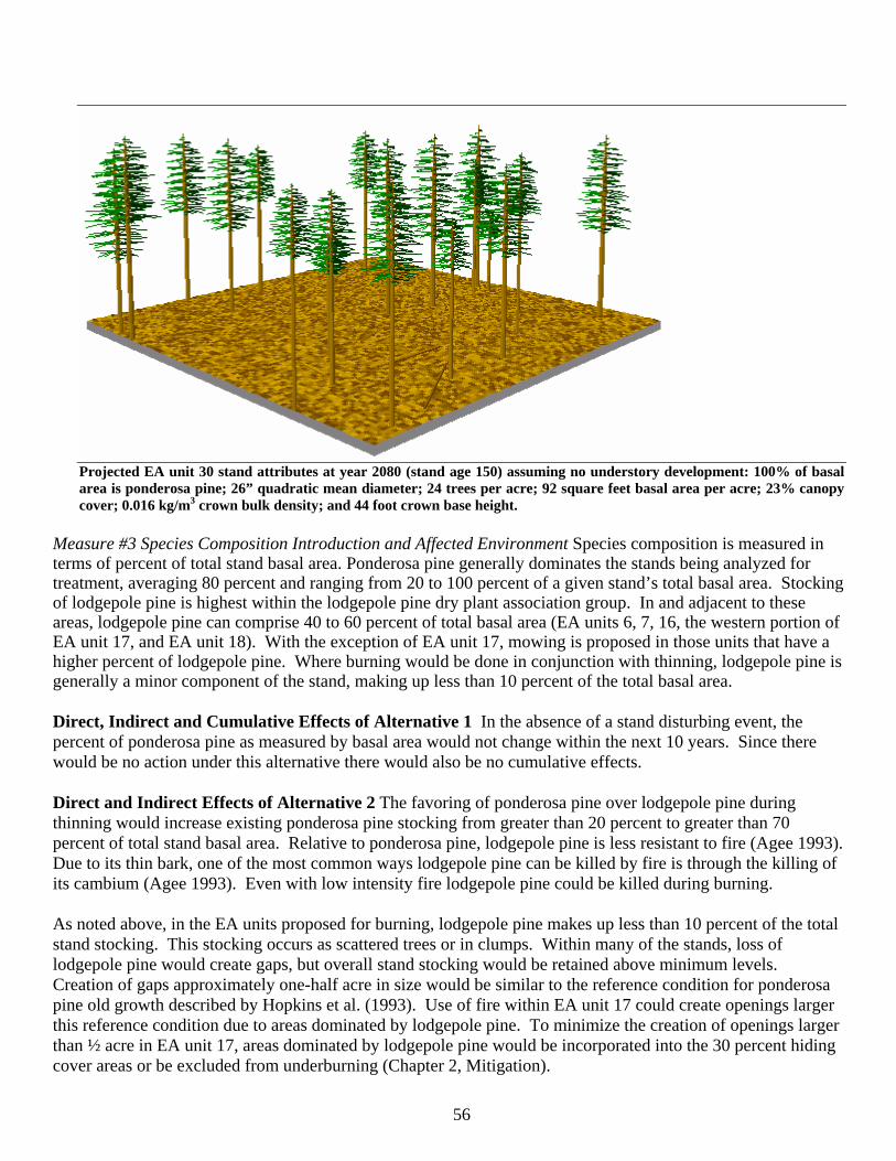
56
Projected EA unit 30 stand attributes at year 2080 (stand age 150) assuming no understory development: 100% of basal area is ponderosa pine; 26” quadratic mean diameter; 24 trees per acre; 92 square feet basal area per acre; 23% canopy cover; 0.016 kg/m3 crown bulk density; and 44 foot crown base height.
Measure #3 Species Composition Introduction and Affected Environment Species composition is measured in terms of percent of total stand basal area. Ponderosa pine generally dominates the stands being analyzed for treatment, averaging 80 percent and ranging from 20 to 100 percent of a given stand’s total basal area. Stocking of lodgepole pine is highest within the lodgepole pine dry plant association group. In and adjacent to these areas, lodgepole pine can comprise 40 to 60 percent of total basal area (EA units 6, 7, 16, the western portion of EA unit 17, and EA unit 18). With the exception of EA unit 17, mowing is proposed in those units that have a higher percent of lodgepole pine. Where burning would be done in conjunction with thinning, lodgepole pine is generally a minor component of the stand, making up less than 10 percent of the total basal area. Direct, Indirect and Cumulative Effects of Alternative 1 In the absence of a stand disturbing event, the percent of ponderosa pine as measured by basal area would not change within the next 10 years. Since there would be no action under this alternative there would also be no cumulative effects. Direct and Indirect Effects of Alternative 2 The favoring of ponderosa pine over lodgepole pine during thinning would increase existing ponderosa pine stocking from greater than 20 percent to greater than 70 percent of total stand basal area. Relative to ponderosa pine, lodgepole pine is less resistant to fire (Agee 1993). Due to its thin bark, one of the most common ways lodgepole pine can be killed by fire is through the killing of its cambium (Agee 1993). Even with low intensity fire lodgepole pine could be killed during burning. As noted above, in the EA units proposed for burning, lodgepole pine makes up less than 10 percent of the total stand stocking. This stocking occurs as scattered trees or in clumps. Within many of the stands, loss of lodgepole pine would create gaps, but overall stand stocking would be retained above minimum levels. Creation of gaps approximately one-half acre in size would be similar to the reference condition for ponderosa pine old growth described by Hopkins et al. (1993). Use of fire within EA unit 17 could create openings larger this reference condition due to areas dominated by lodgepole pine. To minimize the creation of openings larger than ½ acre in EA unit 17, areas dominated by lodgepole pine would be incorporated into the 30 percent hiding cover areas or be excluded from underburning (Chapter 2, Mitigation).
57
Cumulative Effects of Alternative 2 Since none of the actions that could contribute to cumulative effects overlap areas proposed for treatment, there would be no cumulative effects. Measure #4 Canopy Structure Introduction and Affected Environment Measures of canopy structure focus on the following key components of canopy structure identified by Peterson et al. (2005) as being related to crown-fire hazard: canopy base height, canopy bulk density, and canopy continuity. Lowest crown base heights, highest crown bulk densities, and highest canopy cover are associated with those EA units or portions of EA units that have not been treated since they were logged in the 1920’s to 1930’s (Table 3-21). Areas with recent treatments have more elevated crown base heights and reduced crown bulk densities (Table 3-21). Past treatments have generally reduced crown-fire hazard by raising crown base height, reducing crown bulk density, and reducing canopy continuity. Table3-21 Existing canopy structure in areas proposed for treatment.
Crown Base Height (Feet) Crown Bulk Density (kg/m3) Canopy Cover %
Management History Avg Min Max Avg Min Max Avg Min Max
No recent management (Sample size 10) 8 4 22 0.056 0.040 0.090 40 32 53 Recent management (Sample size 14) 24 14 33 0.034 0.024 0.046 28 18 35
Under certain weather conditions, existing crown bulk densities may exceed thresholds above which stands would be more vulnerable to active crown fire. Fitzgerald (2005) indicates dense, even-aged ponderosa pine stands with crown bulk densities above 0.10 kg/m3 are more vulnerable to active crown fire because fire can easily spread from tree crown to tree crown under weather and topographic conditions conducive to crown fire initiation and spread. Most areas considered for treatment are below this level, although some areas not recently managed are approaching this level (Table 3-21). Agee (1996) describes crown bulk density thresholds assuming three rates of spread. At the upper rate of spread analyzed by Agee (1996), crown bulk densities above .037 kg/m3 were vulnerable to crown fire spread. With the Sunriver HFRA project, all stands not recently managed are above this crown bulk density threshold (Table 3-21). Many that have been managed recently are approaching this level. Direct and Indirect Effects of Alternative 1 In areas with lower stand densities, existing shrub understories may provide favorable microsites for ponderosa and lodgepole pine seedling recruitment. Crown base heights in the next 10 to 20 years would trend towards those currently present in unmanaged stands (Table 3-21). Keyes and Maguire (2005) reviewed the results of regeneration field studies located in central Oregon which analyzed the relationship of shrubs to ponderosa pine regeneration. Summarizing the study findings, Keyes and Maguire (2005) indicate understory shrubs help in securing natural regeneration of ponderosa pine. They state “dense shrub understories are likely to continue to contributing to the development of ladder fuels by their positive effect on seedling recruitment.” Cumulative Effects of Alternative 1 Since there would be no treatment with this alternative there would be no effects. This would mean that the only area within the Sunriver HFRA project area where canopy continuity and crown bulk density would be lowered to desired levels (037 kg/m3) while increasing canopy base height would be the 203 acres of reasonably foreseeable thinning and underburing. Direct and Indirect Effects of Alternative 2 Thinning as proposed would increase the height to live crown, decrease crown bulk density to below 037 kg/m3 and decrease canopy continuity (Table 3-22). Least gain in height to live crown would be in those areas where trees in the lower canopy need to be retained to meet minimum stocking requirements. This generally would be within stands with a mix of ponderosa and lodgepole pine that have not been recently managed. Use of pruning in the older ponderosa pine plantation (EA unit 32) would remove the lower branches of trees and lift the crown, creating more distance between potential surface
58
flames and the bottom of the tree canopy (Fitzgerald 2005). Table 3-22 Canopy structure in areas proposed for thinning before and after thinning.
Crown Base Height (Feet) Crown Bulk Density (kg/m3) Canopy Cover (%)
Management History Avg Min Max Avg Min Max Avg Min Max
No recent management (Sample size 10) • Existing Condition 8 4 22 0.056 0.040 0.090 40 32 53 • Post Thin Condition 32 7 46 0.021 0.015 0.025 20 14 24 • Change from Existing +400% +175% +209% -62% -62% -72% 50% 56% 55% Recent management (Sample size 5) • Existing Condition 24 19 29 0.036 0.027 0.046 30 27 35 • Post Thin Condition 38 33 52 0.019 0.015 0.024 22 21 25 • Change from Existing +158% +174% +179% -47% -44% -47% 27% 22% 28%
Thinning, underburning and mowing would create conditions favorable for the re-establishment of understory vegetation. Reduced canopy cover together with seedbeds created by prescribed burning could create conditions favorable for germination of ponderosa pine and lodgepole pine seeds. Low precipitation common for the area together with low shrub cover would limit survival of germinants. Reduced tree canopy cover would favor the re-establishment of bitterbrush and greenleaf manzanita. Where stands have been thinned and mowed, shrubs will likely grow to pre-treatment levels (approximately 30 percent canopy cover) within 10 to 13 years. Growth of shrubs will likely be slower where thinning is followed by burning, with shrubs canopy cover growing to approximately 10 to 15 percent within 10 to 13 years of burning.
Proposed thinning and pruning treatments in combination with mowing and prescribed fire follow the principles for creating fire-resilient forests. These principles include in the order listed: reducing surface fuels, increasing height to live crown, keeping larger trees, and decreasing crown density (Fitzgerald 2005).
Mason et al. (2003) modeled four harvest treatments to compare relative effects on fire risk: 1) Remove 9” and under trees (9 and under). All trees less than or equal 9”dbh were harvested; 2) Remove 50% BA, from below (Half BA); Basal area was reduced by half by removing the smallest trees (thinning from below). 3) Leave 45 sq. ft. of BA, from below (BA 45); This treatment was intended to simulate restoration of savannah-like conditions; 4) Remove 12” and greater, from above (12 and over). This treatment was intended to simulate harvest designed to maximize economic return by taking the largest and most valuable trees > 12” dbh. For both harvest treatments modeled by Mason with a basal area target (Half BA and BA 45), thinning was from below with the smallest trees being removed. An upper diameter limit for harvest was not specified. Modeling results from the Fremont (Mason et al. 2003) would be most applicable to conditions on the Deschutes National Forest. As stated by Mason et al. (2003), “treatment simulation results indicate the thinning treatment Half BA and BA 45, may be the most effective in reducing fire risk in high and moderate risk forests.” Greatest reduction of risk occurred with the BA 45 treatment. Thinning treatments as proposed with the Sunriver HFRA project are most similar to the two thinning from below treatments (Half BA and BA 45) modeled by Mason et al. (2003). Sunriver HFRA treatments would reduce basal areas by 20 to 50 percent (Table 3-17). Average residual basal areas would range from 50 to 60 square feet of basal area per acre (Table 3-17). While the Sunriver HFRA project would remove trees greater than 12 inches dbh, trees in this size class would not be removed in the manner modeled (12 and over) by Mason et al. (2003). Shrub response to thinning and underburning has been measured in a long-term study evaluating the effects of prescribed fire and thinning in central Oregon ponderosa pine forests. This study includes plots in site and stand conditions similar to those found in the Sunriver HFRA project. In reporting fifteen year results from the study, Busse and Riegel (2005) indicate shrub cover increased more than 200 percent due to thinning. Antelope bitterbrush, in particular, responded to thinning. Busse and Riegel (2005) report average cover of bitterbrush
59
after 13 years was 7 percent on unthinned plots compared to 25 percent on thinned plots. Maximum bitterbrush cover on thinned plots reached 50 percent. Where thinning was followed with fire, bitterbrush cover was severely reduced. Post-fire seed germination led to partial recovery of the bitterbrush. By 10 years following the burn, bitterbrush cover on burned plots averaged 13 percent compared to 25 percent on the unburned plots. The Understory Response Model was developed to examine fuels management effect on plant survivorship. For a discussion of this model and the rational for not relying on it to predict understory response to treatments, refer to Appendix I.
Recruitment of ponderosa and lodgepole pine seedlings could occur more slowly than that of the shrubs. Keyes and Maguire (2005) describe some of the factors capable of limiting seedling recruitment in ponderosa pine forests. Of the factors described, Keyes and Maguire indicate moisture stress represents the most significant of practicably controllable factors. Citing Headman (1992), Keyes and Maguire (2005) state “the primary obstacle to regeneration of this species throughout its natural range is drought... Annual precipitation in the western and southwestern United States is generally adequate for tree growth but erratic distribution during the year makes seedling establishment difficult.” As shrubs redevelop in the understory, recruitment of ponderosa pine regeneration may increase (Keyes and Maguire 2005). Cumulative Effects of Alternative 2 Since none of the actions that could contribute to cumulative effects overlap areas proposed for treatment, there would be no cumulative effects. When combined with the 203 acres of reasonably foreseeable activities a total of 1876 acres or 35 percent of the project area would have vegetative treatments within the next 5-7 years that would lower stand replacement wildfire risk. Measure #5 Stand Structure Scope and Scale of Analysis The Eastside Screens interim ecosystem standard indicates patterns of stand structure are to be characterized by biophysical environment for “the proposed timber sale and its associated watershed” and compared to the Historic Range of Variability (HRV). According to this standard, HRV should be developed for “large landscapes across which forest types, environmental settings, and disturbance regimes (fire and insects/disease) are relatively uniform”. The Sunriver HFRA project area is located within the Pilot Butte watershed (5th Field) and it includes a diversity of plant association groups (PAGs), including ponderosa pine wet and dry, mixed conifer wet and dry, and lodgepole pine wet and dry (Table 3-23). The majority of the Sunriver HFRA is within the ponderosa pine dry PAG. Other PAGs in the HFRA include ponderosa pine wet and lodgepole pine dry (Table 3-23).
Table 3-23 Plant association groups (PAGs) at three landscape scales.
Pilot Butte Watershed HRV Analysis Area Sunriver HFRA Project AreaPlant Association
Group (PAG) Acres % of Watershed Acres
HRV Analysis Area %
% of Watershed
PAG Acres
% of SunriverHFRA
% of Watershed
PAG Forest PAGs Ponderosa pine Dry 57,589 49.3% 30,325 68.8% 52.6% 4,304 80.4% 7.5% Ponderosa pine Wet 9,052 7.7% 1,352 3.1% 14.9% 286 5.3% 3.2% Lodgepole pine Dry 13,869 11.9% 1,350 3.1% 9.7% 743 13.9% 5.4% Lodgepole pine Wet 4,219 3.6% Mixed Conifer Dry 5,311 4.5% 750 1.7% 14.1% Mixed Conifer Wet 13,810 11.8% Mtn Hemlock Dry 17 <0.1%
Subtotal 103,867 88.8% 33,777 76.6% --- 5,333 99.6% --- Non Forest PAGs Hardwood 68 <0.1% Riparian 319 0.3% 296 0.6% 92.8% 15 0.3% 4.7% Meadow 756 0.6% Mesic Shrub 355 0.3%
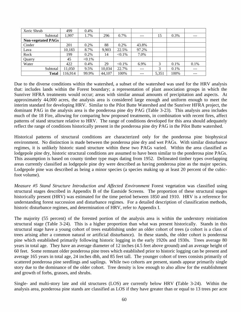
60
Xeric Shrub 499 0.4% Subtotal 1,997 1.7% 296 0.7% --- 15 0.3% ---
Non-vegetated PAGs Cinder 201 0.2% 88 0.2% 43.8% Lava 10,183 8.7% 9,903 22.5% 97.2% Rock 199 0.2% 14 <0.1% 7.0% Quarry 45 <0.1% Water 422 0.4% 29 <0.1% 6.9% 3 0.1% 0.1%
Subtotal 11,050 9.5% 10,034 22.7% --- 3 0.1% --- Total 116,914 99.9% 44,107 100% --- 5,351 100% ---
Due to the diverse conditions within the watershed, a subset of the watershed was used for the HRV analysis that: includes lands within the Forest boundary; a representation of plant association groups in which the Sunriver HFRA treatments would occur; areas with similar annual amounts of precipitation and aspects. At approximately 44,000 acres, the analysis area is considered large enough and uniform enough to meet the interim standard for developing HRV. Similar to the Pilot Butte Watershed and the Sunriver HFRA project, the dominant PAG in the analysis area is the ponderosa pine dry PAG (Table 3-23). This analysis area includes much of the 18 Fire, allowing for comparing how proposed treatments, in combination with recent fires, affect patterns of stand structure relative to HRV. The range of conditions developed for this area should adequately reflect the range of conditions historically present in the ponderosa pine dry PAG in the Pilot Butte watershed.
Historical patterns of structural conditions are characterized only for the ponderosa pine biophysical environment. No distinction is made between the ponderosa pine dry and wet PAGs. With similar disturbance regimes, it is unlikely historic stand structure within these two PAGs varied. Within the area classified as lodgepole pine dry, historic structural conditions are assumed to have been similar to the ponderosa pine PAGs. This assumption is based on county timber type maps dating from 1952. Delineated timber types overlapping areas currently classified as lodgepole pine dry were described as having ponderosa pine as the major species. Lodgepole pine was described as being a minor species (a species making up at least 20 percent of the cubic-foot volume). Measure #5 Stand Structure Introduction and Affected Environment Forest vegetation was classified using structural stages described in Appendix B of the Eastside Screens. The proportion of these structural stages historically present (HRV) was estimated for the time period between 1850 and 1910. HRV is a reference for understanding forest succession and disturbance regimes. For a detailed description of classification methods, historic disturbance regimes, and determination of HRV, refer to Appendix I. The majority (55 percent) of the forested portion of the analysis area is within the understory reinitiation structural stage (Table 3-24). This is a higher proportion than what was present historically. Stands in this structural stage have a young cohort of trees establishing under an older cohort of trees (a cohort is a class of trees arising after a common natural or artificial disturbance). In these stands, the older cohort is ponderosa pine which established primarily following historic logging in the early 1920s and 1930s. Trees average 80 years in total age. They have an average diameter of 12 inches (4.5 feet above ground) and an average height of 60 feet. Some remnant older ponderosa pine trees which established prior to historic logging can be present and average 165 years in total age, 24 inches dbh, and 85 feet tall. The younger cohort of trees consists primarily of scattered ponderosa pine seedlings and saplings. While two cohorts are present, stands appear primarily single story due to the dominance of the older cohort. Tree density is low enough to also allow for the establishment and growth of forbs, grasses, and shrubs. Single- and multi-story late and old structures (LOS) are currently below HRV (Table 3-24). Within the analysis area, ponderosa pine stands are classified as LOS if they have greater than or equal to 13 trees per acre
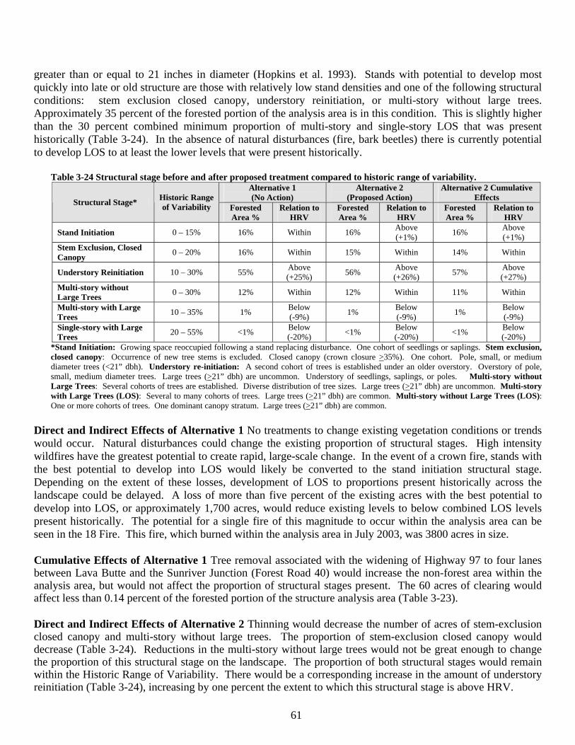
61
greater than or equal to 21 inches in diameter (Hopkins et al. 1993). Stands with potential to develop most quickly into late or old structure are those with relatively low stand densities and one of the following structural conditions: stem exclusion closed canopy, understory reinitiation, or multi-story without large trees. Approximately 35 percent of the forested portion of the analysis area is in this condition. This is slightly higher than the 30 percent combined minimum proportion of multi-story and single-story LOS that was present historically (Table 3-24). In the absence of natural disturbances (fire, bark beetles) there is currently potential to develop LOS to at least the lower levels that were present historically.
Table 3-24 Structural stage before and after proposed treatment compared to historic range of variability.
Alternative 1 (No Action)
Alternative 2 (Proposed Action)
Alternative 2 Cumulative Effects Structural Stage* Historic Range
of Variability Forested Area %
Relation to HRV
Forested Area %
Relation to HRV
Forested Area %
Relation to HRV
Stand Initiation 0 – 15% 16% Within 16% Above (+1%) 16% Above
(+1%) Stem Exclusion, Closed Canopy 0 – 20% 16% Within 15% Within 14% Within
Understory Reinitiation 10 – 30% 55% Above (+25%) 56% Above
(+26%) 57% Above (+27%)
Multi-story without Large Trees 0 – 30% 12% Within 12% Within 11% Within
Multi-story with Large Trees 10 – 35% 1% Below
(-9%) 1% Below (-9%) 1% Below
(-9%) Single-story with Large Trees 20 – 55% <1% Below
(-20%) <1% Below (-20%) <1% Below
(-20%) *Stand Initiation: Growing space reoccupied following a stand replacing disturbance. One cohort of seedlings or saplings. Stem exclusion, closed canopy: Occurrence of new tree stems is excluded. Closed canopy (crown closure >35%). One cohort. Pole, small, or medium diameter trees (<21” dbh). Understory re-initiation: A second cohort of trees is established under an older overstory. Overstory of pole, small, medium diameter trees. Large trees (>21” dbh) are uncommon. Understory of seedlings, saplings, or poles. Multi-story without Large Trees: Several cohorts of trees are established. Diverse distribution of tree sizes. Large trees (>21” dbh) are uncommon. Multi-story with Large Trees (LOS): Several to many cohorts of trees. Large trees (>21” dbh) are common. Multi-story without Large Trees (LOS): One or more cohorts of trees. One dominant canopy stratum. Large trees (>21” dbh) are common.
Direct and Indirect Effects of Alternative 1 No treatments to change existing vegetation conditions or trends would occur. Natural disturbances could change the existing proportion of structural stages. High intensity wildfires have the greatest potential to create rapid, large-scale change. In the event of a crown fire, stands with the best potential to develop into LOS would likely be converted to the stand initiation structural stage. Depending on the extent of these losses, development of LOS to proportions present historically across the landscape could be delayed. A loss of more than five percent of the existing acres with the best potential to develop into LOS, or approximately 1,700 acres, would reduce existing levels to below combined LOS levels present historically. The potential for a single fire of this magnitude to occur within the analysis area can be seen in the 18 Fire. This fire, which burned within the analysis area in July 2003, was 3800 acres in size. Cumulative Effects of Alternative 1 Tree removal associated with the widening of Highway 97 to four lanes between Lava Butte and the Sunriver Junction (Forest Road 40) would increase the non-forest area within the analysis area, but would not affect the proportion of structural stages present. The 60 acres of clearing would affect less than 0.14 percent of the forested portion of the structure analysis area (Table 3-23). Direct and Indirect Effects of Alternative 2 Thinning would decrease the number of acres of stem-exclusion closed canopy and multi-story without large trees. The proportion of stem-exclusion closed canopy would decrease (Table 3-24). Reductions in the multi-story without large trees would not be great enough to change the proportion of this structural stage on the landscape. The proportion of both structural stages would remain within the Historic Range of Variability. There would be a corresponding increase in the amount of understory reinitiation (Table 3-24), increasing by one percent the extent to which this structural stage is above HRV.
62
Reductions in stand density associated with thinning treatments would increase the proportion of forested acres with potential to develop relatively quickly into late or old structure to approximately 36 percent of the analysis area. While this is a slight increase over the no action alternative, it is still at the lower end of the combined minimum proportion of multi-story and single-story LOS that was present historically. Thinning, mowing, and burning treatments would increase the likelihood that treated stands would move towards LOS conditions. Treatments would maintain or accelerate tree diameter growth and reduce the hazard of crown fires and bark beetle outbreaks. The proportion of the landscape affected by these treatments would, however, be relatively small. Net treatment acres (Table 2-1) are approximately 5 percent of the HRV analysis area (Table 3-23). As with the no action alternative, a crown fire on a relatively small number of acres (2,000 acres) could reduce the proportion of the landscape with the potential to develop most rapidly into LOS to levels below the combined minimum LOS levels present historically. Cumulative Effects of Alternative 2 Identical to Alternative 1, tree removal associated with future road access projects would affect less than 0.14 percent of the forested portion of the analysis area (Table 3-23). Reductions in stand density associated with reasonably foreseeable thinning treatments (Appendix I) would increase the proportion of forested acres with potential to develop relatively quickly into late or old structure to approximately 38 percent of the analysis area. This is at the lower end of the combined minimum proportion of multi-story and single-story LOS that was present historically (Table 3-24). Thinning, mowing, and burning associated with foreseeable future actions (Appendix I) would further increase the likelihood that treated stands would move towards LOS conditions. These acres together with those proposed for treatment with Alternative 2 would total approximately 5,120 acres, or approximately 15 percent of the forested portion of the HRV analysis area. A crown fire on a relatively small number of acres (2,700 acres) could reduce the proportion of the landscape with the potential to develop most rapidly into LOS to levels below the combined minimum LOS levels present historically. Natural disturbances within the analysis area, especially wildfire, would continue to have potential to create large-scale change that could lengthen the time it will take for LOS to develop to proportions that were present historically across the landscape. Forest Health Measure #1 Stand Susceptibility to Bark Beetle Introduction and Affected Environment Bark beetles can act as agents of change, affecting ecosystems directly and indirectly. These changes are summarized by Samman and Logan (2000): Direct effects include individual tree death, changes in forest stand densities, changes in coarse woody debris, changes in forest floor litter, and changes in the amount of light reaching the forest floor. Indirect effects include timing, scale, and intensity of fire, changes in water quality and quantity, changes in wildlife use of the forest, changes in species composition, age, and size of remaining trees, and changes in commodity and/or amenity values. Effects of bark beetles within the Sunriver HFRA Project area would be similar to those described by Sammon and Logan (2000) for ponderosa pine forest ecosystems in the Rocky Mountain area. Endemic beetle populations have minimal effects on ponderosa pine stands, killing individual and occasionally small groups of trees. If populations build to outbreak levels, 40 to 60 percent of the stand can be killed, depending on the age and size classes within the stand. Historically, endemic populations of low-level outbreaks have provided the fuel necessary for the periodic low-intensity fires that help perpetuate uneven-aged ponderosa pine stands. However with the exclusion of fire, stand densities increase and age-class diversity decreases, making these stands more susceptible to beetle population outbreaks. When a large-scale outbreak does occur, fuel loads will increase, leading to large-scale crown fires and replacement of tree cover with grasses and shrubs. Sammon and Logan (2000) state “although bark beetle outbreaks are important in the ecological development of a forest landscape, resulting levels of tree mortality may exceed desirable levels, affecting multiple resource objectives including timber, wildlife, and recreation.”

63
Rating systems for bark beetles are intended to serve as general guides that aid in the identification of susceptible stands (Fettig et al. 2007). For forest stands, hazard relates to factors which affect the likelihood of bark beetle occurrence such as tree species composition, age-size structure, stand density and precipitation (Fettig et al. 2007). Risk is a function of insect presence, abundance and distribution as it relates to stand hazard or potential for tree mortality (Fettig et al. 2007). Bark beetles currently causing tree mortality within the Sunriver HFRA project area include mountain pine beetle (Dendroctonus ponderosae Hopkins) and western pine beetle (Dendroctonus brevicomis LeConte). The 2006 Aerial Survey (USDA Forest Service 2007b) mapped patches of beetle induced mortality within and immediately adjacent to the Sunriver HFRA project area. Mortality levels ranged from less than 1 tree per acre to 10 trees per acre. Mountain pine beetle activity was mapped in ponderosa and lodgepole pine. Western pine beetle activity was mapped in pole-size ponderosa pine. The majority of stands being analyzed for treatment have densities above the upper management zone (Table 3-16) making them susceptible to bark beetle attack. Forest Health Measure #1 Stand Susceptibility to Bark Beetle Scope and Scale of Analysis The scale of analysis will be the gross area being analyzed for treatment (Appendix I, 1,932 acres). Beyond treatment area boundaries, the effects of the treatments on beetle susceptibility are not considered to be quantitatively or qualitatively meaningful. Beetle susceptibility is measured in terms of the number of acres that would exceed the upper management zone in the short term (within 5 years) and long term (within 25 years). To rate stand susceptibility to bark beetles, this analysis compares the stand density index (SDI) projected by FVS to the calculated upper management zones (Table 3-15). This follows a rating system described for use on the Deschutes National Forest (USDA Forest Service 1996c). The system uses the procedures described by Cochran et al. (1994) to identify stand densities above which mortality from bark beetle could be expected. This rating system was described by the Deschutes Science Team (USDA Forest Service 1996c) as being “based on the published risk and hazard rating systems which are most applicable to eastern Oregon”. The Science Team stated “it is important to understand that risk/hazard models are not intended to precisely reproduce the complexity of nature, but rather to identify and relate key biological features which may have predictive value” (USDA Forest Service 1996c). Direct and Indirect Effects of Alternative 1 Relative stand density would continue to increase as tree diameters increase. By 2010, approximately 65 percent of the area being analyzed for treatment would be susceptible to bark beetle attack (Table 3-25). By the year 2030, this amount would increase to approximately 85 percent (Table 3-25).
Table 3-25 Short and long term effect of thinning on beetle hazard within treatment areas (1,932 acres).
Time Scale Alternative 1 Alternative 2 Hazard Acres Analysis Area % Hazard Acres Analysis Area % Change relative to Alternative 1Short Term (2010) 1,250 65% 664 34% -48% Long Term (2030) 1,642 85% 936 48% -44%
Mountain pine beetle would continue to attack and kill larger diameter trees (greater than 8 inches dbh). Both ponderosa and lodgepole pine would be affected, with lodgepole pine greater than 9 inches dbh generally being attacked first. Western pine beetle and red turpentine beetle (Dendroctunus valens LeConte) could also kill large diameter pines that are slow growing, lightning struck, or heavily infected with mistletoe. Potential for beetle activity would be highest in those stands whose densities are above the upper management zone. Scattered, incidental mortality from beetles would also occur in stands that are below the UMZ, primarily due to stress induced by lightning strikes or high levels of mistletoe infection. Mortality from beetles would most likely occur in periods of both normal and below normal precipitation, with accelerated tree mortality rates
64
possible during periods of low precipitation. In describing bark beetle-tree interactions and forest health, Fettig et al. (2007) indicate as growing space diminishes, a tree’s photosynthates are allocated to different uses in an order of priorities. They indicate that while the hierarchy is not absolute, photosynthates are allocated lastly to insect and disease resistance mechanisms. They summarize that production of insect resistance mechanisms may be compromised when growing space becomes limited by one or more factors. Potential for epidemic levels of mountain pine beetles to become established would be highest in those stands above the upper management zone. If epidemic levels of mountain pine beetles become established in these stands, up to 67 percent of the current basal area, mostly in the largest trees, could have expected mortality (Barrett 1979). Direct and Indirect Effects of Alternative 2 Reductions in stand densities associated with thinning treatments would change one of the factors that contribute to the likelihood of bark beetle occurrence. Vigor of trees would be maintained or improved, increasing the ability of trees to survive beetle attack. Burning could increase beetle attacks, but if scorch is maintained below 50 percent of the live crown (Chapter 2, Mitigation) mortality as a result of the attacks would be expected to be low. Thinning would reduce the number of acres susceptible to bark beetles in the short term and increase the time it will take for stands to develop conditions favorable for bark beetle attack. In the short term, the number of acres susceptible to bark beetle attack would be decreased by approximately 48 percent (Table 3-25). In the long term, thinning would maintain a low hazard to bark beetles on approximately 50 percent of the area being analyzed for treatment. Acres of hazard would be approximately 44 percent less than Alternative 1 (Table 3-25). Thinning, with its associated decrease in stand density, would reduce the hazard of beetle-caused tree mortality occurring within the treated stands. Thinned areas would remain below the upper management zone for at least 30 years. While the hazard would be reduced, potential for beetle-caused mortality would remain. With 30 percent retention of wildlife clumps within the treatment units, conditions favorable to beetles would remain both within and outside of thinning areas. Areas proposed for thinning range from approximately 5 to 200 acres in size. Mortality from bark beetles could be expected within thinned areas adjacent to wildlife clumps and adjacent densely stocked stands. Smaller thinned stands could be overwhelmed by mountain pine beetle activity within adjacent stands. Within thinned stands, potential for bark beetle outbreaks to occur would be reduced. Thinning would maintain or improve the vigor of residual trees, making more of a tree’s photosynthates available for production of insect resistance mechanisms (Fettig et al. 2007). Thinning would also change the physical environment within the stands, potentially resulting in increased temperatures and windspeeds. Increased temperatures and windspeeds may accelerate the development of certain bark beetle species and force them to overwinter in stages that are more susceptible to freezing (Fettig et al. 2007). Lower stand densities could result in unstable layers of air and multi-directional movement of air. As described by Fettig et al. (2007), this type of air movement dilutes pheromone concentrations and could result in reductions in beetle aggregation. Fetig et al. (2007) indicate a significant number of pioneer beetles are required to overcome host defenses and a lack of beetle recruitment often results in unsuccessful attacks. Reduced insect activity in thinned stands has been observed in a long-term study evaluating the effects of prescribed fire and thinning in central Oregon ponderosa pine forests. This study includes plots in site and stand conditions similar to those found in the Sunriver HFRA project. In reporting fifteen year results from the study, Busse et al. (2006) indicate tree mortality was absent in thinned plots, while insect-caused mortality was noted during the second-half of the study in unthinned stands (4 percent of unthinned trees).
65
Fettig et al. (2007) reviewed tree and stand factors associated with bark beetle infestations and analyzed the effectiveness of vegetation management practices for mitigating the negative impacts of bark beetles on forest ecosystems. Their review drew from 498 scientific publications. Among the conclusions reported by Fettig et al. (2007) was the following regarding the effect of thinning on bark beetle susceptibility: “Factors involving tree density are consistently associated with the occurrence and severity of bark beetle infestations. …thinning has long been advocated as a preventative measure to reduce the amount of bark beetle-caused tree mortality and its effectiveness for this purpose is supported by the scientific literature. Some studies of the efficacy of thinning have failed to detect significant differences among treatments, and others are limited to anecdotal evidence. However, to date there are no reports of significant increases in the amount of Dendroctonus spp. – caused tree mortality in response to thinning treatments. …” Black (2005) reports findings seemingly contrary to Fettig et al. (2007) in a synthesis of reviewed research (sometimes referred to as the Xerces Report). For a discussion of the Black report and the rational for excluding the associated information, refer to Appendix I of this report. Schmid and Mata (2005) studied mountain pine beetle-caused tree mortality in partially cut [thinned] stands surrounded by unmanaged stands. The study took place in ponderosa pine stands in the Black Hills National Forest in South Dakota. Schmid and Mata (2005) drew the following management implications from their research: While partial cutting [thinning] can eliminate substantial mountain pine beetle caused mortality, some mortality could be expected in partially cut stands adjacent to unmanaged stands, especially in the vicinity of their common boundaries. Mountain pine beetle populations in the control and the unmanaged adjacent stands increased to the point where their numbers began to overwhelm the partially cut [thinned] stands. Use of prescribed fire has the potential to increase beetle attacks within the burn area. Fire can kill foliage and buds in the crown, heat the trunk to such an extent to where part or all of the cambium is killed, and heat and kill the roots (Agee 1993). Trees damaged by fire, would be most susceptible to insect attack. As a general rule, if ponderosa pine trees retain at least 50 percent of the live crown that was present prior to the burn, mortality resulting from beetle attacks should be minimal (A. Eglitis, Zone Entomologist, 1999, personal communication). If less than this live crown is retained, particularly if less than 30 percent is retained, the survival of the tree is dependent on a number of factors, one of which is climatic conditions. (A. Eglitis, Zone Entomologist, 1999, personal communication). The majority of trees within burn units would incur some level of crown and bole scorch. Following the burns, attacks by a variety of bark beetles could increase. Turpentine beetle attacks would not be expected to kill the trees but would make trees more susceptible to other insects. Increase in attacks by the pine engraver beetle (Ips pini), the western pine beetle, and the mountain pine beetle could occur. The pine engraver beetle can be the most significant mortality agent following an underburn. Beetle damage could continue up to 1 to 2 years. Increase in beetle activity would not be expected to expand into unburned stands. Within the burns, undamaged trees would generally not be susceptible to insect damage (A. Eglitis, Zone Entomologist, 1999, personal communication). If crown scorch on dominant and co-dominant trees is generally less than 50 percent (Chapter 2, Mitigation), increased beetle activity would be expected to cause minimal mortality. Mitigation is considered moderately effective in minimizing fire damage to dominant and codominant trees. Even with this mitigation, variable fuels and changing weather conditions, can result in high intensity burning occurring within portions of a stand. This can result in crown scorch in excess of 50 percent and in some cases complete killing of foliage. Areas where scorch exceeds stated limits (Chapter 2) would be monitored for mortality resulting directly from the fire or indirectly from bark beetle attack. Cumulative Effects of Alternatives 1 and 2 None of the actions that could contribute to cumulative effects
66
overlap areas proposed for treatment. There would be no cumulative effects. The percentage of the Sunriver HFRA project area susceptible to accelerated bark beetle attack would be decreased under Alternative 2 by an additional 203 acres of thinning and underburning in reasonably foreseeable future activities. Forest Health Measure #2 Level of Dwarf Mistletoe Infection Introduction and Affected Environment Effects dwarf mistletoes have on their hosts include: 1) reduced height and diameter growth, 2) increased mortality, 3) reduced seed production and reduced seed viability, 4) reduced wood strength and increased knot size, 5) increased susceptibility to attack by insects, particularly bark beetles, and 6) increased flammability (Hawksworth 1978). Koonce and Roth (1980) describe the following effects mistletoe has on the flammability of ponderosa pine stands: Mistletoe may influence the frequency of fire by making stands more flammable. Mistletoe infected branches are often laden with resinous spindles and brooms which form fuel ladders leading to crowning fires. Fallen brooms persist in slash, increasing the amount of large, resinous, partially rotten, highly flammable material. In decadent stands, dwarf mistletoe increases the amount of dry, dead aerial fuel. Hawksworth and Wiens (1996) state that: By inducing formation of witches’ brooms and causing top kill and mortality of host trees, dwarf mistletoes affect the species composition, vertical crown structure, and spacing of trees within infected stands. These direct effects, in turn, have numerous consequences on the physical structure and functioning of the ecosystem. For example, the brooms provide forage, nesting, and cover for birds and mammals, but also increase the likelihood of ground fires becoming crown fires. Canopy gaps caused by mistletoe–induced mortality increase within-stand diversity but also reduce the interior-forest area. Depending on management objectives and priorities, the effects of dwarf mistletoe are interpreted as positive, negative, or usually of mixed consequence (Geils et al. 2002). Level of dwarf mistletoe infection is expressed qualitatively in terms of the average dwarf mistletoe rating of infected trees. Dwarf mistletoe, both ponderosa pine dwarf mistletoe (Arceuthobium campylopodum) and lodgepole pine dwarf mistletoe (Arceuthobium americanum), is present within some of the areas proposed for thinning. Where mistletoe is present, stand dwarf mistletoe ratings (DMR) are generally less than 2. As a reference, thinning to eliminate dwarf mistletoe is recommended only where stand DMR is 3 or less (Hawksworth and Wiens 1996). Direct and Indirect Effects of Alternative 1 Within single-story stands with mistletoe infection, dwarf mistletoe would continue to spread vertically in the crown of the tree. Severity of dwarf mistletoe infection would increase over time. Lateral spread of trees would occur in denser stands. Within multi-story stands with mistletoe infection, the crowns of shorter trees would continually be exposed to mistletoe seeds from taller trees. The upper crowns of understory trees would rarely remain free of increasing mistletoe populations, and reduction in tree growth with further increase in mistletoe infection would almost be certain (Parmeter 1978). Without treatment or a high intensity wildfire, this cycle of infection would continue indefinitely, causing increased reductions in stand growth and increased mortality rates. Mortality patterns would vary from isolated trees to clumps of trees. Direct and Indirect Effects of Alternative 2 Thinning treatments would remove some trees with heavier dwarf mistletoe ratings (Appendix I), but overall stand dwarf mistletoe ratings would remain relatively unchanged. Simplified canopy structure and reduced stand density would reduce the probability of mistletoe seed dispersal to susceptible understory hosts and lateral spread among host trees (Hessburg et al. 1994). Alternative 2 would not remove any mistletoe infected trees larger than 21 inches dbh and the emphasis in the EA units where dwarf mistletoe occurs and thinning is proposed is to maintain the “best of the worst.” In other words the larger ponderosa pines would be maintained regardless of mistletoe infection level by thinning to a wider spacing and prescribed underburning. The complete eradication of mistletoe is neither feasible or desirable from a biological and wildlife perspective. The majority of this project area would not have any thinning and mistletoe
67
infected trees would remain throughout the project area both within ponderosa pine and lodgepole pine stands. Mowing and burning treatments would have little effect on stand dwarf mistletoe rating. According to Koonce and Roth (1980), scorch heights of 30 to 60 percent of the crown length are required to significantly reduce dwarf mistletoe infestations. They also state low intensity fires, appropriate for prescribed understory burning, are generally insufficient to sanitize the dominant trees, including old-growth, whose crowns are above the mean scorch height. Cumulative Effects of Alternatives 1 and 2 None of the actions that could contribute to cumulative effects overlap areas proposed for treatment. There are no cumulative effects because there are no ongoing or reasonably foreseeable other vegetation management projects within the area that would reduce overall levels of dwarf mistletoe within the EA units. Similar to Alternative 2, the reasonably foreseeable thinning and underburning of 203 acres within the project area would leave all mistletoe infected trees > 21” dbh. LRMP/Other Management Direction Consistency LRMP Forest-wide (FH-1 to FH-5) standards and guidelines give direction on forest health disease and insect prevention. Alternative 2 would be beneficial both short and long-term at preventing a major insect epidemic by proactively using thinning to improve forest health within the EA units. Vegetation management is designed to decrease both insect and disease risk by thinning and selecting against diseased and low vigor trees. A silvicultural prescription (Appendix I) was prepared consistent with Forest-wide standards and guidelines TM-1 to TM-7, TM-10. The retention of 30 percent of the gross acres of each EA unit and variable density spacing is designed to promote biological diversity (TM-55) and maintain and accelerate the development of structural diversity (TM-56) in an area of uniform stand conditions. Requirements for shrub retention, variable spacing, retention of all trees > 21 inches dbh, wildlife clumps and corridors complement the eventual development of horizontal diversity (TM-57) in a landscape where clearcut harvesting removed all of the mature ponderosa pine trees. As discussed, fire suppression has allowed lodgepole pine to encroach on areas where ponderosa pine was the dominant or only species historically present (TM-67). The retention of 30 percent of the gross acres for wildlife in the EA units would maintain lodgepole pine for species diversity on the landscape. Pure lodgepole pine stands were excluded from consideration for vegetation management.
This decision is consistent with the seven vegetative manipulation requirements of 36 CFR 219.27 (b). 1) All proposed vegetation treatments are suited to multiple-use goals as established by the Forest Plan. Vegetation treatments proposed under Alternative 2 would move vegetative conditions towards the desired condition associated with LRMP MA 8, 9, 17 and the NNVM (Appendix I). 2) Timber harvest proposed with Alternative 2 would not reduce stocking below minimum levels (Forest Vegetation Measure #1). Adequate stocking levels would remain following harvest. While harvest would not create a reforestation need, district experience has demonstrated there is assurance that harvested lands could be adequately restocked within five years after harvest if a need was created. 3) Vegetation treatments included an economic analysis; although the greatest dollar return or output of timber were not the primary factors considered in the development of Alternative 2. The increase in the average quadratic mean diameter and the retention of many of the larger diameter trees reflects the use of a harvesting system that primarily thins from below (Forest Vegetation Measure #2). This harvesting system focuses on removing the smaller diameter trees, which have a lower value than the larger diameter trees. This harvesting system was selected because of its effectiveness in positively changing key components of canopy structure related to crown-fire hazard (Forest Vegetation Measure #4). The harvesting system proposed for use with Alternative 2 was not proposed because it will give the greatest dollar return or the greatest output of timber. 4) Vegetation treatments were developed to enhance residual and adjacent stand health while moving towards the desired future condition of forest lands as outlined in the LRMP. 5) Best Management Practices and timber sale contract specifications that mitigate potential adverse effects would be implemented in all proposed vegetation treatments, thus avoiding permanent impairment of site productivity
68
and ensuring conservation of soil and water resources (refer to soil productivity and maintenance and fisheries and hydrology sections). 6) All proposed vegetation treatments were designed to meet the desired condition as outlined in the LRMP; specific to MA 8, 9, 17 and the NNVM. Refer to appropriate resource section. 7) No new permanent roads would be constructed to implement activities proposed in Alternative 2. Temporary roads needed during harvest would be obliterated after vegetation management operations were completed. Designated skid roads would be used for logging system design and modern ground based harvest systems required for commercial fiber removal is available and consistent with other resource protection. Vegetation management activities that treat competing and unwanted vegetation would not be needed as no evidence supports a prediction that competing and unwanted vegetation would exceed the damage threshold of the site. Invasive plants are discussed under the noxious weeds resource section. HFRA consistency: Consistent with the large tree provision of this act, thinning treatments (Appendix I, Sunriver HFRA Silviculture Report-Appendix A) would focus largely on removing smaller diameter trees while retaining larger diameter trees (Forest Vegetation Measure # 2). Thinning would favor retention of ponderosa pine, a more fire resistant species than lodgepole pine (Forest Vegetation Measure #3). No treatments are proposed within old growth stands (Forest Vegetation Measure # 5). Deschutes LRMP- NNVM Management Plan consistency The treatments proposed with Alternative 2 within NNVM are consistent with the stated intent that all projects should protect existing large, old trees and reestablish conditions that allow natural ecological succession of vegetation to the maximum extent practical (M-8). Thinning (EA unit 4-20 acres) would maintain existing large trees (Forest Vegetation Measure # 2) and would reduce densities to levels closer to those found in historic ponderosa pine old growth (Forest Vegetation Measure #1). Reductions in density would reduce of beetle outbreak (Forest Health Measure #1) and increase the likelihood of the stand developing to conditions associated with “historic” ponderosa pine old growth (Forest Vegetation Measure #2). Underburning, used separately (EA units 4, 13, 23-192 acres) and in combination with the previously described thinning treatment, would establish conditions that would better allow natural ecological succession to occur (Forest Vegetation Measure #4). Thinning to levels proposed, in combination with burning, would create conditions that allow stands to be maintained and perpetuated solely with prescribed fire (M-15). Alternative 2 proposes a total of 212 acres of restoration treatment within NNVM. A recent decision (USDA Forest Service 2007c) was made to restore an additional 153 acres of ponderosa pine within NNVM. The combined acres of ponderosa pine restoration associated with projects would be 365 acres. Assuming within the next five years no additional decisions are made for restoring ponderosa pine within NNVM, annual rate of restoration with these two projects would be 73 acres per year. This is less than the long term rate of restoration identified in the Monument Plan (190 acres). Deschutes LRMP-Eastside screens consistency: Eastside screens only apply to timber sales. Scenario A is used whenever the ecosystem standard documents that any one type of LOS is below the HRV. The timber sale(s) proposed with the project meet the interim wildlife direction under Scenario A. INFISH replaced the Eastside Screens riparian standard and a consistency analysis (see Hydrology/Fisheries section) determined that this project meets INFISH direction. Consistent with the Interim Ecosystem Standard, patterns of stand structure have been characterized by biophysical environment and compared to the Historic Range of Variability (Forest Vegetation Measure #5, Appendix I). The following documents the main objectives of the Eastside Screens for timber sales and the rationale on how Alternative 2 meets Eastside Screens, Scenario A intent and direction.
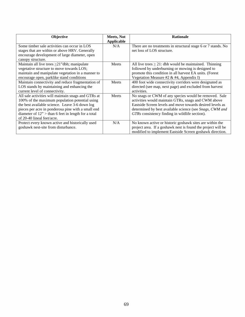
69
Objective Meets, Not
Applicable Rationale
Some timber sale activities can occur in LOS stages that are within or above HRV. Generally encourage development of large diameter, open canopy structure.
N/A There are no treatments in structural stage 6 or 7 stands. No net loss of LOS structure.
Maintain all live trees >21”dbh; manipulate vegetative structure to move towards LOS; maintain and manipulate vegetation in a manner to encourage open, parklike stand conditions
Meets All live trees > 21: dbh would be maintained. Thinning followed by underburning or mowing is designed to promote this condition in all harvest EA units. (Forest Vegetation Measure #2 & #4, Appendix I)
Maintain connectivity and reduce fragmentation of LOS stands by maintaining and enhancing the current level of connectivity.
Meets 400 foot wide connectivity corridors were designated as directed (see map, next page) and excluded from harvest activities.
All sale activities will maintain snags and GTRs at 100% of the maximum population potential using the best available science. Leave 3-6 down log pieces per acre in ponderosa pine with a small end diameter of 12” > than 6 feet in length for a total of 20-40 lineal feet/acre.
Meets No snags or CWM of any species would be removed. Sale activities would maintain GTRs, snags and CWM above Eastside Screen levels and move towards desired levels as determined by best available science (see Snags, CWM and GTRs consistency finding in wildlife section).
Protect every known active and historically used goshawk nest-site from disturbance.
N/A No known active or historic goshawk sites are within the project area. If a goshawk nest is found the project will be modified to implement Eastside Screen goshawk direction.
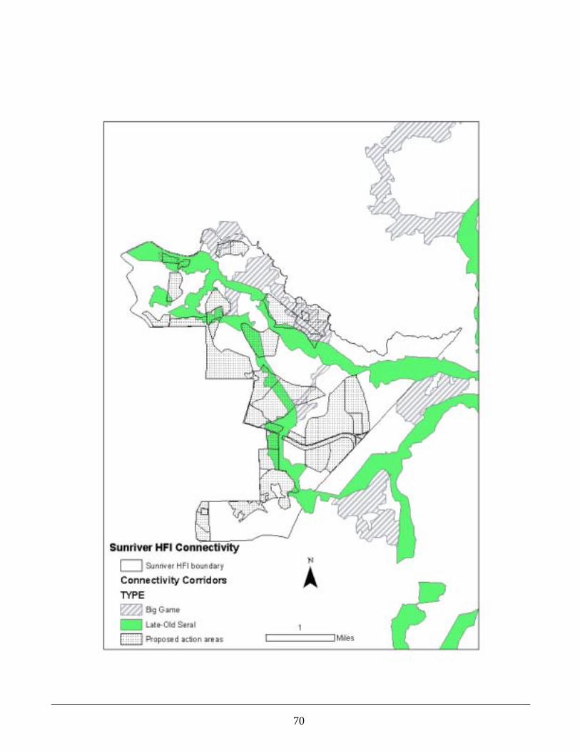
70

71
71
Soil Productivity Introduction The long-term sustainability of forest ecosystems depends on the productivity and hydrologic functioning of soils. Ground-disturbing management activities directly affect soil properties, which may adversely change the natural capability of soils and their potential responses to use and management. A detrimental soil condition often occurs where heavy equipment or logs displace surface organic layers or reduce soil porosity through compaction. Detrimental disturbances reduce the soils ability to supply nutrients, moisture, and air that support soil microorganisms and the growth of vegetation. The biological productivity of soils relates to the amount of surface organic matter and coarse woody debris retained or removed from affected sites. Forest soils are considered a non-renewable resource, as measured by human life spans, and maintenance or enhancement of soil productivity is an integral part of National Forest management. Therefore, an evaluation of the potential effects on soil productivity is essential for integrated management of forest resources. The following two measures will be used for this Design Issue: 1) Change in extent of detrimental soil conditions following proposed harvest and mitigation treatments within the individual activity areas proposed for mechanical treatments; 2) Amount of coarse woody debris (CWM) and surface organic matter that would likely be retained to protect mineral soil from erosion and provide both short and long-term nutrient supplies for maintaining soil productivity on treated sites. Scope of the Analysis The soil resource may be directly, indirectly, and cumulatively affected within each of the activity areas proposed within the project area. An activity area is defined as “the total area of ground impacted activity, and is a feasible unit for sampling and evaluating” (FSM 2520 and Forest Plan, page 4-71). For this project proposal, activity area boundaries are considered to be the smallest identified area where the potential effects of different management practices would occur. Thus, the discussion of soil effects and soil quality standards will be focused on the units proposed for silvicultural and fuel reduction treatments. The activity areas range in size from approximately 3 acres to 139 acres. Quantitative analyses and professional judgment were used to evaluate the issue measures by comparing existing conditions to the anticipated conditions which would result from implementing Alternative and reasonably foreseeable future actions. The temporal scope of the analysis is defined as short-term effects being changes to soil properties that would generally revert to pre-existing conditions within 5 years or less, and long-term effects as those that would substantially remain for 5 years or longer. This analysis also considered the effectiveness and probable success of implementing the management requirements, mitigation measures, and BMPs which are designed to avoid, minimize or reduce potentially adverse impacts to soil productivity. Affected Environment-Landscape Characteristics The Sunriver HFRA project area covers approximately 5,352 acres within the Newberry Volcano physiographic area, where essentially all landforms, rocks, and soil are products of volcanic events that occurred over various time periods. The landscape is characterized by gently sloping plains and uneven lava flows which lie below cinder cones and buttes in surrounding areas outside of the project area. Slopes generally range from 0 to 30 percent with the exception of steeper side-slopes (25 to 80 percent) associated with the rough edges of barren lava flows. Except for localized areas of barren lava flows, the majority of the project area (over 95 percent) has been covered by a moderately thick layer of volcanic ash and pumice deposits that consist mainly of non-cohesive (loose), sand-sized soil particles with little or no structural development. Approximately 47 acres (one percent) have been influenced by glacial outwash flooding that once occurred to the west of the project area. Glacial outwash plains contain buried glacial-till deposits that consist of sands and gravels that have been reworked by running water from the melting of historic mountain glaciers. Elevation ranges from about 4,150 feet along the Deschutes River (northwestern boundary) to approximately 4,400 feet in the southeastern portion of the project area. Mean annual precipitation averages between 10 to 15 inches. Most of the water yielded from these lands is delivered to streams as deep seepage and subsurface flows. The sandy textures of the ash-influenced soils have high infiltration and percolation rates that readily drain excess moisture and account for low amounts of overland flow. Dominant soils are considered to be well-to-
72
excessively drained. The underlying residual soils and bedrock materials have a moderate capacity to store water. The glacial outwash plains (47 acres) have poorly to somewhat poorly drained soils in localized areas of the dominant landform, such as swales and depressions. A seasonally high water table is typically present within a depth of two to five feet in sensitive portions of this landtype. Wet soil conditions are generally of short duration following snowmelt in early spring and the sandy-textured soils do dry out for at least a portion of the year. These sites generally do not support riparian vegetation species. The Deschutes River forms a portion of the northwestern boundary of the project area. There are no intermittent or ephemeral stream channels known to exist within the project area (see Hydrology/Fisheries section). The project area contains nine landtype units based on similarities in landforms, geology, and climatic conditions that influence defined patterns of soil and vegetation (Soil Resource Inventory, Larsen, 1976). The biophysical characteristics of these landtype units can be interpreted to identify hazards, suitabilities, and productivity potentials for natural resource planning and management. Three dominant landtype units, Soil Resource Inventory (SRI) mapping units 63, 64, and 6J, comprise approximately 96 percent of the project area. These lands consist of gently sloping plains and uneven lava flows with slopes that range from 0 to 30 percent. Dominant soils are moderately deep (20 to 40 inches) to deep (greater than 40 inches) with loamy-sand textures and moderate productivity potential for the growth of vegetation. The more productive soils are commonly found on north and east slope aspects and on concave slope positions such as toe slopes, swales and depressions. Less than 2 percent of the project area is comprised of landtypes that contain shallow soils (less than 20 inches) and areas of barren lava flows which are unsuited for timber management. Soils derived from volcanic ash and pumice deposits tend to be non-cohesive (loose) and they have very little structural development due to the young geologic age of the volcanic parent materials. These ash-influenced soils have naturally low bulk densities and low compaction potential. Mechanical disturbances can still reduce soil porosity to levels that limit vegetative growth, especially where there is a lack of woody debris and surface organic matter to help cushion the weight distribution of ground-based equipment. The sandy-textured surface layers are also easily displaced by equipment operations, especially during dry moisture conditions. The maneuvering of equipment is most likely to cause soil displacement damage on steep landforms. Approximately 32 acres (0.6 percent) of the project area contains steep slopes associated with the rough edges of lava flows, where rock escarpments typically preclude equipment operations. The dominant sandy-textured soils within the project area are not susceptible to soil puddling damage due to their lack of plasticity and cohesion. Surface erosion on undisturbed sites with gentle slopes occurs at naturally low rates because soils are protected by vegetation and organic litter layers. Currently, soils in the project area are adequately protected to maintain erosion rates within acceptable limits. Surface erosion by water is generally not a concern due to gentle slopes and the low-to-moderate erosion hazard ratings of the dominant landtypes. Accelerated rates of surface erosion are usually associated with disturbances or events that reduce vegetative cover, displace organic surface layers, or reduce soil porosity through compaction. Due to the lack of structural development, soils derived from volcanic ash are easily eroded where water becomes channeled on disturbed sites such as road surfaces, recreation trails, and logging facilities. These ash-influenced soils are well suited for tillage treatments (subsoiling) due to the absence of rock fragments on the surface and within soil profiles. These soil restoration treatments loosen compacted soil layers and improve the soils ability to supply nutrients, moisture, and air that support vegetative growth and biotic habitat for soil organisms. Affected Environment-Land Suitability and Inherent Soil Productivity The suitable lands database for the Deschutes National Forest LRMP identifies areas of land which are considered to be suitable for timber production using criteria affecting reforestation potential (FSH 2409.13). Lands that do not meet these criteria are considered unsuitable or partially suitable for timber harvest due to regeneration difficulties or the potential for irreversible damage to resource values from management activities.
73
Dominant landtypes within the Sunriver HFRA project area generally have moderate productivity ratings. Approximately 100 acres (2 percent) of the project area contain landtypes (SRI mapping units 1, 11, and 15) with little or no natural soil, or site conditions and soil properties are too variable for classifying a suitability rating. These lands typically consist of barren lava flows or other sparsely vegetated sites with scattered non-commercial trees. The locations of the proposed activity areas exclude areas which are considered to be unsuitable for timber production. All activity areas proposed for commercial timber harvest and/or non-commercial thinning treatments meet the criteria for land suitability that would allow them to be regenerated or resist irreversible resource damage. Affected Environment-Sensitive Soil Types Based on criteria for identifying sensitive soils to management (Deschutes LRMP (Appendix 14, Objective 5), sensitive soils within the Sunriver HFRA project area include: 1) soils on slopes greater than 30 percent (slopes range from 25 to 80 percent, *Map Unit 14 (32 acres on steep edges of lava flows; 2) soils with variable depths on rocky lava flows, *Map Unit 1 (33 acres of barren lava flows), and Map Unit 11 (2 acres of low density timber); 3) potentially wet soils with seasonally high water tables, *Map Unit 43 (47 acres of glacial outwash plains and bottomlands); and 4) soils associated with frost pockets in cold air drainages and basins *Map Unit 15 (65 acres of lodgepole pine basins).
There are no landtypes that contain sensitive soils with high or severe ratings for surface erosion. An estimated 177 acres (3 percent) of the project area contains landtypes with localized areas of sensitive soils. It should be emphasized that only portions of these total landtype acres actually contain sensitive soils. Landtype delineations for category 3 (Map Unit 43) contain localized areas with seasonally high water tables in drainage bottoms, swales, and depressions only during certain months of the year. Areas with sensitive soils are typically confined to specific segments of the dominant landform and are generally too small to delineate on maps. Affected Environment-Existing Condition of the Soil Resource (Natural Events) There is currently no evidence of detrimental soil conditions from natural disturbance events within the project area. Fire history data indicates that there have been no large wildfires (greater than 100 acres in size) within the project area since the early 1900’s. Enough time has passed since the occurrence of smaller fires that the recovery of native vegetation and forest litter are currently providing adequate sources of ground cover to protect mineral soil from water and wind erosion. There is currently no evidence of severely burned soils and/or accelerated surface erosion within affected areas. Fire exclusion has resulted in undesirable vegetation conditions and excessive fuel loadings in portions of the project area that classify as high or extreme for fire behavior (see Fire/Fuels Section). There are no natural or management-related landslides within the project area. Dominant landtypes do not meet criteria for landslide prone terrain and the high permeability of the ash-influenced soil generally precludes the buildup of hydraulic pressures that could trigger landslides. Therefore, natural disturbances are not included as existing sources of detrimental soil conditions within any of the activity areas proposed for this project. Management Related Disturbances Introduction The current condition of soils is directly related to soil porosity and the quantity and quality of surface organic matter within the project area. The following background information is relevant to issue measures developed for tracking the soil productivity issue. Affected Environment-Existing Condition of the Soil Resource (Timber Management) Ground-disturbing management activities and associated facilities (i.e., roads, log landings, skid trails, OHV trails, and recreation sites) have caused some adverse changes to soil quality, especially where mechanical disturbances removed vegetative cover, displaced organic surface layers, or detrimentally compacted the soil. The project area also contains permitted utilities such as power lines and phone lines where soil disturbances are mainly associated with existing access roads. None of these special use facilities are located within any of the activity areas proposed for mechanical vegetation treatments. There are no livestock water developments or other land uses that have committed the soil resource to a non-productive condition.
74
Ground-based railroad logging was used to harvest large-diameter ponderosa pine in portions of the project area during the 1920s and 1930s. Visual evidence of logging facilities from that period is difficult to locate due to the abundance of ground cover vegetation and forest litter. Since volcanic ash soils have naturally low bulk densities and compaction potential, it is expected that natural processes have gradually restored soil quality over the past 70 to 80 years. Soils on previously compacted sites have likely returned to near-natural density levels through frost heaving, root penetration, freeze-thaw and wetting-drying cycles. The establishment of native vegetation and accumulation of organic matter has improved areas of past soil displacement. Therefore, these older soil disturbances are not included as existing sources of detrimental soil conditions within any of the activity areas proposed for this project. Based on more recent harvest history, various silvicultural treatments were implemented within the project area between 1972 and 2002. Past stand entries that overlap with proposed activity areas were mechanical thinning treatments, both commercial and non-commercial prescriptions, which were implemented between 1984 and 1991. Ground-based logging equipment disturbed soils on portions of 11 of the 21 EA units proposed for mechanical harvest under Alternative 2. There was no overlap of previously harvested areas within the remaining ten (10) EA units. The primary sources of detrimental soil conditions are associated with the transportation system and existing logging facilities which were used for timber harvest and yarding activities. Temporary roads, log landings, and primary skid trails were constructed and used to access individual harvest units of past timber sales. Most project-related impacts to soils occurred on and adjacent to these heavy-use areas where mechanical disturbances removed vegetative cover, displaced organic surface layers, or compacted soil surface layers. Much of the random disturbance between main skid trails and away from landings has decreased naturally over time. Research studies and local soil monitoring have shown that soil compaction and soil displacement account for the majority of detrimental soil conditions resulting from ground-based logging operations (Page-Dumroese, 1993; Geist, 1989; Powers, 1999; Deschutes Soil Monitoring Reports). The extent of detrimentally disturbed soil is dependent on a number of variables including the types of silvicultural prescriptions, the intensity of equipment use with each entry, and the spacing distances between main skid trails. Local knowledge and experience with past and current harvest practices, research references, local monitoring reports, and field investigations were used to estimate detrimental soil conditions within each of the activity areas planned for this project. Soil monitoring results on local landtypes and similar soils have shown that 15 to 30 percent of the unit area can be detrimentally disturbed by ground-based harvest systems depending on harvest prescriptions and soil conditions at the time of harvest (Deschutes Soil Monitoring Reports, 1995, 1996, 1997, and 1999). Soil condition assessments were conducted for a representative sample of previously harvested areas within the project area to verify the estimated percentages of existing soil conditions in overlap portions of the proposed activity areas. The primary objective was to verify previous monitoring results of similar management practices on similar landscapes and volcanic-ash soils of the Deschutes National Forest. Qualitative assessments of soil surface conditions were made by establishing line transects and recording visual evidence of soil disturbance at 5 foot intervals. Detrimental soil compaction was the primary disturbance category observed where equipment operations were intensive. Shovel probing was used to assess compaction using resistance to penetration as a measure. Soil displacement, as defined by FSM 2521.03, was more difficult to distinguish due to the establishment of native vegetation and the accumulation of forest litter. Results showed that the average amount of soil impacts was actually less than results from previous field assessments of commercial thinning treatments. Based on the proportionate extent of overlap of sampled areas within proposed activity areas, these field assessment results are included in the percentages of existing detrimental soil conditions in Table 3-26. Conservative estimates were used to predict how much surface area is currently impacted by existing roads,
75
main skid trail systems, and log landings for the remaining activity areas which were not assessed in the field. The spacing distances between main skid trails generally averaged between 75 and 100 feet (approximately 11 to 14 percent of the unit area). Local soil monitoring has shown that the use of ground-based equipment for commercial thinning treatments generally causes about 3 to 5 percent more soil impacts than disturbed area estimates based solely on skid trail spacing distances and the average size of log landings. Seventeen (17) percent was used to calculate existing amounts of detrimental soil conditions in areas where past thinning treatments overlap with portions of 7 of the 21 EA units proposed for mechanical harvest. The amount of detrimentally disturbed soil associated with existing logging facilities is included in the estimated percentages displayed in Table 3-26 of the Environmental Consequences section. Much of the random disturbance between main skid trails and away from landings has decreased naturally over time. Research has shown that the detrimental effects of soil compaction generally require more than 3 to 5 equipment passes over the same piece of ground (McNabb, Froehlich, 1983). Where logs were skidded with only 1 or 2 equipment passes, soil compaction was shallow (2 to 4 inches) and the bulk density increases did not qualify as a detrimental soil condition. Frost heaving and freeze-thaw cycles have gradually restored soil porosity in areas with slight to moderately compacted layers near the ground surface. Other factors that have helped the recovery process include root penetration, rodent activity, wetting and drying cycles, and surface organic matter. The establishment of vegetative ground cover and the accumulation of litter and organic matter has also been improving areas of past soil displacement. There is no evidence that mechanical site preparation and/or brush removal treatments caused detrimental soil displacement in any of the activity areas proposed for this project nor is there any evidence that post-harvest, broadcast burn treatments caused any severely burned soil in random locations off designated logging facilities in previously managed areas. Based on field experience of the district firewood coordinator, the extent of illegal firewood cutting in this project area has been relatively minor compared to other areas on the district that have better quality firewood in more remote areas (DeMello, personal communication). Conservative estimates were used to account for soil impacts associated with existing roads and logging facilities. It is expected that the limited extent of random soil disturbances from any user-created woodcutting roads is likely included in these estimates of existing detrimental soil conditions. There have been no restoration treatments, such as subsoiling, which have rehabilitated compacted soil on existing skid trails and log landings in any of the activity areas proposed for mechanical harvest. The long-term effects of deep compaction still persist where multiple equipment passes were made in previously harvested areas. Impacted soils will remain in a detrimental condition until such time that reclamation treatments are implemented to improve the hydrologic function and productivity on disturbed sites. Ground-based logging equipment disturbed soils on portions of 11 of the 21 EA units proposed for mechanical vegetation treatments. Based on the proportionate extent of overlap with past treatment areas, it was concluded that none of these proposed EA units currently have detrimental soil conditions that exceed 20 percent of the area. The extent of soil impacts associated with existing roads and logging facilities ranges from 3 to 19 percent with an average of 10 percent. There are no existing logging disturbances within the remaining 10 EA units. Affected Environment-Existing Condition of the Soil Resource (Roads) Roads detrimentally disturb soil properties and convert the soil resource to a non-productive condition. Most of the precipitation that falls on compacted road surfaces is transmitted as surface runoff, and roads are primary sources of accelerated surface erosion. The project area contains approximately 61 miles of classified system roads. This equates to approximately 99 acres or 1.8 percent of the project area. Segments of these existing roads, ranging from less
76
than 0.1 to 1.7 miles (0.2 to 2.6 acres), cross through portions of 20 of the 21 EA units proposed for mechanical treatments under Alternative 2. Some local system roads are currently closed to public use, but segments of these roads may be re-opened to provide necessary access. All local system roads proposed for closure would be subsoiled and decommissioned from the transportation system following their use. Road surveys will be conducted to identify where maintenance may be necessary to correct drainage problems on existing system roads that would be used as haul routes for this project. The estimated amount of detrimentally disturbed soil committed to existing system roads is included in acres and percentages of existing soil impacts displayed in Table 3-26 and the summarized information in Table 3-27. There are no soil impacts associated with cinder or rock borrow pits within the project area. Affected Environment-Existing Condition of the Soil Resource (Recreation Activities) The extent of detrimental soil conditions associated with recreation use is minor in comparison to the transportation system and past logging disturbances. Soil disturbances are generally confined to relatively small sites where the concentration of human activity often reduces vegetative cover. Recreation facilities preclude other uses of the soil for as long as they remain in use. Campfires usually consume available sources of down woody debris around recreation sites. Developed facilities consist of the Benham Falls East day-use picnic area (about 0.4 acres), a canoe takeout area (about one acre), one trailhead (about 1/8 acre), and approximately 10 miles of non-motorized system trails. Most of these developed sites, including the picnic area and canoe takeout area, are excluded from planned activity areas and hazard trees are removed as needed. Short segments of system trail (0.1 miles) cross through portions of two (2) activity areas (EA Units 1 and 6) proposed for commercial harvest. A disturbed width of 6 feet was used to estimate the amount of disturbed soil associated with developed recreational trails. This equates to approximately 0.7 acres per mile of trail. Approximately 0.1 acres of soil is dedicated to system trails within EA units 1 and 6. These amounts are included in the estimated percentages of detrimental soil conditions for these two activity areas (Table 3-26). Soil impacts from dispersed recreation activities are usually found along existing roads, trails and other management facilities where vegetation has been cleared and soils have been previously disturbed by other land uses. Heavy use of popular dispersed recreation sites typically show soil resource damage given a combination of overuse, improper camping techniques and insufficient control and maintenance. Approximately 24 dispersed campsites, that average about 1/8 acre (0.125) in size, have been inventoried within the project area (see Recreation Section). The majority of these disturbed sites are located near the Deschutes River, outside of the activity areas proposed with this project. It is not known if any dispersed campsites occur within the proposed EA units. Due to the average size of the proposed activity areas, the minor extent of soil disturbances from dispersed camping and other incidental uses by hikers and mountain bikers would not be expected to increase the percentages of existing detrimental soil conditions displayed in Table 3-26. Conservative estimates were used to account for soil disturbances from existing roads and logging facilities, and the minor extent of these impacts is likely included in these estimates. There is no accurate inventory of the number or miles of user-created roads and OHV trails within the project area. User-created trails typically occur where vegetation has been cleared on or adjacent to old skid trail networks of past harvest areas. Compacted soils committed to existing logging facilities continue to remain in a detrimental condition until reclamation activities, such as subsoiling, are implemented to improve the hydrologic function and productivity on these previously disturbed sites. Conservative estimates were used to account for soil disturbances from existing roads and logging facilities; so the extent of recreation-related disturbances from these activities is likely included in the estimates of existing detrimental soil conditions (Table 3-26). It is also expected that the majority of use likely occurs adjacent to the Deschutes River and the urban interface zone which are both outside of the activity areas proposed with this project. Therefore, the minor extent of detrimental soil conditions from dispersed recreation use is not expected to have a measurable effect on site productivity within the individual activity areas proposed for this project.
77
Summary: The primary sources of detrimental soil conditions are associated with the transportation system and existing logging facilities which were used for past timber harvest activities. The extent of detrimentally disturbed soil associated with recreation and other land uses is relatively minor in comparison. For activity areas that have already been impacted by previous management, project plans need to include options for avoiding, reducing, and mitigating cumulative levels of existing and predicted amounts of new soil disturbance from project activities. Previous harvest entries consisted of both commercial and non-commercial thinning treatments using ground based equipment. Based on the extent of overlap with past activity areas, it was concluded that none of the 21 activity areas proposed for mechanical harvest treatments currently have detrimental soil conditions that exceed 20 percent of the unit area. Existing detrimental soil conditions range from 0 to 19 percent and average 9 percent. Most project-related impacts to soils occurred on and adjacent to heavy-use areas such as skid trail systems, log landings and roads that were used for access in past timber sale units. Table 3-26 displays quantitative, unit-specific information that shows the predicted amounts of detrimental soil conditions before and after implementation of project activities. The extent of existing soil impacts associated with roads, logging facilities, and developed system trails is included in the estimated acres and percentages shown in Column 3 of this table. Affected Environment-Coarse Woody Debris (CWM) and Surface Organic Matter The effects of management activities on soil productivity also depend on the amount of coarse woody debris and surface organic matter retained or removed on affected sites. Decaying wood on the forest floor is critical for maintaining the soils ability to retain moisture and provide both short and long-term nutrient supplies and biotic habitat for microorganism populations. Mycorrhizal fungi and other soil organisms depend upon the continuing input of woody debris and fine organic matter. A balance between fuel management objectives and ensuring adequate amounts of CWM is an important goal for maintaining long-term soil productivity. Using mycorrhizal fungi as a bio-indicator of productive forest soils, research studies were used to develop conservative recommendations for leaving sufficient CWM following management activities (Graham et al. 1994, Brown et al. 2003). A minimum of 5 to 10 tons per acre of coarse woody debris (greater than 3 inches in diameter) should be retained on dry, ponderosa pine sites and 10 to 15 tons of CWM per acre on mixed conifer and lodgepole pine sites to maintain soil productivity. A sufficient number of standing dead snags and/or live trees should also be retained for future recruitment of organic matter. Conserving surface litter (i.e., organic materials such as leaves, twigs and branches less than 3 inches in diameter) is also important for protecting mineral soil from erosion, buffering the effects of soil compaction, and supplying nutrients that support the growth of vegetation and native populations of soil organisms. Surface litter also provides on-site moisture retention. Current levels of coarse woody debris and surface litter are not known for site-specific locations throughout the project area. However, it is expected that adequate amounts of each currently exist to protect mineral soil from erosion and provide nutrients for maintaining soil productivity over much of the project area. There are some older activity areas, where vegetation management activities were implemented prior to LRMP direction (1990), that likely contain less than desired amounts of CWM on the ground. Levels of CWM and surface litter in forested areas have been improving towards optimum conditions as additional woody materials have accumulated through natural mortality, windfall, and recruitment of fallen snags over time. Annual leaf/needle fall, small diameter branches, twigs and other forest litter have increased organic matter levels for short-term nutrient cycling and humus development in the mineral soil. In other portions of the project area, fire exclusion has resulted in undesirable vegetation conditions and fuel loadings in excess of pre-settlement conditions.
78
Soil Productivity Management Direction The Pacific Northwest Region developed soil quality standards and guidelines that limit detrimental soil disturbances associated with management activities (FSM 2520, R-6 Supplement No. 2500-98-1). This Regional guidance supplements the Deschutes LRMP standards and guidelines and provides policy for planning and implementing management practices which maintain or improve soil quality. It is consistent with LRMP interpretations for standards and guidelines SL-3 and SL-4 that limit the extent of detrimental soil conditions within activity areas. Standard and Guideline (SL-4) directs the use of rehabilitation measures when the cumulative impacts of management activities are expected to cause damage exceeding soil quality standards and guidelines on more than 20 percent of an activity area. Standard and Guideline (SL-5) limits the use of mechanical equipment in sensitive soil areas. The primary objective for the soil resource is to plan and conduct management activities so that on-site loss of soil productivity is minimized on lands which are not officially dedicated to permanent facilities necessary to achieve other land management objectives. Soil quality standards and guidelines do not apply to intensively developed sites such as mines, developed recreation facilities, and administrative sites (FSM 2520, R-6 Supplement No. 2500-98-1). Management direction requires that when initiating new activities: 1) Design new activities that do not exceed detrimental conditions on > 20 percent of an activity area, including the permanent transportation system; 2) In activity areas where < 20 percent detrimental soil impacts exist from prior activities, the cumulative amount of detrimentally disturbed soil must not exceed the 20 percent limit following project implementation and restoration; and 3) In activity areas where > 20 percent detrimental soil conditions exist from prior activities, the cumulative detrimental effects from project implementation and restoration must, at a minimum, not exceed the conditions prior to the planned activity and should move conditions toward a net improvement in soil quality. Detrimental soil conditions are those that meet the following criteria: Detrimental Compaction in volcanic ash/pumice soils is an increase in soil bulk density of 20 percent, or more, over the undisturbed level. Detrimental Puddling occurs when the depth of ruts or imprints is six inches or more. Detrimental Displacement is the removal of more than 50 percent of the A horizon from an area greater than 100 square feet, which is at least 5 feet in width. Severely Burned soils are considered to be detrimentally disturbed when the mineral soil surface has been significantly changed in color, oxidized to a reddish color, and the next one-half inch blackened from organic matter charring by heat conducted through the top layer on an area 100 square feet or greater with a width of at least five feet. Target Landscape Condition The primary management goal is to maintain or enhance soil conditions at acceptable levels without impairment of the productivity of the land. The extent of detrimental soil disturbances is minimized through the application of management requirements and mitigation measures designed to minimize, avoid or eliminate potentially significant impacts, or rectifying impacts in site-specific areas by restoring the affected environment. The land effectively takes in and distributes water, and erosion rates are controlled to near-natural levels. The biological productivity of soils is ensured by management prescriptions that retain adequate supplies of surface organic matter and coarse woody debris without compromising fuel management objectives and the risk of soil damage from large, stand replacement wildfire. Soil Productivity Environmental Effects Introduction The magnitude and duration of potential effects, both physical and biological changes in soil productivity, depend on the intensity of site disturbance, the timing and location of activities, and the inherent properties of the volcanic ash-influenced soils within affected activity areas. Direct effects occur at essentially the same time and place as the actions that cause soil disturbance, such as soil displacement and compaction from equipment operations. Indirect effects occur sometime after or some distance away from the initial disturbance, such as increased runoff and surface erosion from previously compacted areas. Cumulative effects include all past, present, and reasonably foreseeable actions that cause soil disturbance within the same activity areas proposed with this project.
79
The potential for detrimental changes to soil physical properties was quantitatively analyzed by the extent (surface area) of temporary roads, log landings, and designated skid-trail systems that would likely be used to facilitate yarding activities within each of the proposed activity areas. Professional judgment was used to evaluate changes in the amount and composition of CWM and surface organic matter. This analysis also considered the effectiveness and probable success of implementing the soil mitigation and resource protection measures which are designed to avoid, minimize or reduce potentially adverse impacts to soil productivity. The following section, Important Interactions, provides a discussion of the potential effects on soil and biological conditions from implementing the various vegetation management and fuel reduction treatments. After this discussion, the environmental effects are presented and tracked by the issue measures used to evaluate the estimated impacts on soil productivity. Important Interactions The development and use of temporary roads, log landings, and skid trail systems are the primary sources of physical disturbance that would result in adverse changes to soil productivity. Soil condition assessments for similar soils and the same types of ground-based harvest systems, research references, local monitoring reports (including the effectiveness of subsoiling treatments), Sunriver field investigations, and personal communications with local, sale administration and soil scientist personnel were used to predict the potential extent of detrimental soil disturbance within activity areas. Research studies and local soil monitoring have shown that soil compaction and soil displacement account for the majority of detrimental soil conditions resulting from ground-based logging operations (Page-Dumroese, 1993; Geist, 1989; Powers, 1999; Deschutes N.F., Soil Monitoring Reports). For the commercial thinning prescriptions proposed for this entry, conservative estimates were used to predict how much surface area would likely be impacted by logging facilities that would be needed to accommodate the harvest and yarding of commercial material. No new roads would be constructed and retained as part of the transportation system. Approximately 0.7 miles (total) of temporary road would be established or re-established to allow access to 4 of the 21 activity areas (EA units 3, 4, 21, and 30) proposed for mechanical vegetation treatments. Some of these spur roads would consist of reopening short segments (100 to 1,600 feet) of old access roads from previous entries. The re-use of existing road prisms would not cause additional soil impacts because machinery access would occur on previously disturbed sites. Temporary roads are built to low specification with the amount of surface area limited to the minimum necessary to get equipment into log landing areas. The magnitude of soil disturbance associated with temporary roads for this project would be essentially the same as the disturbed widths of primary skid trails. None of the temporary road locations would require excavation of cut-and-fill slopes because they are located on nearly level to gentle slopes. All temporary road segments would be subsoiled (obliterated) following their use, so disturbed area estimates are balanced by restoration treatments which are designed to improve soil quality by reclaiming and stabilizing compacted road surfaces. The proposed actions also include permanently closing approximately 16.5 miles of open system roads following project activities. Under this project proposal, all roads identified for closure would be decommissioned by subsoiling because they are no longer needed for long-term access. Road closure and decommissioning treatments that include subsoiling treatments result in a further reduction in the amount of detrimentally compacted soil within activity areas. Commercial harvest would likely be accomplished using a tractor-mounted feller buncher equipped with a felling head (harvester shear). Mechanically harvested trees would be whole-tree yarded to main skid trail networks and rubber-tired grapple machines would then transport the bunched trees to landings for processing and loading. The grapple skidding equipment would be restricted to designated skid trails at all times. It is estimated that skid trails would have an average disturbed width of 12 feet and the average spacing distance
80
between main trails would be approximately 100 feet. On moderately flat ground with small timber, research found that skid trail spacings of 100 feet would account for approximately 11 percent of the unit area (Froehlich, 1981, Garland, 1983). The primary skid trails are not constructed trails when the terrain is gentle to moderately sloping as in the Sunriver project area. Therefore, surface organic layers are not scraped away by equipment blades or removed off site. These organic materials are either retained near the top of the skid trail, or through operations fluffed to the edges of the trail. It is not mixed deeper into the soil profile, and these organic materials are easily redistributed onto the skid trails during rehabilitation treatments. Based on personal communications with timber sale administrators, the Forest average for log landings is one landing (100 feet by 100 feet) for 10 acres of harvest (approximately 2 percent of the unit area). Disturbed area calculations for log landings are added to the acreage estimates for main skid trails to determine the overall soil disturbance. The majority of soil impacts would consist of soil compaction on heavy use areas (i.e., roads, log landings, and main skid trails) in known locations that can be reclaimed when these facilities are no longer needed for future management. In unmanaged portions of the proposed activity areas, the development and use of new logging facilities would result in approximately 13 percent of the harvest unit areas (11 percent in skid trails plus 2 percent in log landings). This amount was used to analyze the proportionate extent of detrimental soil conditions which are expected to occur in unmanaged portions of activity areas proposed for harvest. Machine traffic off designated logging facilities would be limited in extent. Mechanical harvesters would only be allowed to make no more than two equipment passes on any site-specific area between main skid trails or away from log landings. Physical impacts to the soil resource incurred by off-trail machine traffic are generally considered to be detrimental where multiple passes are made by heavy equipment. Research has shown that the detrimental effects of soil compaction generally require more than 3 to 5 equipment passes over the same piece of ground (McNabb and Froehlich, 1983). Therefore, the effects of only two passes are not expected to qualify as a detrimental soil condition. On gentle to moderately sloping terrain, the maneuvering of equipment generally does not remove soil surface layers in areas that are at least 5 feet in width to qualify as detrimental soil displacement (FSM 2520, R-6 Supplement). Smaller areas of displacement or the mixing of soil and organic matter does not constitute a detrimental soil condition. Past monitoring information was used to predict the extent of new soil disturbance in activity areas that overlap with previously managed areas. The estimates of detrimental soil conditions account for the expected amount of volume removal, the type of logging equipment, the spacing of skid trails, the number of log landings that would be needed to deck accumulated materials, and the fact that not all existing logging facilities can be reutilized due to their orientation within units. For the commercial thinning treatments proposed for this entry, conservative estimates were used to predict how much surface area would likely be impacted by additional logging facilities that would be needed to accommodate the yarding of commercial material. Although existing skid trail networks and log landings would be used wherever possible, soil condition assessments have shown that commercial thinning treatments generally cause a 5 to 10 percent increase in detrimental soil conditions with each successive entry into a stand (Craigg, 2000). An average increase of 7 percent detrimental soil conditions associated with additional logging facilities was used to analyze the proportionate extent of overlap for previously managed areas that occur within activity areas proposed for this entry. Table 3-26 displays acres and percentages of detrimental soil conditions for existing conditions and the predicted effects from project implementation, including soil restoration treatments, for each of the activity areas proposed for harvest. Non-commercial thinning would be accomplished by hand felling small-diameter trees with chainsaws following commercial harvest treatments. Manual thinning treatments would not cause cumulative increases in detrimental soil conditions because machinery would not be used for yarding these non-commercial materials. Mitigation and resource protection measures would not be necessary for these non-mechanical treatments. Some of these trees would remain on the ground to provide surface cover and a source of nutrients as these organic materials gradually decompose. This would have beneficial effects to site productivity by improving the soils
81
ability to resist surface erosion and providing organic matter for humus development in mineral soil. Fuel Reduction Activities A combination of various fuel reduction treatments would be implemented to reduce the potential for intense wildfires and their rates of spread. Fuel treatments include thinning trees, hand piling and burning slash materials, mechanical shrub/slash treatments (mowing), and the use of prescribed fire. Most of the slash generated from commercial harvest would be machine piled and burned on log landings and/or main skid trails. Burning large concentrations of machine-piled logging slash would cause severely burned soil because heat is concentrated in a localized area. However, this slash disposal method would not result in a net increase in detrimental soil conditions because burning would occur on previously disturbed sites. Therefore, there would be no cumulative increase from the predicted amount of detrimentally disturbed soil associated with the mechanical harvest and yarding activities. Table 3-26 displays existing and predicted amounts of detrimental soil conditions for each of the individual activity areas planned for commercial harvest. The proposed activities also include hand treatments for reducing fuel accumulations in portions of 12 activity areas that total approximately 153 acres. The hand pile and burn method would be used to burn small concentrations of woody materials that are well-distributed within these activity areas. This non-mechanical fuels treatment does not cause soil displacement or compaction damage. Due to the relatively small size of hand piles, ground-level heating is usually not elevated long enough to detrimentally alter soil properties that affect long-term site productivity. These activities are conducted at times and under conditions that reduce the risk of resource damage, including impacts to soils and understory vegetation. Soil heating is reduced when the soil surface layer is moist, so piles are typically burned following periods of precipitation. Nutrient releases may actually benefit site productivity in these small localized areas. Conservative estimates were used to account for the cumulative amount of surface area that could be potentially impacted from harvest and yarding activities. The cumulative effects to soils from this activity would be relatively minor in comparison. Therefore, the overall extent of detrimental soil conditions is not expected to increase above the predicted levels in any of the activity areas proposed for this post-harvest treatment. In portions of 10 activity areas that total approximately 438 acres, specialized machinery with attachments for mowing would be used to reduce the height of tall shrubs and small trees to within four to six inches of the ground. Only brush and light fuels will be mowed leaving any large-diameter downed logs in place. It is estimated that an additional 120 acres of mowing would be used to create fuel breaks within portions of 21 activity areas proposed for prescribed burn treatments. Prescribed underburning or the hand pile-and-burn method would then be used to reduce ground fuels following the mowing treatment. Brush mowing activities would not cause detrimental soil displacement and increases in soil bulk density are inconsequential. The primary factors that limit soil compaction are the low ground pressure of the tractor and mowing heads, the limited amount of traffic (one equipment pass), and the cushioning effect of surface organic matter. These activities have been monitored in the past, and results show that increases in soil displacement and compaction do not meet the criteria for detrimental soil conditions (Soil Monitoring Report, 1997). Prescribed fire would be used to reduce fuel accumulations in 11 activity areas (540 acres) following mechanical thinning as well as 10 activity areas (664 acres) where prescribed underburning would be used exclusively to treat the shrub layer and reduce natural fuels. Natural fuel accumulations within treatment areas consist mainly of fine fuels (i.e., decadent brush, tree branches, and needle cast litter) that typically do not burn for long duration and cause excessive soil heating. Prescribed burning activities are conducted at times and under conditions that maximize benefits while reducing the risk of resource damage. Prescribed underburns would be accomplished under carefully controlled conditions to minimize damage to standing trees and remove only a portion of the surface organic matter without exposing extensive areas of bare mineral soil.
82
Prescribed burn plans would comply with all applicable LRMP standards and guidelines and Best Management Practices (BMPs) prior to initiation of burn treatments. Soil moisture guidelines would be included in burn plans to minimize the risk for intense ground-level heating. Duff moisture levels of approximately 50 percent are typical during light intensity underburns. Soil heating during spring burns would be negligible because higher moisture levels at this time of year generally result in cooler burns with lower potential for causing severely burned soil. Ground cover vegetation is expected to recover rapidly, and it is not anticipated that these burn treatments would accelerate surface erosion above tolerable limits. Fall burning would be conducted following brief periods of precipitation. Existing snags and down logs will be retained to meet coarse woody debris requirements for wildlife habitat and soil productivity. It is expected that adequate retention of coarse woody debris and fine organic matter (duff layer) would still exist for protecting mineral soil from erosion and supplying nutrients that support the growth of vegetation and populations of soil organisms. The successful implementation of prescribed underburning would likely result in beneficial effects by reducing fuel loadings and wildfire potential as well as increasing nutrient availability in burned areas. It is anticipated that fire lines, both mechanical and hand lines, would be used in conjunction with existing roads and natural barriers to effectively control the spread of fire within treatment units. The extent of disturbed soil would be limited to the minimum necessary to achieve fuel management objectives. In locations where mechanical fuel breaks are necessary, a low-ground pressure ATV machine would pull a small wedge-shaped plow to expose mineral soil in areas approximately 2.5 feet to 3 feet wide. Hand lines would likely be less than 18 to 24 inches in width. Neither method would result in the removal of surface organic layers in large enough areas, at least 5 feet in width as defined in FSM 2520, to qualify as detrimental soil displacement. Compaction is not a concern because this activity would be accomplished with a single equipment pass. Displaced topsoil and unburned woody debris would be redistributed over mechanical fire lines following prescribed burning activities. Litter from adjacent trees, coupled with the establishment of herbaceous grasses, forbs, shrubs, and tree seedlings would provide new sources of fine organic matter for humus development in the mineral soil. Soil Restoration Treatments on Roads and Logging Facilities Subsoiling treatments are designed to promote maintenance or enhancement of soil quality. Subsoiling directly fractures compacted soil particles, thereby reducing soil strength and increasing macro pore space with the soil profile. These conservation practices comply with Regional policy and LRMP interpretations for Forest-wide standards and guidelines SL-3 and SL-4 that limit the extent of detrimental soil conditions. Soil restoration treatments would be applied with a self-drafting winged subsoiler to reduce the cumulative amount of detrimentally compacted soil within nine activity areas which are expected to have soil impacts that exceed 20 percent of the unit area following commercial harvest. This would include subsoiling all temporary roads and some of the primary skid trails and log landings following post-harvest activities. The majority of existing and new soil impacts would be confined to known locations in heavy use areas which facilitates where subsoiling treatments would need to be implemented on compacted sites. Table 3-26 (Column 5) displays the number of acres within each harvest unit that would be subsoiled and the percentage of detrimental soil conditions that would remain upon completion of the subsoiling treatment. Subsoiling improves the hydrologic function and productivity on disturbed sites by fracturing compacted soil layers and increasing porosity within soil profiles. Subsequently, this contributes to increased water infiltration, enhanced vegetative root development, and improves the soils ability to supply nutrients, moisture, and air that support vegetative growth and biotic habitat for soil organisms. Additional treatment options for improving soil quality on disturbed sites include redistributing topsoil in areas of exposed mineral soil and pulling available logging slash and woody materials over the treated surface. Subsoiling would also be applied to decommission approximately 16.5 miles of local system road from the transportation system following post-harvest activities. Road closure and decommissioning treatments that
83
include subsoiling result in a further reduction in the amount of detrimentally compacted soil within activity areas. Short segments of road, ranging from 0.1 to 0.5 miles (0.2 to 0.8 acres), cross through portions of nine (9) activity areas (EA Units 6, 17, 18, 21, 26, 28, 30, 31, and 33) proposed for mechanical vegetation treatments. Soil restoration acres for these EA units were deducted from the disturbed area estimates in Table 3-26 because subsoiled areas are expected to reach full recovery within the short-term. Decommissioned roads outside of activity areas also help reduce the overall amount of detrimental soil conditions within the larger project area. As previously described under Affected Environment, extensive areas of the project area have been covered by loose, non-cohesive ash and pumice deposits that consist mostly of sand-sized soil particles. These coarse-textured soils have little or no structural development within the principal root development zone (4 to 12 inches in depth) where changes in soil compaction (bulk density) are assessed according to Regional direction (FSM 2521.03). Dominant soils are well suited for tillage treatments due to their naturally low bulk densities, low compaction potential, and absence of rock fragments on the surface and within soil profiles. These are the soil properties which are typically affected by mechanical forces that either reduce or improve soil porosity in the compaction zone. Although equipment traffic during harvest operations can decrease soil porosity on these soil materials, compacted sites can be mitigated physically by tillage with a winged subsoiler (Powers, 1999). Monitoring of past subsoiling activities on the Deschutes National Forest has shown that these treatments are highly effective in restoring detrimentally compacted soils. The winged subsoiling equipment used locally has been shown to lift and shatter compacted soil layers in greater than 90 percent of the compacted zone with one equipment pass (Craigg, 2000). Field observations have shown that bulk densities return to natural levels after a year or two of physical settling and moisture percolation through the soil profile (Deschutes Soil Monitoring, 1995). Most of the surface organic matter remains in place because the equipment is designed to allow adequate clearance between the tool bar and the surface of the ground for allowing smaller logging slash to pass through without building up. Any mixing of soil and organic matter does not cause detrimental soil displacement because these materials are not removed off site. Since the winged subsoiler produces nearly complete loosening of compacted soil layers without causing substantial displacement, subsoiled areas on this forest are expected to reach full recovery within the short-term (less than 5 years) through natural recovery processes. Although the biological significance of subsoiling is less certain, these restoration treatments likely improve subsurface habitat by restoring soils ability to supply nutrients, moisture, and air that support soil microorganisms. Research studies on the Deschutes National Forest have shown that the composition and distributions of soil biota populations rebound back toward pre-impact conditions following subsoiling treatments on compacted skid trails and log landings (Moldenke et al., 2000). The subsoiling specialist and trained crew members work with the equipment operator to identify locations of detrimentally compacted soil. Implementation and effectiveness monitoring is then conducted on treatment areas to assure that soil resoration objectives have been met. Effects of Implementing Potential Sale Area Improvement Activities The interdisciplinary team identified sale area improvement opportunities that include additional road closures, weed monitoring, flagging removal, noncommercial thinning, and tree pruning. None of these project activities would cause additional adverse impacts that would increase the extent of detrimental soil conditions within any of the proposed activity areas. Manual thinning and pruning treatments would not require resource protection measures for these non-mechanical treatments. Road closures that use signs or barriers do not reduce the number of acres of detrimentally disturbed soil because the road prism remains in place. Road closures and decommissioning treatments that include subsoiling result in a further reduction in the amount of detrimentally compacted soil. This would have a beneficial effect to site productivity by reducing the potential for erosion damage and promoting the recovery of native vegetation on disturbed sites in other portions of the project area.
84
Direct and Indirect Effects of Alternative 1 Measure #1: Detrimental Soil Disturbance The effects of past and ongoing management activities were previously described under Affected Environment-Existing Condition of the Soil resource. Under Alternative 1 (No Action), the management activities proposed in this document would not take place. The extent of detrimental soil conditions would not increase above existing levels because no additional land would be removed from production to build temporary roads and logging facilities. Implementation of project design criteria and mitigation measures would not be necessary. The amount of detrimentally disturbed soil associated with existing roads, logging facilities, and developed recreation trails is included in the unit-specific information displayed in Table 3-26 and the summarized estimates in Table 3-27. Although disturbed soils would continue to recover naturally from the effects of past management, the current percentages of detrimental soil conditions would likely remain unchanged for an extended period of time. This alternative would defer opportunities for soil restoration treatments that reduce existing impacts and help move conditions toward a net improvement in soil quality. Soil productivity would not change appreciably unless future stand-replacing wildfires cause intense ground-level heating that results in severely burned soils. Detrimental changes to soil properties typically result from extreme surface temperatures of long duration, such as the consumption of large diameter logs on the forest floor. Although hazardous fuels have been reduced in some previously managed areas, fire exclusion has resulted in undesirable vegetation conditions and excessive fuel loadings in other portions of the project area (see Fire/Fuels Section). Alternative 1 would defer fuel reduction opportunities at this time. If a large amount of fuel is present in timber stands, soil temperatures during an intense ground-level fire can remain high for an extended period of time and excessive soil heating would be expected to produce detrimental changes in soil chemical, physical, and biological properties. Severely burned soil would mainly be confined to localized microsites beneath downed logs, stumps, or around the root crowns of individual trees. Severe burning may cause soils to repel water, thereby increasing surface runoff and subsequent erosion. The loss of protective ground cover would also increase the risk for accelerated wind erosion on the loose, sandy textured soils which are widespread throughout the project area. Grass and brush fires are fast moving, and ground-level heating is usually not elevated long enough to detrimentally alter soil properties. Measure #2: Coarse Woody Debris (CWM) and Surface Organic Matter In the short term, the amount of coarse woody debris and surface litter would gradually increase or remain the same. In forested areas, coarse woody materials will continue to increase through natural mortality, windfall, and recruitment of fallen snags over time. Short-term nutrient sources will also increase through the accumulation of small woody material from shrub and tree branches, annual leaf and needle fall, and decomposition of grass and forb plant materials. In the long term, fuel loadings will continue to increase thereby increasing the potential for an uncharacteristic, high intensity wildfire. Existing and projected high fuel loadings would be expected to support a future wildfire that is capable of killing and/or consuming large areas of vegetation, coarse woody material, and surface organic matter. The loss of CWM and surface organic matter would adversely affect both short and long-term nutrient input and water storage capability on affected sites. Over time, at least some of the CWM losses in timber stands would be replaced as fire killed trees are recruited to the forest floor. Cumulative Effects of Alternative 1 Measure #1: Detrimental Soil Disturbance Under Alternative 1 (No Action), the extent of detrimental soil conditions would not increase above existing levels because no additional land would be removed from production to build temporary roads and logging facilities. The effects of past and current management activities were previously described under Existing Condition of the soil resource. Measure #2: Coarse Woody Debris (CWM) and Surface Organic Matter Under Alternative 1, the amount of
85
coarse woody debris and surface organic matter will gradually increase over time. In the long term, the accumulation of CWM and forest litter would increase the risk for wild land fires. Direct and Indirect Effects of Alternative 2 The proposed management activities are identified in the Alternative Descriptions (EA, Chapter 2). Alternative 2 is designed to reduce the potential for intense wildfires and their rates of spread by implementation of commercial and non-commercial tree thinning and a combination of various fuel reduction treatments. The nature of the effects to the soil resource has already been described under “Important Interactions” in this resource section. Measure #1: Detrimental Soil Disturbance The use of ground-based equipment for commercial thinning treatments would increase the amount and distribution of soil impacts within the proposed activity areas (Tables 3-26 and 3-27). The development and use of temporary roads, log landings, and skid trail systems are the primary sources of new soil disturbance that would result in adverse changes to soil productivity. Most soil impacts would occur on and adjacent to these heavy-use areas where multiple equipment passes typically cause detrimental soil compaction. Project design and resource protection measures would be applied to avoid or minimize the extent of soil disturbance in random locations between main skid trails and away from landings. The amount of surface area committed to temporary roads and new logging facilities would be limited to the minimum necessary to achieve management objectives. Although existing facilities would be used to the extent possible, temporary roads and some additional skid trails and landings will be needed to accommodate harvest and yarding activities. A total of approximately 0.7 miles of temporary road would be established or re-established to allow access to four (4) activity areas proposed for mechanical vegetation treatments. Some of these spur roads would consist of reopening short segments (less than 0.1 to 0.3 miles) of old access roads from previous entries. The re-use of existing road prisms would not cause additional soil impacts because machinery access would occur on previously disturbed sites. The magnitude of soil disturbance associated with new temporary roads would be essentially the same as the disturbed widths of primary skid trails. None of the temporary road locations would require excavation of cut-and-fill slopes because they are located on nearly level to gentle slopes. All temporary road segments would be subsoiled (obliterated) following their use, so disturbed area estimates are balanced by restoration treatments which are designed to improve soil quality by reclaiming and stabilizing compacted road surfaces. Since there was only minor overlap with previously managed areas, opportunities to reuse existing skid trail networks and log landings would be limited. Conservative estimates indicate that a total of approximately 67 acres of soil would be removed from production to establish designated skid trail systems and log landings within portions of the 21 activity areas proposed under Alternative 2. Table 3-26 displays existing and predicted amounts of detrimental soil conditions in acres and percentages for each of the individual activity areas following mechanical harvest and subsoiling mitigation. The effects to soils from post-harvest fuel reduction treatments would be relatively minor in comparison to harvest and yarding activities. Non-commercial thinning by hand felling small-diameter trees with chainsaws would not cause additional soil impacts. Brush mowing activities have been monitored in the past, and results show that increases in soil displacement and compaction do not meet the criteria for detrimental soil conditions (Soil Monitoring Report, 1997). Hand piling and burning small concentrations of slash does not cause soil displacement or compaction damage, and soil heating is usually not elevated long enough to detrimentally alter long-term site productivity. Prescribed underburn treatments would be accomplished under controlled conditions to minimize the risk for intense ground-level heating. Conservative estimates were used to account for the cumulative amount of surface area that could be potentially impacted from harvest and yarding activities. Therefore, the overall extent of detrimental soil conditions from these post-harvest activities is not expected to increase above the predicted levels following commercial harvest.
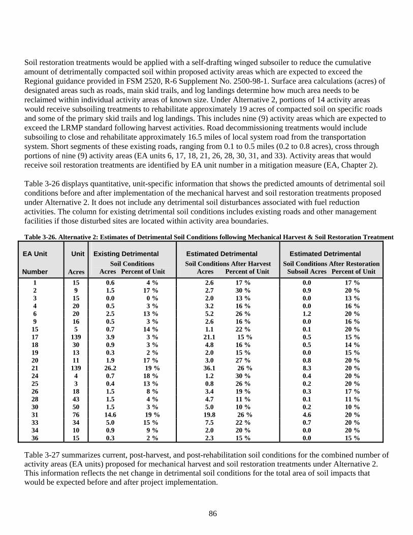
86
Soil restoration treatments would be applied with a self-drafting winged subsoiler to reduce the cumulative amount of detrimentally compacted soil within proposed activity areas which are expected to exceed the Regional guidance provided in FSM 2520, R-6 Supplement No. 2500-98-1. Surface area calculations (acres) of designated areas such as roads, main skid trails, and log landings determine how much area needs to be reclaimed within individual activity areas of known size. Under Alternative 2, portions of 14 activity areas would receive subsoiling treatments to rehabilitate approximately 19 acres of compacted soil on specific roads and some of the primary skid trails and log landings. This includes nine (9) activity areas which are expected to exceed the LRMP standard following harvest activities. Road decommissioning treatments would include subsoiling to close and rehabilitate approximately 16.5 miles of local system road from the transportation system. Short segments of these existing roads, ranging from 0.1 to 0.5 miles (0.2 to 0.8 acres), cross through portions of nine (9) activity areas (EA units 6, 17, 18, 21, 26, 28, 30, 31, and 33). Activity areas that would receive soil restoration treatments are identified by EA unit number in a mitigation measure (EA, Chapter 2). Table 3-26 displays quantitative, unit-specific information that shows the predicted amounts of detrimental soil conditions before and after implementation of the mechanical harvest and soil restoration treatments proposed under Alternative 2. It does not include any detrimental soil disturbances associated with fuel reduction activities. The column for existing detrimental soil conditions includes existing roads and other management facilities if those disturbed sites are located within activity area boundaries. Table 3-26. Alternative 2: Estimates of Detrimental Soil Conditions following Mechanical Harvest & Soil Restoration Treatment
EA Unit
Number
Unit
Acres
Existing Detrimental Soil Conditions
Acres Percent of Unit
Estimated Detrimental Soil Conditions After Harvest Acres Percent of Unit
Estimated Detrimental Soil Conditions After Restoration
Subsoil Acres Percent of Unit
1 15 0.6 4 % 2.6 17 % 0.0 17 % 2 9 1.5 17 % 2.7 30 % 0.9 20 % 3 15 0.0 0 % 2.0 13 % 0.0 13 % 4 20 0.5 3 % 3.2 16 % 0.0 16 % 6 20 2.5 13 % 5.2 26 % 1.2 20 % 9 16 0.5 3 % 2.6 16 % 0.0 16 %
15 5 0.7 14 % 1.1 22 % 0.1 20 % 17 139 3.9 3 % 21.1 15 % 0.5 15 % 18 30 0.9 3 % 4.8 16 % 0.5 14 % 19 13 0.3 2 % 2.0 15 % 0.0 15 % 20 11 1.9 17 % 3.0 27 % 0.8 20 % 21 139 26.2 19 % 36.1 26 % 8.3 20 % 24 4 0.7 18 % 1.2 30 % 0.4 20 % 25 3 0.4 13 % 0.8 26 % 0.2 20 % 26 18 1.5 8 % 3.4 19 % 0.3 17 % 28 43 1.5 4 % 4.7 11 % 0.1 11 % 30 50 1.5 3 % 5.0 10 % 0.2 10 % 31 76 14.6 19 % 19.8 26 % 4.6 20 % 33 34 5.0 15 % 7.5 22 % 0.7 20 % 34 10 0.9 9 % 2.0 20 % 0.0 20 % 36 15 0.3 2 % 2.3 15 % 0.0 15 %
Table 3-27 summarizes current, post-harvest, and post-rehabilitation soil conditions for the combined number of activity areas (EA units) proposed for mechanical harvest and soil restoration treatments under Alternative 2. This information reflects the net change in detrimental soil conditions for the total area of soil impacts that would be expected before and after project implementation.
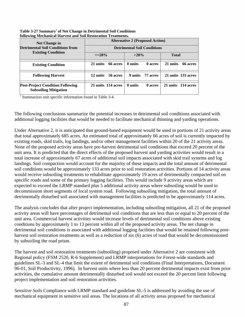
87
Table 3-27 Summary1 of Net Change in Detrimental Soil Conditions following Mechanical Harvest and Soil Restoration Treatments.
Alternative 2 (Proposed Action)
Detrimental Soil Conditions Net Change in
Detrimental Soil Conditions from Existing Condition
<=20% >20% Total
Existing Condition 21 units 66 acres 0 units 0 acres 21 units 66 acres
Following Harvest 12 units 56 acres 9 units 77 acres 21 units 133 acres
Post-Project Condition Following Subsoiling Mitigation
21 units 114 acres 0 units 0 acres 21 units 114 acres
1 Summarizes unit specific information found in Table 3-4.
The following conclusions summarize the potential increases in detrimental soil conditions associated with additional logging facilities that would be needed to facilitate mechanical thinning and yarding operations. Under Alternative 2, it is anticipated that ground-based equipment would be used in portions of 21 activity areas that total approximately 685 acres. An estimated total of approximately 66 acres of soil is currently impacted by existing roads, skid trails, log landings, and/or other management facilities within 20 of the 21 activity areas. None of the proposed activity areas have pre-harvest detrimental soil conditions that exceed 20 percent of the unit area. It is predicted that the direct effects of the proposed harvest and yarding activities would result in a total increase of approximately 67 acres of additional soil impacts associated with skid trail systems and log landings. Soil compaction would account for the majority of these impacts and the total amount of detrimental soil conditions would be approximately 133 acres prior to soil restoration activities. Portions of 14 activity areas would receive subsoiling treatments to rehabilitate approximately 19 acres of detrimentally compacted soil on specific roads and some of the primary logging facilities. This would include 9 activity areas which are expected to exceed the LRMP standard plus 5 additional activity areas where subsoiling would be used to decommission short segments of local system road. Following subsoiling mitigation, the total amount of detrimentally disturbed soil associated with management facilities is predicted to be approximately 114 acres. The analysis concludes that after project implementation, including subsoiling mitigation, all 21 of the proposed activity areas will have percentages of detrimental soil conditions that are less than or equal to 20 percent of the unit area. Commercial harvest activities would increase levels of detrimental soil conditions above existing conditions by approximately 1 to 13 percent within all of the proposed activity areas. The net change in detrimental soil conditions is associated with additional logging facilities that would be retained following post-harvest soil restoration treatments as well as a reduction of six (6) acres of road that would be decommissioned by subsoiling the road prism. The harvest and soil restoration treatments (subsoiling) proposed under Alternative 2 are consistent with Regional policy (FSM 2520, R-6 Supplement) and LRMP interpretations for Forest-wide standards and guidelines SL-3 and SL-4 that limit the extent of detrimental soil conditions (Final Interpretations, Document 96-01, Soil Productivity, 1996). In harvest units where less than 20 percent detrimental impacts exist from prior activities, the cumulative amount detrimentally disturbed soil would not exceed the 20 percent limit following project implementation and soil restoration activities. Sensitive Soils Compliance with LRMP standard and guideline SL-5 is addressed by avoiding the use of mechanical equipment in sensitive soil areas. The locations of all activity areas proposed for mechanical
88
vegetation treatments exclude areas identified as sensitive to management through the project design. None of the proposed activity areas contain sensitive soils on steep slopes (greater than 30 percent), sensitive soils with high or severe ratings for surface erosion, or potentially wet soils that would require site-specific mitigation measures. The locations of the proposed activity areas also exclude soils with variable depths on rocky lava flows and other low productivity sites where frost pockets and climatic factors limit regeneration potential. Measure #2: Coarse Woody Debris (CWM) and Surface Organic Matter The measure for CWM and surface organic matter were evaluated qualitatively based on the probable success of implementing appropriate Best Management Practices and recommended guidelines that address adequate retention of these important landscape components to meet soil productivity and wildlife habitat objectives (see Wildlife Section and Chapter 2 Mitigation). A minimum amount of 5 to 10 tons per acre of CWM on ponderosa pine sites and 10 to 15 tons per acre on mixed conifer or lodgepole pine sites is recommended to ensure desirable biological benefits for maintaining soil productivity without creating an unacceptable fire hazard (Brown et al., 2003, Graham et al. 1994). Based on guidelines for estimating tons per acre of CWM (Brown, 1974 and Maxwell, Ward, 1980), the levels of CWM retention to meet wildlife habitat objectives (Eastside Screen direction) would also meet these soil resource objectives. The proposed harvest activities would reduce potential sources of future CWM, especially where mechanized whole-tree yarding is used in activity areas. Harvest activities recruit CWM to the forest floor through breakage of limbs and tops during felling and skidding operations. Existing down woody debris would be protected from disturbance and retained on site to the extent possible. Understory trees, damaged during harvest operations, would also contribute woody materials that provide ground cover protection and a source of nutrients on treated sites. It is expected that enough broken branches, unusable small-diameter trees, and other woody materials would be available after mechanical thinning activities to meet recommended guidelines for CWM retention. Fuel reduction treatments would also reduce CWM and some of the forest litter by burning logging slash and natural fuel accumulations. Most of the logging slash generated from commercial harvest would be machine piled and burned on log landings and/or main skid trails. Post-harvest review by fuel specialists would determine the need for prescribed underburn treatments, especially where fine fuel accumlations increase the risk of wildfire to unacceptable levels. If prescribed fire is recommended, burning would occur during moist conditions to help ensure adequate retention of CWM and surface organic matter following treatment. Fuel reductions achieved through planned ignitions usually burn with low-to-moderate intensities that increase nutrient availability in burned areas. Low intensity fire does not easily consume material much larger than 3 inches in diameter, and charring does not substantially interfere with the decomposition or function of coarse woody debris (Graham et al., 1994). Although prescribed burn treatments are not intended to kill residual trees, tree mortality in varying amounts will likely occur during project implementation. Any dead trees killed from prescribed burn treatments will eventually fall to the ground and become additional sources of CWM. Depending on the rate of decay and local wind conditions, many of the small-diameter trees (less than 10 inches) would be expected to fall within the short-term (less than 5 years). A cool-temperature prescribed burn would remove some of the surface litter and duff materials without exposing extensive areas of bare mineral soil. Some of the direct and indirect beneficial effects to the soil resource include: 1) a reduction of fuel loadings and wildfire potential, 2) increased nutrient availability in localized areas, and 3) maintenance of organic matter that supports biotic habitat for mycorrhizal fungi and microorganism populations. Alternative 2 Project Design Criteria and Mitigation Project implementation includes the application of management requirements, project design elements, and mitigation measures to avoid, minimize, or rectify potentally adverse impacts to the soil resource (EA, Chapter 2). Operational guidelines for equipment use
89
provide options for limiting the amount of surface area covered by logging facilities and controlling equipment operations to minimize the potential for soil impacts in random locations of harvest units. Existing logging facilities would be reutilized to the extent possible. Grapple skidders would only be allowed to operate on designated skid trails spaced on average of 100 feet apart (11 percent of the unit area). Machine traffic off designated logging facilities would be limited in extent. Mechanical harvesters would only be allowed to make no more than two equipment passes on any site-specific area between main skid trails or away from log landings. The short-term effects of only two equipment passes are not expected to qualify as a detrimental soil condition. Natural processes, such as frost heaving and freeze-taw cycles, can generally offset soil compaction near the soil surface. Equipment operations would be avoided in portions of harvest units that contain steep slopes over 30 percent. Other requirements include avoiding equipment operations during periods of high soil moisture and operating equipment over frozen ground or a sufficient amount of compacted snow. The successful application of these management practices would help lower the estimated percentages of detrimental soil conditions displayed in Table 3-26. The project area is located on the eastern flanks of the Cascade Mountain Range where ample snowfall accumulations typically provide favorable winter logging conditions. The direct and indirect effects to soils is greatly reduced or eliminated by skidding over frozen ground or compacted snow. Best results are achieved by skidding over frozen ground (at least 6 inches in depth) or on a compacted snow base (at least 12 inches in depth) if the soil is not frozen. Skidding over shallower snow packs should only be considered during snow accumulation periods and not during melt periods. If the compacted snow base begins to melt due to warmer temperatures or rain-on-snow events, skidding operations would be discontinued until freezing temperatures and/or additional snowfall allows operations to continue. There is no potential for soil puddling damage because the dominant coarse-textured soils lack plasticity and cohesion. If project implementation includes the use of winter logging operations, it is anticipated that there would be very little or no visual evidence of soil compaction, rutting, displacement, or loss of protective plant and litter cover. All reasonable Best Management Practices (BMPs) would be applied to minimize the effects of road systems and timber management activities on the soil resource. A variety of BMPs are available to control erosion on roads and logging facilities. The BMPs are tiered to the Soil and Water Conservation Practices Handbook (FSH 2509.22), which contains conservation practices that have proven effective in protecting and maintaining soil and water resource values. The Oregon Department of Forestry evaluated more than 3,000 individual practices and determined a 98 percent compliance rate for BMP implementation, with 5 percent of these practices exceeding forest practice rules (National Council for Air and Stream Improvement, 1999). Soil restoration treatments (subsoiling) would be applied with a self-drafting winged subsoiler to rectify impacts by reclaiming and stabilizing detrimentally disturbed soils committed to roads, log landings, and main skid trails. The majority of existing and new soil impacts would be confined to known locations in these heavy use areas which facilitates where soil restoration treatments need to be implemented on compacted sites. The predicted amount of detrimental soil conditions was evaluated for each activity area proposed for commercial harvest. Individual activity areas that would receive subsoiling treatments are identified by unit number in a site-specific mitigation measure (EA, Chapter 2). The predicted amount of subsoiled acres within specific activity areas were used for deductions in estimated percentages of detrimental soil conditions in Table 3-26. Subsoiling treatments are expected to be highly effective in restoring detrimentally compacted soils. Dominant soils within the project area are well suited for tillage treatments due to naturally low bulk densities and the absence of rock fragments within soil profiles. Restoration treatments, such as subsoiling, are designed to promote maintenance or enhancement of soil quality, and they are consistent with Regional policy (FSM 2520, R-6 Supplement) and LRMP interpretations of standards and guidelines SL-3 and SL-4.
90
Soil moisture guidelines would be included in prescribed burn plans to minimize the potential for intense ground-level heating and adverse effects to soil properties. Guidelines for adequate retention of coarse woody debris and fine organic matter are included as management requirements to assure both short-term and long-term nutrient cycling on treated sites. Cumulative Effects of Alternative 2 Measure #1: Detrimental Soil Disturbance Implementation of Alternative 2 would cause some new soil disturbances where ground-based equipment is used for mechanical harvest and yarding activities during this entry. The primary sources of detrimental soil conditions from past management are associated with existing roads and ground-based logging facilities which were used for harvest activities between 1984 and 1991. Likewise, the majority of project-related soil impacts from this entry would also be confined to known locations in heavy use areas (such as roads, log landings, and main skid trails) that can be reclaimed through subsoiling treatments. Table 3-26 displays acres and percentages of detrimental soil conditions for existing conditions and the predicted effects from project implementation, including soil restoration treatments, for each of the activity areas proposed for commercial harvest under Alternative 2. The net change in detrimental soil conditions is associated with additional logging facilities that would be retained following post-harvest soil restoration treatments. Under Alternative 2, an estimated total of approximately 66 acres of soil is currently impacted by existing roads, skid trails, log landings, and/or other management facilities within 20 of the 21 activity areas proposed for commercial harvest. None of these proposed activity areas have pre-harvest detrimental soil conditions that exceed of 20 percent of the unit area. Based on disturbed area estimates after project implementation, including subsoiling mitigation, the total amount of detrimentally disturbed soil associated with management facilities is predicted to be approximately 114 acres. The analysis concludes that after project implementation, including subsoiling mitigation, all 21 of the proposed activity areas will have percentages of detrimental soil conditions that are less than or equal to 20 percent of the unit area. As previously described for direct and indirect effects, the combined effects of slash disposal and other fuel reduction treatments are not expected to cause cumulative increases in detrimental soil conditions beyond the predicted levels displayed in Table 3-26. There are no violations of Regional policy (FSM 2520, R-6 Supplement) or LRMP Standards and Guidelines SL-3 and SL-4 under Alternative 2 because the project will not cause an activity area to move from a detrimental soil condition less than 20 percent to one that is greater than 20 percent. Measure #2: Coarse Woody Debris (CWM) and Surface Organic Matter As previously described for the direct and indirect effects, it is expected that Alternative 2 would comply with the recommended management guidelines that ensure adequate retention of snags, coarse woody debris, and fine organic matter for surface cover, biological activity, and nutrient supplies for maintaining soil productivity on treated sites. Foreseeable Actions Common to All Alternatives Future management activities are assumed to occur as planned in the schedule of projects for the Deschutes National Forest. No outyear timber sales or other ground-disturbing management activities are currently scheduled in areas that would overlap with any of the activity areas proposed with the Sunriver project. The South Bend HFRA project area is located outside of the Sunriver project area boundaries. The Oz project proposes approximately 203 acres of mechanical harvest and prescribed burning treatments in six activity areas that occur within the project area. However, none of these treatment areas overlap with any of the activity areas proposed with this project. Consequently, there would be no cumulative increase in the extent of detrimental soil conditions beyond the predicted levels displayed for each of the proposed activity areas in Table 3-26. The successful implementation of these treatments would likely result in some beneficial effects to soils in different locations of the project area by reducing fuel loadings and increasing nutrient availability in burned areas.
91
The locations for the Kiwa Springs Mountain Bike trail and the right-of-way clearing for the Cottonwood Road Interchange along US Highway 97 are both outside of the Sunriver project area. Consequently, there would be no cumulative effects on any of the activity areas proposed with this project. The Noxious Weed Control EIS would likely implement various treatments to control invasive plants in site-specific areas within the project area. These future activities are not expected to cause any detrimental changes in soil properties. Small areas of soil displacement or the mixing of soil and organic matter would not meet criteria considered detrimental to soil productivity. It is also unlikely that herbicide treatments would cause any adverse direct or indirect effects to soil productivity (18 Fire Herbicide Treatment Environmental Assessment, Soils Report, 2005). The Forest Access Management Plan will likely include the development of new OHV trail systems and other recreation facilities, but the exact locations are unknown at this time. Therefore, none of these future actions are expected to result in a cumulative increase in the extent of detrimental soil conditions beyond the predicted levels displayed in Table 3-26. Other foreseeable future activities include continued recreation use, standard road maintenance, and prescribed maintenance burning to reduce fuel densities and the risk for future wildfires. The effects of recreation use would be similar to those described for Existing Condition of the Soil Resource. Future soil disturbances would be confined mainly to small concentration areas that would have a relatively minor effect on overall site productivity. Except for two short segments of system trail (0.1 miles) in EA Units 1 and 6, developed recreation facilities are excluded from the proposed activity areas. Impacts from dispersed recreation activities are usually found along existing roads and trails where vegetation has been cleared on or adjacent to old logging facilities. Future impacts from dispersed camping and incidental use by hikers and mountain bikers are expected to occur in similar locations. Soil disturbances from future recreation use are not expected to have a measurable effect on site productivity within the individual activity areas proposed for this project. There are no major soil-related concerns associated with the combined effects of these future activities. Road maintenance activities would reduce accelerated erosion rates where improvements are necessary to correct drainage problems on specific segments of existing road. Surface erosion can usually be controlled by implementing appropriate Best Management Practices (BMPs) that reduce the potential for indirect effects to soils in areas adjacent to roadways. There are no major soil-related concerns associated with the combined effects of these future activities. The effects of prescribed maintenance burning would be similar to those previously described for the direct and indirect effects associated with implementation of Alternative 2. These complimentary activities would be conducted under carefully controlled conditions that maximize benefits while reducing the risk for resource damage. Prescribed burn plans would comply with all applicable LRMP standards and guidelines and BMPs prior to initiation of burn treatments. Soil moisture guidelines would be included in burn plans to minimize the risk of intense heating of the soil surface. The successful implementation of these proposed activities would likely result in beneficial effects by reducing fuel loadings and wildfire potential as well as increasing nutrient availability in burned areas. There are no measurable cumulative effects expected on the amount or presence of CWM and surface organic matter associated with any reasonable and foreseeable actions. These future activities would occur on gentle to moderately sloping terrain where ground disturbances typically do not remove soil surface layers in large enough areas to qualify as a detrimental soil condition. Under Alternative 2, the cumulative effects from the proposed actions combined with all past, present, and reasonably foreseeable management activities comply with Regional policy (FSM 2520, R-6 Supplement) and LRMP direction for planning and implementing management practices in previously managed areas.
92
LRMP/Other Management Direction Consistency LRMP Management Areas MA-8, MA-9, MA-17 and the NNVM Management Plan do not contain specific standards and guidelines for the soil resource in this area. The Forest-wide standards and guidelines apply to this project proposal. Under Alternative 2, equipment operations would cause some new soil disturbances in portions of previously managed areas where ground-based logging is proposed for this entry. The project design elements, management requirements, and Best Management Practices (BMPs) built into this alternative are all designed to avoid or minimize potentially adverse impacts to the soil resource. The amount of disturbed soil associated with temporary roads and logging facilities would be limited to the minimum necessary to achieve management objectives. Compliance with LRMP standard and guideline SL-5 is addressed by avoiding the use of mechanical equipment in areas with sensitive soils. None of the proposed activity areas contain sensitive soils on steep slopes (greater than 30 percent), sensitive soils with high or severe ratings for surface erosion, or potentially wet soils that would require site-specific mitigation measures. All reasonable Best Management Practices for Timber Management and Road Systems would be applied to protect the soil surface and control erosion on and adjacent to roads and logging facilities that would be used during project implementation. These conservation practices are to be implemented during and following project activities to meet the stated objectives for protecting and maintaining soil productivity. Soil restoration treatments would be applied to rectify impacts by reducing the amount of detrimentally compacted soil dedicated to existing roads, temporary roads, and some of the primary logging facilities within specific activity areas. Restoration treatments, such as subsoiling, are designed to promote maintenance or enhancement of soil quality. These conservation practices comply with LRMP interpretations of Forest-wide standards and guidelines SL-3 and SL-4. Subsoiling mitigation is also supported by the Forest Service Manual and Regional direction for planning and implementing management activities (FSM 2520, R-6 Supplement). The analysis concludes that after project implementation, including subsoiling mitigation, all 21 of the activity areas proposed for mechanical harvest will have percentages of detrimental soil conditions that are less than or equal to 20 percent of the unit area. In harvest units where less than 20 percent detrimental impacts exist from prior activities, the cumulative amount detrimentally disturbed soil would not exceed the 20 percent limit following project implementation and soil restoration activities. The proposed actions are also expected to comply with recommended guidelines for snags and coarse woody debris retention following both harvest and fuel reduction treatments. Therefore, the combined effects of all past, present, and reasonably foreseeable management activities would be within allowable limits set by Regional direction and LRMP standards and guidelines for protecting and maintaining soil productivity within each of the proposed activity areas. Irreversible and Irretrievable Commitments The proposed actions are not expected to create any impacts that would cause irreversible damage to soil productivity. There is low risk for mechanical disturbances to cause soil mass failures (landslides) due to the inherent stability of dominant landtypes and the lack of seasonally wet soils on steep slopes. Careful planning and the application of Best Management Practices and project design elements would be used to prevent irreversible losses of the soil resource. The development and use of temporary roads and logging facilities is considered an irretrievable loss of soil productivity until their functions have been served and disturbed sites are returned back to a productive capacity. Soil restoration activities (subsoiling) would be applied to improve the hydrologic function and productivity on detrimentally compacted soils. There would be no irretrievable losses of soil productivity associated with reclamation treatments that decommission unneeded roads and logging facilities.
93
Short-Term Uses of the Human Environment and the Maintenance of Long-Term Productivity Project design, LRMP management requirements and mitigation measures built into Alternative 2 ensure that long-term soil productiviy will not be impaired by the application of short-term management practices. Soil restoration treatments (subsoiling) would be applied to rectify impacts and improve soil productivity in specific areas where disturbed soils are committed to roads and logging facilities. Wildlife Habitat Management Introduction In this resource section; LRMP/Other Management Direction Consistency findings were made, where appropriate, under each of the direct, indirect and cumulative effects discussion. Also included under the effects analysis is additional management direction, affected environment information and measures appropriate to understanding the analysis. Scope of the Analysis Analysis Methodology (for those species receiving further consideration Table 3-29) Species populations and distributions were not discussed in depth. Rather, effects on habitats and habitat components were discussed with the assumption that if appropriate habitat is available for a species, then that species occupies or could occupy the habitat. Examples of specific habitat components analyzed include: snag/coarse woody material (CWM), habitat/green tree replacements (GTR’s), late/old structural habitat (LOS). Population trends were determined by assessing how the alternatives impact the structure and function of the vegetation (i.e. habitat) relative to the current and historic habitat availability in conjunction with state conservation status information for the species in the Natureserve (2006) an online encyclopedia of life, http://www.natureserve.org/explorer. Rankings are given for global, national, and state levels. Only the state rankings will be used in this analysis. Inferences regarding species diversity and relative population levels were made based upon habitat quality, condition, and quantity. Where needed and applicable, professional judgment, supported by the available information and field visits, were used to assess habitat conditions and quality. The project’s Silvicultural Report (2006 Barbara Schroeder, Silviculturist) details the historical patterns and structure within the project area. Field reconnaissance information, current analysis tools, recent literature, and Geographical Information System databases provided additional information. Some wildlife habitats required a more detailed analysis and discussion. Level of analysis depended on the existing habitat conditions (i.e. limited habitat availability versus widespread habitat availability), the magnitude and intensity of the effects of the proposed actions (i.e. would the proposed actions cause a loss, no change, or increase in habitat), the risk to the resources (sustainability and availability of the habitat), and the significant issues identified. These factors were used to form conclusions as to how the information in regards to the effects would be useful and relevant in the process of making an informed decision. Table 3-28 lists the past, present, and reasonably foreseeable actions used for the analysis of cumulative effects. The effects of past projects prior to those listed have been included in the existing condition discussion under each subject heading and do not appear as separate projects. These past actions are either no longer having effects that would overlap the effects of the proposed action in time and space, or if their effects are ongoing, these effects have been incorporated into the existing habitat conditions and it is not useful nor relevant to the decision making process to analyze them separately. Any other past projects that overlap in time and space with the proposed actions do contribute effects that are additive to the proposed actions and may be useful and relevant to the decision-making process are listed. Since the effects deal with forest development which inherently involve multiple decades, short-term effects (<20-30 years) and long term (>30 years) are addressed. Similarly, the timeframes used to address cumulative effects may vary by species but generally include a time span of 20 years, which would roughly equate to more
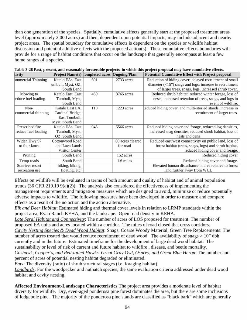
94
than one generation of the species. Spatially, cumulative effects generally start at the proposed treatment areas level (approximately 2,000 acres) and then, dependent upon potential impacts, may include adjacent and nearby project areas. The spatial boundary for cumulative effects is dependent on the species or wildlife habitat discussion and potential additive effects with the proposed action(s). These cumulative effects boundaries will provide for a range of habitat conditions that occur on the landscape that generally encompass at least a few home ranges of a species. Table 3-28 Past, present, and reasonably foreseeable projects in which this project proposal may have cumulative effects. tivity Project Name(s) Completed acres Ongoing/Plan Potential Cumulative Effect with Project proposal ommercial Thinning Katalo EAs, East
Tumbull, Myst, OZ, South Bend
601 2733 acres Reduction of hiding cover; delayed recruitment of small diameter (<15”) snags and logs; increase in recruitment
of larger trees, snags, logs, increased shrub cover. Mowing to
reduce fuel loading Katalo East, East
Tumbull, Myst, South Bend
460 3765 acres Reduced shrub habitat; reduced winter forage, loss of nests, increased retention of trees, snags, and logs in
event of wildfire. Non-
commercial thinning Katalo East EA, Cardinal Bridge,
East Tumbull, Myst, South Bend
110 1223 acres Reduced hiding cover, and multi-storied stands, increase in recruitment of larger trees.
Prescribed fire reduce fuel loading
Katalo EAs, East Tumbull, Myst,
OZ, South Bend
945 5566 acres Reduced hiding cover and forage, reduced log densities, increased snag densities, reduced shrub habitat, loss of
nests and dens Widen Hwy 97
to four lanes Cottonwood Road
and Lava Lands Visitor Center
60 acres cleared for road
Reduced east/west connectivity on public land, loss of forest habitat (trees, snags, logs) and shrub habitat,
reduced hiding cover and forage. Pruning South Bend 152 acres Reduced hiding cover
Temp roads South Bend 1.6 miles Reduced hiding cover and forage. Sunriver resort recreation use
hiking, biking, floating, etc;
Elevated human disturbance in area relative to forest land further away from WUI.
Effects on wildlife will be evaluated in terms of both amount and quality of habitat and of animal population trends (36 CFR 219.19 9(a)(2)). The analysis also considered the effectiveness of implementing the management requirements and mitigation measures which are designed to avoid, minimize or reduce potentially adverse impacts to wildlife. The following measures have been developed in order to measure and compare effects as a result of the no action and the action alternative. Elk and Deer Habitat: Estimated hiding and thermal cover levels in relation to LRMP standards within the project area, Ryan Ranch KEHA, and the landscape. Open road density in KEHA. Late Seral Habitat and Connectivity: The number of acres of LOS proposed for treatment. The number of proposed EA units and acres located within a corridor. The miles of road closed that cross corridors. Cavity Nesting Species & Dead Wood Habitat: Snags, Coarse Woody Material, Green Tree Replacements: The number of acres treated that would reduce recruitment of dead wood. The availability of snags > 10” dbh currently and in the future. Estimated timeframe for the development of large dead wood habitat. The sustainability or level of risk of current and future habitat to wildfire , disease, and beetle mortality. Goshawk, Cooper’s, and Red-tailed Hawks, Great Gray Owl, Osprey, and Great Blue Heron: The number and percent of acres of potential nesting habitat degraded or eliminated. Bats: The diversity (ratio) of shrub structural stages (i.e. foraging habitat). Landbirds: For the woodpecker and nuthatch species, the same evaluation criteria addressed under dead wood habitat and cavity nesting. Affected Environment-Landscape Characteristics The project area provides a moderate level of habitat diversity for wildlife. Dry, even-aged ponderosa pine forest dominates the area, but there are some inclusions of lodgepole pine. The majority of the ponderosa pine stands are classified as “black bark” which are generally
95
less than 80 years old with one canopy layer. The relatively low elevation and limited precipitation of the area likely limit the site capability to develop multi-stratum late and old structure (LOS) forest. The potential for single-story LOS is good. The Deschutes River is the western boundary of the project, which provides the richest diversity of habitat in the area. The Ryan Ranch KEHA, which is a LRMP designation, occupies 86 percent (4,604 ac.) of the project area. None of the project area is designated by the LRMP as deer habitat (winter range),although in low snow years the project area functions as winter range. Wildlife Habitat Management Direction The LRMP, as amended, specifies standards and guides to maintain, protect and enhance wildlife habitat. This is accomplished by following applicable Forest-wide (LRMP WL-1 to WL-75), Upper Deschutes River Plan, NNVM plan, Eastside Screens, and individual management area Standards and Guidelines. In the Sunriver HFRA project area, those Standards and Guidelines pertaining to management of black bark stands and roads in the Ryan Ranch KEHA are pertinent. Wildlife direction from the Upper Deschutes River Plan is discussed under the Wild and Scenic River Values section. It is Forest Service policy to avoid all adverse impacts on threatened and endangered species and their habitats except when it is possible to compensate adverse effects totally through alternatives identified in a biological opinion rendered by the Fish and Wildlife Service. Measures are to be identified and prescribed to prevent adverse modification or destruction of critical habitat and other habitats essential for the conservation of endangered, threatened, and proposed species (Forest Service Manual, FSM 2670.31). Projects proposed in occupied or potential habitat of any federal candidate, threatened, or endangered species on the Forest must be consistent with the Project Design Criteria (PDC) for the Joint Aquatic and Terrestrial Programmatic Biological Assessment (BA) for Fiscal Years 2006-09 (USDA et al. 2006), hereafter referred to as the Programmatic BA, in order to require no further consultation. A Biological Assessment (BA) will not be prepared because 1) it is not a major federal construction project that requires an environmental impact statement; 2) the effects on federal threatened, endangered and proposed species are not significant (i.e. adverse, jeopardy); and 3) it meets the PDCs for the Programmatic BA. The EA considered and applied the best science available; including papers, reports, literature reviews, review citations, peer reviews, science consistency reviews, and results of ground-based observations. The best available science was used to determine species or habitat presence and effects. A list of the science used can be found within the species discussions and in the Literature Cited section of this document as well as an accounting of any other scientific literature brought to attention during the public scoping process. Generally three documents provide guidance or species lists for consideration in the management of federal lands. Management actions should minimize negative impacts, promote habitat development or provide habitat protection to some degree for those species that occur within the habitats of federally managed land. The three documents and associated species lists include the Deschutes National Forest – Management Indicator Species (MIS), the US Fish and Wildlife Service Birds of Conservation Concern, and a Conservation Strategy for Landbirds of the East-Slope of the Cascade Mountains in Oregon and Washington. Species listed in these documents overlap with each other as well as the federal threatened, endangered and sensitive species lists. Neotropical migratory birds have become species of interest recently, due to the downward trend of landbirds in the western United States. The decline of these populations are a result of many complex issues, but factors believed to be responsible include; loss, fragmentation, and alteration of historic vegetation communities. Other probable causes to the decline include predation from feral species, nest parasitism, and use of pesticides associated with agriculture areas. There is currently an Executive Order (13186) that provides for enhanced cooperation between the Forest Service and USFWS in regards to addressing impacts to neotropical migratory
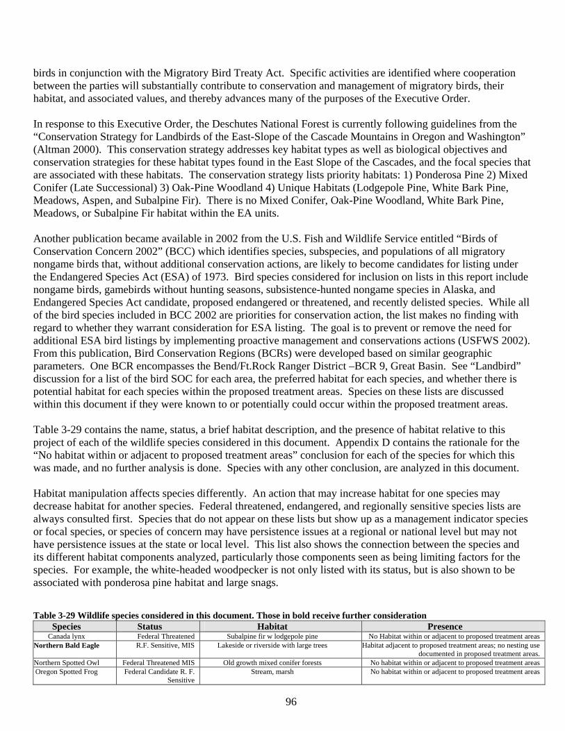
96
birds in conjunction with the Migratory Bird Treaty Act. Specific activities are identified where cooperation between the parties will substantially contribute to conservation and management of migratory birds, their habitat, and associated values, and thereby advances many of the purposes of the Executive Order. In response to this Executive Order, the Deschutes National Forest is currently following guidelines from the “Conservation Strategy for Landbirds of the East-Slope of the Cascade Mountains in Oregon and Washington” (Altman 2000). This conservation strategy addresses key habitat types as well as biological objectives and conservation strategies for these habitat types found in the East Slope of the Cascades, and the focal species that are associated with these habitats. The conservation strategy lists priority habitats: 1) Ponderosa Pine 2) Mixed Conifer (Late Successional) 3) Oak-Pine Woodland 4) Unique Habitats (Lodgepole Pine, White Bark Pine, Meadows, Aspen, and Subalpine Fir). There is no Mixed Conifer, Oak-Pine Woodland, White Bark Pine, Meadows, or Subalpine Fir habitat within the EA units. Another publication became available in 2002 from the U.S. Fish and Wildlife Service entitled “Birds of Conservation Concern 2002” (BCC) which identifies species, subspecies, and populations of all migratory nongame birds that, without additional conservation actions, are likely to become candidates for listing under the Endangered Species Act (ESA) of 1973. Bird species considered for inclusion on lists in this report include nongame birds, gamebirds without hunting seasons, subsistence-hunted nongame species in Alaska, and Endangered Species Act candidate, proposed endangered or threatened, and recently delisted species. While all of the bird species included in BCC 2002 are priorities for conservation action, the list makes no finding with regard to whether they warrant consideration for ESA listing. The goal is to prevent or remove the need for additional ESA bird listings by implementing proactive management and conservations actions (USFWS 2002). From this publication, Bird Conservation Regions (BCRs) were developed based on similar geographic parameters. One BCR encompasses the Bend/Ft.Rock Ranger District –BCR 9, Great Basin. See “Landbird” discussion for a list of the bird SOC for each area, the preferred habitat for each species, and whether there is potential habitat for each species within the proposed treatment areas. Species on these lists are discussed within this document if they were known to or potentially could occur within the proposed treatment areas. Table 3-29 contains the name, status, a brief habitat description, and the presence of habitat relative to this project of each of the wildlife species considered in this document. Appendix D contains the rationale for the “No habitat within or adjacent to proposed treatment areas” conclusion for each of the species for which this was made, and no further analysis is done. Species with any other conclusion, are analyzed in this document. Habitat manipulation affects species differently. An action that may increase habitat for one species may decrease habitat for another species. Federal threatened, endangered, and regionally sensitive species lists are always consulted first. Species that do not appear on these lists but show up as a management indicator species or focal species, or species of concern may have persistence issues at a regional or national level but may not have persistence issues at the state or local level. This list also shows the connection between the species and its different habitat components analyzed, particularly those components seen as being limiting factors for the species. For example, the white-headed woodpecker is not only listed with its status, but is also shown to be associated with ponderosa pine habitat and large snags. Table 3-29 Wildlife species considered in this document. Those in bold receive further consideration
Species Status Habitat Presence Canada lynx Federal Threatened Subalpine fir w lodgepole pine No Habitat within or adjacent to proposed treatment areas
Northern Bald Eagle R.F. Sensitive, MIS Lakeside or riverside with large trees Habitat adjacent to proposed treatment areas; no nesting use documented in proposed treatment areas.
Northern Spotted Owl Federal Threatened MIS Old growth mixed conifer forests No habitat within or adjacent to proposed treatment areas Oregon Spotted Frog Federal Candidate R. F.
Sensitive Stream, marsh No habitat within or adjacent to proposed treatment areas
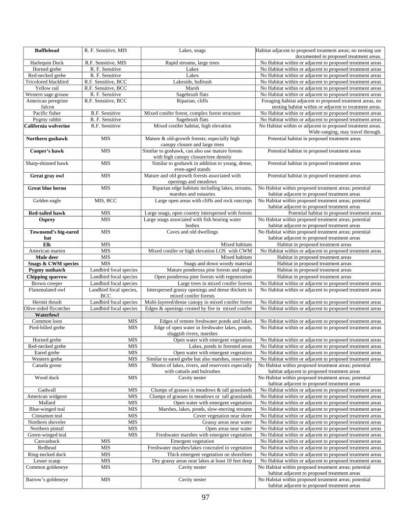
97
Bufflehead R. F. Sensitive, MIS Lakes, snags Habitat adjacent to proposed treatment areas; no nesting use documented in proposed treatment areas.
Harlequin Duck R.F. Sensitive, MIS Rapid streams, large trees No Habitat within or adjacent to proposed treatment areas Horned grebe R. F. Sensitive Lakes No Habitat within or adjacent to proposed treatment areas
Red-necked grebe R. F. Sensitive Lakes No Habitat within or adjacent to proposed treatment areas Tricolored blackbird R.F. Sensitive, BCC Lakeside, bullrush No Habitat within or adjacent to proposed treatment areas
Yellow rail R.F. Sensitive, BCC Marsh No Habitat within or adjacent to proposed treatment areas Western sage grouse R. F. Sensitive Sagebrush flats No Habitat within or adjacent to proposed treatment areas American peregrine
falcon R.F. Sensitive, BCC Riparian, cliffs Foraging habitat adjacent to proposed treatment areas, no
nesting habitat within or adjacent to treatment areas. Pacific fisher R.F. Sensitive Mixed conifer forest, complex forest structure No Habitat within or adjacent to proposed treatment areas Pygmy rabbit R. F. Sensitive Sagebrush flats No Habitat within or adjacent to proposed treatment areas
California wolverine R.F. Sensitive Mixed conifer habitat, high elevation No Habitat within or adjacent to proposed treatment areas. Wide-ranging, may travel through.
Northern goshawk MIS Mature & old-growth forests; especially high canopy closure and large trees
Potential habitat in proposed treatment areas
Cooper’s hawk MIS Similar to goshawk, can also use mature forests with high canopy closure/tree density
Potential habitat in proposed treatment areas
Sharp-shinned hawk MIS Similar to goshawk in addition to young, dense, even-aged stands
Potential habitat in proposed treatment areas
Great gray owl MIS Mature and old growth forests associated with openings and meadows
Potential habitat in proposed treatment areas
Great blue heron MIS Riparian edge habitats including lakes, streams, marshes and estuaries
No Habitat within proposed treatment areas; potential habitat adjacent to proposed treatment areas
Golden eagle MIS, BCC Large open areas with cliffs and rock outcrops No Habitat within proposed treatment areas; potential habitat adjacent to proposed treatment areas
Red-tailed hawk MIS Large snags, open country interspersed with forests Potential habitat in proposed treatment areas Osprey MIS Large snags associated with fish bearing water
bodies No Habitat within proposed treatment areas; potential
habitat adjacent to proposed treatment areas Townsend’s big-eared
bat MIS Caves and old dwellings No Habitat within proposed treatment areas; potential
habitat adjacent to proposed treatment areas Elk MIS Mixed habitats Habitat in proposed treatment areas
American marten MIS Mixed conifer or high elevation LOS with CWM No Habitat within or adjacent to proposed treatment areas Mule deer MIS Mixed habitats Habitat in proposed treatment areas
Snags & CWM species MIS Snags and down woody material Habitat in proposed treatment areas Pygmy nuthatch Landbird focal species Mature ponderosa pine forests and snags Habitat in proposed treatment areas
Chipping sparrow Landbird focal species Open ponderosa pine forests with regeneration Habitat in proposed treatment areas Brown creeper Landbird focal species Large trees in mixed conifer forests No Habitat within or adjacent to proposed treatment areas
Flammulated owl Landbird focal species, BCC
Interspersed grassy openings and dense thickets in mixed conifer forests
No Habitat within or adjacent to proposed treatment areas
Hermit thrush Landbird focal species Multi-layered/dense canopy in mixed conifer forest No Habitat within or adjacent to proposed treatment areas Olive-sided flycatcher Landbird focal species Edges & openings created by fire in mixed conifer No Habitat within or adjacent to proposed treatment areas
Waterfowl Common loon MIS Edges of remote freshwater ponds and lakes No Habitat within or adjacent to proposed treatment areas
Pied-billed grebe MIS Edge of open water in freshwater lakes, ponds, sluggish rivers, marshes
No Habitat within or adjacent to proposed treatment areas
Horned grebe MIS Open water with emergent vegetation No Habitat within or adjacent to proposed treatment areas Red-necked grebe MIS Lakes, ponds in forested areas No Habitat within or adjacent to proposed treatment areas
Eared grebe MIS Open water with emergent vegetation No Habitat within or adjacent to proposed treatment areas Western grebe MIS Similar to eared grebe but also marshes, reservoirs No Habitat within or adjacent to proposed treatment areas Canada goose MIS Shores of lakes, rivers, and reservoirs especially
with cattails and bulrushes No Habitat within proposed treatment areas; potential
habitat adjacent to proposed treatment areas Wood duck MIS Cavity nester No Habitat within proposed treatment areas; potential
habitat adjacent to proposed treatment areas Gadwall MIS Clumps of grasses in meadows & tall grasslands No Habitat within or adjacent to proposed treatment areas
American widgeon MIS Clumps of grasses in meadows or tall grasslands No Habitat within or adjacent to proposed treatment areas Mallard MIS Open water with emergent vegetation No Habitat within or adjacent to proposed treatment areas
Blue-winged teal MIS Marshes, lakes, ponds, slow-moving streams No Habitat within or adjacent to proposed treatment areas Cinnamon teal MIS Cover vegetation near shore No Habitat within or adjacent to proposed treatment areas
Northern shoveler MIS Grassy areas near water No Habitat within or adjacent to proposed treatment areas Northern pintail MIS Open areas near water No Habitat within or adjacent to proposed treatment areas
Green-winged teal MIS Freshwater marshes with emergent vegetation No Habitat within or adjacent to proposed treatment areas Canvasback MIS Emergent vegetation No Habitat within or adjacent to proposed treatment areas
Redhead MIS Freshwater marshes/lakes concealed in vegetation No Habitat within or adjacent to proposed treatment areas Ring-necked duck MIS Thick emergent vegetation on shorelines No Habitat within or adjacent to proposed treatment areas
Lesser scaup MIS Dry grassy areas near lakes at least 10 feet deep No Habitat within or adjacent to proposed treatment areas Common goldeneye MIS Cavity nester No Habitat within proposed treatment areas; potential
habitat adjacent to proposed treatment areas Barrow’s goldeneye MIS Cavity nester No Habitat within proposed treatment areas; potential
habitat adjacent to proposed treatment areas
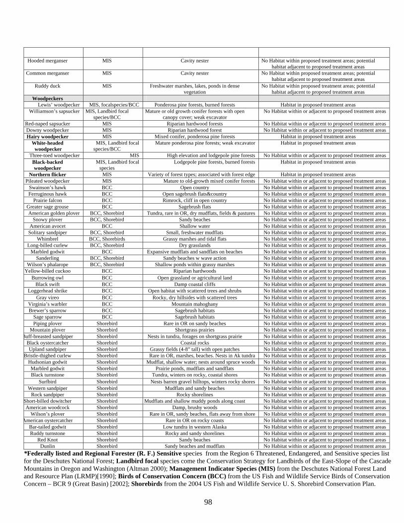
98
Hooded merganser MIS Cavity nester No Habitat within proposed treatment areas; potential habitat adjacent to proposed treatment areas
Common merganser MIS Cavity nester No Habitat within proposed treatment areas; potential habitat adjacent to proposed treatment areas
Ruddy duck MIS Freshwater marshes, lakes, ponds in dense vegetation
No Habitat within proposed treatment areas; potential habitat adjacent to proposed treatment areas
Woodpeckers Lewis’ woodpecker MIS, focalspecies/BCC Ponderosa pine forests, burned forests Habitat in proposed treatment areas
Williamson’s sapsucker MIS, Landbird focal species/BCC
Mature or old growth conifer forests with open canopy cover; weak excavator
No Habitat within or adjacent to proposed treatment areas
Red-naped sapsucker MIS Riparian hardwood forests No Habitat within or adjacent to proposed treatment areas Downy woodpecker MIS Riparian hardwood forest No Habitat within or adjacent to proposed treatment areas Hairy woodpecker MIS Mixed conifer, ponderosa pine forests Habitat in proposed treatment areas
White-headed woodpecker
MIS, Landbird focal species/BCC
Mature ponderosa pine forests; weak excavator Habitat in proposed treatment areas
Three-toed woodpecker MIS High elevation and lodgepole pine forests No Habitat within or adjacent to proposed treatment areas Black-backed woodpecker
MIS, Landbird focal species
Lodgepole pine forests, burned forests Habitat in proposed treatment areas
Northern flicker MIS Variety of forest types; associated with forest edge Habitat in proposed treatment areas Pileated woodpecker MIS Mature to old-growth mixed conifer forests No Habitat within or adjacent to proposed treatment areas
Swainson’s hawk BCC Open country No Habitat within or adjacent to proposed treatment areas Ferruginous hawk BCC Open sagebrush flats&country No Habitat within or adjacent to proposed treatment areas
Prairie falcon BCC Rimrock, cliff in open country No Habitat within or adjacent to proposed treatment areas Greater sage grouse BCC Sagebrush flats No Habitat within or adjacent to proposed treatment areas American golden plover BCC, Shorebird Tundra, rare in OR, dry mudflats, fields & pastures No Habitat within or adjacent to proposed treatment areas
Snowy plover BCC, Shorebird Sandy beaches No Habitat within or adjacent to proposed treatment areas American avocet BCC Shallow water No Habitat within or adjacent to proposed treatment areas
Solitary sandpiper BCC, Shorebird Small, freshwater mudflats No Habitat within or adjacent to proposed treatment areas Whimbrel BCC, Shorebirds Grassy marshes and tidal flats No Habitat within or adjacent to proposed treatment areas
Long-billed curlew BCC, Shorebird Dry grasslands No Habitat within or adjacent to proposed treatment areas Marbled godwit BCC Expansive mudflats and sandflats on beaches No Habitat within or adjacent to proposed treatment areas
Sanderling BCC, Shorebird Sandy beaches w wave action No Habitat within or adjacent to proposed treatment areas Wilson’s phalarope BCC, Shorebird Shallow ponds within grassy marshes No Habitat within or adjacent to proposed treatment areas
Yellow-billed cuckoo BCC Riparian hardwoods No Habitat within or adjacent to proposed treatment areas Burrowing owl BCC Open grassland or agricultural land No Habitat within or adjacent to proposed treatment areas
Black swift BCC Damp coastal cliffs No Habitat within or adjacent to proposed treatment areas Loggerhead shrike BCC Open habitat with scattered trees and shrubs No Habitat within or adjacent to proposed treatment areas
Gray vireo BCC Rocky, dry hillsides with scattered trees No Habitat within or adjacent to proposed treatment areas Virginia’s warbler BCC Mountain mahoghany No Habitat within or adjacent to proposed treatment areas Brewer’s sparrow BCC Sagebrush habitats No Habitat within or adjacent to proposed treatment areas
Sage sparrow BCC Sagebrush habitats No Habitat within or adjacent to proposed treatment areas Piping plover Shorebird Rare in OR on sandy beaches No Habitat within or adjacent to proposed treatment areas
Mountain plover Shorebird Shortgrass prairies No Habitat within or adjacent to proposed treatment areas Buff-breasted sandpiper Shorebird Nests in tundra, forages on shortgrass prairie No Habitat within or adjacent to proposed treatment areas
Black oystercatcher Shorebird Coastal rocks No Habitat within or adjacent to proposed treatment areas Upland sandpiper Shorebird Grassy fields (4-8” tall) with open patches No Habitat within or adjacent to proposed treatment areas
Bristle-thighed curlew Shorebird Rare in OR, marshes, beaches. Nests in Ak tundra No Habitat within or adjacent to proposed treatment areas Hudsonian godwit Shorebird Mudflat, shallow water; nests around spruce woods No Habitat within or adjacent to proposed treatment areas Marbled godwit Shorebird Prairie ponds, mudflats and sandflats No Habitat within or adjacent to proposed treatment areas Black turnstone Shorebird Tundra, winters on rocky, coastal shores No Habitat within or adjacent to proposed treatment areas
Surfbird Shorebird Nests barren gravel hilltops, winters rocky shores No Habitat within or adjacent to proposed treatment areas Western sandpiper Shorebird Mudflats and sandy beaches No Habitat within or adjacent to proposed treatment areas
Rock sandpiper Shorebird Rocky shorelines No Habitat within or adjacent to proposed treatment areas Short-billed dowitcher Shorebird Mudflats and shallow muddy ponds along coast No Habitat within or adjacent to proposed treatment areas American woodcock Shorebird Damp, brushy woods No Habitat within or adjacent to proposed treatment areas
Wilson’s plover Shorebird Rare in OR, sandy beaches, flats away from shore No Habitat within or adjacent to proposed treatment areas American oystercatcher Shorebird Rare in OR on rocky coasts No Habitat within or adjacent to proposed treatment areas
Bar-tailed godwit Shorebird Low tundra in western Alaska No Habitat within or adjacent to proposed treatment areas Ruddy turnstone Shorebird Rocky and sandy shorelines No Habitat within or adjacent to proposed treatment areas
Red Knot Shorebird Sandy beaches No Habitat within or adjacent to proposed treatment areas Dunlin Shorebird Sandy beaches and mudflats No Habitat within or adjacent to proposed treatment areas
*Federally listed and Regional Forester (R. F.) Sensitive species from the Region 6 Threatened, Endangered, and Sensitive species list for the Deschutes National Forest; Landbird focal species come the Conservation Strategy for Landbirds of the East-Slope of the Cascade Mountains in Oregon and Washington (Altman 2000); Management Indicator Species (MIS) from the Deschutes National Forest Land and Resource Plan (LRMP)[1990]; Birds of Conservation Concern (BCC) from the US Fish and Wildlife Service Birds of Conservation Concern – BCR 9 (Great Basin) [2002]; Shorebirds from the 2004 US Fish and Wildlife Service U. S. Shorebird Conservation Plan.
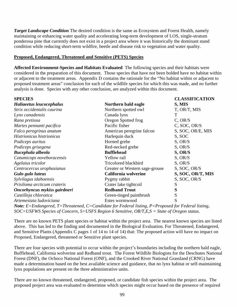
99
Target Landscape Condition The desired condition is the same as Ecosystem and Forest Health, namely maintaining or enhancing water quality and accelerating long-term development of LOS, single-stratum ponderosa pine that currently does not exist in a project area where it was historically the dominant stand condition while reducing short-term wildfire, beetle and disease risk to vegetation and water quality. Proposed, Endangered, Threatened and Sensitive (PETS) Species Affected Environment-Species and Habitats Evaluated The following species and their habitats were considered in the preparation of this document. Those species that have not been bolded have no habitat within or adjacent to the treatment areas. Appendix D contains the rationale for the “No habitat within or adjacent to proposed treatment areas” conclusion for each of the wildlife species for which this was made, and no further analysis is done. Species with any other conclusion, are analyzed within this document. SPECIES CLASSIFICATION Haliaeetus leucocephalus Northern bald eagle S, MIS Strix occidentalis caurina Northern spotted owl T, OR/T, MIS Lynx canadensis Canada lynx T Rana pretiosa Oregon Spotted frog C, OR/S Martes pennanti pacifica Pacific fisher C, SOC, OR/S Falco peregrinus anatum American peregrine falcon S, SOC, OR/E, MIS Histrionicus histrionicus Harlequin duck S, SOC Podiceps auritus Horned grebe S, OR/S Podiceps grisegena Red-necked grebe S, OR/S Bucephala albeola Bufflehead S, OR/S Cotumicops noveboracensis Yellow rail S, OR/S Agelaius tricolor Tricolored blackbird S, OR/S Centrocercus urophasianus Greater or Western sage-grouse S, SOC, OR/S Gulo gulo luteus California wolverine S, SOC, OR/T, MIS Sylvilagus idahoensis Pygmy rabbit S, SOC, OR/S Prisiloma arcticum crateris Crater lake tightcoil S Oncorhyncus mykiss gairdneri Redband Trout S Castilleja chlorotica Green-tinged paintbrush S Artemesiaia ludoviciana Estes wormwood S Note: E=Endangered, T=Threatened, C=Candidate for Federal listing, P=Proposed for Federal listing, SOC=USFWS Species of Concern, S=USFS Region 6 Sensitive, OR/T,E,S = State of Oregon status. There are no known PETS plant species or habitat within the project area. The nearest known species are listed above. This has led to the finding and documented in the Biological Evaluation. For Threatened, Endangered, and Sensitive Plants (Appendix C pages 1 of 14 to 14 of 14) that: The proposed action will have no impact on Proposed, Endangered, threatened or Sensitive plant species. There are four species with potential to occur within the project’s boundaries including the northern bald eagle, Bufflehead, California wolverine and Redband trout. The Forest Wildlife Biologists for the Deschutes National Forest (DNF), the Ochoco National Forest (ONF), and the Crooked River National Grassland (CRNG) have made a determination based on the best available science and guidance, that no lynx habitat or self-maintaining lynx populations are present on the three administrative units. There are no known threatened, endangered, proposed, or candidate fish species within the project area. The proposed project area was evaluated to determine which species might occur based on the presence of required
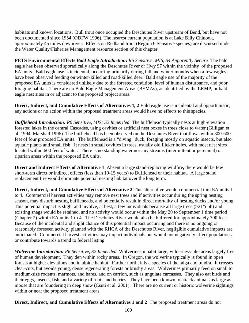
100
habitats and known locations. Bull trout once occupied the Deschutes River upstream of Bend, but have not been documented since 1954 (ODFW 1996). The nearest current population is at Lake Billy Chinook, approximately 45 miles downriver. Effects on Redband trout (Region 6 Sensitive species) are discussed under the Water Quality/Fisheries Management resource section of this chapter. PETS Environmental Effects Bald Eagle Introduction: R6 Sensitive, MIS, S4 Apparently Secure The bald eagle has been observed sporadically along the Deschutes River or Hwy 97 within the vicinity of the proposed EA units. Bald eagle use is incidental, occurring primarily during fall and winter months when a few eagles have been observed feeding on winter-killed and road-killed deer. Bald eagle use of the majority of the proposed EA units is considered unlikely due to the forested condition, level of human disturbance, and poor foraging habitat. There are no Bald Eagle Management Areas (BEMAs), as identified by the LRMP, or bald eagle nest sites in or adjacent to the proposed project areas. Direct, Indirect, and Cumulative Effects of Alternatives 1, 2 Bald eagle use is incidental and opportunistic, any actions or no action within the proposed treatment areas would have no effects to this species. Bufflehead Introduction: R6 Sensitive, MIS; S2 Imperiled The bufflehead typically nests at high-elevation forested lakes in the central Cascades, using cavities or artificial nest boxes in trees close to water (Gilligan et al. 1994, Marshall 1996). The bufflehead has been observed on the Deschutes River that flows within 300-600 feet of four proposed EA units. The bufflehead is a “diving” duck, foraging mostly on aquatic insects, but also aquatic plants and small fish. It nests in small cavities in trees, usually old flicker holes, with most nest sites located within 600 feet of water. There is no standing water nor any streams (intermittent or perennial) or riparian areas within the proposed EA units. Direct and Indirect Effects of Alternative 1 Absent a large stand-replacing wildfire, there would be few short-term direct or indirect effects (less than 10-15 years) to Bufflehead or their habitat. A large stand replacement fire would eliminate potential nesting habitat over the long term. Direct, Indirect, and Cumulative Effects of Alternative 2 This alternative would commercial thin EA units 1 to 4. Commercial harvest activities may remove nest trees and if activities occur during the spring nesting season, may disturb nesting buffleheads, and potentially result in direct mortality of nesting ducks and/or young. This potential impact is slight and involve, at best, a few individuals because all large trees (>21”dbh) and existing snags would be retained, and no activity would occur within the May 20 to September 1 time period (Chapter 2) within EA units 1 to 4. The Deschutes River would also be buffered for approximately 300 feet. Because of the incidental and slight chance of this potential impact occurring and there is no ongoing or reasonably foreseen activity planned with the RHCA of the Deschutes River, negligible cumulative impacts are anticipated. Commercial harvest activities may impact individuals but would not negatively affect populations or contribute towards a trend to federal listing. Wolverine Introduction: R6 Sensitive, S2 Imperiled Wolverines inhabit large, wilderness-like areas largely free of human development. They den within rocky areas. In Oregon, the wolverine typically is found in open forests at higher elevations and in alpine habitat. Farther north, it is a species of the taiga and tundra. It crosses clear-cuts, but avoids young, dense regenerating forests or brushy areas. Wolverines primarily feed on small to medium-size rodents, marmots, and hares, and on carrion, such as ungulate carcasses. They also eat birds and their eggs, insects, fish, and a variety of roots and berries. They have been known to attack animals as large as moose that are foundering in deep snow (Csuti et al, 2001). There are no current or historic wolverine sightings within or near the proposed treatment areas. Direct, Indirect, and Cumulative Effects of Alternatives 1 and 2 The proposed treatment areas do not
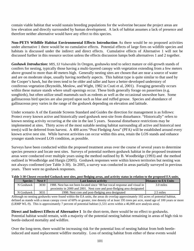
101
contain viable habitat that would sustain breeding populations for the wolverine because the project areas are low elevation and directly surrounded by human development. A lack of habitat assumes a lack of presence and therefore neither alternative would have any effect to this species. Non-PETS Wildlife Habitat Environmental Effects Introduction As there would be no proposed activities under alternative 1 there would be no cumulative effects. Potential effects of large fires on wildlife species and habitats is discussed under the indirect and direct effects. Cumulative effects of Alternative 1 will not be discussed further in this resource section unless the effects discussion lumps both alternatives 1 and 2 together. Goshawk Introduction: MIS, S3 Vulnerable In Oregon, goshawks tend to select mature or old-growth stands of conifers for nesting, typically those having a multi-layered canopy with vegetation extending from a few meters above ground to more than 40 meters high. Generally nesting sites are chosen that are near a source of water and are on moderate slope, usually having northerly aspects. This habitat type is quite similar to that used by the Cooper’s hawk, but the trees tend to be older and taller and have a better-developed understory of coniferous vegetation (Reynolds, Meslow, and Wight, 1982 in Csuti et al, 2001). Foraging generally occurs within these mature stands where small openings occur. These birds generally forage on passerines (e.g. songbirds), but often utilize small mammals such as rodents as well as the occasional snowshoe hare. Some gallinaceous bird species are also preyed upon such as blue and ruffed grouse. Species and abundance of gallinaceous prey varies in the range of the goshawk depending on elevation and latitude. Under scenario A of the Eastside Screens Standard and Guides the direction for management is as follows: Protect every known active and historically used goshawk nest-site from disturbance. “Historically” refers to known nesting activity occurring at the site in the last 5 years. Seasonal disturbance restrictions may be implemented at sites. Thirty acres of the most suitable nesting habitat surrounding all active and historical nest tree(s) will be deferred from harvest. A 400 acres “Post Fledging Area” (PFA) will be established around every known active nest site. While harvest activities can occur within this area, retain the LOS stands and enhance younger stands toward LOS condition, as possible. Surveys have been conducted within the proposed treatment areas over the course of several years to determine species presence and locate nest sites. Surveys of potential northern goshawk habitat in the proposed treatment areas were conducted over multiple years using the method outlined by B. Woodbridge (1993) and the method outlined in Woodbridge and Hargis (2005). Goshawk responses were within known territories but nesting was not always confirmed (see Table 3-30). In 2005, a survey was conducted in areas partially surveyed in previous years. There were no goshawk responses. Table 3-30 Closest recorded Goshawk nest sites, post fledging areas, and activity status in relation to the proposed EA units.
Species Nest # Last known activity Distance to EA Units N Goshawk 3030 1988. Nest has not been located since ‘88 but vocal response and visual in
proximity in 2000 and 2001. Nest core and post-fledging area designated 3.0 miles
N Goshawk 3031 1998: Nest core and post-fledging area designated 2.5 miles Although no nesting goshawks were found within the EA units, the areas do overlap approximately 102 acres of potential habitat, defined as stands with a mean canopy cover of 60% or greater, tree density of at least 195 trees per acre, stand age of 100 years or more (LRMP WL-9). This is approximately 7 percent of potential habitat (1,531 acres within a 46,000 acre analysis area). Direct and Indirect Effects of Alternative 1 In the short-term, there would be no effect to goshawks. Potential habitat would remain, with a majority of the potential nesting habitat remaining in areas of high risk to beetle-induced mortality and wildfire. Over the long-term, there would be increasing risk for the potential loss of nesting habitat from both beetle-induced and stand replacement wildfire mortality. Loss of nesting habitat from either of these events would
102
displace this species from the project area, except for foraging, for a minimum of four to five decades. It is likely that there would be a declining trend in populations as a result of habitat loss due to natural disturbances. Direct, Indirect, and Cumulative Effects of Alternative 2 Thinning would degrade goshawk nesting habitat, in the short-term. Where EA units overlap potential goshawk habitat, 79 acres would be thinned or degraded (5 percent of the 46,000 acre analysis area). Underburning or mowing, without associated thinning, is not expected to have effects to potential goshawk nesting habitat. As the remaining trees respond to thinning with accelerated diameter growth, more suitable nesting habitat than presently available is expected. Alternative 2 is not expected to effect goshawk foraging. Juxtaposition of non-treatment areas both within and adjacent to the EA units would provide for a diversity of prey. This juxtaposition would also minimize any effects to any fledged goshawks from the larger area. Alternative 2 activities are not expected to effect the known territories (3030, 3031), and these territories are expected to remain as functioning nesting habitat. The proposed actions may effect dispersing goshawks as they move through the area. It is unlikely that the 79 acres being thinned within the EA units would be used for nesting. These 79 acres are scattered and within the vicinity of the Sunriver resort, and it is known that many people enjoy the area surrounding the EA units for hiking, biking, and floating on the river. The level of human use during the goshawk nesting season is substantially higher than in other areas of goshawk nesting habitat in the larger area. This higher level of use means that there is more potential disturbance. Goshawk have a relatively low tolerance level for human disturbance, thus rendering this 79 acres as low quality habitat. The incremental effect that the proposed treatments have on potential goshawk nesting habitat is neither significant nor relevant in making an informed decision between the alternatives. LRMP/Other Management Direction Consistency As mentioned earlier, the Screens amended the Deschutes LRMP with specific guidelines to goshawks. District records and survey efforts have not discovered any goshawk nests within or near the EA units. No new PFAs or 30 acre nest cores need to be established, and all proposed actions take place well away from any designated ones. The Screens, however, do include under Scenario A (5) a) that all active and historically used goshawk nest site be protected from disturbance. The LRMP judges a disturbance distance of ¼ mile for non-blasting activities. Although there are no known or historic goshawk nests in the proposed treatment units, it is possible, due to the fact that goshawks move, that a nest may be discovered in the interim between project implementation and completion. Mitigation measures address this circumstance. WL-6: “nesting habitat for at least 40 goshawk pairs will be provided in mixed conifer, mountain hemlock, and ponderosa pine forests. Habitat for an additional 30 pairs in lodgepole pine forest…” According the Screens, a nest core should be 30 acres in size; in the LRMP, nesting stands should be at least 25 acres in size. Of the potential habitat within EA units, there are only two portions that are part of potential habitat clumps meeting at least these size definitions. Most of the other habitat is in smaller parcels of <10 acres. The proposed treatments may only effect one potential nest core. Nesting habitat will develop, in the long-term, within the EA units, and the largest potential nesting habitat clumps are outside of the treatment areas. Mitigation measures will ensure that any nests discovered receive protection. WL-9: “Nest sites will be selected on the basis of present or past use whenever possible…” The proposed Ea units and an adjacent larger area have been surveyed. No nesting goshawks were found. Cooper’s Hawk Introduction MIS, S4 Apparently Secure The Cooper’s hawk prefers coniferous, mixed and
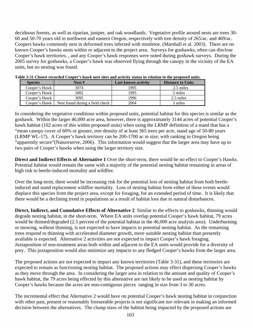
103
deciduous forests, as well as riparian, juniper, and oak woodlands. Vegetative profile around nests are trees 30-60 and 50-70 years old in northwest and eastern Oregon, respectively with tree density of 265/ac. and 469/ac. Coopers hawks commonly nest in deformed trees infected with mistletoe. (Marshall et al. 2003). There are no known Cooper’s hawks nests within or adjacent to the project area. Surveys for goshawks, often can disclose Cooper’s hawk territories. , and any Cooper’s hawk responses were noted during goshawk surveys. During the 2005 survey for goshawks, a Cooper’s hawk was observed flying through the canopy in the vicinity of the EA units, but no nesting was found. Table 3-31 Closest recorded Cooper’s hawk nest sites and activity status in relation to the proposed units.
Species Nest # Last known activity Distance to Units Cooper’s Hawk 3074 1995 2.5 miles Cooper’s Hawk 3082 1995 5 miles Cooper’s Hawk 3095 1996 2.5 miles Cooper’s Hawk Nest found during a field check 2004 3 miles
In considering the vegetative conditions within proposed units, potential habitat for this species is similar as the goshawk. Within the larger 46,000 acre area, however, there is approximately 3144 acres of potential Cooper’s hawk habitat (102 acres of this within proposed units) when using the LRMP definition of a stand that has a “mean canopy cover of 60% or greater, tree density of at least 365 trees per acre, stand age of 50-80 years (LRMP WL-17). A Cooper’s hawk territory can be 200-1700 ac in size; with ranking in Oregon being “apparently secure”(Natureserve, 2006). This information would suggest that the larger area may have up to two pairs of Cooper’s hawks when using the larger territory size. Direct and Indirect Effects of Alternative 1 Over the short-term, there would be no effect to Cooper’s Hawks. Potential habitat would remain the same with a majority of the potential nesting habitat remaining in areas of high risk to beetle-induced mortality and wildfire. Over the long-term, there would be increasing risk for the potential loss of nesting habitat from both beetle-induced and stand replacement wildfire mortality. Loss of nesting habitat from either of these events would displace this species from the project area, except for foraging, for an extended period of time. It is likely that there would be a declining trend in populations as a result of habitat loss due to natural disturbances. Direct, Indirect, and Cumulative Effects of Alternative 2 Similar to the effects to goshawks, thinning would degrade nesting habitat, in the short-term. Where EA units overlap potential Cooper’s hawk habitat, 79 acres would be thinned/degraded (2.5 percent of the potential habitat in the 46,000 acre analysis area). Underburning or mowing, without thinning, is not expected to have impacts to potential nesting habitat. As the remaining trees respond to thinning with accelerated diameter growth, more suitable nesting habitat than presently available is expected. Alternative 2 activities are not expected to impact Cooper’s hawk foraging. Juxtaposition of non-treatment areas both within and adjacent to the EA units would provide for a diversity of prey. This juxtaposition would also minimize any impacts to any fledged Cooper’s hawks from the larger area. The proposed actions are not expected to impact any known territories (Table 3-31), and these territories are expected to remain as functioning nesting habitat. The proposed actions may effect dispersing Cooper’s hawks as they move through the area. In considering the larger area in relation to the amount and quality of Cooper’s hawk habitat, the 79 acres being effected by this alternative are not likely to be used as nesting habitat by Cooper’s hawks because the acres are non-contiguous pieces ranging in size from 3 to 30 acres. The incremental effect that Alternative 2 would have on potential Cooper’s hawk nesting habitat in conjunction with other past, present or reasonably foreseeable projects is not significant nor relevant in making an informed decision between the alternatives. The clump sizes of the habitat being impacted by the proposed actions are
104
not large enough to constitute an entire nest core. LRMP/Other Management Direction Consistency LRMP WL-13: states that; “Nesting habitat for at least 60 pairs of Cooper’s hawk will be provided in mixed conifer and ponderosa pine forests outside of wilderness and the Oregon Cascades Recreation Area.” Thinning within the EA units would degrade 79 acres of potential Cooper’s hawk nesting habitat. This acreage is scattered into various sized parcels from 3 to 30 acres. Because these affected acres are scattered, the cumulative effect is diluted and not concentrated on one territory. Overall nesting habitat is still being provided. Pairs of Cooper’s hawks in eastern Oregon have been found at a density of one for every 4,589 acres (Henny, 2003), for sharp-shinned hawks, there was one nest for every 6,793 acres in southern Oregon (White Scheuering and McAtee, 2003). Considering the proposed treatment areas with the larger area, there could be upwards of 2 pairs of Cooper’s hawks based on the territory size reported by Henny (2003) and White Scheuering and McAtee (2003). Currently there are 3-4 known Cooper’s hawk nests within this larger area. Over the larger landscape of adjacent and similar forest types it appears there is ample habitat for Cooper’s hawks. WL-16: “Prospective sites with appropriate vegetative structure…will be identified before they have been precommercially or commercially thinned…” Potential habitat was identified and it has been acknowledged that commercial thinning would negatively affect habitat over the short-term with a beneficial effect over the long term. Mitigation measures ensure that any nests discovered during implementation receive protection. Great Gray Owl Introduction MIS, S3 Vulnerable Great gray owl nest stands vary in stand type from mixed stands of ponderosa pine and lodgepole pine to mixed conifer. Within these stands, for optimum nesting habitat canopy cover ranges from 50-70 percent. Nest stands are generally associated with open forest containing canopy closure that ranges from 11-59 percent dominated with grasses, open grassy habitat, including bogs, selective and clear-cut logged areas, and natural meadows (Bull and Henjum 1990). The LRMP defines this owl’s habitat as being: lodgepole pine dominated overstory, overstory tree density of 67 trees per acre for trees greater than 12 inches diameter at breast height, canopy cover of 60 percent (50-70 percent), and distance to nearest meadow 440 (63-1,070ft.) feet (LRMP WL-31). There are no natural meadows or large grassy openings within or adjacent to any of the EA units. There are some small openings within some of the Ea units, however these are quickly filling in with shrubs and seedlings. There are approximately 26 acres of lodgepole pine habitat that overlap the EA units that would meet the stand definitions for great gray habitat, but these acres are not adjacent to meadows. Over a larger area, along the Deschutes River that runs through federally-owned land, there is approximately 236 acres of potential great gray habitat. Great gray owls have been reported in lodgepole pine habitat along the Deschutes River south of Sunriver. More recently in the vicinity of La Pine State Park (9 miles south) and golf courses in the various communities. Despite the lack of habitat within the EA units, surveys for great gray owls have been conducted using the protocol method outlined in the April 1995 “Survey Protocol for the Great Gray Owl” and the subsequent version 3.0 (Quintana et al. 2004) within potential habitat along the Deschutes River. No great gray owls were reported. The figures and survey forms are located in the District wildlife project files. Direct and Indirect Effects of Alternative 1 In the short-term, there would be no effect to great gray owls. Potential habitat would remain, with a majority of the potential nesting habitat for this species remaining in areas of high risk to beetle mortality and wildfire. Direct, Indirect, and Cumulative Effects of Alternative 2 Thinning is proposed within the 26 acres of potential great gray owl habitat that overlaps the EA units. Thinning would degrade the habitat, making it unsuitable for nesting. This is currently low potential habitat because of the lack of nearby grassy openings and
105
meadows. Although these 26 acres may no longer function as potential habitat; thinning in the other EA units, in conjunction with underburning or mowing, may encourage development of great gray foraging habitat. There are 236 acres of potential habitat within the larger, immediate area, Alternative 2 treatments may provide a greater juxtaposition of foraging habitat with potential nesting habitat outside of the EA units. The 26 acres of treatment within potential great gray owl habitat represents approximately 11 percent of the habitat in the larger area. This incremental effect to potential habitat is not considered significant or relevant to the making of an informed decision between alternatives. This is because the effect is unique to this project and not cumulative to the other project areas mentioned in Table 3-28, and that the pieces affected are small, non contiguous, and not capable of supporting an individual pair on their own. Known sightings are south of the EA units, and there may be some barriers to movement of these owls to the project area due to the presence of the community and resort of Sunriver. LRMP/Other Management Direction Consistency There are currently at least 5 pairs of great gray owls in the northern portion of the Forest (Sisters Ranger District, L. Turner, Wildlife Biologist, pers. commun. 9/2005). In the central portion of the forest (Bend-Fort Rock Ranger District), great gray owls have been heard or seen in the vicinity of the Deschutes River and wet meadows, but nests have not been located (J. Lowrie and M. Gregg, Wildlife Biologists, pers. commun. 9/2005). There is one known great gray owl nest site in the southern portion of the Forest, with potential habitat for three or four more pairs (Crescent Ranger District, J. Kittrell, Wildlife Biologist, pers. commun. 9/2005). Based on this information, there appears to be suitable habitat on the Forest, outside of the Sunriver HFRA project area, to support 8 pairs of nesting great gray owls WL-30). This is consistent with recorded sightings of great gray owls on the Forest. There have been 42 recorded sightings on the Forest, with none of the sightings located east of La Pine (M. Gregg, pers. commun. 9/2005), based on sightings in the NRIS Fauna National Wildlife Database). Alternative 2 complies with current direction. Eighty-nine percent of the potential nesting habitat will remain within the area. Any new nests discovered will be protected from disturbance (WL-31, 33). Red-tailed Hawk Introduction: MIS, S5 Secure Red-tailed hawks have an extremely wide tolerance for habitat variation. Red-tails are largely perch hunters. Habitat types that provide suitable perches (trees, utility poles, outcrops, etc.) and are open enough to permit the detection of ground-dwelling prey, typically support Red-tailed Hawks. Red-tails frequent woodland, agricultural land, clearcuts, grasslands, sagebrush plains, alpine environments, and urban areas. They construct nests in a variety of situations including tree, utility poles cliffs, and place there nests higher than other broad-winged hawks (Marshal et al. 2003). The Sunriver HFRA project area provides abundant foraging habitat, due to its amount of fragmentation (e.g. lava flows, plantations, power and gas lines). Most of the plantation units have residual overstory trees associated with the units that could provide potential roost and nest sites. Red-tails are commonly observed soaring in the area and are common across the district. There are no known nest sites that occur within the project area. Natureserve (2006) ranks this species as “secure” in most of continental United States, including Oregon. Table 3-32. Closest recorded Red-tailed hawk nest sites and activity status in relation to the proposed units
Species Nest # Last known activity Distance to Units Red-tailed Hawk 3064 1997 4 miles Red-tailed Hawk New nest June, ‘01 4 miles
Direct and Indirect Effects of Alternative 1 Red-tailed hawk There would be no effect to Red-tailed hawks. The increased potential for stand replacing fires could create additional foraging and nesting (snags) habitat for this species.. Due to this species generalist nature, it is expected that habitat would be stable in the long-term.
106
Direct, Indirect, and Cumulative Effects of Alternative 2 Since no trees over 21” dbh will be cut, this alternative would have no effect on nesting habitat for this species. Mitigation measures are proposed in the event an active nest is located during project implementation. Prey habitat would improve under the action alternative. Thinning treatments would create more open stand conditions, allowing greater maneuverability and greater visibility and access to prey, while mechanical shrub treatment and prescribed underburning would promote greater plant diversity, providing habitat for a wide variety of small mammals, the primary prey of the red-tailed hawk (see Shrub Habitat discussion, page 114). Due to the generalist nature of this species, no cumulative effects to this species are anticipated. There would be negligible change in available nesting and foraging habitat. LRMP/Other Management Direction Consistency Alternative 2 complies with current direction for this species. Potential habitat was analyzed for effects, and any nests are found during implementation they would be protected by maintaining the forested character around the nest (WL-2) and by eliminating disturbing activities (WL-3).from March 1 to August 31. Great Blue Heron Introduction MIS, S4 Apparently Secure The great blue heron can be found in nearly any meadow, grassland, marsh, riparian thicket, lake, river, or pond within every habitat type, including agriculture, pasture, and urban areas. Nests are commonly located in coniferous or deciduous trees, but also can be found on cliff ledges, or even on the ground in thick marsh vegetation (Csuti et al. 2001). There is no standing water nor any streams (intermittent or perennial) or riparian areas within the EA units. The closest EA unit is over 500 feet from riparian vegetation. The stands along the Deschutes River serve as potential habitat for this species. No known nests or rookeries are within or near the EA units. Direct and Indirect Effects of Alternative 1 This alternative would not have any effects on this species. Direct, Indirect and Cumulative Effects of Alternative 2 There are four EA units that are near the river (Units 1-4). The Deschutes River is buffered by a minimum of 300 feet and the unit boundaries begin well into the upland vegetation and do not treat riparian vegetation. This would protect potential great blue heron habitat and no effects from the action alternative are expected. Due to the lack of potential direct and indirect effects from Alternative 2 activities, there would be no cumulative effects as a result of this alternative. LRMP/Other Management Direction Consistency All alternatives comply with current direction for this species. There are no known rookeries. Potential habitat was analyzed for effects. Because no large trees (>21” dbh) are to be cut and riparian/river habitat is buffered, there would be no effects to great blue herons. Habitat for any potentially new rookeries would be provided (WL-36). Osprey Introduction, MIS, S4 Apparently Secure historically nested only in forested regions of Oregon because of its selection for large live tree (broken top) or dead tree (snag) for nest sites. Nests in Oregon are usually located within 2 mi of water with an accessible fish population. Nest sites on utility poles are common due to land clearing for agriculture and lack of suitable habitat for nesting. They will also use nest platforms developed for Canada Geese as nest sites, which was noted to occur at wildlife refuges (Marshall et al. 2003). There are no designated Osprey Management Areas associated with the project. Osprey have been known to nest in the Benham Falls area near EA unit 4 and in early 2007 nest-building activity has been observed. Foraging occurs along the main stem of the Deschutes River. Natureserve (2006) reports that osprey numbers are increasing and gives the osprey an “apparently secure” ranking in Oregon.
107
Table 3-33 Closest recorded Osprey nest sites and activity status in relation to the proposed units. Species Nest # Last known activity Distance to Units Osprey 3026 1983 4 miles Osprey 3054 1983 4 miles Osprey New nest 2007 500 ft.
Direct and Indirect Effects of Alternative 1 There would be no effect on potential nesting or foraging habitat. Osprey will often nest in large snags near water. Due to the lack of potential direct and indirect effects, there would be no cumulative effects as a result of this alternative. Direct, Indirect and Cumulative Effects of Alternative 2 The action alternative would not affect foraging habitat. No trees over 21” dbh would be harvested, therefore potential nesting habitat would not be affected. Activity within EA unit 4 would not occur within the active nesting season (Chapter 2) to prevent disturbance. Due to the lack of potential direct and indirect effects from the proposed actions, there would be no cumulative effects as a result of this alternative. LRMP/Other Management Direction Consistency Alternative 2 complies with current direction for this species. Potential habitat was analyzed for effects, and mitigation measures are proposed to protect active nests from disturbance. The closest EA unit is more than 500 feet from any known nesting activity (WL-2, 3). Townsend’s Big-eared Bat Introduction MIS, S2 Imperiled Occurrence of Townsend’s big-eared bats is documented on the Deschutes NF. This species of bat depends on caves for hibernation, for raising their young, and for day and night roosting. They forage in a broad range of forested conditions, from open savanna to fully stocked conifer stands. Prey species are strongly associated with bitterbrush, cantus, and other shrub species. Most foraging is suspected to occur within five miles of their day roosts. Past studies have shown that foraging along forest edges occurred most often, apparently related to availability of prey species (moths) and protective habitat for predation. They utilize open water to meet moisture requirements. Large winter hibernating populations of these bats occur in a few caves on the Bend-Ft. Rock Ranger District. The population is estimated to be 600 individuals in central Oregon (including Deschutes National Forest and adjacent areas). There are about 2,500 in Oregon. As of 2003, population trends for central Oregon, based on winter counts in hibernacula, have indicated a decline of about 25 percent since 1986. The decline is probably related to disturbance of hibernating bats, disturbance to the maternity roosts, and effects of wildfires. Known hibernaculums are more than 20 miles from the project area. The lava formation adjacent to EA unit 13 may have pockets where a bat could day roost. Any usage (i.e. foraging) of the EA units would likely be incidental. Direct and Indirect Effects of Alternative 1 There would be no direct effects to Townsend’s big-eared bats. From a foraging standpoint, most of the bat species’ prey habitat includes a shrub component. Alternative 1 would retain shrubs in a variety of seral stages within the larger area. No effect to bat foraging habitat is anticipated. This alternative does carry a higher risk of a large stand replacement wildfire in the project area which would have negative effects on bat foraging. Due to the lack of direct and indirect effects to cave habitat, absent a large stand replacement wildfire, there would be no cumulative effects to this bat species as a result of the no action alternative. Direct, Indirect and Cumulative Effects of Alternative 2 Alternative 2 would not have any direct effects to caves or the lava habitat adjacent to EA unit 13. No direct or indirect effects to roosting habitat for bats that use this type of roost are expected.
108
Foraging habitat could be effected by the prescriptions for fuels treatments in shrub habitat. A detailed discussion of the effects to shrub habitat is found starting on page 114. For the various bat species, alteration of shrub habitat could influence prey availability within the project area. A variety of shrub structure is desirable in order to attract a variety of insect prey species. Alternative 2 maintains a large amount of early shrub structure through fuels treatments (mowing and underburning). Early seral shrubs may not produce as many flowers or leaves that moths and other insects would feed on as mid-seral shrubs. The overall diversity of shrub structure would be reduced. The effect on bat species may be a reduction in available prey or foraging opportunities near roost habitat. Retention patches within EA units would help off-set this effect, but there would be an increase of early shrub structure. The lack of direct effects and indirect effects means that there would be no cumulative effects to cave or rock roosting habitat and the Townsend big-eared bat. There would be cumulative effects to foraging habitat (see shrub habitat discussion). Similar to the direct and indirect effects, cumulatively the maintenance of more early shrub habitat may decrease the diversity of prey species for bats. Over the larger area, the areas with the best foraging opportunities for bats would be away from the urban-interface, where larger areas of more mature shrubs would be found. A lack of shrub habitat diversity (i.e. shrub seral /structural stages) may alter foraging patterns by western big-eared bats, or reduce bat prey species diversity which then can reduce bat populations or bat species diversity. At the same, the reduction of the risk of a large stand replacement wildfire would help maintain a mosaic of shrub seral stages within and adjacent to the project area. At the current rate of stand replacement wildfire, all of the shrub habitat would be changed to the early seral stage over the next five decades within the 147,978 acre Pilot Butte watershed. LRMP/Other Management Direction Consistency Compliance with bat habitat direction has been met. There are no known important caves adjacent to EA units and there is mitigation to maintain shrub diversity (WL-64) within the EA units as well as minimize smoke from prescribed burning that disrupt any bats. Known important caves on the district are protected and monitored (WL-64, 65, 70). Big Game Introduction Elk MIS, National Status –Secure; Mule Deer MIS, S5 Secure Elk use the project area for foraging, hiding and thermal cover; largely in the winter months. The EA units are within the larger 21,462 acre Ryan Ranch KEHA and the EA units cover approximately 8 percent of the KEHA. Mule deer also use the area for foraging, hiding and thermal cover. None of the EA units are within any LRMP designated winter range (MA-7), however mule deer are known to use the area in the winter in low snow years. For the purposes of this analysis, effects to these species are addressed concurrently and focused on habitat uses (i.e. thermal and hiding cover, foraging habitat) since many similarities in habitat requirements exist. Since the LRMP more directly addresses elk and deer habitat under a variety of topics, the format for addressing effects is different than that used for other species. Hiding/Thermal Cover Hiding cover is defined as vegetation capable of hiding 90 percent of a standing adult deer or elk from view of a human at a distance equal to or less than 200 feet (Thomas, 1979, LRMP WL-54). Hiding cover provides security to big game and protection from predators. Hiding cover is especially important for reducing vulnerability to hunting and poaching pressure by providing concealment in areas that have high open road densities and easy access by hunters (e.g., the proposed treatment areas). Hiding cover is evaluated in deer summer range (the entire Forest outside the Deer Habitat management allocation) and the Ryan Ranch KEHA, per LRMP direction. Hiding cover is not limited in the area (Table 3-34). Cover used by big game to moderate cold weather conditions and to assist in maintaining a constant body temperature is referred to as thermal cover (Thomas, 1979). Tree canopy cover conditions that provide optimal

109
thermal cover are considered to be greater than 75 percent canopy cover in seedling and sapling stands that are greater than 5 feet in height or canopy cover greater than 60 percent in pole sized (5-9 inches DBH) trees and larger (Thomas, 1979). Tree canopy cover conditions for optimal thermal cover on the Deschutes National Forest have been compromised due to low site productivity for tree growth and the risk of insect epidemics killing or severely damaging tree stands. Crown cover greater than 40 percent with trees 40 feet tall, 10 acres in size on 20 percent of the KEHA is recommended for thermal cover on the Deschutes National Forest (WL-50). Ideally, hiding and thermal cover stands would be in close proximity to foraging areas and would make up approximately 40 percent of the land area (Thomas 1979). The optimum distance between cover stands for maximum use by big game is thought to be approximately 1,200 feet with stand sizes ranging from 6 to 26 acres (Thomas, 1979). Estimates of the amount of hiding cover within the proposed action areas and Ryan Ranch KEHA were derived from field inventory and satellite imagery (ISAT). Estimates of the amount of thermal cover were derived from field inventory, satellite imagery (ISAT), and stands considered as high stocking/density (based on stand density indices and number of trees per acre). Winter range habitat units (WRHU) are areas in the winter range of mule deer ranging from 15,000 to 20,000 acres; where habitat conditions and the potential effects of activities are evaluated. Hiding and thermal cover desired conditions for WRHUs is based on a recommendation contained in the Devil’s Garden WRHU Analysis Paper (USDA, 2002). The Lava River WRHU overlaps the project area and, as noted before, mule deer in low snow years utilize the project area. Since none of the project area is designated as deer winter range, standards and guidelines for the Ryan Ranch KEHA and black bark pine management (WL-51) take precedence. Table 3-34 displays the existing amount (acres) of cover in each of the LRMP management allocations and deer winter range habitat unit. The applicable LRMP standards and guideline (S&G) or Goals and Objectives are displayed as the management objective. The management objectives are minimums and not necessarily the preferred or conditions for wildlife. Figures 12 and 13 display hiding cover and thermal cover. Hiding and thermal cover levels currently exceed LRMP levels. Table 3-34 Existing Hiding andThermal Cover by LRMP Management Allocation and Winter Range Habitat Unit.
Hiding Cover Acres (percent)
Management Objectivefor hiding cover
Thermal Cover Acres (percent)
Management Objective for thermal cover
EA Units* (1,686 acres) 565 (33%) NA 352 (21%) NA Deer Summer Range/Total KEHA east of Deschutes R.
(including area overlapping EA units; 4,604 acres)
1,599 (35%) 1,262 (27%)
KEHA overall** (21,462 acres) 8,057 (37%)
30 pecent blackbark “screening” cover in Ryan
Ranch Key Elk Area
8,020 (37%)
20% in Ryan Ranch Key Elk Area
Lava River WRHU (8,651 acres) 2,882 (33%) 10% 2,644 (31%) 30% * Displayed as an overview only. Not the geographic or management area in which the LRMP standards and guidelines are measured. **Includes East Tumbull and Myst projects Existing hiding cover levels are above the management objective levels. Hiding cover is generally well distributed throughout the summer and winter ranges (Key Elk Area and Lava River WRHU) but there are areas where cover stands are either larger or smaller than what is considered optimum for use by big game (see Figures 12 and 13). In the Ryan Ranch KEHA, the majority of hiding cover is found in lodgepole pine stands along the Deschutes River. The existing amount of thermal cover is also largely at or above the objectives within the KEAH and Lava River WRHU. Cook et al (2004) acknowledge that thermal cover may not be as crucial a component of winter habitat, animal health and survival as the components of quality forage and hiding cover. Thus, if thermal cover levels alone are not meeting LRMP goals and objectives it may not necessarily result in negative effects to
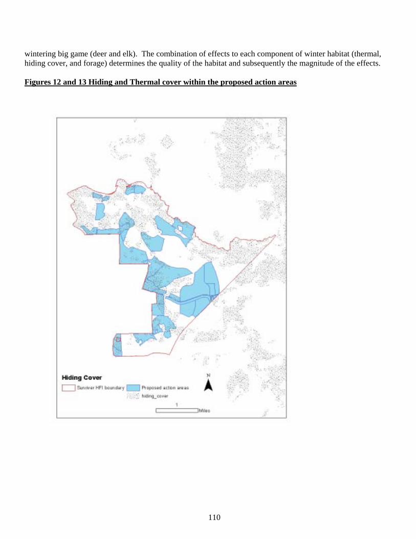
110
wintering big game (deer and elk). The combination of effects to each component of winter habitat (thermal, hiding cover, and forage) determines the quality of the habitat and subsequently the magnitude of the effects. Figures 12 and 13 Hiding and Thermal cover within the proposed action areas
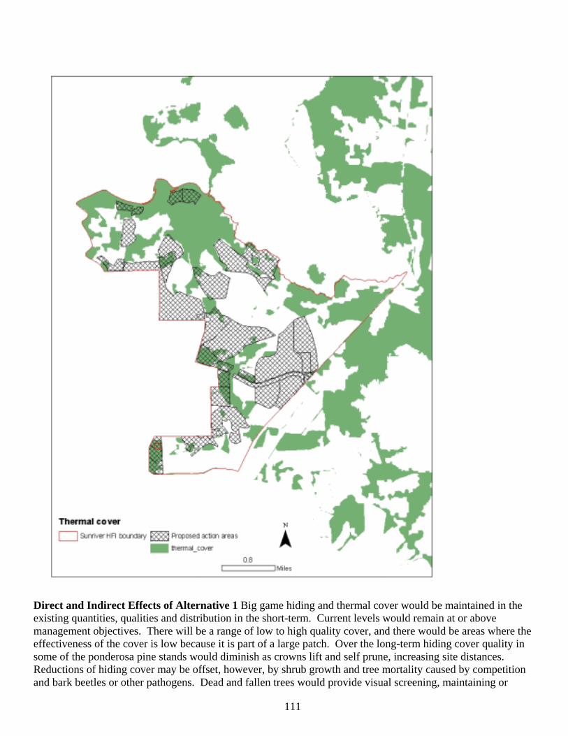
111
Direct and Indirect Effects of Alternative 1 Big game hiding and thermal cover would be maintained in the existing quantities, qualities and distribution in the short-term. Current levels would remain at or above management objectives. There will be a range of low to high quality cover, and there would be areas where the effectiveness of the cover is low because it is part of a large patch. Over the long-term hiding cover quality in some of the ponderosa pine stands would diminish as crowns lift and self prune, increasing site distances. Reductions of hiding cover may be offset, however, by shrub growth and tree mortality caused by competition and bark beetles or other pathogens. Dead and fallen trees would provide visual screening, maintaining or
112
improving hiding cover. Shrubs in many of the stands that do not currently provide hiding cover are relatively young in age. Growth of green leaf manzanita (Arctostaphylos patula) and snowbrush (Ceanothus velutinus) could provide hiding cover in some areas. Thermal cover quality and quantity is expected to remain about the same over the long-term, provided there are not more stand replacing wildfire events such as the 18 Fire of 2003 and Woodside Ranch Fire of 2007 that occurred six miles to the east. Similar habitat conditions, as present within the project area, existed within the fire perimeters. As a result of the fires, it is now an area with large patches of little to no cover (hiding or thermal). Indirect effects to big game cover entail the maintenance of a tenuous balance between sustainable habitat and no habitat. No action would certainly maintain the remaining cover for the short-term. However, it also maintains the high level of risk of loss to catastrophic wildfire. Alternative 1 also forgoes the opportunity to close excess roads. Maintaining fire-susceptible and high beetle-risk stands for cover while still allowing for the road density to remain high does not promote quality habitat. Should another fire occur, not only would cover and forage be lost, but also the high disturbance from motorized vehicles and other associated human uses would render the area poor habitat, especially in the winter. During the previous 20 years, the area has experienced increased societal pressures. The human population of Central Oregon continues to grow. Many of the residences that border the project area are less than 20 years old. It is an advertised selling point for real estate to be adjacent to federal lands, and the Sunriver HFRA project area is no different. These residences are high value properties. Social expectations along the WUI have changed such that the wildfire risk should be minimized. This shift in expectations then has effects on the management of wildlife habitat (e.g., deer cover and forage). That is to say, maintaining the elements of good habitat (tall shrub forage, and higher canopy closure) can conflict with measures to reduce wildfire risk. Another result of increasing human populations is the increased recreational pressure on the area because of its proximity to Bend and Sunriver. The area also tends to experience an early snowmelt. The types of recreational use run the full spectrum of low-impact to wildlife (e.g. hiking and bird watching) to high-impact (off-road vehicle use, target shooting, and hunting). As use increases, deer and other wildlife may seek “refuge” from these disturbances on private lands where access is considerably more restricted. This also leads to more wildlife/human conflict within the WUI. Improvements to existing tourist attractions and recreational opportunities adjacent to the area (e.g. Lava Lands, Lava River Cave, and Benham Falls) contribute to increases in recreational pressure, disturbance to wildlife, and the need to minimize wildfire risk. Other Federal vegetation management actions have also contributed to effects to habitat. In the Ryan Ranch KEHA, there is currently one active vegetation project (East Tumbull: 2,014 acres). Other project areas are within transitional and summer range for deer and within the KEHA (see Table below). Each of these efforts contain actions that benefit mule deer and habitat (e.g. road closures, vegetation treatments to increase tree and shrub growth and vigor and reduce wildfire risk), but the benefits may not be realized for many years after the activities are completed, with the potential short-term negative effect of reduced cover. Table 3-35 Existing Proportions of Cover Habitat Across the Ryan Ranch Key Elk Habitat Area.
Cover Type LRMP Target
Overall Average
Sunriver HFRA
Katalo Myst East Tumbull
Hiding Cover 30% 31-32% 35% 16% 30% 43-48% Thermal Cover 20% 41% 27% 22% 62% 53%
Under Alternative 1, the result of no action combined with ongoing and foreseeable federal actions within winter range, increased human disturbance, and shifting social pressures on federal lands adjacent to urban/suburban areas, there would continue to be a lack of quality winter habitat and a decline in the North
113
Paulina deer herd. The North Paulina deer herd has not met the target size (as determined by the ODFW Mule Deer Plan, Dec. 1990) for over 20 years (ODFW pers. commun. April 2005). Although it is likely that this is not solely the result of current conditions, the winter range habitat may no longer be able to sustain the population objectives. There is a synergistic relationship of reduced cover, increased human disturbance, predation and reduced forage (see shrub discussion). The effect is that individuals in the populations will have to expend more energy in either fleeing disturbance or seeking quality food. If the animal is expending energy to deal with each of these pressures together, as would be the case in the KEHA, then the result is reduced health of the animal and smaller populations. Subsequent effects of this may be reduced hunting opportunities within the area and increased wildlife/residential conflicts within the urban interface. Since there are no management actions proposed under this alternative, there are no cumulative effects to elk and deer cover. This alternative also forgoes the opportunities to improve habitat through road closures and reduction in the risk of a large stand replacement wildfire. Direct, Indirect and Cumulative Effects of Alternative 2 Thinning and prescribed underburning would reduce stand densities including seedling and sapling sized trees, and shrubs and down logs that provide visual screening and hiding cover. These activities would have the direct effect of reducing hiding and thermal cover in this portion of the Ryan Ranch KEHA (Table 3-36). The short-term, indirect effects of reduced amounts of hiding cover are increased vulnerability of big game to hunting and poaching. Areas of the greatest hunting pressure occur in deer summer range. Indirect effects of reduced amounts of thermal cover are increased energy expenditures by deer and elk in order to stay warm. Reduced quantities of thermal cover expose individuals to wind, deeper snow, and colder temperatures which may then decrease the health of the animal. Despite this reduction of cover, the distribution of cover and forage would improve. Thinning treatments are generally proposed in large blocks of thermal cover that are larger than what is necessary to receive maximum use by deer and elk. Alternative 2 would result in a better distribution and arrangement of cover and foraging areas, and utilization by deer and elk, than the current condition. Thermal cover stands are maintained between the created foraging areas. Other positive indirect effects are the improvement of the distribution of cover and foraging areas in the short-term (<20 years) and the amount of cover over the long-term (>20 years). In the long-term, the area will be habitat with more diverse forest structure that provides more effective forage and cover distribution.
Table 3-36. Immediate Post Treatment Acres and Ratios of Hiding and Thermal Cover in the Ryan Ranch KEHA (30% screening cover standard; 20% thermal cover standard).
Hiding Cover Thermal Cover Alternative 1 Alternative 2 No Action Alternative 2
EA Units* (1,686 acres) 565 (33%) 328 (19%) 352 (21%) 151 (9%) Deer Summer Range/Total Ryan Ranch KEHA east of Deschutes R. (including
area overlapping EA units; 4,604 acres)
1,599 (35%) 1362 (30%) 1,262 (27%) 1,061 (23%)
Lava River WRHU (8,651 acres) 2,882 (33%) 2,645 (31%) 2,644 (31%) 2,443 (28%)* Displayed as overview only. Not geographic or management area in which the LRMP standards and guidelines are measured.
The cumulative effect of the proposed actions, in combination with past and foreseeable actions, is a trend towards lower proportions of cover (hiding and thermal) in the KEHA. Add to this other proposed or ongoing commercial harvest, high road density, and the proximity to human population centers, and the KEHA becomes less effective and lower quality. This would be true for the short term (next 20 years). As the EA units respond with increased growth, over a longer period of time (>20 years), cover would return. This lower level of hiding and thermal is exacerbated by a high road density. Closing and decommissioning roads, along with a seasonal closure (Chapter), would help off-set the negative effects of reduced cover.
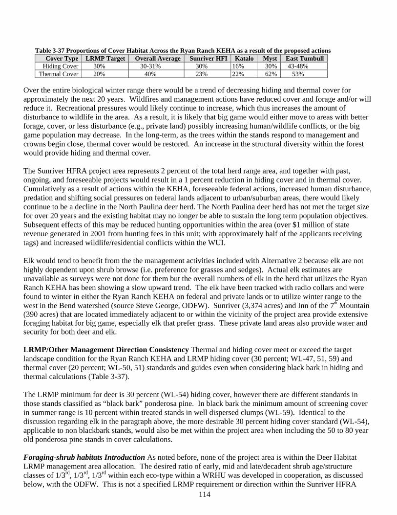
114
Table 3-37 Proportions of Cover Habitat Across the Ryan Ranch KEHA as a result of the proposed actions Cover Type LRMP Target Overall Average Sunriver HFI Katalo Myst East Tumbull
Hiding Cover 30% 30-31% 30% 16% 30% 43-48% Thermal Cover 20% 40% 23% 22% 62% 53%
Over the entire biological winter range there would be a trend of decreasing hiding and thermal cover for approximately the next 20 years. Wildfires and management actions have reduced cover and forage and/or will reduce it. Recreational pressures would likely continue to increase, which thus increases the amount of disturbance to wildlife in the area. As a result, it is likely that big game would either move to areas with better forage, cover, or less disturbance (e.g., private land) possibly increasing human/wildlife conflicts, or the big game population may decrease. In the long-term, as the trees within the stands respond to management and crowns begin close, thermal cover would be restored. An increase in the structural diversity within the forest would provide hiding and thermal cover. The Sunriver HFRA project area represents 2 percent of the total herd range area, and together with past, ongoing, and foreseeable projects would result in a 1 percent reduction in hiding cover and in thermal cover. Cumulatively as a result of actions within the KEHA, foreseeable federal actions, increased human disturbance, predation and shifting social pressures on federal lands adjacent to urban/suburban areas, there would likely continue to be a decline in the North Paulina deer herd. The North Paulina deer herd has not met the target size for over 20 years and the existing habitat may no longer be able to sustain the long term population objectives. Subsequent effects of this may be reduced hunting opportunities within the area (over $1 million of state revenue generated in 2001 from hunting fees in this unit; with approximately half of the applicants receiving tags) and increased wildlife/residential conflicts within the WUI. Elk would tend to benefit from the the management activities included with Alternative 2 because elk are not highly dependent upon shrub browse (i.e. preference for grasses and sedges). Actual elk estimates are unavailable as surveys were not done for them but the overall numbers of elk in the herd that utilizes the Ryan Ranch KEHA has been showing a slow upward trend. The elk have been tracked with radio collars and were found to winter in either the Ryan Ranch KEHA on federal and private lands or to utilize winter range to the west in the Bend watershed (source Steve George, ODFW). Sunriver (3,374 acres) and Inn of the 7th Mountain (390 acres) that are located immediately adjacent to or within the vicinity of the project area provide extensive foraging habitat for big game, especially elk that prefer grass. These private land areas also provide water and security for both deer and elk. LRMP/Other Management Direction Consistency Thermal and hiding cover meet or exceed the target landscape condition for the Ryan Ranch KEHA and LRMP hiding cover (30 percent; WL-47, 51, 59) and thermal cover (20 percent; WL-50, 51) standards and guides even when considering black bark in hiding and thermal calculations (Table 3-37). The LRMP minimum for deer is 30 percent (WL-54) hiding cover, however there are different standards in those stands classified as “black bark” ponderosa pine. In black bark the minimum amount of screening cover in summer range is 10 percent within treated stands in well dispersed clumps (WL-59). Identical to the discussion regarding elk in the paragraph above, the more desirable 30 percent hiding cover standard (WL-54), applicable to non blackbark stands, would also be met within the project area when including the 50 to 80 year old ponderosa pine stands in cover calculations. Foraging-shrub habitats Introduction As noted before, none of the project area is within the Deer Habitat LRMP management area allocation. The desired ratio of early, mid and late/decadent shrub age/structure classes of 1/3rd, 1/3rd, 1/3rd within each eco-type within a WRHU was developed in cooperation, as discussed below, with the ODFW. This is not a specified LRMP requirement or direction within the Sunriver HFRA
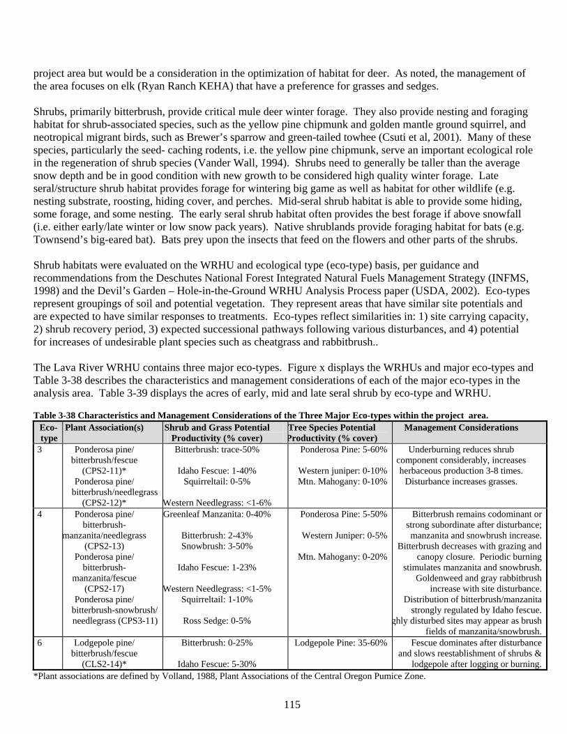
115
project area but would be a consideration in the optimization of habitat for deer. As noted, the management of the area focuses on elk (Ryan Ranch KEHA) that have a preference for grasses and sedges. Shrubs, primarily bitterbrush, provide critical mule deer winter forage. They also provide nesting and foraging habitat for shrub-associated species, such as the yellow pine chipmunk and golden mantle ground squirrel, and neotropical migrant birds, such as Brewer’s sparrow and green-tailed towhee (Csuti et al, 2001). Many of these species, particularly the seed- caching rodents, i.e. the yellow pine chipmunk, serve an important ecological role in the regeneration of shrub species (Vander Wall, 1994). Shrubs need to generally be taller than the average snow depth and be in good condition with new growth to be considered high quality winter forage. Late seral/structure shrub habitat provides forage for wintering big game as well as habitat for other wildlife (e.g. nesting substrate, roosting, hiding cover, and perches. Mid-seral shrub habitat is able to provide some hiding, some forage, and some nesting. The early seral shrub habitat often provides the best forage if above snowfall (i.e. either early/late winter or low snow pack years). Native shrublands provide foraging habitat for bats (e.g. Townsend’s big-eared bat). Bats prey upon the insects that feed on the flowers and other parts of the shrubs. Shrub habitats were evaluated on the WRHU and ecological type (eco-type) basis, per guidance and recommendations from the Deschutes National Forest Integrated Natural Fuels Management Strategy (INFMS, 1998) and the Devil’s Garden – Hole-in-the-Ground WRHU Analysis Process paper (USDA, 2002). Eco-types represent groupings of soil and potential vegetation. They represent areas that have similar site potentials and are expected to have similar responses to treatments. Eco-types reflect similarities in: 1) site carrying capacity, 2) shrub recovery period, 3) expected successional pathways following various disturbances, and 4) potential for increases of undesirable plant species such as cheatgrass and rabbitbrush.. The Lava River WRHU contains three major eco-types. Figure x displays the WRHUs and major eco-types and Table 3-38 describes the characteristics and management considerations of each of the major eco-types in the analysis area. Table 3-39 displays the acres of early, mid and late seral shrub by eco-type and WRHU. Table 3-38 Characteristics and Management Considerations of the Three Major Eco-types within the project area.
Eco- type
Plant Association(s) Shrub and Grass Potential Productivity (% cover)
Tree Species Potential Productivity (% cover)
Management Considerations
3 Ponderosa pine/ bitterbrush/fescue
(CPS2-11)* Ponderosa pine/
bitterbrush/needlegrass (CPS2-12)*
Bitterbrush: trace-50%
Idaho Fescue: 1-40% Squirreltail: 0-5%
Western Needlegrass: <1-6%
Ponderosa Pine: 5-60%
Western juniper: 0-10% Mtn. Mahogany: 0-10%
Underburning reduces shrub component considerably, increases herbaceous production 3-8 times.
Disturbance increases grasses.
4 Ponderosa pine/ bitterbrush-
manzanita/needlegrass (CPS2-13)
Ponderosa pine/ bitterbrush-
manzanita/fescue (CPS2-17)
Ponderosa pine/ bitterbrush-snowbrush/ needlegrass (CPS3-11)
Greenleaf Manzanita: 0-40%
Bitterbrush: 2-43% Snowbrush: 3-50%
Idaho Fescue: 1-23%
Western Needlegrass: <1-5%
Squirreltail: 1-10%
Ross Sedge: 0-5%
Ponderosa Pine: 5-50%
Western Juniper: 0-5%
Mtn. Mahogany: 0-20%
Bitterbrush remains codominant or strong subordinate after disturbance; manzanita and snowbrush increase.
Bitterbrush decreases with grazing and canopy closure. Periodic burning
stimulates manzanita and snowbrush. Goldenweed and gray rabbitbrush
increase with site disturbance. Distribution of bitterbrush/manzanita
strongly regulated by Idaho fescue. ghly disturbed sites may appear as brush
fields of manzanita/snowbrush.6 Lodgepole pine/
bitterbrush/fescue (CLS2-14)*
Bitterbrush: 0-25%
Idaho Fescue: 5-30%
Lodgepole Pine: 35-60% Fescue dominates after disturbance and slows reestablishment of shrubs &
lodgepole after logging or burning.*Plant associations are defined by Volland, 1988, Plant Associations of the Central Oregon Pumice Zone.
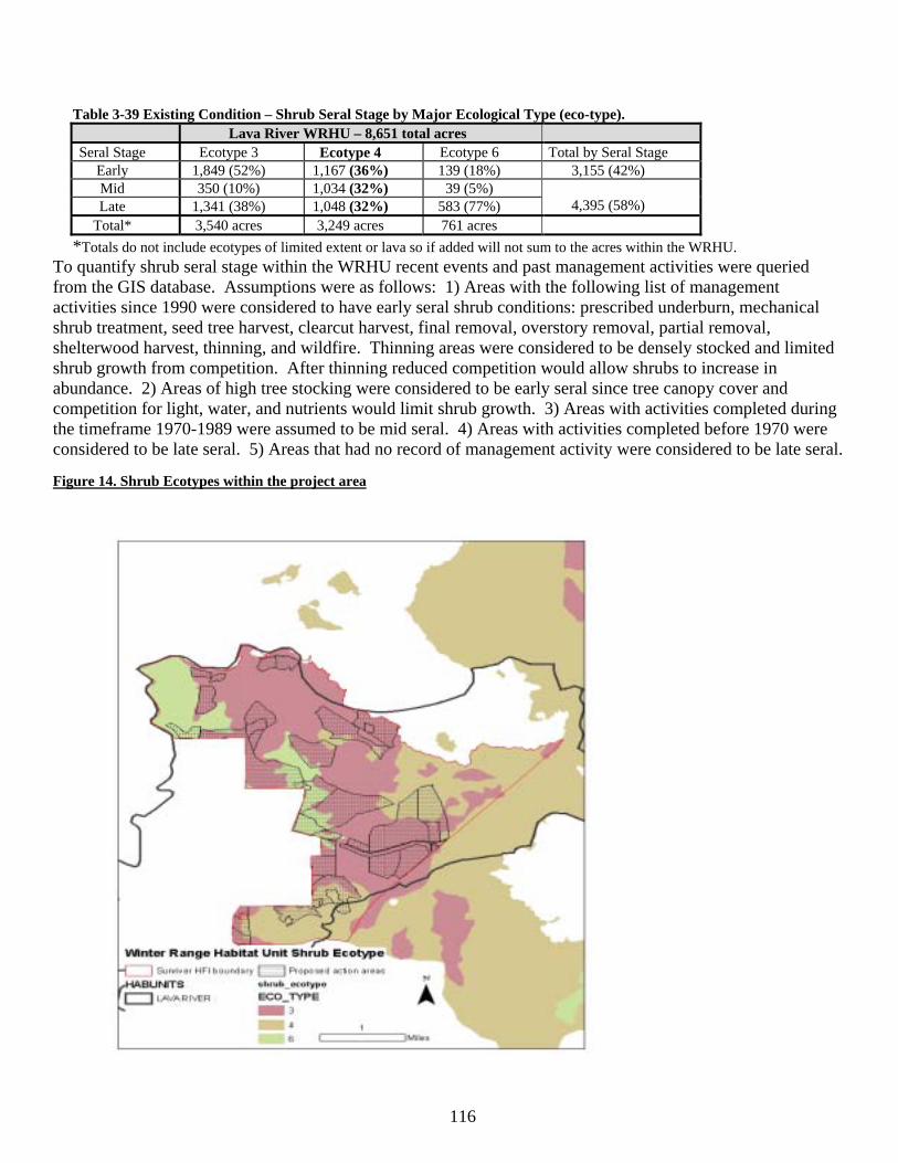
116
Table 3-39 Existing Condition – Shrub Seral Stage by Major Ecological Type (eco-type). Lava River WRHU – 8,651 total acres
Seral Stage Ecotype 3 Ecotype 4 Ecotype 6 Total by Seral Stage Early 1,849 (52%) 1,167 (36%) 139 (18%) 3,155 (42%) Mid 350 (10%) 1,034 (32%) 39 (5%) Late 1,341 (38%) 1,048 (32%) 583 (77%)
4,395 (58%)
Total* 3,540 acres 3,249 acres 761 acres *Totals do not include ecotypes of limited extent or lava so if added will not sum to the acres within the WRHU.
To quantify shrub seral stage within the WRHU recent events and past management activities were queried from the GIS database. Assumptions were as follows: 1) Areas with the following list of management activities since 1990 were considered to have early seral shrub conditions: prescribed underburn, mechanical shrub treatment, seed tree harvest, clearcut harvest, final removal, overstory removal, partial removal, shelterwood harvest, thinning, and wildfire. Thinning areas were considered to be densely stocked and limited shrub growth from competition. After thinning reduced competition would allow shrubs to increase in abundance. 2) Areas of high tree stocking were considered to be early seral since tree canopy cover and competition for light, water, and nutrients would limit shrub growth. 3) Areas with activities completed during the timeframe 1970-1989 were assumed to be mid seral. 4) Areas with activities completed before 1970 were considered to be late seral. 5) Areas that had no record of management activity were considered to be late seral. Figure 14. Shrub Ecotypes within the project area
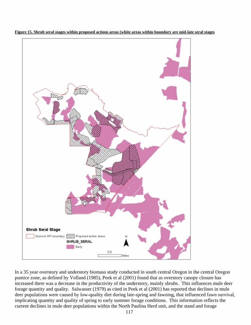
117
Figure 15. Shrub seral stages within proposed actions areas (white areas within boundary are mid-late seral stages
In a 35 year overstory and understory biomass study conducted in south central Oregon in the central Oregon pumice zone, as defined by Volland (1985), Peek et al (2001) found that as overstory canopy closure has increased there was a decrease in the productivity of the understory, mainly shrubs. This influences mule deer forage quantity and quality. Salwasser (1979) as cited in Peek et al (2001) has reported that declines in mule deer populations were caused by low-quality diet during late-spring and fawning, that influenced fawn survival, implicating quantity and quality of spring to early summer forage conditions. This information reflects the current declines in mule deer populations within the North Paulina Herd unit, and the stand and forage
118
conditions present within parts of the proposed action areas. Direct and Indirect Effects of Alternative 1 Shrub habitats would continue to age. Mature shrubs that are above snow levels and accessible to deer (i.e., winter forage) would increase in abundance through time but as shrubs become decadent the nutritional quality would decline. Some natural regeneration of bitterbrush would occur, especially in the mid-seral shrub age classes, which would develop into winter forage. Herbaceous species, grasses and forbs, which are high in nutritional quality during spring and early summer periods would decrease in abundance and diversity with accumulation of needle litter, maturity of shrubs, increasing tree density, and lack of disturbance. The desired mix of seral stages would continue to be seen in Ecotype 4 for approximately 10-20 years until the shrubs age which would then skew the ratio to predominantly mid and late seral stages. In Ecotype 3, the shrubs would move towards mostly mid-seral stage. The risk of wildfire and potential for loss of mule deer winter forage would remain high and may increase through time. It is noted that the portions of the 18 and Woodside Ranch fires that burned with a high intensity were also areas that had late seral shrubs. Alternative 1 would forgo the opportunity to reduce the risk of wildfire occurring in mule deer winter forage and the opportunity to improve the abundance of herbaceous forage. Shrub habitat for other species, especially those that depend upon late seral shrubs (e.g. nesting songbirds), would remain. There would still be the risk of wildfire events occurring. Additional wildfires would further reduce this type of shrub habitat, but in the short-term; this habitat would remain at the current levels and distribution. Reduction of shrub habitat may have negative effects to bat species that forage in this habitat type. Although selection of this alternative would not have additive, cumulative effects to past, present, and foreseeable projects, as a result of no action in the area, the shrub habitat would remain at the existing levels. An advantage to larger patches of shrub seral diversity would be more continuous habitat for the wildlife species that use shrubs for nesting, hiding cover, foraging, roosting, and perches (e.g., green-tailed towhee, Townsend’s big-eared bat). An advantage of smaller patches of diversity would be a better distribution of foraging by big game and higher species diversity over a smaller area. Direct, Indirect and Cumulative Effects of Alternative 2 The direct effect of natural fuels treatments (mechanical shrub treatment and prescribed underburning), and to a lesser degree, ground-based timber harvest, is to convert treated areas to early seral conditions. Treatments would reduce the amount of mule deer winter forage provided by shrubs, primarily bitterbrush, and reduce the amount of cover or prey habitat for small mammals and birds (e.g. bats and bluebirds that prey upon insects that rely on shrub habitat). Mechanical shrub treatment and prescribed underburning conducted in the spring and early summer could also result in the direct mortality of small mammals and birds that nest in shrubs, small trees, or on the ground (e.g. chipping sparrow). This effect is mitigated by the mitigation measure (Chapter 2) to restrict activities during the times of neotropical bird nesting (May20-August 31st) and high recreation activities. Table 3-40 displays the direct effects of each alternative to shrub ratios in the WRHU. Alternative would move the shrub conditions towards more early seral shrubs. Mitigation measures (Chapter 2) to retain some late and mid seral shrub structure within the EA units would help provide some habitat. Due to the unpredictability of fire there may actually be a higher retention ratio which would result in higher levels of late seral shrub habitat. This would retain a greater diversity in forage conditions for mule deer that may benefit individual deer health.
Table 3-40 Post Treatment Shrub Condition – Shrub Seral Stage in the Lava River WRHU Seral Stage Alternative 1 Alternaitve 2*
Early 3,155 acres (42%) 3,608 acres (48%) Mid-Late 4,395 (58%) 3,942 acres (52%)
* Includes 30% retention within EA units (Chapter 2)

119
119
Indirect effects of natural fuels treatments in Eco-type 3 would be to increase herbaceous species production (Table 3-38). Post treatment, the EA units would be dominated by Idaho fescue. The length of time for shrubs to regenerate in this eco-type is unknown but is generally thought that it would take 5-10 years for shrubs to establish and approximately 30 to 40 years to attain late seral shrub conditions. While treated areas are in the early seral condition, they would provide poor winter forage (abundance, availability, and quality) for mule deer and are not expected to receive much deer use. During the winter months when there is snow on the ground there would be little forage available above the snow level in treated areas. Mule deer would utilize mature shrubs in untreated areas between EA units. Although undesirable from a wintering mule deer perspective, treatments in Eco-type 3 in the Lava River WRHU are expected to be beneficial to elk within the Ryan Ranch KEHA by promoting preferred herbaceous forage species. In Eco-type 4 in Lava River WRHU, proposed actions would result in approximately half of the eco-type being in early seral post-treatment. Quantities of both mid and late seral shrub would be below the optimum level for deer and some other species. Natural fuels treatments, particularly prescribed underburning, in Eco-type 4 are expected to stimulate the growth of green leaf manzanita, a non-palatable forage species. Bitterbrush, the preferred winter browse of mule deer, is expected to regenerate with time but be subordinate to manzanita. Treated areas would be poor wintering areas for mule deer until bitterbrush regenerates. This would take years (>10 years). Mule deer are expected to utilize other stands with mature bitterbrush until treated areas regenerate with bitterbrush tall enough to be available over snow. The length of time necessary for bitterbrush to regenerate in Eco-type 4 would be less than in Eco-type 3 due to better growing conditions in this Eco-type, including more productive soils and higher amounts of precipitation. Treatments in Eco-type 6 in the Lava River WRHU would also promote Idaho fescue. Similar to the treatments in the other eco-types, treated areas would provide poor winter forage for mule deer and would not receive much use during the winter by this species. Treatments in this eco-type would be beneficial to elk because they generally favor herbaceous species. Other beneficial, indirect effects of treatment include reducing the risk of wildfire. Wildfire fire areas are also prone to invasion of noxious weeds (e.g. cheatgrass and knapweed). Alternative 2 would move the project area away from what is desired and recommended in the Integrated Fire Management Strategy (INFMS, 1998) for mule deer, however it would move the project area towards what is desirable and recommended for the Ryan Ranch KEHA. Alternative 2 incorporate a management recommendation/mitigation to retain 30 percent of each EA unit untreated. This would provide a 1 to 2 percent increase in mid-late seral shrubs overall, that would be well-distributed and help off-set some of the negative effects of having a higher percentage of early seral shrubs. This would benefit other species that use shrubs as habitat as well as deer. Thinning and creation of small openings may aid in the development of higher quality foraging in winter and summer range as shrub growth responds to the decrease in canopy closure. It is likely, however, that the shift to maintaining a higher percentage of early-seral shrubs would be a long-lasting effect within this project area. This is because of the combination of a management allocation (Ryan Ranch KEHA) that favors the establishment of grass to benefit elk, the Eastside Screens that promotes the restoration of LOS ponderosa pine conditions and a need to reduce fuel loading to protect the Sunriver WUI. Future treatments would likely maintain much of the shrub habitat in an early seral condition within the project area. Habitat for species dependent on late-seral shrubs would be reduced. Including a seasonal road closure would help reduce harassment of both deer and elk and other wildlife species. The cumulative effect of Alternative 2, past projects and reasonably foreseeable projects over the North Paulina Deer Herd winter range, is a trend toward more early seral conditions.. This is particularly true in the lower elevation, most valuable mule deer wintering habitats along the forest boundary and adjacent to the Bend WUI.
120
As fuel loading issues are addressed in the WUI (and early seral habitats effectively maintained) and foreseeable projects are implemented, it would become more difficult to achieve the desired winter forage age/structure ratios of 1/3:1/3:1/3 and other recommendations of the INFMS. Similar to the discussion for Alternative 1 shrub seral stage diversity would likely become more simplified on a small scale (thousands of acres), with better distribution and diversity of seral stages on the landscape scale (hundreds of thousands of acres). Over the long term, there would likely be a shift of the best quality habitat for late-seral shrub dependent species away from the WUI. Winter forage is one component of quality big game winter range. As Cook et al (2004) summarized “among habitat attributes that can be managed, two remain fundamentally influential to energy balance: forage quality and quantity and their effect on energy intake and structural attributes of habitat that mediate energy expenditures associated with travel and harassment (e.g., snow intercept, security cover).” Studies cited in their document found that forage quality and quantity appeared to influence big game winter survival more than the amount of thermal cover. There are activities in each of these attributes that affects the ratios and densities of forage, cover, and roads (harassments). These actions, in conjunction with past, present and foreseeable actions, would likely move forage ratios away from optimal levels for some species; reduce road densities; and at first reduce cover, but in the long-term cover would increase. As a result of Alternative 2, forage quality and availability would be reduced for deer but may improve for elk. This would likely have greater impact on winter range where it has been determined that availability of quality forage is an important factor to big game health. Peek et al (2001) have reported the relationship of forage quality and quantity to mule deer populations and discussed the effects as the individuals move from winter range to summer range (late-spring and fawning). Alternative 2 would reduce road densities during the winter which would off-set some of the negative impacts from the reduced forage. In summary, there may be reduced deer herd numbers as a result of Alternative 2 in conjunction with other past, present and foreseeable projects due to the reduced cover and forage availability on winter range and within the KEHA. As mentioned above, the last time the North Paulina deer herd met ODFW objectives predates the LRMP. This could mean that either hunter opportunities need to be reduced further, herd objectives are too high or perhaps predation needs to be addressed along with habitat modification. At the same time, the project area is not ideal winter range for deer and one of the major ODFW concerns is the maintenance of a migration corridor through the area. The latest proposal for Highway 97 is a divided highway between Lava Butte and Cottonwood Road with two underpasses for big game in order to decrease barriers to movement between the project area and deer winter range located to the east. Reducing human disturbance through road closures and big game mortality caused by vehicular traffic on Highway 97 should help off-set reduced deer herd numbers. Sunriver (3,374 acres) and Inn of the 7th Mountain (390 acres) that are located immediately adjacent to or within the vicinity of the project area provide extensive foraging habitat for big game, especially elk that prefer grass. These private land areas provide water and security for both deer and elk and these no hunting zones also provide a safe haven within the project area. LRMP/Other Management Direction Consistency As shown throughout the above analysis, Alternative 2 would retain cover levels above the stated LRMP standard and guidelines for the Ryan Ranch KEHA and vegetation management is designed to provide conditions that would support elk (WL-43) by reducing road density and shifting forage to more grass and sedges. Ryan Ranch KEHA Road Density Introduction Current LRMP standards and guidelines call for a further evaluation of road density/management in order to make a final judgment in compliance with the LRMP. Currently the LRMP WL-46 states that “open road densities should not exceed an overall average between 0.5-1.0 miles per square mile within each key area, unless impacts on elk can be avoided or the proposed project
121
would result in a net benefit to elk habitat. Where public use is heavy, the low end of the range should be the objective. Where public use is light, the high end of the density range would satisfy habitat effectiveness goals. The density will be applied as an average over a key area and will be used as a threshold for further evaluation.” The Ryan Ranch Key Elk Area is dissected by the Deschutes River. Although elk can cross the river, it may be unlikely that they would cross at areas closest to the EA units because there are more shallow areas to cross along the river elsewhere. Table 3-41 details the existing road densities both for the whole key elk area, and the portion encompassing the proposed treatment areas. Table 3-41 Current Open Road Density.
Management Allocation System Road Density (miles per sq. mile: mi/mi2)*
Target Open Road Density (mi/mi2)
Ryan Ranch KEHA (4,604 acre project area)
8.06 0.5-1.5 (LRMP WL-46)
Overall Ryan Ranch KEHA 21,462 acres 3.8 0.5-1.5 (LRMP WL-46) Direct and Indirect Effects of Alternative 1 Alternative 1 would maintain the current open road density and the high levels of disturbance to wildlife, and increased vulnerability of big game to hunting and poaching. This alternative would preclude the option of closing system and non-system roads and implementing a seasonal road closure in the area; keeping the area road density at double the LRMP desired density. In conjunction with the increase in human population and recreational pressure is the increase in use of the roads. In this portion of the KEHA, road densities are high and it is difficult to enforce closures because of the flat terrain; that allows people to drive around physical barriers. From a wildlife perspective, any reduction in road density would result in better habitat. The no action alternative would not close any roads, and some foreseeable projects may add to the existing road density (e.g. widening of Hwy 97: 2.0 miles, new access to Lava Lands Visitor Center, Lava River Cave and Benham Falls: 2.5 miles added). As other planned projects are implemented within the Ryan Ranch KEHA, and the associated, planned road closures are implemented, overall road densities would go down (e.g. East Tumbull, Table 3-42). Road densities would still remain above the LRMP objective levels. Increased human disturbance, as a result of available road density and an increasing population, would continue. Although this alternative would have no additive effects to the existing conditions, there could be long term effects of taking no action because the negative effects of a high open road density would act synergistically with the potential negative effects of reduced cover due to a wildfire. A high open road density provides the medium for disturbance which would cause an animal to seek refuge on private/residential land (increasing those conflicts) or to flee. Thereby more energy is expended that can affect its health which then can result in death or no reproduction. Ultimately this can result in reduced herd numbers, reduced hunting opportunities, and reduced revenues. Table 3-42 Project road densities in the entire Ryan Ranch KEHA
Project Name Road Density (miles/square mile) Katalo 4.0
East Tumbull 1.3 with proposed closure (2.8 in KEHA) Direct, Indirect and Cumulative Effects of Alternative 2 No new roads would be created and 16.1 miles of existing roads would be decommissioned. In addition, a seasonal restriction on roads within this portion of the Ryan Ranch KEHA would be added to the existing Tumalo Cooperative Winter Closure Area that closes the roads in other parts of the KEHA seasonally from Dec. 1st to March 31st. Since elk primarily use the project area portion of the KEHA in the winter, the seasonal closure would help mitigate the reduction in cover levels and reduce disturbance. As shown in Table 3-43, Alternative 2 (road closures and addition to seasonal closure) would substantially move the proximate key elk area towards compliance with the LRMP.
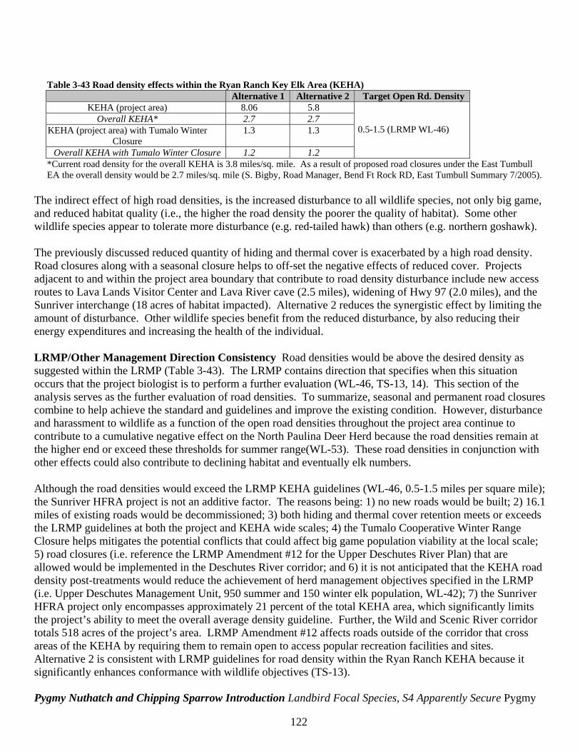
122
Table 3-43 Road density effects within the Ryan Ranch Key Elk Area (KEHA)
Alternative 1 Alternative 2 Target Open Rd. Density KEHA (project area) 8.06 5.8
Overall KEHA* 2.7 2.7 KEHA (project area) with Tumalo Winter
Closure 1.3 1.3
Overall KEHA with Tumalo Winter Closure 1.2 1.2
0.5-1.5 (LRMP WL-46)
*Current road density for the overall KEHA is 3.8 miles/sq. mile. As a result of proposed road closures under the East Tumbull EA the overall density would be 2.7 miles/sq. mile (S. Bigby, Road Manager, Bend Ft Rock RD, East Tumbull Summary 7/2005).
The indirect effect of high road densities, is the increased disturbance to all wildlife species, not only big game, and reduced habitat quality (i.e., the higher the road density the poorer the quality of habitat). Some other wildlife species appear to tolerate more disturbance (e.g. red-tailed hawk) than others (e.g. northern goshawk). The previously discussed reduced quantity of hiding and thermal cover is exacerbated by a high road density. Road closures along with a seasonal closure helps to off-set the negative effects of reduced cover. Projects adjacent to and within the project area boundary that contribute to road density disturbance include new access routes to Lava Lands Visitor Center and Lava River cave (2.5 miles), widening of Hwy 97 (2.0 miles), and the Sunriver interchange (18 acres of habitat impacted). Alternative 2 reduces the synergistic effect by limiting the amount of disturbance. Other wildlife species benefit from the reduced disturbance, by also reducing their energy expenditures and increasing the health of the individual. LRMP/Other Management Direction Consistency Road densities would be above the desired density as suggested within the LRMP (Table 3-43). The LRMP contains direction that specifies when this situation occurs that the project biologist is to perform a further evaluation (WL-46, TS-13, 14). This section of the analysis serves as the further evaluation of road densities. To summarize, seasonal and permanent road closures combine to help achieve the standard and guidelines and improve the existing condition. However, disturbance and harassment to wildlife as a function of the open road densities throughout the project area continue to contribute to a cumulative negative effect on the North Paulina Deer Herd because the road densities remain at the higher end or exceed these thresholds for summer range(WL-53). These road densities in conjunction with other effects could also contribute to declining habitat and eventually elk numbers. Although the road densities would exceed the LRMP KEHA guidelines (WL-46, 0.5-1.5 miles per square mile); the Sunriver HFRA project is not an additive factor. The reasons being: 1) no new roads would be built; 2) 16.1 miles of existing roads would be decommissioned; 3) both hiding and thermal cover retention meets or exceeds the LRMP guidelines at both the project and KEHA wide scales; 4) the Tumalo Cooperative Winter Range Closure helps mitigates the potential conflicts that could affect big game population viability at the local scale; 5) road closures (i.e. reference the LRMP Amendment #12 for the Upper Deschutes River Plan) that are allowed would be implemented in the Deschutes River corridor; and 6) it is not anticipated that the KEHA road density post-treatments would reduce the achievement of herd management objectives specified in the LRMP (i.e. Upper Deschutes Management Unit, 950 summer and 150 winter elk population, WL-42); 7) the Sunriver HFRA project only encompasses approximately 21 percent of the total KEHA area, which significantly limits the project’s ability to meet the overall average density guideline. Further, the Wild and Scenic River corridor totals 518 acres of the project’s area. LRMP Amendment #12 affects roads outside of the corridor that cross areas of the KEHA by requiring them to remain open to access popular recreation facilities and sites. Alternative 2 is consistent with LRMP guidelines for road density within the Ryan Ranch KEHA because it significantly enhances conformance with wildlife objectives (TS-13). Pygmy Nuthatch and Chipping Sparrow Introduction Landbird Focal Species, S4 Apparently Secure Pygmy
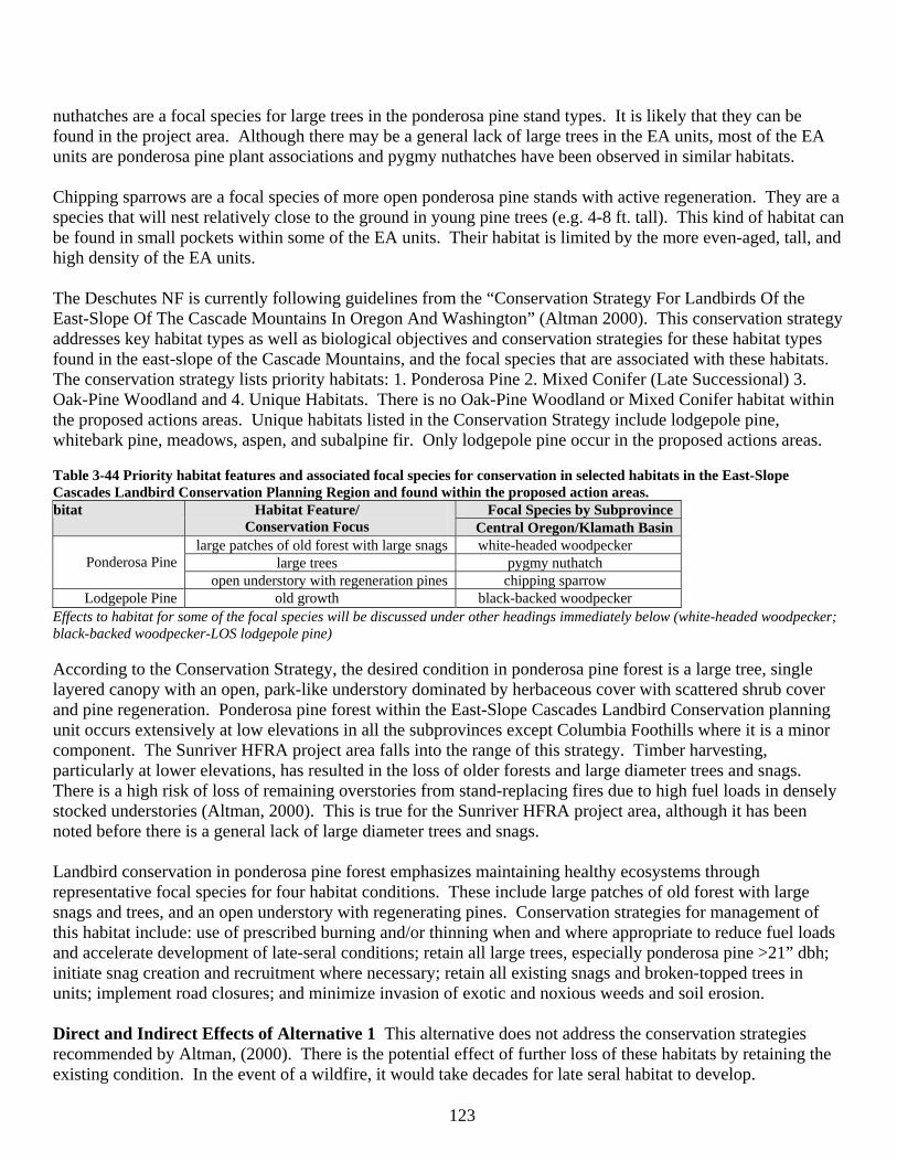
123
nuthatches are a focal species for large trees in the ponderosa pine stand types. It is likely that they can be found in the project area. Although there may be a general lack of large trees in the EA units, most of the EA units are ponderosa pine plant associations and pygmy nuthatches have been observed in similar habitats. Chipping sparrows are a focal species of more open ponderosa pine stands with active regeneration. They are a species that will nest relatively close to the ground in young pine trees (e.g. 4-8 ft. tall). This kind of habitat can be found in small pockets within some of the EA units. Their habitat is limited by the more even-aged, tall, and high density of the EA units. The Deschutes NF is currently following guidelines from the “Conservation Strategy For Landbirds Of the East-Slope Of The Cascade Mountains In Oregon And Washington” (Altman 2000). This conservation strategy addresses key habitat types as well as biological objectives and conservation strategies for these habitat types found in the east-slope of the Cascade Mountains, and the focal species that are associated with these habitats. The conservation strategy lists priority habitats: 1. Ponderosa Pine 2. Mixed Conifer (Late Successional) 3. Oak-Pine Woodland and 4. Unique Habitats. There is no Oak-Pine Woodland or Mixed Conifer habitat within the proposed actions areas. Unique habitats listed in the Conservation Strategy include lodgepole pine, whitebark pine, meadows, aspen, and subalpine fir. Only lodgepole pine occur in the proposed actions areas. Table 3-44 Priority habitat features and associated focal species for conservation in selected habitats in the East-Slope Cascades Landbird Conservation Planning Region and found within the proposed action areas.
Focal Species by Subprovince bitat Habitat Feature/ Conservation Focus Central Oregon/Klamath Basin
large patches of old forest with large snags white-headed woodpecker large trees pygmy nuthatch
Ponderosa Pine
open understory with regeneration pines chipping sparrow Lodgepole Pine old growth black-backed woodpecker
Effects to habitat for some of the focal species will be discussed under other headings immediately below (white-headed woodpecker; black-backed woodpecker-LOS lodgepole pine) According to the Conservation Strategy, the desired condition in ponderosa pine forest is a large tree, single layered canopy with an open, park-like understory dominated by herbaceous cover with scattered shrub cover and pine regeneration. Ponderosa pine forest within the East-Slope Cascades Landbird Conservation planning unit occurs extensively at low elevations in all the subprovinces except Columbia Foothills where it is a minor component. The Sunriver HFRA project area falls into the range of this strategy. Timber harvesting, particularly at lower elevations, has resulted in the loss of older forests and large diameter trees and snags. There is a high risk of loss of remaining overstories from stand-replacing fires due to high fuel loads in densely stocked understories (Altman, 2000). This is true for the Sunriver HFRA project area, although it has been noted before there is a general lack of large diameter trees and snags. Landbird conservation in ponderosa pine forest emphasizes maintaining healthy ecosystems through representative focal species for four habitat conditions. These include large patches of old forest with large snags and trees, and an open understory with regenerating pines. Conservation strategies for management of this habitat include: use of prescribed burning and/or thinning when and where appropriate to reduce fuel loads and accelerate development of late-seral conditions; retain all large trees, especially ponderosa pine >21” dbh; initiate snag creation and recruitment where necessary; retain all existing snags and broken-topped trees in units; implement road closures; and minimize invasion of exotic and noxious weeds and soil erosion. Direct and Indirect Effects of Alternative 1 This alternative does not address the conservation strategies recommended by Altman, (2000). There is the potential effect of further loss of these habitats by retaining the existing condition. In the event of a wildfire, it would take decades for late seral habitat to develop.
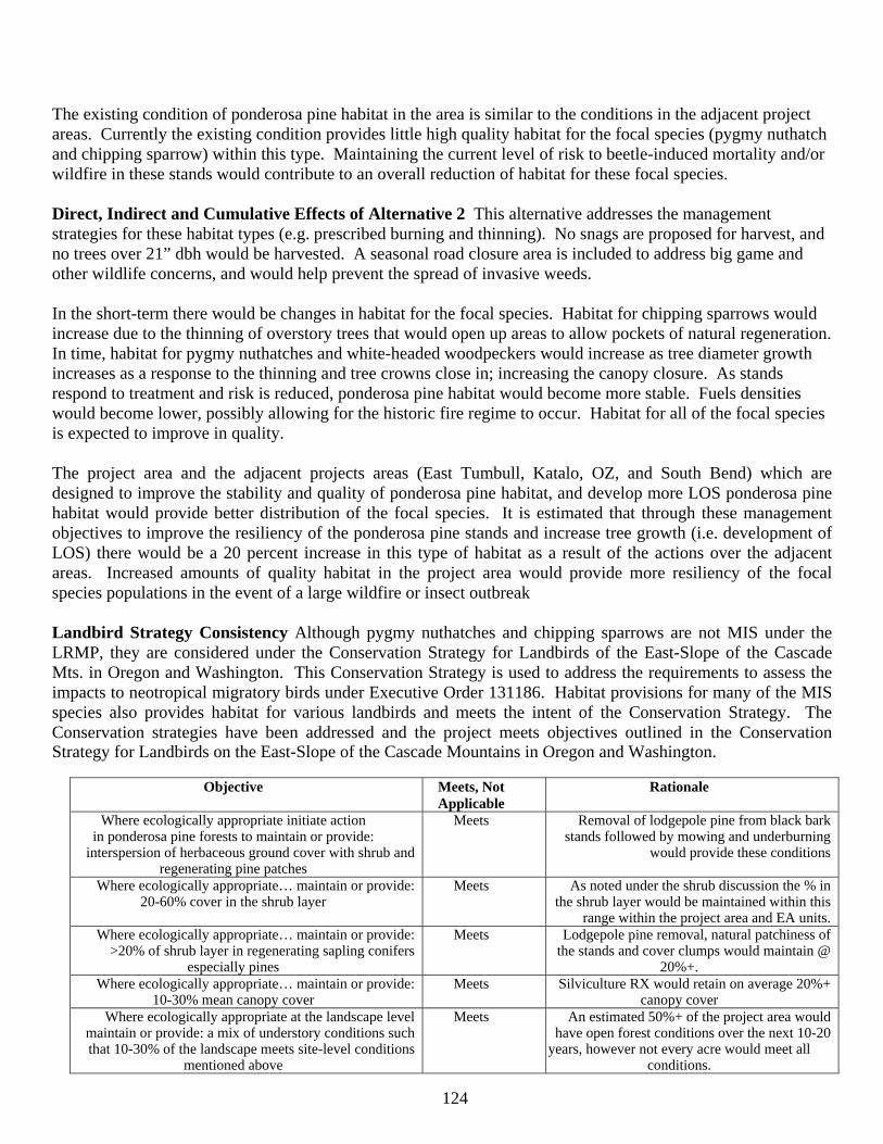
124
The existing condition of ponderosa pine habitat in the area is similar to the conditions in the adjacent project areas. Currently the existing condition provides little high quality habitat for the focal species (pygmy nuthatch and chipping sparrow) within this type. Maintaining the current level of risk to beetle-induced mortality and/or wildfire in these stands would contribute to an overall reduction of habitat for these focal species. Direct, Indirect and Cumulative Effects of Alternative 2 This alternative addresses the management strategies for these habitat types (e.g. prescribed burning and thinning). No snags are proposed for harvest, and no trees over 21” dbh would be harvested. A seasonal road closure area is included to address big game and other wildlife concerns, and would help prevent the spread of invasive weeds. In the short-term there would be changes in habitat for the focal species. Habitat for chipping sparrows would increase due to the thinning of overstory trees that would open up areas to allow pockets of natural regeneration. In time, habitat for pygmy nuthatches and white-headed woodpeckers would increase as tree diameter growth increases as a response to the thinning and tree crowns close in; increasing the canopy closure. As stands respond to treatment and risk is reduced, ponderosa pine habitat would become more stable. Fuels densities would become lower, possibly allowing for the historic fire regime to occur. Habitat for all of the focal species is expected to improve in quality. The project area and the adjacent projects areas (East Tumbull, Katalo, OZ, and South Bend) which are designed to improve the stability and quality of ponderosa pine habitat, and develop more LOS ponderosa pine habitat would provide better distribution of the focal species. It is estimated that through these management objectives to improve the resiliency of the ponderosa pine stands and increase tree growth (i.e. development of LOS) there would be a 20 percent increase in this type of habitat as a result of the actions over the adjacent areas. Increased amounts of quality habitat in the project area would provide more resiliency of the focal species populations in the event of a large wildfire or insect outbreak Landbird Strategy Consistency Although pygmy nuthatches and chipping sparrows are not MIS under the LRMP, they are considered under the Conservation Strategy for Landbirds of the East-Slope of the Cascade Mts. in Oregon and Washington. This Conservation Strategy is used to address the requirements to assess the impacts to neotropical migratory birds under Executive Order 131186. Habitat provisions for many of the MIS species also provides habitat for various landbirds and meets the intent of the Conservation Strategy. The Conservation strategies have been addressed and the project meets objectives outlined in the Conservation Strategy for Landbirds on the East-Slope of the Cascade Mountains in Oregon and Washington.
Objective Meets, Not Applicable
Rationale
Where ecologically appropriate initiate action in ponderosa pine forests to maintain or provide:
interspersion of herbaceous ground cover with shrub and regenerating pine patches
Meets Removal of lodgepole pine from black bark stands followed by mowing and underburning
would provide these conditions
Where ecologically appropriate… maintain or provide: 20-60% cover in the shrub layer
Meets As noted under the shrub discussion the % in the shrub layer would be maintained within this
range within the project area and EA units. Where ecologically appropriate… maintain or provide:
>20% of shrub layer in regenerating sapling conifers especially pines
Meets Lodgepole pine removal, natural patchiness of the stands and cover clumps would maintain @
20%+. Where ecologically appropriate… maintain or provide:
10-30% mean canopy cover Meets Silviculture RX would retain on average 20%+
canopy cover Where ecologically appropriate at the landscape level
maintain or provide: a mix of understory conditions such that 10-30% of the landscape meets site-level conditions
mentioned above
Meets An estimated 50%+ of the project area would have open forest conditions over the next 10-20
years, however not every acre would meet all conditions.
125
LOS lodgepole pine (black-backed woodpecker) habitat Introduction Conservation issues related to this habitat type include its reduction by timber harvest, insect outbreaks, fire suppression, and over-stocked stands (Altman, 2000). Many species that utilize this habitat need relatively large blocks of habitat to maintain populations, and salvage logging in decadent stands has removed nest and foraging trees. Conservation strategies include leaving portions unsalvaged in burned and beetle-killed areas; and exempting areas from commercial timber management in order to retain LOS characteristics as long as possible (Altman, 2000). Direct and Indirect Effects of Alternative 1 Alternative 1 would retain the existing habitat. The lodgepole pine habitats within the proposed action areas are relatively small. The focal species for this habitat, the black-backed woodpecker, can also be found in ponderosa pine habitat. The high risk of losing these stands in the event of a beetle outbreak or wildfire would have similar effects as those described for ponderosa pine habitat. Initially habitat would increase as a result of disturbance in these high risk stands, however, over the long-term it may take more than 40 years for new habitat to develop within the project area. Cumulative effects to this habitat type are similar to those described under the ponderosa pine habitat. The large lodgepole pine-dominated stands as referred to in the Conservation Strategy are not as common in the project area as in other areas to the south. Although there are risks to maintaining current habitat conditions, cumulatively potential effects would be minimal. Direct, Indirect and Cumulative Effects of Alternative 2 None of the EA units are considered old growth lodgepole pine (stage 6L). There are 774 acres of lodgepole pine and mixed lodgepole/ponderosa pine stands falling within the EA unit boundaries. Objectives for treatments within the non-LOS lodgepole plant association involve fire risk reduction in the WUI and maintaining/increasing ponderosa pine dominance. There would be no effect to current LOS lodgepole pine habitat. Treatments within the non-LOS lodgepole habitat may aid in the development of the habitat for the focal species. The focal species for this habitat, the black-backed woodpecker, does use ponderosa pine habitats. Cumulative effects to lodgepole pine habitat are beneficial but minimal. As a result of the actions there would be no additional decrease in mature lodgepole pine habitat over the combined adjacent project areas. Black-backed Woodpecker Introduction MIS, Landbird Focal Species, S3 Vulnerable According to Goggans (1988) and Bull et al (1986), the black-backed woodpecker uses mature ponderosa pine and lodgepole pine habitat types at relatively low elevations (less than 4500 feet), but can be found at higher elevations. Altman (2000) designates black-backed woodpeckers as a focal species for old-growth lodgepole pine. The proposed EA units range in elevation from approximately 4200-4300 feet. It is likely that this species could be found within some of the EA units due to the small amount of, mature lodgepole pine habitat (EA units 6, 7, 16-19, 26). The black-backed woodpecker can use smaller snags for nesting as well as foraging. Bull et al (1986) suggested that this use of smaller diameter snags for nesting is a way of competing with other woodpecker species in the same habitat (e.g. white-headed woodpecker, northern flickers, etc.). The project area and adjacent areas have snags of this size class that can serve as potential habitat. Saab and Dudley (1998) found black-backed woodpeckers selecting for clumps of snags and unlogged control plots in their study on fire and salvage logging. The EA units do have habitat for this species, however there is little “clumping” of existing snags. The largest patch of habitat for this species is within the 18 Fire area that is more than 8 miles away. Direct and Indirect Effects of Alternative 1 There would be no short-term, direct effects to populations of this species as a result of Alternative 1. Habitat for this species would continue to be found in this and adjacent project areas, albeit the habitat would not be considered old-growth lodgepole pine. In the long-term, habitat for this species may increase as the areas with high risk of beetle-induced mortality
126
becomes infested and the trees die; creating patches of nesting and foraging habitat in the ponderosa pine and lodgepole pine habitat types. In areas with mistletoe likely to spread to the understory, it is possible that development of habitat within these areas would be delayed. Mistletoe infestation may grow to the point of having the understory remain small creating a patch of no habitat. Black-backed woodpecker populations in and around the project area may increase as high risk stands succumb to insect and or fire mortality. Direct, Indirect and Cumulative Effects of Alternative 2 There would be no short-term, direct effects to populations of this species. This alternative may delay the development of larger patches of dead trees (i.e. habitat) by thinning or burning stands with a high risk of beetle mortality. Generally, in the long-term (>20 years), by reducing mistletoe, protecting the existing snags within EA units, and providing for some larger green trees (GTRs within units), the EA units in the ponderosa pine and lodgepole pine habitat types would likely achieve mature conditions more quickly than no action. These will become the mature tree and snag habitat in the future that is associated with black-backed woodpecker habitat. However, treatments that improve the growth and health of the forested stands would increase the resilience of these stands to disturbance such as beetle outbreaks and fires. Black-backed woodpeckers can take advantage of these outbreaks as foraging habitat. By increasing the resilience of the stands there is less likelihood that wide-scale fires or insect mortality would occur within the project area. This type of foraging habitat may become more limited at some unknown future date. There would be no short-term, direct effects to populations of this species as a result of this alternative. Past, current, and foreseeable future actions often have the objective to reduce beetle and wildfire risk (e.g. East Tumbull and Katalo projects have approximately 1,000 acres total in stands with a lodgepole pine component), especially within WUI. Large, widespread outbreaks and wildfires are expected to become less common but still occur in patches away from the WUI. Foraging and nesting habitat in the future would likely be distributed in smaller densities across the landscape; and nesting and foraging habitat would become rarer in the WUI. Cumulative effects to this species and its habitat as a result of the alternatives would be negligible due the similarity of habitat throughout the landscape and the common history of past logging. The proposed actions in the proposed project areas would improve the health and resiliency of an approximate 40 percent of lodgepole pine habitat over the landscape (the combined adjacent project areas: East Tumbull, Katalo, OZ, and South Bend). Since the vegetation management objective seeks to reduce the risk of insect outbreaks and wildfire, habitat for this species may become more limited. However, management for higher snag densities would help off-set this effect. Over the landscape, populations are expected to initially decrease due to the effects of management, but would in the long-term stabilize through better management of snag densities. LRMP/Other Management Direction Consistency LRMP direction for this MIS species is met through the consideration and management of habitat currently and in the future. A snag analysis using the DecAID advisor (Table 3-49) has shown that current estimates of snag densities generally meet the directed level except in the lodgepole pine habitats and for large snags. The alternatives would not directly affect current snag densities. The Eastside Screens revised WL-37 to reflect the 100 percent (versus 40 percent) potential population level. This standard as been addressed under the Snag discussion. The Deschutes National Forest Wildlife Tree Implementation Plan (WL-38) was used to determine green tree replacement habitat for future black-backed woodpecker habitat. See Green Tree Replacement (GTR) discussion for how this standard was addressed. White-headed Woodpeckers Introduction MIS, Landbird Focal Species, S2 Imperiled White-headed woodpeckers utilize both live and dead ponderosa pines. They will forage on both live and dead pines often selecting the large diameter pines because they have more seeds and make more suitable nesting habitat.

127
Having large ponderosa pine does not assure this species’ presence. Indications have been made that a well-developed understory of trees and shrubs may encourage mammalian predation on nests (Marshall, 1997). White-headed woodpeckers are absent from early seral ponderosa pine stands. These woodpeckers are poor excavators and generally select for a more moderately decayed or softer snag in which to nest (Dixon 1995 as cited in Marshall 1997). This woodpecker species’ habitat can also be an indicator of goshawk, and pygmy nuthatch habitat. Many of the EA units are not currently nesting habitat for this species because of the lack of large trees and snags, but white-headed woodpeckers may forage within the EA units. Existing habitat for this species would be within the ponderosa pine LOS habitat but even here there is a lack of large diameter ponderosa pine snags in densities recommended in Bull et al (1997 [Tables 18, 21, and 22]). Direct and Indirect Effects of Alternative 1 This alternative would not likely have short-term direct or indirect effects to any existing habitat. In the long-term there may be added recruitment of ponderosa pine snags (<21”) due to insect and/or wildfire mortality. These would not be considered quality nesting habitat for white-headed woodpeckers because this species is associated with larger snags. Development of new, large ponderosa pine may be compromised by the retention of dense stands and subsequent slow diameter growth. Shrub layers, absent wildfires, would continue to develop and provide habitat for nest predators. Direct, Indirect and Cumulative Effects of Alternative 2 Under this alternative no trees >21” dbh would be removed. Although Alternative 2 would not directly effect white-headed woodpeckers, indirectly, in the short and long-term, less habitat may be available because there would be fewer trees that would be healthier. The habitat that would be available in the long-term would be of higher quality because of the better growth rates of the remaining ponderosa pine in the stands. The vegetation management activities of thinning, underburning and mowing would retain more potential habitat for white-headed woodpeckers (the largest trees), while also promoting long-term development of habitat (through thinning and increased growth of remaining trees). Mowing and burning would also reduce the undergrowth that Marshall (1997) refers to as being a detriment to white-headed woodpecker habitat. There are no large, continuous tracts of unharvested white-headed woodpecker habitat on the landscape because of past harvest activities (see LOS discussion). Past, ongoing, and future vegetation management actions on federal land tend to focus on reducing beetle and wildfire risk and/or promoting ponderosa pine and large tree habitat (e.g. Katalo, East Tumbull, South Bend)). In the long-term, this alternative would contribute more LOS ponderosa pine habitat with a corresponding increase in white-headed woodpecker habitat over the landscape. Since neither of the alternatives remove snags or trees >21” (i.e. potential white-headed woodpecker habitat), no cumulative effects to white-headed woodpecker populations are expected. In the long-term, due to shifting emphasis in vegetation management to accelerate the development of LOS ponderosa pine habitat and management of higher snag densities, habitat trend for the white-headed woodpecker is expected to continue to increase. As habitat develops for this species, so does habitat for nuthatches, owls, and other secondary cavity nesters. Likely trends are that populations of white-headed woodpeckers would increase. LRMP/Other Management Direction Consistency LRMP direction for this MIS species is met through the consideration and management of habitat currently and in the future. The dead wood analysis has shown that current estimates of snag densities generally meet the directed level except for large snags. Alternative 2 would not directly affect current snag densities, and would likely improve habitat in the future. Landbird Strategy Consistency Biological objectives for the White-headed woodpecker and Pygmy nuthatch in ponderosa pine LOS is addressed below. The project meets objectives outlined in the Conservation Strategy for Landbirds on the East-Slope of the Cascade Mountains in Oregon and Washington.
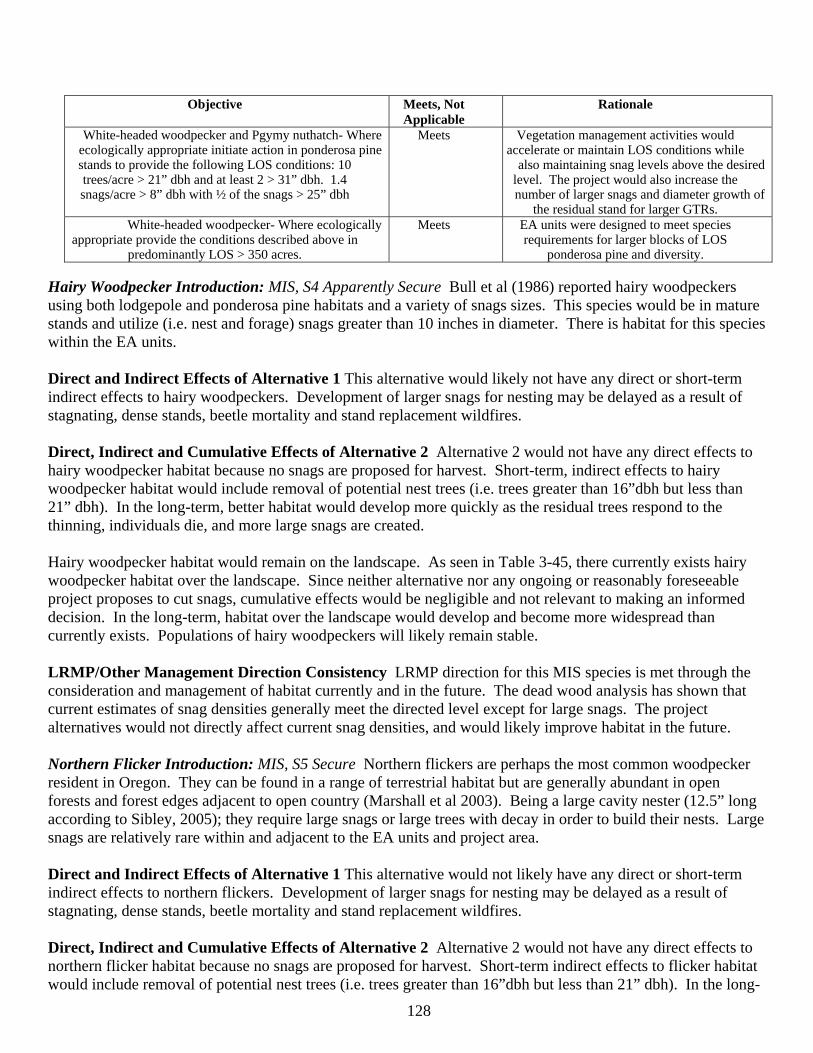
128
Objective Meets, Not Applicable
Rationale
White-headed woodpecker and Pgymy nuthatch- Where ecologically appropriate initiate action in ponderosa pine stands to provide the following LOS conditions: 10 trees/acre > 21” dbh and at least 2 > 31” dbh. 1.4 snags/acre > 8” dbh with ½ of the snags > 25” dbh
Meets Vegetation management activities would accelerate or maintain LOS conditions while
also maintaining snag levels above the desired level. The project would also increase the number of larger snags and diameter growth of
the residual stand for larger GTRs. White-headed woodpecker- Where ecologically
appropriate provide the conditions described above in predominantly LOS > 350 acres.
Meets EA units were designed to meet species requirements for larger blocks of LOS
ponderosa pine and diversity. Hairy Woodpecker Introduction: MIS, S4 Apparently Secure Bull et al (1986) reported hairy woodpeckers using both lodgepole and ponderosa pine habitats and a variety of snags sizes. This species would be in mature stands and utilize (i.e. nest and forage) snags greater than 10 inches in diameter. There is habitat for this species within the EA units. Direct and Indirect Effects of Alternative 1 This alternative would likely not have any direct or short-term indirect effects to hairy woodpeckers. Development of larger snags for nesting may be delayed as a result of stagnating, dense stands, beetle mortality and stand replacement wildfires. Direct, Indirect and Cumulative Effects of Alternative 2 Alternative 2 would not have any direct effects to hairy woodpecker habitat because no snags are proposed for harvest. Short-term, indirect effects to hairy woodpecker habitat would include removal of potential nest trees (i.e. trees greater than 16”dbh but less than 21” dbh). In the long-term, better habitat would develop more quickly as the residual trees respond to the thinning, individuals die, and more large snags are created. Hairy woodpecker habitat would remain on the landscape. As seen in Table 3-45, there currently exists hairy woodpecker habitat over the landscape. Since neither alternative nor any ongoing or reasonably foreseeable project proposes to cut snags, cumulative effects would be negligible and not relevant to making an informed decision. In the long-term, habitat over the landscape would develop and become more widespread than currently exists. Populations of hairy woodpeckers will likely remain stable. LRMP/Other Management Direction Consistency LRMP direction for this MIS species is met through the consideration and management of habitat currently and in the future. The dead wood analysis has shown that current estimates of snag densities generally meet the directed level except for large snags. The project alternatives would not directly affect current snag densities, and would likely improve habitat in the future. Northern Flicker Introduction: MIS, S5 Secure Northern flickers are perhaps the most common woodpecker resident in Oregon. They can be found in a range of terrestrial habitat but are generally abundant in open forests and forest edges adjacent to open country (Marshall et al 2003). Being a large cavity nester (12.5” long according to Sibley, 2005); they require large snags or large trees with decay in order to build their nests. Large snags are relatively rare within and adjacent to the EA units and project area. Direct and Indirect Effects of Alternative 1 This alternative would not likely have any direct or short-term indirect effects to northern flickers. Development of larger snags for nesting may be delayed as a result of stagnating, dense stands, beetle mortality and stand replacement wildfires. Direct, Indirect and Cumulative Effects of Alternative 2 Alternative 2 would not have any direct effects to northern flicker habitat because no snags are proposed for harvest. Short-term indirect effects to flicker habitat would include removal of potential nest trees (i.e. trees greater than 16”dbh but less than 21” dbh). In the long-
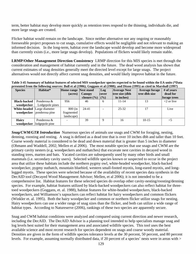
129
term, better habitat may develop more quickly as retention trees respond to the thinning, individuals die, and more large snags are created. Flicker habitat would remain on the landscape. Since neither alternative nor any ongoing or reasonably foreseeable project proposes to cut snags, cumulative effects would be negligible and not relevant to making an informed decision. In the long-term, habitat over the landscape would develop and become more widespread than currently exists (i.e., more large snags develop). Populations of flickers would likely remain stable. LRMP/Other Management Direction Consistency LRMP direction for this MIS species is met through the consideration and management of habitat currently and in the future. The dead wood analysis has shown that current estimates of snag densities generally meet the directed level except for large snags. The project alternatives would not directly affect current snag densities, and would likely improve habitat in the future. Table 3-45 Summary of habitat features of selected MIS woodpecker species expected to be found within the EA units (*Data presented from the following sources: Bull et al (1986); Goggans et al (1988); and Dixon (1995) as cited in Marshall (1997)
Species Habitat* Home range (acres)
Nest stand Canopy closure (%)
Log cover (%)
Average Nest tree size (dbh
in inches)
Average forage tree dbh size
# of years dead for
forage trees Black-backed
woodpecker Ponderosa & Lodgepole pines
956 46 6 11-14 13 <2 or live
White-headed woodpecker
Large diameter ponderosa pine
800 (in fragmented landscape)
24-41 - 25-32 17 Live
Hairy woodpecker
Ponderosa & lodgepole pine
- 39 9 16 10-15 <5
Snag/CWM/GTR Introduction Numerous species of animals use snags and CWM for foraging, nesting, denning, roosting and resting. A snag is defined as a dead tree that is over 10 inches dbh and taller than 10 feet. Coarse woody material is considered to be dead and down material that is greater than 5 inches in diameter (Ohmann and Waddell, 2002; Mellen et al 2006). The most notable species that use snags and CWM are the primary cavity nesters (e.g. woodpeckers and nuthatches) that excavate nest cavities in decayed wood in standing trees, marten and bats. Vacated cavities are subsequently used by many other birds and small mammals (i.e. secondary cavity users). Selected wildlife species known or suspected to occur in the project area that utilize these habitats include the northern pygmy owl, white-headed woodpecker, black-backed woodpecker, pygmy nuthatch, mountain bluebird, western small-footed myotis, long-eared myotis, and long-legged myotis. These species were selected because of the availability of recent species data synthesis in the DecAID tool (Decayed Wood Management Advisor; Mellen, et al 2006); it is not intended to be a comprehensive list. Habitat features for these selected species do overlap other cavity-nesting/roosting/denning species. For example, habitat features utilized by black-backed woodpeckers can also reflect habitat for three-toed woodpeckers (Goggans, et. al. 1988), habitat features for white-headed woodpeckers, black-backed woodpeckers, and Williamson’s sapsuckers can reflect habitat for hairy woodpeckers and common flickers (Winkler et. al. 1995). Both the hairy woodpecker and common or northern flicker utilize snags for nesting. Hairy woodpeckers can use a wider range of snag sizes than the flicker, and both can utilize a wide range of habitat types. According to Natureserve (2006), rankings of these two species are apparently secure. Snag and CWM habitat conditions were analyzed and compared using current direction and newer research, including the DecAID. The DecAID Advisor is a planning tool intended to help specialists manage snag and log levels best suited for their management area and associated wildlife species. This tool uses the best available science and most recent research for species dependent on snags and coarse woody material. Densities are given in the form of wildlife species tolerance levels at the 30 percent, 50 percent, and 80 percent levels. For example, assuming normally distributed data, if 20 percent of a species’ nests were in areas with >
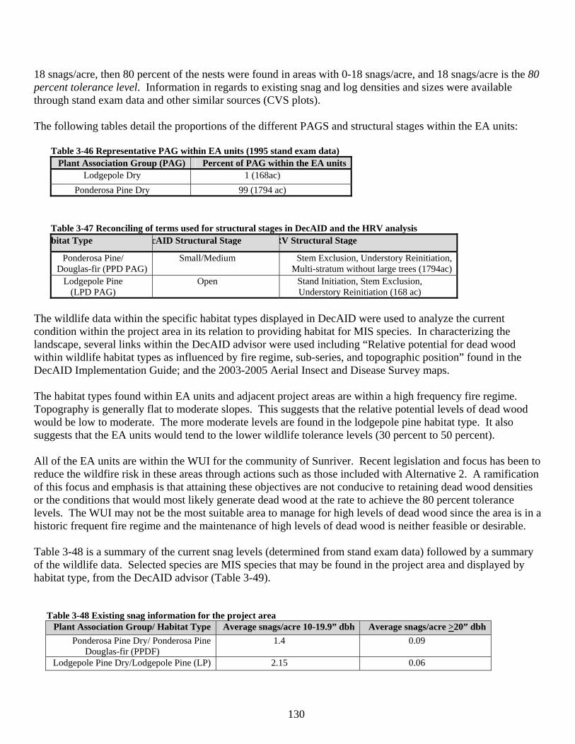
130
18 snags/acre, then 80 percent of the nests were found in areas with 0-18 snags/acre, and 18 snags/acre is the 80 percent tolerance level. Information in regards to existing snag and log densities and sizes were available through stand exam data and other similar sources (CVS plots). The following tables detail the proportions of the different PAGS and structural stages within the EA units:
Table 3-46 Representative PAG within EA units (1995 stand exam data) Plant Association Group (PAG) Percent of PAG within the EA units
Lodgepole Dry 1 (168ac) Ponderosa Pine Dry 99 (1794 ac)
Table 3-47 Reconciling of terms used for structural stages in DecAID and the HRV analysis bitat Type cAID Structural Stage RV Structural Stage
Ponderosa Pine/ Douglas-fir (PPD PAG)
Small/Medium Stem Exclusion, Understory Reinitiation, Multi-stratum without large trees (1794ac)
Lodgepole Pine (LPD PAG)
Open Stand Initiation, Stem Exclusion, Understory Reinitiation (168 ac)
The wildlife data within the specific habitat types displayed in DecAID were used to analyze the current condition within the project area in its relation to providing habitat for MIS species. In characterizing the landscape, several links within the DecAID advisor were used including “Relative potential for dead wood within wildlife habitat types as influenced by fire regime, sub-series, and topographic position” found in the DecAID Implementation Guide; and the 2003-2005 Aerial Insect and Disease Survey maps. The habitat types found within EA units and adjacent project areas are within a high frequency fire regime. Topography is generally flat to moderate slopes. This suggests that the relative potential levels of dead wood would be low to moderate. The more moderate levels are found in the lodgepole pine habitat type. It also suggests that the EA units would tend to the lower wildlife tolerance levels (30 percent to 50 percent). All of the EA units are within the WUI for the community of Sunriver. Recent legislation and focus has been to reduce the wildfire risk in these areas through actions such as those included with Alternative 2. A ramification of this focus and emphasis is that attaining these objectives are not conducive to retaining dead wood densities or the conditions that would most likely generate dead wood at the rate to achieve the 80 percent tolerance levels. The WUI may not be the most suitable area to manage for high levels of dead wood since the area is in a historic frequent fire regime and the maintenance of high levels of dead wood is neither feasible or desirable. Table 3-48 is a summary of the current snag levels (determined from stand exam data) followed by a summary of the wildlife data. Selected species are MIS species that may be found in the project area and displayed by habitat type, from the DecAID advisor (Table 3-49).
Table 3-48 Existing snag information for the project area Plant Association Group/ Habitat Type Average snags/acre 10-19.9” dbh Average snags/acre >20” dbh
Ponderosa Pine Dry/ Ponderosa Pine Douglas-fir (PPDF)
1.4 0.09
Lodgepole Pine Dry/Lodgepole Pine (LP) 2.15 0.06
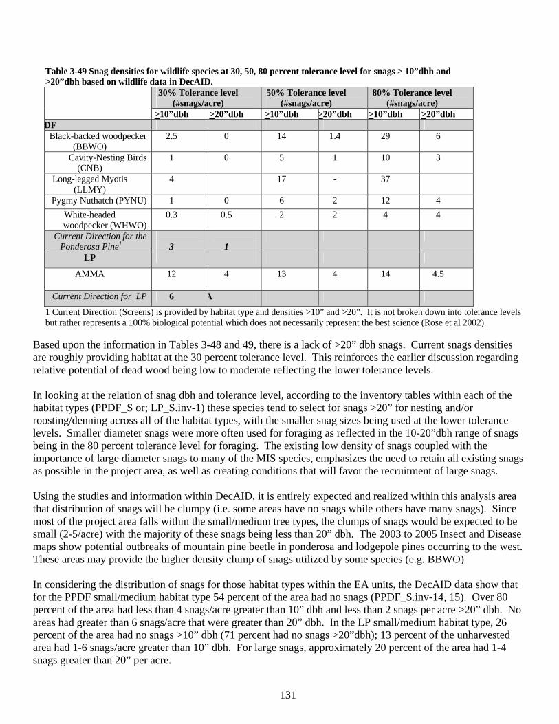
131
Table 3-49 Snag densities for wildlife species at 30, 50, 80 percent tolerance level for snags > 10”dbh and >20”dbh based on wildlife data in DecAID.
30% Tolerance level (#snags/acre)
50% Tolerance level (#snags/acre)
80% Tolerance level (#snags/acre)
>10”dbh >20”dbh >10”dbh >20”dbh >10”dbh >20”dbh DF
Black-backed woodpecker (BBWO)
2.5 0 14 1.4 29 6
Cavity-Nesting Birds (CNB)
1 0 5 1 10 3
Long-legged Myotis (LLMY)
4 17 - 37
Pygmy Nuthatch (PYNU) 1 0 6 2 12 4 White-headed
woodpecker (WHWO) 0.3 0.5 2 2 4 4
Current Direction for the Ponderosa Pine1
3
1
LP
AMMA 12 4 13 4 14 4.5
Current Direction for LP 6 A
1 Current Direction (Screens) is provided by habitat type and densities >10” and >20”. It is not broken down into tolerance levels but rather represents a 100% biological potential which does not necessarily represent the best science (Rose et al 2002).
Based upon the information in Tables 3-48 and 49, there is a lack of >20” dbh snags. Current snags densities are roughly providing habitat at the 30 percent tolerance level. This reinforces the earlier discussion regarding relative potential of dead wood being low to moderate reflecting the lower tolerance levels. In looking at the relation of snag dbh and tolerance level, according to the inventory tables within each of the habitat types (PPDF_S or; LP_S.inv-1) these species tend to select for snags >20” for nesting and/or roosting/denning across all of the habitat types, with the smaller snag sizes being used at the lower tolerance levels. Smaller diameter snags were more often used for foraging as reflected in the 10-20”dbh range of snags being in the 80 percent tolerance level for foraging. The existing low density of snags coupled with the importance of large diameter snags to many of the MIS species, emphasizes the need to retain all existing snags as possible in the project area, as well as creating conditions that will favor the recruitment of large snags. Using the studies and information within DecAID, it is entirely expected and realized within this analysis area that distribution of snags will be clumpy (i.e. some areas have no snags while others have many snags). Since most of the project area falls within the small/medium tree types, the clumps of snags would be expected to be small (2-5/acre) with the majority of these snags being less than 20” dbh. The 2003 to 2005 Insect and Disease maps show potential outbreaks of mountain pine beetle in ponderosa and lodgepole pines occurring to the west. These areas may provide the higher density clump of snags utilized by some species (e.g. BBWO) In considering the distribution of snags for those habitat types within the EA units, the DecAID data show that for the PPDF small/medium habitat type 54 percent of the area had no snags (PPDF_S.inv-14, 15). Over 80 percent of the area had less than 4 snags/acre greater than 10” dbh and less than 2 snags per acre >20” dbh. No areas had greater than 6 snags/acre that were greater than 20” dbh. In the LP small/medium habitat type, 26 percent of the area had no snags >10” dbh (71 percent had no snags >20”dbh); 13 percent of the unharvested area had 1-6 snags/acre greater than 10” dbh. For large snags, approximately 20 percent of the area had 1-4 snags greater than 20” per acre.
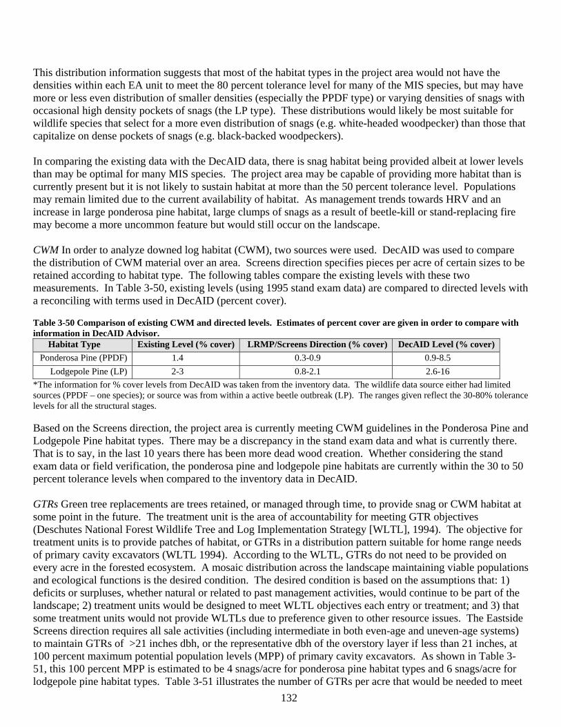
132
This distribution information suggests that most of the habitat types in the project area would not have the densities within each EA unit to meet the 80 percent tolerance level for many of the MIS species, but may have more or less even distribution of smaller densities (especially the PPDF type) or varying densities of snags with occasional high density pockets of snags (the LP type). These distributions would likely be most suitable for wildlife species that select for a more even distribution of snags (e.g. white-headed woodpecker) than those that capitalize on dense pockets of snags (e.g. black-backed woodpeckers). In comparing the existing data with the DecAID data, there is snag habitat being provided albeit at lower levels than may be optimal for many MIS species. The project area may be capable of providing more habitat than is currently present but it is not likely to sustain habitat at more than the 50 percent tolerance level. Populations may remain limited due to the current availability of habitat. As management trends towards HRV and an increase in large ponderosa pine habitat, large clumps of snags as a result of beetle-kill or stand-replacing fire may become a more uncommon feature but would still occur on the landscape. CWM In order to analyze downed log habitat (CWM), two sources were used. DecAID was used to compare the distribution of CWM material over an area. Screens direction specifies pieces per acre of certain sizes to be retained according to habitat type. The following tables compare the existing levels with these two measurements. In Table 3-50, existing levels (using 1995 stand exam data) are compared to directed levels with a reconciling with terms used in DecAID (percent cover). Table 3-50 Comparison of existing CWM and directed levels. Estimates of percent cover are given in order to compare with information in DecAID Advisor.
Habitat Type Existing Level (% cover) LRMP/Screens Direction (% cover) DecAID Level (% cover) Ponderosa Pine (PPDF) 1.4 0.3-0.9 0.9-8.5
Lodgepole Pine (LP) 2-3 0.8-2.1 2.6-16 *The information for % cover levels from DecAID was taken from the inventory data. The wildlife data source either had limited sources (PPDF – one species); or source was from within a active beetle outbreak (LP). The ranges given reflect the 30-80% tolerance levels for all the structural stages. Based on the Screens direction, the project area is currently meeting CWM guidelines in the Ponderosa Pine and Lodgepole Pine habitat types. There may be a discrepancy in the stand exam data and what is currently there. That is to say, in the last 10 years there has been more dead wood creation. Whether considering the stand exam data or field verification, the ponderosa pine and lodgepole pine habitats are currently within the 30 to 50 percent tolerance levels when compared to the inventory data in DecAID. GTRs Green tree replacements are trees retained, or managed through time, to provide snag or CWM habitat at some point in the future. The treatment unit is the area of accountability for meeting GTR objectives (Deschutes National Forest Wildlife Tree and Log Implementation Strategy [WLTL], 1994). The objective for treatment units is to provide patches of habitat, or GTRs in a distribution pattern suitable for home range needs of primary cavity excavators (WLTL 1994). According to the WLTL, GTRs do not need to be provided on every acre in the forested ecosystem. A mosaic distribution across the landscape maintaining viable populations and ecological functions is the desired condition. The desired condition is based on the assumptions that: 1) deficits or surpluses, whether natural or related to past management activities, would continue to be part of the landscape; 2) treatment units would be designed to meet WLTL objectives each entry or treatment; and 3) that some treatment units would not provide WLTLs due to preference given to other resource issues. The Eastside Screens direction requires all sale activities (including intermediate in both even-age and uneven-age systems) to maintain GTRs of >21 inches dbh, or the representative dbh of the overstory layer if less than 21 inches, at 100 percent maximum potential population levels (MPP) of primary cavity excavators. As shown in Table 3-51, this 100 percent MPP is estimated to be 4 snags/acre for ponderosa pine habitat types and 6 snags/acre for lodgepole pine habitat types. Table 3-51 illustrates the number of GTRs per acre that would be needed to meet
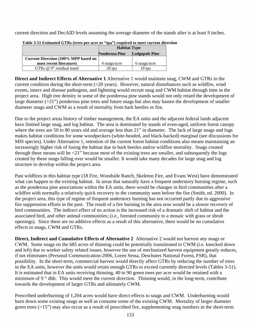
133
current direction and DecAID levels assuming the average diameter of the stands after is at least 9 inches.
Table 3-51 Estimated GTRs (trees per acre or “tpa”) required to meet current direction Habitat Type
Ponderosa Pine Lodgepole Pine Current Direction (100% MPP based on
most recent literature)
4 snags/acre
6 snags/acre GTRs @ 9” residual stand 20 tpa 19 tpa
Direct and Indirect Effects of Alternative 1 Alternative 1 would maintain snag, CWM and GTRs in the current condition during the short-term (<20 years). However, natural disturbances such as wildfire, wind events, insect and disease pathogens, and lightning would recruit snag and CWM habitat through time in the project area. High tree density in some of the ponderosa pine stands would not only retard the development of large diameter (>21”) ponderosa pine trees and future snags but also may hasten the development of smaller diameter snags and CWM as a result of mortality from bark beetles or fire. Due to the project areas history of timber management, the EA units and the adjacent federal lands adjacent have limited large snag, and log habitat. The area is dominated by stands of even-aged, uniform forest canopy where the trees are 50 to 80 years old and average less than 21” in diameter. The lack of large snags and logs makes habitat conditions for some woodpeckers (white-headed, and black-backed) marginal (see discussions for MIS species). Under Alternative 1, retention of the current forest habitat conditions also means maintaining an increasingly higher risk of losing the habitat due to bark beetles and/or wildfire mortality. Snags created through these means will be <21” because most of the existing trees are smaller, and subsequently the logs created by these snags falling over would be smaller. It would take many decades for large snag and log structure to develop within the project area. Past wildfires in this habitat type (18 Fire, Woodside Ranch, Skeleton Fire, and Evans West) have demonstrated what can happen to the existing habitat. In areas that naturally have a frequent understory burning regime, such as the ponderosa pine associations within the EA units, there would be changes in bird communities after a wildfire with normally a relatively quick recovery to the community seen before the fire (Smith, ed. 2000). In the project area, this type of regime of frequent understory burning has not occurred partly due to aggressive fire suppression efforts in the past. The result of a fire burning in the area now would be a slower recovery of bird communities. The indirect effect of no action is the increased risk of a dramatic shift of habitat and the associated bird, and other animal communities; (i.e., forested community to a mosaic with grass or shrub openings). Since there are no additive effects as a result of this alternative, there would be no cumulative effects to snags, CWM and GTRs. Direct, Indirect and Cumulative Effects of Alternative 2 Alternative 2 would not harvest any snags or CWM. Some snags on the 685 acres of thinning could be potentially transitioned to CWM (i.e. knocked down and left) due to worker safety related issues, however the use of mechanized harvest equipment greatly reduces, if not eliminates (Personal Communication-2006, Loren Sessa, Deschutes National Forest, FSR), that possibility. In the short-term, commercial harvest would directly affect GTRs by reducing the number of trees in the EA units, however the units would retain enough GTRs to exceed currently directed levels (Tables 3-51). It is estimated that in EA units receiving thinning, 40 to 90 green trees per acre would be retained with a minimum of 9 “ dbh. This would meet the current direction. Thinning would, in the long-term, contribute towards the development of larger GTRs and ultimately CWM. Prescribed underburning of 1,204 acres would have direct effects to snags and CWM. Underburning would burn down some existing snags as well as consume some of the existing CWM. Mortality of larger diameter green trees (>15”) may also occur as a result of prescribed fire, supplementing snag numbers in the short-term
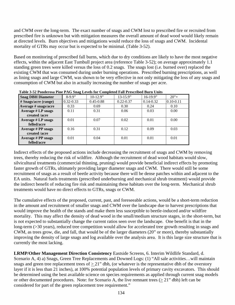
134
and CWM over the long-term. The exact number of snags and CWM lost to prescribed fire or recruited from prescribed fire is unknown but with mitigation measures the overall amount of dead wood would likely remain at directed levels. Burn objectives and mitigations would reduce the loss of snags and CWM. Incidental mortality of GTRs may occur but is expected to be minimal. (Table 3-52). Based on monitoring of prescribed fall burns, which due to dry conditions are likely to have the most negative effects, within the adjacent East Tumbull project area (reference Table 3-52); on average approximately 1.1 standing green trees were killed versus the loss of 0.2 snags. The snags lost (i.e. burned over) replaced the existing CWM that was consumed during under burning operations. Prescribed burning prescriptions, as well as lining snags and large CWM, was shown to be very effective in not only mitigating the loss of any snags and consumption of CWM but also in actually increasing the number of snags per acre.
Table 3-52 Ponderosa Pine PAG Snag Levels for Completed Fall Prescribed Burn Units Snag DBH Diameter 8-9.9” 10-12.9” 13-15.9” 16-19.9” 20”+ # Snags/acre (range) 0.32-0.33 0.45-0.88 0.22-0.37 0.14-0.32 0.10-0.11 Average # snags/acre 0.33 0.69 0.30 0.24 0.10 Average # LP snags
created /acre 0.11 0.31 0.06 0.03 0.00
Average # LP snags felled/acre
0.01 0.07 0.02 0.01 0.00
Average # PP snags created /acre
0.16 0.31 0.12 0.09 0.03
Average # PP snags felled/acre
0.01 0.04 0.01 0.01 0.01
Indirect effects of the proposed actions include decreasing the recruitment of snags and CWM by removing trees, thereby reducing the risk of wildfire. Although the recruitment of dead wood habitats would slow, silvicultural treatments (commercial thinning, pruning) would provide beneficial indirect effects by promoting faster growth of GTRs, ultimately providing larger diameter snags and CWM. There would still be some recruitment of snags as a result of beetle activity because there will be dense patches within and adjacent to the EA units. Natural fuels treatments (prescribed underburning and mechanical shrub treatment) would provide the indirect benefit of reducing fire risk and maintaining these habitats over the long-term. Mechanical shrub treatments would have no direct effects to GTRs, snags or CWM. The cumulative effects of the proposed, current, past, and foreseeable actions, would be a short-term reduction in the amount and recruitment of smaller snags and CWM over the landscape due to harvest prescriptions that would improve the health of the stands and make them less susceptible to beetle-induced and/or wildfire mortality. This may affect the density of dead wood in the small/medium structure stages, in the short-term, but is not expected to substantially change the current ratios seen over the landscape. One benefit is that in the long-term (>30 years), reduced tree competition would allow for accelerated tree growth resulting in snags and CWM, as trees grow, die, and fall, that would be of the larger diameters (20” or more), thereby substantially improving the density of large snags and log available over the analysis area. It is this large size structure that is currently the most lacking. LRMP/Other Management Direction Consistency Eastside Screens, 6. Interim Wildlife Standard, d. Scenario A, 4) a) Snags, Green Tree Replacements and Downed Logs: (1) “All sale activities…will maintain snags and green tree replacement trees of > 21” dbh, (or whatever is the representative dbh of the overstory layer if it is less than 21 inches), at 100% potential population levels of primary cavity excavators. This should be determined using the best available science on species requirements as applied through current snag models or other documented procedures. Note: for Scenario A, the live remnant trees (> 21” dbh) left can be considered for part of the green replacement tree requirement.”
135
No snags are planned to be removed under either alternative. There would be no direct impacts to snags levels. Snag levels are below desired levels in some habitat types, however no further reduction in snag habitat would likely occur with the implementation Alternative 2. CWM The Screens (6. Interim wildlife standard; d. Scenario A, 4) Snags, Green Tree Replacements and Down Logs; [2]) revised LRMP standards WL-72, 73 to read: “ Pre-activity (currently existing) downed logs may be removed only when they exceed the quantities listed below…It is not the intention of this direction to leave standing trees for future logs in addition to the required snag numbers…” Quantities of logs: 3-6 pieces greater than 6 ft long and 12” in diameter or greater be maintained in ponderosa pine types (15-20 in mixed conifer), and 15-20 pieces greater than 8 feet long and 8” in diameter be maintained in lodgepole pine types. Existing levels appear to generally meet those proposed by current direction (Table 3-50), however no CWM would be removed under either alternative and levels would likely remain the same. Alternative 2 may have minor beneficial effects to long-term CWM recruitment. GTRs Eastside Screens, 6. Interim Wildlife Standard, d. Scenario A, 4) a) Snags, Green Tree Replacements and Downed Logs: (1) “All sale activities…will maintain snags and green tree replacement trees of > 21” dbh, (or whatever is the representative dbh of the overstory layer if it is less than 21 inches), at 100% potential population levels of primary cavity excavators. This should be determined using the best available science on species requirements as applied through current snag models or other documented procedures. NOTE: for Scenario A, the live remnant trees (> 21” dbh) left can be considered for part of the green replacement tree requirement.” LRMP direction refers to Deschutes DWTL for GTR numbers. This document gives figures based on Thomas 1979. In Bull et al (1997) it is suggested that Thomas figures were not high enough to cover all habitat needs. Using Screens direction to use most recent research, the GTR figures given in the DWTL were recalculated to reflect the updated 100 percent potential population levels based on newer research. Rose et al (2002) and Mellen et al (2006) determined that the “potential population level” is a flawed technique. Mellen et al (2006) uses statistical “tolerance levels” in the DecAID tool. DecAID is not part of the Screens direction, therefore its use was for comparison purposes. Alternative 2 vegetation management treatments are expected to retain 40-90 trees per acre, and would meet the directed levels (Table 3-51) for the ponderosa pine types. These levels exceed the baseline GTR levels given in the Screens direction and WLTL that were based on Thomas (1979). LOS Habitat/Connectivity Introduction Late and Old Structure Forest Habitat (LOS) LOS is defined by the Eastside Screens as multi-strata stands with large trees (referred to as stage 6) and single strata stands with large trees (referred to as stage 7). A large tree is defined as being greater than or equal to 21 inches in DBH. Multi-stratum stands are comprised of two or more tree canopy layers and two or more size cohorts of trees. Medium and large sized trees dominate the overstory but trees of all size classes may be present. Stand structure and tree sizes are diverse. Single stratum LOS stands are comprised of a single dominant canopy stratum consisting of medium or large sized trees. Large trees are common. Young trees are absent or few in the understory. The stand may appear “park-like”. There are no Old-Growth Management Areas (OGMAs) within or proximate (within 5000 acres) of the project area. There is no classified LOS within any of the EA units. The amount of LOS is extremely limited due to the extensive timber harvest described earlier. Both the stage 6 and stage 7 structural stages are below the HRV, defined as conditions in the pre-European settlement area. Low amounts of this habitat limit the
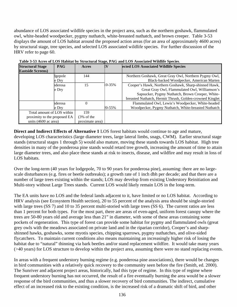
136
abundance of LOS associated wildlife species in the project area, such as the northern goshawk, flammulated owl, white-headed woodpecker, pygmy nuthatch, white-breasted nuthatch, and brown creeper. Table 3-53 displays the amount of LOS habitat around the proposed action areas (for an area of approximately 4600 acres) by structural stage, tree species, and selected LOS associated wildlife species. For further discussion of the HRV refer to page 60.
Table 3-53 Acres of LOS Habitat by Structural Stage, PAG and LOS Associated Wildlife Species. Structural Stage
(Eastside Screens) PAG Acres RV ected LOS Associated Wildlife Species
dgepole ne Dry
144 Northern Goshawk, Great Gray Owl, Northern Pygmy Owl, Black-backed Woodpecker, American Marten
nderosa ne Dry
15
10-35% Cooper’s Hawk, Northern Goshawk, Sharp-shinned Hawk, Great Gray Owl, Flammulated Owl, Williamson’s
Sapsucker, Pygmy Nuthatch, Brown Creeper, White- breasted Nuthatch, Hermit Thrush, Golden-crowned Kinglet
nderosa ne Dry
0 20-55%
Flammulated Owl, Lewis’s Woodpecker, White-headed Woodpecker, Pygmy Nuthatch, White-breasted Nuthatch
Total amount of LOS within proximity to the proposed EA units (4600 ac area)
159 (3% of the
proximate area)
Direct and Indirect Effects of Alternative 1 LOS forest habitats would continue to age and mature, developing LOS characteristics (large diameter trees, large lateral limbs, snags, CWM). Earlier structural stage stands (structural stages 1 through 5) would also mature, moving these stands towards LOS habitat. High tree densities in many of the ponderosa pine stands would retard tree growth, increasing the amount of time to attain large diameter trees, and also place these stands at risk to insects, disease, and wildfire and may result in loss of LOS habitats. Over the long-term (40 years for lodgepole, 70 to 90 years for ponderosa pine), assuming: there are no large-scale disturbances (e.g. fires or beetle outbreaks); a growth rate of 1 inch dbh per decade; and that there are a number of large trees existing within the stands; LOS may develop from existing Understory Reinitiation and Multi-story without Large Trees stands. Current LOS would likely remain LOS in the long-term. The EA units have no LOS and the federal lands adjacent to it, have limited or no LOS habitat. According to HRV analysis (see Ecosystem Health section), 20 to 55 percent of the analysis area should be single-storied with large trees (SS 7) and 10 to 35 percent multi-storied with large trees (SS 6). The current ratios are less than 1 percent for both types. For the most part, there are areas of even-aged, uniform forest canopy where the trees are 50-80 years old and average less than 21” in diameter, with some of these areas containing some pockets of regeneration. This type of forest can provide some habitat for pygmy and flammulated owls (great grey owls with the meadows associated on private land and in the riparian corridor), Cooper’s and sharp-shinned hawks, goshawks, some myotis species, chipping sparrows, pygmy nuthatches, and olive-sided flycatchers. To maintain current conditions also means maintaining an increasingly higher risk of losing the habitat due to “natural” thinning via bark beetles and/or stand replacement wildfire. It would take many years (>40 years) for LOS structure to develop within the project area, assuming there were no stand replacing events. In areas with a frequent understory burning regime (e.g. ponderosa pine associations), there would be changes in bird communities with a relatively quick recovery to the community seen before the fire (Smith, ed. 2000). The Sunriver and adjacent project areas, historically, had this type of regime. In this type of regime where frequent understory burning has not occurred, the result of a fire eventually burning the area would be a slower response of the bird communities, and thus a slower recovery of bird communities. The indirect, cumulative effect of an increased risk to the existing condition, is the increased risk of a dramatic shift of bird, and other
137
animal communities. The 18 and Woodside Ranch Fires illustrated what would happen under the no action alternative. As a result of no action, this project area would provide continuous forest habitat for wildlife but with a high risk of wildfire. LOS habitat, with a low risk to beetles and/or wildfire, would be provided over the long-term (>20 years) in adjacent project areas as a result of the current and foreseeable projects (e.g. approx. 496 acre of LOS in East Tumbull project area). Direct, Indirect and Cumulative Effects of Alternative 2 There would no direct effects to existing LOS as a result of Alternative 2 because none of the EA units contain LOS habitat. In time, the effects of the vegetation management activities would be to: increase tree growth within the EA units, providing a dominance of large diameter trees and multiple canopy layered stands in the future; reduce the risk of loss to wildfire by reducing ground, ladder and crown fuels; reduce the risk of mortality from insects, primarily bark beetles, by reducing tree competition. A component of structural stage 7 (single-story with large trees), that is currently absent, would develop. This would benefit species associated with this habitat type, such as the white-headed woodpecker and nuthatches. A negative effect is to reduce the immediate recruitment of snags and coarse woody material (CWM) by increasing tree growth and vigor. This negative aspect is offset by the increased tree growth that would in time provide for larger diameter snags and CWM suitable for a greater variety of cavity and down wood associated wildlife. Over time, treated stands would become LOS, provide large diameter trees, and large diameter snags and CWM. The long-term effects of the proposed actions would be to increase the amount of ponderosa pine LOS (open understory, frequent fire regime). In the short-term (e.g. next 20 years), much of the area would have little LOS habitat as a result of past management actions and natural events such as wildfire. Over the long-term (>20 years) the abundance of LOS habitat and the wildlife species associated with it are expected to increase within the EA units. Existing LOS habitat is also expected to be more resilient to major events (e.g. wildfire or insect outbreak) because of the managed stands around them and an overall decrease in fuel loading around them. Wildlife species that would benefit the most in the long-term, would be those that are associated with old-growth ponderosa pine. Over the larger landscape (15,000 acres), the current proportions and trends within LOS are similar and effects within adjacent project areas are additive. Assuming that thinning would set the stage for an increase in LOS, there would be an addition of 1,867 acres of ponderosa pine LOS over the area. In the long-term, as larger structure develops as a result of the other vegetation management objectives to increase health, vigor/growth, and resiliency of stands approximately 7,883 acres more of LOS habitat would become available (approximate acres contributed by the East Tumbull project area: currently 77 ac of ponderosa pine LOS with over 7000 acres of ponderosa pine not currently LOS thinned and would become LOS). LRMP/Other Management Direction Consistency Eastside Screens, 6. Interim wildlife standard, d. Scenario A “DO NOT allow timber sale harvest activities to occur within LOS stages that are BELOW HRV.” 2) (a) “maintain all…live trees >21” dbh that currently exist. b) manipulate vegetative structure that does not meet late and old structural conditions…in a manner that moves it towards these conditions as appropriate to meet HRV.” There are no vegetation management activities within any classified LOS. Treatments are expected to move the project area towards the HRV. Connectivity Introduction Maintaining connectivity between habitats, particularly LOS habitat, is believed to be important for numerous wildlife species. Connectivity of habitats is believed to allow free movement, interaction of adults, and dispersal of young. Although there is current controversy regarding the value of corridors (Nature.com/news/2007), management direction pertaining to maintaining connectivity between late
138
and old structured stands, in addition to designated old growth management areas, is provided by the Eastside Screens. Eastside Screen direction is to maintain or enhance the current level of connectivity between LOS stands and between all LRMP designated old growth (OGMA) habitats by maintaining stands between them. LOS stands and old growth (OGMA) habitats need to be connected to each other inside the project area, as well as, to adjacent project areas, by at least two directions. Connectivity corridor stands should be those in which medium diameter or larger trees are common, and canopy closures are within the top one-third of site potential. Stand widths should be at least 400 feet wide at their narrowest point. If stands meeting this description are not available then the next best stands should be used for connections. The length of corridors between LOS stands and old growth management areas should be as short as possible. Connectivity corridors, meeting Eastside Screens direction, were identified within the overall project area (page 70). The corridors connect all LRMP OGMA to stands classified as LOS and to OGMA management areas and LOS stands in adjacent project areas. Management direction related to maintaining travel corridors for big game (deer and elk) is provided by the LRMP. Travel corridors may be provided where needed by linking stands that meet hiding cover definitions for deer and elk (LRMP WL-48 & WL-56). For this project, many of the big game travel/movement corridors are the same as the LOS connectivity corridors since many of the connectivity corridors were the densest available. Direct and Indirect Effects of Alternative 1 Similar to the discussion for LOS and old growth habitat, connections to these stands would also be at risk to wildfires and beetle infestation. These linkages may provide for dispersal and movement until the surrounding treated areas develop LOS characteristics ( 40+ years). The current levels of connectivity in the project area would be maintained given no major disturbance events occur. Some of the acres within LOS corridors are at high risk of beetle-caused mortality. These acres are dispersed over a number of linkages. If beetle-caused mortality were to occur, connectivity would be disrupted across the landscape. Designation of connectivity corridors across the project area would provide linkages to old growth areas throughout this portion of the district. This helps assure opportunities for movement and dispersal for species that select for closed forest canopy. Similar to the discussion under LOS habitats, the corridors would remain intact so long as there is no beetle outbreak or wildfire. Loss of connectivity due to beetle or wildfire mortality not only disrupts movement within the project area but also across the landscape. Effectiveness of the corridors is also influenced by roads. Major roadways can provide a barrier to movement. Highway 97 is an effective east/west barrier to land animal movement. Forest roads do not have the same effect as a paved highway, but disturbance and harassment as a result of a high road density can reduce the effectiveness of a corridor. Past, current and foreseeable actions that potentially disrupt connectivity and movement across the landscape include: Hwy 97 road barriers (past action: 3.0 miles), widening of Hwy 97 (future action: 2.0 miles), and the new access and interchanges around Cottonwood Road, Lava Lands Visitor Center, and Lava River Cave (future actions: 2.5 miles and 18 acres impacted). This alternative has no additive or cumulative effects to connectivity corridors that run through the project area to make connections with corridors in adjacent areas. Direct, Indirect and Cumulative Effects of Alternative 2 Similar to Alternative 1, connections with other LOS and designated old growth areas (OGMAs or MA-15) were established. As shown in Table 3-54 some portions of corridors would be treated under this alternative. The treatment prescriptions for the thinning EA units would retain a 400 foot wide corridor untreated (Chapter 2) and the vegetation management activities
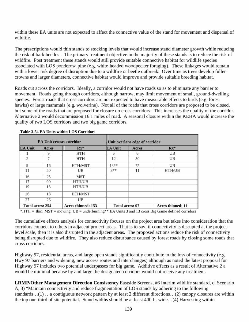
139
within these EA units are not expected to affect the connective value of the stand for movement and dispersal of wildlife. The prescriptions would thin stands to stocking levels that would increase stand diameter growth while reducing the risk of bark beetles . The primary treatment objective in the majority of these stands is to reduce the risk of wildfire. Post treatment these stands would still provide suitable connective habitat for wildlife species associated with LOS ponderosa pine (e.g. white-headed woodpecker foraging). These linkages would remain with a lower risk degree of disruption due to a wildfire or beetle outbreak. Over time as trees develop fuller crowns and larger diameters, connective habitat would improve and provide suitable breeding habitat. Roads cut across the corridors. Ideally, a corridor would not have roads so as to eliminate any barrier to movement. Roads going through corridors, although narrow, may limit movement of small, ground-dwelling species. Forest roads that cross corridors are not expected to have measurable effects to birds (e.g. forest hawks) or large mammals (e.g. wolverine). Not all of the roads that cross corridors are proposed to be closed, but some of the roads that are proposed for closure do cross corridors. This increases the quality of the corridor. Alternative 2 would decommission 16.1 miles of road. A seasonal closure within the KEHA would increase the quality of two LOS corridors and two big game corridors.
Table 3-54 EA Units within LOS Corridors
EA Unit crosses corridor A Unit overlaps edge of corridor EA Unit Acres Rx* EA Unit Acres Rx*
1 9 HTH 5 6 UB 2 7 HTH 12 50 UB
9 16 HTH/MST 13** 75 UB 11 50 UB 3** 11 HTH/UB 16 25 MST 17 90 HTH/UB 19 13 HTH/UB
26 18 HTH/MST 27 26 UB
Total acres: 254 Acres thinned: 153 Total acres: 97 Acres thinned: 11 *HTH = thin; MST = mowing; UB = underburning** EA Units 3 and 13 cross Big Game defined corridors
The cumulative effects analysis for connectivity focuses on the project area but takes into consideration that the corridors connect to others in adjacent project areas. That is to say, if connectivity is disrupted at the project-level scale, then it is also disrupted in the adjacent areas. The proposed actions reduce the risk of connectivity being disrupted due to wildfire. They also reduce disturbance caused by forest roads by closing some roads that cross corridors. Highway 97, residential areas, and large open stands significantly contribute to the loss of connectivity (e.g. Hwy 97 barriers and widening, new access routes and interchanges) although as noted the latest proposal for Highway 97 includes two potential underpasses for big game. Additive effects as a result of Alternative 2 a would be minimal because by and large the designated corridors would not receive any treatment. LRMP/Other Management Direction Consistency Eastside Screens, #6 Interim wildlife standard, d. Scenario A, 3) “Maintain connectivity and reduce fragmentation of LOS stands by adhering to the following standards…(1) …a contiguous network pattern by at least 2 different directions…(2) canopy closures are within the top one-third of site potential. Stand widths should be at least 400 ft. wide…(4) Harvesting within
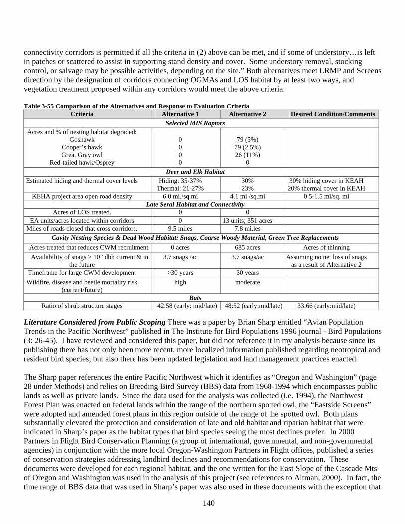
140
connectivity corridors is permitted if all the criteria in (2) above can be met, and if some of understory…is left in patches or scattered to assist in supporting stand density and cover. Some understory removal, stocking control, or salvage may be possible activities, depending on the site.” Both alternatives meet LRMP and Screens direction by the designation of corridors connecting OGMAs and LOS habitat by at least two ways, and vegetation treatment proposed within any corridors would meet the above criteria. Table 3-55 Comparison of the Alternatives and Response to Evaluation Criteria
Criteria Alternative 1 Alternative 2 Desired Condition/Comments Selected MIS Raptors
Acres and % of nesting habitat degraded: Goshawk
Cooper’s hawk Great Gray owl
Red-tailed hawk/Osprey
0 0 0 0
79 (5%) 79 (2.5%) 26 (11%)
0 Deer and Elk Habitat
Estimated hiding and thermal cover levels Hiding: 35-37% Thermal: 21-27%
30% 23%
30% hiding cover in KEAH 20% thermal cover in KEAH
KEHA project area open road density 6.0 mi./sq.mi 4.1 mi./sq.mi 0.5-1.5 mi/sq. mi Late Seral Habitat and Connectivity
Acres of LOS treated. 0 0 EA units/acres located within corridors 0 13 units; 351 acres
Miles of roads closed that cross corridors. 9.5 miles 7.8 mi.les Cavity Nesting Species & Dead Wood Habitat: Snags, Coarse Woody Material, Green Tree Replacements
Acres treated that reduces CWM recruitment 0 acres 685 acres Acres of thinning Availability of snags > 10” dbh current & in
the future 3.7 snags /ac 3.7 snags/ac Assuming no net loss of snags
as a result of Alternative 2 Timeframe for large CWM development >30 years 30 years
Wildfire, disease and beetle mortality.risk (current/future)
high moderate
Bats Ratio of shrub structure stages 42:58 (early: mid/late) 48:52 (early:mid/late) 33:66 (early:mid/late)
Literature Considered from Public Scoping There was a paper by Brian Sharp entitled “Avian Population Trends in the Pacific Northwest” published in The Institute for Bird Populations 1996 journal - Bird Populations (3: 26-45). I have reviewed and considered this paper, but did not reference it in my analysis because since its publishing there has not only been more recent, more localized information published regarding neotropical and resident bird species; but also there has been updated legislation and land management practices enacted. The Sharp paper references the entire Pacific Northwest which it identifies as “Oregon and Washington” (page 28 under Methods) and relies on Breeding Bird Survey (BBS) data from 1968-1994 which encompasses public lands as well as private lands. Since the data used for the analysis was collected (i.e. 1994), the Northwest Forest Plan was enacted on federal lands within the range of the northern spotted owl, the “Eastside Screens” were adopted and amended forest plans in this region outside of the range of the spotted owl. Both plans substantially elevated the protection and consideration of late and old habitat and riparian habitat that were indicated in Sharp’s paper as the habitat types that bird species seeing the most declines prefer. In 2000 Partners in Flight Bird Conservation Planning (a group of international, governmental, and non-governmental agencies) in conjunction with the more local Oregon-Washington Partners in Flight offices, published a series of conservation strategies addressing landbird declines and recommendations for conservation. These documents were developed for each regional habitat, and the one written for the East Slope of the Cascade Mts of Oregon and Washington was used in the analysis of this project (see references to Altman, 2000). In fact, the time range of BBS data that was used in Sharp’s paper was also used in these documents with the exception that

141
the conservation strategies incorporated data available after 1994. In 2001, an Executive Order was signed to detail the responsibilities of federal agencies to protect migratory birds. Compliance with this order is attained by using the Partners in Flight Conservation Strategy most befitting of the project area. At least 11 of the species specifically referenced in the Sharp paper are also either focal species within the Conservation Strategies or MIS within the LRMP. Recreation Management Introduction The Deschutes River, a high use recreation area, runs along the western boundary of the Sunriver HFRA project area and the NNVM is located within and adjacent to the northern boundary. Use of the developed recreation day use facilities and dispersed recreations sites is high in the summer months.. The area has seen an increase in use due to increased population, and Sunriver and Bend being popular recreation destination areas. During the fall the area receives some use, primarily from hunters, mountain bikers, day hikers and horseback riding. The area does provide some opportunities for dispersed camping. However, there is an area closure in the Wild and Scenic River corridor for overnight camping and OHV use. Canoeing is by far the most popular activity on this flat water stretch of the Deschutes River. Scope of the Analysis Recreation effects focus on the segments of the Upper Deschutes Wild and Scenic River that occur within the project area, implementation of road closures included in the Upper Deschutes River Plan and to a lesser extent dispersed recreation outside of the river corridor. Information regarding past actions, either vegetation or recreation management are incorporated into the existing condition discussion, below. Affected Environment-Developed Recreation There are 3 day use facilities in the project area, all of which are adjacent to the Deschutes River and provide access to the river trail. They include the Benham Falls East Day Use are, the southern end of the Deschutes River trail and the Sunriver canoe takeout. The Lava Lands Visitor Center Complex is located just outside of the projects areas northeastern boundary. The facilities related to these sites are nearing the age when significant renovation or replacement is required. Affected Environment-Dispersed Recreation Dispersed recreation sites activities and facilities include; dispersed campsites, driving for pleasure, OHV use, flat water river use (mostly canoeing from Sunriver to Benham Day Use area), fishing, informal trail use, horseback riding, mountain biking, shooting, and forest products collection. Vandalism and dumping are problems in this area due to its proximity to town. There are substantial areas of urban interface between public land and Sunriver properties. Many of these activities occur within this zone. There are a total of 24-recorded dispersed campsites in the project area. At this time, all are accessible by vehicle on system or user created roads. Long-time users of the area are generally made up of Bend and La Pine area residents. A majority of the non Central Oregon visitors are on summer vacations and seeking outdoor recreation experiences. Affected Environment-Special Uses Special Uses and permitted utilities in this area include; 1) power lines, buried and aerial, 2) phone lines, 3) railroad tracks, and 4) private water facilities. All are under permit and maintained by the permittee. Periodic vegetation manipulation is required to maintain aerial power lines. Affected Environment-Roads and Trails There are three official system trails within the project area. They are the Benham Day Use area Interpretive Loop (hiker only, ½ mile), and the Deschutes River trail/ Black Rock trail (hiker/biker, 9.5 miles). There is a winter wildlife closure on the Deschutes River trail. There are no inventoried roadless areas, areas with roadless characteristics or Wilderness areas within or adjacent to the project area nor associated special uses. There is a large lava flow directly to the north, outside of the project area in the NNVM, which hosts little recreation, other than dispersed exploration and some over the snow use in high snow winters.
142
There is substantial day use from specific areas, such as Sunriver, Benham Falls Day Use area, and the urban interface. This includes all modes of transportation, winter and summer. Use is moderate to high from existing trailheads as well. Road construction and development (planned and user-created) over the years has made access easier to the river and some upland areas. This has resulted in degraded soil and vegetative resources to varying degrees. Impacts are generally in the form of trampled vegetation and compacted soils that contribute to overland flow in concentrated recreation sites/areas. Many of the roads are used as trails for all types of users, both motorized and non-motorized. Recreation Management Environmental Effects Direct and Indirect Effects of Alternative 1- This alternative would put at risk the outstandingly remarkable values that were identified when the Deschutes River was designated as a Wild and Scenic River. The effects of the two alternatives on those Wild and Scenic River Values immediately follows this section. Recreation use would continue to rise at an increasing rate; estimated at 5 percent per year. This is due to a similar increase in the population of Central Oregon and the growing popularity of the area and its recreation and other amenities. Developed Recreation There would be no changes to existing developed facilities in any alternative. There is an increasing need to manage the vegetation adjacent to these facilities. In this alternative, there would be no treatment of vegetation for the purpose of fire protection, view shed management, promoting healthy forest stands and interpretation. There would therefore be an increased risk of loss to fire by not treating dense vegetation and fuels adjacent to these facilities. There would also be a loss of opportunity to manage adjacent stands for the purpose of opening up views from these sites of other vistas. In addition, public health and safety could suffer in case of a catastrophic event. Dispersed Recreation The No Action alternative would make no changes to dispersed recreation opportunities or physical features on the ground. The existing, dispersed campsites would continue to be utilized at an increasing rate. These areas would continue to contribute to an increased risk from escaped campfires and overland flow, with a continued risk of moving sediment into the river. Day use activities would continue to increase, especially along the urban interface zone. Illegal practices, typical of activities in this area, such as garbage and refuse dumping would also increase. User trails would continue to develop. As the population and use grows over time, there is a need for people to get away from the developed, high use areas and as a result they explore surrounding areas on foot, bike, vehicle, etc. Common and logical routes are used repeatedly and a trail develops. These trails are general a combination of the easiest and shortest routes from one place to another. These places are usually destinations that would attract a recreationist. For example, there is a fisherman’s trail most of the way along the Deschutes River. Special Uses There would be no changes to the existing special uses and utilities, and no negative impacts expected with any of the alternatives. Cumulative Effects of Alternative 1 Since there would be no new proposed activities under this alternative there would be no cumulative effects. Direct and Indirect Effects of Alternative 2 Developed Recreation Participation in day use activities would continue to increase as described previously. In general, the developed sites are within the Wild and Scenic River corridor and the 300 foot RHCA along the river, so no vegetative manipulation would occur within the sites and there would be no changes to the developed facilities under this alternative. There are various treatments (EA units 1-6) planned around the
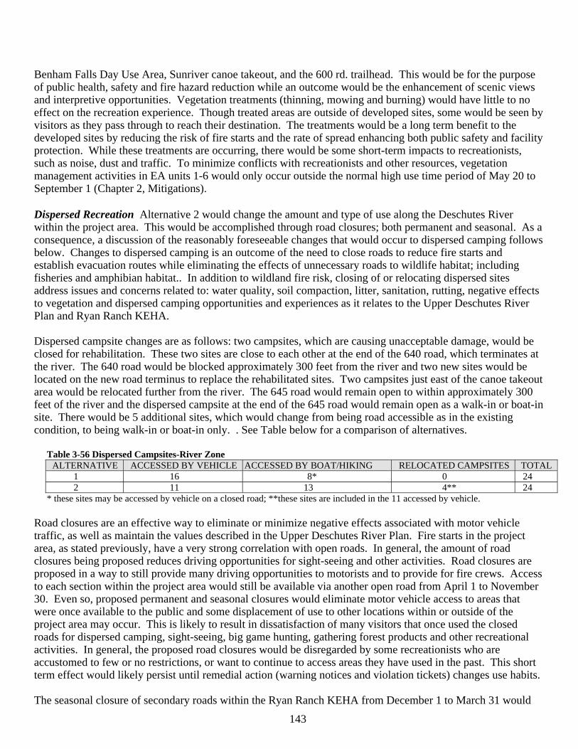
143
Benham Falls Day Use Area, Sunriver canoe takeout, and the 600 rd. trailhead. This would be for the purpose of public health, safety and fire hazard reduction while an outcome would be the enhancement of scenic views and interpretive opportunities. Vegetation treatments (thinning, mowing and burning) would have little to no effect on the recreation experience. Though treated areas are outside of developed sites, some would be seen by visitors as they pass through to reach their destination. The treatments would be a long term benefit to the developed sites by reducing the risk of fire starts and the rate of spread enhancing both public safety and facility protection. While these treatments are occurring, there would be some short-term impacts to recreationists, such as noise, dust and traffic. To minimize conflicts with recreationists and other resources, vegetation management activities in EA units 1-6 would only occur outside the normal high use time period of May 20 to September 1 (Chapter 2, Mitigations). Dispersed Recreation Alternative 2 would change the amount and type of use along the Deschutes River within the project area. This would be accomplished through road closures; both permanent and seasonal. As a consequence, a discussion of the reasonably foreseeable changes that would occur to dispersed camping follows below. Changes to dispersed camping is an outcome of the need to close roads to reduce fire starts and establish evacuation routes while eliminating the effects of unnecessary roads to wildlife habitat; including fisheries and amphibian habitat.. In addition to wildland fire risk, closing of or relocating dispersed sites address issues and concerns related to: water quality, soil compaction, litter, sanitation, rutting, negative effects to vegetation and dispersed camping opportunities and experiences as it relates to the Upper Deschutes River Plan and Ryan Ranch KEHA. Dispersed campsite changes are as follows: two campsites, which are causing unacceptable damage, would be closed for rehabilitation. These two sites are close to each other at the end of the 640 road, which terminates at the river. The 640 road would be blocked approximately 300 feet from the river and two new sites would be located on the new road terminus to replace the rehabilitated sites. Two campsites just east of the canoe takeout area would be relocated further from the river. The 645 road would remain open to within approximately 300 feet of the river and the dispersed campsite at the end of the 645 road would remain open as a walk-in or boat-in site. There would be 5 additional sites, which would change from being road accessible as in the existing condition, to being walk-in or boat-in only. . See Table below for a comparison of alternatives.
Table 3-56 Dispersed Campsites-River Zone ALTERNATIVE ACCESSED BY VEHICLE ACCESSED BY BOAT/HIKING RELOCATED CAMPSITES TOTAL
1 16 8* 0 24 2 11 13 4** 24
* these sites may be accessed by vehicle on a closed road; **these sites are included in the 11 accessed by vehicle. Road closures are an effective way to eliminate or minimize negative effects associated with motor vehicle traffic, as well as maintain the values described in the Upper Deschutes River Plan. Fire starts in the project area, as stated previously, have a very strong correlation with open roads. In general, the amount of road closures being proposed reduces driving opportunities for sight-seeing and other activities. Road closures are proposed in a way to still provide many driving opportunities to motorists and to provide for fire crews. Access to each section within the project area would still be available via another open road from April 1 to November 30. Even so, proposed permanent and seasonal closures would eliminate motor vehicle access to areas that were once available to the public and some displacement of use to other locations within or outside of the project area may occur. This is likely to result in dissatisfaction of many visitors that once used the closed roads for dispersed camping, sight-seeing, big game hunting, gathering forest products and other recreational activities. In general, the proposed road closures would be disregarded by some recreationists who are accustomed to few or no restrictions, or want to continue to access areas they have used in the past. This short term effect would likely persist until remedial action (warning notices and violation tickets) changes use habits. The seasonal closure of secondary roads within the Ryan Ranch KEHA from December 1 to March 31 would
144
have very little effect on dispersed vehicular use because snow depths makes most of the area affected by this closure order inaccessible for a large part of the winter. At the same time, the closure period is outside of the big game hunting season and high use river recreation time period. There are no known impacts to existing or future special uses, permits, permittees, or utilities with the proposed action. Trails are located within EA units 1, 6, and 13, and are also near or adjacent to EA units 2 to 5. Use of these trails would be unsafe and closed during mechanical treatment operations. Clean up of these trails in the form of maintenance and reconstruction would be completed after the treatments through contracts or force account crews and the actual time period trail segments would be closed would likely be less than four weeks. Mountain bike, horse or foot traffic would be diverted or detoured to other trails or roads to bypass the vegetation management activity until completion of the fuels reduction treatment. To minimize conflicts with recreationists and other resources, vegetation management activities in EA units 1-6 and 13 would only occur outside the normal high use time period of May 20 to September 1 (Chapter 2, Mitigations). Cumulative Effects of Alternative 2 There would be no short or long term direct, indirect or cumulative effects from the treatments to the special uses in the project area. Road closures from other projects in the surrounding areas would reduce the amount of recreational motorized use. The overall effect to the public is that there are fewer roads to drive than there were previously. Motorized road access would still be maintained to every section within the project area while the opportunity for nonmotorized dispersed use such as hiking and mountain biking would increase consistent with the Upper Deschutes River Plan. LRMP/Other Management Direction Consistency Under Alternative 2, vegetation management activities would cause some temporary closing of trails for safety reasons. As noted there would be no activity within the RHCA of the Deschutes River to avoid conflicts with existing trails. Where disturbance cannot be avoided; cleanup operations would be concurrent (TR-3). Compliance with the Upper Deschutes River Plan is addressed by implementing all road closures included in the plan while maintaining motorized vehicle access to all developed sites, dispersed sites and ingress/egress routes specified in the Upper Deschutes River Plan LRMP Amendment #12 (Upper Deschutes River Plan page 37:R-4, R-5; page 42: A-4; LRMP, WL-45). Wild and Scenic River Values Introduction The Deschutes River that forms much of the western boundary of the project area was included in the Federal Wild and Scenic River system in 1988. The federal act that established the Wild and Scenic River system mandates that the administering agency “protect and enhance” the Outstandingly Remarkable values (ORVs) for which the river was designated. The Upper Deschutes River Plan guides all development, management and restoration activities within the river corridor to protect these values which are used for the analysis of effects. Scope of the Analysis The scope of the analysis is confined to those federal lands located within Segment 4, south of Benham Falls Day use area trailhead and north of the north boundary of Sunriver. Cumulative actions include Alternative 2 and the ongoing thinning and underburning of 18 acres within East Tumbull EA unit 132. No other ongoing vegetation management activities on Federal lands are occurring within these segments. There are approximately 819 acres of private land within Sunriver that is adjacent to the project area that is within Segment 3. Infrastructure, recreational and residential housing development has largely been completed on these lands. Private land use and development were not included because these uses are governed by state and local land use regulations that are designed to protect river values (Upper Deschutes River Plan, page 45). There would be no additive effects on ORVs because the effects of completed WUI treatments on private lands have protected the ORVs and there would be no treatments within the RHCAs on Federal land. Vegetation management has been deferred from the river corridor for most of the prior 15 years while the Upper Deschutes River Plan was completed. Because none of the prior completed activities have any identified ongoing negative effects these activities were incorporated into the existing condition.
145
Affected Environment-Wild and Scenic River Values The Sunriver HFRA project area incorporates a portion of Segment 4 (northern boundary of the project area to northern boundary of Sunriver) of the Upper Deschutes River Plan. The following outstandingly remarkable values (ORV) are found within the project area: Geologic, Fishery, Wildlife, Cultural, Vegetation, Scenic and Recreation. Hydrology was classified as significant for all of segment 4 within the project area. Geologic: This value refers to the lava flows which have pushed the river west of earlier channels north of Benham Falls, outside of the project area, and created the stair-step falls and rapids popular with river runners. The river channel shape, size and rate of change is not classified as an ORV because the dynamics are controlled by water releases from upstream dams. Fishery/Hydrologic: The redband rainbow fishery in segment 4 is an ORV. The hydrological portion of the river was rated as significant. As discussed in Chapter 1, the dam regulated irrigation flow is the primary contributor to listing of the Deschutes River under section 303 (d) of the Clean Water Act. Even though the Deschutes is a listed river the clear, clean water is a major component of the Fishery ORV as well as the Scenic and Recreation ORVs. Cultural/historical: The Upper Deschutes River Plan encompasses more than 100 historic and prehistoric sites which are eligible for inclusion in the National Register of Historic Places. Vegetation: Vegetation in segment 4 is an ORV because of the presence of Artemis ludoviciana ssp. Estesii (Estes Mugwort or wormwood) a federal Category 2 Candidate for protection under the Endangered Species Act. Recreation: Recreation is an ORV because of the range of activities such as fishing, hiking, horseback riding, canoeing, biking and hunting and the attraction of the river for vacationers from outside of the region. Scenic: The mix of geologic, hydrologic, vegetative and wildlife along segment 4 is an ORV. Wildlife: The diversity of the bird population in segment 4 is an ORV. Wild and Scenic River Values Environmental Effects Direct and Indirect Effects of Alternative 1 Neither of the two alternatives would affect the lava flows (Geologic) that created the stair-step falls and rapids downstream of Benham Falls; however Alternative 1 would put at risk the other ORV and significant values associated with the Deschutes River. Fishery/Hydrologic: Under Alternative 1, the largest potential for effects to water resources and fish habitat would come from a large-scale fire. The trend of forest health deterioration and fuels build-up that could inevitably lead to a large scale fire would not be addressed under this alternative. Effects could include a loss of shade, loss of future large wood recruitment and increased sediment input to the watercourse. Due to its proximity to the WUI, even small wildfires would be aggressively suppressed with the potential for future fish kills caused by fire retardant reaching aquatic systems as occurred in the summer of 2002 along Fall River, a Deschutes River tributary. Although the overwhelming majority of river bank erosion in this section is caused by the fluctuating flows caused by upstream water releases; existing dispersed recreation use is also contributing sedimentation and river bank degradation (Upper Deschutes River Plan, Appendix C-11, C-25) as discussed below under the recreation section.
146
Cultural/historical: There would be an effect to eligible or potentially eligible cultural properties if underburn treatments are not implemented. The result would be a heavier fuel load which would result in a high intensity fire. Fire effects on cultural properties state that temperatures above 650 degrees F can affect stone artifacts. (1998, BLM Protocol). Wildfire could reveal new cultural properties with the potential of loss to artifact hunters. Not conducting road closures would continue motor vehicle access to cultural properties and the potential for loss or degradation of cultural properties to other factors such as erosion and inadvertent recreational visitor collection. Vegetation: Under Alternative 1 no vegetation or fuel treatments would occur. Deferring thinning and other fuels reduction activities means that the upland vegetative condition would remain as is and over time stand densities would continue to increase. Insect and disease problems would show a corresponding increase resulting in accelerated tree mortality and increased fuel loading. Mortality of larger ponderosa pine trees would exceed natural mortality rates putting current and future bald eagle and osprey-nesting habitat at risk Lodgepole pine would regenerate in naturally created openings more readily than ponderosa pine and slowly change the species composition to a lodgepole pine dominated stand on sites historically ponderosa pine. Current conditions would remain with a high risk of a stand replacing fire event or insect event that could destroy existing vegetation and create a landscape similar to what occurred in the Pringle Fire of 1995. The Pringle Fire was a stand replacing wildfire event that killed all of the overstory trees as well as numerous bald eagle and osprey nest trees along a 3.5 mile stretch of the Deschutes River. A stand replacing fire would drastically change the structural stage composition of the forest, result in a major loss of future LOS conditions, create unsightly scenic views and set-back the development of a mosaic of different stand structures and ages on lands that were previously clear-cut. Recreation: Under Alternative 1, the trend of making the area less attractive for vacationers, weekday and weekend recreationists would continue. The maze of open roads has led to a trend of increasing dumping of household garbage and abandonment of motor vehicles that not only makes the area less attractive for recreationists but also in the event of a wildfire, confusing over evacuation routes. Scenic: Scenic values over the short term would not change. Currently, the surrounding upland landscapes have only moderate diversity due to the prior, extensive clear-cutting of ponderosa pine and the development of large areas of immature “black bark” ponderosa pine. Encroachment of lodgepole pine on areas historically dominated by ponderosa pine has also obscured views. The risk of losing extensive areas of ponderosa pine, that is just now starting to form desirable characteristics such as large diameters and yellow bark, and the minor amount of large old ponderosa pine remaining within the project area would continue to increase. Based on the fire history, stand densities, fuel loading and the number of annual fire starts, loss of the overwhelming majority of the forested lands to a stand replacing wildfire would be inevitable. At the present annual average rate of loss this would occur within the next five decades. In actuality, there is a high potential for this to occur within a single fire season as demonstrated by the recent Davis and B & B fires of 2003 and GW Fire of 2007. Road associated dispersed recreation use as discussed above would also continue and combined with illegal dumping, illegal firewood cutting, escaped campfires and arson the scenic values would continue to degrade. Wildlife: Under alternative 1, nothing would change for the short term. Current high levels of motorized access to the portion of the Ryan Ranch KEHA east of the Deschutes River would remain the same, allowing disturbance and poaching from motorized vehicles to continue. The risk of loss of nesting, riparian, and upland habitat by wildfire would continue to increase with a corresponding risk of loss of potential nesting, roosting, hiding and calving habitat for species as diverse as elk, mule deer, osprey and bald eagles.
147
Bird diversity that is dependent on riparian areas and the variable density upland stands would be lost in the event of a large stand replacement fire. This would eliminate bird diversity and favor habitat generalists such as red tail hawks, bluebirds and other species that utilize open areas. Under Alternative 1 the eventual loss of upland vegetation to wildfire would necessitate a road closure order. Road closures are routinely issued for fire areas to provide for public safety (roadside hazard trees) and to allow riparian and upland vegetation to recover. Road closures would be difficult to enforce on any stand replacement wildfire, due to the gently sloping lands and nearby vicinity of developed areas. Unrestricted motor vehicle access has a high risk for spreading noxious weeds and reducing future vegetative and wildlife habitat diversity. Cumulative Effects of Alternative 1 Under Alternative 1 there would be no cumulative effects to ORVs because no activity would take place within the project area. The ongoing activities on the westside of the river within segment 4, would have some minor beneficial effects on ORVs. Fishery/Hydrologic: The thinning and underburning of 18 acres (East Tumbull EA unit 132) would have a minor beneficial effect on reducing the potential for a large scale fire in the watershed with a subsequent decrease in the potential for fire related effects to the river. There would be no direct and indirect effects to the river from the proposed vegetation management and fuels management activities because the treatments are on gentle slopes with permeable volcanic soils, with no potential of overland flow carrying sediments to streams. Cultural/historical: There would be no cumulative effects because no activity would occur under this alternative and all sites would be avoided in other ongoing activities. Vegetation: Similar to the effect on the Fishery/Hydrologic ORVs there might be a minor beneficial effect on the vegetation ORV. The level of ongoing treatments and the major wildland fire risk posed by the vegetation on the eastside of the river would make this effect meaningless in the overall context of protecting upland vegetation. Recreation/Scenic: There would be no effect on the recreation or scenic ORVs. Wildlife: The risk of loss of nesting, riparian, and upland habitat by wildfire would decrease on 18 acres. Direct and Indirect Effects of Alternative 2-Fishery/Hydrologic: The action alternative would decrease the potential for a large scale fire in the watershed with a subsequent decrease in the potential for fire related effects to the river. There would be no direct and indirect effects to the river from the proposed vegetation management and fuels management activities because the treatments outside of the RHCA of the Deschutes River are on gentle slopes with permeable volcanic soils, with no potential of overland flow carrying sediments to streams. The implementation of BMPs and mitigation measures would eliminate the potential for any sediment delivery into the Deschutes River caused by road closure activities. Although the overwhelming majority of river bank erosion in this section is caused by the fluctuating flows caused by upstream water releases; road closures and the reduction of existing dispersed recreation sites would restore an estimated 1 acre within the RHCA of the Deschutes River. Revegetation of these sites would restore water infiltration but more importantly it would prevent the enlargement of these sites by overuse and prevent potential future problems from developing such as overland flow into the river. Alternatives 2 would not result in any changes to the flow regimes of the Deschutes river, due to vegetation management activities such as thinning, based on a review of the hydrogeology of the basin. Cultural/historical: Alternative 2 does not have the potential to impact eligible or potentially eligible cultural properties because all sites would be avoided.
148
Indirect effects are not expected but the potential does exist. Unevaluated and significant cultural sites avoided by project implementation could have more people working during the short-term (5-7 years) in the vicinity with the potential to have surface artifacts observed and collected. Pile burning can potentially escape the planned burn location although the potential for surface temperatures to exceed 650 degrees F is highly unlikely because pile burning is prescribed to take place under high moisture conditions or snow cover. Changing the vegetation patterns through thinning and the transportation system by road closures and obliterations would change how subsequent forest users over the long term use the area; moving dispersed recreation use such as camping and hiking to adjacent locations avoided by this project area. This would be a beneficial effect as it would tend to direct users away from the immediate river corridor where the bulk of the historic and prehistoric sites are located. Vegetation: A total of 66 acres of upland vegetation in EA units 1-4, 6 (EA unit 4 is within the NNVM), outside of the RHCA, within the Deschutes River Wild and Scenic River Corridor would be thinned, prescribed burned and mowed to maintain ponderosa pine, mimic low intensity fires, perpetuate a mosaic of stand structures and ages, and reduce the risk of high intensity fires (Upper Deschutes River Plan, page 29, 62). The treatments are designed to reduce tree stress and create a healthier forest condition. Ponderosa pine would be favored in all thinning treatments to reduce the amount of lodgepole pine in areas historically dominated by ponderosa pine while also accelerating the development of LOS stage stands. Insect and disease problems would be reduced to ensure that desirable levels of endemic mortality continue while lowering the risk of an undesirable epidemic outbreak in the uniform, immature “black bark” ponderosa pine stands. Fuel treatments, including thinning, would reduce ladder fuels, crown density and the risk of a stand replacing wildfire. Natural and human-caused disturbances would mostly likely not be large stand-replacing events greater than 10 acres within the EA units. Wildlife cover and dispersal habitat would be decreased in the short term, but would increase over the long term as tree crowns increase and growing space becomes occupied. Recreation: Alternative 2 would implement the final transportation system contained in the Upper Deschutes River Plan and help reverse the trend of making the area less attractive for vacationers, weekday and weekend recreationists. Motorized dispersed camping and motorized public and administrative access to all existing developed recreation sites would continue. Road closures and thinning activities would reduce the areas and opportunities for unobserved dumping of household garbage, dangerous substances and abandoned vehicles. The opportunity and attractiveness of the area for hiking, mountain bike, and horseback riding would increase. Dispersed motorized recreational opportunities would decrease due to the road closures however there would be no decrease in camping or OHV opportunities because even though none is allowed within the river corridor (see maps in Appendix G for closure areas). Changes to dispersed camping is outside the scope of this project. Scenic: Scenic integrity would be improved under Alternative 2. Limiting motorized access would improve site conditions by preventing damage to riparian and upland vegetation within the river corridor while lowering unsightly, illegal dumping and firewood cutting. Thinning and fuels reduction would perpetuate the desired landscape and accelerate the development of large diameter yellow-barked ponderosa pine while lowering the risk of large wildfires. Encroachment of lodgepole pine in the southern portion on areas historically dominated by ponderosa pine would be reduced on an estimated 66 acres. The effects on Scenic Views throughout the project area is covered in depth under the Scenic Views resource section. Wildlife: Under Alternative 2, nesting habitat would be maintained, enhanced or protected on nine percent of the river corridor (46 of 519 acres; 20 acres is in the NNVM). There would be no treatment within the RHCAs and no effect on the meadow and riparian mosaic that makes bird diversity in Segment 4 an ORV. Implementation of the Upper Deschutes River Plan transportation system and the Tumalo Cooperative winter closure would substantially lower motor vehicle disturbance to elk and deer within the Ryan Ranch KEHA. There would be no effect on travel corridors because they were excluded from management activity.
149
The risk of loss of nesting, riparian, and upland habitat by wildfire would decrease due to the areas treated within and adjacent to the corridor and the strategic juxtaposition of the EA units that are designed to maximize the effectiveness of fuels reduction activities. Vegetation management and road closure activities would decrease human-caused ignitions, resistance to control and noxious weed spread while maintaining, improving and accelerating wildlife habitat diversity, wildlife habitat effectiveness, nesting and calving habitat. Cumulative Effects of Alternative 2 The combined effects of planned, ongoing and those activities included in Alternative 2 would have a beneficial effect on ORVs. Fishery/Hydrologic: A total of 84 acres of upland vegetation would be treated between the Sunriver HFRA and East Tumbull projects to reduce the potential for a stand replacement fire in the river corridor with a subsequent decrease in the potential for fire related effects to the river. There would be no direct, indirect or cumulative negative effects to the river from the proposed vegetation management and fuels management activities because the treatments are on gentle slopes with permeable volcanic soils, with no potential of overland flow carrying sediments to streams. Cultural/historical: There would be no cumulative effects because all sites would be avoided. Vegetation: Cumulatively a total of 84 acres would have thinning and or other fuels reduction treatments to maintain ponderosa pine, mimic low intensity fires, perpetuate a mosaic of stand structures and ages, and reduce the risk of high intensity fires. Under Alternative 2 areas immediately adjacent to the river corridor would be thinned and prescribed burned or mowed; providing additional protection to the river corridor. Recreation/Scenic: Alternative 2 would help reverse the trend of making the area less attractive for vacationers, weekday and weekend recreationists. A total of 30 percent of the river corridor within the Pilot Butte watershed would have scenic view enhancement completed during the 2000 to 2010 decade; if the 84 acres of thinning and underburning is completed by the end of 2010. The beneficial effect of this planned activity would accelerate the development of large yellow-barked trees by two to three decades and reduce lodgepole pine encroachment on these acres to a level where periodic maintenance burns in the future could maintain the ponderosa pine stands without additional mechanical treatment. Wildlife: Implementation of the Upper Deschutes River Plan transportation system would substantially lower motor vehicle disturbance to elk within the Ryan Ranch KEHA within the river corridor. The risk of loss of nesting, riparian, and upland habitat by wildfire would also be reduced. LRMP/Other Management Direction Consistency The Upper Deschutes River Plan identifies actions needed to achieve the goals or Standards and Guidelines of the plan. The table below lists the pertinent categories of actions needed to achieve those Standards and Guidelines in order to maintain, enhance and protect ORVs. Table 3-57
ORV to Maintain, Protect, Enhance
Category of Action Action Examples
Hydrologic and Geologic
Actions which eliminate stream sedimentation or improve streambank stability
Close roads
Actions that protect wildlife and riparian habitat, public health and safety and reduces wildlife disturbance
Vegetation, Wildlife And Recreation
Long term actions to prevent wildfire, insect epidemics, and disease.
Reduce the amount and distribution of natural fuel loads
Reduce lodgepole pine component within historic ponderosa pine Forests
Remove vegetation to reduce competition to ponderosa pine
150
Vegetation Actions that inhibit or prevent non-native species from enteringor expanding their range in the river corridor.
No example actions described in Upper Deschutes River Plan
Action which reduce visibility of human impacts Scenic Actions which perpetuate desired long-term scenic quality
No example actions described in Upper Deschutes River Plan
Cultural Actions which ensure protection of Cultural Resources associated with other project activities
Avoidance
Table 3-58 displays the proposed Alternative 2 EA unit treatments and consistency with the category of actions from the Upper Deschutes River Plan. All EA units include mitigation measures in project design and implementation to prevent or inhibit non-native species from entering or expanding in the river corridor.
Table 3-58 Sunriver HFRA EA Units Treatment 1// Category of Action 2/ Acres
EA Unit 6 Thin < 21”dbh, HP, Mow/ #1, 2, 4, 5, 6, 8, 9 7 EA Unit 3, 4 Thin < 21”dbh, HP, PB/ #1, 2, 4, 5, 6, 8, 9 35 EA Unit 1, 2 Thin < 21”dbh, HP/ #1, 2, 4, 5, 6, 8, 9 24
1/HP-Handpile; PB-prescribe burn 2/ Category of Action from Table 3-57: #1 Actions which eliminate stream sedimentation or improve streambank stability; #2 Actions that protect wildlife and riparian habitat public health and safety; #3 Actions that reduce wildlife disturbance; #4 Long term actions to prevent wildfire, #5 insect epidemics, and disease; #6 Actions that inhibit or prevent non-native species from entering or expanding their range in the river corridor; #7 Actions which reduce visibility of human impacts; #8 Actions which perpetuate desired long-term scenic quality; #9 Actions which ensure protection of Cultural Resources associated with other project activities.
Vegetation Standards and Guidelines All EA units have noxious weed control provisions to prevent non-native species from entering or expanding their range in the river corridor (LRMP, Amendment #12, V-7). In addition, the 16.1 miles of road obliteration addresses short-term and long-term reduction of wildlife disturbance while thinning and other fuels reduction activities addresses long-term wildlife disturbance reduction. These road closures are designed to reduce human caused ignitions and noxious weed introduction and spread (Category #3, #6, Table 3-57). The use of prescribe fire to mimic historic events would be used on a total of 35 acres and be conducted in compliance with Oregon State Smoke Management Plans (LRMP, Amendment #12, V-9, V-10, V-12). An additional 31 acres would have handpiling, thinning and mechanical shrub treatment to assist in the safe use of fire and to reduce the threat to the WUI. The proposed thinning of 66 acres would enhance the potential for current and future nesting, roosting habitat for eagles and osprey (LRMP, Amendment #12, V-16). All thinning included in Alternative 2 would retain trees of the best vigor. Ponderosa pine would be favored over lodgepole pine and have variable spacing to mimic natural stand developments. Mowing and underburning would reduce understory vegetation, including grasses, shrubs and small trees to move towards the more open ponderosa pine stands that historically dominated this area. On the 35 acres of underburning the tree boles and lower needles of trees would be scorched. The appearance of vegetation following treatments including variable spaced trees, clumps of shrubs and or bole scorch would mimic the historic, frequent, low intensity ground fires (LRMP, Amendment #12, V-17) Wildlife, Scenery, Recreation, Administrative, Geology and Hydrology Standards and Guidelines Consistent with Eastside Screen direction wildlife dispersal and connectivity travel routes were designated throughout the area, all roads not specifically mentioned to remain open in the Upper Deschutes River Plan would be closed, and the seasonal closure of the Tumalo Cooperative Winter Range Closure Area would remain in effect under Alternative 2 (LRMP, Amendment #12, G-5, A-4, R-5, W-1 to W-3). Vegetation management within the river corridor defers treatment within 300 feet of the river to maintain retention and partial retention in segment 4 as seen from the river and corridor. Upland thinning of 66 acres includes whole tree yarding and concurrent handpiling along travel corridors to mitigate effects on visual
151
quality. Mechanical operations involving tree removal would not occur between May 20 and September 1 to further reduce effects on visual quality. Mowing would be conducted, where needed on the 35 acres of prescribed underburning to reduce scorch heights (LRMP, Amendment #12, S-1). See scenic quality effects section immediately following for additional scenery analysis and consistency findings. Scenic Quality Introduction Scenic values are often based upon local knowledge of an area’s unique characteristics and how people relate to a particular landscape or setting. Measuring these values is often subjective and communicated through the overall quality of the visitor experience. The key to realizing these values is to understand the traditions and connections visitors have developed over time to a certain place. The measure used in this analysis id the number of acres (or percentage) of improved or enhanced scenery. Visitors often have definite expectations of scenic views and other sensory experiences. These expectations are mainly based upon aesthetics and can be expressed through reactions to changes in the landscape or to patterns of land use. Visible and perceptible changes in noise levels, intensity of illumination, new building structures or lighted signs, surface changes such as paving or concrete, cut and fill grade changes, and removal of native vegetation are especially noticeable in developed areas surrounded by a forest setting. Recent population changes and growth of development in Bend and Sunriver have brought more pressure and greater potential for disturbance to scenic quality and negative impacts to visitor recreation experiences in semi-primitive and primitive settings. Light pollution from adjacent urban areas, dust, noise, and erosion problems from increased traffic on Forest Roads, and higher density recreation activities have all occurred in recent years to impact the visitor’s recreation experience in other areas on the Forest. On the other hand, greater risk from fire has occurred due to higher numbers of residents and visitors to the project area’s recreation sites and trails. Scope of the Analysis Scenic view analysis is confined to the project area and the transportation corridors that access it with an emphasis on the maintenance and enhancement of those features that give the project area its sense of place. Vegetation management activities that have taken place during previous years including thinning, underburning and mowing have been beneficial at maintaining and enhancing scenic quality. Cataloguing these activities is not necessary because they have been included in the existing condition. There are no other on-going or reasonably foreseeable activities within the project area that would negatively change scenic quality. Affected Environment-Existing Scenic Condition The project area is located between the resort-residential community of Sunriver, the Wild and Scenic Deschutes River, and the Lava Butte Geological Area of the Newberry National Volcanic Monument. This wildland urban interface setting represents the need to balance resort/residential community lifestyle with safety from the threat of wildfire and with preserving natural resource areas for native plants and wildlife habitat. The characteristic landscape of the project area is of high density stands of ponderosa and lodgepole pine. These thickets are dark and overgrown lacking the open air and more uplifting views provided by the healthier appearance of larger diameter ponderosa pine and native grasses. Residents of Sunriver were originally attracted to a forested river setting and are now aware of the risk of wildfire in central Oregon and the need to reduce fuels and create defensible spaces around residential areas. The project area may seem as a “natural appearing landscape” to the casual forest visitor. However, the current condition is far from being natural. Decades of historic timber harvest and fire suppression have led to the current condition of an unnatural, mostly high density forested landscape. The development of larger trees is being suppressed by the densely stocked stands and the changes in the fire regime and other natural disturbances throughout the project area. The densely stocked forests with a high canopy closure percent has
152
led to the exclusion of the open park-like stands historically found within the area. Scenic Quality Management Direction The USDA Forest Service established a Handbook for Scenery Management System (SMS--USDA FS 1995) use to protect and enhance scenic resources which may be diminished by human activities, such as vegetation management, recreation and/or administrative facility development. The analysis will take into consideration the balance between Social (human) and Ecological (natural) needs within the analysis area. This Scenery Management System (SMS) will be used in conjunction with the Deschutes LRMP 1990 as amended by the NNVM plan). The Forest Service implementing regulations, currently establish a variety of Scenic Quality Standards (SQO's for Scenic Views—MA 9). These standards include:
• Natural Appearing Landscape with High Scenic Integrity Level (formerly Retention, MA 9, SV-1; NNVM, M-76),
• Slightly Altered Landscape with Medium Scenic Integrity Level (formerly Partial Retention, MA 9, SV-2),
• Altered Landscape with Low Scenic Integrity Level (formerly Modification or General Forest, MA 8, GFO) within the Foreground as well as in the Middleground landscape. Scenery Management Objectives are defined in terms of Scenic Integrity Levels which describe existing conditions and whether the landscape is visually perceived to be “complete” or not. The most complete or highest rating for Scenic Integrity Levels means having little or no deviation from the landscape character that makes it appealing and attractive to visitors and local residents. In addition to describing existing conditions, Scenic Integrity Levels also describe the level of development allowed and ways to mitigate deviations from the area’s landscape character. Usually the most effective way to meet Scenic Integrity Levels is to repeat visual form, line, color, texture, pattern, and scale common to the scenic values of the landscape character being viewed. For example, in natural and natural appearing landscapes, deviations such as created openings can sometimes be visually enhanced through repetition of size, shape, spacing, surface color, edge effect, and pattern of natural openings common to the existing landscape character. Adding structures or additions to existing structures in the landscape can often be accomplished by repeating architectural form, line, color, texture, pattern, and scale that visually relates to the surrounding site features. When repetition is designed to be accurate and well placed, the deviation may blend so well that change is not evident. Please refer to LRMP, MA 9, Scenic Views Allocation; NNVM, M-76; M-80 and the Scenery Management System (SMS--USDA FS 1995) handbook for more detail. Scenic View Allocations within the Sunriver HFRA project area There are a total of 3,309 acres (62 percent of project area) within Scenic Views (LRMP, MA 9) allocation areas, 1,135 acres (21 percent) within the NNVM and 518 acres (10 percent) within the Upper Deschutes Wild and Scenic River (MA 17-Upper Deschutes River Plan pages 33-34). Access is mostly from Highway 97, Forest Road 9702, and Cottonwood Road. The 3,309 acres within the Scenic Views Management Area mostly includes foreground areas within travel corridors which are classified as High Integrity or Retention for Scenery Management Objectives. Target Landscape condition The desired future condition for the Sunriver HFRA Project Area for scenic values is to enhance scenic views through treatments resulting in a more open landscape characteristic of historic old growth forests with larger diameter ponderosa pine visible. The removal of smaller trees and the reduction of fuels would insure long-term survival rates by providing open space areas around larger diameter ponderosa pine. Safety conditions would be improved through the improved access and visibility along roads designated for evacuation or firefighter access in both residential and recreation areas. Enhanced views would be a much
153
more natural appearing mosaic of sun and shade. Ponderosa pine in foreground views (MA 9-4, NNVM M-80, Upper Deschutes River Plan S-1) would be managed to maintain or create a visual mosaic of numerous, large diameter, yellow-barked trees with stands of younger trees offering scenic diversity as seen from sensitive viewer locations, such as from a travel corridor. Ponderosa pine viewed as middlegrounds (M9-15, M-80) will be managed so that they provide a strong textural element. The present of a few individual large trees with full crowns is an important part of this landscape element. Immature stands are also an essential component in the landscape because they help provided a strong color contrasts, and they eventually become the replacements for the larger, old growth trees that perpetuate the desired coarsely-textured character. Visible openings are desirable where the natural landscape contains similar openings, or where natural-appearing openings can provide additional diversity in the landscape where lacking. Scenic Quality Environmental Effects Important Interactions The proposed activities were designed to create an altered and different forest character that would increase forest health, enhance short and long-term scenery and improve the recreational experience. The effect on scenic resources from the two alternatives, specifically on landscape character, scenic quality, and scenic integrity level, can be classified into two specific categories. The first is short-term effects (0 to 5 years), and the other is long-term effects (from 5 years and beyond). The effect from the proposed management activities would be most evident to the visiting public within the foreground landscape (0 to 1/2 mile corridor) and some part of the middleground landscape (1/2 to 5 miles). This effect analysis takes into account short, long-term effect and cumulative effects. Direct and Indirect Effects of Alternative 1 Measure: Acres (or percentage) of improved or enhanced scenery Under this alternative, none of the existing vegetation community within the project area would be managed. Natural and ecological processes, such as insects and diseases, wind and snow damage, dead and down tree accumulations, would continue, exacerbated by continuing fire suppression. No action would be taken to reduce the risk at a landscape scale of a large, stand replacement fire. Vegetation health, growth, and vigor would continue to decline on those dense stands at high risk of beetle attack. The Deschutes National Forest LRMP objectives and the Desired Future Condition for Scenic Views (LRMP, MA 9, NNVM, MA 17) are not expected to be met as originally intended. An analysis of stand replacement wildfires within the subwatershed suggests that if current trends continue the entire project area would revert back to early seral stage stands over the next five decades. Cumulative Effects of Alternative 1 Measure Acres: (or percentage) of improved or enhanced scenery. There would be no cumulative effects with this alternative because there would be no vegetation management activities that could affect scenic quality. Excepting the 203 acres of reasonably foreseeable thinning and underburning; scenic quality within the project area would continue to trend down as fuels levels, stand density, and stand mortality continue to increase from on-going fire suppression and motorized access. Direct and Indirect Effects of Alternative 2 Measure: Acres (or percentage) of improved or enhanced scenery. Under Alternative 2, the management of existing vegetation to reduce fuel loading and to highlight individual large ponderosa pine trees would take effect. Mechanical shrub treatments (mowing), prescribed fire (underburn), tree thinning (commercial and noncommercial thinning), and hand piling would be utilized to complete management activities as proposed. Upland fuel reduction treatments, specifically within the ponderosa pine and mixed pine stands, would reduce the overall wildland fire risk of a stand replacing wildfire that could severely affect both short and long-term scenic resources (i.e. scenic quality, scenic integrity level,
154
and landscape character). Fuel treatments would create a mosaic of shrub and grass communities with scattered regeneration within the understory. Short-term effects such as opening up stands through burning, mowing, and piles of thinning slash may be noticeable to the viewer. Implementing mitigation measures such as removal of slash piles and locating landings and skid trails away from main travel corridors would make these treatments less visible to the viewer especially when clean-up is completed within two years. Long-term effects from proposed treatments would become less noticeable due to natural changes in the landscape over time such as vegetation growth. The largest potential for negative effect on scenery generated by the proposed management activities may be from logging disturbance, fuels treatment activities, and timing of such management activities. Logging of green trees, as well as prescribed burning and mowing, may reduce scenic quality and recreation experience during the short-term period. The time period of concern is during the summer peak recreation season, between the month of June and August. Summer logging activities may reduce or impede recreation access and experience level to the highly popular Upper Deschutes Wild and Scenic River and the associated recreation sites. The low elevation of the project area combined with soils that are well drained and hold up well during late fall and winter make it an ideal area for winter logging operations, which could help reduce recreation/logging conflict as well as reducing impact on the landscape. To eliminate recreational and visual conflicts, vegetation management activities involving mechanized tree removal and mowing would occur outside of the normal recreation season of May 20 to September 1. To further eliminate or minimize short-term effects on scenic views the following highly effective mitigation measures (see also Chapter 2) would be used:
• Minimize the use of paint where feasible, especially within the immiediate Foreground landscape. Where paint is needed along scenic routes, utilize backside tree marking to minimize visibility.
• Flush cut stump (8 inches or less) within immediate Foreground landscape (0 to 300 feet). • Where possible, design and locate skid trails and landings at least 300 feet away from Highway 97,
Cottonwood Road, and Forest Roads 40 and 9702.. • Slash treatment within scenic corridor to be completed within a two years period. • Keep scorching of tree crowns during prescribed burning to approximately 1/3 of live crown ratio. • Removal of all boundary flagging as part of the post treatment activities, within one and two years
period, respectively, for SV-1 and SV-2 along scenic corridors. Prescribed burning and/or natural fuels mowing activities are proposed under this alternative. Compared to Alternative 1, both treatment types would reduce fuel loading, improve and enhance naturally appearing landscape characteristics, scenic quality, and scenic integrity level. Mowing of shrub components in the landscape has the potential to have a direct affect on short-term scenic quality within the project area. Retaining clumps and small islands of the existing shrub layer distributed throughout the mowing unit (mosaic pattern) is designed to mitigate this visual effect as well as provide visual diversity in the post treatment landscape. Approximately 1335 acres (or 40 percent of the Scenic Views Management area) would be treated under this alternative. Additionally, a total of 46 acres (9 percent) within the Upper Deschutes River corridor and 212 acres (19 percent) within the NNVM would be thinned and/or mowed or underburned to accelerate the development of large-yellow bark ponderosa pine, a key scenic component within the landscape. Under this alternative, the Desired Future Condition for Scenic Views, the NNVM and the Upper Deschutes river corridor is expected to move toward the desired conditions as originally intended. Over all, the long-term enhancement of landscape character, scenic quality, and scenic integrity level is expected while meeting. scenic quality standards and guidelines. Table 3-59 Alternatives Comparison: Scenic Landscape Character, Scenic Quality, Scenic Integrity Level
ANAGEMENT AREA LTERNATIVE 1 (NO ACTION) LTERNATIVE 2 PLANNED ACTIONS
155
Scenic Views (Management Area 9)
SV-1, SV-2 Total 3,309
Generally follow natural and ecological processes No management activity other than the routine and normal function of resources management
No short-term effect on Scenic Resources
Proposed treatment of approx. 1,335 acres (40 percent of MA-9) resulting in beneficial short and
long-term alteration of the landscape character that is expected to be noticeable to casual forest visitors.
Newberry National Volcanic Monument (Lava
Butte Zone) Total 1,135 Acres
Generally follow natural, ecological processes No management activity other than the routine and normal function of resources management
No short-term effect on Scenic Resources
Proposed treatment of 212 acres (19 percent of NNVM in project area) resulting in beneficial short
and long-term alteration of the landscape that is expected to be noticeable to casual forest visitors.
Upper Deschutes W&SR (Management Area 17)
Total 518 Acres
Generally follow natural, ecological processes No management activity other than the routine and normal function of resources management
No short-term effect on Scenic Resources
Proposed treatment of 46 acres (9 percent of MA- 17) resulting in beneficial short and long-term
alteration of the landscape character that is expected to be noticeable to casual forest visitors.
Not expected to meet LRMP Desired Future Scenic Condition (Open Park-Like Stands)
Expect to meet LRMP Standard and Guidelinesand Enhance Long-Term Scenery
Cumulative Effects of Alternative 2 Short-term effects such as opening up stands through burning, mowing, and piles of thinning slash may be noticeable to the viewer. Implementing mitigation measures such as removal of slash piles and locating landings and skid trails away from main travel corridors would make these treatments less visible to the viewer especially when clean-up is completed within two years. Long-term effects from proposed treatments would become less noticeable due to natural changes in the landscape over time such as vegetation growth. The cumulative effects benefiting from past and proposed future activities would be improvements to scenic quality and forest health and lower stand replacement wildfire risk. Measure #1 Acres (or percentage) of improved or enhanced scenery. The combination of Alternative 2 and the past projects in the area, as reflected by the existing condition, contribute toward a more desired forest conditions that meet both short and long-term scenic views. Alternative 2 would prescribe underburn and/or thin 1,335 acres in addition to 203 acres (Oz CE) of reasonably foreseeable projects. To date, none of the previous underburns or thinning projects has been determined to be visually unacceptable within the project area. Based on the provisions for conducting underburns under prescribed conditions there would be no negative cumulative effects on scenic quality from underburning or thinning. Mowing of shrub components in the landscape has the potential to have a direct affect on short-term scenic quality within the project area. As noted before, 30 percent of the net treatment acres in the EA units would not be treated. Retention clumps and small islands of the existing shrub layer would be distributed throughout the mowing areas to help mitigate this visual effect. There would be no negative cumulative effects on scenic quality from mowing within the project area. LRMP/Other Management Direction Consistency The landscape character goal for the project area is to move towards the historic ponderosa pine condition that was dominated by open, park-like stands with large yellow bark ponderosa pine greater then 30 inches in diameter. Vegetative management within the NNVM, MA 9, and MA-17 is designed to perpetuate the desired visual condition by accelerating the development of LOS stage ponderosa pine (MA 9-11 to 9-17). This would be achieved by thinning from below with variable spacing to control insects and disease (MA 9-96, NNVM M-80) and highlighting rock outcrops (MA 9-16) and individually scattered large yellow barked trees (MA 9-6) in an interdisciplinary integrated (MA 9-7, 17, 26) silvicultural prescription (Appendix I) for each EA unit. The black bark stands in the EA units would have variable density thinning, interspersed with no treatment screening clumps to gradually introduce both horizontal and vertical diversity. Whole tree removal and concurrent handpiling of thinning slash would ensure that cleanup activities would be completed after the work has been completed in a timely manner to meet visual quality standards (M9-8, LRMP, Amendment #12, S-1). To eliminate recreational and visual conflicts, vegetation management activities involving mechanized tree
156
removal, mowing and prescribed underburning within EA units 1 to 6 would occur outside of the normal May 20 to September 1 recreation season (MA 11-43, LRMP, Amendment #12, S-1). Transportation System Access (Roads Analysis) Scope of the Analysis The scope of the analysis is focused on the transportation system within the project area and the main roads that connect this system with areas outside of the project area. For all practical purposes this is the transportation system that overlays the Upper Deschutes River Plan. The project area instead of implementation units were used to evaluate road density because at over 16 square miles it is large enough to assess the average open road density. The cumulative effect on road density within the Ryan Ranch KEHA is discussed under the wildlife habitat section as well as road densities within appropriate management areas. There are no ongoing or reasonably foreseeable road closures or road construction within the project area. Affected Environment-Existing Road Density The existing open road density is 7.3 miles of open road per square mile within the project area. This figure is skewed higher due to the fact that the eastern and southern boundaries are defined by Highway 97 and Road 40 boundary. Boundary roads use half of the miles for road density calculations. Transportation System Access Management Direction The LRMP, as amended by the Upper Deschutes River Plan, specifies threshold road density guidelines for key elk areas (WL-46), big game summer range (WL-53) and deer habitat (winter range, MA 7-22). These guidelines are analyzed in depth under the wildlife habitat management direction. The Upper Deschutes River Plan conducted an analysis to identify the existing roads needed for a safe and responsive road system taking into account public needs and desires that would also be consistent with protecting and enhancing the Wild and Scenic River Values in this portion of the project area. Roads to remain open include those roads that access developed recreation sites (LRMP, Amendment #12, R-5) and roads to be maintained for administrative and emergency evacuation and access routes (LRMP, Amendment #12, RA-4). The ID team reviewed the Upper Deschutes River Plan transportation system (Appendix H) and the roads analysis for the project area with the additional provisions that the seasonal closure of the Tumalo Cooperative Winter Range Closure Area would be extended to the project area (LRMP, Amendment #12, W-3) and road densities would be managed to improve habitat effectiveness (LRMP, Amendment #12, W-2). Target Landscape Condition The Upper Deschutes River Plan (LRMP, amendment #12), Forest and area roads analysis specify the major roads that are to remain open in the project area. These roads include 9702, 40, State Highway 97 and Cottonwood Road. Notwithstanding the provision that these roads must remain open, the upper limit on target open road density guideline is 1.5 miles per square mile for the Ryan Ranch KEHA (4,593 of 5,352 project acres) and 2.5 miles per square mile (WL-53) for the remainder of the project area. Transportation System Access Environmental Effects Environmental effects of road densities, closures and temporary roads on recreation, fuels and fire hazard reduction, wildlife habitat, fisheries and hydrology, Wild and Scenic River Values are included in the approriate resource section. Direct and Indirect Effects of Alternative 1 Roads superfluous to administrative, recreational, private and commercial use would remain open. The opportunity to implement the Upper Deschutes River Plan transportation system would be deferred. Negative effects on river values, wildlife habitat, fire and fuels hazard, etc from redundant and unneeded roads would continue as discussed elsewhere in this chapter. Roads required for recreational access would receive routine, periodic maintenance such as brushing and blading.
157
Direct and Indirect Effects of Alternative 2 Alternative 2 would require an estimated 0.7 miles of temporary roads to access firm wood fiber removal EA units (Appendix H). Approximately 50 percent of the temporary roads are existing old roads from previous entries that would be reopened Effects on road density are limited because the roads are not open to the public and contract provisions require their closure by the purchaser when fiber removal operations are completed. At the most it is anticipated that at any given time during fiber removal, a maximum of 0.3 mile of temporary road would be open. If none of the planned 16.1 miles of road obliterations are completed (map page 158) before the beginning of fiber removal operations, a maximum increase of 0.03 miles per square mile for the project area would occur due to temporary road construction. This would increase the current road density of 7.29 miles per square mile within the project area to 7.32 miles per square mile before being reduced to 5.32 miles per square mile when all activities have been completed. None of the temporary road locations would require any earthwork such as cuts, fills, or drainage structures because they are located on flat ground (less than 5 percent) and do not cross any perennial, intermittent or ephemeral water courses. No permanent specified roads would be constructed. The effects of subsoiling temporary and permanent roads is discussed under the wildlife and soils resource sections. Utilities such as powerlines, water pipelines and water storage tanks would still be accessible for administrative access. The chances for power outages or drinking water degradation due to a wildfire within the project area damaging lines and infrastructure would be lower than Alternative 1 after the vegetation management activities included with Alternative 2 are completed. Vegetation management activities would include normal maintenance activities such as dust abatement to prevent dust, road grading to maintain surfacing and water drainage, spot rocking and brushing. Cumulative Effects of Alternatives 1 and 2 There are no identified cumulative effects because under Alternative 1 there would be no activities and under Alternative 2 there are no other ongoing or planned transportation system changes. Cumulative effects on road densities within the Ryan Ranch KEHA is discussed under the wildlife habitat resource section. LRMP/Other Management Direction Consistency Wildlife habitat management direction (WL-46, WL-53) is addressed by closing roads that are not required by the LRMP (LRMP, Amendment #12, R-5, RA-4) to remain open or needed for administrative and public access. Consistent with management direction (FSM 7700), a roads analysis was completed for this project (District Files). Road density within the project area would fall to 5.32 miles per square mile during the summer and 1.2 miles per square mile during the Tumalo Cooperative Winter Range Closure Area time period, consistent with LRMP.
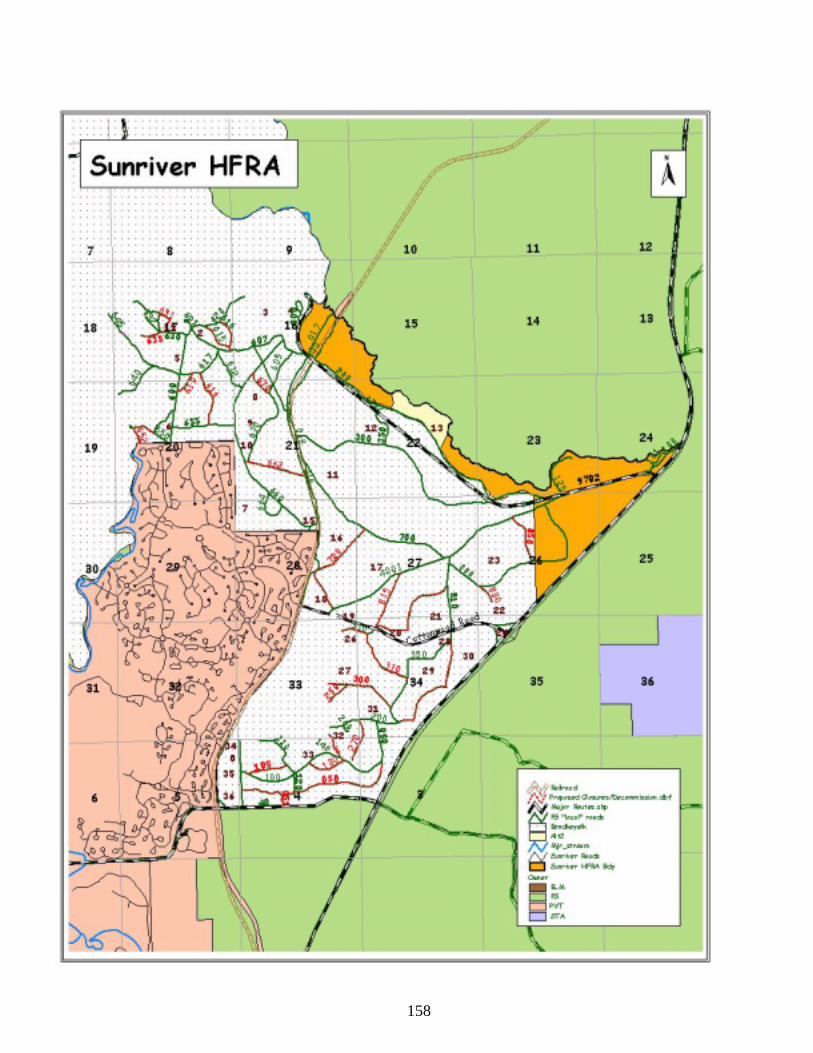
158
159
Hydrology (Water Quality) and Fisheries Management Introduction Water Quality and Fisheries Management are closely related. In this resource section the scope of the analysis and affected environment are discussed separately; followed by a combined effects analysis for the following measures: Measure #1 Timing and Volume of Peak/Base Flows and Water Yield; Measure #2 Water Quality ODEQ 303(d) Parameters; Measure #3 Fish Habitat and Populations, Measure #4 Project Design Criteria and Mitigation. Quantitative analyses and professional judgment were used to evaluate the issue measures by comparing existing conditions to the anticipated conditions from implementing the two alternatives. This analysis also considered the effectiveness and probable success of implementing the management requirements, mitigation measures, and Best Management Practices (BMPs), which are designed to avoid, minimize or reduce potentially adverse impacts to habitat conditions, water quantity and water quality. Scope of the Analysis The hydrology resource may be directly or indirectly affected within the project area. The Deschutes River is the major waterbody within the project area; therefore it will be the focus of the hydrologic analysis. The Equivalent Clearcut Area (ECA) methodology was used to determine where cumulative watershed effects might occur at the 5th field watershed scale. Past, Present, and Reasonably Foreseeable Actions were considered in this analysis. Past actions included development in the City of Bend and outlying areas. Past actions on Forest Service lands included vegetation management activities (dating back approximately 45 years), fire history, and road density. Present actions included on-going vegetation management activities, such as the East Tumbull and Lava Cast Projects. Reasonably Foreseeable Actions included the South Bend HFRA Project, the OZ CE and U.S. Hwy 97 construction but did not include private lands, such as the City of Bend and Sunriver because there is not an additive effect with these other actions. A recovery rate factor, derived from local recovery rates, is included to achieve the final ECA determination. A recovery rate based on a 50-year recovery period was used on this project. This is within the range of reported recovery rates in literature and through personal communication with Troendle in 1999. Affected Environment-Landscape Setting The Sunriver HFRA project area is east of the owl line, and lies within the management area of the Inland Native Fish Strategy (INFISH), which amended the Deschutes National Forest Land and Resource Management Plan in 1995. The project area also includes lands within the corridor of the Upper Deschutes Wild and Scenic River, for which an Environmental Impact Statement (EIS) and Comprehensive Management Plan (Upper Deschutes River Plan, 1996) were completed in 1996. Wild and Scenic River Segments included in the project area are 4A and 4B. These segments include the area from the northern boundary of Sunriver (river mile 185.7) downriver to Slough Day Use Area (river mile 172.6). Wild and Scenic Rivers are included under Management Area 17 of the 1990 Deschutes National Forest Land and Resource Management Plan. The Federal Wild and Scenic River and State Scenic Waterway Acts established an overriding goal to protect and enhance the ORVs for which the river was designated. The 5,352 acre project area is within the 147, 978 acre Pilot Butte 5th field watershed, which is located on the eastern slope of the Cascade Mountain Range, and encompasses the city of Bend. This 5th field watershed is sub-divided into (7) 6th field sub-watersheds (Coyote Springs, Benham Falls, Lava Island Falls, Mokst Butte West, Green Mountain, Bessie Butte, and Lockit Butte). The Sunriver HFR project area lies within three of these 6th field sub-watersheds; Coyote Springs (15,538 acres), Benham Falls (22,901 acres), and Mokst Butte West (11,223 acres). Past impacts to the landscape have occurred from road construction, timber harvest, recreational activities, private land development, and wildfire. Roads and trails currently provide access to much of the area, and urban development is present along the west boundary of the project. Land in private ownership comprises 3,969 acres of the 16,995 acres within the Upper Deschutes Wild and Scenic River corridor (23% - Deschutes NF, 1996). There is no evidence of past mass wasting or debris flows within the watershed.
160
Riparian conditions along the Deschutes River within and adjacent to the project area vary from fair to good depending upon the degree of conifer encroachment, recreational use (dispersed and developed), and road density. Some isolated riparian areas have compaction, while most are functioning well. The controlled flow regime upriver at Wickiup Dam is the predominate source of hydrologic disturbance. During the summer months, algae blooms that form in the reservoir are then passed downriver. Additional information about existing conditions can be found in the Environmental Impact Statement for the Upper Deschutes Wild and Scenic River (Deschutes NF, 1996). Affected Environment-Upper Deschutes River Hydrologic Characteristics Vegetation management activities (harvesting, skidding, landings, road building, underburning) have potential for causing hydrological effects in a watershed. The pathways by which water moves to stream channels is affected by vegetation management through its influences on snow accumulation and melt rates, influences on evapotranspiration and soil water, and influences on soil structure that affect infiltration and water transmission rates (Meehan, 1991). This in turn can lead to changes in the timing, duration, and volume of peak flows in a stream, which influences changes in bank erosion and channel forming processes within the stream. Vegetation management also has the potential to modify stream processes by mass movements of sediment, bank destabilization from vegetation removal, and loss of instream large wood from direct removal or debris torrents. Effects from vegetation management activities are influenced by the proximity of treatments to streams and slope. Changes in water quality (suspended sediment, temperature, dissolved oxygen, nutrients) have potential to be affected by vegetation management activities (Meehan, 1991). Hydrologic and stream morphology changes ultimately influence fish habitat and fish populations. Mowing of underbrush generally has minor hydrologic effects to a watershed, as ground cover is retained. Some soil compaction occurs during these operations. Reducing net evapotranspiration by harvest of vegetation, in areas with soils that have high infiltrations rates, can also lead to increased water yield in ground water systems (Manga, 1997). The increased yield in groundwater generally takes days to months to “surface” in springs or stream systems, if not stored subsurface. Water yield increase due to groundwater flow generally is not a concern as some water is either or both stored and redistributed subsurface. Hydrological effects from vegetation management activities as described do not typically occur in the Upper Deschutes River basin, which includes the Sunriver HFR Project area. Runoff is a relatively small component of the total water budget in the basin due to the high infiltration rates of the highly permeable volcanic soils (Gannett, 2001). Surface water drainages are uncommon in the basin, and are primarily spring-driven. Groundwater that has moved through the highly permeable Cascade Range comes in contact with the low permeability sedimentary deposits of the La Pine sub-basin, forcing discharge to the surface (Gannett, 2001). A large proportion of the precipitation in the Upper Deschutes Basin falls in the Cascade Range along the western fringe of the basin, making it the principal groundwater recharge area for the basin. East of the Cascade Range, there is little or no recharge from precipitation within the basin (Gannett, 2001). Precipitation in the Sunriver HFR Project area is approximately 15-20 inches annually, while in the Cascade Range recharge area, annual precipitation may exceed 200 inches. Evapotranspiration of groundwater is rare in the basin. Groundwater level fluctuations in the basin are driven primarily by decadal climatic cycles (Gannett, 2001). Affected Environment-Water Quantity The Pilot Butte watershed and the Sunriver HFRA project area are within the 4th field Upper Deschutes River basin, which encompasses 1,759 square miles measured at Benham Falls (river mile 181.6). The Deschutes River within the project area loses flow to the surrounding strata, re-charging the groundwater. Comparison of gauging station flow data indicates significant water loss from the Sunriver area down to Bend. Analysis of past flow data for the reach between the old Camp Abbott Bridge near Besson Camp and Benham Falls gauging station (10 miles downriver) demonstrated an average loss of nearly
161
24 ft³/s, and the 7.5 mile reach between Benham Falls and Lava Island averaged 83 cfs loss (Gannett, 2001). Surface water drainages are uncommon in the Pilot Butte watershed and the Sunriver HFRA project area. The Pilot Butte watershed contains less than 36 miles of perennial stream channel, of which approximately 4 miles is within the Sunriver HFRA project area. The Deschutes River from river mile 181.6 to 185.7 is the only perennial stream included in the project area (east bank only). The flow of the Deschutes River is regulated at Wickiup Dam. The flow regime was historically very stable, with a mean flow of about 1190 cubic feet/second (cfs) and an annual range from approximately 1000 - 1600 cfs measured at Benham Falls (Deschutes NF, 1996). Bankfull discharge, historic and present, are significantly less than would be expected for a basin this size (Rosgen, 1998), indicating significant infiltration to groundwater. Large flood events were uncommon, even prior to regulation. The river now experiences a large swing in flow with storage practices for irrigation needs. Flow is reduced in the winter, as low as 20 cfs released upriver at Wickiup Reservoir during low precipitation years, and then is elevated in the summer, with releases at Wickiup as high as 1800 – 2000 cfs to meet irrigation demands. This results in a range of flows from approximately 700 cfs to 2500 cfs measured at Benham Falls. The altered flow regime has led to increased riverbank erosion, widening of the channel, and reduced water quality and fish habitat (Deschutes NF, 1996). These effects are most evident in the river upstream of the confluence with Fall River, which is approximately 20 miles upriver of the southern end of the project area. The additional discharge provided by Fall River, Spring River, Little Deschutes River, and several small springs tempers the effects of the modified flow regime in downriver reaches. As described previously, the Upper Deschutes River basin is primarily a groundwater driven system due to high infiltration rates of volcanic soils. Groundwater constitutes virtually the entire flow of several tributaries to the Deschutes River upriver of the project area, including Fall River (Gannett, 2001), the majority of which discharges from springs near the headwaters. The source of the discharge is thought to be from snowmelt that originated from the Cascade Range to the west (Gannett, et al 2001). Aquifers in the Cascade Range consist primarily of quaternary basaltic andesites, and are probably composed of many interbedded flows (Manga, 1999). A comparison of the groundwater discharge variations in the Cascade Range with precipitation levels at Crater Lake (over 100 miles south of the project area) showed that periods of high groundwater discharge generally corresponds with periods of high precipitation (Gannett, 2001). Manga (1999) studied discharge on Upper Deschutes Basin spring-fed streams at 3 different timescales. The hydraulic timescale related long term changes in discharge to long term changes in recharge. This describes the effect of, and the recovery from, droughts. The hydraulic time scale for Fall River was calculated at 6.3 years. The time lag, which measures the time lag between groundwater recharge (springtime snowmelt) and the time of peak discharge at the spring, was calculated at 112 days. Lastly, Manga estimated that the age of groundwater discharged in the Upper Deschutes Basin springs to be approximately 10-30 years. In summary, groundwater movement from the Cascade recharge area to surface systems is gradual. Groundwater flow direction in the Upper Deschutes basin is influenced by complex, underlying geology, and is not closely associated with the surface topography in some areas. Generally, groundwater flow direction in the project area is from the west direction from the Cascade Range toward the Deschutes River (Lite, 20021). Road density in the Sunriver HFRA Project area is approximately 6 miles/square mile. There is only one stream crossing – the footbridge near Benham Falls West Day Use Area. The road network has had minimal effects on increasing the drainage network within the project area. Affected Environment-Water Quality The regulated flows at Wickiup Dam is the largest influence on water quality of the Deschutes River, and has likely led to the status as a water quality impaired waterbody under the
162
Clean Water Act . Other factors that may contribute to water quality impairment are private land development and associated septic drainfields, which are considered to be a source of oxygen demanding bacteria (Deschutes NF, 1996), developed and dispersed recreational sites, and recreational activities including motorized boating. These activities have resulted in elimination or reduction in shade, large wood recruitment, riparian vegetation, riverbank stability, and increases in nutrient and sediment loading, all which can influence water quality and fish habitat. Impacts from recreational sites are generally at a localized scale. Agricultural land use is rare along the Upper Deschutes River. The objective of the Clean Water Act (CWA) of 1972 is to restore and maintain the chemical, physical, and biological integrity of all waters. Under Section 319 of the 1987 CWA Amendments, states are required to determine those waters that will not meet the goals of the CWA, determine those non-point source activities that are contributing pollution, and develop a process on how to reduce such pollution to the “maximum extent practicable”. Section 303(d) of the CWA requires that a list be developed of all impaired or threatened waters within each state. The Oregon Department of Environmental Quality (ODEQ) is responsible for compiling the 303(d) list, assessing data, and submitting the 303(d) list to the Environmental Protection Agency (EPA) for federal approval. Management direction for federal land management agencies regarding 303(d) listed rivers is that project activities should protect and not further degrade the parameters for which it is listed. In addition, Water Quality Restoration Plans (WQRP) are to be developed that address impaired waters (USFS, BLM, 1999). A draft WQRP has been developed for the Upper Deschutes River 4th field watershed. The 2004-2006 Oregon Department of Environmental Quality (ODEQ) list of water quality impaired water bodies (303(d) list) includes the Deschutes River within the Sunriver HFR Project area. The ODEQ river reach that most closely fits the project area is river mile 168.2 – 189.4. The parameters within this reach for which standards are not met are dissolved oxygen and temperature year-round, sedimentation (season undefined), turbidity (spring and summer), and chlorophyll a (summer). The presence of Wickiup Dam, located approximately 45 miles upstream of the project area, and the modification of natural flow may provides some explanation for these 303(d) listings. Beneficial uses affected by these listings are aesthetics, resident fish life and aquatic life, water supply, salmonid fish spawning, and salmonid fish rearing. Beneficial uses are documented according to criteria in the Oregon Department of Environmental Quality, (ODEQ, 1998a). A beneficial use is a resource or activity that would be directly affected by a change in water quality or quantity. Water quality for beneficial uses is maintained and protected through the implementation of the Deschutes National Forest Plan (1990) Standards and Guidelines including Best Management Practices (BMPs), INFISH (1995), the Upper Deschutes Wild and Scenic River and State Scenic Waterway Management Plan (1996), and the Newberry National Volcanic Monument Comprehensive Management Plan (1994). All proposed management activities under the Sunriver HFR Project would meet the required Standards and Guidelines and selected BMPs in both the short and long term. Fisheries Management Introduction The long-term sustainability of fisheries populations depends largely on habitat conditions and water quality, both are which are influenced by activities that occur instream, on the floodplain, and within the uplands of the watershed. Land use activities, such as vegetation management, road construction, private land development, and recreation have potential to adversely affect fish populations and fish habitat by reducing shade, overhead cover, and future instream recruitment of large woody material, introducing fine sediments, pollutants, and nutrients, and altering the timing and volume of streamflows.
163
Scope of the Analysis The fisheries resource may be directly, indirectly affected within the project area or cumulatively within the Pilot Butte watershed. The Deschutes River is the major waterbody within the project area, therefore it will be the focus of the fisheries resource analysis. As mentioned above, the long-term sustainability of fisheries populations depends largely on habitat conditions and water quality, which the analysis will be based on. Changes in fisheries management such as fish stocking and angling regulations and the effects they may have on the fisheries resource is beyond the scope of this analysis because these decisions are made by the ODFW and they have no effect on the decision to be made. It is Forest Service policy to avoid all adverse impacts to threatened and endangered species and their habitats, except when it is possible to compensate adverse effects through alternatives identified in a biological opinion rendered by the U.S. Fish and Wildlife Service. Measures are to be identified and prescribed to prevent adverse modification or destruction of critical habitat and other habitats essential for the conservation of endangered, threatened, and proposed species (FSM 2670.31). Through the biological evaluation process (FSM 2672.4), actions and programs authorized, funded, or carried out by the Forest Service are to be reviewed to determine their potential for effects on threatened and endangered species and species proposed for listing (FSM 2670.31). Species classified as sensitive by the Forest Service are to be considered in the National Environmental Policy Act process by conducting biological evaluations to determine their potential effect of all programs and activities on these species (FSM 2670.32). No impacts may be allowed on sensitive species that would result in loss of population viability or create significant trends toward federal listing. The findings of biological evaluations are to be documented in a decision notice, or if applicable, in official files. Affected Environment-Fisheries Populations and Habitat Threatened, Endangered and Sensitive Species One species of fish listed on the Regional Foresters Sensitive Species List may occur within the project area. There are no known threatened, endangered, proposed, or candidate fish species within the project area. The proposed project area was evaluated to determine which species might occur based on the presence of required habitats and known locations. Bull trout once occupied the Deschutes River upstream of Bend, but have not been documented since 1954 (ODFW 1996). The nearest current population is at Lake Billy Chinook, approximately 45 miles downriver. Redband trout (Oncorhynchus mykiss gairdneri) are the only Forest Service Region 6 sensitive aquatic species within the project area. Dr. Robert Behnke, fish geneticist, has divided the rainbow trout into three major groups (Behnke, 1992). The redband is considered an inland version of the rainbow trout. The redband of Central Oregon are included in the inland Columbia River Basin sub-group (Oncorhynchus mykiss gairdneri) and are also a State of Oregon sensitive species. The redband trout has habitat requirements similar to other salmonids. There are both fluvial and adfluvial populations. Optimal water temperatures are 54-64 degrees Fahrenheit, but they have been known to survive temporary exposure up to 85 degrees. In the stream environment, they seek cover provided by large woody material, undercut banks, boulders, depth, and turbulence. They can be found in desert stream environs as well as those with forested canopies. They require clean gravels for spawning, preferably in the 0.25" - 2.0" range. Historic fish populations in the Deschutes River within the Sunriver HFRA project area included redband trout, bull trout (Salvelinus confluentus), mountain whitefish (Prosopium williamsoni), and sculpin (Cottus sp.). There are no records of anadromous species in the project area, as upriver migratory fish passage is considered to be restricted to below Big Falls on the Deschutes River downriver of Bend (ODFW, 1996). Over the last 100 years, several other fish species have been introduced into the basin, considerably altering the fish community. In addition, the bull trout is considered to be extirpated from the Deschutes River above Bend (ODFW, 1996).
164
Fish species that have either been introduced into the Deschutes River or move into the river through the unscreened outlet at Wickiup Dam include rainbow trout (Onchorhyncus mykiss), kokanee salmon (Oncorhyncus nerka kennerlyi), largemouth bass (Micropterus salmoides), eastern brook trout (Salvelinus fontinalis), three-spined stickleback (Gasterosteus aculeatus), tui chub (Gila bicolor), brown bullhead (Ictalurus nebulosus), coho salmon (Oncorhyncus kisutch), and brown trout (Salmo trutta). Determination of the value of redband trout in Segment 4 has been deferred until a review of the genetic status has been completed. Until that time, the redband population is to be treated as an ORV (Deschutes NF, 1996). The Federal Wild and Scenic River and State Scenic Waterway Acts established an overriding goal to protect and enhance the ORVs for which the river was designated (Deschutes NF, 1996). Species considered to be resident fish are the redband trout, rainbow trout, mountain whitefish, sculpin, brook trout, and brown trout. The native redband trout have interbred with various introduced hatchery stocks of rainbow trout over the last several decades. The genetic make-up of the rainbow in the project area was studied a decade ago. Samples collected downriver of Benham Falls (river mile 181.6) revealed 7.2 percent hatchery rainbow genetic contribution, i.e., on average, the fish were 92.8 percent pure redband (Phelps, 1996). The altered flow regime below Wickiup Dam has affected fish habitat. Analysis of aerial photographs and channel morphology data indicates the channel is becoming wider and shallower, reducing maximum and average depths. The effects to fish habitat within the project area are reduced from that observed in upriver reaches because of the flow contribution of the tributary streams previously mentioned above. The channel width has increased approximately 20 percent since the inception of Wickiup Dam (Deschutes NF, 1996). Aggradation in pools has reduced their effectiveness as fish habitat. River bottom substrates have high volumes of sand and silt. These fine sediments plug the interspaces of substrate gravels, reducing the survival rates of developing fish embryos buried within, and limiting habitat for aquatic invertebrates (Meehan, 1991). Log drives down the river in the 1930’s damaged riverbanks and reduced instream large wood that fish depend on for cover from predators and as velocity breaks for resting. The endpoint for the river log drives was near the Benham Falls footbridge, where logs were loaded onto railroad cars and delivered to the mills in Bend. There is excellent fish hiding cover at this site due to the large accumulation of instream wood. The Sunriver Fish Habitat Restoration Project (1998) and the Kelsey Fish Habitat Project (2003) restored over 450 trees to the Deschutes River within or immediately upriver of the project area. Recent projects upriver of the project area have also re-introduced large wood. Due to limitations of equipment, large wood introductions are limited primarily to trees less than 20” diameter at breast height. Historically, abundant large ponderosa pines up to 4’ diameter were likely found within the channel to provide fish habitat. Habitat type of the Deschutes River within the project area is dominated by long pools. Although there are only 3.2 pools/mile, 79.7 percent is pool habitat. Side channel habitat is essentially non-existent. The channel is generally wide and shallow, with a width/depth ratio of 20.9. Residual pool depth averages 6.3 feet. Large woody material (minimum 12” diameter and 35’ length) totaled 21.9 pieces/mile (Dachtler, 2005). See the Upper Deschutes Wild and Scenic River Environmental Impact Statement (1996) and the ODFW Upper Deschutes River Sub-basin Plan (1996) for additional information on the fisheries resource. Essential Fish Habitat Although the Upper Deschutes 4th field watershed (17070301) is mapped by the National Marine Fisheries Service as Essential Fish Habitat for chinook salmon, there are no present or historical records of chinook populations above Big Falls on the Deschutes River, over 50 miles downriver from the project area. Water Quality and Fisheries Management Direction The LRMP, as amended by the Upper Deschutes River Plan, specifies management activities to protect water quality, riparian and fish habitat. The most site-specific potential negative effects to the watershed from the proposed activities are from the introduction of sediment into channels as a result of harvest, burning, road maintenance, and/or restoration activities. In order to
165
minimize or eliminate effects, all appropriate BMPs would be implemented in conjunction with the standards and guidelines from the LRMP, INFISH, and the Upper Deschutes River Plan. This is accomplished by the following pertinent BMPs T-10, T-21,F-3; LRMP standards and guidelines R-3, R-22 to 24 and Upper Deschutes River Plan V-9, V-11, V- 12 and V-17. The Deschutes River within the project area is listed as having impaired water under Section 303(d) of the CWA. Management direction for federal land management agencies regarding 303(d) listed rivers is that project activities should protect and not further degrade the parameters for which it is listed. Target Landscape condition The desired condition is to maintain or enhance riparian dependent resources such as water quality and quantity, fish habitat and riparian associated wildlife and vegetation Hydrology (Water Quality) and Fisheries Management Environmental Effects Direct and Indirect Effects of Alternative 1. The ongoing management activities that would continue under the no action alternative are identified in the Alternative Descriptions (EA, Chapter 2). None of the management actions identified under the proposed action would take place. Measure #1: Timing and Volume of Peak/Base Flows and Water Yield. The timing and volume of peak and base flows and the total water yield of the Deschutes River is primarily influenced by the releases at Wickiup Dam, upriver of the project area. There would be no direct effects to peak flows and water yield to the Deschutes River from selecting this alternative. Any changes in peak flows and water yield in the Deschutes River would be the result of dam operations, changes in flows in tributary streams outside of the project area, natural climatic variations, or other causes. Changes in peak flows and water yield of ephemeral channels within the project area would be the result of natural climatic variations or other causes. There is potential for indirect effects to occur under this alternative. Over time, forest health deterioration and fuels build-up within the project area could lead to stand-replacing wildfires that have the potential to change peak/base flows and water yield because of an increase in surface run-off, especially if soils become hydrophobic, and decreased evapotranspiration. However, changes would be immeasurable because of the groundwater dominated nature of the landscape that exhibits little surface runoff. Measure #2: Water Quality-ODEQ 303(d) Parameters The water quality of the Deschutes River is primarily influenced by the altered flow regime from operations at Wickiup Dam and by private land development along the river. These activities have largely contributed to altered water temperatures, increased bank erosion, increased nutrients, and decreased shade and riparian vegetation. (Deschutes NF, 1996). There would be no direct effects to water quality of the waterbodies in the project area, including the 303(d) parameters of dissolved oxygen, water temperature, turbidity, sedimentation, and chlorophyll a listed for the Deschutes River from selecting the No Action alternative. Any changes in water quality in the Deschutes River would be the result of dam operations, changes in water quality in tributary streams outside of the project area, natural climatic variations, activities on private lands, or other causes. Direct effects to water quality of ephemeral channels within the project area would be the result of natural climatic variations or other causes. There is potential for indirect effects to occur under this alternative. Over time, forest health deterioration and fuels build-up within the project area could lead to stand-replacing wildfires that have the potential to change water quality and affect the 303(d) parameters for which the Deschutes River is listed, especially if the wildfires were to enter the RHCAs. Fisk and others (2003) summarized that riparian areas have been observed to burn less hot than upslope areas, although the burn values were positively related to upslope burn values. Higher order streams (Deschutes River is high order) riparian areas burned less similar to upslope areas than small order streams. Other research has indicated that riparian areas can burn as frequently as upslope fires (Dwire,
166
2003). Because fire behavior is influenced by fuel characteristics, the variation in riparian vegetation likely contributes to the tendency for many fires to burn in a patchy manner through riparian areas. Wildfire within the RHCAs in the short term (episodic) could decrease pH and increase water temperatures, overland flow of sediments and organic debris, which would then affect turbidity, sedimentation, and dissolved oxygen and chlorophyll a concentrations. Wildfire would reduce riparian vegetation, standing timber, protective ground vegetation, and the organic duff layer. These features provide shade and riverbank stability, and reduce overland flow of sediments, metals, and nutrients. Adverse effects would continue until vegetation recovers. In the event of wildfire, there is also the risk of fire retardant reaching aquatic systems during fire suppression operations, adversely affecting water quality. Other fire suppression efforts, such as dozer line construction, could also lead to overland flow of sediments or retardant or foaming agents Effects to ODEQ (303(d)) Parameters The No Action alternative would have no direct effects to the ODEQ 303(d) parameters for which the Deschutes River is listed. There is potential for adverse effects to occur under the scenario of stand replacing wildfire. Following is a description of effects to the 303(d) parameters should stand replacing wildfires occur near the Deschutes River. Effects to water temperature: During the course of a wildfire within the RHCA, water temperature would be increased from the heat of the fire itself. The increase in temperature would depend on the intensity of the fire, size of the fire, proximity to the Deschutes River, discharge at the time of the fire, and duration of the fire. Post-fire, shade would be reduced, which would allow increased solar radiation and increased water temperatures in the summer and decreased winter temperatures due to the loss of buffering capacity. Albin, 1979, found that water temperatures increased an average of 1.5° C in a burned watershed 35 years after the fire. However, this research was conducted on small 1st and 2nd order streams (Gresswell, 1999), whereas the Deschutes River is a large 4th order system. Effects to dissolved oxygen: During the course of the fire dissolved oxygen would be decreased as water temperatures increase. Post-fire, dissolved oxygen would be decreased as water temperatures increase from the lack of shade until vegetation recovers to heights capable of shading. Full shade recovery could take several decades. Oxygen could also be depleted from metabolism of increased runoff of organic matter, until ground cover becomes re-established to limit runoff. Effects to turbidity: During the fire, turbidity may be increased from toppling of trees that are growing on the riverbank, introducing sediment as they fall. Turbidity from this action is likely to result in minimal increases in turbidity and may be immeasurable in the river. A weather storm that resulted in heavy precipitation soon after a fire could introduce overland flow of sediments within the RHCAs into the Deschutes River that would measurably increase turbidity. Chronic, or long term small inputs of sediment from RHCAs that increase turbidity could continue for several years until vegetation groundcover is re-established. Chronic sediment inputs would likely be immeasurable in the river due to limitations of equipment and techniques of sampling. Overland flow of sediments as a result of a fire, either chronic or episodic, would be minor compared to the movement of sediments through the system from accelerated upriver bank erosion and from natural sources. Highly permeable soils, lack of precipitation, and the lack of slope within much of the RHCAs within the project area would limit the volume of sediments introduced into the Deschutes River from overland flow. Consumption of riverbank vegetation by wildfire could lead to decreased riverbank stability, increasing bank erosion and sediment introduction that could increase turbidity until riverbank vegetation and stability recover.
167
Effects to sedimentation: The pathways for sedimentation and the effects of the fire on sedimentation are similar to those listed under turbidity above. Sedimentation occurs as suspended and other larger sediments deposit on and in the river substrate. Effects to chlorophyll a: During the fire, ash and smoke could introduce nutrients to the river. Spencer and others (2003) detected an increase phosphorus and nitrogen of 5 to 60 fold above background levels resulting from smoke and ash during a fire in Montana. After the fire, increased overland flow within the RHCAs of the Deschutes River could introduce additional nutrients (nitrogen, phosphorus, organic carbon) to the river. The nutrients would increase primary production, primarily by algae, which would increase the concentration of chlorophyll a. Once ground cover is re-established, overland flow would be reduced. As mentioned previously, the potential for overland flow within the RHCAs of the Deschutes River is limited by lack of precipitation, slope, abundant ground cover, and highly permeable soils. Measure #3 – Fish Habitat and Populations Fish habitat and populations are largely influenced by water quality and water quantity. The No Action alternative would have no direct effects to habitat or populations, including that of the sensitive species redband trout. Effects to habitat or populations would be from natural causes, fish management actions, or other causes. Research has shown that fire can result in direct mortality to fish (Gresswell, 1999). Responses of fish populations to fire and fire-related disturbance have been documented in a limited number of studies, mostly for salmonid fishes. The influence of fire on persistence of native salmonid populations is highly variable. In some cases, local extinctions have been observed in response to fire, particularly in areas where populations of fishes have been isolated in small headwater streams. In larger interconnected systems, fish populations appear to be more resilient to the effects of fire (Dunham, 2003). There is potential for indirect effects to fish habitat and populations, including redband trout, in the event of stand replacing wildfires, especially if they enter RHCAs. These effects are primarily tied to water quality, effects on which were discussed above. Increased water temperatures and decreased dissolved oxygen can affect fish by increasing mortality, promoting disease, decreasing growth, and decreasing embryo survival. Suspended sediment can be abrasive to fish gills and reduce foraging ability. Fine sediments accumulated in riverbed substrates can limit survival of developing fish embryos and limit the production of aquatic macroinvertebrates, which provide forage for fish (Bjornn and Reiser, 1991, in Meehan, 1991). Fine sediments in the streambed were shown to impair growth and survival of steelhead juveniles (Suttle, 2004). A decrease in bank stability and riparian vegetation would decrease overhead cover for fish, including redband trout. There would be a benefit to fish habitat from an increase in large woody material from fire-toppled trees and increased windfalls for several years after the fire. Instream large wood provides hiding cover for fish, reduces velocities to provide microhabitats, and provides habitat and a food source for aquatic macroinvertebrates. However, there would be a reduction in future recruitment of large woody material until the stands recover to maturity. An increase in primary productivity as a result of fire-introduced nutrients could increase the abundance of macroinvertebrates, thus increasing the food base for fish. Increases in macroinvertebrate abundance and diversity would likely be short term. Minshall (2003) summarized changes to macroinvertebrate communities are generally restricted to the first 5-10 years, but research was done on small order streams. The large size of the Deschutes River would likely temper any effects to the macroinvertebrate community as a result of a fire. As mentioned previously under effects to water quality, there is also the risk of fire retardant and foaming agents reaching aquatic systems during fire-fighting operations. Fire retardant can persist in soils and produce toxic effects for weeks, especially in sandy soils (Luce, 2005). During August of 2002, fire retardant was
168
inadvertently dropped in nearby Fall River while attempting to extinguish a small fire (<5 acres). A large fish kill was observed, estimated at 21,000 fish by the Oregon Department of Fish and Wildlife (ODFW). Aquatic invertebrates were also adversely affected. Recovery of the fish population was anticipated by ODFW to take up to 9 years. Essential Fish Habitat There would be no effects to Essential Fish Habitat from this alternative. Although the Upper Deschutes 4th field watershed (17070301) is mapped by the National Marine Fisheries Service as Essential Fish Habitat for chinook salmon, there are no present or historical records of chinook populations above Big Falls on the Deschutes River, over 50 miles downriver from the project area. Measure #4 – Project Design Criteria and Mitigation Implementation of Project Design Criteria and Mitigation Measures are not necessary as no management activities would occur. Cumulative Effects of Alternative 1 Measure #1: Timing, Duration and Volume of Peak/Base Flows and Water Yield. Under Alternative 1 the extent of effects to timing and volume of peak and base flows and water yield would not increase above existing levels as a result of implementing this alternative because no additional activities would occur. The effects of past and current management activities were previously described under the Affected Environment sections. However, the risk of wildfire would increase over time. Should wildfire occur the indirect effects listed previously under Alternative 1 would contribute to the effects presently occurring from other activities in the basin upriver and downriver of the project area. Cumulative effects from within the project area would be transferred to areas downriver of the project area, but the changes may be immeasurable because of the groundwater dominated nature of the landscape that exhibits little surface runoff. Measure #2: Water Quality - ODEQ 303(d) Parameters. Under Alternative 1 the extent of effects to water quality, including the 303(d) parameters, would not increase above existing levels as a result of implementing this alternative because no additional activities would occur. The effects of past and current management activities were previously described under the Affected Environment sections. However, the risk of wildfire would increase over time. Should wildfire occur the indirect effects listed previously under Alternative 1 would contribute to the effects presently occurring from other activities in the basin upriver and downriver of the project area. Cumulative effects from within the project area would be transferred to areas downriver. Under the scenario of a stand replacing wildfire in the project area, adverse effects to the 303(d) parameters could occur, which are summarized below: Water temperature: An increase in water temperature during the fire and the decrease in shade post-fire would add cumulative effects to the increased water temperatures from the altered flow regime and removal of riparian vegetation elsewhere along the river. Temperature is presently listed as a 303(d) parameter within and for 70 consecutive miles downriver of the project area. Dissolved oxygen: Increased water temperatures during and post-fire would decrease dissolved oxygen, adding to the upriver adverse effects on temperature as described above. In addition, fire-introduced organic matter would add to organic matter inriver supplied from other sources such as developed land and disturbed riparian areas, increasing the biological oxygen demand. Dissolved oxygen is included on the 303(d) list for river reaches immediately below the project area. Turbidity: Increased overland flow of sediments and increased bank erosion would add cumulative effects to suspended sediment originated from bank erosion, algae blooms, and other sources occurring in Wickiup Reservoir. Sources of turbidity are decreased downriver of the project area from areas upriver of the project area. Turbidity is included on the 303(d) list immediately downriver of the project area.
169
Sedimentation: Increased suspended sediments that become deposited on and in the river substrate would increase adverse effects from sediments originated from other sources as described above under turbidity. Sedimentation is included on the 303(d) list in the reach immediately downriver of the project area. Chlorophyll a: Increased nutrient loading and solar radiation would add to other sources generated along the river, increasing chlorophyll a concentrations. Chlorophyll a is included on the 303(d) list in the reach immediately downriver of the project area. Measure #3 – Fish Habitat and Populations. Under Alternative 1 the extent of effects to fish habitat and populations would not increase above existing levels as a result of implementing this alternative because no additional activities would occur. The effects of past and current management activities were previously described under the Affected Environment sections. However, the risk of wildfire would increase over time. Should wildfire occur the indirect effects to water quantity, water quality, and fish habitat described previously under Alternative 1 would contribute to the effects presently occurring from other activities in the basin upriver and downriver of the project area. Measure #4 – Project Design Criteria and Mitigation. Implementation of project design criteria and mitigation of project-related water or fisheries resource disturbances would not be necessary under Alternative 1. Direct and Indirect Effects of Alternative 2. The management activities that are proposed under this alternative are described in the Alternative Descriptions (Chapter 2). No treatments are prescribed within the 300 foot RHCAs of the Deschutes River. EA units 1, 2, 3, 4 and 6 abut against or are in close proximity to the RHCAs. Slopes within these EA units are flat to very gentle near the boundaries with the RHCAs. Soils are highly permeable and well to excessively drained (Landtype 63 – Deschutes National Forest, 1979). Measure #1: Timing, Duration, and Volume of Peak/Base Flows and Water Yield. A combination of thinning, hand piling, prescribed burning, and mowing would occur on 1,673 acres. More than one activity may occur on a treatment unit. A total of 16.1 miles of road would be decommissioned, all outside of RHCAs. Based on the character of the hydrogeology of the Upper Deschutes Basin and the design of the proposed activities, including mitigations, management activities proposed under Alternative 2 would have no measurable direct or indirect effects to the timing, duration, or volume of peak and base flows nor increase the water yield¸ nor in any other way measurably alter the flow regime of the Deschutes River or any ephemeral channel. Infiltration of precipitation may be decreased in areas where soils become compacted as a result of management actions. Temporary pooling of water may occur in some of these compacted areas after intense precipitation events or snowmelt in the short term (5 years or less), but would not add to an increase in the stream drainage network. There would be no measurable effects to the Deschutes River or any ephemeral channel as a result of implementing this alternative for the following reasons: 1) Highly permeable volcanic soils allowing high infiltration of precipitation. Groundwater table generally near the surface near Spring River and immediately west but increases to generally 150 - 300 hundred feet lower than the river in the Meadow Camp area 4 miles northeast of the project area (Chitwood 2005, personal communication).
2) The Deschutes River has a highly managed flow regime, and is highly altered from the natural regime. Source of discharge for tributary springs in the Upper Deschutes River basin is primarily from the Cascades Range recharge area. There is limited precipitation and recharge to groundwater from within the project area.
3) Lack of runoff and surface water in the project area, even in areas of moderate slopes.
170
4) Past management in the project area and adjacent lands has only minimally increased the stream drainage network, therefore not measurably increasing surface flows to the Deschutes River.
5) Changes in evapotranspiration would have little hydrologic effect since evapotranspiration from groundwater is rare in the Upper Deschutes basin. High infiltration rates limits volume of precipitation that can be evapotranspired as it moves through the soil to the groundwater.
6) Changes in flows in the Upper Deschutes basin have been shown to correlate to changes in climate cycles.
7) Design of project activities that excludes activities in RHCAs and includes mitigation measures to protect soil and water resources (See Mitigations section). The road density within the project area would be reduced from approximately 7 to 5 miles/square mile under this alternative. The reduction in road density and associated dispersed campsites would have a minimal effect on this measure because under present conditions the road network is having little hydrologic effect. The potential for insect and disease damage and fire risk is decreased over that of Alternative 1, thus decreasing the potential for changes in peak/base flows or water yield as a result of stand replacing wildfires. Measure #2: Water Quality - ODEQ 303(d) Parameters There would be no management activities within the RHCAs of the Deschutes River (minimum width 300 feet). RHCAs with sufficient ground cover act as a filter to surface run-off, pollutants, and overland flow of sediments. There would be no direct effects to water quality of the Deschutes River, including the 303(d) parameters of dissolved oxygen, water temperature, turbidity, sedimentation, and chlorophyll a listed for the Deschutes River from selecting this alternative. Any changes in water quality in the Deschutes River would be the result of dam operations, changes in water quality in tributary streams outside of the project area, natural climatic variations, activities on private lands, or other causes. Changes in water quality of ephemeral channels within the project area would be the result of natural climatic variations or other causes. This alternative reduces the potential for indirect effects to occur as described above under the No Action alternative. Forest health would be improved and fuels build-up would be reduced, decreasing the potential for stand-replacing wildfires that could adversely affect water quality including the 303(d) parameters for which the Deschutes River is listed. By reducing the risk of wildfire, this alternative also reduces the risk of fire retardant, known to adversely affect water quality, from reaching aquatic systems during fire-fighting operations. Under current conditions, some stands within the RHCAs of the Deschutes River are overstocked and at risk of insect and disease infestations and increased fire risk. Since there are no vegetation treatments proposed within RHCAs, the potential for wildfire within the RHCAs is increased. Should wildfire burn within the RHCAs, adverse effects to water quality and the 303(d) parameters could occur. These effects would be similar to, but less than, those described above under the direct and indirect effects of Alternative 1. Upslope stands would still be treated to decrease fire risk and would reduce adverse effects to water quality should fire occur. Effects to ODEQ (303(d)) Parameters Effects to water temperature: The amount of shade provided by trees next to the stream will decrease as channel width increases. The Deschutes River averages nearly 140 feet bankfull width within the project area, therefore potential shading from riparian vegetation is limited. There will be no vegetation treatments within the RHCA of the Deschutes River. Effective stream shade would be maintained under this alternative, therefore not adversely affecting water temperature. Effective stream shade is defined as the total solar radiation blocked over a twenty-four hour period (USFS, BLM 2005). Stream
171
shading is broken down into two zones, primary and secondary. For slopes less than 30% and tree heights of 80-100 feet, typical of the RHCAs of the Sunriver HFR project area, the primary shade distance is 40-50 feet from the stream edge, decreasing to less than 35 feet for slopes less than 10% (USFS, BLM 2005). The period of greatest solar radiation occurs between 10:00 am and 2:00 pm (USFS, BLM 2005). Trees located in the primary shade zone nearest the stream provide shade all day and are the only trees providing shade during this critical 4 hour period. Trees in the secondary shading zone (beyond the primary zone) can provide some shading when the sun is lower in its arc. The amount of shading in the secondary zone will depend on stand density. Within this zone, there is no added benefit to shade from over stocked stands because of the “tree behind a tree” concept, where one tree can cancel any shade benefit from another tree (USFS, BLM 2005). Thinning activities would occur 300 feet or greater from the river, therefore effects to shading would be none to negligible. The vegetation treatments under this alternative are likely outside even the secondary shading zone. Effects to dissolved oxygen: Water temperatures and organic debris loading would be maintained, therefore no adverse effects to dissolved oxygen would occur. Increases in water temperature reduces dissolved oxygen, and biological metabolism of organic debris depletes dissolved oxygen. Effects to turbidity: There would be negligible effects to overland flow of sediments within the project area, and no ground disturbing or underburning activities within the RHCAs, therefore there would be no measurable increase in turbidity from implementing this alternative. The RHCAs would filter potential surface run-off and overland flow of sediments, limiting sediment entering the Deschutes River. Vegetation treatment units near RHCAs are generally on flat to gently sloped terrain, which, along with highly permeable soils and abundant ground cover, limits surface run-off as a result of management activities. Effects to sedimentation: There would be no measurable effects to sedimentation using the same reasoning as described above under turbidity. Effects to chlorophyll a: There would be no measurable increase in nutrient loading, which can occur with overland flow of sediments, and no increase in solar radiation, therefore there would be no effect to primary production and chlorophyll a concentrations. Measure #3: Fish Habitat and Populations Fish habitat and populations are largely influenced by water quality, water quantity, and timing of streamflows. Since actions proposed under this alternative would have immeasurable effects to both water quality and water quantity, there would be no direct or indirect effects to habitat or populations, including that of the sensitive species redband trout, as a result of implementing these actions. Effects to habitat or populations would be from natural causes, fish management actions, or other causes. Potential for stand replacing wildfire is reduced, protecting riverbank stability, shade, future large wood recruitment to channels, and spawning gravels. The potential for short term gain in large wood recruitment as a result of wildfire is reduced. Under current conditions, some stands within the RHCAs of the Deschutes River are overstocked and at risk of insect and disease infestations and increased wildland fire risk. Since no vegetation treatments are proposed within RHCAs, the potential for wildfire within the RHCAs is increased. Should wildfire burn within the RHCAs, adverse effects to fish habitat and populations could occur. These effects would be similar to, but less than, those described above under the direct and indirect effects of Alternative 1. Upslope stands would still be treated to decrease wildland fire risk and reduce the potential for fire to spread to RHCAs. The Fisheries Biological Evaluation concluded that this alternative would have No Effect to redband trout and downriver bull trout populations.
172
Essential Fish Habitat There would be no effects to Essential Fish Habitat from this alternative. Although the Upper Deschutes 4th field watershed (17070301) is mapped by the National Marine Fisheries Service as Essential Fish Habitat for chinook salmon, there are no present or historical records of chinook populations above Big Falls on the Deschutes River, over 50 miles downriver from the project area. Measure #4-Project Design Criteria and Mitigation Management direction for federal land management agencies regarding 303(d) listed rivers is that project activities should protect and not further degrade the parameters for which it is listed. Management direction regarding sensitive species is that actions would benefit, have no impact, or minimize impacts so that there is no loss of population viability or creation of a significant trend toward federal listing. The management requirements, mitigation measures, and project design elements prescribed under this alternative are designed to avoid, minimize, or rectify potentially adverse effects to water quality, including the 303(d) list parameters. The design of Alternative 2 includes restriction of vegetation and fuels management activities within the RHCAs to limit potential adverse impacts to riparian vegetation, water quality, and fisheries populations and habitat, including that of redband trout. No new system roads are planned. Road closure or decommissioning would be implemented on a total of 15 miles. Cumulative Effects of Alternative 2 Introduction Cumulative Effects include all past, present, and reasonably foreseeable future actions that have potential to result in changes to fish populations, fish habitat, water quantity and quality, within the Sunriver HFRA project area. Past, Present, and Reasonably Foreseeable Actions for the Pilot Butte 5th field watershed were described under the Hydrology Scope of Analysis. Proposed activities, in conjunction with present and past activities, may have an effect on watershed condition and integrity. The Equivalent Clearcut Area (ECA) methodology was used to determine where cumulative watershed effects might occur. Using ECA calculations in conjunction with field observations can provide important documentation of existing hydrological health of the watershed. The ECA methodology is defined as a watershed index of snowmelt and evapotranspiration rates relative to baseline condition where tree stands are considered fully canopied. ECA was designed as a planning tool to aid the Forest Service in assessing the cumulative effects of land management activities (Bettinger et al., 1998). Research by Troendle and Olson (1993), Troendle and King (1985, 1987), and Troendle (1983) found that there is no one specific threshold as to how much a watershed can be clearcut before a change in peak flow can be documented. ECA thresholds, in relation to changes in peak flow, have been documented as low as 25 percent and as high as 40 percent. This threshold is highly dependent upon the physical characteristics of the watershed. The ECA value is partially elevated due to the presence of the city of Bend within the Pilot Butte watershed. ECA was recently completed (11/2001) for the Pilot Butte 5th field watershed included in planning for another project. The ECA at that time was 22.3 percent. However, this figure may be an overestimation because of the coefficients used at that time (Tanner, personal communication, 2006). Adjusting for hydrologic recovery based on a 50 year time period (6 years of recovery), that ECA value becomes 19.6 percent. Projects that have occurred in the watershed since the initial ECA analysis was completed have included the East Tumbull and Lava Cast Vegetation Management Projects - elevating the ECA for the current existing conditions in the watershed to 21.3 percent. Adding Reasonably Foreseeable Projects (South Bend HFRA, OZ Timber Sale), the ECA is further adjusted to 21.6 percent. Development occurring on non-Forest Service lands since the original ECA was completed was not accounted for in this ECA analysis. Despite the relatively high level of activity in the watershed, there has likely been no measurable hydrologic effect to the Deschutes River and other stream channels. There is little correlation between activity on the surface and hydrologic effects, because of the highly permeable volcanic landscape providing for groundwater dominated hydrology as described previously.
173
Cumulative Effects of Alternative 2 Measure #1: Timing, Duration and Volume of Peak/Base Flows and Water Yield. There is minimal potential for the proposed action to have cumulative effects to peak and base flows because of the hydrogeology of the project area accounting for a groundwater driven system, built-in project design criteria, and mitigation measures. Selection of the Proposed Action of the Sunriver HFRA project would minimally increase the ECA to 21.7 percent from 21.6 percent. This small increase would not have measurable changes to this measure because of reasoning described previously under direct and indirect environmental effects of Alternative 2; in summary, the lack of surface water, low precipitation, highly permeable volcanic soils, and the groundwater driven nature of the watershed reduce impacts to the flow regime to negligible levels as a result of management activities. This alternative reduces the risk of wildfire and the potential cumulative effects to flows and water yield that could occur thereof as described under cumulative effects of Alternative 1; which deducted that, in summary, the flow regime could be altered by wildfire but changes may be immeasurable due to the groundwater-driven nature of the watershed and the highly managed and altered flow regime of the Deschutes River. Measure #2: Water Quality - ODEQ 303(d) Parameters There is minimal potential for the proposed action to have cumulative effects to water quality and the 303(d) parameters because of the hydrogeology of the project area accounting for a groundwater driven system, built-in project design criteria, and mitigation measures. This alternative reduces the risk of wildfire and the potential cumulative effects to water quality that could occur thereof that were described above under the No Action alternative. Measure #3 – Fish Habitat and Populations There is minimal potential for the proposed action to have cumulative effects to fish habitat and fish populations because of the minimal cumulative effects to water quality and quantity, built-in project design criteria, and mitigation measures. This alternative reduces the risk of wildfire and the potential cumulative effects to water quality and quantity that could occur thereof, which would in turn affect fish populations and fish habitat, including redband trout. Measure #4 – Project Design Criteria and Mitigation The project design under this alternative including management requirements and mitigation measures was structured to minimize cumulative effects. The design of Alternative 2 includes restriction of vegetation and fuels management activities within the RHCAs to limit potential adverse impacts to riparian vegetation, water quality, and fisheries populations and habitat, including that of redband trout. No new system roads are planned. Road closure or decommissioning would be implemented on a total of 16.1 miles. Summary of Environmental Effects to Redband Trout: R6 Sensitive Alternative 1: Due to the potential for adverse indirect effects from wildfire, this alternative May Impact Individuals and Habitat of redband trout, but will not likely contribute to a trend towards federal listing or cause a loss of viability to the population or species. Alternative 2: This alternative would have No Impact to redband trout. The proposed action includes project design criteria and mitigation measures that protect redband trout and their habitat. LRMP/Other Management Direction Consistency Consistency with Executive Order 11988 (Floodplains) and Executive Order 11990 (Wetlands) Floodplains: Executive Order 11988 provides direction to avoid adverse impacts associated with the occupancy and modification of floodplains. Floodplains are defined by this order as, “. . . the lowland and relatively flat areas adjoining inland and coastal waters including flood prone areas of offshore islands, including at a minimum, that area subject to a one percent [100-year recurrence] or greater chance of flooding in any one year.” Wetlands: Executive Order 11990 is to avoid adverse impacts associated with destruction or
174
modification of wetlands. Wetlands are defined by this order as, “. . . areas inundated by surface or ground water with a frequency sufficient to support and under normal circumstances does or would support a prevalence of vegetative or aquatic life that requires saturated or seasonally saturated soil conditions for growth and reproduction. Wetlands generally include swamps, marshes, bogs, and similar areas such as sloughs, potholes, wet meadows, river overflows, mud flats, and natural ponds.” Floodplains adjacent to the Deschutes River vary from narrow (<20 feet wide), transitioning quickly into upslope vegetation stands of ponderosa or lodgepole pine and bitterbrush, to several hundred feet wide composed of sedge and willow communities that form wetlands. Neither new or temporary road construction, nor any vegetation or fuels treatment units are proposed within floodplains or wetlands. Riparian buffers, as described under the INFISH discussion below, have been prescribed to provide protection to floodplains and wetlands. There would be no adverse effects to floodplains or wetlands from implementing this alternative. LRMP Consistency Standards and guidelines include, but are not limited to: maintain or enhance riparian areas and the riparian dependent resources (water quality and quantity, fish, and certain wildlife and vegetation that owe their existence to riparian areas) associated with these areas (RP-2); meet or exceed water quality standards for the State of Oregon through application of Best Management Practices (RP-7), (WT-1,2); evaluate cumulative effects of proposed projects on water quality, runoff, stream channel conditions, and fish habitat and adopt measures to avoid adverse effects to these resources (RP-8). Consistency is done by following the provisions of the CWA (WT-1) as discussed above under environmental effects and implementing the pertinent BMPs (RP-7, refer to Chapter 2) into the design of Alternative 2. Consistent with BMP T-10: All log landings would be located outside the RHCAs to prevent potential sedimentation; T-21, To prevent pollutants from entering water, all servicing and refueling of equipment would occur outside of RHCAs; F-3, Prescribe fire would be conducted outside of RHCAs. LRMPs R-3, 22, 23, 24 would be addressed by decommissioning roads (subsoiling) when the probabilities of rain are low and closing 16.1 miles of existing road to minimize ongoing soil erosion. Deschutes National Forest Management Area 17 (Wild and Scenic River) Standards and Guidelines, enclosed in the Upper Deschutes Wild and Scenic River Comprehensive Management Plan (Upper Deschutes River Plan) that are applicable to the proposed project were listed previously under Mitigation Measures. Consistency with the Upper Deschutes River Plan standards and guidelines of V-9, V-11, V-12 and V-17 is discussed under the Wild and Scenic River Values section. Probable Actions listed in the river plan and incorporated into Alternative 2 to maintain and enhance riparian areas and dependent resources (RP-2) include: reduce the amount and distribution of natural fuel loads; manage vegetation to protect and enhance ORVs; reduce the lodgepole pine component within historic ponderosa pine forests; and remove vegetation to reduce competition to ponderosa pine (Upper Deschutes Rive Plan page 60, 62). All actions proposed under Alternative 2 are consistent with the standards and guidelines listed above. The proposed action would maintain riparian resources and protect water quality through design measures including the avoidance of management activities within RHCAs and the implementation of Best Management Practices to protect water and soil resources. Cumulative effects, including the use of ECA methodology, has been completed (RP-8). The Fishery Outstandingly Remarkable Value identified in the Upper Deschutes Wild and Scenic River FEIS would be protected. Newberry National Volcanic Monument Management Plan (NNVM) Consistency A portion of the project area is within the Lava Butte Zone within the NNVM. There are no specific standards and guidelines regarding riparian-dependent species in this zone. Alternative 2 is consistent with the Monument wide standards and guidelines of the NNVM Management Plan, including M-38 and M-49, which have objectives of protecting PETS species and protection of water quality through the application of BMPs, respectively.
175
Riparian Management Objectives Compliance Management direction within INFISH (USFS, 1995) requires Riparian Habitat Conservation Areas (RHCAs) to be delineated for watersheds. They are portions of water-sheds where riparian-dependent resources receive primary emphasis, and management activities are subject to specific standards and guidelines. RHCAs include riparian corridors, wetlands, intermittent streams, and other areas that help maintain the integrity of aquatic ecosystems by (1) influencing the delivery of coarse sediment, organic matter, and woody debris to streams, (2) providing root strength for channel stability, (3) shading the stream, (4) protecting water quality, and (5) providing a network of uninterrupted habitats to serve as connectors for migrating species. Management of RHCAs are intended to achieve Riparian Management Objectives (RMOs), described by habitat features indicating “good” watershed health and inland native fish habitat. Interim RHCA widths apply where watershed analysis has not been completed. Site-specific widths may be increased where necessary to achieve riparian management goals and objectives, or decreased where interim widths are not needed to attain management goals and objectives, or avoid adverse effects. RHCA standard widths are applied based on the category of stream as defined by INFISH (1995), page E-5 and E-6. The following categories are applicable to the project area: • Category 1 areas (fish-bearing streams) will consist of a riparian area that incorporates the stream and the area on either side of the stream extending from the edges of the active stream channel to the top of the inner gorge, or to the outer edges of the 100-year floodplain, or to the outer edges of riparian vegetation, or to a distance equal to the height of two site potential trees, or 300 feet slope distance (600 feet, including both sides of the stream channel), whichever is greatest. • Category 3 areas (ponds, lakes, reservoirs, and wetlands > 1 acre) will have a riparian area that consists of the body of water or wetland and the area to the outer edges of the riparian vegetation, or to the extent of the seasonally saturated soil, or to the extent of moderately and highly unstable areas, or to a distance equal to the height of one site-potential tree, or 150 feet slope distance from the edge of maximum pool elevation of constructed ponds and reservoirs or from the edge of the wetland, pond or lake, whichever is greatest. • Category 4 areas (seasonally flowing or intermittent streams, wetlands less than one acre, landslides, and landslide-prone areas) will consist of a riparian area that includes the extent of landslides and landslide-prone areas, or the intermittent stream channel and the area to the top of the inner gorge, or the intermittent stream channel or wetland and the area to the outer edges of the riparian vegetation, or one half site potential tree, or 50 feet slope distance whichever is greatest. For Priority Watersheds the area from the edges of the stream channel, wetland, landslide, or landslide-prone area to a distance equal to the height of one sit-potential tree, or 100 feet slope distance, whichever is greatest. The Riparian Management Objectives (RMOs) from INFISH are listed below in Tables 3-60 and 61. According to INFISH, not all of the described features may occur within a specific stream segment of a stream within a watershed, but all generally should occur at the watershed scale for stream systems of moderate size. Components of what is considered good habitat can vary geographically, and site specific RMOs are encouraged to be established through watershed analysis or site-specific analysis. Latitude can be used for assessing the importance of an objective based on the condition of the other objectives. The RMOs applicable to a forested system include pool frequency, water temperature, large woody debris, and width/depth ratio. Data is from a Deschutes River survey recently completed (Dachtler, 2005). Pool frequency: Pool frequency is not being met within the project area. The average bankfull width of the Deschutes River in the project area is approximately 170 feet. According to Table 3-61 from INFISH, there should be between 9 and 12 pools/mile. Under existing conditions there are approximately 3.2 pools/mile. This value likely approximates the historic frequency. Spring-fed systems often have low pool frequencies, and are dominated by glide habitats.
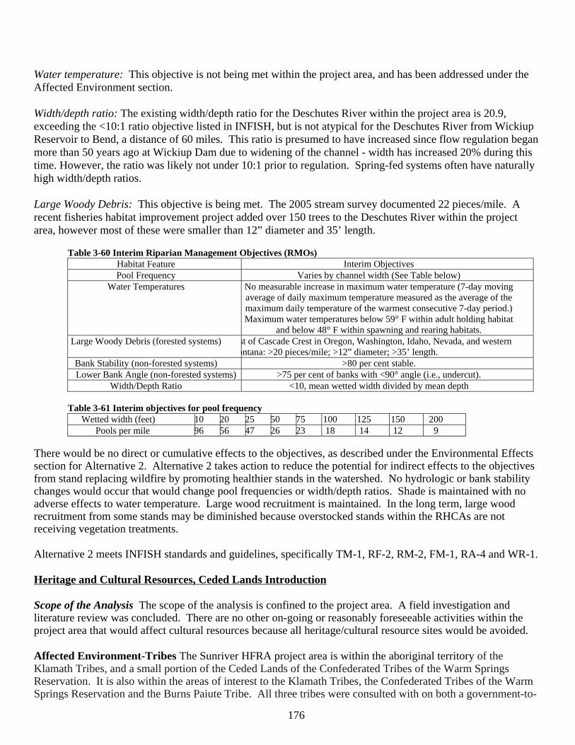
176
Water temperature: This objective is not being met within the project area, and has been addressed under the Affected Environment section. Width/depth ratio: The existing width/depth ratio for the Deschutes River within the project area is 20.9, exceeding the <10:1 ratio objective listed in INFISH, but is not atypical for the Deschutes River from Wickiup Reservoir to Bend, a distance of 60 miles. This ratio is presumed to have increased since flow regulation began more than 50 years ago at Wickiup Dam due to widening of the channel - width has increased 20% during this time. However, the ratio was likely not under 10:1 prior to regulation. Spring-fed systems often have naturally high width/depth ratios. Large Woody Debris: This objective is being met. The 2005 stream survey documented 22 pieces/mile. A recent fisheries habitat improvement project added over 150 trees to the Deschutes River within the project area, however most of these were smaller than 12” diameter and 35’ length.
Table 3-60 Interim Riparian Management Objectives (RMOs) Habitat Feature Interim Objectives Pool Frequency Varies by channel width (See Table below)
Water Temperatures No measurable increase in maximum water temperature (7-day moving average of daily maximum temperature measured as the average of the maximum daily temperature of the warmest consecutive 7-day period.) Maximum water temperatures below 59° F within adult holding habitat
and below 48° F within spawning and rearing habitats. Large Woody Debris (forested systems) st of Cascade Crest in Oregon, Washington, Idaho, Nevada, and western
ontana: >20 pieces/mile; >12” diameter; >35’ length. Bank Stability (non-forested systems) >80 per cent stable. Lower Bank Angle (non-forested systems) >75 per cent of banks with <90° angle (i.e., undercut).
Width/Depth Ratio <10, mean wetted width divided by mean depth
Table 3-61 Interim objectives for pool frequency Wetted width (feet) 10 20 25 50 75 100 125 150 200
Pools per mile 96 56 47 26 23 18 14 12 9 There would be no direct or cumulative effects to the objectives, as described under the Environmental Effects section for Alternative 2. Alternative 2 takes action to reduce the potential for indirect effects to the objectives from stand replacing wildfire by promoting healthier stands in the watershed. No hydrologic or bank stability changes would occur that would change pool frequencies or width/depth ratios. Shade is maintained with no adverse effects to water temperature. Large wood recruitment is maintained. In the long term, large wood recruitment from some stands may be diminished because overstocked stands within the RHCAs are not receiving vegetation treatments. Alternative 2 meets INFISH standards and guidelines, specifically TM-1, RF-2, RM-2, FM-1, RA-4 and WR-1. Heritage and Cultural Resources, Ceded Lands Introduction Scope of the Analysis The scope of the analysis is confined to the project area. A field investigation and literature review was concluded. There are no other on-going or reasonably foreseeable activities within the project area that would affect cultural resources because all heritage/cultural resource sites would be avoided. Affected Environment-Tribes The Sunriver HFRA project area is within the aboriginal territory of the Klamath Tribes, and a small portion of the Ceded Lands of the Confederated Tribes of the Warm Springs Reservation. It is also within the areas of interest to the Klamath Tribes, the Confederated Tribes of the Warm Springs Reservation and the Burns Paiute Tribe. All three tribes were consulted with on both a government-to-
177
government and staff-to-staff basis prior to and during project scoping. There are no known traditional cultural uses of the project area by the various tribes or tribal members at this time. Heritage and Cultural Resources Management Direction Management direction for cultural resources is found in the Deschutes LRMP (CR-1 to CR-6), Forest Service Manual section 2360, in federal regulations 36CFR64 and 36CFR800, and in federal laws including the National Historic Preservation Act of 1966, the National Environmental Policy Act of 1969, and the National Forest Management Act of 1976. Standards and Guidelines of the LRMP states: CR-1 Surveys will be conducted based on an inventory plan and design agreed to by the Forest and State Historic Preservation Officer (SHPO); from this database the forest will develop and maintain a forest-wide cultural resource overview. CR-2 Cultural properties located during inventory will be evaluated to determine their eligibility for listing in the National Register of Historic Places. CR-3 The Forest will develop the thematic National Register nominations and management plans for various classes of prehistoric and historic resource properties. CR-4 Cultural properties in conflict with ground disturbing projects will be evaluated and depending upon the nature of the project, the activity may be redesigned to avoid damage or a mitigation will be developed. CR-5 Management of cultural resources will be coordinated with other agencies including the State Historic Preservation Office and Advisory Council on Historic Preservation. This management will be coordinated with the Warm Springs and Klamath tribal groups. CR-6 Management of the Native American cultural resources will be coordinated with the appropriate Native American Tribe. This coordination will include notification of the appropriate Tribal Group when projects are proposed in areas of known concern. Heritage and Cultural Resource Environmental Effects Important Interactions Effects to heritage resources are a concern because the resource is non-renewable and as the cultural property is further disturbed and impacted, it may no longer be able to provide information that can help determine how the area was used by prehistoric and historic peoples. In EA units proposed for thinning, using heavy equipment and creating landings can heavily impact cultural properties. Activities such as hand piling followed by burning of the piles can effect a cultural property through breaking artifacts, changing their association and locations and damaging any research potential with the loss of artifact hydration rinds from intense and prolonged heat. This same type of management activity can be implemented with no effect on cultural properties if completed by hand (chainsaws) with no pile burning. Mowing, mechanical shrub treatment and underburning does not have an effect on prehistoric cultural properties. Underburning can have impacts to historic sites that contain perishable materials by damaging glass and tin artifacts in historic debris dumps or scatters and any remains of historic structures, corrals, and fence lines. Decommissioning roads by subsoiling can destroy, break or redistribute artifacts. Direct and Indirect Effects of Alternative 1 There would be an effect to eligible or potentially eligible cultural properties if prescribed underburning treatments are not implemented. The result would be a heavier fuel load which would result in a high intensity fire such. Fire effects on cultural properties state that temperatures above 650 degrees F can affect stone artifacts. (1998, BLM Protocol). Wildfires have the potential to reveal new cultural properties because the duff layer is typically consumed; attracting artifact hunters. Not conducting road closures would continue motorized vehicle access to the project area that could facilitate degradation and destruction of cultural properties. The potential for impact to cultural properties from other sources such as erosion and visitor collection would not change. Cumulative Effects of Alternative 1 There are no cumulative effects because there would be no proposed activities with this alternative. Expected future potential sources of disturbance would include continued
178
collection from visitors within heavy recreational areas. Direct and Indirect Effects of Alternative 2 The project does not have the potential to impact eligible or potentially eligible cultural properties because: 1.) Cultural properties determined eligible and/or potentially eligible would be avoided by redesigning project EA units or completed by using hand methods. 2.) Cultural properties located within EA units which have underburning will not be impacted according to: (a) the 2004 Programmatic Agreement, Appendix A #26 – Landscape-scale low-intensity underburning where fire sensitive historic properties are absent and existing fire lines or existing roads or natural barriers will be used as fire lines; (b) The prescribed burn plan completed for underburning activities is designed for cool, moist conditions and a low intensity ground fire that prevents degradation of cultural resources and artifacts. (c) All known sites would be excluded from underburning. 3.) In areas such as the WUI and high use recreation areas where safety is a concern, treatments may be implemented in EA units which contain cultural properties. In order to avoid ground disturbance within cultural site boundaries, thinning treatments would be completed by hand. Pile burning would not occur within the site. 4.) Conducting road closures would limit access to cultural properties and would have the beneficial effect of stopping ongoing damage from road use and maintenance. There would be no impact to cultural properties under the 2004 Programmatic Agreement, Appendix B #5. Indirect effects from implementation of this project are not expected but the potential, although small, does exist. Unevaluated sites and significant cultural properties avoided by project implementation would have more people working in the vicinity of the property over the short term. There is potential to have surface tools or other artifacts observed and collected by contractors working on a project although this has never been documented or suspected to occur on the district. On the other hand, road closures would reduce motor vehicle access and human caused ignitions lessening the potential for damage due to wildfires and artifact collection. There is currently no known traditional use of the project area by tribes or tribal members and none of the alternatives would effect existing treaty rights or prevent the tribes from utilizing the area for traditional uses currently or at some future date. Although some roads would be closed under Alternative 2; vehicular access is still maintained to every section within the project area by roads proposed to remain open. Cumulative Effects of Alternative 2 Under this alternative any and all effects would be avoided (Chapter 2). There would be no cumulative effects associated with the combination of Alternative 2, on-going activities, and reasonably foreseeable future activities because all cultural sites would be avoided in all of the projects. LRMP (Forest Plan) Consistency Alternative 2 would not affect any listed or eligible cultural or historic resources because all heritage resources would be avoided (Appendix K.), therefore, the undertaking meets the criteria given in Stipulation III.(A)2, and (B)1 of the 2004 Programmatic Agreement among the USDA Forest Service, the Advisory Council on Historic Preservation, and the Oregon State Historic Preservation Officer. Compliance with LRMP standards and guidelines CR-1 and CR-5 were addressed by conducting adequate surveys and recording cultural properties under current heritage standards within the Central Oregon Heritage Group database. This database includes the Ochoco and Deschutes National Forests, Bureau of Land Management, the State Historic Preservation Office and The Confederated Tribes of the Warm Springs. Compliance with CR-2 to CR-4 is addressed by redesigning the EA units to avoid all sites until they can be evaluated to determine their eligibility for listing in the National Register of Historic Places. Compliance with standard and guideline LRMP CR-6 has been addressed by notifying Tribal groups of the proposed project. Commercial Timber Harvest, Economic and Social Analysis Introduction The need for maintaining and restoring healthy forest conditions in an economically cost-efficient manner is addressed under Alternative 2 by commercial thinning small diameter ponderosa and lodgepole pine trees. The
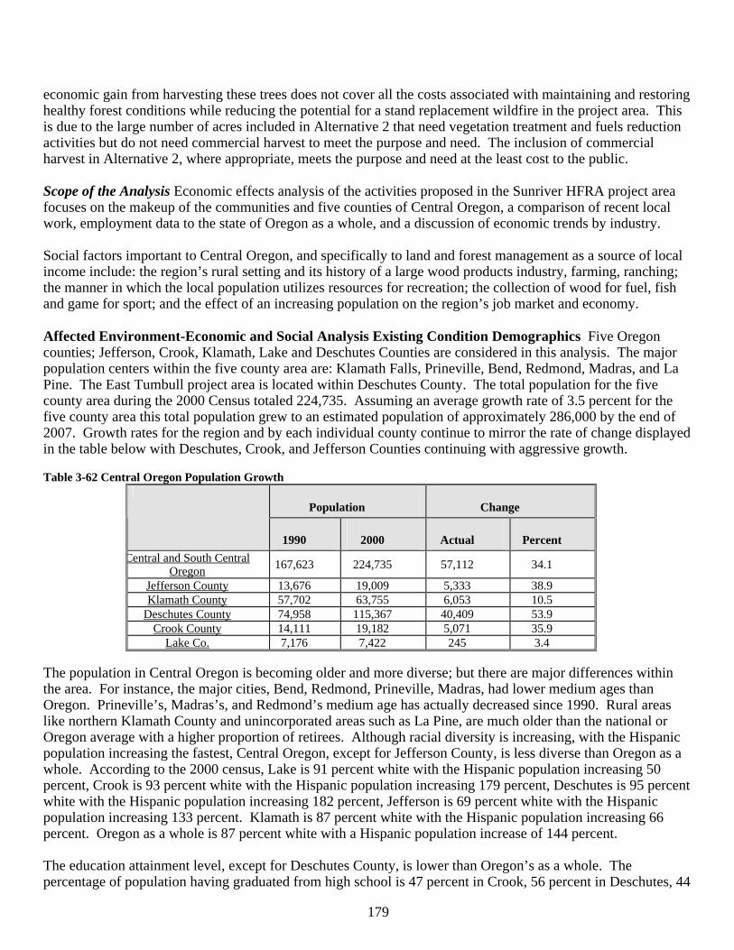
179
economic gain from harvesting these trees does not cover all the costs associated with maintaining and restoring healthy forest conditions while reducing the potential for a stand replacement wildfire in the project area. This is due to the large number of acres included in Alternative 2 that need vegetation treatment and fuels reduction activities but do not need commercial harvest to meet the purpose and need. The inclusion of commercial harvest in Alternative 2, where appropriate, meets the purpose and need at the least cost to the public. Scope of the Analysis Economic effects analysis of the activities proposed in the Sunriver HFRA project area focuses on the makeup of the communities and five counties of Central Oregon, a comparison of recent local work, employment data to the state of Oregon as a whole, and a discussion of economic trends by industry. Social factors important to Central Oregon, and specifically to land and forest management as a source of local income include: the region’s rural setting and its history of a large wood products industry, farming, ranching; the manner in which the local population utilizes resources for recreation; the collection of wood for fuel, fish and game for sport; and the effect of an increasing population on the region’s job market and economy. Affected Environment-Economic and Social Analysis Existing Condition Demographics Five Oregon counties; Jefferson, Crook, Klamath, Lake and Deschutes Counties are considered in this analysis. The major population centers within the five county area are: Klamath Falls, Prineville, Bend, Redmond, Madras, and La Pine. The East Tumbull project area is located within Deschutes County. The total population for the five county area during the 2000 Census totaled 224,735. Assuming an average growth rate of 3.5 percent for the five county area this total population grew to an estimated population of approximately 286,000 by the end of 2007. Growth rates for the region and by each individual county continue to mirror the rate of change displayed in the table below with Deschutes, Crook, and Jefferson Counties continuing with aggressive growth. Table 3-62 Central Oregon Population Growth
Population Change
1990 2000 Actual Percent
Central and South Central Oregon
167,623 224,735 57,112 34.1
Jefferson County 13,676 19,009 5,333 38.9 Klamath County 57,702 63,755 6,053 10.5
Deschutes County 74,958 115,367 40,409 53.9 Crook County 14,111 19,182 5,071 35.9
Lake Co. 7,176 7,422 245 3.4 The population in Central Oregon is becoming older and more diverse; but there are major differences within the area. For instance, the major cities, Bend, Redmond, Prineville, Madras, had lower medium ages than Oregon. Prineville’s, Madras’s, and Redmond’s medium age has actually decreased since 1990. Rural areas like northern Klamath County and unincorporated areas such as La Pine, are much older than the national or Oregon average with a higher proportion of retirees. Although racial diversity is increasing, with the Hispanic population increasing the fastest, Central Oregon, except for Jefferson County, is less diverse than Oregon as a whole. According to the 2000 census, Lake is 91 percent white with the Hispanic population increasing 50 percent, Crook is 93 percent white with the Hispanic population increasing 179 percent, Deschutes is 95 percent white with the Hispanic population increasing 182 percent, Jefferson is 69 percent white with the Hispanic population increasing 133 percent. Klamath is 87 percent white with the Hispanic population increasing 66 percent. Oregon as a whole is 87 percent white with a Hispanic population increase of 144 percent. The education attainment level, except for Deschutes County, is lower than Oregon’s as a whole. The percentage of population having graduated from high school is 47 percent in Crook, 56 percent in Deschutes, 44
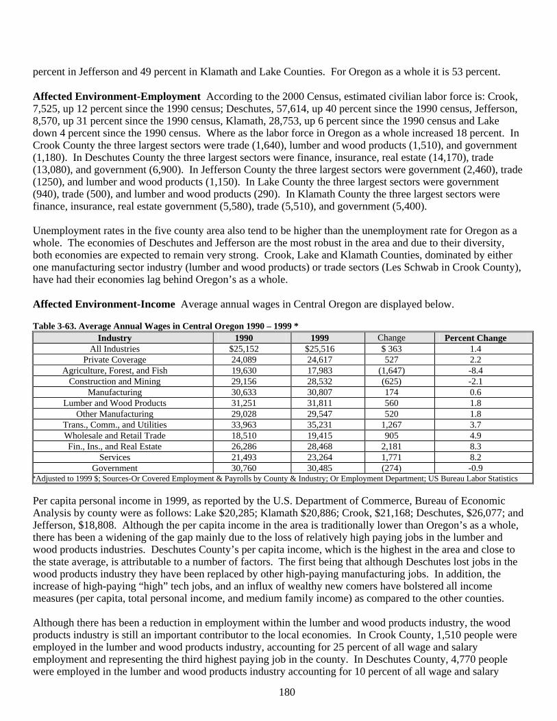
180
percent in Jefferson and 49 percent in Klamath and Lake Counties. For Oregon as a whole it is 53 percent. Affected Environment-Employment According to the 2000 Census, estimated civilian labor force is: Crook, 7,525, up 12 percent since the 1990 census; Deschutes, 57,614, up 40 percent since the 1990 census, Jefferson, 8,570, up 31 percent since the 1990 census, Klamath, 28,753, up 6 percent since the 1990 census and Lake down 4 percent since the 1990 census. Where as the labor force in Oregon as a whole increased 18 percent. In Crook County the three largest sectors were trade (1,640), lumber and wood products (1,510), and government (1,180). In Deschutes County the three largest sectors were finance, insurance, real estate (14,170), trade (13,080), and government (6,900). In Jefferson County the three largest sectors were government (2,460), trade (1250), and lumber and wood products (1,150). In Lake County the three largest sectors were government (940), trade (500), and lumber and wood products (290). In Klamath County the three largest sectors were finance, insurance, real estate government (5,580), trade (5,510), and government (5,400). Unemployment rates in the five county area also tend to be higher than the unemployment rate for Oregon as a whole. The economies of Deschutes and Jefferson are the most robust in the area and due to their diversity, both economies are expected to remain very strong. Crook, Lake and Klamath Counties, dominated by either one manufacturing sector industry (lumber and wood products) or trade sectors (Les Schwab in Crook County), have had their economies lag behind Oregon’s as a whole. Affected Environment-Income Average annual wages in Central Oregon are displayed below. Table 3-63. Average Annual Wages in Central Oregon 1990 – 1999 *
Industry 1990 1999 Change Percent Change All Industries $25,152 $25,516 $ 363 1.4
Private Coverage 24,089 24,617 527 2.2 Agriculture, Forest, and Fish 19,630 17,983 (1,647) -8.4
Construction and Mining 29,156 28,532 (625) -2.1 Manufacturing 30,633 30,807 174 0.6
Lumber and Wood Products 31,251 31,811 560 1.8 Other Manufacturing 29,028 29,547 520 1.8
Trans., Comm., and Utilities 33,963 35,231 1,267 3.7 Wholesale and Retail Trade 18,510 19,415 905 4.9 Fin., Ins., and Real Estate 26,286 28,468 2,181 8.3
Services 21,493 23,264 1,771 8.2 Government 30,760 30,485 (274) -0.9
*Adjusted to 1999 $; Sources-Or Covered Employment & Payrolls by County & Industry; Or Employment Department; US Bureau Labor Statistics Per capita personal income in 1999, as reported by the U.S. Department of Commerce, Bureau of Economic Analysis by county were as follows: Lake $20,285; Klamath $20,886; Crook, $21,168; Deschutes, $26,077; and Jefferson, $18,808. Although the per capita income in the area is traditionally lower than Oregon’s as a whole, there has been a widening of the gap mainly due to the loss of relatively high paying jobs in the lumber and wood products industries. Deschutes County’s per capita income, which is the highest in the area and close to the state average, is attributable to a number of factors. The first being that although Deschutes lost jobs in the wood products industry they have been replaced by other high-paying manufacturing jobs. In addition, the increase of high-paying “high” tech jobs, and an influx of wealthy new comers have bolstered all income measures (per capita, total personal income, and medium family income) as compared to the other counties. Although there has been a reduction in employment within the lumber and wood products industry, the wood products industry is still an important contributor to the local economies. In Crook County, 1,510 people were employed in the lumber and wood products industry, accounting for 25 percent of all wage and salary employment and representing the third highest paying job in the county. In Deschutes County, 4,770 people were employed in the lumber and wood products industry accounting for 10 percent of all wage and salary
181
employment and representing the seventh highest paying job in the county. In Jefferson County, 1,150 people were employed in the wood products industry accounting for 19 percent of all wage and salary employment, and representing the third highest paying job in the county. In Klamath County, 3,180 people were employed in the lumber and wood products industry accounting for 19 percent of all wage and salary employment. In Lake County, 13 percent of all wage and salary employment was in the lumber and wood products industry. Agriculture is an important use in Central Oregon. Leading crops include cattle, forage and hays. In Jefferson County there is also a substantial amount of seed and vegetable products. Total agricultural sales by county in 2000 were as follows: Crook, $34,604,000; Deschutes, $21,855,000; Jefferson, $46,431,000; Lake $54,508,000; and Klamath $128,806,000. Although farm income is a very small portion of total personal income in the area, the agriculture sector’s role in the local economies is substantial in all but Deschutes County. Employment and income statistical references do not specifically track recreation and tourism as a sector. Instead recreation and tourism contributes to several sectors, transportation, services (accommodations, eating and drinking, recreation), retail trade, and even government. The Oregon Tourism Commission publishes an annual report with estimates to total travel related spending in each County. Estimated employments from these expenditures in 1999 were are as follows. In Crook, 380 people were employed in industries supporting recreation and tourism, representing 6.3 percent of all wage and salary employment. In Deschutes County, 5,160 people were employed in industries supporting recreation and tourism. This represents 10.5 percent of all wage and salary employment in the county. In Jefferson, 1,040 people were employed in industries supporting recreation and tourism. This represents 16.8 percent of all wage and salary employment in the county. In Lake, 170 people were employed in industries supporting recreation and tourism. This represents 7.7 percent of all wage and salary employment in the county. In Klamath 1,930 people were employed in industries supporting recreation and tourism. This represents 8.3 percent of all wage and salary employment in the county. Affected Environment-Social Physical and biological environments influence human social life. This is most evident in rural areas where the variety and quality of available natural resources often determines the chief means of economic livelihood, what leisure activities people are likely to pursue and local preferences for the use of public lands. From a historical prospectus it is evident that all of the local community's cultures were natural resource based and especially in the more rural less populated areas, still are. Livestock, agriculture and timber were the backbone of the economic structure and as a result strongly shaped the social fabric that still largely defines the communities today. Since most of the surrounding land is administered by federal agencies, chiefly the Ochoco, Deschutes, Winema, Fremont National Forests and the Prineville and Lakeview Districts of the BLM, changes in federal land use policies impact the socioeconomic and socio-cultural way of life. The various communities, and the individuals within them, contain a broad spectrum of perceptions and values related to the use of resources on the surrounding national forests. Many of the communities (rural industrial, as defined in the Deschutes LRMP) within Central and South Central Oregon, such as Crescent and Gilchrist, are closely tied to the Forests in work, subsistence, and play, and are directly affected by what happens on the Forests. The relationship between the Forests and these communities is based in part on access to logs so that individuals can make a living from harvesting, manufacturing, and transportation businesses. People from these communities use fuelwood, fish, and game for part of their subsistence and recreational activities. Recreation (often motorized) is an important component of the life styles for many people living in these communities. The Sunriver destination resort community is defined by recreation opportunities and recreation residences (rural recreation and residential, as defined in the Deschutes LRMP). Environmental and scenic amenities and nearby recreational opportunities plays the major role in their existence instead of extraction-based activities. Bend (Central Oregon Urban Center, as defined in the Deschutes LRMP), is the dominant community in the area. It has a large industrial sector with secondary wood products playing a major role, and a large service
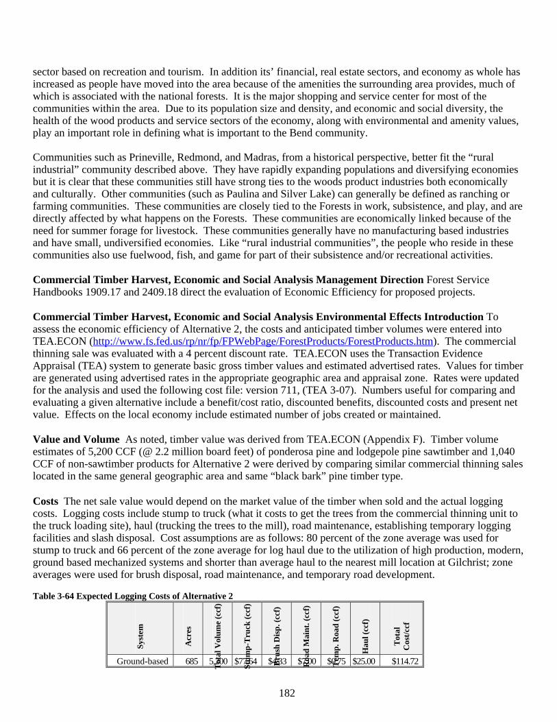
182
sector based on recreation and tourism. In addition its’ financial, real estate sectors, and economy as whole has increased as people have moved into the area because of the amenities the surrounding area provides, much of which is associated with the national forests. It is the major shopping and service center for most of the communities within the area. Due to its population size and density, and economic and social diversity, the health of the wood products and service sectors of the economy, along with environmental and amenity values, play an important role in defining what is important to the Bend community. Communities such as Prineville, Redmond, and Madras, from a historical perspective, better fit the “rural industrial” community described above. They have rapidly expanding populations and diversifying economies but it is clear that these communities still have strong ties to the woods product industries both economically and culturally. Other communities (such as Paulina and Silver Lake) can generally be defined as ranching or farming communities. These communities are closely tied to the Forests in work, subsistence, and play, and are directly affected by what happens on the Forests. These communities are economically linked because of the need for summer forage for livestock. These communities generally have no manufacturing based industries and have small, undiversified economies. Like “rural industrial communities”, the people who reside in these communities also use fuelwood, fish, and game for part of their subsistence and/or recreational activities. Commercial Timber Harvest, Economic and Social Analysis Management Direction Forest Service Handbooks 1909.17 and 2409.18 direct the evaluation of Economic Efficiency for proposed projects. Commercial Timber Harvest, Economic and Social Analysis Environmental Effects Introduction To assess the economic efficiency of Alternative 2, the costs and anticipated timber volumes were entered into TEA.ECON (http://www.fs.fed.us/rp/nr/fp/FPWebPage/ForestProducts/ForestProducts.htm). The commercial thinning sale was evaluated with a 4 percent discount rate. TEA.ECON uses the Transaction Evidence Appraisal (TEA) system to generate basic gross timber values and estimated advertised rates. Values for timber are generated using advertised rates in the appropriate geographic area and appraisal zone. Rates were updated for the analysis and used the following cost file: version 711, (TEA 3-07). Numbers useful for comparing and evaluating a given alternative include a benefit/cost ratio, discounted benefits, discounted costs and present net value. Effects on the local economy include estimated number of jobs created or maintained. Value and Volume As noted, timber value was derived from TEA.ECON (Appendix F). Timber volume estimates of 5,200 CCF (@ 2.2 million board feet) of ponderosa pine and lodgepole pine sawtimber and 1,040 CCF of non-sawtimber products for Alternative 2 were derived by comparing similar commercial thinning sales located in the same general geographic area and same “black bark” pine timber type. Costs The net sale value would depend on the market value of the timber when sold and the actual logging costs. Logging costs include stump to truck (what it costs to get the trees from the commercial thinning unit to the truck loading site), haul (trucking the trees to the mill), road maintenance, establishing temporary logging facilities and slash disposal. Cost assumptions are as follows: 80 percent of the zone average was used for stump to truck and 66 percent of the zone average for log haul due to the utilization of high production, modern, ground based mechanized systems and shorter than average haul to the nearest mill location at Gilchrist; zone averages were used for brush disposal, road maintenance, and temporary road development. Table 3-64 Expected Logging Costs of Alternative 2
Syst
em
Acr
es
Tot
al V
olum
e (c
cf)
Stum
p-T
ruck
(cc
f)
Bru
sh D
isp.
(cc
f)
Roa
d M
aint
. (cc
f)
Tem
p. R
oad
(ccf
)
Hau
l (cc
f)
Tot
al
Cos
t/cc
f
Ground-based 685 5,200 $77.64 $4.33 $7.00 $0.75 $25.00 $114.72
183
The logging costs were added to the additional costs of activities needed to implement a timber sale. These include: weed treatment/monitoring of off-road equipment to reduce the potential of spreading nonnative plants ($5,000); subsoiling costs of $2,850; sale preparation costs of $4.00/CCF; sale administration costs of $3.00/CCF; NEPA planning, roads analysis and survey costs of $18.00/CCF ($93,600).
Table 3-65 Alternative Financial Efficiency
Alternative Estimated
Volume CCF Present Net
Benefits (PNB) Present Net
Costs (PNC) Net Present
Value (NPV) Benefit/cost Ratio (B/C)
Alternative 1 0 0 $93,600 -$93,600 0 Alternative 2 5,200 $225,621 $130,000 $81,1131 1.64
The negative PNV for alternative1 reflects planning and survey costs associated with the preparation of this EA. The following are costs of non commercial vegetation management activities which are intended to lower the risk of a stand replacement wildfire, and expedite the restoration of LOS stage ponderosa under Alternative 2. Table 3-66 Additional Vegetation Management Costs
Activity Cost Close 16.1 miles of road $8,050
Remove tags in Scenic Views $1,000Non commercial thin 685 acres $68,500
Hand pile 153 acres $30,600Replace road/trail signs $1,000
Mow 558 acres $27,900Prescribe burn 1,204 acres $60,200
Direct and Indirect Effects of Alternative 1 Selection of this alternative would result in no active management of vegetation except for ongoing management activities such as fire suppression and hazard tree felling adjacent to roads and recreation sites. There would be no economic return and no additional jobs would be created or maintained. This alternative would likely have negative impacts to the local economy because timber-related jobs would not be maintained. Although Alternative 1 would generate no current revenues to return to the Treasury of the United States of America there is a cost resulting from the expenditure of planning monies as shown above. Cumulative Effects of Alternative 1 The cumulative effects on forest resources are discussed in other portions of this EA. All resources have a value, though many are difficult to identify in dollar terms. There would be no cumulative effects on commercial timber, economic and social activities with Alternative 1 because there would be no vegetation management , road closure or other projects. In Alternative 1, no fuels reduction or thinning would occur. Future fires within the project area would have the potential to be more difficult to control due to the yearly increase in fuel loading. This potential could require more resources to control fire, create increased dangers to wild land fire fighters and increase costs to contain a fire than compared to Alternative 2. Direct and Indirect Effects of Alternative 2 The commercial thinning units have a positive economic return. When the related revenues and costs (including all planning costs) are analyzed the NPV is $81,131, with a benefit/cost ratio of 1.64. The costs associated with non commercial vegetation management, prescribed burning, mowing and other activities is estimated at an additional $197,250. The net sale value is estimated to be $225,621 of which some or all could be used to offset the additional management costs displayed above. The number of jobs maintained or created was calculated by using figures for the Deschutes National Forest from Appendix B-5 of the FY 1997 Timber Sale Program Annual Report. Excluding firewood from the volume
184
harvested on the Deschutes National Forest in Fiscal Year 1997, an estimated 9.6 jobs per million board feet were maintained or created. Of the total estimated volume, approximately 2.2 million board feet is sawtimber. At 9.6 jobs per million board feet, Alternative 2 would maintain or create 21 jobs. Non sawtimber volume of 1,040 CCF consisting primarily of the tops of trees as well as trees under 8 inches in diameter were not used in the calculation of the total estimated number of jobs created or maintained with Alternative 2. Estimated employee income of $668,031 is derived by multiplying the average 1999 salary of $31,811 for lumber and wood products jobs and the number of jobs (21 jobs) created or maintained. Cumulative Effects of Alternative 2 Under both alternatives the possibility of wildfire returning is high because of the location, weather and vegetation. What varies between alternatives in regards to fire is the fuels and future stand structure following implementation of Alternative 2. The level, type and structure of natural fuels remaining would contribute directly to the investment needed to control a wildfire in the project area to protect houses, facilities and other infrastructure. Alternative 2 includes thinning, underburning and mowing that reduces flame heights and current fuel loads. Resources required to control or manage fires could be substantially less than Alternative 1. This alternative has the best opportunity to accelerate the establishment and development of LOS ponderosa pine and provides the best assurance that the stands within the project area can develop past the immature age; when the relatively small diameter trees are susceptible to ground fire mortality. Alternative 2 also provides for current and future opportunity for employment in the woods industry. Over the last 10 years (1997 to 2006), an annual average of approximately 63.4 MMBF of timber has been sold from the Deschutes National Forest. In the near future, the amount of timber offered for sale is expected to be near this annual average and as such Alternative 2 would not provide a cumulative increase in economic activity. The Deschutes National Forest is expected to continue offering timber for sale and is expected to continue making contributions to the local economy as a result of timber harvest activities. LRMP (Forest Plan) Consistency Consistent with FSH 1909.17 and 2409.18 this economic efficiency analysis was completed. Net public benefits are measured by both qualitative and quantitative criteria rather than a single measure of index such as NPV or benefit cost ratios. When considering only commercial thinning direct and indirect costs, the project has a positive return. The NPV would be negative when including all of the non thinning related projects and costs. The Forest Service is not mandated by law to show a profit from land management activities although economics is a consideration when designing and implementing activities. Civil Rights and Environmental Justice Introduction Environmental Justice is defined as the pursuit of equal justice and protection under the law for all environmental statutes and regulations, without discrimination based on race, ethnicity, or socioeconomic status. The minority and low income populations groups living in counties surrounding the East Tumbull project work in diverse occupations. Some minorities, low income residents, and Native Americans may rely on forest products or related forest activities for their livelihood. This is especially true for those individuals that reside in the rural Central Oregon communities. Scope of the Analysis Identical to the Commercial Timber Harvest, Economic and Social Analysis the effects analysis area focuses on Central Oregon and land and forest management activities. Affected Environment-Economic and Social Analysis Existing Condition Demographics were covered in the previous section. Civil Rights and Environmental Justice Management Direction. Civil Rights legislation and Executive Order 12898 (Environmental Justice) direct an analysis of the proposed alternatives as they relate to specific

185
subsets of the American population. The subsets of the general population include ethnic minorities, people with disabilities, and low-income groups. The Deschutes LRMP includes minimizing social and administrative barriers to use of the forest (HM-1) and consideration of the needs of the handicapped (HM-4). Direct and Indirect Effects of Alternative 1 This alternative would continue the local economic situation as described above and not reduce the potential for a large, stand-replacement wildfire in the project area. Recent research by the Center for Watershed and Community Health outline both the direct and indirect effects of wildfire on the health and welfare of impoverished individuals, families, and communities. Beside the direct impacts of the fire on potential jobs and income, there are also negative impacts to the value of property and other assets created by the public perception of risk created by local wildfires. The long-term effect of a decrease in a sustainable local timber supply combined with a short-term decrease in recreational opportunities can also affect local employers and taxpayers. This means that the tax base decreases and the costs of sustaining local services cost more. Poor householders in local communities are especially vulnerable to the fallout of a wildfire on their local economy. They have limited financial ability to cope with the disruptive effects this may have on economic activity and dependent social services. The effects discussed in this section, are difficult to measure, but would tend to have a disproportional impact on local low income households. Minority groups from outside the immediate area that are attracted to vegetation management work such as noncommercial thinning would probably see fewer changes in income when compared to local groups. Direct and Indirect Effects of Alternative 2 Alternative 2 has the potential to provide local employment and to bring in workers from outside the community to perform thinning, trucking, mowing and other related fuels reduction activities. The primary services needed by outside workers would be food and shelter. Local businesses that can supply food and other services would capture most of the money being spent by the workers in the area. This would likely result in increased local household incomes during implementation of project activities. Since these businesses have supported similar workforces in the past, capitol expansion would not be required. As thinning, hand piling and other fuels reduction activities are expected to span a period of years; it is reasonable to expect a good proportion of the work will go to minority-based small businesses, as in the past. Cumulative Effects No cumulative effects were identified. Although road closures included with Alternative 2 and other adjacent ongoing projects would limit motorized access and, in theory, make dispersed camping less convenient for low income individuals and families, there are still numerous other locations in and near the area that would remain available for free camping. Motorized road access would still be provided for low income and disabled persons to every section in the project area, as well as every section in the adjacent project areas. LRMP (Forest Plan) Consistency The analysis did not identify discrimination based on race, ethnicity, or socioeconomic status from the implementation of Alternative 2. On the contrary, it identified economic opportunities for all disadvantaged groups while maintaining vehicle access to each section within the project area (HM-4) and minimizing social and administrative barriers to legitimate use of the forest (HM-1) by handicapped individuals and other subsets of the American population. Other Effects and Findings Wetlands, fisheries, water quality and designated floodplains would not be adversely affected by any of the proposed management activities (Water Quality/Fisheries and Wild and Scenic River Values). There would be no direct, indirect, or cumulative adverse effects to inventoried roadless areas, Pacific Yew or habitat, park land or prime farm land under Alternatives 1 and 2 because none exist within or adjacent to the
186
project area. No significant permanent or irretrievable commitment of resources would occur under Alternative 2 with the exception of a negligible, irretrievable loss of fugitive dust caused by mechanical operations. No significant adverse effects to public health or safety have been identified. Proposed activities in Alternative 2 would improve public health and safety by reducing the risk of entrapment from wildfire, especially along the WUI and the negative effects on air and water quality from a large stand-replacing wildfire. All other proposed activities would not expose the public to an elevated risk of injury above hazards associated with routine forest practices such as tree felling and operation of mechanized equipment that are regulated by the Oregon Occupational Safety and Health Division. The effects of implementation of the alternatives are well known, not highly controversial from either a scientific or public perspective, and do not involve any unique or unknown risks. During scoping and collaboration , the level of concern voiced by the public regarding was minor (Chapter IV). Numerous projects similar in size and complexity over the last 10 years have not identified any unknown risks, effects or scientific controversy. This project is similar in all respects to the Katalo project that was chosen by the Governor of Oregon’s Scientific Advisory Team as the type of project that could build consensus between academia and the public on the use of small tree harvest and fuels reduction to treat forest health and wildfire issues. Vegetation Management Analysis, Noxious Weeds Introduction Noxious weeds, as defined in FSM 2080.5, generally possess one or more of the following characteristics: aggressive and difficult to manage, poisonous, toxic, parasitic, a carrier or host of serious insects or disease, and being native or new to or not common to the United States or parts thereof. In addition to noxious weeds, which are designated by the State of Oregon, there is a group of non-native plants that are aggressive, such as mullein and cheatgrass, and that can also reduce diversity and create land management problems. Scope of the Analysis The analysis focuses on the existing condition within the project area, the major access roads and transportation of equipment to the area. The Forest Service is proposing to implement the Oz project within the south end of the project area sometime within the next year, which involves heavy equipment and the attendant potential for weed introductions. Also, a waterline is being buried along the 4001 road adjacent to EA units 34 and 35. These projects carry the potential to introduce or spread weeds, mainly because heavy equipment would be used.. Affected Environment-Existing Noxious Weed and Non-Native Plant Populations of Concern There is one noxious weed of concern that is located at three sites within the project area: spotted knapweed, Centaurea maculosa (see Noxious Weed Risk Assessment Report and maps, Appendix C for locations). Spotted knapweed is a very aggressive plant that grows along most major highways in Central Oregon. It is a perennial forb in the sunflower family that lives for 3-5 years. It is very competitive on disturbed dry to mesic sites because it is able to germinate in a wide range of conditions and it grows early in spring before many native plants. Seeds may be dispersed on animals and humans, and by being caught up in vehicles. Distribution over large areas is linked to transportation systems. Known sites along Highway 97 (one of three sites) are currently being treated under the Deschutes National Forest Noxious Weed Control Environmental Assessment (1998). Only manual treatments (i.e. pulling by hand) are currently allowed on the other two sites. Noxious Weed Management Direction Forest Service Manual direction requires that a Noxious Weed Risk Assessment (Appendix C) be prepared for all projects involving ground-disturbing activities. For projects that have a moderate to high risk of introducing or spreading noxious weeds, Forest Service policy requires that decision documents must identify noxious weed control measures that will be undertaken during project implementation (FSM 2081.030). In addition to FSM 2081.030, an Executive Order (2/3/99) requires Federal agencies to use relevant programs
187
and authorities to prevent the introduction of invasive species and not authorize or carry out actions that are likely to cause the introduction or spread of invasive species unless the agency has determined, and made public, documentation that shows that the benefits of such actions clearly outweigh the potential harm, and all feasible and prudent measures to minimize risk of harm will need to be taken in conjunction with the actions. The R6 2005 FEIS culminated in a Record of Decision (R6 2005 ROD) that amended the Deschutes National LRMP by adding management direction or standards relative to invasive plants. Three of those standards specifically address prevention of weed introductions into projects of the type that the Sunriver HFRA project represents. These standards obligate the Forest Service to incorporate weed prevention into its planning documents and implementation phase. Target Landscape condition Preventing the introduction and spread of noxious weeds so that current populations of undesirable non-native plants can be contained, reduced or eliminated. Direct and Indirect Effects of Alternative 1 There would be no direct and indirect effects because implementation of the project would not occur; however ongoing recreational use of the area would continue to spread and introduce noxious weeds. This is because noxious weeds within the project area are typically associated with roads and trails. Under alternative 1, motorized vehicular access would remain as is and private vehicles would continue to act as weed vectors by possibly bringing in or spreading weed seed from roadsides and pumice pits that have current high populations of weeds. Ongoing high recreation use such as mountain bikes and horse back riding would also continue; possibly further spreading noxious weed populations along trails. Hand pulling have already been implemented within the project area and hopefully would be able to maintain current weed populations at current levels. This alternative would not reduce the potential for a large, stand-replacement wildfire in the project area. In the event of a fire within the project area all available engines would rapidly respond due to the areas proximity to Bend. The potential for introduction and spread of noxious weeds would be high because few, if any, of the vehicles would be cleaned before entering National Forest system lands. The very real scenario exists of a city of Bend (or other department or agency) engine going directly from a knapweed site in the city to a fire within the project area. The ability to control operations by avoiding current weed sites would also not occur leading to the spread of existing populations of noxious weeds. The ground disturbance caused by both fire suppression operations and a high intensity wildfire would provide ideal conditions for noxious weed spread exacerbated by the ongoing motor vehicle access that would remain under this alternative. Direct and Indirect Effects of Alternative 2 The heavy machinery used to implement this project carries the risk of introcuding or spreading weeds. The design elements and site-specific recommendations (Chapter 2, Mitigation and Management Requirements) would help reduce, but not eliminate, this risk. The strategy for managing noxious weeds under Alternative 2 is prevention. The prevention strategies incorporated into this alternative would alleviate most potential problems associated with the potential introduction or spread of noxious weed populations within the project area. However, if monitoring indicated that prevention measures are not adequate in preventing the introduction and spread of noxious weeds, early treatment consisting of hand pulling would be implemented. In areas where undesirable weeds currently exist, there would be a “high” risk associated with the implementation of Alternative 2 if mitigation measures were not included. This is due to the following assumptions: noxious weeds are known to grow within the project area; some project operations would be carried out adjacent to existing noxious weed sites; mechanized machinery would be used for some of the work;
188
and there would be some ground disturbance. Spotted knapweed grows in three known locations within and adjacent to EA units 4, 18 and 30. Actual noxious weed populations within all EA units would be flagged out and avoided by all vegetation management activities. In all EA units where heavy machinery would operate, all equipment would be cleaned before coming into the project area. All of these requirements (discussed further under LRMP/Other Management Direction Consistency) have been shown to be effective and the risk of noxious weed introduction or spread through implementation of Alternative 2 would be low. Other major vectors for the spread of noxious weeds are major travel routes such as Highway 97, Cottonwood Road, Road 40 and 9705. No mechanized equipment would be allowed with 30 feet of the shoulders of this roads to prevent the spread of noxious weeds that may become established within the project area during the implementation phase of this alternative. Proposed road closures would help offset the risk of introduction and spread of noxious weeds by private vehicles. The 16.1 mile reduction in roads open to motorized vehicles exceeds the total miles of the final proposed transportation system. Another major contributor to reducing the introduction and spread of noxious weeds within the project area is the lessened risk of a large stand replacing wildfire. As seen in the 18 Fire of 2003, that was located within and adjacent to the Bend WUI, undesirable non-native plants like Russian thistle and noxious weed populations can quickly take advantage of wildfire disturbance and spread rapidly. Cumulative Effects No cumulative effects were identified. High levels of recreation would continue within the project area, bringing with it the possibility of new weed introduction and spread. The reasonably foreseeable OZ project within the south end of the project area and a buried waterline along road 4001 adjacent to EA units 34 and 35, also carry the potential to introduce or spread weeds, mainly because heavy equipment would be used and regulations that require washing of vehicles prior to entry onto National Forest system lands are not assumed to be 100 percent effective. LRMP and Management Direction Consistency The following goals and guidelines, relative to timber harvest and fire management are listed in the USDA Forest Service Guide to Noxious Weed Prevention Practices. This guide discusses weed prevention practices that support implementation of FSM, the February 1999 Executive Order direction on Invasive Species and the R6 2005 FEIS. Each appropriate guideline (italics) is followed by a description of how it is addressed in the design of Alternative 2. Consistent with management direction the strategy pursued by the Sunriver HFRA project is prevention. This project is intended to comply with the new management direction by cross referencing each guide to ensure consistency with the appropriate standard from the R6 2005 FEIS. Prescribed Fire Fire 13/ R6 2005 FEIS Standard #1. Avoid ignition and burning in areas at high risk for weed establishment or spread due to fire effects. Treat weeds that establish or spread because of unplanned burning of weed infestations. All established noxious weed populations would be excluded from underburning. Funds for noxious weed monitoring and hand pulling would be used for weeds that spread into EA units. Fire 14/ R6 2005 FEIS Standard #1. When possible use staging areas and helibases that are maintained in a weed-free condition. Staging areas would be located outside noxious weed sites. All implementers will be given maps of weed sites. Helibases would not be used. Fire 16/ R6 2005 FEIS Standard #1. Use appropriate preparation and suppression tactics to reduce disturbances to soil and vegetation. Burn prescriptions are designed to minimize duff consumption and exposure of bare mineral soil.
189
Forest Vegetation Management Forest Veg 1/ R6 2005 FEIS Standards #1. Treat weeds on projects used by contractors, emphasizing treatment of weed infestations on existing landings, skid trails, and helibases before activities commence. On going treatment of noxious weed sites is occurring within the project area and identical to Fire 13 and 14 above, all noxious weed sites would be excluded from timber harvest operations. Forest Veg 2/ R6 2005 FEIS Standard #1. Train contract administrators to identify noxious weeds and select lower risk sites for landings and skid trails. The contract administrators are aware of the noxious weed problem, can readily the noxious weeds and non-natives of concern for the project and routinely select lower risk sites for landings and skid trails. Forest Veg 3/ R6 2005 FEIS Standard #1. Encourage operators to maintain weed-free mill yards, equipment parking, and staging areas. Noxious weeds are discussed at pre-work meetings. Forest Veg 4/ R6 2005 FEIS Standard #1. 2, Use standard timber sale contract provisions such as WO-C/CT 6.36 to ensure appropriate equipment cleaning The equipment cleaning clause is included and used in all contracts. Forest Veg 5/ R6 2005 FEIS Standard #1, 2. Minimize soil disturbance to no more than needed to meet project objectives. Logging practices to reduce soil disturbance include, but are not limited to:
! Over-snow logging On average over half of the timber sale harvest on the district occurs during the winter months. The requirement to complete work outside of the busy summer recreational months would necessitate winter operations on many of the EA units.
! Skyline or helicopter logging Modern ground based boom-mounted shears with designated skidroads would be used to minimize ground disturbance.
! Reuse landings, skid trails and helibases when they are weed free. Landings and skid trails are routinely reused. All EA have gentle or flat slopes (average 1 to 10 percent). Sensitive soil areas with slopes greater than 30 percent have been excluded from vegetation management activity. This reduces the amount of soil displacement. Forest Veg 6/ R6 2005 FEIS Standard #1. Minimize period from end of logging to site preparation, revegetation, and contract closure. Timber Sales would likely have a two year or less contract. There would be no site preparation or revegetation because vegetation management is confined to thinning, mowing and underburning. Post Vegetation Management Operations Forest Veg 7/ R6 2005 FEIS Standard #1. Minimize soil disturbance to no more than needed to meet vegetation management objectives. Prevention practices to reduce soil disturbance include, but are not limited to: Treating fuels in place instead of piling All commercial thinning includes whole-tree removal to minimize soil disturbance and detrimentally burned soils. Minimizing heat transfer to soil in burning Biomass utilization is the preferred method to reduce effects on soils. Monitoring of handpiles shows that they typically do not exceed one percent of an individual EA unit. Minimizing fireline construction All underburning operations are designed to maximize use of roads for firelines. The current high road density in the project area facilitates underburning and reduction of ground disturbance. Forest Veg 8/ R6 2005 FEIS Standards #1. For long-term restoration and weed suppression where forested vegetation management has created openings, recognize the need for prompt reforestation. There would be no
190
created openings or need for site preparation or reforestation. Natural grass and forbs response on subsoiled roads completely occupies the growing site within two seasons. Road Management Road 1/ R6 2005 FEIS Standard #1. For timber sale purchaser road maintenance and decommissioning, use standard timber sale contract provisions such as WO-C/CT 6.36 to ensure appropriate equipment cleaning. This provision is used in all contracts. Road 5/ R6 2005 FEIS Standards #1, 2, Avoid acquiring water for dust abatement where access to the water is through weed-infested sites. The Sunriver canoe takeout would be used as a water source for dust abatement; no weeds are currently known at the site. Provisions to minimize conflicts with recreationists outside of the May 20 to September 1 time period limits the need for watering of roads. Road 8/ R6 2005 FEIS Standards #1, 2, Treat weeds in road decommissioning and reclamation projects before roads are made impassable. Reinspect and follow-up based on initial inspection and documentation. Roads proposed for decommissioning and subsoiling of temporary roads, skid roads, and landings would be inventoried for weeds prior to decommissioning and weed populations treated by hand pulling, if found. Refer to mitigation measures for noxious weeds in Chapter 2.
191
CHAPTER 4 CONSULTATION WITH OTHERS Collaborative efforts began with Sunriver in 1999 and continued with the development of the CWPP for Sunriver, signed May 12, 2005. The proposed action (Alternative 2) was developed during the winter and spring of 2007 with input from Patti Gentiluomo of Sunriver, Glenn Ardt of ODFW, Tim Lillebo of ONRC, Karen Coulter of Blue Mountains Biodiversity Project (BMBP) and Asante Riverwind, Fred Tanis and Marilyn Miller of the Sierra Club. The proposed action was mailed on February 20, 2007 to 72 individuals, organizations, agencies, tribes and businesses. The complete list of contacts can be found in Table 4-1. The letters identified site-specific areas being considered for resource and vegetation management activities and timelines for providing input (Appendix J). To ensure the greatest possible coverage, television, radio, and newspaper stories, articles, and advertisements were run in addition to a public meeting that was held on the Sunriver HFRA project on February 28, 2007. Persons and organizations that provided written comments in response to the public meetings, press releases, media coverage or direct mailings along with a copy of their comments are located in Appendix J. A summary of input received during scoping, consultation and collaboration and how the ID team addressed the recommendation or concern follows immediately below. Collaboration: Sunriver, Bend The team that developed the Sunriver CWPP identified and set the priorities for areas needing hazardous fuel reduction treatments as well as the types and methods of treatments included in the proposed action. Ongoing treatments on private lands within Sunriver were designed to be mutually complementary to the treatments proposed within the Sunriver HFRA project area.
Oregon Department of Fish and Wildlife (ODFW) Glen Ardt of ODFW provided input on hiding and thermal cover, road density and the importance of the project area as a travel corridor. Based on ODFW’s input, the project area would be included in the Tumalo Cooperative Winter Range Closure Area. The 16.1 miles of road proposed for closure would be closed by decommissioning (subsoiling) versus blocking the road junctions to prevent them from being illegally reopened. Road decommissioning was designed to eliminate secondary roads that are not needed for access to river sites or private property. Connectivity corridors were designed to facilitate east/west animal movement through the project area. In addition, hiding and thermal cover would be maintained at 30 and 20 percent of the project area, respectively. Sierra Club/BMBP Asante Riverwind, Fred Tanis, Marilyn Miller and Karen Coulter provided comments and suggestions in the office and field on the project. Based on their input the following items were incorporated into Alternative 2. 1) No treatments within RHCAs. 2) No removal of any dead standing or dead down trees. 3) A minimum average of 40 ponderosa pine trees, where available, would be retained per acre in the EA thinning units. 4) All EA units would maintain 30 percent of each unit untreated for hiding cover and or shrub habitat. 5) There would be no herbicides or regeneration harvest proposed. 6) The emphasis on mistletoe infected ponderosa pine trees would be to leave the least infected trees within the EA thinning units. Heavy areas of mistletoe infection, where feasible, would be incorporated into the 30 percent leave areas. 7) No prescribed burning from May 20 to July 5 to minimize effects on nesting landbirds. 8) All EA units were located within 1.5 miles of private property. EA thinning units would be located immediately adjacent to private property, evacuation and access roads, and the high use recreation areas within the project area. 9) One to two clumps per acre of 3-7 (or more) trees would be retained within thinning EA units. 10) To minimize effects on soils, hand piling would be used in lieu of machine piling. Oregon Wild Based on discussions with Oregon Wild, the following was incorporated into Alternative 2: Guidelines for thinning units would retain on average one to two clumps per acre of 3-7 (or more) ponderosa
192
pine trees to help emulate the stand structure that is commonly seen in LOS ponderosa pine stands. Where available, the clumps would focus on retaining those ponderosa pine trees that have yellow-bark, characteristic of older trees. These areas would be in addition to the 30 percent of each EA unit left for wildlife cover. Public Meeting A public meeting was held during normal business hours on February 28. A total of 29 people attended the meeting and participated in informal discussions on the project with members of the interdisciplinary team. Representatives of the Sunriver Community Wildfire Protection Plan team (Environmental Manager Patti Gentiluomo and Bill Chapman and Deschutes County Forester Joe Stutler; SunriverCWPP-Team Member) were on hand to lend support and answer questions. No negative oral or written comments on the Sunriver HFRa project were received during the meeting. The majority of the attendees gave positive feedback to team members. The overall tone of the comments centered on when on the ground fuels reduction efforts of thinning, mowing and underburning would begin. Scoping (written comments) Mr. Keith Cloudas submitted a letter dated March 12, 2007 supporting the Sunriver HFRA project.
Ochoco Lumber Company (OLC) The OLC submitted a letter dated March 20, 2007 supporting Alternative 2. t American Forest Resource Council (AFRC) The AFRC submitted a letter dated March 13, 2007 supporting the collaborative efforts with Deschutes County and Sunriver to reduce the risk of catastrophic wildfire in the Sunriver WUI by incorporating the recommendations of the Sunriver CWPP. AFRC submitted two questions or recommendations regarding: 1) what is the current and expected condition classes of the treated areas? And 2) why is the project area being added to the Tumalo Cooperative Winter Closure Area? Response: The Fuels and Fire Hazard Reduction resource section (Chapter 3) includes an extensive discussion on current and expected condition classes. The Tumalo Cooperative Winter Closure Area was expanded to include this area in collaboration with the ODFW (see discussion above and ODFW letter dated May 21, 2007 in Appendix J). As noted in the Wildlife Habitat Management resource section (Chapter 3) this area is an important migration corridor for mule deer between summer and winter range as well as being a Key Elk Habitat Area. Existing road densities, increasing recreational use and Highway 97 all comprise a challenge to meeting objectives for big game within and adjacent to this project area. The winter closure area would reduce disturbance to big game during the critical late fall to early spring time period. Mr. Stuart Garrett Mr. Garrett phoned the office to express support for doing thinning and prescribed burning in the NNVM and also to request a review of the marking in EA unit 4 after it has been completed. Response: A field visit with Mr. Garrett would be scheduled to review marking in EA unit 4 when completed. Ms. Ginny Murtaugh attended the public meeting and submitted a letter dated February 28, 2007 requesting alternative fuels reduction treatment besides controlled burns Response: As noted in the Fuels and Fire Hazard Reduction section uncontrolled wildfires can produce over seven times as much smoke and particulate matter per acre when compared to a prescribed burn. An estimated 324 acres would be mowed and not prescribed burn (Chapter 2) as an alternate method of fire hazard reduction. Approximately 10 percent of the prescribed burn acres would be mowed along private property and roads to reduce emissions and facilitate the effectiveness of firelines. Mowing, while costing roughly the same per acre (Appendix F) as prescribed burning, is not as cost effective as reducing the risk of a stand replacement fire over
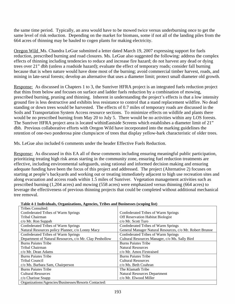
193
the same time period. Typically, an area would have to be mowed twice versus underburning once to get the same level of risk reduction. Depending on the market for biomass, some if not all of the landing piles from the 664 acres of thinning may be hauled to cogen plants for making electricity. Oregon Wild Ms. Chandra LeGue submitted a letter dated March 19, 2007 expressing support for fuels reduction, prescribed burning and road closures. Ms. LeGue also suggested the following: address the complex effects of thinning including tendencies to reduce and increase fire hazard; do not harvest any dead or dying trees over 21” dbh (unless a roadside hazard); evaluate the effect of temporary roads; consider fall burning because that is when nature would have done most of the burning; avoid commercial timber harvest, roads, and mining in late-seral forests; develop an alternative that uses a diameter limit; protect small diameter old growth. Response: As discussed in Chapters 1 to 3, the Sunriver HFRA project is an integrated fuels reduction project that thins from below and focuses on surface and ladder fuels reduction by a combination of mowing, prescribed burning, pruning and thinning. Inherent in understanding the project’s effects is that a low intensity ground fire is less destructive and exhibits less resistance to control that a stand replacement wildfire. No dead standing or down trees would be harvested. The effects of 0.7 miles of temporary roads are discussed in the Soils and Transportation System Access resource sections. To minimize effects on wildlife and plants there would be no prescribed burning from May 20 to July 5. There would be no activities within any LOS forests. The Sunriver HFRA project area is located withinEastside Screens which establishes a diameter limit of 21” dbh. Previous collaborative efforts with Oregon Wild have incorporated into the marking guidelines the retention of one-two ponderosa pine clumps/acre of trees that display yellow-bark characteristic of older trees. Ms. LeGue also included 6 comments under the header Effective Fuels Reduction. Response: As discussed in this EA all of these comments including ensuring meaningful public participation, prioritizing treating high risk areas starting in the community zone, ensuring fuel reduction treatments are effective, including environmental safeguards, using rational and informed decision making and ensuring adequate funding have been the focus of this project and addressed. The project (Alternative 2) focuses on starting at people’s backyards and working out or treating immediately adjacent to high use recreation sites and along evacuation and access roads within 1.5 miles of Sunriver. Vegetation management activities such as prescribed burning (1,204 acres) and mowing (558 acres) were emphasized versus thinning (664 acres) to leverage the effectiveness of previous thinning projects that could be completed without additional mechanical tree removal.
Table 4-1 Individuals, Organizations, Agencies, Tribes and Businesses (scoping list) Tribes Consulted: Confederated Tribes of Warm Springs Tribal Chairman c/o Mr. Ron Suppah
Confederated Tribes of Warm Springs Off Reservation Habitat Biologist c/o Mr. Scott Turo
Confederated Tribes of Warm Springs Natural Resources policy Planner, c/o Lonny Macy
Confederated Tribes of Warm Springs General Manager Natural Resources, c/o Mr. Robert Brunoe
Confederated Tribes of Warm Springs Department of Natural Resources, c/o Mr. Clay Penhollow
Confederated Tribes of Warm Springs Cultural Resources Manager, c/o Ms. Sally Bird
Burns Paiutes Tribe Tribal Chairman c/o Mr. Dean Adams
Burns Paiutes Tribe Natural Resources c/o Mr. Amos Firstraised
Burns Paiutes Tribe Tribal Council c/o Ms. Barbara Sam, Chairperson
Burns Paiutes Tribe Cultural Resources c/o Ms. Beth Coahran
Burns Paiutes Tribe Cultural Resources c/o Charisse Snapp
The Klamath Tribe Natural Resources Department c/o Mr. Elwood Miller
Organizations/Agencies/Businesses/Resorts Contacted:
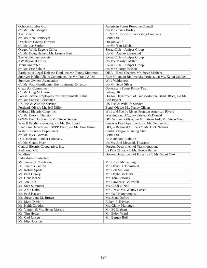
194
Ochoco Lumber Co. c/o Mr. John Morgan
American Forest Resource Council c/o Mr. Chuck Burley
The Bulletin c/o Ms. Kate Ramseyer
KTVZ 21 Resort Broadcasting Company Bend, OR
Deschutes County Forester c/o Mr. Joe Stutler
Oregon Wild c/o Mr. Tim Lillebo
Oregon Wild, Eugene Office c/o Mr. Doug Heiken, Ms. Leanne Siart
Sierra Club – Juniper Group c/o Mr. Asante Riverwind
The Wilderness Society NW Regional Office
Sierra Club – Juniper Group c/o Ms. Marilyn Miller
Trout Unlimited c/o Mr. Eric Suhulz
Sierra Club – Juniper Group c/o Mr. George Wilson
Earthjustice Legal Defense Fund, c/o Mr. Randy Moorman OHA – Bend Chapter, Mr. Steve Mathers Sunriver Public Affairs Committee, c/o Mr. Frank Allen Blue Mountain Biodiversity Project, c/o Ms. Karen Coulter Sunriver Owners Association c/o Ms. Patti Gentiluomo, Environmental Director
Wild Wilderness c/o Mr. Scott Silver
Clean Air Committee c/o Mr. Greg McClarren
Governor’s Forest Policy Team Salem, OR
Forest Service Employees for Environmental Ethic c/o Mr. Forrest Fleischman
Oregon Department of Transportation, Bend Office, c/o Mr. Bob Bryant
US Fish & Wildlife Service Portland, OR c/o Mr. Jeff Dillon
US Fish & Wildlife Service Bend, OR c/o Ms. Nancy Gilbert
Midstate Electric Coop, Inc. c/o Mr. Darwin Thurston
Wild and Scenic Rivers Program American Rivers Washington, D.C., c/o Kristen McDonald
ODFW Bend Office, c/o Mr. Steve George ODFW Bend Office, c/o Mr. Glenn Ardt, Mr. Steve Marx W & H Pacific Resources, c/o Mr. Ron Hand Sunriver Fire Department, c/o Mr. George Fox Bend Fire Department/CWPP Team, c/o Mr. Don Jensen DEQ – Regional Office, c/o Mr. Dick Nichols Water Resources Department c/o Mr. Kyle Gorman
Central Oregon Running Club Bend, OR
D.R. Johnson Lumber Company c/o Mr. Gerald Keck
Blue Ribbon Coalition c/o Ms. Joni Mogstad, Treasurer
Central Electric Cooperative, Inc. Redmond, OR
Oregon Department of Transportation, La Pine Office, c/o Mr. Swede Barber
Wildfire Oregon Department of Forestry c/0 Mr. Stuart Otto Individuals Contacted: Mr. James D. Noteboom Mr. Bruce McCullough Dr. Stuart G. Garrett Mr. David H. Tjomsland Mr. Robert Speik Mr. Bob Mullong Mr. Paul Dewey Mr. Daylin Melhorn Mr. Gene Keane Mr. Tom Sedwick Mr. Jon Cain Mr. Lawrence Brumwell Mr. Stan Summers Ms. Cindi O’Neil Mr. Arlie Holm Mr. Jim & Ms. Wendy Larsen Mr. Paul Hauser Mr. Paul Hammerquist Ms. Susan Jane M. Brown Ms. Joani Duford Mr. Mark Davis Robert P. Davison Mr. Keith Cloudas Ms. Ginny Murtaugh Mr. Vernon & Ms. Helen Risseau Mr. Ed Graham Mr. Tim Hester Mr. Eldon Ward Mr. Carl Jansen Mr. Bergen Bull Mr. Flip Houston


