Embed Size (px)
Citation preview
442 Amazônica 1 (2): 442-483, 2009
Early hunter-gatheres in the TERRA FIRME rainforest:
Stemmed projectile points from the Curuá goldmines
443Amazônica 1 (2): 442-483, 2009
Early hunter-gatheres in the TERRA FIRME rainforest:
Stemmed projectile points from the Curuá goldmines
Early hunter- gatheres in the TERRA FIRME rainforest: Stemmedprojectile points from the Curuá goldmines
University of Illinois at Chigaco, USA
A N N A C. R O O S E V E L T
The University of Montana, Missoula, USA
J o h n E. D o u g l a s
Fundação de Amparo e Desenvolvimento da Pesquisa – Fadesp, Belém, Brasil
A n d e r s o n M a r c i o A m a r a l
Museu Paraense Emílio Goeldi, Belém, Brasil
M a u r a I m a z i o d a S i l v e i r a
Universidade Federal do Piauí, Teresina, Brasil
C a r l o s P a l h e t a B a r b o s a
Universidade Federal do Pará
M a u r o B a r r e t o
Artisanal Miner
W a n d e r l e y S o u z a d a S i l v a
University of Montana, Missoula, USA
L i n d a J. B r o w n
444 Amazônica 1 (2): 442-483, 2009
Roosevelt C. A. et al
AbstractA pattern of accidental stone-tool finds in the terra firme of the Curua river in the middle Xingu basin suggest a widespread oc-cupation by preceramic hunter-gatherers there, contrary to expec-tations that the tropical rainforest has insufficient food resources away from the Amazon floodplain. The stone tools include finely flaked stemmed projectile points possibly related to some from terminal Pleistocene contexts at Caverna da Pedra Pintada, Mon-te Alegre. The food remains with the Monte Alegre tools were from broad-spectrum rupestral and riverine forest foraging. The Xingu points were recovered by artisanal gold-miners in sands and gravels under the Curua river. The miners come across the tools while digging and screening gold-bearing sediments. Those deposits also sometimes contain plant remains and prehistoric wooden artifacts, potential sources of information about ancient habitat, subsistence, and technology. The research team of the Lower Amazon project traveled to several of the underwater find-sites with the miners to prepare for excavations in the future. At one site, Curupite, where miners had found a large stemmed point and a complete palm-wood harpoon foreshaft in 1986, the team used scuba equipment to survey the stream bed and mine pits and map the topography with laser theodolite.
Key words: Paleoindians, terra firme, Xingu archaeology, under-water archaeology, flaked stone projectile points
ResumoAchados acidentais de instrumentos líticos em região de terra firme junto ao rio Curuá, no médio curso da Bacia do Xingu, sugere uma ocupação disseminada por caçadores-coletores pré-cerâmicos na região, contrariamente a expectativas de que a floresta tropical teria recursos alimentares insuficientes para a ocupação humana longe da várzea. Os artefatos líticos incluem pontas de projétil de lascamento cuidadoso, possivelmente rela-cionados a alguns artefatos do Pleistoceno final encontrados na Caverna da Pedra Pintada, em Monte Alegre. Os resíduos ali-mentares encontrados com os artefatos de Monte Alegre eram de uma economia de coleta de ambientes rupestres e ribeirinhos. As pontas do Xingu foram recolhidas por garimpeiros nas areias e cascalhos no leito do rio Curuá. Os garimpeiros encontraram os artefatos enquanto escavavam e peneiravam sedimentos auríferos. Tais depósitos algumas vezes também contêm remanescentes de plantas e artefatos de madeira pré-históricos, fontes de informa-
445Amazônica 1 (2): 442-483, 2009
Early hunter-gatheres in the terra firme rainforest: Stemmed projectile points from the Curuá goldmines
ção potencial sobre antigos habitats, subsistência e tecnologia. O grupo de pesquisa do Projeto Baixo Amazonas viajou a diversos dos sítios submersos com os garimpeiros para preparar escava-ções para o futuro. Em um sítio, Curupité, onde os garimpeiros encontraram uma grande ponta com pedúnculo e um arpão de madeira inteiro em 1986, a equipe utilizou equipamento de mer-gulho para prospectar o leito do rio e os barrancos, e mapearam a topografia com um teodolito a laser.
Palavras-chave: Paleoíndios, terra firme, arqueologia do Xingu, arqueologia sub-aquática, pontas líticas de projétil
ResumenHallazgos accidentales de instrumentos líticos en región de tierra firme junto al rio Curuá, en el medio curso de la cuenca del rio Xingu, sugiere una ocupación diseminada por cazadores-recolec-tores pre-cerámicos en la región, contrariamente a expectativas de que la floresta tropical tenería recursos alimentares insuficientes para la ocupación humana lejos de la planicie del Amazonas. Los artefactos líticos incluyen puntas de proyectil talladas celosamente, posiblemente relacionados a algunos artefactos del Pleistoceno final encontrados en la Caverna de la Piedra Pintada, en Monte Alegre. Los residuos alimentares encontrados con los artefactos de Monte Alegre eran de una economía de coleta de ambientes rupestre y ribereño. Las puntas del Xingu fueran recogidas en las arenas y cascajeras en el lecho del rio Curuá. Los garimpeiros recogerán los artefactos en cuanto escavaban y filtraban sedimen-tos auríferos. Tales depósitos algunas veces también contienen remanecientes de plantas y artefactos de madeira pre-históricos, fuentes de información potencial sobre antiguos hábitats, sub-sistencia y tecnología. El grupo de pesquisa del Proyecto Bajo Amazonas viajó a diversos de los sitios sumergidos con los garim-peiros para preparar excavaciones para el futuro. En un sitio, Cu-rupité, donde los garimpeiros encontraran una grande punta con pedúnculo y un arpón de madeira entero en 1986, la equipe utilizó equipamiento de inmersión para prospectar el lecho del rio e los barrancos, y mapearan la topografía con un teodolito a laser.
Palabras-clave: Paleoindios, tierra firme, arqueologia del Xingu, arqueologia sub-acuática, puntas líticas de proyectil.
446 Amazônica 1 (2): 442-483, 2009
THEORETICAL BACKGROUNDTwo interpretive issues inspire this con-tribution. One is the role of the terra firme tropical forest in early human evolution. The other is the role of lo-cal people in scientific knowledge and discoveries relevant to the first issue.
Despite their differences, both Meg-gers and Lathrap – two early scientific interpreters of Amazonian archaeol-ogy – thought the Amazon rainforest an inadequate habitat for Paleoindians, the Late Paleolithic hunter-gatherers who colonized the Americas in the terminal Pleistocene (Lathrap 1968, Meggers 1954). This “environmental determinist” view reflected ecological theories on human evolution from the mid 19th and to mid 20th centuries, when little archaeology and no dating had been done in tropical rainforests (e.g. Dart 1953, Darwin 1871, Steward 1949). The rainforest lacked the open-country large game herds on which Pa-leoindians were assumed to have lived on and was also thought poor in plant foods rich in starch, protein, or fat.
Early treatments of Terminal Pleisto-cene cultures in the Americas assumed that Paleoindians were fluted-point big-game hunters in tundra or steppe and that a combination of over-hunt-ing of the big game and abrupt climate change at 10,000 years BP created warmer, wetter, more forested condi-tions, eliciting a cultural change to the Archaic, a broad-spectrum foraging adaptation (Binford 1968). However, the hypothesis was wrong about both climate change and cultural change. In most areas, there was strong cultural
and ecological continuity, rather than disjunction, from Paleoindian through early Archaic. Neither the changeover at 10,000 years ago from tundra, cold steppe, and savanna to forest and wet-lands nor the replacement of special-ized fluted-point big game hunters by broad-spectrum big-game hunters with triangular stemmed points have been upheld by recent research. Paleoindian and Early Archaic have been reduced to purely chronological terms, denot-ing respectively the few thousand years just before and just after 10,000.
Doubts about the ubiquity of special-ized big-game hunting in the Termi-nal Pleistocene in the Americas have arisen recently (Borrero 1996, Gray-son and Meltzer 2003, Roosevelt 2005, Roosevelt et al. 2002). Sites with criti-cally confirmed associations of fluted points and bones of megafauna are very few in the Americas and concen-trated in the interior US high plains east of the Rockies, and most megafaunal species were already extinct by the first confirmed human occupations. Most other reliable Terminal Pleistocene site associations in the Americas have other forms of points, and primarily small-package biota, including plants. Fur-thermore, many Pleisteocene points originally claimed to be fluted are not, and Holocene fluted point cultures are confirmed in several areas: the Arctic and Boreal forest, the Southeast, and Lower Central America (Roosevelt nd, Roosevelt et al 2002).
Big-game hunting is dangerous, risky, costly calorically, and not a reliable, predictable source of food (Roosevelt
Roosevelt, A. C. et al
447Amazônica 1 (2): 442-483, 2009
2005, Roosevelt et al. 2002, Chilton 2004). Why then have paleoanthropol-ogists focused on it so? In Old World state societies and their colonies, from which most scholars of human evolu-tion have come, large-game meat is a high-status food elites seek to control, and hunting and fishing are valued elite recreation activities. Given their role in ideology of social hierarchy, the large animal bones’ prominence in sites ex-cavated without fine screening seemed compelling to the archaeologists.
But most hunter-gatherers document-ed prehistorically or ethnographically relied on small fauna and plants, not on large game (Chilton 2004, Hart and Pilling 1964:33-50, Heinen 1988, Lee and Daly 1999, Roosevelt 1998a and b,1999, 2002, 2005). Quantitatively, small faunas are a much greater part of the collectable biomass; their re-production is much more rapid; they are more reliably localized in space and time; and they are not usually danger-ous to acquire. Furthermore, the rivers that drain rainforests provide a myriad of fishes, an abundant and salubrious food source for humans. But plant foods are even more abundant in bio-mass than any fauna. A foraging group hoping to avoid hunger either short or long-term is wiser to focus on these in lieu of big game, for their sustenance.
Furthermore, assumptions that ter-minal Pleistocene environments in the Americas were dominated by icy tundra, arid steppe, and desert-like savanna populated by herds of mega-fauna have not been upheld by the pa-leoecological evidence accrued since
pollen profiles and paleontological sites have become well-dated, quanti-fied, and grounded in actualistic stud-ies (McWeeny 2007, Roosevelt 2000a, 2005, nd, Roosevelt et al. 2002). Most of the land occupied by Paleoindians was more or less forested, humid, and, in the higher latitudes, dominated by wetlands related to glacial melting (Enright and Hill 1995, Anderson and Borns 1994, Wright et al. 1993, Bryant and Holloway 1985). In Amazonia, as in the Congo, the well-dated and quan-tified paleoecological evidence of the time shows a continuing dominance of tropical tree species, not of savanna, steppe, or temperate species (Colin-vaux et al. 1996, Haberle and Maslin 1999, Roosevelt 2002, and references summarized in Roosevelt 2005).
The issue of the nature of ancient hunter-gatherer subsistence is of more than purely paleodietary or culture his-torical importance, since subsistence is intimately related to the character of social organization and gender roles. The big-game-hunting model privi-leged males as the breadwinners and the inventors of stone tools for that purpose. However, women, children and older people are the most impor-tant source of labor and knowledge about the acquisition of the small animals, fish, insects, and plant foods that compose the staples of broad-spectrum foraging economies. In fact, in cultures where smaller game and/or plants are staple foods, women and children, not men, are the breadwin-ners for societies (Dahlberg 1981, Hart and Pilling 1964: 33-50, Heinen 1988,
Early hunter-gatheres in the terra firme rainforest: Stemmed projectile points from the Curuá goldmines
448 Amazônica 1 (2): 442-483, 2009
Martin and Voorhies 1975, and refer-ences summarized in Roosevelt 2002). If such foods were the foundation of most Plio-Pleistocene diets, evo-lutionists’ models of ancient societies and their role in the development of human nature are unrealistic and will have to be re-tooled.
Should such considerations of the na-ture of ancient human habitats and forager diets to be considered “envi-ronmental determinist”? Probably not, for several reasons. Those who have documented the activities of recent or modern hunter-gatherers have given us ample evidence that people both adapt to and shape their habitats (Balee 1989, Boyd 1999, Gremillon 1997, Menzies 2006, Minnis and Elisens 2000, Politis 2007). That their behavior and culture are not “determined” is also shown by the diversity of choices and flex-ibility that they evince over time and space. In addition, living people who rely on foraging for a significant part of their diet, trade economy, or rituals are intensely interested in and knowl-edgeable about their environments. Moreover, it is nearly universal that the biota and environments in their tradi-tional regions are integral parts of their cosmologies, ceremonial activities, and social organization. Thus it can be seen that indigenous people usually con-sider themselves as part of their envi-ronments and the environment as part of their cultures. This argument does not rely purely on ethnographic anal-ogy, for many ancient forager cultures also elevated environmental elements to high cultural importance, to judge by
their choice of raw materials, valuables, and art subjects. To deny the relevance of the environment for any ancient group, given such evidence, would deny consideration of factors that in the group in question are highly likely to have considered very important.
TROPICAL RAINFORESTS AS HABITATS FOR EARLY FORAGERSMy research on tropical forests and their peoples, animals, and plants showed that the original assessment by evolutionary ecologists that tropi-cal rainforests are poor in foods for hunter-gatherers was based on very incomplete evidence (Roosevelt 2005). For example, reviews of available foods in the Congo rainforests (Bailey at al. 1989, Hart 1985, Hart and Hart 1986) left out of the calculus most of the high-calorie fruits, legumes, seeds, and herbs available there (Mitani et al. 1994), especially the most abundant sources of starch and oil: the palms, whose trunks provide an abundance of both sap, starch, and oily nutri-tious fruits and seeds. Other common tropical forest plant groups, such as the gingers and arrowroots also pro-vide common, starch-rich food sourc-es in forests periodically disturbed by humans, animals, or natural disasters. Such plants make up more than 99% of the biomass of food available to humans in the rainforests there.
These scholars also left out of seri-ous consideration the small-package faunal foods. The larvae and ants, ter-mites, and beetles in the forests con-stitute common, rich, and spatially
Roosevelt, A. C. et al
449Amazônica 1 (2): 442-483, 2009
localized sources of protein and fat (Bodenheimer 1951, Dufour 1987), and streams, lakes, and swamps pro-vide not only abundant edible plants but also diverse fish, amphibians, and water turtles. Among the many small game animals in the Congo-Guinean forest (Kingdon 1997), the very small antelopes’ prolific reproduction and affinity for human-disturbed forest make them a particularly abundant and reliable source of meat, whereas typi-cal “large-package” animals such as the elephants and forest buffalo constitute significant dangers to human life and limb, due to their intelligence, aggres-siveness, and viciousness when inter-fered with. But, as mentioned above, even such small, prolific animals make up a very small fraction of the avail-able faunal foods, of which inverte-brates make up the largest part, though fauna overall are insignificant quantita-tively compared to plant food sources (Fittkau and Klinge 1973).
Similarly, the oft-repeated axiom that tropical rainforest soils are poor in nutrients and therefore unproductive of food does not fit the Congo basin, whose soils are rich in nutrients from a long history of vulcanism and alluvia-tion (Roosevelt 2005). Exigent crops, such as maize, are well-documented to produce very well in the basin and for long periods for both domestic and commercial use (Miracle 1966).
In Amazonia, the resource mix avail-able for staple foods for humans is comparable or even more favorable, considering the greater diversity of species with edible products and the
much larger size of the basin. Al-though South America lost much of its large fauna long before the arrival of Paleoindians (Borrero 1996), Amazo-nia’s plant and animal species are much more numerous than Central Africa’s. For example, food-bearing palm spe-cies are substantially more diverse and abundant there than in Africa, as are fish and insects with edible life-forms (Meggers, Ayensu, and Duck-worth 1973; Henderson 1995; Lorenzi 2002). Foragers in Greater Amazonia, like those in the Congo basin, make intensive use of abundant wild food sources such as fish, palm starch and fruits, tree fruits, herbs, roots, and in-vertebrates (Balee 1994, Heinen 1988, Politis 2007).
Accordingly, there is no empirical eco-logical or economic evidence to sup-port the idea that such tropical forest habitats could not have supported for-agers in terminal Pleistocene times in Amazonia. Therefore, there is no clear reason why foragers should not have been able to colonize Amazonia at the same time and as readily as they did other parts of the Americas.
LATE PLEISTOCENE FORAGERS AT MONTE ALEGRE, NEAR SANTARÉM, AT THE MOUTH OF THE TAPAJÓS RIVERAs new views of rainforests and hu-man foraging were emerging, our team investigated a Paleoindian cul-ture at Monte Alegre, along the Ama-zon mainstream opposite Santarém in Pará. The work was part of the Lower Amazon Project: the Developmental
Early hunter-gatheres in the terra firme rainforest: Stemmed projectile points from the Curuá goldmines
450 Amazônica 1 (2): 442-483, 2009
Sequence at Santarém, which sought to establish the cultural-ecological se-quence in the area where the Tapajós river meets the Amazon mainstream. Because the sequence of human occu-pation in the Amazon was very incom-pletely known, I reviewed museum collections and archives from Greater Amazonia in the Americas and Europe to prepare to work in this area in the early 1980s (Roosevelt 2000b).
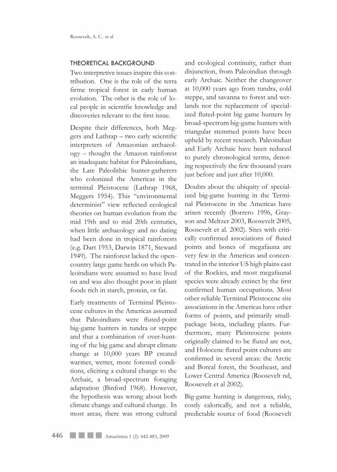
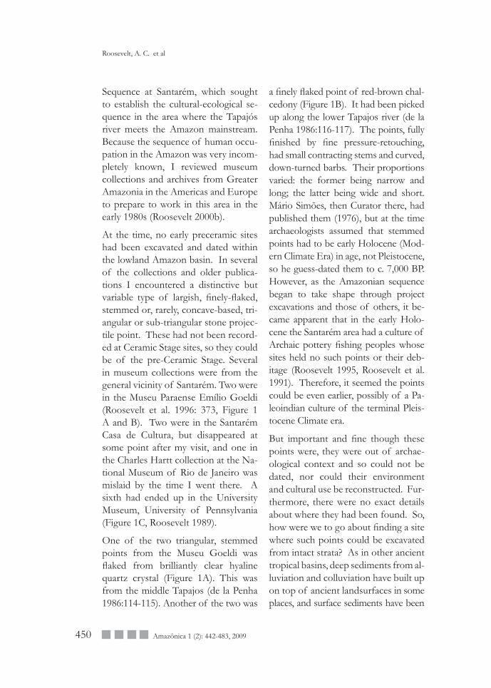
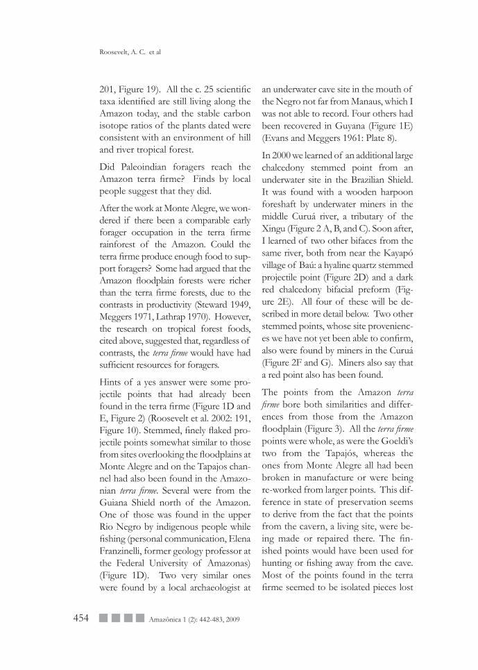
At the time, no early preceramic sites had been excavated and dated within the lowland Amazon basin. In several of the collections and older publica-tions I encountered a distinctive but variable type of largish, finely-flaked, stemmed or, rarely, concave-based, tri-angular or sub-triangular stone projec-tile point. These had not been record-ed at Ceramic Stage sites, so they could be of the pre-Ceramic Stage. Several in museum collections were from the general vicinity of Santarém. Two were in the Museu Paraense Emílio Goeldi (Roosevelt et al. 1996: 373, Figure 1 A and B). Two were in the Santarém Casa de Cultura, but disappeared at some point after my visit, and one in the Charles Hartt collection at the Na-tional Museum of Rio de Janeiro was mislaid by the time I went there. A sixth had ended up in the University Museum, University of Pennsylvania (Figure 1C, Roosevelt 1989).
One of the two triangular, stemmed points from the Museu Goeldi was flaked from brilliantly clear hyaline quartz crystal (Figure 1A). This was from the middle Tapajos (de la Penha 1986:114-115). Another of the two was
a finely flaked point of red-brown chal-cedony (Figure 1B). It had been picked up along the lower Tapajos river (de la Penha 1986:116-117). The points, fully finished by fine pressure-retouching, had small contracting stems and curved, down-turned barbs. Their proportions varied: the former being narrow and long; the latter being wide and short. Mário Simões, then Curator there, had published them (1976), but at the time archaeologists assumed that stemmed points had to be early Holocene (Mod-ern Climate Era) in age, not Pleistocene, so he guess-dated them to c. 7,000 BP. However, as the Amazonian sequence began to take shape through project excavations and those of others, it be-came apparent that in the early Holo-cene the Santarém area had a culture of Archaic pottery fishing peoples whose sites held no such points or their deb-itage (Roosevelt 1995, Roosevelt et al. 1991). Therefore, it seemed the points could be even earlier, possibly of a Pa-leoindian culture of the terminal Pleis-tocene Climate era.
But important and fine though these points were, they were out of archae-ological context and so could not be dated, nor could their environment and cultural use be reconstructed. Fur-thermore, there were no exact details about where they had been found. So, how were we to go about finding a site where such points could be excavated from intact strata? As in other ancient tropical basins, deep sediments from al-luviation and colluviation have built up on top of ancient landsurfaces in some places, and surface sediments have been
Roosevelt, A. C. et al
451Amazônica 1 (2): 442-483, 2009
Figure 1. Projectile points from the Amazon basin. Drawings and photos of two triangular points from the Tapajos river basin. The points have down-curved barbs and small contracting stems. A. Wide point of hyaline quartz crystal, with one chipped barb. Museu Goeldi # 1273. Cachoeira do Chacorão, lower Tapajós river, 6.4 cm. B. Long point of red brown chalcedony. Museu Goeldi #1491 Igarapó do Tucano, middle Tapajós river. 8.5 cm. (Roosevelt et al. 1996: 373, Figure 1; de la Penha 1986: 115-117). C. Drawing of finely flaked triangular point from Santarém. The light brown chalcedony point has a concave base. 12cm. University Museum, Uni-versity of Pensylvania. D. Triangular point from Monte Alegre. The long hyaline quartz crystal point has down-turned barbs and a broken contracting stem. C. 8cm. Collection of Victor Fuchs. Present location unknown. E. Bifaces from Caverna da Pedra Pintada, Monte Alegre. 1. Quartz biface in process of reduction. 2. Small triangular point of quartz with downturned barbs and small, slightly contracted stem. The point is finished but the end of one barb has broken off. The point may have been worked down from a larger point. 3. Bifacial reduction flake of chalcedony. 4. Biface broken during manufacture, possibly part of a contracting stem. 5. Biface broken in manufacture, possibly part of a contracting stem. Both 4 and 5 have been thinned and then pressure-edge retouched along parts of their edges. 6. Assymmetrical biface broken in manufacture. Pressure edge-retouching has not yet been begun. 7. Triangular biface broken in manufacture. Pressure edge-retouching has not yet begun, and several prepared striking platforms for thinning have not yet been struck. (Roosevelt et al. 1996: 378, Figure 6; Roosevelt et al. 2002: 197, Figure 15F). All drawings in this article are by Jane Silva, Desert Archaeology, Tucson, Arizona. F. Stemmed subtriangular point from the Upper Rio Negro, Brazil. Of grey brown chalcedony, the long point has a chipped tip, slightly curved sides, small, slightly down-turned barbs, and a long, flat, nearly straight stem. 15 cm. Present location unknown. G. Stemmed subtriangular points from Guyana (Evans and Meggers 1960: plate 8). From left, large, long point of dark rock, with sharp tip, serrated waist, small, down-turned barbs, and lobe-shaped stem. Ireng river, Rupununi District. C. 15.5 cm. Long point of pale rock, with rounded tip, straight sides, vary small barbs and flat, rounded stem. C. 12 cm. Long point with sharp tip, slightly curved-out sides, small barbs, and long, nearly straight stem. C. 8 cm. Long point with rounded tip, slightly rounded sides, and long, nearly straight, flat stem. C. 11. cm. B through D: Cuyuni river, Mazaruni District.
Early hunter-gatheres in the terra firme rainforest: Stemmed projectile points from the Curuá goldmines
452 Amazônica 1 (2): 442-483, 2009
eroded away in others. With that prob-lem in mind, the first author thought that a cave or rockshelter with signs of early people might contain stratified deposits that had been protected from both ero-sion and deposition.
In reading on the history of the Tapa-jós mouth area, the first author found mid-nineteenth century sources on polychrome rock paintings, caves, and rockshelters in Monte Alegre, oppo-site Taperinha. Among others, Charles Hartt, one of the discoverers of projec-tile points on the property that also had the early pottery shell-midden at Taper-inha, had written about and illustrated the Monte Alegre paintings (1871). Al-fred Russell Wallace, the co-discoverer of the theory of evolution, also had vis-ited the paintings at Monte Alegre and wrote about his trip in his book on the Amazon (1889). Both men had been shown the sites by local people.
Hartt had ascertained that Monte Alegre people of his day had not painted them and did not know who had. The paintings thus were possibly prehistoric. If so, their style and ico-nography seemed unrelated to that of late prehistoric pottery cultures. For example, the art had an image of a spear-thrower, but no bows and ar-rows, which were the most common hunting tools in the cultures observed at contact. It seemed possible, then, that the paintings might be early pre-historic. Although most of the paint-ings were on rocks in the open, some were on the ceilings and walls of caves and rockshelters (Pereira 2003), some of which had prehistoric human oc-
cupation debris. Roosevelt resolved, therefore, to test these rock art sites for stratified archaeological deposits that could be excavated and dated. In that way it might be possible to date both the points and paintings and also investigate their lifestyle and habitat.
Taking the opportunity to visit Monte Alegre in 1987 while excavating nearby, she enquired about the rock art in the main plaza. Soon, residents who knew the rock art came up, and she was able to arrange to go there the next day. That same day she identified Caverna da Pedra Pintada as a likely Paleoindian and Archaic habitation site and decided to return with a team to excavate there and at other promising sites.
A local school-teacher had already found a triangular, stemmed projectile point of quartz crystal (Figure 1D). Although of similar material as that of the short point from the Tapajós in the Museu Goeldi, it was narrow and long like the chalcedony Tapajós point in the Goeldi. The angle of the stem remnant is contracting. An avid artifact collector, the collector, with a partner, excavated several sites in the Amazon in order to find projectile points, an ac-tivity prohibited by law in Brazil. He would not identify the actual find place of this point.
Of the several Monte Alegre inhabit-ants who helped her locate sites there, Nelsi Sadeck, Lazaro C. Batista Lo-bato, Osias da Silva Ribeiro, and Ma-ria Jose Ribeiro were four of the most knowledgable. Nelsi helped in a myriad of ways both intellectual and organiza-tional. He was the Monte Alegre town
Roosevelt, A. C. et al
453Amazônica 1 (2): 442-483, 2009
resident most knowledgeable about the literature, art, caves, and shelters in the Monte Alegre hills, and he intro-duced me to knowledgable residents of the hills. Of those, Lazaro helped us most to identify the biological remains from the excavations. As a modern-day forager on the flora and fauna of the hils, he explained much about the wildlife and its behavior led us to rel-evant modern populations of the biota that our botanist and zoologist could then compare to ancient specimens. Other locals such as Osias and Maria Jose helped with the biota, and others took us to lithic raw material sources, as well. Without these men and women the work could not have been done. Because many local participants in the work were very knowledgable, we could compare information among them and verify its consistency.
To choose a site to dig, we first augered sites. Only at Caverna da Pedra Pintada, however, did we find the deep, stratified, multicomponent deposit we sought (Roosevelt et al. 1996, 1997, Roosevelt et al. 2002). There, above a sterile layer on the cave floor, we uncovered 21 ar-chaeological layers in a sequence of cul-tural deposits from early pre-ceramic to late ceramic periods, separated by a ster-ile layer. The 69 radiometric dates from the site placed the pre-ceramic from about 11,000 to 10,000 BP; the sterile period from 10,000 to 7,500 BP; and the three ceramic phases from 7,500 BP to AD 1,400. On top of the last pre-historic layer was a post-conquest layer containing leaves and excrement of ranch cattle that forage in the hills.
Large quantities of pigment and paint drops of similar chemical composi-tion to the rock art in the cave were recovered in layers dating from 11,000 to 10,500 BP but there was only one later pigment fragment, found in the surface layer. The stone tools in the Pa-leoindian layers were numerous (more than 30,000 artifacts, mostly bifacial debitage) and varied. Whole, nearly whole, or partial tools numbered 24: 10 bifacial and 14 unifacial. Along with several complete unifacial tools, in-cluding a graver and a limace scraper, were almost whole and fragmentary projectile points in the late finishing process or repair (Figure 1E). Some bi-faces were triangular or subtriangular; one fragmentary chalcedony one had a large, slightly contracting base; and one whole one of clear hyaline quartz had a small, slightly contracting base. One of its downturned barbs was shortened by breakage. Statistical analysis showed a significant change in raw materials for bifaces from a majority of hyaline quartz in the earliest layers to a nearly total predominance of chalcedony in the late Paleoindian levels (Roosevelt et al. 1996: 376-377, Table 1, Roosevelt et al. 2002: 197, Figure 15B). In Ho-locene levels, there were only a few hundred stone tools, and none were bifaces or pressure-finished.
Contrary to the assumption that all Pa-leoindians lived by big-game hunting, the food species consisted mostly of palm fruits and kernels, legume aril, small fruits, nuts, fish, turtles, shell-fish, and small animals (Roosevelt et al. 1996: 379, Roosevelt et al. 2002:
Early hunter-gatheres in the terra firme rainforest: Stemmed projectile points from the Curuá goldmines
454 Amazônica 1 (2): 442-483, 2009
201, Figure 19). All the c. 25 scientific taxa identified are still living along the Amazon today, and the stable carbon isotope ratios of the plants dated were consistent with an environment of hill and river tropical forest.
Did Paleoindian foragers reach the Amazon terra firme? Finds by local people suggest that they did.
After the work at Monte Alegre, we won-dered if there been a comparable early forager occupation in the terra firme rainforest of the Amazon. Could the terra firme produce enough food to sup-port foragers? Some had argued that the Amazon floodplain forests were richer than the terra firme forests, due to the contrasts in productivity (Steward 1949, Meggers 1971, Lathrap 1970). However, the research on tropical forest foods, cited above, suggested that, regardless of contrasts, the terra firme would have had sufficient resources for foragers.
Hints of a yes answer were some pro-jectile points that had already been found in the terra firme (Figure 1D and E, Figure 2) (Roosevelt et al. 2002: 191, Figure 10). Stemmed, finely flaked pro-jectile points somewhat similar to those from sites overlooking the floodplains at Monte Alegre and on the Tapajos chan-nel had also been found in the Amazo-nian terra firme. Several were from the Guiana Shield north of the Amazon. One of those was found in the upper Rio Negro by indigenous people while fishing (personal communication, Elena Franzinelli, former geology professor at the Federal University of Amazonas) (Figure 1D). Two very similar ones were found by a local archaeologist at
an underwater cave site in the mouth of the Negro not far from Manaus, which I was not able to record. Four others had been recovered in Guyana (Figure 1E) (Evans and Meggers 1961: Plate 8).
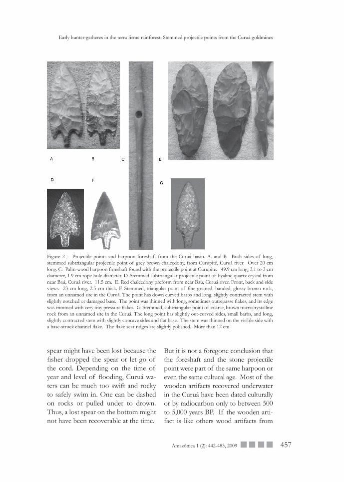
In 2000 we learned of an additional large chalcedony stemmed point from an underwater site in the Brazilian Shield. It was found with a wooden harpoon foreshaft by underwater miners in the middle Curuá river, a tributary of the Xingu (Figure 2 A, B, and C). Soon after, I learned of two other bifaces from the same river, both from near the Kayapó village of Baú: a hyaline quartz stemmed projectile point (Figure 2D) and a dark red chalcedony bifacial preform (Fig-ure 2E). All four of these will be de-scribed in more detail below. Two other stemmed points, whose site provenienc-es we have not yet been able to confirm, also were found by miners in the Curuá (Figure 2F and G). Miners also say that a red point also has been found.
The points from the Amazon terra firme bore both similarities and differ-ences from those from the Amazon floodplain (Figure 3). All the terra firme points were whole, as were the Goeldi’s two from the Tapajós, whereas the ones from Monte Alegre all had been broken in manufacture or were being re-worked from larger points. This dif-ference in state of preservation seems to derive from the fact that the points from the cavern, a living site, were be-ing made or repaired there. The fin-ished points would have been used for hunting or fishing away from the cave. Most of the points found in the terra firme seemed to be isolated pieces lost
Roosevelt, A. C. et al
455Amazônica 1 (2): 442-483, 2009
during use. One Curuá point-find-site, however, did have a biface preform, also, and it and the quartz crystal point find site, also had debitage. So from the evi-dence of those two sites, at least some of the terra firme sites also could have been lithic workshops at campsites.
Workshops at campsites might be more informative than occasional hunting or fishing sites because the longer oc-cupations could have generated a wider range of archaeological materials.
The raw materials of the terra firme points were mostly the same as the Monte Alegre ones: chalcedony and quartz crys-tal. However, the preform was a dark red, cryptocrystalline raw material, and one of the points from unknown sites is of
brown, banded cryptocrystalline materi-al. Quartz crystal is widely available in the Lower Amazon, and chalcedony cobbles are often exposed along rivers draining the Amazon highplain.
Form similarities and differences also existed among the points. The Tapajós points were straightforwardly triangu-lar and had smallish, contracting stems. One was long; the other was wide. All but one of the other Amazon points were comparatively long. The Rio Negro points and three of the Cu-ruá points were sub-triangular in that their sides were slightly rounded. Their bases had longer, straighter stems with only very slight contraction. Such form differences may in the future be found to relate to differences in manufactur-
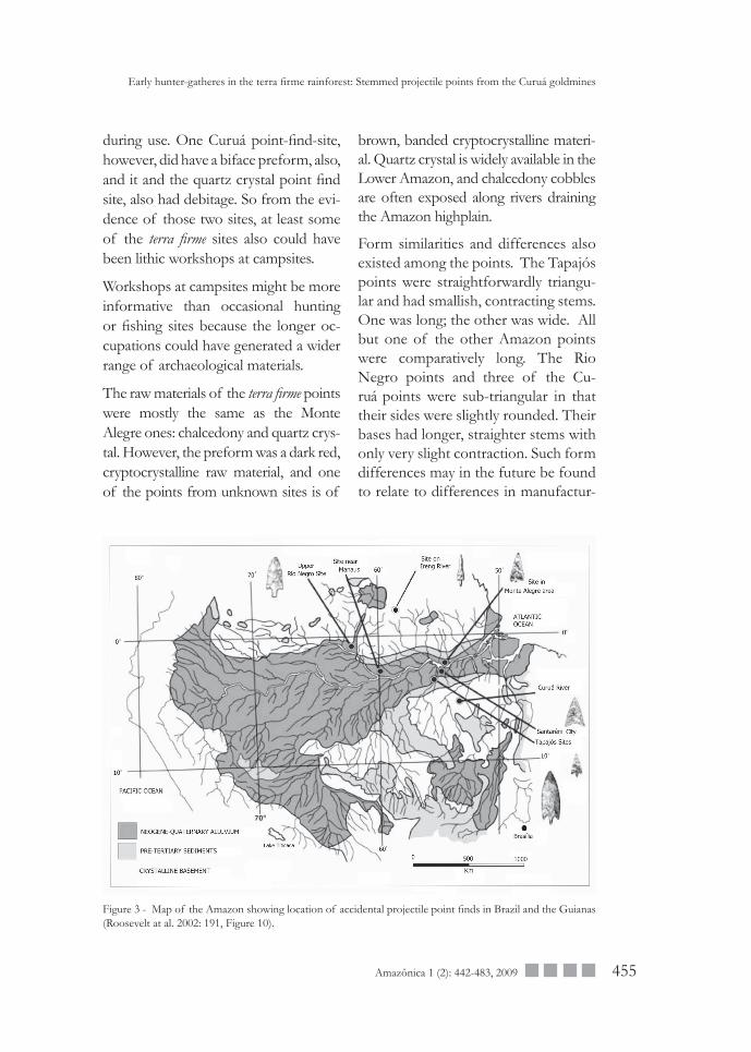
Figure 3 - Map of the Amazon showing location of accidental projectile point finds in Brazil and the Guianas (Roosevelt at al. 2002: 191, Figure 10).
Early hunter-gatheres in the terra firme rainforest: Stemmed projectile points from the Curuá goldmines
456 Amazônica 1 (2): 442-483, 2009
ing stage, haft type, intended use, or simply regional, cultural, temporal, or habitat-prey differences.
THE CHALCEDONY PROJECTILE POINT FROM CURUPITÉThe points from known sites in the Cu-ruá are worth describing in more detail, as we hope to excavate at those sites in the future to investigate the ancient cultures and habitats from which they came.
The chalcedony stemmed point from Curupité (Figure 2 A and B) is large, over 20 cm long. Its general form is long, with slightly curved-out sides, slightly curved downturned barbs, and nearly straight stem narrowing slightly to a squared-off end. The flake scars show finely controlled thinning by shallow, rounded or elongate indirect percussion or baton-struck flakes. The stem was thinned by flakes struck from its end and sides and trimmed by small round or oblong pressure flakes. The end-struck thinning flake is function-ally like a channel flake, but such flakes were also struck from the sides.
The raw material is a dark, greyish brown micro-chrystalline chalcedony with some knotty imperfections, which the knapper handled with variable suc-cess by flaking at them. The point’s flake scars are fresh and unworn, but the stem was dulled purposely for haft-ing by grinding or rubbing.
THE PALM WOOD HARPOON FORESHAFT FROM CURUPITÉThe foreshaft (Figure 2 C) is composed of hard, siliceous palm wood. In shape it is similar to many harpoon foreshafts
worldwide (Fitzhugh and Crowell 1988, Mason 1900). At the proximal end that joined with the spear shaft the artifact is sharply pointed and would have been inserted into a conical hollow at the distal end of the the spear. At the front end, the foreshaft has a carefully shaped knob to fit into a socket. Near this end the shaft widens and bears a large round hole cut all the way through it. This hole is for the heavy cord that would have been attached to the wooden haft for the spear point at one end and coiled in the hand of the harpooner at the other end. This haft, a separate piece, is missing, as is the spear. The compos-ite apparatus possibly would have been propelled by a throwing board, or atlatl, which has a hook that inserts into a hole in the proximal end of the spear.
Four different local people who ex-amined the tool with us independently concluded that it was made of the wood of the Paxiúba palm (Socratea exorrhiza, Henderson 1995: 95). This lowland Amazonian palm is much used for poles and planks because its wood is extremely hard and durable, and it is important in myth and ritual as the palm from which sacred trumpets are made.
Since the flaked stone projectile point and the wooden foreshaft were found less than a meter apart in a gravel stra-tum under several meters of water near the base of the mined deposits, it is possible that they were originally mounted together in the same weapon. Such a spear could have been used to hit a large fish that was ascending or descending the stream in its seasonal migration from the floodplain. The
Roosevelt, A. C. et al
457Amazônica 1 (2): 442-483, 2009
Figure 2 - Projectile points and harpoon foreshaft from the Curuá basin. A. and B. Both sides of long, stemmed subtriangular projectile point of grey brown chalcedony, from Curupité, Curuá river. Over 20 cm long. C. Palm-wood harpoon foreshaft found with the projectile point at Curupite. 49.9 cm long, 3.1 to 3 cm diameter, 1.9 cm rope hole diameter. D. Stemmed subtriangular projectile point of hyaline quartz crystal from near Baú, Curuá river. 11.5 cm. E. Red chalcedony preform from near Baú, Curuá river. Front, back and side views. 23 cm long, 2.5 cm thick. F. Stemmed, triangular point of fine-grained, banded, glossy brown rock, from an unnamed site in the Curuá. The point has down curved barbs and long, slightly contracted stem with slightly notched or damaged base. The point was thinned with long, sometimes outrepasse flakes, and its edge was trimmed with very tiny pressure flakes. G. Stemmed, subtriangular point of coarse, brown microcrystalline rock from an unnamed site in the Curuá. The long point has slightly out-curved sides, small barbs, and long, slightly contracted stem with slightly concave sides and flat base. The stem was thinned on the visible side with a base-struck channel flake. The flake scar ridges are slightly polished. More than 12 cm.
Early hunter-gatheres in the terra firme rainforest: Stemmed projectile points from the Curuá goldmines
spear might have been lost because the fisher dropped the spear or let go of the cord. Depending on the time of year and level of flooding, Curuá wa-ters can be much too swift and rocky to safely swim in. One can be dashed on rocks or pulled under to drown. Thus, a lost spear on the bottom might not have been recoverable at the time.
But it is not a foregone conclusion that the foreshaft and the stone projectile point were part of the same harpoon or even the same cultural age. Most of the wooden artifacts recovered underwater in the Curuá have been dated culturally or by radiocarbon only to between 500 to 5,000 years BP. If the wooden arti-fact is like others wood artifacts from
458 Amazônica 1 (2): 442-483, 2009
underwater sites, it could be middle to late Holocene in age. Since the fore-shaft is perfect, and its current owner-ship is murky, we did not get it dated, which would have required removal of material and damage to its integrity. Perhaps in the future the tool may be recovered for a museum, and a way may be found to sample it unobtrusively for AMS dating, which requires only a few grams of wood. Additionally, by exca-vating more underwater deposits in the Curuá, it may be possible to find other wooden artifacts which can be dated and compared to this one.
We can tentatively reconstruct how a composite tool made up of such a point and foreshaft parts would have been used by looking at how compara-ble tools are used now in the Amazon.
Composite harpoons with assymetri-cal barbed, stemmed metal points are used in the middle Rio Negro for fish-ing Pirarucu (Arapaima gigas). One fish-ing harpoon in use today examined by Roosevelt had a point haft, foreshaft, cord, and spear. Its metal point is less than half the size of the prehistoric one, and the tool is thrown by the fish-er by hand, not with a spear-throwing board, from a small canoe paddled by another person. When a fish is spotted, the thrower hurls the spear into the fish. When the fish takes off, the spear thrower lets loose the cord and the fish-ing partner paddles to follow the fish. The fish caught by this tool was a little less than a meter long, rather skimpy for a species that can reach more than three meters in length (Roosevelt 1991: Figure 6.6 B, C, D). The much larger,
heavier prehistoric point probably was used for spearing a fish or other aquatic animal more than a meter in size. That Paleoindians in the Amazon floodplain were indeed catching such large fish is shown by mouth parts and an otolith from fish as large as 1.5 m excavated at Monte Alegre (Roosevelt et al. 1996: 379, Figure 7B; Roosevelt et al. 2002: 201, Figure 19).
THE HYALINE QUARTZ PROJECTILE POINT FROM BAÚ The quartz crystal point from an under-water mine near Baú (Figure 2D) has a sub-triangular body with only slightly curved-out sides, a long, nearly straight stem, and down-curved barbs. The point has a small chip out of the edge about half way between the base and tip and blunting of one barb, like that on the Tapajos crystal point barb. Since the chip’s edges are very sharp, it may have happened when the point was dug up by the miners. The barb damage seems to be ancient, as its surfaces are some-what smoothed. Possibly, a point with one barb shortened and blunted might not hold straight in the flesh of the prey animal and would turn and slip out.
This point is smoothly worn on its flake scar eminences, either from water polishing or from being rubbed against something soft: fine sand, plant fibers, or skin. One side is much more worn than the other.
This tool’s find site may have been a lithic workshop, for the one of the miners present when it was found thought he saw small flakes of quartz crystal in their sorting tables.
Roosevelt, A. C. et al
459Amazônica 1 (2): 442-483, 2009
THE RED CHALCEDONY BIFACIAL PREFORM FROM BAÚThis large unfinished biface (Figure 2E) has an elongated oblong shape with slightly narrowed proximal third. Its length is about 26 cm. It is covered with scars from deep, rounded or ob-long flakes removed by direct percus-sion. At its stage of manufacture, few or no thinning flakes have been removed by indirect percussion, although pre-pared, pressure-flaked platforms were made on the edges for striking the percussion flakes. Four such platforms not yet flaked off can be seen along the lower left edge of the piece in view B. In view A, one can see the remnants of such a platform at the edge next to the large percussion flake scar at the lower left of the tool. The side view of the piece shows that it is not very far along in the thinning process. Both sides still have substantial projections that need to be removed to thin the biface to the point when its base and edges could be shaped and trimmed.
Miners involved in the recovery of this piece saw flakes of red stone in the gravel, and when we visited the site we also saw flakes of reddish stone, so the find place of this preform may have been a workshop.
COMPARING THE CURUÁ AND OTHER AMAZONIAN POINTS WITH POINTS IN OTHER REGIONS OF SOUTH AMERICATriangular or sub-triangular stemmed points have been found in Paleoindian occupations in other parts of South America, primarily west, north, and
southeast of the Amazon basin in Peru, Colombia, Venezuela, and in northeast-ern and southeastern Brazil. They have been definitively dated to the Paleoin-dian period in north coast Peru, the Ca-ribbean lowlands of Colombia, and in eastern and southeastern Brazil.
The best known ones are points of the Paijan culture of north coastal Peru. This broad-spectrum foraging cul-ture of coastal plain and river valleys has not been exhaustively dated, but minimally it definitely existed between about 10,500 and 8,000 BP (Chauchat 1988, 1992). Paijan points were fash-ioned with similar flaking techniques as the Amazonian ones, and some shapes and the sizes are very similar. However, in contrast to the Amazonian points, a very large number of examples has been found and these exhibit a very wide range of variation within the general tri-angular, stemmed, barbed shape. Some have very narrow, sharp points. Some have large, downturned barbs and oth-ers only have small, lateral ones. Some points are just barely longer than they are wide, and others are much longer than wide and extremely very narrow. Some are serrated; most are not. Only a few have contracting stems. Most stems are either straight or slightly waisted with a slight knob at the ends. Many preforms have been recovered and illustrated, and there are several early-stage ones that are very similar in form and flaking to the red preform from the Curuá river.
Peruvian Paleoindians on the south coast have been dated as early as 11,000 BP at two sites (Keefer et al. 1994, Sandweiss et al. 1994), but the
Early hunter-gatheres in the terra firme rainforest: Stemmed projectile points from the Curuá goldmines
460 Amazônica 1 (2): 442-483, 2009
morphology of finished bifaces there has not yet been defined. Highland Peru’s earliest cultures have not yet been definitively dated, but the earliest points known, which date somewhere between about 10,500 and 9,000 BP, tend to be bipointed, though occasion-ally stemmed, with slight lateral barbs (Lynch 1980, Lynch et al. 1985, Rick 1980). Also among them are a few triangular points with concave bases. Most of the highland points are small-er than the Amazonian points.
Triangular, stemmed points have been recovered in surface surveys in Colom-bia and recently excavated and dated at two sites along the Magdalena river in lowland Colombia (Lopes de Casta-no 1995). Some of the large, finely flaked points from the surface of the Magdalena sites have shapes and sizes very similar to the Amazonian ones, but the forms of the broken ones from the excavations are less clear, though all are triangular or subtriangu-lar with contracting stems, and a few have downturned barbs. The tips of the Magdalena points are sometimes very sharp and thin, like some Paijan ones. Their age ranges at least 10,400 to 10,300. Some scholars call one form of the surface points from highland Colombia “Restrepo” points (Ar-dila Calderon 1991). Those particular points tend to have elongated subtri-angular shapes with long, straight, flat stems similar to the Rio Negro points. They lack downturned barbs.
Rare triangular stemmed points also have been surface collected and occa-sionally excavated from sites in central
and southeastern Brazil (Schmitz 1987, Prous 1995, 1999). The two established preceramic cultures having points are early Itaparica and Lagoa Santa. Nei-ther culture’s points have been pub-lished with clear drawings, photos, or specific provenience information, but the few illustrations available show both triangular and sub-triangular shapes. One triangular quartz crys-tal example with slightly downturned barbs has a stem with a slight knob or bulge at the end, like some of the Paijan points. Although few points have been discussed, reports mention large num-bers of bifacial thinning and retouching flakes. Both the early cultures have Pa-leoindian phases dating between 11,000 and 10,000 BP. Later cultures’ points differ in shape and size, being smaller and often bifircated and/or expanding (although Itaparica is sometimes called “unifacial” (Schmitz 1999), all the rel-evant reported excavations produced bifacially flaked lithics also.)
LEARNING ABOUT THE CURUÁ RIVER FINDSAttention was drawn to the Curuá as a terra firme source of stemmed projec-tile points by a photograph of the Cu-rupité point sent her from the Federal University of Pará (UFPA). One day in 2000, a pilot collector from Altamira brought it to Belem to find out more about it. He took it to the archaeology department of the Museu Paraense Emilio Goeldi (MPEG), and curators photographed it. He also took it to UFPA. Mauro Barreto, a professor of archaeological history at that universi-ty, had worked on the Lower Amazon
Roosevelt, A. C. et al
461Amazônica 1 (2): 442-483, 2009
Project at Monte Alegre and remem-bered Roosevelt’s interest in finding Preceramic terra firme sites and under-water sites, where there might be wet-preserved organics. Realizing that the projectile point might be Paleoindian, by comparison with examples at Mon-te Alegre, he took a photograph when the pilot brought it to UFPA and then sent it to her in Chicago.
When the team returned to Brazil to continue excavating at Santarém, Pará in 2000, Roosevelt took time off to visit the Curuá to find out more about this point and the site where it had originally been found, a locality called Curupité. She went with Maura Imazio da Silveira, from MPEG, who was one of the excavators at Monte Alegre.
We flew to Castelo de Sonhos to gath-er preliminary oral history informa-tion about the point and its site. The head of the artisanal miner family that found the point, a man then about 75 years of age, with a heart condition, lived there. In the mining, his son-in-law and a couple of hired miners did the diving and heavy lifting. The son-inlaw was the person who actually found the artifact in sediments under-water. When Roosevelt and Imazio da Silveira visited the family patriarch in Castelo de Sonhos, they took an oral history. He described how the find was made and its context, as he un-derstood it. When they asked about the nature of the stratigraphy, he de-scribed a downward sequence: first sand, then gravel, then bluish-greenish “clay”. The layers were interspersed with layers or lenses of wet-preserved,
rotten-smelling peat layers of leaves, boughs, and seeds. The artifact had come, he said, from a thick peat-like organic layer between the clay and the gravel layers. When Roosevelt asked him if he’d seen any artifacts of wood or basketry in the peat, he said yes and went inside to get something from his hut. What he brought out was a perfect, complete palm-wood har-poon foreshaft that his son-in-law had found near the projectile point (Figure 2C). Knowing that it was an ancient Indian artifact, he had carefully kept it safe in his hut for six years.During that visit to Castelo de Sonhos, Roosevelt learned from other miners and boat-owners of other underwater artifact-bearing sites and visited a few that were within an hour’s boat-ride from Castelo. Another family of arti-sanal miners who live in Altamira also worked in the Curuá and also have observed archaeological artifacts in their work, though they do not usu-ally take them into their boat. A boat owner who mines and furnishes trans-port along the Curuá would some-times keep on his boat artifacts found by artisanal miners. I also saw several artifacts that miners had set aside in their boats or given to a hotel owner in Castelo de Sonhos for safe-keeping. The hotelier had a large collection of artworks and artifacts from Brazil and elsewhere, which we suggested he do-nate to the Museu Goeldi. After Ima-zio da Silveira and Roosevelt had seen and photographed the collection, the Museu Goeldi sent a team of curators to further record this collection. They also attempted to get the hotel owner
Early hunter-gatheres in the terra firme rainforest: Stemmed projectile points from the Curuá goldmines
462 Amazônica 1 (2): 442-483, 2009
to donate the collection to the museum but also were unsuccessful.
At our first visit, the Curupité point it-self was then in the hands of the Caste-lo de Sonhos hotel owner, to whom the head of the mining family had lent it. Also in his collection at the time was the dark red chalcedony preform from a site near Baú. During this visit, Roosevelt also went to Altamira to try talk to the pilot who had brought the point to Belém, but he was not there. She met with the Mayor and Secretary of Culture of the town, the Funai rep-resentative, and other officials. There, she also made contact with the wife and mother of the then chief of the Curuaia Indian village that is very near the site of Curupité. They had internet service and a two-way radio by which they could contact the village and were very helpful in our communications then and later on. (During the trip to Curupité in 2002, I met that chief in the Curuaia village.)
The following year, 2001, while exca-vating on a Fulbright at Santarém, the collaborators made a trip by boat to the point find-site, where we spend several days with the patriarch from Castelo and the mining family from Altamira that had briefly worked the site inde-pendently. The plan for this visit was to dive down with scuba gear to ex-amine the stream-bed and water con-ditions. This information would assist our planning to return to examine its surface systematically and make a top-ographic map in preparation for future excavations. From his and the young miners’ recollections and our own ob-
servations underwater later, Roosevelt drew a schematic stratigraphic profile (see below), planning to evaluate it later on when we could excavate the layers at the site.
On a second visit to the Curuá in 2002 on the second part of Roosevelt’s Ful-bright, with the permission of the then head of the Belém IPHAN office, she took a larger research team of archae-ologists and undergraduate students to Curupité to do a stream-bed surface survey and theodolite map. We went there with the three sons of the head of the Altamira mining family and the young son-in-law of the miner from Castelo. He was the person who actu-ally found the points in the sediments. His recollection was much clearer and more detailed than that of his father-in-law, who had not worked under wa-ter at that site.
Since our survey and mapping had to be underwater for the most part, the team needed to be trained in scuba and underwater safety. Roosevelt re-certified as an advanced diver before coming to Brazil that year, and Coro-nel Marcos, head of a diving school in Belém, sent with us Sargento Gedalius, a certified scuba teacher, to train both the miners and the UFPA students and recent graduates.
On this visit Roosevelt again looked at the collection of the Castelo hotel owner, but the point from Curupité had been sent to the collection of the pilot in Altamira.
In 2005, she returned again with a smaller group of the UFPA-Santarém
Roosevelt, A. C. et al
463Amazônica 1 (2): 442-483, 2009
students, and we surveyed other Curuá point-find sites to make plans for re-search there in the future. Sites that we saw included two promising ones in the stream bed near the Kayapó settlement of Baú, near Novo Progresso. At Baú, we discussed with the chief and his group of advisors the possibility of do-ing research at the sites in the future.
SUMMARY OF TRIPS TO THE CURUÁIn fall of 2000, Roosevelt and Imazio da Silveira traveled to Castelo de Son-hos, met the older miner, saw collec-tions, and reviewed nearby archaeolog-ical sites on the Curuá. Roosevelt also went to Altamira to talk to informants and officials.
In Fall of 2001, with a small group of colleagues and miners, we flew to Fogoio airstrip on the Curuá, from which we de-scended by boat to Curupité. We dove down to the underwater mining site to as-sess how to work there in the future. We returned from Curupité the same way.
In 2001 our group included the Caste-lo resident who is head of the mining family that found the point at Curupi-té, the members of the mining family from Altamira, Dr. Imazio da Silveira, two divers from the corps of military firefighters, Sargeant Gedálio Barata Monteiro, Captain Mario Morais, and Museu Goeldi intern Carlos Palheta Barbosa, all from Belém, José Garcia Gomes, a mechanic from Santarém, John Dorfman, a writer from New York, and Roosevelt.
In Fall of 2002, with a larger group, including students, Roosevelt traveled
into the Curuá from Santarém by road with a truck for our equipment and a minivan for the people. We stopped at Castelo de Sonhos and at Novo Pro-gresso. At Castelo we looked at the collections at the hotel again. From there we drove to see the headwaters of the river and back to Novo Pro-gresso and then met up with the two riverboats at a nearby port. We de-scended the Curuá to Curupité and moored there, living on the boats and riverbank. John Douglas joined us to map Curupité, arriving and returning to Santarém by air. On the Curuá he flew into and out of the Curuaia Indi-ans’ airstrip on the other side of the river from the Curuaia Aldeia. The rest of the team divided, some leaving as John Douglas did, and others return-ing by boat back up the river to Novo Progresso and from there accompany-ing the equipment and collections in the truck to Santarém.
In 2002, our team included three students or recent grads from UFPA-Santarém, Judith Ribeiro Gama, Silvana Galvão dos Santos, Jasson Iran Monteiro da Cruz, Anderson Marcio Amaral Lima, an avo-cational archaeologist and archaeology technical assistant from Santarém, José Garcia Gomes, who is a mechanic from Santarém, members of the miner fam-ily from Altamira, the son-in-law of the miner from Castelo, who had found the two artifacts, a boat owner from Novo Progresso and his brother and daughter as his crew, Osias da Silva Ribeiro and Salionai Neves Ribeiro, who are archaeo-logical technical workers from Monte Alegre, John Douglas, and Roosevelt.
Early hunter-gatheres in the terra firme rainforest: Stemmed projectile points from the Curuá goldmines
464 Amazônica 1 (2): 442-483, 2009
In Fall of 2005, with a smaller group, we traveled to the Curuá by road in two trucks from Santarém to yet a different Curuá port near Castelo and thence by boats belonging to the Kayapó to the Kayapó Aldeia of Baú. We took the same two boats from there to the two nearby mine sites where the crystal point and the dark red bifacial preform had been found. We examined the two sites to assess them for future work. We then returned to the Aldeia, then to the port, then drove in the trucks back to Santarém.
In 2005, our group included five Brazil-ian students or recent grads from San-tarém, archaeologist Professor Mauro V. Barreto of UFPA-Belém, Anderson Marcio Amaral Lima, two British land-scape archaeologists, Megan Val Baker and Katie Watkins, one member of the family of the Novo Progresso boat owner mentioned above, one truck owner and one truck driver from San-tarém, and Roosevelt.
THE ENVIRONMENT OF THE CURUÁ RIVERThe Curuá is a small river that runs through dense humid tropical rainfor-est in the Amazon high plain above the falls at the edge of the Amazon floodplain (Figure 4A, B, and C). The terrain is hilly and accentuated, so riv-ers are fast and full of rapids. The pat-tern of drainage in the basin suggests that the river is currently cutting, rather than filling, either due to geologically-recent uplift or groundwater table lowering. There are areas of ongoing neo-tectonism in some parts of the
Xingu drainage, but whether that is so in the Curuá we do not know. Gener-ally, Amazon levels were much lower in the Terminal Pleistocene than to-day, and both the mainstream and at least some tributaries ran in quite deep canyons, because sea levels were much lower then, due to the water locked up in ice at the poles. If this also was the case in the Curuá area, then streams at that time would be expected to have been higher energy than now. Miners describe, and we ourselves observed at Curupité, that the lowest levels in the underwater stratigraphy above the gold-bearing clay are coarse gravels. The current bed load at the top of the sediment column has mainly sand-sized particles.
This sequence fits the possible Pleisto-cene-Holocene hydrological sequence but does not prove it. In addition, seemingly the hydrology has changed somewhat since the conquest by Eu-ropeans, for large numbers of late pre-historic archaeological sites now under water. It is possible sedimentation and flooding have resulted from mining and deforestation in the river basin.
Since local regions frequently differ from supraregional patterns of tec-tonism and hydrology, future geo-logical and limnological research is called for to elucidate the sequence. It seems likely for many reasons that drainages were quite different in the Terminal Pleistocene from today. The alluvial gravels under the Curuá were not necessarily deposited by a Paleo-Curuá, for they also exist deep under the terra firme dry land away from the
Roosevelt, A. C. et al
465Amazônica 1 (2): 442-483, 2009
river. Some of the small mines oper-ated by indigenous communities are at dry land like that, although during mining water wells up from the buried gravel strata, which act as paleochannel aquifers. The reason the artisanal min-ers give for targeting gold-bearing sedi-ments under the river is that it’s faster and easier to go through water than through a solid sediment overburden.
The rainforest clothing the region is full of patches of oligarchic forest, where species useful to humans, or adapted to human disturbance, cluster at abandoned habitation sites (Figure 4D). At such sites, Brazil nut trees are common, as are other fruit and nut trees, and one can usually collect large quantities of nuts from the ground. Their freshness is preserved well by their thick, woody capsules years after they have fallen. In the most recently abandoned habitations, many kinds of cultivated plants, shrubs, herbs, and trees still flourish. We saw (and took advantage of) ripe papayas and man-gos, citrus fruits, all kinds of greens, such as collards, and also bananas or plantains. (Many of those fruits are ones introduced during the early years of the European conquest.)
We don’t yet know the age of the wet-preserved plant remains from the Cu-ruá bed, but all those that were easily identifiable were common humid trop-ical plants. The ecofacts found in dat-ed eastern South American Terminal Pleistocene archaeological sites also fit a humid tropical Paleohabitat, in some cases more humid and forested than today because much forest was
been cleared during the post-colonial period resulting in lower rainfall lo-cally (Roosevelt 2002 and nd).
Fish are abundant in the clear brown waters of the river and its tributaries. Small fish are the most abundant, espe-cially piranhas, but some very large fish from the Amazon mainstream make an annual migration up the Xingu and its tributaries. As they leap over the many rapids in large numbers, fishers can spear or trap them in abundance. They often process the fish next to the spear-ing site: splitting, gutting, then air-dry-ing or smoking them on pole racks. The fact that many preceramic projectile points in the terra firme of Amazonia are stemmed and barbed would seem to indicate that large fish were abun-dant then, also. Those may not neces-sarily have been a staple food, however, for at Monte Alegre some points were sizeable, and some were stemmed and barbed, but nonetheless plant foods and small fish greatly outnumbered large fish in the food remains.
Smaller game also is abundant. By the river we saw sloths, peccaries, and deer on the shores or swimming across the river, and many kinds of birds, includ-ing ducks and herons. There also were many lizards, snakes, and frogs, and some shellfish.
CURRENT HUMAN OCCUPATION AND ACTIVITIES RELATED TO THE UNDERWATER ARCHAEOLOGICAL SITESUntil recently, the Curuá was inhabited mainly by indigenous groups, including the Kayapó and Curuaia, and was visit-
Early hunter-gatheres in the terra firme rainforest: Stemmed projectile points from the Curuá goldmines
466 Amazônica 1 (2): 442-483, 2009
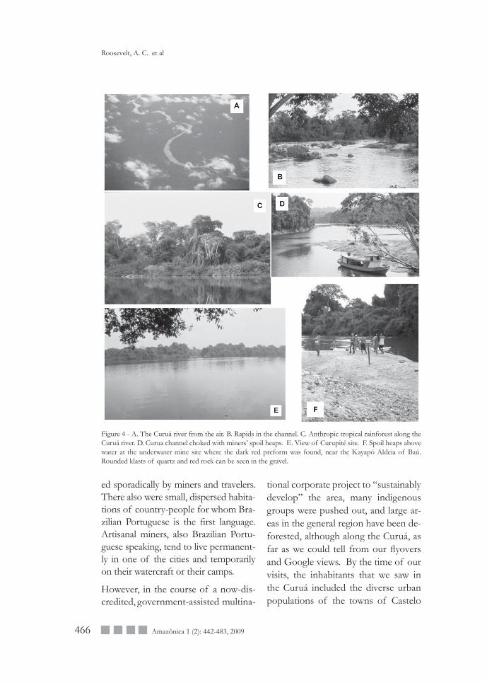
Figure 4 - A. The Curuá river from the air. B. Rapids in the channel. C. Anthropic tropical rainforest along the Curuá river. D. Curua channel choked with miners’ spoil heaps. E. View of Curupité site. F. Spoil heaps above water at the underwater mine site where the dark red preform was found, near the Kayapó Aldeia of Baú. Rounded klasts of quartz and red rock can be seen in the gravel.
ed sporadically by miners and travelers. There also were small, dispersed habita-tions of country-people for whom Bra-zilian Portuguese is the first language. Artisanal miners, also Brazilian Portu-guese speaking, tend to live permanent-ly in one of the cities and temporarily on their watercraft or their camps.
However, in the course of a now-dis-credited, government-assisted multina-
tional corporate project to “sustainably develop” the area, many indigenous groups were pushed out, and large ar-eas in the general region have been de-forested, although along the Curuá, as far as we could tell from our flyovers and Google views. By the time of our visits, the inhabitants that we saw in the Curuá included the diverse urban populations of the towns of Castelo
Roosevelt, A. C. et al
467Amazônica 1 (2): 442-483, 2009
de Sonhos and Novo Progresso, the dispersed, isolated family residences of rural peasants along the river, the miners’ camps, and the Curuaia and Kayapó villages, which are parts of in-digenous reserves. There also were sev-eral police and army posts at important river crossroads, as at Entre Rios.
The small number of artisanal miner groups have extensively disturbed the bed and waters of the Curuá. From the air, the river appears full of their min-ing spoil heaps (Figure 4D), and areas currently being mined have cloudy water and stagnant pools of polluted water. As yet, clear cutting is limited in this river drainage, though it is very ex-tensive and large-scale along the roads to towns like Castelo and Novo Pro-gresso from Santarém. The timber is cut and trucked out, and then the land is put to cattle. The loss of the forest vegetation causes soil erosion, increas-es the heat, and also diminishes rainfall by more than half, creating drought.
As yet there are not active excavations going on to loot archaeological sites. Our interviews with many miners working in the Curuá indicate that all the miners’ archaeological finds so far are accidental. There was no evidence at all that miners sought artifacts. Most of the finds that miners recognize as artifacts are brought up to their water-craft and left there on shelves or cub-bies sometimes for years. There are, however, people such as the hotelier in Castelo and the pilot and a govern-ment bureaucrat in Altamira, who pur-posely collect ancient stone tools and other artifacts that the miners find.
These collectors let it be known that they wish to purchase objects, and, in response, a few miners occasionally sell finds to them for small sums. Most often, however, the finds remain with the miners or they simply give them to an acquaintance or family member to keep. In the future, it would be good for a museum to organize periodic trips up the Curuá to collect these ob-jects for safekeeping and to document the oral histories of their archaeologi-cal context when memories are fresh.
As we went around in the Curuá area, we let it be known that, although it is a good idea to save found archaeological objects from loss by bringing them up to the watercraft and later transferring them to houses on land, objects should not be sold or altered and eventually should be placed in a museum or tribal collection. However, getting the objects to museums is harder than it sounds, since there are few nearby regional mu-seums, and those that there are, such as the Casa de Cultura of Santarém do not have trained curators, registrars, or guards, so objects often are not properly recorded or documented and frequently are given away or sold sur-reptitiously. When curators from the Goeldi Museum and Roosevelt tried to persuade the hotelier in Castelo to cede his collection to the Goeldi, he refused and later dispersed it, report-edly. He did allow us to record it and the Goeldi curators to register some of it, however. Unfortunately, many of those objects had been waxed by the hotelier’s wife, who thought they looked nicer all shiny.
Early hunter-gatheres in the terra firme rainforest: Stemmed projectile points from the Curuá goldmines
468 Amazônica 1 (2): 442-483, 2009
To try to understand more about the ar-chaeological and environmental context of the stone-tool finds, we reviewed the process of mining that produced the Curuá archaeological finds. The miners tend to have small, permanent homes in cities such as Castelo, Altamira, or Novo Progresso, but they usually also have several substantial pole-, mud-, metal-, and thatch-built campsites on the Curuá. From these, the miners go forth to work in small groups of three or four persons, usually relatives or close friends. They may or may not own a riverboat, but all have a “balsa”, which is a small hut made of poles and plastic tarps, all mounted upon two large, hol-low floating metal pontoons connected with a frame. The balsa may have its own motor for moving around or may moved by dragging behind another craft. Most also have a small log canoe or two, often with outboard motor. The group tends to stay out for a month or two during the time of low water, when the gravels are more accessible. Close communication is maintained through a network of miners, Indians, local government workers, and the clergy, who talk by radio and see each other frequently as they circulate among the mine sites, camps, and towns. Since ev-erybody knows everybody else’s busi-ness, word spreads quickly. This infor-mation network has allowed us to verify and disseminate information, ourselves.
It is not yet clear to us exactly how the miners identify gold-bearing sites and layers, but many did describe in similar detail the characteristic layers that tend to have gold. These are the
coarser gravels that lie deep in the bed stratigraphy directly above a layer of greenish-grey fine, clayey sediment. The gold occurs along with black gran-ules at the juncture of these two layers. Above these gravels lie the sands being deposited recently or presently. The gravel-sand sequence gets finer from the base upwards.
When they have decided upon a site to mine, they tie up the balsa to a tree or anchor it by cord attached to a submerged weight on the bottom. The balsa has a motor pump with a plastic tube to suck up water and sediment from the bottom and pour it over a slanted, corrugated-surface sorting table, which allows the sedi-ment to separate out by weight. One person stands at the sorter and picks out gold nuggets or flakes. Another person is under the water with a wet suit, mask, and breathing tube to hold the other end of the tube in whatever layer is being processed. It is usually at this point that he notices the artifacts, as some are too large to go up the tube or might clog it. At Curupité, anyway, both artifacts were recognized by the diver when they were uncovered as he sucked up the gravel around them.
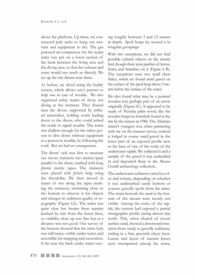
PRELIMINARY RESEARCH AT CURUPITÉTo locate the Curupité site in advance of traveling there, we made several flyovers with air-taxi so that the miner could indicate the site and the pilot then mark its GPS coordinates. (GPS coordinates taken by our team in the Curuá are filed at IPHAN in Belém.)
Roosevelt, A. C. et al
469Amazônica 1 (2): 442-483, 2009
The site is a quiet stretch of the Curuá opposite a small, right-hand tributary, about a half hour upstream of the Cu-ruaia Aldeia (Figure 4E).
In 2001, we tied up the riverboat and two canoes with outboard motors near the site, set the air-compressor up on the beach to fill the scuba tanks, and dove down to the river-bottom from the shore there. The miners located the approximate site of the abandoned mine-pit from its underwater spoil heaps and from the pattern of rocks in the mostly-underwater rapids down-stream from the mine site. To identify the spoil heaps underwater we swam in teams of two back and forth across the approximate location from the bank to the center of the stream.
Our equipment at the time included the air compressor for our tanks, five tanks, three vests, and three masks, which we hung to dry from the an-chor ropes of the boats. We followed the buddy system when we dove. After locating, marking with GPS, and veri-fying the general characteristics of the submerged mine spoils, we left.
In 2002, we anchored the two riverboats downriver from the mine site and lived on them. We mapped and dove down from the shore overlooking the mine.
We had brought with us two canoes with paddles and outboard motors to traverse the water for diving and map-ping. We had three wet suits, three diving vests, five masks, five air tanks, one pressure gauge, and an underwater camera with non-changeable focus and pressure-range up to 45 meters. The
camera was the Sea&Sea Motor Ma-rine 25 MX-10 with 20mm U/W Wide conversion lense sports finder, close-up lens, and YS-40A Auto Strobe. For additional light we used a gun-style un-derwater flashlight. We mapped with the project Topcon total station laser theodolite and metric rod with prism. Our lap-top computers were gateway solos, and our portable battery printers were Canon BCJ 85s and Pixma 90s. We used our old solar panels (pur-chased in the1980s) to run the com-puters and printers to charge camera batteries. The GPS instruments were by Garmin. We brought an old two-way radio on loan from Santarém but it did not work well there, perhaps be-cause of the tall forest vegetation.
John Douglas, who made the map (Figure 5), first recorded the location of the datum, the boundaries of the area around the mine, and their topog-raphy. Then, with team members tak-ing turns holding the prism rod either on land or on the bottom (from one of the canoes), he made a detailed map of the topography and features of the bank, beach, stream bed, mine hole, spoil heaps, and the rocks that project-ed above the surface.
More rocks lay beneath the surface, and altogether they would have composed a rapids, in a situation of lower water levels. Such rapids are good places to spear or net fish.
At the bank we constructed a small wooden platform near the water’s edge at which we could enter and climb out of the water. We suited up on the bank
Early hunter-gatheres in the terra firme rainforest: Stemmed projectile points from the Curuá goldmines
470 Amazônica 1 (2): 442-483, 2009
above the platform. Up there, we con-structed pole racks to hang our wet-suits and equipment to dry. The gas powered air-compressor for the scuba tanks was put on a lower section of the bank between the living area and the diving area, so that the exhaust and noise would not reach us directly. We set up the site datum near there.
As before, we dived using the buddy system, which allows one’s partner to help one in case of trouble. We also organized safety teams of those not diving at the moment. They floated near the divers, supported by inflat-ed innertubes, holding cords leading down to the divers, who could jerked the cords to signal trouble. The water was shallow enough for the safety per-son to dive down without equipment to a person in trouble, by following the cord. But we had no emergencies.
The divers’ task was first to measure out survey transects two meters apart parallel to the shore, marked with long plastic metric tapes. The transects were placed with John’s help using the theodolite. We then moved in teams of two along the tapes mark-ing the transects, swimming close to the bottom to observe it for objects and changes in sediment quality or to-pography (Figure 6A). The water was quite clear but brown from tannins leached by rain from the forest litter, so visibility close up was fine but at a distance was not good. Our survey of the bottom showed that the mine hole was still intact, visible under water, and accessible for mapping and excavation. It lay near the bank under water vary-
ing roughly between 3 and 12 meters in depth. Spoil heaps lay around it in irregular groupings.
With two exceptions, we did not find possible cultural objects on the stream bed, though there were patches of leaves, fruits, and branches on it (Figure 6 B). The exceptions were two small chert flakes, which we found amid gravel on the surface of the spoil heap about 3 me-ters below the surface of the water.
We also found what may be a pointed wooden rod, perhaps part of an arrow originally (Figure 6C). It appeared to be made of Paxiuba palm wood, like the wooden harpoon foreshaft found at the site by the miners in 1986. The Altamira miner’s youngest son, when partnering with me on the transect survey, noticed it lodged in coarse sand/gravel in the lower part of an exposed profile next to the base of one of the rocks of the underwater rapids. We collected it and a sample of the gravel it was embedded in and deposited them in the Museu Goeldi archaeology collection.
The underwater sediment varied in col-or and texture, depending on whether it was undisturbed sandy bottom or coarser, gravelly spoils from the mine. The strata beneath the sand at the bot-tom of the stream were mostly not visible. Among the rocks of the rap-ids, the current had exposed a partial stratigraphic profile facing almost due north. This, when cleared of recent surface sand, showed a downward tran-sition from sandy to gravelly sediment, ending in a fine, greenish clayey layer. Lenses and layers of ancient leaves were interspersed among the strata,
Roosevelt, A. C. et al
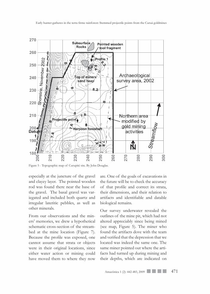
471Amazônica 1 (2): 442-483, 2009
especially at the juncture of the gravel and clayey layer. The pointed wooden rod was found there near the base of the gravel. The basal gravel was var-iegated and included both quartz and irregular lateritic pebbles, as well as other minerals.
From our observations and the min-ers’ memories, we drew a hypothetical schematic cross-section of the stream-bed at the mine location (Figure 7). Because the profile was exposed, one cannot assume that strata or objects were in their original locations, since either water action or mining could have moved them to where they now
Figure 5 - Topographic map of Curupité site. By John Douglas.
Early hunter-gatheres in the terra firme rainforest: Stemmed projectile points from the Curuá goldmines
are. One of the goals of excavations in the future will be to check the accuracy of that profile and correct its strata, their dimensions, and their relation to artifacts and identifiable and datable biological remains.
Our survey underwater revealed the outlines of the mine pit, which had not altered appreciably since being mined (see map, Figure 5). The miner who found the artifacts dove with the team and verified that the depression that we located was indeed the same one. The same miner pointed out where the arti-facts had turned up during mining and their depths, which are indicated on
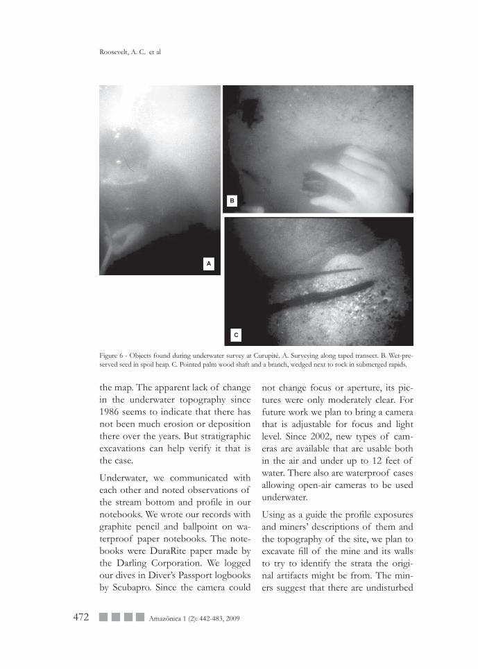
472 Amazônica 1 (2): 442-483, 2009
the map. The apparent lack of change in the underwater topography since 1986 seems to indicate that there has not been much erosion or deposition there over the years. But stratigraphic excavations can help verify it that is the case.
Underwater, we communicated with each other and noted observations of the stream bottom and profile in our notebooks. We wrote our records with graphite pencil and ballpoint on wa-terproof paper notebooks. The note-books were DuraRite paper made by the Darling Corporation. We logged our dives in Diver’s Passport logbooks by Scubapro. Since the camera could
Figure 6 - Objects found during underwater survey at Curupité. A. Surveying along taped transect. B. Wet-pre-served seed in spoil heap. C. Pointed palm wood shaft and a branch, wedged next to rock in submerged rapids.
not change focus or aperture, its pic-tures were only moderately clear. For future work we plan to bring a camera that is adjustable for focus and light level. Since 2002, new types of cam-eras are available that are usable both in the air and under up to 12 feet of water. There also are waterproof cases allowing open-air cameras to be used underwater.
Using as a guide the profile exposures and miners’ descriptions of them and the topography of the site, we plan to excavate fill of the mine and its walls to try to identify the strata the origi-nal artifacts might be from. The min-ers suggest that there are undisturbed
Roosevelt, A. C. et al
473Amazônica 1 (2): 442-483, 2009
Figure 7 - Schematic hypothetical profile of the Curuá river bed sediments at the mine at Curupité.
strata under the spoil deposit adjacent to the mine pit. We wish to check the location for more cultural objects and collect them in their stratigraphic context with associated sediment and biological remains. Some dislodged objects may have gone unnoticed dur-ing mining, and others may still be in place in undisturbed strata. We plan to excavate in “natural” levels, following the layers and lenses in the deposits. Both our and the miners’ observations reveal that there are clear cut layers dis-tinguishable by color, grain size, com-position, hardness, shape of layer, and location in the profile.
We plan to first excavate a trench from the bank down through the middle of the mine pit and beyond its far sidewall to expose strata in the landward and riv-erward sidewalls and to clear out its fill. We also will dig another trench parallel to the bank from the rapids from its
upstream sidewall through the middle of the mine pit and beyond its down-stream sidewall, to expose the strata there. Then we will excavate the block extending from where the artifacts were found into the adjacent mine pit sidewall downriver, to record the strata nearest to the find places. If we find intact stratigraphic sequences, we will sample them, record their Munsell col-ors and collect from them any cultural or environmental materials to analyze for dating and paleoecological informa-tion. If time allows, we will remove all the fill from the pit and excavate though all the spoil heaps, to check for any ad-ditional cultural artifacts that were dis-lodged and lost during mining. All sedi-ment will be fine-screened and floated to recover smaller identifiable materials.
From what we know about Curupité so far, it is likely that the ancient remains there represent a brief occupation or
Early hunter-gatheres in the terra firme rainforest: Stemmed projectile points from the Curuá goldmines
474 Amazônica 1 (2): 442-483, 2009
occupations to spear fish at the rapids during the annual fish runs. If it rep-resents only one visit, then there may have been very few objects left there, perhaps little more than those already found, plus some chips from shaping pole for racks and charcoal from fires to smoke the fish. If, however, the fishing groups were large or the visits repeat-ed, the site might contain a number of stone and wood artifacts and possibly also some fishbone, discarded during processing. Although bone may not be well preserved in the acid waters from rainforests, the pH of the water at the archaeological layer might have been sufficiently buffered by calcareous ele-ments in the clays to prevent dissolu-tion of bone. Nevertheless, being able to verify the stratigraphic context and biological associations of even a few artifacts whether dislodged or in place would be a useful step in fleshing out the nature of the culture.
We also hope that the Curuá waters may contain the remains of stationary struc-tures for fishing: fish fences, dams, fish baskets, paddles, poles, and watercraft. Although late prehistoric ones may be more numerous and accessible, Holo-cene sedimentation would be expected to have covered up and preserved any from the Terminal Pleistocene.
While working at Curupité, we met with leaders from the Curuaia Aldeia down-river from the site and with the Funai representative there. We discussed at length the reason for our interest in the site and brought Curuaia leaders upriver and took them underwater with diving gear to show them the site.
We explained our research plans and hopes for excavating Curupité in the future. We asked if it might be possible to recruit young people of the Aldeia to join the research as part of the en-vironmental archaeology field school. In fact, the leaders expressed interest in possibly participating in future re-search and a field school, themselves.
THE VISIT TO BAÚ IN 2005Our knowledge of and planning for research at two other important lithic find sites in the Curuá is still very pre-liminary.
In Fall of 2005 we went back to the Curuá to try to locate the two biface find-sites we had heard of that might be lithic workshops. These were two underwater sites near the Kayapó Al-deia Baú, which lies junction of the Curuá and Baú river, a tributary. The two as yet unnamed sites lie beyond the Aldeia in the Curuá between its junc-ture with Baú and the Pitiatiá river.
The first site we visited was the one where miners had found the crystal point and perhaps quartz debitage. At the time of our visit the site was com-pletely under water. We were able to dive down to it unaided by equipment but found the water too deep and too fast for an examination of the sub-merged mine.
The second site was where miners had found the dark red chalcedony preform. Part of this site’s spoil heaps were still above water (Figure 4F), so we were able to examine them for lithic raw ma-terial and other remains. We surveyed
Roosevelt, A. C. et al
475Amazônica 1 (2): 442-483, 2009
their surface and found small weathered pieces of red rock, though all appeared natural, not flaked by humans. We also observed fragmentary wet-preserved plant remains and gravel.
Our observations at these two sub-merged sites, the bifaces found at them, and oral history information about them encourage us to consider return-ing at some point to descend with div-ing equipment to examine, survey, and map their underwater surfaces. The fact that one site had an unfinished preform biface is quite strong evidence that it was a lithic workshop and therefore might yield information about the man-ufacture and function of the lithics and possibly also might have wet-preserved wooden artifacts and environmental and paleodietary remains produced and discarded while the occupants were camping there. If so, excavating it might help us make progress in defin-ing the age, environment, lifestyle, and cultural affiliations of the occupation site. As for the site where the crystal point was recovered, we were not able to make progress in evaluating the site archaeologically because of the depth and force of the water over it when we were there. It seems that we might have better access to the site earlier in the Fall or during a year of generally low water in the Amazon. So although this site had some physical problems for our ac-cess, they do not seem insurmountable for future research with diving equip-ment. This site also, if the reports of debitage are correct, might yield infor-mation about lithic manufacturing and camping activities.
In our discussions with the Kayapó, we ascertained that the community and its leaders were not averse in principle to our returning for further research at the sites. As with the Curuaia, we explained that we would be interested in recruit-ing young people from the community to join our research as part of the en-vironmental archaeology field school, and the leaders expressed interest in such a collaboration. We also offered to film or record photographically for them any aspect of the knowledge and activities of the community that it would like to memorialize. That offer also appeared to be of possible interest to them for a future visit. Further, as in the case of the Curuaia, the relevant Funai representatives expressed sup-port in principle for a future applica-tion by us for access to the area for the research, pedagogic, oral history, and community activities, as defined.
Before we left this section of the Curuá on this visit, we were able to see and study the crystal point. One of the min-ers present when the point was found turned up unexpectedly at the small port at the road where we embarqued for Baú in the Kayapó outboards. He was there waiting for us when we re-turned from visiting the underwater site on our way back to the highway to head for Santarém. The crystal point apparently had been removed from its find site by this miner. Earlier, we had spread the word through the miner/indigenous networks in the region that the point should be returned to the site or donated to a public museum. In response, he had brought it back. The
Early hunter-gatheres in the terra firme rainforest: Stemmed projectile points from the Curuá goldmines
476 Amazônica 1 (2): 442-483, 2009
Kayapó representatives present felt the point should be returned for safekeep-ing to their Aldeia, the nearest place to its find spot. It would be kept as an heirloom with the ceremonial treasures of the community.
This seemed a good solution to the problem of where it should go. Al-though cultural objects kept in the communities near where they were found indeed can be lost, that also hap-pens to those deposited in museums that have curators. All the finely flaked concave-base points in the Santarém Casa de Cultura disappeared from that collection sometime between 1981 and 2000. Similarly, the projectile points that Hartt had collected from residents near Taperinha were mislaid at the Na-tional Museum in Rio de Janeiro some-time after being deposited there and therefore were unavailable for study by us. Also, despite some movements of ethnographic groups in Amazo-nia, groups often are at or near their ancient homelands or the homelands of closely related people. Therefore, it would not be unreasonable for them to retain in their communities important objects of cultural heritage, especially since some indigenous people in the Curuá told us that outsiders often ques-tioned the fact that Amazonian Indians once held sway over all of Amazonia, a fact virtually all anthropologists hold as true on a large body of evidence. In this light of cultural affinity, the great urban museum, with few if any Native Amazonian staffers may not seem as apt a repository.
THE ROLE OF LOCAL PEOPLEIN SCIENTIFIC DISCOVERY AND CULTURAL REVITALIZATIONRelevant both to archaeological meth-od and to public archaeology, our experience is that important findings about Amazonia began in knowledge by local people. The most informative sites Roosevelt have worked at that changed ideas of Amazon prehistory were not in the archaeology textbooks but nonetheless were well-known to local people. The region is so large that only a very small fraction of it has been studied by archaeologists. Despite local people’s role, in the pub-lic sphere they often are not credited for their roles in scientific and cultural discoveries, whilst that of the scientist usually is. Their knowledge and its role in science needs to be acknowledged, celebrated, recorded, and published. The scientific resource that this knowl-edge constitutes also needs to be treat-ed as scientific documentation by the organized elicitation, preservation, and public circulation of oral histories. In Brazil recently the National Institute of Historic and Artistic Patrimony (Iphan) has already made progress in this direction by organizing exhibitions and public programs on the subject of popular culture and arts. For this insti-tute, both vernacular and elite culture are integral parts of the patrimony. The scientific community also needs to get more involved in finding local savants, drawing out their accounts, disseminat-ing the information, and crediting their sources. But more important will be the provision of resources and equip-
Roosevelt, A. C. et al
477Amazônica 1 (2): 442-483, 2009
ment to support more agency by local people in such a discovery process. The best outcomes will come when local communities have the awareness and the wherewithall to bring out, dis-seminate, use, and preserve such infor-mation themselves.
For this to happen, they also must have more adequate access to high qual-ity educational resources. Being from distant rural areas, they often don’t get very good lower schooling and so don’t have good access to a university education. In the US several men who rose to leading or influential positions in Paleoindian archaeology came from rural families in the country. Through working with scholars in fieldwork and through public resources they were able to advance their educations and so qualify as professional archaeologists. Among Brazilian artisanal miners and peasant and indigenous populations of the Curuá there also are people with the energy and intellectual ability to con-tribute to and benefit from Amazon knowledge as scientists and teachers in the future, if they can get access to the educational resources they need.
In addition, having collections physi-cally centralized in large regional or central repositories, though convenient in some ways curatorially and for pub-lic education, is not necessarily the best solution to the safekeeping and study of them and the dissemination of in-formation on them. Having local mu-seums within an archaeological region means that the people there can bet-ter benefit from their services and also contribute to their programs. We have
found that knowledge of the long and rich prehistory of Amazonian Indians had often not filtered down to Alde-ias or even to regional capitals. Local museums would help disseminate in-formation about the long and brilliant culture history of the Amazon.
In some countries, such as Mexico, there is a strong tradition of excellent local and site museums. In other coun-tries, such as Peru and China, such mu-seums may be few, but regardless they greatly enhance the cultural knowledge of both local people and visitors from the outside. Perhaps in Japan, the inte-gration of local people with museums has been done best. There are many municipality sponsored universities and research institutes, and the large regional museums, such as the Lake Biwa Museum, are active in recruiting these and the local people to help in the process of finding, preserving, and disseminating information about im-portant historical scientific resources, such as archaeological or paleontologi-cal sites. At Lake Biwa, in addition, the development of activities such as lo-cal paleontology “clubs” with regular field-trips was generally felt to have diminished the destruction or looting of paleontological sites.
One change that is needed is for large funding agencies to change their poli-cies to include grants to support ex-cellent candidates from educationally underserved rural regions. Funds for the improvement of local-based edu-cation, research and museums also could be obtained from the huge prof-its accrued by the large, often foreign
Early hunter-gatheres in the terra firme rainforest: Stemmed projectile points from the Curuá goldmines
478 Amazônica 1 (2): 442-483, 2009
concerns involved in extractive exploi-tation in Amazonia. At present, local, state, and central government officials absolutely scurry to give these com-panies easements from permits and discounts from taxes and even allow them to use government resources and equipment that properly should be only for the use of local citizens, groups, and businesses. Instead, the price of business should be that they desist from abusive company practices that damage local communities, busi-nesses, and environments and should in addition contribute significantly to local educational institutions, to scholarships for college and graduate school, and to the building and staffing of local museums. Furthermore, local police and security forces, rather than being put to the use of the foreign cor-porations, as we saw being done in the Curuá area in 2001, could be organized and trained to protect local cultural re-sources, such as sites and artifacts, and to enforce the law against perpetrators who destroy and loot them. Much time, effort, and money goes into the exigent process of awarding research permits to archaeologists, but ironically they may find their desired research sites to be damaged because there is not a con-certed program to protect sites.
TWO SIDES TO THE COININ ARTISANAL GOLD MINING AND ARCHAEOLOGY IN THE CURUÁArtisanal mining in the Curuá is both a source of knowledge and local earn-ings and a cause of environmental and cultural damage and harm to human
health. Nearly all the discoveries of lo-cal archaeological cultures there come from the mining, and knowledge of these cultures is held and disseminated by the miners. Without them and their work, there really would not be any knowledge of Curuá archaeology.But, like mining by corporations, ar-tisanal mining, although smaller scale, is harmful in many ways. Ancient sites and geological deposits over large areas are disturbed and damaged by it. Clear forest streams become sedi-ment-filled, with bad consequences for fishing. Water becomes polluted with chemicals and infectious organ-isms, and clearings and stagnant ponds are created that increase the incidence of malaria.
What to do about it? Solution options depend to some degree on the geology of gold deposits in the Curuá. If the original gold sources from which the alluvial “placer” gold deposits come could be located, then in theory min-ing could be more contained spatially. Because placer deposits are diffuse, miners have to disturb a large area and process a lot of sediment to get even a little gold, and for this they are paid a pittance. It seems clear, how-ever, that handing source mining over to extractive companies is not the an-swer. Their past history in Amazonia and elsewhere reveals their strong ten-dency to disregard community rights and interests in the resources that they mine. But perhaps the creation of re-gional cooperatives at mother lodes would be a way to limit the areal extent of damage but retain local peoples’
Roosevelt, A. C. et al
479Amazônica 1 (2): 442-483, 2009
control of the resource and access to its benefits. The theoretical school of heterarchy in anthropology holds that small-scale, bottom up processes of organizing can be more informed, cre-ative, adaptive, efficient, and beneficial than top-down, centralized processes controlled from the outside. If so, then local communities need to get into the act by starting the organizing process themselves. What governments can do to help is prevent unwanted outside interference by large concerns, provide any needed extension and credit, and then get out of the way.
REFERENCESAnderson, B. G. and H. W. Borns. 1994. The Ice Age World. Oslo, Norway: Scandi-navian University Press.
Angelo, C. Monteiro de Almeida. 2005. Folha Ciencia December 3: A31.
Ardila Calderon, G. I. 1991. The peopling of northern South America, in Clovis: ori-gins and adaptations. Center for the Study of the First Americans, pp. 261-282. Edited by R. Bonnichsen and K. L. Turnmire. Corval-lis, OR: Oregon State University.
Balée, W. 1989. The culture of Amazonian forests. Advances in Economic Botany 7: 1-20.
___. 1994 Footprints of the Forest: Ka’apor Ethnobotany - the Historical Ecology of Plant Utlilization by an Amazonian People. New York: Columbia University Press.
Beckerman, S. 1994. Hunting and fishing in Amazonia: Hold the answers, What are the questions?, in Amazonian Indians from Prehistory to the Present: Anthropological Perspec-tives, pp. 177-200. Edited by A.C. Roosevelt. Tuscon: University of Arizona Press.
Bailey, R. C., G. Head, M. Jenike, B. Owen, R. Rechtman, and E. Zechenter. 1989. Hunt-ing and gathering in tropical rainforest: Is it possible? American Anthropologist 91: 59-82.
Binford, L. R. 1968. Post-Pleistocene ad-aptations, in New Perspectives in Archaeology, pp. 313-341. Edited by S. R. Binford and L. R. Binford. Aldine, Chicago, IL.
Bodenheimer, F. 1951. Insects as Human Food. The Hague, Netherlands: Dr. W Junk Publishers.
Borrero, L. A. 1996. The Pleistocene-Holocene transition in southern South America, in Humans at the End of the Ice Age, pp. 339-354. Edited by L. G. Straus, B. V. Ericksen, J. M. Erlandson, and D. R. Yesner. New York, NY: Plenum.
Boyd, R. (editor). 1999. Indians, Fire, and the Land in the Pacific Northwest. Corvallis, OR: Oregon State University.
Bryant, V. M. and R. C. Holloway (editors). 1985. Pollen records of late quaternary north american sediments. Dallas, TX: American Association of Stratigraphic Palynologists Foundation.
Byers, D. A. and A. Ugan. 2005. Should we expect large game specialization in the late Pleistocene? An Optimal Forag-ing perspective on early Paleoindian prey choice. Journal of Archaeological Science 32: 1624-1640.
Chauchat, C. 1988. Early hunter-gatherers on the Peruvian Coast, in Peruvian Prehisto-ry, pp. 41-66. Edited by R. Keatinge. Cam-bridge, UK: Cambridge University Press.
____. 1992. Prehistoire de la Cote Nord du Perou: Le Paijanien de Cupisnique. Cahiers du Quaternaire No. 18. Centre National de la Recherche Scientifique Editions, Centre Re-gional de Publication de Bordeaux. 391 pp.
Early hunter-gatheres in the terra firme rainforest: Stemmed projectile points from the Curuá goldmines
480 Amazônica 1 (2): 442-483, 2009
Chilton, E. S. 2004. Beyond “Big”: Gender, age, and subsistence diversity in Paleoindian societies, in The Settlement of the American Continents: A Multidisciplinary Approach to Hu-man Biogeography, pp. 162-172. Edited by C. M. Barton, G. A. Clark, and D. R. Yesner. Tucson: University of Arizona Press.
Colinvaux, P. A., P. E. de Oliveira, P. E. Moreno, M. C. Miller, and M. B. Bush. 1996. A long pollen record from lowland Amazonia: Forest and cooling in glacial times. Science 274: 85-88.
Dahlberg, F. (editor). 1981. Woman the Gath-erer. New Haven, CT: Yale University Press.
Dart, R. A. 1953. The predatory transition from ape to man. International Anthropologi-cal and Linguistic Review 1: 201-218.
Darwin, C. 1871. The Descent of Man and Selection in Relation to Sex. New York, NY: George Macy Companies.
De la Penha, G., S. de Almeida Bruni, and N. Papavero (editors). 1986. O Museu Paraense Emilio Goeldi. São Paulo: CNPq and Banco Safra.
Dent, R. J. 2007. Seed collecting and fish-ing in the Shawnee Minisink Paleoindian site, in Foragers of the Terminal Pleistocene in North America, pp. 116-131. Edited by R. B. Walker and B. N. Driskell. Lincoln, NB: University of Nebraska Press.
Dorfman, J. 2002. The Amazon trail. Dis-cover May 1:1-9.
Dufour, D. L. 1987. Insects as food: A case study from the northwest Amazon. Ameri-can Anthropologist 89(2): 383-387.
Enright, N. J. and R. S. Hill (editors). 1995. The Ecology of the Southern Conifers. Washing-ton, D. C. Smithsonian Institution Press.
Evans, C. and B. J. Meggers. 1961. Archae-ological Investigations in British Guiana.
Smithsonian Institution, Bureau of American Ethnology, Bulletin 177. Washington, D. C.
Fittkau, E. J. and H. Klinge. 1973. On bio-mass and trophic structure of the Central Amazon rainforest. Biotropica 5:1-14.
Fitzhugh, W. W. and A. Crowell. 1988. Crossroads of Continents. Washington, D.C.: Smithsonian Institution.Grayson, D. K. and D. J. Meltzer. 2002. Clovis hunting and large mammal extinc-tion: A critical review of the evidence. Jour-nal of World Prehistory 16(4): 313-359.
____.2003 A requiem for North Ameri-can overkill. Journal of Archaeological Science 30: 585-593.
Gremillon, K. J. (editor). 1997. People, plants and landscapes: studies in paleoethnobotany. Tus-caloosa, AL: University of Alabama Press.
Haberle, S. G, and M. A. Maslin. 1999. Late Quaternary vegetation and climate change in the Amazon basin based on a 50,000 year pollen record from the Amazon fan, ODP site 932. Quaternary Research 51:27-38.
Hart, C. W. M. and A. R. Pilling. 1964. The Tiwi of North Australia. New York: Holt, Rinehart and Winston.
Hart, T. B. and J. A. Hart. 1986. The eco-logical basis of hunter-gatherer subsistence in African rainforests: The Mbuti of east-ern Zaire. Human Ecology 14(1): 29-55.
Hartt, C. F. 1871. Brazilian rock inscrip-tions. American Naturalist 5(3): 139-147.
Heinen. 1988. Oko Warao: Marshland People of the Orinoco Delta. Ethnologische Studien Band 4. Munster, Germany.
Henderson, A. 1995. Palms of the Amazon. New York: Oxford University Press.
Keefer, D., S. deFrance, M. E. Moseley, J. B. Richardson III, D. R. Satterlee, and A. Day-Lewis. 1998. Early maritime economy
Roosevelt, A. C. et al
481Amazônica 1 (2): 442-483, 2009
and El Nino events at Quebrada Tacahuay, Peru. Science 281:1833-1835.
Kingdon, J. 1997. The Kingdon Field Guide to Af-rican Mammals. San Diego: Academic Press.
Kornfeld, M. 2007. Are Paleoindians of the Great Plains and Rockies subsistence specialists?, in Foragers of the Terminal Pleis-tocene in North America, pp. 32-58. Edited by R. B. Walker and B. N. Driskell. Lincoln, NB: University of Nebraska Press.
Lathrap, D. W. 1968. The “hunting” economies of the tropical forest zone of South America: An attempt at historical perspective, in Man the Hunter, pp. 23-29. Edited by R. B. Lee and I. DeVore. Chi-cago, IL: Aldine Publishers.
___. 1970. The Upper Amazon. New York: Praeger Publishers.
Lee, R. B. and R. Daly (editors). 1999. Cam-bridge University Encyclopedia of Hunter-Gath-erers. Cambridge, UK: Cambridge U. Press.
Lopes de Castano, C. 1995. Dispersion de puntas de proyectil bifaciales en la cuenca media del rio Magdalena, in Ambito: Ocu-paciones Tempranas de America Tropical, pp. 73-82. Fundacion ERIGAIE, Institute Colombiano de Antropologia, Bogota, Columbia.
Lorenzi, H. 2002. Brazilian Trees: A Guide to the Identification and Cultivation of Brazil-ian Native Trees. Vol. 1. fourth edition and Volume 2 second edition. Nova Odessa, BR: Instituto Plantarum de Estudos da Flora Ltda.
Lynch, T. F. (editor). 1980. Guitarrero Cave: Early Man in the Andes. New York: Aca-demic Press, New York, NY.
Lynch, T. F, R. Gillespie, and J. Gowlett. 1985. Chronology of Guitarrero Cave, Peru. Science 229:864-867.
Martin, M. K. and B. Voorhies. 1975. The Female of the Species. New York, NY: Co-lumbia University Press.
Mason, O. T. 1902. Aboriginal American Harpoons: A Study in Ethnic Distribution and Invention. Smithsonian Annual Report for 1900. Washington, D. C. Smithsonian In-stitution. Pp. 189-349.McWeeney, L. 2007. Revising the Paleoin-dian environmental picture in Northeastern North America, in Foragers of the Terminal Pleistocene in North America, pp. 148-167. Ed-ited by R. B. Walker and B. N. Driskell. Lin-coln, NB: University of Nebraska Press.
Miracle, M. 1966. Maize in Tropical Africa. Madison, WI: University of Wisconsin Press.
Meggers, Betty J. 1954. Environmental Limitation on the Development of Culture. American Anthropologist 56(5): 801-824.
____. 1971. Amazonia: Man and Nature in a Counterfeit Paradise. Chicago: Aldine Publishers.
Meggers, B. J., E. S. Ayensu, and W. D. Duck-worth (editors). 1973. Tropical forest ecosystems in africa and south america: a comparative review. Washington, D. C: Smithsonian Press.
Menzies, C. R. (editor). 2006. Traditional eco-logical knowledge and natural resource management. Lincoln, NB: University of Nebraska Press.
Michab, M., J. K. Feathers, J.-L. Joron, N. Mercier, M. Selos, H. Valladas, J.-L. Reyss, and A. C. Roosevelt. 1998. Luminescence dates for the paleoindian site of Pedra Pin-tada, Brazil. Quaternary Geochronology 17(11): 1041-1046.
Minnis, P. E. and W. J. Elisens (editors). 2000. Biodiversity and Native America. Nor-man, OK: University of Oklahoma Press.
Mitani, M., S. Kuroda, and C. E. G. Tutin (editors). 1994. Floral lists from five study sites of apes in the african tropical forests.
Early hunter-gatheres in the terra firme rainforest: Stemmed projectile points from the Curuá goldmines
482 Amazônica 1 (2): 442-483, 2009
Tropics 3(3/4): 247-348.
Pereira, E. 2003. Arte Rupestre na Amazo-nia - Pará. Belém: Museu Paraense Emilio Goeldi and São Paulo: UNESP.
Politis, G. 2007. Nukak: Ethnoarchaeology of an Amazonian People. Walnut Creek, CA: Left Coast Press and London: University College London Institute of Archaeology Publications.Prous, A. 1995. Archaeological analysis of the oldest settlements in the Americas. Re-vista Brasileira de Genetica 18:689-699.
____.1999. As primeiras populações do Estado de Minas Gerais, in Pré-Historia da Terra Brasilis, pp. 101-114. Edited by M. C. Tenorio. Rio de Janeiro: UFRJ.
Rick, J. W. 1980. Prehistoric Hunters of the High Andes. Academic Press, New York, NY.
Roosevelt, A. C. 1989. Resource management in the Amazon Basin before the European conquest: Beyond ethnographic projection, in Natural Resource Management by Indigenous and Folk Societies in Amazonia, edited by D. Posey and W. Balee. New York Botanical Garden. Advances in Economic Botany, No. 7: 30-61.
____. 1991. Mound-builders of the Amazon: Geophysical Archaeology on Marajo Island, Bra-zil. Studies in Archaeology. San Diego: Academic Press.
____.1995. Early pottery in the Amazon: twenty years of scholarly obscurity, in The emergence of pottery: Technology and innovation in ancient societies, pp. 115-13. Edited by W. Barnett and J. Hoopes. Washington, D. C.: Smithsonian Institution.
____. 1998a. Ancient and modern hunt-er-gatherers of lowland South America: An evolutionary problem, in Advances in Historical Ecology, pp. 190-212. Edited by W. Balee. New York: Columbia U. Press.
____. 1998b. Paleoindian and archaic occu-pations in the lower Amazon, Brazil: a sum-mary and comparison, in Festschrift honoring Wesley Hurt, pp. 165-192. Edited by Mark Plew. Lanham, Md.: U. Press of America.
____. 1999. Ancient hunter-gatherers of South America, in Cambridge University Encyclopedia of Hunter-Gatherers, pp. 86-92. Edited by R. Lee and R. Daly. Cambridge: Cambridge U. Press.
____. 2000a. The lower Amazon: a dynamic human habitat in Imperfect balance: landscape transformations in the precolumbian Americas, pp. 455-491. Edited by D.L. Lentz. New York: Columbia University Press.
____. 2000b. New information from old collections: The interface of science and systematic collections. Cultural Resource Management 23(5): 25-29. U. S. Department of the Interior, National Park Service, Cul-tural Resources.
____. 2002. Gender in human nature: sociobiology revisited and revised, in In pursuit of gender: Worldwide archaeological ap-proaches, pp. 355-376. Edited by S.M. Nel-son and M. Rosen-Ayalon. Walnut Creek, CA: Altamira Press.
____. 2005. Ecology in human evolution: origins of the species and of complex so-cieties, in A catalyst for ideas: anthropological archaeology and the legacy of Douglas Schwartz, Pp. 169-208. Edited by V. Scarborough. Santa Fe: School of American Research.
Roosevelt, A. C., J. E. Douglas, and L. J. Brown. 2002. Migrations and adaptations of the first Americans: Clovis and Pre-Clovis viewed from South America, in The first Americans: The Pleistocene colonization of the New World, pp. 159-236. Edited by Nina Jablonski. Memoirs of the California Academy of Sciences No. 27. Berkeley: University of
Roosevelt, A. C. et al
483Amazônica 1 (2): 442-483, 2009
California Press and the California Acad-emy of Sciences.
____. nd Clovis in Context: New Light on the Peopling of the Americas. Book in prepara-tion. Pp. 550 typescript.
Roosevelt, A. C., R. Housley, I. Imazio da Silveira, S. Maranca, and R. Johnson. 1991. Eighth Millennium Pottery from a Prehis-toric Shell Midden in the Brazilian Ama-zon. Science 254(5038): 1621-1624.
Roosevelt, A. C., M. Lima Costa, C. Lopes Machado, M. Michab, N. Mercier, H. Valladas, J. Feathers, W. Barnett, M. Im-azio da Silveira, A. Henderson, J. Sliva, B. Chernoff, D. Reese, J. A. Holman, N. Toth, and K. Schick. 1996. Paleoindian Cave Dwellers in the Amazon: The Peopling of the Americas. Science 272: 373-384.
Roosevelt, A. C., M. Lima da Costa, L. J. Brown, J. E. Douglas, M. O’Donnell, E. Quinn, J. Kemp, C. Lopes Machado, M. Imazio da Silveira, J. Feathers, and A. Hen-derson. 1997. Dating a Paleoindian Site in the Amazon in Comparison with Clovis Culture. Science 275: 1950-1952.
Schmitz, P. I. 1987. Prehistoric hunter-gatherers of Brazil. Journal of World Prehis-tory 1:3-126.
_____. 1999. A questão do Paleoíndio, in Pré-História da Terra Brasilis, pp. 55-59. Edited by M. C. Tenorio. Rio de Janeiro: Editora UFRJ.
Sandweiss, D. H., H. Mclnnis, R. L. Burger, A. Cano, B. Ojeda, R. Paredes, M. C. Sand-weiss, and M. D. Glasscock. 1998. Quebra-da Jaguay: early South American maritime adaptations. Science 281:1830 -1832.
Simões, M.1976. Nota sobre duas pontas de projétil da Bacia Tapajós (Pará). Boletim do Museu Paraense Emilio Goeldi, NS 62: 1-14.
Steward, J. H. 1949. South American cul-tures: An interpretive summary, in Com-parative Ethnology of South American Indians. Handbook of South American Indians, vol 5, pp. 669-772. Edited by J. H. Steward. Wash-ington, D. C. Smithsonian Institution.
Wallace, A. R. 1889. A narrative of travels on the Amazon and Rio Negro. London, UK: Ward, Lock.
Wright, H. E., Jr., J. E. Kutzbach, T. Webb, III, W. F. Ruddiman, F. A. Street-Perrott, and P. J. Bartlein (editors). 1993. Global Cli-mates since the Last Glacial Maximum. Min-neapolis, MN: University of Minnesota Press.
Yesner, D. R. 2007. Faunal extinction, hunter-gatherer foraging strategies, and subsistence diversity among eastern Berin-gian Paleoindians, in Foragers of the terminal Pleistocene in North America, pp.15-31. Edit-ed by R. B. Walker and B. N. Driskell. Lin-coln, NB: University of Nebraska Press.
Early hunter-gatheres in the terra firme rainforest: Stemmed projectile points from the Curuá goldmines


