Embed Size (px)
Citation preview
Initial Environmental Examination August 2017
IND: Second Rural Connectivity Investment Program Chhattisgarh Prepared by National Rural Road Development Agency, Ministry of Rural Development, Government of India for the Asian Development Bank.
CURRENCY EQUIVALENTS (as of 6 July 2017)
Currency unit – Indian Rupees (INR/Rs) INR1.00 = $ 0.01545
$1.00 = INR 64.73
ABBREVIATIONS ADB : Asian Development Bank BIS : Bureau of Indian Standards CD : Cross Drainage CGRRDA Chhattisgarh Rural Road Development
Authority CGWB : Central Ground Water Board CO : Carbon Monoxide COI : Corridor of Impact DM : District Magistrate EA : Executing Agency EAF : Environment Assessment Framework ECOP : Environmental Codes of Practice EIA : Environmental Impact Assessment EMAP : Environmental Management Action Plan EO : Environmental Officer FEO : Field Environmental Officer FGD : Focus Group Discussion FFA : Framework Financing Agreement GOI : Government of India GP : Gram panchyat GSB : Granular Sub Base HA : Hectare HC : Hydro Carbon IA : Implementing Agency IEE : Initial Environmental Examination IRC : Indian Road Congress LPG : Liquefied Petroleum Gas MFF : Multitranche Financing Facility MORD : Ministry of Rural Development MORTH : Ministry of Road Transport and Highways MOU : Memorandum of Understanding NAAQS : National Ambient Air Quality Standards NGO : Non Governmental Organisation NOx : Nitrogen Oxide NC : Not Connected NGO : Non-Government Organization NRRDA : National Rural Road Development Agency PIU : Project Implementation Unit PIC : Project Implementation Consultants PRIs : Panchyati Raj Institutions PMGSY : Pradhan Mantri Gram Sadak Yojana POL : Petroleum, Oil and Lubricants PPTA : Project Preparation Technical Assistance ROW : Right-of-Way
This initial environmental examination is a document of the borrower. The views expressed herein do not necessarily represent those of ADB's Board of Directors, Management, or staff, and may be preliminary in nature. In preparing any country program or strategy, financing any project, or by making any designation of or reference to a particular territory or geographic area in this document, the Asian Development Bank does not intend to make any judgments as to the legal or other status of any territory or area.
RPM : Respirable Particulate Matter RRP : Report and Recommendation of the President SRRDA : State Rural Road Development Agency SBD : Standard Bidding Documents SO2 : Sulphur di-Oxide SPM : Suspended Particulate Matter TA : Technical Assistance TOR : Terms of Reference TSC : Technical Support Consultants UG : Upgradation WBM : Water Bound Macadam CGRRA Chhattisgarh Rural Road Development
Agency ZP : Zilla Parisad
TABLE OF CONTENTS
EXECUTIVE SUMMARY ............................................................................................................. i A. Physical Environment .................................................................................................... i B. Biological Environment ................................................................................................. ii C. Socio-economic Environment ....................................................................................... ii D. Anticipated Enviromental Impacts and Mitigating Measures ......................................... ii E. Conclusion and Recommendations ............................................................................. iv
I. INTRODUCTION ................................................................................................................ 1 A. Project Background ..................................................................................................... 1 B. Project Roads Identification and Location .................................................................... 1 C. ADB Safeguard Policies and Category of the Project .................................................. 2 D. Objectives and Approach for Environmental Assessment ............................................ 3 E. IEE Methodology and Content ..................................................................................... 4 F. Legal Framework and Legislative Requirements: ........................................................ 4 G. Acknowledgement ....................................................................................................... 6
II. DESCRIPTION OF THE PROJECT .................................................................................... 7 A. General ....................................................................................................................... 7 B. Sample Roads Selected in Chhattisgarh State ............................................................ 7 C. Project Description ...................................................................................................... 7
III. DESCRIPTION OF THE ENVIRONMENT .........................................................................11 A. Background ................................................................................................................11 B. Physical Environment .................................................................................................13 C. Ecological Resources .................................................................................................20 D. Socio-Economic Environment .....................................................................................26 E. Salient Environmental Features of Sample Roads ......................................................32
IV. ANTICIPATED ENVIRONMENTAL IMPACTS AND ITS MITIGATION MEASURES ..........34 A. Common Impacts during Design and Construction Phase ..........................................34 B. Common Impacts during Post Construction and Operation Phase .............................42 C. Road Specific Impacts ................................................................................................44 D. Climate Change Impacts and Risks ............................................................................44
V. ENVIRONMENTAL MANAGEMENT PLAN, INSTITUTIONAL ARRANGEMENTS AND GRIEVANCE REDRESS MECHANISM .............................................................................48 A. Environmental Management Plan ...............................................................................48 B. Environmental Monitoring Plan ...................................................................................48 C. Institutional Arrangements and Responsibilities ..........................................................49 D. Environmental Assessment and Review Framework ( EARF) for Second RCIP .........53 E. Capacity Building ........................................................................................................54 F. Consultation and Information Disclosure.....................................................................54 G. Grievance Redress Mechanism ..................................................................................55
VI. PUBLIC CONSULTATION AND INFORMATION DISCLOSURE .......................................56 A. General ......................................................................................................................56 B. Compliance with Relevant Regulatory Requirements .................................................56 C. Beneficiaries’ Comments ............................................................................................56 D. Addressal of Issues ....................................................................................................57
VII. CONCLUSIONS AND RECOMMENDATIONS...................................................................59 A. Conclusions ................................................................................................................59 B. Key Recommendations: ..............................................................................................60
APPENDICES Appendix 1: Details of Roads in Chhattisgarh ...........................................................................61 Appendix 2: Rural Roads: Environmental Checklist ..................................................................63 Appendix 3: Guidelines for Borrow Areas Management .......................................................... 106 Appendix 4: Environmental Management Plan ........................................................................ 109 Appendix 5: Environmental Monitoring Plan ............................................................................ 122 LIST OF TABLES Table 1: Summary of proposed subprojects for Second RCIP-II Tr I .......................................... 2 Table 2: Summary of District Wise Rural Roads ......................................................................... 7 Table 3: ROW Requirement ....................................................................................................... 8 Table 4: Summary Key Environmental Features of the Sample Roads Districts .......................11 Table 5: Ambient Air Quality during 2008 ..................................................................................13 Table 6: Ambient Air Quality Status of Chhattisgarh in Previous Years .....................................15 Table 7: Land Use Pattern in the State .....................................................................................17 Table 8: List of common Flora & fauna of Project Districts ........................................................21 Table 9: List of Protected Areas in Chhattisgarh .......................................................................25 Table 10: Demographic Profile ..................................................................................................28 Table 11: Human Development Indicators of Chhattisgarh .......................................................29 Table 12: Indicators of Affluence ...............................................................................................29 Table 13: Indicators of Economy of Chhattisgarh ......................................................................30 Table 14: Physical Infrastructure ...............................................................................................31 Table 15: Impacts on Biological Environment, Utility, Community and Religious Structures ......33 Table 16: AADT Composition ....................................................................................................45 Table 17: CO2 Emission Factors ...............................................................................................45 Table 18: Possible Climate Events and Risks to Roads in Assam .............................................46 Table 19: Addressal of Issues and Concerns under the Project ................................................57 LIST OF FIGURES Figure 1: Location of Districts with Tranche 1 Roads.................................................................. 3 Figure 2: Cross-section of Rural Roads.....................................................................................10 Figure 3: Physiography Map .....................................................................................................14 Figure 4: Seismic Zone Map .....................................................................................................17 Figure 5: Hazard Zone Map ......................................................................................................17 Figure 6: River Basin Map of Chhattisgarh ................................................................................18 Figure 7: Average Depth of Water Table ...................................................................................19 Figure 8: Decadal Water Table Conditions in some Sample Project Districts ............................20 Figure 9: Forest Map of Chhattisgarh State ...............................................................................27 Figure 10: Protected Areas/Wildlife Sanctuaries of Chhattisgarh State .....................................28 Figure 11: Institutional Arrangement for EMP Implementation ...................................................50

i
EXECUTIVE SUMMARY
1. Pradhan Mantri Gram Sadak Yojana (PMGSY) aims to provide all-weather road connectivity to currently unserved habitations in India’s rural areas, where 70% of the population live. the government of india (GOI) launched “The Pradhan Mantri Gram Sadak Yojna (PMGSY) in year 2000. The objective of PMGSY is to provide all-weather road connectivity to all rural habitations with a population of more than 500 persons in plains and and 250 persons in hill states. This program is being implemented through National Rural Road Development Agency (NRRDA) under ministry of rural development (MORD) at central level and through state rural road development authority/agencies (SRRDA) at state level.
2. The Second Rural Connectivity Investment Program (RCIP-2) is the continuation of Rural Connectivity Investment Program (RCIP) and is a Multitranche Financing Facility (MFF) that will be implemented in the states of Assam, Chhattisgarh, Orissa, Madhya Pradesh and West Bengal.
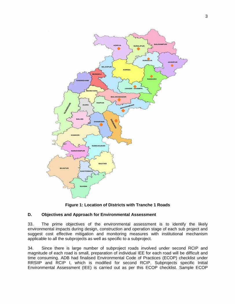
3. The Government of Chhattisgarh is now planning to submit to ADB the first Periodic Finance Request (PFR) that includes the proposal for about 80 rural roads totalling to 1001.58 km. The project as per classification of ADB has been categorised as ‘Category B’ project and therefore requires an Initial Environmental Examination (IEE). No categorisation is made under Indian environmental legislation since these small roads do not require any environmental clearance in accordance to Indian Environmental (Protection) Act and Rules, 1986 amended till date.
4. A review of international agreements and conventions where India is a member were made to ensure compliance. These agreements are: Conventions on Wetlands of International Importance Especially as Water Fowl habitats (Ramsar), Convention concerning the protection of the World Cultural and Natural Heritage, Convention on International Trade in Endangered Species of Wild Fauna & Flora (CITES), Convention on the conservation of Migratory Species of Wild Animals (CMS 1979), and the United Nations Framework Convention on Climate Change, Convention on Biological Diversity.
5. The IEE was conducted based on Detailed Project report (DPR) and sub-project details provided by the the Technical Support Consultant. The IEE covers all activities proposed under the project. The direct area of influence or the corridor of impact (COI) has been considered as 10 m on either side of the proposed road alignment.
A. Physical Environment
6. The climate of Chhattisgarh is mainly tropical, humid and sub-humid. The climate is hot because of its position on the tropic of cancer. May is the hottest month and December-January is the coldest. The maximum temperature during summers ranges from 33ºC to 46ºC while minimum temperature from 30ºC to 19ºC. The temperature during the winter season ranges between of 27ºC to 9ºC. The state receives an annual average rainfall of 1524 mm. The vagaries of monsoon and uneven distribution of rainfall causes at times severe drought conditions. The winter rainfall is meagre.
7. Most of the project area lies in vast open agricultural land and is largely free from air pollution sources other than traffic and few brick-kilns existing in the area. These are located in open area and operate only for few months. As such, the ambient air quality for major pollutants like SO2, SPM and NOX is expected to be within the limits.
ii
8. There is neither significant industrial activity nor significant vehicular traffic contributing to ambient noise levels. The occasional vehicular movement on the unpaved roads contributes to increased noise levels over short duration and limited to daytime. The existing roads do not appear to have vehicular traffic at nighttime.
9. Based on regional topography Chhattisgarh region is divided into three regions, the Northern Hills, the Central Plains and the Bastar Plateau. The central Chhattisgarh basin is characterised by two major landform types, the gently sloping Chhattisgarh Plain and the undulating Rimland. The elevation of the plain ranges from about 250 m on the eastern margin to about 330 m in the west. The gentle gradient of the Chhattisgarh Plain is largely due to its geological structure with flat to gently dipping Cuddapah sedimentary formations. About 18 per cent of the state comes under the flat or level topography, which is largely found in the Chhattisgarh Basin in the central belt of the state. These plains mainly adjoin the river valleys of Godavari, Mahanadi and Sabri River.
B. Biological Environment
10. Chhattisgarh is extremely rich in biodiversity. The State’s forests are of two major types: Tropical Moist Deciduous and the Tropical Dry Deciduous. Composition wise, there are four important formations: Teak forests, Sal forests, miscellaneous forests and Bamboo forests. The chief NTFPs (non-timber forest produce) of the State are tendu leaves (Diospyros melanoxylon), sal seeds (Shorea robusta), harra (Terminalia chebula), gum, chironji (Buchanania lanzan), etc.
11. The project area lies in tropical climate zone; it has a medium range of flora and fauna. However, none of the roads consists of any rare, endangered or threatened floral species. Although, none of the road stretches passes through any forest land/area but still has trees, which might require felling during clearing up operations and construction of rural roads. In most of cases, tree cutting has been minimized by suitably modifying the alignment.
C. Socio-economic Environment
12. Chhattisgarh, earlier a part of Madhya Pradesh, became a separate state on 1st November 2000. It is a state with several unique features, such as abundant natural resources, rich biodiversity, and rich cultural diversity. The population of about 21 million is largely rural (79%). Tribals constitute about 33% of the population, and scheduled castes form about 12%. The welfare and development of tribals is an important focus area for the state government. The percentage of population below the poverty line is high at 44%.
13. The State's economy is highly dependent on the primary sector with agriculture as the main source of livelihood of the population. The share of the primary sector in the State Domestic Product (SDP) of the State is 37.3% whereas at the all India level this share, on an average, is 26.3%. At the all India level, the share of the service sector is 49.3% of GDP (Gross Domestic Product) whereas in Chhattisgarh the service sector has a share of 43.7% of SDP.
D. Anticipated Enviromental Impacts and Mitigating Measures
14. Significant enviromental impacts were anticipated mostly during construction phase. Some of these significant impacts include a) impact on common utilities and community properties; b) loss of productive soil; c) impact on hydrology and drainage; d) compaction and contamination of soil; e) generation and management of construction debris and wastes; f) increased air pollution level; g) increased noise level; h) impact on ground and surface water
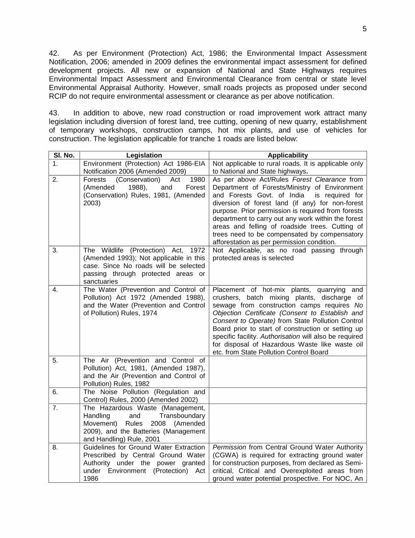
iii
quality and availability; i) loss of trees; j) increased level of vehicle traffic; and k) health and economic hazards to the community. Mitigating measures were proposed in the enviromental management measures to address all the anticipated environmental impacts.
15. Greenhouse gas emission and addressing climate change risks. Total annual emissions without the project (business as usual) at the middle of the design life of 7.5 years is estimated at 64,561.96 tons/year and with project scenario is estimated at 58,700.40 tons/year, for all 80 roads proposed for Tranche 1 of RCIP 2. The with project scenario is still far below the 100,000 tons per year threshold set in the ADB SPS 2009 and therefore not required to implement options to reduce or offset CO2 emissions.
16. Key engineering measures to address climate risk variables such as extreme precipitation, high temperatures and vulnerability to landslides include a) increase in road embankment level road section located in low-lying and flood prone areas; b) erosion protection for areas prone to landslides; c) increase in capacity of spillways and culverts; d) embankment protection through tree plantings; and e) improvement of longitudinal ditches and drains. Provisions have also been made in the bidding documents for the contractor to prepare EMPs based on the final detailed design to address climate related risks and vulnerabilities.
17. EMP Implementation. The Ministry of Rural Development (MoRD) the executing agency has the responsibility for monitoring implementation of the EMP for all subprojects and undertaking necessary due diligence. MoRD ensure this through its Nodal Agency NRRDA (National Rural Road Development Agency). NRRDA constituted by MoRD is the nodal agency for the implementation of the environmental management plan (EMP). SRRDA is the state level agency responsible for implementation of PMGSY program in the state. NRRDA has developed various guidelines and defined institutional arrangements for effective and timely implementation of PMGSY program, which also covers measures for environmental and social safeguards. In line with the defined institutional requirements, each SRRDA has set up district level project implementation units (PIUs). NRRDA also appoints Technical Support Consultant (TSC) to provide technical support for capacity building in SRRDA/PIUs, facilitating them for environmental and social safeguard compliance monitoring and due diligence. SRRDA appoints PIC (project implementation consultant) for supervision of construction work. PIC also helps PIU in monitoring the EMP.
18. Environmental Management and Monitoring Plans. The environmental monitoring program is prepared with aim to monitor the environmental performance of environmental management plan. For rural roads, Environmental Monitoring plan will be more observation oriented and it provides observation areas with frequency of monitoring at pre-construction aspects1, construction stage and operation stage.
19. Grievance Redress Mechanism. Grievance redress mechanism will be implemented from the subproject to national levels. The PIU will designate a public disclosure and complaints contact person for each subproject to help address all concerns and grievances at the subproject level. Grievances, if any, will be considered at the village level by the Grievance Redress Committee (GRC) consisting of members of Gram Panchayat, and Pradhan / Up-Pradhan of Gram Panchayat. The GRC will meet for addressing grievances as needed. Grievances not resolved at the village level will be addressed through the district level GRC, with the following members: Executive Engineer of the PIU, member of Zilla Parishad, member of the grievance committee of the concerned GP; and representatives of affected people.
1 Aspects related to alignment selection for inclusion of new roads
iv
Grievances at this level need to be resolved prior to contract award. At the national level, NRRDA has made provision of registering complaint /suggestion through its website. NRRDA forwards these complains to concerned SRRDA for necessary actions. SRRDA directly or through concerned PIU initiate the appropriate action and update the complainant as well as NRRDA.
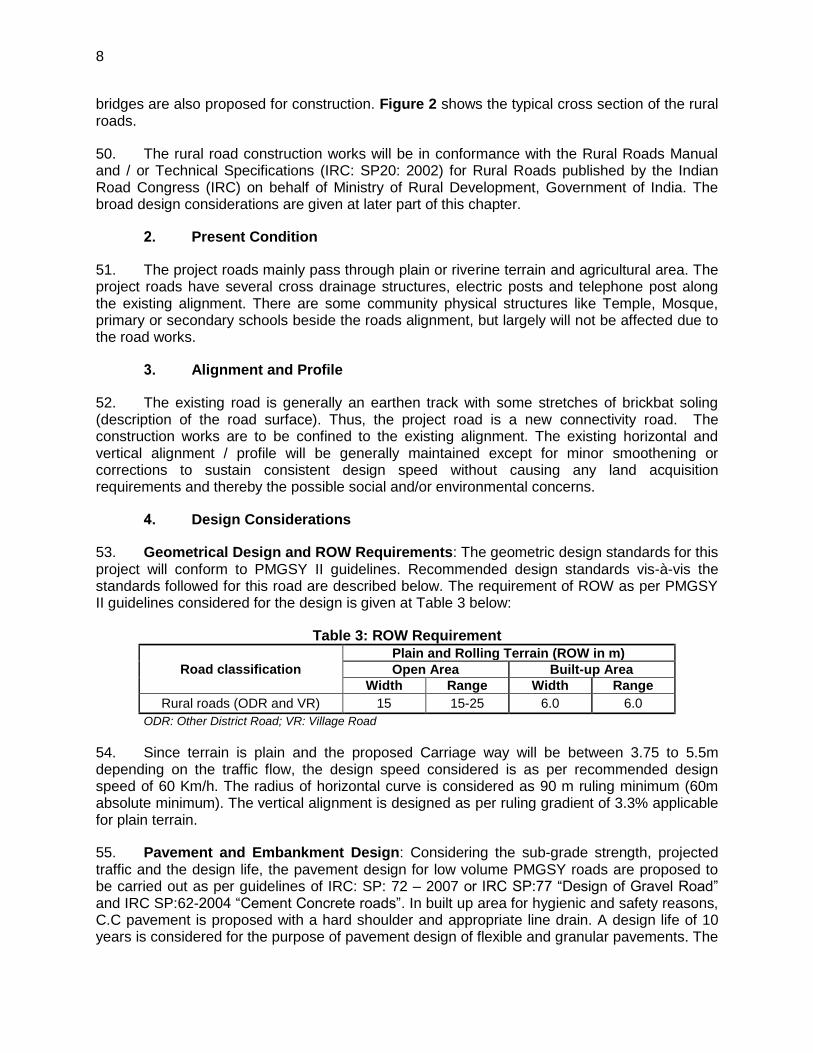
20. Public Consultation. Public consultation was undertaken consistent with the ADB requirements. All the five principles of information dissemination, information solicitation, integration, co-ordination and engagement into dialogue were incorporated in the consultation process. Stakeholders’, including women, were consulted to understand their concerns, apprehensions, overall opinion and solicit recommendations to improve project design. Informal meetings, interviews were organized covering the entire project stretch. Consultations with stakeholders will continue throughout project implementation as necessary at different levels, to update and address the concerns of affected people on environment related issues.
E. Conclusion and Recommendations
21. Conclusion. The proposed Rural Connectivity Investment Program Phase has been categorized as "B" for environment under SPS 2009. No categorization is made under the environmental legislation of India, since these small roads do not require any environmental clearance in accordance with Environment (Protection) Act and Rules, 1986 amended till date. The findings of environment assessment of sample roads indicate that impacts are mostly similar and subprojects are unlikely to cause any significant environmental impacts. While some of the impacts are negative, there are many bearing benefits to the area. Most of the impacts are likely to occur during construction stage, are temporary in nature, and can be mitigated with minor to negligible residual impacts. All sample roads included under Tranche I were selected based on ecological and climate change consideration defined under EARF. Accordingly, none of the sample roads passes through protected areas or encroaches precious ecology (sensitive or protected areas) or any historical or archeologically protected areas.
22. Significant impacts are not considered adverse and typical to road constructions that are simple to mitigate. Impacts related to road siting in flood and erosion prone areas are mitigated through proper design. During construction, impacts can be mitigated through good engineering practices and compliance to permits and clearances issued by the regulatory agencies. The mitigating measures are institutionalized through the EMP and EMoP, and institutional arrangements were established to implement these plans.
23. Recommendations. Any major changes or any additional work other than the proposed project activities indicated in the IEE and Environment Checklist (formerly Environmental Code of Practice or ECOP) will require updates in the IEE. The updated Environment Checklists and IEE will have to be submitted to NRRDA and ADB for concurrence prior to commencement of civil works.
24. Executing agency shall ensure that updated road specific EMP forms part of DPR and is available to contractor at the time of bidding. The contractor will specify the quantity and budget for various activities like rehabilitation of borrow earth pits, first aid and sanitation facilities at construction camp and temporary office/material storage place as per EMP requirements. The same shall be revised if there is any change in the project design. Any such change shall be reported to ADB as well.
1
I. INTRODUCTION
A. Project Background
1. Pradhan Mantri Gram Sadak Yojana (PMGSY) aims to provide all-weather road connectivity to currently unserved habitations in India’s rural areas, where 70% of the population live. The Government of India (GOI) launched “The Pradhan Mantri Gram Sadak Yojna (PMGSY) in year 2000 The objective of PMGSY is to provide all-weather road connectivity to all rural habitations with a population of more than 500 persons in plains and and 250 persons in hill states. This program is being implemented through National Rural Road Development Agency (NRRDA) under Ministry of Rural Development (MORD) at central level and through State Rural Road Development Authority/Agencies (SRRDA) at state level.
25. The Second Rural Connectivity Investment Program (RCIP-2) Is continuation of Rural Connectivity Investment Program (RCIP) and is a Multi-Tranche Financing Facility (MFF) that will be implemented in the states of Assam, Chhattisgarh, Orissa, Madhya Pradesh and West Bengal. Investments In rural roads will improve connectivity, cut transport costs, and provide enabling infrastructure to areas currently with poor access to markets and urban towns, and thus contribute to growth and equity in the country’s largest sector.
26. The Government of Chhattisgarh is now planning to submit to ADB the first Periodic Finance Request (PFR) that includes the proposal for about 303 rural roads totalling to 1001.58 km km in the state of Chhattisgarh Chhattisgarh Rural Road Development Authority (CGRRDA) is the Implementing Agency. The preparatory works for the proposed roads under the first tranche have been completed for the state. As per the requirements of ADB, it is mandatory that the subprojects under the programme comply with ADB's environmental safeguards. The project as per classification of ADB has been categorised as ‘Category B’ project and therefore requires an Initial Environmental Examination (IEE). The Initial environmental examination (IEE) report has been prepared by using environmental checklist for sample roads.
B. Project Roads Identification and Location
27. PMGSY has prepared specific guidelines for the selection of roads under this programme. The key requirements is that any road will be eligible for construction or up-gradation only if it is part of the Core Network2 and satisfy the following environmental safeguards:
i. The selected road shall not disturb any cultural heritage designated by the Government or by international agencies, such as UNESCO, and shall avoid any monuments of cultural or historical importance.
ii. The selected shall not pass through any designated wildlife sanctuaries, national parks, notified ecological sensitive areas or area of internationally significance (e.g., protected wetland designated by the Wetland Convention);
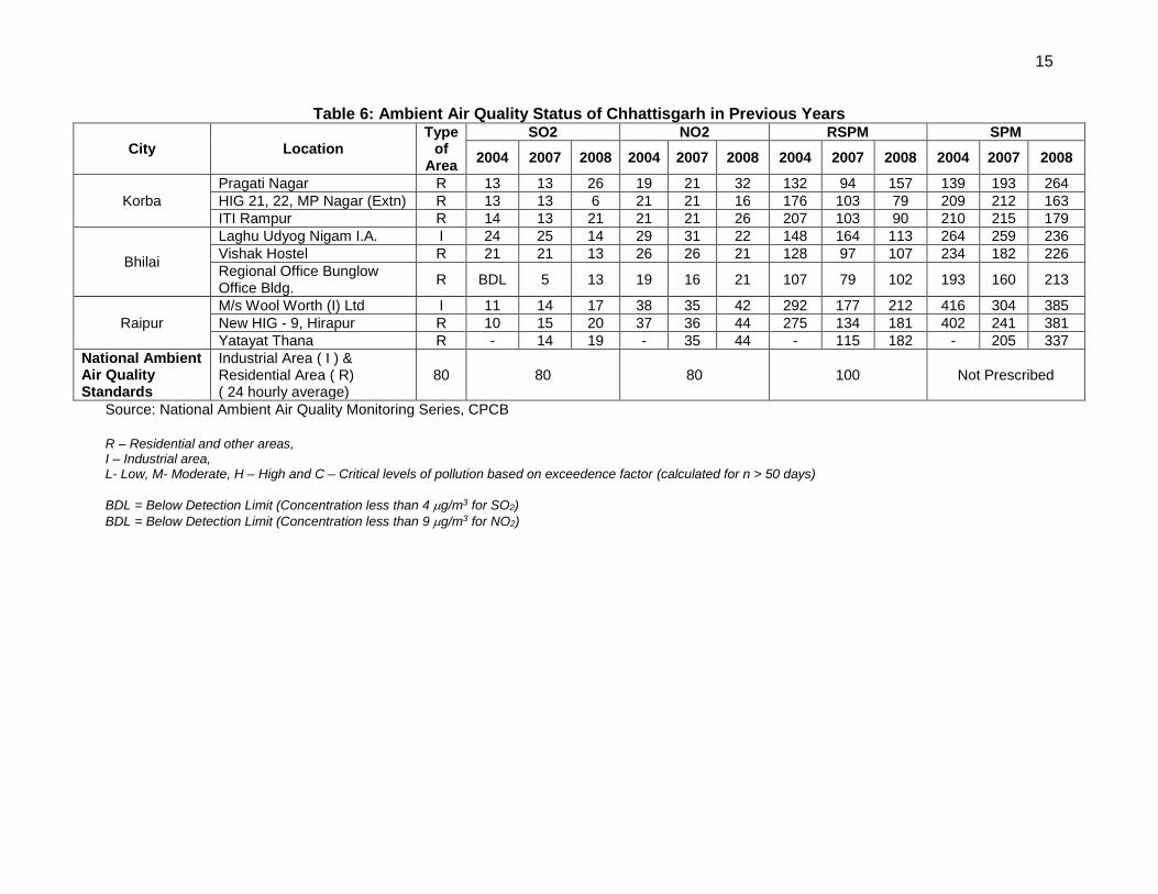
2 Core Network is that minimal network of roads (routes) that is essential to provide access to essential social and
economic services to all eligible habitations in the selected areas through at least single all-weather road connectivity. A core network comprises of through routes and link routes. Through routes are the ones, which collect traffic from several link roads or a long chain of habitations and lead it to marketing centres either directly or through the higher category roads i.e., the district roads or the state or national highways. Link routes are the roads connecting a single habitation or a group of habitations to through routes or district roads leading to market centres. Link routes generally have dead ends terminating on a habitation, while through routes arise from the confluence of two or more link routes and emerge on to a major road or to a market centre
2
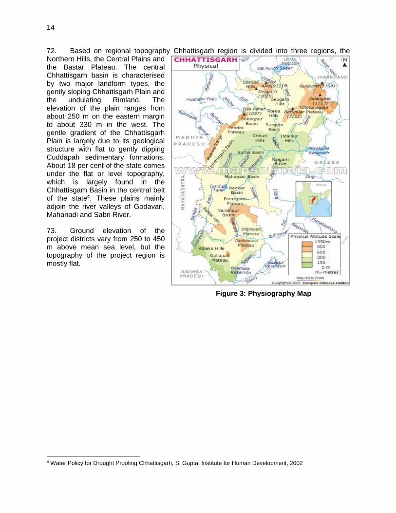
iii. The sub projects shall only involve activities that follow Government of India laws and regulations and meets funding agency safeguard policies.
28. Summary of the proposed subprojects in Second RCIP Tranche I is presented in Table 1.
Table 1: Summary of proposed subprojects for Second RCIP-II Tr I
a. No. of districts where subprojects are located : 10
b. No. of roads : 80
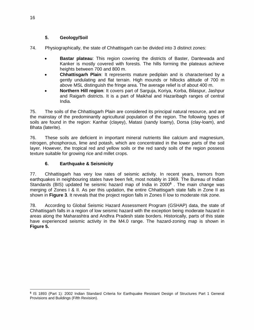
c. Total length of roads (Km) proposed : 1001.58
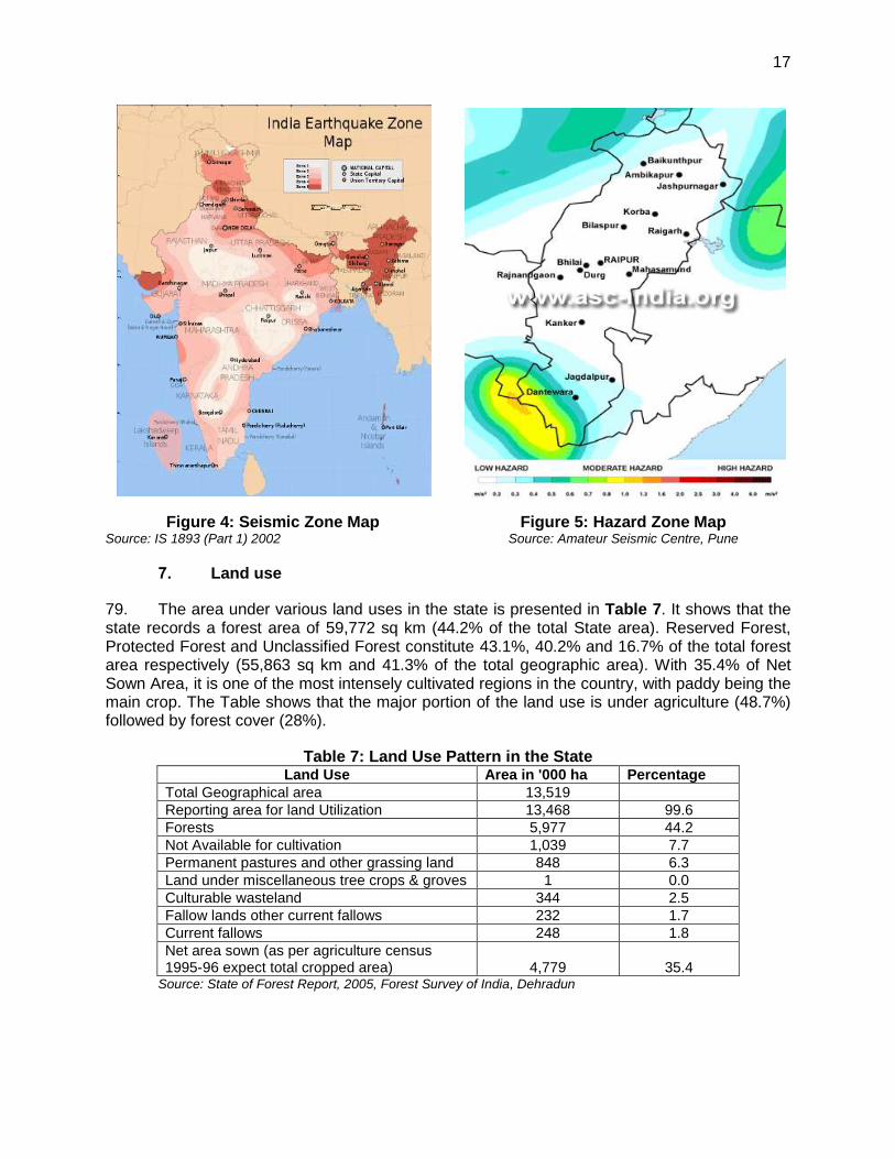
29. These 10 districts are located in the central, north and eastern parts of the state. In this batch of subprojects, the longest road is 38.00 km (T05-Singpur -Mohera-Maragaon-Jabrra- Bhobhalabahara Road in Magarlod block of Dhamtari district), while ML04-Kotami to Salhein in Dabharaof Janjgir-Champa district is the shortest (0.60 Km). The average length of roads works out to 3.519 km.
C. ADB Safeguard Policies and Category of the Project
30. The Asian Development Bank has defined its Safeguard requirements under its ‘Safeguard Policy Statement 2009’ (SPS 09). The SPS 09 require environmental assessment, mitigation and commitment towards environmental protection. The prime objectives of these safeguard policies are to (i) avoid adverse impacts of projects on the environment and affected people, where possible; and (ii) minimize, mitigate, and/or compensate for adverse project impacts on the environment and affected people when avoidance is not possible. ADB as per SPS 09 classifies a project into category A, B or C depending on potential adverse environmental impacts.
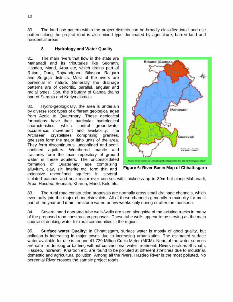
31. All environmentally sensitive components along each subproject is critically analysed to assess the magnitude and extent of likely impacts. These sample subproject roads stretches do not pass through any protected areas nor located near any archeologically important monument. As per selection guidelines, none of the selected subproject passes through reserved forests either. Few trees cutting though may be involved. The roads primarily pass through agricultural and residential areas. Most of the sample roads aligned along existing village roads and unpaved movement paths. As such, there is no land acquisition as the additional land required for the project is availed through voluntary donation from the affected persons. Hence, the project will fall under category B as per ADB Safeguard Policy Statement 2009.
32. No categorisation is made under environmental legislation since these small roads do not require any environmental clearance in accordance to Indian Environmental (Protection) Act and Rules, 1986 amended till date.
3
Figure 1: Location of Districts with Tranche 1 Roads
D. Objectives and Approach for Environmental Assessment
33. The prime objectives of the environmental assessment is to identify the likely environmental impacts during design, construction and operation stage of each sub project and suggest cost effective mitigation and monitoring measures with institutional mechanism applicable to all the subprojects as well as specific to a subproject.
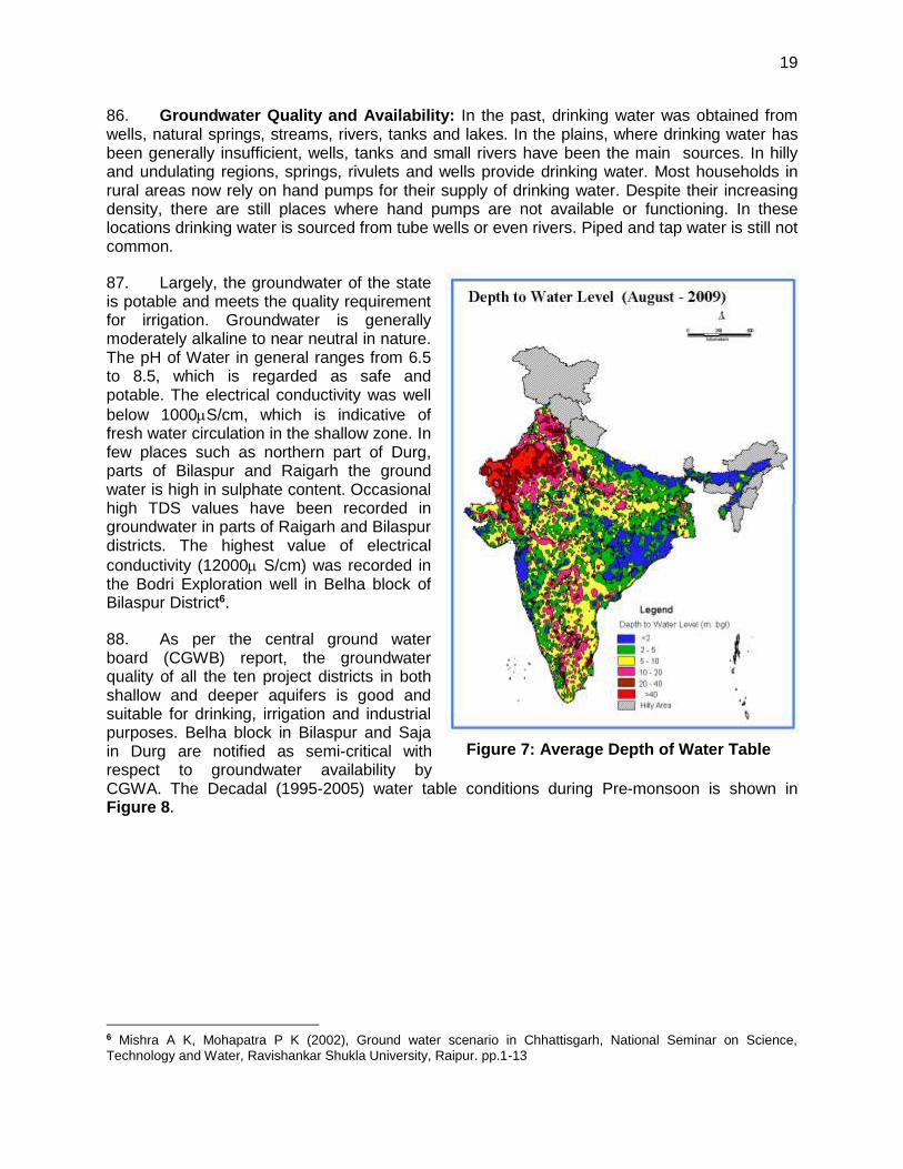
34. Since there is large number of subproject roads involved under second RCIP and magnitude of each road is small, preparation of individual IEE for each road will be difficult and time consuming. ADB had finalised Environmental Code of Practices (ECOP) checklist under RRSIIP and RCIP I, which is modified for second RCIP. Subprojects specific Initial Environmental Assessment (IEE) is carried out as per this ECOP checklist. Sample ECOP
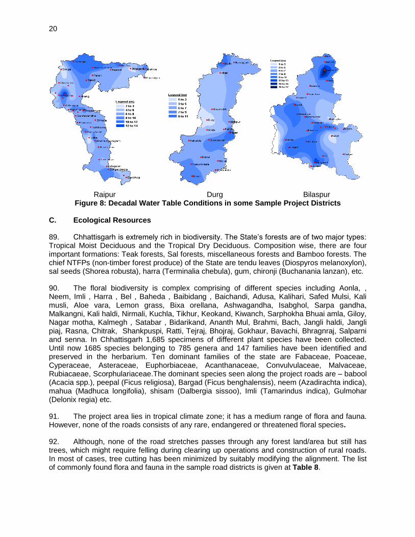
4
checklist with annexures on tree, utility and community structures, strip maps and photographs for each selected sample road is enclosed as Appendix 2.
35. The findings of subproject specific assessment suggest that similar issues exist amongst the state roads with very few subproject specific issues. Therefore, state specific IEE report has been prepared based on ECOP checklist of selected sample roads.
E. IEE Methodology and Content
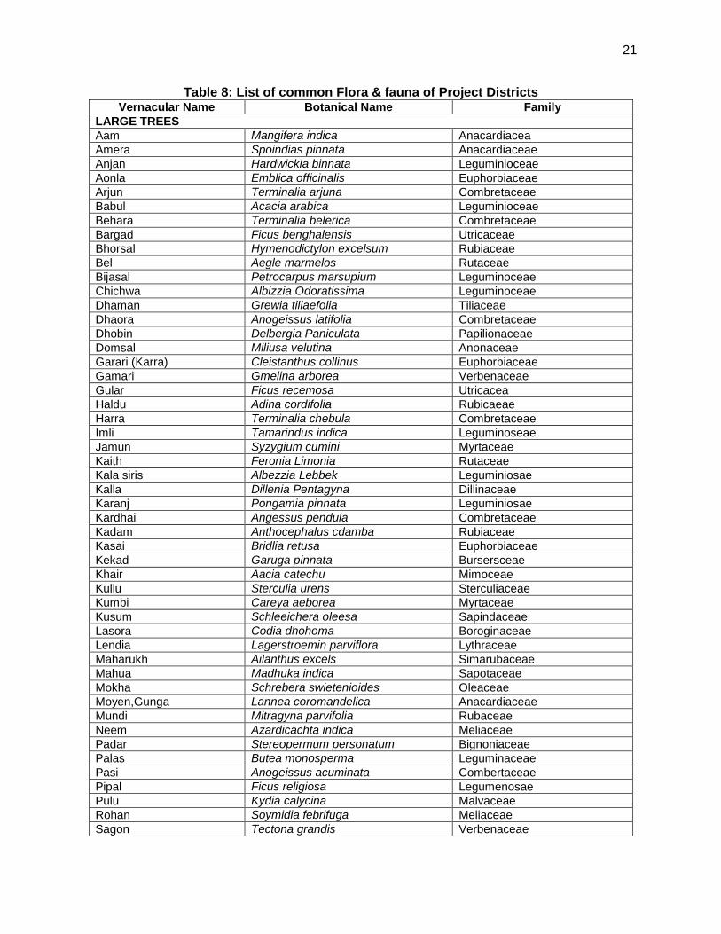
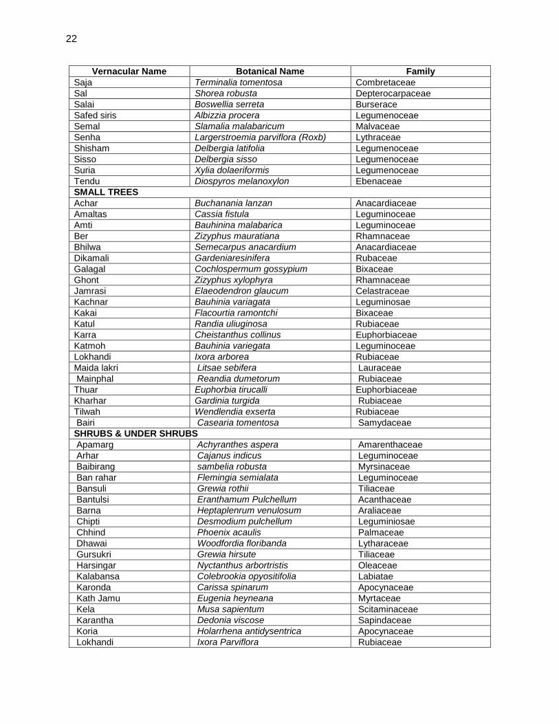
36. The state specific IEE has been largely structured as per Safegaurds Policy Statement, 2009. The IEE reports, including EMPs, monitoring plans, cover the most environmentally sensitive components in state as well as specific to subproject roads.
37. Corridor of Impact: The direct area of influence or the corridor of impact (COI) has been considered as, 10 m on either side of the proposed sample roads alignment based on the proposed cross-section.
38. Field visits, Primary and Secondary Data Collection: Each selected sample road was visited along with concerned PIU officials for environmental assessment and identification of associated environmental issues. Each road specific strip map was prepared during the field visit to capture the information related to tree inventory, utility and community structures located along the proposed road alignment, surface water bodies, and ecological sensitivities. Secondary environmental information pertaining to the environmental issues, protected area, forests areas were collected from various government and non-governmental / research institutions for assessment of the baseline environment of the project locations, district and state as a whole.
39. Data Analysis, Impact identification and Mitigation Measures: Information collected was analysed. The impacts were identified using expert’s assessment and following established practices. Mitigative measures are proposed common to all roads under second RCIP and specific to the roads. EMP is prepared considering mitigative measures and institutional framework of SRRDA.
40. The IEE report includes following seven chapters including this introduction Chapter.
Chapter 1- Introduction
Chapter 2- Description of Project
Chapter 3- Description of Environment
Chapter 4- Anticipated Impacts and Mitigation Measures
Chapter 5- Institutional Requirement and Environmental Monitoring Plan
Chapter 6- Public Consultation and Information Disclosure
Chapter 7- Conclusion and Recommendation
F. Legal Framework and Legislative Requirements:
41. India has well defined institutional and legislative framework. The legislation covers all components of environment viz air, water, soil, terrestrial and aquatic flora and fauna, natural resources, and sensitive habitats. India is also a signatory to various international conventions and protocols.
5
42. As per Environment (Protection) Act, 1986; the Environmental Impact Assessment Notification, 2006; amended in 2009 defines the environmental impact assessment for defined development projects. All new or expansion of National and State Highways requires Environmental Impact Assessment and Environmental Clearance from central or state level Environmental Appraisal Authority. However, small roads projects as proposed under second RCIP do not require environmental assessment or clearance as per above notification.
43. In addition to above, new road construction or road improvement work attract many legislation including diversion of forest land, tree cutting, opening of new quarry, establishment of temporary workshops, construction camps, hot mix plants, and use of vehicles for construction. The legislation applicable for tranche 1 roads are listed below:
Sl. No. Legislation Applicability
1. Environment (Protection) Act 1986-EIA Notification 2006 (Amended 2009)
Not applicable to rural roads. It is applicable only to National and State highways.
2. Forests (Conservation) Act 1980 (Amended 1988), and Forest (Conservation) Rules, 1981, (Amended 2003)
As per above Act/Rules Forest Clearance from Department of Forests/Ministry of Environment and Forests Govt. of India is required for diversion of forest land (if any) for non-forest purpose. Prior permission is required from forests department to carry out any work within the forest areas and felling of roadside trees. Cutting of trees need to be compensated by compensatory afforestation as per permission condition.
3. The Wildlife (Protection) Act, 1972 (Amended 1993); Not applicable in this case. Since No roads will be selected passing through protected areas or sanctuaries
Not Applicable, as no road passing through protected areas is selected
4. The Water (Prevention and Control of Pollution) Act 1972 (Amended 1988), and the Water (Prevention and Control of Pollution) Rules, 1974
Placement of hot-mix plants, quarrying and crushers, batch mixing plants, discharge of sewage from construction camps requires No Objection Certificate (Consent to Establish and Consent to Operate) from State Pollution Control Board prior to start of construction or setting up specific facility. Authorisation will also be required for disposal of Hazardous Waste like waste oil etc. from State Pollution Control Board
5. The Air (Prevention and Control of Pollution) Act, 1981, (Amended 1987), and the Air (Prevention and Control of Pollution) Rules, 1982
6. The Noise Pollution (Regulation and Control) Rules, 2000 (Amended 2002)
7. The Hazardous Waste (Management, Handling and Transboundary Movement) Rules 2008 (Amended 2009), and the Batteries (Management and Handling) Rule, 2001
8. Guidelines for Ground Water Extraction Prescribed by Central Ground Water Authority under the power granted under Environment (Protection) Act 1986
Permission from Central Ground Water Authority (CGWA) is required for extracting ground water for construction purposes, from declared as Semi-critical, Critical and Overexploited areas from ground water potential prospective. For NOC, An
6
Sl. No. Legislation Applicability
application in the prescribed Performa is to be submitted either to the Office of the Regional Director, (CGWB) of the concerned state, or to Member Secretary, CGWA, New Delhi
44. The PMGSY Scheme and Guidelines (2004) No. 12025/8/2001-RC, Ministry of Rural Development (MORD) also defines environmental safeguards particularly with respect to road selection and regulatory compliance which is also to be complied with.
G. Acknowledgement
45. The Technical Support consultants (TSC) gratefully acknowledge the support received from NRRDA and CGRRDA throughout the environmental assessment process. We also acknowledge the assistance received from respective PIUs and the PIC during field visits and other Govt. agencies for primary and secondary data collection as well during public consultation.
7
II. DESCRIPTION OF THE PROJECT
A. General
46. The PMGSY program has mandate to provide all-weather roads to all the rural habitations within the country. Second RCIP is planned to meet above objectives. 90.375 Km roads (30 nos.) are identified as sample roads for Chhattisgarh under Tranche I of Second RCIP. The broad specification for road alignment selection, payment design, construction methodology, geometric design etc. are same and is as per the “Specification for Rural Roads” published by IRC on behalf of the Ministry of Rural Development, Govt. of India. The design details presented in this chapter are as per above specifications. Minor changes will apply depending on road specific issues and design consideration.
47. Since topography of most of the project districts in Chhattisgarh state is largely flat, the design details applicable to flat terrain are presented in following section.
B. Sample Roads Selected in Chhattisgarh State
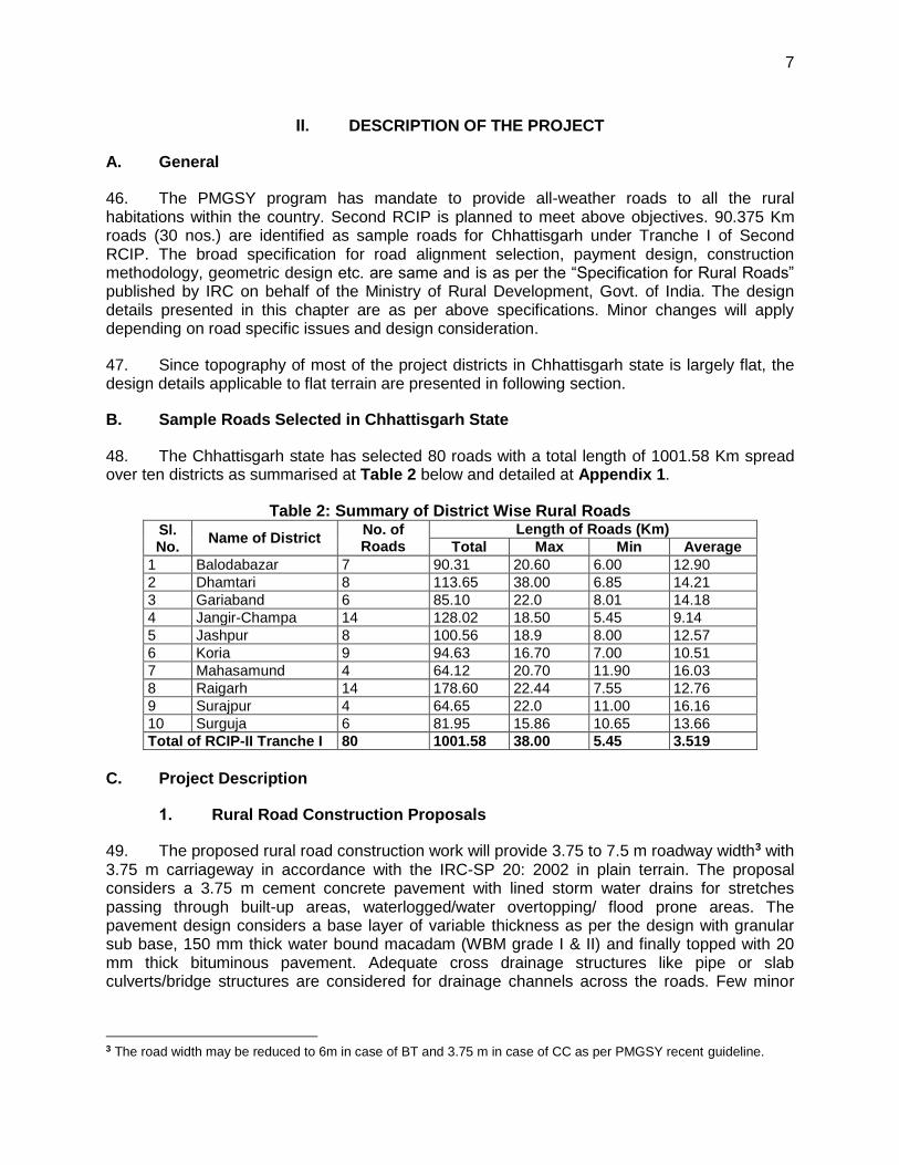
48. The Chhattisgarh state has selected 80 roads with a total length of 1001.58 Km spread over ten districts as summarised at Table 2 below and detailed at Appendix 1.
Table 2: Summary of District Wise Rural Roads Sl. No.
Name of District No. of Roads
Length of Roads (Km)
Total Max Min Average
1 Balodabazar 7 90.31 20.60 6.00 12.90
2 Dhamtari 8 113.65 38.00 6.85 14.21
3 Gariaband 6 85.10 22.0 8.01 14.18
4 Jangir-Champa 14 128.02 18.50 5.45 9.14
5 Jashpur 8 100.56 18.9 8.00 12.57
6 Koria 9 94.63 16.70 7.00 10.51
7 Mahasamund 4 64.12 20.70 11.90 16.03
8 Raigarh 14 178.60 22.44 7.55 12.76
9 Surajpur 4 64.65 22.0 11.00 16.16
10 Surguja 6 81.95 15.86 10.65 13.66
Total of RCIP-II Tranche I 80 1001.58 38.00 5.45 3.519
C. Project Description
1. Rural Road Construction Proposals
49. The proposed rural road construction work will provide 3.75 to 7.5 m roadway width3 with 3.75 m carriageway in accordance with the IRC-SP 20: 2002 in plain terrain. The proposal considers a 3.75 m cement concrete pavement with lined storm water drains for stretches passing through built-up areas, waterlogged/water overtopping/ flood prone areas. The pavement design considers a base layer of variable thickness as per the design with granular sub base, 150 mm thick water bound macadam (WBM grade I & II) and finally topped with 20 mm thick bituminous pavement. Adequate cross drainage structures like pipe or slab culverts/bridge structures are considered for drainage channels across the roads. Few minor
3 The road width may be reduced to 6m in case of BT and 3.75 m in case of CC as per PMGSY recent guideline.
8
bridges are also proposed for construction. Figure 2 shows the typical cross section of the rural roads.
50. The rural road construction works will be in conformance with the Rural Roads Manual and / or Technical Specifications (IRC: SP20: 2002) for Rural Roads published by the Indian Road Congress (IRC) on behalf of Ministry of Rural Development, Government of India. The broad design considerations are given at later part of this chapter.
2. Present Condition
51. The project roads mainly pass through plain or riverine terrain and agricultural area. The project roads have several cross drainage structures, electric posts and telephone post along the existing alignment. There are some community physical structures like Temple, Mosque, primary or secondary schools beside the roads alignment, but largely will not be affected due to the road works.
3. Alignment and Profile
52. The existing road is generally an earthen track with some stretches of brickbat soling (description of the road surface). Thus, the project road is a new connectivity road. The construction works are to be confined to the existing alignment. The existing horizontal and vertical alignment / profile will be generally maintained except for minor smoothening or corrections to sustain consistent design speed without causing any land acquisition requirements and thereby the possible social and/or environmental concerns.
4. Design Considerations
53. Geometrical Design and ROW Requirements: The geometric design standards for this project will conform to PMGSY II guidelines. Recommended design standards vis-à-vis the standards followed for this road are described below. The requirement of ROW as per PMGSY II guidelines considered for the design is given at Table 3 below:
Table 3: ROW Requirement
Road classification
Plain and Rolling Terrain (ROW in m)
Open Area Built-up Area
Width Range Width Range
Rural roads (ODR and VR) 15 15-25 6.0 6.0
ODR: Other District Road; VR: Village Road
54. Since terrain is plain and the proposed Carriage way will be between 3.75 to 5.5m depending on the traffic flow, the design speed considered is as per recommended design speed of 60 Km/h. The radius of horizontal curve is considered as 90 m ruling minimum (60m absolute minimum). The vertical alignment is designed as per ruling gradient of 3.3% applicable for plain terrain.
55. Pavement and Embankment Design: Considering the sub-grade strength, projected traffic and the design life, the pavement design for low volume PMGSY roads are proposed to be carried out as per guidelines of IRC: SP: 72 – 2007 or IRC SP:77 “Design of Gravel Road” and IRC SP:62-2004 “Cement Concrete roads”. In built up area for hygienic and safety reasons, C.C pavement is proposed with a hard shoulder and appropriate line drain. A design life of 10 years is considered for the purpose of pavement design of flexible and granular pavements. The
9
embankment height considered as 1m (average) from ground to crust except at the approaches of cross drainage structures. The embankment height will vary in flood prone area as per the HFL.
56. Road side drain: As the insufficient drainage of surface water leads to rapid damage of road, road side drain (Figure 2) are provided on the locations of habitation areas with concrete pavement. The rainwater will flow along the longitudinal slope and intermittent gaps in concrete curbs
57. Carriageway: The carriageway is proposed as 3.75 m as per IRC-SP20: 2002. It may be even restricted to 3.0 m, where traffic intensity is less than 100 motorised vehicles per day and where the traffic is not likely to increase due to situation, like dead end, low habitation and difficult terrain condition. The ROW requirement in built-up/constricted area may be even reduced to 4 m.
58. Shoulder: Earthen shoulder shall be constructed in layers and compacted to 100% of Proctor’s Density. It is proposed to have 1.875 m wide shoulder (0.875 m hard shoulder and 1 m earthen shoulder) on either side of carriage way.
59. Surfacing: Slow setting bitumen emulsion will be applied as primer on water bound layer. Rapid setting bituminous emulsion shall be used for Tack coat. Premixed carpet 20 mm thick and mixed with equivalent viscosity grade bitumen shall be laid as surfacing course. 6 mm thick, Type B seal coat is considered for sealing of the premixed carpet.
60. Structural Works: Following grades of concrete are proposed for structural works as per specified MORD and IRC specifications:
Concrete in superstructure of Slab Culvert – M-25 (RCC)
Concrete in Abutment cap, Dirt wall of slab culverts – M-25 (PCC)
Brickwork in Abutment, Return Wall, Headwall – Cement mortar (1:4)
Concrete below Abutment, Return Wall, Headwall – M-10 (PCC)
Concrete in pavement (on carriageway) – M-30 (PCC)
Concrete in pavement (on shoulder and drain) – M-25 (PCC
5. Construction Methods
61. Since the proposed rural roads are small in length, NRRDA has framed specific guidelines for cost effective construction of these rural roads. As per the guideline of NRRDA, construction by more of manual means is preferred. Motor grader & tractor-towed rotavator shall be used for handling of bulk materials like spreading of aggregates in sub-base & base courses by mix-in-place method. Ordinary smooth wheeled roller shall be used for compaction if the thickness of the compacted layer does not exceed 100 mm. It is also considered that, hot mix plant of medium type & capacity with separate dryer arrangement for aggregate shall be used for bituminous surfacing work that can be easily shifted. A self-propelled or towed bitumen pressure sprayer shall be used for spraying the materials in narrow strips with a pressure hand sprayer. For structural works, concrete shall be mixed in a mechanical mixer fitted with water measuring device. The excavation shall be done manually or mechanically using suitable medium size excavators.
6. Available Right of Way
10
62. As per the information available from transect walk; ROW is largely available for the rural roads. Additional land required for road improvement will be secured through voluntary donation from private landowners through the Community Participation Framework (CPF). The CPF establishes guidelines to ensure that donation is voluntary and negative social and economic impacts due to the project will be avoided or minimized. The community consultation processes for subproject preparation result in a set of documents that collectively serve as a plan for mitigating likely negative impacts of each subproject. This process follows the ADB social safeguard requirements mentioned below for projects involving voluntary donations:
(i) full consultation with landowners and any non-titled people on site selection; (ii) voluntary donations do not severely affect the living standards of APs and are
directly linked to benefits, with community sanctioned measures to replace any losses that are agreed through verbal and written record by affected people; and
(iii) Voluntary donations are confirmed through verbal and written record and verified and adopted through constitutional process.
(iv) Adequate grievance redress mechanisms are in place.
7. Traffic
63. The present traffic data on each of these rural roads typically varies between 10-15 vehicles per day on most of the rural stretches. The traffic largely comprises motor cycles/two wheelers, tractors, light commercial vehicles, animal drawn carts and bicycles.
8. Economic Assessment
64. The economic analysis carried out for the project has indicated that the rural road construction works will act as a catalyst for the rural economic growth and poverty alleviation of the community in the region.
Figure 2: Cross-section of Rural Roads
11
III. DESCRIPTION OF THE ENVIRONMENT
A. Background
65. Baseline environmental conditions about all facets of environment viz. physical, biological and socio-economic have been established using both primary and secondary sources, consultation with local people, and interaction with forests officials and other Government officials. Efforts have been made to collect the latest information both at regional as well as local level especially along the project roads alignment. This will help to predict likely changes in the environment due to the second RCIP road construction and will serve as performance indicators for various components.
66. The baseline information is presented below at state level and district level. Road specific environmental salient features has also been summarised in this chapter.
67. Located between the Northern latitude of 17°52’ and 24° & East longitude 78°58’ and 84°28’, the state of Chhattisgarh was carved out of the state of Madhya Pradesh on 1st November 2000 to give a fillip to developmental activities and fulfil the long cherished aspirations of the local populace. Spread over an area of 1,35,194 sq km it consists of 27 districts (including 9 new districts formed in 2011) and 146 blocks. Earlier known as the rice bowl of Madhya Pradesh, it is a major rice-producing region of India. The state boundary touches six states of the country, namely Madhya Pradesh, Maharashtra, Andhra Pradesh, Orissa, Jharkhand & Uttar Pradesh. The tranche 1 roads in the state fall in Balodabazar, Dhamtari, Gariaband, Raigarh, Surajpur, Surguja, Jaspur, Janjgir-Champa, Raigarh, Koria and Mahasamund districts of the state. A summary key environmental features of these districts are given in Table 4.
Table 4: Summary Key Environmental Features of the Sample Roads Districts District Description of Environmental Parameters
Baloda Bazar/ Gariyaband
Undivided Raipur district including the newly created Baloda bazaar district covered an area of 13083 sq. km and lies between 19°46’ N and 21°50’ N and 81°25’E to 83°16’ E with population of 3016930 as per 2011 census. The district is surrounded by Bilaspur and Janjgir-Champa in north, Dhamtari in south, Mahasamund in east and Durg in west. The district occupies the south eastern part of the upper Mahanadi valley and the bordering hills in the south and the east. The district has a tropical climatic condition. Summers are extremely hot and at times the mercury may rise to 42°C while winters are mild and lows can fall to 13.2 °C. The district receives a normal rainfall of about 1300 mm. Udanti Sanctuary in Gariaband Tehsil is about 170 km from Raipur. Physiographically, it is divided into three units viz. Chhattisgarh plain, eastern and south eastern undulating, hilly tract, and southern hilly range. Major land use is agriculture. The entire district falls under Mahanadi Basin- main tributaries being Seonath, Jok & Tel. Major soil types in the district are Black Cotton, Red-Yellow Loamy. Principal crops grown in the district are wheat, gram, and cotton. The major geological formations in the district are high-grade gneisses and unclassified metamorphic of Achaean Age.
Mahsamund
Mahasamund district is spread out in an area of 3902.39 Sq. Km in the Central-East of Chhattisgarh State with a population of 860257 as per 2011 census. The district lies between 20°47’N to 21°31’30’’N latitude and 82°00’E to 83°15’45’’ E longitude, surrounded by districts of Raigarh and Raipur of Chhattisgarh y State and Nawapara and Bargarh of Orissa. Mahanadi and its tributaries like Kodar etc. Granite rocks can be
12
District Description of Environmental Parameters
found in the Bagbahra, Basna and Pithora region. Rocks are predominantly Limestone of the Chhattisgarh group contemporary to the Cuddapah group of the Upper Pre-Cambrian age, consisting of limestone layers, shale, sandstone, or quartzite. Neo-granite, dolerite, and quartz in intrusive forms are also found in the district. Hence there is a great scope of intense mining activity. From granite rocks of the Achaean period to stratified rocks of Cuddupah group of Upper Cambrian age are and alluvial soil and sand of recent age are found in abundance in the district. Also found in this region are Neo-granite, Dolerite and Quartz in intrusive forms. Major crops grown are Paddy, Wheat and Kodu.
Raigarh
Raigarh city the capital of Raigarh district is located at 21.9°N 83.4°E. The district has a population of 1265529 as per 2011 Census. It has an average elevation of 215 metres (705 feet). The Kelo river flows through the district which is one of its main water sources. The minimum – maximum temperature range is 29.5 – 49 °C in summer and 8 – 25 ° C in winter.
Janjgir-Champa
Janjgir-Champa district is situated in the east central part of the Chhattisgarh state and surrounded by the districts Raigarh in east, Bilaspur in west, Korba and Bilaspur districts in the north and Raipur and Raigarh districts in the south. The district spreads between 21.60 N to 22.40 N and 82.30 E to 83.20 E with a population of 1317431 as per 2011 Census. It is located at an elevation of 294.4 m above MSL. Janjgir-Champa District falls under the hot temperate climate zone and hence the district experiences very hot and dry. Summer season starts from April to mid June. Rainy season due to the South-West Monsoon is from mid June till the end of September. The average rainfall in the district is 1157.1 mm. And normal rainfall is 1478.0 mm. The average maximum temperature is 49.00 C and average minimum temperature is 80C. The district’s total area is 4, 46,674 hectare.
Jaspur
Jaspur district is situated in the Northern corner of Chhattisgarh state adjoining the border of Bihar, Jharkhand & Orissa in the eastern side. Its total area is 6,205 Sq. Km and it lies between 22017’N and 23015’ N latitude and 83030’E and 84024’ E longitude. Average rainfall of the district is 1048.4 mm. Forest areas constitute around 0.5% of the total area of the district. Main crops grown are Paddy, Maize, Kodo-Kutki, Wheat and pulses.
Surguja
Surguja district is located in the northern part of Chhattisgarh State. Borders of Uttar Pradesh, Jharkhand, Orissa and Madhya Pradesh States are adjoining to the district. This district has extension between south-eastern part of Vindhyachal-Baghelkhand region of peninsular India. It lies between 23037’25” to 2406’17” N latitude and 81034’40” To 8404’40” E longitude. The has as area of about 16359Sq Km. About 50% area of the district is covered by forests
Koria
Koria district lies between 23002' 42" To 23044' 46" N latitude and 81046' 42" To 82033'43" E longitude. The area of the district is 5977km², of which 59.9% is forest area. The district is a vast mass of hill ranges. The general height of the lower tableland is 550 m (1800 feet) above sea level. Average rainfall is 1410.9 mm. Hasdeo, Banas and Gopad are the major rivers of the district.
Surajpur The district forms the northern border of the state with Madhya Pradesh. The area of the district is 2787km². The district largely has a rolling terrain.
Dhamtari
Dhamtari district is situated in the fertile plains of Chhattisgarh Region. The district is situated between 20042' N Latitude and 81033' E Longtitude. The total area of the district is 2029 Sq.Km. and the average altitude is 305 M above the mean sea level. The district is surrounded by district Raipur in
13
District Description of Environmental Parameters
north & district Kanker as well as Bastar in South, part of Odisha state in East & District Durg and Kanker in West. Mahanadi is the principal river of this district
B. Physical Environment
1. Meteorology and Climate
68. The climate of Chhattisgarh is mainly tropical, humid and sub-humid. The climate is hot because of its position on the tropic of cancer. May is the hottest month and December-January is the coldest. The maximum temperature during summers ranges from 33ºC to 46ºC while minimum temperature from 30ºC to 19ºC. The Temperature during the winter season ranges between of 27ºC to 9ºC. The state receives an annual average rainfall of 1524 mm. The vagaries of monsoon and uneven distribution of rainfall causes at times severe drought conditions. The winter rainfall is meagre.
2. Air Quality
69. Most of the project area lies in vast open agricultural land and is largely free from air pollution sources other than traffic and few brick-kilns existing in the area. These were located in open area and operate only for few months. As such, the ambient air quality for major pollutants like SO2, SPM and NOX is expected to be within the limits. However, in absence of any existing data on ambient air quality levels of the project area, secondary sources were referred.
Table 5: Ambient Air Quality during 2008
Area Classification SO2
(µg/m3) NO2
(µg/m3) RSPM (µg/m3)
Industrial 17 42 212
Residential 16 28 126
National Ambient Air Quality Standards for Industrial and Residential Areas 80 80 100
Source: National Ambient Air Quality Status, 2008, CPCB, and Table 3.3
70. The above Table 5 reveals that the concentration of all the pollutants are higher in industrial areas especially nitrogen dioxide and respirable suspended particulate matter. The levels of sulphur dioxide and nitrogen dioxide are however, well within the limits (NAAQS). The higher particulate matter levels are attributed to the vehicular movement on unpaved roads and the loose dust in the agricultural fields that lead to formation of dust clouds over short periods. The same can be inferred from Table 6 that provides a comparison of the air quality at different locations.
3. Noise
71. Along the proposed road construction proposals, there is neither significant industrial activity nor significant vehicular traffic contributing to ambient noise levels. The occasional vehicular movement on the unpaved roads contributes to increased noise levels over short duration and limited to daytime. The existing roads do not appear to have vehicular traffic at nighttime. Therefore, the ambient noise levels are expected to stay within the National Ambient Noise Standards.
4. Topography and Geomorphology
14
72. Based on regional topography Chhattisgarh region is divided into three regions, the Northern Hills, the Central Plains and the Bastar Plateau. The central Chhattisgarh basin is characterised by two major landform types, the gently sloping Chhattisgarh Plain and the undulating Rimland. The elevation of the plain ranges from about 250 m on the eastern margin to about 330 m in the west. The gentle gradient of the Chhattisgarh Plain is largely due to its geological structure with flat to gently dipping Cuddapah sedimentary formations. About 18 per cent of the state comes under the flat or level topography, which is largely found in the Chhattisgarh Basin in the central belt of the state4. These plains mainly adjoin the river valleys of Godavari, Mahanadi and Sabri River.
73. Ground elevation of the project districts vary from 250 to 450 m above mean sea level, but the topography of the project region is mostly flat.
4 Water Policy for Drought Proofing Chhattisgarh, S. Gupta, Institute for Human Development, 2002
Figure 3: Physiography Map
15
Table 6: Ambient Air Quality Status of Chhattisgarh in Previous Years
City Location Type
of Area
SO2 NO2 RSPM SPM
2004 2007 2008 2004 2007 2008 2004 2007 2008 2004 2007 2008
Korba
Pragati Nagar R 13 13 26 19 21 32 132 94 157 139 193 264
HIG 21, 22, MP Nagar (Extn) R 13 13 6 21 21 16 176 103 79 209 212 163
ITI Rampur R 14 13 21 21 21 26 207 103 90 210 215 179
Bhilai
Laghu Udyog Nigam I.A. I 24 25 14 29 31 22 148 164 113 264 259 236
Vishak Hostel R 21 21 13 26 26 21 128 97 107 234 182 226
Regional Office Bunglow Office Bldg.
R BDL 5 13 19 16 21 107 79 102 193 160 213
Raipur
M/s Wool Worth (I) Ltd I 11 14 17 38 35 42 292 177 212 416 304 385
New HIG - 9, Hirapur R 10 15 20 37 36 44 275 134 181 402 241 381
Yatayat Thana R - 14 19 - 35 44 - 115 182 - 205 337
National Ambient Air Quality Standards
Industrial Area ( I ) & Residential Area ( R) ( 24 hourly average)
80 80 80 100 Not Prescribed
Source: National Ambient Air Quality Monitoring Series, CPCB
R – Residential and other areas, I – Industrial area, L- Low, M- Moderate, H – High and C – Critical levels of pollution based on exceedence factor (calculated for n > 50 days)
BDL = Below Detection Limit (Concentration less than 4 g/m3 for SO2)
BDL = Below Detection Limit (Concentration less than 9 g/m3 for NO2)
16
5. Geology/Soil
74. Physiographically, the state of Chhattisgarh can be divided into 3 distinct zones:
Bastar plateau: This region covering the districts of Baster, Dantewada and Kanker is mostly covered with forests. The hills forming the plateaus achieve heights between 700 and 800 m.
Chhattisgarh Plain: It represents mature pediplain and is characterised by a gently undulating and flat terrain. High mounds or hillocks altitude of 700 m above MSL distinguish the fringe area. The average relief is of about 400 m.
Northern Hill region: It covers part of Sarguja, Koriya, Korba, Bilaspur, Jashpur and Raigarh districts. It is a part of Maikhal and Hazaribagh ranges of central India.
75. The soils of the Chhattisgarh Plain are considered its principal natural resource, and are the mainstay of the predominantly agricultural population of the region. The following types of soils are found in the region: Kanhar (clayey), Matasi (sandy loamy), Dorsa (clay-loam), and Bhata (laterite).
76. These soils are deficient in important mineral nutrients like calcium and magnesium, nitrogen, phosphorous, lime and potash, which are concentrated in the lower parts of the soil layer. However, the tropical red and yellow soils or the red sandy soils of the region possess texture suitable for growing rice and millet crops.
6. Earthquake & Seismicity
77. Chhattisgarh has very low rates of seismic activity. In recent years, tremors from earthquakes in neighbouring states have been felt, most notably in 1969. The Bureau of Indian Standards (BIS) updated he seismic hazard map of India in 20005 . The main change was merging of Zones I & II. As per this updation, the entire Chhattisgarh state falls in Zone II as shown in Figure 3. It reveals that the project region falls in Zones II low to moderate risk zone.
78. According to Global Seismic Hazard Assessment Program (GSHAP) data, the state of Chhattisgarh falls in a region of low seismic hazard with the exception being moderate hazard in areas along the Maharashtra and Andhra Pradesh state borders. Historically, parts of this state have experienced seismic activity in the M4.0 range. The hazard-zoning map is shown in Figure 5.
5 IS 1893 (Part 1): 2002 Indian Standard Criteria for Earthquake Resistant Design of Structures Part 1 General
Provisions and Buildings (Fifth Revision).
17
Chhattisgarh State
Figure 4: Seismic Zone Map Source: IS 1893 (Part 1) 2002
Figure 5: Hazard Zone Map Source: Amateur Seismic Centre, Pune
7. Land use
79. The area under various land uses in the state is presented in Table 7. It shows that the state records a forest area of 59,772 sq km (44.2% of the total State area). Reserved Forest, Protected Forest and Unclassified Forest constitute 43.1%, 40.2% and 16.7% of the total forest area respectively (55,863 sq km and 41.3% of the total geographic area). With 35.4% of Net Sown Area, it is one of the most intensely cultivated regions in the country, with paddy being the main crop. The Table shows that the major portion of the land use is under agriculture (48.7%) followed by forest cover (28%).
Table 7: Land Use Pattern in the State Land Use Area in '000 ha Percentage
Total Geographical area 13,519
Reporting area for land Utilization 13,468 99.6
Forests 5,977 44.2
Not Available for cultivation 1,039 7.7
Permanent pastures and other grassing land 848 6.3
Land under miscellaneous tree crops & groves 1 0.0
Culturable wasteland 344 2.5
Fallow lands other current fallows 232 1.7
Current fallows 248 1.8
Net area sown (as per agriculture census 1995-96 expect total cropped area) 4,779 35.4
Source: State of Forest Report, 2005, Forest Survey of India, Dehradun
18
Figure 6: River Basin Map of Chhattisgarh
80. The land use pattern within the project districts can be broadly classified into Land use pattern along the project road is also mixed type dominated by agriculture, barren land and residential areas
8. Hydrology and Water Quality
81. The main rivers that flow in the state are Mahanadi and its tributaries like Seonath, Hasdeo, Mand, Arpa etc, which drains part of Raipur, Durg, Rajnandgaon, Bilaspur, Raigarh and Surguja districts. Most of the rivers are perennial in nature. Generally the drainage patterns are of dendritic, parallel, angular and radial types. Son, the tributary of Ganga drains part of Sarguja and Koriya districts.
82. Hydro-geologically, the area is underlain by diverse rock types of different geological ages from Azoic to Quaternary. These geological formations have their particular hydrological characteristics, which control groundwater occurrence, movement and availability. The Archaean crystallines comprising granites, gneisses form the major litho units of the area. They form discontinuous, unconfined and semi-confined aquifers. Weathered mantle and fractures form the main repository of ground water in these aquifers. The unconsolidated formation of Quaternary age comprising alluvium, clay, silt, laterite etc. form thin and extensive unconfined aquifers in several isolated patches and near major river courses with thickness up to 30m bgl along Mahanadi, Arpa, Hasdeo, Seonath, Kharun, Mand, Kelo etc.
83. The rural road construction proposals are normally cross small drainage channels, which eventually join the major channels/rivulets. All of these channels generally remain dry for most part of the year and drain the storm water for few weeks only during or after the monsoon.
84. Several hand operated tube wells/wells are seen alongside of the existing tracks in many of the proposed road construction proposals. These tube wells appear to be serving as the main source of drinking water for rural communities in the region.
85. Surface water Quality: In Chhattisgarh, surface water is mostly of good quality, but pollution is increasing in major towns due to increasing urbanization. The estimated surface water available for use is around 41,720 Million Cubic Meter (MCM). None of the water sources are safe for drinking or bathing without conventional water treatment. Rivers such as Shivnath, Hasdeo, Indrawati, Kharoon etc. are found to be polluted at different stretches due to industrial, domestic and agricultural pollution. Among all the rivers, Hasdeo River is the most polluted. No perennial River crosses the sample project roads.
19
86. Groundwater Quality and Availability: In the past, drinking water was obtained from wells, natural springs, streams, rivers, tanks and lakes. In the plains, where drinking water has been generally insufficient, wells, tanks and small rivers have been the main sources. In hilly and undulating regions, springs, rivulets and wells provide drinking water. Most households in rural areas now rely on hand pumps for their supply of drinking water. Despite their increasing density, there are still places where hand pumps are not available or functioning. In these locations drinking water is sourced from tube wells or even rivers. Piped and tap water is still not common.
87. Largely, the groundwater of the state is potable and meets the quality requirement for irrigation. Groundwater is generally moderately alkaline to near neutral in nature. The pH of Water in general ranges from 6.5 to 8.5, which is regarded as safe and potable. The electrical conductivity was well
below 1000S/cm, which is indicative of fresh water circulation in the shallow zone. In few places such as northern part of Durg, parts of Bilaspur and Raigarh the ground water is high in sulphate content. Occasional high TDS values have been recorded in groundwater in parts of Raigarh and Bilaspur districts. The highest value of electrical
conductivity (12000 S/cm) was recorded in the Bodri Exploration well in Belha block of Bilaspur District6.
88. As per the central ground water board (CGWB) report, the groundwater quality of all the ten project districts in both shallow and deeper aquifers is good and suitable for drinking, irrigation and industrial purposes. Belha block in Bilaspur and Saja in Durg are notified as semi-critical with respect to groundwater availability by CGWA. The Decadal (1995-2005) water table conditions during Pre-monsoon is shown in Figure 8.
6 Mishra A K, Mohapatra P K (2002), Ground water scenario in Chhattisgarh, National Seminar on Science,
Technology and Water, Ravishankar Shukla University, Raipur. pp.1-13
Figure 7: Average Depth of Water Table
20
Raipur Durg Bilaspur Figure 8: Decadal Water Table Conditions in some Sample Project Districts
C. Ecological Resources
89. Chhattisgarh is extremely rich in biodiversity. The State’s forests are of two major types: Tropical Moist Deciduous and the Tropical Dry Deciduous. Composition wise, there are four important formations: Teak forests, Sal forests, miscellaneous forests and Bamboo forests. The chief NTFPs (non-timber forest produce) of the State are tendu leaves (Diospyros melanoxylon), sal seeds (Shorea robusta), harra (Terminalia chebula), gum, chironji (Buchanania lanzan), etc.
90. The floral biodiversity is complex comprising of different species including Aonla, , Neem, Imli , Harra , Bel , Baheda , Baibidang , Baichandi, Adusa, Kalihari, Safed Mulsi, Kali musli, Aloe vara, Lemon grass, Bixa orellana, Ashwagandha, Isabghol, Sarpa gandha, Malkangni, Kali haldi, Nirmali, Kuchla, Tikhur, Keokand, Kiwanch, Sarphokha Bhuai amla, Giloy, Nagar motha, Kalmegh , Satabar , Bidarikand, Ananth Mul, Brahmi, Bach, Jangli haldi, Jangli piaj, Rasna, Chitrak, Shankpuspi, Ratti, Tejraj, Bhojraj, Gokhaur, Bavachi, Bhragnraj, Salparni and senna. In Chhattisgarh 1,685 specimens of different plant species have been collected. Until now 1685 species belonging to 785 genera and 147 families have been identified and preserved in the herbarium. Ten dominant families of the state are Fabaceae, Poaceae, Cyperaceae, Asteraceae, Euphorbiaceae, Acanthanaceae, Convulvulaceae, Malvaceae, Rubiacaeae, Scorphulariaceae.The dominant species seen along the project roads are – babool (Acacia spp.), peepal (Ficus religiosa), Bargad (Ficus benghalensis), neem (Azadirachta indica), mahua (Madhuca longifolia), shisam (Dalbergia sissoo), Imli (Tamarindus indica), Gulmohar (Delonix regia) etc.
91. The project area lies in tropical climate zone; it has a medium range of flora and fauna. However, none of the roads consists of any rare, endangered or threatened floral species.
92. Although, none of the road stretches passes through any forest land/area but still has trees, which might require felling during clearing up operations and construction of rural roads. In most of cases, tree cutting has been minimized by suitably modifying the alignment. The list of commonly found flora and fauna in the sample road districts is given at Table 8.
21
Table 8: List of common Flora & fauna of Project Districts Vernacular Name Botanical Name Family
LARGE TREES
Aam Mangifera indica Anacardiacea
Amera Spoindias pinnata Anacardiaceae
Anjan Hardwickia binnata Leguminioceae
Aonla Emblica officinalis Euphorbiaceae
Arjun Terminalia arjuna Combretaceae
Babul Acacia arabica Leguminioceae
Behara Terminalia belerica Combretaceae
Bargad Ficus benghalensis Utricaceae
Bhorsal Hymenodictylon excelsum Rubiaceae
Bel Aegle marmelos Rutaceae
Bijasal Petrocarpus marsupium Leguminoceae
Chichwa Albizzia Odoratissima Leguminoceae
Dhaman Grewia tiliaefolia Tiliaceae
Dhaora Anogeissus latifolia Combretaceae
Dhobin Delbergia Paniculata Papilionaceae
Domsal Miliusa velutina Anonaceae
Garari (Karra) Cleistanthus collinus Euphorbiaceae
Gamari Gmelina arborea Verbenaceae
Gular Ficus recemosa Utricacea
Haldu Adina cordifolia Rubicaeae
Harra Terminalia chebula Combretaceae
Imli Tamarindus indica Leguminoseae
Jamun Syzygium cumini Myrtaceae
Kaith Feronia Limonia Rutaceae
Kala siris Albezzia Lebbek Leguminiosae
Kalla Dillenia Pentagyna Dillinaceae
Karanj Pongamia pinnata Leguminiosae
Kardhai Angessus pendula Combretaceae
Kadam Anthocephalus cdamba Rubiaceae
Kasai Bridlia retusa Euphorbiaceae
Kekad Garuga pinnata Bursersceae
Khair Aacia catechu Mimoceae
Kullu Sterculia urens Sterculiaceae
Kumbi Careya aeborea Myrtaceae
Kusum Schleeichera oleesa Sapindaceae
Lasora Codia dhohoma Boroginaceae
Lendia Lagerstroemin parviflora Lythraceae
Maharukh Ailanthus excels Simarubaceae
Mahua Madhuka indica Sapotaceae
Mokha Schrebera swietenioides Oleaceae
Moyen,Gunga Lannea coromandelica Anacardiaceae
Mundi Mitragyna parvifolia Rubaceae
Neem Azardicachta indica Meliaceae
Padar Stereopermum personatum Bignoniaceae
Palas Butea monosperma Leguminaceae
Pasi Anogeissus acuminata Combertaceae
Pipal Ficus religiosa Legumenosae
Pulu Kydia calycina Malvaceae
Rohan Soymidia febrifuga Meliaceae
Sagon Tectona grandis Verbenaceae
22
Vernacular Name Botanical Name Family
Saja Terminalia tomentosa Combretaceae
Sal Shorea robusta Depterocarpaceae
Salai Boswellia serreta Burserace
Safed siris Albizzia procera Legumenoceae
Semal Slamalia malabaricum Malvaceae
Senha Largerstroemia parviflora (Roxb) Lythraceae
Shisham Delbergia latifolia Legumenoceae
Sisso Delbergia sisso Legumenoceae
Suria Xylia dolaeriformis Legumenoceae
Tendu Diospyros melanoxylon Ebenaceae
SMALL TREES
Achar Buchanania lanzan Anacardiaceae
Amaltas Cassia fistula Leguminoceae
Amti Bauhinina malabarica Leguminoceae
Ber Zizyphus mauratiana Rhamnaceae
Bhilwa Semecarpus anacardium Anacardiaceae
Dikamali Gardeniaresinifera Rubaceae
Galagal Cochlospermum gossypium Bixaceae
Ghont Zizyphus xylophyra Rhamnaceae
Jamrasi Elaeodendron glaucum Celastraceae
Kachnar Bauhinia variagata Leguminosae
Kakai Flacourtia ramontchi Bixaceae
Katul Randia uliuginosa Rubiaceae
Karra Cheistanthus collinus Euphorbiaceae
Katmoh Bauhinia variegata Leguminoceae
Lokhandi Ixora arborea Rubiaceae
Maida lakri Litsae sebifera Lauraceae
Mainphal Reandia dumetorum Rubiaceae
Thuar Euphorbia tirucalli Euphorbiaceae
Kharhar Gardinia turgida Rubiaceae
Tilwah Wendlendia exserta Rubiaceae
Bairi Casearia tomentosa Samydaceae
SHRUBS & UNDER SHRUBS
Apamarg Achyranthes aspera Amarenthaceae
Arhar Cajanus indicus Leguminoceae
Baibirang sambelia robusta Myrsinaceae
Ban rahar Flemingia semialata Leguminoceae
Bansuli Grewia rothii Tiliaceae
Bantulsi Eranthamum Pulchellum Acanthaceae
Barna Heptaplenrum venulosum Araliaceae
Chipti Desmodium pulchellum Leguminiosae
Chhind Phoenix acaulis Palmaceae
Dhawai Woodfordia floribanda Lytharaceae
Gursukri Grewia hirsute Tiliaceae
Harsingar Nyctanthus arbortristis Oleaceae
Kalabansa Colebrookia opyositifolia Labiatae
Karonda Carissa spinarum Apocynaceae
Kath Jamu Eugenia heyneana Myrtaceae
Kela Musa sapientum Scitaminaceae
Karantha Dedonia viscose Sapindaceae
Koria Holarrhena antidysentrica Apocynaceae
Lokhandi Ixora Parviflora Rubiaceae
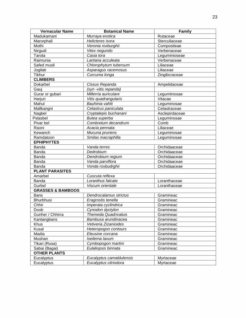
23
Vernacular Name Botanical Name Family
Madukamani Murraya exotica Rutaceae
Marorphali Helicteres isora Sterculiaceae
Mothi Veronia roxburghii Compositeae
Nirgudi Vitex negundo Verbenaceae
Tarota Casia tora Leguminioseae
Raimunia Lantana acculeata Verbenaceae
Safed musli Chlorophytum tubersum Liliaceae
Jogilati Asparagus racemosus Liliaceae
Tikhur Curcuma longa Zingibcraceae
CLIMBERS
Dokarbel Cissus Repanda Ampelidaceae
Gauj (syn -vitis repanda)
Gurar or gubari Millerria auriculare Legumiinosae
Harjuri Vitis quadrangularis Vitacae
Mahul Bauhinia vahlii Leguminosae
Mallkangni Celastrus paniculata Celastraceae
Nagbel Cryptalepis buchanani Asclepirdaceae
Pslasbel Butea superba Leguminosae
Pivar bel Combretum decandrum Comb
Raoni Acacia pennata Liliaceae
Kewanch Mucuna pruriens Leguminosae
Ramdatoon Smilas macraphilla Leguminosae
EPHIPHYTES
Banda Vanda terres Orchidaaceae
Banda Dedrobium Orchidaaceae
Banda Dendrobium regium Orchidaaceae
Banda Vanda parviflora Orchidaaceae
Banda Vonda roxbudrghii Orchidaaceae
PLANT PARASITES
Amarbel Cuscuta reflexa
Banda Loranthus falcate Loranthaceae
Gurbel Viscum orientale Loranthaceae
GRASSES & BAMBOOS
Bans Dendrocalamus strictus Gramineac
Bhurbhusi Eragrostis tenella Gramineac
Chhir Imperata cyclindrica Gramineac
Doob Cynodon dyctylon Gramineac
Gunher / Chhirra Themeda Quadrivaluis Gramineac
Kantangbans Bambusa arundinacea Gramineac
Khus Vetiveria Zizanioides Gramineac
Kusal Heteropogon contours Gramineac
Madia Eleusine corcana Gramineac
Mushan Iseilema laxum Gramineac
Tikari (Rusa) Cymbopogon martini Gramineac
Sabai (Bagai) Eulaliopsis binnata Gramineac
OTHER PLANTS
Eucalyptus Eucalyptus camaldulensis Myrtaceae
Eucalyptus Eucalyptus citriodora Myrtaceae
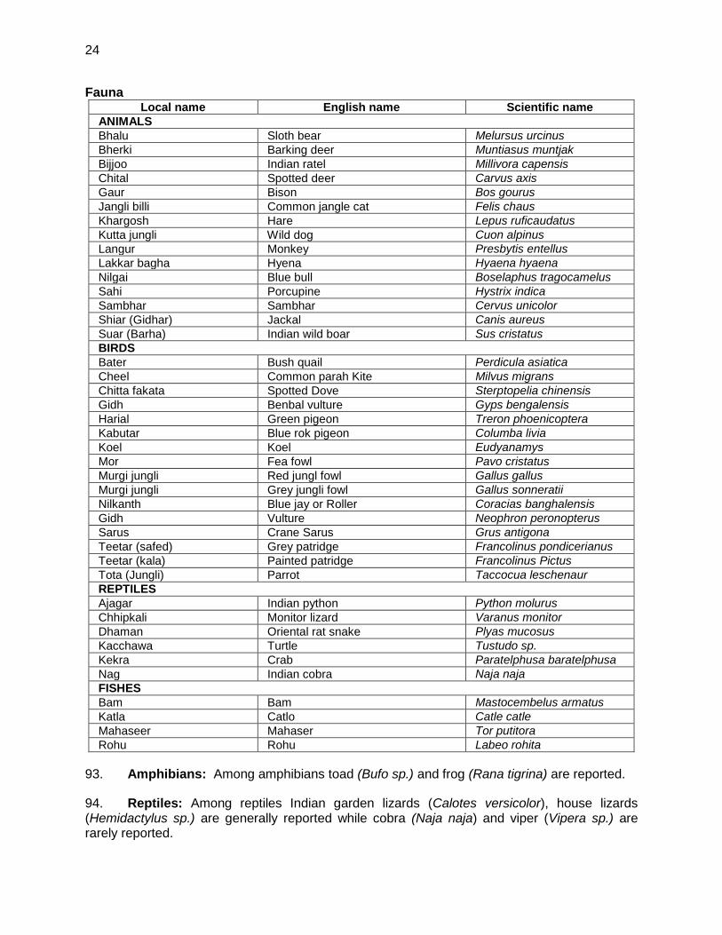
24
Fauna Local name English name Scientific name
ANIMALS
Bhalu Sloth bear Melursus urcinus
Bherki Barking deer Muntiasus muntjak
Bijjoo Indian ratel Millivora capensis
Chital Spotted deer Carvus axis
Gaur Bison Bos gourus
Jangli billi Common jangle cat Felis chaus
Khargosh Hare Lepus ruficaudatus
Kutta jungli Wild dog Cuon alpinus
Langur Monkey Presbytis entellus
Lakkar bagha Hyena Hyaena hyaena
Nilgai Blue bull Boselaphus tragocamelus
Sahi Porcupine Hystrix indica
Sambhar Sambhar Cervus unicolor
Shiar (Gidhar) Jackal Canis aureus
Suar (Barha) Indian wild boar Sus cristatus
BIRDS
Bater Bush quail Perdicula asiatica
Cheel Common parah Kite Milvus migrans
Chitta fakata Spotted Dove Sterptopelia chinensis
Gidh Benbal vulture Gyps bengalensis
Harial Green pigeon Treron phoenicoptera
Kabutar Blue rok pigeon Columba livia
Koel Koel Eudyanamys
Mor Fea fowl Pavo cristatus
Murgi jungli Red jungl fowl Gallus gallus
Murgi jungli Grey jungli fowl Gallus sonneratii
Nilkanth Blue jay or Roller Coracias banghalensis
Gidh Vulture Neophron peronopterus
Sarus Crane Sarus Grus antigona
Teetar (safed) Grey patridge Francolinus pondicerianus
Teetar (kala) Painted patridge Francolinus Pictus
Tota (Jungli) Parrot Taccocua leschenaur
REPTILES
Ajagar Indian python Python molurus
Chhipkali Monitor lizard Varanus monitor
Dhaman Oriental rat snake Plyas mucosus
Kacchawa Turtle Tustudo sp.
Kekra Crab Paratelphusa baratelphusa
Nag Indian cobra Naja naja
FISHES
Bam Bam Mastocembelus armatus
Katla Catlo Catle catle
Mahaseer Mahaser Tor putitora
Rohu Rohu Labeo rohita
93. Amphibians: Among amphibians toad (Bufo sp.) and frog (Rana tigrina) are reported.
94. Reptiles: Among reptiles Indian garden lizards (Calotes versicolor), house lizards (Hemidactylus sp.) are generally reported while cobra (Naja naja) and viper (Vipera sp.) are rarely reported.
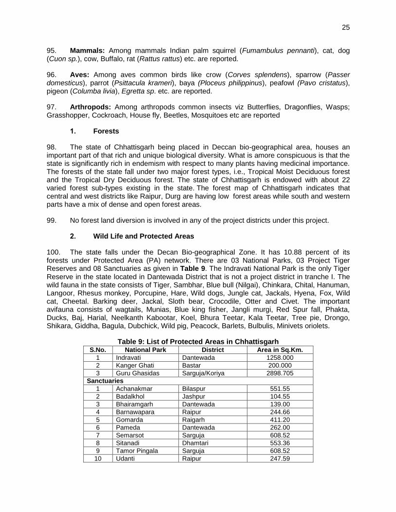
25
95. Mammals: Among mammals Indian palm squirrel (Fumambulus pennanti), cat, dog (Cuon sp.), cow, Buffalo, rat (Rattus rattus) etc. are reported.
96. Aves: Among aves common birds like crow (Corves splendens), sparrow (Passer domesticus), parrot (Psittacula krameri), baya (Ploceus philippinus), peafowl (Pavo cristatus), pigeon (Columba livia), Egretta sp. etc. are reported.
97. Arthropods: Among arthropods common insects viz Butterflies, Dragonflies, Wasps; Grasshopper, Cockroach, House fly, Beetles, Mosquitoes etc are reported
1. Forests
98. The state of Chhattisgarh being placed in Deccan bio-geographical area, houses an important part of that rich and unique biological diversity. What is amore conspicuous is that the state is significantly rich in endemism with respect to many plants having medicinal importance. The forests of the state fall under two major forest types, i.e., Tropical Moist Deciduous forest and the Tropical Dry Deciduous forest. The state of Chhattisgarh is endowed with about 22 varied forest sub-types existing in the state. The forest map of Chhattisgarh indicates that central and west districts like Raipur, Durg are having low forest areas while south and western parts have a mix of dense and open forest areas.
99. No forest land diversion is involved in any of the project districts under this project.
2. Wild Life and Protected Areas
100. The state falls under the Decan Bio-geographical Zone. It has 10.88 percent of its forests under Protected Area (PA) network. There are 03 National Parks, 03 Project Tiger Reserves and 08 Sanctuaries as given in Table 9. The Indravati National Park is the only Tiger Reserve in the state located in Dantewada District that is not a project district in tranche I. The wild fauna in the state consists of Tiger, Sambhar, Blue bull (Nilgai), Chinkara, Chital, Hanuman, Langoor, Rhesus monkey, Porcupine, Hare, Wild dogs, Jungle cat, Jackals, Hyena, Fox, Wild cat, Cheetal. Barking deer, Jackal, Sloth bear, Crocodile, Otter and Civet. The important avifauna consists of wagtails, Munias, Blue king fisher, Jangli murgi, Red Spur fall, Phakta, Ducks, Baj, Harial, Neelkanth Kabootar, Koel, Bhura Teetar, Kala Teetar, Tree pie, Drongo, Shikara, Giddha, Bagula, Dubchick, Wild pig, Peacock, Barlets, Bulbulis, Minivets oriolets.
Table 9: List of Protected Areas in Chhattisgarh S.No. National Park District Area in Sq.Km.
1 Indravati Dantewada 1258.000 2 Kanger Ghati Bastar 200.000 3 Guru Ghasidas Sarguja/Koriya 2898.705
Sanctuaries
1 Achanakmar Bilaspur 551.55 2 Badalkhol Jashpur 104.55 3 Bhairamgarh Dantewada 139.00 4 Barnawapara Raipur 244.66 5 Gomarda Raigarh 411.20 6 Pameda Dantewada 262.00 7 Semarsot Sarguja 608.52 8 Sitanadi Dhamtari 553.36 9 Tamor Pingala Sarguja 608.52 10 Udanti Raipur 247.59
26
S.No. National Park District Area in Sq.Km. 11 Bhoramdev Kawardha 163.80
101. Among the project districts part of Guru Ghasidas National Park and Kanger ghat fall in Sarguja and Bastar districts respectively, while, Achanakmar, Badalkhol, Bhairamgarh & Pameda, Barnawapara, Semarsot, Sitanadi, Udanti and Gomarda sanctuaries fall in Bilaspur, Jaspur, Dantewada, Raipur and Raigarh districts respectively. However, none of the project roads pass through any of these protected areas (Figure 9).
102. Endangered and threatened animals of India have been listed in the Schedule I and Schedule II of the Wildlife (Protection) Act, 1972 (amended in 2001). No threatened, rare, endangered or endemic species were found in COI of the sample roads.
3. Aquatic Biology and Fisheries:
103. No wetland or important water bodies exists in and around the selected project roads area. None of the sample project roads area is having any fish culture ponds.
D. Socio-Economic Environment
1. Demography
104. Chhattisgarh, earlier a part of Madhya Pradesh, became a separate state on 1st November 2000. It is a state with several unique features, such as abundant natural resources, rich biodiversity, and rich cultural diversity. The population of about 21 million is largely rural (79%). Tribals constitute about 33% of the population, and scheduled castes form about 12%. The welfare and development of tribals is an important focus area for the state government. The gender ratio of the state is higher than the national average as shown in Table 10.
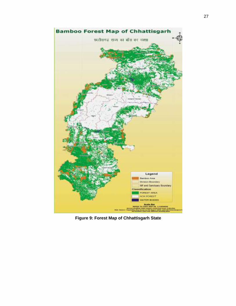
27
Figure 9: Forest Map of Chhattisgarh State
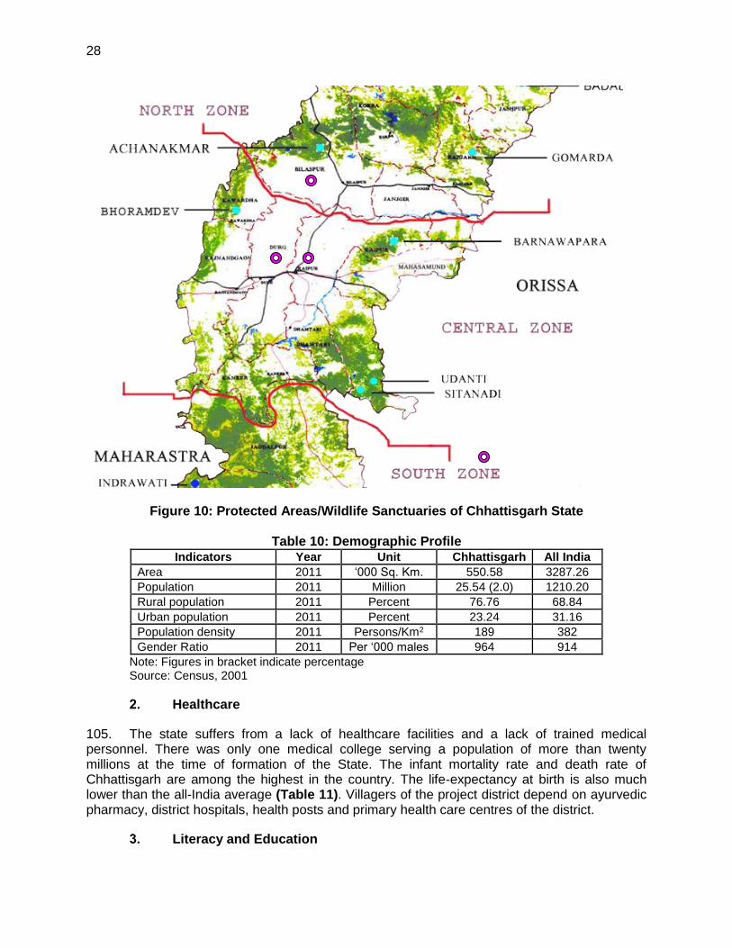
28
Figure 10: Protected Areas/Wildlife Sanctuaries of Chhattisgarh State
Table 10: Demographic Profile Indicators Year Unit Chhattisgarh All India
Area 2011 ‘000 Sq. Km. 550.58 3287.26
Population 2011 Million 25.54 (2.0) 1210.20
Rural population 2011 Percent 76.76 68.84
Urban population 2011 Percent 23.24 31.16
Population density 2011 Persons/Km2 189 382
Gender Ratio 2011 Per ‘000 males 964 914
Note: Figures in bracket indicate percentage Source: Census, 2001
2. Healthcare
105. The state suffers from a lack of healthcare facilities and a lack of trained medical personnel. There was only one medical college serving a population of more than twenty millions at the time of formation of the State. The infant mortality rate and death rate of Chhattisgarh are among the highest in the country. The life-expectancy at birth is also much lower than the all-India average (Table 11). Villagers of the project district depend on ayurvedic pharmacy, district hospitals, health posts and primary health care centres of the district.
3. Literacy and Education
29
106. The state has made considerable progress in the literacy (Table 11). However, the literacy level is particularly low among the scheduled castes and scheduled tribes population, especially among tribal women. The number of primary schools per 0.1 million people is above the average all-India level. However, the primary schools lack facilities and trained teaching staff. Tribals, in particular, lack access to educational facilities. Several enrolment campaigns and welfare programs run in the state to improve enrolment and reduce the dropout rates. The number of recognized professional education institutions is low in Chhattisgarh compared to the all-India situation.
Table 11: Human Development Indicators of Chhattisgarh Indicators Year Unit Chhattisgarh All India
Infant Mortality Rate 2002 Per’000 live birth 73 63
Life Expectancy at Birth
Male 2003 Years 59.2 63.87
Female 2003 Years 58.0 66.91
Death Rate 2002 Per ‘000 pop. 10.3 8.1
Literacy Rate
Male 2011 Per cent 81.45 82.14
Female 2011 Per cent 60.59 65.46
Person 2011 Per cent 71.04 74.04
Gross Enrolment Ratio (Classes I-IV)
Boys 2002-03 Per cent 107.3 97.53
Girls 2002-03 Per cent 101.6 93.07
Total 2002-03 Per cent 104.4 95.39
Primary School 2002-03 Per Lakh Pop. 115.2 63.42
Professional Edu. Inst.* 2002-03 Per Million Pop. 0.2 2.54
* Professional educational institutions include engineering, technology, architecture, medical and teacher training colleges.
4. Affluence
107. The percentage of population below the poverty line is high at 44%. On an average, the level of affluence of a household in Chhattisgarh is lower than that of a household in the rest of the country (Table 12). There are proportionately less number of households in houses with concrete roof, drinking water in premises and open drainage system for waste water in comparison with the all-India level. In both rural and urban areas of Chhattisgarh, the proportion of households having access to safe drinking water is also less compared to the all-India scenario.
Table 12: Indicators of Affluence
5. Economy
108. The State's economy is highly dependent on the primary sector with agriculture as the main source of livelihood of the population. The per capita income (measured by per capita State Domestic Product) of Chhattisgarh is much below the national average as seen from
Indicators Year Unit Chhattisgarh All India
HH in houses with concrete roof 2001 Per cent 10.9 19.8
HH with drinking water in premises 2001 Per cent 19.0 39.0
HH with open drainage for waste water 2001 Per cent 16.7 33.9
HH having access to safe drinking water
Rural
2001 Per cent
66.2 73.2
Urban 88.8 90.0
Total 70.5 77.9
30
Table 13. The share of the primary sector in the State Domestic Product (SDP) of the State is 37.3% whereas at the all India level this share, on an average, is 26.3%. At the all India level, the share of the service sector is 49.3% of GDP (Gross Domestic Product) whereas in Chhattisgarh the service sector has a share of 43.7% of SDP.
109. The expansion of the industrial sector is quite tardy in the State. It is confined to few local areas, mainly in Durg, Raipur, Korba nad Raigarh districts. Most districts of the State hardly have any industrial units except rice milling and wood cutting. The agricultural productivity is very low (Table 13). Low agricultural productivity is the result of several factors, including mono-cropping practices, low use of fertilizer, lack of water resource management and irrigation facilities, and low levels of mechanization. There is significant scope for improving agricultural productivity by addressing these problems.
110. All parameters for the banking services namely, number of bank offices per 100 thousand population, percentage of households availing of the banking services, credit-deposit ratio indicate that banking activities are limited in Chhattisgarh in comparison with the all India scenario.
Table 13: Indicators of Economy of Chhattisgarh Indicators Year Unit Chhattisgarh All India
SDP/GDP per capita 2001- 02 Rs. 11952 17822.8
Composition of SDP / GDP
Primary 2002 Per cent 37.30 26.28
Secondary 2002 Per cent 18.98 24.41
Service 2002 Per cent 43.72 49.31
Average yield of principal crops
Rice 2008-09 Kg. per hect. 1485 2125
Wheat 2008-09 Kg. per hect. 1086 2839
Maize 2008-09 Kg. per hect. 1399 2024
Cropping Intensity 2003 Per cent 117 135
Consumption of fertilizers 2003-04 Kg. per hect. 46.5 89.8
Prop. of area under irrigation 2001 Per cent 20.66 44.2
Bank offices 2004 Per Lakh Pop. 2.80 4.54
HH availing banking services 2001 Per cent 24.10 35.50
Credit-Deposit Ratio 2003 Per cent 39.1 59.4
6. Agriculture
111. About 35% of the state's area is under agriculture and majority of the state's population (about 80%) is dependent on agriculture. The principal food crops of the state are rice, wheat and maize. Agriculture contributed about 34% to the Net State Domestic Product (NSDP) in 2002-2003.
112. Agriculture production and livestock farming is the main source of livelihood in sample project areas. The economy of the area is predominantly agriculture based. It has high potential for agriculture production such as crops, tropical fruits e.g. b mango, papaya, lemon, orange, etc., and green vegetables. Most of the common crops grown in the areas are as rice, wheat, maize, barley, as well as other important vegetables
7. Mineral Resources
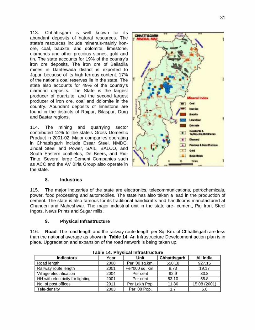
31
113. Chhattisgarh is well known for its abundant deposits of natural resources. The state's resources include minerals-mainly iron-ore, coal, bauxite, and dolomite, limestone, diamonds and other precious stones, gold and tin. The state accounts for 19% of the country's iron ore deposits. The iron ore of Bailadila mines in Dantewada district is exported to Japan because of its high ferrous content. 17% of the nation's coal reserves lie in the state. The state also accounts for 49% of the country's diamond deposits. The State is the largest producer of quartzite, and the second largest producer of iron ore, coal and dolomite in the country. Abundant deposits of limestone are found in the districts of Raipur, Bilaspur, Durg and Bastar regions.
114. The mining and quarrying sector contributed 12% to the state's Gross Domestic Product in 2001-02. Major companies operating in Chhattisgarh include Essar Steel, NMDC, Jindal Steel and Power, SAIL, BALCO, and South Eastern coalfields, De Beers, and Rio-Tinto. Several large Cement Companies such as ACC and the AV Birla Group also operate in the state.
8. Industries
115. The major industries of the state are electronics, telecommunications, petrochemicals, power, food processing and automobiles. The state has also taken a lead in the production of cement. The state is also famous for its traditional handicrafts and handlooms manufactured at Chanderi and Maheshwar. The major industrial unit in the state are- cement, Pig Iron, Steel Ingots, News Prints and Sugar mills.
9. Physical Infrastructure
116. Road: The road length and the railway route length per Sq. Km. of Chhattisgarh are less than the national average as shown in Table 14. An Infrastructure Development action plan is in place. Upgradation and expansion of the road network is being taken up.
Table 14: Physical Infrastructure Indicators Year Unit Chhattisgarh All India
Road length 2008 Per ‘00 sq.km. 550.18 927.15
Railway route length 2001 Per‘000 sq. km. 8.73 19.17
Village electrification 2004 Per cent 92.9 83.8
HH with electricity for lighting 2001 Per cent 53.10 55.8
No. of post offices 2011 Per Lakh Pop. 11.86 15.08 (2001)
Tele-density 2003 Per ‘00 Pop. 1.7 6.6
32
117. Power: The percentage of villages electrified is about 93% in the entire state. However, the percentage of households with electricity for lighting is only 53.1% the all India level. The state was until recently, power surplus state. It is also being linked to the Eastern grid. Korba in Chhattisgarh is the power capital of India. NTPC's Super Thermal Power Plant in Korba works at a very high Plant Load Factor (PLF). There are huge coal reserves in the vicinity, offering cheap power generation opportunities.
10. Religious and Cultural festivals:
118. The state of Chhattisgarh has great cultural value. Festivals and cultural activities are being celebrated throughout the year in the state. Specific events are being organized by tribal communities i.e. Gonds and Banjaras, throughout the year. There are few temples located along the project roads. In some cases those need to be shifted.
E. Salient Environmental Features of Sample Roads
119. The salient environmental features of sample roads are summarized in Table 15.
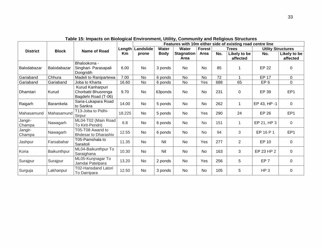
33
Table 15: Impacts on Biological Environment, Utility, Community and Religious Structures
District Block Name of Road Length
Km
Features with 10m either side of existing road centre line
Landslide prone
Water Body
Water Stagnation
Area
Forest Area
Trees Utlity Structures
No. Likely to be affected
No. Likely to be affected
Balodabazar Balodabazar Bhalookona - Singhari- Parasapali Dongridih
6.00 No 3 ponds No No 85 1 EP 22 0
Gariaband Chhura Madeli to Ranipartewa 7.00 No 6 ponds No No 72 1 EP 17 0
Gariaband Gariaband Joba to Kharta 16.60 No 6 ponds No Yes 688 65 EP 6 0
Dhamtari Kurud Kurud Kanharpuri Chorbatti Bhusrenga Bagdehi Road (T-06)
9.70 No 63ponds No No 231 0 EP 39 EP1
Raigarh Baramkela Saria-Lukapara Road to Sankra
14.00 No 5 ponds No No 262 1 EP 43, HP -1 0
Mahasamund Mahasamund T13-Joba to Pidhi-Sirpur
18.225 No 5 ponds No Yes 290 24 EP 26 EP1
Jangir-Champa
Nawagarh ML04-T02 (Main Road To Kirit-Pendri)
6.8 No 6 ponds No No 151 1 EP 21, HP 3 0
Jangir-Champa
Nawagarh T05-T08 Awarid to Bhdesar to Dharashiv
12.55 No 6 ponds No No 94 3 EP 16 P 1 EP1
Jashpur Farsabahar T05-Pamshala to Saraitoli
11.35 No Nil No Yes 277 2 EP 10 0
Koria Baikunthpur ML04-Baikunthpur To Saraighana
10.30 No Nil No No 163 3 EP 23 HP 2 0
Surajpur Surajpur ML05-Kunjnagar To Jamdai Patelpara
13.20 No 2 ponds No Yes 256 5 EP 7 0
Surguja Lakhanpur T02-Hansdand Latori To Darripara
12.50 No 3 ponds No No 105 5 HP 3 0
34
IV. ANTICIPATED ENVIRONMENTAL IMPACTS AND ITS MITIGATION MEASURES
120. Road improvements work brings substantial economic and social benefits to rural communities and national economies. However, it may also cause adverse environmental impacts though of smaller magnitude, since rural road subprojects aligned along the existing road alignments and will be of 8-12 m width only (in special cases it will be between 5-6m). The impacts are expected largely during construction phase, which can be mitigated through engineering measures and adoption of best construction practices. This section outlines the identified impacts during design, construction and operation phases along with proposed mitigation measures for eliminating or minimizing the adverse impacts.
121. The associated environmental impacts are assessed considering present environmental setting of the project area, nature, and extent of the proposed activities. Impacts are analysed on both generic and specific nature and are classified as insignificant, minor, moderate and major.
122. Since the issues associated with most of the roads are similar, the impacts and mitigation measures given below are applicable to most of the subprojects. Any issue specific to a road, is separately mentioned.
A. Common Impacts during Design and Construction Phase
1. Climate change
123. Impact: The proposed roads are analysed considering climate change vulnerability screening checklist defined under EARF to second RCIP. The resource (like barrow earth, aggregate, cement, concrete) requirements for these rural roads as such are minimal. None of these resources is likely to be affected by climate changes (such as changes in temperature and precipitation). None of the project roads is located in natural hazard areas or passes through protected areas or flood prone areas. The habitations are less along these rural roads and as such, no exponential population growth is expected considering the generic trend of population migration from rural to urban areas. Most of the sample roads pass through agricultural fields and along the existing road alignments with low embankment height of 1m (average) from ground to crust except at the approaches to cross drainage structures. As such, the sub project roads are unlikely to be vulnerable or increase the vulnerability of surrounding areas (with respect to population growth, settlement patterns, increasing runoff or landslides
124. Mitigation Measures: Compensatory tree plantations7 (1:3) will be made to compensate the loss of trees cut for construction of sub project roads. Efforts shall be made to plant additional trees for increasing the carbon sink. The tree may be planted with help of village Panchayat8 . All non-sample rural roads to be included in second RCIP will also be screened for climate change vulnerability and necessary mitigation measures shall be adopted for minimisation of identified vulnerability if any.
2. Finalization of Alignment
7SRRDA mostly undertake this activity through state forest department. The forest department plants tree either
along the proposed roads if land is available otherwise on nearby degraded forest land. 8 Village Panchayats are planting trees along rural roads with funding under Mahatma Gandhi National Rural
Employment Act scheme. The PIUs may facilitate with them for planting trees along the road. Some of the PIUs in different states are already helping Village Panchayats for the same.
35
125. Impact: The proposed rural road will be constructed to provide 8-12 m roadway in accordance with PMGSY II guidelines and technical specifications (IRC-SP 20: 2002) for plain terrains. Sample rural roads are aligned to existing road (earthen track with some stretches of brickbat soling). The existing road passes through plain terrain and primarily agriculture areas. None of the sample roads passes close to any protected monument or through protected areas. Impacts due to road alignment and design is expected to be minor and limited to shifting of some common utilities, community structures (temple, school) and cutting of trees falling within road way.
126. Mitigation Measures: The road alignment is finalised considering availability of right of way. The ROW is reduced in built up area or constricted areas to minimize additional land requirement. The road alignment has also been modified to avoid tree cutting, shifting of utilities or community structure to the extent feasible. Some of the measures taken include widening of the road on one end to maintain the tree on the road edge to avoid its cutting, using retaining wall to minimise the road width to 5m wherever required. The road is aligned to follow natural topography to avoid excessive cut and fill. All future roads to be included in second will follow above measures. In addition these subprojects will comply with the following criteria for alignment finalisation::
The road will be part of district core network and will comply with PMGSY guidelines
Subproject shall not disturb any cultural heritage designated by the government or by the international agencies, such as UNESCO, and shall avoid any monuments of cultural or historical importance.
Subproject will not pass through any designated wild life sanctuaries, national park, notified Eco sensitive areas or area of international significance such as protective wet land designated under Wetland Convention, and reserve forest area..
Subproject to comply with local and National legislative requirements (such as forest clearance for diversion of forest land) and ADB’s Safeguard Policy Statement 2009.
3. Land Acquisition
127. Impact: Minor impact, since no land acquisition is involved due to various measures considered for finalisation of road alignment. Villagers have volunteered to donate their land if at certain stages land is required for geometrical correction or alignment adjustment for avoiding tree cutting or shifting of community structure.
128. Mitigation Measures: All efforts shall be made to minimize the land acquisition while finalising the alignment. In an unavoidable situation, adopt suitable engineering measures to reduce the ROW requirement or donation of land from landowners. In the encroached areas, efforts shall be made to restricted road construction to the available space.
4. Protected Areas (National parks, wild life sanctuaries, Eco sensitive zones, protected /historical monuments) and Forest Areas.
129. Impact: Chhattisgarh state has many wild life sanctuaries but none of the sample road is located within 10 km radius of the sample project roads. The nearest national parks and sanctuaries (Guru Ghasidas National Park in Koriya, Badalkhol in Jaspur and Gomarda in Raigarh
district) are located at a distance of minimum 10km away from the project roads. Four out of the
36
12 sample roads pass through forest area and the PIUs have already applied clearance from the Forest department for the purpose of the road construction. As the roads/tracks are already existing in case of all these roads, the project will have very little impact on forest cover of the state/Country. Chhattisgarh is also known to have several archaeological monuments and historical monuments spread all over the state. However, none of them is located within 5 km of sample roads.
130. Mitigation Measures: As there are no Protected/Ecologically sensitive areas in the sub project areas, no such measures are proposed. In case of a diversion of forest land, prior forest clearance shall be obtained under Forest (Conservation) Act 1980 (amended 1988).
5. Land Clearing Operations
131. Impact: The site clearing operations may have impact on common utilities, community properties, land use and vegetation profile of the area if adequate considerations not given to road alignment finalisation, utility and community structure shifting plan, tree felling, and demolition waste disposal.
132. Mitigation Measures: The following steps shall be taken to minimise the associated impact with land clearing operations.
The land clearing operation should be undertaken as per the defined road alignment and community structure, utility and road furniture shifting plan.
The road land width shall be clearly demarcated on the ground.
The utility and community structure shifting shall be as per plan and with consultations and concurrence of the community.
Tree felling shall be limited to those, which could not be saved even by design measures. The tree shall be cut with a permission of Forest department. The vegetable cover shall be removed and disposed in consultation with community.
All public utilities shall be shifted with a concurrence of respective agencies/authority and to the adjacent location approved by them.
The top soils shall be collected and preserved for reuse as a base for turfing of embankment slopes or development of barren areas along roadside. The top soil shall be preserved at identified location with the provision of watering /grass development on the heap surface to prevent air pollution.
6. Cut and Fill and Embankment construction
133. Impact: Inadequate alignment planning may increase the cut and fill requirement as well as need for more borrow earth for embankment formation leading to some impact on land use. Inadequate provision for drainage and embankment slop protection may lead to soil erosion. Due consideration is given to above aspect for alignment finalisation of sample road. With the adoption of appropriate mitigation measures, the impact due to above activity on land use and other environmental component is expected to be minimal.
134. Mitigation Measures: The alignment design shall consider options to minimise excessive cuts and fills. The cut and fill quantities shall be used for embankment to minimise barrow earth requirement. The design shall be as per relevant IRC provisions for cut and fill, slope protection and drainage. Adequate provision shall be made for cross drainage structures for maintaining natural drainage pattern in the subproject area and preventing soil erosion. The top soil of the cut and fill area shall be used for embankment slope protection.
37
7. Establishment of Construction Camp, Temporary office and Storage Area
135. Impact: The congregation of labour population and technical staff in the subproject area during the construction phase is likely to put considerable stress on the limited resources of village areas. Some of the associated impacts are related to health, safety of the labourers at the construction camp sites, availability of safe drinking water, and sanitation.
136. The establishment of construction camp temporary office and storage area will reduce land productivity if these are established on agricultural land. Loading and unloading of construction material, transportation of material, handling of fuel and waste disposal from these areas may have direct and indirect impact on soil, water and air quality
137. Mitigation Measures: The following steps shall be taken to minimise/reduce these impacts:
Construction camp sites shall be located away from any local human settlements (minimum 1 km away) and preferably located on lands, which are not productive barren/waste lands presently. Similarly temporary office and storage areas shall be located away from human settlement areas (minimum 500 m).
The construction camps, office and storage areas shall have adequate water supply, sanitation and all requisite infrastructure facilities. This would minimize dependence of construction personnel on outside resources, presently being used by local populace and minimize undesirable social friction thereof.
The construction camps shall be located at a minimum 500m from forest land/areas to deter the construction labour in trespassing. Similarly, temporary office and storage areas shall be located at a minimum 500m from forest land/areas.
The construction camps, office and storage areas shall have septic tank/soak pit of adequate capacity so that it can function properly for the entire duration of its use.
All construction camps shall have rationing facilities particularly for kerosene/LPG so that dependence on firewood for cooking is avoided completely to the extent possible.
The construction camps, office and storage areas shall have health care facilities for adults, pregnant women and children.
All construction personnel shall be subjected to routine vaccinations and other preventive/healthcare measures.
Contractor shall arrange all personal protective equipment (PPEs) like helmet, boots, and earplugs for workers, first-aid and fire fighting equipment at construction sites. An emergency plan shall be prepared to fight with any emergency like fire.
Garbage bins must be provided in the camp and regularly emptied and disposed off in a hygienic manner. Domestic solid waste shall be disposed of in a control manner. The recyclable waste shall be sold off and nonsaleable and biodegradable waste shall be disposed through secured land filling.
All fuel oil/lubricant unloading and storage shall be made on the paved areas away from storm water drainage.
After completion of construction work, the camp /temporary office/storage areas sites shall be restored to its original condition.
38
8. Traffic Movement
138. Impact: Construction work along the existing road could cause disturbances to traffic movements. It will also pose risk of accident to motorist at night if these blockages and disruption are not clearly demarcated.
139. Mitigation Measures: The contractor will prepare appropriate traffic diversion scheme, which shall be implemented in different stretches of the road as per the progress of the construction work. This plan shall be approved by PIU and implemented before start of any construction work to avoid any inconvenience to the present road users. The diversion plan should ensure smooth flow of traffic, minimise accidents to road users during construction works. Adequate signboards shall be placed much ahead of diversion site to caution the road users. The road signs should be bold and visible and retro reflective in nature for day and night visibility.
9. Associated Impacts due to Construction Activities
a. Loss of productive soil, erosion and land-use
140. Impact: No land use will change due to the project, since required ROW is available throughout the alignment. Land use though will change temporarily of construction camp, temporary office storage areas for the period of construction. This will also result in loss of soil productivity. Soil erosion may take place along steep and un-compacted embankment slope, and wherever vegetation is cleared. Soil erosion may have cumulative effect viz. siltation, embankment damage, drainage clogging etc. The siltation, due to soil erosion may occur only in the ponds located close to the roads. Ten out of the 12 sample roads reviewed have ponds located close to the existing road. Loss of soil due to run off from earth stockpiles may also lead to siltation. Land use may also change due to borrowing the earth.
141. Mitigation Measures: It shall be ensured that the land taken on lease for access road, construction camp and temporary office of the storage facilities, is restored back to its original land use before handing it over back to land owner. The top soil from the productive land (borrow areas, road widening areas etc.) shall be preserved and reused for plantation purposes. It shall also be used as top cover of embankment slope for growing vegetation to protect soil erosion. The topography of all the sample roads through out the stretch is plain except in case rolling/ undulating terrain for very small stretches in few of them especially located in Koria district. Therefore, cut and fill shall be planned as per IRC provisions and rural road manual. All steep cuts shall be flattened and benched. Shrubs shall be planted in loose soil area. IRC: 56 -1974 recommended practice for treatment of embankment slopes for erosion control shall be taken into consideration. Soil erosion shall be visually checked on slopes and embankment areas. If soil erosion observed, suitable measures shall be taken to control it.
b. Borrow Areas and Quarries
142. Impact: Borrow areas if left un-rehabilitated may pose risk to people, particularly children and animals of accidentally falling into it. This may also become potential breeding ground for mosquitoes and vector born disease. Illegal quarrying may lead to unstable soil condition; destroy the landscape of the terrain, air and noise pollution.
143. Mitigation Measures: Borrowing earth from agricultural land shall be minimised to the extent possible. Further, no earth shall be borrowed from already low-lying areas. The borrow
39
earth shall be sourced from identified locations and with prior permission of landowner and with clear understanding for its rehabilitation. The Indian Road Congress (IRC):10-1961 guideline should be used for selection of borrow pits and quantity that can be borrowed. The borrow area shall be located/ rehabilitated as per the guidelines given at Appendix 4. Fly ash shall also be used in road embankment as per IRC guidelines wherever thermal power plant is located within 100 km of the road alignment. The stone aggregate shall be sourced from existing licensed quarries only. The quarry should have requisite consent to operate from State Pollution Control Board. No new quarry shall be opened for the proposed project.
c. Hydrology and Drainage
144. Impact: The activities involved with proposed road development may alter the hydrology and drainage pattern of the area in absence of adequate provision for cross drainage structure, construction wastes disposal and drainage in habitat areas.
145. None of the sample roads is crossing any natural stream/ river. Certain project roads are crossing local and seasonal drains. Village ponds are also located close to few roads.
146. Mitigation Measures: Adequate engineering measures like embankment height above high flood line, retaining wall, cros drainage structures are proposed for protection of sample roads from half river. Adequate provisions are also made for bank stabilisation (like toe wall, slop stabilisation), and prevention of silt runoff during construction and operational stages.
147. The provision of adequate cross drainage structures shall be made to ensure smooth passage of water and maintaining natural drainage pattern of the area. The discharge capacity of the CD structure shall be designed accordingly. The construction work shall be planned in dry season so that water quality of the water channel is not affected due to siltation. Elaborate drainage system shall be provided to drain the storm water from the roadway and embankment and to ensure minimum disturbance to natural drainage of surface and subsurface water of the area. Provision of additional cross drainage structures shall be made in the areas where nearby land is sloping towards road alignment in both the both sides.
148. Provision of CC road construction in habitat area with drainage of both side of the road shall be made as per the design specifications and with adequate slope to prevent any water logging.
d. Compaction and Contamination of Soil
149. Impact: Soil in the adjoining productive lands beyond the ROW, haulage roads, and construction camp area may be compacted due to movement of construction vehicles, machineries, equipments and construction camps/storage facilities. It may get contaminated due to inappropriate disposal of liquid waste, (lubricating oil and fuel spills, waste oil and lubricant and vehicle/equipment washing effluent) and solid waste (fuel filters, oily rags) likely to be generated from repair and maintenance of transport vehicles, construction equipment and machinery.
150. Mitigation Measures: To prevent soil compaction in the adjoining productive lands beyond the ROW, the movement of construction vehicles, machinery and equipment shall be restricted to the designated haulage route. The productive land shall be reclaimed after construction activity. Septic tank or mobile toilets fitted with anaerobic treatment facility shall be provided at construction camp/temporary office/storage areas. Domestic solid waste at
40
construction camp shall be segregated into biodegradable and non-biodegradable waste. The non-biodegradable and recyclable waste shall be sold off. Fuel and lubricants shall be stored at the predefined storage location. The storage area shall be paved with gentle slope to a corner and connected with a chamber to collect any spills of the oils. All efforts shall be made to minimise the waste generation. Unavoidable waste shall be stored at the designated place prior to disposal. To avoid soil contamination at the wash-down and re-fuelling areas, “oil interceptors” shall be provided. Oil and grease spill and oil soaked materials are to be collected and stored in labelled containers (Labelled: WASTE OIL; and hazardous sign be displayed) and sold off to SPCB/ MoEF authorized re-refiners.
e. Construction Debris and Wastes
151. Impact: Uncontrolled disposal of debris and waste may create unhygienic and unsafe condition around the disposal areas.
152. Mitigation Measures: All excavated materials from roadway, shoulders, verges, drains, cross drainage shall be used for embankments formation if feasible, filling pits, and landscaping. Unusable debris material should be suitably disposed off at pre-designated disposal locations, with approval of the concerned authority. The bituminous wastes shall be disposed in secure landfill sites only in environmentally accepted manner. MORTH guidelines shall be followed for debris, wastes removal and disposal at unproductive/wastelands which shall be selected with the consent of villagers and Panchayat. The dumping site should be of adequate capacity and to be located away from residential areas (at least 1000m away). It should also be located away from water bodies to prevent any contamination of these bodies.
f. Air Quality
153. Impact: The potential sources of air emission during the construction phase of the project are given below which can cause localised air pollution.
Dust from earth works (during site preparation).
Emissions from the operation of construction equipment and machines.
Fugitive emissions from vehicles plying on the road, during the transport of construction materials.
Emissions other than dust particularly from the hot mix plants and laying of bitumen. Hot mix plant will generate carbon monoxide (CO), un-burnt hydrocarbon (HC), sulphur dioxide (SO2), particulate matters (PM), and nitrogen oxides (NOx) emissions.
Localised increased traffic congestion in construction areas. Most of the emissions will be in the form of coarse particulate matter, which will settle down in close vicinity of construction site. This may affect the air quality of nearby areas, especially, due to emission discharge from low height of the stack.
154. Mitigation Measures: All these impacts will be temporary and hence, no significant impact is envisaged. The following measures will be taken to minimise these:
Vehicles delivering loose and fine materials like sand and aggregates shall be covered.
41
Dust suppression measures like water sprinkling, shall be applied in all dust prone locations such as unpaved haulage roads9, earthworks, stockpiles and asphalt mixing plant areas.
Mixing plants and asphalt (hot mix) plants shall be located at least 0.5 km away and in downwind direction of the human settlements.
Material storage areas shall also be located downwind of the habitation area.
Hot mix plant shall be fitted with stack of adequate height (30 m) or as may be prescribed by state pollution control board (SPCB) to ensure enough dispersion of exit gases. Consent to establish and operate shall be obtained from State Pollution Control Board and comply with all consent conditions.
Diesel Generating (DG) sets shall also be fitted with stack of adequate height. Low sulphur diesel shall be used in DG sets and other construction machineries. Construction vehicles and machineries shall be periodically maintained.
The requisite PPE (helmet, mask, boot, hand gloves) shall be provided to the construction workers.
g. Noise Quality
155. Impact: Ambient noise level may increase temporarily in the close vicinity of various construction activities, maintenance workshops, vehicles movement and earthmoving equipment.
156. Mitigation Measures: The noise level will be intermittent and temporary and will attenuate fast with increase in distance from noise source. Further, vehicles and equipment should be fitted with silencers and maintained regularly. The workers shall be provided with personal protection devices such as earplugs and earmuffs. Workers’ exposure to noise will be restricted to less than 8 hours a day. Workers duty shall be regulated accordingly.
h. Groundwater and Surface Water Quality and Availability
157. Impact: Water will be required for compaction of formation and domestic purposes in the workers camp. These requirements will be mainly sourced from groundwater. Any uncontrolled abstraction of ground water can deplete the ground water table fast. Contamination of groundwater is not envisaged since all construction camps will have septic tanks or mobile toilets depending on the number of workers in each camp. The drinking water supply to the habitat is primarily through hand pumps and bore wells. No significant impact is anticipated on surface water bodies except probability of siltation during construction. Due to non-perennial nature of surface water bodies, water requirements for drinking and construction purpose shall be met from ground water sources.
158. Mitigation Measures: Requisite permission shall be obtained for abstraction of groundwater from State Ground Water Board/Central Ground Water Authority10 if applicable. The contractor shall arrange for water required during construction in such a way that the water availability and supply to nearby communities remains unaffected. Water intensive activities shall not be undertaken during summer period to the extent feasible. Provision shall be made to link side drains with the nearby ponds for facilitating water harvesting. Where ponds are not
9 Water suppression of fugitive dust can reduce emissions from 12% to 98% 10 As per Central Ground Water Authority (CGWA), there are 43 notified blocks in India where prior permission is required fro extraction of ground water. Currently there are no notified areas in Chhattisgarh state. CGWA is continually updating the list of notified areas.
42
available, the water harvesting pits shall be constructed as per the requirement and rainfall intensity. Measures are already purposed in earlier section for prevention of siltation in water bodies.
i. Biological Environment
159. Impact: Since the sample roads are not passing through any protected areas or forest area, there is no diversion of forest land. The major adverse impacts will be due to tree cutting, Siltation and contamination of water bodies may affect the aquatic life. Since there are only ponds and non-perennial water bodies (local nallas and few canals) the aquatic life is minimal and no significant impact is anticipated on aquatic life.
160. Mitigation Measures: All efforts shall be taken to avoid tree cutting wherever possible. Requisite permission from forest department shall be obtained for cutting of roadside trees. Compensatory Afforestation shall be made on 1:3. ratio basis. Additional trees shall be planted wherever feasible. All care shall be taken to avoid siltation/contamination of water bodies. Movement of herbivores like Cattle, Goats, Cows etc., have been observed in the surrounding agriculture fields. Disturbance to these animals will be avoided to the extent possible.
j. Impact on Common Property Resources
161. Impact: There are public utilities like Electric transformer, electric poles, and hand pumps all along the rural roads. The road construction may require shifting of these utilities. There are many community structures like school, playground village office and temples. One of the roads i.e NH6 - Malidih in Mahasamund district has a small temple located adjacent to the road that will be affected due to the project.
162. Mitigation Measures: All efforts are made to minimize shifting of common utilities and community structures. ROW has been reduced in constricted areas with appropriate engineering measures to minimize land acquisition and shifting of community structures. The community structures/utilities which can not be saved will be shifted to adjacent area with the concurrence and in consultation with community.
B. Common Impacts during Post Construction and Operation Phase
1. Air Quality
163. Impact: Decrease in air quality due to increase in traffic, idling at congestions.
164. Mitigation Measures: The bad road condition is the main cause of poor air pollution at present. The improved road conditions will result in the improved ambient air quality. Also, the subproject road is largely traversing through vast open agriculture areas, which will provide adequate dispersion to gaseous pollutants, generated from vehicles and will offset the increased pollutants.
2. Noise
165. Impact: During the operational phase, movement of traffic will be the prime source of noise. Traffic congestion and pedestrian interferences increase the use of horns. This may result in increased noise levels at habitat areas, nearby schools and religious places.
43
166. Mitigation Measures: Awareness signboard shall be provided for safe driving near the habitat areas. Speed limitation and honking restrictions may be enforced near sensitive locations.
3. Land, Soil, Tree Plantation
167. Impact: The better access can lead to conversion of agriculture land for residential and commercial purposes close to roads, which may result in loss of productive land and agricultural produce. Since the rural road are aimed at connecting the villages, and with the general trend of migration of rural population to urban areas, the phenomena of conversion of agriculture land to residential area is unlikely to change.
168. The land occupied for construction camp /temporary office/material storage area will remain unproductive if it is not restored after completion of construction activities.
169. It shall be essential to ensure the survivability of the compensatory tree planted
170. Mitigation Measures It shall be ensured that all construction camp/temporary office/material storage areas are restored to its original conditions. The borrow area rehabilitation will also be ensured as per the agreed plan with the landowner. Contractor and PIC will ensure the same and obtained clearance from PIU before handling over the site to SRRDA.
171. The PIC will undertake survivability assessment and report to PIU the status of compensatory tree plantation at a stage of completion of construction with recommendation for improving the survivability of the tree if required.
4. Groundwater
172. No impact is anticipated on groundwater due to the project during operation phase, hence, no specific mitigation is proposed.
5. Hydrology and Drainage
173. Impact: Water accumulation incidence may occur due to inadequate availability of cross drainage structure or clogging of cross drainage structures.
174. Mitigation Measures: Regular removal/cleaning of deposited silt shall be done from drainage channels and outlet points before the monsoon season. Rejuvenation of the drainage system by removing encroachments/ congestions shall be regularly conducted.
6. Socio-Economic Impact
175. Assessment of project impact on socio-economic conditions point to the conclusions that positive benefits are many fold compared to its adverse impact.
176. Positive Impacts: The better road access is likely to contribute the overall economic condition of village community. With the quick access to urban market areas, the farmers are likely to get better prices for their farm produce. Children will also be able to access the school and education facilities in the near by urban areas.
44
177. Safety Measures shall be adopted as per NRRDA guidelines. Some of them are highlighted below :
Speed breakers (Rumble strips) as per IRC: 99-1988 shall be provided at sharp curves and bends where the curve design speed is less than 40 km per hour.
Speed breakers shall also be provided at a threshold of habitation (as per NRRDA guidelines) at regular intervals (150-200 m) through habitation.
The speed breakers are provided and directional sight boards installed at sites where reverse horizontal curves are closely spaced and speed reduction is required.
Hazard markers to be installed at each end of all box culverts, river crossing causeways and similar CD structures
Shoulder side slopes shall not be steeper than 2h:1V unless stone pitching of the slopes is provided.
Cement concrete pavement and V-shaped drain is constructed to the full width of the available roadway within densely populated habitation.
Directional sight board are installed on all sharp curves and bends
At main road, intersection or crossing “STOP” sign and ‘T-intersection’ warning sign shall be installed on the village road.
C. Road Specific Impacts
178. The assessment of sample roads indicates that environmental issue associated with all the roads are similar. Hence mitigation measures applicable to all the road are also will be similar except variation in terms of magnitude which will depend on length of the road, the presence various environmental components. These components may be assessed in terms of no of pond, number of community structure (mostly temples, playground, school, gram Panchayat office) likely to be shifted, number and type of common utilities (hand pump, water tank, electric transformer, electrical poles).
179. Forest areas are located along four out of the 12 sample roads at different chainages, Appropriate measures relating to location of camp sites and working hours etc. should be maintained as provided in the environment management plan.
D. Climate Change Impacts and Risks
1. Climate Change Mitigation
180. The Transport Emissions Evaluation Model for Projects (TEEMP) is an excel based tool to assess CO2 gross emissions without (business as usual or BAU) and with the project improvements (with project scenario or WPS). The tool, which was developed by Clean Air Asia and the Institute for Transportation and Development Policy, was funded by ADB. The main improvement from the project that was considered for the model are better surface roughness with less than 2.5m/km, and improved traffic speed and hence less fuel consumption. The model has also been used for CO2 emission assessment during construction stage. The model also allows for the inclusion of impacts related to traffic congestion with and without project through provisions for inserting data on the traffic numbers, lane width, number of lanes and volume/capacity saturation limit. The model also computes for emission and emission intensity of PM and NOx.
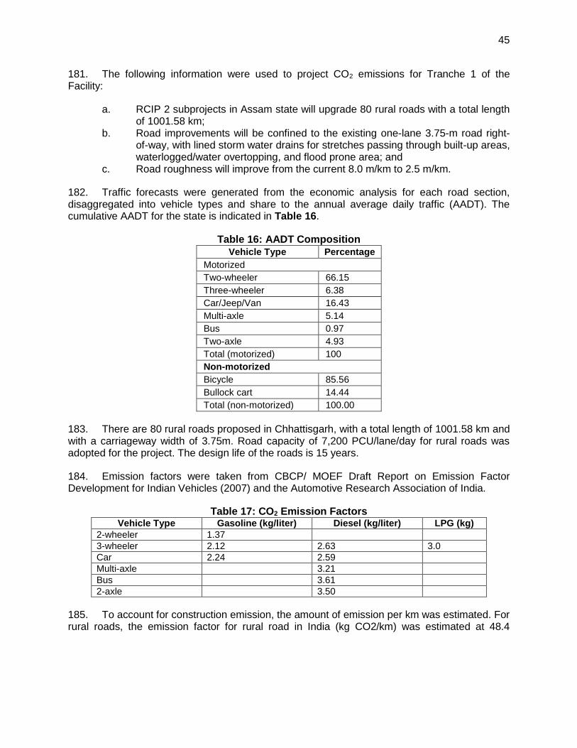
45
181. The following information were used to project CO2 emissions for Tranche 1 of the Facility:
a. RCIP 2 subprojects in Assam state will upgrade 80 rural roads with a total length of 1001.58 km;
b. Road improvements will be confined to the existing one-lane 3.75-m road right-of-way, with lined storm water drains for stretches passing through built-up areas, waterlogged/water overtopping, and flood prone area; and
c. Road roughness will improve from the current 8.0 m/km to 2.5 m/km.
182. Traffic forecasts were generated from the economic analysis for each road section, disaggregated into vehicle types and share to the annual average daily traffic (AADT). The cumulative AADT for the state is indicated in Table 16.
Table 16: AADT Composition
Vehicle Type Percentage
Motorized
Two-wheeler 66.15
Three-wheeler 6.38
Car/Jeep/Van 16.43
Multi-axle 5.14
Bus 0.97
Two-axle 4.93
Total (motorized) 100
Non-motorized
Bicycle 85.56
Bullock cart 14.44
Total (non-motorized) 100.00
183. There are 80 rural roads proposed in Chhattisgarh, with a total length of 1001.58 km and with a carriageway width of 3.75m. Road capacity of 7,200 PCU/lane/day for rural roads was adopted for the project. The design life of the roads is 15 years.
184. Emission factors were taken from CBCP/ MOEF Draft Report on Emission Factor Development for Indian Vehicles (2007) and the Automotive Research Association of India.
Table 17: CO2 Emission Factors Vehicle Type Gasoline (kg/liter) Diesel (kg/liter) LPG (kg)
2-wheeler 1.37
3-wheeler 2.12 2.63 3.0
Car 2.24 2.59
Multi-axle 3.21
Bus 3.61
2-axle 3.50
185. To account for construction emission, the amount of emission per km was estimated. For rural roads, the emission factor for rural road in India (kg CO2/km) was estimated at 48.4
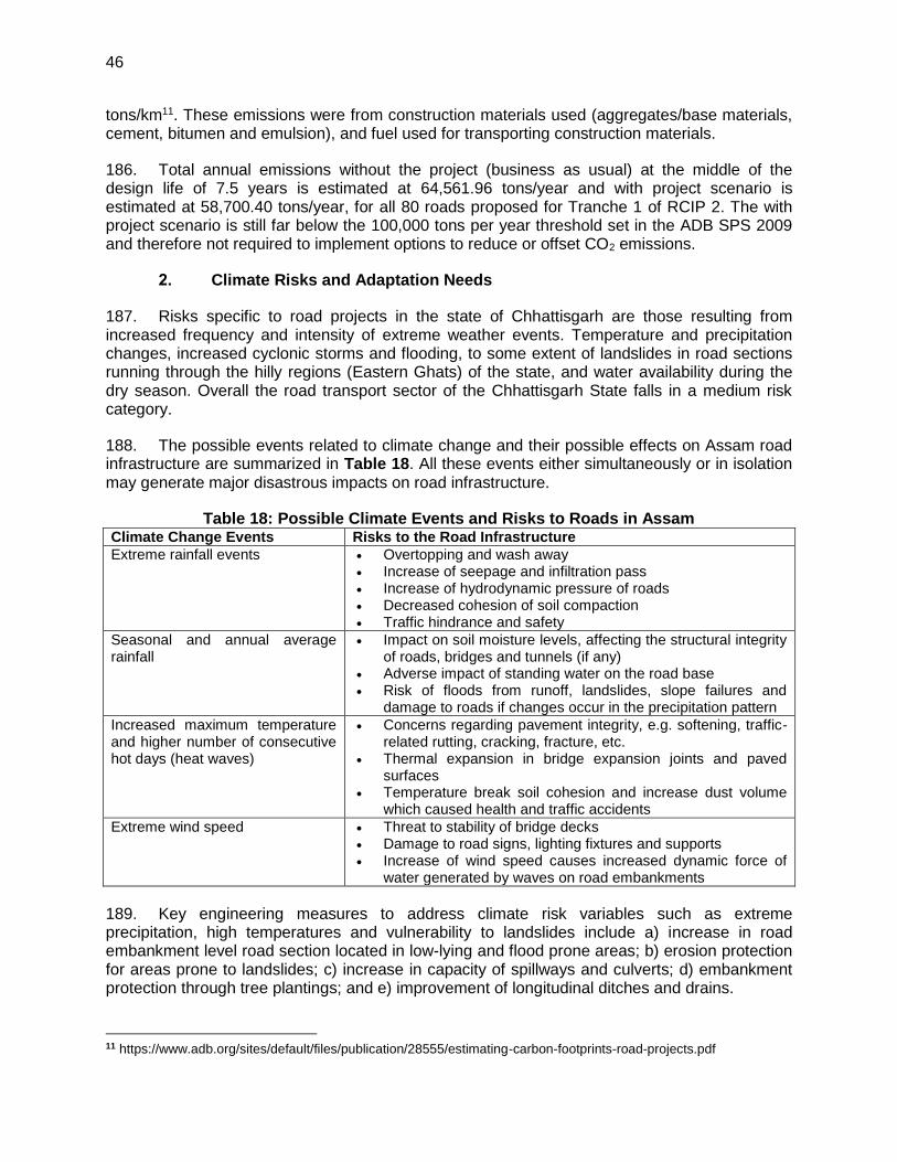
46
tons/km11. These emissions were from construction materials used (aggregates/base materials, cement, bitumen and emulsion), and fuel used for transporting construction materials.
186. Total annual emissions without the project (business as usual) at the middle of the design life of 7.5 years is estimated at 64,561.96 tons/year and with project scenario is estimated at 58,700.40 tons/year, for all 80 roads proposed for Tranche 1 of RCIP 2. The with project scenario is still far below the 100,000 tons per year threshold set in the ADB SPS 2009 and therefore not required to implement options to reduce or offset CO2 emissions.
2. Climate Risks and Adaptation Needs
187. Risks specific to road projects in the state of Chhattisgarh are those resulting from increased frequency and intensity of extreme weather events. Temperature and precipitation changes, increased cyclonic storms and flooding, to some extent of landslides in road sections running through the hilly regions (Eastern Ghats) of the state, and water availability during the dry season. Overall the road transport sector of the Chhattisgarh State falls in a medium risk category.
188. The possible events related to climate change and their possible effects on Assam road infrastructure are summarized in Table 18. All these events either simultaneously or in isolation may generate major disastrous impacts on road infrastructure.
Table 18: Possible Climate Events and Risks to Roads in Assam Climate Change Events Risks to the Road Infrastructure
Extreme rainfall events Overtopping and wash away Increase of seepage and infiltration pass Increase of hydrodynamic pressure of roads Decreased cohesion of soil compaction Traffic hindrance and safety
Seasonal and annual average rainfall
Impact on soil moisture levels, affecting the structural integrity of roads, bridges and tunnels (if any)
Adverse impact of standing water on the road base Risk of floods from runoff, landslides, slope failures and
damage to roads if changes occur in the precipitation pattern
Increased maximum temperature and higher number of consecutive hot days (heat waves)
Concerns regarding pavement integrity, e.g. softening, traffic-related rutting, cracking, fracture, etc.
Thermal expansion in bridge expansion joints and paved surfaces
Temperature break soil cohesion and increase dust volume which caused health and traffic accidents
Extreme wind speed Threat to stability of bridge decks Damage to road signs, lighting fixtures and supports Increase of wind speed causes increased dynamic force of
water generated by waves on road embankments
189. Key engineering measures to address climate risk variables such as extreme precipitation, high temperatures and vulnerability to landslides include a) increase in road embankment level road section located in low-lying and flood prone areas; b) erosion protection for areas prone to landslides; c) increase in capacity of spillways and culverts; d) embankment protection through tree plantings; and e) improvement of longitudinal ditches and drains.
11 https://www.adb.org/sites/default/files/publication/28555/estimating-carbon-footprints-road-projects.pdf

47
190. Provisions have also been made in the bidding documents for the contractor to prepare EMPs based on the final detailed design to address climate related risks and vulnerabilities.
48
V. ENVIRONMENTAL MANAGEMENT PLAN, INSTITUTIONAL ARRANGEMENTS AND GRIEVANCE REDRESS MECHANISM
A. Environmental Management Plan
191. The Environmental Management Plan (EMP) is prepared to facilitate effective implementation of recommended mitigations measures with defined roles and responsibility for implementation and monitoring, regulatory compliance requirements, stages of implementation with location, period and costs. The mitigation measures are proposed to eliminate or minimise the identified impact associated with design, construction and operation stages of the project, to acceptable level by adopting the most feasible options.
192. The EMP is prepared as per Environmental Management Standard (ECOP) applicable to rural road defined be ADB at RRS I stage.
193. The identified impacts are insignificant and are related to clearing operations of RoW, traffic diversions, setting and operation of construction camps, quarry and borrowing operations, transportation of materials, construction of cross drainage structures, air & noise pollution due to construction activities and operation of construction equipment, tree cutting and shifting of utilities and physical community structure.
194. Appropriate mitigation measures are identified for all rural road construction and operation activities. The identified impacts associated with rural roads and mitigative measures are largely common to most of the roads. The EMP is detailed at Appendix 4. It provides action common to all roads at pre construction, construction and operation stage. Since IEE is carried out, prior to preparation of DPR, the EMP will be updated specific to road as per DPR requirements by PIU and included with DPR, which shall be available to contractor at the time of bidding. The areas to be updated as per DPR provisions are highlighted under location column of EMP.
195. Since, these are rural road, the vehicular density and speed will be low. Movement of vehicles would be confined primarily for transfer of agricultural produce to market places. As such, no major emergency is anticipated. In any accidental eventuality, local administration can be reached quickly for help though Gram Panchayat (village administration) communication systems.
B. Environmental Monitoring Plan
196. The environmental monitoring program is prepared with aim to monitor the environmental performance of environmental management plan. The EMOP is planned with the focus on following objectives:
To the assess the effectiveness of mitigation measures proposed
To assess the change in environmental quality during construction and operation stage with respect to before the project scenario.
To assess compliance to regulatory requirements
To monitor the status of corrective action taken in case of deviation from the planned measures or regulatory requirements.
49
197. For rural roads, Environmental Monitoring plan will be more observation oriented and it provides observation areas with frequency of monitoring at pre construction aspects12, construction stage and operation stage. A monitoring plan with monitoring indicator and frequency of monitoring is given at Appendix 5.
C. Institutional Arrangements and Responsibilities
1. Institutional Arrangement
198. NRRDA constituted by MORD is the nodal agency for the implementation of PMGSY in India. SRRDA is the state level agency responsible for implementation of PMGSY program in the state. NRRDA has developed various guidelines and defined institutional arrangements for effective and timely implementation of PMGSY program, which also covers measures for environmental and social safeguards. In line with the defined institutional requirements, each SRRDA has set up district level project implementation units (PIUs). NRRDA also appoints Technical Support Consultant (TSC) to provide technical support for capacity building in SRRDA/PIUs, facilitating them for environmental and social safeguard compliance monitoring and due diligence. SRRDA appoints PIC (project implementation consultant) for supervision of construction work. PIC also helps PIU in monitoring the EMP.
199. NRRDA is also responsible to coordinate with SRRDA and ensure compliance to ADB safeguard requirements.
200. The institutional arrangement at National Level and state level for implementation of PMGSY including second RCIP is shown at Figure 11.
Institutional Environmental Responsibilities
201. The institutional environmental responsibilities for different level and function is elaborated below
202. MORD13 the executing agency has the responsibility for monitoring implementation of the EMP for all subprojects and undertaking necessary due diligence. MORD ensure this through its Nodal Agency NRRDA (National Rural Road Development Agency). MORD will also ensure that
ADB is given access to undertake environmental due diligence for all subprojects, if and when needed as per EARF requirements.
SRRDA meet all environmental assessment requirements in accordance with EARF
It undertakes random monitoring of the implementation of the EMP
Ensure compliance to legislative requirements such as forest clearance for diversion of forest land for non-forest purposes and Consent to Establish/Operate for hot mix plant, batching plant
Appoint Technical Support Consultant (TSC) to assist SRRDA for various environmental aspect and safeguard compliances
12 Aspects related to alignment selection for inclusion of new roads 13 MoRD implements it through its nodal agency NRRDA which undertakes this with the help of Environmental Expert of Technical Support Consultant
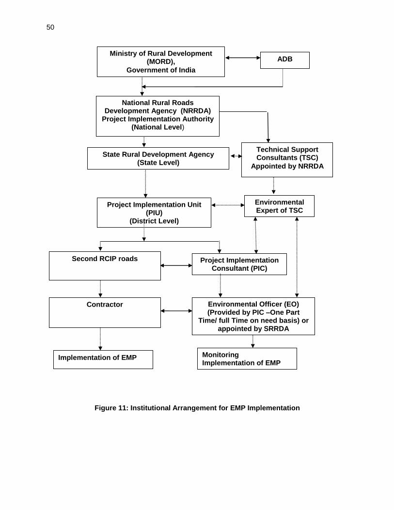
50
Figure 11: Institutional Arrangement for EMP Implementation
Ministry of Rural Development (MORD),
Government of India
National Rural Roads Development Agency (NRRDA)
Project Implementation Authority (National Level)
State Rural Development Agency (State Level)
Project Implementation Unit (PIU)
(District Level)
Second RCIP roads Project Implementation Consultant (PIC)
Contractor Environmental Officer (EO) (Provided by PIC –One Part
Time/ full Time on need basis) or appointed by SRRDA
Implementation of EMP
ADB
Technical Support Consultants (TSC)
Appointed by NRRDA
Environmental Expert of TSC
Monitoring Implementation of EMP
51
203. SRRDA14will ensure that:
ECOP checklist is prepared for each road
The completed ECOP checklist is included in the DPR with the help of PIC.
Ensure that all required statutory environmental clearances are obtained and comply with clearance conditions;
Ensure that the subproject specific EMPs and respective budget are included in the bidding documents;
Ensure that the ECOP checklists and EMP (including general and site specific issues) are made available to the contractors;
Undertake routine monitoring of the implementation of the EMP including spot checks on site and prepare monitoring reports at least once a year; and
With the support of technical support consultants prepare satisfactory environmental due diligence reports of the earlier tranche/periodic financing request before implementing the next tranche.
Appoint Project Implementation Consultant ( PIC) for construction supervision and assist PIUs for EMP implementation and related safeguard compliances.
204. PIU will be responsible to:
Complete the ECOP checklists and prepare subproject specific EMPs (including monitoring plan) for each subproject
Obtain necessary statutory environmental clearance prior to commencement of civil works
Update the respective ECOP checklists and EMPs if there are any changes in alignment of the subprojects
To conduct monitoring of all subprojects and prepare pre-, during and post-construction monitoring checklists through the project implementation consultants,
Prepare and submit to SRRDA annual monitoring report as per ADB defined format
205. The Technical Support Consultants (TSC) appointed by NRRDA. The Environmental Expert of TSC:
Will provide technical assistance to SRRDA/PIU regarding environmental aspects, environmental permitting/clearances requirement,
Periodically review EMP implementation status including spot site inspections.
Conduct workshops/capacity building program at different level and functions.
Prepare environmental Due Diligence report for each trench before implementing next trench
Prepare state Level IEE reports and EMPs for non sample roads based on the ECOP checklist completed by the PIC
206. Project Implementation Consultant (PIC) is appointed by SRRDA. PIC will provide one Environmental Officer (EO). The EO will be responsible to ensure adherence and implementation of EMP at all stages of works by the contractor. The EO, if found warranting
14 With assistance from PIC (Project Implementation Unit)
52
may also conduct field tests, independent of the contractor to determine the effectiveness of EMP under approval of PIC/PIU. The broad duties / responsibilities of the Environmental Officer will include:
Review of project design and specifications to ensure their adequacy and suitability with respect to the implementation of EMP.
Collection and dissemination of relevant environmental documents including amendments to environmental protection acts issued by the various agencies, namely, ADB, Government of India / State and local bodies;
Interact with the counterpart of the Contractor(s), review work progress/plans and ensure implementation of the EMP;
Co-ordination with the NGOs, community groups and Government departments on environmental issues, provide clarifications/ and obtain clearances during project implementation if any, as required from the regulatory authorities and/or submitting periodic compliance reports as required by the State Authorities;
Monitoring sensitive environmental attributes during construction and operation stages15 to ensure that the suggested mitigation measures in the EMP are implemented. This will also serve as the basis for the annual environmental monitoring reports.
Facilitate PIU for preparation of annual monitoring report as per ADB defined format
Documentation of the environmental management/monitoring activities for the regular project implementation progress report; which will serve as the basis for the annual environmental monitoring reports.
Conducting environmental training/awareness programs for the contractors, the project implementation personnel and the communities.
207. Contractor is appointed by SRRDA for construction of road and ensure implementation of EMP proposed. The broad duties of constrictor are as follows:
Make adequate costs provision for EMP requirements while biding
Ensure effective implementation of mitigative measures as per road specific EMP
Comply with all applicable legislative requirements and obtain necessary consents for to Establish/Operate before start of hot mix plant and batching plants. Comply with al permit conditions
Create awareness amongst workers for environment, occupational health and safety aspects. Participate in training and awareness programme along with its executives conducted by PIC.
Provide PPE and adequate resources for Environment Occupational Health and Safety
Follow all the guidelines for borrowing earth and restoration of borrow areas, setting up construction camps
Sourcing of quarry material from approved quarries only
Provide all required input to PIC for environmental monitoring as per EMP.
15 Normally PIC is supposed to undertake five site visits and five monitoring reports as per contracts being issued by
different SRRDA. It is proposed that PIC shall submit the following five monitoring reports: (1) First report at pre construction stage, (2) Second report after three months of start of construction or on completion of 25% construction (3) Thrid report after seven months of start of construction or on completion of 75% of construction, (4) Fourth report after one month of completion of construction and first year of operation stage (5) Fifth report in second month of seond year of operation stage.
53
D. Environmental Assessment and Review Framework ( EARF) for Second RCIP
208. ADB has prepared an Environmental Assessment and Review Framework (EARF) which identifies the broad scope of the MFF, outlines the policy, environmental screening and assessment, and institutional requirements for preparing the environmental assessments to be followed for subsequent batches and tranches. This EARF also specifies criteria for eligibility for selection rural roads under second RCIP. The sample roads are selected following these criteria. The EMP, monitoring requirement, institutional aspects, capacity building, grievance redress mechanism presented in this chapter are developed in line with above EARF. The eligibility criteria for selection of roads under second RCIP, environmental assessment requirement for each trench and legal framework are given below:
1. Selection Criteria and Environmental Assessment Requirement
209. The following criteria will be followed for selection of non sample roads.
(i) No Category A (as per ADB’s SPS) subproject will be included in the MFF. (ii) Subprojects will be eligible for construction or upgrading in accordance with the
PMGSY guidelines, and be included in the respective district core network. (iii) The subprojects shall not disturb any cultural heritage designated by the
Government or by international agencies, such as UNESCO, and shall avoid any monuments of cultural or historical importance.
(iv) The subproject will not pass through any designated wildlife sanctuaries, national parks, other sanctuaries, notified ecological sensitive areas or area of internationally significance (e.g., protected wetland designated by the Wetland Convention).
(v) The projects shall only involve activities that follow Government of India laws and regulations, ADB’s Safeguard Policy Statement (2009)
210. The following environmental Assessment requirement will be followed for all roads included under second RCIP
(i) ECOP checklists with annexes on trees, utility structures, community structures, strip plans and photographs will be completed for each and every road.
(ii) Based on the requirements of the PMGSY guidelines separate ECOP checklists will be prepared for bridges that are longer than 15 m.
(iii) Based on the completed ECOP checklists for roads and bridges, IEE reports will be prepared at a state level. These reports must contain a general EMP and a site specific EMP where there are site specific issues.
(iv) ADB’s REA checklist for roads and highways will be completed based on the state level IEE reports prepared and submitted to ADB to confirm categorization
211. The vulnerable to climate change will also be screened following screening checklists, which was integrated in the ADB REA Checklists and corresponding mitigation measures will be prepared.
(i) Is the project area subject to hazards such as earthquakes, floods, landslides, tropical cyclone winds, storm surges, tsunami or volcanic eruptions and climate changes
54
(ii) Could changes in precipitation patterns or evaporation rates over the lifespan of the project affect its sustainability and cost (i.e., increased landslides increase maintenance costs)?
(iii) Does the project use or depend on resources which could be affected by climate changes such as changes in temperature, precipitation, wind (increased soil moisture content in the sub-grade)?
(iv) Are there any demographic or socioeconomic aspects of the subproject and project area (e.g., population growth, settlement patterns) that increase the vulnerability of the project and surrounding area?
(v) Could the subproject potentially increase the vulnerability of the surrounding area (i.e., by increasing runoff, encouraging settlement in earthquake zones)
2. Legal Framework
212. As per Indian legislation, an environmental clearance is not required for rural roads. However, it may attract provisions of Forest Conservation Act, Wild Life (Protection) Act, and other legislation related with Air, Water and Noise pollution controls and prevention. The legislative applicability screening is presented in chapter 1 of this report and it will apply for non-sample road as well. Additionally, to ensure conformance to ADB’s Safeguard Policy Statement, 2009 (SPS), the subprojects will be subject to the following requirements:
(i) Submission of a completed Rapid Environment Assessment (REA) checklist for Roads and Highways and a categorization form for each state level IEE that is prepared.
(ii) An Initial Environmental Examination16 (IEE) report including the preparation of an Environmental Management Plan (EMP) and a Monitoring Plan.
(iii) Regular monitoring of implementation of the EMP and submission of monitoring reports and due diligence reports to ADB as necessary
E. Capacity Building
213. Existing capacity of the State Rural Roads Development Agencies (SRRDAs) and Project Implementation Units (PIUs) for implementing environmental safeguard issues need substantial strengthening. Capacity building activities will mainly comprise training workshops for SRRDA and PIU environmental officers on (i) completion of environmental code of practice (ECOP) checklists; (ii) preparation of environmental management plan (EMP) and monitoring plans; (iii) monitoring of EMP implementation and completion of pre-, during and post-construction monitoring checklists; and (iv) preparation of monitoring reports. These few workshops have already been conducted at participating states though ADB appointed Environmental specialist. Additional training will be carried out periodically, by In-house trained and experienced officials.
F. Consultation and Information Disclosure
214. During the preparation of ECOP and Detailed Project Report (DPR), the PIU has to ensure consultation, and addressal of concerns of the affected people.
215. All environmental assessment documents are subject to ADB’s Public Communication Policy (2005) and will be made available to the public, upon request. The SRRDAs are
16 As per selection criteria, no Category A subproject will be included under RCIP.
55
responsible for ensuring that all environmental checklist documentation, including the environmental due diligence and monitoring reports, are properly and systematically kept as part of the Investment Program specific records. MORD must disclose state specific sample road IEE reports on its website.
G. Grievance Redress Mechanism
189. Subproject Level. Public disclosure and complaints contact person will be designated by the PIU for each subproject to help address all concerns and grievances of the local communities and affected parties. Contact details will form part of the subproject identification display board that will be placed at both ends of the rural road being constructed.
190. Village Level. If there are environmental issues concerning road subprojects, community consultation process that is transparent, gender responsive and accessible to all stakeholders, in accordance with PMGSY guidelines and SPS 2009 will be conducted. Grievances, if any, will be considered at the village level by the Grievance Redress Committee (GRC) consisting of members of Gram Panchayat, and Pradhan/Up-Pradhan of Gram Panchayat. The GRC will meet for addressing grievances as needed.
191. District Level. Grievances not resolved at the village level will be addressed through the district level GRC, with the following members:
(i) Executive Engineer of the PIU; (ii) Member of Zilla Parishad; (iii) Member of the grievance committee of the concerned GP; and (iv) Representatives of APs will be active participants in the proceedings of grievance
redressal.
192. Grievance procedures, which can be easily understood by stakeholders, and preferably in the local language, will be disseminated to affected communities. Issues need to be resolved prior to awarding of civil work contract.
216. Nationa Level. NRRDA has made provision of registering complaint /suggestion through its website. NRRDA forwards these complains to concerned SRRDA for necessary actions. SRRDA directly or through concerned PIU initiate the appropriate action and update the complainant as well as NRRDA. It is proposed that NRRDA website will be cross-linked to each SRRDA website as well or SRRDA will also make provision of complain registry at its website.
217. The following indicative timeline to resolve grievances at different levels will be observed: Subproject level – 3 days; Village level – 1 week; District level – 1 week; and National level – 2 weeks. GRM related costs, which mostly include travel expenses and meeting related expenses such as refreshments, will be covered by PIU. The GRC meetings will only be convened onlyif and when necessary. Hence, GRC members will not be required to be present in all times during project implementation. Cost for other activities such as recording complaints, minutes of meetings, preparing reports, etc., will be carried out by the PIU / PIC. Complainant has the option to resort to legal redress at any stage.
56
VI. PUBLIC CONSULTATION AND INFORMATION DISCLOSURE
A. General
218. Public consultation was undertaken consistent with the ADB requirements. All the five principles of information dissemination, information solicitation, integration, co-ordination and engagement into dialogue were incorporated in the consultation process. A framework of different environmental impacts likely from the project was strengthened and modified based on opinions of all those consulted, especially in the micro level by setting up dialogues with the village people from whom information on site facts and prevailing conditions were collected.
219. Stakeholder’s consultations were held from March to June 2017. Some of these consultations, reflected below, were done in Balodabazar, Garlaband, Dhamtari, Mahasamund, Raigarh, Janjgir-Champa, Surajpur, Surguja, Jashpur, and Korea districts. Stakeholders’, including women, were consulted to understand their concerns, apprehensions, overall opinion and solicit recommendations to improve project design. Informal meetings, interviews were organized covering the entire project stretch. The informal consultation generally started with explaining the sub projects, followed by an explanation to potential impacts. Participant’s views were gathered with regard to loss of agricultural land, shifting of utilities, shifting of common cultural properties, effect on air and noise quality of the area due to traffic, water availability, accident and risk.
220. The discussions were designed to receive maximum inputs from the participants regarding their acceptability and environmental concerns arising out of the sub-project. They were given the brief outline of the project to which their opinion was sought. Suggestions were also sought for mitigating any potential adverse impact.
B. Compliance with Relevant Regulatory Requirements
221. In India, public consultation is mandatory in case of Category A and B1 category projects17 in select conditions. Being a category B project as per ADB Safeguards Policy Statement 2009, consultation was carried out during the early stage of IEE report preparation. The requirement of public consultation during the implementation of the project has been proposed as part of the mitigation plan.
C. Beneficiaries’ Comments
222. The project has immense acceptability among the local people. They perceived that in addition to providing all weather connectivity, the sub-project road would bring positive socio-economic changes in the area. Local people mainly discussed on issues related to drainage and commencement of the construction work.
223. Some of the general issues raised during the different consultation sessions are summarised below:
Construction Camp - The participants did not apprehend any adverse impact due to the construction camp near to their villages. They responded positively
17 As per schedule I of EIA notification number S.O. 1533, dated 14th September 2006. This notification also defines
when a public consultation is mandatory. However, the project roads doe not require environmental clearance under this notification.
57
towards providing support to these, if required, in terms of any food, water requirements.
Water Logging and Drainage - Participants informed about few low-lying areas where water logging takes place during monsoon season. The villagers requested for provision of adequate cross drainage structures at these locations.
Loss of Livelihood and Income Restoration Options - those who had encroached on the proposed alignment raised this issue. However, they offered the encroached space for the proposed project, if demanded.
Road Safety - Safety issues were not of major concern among the inhabitants including women.
Land Acquisition - People were in full support of the project and were ready to donate their land for the same, if required.
Losses of Idols/Shrines - Participants supported the project and were willing to shift the idols, burial grounds and other religious structures observed at certain locations if required.
Loss of Trees Due to Road Construction - Respondents were of the opinion that trees cutting should be avoided or else minimised. For trees to be cut compensatory plantation should be done. Some villagers expected additional plantation should be carried out. They recommended to plant only local tree species.
Impacts on Health – Villagers do not perceive any impact due to this road project. However, issues pertaining to sexually transmitted diseases (STDs), HIV- AIDS may be an issue during construction stage however, this aspect is analysed by Social Impact Assessment team separately.
Ambient Air & Noise Quality – The respondents viewed that these are the problems of urban areas and their villages are still untouched from this aspect. They even do not anticipate any of these problems after the completion of the project. However, they do not want increased in pollution during construction phase.
Inconvenience during Construction - The participants viewed that they will manage it, as it will be temporary in nature.
Employment during Construction - The locals expected that they should be given preference in employment during project implementation.
Perceptions and Expectations - The public and the affected persons appreciated need and supported the project fully. Community at large appreciated overall benefits to them resulting from project development;
D. Addressal of Issues
224. The efforts made to address all the issues raised during consultations through design changes/adjustments and environmental best practices. Some of the provisions made under the project to address the issues and concerns of the community are given in Table 19. Consultations with stakeholders will continue throughout project implementation as necessary at different levels, to update and address the concerns of affected people on environment related issues.
Table 19: Addressal of Issues and Concerns under the Project Issue/Concern Addressal under the project
Water Logging and
Drainage
Adequate cross drainage structures have been planned
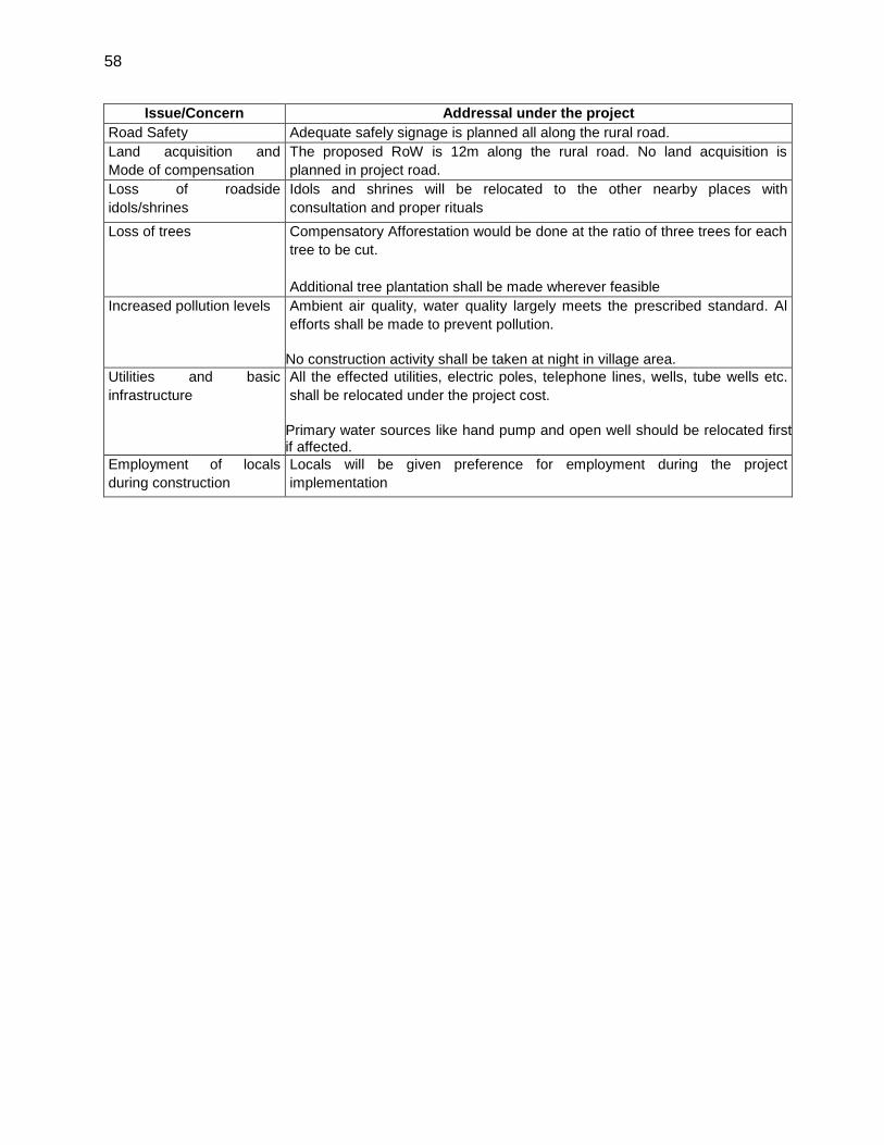
58
Issue/Concern Addressal under the project
Road Safety Adequate safely signage is planned all along the rural road.
Land acquisition and
Mode of compensation
The proposed RoW is 12m along the rural road. No land acquisition is
planned in project road.
Loss of roadside
idols/shrines
Idols and shrines will be relocated to the other nearby places with
consultation and proper rituals
Loss of trees Compensatory Afforestation would be done at the ratio of three trees for each
tree to be cut.
Additional tree plantation shall be made wherever feasible
Increased pollution levels Ambient air quality, water quality largely meets the prescribed standard. Al
efforts shall be made to prevent pollution.
No construction activity shall be taken at night in village area.
Utilities and basic
infrastructure
All the effected utilities, electric poles, telephone lines, wells, tube wells etc.
shall be relocated under the project cost.
Primary water sources like hand pump and open well should be relocated first if affected.
Employment of locals
during construction
Locals will be given preference for employment during the project
implementation
59
VII. CONCLUSIONS AND RECOMMENDATIONS
A. Conclusions
225. The findings of Environment Assessment of sample roads indicate that impacts are mostly similar and subprojects are unlikely to cause any significant environmental impacts. While some of the impacts are negative, there are many bearing benefits to the area. Most of the impacts are likely to occur during construction stage, are temporary in nature, and can be mitigated with minor to negligible residual impacts.
226. The project received immense support from local people as they perceive that this project will improve the overall connectivity and bring various economic opportunities to the people of the area
227. All sample roads included under SECOND RCIP were selected based on ecological and climate change consideration defined under EARF. Accordingly, none of the sample roads passes through protected areas or encroaches precious ecology (sensitive or protected areas) or any historical or archeologically protected areas. As per selection guidelines, none of the selected sample road passes through reserved forests either. Few trees cutting though may be involved.
228. None of the rural road crosses any river, only local nallas are crossed where adequate engineering measures are proposed for the protection of road from the flood.
229. All the sample roads are aligned with existing village roads and unpaved movement paths. As such, land acquisition is nil or very minimal which is also acquired through donations from villagers.
230. Considering insignificant environmental sensitivity, the project is categorised as category B as per ADB Safeguard Policy Statement 2009.
231. No categorisation is made under environmental legislation of India, since these small roads do not require any environmental clearance in accordance to Indian Environmental (Protection) Act and Rules, 1986 amended till date. However, clearance from Forest Department will be required for cutting of trees.
232. The impacts identified are mostly related to alignment selection, land clearing, borrowing earth, cutting of trees, shifting of utilities and community structures, establishment of construction camp or material storage areas, transportation of material and operation of hot mix plant. All identified impacts are either eliminated or minimised through design consideration and suitable mitigative measures.
233. Environmental Management plan covering all stages of road construction (design, construction and operation) is prepared with defined responsibility for its implementation. Environmental Monitoring plan is also prepared to ensure effective implementation of EMPs.
234. NRRDA/SRRDA has defined institutional setup including with specified responsibility for environmental management. Existing capacity of the State Rural Roads Development Agencies (SRRDAs) and Project Implementation Units (PIUs) for implementing environmental safeguard issues need substantial strengthening. The capacity enhancement is proposed through focused workshops and training session. Few workshops have already been conducted at participating
60
states through ADB appointed Environmental specialist. Trained and experienced in-house officials should carry out more raining in future periodically.
235. The IEE also indicate that rural road construction works does not warrant further EIA study for subsequent rural road construction works in Chhattisgarh.
B. Key Recommendations:
236. Any major changes or any major additional work other than the proposed project activities will require updation of ECOPs and IEE. The updated ECOPs and IEE will have to be submitted to NRRDA, and ADB for concurrence before civil works commence.
237. The implementation of prescribed mitigation measures will minimize/avoid the adverse impacts. Moreover, the impacts shall be monitored continually by implementing and updating the Environmental Management plan and Environmental Monitoring Plan.
238. These IEE is prepared based on ECOPs and feasibility stage. Subproject specific EMP shall be improved as per the final provisions made under DPRs. The updated EMP if there is any change, shall also be sent to ADB for information.
239. Executing agency shall ensure that updated road specific EMP forms part of DPR and is available to contractor at the time of bidding. The contractor will specify the quantity and budget for various activities like rehabilitation of borrow earth pits, first aid and sanitation facilities at construction camp and temporary office/material storage place as per EMP requirements. The same shall be revised if there is any change in the project design. Any such change shall be reported to ADB as well
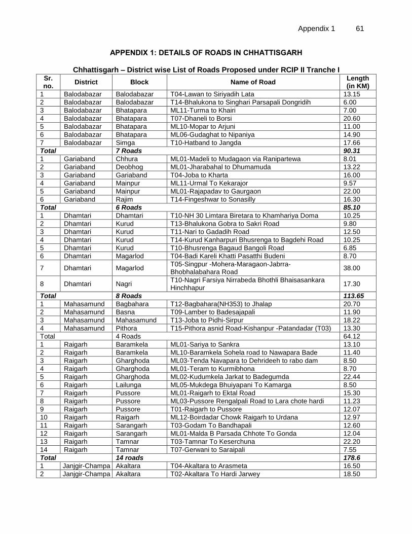
Appendix 1 61
APPENDIX 1: DETAILS OF ROADS IN CHHATTISGARH
Chhattisgarh – District wise List of Roads Proposed under RCIP II Tranche I Sr. no.
District Block Name of Road Length (in KM)
1 Balodabazar Balodabazar T04-Lawan to Siriyadih Lata 13.15
2 Balodabazar Balodabazar T14-Bhalukona to Singhari Parsapali Dongridih 6.00
3 Balodabazar Bhatapara ML11-Turma to Khairi 7.00
4 Balodabazar Bhatapara T07-Dhaneli to Borsi 20.60
5 Balodabazar Bhatapara ML10-Mopar to Arjuni 11.00
6 Balodabazar Bhatapara ML06-Gudaghat to Nipaniya 14.90
7 Balodabazar Simga T10-Hatband to Jangda 17.66
Total 7 Roads 90.31
1 Gariaband Chhura ML01-Madeli to Mudagaon via Ranipartewa 8.01
2 Gariaband Deobhog ML01-Jharabahal to Dhumamuda 13.22
3 Gariaband Gariaband T04-Joba to Kharta 16.00
4 Gariaband Mainpur ML11-Urmal To Kekarajor 9.57
5 Gariaband Mainpur ML01-Rajapadav to Gaurgaon 22.00
6 Gariaband Rajim T14-Fingeshwar to Sonasilly 16.30
Total 6 Roads 85.10
1 Dhamtari Dhamtari T10-NH 30 Limtara Biretara to Khamhariya Doma 10.25
2 Dhamtari Kurud T13-Bhalukona Gobra to Sakri Road 9.80
3 Dhamtari Kurud T11-Nari to Gadadih Road 12.50
4 Dhamtari Kurud T14-Kurud Kanharpuri Bhusrenga to Bagdehi Road 10.25
5 Dhamtari Kurud T10-Bhusrenga Bagaud Bangoli Road 6.85
6 Dhamtari Magarlod T04-Badi Kareli Khatti Pasatthi Budeni 8.70
7 Dhamtari Magarlod T05-Singpur -Mohera-Maragaon-Jabrra- Bhobhalabahara Road
38.00
8 Dhamtari Nagri T10-Nagri Farsiya Nirrabeda Bhothli Bhaisasankara Hinchhapur
17.30
Total 8 Roads 113.65
1 Mahasamund Bagbahara T12-Bagbahara(NH353) to Jhalap 20.70
2 Mahasamund Basna T09-Lamber to Badesajapali 11.90
3 Mahasamund Mahasamund T13-Joba to Pidhi-Sirpur 18.22
4 Mahasamund Pithora T15-Pithora asnid Road-Kishanpur -Patandadar (T03) 13.30
Total 4 Roads 64.12
1 Raigarh Baramkela ML01-Sariya to Sankra 13.10
2 Raigarh Baramkela ML10-Baramkela Sohela road to Nawapara Bade 11.40
3 Raigarh Gharghoda ML03-Tenda Navapara to Dehrideeh to rabo dam 8.50
4 Raigarh Gharghoda ML01-Teram to Kurmibhona 8.70
5 Raigarh Gharghoda ML02-Kudumkela Jarkat to Badegumda 22.44
6 Raigarh Lailunga ML05-Mukdega Bhuiyapani To Kamarga 8.50
7 Raigarh Pussore ML01-Raigarh to Ektal Road 15.30
8 Raigarh Pussore ML03-Pussore Rengalpali Road to Lara chote hardi 11.23
9 Raigarh Pussore T01-Raigarh to Pussore 12.07
10 Raigarh Raigarh ML12-Boirdadar Chowk Raigarh to Urdana 12.97
11 Raigarh Sarangarh T03-Godam To Bandhapali 12.60
12 Raigarh Sarangarh ML01-Malda B Parsada Chhote To Gonda 12.04
13 Raigarh Tamnar T03-Tamnar To Keserchuna 22.20
14 Raigarh Tamnar T07-Gerwani to Saraipali 7.55
Total 14 roads 178.6
1 Janjgir-Champa Akaltara T04-Akaltara to Arasmeta 16.50
2 Janjgir-Champa Akaltara T02-Akaltara To Hardi Jarwey 18.50
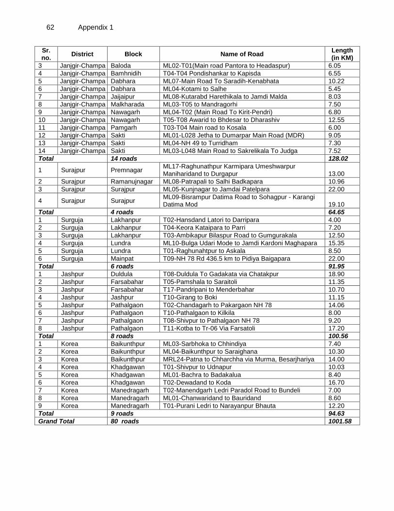
62 Appendix 1
Sr. no.
District Block Name of Road Length (in KM)
3 Janjgir-Champa Baloda ML02-T01(Main road Pantora to Headaspur) 6.05
4 Janjgir-Champa Bamhnidih T04-T04 Pondishankar to Kapisda 6.55
5 Janjgir-Champa Dabhara ML07-Main Road To Saradih-Kenabhata 10.22
6 Janjgir-Champa Dabhara ML04-Kotami to Salhe 5.45
7 Janjgir-Champa Jaijaipur ML08-Kutarabd Harethikala to Jamdi Malda 8.03
8 Janjgir-Champa Malkharada ML03-T05 to Mandragorhi 7.50
9 Janjgir-Champa Nawagarh ML04-T02 (Main Road To Kirit-Pendri) 6.80
10 Janjgir-Champa Nawagarh T05-T08 Awarid to Bhdesar to Dharashiv 12.55
11 Janjgir-Champa Pamgarh T03-T04 Main road to Kosala 6.00
12 Janjgir-Champa Sakti ML01-L028 Jetha to Dumarpar Main Road (MDR) 9.05
13 Janjgir-Champa Sakti ML04-NH 49 to Turridham 7.30
14 Janjgir-Champa Sakti ML03-L048 Main Road to Sakrelikala To Judga 7.52
Total 14 roads 128.02
1 Surajpur Premnagar ML17-Raghunathpur Karmipara Umeshwarpur Maniharidand to Durgapur 13.00
2 Surajpur Ramanujnagar ML08-Patrapali to Salhi Badkapara 10.96
3 Surajpur Surajpur ML05-Kunjnagar to Jamdai Patelpara 22.00
4 Surajpur Surajpur ML09-Bisrampur Datima Road to Sohagpur - Karangi Datima Mod 19.10
Total 4 roads 64.65
1 Surguja Lakhanpur T02-Hansdand Latori to Darripara 4.00
2 Surguja Lakhanpur T04-Keora Kataipara to Parri 7.20
3 Surguja Lakhanpur T03-Ambikapur Bilaspur Road to Gumgurakala 12.50
4 Surguja Lundra ML10-Bulga Udari Mode to Jamdi Kardoni Maghapara 15.35
5 Surguja Lundra T01-Raghunahtpur to Askala 8.50
6 Surguja Mainpat T09-NH 78 Rd 436.5 km to Pidiya Baigapara 22.00
Total 6 roads 91.95
1 Jashpur Duldula T08-Duldula To Gadakata via Chatakpur 18.90
2 Jashpur Farsabahar T05-Pamshala to Saraitoli 11.35
3 Jashpur Farsabahar T17-Pandripani to Menderbahar 10.70
4 Jashpur Jashpur T10-Girang to Boki 11.15
5 Jashpur Pathalgaon T02-Chandagarh to Pakargaon NH 78 14.06
6 Jashpur Pathalgaon T10-Pathalgaon to Kilkila 8.00
7 Jashpur Pathalgaon T08-Shivpur to Pathalgaon NH 78 9.20
8 Jashpur Pathalgaon T11-Kotba to Tr-06 Via Farsatoli 17.20
Total 8 roads 100.56
1 Korea Baikunthpur ML03-Sarbhoka to Chhindiya 7.40
2 Korea Baikunthpur ML04-Baikunthpur to Saraighana 10.30
3 Korea Baikunthpur MRL24-Patna to Chharchha via Murma, Besarjhariya 14.00
4 Korea Khadgawan T01-Shivpur to Udnapur 10.03
5 Korea Khadgawan ML01-Bachra to Badakalua 8.40
6 Korea Khadgawan T02-Dewadand to Koda 16.70
7 Korea Manedragarh T02-Manendgarh Ledri Paradol Road to Bundeli 7.00
8 Korea Manedragarh ML01-Chanwaridand to Bauridand 8.60
9 Korea Manedragarh T01-Purani Ledri to Narayanpur Bhauta 12.20
Total 9 roads 94.63
Grand Total 80 roads 1001.58
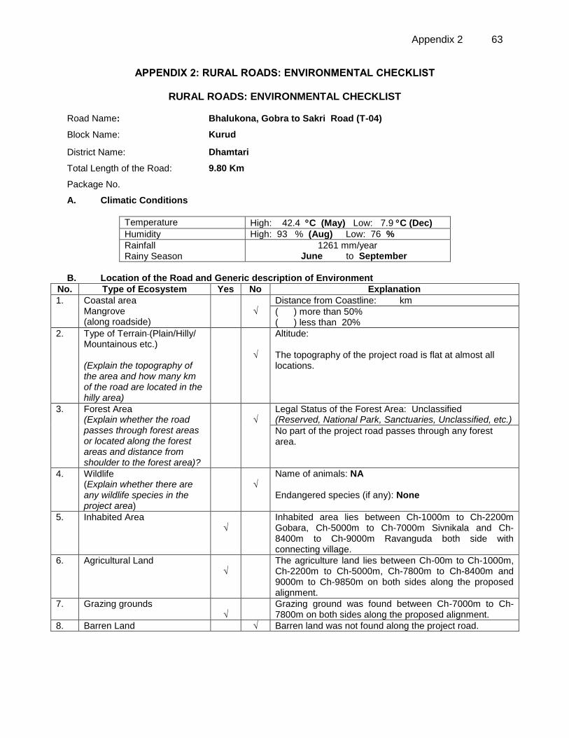
Appendix 2 63
APPENDIX 2: RURAL ROADS: ENVIRONMENTAL CHECKLIST
RURAL ROADS: ENVIRONMENTAL CHECKLIST
Road Name: Bhalukona, Gobra to Sakri Road (T-04)
Block Name: Kurud
District Name: Dhamtari
Total Length of the Road: 9.80 Km
Package No.
A. Climatic Conditions
Temperature High: 42.4 C (May) Low: 7.9 C (Dec)
Humidity High: 93 % (Aug) Low: 76 %
Rainfall Rainy Season
1261 mm/year June to September
B. Location of the Road and Generic description of Environment
No. Type of Ecosystem Yes No Explanation
1. Coastal area Mangrove (along roadside)
√
Distance from Coastline: km
( ) more than 50% ( ) less than 20%
2. Type of Terrain (Plain/Hilly/ Mountainous etc.) (Explain the topography of the area and how many km of the road are located in the hilly area)
√
Altitude: The topography of the project road is flat at almost all locations.
3. Forest Area (Explain whether the road passes through forest areas or located along the forest areas and distance from shoulder to the forest area)?
√
Legal Status of the Forest Area: Unclassified (Reserved, National Park, Sanctuaries, Unclassified, etc.)
No part of the project road passes through any forest area.
4. Wildlife (Explain whether there are any wildlife species in the project area)
√
Name of animals: NA Endangered species (if any): None
5. Inhabited Area √
Inhabited area lies between Ch-1000m to Ch-2200m Gobara, Ch-5000m to Ch-7000m Sivnikala and Ch-8400m to Ch-9000m Ravanguda both side with connecting village.
6. Agricultural Land √
The agriculture land lies between Ch-00m to Ch-1000m, Ch-2200m to Ch-5000m, Ch-7800m to Ch-8400m and 9000m to Ch-9850m on both sides along the proposed alignment.
7. Grazing grounds √
Grazing ground was found between Ch-7000m to Ch-7800m on both sides along the proposed alignment.
8. Barren Land √ Barren land was not found along the project road.
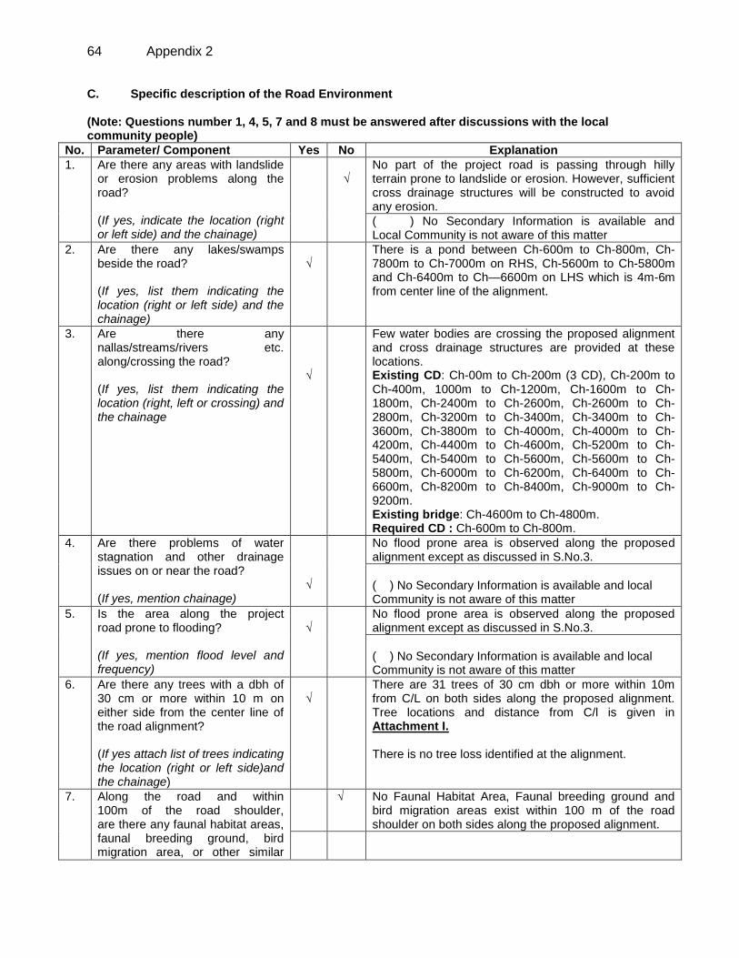
64 Appendix 2
C. Specific description of the Road Environment (Note: Questions number 1, 4, 5, 7 and 8 must be answered after discussions with the local community people)
No. Parameter/ Component Yes No Explanation
1. Are there any areas with landslide or erosion problems along the road? (If yes, indicate the location (right or left side) and the chainage)
√
No part of the project road is passing through hilly terrain prone to landslide or erosion. However, sufficient cross drainage structures will be constructed to avoid any erosion.
( ) No Secondary Information is available and Local Community is not aware of this matter
2. Are there any lakes/swamps beside the road? (If yes, list them indicating the location (right or left side) and the chainage)
√
There is a pond between Ch-600m to Ch-800m, Ch-7800m to Ch-7000m on RHS, Ch-5600m to Ch-5800m and Ch-6400m to Ch—6600m on LHS which is 4m-6m from center line of the alignment.
3. Are there any nallas/streams/rivers etc. along/crossing the road? (If yes, list them indicating the location (right, left or crossing) and the chainage
√
Few water bodies are crossing the proposed alignment and cross drainage structures are provided at these locations. Existing CD: Ch-00m to Ch-200m (3 CD), Ch-200m to Ch-400m, 1000m to Ch-1200m, Ch-1600m to Ch-1800m, Ch-2400m to Ch-2600m, Ch-2600m to Ch-2800m, Ch-3200m to Ch-3400m, Ch-3400m to Ch-3600m, Ch-3800m to Ch-4000m, Ch-4000m to Ch-4200m, Ch-4400m to Ch-4600m, Ch-5200m to Ch-5400m, Ch-5400m to Ch-5600m, Ch-5600m to Ch-5800m, Ch-6000m to Ch-6200m, Ch-6400m to Ch-6600m, Ch-8200m to Ch-8400m, Ch-9000m to Ch-9200m. Existing bridge: Ch-4600m to Ch-4800m. Required CD : Ch-600m to Ch-800m.
4. Are there problems of water stagnation and other drainage issues on or near the road? (If yes, mention chainage)
√
No flood prone area is observed along the proposed alignment except as discussed in S.No.3.
( ) No Secondary Information is available and local Community is not aware of this matter
5. Is the area along the project road prone to flooding? (If yes, mention flood level and frequency)
√
No flood prone area is observed along the proposed alignment except as discussed in S.No.3.
( ) No Secondary Information is available and local Community is not aware of this matter
6. Are there any trees with a dbh of 30 cm or more within 10 m on either side from the center line of the road alignment? (If yes attach list of trees indicating the location (right or left side)and the chainage)
√
There are 31 trees of 30 cm dbh or more within 10m from C/L on both sides along the proposed alignment. Tree locations and distance from C/l is given in Attachment I. There is no tree loss identified at the alignment.
7.
Along the road and within 100m of the road shoulder, are there any faunal habitat areas, faunal breeding ground, bird migration area, or other similar
√ No Faunal Habitat Area, Faunal breeding ground and bird migration areas exist within 100 m of the road shoulder on both sides along the proposed alignment.
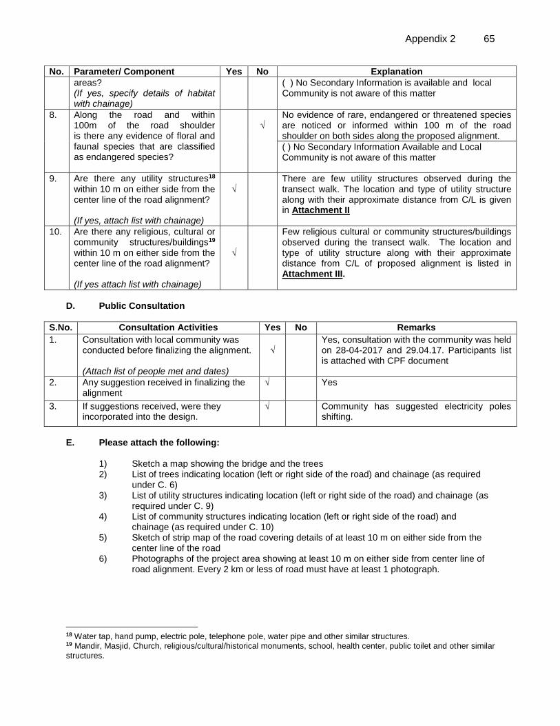
Appendix 2 65
No. Parameter/ Component Yes No Explanation
areas? (If yes, specify details of habitat with chainage)
( ) No Secondary Information is available and local Community is not aware of this matter
8. Along the road and within 100m of the road shoulder is there any evidence of floral and faunal species that are classified as endangered species?
√
No evidence of rare, endangered or threatened species are noticed or informed within 100 m of the road shoulder on both sides along the proposed alignment.
( ) No Secondary Information Available and Local Community is not aware of this matter
9. Are there any utility structures18 within 10 m on either side from the center line of the road alignment? (If yes, attach list with chainage)
√
There are few utility structures observed during the transect walk. The location and type of utility structure along with their approximate distance from C/L is given in Attachment II
10. Are there any religious, cultural or community structures/buildings19 within 10 m on either side from the center line of the road alignment? (If yes attach list with chainage)
√
Few religious cultural or community structures/buildings observed during the transect walk. The location and type of utility structure along with their approximate distance from C/L of proposed alignment is listed in Attachment III.
D. Public Consultation
S.No. Consultation Activities Yes No Remarks
1. Consultation with local community was conducted before finalizing the alignment. (Attach list of people met and dates)
√
Yes, consultation with the community was held on 28-04-2017 and 29.04.17. Participants list is attached with CPF document
2. Any suggestion received in finalizing the alignment
√ Yes
3. If suggestions received, were they incorporated into the design.
√ Community has suggested electricity poles shifting.
E. Please attach the following:
1) Sketch a map showing the bridge and the trees 2) List of trees indicating location (left or right side of the road) and chainage (as required
under C. 6) 3) List of utility structures indicating location (left or right side of the road) and chainage (as
required under C. 9) 4) List of community structures indicating location (left or right side of the road) and
chainage (as required under C. 10) 5) Sketch of strip map of the road covering details of at least 10 m on either side from the
center line of the road 6) Photographs of the project area showing at least 10 m on either side from center line of
road alignment. Every 2 km or less of road must have at least 1 photograph.
18 Water tap, hand pump, electric pole, telephone pole, water pipe and other similar structures. 19 Mandir, Masjid, Church, religious/cultural/historical monuments, school, health center, public toilet and other similar
structures.
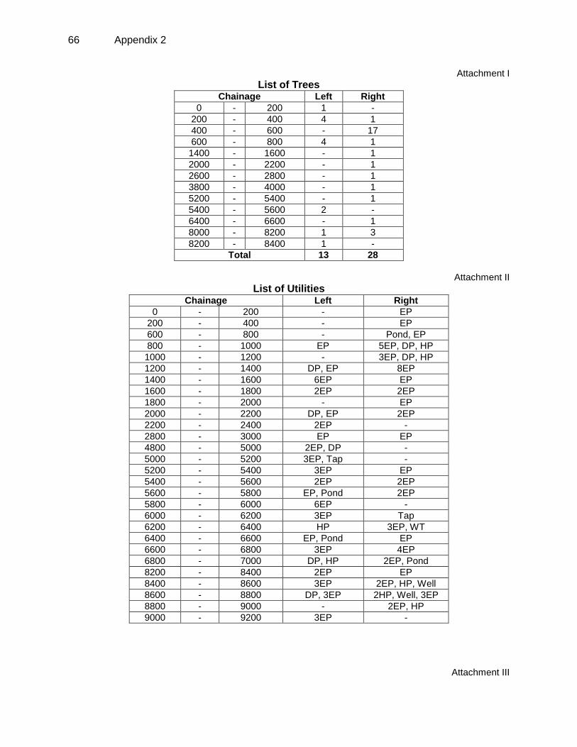
66 Appendix 2
Attachment I
List of Trees Chainage Left Right
0 - 200 1 -
200 - 400 4 1
400 - 600 - 17
600 - 800 4 1
1400 - 1600 - 1
2000 - 2200 - 1
2600 - 2800 - 1
3800 - 4000 - 1
5200 - 5400 - 1
5400 - 5600 2 -
6400 - 6600 - 1
8000 - 8200 1 3
8200 - 8400 1 -
Total 13 28
Attachment II
List of Utilities Chainage Left Right
0 - 200 - EP
200 - 400 - EP
600 - 800 - Pond, EP
800 - 1000 EP 5EP, DP, HP
1000 - 1200 - 3EP, DP, HP
1200 - 1400 DP, EP 8EP
1400 - 1600 6EP EP
1600 - 1800 2EP 2EP
1800 - 2000 - EP
2000 - 2200 DP, EP 2EP
2200 - 2400 2EP -
2800 - 3000 EP EP
4800 - 5000 2EP, DP -
5000 - 5200 3EP, Tap -
5200 - 5400 3EP EP
5400 - 5600 2EP 2EP
5600 - 5800 EP, Pond 2EP
5800 - 6000 6EP -
6000 - 6200 3EP Tap
6200 - 6400 HP 3EP, WT
6400 - 6600 EP, Pond EP
6600 - 6800 3EP 4EP
6800 - 7000 DP, HP 2EP, Pond
8200 - 8400 2EP EP
8400 - 8600 3EP 2EP, HP, Well
8600 - 8800 DP, 3EP 2HP, Well, 3EP
8800 - 9000 - 2EP, HP
9000 - 9200 3EP -
Attachment III
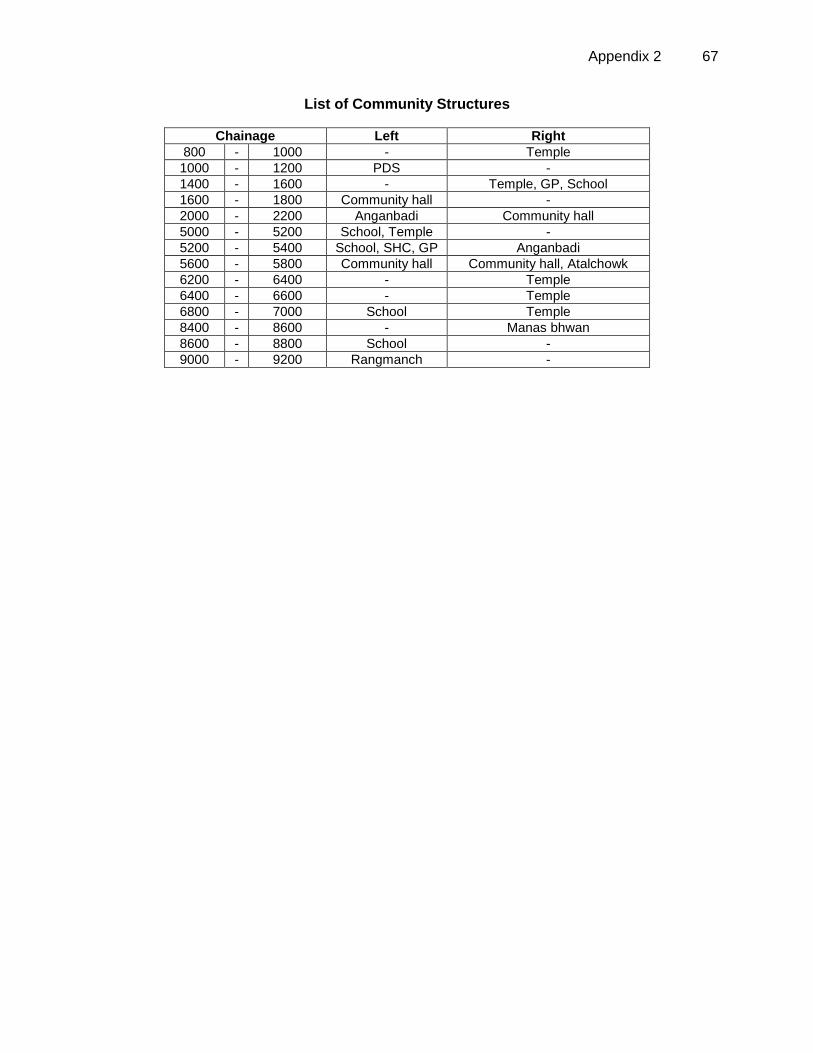
Appendix 2 67
List of Community Structures
Chainage Left Right
800 - 1000 - Temple
1000 - 1200 PDS -
1400 - 1600 - Temple, GP, School
1600 - 1800 Community hall -
2000 - 2200 Anganbadi Community hall
5000 - 5200 School, Temple -
5200 - 5400 School, SHC, GP Anganbadi
5600 - 5800 Community hall Community hall, Atalchowk
6200 - 6400 - Temple
6400 - 6600 - Temple
6800 - 7000 School Temple
8400 - 8600 - Manas bhwan
8600 - 8800 School -
9000 - 9200 Rangmanch -
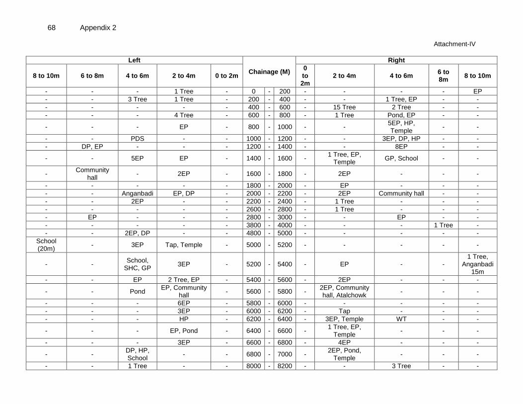
68 Appendix 2
Attachment-IV
Left
Chainage (M)
Right
8 to 10m 6 to 8m 4 to 6m 2 to 4m 0 to 2m 0 to 2m
2 to 4m 4 to 6m 6 to 8m
8 to 10m
- - - 1 Tree - 0 - 200 - - - - EP
- - 3 Tree 1 Tree - 200 - 400 - - 1 Tree, EP - -
- - - - - 400 - 600 - 15 Tree 2 Tree - -
- - - 4 Tree - 600 - 800 - 1 Tree Pond, EP - -
- - - EP - 800 - 1000 - - 5EP, HP, Temple
- -
- - PDS - - 1000 - 1200 - - 3EP, DP, HP - -
- DP, EP - - - 1200 - 1400 - - 8EP - -
- - 5EP EP - 1400 - 1600 - 1 Tree, EP,
Temple GP, School - -
- Community
hall - 2EP - 1600 - 1800 - 2EP - - -
- - - - - 1800 - 2000 - EP - - -
- - Anganbadi EP, DP - 2000 - 2200 - 2EP Community hall - -
- - 2EP - - 2200 - 2400 - 1 Tree - - -
- - - - - 2600 - 2800 - 1 Tree - - -
- EP - - - 2800 - 3000 - - EP - -
- - - - - 3800 - 4000 - - - 1 Tree -
- - 2EP, DP - - 4800 - 5000 - - - - -
School (20m)
- 3EP Tap, Temple - 5000 - 5200 - - - - -
- - School,
SHC, GP 3EP - 5200 - 5400 - EP - -
1 Tree, Anganbadi
15m
- - EP 2 Tree, EP - 5400 - 5600 - 2EP - - -
- - Pond EP, Community
hall - 5600 - 5800 -
2EP, Community hall, Atalchowk
- - -
- - - 6EP - 5800 - 6000 - - - - -
- - - 3EP - 6000 - 6200 - Tap - - -
- - - HP - 6200 - 6400 - 3EP, Temple WT - -
- - - EP, Pond - 6400 - 6600 - 1 Tree, EP,
Temple - - -
- - - 3EP - 6600 - 6800 - 4EP - - -
- - DP, HP, School
- - 6800 - 7000 - 2EP, Pond,
Temple - - -
- - 1 Tree - - 8000 - 8200 - - 3 Tree - -
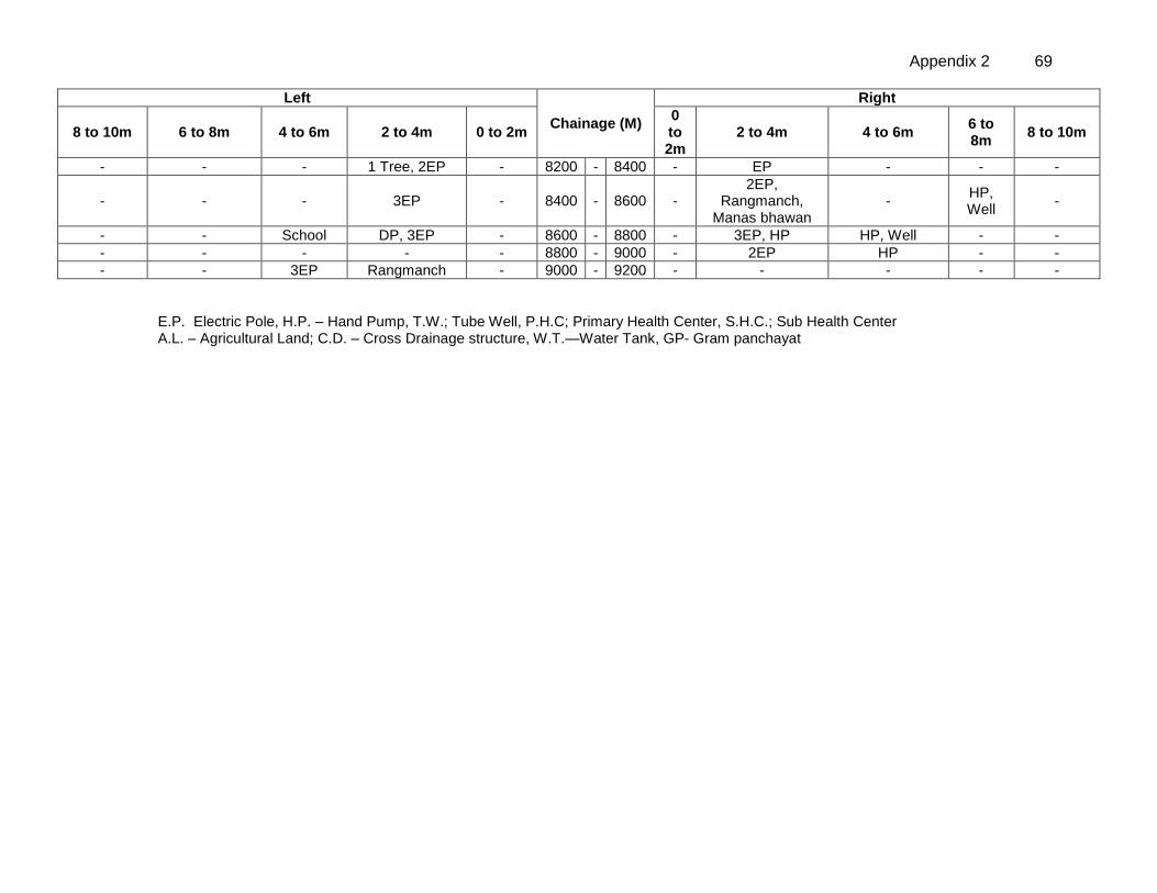
Appendix 2 69
Left
Chainage (M)
Right
8 to 10m 6 to 8m 4 to 6m 2 to 4m 0 to 2m 0 to 2m
2 to 4m 4 to 6m 6 to 8m
8 to 10m
- - - 1 Tree, 2EP - 8200 - 8400 - EP - - -
- - - 3EP - 8400 - 8600 - 2EP,
Rangmanch, Manas bhawan
- HP, Well
-
- - School DP, 3EP - 8600 - 8800 - 3EP, HP HP, Well - -
- - - - - 8800 - 9000 - 2EP HP - -
- - 3EP Rangmanch - 9000 - 9200 - - - - -
E.P. Electric Pole, H.P. – Hand Pump, T.W.; Tube Well, P.H.C; Primary Health Center, S.H.C.; Sub Health Center A.L. – Agricultural Land; C.D. – Cross Drainage structure, W.T.—Water Tank, GP- Gram panchayat
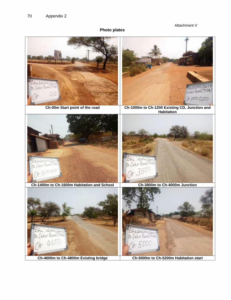
70 Appendix 2
Attachment V
Photo plates
Ch-00m Start point of the road Ch-1000m to Ch-1200 Existing CD, Junction and
Habitation
Ch-1400m to Ch-1600m Habitation and School Ch-3800m to Ch-4000m Junction
Ch-4600m to Ch-4800m Existing bridge Ch-5000m to Ch-5200m Habitation start
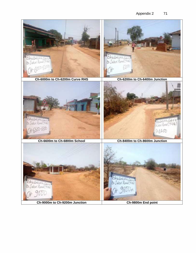
Appendix 2 71
Ch-6000m to Ch-6200m Curve RHS Ch-6200m to Ch-6400m Junction
Ch-6600m to Ch-6800m School Ch-8400m to Ch-8600m Junction
Ch-9000m to Ch-9200m Junction Ch-9800m End point
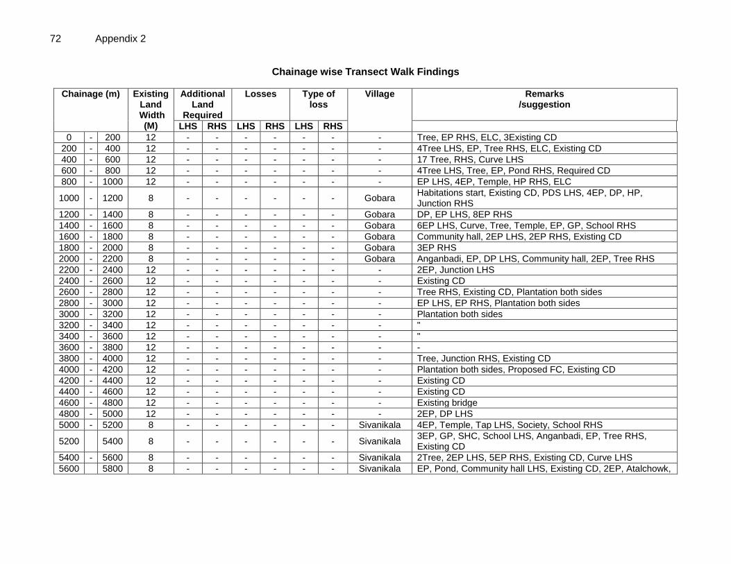
72 Appendix 2
Chainage wise Transect Walk Findings
Chainage (m) Existing Land
Width (M)
Additional Land
Required
Losses Type of loss
Village Remarks /suggestion
LHS RHS LHS RHS LHS RHS
0 - 200 12 - - - - - - - Tree, EP RHS, ELC, 3Existing CD
200 - 400 12 - - - - - - - 4Tree LHS, EP, Tree RHS, ELC, Existing CD
400 - 600 12 - - - - - - - 17 Tree, RHS, Curve LHS
600 - 800 12 - - - - - - - 4Tree LHS, Tree, EP, Pond RHS, Required CD
800 - 1000 12 - - - - - - - EP LHS, 4EP, Temple, HP RHS, ELC
1000 - 1200 8 - - - - - - Gobara Habitations start, Existing CD, PDS LHS, 4EP, DP, HP, Junction RHS
1200 - 1400 8 - - - - - - Gobara DP, EP LHS, 8EP RHS
1400 - 1600 8 - - - - - - Gobara 6EP LHS, Curve, Tree, Temple, EP, GP, School RHS
1600 - 1800 8 - - - - - - Gobara Community hall, 2EP LHS, 2EP RHS, Existing CD
1800 - 2000 8 - - - - - - Gobara 3EP RHS
2000 - 2200 8 - - - - - - Gobara Anganbadi, EP, DP LHS, Community hall, 2EP, Tree RHS
2200 - 2400 12 - - - - - - - 2EP, Junction LHS
2400 - 2600 12 - - - - - - - Existing CD
2600 - 2800 12 - - - - - - - Tree RHS, Existing CD, Plantation both sides
2800 - 3000 12 - - - - - - - EP LHS, EP RHS, Plantation both sides
3000 - 3200 12 - - - - - - - Plantation both sides
3200 - 3400 12 - - - - - - - "
3400 - 3600 12 - - - - - - - "
3600 - 3800 12 - - - - - - - -
3800 - 4000 12 - - - - - - - Tree, Junction RHS, Existing CD
4000 - 4200 12 - - - - - - - Plantation both sides, Proposed FC, Existing CD
4200 - 4400 12 - - - - - - - Existing CD
4400 - 4600 12 - - - - - - - Existing CD
4600 - 4800 12 - - - - - - - Existing bridge
4800 - 5000 12 - - - - - - - 2EP, DP LHS
5000 - 5200 8 - - - - - - Sivanikala 4EP, Temple, Tap LHS, Society, School RHS
5200 5400 8 - - - - - - Sivanikala 3EP, GP, SHC, School LHS, Anganbadi, EP, Tree RHS, Existing CD
5400 - 5600 8 - - - - - - Sivanikala 2Tree, 2EP LHS, 5EP RHS, Existing CD, Curve LHS
5600 5800 8 - - - - - - Sivanikala EP, Pond, Community hall LHS, Existing CD, 2EP, Atalchowk,
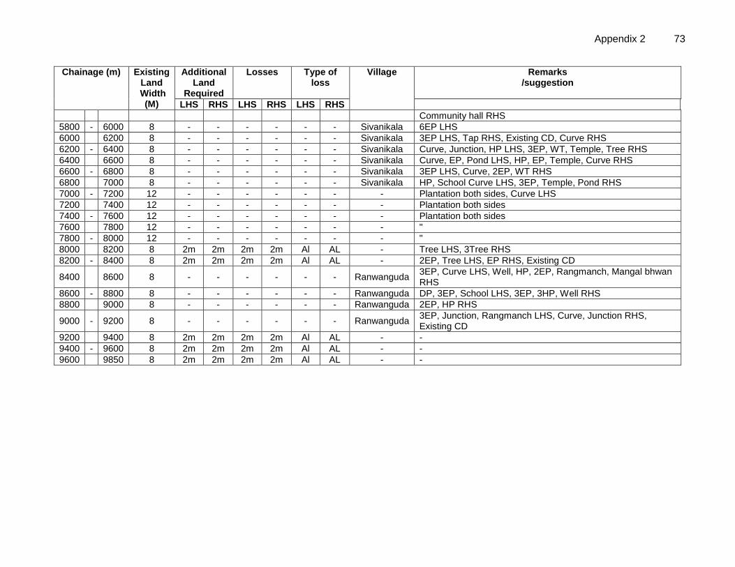
Appendix 2 73
Chainage (m) Existing Land
Width (M)
Additional Land
Required
Losses Type of loss
Village Remarks /suggestion
LHS RHS LHS RHS LHS RHS
Community hall RHS
5800 - 6000 8 - - - - - - Sivanikala 6EP LHS
6000 6200 8 - - - - - - Sivanikala 3EP LHS, Tap RHS, Existing CD, Curve RHS
6200 - 6400 8 - - - - - - Sivanikala Curve, Junction, HP LHS, 3EP, WT, Temple, Tree RHS
6400 6600 8 - - - - - - Sivanikala Curve, EP, Pond LHS, HP, EP, Temple, Curve RHS
6600 - 6800 8 - - - - - - Sivanikala 3EP LHS, Curve, 2EP, WT RHS
6800 7000 8 - - - - - - Sivanikala HP, School Curve LHS, 3EP, Temple, Pond RHS
7000 - 7200 12 - - - - - - - Plantation both sides, Curve LHS
7200 7400 12 - - - - - - - Plantation both sides
7400 - 7600 12 - - - - - - - Plantation both sides
7600 7800 12 - - - - - - - "
7800 - 8000 12 - - - - - - - "
8000 8200 8 2m 2m 2m 2m Al AL - Tree LHS, 3Tree RHS
8200 - 8400 8 2m 2m 2m 2m Al AL - 2EP, Tree LHS, EP RHS, Existing CD
8400 8600 8 - - - - - - Ranwanguda 3EP, Curve LHS, Well, HP, 2EP, Rangmanch, Mangal bhwan RHS
8600 - 8800 8 - - - - - - Ranwanguda DP, 3EP, School LHS, 3EP, 3HP, Well RHS
8800 9000 8 - - - - - - Ranwanguda 2EP, HP RHS
9000 - 9200 8 - - - - - - Ranwanguda 3EP, Junction, Rangmanch LHS, Curve, Junction RHS, Existing CD
9200 9400 8 2m 2m 2m 2m Al AL - -
9400 - 9600 8 2m 2m 2m 2m Al AL - -
9600 9850 8 2m 2m 2m 2m Al AL - -
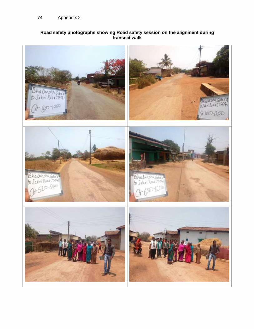
74 Appendix 2
Road safety photographs showing Road safety session on the alignment during transect walk
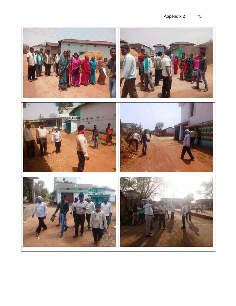
Appendix 2 75
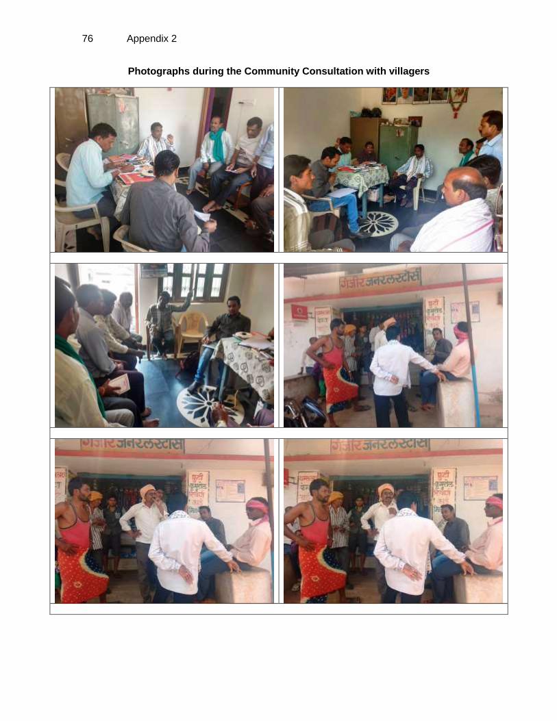
76 Appendix 2
Photographs during the Community Consultation with villagers
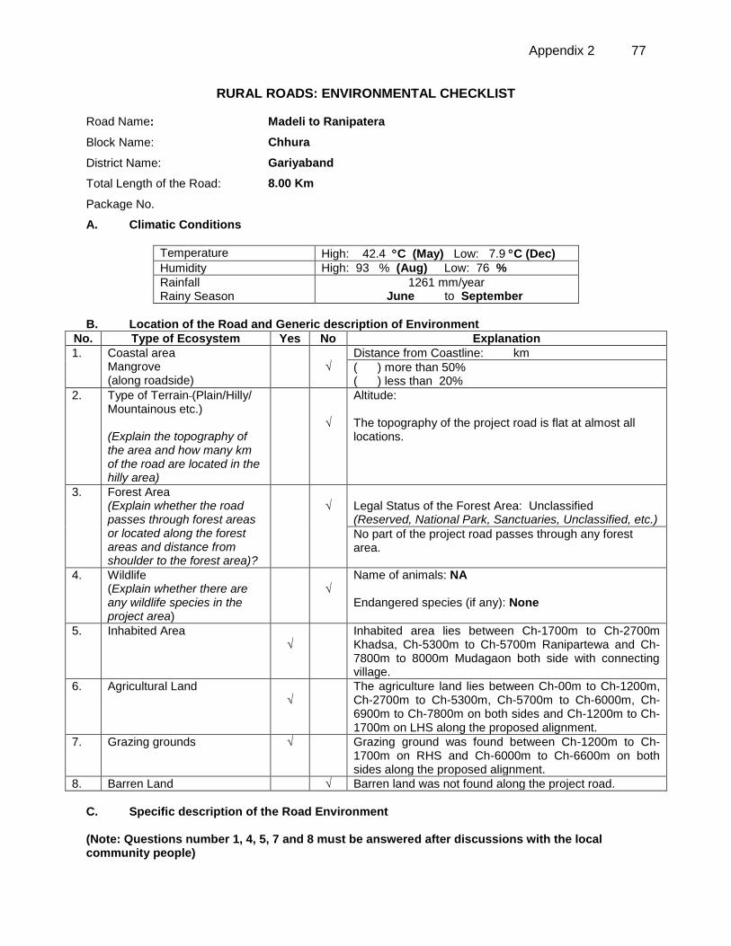
Appendix 2 77
RURAL ROADS: ENVIRONMENTAL CHECKLIST
Road Name: Madeli to Ranipatera
Block Name: Chhura
District Name: Gariyaband
Total Length of the Road: 8.00 Km
Package No.
A. Climatic Conditions
Temperature High: 42.4 C (May) Low: 7.9 C (Dec)
Humidity High: 93 % (Aug) Low: 76 %
Rainfall Rainy Season
1261 mm/year June to September
B. Location of the Road and Generic description of Environment
No. Type of Ecosystem Yes No Explanation
1. Coastal area Mangrove (along roadside)
√
Distance from Coastline: km
( ) more than 50% ( ) less than 20%
2. Type of Terrain (Plain/Hilly/ Mountainous etc.) (Explain the topography of the area and how many km of the road are located in the hilly area)
√
Altitude: The topography of the project road is flat at almost all locations.
3. Forest Area (Explain whether the road passes through forest areas or located along the forest areas and distance from shoulder to the forest area)?
√
Legal Status of the Forest Area: Unclassified (Reserved, National Park, Sanctuaries, Unclassified, etc.)
No part of the project road passes through any forest area.
4. Wildlife (Explain whether there are any wildlife species in the project area)
√
Name of animals: NA Endangered species (if any): None
5. Inhabited Area √
Inhabited area lies between Ch-1700m to Ch-2700m Khadsa, Ch-5300m to Ch-5700m Ranipartewa and Ch-7800m to 8000m Mudagaon both side with connecting village.
6. Agricultural Land √
The agriculture land lies between Ch-00m to Ch-1200m, Ch-2700m to Ch-5300m, Ch-5700m to Ch-6000m, Ch-6900m to Ch-7800m on both sides and Ch-1200m to Ch-1700m on LHS along the proposed alignment.
7. Grazing grounds √
Grazing ground was found between Ch-1200m to Ch-1700m on RHS and Ch-6000m to Ch-6600m on both sides along the proposed alignment.
8. Barren Land √ Barren land was not found along the project road.
C. Specific description of the Road Environment (Note: Questions number 1, 4, 5, 7 and 8 must be answered after discussions with the local community people)
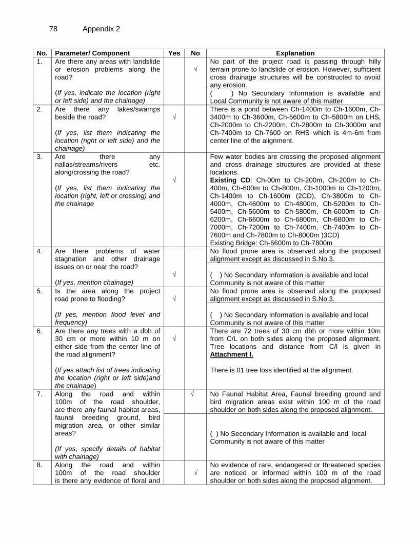
78 Appendix 2
No. Parameter/ Component Yes No Explanation
1. Are there any areas with landslide or erosion problems along the road? (If yes, indicate the location (right or left side) and the chainage)
√
No part of the project road is passing through hilly terrain prone to landslide or erosion. However, sufficient cross drainage structures will be constructed to avoid any erosion.
( ) No Secondary Information is available and Local Community is not aware of this matter
2. Are there any lakes/swamps beside the road? (If yes, list them indicating the location (right or left side) and the chainage)
√
There is a pond between Ch-1400m to Ch-1600m, Ch-3400m to Ch-3600m, Ch-5600m to Ch-5800m on LHS, Ch-2000m to Ch-2200m, Ch-2800m to Ch-3000m and Ch-7400m to Ch-7600 on RHS which is 4m-6m from center line of the alignment.
3. Are there any nallas/streams/rivers etc. along/crossing the road? (If yes, list them indicating the location (right, left or crossing) and the chainage
√
Few water bodies are crossing the proposed alignment and cross drainage structures are provided at these locations. Existing CD: Ch-00m to Ch-200m, Ch-200m to Ch-400m, Ch-600m to Ch-800m, Ch-1000m to Ch-1200m, Ch-1400m to Ch-1600m (2CD), Ch-3800m to Ch-4000m, Ch-4600m to Ch-4800m, Ch-5200m to Ch-5400m, Ch-5600m to Ch-5800m, Ch-6000m to Ch-6200m, Ch-6600m to Ch-6800m, Ch-6800m to Ch-7000m, Ch-7200m to Ch-7400m, Ch-7400m to Ch-7600m and Ch-7800m to Ch-8000m )3CD) Existing Bridge: Ch-6600m to Ch-7800m
4. Are there problems of water stagnation and other drainage issues on or near the road? (If yes, mention chainage)
√
No flood prone area is observed along the proposed alignment except as discussed in S.No.3.
( ) No Secondary Information is available and local Community is not aware of this matter
5. Is the area along the project road prone to flooding? (If yes, mention flood level and frequency)
√
No flood prone area is observed along the proposed alignment except as discussed in S.No.3.
( ) No Secondary Information is available and local Community is not aware of this matter
6. Are there any trees with a dbh of 30 cm or more within 10 m on either side from the center line of the road alignment? (If yes attach list of trees indicating the location (right or left side)and the chainage)
√
There are 72 trees of 30 cm dbh or more within 10m from C/L on both sides along the proposed alignment. Tree locations and distance from C/l is given in Attachment I. There is 01 tree loss identified at the alignment.
7.
Along the road and within 100m of the road shoulder, are there any faunal habitat areas, faunal breeding ground, bird migration area, or other similar areas? (If yes, specify details of habitat with chainage)
√ No Faunal Habitat Area, Faunal breeding ground and bird migration areas exist within 100 m of the road shoulder on both sides along the proposed alignment.
( ) No Secondary Information is available and local Community is not aware of this matter
8. Along the road and within 100m of the road shoulder is there any evidence of floral and
√
No evidence of rare, endangered or threatened species are noticed or informed within 100 m of the road shoulder on both sides along the proposed alignment.
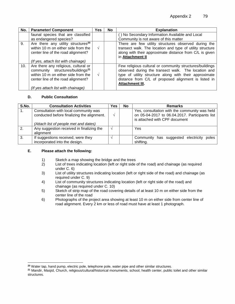
Appendix 2 79
No. Parameter/ Component Yes No Explanation
faunal species that are classified as endangered species?
( ) No Secondary Information Available and Local Community is not aware of this matter
9. Are there any utility structures20 within 10 m on either side from the center line of the road alignment? (If yes, attach list with chainage)
√
There are few utility structures observed during the transect walk. The location and type of utility structure along with their approximate distance from C/L is given in Attachment II
10. Are there any religious, cultural or community structures/buildings21 within 10 m on either side from the center line of the road alignment? (If yes attach list with chainage)
√
Few religious cultural or community structures/buildings observed during the transect walk. The location and type of utility structure along with their approximate distance from C/L of proposed alignment is listed in Attachment III.
D. Public Consultation
S.No. Consultation Activities Yes No Remarks
1. Consultation with local community was conducted before finalizing the alignment. (Attach list of people met and dates)
√
Yes, consultation with the community was held on 05-04-2017 to 06.04.2017. Participants list is attached with CPF document
2. Any suggestion received in finalizing the alignment
√ Yes
3. If suggestions received, were they incorporated into the design.
√ Community has suggested electricity poles shifting.
E. Please attach the following:
1) Sketch a map showing the bridge and the trees 2) List of trees indicating location (left or right side of the road) and chainage (as required
under C. 6) 3) List of utility structures indicating location (left or right side of the road) and chainage (as
required under C. 9) 4) List of community structures indicating location (left or right side of the road) and
chainage (as required under C. 10) 5) Sketch of strip map of the road covering details of at least 10 m on either side from the
center line of the road 6) Photographs of the project area showing at least 10 m on either side from center line of
road alignment. Every 2 km or less of road must have at least 1 photograph.
20 Water tap, hand pump, electric pole, telephone pole, water pipe and other similar structures. 21 Mandir, Masjid, Church, religious/cultural/historical monuments, school, health center, public toilet and other similar
structures.
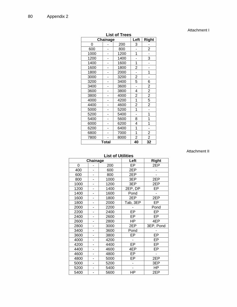
80 Appendix 2
Attachment I
List of Trees Chainage Left Right
0 - 200 3 -
600 - 800 - 2
1000 - 1200 1 -
1200 - 1400 - 3
1400 - 1600 1 -
1600 - 1800 2 -
1800 - 2000 - 1
3000 - 3200 2 -
3200 - 3400 5 6
3400 - 3600 - 2
3600 - 3800 4 2
3800 - 4000 2 2
4000 - 4200 1 5
4400 - 4600 2 2
5000 - 5200 1 -
5200 - 5400 - 1
5400 - 5600 8 1
6000 - 6200 4 1
6200 - 6400 1 -
6800 - 7000 1 2
7800 - 8000 2 2
Total 40 32
Attachment II
List of Utilities Chainage Left Right
0 - 200 EP 2EP
400 - 600 2EP -
600 - 800 2EP -
800 - 1000 3EP 2EP
1000 - 1200 3EP 2EP
1200 - 1400 2EP, DP EP
1400 - 1600 Pond -
1600 - 1800 2EP 2EP
1800 - 2000 Tab, 3EP EP
2000 - 2200 - Pond
2200 - 2400 EP EP
2400 - 2600 EP EP
2600 - 2800 HP 4EP
2800 - 3000 2EP 3EP, Pond
3400 - 3600 Pond -
3600 - 3800 EP EP
4000 - 4200 - EP
4200 - 4400 EP EP
4400 - 4600 4EP EP
4600 - 4800 EP -
4800 - 5000 EP 2EP
5000 - 5200 - 3EP
5200 - 5400 - HP
5400 - 5600 HP 2EP
Appendix 2 81
Chainage Left Right
5600 - 5800 Pond 4EP
5800 - 6000 EP Tab
6000 - 6200 - HP
6200 - 6400 - EP
7400 - 7600 - EP, Pond
7800 - 8000 2EP 2EP, 2HP
Attachment III
List of Community Structures
Chainage Left Right
0 - 200 3Temple -
1600 - 1800 School -
1800 - 2000 School -
2000 - 2200 Lok seva kendra, Bank -
2400 - 2600 - PHC
2600 - 2800 Angnabadi -
5200 - 5400 Atal chowk, Temple Community hall
5400 - 5600 - School, GP
5600 - 5800 School -
6000 - 6200 - Temple
82 Appendix 2
Attachment-IV
Left Chainage (M)
Right
8 to 10m 6 to 8m 4 to 6m 2 to 4m 0 to 2m 0 to 2m 2 to 4m 4 to 6m 6 to 8m 8 to 10m
Temple 2 Tree 1 Tree, EP - - 0 - 200 - - 2EP - -
- - 2EP - - 400 - 600 - - - - -
- EP EP - - 600 - 800 - - 2 Tree - -
- EP EP EP - 800 - 1000 - - EP EP -
- - 1 Tree, 2EP EP - 1000 - 1200 - - EP - EP
- - DP, EP EP - 1200 - 1400 - EP 1 Tree 2 Tree -
Pond - 1 Tree - - 1400 - 1600 - - - - -
- School 2 Tree, EP EP - 1600 - 1800 - - 2EP - -
- School Tab, 2EP EP - 1800 - 2000 - - 1 Tree, EP - -
- - Lok seva
kendra, Bank - - 2000 - 2200 - - - Pond -
- - EP - - 2200 - 2400 - EP - - -
- - EP - - 2400 - 2600 - - EP, PHC - -
- HP, Anganbadi - - - 2600 - 2800 - - - 3EP EP
- - 2EP - - 2800 - 3000 - - 3EP, Pond - -
- - 2 Tree - - 3000 - 3200 - - - - -
- - 5 Tree - - 3200 - 3400 - - 6 Tree - -
- - Pond - - 3400 - 3600 - 1 Tree 1 Tree - -
- - 4 Tree EP - 3600 - 3800 - - 2 Tree, EP - -
- - 2 Tree - - 3800 - 4000 - - 2 Tree - -
- - 1 Tree - - 4000 - 4200 - - 5 Tree, EP - -
- - - EP - 4200 - 4400 - - EP - -
- - 2EP 2 Tree,
2EP - 4400 - 4600 -
1 Tree 1 Tree, EP - -
- - - EP - 4600 - 4800 - - - - -
- - - EP - 4800 - 5000 - EP EP - -
- - 1 Tree - - 5000 - 5200 - EP 2EP - -
- - Atal chowk,
Temple - - 5200 - 5400 -
- 1 Tree, HP,
Community hall - -
HP - 5 Tree 3 Tree - 5400 - 5600 - 1 Tree,
EP EP, School, GP - -
School - - Pond - 5600 - 5800 - - 4EP - -
Appendix 2 83
Left Chainage (M)
Right
8 to 10m 6 to 8m 4 to 6m 2 to 4m 0 to 2m 0 to 2m 2 to 4m 4 to 6m 6 to 8m 8 to 10m
- - EP - - 5800 - 6000 - - Tab - -
- - 4 Tree - - 6000 - 6200 - - 1 Tree HP Temple
- - - 1 Tree - 6200 - 6400 - - HP - -
- - - - 1 Tree 6800 - 7000 - 1 Tree - - -
- - - - - 7400 - 7600 - Pond EP - -
- - 2 Tree, EP EP - 7800 - 8000 - - 2 Tree, 2EP,
HP HP -
E.P. Electric Pole, H.P. – Hand Pump, T.W.; Tube Well, P.H.C; Primary Health Center, S.H.C.; Sub Health Center A.L. – Agricultural Land; C.D. – Cross Drainage structure, W.T.—Water Tank, GP- Gram panchayat
84 Appendix 2
Attachment V
Photo plates
Ch-00m Start point of the road Ch-1000m to Ch-1200m Existing CD
Ch-1600m to Ch-1800m School on LHS and
Habitation Khadsa Ch-2400m to Ch-2600m Primary health center on
RHS
Ch-3200m to Ch-3400m Pond and Curve on LHS Ch-4800m to Ch-5000m Junction
Appendix 2 85
Ch-5200m to Ch-5400m Habitation Ranipartewa Ch-5600m to Ch-5800m Pond on LHS
Ch-6400m to Ch-6600m Junction and Curve on
RHS Ch-7200m to Ch-7400m Curve RHS
Ch-7800m to 8000m Habitation Mudegaon Ch-8000m End point
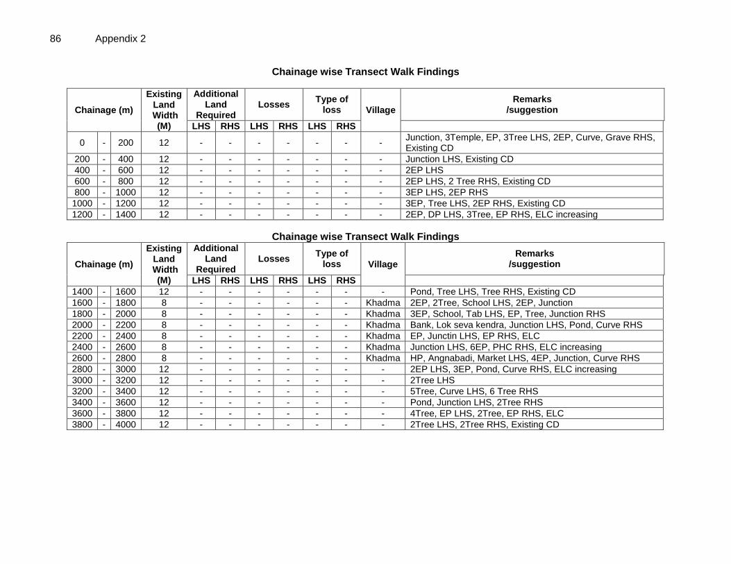
86 Appendix 2
Chainage wise Transect Walk Findings
Chainage (m)
Existing Land
Width (M)
Additional Land
Required Losses
Type of loss Village
Remarks /suggestion
LHS RHS LHS RHS LHS RHS
0 - 200 12 - - - - - - - Junction, 3Temple, EP, 3Tree LHS, 2EP, Curve, Grave RHS, Existing CD
200 - 400 12 - - - - - - - Junction LHS, Existing CD
400 - 600 12 - - - - - - - 2EP LHS
600 - 800 12 - - - - - - - 2EP LHS, 2 Tree RHS, Existing CD
800 - 1000 12 - - - - - - - 3EP LHS, 2EP RHS
1000 - 1200 12 - - - - - - - 3EP, Tree LHS, 2EP RHS, Existing CD
1200 - 1400 12 - - - - - - - 2EP, DP LHS, 3Tree, EP RHS, ELC increasing
Chainage wise Transect Walk Findings
Chainage (m)
Existing Land
Width (M)
Additional Land
Required Losses
Type of loss Village
Remarks /suggestion
LHS RHS LHS RHS LHS RHS
1400 - 1600 12 - - - - - - - Pond, Tree LHS, Tree RHS, Existing CD
1600 - 1800 8 - - - - - - Khadma 2EP, 2Tree, School LHS, 2EP, Junction
1800 - 2000 8 - - - - - - Khadma 3EP, School, Tab LHS, EP, Tree, Junction RHS
2000 - 2200 8 - - - - - - Khadma Bank, Lok seva kendra, Junction LHS, Pond, Curve RHS
2200 - 2400 8 - - - - - - Khadma EP, Junctin LHS, EP RHS, ELC
2400 - 2600 8 - - - - - - Khadma Junction LHS, 6EP, PHC RHS, ELC increasing
2600 - 2800 8 - - - - - - Khadma HP, Angnabadi, Market LHS, 4EP, Junction, Curve RHS
2800 - 3000 12 - - - - - - - 2EP LHS, 3EP, Pond, Curve RHS, ELC increasing
3000 - 3200 12 - - - - - - - 2Tree LHS
3200 - 3400 12 - - - - - - - 5Tree, Curve LHS, 6 Tree RHS
3400 - 3600 12 - - - - - - - Pond, Junction LHS, 2Tree RHS
3600 - 3800 12 - - - - - - - 4Tree, EP LHS, 2Tree, EP RHS, ELC
3800 - 4000 12 - - - - - - - 2Tree LHS, 2Tree RHS, Existing CD
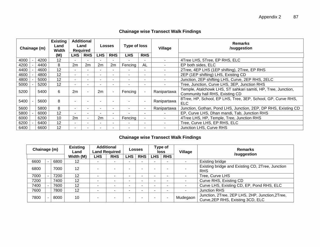
Appendix 2 87
Chainage wise Transect Walk Findings
Chainage (m)
Existing Land
Width (M)
Additional Land
Required Losses Type of loss
Village
Remarks /suggestion
LHS RHS LHS RHS LHS RHS
4000 - 4200 12 - - - - - - - 4Tree LHS, 5Tree, EP RHS, ELC
4200 - 4400 8 2m 2m 2m 2m Fencing AL - EP both sides, ELC
4400 - 4600 12 - - - - - - - 2Tree, 4EP LHS (1EP shifting), 2Tree, EP RHS
4600 - 4800 12 - - - - - - - 2EP (1EP shifting) LHS, Existing CD
4800 - 5000 12 - - - - - - - Junction, 2EP shifting LHS, Curve, 2EP RHS, 2ELC
5000 - 5200 12 - - - - - - - Tree, Junction, Curve LHS, 3EP, Junction RHS
5200
5400 6 2m - 2m - Fencing - Ranipartawa Temple, Atalchowk LHS, ST sahkari samiti, HP, Tree, Junction, Community hall RHS, Existing CD
5400 - 5600 8 - - - - - - Ranipartawa 8Tree, HP, School, EP LHS, Tree, 3EP, School, GP, Curve RHS, ELC
5600
5800 8 - - - - - - Ranipartawa Junction, Gothan, Pond LHS, Junction, 2EP, DP RHS, Existing CD
5800 - 6000 12 - - - - - - - EP, Curve LHS, Dhan mandi, Tab, Junction RHS
6000
6200 10 2m - 2m - Fencing - - 4Tree LHS, HP, Temple, Tree, Junction RHS
6200 - 6400 12 - - - - - - - Tree, Curve LHS, EP RHS, ELC
6400
6600 12 - - - - - - - Junction LHS, Curve RHS
Chainage wise Transect Walk Findings
Chainage (m) Existing
Land Width (M)
Additional Land Required
Losses Type of
loss Village Remarks
/suggestion
LHS RHS LHS RHS LHS RHS
6600 - 6800 12 - - - - - - - Existing bridge
6800
7000 12 - - - - - - - Existing bridge and Existing CD, 2Tree, Junction RHS
7000 - 7200 12 - - - - - - - Tree, Curve LHS
7200
7400 12 - - - - - - - Curve RHS, Existing CD
7400 - 7600 12 - - - - - - - Curve LHS, Existing CD, EP, Pond RHS, ELC
7600
7800 12 - - - - - - - Junction RHS
7800 - 8000 10 - - - - - - Mudegaon Junction, 2Tree, 2EP LHS, 2HP, Junction,2Tree, Curve,2EP RHS, Existing 3CD, ELC
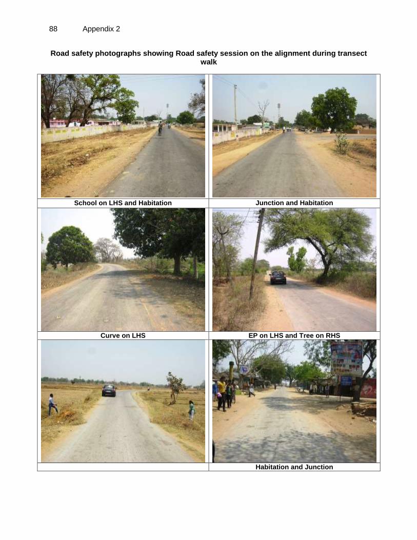
88 Appendix 2
Road safety photographs showing Road safety session on the alignment during transect walk
School on LHS and Habitation Junction and Habitation
Curve on LHS EP on LHS and Tree on RHS
Habitation and Junction
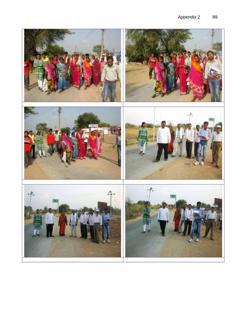
Appendix 2 89
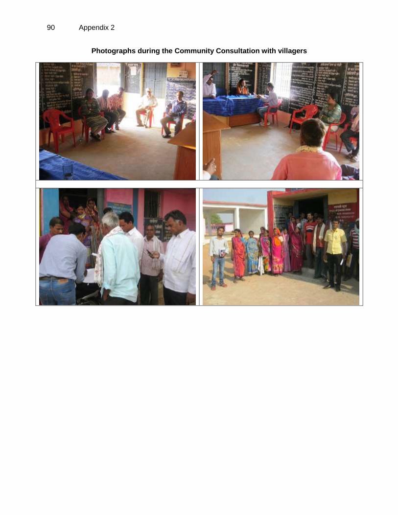
90 Appendix 2
Photographs during the Community Consultation with villagers
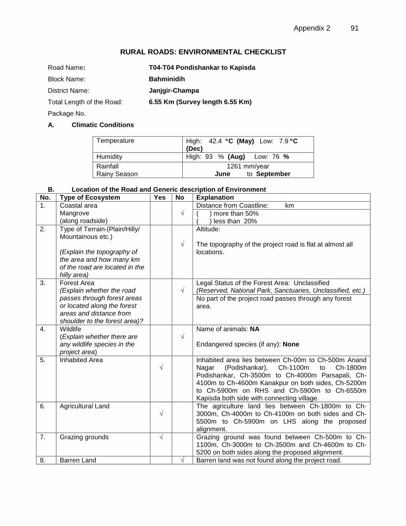
Appendix 2 91
RURAL ROADS: ENVIRONMENTAL CHECKLIST
Road Name: T04-T04 Pondishankar to Kapisda
Block Name: Bahminidih
District Name: Janjgir-Champa
Total Length of the Road: 6.55 Km (Survey length 6.55 Km)
Package No.
A. Climatic Conditions
Temperature High: 42.4 C (May) Low: 7.9 C (Dec)
Humidity High: 93 % (Aug) Low: 76 %
Rainfall Rainy Season
1261 mm/year June to September
B. Location of the Road and Generic description of Environment
No. Type of Ecosystem Yes No Explanation
1. Coastal area Mangrove (along roadside)
√
Distance from Coastline: km
( ) more than 50% ( ) less than 20%
2. Type of Terrain (Plain/Hilly/ Mountainous etc.) (Explain the topography of the area and how many km of the road are located in the hilly area)
√
Altitude: The topography of the project road is flat at almost all locations.
3. Forest Area (Explain whether the road passes through forest areas or located along the forest areas and distance from shoulder to the forest area)?
√
Legal Status of the Forest Area: Unclassified (Reserved, National Park, Sanctuaries, Unclassified, etc.)
No part of the project road passes through any forest area.
4. Wildlife (Explain whether there are any wildlife species in the project area)
√
Name of animals: NA Endangered species (if any): None
5. Inhabited Area √
Inhabited area lies between Ch-00m to Ch-500m Anand Nagar (Podishankar), Ch-1100m to Ch-1800m Podishankar, Ch-3500m to Ch-4000m Parsapali, Ch-4100m to Ch-4600m Kanakpur on both sides, Ch-5200m to Ch-5900m on RHS and Ch-5900m to Ch-6550m Kapisda both side with connecting village.
6. Agricultural Land √
The agriculture land lies between Ch-1800m to Ch-3000m, Ch-4000m to Ch-4100m on both sides and Ch-5500m to Ch-5900m on LHS along the proposed alignment.
7. Grazing grounds √
Grazing ground was found between Ch-500m to Ch-1100m, Ch-3000m to Ch-3500m and Ch-4600m to Ch-5200 on both sides along the proposed alignment.
8. Barren Land √ Barren land was not found along the project road.
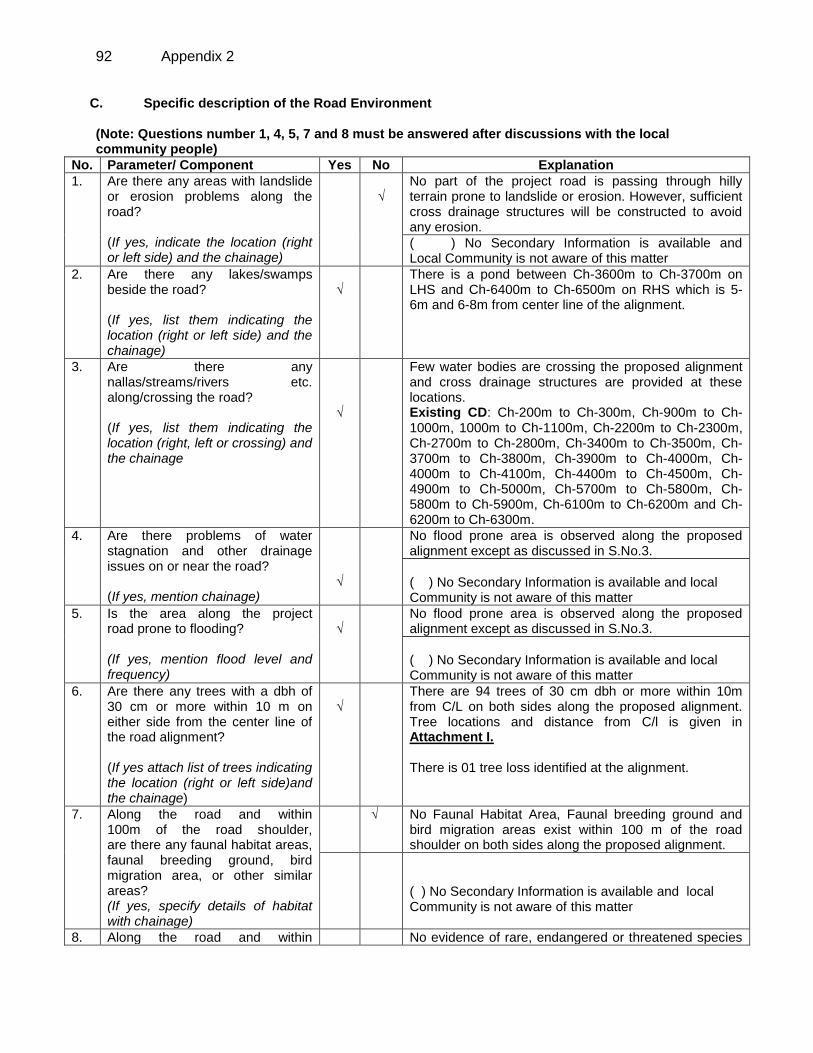
92 Appendix 2
C. Specific description of the Road Environment (Note: Questions number 1, 4, 5, 7 and 8 must be answered after discussions with the local community people)
No. Parameter/ Component Yes No Explanation
1. Are there any areas with landslide or erosion problems along the road? (If yes, indicate the location (right or left side) and the chainage)
√
No part of the project road is passing through hilly terrain prone to landslide or erosion. However, sufficient cross drainage structures will be constructed to avoid any erosion.
( ) No Secondary Information is available and Local Community is not aware of this matter
2. Are there any lakes/swamps beside the road? (If yes, list them indicating the location (right or left side) and the chainage)
√
There is a pond between Ch-3600m to Ch-3700m on LHS and Ch-6400m to Ch-6500m on RHS which is 5-6m and 6-8m from center line of the alignment.
3. Are there any nallas/streams/rivers etc. along/crossing the road? (If yes, list them indicating the location (right, left or crossing) and the chainage
√
Few water bodies are crossing the proposed alignment and cross drainage structures are provided at these locations. Existing CD: Ch-200m to Ch-300m, Ch-900m to Ch-1000m, 1000m to Ch-1100m, Ch-2200m to Ch-2300m, Ch-2700m to Ch-2800m, Ch-3400m to Ch-3500m, Ch-3700m to Ch-3800m, Ch-3900m to Ch-4000m, Ch-4000m to Ch-4100m, Ch-4400m to Ch-4500m, Ch-4900m to Ch-5000m, Ch-5700m to Ch-5800m, Ch-5800m to Ch-5900m, Ch-6100m to Ch-6200m and Ch-6200m to Ch-6300m.
4. Are there problems of water stagnation and other drainage issues on or near the road? (If yes, mention chainage)
√
No flood prone area is observed along the proposed alignment except as discussed in S.No.3.
( ) No Secondary Information is available and local Community is not aware of this matter
5. Is the area along the project road prone to flooding? (If yes, mention flood level and frequency)
√
No flood prone area is observed along the proposed alignment except as discussed in S.No.3.
( ) No Secondary Information is available and local Community is not aware of this matter
6. Are there any trees with a dbh of 30 cm or more within 10 m on either side from the center line of the road alignment? (If yes attach list of trees indicating the location (right or left side)and the chainage)
√
There are 94 trees of 30 cm dbh or more within 10m from C/L on both sides along the proposed alignment. Tree locations and distance from C/l is given in Attachment I. There is 01 tree loss identified at the alignment.
7.
Along the road and within 100m of the road shoulder, are there any faunal habitat areas, faunal breeding ground, bird migration area, or other similar areas? (If yes, specify details of habitat with chainage)
√ No Faunal Habitat Area, Faunal breeding ground and bird migration areas exist within 100 m of the road shoulder on both sides along the proposed alignment.
( ) No Secondary Information is available and local Community is not aware of this matter
8. Along the road and within No evidence of rare, endangered or threatened species
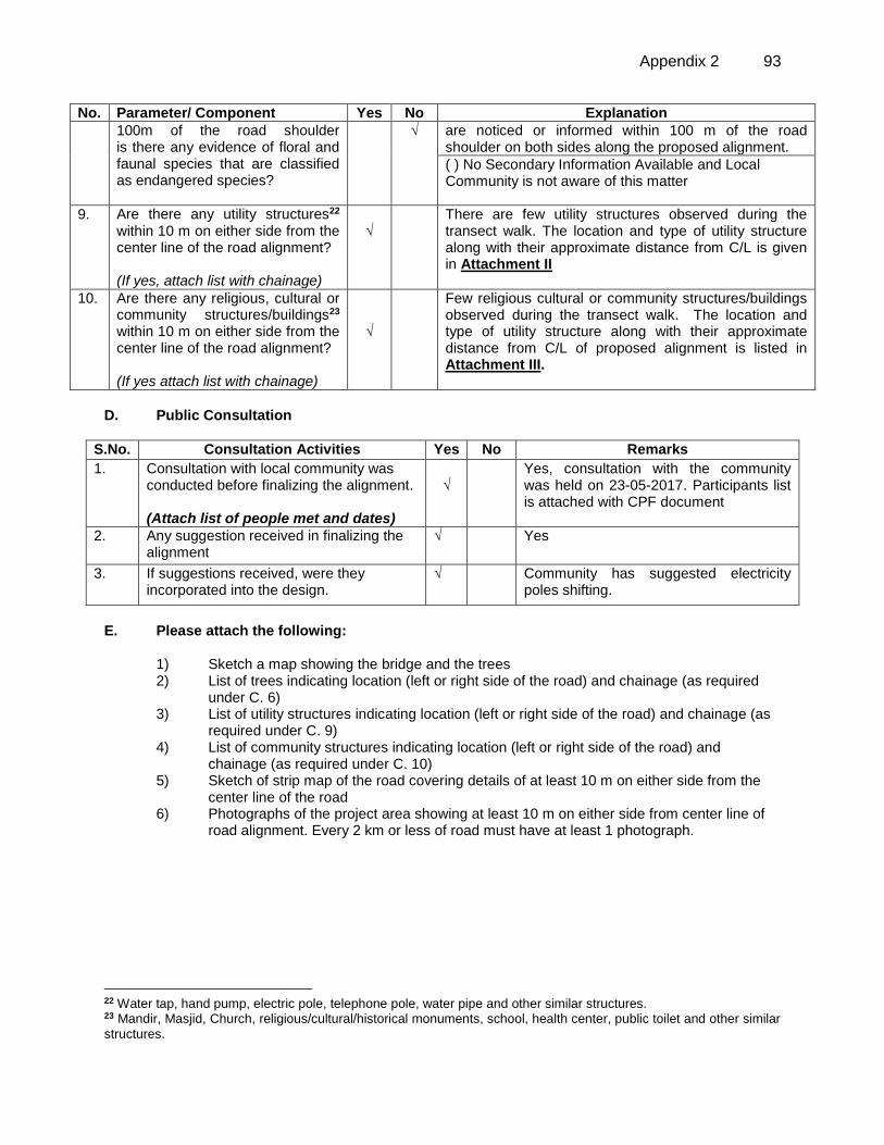
Appendix 2 93
No. Parameter/ Component Yes No Explanation
100m of the road shoulder is there any evidence of floral and faunal species that are classified as endangered species?
√
are noticed or informed within 100 m of the road shoulder on both sides along the proposed alignment.
( ) No Secondary Information Available and Local Community is not aware of this matter
9. Are there any utility structures22 within 10 m on either side from the center line of the road alignment? (If yes, attach list with chainage)
√
There are few utility structures observed during the transect walk. The location and type of utility structure along with their approximate distance from C/L is given in Attachment II
10. Are there any religious, cultural or community structures/buildings23 within 10 m on either side from the center line of the road alignment? (If yes attach list with chainage)
√
Few religious cultural or community structures/buildings observed during the transect walk. The location and type of utility structure along with their approximate distance from C/L of proposed alignment is listed in Attachment III.
D. Public Consultation
S.No. Consultation Activities Yes No Remarks
1. Consultation with local community was conducted before finalizing the alignment. (Attach list of people met and dates)
√
Yes, consultation with the community was held on 23-05-2017. Participants list is attached with CPF document
2. Any suggestion received in finalizing the alignment
√ Yes
3. If suggestions received, were they incorporated into the design.
√ Community has suggested electricity poles shifting.
E. Please attach the following:
1) Sketch a map showing the bridge and the trees 2) List of trees indicating location (left or right side of the road) and chainage (as required
under C. 6) 3) List of utility structures indicating location (left or right side of the road) and chainage (as
required under C. 9) 4) List of community structures indicating location (left or right side of the road) and
chainage (as required under C. 10) 5) Sketch of strip map of the road covering details of at least 10 m on either side from the
center line of the road 6) Photographs of the project area showing at least 10 m on either side from center line of
road alignment. Every 2 km or less of road must have at least 1 photograph.
22 Water tap, hand pump, electric pole, telephone pole, water pipe and other similar structures. 23 Mandir, Masjid, Church, religious/cultural/historical monuments, school, health center, public toilet and other similar
structures.
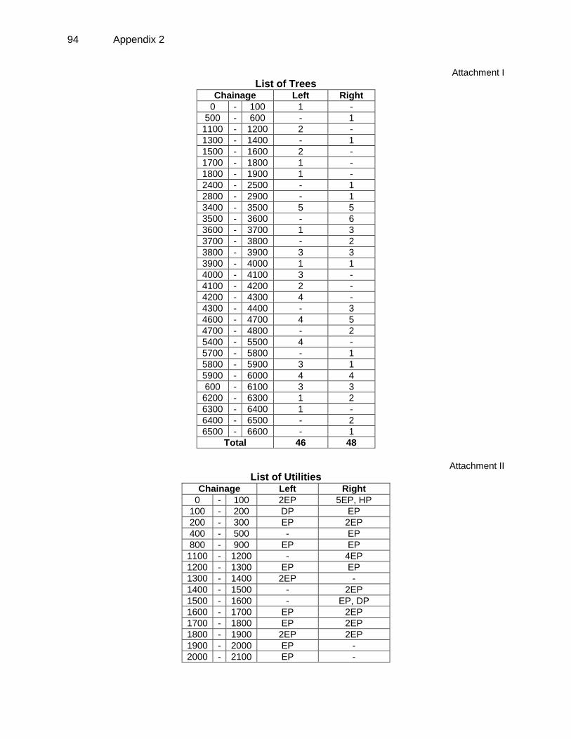
94 Appendix 2
Attachment I
List of Trees Chainage Left Right
0 - 100 1 -
500 - 600 - 1
1100 - 1200 2 -
1300 - 1400 - 1
1500 - 1600 2 -
1700 - 1800 1 -
1800 - 1900 1 -
2400 - 2500 - 1
2800 - 2900 - 1
3400 - 3500 5 5
3500 - 3600 - 6
3600 - 3700 1 3
3700 - 3800 - 2
3800 - 3900 3 3
3900 - 4000 1 1
4000 - 4100 3 -
4100 - 4200 2 -
4200 - 4300 4 -
4300 - 4400 - 3
4600 - 4700 4 5
4700 - 4800 - 2
5400 - 5500 4 -
5700 - 5800 - 1
5800 - 5900 3 1
5900 - 6000 4 4
600 - 6100 3 3
6200 - 6300 1 2
6300 - 6400 1 -
6400 - 6500 - 2
6500 - 6600 - 1
Total 46 48
Attachment II
List of Utilities Chainage Left Right
0 - 100 2EP 5EP, HP
100 - 200 DP EP
200 - 300 EP 2EP
400 - 500 - EP
800 - 900 EP EP
1100 - 1200 - 4EP
1200 - 1300 EP EP
1300 - 1400 2EP -
1400 - 1500 - 2EP
1500 - 1600 - EP, DP
1600 - 1700 EP 2EP
1700 - 1800 EP 2EP
1800 - 1900 2EP 2EP
1900 - 2000 EP -
2000 - 2100 EP -
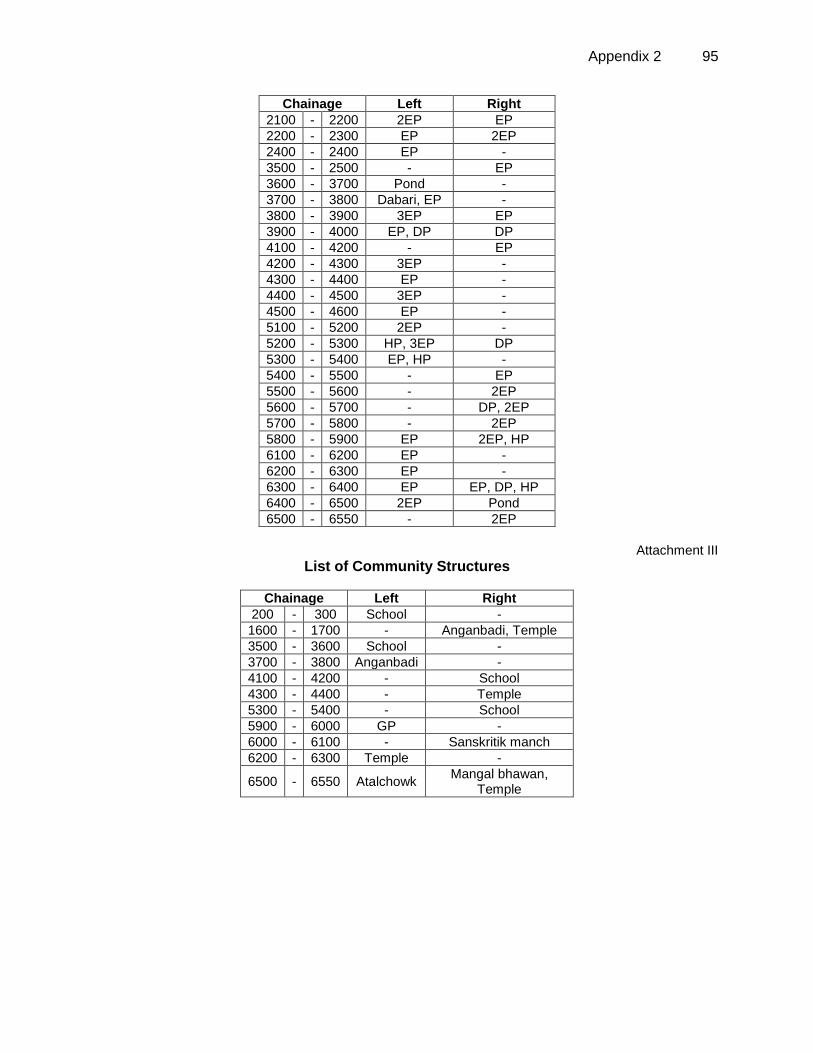
Appendix 2 95
Chainage Left Right
2100 - 2200 2EP EP
2200 - 2300 EP 2EP
2400 - 2400 EP -
3500 - 2500 - EP
3600 - 3700 Pond -
3700 - 3800 Dabari, EP -
3800 - 3900 3EP EP
3900 - 4000 EP, DP DP
4100 - 4200 - EP
4200 - 4300 3EP -
4300 - 4400 EP -
4400 - 4500 3EP -
4500 - 4600 EP -
5100 - 5200 2EP -
5200 - 5300 HP, 3EP DP
5300 - 5400 EP, HP -
5400 - 5500 - EP
5500 - 5600 - 2EP
5600 - 5700 - DP, 2EP
5700 - 5800 - 2EP
5800 - 5900 EP 2EP, HP
6100 - 6200 EP -
6200 - 6300 EP -
6300 - 6400 EP EP, DP, HP
6400 - 6500 2EP Pond
6500 - 6550 - 2EP
Attachment III
List of Community Structures
Chainage Left Right
200 - 300 School -
1600 - 1700 - Anganbadi, Temple
3500 - 3600 School -
3700 - 3800 Anganbadi -
4100 - 4200 - School
4300 - 4400 - Temple
5300 - 5400 - School
5900 - 6000 GP -
6000 - 6100 - Sanskritik manch
6200 - 6300 Temple -
6500 - 6550 Atalchowk Mangal bhawan,
Temple
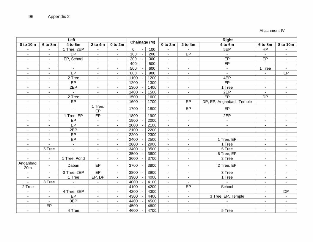
96 Appendix 2
Attachment-IV
Left Chainage (M)
Right
8 to 10m 6 to 8m 4 to 6m 2 to 4m 0 to 2m 0 to 2m 2 to 4m 4 to 6m 6 to 8m 8 to 10m
- - 1 Tree, 2EP - - 0 - 100 - - 5EP HP -
- - DP - - 100 - 200 - EP - - -
- - EP, School - - 200 - 300 - - EP EP -
- - - - - 400 - 500 - - EP - -
- - - - - 500 - 600 - - - 1 Tree -
- - EP - - 800 - 900 - - - - EP
- - 2 Tree - - 1100 - 1200 - - 4EP - -
- - EP - - 1200 - 1300 - - EP - -
- - 2EP - - 1300 - 1400 - - 1 Tree - -
- - - - - 1400 - 1500 - - 2EP - -
- - 2 Tree - - 1500 - 1600 - - EP DP -
- - EP - - 1600 - 1700 - EP DP, EP, Anganbadi, Temple - -
- - - 1 Tree,
EP - 1700 - 1800 - EP EP - -
- - 1 Tree, EP EP - 1800 - 1900 - - 2EP - -
- - EP - - 1900 - 2000 - - - - -
- - EP - - 2000 - 2100 - - - - -
- - 2EP - - 2100 - 2200 - - - - -
- - EP - - 2200 - 2300 - - - - -
- - EP - - 2400 - 2500 - - 1 Tree, EP - -
- - - - - 2800 - 2900 - - 1 Tree - -
- 5 Tree - - - 3400 - 3500 - - 5 Tree - -
- - - - - 3500 - 3600 - - 6 Tree, EP - -
- - 1 Tree, Pond - - 3600 - 3700 - - 3 Tree - -
Anganbadi 20m
- Dabari EP - 3700 - 3800 - - 2 Tree, EP - -
- - 3 Tree, 2EP EP - 3800 - 3900 - - 3 Tree - -
- - 1 Tree EP, DP - 3900 - 4000 - - 1 Tree - -
- 3 Tree - - - 4000 - 4100 - - - - -
2 Tree - - - - 4100 - 4200 - EP School - -
- - 4 Tree, 3EP - - 4200 - 4300 - - - - DP
- - EP - - 4300 - 4400 - - 3 Tree, EP, Temple - -
- - 3EP - - 4400 - 4500 - - - - -
- EP - - - 4500 - 4600 - - - - -
- - 4 Tree - - 4600 - 4700 - - 5 Tree - -
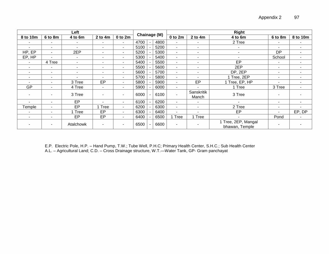
Appendix 2 97
Left Chainage (M)
Right
8 to 10m 6 to 8m 4 to 6m 2 to 4m 0 to 2m 0 to 2m 2 to 4m 4 to 6m 6 to 8m 8 to 10m
- - - - - 4700 - 4800 - - 2 Tree - -
- - - - - 5100 - 5200 - - - - -
HP, EP - 2EP - - 5200 - 5300 - - - DP -
EP, HP - - - - 5300 - 5400 - - - School -
- 4 Tree - - - 5400 - 5500 - - EP - -
- - - - - 5500 - 5600 - - 2EP - -
- - - - - 5600 - 5700 - - DP, 2EP - -
- - - - - 5700 - 5800 - - 1 Tree, 2EP - -
- - 3 Tree EP - 5800 - 5900 - EP 1 Tree, EP, HP - -
GP - 4 Tree - - 5900 - 6000 - - 1 Tree 3 Tree -
- - 3 Tree - - 6000 - 6100 - Sanskritik
Manch 3 Tree - -
- - EP - - 6100 - 6200 - - - - -
Temple - EP 1 Tree - 6200 - 6300 - - 2 Tree - -
- - 1 Tree EP - 6300 - 6400 - - EP - EP, DP
- - EP EP - 6400 - 6500 1 Tree 1 Tree - Pond -
- - Atalchowk - - 6500 - 6600 - - 1 Tree, 2EP, Mangal
bhawan, Temple - -
E.P. Electric Pole, H.P. – Hand Pump, T.W.; Tube Well, P.H.C; Primary Health Center, S.H.C.; Sub Health Center A.L. – Agricultural Land; C.D. – Cross Drainage structure, W.T.—Water Tank, GP- Gram panchayat
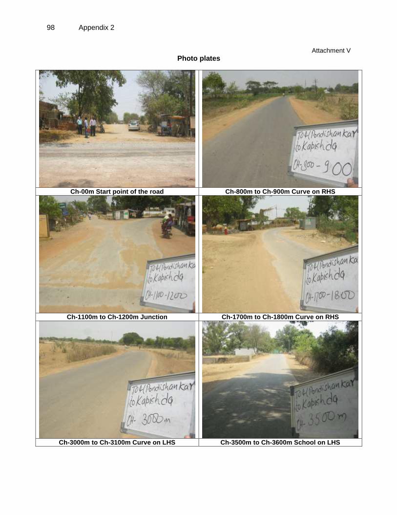
98 Appendix 2
Attachment V
Photo plates
Ch-00m Start point of the road Ch-800m to Ch-900m Curve on RHS
Ch-1100m to Ch-1200m Junction Ch-1700m to Ch-1800m Curve on RHS
Ch-3000m to Ch-3100m Curve on LHS Ch-3500m to Ch-3600m School on LHS
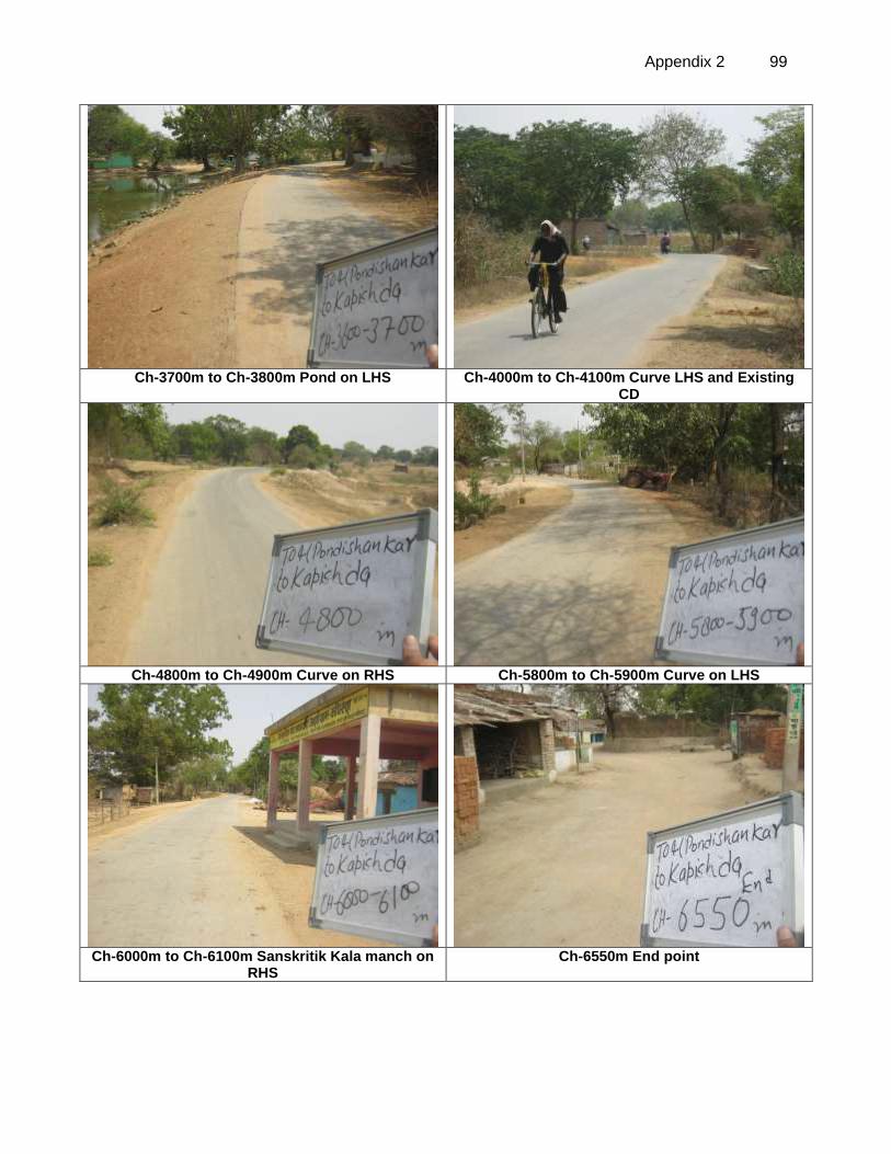
Appendix 2 99
Ch-3700m to Ch-3800m Pond on LHS Ch-4000m to Ch-4100m Curve LHS and Existing
CD
Ch-4800m to Ch-4900m Curve on RHS Ch-5800m to Ch-5900m Curve on LHS
Ch-6000m to Ch-6100m Sanskritik Kala manch on
RHS Ch-6550m End point
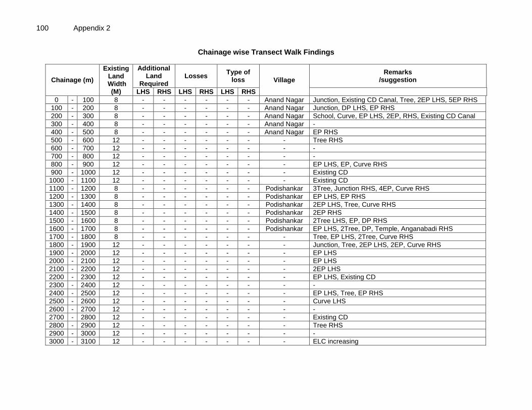
100 Appendix 2
Chainage wise Transect Walk Findings
Chainage (m)
Existing Land
Width (M)
Additional Land
Required Losses
Type of loss Village
Remarks /suggestion
LHS RHS LHS RHS LHS RHS
0 - 100 8 - - - - - - Anand Nagar Junction, Existing CD Canal, Tree, 2EP LHS, 5EP RHS
100 - 200 8 - - - - - - Anand Nagar Junction, DP LHS, EP RHS
200 - 300 8 - - - - - - Anand Nagar School, Curve, EP LHS, 2EP, RHS, Existing CD Canal
300 - 400 8 - - - - - - Anand Nagar -
400 - 500 8 - - - - - - Anand Nagar EP RHS
500 - 600 12 - - - - - - - Tree RHS
600 - 700 12 - - - - - - - -
700 - 800 12 - - - - - - - -
800 - 900 12 - - - - - - - EP LHS, EP, Curve RHS
900 - 1000 12 - - - - - - - Existing CD
1000 - 1100 12 - - - - - - - Existing CD
1100 - 1200 8 - - - - - - Podishankar 3Tree, Junction RHS, 4EP, Curve RHS
1200 - 1300 8 - - - - - - Podishankar EP LHS, EP RHS
1300 - 1400 8 - - - - - - Podishankar 2EP LHS, Tree, Curve RHS
1400 - 1500 8 - - - - - - Podishankar 2EP RHS
1500 - 1600 8 - - - - - - Podishankar 2Tree LHS, EP, DP RHS
1600 - 1700 8 - - - - - - Podishankar EP LHS, 2Tree, DP, Temple, Anganabadi RHS
1700 - 1800 8 - - - - - - - Tree, EP LHS, 2Tree, Curve RHS
1800 - 1900 12 - - - - - - - Junction, Tree, 2EP LHS, 2EP, Curve RHS
1900 - 2000 12 - - - - - - - EP LHS
2000 - 2100 12 - - - - - - - EP LHS
2100 - 2200 12 - - - - - - - 2EP LHS
2200 - 2300 12 - - - - - - - EP LHS, Existing CD
2300 - 2400 12 - - - - - - - -
2400 - 2500 12 - - - - - - - EP LHS, Tree, EP RHS
2500 - 2600 12 - - - - - - - Curve LHS
2600 - 2700 12 - - - - - - - -
2700 - 2800 12 - - - - - - - Existing CD
2800 - 2900 12 - - - - - - - Tree RHS
2900 - 3000 12 - - - - - - - -
3000 - 3100 12 - - - - - - - ELC increasing
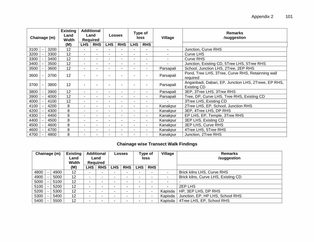
Appendix 2 101
Chainage (m)
Existing Land
Width (M)
Additional Land
Required Losses
Type of loss Village
Remarks /suggestion
LHS RHS LHS RHS LHS RHS
3100 - 3200 12 - - - - - - - Junction, Curve RHS
3200 - 3300 12 - - - - - - - Curve LHS
3300 - 3400 12 - - - - - - - Curve RHS
3400 - 3500 12 - - - - - - - Junction, Existing CD, 5Tree LHS, 5Tree RHS
3500 - 3600 12 - - - - - - Parsapali School, Junction LHS, 2Tree, 2EP RHS
3600 - 3700 12 - - - - - - Parsapali Pond, Tree LHS, 3Tree, Curve RHS, Retainning wall required
3700 - 3800 12 - - - - - - Parsapali Anganbadi, Dabari, EP, Junction LHS, 2Treee, EP RHS, Existing CD
3800 - 3900 12 - - - - - - Parsapali 3EP, 3Tree LHS, 3Tree RHS
3900 - 4000 12 - - - - - - Parsapali Tree, DP, Curve LHS, Tree RHS, Existing CD
4000 - 4100 12 - - - - - - - 3Tree LHS, Existing CD
4100 - 4200 8 - - - - - - Kanakpur 2Tree LHS, EP, School, Junction RHS
4200 - 4300 8 - - - - - - Kanakpur 3EP, 4Tree LHS, DP RHS
4300 - 4400 8 - - - - - - Kanakpur EP LHS, EP, Temple, 3Tree RHS
4400 - 4500 8 - - - - - - Kanakpur 3EP LHS, Existing CD
4500 - 4600 8 - - - - - - Kanakpur 3EP LHS, Curve RHS
4600 - 4700 8 - - - - - - Kanakpur 4Tree LHS, 5Tree RHS
4700 - 4800 8 - - - - - - Kanakpur Junction, 2Tree RHS
Chainage wise Transect Walk Findings
Chainage (m) Existing Land
Width (M)
Additional Land
Required
Losses Type of loss
Village Remarks /suggestion
LHS RHS LHS RHS LHS RHS
4800 - 4900 12 - - - - - - - Brick kilns LHS, Curve RHS
4900 - 5000 12 - - - - - - - Brick kilns, Curve LHS, Existing CD
5000 - 5100 12 - - - - - - - -
5100 - 5200 12 - - - - - - - 2EP LHS
5200 - 5300 12 - - - - - - Kapisda HP, 3EP LHS, DP RHS
5300 - 5400 12 - - - - - - Kapisda Junction, EP, HP LHS, School RHS
5400 - 5500 12 - - - - - - Kapisda 4Tree LHS, EP, School RHS
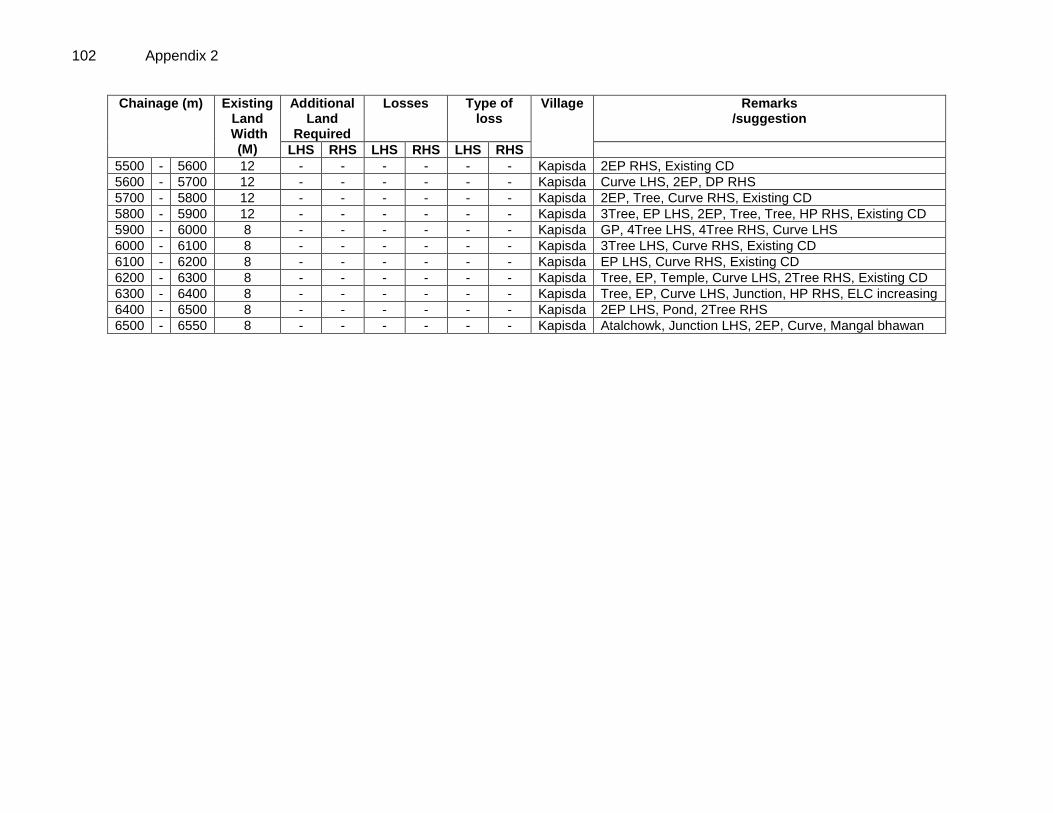
102 Appendix 2
Chainage (m) Existing Land
Width (M)
Additional Land
Required
Losses Type of loss
Village Remarks /suggestion
LHS RHS LHS RHS LHS RHS
5500 - 5600 12 - - - - - - Kapisda 2EP RHS, Existing CD
5600 - 5700 12 - - - - - - Kapisda Curve LHS, 2EP, DP RHS
5700 - 5800 12 - - - - - - Kapisda 2EP, Tree, Curve RHS, Existing CD
5800 - 5900 12 - - - - - - Kapisda 3Tree, EP LHS, 2EP, Tree, Tree, HP RHS, Existing CD
5900 - 6000 8 - - - - - - Kapisda GP, 4Tree LHS, 4Tree RHS, Curve LHS
6000 - 6100 8 - - - - - - Kapisda 3Tree LHS, Curve RHS, Existing CD
6100 - 6200 8 - - - - - - Kapisda EP LHS, Curve RHS, Existing CD
6200 - 6300 8 - - - - - - Kapisda Tree, EP, Temple, Curve LHS, 2Tree RHS, Existing CD
6300 - 6400 8 - - - - - - Kapisda Tree, EP, Curve LHS, Junction, HP RHS, ELC increasing
6400 - 6500 8 - - - - - - Kapisda 2EP LHS, Pond, 2Tree RHS
6500 - 6550 8 - - - - - - Kapisda Atalchowk, Junction LHS, 2EP, Curve, Mangal bhawan
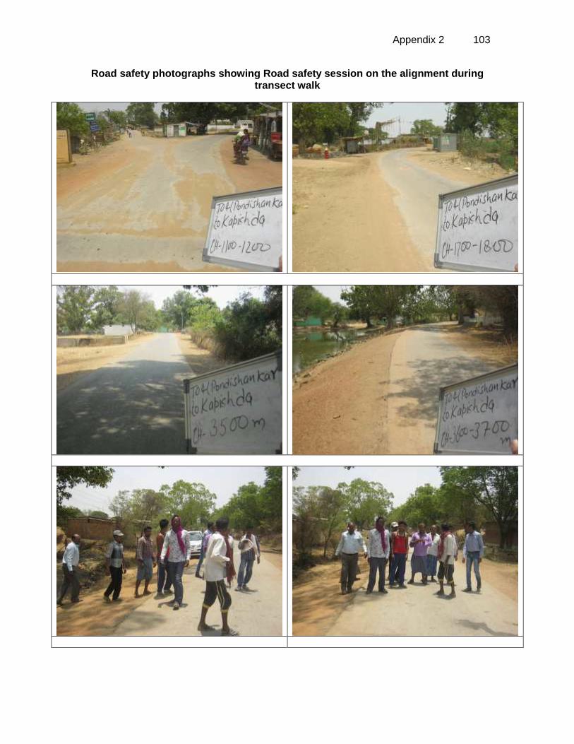
Appendix 2 103
Road safety photographs showing Road safety session on the alignment during transect walk
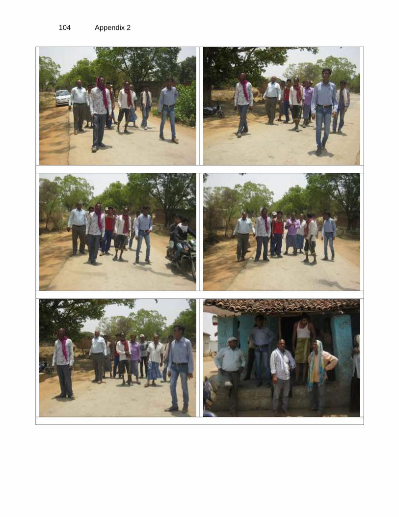
104 Appendix 2
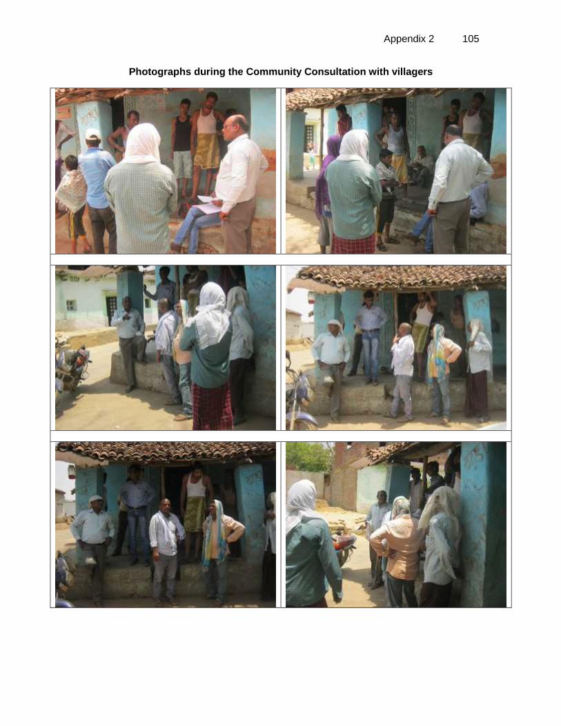
Appendix 2 105
Photographs during the Community Consultation with villagers
106 Appendix 3
APPENDIX 3: GUIDELINES FOR BORROW AREAS MANAGEMENT I. SELECTION OF BORROW AREAS 1. Location of borrow areas shall be finalized as per IRC: 10-1961guidlines. The finalization of locations in case of borrows areas identified in private land shall depend upon the formal agreement between landowners and contractor. If, agreement is not reached between the contractor and landowners for the identified borrow areas sites, arrangement for locating the source of supply of material for embankment and sub-grade as well as compliance to environment requirements in respect of excavation and borrow areas as stipulated from time to time by the Ministry of Environment and Forests, Government of India, and local bodies, as applicable shall be the sole responsibility of the contractor. 2. The contractor in addition to the established practices, rules and regulation will also consider following criteria before finalizing the locations.
The borrow area should not be located in agriculture field unless unavoidable i.e. barren land is not available.
The borrow pits preferably should not be located along the roads.
The loss of productive and agriculture soil should be minimum.
The loss of vegetation is almost nil or minimum.
The Contractor will ensure that suitable earth is available.
II. CONTRACTOR’S RESPONSIBILITY 3. The Contractor shall obtain representative samples from each of the identified borrow areas and have these tested at the site laboratory following a testing program approved by the Engineer. It shall be ensured that the sub-grade material when compacted to the density requirements shall yield the design CBR value of the sub-grade. Contractor shall begin operations keeping in mind following;
Haulage of material to embankments or other areas of fill shall proceed only when sufficient spreading and compaction plants is operating at the place of deposition.
No excavated acceptable material other than surplus to requirements of the Contract shall be removed from the site. Contractor should be permitted to remove acceptable material from the site to suit his operational procedure, then shall make consequent deficit of material arising there from.
Where the excavation reveals a combination of acceptable and un-acceptable materials, the Contractor shall, unless otherwise agreed by the Engineer, carry out the excavation in such a manner that the acceptable materials are excavated separately for use in the permanent works without contamination by the un-acceptable materials. The acceptable material shall be stockpiled separately.
III. BORROWING FROM DIFFERENT LAND-FORMS
A. Borrow Areas located in Agricultural Lands
The preservation of topsoil will be carried out in stockpile.
A 15 cm topsoil will be stripped off from the borrow pit and this will be stored in stockpiles in a designated area for height not exceeding 2m and side slopes not steeper than 1:2 (Vertical: Horizontal).
Appendix 3 107
Borrowing of earth will be carried out up to a depth of 1.5m from the existing ground level.
Borrowing of earth will not be done continuously through out the stretch.
Ridges of not less than 8m widths will be left at intervals not exceeding 300m.
Small drains will be cut through the ridges, if necessary, to facilitate drainage.
The slope of the edges will be maintained not steeper than 1:4 (vertical: Horizontal).
The depth of borrow pits will not be more than 30 cm after stripping the 15 cm topsoil aside.
B. Borrow Areas located in Elevated Lands
The preservation of topsoil will be carried out in stockpile.
A 15 cm topsoil will be stripped off from the borrow pit and this will be stored in stockpiles in a designated area for height not exceeding 2m and side slopes not steeper than 1:2 (Vertical: Horizontal).
At location where private owners desire their fields to be levelled, the borrowing shall be done to a depth of not more than 1.5m or up to the level of surrounding fields
C. Borrow Areas near River side
The preservation of topsoil will be carried out in stockpile.
A 15 cm topsoil will be stripped off from the borrow pit and this will be stored in stockpiles in a designated area for height not exceeding 2m and side slopes not steeper than 1:2 (Vertical: Horizontal).
Borrow area near to any surface water body will be at least at a distance of 15m from the toe of the bank or high flood level, whichever is maximum.
D. Borrow Areas near Settlements
The preservation of topsoil will be carried out in stockpile.
A 15 cm topsoil will be stripped off from the borrow pit and this will be stored in stockpiles in a designated area for height not exceeding 2m and side slopes not steeper than 1:2 (Vertical: Horizontal).
Borrow pit location will be located at least 0.75 km from villages and settlements. If un-avoidable, the pit will not be dug for more than 30 cm and drains will be cut to facilitate drainage.
Borrow pits located in such location will be re-developed immediately after borrowing is completed. If spoils are dumped, that will be covered with a layers of stockpiled topsoil in accordance with compliance requirements with respect MOEF/SPCB guidelines.
E. Borrow Pits along the Road
4. Borrow pits along the road shall be discouraged and if deemed necessary and permitted by the Engineer; following precautions are recommended
The preservation of topsoil will be carried out in stockpile.
A 15 cm topsoil will be stripped off from the borrow pit and this will be stored in stockpiles in a designated area for height not exceeding 2m and side slopes not steeper than 1:2 (Vertical: Horizontal).
Ridges of not less than 8m widths should be left at intervals not exceeding 300m.
Small drains shall be cut through the ridges of facilitate drainage.
108 Appendix 3
The depth of the pits shall be so regulated that there bottom does not cut an imaginary line having a slope of 1 vertical to 4 horizontal projected from the edge of the final section of bank, the maximum depth of any case being limited to 1.5m.
Also, no pit shall be dug within the offset width from the toe of the embankment required as per the consideration of stability with a minimum width of 10m.
I. REHABILITATION OF BORROW AREAS 5. The objective of the rehabilitation program is to return the borrow pit sites to a safe and secure area, which the public should be able to safely enter and enjoy. Securing borrow pits in a stable condition is fundamental requirement of the rehabilitation process. This could be achieved by filling the borrow pit floor to approximately the access road level.
6. Re-development plan shall be prepared by the Contractor before the start of work inline with the owners will require and to the satisfaction of owner. The Borrow Areas shall be rehabilitated as per following;
Borrow pits shall be backfilled with rejected construction wastes and will be given a vegetative cover. If this is not possible, then excavation sloped will be smoothed and depression will be filled in such a way that it looks more or less like the original round surface.
Borrow areas might be used for aquaculture in case landowner wants such development. In that case, such borrow area will be photographed after their post use restoration and Environment Expert of Supervision Consultant will certify the post use redevelopment.
7. The Contractor will keep record of photographs of various stages i.e., before using materials from the location (pre-project), for the period borrowing activities (construction Phase) and after rehabilitation (post development), to ascertain the pre and post borrowing status of the area.
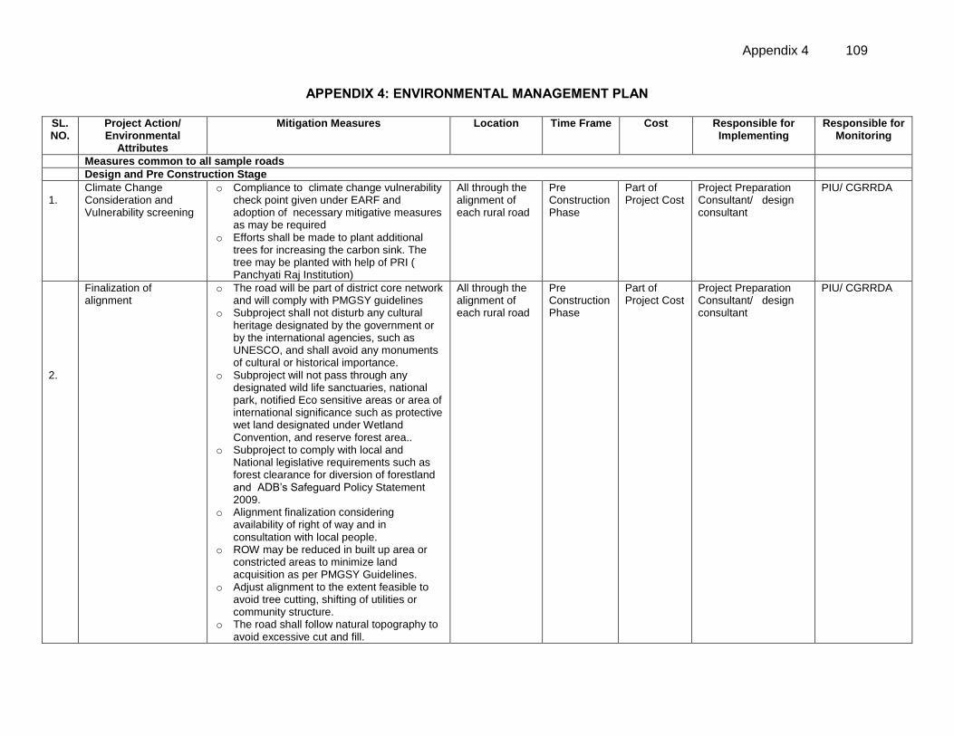
Appendix 4 109
APPENDIX 4: ENVIRONMENTAL MANAGEMENT PLAN
SL. NO.
Project Action/ Environmental
Attributes
Mitigation Measures Location Time Frame Cost Responsible for Implementing
Responsible for Monitoring
Measures common to all sample roads
Design and Pre Construction Stage
1.1. 1.
Climate Change Consideration and Vulnerability screening
o Compliance to climate change vulnerability check point given under EARF and adoption of necessary mitigative measures as may be required
o Efforts shall be made to plant additional trees for increasing the carbon sink. The tree may be planted with help of PRI ( Panchyati Raj Institution)
All through the alignment of each rural road
Pre Construction Phase
Part of Project Cost
Project Preparation Consultant/ design consultant
PIU/ CGRRDA
2.
Finalization of alignment
o The road will be part of district core network and will comply with PMGSY guidelines
o Subproject shall not disturb any cultural heritage designated by the government or by the international agencies, such as UNESCO, and shall avoid any monuments of cultural or historical importance.
o Subproject will not pass through any designated wild life sanctuaries, national park, notified Eco sensitive areas or area of international significance such as protective wet land designated under Wetland Convention, and reserve forest area..
o Subproject to comply with local and National legislative requirements such as forest clearance for diversion of forestland and ADB’s Safeguard Policy Statement 2009.
o Alignment finalization considering availability of right of way and in consultation with local people.
o ROW may be reduced in built up area or constricted areas to minimize land acquisition as per PMGSY Guidelines.
o Adjust alignment to the extent feasible to avoid tree cutting, shifting of utilities or community structure.
o The road shall follow natural topography to avoid excessive cut and fill.
All through the alignment of each rural road
Pre Construction Phase
Part of Project Cost
Project Preparation Consultant/ design consultant
PIU/ CGRRDA
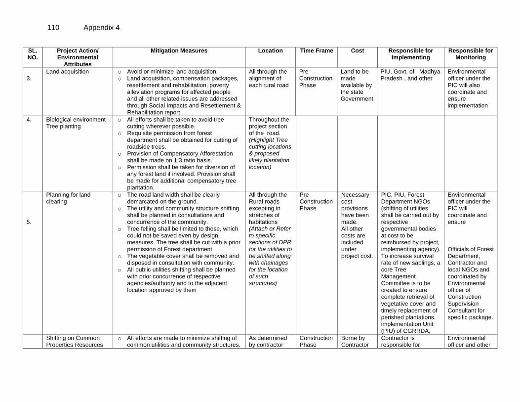
110 Appendix 4
SL. NO.
Project Action/ Environmental
Attributes
Mitigation Measures Location Time Frame Cost Responsible for Implementing
Responsible for Monitoring
3.
Land acquisition o Avoid or minimize land acquisition. o Land acquisition, compensation packages,
resettlement and rehabilitation, poverty alleviation programs for affected people and all other related issues are addressed through Social Impacts and Resettlement & Rehabilitation report.
All through the alignment of each rural road
Pre Construction Phase
Land to be made available by the state Government
PIU, Govt. of Madhya Pradesh , and other
Environmental officer under the PIC will also coordinate and ensure implementation
4. Biological environment - Tree planting
o All efforts shall be taken to avoid tree cutting wherever possible.
o Requisite permission from forest department shall be obtained for cutting of roadside trees.
o Provision of Compensatory Afforestation shall be made on 1:3.ratio basis.
o Permission shall be taken for diversion of any forest land if involved. Provision shall be made for additional compensatory tree plantation.
Throughout the project section of the road. (Highlight Tree cutting locations & proposed likely plantation location)
5.
Planning for land clearing
o The road land width shall be clearly demarcated on the ground.
o The utility and community structure shifting shall be planned in consultations and concurrence of the community.
o Tree felling shall be limited to those, which could not be saved even by design measures. The tree shall be cut with a prior permission of Forest department.
o The vegetable cover shall be removed and disposed in consultation with community.
o All public utilities shifting shall be planned with prior concurrence of respective agencies/authority and to the adjacent location approved by them
All through the Rural roads excepting in stretches of habitations (Attach or Refer to specific sections of DPR for the utilities to be shifted along with chainages for the location of such structures)
Pre Construction Phase
Necessary cost provisions have been made. All other costs are included under project cost.
PIC, PIU, Forest Department NGOs (shifting of utilities shall be carried out by respective governmental bodies at cost to be reimbursed by project, implementing agency). To increase survival rate of new saplings, a core Tree Management Committee is to be created to ensure complete retrieval of vegetative cover and timely replacement of perished plantations. implementation Unit (PIU) of CGRRDA,
Environmental officer under the PIC will coordinate and ensure Officials of Forest Department, Contractor and local NGOs and coordinated by Environmental officer of Construction Supervision Consultant for specific package.
Shifting on Common Properties Resources
o All efforts are made to minimize shifting of common utilities and community structures.
As determined by contractor
Construction Phase
Borne by Contractor
Contractor is responsible for
Environmental officer and other
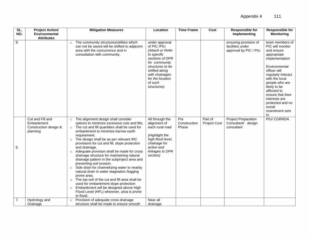
Appendix 4 111
SL. NO.
Project Action/ Environmental
Attributes
Mitigation Measures Location Time Frame Cost Responsible for Implementing
Responsible for Monitoring
8. o The community structures/utilities which can not be saved will be shifted to adjacent area with the concurrence and in consultation with community.
under approval of PIC /PIU (Attach or Refer to specific sections of DPR for community structures to be shifted along with chainages for the location of such structures)
ensuring provision of facilities under approval by PIC / PIU
team members of PIC will monitor and ensure appropriate implementation Environmental officer will regularly interact with the local people who are likely to be affected to ensure that their interests are protected and no social resentment sets in.
6.
Cut and Fill and Embankment Construction design & planning
o The alignment design shall consider options to minimize excessive cuts and fills.
o The cut and fill quantities shall be used for embankment to minimize barrow earth requirement.
o The design shall be as per relevant IRC provisions for cut and fill, slope protection and drainage.
o Adequate provision shall be made for cross drainage structure for maintaining natural drainage pattern in the subproject area and preventing soil erosion.
o Side drain for channelizing water to nearby natural drain in water stagnation /logging prone area.
o The top soil of the cut and fill area shall be used for embankment slope protection
o Embankment will be designed above High Flood Level (HFL) wherever, area is prone to flood.
All through the alignment of each rural road (Highlight the high flood level, chainage for action and linkages to DPR section)
Pre Construction Phase
Part of Project Cost
Project Preparation Consultant/ design consultant
PIU/ CGRRDA
7. Hydrology and Drainage
o Provision of adequate cross drainage structure shall be made to ensure smooth
Near all drainage
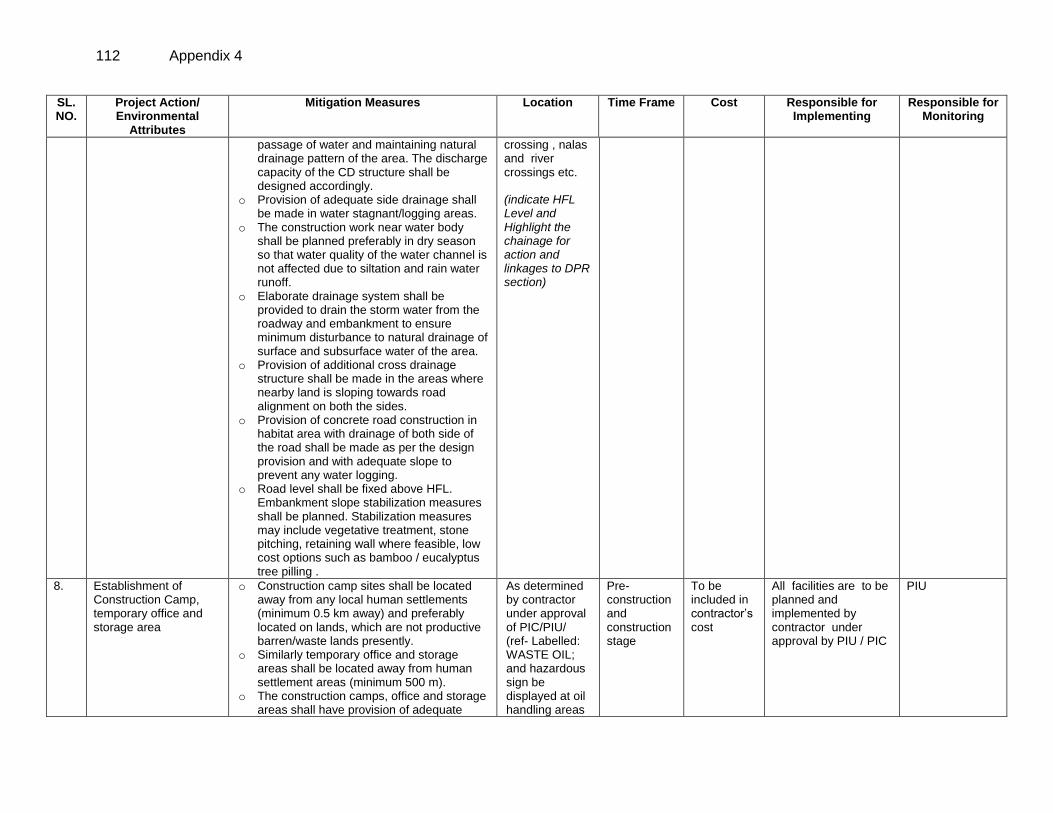
112 Appendix 4
SL. NO.
Project Action/ Environmental
Attributes
Mitigation Measures Location Time Frame Cost Responsible for Implementing
Responsible for Monitoring
passage of water and maintaining natural drainage pattern of the area. The discharge capacity of the CD structure shall be designed accordingly.
o Provision of adequate side drainage shall be made in water stagnant/logging areas.
o The construction work near water body shall be planned preferably in dry season so that water quality of the water channel is not affected due to siltation and rain water runoff.
o Elaborate drainage system shall be provided to drain the storm water from the roadway and embankment to ensure minimum disturbance to natural drainage of surface and subsurface water of the area.
o Provision of additional cross drainage structure shall be made in the areas where nearby land is sloping towards road alignment on both the sides.
o Provision of concrete road construction in habitat area with drainage of both side of the road shall be made as per the design provision and with adequate slope to prevent any water logging.
o Road level shall be fixed above HFL. Embankment slope stabilization measures shall be planned. Stabilization measures may include vegetative treatment, stone pitching, retaining wall where feasible, low cost options such as bamboo / eucalyptus tree pilling .
crossing , nalas and river crossings etc. (indicate HFL Level and Highlight the chainage for action and linkages to DPR section)
8. Establishment of Construction Camp, temporary office and storage area
o Construction camp sites shall be located away from any local human settlements (minimum 0.5 km away) and preferably located on lands, which are not productive barren/waste lands presently.
o Similarly temporary office and storage areas shall be located away from human settlement areas (minimum 500 m).
o The construction camps, office and storage areas shall have provision of adequate
As determined by contractor under approval of PIC/PIU/ (ref- Labelled: WASTE OIL; and hazardous sign be displayed at oil handling areas
Pre- construction and construction stage
To be included in contractor’s cost
All facilities are to be planned and implemented by contractor under approval by PIU / PIC
PIU
Appendix 4 113
SL. NO.
Project Action/ Environmental
Attributes
Mitigation Measures Location Time Frame Cost Responsible for Implementing
Responsible for Monitoring
water supply, sanitation and all requisite infrastructure facilities.
o The construction camps shall be located at a minimum 0.5 km from forest land/areas to deter the construction labour in trespassing. Similarly, temporary office and storage areas shall be located at a minimum 0.5 km from forest land/areas.
o The construction camps, office and storage areas shall have provision of septic tank/soak pit of adequate capacity so that it can function properly for the entire duration of its use.
o All construction camps shall have provision of rationing facilities particularly for kerosene/LPG so that dependence on firewood for cooking is avoided completely to the extent possible.
o The construction camps, office and storage areas shall have provision of health care facilities for adults, pregnant women and children.
o Personal Protective Equipments (PPEs) like helmet, boots, earplugs for workers, first aid and fire fighting equipments shall be available at construction sites before start of construction. An emergency plan shall be prepared to fight with any emergency like fire.
o Provision shall be made for domestic solid waste disposal in a control manner. The recyclable waste shall be sold off and non-saleable and biodegradable waste shall be disposed through secured land filling.
o Provision of paved area for unloading and storage of fuel oil, lubricant oil, away from storm water drainage.
and sold off to SPCB/ MoEF authorized re-refiners). (Contractor to specify the cost provision made for PPE and other environmental sanitation measures required per construction camp / temporary office / storage area)
9.
Traffic Movement o The contractor will identify the areas were temporary traffic diversion may be required. He would prepare appropriate traffic movement plan for ensuring continued flow of traffic during construction phase. This
As proposed under DPR and determined by contractor and approved by
Pre- construction and construction stage
To be included in contractor’s cost
All facilities are to be planned and implemented by contractor under approval by PIU / PIC
PIU
114 Appendix 4
SL. NO.
Project Action/ Environmental
Attributes
Mitigation Measures Location Time Frame Cost Responsible for Implementing
Responsible for Monitoring
may include movement of the traffic from the site of the construction area. This kind of a temporary diversion shall be finalized with the concurrence of respective PIU.
o Wherever, cross drainage structure work require longer construction time and road is to be blocked for longer duration, the PIU / DPR Consultant shall define appropriate measures for traffic diversion before the start of the construction.
o The diversion plan should ensure smooth flow of traffic, minimize accidents to road users during construction works.
o Adequate signboards shall be placed much ahead of diversion site to caution the road users. The road signs should be bold and retro reflective in nature for good visibility in day and night both.
PIC/PIU/ (Highlight the chainages which may require traffic diversions)
10. Occupational Health and Safety
o Speed breakers (Rumble strips) as per IRC: 99-1988 shall be provided at sharp corves design and bends where the curve design speed is less than 40 km per hour in plain and rolling terrain.
o Speed breakers shall also be provided at a threshold of habitation (as per NRRDA guidelines) at regular intervals (150-200 m) through habitation.
o The speed breakers shall be provided and directional sign boards installed at sites where reverse horizontal curves are closely spaced and speed reduction is required.
o Provision shall be made for Hazard markers at each end of all box culverts, river crossing causeways and similar CD structures
o Shoulder side slopes shall not be steeper than 2h:1V unless stone pitching of the slopes is provided.
o Cement concrete pavement and V-shaped drain shall be constructed to the full width of the available roadway within densely populated habitation and as per feasibility.
Throughout the project section at the location determined by contractor and approved by PIU (Highlight the location with chainage for such requirements)
Appendix 4 115
SL. NO.
Project Action/ Environmental
Attributes
Mitigation Measures Location Time Frame Cost Responsible for Implementing
Responsible for Monitoring
o Provision shall be made for Directional sight board shall be installed on all sharp curves and bends
o At a main road, intersection or crossing “STOP” sign and ‘T-intersection’ warning sign shall be installed on the village road.
o It is proposed to approach railways for adequate safety at unmanned railway crossing where applicable. Adequate clearly visible sign shall be provided on both side of the railway crossing
Construction Stage
11.
Sourcing and transportation of construction material ( aggregates , earth)
Borrow Earth:
o The borrow earth shall be obtained from identified locations and with prior permission for landowner and clear understanding for its rehabilitation. The Indian Road Congress (IRC):10-1961 guideline should be used for selection of borrow pits and amount that can be borrowed.
o Borrowing earth from agricultural land shall be minimized to the extent possible. Further, no earth shall be borrowed from already low-lying areas.
o A 15 cm topsoil will be stripped off from the borrow pit and this will be stored in stockpiles in a designated area for height not exceeding 2m and side slopes not steeper than 1:2 (Vertical: Horizontal).
o Borrowing of earth will not be done continuously through out the stretch.
o Ridges of not less than 8m widths will be left at intervals not exceeding 300m.
o Small drains will be cut through the ridges, if necessary, to facilitate drainage.
o The slope of the edges will be maintained not steeper than 1:4 (vertical: Horizontal).
o The depth of borrow pits will not be more than 30 cm after stripping the 15 cm topsoil
As Borrow sites and quarries (if required) location. (List the probable locations for borrow areas. (Highlight the identified quarries, if already identified. Contractors should also indicate the quarry they are likely to use if not already identified at DPR stag)
During Design and construction Stage
Engineering cost
The selection of quarries and material selection will be the responsibility of contractor under approval of PIC /PIU/TSC Environmental officer and other team members of PIC will ensure appropriate implementation of mitigation actions.
PIC /PIU/TSC Environmental officer and other team members of PIC will monitor
116 Appendix 4
SL. NO.
Project Action/ Environmental
Attributes
Mitigation Measures Location Time Frame Cost Responsible for Implementing
Responsible for Monitoring
aside. o Fly ash will also be used in road
embankment as per IRC guidelines wherever thermal power plant is located within 100 km of the road alignment.
o The borrow area shall be rehabilitated as per the understanding arrived with the land-owner. The re-habilitation plan may include the following: Borrow pits shall be backfilled with
rejected construction wastes and will be given a vegetative cover. If this is not possible, then excavation sloped will be smoothed and depression will be filled in such a way that it looks more or less like the original ground surface.
Borrow areas might be used for aquaculture in case landowner wants such development.
Aggregate :
o The stone aggregate shall be sourced from existing licensed quarries
o Copies of consent/ approval / rehabilitation plan for use of existing source will be submitted to PIU.
o Topsoil to be stockpiled and protected for use at the rehabilitation stage
Transportation of Construction Material
o Existing tracks / roads are to be used for hauling of materials to the extent possible.
o Prior to construction of roads, topsoil shall be preserved or at least shall be used for any other useful purposes like using in turfing of embankment rather than allowing its loss by construction activities.
o The vehicles deployed for material transportation shall be spillage proof to avoid or minimize the spillage of the material during transportation. In any case, the transportation links are to be inspected
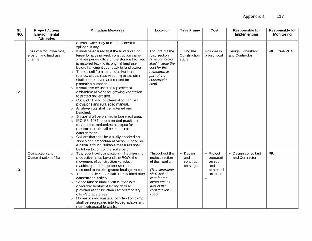
Appendix 4 117
SL. NO.
Project Action/ Environmental
Attributes
Mitigation Measures Location Time Frame Cost Responsible for Implementing
Responsible for Monitoring
at least twice daily to clear accidental spillage, if any.
12.
Loss of Productive Soil, erosion and land use change
o It shall be ensured that the land taken on lease for access road, construction camp and temporary office of the storage facilities is restored back to its original land use before handing it over back to land owner.
o The top soil from the productive land (borrow areas, road widening areas etc.) shall be preserved and reused for plantation purposes.
o It shall also be used as top cover of embankment slope for growing vegetation to protect soil erosion.
o Cut and fill shall be planned as per IRC provisions and rural road manual.
o All steep cuts shall be flattened and benched.
o Shrubs shall be planted in loose soil area. o IRC: 56 -1974 recommended practice for
treatment of embankment slopes for erosion control shall be taken into consideration.
o Soil erosion shall be visually checked on slopes and embankment areas. In case soil erosion is found, suitable measures shall be taken to control the soil erosion
Thought out the road section (The contractor shall include the cost for the measures as part of the construction cost)
During the Construction stage
Included in project cost
Design Consultant and Contractor
PIU / CGRRDA
13.
Compaction and Contamination of Soil
o To prevent soil compaction in the adjoining productive lands beyond the ROW, the movement of construction vehicles, machinery and equipment shall be restricted to the designated haulage route.
o The productive land shall be reclaimed after construction activity.
o Septic tank or mobile toilets fitted with anaerobic treatment facility shall be provided at construction camp/temporary office/storage areas.
o Domestic solid waste at construction camp shall be segregated into biodegradable and non-biodegradable waste.
Throughout the project section of the road s (The contractor shall include the cost for the measures as part of the construction cost)
Design and construction stage
Project preparation cost and construction cost
Design consultant and Contractor,
PIU
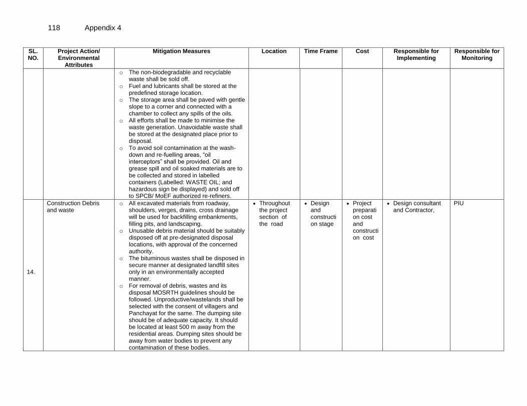
118 Appendix 4
SL. NO.
Project Action/ Environmental
Attributes
Mitigation Measures Location Time Frame Cost Responsible for Implementing
Responsible for Monitoring
o The non-biodegradable and recyclable waste shall be sold off.
o Fuel and lubricants shall be stored at the predefined storage location.
o The storage area shall be paved with gentle slope to a corner and connected with a chamber to collect any spills of the oils.
o All efforts shall be made to minimise the waste generation. Unavoidable waste shall be stored at the designated place prior to disposal.
o To avoid soil contamination at the wash-down and re-fuelling areas, “oil interceptors” shall be provided. Oil and grease spill and oil soaked materials are to be collected and stored in labelled containers (Labelled: WASTE OIL; and hazardous sign be displayed) and sold off to SPCB/ MoEF authorized re-refiners.
14.
Construction Debris and waste
o All excavated materials from roadway, shoulders, verges, drains, cross drainage will be used for backfilling embankments, filling pits, and landscaping.
o Unusable debris material should be suitably disposed off at pre-designated disposal locations, with approval of the concerned authority.
o The bituminous wastes shall be disposed in secure manner at designated landfill sites only in an environmentally accepted manner.
o For removal of debris, wastes and its disposal MOSRTH guidelines should be followed. Unproductive/wastelands shall be selected with the consent of villagers and Panchayat for the same. The dumping site should be of adequate capacity. It should be located at least 500 m away from the residential areas. Dumping sites should be away from water bodies to prevent any contamination of these bodies.
Throughout the project section of the road
Design and construction stage
Project preparation cost and construction cost
Design consultant and Contractor,
PIU
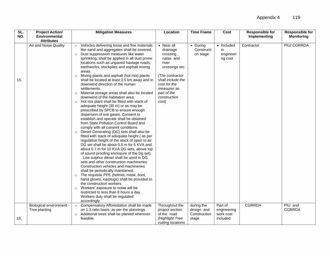
Appendix 4 119
SL. NO.
Project Action/ Environmental
Attributes
Mitigation Measures Location Time Frame Cost Responsible for Implementing
Responsible for Monitoring
15.
Air and Noise Quality o Vehicles delivering loose and fine materials like sand and aggregates shall be covered.
o Dust suppression measures like water sprinkling, shall be applied in all dust prone locations such as unpaved haulage roads, earthworks, stockpiles and asphalt mixing areas.
o Mixing plants and asphalt (hot mix) plants shall be located at least 0.5 km away and in downwind direction of the human settlements.
o Material storage areas shall also be located downwind of the habitation area.
o Hot mix plant shall be fitted with stack of adequate height (30 m) or as may be prescribed by SPCB to ensure enough dispersion of exit gases. Consent to establish and operate shall be obtained from State Pollution Control Board and comply with all consent conditions.
o Diesel Generating (DG) sets shall also be fitted with stack of adequate height ( as per regulation height of the stack of open to air DG set shall be about 0.5 m for 5 KVA and about 0.7 m for 10 KVA DG sets, above top of sound proofing enclosure of the Dg set). . Low sulphur diesel shall be used in DG sets and other construction machineries. Construction vehicles and machineries shall be periodically maintained.
o The requisite PPE (helmet, mask, boot, hand gloves, earplugs) shall be provided to the construction workers.
o Workers’ exposure to noise will be restricted to less than 8 hours a day. Workers duty shall be regulated accordingly.
Near all drainage crossing , nalas and river crossings etc.
(The contractor shall include the cost for the measures as part of the construction cost)
During Construction stage
Included in engineering cost
Contractor PIU/ CGRRDA
15. 16.
Biological environment - Tree planting
o Compensatory Afforestation shall be made on 1:3.ratio basis as per the plannings.
o Additional trees shall be planted wherever feasible.
Throughout the project section of the road (Highlight Tree cutting locations
during the design and Construction stage
Part of engineering work cost included
CGRRDA PIU and CGRRDA
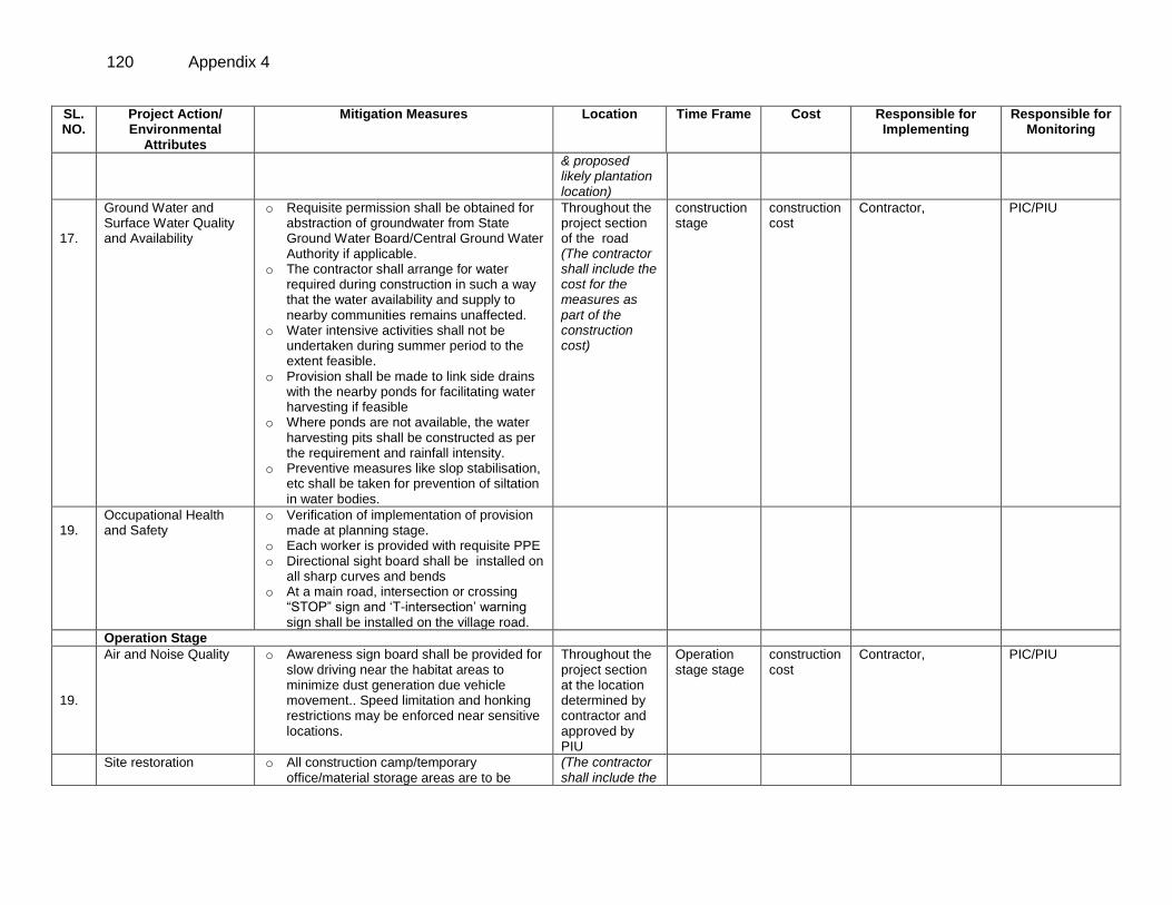
120 Appendix 4
SL. NO.
Project Action/ Environmental
Attributes
Mitigation Measures Location Time Frame Cost Responsible for Implementing
Responsible for Monitoring
& proposed likely plantation location)
17.
Ground Water and Surface Water Quality and Availability
o Requisite permission shall be obtained for abstraction of groundwater from State Ground Water Board/Central Ground Water Authority if applicable.
o The contractor shall arrange for water required during construction in such a way that the water availability and supply to nearby communities remains unaffected.
o Water intensive activities shall not be undertaken during summer period to the extent feasible.
o Provision shall be made to link side drains with the nearby ponds for facilitating water harvesting if feasible
o Where ponds are not available, the water harvesting pits shall be constructed as per the requirement and rainfall intensity.
o Preventive measures like slop stabilisation, etc shall be taken for prevention of siltation in water bodies.
Throughout the project section of the road (The contractor shall include the cost for the measures as part of the construction cost)
construction stage
construction cost
Contractor, PIC/PIU
19.
Occupational Health and Safety
o Verification of implementation of provision made at planning stage.
o Each worker is provided with requisite PPE o Directional sight board shall be installed on
all sharp curves and bends o At a main road, intersection or crossing
“STOP” sign and ‘T-intersection’ warning sign shall be installed on the village road.
Operation Stage
19.
Air and Noise Quality o Awareness sign board shall be provided for slow driving near the habitat areas to minimize dust generation due vehicle movement.. Speed limitation and honking restrictions may be enforced near sensitive locations.
Throughout the project section at the location determined by contractor and approved by PIU
Operation stage stage
construction cost
Contractor, PIC/PIU
Site restoration o All construction camp/temporary office/material storage areas are to be
(The contractor shall include the
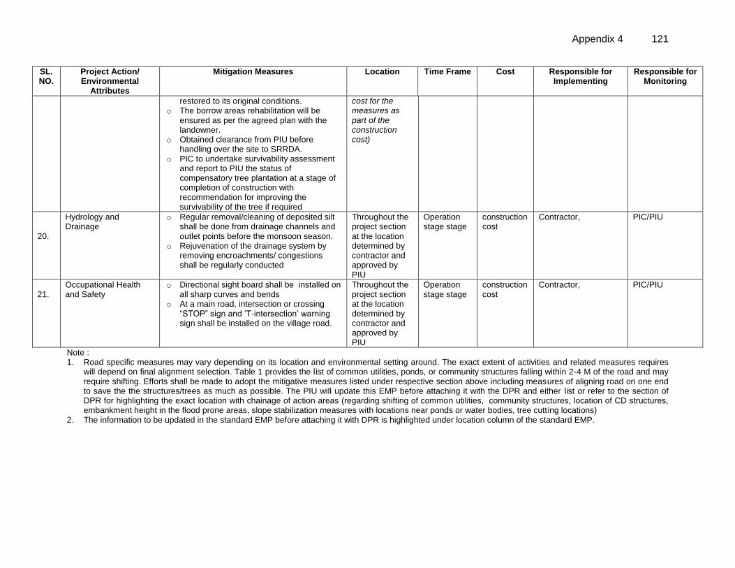
Appendix 4 121
SL. NO.
Project Action/ Environmental
Attributes
Mitigation Measures Location Time Frame Cost Responsible for Implementing
Responsible for Monitoring
restored to its original conditions. o The borrow areas rehabilitation will be
ensured as per the agreed plan with the landowner.
o Obtained clearance from PIU before handling over the site to SRRDA.
o PIC to undertake survivability assessment and report to PIU the status of compensatory tree plantation at a stage of completion of construction with recommendation for improving the survivability of the tree if required
cost for the measures as part of the construction cost)
20.
Hydrology and Drainage
o Regular removal/cleaning of deposited silt shall be done from drainage channels and outlet points before the monsoon season.
o Rejuvenation of the drainage system by removing encroachments/ congestions shall be regularly conducted
Throughout the project section at the location determined by contractor and approved by PIU
Operation stage stage
construction cost
Contractor, PIC/PIU
21.
Occupational Health and Safety
o Directional sight board shall be installed on all sharp curves and bends
o At a main road, intersection or crossing “STOP” sign and ‘T-intersection’ warning sign shall be installed on the village road.
Throughout the project section at the location determined by contractor and approved by PIU
Operation stage stage
construction cost
Contractor, PIC/PIU
Note : 1. Road specific measures may vary depending on its location and environmental setting around. The exact extent of activities and related measures requires
will depend on final alignment selection. Table 1 provides the list of common utilities, ponds, or community structures falling within 2-4 M of the road and may require shifting. Efforts shall be made to adopt the mitigative measures listed under respective section above including measures of aligning road on one end to save the the structures/trees as much as possible. The PIU will update this EMP before attaching it with the DPR and either list or refer to the section of DPR for highlighting the exact location with chainage of action areas (regarding shifting of common utilities, community structures, location of CD structures, embankment height in the flood prone areas, slope stabilization measures with locations near ponds or water bodies, tree cutting locations)
2. The information to be updated in the standard EMP before attaching it with DPR is highlighted under location column of the standard EMP.
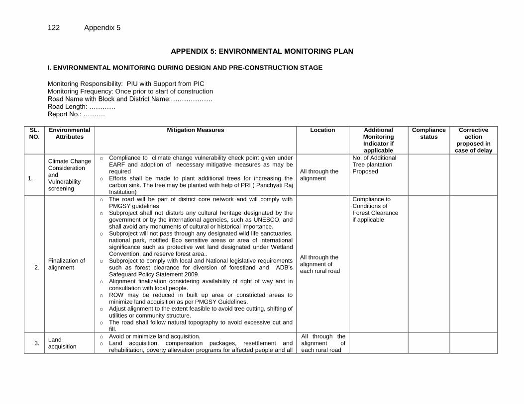
122 Appendix 5
APPENDIX 5: ENVIRONMENTAL MONITORING PLAN I. ENVIRONMENTAL MONITORING DURING DESIGN AND PRE-CONSTRUCTION STAGE
Monitoring Responsibility: PIU with Support from PIC Monitoring Frequency: Once prior to start of construction Road Name with Block and District Name:………………. Road Length: ………… Report No.: ……….
SL. NO.
Environmental Attributes
Mitigation Measures Location Additional Monitoring Indicator if applicable
Compliance status
Corrective action
proposed in case of delay
1.1. 1.
Climate Change Consideration and Vulnerability screening
o Compliance to climate change vulnerability check point given under EARF and adoption of necessary mitigative measures as may be required
o Efforts shall be made to plant additional trees for increasing the carbon sink. The tree may be planted with help of PRI ( Panchyati Raj Institution)
All through the alignment
No. of Additional Tree plantation Proposed
2.
Finalization of alignment
o The road will be part of district core network and will comply with PMGSY guidelines
o Subproject shall not disturb any cultural heritage designated by the government or by the international agencies, such as UNESCO, and shall avoid any monuments of cultural or historical importance.
o Subproject will not pass through any designated wild life sanctuaries, national park, notified Eco sensitive areas or area of international significance such as protective wet land designated under Wetland Convention, and reserve forest area..
o Subproject to comply with local and National legislative requirements such as forest clearance for diversion of forestland and ADB’s Safeguard Policy Statement 2009.
o Alignment finalization considering availability of right of way and in consultation with local people.
o ROW may be reduced in built up area or constricted areas to minimize land acquisition as per PMGSY Guidelines.
o Adjust alignment to the extent feasible to avoid tree cutting, shifting of utilities or community structure.
o The road shall follow natural topography to avoid excessive cut and fill.
All through the alignment of each rural road
Compliance to Conditions of Forest Clearance if applicable
3.
Land acquisition
o Avoid or minimize land acquisition. o Land acquisition, compensation packages, resettlement and
rehabilitation, poverty alleviation programs for affected people and all
All through the alignment of each rural road
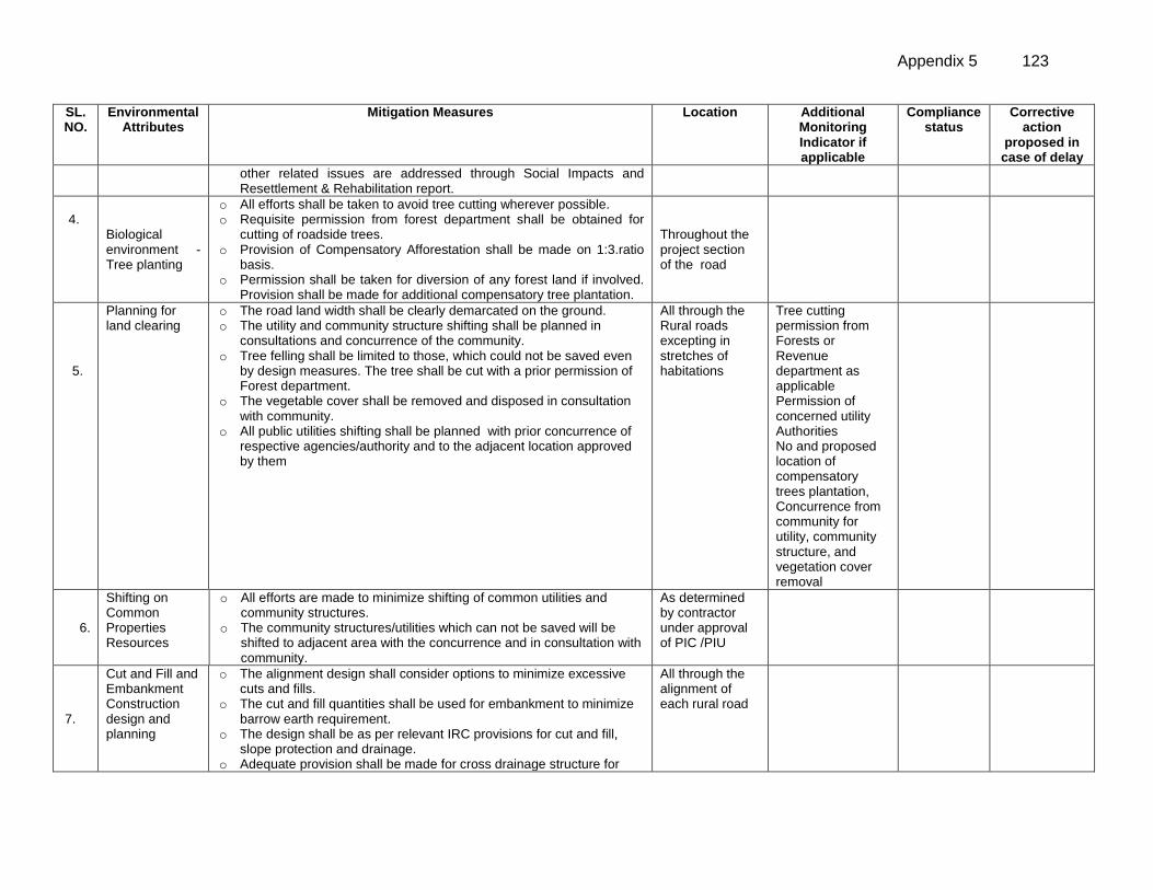
Appendix 5 123
SL. NO.
Environmental Attributes
Mitigation Measures Location Additional Monitoring Indicator if applicable
Compliance status
Corrective action
proposed in case of delay
other related issues are addressed through Social Impacts and Resettlement & Rehabilitation report.
4.
7.77
Biological environment - Tree planting
o All efforts shall be taken to avoid tree cutting wherever possible. o Requisite permission from forest department shall be obtained for
cutting of roadside trees. o Provision of Compensatory Afforestation shall be made on 1:3.ratio
basis. o Permission shall be taken for diversion of any forest land if involved.
Provision shall be made for additional compensatory tree plantation.
Throughout the project section of the road
5.
Planning for land clearing
o The road land width shall be clearly demarcated on the ground. o The utility and community structure shifting shall be planned in
consultations and concurrence of the community. o Tree felling shall be limited to those, which could not be saved even
by design measures. The tree shall be cut with a prior permission of Forest department.
o The vegetable cover shall be removed and disposed in consultation with community.
o All public utilities shifting shall be planned with prior concurrence of respective agencies/authority and to the adjacent location approved by them
All through the Rural roads excepting in stretches of habitations
Tree cutting permission from Forests or Revenue department as applicable Permission of concerned utility Authorities No and proposed location of compensatory trees plantation, Concurrence from community for utility, community structure, and vegetation cover removal
6.
Shifting on Common Properties Resources
o All efforts are made to minimize shifting of common utilities and community structures.
o The community structures/utilities which can not be saved will be shifted to adjacent area with the concurrence and in consultation with community.
As determined by contractor under approval of PIC /PIU
7.
Cut and Fill and Embankment Construction design and planning
o The alignment design shall consider options to minimize excessive cuts and fills.
o The cut and fill quantities shall be used for embankment to minimize barrow earth requirement.
o The design shall be as per relevant IRC provisions for cut and fill, slope protection and drainage.
o Adequate provision shall be made for cross drainage structure for
All through the alignment of each rural road
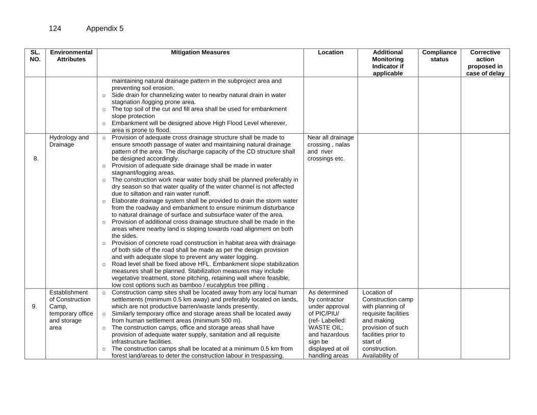
124 Appendix 5
SL. NO.
Environmental Attributes
Mitigation Measures Location Additional Monitoring Indicator if applicable
Compliance status
Corrective action
proposed in case of delay
maintaining natural drainage pattern in the subproject area and preventing soil erosion.
o Side drain for channelizing water to nearby natural drain in water stagnation /logging prone area.
o The top soil of the cut and fill area shall be used for embankment slope protection
o Embankment will be designed above High Flood Level wherever, area is prone to flood.
8.
Hydrology and Drainage
o Provision of adequate cross drainage structure shall be made to ensure smooth passage of water and maintaining natural drainage pattern of the area. The discharge capacity of the CD structure shall be designed accordingly.
o Provision of adequate side drainage shall be made in water stagnant/logging areas.
o The construction work near water body shall be planned preferably in dry season so that water quality of the water channel is not affected due to siltation and rain water runoff.
o Elaborate drainage system shall be provided to drain the storm water from the roadway and embankment to ensure minimum disturbance to natural drainage of surface and subsurface water of the area.
o Provision of additional cross drainage structure shall be made in the areas where nearby land is sloping towards road alignment on both the sides.
o Provision of concrete road construction in habitat area with drainage of both side of the road shall be made as per the design provision and with adequate slope to prevent any water logging.
o Road level shall be fixed above HFL. Embankment slope stabilization measures shall be planned. Stabilization measures may include vegetative treatment, stone pitching, retaining wall where feasible, low cost options such as bamboo / eucalyptus tree pilling .
Near all drainage crossing , nalas and river crossings etc.
9.
Establishment of Construction Camp, temporary office and storage area
o Construction camp sites shall be located away from any local human settlements (minimum 0.5 km away) and preferably located on lands, which are not productive barren/waste lands presently.
o Similarly temporary office and storage areas shall be located away from human settlement areas (minimum 500 m).
o The construction camps, office and storage areas shall have provision of adequate water supply, sanitation and all requisite infrastructure facilities.
o The construction camps shall be located at a minimum 0.5 km from forest land/areas to deter the construction labour in trespassing.
As determined by contractor under approval of PIC/PIU/ (ref- Labelled: WASTE OIL; and hazardous sign be displayed at oil handling areas
Location of Construction camp with planning of requisite facilities and making provision of such facilities prior to start of construction. Availability of
Appendix 5 125
SL. NO.
Environmental Attributes
Mitigation Measures Location Additional Monitoring Indicator if applicable
Compliance status
Corrective action
proposed in case of delay
Similarly, temporary office and storage areas shall be located at a minimum 0.5 km from forest land/areas.
o The construction camps, office and storage areas shall have provision of septic tank/soak pit of adequate capacity so that it can function properly for the entire duration of its use.
o All construction camps shall have provision of rationing facilities particularly for kerosene/LPG so that dependence on firewood for cooking is avoided completely to the extent possible.
o The construction camps, office and storage areas shall have provision of health care facilities for adults, pregnant women and children.
o Personal Protective Equipments (PPEs) like helmet, boots, earplugs for workers, first aid and fire fighting equipments shall be available at construction sites before start of construction. An emergency plan shall be prepared to fight with any emergency like fire.
o Provision shall be made for domestic solid waste disposal in a control manner. The recyclable waste shall be sold off and non-saleable and biodegradable waste shall be disposed through secured land filling.
o Provision of paved area for unloading and storage of fuel oil, lubricant oil, away from storm water drainage.
and sold off to SPCB/ MoEF authorized re-refiners).
consent to establish from pollution control board for setting up the camp.
10.
Traffic Movement
o The contractor will prepare appropriate traffic diversion scheme approved by respective PIU. This shall be implemented prior to start of construction to avoid any inconvenience to the present road users. This shall be implemented in other stretches of the road as per the progress of the construction work.
o The diversion plan should ensure smooth flow of traffic, minimize accidents to road users during construction works.
o Adequate signboards shall be placed much ahead of diversion site to caution the road users. The road signs should be bold and retro reflective in nature for good visibility in day and night both.
As proposed under DPR and determined by contractor and approved by PIC/PIU
11.
Occupational Health and Safety
o Speed breakers (Rumble strips) as per IRC: 99-1988 shall be provided at sharp corves design and bends where the curve design speed is less than 40 km per hour in plain and rolling terrain.
o Speed breakers shall also be provided at a threshold of habitation (as per NRRDA guidelines) at regular intervals (150-200 m) through habitation.
o The speed breakers shall be provided and directional sign boards installed at sites where reverse horizontal curves are closely spaced and speed reduction is required.
Throughout the project section at the location determined by contractor and approved by PIU
126 Appendix 5
SL. NO.
Environmental Attributes
Mitigation Measures Location Additional Monitoring Indicator if applicable
Compliance status
Corrective action
proposed in case of delay
o Provision shall be made for Hazard markers at each end of all box culverts, river crossing causeways and similar CD structures
o Shoulder side slopes shall not be steeper than 2h:1V unless stone pitching of the slopes is provided.
o Cement concrete pavement and V-shaped drain shall be constructed to the full width of the available roadway within densely populated habitation and as per feasibility.
o Provision shall be made for Directional sight board shall be installed on all sharp curves and bends
o At a main road, intersection or crossing “STOP” sign and ‘T-intersection’ warning sign shall be installed on the village road.
o It is proposed to approach railways for adequate safety at unmanned railway crossing where applicable. Adequate clearly visible sign shall be provided on both side of the railway crossing
1111112. Grievance Redress
o Obtaining information from Village level Grievance redress committee, PIU as applicable
Each Sample road once.
NOTE: Each report must enclose Photograph to the maximum possible action points, even if work is in progress.
Appendix 5 127
II. ENVIRONMENTAL MONITORING DURING CONSTRUCTION STAGE Monitoring Responsibility : PIU with Support from PIC Monitoring Frequency : (First Report after third month of start of construction or 25% construction . Second report after ninth month of construction or 75% construction). Project Details:……………. Road Stretch Name : ………. Monitoring Report Quarter No.: ……..
SL. NO.
Environmental Attributes
Mitigation Measures Location Additional Monitoring Indicator if applicable
Compliance status
Corrective action proposed in case
of delay
1.
Sourcing and
transportation of
construction material
(aggregates , earth)
Borrow Earth:
o The borrow earth shall be obtained from identified locations and
with prior permission for landowner and clear understanding for its
rehabilitation. The Indian Road Congress (IRC):10-1961 guideline
should be used for selection of borrow pits and amount that can
be borrowed.
o Borrowing earth from agricultural land shall be minimized to the
extent possible. Further, no earth shall be borrowed from already
low-lying areas.
o A 15 cm topsoil will be stripped off from the borrow pit and this will
be stored in stockpiles in a designated area for height not
exceeding 2m and side slopes not steeper than 1:2 (Vertical:
Horizontal).
o Borrowing of earth will not be done continuously through out the
stretch.
o Ridges of not less than 8m widths will be left at intervals not
exceeding 300m.
o Small drains will be cut through the ridges, if necessary, to
facilitate drainage.
o The slope of the edges will be maintained not steeper than 1:4
(vertical: Horizontal).
o The depth of borrow pits will not be more than 30 cm after
stripping the 15 cm topsoil aside.
o Fly ash will also be used in road embankment as per IRC
guidelines wherever thermal power plant is located within 100 km
of the road alignment.
o The borrow area shall be rehabilitated as per the understanding
At Borrow sites and quarries (if required) location.
Compliance to IRC guidelines and stated criteria, Permission from land owners, Rehabilitation of borrow areas Availability of valid consent of quarries
128 Appendix 5
SL. NO.
Environmental Attributes
Mitigation Measures Location Additional Monitoring Indicator if applicable
Compliance status
Corrective action proposed in case
of delay
arrived with the land-owner. The re-habilitation plan may include
the following:
Borrow pits shall be backfilled with rejected construction
wastes and will be given a vegetative cover. If this is not
possible, then excavation sloped will be smoothed and
depression will be filled in such a way that it looks more or
less like the original ground surface.
Borrow areas might be used for aquaculture in case
landowner wants such development.
Aggregate :
o The stone aggregate shall be sourced from existing licensed
quarries
o Copies of consent/ approval / rehabilitation plan for use of existing
source will be submitted to PIU.
o Topsoil to be stockpiled and protected for use at the rehabilitation
stage
Transportation of Construction Material
o Existing tracks / roads are to be used for hauling of materials to
the extent possible.
o Prior to construction of roads, topsoil shall be preserved or at
least shall be used for any other useful purposes like using in
turfing of embankment rather than allowing its loss by
construction activities.
o The vehicles deployed for material transportation shall be spillage
proof to avoid or minimize the spillage of the material during
transportation. In any case, the transportation links are to be
inspected at least twice daily to clear accidental spillage, if any.
2.
Loss of Productive Soil,
erosion and land use
change
o It shall be ensured that the land taken on lease for access road,
construction camp and temporary office of the storage facilities
is restored back to its original land use before handing it over
back to land owner.
o The top soil from the productive land (borrow areas, road
widening areas etc.) shall be preserved and reused for plantation
purposes.
o It shall also be used as top cover of embankment slope for
growing vegetation to protect soil erosion.
Thought out the
road section
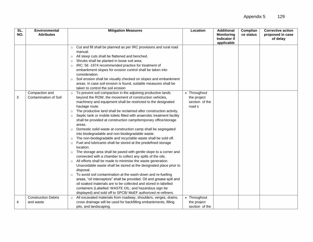
Appendix 5 129
SL. NO.
Environmental Attributes
Mitigation Measures Location Additional Monitoring Indicator if applicable
Compliance status
Corrective action proposed in case
of delay
o Cut and fill shall be planned as per IRC provisions and rural road
manual.
o All steep cuts shall be flattened and benched.
o Shrubs shall be planted in loose soil area.
o IRC: 56 -1974 recommended practice for treatment of
embankment slopes for erosion control shall be taken into
consideration.
o Soil erosion shall be visually checked on slopes and embankment
areas. In case soil erosion is found, suitable measures shall be
taken to control the soil erosion
3
Compaction and
Contamination of Soil
o To prevent soil compaction in the adjoining productive lands
beyond the ROW, the movement of construction vehicles,
machinery and equipment shall be restricted to the designated
haulage route.
o The productive land shall be reclaimed after construction activity.
o Septic tank or mobile toilets fitted with anaerobic treatment facility
shall be provided at construction camp/temporary office/storage
areas.
o Domestic solid waste at construction camp shall be segregated
into biodegradable and non-biodegradable waste.
o The non-biodegradable and recyclable waste shall be sold off.
o Fuel and lubricants shall be stored at the predefined storage
location.
o The storage area shall be paved with gentle slope to a corner and
connected with a chamber to collect any spills of the oils.
o All efforts shall be made to minimise the waste generation.
Unavoidable waste shall be stored at the designated place prior to
disposal.
o To avoid soil contamination at the wash-down and re-fuelling
areas, “oil interceptors” shall be provided. Oil and grease spill and
oil soaked materials are to be collected and stored in labelled
containers (Labelled: WASTE OIL; and hazardous sign be
displayed) and sold off to SPCB/ MoEF authorized re-refiners.
Throughout
the project
section of the
road s
4
Construction Debris
and waste
o All excavated materials from roadway, shoulders, verges, drains,
cross drainage will be used for backfilling embankments, filling
pits, and landscaping.
Throughout
the project
section of the
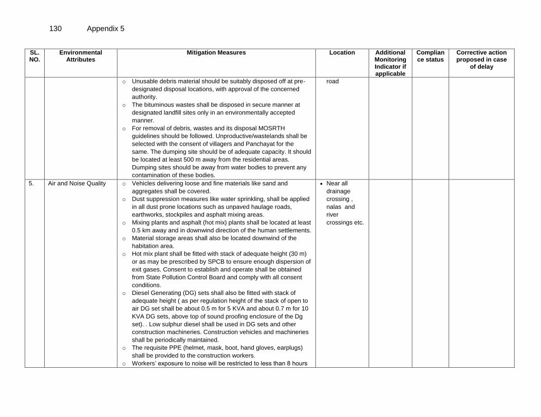
130 Appendix 5
SL. NO.
Environmental Attributes
Mitigation Measures Location Additional Monitoring Indicator if applicable
Compliance status
Corrective action proposed in case
of delay
o Unusable debris material should be suitably disposed off at pre-
designated disposal locations, with approval of the concerned
authority.
o The bituminous wastes shall be disposed in secure manner at
designated landfill sites only in an environmentally accepted
manner.
o For removal of debris, wastes and its disposal MOSRTH
guidelines should be followed. Unproductive/wastelands shall be
selected with the consent of villagers and Panchayat for the
same. The dumping site should be of adequate capacity. It should
be located at least 500 m away from the residential areas.
Dumping sites should be away from water bodies to prevent any
contamination of these bodies.
road
5. Air and Noise Quality o Vehicles delivering loose and fine materials like sand and
aggregates shall be covered.
o Dust suppression measures like water sprinkling, shall be applied
in all dust prone locations such as unpaved haulage roads,
earthworks, stockpiles and asphalt mixing areas.
o Mixing plants and asphalt (hot mix) plants shall be located at least
0.5 km away and in downwind direction of the human settlements.
o Material storage areas shall also be located downwind of the
habitation area.
o Hot mix plant shall be fitted with stack of adequate height (30 m)
or as may be prescribed by SPCB to ensure enough dispersion of
exit gases. Consent to establish and operate shall be obtained
from State Pollution Control Board and comply with all consent
conditions.
o Diesel Generating (DG) sets shall also be fitted with stack of
adequate height ( as per regulation height of the stack of open to
air DG set shall be about 0.5 m for 5 KVA and about 0.7 m for 10
KVA DG sets, above top of sound proofing enclosure of the Dg
set). . Low sulphur diesel shall be used in DG sets and other
construction machineries. Construction vehicles and machineries
shall be periodically maintained.
o The requisite PPE (helmet, mask, boot, hand gloves, earplugs)
shall be provided to the construction workers.
o Workers’ exposure to noise will be restricted to less than 8 hours
Near all
drainage
crossing ,
nalas and
river
crossings etc.
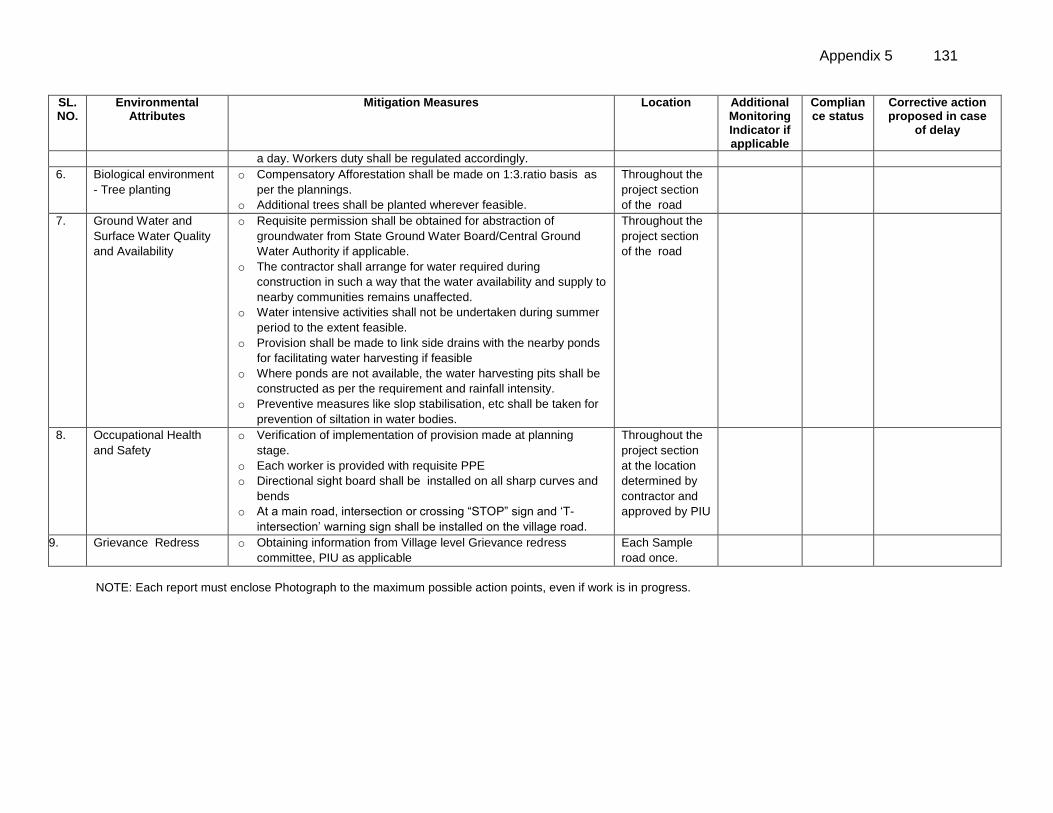
Appendix 5 131
SL. NO.
Environmental Attributes
Mitigation Measures Location Additional Monitoring Indicator if applicable
Compliance status
Corrective action proposed in case
of delay
a day. Workers duty shall be regulated accordingly.
6.
7.77
Biological environment
- Tree planting
o Compensatory Afforestation shall be made on 1:3.ratio basis as
per the plannings.
o Additional trees shall be planted wherever feasible.
Throughout the
project section
of the road
7. Ground Water and
Surface Water Quality
and Availability
o Requisite permission shall be obtained for abstraction of
groundwater from State Ground Water Board/Central Ground
Water Authority if applicable.
o The contractor shall arrange for water required during
construction in such a way that the water availability and supply to
nearby communities remains unaffected.
o Water intensive activities shall not be undertaken during summer
period to the extent feasible.
o Provision shall be made to link side drains with the nearby ponds
for facilitating water harvesting if feasible
o Where ponds are not available, the water harvesting pits shall be
constructed as per the requirement and rainfall intensity.
o Preventive measures like slop stabilisation, etc shall be taken for
prevention of siltation in water bodies.
Throughout the
project section
of the road
8. Occupational Health
and Safety
o Verification of implementation of provision made at planning
stage.
o Each worker is provided with requisite PPE
o Directional sight board shall be installed on all sharp curves and
bends
o At a main road, intersection or crossing “STOP” sign and ‘T-
intersection’ warning sign shall be installed on the village road.
Throughout the
project section
at the location
determined by
contractor and
approved by PIU
9. Grievance Redress o Obtaining information from Village level Grievance redress
committee, PIU as applicable
Each Sample
road once.
NOTE: Each report must enclose Photograph to the maximum possible action points, even if work is in progress.
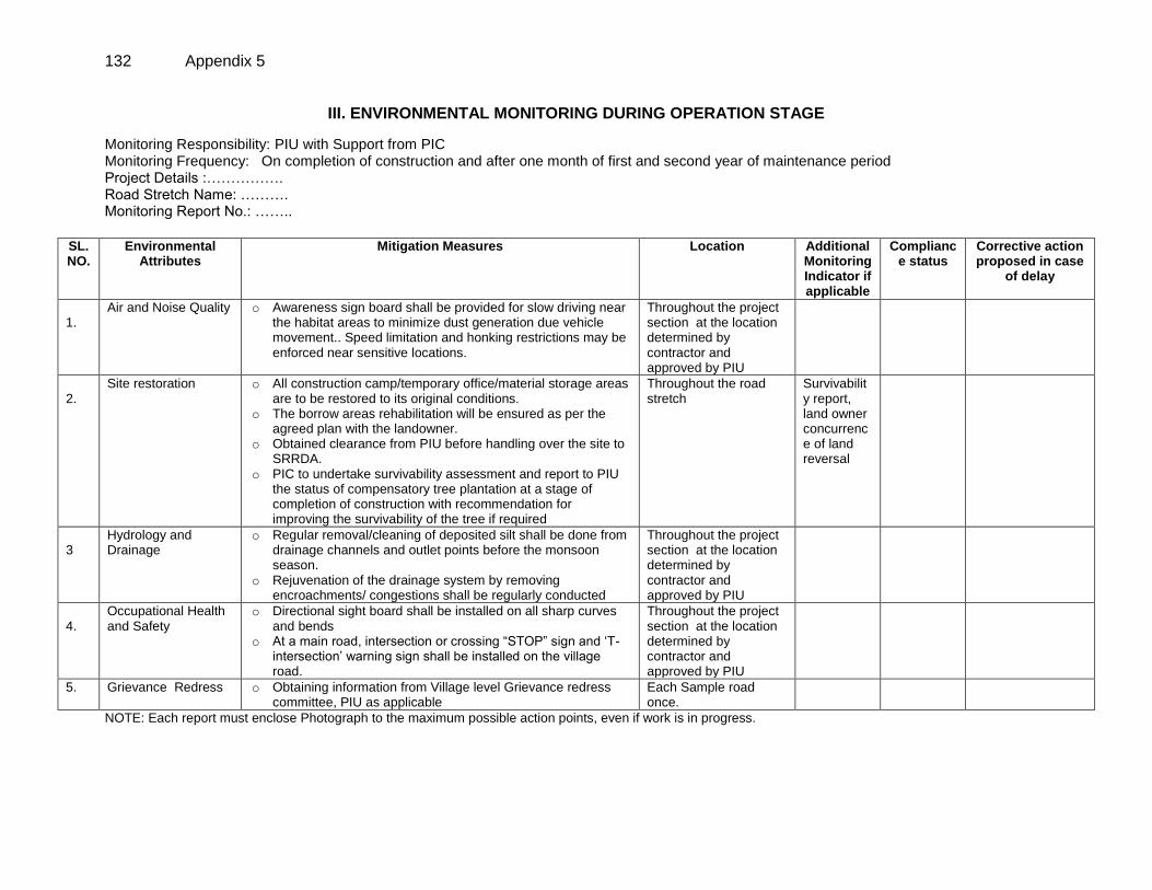
132 Appendix 5
III. ENVIRONMENTAL MONITORING DURING OPERATION STAGE
Monitoring Responsibility: PIU with Support from PIC Monitoring Frequency: On completion of construction and after one month of first and second year of maintenance period Project Details :……………. Road Stretch Name: ………. Monitoring Report No.: ……..
SL. NO.
Environmental Attributes
Mitigation Measures Location Additional Monitoring Indicator if applicable
Compliance status
Corrective action proposed in case
of delay
1.
Air and Noise Quality o Awareness sign board shall be provided for slow driving near the habitat areas to minimize dust generation due vehicle movement.. Speed limitation and honking restrictions may be enforced near sensitive locations.
Throughout the project section at the location determined by contractor and approved by PIU
2.
Site restoration o All construction camp/temporary office/material storage areas are to be restored to its original conditions.
o The borrow areas rehabilitation will be ensured as per the agreed plan with the landowner.
o Obtained clearance from PIU before handling over the site to SRRDA.
o PIC to undertake survivability assessment and report to PIU the status of compensatory tree plantation at a stage of completion of construction with recommendation for improving the survivability of the tree if required
Throughout the road stretch
Survivability report, land owner concurrence of land reversal
3
Hydrology and Drainage
o Regular removal/cleaning of deposited silt shall be done from drainage channels and outlet points before the monsoon season.
o Rejuvenation of the drainage system by removing encroachments/ congestions shall be regularly conducted
Throughout the project section at the location determined by contractor and approved by PIU
4.
Occupational Health and Safety
o Directional sight board shall be installed on all sharp curves and bends
o At a main road, intersection or crossing “STOP” sign and ‘T-intersection’ warning sign shall be installed on the village road.
Throughout the project section at the location determined by contractor and approved by PIU
5. Grievance Redress o Obtaining information from Village level Grievance redress committee, PIU as applicable
Each Sample road once.
NOTE: Each report must enclose Photograph to the maximum possible action points, even if work is in progress.


