Embed Size (px)
Citation preview
INQUA TEPRO COMMISSION PERIBALTIC WORKING GROUPUNIVERSITY OF LATVIA
UNIVERSITY OF DAUGAVPILSLATVIAN ASSOCIATION FOR QUATERNARY RESEARCH
LATE QUATERNARY TERRESTRIAL PROCESSES, SEDIMENTS AND HISTORY:
FROM GLACIAL TO POSTGLACIAL ENVIRONMENTS
EASTERN AND CENTRAL LATVIAAUGUST 16-22, 2014
EXCURSION GUIDE AND ABSTRACTS
UNIVERSITY OF LATVIA RĪGA 2014
Organized by:
University of Latvia
Daugavpils University
Latvian Association for Quaternary Research
INQUA Peribaltic Working Group (INQUA TERPRO Commission)
Organizing committee:
Māris Nartišs (Chair, University of Latvia)
Māris Krievāns (Secretary, University of Latvia)
Aivars Markots (University of Latvia)
Juris Soms (Daugavpils University)
Evija Tērauda (University of Latvia)
Vitālijs Zelčs (University of Latvia)
Contributors:
Ivars Celiņš, Edgars Greiškalns, Ieva Grudzinska, Edyta Kalińska-Nartiša, Laimdota
Kalniņa, Jānis Karušs, Māris Krievāns, Kristaps Lamsters, Aivars Markots, Māris
Nartišs, Agnis Rečs, Normunds Stivriņš, Juris Soms, Ivars Strautnieks, Santa Strode,
Sandra Zeimule, Vitālijs Zelčs
Editors: Vitālijs Zelčs and Māris Nartišs
The English texts of the field guide were revised by Valdis Bērziņš
Recommended reference for this publication:
Zelčs, V. and Nartišs, M. (eds.) 2014. Late Quaternary terrestrial processes, sediments and
history: from glacial to postglacial environments. Excursion guide and abstracts of the INQUA
Peribaltic Working Group Meeting and field excursion in Eastern and Central Latvia, August
17-22, 2014. University of Latvia, Rīga, 2014, 150 pages.
Sponsored by:
University of Latvia
Layout: Vitālijs Zelčs, Māris Nartišs and Māris Krievāns
ISBN 078-9934-517-60-0
© University of Latvia, 2014
This volume is available from:
Faculty of Geography and Earth Sciences
University of Latvia
Rainis Blvd. 19
Rīga, LV1586
Latvia
Late Quaternary Terrestrial Processes, Sediments and History: from Glacial to Postglacial Environments
Eastern and Central Latvia, August 17-22, 2014
77
STOP 13: Inland dune field near Daugavpils, East-Latvian Lowland
Edyta Kalińska-Nartišaa, Juris Soms
b, Santa Strode
b and Māris Nartišs
c
a University of Tartu, Estonia
b Daugavpils University, Latvia
c University of Latvia, Latvia
The landforms of aeolian origin located in the eastern and northern parts of Daugavpils
town, as well as to the north and to the west of the town, represent one of the largest inland
dune fields in Latvia. This dune field is located at the south-eastern edge of the East-Latvian
Lowland, covering at least 260 km2 of the southern part of the Jersika Plain.
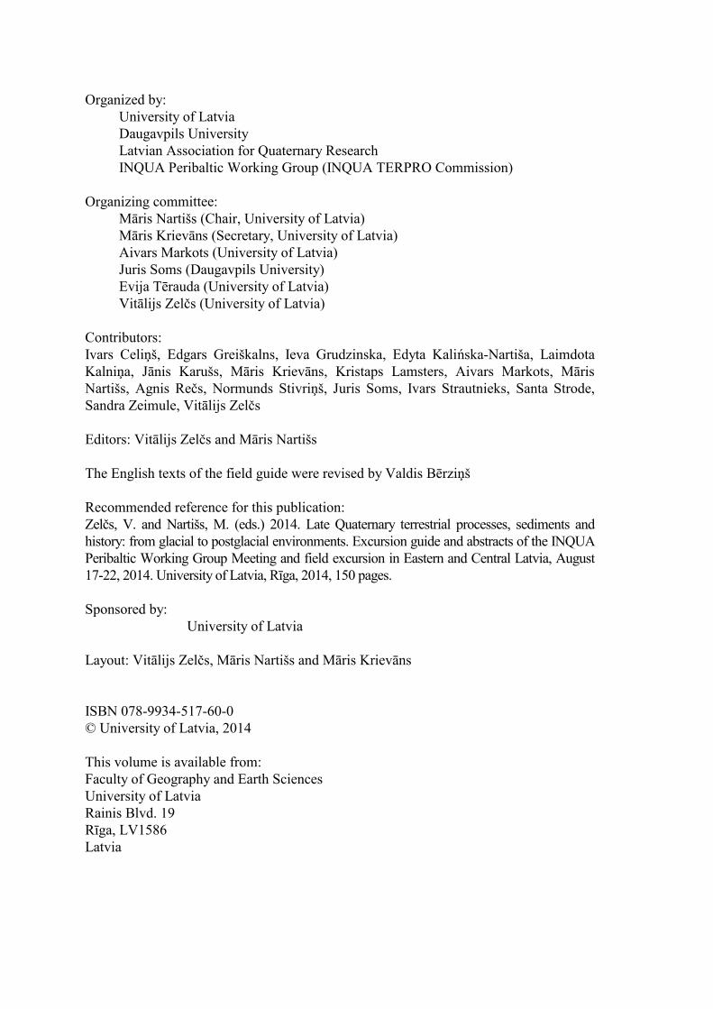
Fig. 13.1. A – Location of the investigated site and its surroundings on the Quaternary sediment map (Juškevičs
and Skrebels 2003): bQ4 – peat, eolQ3 – older aeolian sand, eolQ4 – younger aeolian sand, gQ3 – glaciogenic
sediments, gfQ3 – glaciofluvial sand and gravel, glQ3 – glaciolacustrine sand and silt, aQ4 – younger alluvial
sediments, aQ3 – older alluvial sediments; B – Sedimentary succession, luminescence and radiocarbon age at the
investigated site. Lithofacies symbols are distinguished by Miall’s code (Miall 1978, 1977).
According to Eberhards (1972), the inland dunes have developed on the surface of the
River Daugava paleodelta, which reflects an event of glaciofluvial sedimentation in the
Nīcgale ice dammed lake (Fig. 13.1A) during the Younger Dryas. After the drainage of the
glacial lake, the abundance of unconsolidated sediments, lack of vegetation cover and climatic
conditions favoured the transportation of sand and fine sandy material by wind and the
formation of aeolian landforms.
Despite the evidence of past aeolian activity in this area, under modern climatic
conditions the dune field has been almost entirely stabilized by canopy vegetation, mainly
represented by Scots pine forest, which prevents mobilization of the sand by aeolian
processes. Although information about this area as an inland dune field was presented in the
literature more than 30 years ago (Straume 1979, 1984), the morphology and spatial
distribution of aeolian landforms located in this part of Latvia, their internal structure and
chronology of formation still remain poorly documented.
Analysis of topographic maps at scale 1:10,000 with a contour interval 2 m and remote
sensing data have made it possible to identify within the dune field more than 340 dunes of
Late Quaternary Terrestrial Processes, Sediments and History: from Glacial to Postglacial Environments
Eastern and Central Latvia, August 17-22, 2014
78
different morphology; many of them have an asymmetric profile and parabolic shape in planar
view. The results also indicate that many of the dunes form groups which are randomly
scattered across the dune field.
The altitude of the dunes varies from 90 to 138 m a.s.l. The highest dunes are Alu kalns
(‘Burrow Hill’), Spaidu kalns (‘Coercion Hill’) and Plikais kalns (‘Bare Hill’), which reach
altitude of 139.5, 125 and 124.7 m a.s.l., respectively. Notable is that the altitudes of the dunes
generally decrease from south-east to north-west, i.e. from the proximal to distal direction of
the paleodelta of the River Daugava.
The internal structure and geological composition of the dune field can be observed in
the ca. 20 ha Kāpas sand-pit, which is located 0.8 km SW of the Gijantari railway stop. Due
to sand excavation, 5 to 14 m high outcrops of Quaternary sediments have been formed; here
the uppermost layers of glaciolacustrine sediments and covering aeolian sediments are
available for detailed study.
The sedimentary succession of the Gijantari site (Fig. 13.1B) consists of sand with
trough structure – St (Miall, 1977 1978), where intensive wind conditions are indicated by the
presence of deflation thoughts – DT (Zieliński and Issmer 2008). A significant component is
sand with translatent stratification and horizontal lamination – Src and Sh, respectively,
representing deposition by a gentle wind up to 6 m s-1
(c.f. Zieliński and Issmer 2008).
The major part of the Gijantari site consists of fairly homogeneous fine-grained sands
with a mean (Mz) value of between 1.51 and 2.78 φ. Simultaneously an alternation of both
coarser-grained (Mz=0.56 φ) and finer-grained (Mz=3.40 φ) laminae is visible. The
alternating bedding of silty, fine and coarser sand can be attributed to the deposition and
adhesion of sediments on an alternating dry and wet depositional sand sheet/dune surface
and/or seasonal changes in wind velocity, as observed by Kasse (2002).
The analysis of the roundness of quartz sand grains and the character of their surface
(see the description of the methodology in STOP 6) revealed the predominance of matted
grains with various degrees of rounding; short-duration abrasion/transportation (EM/RM –
type) quartz grains prevail (7–32%); however, a significant quantity of RM grains is also
noted (6–22%). Thus, the predominance of the aeolian factor could be confirmed. However,
the period of aeolian activity could be established as having lasted some hundreds of years
(Mycielska-Dowgiałło 1993) due to the evidence of aeolian action at the corners and edges of
the quartz grains. The latter has been proved experimentally (Costa et al. 2013); aeolian
transport for short distances and during a relatively short period of time is enough to imprint
significant abrasion marks. Simultaneously, the increase in perfectly rounded RM grains
seems to be unusual at localities in Latvia; this has been noted in areas with a significant
duration of aeolian activity, i.e. in Central Poland (Cailleux 1942; Goździk 2007). The cause
of this remains unexplained, however it is considered (Mazzullo 1986) that aeolian sorting
preferentially removes well-rounded quartz grains from the source. Therefore a high
proportion of rounded grains can be observed in the downwind deposits, leaving behind a
deflation lag with a high proportion of angular grains. Similarly, inheritance/transformation in
relation to the former/parental deposits is indicated, where the entire shape of the grain is
considered as crucial for further aeolian abrasion; angular grains reveal a tendency to become
almost spherical (Kuenen 1960). Shiny quartz grains (EL and EM/EL) indicate a river
floodplain or an estuarine shore face in a temperate climate (Marks et al. 2014). Up to 34% of
these have been noted at the Gijantari site, which is rather unique for an aeolian setting.
However, a similar outline has been noted within the aeolian sand-sheets in Central Poland
(Kalińska 2012) and the aeolian complexes in Ukraine (Zieliński et al. 2009). Post-
sedimentary frost weathering is responsible for a high content of cracked (C) quartz grains
Late Quaternary Terrestrial Processes, Sediments and History: from Glacial to Postglacial Environments
Eastern and Central Latvia, August 17-22, 2014
79
(Woronko and Hoch 2011); up to 32% of such grains have been observed. The latter could
therefore indicate seasonal frost action within the open cracks in the surface of frozen ground
(Ribolini et al. 2014).
The relationship between quartz, feldspars, crystalline rocks and micaous minerals is
significant for assessing the mineralogical maturity and inferring the sediment source and
provenance (i.e. Kasper-Zubillaga and Zolezzi-Ruiz 2007). Dune sands are considered multi-
cyclic, being derived from pre-existing recycled sediments (Howari et al. 2007). A significant
occurrence of feldspars and crystalline rocks (19–29% altogether) indicates a nearby source
and suggests that the major part of the sediments did not pass through several sedimentary
cycles.
An intercalated layer with organic matter has been found in the middle part of the dune
(Fig. 13.1B). In order to construct a timescale, two AMS 14
C dates obtained from Beta
Analytic INC were calibrated at the one-δ confidence level using the IntCal13 calibration
curve (Reimer et al. 2013). The macroscopic charcoal fragments collected from the lower and
upper organic layers yielded AMS radiocarbon ages of 13,180 ± 60 and 12,720 ± 30 14
C BP,
respectively (unpublished data). These correspond to the Allerød–Younger Dryas boundary
(Steffensen et al. 2008; van Hoesel et al. 2014) or the GS–1 to GI–1a-b in the NGRIP
stratigraphy (Blockley et al. 2012). These dates can be assumed to mark the lower limit of
accumulation of the aeolian sediments which cover the dated organic matter. They also
demonstrate good agreement with other published data from north-eastern Lithuania
(Stančikaitė et al. 2009) and eastern Latvia (Heikkilä et al. 2009; Veski et al. 2012) on the
development of vegetation in these areas.
Simultaneously, two luminescence ages (Fig. 13.1B) were obtained at the Finnish
Museum of Natural History Dating Laboratory, Helsinki, Finland for the sandy sediment units
directly below and above the organic layer. Equivalent dose (De) determination was carried
out using the single-aliquot regenerative dose (SAR) protocol (Murray and Wintle 2000). A
consistent age of 15.5 ± 2.8 and 14.5 ± 2.2 ka (unpublished data) was obtained. Within the
limits of uncertainty, the luminescence ages agree with the AMS 14
C datings. However, with
respect to the optical age results, the relatively high errors, in the range of 15–18%, must be
noted. Clearly, these have to be reinvestigated.
References
Blockley, S.P.E., Lane, C.S., Hardiman, M., Rasmussen, S.O., Seierstad, I.K., Steffensen, J.P., Svensson, A.,
Lotter, A.F., Turney, C.S.M., Bronk Ramsey, C. 2012. Synchronisation of palaeoenvironmental records
over the last 60,000 years, and an extended INTIMATE event stratigraphy to 48,000 b2k. Quaternary
Science Reviews, 36, 2–10.
Cailleux, A. 1942. Les actiones éoliennes périglaciaires en Europe. Mémoires de la Société Géologique de
France, 41, 1–176.
Costa, P.J.M., Andrade, C., Mahaney, W.C., Marques da Silva, F., Freire, P., Freitas, M.C., Janardo, C.,
Oliveira, M. a., Silva, T., Lopes, V. 2013. Aeolian microtextures in silica spheres induced in a wind tunnel
experiment: Comparison with aeolian quartz. Geomorphology, 180-181, 120–129.
Eberhards, G. 1972. Stroyeniye i razvitiye dolin basseyna peki Daugava [Structure and development of valleys
of the Daugava river basin]. Zinātne, Rīga, 131 pp. (In Russian).
Goździk, J. 2007. The Vistulian aeolian succession in central Poland. Sedimentary Geology, 193, 211–220
Heikkilä, M., Fontana, S.L., Seppä, H. 2009. Rapid Lateglacial tree population dynamics and ecosystem changes
in the eastern Baltic region. Journal of Quaternary Science, 24, 802–815.
Howari, F.M., Baghdady, Goodell, P.C. 2007. Mineralogical and gemorphological characterization of sand dunes
in the eastern part of United Arab Emirates using orbital remote sensing integrated with field
investigations. Geomorphology, 83, 67–81.
Juškevičs, V., Skrebels J. 2003. Map of the Quaternary deposits. In: Āboltiņš, O., Brangulis,A.J. (eds.),
Geological Map of Latvia. Scale 1:200,000. Sheet 34-Jēkabpils. Sheet 24-Daugavpils. Explanatory Text
and Maps. State Geological Survey of Latvia, Rīga.
Late Quaternary Terrestrial Processes, Sediments and History: from Glacial to Postglacial Environments
Eastern and Central Latvia, August 17-22, 2014
80
Kalińska, E. 2012. Geological setting and sedimentary characteristics of the coversands distributed in the western
part of the Blonie glaciolacustrine basin (Central Poland) – preliminary results. Bulletin of the Geological
Society of Finland, 84, 33–44.
Kasper-Zubillaga, J.J., Zolezzi-Ruiz, H. 2007. Grain size, mineralogical and geochemical studies of coastal and
inland dune sands from El Vizcaíno Desert, Baja California Peninsula, Mexico. Revista Mexicana de
Ciencias Geologicas, 24, 423–438.
Kasse, C. 2002. Sandy aeolian deposits and environments and their relation to climate during the Last Glacial
Maximum and Lateglacial in northwest and central Europe. Progress in Physical Geography, 26, 507–
532.
Kuenen, P.H. 1960. Experimental abrasion 4: Eolian action. Journal of Geology, 4, 427–449.
Marks, L., Gałązka, D., Krzymińska, J., Nita, M., Stachowicz-Rybka, R., Witkowski, A., Woronko, B., Dobosz,
S. 2014. Marine transgressions during Eemian in northern Poland: A high resolution record from the type
section at Cierpięta. Quaternary International, 328-329, 45–59.
Mazzullo, J.I.M. 1986. The effects of eolian sorting and abrasion upon the shapes of fine quartz sand grains.
Journal of Sedimentary Petrology, 56, 45–56.
Miall, A.D. 1977. Lithofacies types and vertical profile models in braided river deposits: a summary. Fluvial
Sedimentology, 5, 597–604.
Miall, A.D. 1978. Lithofacies types and vertical profile models in braided river deposits: a summary. In: Miall,
A.D. (ed.), Fluvial Sedimentology. Canadian Society of Petroleum Geologists Memoir, 5, pp. 597–604.
Murray, A.S., Wintle, A.G. 2000. Luminescence dating of quartz using an improved single-aliquot regenerative-
dose protocol. Radiation Measurements, 32, 57–73.
Mycielska-Dowgiałło, E. 1993. Estimates of Late Glacial and Holocene aeolian activity in Belgium, Poland and
Sweden. Boreas, 22, 165–170.
Reimer, P.J., Bard, E., Bayliss, A., Warren Beck, J., Blackwell, P.G., Bronk Ramsey, C., Buck, C.E., Cheng, H.,
Edwards, R.L., Friedrich, M., Grootes, P.M., Guilderson, T.P., Haflidason, H., Hajdas, I., Hatte, C.,
Heaton, T.J., Hoffmann, D.L., Hogg, A.G., Hughen, K.A., Kaiser, K.F., Kromer, B., Manning, S.W., Niu,
M., Reimer, R.W., Richards, D.A., Scott, E.M., Southon, J.R., Staff, R.A., Turney, C.S.M., van der Plicht,
J. 2013. Intcal13 and Marine13 radiocarbon age calibration curves 0–50,000 years cal BP. Radiocarbon,
55, 1869–1887.
Ribolini, A., Bini, M., Consoloni, I., Isola, I., Pappalardo, M., Zanchetta, G., Fucks, E., Panzeri, L., Martini, M.,
Terrasi, F. 2014. Late-Pleistocene Wedge Structures Along the Patagonian Coast (Argentina):
Chronological Constraints and Palaeo-Environmental Implications. Geografiska Annaler: Series A,
Physical Geography, 96(2), 161–176.
Stančikaitė, M., Kisielienė, D., Moe, D., Vaikutienė, G. 2009. Lateglacial and early Holocene environmental
changes in northeastern Lithuania. Quaternary International, 207, 80–92.
Steffensen, J.P., Andersen, K.K., Bigler, M., Clausen, H.B., Dahl-Jensen, D., Fischer, H., Goto-Azuma, K.,
Hansson, M., Johnsen, S.J., Jouzel, J., Masson-Delmotte, V., Popp, T., Rasmussen, S.O., Röthlisberger,
R., Ruth, U., Stauffer, B., Siggaard-Andersen, M.-L., Sveinbjörnsdóttir, A.E., Svensson, A., White,
J.W.C. 2008. High-resolution Greenland ice core data show abrupt climate change happens in few years.
Science, 321, 680–684.
Straume, J. 1979. Sovremenniy relyef Latvii. Nelednikoviye obrazovaniya: Eolovaya gruppa. In: Misans, J.,
Brangulis, A. (eds.), Geologicheskoye stroyeniye i poleznye iskopayemye Latvii. Zinātne, Rīga, pp. 347–
348 (in Russian).
Straume, J. 1984. Sovremenniye geologicheskiye processi i yavleniya [Modern geological processes and
phenomena]. In: Misans, J., Brangulis, A., Straume, J. (eds.), Geologiya Latviyskoy SSR. Obyasnitel'naya
zapiska k geologicheskim kartam Latviyskoy SSR 1:500000. Zinātne, Rīga, pp. 143–144 (in Russian).
Van Hoesel, A., Hoek, W.Z., Pennock, G.M., Drury, M.R. 2014. The Younger Dryas impact hypothesis: a
critical review. Quaternary Science Reviews, 83, 95–114.
Veski, S., Amon, L., Heinsalu, A., Reitalu, T., Saarse, L., Stivrins, N., Vassiljev, J. 2012. Lateglacial vegetation
dynamics in the eastern Baltic region between 14,500 and 11,400calyrBP: A complete record since the
Bølling (GI-1e) to the Holocene. Quaternary Science Reviews, 40, 39–53.
Woronko, B., Hoch, M. 2011. The development of frost-weathering microstructures on sand-sized quartz grains:
examples from Poland and Mongolia. Permafrost and Periglacial Processes, 227, 214–227.
Zieliński, P., Fedorowicz, S., Zaleski, I. 2009. Sedimentary succession in Berezno in the Volhynia Polesie
(Ukraine) as an example of depositional environment changes in the periglacial zone at the turn of the
Vistulian and the Holocene. Geologija, 51, 97–108.
Zieliński, P., Issmer, K. 2008. Propozycja kodu genetycznego osadów środowiska eolicznego. Przegląd
Geologiczny, 56, 67–72.